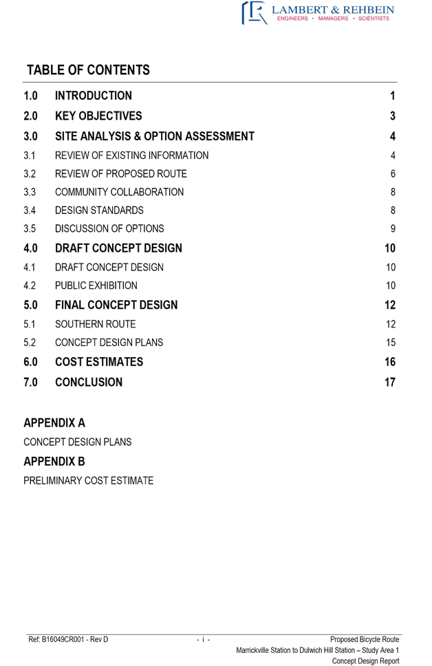
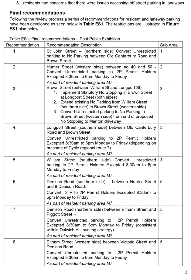
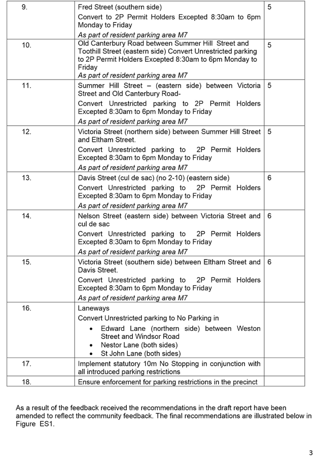
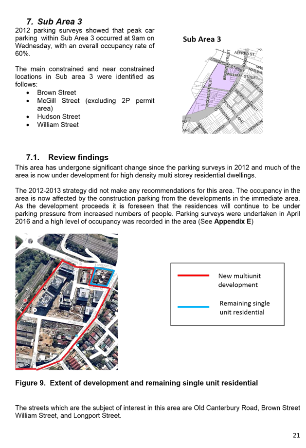
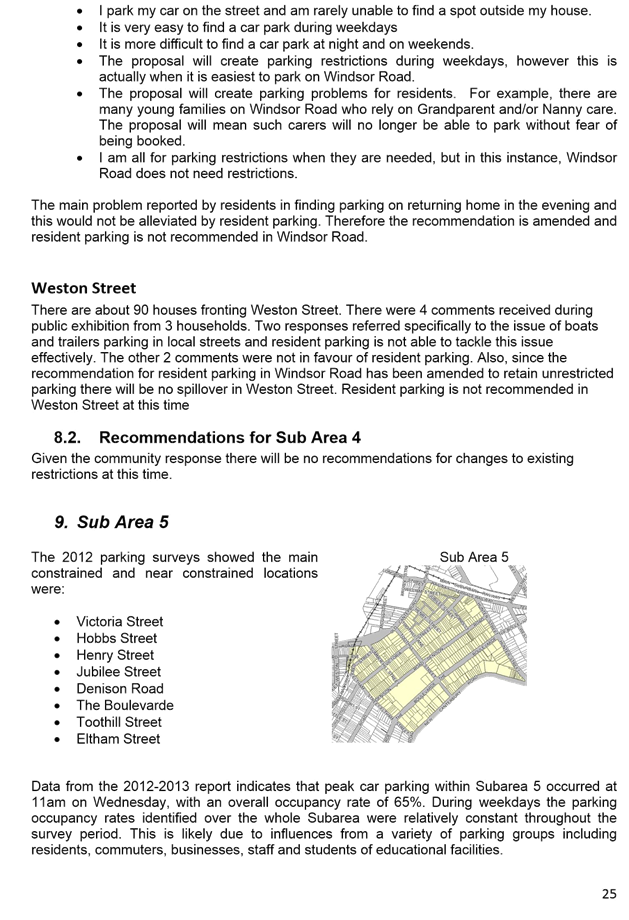
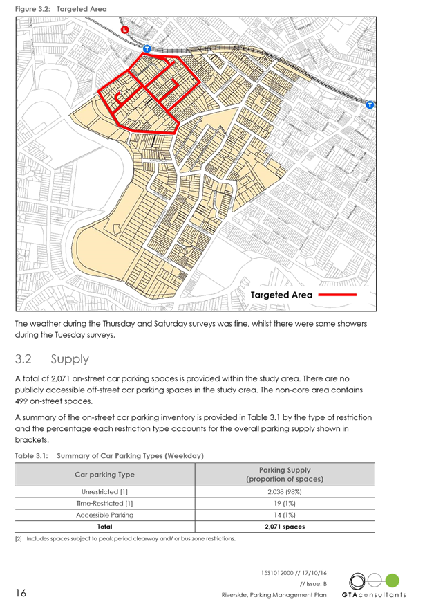
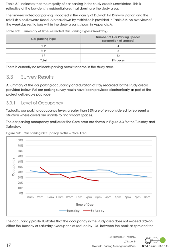
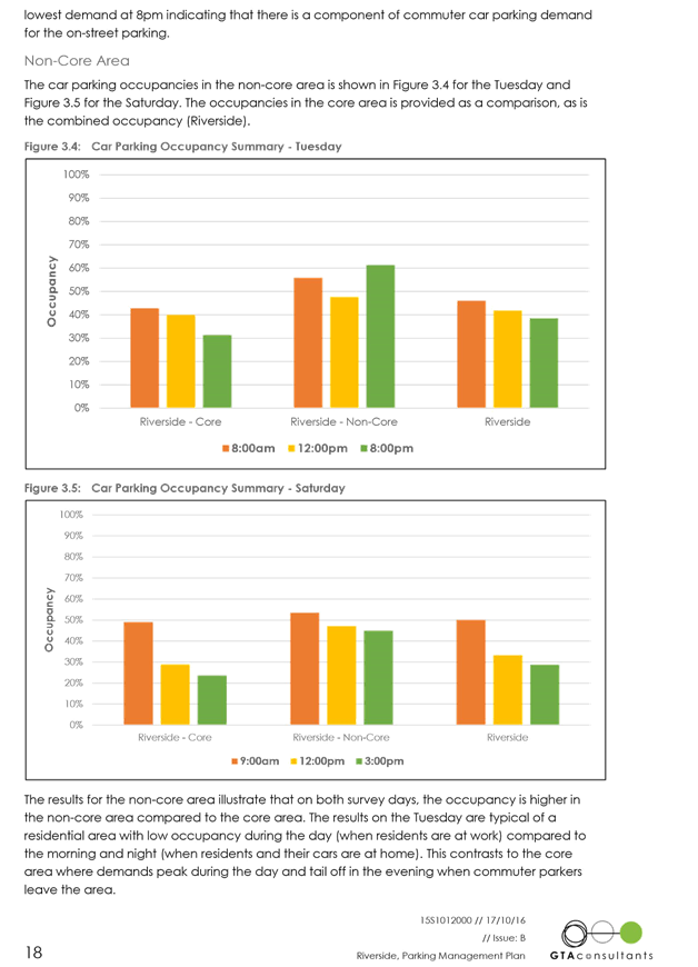
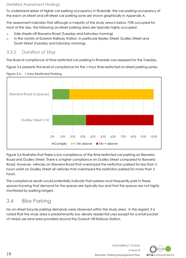
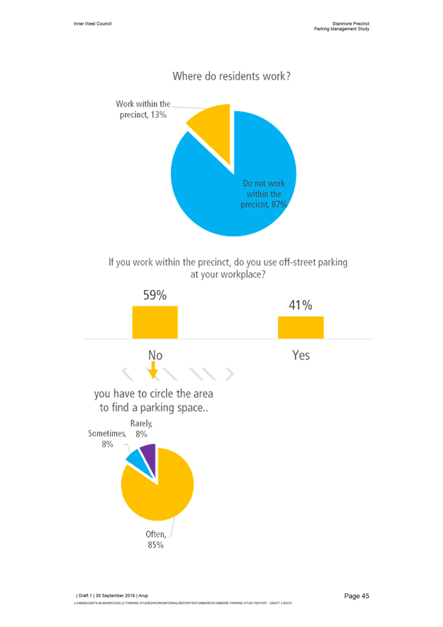
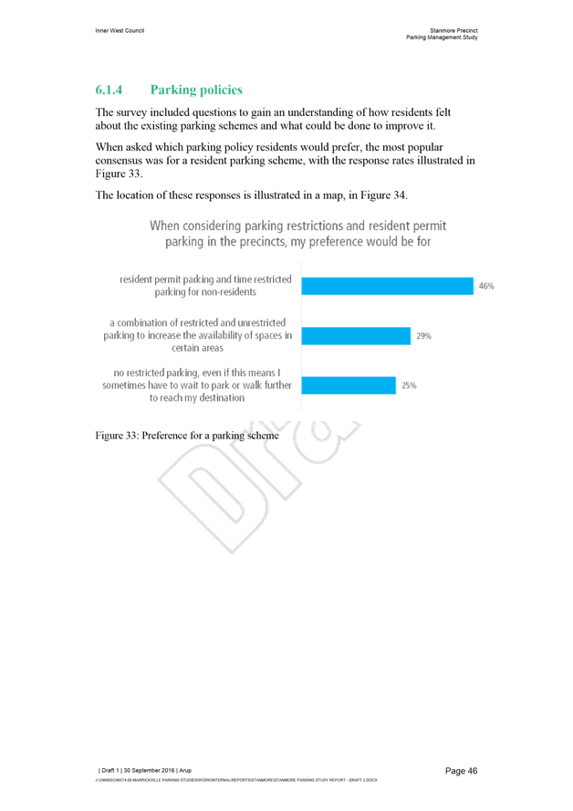
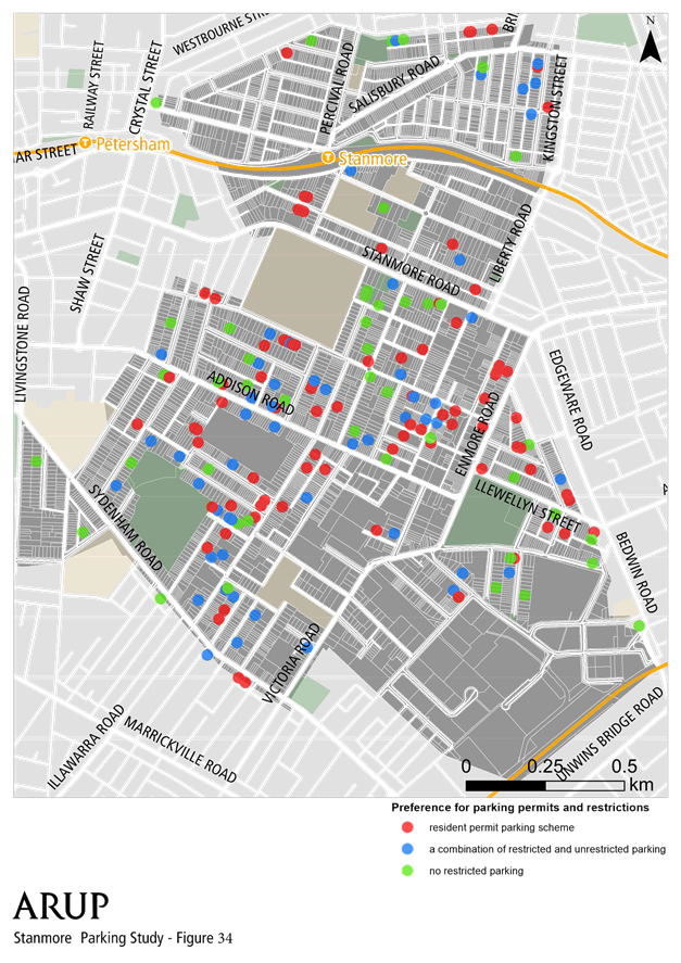
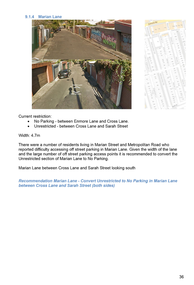
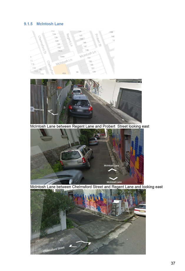
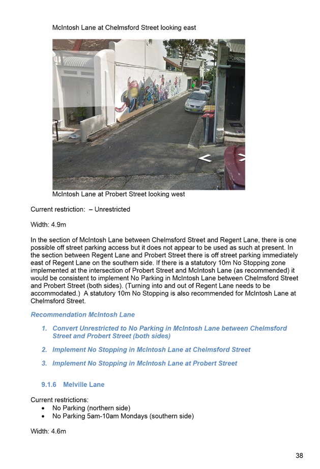
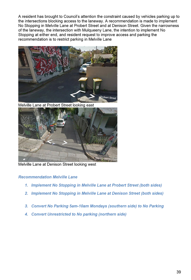
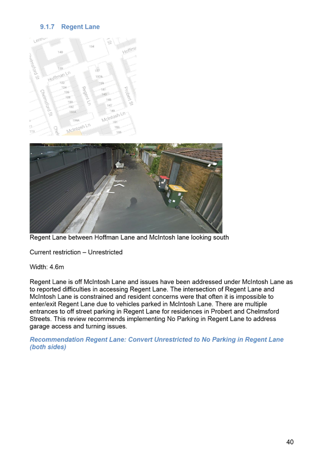
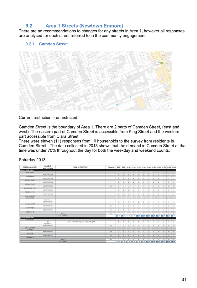
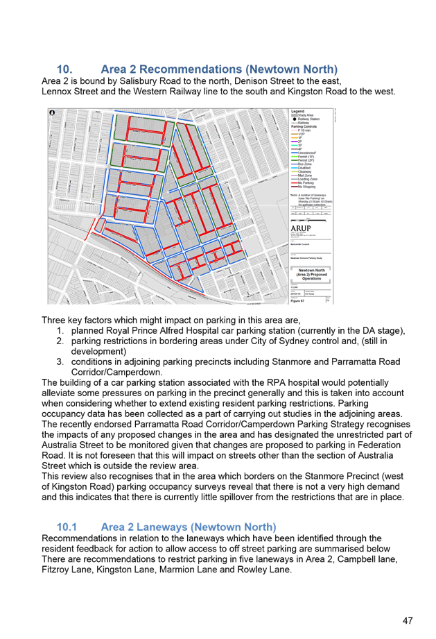
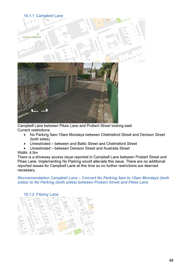
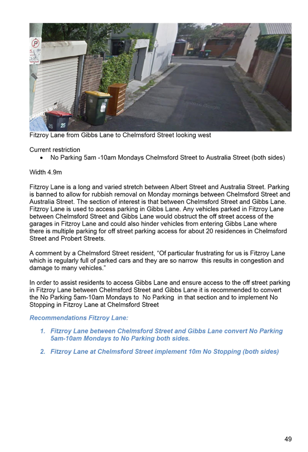
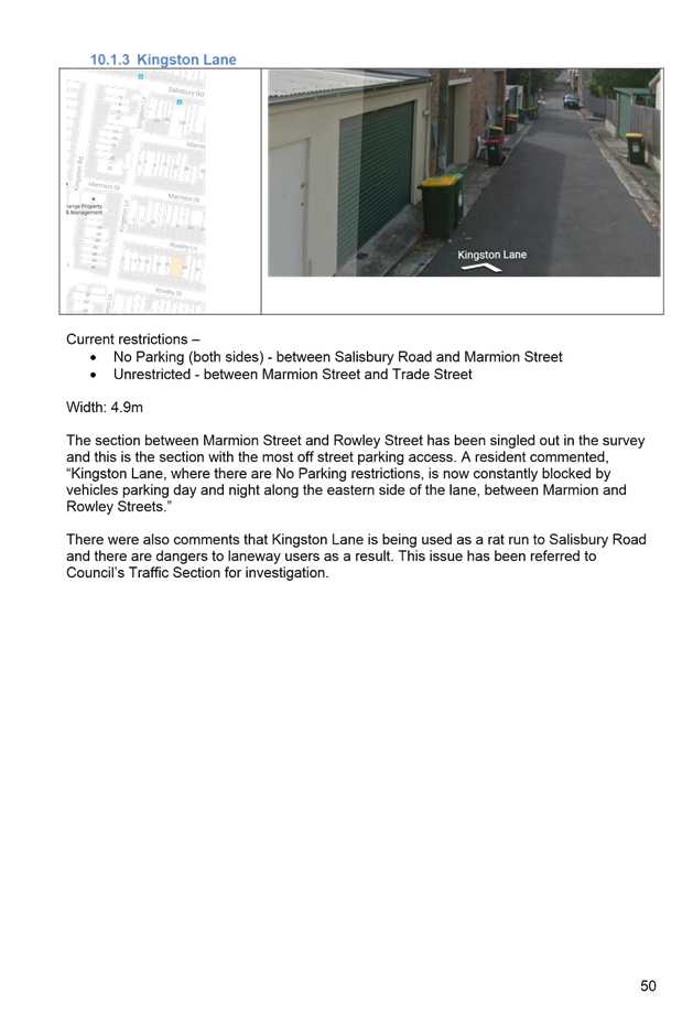
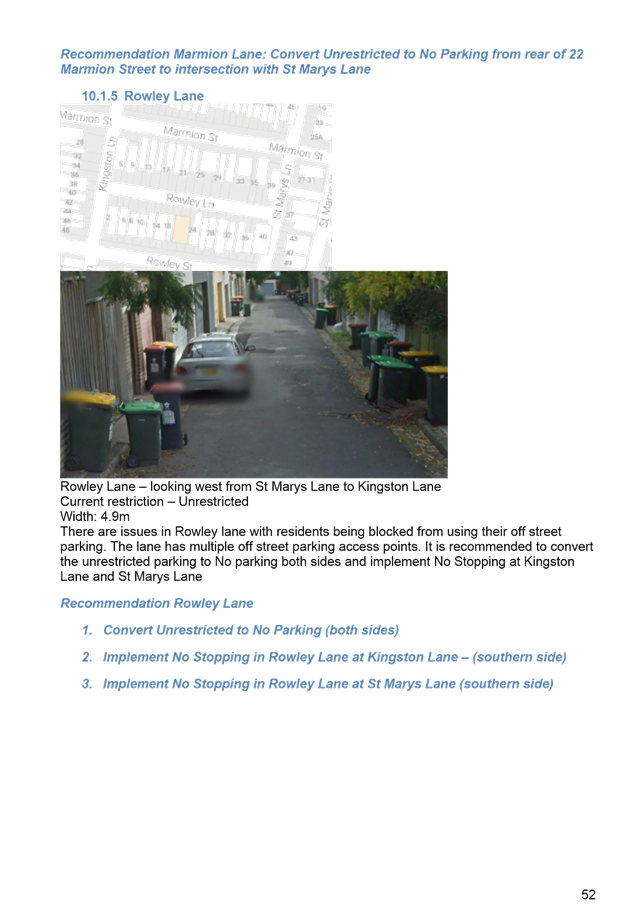
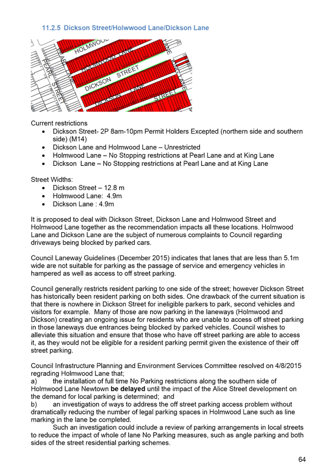
|
AGENDA R |

Local Traffic Committee Meeting
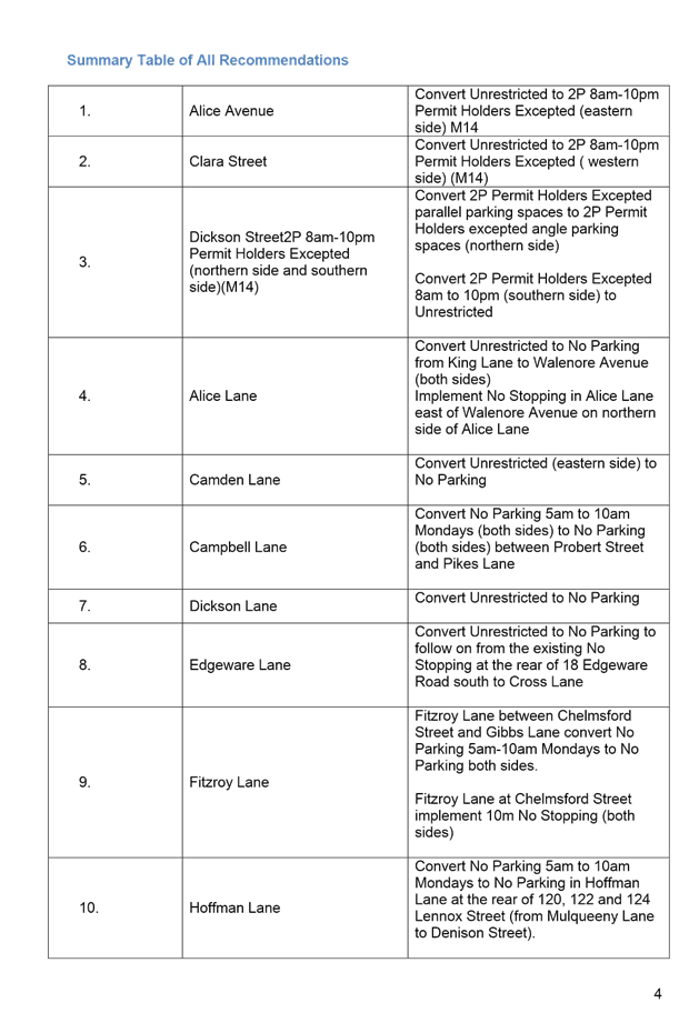
THURSDAY 3 NOVEMBER 2016
10:00am
Function of the Local Traffic Committee
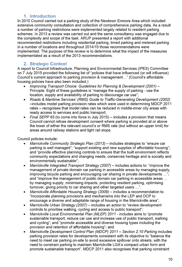
Background
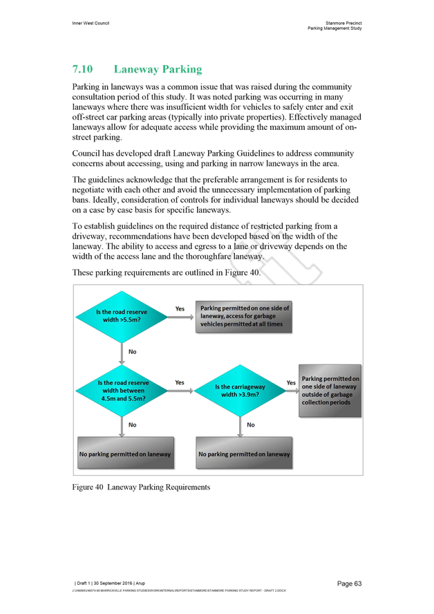
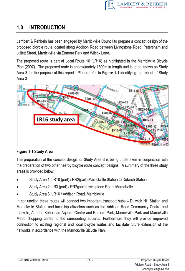
Roads and Maritime Services (RMS) is legislated as the Authority responsible for the control of traffic on all NSW Roads. The RMS has delegated certain aspects of the control of traffic on local roads to councils. To exercise this delegation, councils must establish a local traffic committee and obtain the advice of the RMS and Police. The Inner West Council Local Traffic Committee has been constituted by Council as a result of the delegation granted by the RMS pursuant to Section 50 of the Transport Administration Act 1988.
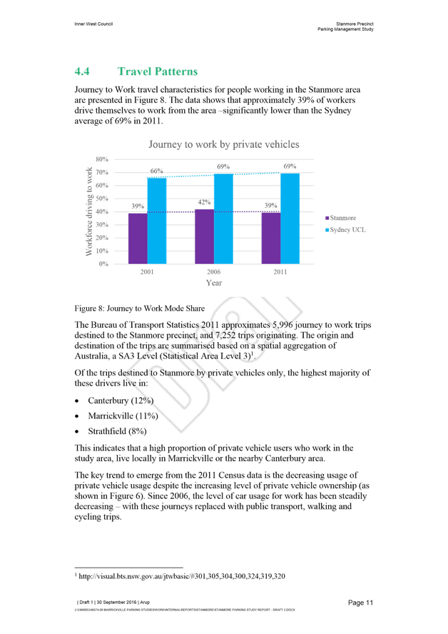
Role of the Committee
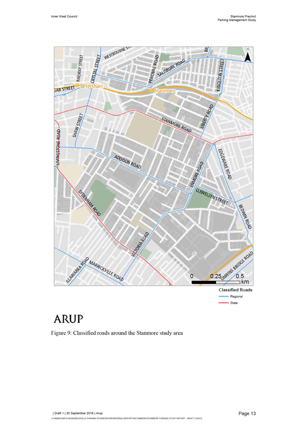
The Local Traffic Committee is primarily a technical review and advisory committee which considers the technical merits of proposals and ensures that current technical guidelines are considered. It provides recommendations to Council on traffic and parking control matters and on the provision of traffic control facilities and prescribed traffic control devices for which Council has delegated authority. These matters are dealt with under Part A of the agenda and require Council to consider exercising its delegation.
In addition to its formal role as the Local Traffic Committee, the Committee may also be requested to provide informal traffic engineering advice on traffic matters not requiring Council to exercise its delegated function at that point in time, for example, advice to Council’s Development Assessment Section on traffic generating developments. These matters are dealt with under Part C of the agenda and are for information or advice only and do not require Council to exercise its delegation.
Committee Delegations
The Local Traffic Committee has no decision-making powers. The Council must refer all traffic related matters to the Local Traffic Committee prior to exercising its delegated functions. Matters related to State Roads or functions that have not been delegated to Council must be referred directly to the RMS or relevant organisation.
The Committee provides recommendations to Council. Should Council wish to act contrary to the advice of the Committee or if that advice is not supported unanimously by the Committee members, then the Police or RMS have an opportunity to appeal to the Regional Traffic Committee.
Committee Membership & Voting
Formal voting membership comprises the following:
· one representative of Council as nominated by Council;
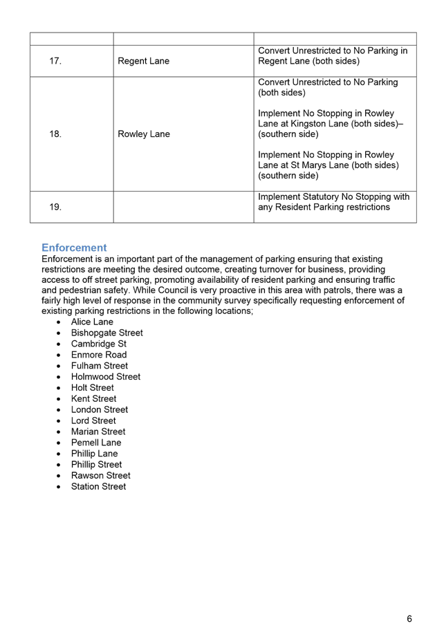
· one representative of the NSW Police from each Local Area Command (LAC) within the LGA, being Newtown, Marrickville, Leichhardt and Ashfield LAC’s.
· one representative from the RMS; and
· State Members of Parliament (MP) for the electorates of Summer Hill, Newtown, Heffron, Canterbury, Strathfield and Balmain or their nominees.
Where the Council area is represented by more than one MP or covered by more than one Police LAC, representatives are only permitted to vote on matters which effect their electorate or LAC.
Informal (non-voting) advisors from within Council or external authorities may also attend Committee meetings to provide expert advice.
Committee Chair
Council’s representative will chair the meetings.
Public Participation
Members of the public or other stakeholders may address the Committee on agenda items to be considered by the Committee. The format and number of presentations is at the discretion of the Chairperson and is generally limited to 3 minutes per speaker. Committee debate on agenda items is not open to the public.
|
|
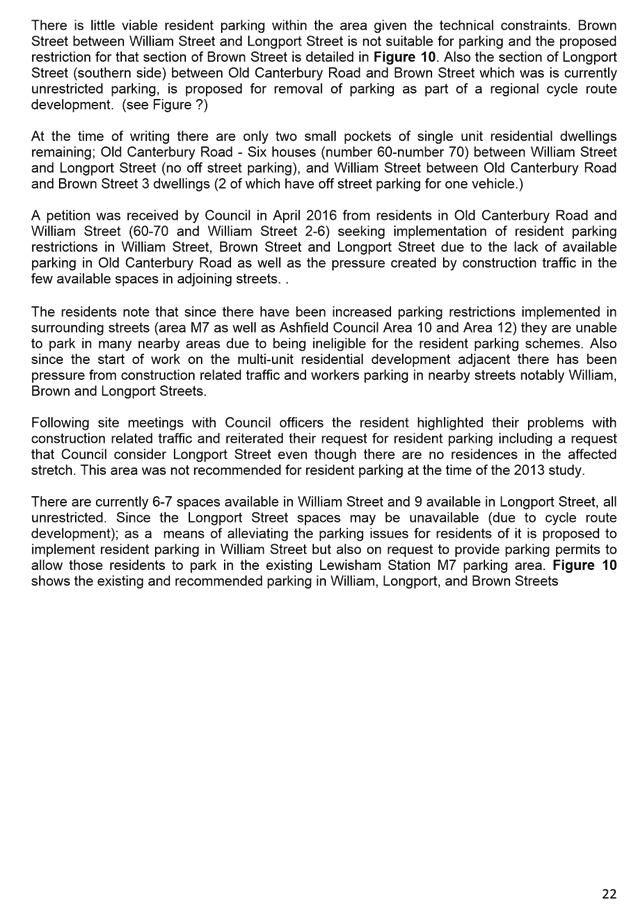
Local Traffic Committee Meeting 3 November 2016 |
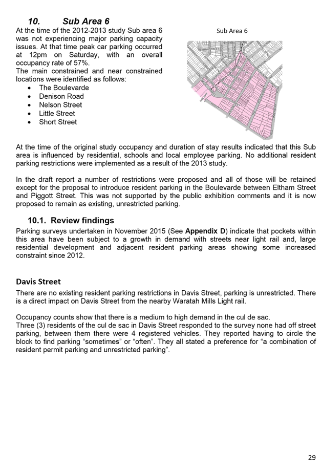
|
AGENDA |
1 Apologies
2 Disclosures of Interest
3 Confirmation of Minutes
4 Matters Arising from Council’s Resolution of Minutes
5 Part A – Items Where Council May Exercise Its Delegated Functions
Traffic Matters Page
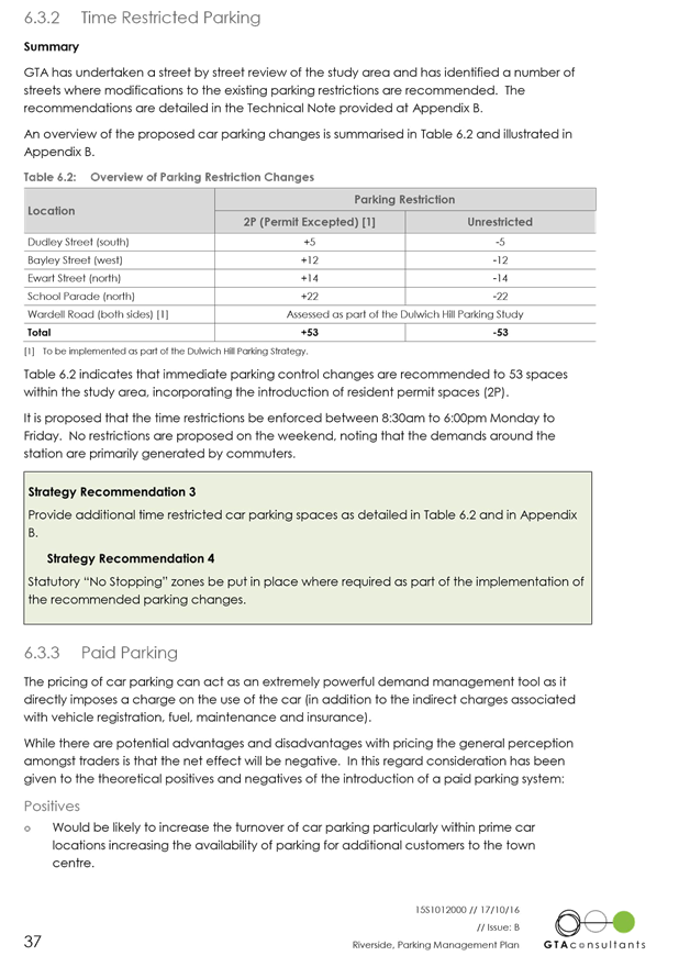
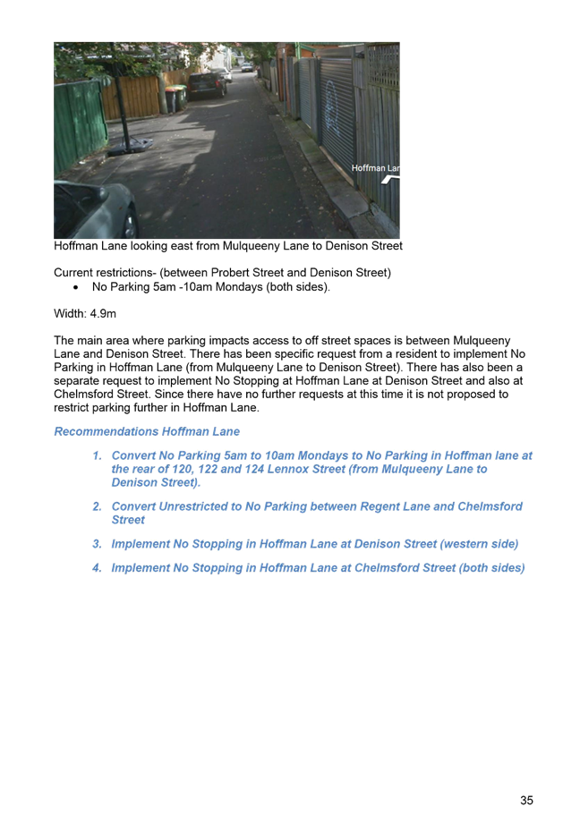
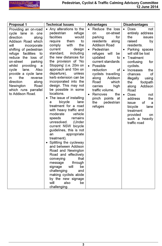
T1116 Item 1 Nicholson
Street, Balmain East - Children’s Crossing
(Balmain Ward/Balmain Electorate/Leichhardt LAC) 6
T1116 Item 2 Balmain
Road at Stanley Street, Leichhardt - Raised Pedestrian Crossing
(Leichhardt Ward/Balmain Electorate/Leichhardt LAC) 14
T1116 Item 3 Catherine
Street at Ilka Street, Lilyfield - Pedestrian Conditions
(Balmain Ward/Balmain Electorate/Leichhardt LAC) 17
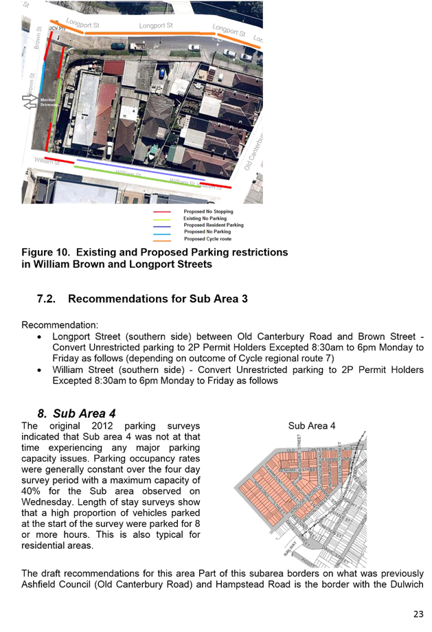
T1116 Item 4 View
Street/Piper Street South, Annandale - Pedestrian Conditions
(Balmain Ward/Balmain Electorate/Leichhardt LAC) 19
T1116 Item 5 Foreman
Street, Tempe - Proposed ‘No Right Turn’ Restriction into Princes
Highway - Consultation Results
(Marrickville Ward/Heffron Electorate/Newtown LAC) 21
T1116 Item 6 Merton
Street, Rozelle - Kerb Blisters
(Balmain Ward/Balmain Electorate/Leichhardt LAC) 27
T1116 Item 7 Union
Street, Tempe - Proposed Traffic Calming Revised Design Plans
(Marrickville Ward/Heffron Electorate/Newtown LAC) 30
T1116 Item 8 Jersey
Street & Moyes Street, Marrickville - Proposed Traffic Calming Revised
Design Plans
(Marrickville Ward/Summer Hill Electorate/Marrickville LAC) 38
T1116 Item 9 Temporary
Road Closure to Carry Out Reinstallation of Mobile Phone Antenna Mount Across
Agar Street, Marrickville
(Marrickville Ward/Marrickville Electorate/Marrickville LAC) 41
T1116 Item 10 Short
Street, Balmain - Road Occupancy
(Balmain Ward/Balmain Electorate/Leichhardt LAC) 44
T1116 Item 11 Heighway
Avenue, Ashfield - Annual Road Occupancy (Christmas Street Party) on Saturday
3rd December 2016
(Ashfield Ward/Strathfield Electorate/Ashfield
LAC) 47
T1116 Item 12 Anthony
Street, Croydon - Annual Road Occupancy (Christmas Street Party) on Saturday 17
December 2016
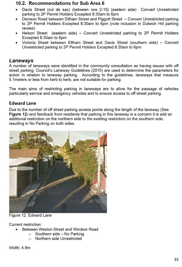
(Leichhardt Ward/Strathfield Electorate/Ashfield LAC) 49
T1116 Item 13 Construction
Traffic Management Plan (CTMP) 15-17 Hercules Street, Ashfield
(Ashfield Ward/Summer Hill Electorate/Ashfield LAC) 51
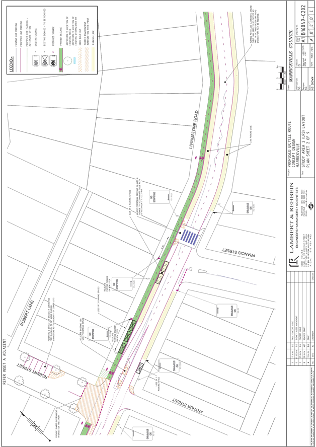
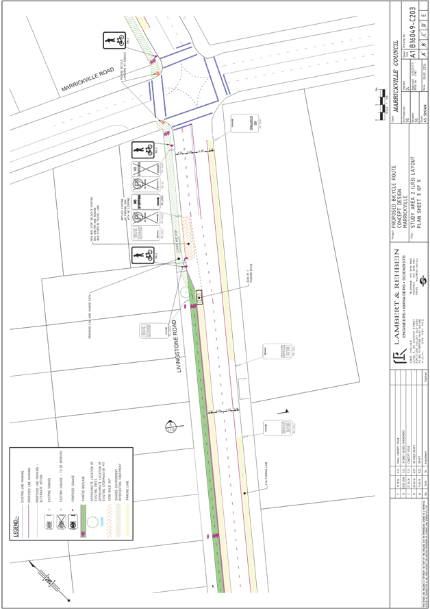
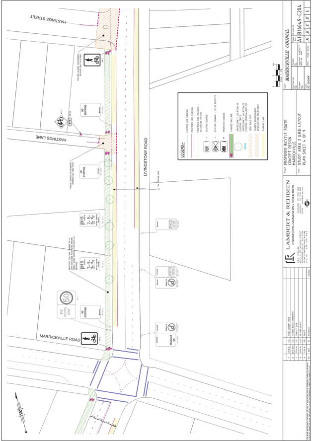
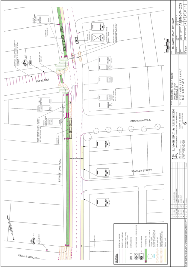
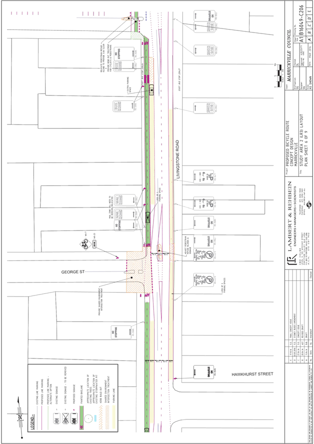
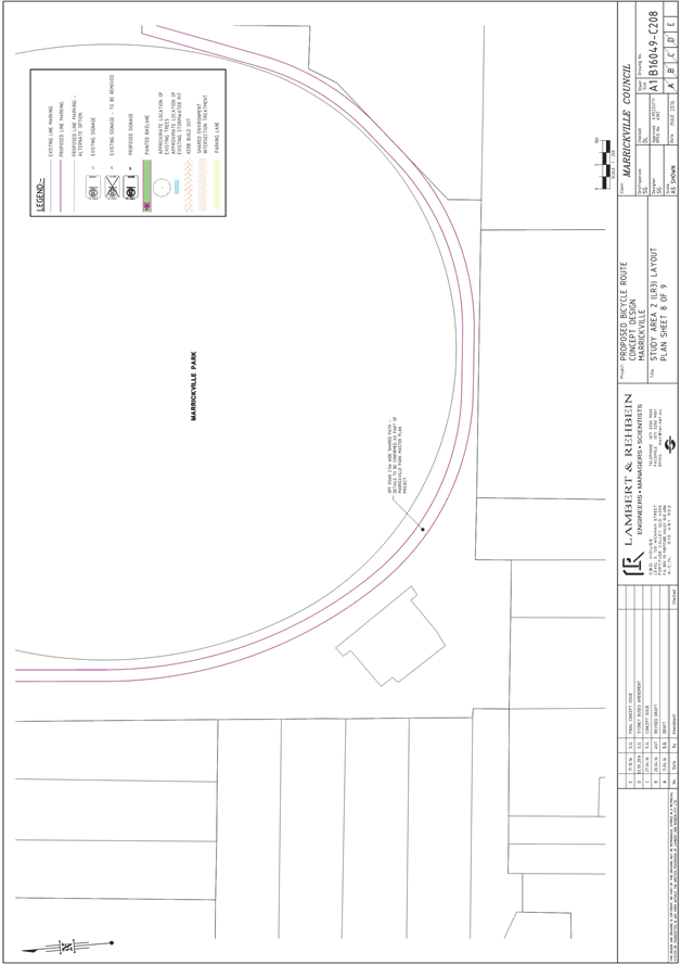
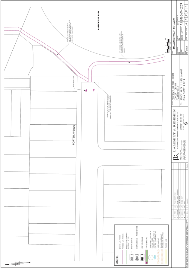
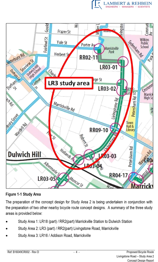
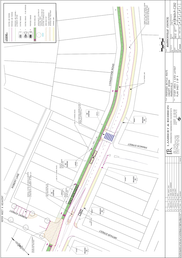
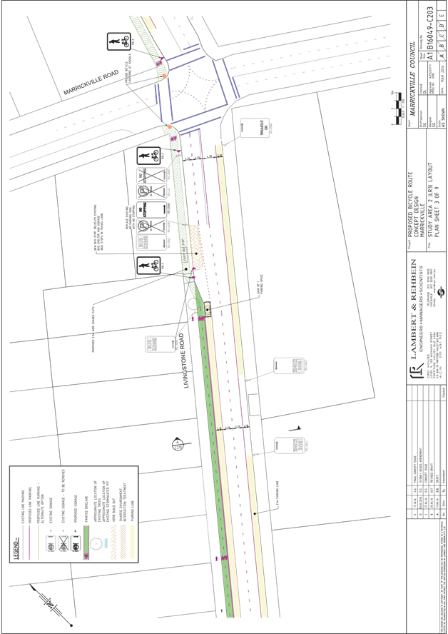
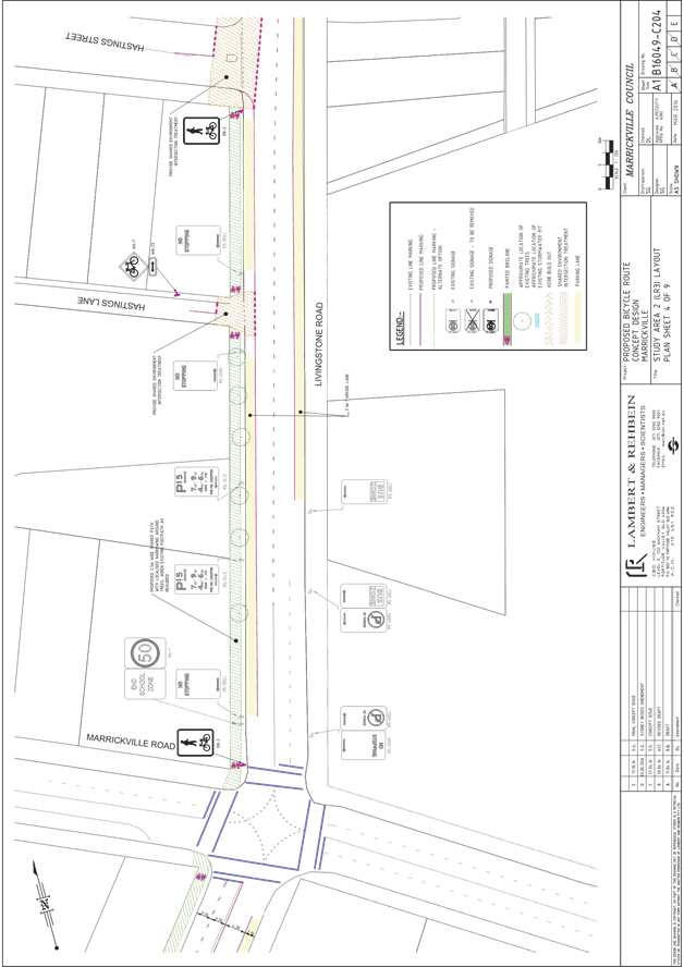
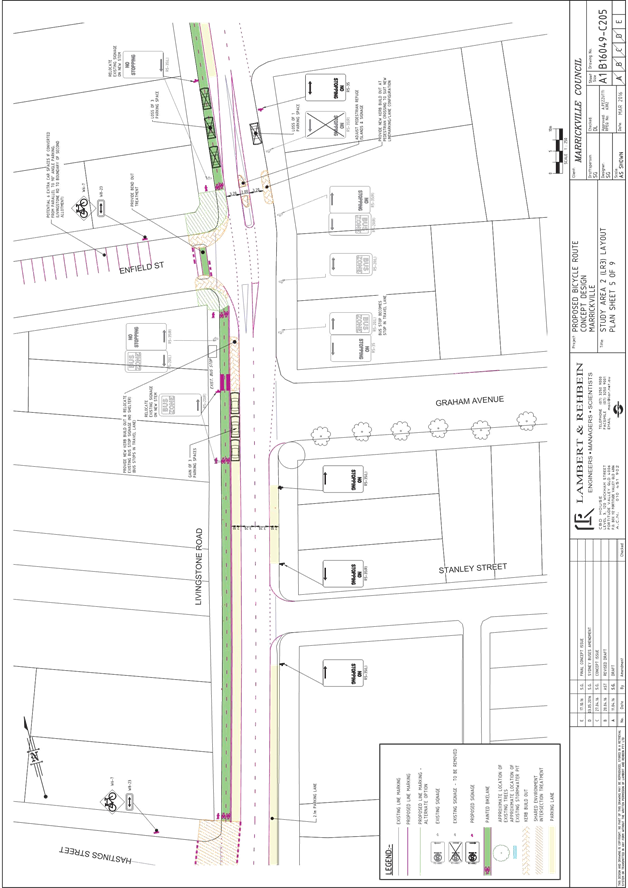
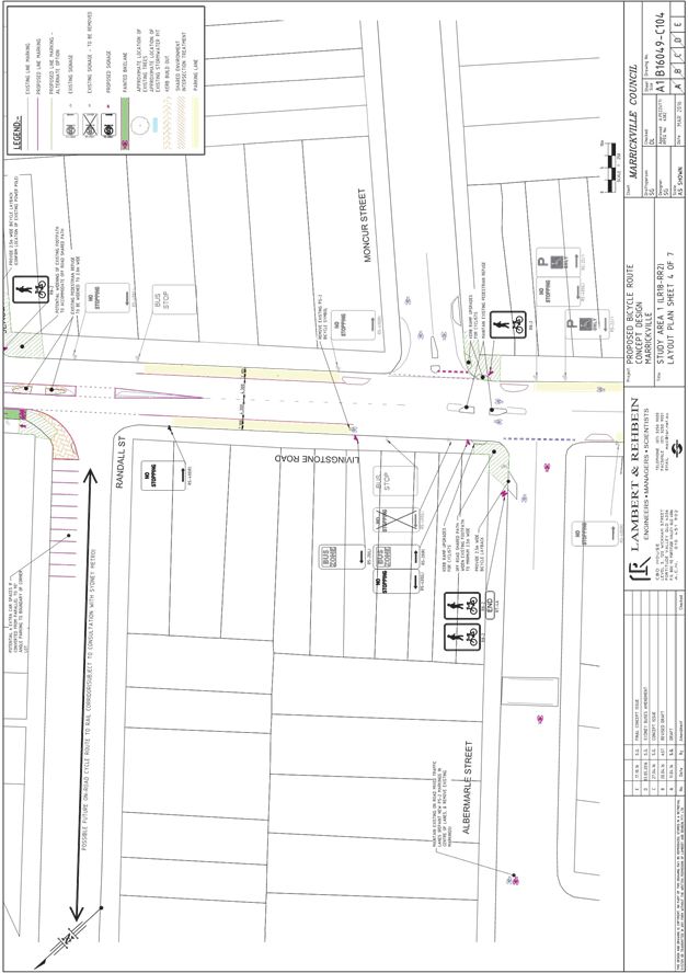
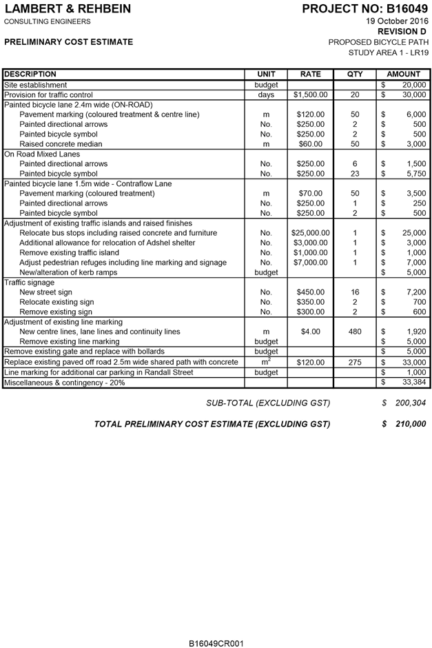
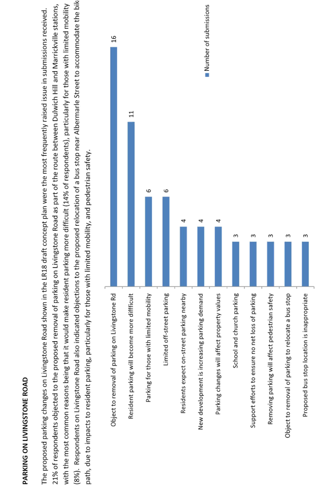
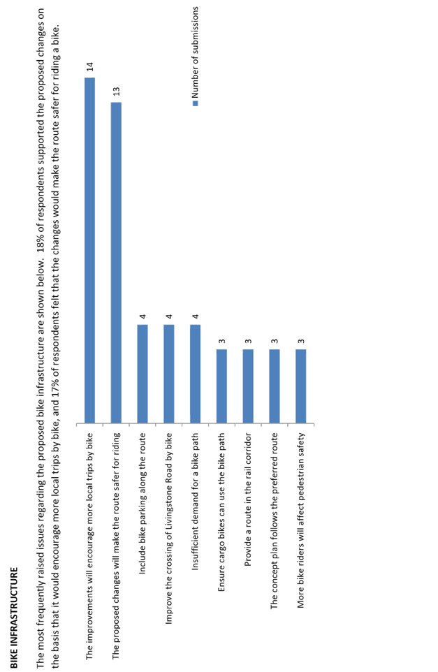
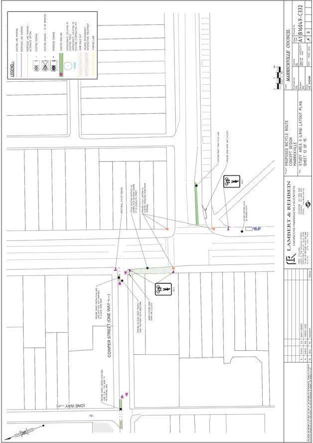
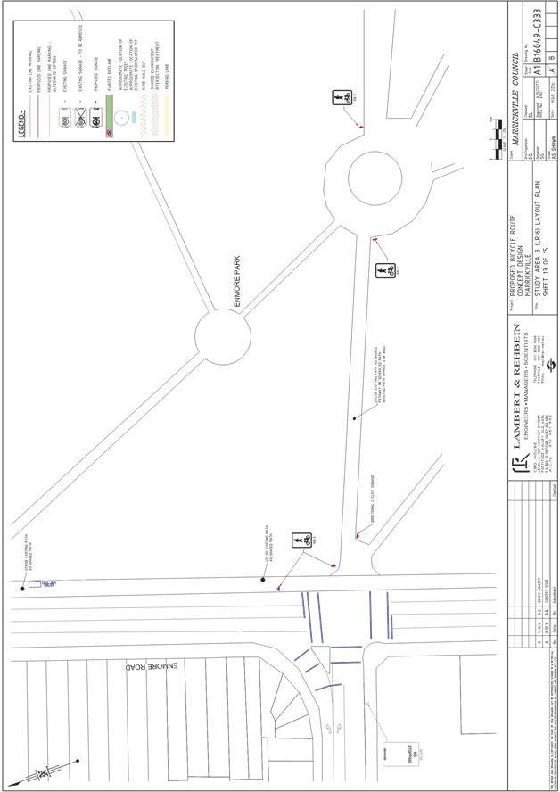
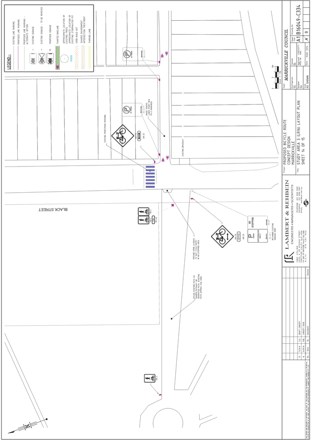
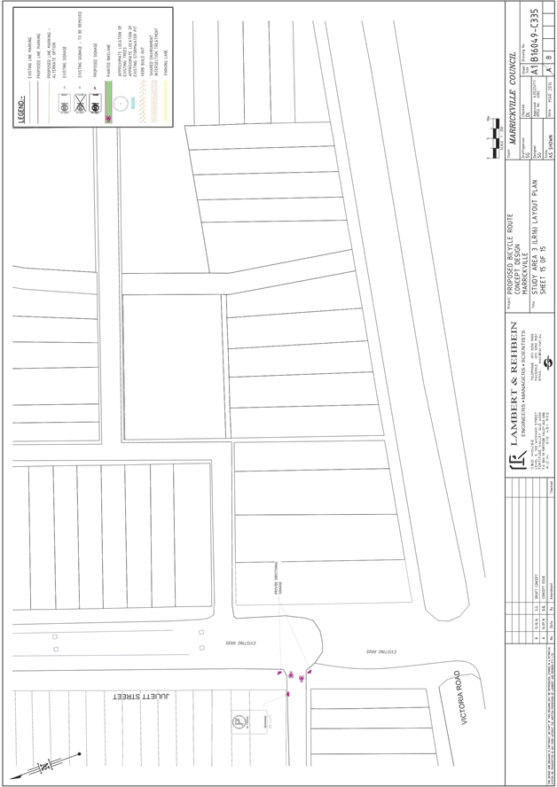
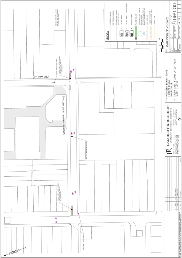
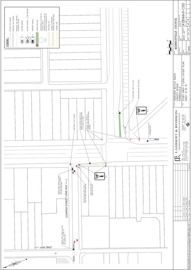
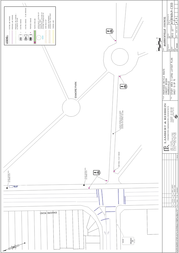
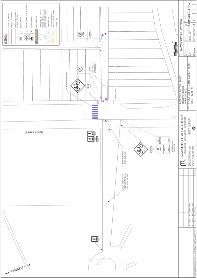
T1116 Item 14 Local Route 3 (Livingstone Road) - Public Consultation Report 88
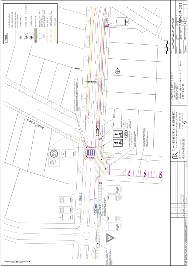
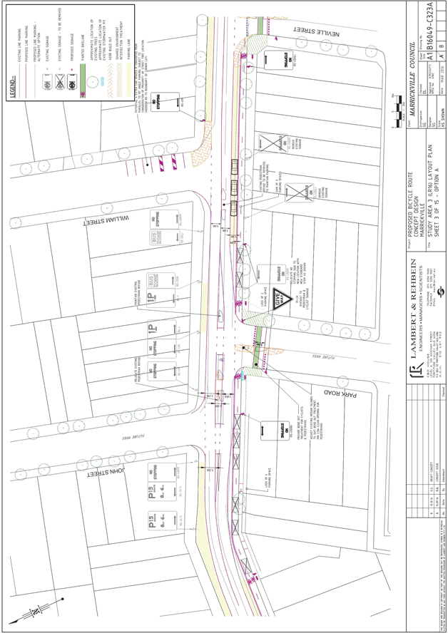
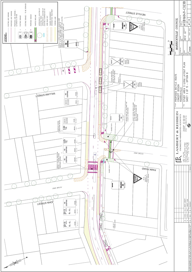
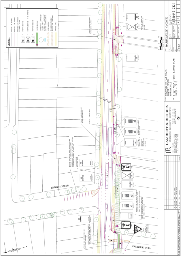
T1116 Item 15 Local Route 18 (Dulwich Hill Station to Marrickville Station) - Public Consultation Report 163
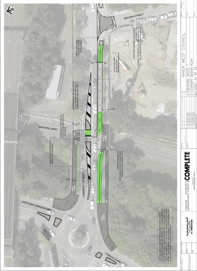
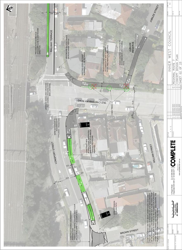
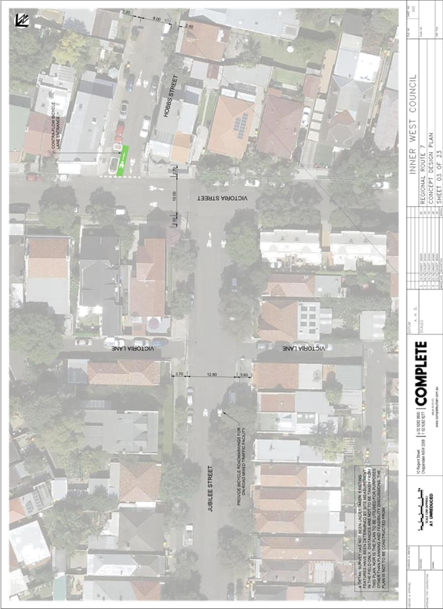
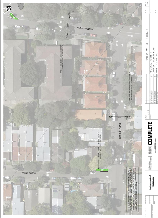
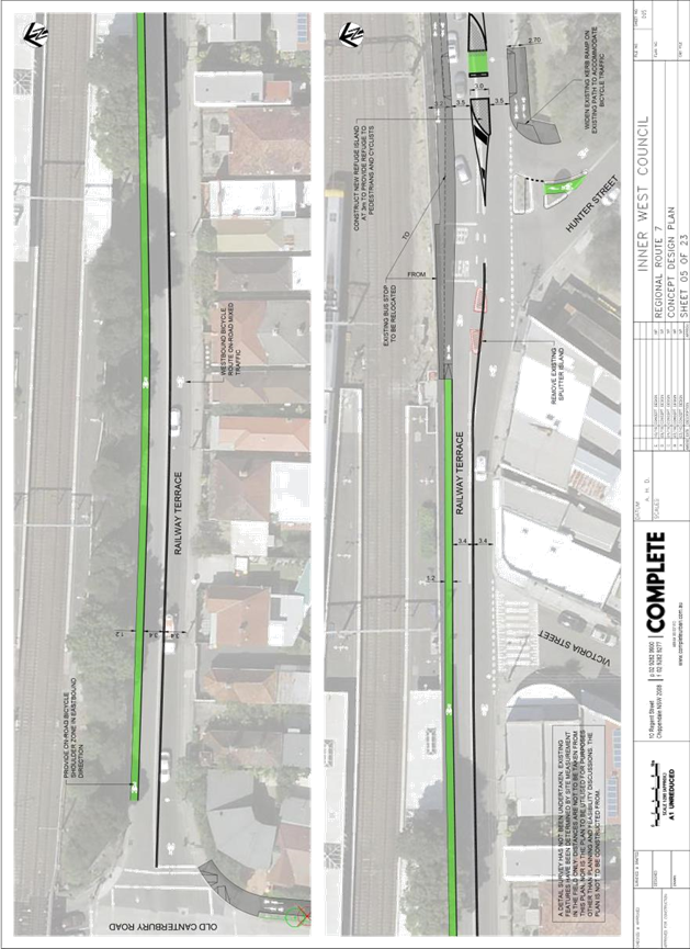
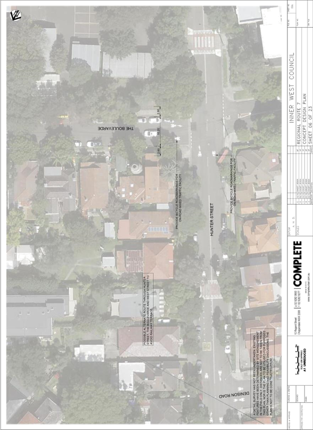
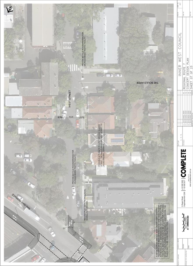
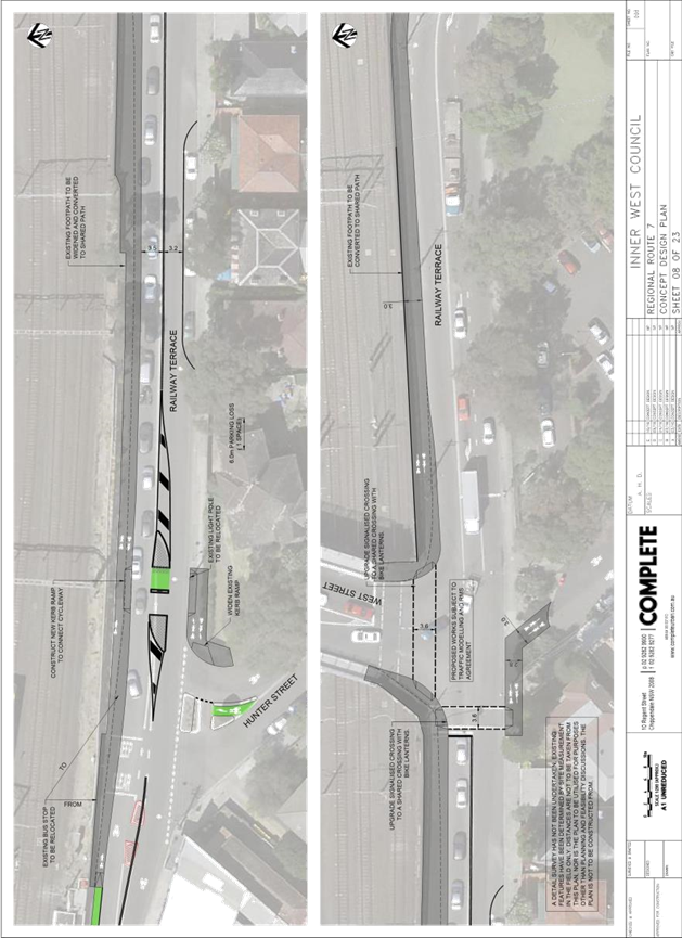
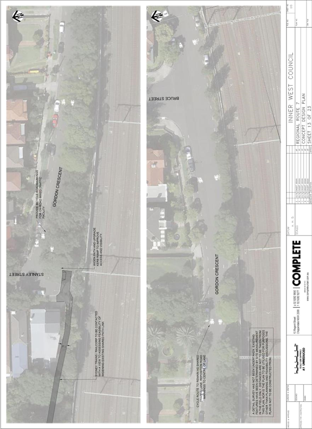
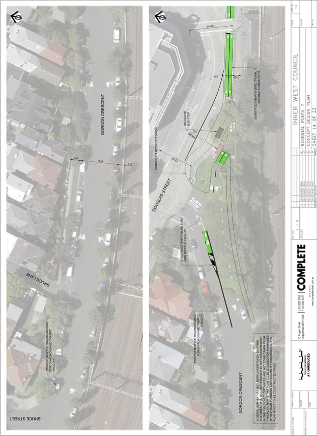
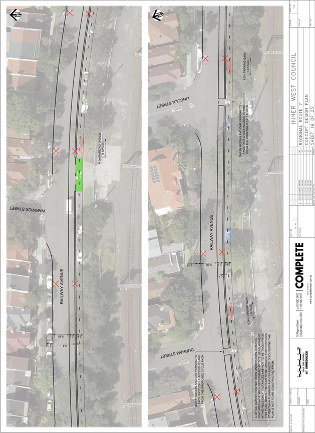
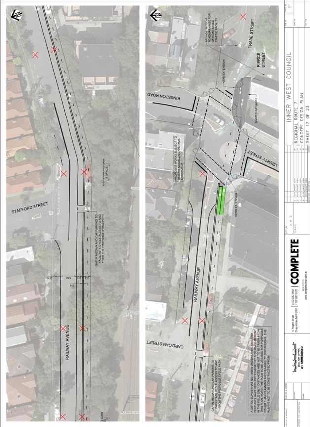
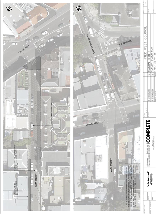
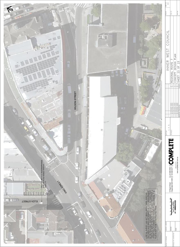
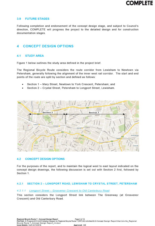
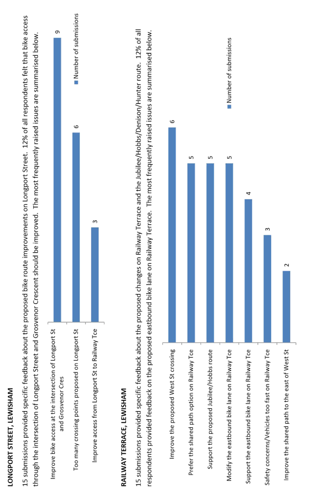
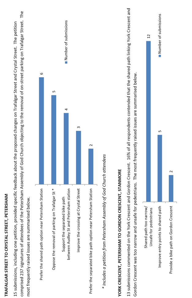
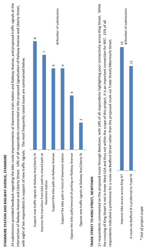
T1116 Item 16 Regional Bicycle Route 7 (Lewisham to Newtown) - Public Consultation Report 214
Parking Matters Page
T1116 Item 17 Livingstone
Road, Marrickville - Relocation of Existing ‘Bus Zone’ &
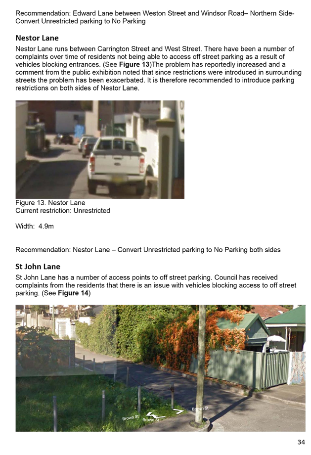
‘No Parking’ Restrictions
(Marrickville Ward/Summer Hill Electorate/Marrickville LAC) 276
T1116 Item 18 Australia
Street, Camperdown - Amendment to Mail Zone Restrictions to allow Residential
Parking in Non-Operational Periods
(Stanmore Ward/Newtown Electorate/Newtown LAC) 279
T1116 Item 19 Ferndale
Lane, Newtown - Extension of ‘No Parking’ Restrictions in the
Laneway
(Stanmore Ward/Newtown Electorate/Newtown LAC) 283
T1116 Item 20 Briar
Lane, St Peters - ‘No Parking’ Restrictions in the Laneway
(Marrickville Ward/Heffron Electorate/Newtown LAC) 288
T1116 Item 21 2
South Street, Marrickville - Request for a Drop-Off & Pick-Up Zone outside
the Waranara Centre
(Marrickville Ward/Summer Hill Electorate/Marrickville LAC) 295
T1116 Item 22 Wooley
Lane, Marrickville - Request for ‘No Parking’ Restrictions in
Laneway
(Marrickville Ward/Summer Hill Electorate/Marrickville LAC) 298
T1116 Item 23 Requests
for Mobility Parking Spaces
(Ashfield, Stanmore & Marrickville Wards/Summer Hill & Newtown
Electorates/Stanmore & Marrickville LACs) 303
T1116 Item 24 Lion
Street and Wetherill Street, Croydon - Proposal for Permit Parking Area 2 and 7
Respectively
(Ashfield Ward/Strathfield Electorate/Ashfield LAC) 311
T1116 Item 25 Mullens
Street, Rozelle between Mansfield Street and No. 181 Mullens Street - Resident (Permit)
Parking Scheme Restrictions
(Leichhardt Ward/Balmain Electorate/Leichhardt LAC) 315
T1116 Item 26 Darling
Street, Balmain East - 1/4P Parking Restriction
(Balmain Ward/Balmain Electorate/Leichhardt LAC) 317
T1116 Item 27 Flood
Street, Leichhardt - No Stopping
(Leichhardt Ward/Balmain Electorate/Leichhardt LAC) 319
T1116 Item 28 Wharf
Road, Lilyfield - No Parking Restrictions
(Leichhardt Ward/Balmain Electorate/Leichhardt LAC) 321
T1116 Item 29 Walumil
Street, Balmain - Motorbike Parking
(Balmain Ward/Balmain Electorate/Leichhardt LAC) 323
T1116 Item 30 Minor
Traffic Facilities
(Leichhardt & Balmain Wards/Balmain Electorate/ Leichhardt LAC) 325
T1116 Item 31 Lewisham Parking Review - Final Report 327
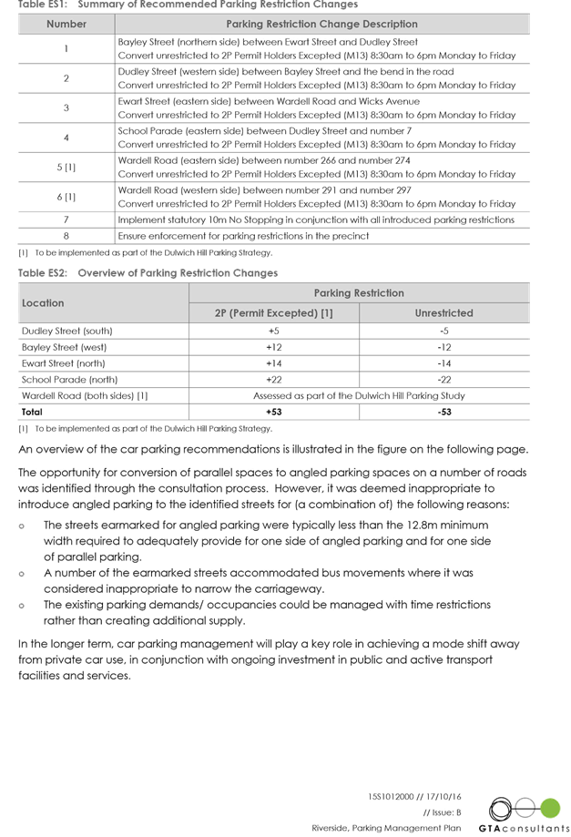
T1116 Item 32 Riverside Parking Study - Final Report 400
Late Items
Nil at time of printing.
6 Part B – Items for Information Only
T1116 Item 33 Illawarra
Road, Marrickville - Safety Concerns of Pedestrian Crossing near Thompson
Street
(Marrickville Ward/Summer Hill Electorate/Marrickville LAC) 485
T1116 Item 34 Local Traffic Committee Meeting Schedule for 2017 488
7 Part C – Items for General Advice Page
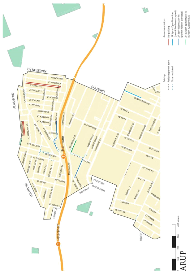
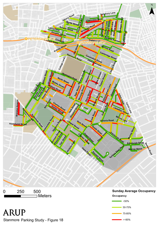
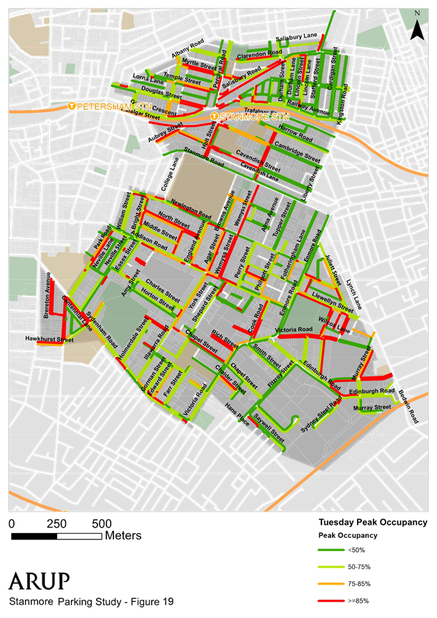
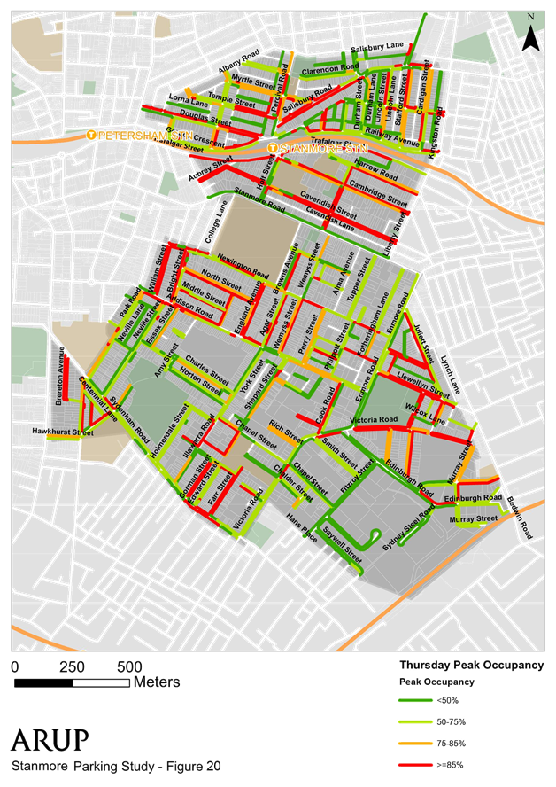
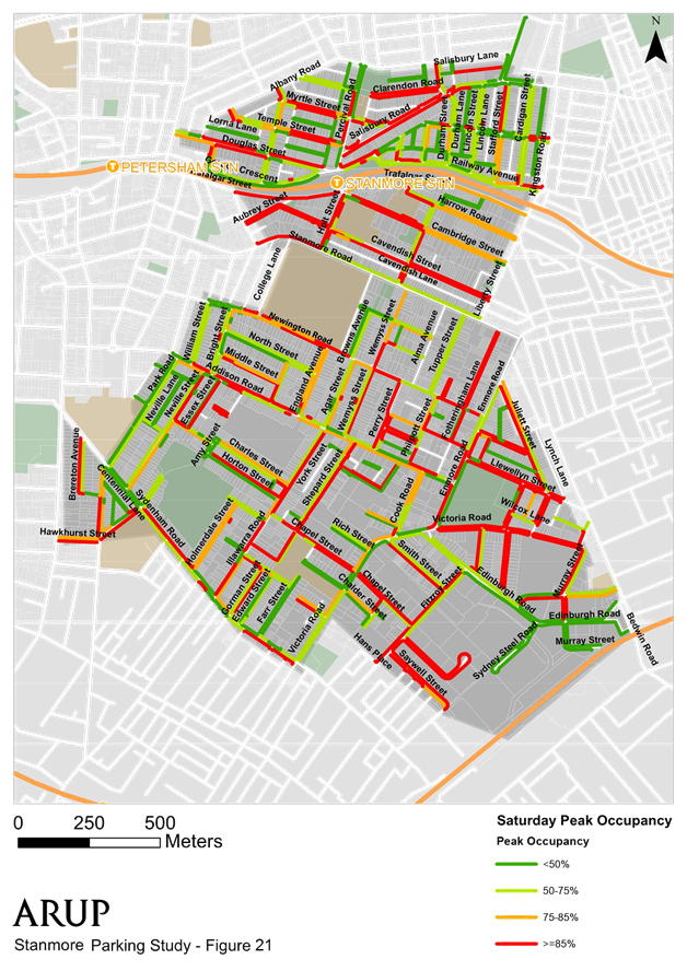
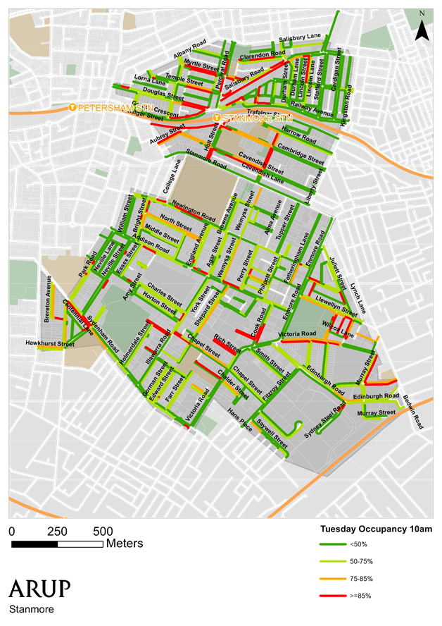
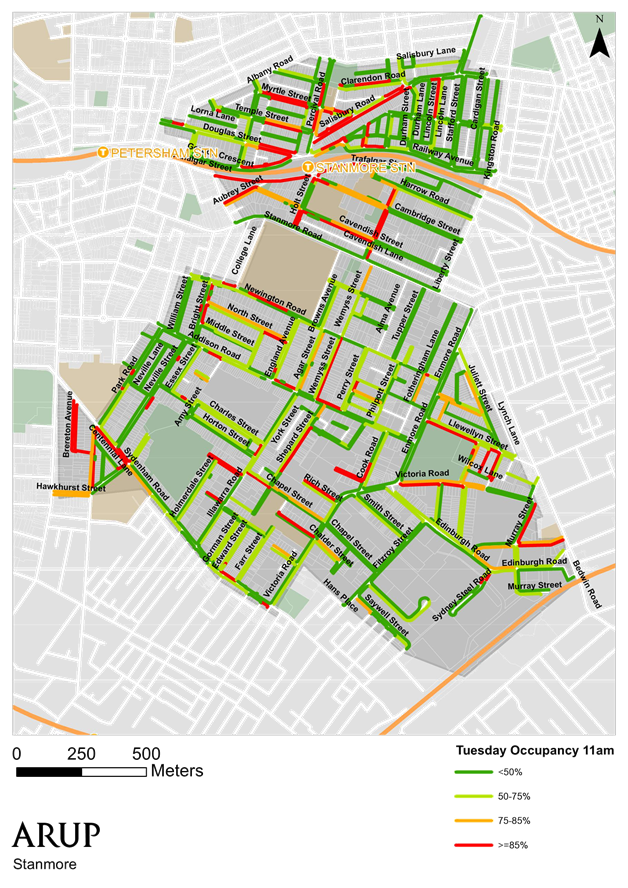
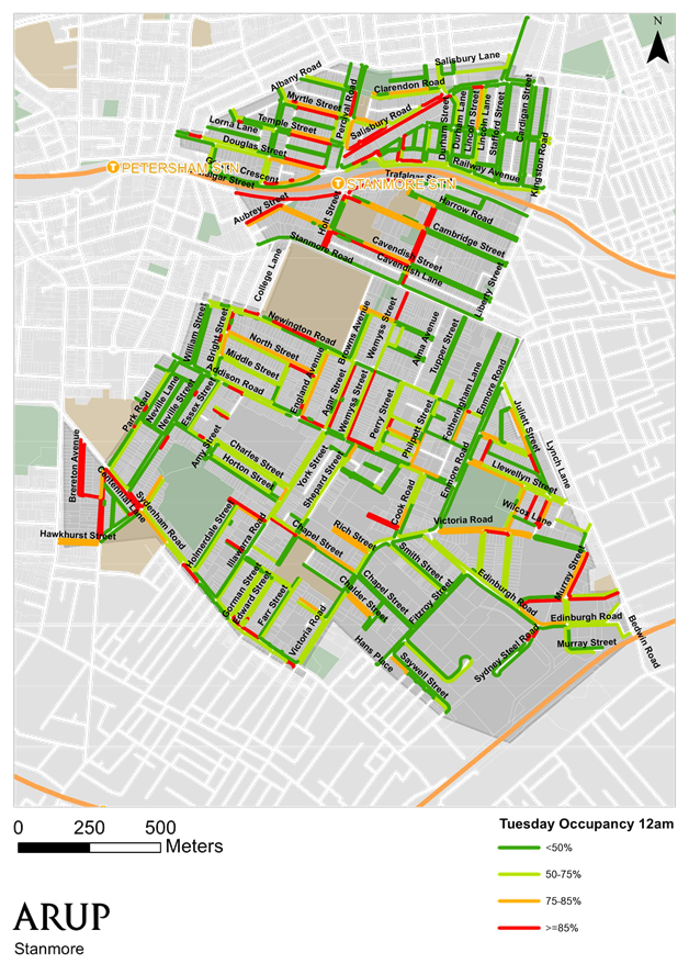
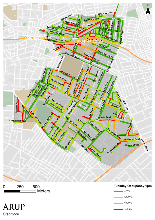
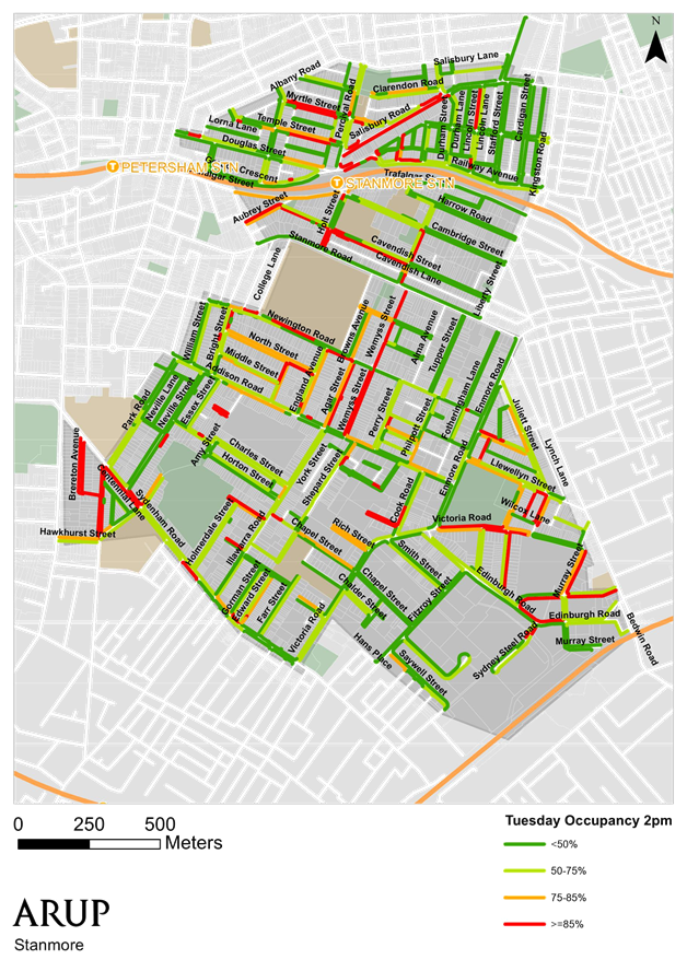
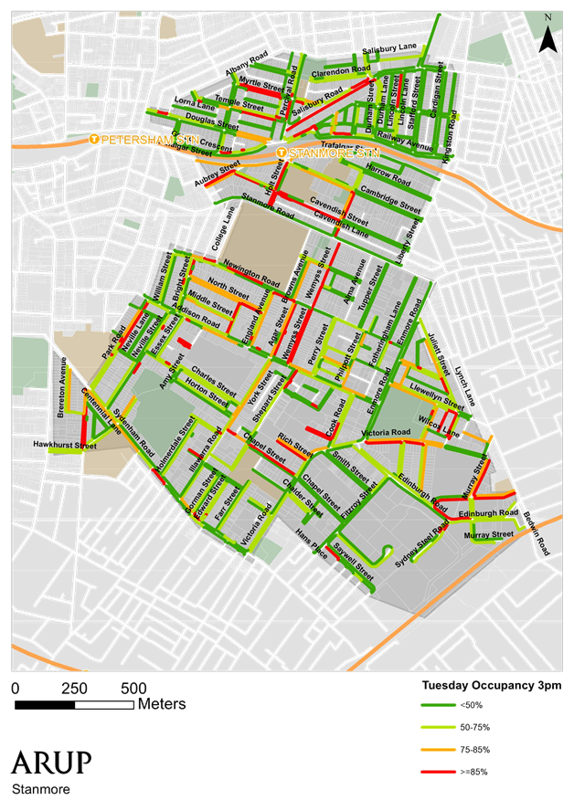
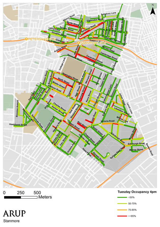
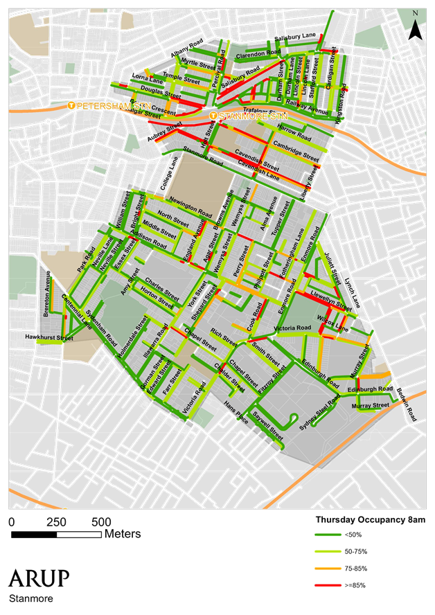
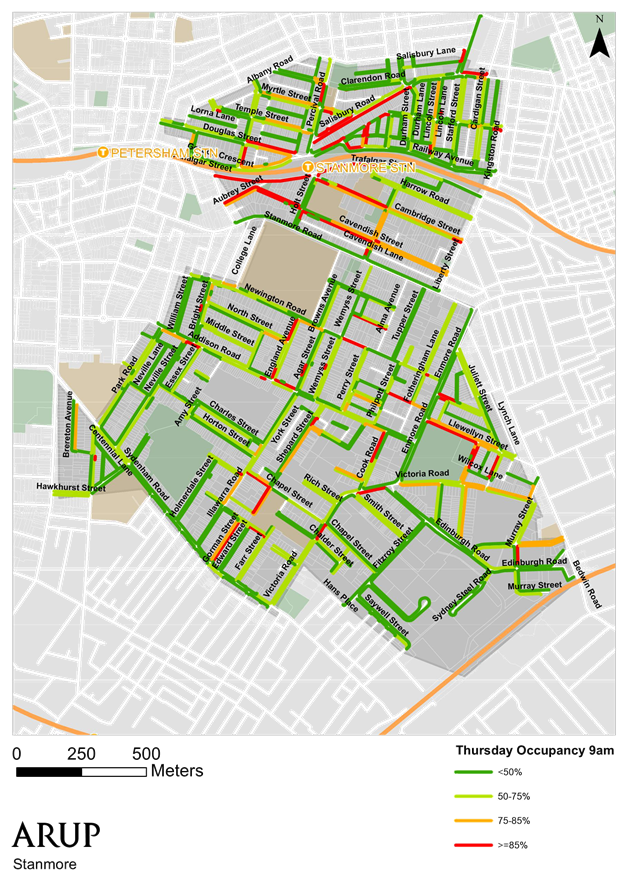
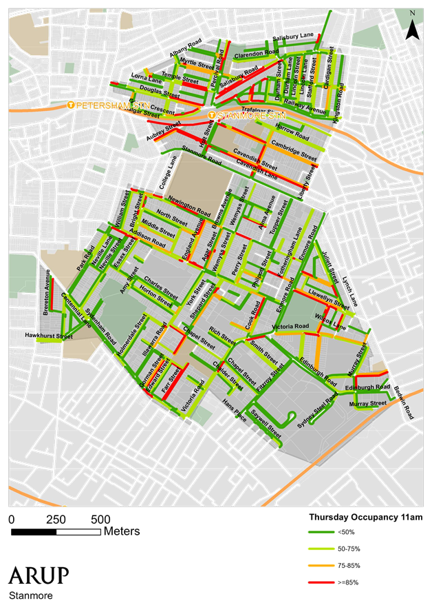
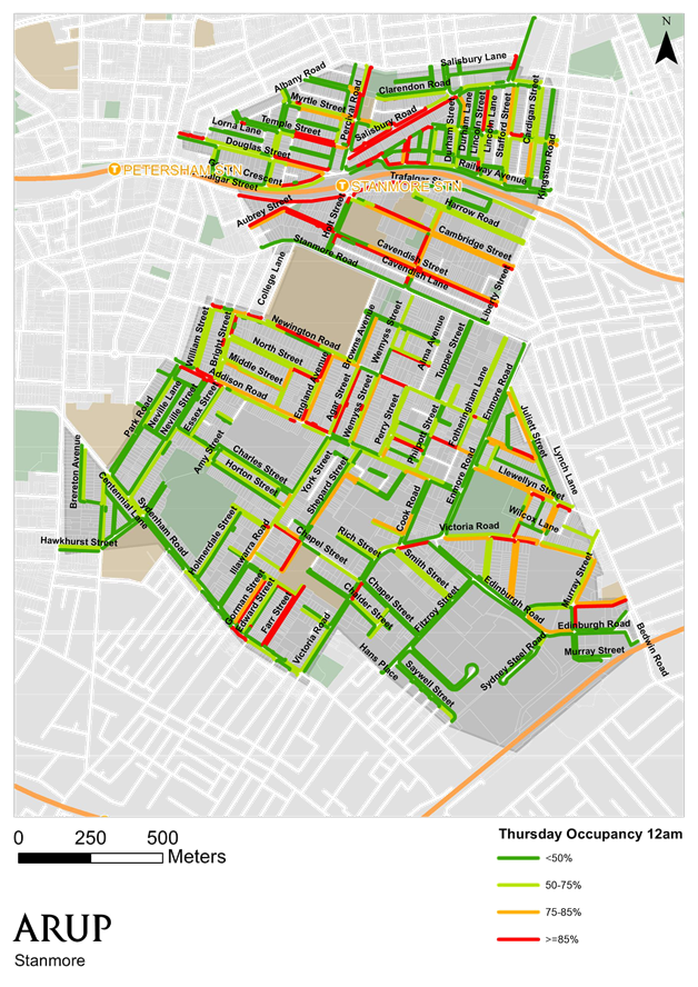
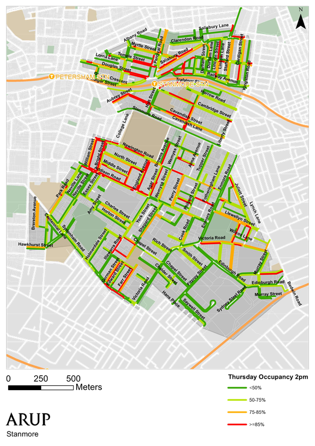
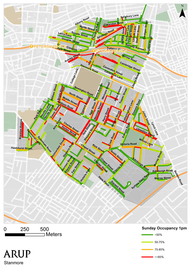
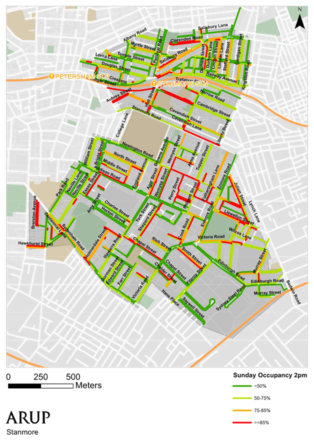
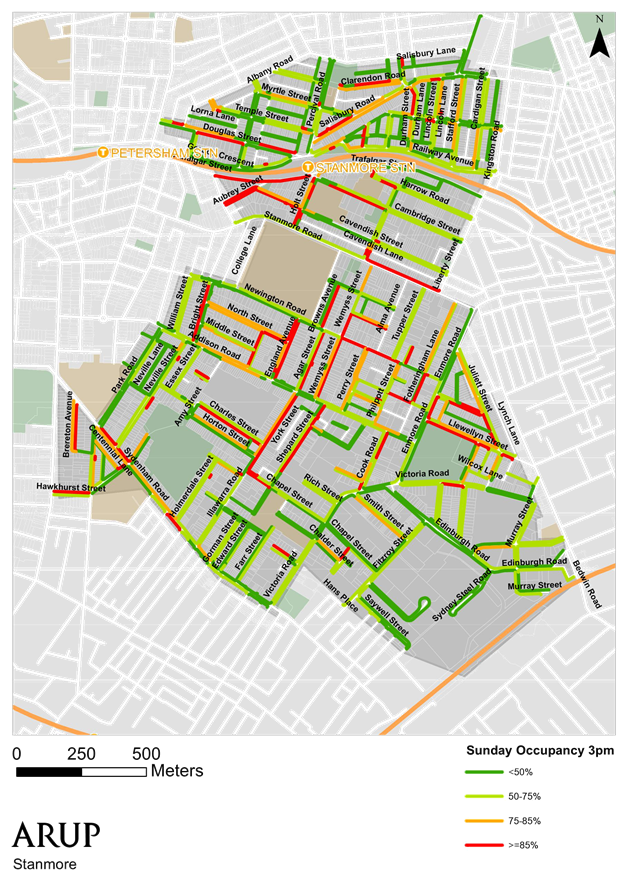
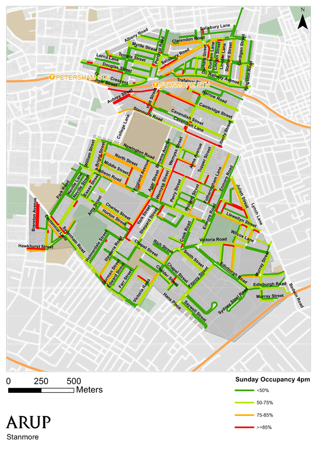
T1116 Item 35 Stanmore Parking Study - Draft Report 489
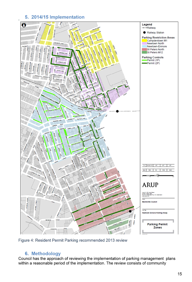
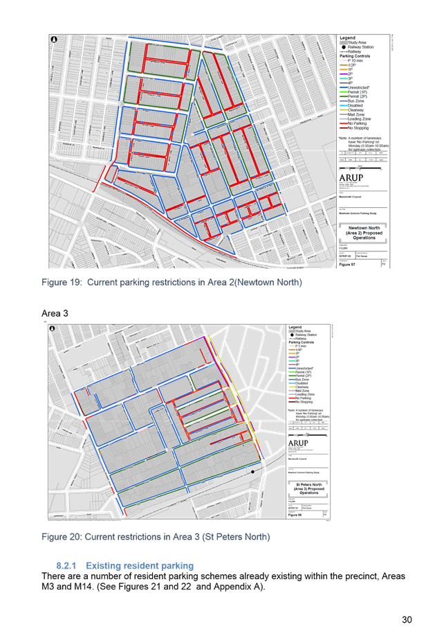
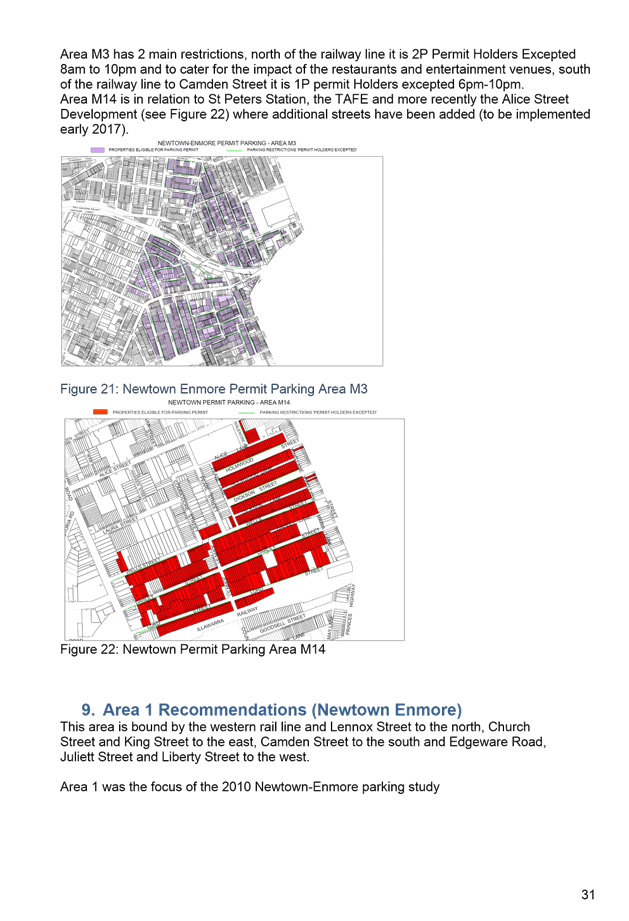
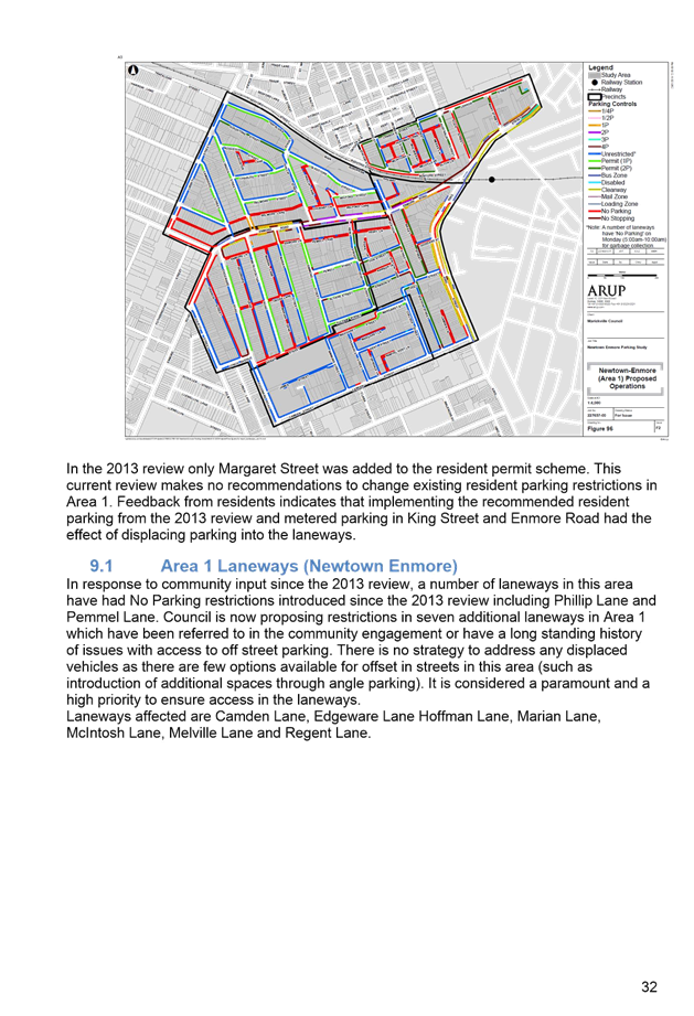
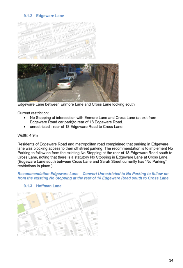
T1116 Item 36 Newtown Enmore Parking Review - Draft Report 615
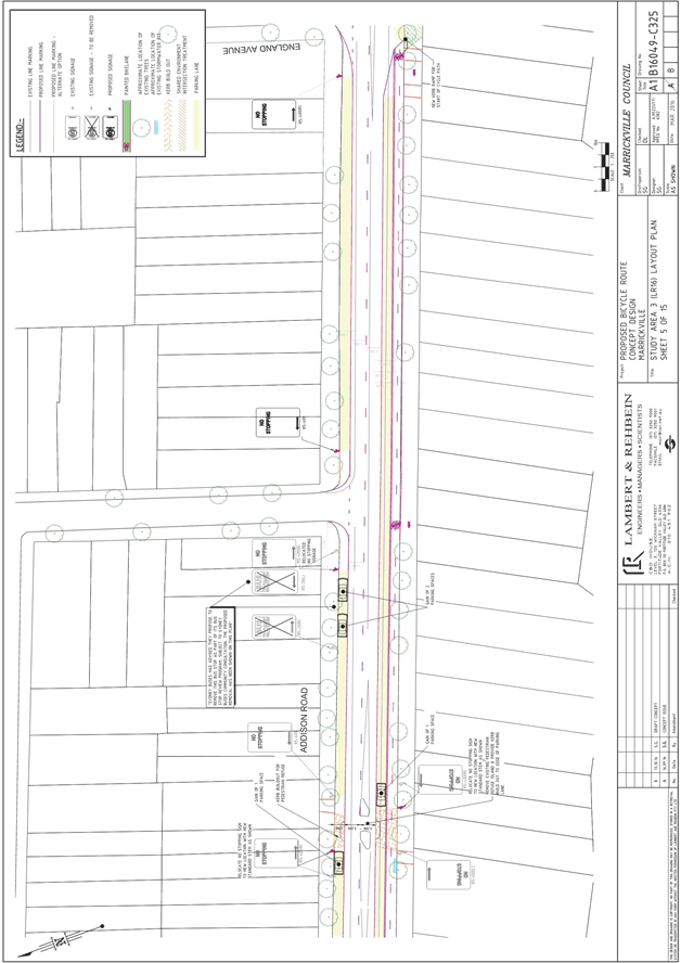
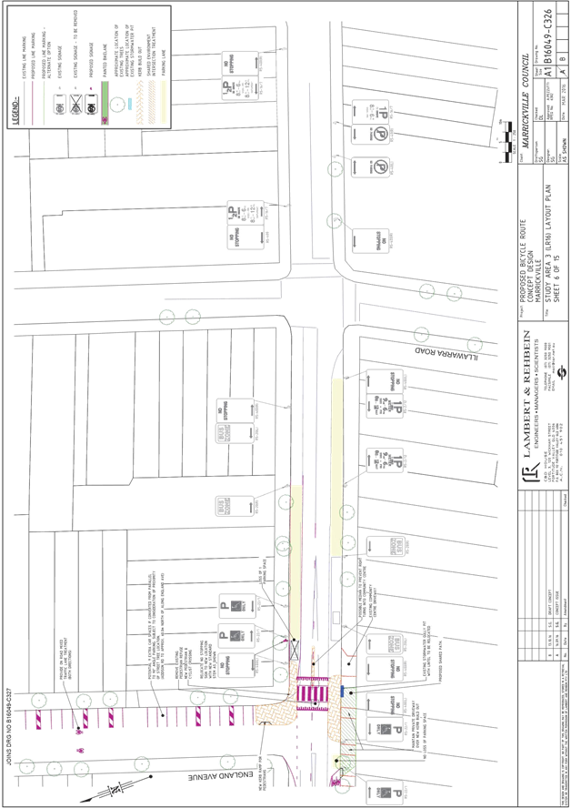
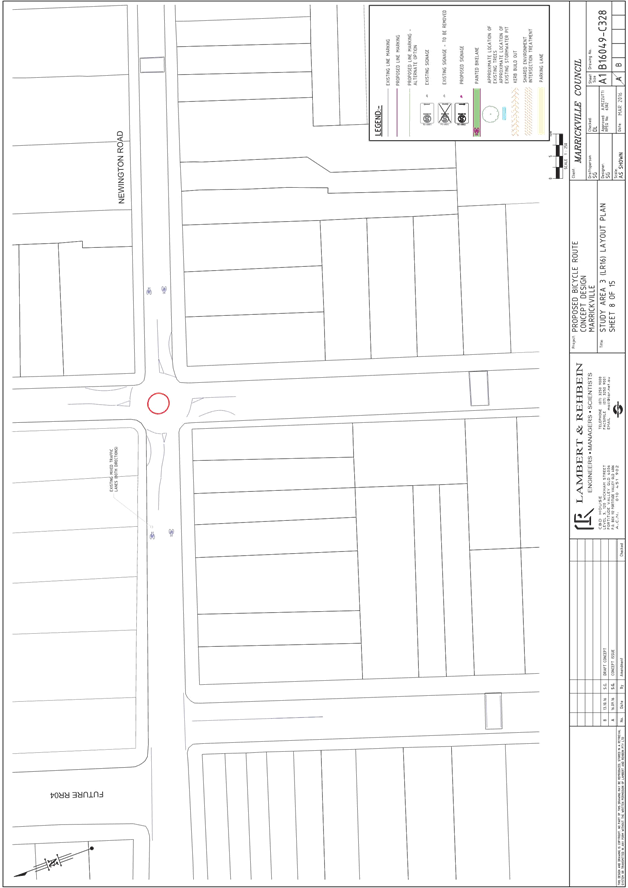
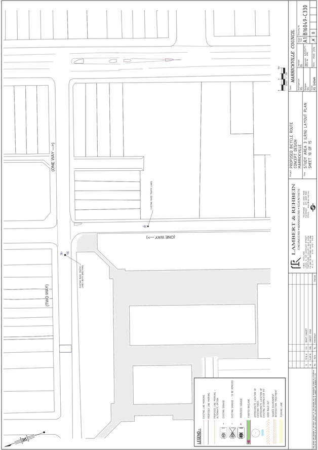
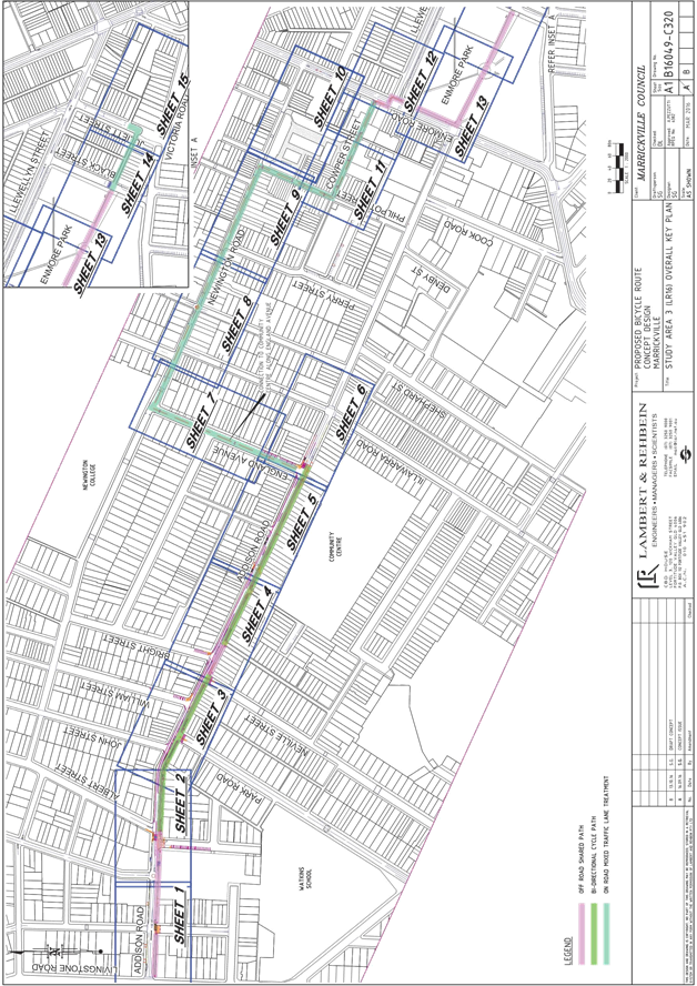
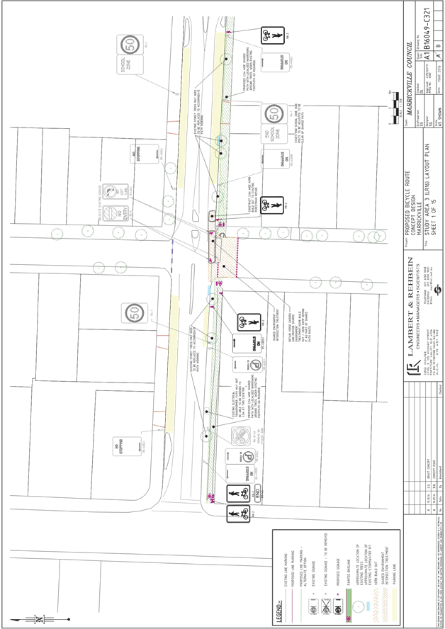
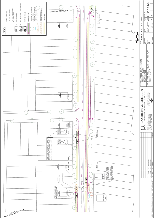
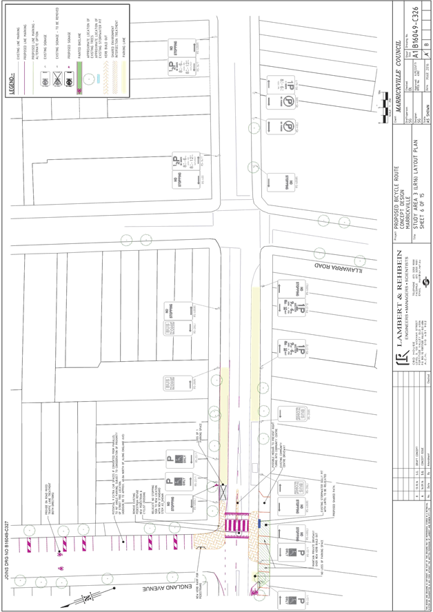
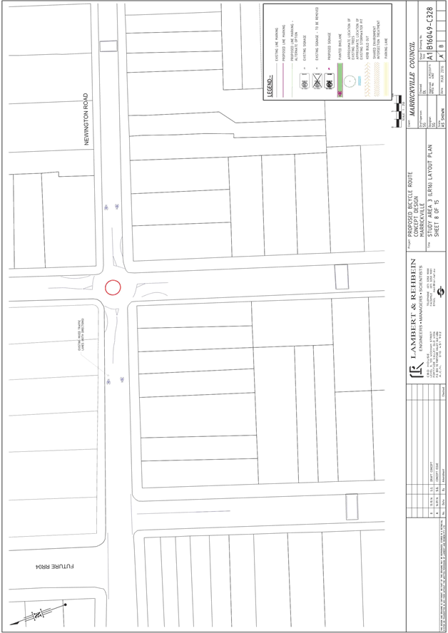
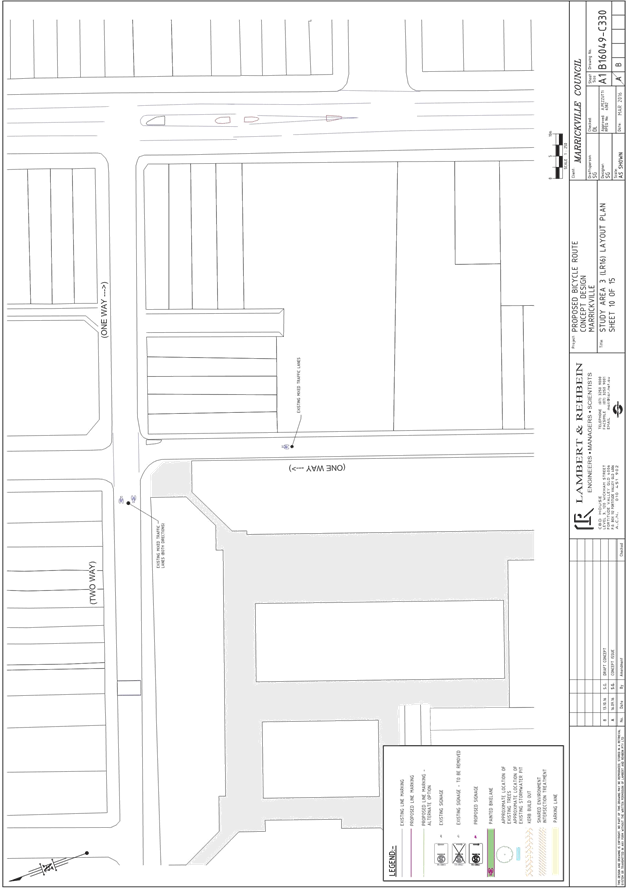
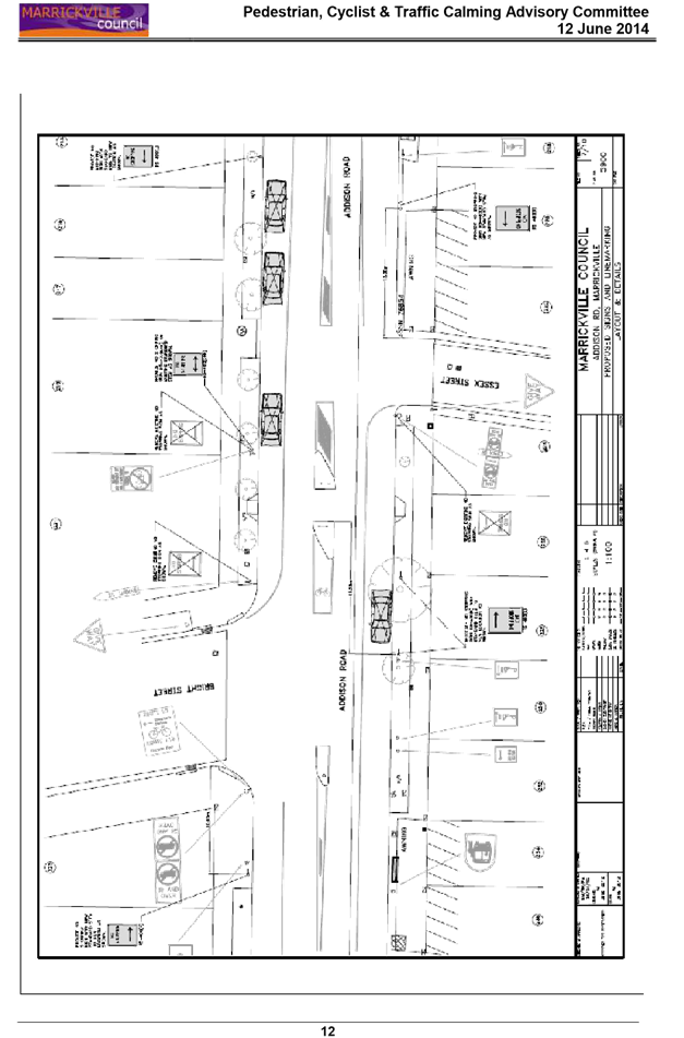
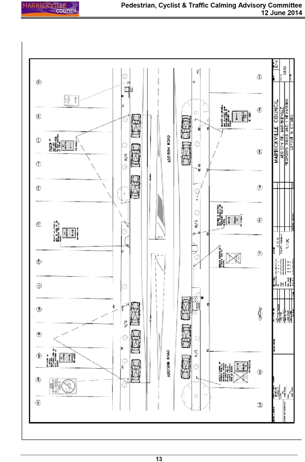
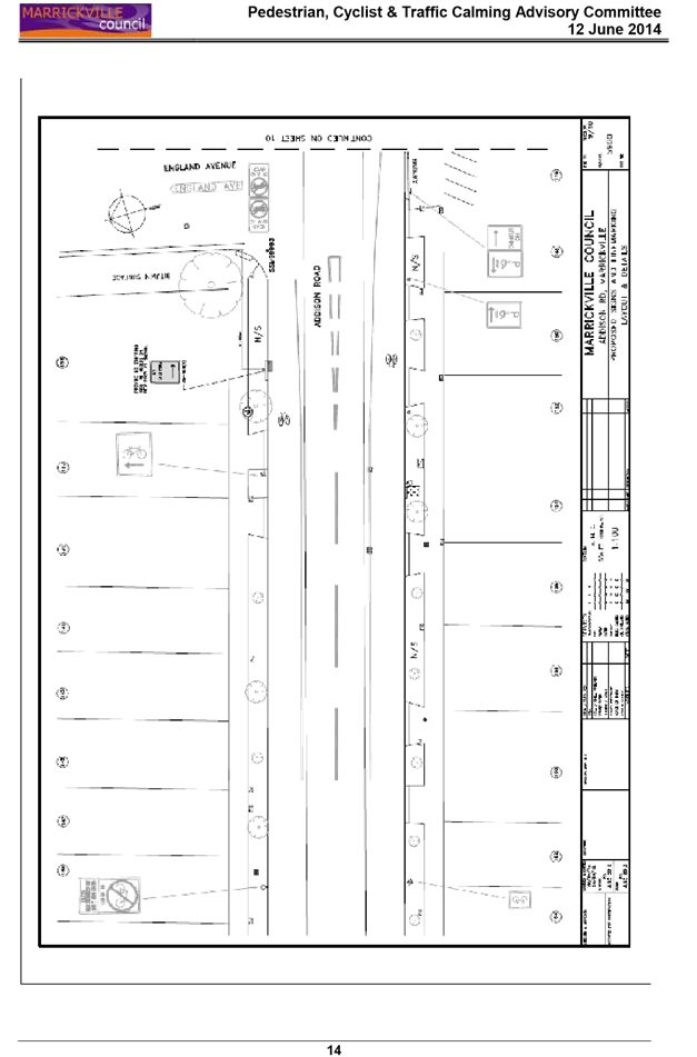
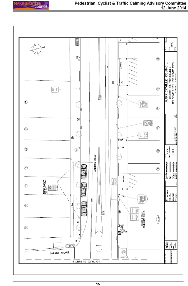
T1116 Item 37 Local Route 16 (Addison Road) - Draft Concept Plan for Public Exhibition 711
8 General Business
9 Close of Meeting
|
|
Local Traffic Committee Meeting 3 November 2016 |
Subject: Nicholson Street, Balmain East - Children’s
Crossing
(Balmain Ward/Balmain Electorate/Leichhardt LAC)
File Ref: 16/6022/122867.16
Prepared By: Nina Fard - Senior Traffic Engineer, Leichhardt
Authorised By: Jason Scoufis - Acting Traffic Manager, Leichhardt
|
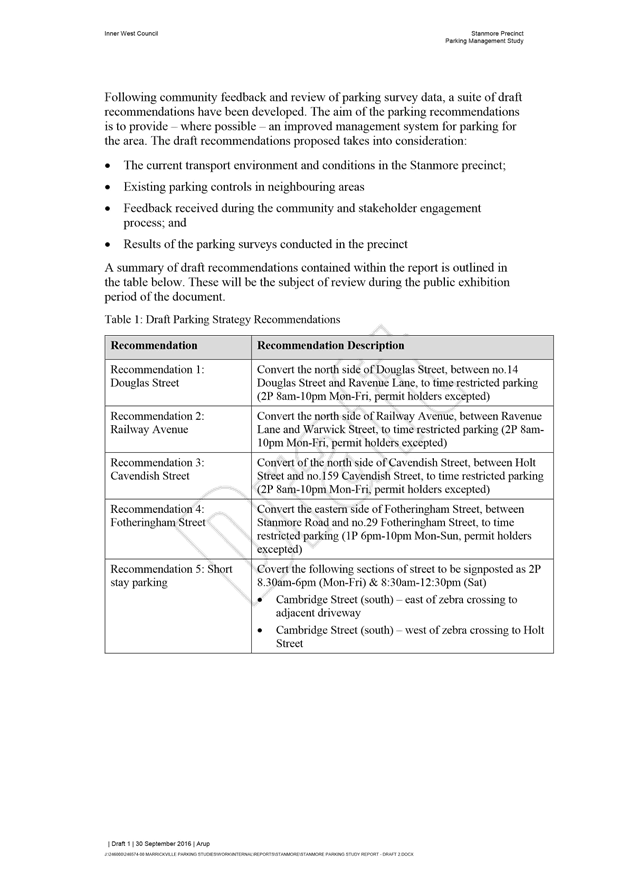
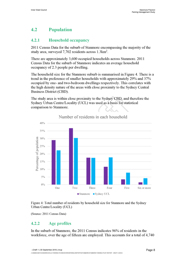
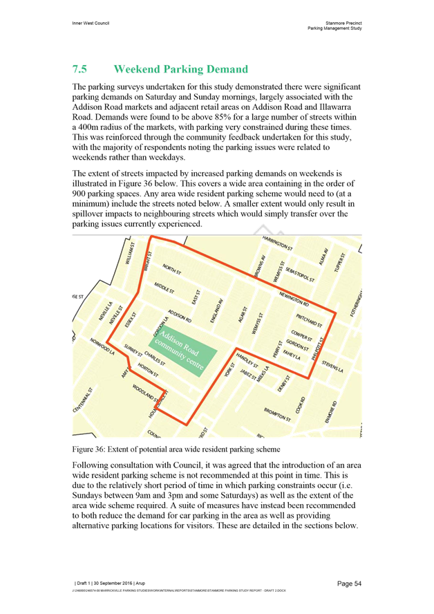
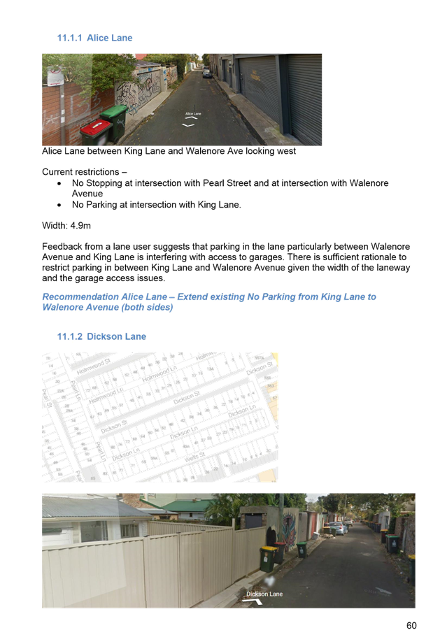
SUMMARY The Traffic Committee at its meeting in November 2015 approved the installation of a ‘Children’s Crossing 8:30am-9:30am to 2:45pm-3:45pm, School Days’ in Nicholson Street, just south of Brett Avenue, Balmain East. Council late last year endorsed the Traffic Committee’s recommendation and the crossing was subsequently installed in February 2016. Council has since received correspondence from a number of local residents in regards to the safety of children using the crossing at its current location and have requested relocation of the crossing to north of Brett Avenue. |
|
RECOMMENDATION
THAT:
1. the current location of the Nicholson Street Children’s Crossing (south of Brett Avenue) be retained; and 2. a STOP sign and the associated TF holding line be installed in Brett Avenue at the intersection of Nicholson Street.
|
BACKGROUND
The Traffic Committee has previously considered a number of reports for the provision of a pedestrian facility in Nicholson Street, Balmain East. The last report in November 2015 examined the following two possible locations for the proposed Children’s Crossing between Nicholson Street Public School and the entrance to Origlass Park:
· A Children’s Crossing north of Brett Avenue (impact on 10 kerbside parking spaces)
· A Children’s Crossing south of Brett Avenue (impact on 6 kerbside parking spaces)
In discussions with the School Principal and P&C representative the preferred location of the approved Children’s Crossing was chosen as south of Brett Avenue. This was based on the crossings impact on kerbside parking as well as providing a buffer from the existing kiss'n'ride parking restriction outside the school's entrance/exit points.
In November 2015 the Traffic Committee approved the installation of a ‘Children’s Crossing 8:30am-9:30am to 2:45pm-3:45pm, School Days’ in Nicholson Street, just south of Brett Avenue, Balmain East. Council late last year endorsed the Traffic Committee’s recommendation and the crossing was subsequently installed in February 2016.
Council has since received correspondence from a number of local residents, raising concerns in regards to the safety of children using the crossing at its current location and requesting relocation of the crossing north of Brett Avenue. The following safety concerns have been reported:
· High number of children NOT using the crossing
· Vehicles making 3 point turns (using Brett Avenue)
· Illegal parking within the 'No Stopping' zones supplementing the crossing facility
· Vehicles making U turns on the crossing
· Pedestrian/Vehicle conflict
· Vehicles crossing the double centrelines when turning left out of Brett Avenue
These issues were also raised at an onsite meeting held in March 2016, where the decision was made to further investigate potential options for relocating the Children’s Crossing north of Brett Avenue.
In order to gauge an understanding of the above mentioned concerns, Council conducted an investigation into the reported concerns involving the Children’s Crossing at its current location. Studies of the traffic and pedestrian activities around the subject Children’s Crossing were conducted a few weeks after the crossing was installed (March 2016) and then again 7 months after the crossing was installed (October 2016).
The results of these studies have been attached as Attachment 1.
Based on the recorded data, a small number of children were observed 'not using’ the crossing each day (average of 4 children during each surveyed period, ie: 1.15h-1.30h). Comparing the current data to those collected a few weeks after the opening of the crossing, the number of children ‘not using’ the crossing has declined overtime and is further reduced when the crossing is supervised by a school official.
A number of local residents have requested the relocation of the crossing north of Brett Avenue to eliminate the need for children to cross Brett Avenue at the intersection of Nicholson Street from the western footpath. Based on surveys conducted, traffic movement’s generation and trip distribution of the intersection of Brett Avenue is considered minimal (average of 4 vehicles during each surveyed period, ie: 1.15h-1.30h).
Making reference to the collected data, an average of 4 vehicles per survey period, were observed making 3 point-turns using the subject intersection during the study period. The number of vehicles making this maneuver has also declined over time.
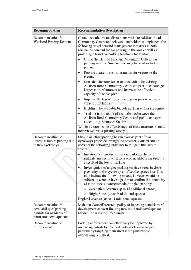
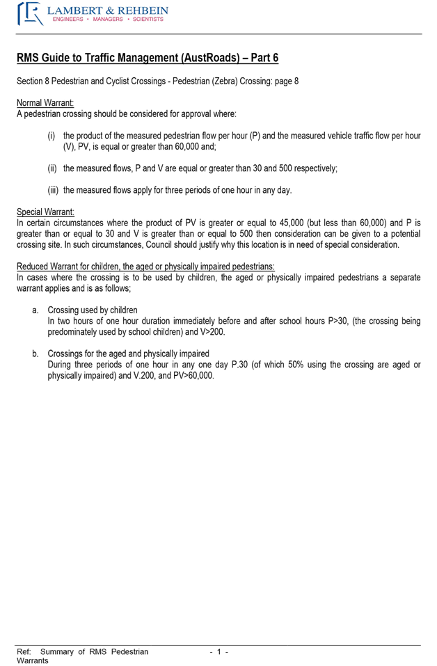
Options for relocation of the crossing:
Council has considered a number of options for a pedestrian facility north of Brett Avenue based on the traffic and pedestrian volumes during morning and afternoon peak periods as well as the potential parking impacts for local residents. The following two options, summarised below and shown on the attached plans, have been assessed and comply with RMS requirements for such facilities:
|
Proposed device |
Location |
Loss of parking/Comments |
|
Option 1: Children’s Crossing (without kerb blisters) |
Immediately north of Brett Avenue |
Total of 10 parking spaces affected temporarily each school day. 7 spaces on the western side and 3 spaces on the eastern side (Part-time, 8:30am-9:30am and 2:45pm-3:45pm, School Days) |
|
Option 2: Children’s Crossing (with kerb blisters) |
Immediately north of Brett Avenue |
Total of 5 spaces affected permanently. 3 spaces on the western side and 2 spaces on the eastern side (all day, 7 days/week). |
A pedestrian (zebra) crossing was also considered but did not meet the RMS reduced warrants for a crossing facility due to low vehicle volumes.
The Children’s Crossing without kerb blisters (Option 1) would operate during school drop off and pick up times (8:30am-9:30am and 2:45pm-3:45pm, School Days) and hence parking outside of these restriction hours would be retained. The School would be required to install flags at the crossing during the hours of operation. The number of parking spaces affected by a Children’s Crossing with kerb blisters (Option 2) would be substantially less; however, these spaces would become permanently unavailable (all day, 7 days/week).
FINANCIAL IMPLICATIONS
The cost for linemarking and signposting will be met from Council’s Operating Budget.
PUBLIC CONSULTATION
201 consultation letters outlining the following three options were mailed out to the affected residents:
1) Relocation of the Children’s Crossing (without kerb blisters), north of Brett Avenue? (as shown on the following Plan)
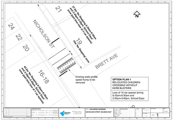
2) Installation of a Children’s Crossing (with kerb blisters), north of Brett Avenue? (as shown on the following Plan)
3) Support retaining the existing location of the Children’s Crossing (South of Brett Avenue)?
|
Results of community consultation |
|||
|
No. of properties |
201 |
Response Rate |
Support Rate |
|
No. of responses received |
54 |
27% |
|
|
No. of properties supporting Option (1) Relocation of the Children’s Crossing North of Brett Avenue (without kerb blisters) |
17 |
|
8% |
|
No. of properties supporting Option (2) Relocation of the Children’s Crossing, North of Brett Avenue (with kerb blisters) |
5 |
|
2% |
|
No. of properties supporting Option (3) Retaining the existing location of the Children’s Crossing, south of Brett Avenue. |
32 |
|
16% |
The above results include a petition opposing the relocation of the crossing signed by 19 residents from 17 properties in Nicholson Street and Brett Avenue, Balmain East. Also, the school community has not reported any specific issues with the operation of the crossing since its installation in February 2016.
Comments from residents objecting to the relocation of the crossing
|
Residents’ Comments |
Officer Comments |
|
Parking is a premium in our streets |
Noted. |
|
Very difficult to park in our street, a school bus should be arranged or parents encouraged to car-share. |
Council as part of its initiative to improve safety around Nicholson Street Public School conducted route analysis and parking surveys in the surrounding streets. A ‘Park and Walk Program’ was then developed and distributed to parents, encouraging them to use the surrounding streets to park their vehicle and walk their children to school. |
|
The school community believe the existing crossing can be retained in its current location. Whilst concerns have been raised with council by some local residents regarding the crossing, since the installation of the crossing I have not received any complaints regarding the location or safety of the crossing from members of my school community. I believe the council has acted in good faith with the school and the residents and hope this issue can be resolved. |
Views of the school officials/community have been noted. |
|
The availability of parking spaces in Nicholson street and surrounding streets is already extremely limited. The removal of more parking spaces would be completely irresponsible. Having acknowledged that there is a parking issue the council should not knowingly make it worse by moving the crossing and taking up more spaces. |
Noted. |
|
We find the proposed reduction in car parking spaces for residents very disappointing and without any substantial rationale, evidence or improved benefit for the children of the primary school. |
Council has undertaken extensive studies of the traffic and pedestrian activities around the subject children's crossing. The decisions to retain or relocate the crossing will be based on the data collected as well as residents and school official’s comments. |
Comments from residents supporting the relocation of the crossing
|
Residents’ Comments |
Officer Comments |
|
This change in the crossing is essential. It is currently very dangerous for kids crossing and cars veering over on the wrong side of the road from Brett Avenue. |
The current location of the children's crossing was selected as the preferred location in order to improve the safety of school children crossing Nicholson Street with minimum impact on the parking availability for residents. The study conducted at the crossing has shown a minor volume of vehicles turning left out of Brett Avenue and a small number of vehicles crossing the double centrelines as they turn left out of Brett Avenue. |
|
The crossing should go directly in front of the school.
|
This option has previously been considered and is not supported as it would require the removal or relocation of the existing 'kissnride' zone that provides a drop off and pick up zone for parents. |
|
I feel the current crossing is not safe enough because there is not enough signs and lights to tell drivers there is a crossing there. |
The current children's crossing and its associated signs and linemarkings are in accordance with the requirements of the Australian Standards and the RMS Technical Directions. RMS has installed flashing lights for the '40km/h School Zone' signage in Nicholson Street which assist in alerting motorists that they are entering a '40km/h School Zone'. |
|
The present location of the children’s crossing is the most dangerous as evidenced by photos provided to Council. All previous photos and correspondence provided should be used in support of our request to relocate the crossing. |
Council has undertaken extensive studies of the traffic and pedestrian activities around the subject children's crossing a few weeks after the crossing was installed (March 2016) and then again 7 months after the crossing was installed (October 2016). The decisions to retain or relocate the crossing will be based on the data collected and analysed by Council staff. |
|
Safety of children should be the main concern, not loss of parking spaces |
Council in discussion with the school officials and the Roads and Maritime Services representative approved the installation of the current Children’s Crossing to facilitate a safe crossing point for the school children. Safety is of upmost importance when considering traffic facilities. In saying that, a facility which improves pedestrian safety and preserves residential amenities is considered an ideal solution. |
|
More rigour required regarding checks on resident/visitors parking. Vehicles clearly not displaying current/valid permits taking up resident spots. |
Council has recently renewed parking permits in the municipality. As part of our commitment to comply with Council’s Resident Parking Policy and the Roads and Maritime Services, a review of the number of permits allocated to each property has been undertaken to ensure no additional permits are granted to ineligible properties. |
|
If the crossing is moved north of Brett Avenue there are less hazards to negotiate |
Relocating the Children’s Crossing north of Brett Avenue will eliminate the need for children to cross Brett Avenue at the intersection of Nicholson Street from the western footpath. However, based on the collected data, vehicular activities at this intersection during the school pickup and drop-off hours are minimal. Relocation of the crossing north of Brett Avenue could result in vehicles reversing over the children crossing when making a 3 point-turn. |
|
It’s better to lose 10 parking spaces during school hours than to lose 5 parking spaces permanently. |
Council is aware that parking is limited in Nicholson Street. All the available options have been presented to residents for their input. |
CONCLUSION
Based on the attached data it can be concluded that the Children’s Crossing at its current location is suitable. It should also be noted that when the crossing is supervised by a designated school official, it has been observed that the behaviour of pedestrians and vehicles improves. Furthermore, the provision of a Stop sign and TF holding line in Brett Avenue at the intersection of Nicholson Street would further improve conditions for pedestrians.
It is recommended that the current location of the Nicholson Street Children’s Crossing be retained and implementation of STOP sign and TF holding line in Brett Avenue at Nicholson Street be SUPPORTED.
|
1.⇩ |
Data from the Study |
|
Local Traffic Committee Meeting 3 November 2016 |
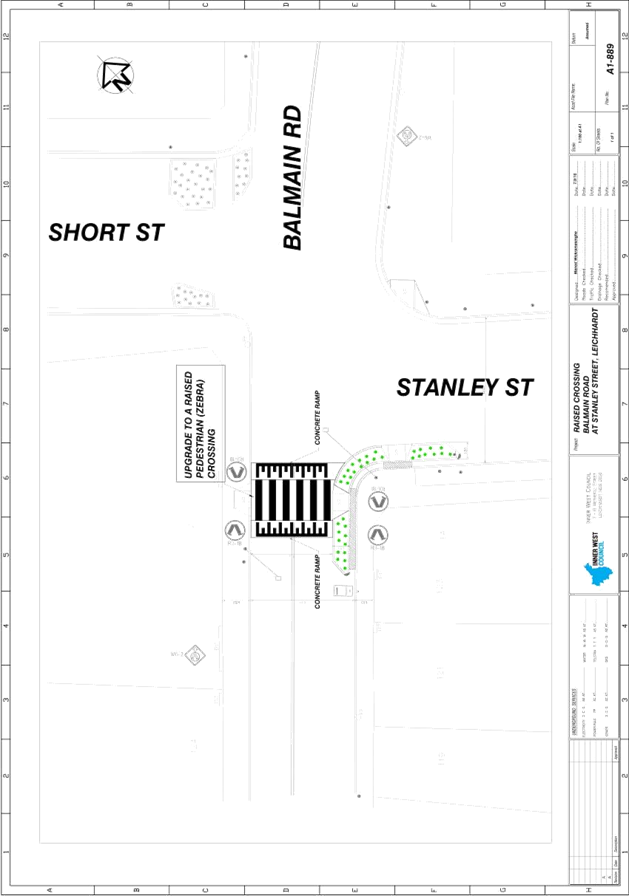
Subject: Balmain Road at Stanley Street, Leichhardt -
Raised Pedestrian Crossing
(Leichhardt Ward/Balmain Electorate/Leichhardt LAC)
File Ref: 16/6022/122902.16
Prepared By: Manod Wickramasinghe - Traffic and Parking Engineer, Leichhardt
Authorised By: Jason Scoufis - Acting Traffic Manager, Leichhardt
|
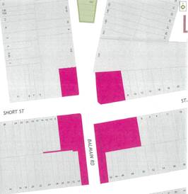
SUMMARY As part of Council’s 2016-17 traffic facilities program, it is proposed to upgrade the existing pedestrian (zebra) crossing on Balmain Road, south of Stanley Street to a raised (zebra) pedestrian crossing. |
|
RECOMMENDATION
THAT the proposed upgrade of the existing pedestrian (zebra) crossing to a raised pedestrian (zebra) crossing be supported as detailed in Attachment 1.
|
BACKGROUND
Council has investigated pedestrian conditions at the existing pedestrian (zebra) crossing near the intersection of Balmain Road and Stanley Street, Leichhardt as a result of a number of concerns received from residents.
Due to the presence of a number of pedestrian generators in the area; Leichhardt Primary School, Child Care Centre in Leichhardt Street, medical practices and shops along Norton Street, there was a high demand for a pedestrian crossing facility in Balmain Road and subsequently a marked pedestrian (zebra) crossing facility was installed in the 2013-14 financial year.
Following installation a number of residents raised concern regarding the need for additional warning to motorists of the facility and that they are concerned with vehicles not stopping when pedestrians are waiting to cross the road at this location.
In order to provide additional warning of the upcoming pedestrian crossing it was recommended in the September 2015 Traffic Committee that zig zag advanced pavement marking be installed on both approaches to the crossing.
However, due to continued concerns with vehicles not stopping at the pedestrian (zebra) crossing after the installation of the zig zag advanced pavement markings, Council successfully applied for RMS Active Transport funding in the 2016/17 program to assist in upgrading the existing pedestrian crossing to a raised pedestrian crossing.
A concept plan showing the proposal is shown in Attachment 1.
This proposal will reduce speeds along Balmain Road on approach to the pedestrian crossing and force motorists to slow down, thus providing improved safety for both pedestrians and vehicles.
In addition, due to the use of asphalt in the construction of the flat top section of the raised pedestrian crossing, there will be improved contrast between the linemarking and existing road surface. The existing road surface in this section is concrete resulting in less contrast with the white zebra lines than on a standard asphalt road surface.
FINANCIAL IMPLICATIONS
The cost of the civil works has been joint-funded between Inner West Council Leichhardt and RMS Active Transport Grant in the 2016-17 Active Transport program.
PUBLIC CONSULTATION
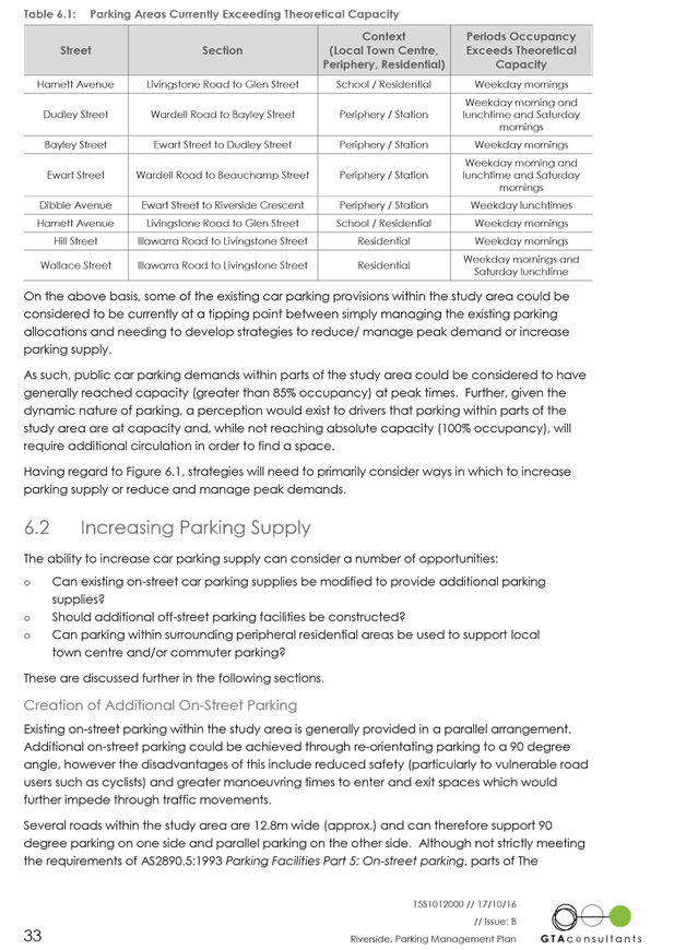
|
A letter outlining the above proposal was mailed out to the affected properties (25 properties) in Balmain Road, Short Street and Stanley Street, Leichhardt
Three responses were received.
One response supported the proposal and two responses objected to the proposal primarily to the increased noise associated with a raised device.
One late response was received asking an additional question which is specified below. |
|
|
RESIDENT COMMENT |
OFFICER RESPONSE |
|
Traffic noise, especially from bus movements is already an issue for the amenity of the nearby residential buildings.
Noise generation will increase if a raised facility is installed particularly as this Balmain Road is a bus route. |
As this is a bus route, the ramp grades will be flatter then a typical raised threshold. This is done to reduce the impact of the raised threshold on buses and their passengers. Due to this there will be reduced noise impacts associated with this crossing as opposed to a standard raised threshold or a watts profile speed hump. |
|
More signage or lights would be a better outcome |
The existing crossing facility already has 2 flourescent pedestrian crossing signs and zig zag advanced pavement markings on each approach. Lighting of the facility is also adequete.
The primary concern is the speed of vehicles passing through the crossing and thus failling to stop when a pedestrian is crossing. |
|
Does the assessment of a raised crossing examine the negative impact of the additional noise from cars slowing, bumping and then accelerating; against pedestrian numbers.
Although vehicle numbers are significant, pedestrian volumes are not. |
In order to install a pedestrian (zebra) crossing in the first instance Council must demonstrate that both pedestrian and vehicle volumes are high enough to meet the RMS warrants for a pedestrian (zebra) crossing.
There are no additional pedestrian volume requirements to raise the crossing as it has already been demonstrated that this is a crossing point with high demand from both pedestrians and vehicles. |
CONCLUSION
In order to improve pedestrian amenity across Balmain Road, Leichhardt at Stanley Street it is recommended that the proposed upgrade of the existing pedestrian (zebra) crossing to a raised pedestrian (zebra) crossing be supported as detailed in Attachment 1.
|
1.⇩ |
Concept Plan |
|
Local Traffic Committee Meeting 3 November 2016 |
Subject: Catherine Street at Ilka Street, Lilyfield -
Pedestrian Conditions
(Balmain Ward/Balmain Electorate/Leichhardt LAC)
File Ref: 16/6022/121223.16
Prepared By: Jason Scoufis - Acting Traffic Manager, Leichhardt
Authorised By: Nina Fard - Senior Traffic Engineer, Leichhardt
|
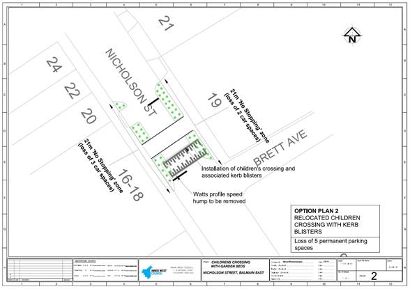
SUMMARY A resident has raised concern regarding pedestrian safety at the Catherine Street/Ilka Street intersection associated with conflict between northbound vehicles making u-turns in Catherine Street and pedestrians. These pedestrians, in particular children are crossing Catherine Street to access to War Memorial Park and are not expecting u-turns at this location. A pedestrian refuge is provided in Catherine Street at Ilka Street to provide pedestrian access to the park via a staged crossing. |
|
RECOMMENDATION
THAT:
1. road flaps be installed in the central painted median island in Catherine Street at Ilka Street to prevent u-turns; and 2. the edgeline on the western side of Catherine Street be adjusted to provide a wider bicycle shoulder parking lane whilst retaining a 3.2 metre wide northbound travel lane.
|
BACKGROUND
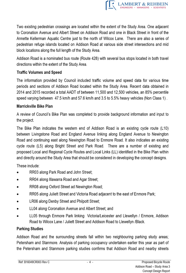
A resident has raised concern regarding pedestrian safety at the Catherine Street/Ilka Street intersection, in particularly associated with conflict between northbound vehicles in Catherine Street making u-turns and pedestrians, in particular children crossing Catherine Street to access to War Memorial Park who are not anticipating a u-turning vehicle at this location. A pedestrian refuge is provided in Catherine Street at Ilka Street to provide pedestrian access to the park.
In order to prevent u-turns whilst not impacting on turning movements at the intersection, it is recommended that road flaps be installed within the painted island to the north of the pedestrian refuge island.
It is also recommended that the northbound parking lane edge line be marginally readjusted to provide a wider lane for cyclists adjacent to the pedestrian refuge. A minimum of 3.2 metre travel lane will be maintained given that this forms part of a bus route.
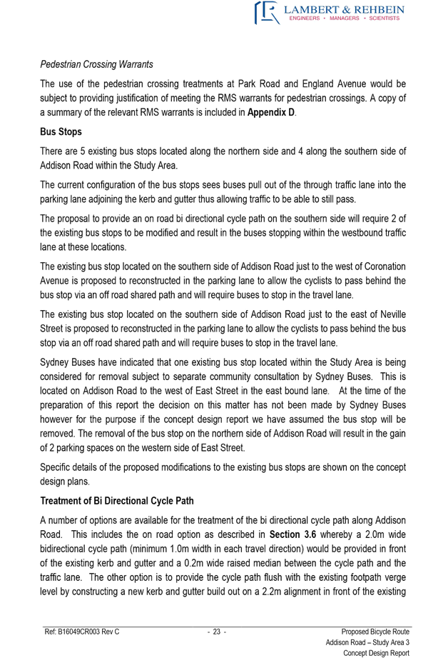
A plan of the proposed changes is detailed below.
FINANCIAL IMPLICATIONS
The cost for linemarking will be met from Council’s Operating Budget.
Image: Plan of the proposed changes
OFFICER COMMENTS
Not applicable.
PUBLIC CONSULTATION
Not required.
CONCLUSION
It is recommended that road flaps be installed in Catherine Street at Ilka Street to prevent u-turns. It is also recommended that the edgeline on the western side of Catherine Street be adjusted to provide a wider bicycle shoulder parking lane.
|
|
Local Traffic Committee Meeting 3 November 2016 |
Subject: View Street/Piper Street South, Annandale -
Pedestrian Conditions
(Balmain Ward/Balmain Electorate/Leichhardt LAC)
File Ref: 16/6022/121238.16
Prepared By: Jason Scoufis - Acting Traffic Manager, Leichhardt
Authorised By: Nina Fard - Senior Traffic Engineer, Leichhardt
|
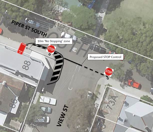
SUMMARY A business owner has raised concern regarding pedestrian safety conditions at the View Street/Piper Street South intersection as a result of speeding vehicles and corner cutting. The new café is generating more pedestrian movements in and around the intersection which has highlighted the issue. |
|
RECOMMENDATION
THAT:
1. a 10 metre ‘No Stopping’ zone be installed on the southern side of Piper Street South west of View Street, Annandale;
2. chevron linemarking be marked around the south western kerb return to reduce the travel lane width, slowing motorists as they make a left turn and providing improved separation between pedestrians and vehicles; and
3. installation of a STOP sign and stop linemarking be undertaken in View Street at Piper Street South.
|
BACKGROUND
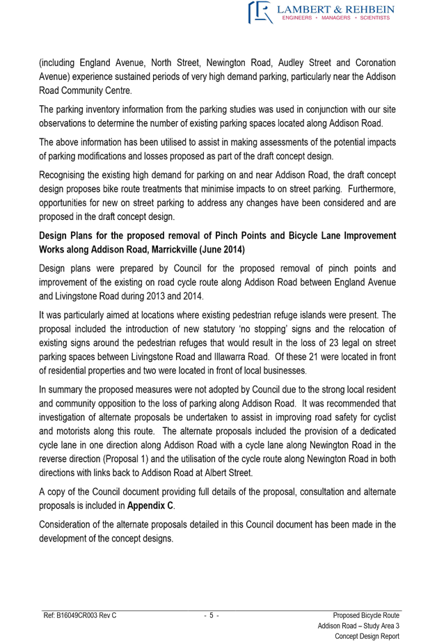
A business owner has raised concern regarding pedestrian safety conditions at the View Street/Piper Street South intersection as a result of speeding vehicles and corner cutting. The new café which opened in September 2016 has resulted in more pedestrian movements in and around the intersection.
In order to provide improved pedestrian conditions it is recommended that the following works be undertaken:
· A 10 metre ‘No Stopping’ zone be installed on the southern side of Piper Street South west of View Street;
· Chevron linemarking be marked around the south western kerb return to reduce the travel lane width, slowing motorists as they make a left turn and providing improved separation between pedestrians and vehicles; and
· Installation of a STOP sign and stop linemarking in View Street at Piper Street South.
A plan of the proposed changed is detailed below:
FINANCIAL IMPLICATIONS
The cost for linemarking and signposting will be met from Council’s Operating Budget.
PUBLIC CONSULTATION
Consultation with shop owner has been carried out and he is supportive of the proposed initiatives.
CONCLUSION
It is recommended that the linemarking and signposting as detailed in the report be supported to improve pedestrian safety in and around the intersection.
|
|
Local Traffic Committee Meeting 3 November 2016 |
Subject: Foreman Street, Tempe - Proposed ‘No
Right Turn’ Restriction into Princes Highway - Consultation Results
(Marrickville Ward/Heffron Electorate/Newtown LAC)
File Ref: 16/6022/121041.16
Prepared By: Jennifer Adams - Traffic and Road Safety Officer, Marrickville
Authorised By: Joe Di Cesare - Manager Design and Investigation, Marrickville
|
SUMMARY It has been reported that the right turn movement from Foreman Street into Princes Highway, Sydenham is dangerous because of the high volume of traffic on the highway and should be banned. Consultation with affected residents and businesses regarding a proposal to introduce morning and afternoon peak hour right-turn ban at this location has been undertaken and the results are presented in this report for consideration. It is recommended that an AM (6am-10am) and PM (3pm – 7pm) peak hour ‘No Right Turn’ restriction from Foreman Street into Princes Highway, Tempe be approved and implemented, subject to a Traffic Management Plan (TMP) being considered and approved by the Roads and Maritime Services (RMS). |
|
RECOMMENDATION
THAT:
1. the findings of the community consultation be received and noted; and 2. the installation of an AM (6am-10am) and PM (3pm – 7pm) peak hour ‘No Right Turn’ restriction from Foreman Street into Princes Highway, Tempe be APPROVED and implemented, subject to a Traffic Management Plan being considered and approved by the Roads and Maritime Services.
|
BACKGROUND
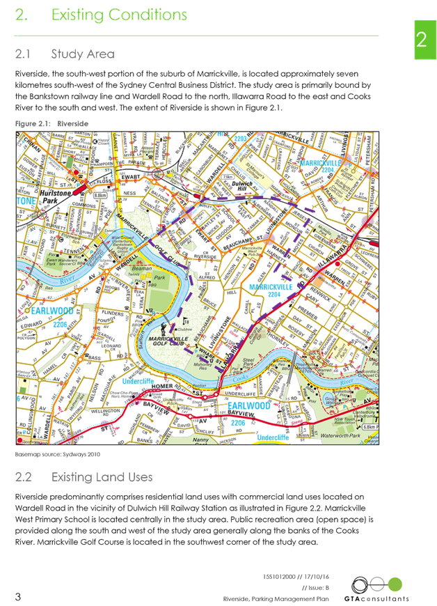
Several local Tempe residents have reported that the right turn movement from Foreman Street into Princes Highway, Sydenham is dangerous because of the high volume of traffic on Princes Highway and should be banned.
It is noted that ‘No Right Turn’ restrictions apply at Park Road at its intersection with Princes Highway and the movement is blocked to many other local streets due to a median on Princes Highway at Tempe.
FINANCIAL IMPLICATIONS
The costs of the supply and installation of the signposting associated with the recommended ‘No Right Turn’ restrictions are approximately $650 and can be met from Council’s operating budget.
OFFICER COMMENTS
Princes Highway is a State Road and arterial route being the principal north-south connection between Sydney and Wollongong. Annual Average Daily Traffic (AADT) for Princes Highway at Cooks River is 62,075vpd and for Princes Highway north of Railway Road is 52,841vpd.
Princes Highway is approximately 19m in width facilitating three lanes in each direction and is signposted 60km/h speed limit. It has a 6-10am northbound clearway and 3-7pm southbound clearway within kerbside lanes. Generally unrestricted kerbside parking is permitted along both sides of the road outside of clearway times.
Foreman Street is a local road and runs north-south between Unwins Bridge Road and Princes Highway and is posted as one-way in a southbound direction. It has a carriageway width of approximately 6 metres and is mainly residential with some industrial properties near Princes Highway.
Foreman Street forms a T-intersection with Princes Highway and both left and right turn movements onto the Princes Highway are permitted. There is a gap in the existing central median island on Princes Highway at this location which allows for the right turn movement from Foreman Street. There is a ‘No Entry’ restriction in place from Princes Highway into Foreman Street, as well as ‘One-way’ signage. (Refer to the attached locality map and photograph).
An observation survey was conducted on Friday 9 September 2016 in the morning peak period.
During the period between 8.00am – 9.00am it was observed that thirty-two (32) vehicles made a left turn out of Foreman Street northward onto Princes Highway and thirteen (13) vehicles made a right turn out of Foreman Street southward onto Princes Highway. Four (4) of the vehicles that turned left originally indicated that they were going to turn right however through delay and/or resignation the vehicles turned left.
A minor rear-end incident was witnessed around 8.15am between two vehicles intending to turn right however after the incident both turned left. Some motorists while turning right weaved their way through the three lanes on Princes Highway when vehicles were backed up and/or they made a dash across the lanes when lights south where red and the platoon had not yet approached Foreman Street.
Traffic volume & speed data
Traffic counts undertaken by a Council Officer on Foreman Street, between School Lane and Princes Highway in December 2011 indicated an average daily traffic volume of 520 vehicles eastbound and an 85th percentile speed of 35 km/h.
The recorded traffic volumes are considered to be acceptable for a local road in a mixed residential and industrial area. The 85th percentile speed recorded is within the current legal speed limit of 50 km/h.
Accident history
A search through the RMS’s reported crash database revealed that over a five-year period between 2011 and 2015 there were three reported crashes at the intersection of Princes Highway and Foreman Street, Tempe. An injury crash occurred in the morning peak on the Highway at Foreman Street (RUM 39 - vehicles from same direction ‘other’). Two tow-away crashes occurred, one of which involved a vehicle crossing the Highway and intending to travel south (RUM 13 - vehicles from adjacent direction – right near) and the other involved a light truck and a motorcycle (RUM 34 – vehicles from same direction – lane change).
Alternative route
Should the proposed time restricted ‘No Right Turn’ at Foreman Street be approved, an alternative route for motorists would be to turn right from Railway Road onto Princes Highway and/or from Gannon Road at the existing traffic signals. These intersections are normally busy during morning and afternoon traffic peak periods, however, the right turn onto the highway is much safer than at Foreman Street. Alternatively motorists could turn left out of Foreman Street onto the Highway and then turn right at the signalised entry into Ikea’s carpark and then exit in a southward direction.
PUBLIC CONSULTATION
A notification letter was sent out on 20 September 2016 to 76 owners and occupiers of all properties within the block bounded by Foreman Street, Princes Highway, Union Street and Unwins Bridge Road, Tempe with the submission closing date of Friday 7 October 2016. At the end of the consultation period, two submissions were received and are summarised below:
|
Comments from respondents |
Officer’s comments |
|
A resident of Foreman Street ‘fully supports the no right turn proposal’.
The resident added that ‘living not too far from that intersection .. I have seen the aftermath of many an accident on that intersection.’ They added ‘keep up the good work’.
|
Respondent supports the proposal.
|
|
Another resident supports the proposed ‘No Right Turn’ restriction into Princes Highway from Foreman Street. “I heartily approve of this proposal and thank you. On numerous occasions I have had to sit behind a car attempting to make a right turn and hoping that an accident does not happen. As far as I am concerned the sign cannot go up quickly enough.’
|
Respondent supports the proposal.
|
CONCLUSION
In order to increase safety and given that there were no objections from the community, the provision of peak hour ‘No Right Turn’ restriction from Foreman Street into Princes Highway, Tempe is recommended.
If supported by Council, a Traffic Management Plan (TMP) will need to be submitted to the RMS for consideration and approval.
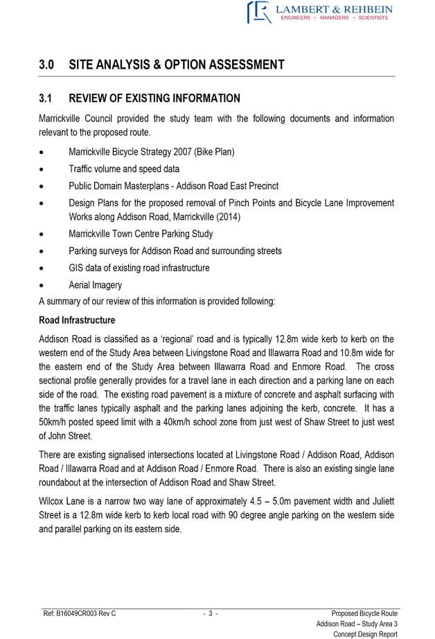
Locality map – Foreman Street, Tempe
![]()
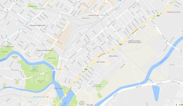
Google Maps
![]()
Photographs – Forman Street at Princes Highway, Tempe
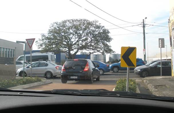
Foreman Street looking south to Princes Highway intersection (am peak)
Princes Highway looking north ward and Foreman Street on right (am peak)
|
Looking south along Princes Highway from Foreman Street intersection (am peak)
Vehicle making right hand turn out of Foreman Street south onto Princes Highway |
|
|
Local Traffic Committee Meeting 3 November 2016 |
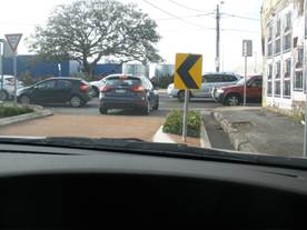
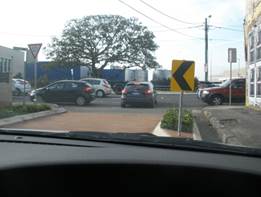
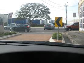
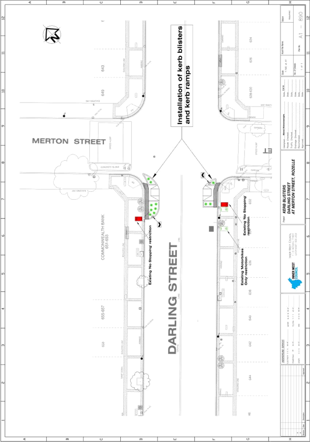
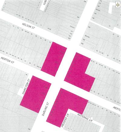
Subject: Merton Street, Rozelle - Kerb Blisters
(Balmain Ward/Balmain Electorate/Leichhardt LAC)
File Ref: 16/6022/121245.16
Prepared By: Manod Wickramasinghe - Traffic and Parking Engineer, Leichhardt
Authorised By: Jason Scoufis - Acting Traffic Manager, Leichhardt
|
SUMMARY As part of the 2016-17 traffic facilities program, it is recommended to install kerb blisters on Darling Street at Merton Street, Rozelle to improve pedestrian amenity. |
|
RECOMMENDATION
THAT the construction of kerb blisters on both sides of Darling Street, Rozelle immediately south of Merton Street be supported as detailed in Attachment 1.
|
BACKGROUND
Council has investigated pedestrian conditions at the intersection of Merton Street and Darling Street, Rozelle as a result of a number of requests received from residents and businesses.
This intersection is the only one on Darling Street between Victoria Road and Wise Street which does not have a pedestrian crossing facility i.e. Pedestrian (zebra) crossing or signalised pedestrian crossing.
Pedestrian and vehicle counts have indicated that the warrant for a pedestrian (zebra) crossing is not met, hence the proposal for kerb blisters on Darling Street at Merton Street, Rozelle.
A concept plan showing the proposal is shown in Attachment 1.
This proposal will provide a shortened crossing distance for pedestrians and allow vehicles to sight pedestrians more easily, thus providing improved safety for both pedestrians and vehicles.
It is also expected that this facility will result in a reduction in vehicular speeds in Darling Street through Rozelle Town Centre including turning movements at the intersection.
FINANCIAL IMPLICATIONS
The cost of the civil works has been funded from Inner West Council Leichhardt’s 2016-17 traffic facilities program.
PUBLIC CONSULTATION
A letter outlining the above proposal was mailed out to the affected properties (64 properties) in Darling Street and Merton Street, Rozelle.
One response was received supporting the proposal.
CONCLUSION
In order to improve pedestrian amenity along Darling Street, Rozelle it is recommended that the proposed construction of kerb blisters on both sides of Darling Street, Rozelle immediately south of Merton Street be supported as detailed in Attachment 1.
|
1.⇩ |
Concept Plan |
|
Local Traffic Committee Meeting 3 November 2016 |
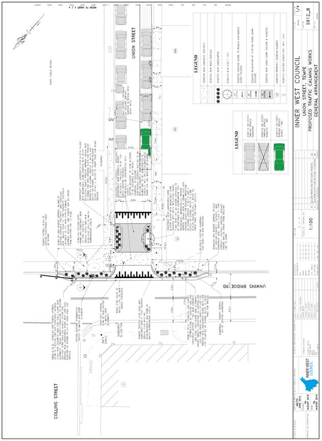
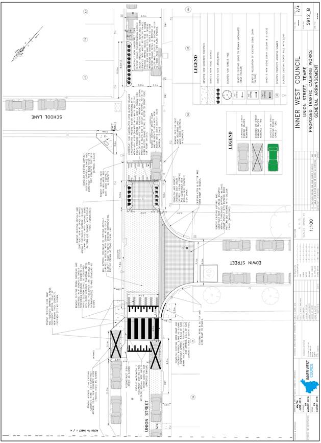
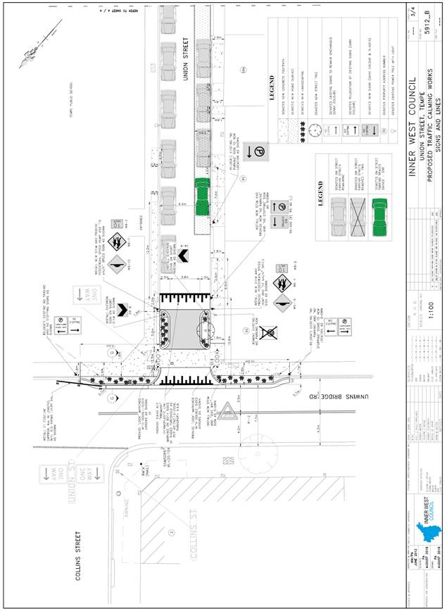
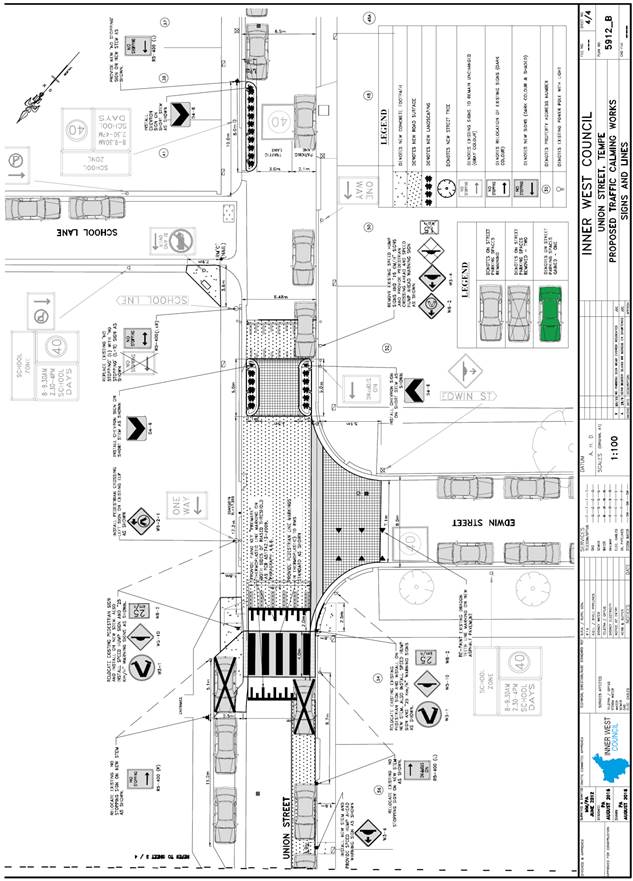
Subject: Union Street, Tempe - Proposed Traffic Calming
Revised Design Plans
(Marrickville Ward/Heffron Electorate/Newtown LAC)
File Ref: 16/6022/122143.16
Prepared By: Emilio Andari - Civil Engineer, Marrickville
Authorised By: Joe Di Cesare - Manager Design and Investigation, Marrickville
|
SUMMARY A presentation by a resident of Union Street, Tempe was made to the Local Traffic Committee at its meeting on 6 October 2016. A number of concerns and issues were raised as part of the presentation regarding the proposed traffic calming measured in Union Street. It was resolved to refer the matter back to the November Local Traffic Committee meeting in order to address the resident’s concerns. The report below addresses the issues raised through the resident’s presentation and incorporates changes to the detailed design plan following consideration of these issues. |
|
RECOMMENDATION
THAT the detailed design plan for a raised pedestrian crossing, a raised threshold and an at-grade threshold (including kerb blisters) and associated signs and line markings in Union Street, Tempe (as per the attached design plan No. 5912 ‘Amendment B’) be APPROVED.
|
BACKGROUND
Council is proposing to construct a raised pedestrian crossing, a raised threshold and an at-grade threshold (including kerb blisters) and associated signs and line markings in Union Street, Tempe adjacent to Tempe Public School between Unwins Bridge Road and School Lane.
The design plans have been revised following consideration of issues raised during a presentation by a Union Street resident at the October, 2016 Local Traffic Committee meeting.
FINANCIAL IMPLICATIONS
Funding of $100,000 has been allocated by Council for these works under the 2016/2017 Capital Works Program.
OFFICER COMMENTS
Site location & road network
|
Street Name |
Union Street |
|
Section |
Between Princes Highway and Unwins Bridge Road |
|
Carriageway Width (m) |
6.5 |
|
Carriageway Type |
One-way road with one travel lane in a westbound traffic flow, in addition to kerbside parking lanes. |
|
Classification |
Local |
|
85th Percentile Speed (km/h) |
29.5 |
|
Vehicles Per Day (vpd) |
449 |
|
Reported Crash History (2010 – 2015) |
No crashes recorded. |
|
Heavy Vehicle Volume (%) |
3.2 |
|
Parking Arrangements |
Unrestricted parking on both sides of the road. |
Vehicles counts were undertaken on Union Street at Unwins Bridge Road initially to gauge whether the site would warrant a marked foot crossing. Although the location didn’t, it was found that a continuous footpath treatment could be provided.
A vehicle count was undertaken to gauge if a continuous footpath treatment met the Roads and Maritime Service (RMS) warrant. The results of the analysis is summarised below:
|
Period |
Vehicles (V) |
|
Morning (9.00am-10.00am) |
44vph |
|
Afternoon (1.00pm-2.00pm) |
38vph |
|
Evening (5.00pm-6.00pm) |
32vph |
(vph – vehicles per hour)
The RMS warrant typically requires no more than 45 vehicles per hour moving through the intersection that is being treated. Measured vehicle flow is to be applied for three periods of one hour in any day. The counts above were taken on a weekday in November 2014.
Design plans
Design plans for the proposal for a raised pedestrian crossing, a raised threshold and an at-grade threshold (including kerb blisters) and associated signs and line markings in Union Street, Tempe adjacent to Tempe Public School between Unwins Bridge Road and School Lane (as per the attached design plan No. 6102 ‘Amendment B’) are submitted for consideration. The design plans have been amended from the previous design plans No. 6102 & No. 6102 ‘Amendment A’ following concerns raised by a local resident.
The proposed scope of work includes the following:
· Replace the existing at-grade pedestrian crossing in Union Street and construct a new raised pedestrian crossing;
· Construct a new raised threshold with landscaped kerb islands in Union Street at Unwins Bridge Road;
· Widen the footpath in Unwins Bridge Road and provide landscaped verges;
· Replace the existing speed hump in Union Street, adjacent to property no. 52 Union Street, with a new coloured at-grade threshold and landscaped kerb islands;
· Constructing a new coloured, at-grade threshold in Edwin Street at Union Street;
· Reseal the road at the intersection of Union Street and Edwin Street;
· Construct sections of new concrete footpath along Union Street; and
· Install associated signage and line markings, replacing any damaged signs and repairing any faded line markings.
The amendments following concerns raised by the resident include the following:
· The northern kerb blister island opposite to property no. 52 Union Street has been shortened from 9.4m to 5.0m. It should be noted that Council garbage vehicles do not turn right from School Lane into Union Street as the vehicles parked opposite School Lane prevent them from being able to perform this turning manoeuvre;
· The existing ‘No Stopping’ (left arrow) sign on the northern side of Union Street is 3.6m west of School Lane and is to be replaced with a ‘No Stopping’ (left and right arrow) sign. In accordance with the Australian Road Rules, a ‘No Stopping’ zone is mandatory for a distance of 10 metres from an intersecting road; and
· The existing ‘No Parking’ sign on the southern side of Union Street outside property no. 60 Union Street be shifted 7m west towards Unwins Bridge Road. It should be noted that the sign relocation will gain one additional on-street parking space in Union Street.
|
Residents’ Comments |
Officer’s Response |
|
1. Concerns were raised regarding the new raised pedestrian crossing and loss of two car parking spaces. The resident highlights that parking is a premium within the area especially with the nearby school and church in Union Street.
|
1. It is acknowledged that the proposed treatments will result in the loss of two (2) on-street parking spaces adjacent to the proposed raised pedestrian crossing in Union Street. In accordance with Australian Standard (AS1742.10-2009), the design requirements for a pedestrian crossing must consist of ‘No Stopping’ restrictions on approach and departure to the crossing. This is to increase visibility for pedestrians and improve safety. In this case, the crossing is located adjacent to Tempe Primary School so it important to ensure that safety is not compromised. It should be noted that the existing ‘No Stopping’ restrictions associated with the existing at-grade crossing does not comply with either Australian Standards or Australian Road Rules. |
|
2. Concerns of new raised threshold with landscaped kerb islands in Union Street at Unwins Bridge Road as this will reduce the line of sight for turning motorists. 3. Concerns regarding the widening the footpath in Unwins Bridge Road and providing landscaped verges as this will reduce the line of sight for turning motorists. |
2 & 3. The design plans addressed the visibility issues in Union Street at Unwins Bridge Road by ensuring the proposed landscaping in Unwins Bridge Road does not grow taller than 0.6m in height. Also, the extension of kerb and removal of approximately 8 metres of pedestrian safety fencing paneling along Unwins Bridge Road at Union Street will provide better sight lines for queuing motorists in Union Street at Unwins Bridge Road. Pedestrians will still be prevented from crossing Unwins Bridge Road at this point as the landscaping will act as a barrier and deterrent. |
|
4. Removing the speed hump in Union Street, between Edwin Street and School Lane, and constructing a new coloured threshold and landscaped kerb islands would hinder the ability for turning motorists to safely make the right turn without obstruction.
|
4. The existing speed hump is located too close to the proposed raised pedestrian crossing therefore it has been removed and replaced with an at-grade threshold treatment which will act as an entry treatment in this case. The design of the proposed kerb blister islands have been amended to accommodate the turning path of a 6.6m long small rigid vehicle turning out of School Lane into Union Street and an 8.8m long medium rigid vehicle (i.e. waste collection truck) turning into and out of Edwin Street from Union Street. The width of the roadway at the intersection of School Lane into Union Street and vehicles parked on the opposite side of the intersection make this turn very tight at present and it should be noted that Council garbage vehicles do not turn right from School Lane into Union Street as parked vehicles prevents them from being able to perform this turning manoeuvre. In the amended plans, the northern kerb blister island opposite to property no. 52 Union Street has been shortened from 9.4m to 5.0m to assist with turning movements of larger vehicles and to maintain the existing situation regarding possible turn movements. |
|
5. The construction of a new coloured, flat threshold in Edwin Street at Union Street not necessary. 6. Resealing the road at the intersection of Edwin Street at Union Street is not necessary.
|
5 & 6. The introduction of a stenciled at-grade treatment promotes visual and physical changes i.e. pavement and material to highlight change in traffic conditions. It was identified during site investigations that the road surface was in a poor condition and a decision was made by Council’s officer to resurface the pavement in order to accommodate the stencilling works. |
|
7. Proposed the shortening of the existing ‘No Parking’ zone adjacent to properties 60 & 62 Union Street to gain an additional parking space for residents.
|
7. There is currently a section of ‘No Parking’ on the southern side of Union Street in front of properties 60 & 62 Union Street. The ‘No Parking’ restrictions outside property 60 Union Street have been shifted 7m west towards Unwins Bridge Road. This proposal will gain one additional on-street parking space in Union Street. However, the kerb ramp and ‘No Parking restrictions out front of property 62 Union Street will remain in place to provide a pick-up and drop-off area in close proximity to the church and school. The design plan also illustrates the relocation of the signs and stem with the inclusion of statutory ‘No Stopping’ restrictions at the intersection of Union Street and Unwins Bridge Road. It should be noted that parking on the footpath is prohibited under the Australian Road Rules, though this is an enforcement issue. Council Rangers have been notified. |
|
8. The construction of a new raised threshold with landscaped kerb islands in Union Street at Unwins Bridge Road would hinder the ability for turning motorists to safely make the left turn without obstruction. |
8. The design of the proposed raised threshold with landscaped kerb islands accommodates the turning path of an 8.8m long medium rigid vehicle (i.e. waste collection truck) turning out of Union Street into Unwins Bridge Road. |
As a result of the issues raised by the resident, the design plan has been amended to address the resident’s concerns. The proposed treatments will now result in the loss of one (1) legal on-street parking spaces in Union Street. It is envisaged that these measures will improve pedestrian and student safety (refer to the attached design plan No. 5912 ‘Amendment B’). All current vehicular access to adjoining properties will be retained.
PUBLIC CONSULTATION
Consultation was undertaken with affected stakeholders (i.e. the church and the women refugee centre) in October 2016 in relation to the shortening of the existing ‘No Parking’ zone adjacent to property no. 60 and 62 Union Street. The stakeholders raised no objections to the shortening of the zone by one space, however the church stated that they wanted the existing pram ramp maintained for mobility impaired people. In addition, Council officers have advised the residents and the key stakeholders of Union Street of the proposed changes in the form of a letter together with a copy of the final amended design plan.
CONCLUSION
It is recommended that the design of the proposed traffic devices and associated signs and markings be approved, to improve pedestrian safety and traffic conditions.
|
|
Local Traffic Committee Meeting 3 November 2016 |
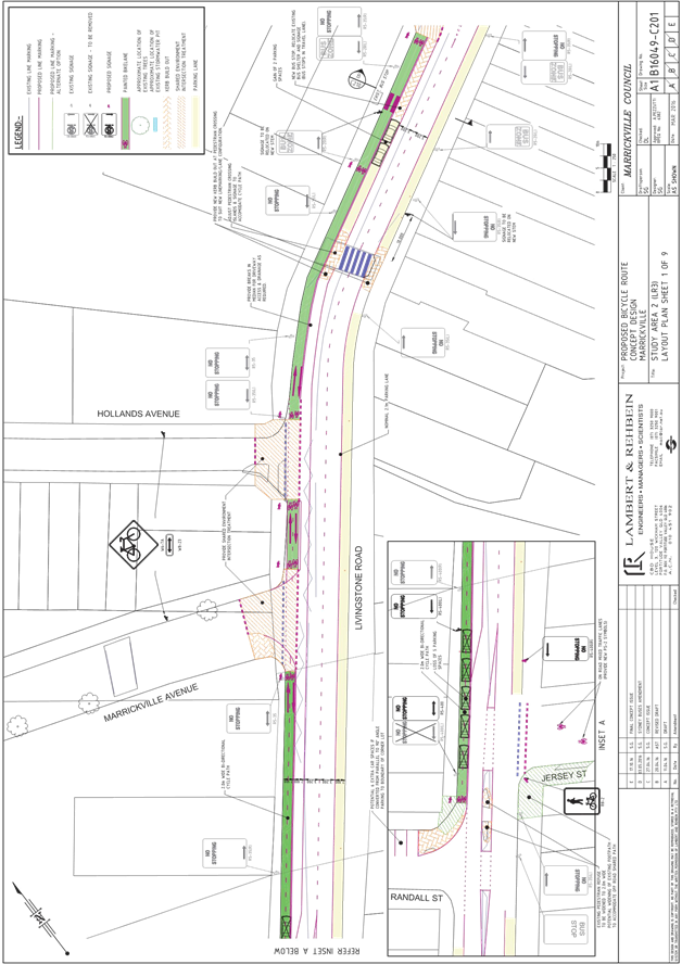
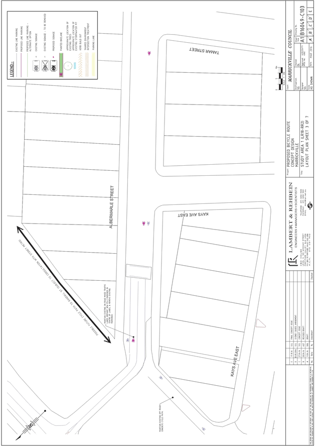
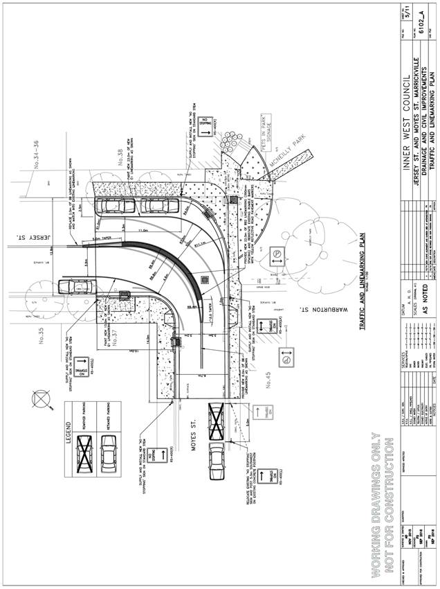
Subject: Jersey Street & Moyes Street, Marrickville
- Proposed Traffic Calming Revised Design Plans
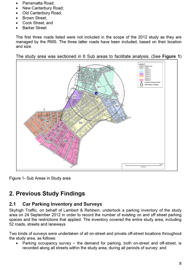
(Marrickville Ward/Summer Hill Electorate/Marrickville LAC)
File Ref: 16/6022/120222.16
Prepared By: Emilio Andari - Civil Engineer, Marrickville
Authorised By: Joe Di Cesare - Manager Design and Investigation, Marrickville
|
SUMMARY Revised design plans have been finalised for the proposed drainage improvements, landscaping and associated signs and line marking works at the intersection of Jersey Street and Moyes Street, Marrickville as part of Council’s Drainage Facility Capital Works Program. The proposal for three new storm water inlets, a new kerb and gutter alignment and associated signs and line markings will improve drainage amenities and traffic conditions at this location. |
|
RECOMMENDATION
THAT the detailed design plans for drainage improvements, landscaping and associated signs and line marking works at the intersection of Jersey Street and Moyes Street, Marrickville (as per the design plan No. 6102_A) be APPROVED.
|
BACKGROUND
Council is proposing to construct three new storm water inlets, a kerb and gutter alignment with landscaping and associated signs and line marking works at the intersection of Jersey Street and Moyes Street, Marrickville near McNeilly Park. This proposal is a revision of a design which was considered at the Local Traffic Committee in September 2016. At this meeting, local residents made representations to the committee with regards to loss of parking at the subject location. The proposed design has been amended to retain one parking space whilst still improving drainage amenities and traffic conditions at this location.
The revised design plans have been finalised for the proposed devices together with the consultation and are presented in this report for consideration.
FINANCIAL IMPLICATIONS
Funding of $115,000 has been allocated by Council for these works under the 2016/2017 Capital Works Program.
OFFICER COMMENTS
Site location & road network
|
Street Name |
Jersey Street |
Moyes Street |
|
Section |
Between Livingstone Road and Moyes Street |
Between Jersey Street and Warren Road |
|
Carriageway Width (m) |
12.8 |
6.7 |
|
Carriageway Type |
Two-way road with one travel lane in each direction, in addition to kerbside parking lanes. |
Two-way road with one travel lane in each direction, in addition to kerbside parking lanes. |
|
Classification |
Local |
Local |
|
85th Percentile Speed (km/h) |
51.1 |
43.2 |
|
Vehicles Per Day (vpd) |
848 |
1,590 |
|
Reported Crash History (July 2010 – June 2015) |
No crashes recorded. |
No crashes recorded. |
|
Heavy Vehicle Volume (%) |
1.8 |
2.2 |
|
Parking Arrangements |
Unrestricted parking on both sides of the road. |
Unrestricted parking on both sides of the road. |
Design plans
Design plans for the proposal for three new storm water inlets, a new kerb and gutter alignment and associated signs and line markings at the intersection of Jersey Street and Moyes Street, Marrickville (as per the attached design plan No. 6102_A) are submitted for consideration. The design plans have been amended from the original design plan No. 6102 following concerns raised by local residents.
The proposed scope of work includes the following:
· Construct new kerb and gutter alignments on both sides of the roadway at the intersection of Jersey Street and Moyes Street and provide two new kerb ramps with landscaped verges.
· Construct three new storm water inlets as per design plan.
· Provide new BB, BB2 and E1 line markings as per design plan.
· Reseal the road at the intersection of Jersey Street and Moyes Street.
· Install three new ’No Stopping’ signs at the intersection of Jersey Street and Moyes Street to discourage illegal parking on this corner and to provide improved turn paths for waste collection trucks.
· The existing ‘No Stopping’ sign on the eastern side of Moyes Street is to be shifted 5 metres south from the intersection with Jersey Street. This modification provides for improved turn paths for waste collection trucks.
The amendments following concerns raised by local residents include the following:
· Construct an amended new kerb and gutter alignment on the northern side of Jersey Street and eastern side of Moyes Street.
· Relocate the proposed ‘No Stopping’ sign on the north-eastern side of Jersey Street by placing the sign 11 metres east from the existing driveway to property no. 38 Jersey Street. This modification will retain one parking space whilst maintaining the improvement of drainage amenities and traffic conditions at this location.
· Install an additional ‘No Stopping’ sign on the eastern side of Moyes Street outside McNeilly Park. This is to discourage motorists from parking their vehicles within the ‘No Stopping’ zone on the eastern side of Moyes Street at its intersection with Jersey Street.
The proposed treatment will result in the loss of one (1) on-street parking spaces in Moyes Street as an outcome of the proposed ‘No Stopping’ restrictions in order to improve turning paths for waste collection trucks and to discourage illegal parking on this corner (refer to the attached design plan No. 6102_A). All current vehicular access to adjoining properties will be retained.
PUBLIC CONSULTATION
Further consultation was conducted in September 2016. This was in the form of a letter and a copy of the amended design plan being sent out to the local residents in Jersey Street and Greenbank Street, Marrickville. A total of 19 letters were distributed. There were no responses to the proposed amended design received.
CONCLUSION
It is recommended that the design of the proposed devices and associated signs and markings be approved, to improve drainage amenities and traffic conditions.
Design Plan No. 6102_A
|
|
Local Traffic Committee Meeting 3 November 2016 |
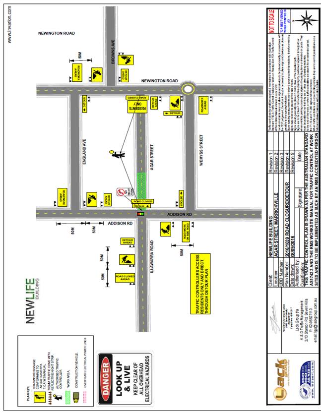
Subject: Temporary Road Closure to Carry Out
Reinstallation of Mobile Phone Antenna Mount Across Agar Street, Marrickville
(Marrickville Ward/Marrickville Electorate/Marrickville LAC)
File Ref: 16/6022/121121.16
Prepared By: Maaran Mutharasa - Engineer Traffic Services, Marrickville
Authorised By: Joe Di Cesare - Manager Design and Investigation, Marrickville
|
SUMMARY An application has been received from K&D Traffic Management Pty Ltd for the temporary full road closure of Agar Street (between Addison Road and Newington Road) Marrickville for a period of 7 hours from 10am to 5pm on 3th and 4th of December 2016, in order to stand a mobile boom crane on Agar Street to reinstall a mobile phone antenna mount across Agar Street, Marrickville. It is recommended that the proposed temporary road closure be approved, subject to the conditions outlined in this report. |
|
RECOMMENDATION
THAT the proposed temporary full road closure of Agar Road(between Addison Road and Newington Road) Marrickville be APPROVED for a period of 7 hours from 10am to 5pm on 3th and 4th of December 2016 December 2016, in order to stand a mobile boom crane on Agar Street to reinstall a mobile phone antenna mount across Agar Street, Marrickville, subject to the following conditions:
1. a fee of $1,354.60 for the temporary full road closure is payable by the applicant in accordance with Council’s Fees and Charges; 2. the temporary full road closure be advertised in the local newspaper providing 28 days’ notice for submissions, in accordance with the Roads Act; 3. a Traffic Management Plan (TMP) be submitted by the applicant to the Roads and Maritime Services for consideration and approval; 4. a Traffic Control Plan (TCP) which has been prepared by a certified Traffic Controller, is to be submitted to Council for review with a copy of the Traffic Controllers certification number attached to the plan, not less than 5 days prior to implementation of closure; 5. a Road Occupancy License be obtained by the applicant from the Roads and Maritime Services’ Transport Management Centre; 6. notice of the proposed closure be forwarded by the applicant to the NSW Police, the NSW Fire Brigades and the NSW Ambulance Services; 7. notification signs advising of the proposed road closures and new traffic arrangements to be strategically installed and maintained by the applicant at each end of the street at least 7 days prior to the closure; 8. all affected residents and businesses shall be notified in writing, by the applicant, of the proposed temporary road closure at least 7 days in advance of the closure with the applicant making reasonable provision for residents; 9. vehicular and pedestrian access for residents and businesses to their off-street car parking spaces be maintained where possible whilst site works are in progress; 10. adequate vehicular traffic control shall be provided for the protection and convenience of pedestrians and motorists including appropriate signage and flagging. Workers shall be specially designated for this role, as necessary to comply with this condition. This is to be carried out in accordance with the Australian Standard AS 1742.3 - Traffic Control Devices for works on roads; 11. the holder of this approval shall indemnify the Council against all claims, damages and costs incurred by, or charges made against, the Council in respect to death or injury to any person or damage in any way arising out of this approval. In this regard, a public liability insurance policy for an amount not less than $20,000,000 for any one occurrence is to be obtained and is to note the Council as an interested party. The holder of this approval shall inform its insurer of the terms of this condition and submit a copy of the insurance policy to the Council prior to commencement of the work the subject of this approval; 12. the operator of any unit exercising this approval shall have this approval with them and produce it if required along with any other relevant authority approvals granted in the connection with the work; 13. mobile cranes, cherry packers or concrete boom pumps shall not stand within the public way for extended periods when not in operation under this approval; 14. the operation of the mobile crane shall not give rise to an "offensive noise" as defined in the Protection of Environment Operations Act, 1997. Furthermore, vibrations and/or emission of gases that are created during its operations and which are a nuisance, or dangerous to public health are not permitted; 15. all work is to be carried out in accordance with Work Cover requirements; and 16. the costs to repair damages, as a result of these works, to Council's footway and roadway areas will be borne by the applicant.
|
BACKGROUND
An application has been received from K&D Traffic Management Pty Ltd for the temporary full road closure of Agar Street (between Addison Road and Newington Road) Marrickville for a period of 7 hours from 10am to 5pm on 3th and 4th of December 2016, in order to stand a mobile boom crane on Agar Street to reinstall a mobile phone antenna mount across Agar Street, Marrickville
FINANCIAL IMPLICATIONS
Under Council’s Fees & Charges, the applicant is to pay a fee of $1,354.60 for the temporary full road closure. This fee includes advertising the proposal in accordance with the Roads Act 1993.
PUBLIC CONSULTATION
The applicant is to notify all affected residents and businesses in writing at least 7 days prior to the commencement of works. The proposed road closure is to be advertised in the local newspaper in accordance with the Roads Act 1993.
CONCLUSION
It is recommended that the proposed temporary road closures be approved, subject to the conditions outlined in this report.
Traffic Control Plan submitted by the applicant – Agar Street, Marrickville
|
|
Local Traffic Committee Meeting 3 November 2016 |
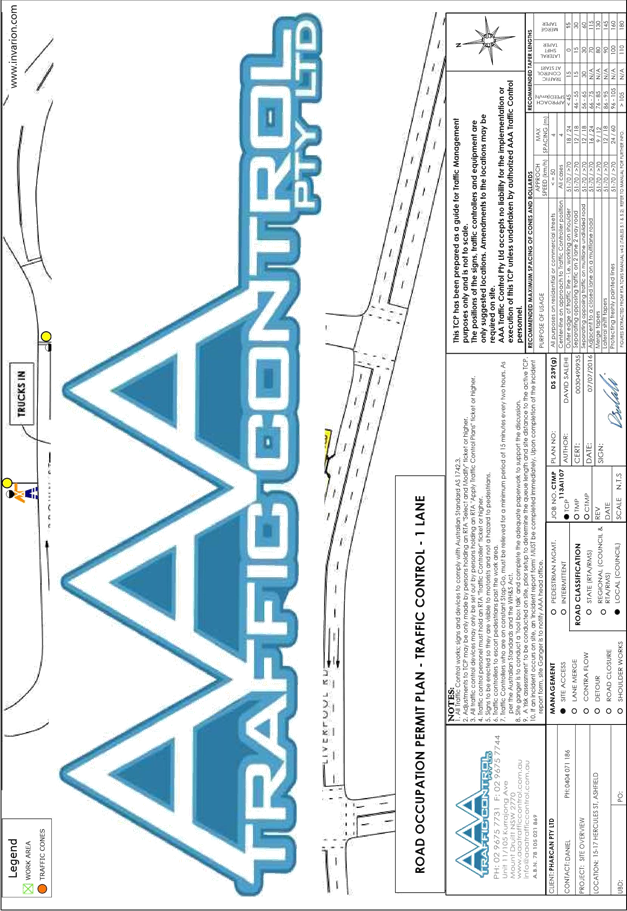
Subject: Short Street, Balmain - Road Occupancy
(Balmain Ward/Balmain Electorate/Leichhardt LAC)
File Ref: 16/6022/121270.16
Prepared By: Manod Wickramasinghe - Traffic and Parking Engineer, Leichhardt
Authorised By: Jason Scoufis - Acting Traffic Manager, Leichhardt
|
SUMMARY Council has received an application from a resident of Short Street, Balmain to conduct a Christmas street party in Short Street between Spring Street and Curtis Road. This is an annual event. |
|
RECOMMENDATION
THAT: 1. the temporary road closure of Short Street, Balmain between Spring Street and Curtis Road, on Saturday, 17th December 2016 between 6.00pm and 11.30pm be approved, subject to the following conditions: a. an unencumbered passage minimum 3.0m wide be available for emergency vehicles through the closed section of Short Street, Balmain; b. the occupation of the road carriageway must not occur until the road has been physically closed; c. the applicant notifies all affected businesses, residents and other occupants of the temporary road closure prior to the event. Any concerns or requirements in relation to the road closure raised by business proprietors, residents and other occupants must be resolved or accommodated. The notification shall involve at the minimum an information letterbox drop distributed one week prior to the commencement of the event. The proposed information, distribution area and period must be submitted to Council’s Traffic section for approval two weeks before the event; d. the approved Traffic Control Plan (TCP) be implemented at the applicant’s expense including RMS accredited traffic controllers; e. the Fire Brigade (Balmain) be notified of the intended closure; f. the applicant provide and erect barricades and signs, in accordance with the current Australian Standard AS 1742.3: Traffic Control Devices for Works on Roads. As a minimum the following must be erected at both ends of the road closure area: i. Barrier Boards; ii. ‘Road Closed’ (T2-4) signs; iii. ‘Detour’ (T5-1) signs; g. the Street Party co-ordinator be advised Council provides barricades, ‘Road Closed’ and ‘Detour’ signs free or at minimum cost. The Street Party co-ordinator is required to arrange delivery by Council at cost, or arrange pickup from and return to Council’s Depot at no cost. Any non-standard signs may be provided at cost; h. the applicant must comply with the risk assessment conditions supplied by Council’s Employee Services Section prior to the event. (Council contact: David Gollan on 9367 9222); i. the areas to be used for the activities must be maintained in a clean and tidy condition to the satisfaction of Council’s Director Major Projects and Engineering, or else the applicant will be required to reimburse Council for any extraordinary cleaning costs; j. the conduct of any activities or use of any equipment required in conjunction with the road occupancy and temporary road closure not results in any ‘offensive noise’ as defined by the Noise Control Act; k. a copy of the Council approval be available on site for inspection by relevant authorities; l. Council reserves the right to cancel the approval at any time; m. the applicant complies with any reasonable directive from Council Officers and NSW Police; and 2. the applicant be advised of the Committee’ recommendation.
|
BACKGROUND
Council has received an application from a resident of Short Street, Balmain to conduct a Christmas street party in Short Street between Spring Street and Curtis Road.
The street party is proposed to be held on Saturday, 17th December 2016 between 6.00pm and 11.30pm. The applicant is seeking permission for a temporary full road closure of Short Street, Balmain, between Spring Street and Curtis Road.
The Traffic Control Plan for the closure is as follows:
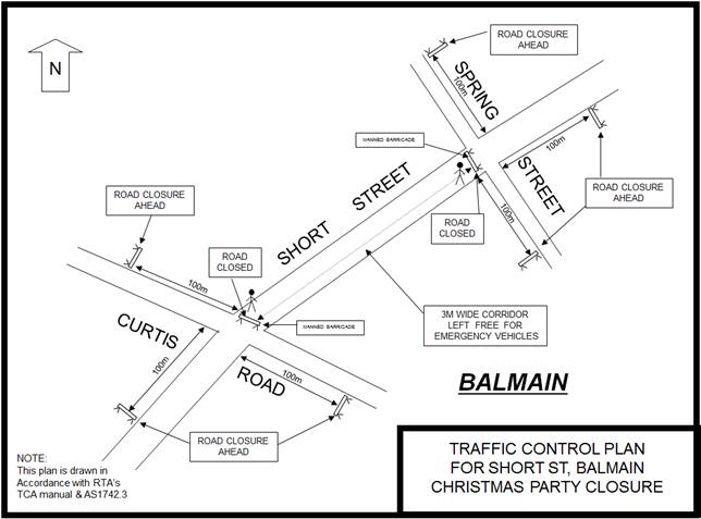
This is an annual event and no significant issues have occurred in previous years.
According to the RMS ‘Guide to Traffic and Transport Management for Special Events’ (Version 3.4) a small street party is considered as a ‘Class 3’ event.
The RMS advises that features common to all Class 3 special events are that the event:
· does not impact local or major traffic and transport systems or classified roads;
· disrupts the non-event community in the immediate area only;
· requires Local Council and Police consent;
· is conducted on-street in a very low traffic area such as a dead-end or cul-de-sac; and
· is never used for racing events.
Other features of a Class 3 special event are that it:
· may, depending on Local Council policy, require a simplified Transport Management Plan;
· may depend on each Council's Special Events Policy and is not available in all Council areas; and
· may not require advertising the event's traffic aspects to the community.
Council’s Employee Services section has prepared a policy for Special Events. Inner West Council (Leichhardt Service Centre) encourages properly conducted neighbourhood street parties as a means of building community spirit and improving neighbourhood security. Fees for road occupancy are waived by Council for small community street parties.
Where the following conditions apply, organisers are only required to obtain approval for a street party involving a temporary road closure:
· the party is to be held outdoors for fewer than 100 people;
· no temporary structures or jumping castles are to be erected;
· participants are to bring their own food and drinks, and food and drink are not for sale; and
· there will be no performers or amplified music involved.
For approved street parties, Council will provide barricades and ‘Road Closed’ signs free or at minimum cost. Any non-standard signs may be provided at cost. The Street Party Co-coordinator will need to arrange delivery by Council at cost, or arrange pickup from and return to Council’s Depot at no cost.
Subject to the approval of the street party by the Traffic Committee, if required, Council’s Employee Services will undertake a risk assessment with the applicant to ensure that the event is conducted in a safe manner.
FINANCIAL IMPLICATIONS
None.
PUBLIC CONSULTATION
Not applicable.
|
|
Local Traffic Committee Meeting 3 November 2016 |
Subject: Heighway Avenue, Ashfield - Annual Road
Occupancy (Christmas Street Party) on Saturday 3rd December 2016
(Ashfield Ward/Strathfield Electorate/Ashfield
LAC)
File Ref: 16/6022/121488.16
Prepared By: Boris Muha - Traffic and Projects Engineer, Ashfield
Authorised By: Jason Scoufis - Acting Traffic Manager, Leichhardt
|
SUMMARY Representation has been received from Ms Julia Pokorny for residents in Heighway Avenue, requesting the temporarily closure of Heighway Avenue, between Walter Street and Frederick Street, to conduct an annual Christmas Street party from 5.00pm-9.00pm on the Saturday 3rd December 2016. |
|
RECOMMENDATION
THAT the Committee raises no objection for Council to proceed and arrange the temporary closure of Heighway Avenue, Ashfield, between Walter Street and Frederick Street, to conduct an annual Christmas Street Party on the Saturday 3 December 2016, from 5.00pm - 9.00pm. The closure will be subject to relevant conditions as imposed by Council together with any other conditions from the RMS and Police.
|
BACKGROUND
This event is held annually with road closure arrangements being no different to past years. The road closure is a category type “Class 3” minor event under the RMS format for special events. Concurrence is only required from the Council and Police and that RMS be only notified of the event.
Heighway Avenue between Walter Street and Frederick Street is a narrow one-way Local Road, which carries low volumes of traffic in the easterly direction from Walter to Frederick Street. Detouring can be made via the surrounding streets of Thomas Street and Frederick Street. Local traffic access can be maintained in the adjoining section of Heighway Avenue and Walter Street.
Resident access through the closed easterly one-way section of Heighway Avenue can be maintained from the Walter Street end.
FINANCIAL IMPLICATIONS
Supply of material (signs and barricades) to the event organiser- approximately $600.
OFFICER COMMENTS
This event is of similar arrangements as in previous years and approved by the Traffic Committee. Police and RMS have raised no objection in the past to the above special event road closure.
For this type Class 3 minor event the main conditions of the road closure are:
· Council supplies material (signs and barricades) to the event organiser. The organiser is responsible to erect the signs and barricades according to the Traffic Control Plan (TCP) below, and arrange the management of the closure with RMS accredited traffic controllers. Council Rangers would be requested to oversee the event to assure that the traffic control arrangements are in order.
· The event only entails the placement of tables and chairs upon the public footway or street, and is assessed as a low risk event to have it covered under Council (Casual Hire) insurance. However, in the claim of injury a $2000 excess would apply.
· A clear passage of at least 4.0m is provided for emergency vehicle access. (Police condition)
· The organiser is responsible to arrange bins for litter control, and make the area neat and tidy following the re-opening of the road.
· The Organiser is responsible to dismantle the signs and barricades and place the material in a designated area for Council to pick up after the completion of the event.
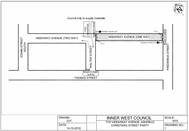
Traffic Control Plan (TCP) for Heighway Avenue, Ashfield - Christmas Street Party
PUBLIC CONSULTATION
The organiser is responsible for notifying the residents in the area at least one week prior to the event.
CONCLUSION
It is recommended that the Committee raise no objection for Council to proceed and arrange the temporary closure of Heighway Avenue, Ashfield, between Walter Street and Frederick Street, to conduct an annual Christmas Street Party on the Saturday 3 December 2016, from 5.00pm - 9.00pm. The closure will be subject to relevant conditions as imposed by Council together with any other conditions from the RMS and Police.
|
|
Local Traffic Committee Meeting 3 November 2016 |
Subject: Anthony Street, Croydon - Annual Road
Occupancy (Christmas Street Party) on Saturday 17 December 2016
(Leichhardt Ward/Strathfield Electorate/Ashfield LAC)
File Ref: 16/6022/121434.16
Prepared By: Boris Muha - Traffic and Projects Engineer, Ashfield
Authorised By: Jason Scoufis - Acting Traffic Manager, Leichhardt
|
SUMMARY Representation has been received from Ms Jackie Speak for residents in Anthony Street, Croydon, requesting the temporary closure of Anthony Street, Croydon, between Croydon Road and Etonville Parade, to conduct an annual Christmas Street party from 4.00pm-9.00pm on Saturday 17 December 2016. |
|
RECOMMENDATION
THAT the Committee raises no objection for Council to proceed and arrange the temporary closure of Anthony Street, Croydon, between Croydon Road and Etonville Parade, to conduct an annual Christmas Street Party on the Saturday 17 December 2016, from 4.00pm - 9.00pm. The closure will be subject to relevant conditions as imposed by Council together with any other conditions from the RMS and Police.
|
BACKGROUND
This Christmas street party closure has been held the last couple years. The road closure is a category type “Class 3” under the RMS format for special events. Concurrence is only required from the Council and Police and that RMS be only notified of the event.
The above section of Anthony Street is two way Local Road that carries low volumes of traffic. Detouring of traffic can be made via the surrounding streets of Croydon Road/Elizabeth Street and Etonville Parade/Hunt Street. Resident access will be allowed from the Etonville Parade end of the closure.
This event is of similar arrangements as in previous years and approved by the Traffic Committee.
Police and RMS have raised no objection in previous years to the above special event road closure.
FINANCIAL IMPLICATIONS
Supply of material (signs and barricades) to the event organiser - approximately $600.
OFFICER COMMENTS
This event is similar to previous years and approved previously by the Traffic Committee. Police and RMS have raised no objection in the past to the above special event road closure.
For this type Class 3 minor event the main conditions of the road closure are:
· Council supplies material (signs and barricades) to the event organiser. The organiser is responsible to erect the signs and barricades according to the Traffic Control Plan (TCP) below, and arrange the management of the closure with RMS accredited traffic controllers. Council Rangers would be requested to oversee the event to assure that the traffic control arrangements are in order.
· The event only entails the placement of tables and chairs upon the public footway or street, and is assessed as a low risk event to have it covered under Council (Casual Hire) insurance. However, in the claim of injury a $2000 excess would apply.
· A clear passage of at least 4.0m is provided for emergency vehicle access.(Police condition)
· The organiser is responsible to arrange bins for litter control, and make the area neat and tidy following the re-opening of the road.
· The Organiser is responsible to dismantle the signs and barricades and place the material in a designated area for Council to pick up after the completion of the event.
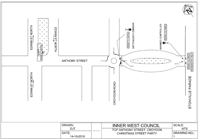
Traffic Control Plan (TCP) for Anthony Street, Croydon - Christmas Street Party
PUBLIC CONSULTATION
The organiser is responsible for notifying the residents in the area at least one week prior to the event.
CONCLUSION
It is recommended that the Committee raise no objection for Council to proceed and arrange the temporary closure of Anthony Street, Croydon, between Croydon Road and Etonville Parade, to conduct an annual Christmas Street Party on the Saturday 17 December 2016, from 4.00pm - 9.00pm. The closure will be subject to relevant conditions as imposed by Council together with any other conditions from the RMS and Police.
|
|
Local Traffic Committee Meeting 3 November 2016 |
Subject: Construction Traffic Management Plan (CTMP) 15-17
Hercules Street, Ashfield
(Ashfield Ward/Summer Hill Electorate/Ashfield LAC)
File Ref: 16/6022/121181.16
Prepared By: Boris Muha - Traffic and Projects Engineer, Ashfield
Authorised By: Jason Scoufis - Acting Traffic Manager, Leichhardt
|
SUMMARY AAA Traffic Control Pty Ltd for Daniel Younan & Associates has prepared a Construction Traffic Management Plan (CTMP) as required under condition of consent for the development of 15-17 Hercules Street, Ashfield. The CTMP dated 14th October 2016 (Attachment 1) has been developed in discussion and meetings on site between the developer, Council, Police and STA for use of the rear lane, known as Fox’s Lane, for road occupation and construction vehicle access to the site. It is recommended that the CTMP operate to the extent of providing a full road closure in Fox’s Lane, and the installation of a work zone, during DA times of operation. This would be subject to the CTMP being further revised to include Council permit conditions for the use and operation of the Fox’s Lane under appropriate Council fees and charges, and include any other conditions as required by the RMS and/or Police. Any out of hours operation, will need to be approved under special permit arrangement (e.g. the erection and dismantling of a tower crane.) and may be included in Council permit conditions in use and operation of Fox’s Lane. |
|
RECOMMENDATION
THAT support be given for the Construction Traffic Management Plan to operate to the extent of providing a full road closure in Fox’s Lane and installation of a work zone in Fox’s Lane, during DA times of operation for development works of 15-17 Hercules Street, Ashfield. This is subject to the CTMP being further revised (for Council approval) to include: 1. Council permit conditions for the use and operation of Fox’s Lane under appropriate Council fees and charges; and 2. any other conditions as required by the RMS and/or Police.
|
BACKGROUND
The work involves the demolition and excavation of the existing Commonwealth Bank Building and associated structures. This then follows the construction of an 8 level mixed used building comprising of:
· Three (3) retail tenancy at the ground floor.
· twenty three (23) residential apartments comprising of 15x1 bedroom, 7x2 bedroom and 1x3 bedroom.
· Communal roof terrace located on level 3.
· Three (3) basement parking levels accommodating 30 parking spaces.
The site has a frontage to Hercules Street which is a main Local Street in Ashfield. Hercules Street is a narrow road with a one -way northbound traffic flow with one through lane and two parking lanes. It serves as a major thoroughfare for buses from Liverpool Road to Brown Street to reach Ashfield Station, and includes a taxi zone and commercial parking in the area, and is also an area of high pedestrian activity.
Fox’s Lane is one-way northbound from Liverpool Road to Brown Street and has a width of approx. 5.6- 5.8m wide. The lane serves rear access to properties fronting Hercules Street and Liverpool Road, including that of 15-17 Hercules Street. Fox’s Lane is generally light of traffic and provides a short cut from Liverpool Road to Brown Street.
Fox’s Lane has been closed off in the past whilst development works were carried out to the adjoining building 11-13 Hercules Street.
FINANCIAL IMPLICATIONS
Nil - all works are development funded.
OFFICER COMMENTS
The following are major points addressed under the CTMP:
· There are four stages of work involved, Demolition (estimated duration 4 weeks), Excavation (12 weeks), Construction (75 weeks) and Fit out (15 weeks) –approx. up to 2 years.
· All vehicles will travel on route to and from the site via the State Roads, Brown Street and Fox’s Lane.
· All vehicles up to the size of truck and dog (trailer), during the course of demolition, excavation and construction, and with size vehicles over 7.5m during the fit out stage, will approach from Brown Street and be guided under flagmen control to travel in the southerly direction up Fox’s Lane towards the site.
· All vehicles exiting the site will travel in the northerly direction down Fox’s Lane and turn right out into Brown Street, under flagmen control, and then head towards Liverpool Road.
· Delivery vehicles sizes up to 7.5m in the fit out stage of the development will approach off Liverpool Road and turn left into Fox’s Lane to proceed in the northerly direction to the site.
· Buses will be given priority in movement along Brown Street over that of heavy vehicles accessing the intersection of Fox’s Lane and Brown Street.
· During the course of road occupation, flagmen will be positioned at the intersection of Fox’s Lane and Liverpool Road, and Fox’s Lane and Brown Street. Traffic coming off Liverpool Road will not be permitted through Fox’s Lane. Access to properties will be provided, and the builder will regularly consult with the residents and businesses throughout the works so as to reasonably limit any inconvenience.
· The CTMP makes mention of occasional 2 lane occupation use of Fox’s Lane. Given the width of Fox’s Lane, this is regarded as a full road closure not permitting through traffic use of Fox’s Lane during certain construction vehicle activities. It is acknowledged that a full road closure through the day is considered a safe and proper traffic arrangement for certain construction vehicle activities associated with the development (e.g. the available use of Fox’s Lane, and the time and frequency of haulage trucks needing to access the site, or in occasions where truck/plant are required to stand on the road and traffic cannot by-pass.
Traffic can detour via Hercules Street or Brown Street. Council will need to determine appropriate fees and charges applicable to the road closure activity.
· Appropriate hoarding and fencing will be erected to safely guide pedestrians through and around the site.
· As stated in the CTMP –Construction Vehicle Access during Demolition, Excavation & Construction (page 10): The applicant will seek to demonstrate to Council and/or Police the movement of truck and dog (trailer) through the lane, and should problems arise the applicant may need to resort to full use of bogie trucks. No standing plant or vehicles will access the site from Hercules Street.
· As stated in the CTMP (Clause 3.7-page 16): Should there be any major concerns or problems that are raised by either Council and/or the Police, the builder will be willing to discuss a solution, and if necessary review the Construction Traffic Management Plan.
The builder shall abide to any reasonable directions from Council and the Police during the course of the development.
The following plans and photos show the site location, Artist’s view of the development once complete, and the existing view of Fox’s Lane from Liverpool Road to Brown Street.
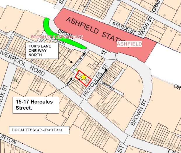
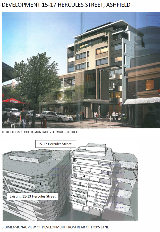
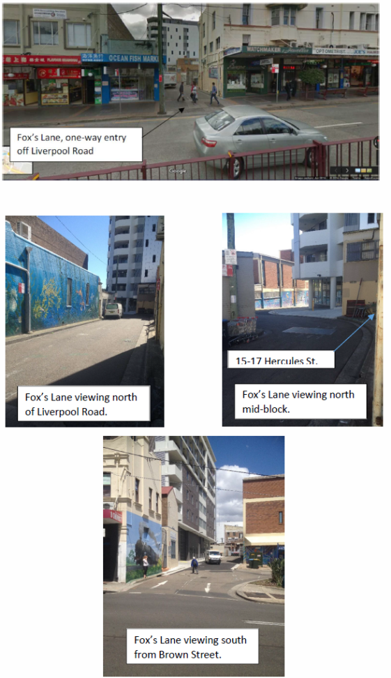
PUBLIC CONSULTATION
Nil - Applicant/Builder will be responsible to regularly notify/consult with affected residents and businesses throughout the work.
CONCLUSION
It is recommended that the CTMP operate to the extent of providing a full road closure in Fox’s Lane (as and when required), and the installation of a work zone, during DA times of operation. This would be subject to the CTMP being further revised to include Council permit conditions for the use and operation of the Fox’s Lane under appropriate Council fees and charges, and include any other conditions as required by the RMS and/or Police.
|
1.⇩ |
Construction Traffic Management Plan (CTMP) dated 14th October 2016 |
|
Local Traffic Committee Meeting 3 November 2016 |
Subject: Local Route 3 (Livingstone Road) - Public Consultation Report
File Ref: 16/5957/116526.16
Prepared By: Benny Horn - Cycling Planner, Marrickville
Authorised By: Brooke Martin - Manager Infrastructure Planning and Property, Marrickville
|
SUMMARY Council has prepared a final concept plan for improvements to Local Route 3, a bicycle route identified in Council’s Bicycle Plan, following public exhibition of the draft concept plan. 62% of the responses received did not support the concept plan. The concept plan has been amended in response to the main objection of the proposed removal of on-street parking on Livingstone Road. The final concept plan identifies a route along Livingstone Road from the Bankstown Line rail corridor to Marrickville Park to make bike riding safer, more comfortable and more convenient, and addresses the community concerns by reducing impacts to on-street parking by 99%. This report recommends that the final concept plan be approved and detailed designs for the route be developed. |
|
RECOMMENDATION
THAT the final concept plan for Local Route 3 be approved and detailed designs for the route be developed.
|
BACKGROUND
In 2007, Council adopted the Marrickville Bicycle Plan following consultation with relevant stakeholders including the local community. A key objective of the Bicycle Plan is to make cycling easier, safer and more attractive in Marrickville LGA, and to reduce community car use. Local Route 3 (LR3) is a key north-south route identified in the Bicycle Plan.
The Marrickville Community Strategic Plan sets objectives for bike riding in the community:
· 3.3.1: Plan and provide accessible and well-connected footpaths, cycleways and associated facilities
· 3.3.2: Support and promote cycling, walking and use of public transport and other alternative modes to reduce car use
· 3.4.2: Reduce the impact of traffic and improve pedestrian and cyclist safety, particularly around schools and urban centres.
In 2015/16, Council received a grant from Transport for NSW to develop a concept plan for improvements to LR3 between Marrickville Park and Jersey Street, consistent with the NSW Government’s objective of making bike riding a safe, convenient and enjoyable transport option for short trips. To inform initial assessment of options, Council undertook preliminary engagement with stakeholders in February/March 2016. A draft concept plan was developed and endorsed at Council’s 12 May 2016 Traffic Committee meeting for public exhibition.
The final concept plan (Attachment 1) and accompanying consultant’s report (Attachment 2) proposes improved bike access to local destinations including Marrickville Park, the future Marrickville Library and Community Hub, and local schools. LR3 will connect to route LR18 (Dulwich Hill station to Marrickville station) at Randall Street.
FINANCIAL IMPLICATIONS
The detailed design phase of this project is funded in the current 2016/17 annual budget. The construction of the route is dependent on future available budgets and grants.
PUBLIC CONSULTATION
The LR3 draft concept plan was concurrently placed on public exhibition with the LR18 draft concept plan as below:
· Public exhibition dates: 29 June to 23 August 2016 (closing date extended from 26 July as requested by community members to allow more time for community feedback).
· Public exhibition was advertised to the community in the Inner West Courier, on Council’s website and social media channels, and temporary signage placed along the route.
· Approximately 1,100 letters were sent to residents, businesses and property owners in the LR3 and LR18 study areas as well as other key stakeholders inviting comments.
· Two drop-in sessions were held at Marrickville Town Hall. Community members could view the plans and discuss the proposed changes with Council officers. Approximately 60 community members attended over the two drop-in sessions, with most registering concerns about the proposed changes to on-street parking on Livingstone Road.
· Door knocking was carried out to nearly 300 homes and businesses on Livingstone Road and affected side streets to provide information on the proposal and seek feedback.
· 329 submissions regarding the LR3 draft concept plan, including two petitions.
o 34% of respondents indicated either “support” (28%) or “support with changes” (6%) for the proposed changes
o 62% of respondents indicated they did “not support” the proposed changes
o 3% of respondents did not indicate whether they supported the changes or not.
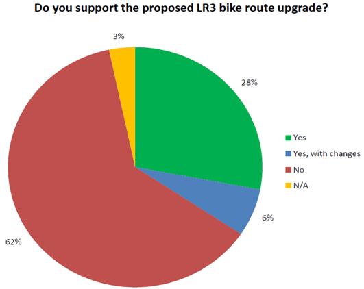
The issues most frequently raised in submissions related to:
· Removal of on-street parking on Livingstone Road
· School and church parking on Livingstone Road
· Demand for bike infrastructure
· Demand for on-street parking on side streets
· Availability of off-street parking
· Bike rider safety
· Bike riding as a form of transport for local trips
· Bus stop changes
· Congestion on Livingstone Road
· Access for people with limited mobility.
A public exhibition summary is at Attachment 3.
Roads and Maritime Services (RMS)
RMS requested modelling of any changes to the intersection of Livingstone Road and Marrickville Road that would affect traffic flows. Modelling of the revised shared bicycle and pedestrian crossing has been carried out and indicates no substantial change to existing intersection operation. In response to community concerns about changes to on-street parking, RMS provided in-principle agreement to narrowing of the proposed two-way bike path to enable both existing parking lanes to be retained. RMS confirmed it had no objections to the final concept plan.
Sydney Buses
Sydney Buses indicated support for proposed in-lane bus stops on Livingstone Road as they improve bus operations by eliminating delays when merging back into the traffic lane. Sydney Buses also requested that all bus stops along the route be formalized and provided guidance about lane widths at bus stops.
Following public exhibition of the draft concept plan, Sydney Buses advised that it is no longer considering removing two bus stops on Livingstone Road near Pile Street as part of its review of bus stops. Sydney Buses also advised that it is considering removing the southbound bus stop adjacent to the Marrickville Hospital redevelopment site, although no decision has yet been made. Changes at this bus stop would not impact on the bike path.
Sydney Trains
Sydney Trains advised that Council must confirm arrangements with the rail authority before undertaking any work on rail property, including the Livingstone Road bridge over the Bankstown Line.
Kidzville Early Learning Centre
Kidzville submitted a petition containing 74 signatures objecting to the removal of on-street parking outside the premises, on the basis that the parking spaces were used by parents for drop-off and pick-up of children at the centre, and that the safety of the children would be impacted if required to walk further to/from their car. Council officers subsequently contacted the lead petitioner, where it was agreed that options to restore the parking spaces would be investigated. The final concept plan seeks to address Kidzville’s concerns by continuing the shared path at the intersection of Marrickville Road further north to Hastings Street and reinstating parking on this section of Livingstone Road.
Bike Marrickville
Bike Marrickville indicated support for a bike path along Livingstone Road as it is a key north-south connection within Marrickville, between Marrickville and Petersham, and between the Bankstown and Inner West rail lines. The revised configuration provides a safer bike facility whilst addressing community concerns about on-street parking.
OFFICER COMMENTS
Nearly all objections received related to the proposed removal of on-street parking on Livingstone Road. The table of stakeholder comments is at Attachment 4. Two petitions were received objecting to the proposed changes, with both also citing the removal of parking on Livingstone Road as central to their concerns. Council officers contacted the lead petitioner of the Kidzville Early Learning Centre petition to discuss their concerns further, however were unable to follow up with the organiser of the other petition as no contact details were provided.
The proposed changes to parking on Livingstone Road in the draft concept plan heightened existing local resident concerns about high demand for on-street parking, particularly in the face of increasing rates of car ownership, new residential developments, and competition with school and church parking.
In response to substantial local community opposition to removing on-street parking, Council officers further considered alternative north-south route options raised in community feedback to identify options that: (i) improve bike rider safety, convenience and comfort for local trips, and (ii) minimise impacts to on-street parking. Wardell Road would offer a circuitous route to Marrickville station and Marrickville south that would not encourage trips to be taken by bike given the detour and time delays involved. Routes using low-volume side streets nearby would also be circuitous given the irregular layout of the side streets. Petersham Road offers a direct north-south link, however is too narrow to allow for appropriate separation of bikes from other vehicles to the south of Marrickville Road and on Illawarra Road where traffic volumes are higher.
Just as Livingstone Road provides a direct route for motor vehicle traffic travelling north/south, if made safer for bike riders it will offer a convenient route for trips by bike too. It connects bike riders to local destinations such as Marrickville Park, the future Marrickville Library and Community Hub, and local schools. It will also link bike riders to other planned routes for destinations further afield, such as Dulwich Hill and Marrickville stations via Local Route 18 and Petersham shops and station, Newtown and inner Sydney via Regional Route 2/Regional Route 7.
Council and RMS subsequently identified a road configuration in which a bike path can be provided on Livingstone Road whilst also maintaining both parking lanes. This option narrows the proposed bike path to 2.0m (from 2.4m), which then provides sufficient road width for both parking lanes to be retained (Figure 1). The final concept plan has been modified to incorporate this proposed configuration. A 2.0m wide bike path is consistent with RMS and Austroads guidelines for local bicycle routes and allows room for two bicycles to safely pass one another. The proposed road configuration also meets Sydney Buses requirements for traffic lane widths (3.2m) and RMS standards for parking lane widths (2.1m), and provides a narrow median between parked cars and the bike path.
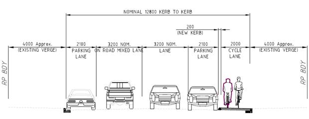
Figure 1: Revised typical cross-section on Livingstone Road with bike path and parking lanes.
The revised two-way bike path design:
· supports Council objectives to make bike riding safer, easier and more convenient
· improves on existing conditions in which bicycles travel in the traffic lane or car door zone alongside parked cars and approach from the driver’s blind spot;
· places bike riders on the passenger side of parked cars, thus reducing the incidence of potential conflict with passing bike riders;
· places bike riders travelling in the opposite direction nearest to parked cars, thus providing good line of sight between car passengers and approaching bike riders to reduce the incidence of potential conflict;
· provides a defined space for bike riders to travel out of the traffic lanes, and
· results in only localised removal of on-street parking on Livingstone Road. A net loss of one parking space is proposed on Livingstone Road between the Bankstown Line rail bridge and Marrickville Park (down from 121 in the draft concept plan)
· reduces angled parking proposed on side streets to mitigate impacts of reduced parking on Livingstone Road. In line with reduced parking loss on Livingstone Road, the net increase in parking spaces on side streets has been reduced in the final concept plan to nine additional spaces on Francis Street and Enfield Street, down from 146 additional spaces on eight side streets proposed in the draft concept plan. (note: additional angled parking on Pile Street will continue to be investigated as a separate Council project).
Feedback from bike riders requested that rider safety along the route be improved. The revised configuration provides a safer bicycle facility whilst addressing community concerns about on-street parking.
Where located alongside parked cars, the bike path is proposed to be raised to the level of the existing kerb. This will enable people entering/exiting parked cars on the passenger side (i.e. adjacent to the bike path) to temporarily occupy the bike path as needed – just as the driver and passengers may need to temporarily occupy the traffic lane when entering/exiting a parked car on the driver’s side. Driveways crossing the raised bike path are proposed to be built out to the level of the bike path. Motorists entering/exiting driveways must watch for bike riders when crossing the bike path just as they are must watch for pedestrians when crossing the footpath. Where no on-street parking is adjacent the bike path, it is proposed to be at road level with a separating kerb (with gaps) to demarcate the path from the traffic lane.
RMS and community submissions highlighted potential impacts to traffic flow on Livingstone Road. The final concept plan proposes a 190 metre section of shared path, from 50 metres south of the Livingstone Road/Marrickville Road intersection to Hastings Street via a shared pedestrian/bike crossing to reduce changes at the intersection. This utilises a section of path where there is sufficient width to cater for both pedestrians and bike riders. Intersection modelling has been carried out and demonstrates that the revised changes will have no substantial impact on intersection traffic flow.
Other issues raised in submissions included perceived lack of demand for bike infrastructure; pedestrian and bike rider safety; and proposed bus stop changes. Changes have been made to the draft concept plan to address issues raised where feasible. The removal of two bus stops near Pile Street was shown in the draft concept plan following Sydney Buses advice that it proposed removing these stops. In September 2016 Sydney Buses advised Council that it is no longer considering removal of these stops. This has been shown in the final concept plan.
The final concept plan reduces parking impacts on Livingstone Road and side streets (where angled parking was originally proposed to mitigate parking loss on Livingstone Road):
· Livingstone Road: net loss of one space (10 spaces to be removed and nine new spaces to be provided along the route; down from 121 spaces removed in the draft concept plan)
· Marrickville Avenue: no change to existing parking conditions
· Robert Street: net gain of three parking spaces by providing angled parking
· Hastings Street: no change to existing parking conditions
· Enfield Street: net gain of six parking spaces by providing angled parking
· Pile Street: net gain of approximately 19 parking spaces by providing angled parking (to be undertaken by Council as a separate project)
· Francis Street: no change to existing parking conditions
· Hawkhurst Street: no change to existing parking conditions
· Graham Avenue: no change to existing parking conditions
Confirmation Of Changes Made Following Public Consultation
The following changes have been made to the concept plan:
(a) Livingstone Road:
a. Reduce the width of the two-way separated bike path from 2.4m to 2.0m
b. Provide a 50m shared path on southern approach to Marrickville Road and a 140m shared path between Marrickville Road and Hastings Street
c. Reinstate the parking lane on the western side, to be located next to the bike path (with localised removal of spaces where required). The proposed net reduction in on-street parking spaces on Livingstone Road is two spaces (down from 121 in the draft concept plan), a 98% reduction in the net number of spaces to be removed
d. Delete proposed bus stop relocations; realign proposed in-lane bus stops
e. Reinstate the bus stops near Pile Street as per Sydney Buses’ updated advice
f. Modify proposed relocation/widening of pedestrian refuges: near Arthur Street; near Enfield Street; near George Street; near Pile Street
g. Delete proposed traffic lane changes at the intersection of Marrickville Road
(b) Marrickville Avenue: delete proposed angled parking
(c) Robert Street: reduce extent of proposed angled parking to provide three additional spaces
(d) Hastings Street: delete proposed angled parking
(e) Enfield Street:
a. reduce extent of proposed angled parking to provide six additional spaces
b. provide a bend-out intersection treatment
(f) Pile Street: angled parking to be investigated as a separate Council project
(g) Francis Street: delete proposed angled parking
(h) Hawkhurst Street: delete proposed angled parking
(i) Graham Avenue: delete proposed angled parking
CONCLUSION
The final LR3 concept plan incorporates changes to address issues raised during community consultation. Nearly all objections received were regarding the proposed removal of on-street parking on Livingstone Road, or associated changes. The final concept plan reduces proposed removal of parking by 98% with a bike path configuration that meets RMS and Sydney Buses requirements.
The proposed bike route improvements along Livingstone Road will encourage bike riding in the local community by providing a safer, more comfortable and more convenient north-south link to local destinations, such as Marrickville Park, the future Marrickville Library, and local schools, as well as to existing and planned routes for other destinations including Bankstown and Inner West Line train stations and the Cooks River. This report recommends that the final concept plan be approved and detailed designs for the route be prepared.
|
1.⇩ |
Final Concept Plan |
|
2.⇩ |
Consultant's Report |
|
3.⇩ |
Public Exhibition Summary |
|
4.⇩ |
Table of Stakeholder Comments |
|
Local Traffic Committee Meeting 3 November 2016 |
Subject: Local Route 18 (Dulwich Hill Station to Marrickville Station) - Public Consultation Report
File Ref: 16/5957/117493.16
Prepared By: Benny Horn - Cycling Planner, Marrickville
Authorised By: Brooke Martin - Manager Infrastructure Planning and Property, Marrickville
|
SUMMARY Council has prepared a final concept plan for improvements to Local Route 18, a bicycle route identified in Council’s Bicycle Plan, following public exhibition of the draft concept plan. The final concept plan identifies a route between Dulwich Hill station and Marrickville station to make bike riding safer, more comfortable and more convenient. 70% of submissions received during public exhibition indicated support for the draft concept plan. This report recommends that the final concept plan be approved and detailed designs for the route be developed. |
|
RECOMMENDATION
THAT:
1. the final concept plan for Local Route 18 be approved and detailed designs for the route be developed; and 2. Council consult further with Sydney Metro to seek agreement on a bike route in the rail corridor between School Parade and Randall Street.
|
BACKGROUND
In 2007, Council adopted the Marrickville Bicycle Plan following consultation with relevant stakeholders including the local community. A key objective of the Bicycle Plan is to make cycling easier, safer and more attractive in Marrickville LGA, and to reduce community car use. Local Route 18 (LR18) is an east-west route identified in the Bicycle Plan.
The Marrickville Community Strategic Plan sets objectives for bike riding in the local community:
· 3.3.1: Plan and provide accessible and well-connected footpaths, cycleways and associated facilities
· 3.3.2: Support and promote cycling, walking and use of public transport and other alternative modes to reduce car use
· 3.4.2: Reduce the impact of traffic and improve pedestrian and cyclist safety, particularly around schools and urban centres.
In 2015/16, Council received a grant from Transport for NSW to develop a concept plan for improvements to part of LR18 between Dulwich Hill and Marrickville train stations, consistent with the NSW Government’s objective of making bike riding a safe, convenient and enjoyable transport option for short trips. To inform the initial assessment of options, Council undertook preliminary engagement with stakeholders in February and March 2016 and a preferred route option via Dudley Street, Albermarle Street and Warburton Street was identified. A draft concept plan was developed and endorsed for public exhibition at Council’s May 2016 PCTCAC meeting.
The final concept plan (Attachment 1) and accompanying consultant’s report (Attachment 2) proposed improved bike access between Dulwich Hill and Marrickville train stations. LR18 will link to proposed LR3 (Livingstone Road) at Randall Street, offering a safer, easier route between rail stations and local destinations such as Marrickville Park and the future Marrickville Library.
FINANCIAL IMPLICATIONS
The detailed design phase of the project is funded in the current 2016/17 annual budget. The construction of the route is currently not listed in the budget, it is dependent on future available budgets and grant applications.
PUBLIC CONSULTATION
The LR18 draft concept plan was concurrently placed on public exhibition with the LR3 draft concept plan as below:
· Public exhibition dates: 29 June to 23 August 2016 (closing date extended from 26 July as requested by community members to allow more time for community feedback).
· Public exhibition was advertised to the community in the Inner West Courier, on Council’s website and social media channels, and temporary signage placed along the route.
· Approximately 1,100 letters were sent to residents, businesses and property owners in the LR3 and LR18 study areas as well as other key stakeholders inviting comments.
· Two drop-in sessions were held at Marrickville Town Hall. Community members could view the plans and discuss the proposed changes with Council officers. Approximately 60 community members attended over the two drop-in sessions, with most registering concerns about the proposed changes to on-street parking on Livingstone Road.
· Door knocking was carried out to nearly 300 homes and businesses on Livingstone Road, including homes in the LR18 study area on Livingstone Road and Randall Street to provide information on the proposed changes and seek feedback.
· 77 submissions were received from the community regarding the LR18 draft concept plan:
o 70% of respondents indicated either “support” (61%) or “support with changes” (9%) for the proposed changes
o 27% of respondents indicated they did “not support” the proposed changes
o 3% of respondents did not indicate whether they supported the changes or not.
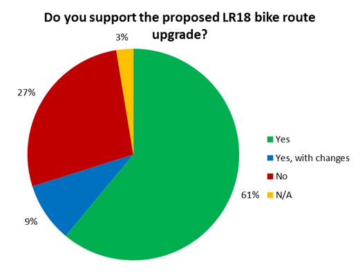
A public exhibition summary is at Attachment 3. The issues most frequently raised related to:
· Removal of on-street parking on Livingstone Road
· Encouraging bike riding as a form of transport for local trips
· Improving bike rider safety
· Level of demand for bike infrastructure
· Lack of off-street parking
· Impacts of Livingstone Road parking changes for people with limited mobility
Roads and Maritime Services (RMS)
RMS suggested modifications to the proposed pedestrian crossing on Dudley Street to reduce the length of the crossing, and requested that the warrant for the crossing be checked. RMS also advised that signage should be provided directing bike riders using the pedestrian crossings at Illawarra Road and Schwebel Street to dismount from their bikes. RMS confirmed it had no objections to the final concept plan.
Sydney Buses
Sydney Buses expressed concern that the proposed in-lane bus stop at Dudley Street would be located too close to Wardell Road and that stopped buses would then impede other turning traffic. Sydney Buses suggested that the proposed pedestrian crossing on Dudley Street may result in pedestrians blocking buses as they turn right from Wardell Road. Sydney Buses also suggested that the Illawarra Road bus stop near Warburton Street be extended further south.
Sydney Trains
Sydney Trains advised that planning on the Bankstown Line rail corridor was now the responsibility of Sydney Metro. Sydney Trains also advised that Council must confirm arrangements with the rail authority before undertaking any work on rail property.
Sydney Metro
Sydney Metro advised while it would be investigating a corridor for future pedestrian and bicycle connections as part of its metro conversion of the Bankstown Line rail corridor, planning for the corridor is still in early stages and so a decision on providing a bike path in the rail corridor west of Randall Street could not yet be made.
OFFICER COMMENTS
Nearly all objections received related to the proposed removal of on-street parking on Livingstone Road (Albermarle Street to Randall Street). The table of stakeholder comments is at Attachment 3.
Submissions suggested bypassing this section of Livingstone Road to avoid impacts to on-street parking and bus operations by locating the bike path on unused land in the Bankstown Line rail corridor between Randall Street and Albermarle Street. Planning on this rail corridor is part of the NSW Government’s Sydney Metro City and Southwest project. Consultation with Sydney Metro indicated that while a bike path along the rail corridor between Randall Street and Albermarle Street could be considered as part of the metro rail conversion, planning of the conversion was not yet at the stage where a commitment could be given to Council. Metro services on the Bankstown Line are scheduled to commence in 2024.
Use of available land on the rail corridor would enable a safe, high quality bike path to be provided with no impact to resident parking amenity and good connectivity to local residents via Randall Street and Albermarle Street. It would also enhance local access to Sydney Metro stations. Council will continue to work with Sydney Metro to seek support for the LR18 rail corridor option to be provided in the medium term and timed with work converting the rail line.
Pending a future decision on a rail corridor bike path, a mixed traffic treatment on Moncur Street rather than Jersey Street will provide the nominated LR18 link between Dulwich Hill station and Marrickville station with minimal impact to existing conditions on Livingstone Road between Albermarle Street and Randall Street. East-west bike riders will be able to cross between Albermarle Street and Moncur Street by crossing Livingstone Road via an upgraded pedestrian/bicycle refuge, rather than travelling along Livingstone Road to/from Jersey Street.
The draft concept plan also proposed widening the shared path between Kays Avenue East and School Parade further into the rail corridor. This section of the route is also impacted by Sydney Metro planning timeframes, however as with the section discussed above Sydney Metro have indicated that the proposed changes or further widening to provide a separated bike path and footpath could be considered in the medium term. Council will continue to work with Sydney Metro to seek advocate for this improvement.
At Dudley Street near Wardell Road, the draft concept plan proposed a pedestrian crossing to improve access south of the train station. Traffic counts indicate that the proposed crossing is not likely to meet RMS vehicle volume requirements to warrant a crossing. This has been deleted and two parking spaces proposed to be removed to accommodate the crossing have been reinstated. In response to Sydney Buses concerns that the proposed in-lane bus stop would block other vehicles turning into Dudley Street, the final concept plan has modified to relocate the bus stop 20m further east. This allows the proposed separated bike path to be extended further west towards Wardell Road.
The final concept plan reduces the proposed parking impacts:
· Dudley Street: 1 space removed (down from 5 spaces in the draft concept plan)
· Livingstone Road: five spaces removed (down from 16 spaces)
· Randall Street: 6 additional spaces by providing angled parking, down from 15 spaces.
Confirmation Of Changes Made Following Public Consultation
The following changes have been made to the concept plan:
(a) Dudley Street:
a. Delete proposed pedestrian crossing and reinstate two on-street parking spaces on southern side of Dudley Street
b. Relocate eastbound bus stop 20m east and some on-street parking to the west
c. Extend the proposed two-way bike path further west behind the parking lane
(b) Livingstone Road:
a. Delete proposed two-way bike path and associated changes to parking and bus stops between Albermarle Street and Randall Street
b. Delete associated changes to bus stops
(c) Randall Street
a. Reduce extent of proposed angled parking and relocate to northern side
b. Delete proposed shared environment intersection
(d) Moncur Street
a. Retain existing bike roadmarkings
CONCLUSION
Community consultation indicated that 70% support the concept plan. The final LR18 concept plan incorporates changes to address issues raised during public consultation. It identifies a future route via the rail corridor to be pursued in further consultation with Sydney Metro, and addresses community concerns about changes to on-street parking on Livingstone Road.
The proposed bike route improvements will encourage bike riding in the local community by improving providing a safer, more comfortable and more convenient link to Dulwich Hill and Marrickville stations. It will also connect to other routes, including LR3 on Livingstone Road.
This report recommends that the final concept plan be approved and detailed designs for the route be prepared.
|
1.⇩ |
Final Concept Plan |
|
2.⇩ |
Consultant's Report |
|
3.⇩ |
Public Exhibition Summary |
|
4.⇩ |
Table of Stakeholder Comments |
|
Local Traffic Committee Meeting 3 November 2016 |
Subject: Regional Bicycle Route 7 (Lewisham to Newtown) - Public Consultation Report
File Ref: 15/5932/115147.16
Prepared By: Benny Horn - Cycling Planner, Marrickville
Authorised By: Brooke Martin - Manager Infrastructure Planning and Property, Marrickville
|
SUMMARY Council has prepared a final concept plan for improvements to Regional Route 7, a NSW Government priority bicycle route and part of strategic bicycle corridor, following public exhibition of the draft concept plan. The final concept plan connects Lewisham and Newtown to make bike riding safer, more comfortable and more convenient. 77% of submissions received during public exhibition indicated support for the proposal. This report recommends the final concept plan be endorsed to progress to the detailed design stage. |
|
RECOMMENDATION THAT: 1. the final concept plan for Regional Route 7 be approved and detailed designs for the route be developed; and 2. Council consult further with Roads and Maritime Services and the City of Sydney to identify options for improved bicycle access across King Street, Newtown.
|
BACKGROUND
In 2007, Council adopted the Marrickville Bicycle Plan following consultation with relevant stakeholders including the local community. A key objective of the Bicycle Plan is to make cycling easier, safer and more attractive in Marrickville LGA, and to reduce community car use. Regional Route 7 (RR7) is a key bicycle route identified in the Bicycle Plan:
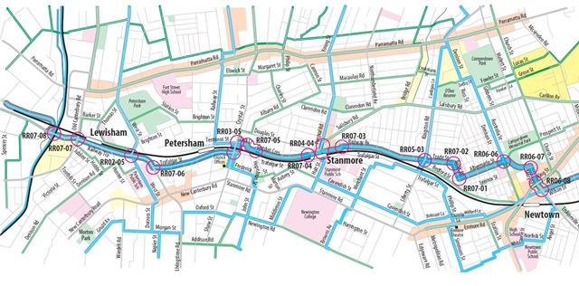
The Marrickville Community Strategic Plan sets objectives for bike riding in the local community:
· 3.3.1: Plan and provide accessible and well-connected footpaths, cycleways and associated facilities
· 3.3.2: Support and promote cycling, walking and use of public transport and other alternative modes to reduce car use
· 3.4.2: Reduce the impact of traffic and improve pedestrian and cyclist safety, particularly around schools and urban centres.
RR7 also supports the NSW Government’s objectives to make bike riding a safe, convenient and enjoyable transport option for short trips, and is nominated by the NSW Government as a priority route and part of a strategic Inner West bicycle corridor.
In 2015/16, Council received a grant from Transport for NSW to develop a concept plan for improvements to RR7, consistent with the NSW Government’s objective of making bike riding a safe, convenient and enjoyable transport option for short trips. To inform the initial assessment of options, Council undertook preliminary engagement with stakeholders in February/March 2016. A draft concept plan was developed and endorsed for public exhibition at Council’s May 2016 PCTCAC meeting.
The final concept plan (Attachment 1) and accompanying consultant’s report (Attachment 2) propose improvements to bike access between Lewisham and Newtown. RR7 will provide connections to local train stations, the GreenWay and other routes including to inner Sydney.
FINANCIAL IMPLICATIONS
The detailed design phase of this project is funded in the current annual 2016/17 budget. The construction of the route is dependent on future successful grant applications.
PUBLIC CONSULTATION
The RR7 draft concept plan was placed on public exhibition as follows:
· Public exhibition dates: 31 May to 28 June 2016
· Public exhibition was advertised to the community in the Inner West Courier, on Council’s website and social media channels, and temporary signage placed along the route.
· Approximately 1,400 letters were sent to residents, businesses and property owners in the study area as well as other stakeholders inviting comment.
· Two drop-in sessions were held at Council’s Petersham Service Centre. Community members could view the plans and discuss the proposal with Council officers. A total of five community members attended the two drop-in sessions.
· 73 submissions were received from the community regarding the RR7 draft concept plan, including one petition:
o 77% of submissions indicated “support” (33%) or “support with changes” (44%)
o 19% of submissions indicated they did “not support” the draft concept plan
o 4% of submissions did not indicate whether they supported the draft concept plan.
A public exhibition summary is at Attachment 3. Issues most frequently raised related to:
· Bicycle access and safety on Longport Street and Railway Terrace
· Impacts to on-street parking on Trafalgar Street
· Preferred bicycle route alignment through Newtown and access across King Street
· Proposed traffic signals at the intersection of Railway Avenue, Liberty Street, Trade Street and Kingston Road
· Pedestrian safety on shared paths near Petersham Station and near York Crescent.

Roads and Maritime Services (RMS)
RMS provided strategic support for the proposal, requesting further consideration of separated bike paths rather than shared paths to meet NSW Government objectives for its priority routes.
RMS also raised a number of matters during consultations, including:
· bike safety at the intersection of Brown Street and Longport Street, Lewisham
· changes to the eastbound bus stop on Trafalgar Street near Petersham Station
· concerns about rider safety and traffic flows of a bike crossing at King Street, Newtown
Discussions with the City of Sydney highlighted that Inner West Council and the City of Sydney are improving bike routes on each side of King Street, and that further consultation with RMS is required to improve bike access at King Street as it is a State road.
RMS requested modelling of proposed changes at the following intersections to determine impacts to traffic flow: Railway Terrace/West Street; Trafalgar Street/Crystal Street; Douglas Street/Percival Road, and Railway Avenue/Liberty Street/Trade Street/Kingston Road.
RMS confirmed it had no objections to the final concept plan.
Sydney Buses
Sydney Buses raised the following issues about the proposed bike route changes:
· traffic lane widths on Railway Terrace to accommodate buses
· turning paths for buses into West Street
· changes to the eastbound bus stop on Trafalgar Street near Petersham Station
· request for all bus stops along the route to be formalised.
Sydney Buses advised that it proposes removing the eastbound bus stop on Trafalgar Street near the NSW Rail Training Centre as part of its review of bus stops. Sydney Buses noted that it would carry out community consultation before making a final decision on the removal.
Sydney Trains
Sydney Trains indicated no objections to Council undertaking preliminary geotechnical investigations to assess whether widening of the shared path between York Crescent and Gordon Crescent was feasible, however noted that an adjacent landowner had previously raised concerns about a similar proposal to widen the path. Council officers subsequently contacted the adjacent resident, who reiterated concerns about the widening the path potentially contributing to land destabilisation, noise pollution and reduced resident amenity.
Sydney Trains also noted planned improvements to Inner West Line stations that could affect the RR7 alignment, and advised that Council must confirm arrangements with Sydney Trains before undertaking any work on rail property, including on road bridges over rail lines.
Petersham Assemblies of God Church
Petersham Assemblies of God Church submitted a petition containing 270 signatures and objecting to the scale of removal of on-street parking on the northern side of Trafalgar Street to accommodate a separated bike path. Council officers met with the lead petitioner to discuss the concerns, and it was agreed that Council would investigate options to reduce parking loss, particularly east of the train station. The lead petitioner subsequently indicated support for changes to the draft concept plan to reinstate some on-street parking on Trafalgar Street.
Bike Marrickville
Bike Marrickville indicated strong support for the proposed route and concept design in general, including as an additional transport option for residents in Lewisham and Summer Hill facing large increases in residential density. Bike Marrickville provided detailed comments about sections of the route, and noted constraints at West St/Railway Terrace and King Street.
OFFICER COMMENTS
Issues most frequently raised in community feedback centred on the quality and connectivity of the bike route, pedestrian safety and amenity, intersection changes and impacts to on-street parking on Trafalgar Street. The table of stakeholder comments is at Attachment 4.
Petersham Assemblies of God Church submitted a petition to Council objecting to the removal of on-street parking on Trafalgar Street. Council’s analysis of parking in Petersham indicated that the spaces proposed to be removed were primarily used by commuters, with little turnover particularly on weekdays, and that sufficient spaces to meet existing demand were available in nearby streets. In meetings with the lead petitioner it was subsequently agreed that options to reduce the loss of parking, particularly near Crystal Street, would be considered further.
In early 2016 a petition was received by Council regarding limited availability of parking for residents bounded by Longport Street, Brown Street, William Street and Old Canterbury Road. The petitioners were concerned about available on-street parking being used by construction workers from the adjacent high density residential development at Lewisham West. The proposed bike route improvements will remove eight on-street parking spaces on Longport Street used by the residents, although no objections to the removal of parking was received during public exhibition of the RR7 draft concept plan. To address the removal of parking on Longport Street, Council’s Lewisham Parking Study recommends that resident parking restrictions be applied to on-street parking on William Street.
The final concept plan proposes the following parking changes:
· Longport Street: 8 spaces removed (as per the draft concept plan)
· Railway Terrace: 1 space removed
· Trafalgar Street: 24 spaces removed (down from 33 spaces in the draft concept plan)
· York Crescent: 1 space removed
· Railway Avenue: no net loss of parking
Changes made following public consultation
The following changes have been made to the concept plan:
(a) Grosvenor Crescent and Smith Street: provide kerb ramps and a pedestrian/bicycle refuge
(b) Longport Street: extend the two-way bike path and transition to a 2.5m wide shared path
(c) Railway Terrace:
a. Adjust the traffic lanes west of Hunter Street to be 3.4 metres in each direction
b. widen the traffic lanes at the new pedestrian/bicycle refuge to 3.5 metres
c. adopt the shared path option between Hunter Street and West Street
(d) West Street: relocate the east-west pedestrian crossing closer to Railway Terrace
(e) Trafalgar Street:
a. Modify the northern approach to the pedestrian crossing near Audley Street
b. Provide a 2.4m wide shared path and 10 new street tree plantings, and reinstate 14 off-peak on-street parking spaces between Regent Street to Crystal Street.
c. Relocate the eastbound bus stop near Petersham train station from 20m west of the station entrance to 40m east of the station entrance (requires removal of one on-street parking space on the southern side)
d. Relocate the westbound bus stop near Petersham station from 15m east of the traffic signals to 30m west of the traffic signals (requires removal of four on-street parking spaces west of Regent Street)
(f) York Crescent-Gordon Crescent shared path:
a. relocate ‘no stopping’ sign and adjust kerb ramp to improve sightlines and reduce bicycle speeds at the York Crescent entrance to the shared path
b. undertake geotechnical investigations to assess feasibility of path widening
c. relocate kerb ramp at Gordon Crescent further east
(g) Douglas Street:
a. green paint to demarcate the bike path from shared path and footpath sections
b. provide a right turn bay for vehicles turning into Percival Road
(h) Railway Avenue: provide bike access to/from the separated bike path and Surrey Street, Warwick Street, Durham Street, Lincoln Street, Stafford Street and Cardigan Street
(i) Pierce Street: provide bike roadmarkings.
CONCLUSION
Community consultation indicated that 77% support the concept plan. The final RR7 concept plan incorporates changes to address issues raised during public consultation. The proposed bike route improvements between Lewisham and Newtown will encourage bike riding in the local community by providing a safer, more comfortable and more convenient link to local destinations, train stations and to other routes such as the GreenWay and the Wilson Street route to inner Sydney. This report recommends that the final concept plan be approved and detailed designs for the route be prepared. This report also recommends that Council continue work to identify options to improve the route across King Street.
|
1.⇩ |
Final Concept Plan |
|
2.⇩ |
Consultant's Report |
|
3.⇩ |
Public Exhibition Summary |
|
4.⇩ |
Table of Stakeholder Comments |
|
Local Traffic Committee Meeting 3 November 2016 |
Subject: Livingstone Road, Marrickville - Relocation of
Existing ‘Bus Zone’ & ‘No Parking’ Restrictions
(Marrickville Ward/Summer Hill Electorate/Marrickville LAC)
File Ref: 16/6022/120209.16
Prepared By: Emilio Andari - Civil Engineer, Marrickville
Authorised By: Joe Di Cesare - Manager Design and Investigation, Marrickville
|
SUMMARY A detailed signage plan has been finalised for the proposed relocation of a ‘Bus Zone’ on Livingstone Road, Marrickville as part of the proposed development of Council’s new Library and Community Hub located on the corner of Marrickville Road and Livingstone Road, Marrickville. The proposal for a new ‘Bus Zone’ with associated signs will improve traffic conditions at this location as a result of the future development. |
|
RECOMMENDATION
THAT the detailed signage plan of the ‘Bus Zone’ relocation with associated signs on the eastern side of Livingstone Road, Marrickville near its intersection with Marrickville Road (as per the signage plan No. PTC-001 Rev5) be APPROVED.
|
BACKGROUND
Mirvac will be undertaking construction works on behalf of Council to provide the new Library and Community Hub at the old Marrickville Hospital site located on the corner of Marrickville Road and Livingstone Road, Marrickville.
Mirvac have approached Council to seek approval for the proposed ‘Bus Zone’ relocation works on Livingstone Road, Marrickville adjacent to the old Marrickville Hospital site. These works include the relocation of a ‘Bus Zone’ with associated signs.
The detailed signage plan has been finalised for the proposed relocation of the ‘Bus Zone’ and is presented in this report for consideration.
FINANCIAL IMPLICATIONS
This project will be funded by Council as part of the new Library and Community Hub development.
OFFICER COMMENTS
Site location & road network
|
Street Name |
Livingstone Road |
Marrickville Road |
|
Section |
Between Marrickville Road and Hastings Street |
Between David Street and Fletcher Street |
|
Carriageway Width (m) |
12.8 |
12.8 |
|
Carriageway Type |
Two-way road with one travel lane in each direction, in addition to kerbside parking lanes. |
Two-way road with one travel lane in each direction, in addition to kerbside parking lanes. |
|
Classification |
Local |
Regional |
|
85th Percentile Speed (km/h) |
48.2 |
55.8 |
|
Vehicles Per Day (vpd) |
8,248 |
14,072 |
|
Reported Crash History (2010 – 2015) |
No crashes recorded. |
11 crashes. Rum Code: 02, 00 (x3), 10, 32, 21 (x3), & 30. All crashes resulted in either tow away or injury (at the intersection with Livingstone Road). |
|
Heavy Vehicle Volume (%) |
2.5 |
3.6 |
|
Parking Arrangements |
Unrestricted parking on both sides of the road. |
Unrestricted parking on both sides of the road with a section of timed ‘No Stopping’ restrictions. |
Signage Plan (No. PTC-001 Rev5)
The proposed scope of work includes the following:
· Shift the existing ‘Bus Zone’ signage on the eastern side of Livingstone Road towards the south, approximately 27 metres from its intersection with Marrickville Road as per signage plan.
· Install new ‘No Parking’ restrictions to replace the ‘Bus Zone’ restrictions at the old location for a length of 17.6 metres as per signage plan.
The proposed treatment will not result in the loss of legal on-street parking spaces in Livingstone Road (refer to the signage plan No. PTC-001 Rev5). All current vehicular access to adjoining properties will be retained.
PUBLIC CONSULTATION
Consultation between Mirvac and the State Transit Authority (STA) was undertaken prior to finalising the signage plan proposal. The STA has been notified of the final signage plan proposal.
CONCLUSION
It is recommended that the detailed signage plan of the proposed relocation of a ‘Bus Zone’ on Livingstone Road, Marrickville with associated signs be approved, in order to improve traffic conditions at this location as a result of the future development.
Signage Plan No. PTC-001 Rev5
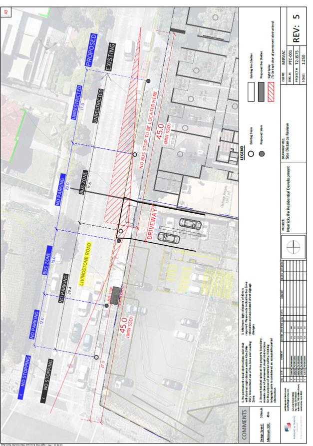
|
|
Local Traffic Committee Meeting 3 November 2016 |
Subject: Australia Street, Camperdown - Amendment to
Mail Zone Restrictions to allow Residential Parking in Non-Operational Periods
(Stanmore Ward/Newtown Electorate/Newtown LAC)
File Ref: 16/6022/120982.16
Prepared By: Jennifer Adams - Traffic and Road Safety Officer, Marrickville
Authorised By: Joe Di Cesare - Manager Design and Investigation, Marrickville
|
SUMMARY A local resident has requested that parking be allowed in the recently formalised ‘Mail Zone’ adjacent to 44-50 Australia Street, Camperdown. Details of operational times for the ‘Mail Zone’ at this location were requested from Australia Post. Australia Post advised Council that they did not object to a time restricted ‘Mail Zone’ at this location thereby allowing an opportunity to extend the adjacent Resident Parking Scheme (M1) for the benefit of local residents. Due to the high utilisation of on-street parking in the subject area, it is recommended that the dedicated ‘Mail Zone’ become time restricted to Australia Post operational times of 5.00pm – 8.00pm, Sunday to Friday and the existing Resident Parking Scheme (M1) in Australia Street, Camperdown, be extended into the mail zone outside Australia Post’s operational hours. |
|
RECOMMENDATION
THAT:
1. the existing dedicated ‘Mail Zone’ adjacent to 44-50 Australia Street, Camperdown be time restricted to Australia Post operational times of 5.00pm – 8.00pm, Sunday to Friday; 2. the adjacent Residential Parking Scheme restrictions be extended into the ‘Mail Zone’ with amended times of ‘2P 8.30am – 5.00pm, Mon-Fri, Permit Holders Excepted – Area M1’; and 3. the applicant, surrounding residents, Australia Post and Council Parking Officers be advised in terms of this report.
|
BACKGROUND
On 9 July 2015 a report was presented to the Traffic Committee after a request was received from a resident in Australia Street, Camperdown for the expansion of the existing Residential Parking Scheme (M1) in Australia Street due to the closure of a local factory. The factory premise at 44-50 Australia Street had been sold and the associated factory parking restrictions ‘No Parking 8.30am – 6pm Monday-Friday’ became redundant and there was an opportunity to better utilise this parking space for the benefit of local residents.
Subsequently, due to the high utilisation of on-street parking in the subject area, it was recommended that the extension to the existing Resident Parking scheme in Australia Street south of Fowler Street, Camperdown, by four spaces be approved, along with formalisation of the existing Mail Zone.
A local resident has now requested that parking be allowed in the recently formalised ‘Mail Zone’ adjacent to 44-50 Australia Street, Camperdown.
A Council Officer contacted Australia Post and requested details of the operational times for the ‘Mail Zone’ at this location. Australia Post advised that they have no objection to a time restricted ‘Mail Zone’ at this location allowing an opportunity to extend the adjacent Resident Parking Scheme for the benefit of local residents.
FINANCIAL IMPLICATIONS
The costs of the supply of new signage are approximately $350 and can be met from Council’s operational budget.
OFFICER COMMENTS
Residential Parking restrictions apply in Australia Street, between Salisbury Road and Fowler Street, Camperdown. At present, apart from the statutory parking restrictions associated with the traffic signals at Salisbury Road and the ‘Mail Zone’, residential parking restrictions stating ‘2P 8.30am – 6pm, Monday – Friday, Permit Holders Excepted – Area M1’ apply to the east side of Australia Street up to Fowler Street. (Refer to the attached locality map).
A site inspection revealed that there is a very high demand for parking in the area and the majority of on-street parking spaces in the subject area were occupied. Freeing up the dedicated ‘Mail Zone’ to parking outside Australia Post’s operational hours would benefit local residents with an additional parking space.
Operationally, Australia Post staff need to utilise the Mail Zone between 5pm and 8pm Monday to Friday plus between 5pm and 8pm Sunday. There are no clearances on Saturdays.
Residential Parking restriction arrangements can apply outside of Australia Post’s operational times.
It is noted that the old (ice cream) factory site at 44-50 Australia Street, Camperdown may at some time be redeveloped and at present there are discussions about a proposed mixed use warehouse conversion however it is not envisioned that any redevelopment of the site will impact the existing parking on-street and that all associated parking will be accommodated within the site.
PUBLIC CONSULTATION
Australia Post was consulted. Adjacent residents/businesses will be notified of the proposed changes prior to the installation of signage.
CONCLUSION
Due to the high utilization of on-street parking in the locality it is recommended that the ‘Mail Zone’ be available as an extension to the existing Residential Parking restrictions outside of Australia Post’s operational hours.
Locality Map – Australia Street, Camperdown

![]()
![]()
Existing Residential Parking Scheme (M1) – highlighted properties eligible for parking permits

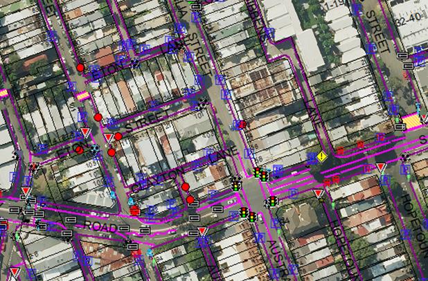
Photographs – Australia Street, Camperdown
Looking southward along Australia Street towards Salisbury Road intersection
Existing ‘Mail Zone’ outside 44-50 Australia Street (on left hand side) proposed to be an extension of the existing Residential Parking (M1) outside Australia Post’s operational hours.
|
|
Local Traffic Committee Meeting 3 November 2016 |
Subject: Ferndale Lane, Newtown - Extension of ‘No
Parking’ Restrictions in the Laneway
(Stanmore Ward/Newtown Electorate/Newtown LAC)
File Ref: 16/6022/121030.16
Prepared By: Jennifer Adams - Traffic and Road Safety Officer, Marrickville
Authorised By: Joe Di Cesare - Manager Design and Investigation, Marrickville
|
SUMMARY A resident of Ferndale Street, Newtown raised concerns with regards to vehicles being parked in Ferndale Lane opposite their garage and therefore restricting vehicular access into and out of their garage. It is recommended that the existing 'No Parking' restrictions on the western side of Ferndale Lane be extended 16 metres northward from the rear of property No.32 Ferndale Street to the rear of the property No.24 Ferndale Street, Newtown to improve vehicular access to residents’ off-street parking. |
|
RECOMMENDATION
THAT:
1. the existing 'No Parking' restrictions on the eastern side of Ferndale Lane BE EXTENDED by 16 metres northward from the rear of property No.32 Ferndale Street to the rear of property No.24 Ferndale Street, Newtown to improve vehicular access to residents’ off-street parking; and 2. the applicant, Council's Rangers and all affected residents be advised in terms of this report.
|
BACKGROUND
Concerns have been raised by a resident of Ferndale Street, Newtown that vehicles are often parked in Ferndale Lane opposite their garage restricting vehicular access into and out of their garage. The resident advised that the problem is due to vehicles parking on the opposite side of the laneway and this is compounded by the narrow width of the laneway.
The applicant’s property is located on the eastern side of Ferndale Street and has one off-street car parking facility, accessed from Ferndale Lane. (Refer to the attached locality map and photographs).
In April 2001 the Committee recommended that a questionnaire survey of all affected residents be undertaken regarding a proposal to install parking restrictions along one side of Ferndale Lane. The results of the survey were referred back to the Committee in May 2001. Ten (10) survey responses were received, and of these, two (2) supported the proposal and eight (8) were opposed.
The majority of those opposed to the proposal made reference to the general shortage of parking in the area and the need to park in the lane. Some respondents advised that while access to off-street facilities should be possible, any restrictions installed should be kept to a minimum.
Consequently, it is recommended that only a short section of “No Parking” be provided on the eastern side of the lane, directly opposite the original applicant’s rear garage area.
In September 2007 Council received another request for the provision of 'No Parking' restrictions in Ferndale Lane, Newtown, as parked vehicles restricted access to off-street parking spaces. Another questionnaire survey was conducted and the results were tabled at the Committee’s meeting of 19 February 2008. The recommendations of the Committee were adopted by Council at its meeting held on 11 March 2008. Council resolved THAT:
1. The findings of the resident questionnaire survey be received and noted;
2. The installation of 'No Parking' restrictions in Ferndale Lane, Newtown, NOT be approved as a result of the low level of support from residents; and
3. All residents in the study area be advised in terms of this report.
A report went to the 24 July 2012 Committee meeting regarding a proposal to install full-time ‘No Parking’ restrictions on the eastern side of Ferndale Lane (opposite to the rear of properties No. 32 to 38 Ferndale Street, Newtown) for a distance of 16 metres, to provide adequate space for residents to turn into and out of their off-street parking facilities.
The matter was discussed at the meeting and it was noted that two objections were received from residents who were concerned about the loss of parking spaces in the laneway. The Committee’s recommendation, which was adopted by Council on 21 August 2012, was that:
“the installation of full-time ‘No Parking’ restrictions on the eastern side of Ferndale Lane (opposite to the rear of properties No. 32 to 38 Ferndale Street, Newtown) for a distance of 16 metres be APPROVED, to provide adequate space for residents to turn into and out of their off-street parking facilities”.
Subsequent to the meeting Council received a number of submissions from residents of Ferndale Street and Camden Street in opposition to the proposed ‘No Parking’ restrictions in Ferndale Lane. The residents’ concerns in relation to loss of parking were considered, however the provision of the recommended ‘No Parking’ zone (ie. 16 metres in length resulting in the loss of 3 car parking spaces and the gain of access to 3 off-street car parking spaces) in Ferndale Lane was considered necessary in order to improve vehicular access to existing off-street parking facilities. It was considered that residents with off-street parking spaces have the right to be able to utilise these spaces if they wish to do so and off-street parking removes vehicles from being parked on-street.
The Committee members also noted that should parking on the corner of Ferndale Lane and Camden Street be a problem for vehicles accessing the laneway, the matter would be revisited with a view to install ‘No Stopping’ restrictions in the laneway at this location.
FINANCIAL IMPLICATIONS
The cost of extending the existing ‘No Parking’ restrictions 16 metres northward on the eastern side of Ferndale Lane is approximately $300 and can be met form Council’s signs and line markings budget.
OFFICER COMMENTS
Ferndale Lane is approximately 5 metres in width and it runs north-south between Kent and Camden Streets, providing rear access to properties fronting Ferndale Street. At present, there is a 16 metre length of full-time ‘No Parking’ restrictions installed on the eastern side of Ferndale Lane (between Camden Street and the rear of 32 - 38 Ferndale Street, Newtown) and there is also a section of ‘No Parking’ along the eastern side of Ferndale Lane, near Kent Street (opposite the rear garage of No.16 Ferndale Street), to provide adequate space for residents to turn into and out of their off-street parking facilities. There are no vehicular driveways presently installed on the eastern side of the lane.
It has been observed during a site inspection undertaken in the afternoon period on two occasions that on-street parking spaces in the area were moderately utilised and vehicles were parked on the eastern side of the laneway, thereby restricting access to garages on the western side. A rubbish skip was located in the laneway and vehicles were recurrently parked within the statutory 10 metre ‘No Stopping’ restrictions at both intersections of the laneway.
The provision of a 16 metre extension to the existing ‘No Parking’ zone on the eastern side of the laneway near Camden Street would provide adequate space for residents to turn into and out of their off-street parking facilities. It should be noted that laneways were generally built to provide service access for properties into off-street parking facilities.
PUBLIC CONSULTATION
On 20 September 2016 twenty-one (21) consultation letters were hand delivered to neighboring owners/occupiers notifying them that Council was considering a proposal to extend the existing ‘No Parking’ restrictions in Ferndale Lane on the eastern side of Ferndale Lane by 16 metres northward from the rear of property No.32 Ferndale Street to the rear of property No.24 Ferndale Street, Newtown in order to improve vehicular access to residents’ off-street parking.
The closing date for submissions ended on 7 October 2016. Three (3) submissions were received and of these two (2) opposed the proposal and one (1) was supportive. Both of those opposed to the proposal made reference to the general shortage of parking in the area and the need to park in the lane. One was adamant that parking shortages in the area were due to new developments which lacked inadequate parking provision within their complexes. The premise that a selected few residents benefit at the expense several was also itemised. The resident who supported the proposal noted that if approved, they will be able to park their cars off the street which will open up another 2 car spots in the neighbourhood.
Principally, while access to off-street facilities should be possible, any restrictions installed should be kept to a minimum. Further, it is noted that consideration was initially to restrict all parking in the laneway.
CONCLUSION
Ferndale Lane is quite narrow and should a vehicle be parked close to or opposite a driveway,
vehicle access can be impeded. No Parking’ restrictions would assist residents with rear garage areas who may be experiencing access difficulties. Therefore, in order to provide clear vehicular access to the applicant's off-street parking facility, it is recommended that the existing 'No Parking' restrictions on the western side of Ferndale Lane be extended 16 metres northward from the rear of property No.32 Ferndale Street to the rear of the property No.24 Ferndale Street, Newtown to improve vehicular access to residents’ off-street parking.
Locality map – Ferndale Lane, Newtown
Subject location
–Ferndale Lane, Newtown ![]()
![]()

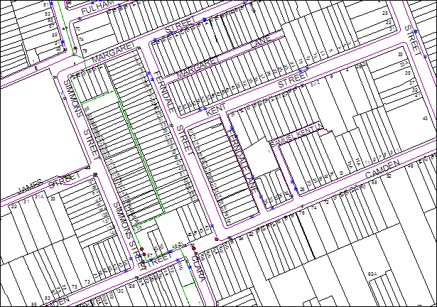
![]()
N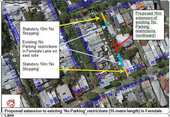
![]()
Photographs - Ferndale Lane, Newtown
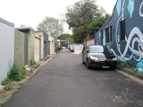 Ferndale
Lane – looking towards Kent Street
Ferndale
Lane – looking towards Kent Street
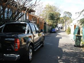 Ferndale Lane – Looking
towards Camden St
Ferndale Lane – Looking
towards Camden St
Location - New signage – Ferndale Lane, Newtown
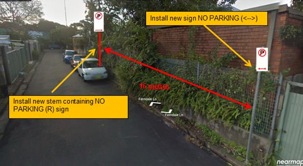
|
|
Local Traffic Committee Meeting 3 November 2016 |
Subject: Briar Lane, St Peters - ‘No Parking’
Restrictions in the Laneway
(Marrickville Ward/Heffron Electorate/Newtown LAC)
File Ref: 16/6022/120996.16
Prepared By: Jennifer Adams - Traffic and Road Safety Officer, Marrickville
Authorised By: Joe Di Cesare - Manager Design and Investigation, Marrickville
|
SUMMARY Representations have been received from local residents for the installation of full time ‘No Parking’ restrictions in Briar Lane, St Peters as vehicular access is often blocked by parked vehicles in the laneway and some residents are unable to access their off-street parking due to parked vehicles. Residents have been notified of the proposal to install ‘No Parking’ restrictions along the eastern length of the laneway along with statutory 10 metre ‘No Stopping’ signs on the south-east side of Briar Lane at its intersection with Henry Street. It is recommended that the proposal be approved. |
|
RECOMMENDATION
THAT:
1. the installation of full-time ‘No Parking’ restrictions on the eastern side of Briar Lane, St Peters commencing adjacent to property No. 9 Henry Street and extending to the northern end of the laneway be APPROVED, in order to provide unobstructed vehicular access to the laneway and to the off-street car parking spaces and deter illegal parking across vehicular crossings; 2. the installation of statutory ‘No Stopping’ restrictions on the south-east side of Briar Lane, St Peters for a distance of 10 metres from its intersection with Henry Lane, St Peters be APPROVED, in order to deter illegal parking, improve access for turning motorists and increase safety; and 3. the applicants, affected residents and Council Rangers be advised in terms of this report.
|
BACKGROUND
Council Officers have been advised that vehicular access to Briar Lane is often blocked by vehicles parked in the laneway and some residents cannot access their off-street parking when vehicles are parked opposite their driveway/garage. It was noted that garbage trucks often do not have enough space to access the laneway.
Residents have also indicated that parking issues in the laneway have only arisen since the implementation of nearby Residential Parking restrictions in surrounding streets in June 2015.
Concerns raised refer to the ‘knock-on’ effects of on-street parking and that an increased demand for parking now takes place in the laneway as it is unrestricted parking.
FINANCIAL IMPLICATIONS
The costs of the supply and installation of the signposting associated with the recommended ‘No Parking’ & ‘No Stopping’ restrictions are approximately $800 and can be met from Council’s operating budget.
OFFICER COMMENTS
Briar Lane is a dead-end laneway running (north)west-(south)east off Henry Street and parallel to Grove Street and Sutherland Street, St Peters. The laneway is approximately 5.70 metres in width and has no kerb and gutter or footpaths. Briar Lane provides rear access to properties fronting Grove Street and Sutherland Street, therefore there are driveways located on both sides of the laneway. At present the laneway has unrestricted parking and vehicles park on both sides. (Refer to the attached locality map and photographs.)
A site inspection undertaken by a Council Officer revealed that many vehicles parked in front of garages/off-street parking spaces in addition to any legal parking in the laneway. Technically, under NSW Road Rules (198) motorists (even if they are the resident of the property) cannot park in a way that either partially or completely blocks a driveway/garage.
It was also noted that some legal spaces are located opposite driveways and when a vehicle is parked in these spaces it does not leave sufficient space for residents to enter/exit from their garages/off-street parking spaces due to the narrow carriageway. (Refer to the attached photos).
Parking in laneways
Council recently adopted the Laneway Parking Guidelines which outline the measures to consider when the use of the laneway prohibits access to off-street parking and access through the laneway. The effective use of narrow streets and laneways alleviates parking pressure. Effectively managed laneways allow for adequate access while providing the maximum amount of on-street parking. The Laneway Parking Guidelines outline the priorities for using narrow laneways and the actions and processes that Council will use to manage access and parking. These guidelines have been developed to provide consistency for evaluating the need for parking controls and manage the use of narrow streets and laneways to maintain access and maximise parking. The need for parking controls is based on the width of the laneway shown below in Table 1.
Table 1: Laneway Parking Guidelines Laneway Width
|
Laneway Width |
Parking and Access Arrangements |
|
5.1 metres or more wide |
· Parking allowed on at least one side of the laneway · Allows access for emergency, delivery and waste collection trucks at all times · Complies with Australian Standards and Road Rule 208(7) |
|
Less than 5.1 metres |
· Parking NOT permitted in the laneway · Allows vehicle access at all times and complies with Australian Standards and Road Rule 208(7) |
NSW legislation includes various requirements to manage access and parking on roads. The Roads Act provides rights of access along roads and also for access to private property. The Road Rules includes requirements which affect parking at intersections, driveways and also parking along laneways.
Parking in narrow laneways next to intersections and driveways can cause access and safety concerns for residents. NSW Road Rules address these issues as they prohibit parking across property driveways and within 10 metres of an intersection without traffic lights.
For parking to be allowed in a narrow laneway, the Australian Standards require that parallel parking spaces be at least 2.1 metres wide and NSW Road Rules requires that at least 3 metres must be available between a parked car and the kerb or edge of the laneway to allow moving vehicles to pass safely. Therefore, laneway widths that are less than 5.1 metres wide are too narrow to allow parking as any parked vehicle would prevent traffic from using the laneway (see Figure 1)

Figure 1: Recommended minimum width of laneway for parking – 5.1 metres
Council’s preference is for residents to negotiate with each other to avoid implementing parking bans. Where problems occur, parking restrictions can be considered for individual laneways on a case-by-case basis. The guidelines provide consistency for assessing the need for parking controls.
Accordingly, following Council’s Laneway Parking Guidelines and given that Briar Lane is wider than 5.1m, it is appropriate to allow parking at least on one side of the laneway. It should be noted that laneways were generally built to provide service for properties and access into off-street parking facilities therefore restricting parking in this laneway will help achieve this goal.
PUBLIC CONSULTATION
A consultation letter was hand delivered to 37 owners and/or occupiers of the affected properties that are adjacent to Briar Lane regarding the proposal to install full-time ‘No Parking’ restrictions along the entire eastern side of the laneway, from Henry Street to the end of the laneway, with statutory ‘No Stopping’ restrictions on the southern end of the eastern side of the lane at its intersections with Henry Street, St Peters. The closing date for submissions ended on 7 October 2016.
Resident survey findings
A total of six (6) responses were received from residents, representing a 16% return. Of these submissions, 2 out rightly supported the proposal, 2 objected in part and 2 were neutral stating that recent residential parking scheme restrictions in adjoining streets created a demand for parking in the laneway.
Comments from residents
|
Comments from respondent |
Council Officer’s comments |
|
Resident supports the proposal and says laneway access and resident’s garages are frequently blocked by parked vehicles. |
Noted |
|
Resident opposes the proposal to designate the first 10 metres on the eastern side of laneway being no stopping zone and believes they should be able to park over their own driveway/garage. |
NSW Road Rules prohibit parking within 10 metres of an intersection without traffic lights and also prohibit parking across property driveways. Penalties are enforceable for both offences. Note ‘No Stopping’ signage does not have to be installed to enforce the No Stopping at intersection rule |
|
Resident objects to the proposal and says parking is limited in the area due to recent residential parking scheme restrictions in Grove Street and resident says any parking restrictions in laneway should be on the western side of the laneway as Sutherland Street residents are eligible for parking permits |
Feedback on the implementation of the Sydenham Parking Strategy has been passed onto Council’s Parking Planner for review - It is noted that in June 2015 the resident parking scheme for Sydenham precinct (Area M4) was implemented as part of the Sydenham Parking Strategy adopted by Council in February 2014.
· Grove Street (between Unwins Bridge Road and Henry Street) was not recommended for a change in parking conditions · Grove Street (between Henry Street and Princes Highway) and Grove Street (between Rolf Lane & Bakers Lane) were included in the residential parking scheme and permit parking restrictions were introduced.
Parking restrictions on the west side of the laneway restricts more resident’s access to off-street parking spaces, which may result in more vehicles being parked on the road, if these garages are not used. It should be noted that laneways were generally built to provide service access for properties and access into off-street parking facilities. |
|
Resident believes that issues in the laneway have only arisen after various properties are being renovated and subsequently work vehicles and skips hinder laneway access.
Resident stated also if lane is to have parking restrictions on one side consideration needs to be given to making Sutherland Street (Unwins Bridge end) unrestricted parking on one side as presently 2 hour restrictions are on both sides. They believe this to be excessive and unfair for local residents. Adding, if unrestricted parking were to be on one side parking congestion issues in Briar Lane may cease. |
It is noted that DA consent conditions control redevelopment works and conditions must be adhered with. The placing of any materials on Council's footpath or roadway is prohibited, without the consent of Council. The placement of waste storage containers in a public place requires Council approval and must comply with Council's Policy – 'Placement of Waste Storage Containers in a Public Place'.
Feedback on the implementation of the Sydenham Parking Strategy has been passed onto Council’s Parking Planner for review |
|
Resident says issues with parking in Briar Lane have arisen since the implementation of 2P signs in the surrounding streets around a year ago and advises the ‘parking strategy’ has caused many local parking issues and suggest that street parking be changed back to unrestricted on Sutherland and Grove Streets. |
Noted. Feedback on the Parking Strategy will be passed onto Council’s Parking Planner for review. |
|
Resident approves the proposal and said at times it was very hard to go out of their garage. |
Noted. |
CONCLUSION
In order to provide unobstructed vehicular access to the laneway and residents’ off-street car parking spaces and deter illegal parking across vehicular crossings, it is recommended that full-time ‘No Parking’ restrictions be installed in Briar Lane on the eastern side of the laneway from the statutory 10 metre ‘No Stopping’ section at Henry Street to the end of the laneway, in order to deter illegal parking, improve access for turning motorists and increase safety.
Locality Map – Briar Lane, St Peters

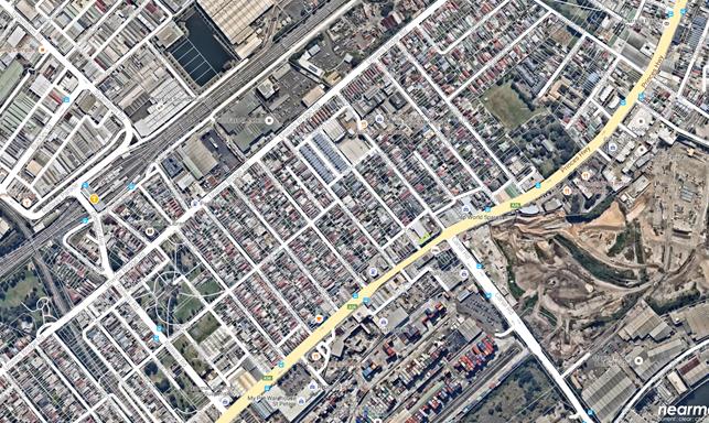
Proposed ‘No Parking’ restrictions in Briar
Lane on the eastern side Statutory 10 metre ‘No Stopping’
restrictions. N![]()
![]()


![]()
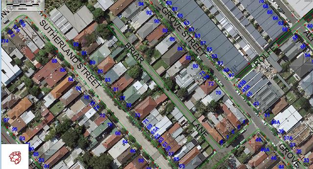
Proposed ‘No Parking’ restrictions (eastern side) in Briar Lane, St Peters
Photographs – Briar Lane, St Peters
|
|
Looking northward along Briar Lane from Henry Street, St Peters)
|
|
Looking southward from the end of Briar Lane towards Henry Street, St Peters
|
|
Local Traffic Committee Meeting 3 November 2016 |
Subject: 2 South Street, Marrickville - Request for a
Drop-Off & Pick-Up Zone outside the Waranara Centre
(Marrickville Ward/Summer Hill Electorate/Marrickville LAC)
File Ref: 16/6022/120228.16
Prepared By: Emilio Andari - Civil Engineer, Marrickville
Authorised By: Joe DiCesare - Manager Design and Investigation, Marrickville
|
SUMMARY A request has been received from the Waranara Centre for the provision of a morning and afternoon school P10minute drop-off/pick-up zone adjacent to the school in South Street, Marrickville to assist parents and carers with the drop-off and pick-up of children. It is recommended that the proposal be approved. |
|
RECOMMENDATION
THAT the installation of ‘P10minute, 8:00am-9:30am and 2:30pm-4:00pm, Mon-Fri’ restrictions on the eastern side of South Street, Marrickville directly outside property 2 South Street (10 metres in length), be APPROVED, in order to provide an on-street drop-off/pick-up parking facility and to improve safety for passing traffic and access for children and parents into their vehicles.
|
BACKGROUND
The Waranara Centre, Good Shepherd Australia New Zealand’s school for disadvantaged and marginalised young people was officially opened in January 2015. It provides secondary education for students in year 9 and 10 who cannot thrive in the mainstream.
Council was approached by the Waranara Centre for the provision of a morning and afternoon school P10minute drop-off/pick-up zone in South Street, Marrickville to assist parents and carers with the drop-off and pick-up of children during peak school times.
FINANCIAL IMPLICATIONS
The costs of the supply and installation of the signposting associated with the recommended drop-off/pick-up zone are approximately $800 and can be met from Council’s operating budget.
OFFICER COMMENTS
Site location & road network
|
Street Name |
South Street |
|
Section |
Between Marrickville Road and Pine Street |
|
Carriageway Width (m) |
12.8 |
|
Carriageway Type |
Two-way road with one travel lane in each direction, in addition to kerbside parking lanes. |
|
Classification |
Local |
|
85th Percentile Speed (km/h) |
53.3 |
|
Vehicles Per Day (vpd) |
515 |
|
Reported Crash History (2010-2014) |
1 crash. Rum Code: 41. The crash resulted in a tow away. |
|
Heavy Vehicle Volume (%) |
1.5 |
|
Parking Arrangements |
Unrestricted parking on both sides of the road. |
Locality Map
Proposed drop-off/pick-up parking zone The Waranara Centre

![]()
![]()
On-street parking
It has been observed by Council Officers during a site inspection that on-street parking spaces along South Street, Marrickville were highly utilised. By providing a morning and afternoon school P10minute drop-off/pick-up zone in South Street, this will alleviate congestion between motorists and improve safety for passing traffic and access for children and parents into their vehicles.
Photographs
|
|
The location of the proposed drop-off/pick-up parking zone adjacent to the Waranara Centre outside 2 South Street, Marrickville (facing east)
|
|
On-street parking in South Street near the Waranara Centre (facing south-east)
PUBLIC CONSULTATION
Consultation regarding the proposal was undertaken with the Waranara Centre and Council officers have advised the school of the recommendation within this report.
CONCLUSION
In an effort to alleviate congestion during the morning and afternoon pick-up period adjacent to the Waranara Centre at 2 South Street, Marrickville, it is recommended that the provision of ‘P10minute, 8:00am-9:30am and 2:30pm-4:00pm, Mon-Fri’ restrictions, be approved, to provide an on-street drop-off/pick-up parking facility and to improve safety for passing traffic and access for children and parents into their vehicles.
|
|
Local Traffic Committee Meeting 3 November 2016 |
Subject: Wooley Lane, Marrickville - Request for ‘No
Parking’ Restrictions in Laneway
(Marrickville Ward/Summer Hill Electorate/Marrickville LAC)
File Ref: 16/6022/121057.16
Prepared By: Jennifer Adams - Traffic and Road Safety Officer, Marrickville
Authorised By: Joe Di Cesare - Manager Design and Investigation, Marrickville
|
SUMMARY Representations have been received from local residents for the installation of full time ‘No Parking’ restrictions in Wooley Lane, between Warburton Street and Greenbank Street, Marrickville adjacent to their off-street car parking spaces along the laneway, as vehicular access is often blocked by parked vehicles in the laneway.
Residents have been notified of the proposal to extend the existing ‘No Parking’ restrictions on the western side of Wooley Lane by 30 metres to encompass the entire length of the laneway to improve access to off-street parking. It is recommended that the proposal be approved. |
|
RECOMMENDATION
THAT:
1. the existing full-time ‘No Parking’ restrictions on the western side of Wooley Lane, between Warburton Street and Greenbank Street, Marrickville BE EXTENDED by 30 metres southward, in order to provide unobstructed vehicular access to the off-street car parking spaces and deter illegal parking across vehicular crossings; 2. the installation of statutory ‘No Stopping’ restrictions on the southern end of the western side of Wooley Lane, Marrickville for a distance of 10 metres from its intersection with Greenbank Street, be APPROVED, in order to deter illegal parking, improve access for turning motorists and increase safety; and 3. the applicants, Council Rangers and affected residents be advised in terms of this report.
|
BACKGROUND
In 2000 Council surveyed adjacent local residents / business owners regarding a proposal to install parking restrictions on the western side of Wooley Lane, Marrickville to prevent parked vehicles from impeding through traffic and the collection of waste. A report was presented to the Traffic Committee on 14 December 2000 and a 36 metre zone of “No Parking’ was recommended to be installed on the western side of the laneway.
Presently, it has been reported that a problem exists with many cars constantly parking in the laneway and blocking access to off-street parking spaces / garages. It was reported also that commercial waste bins are regularly placed in the laneway compounding access.
FINANCIAL IMPLICATIONS
The costs of the supply and installation of the signposting associated with the recommended ‘No Parking’ & ‘No Stopping’ restrictions are approximately $550 and can be met from Council’s operating budget.
OFFICER COMMENTS
In the past requests for parking restrictions in the subject lane have been generally from Illawarra Road business proprietors to prevent parked vehicles from impeding through traffic and the collection of waste. More recently requests for parking restrictions are related to access of off-street car parking facilities.
Wooley Lane is a narrow laneway (5 metres in width) running north/south between Warburton Street and Greenbank Street and parallel to Illawarra Road. (Refer to the attached Locality Plan and photographs). Property Nos. 346 to 370 Illawarra Road back onto the lane and the majority of these properties have a driveway access leading to small off-street parking areas. In the case of the units at property No. 346, several off-street car parking positions are accessed from Warburton Street. All waste collection is undertaken from the laneway.
Inspections of the site revealed vehicles parked on the western side of the laneway where there were no restrictions to parking. The position of some of these vehicles blocks access to off-street parking facilities on the opposite side of the laneway and also makes it difficult for a large vehicle to pass.
Parking in laneways
The proposal to extend ‘No Parking’ restrictions along the entire length of the laneway will provide unobstructed vehicular access to adjoining properties as well as unobstructed access along the laneway. It was observed during the site inspection that some of the off-street parking facilities were utilised. It was also observed that there is a high demand for parking in the area.
It should be noted that laneways were generally built to provide service access for properties and access into off-street parking facilities. Prohibiting parking in this laneway will help achieve this goal.
Council’s adopted ‘Laneway Parking Guidelines’ outline the measures to consider when the use of the laneway prohibits access to off-street parking and access through the laneway. The Guidelines outline the priorities for using narrow laneways and the actions and processes that Council will use to manage access and parking. These guidelines have been developed to provide consistency for evaluating the need for parking controls and manage the use of narrow streets and laneways to maintain access and maximise parking. The need for parking controls is based on the width of the laneway as shown in Table 1 reproduced.
Table 1: Laneway Parking Guidelines Laneway Width
|
Laneway Width |
Parking and Access Arrangements |
|
5.1 metres or more wide |
· Parking allowed on at least one side of the laneway · Allows access for emergency, delivery and waste collection trucks at all times · Complies with Australian Standards and Road Rule 208(7) |
|
Less than 5.1 metres |
· Parking NOT permitted in the laneway · Allows vehicle access at all times and complies with Australian Standards and Road Rule 208(7) |
For parking to be allowed in a narrow laneway, the Australian Standards require that parallel parking spaces be at least 2.1 metres wide and NSW Road Rules requires that at least 3 metres must be available between a parked car and the kerb or edge of the laneway to allow moving vehicles to pass safely. Therefore, laneway widths that are less than 5.1 metres wide are too narrow to allow parking as any parked vehicle would prevent traffic from using the laneway (see Table 1 above and Figure 1 below).
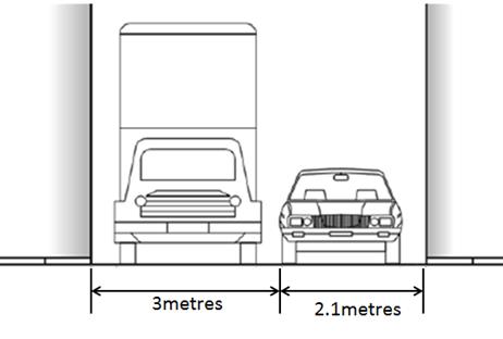
Figure 1: Recommended minimum width of laneway for parking – 5.1 metres
PUBLIC CONSULTATION
A public consultation letter was hand delivered on 10 October 2016 to 20 owners and/or occupiers of the affected properties that are adjacent to the subject laneway regarding the proposal to extend the existing full-time ‘No Parking’ restrictions southward along the entire western length of Wooley Lane (including statutory ‘No Stopping’ restrictions at its intersection with Greenbank Street – western side). The closing date for submissions ended on 21 October 2016.
At the end of the survey period provided for comments, three responses were received. All three supported the proposal. Comments provided include the following:
· “support the proposal….…we constantly have issues with cars parked in the laneway….over our driveway….impossible to park..”
· ‘strongly agree with proposal…..it’s a constant drama with cars parking over my driveway ….there is a lot of issues when driving in the laneway with cars having difficulties on passing, trucks, etc…it’s a narrow lane….cars are already parked in ‘non parking’ area of the lane already.”
· “….I hope the signs will be erected as soon as possible…mean time we have no access…in…out of our garage…”
Considering the number of responses in support of the proposal it is considered favourable that the installation of "No Parking" restrictions be approved.
CONCLUSION
In order to provide unobstructed vehicular access to the residents’ off-street car parking spaces and deter illegal parking across vehicular crossings, it is recommended that full-time ‘No Parking’ restrictions be installed along the entire western side of Wooley Lane, between Warburton Street and Greenbank Street, Marrickville.
Locality Map – Wooley Lane, Marrickville
![]()

![]()
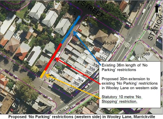
Photographs – Wooley Lane, Marrickville
|
|
Wooley Lane (facing south) from Warburton Street, Marrickville
|
|
Wooley Lane (facing north) from Greenbank Street, Marrickville
|
|
Local Traffic Committee Meeting 3 November 2016 |
Subject: Requests for Mobility Parking Spaces
(Ashfield, Stanmore & Marrickville Wards/Summer Hill & Newtown
Electorates/Stanmore & Marrickville LACs)
File Ref: 16/6022/121119.16
Prepared By: Maaran Mutharasa - Engineer Traffic Services, Marrickville
Authorised By: Joe Di Cesare - Manager Design and Investigation, Marrickville
|
SUMMARY Requests have been received from residents within the Local Government Area (LGA) for the provision of dedicated mobility parking spaces outside their residence. It is recommended that the following 'Mobility Parking' spaces be approved as the applicant’s current medical conditions warrant the provision of these spaces and they have constrained or no off-street parking opportunities. |
|
RECOMMENDATION
THAT subject to the below conditions, the following locations be APPROVED as a ‘mobility parking’ space:
1. Southern side of Station Street, Petersham adjacent to property no 36 Station Street, Tempe; 2. Southern side of Camden Street, Tempe adjacent to property no 160 Camden Street, Tempe; and 3. Northern side of Alfred Street, Marrickville adjacent to property no 1A Alfred Street, Marrickville.
The conditions are: a. the operation of the dedicated parking space be valid for twelve (12) months from the date of installation; b. the applicant advising Council of any changes in circumstances affecting the need for the special parking space; and c. the applicant is requested to furnish a medical certificate and current mobility permit justifying the need for the mobility parking space for its continuation after each 12 months period.
|
BACKGROUND
A copy of the RMS disability parking permit and a medical certificate in support of the applications was submitted to Council.
FINANCIAL IMPLICATIONS
The costs of the supply and installation of the signposting associated with the recommended mobility parking spaces is approximately $2100.
It should be noted that Council normally signposts on-street mobility parking spaces and does not line mark these spaces. Should the applicant require the provision of kerb ramps, this can be provided at their cost.
OFFICER COMMENTS
|
Subject Location |
Classification of Road |
Road Description |
|
Station Street, Petersham |
Local Road |
Two-way mixed-use street, 6.7m in width that runs west-east from Livingstone Road to Albert Street. |
|
Camden Street, Enmore |
Local Road |
Two-way mixed-use street, 6.7m in width that runs west-east from Edgeware Road to Clara Street. |
|
Alfred Street, Marrickville |
Local Road |
Two-way mixed-use street, 12.9m in width that runs east- west from Beauchamp Street to Dead End Road. |
36 Station Street, Tempe
The applicant’s property is located on the southern side of Station Street, Tempe and approximately 45m east from Princes Highway. The applicant’s property does not have an off-street parking facility (refer to the attached locality map and photographs).
At present, there is unrestricted parking on both sides of Station Street. There are no existing mobility parking spaces in close proximity to the applicant’s property. It has been observed during a site inspection undertaken in the morning period that the on-street parking spaces in Station Street were moderately utilised.
The applicant advised a Council Officer that his condition does not allow him to walk long distances due to his medical conditions. The applicant also stated that he does drive and has difficulty finding a parking space near his property.
160 Camden Street, Enmore
The applicant’s property is located on the southern side of Camden Street, Enmore and approximately 95m east from Edgeware Road. The applicant’s property does not have an off-street parking facility (refer to the attached locality map and photographs).
At present, there is unrestricted parking on both sides of Camden Street. There are no existing mobility parking spaces in close proximity to the applicant’s property. It has been observed during a site inspection undertaken in the morning period that the on-street parking spaces in Camden Street were heavily utilised.
The applicant advised a Council Officer that his medical condition does not allow him to walk long distances. The applicant also stated that he does drive and has difficulty finding a parking space near his property.
1A Alfred Street, Marrickville
The applicant’s property is located on the northern side of Alfred Street, Marrickville and approximately 45m west from Beauchamp Street. The applicant’s property does not have an off-street parking facility (refer to the attached locality map and photographs).
At present, there is unrestricted parking on both sides of Alfred Street. There are no existing mobility parking spaces in close proximity to the applicant’s property. It has been observed during a site inspection undertaken in the morning period that the on-street parking spaces in Alfred Street were moderately utilised.
The applicant advised a Council Officer that her medical condition does not allow her to walk up the hill. The applicant explained that she does not drive a vehicle however he is driven by another family member.
Technical Standards
Australian Standard AS2890.5-1993 “On-Street Parking” states the following in regards to the provision of parking for people with a disability:
“Parallel parking spaces shall not be marked as disabled spaces, nor included in the count of spaces available for people with disabilities unless –
i. A 3.2m wide space can be provided, e.g. by indenting the space into the footpath area; and
ii. Kerb ramps as shown in Figure 4.2(a) are also provided”.
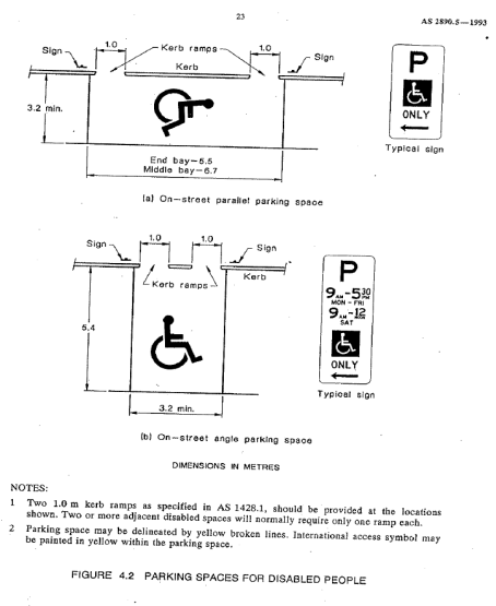
It should be noted that due to the limited width of streets around the Marrickville LGA, it is often difficult to comply with these requirements for the parking space dimensions. This may also result in the loss of some adjacent on-street parking spaces.
Mobility parking spaces are primarily intended for on-street and off-street parking at destinations, such as in commercial/retail areas and public car parks near hospitals, schools and public transport facilities where multiple usages can be expected. They were generally not intended for points of origin such as reserving on-street parking.
A mobility parking space is not intended for the sole use of one applicant, but rather a shared facility that can used by all authorised persons having an RMS mobility permit.
PUBLIC CONSULTATION
A notification letter has been sent to the applicants informing them of the application process and as part of the assessment they will be considered at this meeting.
CONCLUSION
It is recommended that the 'Mobility Parking' spaces be approved as the applicants conditions warrant the provision of these spaces.
It should be noted that the proposed mobility parking spaces are not for the sole use of the applicant and may be used by other authorised persons.
Locality Map – 36 Station Street, Tempe
N
![]()
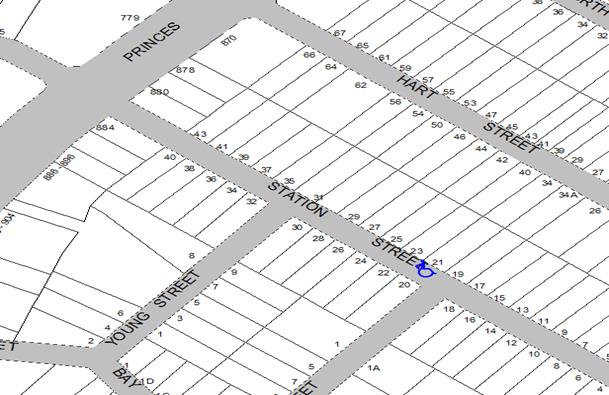
|
Existing Mobility
Parking spaces in close proximity to the applicant’s property Existing Mobility
Parking spaces in close proximity to the applicant’s property
Photographs – 36 Station Street, Tempe
|
|
The frontage of the applicant's property in Station Street, Tempe
|
|
On-street parking in Station Street, Tempe
Locality Map – 160 Camden Street, Enmore
N
|
Photographs – 160 Camden Street, Enmore
|
|
The frontage of the applicant's property in Camden Street, Enmore
|
|
On-street parking in Camden Street, Enmore
Locality Map – 1A Alfred Street, Marrickville
N
|
Existing Mobility
Parking spaces in close proximity to the applicant’s property Existing Mobility
Parking spaces in close proximity to the applicant’s property
Photographs – 1A Alfred Street, Marrickville
|
|
The frontage of the applicant's property in Alfred Street, Marrickville
|
|
On-street parking in Alfred Street, Marrickville
|
|
Local Traffic Committee Meeting 3 November 2016 |
Subject: Lion Street and Wetherill Street, Croydon -
Proposal for Permit Parking Area 2 and 7 Respectively
(Ashfield Ward/Strathfield Electorate/Ashfield LAC)
File Ref: 16/6022/121228.16
Prepared By: Anca Eriksson - Traffic Officer, Ashfield
Authorised By: Jason Scoufis - Acting Traffic Manager, Leichhardt
|
SUMMARY Requests have been received from local residents for consideration of a Resident Parking Scheme in Lion Street and Wetherill Street, Croydon. Surveys and recent consultation was conducted to consider the inclusion of Lion and Wetherill Streets as part of the extension of the Ashfield LGA Residential Parking Scheme with precincts introduced in the surrounding street areas over the last few years. The following recommendation is made to propose installation of ‘2P 8.00am-6.00pm Mon-Fri., Permit Holders Excepted – Area 2 (east side of Wetherill Street, north of Liverpool Road) & ‘2P 8.00am-6.00pm Mon-Fri., Permit Holders Excepted - Area 7 (west side of Lion Street). |
|
RECOMMENDATION
THAT: 1. ‘2P 8.00am-6.00pm Mon-Fri., Permit Holders Excepted - Area 2’ restrictions be installed on the eastern side of Wetherill Street, north of Liverpool Road, Croydon; and 2. ‘2P 8.00am-6.00pm Mon-Fri., Permit Holders Excepted - Area 7’ restrictions be installed on the western side of Lion Street, Croydon.
|
BACKGROUND
At the Inner West Council (Ashfield Transitional) Local Traffic Committee meeting on the 3 June 2016, it was reported that:
1. Council had received several requests in the past year from residents of Lion Street and Wetherill Street, Croydon for the introduction of resident parking restrictions on the west side of Lion Street and on the east side of Wetherill Street north of Liverpool Road. Each of these streets currently has unrestricted parking on both sides.
2. Surveys undertaken in these streets identified parking occupancy levels between 77-80%. The Ashfield Council’s Resident Parking Policy states that where the occupancy level exceeds 75%, the street may be eligible for consideration for resident parking restrictions.
3. Further investigations have revealed that both Lion Street and Wetherill Street north of Liverpool Road, have high number of homes with a limited supply of off- street parking spaces. In Lion Street, there are 26 homes with 25 of those considered to have one or no off-street parking spaces. In Wetherill Street (north of Liverpool Road) there are 32 homes with 16 of those considered to have one or no off-street parking spaces.
At the time of reporting the matter to the Traffic Committee in June 2016, consultation had not been carried out. The Traffic Committee recommended that consultation proceed in proposing resident parking restrictions in Lion Street and Wetherill Street (north of Liverpool Road), and that the outcome of the consultation be reported back to the Traffic Committee with a direction in the matter.
FINANCIAL IMPLICATIONS
Funding will be provided under general traffic facilities program with estimated $2,500-3,000 for signposting.
OFFICER COMMENTS
Although resident consultation was not carried when the matter was reported to the Traffic Committee at its meeting on the 3 June 2016. It was considered at the time that more than 50% of respondents should be supportive of the introduction of resident parking restrictions, provided the restrictions were only introduced to one side of the street.
Under the Ashfield Council Resident Parking Policy, permits are only issued out to eligible residents, hence the need to maintain one side of the street as unrestricted parking for those ineligible for permits. There are more homes potentially eligible for permits on the west side of Lion Street and on the east side of Wetherill Street. Restrictions could therefore be proposed for those sides of the streets.
Subject section along Lion Street (facing north)
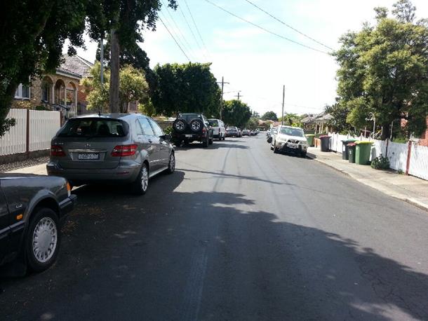
Subject section along Wetherill Street (facing north)
PUBLIC CONSULTATION
A consultation letter was sent to owners and occupiers of the effected residential properties on Lion Street and Wetherill Street regarding the proposal to install ‘2P 8:00am – 6:00pm, Monday to Friday Permit Holders Excepted – Area 7’ restrictions on the western side of Lion Street and a restriction of '2P 8:00am – 6:00pm, Monday to Friday Permit Holders Excepted – Area 2’ on the eastern side of Wetherill Street, north of Liverpool Road.
The closing date for submissions ended on 22 July 2016. The outcome of the resident consultation identified that more than 50% of respondents were supportive of the introduction of resident parking restrictions. Of six (6) respondents on Wetherill Street four (4) were supportive and two (2) were opposed, and of eight (8) respondents on Lion Street six (6) were supportive and two (2) were opposed.
CONCLUSION
In order to provide parking opportunities for local residents and to help reduce on-street parking pressures, it is recommended that restrictions of ‘2P 8:00am – 6:00pm, Mon - Fri Permit Holders Excepted – Area 7’ be installed on the west side of Lion Street and a restriction of ‘2P 8:00am – 6:00pm, Mon-Fri Permit Holders Excepted – Area 2’ be installed on the eastern side of Wetherill Street, north of Liverpool Road.
|
1.⇩ |
Proposed 2P Resident Parking Restrictions |
|
Local Traffic Committee Meeting 3 November 2016 |
Subject: Mullens Street, Rozelle between Mansfield
Street and No. 181 Mullens Street - Resident (Permit) Parking Scheme
Restrictions
(Leichhardt Ward/Balmain Electorate/Leichhardt LAC)
File Ref: 16/6022/121503.16
Prepared By: Nina Fard - Senior Traffic Engineer, Leichhardt
Authorised By: Jason Scoufis - Acting Traffic Manager, Leichhardt
|
SUMMARY Council has received a petition form the residents of Mullens Street (between Mansfield Street and No. 181 Mullens Street). The residents have requested extension of the existing Resident Parking Scheme (RPS) Zone R1 to include the frontage of their properties for a total of 5 indented parking spaces. The request intends to deter long term commuter parking which was recently exacerbated following the installation of RPS restrictions in the nearby Mansfield Street, Rozelle. |
|
RECOMMENDATION
THAT ‘2P 8am-6pm, Mon-Fri, Permit Holders Excepted, Area R1’ restrictions be installed on the western side of Mullens Street, Rozelle (between Mansfield Street and No. 181 Mullens Street).
|
BACKGROUND
The majority of residents of Mullens Street (between Mansfield Street and No. 181 Mullens Street) have requested extension of Resident Parking Scheme (RPS) restrictions along the frontage of their properties to deter long stay parking by commuters and the patrons of the surrounding commercial properties. This section of Mullens Street is the only residential section south of Mansfield Street and as such, experiences high parking demands intensified by the surrounding land use and the installation of 2P RPS restrictions in Mansfield Street, Rozelle, in early 2016.
The above proposed parking restrictions are shown on the map below.
Parking occupancy surveys undertaken along the mentioned section of Mullens Street have shown consistent occupancy levels higher than the required 85%. Council has previously conducted an investigation into RPS restrictions in Mansfield Street west of Mullens Street, which did not proceed due to lack of support from the residents.
|
Mullen Street, Rozelle |
|
|||
|
Sections: |
Number of properties |
Number of properties supported (signed the petition) |
Response Rate |
Support Rate |
|
Mansfield Street -No. 181 Mullens Street |
10 |
8 |
80% |
80% |
According to Council’s policy on Resident Parking, a minimum of 50% support from the properties in the subject section of the street is required for consideration to implement a RPS.
Based on the above results, Mullens Street between Mansfield Street and No. 181 Mullens Street has received more than 50% resident support.
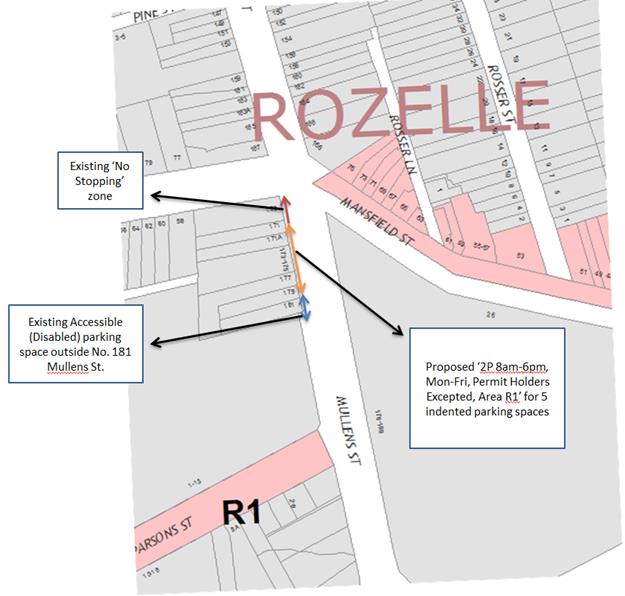
FINANCIAL IMPLICATIONS
The installation of new signage is to be funded from Council’s operating budget.
PUBLIC CONSULTATION
21 notification letters outlining the parking proposal with a copy of the proposed parking plan were sent out to the affected property owners, occupiers and businesses in the area:
No objections were received to the proposal.
CONCLUSION
It is recommended that the proposed ‘2P 8am-6pm, Mon-Fri, Permit Holders Excepted, Area R1’ restrictions on the western side of Mullens Street, Rozelle (between Mansfield Street and No. 181 Mullens Street) be approved for implementation.
|
|
Local Traffic Committee Meeting 3 November 2016 |
Subject: Darling Street, Balmain East - 1/4P Parking
Restriction
(Balmain Ward/Balmain Electorate/Leichhardt LAC)
File Ref: 16/6022/121513.16
Prepared By: Nina Fard - Senior Traffic Engineer, Leichhardt
Authorised By: Jason Scoufis - Acting Traffic Manager, Leichhardt
|
SUMMARY Council has received a petition from a number of business owners in Darling Street between Curtis Road and Stephen Street, requesting the installation of two short term parking spaces. The business owners have raised concerns in regards to the low turnover in the existing 2-hour parking zones in this section of Darling Street and the impacts on their customers’ parking needs. |
|
RECOMMENDATION
THAT ‘1/4P 8am-6pm’ and ‘2P 6pm-10pm, 7 days’ Permit Holders Excepted, Authorised Area B2’ signage be installed outside No.224 Darling Street, Balmain for a length of 6 metres (as shown on the plan).
|
BACKGROUND
In response to the petition, Council undertook parking occupancy surveys in the section of Darling Street between Curtis Road and Queens Place. The survey results indicated that vehicle occupancy levels as well as vehicle turnover rates did not warrant installation of parking meters. However, to assist businesses in this section of Darling Street, Council proposed to amend the existing ‘2P 8am-10pm, Permit Holders Excepted, Authorised Area B2’ parking restrictions for two parking spaces outside No. 224 Darling Street and install two ‘1/4P 8am-6pm’ and ‘2P 6pm-10pm, 7 days’ Permit Holders Excepted, Authorised Area B2’ signage (as shown on the plan).
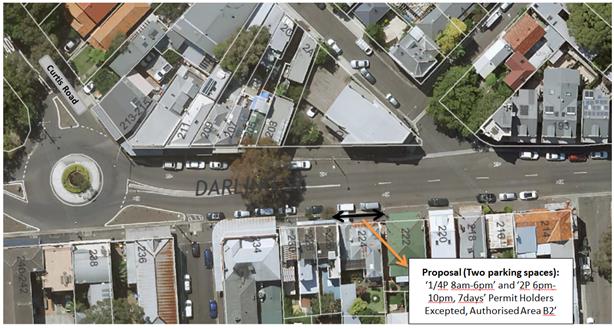
FINANCIAL IMPLICATIONS
The installation of new signage is to be funded from Council’s operating budget.
PUBLIC CONSULTATION
109 notification letters outlining the parking proposal with a copy of the proposed parking plan were sent out to the affected property owners, occupiers and businesses in the area:
One objection was received from the owner of No.224 Darling Street, requesting that the proposed short term parking restrictions be relocated as his property is the only property with partial residential frontage along the south side of Darling Street. The resident is expecting to have surgery in the near future, thereby requiring a Disabled Parking Space at the front of the property. It was suggested that one of the proposed ‘1/4P 8am-6pm, 7 days’ parking spaces be considered on the north side of Darling Street to reduce the impact on the south side and also assist the businesses on the south side of the street.
The footpath between the roundabout at Curtis Road and No.224 Darling Street is elevated from the road and has guardrail barriers installed. As such, relocation of the proposed short term parking space further west towards the roundabout is not supported on safety grounds. However, in order to reduce the impact of the proposed restrictions on the residents of 224 Darling Street the proposal has been amended to installation of one ‘1/4P 8am-6pm’ and ‘2P 6pm-10pm, 7 days’ Permit Holders Excepted, Authorised Area B2’ restriction outside the commercial frontage of No. 224 Darling Street (as shown on the plan).
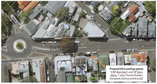
Council will further investigate the support for the possible installation of one ‘1/4P 8am-6pm, 7 days’ on the north side of Darling Street between Curtis Road and Colgate Avenue.
FINANCIAL IMPLICATIONS
The installation of new signage is to be funded from Council’s operating budget.
CONCLUSION
It is recommended that the proposed ‘1/4P 8am-6pm’ and ‘2P 6pm-10pm, 7 days’ Permit Holders Excepted, Authorised Area B2’ restriction outside the commercial frontage of No. 224 Darling Street (for a total of one parking space) be APPROVED in order to deter all day parking and improve parking turnover.
|
|
Local Traffic Committee Meeting 3 November 2016 |
Subject: Flood Street, Leichhardt - No Stopping
(Leichhardt Ward/Balmain Electorate/Leichhardt LAC)
File Ref: 16/6022/121243.16
Prepared By: Manod Wickramasinghe - Traffic and Parking Engineer, Leichhardt
Authorised By: Jason Scoufis - Acting Traffic Manager, Leichhardt
|
SUMMARY It is recommended to signpost the statuatory 10m ‘No Stopping’ zone on the eastern side of Flood Street, south of Albert Street to provide adequate sight lines to traffic in Flood Street. |
|
RECOMMENDATION
THAT a 10m ‘No Stopping’ zone be signposted on the eastern side of Flood Street, Leichhardt immediately south of Albert Street.
|
BACKGROUND
Concerns have been raised regarding vehicles obstructing sight lines and manuevering space by parking on the eastern side of Flood Street, too close to the intersection of Flood Street/Albert Street, Leichhardt.
In order to allievate this issue it is proposed to signpost the 10m ‘No Stopping’ zone as shown on the plan below.
FINANCIAL IMPLICATIONS
The cost of the signposting will be funded from Council’s operating budget.
PUBLIC CONSULTATION
A letter outlining the above proposal was mailed out to the affected properties (2 properties) in Flood Street and Albert Street.
No responses were received.
CONCLUSION
Therefore it is recommended that a 10m ‘No Stopping’ restriction be installed on the eastern side of Flood Street, Leichhardt immediately south of Albert Street.
|
|
Local Traffic Committee Meeting 3 November 2016 |
Subject: Wharf Road, Lilyfield - No Parking
Restrictions
(Leichhardt Ward/Balmain Electorate/Leichhardt LAC)
File Ref: 16/6022/121532.16
Prepared By: Manod Wickramasinghe - Traffic and Parking Engineer, Leichhardt
Authorised By: Jason Scoufis - Acting Traffic Manager, Leichhardt
|
SUMMARY It is recommended to install a 13 ‘No Parking’ zone on the western side of Wharf Road extending 3m either side of the University of Tasmania car park driveway in order to address concerns with vehicles being unable to pass each other in Wharf Road. |
|
RECOMMENDATION
THAT a 13 ‘No Parking’ zone be installed on the western side of Wharf Road extending 3m either side of the University of Tasmania car park driveway.
|
BACKGROUND
Concerns have been raised regarding the inability for vehicles to pass each other along Wharf Road, Lilyfield when vehicles are occupying the majority of parking spaces on the western side of the street north of No.14 Wharf Road.
Wharf Road is approximately 6.8m wide and provides access to the University of Tasmania, NSW Ambulance Headquarters, Wharf Road Recreational Hall, Glover Street Sporting Ground and other Callan Park facilities.
In order to address these concerns it is proposed to install a 13 ‘No Parking’ zone on the western side of Wharf Road extending 3m either side of the University of Tasmania car park driveway as shown on the following plan.
This treatment also benefits safety for vehicles exiting the car park as it improves sightlines in both directions.
FINANCIAL IMPLICATIONS
The cost of the signposting will be funded from Council’s operating budget.
PUBLIC CONSULTATION
The only property directly affected by the proposed ‘No Parking’ zone is the University of Tasmania which operates from Callan Park. The University of Tasmania has been notified of the proposal.
CONCLUSION
Therefore it is recommended that a 13 ‘No Parking’ zone be installed on the western side of Wharf Road extending 3m either side of the University of Tasmania car park driveway.
|
|
Local Traffic Committee Meeting 3 November 2016 |
Subject: Walumil Street, Balmain - Motorbike Parking
(Balmain Ward/Balmain Electorate/Leichhardt LAC)
File Ref: 16/6022/121268.16
Prepared By: Manod Wickramasinghe - Traffic and Parking Engineer, Leichhardt
Authorised By: Jason Scoufis - Acting Traffic Manager, Leichhardt
|
SUMMARY It is proposed to provide a dedicated on-street Motorbike Parking space in Walumil Street to address concerns raised by the Colgate Palmolive building management regarding scattered motorbike parking in Colgate Avenue and Walumil Street, Balmain. |
|
RECOMMENDATION
THAT a 6m ‘Motorbike Only’ restriction be installed on the northern side of Walumil Street, Balmain immediately west of St Andrew Street.
|
BACKGROUND
Concerns have been raised by the Colgate Palmolive building management (No.22-23 Colgate Avenue, Balmain) regarding scattered motorbike parking in Colgate Avenue and Walmil Street, Balmain. This parking behaviour results in full sized car spaces being occupied by single motorbikes.
Site inspections have revealed that there often several motorbikes parking in close proximity to the Colgate Avenue/Walumil Street intersection.
In order to encourage these motorbikes to park together thus maximising on-street parking capacity, it is proposed to provide 6m of ‘Motorbike Only’ parking in Walumil Street as shown in the following plan.
FINANCIAL IMPLICATIONS
The cost of the signposting will be funded from Council’s operating budget.
PUBLIC CONSULTATION
|
A letter outlining the above proposal was mailed out to the affected properties (113 properties) Walumil Street, Colgate Street and St Andrews Street, Balmain.
Three responses were received supporting the proposal in principle however each suggested moving the ‘Motorbike Space’ further east to the original proposal. The primary reason for this was the location already experiences significant noise and echoing due to the close proximity of the 2 multistory buildings.
Further consultation with the Strata Executive Committee and Colgate Palmolive building management was undertaken and confirmed that an amended location was more suitable. |
|
CONCLUSION
Therefore it is recommended that a 6m ‘Motorbike Only’ restriction be installed on the northern side of Walumil Street, Balmain immediately west of St Andrew Street as shown on the following plan.
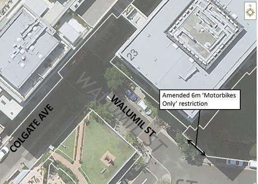
|
|
Local Traffic Committee Meeting 3 November 2016 |
Subject: Minor Traffic Facilities
(Leichhardt & Balmain Wards/Balmain Electorate/ Leichhardt LAC)
File Ref: 16/6022/121521.16
Prepared By: Manod Wickramasinghe - Traffic and Parking Engineer, Leichhardt
Authorised By: Jason Scoufis - Acting Traffic Manager, Leichhardt
|
SUMMARY This report deals with minor traffic facility applications received by Inner West Council, Leichhardt and includes ‘Disabled Parking’ and ‘Works Zones’. |
|
RECOMMENDATION
THAT:
1. a 6m ‘Disabled Parking’ space be installed in front of No.16 George Street, Balmain; 2. a 8m 'Works Zone 7.00am - 5.00pm Mon-Fri, 7.00am - 1.00pm Sat' be installed in front of No.8 Derbyshire Road, Leichhardt for 12 weeks; and 3. a 6m ‘Disabled Parking’ space be installed in front of No.13 Hearn Street, Leichhardt including construction of associated kerb ramps.
|
BACKGROUND
This report deals with minor traffic facility applications received by Inner West Council, Leichhardt and includes ‘Disabled Parking’ and ‘Works Zones’.
FINANCIAL IMPLICATIONS
The installation of ‘Disabled Parking’ signage is funded from Council’s operating budget and ‘Works Zones’ signage from fees and charges paid by the applicant.
OFFICER COMMENTS
1 Installation of ‘Disabled Parking’ Restriction – George Street, Balmain
Council Ref: DWS 3991894
The resident of No.16 George Street, Balmain has requested the installation of a ‘Disabled Parking’ zone in front of the resident’s property.
A site investigation has revealed that the property does not have off-street parking.
The applicant does not require the use of a wheelchair.
Officer’s recommendation
That a 6m ‘Disabled Parking’ space be installed in front of No.16 George Street, Balmain.
2 Installation of ‘Works Zone’ Restriction – Derbyshire Road, Leichhardt
Council Ref: DWS 3972766
The applicant has requested the installation of a temporary 8m 'Works Zone 7.00am - 5.00pm Mon-Fri, 7.00am - 1.00pm Sat' in front of No.8 Derbyshire Road, Leichhardt for 12 weeks.
Officer’s recommendation
That a 8m 'Works Zone 7.00am - 5.00pm Mon-Fri, 7.00am - 1.00pm Sat' be installed in front of No.8 Derbyshire Road, Leichhardt for 12 weeks.
3 Installation of ‘Disabled Parking’ Restriction – Hearn Street, Leichhardt
As part of Council’s Open Space Program, No.13 Hearn Street, Leichhardt has been converted to a neighbourhood playground including play equipment designed for mobility impaired infants.
The playground is now open to the public and there have been requests for the provision of a ‘Disabled Parking’ zone in front of the park.
Officer’s recommendation
That a 6m ‘Disabled Parking’ space be installed in front of No.13 Hearn Street, Leichhardt (neighbourhood playground) including construction of associated kerb ramps.
|
|
Local Traffic Committee Meeting 3 November 2016 |
Subject: Lewisham Parking Review - Final Report
File Ref: 15/4525/116228.16
Prepared By: Mary Bailey - Parking Planner, Marrickville
Authorised By: Brooke Martin - Manager Infrastructure Planning and Property, Marrickville
|
SUMMARY The Lewisham Parking Study was completed in 2013 and the recommendations of the study implemented in 2014. This is a review of the implemented actions of the final study. Following public exhibition of the draft recommendations 68% of the community feedback supported the Lewisham Parking Study Review recommendations. The final report and recommendations have been revised following the community feedback. |
|
RECOMMENDATION
THAT the Committee endorse the recommendations in the Lewisham Final Parking Study Review and Management Plan.
|
BACKGROUND
The Lewisham Parking Study was completed in 2013 and the recommendations of the study implemented in 2014. This is a review of the implemented actions of the final study. Following public exhibition of the draft recommendations 68% of the community feedback supported the Lewisham Parking Study Review recommendations. The final report and recommendations have been revised following the community feedback.
The measures implemented as a result of recommendations in the 2013 strategy included expansion of and existing resident permit parking area (Area M7 – Lewisham Station), and the creation of a new one, (Area M16 – Lewisham). (See Appendix D)
All residents and householders in the area received a letter informing that the strategy is under review and to seek feedback through the online questionnaire on Your Say Marrickville. There were 180 responses to the questionnaire and a number of emails and phone calls from residents. This information was used in the analysis of the study and preferences for each street.
The review looks at the impact of the implementation and the feedback from the community, parking data gathered since the implementation and other potential impacts on parking in the area such as parking restriction changes in adjacent areas and residential development.
Parking surveys have been undertaken in targeted areas showing the occupancy over various time periods throughout the day and various days of the week. These surveys inform the recommendations for changes to resident parking in a number of areas.
A draft report with recommendations based on community feedback and parking data was placed on public exhibition between mid August and mid September 2016.
PUBLIC CONSULTATION
Community Consultation
A letter was sent to 3,200 residents and householders in the study area in February 2016 requesting feedback through a questionnaire on the Your Say Marrickville web site. The survey questioned whether restrictions had been implemented for the resident and if they were satisfied as a result. Also people were asked if they had difficulty finding parking, what type of restrictions they preferred and for additional comments regarding parking in their street and area.
Summary of Main Parking Issues Raised In Consultation
The results of the community survey can be summarised as follows:
· Commuters take parking in residential streets around the station for long periods of the day
· Business trucks and vehicles park for extended periods on residential streets
· Large entertainment venues within the area – taking up parking/ noise/ rubbish
· Local employees park in residential areas
· TAFE students and teachers take residents parking spaces; (more so since fee introduced for TAFE car park)
· Staff from all schools and CHBS students park in residential streets
· Concerns regarding large residential developments impacts on parking
· Concerns regarding light rail interchanges and the impact of commuters parking especially in small streets close to the stations
· There is a need for increased enforcement
Of the 198 responses received, 108 people said they had not had restrictions introduced in their street and 90 had restrictions introduced. Of the 90 who had restrictions introduced, 39% were “satisfied” or “very satisfied”, 44% were dissatisfied or very dissatisfied and 17% were “neither satisfied nor dissatisfied”. Some people were dissatisfied with the restrictions because they still could not find parking conveniently even though resident parking had been introduced in their street. This is a function of high demand and it is questionable if changing parking restrictions further would increase satisfaction as supply is limited. For a summary of the satisfaction results see Figure 1.
Figure 1: Summary of satisfactions ratings for all respondents to 2016 survey
The draft proposals were put on public exhibition between mid August and mid September 2016. During the public exhibition period there were 184 comments received from residents. An additional 56 were received from 2 schools, all against any increase in resident parking restrictions (28 from Petersham Public School in Hunter Street and 28 from teachers at Christian Brothers High School in The Boulevarde).
Of the 128 residents, 68% were in support and 32% did not support. (See Figure 2)
Figure 2: Residents support for recommendations
Those that did not support were mainly due to the following points:
1. There is not enough demand for parking to warrant parking restrictions in my street
2. Implementing parking will inconvenience guests and multiple car households
3. Resident parking should be only on one side or resident parking should be on both sides of the street
4. Resident parking should be extended - 7 days/24 hours (for instance near major development)
OFFICER COMMENTS
Final recommendations – Post Public Exhibition
Based on the feedback received during public exhibition, the recommendations in the draft report have been amended. Following the review process a series of recommendations for resident and laneway parking have been developed as seen below in Table 1. The final recommendations are illustrated in Figure 3.
Table 1: Final recommendations – Post Public Exhibition
|
Recommendation |
Recommendation Description |
Sub Area |
|
1. |
St John Street – (northern side) Convert Unrestricted parking to No Parking between Old Canterbury Road and Brown Street |
1 |
|
2. |
Hunter Street (western side) between no 40 and 50 - Convert Unrestricted parking to 2P Permit Holders Excepted 8:30am to 6pm Monday to Friday As part of resident parking area M7 |
2 |
|
3. |
Brown Street (between William St and Longport St) 1. Implement Statutory No Stopping in Brown Street at Longport Street (both sides) 2. Extend existing No Parking from William Street (southern side) to Brown Street (western side) 3. Convert Unrestricted parking to No Parking in Brown Street (western side) from end of proposed No Stopping to Meriton driveway |
3 |
|
4. |
Longport Street (southern side) between Old Canterbury Road and Brown Street Convert Unrestricted parking to 2P Permit Holders Excepted 8:30am to 6pm Monday to Friday (depending on outcome of Cycle regional route 7) As part of resident parking area M7 |
3 |
|
5. |
William Street (southern side) Convert Unrestricted parking to 2P Permit Holders Excepted 8:30am to 6pm Monday to Friday As part of resident parking area M7 |
3 |
|
6. |
Denison Road (southern side) – between Hunter Street and 9 Denison Road. Convert 2 P to 2P Permit Holders Excepted 8:30am to 6pm Monday to Friday As part of resident parking area M7 |
5 |
|
7. |
Denison Road (northern side) between Eltham Street and Piggott Street - Convert Unrestricted parking to 2P Permit Holders Excepted 8:30am to 6pm Monday to Friday (consistent with in Dulwich Hill parking strategy) As part of resident parking area M7 |
5 |
|
8. |
Eltham Street (western side) between Victoria Street and Denison Road. Convert Unrestricted parking to 2P Permit Holders Excepted 8:30am to 6pm Monday to Friday As part of resident parking area M7 |
5 |
|
9. |
Fred Street (southern side) Convert to 2P Permit Holders Excepted 8:30am to 6pm Monday to Friday As part of resident parking area M7 |
5 |
|
10. |
Old Canterbury Road between Summer Hill Street and Toothill Street (eastern side) Convert Unrestricted parking to 2P Permit Holders Excepted 8:30am to 6pm Monday to Friday As part of resident parking area M7 |
5 |
|
11. |
Summer Hill Street – (eastern side) between Victoria Street and Old Canterbury Road- Convert Unrestricted parking to 2P Permit Holders Excepted 8:30am to 6pm Monday to Friday As part of resident parking area M7 |
5 |
|
12. |
Victoria Street (northern side) between Summer Hill Street and Eltham Street. Convert Unrestricted parking to 2P Permit Holders Excepted 8:30am to 6pm Monday to Friday As part of resident parking area M7 |
5 |
|
13. |
Davis Street (cul de sac) (no 2-10) (eastern side) Convert Unrestricted parking to 2P Permit Holders Excepted 8:30am to 6pm Monday to Friday As part of resident parking area M7 |
6 |
|
14. |
Nelson Street (eastern side) between Victoria Street and cul de sac Convert Unrestricted parking to 2P Permit Holders Excepted 8:30am to 6pm Monday to Friday As part of resident parking area M7 |
6 |
|
15. |
Victoria Street (southern side) between Eltham Street and Davis Street. Convert Unrestricted parking to 2P Permit Holders Excepted 8:30am to 6pm Monday to Friday As part of resident parking area M7 |
6 |
|
16. |
Laneways Convert Unrestricted parking to No Parking in · Edward Lane (northern side) between Weston Street and Windsor Road · Nestor Lane (both sides) · St John Lane (both sides) |
|
|
17. |
Implement statutory 10m No Stopping in conjunction with all introduced parking restrictions |
|
|
18. |
Ensure enforcement for parking restrictions in the precinct |
|
Final Recommendations Summary map – Post Public Exhibition
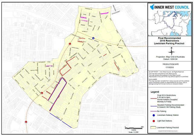
Figure 3. Final Recommendations Summary map – Post Public Exhibition
FINANCIAL IMPLICATIONS
There is budget available in the current 2016/17 financial year to implement most of the study recommendations. If further budget is required this will be included in the 2017/18 financial year.
CONCLUSION
This review of the 2013 parking study and 2014 implementation is based on significant community input and analysis of feedback and parking surveys. The recommendations are made in response to community feedback on the impact of knock on effects and residential developments in their streets. Where resident parking was not supported, no recommendations are made. A review of the precinct parking needs should be scheduled to occur within 12 to 24 months on implementation of the review recommendations.
|
1.⇩ |
Lewisham Parking Management Strategy 2016 - Final Report |
|
Local Traffic Committee Meeting 3 November 2016 |
Subject: Riverside Parking Study - Final Report
File Ref: 15/5910/118822.16
Prepared By: Mary Bailey - Parking Planner, Marrickville
Authorised By: Brooke Martin - Manager Infrastructure Planning and Property, Marrickville
|
SUMMARY The final Riverside Parking Management Plan is a comprehensive community engagement, review, analysis and parking management plan for the Riverside area. The draft report was placed on Public Exhibition during August with 57% not supporting the recommendations within the report. The comments on the draft recommendations from public exhibition during August 2016 have informed and amended the final recommendations for Riverside precinct. |
|
RECOMMENDATION
THAT the Committee endorse as detailed in this report, the recommendations (Table 2) and action plan (Table 3) in the Riverside Final Parking Management Plan.
|
BACKGROUND
The final recommendations of the Riverside Parking Management Plan have been through a process of community consultation, parking data analysis, review of council documentation, and internal stakeholder engagement. The comments on the draft recommendations from public exhibition during August 2016 have informed the final recommendations for Riverside precinct.
The purpose of the Riverside parking study is to achieve the following within the study area:
· investigate and review the business corridors and neighbouring residential on-street and off-street parking policy framework and management strategies
· identify the parking needs, outline where the parking need is and why, and
· propose what other actions could be taken to reduce demand and provide alternative forms of access/ transport.
The community engagement for the Parking Strategy development was carried out as part of the Tomorrows Dulwich Hill planning project.
This car parking management plan sets out an assessment of the following:
· existing transport context
· collation of all existing information and collection of parking usage data for the study area as well as preliminary consultation with stakeholders and community
· determination of existing car parking demand including short-falls of existing supply
· estimation of future car parking demand based on anticipated land use growth areas
· development of parking strategies to manage existing and future car parking demand.
The draft report was endorsed by Council’s Traffic Committee and went to public exhibition in August/September 2016. The recommendations in that report included the implementation of additional resident parking around Dulwich Hill Rail precinct, The feedback received during the public exhibition phase of the draft report resulted in a number of changes to address concerns of residents in particular.
FINANCIAL IMPLICATIONS
There is budget available in the current annual 2016/2017 financial year for implementation of the final parking management plan.
PUBLIC CONSULTATION
The community engagement for the Riverside Parking Management Plan was through the Yoursay website, “Making Parking Fairer in Riverside precinct”. All residents within the study area received a leaflet in the mail explaining the project and the feedback request on the draft plan (Figure 1). The community provided online feedback (between 16 August and 14 September 2016) regarding the draft recommendations.
96 people provided submissions, including 43% in support of the strategy 57% against the strategy. Below are some extracts from the community engagement.
Support:
· “This does not go far enough. The whole area should be restricted parking…”
· “Great idea – parking is a nightmare for residents and our visitors”
· “Extend restrictions…”
Against:
· “This is outrageous. This is very quiet part of Marrickville…”
· “It will drive more vehicles into smaller side streets which are at their peak now”
Residents are supportive of time and permit restrictions being implemented close to Dulwich Hill Station (where there are competing demands between residents and commuters); but not supportive of time and permit restrictions being implemented in the residential areas away from the station (where demands are generally resident only). The primary concern appears to be that the introduction of the resident permit scheme may have a “knock on” effect to adjacent residential streets.
Based on the feedback on the draft report the recommended parking restrictions in the residential areas (i.e. Harnett Avenue, Wallace Street and Hill Street) have been deleted. The recommended parking restrictions surrounding Dulwich Hill Station have been deleted from Dibble Avenue and scaled back on Ewart Street and School Parade to reflect the community sentiments.
OFFICER COMMENTS
Parking Restriction Changes
Resident parking will be introduced on one side of the street only. There will be an estimated increase of resident parking spaces of 53, (See Table 1) all of which are gained through conversion of unrestricted parking. It is not anticipated that there will be a significant knock on effect into residential streets and that the impact will be absorbed throughout the surrounding area. Any potential impacts will be uncovered at the time of the planned review of the implementation within the next 12-24 months.
The proposed resident parking changes in Wardell Road have been assessed as part of the Dulwich Hill Parking Study and are consistent with changes proposed in Wardell Road immediately north of the railway line. The decision to provide some resident parking on either side of Wardell Road is made with direct reference to the location of single unit residential dwellings and with the consideration that there is a high volume of traffic on this regional road.
No laneways within the study area were identified as having parking issues.
Table 1 Overview of Parking Restriction Changes
|
Location |
Parking Restriction |
|
|
2P (Permit Excepted) |
Unrestricted |
|
|
Dudley Street (south) |
+5 |
-5 |
|
Bayley Street (west) |
+12 |
-12 |
|
Ewart Street (north) |
+14 |
-14 |
|
School Parade (north) |
+22 |
-22 |
|
Wardell Road (both sides) [1] |
Assessed as part of the Dulwich Hill Parking Study |
|
|
Total |
+53 |
-53 |
[1]To be implemented as part of the Dulwich Hill Parking Strategy.
RECOMMENDATIONS
The recommendations of the plan are contained in the report attached and summarised below in the Table 2 and mapped in Figure 1. The Action Plan at Table 3 also includes other parking management strategies that are identified that are not arking restriction changes.
Table 2: Summary of Recommended Parking Restriction Changes
|
Number |
Parking Restriction Change Description |
|
1 |
Bayley Street (northern side) between Ewart Street and Dudley Street Convert Unrestricted parking to 2P Permit Holders Excepted (M13) 8:30am to 6pm Monday to Friday |
|
2 |
Dudley Street (western side) between Bayley Street and the bend in the road Convert Unrestricted parking to 2P Permit Holders Excepted (M13) 8:30am to 6pm Monday to Friday |
|
3 |
Ewart Street (eastern side) between Wardell Road and Wicks Avenue Convert Unrestricted parking to 2P Permit Holders Excepted (M13) 8:30am to 6pm Monday to Friday |
|
4 |
School Parade (eastern side) between Dudley Street and number 7 Convert Unrestricted parking to 2P Permit Holders Excepted (M13) 8:30am to 6pm Monday to Friday |
|
5 [1] |
Wardell Road (eastern side) between number 266 and number 274 Convert Unrestricted parking to 2P Permit Holders Excepted (M13) 8:30am to 6pm Monday to Friday |
|
6 [1] |
Wardell Road (western side) between number 291 and number 297 Convert Unrestricted parking to 2P Permit Holders Excepted (M13) 8:30am to 6pm Monday to Friday |
|
7 |
Implement statutory 10m No Stopping in conjunction with all introduced parking restrictions |
|
8 |
Ensure enforcement for parking restrictions in the precinct |
[1] To be implemented as part of the Dulwich Hill Parking Strategy.
Figure 1: Recommended Parking Restrictions
Action Plan
Further to the identified recommendations the Action Plan in Table 3 below provides an overall parking management plan.
Table 3. Action Plan
|
ID. No. |
Action |
Priority |
|
1 |
Rely on existing parking supplies within the surrounding residential areas to accommodate the short term existing parking demands of the centre and overflow commuter demands. |
M |
|
2 |
Modify parking restrictions within surrounding residential streets of the town centre and station precinct to appropriately manage demands and needs of all users |
S |
|
3 |
Provide additional time restricted car parking spaces as detailed in Table 1 (and in Appendix B of the attached report) |
S |
|
4 |
Statutory “No Stopping” zones be put in place where required as part of the implementation of the recommended parking changes. |
S |
|
5 |
The existing car parking demands and turnover do not warrant the introduction of paid parking into the study area at this stage. Continue to use time restrictions to manage parking demands. |
L |
|
6 |
Review the network of pedestrian connections to the Dulwich Hill station from surrounding residential areas, to ensure these are safe and amenable in order to reduce the key barriers presented to walking such as major roads. |
M |
|
7 |
Continue to provide end of trip facilities for cyclists, including bicycle hoops at strategic locations throughout the study area. |
M |
|
8 |
Ensure end of trip facilities for cyclists (showers, lockers, change rooms and bicycle storage) are provided in major developments. |
S |
|
9 |
Continue to lobby TfNSW to ensure that the best possible public transport facilities are provided in the study area. |
M |
|
10 |
Periodically review inventory of residential parking spaces for people with disabilities to ensure efficient use of on-street parking provisions. |
M |
|
11 |
Existing loading requirements should be monitored over time and if necessary, a reactive approach be taken to accommodate any significant changes to pick-up or delivery requirements, having regard to balancing competing objectives such as availability of on-street visitor parking to support economic function. |
M |
|
12 |
On-site loading should continue to be pursued for larger new developments, particularly those having access to back-of-house areas, in accordance with the guidance provided in the DCP. |
M |
|
13 |
Introduce a car share parking requirement for larger developments into the DCP. |
M |
|
14 |
It is recommended that enforcement be increased in the time restricted areas, particularly if the recommended new time restrictions are introduced. |
S |
|
15 |
Introduce formal (signposted) ‘No Stopping’ parking restrictions (for 10m) at unsignalised intersections to improve safety in the town centre and surrounding Dulwich Hill Station (combination of signs and/or linemarking). |
S |
S – Short term - 1 – 2 years; M – Medium term - 3 – 5 years; L – Long term - 5+ years
CONCLUSION
The Riverside Parking Management Plan provides information about the existing parking demand and community sentiment regarding parking in the precinct. The public exhibition of the recommendations in the draft report gave the community an opportunity to comment on whether they supported or were not in support of resident parking in a number of streets across the precinct.
The parking demands in the area are mainly generated by:
· the Dulwich Hill rail hub; and
· pockets of medium density residential development such as in Hill Street, where there is insufficient off street parking.
The recommendations for resident parking restrictions are confined to the area close to the Dulwich Hill rail hub. This should alleviate some of the parking concerns for residents who compete with commuters. Implementing resident parking in areas where there is older style medium residential development may do little to alleviate the parking pressure and therefore these areas are not recommended for resident parking at this time. Further investigations can be carried out at the time of the regular review 12 to 24 months post implementation.
|
1.⇩ |
Riverside Parking Management Plan |
|
Local Traffic Committee Meeting 3 November 2016 |
Subject: Illawarra Road, Marrickville - Safety Concerns
of Pedestrian Crossing near Thompson Street
(Marrickville Ward/Summer Hill Electorate/Marrickville LAC)
File Ref: 16/6022/120246.16
Prepared By: Emilio Andari - Civil Engineer, Marrickville
Authorised By: Joe Di Cesare - Manager Design and Investigation, Marrickville
|
SUMMARY This report is for Council to consider the findings of a review into the safety of the raised pedestrian crossing on Illawarra Road, Marrickville, near its intersection with Thompson Street and speeding issues in the section of Illawarra Road between Sydenham Road and Thompson Street. Council Officers undertook an investigation into the safety of this raised pedestrian crossing which revealed that speeding is not an issue on approach to the crossing nor does the crossing require further improvements at present. |
|
RECOMMENDATION
THAT the report be received and noted.
|
BACKGROUND
At Council’s meeting of 15 March 2016, a Notice of Motion titled “Pedestrian Safety Around Henson Park” was moved as follows:
That Council investigates the issues of speeding and pedestrian safety in the section of Illawarra Road between Sydenham Road & Thompson Street, Marrickville and provides recommendations for the consideration of the Pedestrian, Cyclist and Traffic Calming Advisory Committee.
The section of roadway in question is located along Illawarra Road, Marrickville between Sydenham Road and Thompson Street. The existing raised pedestrian crossing on Illawarra Road near its intersection with Thompson Street was included as part of the investigation.
FINANCIAL IMPLICATIONS
Nil.
OFFICER COMMENTS
Site location & road network
|
Street Name |
Illawarra Road |
|
Section |
Between Council Street and Sydenham Road |
|
Carriageway Width (m) |
9.1 |
|
Carriageway Type |
Two-way road with one travel lane in each direction, in addition to kerbside parking lanes. |
|
Classification |
Local |
|
85th Percentile Speed (km/h) |
45.4 |
|
Vehicles Per Day (vpd) |
5,545 |
|
Reported Crash History (2011 – 2015) |
2 crashes (Rum Code: 49 & 71). Both crashes resulted in tow away. |
|
Heavy Vehicle Volume (%) |
2.9 |
|
Parking Arrangements |
Unrestricted parking on both sides of the road. |
The existing raised pedestrian crossing located on Illawarra Road immediately north from its intersection with Thompson Street provides appropriate lighting and both signage and line marking is in place to the relevant standards. There are adequate sightlines to this crossing from both the south direction and north direction although there is ‘zig-zag’ as well as ‘SLOW’ line markings on both the southbound and northbound approach.
A review of the crash history in the vicinity of the crossing revealed that over a five year period, between 2011 and 2015 that two crashes occurred. There was 1 crash ‘Rum Code: 49 – other manoeuvring’ which was identified near the raised pedestrian crossing however this accident did not involve any pedestrians. There was 1 other crash ‘Rum Code: 71 – left off carriageway into object/parked vehicle’ which was identified mid-block between Sydenham Road and Thompson Street and this accident did not involve any pedestrians. Both crashes resulted in tow away. The crash directions were random and no pattern could be established in relation to these crashes.
The road width of Illawarra Road between Sydenham Road and Thompson Street is measured to be 9.1 metres. Currently, parking is permitted on both sides of the road. The resulting narrow traffic lanes act as a traffic calming measure. That is, Illawarra Road is a two-way street with a travel lane in each direction. Vehicles travelling along Illawarra Road would give way to the opposing traffic where there are sections of ‘No Parking’ and this reduces the speed of traffic.
A pedestrian versus vehicle count was undertaken to gauge if this crossing currently meets Roads and Maritime Service warrants. The results of this analysis are summarised below:
|
Period |
Pedestrians (P) |
Vehicles (V) |
(P) X (V) |
|
Morning |
17pph |
454vph |
7,718 |
|
Afternoon |
23pph |
360vph |
8,280 |
(pph – pedestrians per hour, vph – vehicles per hour)
In order for a marked foot crossing to be considered the following warrants needs to be satisfied.
(a) The measured flows, P&V are equal or greater than 30 & 500 respectively;
(b) The product of the measured pedestrian flow per hour (P) and the measured vehicular flow per hour (V), PV is equal to or greater than 60,000; and
(c) The measured flows apply for three (3) periods of one hour in any day.
Although, this raised pedestrian crossing does not meet the warrant, the crossing is located on a route to a school (Marrickville Primary School) and a reduced warrant can be met for this site.
P ≥ 30 and V ≥ 200
Therefore it is not proposed to remove this crossing.
The tables below summarise the speed of traffic over the day, morning and afternoon:
(counts were taken on a weekday in May 2014)
Over the day
|
Approach direction of traffic |
mean speed (km/h) |
85% speed (km/h) |
95% speed (km/h) |
% of Vehicles exceeding 50 km/h |
|
Northbound & Southbound |
36.9 |
45.4 |
50.8 |
6.0 |
Morning Peak (immediately before school)
|
Approach direction of traffic |
mean speed (km/h) |
85% speed (km/h) |
95% speed (km/h) |
% of Vehicles exceeding 50 km/h |
|
Northbound & Southbound |
37.2 |
45.0 |
50.0 |
5.1 |
Afternoon Peak (immediately after school)
|
Approach direction of traffic |
mean speed (km/h) |
85% speed (km/h) |
95% speed (km/h) |
% of Vehicles exceeding 50 km/h |
|
Northbound & Southbound |
34.1 |
42.5 |
47.2 |
2.6 |
The count data reveals that:
· The speeds are slightly higher in the morning peak period than the rest of the day overall. A contributing factor to this trend is due to motorist behaviour in the morning. It is expected to have higher speeds as drivers are often trying to get to their destination on time (i.e. drop-off children to schools/go to work/appointments).
· Data reveals that in the peak school periods, that both 85% speeds and 95% speeds are above 40km/h however it should be noted that this pedestrian crossing is not included within a school zone as this street is not directly linked to an adjacent school.
· There is very low percentage of vehicles actually exceeding 50km/h throughout the day and even fewer percentage during peak periods.
· Generally throughout the day the speed of traffic is below 50 km/h.
The outcome of the investigation also revealed that the raised pedestrian crossing has been constructed to the relevant standards and does have all the appropriate signage, line marking and lighting.
PUBLIC CONSULTATION
Nil.
CONCLUSION
Based on the information obtained and analysed, it would be difficult to justify the need for further treatments either at the crossing or on approach to the crossing.
|
|
Local Traffic Committee Meeting 3 November 2016 |
Subject: Local Traffic Committee Meeting Schedule for 2017
File Ref: 16/6022/121966.16
Prepared By: Emilio Andari - Civil Engineer, Marrickville
Authorised By: Joe Di Cesare - Manager Design and Investigation, Marrickville
|
SUMMARY The proposed schedule of the Local Traffic Committee meetings has been prepared for the 2017 calendar year. It is recommended that the proposed meeting schedule be received and noted. |
|
RECOMMENDATION
THAT the proposed schedule of meetings of the Local Traffic Committee for the 2017 calendar year be received and noted.
|
BACKGROUND
To assist Committee members with forward planning, the schedule of meetings of the Local Traffic Committee for 2017 is detailed below.
FINANCIAL IMPLICATIONS
Nil.
OFFICER COMMENTS
All meetings will be held on the 1st Thursday of each month and commencing at 10.00AM.
The proposed meeting dates for 2017 are as follows:
|
Date |
Time |
|
2 February 2017 |
10.00am |
|
2 March 2017 |
10.00am |
|
6 April 2017 |
10.00am |
|
4 May 2017 |
10.00am |
|
1 June 2017 |
10.00am |
|
6 July 2017 |
10.00am |
|
3 August 2017 |
10.00am |
|
7 September 2017 |
10.00am |
|
5 October 2017 |
10.00am |
|
2 November 2017 |
10.00am |
|
7 December 2017 |
10.00am |
CONCLUSION
It is recommended that the proposed meeting schedule for 2017 be received and noted.
|
|
Local Traffic Committee Meeting 3 November 2016 |
Subject: Stanmore Parking Study - Draft Report
File Ref: 15/SF548/114639.16
Prepared By: Mary Bailey - Parking Planner, Marrickville
Authorised By: Brooke Martin - Manager Infrastructure Planning and Property, Marrickville
|
SUMMARY The draft Stanmore Parking Study identifies the extent and utilisation of parking in the precinct, establishes community opinion and concerns and proposes a strategy for parking in the area. It makes a number of recommendations for resident, short term and laneway parking restrictions to address concerns raised by the community and based on the data collected. It is recommended to place the draft Stanmore Parking Study and recommendations on public exhibition for community feedback. |
|
RECOMMENDATION
THAT the Draft Stanmore Parking Study report be approved for Public Exhibition.
|
BACKGROUND
The draft Stanmore Parking Study identifies the extent and utilisation of parking in the precinct, establishes community opinion and concerns and proposes a strategy for parking in the area. It makes a number of recommendations for resident, short term and laneway parking restrictions to address concerns raised by the community and based on the data collected. It is recommended to place the draft Stanmore Parking Study and recommendations on public exhibition for community feedback.
The objective of the study is to:
· Review the existing documentation, previous parking studies, strategies and survey data for the area
· Identify the extent and nature of the existing on-street and off-street public car parking demand, utilisation and inventory
· Undertake community consultations to identify existing issues and aspirations in relation to parking in the Stanmore precinct
· Develop a parking management strategy that will help optimise the amount of parking available for road users.
The study area is shown in Figure 1 below.
Figure 1: Stanmore Parking Study area
Community opinions were collected by a questionnaire survey to establish how residents view the parking arrangements for their given area. A process was established whereby comments could be mapped to specific locations which allowed issues to be grouped throughout the study area. Typically residents of the precinct found it more difficult to locate parking space near their residence or place of employment either side of Addison Road near the Addison Road community centre, and immediately north of Stanmore Road.
Parking surveys were undertaken to establish the number of available spaces and the demand for parking within the study area. The surveys recorded the number of potential parking spaces and their utilisation, with 7,757 on-street parking spaces surveyed across the study area. The surveys were conducted on an hourly basis during the week and during the weekend, and provide an indication of the busiest streets during these periods to provide guidance towards implementing a fair and reasonable strategy.
The data collection showed opinions throughout the study area aligned areas of high community concern and areas with a high demand for parking. Notable areas where parking occupancy was high included around Stanmore Station and in the vicinity of the Addison Road community centre on weekends.
Following community feedback and review of parking survey data, a suite of draft recommendations have been developed. The aim of the parking recommendations is to provide – where possible – an improved management system for parking for the area. The draft recommendations proposed takes into consideration:
· the current transport environment and conditions in the Stanmore precinct
· existing parking controls in neighbouring areas
· feedback received during the community and stakeholder engagement process; and
· results of the parking surveys conducted in the precinct
A summary of draft recommendations contained within the report is outlined in Table 1 below and illustrated in Figure 1 also below. These will be the subject of review during the public exhibition period of the document.
Table 1: Draft Parking Strategy Recommendations
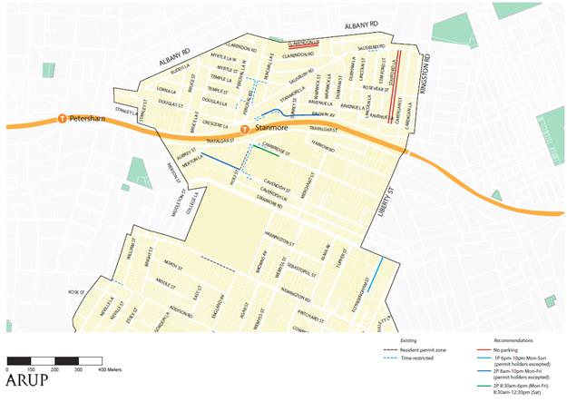
Figure 2: Summary of recommended parking changes
The streets subject to the proposed changes to parking restrictions, and the number of car parking spaces impacted, are summarised in Table 2.
Table 2 Overview of proposed parking restriction changes
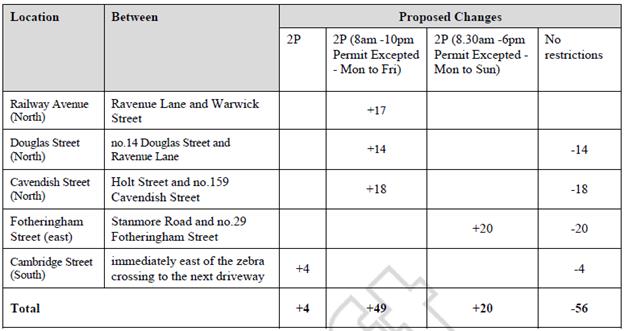
FINANCIAL IMPLICATIONS
The budget for implementation is currently under review as part of the future budget process.
OFFICER COMMENTS
One of the key issues in this area is the impact of the Addison Road markets. This study makes recommendations to undertake travel demand management measures and seek alternative parking sites. A recommendation to implement resident parking in this precinct would result in widespread restrictions but for only limited timeframes (during market and event times on weekends)
The parking surveys undertaken for this study demonstrated there were significant parking demands on Saturday and Sunday mornings, largely associated with the Addison Road markets and adjacent retail areas on Addison Road and Illawarra Road. Demands were found to be above 85% for a large number of streets within a 400m radius of the markets, with parking very constrained during these times.
This was reinforced through the community, with the majority of respondents noting the parking issues were related to weekends rather than weekdays. The extent of streets impacted by increased parking demands on weekends is illustrated in Figure 2 below. This covers a wide area containing in the order of 900 parking spaces. Any area wide resident parking scheme would need to (at a minimum) include the streets noted below. A smaller extent would only result in spillover impacts to neighbouring streets which would simply transfer over the parking issues currently experienced.
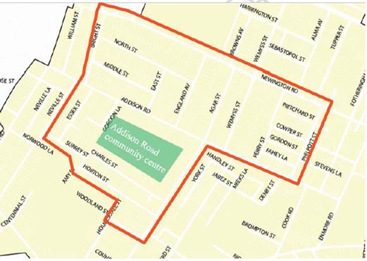
Figure 3: Extent of potential area wide resident parking scheme
Council is not recommending the introduction of such a widespread resident parking scheme at this point in time. This is due to the relatively short period of time in which parking constraints occur (i.e. Sundays between 9am and 3pm and some Saturdays) as well as the extent of the area wide scheme required.
A suite of measures have instead been recommended to both reduce the demand for car parking in the area as well as providing alternative parking locations for visitors.
Additional
parking
Currently the demand for car parking
within the Addison Road community centre on Sundays exceeds the supply of
approximately 120 spaces. This results in visitors to the markets parking on
nearby residential streets and is reflected in the high occupancy rates
recorded in the surveys undertaken for this study. To accommodate this high
demand, two alternative off-street car park locations have been identified,
those being:
· Henson Park car park (approximately 80 spaces)
· New car park at Newington College (approximately 200 spaces)
Subject to negotiation between the owners of these sites and Council, these car parking areas can potentially be utilised by the Addison Road Community Centre during Sunday mornings. Use of these areas would have to coincide with times where events are not held at either site, however the majority of events at both Henson Park and Newington College take place on Saturday mornings and afternoons.
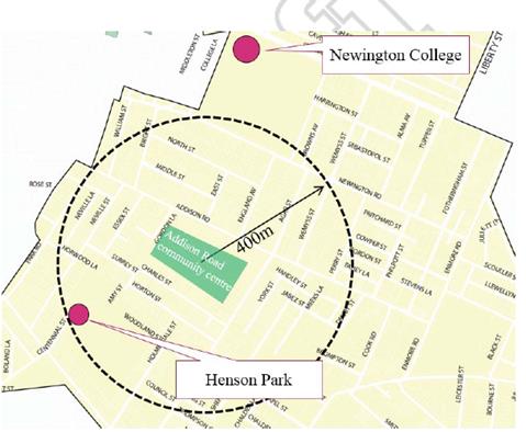
Figure 4 Additional parking opportunities serving Addison Road Community Centre
Travel Demand Management
Council is recommending that travel demand management by way of promotion of public transport and alternative transport options be investigated and promoted to reduce parking demand. A number of existing examples are detailed in the report including provision of information via web promotions, promoting alternative transport and working with public transport providers to ensure the best possible service is provided.
PUBLIC CONSULTATION
The parking strategy involved an extensive community consultation process to understand specific local issues which are currently in place within the study area and the feedback received during both consultation periods to inform the recommendations of the parking strategy.
The Making Paring fairer survey was sent to all householders and residents within the study area and a total of 182 responses were received. The key findings were:
· Residents found that the most common issues in the study area were local employees taking up parking spaces, and the lack of monitoring and enforcement.
· A majority (59%) of the residents are able to park within one block of their residence, while the significant majority (96%) are able to park within 200 metres of their residence.
· Residents found that it was most difficult to find a convenient parking space at their residence during weekend afternoons
· 16% of the respondents in the Stanmore study area had complaints about the parking demand from visitors to the Addison Road Community Centre markets and popular cafes along Illawarra Road. These problems were especially noticeable during the weekends. Residents expressed concerns that not enough guidance is given to visitors travelling to the precinct on where and how to park.
· 10% of the respondents had complaints about traffic and parking demand generated from the nearby schools such as Newington College, especially during sport events held by the school on weekends
· Spillover parking on side streets adjacent to Stanmore Road and Addison Road was a common issue raised during the consultation period. This is both an issue during weekdays and weekends.
Main parking issues reported are illustrated in Figure 5
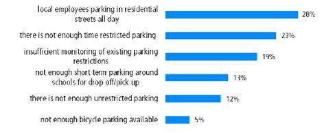
Figure 5: Areas of parking concern for respsondents
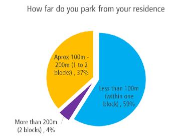
Figure 6 – How far residents park from their houses
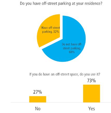
Figure 7: Availability and Use of Off Street Parking
CONCLUSION
There has been an extensive investigation into the parking occupancy and length of stay in the study area. The community has been widely canvassed for input on their parking concerns. All the information collected has been analysed from a technical, enforcement and policy point of view. The Draft recommendations reflect the wide range of considerations necessary to make any changes to parking restrictions. Council is aware of the number of complex and evolving matters such as land use changes. The public exhibition will enable community feedback for further analysis of the issues in the area.
|
1.⇩ |
Stanmore Parking Study Report |
|
Local Traffic Committee Meeting 3 November 2016 |
Subject: Newtown Enmore Parking Review - Draft Report
File Ref: 15/4545/106517.16
Prepared By: Mary Bailey - Parking Planner, Marrickville
Authorised By: Brooke Martin - Manager Infrastructure Planning and Property, Marrickville
|
SUMMARY The Newtown Enmore Parking Study was completed in 2013 and the recommendations of the study implemented in 2014. This is a review of the implemented actions of the final study. An interim study and recommendations around the Alice Street development have been endorsed and will be implemented this year. This review and draft report has a focus on restrictions in laneway parking in response to resident feedback of the ongoing issue. It is recommended to place the draft Newtown Enmore parking review report and recommendations on public exhibition for community feedback. |
|
RECOMMENDATION
THAT the Draft Newtown Enmore Parking Review report be approved for Public Exhibition.
|
BACKGROUND
The Newtown Enmore Parking Study was completed in 2013 and the recommendations of the study implemented in 2014. This is a review of the implemented actions of the final study. An interim study and recommendations around the Alice Street development have been endorsed and will be implemented this year. This review and draft report has a focus on restrictions in laneway parking in response to resident feedback of the ongoing issue. It is recommended to place the draft Newtown Enmore parking review report and recommendations on public exhibition for community feedback.
This 2016 review looks at the impact of the implementation and accounts for feedback from the community, parking data gathered since the implementation and other potential impacts on parking in the area such as parking restriction changes in adjacent areas, residential development, and changes in activity along key arterial corridors from commuter and commercial related demand.
The review notes a number of laneways which have been identified as of particular concern and recommends the implementation of “No Parking” restrictions in those laneways. Enabling residents access to off street parking is the main aim since if they are determined by Council to have off street parking they are not eligible for a permit, only one permit per household being permissible.
It was a concern that there could be knock on effects from the implementation of parking restrictions whereby streets which had no restrictions would be impacted. To address this impact, the review recommends implementing resident parking restrictions in a number of additional streets. Where the implementation of resident parking would not substantially improve the parking situation and there is not significant demand from residents, Council will not implement restrictions as there could be further knock on effects.
There are a number of other studies and reviews taking place which impact the Newtown Enmore area and these are being taken into account, Parramatta Road Corridor Camperdown Parking Study, Stanmore Parking Study and changes being implemented as a response to the Alice Street Development.
Since the 2014 implementation there have been streets added to the M14 Resident Parking Zone as a result of the impact of the Alice Street Development. This has pre-empted the review and forms a significant part of parking restriction changes to the precinct
and to Area 3.
OFFICER COMMENTS
Decisions have been arrived at in regard to resident parking based on the overall support or lack of it from each individual street. The analysis for each street (in the report attached) illustrates the character of the street, the detail of the feedback and the relative demand including the number of households, number of vehicles per household, difficulty in finding parking and the availability of off street parking.
There are only 2 additional streets recommended by this review for residential parking, Alice Avenue and Clara Street, both short streets where residents have difficulty parking and where there is strong support for implementation of resident parking.
Residents in the M3 and M14 resident parking zones which cover Newtown/Enmore are eligible for only 1 Permit per household (none if off street parking is determined to be available). There is a considerable amount of angst communicated from residents who are not eligible for a permit and who have their off street parking in the laneway consistently being blocked by parked vehicles. There is a strong mandate for Council to act to restrict parking in the laneways and this is a key component of the report and the recommendations. It should be noted that one side of the street is left unrestricted where resident parking is implemented (with one exception Dickson Street and this is recommended for change to one side resident parking). This allows for visitors, second vehicles and other uses including business, trades and commuters.
The laneway recommendations are guided by the Laneway Guidelines endorsed by Council in December 2015, which state that if a laneway is less than 5.1m wide it is not suitable for parking on either side. This is to accommodate the free passage of emergency vehicles/service vehicles and vehicles wishing to access off street parking.
As part of the community survey respondents were asked what kind of parking they preferred and one of the options was “restrictions to laneway parking”. Where that option was chosen or where there was a specific comment that laneway access to parking was an issue, that particular laneway was investigated in detail and recommendation made based on the width of the laneway and the presence of off street parking access points.
In most cases there is no option to provide any additional parking to offset loss of laneway parking except in the case of Dickson Lane and Holmwood Lane where it is proposed to implement angle parking in Dickson Street. (see report attached for further detail)
Dickson Street Permit Conditions “grandfathered”
At present the residents of Dickson Street are under a scheme where 2 resident parking permits are allowable per household. At the Infrastructure Planning and Environment Serves (IPES) Committee of Marrickville Council on 4 March 2014 as part of the acceptance of the Newtown Enmore parking Study review recommendations, a resolution was passed that “grandfathered” those conditions with a view to making the resident parking criteria the consistent with other streets in the M14 area. The resolution stated, ‘the present resident parking arrangements in Dickson Street (where resident parking restrictions exist on both sides of the street, with up to 2 permits issued to each eligible property) be “grandfathered” by December 2018, with a view to reverting to the same resident parking restrictions proposed for the rest of the Study area. Further, that Council permits residents in possession of two parking permits as at the date of this meeting to continue to renew them until the new system is implemented. Further, that the residents in Dickson Street be so advised.” A letter was sent to residents on 24 April 2014 advising them of the decision of the IPES Committee.
Interim study review due to the Alice Street Development
Since the implementation of the 2014 recommendations there has been one significant multi unit residential development in Alice Street. As part of an impact review for that development, recommendations have been made to implement resident parking restrictions as part of resident parking zone M14 (8am - 10pm ) in a number of streets, namely Alice Street, Commodore Street, Little Commodore Street, Hawken Street, Laura Street, Pearl Street, John Street.
RECOMMENDATIONS
There are 19 recommendations related to resident parking, laneway parking and No Stopping. A thorough review of the responses from the community survey and analysis of data, result in only 2 additional streets being recommended for resident parking restrictions which are Alice Avenue and Clara Street (additional to those streets recommended in the Alice Street development review). These changes will have little impact on the overall parking in the area but provide improved parking amenity for residents in those streets.
One of the key outstanding issues in the precinct is laneway parking and this review has highlighted a number of laneways where residents are having difficulty accessing off street parking as a result of vehicles blocking access and egress.
In some cases it is difficult to mitigate the impact of reducing laneway parking as there are no alternatives. However, in the case of Holmwood Lane and Dickson Lane it is proposed that introduction of angle parking in Dickson Street could offset loss of laneway parking.
There would be a net gain of 42 resident parking spaces under the proposed scheme.
Laneway Recommendations
There has been an increase in laneway parking since the resident parking measures were implemented in 2014. The community survey identified laneways where changes are required. In addition to the changes recommended in Holmwood and Dickson Lanes a number of other laneways are posing access and egress issues. Council’s Laneway Guidelines December 2015 indicate that laneways of 5.1m or less are not suitable for parking of vehicles even on one side of the laneway. Many of the laneways in Newtown Enmore precinct are narrower than 5.1m.
There have been a number of complaints from residents that No Parking signs in laneways are being vandalised (notably Phillip Lane). Where there is persistent vandalism or removal of No Parking signs in laneways there is an option for Council to paint an unbroken yellow line to indicate a No Parking restriction applies.
TABLE 1 Summary Of Recommendations
|
1. |
Alice Avenue |
Convert Unrestricted to 2P 8am-10pm Permit Holders Excepted (eastern side) M14 |
|
2. |
Clara Street |
Convert Unrestricted to 2P 8am-10pm Permit Holders Excepted ( western side) (M14) |
|
3. |
Dickson Street2P 8am-10pm Permit Holders Excepted (northern side and southern side)(M14) |
Convert 2P Permit Holders Excepted parallel parking spaces to 2P Permit Holders excepted angle parking spaces (northern side)
Convert 2P Permit Holders Excepted 8am to 10pm (southern side) to Unrestricted
|
|
4. |
Alice Lane |
Convert Unrestricted to No Parking from King Lane to Walenore Avenue (both sides) Implement No Stopping in Alice Lane east of Walenore Avenue on northern side of Alice Lane
|
|
5. |
Camden Lane |
Convert Unrestricted (eastern side) to No Parking
|
|
6. |
Campbell Lane |
Convert No Parking 5am to 10am Mondays (both sides) to No Parking (both sides) between Probert Street and Pikes Lane
|
|
7. |
Dickson Lane |
Convert Unrestricted to No Parking
|
|
8. |
Edgeware Lane |
Convert Unrestricted to No Parking to follow on from the existing No Stopping at the rear of 18 Edgeware Road south to Cross Lane
|
|
9. |
Fitzroy Lane |
Fitzroy Lane between Chelmsford Street and Gibbs Lane convert No Parking 5am-10am Mondays to No Parking both sides.
Fitzroy Lane at Chelmsford Street implement 10m No Stopping (both sides)
|
|
10. |
Hoffman Lane |
Convert No Parking 5am to 10am Mondays to No Parking in Hoffman Lane at the rear of 120, 122 and 124 Lennox Street (from Mulqueeny Lane to Denison Street).
Convert Unrestricted to No Parking between Regent Lane and Chelmsford Street
Implement No Stopping in Hoffman Lane at Denison Street (western side)
Implement No Stopping in Hoffman Lane at Chelmsford Street (both sides) |
|
11. |
Holmwood Lane |
Convert Unrestricted to No Parking
|
|
12. |
Kingston Lane |
Convert Unrestricted to No Parking in Kingston Lane between Marmion Street and Trade Street (both sides)
Implement No Stopping in Kingston Lane at Marmion Street (both sides)
Implement No Stopping in Kingston Lane at Rowley Street (both sides)
|
|
13. |
Marian Lane |
Convert Unrestricted to No Parking in Marian Lane between Cross Lane and Sarah Street (both sides)
|
|
14. |
Marmion Lane |
Convert Unrestricted to No Parking from rear of 22 Marmion Street to intersection with St Marys Lane
|
|
15. |
Mcintosh Lane |
Convert Unrestricted to No Parking in McIntosh Lane between Chelmsford Street and Probert Street (both sides)
Implement No Stopping in McIntosh Lane at Chelmsford Street (both sides)
Implement No Stopping in McIntosh Lane at Probert Street(both sides)
|
|
16. |
Melville Lane |
Implement No Stopping in Melville Lane at Probert Street (both sides)
Implement No Stopping in Melville Lane at Denison Street (both sides)
Convert No Parking 5am-10am Mondays (southern side) to No Parking
Convert Unrestricted to No Parking (northern side)
|
|
17. |
Regent Lane |
Convert Unrestricted to No Parking in Regent Lane (both sides)
|
|
18. |
Rowley Lane |
Convert Unrestricted to No Parking (both sides)
Implement No Stopping in Rowley Lane at Kingston Lane (both sides)– (southern side)
Implement No Stopping in Rowley Lane at St Marys Lane (both sides) (southern side)
|
|
19. |
No Stopping |
Implement Statutory No Stopping with any Resident Parking restrictions
|
Enforcement
Council has a proactive program of patrols and enforcement is an important part of the management of parking ensuring that existing restrictions are meeting the desired outcome, creating turnover for business, providing access to off street parking, promoting availability of resident parking and ensuring traffic and pedestrian safety. The community has requested that more focus is placed on the following streets for enforcement, Alice Lane, Bishopgate Street, Cambridge St, Enmore Road, Fulham Street, Holmwood Street, Holt Street, Kent Street, London Street, Lord Street, Marian Street, Pemell Lane, Phillip Lane, Phillip Street, Rawson Street, Station Street.
FINANCIAL IMPLICATIONS
There is budget in the current 2016/17 financial year to implement the Alice Street recommendations of the interim review. The implementation of the final review will be in the 2017/18 financial year.
PUBLIC CONSULTATION
A letter was sent to each resident and householder in the area advising of the strategy review and informing them of the questionnaire on Your Say Marrickville. There were 378 responses to the questionnaire and a number of emails and phone calls from residents which have all been collated into results regarding the circumstances and preferences for each street. Sixty seven (67) streets were represented through the survey responses. Questions included level of satisfaction with measures implemented, preferred type of parking, difficulty in finding parking, availability of off street parking and number of registered vehicles in respondents household.
Findings indicate that where people are dissatisfied, the main reason is that there is insufficient parking and that commuters are parking in their street. The impact of major attractors like the Enmore Theatre was also a matter for comment. Most respondents called for a, “combination of resident permit parking and unrestricted parking”, or, “resident permit parking for residents and time restricted for non-residents”.
Respondents commented that restrictions introduced in 2014 had resulted in increased parking in laneways.
There were 52 responses related to either vehicles blocking off street access in lanes where parking is unrestricted; or complaints that there was non-compliance with existing restrictions with the result of people (not eligible for A resident parking permit) being blocked from their off street parking. Respondents also called for increased enforcement of existing restrictions.
CONCLUSION
The initial community consultation, parking surveys, council records and previous studies have all been analysed in the development of the draft recommendations. It is recommended that the Traffic Committee and Council endorse the draft report and recommendations for public exhibition to receive community feedback. Final recommendations will be drafted early in 2017 with a view to implementation within the financial year 2016/2017.
|
1.⇩ |
Draft Report - Newtown Enmore Parking Review |
|
Local Traffic Committee Meeting 3 November 2016 |
Subject: Local Route 16 (Addison Road) - Draft Concept Plan for Public Exhibition
File Ref: 16/5957/118317.16
Prepared By: Benny Horn - Cycling Planner, Marrickville
Authorised By: Brooke Martin - Manager Infrastructure Planning and Property, Marrickville
|
SUMMARY At its 26 July 2016 meeting, Council endorsed a draft concept plan proposing bicycle route improvements on Addison Road for public exhibition. The draft concept plan has since been revised to incorporate a new configuration for a separated bike path on local bike routes agreed by Council and RMS. The proposed improvements seek to address bicycle rider safety on Addison Road associated with existing conditions, and greatly reduce the impact of on street parking. This report recommends the revised draft concept plan be placed on public exhibition. |
|
RECOMMENDATION
THAT:
1. the revised draft concept plan for Local Route 16 be placed on public exhibition for 28 days; and 2. following public exhibition, a final report be prepared detailing outcomes of consultation and a final concept plan.
|
BACKGROUND
In 2007, Council adopted the Marrickville Bicycle Plan following consultation with relevant stakeholders including the local community. A key objective of the Bicycle Plan is to make cycling easier, safer and more attractive in Marrickville LGA, and to reduce community car use. Local Route 16 (LR16) is an east-west route between Livingstone Road and Juliett Street identified in the Bicycle Plan.
The Marrickville Community Strategic Plan identifies strategies to promote bike riding:
|
Outcome |
Strategies |
|
3.3 The community walks, rides bikes and uses public transport |
3.3.1 Plan and provide accessible and well-connected footpaths, cycleways and associated facilities |
|
|
3.3.2 Promote accessibility of railway stations and bus stops |
|
|
3.3.3 Support and promote cycling, walking and use of public transport and other alternative modes to reduce car use |
|
3.4 Marrickville’s roads are safer and less congested |
3.4.2 Reduce the impact of traffic and improve pedestrian and cyclist safety, particularly around schools and urban centres |
In 2015/16, Council received a grant from Transport for NSW to develop a concept plan for improvements to LR16. This is consistent with the NSW Government’s objective of making bike riding a safe, convenient and enjoyable transport option for short trips.
An LR16 draft concept plan was developed and endorsed for public exhibition at Council’s 26 July 2016 meeting. It incorporated preliminary stakeholder input and sought to address bicycle safety issues on Addison Road associated with existing shared bike/parking (car door) lanes, pinch points and close overtaking of bicycles on narrow sections of road.
Council and RMS subsequently identified a road configuration for a two-way bike path that would maintain both parking lanes. The draft concept plan has been revised to incorporate this configuration, and is presented in this report (Attachment 1) along with the accompanying consultant’s report (Attachment 2). The configuration consists of a 2.0m wide bike path, consistent with RMS and Austroads guidelines for local bicycle routes and which allows room for two bicycles to safely pass one another, two traffic lanes that meet Sydney Buses requirements and two parking lanes that are consistent with RMS standards. The configuration also provides a narrow median between parked cars and the bike path.
FINANCIAL IMPLICATIONS
The detailed design phase of this project is funded in the current annual 2016/17 budget. The construction of the route is dependent on future available budgets and grants.
OFFICER COMMENTS
Existing conditions on Addison Road
Addison Road is a Regional Road used by 12-13,000 vehicles per day. It is also a key east-west link for bike riders, linking residents and visitors to RR5 (to Newtown, inner Sydney and the Cooks River) at Juliett Street. Several important local destinations are on or near Addison Road, including the Addison Road Community Centre, Enmore Park, Annette Kellerman Aquatic Centre and Marrickville Metro shopping centre.
Bicycle facilities on Addison Road between Livingstone Road and Illawarra Road presently comprise shared parking lanes in both directions, in which bike symbols direct bicycles to travel in the parking lane rather than the traffic lane. This treatment is unsafe as it directs bicycles into the ‘car door zone’, where risk of collision with opening car doors is high.
On Addison Road between Illawarra Road and Enmore Road, there are presently no roadmarkings, and bicycles travel either in the ‘car door zone’ or in the traffic lane.
Safety risks to bike riders in the shared parking lanes are exacerbated by several pinch points along Addison Road (e.g. at pedestrian median refuges), in which bicycles are ‘squeezed out’ and must abruptly merge into and out of the traffic lane. The varying and narrow conditions also make overtaking of bicycles by motorists dangerous on some sections of Addison Road.
There have been five reported collisions involving bicycles on Addison Road since 2010, including two ‘car door’ crashes. Signs have been erected to direct bikes away from the footpaths on Addison Road in response to pedestrian complaints.
Proposed LR16 improvements
The revised draft concept plan (Attachment 1) proposes improvements to LR16 to eliminate safety risks associated with the existing shared parking lane facility. The proposed route travels east-west via Addison Road, England Avenue, Newington Road, Philpott Street, Cowper Street, Enmore Park and Wilcox Lane. The route via side streets between England Avenue and Cowper Street avoids significant parking impacts of a separated bike path east of Illawarra Road and addresses RMS concerns about impacts to bus operations as a result of bikes travelling in traffic lanes. It also provides a direct link to planned Regional Route 4 (to Stanmore and Enmore) at Newington Road.
The proposed changes include:
· A two-way separated bike path on the southern side of Addison Road, between Coronation Avenue and the Addison Road Community Centre
· Widening of existing footpaths to form 2.5 metre wide shared paths on the southern side of Addison Road between:
o Livingstone Road and Coronation Avenue
o Neville Street and Essex Street
· Mixed traffic lanes on England Avenue, Newington Road, Philpott Street, Cowper Street and Wilcox Lane
· Shared path signage in Enmore Park
Other route and treatment options
Other options that were considered in the initial assessment of route options but discounted are summarised below:
|
Other LR3 option |
Rationale for not supporting this option |
|
Retain existing shared parking lane conditions on Addison Road |
The present shared parking lanes on Addison Road are not safe for bicycle riders, due to safety risks associated travelling in the car door zone and through pinch points at pedestrian refuges. |
|
Provide bike shoulder lanes |
Bike shoulder lanes are considered unsuitable for Addison Road, as they provide no separation between bicycles and parked cars. |
|
Provide a shared path on the existing footpath along Addison Road |
Shared paths would require widening of the existing footpath to 2.5m to accommodate two-way bike and pedestrian movements. This would require removal a significant number of street trees and substantial loss of amenity for pedestrians and residents.
The draft concept plan proposes a 200m shared path (2.5m wide) on Addison Road between Livingstone Road and Coronation Avenue to avoid impacts to parking and/or traffic movement on this section. The path on this section can be widened without requiring removal of street trees. |
|
Provide a bike path without removing a parking lane |
Addison Road varies in width. Between Livingstone Road and Illawarra Road it is 12.8m wide and can thus accommodate a two-way bike path (2.0m wide plus median), two traffic lanes (3.2m wide) and two parking lanes (2.1m).
East of Illawarra Road, Addison Road narrows to approximately 10.6m. A two-way bike path here would require removal of a parking lane. |
|
Provide a bike path by removing a parking lane |
Removing a parking lane on Addison Road is unsuitable given existing high demand for residential on-street parking in this area. |
|
Use an alternative route |
No alternative east-west routes provide a direct option for bike riders. Newington Road, while less direct, is proposed for the eastern portion of the route to minimise bike path impacts to parking and in response to RMS concerns about impacts to bus operations on Addison Road. |
Changes to on-street parking
The proposed changes would results in a net gain of 27 on-street parking spaces, comprising:
· Net loss of one parking space on Addison Road
· Net gain of 28 parking spaces by providing angled parking on Coronation Avenue (11 extra spaces); William Street (4 extra spaces); Bright Street (4 extra spaces); and England Avenue (9 extra spaces).
Improved pedestrian amenity
The draft concept plan proposes changes to pedestrian amenity and access on Addison Road:
· New pedestrian crossing near John Street/Park Road to replace two pedestrian refuges
· New pedestrian crossing near England Avenue to replace a pedestrian refuge and option of a new median to prevent right turns into the Addison Road Community Centre
· New kerb extensions 60m west of East Street to replace a pedestrian refuge and reduce pedestrian crossing distance; and
· New shared environment intersection treatments at Audley Street; Coronation Avenue; Essex Street and Gordon Square.
PUBLIC CONSULTATION
Preliminary consultation to inform LR16 route options was undertaken earlier this year with:
· The local community via an online discussion forum held in February and March on Council’s ‘Your Say’ website and advertised via Council’s social media channels and temporary signage placed along the route
· Other stakeholders including RMS, Sydney Buses and Bike Marrickville
· Internal stakeholders at Council.
Preliminary feedback raised concerns about parking impacts of any changes and bike rider safety in existing road conditions, and highlighted that while the main alternative route, Newington Road, has less traffic it is constrained by its indirectness and gradient. Addison Road was considered to offer a number of local destinations for bike riders.
Ongoing consultation with RMS and Sydney Buses raised concerns about potential delays to bus operations on Addison Road caused by bikes travelling in the traffic lanes on Addison Road, and indicated preferences for a route via Newington Road or in a separated bike path. RMS subsequently confirmed it had no objections to the revised draft concept plan being placed on public exhibition. Sydney Buses advised it is considering removing the eastbound bus stop near East Street, pending community consultation on the proposed change.
Engagement Plan
The draft concept plan is an initial option developed by Council to indicate potential impacts of proposed bike route improvements so that they can be considered and responded to by the community. Council will place the draft concept plan on public exhibition so that community and other stakeholder input can be sought and used to further develop a concept plan for a safer Addison Road bike route.
Council engagement during public exhibition will include the following:
|
Issues and comments |
Key stakeholders |
|
Preferred route and treatment options |
Local community; RMS; Sydney Buses; Bike Marrickville |
|
Minor changes to bus stops: · Addison Rd near Neville St · Addison Rd near Coronation Ave |
Sydney Buses |
|
Changes to on-street parking: · Localised changes on Addison Rd · Installation of angled parking on Coronation Ave; William St; Bright St; England Ave |
Local community
|
|
Changes to pedestrian crossing facilities |
Local community; RMS |
CONCLUSION
The LR16 draft concept plan was revised to incorporate a two-way separated bike path and seeks to minimise impacts to on-street parking. The proposed bike route improvements will encourage bike riding in the local community by providing a safer, more comfortable and more convenient east-west route to local destinations, including the Addison Road Community Centre, Enmore Park and Annette Kellerman Aquatic Centre and Marrickville Metro shopping centre. It will also connect to existing and planned routes for destinations further afield, including to Stanmore, Marrickville Road, Newtown and inner Sydney.
This report recommends that the draft concept plan be placed on public exhibition for 28 days, with a further report detailing outcomes of public exhibition and a final concept plan to follow.
|
1.⇩ |
Draft Concept Plan for Public Exhibition |
|
2.⇩ |
Draft Consultant's Report |