|
Supplementary AGENDA 1 |
Distributed on 29 November 2016

Local Traffic Committee Meeting
THURSDAY 1 DECEMBER 2016
10:00am
|
Supplementary AGENDA 1 |
Distributed on 29 November 2016
Local Traffic Committee Meeting
THURSDAY 1 DECEMBER 2016
10:00am
|
|
Local Traffic Committee Meeting 1 December 2016 |
|
SUPPLEMENTARY ITEMS |
The following reports appear as late items with the Chairperson’s approval as information required for the preparation of the reports was not available at the time of distribution of the Business Paper.
5 Part A – Items Where Council May Exercise Its Delegated Functions
Traffic Matters Page
T1216 Item 35 Meet
Me in the Middle 10K - 2017 Walking Special Event
(Leichhardt & Balmain Wards/Balmain Electorate/Leichhardt LAC) 3
T1216 Item 36 Wests
Tigers Junior Triathlon Traffic Management Plan
(Balmain Ward/Balmain Electorate/Leichhardt LAC) 13
T1216 Item 37 Temporary
Road Closures for the Mardi Gras Fair Day Event on Sunday 19 February 2017
(Stanmore Ward/Newtown Electorate/Newtown LAC) 33
Parking Matters
T1216 Item 38 Minor
Traffic Facilities
(Leichhardt & Balmain Wards/Balmain Electorate/Leichhardt LAC) 43
|
|
Local Traffic Committee Meeting 1 December 2016 |
Subject: Meet Me in the Middle 10K - 2017 Walking
Special Event
(Leichhardt & Balmain Wards/Balmain Electorate /Leichhardt LAC)
File Ref: 16/6022/135836.16
Prepared By: Manod Wickramasinghe - Traffic and Parking Engineer, Leichhardt
Authorised By: John Stephens - Traffic Manager, Leichhardt
|
SUMMARY The Meet Me in the Middle event (organised by Walking Events Worldwide Pty Ltd) will be held on Sunday, 26th March 2017 at various locations across Sydney, including areas within the Inner West Council. The Event is in its inaugural year of operation and the organiser is seeking approval. |
|
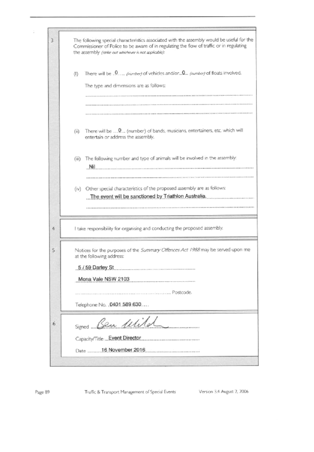
RECOMMENDATION
THAT: 1. the Walking Events Worldwide Pty Ltd, Meet Me in the Middle 10K event to be held on Sunday, 26th March 2017 be approved subject to receipt of a Transport Management Plan in accordance with RMS requirements; and 2. a current Public Liability Insurance Policy which includes the Inner West Council being an interested party be submitted by the event organiser prior to the event.
|
BACKGROUND
The Walking Events Worldwide Pty Ltd, Meet Me in the Middle 10K event will be held on Sunday, 26th March 2017.
Meet Me in the Middle is an initiative created by Walking Events Worldwide Pty Ltd. The company was established to execute fundraising events for major Australian charities.
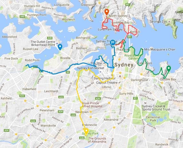
Meet Me in the Middle starts at the same time from four different locations around Sydney – the North, South, East and West. All routes track through inner-city suburbs before arriving at ‘The Middle’, Barangaroo Reserve, on the shores of Sydney Harbour.
Once the 10km walk of Sydney’s suburbs is completed, a food festival is held at Barangaroo Reserve.
The West Route is the only route which passes through the Inner West Council area.
The Event is in its inaugural year of operation and is expected to attract a maximum of 1,800 participants for the west part of the route.
Event Details
The course for Meet Me in the Middle will open at 10am and close at 5pm, and it is estimated that it may attract up to 7,200 participants (1,800 per route). Each walking route is approximately 10km in length and all routes finish at Barangaroo Reserve. Inner West Council forms part of the West Route Only.
Event Overview
Event Name: Meet Me in the Middle [http://www.meetmeinthemiddle.com/]
Event Organiser: Mr Ross Wall, Walking Events Worldwide Pty Ltd
Date: Sunday, 26th March 2017
Course Opens: 10am
Course Closes: 5pm
Participation Target: 1,800 maximum per start/route (released in waves of 150 participants every 5 minutes between 10am and 11:40am)
Course Description: The West Route is approximately 10km in length, beginning in Timbrell Park, Five Dock and finishing in Barangaroo Reserve.
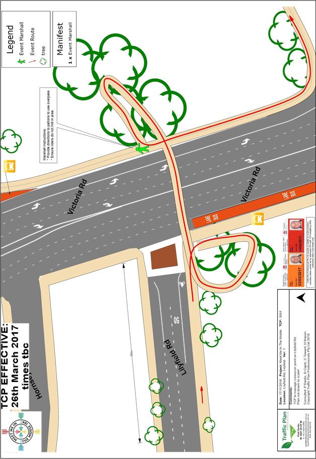
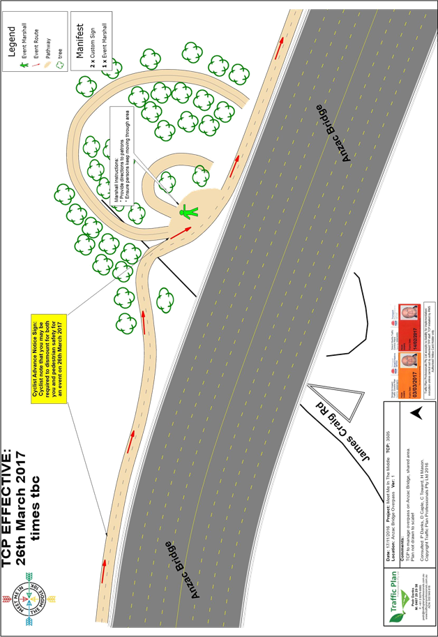
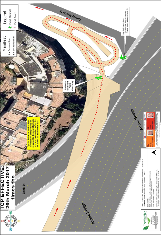
Easton Park (Lilyfield Road) will be used as a check-in location.
Impact on the Inner West LGA
The route through the Inner West LGA is via:
· The Bay Run
· Lilyfield Road
· Pedestrian Bridge over Victoria Road
Approval of Traffic and Pedestrian Management Plan (TMP)
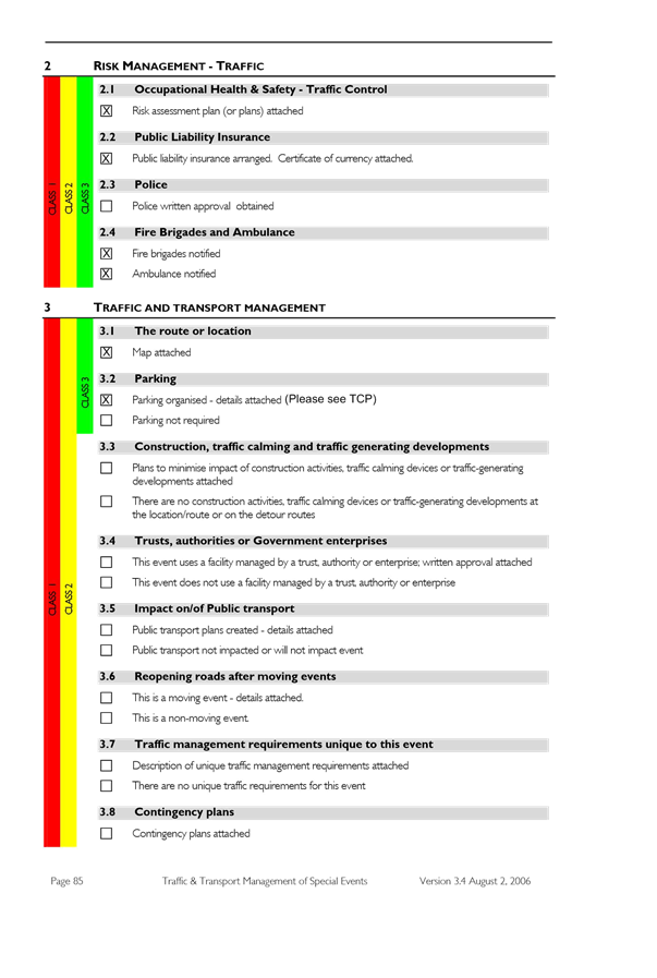
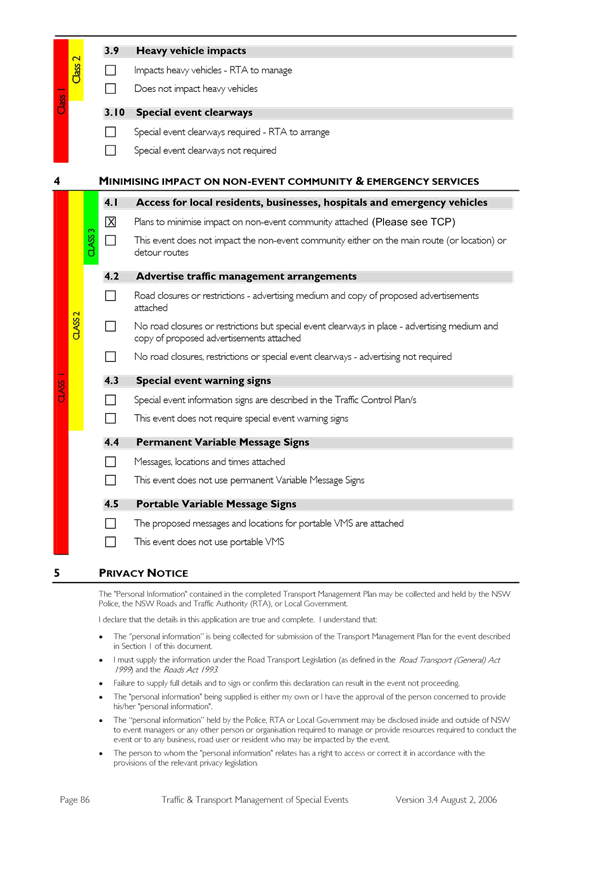
This Event does not require closure of any roads in the Inner West LGA. As the participants would be using footpaths and crossing the street network with assistance of traffic controllers, the Event does not cause significant impacts on traffic and transport systems. Therefore, the Event can be considered as Class 3. Hence, Council’s approval for the Traffic & Transport Management Plan is adequate.
This Pedestrian and Traffic Management Plan when approved by the relevant authorities becomes the prime document detailing with the traffic and transport arrangements under which this event is to proceed.
Changes to the Plan require the approval of the Police and the RMS, and where necessary to the appropriate local government organisation. All functional or single agency supporting plans are to recognise the primacy of the Plan and nothing contained in those plans may contravene any aspect of the Plan.
In case of emergencies, or for the management of incidents, the Police are not subject to the conditions of the Plan; however will make every effort to inform the other agencies of the nature of the incident and the Police response.
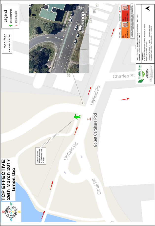
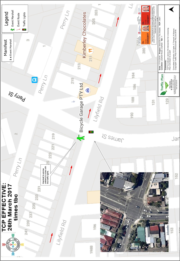
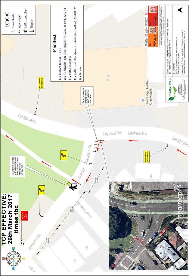
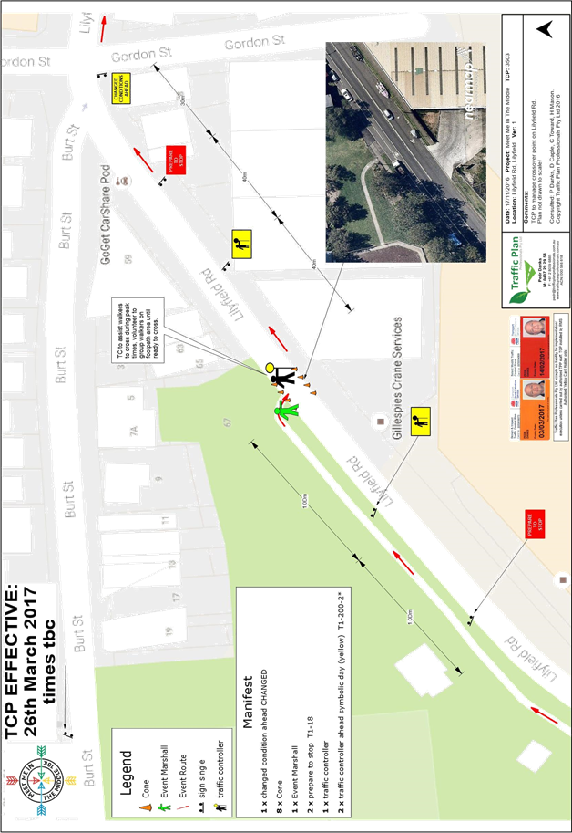
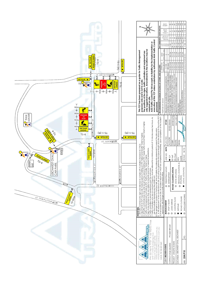
The route for the proposed Meet Me in the Middle 10K event and the Traffic Control Plans (TCP) for Inner West LGA are attached.
FINANCIAL IMPLICATIONS
All costs associated with Meet Me in the Middle 10K walk are funded by the Walking Events Worldwide P/L.
|
1.⇩ |
TCPs - Meet Me in the Middle 10K 2016 |
|
Local Traffic Committee Meeting 1 December 2016 |
Subject: Wests Tigers Junior Triathlon Traffic
Management Plan
(Balmain Ward/Balmain Electorate/Leichhardt LAC)
File Ref: 16/6022/135868.16
Prepared By: Jason Scoufis - Acting Traffic Manager, Leichhardt
Authorised By: John Stephens - Traffic Manager, Leichhardt
|
SUMMARY This report seeks approval for the temporary road closure of Glover Street and Mary Street north of Chapel Street and the unnamed road between Frazer Street and Mary Street to facilitate the Wests Tigers Junior Triathlon’ event on Sunday 22nd January 2017. |
|
RECOMMENDATION
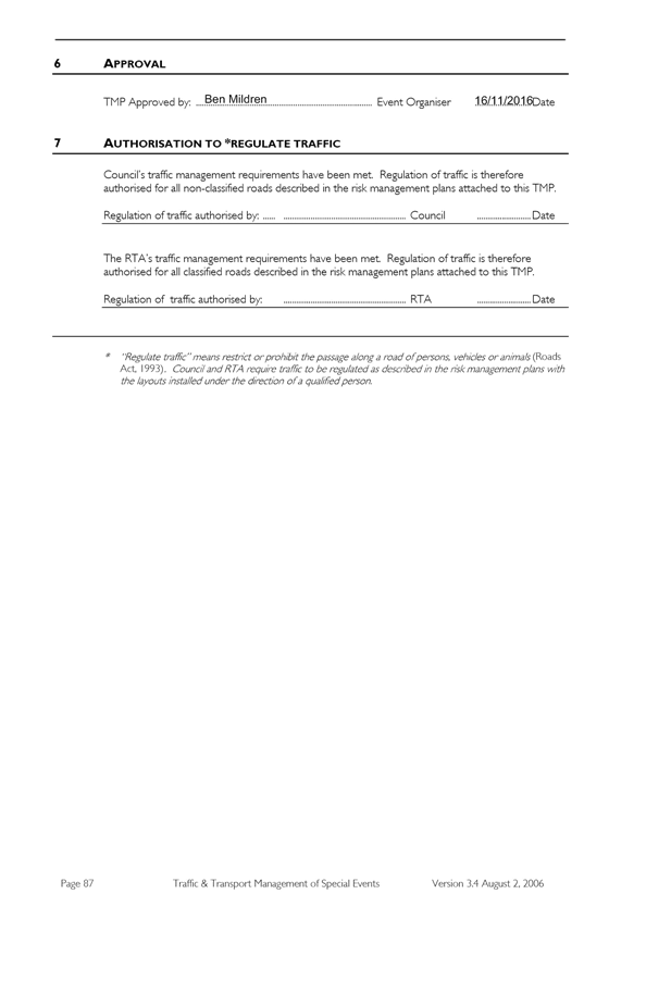
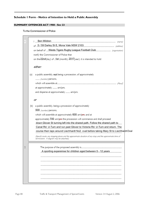
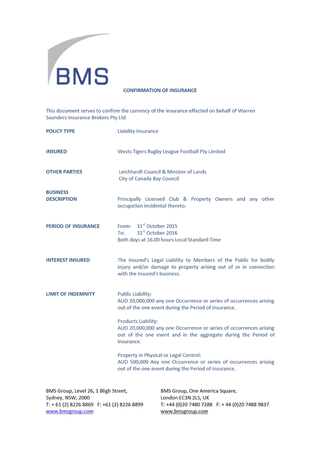
THAT the temporary road closure of Glover Street and Mary Street north of Chapel Street and the unnamed road between Frazer Street and Mary Street on Sunday 22nd January 2017 between 4am and 12 midday be approved subject to the following conditions: 1. the Traffic Management Plan detailing the traffic arrangements for the Wests Tigers Junior Triathlon be supported; 2. the Traffic Control Plan (TCP) be implemented by the applicant, including RMS accredited traffic controllers; subject to an additional traffic controller being located at the intersection of the unnamed road and Frazer Street; 3. the Traffic Management Plan be forwarded to Council’s Area Base Coordinator, Transport Management Centre and the Major Events & Incidents Group (NSW Police) by the applicant; 4. the applicant be requested to advise all affected residents and businesses in advance of the temporary parking changes and road closures in the subject area; 5. the applicant forward to Council a copy of its current Public Liability Insurance Policy with Council shown as an interested party and being indemnified from all claims; 6. a three (3) metre unencumbered passage be available for emergency vehicles though all the closed section of internal roads at all times; 7. all advertising of the event must encourage the use of Public Transport; 8. the applicant be requested to liaise with the STA to organise additional public transport services if necessary; 9. Fire and Rescue NSW be notified of the intended closure; 10. the applicant provide and erect barricades and signs, in accordance with the current Australian Standard AS 1742.3: Traffic Control Devices for Works on Roads. As a minimum the following must be erected at the appropriate locations: a. Barrier Boards (Barricades); b. ‘Road Closed’ (T2-4) signs; c. ‘Road Closed Ahead’ (T2-Q02A); d. ‘On Side Road’ (TC-1325); 11. the areas to be used for the activities must be maintained in a clean and tidy condition to the satisfaction of Council’s Director Major Projects & Engineering, or else the applicant will be required to reimburse Council for any extraordinary cleaning costs; 12. the conduct of any activities or use of any equipment required in conjunction with the road occupancy and temporary road closure not results in any ‘offensive noise’ as defined by the Noise Control Act; 13. a copy of the Council approval be available on site for inspection by relevant authorities; 14. Council reserves the right to cancel the approval at any time; 15. the applicant complies with any reasonable directive from Council Officers and NSW Police; and 16. the applicant be advised of the Committee’s recommendation.
|
BACKGROUND
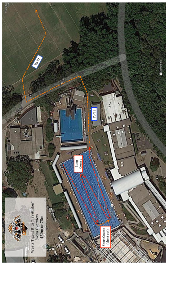
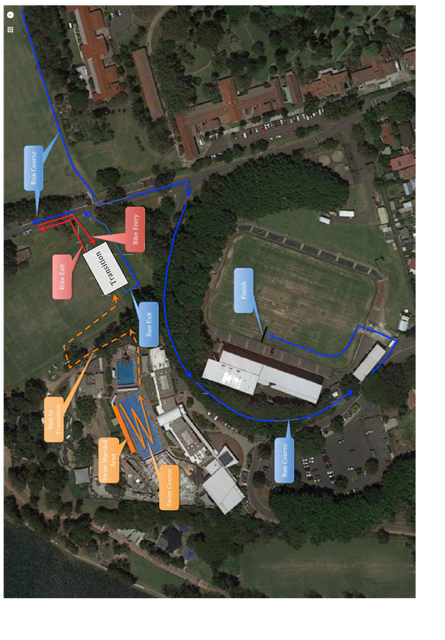
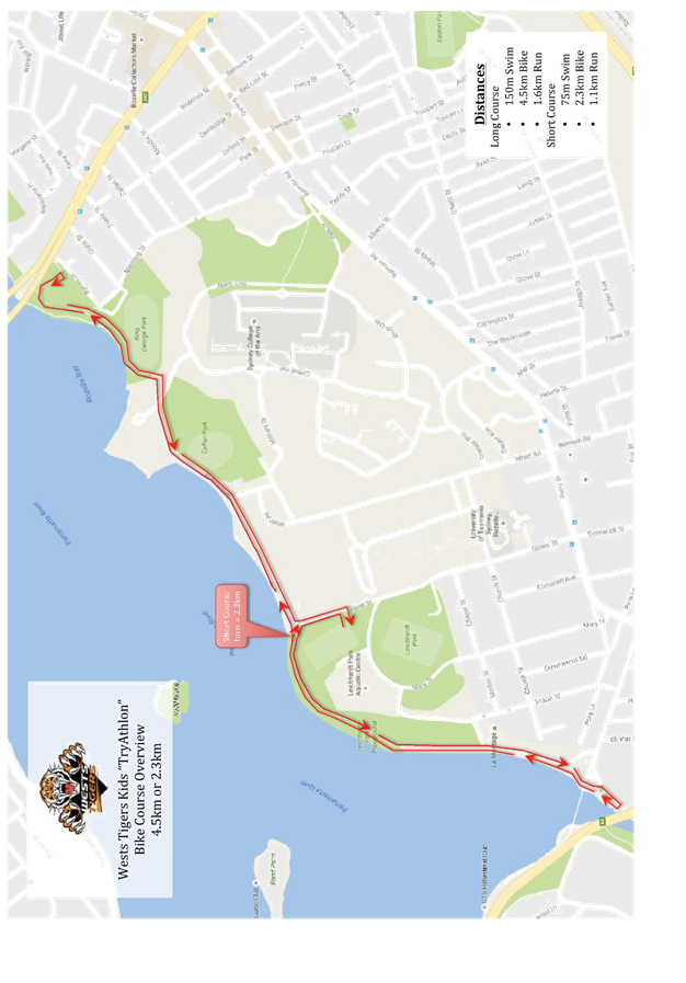
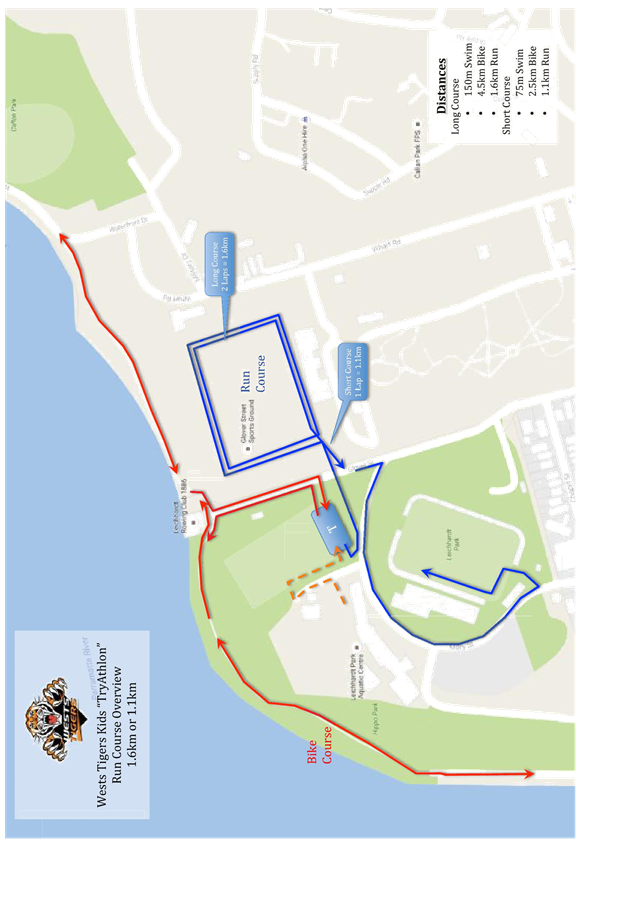
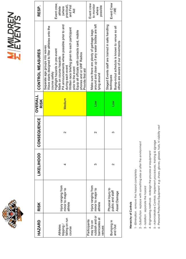
Council has received an application for the Wests Tigers Triathlon Event. The event is a triathlon for children comprising of a swim, cycle and run. The swim component will be undertaken in Leichhardt Park Aquatic Centre (LPAC), with the cycle component using the Bay Run and Glover Street whilst the run component uses Glover Street Sports Ground and Mary Street and Glover Street with the finish within Leichhardt Oval.
The event is to be held on Sunday 22nd January 2017 with bump in commencing 4am and bump out by 12 noon with the actual event start time of 7am and finish time of 10am.
The event is anticipating 500 children (aged 5 to 12). The event has a long course and a short course.
The long course comprises of a 150m swim, 4.5 km bike leg and 1.5km run, whilst the short course comprises of a 75m swim, 2.3 km bike leg and 1.1km run.
The applicant is seeking permission for a temporary full road closure of Mary Street and Glover Street, north of Chapel Street and the unnamed road between Frazer Street and Mary Street.
This is the first time the event has been held.
FINANCIAL IMPLICATIONS
The Event Co-ordinator will bear all costs associated with the road closures.
|
1.⇩ |
Wests Tigers Junior Triathlon TMP and TCP |
|
Local Traffic Committee Meeting 1 December 2016 |
Subject: Temporary Road Closures for the Mardi Gras
Fair Day Event on Sunday 19 February 2017
(Stanmore Ward/Newtown Electorate/Newtown LAC)
File Ref: 16/6022/136349.16
Prepared By: Emilio Andari - Civil Engineer, Marrickville
Authorised By: Joe Di Cesare - Manager Design and Investigation, Marrickville
|
SUMMARY A Section 68 application under the Local Government Act 1993 has been received from the Sydney Gay & Lesbian Mardi Gras in relation to holding the ‘Mardi Gras Fair Day’ which includes a live music stage, food/retail stalls, exhibitions and a dog show on Sunday 19 February 2017. The applicant has requested the temporary road closure, between the hours of 5.00AM to 8.00PM, of Lennox Street, Mary Street, Eliza Street and Federation Road, Newtown. It is recommended that Council agree to the temporary road closures on Sunday 19 February 2017 between the hours of 5.00AM to 8.00PM subject to complying with the following conditions; apply to the RMS for consent to close the subject roads, subject to the event being advertised, a Traffic Management Plan be submitted to the RMS for approval, a Road Occupancy License be obtained from the Transport Management Centre and advice of the proposed event being forwarded to the appropriate authorities including emergency services. |
|
RECOMMENDATION
THAT: 1. the proposed temporary road closure of Lennox Street, Eliza Street, Mary Street and Federation Road, Newtown on Sunday 19 February 2017, between 5.00AM to 8.00PM, for the holding of the ‘Mardi Gras Fair Day’ (Class 2 event under the RMS Special Events Guide), be APPROVED subject to the approval of the Development Application and the applicant complying with the following conditions: a. a fee of $1,441.70 for the temporary road closure is payable by the applicant in accordance with Council’s Fees and Charges; b. the temporary full road closure be advertised by the applicant in the local newspaper providing 28 days notice for submissions, in accordance with the Roads Act; c. a Traffic Management Plan (TMP) be submitted by the applicant to the Roads and Maritime Services for consideration and approval; d. a Traffic Control Plan (TCP) which has been prepared by a certified Traffic Controller, is to be submitted to Council for review with a copy of the Traffic Controller’s certification number attached to the plan, not less than 5 days prior to implementation of the closure; e. a Road Occupancy License (ROL) application be obtained by the applicant from the Transport Management Centre; f. notice of the proposed event is forwarded by the applicant to the NSW Police Local Area Commander, State Transit Authority, NSW Fire Brigades and NSW Ambulance Services; g. advance notifications signs advising of the proposed road closure and traffic diversions to be strategically installed and maintained by the applicant at least two (2) weeks prior to the event; h. ‘No Stopping - Special Event’ signs be affixed over all existing timed parking restriction signs within the sections of streets to be closed on the afternoon of the day prior to the event; i. a 4-metre wide emergency vehicle access must be maintained through the closed road areas during the course of the event; j. all affected residents and businesses shall be notified in writing by the applicant of the proposed temporary road closure at least two (2) weeks prior to the event, with the applicant making reasonable provision for residents and businesses; k. adequate vehicular traffic control shall be provided for the protection and convenience of pedestrians and motorists including appropriate signage and flagging. Workers shall be specially designated for this role (and carry appropriate certificates), as necessary to comply with this condition. This is to be carried out in accordance with the Australian Standard AS 1742.3 – Traffic Control Devices for works on roads; l. water filled barriers be placed at the road closure points to protect against any possible errant vehicles; 2. the applicant be advised in terms of this report and that all costs for advertising the event and implementation of the road closure are to be borne by the applicant; and 3. the applicant be advised that an annual application needs to be submitted to Council for the temporary road closures associated with the event.
|
BACKGROUND
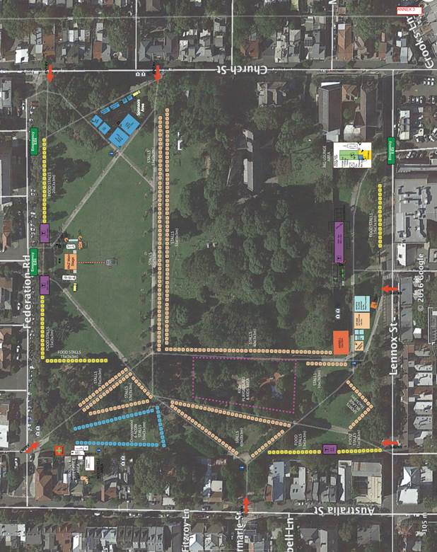
The ‘Mardi Gras Fair Day’ is a free event which has been held previously in other parts of the Sydney City district and attracts thousands of attendees every year. It is envisaged that the event will attract around 80,000 people throughout the day with a maximum of 30,000 at any given time.
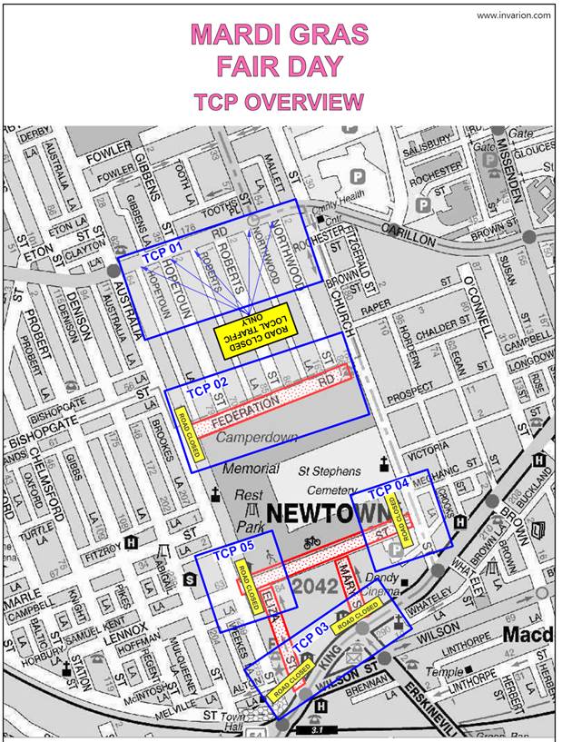
The Sydney Gay & Lesbian Mardi Gras have applied to hold this event in the grounds of the Camperdown Memorial Rest Park on Sunday 19 February 2017. A temporary full-road closure of Lennox Street, Mary Street, Eliza Street and Federation Road, Newtown will be required for the duration of the event.
FINANCIAL IMPLICATIONS
Nil.
OFFICER COMMENTS
Impacts on traffic
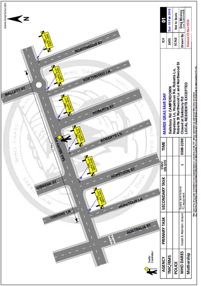
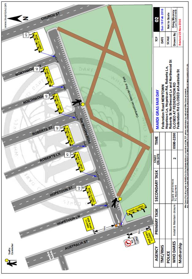
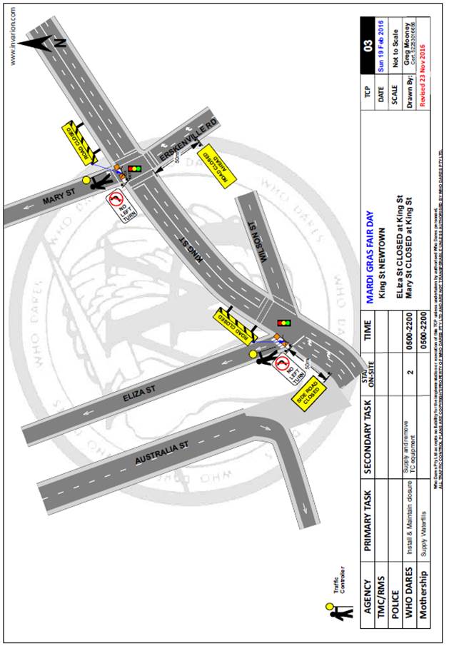
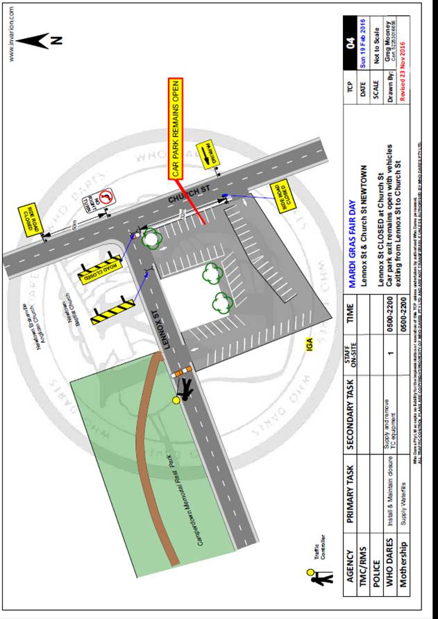
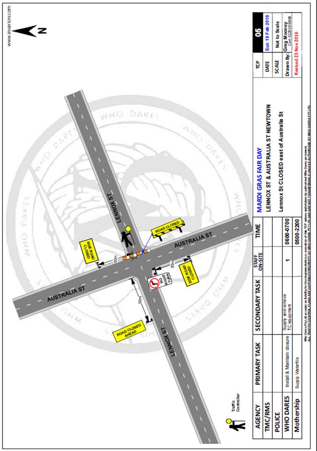
The event will be held on Sunday 19 February 2017and the following streets will need to be temporarily closed between 5.00AM and 8.00PM on the day of the event (refer to the attached traffic control plans):
· Lennox Street - between Australia Street and Church Street.
· Mary Street - between King Street and Lennox Street.
· Eliza Street - between King Street and Lennox Street.
· Federation Road - between Australia Street and Church Street.
Appropriate advance warning signs will be strategically installed at least two (2) weeks prior to the event. Barricades will be used to effect the closures and a 4-metre wide emergency vehicle access will need to be maintained through the area during the course of the festival. Security personnel trained in traffic management will manage traffic into and around the event to ensure safety and reduce congestion.
Furthermore, feedback from local residents regarding other events held in Camperdown Memorial Rest Park indicated the need for signage to be placed at the Salisbury Road end of the six roads/laneways (Hopetoun Lane, Hopetoun Street, Roberts Lane, Roberts Street, Northwood Lane and Northwood Street) that run between Salisbury Road and Federation Road, Newtown. Traffic signage indicating that there is no thoroughfare in the road/laneway on event day and the road/laneway is open to ‘residents only’ is highly recommended. This may require additional traffic controllers.
Public Transport
It is noted that the event location is situated near public transport facilities with Newtown Railway Station and Sydney Buses servicing on King Street. The bus routes operating along King Street, Newtown are:
· 352 Marrickville Metro – Newtown – Surry Hills – Bondi Junction
· 370 Leichhardt – Glebe – Newtown – UNSW – Coogee Beach
· 422 Kogarah – Tempe – St Peters – City
· 423 Kingsgrove – Earlwood – City
· 426 Dulwich Hill – Marrickville – City
· 428 Canterbury – Petersham – City
· M30 Spit Junction – Neutral Bay – City – UNSW – King St – Sydenham
A request for additional bus services has been lodged with Transport for NSW by the applicant.
Sydney Trains will increase the frequency of trains stopping at Newtown station to 8 trains per hour (in each direction) between 9:00AM and 9:00PM, which is double the normal capacity. This allows Newtown Railway Station to handle around 15,000 people per hour.
Parking Provision
The Event Organiser will not be encouraging patrons to drive and park their vehicles for the event. There is on-street parking available in surrounding streets however, most these streets consist of a combination of ‘2P’ timed parking restrictions and unrestricted parking. It is also noted that nearby carparks and King Street, Newtown provide ticketed parking. The event organiser will be implementing bicycle racks near the event site entry points in Camperdown Memorial Rest Park to encourage patrons to ride and park their bicycles on site. Patrons will be encouraged to use public transport or bicycles.
Site Plan
PUBLIC CONSULTATION
The proposed road closures of Lennox Street, Mary Street, Eliza Street and Federation Road, Newtown will need to be advertised in the newspaper for a period of 28 days by the applicant and a Traffic Management Plan is to be submitted to the RMS for consideration and approval.
The event organiser will need to notify all affected residents and businesses in writing of the proposed temporary road closure at least two weeks prior to the event and make reasonable provision for residents and businesses, where possible.
CONCLUSION
It is recommended that Council agree to the temporary road closures on Sunday 19 February 2017 between the hours of 5.00AM to 8.00PM subject to complying with the following conditions; apply to the RMS for consent to close the subject roads, subject to the event being advertised, a Traffic Management Plan be submitted to the RMS for approval, a Road Occupancy License be obtained from the Transport Management Centre and advice of the proposed event being forwarded to the appropriate authorities including emergency services.
|
|
Local Traffic Committee Meeting 1 December 2016 |
Subject: Minor Traffic Facilities
(Leichhardt & Balmain Wards/Balmain Electorate /Leichhardt LAC)
File Ref: 16/6022/135826.16
Prepared By: Manod Wickramasinghe - Traffic and Parking Engineer, Leichhardt
Authorised By: John Stephens - Traffic Manager, Leichhardt
|
SUMMARY This report deals with minor traffic facility applications received by Inner West Council, Leichhardt and includes ‘Disabled Parking’. |
|
RECOMMENDATION
THAT: 1. a 7.2m ‘Disabled Parking’ zone (90 degree angle parking); consisting of two 2.4m ‘Disabled Parking spaces and a 2.4m ‘shared space’, be provided on the southern side of the King George Park car park, immediately east of the existing toilet block; 2. a 6m ‘Disabled Parking’ zone be installed in front of No.5 William Street, Annandale; 3. a 6m ‘Disabled Parking’ zone be installed in front of No.12 Joseph Street, Lilyfield, subject to receiving the Aged Care Assessment Team report from the applicant; 4. the 6m ‘Disabled Parking’ space in front of No.31 Marlborough Street, Leichhardt be removed as it is no longer required and the 2P ticket 8am-10pm RPS restrictions be reinstated; 5. the 6m ‘Disabled Parking’ space in Booth Street, Balmain on the side boundary of No.110 Palmer Street be removed and replaced with resident parking restrictions as the zone is no longer required; 6. the 6m ‘Disabled Parking’ space in front of No.32 Cove St Birchgrove be removed as the zone is no longer required; 7. the 6m ‘Disabled Parking’ space in front of No.181 Mullens Street, Rozelle be removed as the zone is no longer required; 8. the 6m ‘Disabled Parking’ space in front of No.15 Foucart Street, Rozelle be removed as the zone is no longer required; and 9. the 6m ‘Disabled Parking’ space in front of No.13 Moore Street, Leichhardt be removed as the zone is no longer required.
|
BACKGROUND
This report deals with minor traffic facility applications received by Inner West Council, Leichhardt and includes ‘Disabled Parking’.
FINANCIAL IMPLICATIONS
The installation of ‘Disabled Parking’ signage is funded from Council’s operating budget.
OFFICER COMMENTS
1 Installation of ‘Disabled Parking’ Restriction – King George Park car park (near Manning Street), Rozelle
Council Ref: DWS 4030043
Council has received requests for the installation of ‘Disabled Parking’ facilities in the King George Park car park, immediately east of the existing toilet blocks.
Officer’s recommendation
That a 7.2m ‘Disabled Parking’ zone (90 degree angle parking); consisting of two 2.4m ‘Disabled Parking spaces and a 2.4m ‘shared space’, be provided on the southern side of the King George Park car park, immediately east of the existing toilet block.
2 Installation of ‘Disabled Parking’ Restriction – William Street, Annandale
Council Ref: DWS 4021873
The resident of No.5 William Street, Annandale has requested the installation of a ‘Disabled Parking’ zone in front of the resident’s property.
A site investigation has revealed that the property does not have off-street parking.
The applicant does not require the use of a wheelchair.
Officer’s recommendation
That a 6m ‘Disabled Parking’ zone be installed in front of No.5 William Street, Annandale.
3 Installation of ‘Disabled Parking’ Restriction – Joseph Street, Lilyfield
Council Ref: DWS 3984930
The resident of No.12 Joseph Street, Lilyfield has requested the installation of a ‘Disabled Parking’ zone in front of the resident’s property.
A site investigation has revealed that the property does have off-street parking.
The applicants family has advised that an Aged Care Assessment Team (ACAT) organised by Balmain Hospital attended the home for home modification with an occupational therapist. The ACAT advised that due to her frailty she should not use internal stairs to the garage. It was also advised by ACAT that she not use the stairs at front of the house, at the driveway. An on-street ‘Disabled Parking’ zone limits the number of stairs that need to be negotiated to four.
The applicant does not require the use of a wheelchair.
Officer’s recommendation
That a 6m ‘Disabled Parking’ zone be installed in front of No.12 Joseph Street, Lilyfield, subject to receiving the Aged Care Assessment Team report from the applicant.
4 Removal of ‘Disabled Parking’ Restriction – Marlborough Street, Leichhardt
Council Ref: DWS 4018870
The resident of No.31 Marlborough Street, Leichhardt has notified Council that the applicant to the ‘Disabled Parking’ zone outside the property has passed away and thus the ‘Disabled Parking’ zone is no longer required..
Officer’s recommendation
That the 6m ‘Disabled Parking’ space in front of No.31 Marlborough Street, Leichhardt be removed as it is no longer required and the 2P ticket 8am-10pm RPS restrictions be reinstated.
5 Removal of ‘Disabled Parking’ Restriction – Booth Street, Balmain
Council Ref: DWS 3946454
Residents have notified Council that the applicant to the ‘Disabled Parking’ zone in Booth Street, Balmain on the side boundary of No.110 Palmer Street has moved away and thus the ‘Disabled Parking’ zone is no longer required. Council has consulted the property, proposing removal of the ‘Disabled Parking’ zone and no response has been received.
Officer’s recommendation
That the 6m ‘Disabled Parking’ space in Booth Street, Balmain on the side boundary of No.110 Palmer Street be removed and replaced with resident parking restrictions as the zone is no longer required.
6 Removal of ‘Disabled Parking’ Restriction – Cove Street, Birchgrove
Council Ref: DWS 4043385
A family member has notified Council that the applicant to the ‘Disabled Parking’ zone in front of No.32 Cove St Birchgrove has passed away and thus the ‘Disabled Parking’ zone is no longer required.
Officer’s recommendation
That the 6m ‘Disabled Parking’ space in front of No.32 Cove St Birchgrove be removed as the zone is no longer required.
7 Removal of ‘Disabled Parking’ Restriction – Mullens Street, Rozelle
Council Ref: DWS N/A
Residents have notified Council that the applicant to the ‘Disabled Parking’ zone in front of No.181 Mullens Street, Rozelle has moved away and thus the ‘Disabled Parking’ zone is no longer required. Council has consulted the property, proposing removal of the ‘Disabled Parking’ zone and no response has been received.
Officer’s recommendation
That the 6m ‘Disabled Parking’ space in front of No.181 Mullens Street, Rozelle be removed as the zone is no longer required.
8 Removal of ‘Disabled Parking’ Restriction – Foucart Street, Rozelle
Council Ref: DWS 4046261
Residents have notified Council that the applicant to the ‘Disabled Parking’ zone in front of No.15 Foucart Street, Rozelle has moved away and thus the ‘Disabled Parking’ zone is no longer required. Council has consulted the property, proposing removal of the ‘Disabled Parking’ zone and no response has been received.
Officer’s recommendation
That the 6m ‘Disabled Parking’ space in front of No.15 Foucart Street, Rozelle be removed as the zone is no longer required.
9 Removal of ‘Disabled Parking’ Restriction – Moore Street, Leichhardt
Council Ref: DWS 4056717
A family member of the applicant to the ‘Disabled Parking’ zone in front of No.13 Moore Street, Leichhardt has notified Council that the applicant has passed away and thus the ‘Disabled Parking’ zone is no longer required.
Officer’s recommendation
That the 6m ‘Disabled Parking’ space in front of No.13 Moore Street, Leichhardt be removed as the zone is no longer required.