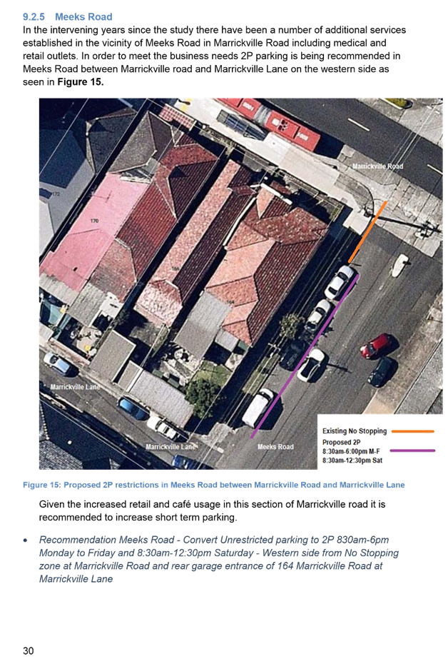
|
AGENDA R |

Local Traffic Committee Meeting
THURSDAY 2 FEBRUARY 2017
10:00am
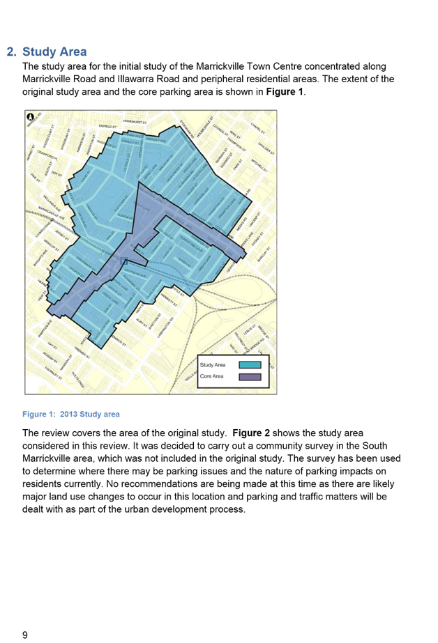
Background
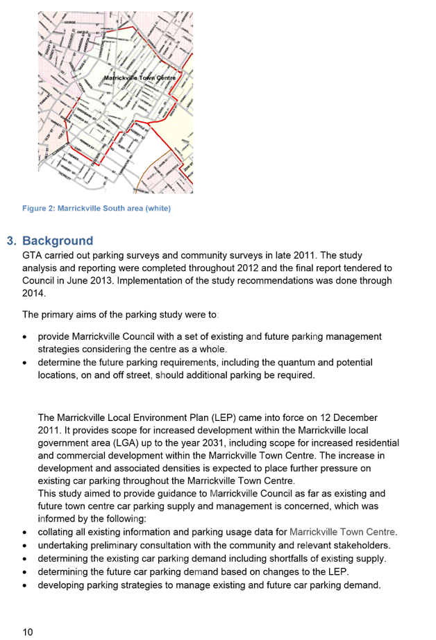
Roads and Maritime Services (RMS) is legislated as the Authority responsible for the control of traffic on all NSW Roads. The RMS has delegated certain aspects of the control of traffic on local roads to councils. To exercise this delegation, councils must establish a local traffic committee and obtain the advice of the RMS and Police. The Inner West Council Local Traffic Committee has been constituted by Council as a result of the delegation granted by the RMS pursuant to Section 50 of the Transport Administration Act 1988.
Role of the Committee
The Local Traffic Committee is primarily a technical review and advisory committee which considers the technical merits of proposals and ensures that current technical guidelines are considered. It provides recommendations to Council on traffic and parking control matters and on the provision of traffic control facilities and prescribed traffic control devices for which Council has delegated authority. These matters are dealt with under Part A of the agenda and require Council to consider exercising its delegation.
In addition to its formal role as the Local Traffic Committee, the Committee may also be requested to provide informal traffic engineering advice on traffic matters not requiring Council to exercise its delegated function at that point in time, for example, advice to Council’s Development Assessment Section on traffic generating developments. These matters are dealt with under Part C of the agenda and are for information or advice only and do not require Council to exercise its delegation.
Committee Delegations
The Local Traffic Committee has no decision-making powers. The Council must refer all traffic related matters to the Local Traffic Committee prior to exercising its delegated functions. Matters related to State Roads or functions that have not been delegated to Council must be referred directly to the RMS or relevant organisation.
The Committee provides recommendations to Council. Should Council wish to act contrary to the advice of the Committee or if that advice is not supported unanimously by the Committee members, then the Police or RMS have an opportunity to appeal to the Regional Traffic Committee.
Committee Membership & Voting
Formal voting membership comprises the following:
· one representative of Council as nominated by Council;
· one representative of the NSW Police from each Local Area Command (LAC) within the LGA, being Newtown, Marrickville, Leichhardt and Ashfield LAC’s.
· one representative from the RMS; and
· State Members of Parliament (MP) for the electorates of Summer Hill, Newtown, Heffron, Canterbury, Strathfield and Balmain or their nominees.
Where the Council area is represented by more than one MP or covered by more than one Police LAC, representatives are only permitted to vote on matters which effect their electorate or LAC.
Informal (non-voting) advisors from within Council or external authorities may also attend Committee meetings to provide expert advice.
Committee Chair
Council’s representative will chair the meetings.
Public Participation
Members of the public or other stakeholders may address the Committee on agenda items to be considered by the Committee. The format and number of presentations is at the discretion of the Chairperson and is generally limited to 3 minutes per speaker. Committee debate on agenda items is not open to the public.
|
|
Local Traffic Committee Meeting 2 February 2017 |
|
AGENDA |
1 Apologies
2 Disclosures of Interest
3 Confirmation of Minutes
4 Matters Arising from Council’s Resolution of Minutes
5 Part A – Items Where Council May Exercise Its Delegated Functions
Traffic Matters Page
T0217 Item 1 Ellen
Street, Rozelle - ‘Proposed 10 Km/H Shared Zone’
(Balmain Ward/Balmain Electorate/Leichhardt LAC) 5
T0217 Item 2 Prosper
Lane, Rozelle - ‘Proposed 10 Km/H Shared Zone’
(Balmain Ward/Balmain Electorate/Leichhardt LAC) 8
T0217 Item 3 Station
Street, Marrickville - Shared Zone Proposal - Final Design Plan for Traffic
Signage
(Marrickville Ward/Heffron Electorate/Marrickville LAC) 11
T0217 Item 4 Kintore
Street, Dulwich Hill - Pedestrian Safety - Zig Zag Line Marking at Wombat
Crossing
(Ashfield Ward/Summer Hill Electorate/Marrickville LAC) 15
T0217 Item 5 Flood
Street, Leichhardt - Road Occupancy
(Leichhardt Ward/Balmain Electorate/Leichhardt LAC) 19
T0217 Item 6 Holbeach
Avenue, Tempe - Special Event - Bengali ‘New Year‘s Day’ Fair
in Tempe Reserve on Saturday 8 April 2017
(Marrickville Ward/Heffron Electorate/Newtown LAC) 21
T0217 Item 7 Audley
Street, Petersham - Temporary Full Road Closure for Special Event on Sunday 12
March 2017
(Stanmore Ward/Newtown Electorate/Marrickville LAC) 29
T0217 Item 8 Temporary
Road Closure to Carry Out Installation of A/C Compressors on the North Facing
Wall of 'The Hub' Building in Alton Lane, Newtown
(Stanmore Ward/Newtown Electorate/Newtown LAC) 34
T0217 Item 9 Proposed
One-Way Slow Point Traffic Calming Treatment - Tennyson Street, Dulwich Hill
(Ashfield Ward/Summer Hill Electorate/Marrickville LAC) 37
T0217 Item 10 Lewisham LATM Final Report 44
Parking Matters
T0217 Item 11 Requests
for Mobility Parking Spaces
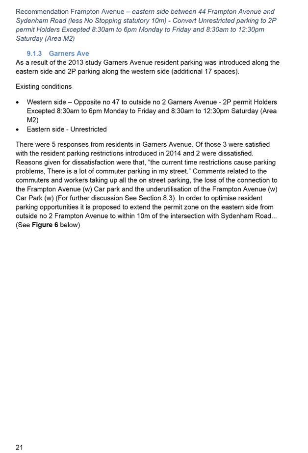
(Stanmore & Marrickville Wards/Heffron & Newtown
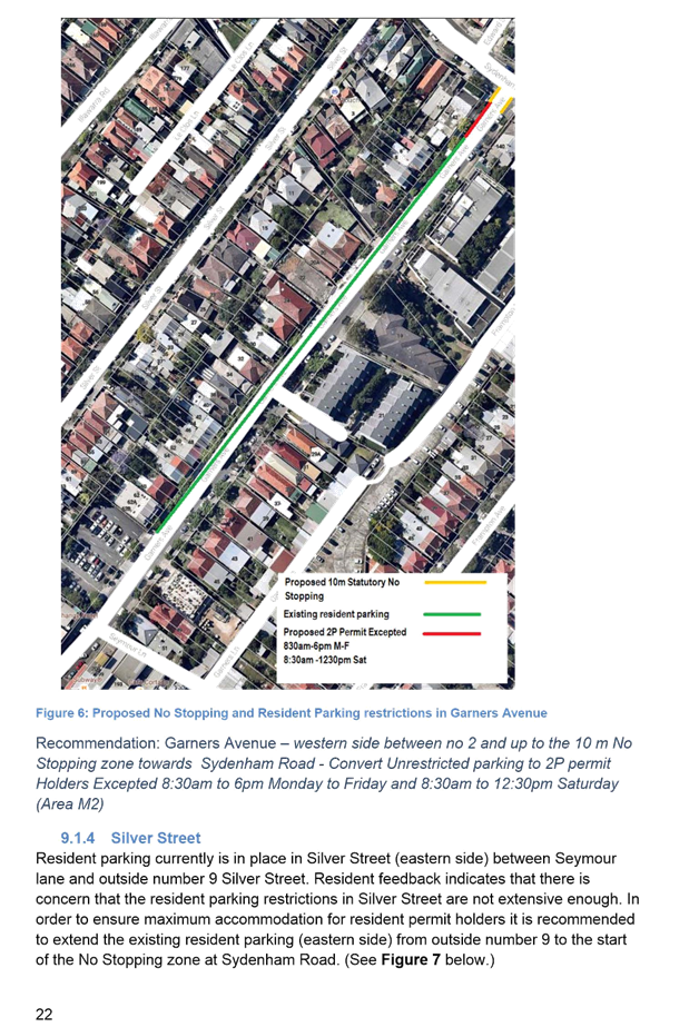
Electorates/Marrickville & Newtown LACs) 49
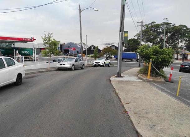
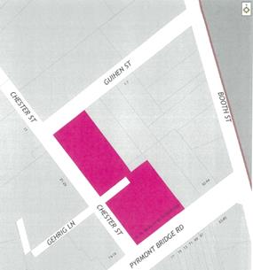
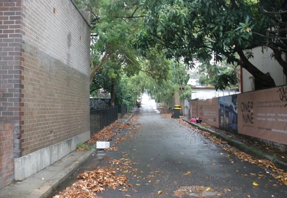
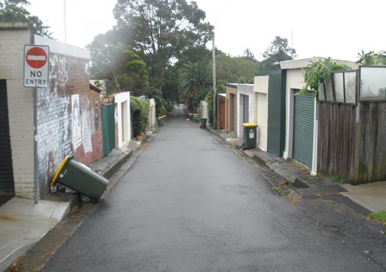
T0217 Item 12 Gehrig
Lane, Camperdown - ‘No Parking’ and ‘No Stopping’
Restrictions
(Leichhardt Ward/Balmain Electorate/Leichhardt LAC) 56
T0217 Item 13 Durham
Lane, Stanmore - Proposed ‘No Parking’ Restrictions in a Section of
the Laneway
(Stanmore Ward/Newtown Electorate/Newtown LAC) 58
Parking Matters (Cont’d) Page
T0217 Item 14 Francis
Street, Marrickville - Casimir Catholic College - Changes to Bus Stop to
include No Parking Drop-Off School Zone Hours
(Marrickville Ward/Summer Hill Electorate/Marrickville LAC) 63
T0217 Item 15 Minor
Traffic Facilities
(Leichhardt & Balmain Wards/Balmain Electorate/Leichhardt LAC) 67
T0217 Item 16 Smidmore
Street, Marrickville - Request by Breastscreen Australia to Position a Mobile
X-Ray Unit
(Marrickville Ward/Summer Hill Electorate/Marrickville LAC) 69
T0217 Item 17 Charlotte
Street, Lilyfield - Angle Parking and Resident Parking Scheme Investigation
(Leichhardt Ward/Balmain Electorate/Leichhardt LAC) 72
T0217 Item 18 Short
Term Parking Restrictions at Schools
(Leichhardt & Balmain Wards/Balmain Electorate/Leichhardt LAC) 74
T0217 Item 19 Requests
for ‘Works Zone’ adjacent to Construction Sites
(Stanmore & Marrickville Wards/Newtown, Heffron & Summer Hill
Electorates/Newtown & Marrickville LACs) 77
Late Items
Nil at time of printing.
6 Part B – Items for Information Only
T0217 Item 20 The
‘Gear Up Girl’ Bicycle Event
(Marrickville Ward/Summer Hill & Heffron Electorates/Marrickville &
Newtown LACs) 87
T0217 Item 21 Minor
Traffic Facilities
(Leichhardt & Balmain Wards/Balmain Electorate/Leichhardt LAC) 93
T0217 Item 22 Campbell
Street, Waterview Street, Wells Street and Alexander Street, Balmain - Resident
Parking Scheme
(Leichhardt Ward/Balmain Electorate/Leichhardt LAC) 94
T0217 Item 23 Amended
Locations of Additional School Zone Flashing Lights outside Schools in Inner
West LGA
(Various Wards/Electorates/LACs) 98
T0217 Item 24 Unnamed
Laneway between May Street and The Boulevarde, Lilyfield - Road Occupancy
(Street Party)
(Balmain Ward/Balmain Electorate/Leichhardt LAC) 100
T0217 Item 25 Parking
Study for Impact of Old Tram Shed Redevelopment - North East Annandale
(Leichhardt Ward/Balmain Electorate/Leichhardt LAC) 105
7 Part C – Items for General Advice
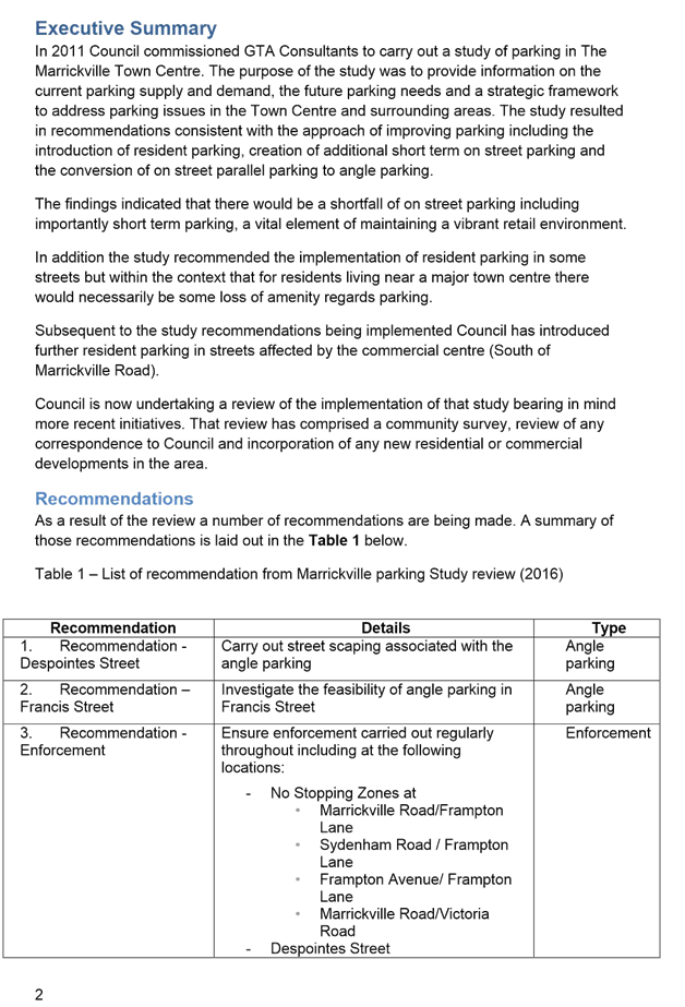
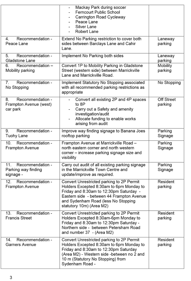
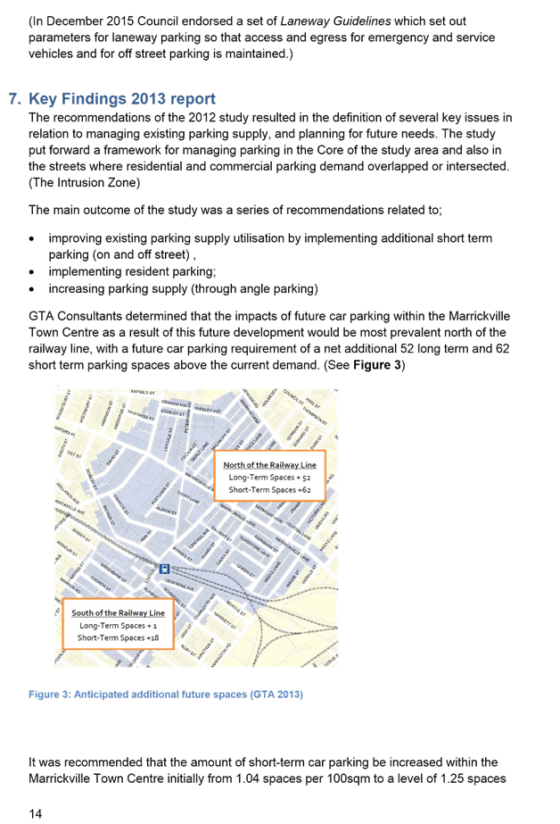
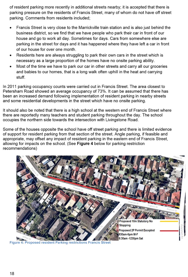
T0217 Item 26 Marrickville Parking Study Review 159
8 General Business
9 Close of Meeting
|
|
Local Traffic Committee Meeting 2 February 2017 |
Subject: Ellen Street, Rozelle - ‘Proposed 10
Km/H Shared Zone’
(Balmain Ward/Balmain Electorate/Leichhardt LAC)
File Ref: 17/6022/7191.17
Prepared By: Jason Scoufis - Team Leader Traffic, Leichhardt
Authorised By: John Stephens - Traffic Manager, Leichhardt
|
SUMMARY Council is proposing to install a 10 km/h Shared Zone in Ellen Street, Rozelle as requested by a number of residents in the street to alleviate concerns regarding pedestrian safety associated with the lack of footpath requiring pedestrians to walk on the road. |
|
RECOMMENDATION
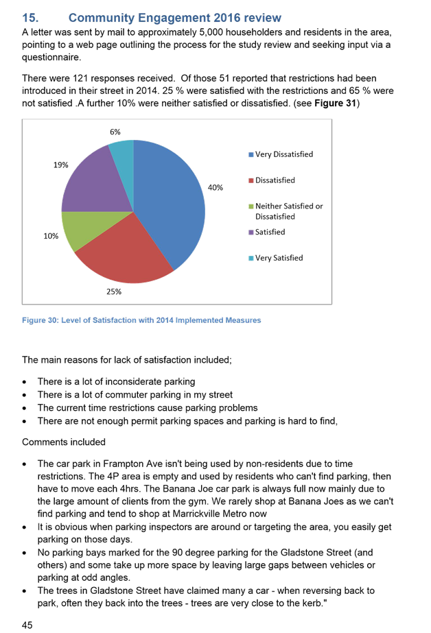
THAT a ‘10km/h Shared Zone’ be installed in Ellen Street and adjacent unnamed laneway, Rozelle with associated traffic calming devices, subject to RMS approval.
|
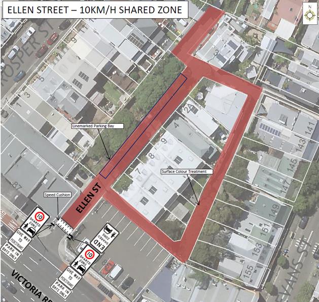
BACKGROUND
Ellen Street is a local road with a 40 km/hr speed limit. It is a dead - end at its northern end and provides access to a rear access laneway which intersects with Ellen Street at two locations.
Ellen Street has very low traffic volumes and speeds with an ADT of 40 vehicles/day and 85th%ile speed of 19 km/h. It provides access to residential properties and also the Council leased Ellen Street Car Park adjacent to Victoria Road.
Kerbside parallel parking is provided on the western side of Ellen Street and parking is not permitted in the unnamed laneway due to its narrow width.
Proposal
The proposal is detailed below and includes the following traffic treatments to clearly define the Shared Zone:
· Speed cushion at the southern end of Ellen Street approximately 10 metres from Victoria Road.
· Shared Zone signposting as required in line with NSW speed zone guidelines.
· Parking area designated by linemarking a parking bay.
· The pavement surface to be changed to highlight the difference in the street environment from the surrounding road network.
The RMS Network and Safety Sydney Division were forwarded a plan and RMS provided a number of comments which have been taken into consideration in the plan prior to consultation.
|
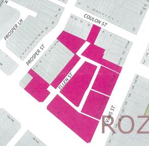
PUBLIC CONSULTATION A letter outlining the above proposal was mailed out to the affected properties (27 properties) in Prosper Street, Coulon Street, Ellen Street and Evans Street, Rozelle
Four (4) responses were received, including one (1) objection.
|
|
|
Resident Comment |
Officer Response |
|
The requirement to create a Shared Zone is not required as the majority of cars accessing Ellen Street past the Council parking area are residents aware of the need to drive at a slower speed |
Noted; however, the lack of footpath still requires pedestrians to walk on the road in conflict with vehicles manouvering into/out of car spaces. Given the road environment, a 10 km/h Shared Zone is considered appropriate and was requested by residents. |
|
The speed cushion would be better positioned just after the entrance to the Council Car Park to better manage the speed of vehicles that would need to drive past this point |
RMS have required that the speed cushion be located on entry to the Shared Zone and that the Shared Zone extend the full length of Ellen Street |
|
We are very happy with the proposed plan to change the area to a controlled speed zone and Shared Zone and welcome the change |
Noted |
FINANCIAL IMPLICATIONS
The cost of the signposting will be funded from Council’s operational budget.
CONCLUSION
In order to provide improved pedestrian amenity, it is recommended that a ‘10km/h Shared Zone’ be installed in Ellen Street and the adjacent unnamed laneway, Rozelle with associated traffic calming devices, subject to the RMS approval.
|
|
Local Traffic Committee Meeting 2 February 2017 |
Subject: Prosper Lane, Rozelle - ‘Proposed 10
Km/H Shared Zone’
(Balmain Ward/Balmain Electorate/Leichhardt LAC)
File Ref: 17/6022/7298.17
Prepared By: Jason Scoufis - Team Leader Traffic, Leichhardt
Authorised By: John Stephens - Traffic Manager, Leichhardt
|
SUMMARY Council is proposing to install a 10 km/h Shared Zone in Prosper Lane, Rozelle as requested by a number of residents in the area to alleviate concerns regarding pedestrian safety associated with the need to walk on the road as there is no footpath for the majority of the lane. |
|
RECOMMENDATION
THAT a ‘10km/h Shared Zone’ be installed in Prosper Lane, Rozelle with associated traffic calming devices, subject to RMS approval.
|
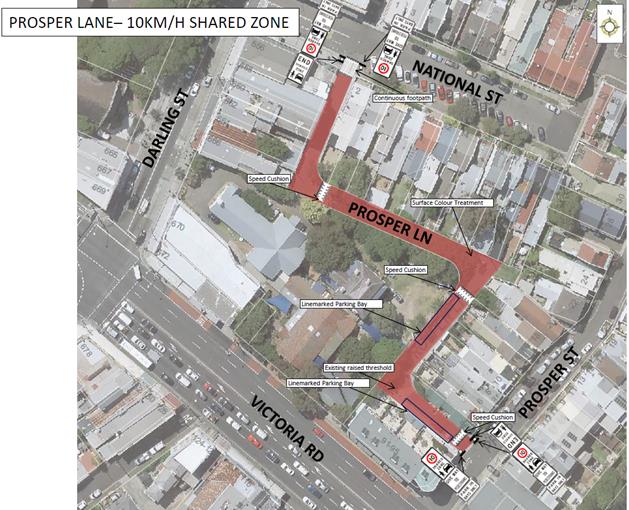
BACKGROUND
Prosper Lane is a local road with a 40 km/hr speed limit which extends from National Street to Prosper Street, a length of approximately 170 metres. It is two way at its northern and eastern end, with the middle section signposted one-way westbound uphill towards National Street.
It has very low traffic volumes and speeds (2016 data) with a midblock Average Daily Traffic Volume (ADT) of 121 vehicles/day and 85%ile speed of 27 km/h.
Small areas of on-street parking are provided with the majority of the lane being signposted ‘No Parking’ to provide access to off-street parking spaces.
Proposal
The proposal is detailed below and includes the following traffic treatments to clearly define the Shared Zone:
· Three speed cushions and one continuous footpath treatment.
· Shared Zone signposting as required in line with NSW speed zone guidelines.
· Parking area designated by linemarking parking bays in the two existing parking areas, noting no loss of on-street parking.
· The pavement surface to be changed to highlight the difference in the street environment from the surrounding road network.
The RMS Network and Safety Sydney Division were forwarded a plan and RMS provided a number of comments which have been taken into consideration in the plan prior to consultation.
|
PUBLIC CONSULTATION
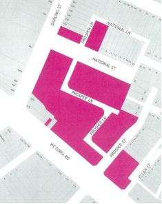
A letter outlining the above proposal was mailed out to the affected properties (44 properties) in Victoria Road, National Street, Darling Street and Prosper Street, Rozelle.
Eight (8) responses were received all supporting the proposal.
|
|
|
Resident Comment |
Officer Response |
|
Too many signs at both entries to Shared Zone |
Dual signs required at both ends as per RMS requirements. |
|
Does not support conversion of the lane to two way |
The proposal does not change the existing traffic flow arrangements i.e. the one way sections will remain one way and the two way sections will remain two way. |
|
Supports proposal and advised that vehicles travel the wrong direction in the one way section as a rat run to access Victoria Road. |
The traffic calming associated with the Shared Zone will reduce the attractiveness to travel the wrong way in the lane due to increased travel times. |
|
Requests zebra crossing and STOP sign to cross National Street intersection due to high walls obstructing sight lines |
Proposal includes a contnuous footpath treatment at this location, which will provide pedestrian priority in lieu of a zebra crossing which cannot be provided at this location as the warrants for such a facility are not met. |
|
Requests the entire lane becomes one way northbound (Prosper Street – National Street) |
This has a negative impact on access to a number of properties, including vehicular access to and from St Thomas Anglican Church and is not supported. |
FINANCIAL IMPLICATIONS
The cost of the signposting will be funded from Council’s operational budget.
CONCLUSION
In order to provide improved pedestrian amenity it is recommended that a ‘10km/h Shared Zone’ be installed the full length of Prosper Lane, Rozelle with associated traffic calming devices, subject to RMS approval.
|
|
Local Traffic Committee Meeting 2 February 2017 |
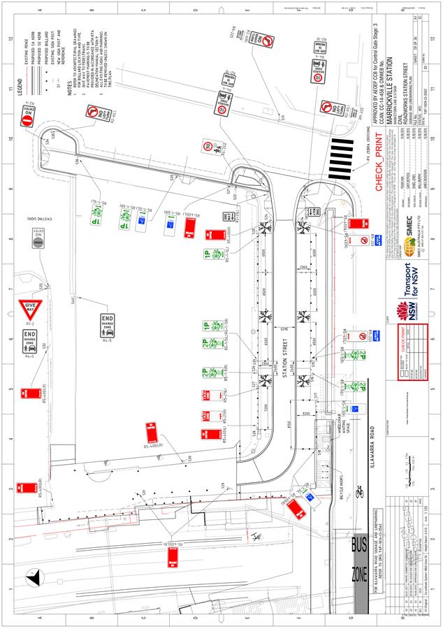
Subject: Station Street, Marrickville - Shared Zone
Proposal - Final Design Plan for Traffic Signage
(Marrickville Ward/Heffron Electorate/Marrickville LAC)
File Ref: 17/6022/7466.17
Prepared By: Jennifer Adams - Traffic and Road Safety Officer, Marrickville
Authorised By: George Tsaprounis - A/Manager Design and Investigation, Marrickville
|
SUMMARY The ‘Traffic Signage Plan’ for the new ‘Shared Zone’ on Station Street adjacent Marrickville Railway Station, Marrickville has now been finalised and submitted for consideration. It is recommended that the Traffic Signage Plan be approved subject to concurrence of RMS. |
|
RECOMMENDATION
THAT the Traffic Signage Plan (TAP-1826-CI-3562) for the new ‘Shared Zone’ in Station Street adjacent to Marrickville Railway Station, Marrickville be approved subject to the concurrence of the RMS.
|
BACKGROUND
As part of its Civil Works Program, Council proposed to carry out reconstruction and enhancement works of the shopping strip on Station Street, Marrickville and the immediate surrounding area in the first half of 2012. Concept design plans were developed and consultation with affected properties was undertaken. A report went to the 20 December 2011 Committee meeting and the following recommendation ensued:
1. The findings of the consultation survey be received and noted;
2. The signs and lines associated with design Option 1 (as per Design Plan No. 4970) be APPROVED; and
3. The proposed ‘Shared Zone’ be REFERRED to the Roads and Maritime Services for consideration and approval.
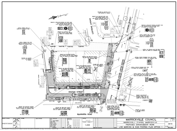
Refer to the locality map and Option 1 plan attached. Council endorsed the concept design (OPTION 1) for the Marrickville Station environs and the proposed funding dependant staging at its meeting 17 February 2012.
At its meeting of April 2012 and again in October 2014, Council endorsed the concept plan for the streetscape enhancement of Station Street, Marrickville. Works were initially deferred in 2012 as a result of a development proposal affecting adjacent land which potentially would include an upgrade of the public domain. This development proposal did not proceed.
Subsequently Transport for NSW (TfNSW) commenced its planned accessibility upgrade of Marrickville Station. Part of this project included a basic street upgrade to Station Street. In October 2014 Council resolved to:
“authorize the General Manager to negotiate with Transport for NSW in relation to the contribution of council funds towards the streetscape upgrade works, with a view to ensuring the outcome is consistent with the endorsed concept design.”
TfNSW has been developing the shared zone design in consultation with Council and the shared zone design within this report is the final design which requires approval by Council and RMS.
FINANCIAL IMPLICATIONS
Works on the Station Street upgrade are essentially completed and there are no budget implications associated with adopting the plan.
OFFICER COMMENTS
Adjacent to the Marrickville Railway Station, is Station Street and a small local commercial area which houses several small local businesses. Station Street consisted of a narrow one way road with parallel parking on the shopfront side of the street. The narrow street had no formal pedestrian footpath provisions on the platform side, forcing pedestrians to travel on the road before reaching a narrow footpath provided on the shopfront side of Station Street. Due to the aforementioned conditions, and the low volumes of vehicle traffic and high pedestrian activity environment, the area between the platform 2 and the shopfront was proposed to be a shared zone. As defined by TTD 2014/003 July 2014, a shared zone is a road or network of roads or a road related area where space is shared safely by vehicles and pedestrians and where pedestrian priority and quality of life take precedence over ease of vehicle movement.
The ‘Traffic Signage Plan’ for the new ‘Shared Zone’ on Station Street adjacent Marrickville Railway Station, Marrickville has now been finalised and submitted for consideration. It is recommended that the Traffic Signage Plan be approved subject to concurrence of RMS. Refer to the Traffic Signage Plan (TAP-1826-CI-3562) for the new ‘Shared Zone’.
PUBLIC CONSULTATION
Nil.
CONCLUSION
The proposed shared zones adjacent to Marrickville Railway Station will provide pedestrian priority, as well as improved amenity and accessibility to local pedestrian movements. The inclusion of a shared zone and accompanying treatments, provides drivers with a changed street environment, stimulating reduced vehicle speeds and a shift in priority to pedestrians. These align with the TAP initiative by providing an accessible station precinct and encouraging a seamless transfer between all modes and customers within and surrounding Marrickville Station.
It is recommended that the Traffic Signage Plan be approved subject to concurrence of RMS.
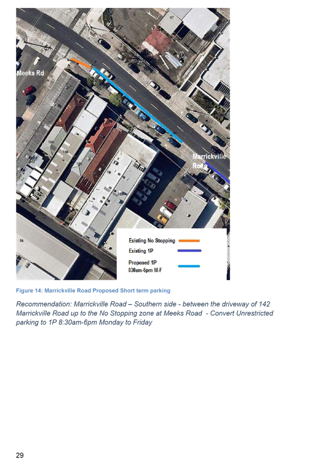
Locality map – Station Street, Marrickville
![]()
![]()

![]()
|
OPTION 1
|
|
|
Local Traffic Committee Meeting 2 February 2017 |
Subject: Kintore Street, Dulwich Hill - Pedestrian
Safety - Zig Zag Line Marking at Wombat Crossing
(Ashfield Ward/Summer Hill Electorate/Marrickville LAC)
File Ref: 17/6022/7436.17
Prepared By: Jennifer Adams - Traffic and Road Safety Officer, Marrickville
Authorised By: George Tsaprounis - A/Manager Design and Investigation, Marrickville
|
SUMMARY Concerns have been raised about the incidence of motorists failing to observe the pedestrian wombat crossing on Kintore Street, Dulwich Hill near Blackwood Avenue and adjacent to Dulwich Hill Primary School. It is recommended that sections of ‘zig zag’ lines be installed on both approaches to the crossing in an effort to provide additional warning to approaching motorists. |
|
RECOMMENDATION
THAT: 1. in order to enhance pedestrian safety “zig zag” lines be installed on both approaches to the pedestrian wombat crossing situated on Kintore Street, Dulwich Hill immediately north of its junction with Blackwood Avenue; and 2. the citizen be advised of the decision.
|
BACKGROUND
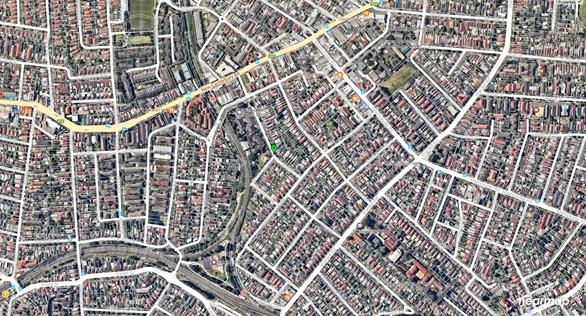
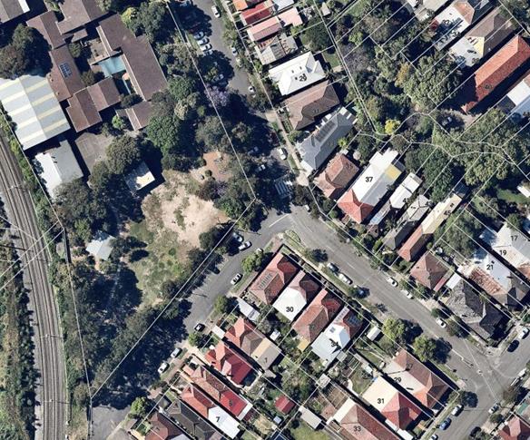
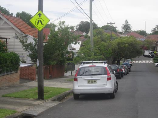
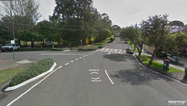
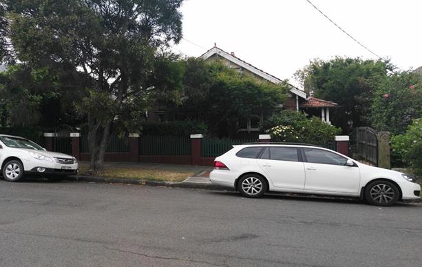
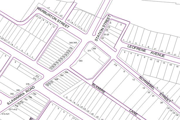
A pedestrian wombat crossing is presently installed in Kintore Street, Dulwich Hill near Blackwood Avenue and adjacent to Dulwich Hill Primary School. Refer to the locality map.
The existing pedestrian wombat crossing was installed late 2000 following concerns raised by the school regarding provision of a safe crossing for school children.
All standard signs and markings for a pedestrian wombat crossing are presently in position, including advance warning signs. A local citizen has raised concerns about the incidence of motorists failing to observe the crossing and advised his son has had several near miss experiences at the crossing.
FINANCIAL IMPLICATIONS
The cost of the installation of ‘zig zag’ line marking can be funded from Council’s signs and line marking budget.
OFFICER COMMENTS
Kintore Street is a local road running adjacent to Dulwich Hill Public School. The main entrance to the school is from Kintore Street, which is closed at its intersection with Hercules Street. The school has currently around 530 students.
Kintore Street between Macarthur Parade and Blackwood Avenue carries around 850 vehicles per day and the 85th percentile speed is 43km/h. There have been no RMS recorded crashes in the locality of the pedestrian crossing installed in Kintore Street near Blackwood Avenue, Dulwich Hill.
The crossing is located near a slight curve in the roadway and at the bottom of a hill. Whilst all essential signage is in position, it is considered that sections of ‘zig zag’ warning lines should be installed on both approaches to the existing pedestrian wombat crossing in Kintore Street, Dulwich Hill near Blackwood Avenue in order to enhance pedestrian safety.
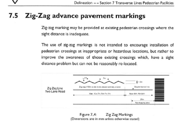
Zig-Zag advance pavement markings
Zig-zag marking may be provided at existing pedestrian crossings where the sight distance is inadequate.
The use of zig-zag markings is not intended to encourage installation of pedestrian crossings at inappropriate or hazardous locations, but rather to improve the awareness of those existing crossings which, have a sight distance problem but can not be reasonably re-located.
PUBLIC CONSULTATION
No public consultation is required.
CONCLUSION
To improve pedestrian safety at the crossing it is recommended that sections of ‘zig zag’ lines be installed on both approaches to the crossing in an effort to provide additional warning to approaching motorists.
Locality Map – Kintore Street, Dulwich Hill
|
Pedestrian crossing in Kintore Street, Dulwich Hill
|
Pedestrian crossing in Kintore Street, Dulwich Hill
|
Looking southward along Kintore Street, Dulwich Hill
Looking northward along Kintore Street, Dulwich Hill
|
|
|
Local Traffic Committee Meeting 2 February 2017 |
Subject: Flood Street, Leichhardt - Road Occupancy
(Leichhardt Ward/Balmain Electorate/Leichhardt LAC)
File Ref: 17/6022/7189.17
Prepared By: Manod Wickramasinghe - Traffic and Parking Engineer, Leichhardt
Authorised By: John Stephens - Traffic Manager, Leichhardt
|
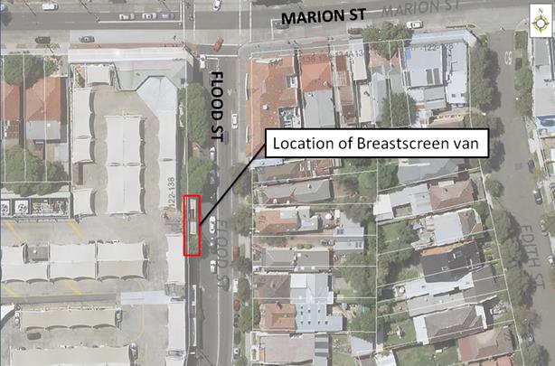
SUMMARY This report considers a request received from Breastscreen NSW for the temporary placement of their mobile lab unit on the western side of Flood Street adjacent to Leichhardt Market Place within the existing ‘Taxi Zone”, for the duration of 8 weeks starting from Friday, 7th July to Friday 1st September 2017. |
|
RECOMMENDATION
THAT the road occupancy for the NSW mobile lab unit on the western side of Flood Street, adjacent to Leichhardt Market Place within the existing ‘Taxi Zone’, for the duration of 8 weeks starting from Friday, 7th July to Friday 1st September 2017 be supported, subject to the following conditions:
1. all affected businesses, residents and other occupants must be notified of the road occupancy and activities at least one week prior to the commencement of the event. Any concerns or requirements raised by business proprietors, residents and other occupants must be resolved or accommodated by the applicant; 2. the applicant contact Energy Australia/Ausgrid in relation to power access to the mobile laboratory; 3. the areas to be used for the activities must be maintained in a clean and tidy condition to the satisfaction of Council’s Group Manager Footpaths, Roads , Traffic and Stormwater, or else the applicant will be required to reimburse Council for any extraordinary cleansing costs; 4. the Council and RMS must be indemnified against all claims for damage or injury that may result from either the activities or from the occupation of part of the public way during the activities. The applicant must therefore produce evidence of its public risk insurance cover (under which Council is indemnified) with a minimum policy value of at least $10,000,000; 5. a copy of the Council approval letter must be made available on the site for inspection by relevant officers; 6. the applicant must comply with any reasonable directive from Council’s Compliance Officers and 7. Council reserves the right to cancel this approval at any time.
|
BACKGROUND
BreastScreen NSW has requested approval to locate a mobile lab unit on the western side of Flood Street, adjacent to Leichhardt Market Place within the existing ‘Taxi Zone’ for the duration of 8 weeks from Friday, 7 July to 1 September 2017. The mobile lab unit will operate for screening from 8.45am to 4pm Monday to Friday. This location has been used in previous years without any issues and would not affect any businesses, see proposed location below:
Note that the applicant has been requested to provide a copy of their public risk insurance.
FINANCIAL IMPLICATIONS
Nil.
CONCLUSION
That the road occupancy for a Breast Screen NSW mobile lab unit on the western side of Flood Street, adjacent to Leichhardt Market Place be supported subject to the conditions listed in the officer’s recommendation.
|
|
Local Traffic Committee Meeting 2 February 2017 |
Subject: Holbeach Avenue, Tempe - Special Event -
Bengali ‘New Year‘s Day’ Fair in Tempe Reserve on Saturday 8
April 2017
(Marrickville Ward/Heffron Electorate/Newtown LAC)
File Ref: 17/6022/7431.17
Prepared By: Jennifer Adams - Traffic and Road Safety Officer, Marrickville
Authorised By: George Tsaprounis - A/Manager Design and Investigation, Marrickville
|
SUMMARY Council has received an application under Section 68 of the Local Government Act 1993 to use Tempe Reserve for the Bengali ‘New Year’s Day’ fair on Saturday 8 April 2017, Saturday 7 April 2018 and Saturday 13 April 2019 between the hours of 10.00am to 10.00pm including the erection of a stage, 70 stalls and associated works. No temporary road closures are proposed as part of the event, which has been held locally for the past 10 years. It is recommended that the comments of the Local Traffic Committee be received and noted. |
|
RECOMMENDATION
THAT the following comments of the Local Traffic Committee be received and noted and no objection be raised to the Section 68 Application for the proposed Bengali ‘New Year’s Day’ fair on Saturday 8 April 2017 subject to the applicant complying with the following conditions: 1. Notification of the proposed event be forwarded to the NSW Police, RMS’s Transport Management Centre, State Transit Authority (Kingsgrove Depot), the NSW Fire Brigade and the NSW Ambulance Services; 2. Affected residents and/or businesses are notified in writing at least two weeks prior to event; 3. A 4 metre wide emergency vehicle access be maintained through the area during the course of the event; 4. Adequate vehicular traffic control shall be provided for the protection and convenience of pedestrians and motorists including appropriate signage and flagging. Workers shall be specially designated for this role (and carry appropriate certificates), as necessary to comply with this condition. This is to be carried out in accordance with the Australian Standard AS 1742.3 - Traffic Control Devices for works on roads; and 5. The applicant be advised that an annual application needs to be submitted to Council for the event and in future a Traffic and Parking Management Plan, including a Stall Holder All Day Parking Arrangement Plan, be presented as part of future applications.
|
BACKGROUND
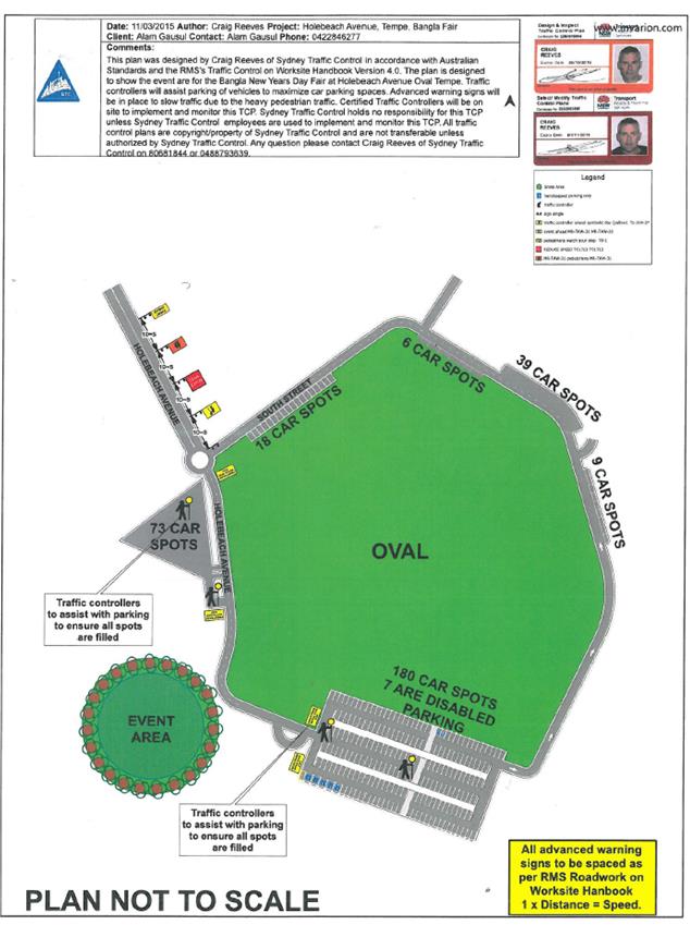
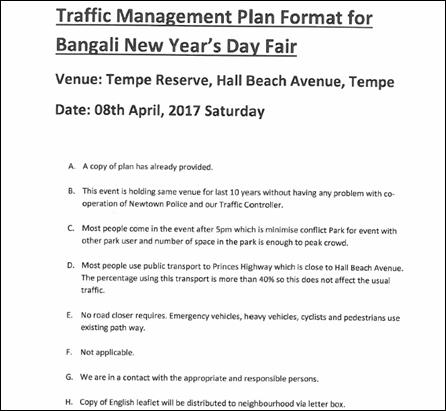
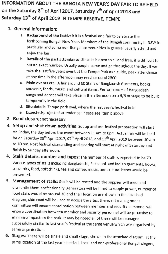
Council has received an application under Section 68 of the Local Government Act 1993 to use Tempe Reserve for the Bengali ‘New Year’s Day’ fair on Saturday 8 April 2017, Saturday 7 April 2018 and Saturday 13 April 2019 between the hours of 10.00am to 10.00pm including the erection of a stage, 70 stalls and associated works. No temporary road closures are proposed as part of the event, which has been held locally for the past 10 years.
The application is required to be referred to the Local Traffic Committee for consideration under State Environmental Planning Policy (Infrastructure) 2007.
The applicant advised that this festival is usually held to celebrate the forthcoming Bengali New Year. Members of the Bengali community in NSW in particular and some non-Bengali communities in general usually attend and enjoy the fair. Since the event is open to all and is free, it is difficult to put an exact number of people expected to attend as usually people come and go throughout the day, however the organiser in 2016 indicated that around 2500 people could be expected to attend throughout the day.
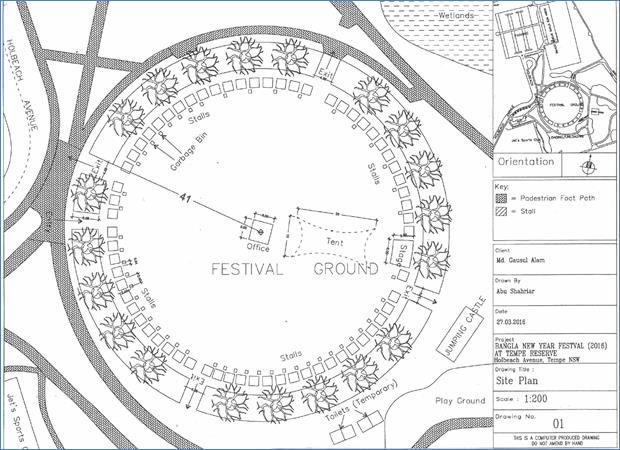
The festival will include approximately 70 Stalls of Bangladesh Garments, books, souvenir, foods, music, and cultural items. Performances of Bangladeshi songs and dances will take place in the afternoon on a stage to be built temporarily in the field (refer to the attached event notes and plan provided by the applicant). It is noted that last years’ event listed 60 stalls associated with the event and this year there will be an extra 10 stalls.
FINANCIAL IMPLICATIONS
Nil.
OFFICER COMMENTS
Impacts of event
There are no temporary road closures proposed as part of the event. The applicant provided a basic traffic plan to manage the parking at the site (identifying 325 spaces and 4 Traffic Controllers “to assist with parking to ensure all spots are filled’) and detailed no other traffic control proposal or traffic impact specifics making a full assessment of the impact of the event difficult. However, the event has been running at the same location for the past 10 years and it was stated that traffic controllers on site have worked ‘with the coordination of Newtown Police Station’ to manage the event. The applicant also advised that there will be no affect on Public Transport services or emergency services.
It is noted that this year Newtown LAC commented on previous events at the site as “presenting moderate to major traffic management issues for the Princes Highway and surrounding feeder streets impacting on the flow of traffic along Princes Highway, a major arterial road in addition to causing disruption to residents on the feeder streets with vehicles being double parked and parking across driveways.”
Tempe Reserve is accessed via Holbeach Avenue directly from Princes Highway, Tempe. RMS will need to be notified prior to the event. Motorists will more than likely use Holbeach Avenue as access therefore, no traffic will be re-assigned and no public transport services will be affected.
The event is to be held on a Saturday and other users of Tempe Reserve may be impacted.
A sporting event(s) may take place at Tempe Reserve on the same day of the proposed event and Council’s Development Assessment Officers should take this into account when assessing the Development Application. Considering (other) events occurring on the same day this may reduce the availability of parking and increase the likelihood of over-spill parking into adjacent residential streets.
Without having any true attendance numbers to the event it is difficult to determine traffic generated by the event or the exact extent of any spill-over of parking that may occur in the neighbouring Tempe residential area south of Princes Highway and east of Holbeach Avenue.
Parking Provision
RMS’s Guide to Traffic Generating Developments defines a ‘market’ is a gathering of stalls in an open place and states that medium sized to larger markets are generally located in open areas, such as showgrounds, car parks, drive-in theatres, racecourses or on-street. Parking requirements are usually determined by the number of participating stalls in the market place.
Tempe Reserve is in Council’s Parking Area 3 and parking rates specifically for a ‘fair / market’ are not detailed in Council’s development controls. RMS’s Guide to Traffic Generating Developments for a ‘market’ state a minimum parking provision of 2 spaces per stall or a desirable rate of 2.5 spaces per stall, excluding stall holders. 70 stalls would therefore require a minimum of 140 spaces for visitors and desirable rate of 175 spaces. These rates are based on a mode split for cars of 0.80 and a reasonable availability and convenience of alternative markets in the area.
It is anticipated that 70 stalls would have at least 130 associated stall attendants and would generate at least 60 vehicles that would require to be parked for the whole event duration. Accordingly, any market/fair proposal needs to have a Transport and Traffic Management Plan and a Stall Holder All Day Parking Arrangement Plan. This is essential, especially in the event that the popularity of the event grows.
There are 325 parking spaces (inclusive of 7 disabled parking spaces) identified in the plan submitted by the applicant. It is noted that there is other parking in the locality associated with other users of Tempe Reserve; Jets Sports Club, Tempe Golf Driving Range and Robyn Webster Sports Centre.
Stallholder parking arrangements and loading and unloading provisions are not detailed and the application needs to be updated in future to include some specific conditions of consent to manage these along with traffic and pedestrian movements around the event site, including the preparation and implementation of Traffic Control Plans that are to be prepared by RMS certified personnel. No detail has been supplied regarding bicycle, motorcycle parking in relation to this application. This needs to be addressed in any future applications.
Provisions for emergency vehicles, cyclist and pedestrians
Access for emergency vehicles will be required to be maintained at all times and will be from Princes Highway via Holbeach Avenue, Tempe.
Cyclists are to be able to travel along the path through the event site between Princes Highway and Airport Drive. Access for cyclists through the site is required to be maintained.
Pedestrians are to be encouraged to cross roads at dedicated and safe points. It is advised that fenced water filled barriers be placed to discourage pedestrians straying onto roads at unsafe points.
It is also advised that certified traffic controllers be on site at all main crossing points around the event site to manage and direct the safe movement of pedestrians as well as manage parking.
PUBLIC CONSULTATION
Consultation/notification regarding the proposal would normally be undertaken by Council's Development and Planning Services as part of the Development Application process.
CONCLUSION
It is recommended that the comments of the Pedestrian, Cyclist and Traffic calming Advisory Committee be received and noted.
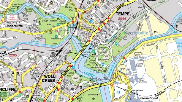
Locality Map - Tempe Reserve, Tempe

Site Plan – Tempe Reserve, Tempe
|
|
Local Traffic Committee Meeting 2 February 2017 |
Subject: Audley Street, Petersham - Temporary Full Road
Closure for Special Event on Sunday 12 March 2017
(Stanmore Ward/Newtown Electorate/Marrickville LAC)
File Ref: 17/6022/7327.17
Prepared By: Emilio Andari - Civil Engineer, Marrickville
Authorised By: George Tsaprounis - A/Manager Design and Investigation, Marrickville
|
SUMMARY A Development Application was approved in 2012 for the holding of the annual ‘Bairro Portuguese Food and Wine Fair’ for a five year period (i.e. 17 March 2013, 16 March 2014, 15 March 2015, 13 March 2016 and 12 March 2017). This year’s event will necessitate the temporary closure of Audley Street (between Trafalgar Street and New Canterbury Road), Sadlier Crescent (between Audley Street and Abels Lane) and Fisher Street (between Audley Street and Regent Street), as well as the parking lanes on New Canterbury Road (between Gordon street and Audley Street), Petersham from 1.00am until 12.00 midnight as in previous years. It is recommended that Council agree to the temporary road closures on Sunday 12 March 2017; apply to the RMS for consent to close the subject roads, subject to the event being advertised, a Traffic Management Plan be submitted to the RMS for approval and advice of the proposed event being forwarded to the appropriate authorities, including the Transport Management Centre. |
|
RECOMMENDATION
THAT the proposed temporary road closure of Audley Street (between Trafalgar Street and New Canterbury Road), Sadlier Crescent (between Audley Street and Abels Lane) and Fisher Street (between Audley Street and Regent Street), as well as the parking lanes on New Canterbury Road (between Gordon street and Audley Street), Petersham, on Sunday 12 March 2017, from 1.00am to 12.00 midnight, for the holding of the annual ‘Bairro Portuguese Food and Wine Fair’, be APPROVED subject to the applicant complying with the following conditions: 1. The temporary road closure is advertised in the local newspaper providing 28 days notice for submissions; 2. A Traffic Management Plan (TMP) is submitted to and approved by the Roads and Maritime Services; and an application for a Road Occupancy Licence and a temporary Speed Zone Authorisation is forwarded to and approved by the Transport Management Centre; 3. Notice of the proposed event is forwarded to the N.S.W. Police, State Transit Authority, Marrickville Local Area Commander, the NSW Fire Brigades and the NSW Ambulance Services; 4. Advance notifications signs for the event are strategically installed at least two (2) weeks prior to the event; 5. "No Parking - Special Event" signs are affixed over all existing timed parking restriction signs within the sections of streets to be closed on the afternoon of the day prior to the event; 6. State Transit Authority (Leichhardt Depot) be requested to implement a revised routing for scheduled bus services in Audley Street on the day of the event and install temporary bus stops as required; 7. A 4-metre wide emergency vehicle access must be maintained through the closed road areas during the course of the event; 8. The applicant is to consult with all affected residents and/or businesses in the area in writing and to conduct a letter box drop of surrounding properties at least two weeks prior to event; and 9. Adequate vehicular traffic control shall be provided for the protection and convenience of pedestrians and motorists including appropriate signage and flagging. Workers shall be specially designated for this role (and carry appropriate certificates), as necessary to comply with this condition. This is to be carried out in accordance with the Australian Standard AS 1742.3 - Traffic Control Devices for works on roads.
|
BACKGROUND
Temporary road closures were implemented in previous years to hold the annual ‘Bairro Portuguese Food and Wine Fair’. This annual Fair aims to showcase Petersham's businesses and services and attract people to the area and has a multicultural theme. On all previous occasions, the closures were successful and no major problems were experienced.
FINANCIAL IMPLICATIONS
The costs associated with the temporary road closures are to be borne by Council as part of its major events budget.
OFFICER COMMENTS
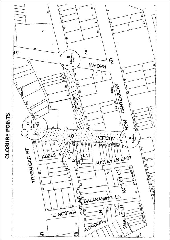
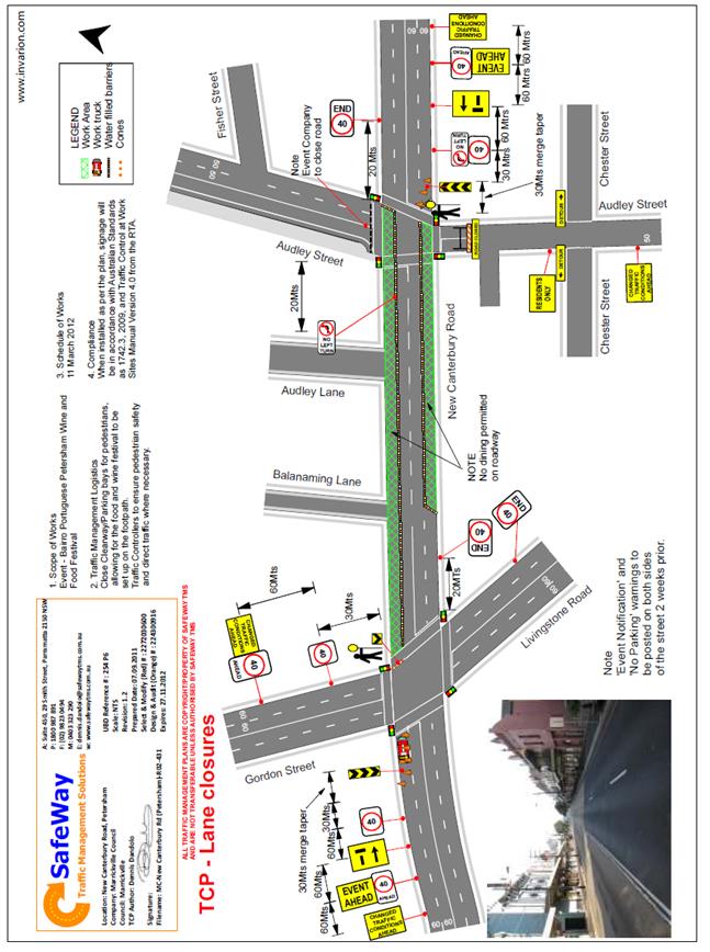
Council has applied for the temporary closure of Audley Street (between Trafalgar Street and New Canterbury Road), Sadlier Crescent (between Audley Street and Abels Lane) and Fisher Street (between Audley Street and Regent Street), as well as the parking lanes on New Canterbury Road (between Gordon street and Audley Street), Petersham, on Sunday 12 March 2017, between the hours of 1.00am and 12.00 midnight for the holding of the ‘Bairro Portuguese Food and Wine Fair’ (Refer to the attached locality map and Traffic Control Plan for proposed road closures). This is an extension of a Class 2 Event.
Lane closures of New Canterbury Road
As per the previous event held earlier this year, it is proposed to close the parking lanes on New Canterbury Road (between Gordon Street and Audley Street) as shown on the Traffic Control Plan (TCP) prepared by SafeWay Traffic Management Solutions (ATTACHED).
In previous years the event attracted approximately 15,000 attendees prompting the event coordinators to look at ways to ease congestion at the main site and make access easier from New Canterbury Road. The closure of the parking lanes on New Canterbury Road improves access to the area where the main event is to be conducted and improves the amenity of the footpath dining outside a number of the eateries along New Canterbury Road which are adjacent to the closure.
There is significant improvement in the access for people with disabilities as congestion will reduced and there will be no obstacles such as tables, chairs, planter boxes, light/sign poles and bins in the closed lanes. The solid barriers will separate the pedestrians from the moving traffic on the adjacent lane and will also help prevent young children who may be separated from their custodians escaping onto the main thoroughfare and possibly being hit by passing traffic.
The TCP indicates that a reduced temporary speed limit of 40km/h is required on New Canterbury Road (between Gordon Street and Audley Street) during the closure of the parking lanes for the subject event. An application for a Road Occupancy Licence will be forwarded to the RMS’ Transport Management Centre for approval.
The time-span for the road closure is necessary to allow stalls and stages to be set up before the event and dismantled after the event. The closure will be effected by the placement of barricades (to be manned by SES personnel) at the following locations:
· Junction of Audley Street and New Canterbury Road;
· Junction of New Canterbury Road and Gordon Street;
· Junction of Audley Street and Trafalgar Street;
· Junction of Fisher Street and Regent Street; and
· Junction of Sadlier Crescent and Abels Lane.
Special advance notice signs will be strategically installed at least two weeks prior to the event to alert motorists of the proposed closures. These signs will be installed at the following locations:
· Junction of Railway Terrace and Gordon Street;
· Junction of New Canterbury Road and Audley Lane;
· Junction of Trafalgar Street and Audley Street;
· Junction of Regent and Fisher Streets; and
· Junction of Nelson Place and Sadlier Crescent.
In addition, 'No Parking - Special Event' signs will be affixed over all existing timed parking restrictions signs in the area to be closed on the afternoon before the day of the event. Residents in Fisher Street will be allowed access into and out of their properties.
Audley Street is used by scheduled State Transit bus services and the Authority will need to implement the re-routing of services on the day as in previous years.
PUBLIC CONSULTATION
The proposed temporary road closures will be advertised in the local papers as in previous years.
CONCLUSION
It is recommended that Council agree to the temporary road closures on Sunday 12 March 2017; apply to the RMS for consent to close the subject roads, subject to the event being advertised, a Traffic Management Plan be submitted to the RMS for approval and advice of the proposed event being forwarded to the appropriate authorities, including the Transport Management Centre.
Locality Map - Temporary road closures
|
|
Local Traffic Committee Meeting 2 February 2017 |
Subject: Temporary Road Closure to Carry Out
Installation of A/C Compressors on the North Facing Wall of 'The Hub' Building
in Alton Lane, Newtown
(Stanmore Ward/Newtown Electorate/Newtown LAC)
File Ref: 17/6022/8031.17
Prepared By: Idris Hessam - Graduate Civil Engineer Traffic Services, Marrickville
Authorised By: George Tsaprounis - A/Manager Design and Investigation, Marrickville
|
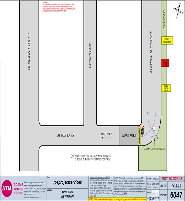
SUMMARY An application has been received from Adams Traffic Management for the temporary full road closure of Alton Lane (between Australia Street and Weeks Lane) Newtown for a period of 10 hours from 7am to 5pm on 1st and 2nd of March 2017, in order to stand a mobile crane on Alton Lane to install A/C Compressors on ‘The Hub’ building. It is recommended that the proposed temporary road closure be approved, subject to the conditions outlined in this report. |
|
RECOMMENDATION
THAT the proposed temporary full road closure of Alton Lane (between Australia Street and Weeks Lane) Newtown for a period of 10 hours from 7am to 5pm on 1st and 2nd of March 2017, in order to stand a mobile crane on Alton Lane to install A/C Compressors on ‘The Hub’ building, subject to the following conditions:
1. a fee of $1,354.60 for the temporary full road closure is payable by the applicant in accordance with Council’s Fees and Charges; 2. the temporary full road closure be advertised in the local newspaper providing 28 days’ notice for submissions, in accordance with the Roads Act; 3. a Traffic Management Plan (TMP) be submitted by the applicant to the Roads and Maritime Services for consideration and approval; 4. a Traffic Control Plan (TCP) which has been prepared by a certified Traffic Controller, is to be submitted to Council for review with a copy of the Traffic Controllers certification number attached to the plan, not less than 5 days prior to implementation of closure; 5. a Road Occupancy License be obtained by the applicant from the Roads and Maritime Services’ Transport Management Centre; 6. notice of the proposed closure be forwarded by the applicant to the NSW Police, the NSW Fire Brigades and the NSW Ambulance Services; 7. notification signs advising of the proposed road closures and new traffic arrangements to be strategically installed and maintained by the applicant at each end of the street at least 7 days prior to the closure; 8. all affected residents and businesses shall be notified in writing, by the applicant, of the proposed temporary road closure at least 7 days in advance of the closure with the applicant making reasonable provision for residents; 9. vehicular and pedestrian access for residents and businesses to their off-street car parking spaces be maintained where possible whilst site works are in progress; 10. adequate vehicular traffic control shall be provided for the protection and convenience of pedestrians and motorists including appropriate signage and flagging. Workers shall be specially designated for this role, as necessary to comply with this condition. This is to be carried out in accordance with the Australian Standard AS 1742.3 - Traffic Control Devices for works on roads; 11. the holder of this approval shall indemnify the Council against all claims, damages and costs incurred by, or charges made against, the Council in respect to death or injury to any person or damage in any way arising out of this approval. In this regard, a public liability insurance policy for an amount not less than $20,000,000 for any one occurrence is to be obtained and is to note the Council as an interested party. The holder of this approval shall inform its insurer of the terms of this condition and submit a copy of the insurance policy to the Council prior to commencement of the work the subject of this approval; 12. the operator of any unit exercising this approval shall have this approval with them and produce it if required along with any other relevant authority approvals granted in the connection with the work; 13. mobile cranes, cherry packers or concrete boom pumps shall not stand within the public way for extended periods when not in operation under this approval; 14. the operation of the mobile crane shall not give rise to an "offensive noise" as defined in the Protection of Environment Operations Act, 1997. Furthermore, vibrations and/or emission of gases that are created during its operations and which are a nuisance, or dangerous to public health are not permitted; 15. all work is to be carried out in accordance with Work Cover requirements; and 16. the costs to repair damages, as a result of these works, to Council's footway and roadway areas will be borne by the applicant.
|
BACKGROUND
An application has been received from Adams Traffic Management for the temporary full road closure of Alton Lane (between Australia street and Weeks Lane) Newtown for a period of 10 hours from 7am to 5pm on 1th and 2th of March 2017, in order to stand a mobile crane on Alton Lane to install A/C Compressors on ‘The Hub’ building.
FINANCIAL IMPLICATIONS
Under Council’s Fees & Charges, the applicant is to pay a fee of $1,354.60 for the temporary full road closure. This fee includes advertising the proposal in accordance with the Roads Act 1993.
OFFICER COMMENTS
It is recommended that the proposed temporary road closure be approved.
PUBLIC CONSULTATION
The applicant is to notify all affected residents and businesses in writing at least 7 days prior to the commencement of works. The proposed road closure is to be advertised in the local newspaper in accordance with the Roads Act 1993.
CONCLUSION
It is recommended that the proposed temporary road closures be approved, subject to the conditions outlined in this report.
Traffic Control Plan submitted by the applicant – Alton Lane, Newtown
|
|
Local Traffic Committee Meeting 2 February 2017 |
Subject: Proposed One-Way Slow Point Traffic Calming
Treatment - Tennyson Street, Dulwich Hill
(Ashfield Ward/Summer Hill Electorate/Marrickville LAC)
File Ref: 17/6022/6996.17
Prepared By: Snezana Bakovic - Project Engineer Traffic, Marrickville
Authorised By: George Tsaprounis - A/Manager Design and Investigation, Marrickville
|
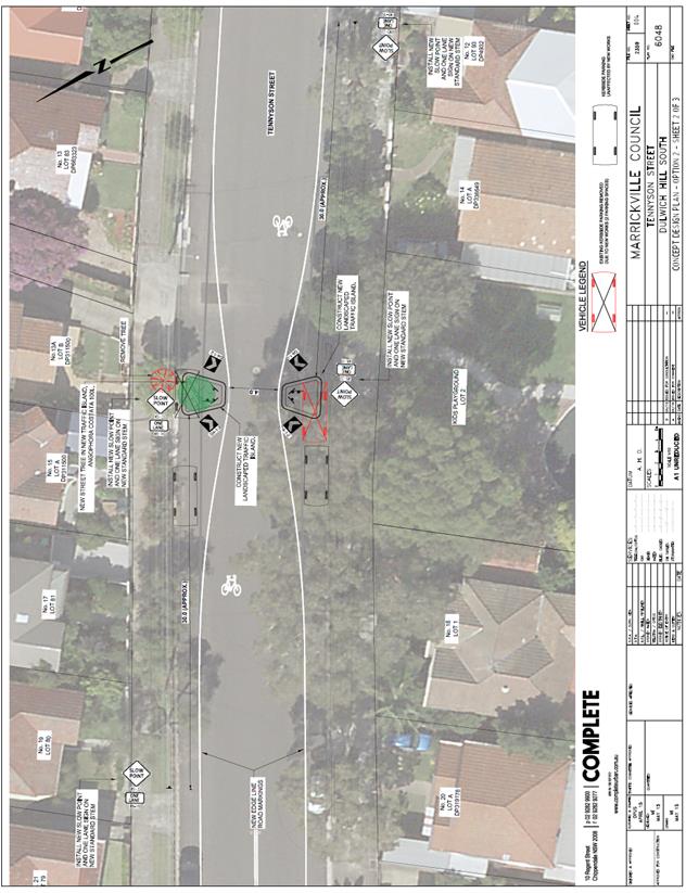
This is a report on the results of a resident questionnaire survey undertaken, as part of a review of the effectiveness of the temporary one way slow point treatment in Tennyson Street, Dulwich Hill. (Refer to Figure 1). As a result of the feedback from a residential survey and the benefits of increasing traffic safety in the area, it is recommended that the proposed permanent traffic calming - one way slow point with landscaped islands, and associated signage and line markings (Design Plan No 6048) be APROVED. |
|
RECOMMENDATION
THAT the permanent treatment of the Tennyson Street, Dulwich Hill - One Way Slow point consisting of two landscaped islands, and associated signs and line markings (as per Design Plan No 6048) be APPROVED.
|
BACKGROUND
At its meeting in October 2016 Council approved the installation of a temporary one way slow point in Tennyson Street, Dulwich Hill, to test its effectiveness and ensure there were no driveway access issues. This temporary measure was installed in November 2016 and was on trial for a month.
Council Officers have subsequently organised a traffic and community survey to gauge the effectiveness of on the temporary treatment.
Based on the survey results the design plans have now been finalised for the one way slow point in Tennyson Street, Dulwich Hill (Design Plan - Permanent Solution No 6048) and are presented to the Committee for consideration.
FINANCIAL IMPLICATIONS
Funding of approximately $15,000 is currently allocated for the proposed works as part of Council’s 2016/17 Capital Works budget. The cost of the proposed works is estimated at $25,000. The budget adjustment would be done via separate report to Council.
OFFICER COMMENTS
One Way slowing point temporary treatment in front of property 13A Tennyson Street includes:
· Two chevron white painted islands, outline with retro reflective guide posts; and
· Associated signs and line markings.
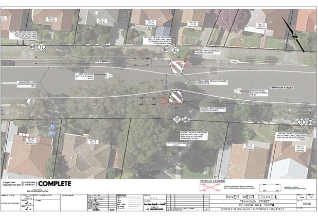
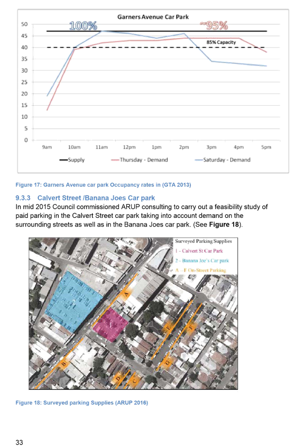
Figure 1: Tennyson Street - Dulwich Hill – One-Way slow point -Temporary Testing
Following the temporary treatment installation, Council conducted a survey of traffic volume and speed in Tennyson Street (refer to Table1).
|
Tennyson Street, Dulwich Hill |
||||
|
Eastbound traffic volume (v/day) |
Westbound traffic volume (v/day) |
Total traffic volume (v/day) |
85% Speed (km/h) |
Date of survey |
|
352v/day |
440.6v/day |
793 v/day |
54.4 km/h |
August 2016 |
|
329.4v/day |
437.2 v/day |
766.6v/day |
51 km/h |
December 2016 |
Table 1: Traffic survey data (before and after temporary treatment)
The latest speed survey revealed the following:
· Tennyson Street is a local street with low traffic volume, 869 Vehicles/day.
· The temporary treatment has decreased 85 % speeds from 54.4km/h to 51km/h, just above the speed limits for Local Roads.
· This slight reduction in speed can be attributed to other traffic calming measures recently introduced to Tennyson Street including entry threshold at Riverside Crescent and a median Island at the corner of Tennyson Street.
Speed reduction
The measured speed reduction was less than expected, likely reasons are:
· The temporary measures provided good visibility ‘through’ the one way device and this would not result in the desired speed reduction effect as motorists would be able to easily see if there were approaching vehicles.
· The traffic volume is low. With a low traffic volume no friction is created with opposing vehicle movements and as such there was no need for motorist to reduce speed to give way to approaching vehicles as this would be an infrequent event.
It should be noted that the permanent treatment, with landscaping / street tree would slightly reduce sight lines to oncoming vehicles and therefore would encourage speed reduction whilst motorists determined if there was an approaching vehicle. That being said, the device in Tennyson Street is located at a sag in the road alignment and as such it is possible that motorists would always have a good line of sight through the device, possibly over the top of potential landscaping / street tree.
Although it is acknowledge that the device may not have desired effect on the reduction of speed, it has previously received community support and will improve amenity in Tennyson Street. The treatment effectiveness would be monitored and if required some additional speed reduction measures could be incorporated into the one way slow point. The additional speed reduction measures options might be:
· Speed cushion; or
· Textured / coloured surfacing.
PUBLIC CONSULTATION
Upon the implementation of temporary treatment Council invited resident to provide feedback on the one-way temporary treatment and to choose one option for improving Tennyson Street.
32 survey forms were sent out to all property owners and occupiers of Tennyson Street, Dullish Hill. The community survey closed on 16 December 2016. Council received 7 (seven) submissions.
The summary of the resident feedback is listed in the table below (refer to Table2).
|
Resident Address |
Preferred treatment Option |
Do you have difficulty accessing your property |
Resident Comments |
Designer Comments |
|
|
One-way slow point with landscaped islands |
Two-way slow point with landscaped islands |
||||
|
10 Tennyson St, Dulwich Hill |
None of them |
No |
There has not been decrease in traffic neither in speed. Police cars speeding along street. The residents at 13A and 15 are having great difficulty accessing their driveways. A tree in front of these houses would be ridiculous. Don’t do it. |
The permanent treatment, with landscaping / street tree, This should have a reduced ‘see through’ effect and would encourage speed reduction whilst motorists determined if there is a vehicle approaching. |
|
|
15 Tennyson St ,Dulwich Hill |
|
Two way slow point |
Yes |
Very dangerous turning into driveway, car behind us do not expect us to stop. We have nearly been rear ended on several occasions. Driving out of our carport is very dangerous. We cannot see. Personally, we do not think either option is working. People are still speeding plus now aiming for centre of islands. I think island should be removed. Waste of money and doesn’t look good.
|
It is considered that the current measures provide a situation that provides better visibility than if a car is parked adjacent the kerb between No 13A and 15. Additionally, the single lane moves traffic away from the driveway, allowing exiting vehicles to enter a greater distance in the road before entering the actual line of traffic. The permanent treatment, with landscaping / street tree, Should have a reduced ‘see through’ effect and would encourage speed reduction whilst motorists determined if there was an approaching vehicle. |
|
6 Tennyson Street, Dulwich Hill |
One way slow point |
|
|
No comment provided |
|
|
18 Tennyson Street, Dulwich Hill |
One way slow point |
|
No |
Of paramount importance is the fact that children entering and exiting Tennyson Street Playground have experienced an increased level of safety with the one-way slow point currently being trailed. We are immediately adjacent to the one-way slow point and Playground .Having one way slow point has dramatically improved safety for us and pedestrians. To maximise the safety of children using Tennyson Street Playground please install plastic speed cushions across the one-way slow point. |
Noted The permanent treatment, with landscaping / street tree, Should have a reduced ‘see through’ effect and would encourage speed reduction whilst motorists determined if there was an approaching vehicle. Council would continue to monitor the effectiveness of the permanent treatment and would add additional traffic slowing measure if required.
|
|
13 A Tennyson Street |
|
Two way slow point |
Yes |
We have difficulties when reversing from our driveway. Other car does not stop to allow us to reverse out of driveway. I have has a couple of near misses when other cars don’t want to stop. |
Cars are not required to stop for vehicles exiting driveways, it is expected that exiting vehicles wait until the road is clear before reversing out into the road. Equally, drivers are expected to adequately indicate their entry into a driveway to ensure that other motorists are aware of their intention to slow and turn. It is considered that the current provide a situation that provides better visibility than if a car is parked adjacent the kerb between No 13A and 15. Additionally, the single lane slow point moves traffic away from the driveway, allowing exiting vehicles to enter a greater distance in the road before entering the actual line of traffic. |
|
12 Tennyson Street, Dulwich Hill |
One way slow point with modification |
|
No |
Cars speeding up to get through slow point when car coming from opposite direction. If visibility reduced then car might be encouraged to slow down. Currently it is not working. |
The permanent treatment, with landscaping / street tree, Should have a reduced ‘see through’ effect and would encourage speed reduction whilst motorists determined if there is a vehicle approaching. Council would continue to monitor the effectiveness of the permanent treatment and would add additional traffic slowing measure if required. |
|
18 Union Street, Dulwich Hill |
|
Two way slow point |
No |
No comment provided |
|
|
TOTAL |
3 |
3 |
|
|
|
Table 2- Tennyson Street-Dulwich Hill-Summary residents’ feedback
|
Supporting One Way Slow point proposal (%) |
Supporting Two Way Slow point proposal (%) |
None of proposed solution |
|
43% |
43% |
14% |
CONCLUSION
Since November 2015, Council has been working with the residents to examine treatments for improving traffic safety and amenity along Tennyson Street. During that time many options for traffic speed reduction have been investigated and presented to the residents for comment.
A single slow point lane moves traffic away from adjacent driveways, thereby allowing exiting vehicles to enter a greater distance in the road before entering the actual line of traffic. Also, it is anticipated that the permanent One Way slow point treatment, with landscaping / street tree, would reduce ‘see through’ effect and therefore would encourage additional speed reduction under the speed limit for Local Roads. It is therefore recommend that permanent One Way Slow point consisting of two landscaped islands, and associated signs and line markings (as per Design Plans No 6048) be APROVED.
Tennyson Street-Dulwich Hill –One-Way slow point –Design Plan –Permanent solution
ATTACHMENTS
|
|
Local Traffic Committee Meeting 2 February 2017 |
Subject: Lewisham LATM Final Report
File Ref: 14/5142/6024.17
Prepared By: Felix Liu - Traffic Management Planner, Marrickville
Authorised By: George Tsaprounis - A/Manager Design and Investigation, Marrickville
|
SUMMARY This is a recommendation to endorse the final Lewisham LATM report. The proposals within the report are based on community input and analysis of feedback from the Public Exhibition period through 4 November and 7 December 2016. There were 57 submissions from individual households relating to specific streets or treatments. 65% of the submissions indicated support or support with changes to the proposals. Once this recommendation is endorsed by Traffic Committee and Council the projects will be incorporated into future design and construction programs. |
|
RECOMMENDATION
THAT the final Lewisham LATM report be endorsed for implementation including the following Table 1 Final LTAM treatments:
|
BACKGROUND
The Marrickville Community Strategic Plan (CSP) – Our Place Our Vision 2023 has key outcomes:
· Marrickville's roads are safer and less congested
· Marrickville's streets, lanes and public spaces are sustainable, welcoming, accessible and clean
· The community walks, ride bikes and use public transport.
One element of delivering the above outcomes is the development of Local Area Traffic Management (LATM) study and plan including recommendations.
The objective of local area traffic management planning is to investigate and review the performance of the existing Local Area Traffic Management (LATM) schemes and recommend proposed LATM works. The Lewisham LATM study was originally completed in 1995 and reviewed in 2004.
PUBLIC CONSULTATION
Public Consultation was undertaken in November and December 2016 via newspaper advertisement, Your Say Inner West website and a mail-out. Letters were sent to 1,932 residents and householders in the study area requesting feedback. A hard copy of the draft report was also provided at Council’s Administration Centre and Marrickville Library.
A survey form was provided online and at the display site where residents could indicate their support for the draft concept recommendations. Respondents could indicate their “support”, “support with changes” or “not support” the proposed draft concept plan. Respondents were also asked to comment on their reasons or concerns about the concept.
Council received a total of 57 submissions from individual households with most submissions relating to a specific street or treatment, including 37 in support of the strategy (65%) and 20 against the strategy (35%). Of the 37 people that supported the strategy, 29 indicates they supported the strategy with changes made. Key findings of the community feedback are provided below:
Support:
· Road narrowing of Summer Hill Street (Old Canterbury Road) at Old Canterbury Road, with strong support for full closure at this location to eliminate rat-running.
· Road narrowing of Eltham Street at Victoria Street, with further traffic calming requested within Fred Street and Eltham Street to slow drivers.
· Raised pedestrian crossing on Toothill Street, south of Victoria Street, with flashing lights requested during school zone hours (requested for other raised crossing facilities as well)
· Fixed radar speed display on Denison Road, with requests to also consider Toothill Street.
Against:
· Modified T-intersections, particularly at Victoria Street and Summer Hill Street intersection due to significant impact on parking, although there is support for ‘No Stopping’ restrictions at intersections.
· Left in/ left out on Henry Street at Old Canterbury Road as this would limit access to Parramatta Road for residents. Notwithstanding, there is some support for full closure at this location to eliminate ‘rat-running’.
· Permanent ‘No Right Turn’ restriction from Old Canterbury Road into Summer Hill Street (Old Canterbury Road), with some residents noting that the key issue is ‘rat-running’ vehicles turning left.
The primary concern from the community feedback is the impact kerb extensions would have on parking, especially closer to Lewisham Railway Station, where parking occupancy is high throughout the day on unrestricted road sections.
The community feedback included additional concerns relating to ‘rat-running’ and vehicle speeds along Hunter Street (to/from New Canterbury Road) and The Boulevarde (between Hunter Street and Toothill Street). There is no recent traffic data for these road sections, however a review of historic data for indicates that the 85th percentile speeds are 47km/h on Hunter Street (2004 data) and 46km/h on The Boulevarde (2012 data). Whilst these speeds exceed the maximum speed criteria (i.e. 40km/h), the speeds do not exceed the 50km/h speed limit.
In addition, the community feedback included concerns along the arterial road network that influence some traffic issues experienced in the study area. These included:
· No safe pedestrian crossing facilities on Old Canterbury Road along key desire lines to access Lewisham West Light Rail stop.
· Filtered right turn from Old Canterbury Road into Toothill Street adds to congestion along the through traffic during peak period.
· Vehicles performing dual right turns from Toothill Street into Old Canterbury Road given no turning lane linemarking.
· New Canterbury Road vehicles travelling through the West Street traffic signals on red, compromising the safety of pedestrians.
· The combination of parked vehicles along Old Canterbury Road and vehicles turning right into William Street blocking southbound traffic.
· Traffic congestion on Old Canterbury Road affecting egress from side streets, such as William Street, Henry Street, Hudson Street, McGill Street and Summer Hill Street (Old Canterbury Road).
The following changes have been incorporated into the final LATM report.
· Repeal modified T-intersections at Hunter Street/ Denison Road and Victoria Street/ Summer Hill Street to reflect the strong community views on loss of on-street parking. It is recommended that these treatments are replaced with kerb extensions within the regulatory ‘No Stopping’ zones to improve sight distances and reduce illegal car parking.
· Repeal left in/ left out on Henry Street at Old Canterbury Road to maintain alternative access to Parramatta Road for residents (as opposed to Toothill Street). A time restricted ‘No Right Turn’ restriction from Old Canterbury Road into Henry Street during the AM peak hour is recommended to reduce ‘rat-running’ via Henry Street from Old Canterbury Road and Railway Terrace.
· Repeal permanent ‘No Right Turn’ restriction from Old Canterbury Road into Summer Hill Street (Old Canterbury Road).
OFFICER COMMENTS
Based on the feedback received during Public Exhibition, the proposals in the draft concept plan have been amended. The final LATM proposals are shown in Table 1.
Table 1 Final LATM Treatments
|
Street |
Item |
Section/Location |
LATM Proposals |
|
Denison Road |
1 |
Eltham St to Toothill St |
· Fixed radar speed display · Reconstruction of existing flat top road hump with kerb extension · Parking lane linemarking · On-road bicycle symbol |
|
2 |
Toothill St to Hobbs St |
· Parking lane linemarking · On-road bicycle symbol |
|
|
3 |
Hobbs St to Hunter St |
· Single lane slow point |
|
|
Toothill Street |
4 |
South of Victoria St |
· Raised existing pedestrian crossing with kerb extension |
|
5 |
Old Canterbury Rd to New Canterbury Rd |
· Parking lane linemarking |
|
|
West Street |
6 |
South of The Boulevarde |
· Raised existing pedestrian crossing with kerb extension |
|
Summer Hill Street |
7 |
At Old Canterbury Road |
· Pedestrian refuge · Permanent “No Right Turn” restriction from Old Canterbury Road |
|
Fred Street |
8 |
At Victoria Street |
· Kerb extension |
|
The Boulevarde |
9 |
North of Eltham St |
· Kerb extension |
|
10 |
South of Toothill St |
· Pedestrian refuge |
|
|
Victoria Street |
11 |
South of Toothill St |
· Pedestrian refuge |
|
12 |
Hobbs St to Jubilee St |
· On-road bicycle symbol |
|
|
13 |
Toothill St to Hunter St |
· Single lane slow point |
|
|
14 |
At Summer Hill St |
· Kerb extension within regulatory ‘No Stopping’ distances. |
|
|
Hunter Street |
15 |
At Denison Rd |
· Modified T-intersection |
|
Henry St |
16 |
At Old Canterbury Rd |
· Pedestrian refuge · Left-in-left-out restriction |
FINANCIAL IMPLICATIONS
A sum of $200,000 has been initially proposed for the 2017/18 financial year to implement LATM proposals in stages, subject to the prioritization of items and budget allocation.
Initial cost estimation with prioritisation are indicated in Table 2.
Table 2 Prioritisation and Cost Estimation
|
Ranking |
Item |
Street |
Section |
Cost Estimation |
|
1 |
3 |
Edinburgh Road |
Fitzroy Street to Murray Street |
$3,400 |
|
2 |
1 |
Fitzroy Street |
Chapel Street to Edinburgh Road |
$4,200 |
|
3 |
2 |
Fitzroy Street |
Sydenham Road to Chapel Street |
$6,200 |
|
4 |
4 |
Llewellyn Street |
Enmore Road to Edgeware Road |
$13,000 |
|
5 |
13 |
Victoria Rd |
At Edgeware Rd |
$39,000 |
|
6 |
14 |
Sydenham Rd, Shirlow St, Sydney Steel St, Edinburgh Rd, Smidmore St |
various |
$3,000 |
|
7 |
5 |
Victoria Rd – Bourne St, Black St and Leicester St |
Junctions |
$85,300 |
|
8 |
12 |
Juliett St with and including Lynch Ave |
Llewellyn St to Lynch Ave |
$1,500 |
|
9 |
6 |
Fitzroy St / Edinburgh Rd |
roundabout |
$200 |
|
10 |
11 |
Black Street |
Victoria Rd to Llewellyn St |
$52,000 |
|
11 |
8 |
Juliett Street |
Scouller St to Enmore Rd |
$4,700 |
|
12 |
7 |
Francis Street |
Lynch Avenue to Enmore Road |
$1,900 |
|
13 |
9 |
Lynch Avenue / Edgeware Road |
Junction |
$500 |
|
14 |
10 |
Shelleys Ln/ Llewellyn St |
Junction |
$13,300 |
CONCLUSION
The final Lewisham LATM proposals are based on community input and analysis of feedback. Following consultation of the concept plan, amendments have been incorporated into the final LATM report. It is recommended that the Final Report for Lewisham LATM be endorsed for implementation.
|
|
Local Traffic Committee Meeting 2 February 2017 |
Subject: Requests for Mobility Parking Spaces
(Stanmore & Marrickville Wards/Heffron & Newtown
Electorates/Marrickville & Newtown LACs)
File Ref: 17/6022/7351.17
Prepared By: Idris Hessam - Graduate Civil Engineer Traffic Services, Marrickville
Authorised By: George Tsaprounis - A/Manager Design and Investigation, Marrickville
|
SUMMARY A number of requests have been received from residents for the provision of dedicated mobility parking space outside their residence. It is recommended that the following 'Mobility Parking' spaces be approved as the applicants current medical conditions warrants the provision of the space and they have constrained or no off-street parking opportunities. |
|
RECOMMENDATION
THAT the following locations:
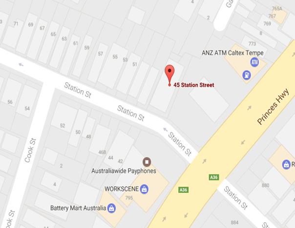
1. northern side of Clarendon Road, Stanmore in front of property no. 50 Clarendon Road, Stanmore; and 2. northern side of Station Street, Tempe in front of property no. 45 Station Street, Tempe; be APPROVED as a ‘mobility parking’ space, subject to: a) the operation of the dedicated parking space be valid for twelve (12) months from the date of installation; b) the applicant advising Council of any changes in circumstances affecting the need for the special parking space; and c) the applicant is requested to furnish a medical certificate and current mobility permit justifying the need for the mobility parking space for its continuation after each 12 months period.
|
BACKGROUND
A copy of the RMS disability parking permit and a medical certificate in support of the applications was submitted to Council.
FINANCIAL IMPLICATIONS
The costs of the supply and installation of the signposting associated with the recommended mobility parking space is approximately $1000.
It should be noted that Council normally signposts on-street mobility parking spaces and does not line mark these spaces. Should the applicant require the provision of kerb ramps, this can be provided at their cost.
OFFICER COMMENTS
|
Subject Location |
Classification of Road |
Road Description |
|
Clarendon Road, Stanmore |
Local Road |
Two-way residential street, 12.8m in width that runs west-east from Albany Road to Percival Lane West. |
|
Station Street, Tempe |
Local Road |
One way westbound street, 6.4m in width that runs from Princess Highway to Cook Street. |
50 Clarendon Road, Stanmore
The applicant’s property is located on the northern side of Clarendon Road, Stanmore. The applicant’s property has no off-street parking facility.
At present, unrestricted parking is permitted on both sides of Clarendon Road. It has been observed during a site inspection undertaken in the afternoon period that on-street parking spaces in Clarendon Road were moderately utilized.
The applicant does not drive a vehicle however she is driven by another family member.
Currently there is no existing mobility parking space within close proximity to the applicant’s property. Due to her current medical condition, she requires parking availability close to her property.
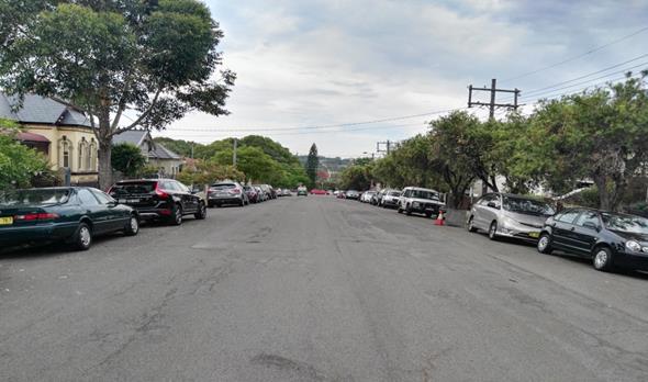
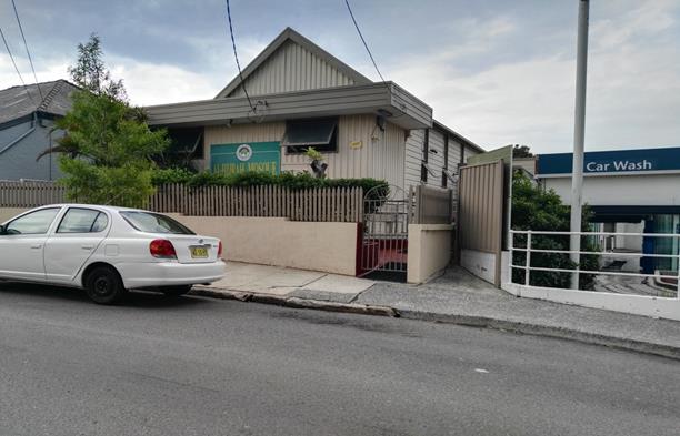
45 Station Street, Tempe
The applicant’s property is located on the northern side of Station Street, Tempe. The applicant’s property has no off-street parking facility.
At present, unrestricted parking is permitted on northern side of Station Street. It has been observed during a site inspection undertaken in the afternoon period that on-street parking spaces in Station Street were moderately utilised.
There are no existing mobility parking spaces in close proximity to the applicant.
The subject property is a place of worship. The applicant who is also the President of the Committee explained that their members often congregate at the premises. There are members who use wheel chairs and attend daily prayers around 2 to 5 times per day. Their numbers substantially increase during Friday prayers, weekend gatherings and during the month of Ramadhan. He also enclosed a petition letter from disabled members pleading for mobility parking space. Due to the usability of the subject property, parking availability is recommended in close proximity.
Technical Standards
Australian Standard AS2890.5-1993 “On-Street Parking” states the following in regards to the provision of parking for people with a disability:
“Parallel parking spaces shall not be marked as disabled spaces, nor included in the count of spaces available for people with disabilities unless –
i. A 3.2m wide space can be provided, e.g. by indenting the space into the footpath area; and
ii. Kerb ramps as shown in Figure 4.2(a) are also provided”.
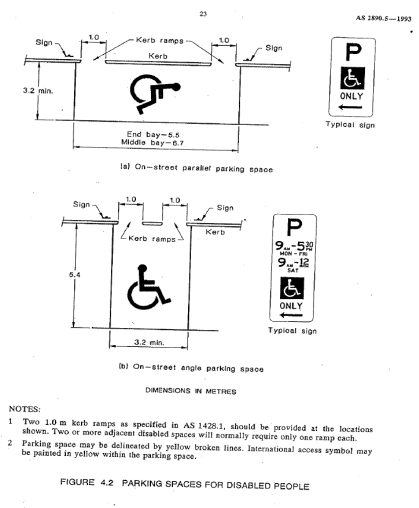
It should be noted that due to the limited width of streets around the Marrickville LGA, it is often difficult to comply with these requirements for the parking space dimensions. This may also result in the loss of some adjacent on-street parking spaces.
Mobility parking spaces are primarily intended for on-street and off-street parking at destinations, such as in commercial/retail areas and public car parks near hospitals, schools and public transport facilities where multiple usages can be expected. They were generally not intended for points of origin such as reserving on-street parking.
A mobility parking space is not intended for the sole use of one applicant, but rather a shared facility that can used by all authorised persons having an RMS mobility permit.
PUBLIC CONSULTATION
A notification letter has been sent to the applicants informing them of the application process and as part of the assessment they will be considered at this meeting.
CONCLUSION
It is recommended that ‘Mobility Parking' spaces be approved as the applicant’s properties do not have an off-street parking facility and/or the applicants condition warrants the provision of the space.
It should be noted that the proposed mobility parking spaces are not for the sole use of the applicant and may be used by other authorised persons.
Locality Map – 50 Clarendon Road, Stanmore

![]()
![]()
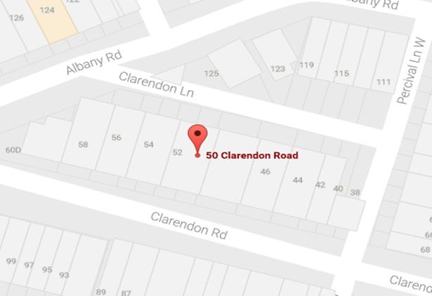
Photographs – 50 Clarendon Road, Stanmore
|
|
The frontage of the applicant's property in Clarendon Road, Stanmore
|
|
On-street parking in Clarendon Road, Stanmore
Locality Map – 45 Station Street, Tempe
|
|
![]()
Photographs – 45 Station Street, Tempe
|
|
The frontage of the applicant's property in Station Street, Tempe
|
|
On-street parking in Station Street, Tempe
|
|
On-street parking in Station Street, Tempe
|
|
Local Traffic Committee Meeting 2 February 2017 |
Subject: Gehrig Lane, Camperdown - ‘No Parking’
and ‘No Stopping’ Restrictions
(Leichhardt Ward/Balmain Electorate/Leichhardt LAC)
File Ref: 17/6022/7156.17
Prepared By: Manod Wickramasinghe - Traffic and Parking Engineer, Leichhardt
Authorised By: John Stephens - Traffic Manager, Leichhardt
|
SUMMARY Council is seeking to address a number of concerns raised by residents regarding vehicles obstructing access to off street parking spaces by parking on the northern side of Gehrig Lane, Camperdown opposite garage entrances. |
|
RECOMMENDATION
THAT a 10m ‘No Stopping’ zone followed by a 17m ‘No Parking’ zone be installed on the northern side of Gehrig Lane, east of Chester Street (public road section only).
|
BACKGROUND
Concerns have been raised by residents of Pyrmont Bridge Road regarding vehicles obstructing access to off-street parking spaces by parking on the northern side of Gehrig Lane, Camperdown opposite garage entrances.
In order to alleviate this issue it is proposed to signpost a 10m ‘No Stopping’ zone and 17m ‘No Parking’ zone on the northern side of Gehrig Lane, east of Chester Street (public road section only) as shown on the plan below.
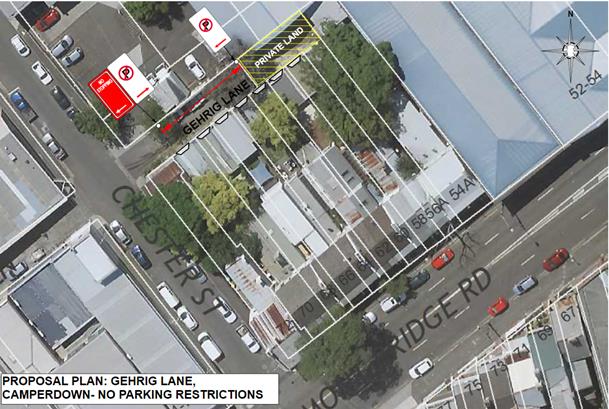
A swept path analysis has shown that vehicles parked on the northern side of Guihen Lane, opposite driveways do obstruct access for the residents.
FINANCIAL IMPLICATIONS
The cost of the signposting will be funded from Council’s operational budget.
|
PUBLIC CONSULTATION
A letter outlining the above proposal was mailed out to the affected properties (11 properties) in Pyrmont Bridge Road, Guihen Street and Chester Street, Camperdown
No responses were received.
|
|
CONCLUSION
In order to address concerns from residents regarding blocked driveway access, it is proposed to provide a 10m ‘No Stopping’ zone followed by a 17m ‘No Parking’ zone on the northern side of Gehrig Lane, east of Chester Street, Camperdown (public road section only).
|
|
Local Traffic Committee Meeting 2 February 2017 |
Subject: Durham Lane, Stanmore - Proposed ‘No
Parking’ Restrictions in a Section of the Laneway
(Stanmore Ward/Newtown Electorate/Newtown LAC)
File Ref: 17/6022/6937.17
Prepared By: Jennifer Adams - Traffic and Road Safety Officer, Marrickville
Authorised By: George Tsaprounis - A/Manager Design and Investigation, Marrickville
|
SUMMARY A resident of Lincoln Street, Stanmore raised concerns with vehicles parked in Durham Lane opposite their driveway/garage and therefore restricting vehicular access into and out of their off-street parking space and has requested full time ‘No Parking’ restrictions in the laneway. Surrounding local residents have been notified of the proposal to install a 12 metre length of ‘No Parking’ restrictions along the western side of the laneway opposite the rear of property No.2 Lincoln Street to the rear of property No.6 Lincoln Street, Stanmore to improve vehicular access to residents’ off-street parking. Due to resident feedback the proposal has been amended to read ‘install a 24 metre length of ‘No Parking’ restrictions along the western side of the laneway opposite the rear of property No.2 Lincoln Street to the rear of property No.10 Lincoln Street, Stanmore to improve vehicular access to residents’ off-street parking’. It is recommended that this proposal be approved. |
|
RECOMMENDATION
THAT:
1. the installation of 24 metre length of full-time ‘No Parking’ restrictions on the western side of Durham Lane, Stanmore opposite the rear of property No.2 Lincoln Street to the rear of property No.10 Lincoln Street be APPROVED, to improve vehicular access to residents’ off-street parking; and 2. the applicant, Council Rangers and affected residents be advised in terms of this report.
|
BACKGROUND
Council Officers have been advised that vehicular access from Durham Lane to some residents’ off-street parking is on occasions blocked by vehicles parked in the laneway. Specifically, some residents cannot access their off-street parking when vehicles are parked opposite their driveway/garage.
FINANCIAL IMPLICATIONS
The cost of the supply and installation of the signage associated with the recommended ‘No Parking’ restrictions is approximately $600 and can be met from Council’s operating budget.
OFFICER COMMENTS
Durham Lane is a one-way lane that runs north-south between Salisbury Road and Rosevear Street, Stanmore. The laneway is approximately 4.9 metres in width and is adjoined by mainly residential properties. Durham Lane provides rear access to properties fronting Lincoln Street and Durham Street, hence there are driveways located on both sides of the laneway. It is noted that formal driveway crossings are not present for some off-street parking spaces.
At present the laneway has no parking restrictions and vehicles may park on either side of the laneway. (Refer to the attached locality map and photographs.)
In the past concern had also been expressed by residents that parked vehicles on the corner of Durham Lane at Salisbury Road hindered turning into the laneway and subsequently it was proposed to install 'No Stopping' restrictions in the form of unbroken yellow lines for a distance of 10 metres in Durham Lane at junction with Salisbury Road. Council adopted that proposal on 27 September 2016.
Parking in laneways
Council’s Laneway Parking Guidelines outline the measures to consider when the use of the laneway prohibits access to off-street parking and access through the laneway. The effective use of narrow streets and laneways alleviates parking pressure. Effectively managed laneways allow for adequate access while providing the maximum amount of on-street parking.
NSW legislation includes various requirements to manage access and parking on roads. The Roads Act provides rights of access along roads and also for access to private property. The Road Rules includes requirements which affect parking at intersections, driveways and also parking along laneways.
Council’s preference is for residents to negotiate with each other to avoid implementing parking bans. Where problems occur, parking restrictions can be considered for individual laneways on a case-by-case basis. The guidelines provide consistency for assessing the need for parking controls.
It should be noted that laneways were generally built to provide service for properties and access into off-street parking facilities therefore restricting parking in this laneway will help achieve this goal.
PUBLIC CONSULTATION
A notification letter was sent to 31 properties fronting the northern section of Durham Lane, Stanmore regarding the proposal to install a 12 metre length of full-time ‘No Parking’ restrictions along the western side of the laneway, opposite the rear of property No.2 Lincoln Street to the rear of property No.6 Lincoln Street, Stanmore. The closing date for submissions ended on 20 January 2017.
Resident survey findings - A total of three (3) responses were received from residents. Of these submissions, two supported the proposal and the other requested an extension to the proposed ‘No Parking’ restrictions to include the next two adjoining properties
CONCLUSION
Durham Lane is quite narrow and should a vehicle be parked close to or opposite a driveway,
vehicle access can be impeded. ‘No Parking’ restrictions would assist residents with rear garage areas who may be experiencing access difficulties. Therefore, in order to provide clear vehicular access to the applicant's and other responding resident’s off-street parking facilities, it is recommended that a 24 metre length of full time ‘No Parking’ restrictions be installed in Durham Lane, Stanmore opposite the rear of property No.2 Lincoln Street to the rear of property No.10 Lincoln Street be approved, to improve vehicular access to the residents’ off-street parking facilities.
Locality Map – Durham Lane, Stanmore


![]()
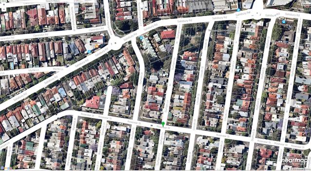
Proposed 12m length of ‘No Parking’ restrictions (western side) in Durham Lane, Stanmore
![]()
![]()
![]()
![]()

![]()

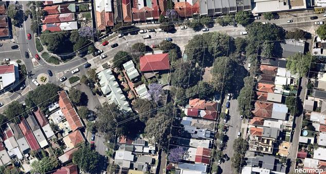
![]()
![]()
Photographs – Durham Lane, Stanmore
|
|
Looking southward in Durham Lane from Salisbury Street towards Rosevear Street, Stanmore
|
|
Looking northward along Durham Lane from Rosevear Street, Stanmore
Location – New Signage – Durham Lane, Stanmore
![]()
![]()

![]()

![]()
![]()


![]()
![]()
![]()
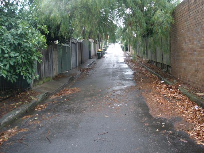
|
|
Local Traffic Committee Meeting 2 February 2017 |
Subject: Francis Street, Marrickville - Casimir
Catholic College - Changes to Bus Stop to include No Parking Drop-Off School
Zone Hours
(Marrickville Ward/Summer Hill Electorate/Marrickville LAC)
File Ref: 17/6022/6927.17
Prepared By: Jennifer Adams - Traffic and Road Safety Officer, Marrickville
Authorised By: George Tsaprounis - A/Manager Design and Investigation, Marrickville
|
SUMMARY A request has been received from the Principal of Casimir Catholic College for the morning and afternoon school “No Parking” drop-off/pick-up zone adjacent to the school in Francis Street, Marrickville to be extended into the existing adjacent now defunct ‘Bus Zone’ to assist parents and carer with the drop-off and pick-up of school children. It is recommended that the existing 21 metre length “Bus Zone, 7.00AM-6.00PM School Days” restrictions on the northern side of Francis Street directly adjacent to the school driveway be changed to “No Parking, Buses Excepted 8.00am-9.30am and 2.30pm-4pm Mon-Fri – School Days Only” to allow for legal bus parking at the school and/or a continuous 50 metre length for drop-off and pick-up during peak school times. |
|
RECOMMENDATION
THAT:
1. the existing 21 metre length “Bus Zone, 7.00AM-6.00PM School Days” restrictions on the northern side of Francis Street directly adjacent to the school driveway be changed to “No Parking, Buses Excepted 8.00am-9.30am and 2.30pm-4pm Mon-Fri – School Days Only” to allow for legal bus parking at the school and/or a continuous 50 metre length for drop-off and pick-up during peak school times; and 2. the Principal of Casimir Catholic College and Council Parking Officers be advised in terms of this report.
|
BACKGROUND
Council was approached by the Principal of Casmir Catholic College to completely remove the Bus Zone parking restrictions in Francis Street, Marrickville and change the existing ‘Bus Zone’ to ‘No Parking 8:00am-9:30am and 2:30pm-4:00pm’. The Principal stated that:
“We do not have any school special buses. All students who commute on buses use the public buses and alight and board on Livingstone Road, making this sign redundant. As this is the closest kerbside space to the school gates, this will hopefully reduce parents who double park in dropping off and picking up their children.
Rest assured, the College will continue to highlight to parents that the practice of double parking is both an illegal and unacceptable risk.”
A copy of the College’s letter is provided below.
Several parents at the school received infringement notices for double parking adjacent to the Bus Zone. The Principal recognised that the parents have an obligation and responsibility to park legally however in light of the ‘Bus Zone’ rarely being used it remained a common sense solution to remove the defunct ‘Bus Zone’ to allow for drop-off and pick-up during peak school times.
FINANCIAL IMPLICATIONS
The cost of the supply and installation of the signposting is to be funded from Council’s signs and line marking budget.
OFFICER COMMENTS
Casimir Catholic College has boundaries to both Livingstone Road and Francis Street. In mid-2013 flashing lights were installed on Livingstone Road for the School Zone. Francis Street is a residential street running south-east off Livingstone Road. At present, a 21 metre length “Bus Zone, 7.00AM-6.00PM School Days” restrictions area is installed north–east of the college’s driveway in Francis Street and then there is a 30 metre section of “No Parking 8.00-9.30 AM and 2.30-4.00 PM School Days’. Previously the 30 metre length was ‘P5 8.00-8.45AM School Days’ and was changed in February 2016. Refer to the attached locality map.
It is noted that that road safety around schools is a major issue, including Casimir Catholic College. Congestion is apparent outside and around many of the 36 schools in the former Marrickville local government area (LGA) especially at peak school periods (morning drop-off and afternoon pick-up). Council does provide road safety education material to all schools that may be disseminated through the school and/or the P&C. Each year an information flyer ”School Zone Parking Offences” is updated with new penalties for parking offences and sent to all schools for dissemination. Additionally, Council Rangers regularly patrol schools in the LGA on a rotating roster during school terms.
PUBLIC CONSULTATION
Both the Principal of the college and Council Rangers were contacted and the request discussed. There is evidence of illegal double parking and parking in the bus stop and it is envisaged that the provision of an extended ‘No Parking’ pick-up / drop-off type facility at the college will reduce drop-off and pick-up times thereby alleviating traffic congestion in Francis Street.
CONCLUSION
It is considered that the existing defunct “Bus Zone, 7.00AM-6.00PM School Days” restrictions on the northern side of Francis Street directly adjacent to the school driveway can be changed to “No Parking, Buses Excepted 8.00am-9.30am and 2.30pm-4pm Mon-Fri – School Days Only”. The change would allow for legal bus parking at the school and/or a longer drop-off and pick-up zone, which during peak school times would assist parents and carers with the drop-off and pick-up of children attending the college.
Locality Map – Francis Street, Marrickville
![]()
![]()
![]()
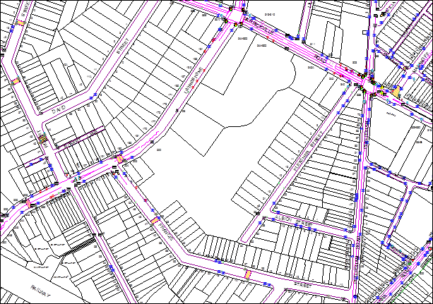
Change existing 21m length of “Bus Zone, 7.00AM-6.00PM School Days” to “No Parking, Buses Excepted 8.00-9.30 AM and 2.30-4.00 PM Mon-Fri - School Days”
 |

![]()
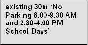
![]()
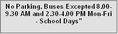
![]()

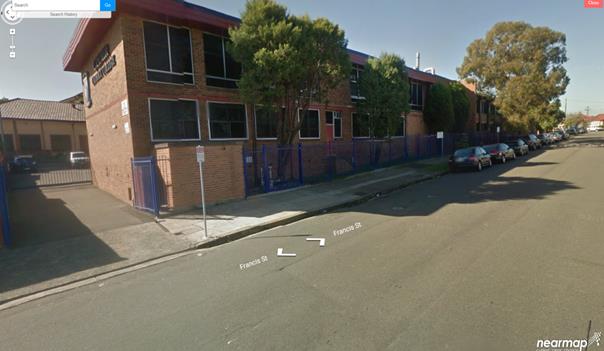
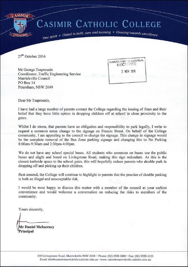
ATTACHMENTS
|
|
Local Traffic Committee Meeting 2 February 2017 |
Subject: Minor Traffic Facilities
(Leichhardt & Balmain Wards/Balmain Electorate/Leichhardt LAC)
File Ref: 17/6022/7177.17
Prepared By: Manod Wickramasinghe - Traffic and Parking Engineer, Leichhardt
Authorised By: John Stephens - Traffic Manager, Leichhardt
|
SUMMARY This report considers minor traffic facility applications received by Inner West Council, Leichhardt and includes ‘Disabled Parking’ and ‘Works Zone’ requests. |
|
RECOMMENDATION
THAT:
1. the 6m ‘Disabled Parking’ space in front of No.1 Callan Street, Rozelle be removed as the zone is no longer required; 2. a 10m 'Works Zone 7.00am - 5.00pm Mon-Fri, 7.00am - 1.00pm Sat' be installed in front of No.118 Louisa Road, Birchgrove for 12 weeks; 3. the existing 16m ‘'Works Zone 7.00am - 5.00pm Mon-Fri, 7.00am - 1.00pm Sat’ be extended northwards so that it is a total of 34m. This would consist of a 22m ‘Works Zone’ and a 12m ‘Works Zone; separated driveway to 30-40 George Street which will be temporarily signposted as a ‘No Parking’ zone; 4. the following be installed: a. a temporary 9m 'Works Zone 7.00am - 5.00pm Mon-Fri, 7.00am - 1.00pm Sat' in Denison Street outside the frontage of No.46A Denison Street, Rozelle for 12 weeks; and b. a temporary 9m 'Works Zone 7.00am - 5.00pm Mon-Fri, 7.00am - 1.00pm Sat' in Emily Street at the rear of No.46A Denison Street, Rozelle for 12 weeks.
|
BACKGROUND
This report considers minor traffic facility applications received by Inner West Council, Leichhardt and includes ‘Disabled Parking’ and ‘Works Zone’ requests.
FINANCIAL IMPLICATIONS
The installation of ‘Disabled Parking’ signage is funded from Council’s operating budget and ‘Works Zones’ signage from fees and charges paid by the applicant.
OFFICER COMMENTS
1 Removal of ‘Disabled Parking’ Restriction – Callan Street, Rozelle
Council Ref: DWS 4121746
A family member of the applicant to the ‘Disabled Parking’ zone in front of No.1 Callan Street, Rozelle has notified Council that the applicant has moved away and thus the ‘Disabled Parking’ zone is no longer required.
Officer’s recommendation
That the 6m ‘Disabled Parking’ space in front of No.1 Callan Street, Rozelle be removed as the zone is no longer required.
2 Installation of ‘Works Zone’ Restriction – Louisa Road, Birchgrove
Council Ref: DWS 4130871
The applicant has requested the installation of a temporary 10m 'Works Zone 7.00am - 5.00pm Mon-Fri, 7.00am - 1.00pm Sat' in front of No.118 Louisa Road, Birchgrove for 12 weeks.
Officer’s recommendation
That a 10m 'Works Zone 7.00am - 5.00pm Mon-Fri, 7.00am - 1.00pm Sat' be installed in front of No.118 Louisa Road, Birchgrove for 12 weeks with the resident parking zone being temporarily removed.
3 Installation of ‘Works Zone’ Restriction – George Street, Leichhardt
Council Ref: WZ/2017/1
The applicant has requested that the existing 16m 'Works Zone 7.00am - 5.00pm Mon-Fri, 7.00am - 1.00pm Sat' in front of No.30-40 George Street, Leichhardt be extended to a 34m 'Works Zone 7.00am - 5.00pm Mon-Fri, 7.00am - 1.00pm Sat' in front of No.30-40 George Street, Leichhardt for 12 weeks.
Officer’s recommendation
That the existing 16m ‘'Works Zone 7.00am - 5.00pm Mon-Fri, 7.00am - 1.00pm Sat’ be extended northwards so that it is a total of 34m. This would consist of a 22m ‘Works Zone’ and a 12m ‘Works Zone; separated driveway to 30-40 George Street which will be temporarily signposted as a ‘No Parking’ zone.
4 Installation of ‘Works Zone’ Restriction – Denison Street and Emily Street, Rozelle
Council Ref: DWS 4153539
The applicant has requested the installation of the following ‘Works Zone’ restrictions:
· a temporary 9m 'Works Zone 7.00am - 5.00pm Mon-Fri, 7.00am - 1.00pm Sat' in Denison Street outside the frontage of No.46A Denison Street, Rozelle for 12 weeks.
· a temporary 9m 'Works Zone 7.00am - 5.00pm Mon-Fri, 7.00am - 1.00pm Sat' in Emily Street at the rear of No.46A Denison Street, Rozelle for 12 weeks.
Officer’s recommendation
That the following be installed:
· a temporary 9m 'Works Zone 7.00am - 5.00pm Mon-Fri, 7.00am - 1.00pm Sat' in Denison Street outside the frontage of No.46A Denison Street, Rozelle for 12 weeks.
· a temporary 9m 'Works Zone 7.00am - 5.00pm Mon-Fri, 7.00am - 1.00pm Sat' in Emily Street at the rear of No.46A Denison Street, Rozelle for 12 weeks.
|
|
Local Traffic Committee Meeting 2 February 2017 |
Subject: Smidmore Street, Marrickville - Request by
Breastscreen Australia to Position a Mobile X-Ray Unit
(Marrickville Ward/Summer Hill Electorate/Marrickville LAC)
File Ref: 17/6022/6942.17
Prepared By: Jennifer Adams - Traffic and Road Safety Officer, Marrickville
Authorised By: George Tsaprounis - A/Manager Design and Investigation, Marrickville
|
SUMMARY A request has been received from ‘BreastScreen New South Wales’ to position a mobile x-ray van in Smidmore Street, Marrickville, for a period of nine (9) weeks, as in previous years. It is recommended that the request be approved, on the basis of this being an annual occurrence with no major problems being encountered previously. |
|
RECOMMENDATION
THAT: 1. the positioning of a ‘BreastScreen N.S.W.’ mobile x-ray van on the northern side of Smidmore Street, Marrickville, approximately 55 metres east of Edinburgh Road, outside the Marrickville Metro Shopping Centre, be APPROVED, for a period of nine (9) weeks from Friday 31 March to Friday 2 June 2017; and 2. the existing ‘No Parking’ restrictions (for the length of van) be temporarily removed for the proposed duration (i.e. 31 March to 2 June 2017).
|
BACKGROUND
The Marketing and Recruitment Officer for ‘BreastScreen New South Wales’ has submitted a letter to Council dated 2 December 2016, seeking permission to position a mobile x-ray van on the northern side of Smidmore Street in close proximity to the Marrickville Metro Shopping Centre, as in previous years (Refer to the attached copy of the letter and schematic diagram).
The van would be on site for a period of nine (9) weeks, from Friday 31 March to Friday 2 June 2017. The positioning of this van at this location has been occuring annually. (Refer to attached picture).
FINANCIAL IMPLICATIONS
There are no financial implications for Council from this proposal.
OFFICER COMMENTS
The site requested is on the northern side of Smidmore Street, approximately 55 metres east of Edinburgh Road. The location is within a section of 'No Parking' restrictions and has been used for several years for the same purpose without any problems. The location is away from the main entrance to the Marrickville Metro Shopping Centre, ‘Taxi Stand’ and ‘Bus Zone’ so it does not interfere with pedestrian or vehicular movements.
PUBLIC CONSULTATION
No public consultation is required. The Marketing and Recruitment Officer for ‘BreastScreen New South Wales’ has discussed the proposal with the Centre Management at Marrickville Metro Shopping Centre.
Council Officers have also consulted with the Centre Management at Marrickville Metro Shopping Centre in regards to any proposed works in Smidmore Street due to the redevelopment of the Metro Centre. No planned works are proposed for the time period listed, however should the need arise for relocation of the mobile x-ray van the present parking restricted area on Murray Street just south of the pedestrian zebra crossing has been identified as a backup location.
CONCLUSION
It is recommended that the positioning of the mobile x-ray van at this location be approved, as in previous years.
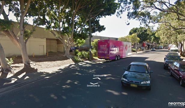
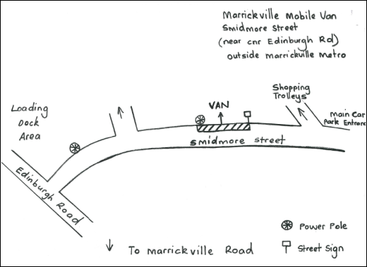
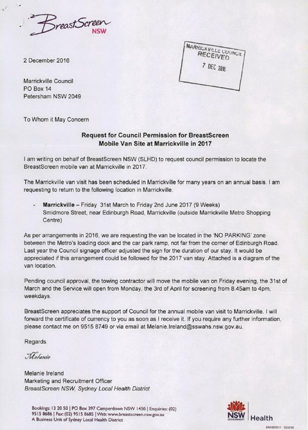
|
|
Local Traffic Committee Meeting 2 February 2017 |
Subject: Charlotte Street, Lilyfield - Angle Parking
and Resident Parking Scheme Investigation
(Leichhardt Ward/Balmain Electorate/Leichhardt LAC)
File Ref: 17/6022/7188.17
Prepared By: Manod Wickramasinghe - Traffic and Parking Engineer, Leichhardt
Authorised By: John Stephens - Traffic Manager, Leichhardt
|
SUMMARY The Traffic Committee at its meeting held on 1 December 2016 considered Item 27 regarding the introduction of a resident parking scheme (RPS) and ‘60 degree angle parking rear to kerb’ restriction in Charlotte Street, Lilyfield. Due to concerns raised by residents, the matter was deferred pending an on-site meeting between the Committee members and residents in the street. Consequently, an invitation letter was mailed to affected residents to attend an on-site meeting at 8:30am on Thursday 2 February, prior to the formal meeting of the Traffic Committee. |
|
RECOMMENDATION
THAT:
1. ‘60 degree angle parking rear to kerb vehicles under 6 metres only’ signs be installed on the southern side of Charlotte Street with the exception of retaining a 6.6 metre section of parallel parking at the easternmost section of the road; and 2. the proposal to introduce a resident parking scheme in Charlotte Street be not supported at the present time due to lack of resident support.
|
BACKGROUND
At the December 2016 meeting, the Traffic Committee considered requests from residents for a Resident Parking Scheme (RPS) in Charlotte Street, Lilyfield to address issues with long stay parking by non-resident vehicles. In addition, it considered the implementation of ’60 degree angle parking rear to kerb’ restrictions on the southern side of Charlotte Street to address road safety concerns.
The report recommended that the RPS proposal be not supported due to the lack of resident support; however, it was recommended that the signposting of ‘60⁰ angle parking; rear to kerb; vehicles under 6m only’ on the southern side of Charlotte Street proceed in order to address the safety concerns raised by some residents.
Given concerns raised by residents at the meeting, the Traffic Committee recommended that the matter be deferred pending an on-site meeting with Committee members and residents to discuss the proposal in more detail.
Proposal
As per the officer’s recommendation from the December 2016 Traffic Committee meeting it is proposed to signpost a ‘60 degree angle parking rear to kerb vehicles under 6m’ restriction on the southern side of Charlotte Street. Also, this proposal includes one 6.6m parallel parking space on the southern side of Charlotte Street, adjacent to the closed-end, to allow driveway access to the rear of No.38 Ainsworth Street.
The northern side of Charlotte Street will not be signposted as angle parking cannot be provided in accordance with RMS and Australian Standard requirements.
This proposal is shown on the following plan and provides a typical cross-section of:
· 2.1m Parallel Parking
· 5.8m Travel Lane
· 5.1m Angle Parking lane
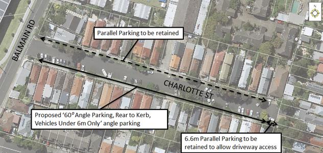
It should be noted that the analysis undertaken in the December 2016 Traffic Committee report demonstrated that angle parking could only be signposted on the southern side of Charlotte Street, although vehicles currently angle park informally on both sides of Charlotte Street towards the eastern closed end of the street.
FINANCIAL IMPLICATIONS
The cost of the signposting will be funded from Council’s operating budget.
PUBLIC CONSULTATION
The results of the on-site meeting with residents and Traffic Committee members to be held at 8:30am on 2nd February 2017 will be discussed at this Traffic Committee Meeting.
CONCLUSION
This report will be considered in conjunction with the December 2016 Traffic Committee report and the discussion from the on-site meeting held the morning of 2nd February 2017.
|
|
Local Traffic Committee Meeting 2 February 2017 |
Subject: Short Term Parking Restrictions at Schools
(Leichhardt & Balmain Wards/Balmain Electorate/Leichhardt LAC)
File Ref: 17/6022/7201.17
Prepared By: Manod Wickramasinghe - Traffic and Parking Engineer, Leichhardt
Authorised By: John Stephens - Traffic Manager, Leichhardt
|
SUMMARY This report considers a Council resolution to convert existing 5 minute drop-off/pick-up parking restrictions to 10 minute parking restrictions in the areas adjacent to schools within the former Leichhardt Council LGA. This parking restriction amendment was not previously considered by the Traffic Committee. |
|
RECOMMENDATION
THAT:
1. the three spaces on the western side of Eaton Street, north of Darvall Street be amended to 10 minute parking (with amended times of operation) as per the adopted minutes of the April 2016 Traffic Committee meeting; 2. the four spaces in Mackenzie Street and Prospect Street, Leichhardt be amended to 10 minute parking (with amended times of operation) as per the adopted minutes of the May 2016 Traffic Committee meeting; and 3. the other 5 minute parking restrictions adjacent to; Balmain Public School, Annandale Public School, St Fiacre Catholic Primary School, Inner Sydney Montessori School, Leichhardt Public School, Kegworth Public School, Father John Therry Catholic School and Annandale North Public School be retained.
|
BACKGROUND
Following concerns raised by some parents regarding lack of drop-off/pick-up parking restrictions for the after school care at Balmain Public School, Council considered several reports regarding the extension of the five minute free parking on Eaton Street until 6pm on school days for the three spaces near the school's gate. The reports also considered the traffic and parking management around Gladstone Park, Balmain.
In the final report to the March 2016 Council meeting, it was recommended:
1. That the following amendments to the 5-minute parking for the first three spaces on the western side of Eaton Street, north of Darvall Street be referred to the April Traffic Committee meeting for its consideration:
i. That the one space currently restricted as “P5min 8.00am-8.45am; 3.00pm-3.30pm School Days” be amended to “P10min 8.00am-8.45am; 2.30pm-6.00pm School Days".
ii. That the existing part time ‘Disabled Parking’ restrictions for the space described in part i. be retained.
iii. That the two spaces currently restricted as “P5min 8.00am-9.00am; 2.45pm-3.30pm School Days” be amended to “P10min 8.00am-9.00am; 2.30pm-6.00pm School Days”.
iv. That the 4P parking restrictions be appropriately amended to follow the proposed 10 minute parking extension with the parking meter reprogrammed to allow for the free 10-minute parking up to 6pm on School Days.
2. That the specific parking and traffic management issues raised by the stakeholders be investigated and reported back to the Traffic Committee meeting for consideration.
3. That the current '5 min parking' be converted to ‘10 min parking zones’ and 'No Parking' restrictions outside schools be retained, including within the Ticket parking meter areas.
4. That the new parking restrictions be trialled for 6 months
Following the Council meeting, the April Traffic Committee considered and supported the proposed changes to the three parking spaces on the western side of Eaton Street, north of Darvall Street. This was also supported by the after school care co-ordinator and Balmain Public School.
FINANCIAL IMPLICATIONS
The cost of the signposting will be funded from Council’s operational budget
OFFICER COMMENTS
Nil.
PUBLIC CONSULTATION
In order to assess the views of the School Principals with regards to the change in parking restrictions from 5 minute parking to 10 minute parking (as per Part 3 of the Council resolution), officers sent out a consultation letter requesting that the School Principals comment on the changes.
The following schools were consulted; Balmain Public School, Annandale Public School, St Fiacre Catholic Primary School, Inner Sydney Montessori School, Leichhardt Public School, Kegworth Public School, Father John Therry Catholic School and Annandale North Public School.
Council received concerns from a number of these Schools with regard to the proposed changes. The typical comments were:
· As we are a busy school with a very limited number of parking spots, this would reduce the parking opportunities for our parents. They agree with me that this would not enhance the drop off time situation.
· The P&C discussed the P10 minute proposal last week. Generally it was not seen as an improvement, in that it did not address the major issues and would result in less vehicle turn over in the busy periods that the P5 minute applies.
· Converting P5 minute to P10 minute parking restrictions poses the risk that a number of parents will not be able to find a parking space if they need to walk into the school quickly with their child. I believe, that an increase of double parking would occur which increases a safety risk for the school community. The school would not recommend a change in the current P5 minute parking restrictions at this time.
Council received objections from all schools except for St Fiarce’s Catholic Primary School which supported the change and Father John Therry School which did not provide a comment.
In addition, it should be noted that Council officers consulted stakeholders near Gladstone Park regarding parking and traffic management as per Part 2 of the March 2016 Council resolution. These stakeholders were Balmain Primary and Father John Therry Primary Schools, residents, the Church, Balmain Hospital, Balmain Bowling Club and Balmain Children’s Centre on Booth Street.
As a result, Council officers reviewed the allocation of parking permits to the Balmain Hospital, installed additional School and pedestrian warning signs in Eaton Street and Darvall Street and is investigating drop-off/pick-up restrictions for Balmain Children's Centre in Booth Street, Balmain. A request to upgrade the existing Childrens Crossing in Eaton Street to a Pedestrian Crossing and to install traffic calming devices in Eaton Street was not investigated further due to the low vehicle volumes and speeds observed in Eaton Street.
CONCLUSION
Following consultation with the Schools and in order to maintain vehicle turnover in the drop-off/pick-up restrictions around schools, it is recommended that the existing P5 minute parking around schools be retained with the following exceptions:
· The three spaces on the western side of Eaton Street north of Darvall Street be amended to 10 minute parking (with amended times of operation) as per the adopted minutes of the April 2016 Traffic Committee
· The four spaces in Mackenzie Street and Prospect Street, Leichhardt continue to be amended to 10 minute parking (with amended times of operation) as per the adopted minutes of the May 2016 Traffic Committee
|
|
Local Traffic Committee Meeting 2 February 2017 |
Subject: Requests for ‘Works Zone’ adjacent
to Construction Sites
(Stanmore & Marrickville Wards/Newtown, Heffron & Summer Hill
Electorates/Newtown & Marrickville LACs)
File Ref: 17/6022/7427.17
Prepared By: Idris Hessam - Graduate Civil Engineer Traffic Services, Marrickville
Authorised By: George Tsaprounis - A/Manager Design and Investigation, Marrickville
|
SUMMARY A number of requests have been received from several builders for the provision of 'Works Zone' to facilitate construction deliveries and permit the parking of construction vehicles during loading and unloading activities. It is recommended that the 'Works Zone' be approved for the construction works subject to Council fees and charges. |
|
RECOMMENDATION
THAT 1. the installation of a ‘Works Zone 7AM-5.30PM Mon-Sat’ (total of 20 metres in length) on the southern side of Trafalgar Street adjacent to property no. 149 Trafalgar Street, Stanmore be APPROVED for a period of ten (10) months, for the proposed construction work; 2. the installation of a ‘Works Zone 7AM-5.30PM Mon-Sat’ (total of 12 metres in length) on the eastern side of West Street adjacent to property no. 33 West Street, Petersham be APPROVED for a period of five (5) months, for the proposed construction work; 3. the installation of a ‘Works Zone 7AM-5.30PM Mon-Sat’ (total of 10 metres in length) on the western side of Barwon Park Road adjacent to property no. 38 Princes Highway, St Peters be APPROVED for a period of twelve (12) months, for the proposed construction work; 4. the installation of a ‘Works Zone 7AM-5.30PM Mon-Sat’ (total of 30 metres in length) on the eastern side of McGill Street adjacent to property no. 7-15 McGill Street, Lewisham be APPROVED for a period of twelve (12) months, for the proposed construction work; and 5. the costs of supply, installation and removal of the signs and ‘Works Zone’ fees in accordance with Council’s Fees and Charges for the above mentioned works zones are to be borne by the applicants.
|
BACKGROUND
Written applications along with the plans illustrating the proposed locations of ‘Works Zone’ were submitted to Council for consideration.
FINANCIAL IMPLICATIONS
The costs of supply, installation and removal of the signs and ‘Works Zone’ fees are to be borne by the applicant in accordance with the Council’s Fees and Charges.
OFFICER COMMENTS
|
Subject Location |
Classification of Road |
Road Description |
|
Trafalgar Street, Stanmore |
Local Road |
Two-way street, 8m in width that runs West-East between Holt Street and Harrow Road. |
|
West Street, Petersham |
Local Road |
Two-way street, 12.8m in width that runs North-South between Railway Terrace and The Boulevard |
|
Barwon Park Road, St Peters |
Local Road |
Two-way street, 12.8m in width that runs North-South between Princes Highway and Campbell Road |
|
McGill Street, Lewisham |
Local Road |
Two-way street, 6.5m in width that runs North-South between Hudson Street and Old Canterbury Road. |
149 Trafalgar Street, Stanmore
The subject property is located on southern side of Trafalgar Street, Stanmore. The proposed ‘Works Zone’ will be 20 metres in length. It will be required for a period of approximately ten (10) months, to be utilised by construction vehicles during deliveries, loading and unloading activities (refer to the below locality map and photographs). It is estimated that these works will take ten (10) months to complete.
At present, there is unrestricted parking on southern side of Trafalgar Street .The parking spaces in the subject section of Trafalgar Street are highly utilised by local residents. Therefore, the provision of a ‘Works Zone’ would provide a safe facility for loading and unloading activities at the subject site during the construction period.
33 West Street, Petersham
The subject property is located on eastern side of West Street, Petersham. The proposed ‘Works Zone’ will be 12 metres in length. It will be required for a period of approximately five (5) months, to be utilised by construction vehicles during deliveries, loading and unloading activities (refer to the below locality map and photographs). It is estimated that these works will take five (5) months to complete.
At present, there is unrestricted parking on both sides of West Street .The parking spaces in the subject section of West Street are highly utilised by local residents. Therefore, the provision of a ‘Works Zone’ would provide a safe facility for loading and unloading activities at the subject site during the construction period.
Barwon Park Road (adjacent to 38 Princes Highway, St Peters
The subject property is located on the eastern side of Princes Highway, St Peters. The proposed ‘Works Zone’ will be 10 metres in length and on the western side of Barwon Park Road, St Peters at the rear of the property. It will be required for a period of approximately twelve (12) months, to be utilised by construction vehicles during deliveries, loading and unloading activities (refer to the below locality map and photographs). It is estimated that these works will take twelve (12) months to complete.
At present, there is unrestricted parking on both sides of Barwon Park Road .The parking spaces in the subject section of Barwon park Road are highly utilised by local residents and businesses. Therefore, the provision of a ‘Works Zone’ would provide a safe facility for loading and unloading activities at the subject site during the construction period.
7-15 McGill Street, Lewisham
The subject property is located on the eastern side of McGill Street, Lewisham. The proposed ‘Works Zone’ will be 30 metres in length. It will be required for a period of approximately twelve (12) months, to be utilised by construction vehicles during deliveries, loading and unloading activities (refer to the below locality map and photographs). It is estimated that these works will take twelve (12) months to complete.
At present, there is unrestricted parking on eastern side of McGill Street .The parking spaces in the subject section of McGill Street are highly utilised by local residents. Therefore, the provision of a ‘Works Zone’ would provide a safe facility for loading and unloading activities at the subject site during the construction period.
Locality Map – Trafalgar Street, Stanmore (adjacent to 149 Trafalgar Street, Stanmore)

![]()
![]()
![]()
Photographs –Trafalgar Street, Stanmore (adjacent to 149 Trafalgar Street, Stanmore)

![]()
![]()

![]()

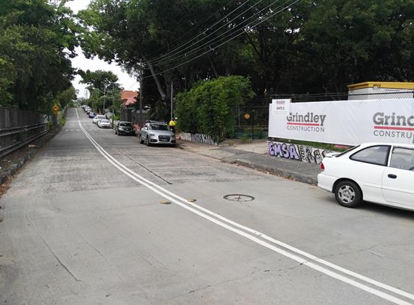
The proposed location of the ‘Works Zone’ in Trafalgar Street, Stanmore.
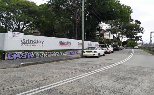
On-street parking in Trafalgar Street, outside construction site
Locality Map – West Street, Petersham (adjacent to 33 West Street, Petersham)
![]()
![]()
![]()
![]()
Photographs – West Street, Petersham (adjacent to 33 West Street, Petersham)
![]()
![]()
![]()

![]()
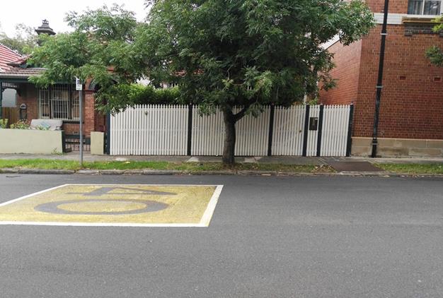
The proposed location of the ‘Works Zone’ in West Street, Petersham.
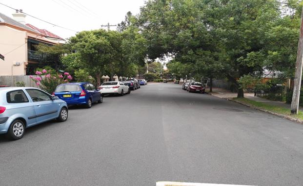
On-street parking in West Street, outside construction site
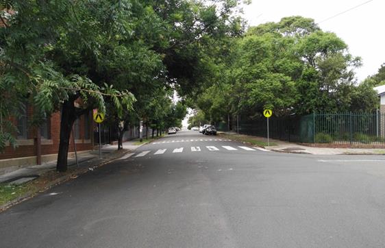
On-street parking in West Street, outside construction site
Locality Map – Barwon Park Road, St Peters (adjacent to 38 Princes Highway, St Peters)
![]()
![]()
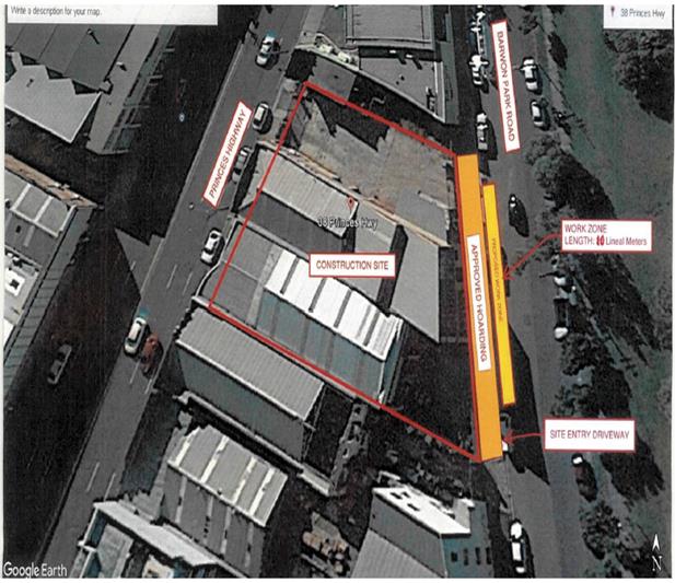
Photographs – Barwon Park Road, St Peters (adjacent to 38 Princes Highway, St Peters)
![]()
![]()

![]()
![]()
![]()
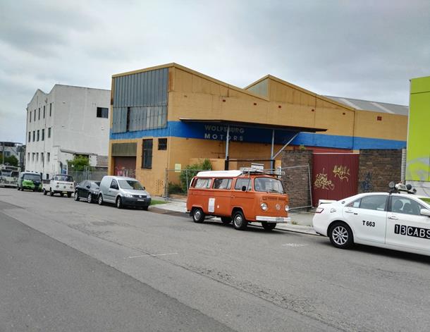
The proposed location of the ‘Works Zone’ in Barwon Park Road, St Peters.
On-street parking in Barwon Park Road, outside construction site
Locality Map – McGill Street, Lewisham (adjacent to 7-15 McGill Street, Lewisham)
![]()
![]()
![]()
![]()
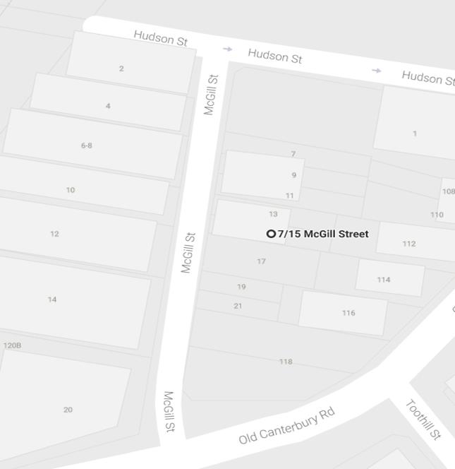
Photographs – McGill Street, Lewisham (adjacent to 7-15 McGill Street, Lewisham)
![]()


![]()
![]()
![]()
The proposed location of the ‘Works Zone’ in McGill Street, Lewisham.
On-street parking in McGill Street, outside construction site
PUBLIC CONSULTATION
A notification letter has been sent to the residents informing them of the application process and as part of the assessment they will be considered at this meeting.
CONCLUSION
It is proposed to install ‘Works Zone’ to better facilitate construction deliveries and allow the parking of construction vehicles during loading and unloading activities.
|
|
Local Traffic Committee Meeting 2 February 2017 |
Subject: The ‘Gear Up Girl’ Bicycle Event
(Marrickville Ward/Summer Hill & Heffron Electorates /Marrickville &
Newtown LACs)
File Ref: 17/6022/7333.17
Prepared By: Emilio Andari - Civil Engineer, Marrickville
Authorised By: George Tsaprounis - A/Manager Design and Investigation, Marrickville
|
SUMMARY Advice has been received from Bicycle NSW regarding the 'Gear Up Girl' bicycle challenge to be held on Sunday 12 March 2017, which will involve cycling through the Inner West Local Government Area (LGA). It is recommended that Council supports the proposed cycling event, subject to the event being advertised, a Traffic Management Plan be submitted to the RMS for approval and advice of the proposed event be forwarded to the appropriate authorities and affected properties by the applicant. |
|
RECOMMENDATION
THAT the report be received and noted.
|
BACKGROUND
A submission has been received from Bicycle NSW advising that this year’s ‘Gear Up Girl' bicycle challenge will be held on Sunday 12 March 2017 and will involve cycling through the Inner West LGA. The applicant seeks Council's support for this year's event as in previous years.
FINANCIAL IMPLICATIONS
Nil.
OFFICER COMMENTS
The applicant advised that the ‘Gear up Girl’ bicycle challenge has rides to cater for women of all ages and abilities, and is enjoyed year after year as a positive experience for all women who participate. Where possible the ride utilises routes on off-road cycle ways/shared pathways, or dedicated on-road cycle lanes.
The routes chosen showcase Inner West Council’s cycling infrastructure, particularly the Cooks River cycle way.
In 2017 Gear Up Girl offers 20km, 40km and 60km ride length options:
20km Beach Ride – Cooks cycleway, start at Wolli Creek to Cronulla.
Start – Riders are released in waves between 8.00am and 9.30am from Cahill Park (west), Wolli Creek and finish at Don Lucas Reserve, Cronulla.
Participants are restricted to 400.
40km Classic Ride – Sydney Olympic Park to Cronulla.
Start – 7.30am from Bicentennial Park, Sydney Olympic Park and finish at Cronulla.
Participants are restricted to 750.
60km Coast Ride – Sydney Olympic Park to Cronulla, including Kurnell.
Start – 7.00am from Bicentennial Park, Olympic Park and finish at Don Lucas Reserve, Cronulla. This ride is a loop ride out to Kurnell and return.
Participants are restricted to 750.
The applicant advised that the Road Occupancy Licence for the event is being negotiated with the Transport Management Centre (TMC). Both the TMC and NSW Police support the event. The proposed cycle route travels along the cycle way, from Illawarra Road, through Mackey Park and Kendrick Park and on the footpath on Princes Highway, Tempe, along the Cooks River (refer to the attached Traffic Control Plans submitted by the applicant).
Where required, NSW Police are contracted for event traffic management in the planning and delivery of the event. Police will be located at any intersections as stated on Traffic Control Plans. Bicycle Patrol Unit Police are also recruited to perform a ‘mobile’ Police presence ensuring participant and community safety along the cycle route.
PUBLIC CONSULTATION
Bicycle NSW advised that a letter will be distributed to all relevant residents and businesses containing advice about the event, and any changed traffic conditions, along with a map showing the changes. This communication will be confirmed in consultation with the local Council and the Transport Management Centre and will be distributed two weeks prior to the event.
Posters outlining basic details will be installed prior to the event at various locations along any shared pathways used in the event. Local newspaper notices will be allocated to relevant publications detailing any changed traffic conditions as another method of advising residents of the road closures. Newspaper notices will be placed one week prior to the event.
CONCLUSION
As this event was successfully implemented in previous years, the 'Gear Up Girl' bicycle event held on Sunday 12 March 2017 will once again be supported subject to the applicant complying with the following conditions:
1. The event being advertised in the local newspapers by the applicant in advance of the event;
2. A Traffic Management Plan being submitted by the applicant to the Roads and Maritime Services for consideration and approval;
3. Advice of the proposed event be forwarded by the applicant to the N.S.W. Police, the Transport Management Centre, State Transit Authority, Marrickville & Newtown Local Area Commander, the NSW Fire Brigades and the NSW Ambulance Services; and
4. Adequate traffic control shall be provided for the protection and convenience of pedestrians, cyclists and motorists including appropriate signage and flagging. Workers shall be specially designated for this role (and carry appropriate certificates), as necessary to comply with this condition. This is to be carried out in accordance with the Australian Standard AS 1742.3 - Traffic Control Devices for works on roads.
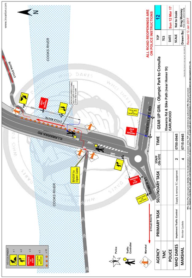
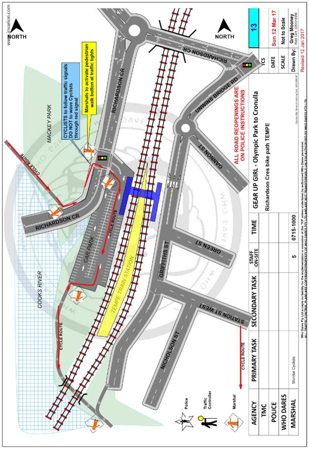
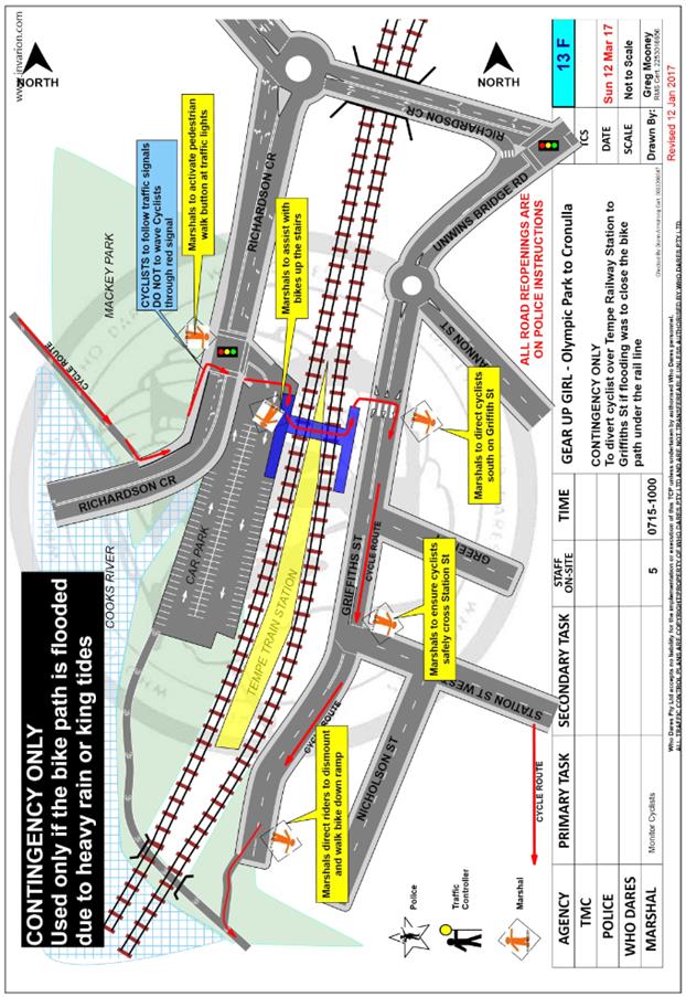
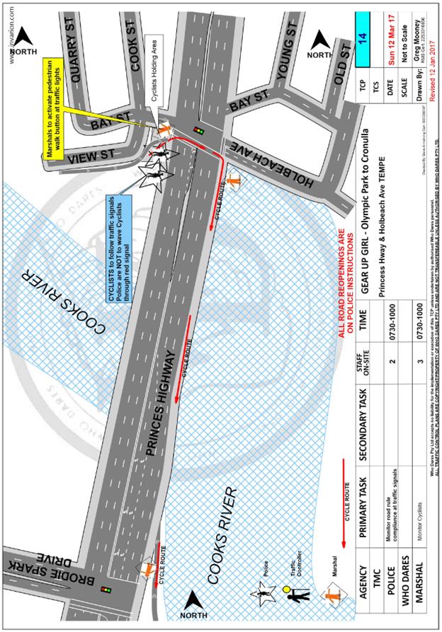
|
|
Local Traffic Committee Meeting 2 February 2017 |
Subject: Minor Traffic Facilities
(Leichhardt & Balmain Wards/Balmain Electorate/Leichhardt LAC)
File Ref: 17/6022/7137.17
Prepared By: Manod Wickramasinghe - Traffic and Parking Engineer, Leichhardt
Authorised By: John Stephens - Traffic Manager, Leichhardt
|
SUMMARY This report advises of minor traffic facility applications received by Inner West Council, Leichhardt that were supported between the December 2016 and February 2017 Traffic Committee meetings. In an email dated 13 December 2016, both the RMS and Police representative supported the subject temporary Works Zone installation. |
|
RECOMMENDATION
THAT a 12m 'Works Zone 7.00am - 5.00pm Mon-Fri, 7.00am - 1.00pm Sat' be installed in Edith Street on the side boundary of No.118-120 Marion Street, Leichhardt for 12 weeks.
|
BACKGROUND
This report advises of minor traffic facility applications received by Inner West Council, Leichhardt that were supported between the December 2016 and February 2017 Traffic Committee meetings. In an email dated 13 December 2016, both the RMS and Police representative supported the subject temporary Works Zone installation.
FINANCIAL IMPLICATIONS
The installation of ‘Works Zones’ signage will be costed from fees and charges paid by the applicant.
OFFICER COMMENTS
1 Installation of ‘Works Zone’ Restriction – Edith Street, Leichhardt
Council Ref: DWS 4070590
The applicant has requested the installation of a temporary 12m 'Works Zone 7.00am - 5.00pm Mon-Fri, 7.00am - 1.00pm Sat' in Edith Street on the side boundary of No.118-120 Marion Street, Leichhardt for 12 weeks.
Officer’s recommendation
That a 12m 'Works Zone 7.00am - 5.00pm Mon-Fri, 7.00am - 1.00pm Sat' be installed in Edith Street on the side boundary of No.118-120 Marion Street, Leichhardt for 12 weeks.
|
|
Local Traffic Committee Meeting 2 February 2017 |
Subject: Campbell Street, Waterview Street, Wells
Street and Alexander Street, Balmain - Resident Parking Scheme
(Leichhardt Ward/Balmain Electorate/Leichhardt LAC)
File Ref: 17/6022/7086.17
Prepared By: Nina Fard - Senior Traffic Engineer, Leichhardt
Authorised By: John Stephens - Traffic Manager, Leichhardt
|
SUMMARY Council has received correspondence from residents of Campbell Street and Waterview Street, Balmain raising concerns regarding increased parking demands generated by residents, commuters, trades vehicles and the employees of Sydney Ferries Maintenance Workshops. This report provides the result of a resident parking scheme investigation in Campbell Street, Waterview Street, Wells Street and Alexander Street, Balmain. |
|
RECOMMENDATION
THAT the proposed Resident Parking Scheme in Campbell Street, Waterview Street, Wells Street and Alexander Street not be supported at the present time due to less than 50% support received from the consulted residents.
|
BACKGROUND
A number of residents from Campbell Street and Waterview Street, Balmain requested the implementation of resident parking scheme in the unrestricted section of these streets in 2016. As any changes to parking in Campbell and Waterview Streets could impact the parking availability in the adjoining streets (Wells Street and Alexander Street), it was decided to investigate a resident parking scheme option for all four streets.
It should be noted that the western end of Campbell Street and Waterview Street (towards Curtis Road and Queens Place respectively) currently have the following resident parking restrictions:
“2P 8am-10pm, Permit Holders Excepted, Authorised Area B1”
As a result, extra demand is created for parking in the eastern end of these streets.
Parking occupancy surveys were undertaken in the subject streets in 2016 and they indicated high parking occupancy levels in some sections of the study area. The parking occupancy levels equal to or over 85% are shown in bold on the following map.
FINANCIAL IMPLICATIONS
Nil.
OFFICER COMMENTS
A Resident Parking proposal was prepared to extend the existing “2P 8am-10pm, Permit Holders Excepted, Authorised Area B1” restrictions along Campbell Street, Waterview Street, Wells Street and Alexander Street, as shown on the following map.
|
CONSULTATION
A letter outlining the above parking proposal option was mailed out to the affected properties (163 properties) in Campbell Street, Waterview Street, Wells Street and Alexander Street as indicated on the attached plan, requesting residents’ views regarding the proposal.
|
|
Consultation survey results are summarised as follows:
Waterview Street
Number
of properties - 29
(including corner properties)
Number of properties responded - 14
Number of properties supported - 9
Response Rate - 48.3%
Support Rate - 31%
Campbell Street
Number
of properties - 101
(including corner properties)
Number of properties responded - 25
Number of properties supported - 12
Response Rate - 24.8%
Support Rate - 12%
Alexander Street
Number
of properties - 12
(including corner properties)
Number of properties responded - 17
Number of properties supported - 2
Response Rate - 58.3%
Support Rate - 16.7%
Wells Street
Number
of properties - 33
(including corner properties)
Number of properties responded - 19
Number of properties supported - 14
Response Rate - 57.6%
Support Rate - 42.4%
Complete study area
Number
of properties - 163
(including corner properties)
Number of properties responded - 50
Number of properties supported - 24
Response Rate - 30.7%
Support Rate - 14.7%
According to Council’s Resident Parking Policy, a minimum of 50% support based on all properties in the subject section of the street is required to consider the proposal favourably.
CONCLUSION
Based on the above results, the RPS proposals in Campbell Street, Waterview Street, Wells Street and Alexander Street did not receive at least 50% support from the residents. As such, the proposed RPS cannot be supported in accordance with Council's Resident Parking Policy at the present time.
|
|
Local Traffic Committee Meeting 2 February 2017 |
Subject: Amended Locations of Additional School Zone
Flashing Lights outside Schools in Inner West LGA
(Various Wards/Electorates/LACs)
File Ref: 17/6022/6952.17
Prepared By: Jennifer Adams - Traffic and Road Safety Officer, Marrickville
Authorised By: George Tsaprounis - A/Manager Design and Investigation, Marrickville
|
SUMMARY Council has been notified by the Roads and Maritime Services (RMS) that there have been slight amendments to the locations of several of the additional school zone flashing lights that will be installed outside a number of schools throughout Inner West LGA. Installation is expected to be completed by mid-2017. |
|
RECOMMENDATION
THAT this report be received and noted.
|
BACKGROUND
A report went to the Committee in December 2016 detailing the RMS’s plan to install additional school zone flashing lights outside a number of schools throughout Inner West LGA. These locations are part of NSW Government’s $5 million Program for Additional School Zone Flashing Lights which will emphasize busy entrance points at the selected schools to improve safety around the schools. These installations are in addition to the rollout of flashing lights to every school in NSW, which the Government completed in January 2016.
Installation of the additional school zone flashing lights is expected to be completed by mid-2017.
Council has now been notified by the Roads and Maritime Services (RMS) that there have been slight amendments to the locations of several of the additional school zone flashing lights that will be installed outside a number of schools throughout Inner West LGA.
FINANCIAL IMPLICATIONS
There are no financial implications for Council associated with this matter.
OFFICER COMMENTS
A letter dated 25 November 2016 was received from the RMS amending the locations of several of the additional school zone flashing lights at various schools within the Inner West Council area.
The schools affected and the streets to have amendments to the locations of the additional school zone flashing lights are highlighted in the following table:
|
Area |
School |
Treatment Road |
|
Ashfield |
Canterbury Boys High |
Princes Street |
|
|
St Patricks Catholic Primary |
Robert and Drynan Streets |
|
|
Summer Hill Public |
Robert and Drynan Streets |
|
|
Trinity Grammar Anglican Infants School |
Robert and Drynan Streets |
|
|
Trinity Grammar Anglican Senior School |
Robert and Drynan Streets |
|
|
Yeo Park Infants |
Old Canterbury Road |
|
Leichhardt |
Annandale Public |
Trafalgar Street |
|
|
Kegworth Public |
Lords Road |
|
|
Orange Grove Public |
Balmain Road |
|
|
St Brendan’s Catholic |
Trafalgar Street |
|
Marrickville |
Camdenville Public |
Wells and Commordore Streets |
|
|
Casimir Catholic |
Francis and Fletcher Streets |
|
|
Christian Brothers Lewisham |
Denison Street and The Boulevarde |
|
|
Dulwich Hill School of Visual Arts and Design |
Fairfowl and Charlecot Streets |
|
|
Dulwich Hill Public |
Kintore Street |
|
|
Fort Street Public |
Andreas and Palace Streets |
|
|
Lewisham Public |
The Boulevarde |
|
|
Marrickville High |
Yabsley Avenue |
|
|
Newington College — Junior Campus |
Cavendish Street |
|
|
Newington College — Senior Campus |
Newington Road |
|
|
Stanmore Public |
Cavendish Street |
|
|
Wilkins Public |
Park Road |
PUBLIC CONSULTATION
The project is being managed by the RMS.
CONCLUSION
The rollout of additional flashing lights commenced in late 2016 and is expected to be completed by mid-2017. Roads and Maritime will work with delivery partners to install this important safety infrastructure across the state.
It is recommended that this report be received and noted.
|
|
Local Traffic Committee Meeting 2 February 2017 |
Subject: Unnamed Laneway between May Street and The
Boulevarde, Lilyfield - Road Occupancy (Street Party)
(Balmain Ward/Balmain Electorate/Leichhardt LAC)
File Ref: 17/6022/7104.17
Prepared By: Nina Fard - Senior Traffic Engineer, Leichhardt
Authorised By: John Stephens - Traffic Manager, Leichhardt
|
SUMMARY This report advises of a road occupancy application received by Inner West Council, Leichhardt between the December 2016 and February 2017 Traffic Committee meetings. The road occupancy application was distributed to Traffic Committee members in an email dated 13th December 2016 and was subsequently supported by the RMS, Police and the Local Members’ representatives. |
|
RECOMMENDATION
THAT the approval of a Road Occupancy application for a Christmas street party in the unnamed laneway between May Street and The Boulevarde, Lilyfield on Saturday 17th of December 2016, be noted.
|
BACKGROUND
Council received an application from a resident of Balmain Road, Lilyfield to conduct a Christmas street party at the rear of their property in the unnamed laneway between May Street and The Boulevarde, Lilyfield on Saturday 17th of December 2016.
The street party was proposed for Saturday, 17th December 2016 between 6.00pm and 11.30pm. The applicant was seeking permission for a temporary full road closure of the unnamed laneway between May Street and The Boulevarde.
The Traffic Control Plan for the closure is as follows:
This is an annual event and no significant issues have occurred in previous years.
According to the RMS ‘Guide to Traffic and Transport Management for Special Events’ (Version 3.4) a small street party is considered as a ‘Class 3’ event.
The RMS advises that features common to all Class 3 special events are that the event:
· does not impact local or major traffic and transport systems or classified roads
· disrupts the non-event community in the immediate area only
· requires Local Council and Police consent
· is conducted on-street in a very low traffic area such as a dead-end or cul-de-sac
· is never used for racing events.
Other features of a Class 3 special event are that it:
· may, depending on Local Council policy, require a simplified Transport Management Plan
· may depend on each Council's Special Events Policy and is not available in all Council areas
· may not require advertising the event's traffic aspects to the community.
Council’s Employee Services section has prepared a policy for Special Events. Inner West Council (Leichhardt Service Centre) encourages properly conducted neighbourhood street parties as a means of building community spirit and improving neighbourhood security. Fees for road occupancy are waived by Council for small community street parties.
Where the following conditions apply, organisers are only required to obtain approval for a street party involving a temporary road closure:
· the party is to be held outdoors for fewer than 100 people
· no temporary structures or jumping castles are to be erected,
· participants are to bring their own food and drinks, and food and drink are not for sale
· there will be no performers or amplified music involved
For approved street parties, Council will provide barricades and ‘Road Closed’ signs free or at minimum cost. Any non-standard signs may be provided at cost. The Street Party Co-ordinator will need to arrange delivery by Council at cost, or arrange pickup from and return to Council’s Depot at no cost.
FINANCIAL IMPLICATIONS
Nil.
OFFICER COMMENTS
Officer’s recommendation
THAT:
1) the temporary road closure of the unnamed laneway between May Street and The Boulevarde, on Saturday, 17th December 2016 between 6.00pm and 11.30pm be approved, subject to the following conditions:
a) An unencumbered passage minimum 3.0m wide be available for emergency vehicles through the closed section of the unnamed laneway between May Street and The Boulevarde, Lilyfield.
b) The occupation of the road carriageway must not occur until the road has been physically closed.
c) That the applicant notifies all affected businesses, residents and other occupants of the temporary road closure prior to the event. Any concerns or requirements in relation to the road closure raised by business proprietors, residents and other occupants must be resolved or accommodated. The notification shall involve at the minimum an information letterbox drop distributed to all affected properties
d) That the approved Traffic Control Plan (TCP) be implemented at the applicant’s expense including RMS accredited traffic controllers.
e) That the Fire Brigade (Leichhardt) be notified of the intended closure.
f) That the applicant provide and erect barricades and signs, in accordance with the current Australian Standard AS 1742.3: Traffic Control Devices for Works on Roads. As a minimum the following must be erected at both ends of the road closure area:
i. Barrier Boards
ii. ‘Road Closed’ (T2-4) signs
iii. ‘Detour’ (T5-1) signs
g) That the Street Party co-ordinator be advised Council provides barricades, ‘Road Closed’ and ‘Detour’ signs free or at minimum cost. The Street Party co-ordinator is required to arrange delivery by Council at cost, or arrange pickup from and return to Council’s Depot at no cost. Any non-standard signs may be provided at cost.
h) That the applicant must comply with the risk assessment conditions supplied by Council’s Employee Services Section prior to the event. (Council contact: David Gollan on 9367 9222).
i) That the areas to be used for the activities must be maintained in a clean and tidy condition to Council’s satisfaction, or else the applicant will be required to reimburse Council for any extraordinary cleaning costs.
j) That the conduct of any activities or use of any equipment required in conjunction with the road occupancy and temporary road closure not results in any ‘offensive noise’ as defined by the Noise Control Act.
k) That a copy of the Council approval be available on site for inspection by relevant authorities.
l) That Council reserves the right to cancel the approval at any time.
m) That the applicant complies with any reasonable directive from Council Officers and NSW Police.
2) The applicant be advised of the Committee’ recommendation.
|
|
Local Traffic Committee Meeting 2 February 2017 |
Subject: Parking Study for Impact of Old Tram Shed
Redevelopment - North East Annandale
(Leichhardt Ward/Balmain Electorate/Leichhardt LAC)
File Ref: 17/6022/7149.17
Prepared By: Nina Fard - Senior Traffic Engineer, Leichhardt
Authorised By: John Stephens - Traffic Manager, Leichhardt
|
SUMMARY This report provides the findings of a review of the feasibility of providing a residential parking scheme in streets bounded by Johnston Street, The Crescent, Nelson Lane and Piper Street, (North) Annandale, based on overall parking occupancy levels. Council engaged consultants to undertake “pre-development” parking occupancy surveys in September 2014 and “post-opening” occupancy surveys in November 2016 to assess the potential impact of the Old Tram Sheds redevelopment at Harold Park on parking amenities in the surrounding streets of North/East Annandale. |
|
RECOMMENDATION
THAT the implementation of a Resident Parking Scheme in streets bounded by Johnston Street, The Crescent, Nelson Lane and Piper Street, Annandale not be supported at the present time due to less than 85% parking occupancy levels.
|
BACKGROUND
Prior to the commencement of redevelopment of the Old Tram Sheds at Harold Park, a number of residents in the vicinity of the development raised concerns regarding the impact on parking in the surrounding streets. In response to residents’ concerns, the former Leichhardt Council at its Ordinary Meeting on 24 June 2014 considered a report on ‘Harold Park Adaptive Reuse of Tram Sheds- overflowing Parking in Annandale’ and resolved the following:
“That:
1) Leichhardt Council prepare a brief for a detailed parking study to be undertaken in the affected streets of Annandale and engage a suitably qualified traffic and parking consultant.
2) That parking surveys be undertaken prior to construction and three (3) months after the commencement of operations of the Tram Shed site to assess the on-street parking impacts for residents of Annandale.
3) That the consultant analyse the results and prepare a report to Leichhardt Council making recommendations on the implementation of a resident parking scheme within the affected streets of Annandale.
4) That the city of Sydney be requested to fund the cost of the parking surveys and implementation of any proposed resident parking scheme.”
Council commissioned a consultant to undertake “pre-development” parking occupancy surveys in streets bounded by Johnston Street, The Crescent, Nelson Lane and Piper Street in September 2014. These parking studies reviewed parking demands in the following streets:
· Johnston Street, Annandale (Piper Street to The Crescent)
· View Street, Annandale (Piper Street to The Crescent)
· Trafalgar Street, Annandale (Piper Street to The Crescent)
· William Street, Annandale (Rose Street to The Crescent)
· Nelson Street, Annandale ( north of Rose Street)
· Nelson Street, Annandale (south of Rose Street)
· Rose Street (Johnston Street to Nelson Lane)
· Piper Street North, Annandale
· Piper Street East, Annandale
· Nelson Lane, Trafalgar Lane and Rose Lane, Annandale
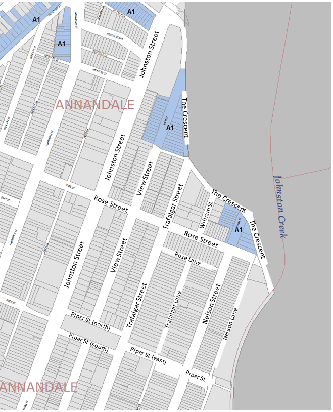
The survey results indicated that overall parking occupancy levels in the streets in the study area were below 85%. Council’s Resident Parking Scheme (RPS) Policy adopted by the former Leichhardt Council on 29th April 2014 (RESOLUTION NO: C97/14) requires occupancy levels of higher than 85% for a street to become a candidate street for further investigation. As such no resident parking restrictions were proposed in 2014.
The parking occupancy levels for Nelson Street and Rose Street were reviewed in detail, in February 2015 and again in September 2015, after concerns were raised regarding the extra parking demand associated with the Harold Park construction site. The Traffic Committee at its meeting in November 2015 considered a report on a resident parking proposal for Nelson Street (The Crescent-Piper Street) and based on the community consultation results, recommended resident parking restrictions in Nelson Street between The Crescent and Rose Street, Annandale.
Angle parking was formalised and RPS restrictions were implemented at the above mentioned section of Nelson Street in 2016.
FINANCIAL IMPLICATIONS
Nil.
OFFICER COMMENTS
Following the opening of the new development on 22nd September 2016, Council re-engaged consultants to undertake parking occupancy surveys in the above mentioned streets in November 2016 to gauge an understanding of the potential “post-opening” parking impact of the Harold Park development. The following graphs show the recorded occupancy levels during the study period in 2014 (pre-development) and the occupancy levels recorded in 2016 (post-opening).
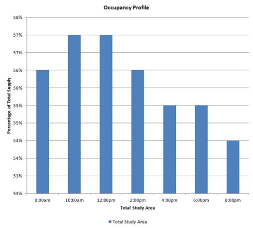
Occupancy percentage versus 2h time intervals (Saturday 13/09/2014)
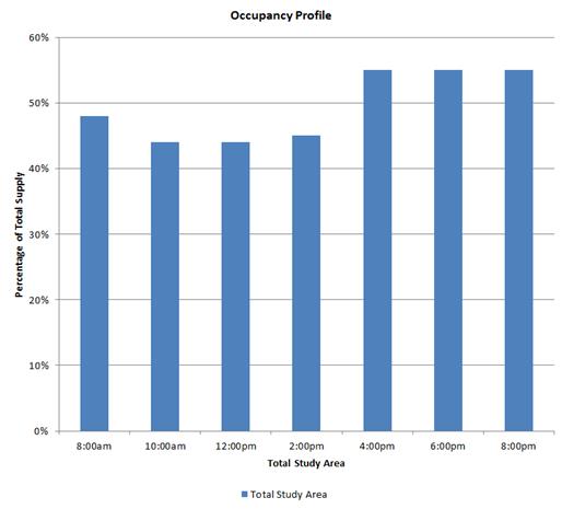
Occupancy percentage versus 2h time intervals (Sunday 14/09/2014)
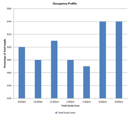
Occupancy percentage versus 2h time intervals (Monday 15/09/2014)
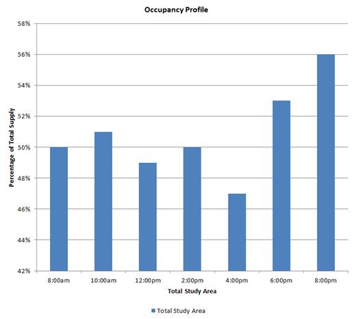
Occupancy percentage versus 2h time intervals (Wednesday 17/09/2014)
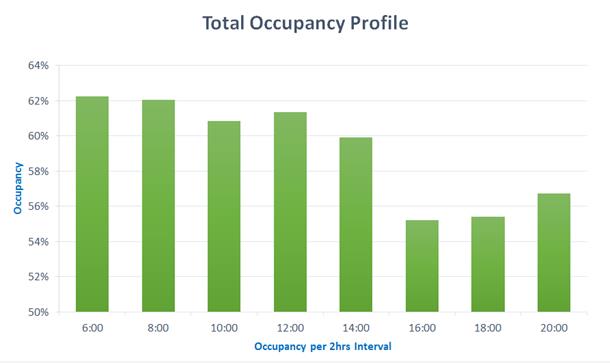
Occupancy percentage versus 2h time intervals (Monday 21/11/2016)
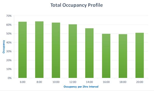
Occupancy percentage versus 2h time intervals (Wednesday 23/11/2016)
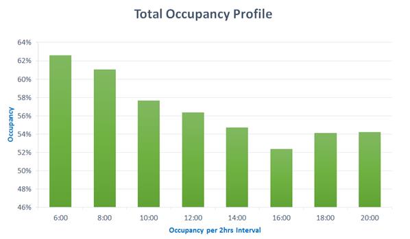
Occupancy percentage versus 2h time intervals (Saturday 26/11/2016)
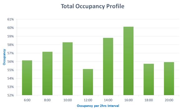 Occupancy percentage versus 2h time intervals (Sunday
27/11/2016)
Occupancy percentage versus 2h time intervals (Sunday
27/11/2016)
The 2016 survey results indicate that the roads within the study area have experienced an overall increase in the occupancy levels, in comparison to 2014. Although that is the case, the surveyed streets still had occupancy levels below 85%. The occupancy surveys were conducted at two hour intervals between 8am and 10pm.
The hourly break down of the occupancy rates for individual Streets surveyed in November 2016, have been included as an attachment to this report.
CONCLUSION
Based on the above results, parking occupancy levels in streets bounded by Johnston Street, The Crescent, Nelson Lane and Piper Street, Annandale are less than 85%. As such, in accordance with Council's Resident Parking Policy, these streets are not candidate streets for a Resident Parking Scheme, at the present time.
|
1.⇩ |
North Annandale Parking Study November 2016 |
|
Local Traffic Committee Meeting 2 February 2017 |
Subject: Marrickville Parking Study Review
File Ref: 14/4005/131503.16
Prepared By: Mary Bailey - Parking Planner, Marrickville
Authorised By: George Tsaprounis - A/Manager Design and Investigation, Marrickville
|
SUMMARY In 2013 Council endorsed recommendations of the Marrickville Town Centre parking management report. The implementation of resident parking, angle parking, and short term parking restrictions was carried out in 2014. A review of the implementation has been completed including community engagement, parking surveys and a technical review. This report is to recommend the draft recommendations for parking management for public exhibition. |
|
RECOMMENDATION
THAT the Draft Marrickville Parking Study review be approved for public exhibition.
|
BACKGROUND
The purpose of the study was to provide information on the current parking supply and demand, the future parking needs and a strategic framework to address parking issues in the Town Centre and surrounding areas. The study made recommendations to improve parking including the introduction of resident parking, creation of additional short term on street parking and the conversion of on street parallel parking to angle parking. (Subsequent to the study recommendations being implemented Council has introduced a further resident parking scheme in streets affected by commercial uses south of Marrickville Road.)
This review takes account of this expanded resident parking scheme and makes recommendations based on a community survey, review of any correspondence to Council, and incorporation of impacts from any new residential or commercial developments in the area.
Recommendations
As a result of the review a number of recommendations are being made. A summary of those recommendations is laid out in the Table 1 below.
Table 1 – List of recommendation from Marrickville parking Study
review (2016)
|
Recommendation |
Details |
Work Required |
|
1. Recommendation - Despointes Street |
Carry out street scaping associated with the angle parking |
Streetscaping |
|
2. Recommendation – Francis Street |
Investigate the feasibility of angle parking in Francis Street |
Streetscaping |
|
3. Recommendation -Enforcement |
Ensure enforcement carried out regularly throughout including at the following locations: - No Stopping Zones at • Marrickville Road/Frampton Lane • Sydenham Road / Frampton Lane • Frampton Avenue/ Frampton Lane • Marrickville Road/Victoria Road - Despointes Street - Mackay Park during soccer - Ferncourt Public School - Carrington Road Cycleway - Peace Lane - Silver Lane - Robert Lane |
Enforcement |
|
4. Recommendation - Peace Lane |
Extend No Parking restriction to cover both sides between Barclays Lane and Cahir Lane. |
Laneway parking |
|
5. Recommendation - Gladstone Lane |
Implement No Parking both sides |
Laneway parking |
|
6. Recommendation – Mobility parking |
Convert 1P to Mobility Parking in Gladstone Street (western side) between Marrickville Lane and Marrickville Road. |
Mobility parking |
|
7. Recommendation - No Stopping |
Implement Statutory No Stopping associated with all recommended parking restrictions as appropriate |
No Stopping |
|
8. Recommendation - Frampton Avenue (west) car park |
- Convert all existing 2P and 4P spaces to 8P - Carry out a Safety and amenity investigation/audit - Allocate funding to enable works arising from audit |
Off Street parking |
|
9. Recommendation - Tuohy Lane |
Improve way finding signage to Banana Joes rooftop parking |
Parking Signage |
|
10. Recommendation - Frampton Avenue |
Frampton Avenue at Marrickville Road – north eastern corner and north western corner – increase parking signage size and visibility |
Parking Signage |
|
11. Recommendation - Parking way finding signage - |
Carry out audit of all existing parking signage in the Marrickville Town Centre and update/improve as required. |
Parking Signage |
|
12. Recommendation - Frampton Avenue |
Convert Unrestricted parking to 2P Permit Holders Excepted 8:30am to 6pm Monday to Friday and 8:30am to 12:30pm Saturday - Eastern side - between 44 Frampton Avenue and Sydenham Road (less No Stopping statutory 10m) (Area M2) |
Resident parking |
|
13. Recommendation - Francis Street |
Convert Unrestricted parking to 2P Permit Holders Excepted 8:30am-6pm Monday to Friday and 8:30am to 12:30pm Saturday - Northern side - between Petersham Road and number 37 - (Area M2) |
Resident parking |
|
14. Recommendation - Garners Avenue |
Convert Unrestricted parking to 2P Permit Holders Excepted 8:30am to 6pm Monday to Friday and 8:30am to 12:30pm Saturday (Area M2) - Western side -between no 2 and 10 m (Statutory No Stopping) from Sydenham Road - |
Resident parking |
|
15. Recommendation - Church Street |
Convert Unrestricted parking to 2P 8:30am – 6pm Mon-Fri, 8:30am – 12:30 pm Sat - Northern side between Illawarra Road and unnamed laneway - Southern side between Illawarra Road and driveway of 384 Illawarra Road (in Church Street) |
Short term parking |
|
16. Recommendation - Greenbank Street |
- Implement statutory 10m No Stopping southern side at Illawarra Road - Convert Unrestricted parking to 2P 830am-6pm Monday to Friday and 830am-1230pm Saturday • Northern side between No Stopping Zone and driveway at back of 370 Illawarra Road • Southern side between No Stopping zone and entrance to double garage (off street parking for 372 Illawarra Road) |
Short term parking |
|
17. Recommendation - Grove Street |
- Implement statutory 10m No Stopping both sides at Illawarra Road - Convert Unrestricted parking to 2P 830am-6pm Monday to Friday and 8:30am-12:30pm Saturday • Southern side – between No Stopping zone and entrance to double garage at rear of 397 Illawarra Road • Northern side – between No Stopping zone and end of property boundary of 395 Illawarra Road |
Short term parking |
|
18. Recommendation - Marrickville Road |
Convert Unrestricted parking to 1P 8:30am-6pm Monday to Friday - Southern side - between the driveway of 142 Marrickville Road up to the No Stopping zone at Meeks Road - |
Short term parking |
|
19. Recommendation - Meeks Road |
Convert Unrestricted parking to 2P 830am-6pm Monday to Friday and 8:30am-12:30pm Saturday - Western side between Marrickville Road and Marrickville Lane |
Short term parking |
Study Area
The study area for the initial study of the Marrickville Town Centre concentrated along Marrickville Road and Illawarra Road and peripheral residential areas. The extent of the original study area and the core parking area is shown in Figure 1.
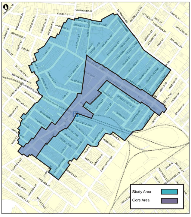
Figure 1: 2013 Study area
The review covers the area of the original study. Figure 1 shows the study area considered in this review. It was decided to carry out a community survey in the South Marrickville area, which was not included in the original study. The survey has been used to determine where there may be parking issues and the nature of parking impacts on residents currently. No recommendations are being made at this time as there are likely major land use changes to occur in the South Marrickville area and parking and traffic matters will be dealt with as part of the urban development process
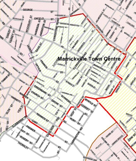
Figure 2 Marrickville South area (white)
FINANCIAL IMPLICATIONS
Funding has been allocated for implementation of the review recommendations for 2016-2017 financial year.
PUBLIC CONSULTATION
A letter was sent by mail to approximately 5,000 householders and residents in the area pointing to a web page outlining the process for the study review and seeking input via a questionnaire. There were 121 responses received. Of those 51 reported that restrictions had been introduced in their street in 2014. 25 % were satisfied with the restrictions and 65 % were not satisfied. A further 10% were neither satisfied or dissatisfied. (see Figure 3)

Figure 3: level of Satisfaction with implemented measures
The main reasons for lack of satisfaction included;
· There is a lot of inconsiderate parking
· There is a lot of commuter parking in my street
· The current time restrictions cause parking problems
· There are not enough permit parking spaces and parking is hard to find
Comments included
· The car park in Frampton Ave isn't being used by non residents due to time restrictions. The 4P area is empty and used by residents who can't find parking, then have to move each 4hrs. The Banana Joe car park is always full now mainly due to the large amount of clients from the gym. We rarely shop at Banana Joes as we can't find parking and tend to shop at Marrickville Metro now
· It is obvious when parking inspectors are around or targeting the area, you easily get parking on those days.
· No parking bays marked for the 90 degree parking for the Gladstone Street (and others) and some take up more space by leaving large gaps between vehicles or parking at odd angles.
· The trees in Gladstone Street have claimed many a car - when reversing back to park, often they back into the trees - trees are very close to the kerb."
· Paying for second parking permit is not preferred
· "Would it be possible to a) change the time of the permit to a more memorable time e.g. calendar or financial year and the year in large font to remind us to renew. September passes by without noticing the permit has expired or b) is it possible to get a reminder to renew?
· "Parking for residents on Gladstone St on a Saturday and Sunday has become very difficult. Often I have to park on another street after circling the block several times. I would like to see the time restrictions on Saturday extended to all day rather than the existing half day. I would like to see a half day (up to 12:30pm) time restriction on Sunday.
· "Resident parking scheme restrictions in Garners Avenue (combination of 2P/permit and unrestricted) has improved the parking situation for residents and is generally working well. In the future, these restrictions may need to be extended into night time hours and on Sundays.
· "The parking scheme for the West side of Gladstone ST is not working. Parking in an angle of 90 degrees to the road, blocks the two way traffic depending on the length of the car. Also the driver on the parked vehicle has not the ability to see cars coming from Calvert St. The slope of the road from the centre to the sidewalk is also a problem, with long cars hitting the sidewalk when they try to park.
· Moving beyond my lament of former developments - a constructive change to parking in my view would be to extend the 2P (residents permitted) from 45 down to 29 Garners Avenue in place of currently unrestricted parking. Workers are the main ones parking in this zone currently and in my view could usefully be given an incentive to park in Frampton Avenue West to better utilize this council asset, this would not make a big difference to shoppers and would improve access for residents.
· For over 5 years council repeatedly told residents that they would implement a parking solution for town workers using the under utilised Framton Ave car Park. THIS HAS STILL NOT HAPPENED and Garners Avenue is inundated with workers cars on the Eastern side making no room for residents. We want 2P Residents Permitted all the way down the western side AND at least HALF WAY DOWN THE EASTERN SIDE, Past the ANZAC CLUB development, Monday through to Saturday. Council needs to look after its rate paying residents first. There is a huge 114 space empty car park in Frampton Ave that should be being used by shoppers and town workers. Make it 8P and get these NON RESIDENT cars off our streets. In addition there are still NO bike racks at either the Garners Ave or the Frampton Ave car parks? So much for being a green council.
· With the parking restrictions in place it is no sustainable for either residents or patrons visiting the area to find parking, especially with all the new apartments going up. Im a commercial property owner on illawarra rd, i own a chiropractic clinic, and my patients have to circle or are worried about parking there cars because of the parking inspectors. Please unrestrict all parking around marrickville as it is having implications on business trading.
· "Restricted resident parking means that we, and our neighbours, can be fined for parking over two hours outside our own house. If we arrive home in the evening and can only find a park in the restricted parking, we can find ourselves with a parking fine the next morning if we are not up and out in time.
· Residents pay council rates. And we pay for our parking permits. It is unfair for our parking to be restricted.
· We voiced this concern before the new parking restrictions were put in place.
· I suggest that if council really wanted to resolve the parking issues in Marrickville, rather than create revenue through fining people for parking infringements - make all the car spaces on my street unrestricted parking!"
There were 68 respondents who had not had restrictions introduced. Of the 68 that did not have restrictions implemented, 24 preferred Unrestricted parking and the remaining 45 wanted some form of resident parking. (See Figure 4).
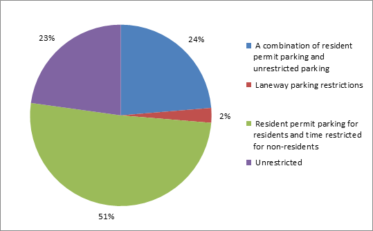
Figure 4: Type of Parking Preferred Community Survey 2016
CONCLUSION
Overall it appears that between the recommendations of the 2013 study implemented in 2014 and the increased resident parking introduced in 2016, there are only a few outstanding parking issues within the Marrickville Town Centre. The recommendations of the review in Table 1 above seek to address those outstanding issues and community concerns. The public exhibition of the recommendations will ensure that there is an opportunity for stakeholders to have a say on all the draft recommendations. It is foreseen that the final report will be submitted to Council for approval in late March 2017.
|
1.⇩ |
Marrickville Parking Study Review - Draft Report |