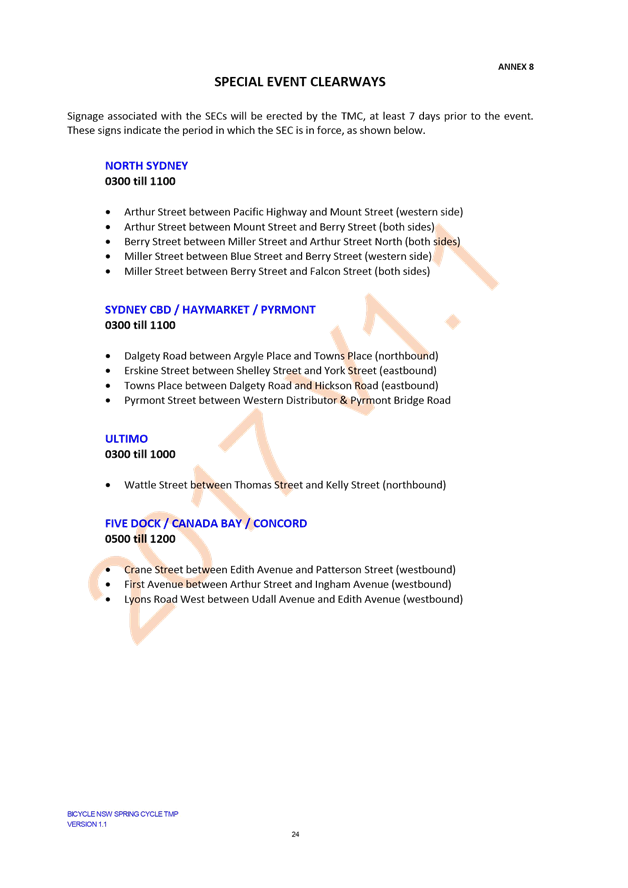
AGENDA

Local Traffic Committee Meeting
THURSDAY 6 JULY 2017
10:00am
|
|
Local Traffic Committee Meeting 6 July 2017 |
Function of the Local Traffic Committee
Background
Roads and Maritime Services (RMS) is legislated as the Authority responsible for the control of traffic on all NSW Roads. The RMS has delegated certain aspects of the control of traffic on local roads to councils. To exercise this delegation, councils must establish a local traffic committee and obtain the advice of the RMS and Police. The Inner West Council Local Traffic Committee has been constituted by Council as a result of the delegation granted by the RMS pursuant to Section 50 of the Transport Administration Act 1988.
Role of the Committee
The Local Traffic Committee is primarily a technical review and advisory committee which considers the technical merits of proposals and ensures that current technical guidelines are considered. It provides recommendations to Council on traffic and parking control matters and on the provision of traffic control facilities and prescribed traffic control devices for which Council has delegated authority. These matters are dealt with under Part A of the agenda and require Council to consider exercising its delegation.
In addition to its formal role as the Local Traffic Committee, the Committee may also be requested to provide informal traffic engineering advice on traffic matters not requiring Council to exercise its delegated function at that point in time, for example, advice to Council’s Development Assessment Section on traffic generating developments. These matters are dealt with under Part C of the agenda and are for information or advice only and do not require Council to exercise its delegation.
Committee Delegations
The Local Traffic Committee has no decision-making powers. The Council must refer all traffic related matters to the Local Traffic Committee prior to exercising its delegated functions. Matters related to State Roads or functions that have not been delegated to Council must be referred directly to the RMS or relevant organisation.
The Committee provides recommendations to Council. Should Council wish to act contrary to the advice of the Committee or if that advice is not supported unanimously by the Committee members, then the Police or RMS have an opportunity to appeal to the Regional Traffic Committee.
Committee Membership & Voting
Formal voting membership comprises the following:
· one representative of Council as nominated by Council;
· one representative of the NSW Police from each Local Area Command (LAC) within the LGA, being Newtown, Marrickville, Leichhardt and Ashfield LAC’s.
· one representative from the RMS; and
· State Members of Parliament (MP) for the electorates of Summer Hill, Newtown, Heffron, Canterbury, Strathfield and Balmain or their nominees.
Where the Council area is represented by more than one MP or covered by more than one Police LAC, representatives are only permitted to vote on matters which effect their electorate or LAC.
Informal (non-voting) advisors from within Council or external authorities may also attend Committee meetings to provide expert advice.
Committee Chair
Council’s representative will chair the meetings.
Public Participation
Members of the public or other stakeholders may address the Committee on agenda items to be considered by the Committee. The format and number of presentations is at the discretion of the Chairperson and is generally limited to 3 minutes per speaker. Committee debate on agenda items is not open to the public.
1. Apologies
2. Disclosures of Interest
3. Confirmation of Minutes
4. Matters Arising from Council’s Resolution of Minutes
5. Part A – Items where Council may Exercise its Delegated Functions
Parking Matters: Page
T0717 Item 1 Alice Street, Newtown - Proposed Drop-Off & Pick-Up Zone Associated with Proposed Childcare Centre (Stanmore Ward/Newtown Electorate/Newtown LAC) 5
T0717 Item 2 Marrickville Town Centre Parking Review (Marrickville Ward/Heffron Electorate/Marrickville LAC) 9
T0717 Item 3 Requests for Mobility Parking Spaces (Marrickville & Ashfield Wards/Summer Hill Electorate/Marrickville LAC) 85
T0717 Item 4 Hodern Avenue Petersham - Proposed Permit Parking Restrictions (Stanmore Ward/Newtown Electorat/Marrickville LAC) 97
T0717 Item 5 Fowler Lane, Camperdown - Extension of Statutory 'No Stopping' Restrictions at Tooth Lane to Improve Access (Stanmore Ward/Newtown Electorate/Newtown LAC) 102
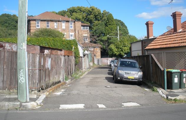
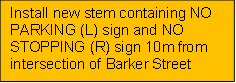
T0717 Item 6 Barker Lane, Lewisham - 'No Parking' Restrictions in the Laneway (Stanmore Ward/Newtown Electorate/Marrickville LAC) 106
T0717 Item 7 Gordon Street, Annandale - 'No Stopping' Restrictions (Leichhardt Ward/Balmain Electorate/Leichhardt LAC) 112
T0717 Item 8 Emma Street and Hill Street, Leichhardt 'No Stopping' Restrictions (Leichhardt Ward/Balmain Electorate/Leichhardt LAC) 114
T0717 Item 9 Minor Traffic Facilities (Leichhardt & Balmain Wards/Balmain Electorate/Leichhardt LAC) 117
T0717 Item 10 Request for Mobility Parking Space at/near No 23A Albert Parade, Ashfield 120
T0717 Item 11 Request for Works Zone Installation Outside 17 Charlotte Street, Ashfield (Haberfield Ward / Summer Hill Electorate / Ashfield LAC) 127
Traffic Matters: Page
T0717 Item 12 2017 Footprints ECO Festival (Leichhardt/Balmain) Proposed Temporary Road Closure to Hold Footprints Festival on Sunday 27 August 2017 131
T0717 Item 13 Little Commodore Street, Newtown - Proposed Kerb Extension Design Plan (Stanmore Ward/Newtown Electorate/Newtown LAC) 144
T0717 Item 14 Murray Street, Marrickville - Temporary Road Closure to Carry Out Crane Lift Escalators into Metro Shopping Centre (Marrickville Ward/Newtown Electorate/Marrickville LAC) 148
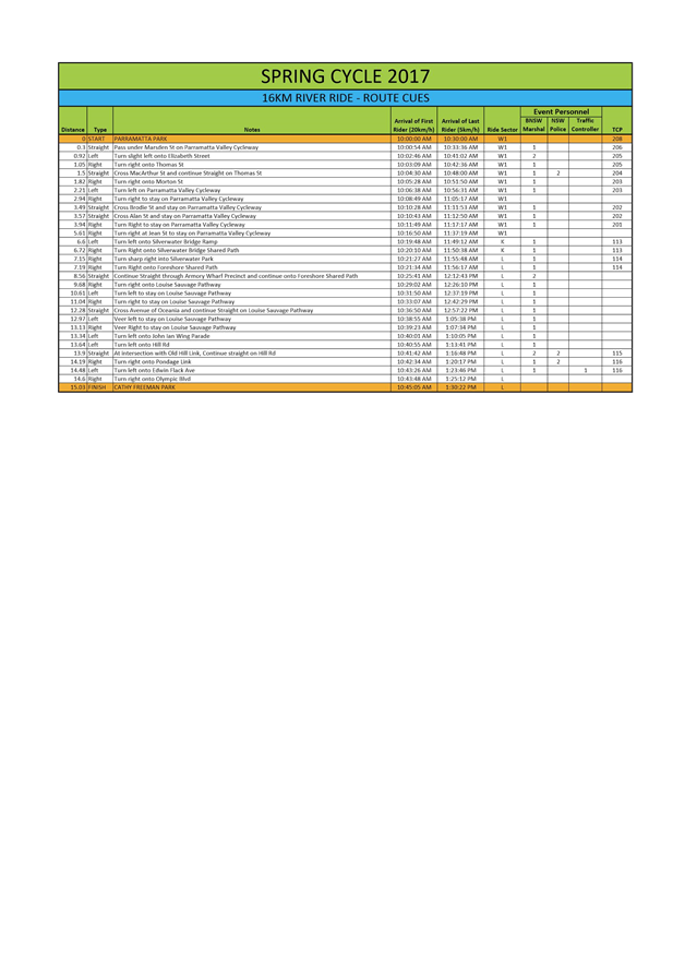
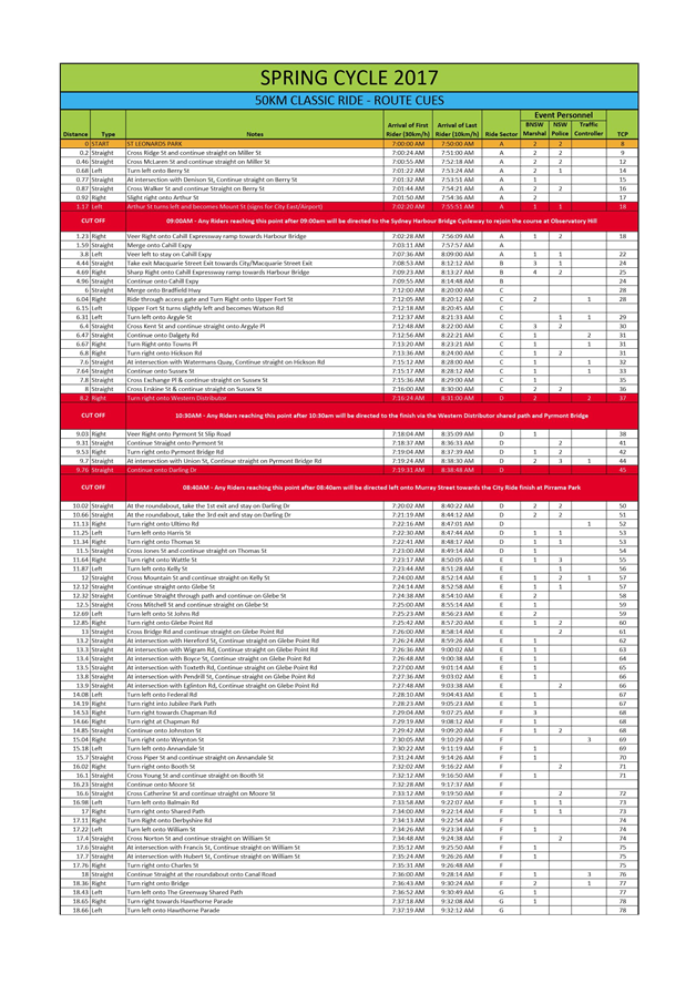
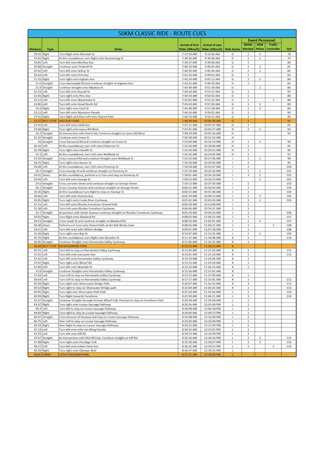
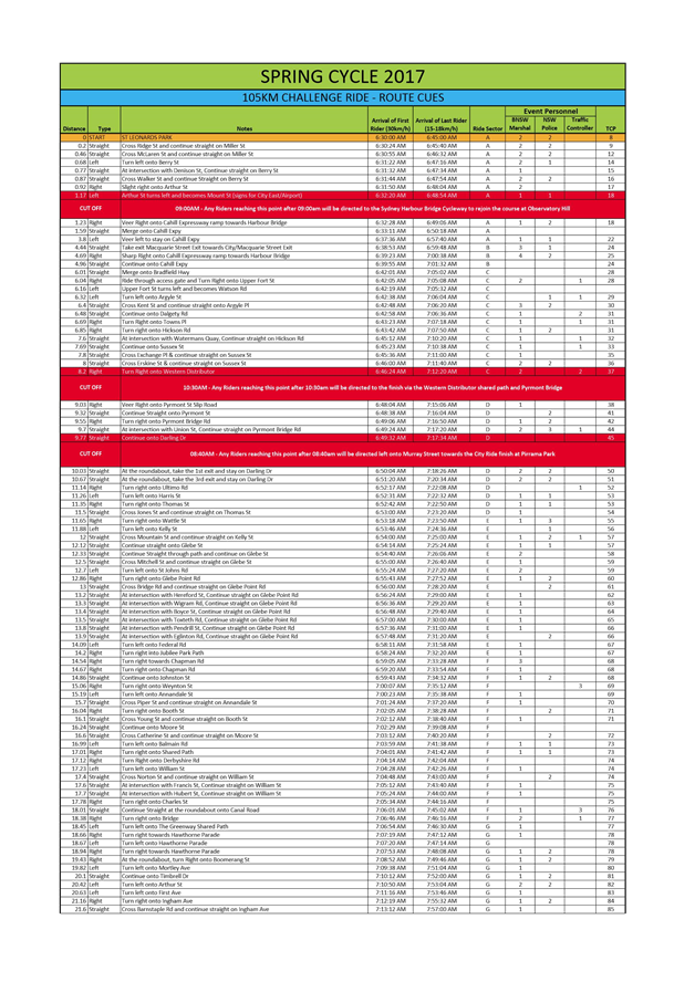
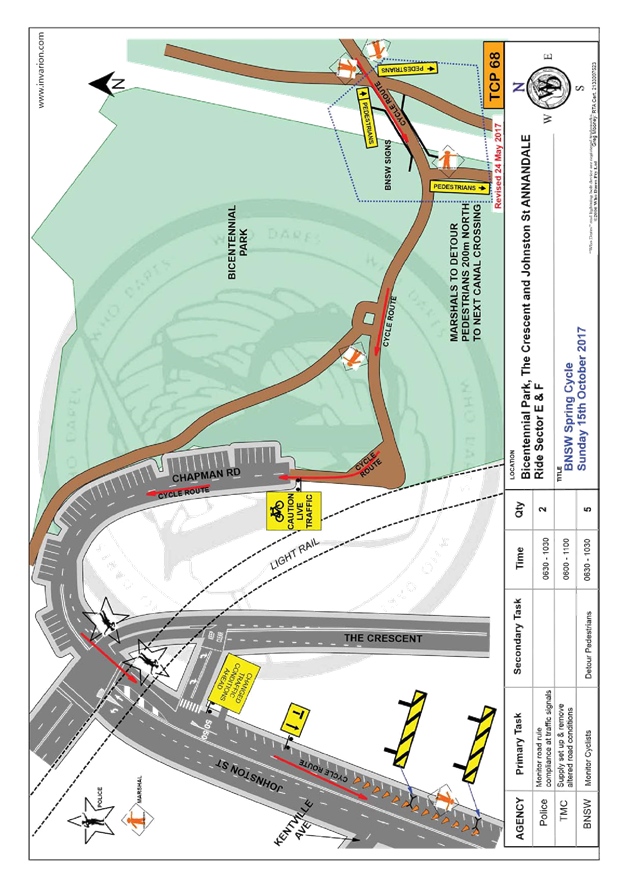
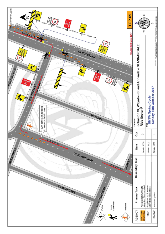
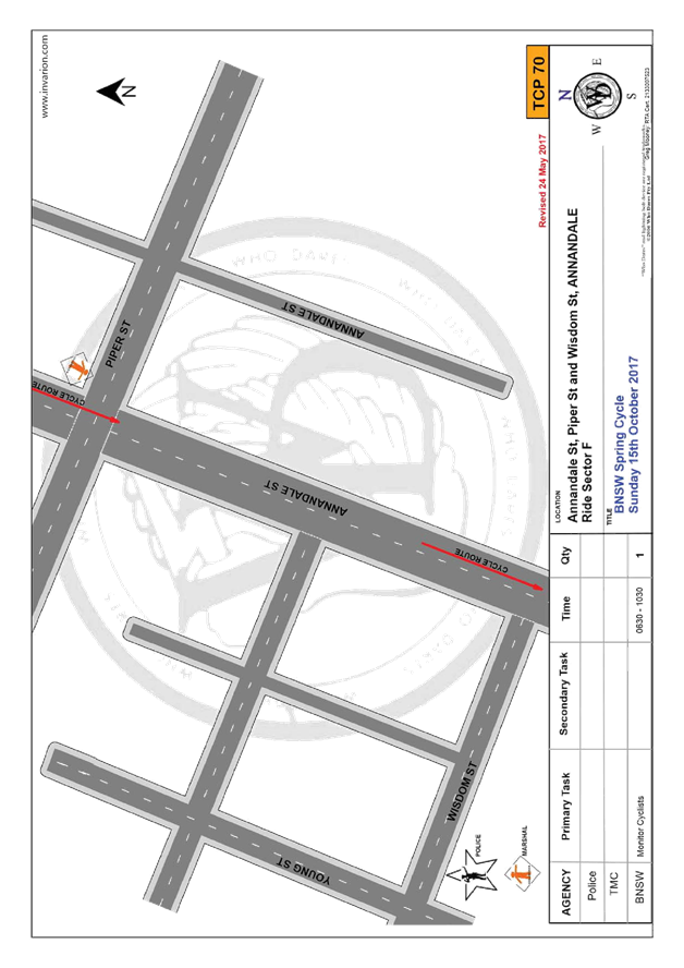
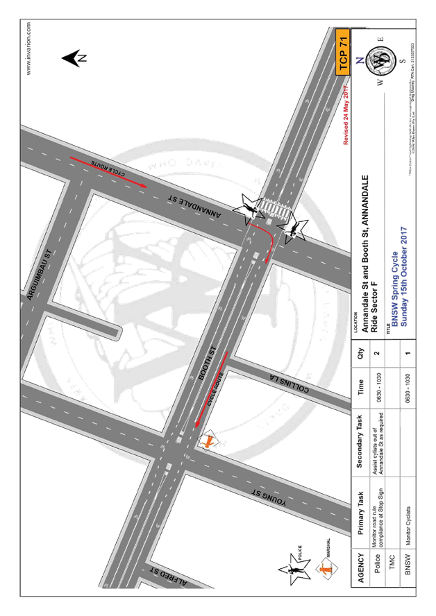
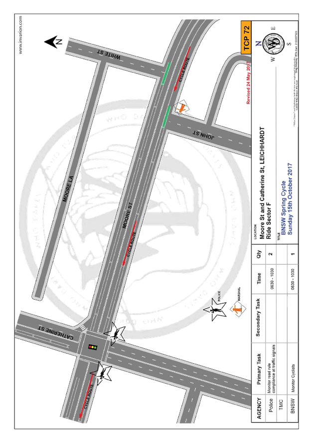
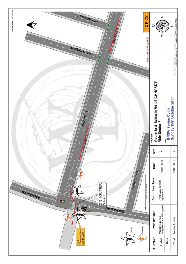
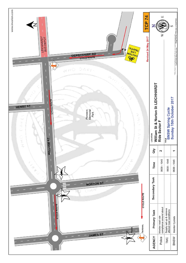
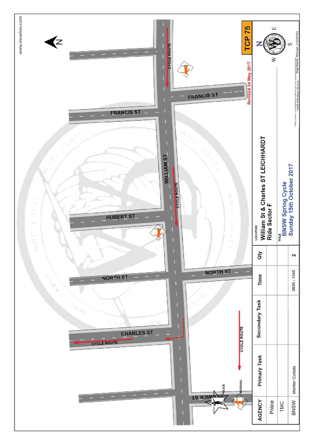
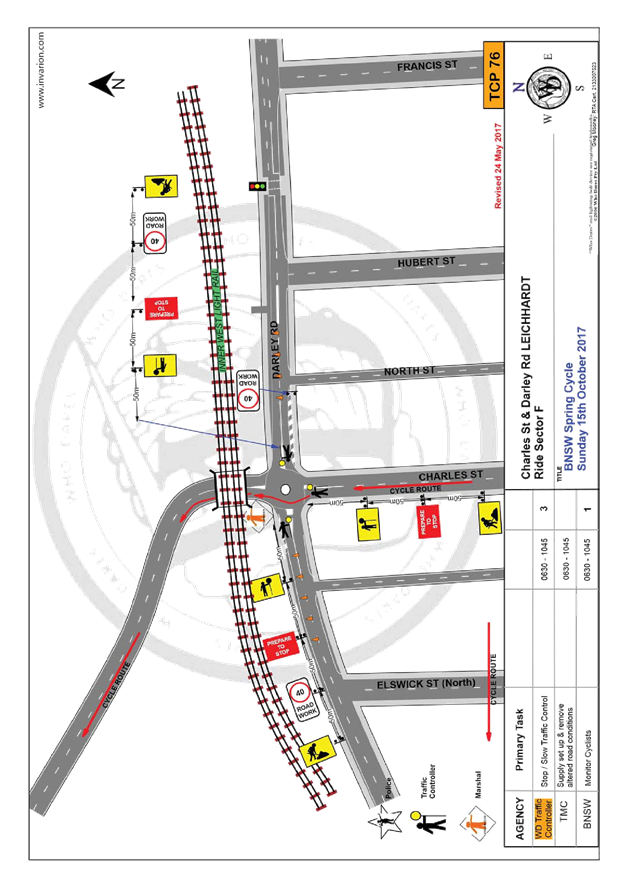
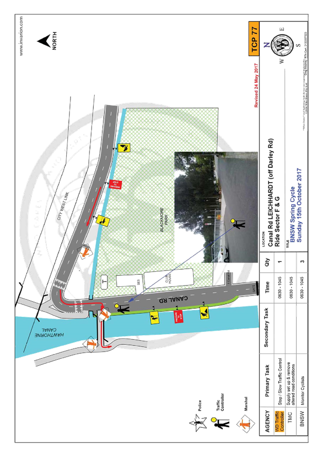
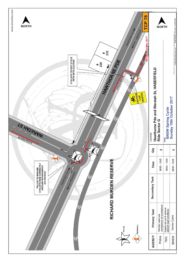
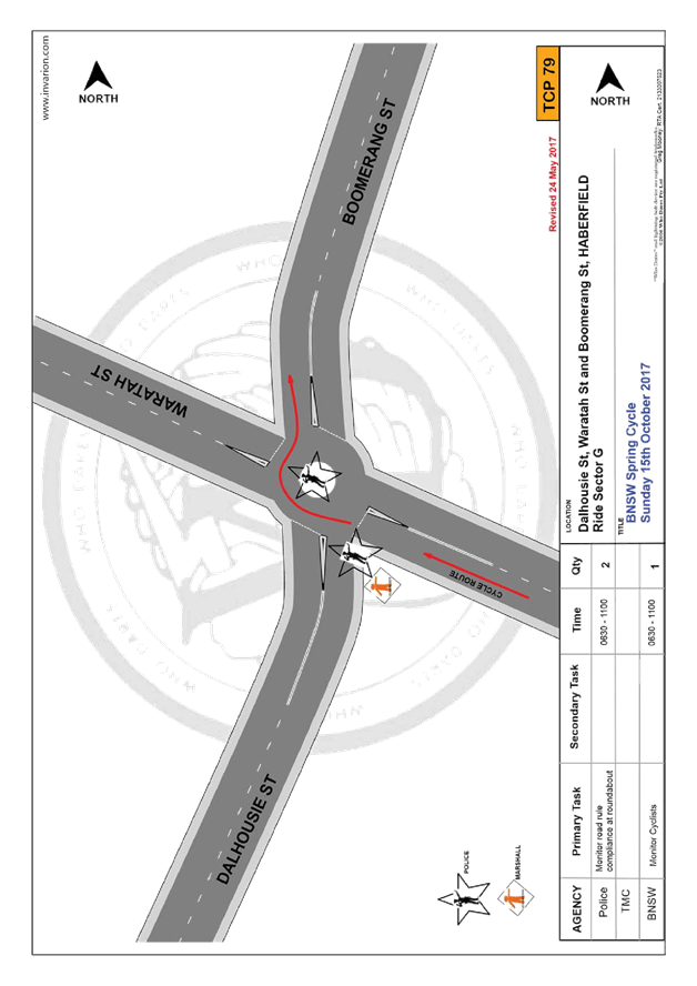
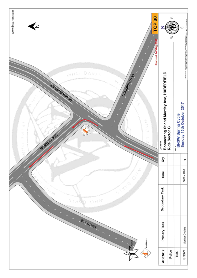
T0717 Item 15 2017 Spring Cycle (Leichhardt/Balmain/Leichhardt LAC) - Traffic Management Plant and Traffic Control Plan for the 2017 Spring Cycle Event 151
T0717 Item 16 Australia Street, Newtown - Temporary Full Road Closure to Carry Out Crane Lift Works for Newtown Neighbourhood Centre (Stanmore Ward/Newtown Electorate/Newtown LAC) 213
T0717 Item 17 Smith Street, Tempe - Removal of Speed Cushions (Marrickville Ward/Heffron Electorate/Newtown LAC) 217
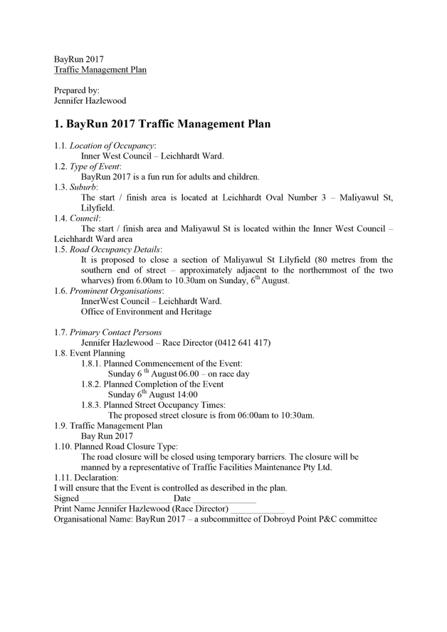
T0717 Item 18 Bay Run (Leichhardt Ward/Balmain electorate/Leichhardt LAC) Proposed Temporary Road Closure to hold Bay Run Event on Sunday 6 August 2017 222
Late Items:
Nil at the time of printing.
1. Part B – Items for Information Only
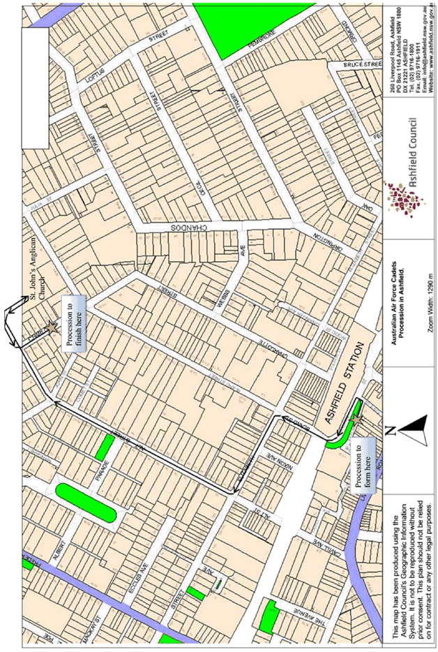
T0717 Item 19 Australian Air Force Cadets Annual Street Procession Through Ashfield Sunday 6 August 2017 (Ashfield & Leichhardt Wards/Summer Hill Electorate/Ashfield LAC) 235
T0717 Item 20 Livingstone Road, Marrickville - Temporary Road Closures for St Brigid's Church on Sunday 30 July 2017 (Marrickville Ward/Summer Hill Electorate/Marrickville LAC) 238
2. Part C – Items for General Advice
T0717 Item 21 2/32-72 Alice Street, Newtown - Proposed Childcare Centre (Stanmore Ward/Newtown Electorate/Newtown LAC) 240
T0717 Item 22 Bedford Street, Newtown - Newtown Community Market – Modification to Consent Conditions – TMP and Bump in and Bump Out Procedure (Stanmore Ward / Newtown Electorate / Newtown LAC) 251
3 General Business
4 Close of Meeting
|
|
Local Traffic Committee Meeting 6 July 2017 |
Subject: Alice Street, Newtown - Proposed Drop-Off & Pick-Up Zone Associated with Proposed Childcare Centre (Stanmore Ward/Newtown Electorate/Newtown LAC)
File Ref: 17/6022/72454.17
Prepared By: Emilio Andari - Civil Engineer
Authorised By: Joe Di Cesare - Manager Design and Investigation
|
SUMMARY A Development Application has been received to fit out and use the premises as a childcare centre for 32 children at 2/32-72 Alice Street, Newtown. Council Officers are assessing the development application as a separate matter. Parking required for the development is to be provided on-site via a basement car parking. However for ease of access for parents, a drop off/pick up zone is also proposed adjacent to the frontage of the childcare centre. Therefore, subject to the development consent being granted, it is recommended that a drop-off and pick-up parking zone be installed adjacent to the proposed site in Alice Street.
|
|
RECOMMENDATION
THAT subject to development consent being granted for the Development Application (DA201600678.01) of 2/32-72 Alice Street, Newtown;
1. Council approve the installation of ‘P10minute 7:00am-9:00am, 4:00pm-6:00pm, Mon-Fri’ restrictions for a distance of 12 metres along the southern side of Alice Street, Newtown directly outside 2/32-72 Alice Street, Newtown, in order to facilitate an on-street drop-off/pick-up parking zone; and 2. the costs of the supply and installation of the associated parking signage are to be borne by the applicant in accordance with Council’s Fees and Charges.
|
BACKGROUND
A Development Application has been received to fit out and use the premises as a childcare centre for 32 children at 2/32-72 Alice Street, Newtown. Following the assessment of the development application and subject to the development consent being granted, it is recommended that a drop-off and pick-up parking zone be installed adjacent to the proposed site in Alice Street.
The application is required to be referred to the Local Traffic Committee for consideration under State Environmental Planning Policy (Infrastructure) 2007.
FINANCIAL IMPLICATIONS
The costs of the supply and installation of the associated parking signage are to be borne by the applicant in accordance with Council’s Fees and Charges.
OFFICER COMMENTS
Site location & road network
|
Street Name |
Alice Street |
|
Subject Section |
Between Pearl Street and Walenore Avenue |
|
Carriageway Width (m) |
12.2 |
|
Carriageway Type |
Two-way road with one travel lane in each direction, in addition to kerbside parking lane along both sides of the road. |
|
Classification |
Regional |
|
85th Percentile Speed (km/h) |
49.0 |
|
Vehicles Per Day (vpd) |
10,168 |
|
Reported Crash History (July 2011 - June 2016) |
2 crashes (Rum Codes: 11 & 60). Both crashes resulted with no injury and only tow-away (intersection collision & collision into parked car). |
|
Heavy Vehicle Volume (%) |
8.4 |
|
Parking Arrangements |
Unrestricted parking on the southern side and ‘2P 8am-10pm Permit Holders Excepted Area M14’ restrictions on the northern side. |

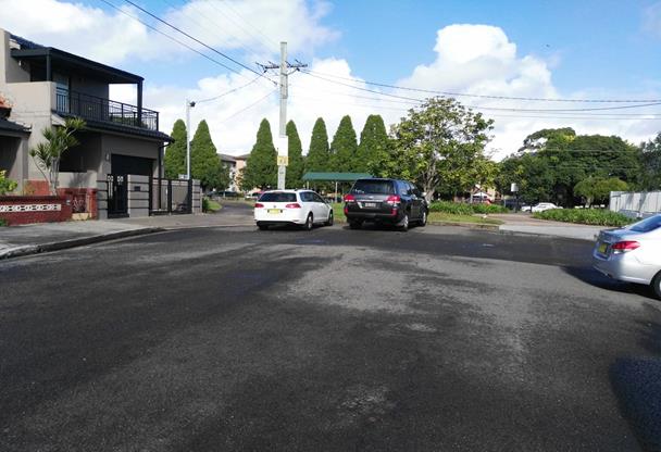
Proposed drop-off and pick-up parking zone during peak periods on weekdays in Alice Street
It was observed during a site inspection that these unrestricted parking spaces along the southern side of Alice Street were highly utilised and the provision of 2 on-street parking spaces used as a drop-off and pick-up parking zone during peak periods on weekdays would allow access for parents and carers to park their vehicles in close proximity to the proposed child care centre (refer to the photos below). The zone will revert back to unrestricted outside those hours.
Given that the number of proposed on-site parking spaces for the development application are satisfied with respect to Council’s DCP 2011 (incorporating Amendment No.1), it would be appropriate to allow a drop-off and pick-up parking zone in close proximity to the proposed child care centre to provide a convenient and safe drop off/pick up zone for parents..
Therefore, the provision for ‘P10minute 7:00am-9:00am, 4:00pm-6:00pm, Mon-Fri’ restrictions for a distance of 12 metres (2 car parking spaces) along the southern side of Alice Street, Newtown adjacent to the proposed child care centre is recommended.


Proposed childcare centre at ground floor in Alice Street (facing south-west)

Location of proposed ‘drop-off & pick-up’ zone in Alice Street (facing south)
PUBLIC CONSULTATION
Consultation/notification regarding the proposal would normally be undertaken by Council's Development and Planning Services as part of the development application process.
CONCLUSION
Subject to the development consent being granted for the proposed child care centre at 2/32-72 Alice Street, Newtown, it is recommended that a drop-off and pick-up parking zone be installed in Alice Street directly outside the premises to improve safety for passing traffic and access for children and parents into their vehicles. The costs of the supply and installation of the parking signage are to be borne by the applicant.
|
|
Local Traffic Committee Meeting 6 July 2017 |
Subject: Marrickville Town Centre Parking Review (Marrickville Ward/Heffron Electorate/Marrickville LAC)
File Ref: 14/4005/27752.17
Prepared By: Mary Bailey - Parking Planner
Authorised By: George Tsaprounis - Coordinator Traffic Engineering Services
|
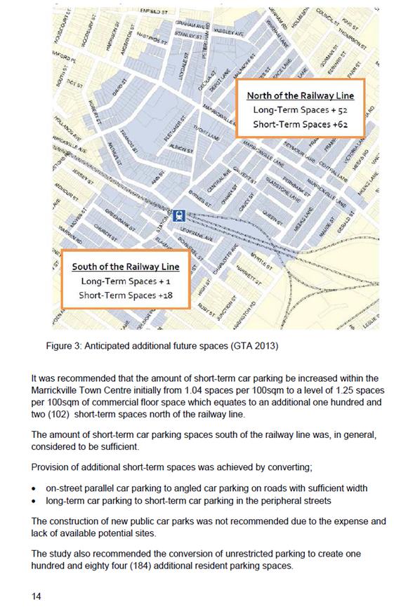
SUMMARY In 2011 Council commissioned GTA Consultants to carry out a study of parking in the Marrickville town centre. Recommendations from that study including the introduction of resident parking, creation of additional short term on street parking and the conversion of on street parallel parking to angle parking were implemented in 2014. Council has now undertaken a review of the implementation of the study recommendations. Following community consultation the review recommends some additional resident parking, off street parking, angle parking, short term parking and laneway parking restrictions.
|
|
RECOMMENDATION
THAT the final recommendations of the Marrickville Parking Review as listed in the Table below be approved.
|
|
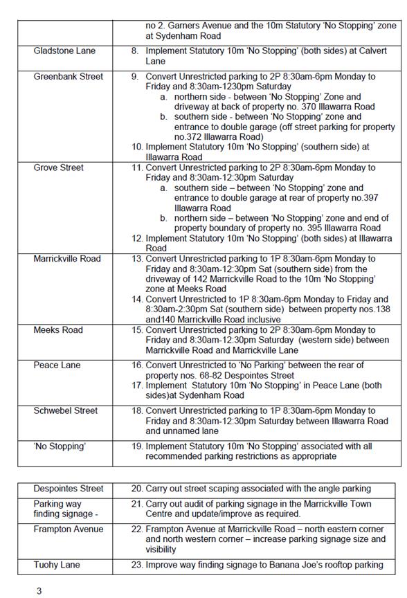
Recommendation |
Details Final |
|
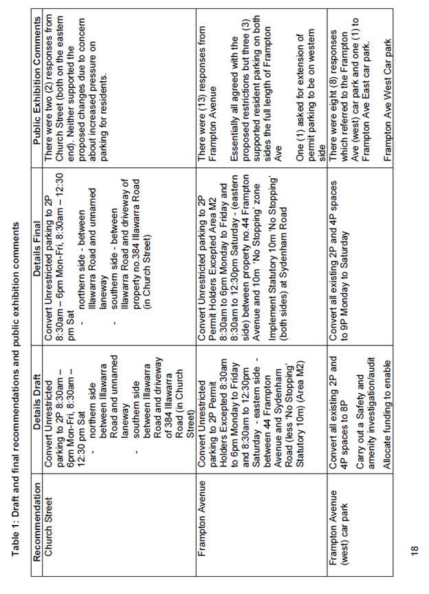
Church Street |
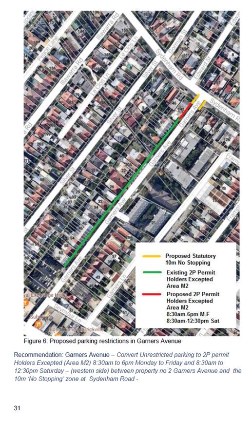
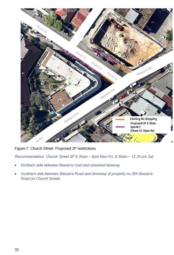
1. Convert Unrestricted parking to 2P 8:30am – 6pm Mon-Fri, 8:30am – 12:30 pm Sat • northern side - between Illawarra Road and unnamed laneway • southern side - between Illawarra Road and driveway of property no.384 Illawarra Road (in Church Street) |
|
Frampton Avenue |
2. Convert Unrestricted parking to 2P Permit Holders Excepted Area M2, 8:30am to 6pm Monday to Friday and 8:30am to 12:30pm Saturday - (eastern side) between property no.44 Frampton Avenue and Sydenham Road (less ‘No Stopping’ Statutory 10m) 3. Implement Statutory 10m ‘No Stopping’ (both sides) at Sydenham Road |
|
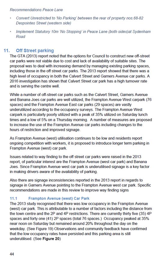
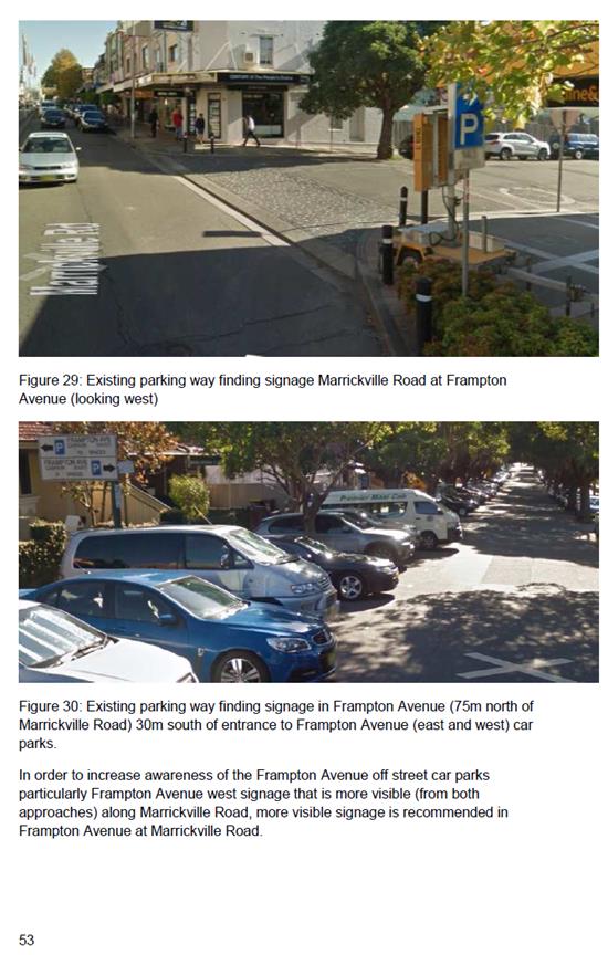
Frampton Avenue (west) car park |
4. Convert all existing 2P and 4P spaces to 9P, 8am-6pm Monday to Saturday |
|
Francis Street |
5. Convert Unrestricted parking to 2P Permit Holders Excepted Area M2 8:30am-6pm Monday to Friday and 8:30am to 12:30pm Saturday - (both sides) between Petersham Road and property no. 37A Francis Street 6. Implement Statutory 10m ‘No Stopping’ (both sides) at Petersham Road |
|
Garners Avenue |
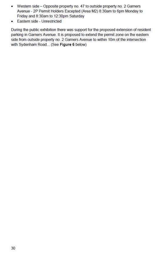
7. Convert Unrestricted parking to 2P Permit Holders Excepted Area M2 (western side) 8:30am to 6pm Monday to Friday and 8:30am to 12:30pm Saturday - (eastern side) between property no 2. Garners Avenue and the 10m Statutory ‘No Stopping’ zone at Sydenham Road |
|
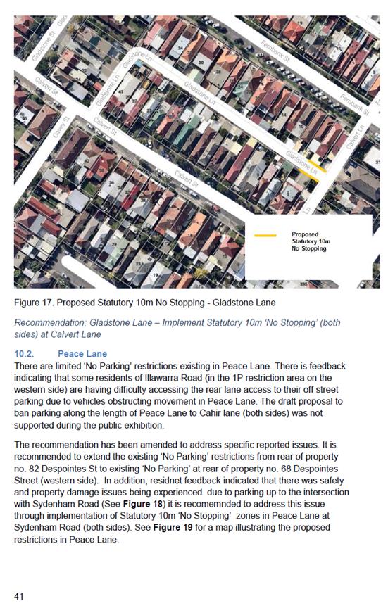
Gladstone Lane |
8. Implement Statutory 10m ‘No Stopping’ (both sides) at Calvert Lane |
|
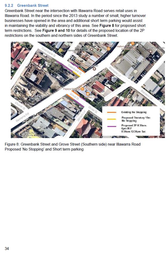
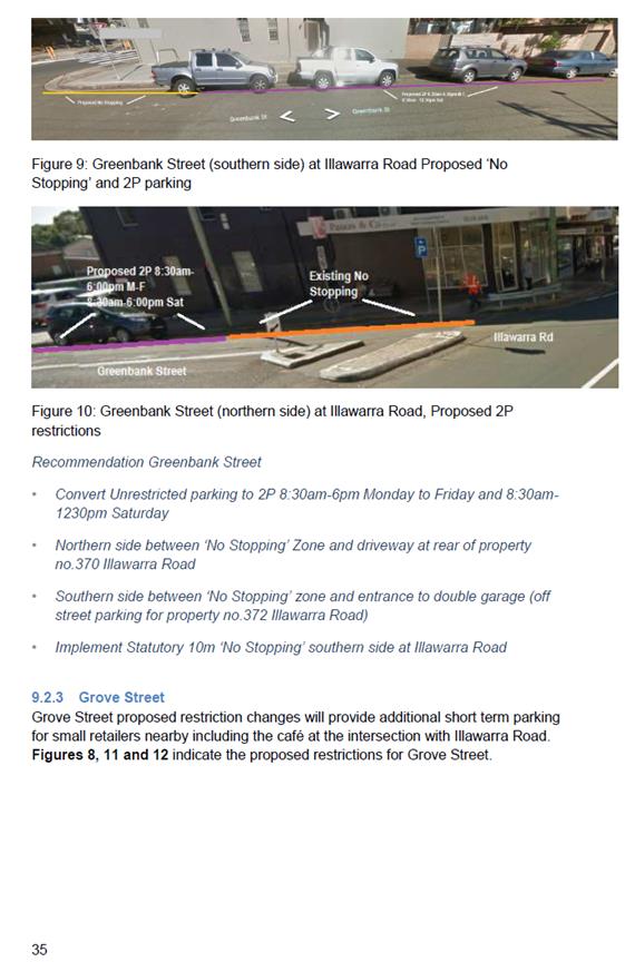
Greenbank Street |
9. Convert Unrestricted parking to 2P 8:30am-6pm Monday to Friday and 8:30am-1230pm Saturday a. northern side - between ‘No Stopping’ Zone and driveway at back of property no. 370 Illawarra Road b. southern side - between ‘No Stopping’ zone and entrance to double garage (off street parking for property no.372 Illawarra Road) 10. Implement Statutory 10m ‘No Stopping’ (southern side) at Illawarra Road |
|
Grove Street |
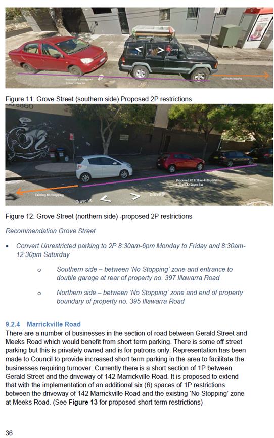
11. Convert Unrestricted parking to 2P 8:30am-6pm Monday to Friday and 8:30am-12:30pm Saturday a. southern side – between ‘No Stopping’ zone and entrance to double garage at rear of property no.397 Illawarra Road b. northern side – between ‘No Stopping’ zone and end of property boundary of property no. 395 Illawarra Road 12. Implement Statutory 10m ‘No Stopping’ (both sides) at Illawarra Road |
|
Marrickville Road |
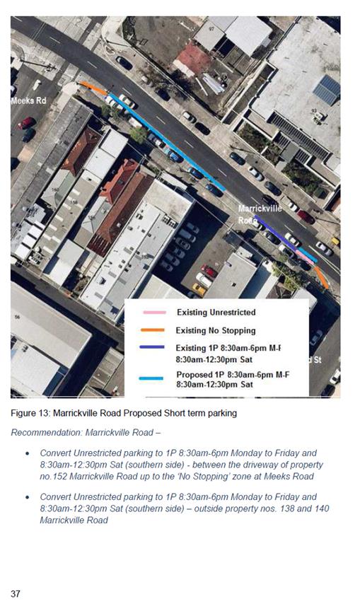
13. Convert Unrestricted parking to 1P 8:30am-6pm Monday to Friday and 8:30am-12:30pm Sat (southern side) from the driveway of 142 Marrickville Road to the 10m ‘No Stopping’ zone at Meeks Road 14. Convert Unrestricted to 1P 8:30am-6pm Monday to Friday and 8:30am-2:30pm Sat (southern side) between property nos.138 and140 Marrickville Road inclusive |
|
Meeks Road |
15. Convert Unrestricted parking to 2P 8:30am-6pm Monday to Friday and 8:30am-12:30pm Saturday (western side) between Marrickville Road and Marrickville Lane |
|
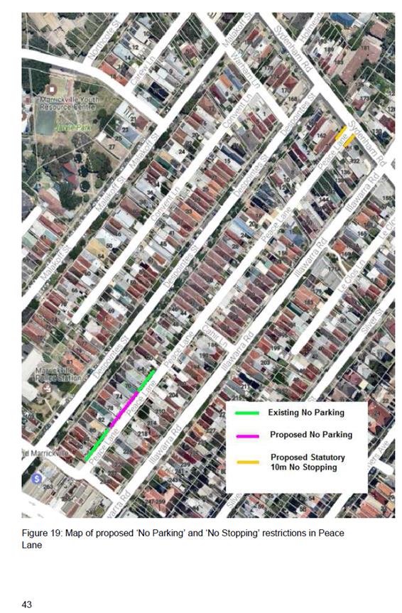
Peace Lane |
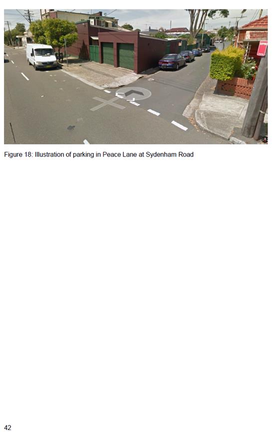
16. Convert Unrestricted to ‘No Parking’ between the rear of property nos. 68-82 Despointes Street 17. Implement Statutory 10m ‘No Stopping’ in Peace Lane (both sides)at Sydenham Road |
|
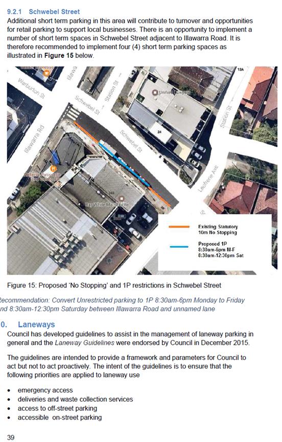
Schwebel Street |
18. Convert Unrestricted parking to 1P 8:30am-6pm Monday to Friday and 8:30am-12:30pm Saturday between Illawarra Road and unnamed lane |
|
‘No Stopping’ |
19. Implement Statutory 10m ‘No Stopping’ associated with all recommended parking restrictions as appropriate |
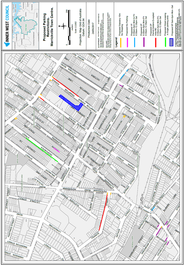
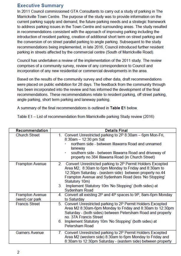
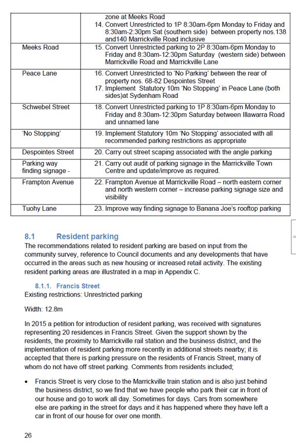
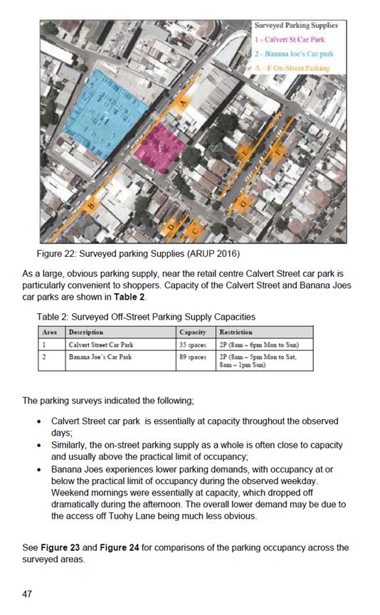
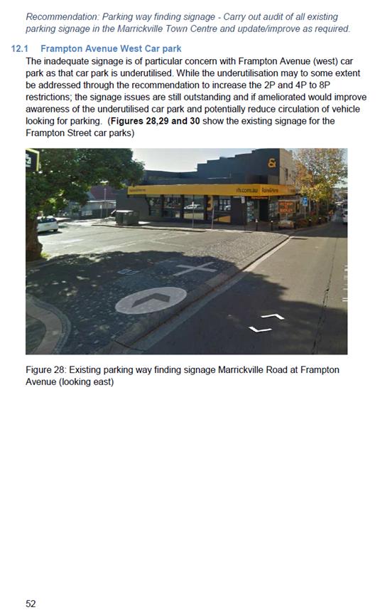
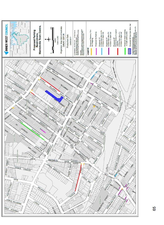
Figure 1: Proposed parking restrictions Marrickville town Center
BACKGROUND
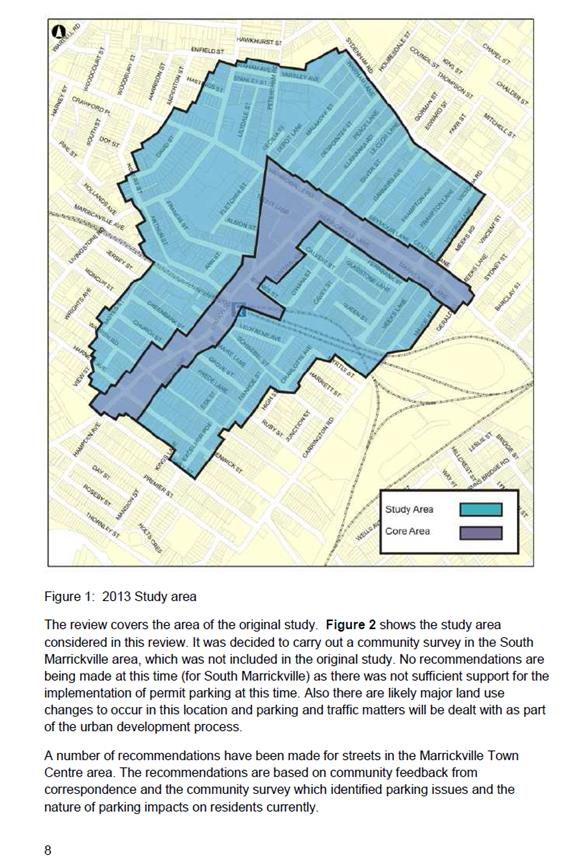
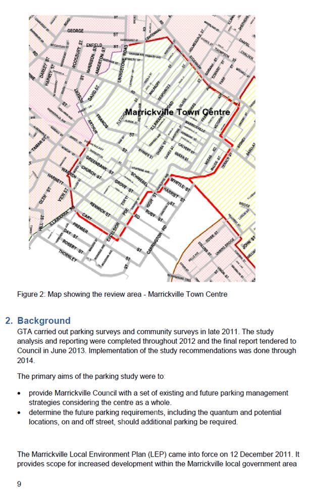
In 2011 Council commissioned GTA Consultants to carry out a study of parking in The Marrickville Town Centre. The purpose of the study was to provide information on the current parking supply and demand, the future parking needs and a strategic framework to address parking issues in the Town Centre and surrounding areas. The study resulted in recommendations consistent with the approach of improving parking including the introduction of resident parking, creation of additional short term on street parking and the conversion of on street parallel parking to angle parking. Subsequent to the study recommendations being implemented, in late 2016, Council introduced further resident parking in streets affected by the commercial centre (South of Marrickville Road).
Council has undertaken a review of the implementation of the 2011 study. The review comprises of a community survey, review of any correspondence to Council and incorporation of any new residential or commercial developments in the area.
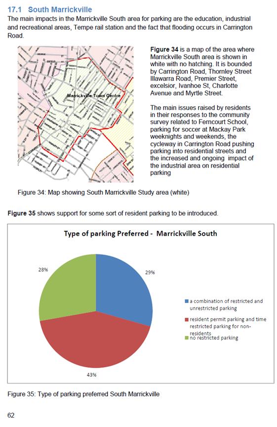
Based on the results of the community survey and other data, draft recommendations were placed on public exhibition for 28 days. The feedback from the community through has been incorporated into the review and has informed the development of the final recommendations. These recommendations relate to resident parking, off street parking, angle parking, short term parking and laneway parking.
FINANCIAL IMPLICATIONS
The cost of implementing the recommendations is approximately $20,000 and this has not been allocated.
OFFICER COMMENTS
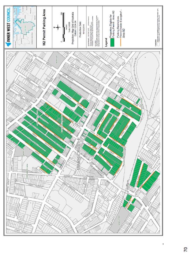
The implementation of resident parking in additional streets in 2016 has addressed the major areas of concern for residents in the study area. Subsequent to the parking measures recommended in the 2013 study being introduced in 2014, Council received representations from the residents of a number of streets seeking consideration for resident parking. Following investigation and community engagement the extent of resident parking in the Marrickville Town Centre was increased to include additional streets (M2 area) as follows;
· Byrnes Street
· Cavey Street
· Calvert Street
· O’Hara Street
· Queen Street, and
· Victoria Road
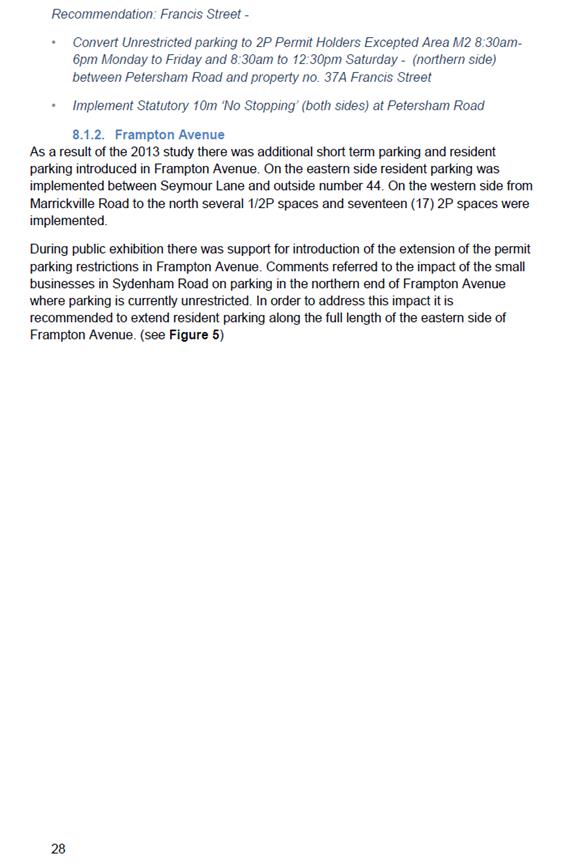
Given the additional resident parking implemented in 2016, only some minor extensions to existing resident parking restrictions are recommended in this review. Those refer to extensions of existing resident parking restrictions in Frampton Avenue, and Garners Avenue and the addition of a section of Francis Street to the resident parking scheme.
There was a draft recommendation to extend the resident parking in Silver Street, near Sydenham Road, but this was not supported by residents. In order to respond to increased retail and commercial activity, some short term parking is recommended in Marrickville Road near Meeks Road, in Church Street, Grove and Greenbank Streets.
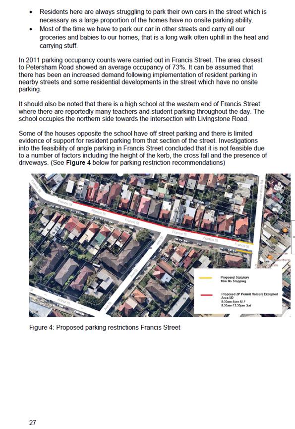
This review recommends no major changes to angle parking in the area but as a result of resident feedback recommends improvements to street scape associated with the Despointes Street angle parking.
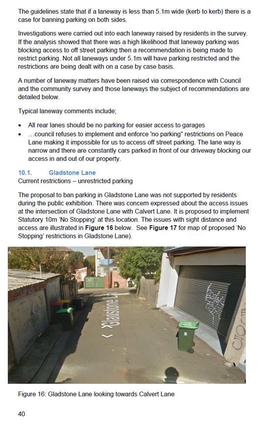
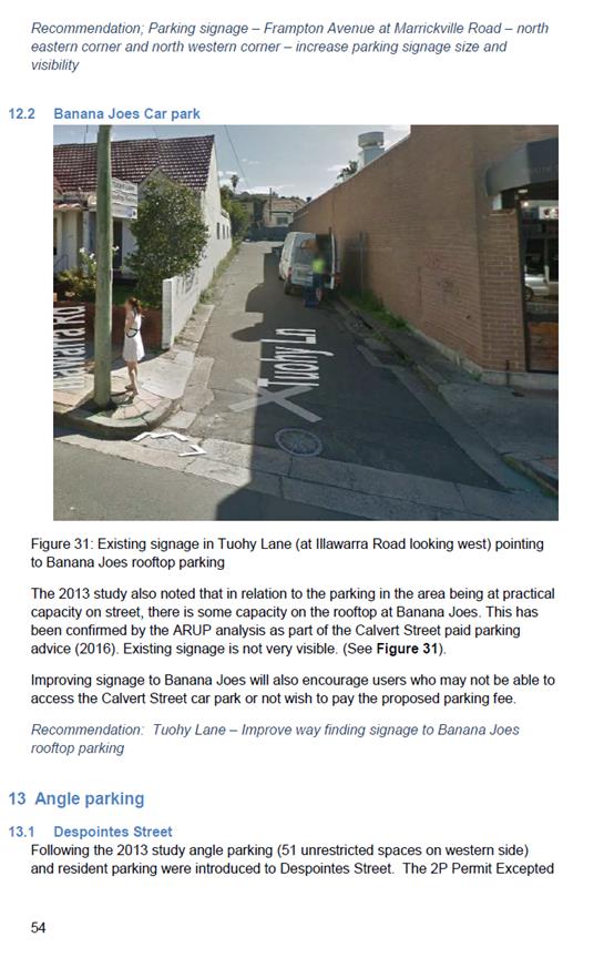
Some laneway parking restrictions are also recommended as a result of feedback from residents regarding their access to off street parking being blocked. In response to resident feedback, the draft recommendation to ban parking along the length of Peace Lane has been amended to apply to a short section to ensure driveway access. The draft recommendation to ban parking in Gladstone Lane was not supported, so parking conditions will remain as they are in Gladstone Lane except for the introduction of ‘No Stopping’ restrictions to ensure passage of vehicles and sight distance.
The Frampton Avenue (west) car park has been the subject of a good deal of feedback from the community and the recommended change from 2P and 4P to 8P was widely supported by residents, especially those in Frampton Avenue. Council has decided to implement 9P parking restrictions which will be suitable for local workers and still deter overnight and long stay parking. The rationale for this change is to provide an alternative to on street parking for workers in the area and thereby free up more on street parking for use by residents. See Table 2 for details of the draft recommendations and the changes made after public exhibition.
PUBLIC CONSULTATION
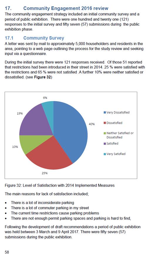
A letter was sent by mail to approximately 5,000 householders and residents in the area, pointing to a web page outlining the process for the study review and seeking input via a questionnaire.
During the initial survey there were 121 responses received. Of those 51 reported that restrictions had been introduced in their street in 2014. 25 % were satisfied with the restrictions and 65 % were not satisfied .A further 10% were neither satisfied or dissatisfied. (see Figure 1)

Figure 1: Level of Satisfaction with 2014 Implemented Measures
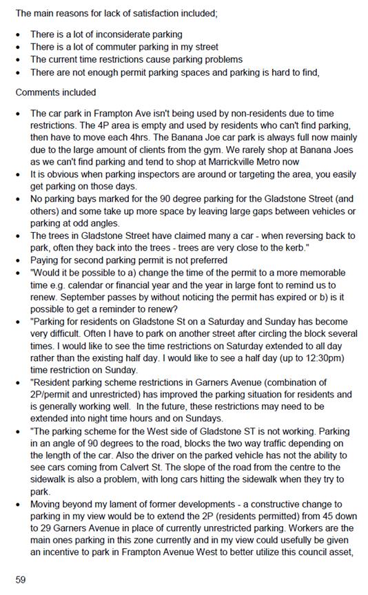
The main reasons for lack of satisfaction included;
· There is a lot of inconsiderate parking
· There is a lot of commuter parking in my street
· The current time restrictions cause parking problems
· There are not enough permit parking spaces and parking is hard to find,
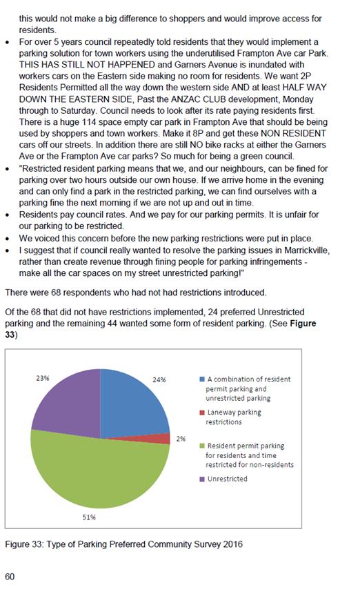
Following the development of draft recommendations a period of public exhibition was held between 3 March and 9 April 2017. During the public exhibition phase there were fifty seven (57) submissions with twenty five (25) respondents who did not support the draft recommendations and twenty two (22) who supported the recommendations. Of the twenty five (25) who did not support the recommendations, seven (7) were from Silver Street and all objected to the implementation of permit parking in their street. The recommendations have been amended to reflect that feedback.
There were a number of submissions against the implementation of No Parking restrictions in laneways. Recommendations in Peace Lane and Gladstone Lane have been amended in response. There were also a number of submissions seeking additional long term parking specifically in relation to extension of the parking hours in the Frampton Avenue (west) car park. The recommendation to introduce 9P restrictions addresses that feedback.
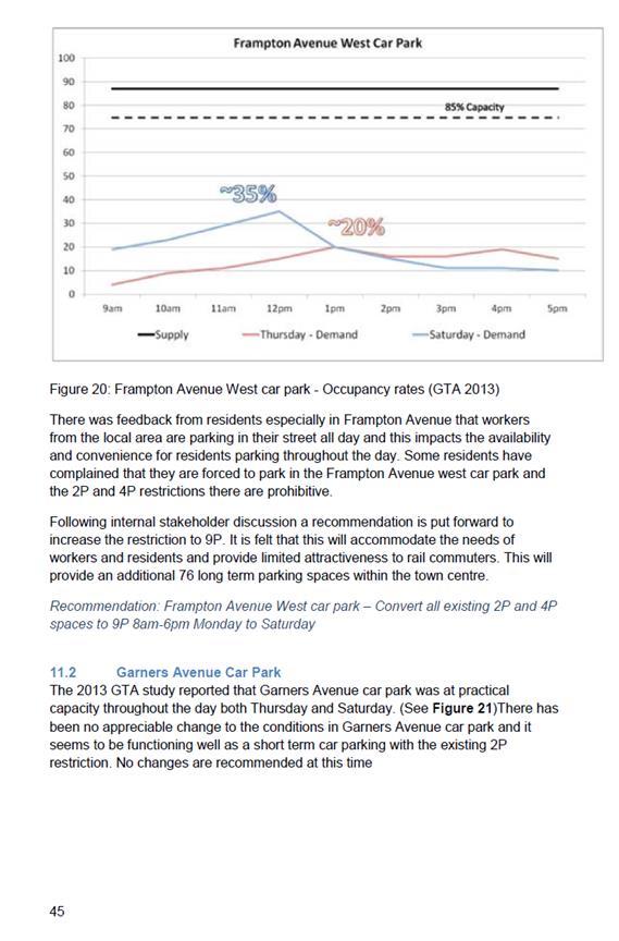
CONCLUSION
The 2013 GTA parking study in the Marrickville town centre addressed a number of significant parking issues in the area. The implementation of angle parking has been instrumental in addressing parking shortfall from development; and, the introduction of short term parking near the core area has provided increased opportunities for turnover for the retail centre. Resident parking has subsequently been extended into a number of streets and this has resulted in a reduction in residents expressing concerns to Council over parking impact.
The review has served to address a number of outstanding issues related to resident parking, off street parking (particularly in the Frampton Avenue (west) and short term parking in areas peripheral to the centre where there has been an increase in retail and commercial activity.
|
1.⇩ |
Final report post exhibition Marrickville Parking Study review 2017 |
|
|
Local Traffic Committee Meeting 6 July 2017 |
Subject: Requests for Mobility Parking Spaces (Marrickville & Ashfield Wards/Summer Hill Electorate/Marrickville LAC)
File Ref: 17/6022/74238.17
Prepared By: Idris Hessam - Graduate Civil Engineer Traffic Services
Authorised By: Joe Di Cesare - Manager Design and Investigation
|
SUMMARY A number of requests have been received from residents for the provision of dedicated mobility parking space outside their residence. It is recommended that the following 'Mobility Parking' spaces be approved as the applicants current medical conditions warrants the provision of the space and they have constrained or no off-street parking opportunities.
|
|
RECOMMENDATION
THAT the following locations:
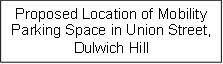
1. eastern side of Roach Street, Marrickville in front of property no. 2 Roach Street, Marrickville; 2. eastern side of Union Street, Dulwich Hill adjacent to property no. 643 New Canterbury Road, Dulwich Hill; 3. northern side of Frederick Street, St Peters in front of property no. 23 Frederick Street , St Peters; and 4. eastern side of Quarry Street, Tempe in front of property no.8 Quarry Street, Tempe be APPROVED as a ‘mobility parking’ space, subject to: a) the operation of the dedicated parking space be valid for twelve (12) months from the date of installation; b) the applicant advising Council of any changes in circumstances affecting the need for the special parking space; and c) the applicant is requested to furnish a medical certificate and current mobility permit justifying the need for the mobility parking space for its continuation after each 12 months period.
|
BACKGROUND
A copy of the RMS disability parking permit and a medical certificate in support of the applications was submitted to Council.
FINANCIAL IMPLICATIONS
The costs of the supply and installation of the signposting associated with the recommended mobility parking space is approximately $2000.
It should be noted that Council normally signposts on-street mobility parking spaces and does not line mark these spaces. Should the applicant require the provision of kerb ramps, this can be provided at their cost.
OFFICER COMMENTS
|
Subject Location |
Classification of Road |
Road Description |
|
Roach Street, Marrickville |
Local Road |
One-way residential street, 12.9m in width that runs north-south from Warren Road to Dead End. |
|
Quarry Street, Tempe |
Local Road |
Two-way residential street, 12.9m in width that runs north-south from Station Street to Bay Street. |
|
Union Street, Dulwich Hill |
Local Road |
Two-way residential street, 11.1m in width that runs north-south from May Street to New Canterbury Road. |
|
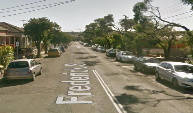
Frederick Street, St Peters |
Local Road |
Two-way residential street, 11.9m in width that runs west-east from Henry Street to Princess Hwy. |
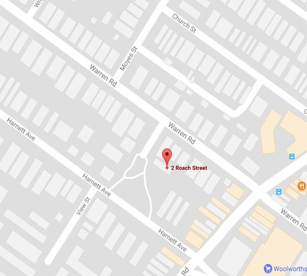
2 Roach Street, Marrickville
The applicant’s property is located on the eastern side of Roach Street, Marrickville. The applicant’s property has no off-street parking facility.
At present, unrestricted parking is permitted on both sides of Roach Street, Marrickville. It has been observed during a site inspection undertaken in the afternoon period that on-street parking spaces in Roach Street were moderately utilized.
The applicant does not drive a vehicle however he is driven by another family member.
Currently there is no existing mobility parking space within close proximity to the applicant’s property. Due to his current medical condition, he requires parking availability close to his property
641 New Canterbury Road, Dulwich Hill
The applicant’s property is located on the eastern side of New Canterbury Road, Dulwich Hill. The applicant’s property has no off-street parking facility.
At present, unrestricted parking is permitted on both sides of Union Street, Dulwich Hill. It has been observed during a site inspection undertaken in the afternoon period that on-street parking spaces in Union Street were moderately utilised.
The applicant does drive a vehicle and currently there is no existing mobility parking space within close proximity to the applicant’s property. Due to his current medical condition, he requires parking availability close to his property.
A notification letter has been sent to the neighbour at 643 New Canterbury Road, Dulwich Hill but no response has been received to date.
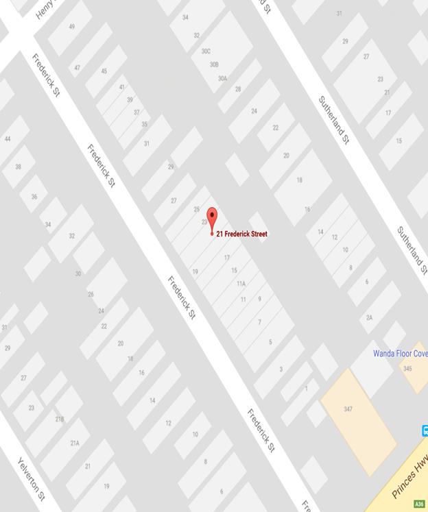
21 Frederick Street, St Peters
The applicant’s property is located on the northern side of Frederick Street, St Peters. The applicant’s property has no off-street parking facility.
At present, unrestricted parking is permitted on both sides of Frederick Street, St Peters. It has been observed during a site inspection undertaken in the afternoon period that on-street parking spaces in Frederick Street were moderately utilised.
It should be noted that the applicant will require the use of a wheelchair for mobility in the near future. Therefore the applicant requires parking availability close to her property.
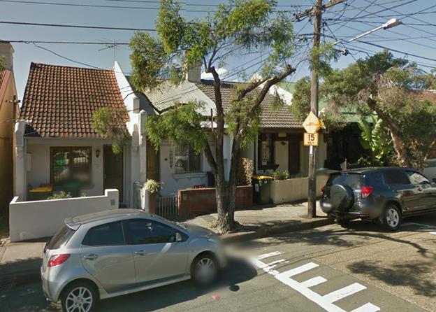
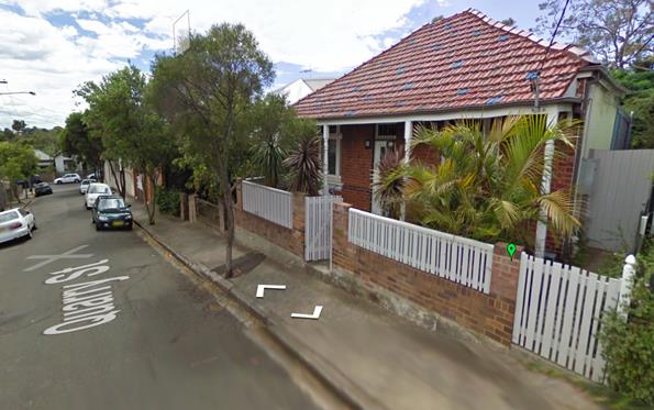
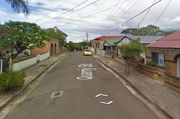
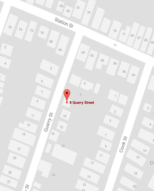
8 Quarry Street, Tempe
The applicant’s property is located on the eastern side of Quarry Street, Tempe. The applicant’s property has no off-street parking facility.
At present, unrestricted parking is permitted on both sides of Quarry Street, Tempe. It has been observed during a site inspection undertaken in the afternoon period that on-street parking spaces in Frederick Street were moderately utilised.
The applicant does drive a vehicle and due to his current medical condition, he requires parking availability close to his property.
Technical Standards
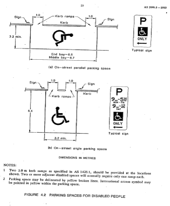
Australian Standard AS2890.5-1993 “On-Street Parking” states the following in regards to the provision of parking for people with a disability:
“Parallel parking spaces shall not be marked as disabled spaces, nor included in the count of spaces available for people with disabilities unless –
i. A 3.2m wide space can be provided, e.g. by indenting the space into the footpath area; and
ii. Kerb ramps as shown in Figure 4.2(a) are also provided”.
It should be noted that due to the limited width of streets around the Marrickville LGA, it is often difficult to comply with these requirements for the parking space dimensions. This may also result in the loss of some adjacent on-street parking spaces.
Mobility parking spaces are primarily intended for on-street and off-street parking at destinations, such as in commercial/retail areas and public car parks near hospitals, schools and public transport facilities where multiple usages can be expected. They were generally not intended for points of origin such as reserving on-street parking.
A mobility parking space is not intended for the sole use of one applicant, but rather a shared facility that can used by all authorised persons having an RMS mobility permit.
PUBLIC CONSULTATION
A notification letter has been sent to the applicants informing them of the application process and as part of the assessment they will be considered at this meeting.
CONCLUSION
It is recommended that ‘Mobility Parking' spaces be approved as the applicant’s properties do not have an off-street parking facility and/or the applicants condition warrants the provision of the space.
It should be noted that the proposed mobility parking spaces are not for the sole use of the applicant and may be used by other authorised persons.
Locality Map – 2 Roach Street, Marrickville

![]()
![]()
Photographs – 2 Roach Street, Marrickville
|
|
The frontage of the applicant's property in Roach Street, Marrickville
|
|
On-street parking Roach Street, Marrickville
Locality Map – 641 New Canterbury Road, Dulwich Hill
|
|
 |
|||
Photographs – 641 New Canterbury Road, Dulwich Hill
|
|
The frontage of the applicant's property in New Canterbury Road, Dulwich Hill
|
|
On-street parking in Union Street, Dulwich Hill
Locality Map – 21 Frederick Street, St Peters
![]()
![]()
![]()
Photographs – 21 Frederick Street, St Peters
|
|
The frontage of the applicant's property in Frederick Street, St Peters
|
|
On-street parking in Frederick Street, St Peters
Locality Map – 8 Quarry Street, Tempe

![]()
![]()
Photographs – 8 Quarry Street, Tempe
|
|
The frontage of the applicant's property in Quarry Street, Tempe
|
|
On-street parking in Quarry Street, Tempe
|
|
Local Traffic Committee Meeting 6 July 2017 |
Subject: Hodern Avenue Petersham - Proposed PermiT PARKING RESTRICTIONS (Stanmore Ward/Newtown Electorat/Marrickville LAC)
File Ref: 15/SF546/68614.17
Prepared By: Mary Bailey - Parking Planner
Authorised By: Joe Di Cesare - Manager Design and Investigation
|
SUMMARY Residents have made representations to Council to introduce resident parking restrictions in Hordern Avenue, Petersham. Permit parking restrictions have been introduced in surrounding streets as part of the Parramatta Road Corridor/Camperdown Parking Strategy. There was sufficient support through community consultation with affected residents to recommend permit parking restrictions in Hordern Avenue, Petersham.
|
|
RECOMMENDATION
THAT:
1. the installation of ‘2P 8am–10pm Mon-Fri, Area M5 Permit Holders Excepted’ restrictions on the eastern side of Hordern Avenue, Petersham (between Croydon Street and the cul de sac) be APPROVED, in order to provide parking opportunities for local residents; and 2. the statutory ’No Stopping’ zones (10 metres in length) be put in place where required as part of the recommended parking changes listed above.
|
BACKGROUND
A number of streets in the Petersham area in close proximity to Hordern Avenue, Petersham have been designated as permit parking in the Parramatta Road Corridor/Camperdown Parking Study (2016). As Hordern Avenue was not included in the resident parking scheme, there have been concerns expressed by residents that parking for residents is already difficult due to a number of impacts including commuter parking. Also, residents have expressed a concern that there would be a knock-on effect now that the proposed resident parking restrictions are implemented in surrounding streets. See Figure 1 for a map illustrating the nearby streets which have had resident parking implemented recently.
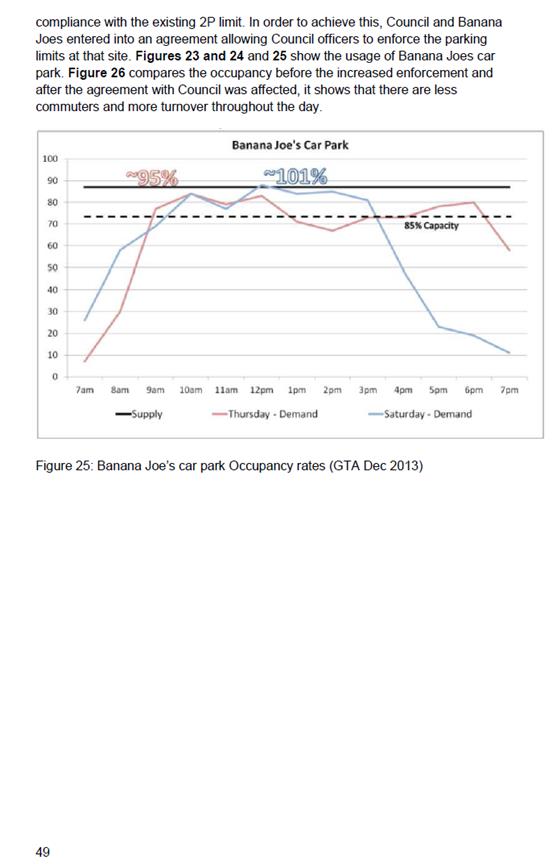
The parking surveys undertaken as part of the Parramatta Road Corridor/Camperdown Parking Study show that there is a commuter effect in Hordern Avenue experiencing high levels of occupancy (85% plus) on Tuesday and Thursday throughout the day with a low level of parking occupancy (50% or less) on Saturday.
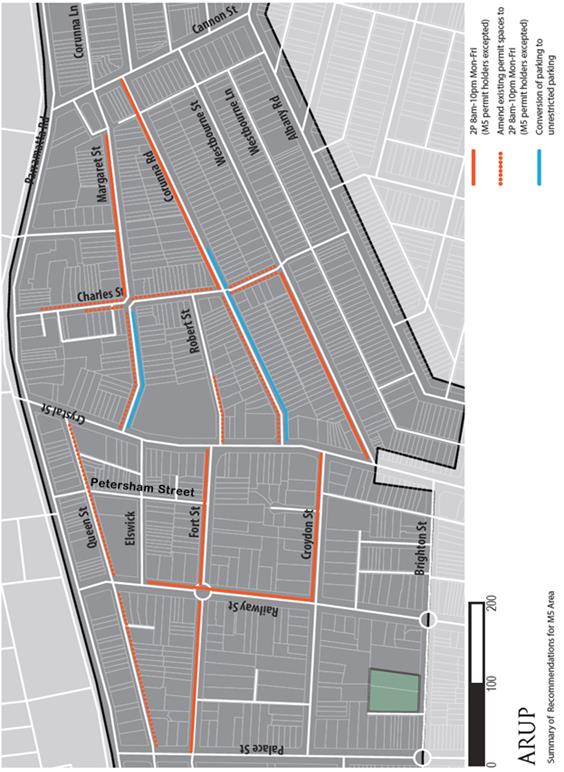
Figure 1: Recommendations for parking restrictions from Parramatta Road
Corridor/Camperdown Parking Study 2016
FINANCIAL IMPLICATIONS
The costs of the supply and installation of the signposting associated with the recommended ‘No Stopping’ & Permit Parking restrictions are approximately $1,500 and can be met from Council’s operating budget.
OFFICER COMMENTS
The proposal is to restrict parking to 2 hours between 8am and 10pm Mon-Fri, Permit Holders Excepted Area M5, at the front of residential. See Figure 2 and Figure 3 below for maps of the proposed changes.
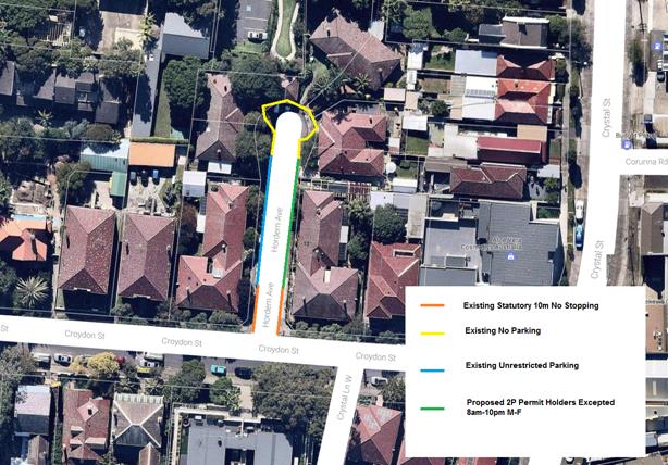
Figure 2: Existing and Proposed Parking Restrictions in Hordern Avenue, Petersham
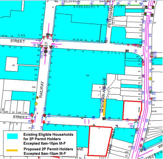
Figure 3: Permit Parking conditions in the surrounding area to Hordern Avenue, Petersham
PUBLIC CONSULTATION
A notification letter was sent on 2 June 2017 to owners and occupiers of the affected properties that are adjacent to the subject sections along Hordern Avenue and Croydon Street, Petersham regarding proposed introduction of ‘2P 8am-10pm Mon-Fri Permit Holders Excepted Area M5’ restrictions to address concerns regarding difficulty for residents to find parking. The closing date for submissions ended on 16 June 2017.
A total of thirty (30) letters were sent out to the affected residential properties (Croydon Street and Hordern Avenue properties). There were seven (6) responses received.
Council received one (1) response opposing and five (5) responses supporting the proposed permit parking and ‘No Stopping’ restrictions. The responses are detailed below.
|
Residents’ Comments (opposing proposal) |
Officer’s Response |
|
One (1) resident of Croydon Street opposes the proposed permit parking stating that there were multiple vehicles associated with the household and further restrictions would make parking more difficult.
|
Where resident parking restrictions are installed, this is only on one side of the affected street, leaving the opposite side unrestricted parking. This unrestricted parking is available for vehicles of residents who are not eligible for resident parking permits. |
|
Residents’ Comments (supporting proposal) |
Officer’s Response |
|
Five (5) residents of Hordern Avenue supported the proposal. No specific comments were received. |
Received and noted.
|
CONCLUSION
Council acknowledges the potential impact of knock-on effects from the pending introduction of permit parking in surrounding streets. The proposal to introduce permit parking restrictions in Hordern Avenue, Petersham has received sufficient support to proceed with the implementation.
|
|
Local Traffic Committee Meeting 6 July 2017 |
Subject: Fowler Lane, Camperdown - Extension of Statutory 'No Stopping' Restrictions at Tooth Lane to Improve Access (Stanmore Ward/Newtown Electorate/Newtown LAC)
File Ref: 17/6022/74163.17
Prepared By: Jennifer Adams - Traffic and Road Safety Officer
Authorised By: Joe Di Cesare - Manager Design and Investigation
|
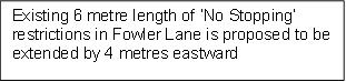
SUMMARY A resident of Fowler Street, Camperdown raised concerns with vehicles being parked in Fowler Lane opposite their driveway/off street parking and therefore restricting vehicular access into and out of their off street parking. It is recommended that the existing 6 metre length of 'No Stopping' restrictions on the southern side of Fowler Lane east of Tooth Lane be extended 4 metres eastward to a distance of 10 metres from its intersection with Tooth Lane to improve vehicular access to residents’ off-street parking.
|
|
RECOMMENDATION
THAT the proposal to extend the existing 6 metre length of ‘No Stopping’ restrictions on the south side of Fowler Lane east of Tooth Lane be extended 4 metres eastward to a distance of 10 metres from its intersection with Tooth Lane, Camperdown be APPROVED in order to deter illegal parking, increase safety and visibility for turning motorists, and improve vehicular access into and out of residents’ off-street parking.
|
BACKGROUND
Concerns have been raised by a resident of Fowler Street, Camperdown that vehicles legally parked in Fowler Lane opposite their driveway/off street parking restrict vehicular access into and out of their driveway/off street parking. The resident advised that the problem is due to vehicles parking on the opposite side of the laneway, this is compounded by the narrow width of the laneway and that the laneway is busy.
The applicant’s property is located on the southern side of Fowler Street and has one off-street car parking facility, accessed from Fowler Lane. (Refer to the attached locality map and photographs).
FINANCIAL IMPLICATIONS
The cost of the relocation of the existing ‘No Stopping’ sign 4 metres eastward on the southern side of Fowler Lane, east of Tooth Lane, is approximately $300 and can be met form Council’s signs and line markings budget.
OFFICER COMMENTS
Fowler Lane is a narrow laneway (4.9 metre carriageway) running east-west between Mallett and Australia Streets and intersecting with Gibbens Street at its mid-point. The section of laneway referred to in this report extends from Gibbens Street to Mallett Street and a ‘one-way’ restriction in an easterly direction applies. At present, “No Parking” restrictions are installed along the northern side of this section of lane and ‘2P 8.30am-6pm Monday-Friday’ restrictions with statutory ‘No Stopping’ restrictions along the southern side.
NSW legislation includes various requirements to manage access and parking on roads. The Roads Act provides rights of access along roads and also for access to private property. The Road Rules includes requirements which affect parking at intersections, driveways and also parking along laneways. Increasing the ‘No Stopping’ distance as suggested brings it into line with current statutory 10 metre No Stopping distances.
Technical Issues
In accordance with the Australian Road Rules, a ‘No Stopping’ zone is mandatory for a distance of 10 metres from an intersecting road. Pursuant to the RMS’ Technical Directions, it is stated that signposting at an unsignalised intersection (without pedestrian crossing) “should only be required where there is a compliance problem or there is adjoining signposting”.
Parking in laneways
Council’s Laneway Parking Guidelines outline the measures to consider when the use of the laneway prohibits access to off-street parking and access through the laneway. Effectively managed laneways allow for adequate access while providing the maximum amount of on-street parking. The guidelines provide consistency for assessing the need for parking controls.
It should be noted that laneways were generally built to provide service for properties and access into off-street parking facilities therefore restricting parking in this laneway will help achieve this goal.
Further, it is noted that according to Council’s Residential Parking Permit scheme for M1 parking area when a property has one off street parking space only one parking permit is permissible for that property.
PUBLIC CONSULTATION
On 1 June 2017 eight letters were sent out to surrounding owners/occupiers notifying them that Council was proposing to extend the existing statutory ‘No Stopping’ restrictions in Fowler Lane on the southern side east of its intersection with Tooth Lane, Camperdown to improve resident’ access to off-street parking.
The closing date for submissions ended on 19 June 2017. Two responses were received in addition to the applicant’s original request.
Comments from residents
|
Resident’s comments |
Council Officer’s response |
|
Resident approves the proposal and said at times it was very hard to go out of their off street parking space. |
Noted. |
|
Resident supports the proposal
|
Noted |
|
Resident opposes the proposal to designate the first 10 metres on the southern side of laneway being no stopping zone and states that parking in the area has become increasing difficult. |
No legal parking has been lost as a result of this proposal. In accordance with the Australian Road Rules, a ‘No Stopping’ zone is mandatory for a distance of 10 metres from an intersecting road.
|
CONCLUSION
In order to provide clear vehicular access to the applicant's off-street parking facility, it is recommended that the the existing statutory 'No Stopping' restrictions on the southern side of Fowler Lane be extended by 4 metres eastward to a distance of 10 metres from its intersection with Tooth Lane, Camperdown.
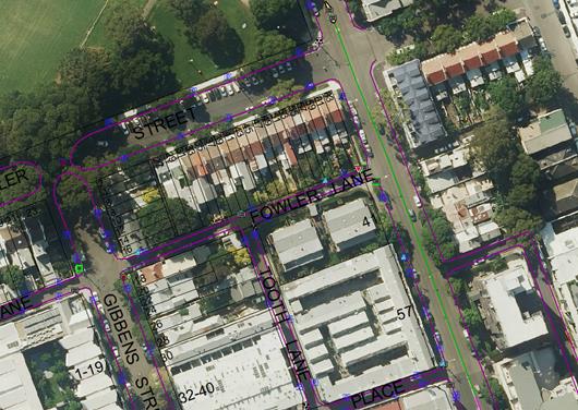
Locality map – Fowler Lane, Camperdown
![]()
Proposed 4 metre extension to existing statutory ‘No Stopping’ restrictions in Fowler Lane, Camperdown

![]()
![]()
![]()
![]()
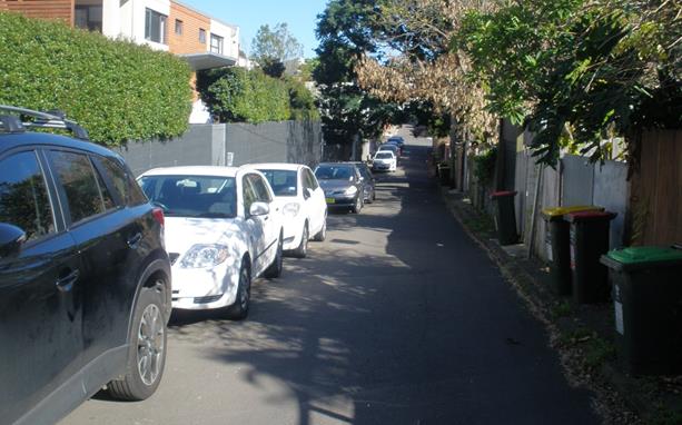
Photographs – Fowler Lane, Camperdown
![]()
Fowler Lane looking westward towards Tooth Lane and Gibbons Street, Camperdown
![]()
![]()
![]()
![]()
![]()
![]()
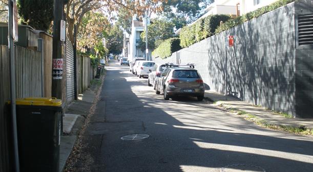
Extend existing ‘No Stopping’ restrictions eastward by 4 metres on the southern side of
Fowler Lane, Camperdown
|
|
Local Traffic Committee Meeting 6 July 2017 |
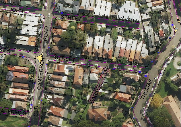
Subject: Barker Lane, Lewisham - 'No PaRking' Restrictions in the Laneway (Stanmore Ward/Newtown Electorate/Marrickville LAC)
File Ref: 17/6022/74074.17
Prepared By: Jennifer Adams - Traffic and Road Safety Officer
Authorised By: Joe Di Cesare - Manager Design and Investigation
|
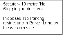
SUMMARY Representations have been received from local residents for the installation of full time ‘No Parking’ restrictions in Barker Lane, Lewisham as vehicular access is often blocked by parked vehicles in the laneway and some residents cannot access their off-street parking. Residents have been notified of the proposal to install ‘No Parking’ restrictions along the western length of the laneway along with statutory 10 metre ‘No Stopping’ signs on the north-west side of Barker Lane at its intersection with Barker Street. It is recommended that the proposal be approved.
|
|
RECOMMENDATION
THAT:
1. the installation of full-time ‘No Parking’ restrictions on the western side of Barker Lane, Lewisham along the 34 metre lenght of the laneway (from the end of the cul-de-sac to the statutory 10 metre distance) be APPROVED, in order to provide unobstructed vehicular access to the laneway and to the off-street car parking spaces and deter illegal parking across vehicular crossings;
2. the installation of statutory ‘No Stopping’ restrictions on the north-west side of Barker Lane, Lewisham for a distance of 10 metres from its intersection with Barker Street, Lewisham be APPROVED, in order to deter illegal parking, improve access for turning motorists and increase safety; and
3. the applicants, Council Rangers and affected residents be advised in terms of this report.
|
BACKGROUND
Council Officers have been advised that vehicular access to Barker Lane is often blocked by vehicles parked in the laneway and some residents cannot access their off-street parking when vehicles are parked opposite their driveway/garage.
Residents have also indicated that parking issues in the laneway are amplified by the angle of the garage access to the laneway. (Refer to the attached locality map and photographs.)
FINANCIAL IMPLICATIONS
The costs of the supply and installation of the signposting associated with the recommended ‘No Parking’ & ‘No Stopping’ restrictions are approximately $800 and can be met from Council’s operating budget.
OFFICER COMMENTS
Barker Lane is a dead-end laneway running south-west off Barker Street, between Old Canterbury Road and Thomas Street, Lewisham. The laneway is approximately 44 metres in length and 4.6 metres in width and has kerb gutters with no footpath. Barker Lane provides rear access to properties fronting Thomas Street mainly and one property on Barker Street and has driveways located on both sides of the laneway. At present the laneway has no parking restrictions and vehicles generally park on the western side.
A site inspection undertaken by a Council Officer revealed that a number of vehicles parked on the western side opposite driveways and when a vehicle is parked in these spaces it does not leave sufficient space for residents to enter/exit from their garages/off-street parking spaces due to the narrow carriageway.
Parking in laneways
Council recently adopted the Laneway Parking Guidelines which outline the measures to consider when the use of the laneway prohibits access to off-street parking and access through the laneway. The effective use of narrow streets and laneways alleviates parking pressure. Effectively managed laneways allow for adequate access while providing the maximum amount of on-street parking.
The Laneway Parking Guidelines outline the priorities for using narrow laneways and the actions and processes that Council will use to manage access and parking. These guidelines have been developed to provide consistency for evaluating the need for parking controls and manage the use of narrow streets and laneways to maintain access and maximise parking. The need for parking controls is based on the width of the laneway shown below in Table 1.
Table 1: Laneway Parking Guidelines Laneway Width
|
Laneway Width |
Parking and Access Arrangements |
|
5.1 metres or more wide |
· Parking allowed on at least one side of the laneway · Allows access for emergency, delivery and waste collection trucks at all times · Complies with Australian Standards and Road Rule 208(7) |
|
Less than 5.1 metres |
· Parking NOT permitted in the laneway · Allows vehicle access at all times and complies with Australian Standards and Road Rule 208(7) |
NSW legislation includes various requirements to manage access and parking on roads. The Roads Act provides rights of access along roads and also for access to private property. The Road Rules includes requirements which affect parking at intersections, driveways and also parking along laneways.
Parking in narrow laneways next to intersections and driveways can cause access and safety concerns for residents. NSW Road Rules address these issues as they prohibit parking across property driveways and within 10 metres of an intersection without traffic lights.
For parking to be allowed in a narrow laneway, the Australian Standards require that parallel parking spaces be at least 2.1 metres wide and NSW Road Rules requires that at least 3 metres must be available between a parked car and the kerb or edge of the laneway to allow moving vehicles to pass safely. Therefore, laneway widths that are less than 5.1 metres wide are too narrow to allow parking as any parked vehicle would prevent traffic from using the laneway (see Figure 1).
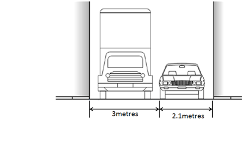
Figure 1: Recommended minimum width of laneway for parking – 5.1 metres
Council’s preference is for residents to negotiate with each other to avoid implementing parking bans. Where problems occur, parking restrictions can be considered for individual laneways on a case-by-case basis. The guidelines provide consistency for assessing the need for parking controls.
It should be noted that laneways were generally built to provide service for properties and access into off-street parking facilities therefore restricting parking in this laneway will help achieve this goal.
PUBLIC CONSULTATION
A consultation letter was sent to six affected residents that are adjacent to Barker Lane regarding the proposal to install full-time ‘No Parking’ restrictions along the entire western side of the laneway with statutory ‘No Stopping’ restrictions on the north-west end of the lane at its intersections with Barker Street, Lewisham. The closing date for submissions ended on 19 June 2017.
Resident survey findings
A total of two responses were received from residents, representing a 33% return. Both of the submissions out rightly supported the proposal. art and 2 were neutral stating that recent residential parking scheme restrictions in adjoining streets created a demand for parking in the laneway.
CONCLUSION
In order to provide unobstructed vehicular access to the laneway and residents’ off-street car parking spaces and deter illegal parking across vehicular crossings, it is recommended that full-time ‘No Parking’ restrictions be installed in Barker Lane on the western side of the laneway from the statutory 10 metre ‘No Stopping’ section at Barker Street to the end of the laneway, in order to deter illegal parking, improve access for turning motorists and increase safety.
Locality Map – Barker Lane, Lewisham
![]()
![]()
![]()
![]()
![]()
![]()
![]()
Proposed ‘No Parking’ restrictions (western side) in Barker Lane, Lewisham
Photographs – Barker Lane, Lewisham
Location of new signage – Barker Lane, Lewisham
![]()

![]()

![]()

![]()
ATTACHMENTS
|
|
Local Traffic Committee Meeting 6 July 2017 |
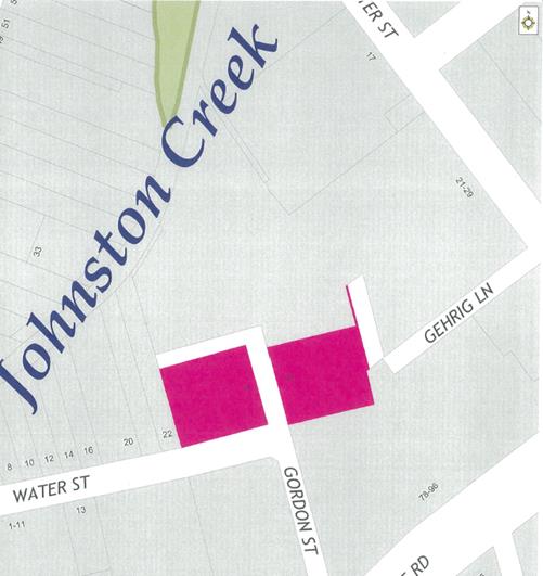
Subject: Gordon Street, Annandale - 'No Stopping' Restrictions (Leichhardt Ward/Balmain Electorate/Leichhardt LAC)
File Ref: 17/6022/74624.17
Prepared By: Manod Wickramasinghe - Traffic and Parking Engineer
|
SUMMARY Council has received a request to signpost the statutory ‘No Stopping’ restrictions on the western side of Gordon Street, north of Water Street, Annandale in order to prevent illegal parking.
|
|
RECOMMENDATION
THAT a 10m ‘No Stopping’ zone be installed on the western side of Gordon Street, north of Water Street, Annandale.
|
BACKGROUND
Concerns have been raised regarding vehicles parking on the western side of Gordon Street, north of Water Street, too close to the intersection of Gordon Street/Water Street, Annandale.
This parking behaviour obstructs maneuvering space and also obstructs access to the off-street parking on the eastern side of Gordon Street, Annandale.
In order to alleviate this issue it is proposed to signpost the 10m ‘No Stopping’ zone as shown on the following plan.
FINANCIAL IMPLICATIONS
The cost of signposting will be funded from Council’s operational budget.
PUBLIC CONSULTATION
A letter outlining the above proposal was mailed out to the affected properties (2 properties) in Gordon Street, Annandale – see image below.
No responses were received.
CONCLUSION
The proposed ‘No Stopping’ zone will improve sight distance at the intersection and remove illegal parking opposite the off street parking on the eastern side of Gordon Street, Annandale.
|
|
Local Traffic Committee Meeting 6 July 2017 |
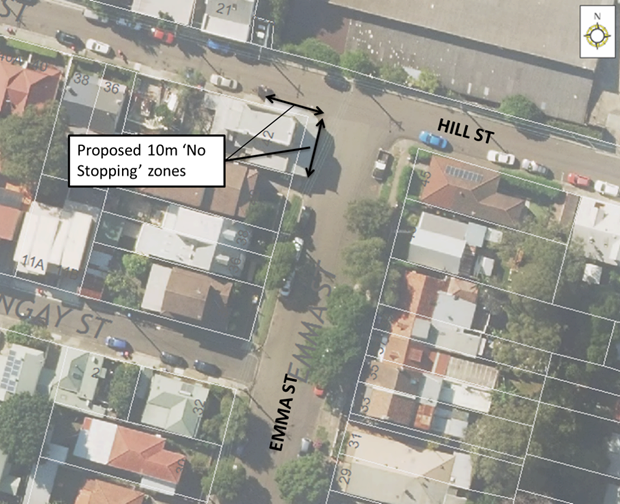
Subject: Emma Street and Hill Street, Leichhardt 'No Stopping' Restrictions (Leichhardt Ward/Balmain Electorate/Leichhardt LAC)
File Ref: 17/6022/74634.17
Prepared By: Manod Wickramasinghe - Traffic and Parking Engineer
|
SUMMARY Council has received a request to signpost the statuary ‘No Stopping’ restrictions at the intersection of Emma Street and Hill Street, Leichhardt on the frontage of No.42 Emma Street, Leichhardt in order to prevent illegal parking. |
|
RECOMMENDATION
THAT:
1. a 10m ‘No Stopping’ zone be installed on the southern side of Hill Street, west of Emma Street, Leichhardt; and 2. a 10m ‘No Stopping’ zone be installed on the western side of Emma Street, south of Hill Street, Leichhardt.
|
BACKGROUND
Council has received concerns from the owner of No.42 Emma Street, Leichhardt regarding vehicles damaging the awning support posts of No.42 Emma Street by parking on the western side of Emma Street and southern side of Hill Street, too close to the intersection of Emma Street/Hill Street, Leichhardt.
The awning posts are within 10m of the subject intersection and damage is largely caused by vehicles maneuvering when parking illegally.
In order to alleviate this issue, it is proposed to signpost the statutory 10m ‘No Stopping’ zones as shown on the following plan.
FINANCIAL IMPLICATIONS
The cost of signposting will be funded from Council’s operational budget.
PUBLIC CONSULTATION
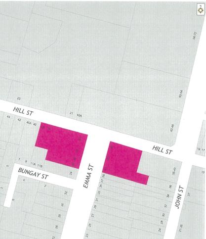
A letter outlining the above proposal was mailed out to the affected properties (9 properties) in Emma Street and Hill Street, Leichhardt – see image below.
No responses were received.
CONCLUSION
The proposed ‘No Stopping’ zones will improve sight distance at the intersection and remove illegal parking manoeuvers adjacent to the awning support posts at the corner property.
|
|
Local Traffic Committee Meeting 6 July 2017 |
Subject: Minor Traffic Facilities (Leichhardt & Balmain Wards/Balmain Electorate/Leichhardt LAC)
File Ref: 17/6022/74604.17
Prepared By: Manod Wickramasinghe - Traffic and Parking Engineer
|
SUMMARY This report deals with minor traffic facility applications received by Inner West Council, Leichhardt and includes ‘Disabled Parking’ and ‘Works Zone’ applications.
|
|
RECOMMENDATION
THAT:
1. the ‘Disabled Parking’ space in front of No.9 Cecily Street, Lilyfield be removed as the zone is no longer required; 2. the ‘Disabled Parking’ space in front of No. 2 Reuss Street, Balmain be removed as the zone is no longer required; 3. the ‘Disabled Parking’ space in front of No.156 Beattie Street, Balmain be removed as the zone is no longer required; 4. a 6m ‘Disabled Parking’ zone be installed in front of No.21 Nelson Street, Rozelle (overhanging across No.23 Nelson Street by 1.5m) replacing the 4P ticket parking (RPS) restrictions; 5. a 10m 'Works Zone 7.00am - 5.00pm Mon-Fri, 7.00am - 1.00pm Sat' be installed in front of No.99 Evans Street, Rozelle for 12 weeks with the 2P Resident Parking zone being temporarily removed; and 6. a 10m 'Works Zone 7.00am - 5.00pm Mon-Fri, 7.00am - 1.00pm Sat' be installed in front of No.2A Hart Street, Balmain East for 12 weeks (adjacent to driveway of No.2A Hart Street).
|
BACKGROUND
This report considers minor traffic facility applications received by Inner West Council, Leichhardt and includes ‘Disabled Parking’ and ‘Works Zone’ requests.
FINANCIAL IMPLICATIONS
The installation of ‘Disabled Parking’ signage is funded from Council’s operating budget and ‘Works Zones’ signage from fees and charges paid by the applicant.
OFFICER COMMENTS
1 Removal of ‘Disabled Parking’ Restriction – Cecily Street, Lilyfield
Council Ref: DWS 4374915
Council has been notified that the applicant to the ‘Disabled Parking’ zone in front of No.9 Cecily Street, Lilyfield has passed away and thus the ‘Disabled Parking’ zone is no longer required.
Officer’s recommendation
That the ‘Disabled Parking’ space in front of No.9 Cecily Street, Lilyfield be removed as the zone is no longer required.
2 Removal of ‘Disabled Parking’ Restriction – Reuss Street, Birchgrove
Council Ref: DWS 4347260
Council has been notified by the applicants’ family that the applicant to the ‘Disabled Parking’ zone in front of No.2 Reuss Street, Birchgrove has moved away and thus the ‘Disabled Parking’ zone is no longer required.
Officer’s recommendation
That the ‘Disabled Parking’ space in front of No. 2 Reuss Street, Balmain be removed as the zone is no longer required.
3 Removal of ‘Disabled Parking’ Restriction – Beattie Street, Balmain
Council Ref: DWS 4384519
Council has been notified by the new owners of No.156 Beattie Street, Balmain that the applicant to the ‘Disabled Parking’ zone in front of No.156 Beattie Street has moved away and thus the ‘Disabled Parking’ zone is no longer required.
Officer’s recommendation
That the ‘Disabled Parking’ space in front of No.156 Beattie Street, Balmain be removed as the zone is no longer required.
4 Installation of ‘Disabled Parking’ Restriction – Nelson Street, Rozelle
Council Ref: DWS 4261993
The resident of No.21 Nelson Street, Rozelle has requested the installation of a ‘Disabled Parking’ zone in front of the resident’s property. However, due to the narrow width of properties in Nelson Street, there will be some overhang across the frontage of No.23 Nelson Street by approximately 2m. The owner occupiers of No.23 Nelson Street have been notified about the proposal and were supportive.
A site investigation has revealed that the property does not have off-street parking. Note, there is 4P Ticket and Resident Parking restrictions in this section of Nelson Street.
The applicant does not require the use of a wheelchair.
Officer’s recommendation
That a 6m ‘Disabled Parking’ zone be installed in front of No.21 Nelson Street, Rozelle (overhanging across No.23 Nelson Street by 1.5m) replacing the 4P ticket parking (RPS) restrictions.
5 Installation of ‘Works Zone’ Restriction – Evans Street, Rozelle
Council Ref: DWS 4405764
The applicant has requested the installation of a temporary 10m 'Works Zone 7.00am - 5.00pm Mon-Fri, 7.00am - 1.00pm Sat' in front of No.99 Evans Street, Rozelle for 12 weeks.
Officer’s recommendation
That a 10m 'Works Zone 7.00am - 5.00pm Mon-Fri, 7.00am - 1.00pm Sat' be installed in front of No.99 Evans Street, Rozelle for 12 weeks with the 2P Resident Parking zone being temporarily removed.
6 Installation of ‘Works Zone’ Restriction – Hart Street, Balmain East
Council Ref: DWS 4391248
The applicant has requested the installation of a temporary 10m 'Works Zone 7.00am - 5.00pm Mon-Fri, 7.00am - 1.00pm Sat' in front of No.2A Hart Street, Balmain East for 12 weeks.
Officer’s recommendation
That a 10m 'Works Zone 7.00am - 5.00pm Mon-Fri, 7.00am - 1.00pm Sat' be installed in front of No.2A Hart Street, Balmain East for 12 weeks (adjacent to driveway of No.2A Hart Street).
|
|
Local Traffic Committee Meeting 6 July 2017 |
Subject: Request for Mobility Parking Space at/near No 23A Albert Parade, Ashfield
File Ref: 17/6022/74320.17
Prepared By: Anca Eriksson - Traffic Officer
|
SUMMARY Council has received an application from a resident of No.23A Albert Parade, Ashfield for the installation of a dedicated mobility parking space at the front of the property in Albert Parade. It is recommended that a space be created in front of the property as there is a lack of or inability to park/access the property off-street and on-street parking in the vicinity of the home is difficult to find.
|
|
RECOMMENDATION
THAT the installation of a mobility parking space in front of/near No. 23A in Albert Parade, Ashfield, be supported. |
BACKGROUND
The applicant has supplied Council with copies of his mobility parking permit, and a letter from his Doctor supporting the need for a mobility parking space.
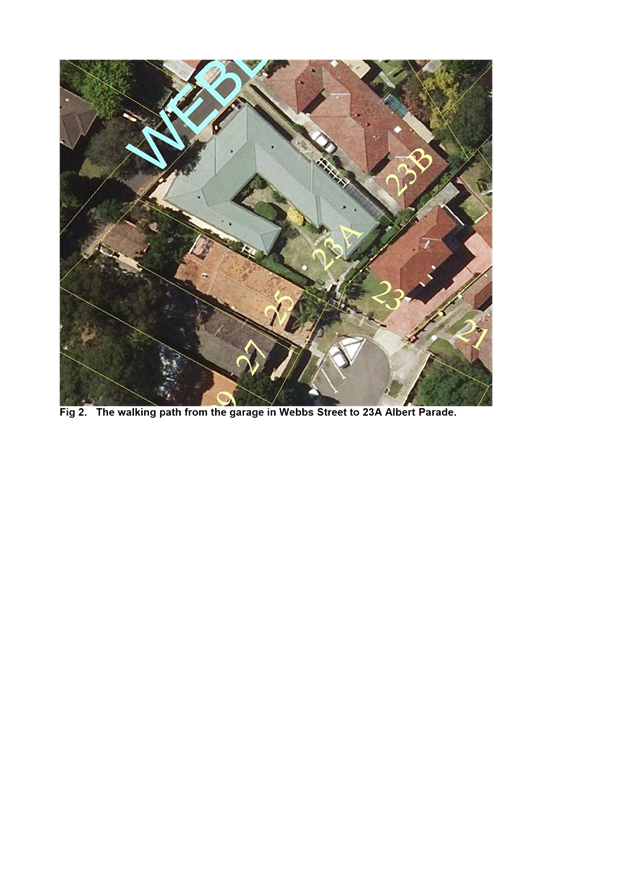
The applicant stated that although he has off-street parking, he finds it difficult to access his house due to the difficulty in driving in and out of his narrow width garage. He also finds it difficult to walk from the garage, located to the rear of the site in Webb Street, to the entrance of the property near/outside Albert Parade, which is more than 50m in length. See Figure 2 and 3 attached.
FINANCIAL IMPLICATIONS
The estimated cost of implementing the signs will be funded from Council’s operational budget.
OFFICER COMMENTS
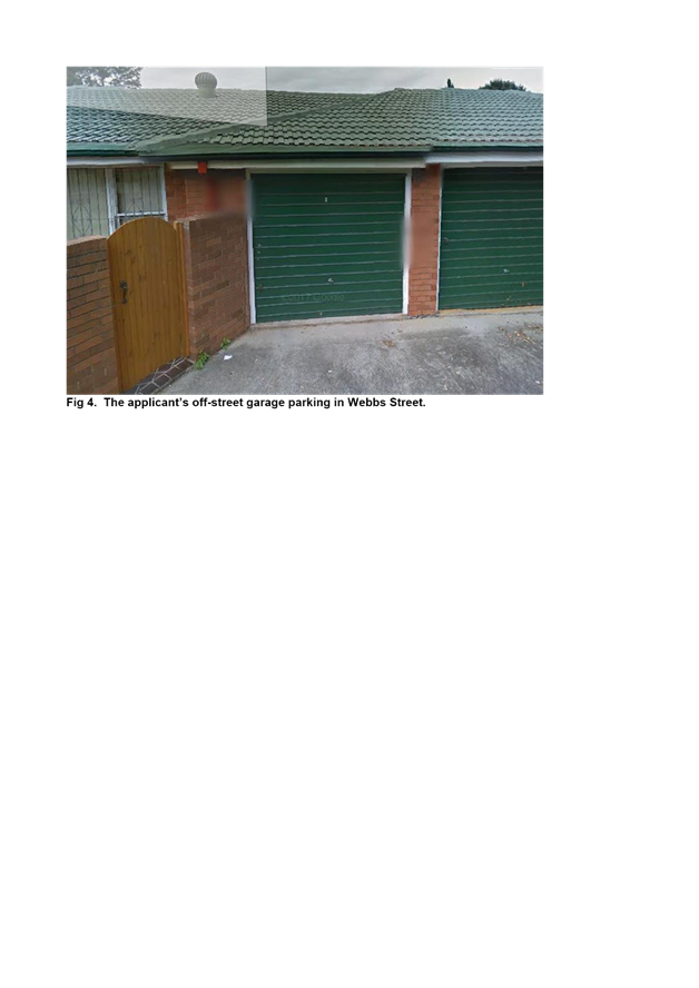
Inspection on-site identified that the garage does not properly cater for mobility impaired drivers, and cannot be modified in order to do so. Parking observations indicated that the resident has one off-street narrow width garage (2.4 m) located in Webbs Street (Fig 4).
The northern end of Albert Parade is closed as a cul-de-sac and the applicant’s place of residence is nearby. ‘No Stopping’ restrictions currently exist around the cul-de-sac, with 60 degree angle parking (front to kerb) on the western side and unrestricted parallel parking on the eastern side. Parking is highly utilised on both sides of the street.
The applicant has no rear access from Webb Street and he is required to walk up Webb Street and then through a driveway/pathway of the adjoining 23B building to access his property at Albert Parade.
The applicant’s Doctor has indicated that he has a very complex medical history and significant issues with his mobility. The illness or disability limits his walking to short distances and has indicated that the applicant needs to be able to park close to his home. The applicant has been informed that a Disabled Parking space, if provided will not be for his sole use and that any person holding a valid Mobility Parking Permit may park in it. Council has been informed that the Mobility Parking Space could be used by an elderly lady in the street having a disability.
The proposed Mobility Parking Space in Albert Parade is to be placed within the last angle parking spot on the western side measuring 2.5m in width. The space is next to an area marked clear of parking. This area can satisfy mobility space requirements under the Australian Standard AS2890.5. Kerb ramps are not proposed in this instance and an existing nearby driveway can adequately provide for access. The installation of a Mobility Parking Space outside the premises in Albert Parade is therefore recommended.
PUBLIC CONSULTATION
Council has written to residents of Albert Parade within the vicinity of the proposed Mobility Parking Space informing them of the application and inviting comment. No objections have been received.
CONCLUSION
It is recommended that the Mobility Parking space be supported as indicated in the above report.
|
1.⇩ |
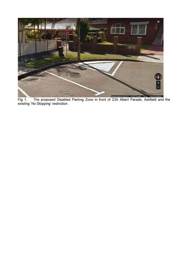
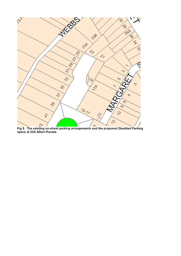
Fig 1. The proposed Disabled Parking Zone in front of 23A Albert Parade, Ashfield and the existing ‘No Stopping’ restriction. |
|
2.⇩ |
Fig 2. The walking path from the garage in Webbs Street to 23A Albert Parade. |
|
3.⇩ |
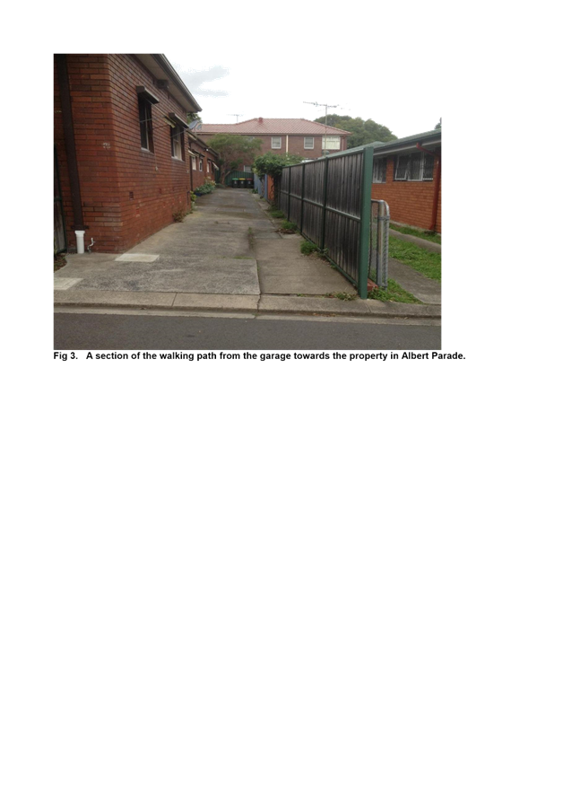
Fig 3. A section of the walking path from the garage towards the property in Albert Parade. |
|
4.⇩ |
Fig 4. The applicant’s off-street garage parking in Webbs Street. |
|
5.⇩ |
Fig 5. The existing on-street parking arrangements and the proposed Disabled Parking space at 23A Albert Parade. |
|
Local Traffic Committee Meeting 6 July 2017 |
Subject: Request for Works Zone Installation Outside 17 Charlotte Street, Ashfield (Haberfield Ward / Summer Hill Electorate / Ashfield LAC)
File Ref: 17/6022/74262.17
Prepared By: Helal (Henry) Uddin - Assistant Engineer
|
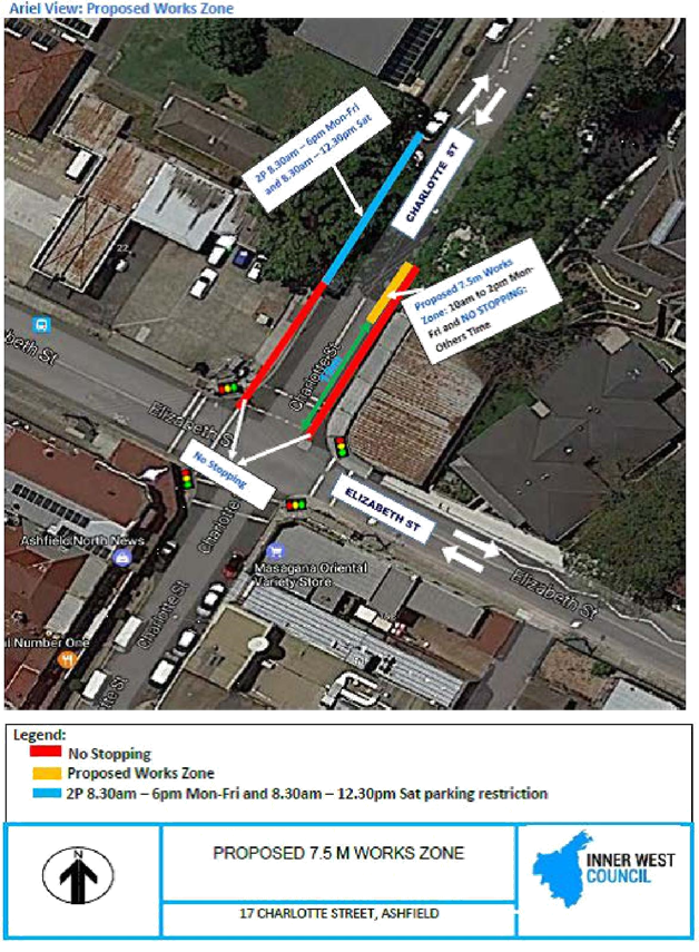
SUMMARY A request has been received from a builder to install a temporary 'Works Zone' between 10.00am to 2.00pm Mon – Friday outside 17 Charlotte Street, Ashfield. A 'Works Zone' approximately 7.5metres in length will be installed to the rear end of the site frontage outside 17 Charlotte Street, 19m from Elizabeth Street, Ashfield. The development works will include the removal and replacement of the shop’s awning and internal and external works. The 'Works Zone' will provide for the delivery of construction materials for the refurbishment works, as well as removing waste materials from the site.
|
|
RECOMMENDATION
THAT:
1. a 7.5m ‘Works Zone 10.00am to 2.00pm Mon-Fri, No Stopping At Other Times’ be temporarily installed outside 17 Charlotte Street, 19m north of Elizabeth Street, Ashfield for 12 weeks;
2. the rear 7.5m section of the existing ‘NO STOPPING’ zone (26.5m in total) be temporarily replaced with the above temporary 'Works Zone'; and
3. the cost of supply, installation and removal of the 'Works Zone' signs be met by the applicant, in accordance with Council’s current Fees and Charges.
|
BACKGROUND
The property is located at the corner of the signalised intersection of Elizabeth Street and Charlotte Street, Ashfield. The kerb lane along the full frontage of the site in Charlotte Street is currently restricted as ‘No Stopping’ for vehicles to negotiate a left turn (under filter) movement into Elizabeth Street. The building site has no off-street parking to accommodate construction vehicles. The builder has requested the installation of a temporary 'Works Zone' outside the rear section of the property in Charlotte Street for the ease, effective and safe handling of materials to and from the site.
FINANCIAL IMPLICATIONS
The cost of supply, installation and removal of the 'Works Zone' signs are to be in accordance with Council’s current Fees and Charges and are to be met by the applicant.
OFFICER COMMENTS
Charlotte Street between Elizabeth Street and Webbs Avenue is a two way street approximately 10.2m wide kerb to kerb. Parking is provided on both sides of the street with one through traffic lane in each direction.
Currently, 'No Stopping' restrictions apply outside the full frontage length of the site in Charlotte Street, approximately 26.5 metres in length. Left turn, through and right turn vehicle movements from Charlotte Street (north) at the intersection occur primarily under the one line of traffic. All turning movements are permitted during the green light phase. Charlotte Street (south) is one-way south, therefore allowing right turn vehicles travelling southbound to turn without any opposing movement. The left turn movement of vehicles into Elizabeth Street is not considered heavy outside of the peak hour times. A temporary reduced ‘No Stopping' length of 19 metres (15m from the Stop line) is considered sufficient for the left turn movement of vehicles outside of the peak hours. The kerb space along the full frontage of the Charlotte Street side of the site will revert to and operate as a 'No Stopping' zone outside of the proposed 'Works Zone' times.
PUBLIC CONSULTATION
Not applicable. The 'Works Zone' will apply within the rear end of the frontage to the site in Charlotte Street.
CONCLUSION
The proposed temporary 'Works Zone' will assist the parking of construction vehicles for loading and unloading of construction materials for the site. It is recommended that a 7.5m 'Works Zone 10am - 2pm; No Stopping At Other Times' be placed at the rear end of 17 Charlotte Street.
|
1.⇩ |
Aerial view of proposed works zone location |
|
2.⇩ |
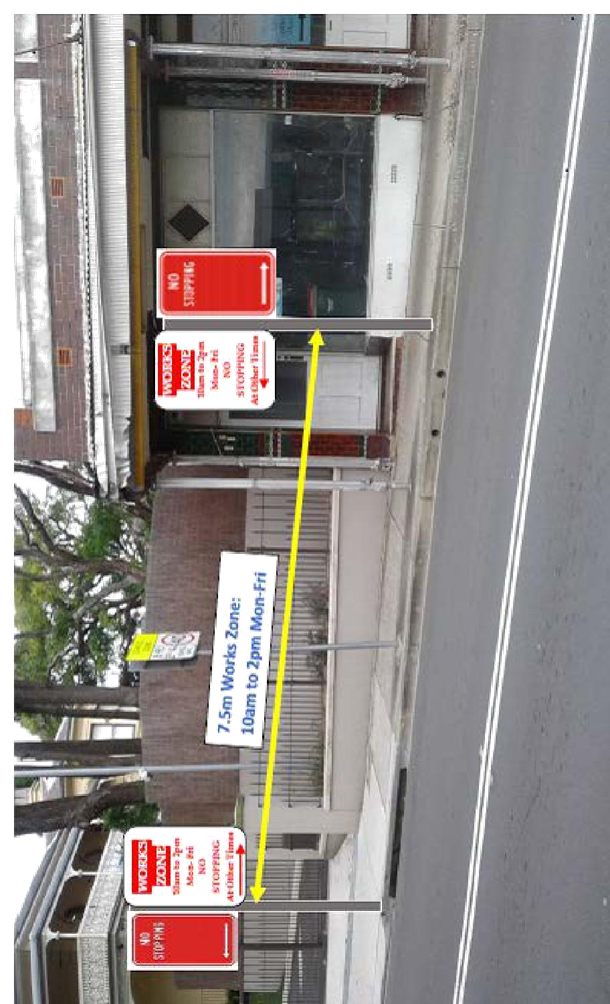
Photo highlighting the proposed works zone location |
|
Local Traffic Committee Meeting 6 July 2017 |
Subject: 2017 Footprints ECO Festival (Leichhardt/Balmain) Proposed Temporary Road Closure to Hold Footprints Festival on Sunday 27 August 2017
File Ref: 17/6022/72604.17
Prepared By: Nina Fard - A/Traffic Team Leader
|
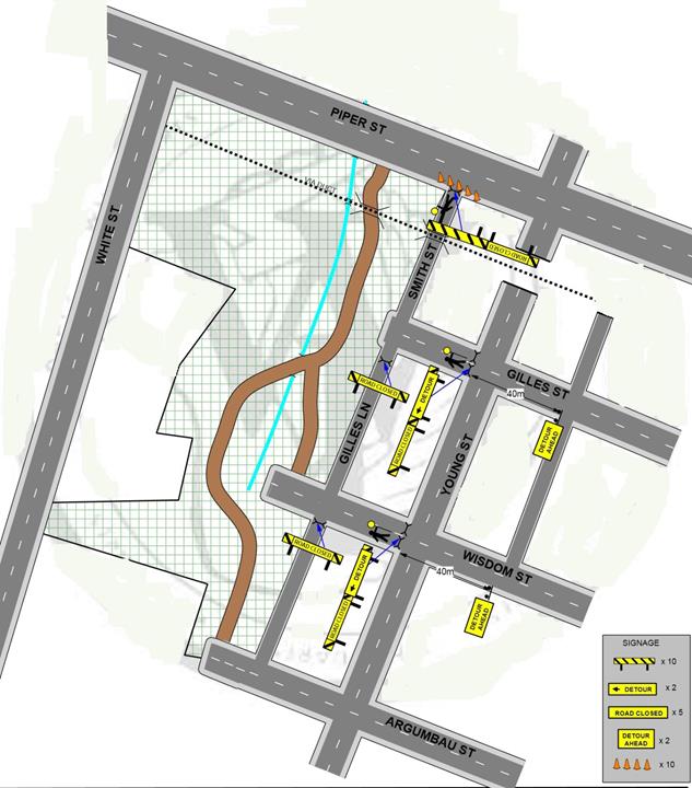
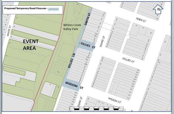
SUMMARY The Footprints Eco Festival is an event run by Inner West Council with a focus on environmental sustainability of the local community. The event will focus on delivering information to participants on a variety of environmental topics via talks, workshops and information, and market stalls. Some light entertainment will be located within the park lands and tours of environmentally notable locations within the parklands will be conducted throughout the event. • The Event will be held at Whites Creek Valley Park and William Stewart playground in Annandale on Sunday 27th August 2017 between 11:00am and 3:00pm. The event is expected to attract approximately 2000 people. It is recommended that the temporary road closures of the following streets be supported: • Smith Street between Piper Street and Gillies Street; • Gillies Street between Young Street and cul-de-sac; • Gillies Lane between Gillies Street and Wisdom Street; • Wisdom Street, west of Young Street; and Subject to formal approval of the TMP and TCP by RMS.
|
|
RECOMMENDATION
THAT:
1. the following temporary road closures for the ‘Footprints Eco’ festival to be held at Whites Creek Valley Park and William Stewart playground in Annandale from 2pm on Saturday, 26th August to 7pm on Sunday, 27th August 2017 be supported, subject to the TMP being approved by RMS:
• Smith Street between Piper Street and Gilles Street, • Gillies Street between Young Street and cul-de-sac, • Gillies Lane between Gillies Street and Wisdom Street, • Wisdom Street, west of Young Street
2. all residents, business houses, churches, hotels etc. in and around the affected areas be notified in advance of the temporary parking changes and temporary internal road closures in the subject area; 3. a three (3) metre unencumbered passage be available for emergency vehicles though all the closed section of internal roads at all times; 4. all advertising of the event encourage the use of Public Transport; 5. those additional public transport services, if necessary, be organised in coordination with the STA; 6. free bicycle valet parking be provided to the public and include the availability of this service in promoting the event; 7. Council provides and erects barricades and signage in accordance with Australian Standard AS 1742.3-1996: Traffic Control Devices for Works on Roads; 8. all traffic controllers must hold RMS certification; 9. all reasonable directions of Police be obeyed if such directions are given; 10. the local area Fire & Rescue NSW station be notified of the event details; 11. Council’s Manager Resource Recovery Services must be notified of the clean-up arrangements (Council contact: Allan Willding 9367 9222); and 12. the conduct of any activities or use of any equipment required in conjunction with the road closures must not result in any “offensive noise” as defined by the Noise Control Act. |
BACKGROUND
The traffic management during the event will be in accordance with the attached TMP and TCP and similar to that used for last year’s event. There were no reported issues regarding traffic management from last year. The attached TMP and TCP will be forwarded to RMS for formal approval.
In order to allow stalls and structures to be erected it will be required to temporarily close Smith Street (between Piper Street and Gilles Street), Gillies Street (between Young Street and cul-de-sac), Gillies Lane (between Gillies Street and Wisdom Street) and Wisdom Street, west of Young Street to traffic from 2pm on Saturday, 26th August to 7pm on Sunday, 27th August 2016.
The subject section of Gillies Street ends at a cul-de-sac. Both Smith Street and Gillies Street are local streets. As all the properties along Smith Street and Gillies Street have access to Young Street, the impact of the road closures is expected to be minimal.
The proposed road closures will be arranged using barricades and appropriate signage provided by Inner West Council at all road closure points prior to the commencement of the Event. In addition, traffic control marshals will be located at the main road closure points.
As the Event is to be held on a Sunday, traffic impacts on commercial and work related traffic would be minimal.
This event will promote the use of public transport as the predominant form of transport to the Event and a strong ‘No Cars’ message will be included in event promotions.
Inner West Council will arrange street cleaning and waste removal prior to the re-opening of the roadways. Traffic marshals will remain at all road closure barriers until street cleaning is completed and instructed by the Event Organiser to remove barriers.
Emergency vehicles will have access to all areas controlled by Traffic Controllers and Security Staff. First Aid Centres staffed by St Johns Ambulance Services will be situated within the parklands.
Residents will be advised prior to the event of closures and encouraged to pre-plan vehicle access before the event.
Heavy vehicles will be diverted at road closures in line with other traffic.
Inner West Council, as event organiser, carries public risk insurance cover with a minimum policy value $20,000,000. The policy will indemnify Inner West Council staff and Police staff rostered for duty on the day of the Event, against all claims for damage or injury that may result from activities associated with the Event and the occupation of that part of the public way occupied during the Event.
FINANCIAL IMPLICATIONS
Nil.
OFFICER COMMENTS
As part of the application process, Council will notify all residents, business houses, churches, hotels etc. in and around the affected areas, by way of letterbox drop detailing times of proposed road closures and parking restrictions that will be put in place on the day of the event.
The Footprints Eco Festival will be advertised on Council’s website and in the local community newspapers informing local residents of the revised traffic arrangements, road closures and parking restrictions that will be put in place on the day of the event. To further inform the public of the event, including the altered traffic arrangements, any advertising whether paid or free is to include notification of the closure and the potential for traffic delays in the area.
Traffic information services on commercial and community radio programs will be used to advise the public of the Event and the road closure associated with the event.
PUBLIC CONSULTATION
Nil.
CONCLUSION
It is recommended that the temporary road closures of the following Streets be supported:
• Smith Street between Piper Street and Gillies Street
• Gillies Street between Young Street to the cul-de-sac
• Gillies Lane, between Gillies Street and Wisdom Street
• Wisdom Street, west of Young Street
subject to formal approval of the TMP and TCP by RMS.
|
1.⇩ |
The Footprints Eco Festival TMP submitted by the event organiser. |
|
2.⇩ |
The Footprints Eco Festival TCP submitted by the event organiser. |
|
Local Traffic Committee Meeting 6 July 2017 |
Subject: Little Commodore Street, Newtown - Proposed Kerb Extension Design Plan (Stanmore Ward/Newtown Electorate/Newtown LAC)
File Ref: 17/6022/73470.17
Prepared By: Emilio Andari - Civil Engineer
Authorised By: Joe Di Cesare - Manager Design and Investigation
|
SUMMARY A detailed design plan has been finalised for the proposed footpath improvements in Pearl Street, Newtown as part of Council’s Capital Works Program for Footpaths. The proposal for a kerb extension with a new kerb and gutter alignment in Little Commodore Street at its intersection with Pearl Street will improve pedestrian safety and traffic conditions at this location.
|
|
RECOMMENDATION
THAT the detailed design plan of the kerb extension with a new kerb and gutter alignment in Little Commodore Street, Newtown at its intersection with Pearl Street (as per the attached design plan No. 6167) be APPROVED.
|
BACKGROUND
One of the key objectives from Council’s Community Strategic Planning document is to provide accessible and well connected footpaths, cycleways and associated facilities. The objective is to be achieved through reduced impact of traffic and improvement of pedestrian and cyclist safety, particularly around schools and urban centres.
Council is proposing to reconstruct the footpath along Pearl Street, Newtown and have integrated a kerb extension with a new kerb and gutter alignment at the intersection of Pearl Street and Little Commodore Street.
The detail design plan has been finalised for the proposed device together with the consultation and are presented in this report for consideration.
FINANCIAL IMPLICATIONS
Funding of $120,000 has been allocated by Council for the entire scope of works for Pearl Street under the 2017/2018 Capital Works Program for Footpaths. These works include reconstructing the footpath in Pearl Street (including a new kerb and gutter alignment at Little Commodore Street, new footpath trees and new kerb ramps) between Alice Street and Wells Street.
OFFICER COMMENTS
Site location & road network
|
Street Name |
Little Commodore Street |
|
Section |
Between Pearl Street and Commodore Street |
|
Carriageway Width (m) |
8.5 |
|
Carriageway Type |
Two-way road with one travel lane in each direction, in addition to kerbside parking lanes. |
|
Classification |
Local |
|
85th Percentile Speed (km/h) |
33.0 |
|
Vehicles Per Day (vpd) |
394 |
|
Reported Crash History (July 2011 - June 2016) |
No crashes recorded. |
|
Heavy Vehicle Volume (%) |
3.6 |
|
Parking Arrangements |
Southern side of the road consists of ‘2P 8am-10pm Permit Holders Excepted Area M14’ and northern side of the road consists of unrestricted parking. |
Design plans
The proposed scope of works includes the construction of a kerb extension on the northern side of Little Commodore Street at Pearl Street and two new kerb ramps.
The proposed treatment will not result in the loss of legal on-street parking spaces in Little Commodore Street (refer to the attached design plan No. 6167). All current vehicular access to adjoining properties will be retained.
PUBLIC CONSULTATION
Consultation was conducted in May 2017. A letter as well as a copy of the design plan for the entire scope of works for Pearl Street, Newtown was sent to the local residents. A total of 77 letters were distributed. There were no responses received in relation to the proposed kerb extension with a new kerb and gutter alignment at the intersection of Pearl Street and Little Commodore Street.
CONCLUSION
It is recommended that the design of the proposed kerb extension be approved, to improve pedestrian safety and traffic conditions.

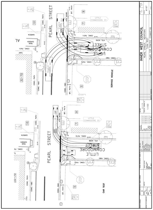 |
|
|
Local Traffic Committee Meeting 6 July 2017 |
Subject: Murray Street, Marrickville - Temporary Road Closure to Carry Out Crane Lift Escalators into Metro Shopping Centre (Marrickville Ward/Newtown Electorate/Marrickville LAC)
File Ref: 17/6022/72568.17
Prepared By: Idris Hessam - Graduate Civil Engineer Traffic Services
Authorised By: Joe Di Cesare - Manager Design and Investigation
|
SUMMARY An application has been received from K&D Traffic Management Pty Ltd for the temporary full road closure of Murray Street (between Victoria Road and Smidmore Street) Marrickville for a period of 43 hours from 6:00pm to 1:00pm continuously on 25th August till 27th of August 2017, in order to stand a mobile crane on Murray Street to crane lift Escalators across Murray Street into Metro shopping Centre, Marrickville. It is recommended that the proposed temporary road closure be approved, subject to the conditions outlined in this report.
|
|
RECOMMENDATION
THAT the proposed temporary full road closure of Murray Street (between Victoria Road and Smidmore Street) Marrickville for a period of 43 hours from 6:00pm to 1:00pm continuously on 25th August till 27th of August 2017, in order to stand a mobile crane on Murray Street to crane lift Escalators across Murray Street into Metro shopping Centre, Marrickville, subject to the following conditions:
1. a fee of $1,354.60 for the temporary full road closure is payable by the applicant in accordance with Council’s Fees and Charges; 2. the temporary full road closure be advertised in the local newspaper providing 28 days’ notice for submissions, in accordance with the Roads Act; 3. a Traffic Management Plan (TMP) be submitted by the applicant to the Roads and Maritime Services for consideration and approval; 4. a Traffic Control Plan (TCP) which has been prepared by a certified Traffic Controller, is to be submitted to Council for review with a copy of the Traffic Controllers certification number attached to the plan, not less than 5 days prior to implementation of closure; 5. a Road Occupancy License be obtained by the applicant from the Roads and Maritime Services’ Transport Management Centre; 6. notice of the proposed closure be forwarded by the applicant to the NSW Police, the NSW Fire Brigades and the NSW Ambulance Services; 7. notification signs advising of the proposed road closures and new traffic arrangements to be strategically installed and maintained by the applicant at each end of the street at least 7 days prior to the closure; 8. all affected residents and businesses shall be notified in writing, by the applicant, of the proposed temporary road closure at least 7 days in advance of the closure with the applicant making reasonable provision for residents; 9. vehicular and pedestrian access for residents and businesses to their off-street car parking spaces be maintained where possible whilst site works are in progress; 10. adequate vehicular traffic control shall be provided for the protection and convenience of pedestrians and motorists including appropriate signage and flagging. Workers shall be specially designated for this role, as necessary to comply with this condition. This is to be carried out in accordance with the Australian Standard AS 1742.3 - Traffic Control Devices for works on roads; 11. the holder of this approval shall indemnify the Council against all claims, damages and costs incurred by, or charges made against, the Council in respect to death or injury to any person or damage in any way arising out of this approval. In this regard, a public liability insurance policy for an amount not less than $20,000,000 for any one occurrence is to be obtained and is to note the Council as an interested party. The holder of this approval shall inform its insurer of the terms of this condition and submit a copy of the insurance policy to the Council prior to commencement of the work the subject of this approval; 12. the operator of any unit exercising this approval shall have this approval with them and produce it if required along with any other relevant authority approvals granted in the connection with the work; 13. mobile cranes, cherry packers or concrete boom pumps shall not stand within the public way for extended periods when not in operation under this approval; 14. the operation of the mobile crane shall not give rise to an "offensive noise" as defined in the Protection of Environment Operations Act, 1997. Furthermore, vibrations and/or emission of gases that are created during its operations and which are a nuisance, or dangerous to public health are not permitted; 15. all work is to be carried out in accordance with Work Cover requirements; and 16. the costs to repair damages, as a result of these works, to Council's footway and roadway areas will be borne by the applicant.
|
BACKGROUND
An application has been received from K&D Traffic Management Pty Ltd for the temporary full road closure of Murray Street (between Victoria Road and Smidmore Street) Marrickville for a period of 43 hours from 6:00pm to 1:00pm continuously on 25th August till 27th of August 2017, in order to stand a mobile crane on Murray Street to crane lift Escalators across Murray Street into Metro shopping Centre, Marrickville.
FINANCIAL IMPLICATIONS
Under Council’s Fees & Charges, the applicant is to pay a fee of $1,354.60 for the temporary full road closure. This fee includes advertising the proposal in accordance with the Roads Act 1993.
OFFICER COMMENTS
Nil.
PUBLIC CONSULTATION
The proposed full-road closure of Murray Street between Victoria Road and Smidmore Street is currently advertised in the newspaper for a period of 28 days. The advertising period commenced on 20 June 2017 and will conclude on 17 July 2017.
The applicant is to notify all affected residents and businesses in writing at least 7 days prior to the commencement of works and make reasonable provision for residents and businesses, where possible.
CONCLUSION
It is recommended that the proposed temporary road closures be approved, subject to the conditions outlined in this report.
Traffic Control Plan submitted by the applicant – Murray Street, Marrickville
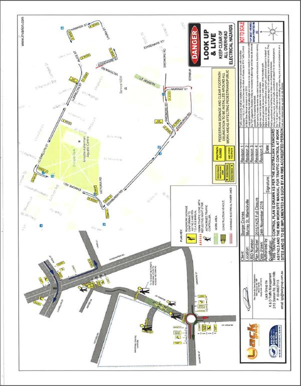
|
|
Local Traffic Committee Meeting 6 July 2017 |
Subject: 2017 Spring Cycle (Leichhardt/Balmain/Leichhardt LAC) - Traffic Management Plant and Traffic Control Plan for the 2017 Spring Cycle Event
File Ref: 17/6022/72463.17
Prepared By: Nina Fard - A/Traffic Team Leader
|
SUMMARY The Spring Cycle supported by Transport for NSW, is Sydney’s largest recreational mass community bike riding event and provides a unique opportunity to travel through Sydney by bike, capturing the city’s iconic attractions, landscape and views. Every year, around 10,000 people join the Spring Cycle for a celebration of cycling that starts in North Sydney and continues across the Sydney Harbour Bridge main deck through Glebe, Annandale and Leichhardt and on to the festival-style atmosphere at the finish at Sydney Olympic Park, Homebush.
The Spring Cycle is organised by Bicycle NSW with the support of the NSW Government, Transport for NSW, Transport Management Centre, Roads & Maritime Services, NSW Police, New South Wales Ambulance Service, St John First Aid, City of Sydney, Sydney Olympic Park, Local Councils and more than 500 trained Bicycle NSW volunteers.
Bicycle NSW has requested approval from the Local Traffic Committee and Council to conduct the 2017 Bicycle NSW Spring Cycle event (its 34th year) on Sunday, 15 October 2017.
It is recommended that the 2017 Bicycle NSW Spring Cycle event to be held on Sunday, 15 October 2017 be supported:
Subject to complying with the following conditions; the TMP and TCP being approved by the Transport Management Centre, all residents will be notified of the event through letterbox drop at least two weeks prior to the event, proposed event being forwarded to the appropriate authorities, including emergency services and a current Public Liability Insurance Policy be provided to Inner West Council.
|
|
RECOMMENDATION
THAT:
1. the 2017 Bicycle NSW Spring Cycle event to be held on Sunday, 15 October 2017 be supported, subject to:
(a) the Traffic Management Plan and Traffic Control Plans being approved by the Transport Management Centre; (b) the event organiser producing a current Public Liability Insurance Policy with Inner West Council being included as an Interested Party;
2. the organiser of the event be requested to advise the affected properties in Canal Road, Leichhardt regarding the Event details to discourage traffic movements through the narrow section of Canal Road during the critical period of the event.; and
3. the representative of Bicycle New South Wales be advised of the Committee’s recommendation.
|
BACKGROUND
This is the 34th running of the NSW Spring Cycle event. The event in 2017 will offer four ride options:
Sydney City Ride– North Sydney to Pyrmont (10km)
Start: 8.00am-8.30am
Ideal for families and novice riders who want to experience the thrill of riding over the Harbour Bridge and past some of Sydney’s most iconic landmarks including the Sydney Opera House and historic Rocks area. Riders celebrate their Spring Cycle ride with a festival finish at Pirrama Park, Pyrmont.
Challenge Ride – North Sydney to Olympic Park (105km)
Start: 6.30am-6.45am
This ride is for those looking to challenge their cycling performance by riding the greater Sydney. Riders will clock up 50kms riding across the Harbour Bridge, past the Sydney Opera House and traversing the diverse Inner West before heading out to Western Sydney Parklands via picturesque Parramatta and Prospect Dam, then back to Sydney Olympic Park.
River Ride- Parramatta Park (16 Km)
Start: 10.00am-10.30am
This year there will be a new route added to the Spring Cycle: The 16km River Ride. This ride will be ideal for families out in the Western Suburbs of Sydney as it will explore the cycleway along the Parramatta River. The ride will start at Parramatta Park and conclude at the big finish festival site in Cathy Freeman Park, Sydney Olympic Park.
Classic Ride – North Sydney to Sydney Olympic Park (50km)
Start:7:00am-7:30am
For those looking for an adventure, this route takes in the best of the 12km Sydney City Ride ‐ over the spectacular Harbour Bridge, past the Opera House and historic Rocks area, before exploring the diverse Inner West and venturing out to Sydney Olympic Park.
Bicycle Route through Inner West Council
The route via Inner West Council is summarised below:
• Arriving Annandale through Bicentennial Park (Glebe)
• Turn into Johnston Street from Chapman Road (Annandale)
• Turn right onto Weynton Street (Annandale)
• Turn left onto Annandale Street (Annandale)
• Turn right onto Booth Street-Moore Street (Leichhardt)
• Cross Balmain Road at the Balmain Road/Moore Street intersection (Leichhardt) – BNSW to arrange opening of fence panels in Balmain Road opposite Moore Street as per TCP 73, with RMS.
• Use off-road shared path adjacent to the Leichhardt Secondary School (Leichhardt)
• Turn right onto Derbyshire Road (Leichhardt)
• Turn left onto William Street (Leichhardt) at bus depot entry/exit.
• Turn right onto Charles Street (Leichhardt)
• Cross Darley Road at Charles Street (Leichhardt)
• Use Canal Road (Leichhardt)
• Use the bridge across Hawthorne Canal to Hawthorne Parade
• Turn right onto Waratah Street (Haberfield)
• Turn right onto Boomerang Street (Haberfield) at the roundabout.
• Turn left onto Mortley Avenue (Haberfield)
• Cross Dobroyd Parade at the Mortley Avenue/Timbrell Drive intersection (Haberfield) continue onto Timbrell Drive (Five Dock)
The TMP and TCPs submitted by the event organiser is attached and will be forwarded to RMS for approval.
All traffic signal intersections along the route will be supervised by Police.
The section of Canal Road which is part of the event route is relatively narrow and part of this section also has a ‘Shared Zone’. Currently parking is not permitted in the subject section of Canal Road.
FINANCIAL IMPLICATIONS
Nil.
PUBLIC CONSULTATION
The Bicycle NSW organisers have advised that as in previous years, a detailed community consultation and event notification strategy will be delivered and executed to ensure minimum disruption is caused and all non‐event stakeholders are well informed about the potential impact and alternate arrangements can be made.
CONCLUSION
It is recommended that the 2017 Bicycle NSW Spring Cycle event scheduled for Sunday, 15th October 2017 be supported as per the submitted TMP and TCPs.
|
1.⇩ |
The Spring Cycle Event TMP submitted by the event organiser. |
|
2.⇩ |
The Spring Cycle Event TCP submitted by the event organiser. |
|
Local Traffic Committee Meeting 6 July 2017 |
Subject: Australia Street, Newtown - Temporary Full Road Closure to Carry Out Crane Lift Works for Newtown Neighbourhood Centre (Stanmore Ward/Newtown Electorate/Newtown LAC)
File Ref: 17/6022/72436.17
Prepared By: Emilio Andari - Civil Engineer
Authorised By: Joe Di Cesare - Manager Design and Investigation
|
SUMMARY An application has been received from The Traffic Marshal Pty Ltd for the temporary full road closure of Australia Street, Newtown, between Hoffman Lane and Alton Lane, for a period of 3 hours on 3rd August 2017 between the hours of 3:00am and 6:00am, in order to stand a mobile crane at the intersection of Australia Street and Alton Lane to install A/C compressors for the Newtown Neighborhood Centre. It is recommended that the proposed temporary full road closure be approved, subject to the conditions outlined in this report.
|
|
RECOMMENDATION
THAT the proposed temporary full road closure of Australia Street, Newtown, between Hoffman Lane and Alton Lane, be APPROVED, for a period of 3 hours on 3rd August 2017 between the hours of 3:00am and 6:00am, in order to stand a mobile crane at the intersection of Australia Street and Alton Lane to install A/C compressors for the Newtown Neighbourhood Centre, subject to the following conditions;
1. a fee of $1,354.60 for the temporary full road closure is payable by the applicant in accordance with Council's Fees and Charges;
2. the temporary full road closure be advertised in the local newspaper providing 28 days’ notice for submissions, in accordance with the Roads Act;
3. a Traffic Control Plan (TCP) which has been prepared by a certified Traffic Controller, is to be submitted to Council for review with a copy of the Traffic Controllers certification number attached to the plan, not less than 5 days prior to implementation of closure;
4. notice of the proposed closure be forwarded by the applicant to the NSW Police, the NSW Fire Brigades and the NSW Ambulance Services;
5. notification signs advising of the proposed temporary full road closures and new traffic arrangements to be strategically installed and maintained by the applicant at each end of the street at least 7 days prior to the closure;
6. all affected residents and businesses shall be notified in writing, by the applicant, of the proposed temporary full road closure at least 7 days in advance of the closure with the applicant making reasonable provision for residents;
7. vehicular and pedestrian access for residents and businesses to their off-street car parking spaces be maintained where possible whilst site works are in progress;
8. adequate vehicular traffic control shall be provided for the protection and convenience of pedestrians and motorists including appropriate signage and flagging. Workers shall be specially designated for this role, as necessary to comply with this condition. This is to be carried out in accordance with the Australian Standard AS 1742.3 - Traffic Control Devices for works on roads;
9. the holder of this approval shall indemnify the Council against all claims, damages and costs incurred by, or charges made against, the Council in respect to death or injury to any person or damage in any way arising out of this approval. In this regard, a public liability insurance policy for an amount not less than $20,000,000 for any one occurrence is to be obtained and is to note the Council as an interested party. The holder of this approval shall inform its insurer of the terms of this condition and submit a copy of the insurance policy to the Council prior to commencement of the work the subject of this approval;
10. the operator of any unit exercising this approval shall have this approval with them and produce it if required along with any other relevant authority approvals granted in the connection with the work;
11. mobile cranes, cherry packers or concrete boom pumps shall not stand within the public way for extended periods when not in operation under this approval;
12. the operation of the mobile crane shall not give rise to an "offensive noise" as defined in the Protection of Environment Operations Act, 1997. Furthermore, vibrations and/or emission of gases that are created during its operations and which are a nuisance, or dangerous to public health are not permitted;
13. all work is to be carried out in accordance with Work Cover requirements; and
14. the costs to repair damages, as a result of these works, to Council's footway and roadway areas will be borne by the applicant.
|
BACKGROUND
An application has been received from The Traffic Marshal Pty Ltd for the temporary full road closure of Australia Street, Newtown, between Hoffman Lane and Alton Lane, for a period of 3 hours on 3rd August 2017 between the hours of 3:00am and 6:00am, in order to stand a mobile crane at the intersection of Australia Street and Alton Lane to install A/C compressors for the Newtown Neighbourhood Centre.
FINANCIAL IMPLICATIONS
Under Council’s Fees & Charges, the applicant is to pay a fee of $1,354.60 for the temporary full road closure. This fee includes advertising the proposal in accordance with the Roads Act 1993.
OFFICER COMMENTS
Site location & road network
|
Street Name |
Australia Street |
|
Section |
Between Hoffman Lane and Alton Lane |
|
Carriageway Width (m) |
9.8 |
|
Carriageway Type |
Two-way road with one travel lane in each direction, in addition to kerbside parking lanes. |
|
Classification |
Local |
|
85th Percentile Speed (km/h) |
37.4 |
|
Vehicles Per Day (vpd) |
921 |
|
Reported Crash History (July 2011 - June 2016) |
No crashes recorded |
|
Heavy Vehicle Volume (%) |
4.1 |
|
Parking Arrangements |
‘No Parking Police Vehicles Excepted’ is permitted along the eastern side of the road and ‘2P 8am-10pm Permit Holders Excepted Area M3’ is permitted along the western side of the road. |
Vehicular access for local residents/businesses and emergency services will be maintained during the closure, where possible. Authorised Traffic controllers will be on-site during the time of the road closure and are to be positioned at the closure points when required to provide vehicular access to local residents/businesses and ensure the safety of motorists and pedestrians (refer to Traffic Control Plan for details).
PUBLIC CONSULTATION
The proposed full-road closure of Australia Street, Newtown between Hoffman Lane and Alton Lane is currently advertised in the newspaper for a period of 28 days. The advertising period commenced on 27 June 2017 and will conclude on 24 July 2017.
The applicant is to notify all affected residents and businesses in writing at least 7 days prior to the commencement of works and make reasonable provision for residents and businesses, where possible.
CONCLUSION
It is recommended that the proposed temporary full road closures be approved, subject to the conditions outlined in this report.
Traffic Control Plan submitted by the applicant – Australia Street, Newtown
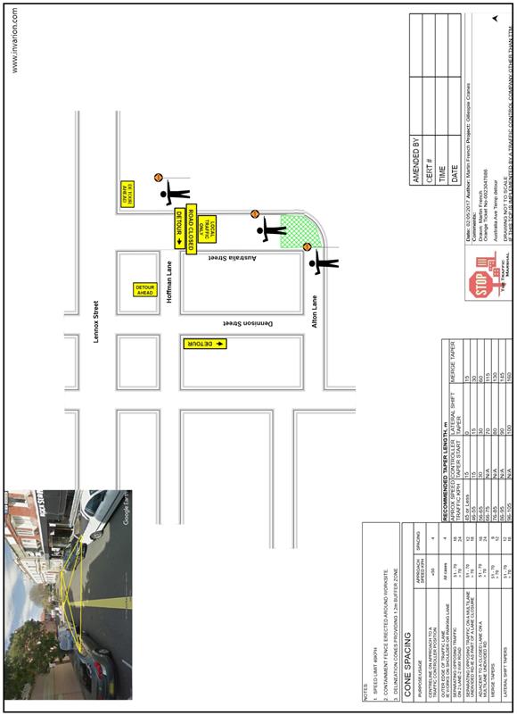
|
|
Local Traffic Committee Meeting 6 July 2017 |
Subject: Smith Street, Tempe - Removal of Speed Cushions (Marrickville Ward/Heffron Electorate/Newtown LAC)
File Ref: 17/6022/72430.17
Prepared By: Emilio Andari - Civil Engineer
Authorised By: Joe Di Cesare - Manager Design and Investigation
|
SUMMARY For the Committee to consider the removal of the speed cushions installed adjacent to property no. 40 & no. 42 Smith Street, Tempe.
|
|
RECOMMENDATION
THAT the speed cushions adjacent to property no. 40 & no. 42 Smith Street be removed following notification of neighbouring properties. |
BACKGROUND
In May 2011, Council considered the “St Peters/Tempe LATM Study 2010-2011” and adopted the proposal to “install two sets of speed cushions and associated line marking and signage in Smith Street. Speed cushions to be placed in pairs approximately 80m apart”. Extensive consultation was undertaken by Council’s consultants on the proposed measures including community presentation & workshop, community questionnaire, & stakeholder meetings.
A design for the speed cushions was completed (refer to design plan no. 5757) and Council’s design section undertook further consultation with each of the affected properties regarding the design of speed cushions for Smith Street. There were no submissions received in relation to the proposed design of the speed cushions & subsequently at its meeting of the 13 September 2011, the Land Use, Assets & Corporate Committee adopted the recommendation of the Pedestrian, Cyclist and Traffic Calming Advisory Committee (ex-Marrickville Council committee meeting).
In September 2012, the Pedestrian, Cyclist and Traffic Calming Advisory Committee recommended that “the speed cushions adjacent to property no. 22 Smith Street be removed following notification of neighbouring properties” due to community feedback regarding noise complaints from a high percentage of trucks using Smith Street. The recommendation was adopted by Council in October 2012 and the speed cushions adjacent to property no. 22 Smith Street were removed shortly after with the intent that the second set of speed cushions adjacent to property no. 40 & no. 42 Smith Street will be monitored should issues of noise arise.
FINANCIAL IMPLICATIONS
The removal of the speed cushions at an estimated cost of $1,500 can be met from Council’s operating budget.
OFFICER COMMENTS
Site location & road network
|
Street Name |
Smith Street |
|
Section |
Between Princes Highway and Wood Street |
|
Carriageway Width (m) |
12.8 |
|
Carriageway Type |
Two-way road with one travel lane in each direction, in addition to kerbside parking lanes. |
|
Classification |
Local |
|
85th Percentile Speed (km/h) |
33.1 |
|
Vehicles Per Day (vpd) |
1,337 |
|
Reported Crash History (July 2011 – June 2016) |
No crashes recorded. |
|
Heavy Vehicle Volume (%) |
13.3 |
|
Parking Arrangements |
Unrestricted parking along both sides of the road. |
Council has recently received representation from the owners of property no. 40 Smith Street, Tempe regarding problems of noise associated with the speed cushions, especially when trucks with dual wheel axles negotiate the speed cushions.
Speed cushions come in widths between 1.6m & 1.9m with a corresponding design speed of between 50 km/h and 35 km/h. The width of the speed cushions in Smith Street is 1.8m which would corresponds to a design speed of 40 km/h. The minimum width of the speed cushion is based on the wheel spacing of a motor vehicle.
The installation of the speed cushions has been effective in the reduction of speed by approximately 17 km/h and in this respect they have been successful. However, it should be noted that Smith Street is a mixed industrial & residential street with the percentage of heavy vehicle movements (13.3%) being much higher than other residential streets. Therefore, the interaction of trucks with the traffic calming device (in this case speed cushions) is important, with respect to potential noise that might arise as a result of the device.
An investigation into the dual wheel trucks and their inner wheel spacing was carried out to determine if these types of trucks could straddle the speed cushion.
The types of trucks examined are as follows;
|
Type of truck |
Length |
Inner wheel spacing |
|
Small tipper trucks |
4.8m |
1.1m |
|
Service vehicle |
6m |
1.2m |
|
Service vehicle |
9m |
1.2m |
|
Garbage truck |
11m |
1.3m |
|
Semi-trailer |
18m |
1.1m |
The result of this investigation was that the inner wheel spacing of dual wheel axle truck was shorter than the minimum width of a speed cushion (It should be noted that single wheel trucks have a wheel spacing greater than 2m). The effect of this narrower wheel spacing means that dual wheel axle trucks which do not slow for the speed cushions would result in potential noise problems, especially in the vicinity of the device.
Given the high percentage of trucks using Smith Street, the representations of the resident are justified. Normally speed humps are not constructed on local roads with a high percentage of heavy vehicles due to issues of noise. Speed cushions were chosen in this case on the basis that they would be straddled by heavy vehicles.
Locality Map – Smith Street, Tempe
![]()
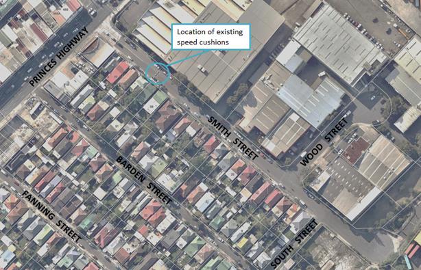
Photographs – Smith Street, Tempe
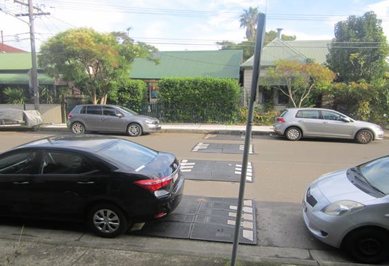
Existing speed cushions outside property no. 40 & no. 42 Smith Street (facing south)
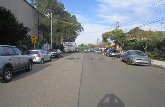
Existing speed cushions in Smith Street (facing south-west)
A number of site inspections were undertaken and it should be noted that it was revealed that Smith Street has a large cul-de-sac at the southern end and this is frequently used by truck drivers. Smith Street is a road that is approximately 300m in total length. The only existing set of speed cushions in Smith Street are located adjacent to property no. 40 & no. 42 Smith Street which are approximately 50m south from its intersection with Princes Highway (which the speed cushions are located at the northern end of Smith Street). There were a number of truck drivers which did not slow for the existing speed cushions and these trucks did create noise problems, especially unladen tipper trucks. It should also be noted that the existing set of speed cushions in Smith Street would have very minimal impact to the reduction of speed along the entire length of the street due to its current location and the removal of the additional set of speed cushions which were placed adjacent to property no. 22 Smith Street.
PUBLIC CONSULTATION
The affected residents adjacent to the existing speed cushions in Smith Street have written into Council stating that the ongoing noise was an issue and affecting the local residents. Council Officers acknowledged the noise issue and indicated that they would examine the removal of the speed cushions in this case and have been in contact with the affected residents who have engaged Council.
Neighboring properties have not been consulted to date however, notification of the removal of the speed cushions will be undertaken prior to the removal of the speed cushions.
CONCLUSION
Given the high percentage of trucks using Smith Street with dual wheel axle trucks representing a good proportion of these truck movements it is recommended that the speed cushions adjacent to no. 40 & no.42 Smith Street be removed. The precast speed humps will be available for reuse in other projects.
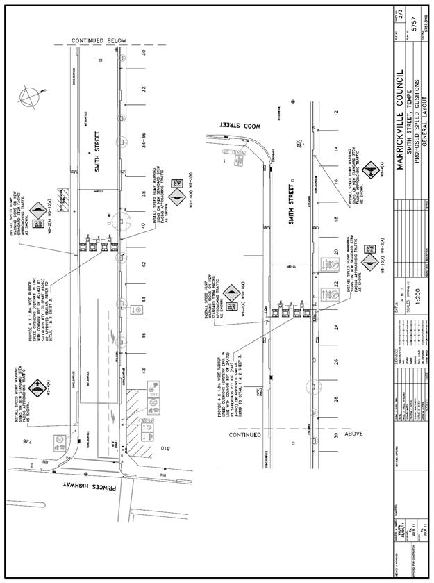 |
|
|
Local Traffic Committee Meeting 6 July 2017 |
Subject: Bay Run (Leichhardt Ward/Balmain electorate/Leichhardt LAC) Proposed Temporary Road Closure to hold Bay Run Event on Sunday 6 August 2017
File Ref: 17/6022/74650.17
Prepared By: Manod Wickramasinghe - Traffic and Parking Engineer
|
SUMMARY The Bay Run Committee has requested approval from the Local Traffic Committee and Council to conduct the annual Bay Run event (its 15th year) on Sunday, 6th August 2017.
The Bay Run follows the shore line of Iron Cove and is approximately 7km. The shared path on the Iron Cove Bridge will form part of the Bay Run. This event will be held between 6.00am and 10.30am on 6th August 2017. The race participation includes approximately: • 2000 runners • 250 walkers • 70 runners with dogs • 400 children (2km) |
|
RECOMMENDATION
THAT:
1. the proposed temporary closure of Maliyawul Street, Lilyfield, north of Le Montage Function Centre on Sunday, 6th August 2017 between 6.00am and 10.30am be supported, subject to the TMP and TCP being approved by RMS; 2. the applicant be advised to contact OEH to seek approval for the proposed temporary closure of Waterfront Drive, between Central Avenue and Military Drive for the event (within Callan Park, Lilyfield); 3. the applicant be requested to implement the RMS approved Traffic Management Plan (TMP) and Traffic Control Plan (TCP) related to the temporary closure of Maliyawul Street and Waterfront Drive, Lilyfield at its own cost; 4. the applicant be requested to arrange a letter box drop to nearby properties, La Montage, Leichhardt Park & Aquatic Centre, Leichhardt Rowing Club and Balmain Soccer Club (Callan Park) two weeks prior to the event; 5. the event organiser be requested to produce a current Public Liability Insurance Policy with Inner West Council being included as an Interested Party; and 6. Council’s Parks & Open Space Planner be advised of the Committee’s recommendation.
|
BACKGROUND
This is the 15th running of the Bay Run Event. The current Bay Run 2017 organising team has been involved in running the event for a number of years and is again requesting the closure of :
• Maliyawul Street, north of Le Montage Function Centre to arrange the finish line on the road in Maliyawul Street at Leichhardt Oval No.3 and
• Waterfront Drive, between Central Avenue and Military Drive (within Callan Park)
The closure of Maliyawul Street will allow for the set-up of the event on Sunday. The organiser has confirmed that security guards will be in attendance overnight to monitor the area. The participants are expected to arrive around 6am on the Sunday.
The proposed closure of Maliyawul Street is on Sunday, 6th August 2017, between 6.00am and 10.30am to allow for the set-up of the event. It should be noted that the subject section of Maliyawul Street is a ‘No Through’ road.
Since no matches would be permitted on Oval No.3 at the time of this event, the closure of an 80m (from the closed end) section of Maliyawul Street should cause no significant impacts on parking during the event closure time. This closure has occurred at previous year’s events and has caused no traffic issues.
The closure of Waterfront Drive is to prevent conflicts with vehicles.
Non-event cyclists would not be able to use the closed sections of Maliyawul Street and Waterfront Drive. However, as a number of detours are available for non-event cyclists, the impact on them is considered minimal.
The TMP and TCP submitted by the event organiser as attached in the appendix will be forwarded to RMS for approval.
The applicant has advised that they have ongoing public liability insurance to the amount of $50 million. As part of obtaining the public liability insurance a risk management plan has also been prepared.
FINANCIAL IMPLICATIONS
Nil.
PUBLIC CONSULTATION
The Bay Run organisers have advised that the event will be publicised via a range of public media in the lead up to the event including local banners, notifications on the Bay Run course, local media (print and radio) and via social media (Facebook). Inner West Council (Leichhardt) is a supporting partner of the event. Le Montage is aware of the event. Leichhardt Park Aquatic Centre, Leichhardt Rowing Club and Balmain District FC (Callan Park) will all be notified about the event in the lead up to the event.
The Office of Environment and Heritage will be contacted regarding closing the section of Waterfront Drive as outlined in the TMP.
As in 2016 there will be a letter box drop to residents in the nearby streets, by the organisers in the lead up to the event.
CONCLUSION
It is recommended that Council agree to the temporary road closure of the subject section of Maliyawul Street and Waterfront Drive on Sunday 6th August 2017, subject to the applicant complying with the following conditions; the TMP and TCP being approved by RMS, the proposed temporary closure of Waterfront Drive be approved by OEH, arrange letter box drop to nearby properties, La Montage, Leichhardt Park & Aquatic Centre, Leichhardt Rowing Club and Balmain Soccer Club (Callan Park) two weeks prior to the event, details of the proposed event being forwarded to the appropriate authorities including emergency services and a current Public Liability Insurance Policy be provided to Inner West Council.
|
1.⇩ |
Bay Run 2017 - Traffic Management Plan |
|
Local Traffic Committee Meeting 6 July 2017 |
Subject: Australian Air Force Cadets Annual Street Procession Through Ashfield Sunday 6 August 2017 (Ashfield & Leichhardt Wards/Summer Hill Electorate/Ashfield LAC)
File Ref: 17/6022/74279.17
Prepared By: Boris Muha - Traffic and Projects Engineer
Authorised By: John Stephens - Traffic Manager
|
SUMMARY An application has been made by Flight Lieutenant Les Nastevski of the Australian Air Force Cadets requesting permission for a street procession to be held on Sunday, 6 August 2017. The Australian Air Force Cadets, formerly the Air Training Corps, have over the last 60 years conducted its Annual Church parade on the first Sunday in August.
Previously, the former Ashfield Council supported the Procession conducted over the past number of years and similar conditions are recommended below.
|
|
RECOMMENDATION
THAT:
The Street Procession to be held on Sunday, 6 August 2017 be supported, subject to the following conditions:
1. the applicant make formal application to the NSW Police Service for its approval, and that the Procession be conducted under the control of the NSW Police;
2. the applicant arrange the appropriate and necessary notification to affected residents and shopkeepers in the area advising of the Procession; and
3. Sydney Buses be requested to arrange to either hold back or divert bus services in the area.
|
BACKGROUND
The applicant will make direct formal application to the NSW Police Service for approval on the above Street Procession and request Police to provide assistance and traffic control for the Procession.
The Parade will form up adjacent to Brown Street, Ashfield at 9.00am. It will move off at 9.30am (under Police escort) west along Brown Street, then left at Elizabeth Street, right into Alt Street and then proceed to St. Johns Anglican Church. The Parade consists of an armed guard, band and approximately 200 cadets.
At the conclusion of the Church Service, about 11.30am, the Parade will form up and proceed out of the church grounds and left into Alt Street then left into Charlotte Street where the Parade was dismissed.
FINANCIAL IMPLICATIONS
Nil.
OFFICER COMMENTS
The Procession is a RMS “class 4” category special event requiring NSW Police Service approval and that the Procession be conducted under the control of the Police.
The former Ashfield Council has in the past supported this annual event which has similarly been conducted over the last 60 years.
The route of the Procession is shown in the attachment below.
PUBLIC CONSULTATION
The Applicant is to arrange appropriate notification of the event.
CONCLUSION
The matter is for the Committee's information and to note that the Procession is supported, subject to Police approval being gained and that the applicant arranges appropriate and necessary notification to Sydney Buses and affected residents and shopkeepers in the area advising of the Procession.
|
1.⇩ |
Australian Air Force Cadets Annual Street Procession in Ashfield for Sunday 6 August 2017 |
|
Local Traffic Committee Meeting 6 July 2017 |
Subject: Livingstone Road, Marrickville - Temporary Road Closures for St Brigid's Church on Sunday 30 July 2017 (Marrickville Ward/Summer Hill Electorate/Marrickville LAC)
File Ref: 17/6022/74498.17
Prepared By: Emilio Andari - Civil Engineer
Authorised By: Joe Di Cesare - Manager Design and Investigation
|
SUMMARY Council has been advised by the NSW Police that there will be a street procession taking place on Sunday 30 July 2017, between 3.00pm and 4.00pm for St Brigid's Catholic Church in Marrickville. This procession will require some temporary road closures which will be undertaken by the NSW Police. Council has been requested to provide barricades to assist the Police in implementing the proposed road closures.
It is recommended that this report be received and noted. It is also recommended that Council provide barricades at no cost to assist the Police in implementing the proposed temporary road closures as in previous years.
|
|
RECOMMENDATION
THAT;
1. The report be received and noted; and
2. Council provide barricades at no cost to assist the Police implementing the proposed temporary road closures as in previous years.
|
BACKGROUND
Council has been advised that there will be a street procession for the celebration of ‘Our Lady of the Snow’ taking place on Sunday 30 July 2017, between 3.00pm and 4.00pm for St Brigid's Catholic Church in Marrickville. This procession will require some temporary road closures which will be undertaken by the NSW Police with the assistance from the State Emergency Services (SES). Council has been requested to provide barricades to assist the Police in implementing the proposed road closures.
FINANCIAL IMPLICATIONS
There will be a small cost to Council involving the delivery and pick up of the barricades and it is proposed to waive this cost as in previous years.
OFFICER COMMENTS
St Brigid's Parish - ‘Our Lady of the Snow’
This procession is organised by the Italian Catholic community of Marrickville. It is expecting approximately five hundred (500) people. The procession will take place on Sunday, 30 July 2017 and consist of a period of no more than an hour and will commence at 3:00pm at St Brigid's Catholic Church.
All road closures will be under the control of the NSW Police and with the assistance of the SES. Council will provide barricades to assist the Police implementing the proposed road closures at Council’s cost.
Police/SES will direct traffic at the following intersections;
a) Marrickville Road and Livingstone Road (8 x sets of barricades)
b) Marrickville Road and Petersham Road (8 x sets of barricades)
c) Illawarra Road and Petersham Road (2 x sets of barricades)
d) Livingstone Road and
Francis Street (2 x sets of barricades)
e) Livingstone Road and
Arthur Street and Robert Street (3 x sets of barricades)
PUBLIC CONSULTATION
Nil.
CONCLUSION
It is recommended that this report be received and noted. It is also recommended that Council provide barricades to assist the Police in implementing the proposed temporary road closures at no cost.
|
|
Local Traffic Committee Meeting 6 July 2017 |
Subject: 2/32-72 Alice Street, Newtown - Proposed Childcare Centre (Stanmore Ward/Newtown Electorate/Newtown LAC)
File Ref: 17/6022/72442.17
Prepared By: Emilio Andari - Civil Engineer
Authorised By: Joe Di Cesare - Manager Design and Investigation
|
SUMMARY A Development Application has been received to fit out and use the premises at 2/32-72 Alice Street, Newtown as a childcare centre for 32 children. It is recommended that the comments of the Local Traffic Committee be referred to Council’s Development Assessment Section for consideration in determining the Development Application. |
|
RECOMMENDATION
THAT the report be received and noted. |
BACKGROUND
This development application is required to be referred to the Local Traffic Committee for consideration under State Environmental Planning Policy (Infrastructure) 2007.
FINANCIAL IMPLICATIONS
Nil.
OFFICER COMMENTS
Site location & road network
|
Street Name |
Alice Street |
Pearl Street |
Walenore Avenue |
Alice Lane |
|
Subject Section |
Between Pearl Street and Walenore Avenue |
Between Alice Street and Little Commodore Street |
Between Alice Street and Alice Lane |
Between Pearl Street and Walenore Avenue |
|
Carriageway Width (m) |
12.2 |
11.1 |
12.8 |
4.9 |
|
Carriageway Type |
Two-way road with one travel lane in each direction, in addition to kerbside parking lane along both sides of the road. |
Two-way road with one travel lane in each direction, in addition to kerbside parking lane along both sides of the road. |
Two-way road with one travel lane in each direction, in addition to kerbside parking lane along both sides of the road. |
Two-way road with one travel lane in each direction, in addition to kerbside parking lane along both sides of the road. |
|
Classification |
Regional |
Local |
Local |
Local |
|
85th Percentile Speed (km/h) |
49.0 |
42.1 |
32.8 |
33.1 |
|
Vehicles Per Day (vpd) |
10,168 |
559 |
814 |
302 |
|
Reported Crash History (July 2011 - June 2016) |
2 crashes (Rum Codes: 11 & 60). Both crashes resulted with no injury and only tow-away (intersection collision & collision into parked car). |
1 crash (Rum Code: 1). Crash resulted in injury (pedestrian emerging). |
1 crash (Rum Code: 42). Crash resulted with no injury and only tow-away (parked vehicle merged into traffic lane). |
No crashes recorded. |
|
Heavy Vehicle Volume (%) |
8.4 |
4.2 |
3.8 |
2.0 |
|
Parking Arrangements |
Unrestricted parking on the southern side and ‘2P 8am-10pm Permit Holders Excepted Area M14’ restrictions on the northern side. |
Unrestricted parking on the eastern side and ‘2P 8am-10pm Permit Holders Excepted Area M14’ restrictions on the western side. |
Unrestricted parking on the western side and ‘2P 8am-10pm Permit Holders Excepted Area M14’ restrictions on the eastern side. |
Unrestricted parking on both sides of the road. |
The proposed childcare centre is located near the north-eastern corner of the entire mixed-use development of 32-72 Alice Street, Newtown and the closest direct entrance to the commercial tenancy is from Alice Street. The subject site is a ground-floor commercial tenancy (Unit 2) that consists of 5 existing parking spaces in the existing basement carpark which is accessed through a driveway crossing located in Pearl Street. The surrounding land uses comprise of a mixture of residential single-dwelling properties and apartment buildings. The location of the proposed childcare centre is also approximately 150m west of the businesses on King Street, Newtown. It should be noted that there are several apartment buildings within close proximity to the subject site along Alice Street (refer to the attached locality map and photographs).
Locality map – Unit 2/32-72 Alice Street, Newtown

![]()
![]()


Proposed childcare centre at ground floor in Alice Street (facing south-west)
Proposed development
The proposed development application is for the approval to fit out and use the commercial tenancy as a childcare centre at 2/32-72 Alice Street, Newtown. The proposed childcare centre is to accommodate up to 32 children aged 0-5 years old and 10 staff. It is proposed that the childcare centre will operate from 7am-6pm on weekdays. The proposal also includes the allocation of 5 existing parking spaces in the existing basement carpark which is accessed through a driveway crossing located in Pearl Street and up to 2 parking spaces provided on-street and to be used as a drop-off and pick-up facility for parents and carers in Alice Street (refer to the attached development plans).
Public transport
The subject site has access to public transport services with Newtown Railway Station being located approximately 800 metres north from the site, St Peters Station is located some 650m from the site and bus routes (Route 308, 352, 370 and 422) operating along Alice Street out front of the proposed site and along King Street located approximately 150 metres east from the site.
Parking provision
Council's DCP 2011 (incorporating Amendment No.1) requires provision of off-street parking as follows for Parking Area 1:
1 car parking space per 50m2 Gross Floor Area (GFA).
Therefore, the proposed development having a total GFA of 260m2 should provide a total of 5 off-street car parking spaces.
Council's DCP 2011 (incorporating Amendment No.1) requires the provision of off-street bicycle parking for child care centre as follows:
1 bicycle parking space per 20 staff for staff + 2 for customers.
Therefore, the proposed development having 10 staff members should provide a total of 3 off-street bicycle parking spaces as follows:
- 1 space for staff bicycle parking, and
- 2 spaces for parents and carers bicycle parking.
It is proposed that 5 on-site car parking spaces will be designated for the use of the childcare centre for staff parking which is located in the basement carpark with driveway access through Pearl Street. Due to the position of the allocated spaces, it is proposed that this carpark would be used for staff parking only as it is not positioned close to a lift and not in close proximity to the proposed childcare centre. The car parking spaces have been provided in accordance to Council’s DCP 2011 (incorporating Amendment No.1) and the proposal meets the minimum requirement of 5 off-street car parking spaces.
It should be noted that Council's DCP 2011 (incorporating Amendment No.1) requires motorcycle parking to be provided at a rate of 5% of the car parking required for the development. In this case, given so few car parking spaces are required, the provision of motorcycle parking spaces for the child care centre is not required. The proposal does not consider the provision for any bicycle parking spaces and motorcycle parking spaces however as part of the entire development site, the commercial tenancy is provided with bicycle and motorcycle spaces within the carpark but should it be noted that these spaces will also be suited for staff parking only due to the spaces not in close proximity to the proposed child care centre.
In addition, the applicant’s proposal requests for the provision of 2 on-street parking spaces near the frontage of the site on the southern side of Alice Street to be used as a drop-off and pick-up parking zone during peak periods on weekdays. Council's DCP 2011 (incorporating Amendment No.1) states that assessing development applications for child care centres are a special case due to the high number of car trips generated for a short duration at drop off and pick up times, and the particular safety issues involved with young children around cars. Given that the number of proposed on-site parking spaces located in the basement carpark are satisfied with accordance to Council’s DCP 2011 (incorporating Amendment No.1), it would be appropriate to allow a drop-off and pick-up parking zone in close proximity to the proposed child care centre to improve any safety. Therefore, the provision for ‘P10minute 7:00am-9:00am, 4:00pm-6:00pm, Mon-Fri’ restrictions for a distance of 12 metres (2 car parking spaces) along the southern side of Alice Street, Newtown adjacent to the proposed child care centre is supported.
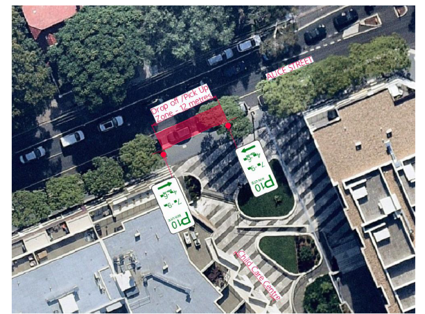
Proposed drop-off and pick-up parking zone during peak periods on weekdays in Alice Street
Site inspections were undertaken by a Council Officer during the afternoon period of a typical weekday on a few occasions and it was observed that on-street parking spaces in Alice Street, Pearl Street, Walenore Avenue and Alice Lane were all highly utilised. Each of these streets, excluding Alice Lane, consists of permit parking along one side of the street (out front of the existing single-dwelling residencies). This precinct was recently implemented (October 2016) and falls under the expansion of the Area M14 Permit Parking Precinct where parking restrictions apply to non-permit holders. These restrictions are ‘2P 8am-10pm Permit Holders Excepted Area M14’. It was observed during the site inspections that these time-restricted parking spaces were all moderate-to-highly utilised. The on-street parking spaces surrounding the development site consists of unrestricted parking in all four streets. It was observed during the site inspections that these unrestricted parking spaces were all highly utilised and therefore the provision of 2 on-street parking spaces used as a drop-off and pick-up parking zone during peak periods on weekdays would allow access for parents and carers to park their vehicles in close proximity to the proposed child care centre (refer to the photos below).

Existing on-street parking along Alice Street
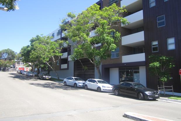
Existing on-street parking along Walenore Avenue
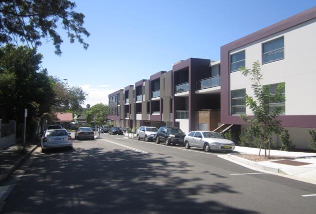
Existing on-street parking along Pearl Street
Existing on-street parking along Alice Lane
Vehicular Access, waste management (collection) & internal traffic circulation
The vehicular access to the off-street parking spaces will be from Pearl Street, where the existing access driveway is located, while the loading dock access will be from Walenore Avenue.
As part of the original development site proposal for 32-72 Alice Street, Newtown, the proposal consisted of a 3m road widening of Pearl Street (between Alice Street and Alice Lane). This was to facilitate vehicular access movements to and from the basement carpark. At the time of the development assessment for the development site, the traffic consultant provided the internal parking layout and the circulation provides for two-way movements and is considered to be adequate and allows for vehicles to enter and exit the site in a forward direction.
Estimated traffic generation
The applicant's traffic consultant report stated that the total estimated traffic generation from the proposed child care centre would be would be 26 vehicle trips per hour (morning peak) and 23 vehicle trips per hour (early evening peak). These estimated traffic generation rates are considered to be acceptable and can be accommodated with the surrounding road network.
PUBLIC CONSULTATION
Consultation/notification regarding the proposal would normally be undertaken by Council's Development and Planning Services as part of the development application process.
CONCLUSION
It is proposed that the following traffic related comments be forwarded to Council’s Development Assessment section.
Based on the information presented in the applicant’s submission to Council with regards to the traffic and parking implications, it is considered that the proposed development application is supported in its current form, subject to the provision of 2 on-street parking spaces used as a drop-off and pick-up parking zone during peak periods on weekdays along the southern side of Alice Street, Newtown adjacent to the proposed child care centre. The drop-off and pick-up parking zone is to include ‘P10minute 7:00am-9:00am, 4:00pm-6:00pm, Mon-Fri’ restrictions for a distance of 12 metres. The costs of the supply and installation of the parking signage are to be borne by the applicant.
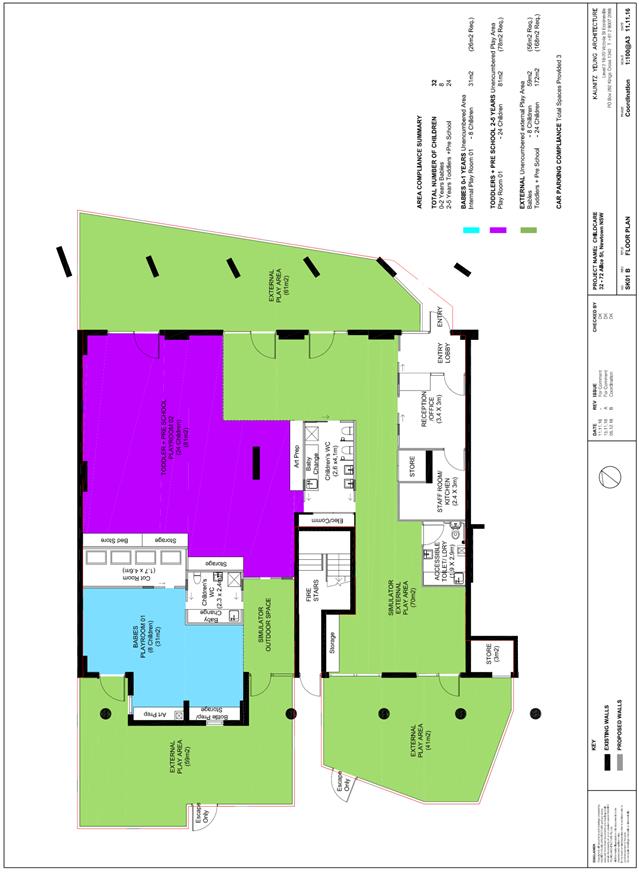
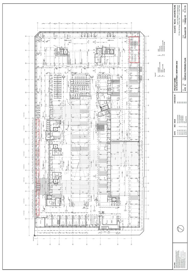 |
 |
|
|
Local Traffic Committee Meeting 6 July 2017 |
Subject: Bedford Street, Newtown - Newtown Community Market – Modification to Consent Conditions – TMP and Bump in and Bump Out Procedure (Stanmore Ward / Newtown Electorate / Newtown LAC)
File Ref: 17/6022/74097.17
Prepared By: Jennifer Adams - Traffic and Road Safety Officer
Authorised By: Joe Di Cesare - Manager Design and Investigation
|
SUMMARY Council has received an application under Section 106 of the Local Government Act to modify approval No. S68-201500007 dated 29 January 2016 to amend condition 3 (Part A) relating to the amended traffic management plan and bump in and bump out procedure.
The application is required to be referred to the Local Traffic Committee for consideration under State Environmental Planning Policy (Infrastructure) 2007.
No temporary road closures are required as part of the event.
Comments will be referred to Council’s Development Assessment Section for consideration in determining the Section 106 Application.
|
|
RECOMMENDATION
THAT the report be received and noted. |
BACKGROUND
In 2012 Newtown Community Market formally began with 12 stallholders, prior to this an ad-hoc and an unregistered market took place in Newtown Square, Bedford Street, Newtown. The Newtown Community Market was run by Newtown Neighbourhood Centre (NNC) and was limited to one day per week on the weekend to a maximum of 52 days per year. The duration was also restricted (regular hours 10.00am to 4.00pm each market day with extended trading during summer months until 7.00pm). No temporary road closures are required as part of the event.
In 2013 NNC applied for a 5 year licence to conduct the weekend markets. Numerous issues were raised by former Marrickville Council and members of the local community regarding the application. Conditions were placed on the markets to ensure that the area is safe, with ample space for pedestrians and emergency vehicles.
In January 2016 Council determined Application No. S68-201500007 to continue to conduct a weekend community market at Newtown Square between 10.00am to 4.00pm on either Saturday or Sunday comprising a maximum of 50 stalls selling art, craft, clothing, jewellery, books, CDs, DVDs, bric-a-brac, other non-consumables and pre-packaged food relating to property situated at 1 Bedford Street, Newtown.
Approval No.S68-201500007 was determined on 29 January 2016 with a deferred commencement consent subject to the following terms and conditions:
Condition 3. An amended Traffic Management Plan and Bump-in Bump-out Procedure must be submitted to Council restricting loading/unloading associated with the community markets along Australia Street, Alton Lane, Bedford Street and Denison Road in a manner that would not inconvenience the public.
Reason: To ensure the loading and unloading of market vendor vehicles does not interfere with public amenity.
NNC is now seeking, under a Section 96 modification request, to amend the Conditions of Consent to the following clauses: Condition 3, Condition 11(a) (c) and (e), and Condition 15 (c). With respect to these clauses NNC have sought either: (a) Amendment — proposed alteration to part of the condition; (b) Deletion — proposed deletion of the condition; or (c) Replacement of a clause.
In regards to Condition 3 amendment sought: is "The Market being permitted to operate a maximum of 104 days in any period of 12 months on Saturdays and Sundays."
In regards to Condition 11 amendments sought are as follows:
a) Change requested — "deliveries and erection of infrastructure being carried out from 7:00am on Saturdays and Sundays." Reason: amendments to the Square have restricted access to space for vehicle deliveries and the Market requires an additional bump-in time to cater for this. Please note that the Bump-In schedule has been developed to reflect this time. b) Stet
c) Stet
d) Change required (believed error in clause which provided no time for bump out): "dismantling and removal of infrastructure to continue no later than 10pm on those days". Reason: it takes up to 3 hours to bump in and bump out the Market.
e) Change required (believed error in clause which provided no time for bump out): "All remaining dismantling being completed by 10pm.... With the Square being fully available to Council's satisfaction from l0pm on those days". Reason: it takes up to 3 hours to bump in and bump out the Market.In regards to Condition 15 amendments sought is deletion of the clause 15(c) “No vehicles of any nature are permitted on the entire site.” Reason given being “To enable implementation of the Traffic Management Plan (attached) and to facilitate the safe and efficient operations of the Market with minimal disruption to local residents.”
A Traffic Management Plan (TMP), dated 20 December 2016, was submitted to Council. The scope of this plan states it includes provision for the safe movement of vehicular and pedestrian traffic to, from and around Newtown Square during the Community Market bump in, live phase & bump out each Saturday. The submitted TMP was considered not adequate for a full assessment to be made and a new TMP was requested and has now been submitted to Council, dated 6/6/2017.
FINANCIAL IMPLICATIONS
Nil.
OFFICER COMMENTS
Site location
The site is known as “Newtown Square” and is located on a closed part of Bedford Street that is bounded by Bedford Street to the west, buildings at 1-13 Bedford Street to the north, Australia Street to the north east and the King Street and Enmore Road intersection to the south. The site is a public square which contains street furniture including seating, bicycle stands and landscaping.
Newtown Square is surrounded by commercial and retail development along Enmore Road and King Street and is situated between the Enmore Road and King Street shopping strips, with Newtown Station situated opposite the site, approximately 30 metres to the south east of the King Street and Enmore Road intersection. More broadly, the following can be found in the surrounding area:
• The former Newtown Town Hall abuts Newtown Square to the north;
• The Newtown Neighbourhood Centre abuts Newtown Square to the north east;
• The Newtown Police Station and Local Court situated 60 metres to the north of Newtown Square; and
• The Newtown Fire Station situated 100 metres to the north of Newtown Square.
Newtown Community Market
Newtown Community Market as held in Newtown Square on either a Saturday or Sunday (generally Saturday’s) for a maximum of 52 days per calendar year has 25 stalls on average with maximum capacity for 50 stalls. It operates from 10.00am to 4.00pm during eastern standard time and 10.00am to 7.00pm in daylight savings time. The installation and setup of equipment and facilities (bump in) is between 8.00am to 9.30am and packing up (bump out) is between 4.00pm to 6.00pm (non-daylight savings). During daylight savings the site is cleared by 7.00pm.
Stall holders were allocated a specific set up and pack down time (bump-in and bump out times) at least one day prior to the operation of the market and the process was managed by the market manager and at least 1 other staff member, who have appropriate training in traffic management. Unloaded vehicles exited into Bedford Street only with no right turns into Denison Street.
The markets were running contrary to consent conditions in that vehicles were unloading and loading on the grassed area at the end of Bedford Street adjacent to the square. (Refer to site map.) Consent condition 15 (c) stated “No vehicles of any nature are permitted on the entire site.”
![]()
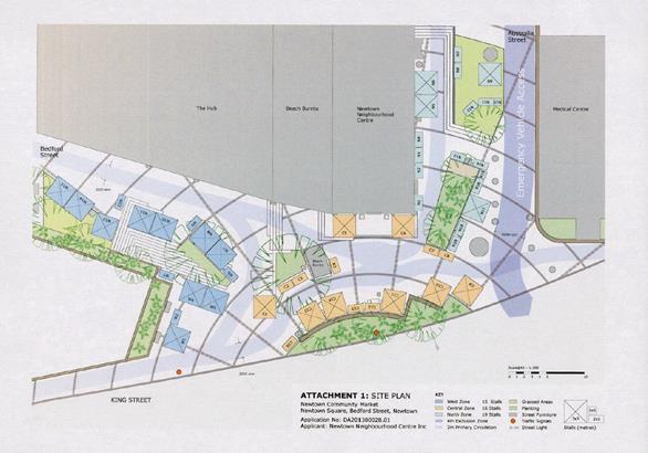
Discussions in September 2016 were held between Council Officers and NNC about allowing vehicles on site to load and/or unload. It was stated that the markets have been running for the past 2 years and the procedure for bumping in and out works sufficiently at the subject location. The use of the grassed area adjacent to the Bedford Street dead end to unload was originally not supported because access is via a pram ramp not a vehicular crossing.
The amendments sought now are to allow the market to operate on both Saturday and Sunday, allow vehicles on site and to extend the bump in and bump out times from 8.00am to 7.00am and from 6pm to 7pm and to 10pm (daylight saving). The applicant has stated the reason for the latter changes are because it takes up to 3 hours to bump in and bump out the Market. Section 96 modifications sought
Condition 3 modifications sought that the market run both days of the weekend throughout the year is not supported as it would dominate the location not allowing a variety of uses at the prominent site. The market now (at approximately 25 stalls) also generates moderate traffic movements and parking requirements impacting the amenity of the local area and if they are continuous over the whole weekend they may have a detrimental effect in the locality.
Condition 11 modifications relate to bump in and bump out times which are considered appropriate and the new times of 7am start and 7pm (10pm in daylight saving) are supported accordingly .
The TMP report submitted in December 2016 by the applicant notes that ‘3 vehicles may be allocated per bump- in segment.” Now in the June 2017 resubmitted TMP report the applicant notes that ‘4 vehicles may be allocated per bump- in segment.’
Each segment documented is 30 minutes duration, therefore it is acknowledged that 24 (opposed to the previous 18) vehicles in total will be allocated access to load and unload on any one market day at the subject location. “Approved stallholders only are given a bump-in and bump-out time prior to the Market Day.” The conditions should reiterate a maximum 24 vehicles allowed to unload/load per market day.
The applicant’s TMP report also states that there will be a “Maximum of 4 vehicles in the loading area at any one time.” and “Vehicles exiting the loading area must turn into Bedford Street / No right turn into Denison Road.” The conditions should reiterate that at any one time there can be no more than 4 vehicles on site at any one time during allocated bump in and bump out periods.
The Traffic Control Plan (TCP) appearing in the June 2017 TMP is reproduced below. It details the location of the qualified Traffic controller (TC).
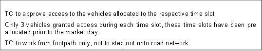

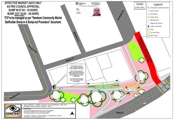
The TMP also states that the “design and installation of equipment used in this TMP will be in accordance with 1742.3 The RTA Traffic Control at Worksites Manual Version 4.0 Issued June 2010. This TMP needs to be approved by all relevant Authorities prior to its activation and can only be installed by a duly authorised & qualified person.”
At this time it is considered acceptable that vehicles load and unload via the kerb access at the corner of Bedford Street and Denison Street, Newtown as per the TMP schedule.

![]()
![]()

Condition 15 modification seeking vehicular access to Newtown Square via Bedford Street is acceptable and discussions with Council’s Development Engineer have confirmed that the original Condition 16c which did not permit any vehicles on the site can be removed and the applicant be advised that a bond may be conditioned to protect the square from any damage.
Parking Provision
Specifically the applicant has not detailed any parking provision for the markets. No vehicular parking provision for either visitors and/or stallholders, no bicycle parking provision or motorcycle parking provision are mentioned, however it is noted that the site is well served by public transport. Council’s DCP2011 shows that the site lies within Parking Area 1, where car parking is most constrained.
It is noted that stall holders are likely to require parking for the duration of the markets from set-up to pack-down, that is up to a possible 12 hour period (markets 10.00am-4.00pm and bump in 7.00-10.00am and bump out 4.00-7.00pm) and it is noted that there is very limited long term on-street parking in the area.
Given the restricted availability of on-street car parking and the general on-street parking restrictions in the surrounding area, it is considered unlikely that many visitors would choose to travel to the venue by car.
RMS’s Guide to Traffic Generating Developments state a minimum parking provision of 2 spaces per stall or a desirable rate of 2.5 spaces per stall, excluding stall holders. 25 to 50 stalls would therefore require a minimum of 50 - 100 spaces for visitors and desirable rate of 63 - 125 spaces respectively. These rates are based on a mode split for cars of 0.80 and a reasonable availability and convenience of alternative markets in the area.
To retain the amenity of the surrounding local area it should be mentioned that in the future should stall numbers increase from 25 to 50 stall number limit consideration must be given to parking provision for both visitors and stall holders. To date no provision has been made for any parking associated with the market which states it generally now haves around 25 stalls.
Traffic Generation
RMS’s Guide to Traffic Generating Developments gives the following rates for markets - 18 trips per stall between 8.00am – 3.00pm (open for 7 hours) and peak hour vehicle trips of 4 trips per stall. 25 stalls thus would generate approximately 450 vehicle trips daily and 100 peak hour vehicle trips. Daily trip generation rates depend on hours of operation and the Guide states a market open for 12 hours a day would be expected to have a higher daily generation rate than that suggested.
As noted the site’s proximity to alternate forms of transportation and the local community focus of the markets allows consideration that the market itself would not be the destination venue in its own right for visitors. There are many other venues (hotels, bars, entertainment venues, cafés, restaurants and the like) in the locality that visitors to the market may also attend.
It is further noted that having regard to the types of goods to be offered for sale at the market stalls including art, craft, clothing, jewellery, books, CDs, DVDs, bric-a-brac and the like, it is unlikely that the use of vehicles would be required to transport purchased goods from the market stalls thereby reducing the need to travel to the markets by motor vehicle.
Emergency Access and Pedestrian Access
Emergency vehicle access and pedestrian access is to be maintained in accordance with the Operational Plan submitted with the application. The stall map and zone map submitted with the application would allow flexibility with the placement of the stalls, whilst still requiring that a 2 metre pedestrian access way is provided throughout the Newtown Square in the duration of the markets. Appropriate conditions are included in the consent to ensure the market maintains access for emergency vehicles and pedestrians.
PUBLIC CONSULTATION
Nil.
CONCLUSION
At this time support is not forthcoming to extend the market operating days to both weekend days however support is forthcoming to allow vehicles on the site. It is acknowledged that bump in and bump out may take up to 3 hours and it is acceptable that a maximum of 24 vehicles can unload and load in the designated area adjacent to Bedford Street during the designated bump in and bump out times per market day. It is noted and acceptable that in accordance with the submitted TMP that only 4 vehicles will be on site at any one time during unloading and loading activities.
Given all of the above, the proposal is considered acceptable on traffic and parking grounds as it stands now with around 25 stalls. The main concern is that any operations associated with the Market need to be restricted enough so as not to cause any inconvenience to the public or any interference with public amenity. Any more stalls would generate higher parking demands, possible traffic congestion and may interfere with access /pedestrian movements.