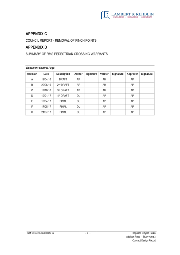
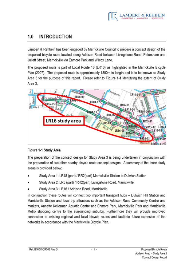
|
AGENDA R |

Local Traffic Committee Meeting
THURSDAY 3 AUGUST 2017
10:00am
|
Local Traffic Committee Meeting 3 August 2017 |
Function of the Local Traffic Committee
Background
Roads and Maritime Services (RMS) is legislated as the Authority responsible for the control of traffic on all NSW Roads. The RMS has delegated certain aspects of the control of traffic on local roads to councils. To exercise this delegation, councils must establish a local traffic committee and obtain the advice of the RMS and Police. The Inner West Council Local Traffic Committee has been constituted by Council as a result of the delegation granted by the RMS pursuant to Section 50 of the Transport Administration Act 1988.
Role of the Committee
The Local Traffic Committee is primarily a technical review and advisory committee which considers the technical merits of proposals and ensures that current technical guidelines are considered. It provides recommendations to Council on traffic and parking control matters and on the provision of traffic control facilities and prescribed traffic control devices for which Council has delegated authority. These matters are dealt with under Part A of the agenda and require Council to consider exercising its delegation.
In addition to its formal role as the Local Traffic Committee, the Committee may also be requested to provide informal traffic engineering advice on traffic matters not requiring Council to exercise its delegated function at that point in time, for example, advice to Council’s Development Assessment Section on traffic generating developments. These matters are dealt with under Part C of the agenda and are for information or advice only and do not require Council to exercise its delegation.
Committee Delegations
The Local Traffic Committee has no decision-making powers. The Council must refer all traffic related matters to the Local Traffic Committee prior to exercising its delegated functions. Matters related to State Roads or functions that have not been delegated to Council must be referred directly to the RMS or relevant organisation.
The Committee provides recommendations to Council. Should Council wish to act contrary to the advice of the Committee or if that advice is not supported unanimously by the Committee members, then the Police or RMS have an opportunity to appeal to the Regional Traffic Committee.
Committee Membership & Voting
Formal voting membership comprises the following:
· one representative of Council as nominated by Council;
· one representative of the NSW Police from each Local Area Command (LAC) within the LGA, being Newtown, Marrickville, Leichhardt and Ashfield LAC’s.
· one representative from the RMS; and
· State Members of Parliament (MP) for the electorates of Summer Hill, Newtown, Heffron, Canterbury, Strathfield and Balmain or their nominees.
Where the Council area is represented by more than one MP or covered by more than one Police LAC, representatives are only permitted to vote on matters which effect their electorate or LAC.
Informal (non-voting) advisors from within Council or external authorities may also attend Committee meetings to provide expert advice.
Committee Chair
Council’s representative will chair the meetings.
Public Participation
Members of the public or other stakeholders may address the Committee on agenda items to be considered by the Committee. The format and number of presentations is at the discretion of the Chairperson and is generally limited to 3 minutes per speaker. Committee debate on agenda items is not open to the public.
|
AGENDA |
1 Apologies
2 Disclosures of Interest
3 Confirmation of Minutes
4 Matters Arising from Council’s Resolution of Minutes
5 Part A – Items Where Council May Exercise Its Delegated Functions
Traffic Matters
ITEM PAGE #
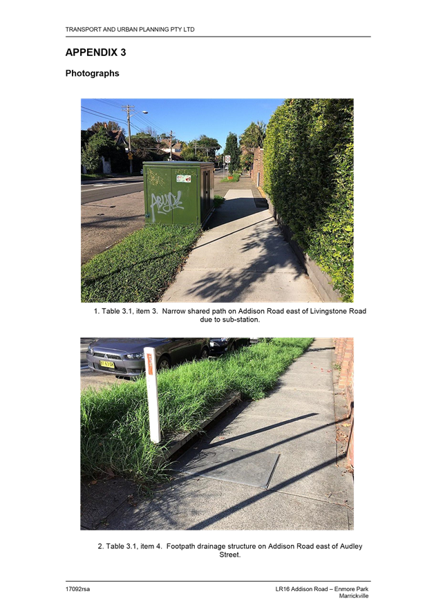
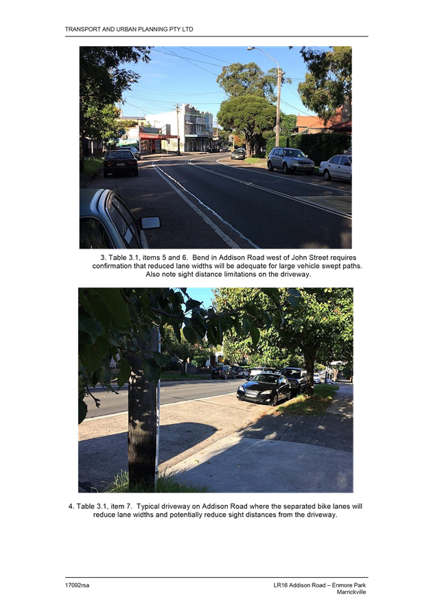
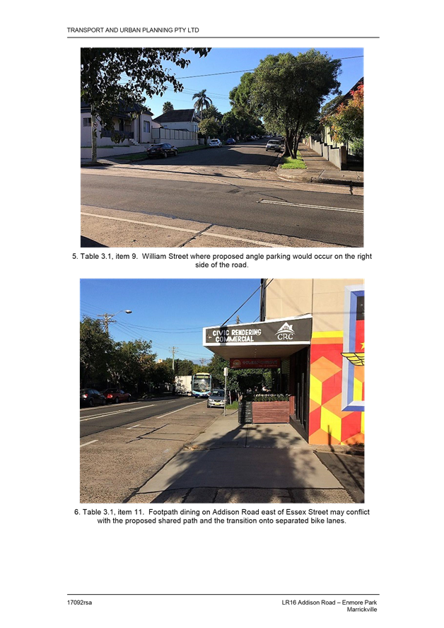
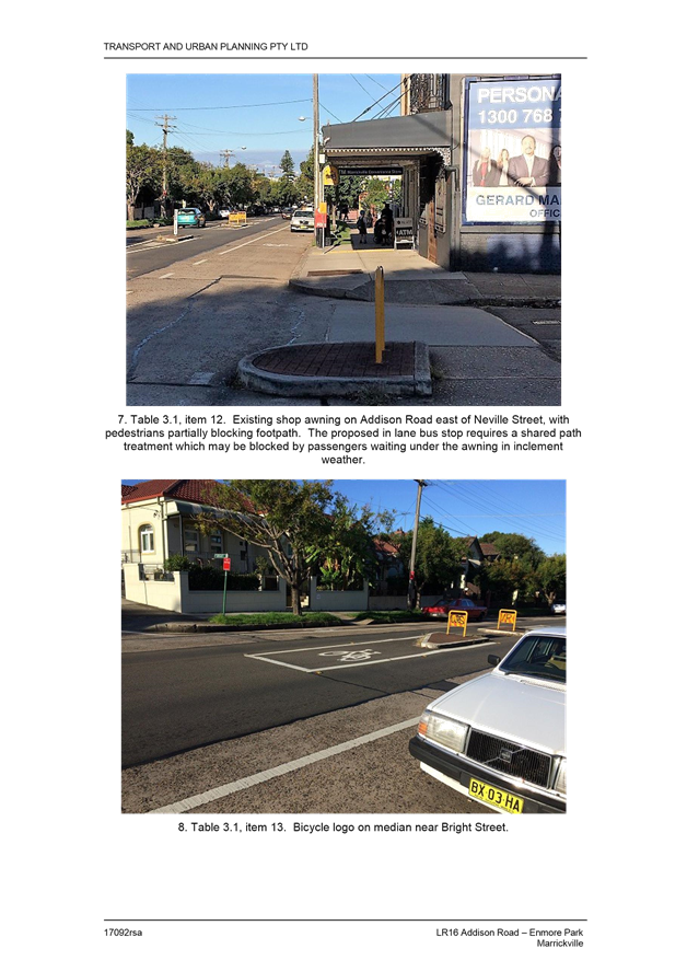
T0817 Item 1 Local Route 16 (Addison Road) - Public Consultation Report And Revised Concept Plan 8
T0817 Item 2 Seven Bridges Walk - Special Event - (Leichhardt & Balmain Ward/Balmain Electorate/Leichhardt Lac) 150
T0817 Item 3 2017 St Brendan’s Parish And School Spring Fair (Leichhardt Ward/Balmain Electorate/Leichhardt Lac) Proposed Temporary Road Closure To Hold School Spring Fair On Sunday 5th November 2017 172
T0817 Item 4 Cavill
Avenue/Liverpool Road, Ashfield – Modification Of Splitter Island And Other
Measures To Facilate Pedestrian Safety.
(Ashfield Ward/Summer Hill Electrate/Ashfield Lac) 184
T0817 Item 5 (A Traffic) Marrickville Road, Marrickville – Temporary Full Road Closures For Marrickville Festival On Sunday 22 October 2017 (Marrickville Ward/Summer Hill Electorate/Marrickville Lac) 189
T0817 Item 6 (A Traffic) Marrickville Road, Marrickville – Temporary Full Road Closures For Dulwich Hill Village Fair On Sunday 10 September 2017 (Ashfield Ward/Summer Hill Electorate/Marrickville Lac) 199
T0817 Item 7 (A Traffic) Burrows Avenue, Sydenham – Proposed Bicycle Car Port – Design Plan (Marrickville Ward/Heffron Electorate/Newtown Lac) 203
T0817 Item 8 (A
Parking) Requests For ‘Works Zone’ Adjacent To No. 66 Constitution
Road,Dulwich Hill
(Ashfield Ward / Summer Hill Electorate / Marrickville Lac) 206
Parking Matters
ITEM PAGE #
T0817 Item 9 Proposed No Stopping Restricitons In Brighton Street At Wentworth Stret, Petersham (Stanmore Ward/Newtown Electorate/Marrickville Lac) 211
T0817 Item 10 (A Parking) Proposed 'No Parking' In Garners Lane, Marrickville Between Seymour Lane And The Rear Of 83 Frampton Avenue (Marrickville Ward/Summer Hill Electorate/Marrickville Lac) 215
T0817 Item 11 (A Parking) Proposed Removal Of 'No Parking' Nestor Lane, Lewisham - Southern Side (Stanmore Ward/Summer Hill Electorate/Marrickville Lac) 218
T0817 Item 12 (A) Hopetoun Lane, Camperdown - Extension Of ‘No Parking’ Restrictions In The Laneway (Stanmore Ward / Newtown Electorate / Newtown Lac) 223
T0817 Item 13 Modification
Of No Parking Restriction- John Street, Leichhardt
(Leichhardt Ward/Balmain Electorate/Leichhardt Lac) 227
T0817 Item 14 Laneway
Rear Of 70 Smith Street, Summer Hill - Request For ‘No Parking’
Restrictions.
(Ashfield Ward/Summer Hill Electrate/Ashfield Lac) 229
T0817 Item 15 ‘No Parking’ And ‘No Stopping’ Restrictions – Unnamed Laneway Between Flood Street And National Street, Leichhardt (Leichhardt Ward/Balmain Electorate/Leichhardt Lac) 231
T0817 Item 16 Minor Traffic Facilities (Leichhardt & Balmain Wards/ Balmain Electorate/ Leichhardt Lac) 235
Late Items
Nil at time of printing.
6 Part C – Items for General Advice
ITEM PAGE #
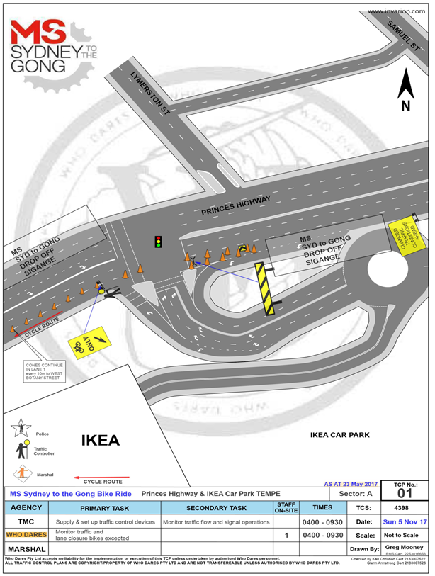
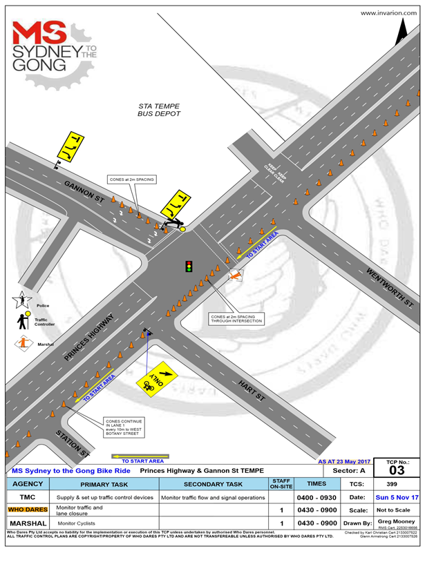
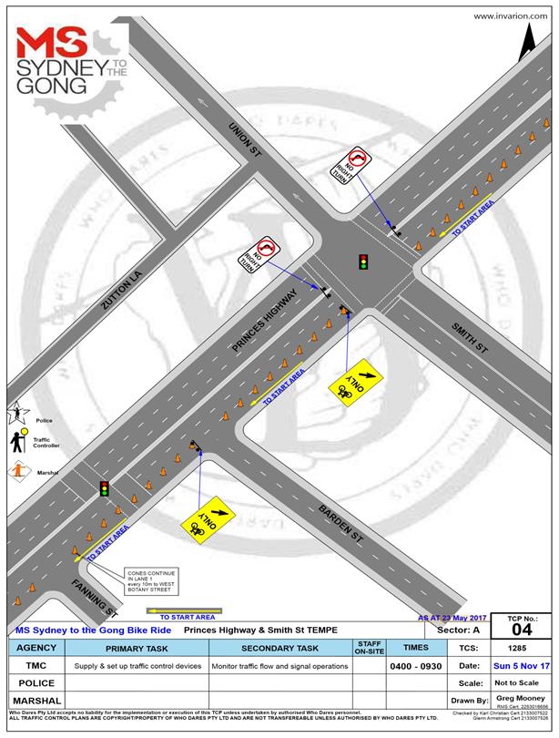
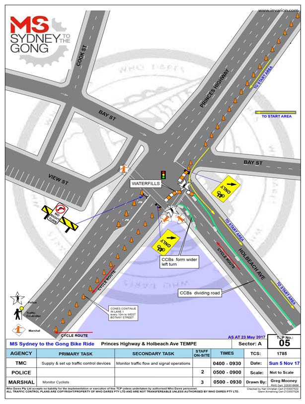
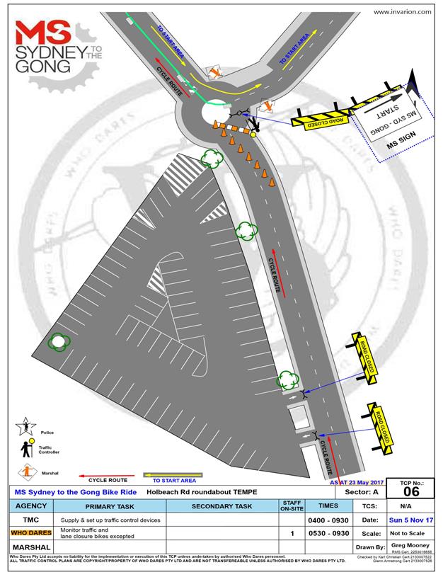
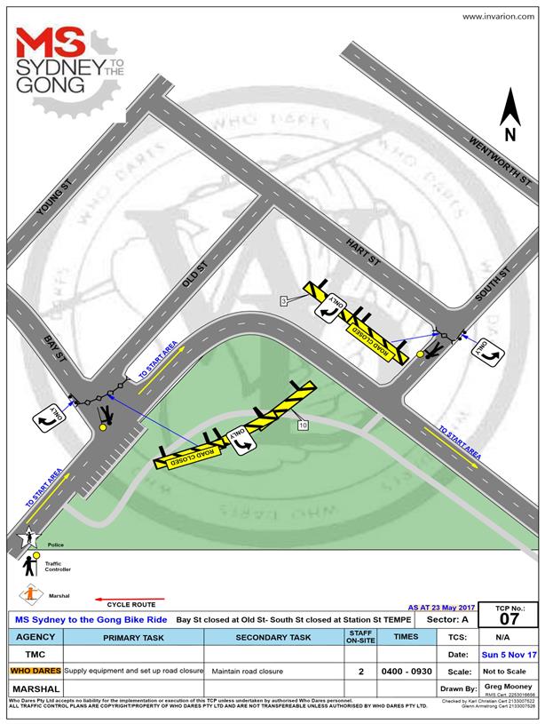
T0817 Item 17 (C) Holbeach Avenue, Tempe – Temporary Full Road Closures For Ms Sydney To The Gong Bike Ride On Sunday 5 November 2017 (Marrickville Ward/Heffron Electorate/Newtown Lac) 238
8 General Business
9 Close of Meeting
|
|
Local Traffic Committee Meeting 3 August 2017 |
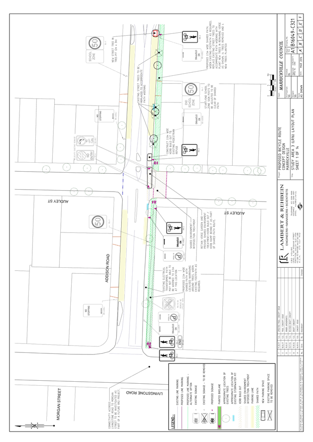
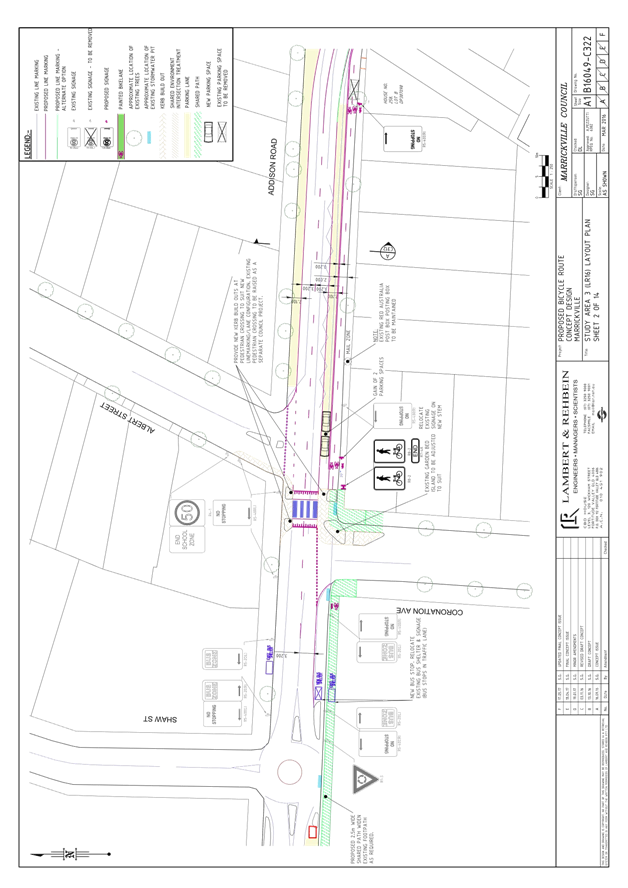
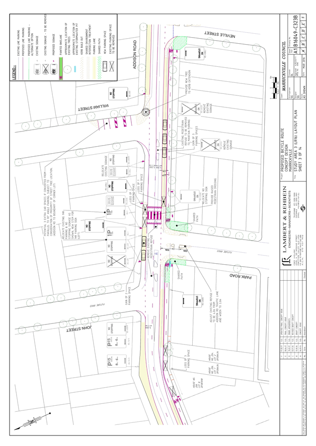
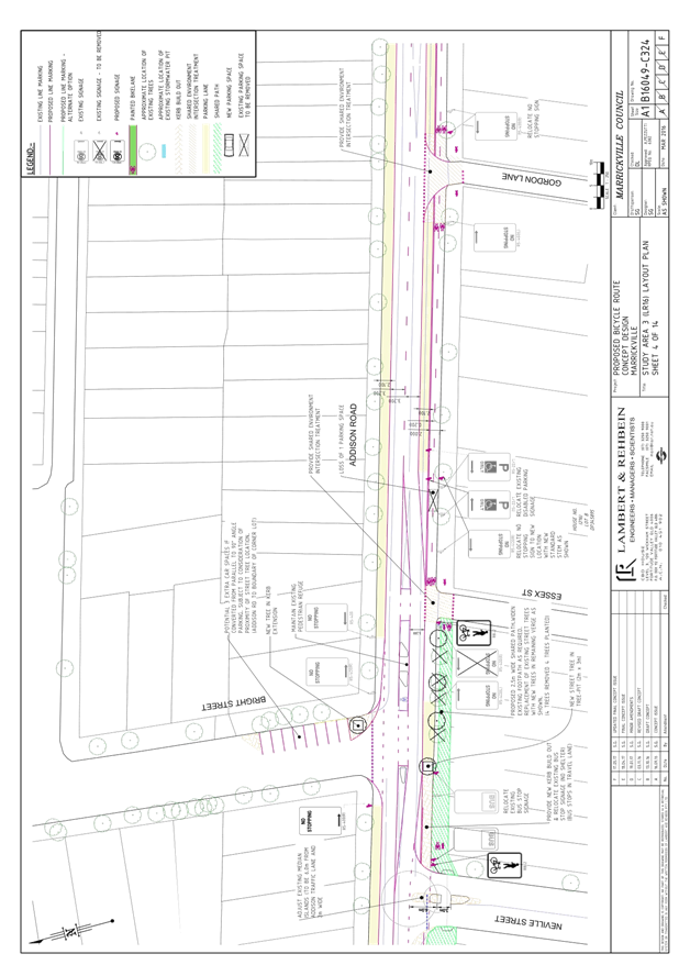
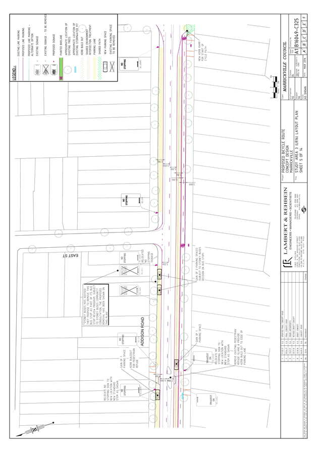
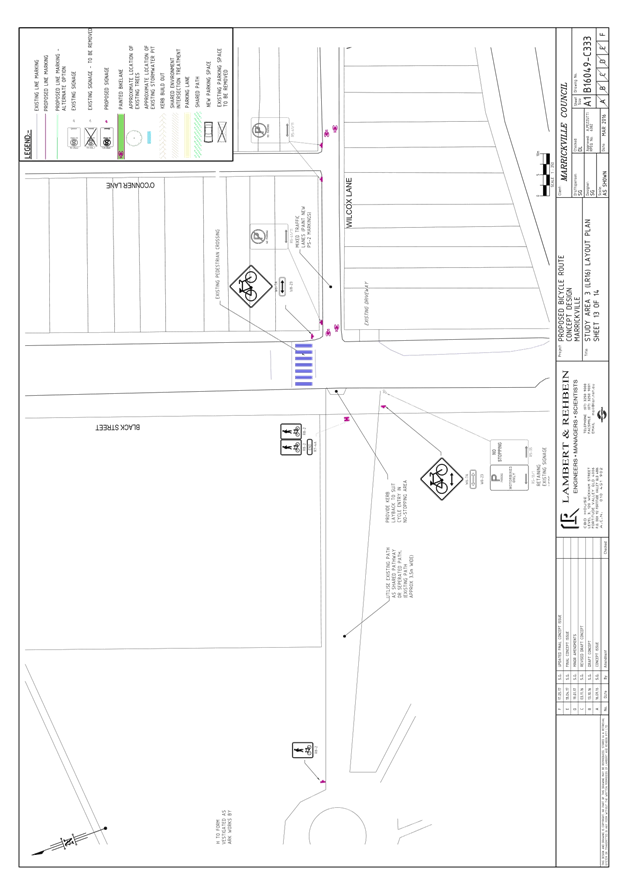
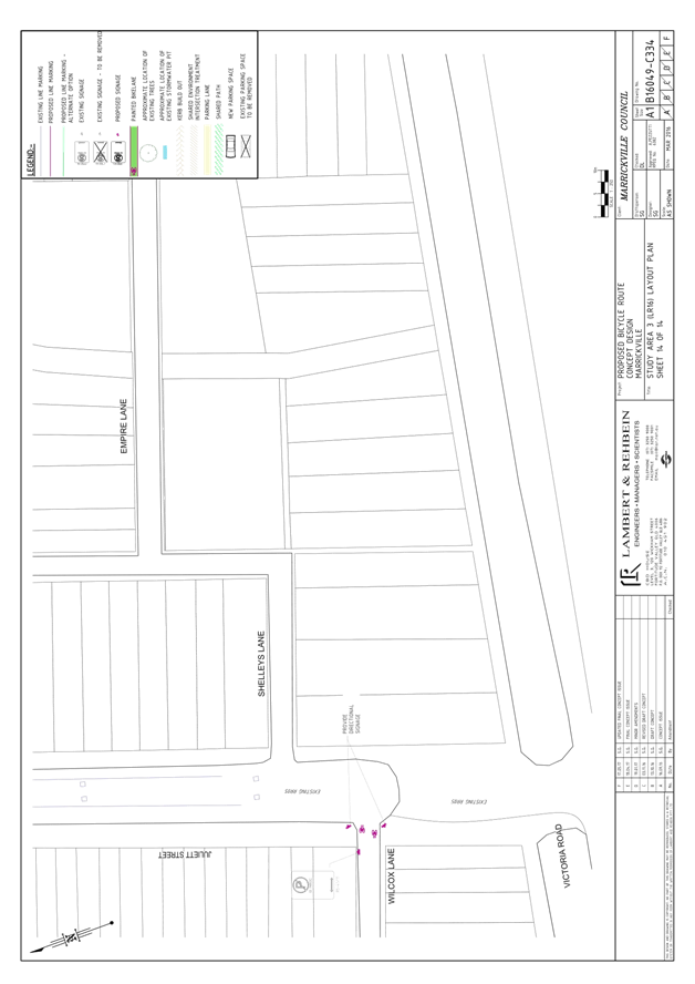
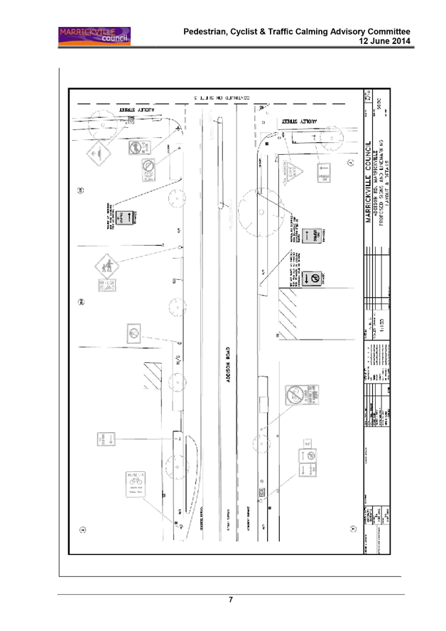
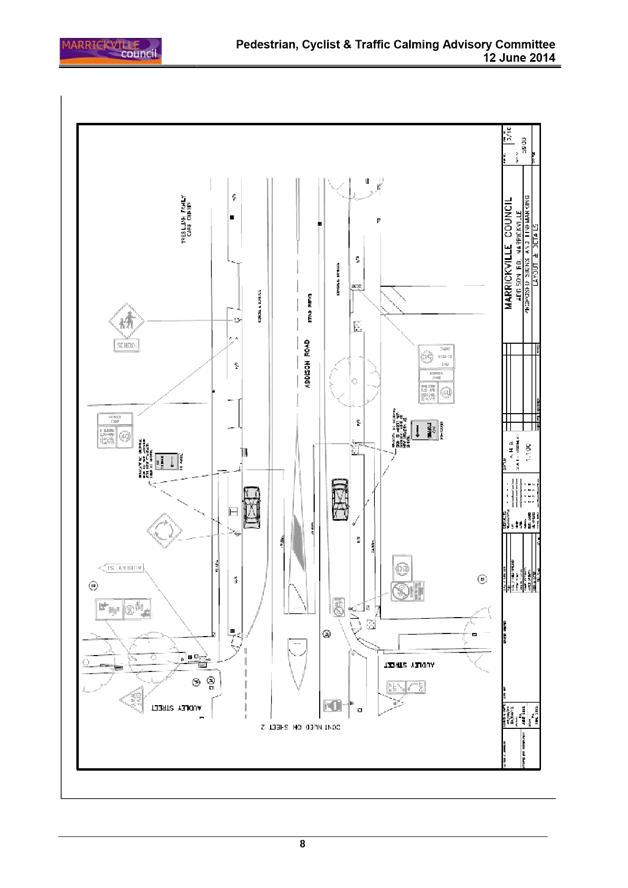
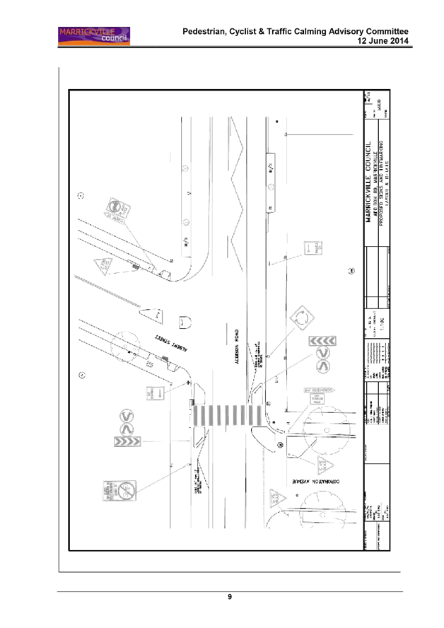
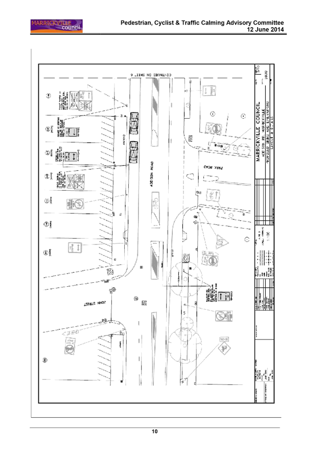
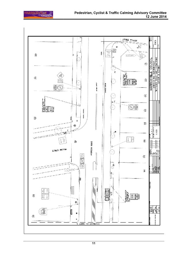
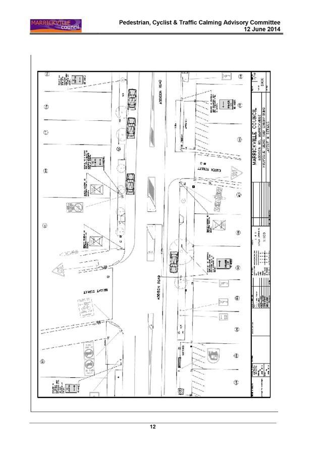
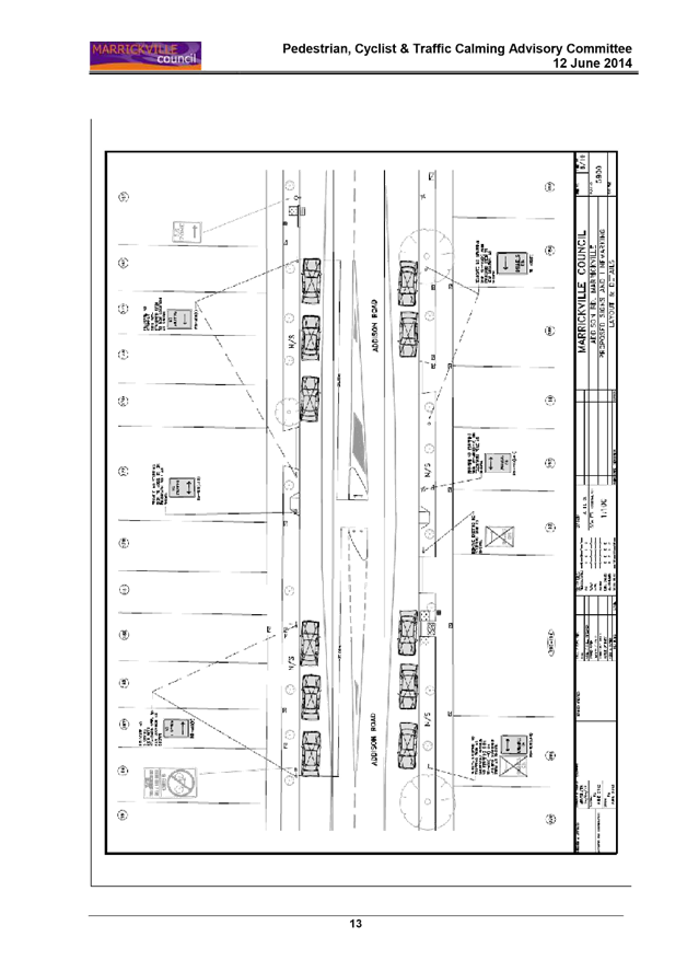
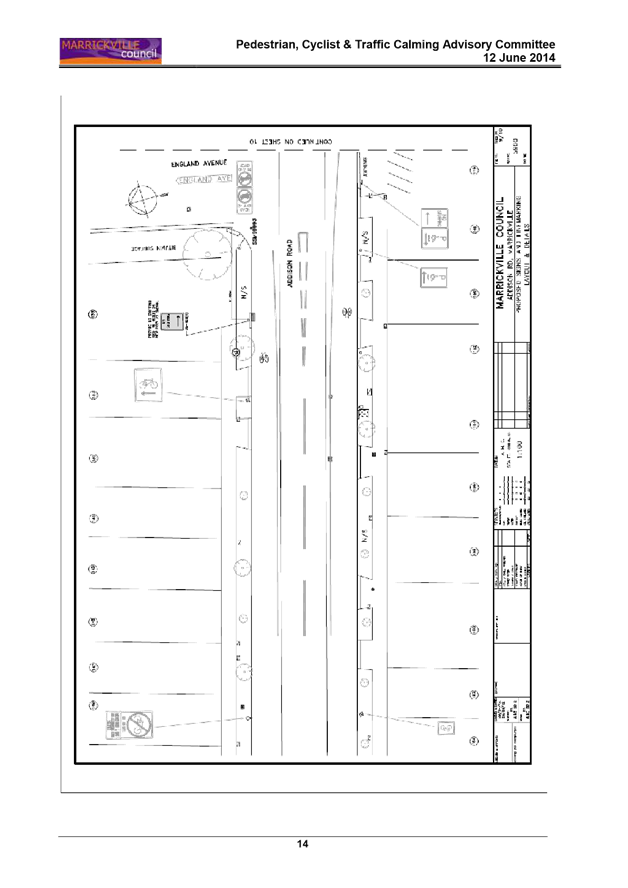
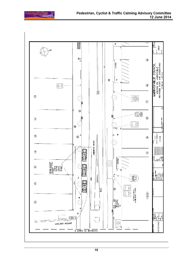
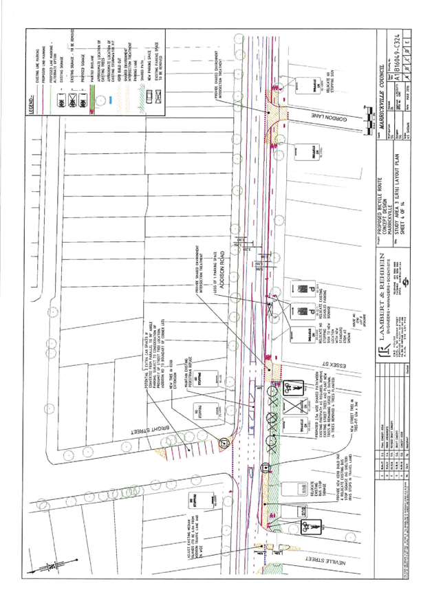
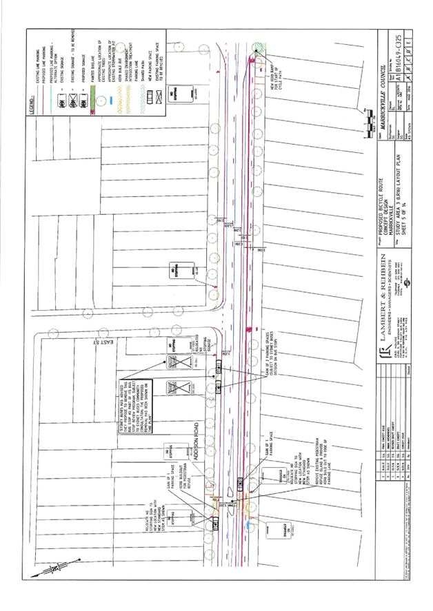
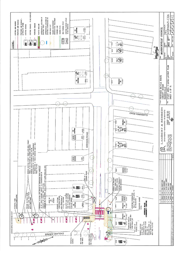
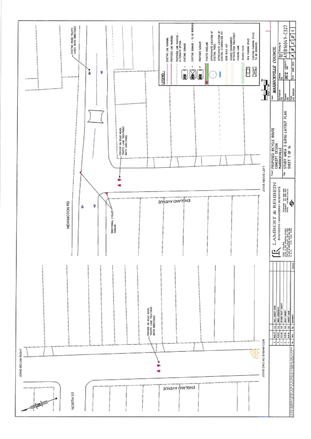
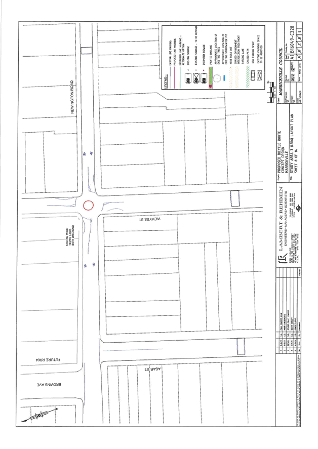
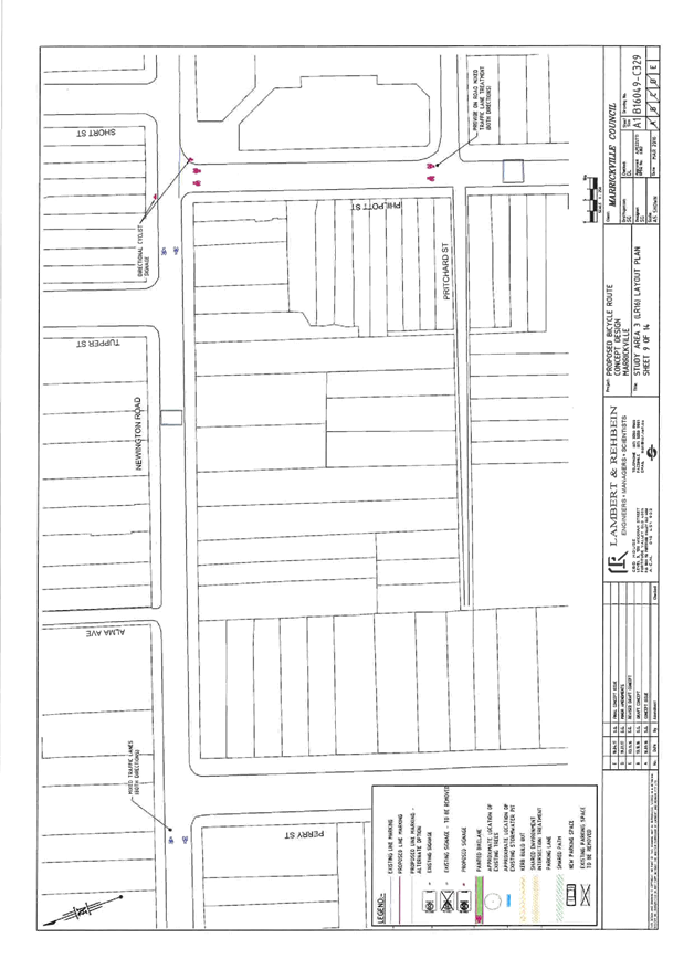
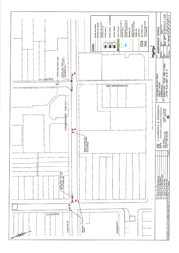
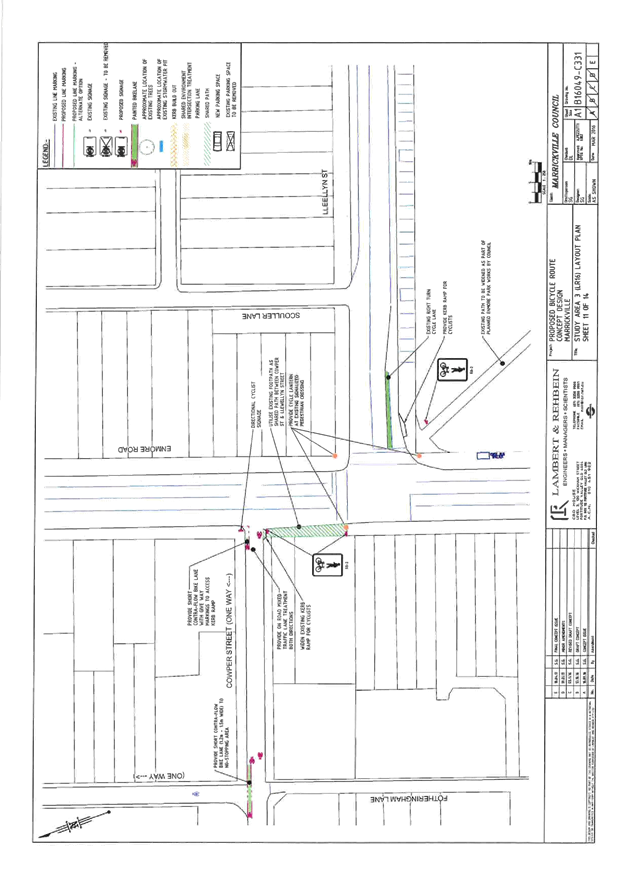
Subject: Local Route 16 (Addison Road) - Public Consultation Report And Revised Concept Plan
File Ref: 16/5957/61186.17
Prepared By: Benny Horn - Cycling Planner
Authorised By: George Tsaprounis - Coordinator Traffic Engineering Services
|
SUMMARY A revised concept plan for improvements to Local Route 16, a bicycle route identified in Council’s Marrickville Bicycle Plan, has been developed following public exhibition of the draft concept plan. This report presents a summary of feedback received during consultation with the local community and other stakeholders, and recommends that the revised concept plan be approved and detailed designs for the route be developed. |
|
RECOMMENDATION
THAT:
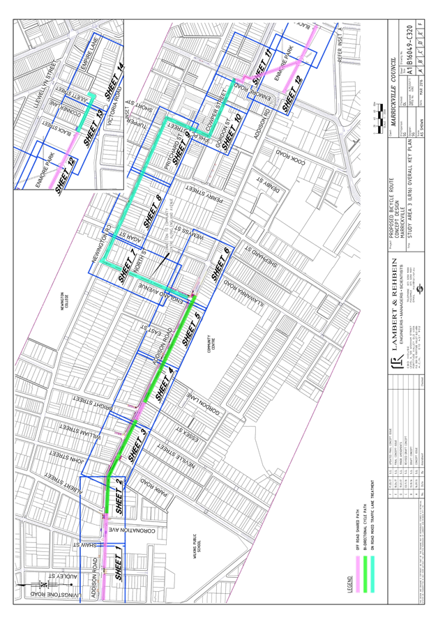
1. The revised concept plan for Local Route 16 (Attachment 1 – sheets B16049-C320 to B16049-C335) be approved; and 2. Detailed designs for the route be developed.
|
BACKGROUND
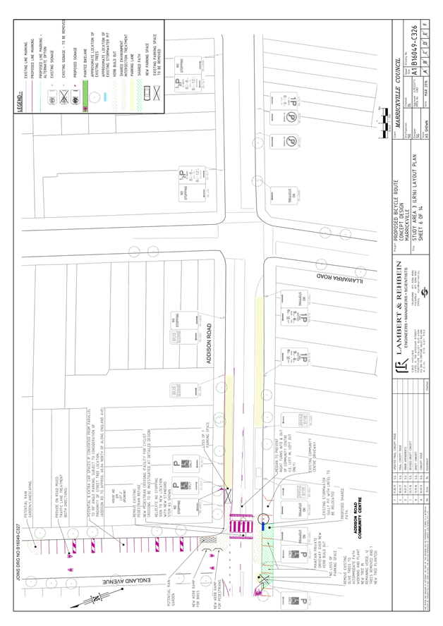
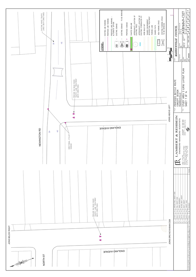
Consistent with Council’s stated commitment to encourage bicycle riding and improve bicycle paths and networks, Council’s Marrickville Bicycle Strategy (adopted in 2007) aims to make riding a bicycle easier, safer and more attractive. Local Route 16 (LR16) is a route from Livingstone Road to Juliett Street via Addison Road identified in the Bicycle Strategy. It aims to improve connections to local destinations such as Addison Road Community Centre, Enmore Park and aquatic centre, and Marrickville Metro.
In 2015, Council received a grant from NSW Roads and Maritime Services (RMS) to develop a concept plan for improvements to LR16. This is consistent with the NSW Government’s objective of making bicycle riding a safe, convenient and enjoyable option for short trips.
Following preliminary engagement with stakeholders, a draft concept plan was developed and endorsed for public exhibition in December 2016. Following public exhibition, a final concept plan (Attachment 1) and consultant’s report (Attachment 2) have been developed.
FINANCIAL IMPLICATIONS
Detailed design and construction of the route are dependent on future budgets and grants.
PUBLIC CONSULTATION
The draft concept plan was placed on public exhibition in late January 2017. Feedback received during public exhibition is outlined in this section of the report.
Following public exhibition, issues raised in submissions were considered, and where feasible informed modifications to the proposal. The local community and those that made submissions during public exhibition were then notified of the revised concept plan in June 2017, and further feedback from community members was received. Changes to the proposal following public exhibition, and the further feedback received by Council is addressed in the next section of this report.
Public exhibition of the draft concept plan (January/February 2017)
The draft concept plan was exhibited from 23 January to 22 February 2017. During this time:
· Public exhibition was advertised to the community in the Inner West Courier, on Council’s website and via Council’s social media channels and temporary signage on the route;
· Approximately 1,600 letters were sent to residents, businesses and property owners in the vicinity of the proposed route, advising of the proposed changes and inviting comments;
· A drop-in information session was held at Addison Road markets on Sunday 12 February, at which community members could view the draft concept plan and discuss the proposal with Council officers. Approximately 50 community members attended the drop-in session;
· Information about the proposal was accessed from Council’s website 1,040 times.
Overview of community submissions during public exhibition
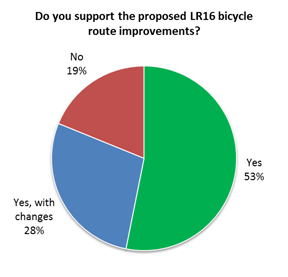
207 submissions from community members were received by Council during public exhibition:
· 81% of submissions (168 submissions) indicated “support” (53%) or “support with changes” (28%) for the proposal;
· 19% of submissions (39 submissions) indicated they did “not support” the proposal.
Overview of community submissions during public exhibition, by location
44% of submissions received during public exhibition were from community members in the vicinity of the proposed route (Table 1). Of these, 67% indicated “support” (40%) or “support with changes” (27%) for the proposal, with 33% indicating they did “not support” the proposal.
|
Response, by location |
Total number of submissions |
Yes |
Yes, with changes |
No |
|
Vicinity of the route |
91 (44%) |
36 (40%) |
25 (27%) |
30 (33%) |
|
Rest of Inner West LGA |
74 (36%) |
49 (66%) |
17 (23%) |
8 (11%) |
|
Outside Inner West LGA |
34 (16%) |
19 (56%) |
15 (44%) |
0 |
|
Not specified |
8 (4%) |
6 (75%) |
1 (13%) |
1 (13%) |
|
Total |
207 |
110 (53%) |
58 (28%) |
39 (19%) |
Table 1: Community submissions received during public exhibition, response by location
Issues raised in community submissions during public exhibition
Issues most frequently raised in community submissions during public exhibition were:
· The route should travel along the full extent of Addison Road, instead of diverting via England Avenue
· Oppose the removal of on-street parking on Addison Road
· The bicycle path should be wider
· Addison Road is unsuitable for a bicycle path given high traffic volumes and speeds / The route should use Newington Road instead
· Bicycle route improvements are a waste of money / a low priority
A summary of issues raised – and Council officer response – is at Attachment 3.
RMS comments about the draft concept plan
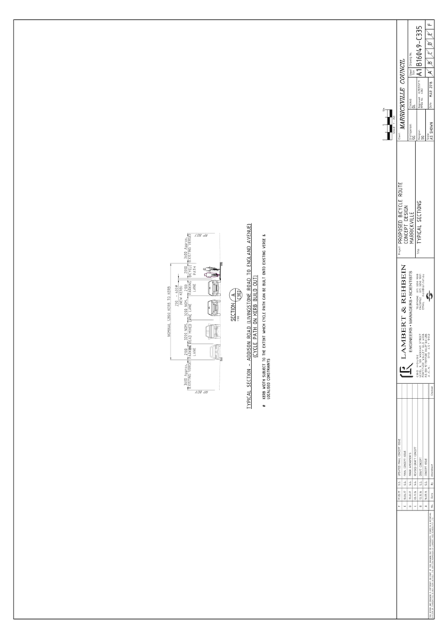
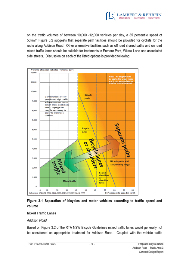
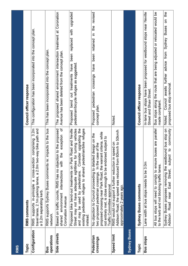
RMS indicated no objection to the proposed configuration of 3.2m travel lanes, 2.1m parking lanes, and a 2.0m two-way separated bicycle path with a 0.2m buffer.
RMS advised it did not support the proposed “bend-out” intersection treatments at Park Road and Neville Street given poor sightlines for turning motorists at these intersections and risk that pedestrians will use the bend out crossings given no adjacent pedestrian crossing.
RMS also advised it did not support the proposed shared environment treatment at Coronation Avenue given traffic volumes at this location.
Following development of the revised concept plan, RMS indicated no objections to the plan.
Sydney Buses comments about the draft concept plan
Sydney Buses indicated support for the proposed separated bicycle path and for the proposed westbound in-lane bus stops on Addison Road.
Sydney Buses requested formalisation of all bus stops on Addison Road, and advised that Transport for NSW still proposes removing the eastbound bus stop near East Street, subject to its consultation with the community.
Following development of the revised concept plan, Sydney Buses confirmed it had no objections to the plan.
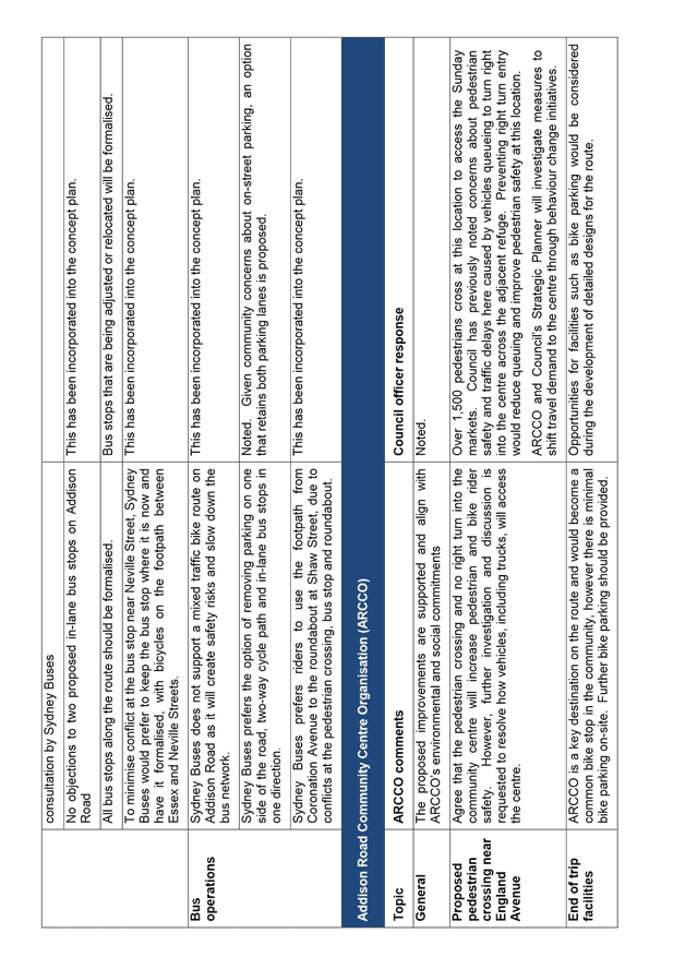
Addison Road Community Centre Organisation (ARCCO) comments about the draft concept plan
In its submission, ARCCO advised that it supported the proposed bicycle route improvements on Addison Road, and suggested consideration of improved bike parking facilities along the route including at the community centre.
ARCCO noted that the proposed pedestrian crossing outside the community centre, and accompanying no right turn into the centre, would improve pedestrian and bicycle rider safety. However ARCCO also requested further investigation and discussion about the impact of the right turn restriction to resolve how vehicles, including trucks, would access the centre.
OFFICER COMMENTS
Following public exhibition, issues raised in submissions were considered, and where feasible informed modifications to the proposal and the development of a revised concept plan. The issues most frequently raised during public exhibition, and Council officer response, are set out in the table below, and changes made to the concept plan following public exhibition are discussed thereafter.
Response to issues raised in public exhibition submissions
Issues raised in public exhibition submissions informed Council’s review of the draft concept plan and subsequent development of the revised concept plan. .
|
Issue raised in public exhibition feedback |
Council officer response |
|
The route should travel along the full extent of Addison Road, instead of diverting via England Avenue (21% of submissions) |
Community interest in a more direct route east of England Avenue is noted. This would require removal of up to 40 on-street parking spaces on Addison Road east of Illawarra Road, as the carriageway narrows on this section. Given existing community concerns about on-street parking on Addison Road, this option has not been considered further. While the proposed route via England Avenue is less direct at its eastern half, it offers: · a safer route for new or less confident bicycle riders; · improved access to Addison Road Community Centre, including direct access for riders approaching from the west; · connectivity to planned Regional Bicycle Route 4 (to Stanmore and Enmore) at Browns Avenue. It is also noted that the proposed route via England Avenue does not preclude consideration of bicycle route improvements as part of any future streetscape improvements by Council for the eastern section of Addison Road. |
|
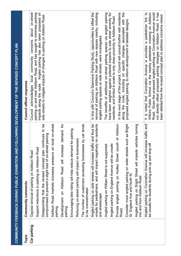
Oppose the removal of on-street parking on Addison Road (8% of submissions) |
Council acknowledges existing local community concerns about on-street parking on and near Addison Road, and has sought to minimise parking impacts along the route. Angled parking has also been proposed on side streets to mitigate impacts of changes to parking on Addison Road. |
|
The bicycle path should be wider (6% of submissions) |
The width of the bicycle path meets NSW and national guidelines for local routes and allows room for two bicycles to pass one another. No objection to the proposed road configuration has been raised by RMS Manager Network and Safety. |
|
Addison Road is unsuitable for a bicycle path given high traffic volumes and speeds / The route should use Newington Road instead (4% of submissions) |
Improving connections to local destinations – such as local shops – is a key objective of Council’s local routes, including the route along Addison Road. Bypassing Addison Road would discourage trips by bicycle by providing poorer access for eastbound riders to the local destinations along Addison Road – such as Addison Road Community Centre and local shops – that this route aims to connect to. The proposed improvements are intended not only for those already riding, but also for new riders of all ages and abilities. A route along Newington Road would not be as effective in encouraging local trips by bicycle as it would offer a steeper uphill gradient west of England Avenue. |
|
Bicycle route improvements are a waste of money / a low priority (4% of submissions) |
Council has committed to supporting and promoting bike riding, walking and the use of public transport and other alternative modes, including by providing a network of bicycle routes. The proposed improvements are intended not only for those already riding, but also those interested but concerned about safety. Safer routes encourage more people of all ages and abilities to ride a bike. |
|
The Addison Road markets are already creating parking problems on Addison Road (3% of submissions) |
Council acknowledges existing local community concerns about on-street parking on and near Addison Road, and has sought to minimise parking impacts along the route. Council’s Strategic Transport Planner and ARCCO have also agreed to investigate options to reduce car travel to the community centre through behaviour change initiatives. |
|
The buffer between parked cars and the bicycle path will be too narrow (3% of submissions) |
The proposed two-way bicycle path improves sightlines between riders and users of parked cars by placing riders travelling in the opposite direction closest to parked cars. The concept plan has been revised to propose widening of the buffer from 0.2m to 0.4m, by building the bicycle path onto the existing kerb (subject to localised constraints). |
|
Residents will need to park further from their homes (3% of submissions) |
Council acknowledges existing local community concerns about on-street parking on and near Addison Road, and has sought to minimise parking impacts along the route. Angled parking has also been proposed on side streets to mitigate impacts of changes to parking on Addison Road. |
|
Support priority for bicycle riders at intersections (3% of submissions) |
Appropriate treatments have been considered at intersections with side streets, subject to traffic volumes and other factors. |
|
Angled parking on side streets will increase traffic and be unsafe for pedestrians (3% of submissions) |
In line with Council’s Stanmore Parking Study, opportunities to offset changes to parking on Addison Road with new spaces nearby, including angled parking spaces on side streets, were investigated. The benefits of additional parking spaces via angled parking have been weighed against potential impacts to side street amenity for residents, and limited in scale to only close proximity to Addison Road. |
|
The speed limit on Addison Road should be reduced (3% of submissions) |
The proposed configuration and two proposed raised pedestrian crossings would create a lower speed environment on Addison Road and make motorists more aware of risks. |
Proposed configuration
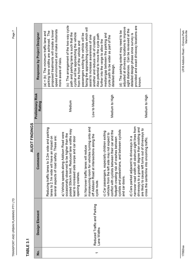
The draft concept plan proposed reducing the width of the parking lanes from approximately 3.4m to 2.1m, and increasing the width of the traffic lanes slightly to 3.2m. The proposed parking lanes are consistent with national standards for parking lane width, and the proposed traffic lanes meets Sydney Buses requirements for bus operations. The proposed 2.0m, two-way bicycle path is consistent with RMS guidelines for local bicycle routes and allows two bicycles to pass one another. No objection to the proposed configuration was raised by RMS’ Manager Network and Safety.
The proposed configuration for parking and traffic lanes would be similar to that in place on Addison Road east of Illawarra Road, where the road narrows to approximately 10.8m.
Pedestrian crossings
Following public exhibition, the proposed location of the crossing near Park Road was relocated approximately 20m east (to immediately east of Park Road) to:
· address concerns raised about poor sightlines for vehicles approaching from the west
· better cater for bus passengers crossing to/from the bus stop near William Street.
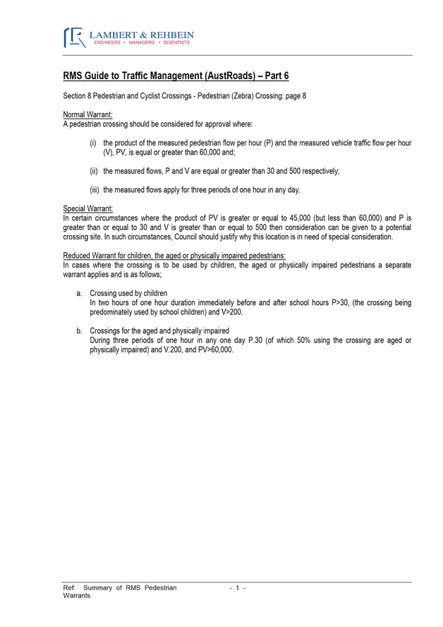
RMS requested warrant counts for the two proposed pedestrian crossings. Based on the below crossing warrant counts collected in February 2017, RMS advised it had:
· no objection to the proposed crossing near Park Road on the basis that, while it does not entirely meet the warrant, it meets the warrant for pedestrian and vehicle demand and is close enough to the total warrant to be endorsed;
· no objection to the proposed crossing near England Avenue as it meets the warrant.
|
Addison Road near Park Road (weekday count) |
|||
|
Time |
Pedestrians (P>30) |
Vehicles (V>500) |
PV (PV>60,000) |
|
7:45 – 8:45 |
39 |
942 |
36,738 |
|
8:45 – 9:45 |
44 |
917 |
40,348 |
|
17:30 – 18:30 |
35 |
1,061 |
37,135 |
|
8:15 – 9:15 |
58 |
975 |
56,550 |
|
Outcome |
Partially meets RMS warrant |
||
|
Addison Road near England Avenue (Sunday count) |
|||
|
Time |
Pedestrians (P>30) |
Vehicles (V>500) |
PV (PV>60,000) |
|
9:15 - 10:15 |
272 |
849 |
230,928 |
|
10:15 – 11:15 |
369 |
856 |
315,864 |
|
12:00 – 13:00 |
347 |
880 |
305,360 |
|
Outcome |
Meets RMS warrant |
||
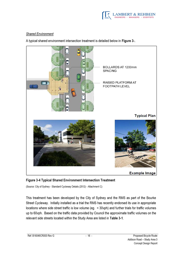
Shared environment intersections
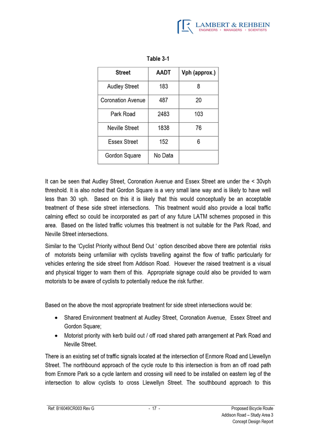
RMS also requested traffic counts for the proposed shared environment treatments at the intersections of Addison Road with Audley Street (south), Coronation Avenue, Essex Street and Gordon Square. Traffic counts were carried out at Audley Street, Coronation Avenue and Essex Street to determine whether the proposed treatments met the RMS threshold, while no counts were carried out at Gordon Square as this street is a cul-de-sac that carries very low volumes of traffic. The counts are shown in the table below:
|
Location |
Ave. peak hour vehicles (V<30) |
Ave. peak ¼ hour vehicles (V<15) |
Comment |
|
Audley St (south) |
18 |
12 |
Meets RMS threshold |
|
Coronation Ave |
73 |
51 |
Exceeds RMS threshold |
|
Essex St |
16 |
8 |
Meets RMS threshold |
RMS subsequently indicated it did not support the proposed treatment at Coronation Avenue as it did not meet the threshold. The concept plan was thus modified to remove this treatment.
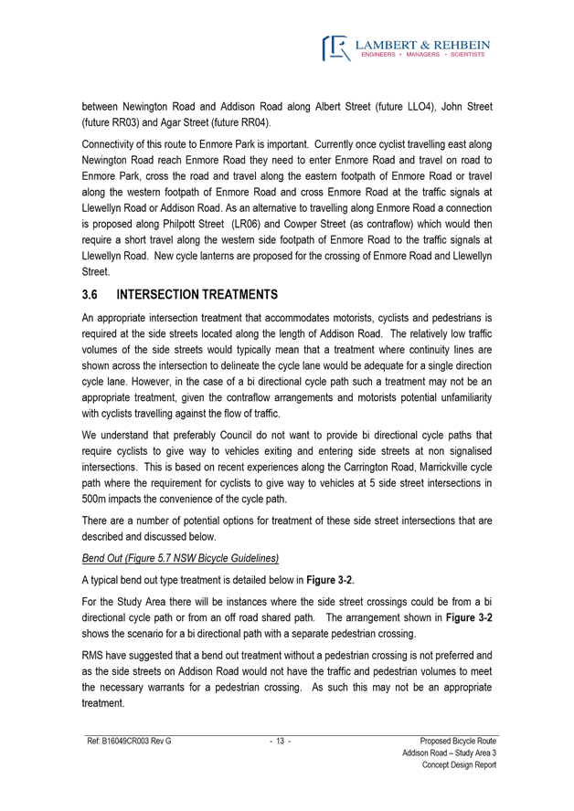
Bend-out intersections
The draft concept plan proposed bend-out bicycle paths to provide bicycle priority across Park Road and Neville Street. RMS raised concerns about the safety of these treatments at these locations due to impeded sightlines for turning vehicles and the risk that pedestrians would use the bend out paths (as there is no adjacent pedestrian crossing). Subsequently, the proposed treatments were deleted from the concept plan. The revised concept plan instead proposes upgrades to existing pedestrian refuges to cater for both pedestrians and bicycle riders.
Two-way bicycle path alongside parking lane
The draft concept plan proposed a two-way bicycle path on the southern side of Addison Road, on a built-out kerb between the parking lane and the existing kerbline, and with a 0.2m buffer between parking lane and bike path. Submissions raised concerns about potential collision between riders on the bicycle path and people getting in and out of parked cars. Presently, bicycle riders on Addison Road are directed to ride in the ‘car door zone’ of the parking lane, alongside parked cars and approaching in the driver’s blind spot. The proposed two-way bicycle path design would improve conditions by:
· moving riders from the blind spot of drivers exiting parked cars, to the non-driver side of parked cars where doors are opened less often; and
· placing riders travelling in the opposite direction nearest to parked cars, thus providing a better line of sight between riders and users of parked cars.
To address concerns about the risk of collision, the concept plan was modified following public exhibition to increase the proposed buffer from 0.2m to 0.4, by partially building the bicycle path on the existing verge (subject to localised constraints).
Street trees
The draft concept plan noted that some street trees along the route may be replaced to allow for widening of proposed shared path sections to 2.5m, to better accommodate both pedestrians and bicycle riders. With advice from Council’s Urban Forest Manager about tree health, replacement tree planting options and Council’s Street Tree Master Plan, the concept plan was revised following public exhibition to propose the replacement of 10 trees along the proposed shared paths with 9 new trees as follows:
· replace 4 street trees between Audley Street and Coronation Avenue with 4 new trees;
· replace 4 street trees between Neville Street and Essex Street with 4 new trees; and
· replace 2 street trees near Addison Road Community Centre with 1 new tree.
The revised concept plan also proposes 2 new street trees on Addison Road, near William Street and Bright Street, resulting in an overall increase of 1 street tree along the route.
Right turn restriction at Addison Road Community Centre
In response to issues raised about the proposed right turn restriction for vehicles entering and exiting the community centre, Council’s Traffic Engineering Services noted that concerns about pedestrian safety and traffic delays on Addison Road caused by vehicles queuing to turn right into the community centre had been previously raised by Council officers. Traffic Engineering Services also noted that as motorists become familiar with the new arrangement, they would modify their approach to the community centre.
Council’s Strategic Transport Planner and ARCCO also agreed to investigate options to reduce travel demand to the community centre through behaviour change initiatives.
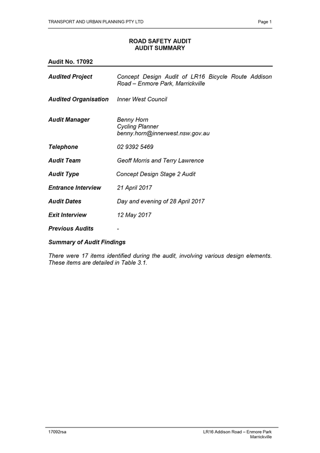
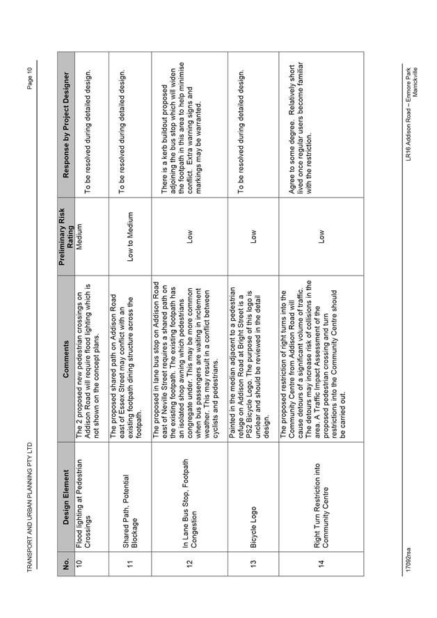
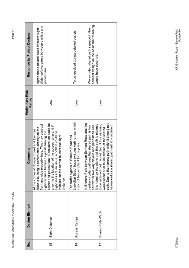
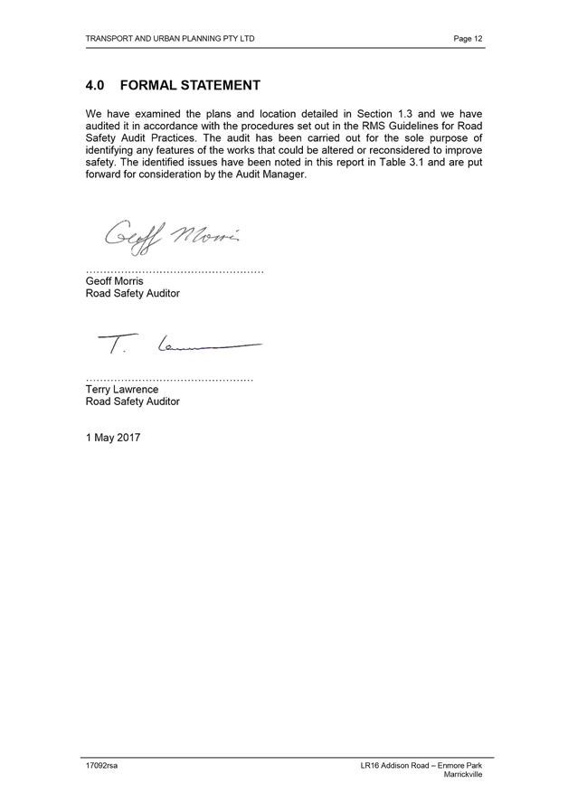
Road safety audit of the revised concept plan
Council commissioned a road safety audit by an independent road safety auditor to identify and assess any risks and issues associated with the revised concept plan. Council’s consultant considered the issues raised and provided a response to address each issue in the revised concept plan or at the detailed design stage of the project (Attachment 4).
During the development of the detailed design plans, a further road safety audit will be carried out by an independent road safety auditor.
Summary of proposed parking impacts in the revised concept plan
Submissions received during public exhibition reaffirmed community concerns about changes to parking on Addison Road. Concerns were also expressed that the proposed angled parking on Coronation Avenue would potentially reduce school student safety at pick up/drop off times, and this proposed measure was thus deleted in the revised concept plan.
The revised concept plan estimates an overall gain of 15 on-street parking spaces (exact changes to be confirmed during the detailed design phase), as follows:
|
Location |
Estimated Gain/Loss |
Comment |
|
East of Coronation Ave |
+2 |
Reduced no stopping distance at existing pedestrian crossing by providing a kerb extension |
|
West of Park Rd |
-3 |
Removed to accommodate bicycle path at bend in road |
|
East of John St |
0 |
Two spaces relocated for proposed pedestrian crossing |
|
East of Park Rd |
-1 |
Required no stopping zone at proposed pedestrian crossing |
|
East of Park Rd |
+3 |
Gained by removing existing pedestrian refuge |
|
East of Essex St |
-1 |
Removed to accommodate bicycle path on approach to pedestrian refuge |
|
East of Gordon Sq |
+1 |
Gained by replacing existing refuge with kerb build- out |
|
West of East St |
+1 |
Gained by replacing existing refuge with kerb build-out |
|
East of England Ave |
-1 |
Required no stopping zone at proposed pedestrian crossing |
|
Addison Road |
Estimated overall change: +1 |
|
|
|
||
|
William St |
+3 |
Net gain in parking by providing some angled parking |
|
Bright St |
+3 |
Net gain in parking by providing some angled parking |
|
England Ave |
+8 |
Net gain in parking by providing some angled parking |
|
Side streets |
Estimated overall change: +14 |
|
|
|
||
|
Total |
Estimated overall change: +15 |
|
|
|
||
|
Other changes on Addison Rd not related to proposed bicycle route improvements |
||
|
West of East St |
+2 |
Subject to Sydney Buses removal of eastbound bus stop |
Summary of changes made following public exhibition
In response to issues raised in public exhibition, the following changes were made to the concept plan:
General
· Increase proposed buffer between parking lane and bicycle path from 0.2m to 0.4m by slightly building the path on the existing verge (subject to localised constraints)
Addison Road
· Propose replacement of four street trees between Audley Street and Coronation Avenue with four new trees (three in verge and one in in-street tree pit)
· Relocate proposed pedestrian crossing from immediately west of Park Road to immediately east of Park Road
· Relocate two parking spaces on northern side of Addison Road closer to John Street
· Propose removal of one parking space on southern side of Addison Road near Park Road
· Propose replacement of four street trees between Neville Street and Essex Street with four new trees (three in verge and one in in-street tree pit)
· Propose replacement of two street trees opposite England Avenue with one new tree.
Coronation Avenue
· Delete proposed shared environment intersection
· Delete proposed angled parking
Park Road
· Replace proposed bend-out bicycle path with upgrade of existing pedestrian refuge to also accommodate bicycles
William Street
· Reduce extent of proposed angled parking by 1 net space
· Propose new street tree in extended kerb near the corner of Addison Road
Neville Street
· Replace proposed bend-out bicycle path with upgrade of existing pedestrian refuge to also accommodate bicycles
Bright Street
· Reduce extent of proposed angled parking by 1 net space
· Propose new street tree in extended kerb near the corner of Addison Road
England Avenue
· Reduce extent of proposed angled parking by 1 net space
· Propose bicycle roadmarkings in traffic lanes at entrance of street
Cowper Street
· Extend proposed contraflow bike lane markings across intersection of Fotheringham Street
Enmore Park
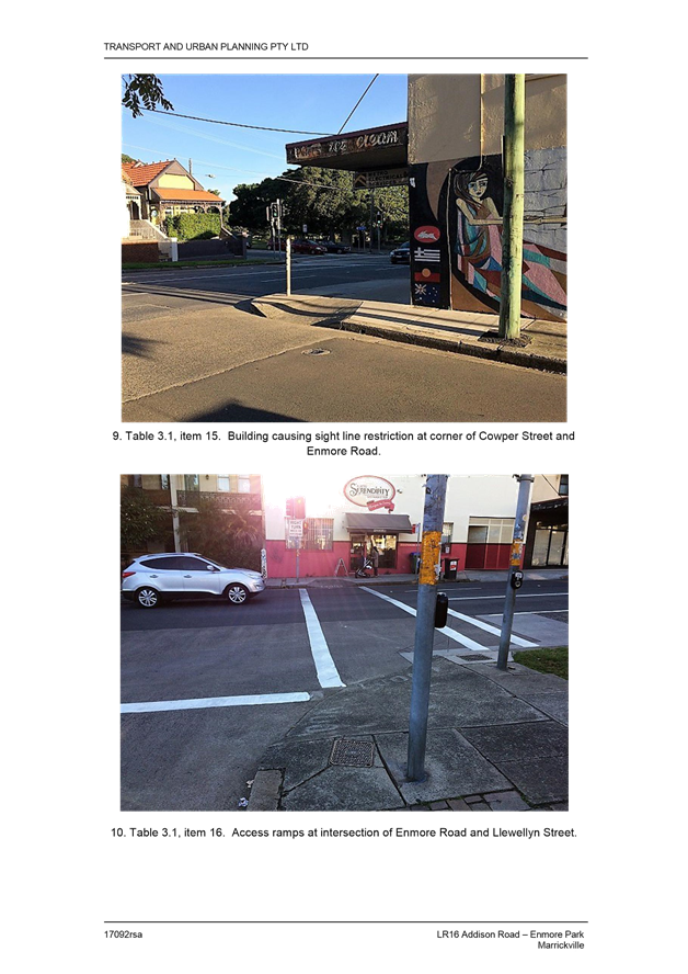
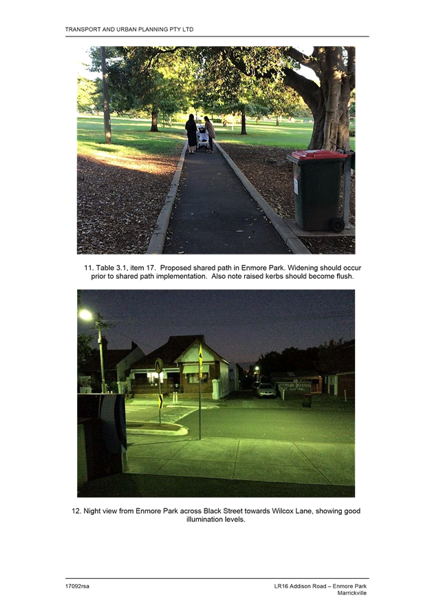
· Propose widening of existing footpath to 2.5m to also accommodate bicycles (widening to be investigated as part of Enmore Park improvements being undertaken by Council).
Notification of the revised concept plan and further feedback (June/July 2017)
Following development of the revised concept plan, in June 2017 Council wrote to approximately 1,600 residents along the route and those that made submissions during public exhibition to notify about the revised concept plan and advise of the next steps for the project.
Council subsequently received 17 further individual submissions from community members and a petition with 95 signatures objecting to the proposal. 6 of the individual submissions indicated support (3) or support with changes (3) for the revised concept plan, and 11 submissions raised objections to the proposed changes.
Issues raised in the petition and in individual submissions have been included in the attached consultation summary, and are summarised in the table below.
|
Issue raised in petition |
Council officer response |
|
Increased risk to resident safety due to proposed reduction in parking lane widths with no ‘safety buffer zone’ |
The proposed 2.1m parking lane width is consistent with national standards, and the proposed 3.2m traffic lane width meets Sydney Buses requirements for bus operations. RMS’ Manager, Network and Safety has stated no objection to the proposed configuration. The proposed configuration and the two proposed raised pedestrian crossings would create a lower speed environment and make motorists more aware of risks. The parking and traffic lane arrangement would be similar to that already in place on Addison Road east of Illawarra Road, where the road narrows to approximately 10.8m. RMS crash data indicates similar crash histories on both the narrower and wider sections of Addison Road between 2012 and 2016. As on any road, people entering/exiting parked cars must watch for passing traffic. |
|
Risk to pedestrian safety due to removal of pedestrian refuge between Gordon Square and East Street |
Based on pedestrian counts and observations, use of the refuge is relatively low and one of its primary functions is to provide access to/from the eastbound bus stop near East Street. With Sydney Buses proposed removal of the bus stop, use of the refuge would be expected to decline – particularly given other pedestrian refuges located nearby (approximately 130m west and 170m east) are adjacent to local destinations such as local shops and the Sunday markets, alternative bus stops, and side streets that provide north-south connections through the area. The proposed removal of the refuge – to be replaced by kerb extensions to reduce the crossing distance – is predicated on the proposed bus stop removal. Measures to enhance the proposed kerb extensions can also be considered during the development of detailed designs for the bicycle route. If Sydney Buses ultimately decides not to proceed with removal of the bus stop, Council will consider alternative options during the detailed design phase to retain the pedestrian refuge. |
|
Reduction in on-street parking |
Council acknowledges existing local community concerns about on-street parking on and near Addison Road, and has sought to minimise parking impacts along the route. Angled parking has also been proposed on side streets to mitigate impacts of changes to parking on Addison Road. The revised concept plan does not propose to reduce the overall number of on-street parking spaces along the route. |
|
Reduction in street trees |
The revised concept plan proposes to increase the overall number of street trees along the route. With advice from Council’s Urban Forest Manager about tree health, replacement tree planting options and Council’s Street Tree Master Plan, the revised concept plan proposes to: · replace 10 street trees with 9 new street trees to allow widening of proposed shared paths along the route; and · plant 2 new street trees on Addison Road. |
|
It appears that Inner West Council have failed to reasonably inform the local residents that will be most impacted, let alone appropriately communicate the changes |
During public exhibition: · Council wrote to 1,600 residents, businesses and property owners in the vicinity of the route to advise of the proposal · The draft concept plan was exhibited on Council’s webpage, and at Petersham Service Centre and Marrickville Library. · Council advertised the proposal in the Inner West Courier, via social media channels and temporary signage on the route · Information on Council’s webpage was accessed 1,040 times · Council held a drop-in session at Addison Road markets, attended by approximately 50 community members · 207 submissions were received including 91 from residents living in the vicinity of the proposed route. Following public exhibition and revision of the concept plan, Council wrote to the following to notify of the revised concept plan and advise of next steps: · approximately 1,600 residents, businesses and property owners in the vicinity of the proposed route; · those that made submissions during public exhibition. The additional notification/advice was undertaken to provide an additional opportunity for feedback about the proposal. |
|
Other issues most frequently raised in further submissions |
Council officer response |
|
Traffic speeds on Addison Road should be reduced |
The proposed configuration and the two proposed raised pedestrian crossings would create a lower speed environment and make motorists more aware of risks. The parking and traffic lane arrangement would be similar to that already in place on Addison Road east of Illawarra Road, where the road narrows to approximately 10.8m. The narrower section of Addison Road (east of Illawarra Road) records slightly lower speeds than the wider section to the west of Illawarra Road. |
|
Reasons for not using alternative route options such as Newington Road seem relatively minor |
A key objective of the local bicycle routes identified in Council’s Marrickville Bicycle Strategy is to provide connections to local destinations. Route LR16 is intended to link riders to local destinations along Addison Road – such as the Addison Road Community Centre – and aims to encourage bicycle riding by catering not only for those already riding, but also for riders of all ages and abilities. Providing a route that bypasses Addison Road would not support this objective or cater for these riders, particularly west of England Avenue where Newington Road offers a steeper uphill gradient. It is acknowledged that the revised concept plan proposes a diversion via England Avenue for the eastern half of the route, however this: · is to avoid significant parking impacts on Addison Road east of Illawarra Road where the carriageway narrows; · makes use of streets with favourable topography; and · does not preclude future bicycle route improvements in the on Addison Road east of Illawarra Road, as part of any future streetscape upgrades by Council for the ‘Addison Road East’ precinct as previously considered in Council’s Public Domain Study. It is also noted that given Addison Road offers local destinations and has relatively favourable topography, it would continue to be used by riders even if alternatives were developed, and thus the existing risks would remain. |
|
It is unclear whether Council has analysed safety risks of the proposal |
Council has commissioned a road safety audit (RSA) by an independent road safety auditor to identify and assess any risks and issues associated with the draft concept plan proposal. Council’s consultant considered the issues raised and provided a response to address/mitigate each issue. A further RSA will be carried out during the development of detailed design plans for the route. |
CONCLUSION
Although 81% of community submissions during public exhibition indicated support for the proposed LR16 route improvements, it is acknowledged that not all community members along Addison Road were supportive of the proposal, primarily due to concerns about safety of narrower parking lanes, removal of a pedestrian refuge and changes to on-street parking. However, Council officers have sought to address the concerns raised through this process, and issues raised during public exhibition informed subsequent modifications to the concept plan.
The revised concept plan proposes bicycle route improvements that would encourage local trips by bicycle, by providing a safer and more pleasant link to local destinations including Addison Road Community Centre and local shops. This report recommends that the final concept plan be approved and detailed designs for the route be prepared.
|
1.⇩ |
Revised concept plan |
|
2.⇩ |
Consultant's revised concept plan report |
|
3.⇩ |
Consultation summary |
|
4.⇩ |
Road safety audit |
|
Local Traffic Committee Meeting 3 August 2017 |
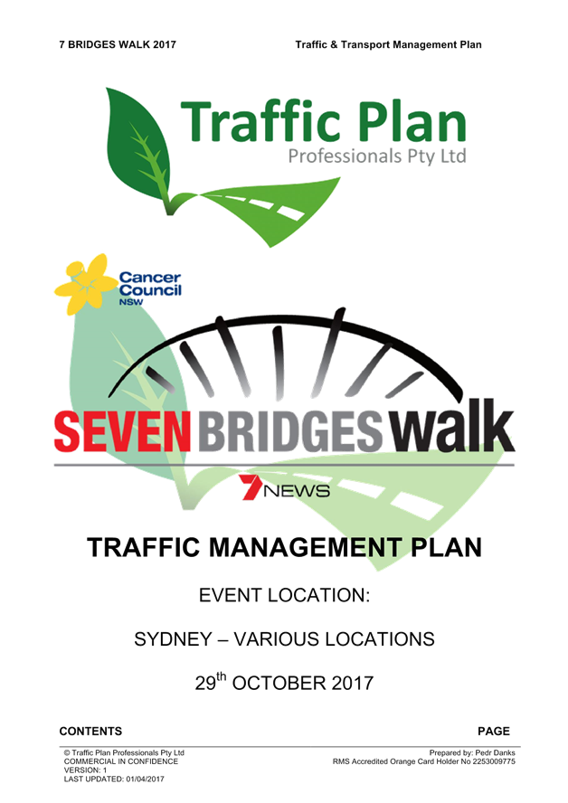
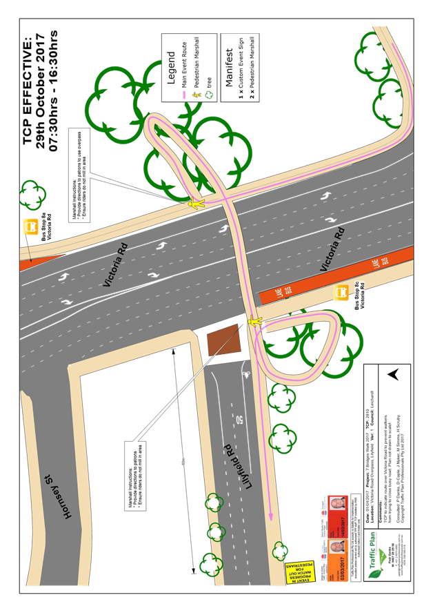
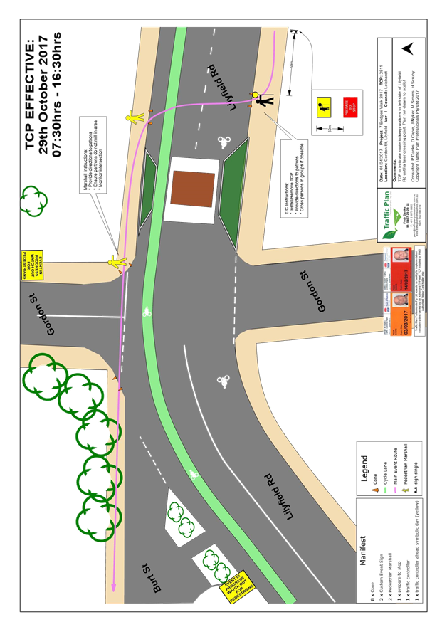
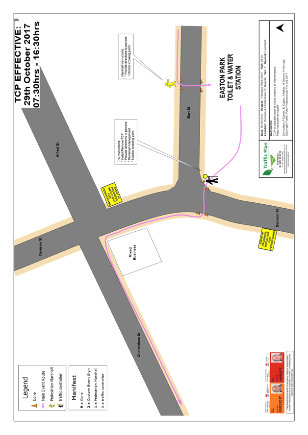
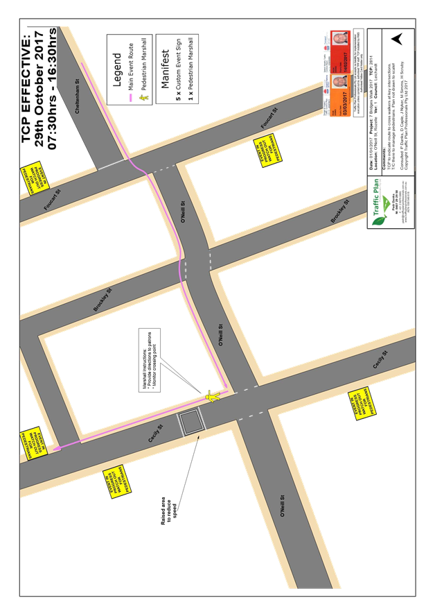
Subject: Seven Bridges Walk - Special Event - (Leichhardt & Balmain Ward/Balmain Electorate/Leichhardt LAC)
File Ref: 17/6022/84846.17
Prepared By: Manod Wickramasinghe - Traffic and Parking Engineer
|
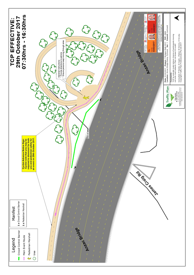
SUMMARY The Cancer Council NSW Seven Bridges Walk event will be held on Sunday, 29th October 2017 at various locations in Sydney including areas within the Inner West Council. The Event is in its 12th year of operation and the applicant seeks approval again in 2017.
|
|
RECOMMENDATION
THAT:
The Cancer Council NSW Seven Bridges Walk to be held on Sunday, 29th October 2017 be approved, subject to a current Public Liability Insurance Policy which includes the Inner West Council being an interested party being submitted by the event organiser prior to the event.
|
BACKGROUND
The Cancer Council NSW Seven Bridges Walk event will be held on Sunday, 29th October 2017.
The Cancer Council NSW Seven Bridges Walk event concept was created and developed by the Pedestrian Council of Australia (PCA) who will remain the owner of the event. The PCA has engaged Mothership Events to deliver the Event Operations and manage the marketing of the Event on behalf of PCA. The Cancer Council NSW Seven Bridges Walk can be regarded as an active opportunity to further enhance the councils and stakeholders charter toward promoting walking as a healthy activity and as an increasingly important means of active transport. In addition, the event will provide a significant contribution to the Cancer Council NSW (CCNSW).
The Event is in its 12th year of operation. The 2015 CCNSW Seven Bridges Walk attracted over 10,000 participants.
It should be noted that the annual event, ‘Norton Street Italian Festa 2017’, will also be held on Sunday, 29th October 2017 in Norton Street, Leichhardt. As both these events operate in separate areas; Leichhardt and Rozelle, no traffic or pedestrian conflicts are expected.
Event Details
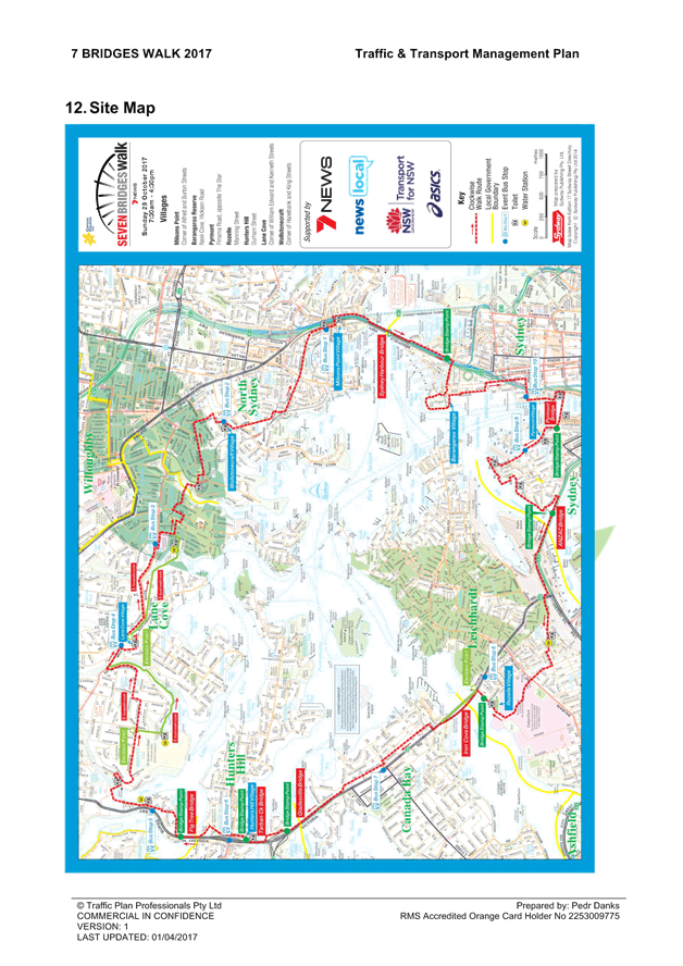
The course for CCNSW Seven Bridges Walk will open at 7:30am, and close at 4:30pm and it is estimated that it may attract up to 15,000 participants. The walking route is approximately 27km in length, and is a closed loop circuit that utilises pathways around the inner metropolitan region of Sydney that skirts the Sydney Harbour and includes the crossing of Seven Bridges. Special event buses will operate in both directions around the course, and will be provided free of charge to everyone holding an ‘event passport’.
Event Overview
Event Name: Cancer Council NSW Seven Bridges Walk [www.7bridgeswalk.com.au]
Event Owner: Pedestrian Council of Australia Ltd (PCA)
Date: Sunday, 29th October 2017
Course Opens: 7:30am via one of the 7 Villages located around the course
Course Closes: 4:30pm
Participation Target: 12,000 people throughout the day (Maximum capacity of 15,000 walkers)
Course Description:
The walking route is approximately 27km in length, and is a closed loop circuit that utilises pathways around the inner metropolitan region of Sydney that skirts the Sydney Harbour and includes the crossing of Seven Bridges.
The Seven Bridges are:
1. Sydney Harbour Bridge
2. Pyrmont Bridge
3. ANZAC Bridge
4. Iron Cove Bridge
5. Gladesville Bridge
6. Tarban Creek Bridge
7. Fig Tree Bridge
Village Locations:
Event ‘Villages’ are located around the course and will be used as check-in locations, First Aid points, drink stations, light catering and entertainment.
The 7 Villages are:
1. Milsons Point Village (Burton Street at Alfred Street, Milson Point)
2. Barangaroo Village (lower level, site name to be provided)
3. Pyrmont Village (at Pyrmont Bay Park, Pirrama Rd, opposite The Star Casino)
4. Rozelle Village (at King George Park, Manning St, Rozelle near Hospital)
5. Hunters Hill Village (at Hunters Hill Scout Hall, Durham St near the Church St overpass on Burns Bay Road, Hunters Hill)
6. Lane Cove Village (Blaxlands Corner - Central Park, William Edward St at Kenneth St, Lane Cove)
7. Wollstonecraft Village (at Brennan Park, Hazelbank St at King St, Wollstonecraft)
Impact on the Inner West LGA
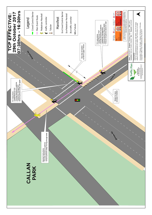
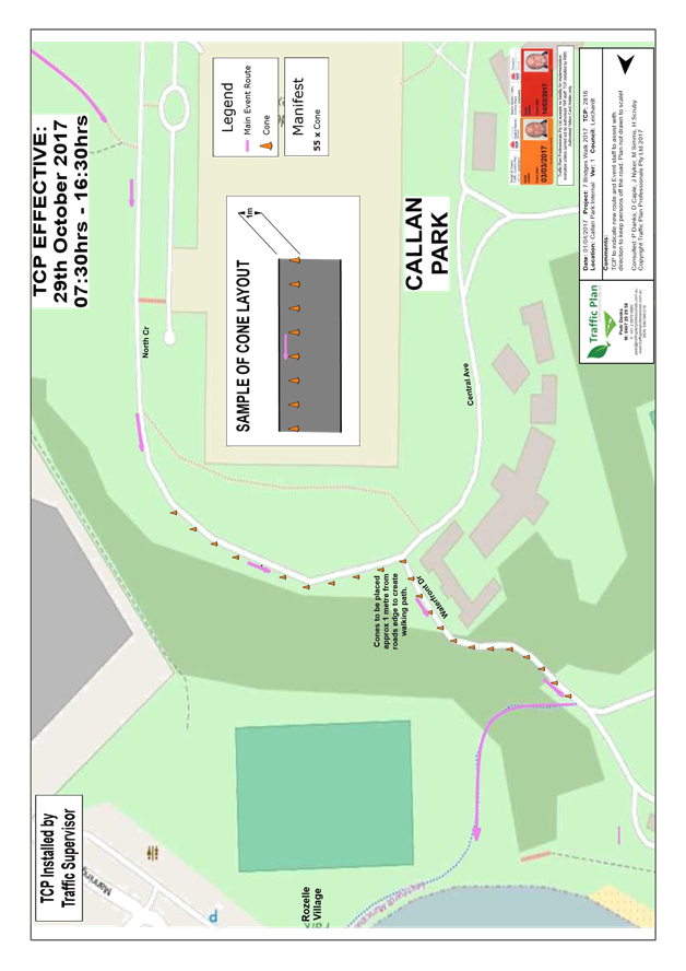
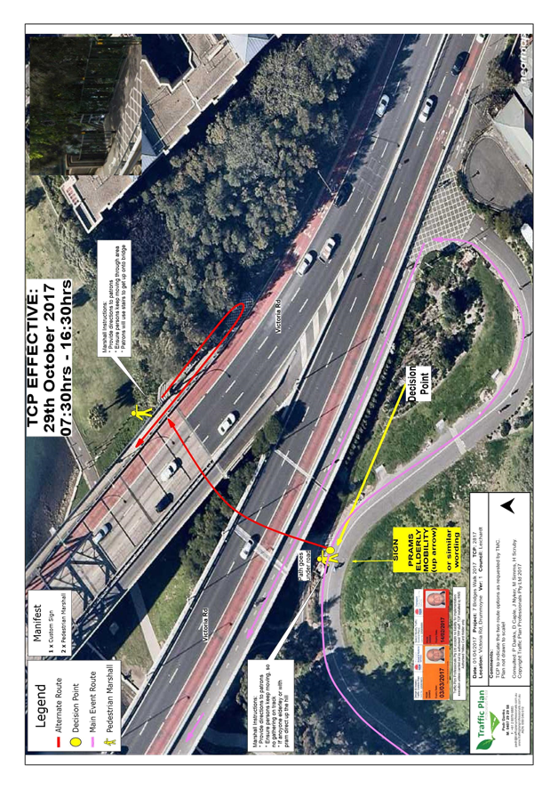
The route through the Inner West LGA is via:
· ANZAC Bridge to Victoria Road
· Use pedestrian bridge over Victoria Road to access Lilyfield Road
· Burt Street
· Denison Street
· Cheltenham Street
· O’Neill Street
· Cecily Street
· Through Callan Park to King George Park
· Byrnes Street to Victoria Road
Approval of Traffic and Pedestrian Management Plan (TMP)
This Event does not require closure of any roads in the Inner West LGA. As the participants would be using footpaths and crossing the street network with assistance of traffic controllers, the Event does not cause significant impacts on traffic and transport systems. Therefore, the Event can be considered as Class 3. Hence, Council’s approval for the Traffic & Transport Management Plan is adequate.
This Pedestrian and Traffic Management Plan when approved by the relevant authorities becomes the prime document detailing with the traffic and transport arrangements under which this event is to proceed.
Changes to the Plan require the approval of the Police and the RMS, and where necessary to the appropriate local government organisation. All functional or single agency supporting plans are to recognise the primacy of the Plan and nothing contained in those plans may contravene any aspect of the Plan.
In case of emergencies, or for the management of incidents, the Police are not subject to the conditions of the Plan but will make every effort to inform the other agencies of the nature of the incident and the Police response.
The route for the proposed Seven Bridges Walk and the draft Traffic Control Plans (TCP) and draft Traffic Management Plan for Inner West LGA are attached. Council officers have requested minor amendments be made to these draft documents and the final TMP and TCPs will be tabled at the August 2017 LTC meeting.
FINANCIAL IMPLICATIONS
All costs associated with the Seven Bridges Walk are funded by the Cancer Council NSW
|
1.⇩ |
Traffic Management Plan - Seven Bridges Walk 2017 (Draft) |
|
2.⇩ |
Traffic Control Plan - Seven Bridges Walk 2017 (Draft) |
|
Local Traffic Committee Meeting 3 August 2017 |
Subject: 2017 St Brendan’s Parish And School Spring Fair (Leichhardt Ward/Balmain Electorate/Leichhardt Lac) Proposed Temporary Road Closure To Hold School Spring Fair On Sunday 5th November 2017
File Ref: 17/6022/84907.17
Prepared By: Manod Wickramasinghe - Traffic and Parking Engineer
|
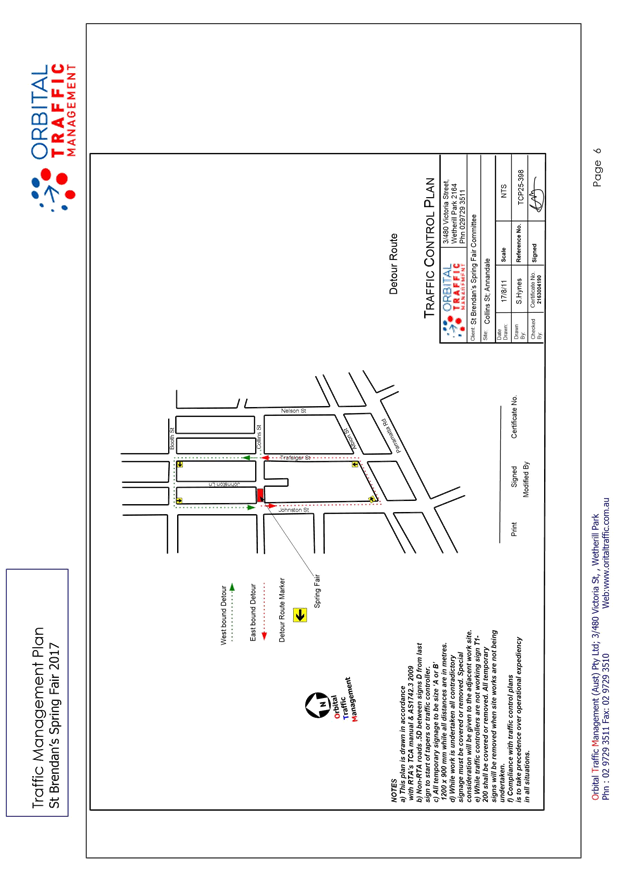
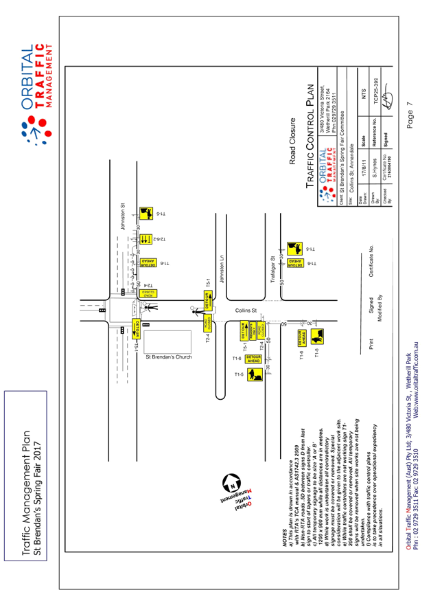
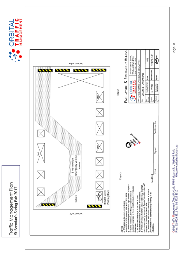
SUMMARY In order to accommodate the St Brendan’s Parish and School Spring Fair, the St Brendan’s Spring Fair Committee has requested the temporary closure of Collins Street between Johnston Lane and Johnston Street, Annandale. A temporary road closure is proposed for Sunday, 5th November 2017 between the hours of 8.00am and 4.00pm. |
|
RECOMMENDATION
THAT:
1) That the temporary closure of Collins Street between Johnston Lane and Johnston Street, Annandale, on Sunday 5th November 2017 between 8:00am and 4:00pm be supported subject to the following conditions:
a) That a three (3) metre unencumbered passage be available for emergency vehicles and pedestrians through the closed section of Collins Street at all times. b) That approval is sought from RMS to close Collins Street between Johnston Lane and Johnston Street, Annandale be obtained prior to the event. c) The occupation of the road carriageway must not occur until the road has been physically closed. d) That the applicant notifies all affected businesses, residents and other occupants of the temporary road closure prior to the event. Any concerns or requirements in relation to the road closure raised by business proprietors, residents and other occupants must be resolved or accommodated. The notification shall involve at the minimum an information letterbox drop distributed two weeks prior to the commencement of the event. e) That the approved Traffic Management Plan (TMP) be implemented at the applicant’s expense. f) That the organiser be advised to arrange RMS accredited traffic controllers to manage the road closure. g) That the applicant provide and erects barricades and signage in accordance with Australian Standard AS 1742.3-2002: Traffic Control Devices for Works on Roads. As a minimum the following must be erected at both ends of the road closure area: a. Barrier Boards b. ‘Road Closed’ (T2-4) signs c. ‘Detour’ (T5-1) signs h) That the applicant produce evidence of public risk insurance cover with a minimum policy value of $10,000,000 under which Council is indemnified against all claims for damage and/or injury that may result from either the activities and/or from the occupation of the public way during the temporary road closure. i) That the areas to be used for the activities must be maintained in a clean and tidy condition to the satisfaction of Council’s Group Manager Footpaths, Roads, Traffic and Stormwater, or else the applicant will be required to reimburse Council for any extraordinary cleansing costs. j) That the conduct of any activities or use of any equipment required in conjunction with the road occupancy and temporary road closure not result in any ‘offensive noise’ as defined by the Noise Control Act. k) That a copy of the Council approval be available on site for inspection by relevant authorities. l) That the applicant complies with any reasonable directive from Council Officers. m) That the applicant be requested to provide free bicycle valet parking to the public and include the availability of this service in promoting the event.
2) That Council reserves the right to cancel this approval at any time. |
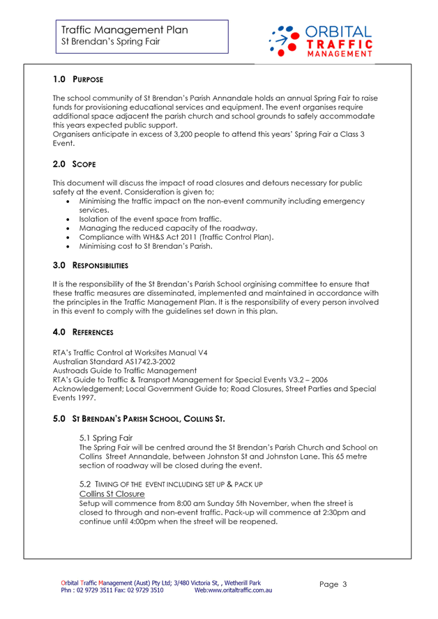
BACKGROUND
The school community of St Brendan’s Parish Annandale holds an annual Spring Fair to raise funds for providing education services and equipment. The event organisers require additional space adjacent to the parish church and School grounds to safely accommodate this year’s expected public support. This event has been held for a number of years with success and no known traffic issues.
The traffic management during the event will be in accordance with the TMP and TCP as attached in ATTACHMENT 1 and similar to that used for earlier events. There were no reported issues regarding traffic management from previous years. The attached TMP and TCP will be forwarded to RMS for formal approval.
In order to allow stalls and structures to be erected, it will be required to temporarily close Collins Street between Johnston Lane and Johnston Street, Annandale, to traffic from 8.00am Sunday, 5th November to 4.00pm. It is expected that all vehicles will be removed from the closed section of Collins Street before 8:00am on Sunday, 5th November as stalls and barricades will be erected at this time.
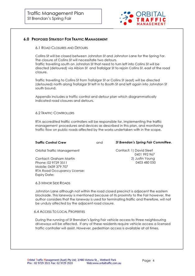
Closure of Collins Street (Johnston Street to Johnston Lane) for the event will necessitate the following detours:
· Traffic travelling south on Johnston Street that need to turn left into Collins Street will be directed (detoured) via Albion Street and Trafalgar Street to re-join Collins Street, east of the road closure.
· Traffic travelling to Collins Street from Trafalgar Street or Collins Street (east) will be directed (detoured) north along Trafalgar Street left in to Booth Street and left again into Johnston Street south bound.
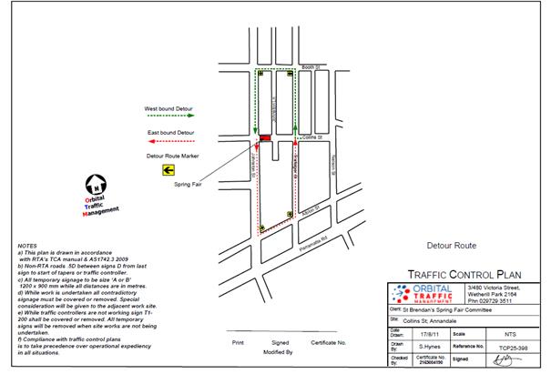
The proposed road closures will be arranged using barricades and appropriate signage at all road closure points prior to the commencement of the Event. In addition, traffic control marshals will be located at the main road closure points. It is the responsibility of the St Brendan’s Parish and School organising committee to ensure that these traffic measures are disseminated, implemented and maintained in accordance with the principles in the Traffic Management Plan.
As the Event is to be held on a Sunday, commercial and work related traffic would be minimal. The event organisers will promote public transport and walking as the predominant ways of reaching the event.
FINANCIAL IMPLICATIONS
Nil
OFFICER COMMENTS
As part of the application process and to ensure awareness of the event and the changed traffic conditions the St Brendan’s Spring Fair committee will contact the local community through; local press, community radio and letter box drops.
There will be advanced warning signs placed along Johnston Street on the northern approach to Collins Street advising Motorists of the road closure and detour. Further advanced warning signage will be placed along Collins Street East and Trafalgar Street.
All areas of the Spring Fair will be accessible to emergency vehicles. Each road closure and barricade will be managed by trained licensed personnel able to assist in the event of emergency vehicle requiring access.
CONCLUSION
It is recommended that the temporary road closure of Collins Street between Johnston Lane and Johnston Street, Annandale, on Sunday, 5th November 2017 between 8:00am and 4:00pm be supported, subject to the conditions outlined above and formal approval of the TMP and TCP by RMS.
|
1.⇩ |
St Brendan’s Parish and School Traffic Management Plan and Traffic Control Plan submitted by the event organiser |
|
Local Traffic Committee Meeting 3 August 2017 |
Subject: Cavill Avenue/Liverpool Road, Ashfield –
Modification of Splitter Island And Other Measures to Facilate Pedestrian
Safety.
(Ashfield Ward/Summer Hill Electrate/Ashfield Lac)
File Ref: 17/6022/85055.17
Prepared By: Boris Muha - Traffic and Projects Engineer
Authorised By: John Stephens - Traffic Manager
|
SUMMARY The following proposal is to modify or upgrade (in the interim if not permanent) an existing splitter island in Cavill Avenue at the intersection of Liverpool Road, Ashfield to facilitate and improve pedestrian safety.
The existing splitter island with a gap for pedestrians is mis-aligned between the existing kerb ramps at the intersection. The modification to the splitter island will involve aligning the pram ramps to improve the amenity and safety of pedestrians in the area.
Also, other treatments to enhance road safety in Cavill Avenue at the intersection of Liverpool Road will be investigated. This may be in the form of either re-aligning the intersection of Cavill Avenue and Liverpool Road, and/or introducing a ‘40 km/h High Pedestrian Activity Area’ in Cavill Avenue and the other local streets or lanes between Cavill Avenue, the railway line, Liverpool Road and Hercules Street.
The following recommendation is made as an alternative to a request by the Guide Dogs NSW/ACT on behalf of the NSW Government ‘Family & Community Services’, located at No.2 Cavill Avenue, for a controlled crossing to be installed at the intersection of Cavill Avenue and Liverpool Road (Hume Highway), Ashfield. |
|
RECOMMENDATION
THAT:
1. The proposed upgrade of the existing splitter island, with kerb ramp adjustments, and installation of pedestrian warning signs and markings in Cavill Avenue at the intersection of Liverpool Road, Ashfield, as shown on the concept plan, Attachment 3 be supported; and 2. Other treatments to enhance road safety in Cavill Avenue at the intersection of Liverpool Road be investigated e.g. re-aligning the intersection of Cavill Avenue and Liverpool Road, and/or introducing a ‘40 km/h High Pedestrian Activity Area’ in Cavill Avenue and the other nearby local streets or lanes between Cavill Avenue, the railway line, Liverpool Road and Hercules Street. |
BACKGROUND
The NSW Government ‘Family and Community Services’ is located at the corner premises of No.2 Cavill Avenue. There is a high number of employees associated with this government department that cross Cavill Avenue near Liverpool Road, including staff or clients that are visually impaired.
The Guide Dogs NSW/ACT has submitted to Council an access report letter stating as follows:
“I am writing on behalf of pedestrians with vision impairment who are accessing Cavill Ave, Ashfield.
Currently, there are a number of barriers to safe travel and clear access in this area:
· There is no controlled crossing at the intersection of Cavill Ave and Hume Highway.
· The kerb ramps at the intersection of Cavill Ave and Hume Highway are not aligned with each other or the pedestrian refuge and do not appear to comply with the RMS guidelines.
· Crossing Cavill Avenue further down the road is impeded by illegal parking of cars in the No Stopping zone and cars that are often parked across the footpath.
· At the time of visit several cars were observed making illegal manoeuvres in Cavill Ave such as U turns across double lines and reversing the wrong way into a one-way street.
Recommendations: [by the applicant]
The area was observed to have a high level of pedestrian traffic. The following recommendations benefit all pedestrians in the area as well as those with a vision, cognitive or mobility impairment.
· Install a controlled crossing at the corner of Cavill Ave and Hume Hwy with complaint kerb ramps.
Enforce road rules in the area namely the use of U turns, one way streets, No Stopping zones and parking across footpaths.
FINANCIAL IMPLICATIONS
The estimated cost for the upgrade to the splitter island with supporting ramp adjustments, signs and markings is approximately $10,000. Funding will be covered either under the Ashfield Town Centre Upgrade Program or general operations funding.
OFFICER COMMENTS
The following points are raised in addressing the request by the Guide Dogs NSW/ACT:
· For a pedestrian ‘zebra or marked foot-crossing’ the RMS Supplement to AS 1742 advises under the normal warrant that:
In each of three separate one hour periods in a typical day
(a) The pedestrian flow per hour (P) crossing the road is greater than or equal to 30
AND,
(b) The vehicular flow per hour (V) through the site is greater than or equal to 500
AND,
(c) The product PV is greater than or equal to 60,000.
A manual traffic and pedestrian count of the area was carried out on the 28th June 2017, in the morning AM peak hour, midday hour and afternoon PM peak hour.
The results with total traffic and pedestrian counts conducted (in both directions) in Cavill Avenue are shown in the following table:
|
Period (1 hour) |
Vehicles (V) |
Pedestrians (P1) (across the intersection). |
Pedestrians (P2) (approx.20-30metres north of the intersection.) |
Product V(P1)/V(P2) |
|
8.30am-9.30am |
105 |
109 |
103 |
11,445/10, 815 |
|
12.30pm-1.30pm |
87 |
128 |
400 |
11,136/34,000 |
|
4.00pm-5.00pm |
113 |
149 |
143 |
16,837/16,159 |
The general pedestrian desire path (P1) is at the intersection. A secondary desire path (P2) is across Cavill Avenue some 20-30 metres to the north. This is mainly employees of the government department electing to cross over at the driveway to the department building rather than at the intersection.
Apart from the high pedestrian count, vehicle numbers on all accounts are well below the minimum requirement of 500 vehicles per hour, and the PV figure on all accounts is below 60,000.
Accordingly, the RMS warrant required to install a pedestrian (zebra) marked foot crossing in Cavill Avenue is not met.
· No accidents are recorded with pedestrians in Cavill Avenue from RMS available accident statistics in the last 5 years.
· Police advise that there have not been any accidents, particularly with pedestrians, in Cavill Avenue in the last 12 months.
· Any crossing facility further north from the intersection is not desirable. This would be away from the general pedestrian desire path across the intersection. Any crossing facility would have to be constructed at least 30 metres in from the intersection with parking needing to be removed. Access driveways to properties on both sides of the street prevent any facility being constructed within 30 metres of the intersection. Pedestrians are readily viewed by vehicles turning left from Liverpool Road into Cavill Avenue at the intersection.
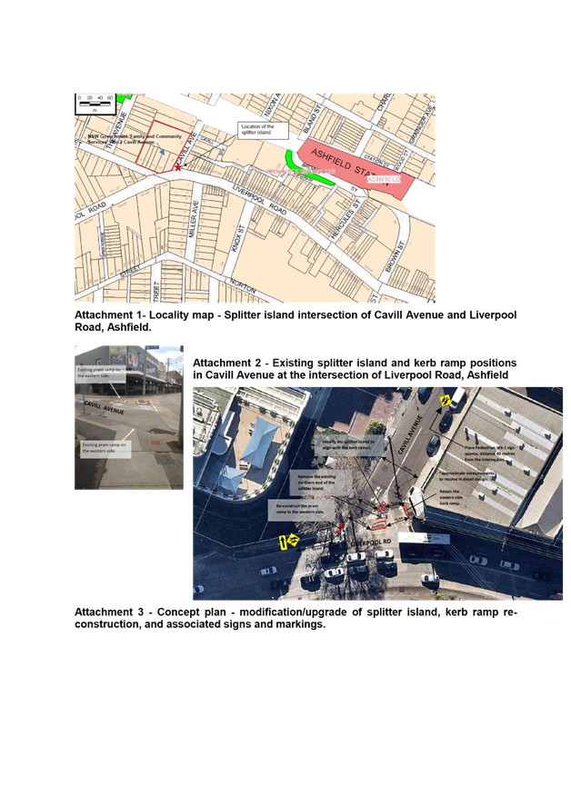
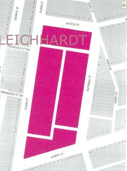
· In reference to the locality map (Attachment 1), Cavill Avenue, in question, is a section of street, aligned north to south, between Liverpool Road and the railway line. This section is a two-way no through road approximately 100 metres long and 10.2m wide (kerb to kerb). Parking is permitted on both sides of the street some 25-30 metres beyond the intersection.
Markham Place is a narrow laneway, restricted one-way east, accessed from Cavill Avenue approximately 40 metres from the intersection. Cavill Avenue, aligned east to west, is one-way west, and measuring approx. 6-7 metres in width. Parking is permitted on the north side. This section comes off the north-south section of Cavill Avenue approximately 80 metres from the intersection.
The internal location of street intersections, short length and narrow width of Cavill Avenue in the north-south section, assists to physically constrict speeds below the 50km/h speed limit.
· A raised platform or continuous footpath treatment at the intersection could impact on vehicles turning left from Liverpool Road into Cavill Avenue and traffic volumes must not exceed over 40 vehicles per hour to consider a continuous footpath treatment.
· The existing splitter island physically assists to regulate all vehicles to turn left out of Cavill Avenue into Liverpool Road. A 'No Right Turn' ban exists from Liverpool Road into Cavill Avenue.
· The existing splitter island in Cavill Avenue at the intersection of Liverpool Road, and the kerb ramp to the western side of the intersection could be modified/re-constructed to align with the existing kerb ramp to the eastern side. (See existing treatment in Attachment 2 and proposed treatment in Attachment 3). A gap in the refuge will be provided within the splitter island of minimum 2.0 wide by 2.5 metres long. This would improve pedestrian amenity at the intersection.
· Heavy (design 8.8m MRV) vehicle access would not be impeded.
· 'LOOK' markings could also be provided at the pram ramps to warn pedestrians to view traffic, particularly traffic turning left from Liverpool Road into Cavill Avenue.
· Surface tactile tiles would be provided adjacent to ramps to assist those pedestrians that are visually impaired.
· Advanced Pedestrian warning signs type W6-1 would be placed on approaches to the intersection as shown in Attachment 3.
· Under the Ashfield Town Centre Improvement Program, other possible measures to enhance road safety, e.g. re-alignment of the intersection of Cavill Avenue and Liverpool Road, and/or introduce ‘40 km/h High Pedestrians Activity Area’ in Cavill Ave and other streets in the immediate area would be investigated.
The modification to the splitter island can serve an interim if not permanent measure till further investigation is made for other possible traffic safety improvements to the area.
The matter of illegal parking and traffic movement in Cavill Avenue has been referred to Council’s Regulatory Services and Police for enforcement.
PUBLIC CONSULTATION
No traffic changes are involved with the modification/upgrade of the splitter island. Notification will be made to all properties requiring access in and out of Cavill Avenue from Liverpool Road, of the modification/upgrade to the splitter island prior to construction.
CONCLUSION
In view of the above, and in lieu of not meeting the warrant for a requested marked foot-crossing, it is recommended that the existing splitter island in Cavill Avenue at the intersection of Liverpool Road, Ashfield be modified/upgraded to improve its alignment with the kerb ramps at the intersection of Liverpool Road, Ashfield. The kerb ramp to the western side would be reconstructed and pedestrian warning signs and markings would be installed in Cavill Avenue at the intersection of Liverpool Road, Ashfield, as shown on the concept plan, Attachment 3.
Other treatments to enhance road safety in Cavill Avenue at the intersection of Liverpool Road will be investigated e.g. re-aligning the intersection of Cavill Avenue and Liverpool Road, and/or introducing a ‘40 km/h High Pedestrian Activity Area’ in Cavill Avenue and the other local streets or lanes between Cavill Avenue, the railway line, Liverpool Road and Hercules Street.
|
1.⇩ |
Attachment 1 - Locality map - location of splitter island
intersection of Cavill Avenue and Liverpool Road Ashfield |
|
Local Traffic Committee Meeting 3 August 2017 |
Subject: (A TRAFFIC) MARRICKVILLE ROAD, MARRICKVILLE – TEMPORARY FULL ROAD CLOSURES FOR MARRICKVILLE FESTIVAL ON SUNDAY 22 OCTOBER 2017 (MARRICKVILLE WARD/SUMMER HILL ELECTORATE/MARRICKVILLE LAC)
File Ref: 17/6022/85327.17
Prepared By: Emilio Andari - Civil Engineer
Authorised By: John Stephens - Traffic Manager
|
SUMMARY 'Marrickville Festival' is an annual event and this year it will be held on Sunday 22 October 2017. As per previous years the event will necessitate the temporary full road closure of Marrickville Road (between Petersham Road and Victoria Road), Illawarra Road (between Sydenham Road and Petersham Road), Alex Travellion Plaza and the Calvert Street car park in Marrickville. Short sections of Silver Street, Garners Avenue, Gladstone Street and Frampton Avenue where these streets intersect Marrickville Road will also be closed. |
|
RECOMMENDATION
THAT:
1. The proposed temporary full road closure of Marrickville Road (between Petersham Road and Victoria Road), Illawarra Road (between Sydenham Road and Petersham Road), Alex Trevallion Plaza, the Calvert Street car park and short sections of Silver Street, Garners Avenue, Gladstone Street, Calvert Street and Frampton Avenue where these streets intersect Marrickville Road, Marrickville, from 11:00pm on Saturday 21 October 2017 to 12:00am on Monday 23 October 2017, for the holding of the annual 'Marrickville Festival' (Class 2 event under the RMS Special Events Guide), be APPROVED subject to the following conditions:
a. The temporary road closures be advertised in the local newspaper providing 28 days notice for submissions;
b. A Traffic Management Plan (TMP) be submitted to the Roads and Maritime Services for consideration and approval; and a Road Occupancy License application be submitted to the Transport Management Centre;
c. Notice of the proposed event be forwarded to the N.S.W. Police, State Transit Authority, Marrickville Local Area Commander, the NSW Fire Brigades and the NSW Ambulance Services;
d. Advance notification signs for the event be strategically installed at least two (2) weeks prior to the event;
e. 'No Parking – Special Event' signs be affixed over all existing parking restriction signage within the area of the festival, on the afternoon of the day prior to the event - Saturday 21 October 2017;
f. 'No Parking – Special Event' signs be affixed both sides of Petersham Road, Marrickville (between Illawarra Road and Marrickville Road) on the afternoon of the day prior to the event - Saturday 21 October 2017;
g. Traffic Controllers be located on Petersham Road to assist with the movement of the buses;
h. A 4-metre wide emergency vehicle access must be maintained through the ‘closed’ road area during the course of the festival;
i. All affected residents and businesses in the closed road area be notified in writing through a letter box drop of surrounding properties at least two (2) weeks prior to event; and
j. Adequate vehicular traffic control shall be provided for the protection and convenience of pedestrians and motorists including appropriate signage and flagging. Workers shall be specially designated for this role (and carry appropriate certificates), as necessary to comply with this condition. This is to be carried out in accordance with the Australian Standard AS 1742.3 - Traffic Control Devices for works on roads.
2. The existing Alcohol-Free Zone in the vicinity of Marrickville Road be suspended on Sunday 22 October 2017 for the purpose of holding this year’s ‘Marrickville Festival’.
|
BACKGROUND
A Development Application has been received for the holding of the annual ‘Marrickville Festival’ for a five year period (i.e. 22 October 2017, 21 October 2018, 20 October 2019, 18 October 2020 and 17 October 2021).
The 'Marrickville Festival' is an annual event and this year will be held on Sunday 22 October 2017. As in previous years, it will be necessary to close Marrickville Road (between Petersham Road and Victoria Road), Illawarra Road (between Sydenham Road and Petersham Road), Alex Travellion Plaza, the Calvert Street car park and short sections of Silver Street, Garners Avenue, Gladstone Street, Calvert Street, and Frampton Avenue where these streets intersect Marrickville Road, Marrickville.
This year’s Marrickville Festival will run between 10:00am and 5:00pm on Sunday 22 October 2017, however, the temporary full road closures are required from 11:00pm on Saturday 21 October 2017 to 12:00am on Monday 23 October 2017.
FINANCIAL IMPLICATIONS
Funding of $97,000 has been allocated by Council for organising the ‘Marrickville Festival’ event under the 2017/2018 Major Community Events Program.
OFFICER COMMENTS
The event area will be on Marrickville Road between Petersham Road and Victoria Road and Illawarra Road between Sydenham Road and Petersham Road (refer to figure 1 – Marrickville Festival Area).

Figure 1 – Marrickville Festival Area
Temporary Closures are planned at the following locations (refer to the traffic control plans – TCP 1, 2, 3 & 4):
· Marrickville Road at Victoria Road,
· Marrickville Road at Petersham Road.
· Gladstone Street at Marrickville Road,
· Frampton Avenue at Marrickville Road,
· Garners Avenue at Marrickville Road,
· Silver Street at Marrickville Road,
· Despointes Street at Marrickville Road,
· Illawarra Road at Petersham Road,
· Illawarra Road at Sydenham Road,
· Calvert Street at Illawarra Road, and
· Peace lane at Despointes Street.
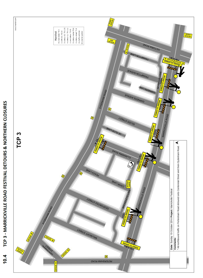
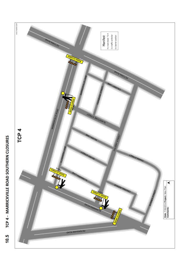
Council barricades will be used to affect the road closures from 11:00pm on Saturday 21 October 2017 to 12:00am on Monday 23 October 2017 and a 4-metre wide emergency vehicle access will need to be maintained through the area during the course of the street festival.
Special Event advance notice signs will be strategically installed at least two (2) weeks prior to the event to alert motorists of the proposed closures. In addition, 'No Parking - Special Event' signs will be affixed over all existing parking signs within the area of the festival and on Petersham Road between Illawarra road and Marrickville Road on the afternoon of the day prior to the event - Saturday 21 October 2017.
Impacts on buses
As per previous years, the following bus diversions will be in place (refer to figure 2 – Bus Diversions):
![]() 418
to Tempe: Marrickville Rd, left Livingstone Rd, right Sydenham Rd, right
Victoria Rd, left Marrickville Rd then normal route.
418
to Tempe: Marrickville Rd, left Livingstone Rd, right Sydenham Rd, right
Victoria Rd, left Marrickville Rd then normal route.
![]() 418
to Burwood: Marrickville Rd, right Victoria Rd, left Sydenham Rd, left
Centennial St, Right Hawkhurst St, Left Livingstone Rd, right Marrickville Rd
then normal route.
418
to Burwood: Marrickville Rd, right Victoria Rd, left Sydenham Rd, left
Centennial St, Right Hawkhurst St, Left Livingstone Rd, right Marrickville Rd
then normal route.
![]() 423
to Circular Quay: Illawarra Rd, left Petersham Rd, left Francis St,
right Livingstone Rd, right Sydenham Rd, left Victoria Rd then normal route.
423
to Circular Quay: Illawarra Rd, left Petersham Rd, left Francis St,
right Livingstone Rd, right Sydenham Rd, left Victoria Rd then normal route.
![]() 423
to Kingsgrove: Victoria Rd, right Sydenham Rd, left Centennial St, Right
Hawkhurst St, left Livingstone Rd, left Marrickville Rd, right Petersham Rd,
right Illawarra Rd then normal route.
423
to Kingsgrove: Victoria Rd, right Sydenham Rd, left Centennial St, Right
Hawkhurst St, left Livingstone Rd, left Marrickville Rd, right Petersham Rd,
right Illawarra Rd then normal route.
![]() 426
to Circular Quay: Marrickville Rd, left Livingstone Rd, right Sydenham Rd,
left Victoria Rd then normal route.
426
to Circular Quay: Marrickville Rd, left Livingstone Rd, right Sydenham Rd,
left Victoria Rd then normal route.
![]() 426
to Dulwich Hill: Victoria Rd, right Sydenham Rd, left Centennial St, Right
Hawkhurst St, left Livingstone Rd, right Marrickville Rd then normal route.
426
to Dulwich Hill: Victoria Rd, right Sydenham Rd, left Centennial St, Right
Hawkhurst St, left Livingstone Rd, right Marrickville Rd then normal route.
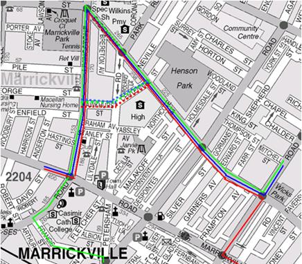
Figure 2 – Bus Diversions
In order to provide bus drivers with adequate manoeuvring space, the following is recommended:
a) that the parking be banned in Petersham Road (between Illawarra Road and Marrickville Road) on the day of the Festival; and/or
b) that Traffic Controllers be located in Petersham Road to assist with the movement of the buses.
No additional temporary bus stops will be required. Existing bus stops on Illawarra Road (near Marrickville Station) and on Marrickville Road (outside St Brigid's Church) are located close enough that intermediate bus stops may not be required.
Impacts on Parking
There are off-street and on-street parking spaces available within the vicinity of the proposed road closures. The car park off Calvert Street has access through Calvert Street and has 37 parking spaces. Some festival activities are proposed to be located in the Calvert Street car park.
There is a roof-top parking area, Banana Joe's car park, (opposite the Calvert Street car park) which has access through Tuohy Lane with approximately 80 parking spaces. As a result of the road closure at Petersham Road, access to this car park will also be restricted during the event.
Due to the proposed road closures the following car parking spaces will be impacted:
Marrickville Road
North side- between Victoria Road and Petersham Road
28 Parking spaces and 2 Bus Zones
South side- between Victoria Road and Petersham Road
43 Parking spaces and 2 Bus Zones
Illawarra Road
East Side – Between Marrickville Road and Petersham Road
21 parking spaces
West Side - None (unrestricted parking)
Parking surveys undertaken in the festival area in previous festivals indicated that there are many on-street parking spaces available to cater for parking in close proximity to the Street event.
Impacts on traffic
The traffic diverted from Marrickville Road and Illawarra Road as a result of the proposed road closures, does not coincide with the peak traffic, as the festival will be held on a Sunday when lower than weekday traffic volumes are expected. Therefore, the traffic generated as a result of the proposed festival will not have a major impact on the surrounding traffic network during the event. Furthermore the arrival and departure of attendees of the festival is expected to be staggered as it is every year when this event takes place.
Police vehicles travelling to and from the Police Station located in Despointes Street will have no access to Marrickville Road during the event, however, access to Sydenham Road will be available.
PUBLIC CONSULTATION
The proposed full-road closures of the event are currently advertised in the local papers for a period of 28 days. The advertising period commenced on 1 August 2017 and will conclude on 28 August 2017. A Traffic Management Plan is to be submitted to the RMS for consideration and approval and a Road Occupancy License application is to be submitted to the Transport Management Centre.
CONCLUSION
It is recommended that Council agree to the temporary road closures on Sunday 22 October 2017; apply to the RMS for consent to close the subject roads, subject to the event being advertised, a Traffic Management Plan be submitted to the RMS for approval, parking on the western side of Petersham Road be temporarily banned, special temporary Bus Zones be installed on Marrickville Road for the duration of the closures and advice of the proposed event being forwarded to the appropriate authorities, including emergency services and the Transport Management Centre.
It is also recommended that the existing Alcohol-Free Zone in the vicinity of Marrickville Road be suspended on Sunday 22 October 2017 for the purpose of holding this year’s ‘Marrickville Festival’.
|
|
Local Traffic Committee Meeting 3 August 2017 |
Subject: (A TRAFFIC) MARRICKVILLE ROAD, MARRICKVILLE – TEMPORARY FULL ROAD CLOSURES FOR DULWICH HILL VILLAGE FAIR ON SUNDAY 10 SEPTEMBER 2017 (ASHFIELD WARD/SUMMER HILL ELECTORATE/MARRICKVILLE LAC)
File Ref: 17/6022/85340.17
Prepared By: Emilio Andari - Civil Engineer
Authorised By: John Stephens - Traffic Manager
|
SUMMARY ‘Dulwich Hill Village Fair' is an annual event and this year it will be held on Sunday 10 September 2017. As per previous years the event will necessitate the temporary full road closure of Marrickville Road (between New Canterbury Road and Durham Street), Seaview Street (between Marrickville Road and property no. 24 Seaview Street), Caves Lane, the Seaview Street car park (car park adjacent to Caves Lane), the Loftus Street car park and Durham Lane, Dulwich Hill (between Durham Street and Loftus Street car park). |
|
RECOMMENDATION
THAT:
1. The proposed temporary full road closure of Marrickville Road (between New Canterbury Road and Durham Street), Seaview Street (between Marrickville Road and property no. 24 Seaview Street), Caves Lane, the Seaview Street car park (car park adjacent to Caves Lane), the Loftus Street car park and Durham Lane, Dulwich Hill (between Durham Street and Loftus Street car park), on Sunday 10 September 2017 between 3:00am and 8:00pm, for the holding of the annual ‘ Dulwich Hill Village Fair’ (Class 2 event under the RMS Special Events Guide), be APPROVED subject to the following conditions:
a. The temporary road closures be advertised in the local newspaper providing 28 days notice for submissions;
b. A Traffic Management Plan (TMP) be submitted to the Roads and Maritime Services for consideration and approval; and a Road Occupancy License application be submitted to the Transport Management Centre;
c. Notice of the proposed event be forwarded to the N.S.W. Police, State Transit Authority, Marrickville Local Area Commander, the NSW Fire Brigades and the NSW Ambulance Services;
d. Advance notification signs for the event be strategically installed at least two (2) weeks prior to the event;
e. 'No Parking – Special Event' signs be affixed over all existing parking restriction signage within the area of the festival, on the afternoon of the day prior to the event - Saturday 9 September 2017;
f. A 4-metre wide emergency vehicle access must be maintained through the ‘closed’ road area during the course of the festival;
g. All affected residents and businesses in the closed road area be notified in writing through a letter box drop of surrounding properties at least two (2) weeks prior to event; and
h. Adequate vehicular traffic control shall be provided for the protection and convenience of pedestrians and motorists including appropriate signage and flagging. Workers shall be specially designated for this role (and carry appropriate certificates), as necessary to comply with this condition. This is to be carried out in accordance with the Australian Standard AS 1742.3 - Traffic Control Devices for works on roads.
|
BACKGROUND
Council's Events Coordinator has advised that this year's annual 'Dulwich Hill Village Fair' will be held on Sunday 10 September 2017. In this regard, the Coordinator has submitted a request for some temporary road closures between the hours of 3:00am and 8:00pm on the day of the event.
The ‘Dulwich Hill Village Fair’ is an annual event and this year will be held on Sunday 10 September 2017. As in previous years, it will be necessary to close Marrickville Road (between New Canterbury Road and Durham Street), Seaview Street (between Marrickville Road and property no. 24 Seaview Street), Caves Lane, the Seaview Street car park (car park adjacent to Caves Lane), the Loftus Street car park and Durham Lane, Dulwich Hill (between Durham Street and Loftus Street car park).
This year’s Dulwich Hill Village Fair will run between 10:00am and 4:00pm on Sunday 10 September 2017, however, the temporary full road closures are required from 3:00am and 8:00pm on Sunday 10 September 2017.
FINANCIAL IMPLICATIONS
Funding of $36,800 has been allocated by Council for organising the ‘Dulwich Hill Village Fair’ event under the 2017/2018 Major Community Events Program.
OFFICER COMMENTS
Temporary road closures are planned for the following locations (refer to the attached locality map):
· Marrickville Road (between New Canterbury Road and Durham Street),
· Seaview Street (between Marrickville Road and property no. 24 Seaview Street),
· Caves Lane,
· Durham Lane (between Durham Street and the Loftus Street carpark),
· The Loftus Street car park, and
· The Seaview Street car park (car park adjacent to Caves Lane).
Locality Map - Temporary road closures
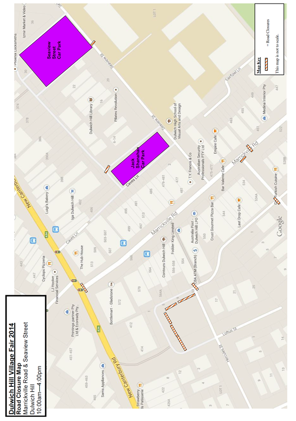
This event is classified as a Class 2 event under the RMS’ Special Events Guide where it impacts local traffic and transport systems but does not impact major traffic and transport systems and disrupts the non-event community in the area around the event but not over a wide area.
Council barricades will be used to affect the closures and a 4-metre wide emergency vehicle access will need to be maintained through the area during the course of the street fair.
Appropriate advance notice signs will be strategically installed at least two weeks prior to the event to alert motorists of the proposed closures. In addition, 'No Parking - Special Event' signs will be affixed over all existing parking restriction signs within the closed roads on the afternoon of the day prior to the event - Saturday 9 September 2017.
Impacts on traffic
Traffic will have to be directed to Beach Road and Durham Street during the closure. The traffic diverted from Marrickville Road and Seaview Street as a result of the proposed road closures, does not coincide with the peak traffic, as the Fair will be held on a Sunday when much lower than weekday traffic volumes are expected.
It is envisaged that the traffic generated as a result of the proposed festival will not have a major impact on the surrounding traffic network during the event. Furthermore the arrival and departure of attendees of the Fair is expected to be staggered as it is every year when this event takes place.
Impacts on buses
At present, bus services use Marrickville Road and cross New Canterbury Road then turn around in Dulwich Street. The temporary closure of Marrickville Road at its intersection with New Canterbury Road will require buses to use a different route during the closure. Consultation with STA regarding the alternative routes will be undertaken as in previous years.
No scheduled bus services operate in Seaview Street and the closure should have minimal impact on traffic movements in this street.
PUBLIC CONSULTATION
The proposed full-road closures of the event are currently advertised in the local papers for a period of 28 days. The advertising period commenced on 1 August 2017 and will conclude on 28 August 2017. A Traffic Management Plan is to be submitted to the RMS for consideration and approval and a Road Occupancy License application is to be submitted to the Transport Management Centre.
CONCLUSION
It is recommended that Council agree to the temporary road closures on Sunday 10 September 2017; apply to the RMS for consent to close the subject roads, subject to the event being advertised, a Traffic Management Plan be submitted to the RMS for approval, and advice of the proposed event being forwarded to the appropriate authorities, including emergency services and the Transport Management Centre.
|
|
Local Traffic Committee Meeting 3 August 2017 |
Subject: (A TRAFFIC) BURROWS AVENUE, SYDENHAM – PROPOSED BICYCLE CAR PORT – DESIGN PLAN (MARRICKVILLE WARD/HEFFRON ELECTORATE/NEWTOWN LAC)
File Ref: 17/6022/85443.17
Prepared By: Emilio Andari - Civil Engineer
Authorised By: John Stephens - Traffic Manager
|
SUMMARY A detailed design plan has been finalised for the proposed on-road bicycle car port in Burrows Avenue, Sydenham. The proposal for an on-road bicycle car port with kerb blisters and associated signs will improve parking opportunities for cyclists at this location. |
|
RECOMMENDATION
THAT the detailed design plan of the on-road bicycle car port with kerb blisters and associated signs on the northern side of Burrows Avenue, Sydenham adjacent to Sydenham Railway Station (as per the attached design plan No. 6114 dated July 2017) be APPROVED.
|
BACKGROUND
In October 2015, the matter was reported to the Local Traffic Committee (former-Marrickville) regarding the proposal of an ‘on-road bicycle rack’ on the northern side of Burrows Avenue, Sydenham adjacent to the railway station and to be located immediately east of the existing mobility parking zone. During this meeting, it was requested by the RMS that a Road Safety Audit (RSA) be undertaken for the proposed facility and that this RSA be submitted to the RMS for consideration and approval. The recommendation of this item with the additional requirement by the RMS was adopted by Council (former-Marrickville) at its meeting held in November 2015.
Council is proposing to amend its previous design sent to the RMS for approval with the replacement of omni stop energy absorbing bollards with kerb blisters due to the depth of the footing required for the bollards conflicting with a large electric cable running along this section of Burrows Avenue.
A RSA was undertaken and submitted to the RMS for consideration and approval. Along with the original design with bollards, the amended detail design plan has been finalised for the proposed device and is presented in this report for consideration.
FINANCIAL IMPLICATIONS
The estimated cost to supply and install the on-road bicycle car port with kerb blisters and signage modification is approximately $15,000. Funds are available within Council’s budget for local bicycle improvements.
OFFICER COMMENTS
Site location & road network
|
Street Name |
Burrows Avenue |
|
Section |
Between Gleeson Avenue and George Street |
|
Carriageway Width (m) |
12.8 |
|
Carriageway Type |
Two-way road with one travel lane in each direction, in addition to kerbside parking lanes. |
|
Classification |
Local |
|
85th Percentile Speed (km/h) |
47.5 |
|
Vehicles Per Day (vpd) |
7,296 |
|
Reported Crash History (July 2011 - June 2016) |
No crashes recorded. |
|
Heavy Vehicle Volume (%) |
5.1 |
|
Parking Arrangements |
Northern side of the road consists of a mobility parking zone, an authorised council car share parking zone, a taxi zone and a section of ‘No Parking’ restrictions. Southern side of the road consists of ‘No Parking’ restrictions with a section of ‘2P 8:30am-6pm Mon-Fri, 8:30am-12:30pm Sat’ restrictions. |
Design Plan – No. 6114
The proposed scope of work includes the following:
· Install an on-road bicycle car port and construct two kerb blisters either side with associated signage and linemarking.
· Install a 9m ‘Bicycle Only’ parking zone immediately west to the existing ‘Mobility Parking’ zone on the northern side of Burrows Avenue (as per design plan).
· Relocate existing ‘Authorised Car Share’ zone and ‘Taxi Zone’ and shift these signs 9m west along the northern side of Burrows Avenue (as per design plan).
The proposed treatment will not result in the loss of legal on-street parking spaces in Burrows Avenue (refer to the attached design plan No. 6114). All current vehicular access to adjoining properties will be retained.
PUBLIC CONSULTATION
Nil.
CONCLUSION
It is recommended that the design of the proposed on-road bicycle car port with kerb blisters and associated signs be approved, to improve parking opportunities for cyclists at this location.
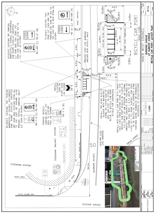
|
|
Local Traffic Committee Meeting 3 August 2017 |
Subject: (A PARKING) REQUESTS FOR ‘WORKS ZONE’
ADJACENT TO No. 66 CONSTITUTION ROAD,DULWICH HILL
(ASHFIELD WARD / SUMMER HILL ELECTORATE / MARRICKVILLE LAC)
File Ref: 17/6022/84834.17
Prepared By: Idris Hessam - Graduate Civil Engineer Traffic Services
Authorised By: John Stephens - Traffic Manager
|
SUMMARY A request has been received from Quality Construction Management for the provision of 'Works Zone' infront of No.66 Constitution Road, Dulwich Hill to facilitate construction deliveries and permit the parking of construction vehicles during loading and unloading activities. It is recommended that the 'Works Zone' be approved for the construction works subject to Council fees and charges and that the existing mobility parking space be relocated to Grove Street for the duration of the temporary ‘Works Zone’. |
|
RECOMMENDATION
THAT:
1. The installation of a ‘Works Zone 7AM-5.30PM Mon-Sat’ (total of 13 metres in length) infront of no. 66 Constitution Road, Dulwich Hill be APPROVED for a period of twelve (12) months, for the proposed construction work; and 2. The existing ‘Mobility Parking’ zone be temporarily relocated to Grove Street (side boundary of no. 72 Constitution Road) for the duration of the ‘Works Zone’. 3. The costs of supply, installation and removal of the signs and ‘Works Zone’ fees in accordance with Council’s Fees and Charges are to be borne by the applicant.
|
BACKGROUND
A Letter along with the plan illustrating the proposed location of ‘Works Zone’ was submitted to Council for consideration.
FINANCIAL IMPLICATIONS
The costs of supply, installation and removal of the signs and ‘Works Zone’ fees are to be borne by the applicant in accordance with the Council’s Fees and Charges.
OFFICER COMMENTS
|
Subject Location |
Classification of Road |
Road Description |
|
Constitution Road, Dulwich Hill |
Local Road |
One-way street, 10.9m in width that runs West -East between Dead End and Grove Street. |
The subject property is located on northern side of Constitution Road, Dulwich Hill. The proposed ‘Works Zone’ will be 13 metres in length. It will be required for a period of approximately twelve (12) months, to be utilised by construction vehicles for loading and unloading activities (refer to the below locality map and photographs). It is estimated that these works will take twelve (12) months to complete.
At present, there is unrestricted parking on both sides of Constitution Road, Dulwich Hill. Also a mobility parking space is noted infront of 66 Constitution Road, Dulwich Hill. A letter has been received from the owner’s lawyer (Adrian F Guido. and Co. Lawyers) on 3 April 2014 requesting the relocation of Mobility Parking Space outside 66 Constitution Road, Dulwich Hill.
The mobility parking space was approved as a part of Transport For NSW project (Sydney Light Rail Inner West Extension Street Escapes Design, Plan No. 600358-7080 dated 29/11/2013).The new location of Mobility Parking Space is proposed for Grove Street adjacent to the side boundary of no. 72 Constitution Road for the same 12 month period. The adjacent property owner has been notified.
It is also noted that the parking spaces in the subject section of Constitution Road, Dulwich Hill are highly utilised by local residents. Therefore, the provision of a ‘Works Zone’ would provide a safe facility for loading and unloading activities at the subject site during the construction period.
Locality Map – 66 Constitution Road, Dulwich Hill (infront of 66 Constitution Road, Dulwich Hill)

![]()
![]()
![]()
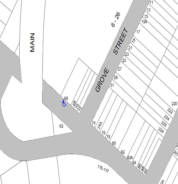
Photographs – 66 Constitution Road, Dulwich Hill (infront of 66 Constitution Road, Dulwich Hill)
![]()

![]()

![]()
![]()
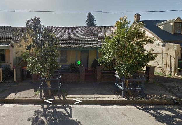
The proposed location of the ‘Works Zone’ in Constitution Road, Dulwich Hill.
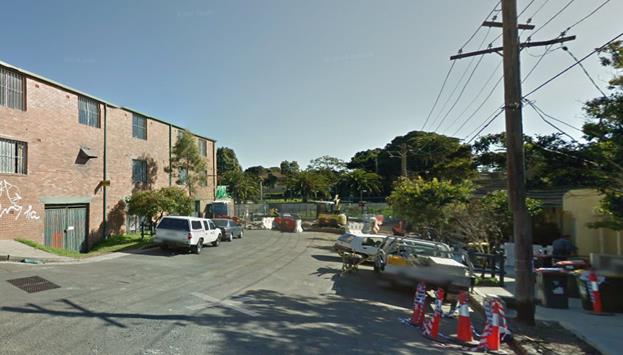
On-street
parking in Constitution Road, Dulwich Hill outside construction s![]() ite
ite
PUBLIC CONSULTATION
A notification letter has been sent to the residents informing them of the application process and as part of the assessment they will be considered at this meeting.
CONCLUSION
It is proposed to install ‘Works Zone’ to better facilitate construction deliveries and allow the parking of construction vehicles during loading and unloading activities
|
|
Local Traffic Committee Meeting 3 August 2017 |
Subject: PROPOSED NO STOPPING RESTRICITONS IN BRIGHTON STREET AT WENTWORTH STRET, PETERSHAM (STANMORE WARD/NEWTOWN ELECTORATE/MARRICKVILLE LAC)
File Ref: 15/SF547/71534.17
Prepared By: Mary Bailey - Parking Planner
Authorised By: George Tsaprounis - Coordinator Traffic Engineering Services
|
SUMMARY A number of representations have been received from residents seeking the installation of Statutory 10m ‘No Stopping” zones in Brighton Street at Wentworth Street, Petersham. The reason for the request is to improve safety and sight distance for those turning from Wentworth Street into Brighton Street. It is therefore proposed to install the Statutory 10m ‘No Stopping’ zones on the northern side of Brighton Street to the east and west side of Wentworth Street.
|
|
RECOMMENDATION
THAT: 1. 'No Stopping' restrictions on the northern side of Brighton Street, Petersham, for a distance of 10m either side of Wentworth Street be APPROVED in accordance with Australian Road Rules to improve sight lines and increase safety at the intersection; and 2. The applicant, respondents and Council Rangers be advised in terms of this report.
|
BACKGROUND
A request has been received from a Petersham resident to improve visibility for motorists at the intersection of Brighton and Wentworth Streets, Petersham. It is recommended that the statutory 'No Stopping' restrictions be installed for a distance of 10m from the intersection of Brighton and Wentworth Streets, Petersham in accordance with Australian Road Rules to improve sight lines for motorists.
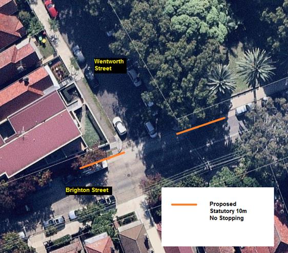
Proposed 10m ‘No Stopping’ zones in Brighton Street, Petersham
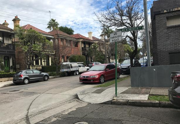
Brighton Street at Wentworth Street - looking west
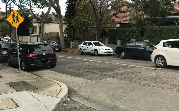
Brighton Street at Wentworth Street - looking east
FINANCIAL IMPLICATIONS
The costs of the supply and installation of the signposting associated with the recommended ‘No Stopping’ signage and is approximately $500 and can be met from the signs and linemarking budget.
OFFICER COMMENTS
Brighton Street is a busy two-way local street with a carriageway of approximately 10 metres in width. Wentworth Street is a short residential 'No Through' local road. Unrestricted parking is permitted on both sides of these two streets.
There is a high demand for parking at the subject intersection due to it being located next to Petersham Park and a small block of residential units. It has been observed at a site inspection that vehicles were illegally parked on the northern side of Brighton Street at its intersection with Wentworth Street.
In order to improve sight lines for motorists and increase safety, it is recommended that the statutory 'No Stopping' restrictions be installed for a distance of 10m from the intersection of Brighton and Wentworth Streets, Petersham in accordance with Australian Road Rules.
PUBLIC CONSULTATION
A letter has been sent to twenty three (23) affected residents and householders on 27 June seeking comments by 14 July 2017.
|
Residents’ Comments (opposing proposal) |
Officer’s Response |
|
There were no comments from residents opposing the proposal |
|
|
|
|
|
Residents’ Comments (supporting proposal) |
Officer’s Response |
|
Two (2) residents of Wentworth Street commented in support of the proposal |
A site visit confirmed that the proposal would ameliorate the sight distance. |
CONCLUSION
The proposed installation of Statutory 10m ‘No Stopping’ zones in Brighton Street at the intersection with Wentworth Street, Petersham is recommended as a measure to address line of sight issues that are experienced by vehicles turning into Brighton Street from Wentworth Street.
|
|
Local Traffic Committee Meeting 3 August 2017 |
Subject: (A PARKING) PROPOSED 'NO PARKING' IN GARNERS LANE, MARRICKVILLE BETWEEN SEYMOUR LANE AND THE REAR OF 83 FRAMPTON AVENUE (MARRICKVILLE WARD/SUMMER HILL ELECTORATE/MARRICKVILLE LAC)
File Ref: 14/4005/71637.17
Prepared By: Mary Bailey - Parking Planner
Authorised By: George Tsaprounis - Coordinator Traffic Engineering Services
|
SUMMARY Council has received representation from affected residents in Garners Avenue and Frampton Avenue, Marrickville seeking the installation of ‘No Parking’ restrictions in the section of Garners Lane (eastern side) between Seymour Lane and the rear of property no. 83 Frampton Avenue. Garners Lane is a narrow lane and is a cul de sac at the northern end. Extending the existing parking restrictions in Garners Lane is supported by residents and will improve access and safety in the lane.
|
|
RECOMMENDATION
THAT:
1. ‘No Parking’ restrictions in Garners Lane, Marrickville (eastern side) between Seymour Lane and the rear of property no. 83 Frampton Avenue be APPROVED; and 2. The applicants, respondents and Council Rangers be advised in terms of this report.
|
BACKGROUND
There are existing ‘No Parking’ restrictions along both sides of Garners Lane except for the subject section. Over the past several years and more recently Council has received request from residents to implement ‘No Parking’ restrictions in the section of Garners Lane between Seymour Lane and the rear of property no. 83 Frampton Avenue.
FINANCIAL IMPLICATIONS
The costs of the supply and installation of the signposting associated with the recommended ‘No parking’ signage and is approximately $500 and can be covered from the signs and line marking budget.
OFFICER COMMENTS
A site inspection confirmed that there are issues with access to off street parking as well as issues with reversing in the laneway causing safety concerns for pedestrians. It is very difficult to turn around in the laneway and if a vehicle cannot exit a rear access garage in the direction of Seymour Lane, it may necessitate the vehicle reversing down the laneway creating a hazard for vehicles and pedestrians who use the laneway to travel from Marrickville Road shops to parking and residences to the north. See Figure 1 below for map of proposed restrictions.
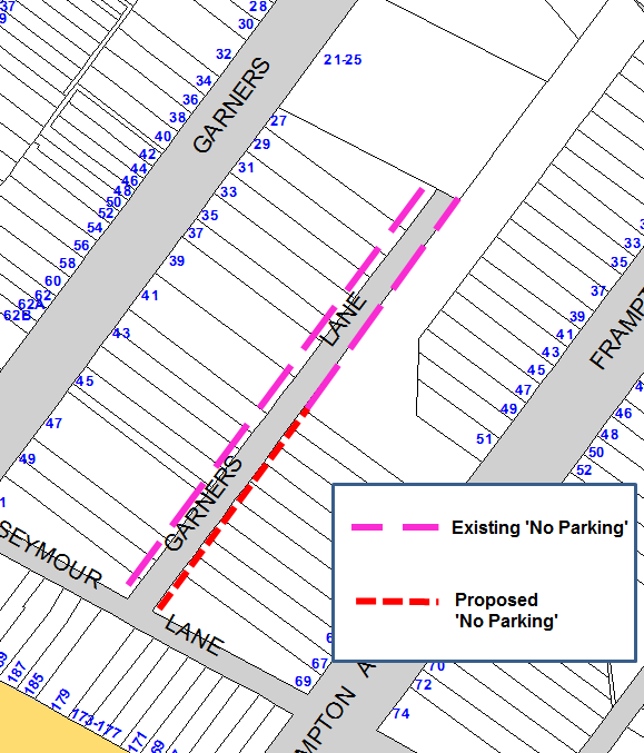
Figure 1: Garners Lane existing and proposed restrictions
PUBLIC CONSULTATION
A notification letter was sent on 26 June 2017 to owners and occupiers of the affected properties that are adjacent to the subject sections along Garners Lane regarding the proposal to introduce ‘No Parking’ in Garners Lane (eastern side) between Seymour Lane and the rear of property no 83 Frampton Avenue. The closing date for submissions was Friday 14 July 2017.
A total of thirty two (32) letters were sent out to the affected residential properties (Marrickville Road, Garners Avenue and Frampton Avenue properties). There were four (4) responses received all in support of the proposal.
The responses are detailed below.
|
Residents’ Comments (opposing proposal) |
Officer’s Response |
|
None received |
n/a |
|
|
|
|
Residents’ Comments (supporting proposal) |
Officer’s Response |
|
This will improve safety in this narrow laneway where people have to reverse to get out of the lane and pedestrians are using it as well.
The proposal will improve access to off street parking |
If the situation remains as it is, some of the residents who back onto the laneway may continue to have difficulty accessing off street parking in an area where on street parking is at a premium.
Also the need for vehicles reversing in the laneway can be reduced and this will improve safety for pedestrians who use the laneway to access the nearby shops and Frampton Avenue (west) car park. |
CONCLUSION
Extending the existing parking restrictions in Garners Lane is supported by residents and will improve access and safety in the lane.
|
|
Local Traffic Committee Meeting 3 August 2017 |
Subject: (A PARKING) PROPOSED REMOVAL OF 'NO PARKING' NESTOR LANE, LEWISHAM - SOUTHERN SIDE (STANMORE WARD/SUMMER HILL ELECTORATE/MARRICKVILLE LAC)
File Ref: 15/4525/72369.17
Prepared By: Mary Bailey - Parking Planner
Authorised By: George Tsaprounis - Coordinator Traffic Engineering Services
|
SUMMARY Council has received representations from residents requesting a review of the existing ‘No Parking’ restrictions on the southern side of Nestor Lane. Council Officers agreed to the review and subsequently carried out consultation with affected residents and property holders. Following the outcome of the community consultation, it is recommended to proceed with the proposal to remove the existing ‘No Parking’ restrictions on the southern side of Nestor Lane with the exception of a section at the rear of 4-6 Thomas Street. |
|
RECOMMENDATION
THAT:
1. Removal of the existing ‘No Parking’ restrictions in Nestor Lane, Lewisham (southern side) except at the rear of property nos 4 & 6 Thomas Street be APPROVED; and
2. The residents, respondents and Council Rangers be advised in terms of this report.
|
BACKGROUND
Currently, there are ‘No Parking’ restrictions on both sides of Nestor Lane, Lewisham. Council has received feedback from residents particularly from several residences fronting Parramatta Road, that this restriction is creating difficulty in finding parking within a reasonable distance from their homes (none of which have off street parking). A meeting was held with the residents on site and Council Officers agreed to consult with affected residents to determine what would be an appropriate parking solution to meet the needs of residents of affected properties.
FINANCIAL IMPLICATIONS
The cost associated with the recommended removal of the ‘No Parking’ sign posting is approximately $500 and can be met from the signs and line marking budget.
OFFICER COMMENTS
Following public consultation, it has been determined that it is necessary to retain the ‘No Parking’ restrictions in a section of the laneway at the rear of property nos. 4 and 6 Thomas Street to ensure that there is adequate clearance for access and egress to off street parking for those properties.
The proposal which was circulated to residents for comment has been amended and the amended proposal will be circulated to respondents to the public consultation with an invitation to attend the Local Traffic Committee meeting where the proposal is being presented. Below Figure 1 shows the original proposal circulated to residents and Figure 2 illustrates the context of the laneway parking. Figure 3 illustrates the amended proposal.
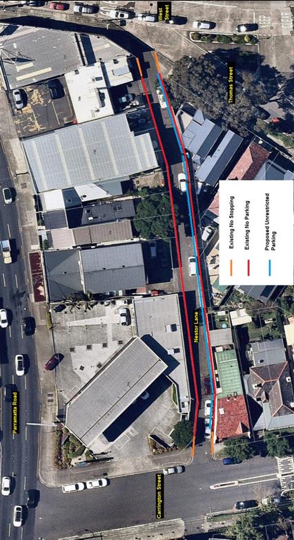
Figure 1: Parking Restriction Proposal Circulated for Resident Comment
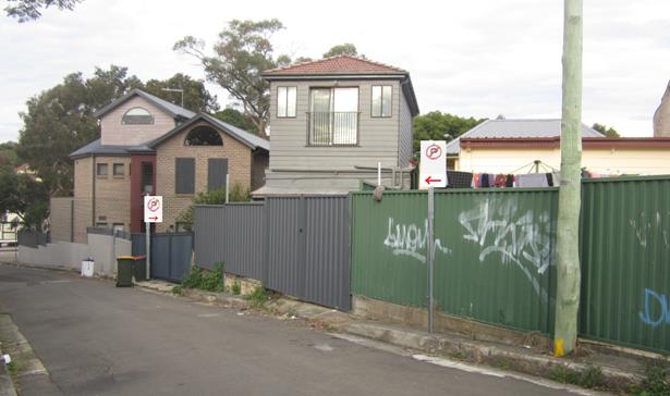
Figure 2: Illustration of placement of proposed ‘No Parking’ restrictions
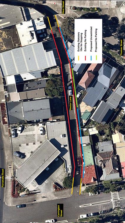
Figure 3: Amended proposal showing section to be retained as ‘No Parking’
PUBLIC CONSULTATION
A notification letter was sent on 27 June 2017 to owners and occupiers of the affected properties that are adjacent to the subject sections along Nestor Lane regarding the proposal to convert ‘No Parking’ to ‘Unrestricted’ parking in Nestor Lane (southern side) between West Street and Carrington Street, Lewisham. The closing date for submissions was Friday 14 July 2017.
A total of twenty (20) letters were sent out to the affected properties (Thomas Street, Carrington Street and Parramatta Road). There were five (5) responses received four (4) supporting the proposal and one (1) objecting.
|
Residents’ Comments (opposing proposal) |
Officer’s Response |
|
One (1) resident of Thomas Street objected to the proposal citing numerous occasions when access to the rear lane access was blocked prior to the ‘No Parking’ restrictions being implemented. |
The amended proposal will address the concerns regarding rear lane access for this respondent. |
|
|
|
|
Residents’ Comments (supporting proposal) |
Officer’s Response |
|
One (1) resident of Carrington Street supported the proposal because the ‘No Parking’ restrictions in Nestor Lane had displaced vehicles in surrounding streets, including Carrington Street making finding parking more difficult.
Three (3) residents of Parramatta Road supported the proposal citing difficulty finding parking and the lack of off street parking |
The amended proposal will not displace any parking spaces from the laneway as it merely preserves the access to driveways. Residents have been advised that Council does not condone parking across driveways. |
CONCLUSION
Community consultation results indicate that there are concerns raised from residents of Thomas Street regarding the proposed removal of ‘No Parking’ restrictions at the rear of their premises. The amended proposal to retain ‘No Parking’ restrictions in one section of the laneway on the southern side addresses the concerns of residents who need access to off street parking, while still allowing for the use of the laneway for parking by residents who have difficulty finding parking and have no access to off street parking.
|
|
Local Traffic Committee Meeting 3 August 2017 |
Subject: (A) HOPETOUN LANE, CAMPERDOWN - EXTENSION OF ‘NO PARKING’ RESTRICTIONS IN THE LANEWAY (STANMORE WARD / NEWTOWN ELECTORATE / NEWTOWN LAC)
File Ref: 17/6022/84095.17
Prepared By: Jennifer Adams - Traffic and Road Safety Officer
Authorised By: Joe Di Cesare - Manager Design and Investigation
|
SUMMARY A resident of Hopetoun Street, Camperdown raised concerns regarding vehicles being parked in Hopetoun Lane opposite their garage and thereby restricting vehicular access into and out of their garage. Residents have been notified of the proposal to extend the 'No Parking' restrictions on the western side of Hopetoun Lane by 27 metres southward from the rear of property No.102 Australia Street to No.112 Australia Street, Camperdown (inclusive). It is envisaged that this proposal will improve vehicular access to residents’ off-street parking. It is recommended that the proposal be approved.
|
|
RECOMMENDATION
THAT:
1. The installation of full-time ‘No Parking’ restrictions on the western side of Hopetoun Lane, Camperdown between the rear of property No.102 Australia Street to No.112 Australia Street, Camperdown (inclusive) be APPROVED, in order to provide unobstructed vehicular access to residents’ off-street car parking spaces; and 2. The applicant, Council's Rangers and affected residents be advised in terms of this report.
|
BACKGROUND
Concerns have been raised by a resident of Hopetoun Lane, Camperdown that vehicles are often parked in Ferndale Lane opposite their garage thereby restricting vehicular access into and out of their garage. This is compounded by the narrow width of the laneway.
The applicant’s property is located on the western side of Hopetoun Street and has an off-street car parking facility, accessed from Hopetoun Lane. (Refer to the attached locality map and photographs).
Several applications for ‘No Parking’ restrictions have been made in the past for similar reasons and restrictions have been installed on an ad-hoc basis in order to provide access to off street parking facilities as well as retain some parking in the laneway.
FINANCIAL IMPLICATIONS
The cost of extending the existing ‘No Parking’ restrictions in Hopetoun Lane is approximately $300 and can be met form Council’s signs and line markings budget.
OFFICER COMMENTS
Hopetoun Lane is approximately 5 metres in width and it runs north-south between Salisbury Road and Federation Road, Camperdown providing rear access to properties fronting Hopetoun Street and Australia Street. At present, there are sections of ‘No Parking’ restrictions along both sides of the laneway, to provide adequate space for residents to turn into and out of their off-street parking facilities.
A site inspection undertaken by a Council Officer revealed there are several vehicular crossings along both sides of the road to provide rear access to properties fronting Australia Street and Hopetoun Street. The subject location consists of several vehicular crossings with very short kerb lengths; therefore no legal spaces are provided within this section of the laneway. It was observed during the site inspection the off-street parking facilities were utilised. It was also noted that there is a high demand for parking in the area and vehicles were parked across driveways. This proposal will provide unobstructed vehicular access to adjoining properties.
Parking in laneways
Council’s Laneway Parking Guidelines outline the measures to consider when the use of the laneway prohibits access to off-street parking and access through the laneway. The effective use of narrow streets and laneways alleviates parking pressure. Effectively managed laneways allow for adequate access while providing the maximum amount of on-street parking.
The Road Rules includes requirements which affect parking at intersections, driveways and also parking along laneways.
Council’s preference is for residents to negotiate with each other to avoid implementing parking bans. Where problems occur, parking restrictions can be considered for individual laneways on a case-by-case basis. The guidelines provide consistency for assessing the need for parking controls.
It should be noted that laneways were generally built to provide service access for properties and access into off-street parking facilities. Prohibiting parking in this laneway will help achieve this goal.
PUBLIC CONSULTATION
On 6 July 2017 twenty-two (22) consultation letters were sent to neighboring owners/occupiers notifying them that Council was considering a proposal to extend the existing ‘No Parking’ restrictions in Hopetoun Lane by 27 metres southward from the rear of property No.102 Australia Street to the rear of No.112 Australia Street, Camperdown (inclusive) to provide clear vehicular access to off-street parking.
Resident survey findings
The closing date for submissions ended on 21 July 2017. Two (2) submissions were received and of these one opposed the proposal and one was supportive. The objector opposing the proposal made reference to the general shortage of parking in the area and the need to park in the laneway.
After the closing date a further resident rang and stated that they objected to the proposal as they said it was taking away residents parking spaces. To date they have not put their objection into writing.
CONCLUSION
Hopetoun Lane is narrow and should a vehicle be parked close to or opposite a driveway vehicle access can be impeded. ‘No Parking’ restrictions would assist residents with rear garage areas who may be experiencing access difficulties. Therefore, in order to provide clear vehicular access to the applicant's off-street parking facility, it is recommended that the existing 'No Parking' restrictions on the western side of Hopetoun Lane be extended by 27 metres southward from the rear of property No.102 Australia Street to No.112 Australia Street, Camperdown inclusive.
Locality map – Hopetoun Lane, Camperdown
![]()

![]()
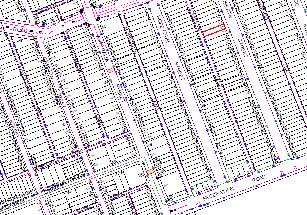
![]()
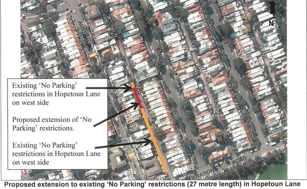
![]()
![]()
Hopetoun Lane, Camperdown
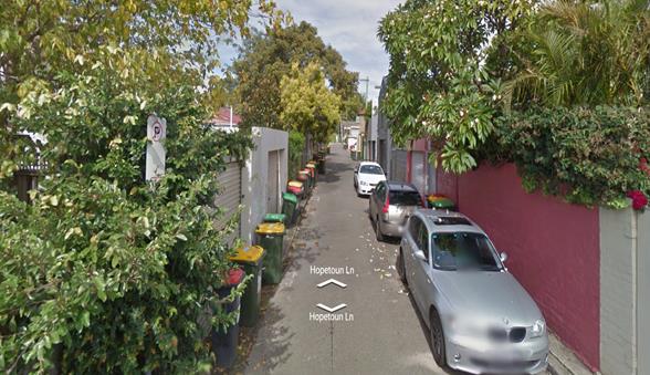
Hopetoun Lane looking south
|
|
Local Traffic Committee Meeting 3 August 2017 |
Subject: Modification Of No Parking Restriction- John
Street, Leichhardt
(Leichhardt Ward/Balmain Electorate/Leichhardt Lac)
File Ref: 17/6022/84968.17
Prepared By: Manod Wickramasinghe - Traffic and Parking Engineer
|
SUMMARY Council has received correspondence from a resident of John Street, Leichhardt, requesting a modification to the operating hours of the existing 6m ‘No Parking’ space outside the business at Nos.21-35 John Street, Leichhardt , to improve parking availability of weekends. |
|
RECOMMENDATION
THAT:
The hours of the existing 6m ‘No Parking 8am-6pm’ space outside Nos.21-35 John Street, Leichhardt be modified to ‘No Parking 8am-6pm Mon-Fri’. |
BACKGROUND
Council has received correspondence from a resident of John Street, Leichhardt, requesting a modification to the operating hours of the existing 6m ‘No Parking 8am-6pm’ space outside the business at Nos.21-35 John Street, Leichhardt (Bathe Warehouse), to improve parking availability over the weekend.
The existing ‘No Parking 8am-6pm’ restriction is signposted immediately north of the Bathe Warehouse driveway and has been provided to allow large delivery vehicles to exit the premises whilst retaining parking on the western side of John Street. It should be noted that John Street is one-way from Styles Street to Hill Street.
John Street is zoned as light industrial between Moore Street and Hill Street with the section between Hill Street and Styles Street being zoned as residential with the exception of Nos.21-35 John Street and No.37 John Street.
PROPOSAL
In order to maximise parking availability for residents of John Street, Leichhardt, it is proposed to amend the existing 6m ‘No Parking 8am-6pm’ restriction outside Nos.21-35 John Street, Leichhardt to ‘No Parking 8am-6pm Mon-Fri’ (as shown on the following plan).
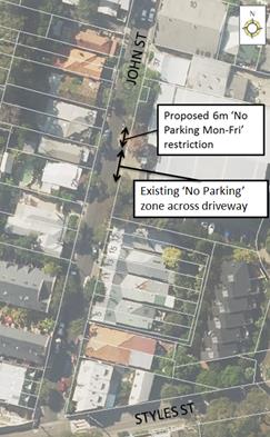
CONSULTATION
Bathe Warehouse (Nos.21-35 John Street) were contacted and they supported the proposal and confirmed that they only operate Monday to Friday.
FINANCIAL IMPLICATIONS
The cost of the signposting will be funded from Council’s operational budget.
CONCLUSION
It is recommended that the operating hours of the existing 6m ‘No Parking 8am-6pm’ restriction outside Nos.21-35 John Street John Street, Leichhardt be modified to ‘No Parking 8am-6pm Mon-Fri’ to increase the parking availability for the residents on weekends.
|
|
Local Traffic Committee Meeting 3 August 2017 |
Subject: Laneway Rear of 70 Smith Street, Summer Hill -
Request For ‘No Parking’ Restrictions.
(Ashfield Ward/Summer Hill Electrate/Ashfield Lac)
File Ref: 17/6022/84991.17
Prepared By: Anca Eriksson - Traffic Officer
|
SUMMARY The resident of No.70 Smith Street, Summer Hill has raised concern with access to his rear garage when vehicles park adjacent to the rear of his property and rear fence of neighbouring property at No.68 Smith Street in the unnamed lane.
The parked cars in the rear lane imped the required turning area needed to enter and exit the subject garage. |
|
RECOMMENDATION
THAT:
A full time 'No Parking' restriction be installed on the northern side of the unnamed rear lane south and parallel to Smith Street, between 41 metres and 57 metres west of the kerb alignment of Spencer Street, Summer Hill.
|
BACKGROUND
Following the recent implementation of ‘No Parking – Monday 6am – 3pm’ restrictions in the rear lane south and parallel to Smith Street for waste collection vehicle access, Council received a few complaints on the positioning of various signs and has further investigated these issues in order to improve turning movements at the T-intersection of the two unnamed lanes opposite the rear of Nos.66-68 Smith Street, and ensure the access to certain driveways and garages. On account of this, Council received a request from the resident of Smith Street for consideration of additional 'No Parking' restrictions in the lane at the rear of No.70 Smith Street between Spencer Street and Carrington Street.
Consequently, it is proposed to install 'No Parking' restrictions on the northern side of the rear lane between Spencer Street and Carrington Street, for a length of approximatively 16 metres, between 41 metres and 57 metres west of Spencer Street as shown on the attached map in Figure 2. This parking restriction would provide access to the garage whilst improving the turning movements of vehicles at the T-intersection.
FINANCIAL IMPLICATIONS
The proposed signage will be funded from Council’s operating budget.
OFFICER COMMENTS
An on-site inspection confirmed that the parking space between number No.68 and No.70 Smith Street in the laneway was occupied by a parked vehicle impeding the access to garage. Also, this parking space impeded turning movements at the T- intersection and the laneway adjacent to the rear of No.70 Smith Street has a narrow width of 5.2 metres from kerb to kerb.
It is evident that a ‘No Parking’ restriction is required.
PUBLIC CONSULTATION
Council has received majority support to the proposal from residents with access to the lane and requested no further restriction of parking in this section of the lane was required. The response to the survey issued to 21 residences in the area revealed that 5 out of 6 respondents supported the introduction of ‘No Parking’ restrictions in the lane as shown on Figure 2, with the request that the ‘No Parking’ does not extend beyond the rear of Nos.64 and 66 Smith Street.
The 16 metres of No Parking (between 41 metres and 57 metres west of Spencer Street) would be signposted from the western end of the garage of No.72 Smith Street to the eastern end of the garage No.68 Smith Street.
CONCLUSION
On the basis of the above information, it is recommended that the proposed ‘No Parking’ restriction as detailed in Figure 2 on the northern side of the laneway be supported.
|
|
Local Traffic Committee Meeting 3 August 2017 |
Subject: ‘No Parking’ And ‘No Stopping’ Restrictions – Unnamed Laneway Between Flood Street And National Street, Leichhardt (Leichhardt Ward/Balmain Electorate/Leichhardt Lac)
File Ref: 17/6022/85118.17
Prepared By: Manod Wickramasinghe - Traffic and Parking Engineer
|
SUMMARY Council has received concerns from number of residents, requesting signage to prevent obstructed access in the unnamed laneways between Flood Street and National Street, Leichhardt. |
|
RECOMMENDATION
THAT:
1. A 13m ‘No Parking’ zone to be installed on the northern side of the unnamed laneway between Ivory Lane and National Street extending west from the common boundary of No.24 Myrtle Street and No.41 Flood Street (Wangal Nura Park); and 2. The southern side of the unnamed laneway between Ivory Lane and National Street (side boundary of Nos. 39 Flood Street and 42 National Street) be signposted as ‘No Parking’ with 10m ‘No Stopping’ zones being installed at the intersections. |
BACKGROUND
Council has received correspondence from a number of residents, requesting the installation of ‘No Parking’ and ‘No Stopping’ restrictions in the unnamed laneway system between Flood Street and National Street, Leichhardt.
Concerns have been raised regarding vehicles parking directly in front of garage accesses and restricting movement throughout the laneway. In order to address these issues it is proposed to provide ‘No Parking’ zones and ‘No Stopping’ zones as indicated below.
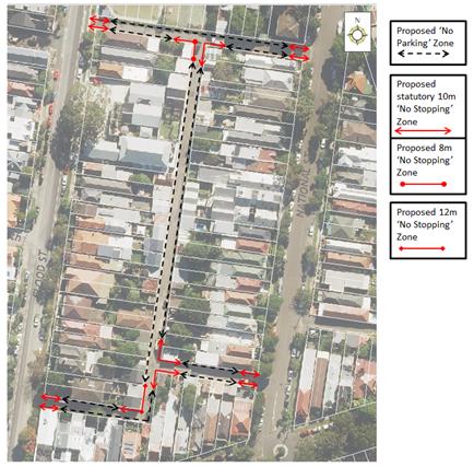
CONSULTATION
|
A letter outlining the above proposal was mailed out to the affected properties (77 properties) in Albert Street, Flood Street, Myrtle Street and National Street, Leichhardt. 42 responses were received, 20 supporting the proposal and 22 objecting to the proposal.
|
|
|
Resident Comment |
Officer Response |
|
I don't support the full proposal but would like restrictions put on the lane that runs behind the park, in particular where that lane forms a T-junction with the lane behind National Street. Cars parking there make it extremely difficult to turn out of the lane. |
The modified proposal addresses these concerns. |
|
This proposal would remove too many legitimate parking opportunities |
|
|
Will still be possible to park
outside our garage temporarily to offload goods or wash the car. |
Permits cannot be issued to park across driveways as this area is a statutory ‘No Parking’ area. However ‘No Parking’ areas can be used to unload goods |
|
Also when we have tradesmen is it possible to obtain a permit to allow them to park immediately outside our garage whilst carrying out work at our house? |
|
|
It would also be good to give the lane a name such as 'National Lane' or possibly 'Aeroplane Jelly Lane (it has the old Aeroplane Jelly factory on it) if that is possible. It is hard to direct people such as contractors etc to it without a name. |
Residents are advised to contact Council’s GIS section to obtain further information of the process to name laneways. |
|
There should be timed parking on National/Myrtle Street. As they are currently used as places to dump cars, store boats and trailers, and as all day parking by commuters. |
Council requires three formal requests from residents of a street to trigger an investigation into a resident parking scheme. |
|
Suggest ‘No Stopping’ signs in Flood St both sides of the unnamed laneway. Many thanks for undertaking this project. |
‘No Stopping’ zones will be provided in Flood Street as part of the approved Resident Parking scheme. |
|
I have limited mobility (up to 10m with walking sticks) and require parking in the back lane to access my home, can you please provide me with a disabled parking outside of my door at the rear of Albert Street. |
Council will need to receive a completed ‘Application for Disabled Parking Zone’ form to consider a request for the installation of ‘Disabled Parking’ |
FINANCIAL IMPLICATIONS
The cost of the signposting will be funded from Council’s operational budget.
CONCLUSION
Due to the number of objections received to the original proposal, the proposal has been modified to focus on the parking issues in the laneway adjacent to Wangal Nura Park. This includes signposting ‘No Parking’ and ‘No Stopping’ restrictions on the southern side of the laneway and providing a reduced section of ‘No Parking’ on the northern side of the laneway at the T-intersection.
|
|
Local Traffic Committee Meeting 3 August 2017 |
Subject: Minor Traffic Facilities (Leichhardt & Balmain Wards/ Balmain Electorate/ Leichhardt Lac)
File Ref: 17/6022/85122.17
Prepared By: Manod Wickramasinghe - Traffic and Parking Engineer
|
SUMMARY This report deals with minor traffic facility applications received by Inner West Council, Leichhardt and includes ‘Disabled Parking’ and ‘Works Zone’ applications. |
|
RECOMMENDATION
THAT:
1. That the ‘Disabled Parking’ space in front of No.34 Stephen Street, Balmain be removed as the zone is no longer required; 2. That a 5.5m ‘Disabled Parking’ zone be installed in front of No.19 Steward Street, Lilyfield replacing the existing resident parking restrictions; 3. That a 5.5m ‘Disabled Parking’ zone be installed in front of No.30 Oxford Street, Rozelle replacing the existing 4P ticket parking restrictions; 4. That a 9m 'Works Zone 7.00am - 5.00pm Mon-Fri, 7.00am - 1.00pm Sat' be installed in front of No.141 Lilyfield Road, Lilyfield for 12 weeks subject to the applicant receiving written concurrence from the residents at No.143 Lilyfield Road, Lilyfield; and 5. That a 30m 'Works Zone 7.00am - 5.00pm Mon-Fri, 7.00am - 1.00pm Sat' be installed in Beattie Street, Balmain in front of No.73 Beattie Street, Balmain for 12 weeks, temporarily replacing the 4P ticket parking restrictions. |
BACKGROUND
This report considers minor traffic facility applications received by Inner West Council, Leichhardt and includes ‘Disabled Parking’ and ‘Works Zone’ requests.
FINANCIAL IMPLICATIONS
The installation of ‘Disabled Parking’ signage is funded from Council’s operating budget and ‘Works Zones’ signage from fees and charges paid by the applicant.
OFFICER COMMENTS
1. Removal of ‘Disabled Parking’ Restriction – Stephen Street, Balmain
Council Ref: DWS 4414932
Council has been notified by a family member that the applicant to the ‘Disabled Parking’ zone in front of No.34 Stephen Street, Balmain has passed away and thus the ‘Disabled Parking’ zone is no longer required.
Officer’s recommendation
That the ‘Disabled Parking’ space in front of No.34 Stephen Street, Balmain be removed as the zone is no longer required.
2. Installation of ‘Disabled Parking’ Restriction – Steward Street, Lilyfield
Council Ref: DWS 4042066
Council has previously received an application for the installation of a ‘Disabled Parking’ zone in front of No.19 Steward Street, Lilyfield. This application was previously not supported by the Traffic Committee as the resident has an off-street parking facility.
The applicant has appealed the decision stating that the driveway is too narrow and due to deteriorating health they can no longer get out of the car when parked in the driveway. An on-site meeting with the resident was conducted and it was noted that the driveway width varied between 1.9 and 2.2m. This driveway width is substandard.
Officer’s recommendation
That a 5.5m ‘Disabled Parking’ zone be installed in front of No.19 Steward Street, Lilyfield replacing the existing resident parking restrictions.
3. Installation of ‘Disabled Parking’ Restriction – Oxford Street, Rozelle
Council Ref: DWS 4429768
The resident of No.30 Oxford Street, Rozelle has requested the installation of a ‘Disabled Parking’ zone in front of the resident’s property.
A site investigation has revealed the property does not have off street parking. The applicant does require the use of a wheelchair and it is noted the adjacent driveway can be used for the purpose of a kerb ramp.
Officer’s recommendation
That a 5.5m ‘Disabled Parking’ zone be installed in front of No.30 Oxford Street, Rozelle replacing the existing 4P ticket parking restrictions.
4. Installation of ‘Works Zone’ Restriction – Lilyfield Road, Lilyfield
Council Ref: DWS 4444415
The applicant has requested the installation of a temporary 9m 'Works Zone 7.00am - 5.00pm Mon-Fri, 7.00am - 1.00pm Sat' in front of No.141 Lilyfield Road, Lilyfield for 12 weeks.
Officer’s recommendation
That a 9m 'Works Zone 7.00am - 5.00pm Mon-Fri, 7.00am - 1.00pm Sat' be installed in front of No.141 Lilyfield Road, Lilyfield for 12 weeks subject to the applicant receiving written concurrence from the residents at No.143 Lilyfield Road, Lilyfield.
5. Installation of ‘Works Zone’ Restriction – Beattie Street and Little Llewellyn Street, Balmain
Council Ref: DWS 4436899 and 4436905
The applicant has requested the installation of a temporary 30m 'Works Zone 7.00am - 5.00pm Mon-Fri, 7.00am - 1.00pm Sat' in Beattie Street, Balmain in front of No.73 Beattie Street, Balmain for 12 weeks, temporarily replacing the 4P ticket parking restrictions.
Officer’s recommendation
That a 30m 'Works Zone 7.00am - 5.00pm Mon-Fri, 7.00am - 1.00pm Sat' be installed in Beattie Street, Balmain in front of No.73 Beattie Street, Balmain for 12 weeks, temporarily replacing the 4P ticket parking restrictions.
|
|
Local Traffic Committee Meeting 3 August 2017 |
Subject: (C) HOLBEACH AVENUE, TEMPE – TEMPORARY FULL ROAD CLOSURES FOR MS SYDNEY TO THE GONG BIKE RIDE ON SUNDAY 5 NOVEMBER 2017 (MARRICKVILLE WARD/HEFFRON ELECTORATE/NEWTOWN LAC)
File Ref: 17/6022/85353.17
Prepared By: Emilio Andari - Civil Engineer
Authorised By: John Stephens - Traffic Manager
|
SUMMARY Council has received an application under Section 68 of the Local Government Act 1993 to use Holbeach Avenue and Tempe Recreation Reserve to hold the annual 'MS Sydney to the Gong Bike Ride' supported by Multiple Sclerosis (MS) Australia on Sunday 5 November 2017. This event will necessitate the temporary full road closure of Holbeach Avenue, Tempe and southbound lane closures on Princes Highway from the car park entrance of IKEA to Cooks River.
It is recommended that the comments of the Local Traffic Committee be referred to Council’s Development Assessment Section for consideration in determining the Development Application. |
|
RECOMMENDATION
THAT the report be received and noted.
|
BACKGROUND
Council has received an application under Section 68 of the Local Government Act 1993 to use Holbeach Avenue and Tempe Recreation Reserve to hold the annual 'MS Sydney to the Gong Bike Ride' supported by Multiple Sclerosis (MS) Australia on Sunday 5 November 2017.
This year will be the 36th year that this event will operate and due to the construction of the WestConnex project, previous year’s start site at Sydney Park (City of Sydney Council) is no longer available. Therefore, the ‘MS Sydney to the Gong Bike Ride’ is looking for a location that can service this size of event without changing the course too much as well as looking towards the future with a site that can be used for years to come. In previous years, the cycling event came through Inner West Council by utilising southbound lane closures along Princes Highway.
FINANCIAL IMPLICATIONS
Nil.
OFFICER COMMENTS
MS Australia are proposing to utilise the IKEA car park as a drop off zone and riders will ride down Princes Highway (southbound) to Tempe Recreation Reserve via Holbeach Avenue to ensure they are not riding down residential streets. The traffic management company will put in an access lane along Princes Highway to keep riders safe while entering the event at Tempe Recreation Reserve where this location will be the start of the cycling course.
The event will start at Tempe Recreation Reserve, Tempe (see Figure 1). On departing, cyclists will ride west on Holbeach Avenue and then turn left onto Princes Highway. Cyclists will then ride along the southbound lanes on Princes Highway as they make their way south over the Cooks River Bridge and beyond.
The applicant advised that support of the NSW Police and RMS will be sought and a detailed Traffic Management Plan has been forwarded to the RMS, NSW Police and relevant Councils and authorities.
NSW Police and the MS Australia Course Marshals will be at critical locations to ensure that participants and motorists follow all proposed traffic management measures. The event will be held on a Sunday morning where traffic volumes are expected to be lower than average.
It is proposed that the traffic control measures would be in place between 4:00am and no later than 9:30am as the event commences at 6.00am and is expected to be concluded by 9.00am. Affected residents and businesses will be allowed access at Police discretion.
Figure 1 – Tempe Recreation Reserve
PUBLIC CONSULTATION
The applicant advised that the traffic control management on the day of the event will be controlled by NSW Police and MS Australia Course Marshals.
A Traffic Management Plan will be submitted to the Roads and Maritime Services for consideration and approval as well as a Road Occupancy License application will be submitted to the Transport Management Centre.
CONCLUSION
It is proposed that the following traffic related comments be forwarded to Council’s Development Assessment section.
Based on the information presented in the applicant’s submission to Council with regards to the proposed cycling event on Sunday 5 November 2017 with the inclusion of a temporary full road closure of Holbeach Avenue, Tempe, it is acknowledged that the event will be controlled by NSW Police and the MS Australia Course Marshals. Therefore, Council supports the temporary full road closure of Holbeach Avenue, Tempe during the course of the event subject to the applicant submitting a Traffic Management Plan to the RMS for consideration and approval, a Road Occupancy License be obtained from the Transport Management Centre and advice of the proposed event being forwarded all affected properties and to the appropriate authorities including emergency services, affected property owners and other key stakeholders (including sporting clubs) be notified at least 14 days prior to the event, Council be named as an interested party in relation to any insurance taken out for the event and that signs be installed along Holbeach Avenue advising of the closure at least 7 days prior to the event.