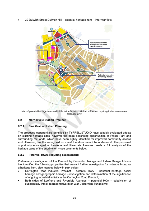
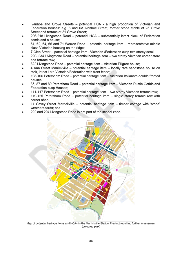
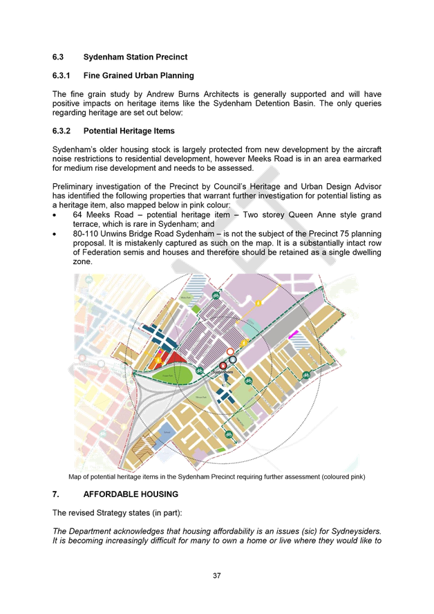
|
AGENDA R |
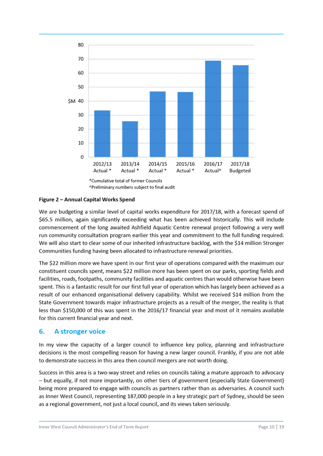
Council Meeting
THURSDAY 12 OCTOBER 2017
6.30PM
|
AGENDA R |
Council Meeting
THURSDAY 12 OCTOBER 2017
6.30PM
In the spirit of open, accessible and transparent government, this meeting of the Inner West Council is being streamed live on Council’s website. By speaking at a Council meeting, members of the public agree to being recorded and must ensure their speech to the Council is respectful and use appropriate language. A person who uses defamatory, discriminatory or offensive language may be exposed to liability for which Council takes no responsibility. Any part of this meeting that is held in closed session will not be recorded
Pre-Registration to Speak at Council Meetings
Council is encouraging members of the public to pre-register their interest to speak at Council Meetings as the Meeting venues have a maximum number they can hold. Members of the public can pre-register up until 2pm of the day of the Meeting. If you wish to register your interest please fill in a Register to Speak Form, available from the Inner West Council website, including:
· your name;
· contact details;
· item on the Agenda you wish to speak to; and
· whether you are for or against the recommendation in the agenda.
What happens after I submit the form?
Your request will then be added to a list that is shown to the Chairperson on the night of the meeting.
Are there any rules for speaking at a Council Meeting?
The following rules apply when addressing a Council meeting:
· keep your address to the point, the time allowed for each speaker is limited to three minutes with one extension of not more than three minutes with the approval of the Council. This time limit applies, no matter how many items are addressed by the speaker;
· when addressing the Meeting you must speak to the Chairperson;
· the Chairperson may curtail public participation where the information being presented is considered repetitive or irrelevant.
Where Items are deferred, Council reserves the right to defer speakers until that Item is heard on the next occasion.
Accessibility
Inner West Council is committed to ensuring people with a disability have equal opportunity to take part in Council and Committee Meetings. If you have any access or disability related participation needs and wish to know more ring 9392 5657.
Persons in the public gallery are advised that under the Local Government Act 1993, a person may NOT tape record a Council meeting without the permission of Council.
Any persons found recording without authority will be expelled from the meeting.
“Record” includes the use of any form of audio, video and still camera equipment or mobile phone capable of recording speech.
An audio recording of this meeting will be taken for the purpose of verifying the accuracy of the minutes.
|
|
Council Meeting 12 October 2017 |
|
SUMMARY OF ITEMS |
The following provides a summary of the items to be considered at the meeting.
1. Acknowledgement of Country
2. Apologies
3. Notice of Webcasting
4. Disclosures
of Interest (Section 451 of the Local Government Act
and Council’s Code of Conduct)
5. Confirmation of Minutes Page
Minutes of 21 September 2017 Council Meeting 5
6. Mayoral Minutes
Nil at the time of printing.
7. Staff Reports
ITEM Page
C1017 Item 1 Draft Submission on Westconnex M4-M5 Link Environmental Impact Statement 9
C1017 Item 2 Revised Draft Sydenham to Bankstown Urban Renewal Corridor Strategy 10
C1017 Item 3 Planning Proposal Snapshot of 4-38 Carrington Road, Marrickville 162
C1017 Item 4 Merger Implementation 196
C1017 Item 5 Administrator's End of Term Report 229
C1017 Item 6 2017/18 Budget and 2018/19 Budget Process. 249
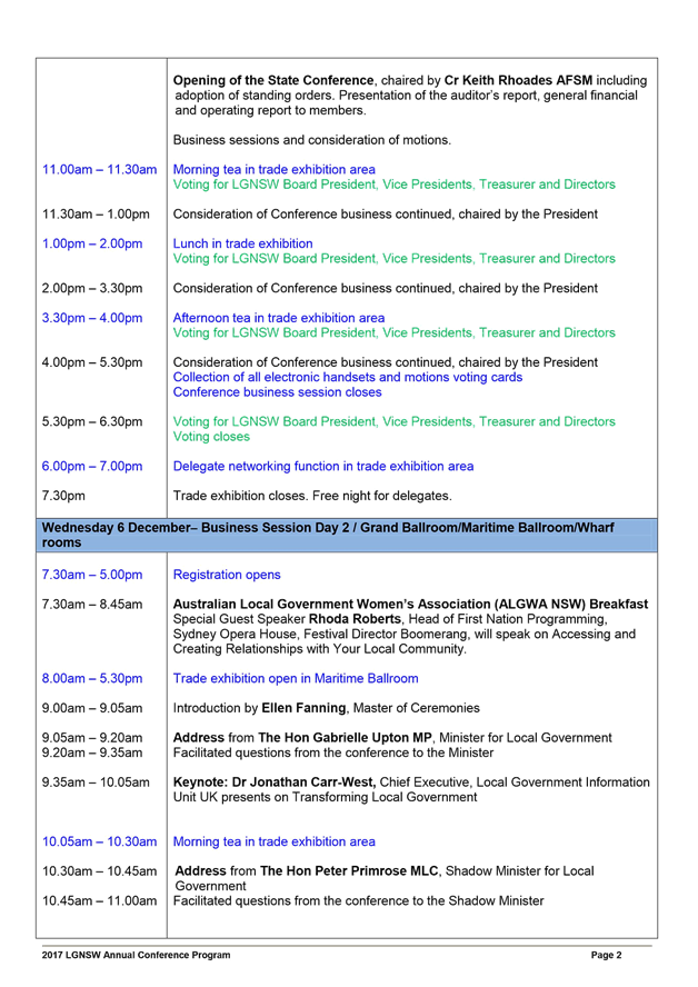
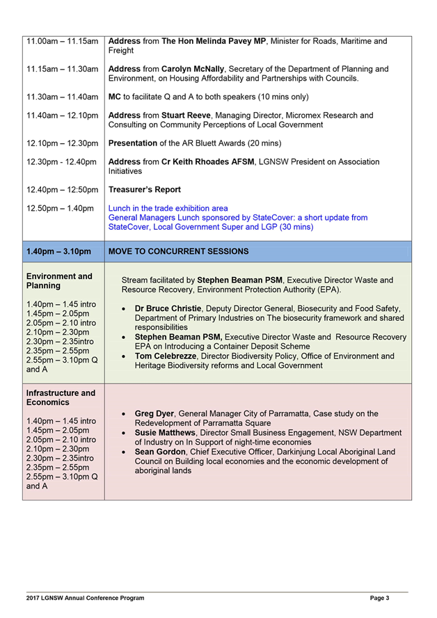
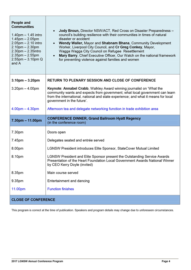
C1017 Item 7 Local Government NSW Annual Conference 252
C1017 Item 8 Panel of Code of Conduct Reviewers 273
C1017 Item 9 Local Traffic Committee Meeting held on 3 August 2017 and 7 September 2017 275
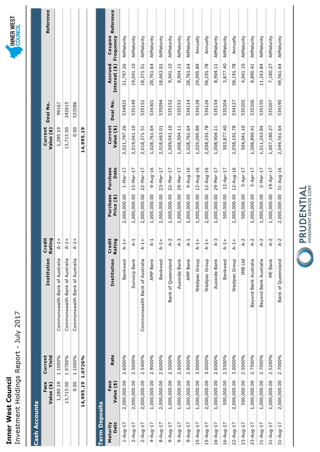
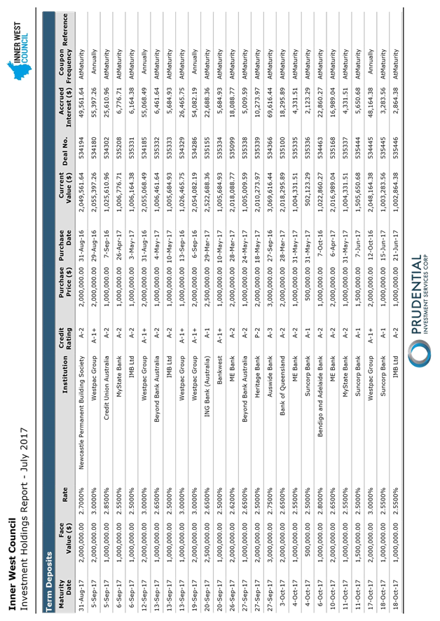
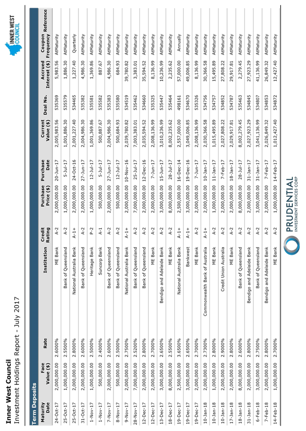
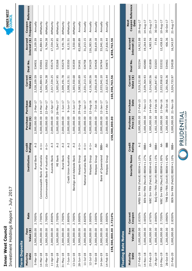
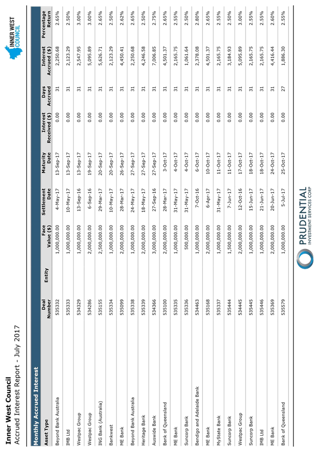
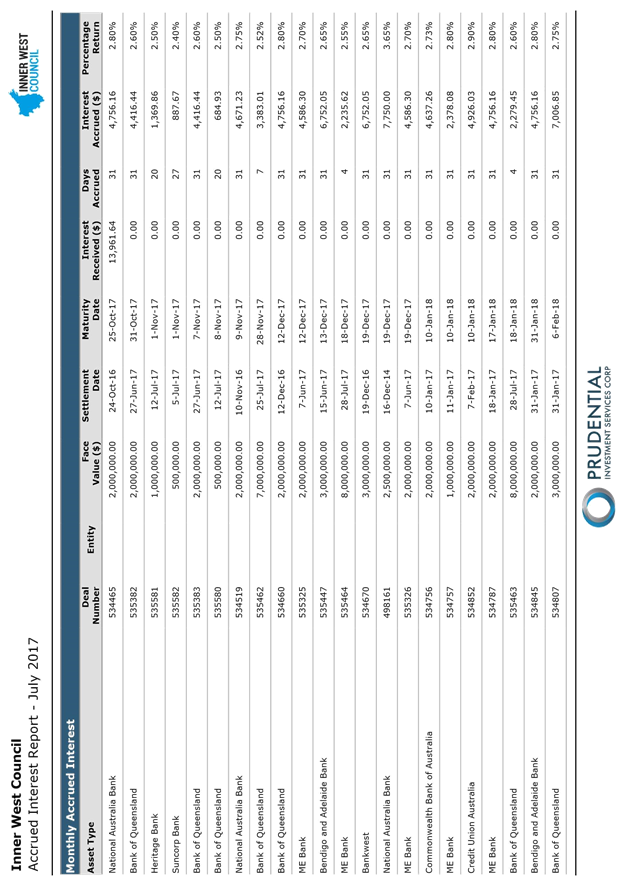
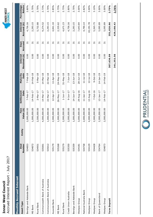
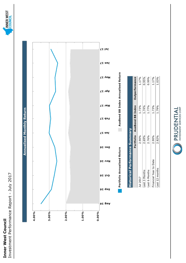
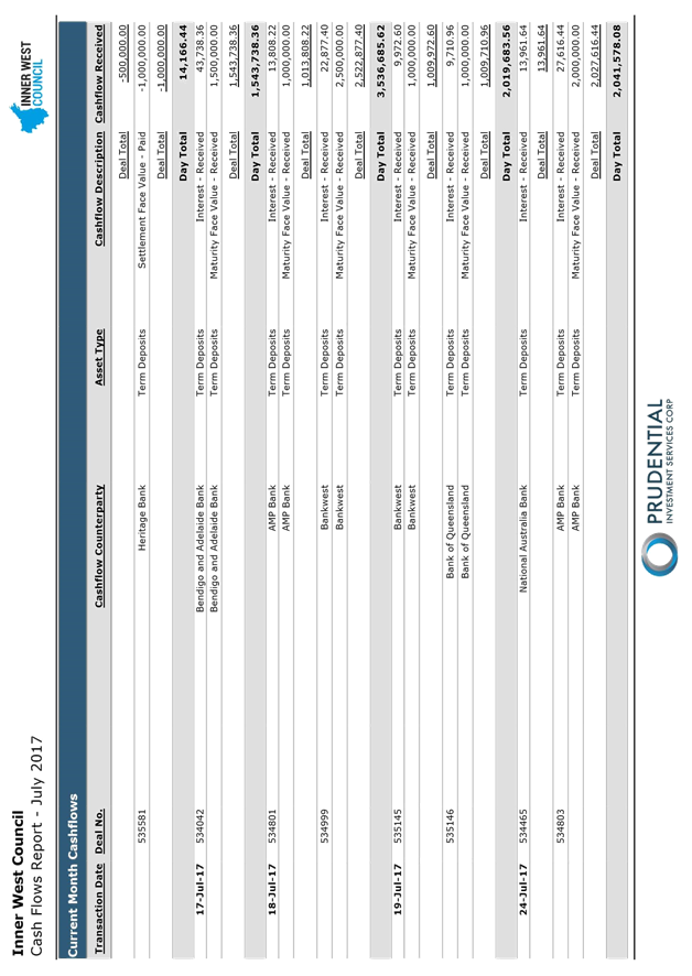
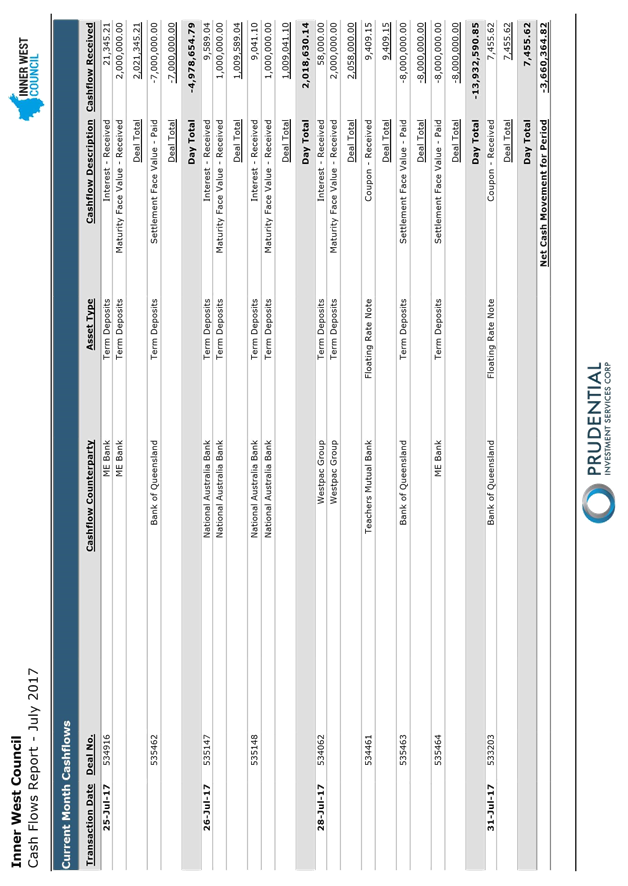
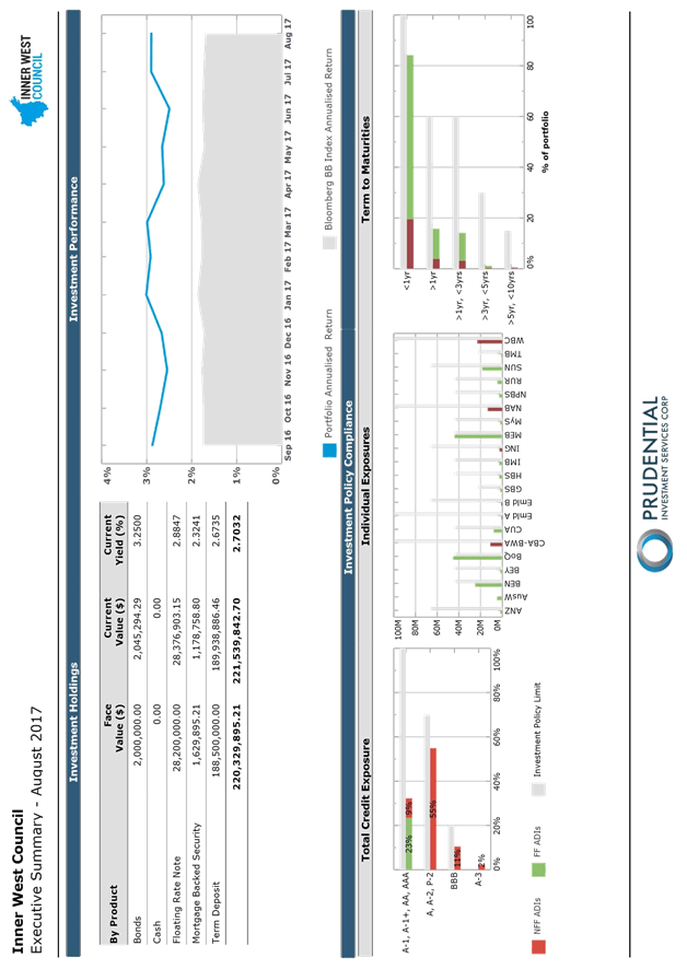
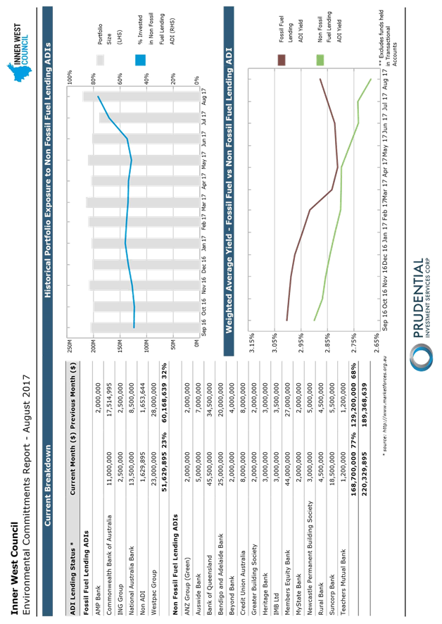
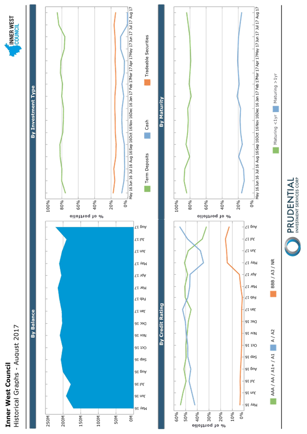
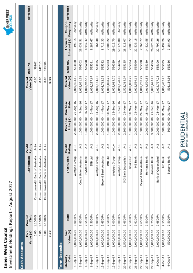
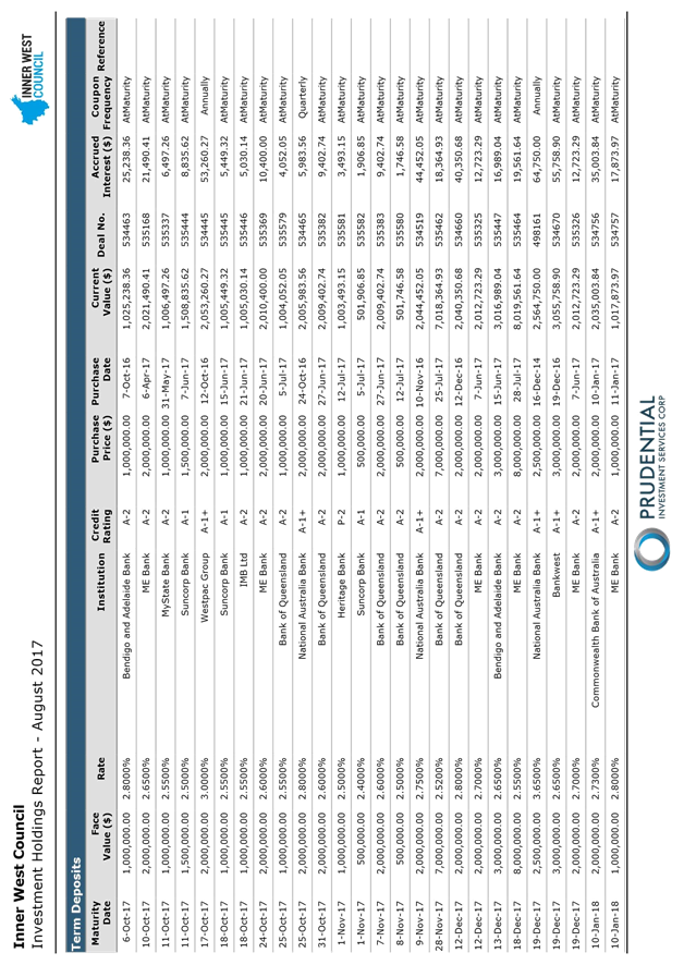
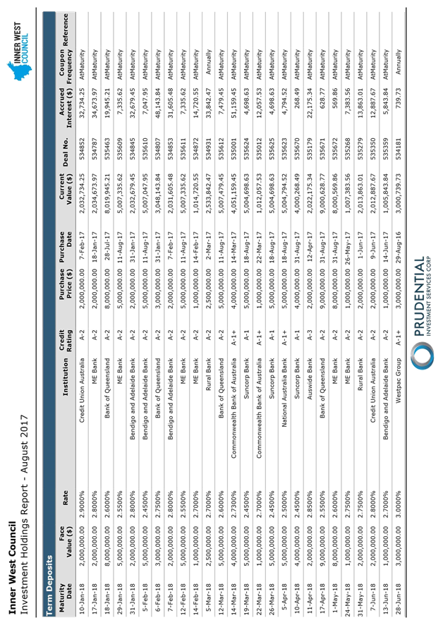
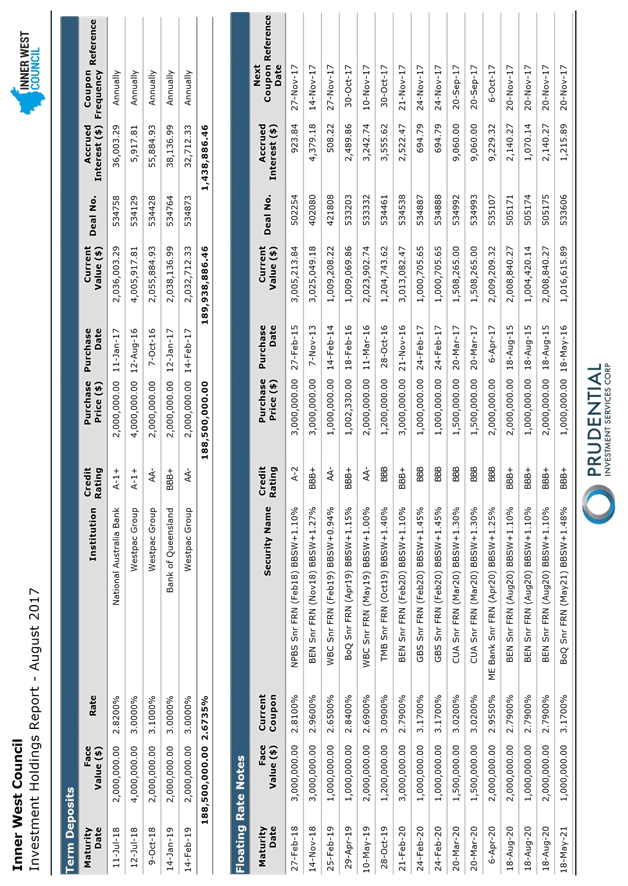
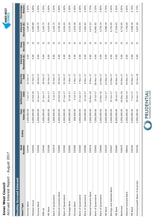
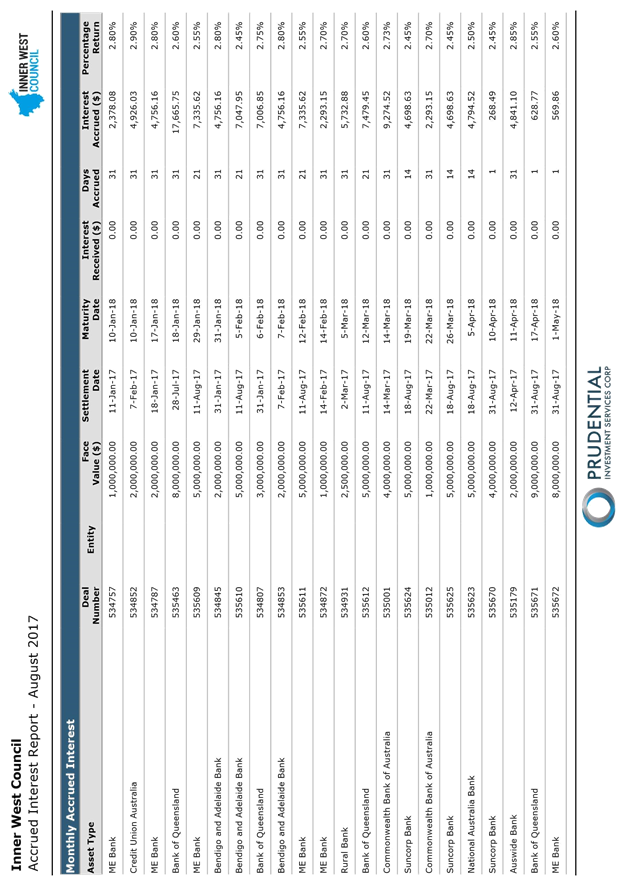
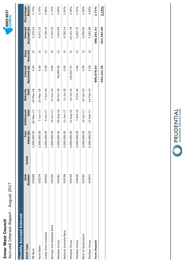
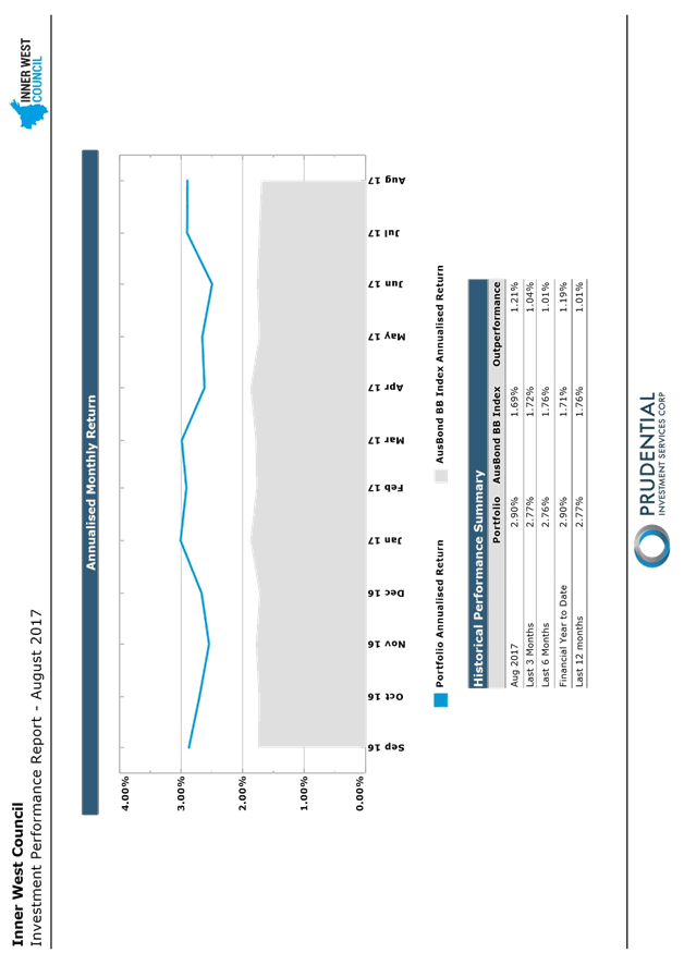
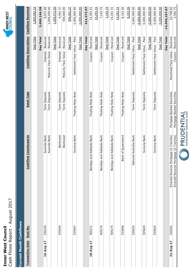
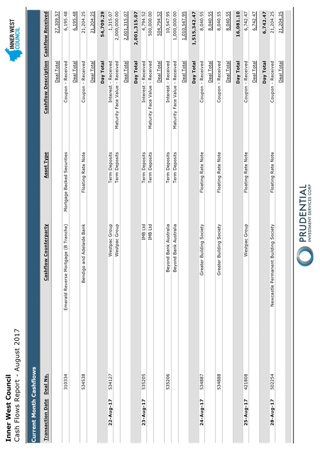
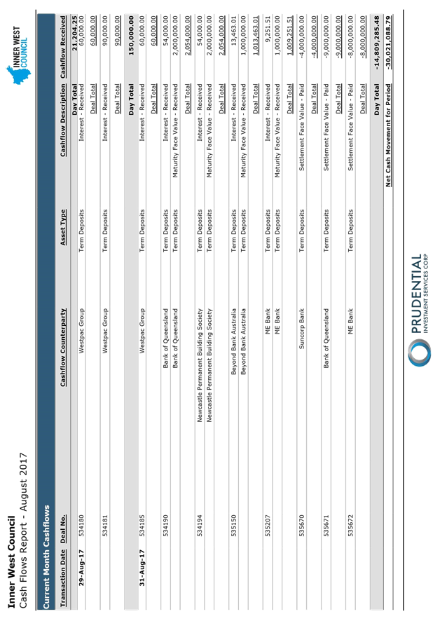
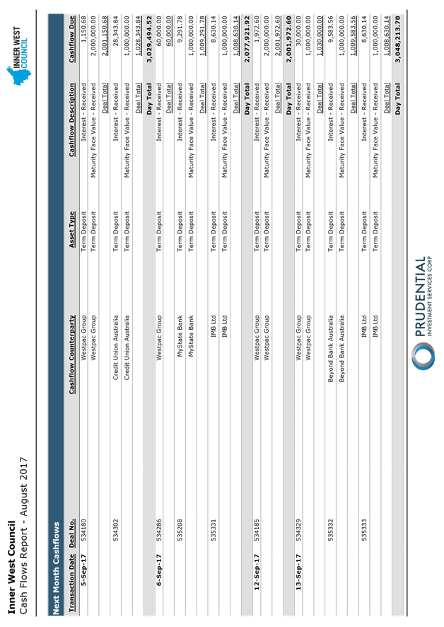
C1017 Item 10 Investment Report as at 31 July 2017 345
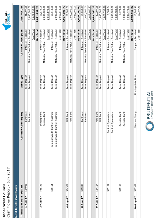
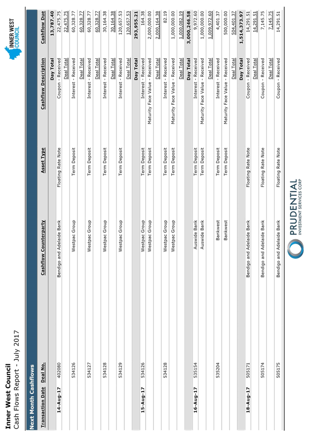
C1017 Item 11 Investment Report as at 31 August 2017 380
C1017 Item 12 Tabling of Pecuniary Interest Returns of Designated Staff for the Return Period 1 July 2016 to 30 June 2017 415
Notices of Motion
ITEM Page
C1017 Item 13 Notice of Motion: Hire Bike Services 416
C1017 Item 14 Notice of Motion: Pedestrian Safety on Croydon Road, Croydon 417
C1017 Item 15 Notice of Motion: Pedestrian Safety on Frederick Street, Ashfield 418
C1017 Item 16 Notice of Motion: Pedestrian Safety in Haberfield and Leichhardt 419
C1017 Item 17 Notice of Motion: Inner West Waterways 420
C1017 Item 18 Notice of Motion: Council Response to the NSW Revised Draft Sydenham to Bankstown Urban Renewal Corridor Strategy 421
C1017 Item 19 Notice of Motion: Expediting The Delivery Of The Upgrade Of Sporting Fields And A Skate Park In Callan Park 422
C1017 Item 20 Notice of Motion: Reversing OSHC fee increases 423
C1017 Item 21 Notice of Motion: Unwinding The Unelected Council's Ban On Dogs In Pubs 424
C1017 Item 22 Notice of Motion: Making the Inner West a leader in renewable energy 425
C1017 Item 23 Notice of Motion: Pride in the Inner West 427
C1017 Item 24 Notice of Motion: A healthier Inner West 428
C1017 Item 25 Notice of Motion: Supporting our Creative Communities 429
C1017 Item 26 Notice of Motion: Establishment of a Sydenham to Bankstown Corridor Committee 431
C1017 Item 27 Notice of Motion: Australia Day 438
C1017 Item 28 Notice of Motion: Council to Enter Cities Power Partnership with the Climate Council and Prepare Report 439
C1017 Item 29 Notice of Motion: Resident Precinct Committees 571
|
|
Council Meeting 12 October 2017 |
Minutes of Extraordinary Council Meeting held on 21 September 2017
Meeting commenced at 6.30pm
|
Present: |
|
|
Darcy Byrne Julie Passas Marghanita Da Cruz Mark Drury Colin Hesse Sam Iskandar Tom Kiat Pauline Lockie Victor Macri Lucille McKenna Rochelle Porteous Vittoria Raciti John Stamolis Louise Steer Anna York Peter Gainsford |
Mayor Deputy Mayor Councillor Councillor Councillor Councillor Councillor Councillor Councillor Councillor Councillor Councillor Councillor Councillor Councillor Interim General Manager Deputy General Manager Assets and Environment |
|
Michael Tzimoulas |
Deputy General Manager Chief Financial and Administration Officer |
|
John Warburton |
Deputy General Manager Community and Engagement |
|
Ian Naylor |
Manager Civic and Executive Support |
|
Katherine Paixao
|
Business Paper Coordinator (Minute Taker) |
The Interim General Manager acted in the role of Chairperson until the election of the Mayor.
1. Acknowledgement of Country by Chairperson
“I acknowledge the Gadigal and Wangal people of the Eora nation on whose country we are meeting today, and their elders past and present.”
2. Notice of Live Streaming of Council Meeting
The Interim General Manager advised that the Council meeting was being streamed live on Council's website and members of the public must ensure their speech to the Council is respectful and use appropriate language.
DISCLOSURES OF INTERESTS: Nil.
|
C0917 Item 1 Oath or Affirmation of Office for Councillors |
|
Councillors Passas, Raciti, Iskandar, McKenna, Macri and Stamolis read out an Oath of Office during the meeting.
Councillors Drury, York, Byrne, Lockie, Hesse, Steer, Da Cruz, Kiat and Porteous read out an Affirmation of Office during the meeting. |
|
C0917 Item 2 Election of Mayor and Deputy Mayor |
|
The Interim General Manager advised that the election of Mayor and Deputy Mayor will be conducted in accordance with the provisions of the Local Government Act and Regulations.
The Interim General Manager advised that he has received nominations for the position of Mayor for Councillor Byrne and Councillor Lockie.
RESOLVED (DRURY/HESSE)
THAT in the view of openness and transparency the election for Mayor and Deputy Mayor be conducted by a show of hands.
CARRIED UNANIMOUSLY
The Interim General Manager asked all Councillors who support Councillor Byrne being the first nomination received, for the position of Mayor to raise their hands.
Councillor Byrne received 8 votes
The Interim General Manager asked all Councillors who support Councillor Lockie being the second nomination received for the position of Mayor, to raise their hands.
Councillor Lockie received 7 votes
The Interim General Manager declared that Councillor Byrne to be elected Mayor.
The Mayor, Councillor Byrne assumed the Chair.
The Interim General Manager advised that he has received nominations for the position of Deputy Mayor for Councillor Passas and Councillor Hesse.
The Interim General Manager asked all Councillors who support Councillor Passas being the first nomination received, for the position of Deputy Mayor to raise their hands.
Councillor Passas received 8 votes
The Interim General Manager asked all Councillors who support Councillor Hesse being the second nomination received, for the position of Deputy Mayor to raise their hands.
Councillor Hesse received 7 votes
The Interim General Manager declared that Councillor Passas to be elected Deputy Mayor. |
MATTER ARISING – TERM OF DEPUTY MAYOR
RESOLVED (BYRNE/MCKENNA)
THAT in accordance with the provisions of Section 231(2) of the Act, the Deputy Mayor be appointed for a term of 1 Year and the Deputy Mayor be elected annually.
CARRIED UNANIMOUSLY
|
C0917 Item 3 Amendment to Council Meeting Schedule |
|
RESOLVED (DRURY/MCKENNA)
THAT the Ordinary Council Meeting scheduled for 26 September 2017 be replaced with an Ordinary Council Meeting on 12 October 2017.
CARRIED UNANIMOUSLY |
|
C0917 Item 4 Panel of Code of Conduct Reviewers |
|||||||||||||||||||||||
|
MOTION (DRURY/MCKENNA)
THAT Council appoint as its Code of Code of Reviewer Panel for a period of 4 years (expiring on 21 September 2021) the following:
AMENDMENT (PASSAS/HESSE) THAT this matter be deferred to allow background information on the panel members to be provided to Councillors. For the Amendment were Councillors Da Cruz, Hesse, Kiat, Lockie, Macri, Passas, Porteous, Raciti, Stamolis and Steer (10). Against the Amendment were Councillors Byrne, Drury, Iskandar, McKenna and York (5). The Amendment was declared carried and the Motion lapsed. |
|||||||||||||||||||||||
|
C0917 Item 5 Referral of Draft 30 June 2017 Financial Statements for Audit |
|
||||||||||||||||||||||
|
RESOLVED (DRURY/MCKENNA)
CARRIED UNANIMOUSLY
|
|
||||||||||||||||||||||
|
URGENCY MOTION – AUSTRALIAN MARRIAGE LAW POSTAL SURVEY
|
|
RESOLVED (KIAT/DRURY)
That Council consider an urgency motion in relation to the Australia Marriage Law Postal Survey.
For the Motion were Councillors Byrne, Da Cruz, Drury, Hesse, Iskandar, Kiat, Lockie, Macri, McKenna, Porteous, Stamolis, Steer and York (13). Against the Motion were Councillors Passas and Raciti (2).
The Mayor declared the matter to be urgent.
RESOLVED (KIAT/DRURY)
THAT Council:
For the Motion were Councillors Byrne, Da Cruz, Drury, Hesse, Iskandar, Kiat, Lockie, Macri, McKenna, Porteous, Stamolis, Steer and York (13). Against the Motion were Councillors Passas and Raciti (2). |
|
URGENCY MOTION - M4-M5
LINK ENVIRONMENTAL IMPACT STATEMENT
|
|
RESOLVED (PORTEOUS/PASSAS)
THAT Council consider an urgency motion in relation to the M4-M5 Link Environmental Impact Statement.
CARRIED UNAMOUSLY
The Mayor declared the matter to be urgent.
RESOLVED (PORTEOUS/STEER)
THAT the Mayor and General Manager immediately write to the Minister for Planning and request that a further 30 days be added to the exhibition period for the WestConnex Stage 3 M4-M5 Link EIS.
CARRIED UNAMOUSLY |
Meeting closed at 8.01pm.
Item No: C1017 Item 1
Subject: Draft Submission on Westconnex M4-M5 Link Environmental Impact Statement
File Ref: /
Prepared By: Kendall Banfield - Manager WestConnex Unit
Authorised By: Gill Dawson - Group Manager Strategic Planning
|
SUMMARY A report on the Draft Submission will be distributed prior to the Meeting. |
|
RECOMMENDATION
THAT Council:
1. Receive and note the Draft Submission;
2. Note that the final submission will be submitted by the 16 October 2017 deadline; and
3. Receive a further report with a copy of the final submission at the Ordinary Council Meeting on 24 October.
|
|
|
Council Meeting 12 October 2017 |
Subject: REVISED DRAFT SYDENHAM TO BANKSTOWN URBAN RENEWAL CORRIDOR STRATEGY
File Ref: /
Prepared By: Peter Failes - Urban Design Planner and Peter Wotton - Strategic Planning Projects Coordinator
Authorised By: Elizabeth Richardson - Group Manager Development Assessment and Regulatory Services
|
SUMMARY This report concerns the revised draft Strategy for the Sydenham to Bankstown Urban Renewal Corridor released in June 2017 by the State Government for community consultation.
Whilst a number of amendments have been made from the initial draft 2015 Strategy, which will have a positive local impact including the retention of high quality character areas, Council continues to have concerns with a number of other matters contained within the revised draft Strategy. Council officers have carried out a detailed assessment of the revised draft strategy and have identified a number of issues and concerns. Officers have recommended that a number of amendments be made to the revised draft Strategy to address those concerns and issues.
Officers have prepared a draft submission for Council’s consideration and that submission is attached as ATTACHMENT 4. A Final Submission will be presented at the Ordinary Council Meeting on 24 October.
The report recommends that Council endorse the draft submission. |
|
RECOMMENDATION
THAT:
1. The report be received and noted. 2. Council endorse the draft submission at ATTACHMENT 4, to be lodged with the Department of Planning and Environment. 3. The Final Submission be presented to the Ordinary Council Meeting on 24 October.
|
1. BACKGROUND
The Sydenham to Bankstown Urban Renewal Corridor Strategy (the Strategy) is a 20 year (to 2036) State Government plan which established a strategic planning framework for urban renewal growth along the new Sydney Metro rail system. Within the Inner West local government area (LGA), the Strategy applies to the Sydenham Railway Precinct, Marrickville Railway Precinct and the Dulwich Hill Railway Precinct.
The Strategy will allow increased residential densities and building heights to reach the targets set for additional homes and jobs in these three precincts.
The first draft of the Strategy was released in October 2015. Following a period of community consultation and the public meeting in November 2015, the former Marrickville Council lodged a submission with the Department of Planning and Environment (DPE) in December 2015 (ATTACHMENT 1).
The revised draft Sydenham to Bankstown Urban Renewal Corridor Strategy (revised draft Strategy) was released for public comments in June 2017. The exhibition period closed on 3 September 2017. However, the DPE granted the Inner West Council (IWC) additional time to provide its detailed submission that would be reported to the incoming elected Council.
In the interim, and following the public meeting held on 10 August 2017, Council’s Interim General Manager submitted a letter to the DPE outlining key concerns raised with the revised draft Strategy and provided a summary of matters raised by the community at the public meeting (ATTACHMENT 2).
2. OVERVIEW OF THE FIRST DRAFT STRATEGY 2015
Key pages from the first draft Strategy 2015 can be found in the Marrickville Council 2015 submission at ATTACHMENT 1. The full set of documents including background material is available on the DPE’s web site at: http://www.planning.nsw.gov.au/Plans-for-your-area/Priority-Growth-Areas-and-Precincts/Sydenham-to-Bankstown-Urban-Renewal-Corridor/Documents
The key issues raised by the former Marrickville Council were:
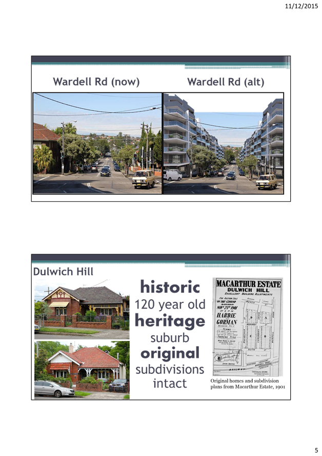
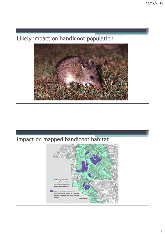
· The loss of too much of the character and fabric of the established, historic and intact inner city suburbs of Marrickville and Dulwich Hill;
· Protection of all listed heritage items and other high quality period buildings and streetscapes within the precincts must be ensured;
· Concerns for the sudden and divisive impact this significant change will have on established communities, with zoning changes led by the private sector;
· Need for the next level of design investigation – precinct wide master planning and a related statutory framework;
· If the Strategy acts as the only guide for privately led rezonings there will be poor and uncoordinated planning outcomes;
· Lack of focus on practical measures to ensure liveability, urban and environmental outcomes related to housing affordability, design excellence, high quality streetscapes/public domain, schools and childcare, precinct sustainability and environmental management matters such as water sensitive urban design, biodiversity management, Cooks River management and waste management; and
· Funding is needed to cover the significant investment in public open space, schools, streetscape, public domain improvements and related community infrastructure.
The former Marrickville Council’s points of agreement with the first draft Strategy were:
· The principle of increasing densities around high-capacity public transport;
· Recognition of the additional work required for the public domain for each local town centre;
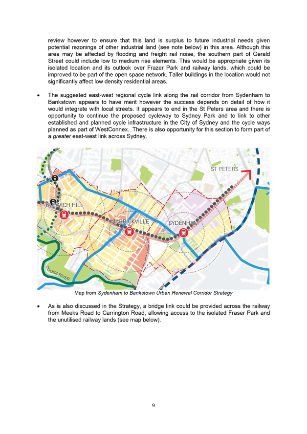
· A continuous regional east-west walking/cycling link from Sydenham to Bankstown along the existing rail corridor;
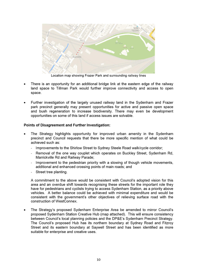
· Increased residential density in the Meeks Road/Gerald Street area where it is outside of the most severely affected aircraft noise areas and where is can act as a buffer to the industrial areas;
· No change to the north-eastern parts of the Marrickville precinct given the smaller lot sizes and to ensure city views from properties to the south;
· Extension of redevelopment areas south-east from Marrickville Station along the southern side of the railway line as these areas have good access to the station and include larger regularly-shaped blocks;
· A maximum height of 5-6 storeys around Dulwich Grove light rail stop; and
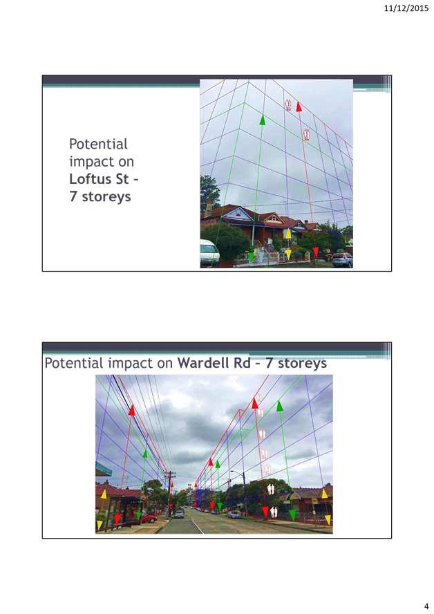
· Redevelopment of areas adjacent to the future GreenWay; around Dulwich Hill Station and around the Loftus Street car park with their proximity, accessibility and established apartment context.
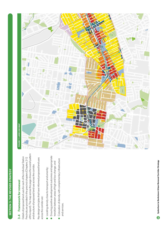
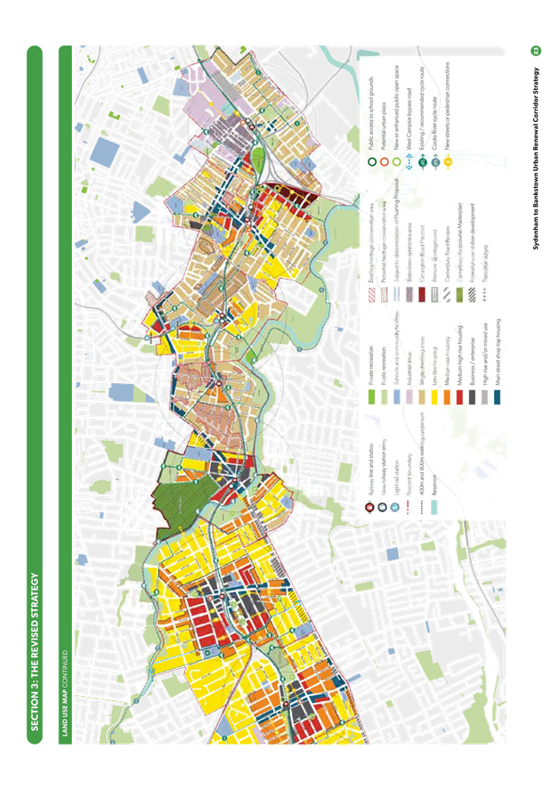
3. OVERVIEW OF THE REVISED DRAFT STRATEGY 2017
Key pages from the revised draft Strategy 2017 can be found at ATTACHMENT 3. The full set of documents including background material is available on the DPE’s web site at: http://www.planning.nsw.gov.au/Plans-for-your-area/Priority-Growth-Areas-and-Precincts/Sydenham-to-Bankstown-Urban-Renewal-Corridor/Documents
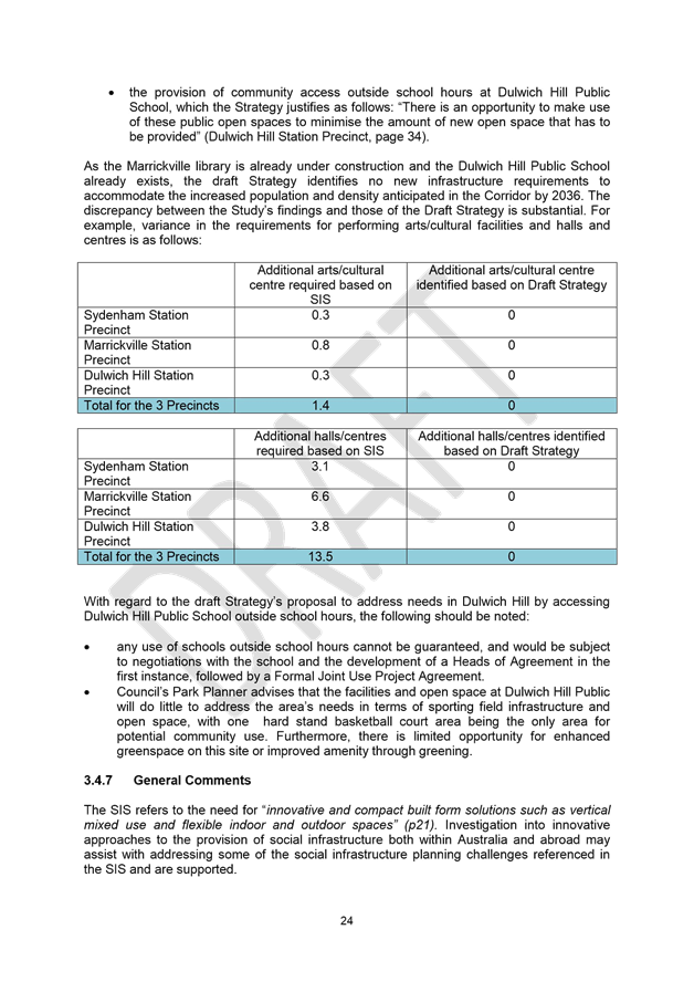
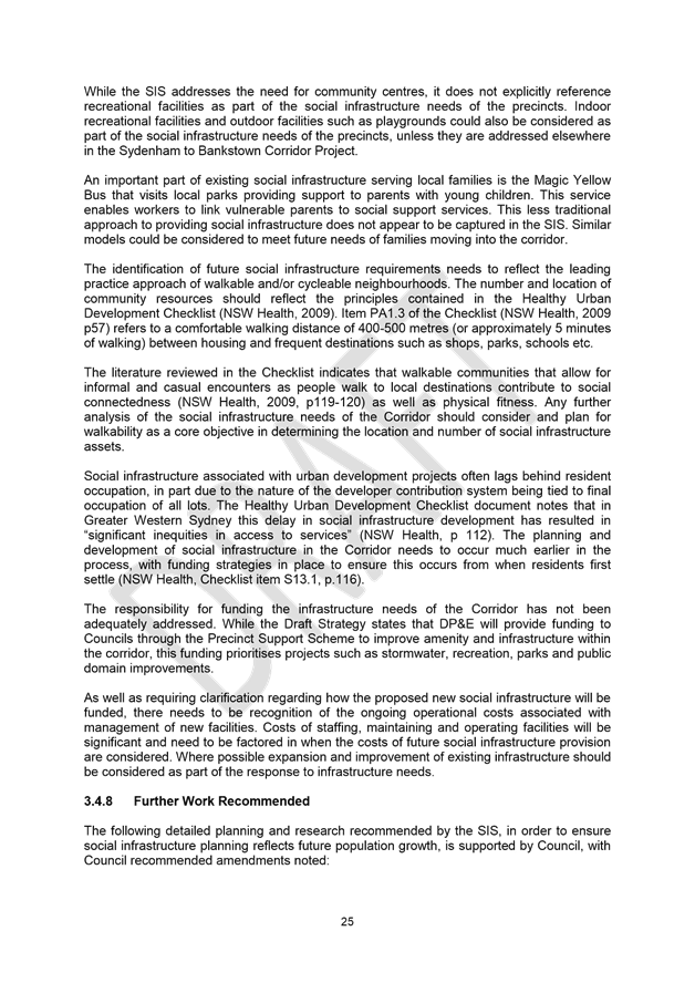
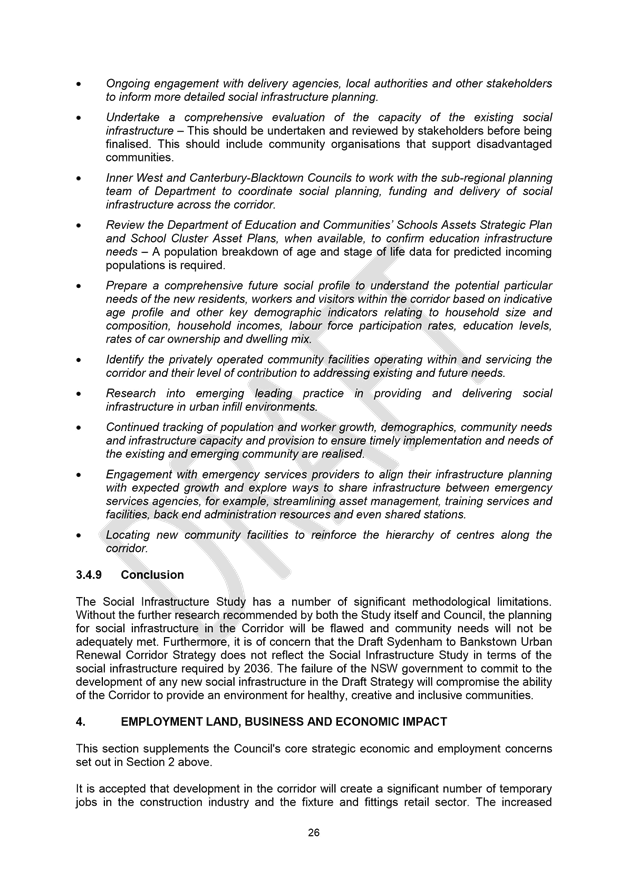
The comparison between the first draft Strategy and the revised draft Strategy reveals that only some of the former Marrickville Council and the communities’ concerns were taken on board and some increased or additional land use strategies are now proposed:
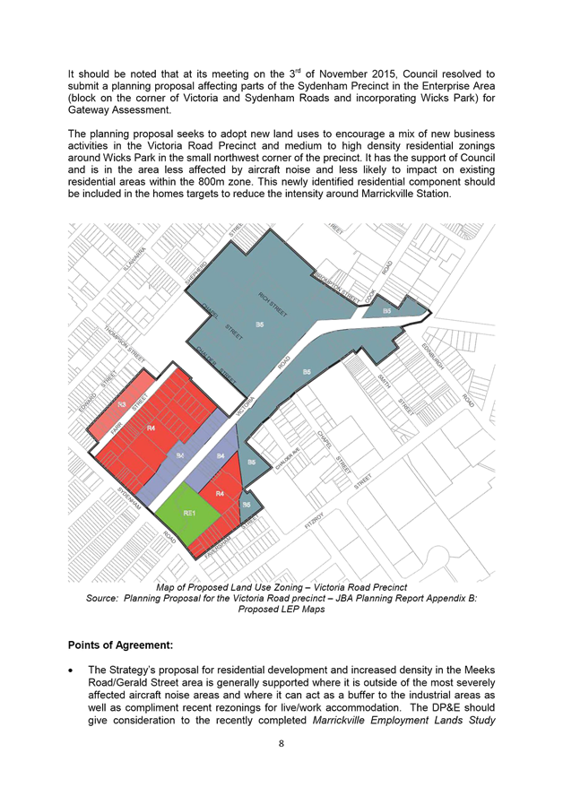
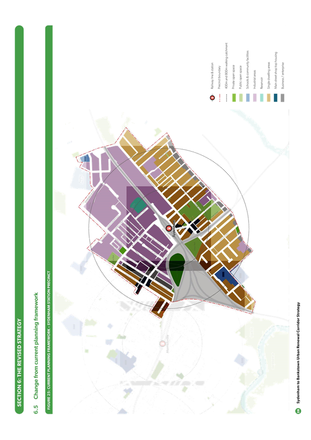
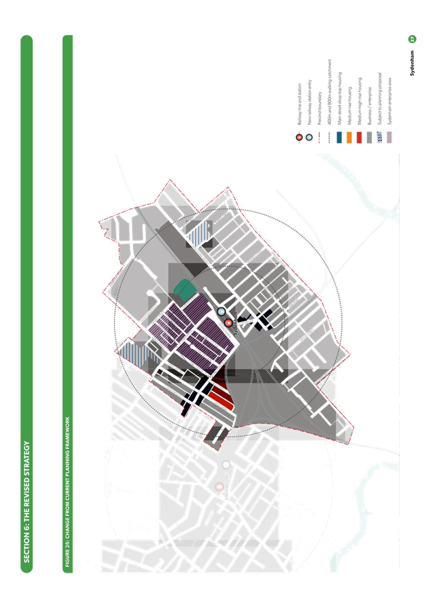
3.1 SYDENHAM STATION PRECINCT
|
FIRST DRAFT STRATEGY 2015 |
REVISED DRAFT STRATEGY 2017 |
|
Additional dwellings to 2036 |
|
|
87 |
500 (+413) |
|
New jobs to 2036 |
|
|
1,101 |
711 (-390) |
|
Land use and density |
|
|
|
73 Mary Street (Precinct 75) and Victoria Road Precinct included as being subject to determination of planning proposals |
|
|
60-62 Mary Street and 9-15 Unwins Bridge Road included to allow for more intensive employment uses and indoor recreation uses as a future business/enterprise area |
|
|
Marrickville Road (between Meeks Road and Sydney Street) – main street shop top housing height limit increased, allowing up to 6 storeys |
|
|
Gleeson Avenue and Unwins Bridge Road – main street shop top housing height limit increased, allowing up to 6 storeys |
|
Employment |
|
|
|
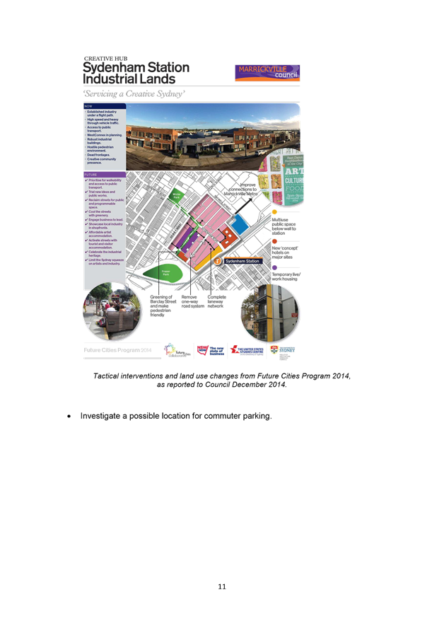
Support the future Sydenham Station Creative Hub which will encourage a vibrant night time economy including more bars and restaurants |
|
|
The enterprise area amended to reflect Council’s plans for a creative hub. The northern boundary is now Sydney Street and Fitzroy Street and eastern boundary is Saywell Street |
|
Transport, traffic and access |
|
|
|
A more direct pedestrian connection and public domain enhancement to be provided between Sydenham Railway Station and the Marrickville Metro shopping centre |
|
|
Pedestrian improvements to Burrows Avenue, Railway Parade and Gleeson Avenue, Marrickville Road and Sydenham Road, including changing Road from one-way to two-way system |
|
|
Extend bus route from Tempe to Airport and Wolli Creek |
|
Open Space |
|
|
|
New urban plaza included in front of a new Metro Station entries and other public domain enhancements |
|
|
A new community space or urban plaza and other public domain improvements on the edge of Sydney Pit |
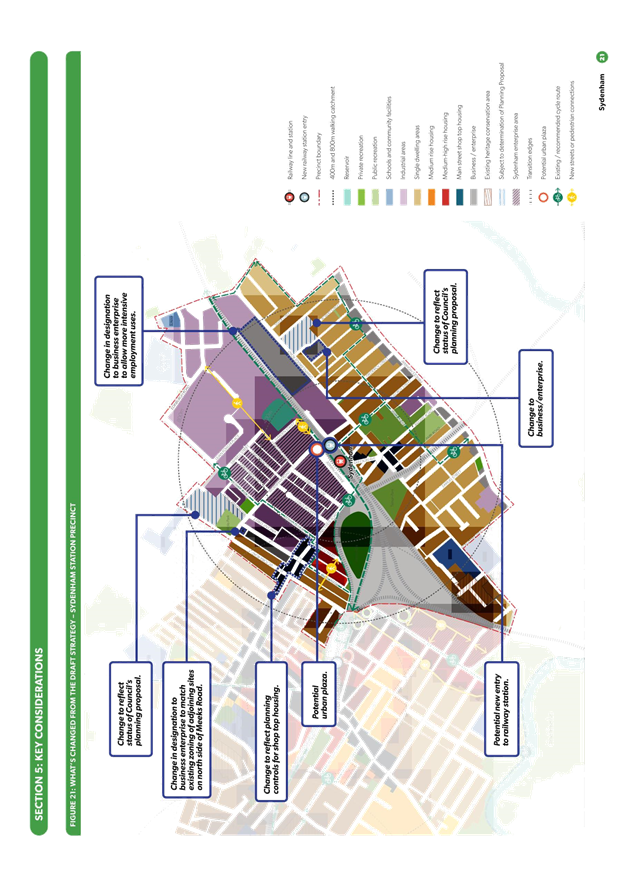
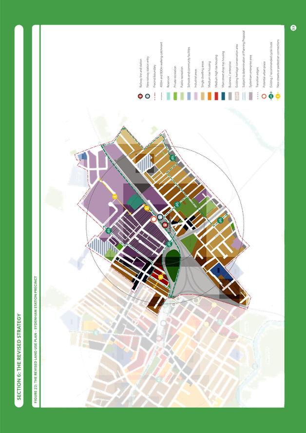
The changes from the first draft Strategy and changes from Council’s current primary development controls set out in Marrickville Local Environmental Plan 2011 (such as permissible land use and building height) are shown in Figures 1 and 2.
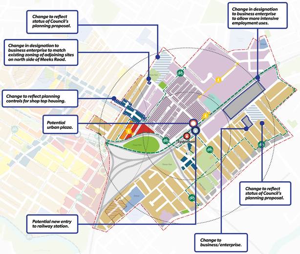
Figure 1 - Changes from first draft Strategy – Sydenham Station Precinct
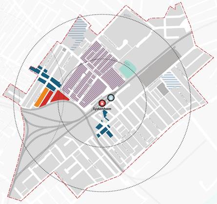
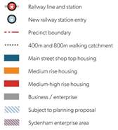
Figure 2 - Changes from Council’s current planning framework – Sydenham Station Precinct
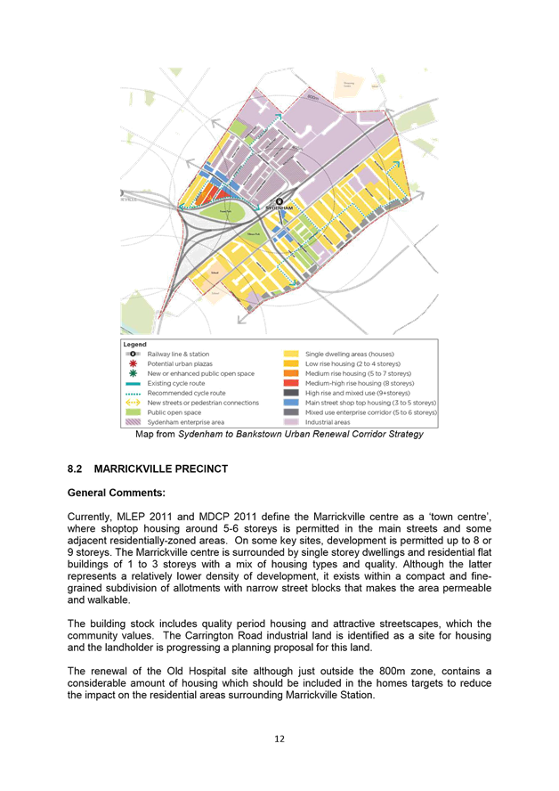
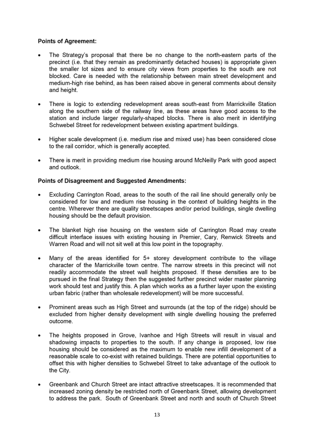
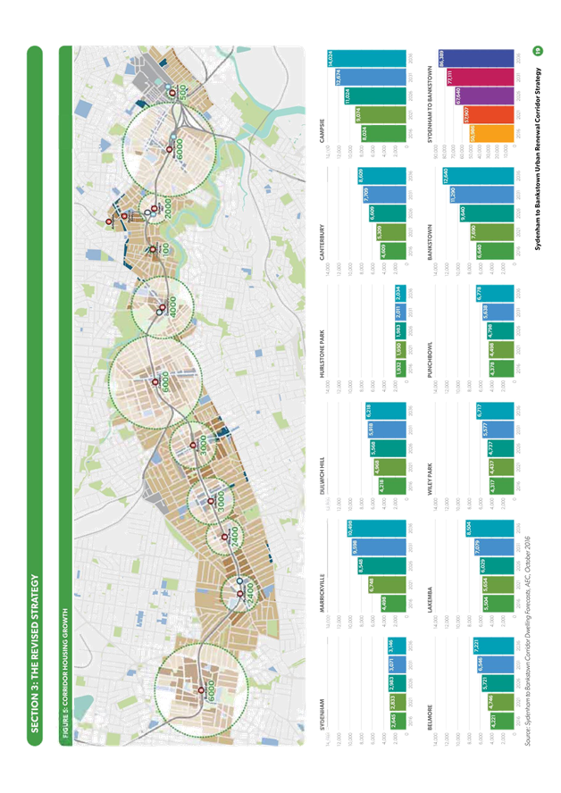
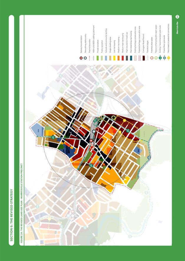
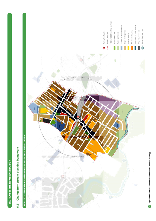
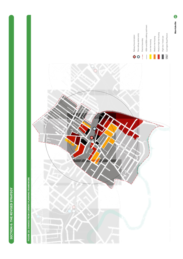
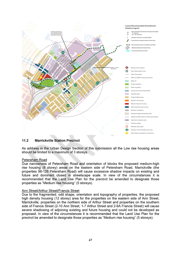
3.2 MARRICKVILLE STATION PRECINCT
|
FIRST DRAFT STRATEGY 2015 |
REVISED DRAFT STRATEGY 2017 |
|
Additional dwellings to 2036 |
|
|
3,978 |
6,000 (+2,022) |
|
New jobs to 2036 |
|
|
1,309 |
555 (-754) |
|
Land use and density |
|
|
|
29-55 Francis Street and 1-25 and 34 Fletcher Street – height limit reduced to low rise housing, allowing up to 4 storeys (as area is within 500m of railway station) |
|
|
2-28 Arthur Street – reduced to medium rise housing, allowing up to 5 storeys |
|
|
Silver Street and Gladstone Street – removed from zoning uplift |
|
|
Central Avenue and 56-76 Calvert Street – reduced to medium rise housing, allowing up to 5 storeys |
|
|
1-29 O’Hara Street – increased to medium rise housing, allowing up to 5 storeys |
|
|
31-41 O’Hara Street – increased to high rise and/or mixed use, allowing up to 12 storeys (with additional height potentially achieved on larger site where community facilities and/or public open space provided) |
|
|
50-54 Calvert Street and 2-34 O’Hara Street – New area proposed for low rise housing, allowing up to 4 storeys (as area is within 500m of railway station) |
|
|
2-12 and 13-17 Warburton Street and 1-7 Greenbank Street – reduced to medium rise housing, allowing up to 5 storeys |
|
|
Area south of Greenbank Street – reduced to low rise housing, allowing up to 3 storeys |
|
|
2-24 Station Street (adjacent to Marrickville Station) – removed from uplift zoning for new urban plaza |
|
|
369-383 Illawarra Road – increased to high rise and/or mixed use, allowing up to 12 storeys |
|
|
1-3 Schwebel Street – increased to high rise and/or mixed use, allowing up to 12 storeys (with additional height potentially achieved on larger site where community facilities and/or public open space provided) |
|
|
22-26 Schwebel Street – increased to medium-high rise, allowing up to 8 storeys |
|
|
Area south of Schwebel Street – reduced to low rise housing, allowing up to 3 storeys |
|
|
3 Myrtle Street and 3-5 Carrington Road – increased to high rise and/or mixed use, allowing up to 12 storeys (with additional height potentially achieved on larger site where community facilities and/or public open space provided) |
|
|
The former Marrickville hospital site – increased to high rise and/or mixed use, allowing up to 12 storeys |
|
Heritage |
|
|
|
Correctly showed the David Street Heritage Conservation Area as a single dwelling area |
|
|
A new Heritage Conservation Area is proposed comprising Silver Street and Gladstone Street |
|
|
The southern side of Greenbank Street and Church Street are identified as low rise housing to provide more gradual transition to the single dwelling areas to the south and west |
|
|
The area to the south of Schwebel Street including Grove Street, High Street, Ivanhoe Street and Ruby Street have been identified for low rise housing following Council’s submission that this area be retained because of its local character |
|
Transport, traffic and access |
|
|
|
Potential new entry to railway station at Victoria Road |
|
|
Enhanced pedestrian amenity and safety with 40km/h high pedestrian activity area in Illawarra Road and enhanced crossing at intersection of Illawarra and Petersham Road as well as Illawarra Road and Warburton Street / Schwebel Street |
|
Open Space |
|
|
|
2-24 Station Street and at the north eastern side of Riverdale Avenue – opportunity for two new urban plazas at the station entrances and improvements to the streetscape along Leofrene Avenue |
|
|
The opportunity for a public open space along the railway line adjoining 3 Myrtle Street and 3-5 Carrington Road and a centrally located park and north-south pedestrian connection with the redevelopment of the Carrington Road precinct |
|
|
The opportunity for pedestrian connection / along the edge of the canal to the west of and parallel to Carrington Road |
|
|
Improvements to McNeilly Park |
The changes from the first draft Strategy and changes from Council’s current primary development controls set out in Marrickville Local Environmental Plan 2011 (such as permissible land use and building height) are shown in Figures 3 and 4.
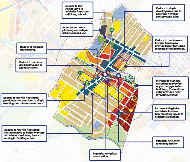
Figure 3 - Changes from first draft Strategy – Marrickville Station Precinct
Figure 4 - Changes from Council's current planning framework – Marrickville Station Precinct
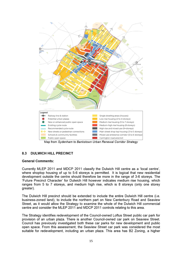
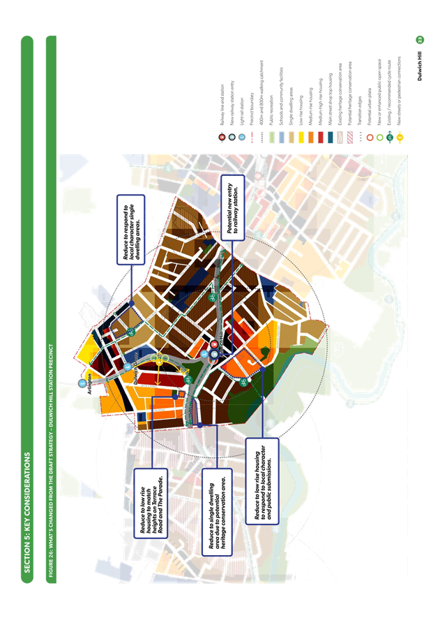
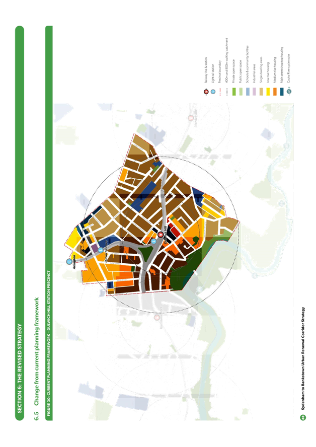
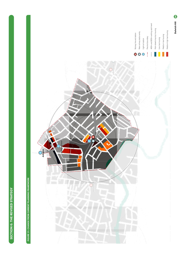
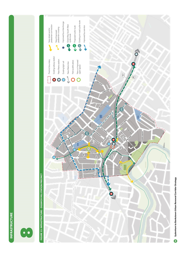
3.3 DULWICH HILL STATION PRECINCT
|
FIRST DRAFT STRATEGY 2015 |
REVISED DRAFT STRATEGY 2017 |
|
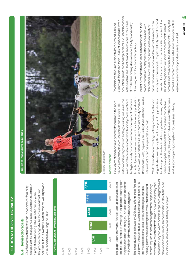
Additional dwellings to 2036 |
|
|
2,059 |
2,000 (-59) |
|
New jobs to 2036 |
|
|
284 |
275 (-9) |
|
Land use and density |
|
|
|
Durham Street, Macarthur Parade, Beach Road and Kintore Street – removed from zoning uplift |
|
|
North of Marrickville Road – removed from zoning uplift |
|
|
394-400 Marrickville Road, 161-199 Livingstone Road, 2-26 David Street and 44-48 Robert Street – removed from zoning uplift and from the Precinct entirely) |
|
|
1-7 Dulwich Street, 197-205 Denison Street and 90A to 104 Constitution Road - New area proposed for low rise housing, allowing up to 3 storeys (and new part of the Precinct) |
|
|
2-10 The Parade – reduced to low rise housing, allowing up to 3 storeys |
|
|
73-101 Ewart Street – removed from zoning uplift |
|
|
66-78 Ewart Street, 266-284 and 277-299 Wardell Road, 47-55 Riverside Crescent, 10-12 Dibble Avenue and 10 Pilgram Avenue – reduced to low rise housing, allowing up to 3 storeys |
|
|
53-71 Ewart Street 51A-57A Ewart Lane – Increased to medium high rise housing, allowing up to 8 storeys |
|
Heritage |
|
|
|
Retain more streets for low-density housing, in particular the areas to the south of Ewart Street and north of Beach street due to street character |
|
|
Identify 73-101 Ewart Street (west of Ness Avenue) as a potential new Heritage Conservation Area |
|
|
Identify 66-70 Ewart Street (near intersection with Wardell Road) as a potential new Heritage Conservation Area |
|
Transport, traffic and access |
|
|
|
New entry to Metro railway station; improved separation of pedestrian footway on Wardell Road bridge over railway and investigate signalised crossing of Wardell Road / Dudley Street |
|
|
New street or pedestrian connection through eastern edge of Hercules Street development |
|
|
The investigation of a crossing over the light rail at Blackwood Avenue between Dulwich Hill Public School and the area included in the Hercules Street Masterplan |
|
|
40km/h high pedestrian area on Wardell Road |
|
|
Extend bus route from Tempe to Airport and Wolli Creek |
|
Open Space |
|
|
|
Potential new urban plaza at new Metro Station entry |
|
|
Improvements to the Jack Shanahan Reserve and a new entrance from Hercules Street via a cut through of the raised embankment |
|
|
Implement part of Iron Cove to Cooks River GreenWay and new open space in the light rail corridor as and associated with Hercules Street development |
|
|
Use of school grounds for after-hours community uses |
|
Environment |
|
|
|
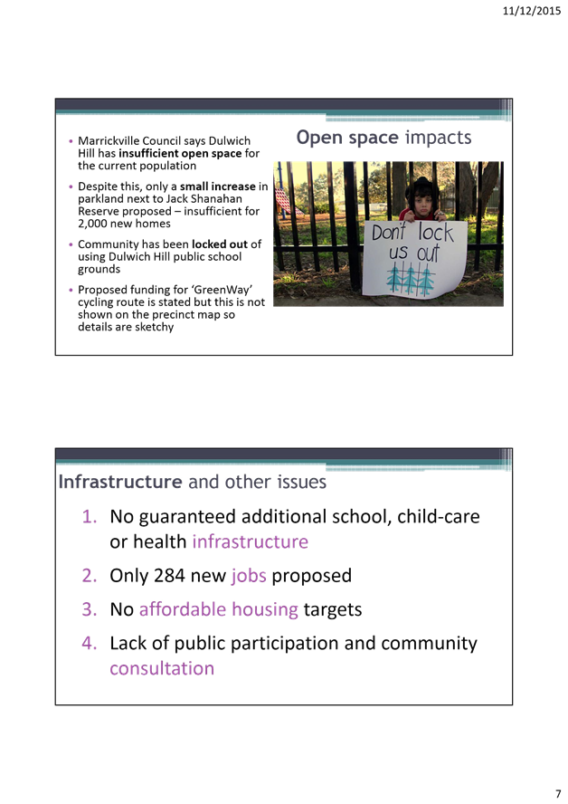
In order to enhance the native habitats for long-nosed bandicoots, new open space area proposed along the rear of the properties on Hercules Street adjoining the light rail line should be planted with appropriate trees and vegetation that would create new habitat for bandicoots |
The changes from the first draft Strategy and changes from Council’s current primary development controls set out in Marrickville Local Environmental Plan 2011 (such as permissible land use and building height) are shown in Figures 5 and 6.
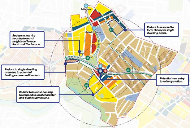
Figure 5 - Changes from first draft Strategy - Dulwich Hill Station Precinct
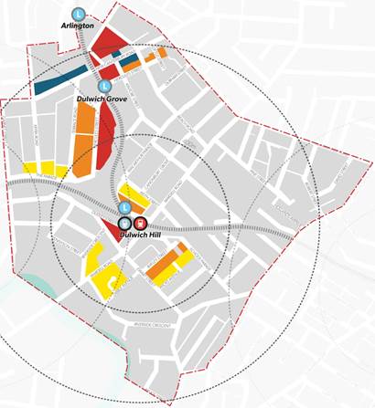
Figure 6 - Changes from Council's current planning framework - Dulwich Hill Station Precinct
4. COMMUNITY ENGAGEMENT
Council has taken a proactive approach to assist the Inner West Council community understand the contents and implications of the revised draft Strategy and promoted the community making submissions to the DPE on the exhibition.
In this regard Council has:
· established Your Say Inner West project page, which was viewed by more than 1,000 people at the following link: http://www.yoursayinnerwest.com.au/sydenham-to-bankstown-urban-renewal-corridor;
· distributed a brochure to 16,500 nearby residences;
· distributed posters at key locations around the LGA;
· promoted the exhibition and public meeting in social and traditional media, and on Council’s website and e-news - media release at the following link: https://www.innerwest.nsw.gov.au/news-hot-topics/media/media-releases/sydenham-to-bankstown-urban-renewal-corridor-back-on-the-agenda);
· held a public meeting on 10 August 2017 at Marrickville Town Hall which was attended by 350 people;
· recorded the meeting and uploaded the video at Your Say Inner West.
From the public meeting and submissions received from key groups including The Southern Sydney Regional Organisation of Councils (SSROC), Marrickville Golf and Community Club and Golf Course, Save Dully and Save Marrickville South the following concerns were raised:
· The need for effective collaboration and high level of engagement between the Inner West Council and the City of Canterbury Bankstown Council.
· There is overdevelopment proposed in the strategy. These plans have not been written for us, they have been written for developers.
· Marrickville and Dulwich Hill have been asked to take too much density.
· The revised draft Strategy makes no reference to affordable housing and sets no targets throughout the corridor. Similarly, the Strategy makes no mention or provision of affordable rental housing for key workers.
· The revised draft Strategy does not have a detailed and comprehensive infrastructure and delivery plan that is integrated to the land use planning for the corridor.
· The infrastructure should be planned before deciding the height of buildings.
· There is little evidence that the Sydenham-Bankstown Corridor and the related transport network and infrastructure are informed by traffic study or analysis. It is important to undertake the traffic analysis.
· Rather than fixing an existing rail line, we should be prioritising parts of Sydney that do not have these services. There are also concerns regarding the privatisation of the train line. Why are we ripping up and replacing an existing and good service?
· Additional waste management infrastructure will be inevitably required to meet the challenge of additional dwellings and people.
· It is not clear in the draft strategy how funds for the identified or other needed infrastructure will be generated and how the infrastructure will be delivered. Section 94 is inadequate as a source of funds for local infrastructure.
· The NSW Government needs to provide clarity on Value Capture and Voluntary Planning Agreements (VPA).
· Marrickville Golf Course is the only golf course in the Inner West Council local government area. How does Council propose to support older citizens sporting activities, if the only golf course within the municipality is reduced in size, or closed entirely?
· We have a deficit of open space. The existing open space areas are already at full capacity. There will be insufficient open space to support the additional development proposed and the height of the proposed buildings will overshadow these open space areas.
· Linear and pocket parks are not family friendly. We need parks where children can play.
· There are no plans for new schools, community centres or public halls. The only public school in Marrickville is already at full capacity.
· The revised draft Strategy does not place the desired emphasis on liveability.
· Concerns are raised regarding where the transition points are.
· The proposed rezoning of new areas of Dulwich Hill and other suburbs should be delayed so the State Government does not place unnecessary additional pressure on the Bankstown line as it progressively shuts down to build the Metro.
· The revised plan for west Carrington Road in its current form does not transition appropriately from single dwellings to increased zoning heights. It would have a major impact on the houses nearby through overshadowing, reduced privacy, physical domination of existing housing and changes to appearance of the streetscape.
· The LGA is rich in heritage, industrial and creative precincts, streetscapes and Aboriginal history. We need to keep Marrickville’s heritage and streetscapes. It is good that the revised draft Strategy protects heritage items, but there is nothing about the protection of streetscapes. The plans disregard the quality of these historic streets and the character of the area will change because of this development. The character is what makes our suburbs significant.
· Retain the heritage streetscape elements, as well as heritage buildings and significant streetscapes, in the southern part of the Marrickville Precinct and retain the heritage industrial buildings along Carrington Road. No areas should be designated for increased density, until a formal independent heritage assessment has been conducted of these areas.
· The revised draft Strategy endorses shop top housing, however this does not work. There are many examples of vacant shop top housing in the area.
· New households will require parking and there must be a parking management plan. New residents will require cars and parking as public transport will not meet all transport needs.
· Protect and foster Carrington Road as a vital enterprise hub for Sydney.
· A number of individual items that reflect Dulwich Hill’s diverse and interesting history and are worthy of heritage protection now face demolition under these plans.
· The final precinct plan should support the Uniting Church in Constitution Road, the former maternity hospital at The Parade and the Greek Church in Hercules Street as potential heritage items and should indicate that further heritage items will be investigated in the rezoning process.
· The revised draft Strategy designates the triangular block bordered by Constitution Road, Denison Road and New Canterbury Road for eight-storey development. Concerns about this intense development include: the lack of strategic planning merit as only part of this block is within the 800m radius from Dulwich Hill station, the block’s heritage character, there is no guarantee in the precinct plan that the affordable housing lost under this process will be replaced by new affordable rental housing, two bus stops along New Canterbury Road directly adjacent to the block are proposed to be removed and the impacts on existing developments.
· Similarly there are concerns with the block bounded by Hercules Street, Consett Street and Terrace Road, which will be the primary development area for Dulwich Hill. Concerns include heritage impacts, height limits and open space appearing as private use for the unit dwellings.
· Hercules Street industrial site - the most intense development on the site should be on the New Canterbury Road frontage (no more than eight storeys) and for development on the Hercules Street frontage to be limited to four storeys.
· Undertake a contaminated land assessment of the industrial area of the proposed Carrington Precinct and west Carrington Road and undertake flood management planning prior to the development of a final proposal.
· Our history, amenity, sustainability are undermined by these plans.
5. DISCUSSION
Council acknowledges the challenge of providing the required housing and jobs to meet Sydney’s forecast growth and the strategic merit in focusing renewal around transport infrastructure and within urban centres. It is also noted that a number of amendments have been made from the initial draft Strategy which will have a positive local impact including the retention of high quality character areas.
Notwithstanding, Council continues to have issues and concerns with the revised draft Strategy. Those issues and concerns are detailed in the attached submission.
The key issues and concerns with the revised draft Strategy are as follows:
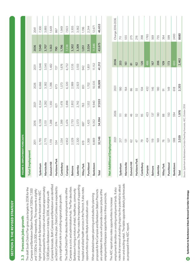
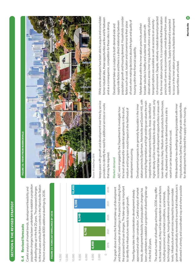
· Lack of transparency about the forecast dwelling and employment numbers in the revised draft Strategy. With the removal of some areas and reduced heights from the original draft Strategy, it is difficult to understand how a similar or significantly greater number of dwellings are now forecast in the revised draft strategy, especially in the Marrickville Station Precinct, which has over 2,000 more dwellings in the revised draft Strategy.
· Some areas being included for zoning uplift, especially in the Marrickville Station Precinct, resulting in the loss of character and fabric. Some of the areas requested to be removed by Council have instead been reduced to low rise housing. The attached submission identifies areas where height continues to be a concern and areas recommended to be removed from any zoning uplift.
· The removal or impact on key Marrickville employment and businesses lands which have been identified to be in high demand through independent analyses. This is of particular relevance within the Sydenham Station Precinct.
· Not providing a comprehensive whole-of-government plan for the required additional infrastructure and services. The anticipated increase in population will undoubtedly result in increased need for affordable rental housing, child care, schools, health care facilities, open space, recreation facilities, road upgrades, new or improved pedestrian and cycling connections and community facilities. No mechanism has been devised that will efficiently and transparently fund the delivery and/or upgrade of local or regional level infrastructure items. This is a significant shortfall of the revised strategy and must be addressed prior to the final strategy being released. Failing to address this issue will delay the delivery of housing and jobs across the Corridor.
· The proposed Greenway South West is strongly supported. However, the draft Strategy has, not adequately addressed the provision of local open space, only specifying that new parks would be left to Council to provide and that there is the potential for part of the Marrickville Golf Course to be repurposed for open space. Land for open space should be identified upfront and funding mechanisms identified. Section 94 will not be sufficient to provide the new open space areas required for the incoming community identified in the Strategy.
· Despite Council’s previous request for affordable housing targets or provision of an inclusionary mechanism, the revised draft Strategy still has not provided any policy or regulatory options to address the issue of affordable rental housing. This critical issue must be addressed by the final strategy.
· Implementing the Strategy will require funding to be made available from the State. Prior to any planning proposals being supported by Council detailed studies such as traffic, urban design and infrastructure planning must be prepared and finalised to ensure incoming growth and associated cumulative impacts can be appropriately managed by Council. Commitment to such funding has yet to be made by the State.
· The revised draft Strategy has not adequately considered urban design criteria such as orientation, topography, lot depths and configuration, width of streets, views relationships with open space and development parcels. Council’s previous submission considered that detailed precinct wide master planning was integral to progress the Strategy, ensuring optimal planning outcomes, however this has not been undertaken. Council is concerned that some blocks and groups of blocks designated for medium-high and high rise housing will cause significant overshadowing, visual bulk, streetscape and view impacts on existing residences.
A summary of the issues and concerns raised by Council officers, as detailed in the attached submission, are as follows:
(NB The number reference in the heading to each issue is the reference number used in the draft submission)
2. Strategic Context
The revised draft Strategy has a number of inconsistencies with relevant strategic planning documents including A Plan for Growing Sydney, the Draft Central District Plan and certain Section 117 Directions.
The Strategy should be amended to ensure consistency with those documents.
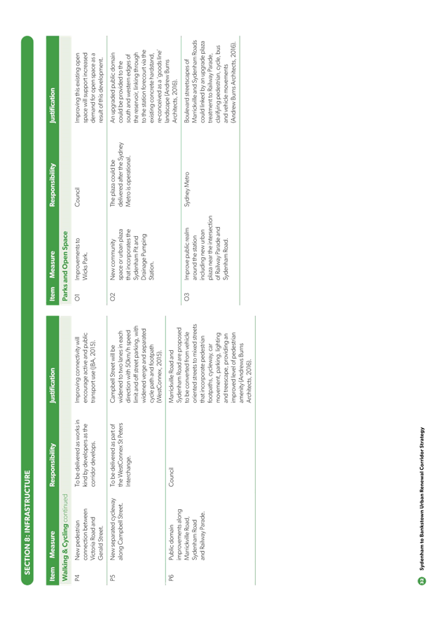
3. Infrastructure
The Strategy does not provide a comprehensive whole-of-government plan for the required additional infrastructure and services, including mechanism(s) that will efficiently and transparently fund the delivery and/or upgrade of those local or regional level infrastructure items.
The Strategy must establish a regional approach for the funding and implementation of the required infrastructure and a State Government commitment to the funding of key infrastructure.
The Strategy needs to address the infrastructure and funding issues raised in Section 3 of Council’s submission including issues relating to:
· Active transport;
· Open space, recreational facilities and public domain infrastructure;
· Street, traffic, parking and stormwater infrastructure; and
· Social infrastructure
All the necessary additional infrastructure and services need to be itemised and incorporated, and appropriately detailed, into the respective Land Use Plan, Infrastructure Plan and Infrastructure Schedule for each precinct. Such documentation should include details of the infrastructure type, hierarchy of facilities (local, district or regional), priority works, indicative timeframe for delivery and funding mechanisms as well as an estimated cost of works (like the infrastructure schedule contained in The Parramatta Road Corridor Urban Transformation Strategy).
4. Employment Land and Economic Development
The Strategy’s proposed rezoning of industrial land would have a significant negative impact on employment, availability of industrial floor space, supply chains, markets and synergies between businesses and Sydney’s creative/cultural institutions.
The downside for the local economy would be the loss of a substantial amount of relatively affordable land, the greater percentage of which is currently occupied by creative industries. Those businesses will be lost when the properties they currently occupy are either demolished or rezoned for medium to high density residential or mixed use development.
The purported opportunity sites referred to in the AEC Employment Analysis have exceptional economic value as industrial lands. The Strategy should be amended to retain those sites for the reasons detailed in Section 4 of Council’s submission.
5. Transport
The Strategy requires a more integrated transport approach as detailed in Section 5 of Council’s submission.
In order to create a more sustainable future, it is essential that the increased residential densities (and employment opportunities) should not be solely designed to make the metro more viable, they should offer genuine city shaping opportunities and start to guide a more sustainable city through more sustainable neighbourhoods.
For the reasons detailed in Council’s submission the Strategy should be based on an integrated approach to transport. The Strategy should be amended accordingly.
The Strategy should also be amended to address the specific transport comments for the respective precincts detailed in Section 5 of Council’s submission.
6. Heritage
A comprehensive heritage study of the areas within the respective precincts should be undertaken to determine whether there are any sites or areas of environmental heritage significance to the area not currently identified as heritage items, heritage conservation areas or draft heritage items or heritage conservation areas. That study should be carried out before any changes are contemplated to existing land use zonings and/or density and scale controls to ensure that any new planning controls respect the existing built environment and any identified heritage significance.
The Strategy should be amended to incorporate the outcomes of that study and to address the other heritage issues raised in Section 6 of Council’s submission.
7. Affordable Housing
The Strategy does not provide an affordable rental housing target or mechanisms to address the issue of the provision of affordable rental housing.
It is essential that the Strategy sets an appropriate affordable rental housing target and that the State Government make amendments to State Environmental Planning Policy No 70 – Affordable Housing (Revised Scheme) to identify that there is a need for affordable housing in the Sydenham to Bankstown Urban Renewal Corridor and that the State Government make relevant amendments to the environmental planning instruments applying to all local government areas in the Corridor to permit the levying of affordable housing contributions for residential development in the Corridor, to enable the creation of Affordable Rental Housing in perpetuity under the management of a Registered Community Housing Provider.
8. Environment
The Strategy should be amended to include a comprehensive sustainability framework with objectives, strategies and targets and measures.
9. Strategic Implementation and Staging
Implementing the Strategy will require funding to be made available from the State. Prior to any planning proposals being supported by Council detailed studies such as traffic, urban design and infrastructure planning must be prepared and finalised to ensure incoming growth and associated cumulative impacts can be appropriately managed by Council. Commitment to such funding has yet to be made by the State.
10. Urban Design
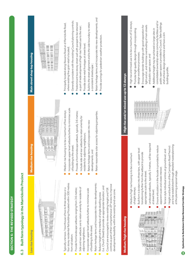
The revised draft Strategy has not adequately considered urban design criteria such as orientation, topography, lot depths and configuration, width of streets, views, relationships with open space and development parcels. For example, as detailed in Section 10 of Council’s submission, some of the land designated for medium-high rise and high rise housing in the Strategy do not support the height/density proposed in terms of solar access, visual bulk and streetscape considerations, based on the principles and guidelines applying to such development under SEPP 65 and the Apartment Design Guide (ADG).
The Strategy needs to be amended, as detailed in Section 10 of Council’s submission, to ensure compliance with those principles and guidelines.
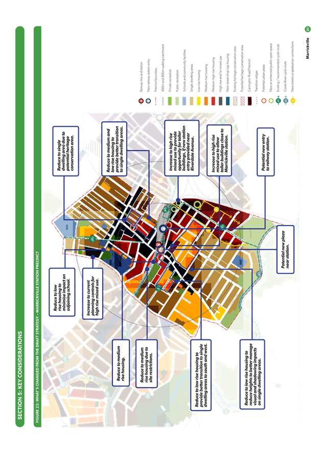
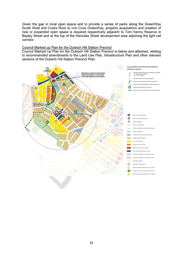
11. Precinct Specific Issues
The draft submission recommends a number of changes be made to the Land Use Plan, Infrastructure Plan and Schedule and other changes for each of the respective Precincts. Those amendments are detailed in Section 11 of Council’s submission.
The recommended changes for each precinct are shown in the following diagrams:
11.1 Sydenham Station Precinct
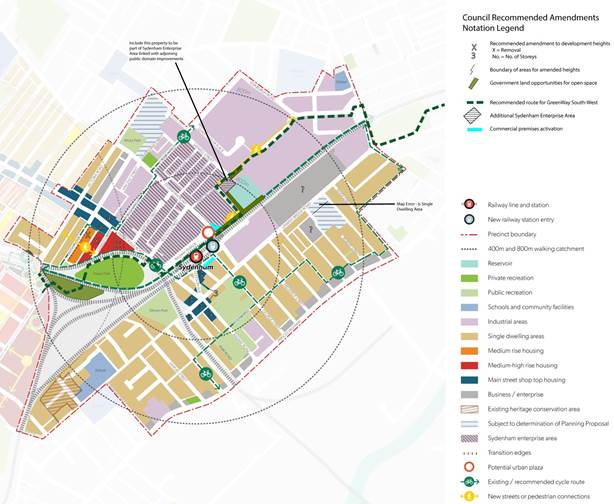
Figure 7 – Council Marked Up Plan for the Sydenham Station Precinct
11.2 Marrickville Station Precinct
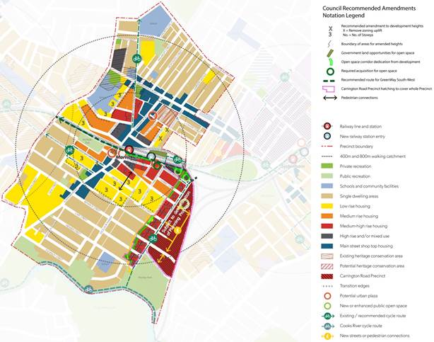
Figure 8 – Council Marked Up Plan for the Marrickville Station Precinct
11.3 Dulwich Hill Station Precinct
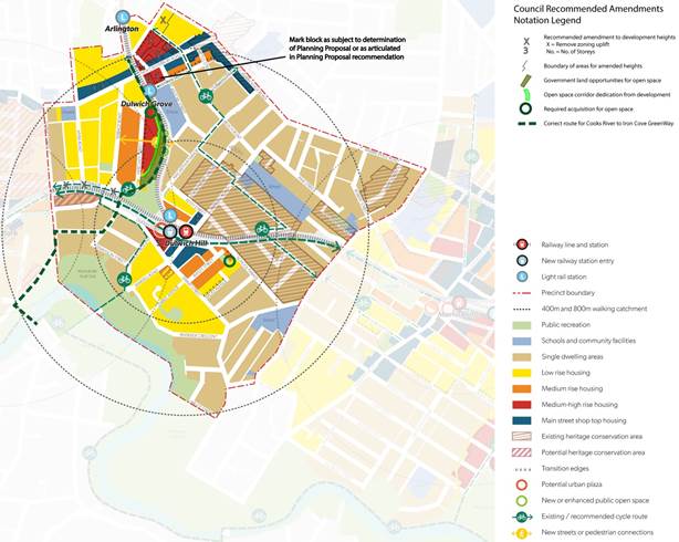
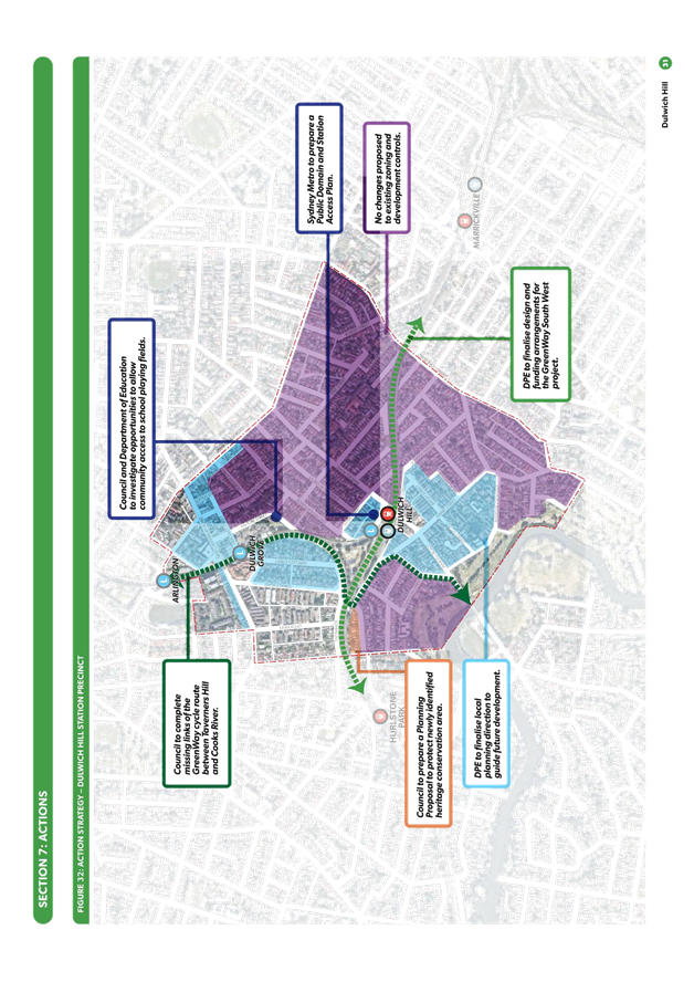
Figure 9 – Council Marked Up Plan for the Dulwich Hill Station Precinct
6. FINANCIAL IMPLICATIONS
The Sydenham to Bankstown Urban Renewal Corridor Strategy is a NSW Government project. There are no financial implications for Council at this stage.
7. OTHER STAFF COMMENTS
The revised draft Strategy for the Sydenham to Bankstown Urban Renewal Corridor was referred to the relevant sections of Council for their consideration. Their referral responses and the issues they raised in relation to the revised draft Strategy have been incorporated into the draft submission.
8. PUBLIC CONSULTATION
The DPE is responsible for the public exhibition of the revised draft Strategy for the Sydenham to Bankstown Urban Renewal Corridor Strategy. The revised draft Strategy was released for public comments in June 2017. The exhibition period closed on 3 September 2017.
However as detailed previously, the DPE has granted the Inner West Council (IWC) additional time to provide its detailed submission to enable the matter to be reported to the newly elected Council.
In the interim, and following the public meeting held on 10 August 2017, Council’s Interim General Manager submitted a letter to the DPE outlining key concerns with the revised draft Strategy and provided a summary of matters raised by the community at the public meeting.
9. CONCLUSION
Whilst a number of amendments have been made from the initial draft Strategy, which will have a positive local impact including the retention of high quality character areas, Council continues to have concerns with a number of other matters contained within the revised draft Strategy.
Council officers have carried out a detailed assessment of the revised draft strategy and have identified a number of issues and concerns. Officers have recommended that a number of amendments be made to the revised draft Strategy to address those concerns and issues.
Officers have prepared a draft submission for Council’s consideration and that submission is attached as ATTACHMENT 4.
|
1.⇩ |
Marrickville Council Submission (Dec 2015) on initial draft 2015 Strategy |
|
2.⇩ |
Initial Council submission (6 Sept 2017) on revised draft 2017 Strategy |
|
3.⇩ |
Selected pages from revised draft 2017 Strategy |
|
4.⇩ |
Draft Council submission on revised draft 2017 Strategy |
|
Council Meeting 12 October 2017 |
Subject: Planning Proposal Snapshot of 4-38 Carrington Road, Marrickville
File Ref: 17/4718
Prepared By: Katie Miles - Strategic Planner
Authorised By: Gill Dawson - Group Manager Strategic Planning
|
SUMMARY On 22 May 2017, Council received a Planning Proposal for the site known as 4-38 Carrington Road, Marrickville. The Planning Proposal seeks to amend Marrickville Local Environmental Plan (MLEP) 2011 as follows:
· Rezone the IN1 General Industrial zoned land to part B2 Local Centre and part R4 High Density Residential; · Impose varied maximum building height development standards for the site of 25 metres, 50 metres up to a maximum height of 105 metres; and · Increase the floor space ratio (FSR) development standard from 0.95:1 to 3.15:1.
The purpose of this report is to provide an overview of the Planning Proposal for Council's information. Please note that Council officers have undertaken a preliminary assessment of the proposal and advised the proponent in a letter of the additional information required. A further report will be provided to Council once additional information from the Proponent has been received and a detailed assessment of the proposal has been carried out.
|
|
RECOMMENDATION
THAT Council receives and notes this report.
|
BACKGROUND
The Planning Proposal at 4-38 Carrington Road, Marrickville, was lodged with Council on 22 May 2017. It seeks to rezone 7.8 hectares of IN1 General Industrial to part B2 Local Centre and part R4 High Density Residential under the Marrickville Local Environmental Plan 2011. The justification for the Planning Proposal is reliant upon the NSW Government's Draft Sydenham to Bankstown Urban Renewal Corridor Strategy, and the former Marrickville Council's Employment Lands Study 2008, prepared by SGS Economics and Planning.
The Planning Proposal also seeks to impose a varied maximum building height development standards of 25 metres to 105 metres (up to 35 storeys assuming a floor to floor height of 3 metres), and increase the FSR development standard from 0.95:1 to 3.15:1 across the entire site. This will facilitate approximately 2,616 new dwellings and 17,306m2 of non-residential floor area (consisting of 10,257m2 of commercial floor area and 7,049m2 of retail floor area). However, it will remove approximately 63,630m2 of existing industrial floor area.
Current Status:
Council officers from various sections of Council and NSW Roads and Maritime Services (RMS) have carried out a preliminary assessment of the proposal. The preliminary assessment has identified that additional information is required to enable a detailed assessment of the proposal. A letter has been sent to the Proponent on 29 September 2017 requesting that additional information and supporting studies be submitted as part of the Planning Proposal to allow for a detailed assessment. A copy of that letter is provided as ATTACHMENT 1.
No voluntary planning agreement (VPA) has been submitted with the Planning Proposal at this stage.
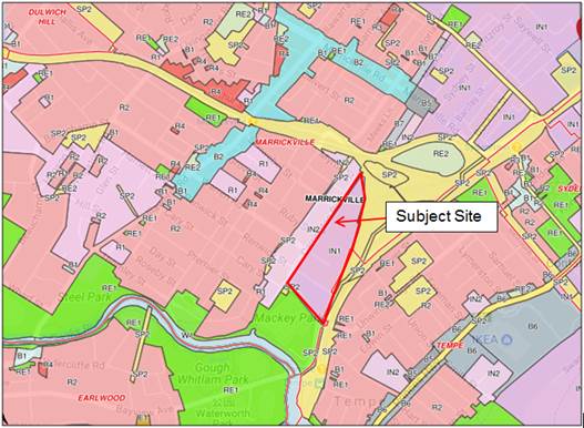
Image 1: Location of 4-38 Carrington Road currently zoned IN1 General Industrial under Marrickville Local Environmental Plan 2011.
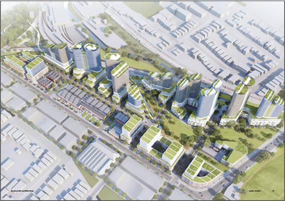
Image 2: Indicative Built Form Layout described by the current Planning Proposal.
Key Issues:
A future report will be provided to Council once additional information from the Proponent has been received and a detailed assessment of the proposal has been carried out. Any future report will critically analyse the Planning Proposal and address the following issues:
· Loss of employment/industrial floorspace including creative industries;
· Inclusion of commercial/retail floorspace away from the local centre;
· Cumulative traffic and transport impacts;
· Flood prone land;
· Heritage and local character area impacts;
· Urban Design;
· Impacts on Sydney Airport height limits (concurrence of Commonwealth required);
· Provision of open space, recreational facilities and local community infrastructure;
· No affordable housing provision has been nominated;
· Environmental and sustainability impacts;
· Land use conflicts and noise/amenity impacts with existing industrial, aircraft noise and freight railway line; and
· Community benefits and a Voluntary Planning Agreement
FINANCIAL IMPLICATIONS
Additional supporting studies will be required for this Planning Proposal and the proponent will need to fund the studies in accordance with Council's Schedule of Fees and Charges.
Council should be aware of the potential cost implications of funding a precinct wide traffic study. Whilst Council can obtain partial funds from developers as part of the Planning Proposal process, this relates only to the impacts of their proposal and cannot be wholly obtained to assess the cumulative traffic/transport impacts of the precinct. Given the ad hoc nature in which Planning Proposals are being lodged, and the absence of a policy to obtain monetary contributions to fund precinct wide traffic studies, Council should acknowledge there is potential that the costs will be borne by Council.
OTHER STAFF COMMENTS
Strategic Planning has issued internal referrals to various sections of Council and also referred the Planning Proposal to RMS for preliminary assessment. The comments raised from this preliminary assessment were detailed in a letter to the proponent. Upon the submission of additional information, Council staff will carry out a full assessment and report the matter to Council.
PUBLIC CONSULTATION
The proponent will be required to provide additional information prior to public consultation on the proposal. A full report will be presented to council in due course that will address public consultation arrangements.
CONCLUSION
Council has received a Planning Proposal for the site known as 4-38 Carrington Road, Marrickville. The Planning Proposal seeks to amend Marrickville Local Environmental Plan 2011 by rezoning the land, impose a varied building height development standard and increase the floor space ratio development standard.
The purpose of this report is to provide an overview of the Planning Proposal for Council's information. The Planning Proposal will be reported back to Council in the future once a detailed assessment of the additional information as part of the proposal has been carried out.
|
1.⇩ |
Request for Additional Information Letter - PPLN201700003 - 4-38 Carrington Road Marrickville |
|
Council Meeting 12 October 2017 |
Subject: MERGER IMPLEMENTATION
File Ref: 17/4718
Prepared By: Nellette Kettle - Group Manager Integration, Customer Service and Business Excellence
Authorised By: Rik Hart - Interim General Manager
|
SUMMARY This report provides the elected Council with an overview on the progress to date with the merger implementation, including the governance framework, achievements, key risks/challenges and upcoming priorities.
Overall, significant progress has been made in the last year as outlined in the report and importantly community satisfaction with Inner West Council has remained high.
Notwithstanding the significant progress, it is important to be mindful that the task of creating a new organisation from three merged entities is complex, taking several years to complete.
|
|
RECOMMENDATION
THAT the report be received and noted and that Council is provided with a further update on progress with the merger implementation in six months. |
BACKGROUND
Inner West Council was proclaimed on 12 May 2016.
Pre-merger planning
The three former councils were collaborating for several months in the lead up to Proclamation, in the knowledge that a merger was highly probable. A Transition Implementation Group comprising senior representation from each of the former councils was formally established to prepare a Change Management and Transition Plan to support the councils in preparing for change.
The merger occurred several weeks earlier than anticipated. At the time of the Proclamation:
· Due diligence activities were approximately 80% completed
· Comparable service profiles had been developed for all functional areas
· Nine (9) cross-council Project Action Teams were operational and at various stages of planning in the following key areas:
o Governance
o Legal
o Systems
o Workforce management
o Communications
o Finance
o Service delivery (front line)
o Procurement
o Culture/change
Post proclamation - transition
Since the merger, work to create the new Council has been guided by the Integration and Innovation Plan (Attachment 1) which was developed in June 2016 in accordance with Department of Premier & Cabinet guidance for merged councils. This plan identified over 80 actions for the transition phase, covering the period until the return of the elected council.
The Plan was structured around the Australian Business Excellence Framework categories and included actions supporting seven key strategic areas:
· Service integration and review
· Local democracy
· Integrated planning
· Equipping and supporting Council staff to be resilient through change
· Organisational re-design
· Systems integration and transformation
· Organisational development
Throughout the Administration period, monthly reports on progress with the merger implementation were provided to the Implementation Advisory Group (IAG). The IAG was established to oversee the merger implementation and comprised the Mayors and Deputy Mayors of the former councils. The IAG reports are available on Council’s website.
Key achievements
Bringing together the merged Council involves hundreds of actions, some are large multi-year projects and others are smaller discrete tasks. Following is a snapshot of some of the achievements to date:
Service integration and improvement
· Integrated customer service department, with a single consolidated contact centre (located in Petersham) and the majority of transactions enabled at all service centres across the LGA
· New Development Advisory and Assessment Policy aimed at streamlining the assessment process and reducing the time taken for approvals
· Integrated library services, community services, arts and culture and event programming and delivery
· Improved capital works delivery, with the value of works delivered increasing by 25% in the first year and expected to remain at similar levels
· Swimming passes can be used interchangeably across Council operated pools (excludes those in the Marrickville service area which are privately operated)
· Outdoor dining fees have been harmonised via a moratorium to ensure a level playing field for businesses
· Group Managers have commenced undertaking reviews, examining the services currently being provided and the inherited key points of difference in service delivery/standards that will need to be addressed into the future (e.g. waste services, resident parking scheme differences)
Supporting local democracy
· Local Representation Advisory Committee and Implementation Advisory Group comprising former Councillors convened during the Administration period to provide continued community representation
· New community engagement framework implemented
· Eight Strategic Reference Groups established and meeting bi-monthly (Environment, Social Inclusion, Transport, Economic Development, Housing and Affordability, Young Leaders, Planning and Heritage, Aboriginal and Torres Strait Islander)
· Live online broadcasting of Council meetings providing increased transparency
· Public meetings on key issues, such as WestConnex and Sydenham to Bankstown urban renewal
Integrated planning
· Interim Statement of Vision and Priorities developed with community input
· Fully integrated Operational Plan and Budget for 2017/18
· Community Strategic Plan under development
Organisational development and equipping and supporting staff through change
· Organisational values developed and launched
· Regular HR and Integration staff roadshows
· Regular General Manager face to face staff talks
· Periodic resilience training for staff
· Training and support in applying for jobs, interview skills and resume writing
· High performance leadership program being rolled out across the organisation, with the Executive, Group Managers, Managers and now Team Leaders completing the six month program, comprising a variety of self-leadership modules
· Quarterly Leadership Team strategic planning workshops
Organisational re-design
· Organisational structures completed for 13 of the 18 Service Units
· To date, 161 staff have been moved into the permanent structure, with many more roles under active recruitment
· Co-location of all indoor staff (approximately 600 people) completed
Systems integration and transformation
· Dark fibre connection established between Service Centres
· Network and active directory integration completed
· Contract executed with TechnologyOne to deliver integrated enterprise system, One Council. First release, finance and procurement, implemented in July 2017. Planning and development work for Release 2 currently underway
· Skype for business implemented across primary sites
· Customer contact centre technology standardised and upgraded and Q-flow ticketing introduced at Customer Service Centres
· Organisational roll out of business process mapping software (Promapp) underway
Key upcoming priorities
Many integration projects are still in flight across the organisation. Significant projects that are underway and yet to be completed include:
· The TechnologyOne, One Council implementation. This is the single largest integration project and is a new enterprise wide system, touching all areas of the Council. The two year implementation program is on track to be completed in December 2018 and will see most Council functions operating out of a single integrated system, including core functions such as customer request management, rates, development applications, financial reporting and management of community assets. Having one integrated system reduces costs and ensures proper and full integration across functions, as well as expanded opportunities for online services, that would be difficult and costly otherwise. Another important benefit of the One Council system once fully implemented, will be access to real time information live on Council’s website, enabling residents to track the progress of their service requests live, increasing accountability and transparency. One Council is being implemented in five release stages. The first release, supporting integrated financial management and procurement across the Council was completed in July 2017. The second release, supporting HR (organisation management) and payroll will be implemented in March 2018, followed by release three, enterprise asset management in May 2018.
· Improving the quality and useability of financial data. Whilst at the organisational level Council now has a fully integrated budget and financial management system, the next step in maturity is to fully align all aspects of the budget accurately into the new organisational Service Unit structure so that the full cost of individual services to the community can be accurately established. This refinement process will be iterative and will also enable accurate dashboard reporting via the website in the near future.
· Finalisation of organisation structures. The process of determining new permanent organisation structures and migrating staff to the new structure has been a lengthy one involving extensive staff consultation at all stages of the process. Council has been fortunate to have the support of a very effective Joint Staff Consultative Committee that has worked incredibly hard and in cooperative partnership with management to achieve quality organisational outcomes with the least amount of disruption and anguish for our staff, who have been, and are still, undergoing an enormous amount of change. Work on permanent organisational structures commenced in September 2016 and is still in train. To date, full structures have been finalised for 13 of the 18 Service Units, and populated as follows:
o Level 1 – Interim General Manager (completed September 2016)
o Level 2 – Deputy General Manager’s (completed November 2016)
o Level 3 – Group Managers (completed March 2017)
o Level 4 – Managers (85% completed)
o Level 5 – Team Leaders/Coordinators/Supervisors (25% completed)
o Level 6/7 – Operational staff (15% completed)
The organisational structures are expected to be completed by the end of 2017.
· Co-location of depot staff. Staff consultation has been completed and the commencement of co-location of outdoor teams into their Service Unit groupings will commence October/November 2017. This will involve a change in the base work location of approximately 80 outdoor staff, as well as related plant and equipment (60 items) across the current four depot sites (St Peters, Summer Hill, Leichhardt and Balmain). This is the final stage in the staff re-location program and enables the integration of the outdoor teams to commence, including having outdoor teams in the same base locations as their team leaders and supervisors and pooling plant and equipment.
· Service review and harmonisation. Formal service reviews were not undertaken during the Administration period on that basis that the elected Council should decide any changes to services and service levels. The pace of service integration and harmonisation work will accelerate over the next year as teams define new operational processes and policies following co-location. Furthermore, there are key differences in service levels in some areas that will need to be worked through over time in consultation with the elected Council, such as waste services, resident parking scheme requirements and verge mowing.
· Development of the new Community Strategic Plan. This work is well underway following extensive community engagement and must be completed by 30 June 2018. A draft CSP will be presented to Council at an upcoming meeting.
· Integrated Local Environmental Plan. This is a three to four year project, with detailed project planning to commence in the next few months. In the interim, Council will continue to operate under the three existing plans.
· New Inner West industrial agreement and salary structure. Council inherited a disparate mix of EBAs, employment conditions and salary structures with the merger. This situation causes concern for staff because of the inequities, as well as challenges for managers, who are managing teams of staff with very different working conditions. This is a complex and industrially sensitive project that must be planned and executed well in order to deliver sustainable and effective long term outcomes for both the organisation and staff. It will require a collaborative effort between management and the Joint Consultative Committee and staff to deliver sustainable outcomes. This project will commence in 2018, once the process of migrating staff to the new organisation structures has been completed and is expected to take up to two years.
· Realising community benefits of the merger – an important area of focus is on continuing to deliver the community benefits that can be derived from our increased scale and capacity as a larger and more influential Council. This is particularly important in relation to major State policy and projects, such as WestConnex, Sydenham to Bankstown corridor, Parramatta Road revitalisation, Bays precinct etc.
Organisational governance – Project Management Office (PMO)
The merger implementation has been coordinated and overseen by a purposefully established Integration Team.
The Integration Team comprises a small project management office (PMO) of six staff (with project management, change management and business analysis capabilities) to support a decentralised integration model that drives full accountability to Group Managers for integration and business as usual operations in their area of responsibility.
The PMO has developed a framework to manage the vast amount of integration activity that is occurring across the organisation to:
· enable an overarching view of the transformation of Inner West Council;
· identify, scope and deliver integration projects;
· align scope and organisational capacity;
· identify and manage interdependencies between projects;
· manage risk; and
· monitor and report progress.
Throughout 2017, the Integration and Transformation Program has gained momentum, with 190 projects in scope spread over a 5 year delivery period across three streams:
· Stream 1: TechnologyOne Implementation – the single largest integration project comprising a suite of corporate applications to integrate and streamline operations
· Stream 2: Corporate Priority Projects – critical projects affecting all areas of Council (e.g. co-location, integrated financials, organisational restructure)
· Stream 3: Service Unit Integration Projects – critical projects that are focussed on integrating and improving the operations of each individual Service Unit
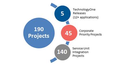
A total of 33 projects of ranging complexity have been successfully delivered to-date under the program, with 85 projects currently in progress.
Risk management
Risk identification and mitigation has been at the forefront of planning since the pre-merger phase, and continues to be a key focus area for the Integration PMO and the enterprise risk team.
The Integration and Innovation Plan identified seven risks to the implementation process, as well as strategies to mitigate them where possible. The identified risks were:
· Community is unaccepting of the new Council
· Loss of local community representation and identity in a larger Council
· Lack of continuity in service delivery
· Failure to resource and deliver business integration with business as usual activities
· Savings from the merger are not realised and costs are recognised
· Opportunities for improvement and innovation are not realised
· Loss of key staff during the implementation period
Through extensive ongoing efforts from staff across the organisation we have been able to minimise these risks to extent that they have had little overall impact on the success of the merger. Indeed, it is both pleasing to see and testament to the work of Council staff that community surveying has indicated that community satisfaction has risen in the first year and remains very high at with 90% of respondents at least somewhat satisfied with Council’s overall performance.
Challenges
Implementing a merger of three organisations without dropping the ball on business as usual service delivery is incredibly challenging, especially as it is widely known that productivity and morale decline during times of high organisational change. Council staff have been experiencing, and will continue to experience for some time yet, a complex high change environment. What makes this change more complicated and unique is that it will be constant over a 2-3 year period and all the core components that bring together an organisation have or will be changing - such as leadership, strategic direction, the organisational delivery model (Service Units), organisational structure, systems in use, business processes, people’s roles, work locations, pay and conditions.
The success that has been achieved to date has only been possible for the contribution of every staff member and is testament to the calibre of staff at Inner West Council, their teamwork, professionalism, capabilities and commitment to the organisation and the Inner West community.
Some of the key challenges include:
· Change fatigue – our staff have been through a lot of change since the merger, including two Interim General Managers in a short space of time with very different organisational approaches, obtaining a role in the new organisation, moving work locations, settling into new teams, and beginning to learn new systems and ways of operating, all whilst striving to deliver services as usual to the community. There is still a lot of change to come, especially in the technology space and along with that, business processes. Some of our teams in particular, such as Human Resources and ICT are at the forefront of many change projects and are under unusual levels of pressure. Accordingly, the pace at which change can occur needs to be delicately balanced across a range of factors including both organisational capacity to deliver and to absorb the change that is underway.
· Prescribed processes – some changes need to be done quickly in order to avoid long periods of uncertainty and anticipation for staff. Sometimes the processes that Council must follow by legislation in the post-merger environment, slow down the pace of change and have unintended consequences. For example, the time taken to complete the prescribed processes for recruitment, which have desirable intentions to ensure proper process and fairness, cause delays and prolonged uncertainty for staff, as it takes up to 12 weeks before they can be placed in a role. These processes are both important and necessary, but are why it has taken over 12 months to fill the organisation structure.
· Integrated communication and ICT systems – it cannot be over emphasised how critical ICT infrastructure is to the successful operation of the merged Council and to delivering operational efficiency and service improvements. The new TechnologyOne system will deliver many benefits over time, including an integrated business applications platform, real time customer information and enhanced e-business capability, however it takes several years to implement and realise the benefits of large scale ICT transformations. The challenge in the short term is operating out of the many disparate legacy systems that still need to be supported and used in the interim. Obtaining accurate, consistent and timely management information is challenging at present and requires significant manual data manipulation from multiple systems.
· Differing employment conditions – now that teams are co-located and integrating their operations, the impact of the different employment conditions is magnified, when people are sitting side by side, sometimes in exactly the same role, with different employment conditions, such as working hours, shift patterns and break times). Rostering and assembling work crews is very challenging in these circumstances. The impact of these differences needs to be carefully managed in the intervening period until the new Inner West industrial framework is finalised. The challenges that this environment creates for the Human Resources Department at an incredibly demanding time in the organisation’s development are also significant.
· Balancing transforming and delivering business as usual – all organisations face the pressures of balancing the successful delivery of business as usual whilst also working to improve the organisation and services at the same time. This challenge is magnified in the post-merger environment simply due to the magnitude of change that is necessary over a relatively short period of time and the reach of those changes across the organisation.
Stronger Councils measures
The Office of Local Government is measuring newly merged councils against a number of success indicators. For Inner West Council, these are shown in the table below. It is expected that Council will need to report on these indicators at least annually.
|
Indicator |
Progress |
|
Net financial savings (NPV) of $60 million over 10 years included in Council’s financial forecasts |
These savings figures are based on the KPMG merger savings commissioned by the Department of Premier & Cabinet.
Council is on track to realise these gross savings of $60m over 10 years, through:
· Savings in senior staff costs ($1.5m p/a) · Savings in insurances ($980k p/a) · Savings in Councillor fees ($350k p/a) · Savings in SSROC fees ($100k p/a) · Expected savings through more effective/scaled procurement (est. $1.3m) It is important to stress that the net savings will be less, due in particular to some short to medium term inflexibilities. These include: employee cost restraints associated with the 3 and 5 year job protections and the impact of rising salaries due to the substantially different salary bases of the former councils.
Other short term constraints include merger costs, including additional ICT costs associated with upgrading to a common hardware and operating platform, as well as maintaining dual sets of software licenses for legacy systems throughout the TechnologyOne implementation period.
A report on the merger costs will be presented to Council later in October.
|
|
Improved community satisfaction index score for Council’s overall performance
Improved community satisfaction index score for Council’s community consultation and engagement
Improved satisfaction index score for community confidence with Council’s integrity and decision making |
A benchmark Community Satisfaction Survey was undertaken in October 2016. The sample consisted of a total of 1,008 residents with key objectives of the research including:
· Assessing and establishing the community’s priorities and satisfaction in relation to council activities, services, and facilities · Identifying the community’s overall level of satisfaction with Council’s performance · Identifying the community’s level of agreement with prompted statements surrounding wellbeing/connectedness · Identifying methods of communication and engagement with Council 85% of residents were at least ‘somewhat satisfied’ with Council performance, of which 51% were satisfied to very satisfied.
The survey was repeated in July 2017 with overall satisfaction increasing by 5% to 90%.
In the 2106 survey, 58% of residents rated Council’s community engagement as ‘good’ to ‘excellent’. This figure remained steady at this level in 2017.
In 2016, 70% of residents were ‘somewhat satisfied’ to ‘satisfied’ with Council’s integrity and decision making. This increased to 75% in the 2017 survey.
|
|
5 year costed capital renewal works program adopted by June 2017 |
A four year funded capital expenditure program is contained in the 2017/18 Operational Plan and Budget. The fifth year is currently in draft.
|
|
Increased proportion of staff who feel the organisation has a positive future and are committed to its success |
An initial staff survey was undertaken in late 2016 with mixed results. Staff focus groups have since been held to evaluate the results and to identify improvement actions.
It is planned to undertake further assessment of staff sentiments to obtain measures of engagement and positivity in November 2017.
As recruitment to the permanent structure progresses, providing more certainty and a stronger sense of team, and the benefits of team co-location and systems integration take hold, it is anticipated that positive staff sentiment has increased.
|
|
Diversity of representation at engagement forums and on strategic reference groups (SRGs)
|
Following an extensive EOI process, the following eight Strategic Reference Groups were created in February 2017:
· Young Leaders Reference Group · Social Inclusion Strategic Reference Group · Economic Development Strategic Reference Group · Housing and Affordability Reference Group · Transport Strategic Reference Group · Environment Strategic Reference Group · Planning and Heritage Strategic Reference Group · Aboriginal and Torres Strait Islander Reference Group
Across the groups there is a good mix of new representatives and previous committee members. Care was taken to ensure the membership of each SRG drew broadly from across the new larger LGA. The SRGs are meeting regularly and are functioning well. The effectiveness of the SRGs is due to be reviewed after one year of operation in February/March 2018.
|
|
90% of housing development applications determined within 40 days
|
Council has fundamentally reformed its Development Application system to improve the customer experience.
In May 2017, Council adopted a new Development Advisory and Assessment Policy which focuses on a consistent and improved pre-DA process in order that applications lodged are complete, ‘approvable’ and less likely to generate substantial objections from neighbours and the broader community.
While the policy and changes to practice have only been in place a short time, we are already seeing positive signs.
It is relevant to note that the NSW Government has changed its definition of what constitutes a ‘housing approval’, to an extent that the target not only captures a very small percentage of Council’s approvals and is no longer the key metric of performance in development assessment. Rather, Council continues to reduce its average processing time for all applications. Council’s average DA processing time reached a peak of 113 days for the month of January 2017, with this figure reduced to an average of 81 days in August 2017.
Overall, we have reduced backlog applications older than 120 days by 55% and those over 40 days by 33% since 1 January 2017. |
|
Increased number of online transactions
|
Legacy websites continue to operate with equal opportunity for online transactions as offered pre-merger. The Technology One E-Business Module will provide increased opportunity for online transactions and is scheduled for completion at the end of 2018.
Customer uptake of available online services has continued to grow, with over 88,000 transactions during 2016/17, which was a 186% increase over the previous year.
|
|
Number of initiatives with NSW Government agencies and others on identified priority issues |
With Council’s new larger scale concerted efforts are being made to influence key policy, planning and infrastructure decisions. Notable inroads have been made in a number of areas to date, including:
WestConnex Council has advocated a mature two-part approach. With almost 60 per cent of the community opposing WestConnex (Micromex, 2016), Council’s principal position has been opposition to the project given our strong view that urban motorways are an outmoded transport option. However, recognising that the project is under construction, Council has been interventionist in trying to get improved management of construction and other impacts on residents. The monthly WestConnex Community Liaison Forum has ensured that impacted residents have had access to key regulatory authorities, such as the Department of Planning & Environment and EPA.
Council has also achieved a number of significant improvements for the community from the project rollout, including obtaining a dedicated in-house Compliance Officer who is working hard to ensure the project complies with its conditions of approval; gaining a guarantee that all residual lands associated with the project will be given back to the community; securing undergrounding of the proposed Rozelle interchange; and abandonment of plans for what would have been a highly invasive construction dive site next to Sydney Secondary College at Leichhardt.
Council pushed hard for the establishment of the State Government’s WestConnex Community Reference Group, but in reality it is delivering little benefit for residents due to Sydney Motorway Corporation’s failure to bring appropriate technical level representation to the meetings and to engage proactively on how the project’s significant impacts might be better managed.
Parramatta Road Guided Electric Transport (GET) In late 2016, the State Government released ambitious renewal plans for Parramatta Road which included 27,000 new homes and 50,000 new jobs; without a proper public transport solution, the Government only committing to a rapid bus system.
Council, in conjunction with the City of Canada Bay Council, undertook a public transport options study for Parramatta Road which conclusively demonstrated that the proposed State Government option of reliance on diesel-fuelled buses did not represent an appropriate transformative transport solution. Council’s study instead recommended the introduction of a Guided Electric Transit System (GETS), leading technology which is increasingly being introduced in many European and North American cities. The technology has many similarities to and advantages of light rail, but without the high construction and disruption costs. In a big win for Council, arrangements are being finalised with the State Government to undertake a joint preliminary feasibility study into the proposal. · Affordable Housing One of the most critical issues facing the Inner West is lack of affordable housing, with the traditional demographic of the Inner West struggling to find affordable rental housing. Following extensive community consultation on a draft Affordable Housing Policy which was strongly supported by the community, Council introduced its city-leading policy in March 2017. The policy is strongly founded on economic viability principles and targets the gain in land value achieved when land is rezoned to a higher density residential use. It requires 15 per cent of units on large private sector sites to be provided for affordable housing and 30 per cent on government sites.
Council is currently working with the Department of Planning and Environment to obtain recognition of the policy in State Environmental Planning Policy (SEPP) 70 – Affordable Rental Housing, which would enable a transparent and streamlined approach to the delivery of affordable rental housing.
Protection of our urban forest Another area where Council has made inroads is in the protection of our street trees. Last winter Ausgrid and its contractors performed a very significant cut to many of our local trees. There was widespread community concern resulting in over 100 complaints. As a result of meetings between Council and Ausgrid’s CEO, Ausgrid has agreed to and is currently implementing a much reduced cut this winter, as well as committing to work with Inner West Council on a bespoke approach to our street trees in the future.
Completing the Greenway Council has also been successful in securing a substantial boost to funding of the Cooks River to Iron Cove Greenway. Early in the term of Administration, Council secured a commitment of $7.25 million from Transport for NSW. This was matched by a $7.25 million commitment by Council, enabling completion of the remaining 3.2 kilometres of the Greenway shared path, from Parramatta Road to the Cooks River, by 2021. This is a long delayed and much needed outcome that the community and former councils had been campaigning for over a decade. · |
|
Increased proportion of staff who believe in the values of the organisation |
Council’s FIRST Organisational Values – flexibility, integrity, respect and spirit of team - were launched in April 2017. The planned staff engagement survey to be conducted in November 2017 will provide a baseline measure of the percentage of staff who believe in the values.
|
FINANCIAL IMPLICATIONS
Council has requested a report on the costs of the merger. This report will be provided to the next Ordinary Council Meeting on 24 October 2017.
OTHER STAFF COMMENTS
This report reflects the contributions of Council staff across all Service Units.
PUBLIC CONSULTATION
Not applicable. This report is available to the community on Council’s website.
CONCLUSION
Significant progress has been made in the last year as outlined in the report. It has been an incredibly busy and challenging period for Council staff, who have been juggling a merger implementation and delivering services as usual. It is particularly pleasing to note that there have been no significant service disruptions and that community satisfaction with Inner West Council has not only remained high, but improved.
Notwithstanding the significant progress, it is important to be mindful that the task of creating a new organisation from three merged entities is complex and will taking several years to complete.
|
1.⇩ |
Integration and Innovation Plan June 2016 |
|
Council Meeting 12 October 2017 |
Subject: Administrator's End of Term Report
File Ref: 17/4718
Prepared By: Ian Naylor - Manager Civic and Executive Support
Authorised By: Tanya Whitmarsh - Group Manager Governance
|
SUMMARY To provide Council with the Administrator’s End of Term Report published on Council’s Website in August 201 . |
|
RECOMMENDATION
THAT Council receive and note the Administrator’s End of Term Report. |
BACKGROUND
The Administrator published an End of Term report in August in 2017 outlining the achievements of the Council during the term of the Administrator, a copy of the report is shown as Attachment 1.
FINANCIAL IMPLICATIONS
Nil.
OTHER STAFF COMMENTS
Nil.
PUBLIC CONSULTATION
Nil.
CONCLUSION
Nil.
|
1.⇩ |
Administrator's End of Term Report |
|
Council Meeting 12 October 2017 |
Subject: 2017/18 Budget and 2018/19 Budget Process.
File Ref: 17/4718
Prepared By: Pav Kuzmanovski - Group Manager Finance
Authorised By: Michael Tzimoulas - Deputy General Manager Chief Financial and Administration Officer
|
SUMMARY The purpose of this report is to outline the process undertaken to develop 2017/18 Budget and 2018/19 Process. |
|
RECOMMENDATION
THAT Council receive and note 2017/18 Budget and 2018/19 Budget Process.
|
BACKGROUND
The 2017/18 Council budget was an amalgamation of the Year 2 of the constituent Council’s (former Ashfield, Leichhardt and Marrickville) respective Long Term Financial Plans. During 2017/18 financial year, Council was required to develop only a one year Operational Plan (one-year budget and service unit outcomes) and work with Councillors post-election to develop the CSP and Long Term Financial Plan (LTFP) starting from 2018/19.
DISCUSSION
The adopted 2017/18 budget incorporates the following reserve structure:
· Statutory Reserves required by legislation. These are referred to as “externally restricted”;
· Internally restricted funds: these are funds quarantined to maintain cash for items such as employee leave liability or monies held in advance for hire of Council property etc; and
· Working Funds: these are funds allocated within the LTFP to specific budgeted items.
The draft balances of these reserves (subject to audit clearance) are as follows as at 30 June 2017:
|
Reserve |
Amount ($M) |
|
Externally Restricted - S94 Develop Contributions |
$58 |
|
Externally Restricted - Unexpended Grants |
$25 |
|
Domestic Waste |
$17 |
|
Externally Restricted - Other Externally Restricted |
$6 |
|
Internally Restricted - Employee Leave Entitlement |
$33 |
|
Internally Restricted – Deposits and Bonds |
$12 |
|
Internally Restricted – Other |
$3 |
|
Working Funds |
$50 |
|
Total |
$204 |
As a part of this process, Council’s has fully funded its Employee Leave Entitlement (previously only partly funded – approximately 50%).
The tabled working funds have been fully allocated to fund capital renewal works in the coming financial years. Any additional initiatives that are incorporated into either the 2017/18 or 2018/19 budget (through a Council resolution) will need to either need to identify a new revenue source, financial saving or reduction in expenditure to fund the proposed initiative.
The 2018/19 Operating and Capital budgets will require Council to adopt a financially sustainable budget that will form a part of the Integrated Planning and Reporting (IPR) framework that includes the Community Strategic Plan (CSP), Delivery Program (4-year outlook), Operational Plan (1-year outlook) and Resourcing Strategy. The Resourcing Strategy will consist of a Long Term Financial Plan, Asset Management Plans (by asset class), Workforce Plans and ICT Strategy.
The 2018/19 budget will see the development of the first LTFP that will document the short, medium and long term financial sustainability of Council and its ability to deliver services into the future. The starting point of the LTFP will see the 2017/18 budget roll into 2018/19 budget (as business as usual) that will form the initial baseline budget. In refining the 2018/19 budget, the considerations need to prioritized:
- Harmonization of Service Levels across Council
- Harmonization of Fees and Charges across Council
- Development of revised strategies and policies
- Continual integration of Service units to ensure effective utilization of resources
Councillors will be responsible for determining service levels and also ensuring that services levels are set in a way that they do not have an impact on Council’s financially sustainability at any stage during the LTFP.
The current capital program is approximately $65 million with cash flow reviewed on a quarterly basis. Council is currently seeing the delivery of a number of large scale capital projects such as Ashfield Pool, Marrickville Hospital Site and Ashfield Town Centre along with the implementation of projects from the Stronger Communities Fund. Over the next 2-3 years, as these projects are completed, Council will see core levels of capital expenditure return to approximately $40 -$50 million funded from a number of funding sources.
Capital budgets will be developed with the following principles to allow realistic delivery of projects with minimal funds carried forward to fund uncompleted works:
- Year 1 – Scoping and Engagement
- Year 2 – Design
- Year 3+ - Construction
This will ensure that Council delivers on its outcomes in the Operational Plan and Delivery Program.
Council will need to work with the community to identify an agreed Asset Management service level in order for the Inner West to determine and calculate its infrastructure backlog as part of the development of the 2018/19 Asset Management Plan.
FINANCIAL IMPLICATIONS
Nil.
OTHER STAFF COMMENTS
Nil.
PUBLIC CONSULTATION
Nil.
CONCLUSION
Nil.
|
|
Council Meeting 12 October 2017 |
Subject: Local Government NSW Annual Conference
File Ref: 17/4718
Prepared By: Ian Naylor - Manager Civic and Executive Support
Authorised By: Tanya Whitmarsh - Group Manager Governance
|
SUMMARY The purpose of this report is to advise Council of the Local Government NSW Annual Conference to be held in Sydney from 4-6 December 2017. It is recommended that Council nominate Councillors who wish to attend the Conference, consider any motions to be put forward to the Conference and receive a further report on motions and voting delegates at 24 October Council Meeting. |
|
THAT Council:
1. Nominate Councillors to attend the 2017 Local Government NSW Conference; 2. Consider motions to be submitted to the Conference; and 3. Receive a further report on 24 October on voting delegates and adopting motions for the Conference. |
BACKGROUND
The Local Government NSW Conference is the annual policy-making event for NSW general-purpose councils, associate members and the NSW Aboriginal Land Council. It is the pre-eminent event of the local government year where local councillors come together to share ideas and debate issues that shape the way we are governed. This year’s Conference will be held at the Hyatt Regency Sydney from 4-6 December 2017. A copy of the Draft Program is shown as Attachment 1.
Registration
The deadline for early bird registration for the Conference is 23 October 2017. The cost for registration is $899 per person. The Expenses and Facilities Policy for Councillors makes provision for Councillors to attend this Conference and to reimburse partners of Councillors to attend the official Conference Dinner. Partners may also attend other functions and business session of the Conference at their own cost.
Accommodation and Travel Expenses
As the Conference is being held in Sydney, accommodation will not be provided for in accordance with the Expenses and Facilities Policy for Councillors. Travel expenses to and from the Conference will be reimbursed in accordance with the Expenses and Facilities Policy for Councillors.
Voting Delegates
Council is entitled to a number of voting delegates who will be entitled to vote on the motions discussed during the Conference. Local Government NSW has advised that they will inform each council of the number of voting delegates they are eligible to have on 13 October. A further report will be prepared for 24 October Council Meeting to consider voting delegates for the Conference.
Motions
Motions may be submitted for debate at the Conference that meet the criteria shown below. The deadline for submission of motions is 6 November 2017. A further report will be submitted to the 24 October Council Meeting to consider any motions to be submitted to the Conference.
Local Government NSW have advised that in order to be considered for the Conference motions must meet the criteria shown below and be different to motions raised at the 2016 Annual Conference. A copy of the Action Report for the 2016 Conference is shown attached as Attachment 2.
The Local Government NSW Board has resolved that motions will be included in the Business Paper for the Conference only where they:
1. are consistent with the objects of the Association (see Rule 4 of the Association’s rules);
2. relate to Local Government in NSW and/or across Australia;
3. concern or are likely to concern Local Government as a sector;
4. seek to advance the Local Government policy agenda of the Association and/or improve governance of the Association;
5. have a lawful purpose (a motion does not have a lawful purpose if its implementation would require or encourage non-compliance with prevailing laws);
6. are clearly worded and unambiguous in nature; and
7. do not express preference for one or several members over one or several other members.
Reasons for a motion to be excluded:
Please note the Board will not include motions in the Business Paper which do not advance the local government policy agenda. Therefore a motion will not be included if it is operational, rather than strategic; not local government business; focused on a local issue only or if the motion is consistent with longstanding actions of LGNSW and the Local Government and Shire's Association.
Further, for a motion to be included in the Conference Business Paper the submitting member needs to provide accompanying evidence of its support for the motion. Such evidence may include an extract of the minutes of the meeting at which the member resolved to submit the motion for consideration by the Conference.
FINANCIAL IMPLICATIONS
There is money allocated in the 2017/18 Budget for attendance by Councillors at the Local Government NSW Annual Conference, including registration fees and travel costs.
OTHER STAFF COMMENTS
Nil
PUBLIC CONSULTATION
Nil
CONCLUSION
Nil
|
1.⇩ |
Local Government NSW - Annual Conference 2017 - Draft Program |
|
2.⇩ |
2016 Annual Conference Action Report |
|
Council Meeting 12 October 2017 |
Subject: Panel of Code of Conduct Reviewers
File Ref: 17/4718
Prepared By: Ian Naylor - Manager Civic and Executive Support
Authorised By: Tanya Whitmarsh - Group Manager Governance
|
SUMMARY Council at its Meeting of 21 September resolved to defer this matter to allow for background information on applicants to be provided to Councillors. This background information has been circulated separately to Councillors as it was provided to a third party as part of a confidential expression of interest process.
This report addresses the need to appoint a panel of independent conduct reviewers as required under Council’s Code of Conduct and pursuant to provisions under sections 440 and 440A of the NSW Local Government Act 1993. |
|
RECOMMENDATION
THAT Council appoint as its Code of Code of Reviewer Panel for a period of 4 years (expiring on 21 September 2021) the following:
|
BACKGROUND
In accordance with Procedures for the Administration of the Model Code of Conduct for NSW Local Councils issued by the Office of Local Government, Council must appoint a panel of conduct reviewers who can review complaints made under Council’s Code of Conduct. The term of the current panel of conduct reviewers expired in July, therefore Council needs to appoint a new panel of conduct reviewers.
During May 2017, SSROC undertook an expression of interest and evaluation process to establish a panel of conduct reviewers for member councils. The evaluation panel consisted of two governance professionals from member councils and one SSROC representative. In assessing the submissions received, the evaluation panel gave consideration to the
· skills of the individuals / organisations to review complaints made under the Code of Conduct
· criteria for conduct reviewers detailed in the Model Code of Conduct
· need to offer to Councils a wide range of expertise
· skills and relative pricing levels that would provide to Councils a range of potential options depending upon the type of review that would be undertaken.
The evaluation panel unanimously agreed that the first 8 individuals / organisations listed in the table included in this report be accepted as members of the Code of Conduct Review Panel for SSROC member Councils.
Council has resolved to enter into a shared service agreement for the provision of an Internal Ombudsman. The Internal Ombudsman will manage code of conduct complaints for Council and refer matters for investigation to one of the 8 individuals / organisations included in the SSROC Panel. However, to receive Code of Conduct complaints the Internal Ombudsman must also be listed as a conduct reviewer on the Inner West Council’s panel of conduct reviewers.
The Internal Ombudsman has been recruited through a competitive process to meet the requirements of the Code of Conduct for the IWC panel of Code of Conduct reviewers. The Internal Ombudsman has been included in the recommended panel of conduct reviewers as shown in the following table.
Proposed IWC Panel of Conduct Reviewers
|
Name |
Organisation |
|
|
|
|
Phil O’Toole |
Centium Group Pty Ltd |
|
Peter Moroney |
Nemesis Consultancy Group Pty Ltd |
|
John Renshaw / Kelvin Kenney |
O’Connor Marsden & Associates Pty Ltd |
|
Wayne Gilbert |
PKF Forensic and Risk Services Pty Ltd |
|
Monica Kelly |
Prevention Partners |
|
Kath Roach |
SINC Solutions |
|
Rob Ryan |
Strategic Risk Solutions |
|
Kathryn Thane |
Train Reaction Pty Ltd |
|
Council’s Internal Ombudsman* |
Internal Ombudsman Service |
* Not part of the SSROC panel of conduct reviewers but added to Council’s panel so that they can manage code of conduct complaints for Council and refer matters for investigation to one of the 8 individuals / organisations listed on the SSROC Panel.
FINANCIAL IMPLICATIONS
If your report has resourcing or budget implications above your current allocation of resources or budget, please contact Pav (x2040) or Caroline Bugg (x2043). Please enter “Nil.” if there are no financial implications.
OTHER STAFF COMMENTS
Nil
PUBLIC CONSULTATION
Nil
|
|
Council Meeting 12 October 2017 |
Subject: Local Traffic Committee Meeting held on 3 August 2017 and 7 September 2017
File Ref: 17/4718
Prepared By: John Stephens - Traffic and Transport Services Manager Wal Petschler
Authorised By: Wal Petschler - Group Manager Footpaths, Roads, Traffic and Stormwater
|
SUMMARY The minutes of the Local Traffic Committee Meeting held on 3 August 2017 and 7 September 2017 are presented for Council consideration. |
|
RECOMMENDATION
THAT the Minutes of the Local Traffic Committee Meeting held on 3 August 2017 and 7 September 2017 be received and the recommendations be adopted with the exception of Item 6 on 3 August 2017 which has been approved by RMS.
|
BACKGROUND
Meetings of the Inner West Council Local Traffic Committee was held on 3 August 2017 at Petersham and 7 September 2017 at Leichhardt. The minutes of the August meeting are shown at ATTACHMENT 1 and the minutes of the September meeting are shown at ATTACHMENT 2.
FINANCIAL IMPLICATIONS
Projects proposed for implementation in 2017/18 are funded within existing budget allocations.
OTHER STAFF COMMENTS
Council should note that, in order to meet the event date for the Dulwich Hill Village Fair 2017, the unanimous recommendation by the Local Traffic Committee on 3 August 2017 concerning Item 6 Marrickville Road, Marrickville – Temporary Full Road Closures for Dulwich Hill Village Fair On Sunday 10 September 2017 was approved by the Roads & Maritime Services, as the approval of the Road Closure could not be exercised under delegations.
PUBLIC CONSULTATION
Specific projects have undergone public consultation as indicated in the respective reports to the Traffic Committee. Members of the public attended the meeting to address the Committee on specific items.
|
1.⇩ |
Minutes of the Local Traffic Committee held on 3 August 2017 |
|
2.⇩ |
Minutes of the Local Traffic Committee held on 7 September 2017 |
|
|
Council Meeting 12 October 2017 |
Minutes of Local Traffic Committee Meeting
Held at Council Chambers, Petersham Service Centre, 2-14 Fisher Street, Petersham
On Thursday, 3 August 2017
Meeting commenced at 10am
ACKNOWLEDGEMENT OF COUNTRY BY CHAIRPERSON
Acknowledgement by Chairperson:
“I acknowledge the Gadigal and Wangal people of the Eora nation on whose country we are meeting today, and their elders past and present.”
|
COMMITTEE REPRESENTATIVES PRESENT |
|
|
|
|
|
Mr George Tsaprounis |
IWC’s Coordinator Traffic Engineering Services, Marrickville (Chair) |
|
Mr Bill Holliday |
Representative for Jamie Parker MP, Member for Balmain |
|
Ms Sarina Foulstone |
Representative for Jo Haylen MP, Member for Summer Hill |
|
SC Stephen Flanagan |
NSW Police – Marrickville |
|
Sgt Dan Chilvers |
NSW Police – Leichhardt |
|
Mr Kristian Calcagno |
Roads & Maritime Services |
|
|
|
|
OFFICERS IN ATTENDANCE |
|
|
|
|
|
Mr Manod Wickramasinghe |
IWC’s Senior Traffic & Parking Engineer, Leichhardt |
|
Mr Boris Muha |
IWC’s Traffic Projects Engineer, Ashfield |
|
Ms Snezana Bakovic |
IWC’s Traffic Management Planner, Marrickville |
|
Mr Benny Horn |
IWC’s Cycling Planner, Marrickville |
|
Mr Emilio Andari |
IWC’s Traffic Engineer, Marrickville |
|
Ms Christina Ip |
IWC’s Administration Assistant, Marrickville |
|
|
|
|
VISITORS |
|
|
|
|
|
Ms Mardi Walker |
Item 1 |
|
Mr Ben Dornan |
Item 1 |
|
Mr Troy Thomas |
Item 1 |
|
Ms Joanne Dickson |
Item 1 |
|
Ms Jakki Pedder |
Item 1 |
|
Ms Lucy Mclean |
Item 15 |
|
|
|
|
APOLOGIES |
|
|
|
|
|
Ms Jo Haylen MP |
Member for Summer Hill |
|
SC Anthony Kenny |
NSW Police – Newtown |
|
Sgt John Micallef |
NSW Police – Ashfield |
|
Mr John Stephens |
IWC’s Traffic and Transport Services Manager |
|
|
|
DISCLOSURES OF INTERESTS
Ms Sarina Foulstone declared a non-pecuniary interest in Item 1 as a member of BIKESydney’s management committee.
CONFIRMATION OF MINUTES
|
The Minutes of the Local Traffic Committee Meeting held on Thursday, 6 July 2017 were adopted at the Council’s Ordinary Meeting held on Tuesday, 25 July 2017. |
MATTERS ARISING FROM COUNCIL’S RESOLUTION OF MINUTES
Nil.
|
T0817 Item 1 Local Route 16 (Addison Road) - Public Consultation Report And Revised Concept Plan (Marrickville Ward/Summer Hill Electorate/Marrickville LAC) |
|
SUMMARY
A revised concept plan for improvements to Local Route 16, a bicycle route identified in Council’s Marrickville Bicycle Plan, has been developed following public exhibition of the draft concept plan. This report presents a summary of feedback received during consultation with the local community and other stakeholders, and recommends that the revised concept plan be approved and detailed designs for the route be developed.
Officer’s Recommendation
THAT:
1. The revised concept plan for Local Route 16 (sheets B16049-C320 to B16049-C335) be approved; and 2. Detailed designs for the route be developed.
DISCUSSION
Public speakers: Ms Mardi Walker, Mr Ben Dornan, Mr Troy Thomas, Ms Joanne Dickson, Ms Jakki Pedder (attended at 10.02am)
The speakers, residents of Addison Road, stated that they did not support the proposed cycle lane and made the following comments:
· The Road Safety Audit Report indicates the reduced parking lane width as a medium risk in relation to potential conflict between cyclists and car doors when car passengers exit from the left side into the cycle lane, in particular children.
· The Road Safety Audit Report does not address the safety issues arising from the reduced buffer zone between the parking lane and the traffic lane given that Addison Road is a highly utilised road and is often used by heavy vehicles.
· Reducing vehicle speeds along Addison Road has not been adequately addressed by the Project Designer in the audit report.
· Kerbs on the north side of Addison Road are 250mm-300mm high which does not allow residents to park close to the kerb and the design does not seem to take this issue into account.
· Residents did not fully understand the plans and what was proposed for the street and some residents also had difficulty locating the plans on Council’s website.
· Queried the implementation of such a proposal to other streets in Sydney, with similar usage and traffic volumes, that have a cycleway configuration similar to the one proposed for Addison Road.
· There has been no cost analysis undertaken on minimising risks.
· Newington Road and the back streets of Addison Road are better alternatives for a cycleway and noted that the proposed plan already uses parts of these streets.
· A video and several photos were also tabled.
(The speakers left the meeting at 10.37am)
Council Officers advised that in response to the Road Safety Audit report and feedback received, the revised concept plan was amended to increase the buffer between the car door and the cycleway to 0.4m. This is consistent with the buffer on existing bike paths in other parts of inner Sydney. The increased buffer would require the bike path to be partially constructed on the existing kerb and verge.
The representative for the Member for Balmain stated that he does not support the proposal in its current form for safety reasons as raised by the speakers. Positioning the bike lane adjacent to the kerb could result in residents placing their bins in the bike lane creating a hazard for cyclists. The representative questioned the use of Addison Road and asked why the entire route is not a shared path instead of part cycleway and part shared path.
The representative for Marrickville Police stated that he does not support the proposal, citing an increase in car door strikes involving cyclists.
Council Officers noted that the eastern end of Addison Road is narrower than the western end of the road and that crash history data for Addison Road shows there is no significant difference in the number and types of crashes in the narrow section of the road compared with the wide section of the road. The proposal plans to reduce the width of the wider section of the road to a width similar to the eastern end of the road. There is evidence of slower speeds on the narrow section of Addison Road compared to the wider section of the street.
Council Officers indicated that:
· City of Sydney representatives have advised that the number of bike accidents have fallen at locations where two-way bike paths have been built; · car door accidents are more frequent on the driver side when cyclists approach the driver’s right blind spot. The proposal will have cyclists approaching the front of the parked car where there is greater visibility for both the cyclist and driver; · passenger side door accidents happen less often than driver door accidents and under the proposal, any impacts to the cyclist will occur on the footpath side of the street instead of the traffic side.
Committee members were advised that an additional Road Safety Audit will be conducted if the proposal progresses to the detailed design stage.
It was suggested Council have an on-site meeting with residents to demonstrate what is being proposed and to investigate the issue of kerb heights. Committee members agreed to defer the item to allow for further community consultation.
COMMITTEE RECOMMENDATION
THAT the item be deferred for further community consultation.
For motion: Unanimous |
|
T0817 Item 2 Seven Bridges Walk - Special Event - (Leichhardt & Balmain Ward/Balmain Electorate/Leichhardt LAC) |
|
SUMMARY
The Cancer Council NSW Seven Bridges Walk event will be held on Sunday, 29th October 2017 at various locations in Sydney including areas within the Inner West Council. The Event is in its 12th year of operation and the applicant seeks approval again in 2017.
Officer’s Recommendation
THAT:
The Cancer Council NSW Seven Bridges Walk to be held on Sunday, 29th October 2017 be approved, subject to a current Public Liability Insurance Policy which includes the Inner West Council being an interested party being submitted by the event organiser prior to the event.
DISCUSSION
The Committee members agreed with the Officer’s recommendation.
COMMITTEE RECOMMENDATION
THAT:
The Cancer Council NSW Seven Bridges Walk to be held on Sunday, 29th October 2017 be approved, subject to a current Public Liability Insurance Policy which includes the Inner West Council being an interested party being submitted by the event organiser prior to the event.
For motion: Unanimous |
|
T0817 Item 3 2017 St Brendan’s Parish And School Spring Fair - Proposed Temporary Road Closure To Hold School Spring Fair On Sunday 5th November 2017 (Leichhardt Ward/Balmain Electorate/Leichhardt LAC) |
|
SUMMARY
In order to accommodate the St Brendan’s Parish and School Spring Fair, the St Brendan’s Spring Fair Committee has requested the temporary closure of Collins Street between Johnston Lane and Johnston Street, Annandale. A temporary road closure is proposed for Sunday, 5th November 2017 between the hours of 8.00am and 4.00pm.
Officer’s Recommendation
THAT:
1) That the temporary closure of Collins Street between Johnston Lane and Johnston Street, Annandale, on Sunday 5th November 2017 between 8:00am and 4:00pm be supported subject to the following conditions:
a) That a three (3) metre unencumbered passage be available for emergency vehicles and pedestrians through the closed section of Collins Street at all times. b) That approval is sought from RMS to close Collins Street between Johnston Lane and Johnston Street, Annandale be obtained prior to the event. c) The occupation of the road carriageway must not occur until the road has been physically closed. d) That the applicant notifies all affected businesses, residents and other occupants of the temporary road closure prior to the event. Any concerns or requirements in relation to the road closure raised by business proprietors, residents and other occupants must be resolved or accommodated. The notification shall involve at the minimum an information letterbox drop distributed two weeks prior to the commencement of the event. e) That the approved Traffic Management Plan (TMP) be implemented at the applicant’s expense. f) That the organiser be advised to arrange RMS accredited traffic controllers to manage the road closure. g) That the applicant provide and erects barricades and signage in accordance with Australian Standard AS 1742.3-2002: Traffic Control Devices for Works on Roads. As a minimum the following must be erected at both ends of the road closure area: a. Barrier Boards b. ‘Road Closed’ (T2-4) signs c. ‘Detour’ (T5-1) signs h) That the applicant produce evidence of public risk insurance cover with a minimum policy value of $10,000,000 under which Council is indemnified against all claims for damage and/or injury that may result from either the activities and/or from the occupation of the public way during the temporary road closure. i) That the areas to be used for the activities must be maintained in a clean and tidy condition to the satisfaction of Council’s Group Manager Footpaths, Roads, Traffic and Stormwater, or else the applicant will be required to reimburse Council for any extraordinary cleansing costs. j) That the conduct of any activities or use of any equipment required in conjunction with the road occupancy and temporary road closure not result in any ‘offensive noise’ as defined by the Noise Control Act. k) That a copy of the Council approval be available on site for inspection by relevant authorities. l) That the applicant complies with any reasonable directive from Council Officers. m) That the applicant be requested to provide free bicycle valet parking to the public and include the availability of this service in promoting the event.
2) That Council reserves the right to cancel this approval at any time.
DISCUSSION
The Committee members agreed with the Officer’s recommendation.
COMMITTEE RECOMMENDATION
THAT:
1) That the temporary closure of Collins Street between Johnston Lane and Johnston Street, Annandale, on Sunday 5th November 2017 between 8:00am and 4:00pm be supported subject to the following conditions:
a) That a three (3) metre unencumbered passage be available for emergency vehicles and pedestrians through the closed section of Collins Street at all times. b) That approval is sought from RMS to close Collins Street between Johnston Lane and Johnston Street, Annandale be obtained prior to the event. c) The occupation of the road carriageway must not occur until the road has been physically closed. d) That the applicant notifies all affected businesses, residents and other occupants of the temporary road closure prior to the event. Any concerns or requirements in relation to the road closure raised by business proprietors, residents and other occupants must be resolved or accommodated. The notification shall involve at the minimum an information letterbox drop distributed two weeks prior to the commencement of the event. e) That the approved Traffic Management Plan (TMP) be implemented at the applicant’s expense. f) That the organiser be advised to arrange RMS accredited traffic controllers to manage the road closure. g) That the applicant provide and erects barricades and signage in accordance with Australian Standard AS 1742.3-2002: Traffic Control Devices for Works on Roads. As a minimum the following must be erected at both ends of the road closure area: a. Barrier Boards b. ‘Road Closed’ (T2-4) signs c. ‘Detour’ (T5-1) signs h) That the applicant produce evidence of public risk insurance cover with a minimum policy value of $10,000,000 under which Council is indemnified against all claims for damage and/or injury that may result from either the activities and/or from the occupation of the public way during the temporary road closure. i) That the areas to be used for the activities must be maintained in a clean and tidy condition to the satisfaction of Council’s Group Manager Footpaths, Roads, Traffic and Stormwater, or else the applicant will be required to reimburse Council for any extraordinary cleansing costs. j) That the conduct of any activities or use of any equipment required in conjunction with the road occupancy and temporary road closure not result in any ‘offensive noise’ as defined by the Noise Control Act. k) That a copy of the Council approval be available on site for inspection by relevant authorities. l) That the applicant complies with any reasonable directive from Council Officers. m) That the applicant be requested to provide free bicycle valet parking to the public and include the availability of this service in promoting the event.
2) That Council reserves the right to cancel this approval at any time.
For motion: Unanimous |
|
T0817
Item 4 Cavill Avenue/Liverpool Road, Ashfield
– Modification of Splitter Island And Other Measures to Facilitate
Pedestrian Safety. |
|
SUMMARY
The following proposal is to modify or upgrade (in the interim if not permanent) an existing splitter island in Cavill Avenue at the intersection of Liverpool Road, Ashfield to facilitate and improve pedestrian safety.
The existing splitter island with a gap for pedestrians is mis-aligned between the existing kerb ramps at the intersection. The modification to the splitter island will involve aligning the pram ramps to improve the amenity and safety of pedestrians in the area.
Also, other treatments to enhance road safety in Cavill Avenue at the intersection of Liverpool Road will be investigated. This may be in the form of either re-aligning the intersection of Cavill Avenue and Liverpool Road, and/or introducing a ‘40 km/h High Pedestrian Activity Area’ in Cavill Avenue and the other local streets or lanes between Cavill Avenue, the railway line, Liverpool Road and Hercules Street.
The following recommendation is made as an alternative to a request by the Guide Dogs NSW/ACT on behalf of the NSW Government ‘Family & Community Services’, located at No.2 Cavill Avenue, for a controlled crossing to be installed at the intersection of Cavill Avenue and Liverpool Road (Hume Highway), Ashfield.
Officer’s Recommendation
THAT:
1. The proposed upgrade of the existing splitter island, with kerb ramp adjustments, and installation of pedestrian warning signs and markings in Cavill Avenue at the intersection of Liverpool Road, Ashfield, as shown on the concept plan, be supported; and 2. Other treatments to enhance road safety in Cavill Avenue at the intersection of Liverpool Road be investigated e.g. re-aligning the intersection of Cavill Avenue and Liverpool Road, and/or introducing a ‘40 km/h High Pedestrian Activity Area’ in Cavill Avenue and the other nearby local streets or lanes between Cavill Avenue, the railway line, Liverpool Road and Hercules Street.
DISCUSSION
Council’s Officer provided Committee members with an enlarged version of the concept plan.
Committee members were advised that it is intended that the pram ramp to the western side of the intersection and splitter island be re-constructed/modified to improve the pedestrian alignment between the ramps. Council’s Officer advised that the existing pram ramp to the eastern side is confined between footway pits and the kerb, and is considered of reasonable condition. Council’s Officer also advised that this ramp will be reconstructed in line with any further possible treatment of the intersection.
The Committee members agreed with the Officer’s recommendation.
COMMITTEE RECOMMENDATION
THAT:
1. The proposed upgrade of the existing splitter island, with kerb ramp adjustments, and installation of pedestrian warning signs and markings in Cavill Avenue at the intersection of Liverpool Road, Ashfield, as shown on the concept plan, be supported; and 2. Other treatments to enhance road safety in Cavill Avenue at the intersection of Liverpool Road be investigated e.g. re-aligning the intersection of Cavill Avenue and Liverpool Road, and/or introducing a ‘40 km/h High Pedestrian Activity Area’ in Cavill Avenue and the other nearby local streets or lanes between Cavill Avenue, the railway line, Liverpool Road and Hercules Street.
For motion: Unanimous |
|
T0817 Item 5 Marrickville Road, Marrickville – Temporary Full Road Closures For Marrickville Festival On Sunday 22 October 2017 (Marrickville Ward/Summer Hill Electorate/Marrickville LAC) |
|
SUMMARY
'Marrickville Festival' is an annual event and this year it will be held on Sunday 22 October 2017. As per previous years the event will necessitate the temporary full road closure of Marrickville Road (between Petersham Road and Victoria Road), Illawarra Road (between Sydenham Road and Petersham Road), Alex Travellion Plaza and the Calvert Street car park in Marrickville. Short sections of Silver Street, Garners Avenue, Gladstone Street and Frampton Avenue where these streets intersect Marrickville Road will also be closed.
Officer’s Recommendation
THAT:
1. The proposed temporary full road closure of Marrickville Road (between Petersham Road and Victoria Road), Illawarra Road (between Sydenham Road and Petersham Road), Alex Trevallion Plaza, the Calvert Street car park and short sections of Silver Street, Garners Avenue, Gladstone Street, Calvert Street and Frampton Avenue where these streets intersect Marrickville Road, Marrickville, from 11:00pm on Saturday 21 October 2017 to 12:00am on Monday 23 October 2017, for the holding of the annual 'Marrickville Festival' (Class 2 event under the RMS Special Events Guide), be APPROVED subject to the following conditions:
a. The temporary road closures be advertised in the local newspaper providing 28 days notice for submissions;
b. A Traffic Management Plan (TMP) be submitted to the Roads and Maritime Services for consideration and approval; and a Road Occupancy License application be submitted to the Transport Management Centre;
c. Notice of the proposed event be forwarded to the N.S.W. Police, State Transit Authority, Marrickville Local Area Commander, the NSW Fire Brigades and the NSW Ambulance Services;
d. Advance notification signs for the event be strategically installed at least two (2) weeks prior to the event;
e. 'No Parking – Special Event' signs be affixed over all existing parking restriction signage within the area of the festival, on the afternoon of the day prior to the event - Saturday 21 October 2017;
f. 'No Parking – Special Event' signs be affixed both sides of Petersham Road, Marrickville (between Illawarra Road and Marrickville Road) on the afternoon of the day prior to the event - Saturday 21 October 2017;
g. Traffic Controllers be located on Petersham Road to assist with the movement of the buses;
h. A 4-metre wide emergency vehicle access must be maintained through the ‘closed’ road area during the course of the festival;
i. All affected residents and businesses in the closed road area be notified in writing through a letter box drop of surrounding properties at least two (2) weeks prior to event; and
j. Adequate vehicular traffic control shall be provided for the protection and convenience of pedestrians and motorists including appropriate signage and flagging. Workers shall be specially designated for this role (and carry appropriate certificates), as necessary to comply with this condition. This is to be carried out in accordance with the Australian Standard AS 1742.3 - Traffic Control Devices for works on roads.
2. The existing Alcohol-Free Zone in the vicinity of Marrickville Road be suspended on Sunday 22 October 2017 for the purpose of holding this year’s ‘Marrickville Festival’.
DISCUSSION
The Committee members agreed with the Officer’s recommendation.
COMMITTEE RECOMMENDATION
THAT:
1. The proposed temporary full road closure of Marrickville Road (between Petersham Road and Victoria Road), Illawarra Road (between Sydenham Road and Petersham Road), Alex Trevallion Plaza, the Calvert Street car park and short sections of Silver Street, Garners Avenue, Gladstone Street, Calvert Street and Frampton Avenue where these streets intersect Marrickville Road, Marrickville, from 11:00pm on Saturday 21 October 2017 to 12:00am on Monday 23 October 2017, for the holding of the annual 'Marrickville Festival' (Class 2 event under the RMS Special Events Guide), be APPROVED subject to the following conditions:
a. The temporary road closures be advertised in the local newspaper providing 28 days notice for submissions;
b. A Traffic Management Plan (TMP) be submitted to the Roads and Maritime Services for consideration and approval; and a Road Occupancy License application be submitted to the Transport Management Centre;
c. Notice of the proposed event be forwarded to the N.S.W. Police, State Transit Authority, Marrickville Local Area Commander, the NSW Fire Brigades and the NSW Ambulance Services;
d. Advance notification signs for the event be strategically installed at least two (2) weeks prior to the event;
e. 'No Parking – Special Event' signs be affixed over all existing parking restriction signage within the area of the festival, on the afternoon of the day prior to the event - Saturday 21 October 2017;
f. 'No Parking – Special Event' signs be affixed both sides of Petersham Road, Marrickville (between Illawarra Road and Marrickville Road) on the afternoon of the day prior to the event - Saturday 21 October 2017;
g. Traffic Controllers be located on Petersham Road to assist with the movement of the buses;
h. A 4-metre wide emergency vehicle access must be maintained through the ‘closed’ road area during the course of the festival;
i. All affected residents and businesses in the closed road area be notified in writing through a letter box drop of surrounding properties at least two (2) weeks prior to event; and
j. Adequate vehicular traffic control shall be provided for the protection and convenience of pedestrians and motorists including appropriate signage and flagging. Workers shall be specially designated for this role (and carry appropriate certificates), as necessary to comply with this condition. This is to be carried out in accordance with the Australian Standard AS 1742.3 - Traffic Control Devices for works on roads.
2. The existing Alcohol-Free Zone in the vicinity of Marrickville Road be suspended on Sunday 22 October 2017 for the purpose of holding this year’s ‘Marrickville Festival’.
For motion: Unanimous |
|
T0817 Item 6 Marrickville Road, Marrickville – Temporary Full Road Closures For Dulwich Hill Village Fair On Sunday 10 September 2017 (Ashfield Ward/Summer Hill Electorate/Marrickville LAC) |
|
SUMMARY
‘Dulwich Hill Village Fair' is an annual event and this year it will be held on Sunday 10 September 2017. As per previous years the event will necessitate the temporary full road closure of Marrickville Road (between New Canterbury Road and Durham Street), Seaview Street (between Marrickville Road and property no. 24 Seaview Street), Caves Lane, the Seaview Street car park (car park adjacent to Caves Lane), the Loftus Street car park and Durham Lane, Dulwich Hill (between Durham Street and Loftus Street car park).
Officer’s Recommendation
THAT:
1. The proposed temporary full road closure of Marrickville Road (between New Canterbury Road and Durham Street), Seaview Street (between Marrickville Road and property no. 24 Seaview Street), Caves Lane, the Seaview Street car park (car park adjacent to Caves Lane), the Loftus Street car park and Durham Lane, Dulwich Hill (between Durham Street and Loftus Street car park), on Sunday 10 September 2017 between 3:00am and 8:00pm, for the holding of the annual ‘ Dulwich Hill Village Fair’ (Class 2 event under the RMS Special Events Guide), be APPROVED subject to the following conditions:
a. The temporary road closures be advertised in the local newspaper providing 28 days notice for submissions;
b. A Traffic Management Plan (TMP) be submitted to the Roads and Maritime Services for consideration and approval; and a Road Occupancy License application be submitted to the Transport Management Centre;
c. Notice of the proposed event be forwarded to the N.S.W. Police, State Transit Authority, Marrickville Local Area Commander, the NSW Fire Brigades and the NSW Ambulance Services;
d. Advance notification signs for the event be strategically installed at least two (2) weeks prior to the event;
e. 'No Parking – Special Event' signs be affixed over all existing parking restriction signage within the area of the festival, on the afternoon of the day prior to the event - Saturday 9 September 2017;
f. A 4-metre wide emergency vehicle access must be maintained through the ‘closed’ road area during the course of the festival;
g. All affected residents and businesses in the closed road area be notified in writing through a letter box drop of surrounding properties at least two (2) weeks prior to event; and
h. Adequate vehicular traffic control shall be provided for the protection and convenience of pedestrians and motorists including appropriate signage and flagging. Workers shall be specially designated for this role (and carry appropriate certificates), as necessary to comply with this condition. This is to be carried out in accordance with the Australian Standard AS 1742.3 - Traffic Control Devices for works on roads.
DISCUSSION
The Committee members agreed with the Officer’s recommendation.
COMMITTEE RECOMMENDATION
THAT:
1. The proposed temporary full road closure of Marrickville Road (between New Canterbury Road and Durham Street), Seaview Street (between Marrickville Road and property no. 24 Seaview Street), Caves Lane, the Seaview Street car park (car park adjacent to Caves Lane), the Loftus Street car park and Durham Lane, Dulwich Hill (between Durham Street and Loftus Street car park), on Sunday 10 September 2017 between 3:00am and 8:00pm, for the holding of the annual ‘ Dulwich Hill Village Fair’ (Class 2 event under the RMS Special Events Guide), be APPROVED subject to the following conditions:
a. The temporary road closures be advertised in the local newspaper providing 28 days notice for submissions;
b. A Traffic Management Plan (TMP) be submitted to the Roads and Maritime Services for consideration and approval; and a Road Occupancy License application be submitted to the Transport Management Centre;
c. Notice of the proposed event be forwarded to the N.S.W. Police, State Transit Authority, Marrickville Local Area Commander, the NSW Fire Brigades and the NSW Ambulance Services;
d. Advance notification signs for the event be strategically installed at least two (2) weeks prior to the event;
e. 'No Parking – Special Event' signs be affixed over all existing parking restriction signage within the area of the festival, on the afternoon of the day prior to the event - Saturday 9 September 2017;
f. A 4-metre wide emergency vehicle access must be maintained through the ‘closed’ road area during the course of the festival;
g. All affected residents and businesses in the closed road area be notified in writing through a letter box drop of surrounding properties at least two (2) weeks prior to event; and
h. Adequate vehicular traffic control shall be provided for the protection and convenience of pedestrians and motorists including appropriate signage and flagging. Workers shall be specially designated for this role (and carry appropriate certificates), as necessary to comply with this condition. This is to be carried out in accordance with the Australian Standard AS 1742.3 - Traffic Control Devices for works on roads.
For motion: Unanimous |
|
T0817 Item 7 Burrows Avenue, Sydenham – Proposed Bicycle Car Port – Design Plan (Marrickville Ward/Heffron Electorate/Newtown LAC) |
|
SUMMARY
A detailed design plan has been finalised for the proposed on-road bicycle car port in Burrows Avenue, Sydenham. The proposal for an on-road bicycle car port with kerb blisters and associated signs will improve parking opportunities for cyclists at this location.
Officer’s Recommendation
THAT the detailed design plan of the on-road bicycle car port with kerb blisters and associated signs on the northern side of Burrows Avenue, Sydenham adjacent to Sydenham Railway Station (as per design plan No. 6114 dated July 2017) be APPROVED.
DISCUSSION
The representative for Marrickville Police stated that the proposed location of the bicycle port is in a space that is not highly visible to the general public. He noted that Sydenham Station is a hot spot for the theft of bicycles.
Council Officers advised that the proposal, including location, was previously supported at the Traffic Committee and the only change to the proposal was the inclusion of kerb blisters due to issues with the proposed ‘omnistop’ bollards and their footing clearance to electrical infrastructure.
The Committee members agreed with the Officer’s recommendation.
COMMITTEE RECOMMENDATION
THAT the detailed design plan of the on-road bicycle car port with kerb blisters and associated signs on the northern side of Burrows Avenue, Sydenham adjacent to Sydenham Railway Station (as per design plan No. 6114 dated July 2017) be APPROVED.
For motion: Unanimous |
|
T0817 Item 8 Requests For ‘Works Zone’ Adjacent To No. 66 Constitution Road, Dulwich Hill (Ashfield Ward / Summer Hill Electorate / Marrickville LAC) |
|
SUMMARY
A request has been received from Quality Construction Management for the provision of 'Works Zone' infront of No.66 Constitution Road, Dulwich Hill to facilitate construction deliveries and permit the parking of construction vehicles during loading and unloading activities.
It is recommended that the 'Works Zone' be approved for the construction works subject to Council fees and charges and that the existing mobility parking space be relocated to Grove Street for the duration of the temporary ‘Works Zone’.
Officer’s Recommendation
THAT:
1. The installation of a ‘Works Zone 7AM-5.30PM Mon-Sat’ (total of 13 metres in length) in front of no. 66 Constitution Road, Dulwich Hill be APPROVED for a period of twelve (12) months, for the proposed construction work; and 2. The existing ‘Mobility Parking’ zone be temporarily relocated to Grove Street (side boundary of no. 72 Constitution Road) for the duration of the ‘Works Zone’. 3. The costs of supply, installation and removal of the signs and ‘Works Zone’ fees in accordance with Council’s Fees and Charges are to be borne by the applicant.
DISCUSSION
The representative for the Member for Summer Hill questioned the relocation of the mobility parking space and asked whether the applicant for the parking space has been notified.
Council’s Officer advised the Committee members that the mobility parking space was provided as an amenity for the nearby light rail station and was not the result of an application from a resident. The Officer also advised that a letter to relocate the mobility parking space was received from the adjacent resident due to construction works commencing for their property.
The Committee members agreed with the Officer’s recommendation.
COMMITTEE RECOMMENDATION
THAT:
1. The installation of a ‘Works Zone 7AM-5.30PM Mon-Sat’ (total of 13 metres in length) in front of no. 66 Constitution Road, Dulwich Hill be APPROVED for a period of twelve (12) months, for the proposed construction work; and 2. The existing ‘Mobility Parking’ zone be temporarily relocated to Grove Street (side boundary of no. 72 Constitution Road) for the duration of the ‘Works Zone’. 3. The costs of supply, installation and removal of the signs and ‘Works Zone’ fees in accordance with Council’s Fees and Charges are to be borne by the applicant.
For motion: Unanimous |
|
T0817 Item 9 Proposed No Stopping Restrictions In Brighton Street At Wentworth Street, Petersham (Stanmore Ward/Newtown Electorate/Marrickville LAC) |
|
SUMMARY
A number of representations have been received from residents seeking the installation of Statutory 10m ‘No Stopping” zones in Brighton Street at Wentworth Street, Petersham. The reason for the request is to improve safety and sight distance for those turning from Wentworth Street into Brighton Street. It is therefore proposed to install the Statutory 10m ‘No Stopping’ zones on the northern side of Brighton Street to the east and west side of Wentworth Street.
Officer’s Recommendation
THAT: 1. 'No Stopping' restrictions on the northern side of Brighton Street, Petersham, for a distance of 10m either side of Wentworth Street be APPROVED in accordance with Australian Road Rules to improve sight lines and increase safety at the intersection; and 2. The applicant, respondents and Council Rangers be advised in terms of this report.
DISCUSSION
The Committee members agreed with the Officer’s recommendation.
COMMITTEE RECOMMENDATION
THAT: 1. 'No Stopping' restrictions on the northern side of Brighton Street, Petersham, for a distance of 10m either side of Wentworth Street be APPROVED in accordance with Australian Road Rules to improve sight lines and increase safety at the intersection; and 2. The applicant, respondents and Council Rangers be advised in terms of this report.
For motion: Unanimous |
|
T0817 Item 10 Proposed 'No Parking' In Garners Lane, Marrickville Between Seymour Lane And The Rear Of 83 Frampton Avenue (Marrickville Ward/Summer Hill Electorate/Marrickville LAC) |
|
SUMMARY
Council has received representation from affected residents in Garners Avenue and Frampton Avenue, Marrickville seeking the installation of ‘No Parking’ restrictions in the section of Garners Lane (eastern side) between Seymour Lane and the rear of property no. 83 Frampton Avenue. Garners Lane is a narrow lane and is a cul de sac at the northern end. Extending the existing parking restrictions in Garners Lane is supported by residents and will improve access and safety in the lane.
Officer’s Recommendation
THAT:
1. ‘No Parking’ restrictions in Garners Lane, Marrickville (eastern side) between Seymour Lane and the rear of property no. 83 Frampton Avenue be APPROVED; and 2. The applicants, respondents and Council Rangers be advised in terms of this report.
DISCUSSION
The Committee members agreed with the Officer’s recommendation.
COMMITTEE RECOMMENDATION
THAT:
1. ‘No Parking’ restrictions in Garners Lane, Marrickville (eastern side) between Seymour Lane and the rear of property no. 83 Frampton Avenue be APPROVED; and 2. The applicants, respondents and Council Rangers be advised in terms of this report.
For motion: Unanimous |
|
T0817 Item 11 Proposed Removal Of 'No Parking' Nestor Lane, Lewisham - Southern Side (Stanmore Ward/Summer Hill Electorate/Marrickville LAC) |
|
SUMMARY
Council has received representations from residents requesting a review of the existing ‘No Parking’ restrictions on the southern side of Nestor Lane. Council Officers agreed to the review and subsequently carried out consultation with affected residents and property holders. Following the outcome of the community consultation, it is recommended to proceed with the proposal to remove the existing ‘No Parking’ restrictions on the southern side of Nestor Lane with the exception of a section at the rear of 4-6 Thomas Street.
Officer’s Recommendation
THAT:
1. Removal of the existing ‘No Parking’ restrictions in Nestor Lane, Lewisham (southern side) except at the rear of property nos 4 & 6 Thomas Street be APPROVED; and
2. The residents, respondents and Council Rangers be advised in terms of this report.
DISCUSSION
The Committee members agreed with the Officer’s recommendation.
COMMITTEE RECOMMENDATION
THAT:
1. Removal of the existing ‘No Parking’ restrictions in Nestor Lane, Lewisham (southern side) except at the rear of property nos 4 & 6 Thomas Street be APPROVED; and
2. The residents, respondents and Council Rangers be advised in terms of this report.
For motion: Unanimous |
|
T0817 Item 12 Hopetoun Lane, Camperdown - Extension Of ‘No Parking’ Restrictions In The Laneway (Stanmore Ward / Newtown Electorate / Newtown LAC) |
|
SUMMARY
A resident of Hopetoun Street, Camperdown raised concerns regarding vehicles being parked in Hopetoun Lane opposite their garage and thereby restricting vehicular access into and out of their garage. Residents have been notified of the proposal to extend the 'No Parking' restrictions on the western side of Hopetoun Lane by 27 metres southward from the rear of property No.102 Australia Street to No.112 Australia Street, Camperdown (inclusive). It is envisaged that this proposal will improve vehicular access to residents’ off-street parking. It is recommended that the proposal be approved.
Officer’s Recommendation
THAT:
1. The installation of full-time ‘No Parking’ restrictions on the western side of Hopetoun Lane, Camperdown between the rear of property No.102 Australia Street to No.112 Australia Street, Camperdown (inclusive) be APPROVED, in order to provide unobstructed vehicular access to residents’ off-street car parking spaces; and 2. The applicant, Council's Rangers and affected residents be advised in terms of this report.
DISCUSSION
The Committee members agreed with the Officer’s recommendation.
COMMITTEE RECOMMENDATION
THAT:
1. The installation of full-time ‘No Parking’ restrictions on the western side of Hopetoun Lane, Camperdown between the rear of property No.102 Australia Street to No.112 Australia Street, Camperdown (inclusive) be APPROVED, in order to provide unobstructed vehicular access to residents’ off-street car parking spaces; and 2. The applicant, Council's Rangers and affected residents be advised in terms of this report.
For motion: Unanimous |
|
T0817
Item 13 Modification Of No Parking Restriction - John
Street, Leichhardt |
|
SUMMARY
Council has received correspondence from a resident of John Street, Leichhardt, requesting a modification to the operating hours of the existing 6m ‘No Parking’ space outside the business at Nos.21-35 John Street, Leichhardt , to improve parking availability of weekends.
Officer’s Recommendation
THAT:
The hours of the existing 6m ‘No Parking 8am-6pm’ space outside Nos.21-35 John Street, Leichhardt be modified to ‘No Parking 8am-6pm Mon-Fri’.
DISCUSSION
The Committee members agreed with the Officer’s recommendation.
COMMITTEE RECOMMENDATION
THAT:
The hours of the existing 6m ‘No Parking 8am-6pm’ space outside Nos.21-35 John Street, Leichhardt be modified to ‘No Parking 8am-6pm Mon-Fri’.
For motion: Unanimous |
|
T0817 Item 14 Laneway Rear of 70 Smith Street, Summer Hill - Request For ‘No Parking’ Restrictions (Ashfield Ward/Summer Hill Electorate/Ashfield LAC) |
|
SUMMARY
The resident of No.70 Smith Street, Summer Hill has raised concern with access to his rear garage when vehicles park adjacent to the rear of his property and rear fence of neighbouring property at No.68 Smith Street in the unnamed lane.
The parked cars in the rear lane imped the required turning area needed to enter and exit the subject garage.
Officer’s Recommendation
THAT:
A full time 'No Parking' restriction be installed on the northern side of the unnamed rear lane south and parallel to Smith Street, between 41 metres and 57 metres west of the kerb alignment of Spencer Street, Summer Hill.
DISCUSSION
Council Officers tabled images (attached) showing a parked car obstructing access to No.70 Smith Street (Fig. 1) and the proposed location of the ‘No Parking’ zone (Fig. 2), as referenced in the agenda.
The Committee members agreed with the Officer’s recommendation.
COMMITTEE RECOMMENDATION
THAT:
A full time 'No Parking' restriction be installed on the northern side of the unnamed rear lane south and parallel to Smith Street, between 41 metres and 57 metres west of the kerb alignment of Spencer Street, Summer Hill.
For motion: Unanimous |
|
T0817 Item 15 ‘No Parking’ And ‘No Stopping’ Restrictions – Unnamed Laneway Between Flood Street And National Street, Leichhardt (Leichhardt Ward/Balmain Electorate/Leichhardt LAC) |
|
SUMMARY
Council has received concerns from number of residents, requesting signage to prevent obstructed access in the unnamed laneways between Flood Street and National Street, Leichhardt.
Officer’s Recommendation
THAT:
1. A 13m ‘No Parking’ zone to be installed on the northern side of the unnamed laneway between Ivory Lane and National Street extending west from the common boundary of No.24 Myrtle Street and No.41 Flood Street (Wangal Nura Park); and 2. The southern side of the unnamed laneway between Ivory Lane and National Street (side boundary of Nos. 39 Flood Street and 42 National Street) be signposted as ‘No Parking’ with 10m ‘No Stopping’ zones being installed at the intersections.
DISCUSSION
Public speaker: Ms Lucy Mclean (attended at 10.40am)
Ms Mclean sought clarification on the location of the proposed ‘No Parking’ zone as the recommendation references Ivory Lane, however she noted the report references Flood Street instead.
Council’s Officer acknowledged the error and stated that Council intends to install the ‘No Parking’ zone in the unnamed laneway between Flood Street and National Street as proposed to residents during consultation, and will correct the recommendation to reflect this. Ms Mclean stated that she supports that recommendation.
(Ms Mclean left the meeting at 10.47am)
COMMITTEE RECOMMENDATION
THAT:
1. A 13m ‘No Parking’ zone to be installed on the northern side of the unnamed laneway between Flood Street and National Street extending west from the common boundary of No.24 Myrtle Street and No.41 Flood Street (Wangal Nura Park); and 2. The southern side of the unnamed laneway between Flood Street and National Street (side boundary of Nos. 39 Flood Street and 42 National Street) be signposted as ‘No Parking’ with 10m ‘No Stopping’ zones being installed at the intersections.
For motion: Unanimous |
|
T0817 Item 16 Minor Traffic Facilities (Leichhardt & Balmain Wards/ Balmain Electorate/ Leichhardt LAC) |
|
SUMMARY
This report deals with minor traffic facility applications received by Inner West Council, Leichhardt and includes ‘Disabled Parking’ and ‘Works Zone’ applications.
Officer’s Recommendation
THAT:
1. That the ‘Disabled Parking’ space in front of No.34 Stephen Street, Balmain be removed as the zone is no longer required; 2. That a 5.5m ‘Disabled Parking’ zone be installed in front of No.19 Steward Street, Lilyfield replacing the existing resident parking restrictions; 3. That a 5.5m ‘Disabled Parking’ zone be installed in front of No.30 Oxford Street, Rozelle replacing the existing 4P ticket parking restrictions; 4. That a 9m 'Works Zone 7.00am - 5.00pm Mon-Fri, 7.00am - 1.00pm Sat' be installed in front of No.141 Lilyfield Road, Lilyfield for 12 weeks subject to the applicant receiving written concurrence from the residents at No.143 Lilyfield Road, Lilyfield; and 5. That a 30m 'Works Zone 7.00am - 5.00pm Mon-Fri, 7.00am - 1.00pm Sat' be installed in Beattie Street, Balmain in front of No.73 Beattie Street, Balmain for 12 weeks, temporarily replacing the 4P ticket parking restrictions.
DISCUSSION
The Committee members agreed with the Officer’s recommendation.
COMMITTEE RECOMMENDATION
THAT:
1. That the ‘Disabled Parking’ space in front of No.34 Stephen Street, Balmain be removed as the zone is no longer required; 2. That a 5.5m ‘Disabled Parking’ zone be installed in front of No.19 Steward Street, Lilyfield replacing the existing resident parking restrictions; 3. That a 5.5m ‘Disabled Parking’ zone be installed in front of No.30 Oxford Street, Rozelle replacing the existing 4P ticket parking restrictions; 4. That a 9m 'Works Zone 7.00am - 5.00pm Mon-Fri, 7.00am - 1.00pm Sat' be installed in front of No.141 Lilyfield Road, Lilyfield for 12 weeks subject to the applicant receiving written concurrence from the residents at No.143 Lilyfield Road, Lilyfield; and 5. That a 30m 'Works Zone 7.00am - 5.00pm Mon-Fri, 7.00am - 1.00pm Sat' be installed in Beattie Street, Balmain in front of No.73 Beattie Street, Balmain for 12 weeks, temporarily replacing the 4P ticket parking restrictions.
For motion: Unanimous |
|
T0817 Item 17 Holbeach Avenue, Tempe – Temporary Full Road Closures For Ms Sydney To The Gong Bike Ride On Sunday 5 November 2017 (Marrickville Ward/Heffron Electorate/Newtown LAC) |
|
SUMMARY
Council has received an application under Section 68 of the Local Government Act 1993 to use Holbeach Avenue and Tempe Recreation Reserve to hold the annual 'MS Sydney to the Gong Bike Ride' supported by Multiple Sclerosis (MS) Australia on Sunday 5 November 2017. This event will necessitate the temporary full road closure of Holbeach Avenue, Tempe and southbound lane closures on Princes Highway from the car park entrance of IKEA to Cooks River.
It is recommended that the comments of the Local Traffic Committee be referred to Council’s Development Assessment Section for consideration in determining the Development Application.
Officer’s Recommendation
THAT the report be received and noted.
DISCUSSION
The Committee members agreed with the Officer’s recommendation.
COMMITTEE RECOMMENDATION
THAT the report be received and noted.
For motion: Unanimous |
GENERAL BUSINESS
1. The representative for RMS requested that Council Officers submit applications for special events to RMS as early as possible, prior to the Traffic Committee meeting, to allow sufficient time to process the required approvals. The representative stated if the application is submitted to RMS prior to Traffic Committee, the recommendation should state that “Traffic Committee approval is subject to receiving approval from RMS” rather than the application being sent to RMS for their approval. Council Officers agreed to provide special event applications to RMS as soon as practical.
2. Council Officers advised that they have received a number of complaints from Haberfield residents about workers at the WestConnex construction site, on the corner of Wattle Street and Parramatta Road, electing to park on the street instead of using designated off-street parking. Council Officers stated that they have spoken to management on site, however workers are still taking up parking on the street. The affected residents have requested a temporary resident parking scheme for the area and Council Officers asked RMS if this is possible. The RMS representative stated that he will liaise with Council Officers on the matter.
Meeting closed at 11:55am.
Item 14 Attachments
Existing parking conditions
|
Council Meeting 12 October 2017 |
Minutes of Local Traffic Committee Meeting
Held at Leichhardt Town Hall, 107 Norton Street, Leichhardt
Meeting commenced at 10.12am
ACKNOWLEDGEMENT OF COUNTRY BY CHAIRPERSON
Acknowledgement by Chairperson:
“I acknowledge the Gadigal and Wangal people of the Eora nation on whose country we are meeting today, and their elders past and present.”
|
COMMITTEE REPRESENTATIVES PRESENT |
|
|
|
|
|
Mr John Stephens |
IWC’s Traffic and Transport Services Manager (Chair) |
|
Mr Bill Holliday |
Representative for Jamie Parker MP, Member for Balmain |
|
Mr Chris Woods |
Representative for Ron Hoenig MP, Member for Heffron |
|
Ms Cathy Peters |
Representative for Jenny Leong MP, Member for Newtown |
|
Sgt John Micallef |
NSW Police – Ashfield |
|
SC Anthony Kenny |
NSW Police – Newtown |
|
SC Stephen Flanagan |
NSW Police – Marrickville |
|
|
|
|
OFFICERS IN ATTENDANCE |
|
|
|
|
|
SC Sam Tohme |
NSW Police – Ashfield |
|
Mr Peter Whitney |
State Transit Authority |
|
Mr Manod Wickramasinghe |
IWC’s Traffic & Planning Engineer |
|
Mr David Yu |
IWC’s Traffic Engineer |
|
Mr Boris Muha |
IWC’s Traffic Projects Engineer |
|
Mr Davide Torresan |
IWC’s Restorations and Assistant Design Engineer |
|
Mr Joshua Staines |
IWC’s Community Development Worker |
|
Mr Emilio Andari |
IWC’s Traffic Engineer |
|
Mr Felix Liu |
IWC’s Traffic Management Planner |
|
Ms Jenny Adams |
IWC’s Road Safety Officer |
|
Mr Pierre Ayoub |
IWC’s Civil Engineer |
|
Ms Ranji Nadarajah |
IWC’s Senior Civil Engineer |
|
Ms Christina Ip |
IWC’s Administration Assistant |
|
|
|
|
VISITORS |
|
|
|
|
|
Ms Amelia Lawson |
Item 1 |
|
Mr Peter Edwick |
Item 1 |
|
Mr Mark Quigley |
Item 7 |
|
Mr Ben Hendricks |
Item 8 |
|
Ms Rene Holmes |
Item 15 and 16 |
|
Ms Rada Cvetkovic-Todorovic |
Item 17 |
|
Mr Justin Foong |
Item 17, representing EG Developments |
|
Mr Khanh Nguyen |
Item 26, representing Traffix Group |
|
|
|
|
APOLOGIES |
|
|
|
|
|
Mr Nicolas Kocoski |
Roads and Maritime Services (emailed support) |
|
Ms Sarina Foulstone |
Representative for Jo Haylen MP, Member for Summer Hill |
|
Sgt Dan Chilvers |
NSW Police – Leichhardt (emailed support) |
|
Mr George Tsaprounis |
IWC’s Coordinator Traffic Engineering Services |
|
|
|
ADDENDUM: Ms Foulstone emailed her apology and raised questions on the following two Items:
Item 9 – Drivers passing the pedestrian crossing on Chapel Street near Shepherd Street are not expecting another crossing as they approach Illawarra Road. Ms Foulstone wanted to know about the use of the zig zag road markings in the lead up to the crossings to alert drivers to the crossing and suggested this could also be used for the crossing on Illawarra Road.
Council Officers advised that:
· The proposed design had intended on keeping the existing zig zag linemarking along Illawarra Road and Council’s Design Engineers have been made aware that the zig zag linemarking on the approach to the crossing is to remain during implementation.
· Speed count data indicates that the 85th percentile speed at the existing pedestrian crossing on Chapel Street near Shepherd Street is 40.7km/hr.
· There were no recorded crashes/accidents between July 2011 – June 2016 at this location.
· Council Officers will undertake further investigation to determine whether zig zag linemarking on approach to the pedestrian crossing on Chapel Street should be introduced.
Item 10 – Ms Foulstone requested confirmation that there is enough space for at least one vehicle between the crossing and Toothill Street, to eliminate any vehicles being on the crossing whilst checking for traffic before entering that intersection.
Council Officers advised that the distance between the proposed pedestrian crossing linemarking and the proposed relocation of the ‘Stop’ holding line is 6.6 metres in length. The proposed raised pedestrian crossing in Denison Road has been relocated to provide sufficient space for one vehicle to wait at the ‘Stop’ line intersection without impeding the pedestrian crossing linemarking.
The Local Member advised that she was satisfied with the information for both of the Items.
DISCLOSURES OF INTERESTS: Nil.
CONFIRMATION OF MINUTES
|
Minutes of the Local Traffic Committee Meeting held on Thursday, 3 August 2017 are awaiting adoption. In order to meet the event date for the Dulwich Hill Village Fair 2017, the unanimous recommendation by the Local Traffic Committee concerning Item 6 Marrickville Road, Marrickville – Temporary Full Road Closures for Dulwich Hill Village Fair On Sunday 10 September 2017 has been approved by Roads & Maritime Services.
|
MATTERS ARISING FROM COUNCIL’S RESOLUTION OF MINUTES
Nil.
|
T0917 Item 1 Dulwich Hill North LATM Final Report |
||||||||||||||||||||||||||||||||||||||||||||||||||||||||||||||||||||||||||||||||||||||||||||||||||||||||||||||||||||||||||||||||||||||||||||||||||||||||||||||||||||||||
|
SUMMARY
This is a recommendation to endorse the final Dulwich Hill North Local Area Traffic Management report. The proposals within the report are based on community input and analysis of the submissions from the Public Exhibition period through 17 May and 14 June 2017. There were 108 submissions from individual households relating to specific streets or treatments. 70 (65%) submissions indicated support or support with changes to the proposals.
Officer’s Recommendation
THAT the final Dulwich Hill LATM report be endorsed for implementation including the following Table 1 Final LATM treatments:
DISCUSSION
Public speakers: Ms Amelia Lawson and Mr Peter Edwick (attended at 10.18am)
Ms Lawson stated that she and a group of Dension Road residents support the proposed measures for Dension Road, and provided the following comments:
· The most effective measures proposed are the changes to the intersection priority at Dulwich Street and Pigott Street and the two-way one-lane slow point. Council should consider relocating the proposed slow point from outside house No.152 to No.133 as No.133 has off-street parking and would be less impacted by any removal of street parking.
· Denison Road measures are given priority and expedited when Council adopts the recommendations.
· There are concerns that the LATM measures will not be enough to prevent Denison Road from becoming busier due to high-density development.
· During initial community consultation, residents requested a second two-way one lane slow point in the street as well as a No Left Turn from Davis Street during peak hour. Residents however were not further surveyed about these options during subsequent consultation.
Mr Edwick stated that speeding and overtaking is an issue in Denison Road during the morning and this leads to issues such as difficulty reversing out of driveways and difficulty crossing the road. He expressed his support for the proposed Denison Road treatments and agreed with the suggestion to relocate the slow point. Mr Edwick also requested that Denison Road works be expedited following Council approval.
(Ms Lawson and Mr Edwick left at 10.28am)
Council’s Traffic Management Planner advised that attempts will be made to locate the slow point to a position that minimises the impact to street parking during the detailed design process.
Council Officers stated that a second slow point is yet to be considered. Furthermore, initial analysis suggested that the benefits of prohibiting left turns from Davis Street into Denison Road (i.e. ‘No Left Turn’ restriction) would be minimal and there would be difficulties with enforcing the rule at this particular intersection.
Council Officers also stated that the residents of 133 Denison Road have not been consulted yet in relation to locating the proposed slow point near their property. This would need to occur prior to any further action.
The Committee members agreed with the Officer’s recommendation subject to residents’ requests being further investigated.
COMMITTEE RECOMMENDATION
THAT:
1. The final Dulwich Hill LATM report be endorsed for implementation including the following Table 1 Final LATM treatments:
2. A second two-way one-lane slow point on Denison Road be investigated. 3. The relocation of the two-way one-lane slow point located outside No. 152 Denison Road (tabled recommendation 2.1) to outside No. 133 Denison Road be investigated.
For motion: Unanimous |
|
T0917
Item 2 Wells Street, Annandale Annual Road
Occupancy (Street Party) |
|
SUMMARY
Council has received an application for approval of a street party in Wells Street between Booth Street and Collins Street to be held on Sunday, 26th November 2017 between 4.00pm and 7.00pm.
Officer’s Recommendation
THAT:
1. The temporary road closure of Wells Street between Booth Street and Collins Street, Annandale on Sunday, 26th November 2017 between 4.00pm and 7.00pm be supported, subject to the following conditions:
a. That an unencumbered passage minimum 4.0m wide be available for emergency vehicles through the closed section of Wells Street, Annandale; b. The occupation of the road carriageway must not occur until the road has been physically closed; c. That the organiser be advised to arrange accredited traffic controllers to manage the road closure; d. That the barbeque activities be undertaken on the footpath, subject to no fire restrictions; e. That the applicant notifies all affected businesses, residents and other occupants of the temporary road closure prior to the event. Any concerns or requirements in relation to the road closure raised by business proprietors, residents and other occupants must be resolved or accommodated. The notification shall involve at the minimum an information letterbox drop distributed one week prior to the commencement of the event. The proposed information, distribution area and period must be submitted to Council’s Traffic section for approval two weeks before the event; f. That the supported Traffic Control Plan (TCP) be implemented at the applicant’s expense; g. That the Fire Brigade (Glebe) be notified of the intended closure by the applicant; h. That the applicant provide and erect barricades and signs, in accordance with the current Australian Standard AS 1742.3: Traffic Control Devices for Works on Roads. As a minimum the following must be erected at both ends of the road closure area: i. Barrier Boards; ii. ‘Road Closed’ (T2-4) signs; and iii. ‘Detour’ (T5-1) signs. i. That the applicant be advised Council provides barricades and ‘Road Closed’ signs free or at minimum cost. The applicant is required to arrange delivery by Council at cost, or arrange pickup from and return to Council’s Depot at no cost. Any non-standard signs may be provided at cost; j. That the areas to be used for the activities must be maintained in a clean and tidy condition to the satisfaction of Council’s Group Manager Roads & Stormwater, or else the applicant will be required to reimburse Council for any extraordinary cleaning costs; k. That the conduct of any activities or use of any equipment required in conjunction with the road occupancy and temporary road closure not results in any ‘offensive noise’ as defined by the Noise Control Act; l. That a copy of the Council approval be available on site for inspection by relevant authorities; m. That Council reserves the right to cancel the approval at any time; and n. That the applicant complies with any reasonable directive from Council Officers and NSW Police.
2. That the applicant be advised of the Committee’s recommendation.
DISCUSSION
The Committee members agreed with the Officer’s recommendation.
COMMITTEE RECOMMENDATION
THAT:
1. The temporary road closure of Wells Street between Booth Street and Collins Street, Annandale on Sunday, 26th November 2017 between 4.00pm and 7.00pm be supported, subject to the following conditions:
a. That an unencumbered passage minimum 4.0m wide be available for emergency vehicles through the closed section of Wells Street, Annandale; b. The occupation of the road carriageway must not occur until the road has been physically closed; c. That the organiser be advised to arrange accredited traffic controllers to manage the road closure; d. That the barbeque activities be undertaken on the footpath, subject to no fire restrictions; e. That the applicant notifies all affected businesses, residents and other occupants of the temporary road closure prior to the event. Any concerns or requirements in relation to the road closure raised by business proprietors, residents and other occupants must be resolved or accommodated. The notification shall involve at the minimum an information letterbox drop distributed one week prior to the commencement of the event. The proposed information, distribution area and period must be submitted to Council’s Traffic section for approval two weeks before the event; f. That the supported Traffic Control Plan (TCP) be implemented at the applicant’s expense; g. That the Fire Brigade (Glebe) be notified of the intended closure by the applicant; h. That the applicant provide and erect barricades and signs, in accordance with the current Australian Standard AS 1742.3: Traffic Control Devices for Works on Roads. As a minimum the following must be erected at both ends of the road closure area: i. Barrier Boards; ii. ‘Road Closed’ (T2-4) signs; and iii. ‘Detour’ (T5-1) signs. i. That the applicant be advised Council provides barricades and ‘Road Closed’ signs free or at minimum cost. The applicant is required to arrange delivery by Council at cost, or arrange pickup from and return to Council’s Depot at no cost. Any non-standard signs may be provided at cost; j. That the areas to be used for the activities must be maintained in a clean and tidy condition to the satisfaction of Council’s Group Manager Roads & Stormwater, or else the applicant will be required to reimburse Council for any extraordinary cleaning costs; k. That the conduct of any activities or use of any equipment required in conjunction with the road occupancy and temporary road closure not results in any ‘offensive noise’ as defined by the Noise Control Act; l. That a copy of the Council approval be available on site for inspection by relevant authorities; m. That Council reserves the right to cancel the approval at any time; and n. That the applicant complies with any reasonable directive from Council Officers and NSW Police.
2. That the applicant be advised of the Committee’s recommendation.
For motion: Unanimous |
|
T0917 Item 3 NSW Aboriginal Rugby League Knockout 2017 – Traffic Management Plan (Leichhardt Ward /Balmain Electorate/Leichhardt LAC) |
|
SUMMARY
The Inner West Council has entered into a partnership with the Redfern All Blacks to host the NSW Aboriginal Rugby League Knockout 2017 at the Leichhardt Park Precinct. The event is being held over a 4 day period from Friday, 29th September 2016 to Monday, 2nd October 2017.
A number of temporary traffic changes are proposed which are detailed in the report.
Officer’s Recommendation
THAT: 1. The Traffic Management Plan detailing the traffic arrangements for the NSW Aboriginal Rugby League Knockout 2017 be supported; 2. That the Traffic Control Plans (TCP) be implemented by Event Services International (ESI), including RMS accredited traffic controllers; 3. The Traffic Management Plan be forwarded to Council’s Area Base Coordinator, Transport Management Centre and the Major Events & Incidents Group (NSW Police) by the applicant; 4. The applicant be requested to advise all affected residents and businesses in advance of the temporary parking changes and temporary internal partial road closures in the subject area; 5. A four (4) metre unencumbered passage be available for emergency vehicles though all the closed section of internal roads at all times; 6. All advertising of the event must encourage the use of Public Transport; 7. The applicant be requested to liaise with the STA to organise additional public transport services if necessary; 8. The NSW Fire Brigade be notified of the intended closure; 9. The applicant provide and erect barricades and signs, in accordance with the current Australian Standard AS 1742.3: Traffic Control Devices for Works on Roads. As a minimum the following must be erected at the appropriate locations: a. Barrier Boards (Barricades); b. ‘Road Closed’ (T2-4) signs; c. ‘Road Closed Ahead’ (T2-Q02A); and d. ‘On Side Road’ (TC-1325). 10. The areas to be used for the activities must be maintained in a clean and tidy condition to the satisfaction of Council’s Group Manager Roads & Stormwater, or else the applicant will be required to reimburse Council for any extraordinary cleaning costs; 11. The conduct of any activities or use of any equipment required in conjunction with the road occupancy and temporary road closure not results in any ‘offensive noise’ as defined by the Protection of the Environment Operations Act 1997; 12. A copy of the Council approval be available on site for inspection by relevant authorities; 13. Council reserves the right to cancel the approval at any time; 14. The applicant complies with any reasonable directive from Council Officers and NSW Police; and 15. The applicant be advised of the Committee’s recommendation.
DISCUSSION
Council’s Community Development Worker tabled an updated Traffic Management Plan and Traffic Control Plan for the event which details plans for a shuttle bus service to pick up and drop off participants and increased security at the main entrance. The Officer noted that Blackmore Oval will not be used at this event due to problems with its use last year.
The officer also advised that Leichhardt Police and Leichardt Fire and Rescue agree with the amendments, and a copy of the updated plans have been provided to Council’s Traffic team.
The representative for the Member for Balmain asked whether special event parking restrictions in the surrounding area would come into effect during the duration of this event. Council Officers stated that an updated parking management scheme for residents around Leichhardt Oval 1 is being discussed with RMS, and will be presented at a future Committee meeting.
The Committee members agreed with the Officer’s recommendation.
COMMITTEE RECOMMENDATION
THAT: 1. The Traffic Management Plan detailing the traffic arrangements for the NSW Aboriginal Rugby League Knockout 2017 be supported; 2. That the Traffic Control Plans (TCP) be implemented by Event Services International (ESI), including RMS accredited traffic controllers; 3. The Traffic Management Plan be forwarded to Council’s Area Base Coordinator, Transport Management Centre and the Major Events & Incidents Group (NSW Police) by the applicant; 4. The applicant be requested to advise all affected residents and businesses in advance of the temporary parking changes and temporary internal partial road closures in the subject area; 5. A four (4) metre unencumbered passage be available for emergency vehicles though all the closed section of internal roads at all times; 6. All advertising of the event must encourage the use of Public Transport; 7. The applicant be requested to liaise with the STA to organise additional public transport services if necessary; 8. The NSW Fire Brigade be notified of the intended closure; 9. The applicant provide and erect barricades and signs, in accordance with the current Australian Standard AS 1742.3: Traffic Control Devices for Works on Roads. As a minimum the following must be erected at the appropriate locations: a. Barrier Boards (Barricades); b. ‘Road Closed’ (T2-4) signs; c. ‘Road Closed Ahead’ (T2-Q02A); and d. ‘On Side Road’ (TC-1325). 10. The areas to be used for the activities must be maintained in a clean and tidy condition to the satisfaction of Council’s Group Manager Roads & Stormwater, or else the applicant will be required to reimburse Council for any extraordinary cleaning costs; 11. The conduct of any activities or use of any equipment required in conjunction with the road occupancy and temporary road closure not results in any ‘offensive noise’ as defined by the Protection of the Environment Operations Act 1997; 12. A copy of the Council approval be available on site for inspection by relevant authorities; 13. Council reserves the right to cancel the approval at any time; 14. The applicant complies with any reasonable directive from Council Officers and NSW Police; and 15. The applicant be advised of the Committee’s recommendation.
For motion: Unanimous |
|
T0917 Item 4 Big
Bike Day 2017 Special Event |
|
SUMMARY
As part of NSW Bike Week 2017, Council is running free events and the last event the ‘Big Bike Day’ is to be held on Sunday, 24th September 2017.
Officer’s Recommendation
THAT:
The Big Bike Day 2017 event proposed to be held on Sunday, 24th September 2017 be supported.
DISCUSSION
The Committee members agreed with the Officer’s recommendation.
COMMITTEE RECOMMENDATION
THAT:
The Big Bike Day 2017 event proposed to be held on Sunday, 24th September 2017 be supported.
For motion: Unanimous |
|
T0917
Item 5 Traffic Management Plan for the 2017 New
Year’s Eve Event |
|
SUMMARY
As instructed by the Police, access to the Balmain peninsula is closed to vehicular traffic every New Year’s Eve. This report outlines the traffic management associated with the event.
Officer’s Recommendation
THAT:
1. The Traffic Management Plan detailing the traffic arrangements for the 2017 New Year’s Eve be supported; 2. The Traffic Management Plan be forwarded to Council’s Parks and Streetscapes Coordinator, Transport Management Centre and the Major Events & Incidents Group (NSW Police); 3. A temporary ‘No Stopping’ zone be installed on the eastern side of Montague Street between Darling Street and Beattie Street, Balmain; 4. That the following modifications to bus stops be approved: On the northern side of Darling Street: i. Install temporary ‘Bus Zones’ between Mort Street and Ford Street; ii. Extend the ‘Bus Zone’ between Ford Street and McDonald Street; and iii. Extend the ‘Bus Zone’ between McDonald Street and Curtis Road, outside Nos.217-223 Darling Street. On the southern side of Darling Street: iv. Install a temporary ‘Bus Zone’ between Booth Street and Beattie Street, outside No. 244-270 Darling Street. 5. The Police representative be requested to provide bike unit resources to improve traffic/crowd controls around the Darling Street/Curtis Road intersection (roundabout); 6. The Police be requested to liaise directly with the Roads and Maritime Services in regards to the installation of variable message signs (“Balmain Peninsula is closed” and “Alcohol Free Zone”) on the main access roads into Balmain Peninsula a few days in advance of the event; 7. Confirmation be sought regarding the areas to be declared alcohol free and the Police and Sydney Buses representatives be advised; 8. The Sydney Buses representative be requested to place adequate notices on buses regarding the establishment of an alcohol free zone in the Balmain East area (details to be provided by Council); 9. The taxi/hire car access to the Peninsula be restricted from 7:00pm. 10. Taxis/hire cars carrying mobility impaired or infirmed residents be permitted access at all hours into the Peninsula; and 11. The Taxi Council be advised of the Committee’s recommendation.
DISCUSSION
The Committee members agreed with the Officer’s recommendation.
COMMITTEE RECOMMENDATION
THAT:
1. The Traffic Management Plan detailing the traffic arrangements for the 2017 New Year’s Eve be supported; 2. The Traffic Management Plan be forwarded to Council’s Parks and Streetscapes Coordinator, Transport Management Centre and the Major Events & Incidents Group (NSW Police); 3. A temporary ‘No Stopping’ zone be installed on the eastern side of Montague Street between Darling Street and Beattie Street, Balmain; 4. That the following modifications to bus stops be approved: On the northern side of Darling Street: i. Install temporary ‘Bus Zones’ between Mort Street and Ford Street; ii. Extend the ‘Bus Zone’ between Ford Street and McDonald Street; and iii. Extend the ‘Bus Zone’ between McDonald Street and Curtis Road, outside Nos.217-223 Darling Street. On the southern side of Darling Street: iv. Install a temporary ‘Bus Zone’ between Booth Street and Beattie Street, outside No. 244-270 Darling Street. 5. The Police representative be requested to provide bike unit resources to improve traffic/crowd controls around the Darling Street/Curtis Road intersection (roundabout); 6. The Police be requested to liaise directly with the Roads and Maritime Services in regards to the installation of variable message signs (“Balmain Peninsula is closed” and “Alcohol Free Zone”) on the main access roads into Balmain Peninsula a few days in advance of the event; 7. Confirmation be sought regarding the areas to be declared alcohol free and the Police and Sydney Buses representatives be advised; 8. The Sydney Buses representative be requested to place adequate notices on buses regarding the establishment of an alcohol free zone in the Balmain East area (details to be provided by Council); 9. The taxi/hire car access to the Peninsula be restricted from 7:00pm. 10. Taxis/hire cars carrying mobility impaired or infirmed residents be permitted access at all hours into the Peninsula; and 11. The Taxi Council be advised of the Committee’s recommendation.
For motion: Unanimous |
|
T0917 Item 6 2018 St Jerome’s Laneway Festival (Balmain Ward / Balmain Electorate / Leichhardt LAC) Traffic Management Plan and Traffic Control Plan |
|
SUMMARY
The proposed event, the St. Jerome's Laneway Festival 2018, is a music festival held annually at Sydney University College of Arts, Rozelle Campus, Callan Park.
Assure Event Safety Services has submitted a Development Application including a Traffic Management Plan for the upcoming “St Jerome’s Laneway Music Festival”, to be held in Callan Park on Sunday, 4th February 2018.
Officer’s Recommendation
THAT:
That the Traffic Management Plan (TMP) dated 23rd August 2017 submitted by the event organiser for the St Jerome’s Laneway Festival 2018 at Callan Park to be held on Sunday, 4th February 2018 between 11am and 11pm be supported, subject to the following:
1. The TMP be implemented at the applicant’s cost; 2. The maximum number of tickets sold to be 12,500, subject to NSW Police approval; 3. Operating the Event as ‘car free’ (no parking is available at the venue); 4. The applicant must obtain approval from the Transport Management Centre for the ‘Special Event Clearway’ restrictions on the northern side (Callan Park side) of Balmain Road and Darling Street (from 200m west of the main entrance to Callan Park at Cecily Street, to Victoria Road) from 2pm to Midnight; 5. Use standard parking restriction signage: ‘No Parking’ (R5-40) and ‘Pick up & Set down Area”’ (R9-301), Bus Zone (R5-20) and Taxi Zone (R5-21) at the locations identified in the TMP; 6. Liaise with Transport for NSW to ensure train and light rail services operate at full capacity (no rail close downs); 7. The applicant must arrange additional special event buses with Sydney Buses (State Transit Authority); 8. Close vehicular access to Callan Park at the Balmain Road/Cecily Street intersection and at the Cottage Way/South Crescent intersection; 9. Arrange crowd control barriers along both sides of Balmain Road south of Cecily Street; and 10. Provide a current Public Liability Insurance Policy to Inner West Council.
DISCUSSION
The Committee members agreed with the Officer’s recommendation.
COMMITTEE RECOMMENDATION
THAT:
That the Traffic Management Plan (TMP) dated 23rd August 2017 submitted by the event organiser for the St Jerome’s Laneway Festival 2018 at Callan Park to be held on Sunday, 4th February 2018 between 11am and 11pm be supported, subject to the following:
1. The TMP be implemented at the applicant’s cost; 2. The maximum number of tickets sold to be 12,500, subject to NSW Police approval; 3. Operating the Event as ‘car free’ (no parking is available at the venue); 4. The applicant must obtain approval from the Transport Management Centre for the ‘Special Event Clearway’ restrictions on the northern side (Callan Park side) of Balmain Road and Darling Street (from 200m west of the main entrance to Callan Park at Cecily Street, to Victoria Road) from 2pm to Midnight; 5. Use standard parking restriction signage: ‘No Parking’ (R5-40) and ‘Pick up & Set down Area”’ (R9-301), Bus Zone (R5-20) and Taxi Zone (R5-21) at the locations identified in the TMP; 6. Liaise with Transport for NSW to ensure train and light rail services operate at full capacity (no rail close downs); 7. The applicant must arrange additional special event buses with Sydney Buses (State Transit Authority); 8. Close vehicular access to Callan Park at the Balmain Road/Cecily Street intersection and at the Cottage Way/South Crescent intersection; 9. Arrange crowd control barriers along both sides of Balmain Road south of Cecily Street; and 10. Provide a current Public Liability Insurance Policy to Inner West Council.
For motion: Unanimous |
|
T0917 Item 7 Ross
Street & Derby Street, Camperdown – Proposed Kerb Extensions &
Kerb Blister Design Plan |
|
SUMMARY
Detailed design plans have been finalised for the proposed footpath improvements in Ross Street and Derby Street, Camperdown as part of Council’s Capital Works Program for footpaths. The proposal for kerb extensions with a new kerb and gutter alignment and associated signs and linemarking in Ross Street at its intersection with Eton Street and the proposal for a kerb blister in Derby Street at its intersection with Denison Street will improve pedestrian safety and traffic conditions at these locations.
Officer’s Recommendation
THAT the detailed design plans of the kerb extensions with a new kerb and gutter alignment and associated signs and linemarking in Ross Street, Camperdown at its intersection with Eton Street and the kerb blister in Derby Street, Camperdown at its intersection with Denison Street (as per design plan No. 6166) be APPROVED.
DISCUSSION
Public speaker: Mr Mark Quigley (attended at 10.35am)
Mr Quigley, resident in Ross Street, expressed his concerns with the proposed plans and made the following comments:
· Parking in Ross Street is unrestricted and as a result it is often occupied during the day by students and workers at the nearby university and RPA Hospital. The proposed design will remove a parking space which will make it more difficult for residents to park in the street. · The speaker’s property does not have off-street parking. A recent driveway application for his property was rejected due to the width of the proposed driveway falling below the standard requirement. Having an off-street parking space on the property would mitigate the proposed loss of parking in the street.
(Mr Quigley left at 10.42am)
Council Officers noted that Eton Street has a Resident Parking Scheme on one side of the street and while Ross Street does not currently have a parking scheme, it is possible for one on the western side of Ross Street and this can be investigated.
The Committee members agreed with the Officer’s recommendation and agreed that a Resident Parking Scheme on the western side of Ross Street should be investigated.
COMMITTEE RECOMMENDATION
THAT:
1. The detailed design plans of the kerb extensions with a new kerb and gutter alignment and associated signs and linemarking in Ross Street, Camperdown at its intersection with Eton Street and the kerb blister in Derby Street, Camperdown at its intersection with Denison Street (as per design plan No. 6166) be APPROVED; and 2. A Resident Parking Scheme on the western side of Ross Street be investigated.
For motion: Unanimous |
|
T0917
Item 8 Thompson Street, Marrickville –
Proposed Kerb Extensions Design Plan |
|
SUMMARY
A detailed design plan has been finalised for the proposal to widen the existing footpaths and narrow the road width in Thompson Street, Marrickville near its intersection with Edward Street as part of the Henson LATM study implementation. The proposal for kerb extensions with a new kerb and gutter alignment and associated signs will improve pedestrian safety at this location.
Officer’s Recommendation
THAT the detailed design plan of the kerb extensions with a new kerb and gutter alignment and associated signs in Thompson Street, Marrickville near its intersection with Edward Street (as per design plan No. 6178) be APPROVED.
DISCUSSION
Public speaker: Mr Ben Hendricks (attended at 10.53am)
Mr Hendricks stated that he supports the proposed kerb extension; however, he does not support the proposed ‘No Stopping’ zone on the southern side of Thompson Street, adjacent to his property at 2 Thompson Street. Mr Hendricks made the following comments:
· Parking in Thompson Street is often occupied by nearby workers which leaves few parking spaces for residents during the day. · There is a proposal endorsed by Council to rezone the Victoria Road precinct which will likely exacerbate existing parking problems in Thompson Street. · The ‘No Stopping’ zone removes 2 parking spaces in front of his property which makes it more difficult for his elderly parents to access his home. · Council does not appear to install ‘No Stopping’ zones in streets that have similar pedestrian access treatments. Photos of pedestrian crossings on Premier Street, Addison Road and Union Street and near Stanmore Public School were tabled as examples of this. · Pedestrian traffic in the street predominantly occurs at the start and end of school days. Mr Hendricks stated that while he does not support the ‘No Stopping’ zone as proposed, he would support a ‘No Stopping’ zone if the restrictions are during school hours only.
(Mr Hendricks left at 11.01am)
Council Officers indicated that pedestrian safety would still be of concern if the ‘No Stopping’ zone is only during school hours and recommended the restrictions be full time. Council Officers advised that 7.3% of traffic volumes in Thompson Street are from heavy vehicles that travel through the street to access Illawarra Road. It was noted that the design proposes to extend the regulatory 10m ‘No Stopping’ zone by 5m to improve safety and sightlines for pedestrian access, particularly for children crossing the road to attend Marrickville Public School.
The Committee members agreed with the Officer’s recommendation.
COMMITTEE RECOMMENDATION
THAT the detailed design plan of the kerb extensions with a new kerb and gutter alignment and associated signs in Thompson Street, Marrickville near its intersection with Edward Street (as per design plan No. 6178) be APPROVED.
For motion: Unanimous
|
|
T0917 Item 9 Illawarra
Road, Marrickville – Proposed Raised Pedestrian Crossing & Kerb
Extensions Design Plan |
|
SUMMARY
A detailed design plan has been finalised for the proposal to upgrade the existing raised pedestrian crossing on Illawarra Road, Marrickville near its intersection with Chapel Street as part of the Henson LATM study implementation. The proposal to upgrade the existing raised pedestrian crossing with kerb extensions and associated signs and line markings will improve pedestrian safety and traffic conditions at this location.
Consultation was undertaken with owners and occupiers of properties adjacent to Illawarra Road and Woodland Street, regarding the proposal. A summary of the consultation results are presented in this report for consideration. It is recommended that the proposed detailed design plan be approved.
Officer’s Recommendation
THAT the design of the raised pedestrian crossing with new kerb extensions and associated signs and line markings on Illawarra Road, Marrickville, at the intersection with Chapel Street and new kerb extensions in Illawarra Road, Marrickville, at the intersection with Woodland Street (as per design plan No. 6147) be APPROVED.
DISCUSSION
The Committee members agreed with the Officer’s recommendation.
COMMITTEE RECOMMENDATION
THAT the design of the raised pedestrian crossing with new kerb extensions and associated signs and line markings on Illawarra Road, Marrickville, at the intersection with Chapel Street and new kerb extensions in Illawarra Road, Marrickville, at the intersection with Woodland Street (as per design plan No. 6147) be APPROVED.
For motion: Unanimous
|
|
T0917 Item 10 Denison
Road, Lewisham – Proposed Raised Pedestrian Crossing & Kerb
Extensions Design Plan |
|
SUMMARY
A detailed design plan has been finalised for the proposal to upgrade the existing at-grade pedestrian crossing in Denison Road, Lewisham at its intersection with Toothill Street as part of the NSW Government’s Pedestrian Infrastructure Safety Around Schools Program. The proposal to upgrade the existing at-grade pedestrian crossing to a new raised pedestrian crossing with kerb extensions and associated signs and line markings will improve pedestrian safety at this location.
Consultation was undertaken with owners and occupiers of properties adjacent to Denison Road and Toothill Street, regarding the proposal. A summary of the consultation results are presented in this report for consideration. It is recommended that the proposed detailed design plan be approved.
Officer’s Recommendation
THAT the design of the raised pedestrian crossing with new kerb extensions and associated signs and line markings in Denison Road, Lewisham, at the intersection of Toothill Street (as per design plan No. 6168) be APPROVED.
DISCUSSION
The Committee members agreed with the Officer’s recommendation.
COMMITTEE RECOMMENDATION
THAT the design of the raised pedestrian crossing with new kerb extensions and associated signs and line markings in Denison Road, Lewisham, at the intersection of Toothill Street (as per design plan No. 6168) be APPROVED.
For motion: Unanimous |
|
T0917 Item 11 2017
Norton Street Italian Festa (Leichhardt Ward/Balmain Electorate/Leichhardt
LAC) |
|
SUMMARY
The proposed event, The Norton Street Italian Festa, is a street festival held annually celebrating the traditional Italian culture that is considered an essential part of the Leichhardt community.
To facilitate the event, it is proposed to close a number of roads in the area the following roads between 3:00am and 8:00pm on Sunday, 29th October 2017 · Norton Street from Marion Street to William Street; · Marlborough Street from Norton Street to Cromwell Street; · Short Street from Norton Street to Balmain Road; · Carlisle Street from Norton Street to Cromwell Street; · Allen Street from Cromwell Street to Derbyshire Road; · Arthur Street from Allen Street to Short Street;
It is recommended that the 2017 Italian Festa Event to be held on Sunday, 29th October 2017 be supported, subject to complying with the following conditions:
The TMP and TCP being approved by the RMS as well as the Transport Management Centre, installation of a ‘Special Event Clearway’ restriction in Norton Street prior to the event, parking for the event be reserved in Short Street on both sides between Norton Street and the unnamed lane for Emergency Service vehicles, approval to conduct a public assembly be obtained from the NSW Police, all affected businesses, residents and other occupants be notified of the road closures, proposed event being forwarded to the appropriate authorities, including emergency services and a current Public Liability Insurance Policy be provided to Inner West Council, nominating Council as an interested party.
Officer’s Recommendation
THAT:
1) The road closure application for the ‘Norton Street Italian Festa 2017’ on Sunday, 29th October 2017 be supported, subject to the following conditions: a) The road closures be restricted to occur between 3:00am and 8.00pm on Sunday, 29th October 2017 at the following locations: i. Norton Street from Marion to William Street; ii. Marlborough Street from Norton Street to Cromwell Street; iii. Short Street from Norton Street to Balmain Road; iv. Carlisle Street from Norton Street to Cromwell Street; v. Allen Street from Cromwell Street to Derbyshire Road; and vi. Arthur Street from Allen Street to Short Street. b) Approval from RMS for the TMP and to install a ‘Special Event Clearway’ restriction in Norton Street be obtained prior to the event; c) Wetherill Street (Norton Street – Balmain Road) and Macauley Street (Cromwell Street – Norton Street) function as two way roads when Norton Street is closed to provide access for residents etc; d) Parking for the event be reserved in: · Short Street on both sides between Norton Street and the unnamed lane for Emergency Service vehicles; · William Street on the southern side between Norton Street and Derbyshire Road (Pioneers Memorial Park side). The angle parking in this area will be temporarily amended to allow parallel parking for Police horse floats etc; e) Approval from the Transport Management Centre to close the roads is obtained prior to the event; f) A three (3) metre unencumbered passage be available for emergency vehicles though the closed section of Norton Street at all times; g) Approval to conduct a public assembly be obtained from the NSW Police prior to the event. A copy of the NSW Police approval must be forwarded to Council’s Traffic Section prior to the event; h) The applicant be requested to provide free bicycle valet parking at a central location (ie. Short Street or Allen Street) including adequate ‘way finding’ signage to the public and include the availability of this service in promoting the event; i) Additional signs indicating ‘Bicycles Excepted’ and ‘cyclists dismount’ be included with the road closure signs provided at the road closure points; j) The occupation of the road carriageway must not occur until the road has been formally closed; k) That the set up and break down times occur at 3.30am and 7:00pm respectively and include additional waste staff at the break down to expedite the road openings; l) The entrance to the access way into Pioneers Memorial Park in Allen Street opposite Arthur Street be temporarily closed by barricades for security purposes during the event; m) All advertising of the event must encourage the use of Public Transport; n) All affected businesses, residents and other occupants be notified of the road closures, activities, parking changes and changes to public transport arrangements. Any concerns or requirements raised by business proprietors, residents and other occupants must be resolved or reasonably accommodated. The notification shall involve the following, at minimum an information letterbox drop distributed two weeks prior to the commencement of the event. The proposed information, distribution area and distribution period is to be submitted to Council’s Traffic Section for approval one week prior to distribution; o) The temporary full road closure be advertised in the local newspaper providing 28 days’ notice for submissions, in accordance with the Roads Act; p) The approved Traffic Management Plan must be implemented at the applicant’s expense; q) Where applicable, that the applicant provides and erects barricades and signage in accordance with Australian Standard AS 1742.3-1996: Traffic Control Devices for Works on Roads; r) All traffic controllers must hold RMS certification; s) The areas to be used for the activities must be maintained in a clean and tidy condition to the satisfaction of Council’s Group Manager Roads and Stormwater, or else the applicant will be required to reimburse Council for any extraordinary cleansing costs; t) Council’s Manager Works & Waste Services must be notified of the cleanup arrangements; u) The conduct of any activities or use of any equipment required in conjunction with the road closures must not result in any “offensive noise” as defined by the Noise Control Act; v) Copies of approvals from Council, NSW Police, RMS and the approved Traffic Management Plan must be available on the site for inspection by NSW Police, WorkCover Inspectors, RMS Inspectors, or Council Officers; w) Applicant shall comply with any reasonable directive from Council’s Officers; x) Council and RMS must be indemnified against all claims for damage or injury that may result from either the activities or from the occupation of part of the public way during the road closures. The applicant must produce evidence of public risk insurance cover (under which the Council and RMS are indemnified) with a minimum policy value of at least $20,000,000; 2) The following measures be provided to accommodate buses: i. Install temporary ‘Bus Zones’ to accommodate two buses on both sides of William Street between Norton Street and James Street; ii. Place barricades within 10m at the south-eastern corner of the Flood Street/William Street intersection to assist buses; and iii. No trucks (Festa) to be parked in the Marion Street ‘Bus Zone’ at the Norton Street intersection, outside the Town Hall. 3) The Sydney Buses Leichhardt Depot be notified of the road closure and associated activities. Any concerns or requirements raised by Sydney Buses Leichhardt Depot must be resolved or accommodated by the applicant; and 4) Council reserves the right to cancel the road closure approval at any time.
DISCUSSION
The Committee members agreed with the Officer’s recommendation.
COMMITTEE RECOMMENDATION
THAT:
1) The road closure application for the ‘Norton Street Italian Festa 2017’ on Sunday, 29th October 2017 be supported, subject to the following conditions: a) The road closures be restricted to occur between 3:00am and 8.00pm on Sunday, 29th October 2017 at the following locations: i. Norton Street from Marion to William Street; ii. Marlborough Street from Norton Street to Cromwell Street; iii. Short Street from Norton Street to Balmain Road; iv. Carlisle Street from Norton Street to Cromwell Street; v. Allen Street from Cromwell Street to Derbyshire Road; and vi. Arthur Street from Allen Street to Short Street. b) Approval from RMS for the TMP and to install a ‘Special Event Clearway’ restriction in Norton Street be obtained prior to the event; c) Wetherill Street (Norton Street – Balmain Road) and Macauley Street (Cromwell Street – Norton Street) function as two way roads when Norton Street is closed to provide access for residents etc; d) Parking for the event be reserved in: · Short Street on both sides between Norton Street and the unnamed lane for Emergency Service vehicles; · William Street on the southern side between Norton Street and Derbyshire Road (Pioneers Memorial Park side). The angle parking in this area will be temporarily amended to allow parallel parking for Police horse floats etc; e) Approval from the Transport Management Centre to close the roads is obtained prior to the event; f) A three (3) metre unencumbered passage be available for emergency vehicles though the closed section of Norton Street at all times; g) Approval to conduct a public assembly be obtained from the NSW Police prior to the event. A copy of the NSW Police approval must be forwarded to Council’s Traffic Section prior to the event; h) The applicant be requested to provide free bicycle valet parking at a central location (ie. Short Street or Allen Street) including adequate ‘way finding’ signage to the public and include the availability of this service in promoting the event; i) Additional signs indicating ‘Bicycles Excepted’ and ‘cyclists dismount’ be included with the road closure signs provided at the road closure points; j) The occupation of the road carriageway must not occur until the road has been formally closed; k) That the set up and break down times occur at 3.30am and 7:00pm respectively and include additional waste staff at the break down to expedite the road openings; l) The entrance to the access way into Pioneers Memorial Park in Allen Street opposite Arthur Street be temporarily closed by barricades for security purposes during the event; m) All advertising of the event must encourage the use of Public Transport; n) All affected businesses, residents and other occupants be notified of the road closures, activities, parking changes and changes to public transport arrangements. Any concerns or requirements raised by business proprietors, residents and other occupants must be resolved or reasonably accommodated. The notification shall involve the following, at minimum an information letterbox drop distributed two weeks prior to the commencement of the event. The proposed information, distribution area and distribution period is to be submitted to Council’s Traffic Section for approval one week prior to distribution; o) The temporary full road closure be advertised in the local newspaper providing 28 days’ notice for submissions, in accordance with the Roads Act; p) The approved Traffic Management Plan must be implemented at the applicant’s expense; q) Where applicable, that the applicant provides and erects barricades and signage in accordance with Australian Standard AS 1742.3-1996: Traffic Control Devices for Works on Roads; r) All traffic controllers must hold RMS certification; s) The areas to be used for the activities must be maintained in a clean and tidy condition to the satisfaction of Council’s Group Manager Roads and Stormwater, or else the applicant will be required to reimburse Council for any extraordinary cleansing costs; t) Council’s Manager Works & Waste Services must be notified of the cleanup arrangements; u) The conduct of any activities or use of any equipment required in conjunction with the road closures must not result in any “offensive noise” as defined by the Noise Control Act; v) Copies of approvals from Council, NSW Police, RMS and the approved Traffic Management Plan must be available on the site for inspection by NSW Police, WorkCover Inspectors, RMS Inspectors, or Council Officers; w) Applicant shall comply with any reasonable directive from Council’s Officers; x) Council and RMS must be indemnified against all claims for damage or injury that may result from either the activities or from the occupation of part of the public way during the road closures. The applicant must produce evidence of public risk insurance cover (under which the Council and RMS are indemnified) with a minimum policy value of at least $20,000,000; 2) The following measures be provided to accommodate buses: i. Install temporary ‘Bus Zones’ to accommodate two buses on both sides of William Street between Norton Street and James Street; ii. Place barricades within 10m at the south-eastern corner of the Flood Street/William Street intersection to assist buses; and iii. No trucks (Festa) to be parked in the Marion Street ‘Bus Zone’ at the Norton Street intersection, outside the Town Hall. 3) The Sydney Buses Leichhardt Depot be notified of the road closure and associated activities. Any concerns or requirements raised by Sydney Buses Leichhardt Depot must be resolved or accommodated by the applicant; and 4) Council reserves the right to cancel the road closure approval at any time.
For motion: Unanimous |
|
T0917 Item 12 George Street, Leichhardt – Temporary Road Closure (Leichhardt Ward / /Balmain Electorate / Leichhardt LAC) |
|
SUMMARY
An application has been received from Construction Solutions for the temporary full road closure of George Street (Between Treadgold Street South and McAleer Street), Leichhardt from :
· 6:00am Tuesday 10/10/17 to midnight (17 hours continuous) with a backup date of 17/10/17; and · 6:00am Thursday 12/10/17 to midnight (17 hours continuous) with a backup date of 19/10/17
The closure will allow for the dismantling of two cranes. It is recommended that the proposed temporary road closure be approved, subject to the conditions outlined in this report.
Officer’s Recommendation
THAT:
The proposed temporary full road closure of George Street (Between Treadgold Street South and McAleer Street), Leichhardt from 6:00am to midnight on Tuesday 10/10/17 (backup date 17/10/17) and Thursday 12/10/17 (backup date 19/10/17) in order to dismantle a crane be approved, subject to the following conditions: 1. A fee of $1,540 for the temporary full road closure is payable by the applicant in accordance with Council’s Fees and Charges; 2. The temporary full road closure be advertised in the local newspaper providing 28 days’ notice for submissions, in accordance with the Roads Act; 3. A Traffic Management Plan (TMP) be submitted by the applicant to the Roads and Maritime Services for consideration and approval; 4. A Traffic Control Plan (TCP) which has been prepared by a certified Traffic Controller, is to be submitted to Council for review with a copy of the Traffic Controllers certification number attached to the plan, not less than 5 days prior to implementation of closure; 5. A Road Occupancy License be obtained by the applicant from the Transport Management Centre; 6. Notice of the proposed closure be forwarded by the applicant to the NSW Police, the Fire and Rescue NSW and the NSW Ambulance Services; 7. Notification signs advising of the proposed road closures and new traffic arrangements to be strategically installed and maintained by the applicant at each end of the street at least 7 days prior to the closure; 8. All affected residents and businesses shall be notified in writing, by the applicant, of the proposed temporary road closure at least 7 days in advance of the closure with the applicant making reasonable provision for residents; 9. Vehicular and pedestrian access for residents and businesses to their off-street car parking spaces be maintained where possible whilst site works are in progress; 10. Adequate vehicular traffic control shall be provided for the protection and convenience of pedestrians and motorists including appropriate signage and flagging. Workers shall be specially designated for this role, as necessary to comply with this condition. This is to be carried out in accordance with the Australian Standard AS 1742.3 - Traffic Control Devices for works on roads; 11. The holder of this approval shall indemnify the Council against all claims, damages and costs incurred by, or charges made against, the Council in respect to death or injury to any person or damage in any way arising out of this approval. In this regard, a public liability insurance policy for an amount not less than $20,000,000 for any one occurrence is to be obtained and is to note the Council as an interested party. The holder of this approval shall inform its insurer of the terms of this condition and submit a copy of the insurance policy to the Council prior to commencement of the work the subject of this approval; 12. The operator of any unit exercising this approval shall have this approval with them and produce it if required along with any other relevant authority approvals granted in the connection with the work; 13. Mobile cranes, cherry pickers or concrete boom pumps shall not stand within the public way for extended periods when not in operation under this approval; and 14. The operation of the heavy plant shall not give rise to an "offensive noise" as defined in the Protection of Environment Operations Act, 1997. Furthermore, vibrations and/or emission of gases that are created during its operations and which are a nuisance, or dangerous to public health are not permitted; all work is to be carried out in accordance with Work Cover requirements; and the costs to repair damages, as a result of these works, to Council's footway and roadway areas will be borne by the applicant.
DISCUSSION
The Committee members agreed with the Officer’s recommendation.
COMMITTEE RECOMMENDATION
THAT:
The proposed temporary full road closure of George Street (Between Treadgold Street South and McAleer Street), Leichhardt from 6:00am to midnight on Tuesday 10/10/17 (backup date 17/10/17) and Thursday 12/10/17 (backup date 19/10/17) in order to dismantle a crane be approved, subject to the following conditions: 1. A fee of $1,540 for the temporary full road closure is payable by the applicant in accordance with Council’s Fees and Charges; 2. The temporary full road closure be advertised in the local newspaper providing 28 days’ notice for submissions, in accordance with the Roads Act; 3. A Traffic Management Plan (TMP) be submitted by the applicant to the Roads and Maritime Services for consideration and approval; 4. A Traffic Control Plan (TCP) which has been prepared by a certified Traffic Controller, is to be submitted to Council for review with a copy of the Traffic Controllers certification number attached to the plan, not less than 5 days prior to implementation of closure; 5. A Road Occupancy License be obtained by the applicant from the Transport Management Centre; 6. Notice of the proposed closure be forwarded by the applicant to the NSW Police, the Fire and Rescue NSW and the NSW Ambulance Services; 7. Notification signs advising of the proposed road closures and new traffic arrangements to be strategically installed and maintained by the applicant at each end of the street at least 7 days prior to the closure; 8. All affected residents and businesses shall be notified in writing, by the applicant, of the proposed temporary road closure at least 7 days in advance of the closure with the applicant making reasonable provision for residents; 9. Vehicular and pedestrian access for residents and businesses to their off-street car parking spaces be maintained where possible whilst site works are in progress; 10. Adequate vehicular traffic control shall be provided for the protection and convenience of pedestrians and motorists including appropriate signage and flagging. Workers shall be specially designated for this role, as necessary to comply with this condition. This is to be carried out in accordance with the Australian Standard AS 1742.3 - Traffic Control Devices for works on roads; 11. The holder of this approval shall indemnify the Council against all claims, damages and costs incurred by, or charges made against, the Council in respect to death or injury to any person or damage in any way arising out of this approval. In this regard, a public liability insurance policy for an amount not less than $20,000,000 for any one occurrence is to be obtained and is to note the Council as an interested party. The holder of this approval shall inform its insurer of the terms of this condition and submit a copy of the insurance policy to the Council prior to commencement of the work the subject of this approval; 12. The operator of any unit exercising this approval shall have this approval with them and produce it if required along with any other relevant authority approvals granted in the connection with the work; 13. Mobile cranes, cherry pickers or concrete boom pumps shall not stand within the public way for extended periods when not in operation under this approval; and 14. The operation of the heavy plant shall not give rise to an "offensive noise" as defined in the Protection of Environment Operations Act, 1997. Furthermore, vibrations and/or emission of gases that are created during its operations and which are a nuisance, or dangerous to public health are not permitted; all work is to be carried out in accordance with Work Cover requirements; and the costs to repair damages, as a result of these works, to Council's footway and roadway areas will be borne by the applicant.
For motion: Unanimous |
|
T0917 Item 13 Gallimore Avenue, Balmain East – Temporary Road Closure (Balmain Ward / /Balmain Electorate / Leichhardt LAC) |
|
SUMMARY
An application has been received from Beebo Constructions for the temporary full road closure of Gallimore Avenue (Between Nos.5-11 Gallimore Ave), Balmain East from 7:00am to 5:00pm on one day in the period from 9th October until 27th of October 2017, in order to stand a boom pump for a concrete pour. It is recommended that the proposed temporary road closure be approved, subject to the conditions outlined in this report.
Officer’s Recommendation
THAT:
The proposed temporary full road closure of Gallimore Avenue (Between Nos.5-11 Gallimore Ave), Balmain East from 7:00am to 5:00pm on one day in the period from 9th October until 27th of October 2017, in order to stand a boom pump for a concrete pour in Gallimore Avenue between Ns. 5-11 Gallimore Avenue be approved, subject to the following conditions: 1. A fee of $1,540 for the temporary full road closure is payable by the applicant in accordance with Council’s Fees and Charges; 2. The temporary full road closure be advertised in the local newspaper providing 28 days’ notice for submissions, in accordance with the Roads Act; 3. A Traffic Management Plan (TMP) be submitted by the applicant to the Roads and Maritime Services for consideration and approval; 4. A Traffic Control Plan (TCP) which has been prepared by a certified Traffic Controller, is to be submitted to Council for review with a copy of the Traffic Controllers certification number attached to the plan, not less than 5 days prior to implementation of closure; 5. A Road Occupancy License be obtained by the applicant from the Transport Management Centre; 6. Notice of the proposed closure be forwarded by the applicant to the NSW Police, the Fire and Rescue NSW and the NSW Ambulance Services; 7. Notification signs advising of the proposed road closures and new traffic arrangements to be strategically installed and maintained by the applicant at each end of the street at least 7 days prior to the closure; 8. All affected residents and businesses shall be notified in writing, by the applicant, of the proposed temporary road closure at least 7 days in advance of the closure with the applicant making reasonable provision for residents; 9. Vehicular and pedestrian access for residents and businesses to their off-street car parking spaces be maintained where possible whilst site works are in progress; 10. Adequate vehicular traffic control shall be provided for the protection and convenience of pedestrians and motorists including appropriate signage and flagging. Workers shall be specially designated for this role, as necessary to comply with this condition. This is to be carried out in accordance with the Australian Standard AS 1742.3 - Traffic Control Devices for works on roads; 11. The holder of this approval shall indemnify the Council against all claims, damages and costs incurred by, or charges made against, the Council in respect to death or injury to any person or damage in any way arising out of this approval. In this regard, a public liability insurance policy for an amount not less than $20,000,000 for any one occurrence is to be obtained and is to note the Council as an interested party. The holder of this approval shall inform its insurer of the terms of this condition and submit a copy of the insurance policy to the Council prior to commencement of the work the subject of this approval; 12. The operator of any unit exercising this approval shall have this approval with them and produce it if required along with any other relevant authority approvals granted in the connection with the work; 13. Mobile cranes, cherry pickers or concrete boom pumps shall not stand within the public way for extended periods when not in operation under this approval; and 14. The operation of the heavy plant shall not give rise to an "offensive noise" as defined in the Protection of Environment Operations Act, 1997. Furthermore, vibrations and/or emission of gases that are created during its operations and which are a nuisance, or dangerous to public health are not permitted; all work is to be carried out in accordance with Work Cover requirements; and the costs to repair damages, as a result of these works, to Council's footway and roadway areas will be borne by the applicant.
DISCUSSION
The Committee members agreed with the Officer’s recommendation.
COMMITTEE RECOMMENDATION
THAT:
The proposed temporary full road closure of Gallimore Avenue (Between Nos.5-11 Gallimore Ave), Balmain East from 7:00am to 5:00pm on one day in the period from 9th October until 27th of October 2017, in order to stand a boom pump for a concrete pour in Gallimore Avenue between Ns. 5-11 Gallimore Avenue be approved, subject to the following conditions: 1. A fee of $1,540 for the temporary full road closure is payable by the applicant in accordance with Council’s Fees and Charges; 2. The temporary full road closure be advertised in the local newspaper providing 28 days’ notice for submissions, in accordance with the Roads Act; 3. A Traffic Management Plan (TMP) be submitted by the applicant to the Roads and Maritime Services for consideration and approval; 4. A Traffic Control Plan (TCP) which has been prepared by a certified Traffic Controller, is to be submitted to Council for review with a copy of the Traffic Controllers certification number attached to the plan, not less than 5 days prior to implementation of closure; 5. A Road Occupancy License be obtained by the applicant from the Transport Management Centre; 6. Notice of the proposed closure be forwarded by the applicant to the NSW Police, the Fire and Rescue NSW and the NSW Ambulance Services; 7. Notification signs advising of the proposed road closures and new traffic arrangements to be strategically installed and maintained by the applicant at each end of the street at least 7 days prior to the closure; 8. All affected residents and businesses shall be notified in writing, by the applicant, of the proposed temporary road closure at least 7 days in advance of the closure with the applicant making reasonable provision for residents; 9. Vehicular and pedestrian access for residents and businesses to their off-street car parking spaces be maintained where possible whilst site works are in progress; 10. Adequate vehicular traffic control shall be provided for the protection and convenience of pedestrians and motorists including appropriate signage and flagging. Workers shall be specially designated for this role, as necessary to comply with this condition. This is to be carried out in accordance with the Australian Standard AS 1742.3 - Traffic Control Devices for works on roads; 11. The holder of this approval shall indemnify the Council against all claims, damages and costs incurred by, or charges made against, the Council in respect to death or injury to any person or damage in any way arising out of this approval. In this regard, a public liability insurance policy for an amount not less than $20,000,000 for any one occurrence is to be obtained and is to note the Council as an interested party. The holder of this approval shall inform its insurer of the terms of this condition and submit a copy of the insurance policy to the Council prior to commencement of the work the subject of this approval; 12. The operator of any unit exercising this approval shall have this approval with them and produce it if required along with any other relevant authority approvals granted in the connection with the work; 13. Mobile cranes, cherry pickers or concrete boom pumps shall not stand within the public way for extended periods when not in operation under this approval; and 14. The operation of the heavy plant shall not give rise to an "offensive noise" as defined in the Protection of Environment Operations Act, 1997. Furthermore, vibrations and/or emission of gases that are created during its operations and which are a nuisance, or dangerous to public health are not permitted; all work is to be carried out in accordance with Work Cover requirements; and the costs to repair damages, as a result of these works, to Council's footway and roadway areas will be borne by the applicant.
For motion: Unanimous |
|
T0917 Item 14 Elswick Street at Macauley Street, Carlisle Street & Marlborough Street, Leichhardt– Proposed Traffic Calming/Intersection Treatment (Leichhardt Ward /Balmain Electorate / Leichhardt LAC) |
|
SUMMARY
Council has been investigating the traffic conditions in Elswick Street, Leichhardt. A number of residents have expressed concerns regarding the speed of vehicles and accidents that have occurred in Elswick Street, between Allen Street and Marion Street.
In order to improve intersection safety and reduce the speed of traffic, it is proposed to install intersection treatments in Elswick Street in the form of raised traffic islands at the following locations: · Intersection of Macauley Street · Intersection of Carlisle Street · Intersection of Marlborough Street
Officer’s Recommendation
THAT:
The proposed intersection treatments and associated linemarking (Attachment 1) in Elswick Street at the intersections of Macauley Street, Carlisle Street and Marlborough Street be supported.
DISCUSSION
The Committee members agreed with the Officer’s recommendation.
COMMITTEE RECOMMENDATION
THAT:
The proposed intersection treatments and associated linemarking (Attachment 1) in Elswick Street at the intersections of Macauley Street, Carlisle Street and Marlborough Street be supported.
For motion: Unanimous |
|
T0917 Item 15 Traffic
Calming – Church Street, Croydon, Between Lang Street and Croydon Road,
Croydon |
|
SUMMARY
Council is proposing to improve pedestrian and motorist safety in Church Street, between Lang Street and Croydon Road. The proposal is based on recommendations from the formal Ashfield Council's Traffic Management Strategy which was endorsed by Council on 23rd August 2016 following a period of community engagement.
The proposed work includes: · introducing landscaped kerb blisters on Church Street, west of Birriga Road; · constructing landscaped kerb extensions in front of No.97 Church Street; · installing kerb ramps on both kerb extensions in front of No.97 Church Street; · introducing bus friendly speed cushions in front of No.115 Church Street and No.97 Church Street; and · painting associated line markings.
Officer’s Recommendation
THAT:
The following traffic calming devices be installed:
1. Bus friendly speed cushions in front of No.115 Church Street with one landscaped kerb blister on the northern side of Church Street, west of Birriga Road (See drawing 537 Edition 1); and 2. Bus friendly speed cushions in front of No.97 Church Street with two kerb extensions and pram ramps, and 'No Stopping' signs (See drawing 537 Edition 2).
DISCUSSION
Council Officers advised that a resident has requested the removal of the bus stop on the southern side of Church Street opposite No. 107 to provide 3 parking spaces. After consultation with STA, approval from Transport NSW was received for the removal of that bus stop. Council Officers propose to undertake this removal during the traffic calming works. In addition, Council Officers propose to signpost the bus stop on the northern side of Church Street outside No. 129, subject to resident consultation, to prevent cars parking in the bus zone. The Committee members agreed with the Officer’s recommendation and the proposed additional works to the bus stops in Church Street.
Public speaker: Ms Rene Holmes (arrived at 11.19am)
Ms Holmes stated that Sydney Buses and emergency services were opposed to the installation of chicanes in Church Street when it was first proposed in 2001 as it would be difficult for buses and emergency services to travel through the devices. She noted that the chicanes were proposed because Church Street is close to a children’s playground; however, a fence has since been erected around the playground to improve safety for its users.
COMMITTEE RECOMMENDATION
THAT:
1. Bus friendly speed cushions be installed in front of No.115 Church Street with one landscaped kerb blister on the northern side of Church Street, west of Birriga Road. (See drawing 537 Edition 1); 2. Bus friendly speed cushions be installed in front of No.97 Church Street with two kerb extensions and pram ramps, and 'No Stopping' signs. (See drawing 537 Edition 2): 3. The bus stop on the southern side of Church Street opposite No. 107 be removed; and 4. The bus stop on the northern side of Church Street outside No. 129 be formalised as a ‘Bus Zone’ with regulatory signposting.
For motion: Unanimous |
|
T0917
Item 16 Traffic Calming – Intersection of Croydon
Road And Church Street, Croydon |
|
SUMMARY
The feasibility of providing a roundabout at the intersection of Church Street and Croydon Road, Croydon following requests from residents has included various investigations by the former Ashfield Council over a number of years.
The findings of a study report into the provision of a roundabout are detailed in the report in conjunction with a feasibility report provided by an independent traffic consultant that does not recommend the installation of a roundabout at the above location.
It is proposed to consult residents on two alternate treatment options in maintaining the current 'STOP' control at the intersection, with or without providing an additional right turn lane on the eastern approach of Church Street at Croydon Road. Also, associated 'No Stopping' restrictions at the intersection and a speed hump (or cushions) treatment in Croydon Road on the northern approach is proposed under the two options.
Officer’s Recommendation
THAT:
Based on the report findings and draft concept options prepared, that resident consultation be undertaken on the following two options: 1. Option 1 (drawing No.2684.01A) Retention of existing 'Stop' controlled intersection with additional right turn lane on eastern approach in Church Street at Croydon Road with: a. Installation of speed hump (or cushions) in Croydon Road, approximately 60m north of Church Street; b. Installation of 'No Stopping' restrictions for 21m on both sides of Church Street, east of Croydon Road; c. Installation of 'No Stopping' restrictions for 15m on east side of Croydon Road, north of Church Street and for 22m on east side of Croydon Road, south of Church Street; and d. Installation of 'No Stopping' restrictions for 16m on west side of Croydon Road, north of Church Street.
2. Option 2: (existing conditions) Retention of existing 'Stop' controlled intersection on Church Street, with; a. Installation of speed hump (or cushions) on Croydon Road, approximately 60m north of Church Street; b. Installation of 'No Stopping' restrictions for 15m on east side of Croydon Road, north of Church Street and for 22m on east side of Croydon Road, south of Church Street; and c. Installation of 'No Stopping' restrictions for 16m on west side of Croydon Road, north of Church Street.
DISCUSSION
Ms Holmes expressed her frustration that after many requests from residents since 2001 for a roundabout at the intersection of Church Street and Croydon Street, Council has not taken action to install one. Ashfield Council approved roundabout concept plan on 26 March 2002. Ms Holmes stated that traffic volumes in Church Street east increased when traffic lights were installed on Frederick Street in 1997. She stated that motorists use Croydon Road and Church Street to bypass congestion and traffic lights at Frederick Street and Parramatta Road, and the increase in traffic has resulted in more accidents at the intersection which often go unreported. Ms Holmes stated a roundabout can and should be built at the intersection of Church and Croydon Streets to improve safety for motorists and residents.
(Ms Holmes left at 11.33am)
Council Officers tabled the following figures for a recent traffic count taken in Church Street, between Croydon Road and Knocklayde Street, Croydon. The traffic count was taken over the week of 30 August to 6 September 2017:
· An average of 4,418 vehicles per day travelled in both directions · An average of 1,776 vehicles per day travelled westbound · An average of 2,640 vehicles per day travelled eastbound · 85% percentile speed was 47.2km/h · 97.2% Class 1 vehicles (cars) Council Officers stated that the two options recommended for community consultation was based on analysis of the intersection’s topography, geometry, bus movements, reported crash history and advice from an independent traffic consultant.
The representative for Ashfield Police stated that they determined on site that a roundabout at the Church Street and Croydon Street intersection would not be feasible because the height of the roundabout would have to be low enough for buses to move through; however, it would have to be so low that cars would travel over the roundabout instead of manoeuvring around it. Ashfield Police stated they also observed that congestion at the intersection mainly occurred during school start and end times.
The Committee members agreed with the Officer’s recommendation.
COMMITTEE RECOMMENDATION
THAT:
Based on the report findings and draft concept options prepared, that resident consultation be undertaken on the following two options: 1. Option 1 (drawing No.2684.01A) Retention of existing 'Stop' controlled intersection with additional right turn lane on eastern approach in Church Street at Croydon Road with: a. Installation of speed hump (or cushions) in Croydon Road, approximately 60m north of Church Street; b. Installation of 'No Stopping' restrictions for 21m on both sides of Church Street, east of Croydon Road; c. Installation of 'No Stopping' restrictions for 15m on east side of Croydon Road, north of Church Street and for 22m on east side of Croydon Road, south of Church Street; and d. Installation of 'No Stopping' restrictions for 16m on west side of Croydon Road, north of Church Street.
2. Option 2: (existing conditions) Retention of existing 'Stop' controlled intersection on Church Street, with; a. Installation of speed hump (or cushions) on Croydon Road, approximately 60m north of Church Street; b. Installation of 'No Stopping' restrictions for 15m on east side of Croydon Road, north of Church Street and for 22m on east side of Croydon Road, south of Church Street; and c. Installation of 'No Stopping' restrictions for 16m on west side of Croydon Road, north of Church Street.
For motion: Unanimous |
|
T0917 Item 17 Old Canterbury Road, Dulwich Hill – Proposed Traffic Signals & Permanent Full Road Closure Concept Plan (Ashfield Ward/Summer Hill Electorate/Ashfield & Marrickville LAC) |
|
SUMMARY
As part of the approved mix-used development proposal at 2-32 Summer Hill Flour Mill, Summer Hill, conditions were imposed on the developer to signalise the intersection at Old Canterbury Road, Edward Street and Weston Street, Dulwich Hill. The intersection design has progressed into a concept design and is awaiting RMS comments on proposed signal design plan.
A concept design plan has been finalised for the proposed traffic signals at the intersection of Old Canterbury Road, Edward Street and Weston Street, Dulwich Hill and the permanent full road closure of a section of Old Canterbury Road, Dulwich Hill, between Weston Street and the Light Rail corridor.
Consultation was undertaken with owners and occupiers of properties adjacent to Illawarra Road and Woodland Street, regarding the proposal. A summary of the consultation results is presented in this report for consideration. It is recommended that the signs and line markings associated with the proposed concept plan be approved in principal subject to the concurrence of the RMS.
Officer’s Recommendation
THAT:
The concept design of the proposed traffic signals and associated signs and line markings at the intersection of Old Canterbury Road, Edward Street and Weston Street, Dulwich Hill and the permanent full road closure of a section of Old Canterbury Road, Dulwich Hill, between Weston Street and the Light Rail corridor, adjacent to property no. 115 Old Canterbury Road to no. 123 Old Canterbury Road (as per design plan No. 5725 CSK2-C) be APPROVED in principal subject to;
1. The detailed design plan be presented to the Local Traffic Committee for consideration and include the GreenWay Project (Iron Cove to Cooks River) improvements with a kerb extension on the eastern side of Weston Street at Old Canterbury Road, Dulwich Hill; and 2. The detailed design plan be forwarded to the Roads & Maritime Services for consideration and approval.
DISCUSSION
Public speaker: Ms Rada Cvetkovic-Todorovic (attended at 11.48am)
Ms Cvetkovic-Todorovic tabled a letter to Council outlining her objections to the proposed permanent full road closure of a section of Old Canterbury Road and stated the following:
· Removing vehicle access to the front of her property at 115 Old Canterbury Road will decrease its value by 10%. · The potential to redevelop her property would be limited if the road is permanently closed. · Emergency vehicles would have difficulty locating and accessing the property if vehicle access to the front of the property is removed. · A sewage access point in Edward Lane is located behind her property and access to her off-street parking is often blocked by sewage maintenance vehicles. · The main sewer line for the area runs though the rear of No.115. In cases of major sewage problems and works, the back of her property will be inaccessible. · The garage of her property becomes flooded during heavy rain. If parking at the front of her property is removed and her garage is inaccessible, she would have to find parking several hundred metres away from the property which is inconvenient when carrying shopping bags, particularly in bad weather. It also raises safety concerns when walking in the quiet streets at night. · Edward Lane is narrow and access to off-street parking in the lane would be more difficult if cars are parked in the lane. Her family also owns a 5.8 metre boat and it would be impossible to pass cars parked in Edward Lane. · In the 8 years she has lived in No.115, she and her family and have not witnessed any accidents involving traffic or pedestrians at the intersection of Old Canterbury Road and Weston Street and believes the intersection is not dangerous. · She has spoken to affected residents and they also share her objections to the proposed road closure and hope there is another solution to addressing safety concerns at the proposed signalised intersection.
(Ms Rada Cvetkovic-Todorovic left at 11.59am)
Public speaker: Mr Justin Foong (arrived at 12pm)
Mr Justin Foong, from EG Developments, stated that it is not the developer’s preference to permanently close the section of Old Canterbury Road, Dulwich Hill, between Weston Street and the Light Rail corridor. He stated that the road closure was proposed after exhausting various options to address safety concerns at the proposed signalised intersection raised by Council engineers and RMS.
Mr Foong noted that during community consultations, only one resident at 119 Old Canterbury Road made submissions and that was a request to maintain the buffer between their property and Old Canterbury Road. He acknowledged that the resident at No.115 has raised issues with the proposed road closure that the developer was not previously aware of. The developer had previously assumed that rear lane access would provide sufficient parking after the road closure; however, they were not aware that the resident at No.115 has two cars and a boat which would make parking in the lane impractical.
The speaker advised that if the section of road is kept open, once signalisation of the intersection is complete, there will still be a reduction of three parking spaces in Old Canterbury Road due to the ‘No Stopping’ signage required and the distances from signals required.
(Mr Foong left at 12.05pm)
The representative for Ashfield Police stated that removing vehicle access to the street would make it difficult for emergency vehicles to locate and access the affected properties. He noted that the properties with rear lane access are not identifiable from the rear.
The Committee members agreed that more consideration of the design is required to account for emergency vehicle access to 115-123 Old Canterbury Road, Dulwich Hill.
COMMITTEE RECOMMENDATION
THAT:
The concept design of the proposed traffic signals and associated signs and line markings at the intersection of Old Canterbury Road, Edward Street and Weston Street, Dulwich Hill and the permanent full road closure of a section of Old Canterbury Road, Dulwich Hill, between Weston Street and the Light Rail corridor, adjacent to property no. 115 Old Canterbury Road to no. 123 Old Canterbury Road (as per design plan No. 5725 CSK2-C) be APPROVED in principal subject to;
1. The detailed design plan be presented to the Local Traffic Committee for consideration and include the GreenWay Project (Iron Cove to Cooks River) improvements with a kerb extension on the eastern side of Weston Street at Old Canterbury Road, Dulwich Hill, with the inclusion of a vehicle access point into the permanent road closure area to provide emergency vehicle access only to the front of properties 115-123 Old Canterbury Road; and 2. The detailed design plan be forwarded to the Roads & Maritime Services for consideration and approval.
For motion: Unanimous |
|
T0917
Item 18 Corunna Road, Stanmore - Proposal to Implement
Permit Parking Scheme |
|
SUMMARY
Residents of Stanmore have requested Council to extend the streets covered by the M15 Resident Permit Parking Scheme to include Corunna Road between Canon Street and Northumberland Avenue, to Macaulay Road between Percival Avenue (Lane and Northumberland Lane West. Community consultation and parking occupancy surveys have informed a number of recommendations which will increase the number of parking opportunities for residents. The recommendations provide a balanced approach allowing for visitors, businesses and residents by applying permit parking to only one side of the road.
Officer’s Recommendation
THAT: 1. Conversion of ‘unrestricted’ parking to ‘2P Permit Holders Excepted’ 8:30am to 6pm Monday to Friday (Area M15) in Corunna Road Canon Street to Percival Road (northern side) be APPROVED; 2. Conversion of ‘unrestricted’ parking to ‘2P Permit Holders Excepted’ 8:30am to 6pm Monday to Friday (Area M15) in Corunna Road - Percival Road to Northumberland Avenue (southern side) be APPROVED; 3. Conversion of ‘unrestricted’ parking to ‘2P Permit Holders Excepted’ 8:30am to 6pm Monday to Friday (Area M15) Corunna Road Northumberland Avenue to Northumberland Lane East (northern side) be APPROVED; 4. Conversion of ‘unrestricted’ parking to ‘2P Permit Holders Excepted’ 8:30am to 6pm Monday to Friday (Area M15)Macaulay Road - Percival Avenue (Lane) to Northumberland Lane West (southern side) be APPROVED; 5. Conversion of existing ‘1P 8:30am to 6pm Monday to Friday, 8:30am – 12:30pm Saturday’ to ‘1P Permit Holders Excepted 8:30am to 6pm Monday to Friday, 8:30am – 12:30pm Saturday’ (Area M15) in Percival Road from Corunna Lane to Corunna Road (eastern side) be APPROVED; and 6. Implementation of ‘Statutory 10m ‘No Stopping’ zones with all permit parking where required be APPROVED.
DISCUSSION
The Committee members agreed with the Officer’s recommendation.
COMMITTEE RECOMMENDATION
THAT: 1. Conversion of ‘unrestricted’ parking to ‘2P Permit Holders Excepted’ 8:30am to 6pm Monday to Friday (Area M15) in Corunna Road Canon Street to Percival Road (northern side) be APPROVED; 2. Conversion of ‘unrestricted’ parking to ‘2P Permit Holders Excepted’ 8:30am to 6pm Monday to Friday (Area M15) in Corunna Road - Percival Road to Northumberland Avenue (southern side) be APPROVED; 3. Conversion of ‘unrestricted’ parking to ‘2P Permit Holders Excepted’ 8:30am to 6pm Monday to Friday (Area M15) Corunna Road Northumberland Avenue to Northumberland Lane East (northern side) be APPROVED; 4. Conversion of ‘unrestricted’ parking to ‘2P Permit Holders Excepted’ 8:30am to 6pm Monday to Friday (Area M15)Macaulay Road - Percival Avenue (Lane) to Northumberland Lane West (southern side) be APPROVED; 5. Conversion of existing ‘1P 8:30am to 6pm Monday to Friday, 8:30am – 12:30pm Saturday’ to ‘1P Permit Holders Excepted 8:30am to 6pm Monday to Friday, 8:30am – 12:30pm Saturday’ (Area M15) in Percival Road from Corunna Lane to Corunna Road (eastern side) be APPROVED; and 6. Implementation of ‘Statutory 10m ‘No Stopping’ zones with all permit parking where required be APPROVED.
For motion: Unanimous |
|
T0917 Item 19 Requests
for Mobility Parking Spaces |
|
SUMMARY
A number of requests have been received from residents for the provision of dedicated mobility parking space outside their residence. It is recommended that the following 'Mobility Parking' spaces be approved as the applicants current medical conditions warrant the provision of the space and they have constrained or no off-street parking opportunities.
Officer’s Recommendation
THAT the following locations:
1. Northern side of Westbourne Street, Stanmore infront of property no. 50 Westbourne Street, Stanmore; 2. Northern side of Denison Road, Lewisham infront of property no. 34 Denison Road, Lewisham; 3. Southern side of Hutchinson street, St Peters infront of property no. 55 Hutchinson street, St Peters; be APPROVED as a ‘mobility parking’ space, subject to: a) The operation of the dedicated parking space be valid for twelve (12) months from the date of installation; b) The applicant advising Council of any changes in circumstances affecting the need for the special parking space; and c) The applicant is requested to furnish a medical certificate and current mobility permit justifying the need for the mobility parking space for its continuation after each 12 months period.
DISCUSSION
The Committee members agreed with the Officer’s recommendation.
COMMITTEE RECOMMENDATION
THAT the following locations:
1. Northern side of Westbourne Street, Stanmore infront of property no. 50 Westbourne Street, Stanmore; 2. Northern side of Denison Road, Lewisham infront of property no. 34 Denison Road, Lewisham; 3. Southern side of Hutchinson street, St Peters infront of property no. 55 Hutchinson street, St Peters; be APPROVED as a ‘mobility parking’ space, subject to: a) The operation of the dedicated parking space be valid for twelve (12) months from the date of installation; b) The applicant advising Council of any changes in circumstances affecting the need for the special parking space; and c) The applicant is requested to furnish a medical certificate and current mobility permit justifying the need for the mobility parking space for its continuation after each 12 months period.
For motion: Unanimous |
|
T0917 Item 20 Macaulay
Lane at Bridge Road, Stanmore - Conversion of 'No Parking' To Unrestricted |
|
SUMMARY
Council has received representation from a business located on the corner of Bridge Road and Macaulay Lane for a review or the ‘No Parking’ restriction in Macaulay Lane. Following a review of the existing conditions a proposal is being made to convert a section of the laneway to ‘unrestricted’ parking in order to increase parking opportunities for business and visitors to the area.
Officer’s Recommendation
THAT:
The conversion of a section of Macaulay Lane between Bridge Road and the western end of the loading dock of 10 Bridge Road (southern side); from ‘No Parking’ to ‘unrestricted’ parking be APPROVED to increase parking opportunities in the area
DISCUSSION
The Committee members agreed with the Officer’s recommendation.
COMMITTEE RECOMMENDATION
THAT:
The conversion of a section of Macaulay Lane between Bridge Road and the western end of the loading dock of 10 Bridge Road (southern side); from ‘No Parking’ to ‘unrestricted’ parking be APPROVED to increase parking opportunities in the area
For motion: Unanimous |
|
T0917
Item 21 Requests for ‘Works Zone’ Adjacent to
Construction Site |
|
SUMMARY
A request has been received from Quality Construction Management for the provision of 'Works Zone' adjacent to 24 Premier Street, Marrickville to facilitate construction deliveries and permit the parking of construction vehicles during loading and unloading activities. It is recommended that the 'Works Zone' be approved for the construction works subject to Council fees and charges.
Officer’s Recommendation
THAT:
1. The installation of a ‘Works Zone 7AM-5.30PM Mon-Sat’ (total of 16 metres in length) on the southern side of Premier Street adjacent to property 24 Premier Street, Marrickville be APPROVED for a period of twelve (12) months, for the proposed construction works; and
2. The costs of supply, installation and removal of the signs and ‘Works Zone’ fees in accordance with Council’s Fees and Charges are to be borne by the applicant.
DISCUSSION
The Committee members agreed with the Officer’s recommendation.
COMMITTEE RECOMMENDATION
THAT:
1. The installation of a ‘Works Zone 7AM-5.30PM Mon-Sat’ (total of 16 metres in length) on the southern side of Premier Street adjacent to property 24 Premier Street, Marrickville be APPROVED for a period of twelve (12) months, for the proposed construction works; and
2. The costs of supply, installation and removal of the signs and ‘Works Zone’ fees in accordance with Council’s Fees and Charges are to be borne by the applicant.
For motion: Unanimous |
|
T0917 Item 22 Glassop
Street, Balmain – Motorbike Parking |
|
SUMMARY
Council has received concerns regarding blocked vehicular access to the driveway of No.106 Glassop Street, Balmain because of vehicles over-hanging the driveway.
Officer’s Recommendation
THAT:
3m of ‘Motor Bike Only’ parking be installed on the southern side of Glassop Street between the driveways of No. 106 and No. 108 Glassop Street, Balmain.
DISCUSSION
The Committee members agreed with the Officer’s recommendation.
COMMITTEE RECOMMENDATION
THAT:
3m of ‘Motor Bike Only’ parking be installed on the southern side of Glassop Street between the driveways of No. 106 and No. 108 Glassop Street, Balmain.
For motion: Unanimous |
|
T0917 Item 23 Schultz
Street, Balmain – No Stopping Zone |
|
SUMMARY
Council has received concerns from a resident regarding traffic obstructions when there are vehicles parked on both sides of Shultz Street, Balmain (west of Memory Lane).
Officer’s Recommendation
THAT the existing ‘No Stopping’ zone currently in place on the southern side of Schultz Street west of Memory Lane be extended by 5m to the west.
DISCUSSION
The Committee members agreed with the Officer’s recommendation.
COMMITTEE RECOMMENDATION
THAT the existing ‘No Stopping’ zone currently in place on the southern side of Schultz Street west of Memory Lane be extended by 5m to the west.
For motion: Unanimous |
|
T0917 Item 24 Minor Traffic Facilities (Leichhardt & Balmain Wards/ Balmain Electorate/ Leichhardt LAC) |
|
SUMMARY
This report deals with minor traffic facility applications received by Inner West Council, Leichhardt and includes ‘Disabled Parking’ and ‘Works Zone’ applications.
Officer’s Recommendation
THAT:
1. A 6m ‘Disabled Parking’ zone be installed in front of No.70 Allen Street, Leichhardt; 2. A 6m ‘Disabled Parking’ zone be installed in front of No.31Harris Street, Balmain (overhanging No.33 Harris Street by 1.8m) replacing the existing 2P ticket parking restrictions; 3. A 23m 'Works Zone 7.00am - 5.00pm Mon-Fri, 7.00am - 1.00pm Sat' be installed in front of No.47-51Norton Street, Leichhardt for 12 weeks including the temporary removal of the existing ‘No Stopping Police Vehicles Excepted’ restrictions; 4. A 10m 'Works Zone 7.00am - 5.00pm Mon-Fri, 7.00am - 1.00pm Sat' be installed in front of No.15 Rose Street, Annandale for 12 weeks subject to concurrence being received from the residents of No.13 Rose Street; and 5. A 30m 'Works Zone 7.00am - 5.00pm Mon-Fri, 7.00am - 1.00pm Sat' be installed in Thornton Street on the side boundary of Nos.551-557 Darling Street, Rozelle including the installation of the statutory 10m ‘No Stopping’ zone on the southern side of Thornton Street, west of Darling Street.
DISCUSSION
Council Officers advised that the proposed Works Zone to be installed in front of No.13 and No.15 Rose Street, Annandale (part 4 of the Officer’s recommendation) has been amended to the front of No.15 and No.17 Rose Street, Annandale.
COMMITTEE RECOMMENDATION
THAT:
1. A 6m ‘Disabled Parking’ zone be installed in front of No.70 Allen Street, Leichhardt; 2. A 6m ‘Disabled Parking’ zone be installed in front of No.31Harris Street, Balmain (overhanging No.33 Harris Street by 1.8m) replacing the existing 2P ticket parking restrictions; 3. A 23m 'Works Zone 7.00am - 5.00pm Mon-Fri, 7.00am - 1.00pm Sat' be installed in front of No.47-51Norton Street, Leichhardt for 12 weeks including the temporary removal of the existing ‘No Stopping Police Vehicles Excepted’ restrictions; 4. A 10m 'Works Zone 7.00am - 5.00pm Mon-Fri, 7.00am - 1.00pm Sat' be installed in front of No.15 Rose Street, Annandale for 12 weeks subject to concurrence being received from the residents of No.17 Rose Street; and 5. A 30m 'Works Zone 7.00am - 5.00pm Mon-Fri, 7.00am - 1.00pm Sat' be installed in Thornton Street on the side boundary of Nos.551-557 Darling Street, Rozelle including the installation of the statutory 10m ‘No Stopping’ zone on the southern side of Thornton Street, west of Darling Street.
For motion: Unanimous |
|
T0917 Item 25 Salisbury Road, Camperdown – Proposal for Car Share Parking Space (Stanmore Ward/Newtown Electorate/Newtown LAC) |
|
SUMMARY
Requests have been received from local residents of Salisbury Road, Camperdown and GoGet Car Share representatives for the installation of an on-street dedicated car share parking space nearby their properties along Salisbury Road, Camperdown. Council officers have now undertaken consultation with affected residents and the results of the consultation are presented in this report for consideration.
It is recommended that the installation of the proposed on-street dedicated car share parking space detailed in this report be approved.
Officer’s Recommendation
THAT:
1. The installation of 'No Parking - Council Authorised Car Share Vehicles Excepted' restrictions on the southern side of Salisbury Road, Camperdown, adjacent to property no. 143 Salisbury Road, Camperdown be APPROVED, in order to provide parking opportunities for local residents who participate in the car share scheme; and 2. The costs of the supply and installation of the signposting be borne by the applicant.
DISCUSSION
The Committee members agreed with the Officer’s recommendation.
COMMITTEE RECOMMENDATION
THAT:
1. The installation of 'No Parking - Council Authorised Car Share Vehicles Excepted' restrictions on the southern side of Salisbury Road, Camperdown, adjacent to property no. 143 Salisbury Road, Camperdown be APPROVED, in order to provide parking opportunities for local residents who participate in the car share scheme; and 2. The costs of the supply and installation of the signposting be borne by the applicant.
For motion: Unanimous |
|
T0917 Item 26 Hillcrest Street, Tempe – Proposed New Child Care Centre At No. 22a – DA201700339 (Marrickville Ward /Heffron Electorate / Newtown LAC) |
|
SUMMARY
A Development Application (DA201700339) has been received to construct a new 2 storey 69 place child care centre with associated landscaping and basement car parking (on Lot No.5) 22A Hillcrest Street, Tempe.
It is recommended that the comments of the Local Traffic Committee be referred to Council’s Development Assessment section for consideration in determining the development application.
Officer’s Recommendation
THAT the report be received and noted.
DISCUSSION
Public speaker: Mr Khanh Nguyen (attended at 12.22pm)
Mr Nguyen, representing the DA applicant, made the following comments in response to the Officer’s report:
· It was acknowledged that there was an error in the applicant’s traffic modelling results which suggested that the level of service on Way Street and Unwins Bridge Road will improve. The applicant has sent an amended Traffic Impact Assessment report to Council’s Planners indicating that the level of service in those streets will stay the same based on traffic modelling. · The applicant stands by their calculation that the development only requires 13 parking spaces rather than 14. It is believed that the provision of a service vehicle space is not required on the development based on the rate in Council’s DCP which states that one service vehicle is required per 2,000m2 Gross Floor Area (GFA). The proposed development is only 386m2 GFA, therefore a service vehicle space should not be a requirement. · The applicant believes that there is a shortfall of two parking spaces out of a required 13 spaces and is proposing that the shortfall be made up by two 90-degree angle parking spaces on Hillcrest Street. These two parking spaces would be used for drop-offs and pick-ups. Council’s DCP states that on-street parking spaces can be used for child care centre service due to the nature of the morning and afternoon usage. · Parking surveys show that Hillcrest Street has the capacity to provide two parking spaces to service the proposed child care centre. Hillcrest Street has 66 parking spaces and survey data showed that during morning and afternoon peak times, up to 25 spaces were vacant. · The applicant agreed that Hillcrest Lane should not be used for child care centre parking. This can be addressed as part of the approval process and the applicant can post ‘No Parking’ on both sides of the lane if that is required. · It is noted that the development does not provide a motorcycle parking space. The applicant proposes to incorporate a motorcycle space by removing one of the six bicycle spaces originally planned on the site. (Mr Nguyen left at 12.32pm)
The representative for the Member for Heffron requested that the concerns from Council Officers and residents regarding the shortfall of on-site parking and the unsuitability of the two parking spaces proposed on Hillcrest Street, be noted as a Committee recommendation.
COMMITTEE RECOMMENDATION
THAT:
1. The concerns from Council Officers and residents regarding inadequate on-site parking in the proposed development be noted. 2. The report be received and noted.
For motion: Unanimous |
|
Late Item Request For ‘No Parking’ Restrictions Across Driveway 57 Walker Avenue, Haberfield (Leichhardt Ward/Summer Hill Electorate/Ashfield LAC) |
|
SUMMARY
A request has been made by an organisation ‘Advocate for People with Disabilities’ on behalf of a resident No. 57 Walker Avenue, Haberfield for ‘No Parking’ restrictions to be placed across her driveway for ambulance emergency access into the property.
The recommendation to provide ‘No Parking’ restrictions across the driveway would prevent illegal parking of vehicles and ensure that clearance and property access is available at all times for ambulances and other carer organisations.
Under exceptional circumstances as detailed below, the following recommendation is made.
BACKGROUND
The request is made on behalf of the resident, whose husband was involved in a serious accident some 10 years ago causing profound intellectual and physical disability, and who requires regular 24 hour care as a result of this accident.
It has been advised that on life threatening occasions, it has been necessary to rush him to Concord Hospital and RPA Hospitals by ambulances. It is vital that he receives medical support in the shortest possible time. Access into the property is requested to be made clear for ambulance and carer services at all times.
A copy of letter from the organisation ‘Advocate for People with Disabilities’ on behalf of the resident No. 57 Walker Avenue, Haberfield, was tabled at the meeting and is attached.
FINANCIAL IMPLICATIONS
The proposed signage will be funded from Council’s operating budget.
OFFICER COMMENTS
The internal driveway to the property has been modified to cater for ambulance access with ramp construction to the front door of the property. There has been occasions when vehicles have parked across the driveway denying immediate and proper access for ambulances. It is also claimed that parking problems in the street are associated with West Connex workers and restaurant patrons in the area.
Signposting single dwelling properties with either ‘No Parking’ or ‘No Stopping’ signage would only add to signage clutter and creates an on-going maintenance demand for Council and thus is avoided in general. In this particular situation, ‘No Parking’ restrictions across the driveway could be considered under exceptional circumstances. The wife is prepared to accept that the restrictions could be placed in temporarily and monitored and reviewed every 6 months.
PUBLIC CONSULTATION
Not required. The addition of ‘No Parking’ restrictions across the driveway regulates and reinforces the Road Rules that vehicles must not park across driveways.
CONCLUSION
It is recommended that a full time 'No Parking' restriction be installed across the driveway of No. 57 Walker Avenue, Haberfield, and that the ‘No Parking’ restriction be monitored and reviewed every 6 months for continued use of the restriction across the driveway.
ATTACHMENTS Proposed ‘No Parking’ across driveway of No. 57 Walker Avenue, Haberfield.
Copy of letter- ‘Advocate for People with Disabilities’ for resident No. 57 Walker Avenue, Haberfield.
Officer’s Recommendation
THAT: 1. A full time 'No Parking' restriction be installed across the driveway of No. 57 Walker Avenue, Haberfield. 2. The ‘No Parking’ restrictions be monitored and reviewed every 6 months for continued use of the restrictions across the driveway.
DISCUSSION
Following the meeting, the RMS, Police and State Member representatives advised by email of their support for the Officer’s Recommendation.
COMMITTEE RECOMMENDATION
THAT: 1. A full time 'No Parking' restriction be installed across the driveway of No. 57 Walker Avenue, Haberfield. 2. The ‘No Parking’ restrictions be monitored and reviewed every 6 months for continued use of the restrictions across the driveway.
For motion: Unanimous |
|
|
Meeting closed at 12.58pm.
|
Council Meeting 12 October 2017 |
Subject: Investment Report as at 31 July 2017
File Ref:
Prepared By: Brendhan Barry - Manager Financial Services
Authorised By: Michael Tzimoulas - Deputy General Manager Chief Financial and Administration Officer
|
SUMMARY In accordance with the requirements of clause 212 of the Local Government (General) Regulation 2005, Council is provided with a listing of all investments made pursuant to section 625 of the Local Government Act 1993 and reported for periods ending 31 July 2017.
|
|
RECOMMENDATION
THAT the report be received and noted.
|
BACKGROUND
Clause 212 of the Local Government (General) Regulation 2005 requires that a report be presented to Council each month listing all investments with a certification from the Responsible Accounting Officer. Attached to this report are further reports from Council’s Investment Advisors, Prudential Investment Services.
FINANCIAL IMPLICATIONS
The Investment Holdings report (Attachment 1) for the period ending 31 July 2017 reflects Council’s holding in various investment categories these are listed in the table below. Council’s portfolio size has decreased by approximately $13 million to $189m of which 84% was rated A rated or above.
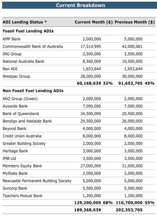
Environmental Commitments
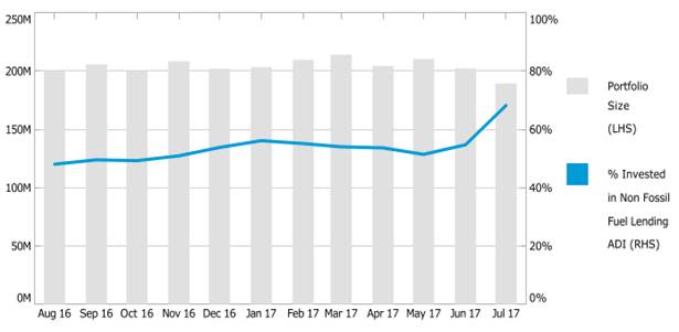
Council’s holdings in Non-Fossil investments increased to approximately $129.2m with a relative total portfolio percentage increase (68% in July 2017 as opposed to 55% in June 2017) in Non-Fossil investments. The percentage increase was driven by a decrease in fossil fuel lending investments from $91.6m to $60.2m (due to maturities) while investments in non-fossil fuel lending ADIs increased from $110.7m to $129.2m. The attachments to this report summarise all investments held by Council and interest returns for periods ending 31 July 2017.
The period ending 31 July 2017, the portfolio for Inner West Council had a One-Month Portfolio Investment Return (2.76%) was above the UBSWA Bank Bill Index Benchmark (1.69%). Council has a well-diversified portfolio with 84% of the portfolio spread among the top three credit rating categories (A long term / A2 short term and higher).
The Current Market value is required to be accounted for by the accounting. The Current Market Value is a likely outcome if Council were to consider recalling the investment prior to its due date.
All investments made for the month of July 2017 have been made in accordance with the Local Government Act, Local Government Regulations and the Inner West Council Investment Policy.
|
1.⇩ |
Investment Summary Report - Inner West Council - July 2017 |
|
2.⇩ |
Inner West Council Economic and Investment Portfolio Commentary - July 2017 |
|
3.⇩ |
Inner West Council - Summary - July 2017 |
|
Council Meeting 12 October 2017 |
Subject: Investment Report as at 31 August 2017
File Ref: 17/4718
Prepared By: Brendhan Barry - Manager Financial Services
Authorised By: Michael Tzimoulas - Deputy General Manager Chief Financial and Administration Officer
|
SUMMARY In accordance with the requirements of clause 212 of the Local Government (General) Regulation 2005, Council is provided with a listing of all investments made pursuant to section 625 of the Local Government Act 1993 and reported for periods ending 31 August 2017.
|
|
RECOMMENDATION
THAT:
The report be received and noted.
|
BACKGROUND
Clause 212 of the Local Government (General) Regulation 2005 requires that a report be presented to Council each month listing all investments with a certification from the Responsible Accounting Officer. Attached to this report are further reports from Council’s Investment Advisors, Prudential Investment Services.
FINANCIAL IMPLICATIONS
The Investment Holdings report (Attachment 1) for the period ending 31 August 2017 reflects Council’s holding in various investment categories these are listed in the table below. Council’s portfolio size has decreased by approximately $8 million to $202m of which 87% was rated A rated or above.
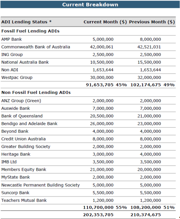
Environmental Commitments
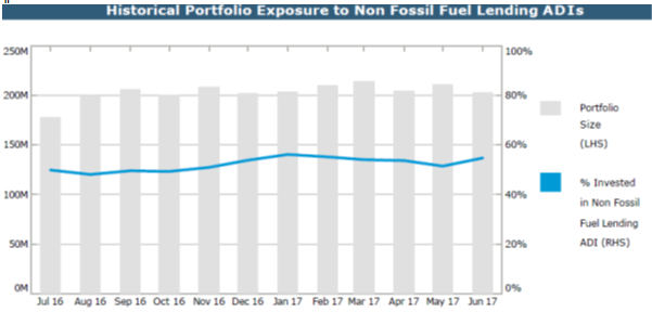
Council’s holdings in Non-Fossil investments increased to approximately $168.7m with a relative total portfolio percentage increase (77% in August 2017 as opposed to 68% in July 2017) in Non-Fossil investments. The percentage increase was driven by a decrease in fossil fuel lending investments from $60.2m to $51.6m (due to maturities) while investments in non-fossil fuel lending ADIs increased from $129.2m to $168.7m. The attachments to this report summarise all investments held by Council and interest returns for periods ending 31 August 2017.
The period ending 31 August 2017, the portfolio for Inner West Council had a One-Month Portfolio Investment Return (2.90%) was above the UBSWA Bank Bill Index Benchmark (1.69%). Council has a well-diversified portfolio with 87% of the portfolio spread among the top three credit rating categories (A long term / A2 short term and higher).
The Current Market value is required to be accounted for by the accounting. The Current Market Value is a likely outcome if Council were to consider recalling the investment prior to its due date.
All investments made for the month of August 2017 have been made in accordance with the Local Government Act, Local Government Regulations and the Inner West Council Investment Policy.
|
1.⇩ |
IWC Aug17 - summary |
|
2.⇩ |
IWC Aug17 |
|
3.⇩ |
IWC Economic and Investment Portfolio Commentary Aug 17 |
|
Council Meeting 12 October 2017 |
Subject: Tabling of Pecuniary Interest Returns of Designated Staff for the Return Period 1 July 2016 to 30 June 2017
File Ref: 17/4718
Prepared By: Ian Naylor - Manager Civic and Executive Support
Authorised By: Tanya Whitmarsh - Group Manager Governance
|
SUMMARY To table the Pecuniary Interest Returns of Designated Staff for the return period 1 July 2016 to 30 June 2017. |
|
RECOMMENDATION
THAT Council note the tabling of Pecuniary Interest Returns of Designated Staff for the return period 1 July 2016 to 30 June 2017. |
BACKGROUND
Section 449(3) of the Local Government Act 1993 requires Designated Staff holding these
positions as of 30 June 2017 to lodge a Return of Pecuniary Interests to the General Manager by 30 September 2017. Section 450A(2) of the Local Government Act 1993 requires these disclosures to be tabled at the first Council Meeting after 30 September 2017. All returns for Designated Staff in office as at 30 June 2017 have been submitted.
Section 449(1) of the Local Government Act 1993 requires Councillors to submit a Return of Pecuniary Interests within 3 months of being declared in office. Returns of Pecuniary Interests are required to be submitted by 16 December for tabling at the first Ordinary Council Meeting in 2018.
FINANCIAL IMPLICATIONS
Nil.
OTHER STAFF COMMENTS
Nil.
PUBLIC CONSULTATION
Nil.
CONCLUSION
Nil.
|
|
Council Meeting 12 October 2017 |
Subject: Notice of Motion: HIRE BIKE SERVICES
File Ref: 17/4718
From Councillor John Stamolis
|
Motion:
THAT:
1. Council to commence investigations which will determine how hire bike services fit with and complement Councils’ own transport strategies, how these services might best operate within our municipality and how to minimise any problems and impacts on our community, our local environment and on Council resources; and 2. A report to be submitted to Council when the investigations are complete. |
Background
Our Council and community are supportive of positive initiatives in regard to the provision of transport options but it also supports a coherent strategy and policy framework for this to occur.
As such, Council should commence investigations which will determine how transport models like those provided by hire bike companies fit with and complement Councils’ own transport strategies, how these models will best operate for the people of our municipality and how to minimise any problems and impacts on our community and the local environment. For example, some bikes have been left in parks, others have blocked footpaths and some appear to have been dumped.
Councils’ investigations and studies might also assist providers of these services with better planning and operation of their services so that the public receives the best service outcomes.
One current problem being experienced by several Councils where these schemes operate is the workload placed on Councils’ regulatory and compliance teams. This not only incurs significant costs for Councils but also diverts important Council resources away from core business that our ratepayers expect and pay for. Councils’ investigations should look at how this can be resolved.
|
|
Council Meeting 12 October 2017 |
Subject: Notice of Motion: Pedestrian Safety on Croydon Road, Croydon
File Ref: 17/4718
From Councillor Marghanita Da Cruz
|
Motion:
THAT:
1. Council through the Traffic Committee urgently convenes an onsite meeting with the local community, a school representative, members of the Traffic Committee and Ward Councillors at a time that school children are walking to school to observe and hear from the community and Councillors on what the key safety issues are and hear from Traffic Committee members on ways they could be addressed; and 2. A report be brought to the Traffic Committee and then to Council as soon as possible outlining proposals to improve the safety for school children and pedestrians on Croydon Road, Croydon. These proposals to include investigation on the installation of a pedestrian crossing and traffic calming measures. The report should also provide a proposed timeline for works and proposed prioritisation of funding for the works. |
Background
A number of residents have contacted me concerned about pedestrian safety on Croydon Road. Croydon Road, Croydon is a busy road particularly before and after school. This makes it difficult and dangerous for children and other pedestrians who are walking to school, the railway station and bus stops.
There is currently a roundabout at Anthony Street – however, the design of the traffic islands at the roundabout with curved narrow slippery surface increases the danger to pedestrians.
There are narrow speed humps which have caused car accidents rather than safely calming motor vehicles.
|
|
Council Meeting 12 October 2017 |
Subject: Notice of Motion: Pedestrian Safety on Frederick Street, Ashfield
File Ref: 17/4718
From Councillor Marghanita Da Cruz
|
Motion:
THAT Council through the Traffic Committee urgently investigate and report on the significant safety risks at pedestrian crossings on Frederick Street with a particular emphasis on the Frederick/John St crossing and provide recommendations on how these risks can be addressed. These recommendations to include consideration of a reduction in the speed limit on Frederick Street and the introduction of traffic calming at the pedestrian crossings on Frederick Street as well as proposals to prevent vehicles overtaking cars turning right near the pedestrian crossings. The report should include a proposed timeline for works and proposed prioritisation of funding for the works. |
Background
A number of residents have contacted me regarding the danger of the pedestrian crossings on Frederick Street Ashfield, particularly the one at the intersection with John Street. This has been the site of numerous accidents and near misses when cars try to overtake other cars waiting to turn right into Frederick or John Streets.
There are a number of parks, the swimming pool, train station and school on the western side of Frederick Street. To access these, residents including children and the elderly need to negotiate Frederick Street.
Damage caused by car crashing into fencing
at JM McCarthey Playground at intersection
of John and Frederick Sts Ashfield
|
|
Council Meeting 12 October 2017 |
Subject: Notice of Motion: Pedestrian Safety in Haberfield and Leichhardt
File Ref: 17/4718
From Councillor Marghanita Da Cruz
|
Motion:
THAT Council: 1. Investigate pedestrian safety measures including the introduction of 40km speed limits and associated traffic calming for the commercial areas approaching the intersection of Dalhousie and Ramsay Streets, Haberfield;
2. Investigate pedestrian safety measures including the introduction of 40km speed limits and associated traffic calming on Marion Street at the intersections with Norton Street, Elswick Street and Flood Street, Leichhardt; and 3. Investigate pedestrian safety measures including the introduction of 40km speed limits and associated traffic calming on the approaches to the intersection of Flood Street and Lords Road, Leichhardt.
|
Background
The approaches to the intersection of Ramsay St and Dalhousie St in Haberfield; Marion Street and Flood Street, Leichhardt and Marion Street and Norton Street, Leichhardt; and Flood at Lord Street, Leichhardt have high pedestrian activity.
Ramsay, Marion and Norton Street are busy motor vehicle thoroughfares and bus corridors, with commercial precincts used by less mobile elderly residents and children with and without carers.
Other areas of high pedestrian activity elsewhere on Norton Street, Leichhardt, on Booth Street Annandale and Darling Street Balmain/Rozelle which all now benefit from safer 40km speed limits.
Local residents and businesses have raised the following specific concerns:
a) Cars travelling south, narrowly missing pedestrians when turning west from Norton Street into Marion Street, Leichhardt.
b) Buses travelling north along Norton Street, clipping the footpath endangering pedestrians, including children heading for Leichhardt Public School, as they turn west from Norton Street
d) Drivers becoming impatient at the pedestrian crossings on the roundabout at the Lord's Road – described as “Road Rage”
d) Cars travelling along Marion Street screeching to a halt at Flood Street. There have also been animal fatalities at the intersection
e) Impatient drivers behavior described as “Road Rage” on Marion Street at Elswick Street intersection, endangering pedestrians.
|
|
Council Meeting 12 October 2017 |
Subject: Notice of Motion: Inner West Waterways
File Ref: 17/4718
From Councillor Lucille McKenna
|
Motion:
THAT Council calls on the General Manger to bring back a report within 100 days for practical steps that would lead to working with the Parramatta River Catchment Group to create a safe swim site in the Inner West Council part of the Parramatta river, installing gross pollutant traps on all stormwater drains in the local government area and what additional support to the Inner West Council could propose for the next action plan of Cooks River Alliance that would result in measurable improvements.
|
Background
The Inner West has two of Sydney’s very significant waterways both have been altered neglected and degraded.
There is community support for improving the Parramatta and Cooks River. The Inner West Council is part of the Cooks River Alliance and the Parramatta River Catchment Group.
|
|
Council Meeting 12 October 2017 |
Subject: Notice of Motion: Council Response to the NSW Revised Draft Sydenham to Bankstown Urban Renewal Corridor Strategy
File Ref: 17/4718
From Councillor Mark Drury
|
Motion:
THAT after Council has determined its position on the NSW Revised Draft Sydenham to Bankstown Urban Renewal Corridor Strategy on 24 October, call on the Mayor to convene a meeting with Save Dully and Save Marrickville South community groups to work out how to publicise councils views and to plan a campaign that emphasises that town planning is best done in collaboration with the people who live and know their suburb and by their elected councillors with the advice of council town planners. |
Background
That the Inner West Council notes that on 10 August at a packed Marrickville Town Hall meeting the following motion was adopted
1. The NSW State Government’s Sydenham to Bankstown rezoning plans are disastrous for our heritage suburbs and force the inner west to bear far more than its fair share of density;
2. Calls on the State Government to immediately release its Environmental Impact Statement for the Sydney Metro and to justify how this transport option is preferable to investing in the current heavy rail, light rail and bus services in the inner west;
3. Calls on the State Government to immediately halt all plans for rezoning and to invest in the community infrastructure that our suburbs need, including schools, open space, child-care centres and hospitals.
Additionally it was observed that there was no attempt in the NSW Governments strategy to address the critical issue of affordable housing.
Since that time Council staff have been working on a response to the Strategy to be put to the elected council
The elected Council looks forward to receiving the draft strategy and determining its position on 24 October.
|
|
Council Meeting 12 October 2017 |
Subject: Notice of Motion: EXPEDITING THE DELIVERY OF THE UPGRADE OF SPORTING FIELDS AND A SKATE PARK IN CALLAN PARK
File Ref: 17/4718
From Mayor, Councillor Darcy Byrne
|
Motion:
THAT Council:
1. Adopt a policy position in support of the establishment of a Callan Park Trust to govern the site and the implementation of the Callan Park Master Plan;
2. Produce a report, to be tabled at the next Ordinary Meeting, detailing the precise status of the Waterfront Drive sporting field upgrade and the skate & BMX Park within Callan Park and identifying the necessary actions required to make sure they can be expedited and delivered;
3. Write to the Premier and relevant Ministers; a. Stating Council’s adopted positions in relation to Callan Park; b. Seeking a meeting with the Minister for Environment and Heritage to discuss the future of Callan Park; and c. Seeking clarification about when the Minister’s public commitment that the approval of the Waterfront Drive playing field upgrade and the transfer of control of the grounds to Council will be carried out.
4. Convene a public meeting in Lilyfield to provide information to the local community about the Council’s plans for Callan Park and to enlist the community’s support in forcing the NSW Government to support the delivery of recreational facilities there, the establishment of a Callan Park Trust and implementation of the Callan Park Master Plan.
|
Background
Despite both projects being fully funded by the former Leichhardt Council, the upgrade of the Waterfront Drive playing fields in Callan Park and the construction of a skate and BMX park there, have not been started, let alone completed, during the period of Administration.
Reasons for the unacceptable delay of these desperately needed recreational facilities include political and bureaucratic delays from State Government Ministers and agencies as well as a failure of the unelected Council to provide sufficient advocacy and or urgency in progressing the projects.
|
|
Council Meeting 12 October 2017 |
Subject: Notice of Motion: Reversing OSHC fee increases
File Ref: 17/4718
From Councillor Anna York
|
Motion:
THAT:
1. The General Manager provide a report on the evidence it has used to justify this fee increase, including evidence that it will in fact deter parents from late pick up; and
2. In the meantime while this report is prepared and considered by Council, that these fee increases immediately revert to the previous 2016/17 rate at Stanmore Public School and other impacted schools.
|
Background
Prior to the election of Councillors, the interim Inner West Council adopted an operational plan which included the 2017/18 Fees & Charges annex.
Parents at Stanmore PS have raised concerns that the out of school hours fees are being increased in the next financial year
The fees proposed in the 2017/18 Fees & Charges annex appear exorbitant, particularly the proposed $100 charge after the second occasion of late pick up
For Stanmore Public School, new fee
increases include:
· The introduction of a new late payment fee that is 5 per cent of the weekly gap fee.
· A substantial increase in the late pick-up fee from $43.30 base rate for every 15 minutes to $45 for every 15 minute period, and an increase to $100 for the first 15 minutes and then $45 for every 15 minutes thereafter after the second late pick up
There is very little information about how the late payment fee would work, and some parents have expressed concern that its structure as a percentage of the weekly gap fee would penalise families who require full-time care.
In addition, there is no further information provided to demonstrate that Council has any evidence that increased fees will in fact deter parents from late pickups. In fact, there is evidence from other areas that increased fees can have the opposite effect.
|
|
Council Meeting 12 October 2017 |
Subject: Notice of Motion: UNWINDING THE UNELECTED COUNCIL'S BAN ON DOGS IN PUBS
File Ref: 17/4718
From Mayor, Councillor Darcy Byrne
|
Motion:
THAT Council: 1. Produce a report: a) Explaining the reasons for and the process that resulted in the ban being implemented and hotels systematically being threatened with fines if they were found to have dogs on their premises;
b) Identifying the past mechanisms through which statutory food safety requirements have been upheld by Council officers without implementing a blanket ban; and
c) Exploring options for how complaints about dogs in pubs could be resolved through mitigation rather than litigation of punitive action from Council.
2. Consult with relevant hotel owners, licensees and managers about how the ban on dogs has affected their business and to identify practical measures that could maintain food safety standards without banning dogs from pubs. The results of this consultation are to be reported back to Council. |
Background
In some suburbs of the Inner West Council area there is a very long tradition and practice of patrons bringing their dogs into pubs. This very well established social and cultural practice has contributed to our unique Inner West pub culture and complimented the importance these suburbs have always placed on companion animals.
For many decades food safety regulations have been upheld and enforced by Leichhardt, Marrickville and Ashfield Councils without there being a need to implement a blanket ban on dogs being in pubs, where the proprietor of the Hotel agrees to allow them.
In the aftermath of the amalgamation of the three constituent councils and the sacking of elected representatives the new Inner West Council implemented a ban on dogs in pubs, without any consultation with pub patrons, licensees or proprietors.
|
|
Council Meeting 12 October 2017 |
Subject: Notice of Motion: Making the Inner West a leader in renewable energy
File Ref: 17/4718
From Councillor Anna York
|
Motion:
THAT the General Manager provide reports on how Council will:
1. Sign up the Inner West Council to the Cities Power Partnership – with a focus on pledging actions focused on solar and renewables leadership. 2. Make the Inner West Council 100% carbon neutral by 2023 3. Make the Inner West Council a leader in Solar photovoltaic (PV) energy by: · Ensuring all new Council-owned developments are fitted with Solar PV cells. · Working towards the retrofitting of all Council-owned buildings with appropriately sized Solar PV cells – potentially through a bulk tendering process – where possible. 4. Establish an Office of Renewable Energy Innovation (REI) to make the Inner West community a leader in renewable energy innovation by: · Setting targets and timeframes for the take up of renewable energy and energy conservation solutions, including benchmarks for new developments; · Leading the investigation into our best options for adopting solar and renewable energy in our area; · Helping drive community renewables ownership by supporting community energy organisations in the Inner West; · Providing support to help home owners and commercial property managers install/manage solar technology – with a goal for the installation of Solar PV cells on all eligible roofs; · Providing a brokerage service to help organisations looking to invest in community energy projects to identify potential partners with suitable roof space; · Investigating the viability of transitioning the Inner West Council vehicle fleet to an electric fleet; and · Prioritise a solar innovation pilot run by REI, which may include a Council/Commercial Solar Power Purchase Agreement, investment in a regional solar farm partnership, and/or a local solar farm pilot. |
Background
Our community in the Inner West are strong supporters of renewable energy, and recognise the need to contribute to a more sustainable pathway for carbon emissions.
However, compared with other inner city areas, the Inner West has relatively low levels of renewable energy infrastructure installations in homes and businesses. This is particularly the case for solar PV panels.
There are many reasons why this may be the case – for example, rooftops on homes and businesses may not be suitable for solar, renters may not be able to directly influence the installation of solar on their rooftops, and a relatively mobile residential population may not consider longer term investments in individual solar or other renewable infrastructure to be viable.
At the same time, we are seeing innovation in solar and renewables driven by the community across Australia, with the growth of community energy projects and the increased role of local governments taking up leadership in this area. The Inner West Council has an opportunity and a responsibility to support our community’s commitment to sustainability and renewable energy.
|
|
Council Meeting 12 October 2017 |
Subject: Notice of Motion: Pride in the Inner West
File Ref: 17/4718
From Councillor Anna York
|
Motion:
THAT:
Council staff provide a report through the General Manager to Council on how the Inner Council will: 1. Support the work of the Inner West LGBTIQ Forum and strengthen its activities by dedicating an LGBTIQ Community Engagement Officer;
2. Identifying options to provide a Council facility for the purpose of establishing a Pride Centre in the Inner West, including options for potential funding partner/s to support the Centre;
3. Lobby the Sydney Gay and Lesbian Mardi Gras to keep Fair Day at Camperdown Memorial Rest Park;
4. Update Council forms to reflect the 2013 guidelines on the recognition of sex and gender;
5. Commission a gateway mural at a prime location reinforcing the Inner West as a safe, positive and friendly community;
6. Establish an awards scheme to recognise LGBTIQ-friendly businesses in each ward; and
7. Work towards making all Council facilities inclusive, accessible and LGBTIQ safe spaces, including training staff.
|
Background
One of the most exciting things about the Inner West is the inclusion and acceptance that makes us one of the most positive and diverse communities in the country.
The Inner West is home to one of the strongest and most active LGBTIQ communities in the country. However, Council can do more to reflect those values and support our LGBTIQ communities.
The Inner West Council has an opportunity to build on the work of the existing LGBT Forum and work to ensure our local council serves the diversity and richness of our community.
|
|
Council Meeting 12 October 2017 |
Subject: Notice of Motion: A healthier Inner West
File Ref: 17/4718
From Councillor Mark Drury
|
THAT within 100 days the General Manager provide reports on how Council will:
1. Invest $65 million over the next 3 years in sporting fields, parks, playgrounds and pools to deliver the highest-quality facilities for local families and clubs;
2. Establish an Inner West Office of Sport to provide assistance to clubs and transform the Council’s relationship with sporting clubs from one based on ground hire only into a strategic partnership to improve the health and wellbeing of our community;
3. Work with clubs to identify bold targets for increasing the participation of women and girls across all sports and implement ways of increasing participation from people from lower socio-economic backgrounds;
4. Establish new netball courts, of which there are too few, and the first hockey field in the Inner West Council area; and
5. Provide for longer tenure on home grounds to allow clubs and Council to jointly apply for state and federal grants to upgrade sporting fields and to have a revised booking field system that acknowledges clubs have longer lead times in preparation for seasons.
|
Background
The Inner West Council can advance the health of our residents by increasing their opportunities to engage in community sport and recreation to combat the threat of increasing incidence of lifestyle related diseases such as diabetes, cardiovascular disease and obesity.
Council can promote and encourage a healthy lifestyle for school age kids specifically and the community generally through sports participation.
Council should work with local community sporting bodies to increase participation levels in sport for people from lower socio-economic backgrounds to remove economic or social barriers.
Council should work with local clubs to set ambitious targets for increasing the participation of women and girls in sport.
Councils approach to sport needs to change we need to recognise that participation in community sport helps to build our community, community cohesion and social wellbeing. Council needs to better recognise that community sports clubs are the largest network of volunteers in our community, and make sure they get the recognition, support and investment they need.
|
|
Council Meeting 12 October 2017 |
Subject: Notice of Motion: Supporting our Creative Communities
File Ref: 17/4718
From Councillor Anna York
|
Motion:
THAT the General Manager provide reports on how Council will:
1. Bring
Vivid Sydney to the Inner West 2. Establish a Live Music Development Fund Proposed as an initial $200,000 live music fund to encourage artists and venues to put on more gigs at existing live music venues, as well as establish new venues throughout the Inner West. 3. Bring
arts and live music to the shop fronts, former factories, cafes and office
blocks of the Inner West 4. Make
the Inner West Sydney’s street art capital 5. Expand the artist in residence
program across the Inner West
In addition to the elements above to be addressed in the requested report from Council staff, Council also expresses its in principle commitment the transformation of the industrial area between Sydenham Station and Victoria Road in Marrickville into a vibrant live music and arts precinct. |
Background
A core part of the identity and foundation of the Inner West is our creative communities – our arts and live music scene have been at the creative core of Sydney for decades.
However, overbearing regulation threatens to suffocate our creative culture. This is exacerbated by pressures wrought from increasing property prices throughout the Inner West.
Combined, these factors are threatening the spaces and community our artists have depended on for many years.
In recognition of the unique place our creative communities hold at the heart of the Inner West, and the particular pressures artists and musicians are facing in our area, support is required to regenerate our arts and music scene, and to ensure local artists will always have spaces to exhibit and perform their work.
|
|
Council Meeting 12 October 2017 |
Subject: Notice of Motion: Establishment of a Sydenham to Bankstown Corridor Committee
File Ref: 17/4718
From Councillor Colin Hesse
|
Motion:
THAT: 1. Council establishes a committee to deal with issues arising from the State Government’s Metro Project and the Sydenham to Bankstown Urban Renewal Corridor (SBURC);
2. The Committee consist of all interested councillors from Marrickville and Ashfield Wards and up to 10 members of the community, with particular emphasis given to members of existing community groups concerned with these State Government initiatives (Save Marrickville South, Save Dully, Marrickville Resident Action Group and the Sydenham to Bankstown Alliance);
3. The committee is co-ordinated by two staff members with expertise in transport and planning;
4. The committee hold regular monthly meetings and is provided with an annual budget sufficient for the purpose of holding monthly meetings; and
5. In the immediate lead-up to the IWC’s submissions to the Urban Renewal Corridor and the Metro EIS the Committee be consulted regarding their opinion on both matters.
|
Background
The SBURC represents a significant residential up-zoning of the suburbs along the Bankstown Rail corridor. It is the State Government’s planning response to the conversion of the Bankstown line, which is part of the Sydney Metro Project.
The SBURC overturns the provisions of the MLEP2011. In response to the SBURC the former Administrator of the IWC, Richard Pearson said he was disappointed that “the planning and rezoning along 13km of the Bankstown rail line had failed to reduce the number of new dwellings proposed for the area.
When the Government released the strategy in 2015 more than 1,800 responded with overdevelopment as the subject of many of those submissions”.
Now it seems the Government is planning even more development without a comprehensive infrastructure plan to deal with the increased population”.
The Communities in Marrickville and Dulwich Hill are deeply concerned and vocally opposed to the massive increase in density proposed by the SBURC.
The Sydney Metro project will convert the existing Sydenham to Bankstown line from double-decker heavy rail to single-decker metro rail. Transport Minister, Andrew Constance admitted that “it is going to be a disruptive time, during the construction of the Metro. This disruption will come from the closure of the rail line for over 12 months, spread over 5 years. Further disruption will come from works equipment and associated construction such as the complete replacement of the Illawarra Road Bridge at Marrickville Station.
There is considerable community concern about the Metro proposal. A Community Meeting in July 2017, organised by the Sydenham to Bankstown Alliance and attended by over 200 residents, unanimously passed a motion opposing the Metro. The motion included the following.
This meeting:
• Opposes the privatisation and conversion of the Bankstown line between Sydenham and Bankstown
• States that the Government’s plan to replace the Bankstown line heavy rail service is a waste of tax payers’ money
• Calls on the Government to extend the Metro on the southern side of the harbour to areas of Sydney that do not currently have a rail service.
Clearly, the combined effects of the Sydenham to Bankstown Urban Renewal Corridor and the Metro Project will have a significant impact on residents of the Inner West Council, particularly the suburbs of Marrickville and Dulwich Hill. More broadly, the conversion of the Bankstown line to a Metro is a missed opportunity: a once-in-a-generation missed opportunity. Any new rail should go to suburbs that don’t currently have a rail service.
|
1.⇩ |
Conversion of Bankstown line for metro trains will force commuters to catch buses for months |
|
2.⇩ |
Sydenham to Bankstown Urban Renewal Corridor public meeting |
|
Council Meeting 12 October 2017 |
Subject: Notice of Motion: Australia Day
File Ref: 17/4718
From Councillor Colin Hesse
|
Motion:
THAT Council seek advice from the Aboriginal and Torres Strait Islander Strategic Reference Group on whether they have a view on the current way in which Council engages with Australia Day. In considering alternatives the Strategic Reference Group is invited to assume the budget which currently applies to Council's Australia Day events should be attached to alternatives to the current celebrations. |
Background
The question of how we celebrate Australia Day and if we should do so at all have long been the subject of considerable debate in the broader Australian community. For many Aboriginal people, the original owners of the land, January 26 is a day of great sorrow. Given the history of the day advice is sought from the Inner West Council Aboriginal and Torres Strait Advisory Committee on how or if Council should engage with this day.
|
|
Council Meeting 12 October 2017 |
Subject: Notice of Motion: Council to Enter Cities Power Partnership with the Climate Council and Prepare Report
File Ref: 17/4718
From: Councillor Tom Kiat
|
Motion:
THAT:
1. Council participate in the Climate Council’s Cities Power Partnership (Partnership ) by expressing its interest to participate in the next available intake of councils to the Partnership.
2. Council, in collaboration with relevant stakeholders including local community groups, other participating councils, organisations including the Southern Sydney Regional Organisation of Councils & the Climate Council, produce a draft report by January 2018 to assess strategic projects and actions (Key Actions) Council may undertake within the Partnership (Report).
3. That Council’s Report identify and assess possible Key Actions which address the following priorities (Priorities): A. Reducing power prices for Inner West residents (including tenants), ratepayers and Council; B. Rapidly transitioning to carbon neutrality and a clean energy future; and C. Efficient use of Council finances through investment in cost cutting energy efficiency measures and revenue generating renewable energy assets.
4. That Council’s Report include assessment of the following proposed Key Actions (Proposed Key Actions ): A. Council to become 100% carbon neutral by 2020; B. All Council buildings to be assessed for suitability of rooftop solar PV; C. Council to increase uptake of rooftop solar in the Inner West by using solar bulk buys, Council-backed lease finance arrangements and streamlined development approvals to offer residents (including tenants/rental properties), commercial properties, and community organisations low or zero upfront cost solar installations; D. Council to invest in Council/community large-scale owned renewable energy assets (e.g. solar farms) within the Inner West and within regional areas participating in the Partnership; E. Council to provide community grants to community organisations to Invest inprojects to reduce power costs and carbon footprint; F. Council to prepare for and facilitate transition to electric vehicles through installation of network of charging stations and Council fleet procurement, and through review of relevant provisions of the Development Control Plan; G. Council to prepare feasibility study on operation of Council owned electric share vehicles; and H. Council to achieve 100% divestment from fossil fuel by 2020. |
Summary
This motion empowers our local community to take control on three interlinked crises facing
the Inner West: rising power bills, energy insecurity, and climate emergency. By entering into
the Cities Power Partnership, Council can knowledge share with other participating local
councils and the Climate Council to deliver lower power prices, stability and certainty, and a
rapid transition to a clean energy future for our community.
In summary, the recommendation is to enter into a partnership with the Climate Council and
to prepare a report.
Background
In July 2017, the Climate Council launched the Partnership. 35 local councils entered the
Partnership, representing around 3 million Australians. The Partnership allows councils to
partner with the Climate Council and other participating local councils ( Power Partners ) to
share knowledge, expertise, and strategic direction, in order to take local leadership to
address our energy crisis.
It has always been important that councils pursue the twin goals of energy efficiency and
reducing carbon emissions. With utter inaction at higher levels of government, despite
overwhelming community support for investment in renewables, it is imperative that councils
take a leadership role to tackle rising power prices and carbon emissions, as well as the
instability in the electricity market and renewables sector. The Environment Strategic
Reference Group ( SRG ) in its draft submission to the Community Strategic Plan ( CSP ),
enclosed , set a vision that included “100% renewable energy for council and community”
and a “transition to clean and renewable energy for all transport options.”
Council is already involved in knowledge sharing in this space through the SSROC
Renewable Energy Master Plan 2013 ( Renewable Master Plan ), enclosed , and the Our
Energy Future initiative. The Partnership builds on this collaborative approach to renewable
energy and provides a framework for Council to prioritize actions identified in the Renewable
Master Plan.
The Renewable Master Plan estimated that almost 60% of the energy demand in SSROC,
covering 1.6 million people, could be met by renewables, and that solar PV represented the
greatest opportunity to increase renewable energy capacity. Accordingly, a focus of this
motion is to increase the uptake of solar PV in the Inner West in a way that is financially
responsible for participants, including Council.
The leadership already taken by Council (and previously, Marricville, Leichhardt and Ashfield
Councils) on renewables and climate action is consistent with the thesis of the enclosed
Climate Council’s 2017 report titled “Local Leadership: Tracking Local Government Progress
on Climate Action.” The report demonstrates the power of local government to deliver
renewables solutions that lower the cost of living for residents. The report highlights (p. 35)
the pioneering example of the City of Darebin’s Solar Saver program which has delivered
solar PV to around 500 properties (many pensioners and low income) at zero up-front cost,
with zero interest loans, with most residents achieving a net saving of $100 per year after
loan repayments. Shoalhaven City in NSW is already looking to implement a similar
program. Both councils are Power Partners. By sharing knowledge and learnings from
across Australia’s local government landscape, Council can participate in and contribute to
the local leadership that is delivering carbon and cost of living savings.
Item 1. How does the Partnership work?
By becoming a Power Partner, Council obtains access to the extensive specialist expertise
shared by the Climate Council and existing Power Partners. Council then has six months to
select five key actions within the areas of renewable energy, energy efficiency, transport and
advocacy . The Climate Council has prepared a summary briefing for Councils, enclosed ,
which contains options and real-world examples within these areas at Appendix A and B
respectively.
As Council works toward its key actions, the Climate Council continues to support Council
including by providing access to its knowledge hub, including domestic and international
experts and facilitation of knowledge sharing with other Power Partners. Council is also
buddied with two other Power Partners for strategic sharing of knowledge.
The Partnership also provides Council with free access to Power Analytics, a technical tool
used for modelling the carbon emission reductions associated with a project, and sharing the
results with other Partners. This helps ensure Council initiatives are geared toward the most
efficient emission reductions.
The Partnership has no membership cost and the self-reporting requirements are not
onerous. The first intake of Power Partners in July 2017 saw 35 local councils join the
Partnership. A further 35 councils will be accepted in the second round intake, beginning
mid-October.
Item 2. What is the purpose of Council’s Report
In order to select five or more Key Actions, Council will collaborate with the Climate
Council to prepare a Report for the consideration of the Inner West community and
Councillors. This Report will review past and current initiatives of Council that may
qualify or be developed into Key Actions. The Report will also identify and assess a
range of Key Actions which could be adopted by Council.
Item 3. What are the priorities of Council in the Partnership?
The Report and Council’s participation in the Partnership should reflect the priorities of
the Inner West community, including as expressed in the Environment SRG draft
submission to the CSP.
The threefold priorities identified for the Partnership are:
a. Reducing power prices for Inner West residents (including tenants), ratepayers and
Council.
b. Rapidly transitioning to carbon neutrality and a clean energy future
c. Efficient use of Council finances through investment in cost cutting energy efficiency
measures and revenue generating renewable energy assets
These priorities will drive Report’s identification and assessment of possible Key Actions.
The aim is to have options that will cut Council costs and increase Council revenue,
lower the bills of ratepayers and aid the rapid transition of the Inner West to a carbon
neutral, renewable energy future.
Item 4. What are some examples of Key Actions we could take in the Inner West
As well as identifying possible Key Actions driven by the Priorities, the Report will give
robust assessment of the Proposed Key Actions. Some of these Proposed Key Actions
have already received attention through the Renewable Master Plan, and/or are being
implemented by other Councils. Further explanatory detail is given below.
|
|
Proposed Key Actions |
Comment |
|
A. |
Council to become carbon neutral by 2020 |
Carbon neutrality could be achieved through a combination renewable energy projects, efficiency gains, carbon sinks (e.g. trees) and carbon offsets. SSROC is presently tendering for a power purchase agreement to provide a minimum of 20% of its electricity from renewable energy. |
|
B. |
All Council buildings to be assessed for suitability of rooftop solar |
This was assessed and recommended by the Renewable Master Plan. Leichhardt Council installed solar systems on a number of its buildings. This should be extended to all Council buildings where possible, including in the other two council areas. |
|
C |
Council to increase uptake of rooftop solar in the Inner West by using solar bulk buys, Council-backed long term finance arrangements and streamlined development approvals to offer residents (including tenants/rental properties), businesses, and community organisations low or zero upfront cost solar installations |
The Renewable Master Plan highlighted solar bulk-buys and innovative finance arrangements (e.g. solar leasing, power purchase agreements, environmental upgrade agreements) as a key to overcoming the high upfront cost of solar systems as a barrier to uptake. As solar can pay itself off within 5-10 years, and thereafter reduce the cost of living for decades, Council can increase access to solar by first reducing the purchase price through bulk buys, and second by introducing 5-10 year low interest loans or similar financial arrangements, whereby the repayment costs are met by the reduction in electricity costs to the occupant.
For example, in 2014, Darebin Council assisted hundreds of pensioner households install solar panels at zero upfront cost. These residents are paying off their systems, interest-free, through their Council rates. Most made an immediate net saving of $100 per year by participating in the program. The Climate Council is currently working with Shoalhaven Council to develop a similar scheme, which will be appropriately tailored to NSW specific regulations. Both Shoalhaven City Council and the City of Darebin are Power Partners.
The Environment SRG draft submission to the CSP identified as a key outcome, “Increased proportion of low income households with renewables [and] reduced power bills.” The benefit of having Council as the proponent of this initiative, rather than private sector operators, is increasing participant trust in the system and reducing cost to participants, in order to maximise accessibility. Council could become a trusted one-stop-shop for rooftop solar, including assessment, approval, bulk-buy discounts and finance, and on this basis actively approach residents and businesses with roofs likely to be able to host solar. |
|
D. |
Council to invest in Council and/or community owned large-scale renewable energy assets (e.g. solar farms) within the Inner West and within regional areas participating in the Partnership |
Assessed and recommended as a priority option by the Renewable Master Plan.
Lismore Council has successfully completed two council/community solar farms, in collaboration with not-for-profit solar firm Farming the Sun.
The City of Sydney and local community investment supported the Sydney Renewable Power Company to build Australia’s largest CBD solar array on the new International Convention Centre. Uncovered car parks across the Inner West could be investigated for use as urban solar farms, using joint Council and community investment.
|
|
E. |
Council to provide community grants or zero-interest loans to community organisations to invest in projects to reduce power costs and carbon footprint |
The Renewable Master Plan recommended Council assist community solar projects as a priority action. Further research should investigate how such projects, including but not limited to solar, might be kick-started through Council grants or zero-interest loans. |
|
F. |
Council to prepare for and facilitate transition to electric vehicles through installation of network of charging stations and Council fleet procurement, and through review of relevant provisions of the Development Control Plan |
The Environment SRG draft submission to the CSP identified the transition to electric vehicles as a priority for the Inner West and Council. Council can directly assist this transition through investment in charging stations and its own fleet.
It is also appropriate for Council to consider possible changes to the DCP that may be required in order to facilitate the transition to electric vehicles (e.g. consideration of whether new buildings should have, or be able to have, electric charging facilities in parking bays) |
|
G. |
Council to prepare feasibility study on operation of Council owned electric share vehicles |
The proposal seeks the Report to address whether Council should undertake feasibility study in relation to Council involvement in share electric vehicles. |
|
H. |
Council to achieve 100% divestment from fossil fuel by 2020 |
Council commitment to divestment from fossil fuels was achieved by Leichhardt and Marrickville Councils, and some degree of divestment is already achieved. While there are legislative restrictions on how Council can manage its investment portfolio, these have been addressed in existing divestment strategies (see report received and noted by Marrickville Council on 25 November 2014).
It is appropriate that Council now take steps to set a deadline for 100% divestment.
|
|
1.⇩ |
Climate Council 2017, "Cities Power Partnership: Information for Councils" |
|
2.⇩ |
Environment Strategic Reference Group Draft Submission to the Community Strategic Plan |
|
3.⇩ |
South Sydney Region of Councils 2013, Renewable Energy Master Plan |
|
4.⇩ |
Climate Council 2017, Local Leadership Tracking Local Government Progress on Climate Action |
|
5.⇩ |
Marrickville Council Meeting 25 November 2014, Item 11, Divestment of fossil fuels - Council Investments including Marrickville Council Investment Strategy Analysis - Exlcuding Fossil Fuel Aligned ADIs |
|
Council Meeting 12 October 2017 |
Subject: Notice of Motion: RESIDENT PRECINCT COMMITTEES
File Ref: 17/4718
From: Councillors John Stamolis and Pauline Lockie
|
Motion:
THAT: 1. Council takes action to set up Resident Precinct Committees for the Inner West Council;
2. Council to design an effective RPC system for the Inner West Council which will include consultation with previous executive of Precinct Committees; and
3. A report to come back to the February 2018 Ordinary Council meeting.
|
Background
One of the first decisions made after administration of our three Councils’ was to dismiss most (if not all) community committees. This included the long standing Resident Precinct Committees (RPC).
RPCs are one of many ways that Council engages with the community.
RPCs are open to anyone in the community and allow people the choice of a resident’s forum as a way to participate in community life and receive and convey information with Council. Some residents, in fact, prefer to have a forum which is more independent of Council and not controlled by Council to share their views and to contribute to local community life.
The RPCs were highly effective in conveying information from Council to the community and, likewise, providing high quality feedback to Council to assist with policy development and service improvement.
The RPCs have been instrumental in bringing major issues to the attention of Council allowing both Council and the RPCs to work together to deliver the best outcomes/policy for the community e.g. Tigers proposal, cruise ship pollution, improvements to local amenity and open space.
The RPCs do not override other resident action groups and, more than often, work with these groups.
The RPCs do have the advantage of dealing with broad-based issues both big and small. The other important advantage of RPCs is their tenure. As many campaign or action groups form and disband over time, the RPCs are always there to serve the community and Council.
Nor do the RPCs contest or challenge Councils’ standing committees. In fact, many Precinct members have also been members of Council committees.
Precinct newsletters and information on Councils website ensure that the decisions and actions of the RPCs are fully accountable and open to the public.
Leichhardt Council expressed support of the RPCs at its Ordinary Meeting in August 2013, see resolution C394/13 that Council:
“Reaffirms its support for the Precincts and the community benefit derived from the Precinct system.”
Leichhardt Council stated that the RPCs can:
· Comment on issues affecting the local Precinct area and/or the whole Local Government Area. The Precinct Committees respond to matters referred by Council and/or pro-actively identify issues on which Council action is desired. This assists Council to formulate policies and programs which best meet the needs of the community.
· Maintain the viability of the Resident Precinct Committee System by holding meetings at least bimonthly and ensuring that these meetings are run according to the adopted Precinct Guidelines.
· Provide representation or input at Council meetings including Committee Meetings and Policy Meetings.
· Make recommendations on any issue relating to Council operations.
· Make recommendations on issues that are the responsibility
of State or Federal Government. The Committee may write to and meet with any
external body to pursue recommendations.
Leichhardt Council also stated
that objectives of the Resident Precinct Committee System were:
· To encourage active resident participation in Council decision making.
· To make participation in Council decision making more accessible, open and more representative.
To assist Council to make decisions that more accurately
reflect both the present and future needs.
The new Inner West Council needs to ensure that there are multiple avenues for
residents to interact with Council and the RPCs have provided a well-known,
widely accepted and effective way to do this.