|
Supplementary AGENDA 1R |
Local Traffic Committee Meeting
TUESDAY 6 MARCH 2018
10.00am
|
Supplementary AGENDA 1R |
Local Traffic Committee Meeting
TUESDAY 6 MARCH 2018
10.00am
|
|
Local Traffic Committee Meeting 6 March 2018 |
|
MEETING AGENDA – PRECIS SUPPLEMENTARY ITEMS |
The following report/s appear as late item/s with approval as information required for the preparation of the report/s was not available at the time of distribution of the Business Paper.
Traffic Matters
ITEM PAGE
LTC0318 Item 18 Route EW09 (Lilyfield Road, Lilyfield) - Separated Cycleway (Balmain Ward/ Leichhardt LAC/ Balmain Electorate) 3
Parking Matters
ITEM PAGE
LTC0318 Item 19 Minor Traffic Facilities (Leichhardt Ward / Balmain Electorate / Leichhardt LAC) 121
LTC0318 Item 20 Northumberland Lane East, Stanmore - Proposal to convert 'No Parking' to 'Unrestricted' Parking (Newtown Electorate/Stanmore Ward/Inner West LAC) 122
|
|
Local Traffic Committee Meeting 6 March 2018 |
Subject: Route EW09 (Lilyfield Road, Lilyfield) - Separated Cycleway (Balmain
Ward/ Leichhardt LAC/ Balmain Electorate)
Prepared By: Manod Wickramasinghe - Coordinator – Traffic and Parking Services
Authorised By: John Stephens - Traffic and Transport Services Manager
|
SUMMARY This report details the revised concept plan, community engagement results and options for further investigation for the Lilyfield Road Separated Cycleway (Route EW09) that has been developed following public exhibition of the revised concept plans.
|
|
RECOMMENDATION
THAT:
1. In recognition of the level of objection to the project in its current form, the project not proceed to detailed design at this time; 2. A revised concept plan be developed for the Lilyfield Road Separated Cycleway (Route EW09) following investigation into the following options: a. Investigation of an amendment to the proposed one-way restriction on Lilyfield Road between Gordon Street to Victoria Road from eastbound to westbound traffic. b. Investigation of further treatments to discourage ‘rat-running’. c. Investigation of opportunities to relocate bicycle crossing to the signalised crossing of Balmain Road and Lilyfield Road. d. Investigation of opportunities to increase parking supply. e. Investigation of opportunities to retain left turn slip lane from Mary Street into Lilyfield Road. f. Investigation of options to allow cyclists to enter mixed traffic treatment in the westbound direction from Mary Street to Canal Road whilst retaining the bidirectional bicycle treatment in this section. g. Investigation of increasing width of cyclepath where possible to 3.0m.
|
BACKGROUND
Consistent with Council’s commitment to encourage bicycle riding and improve bicycle paths and networks, Council’s adopted 2016 Leichardt Bike Plan aims to make riding a bicycle easier, safer and more attractive.
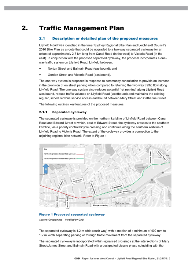
Lilyfield Road (Route EW09) was identified in the Inner Sydney Regional Bike Plan and Leichhardt Council’s 2016 Bike Plan as a route that could be upgraded to a separated, two-way cycleway.
The Super Tuesday Commuter Bike Count 2016 (Prepared by Bicycle Network) showed that up to 321 cyclists utilised Lilyfield Road (EW09) in the 2-hour morning peak period on a typical Tuesday.
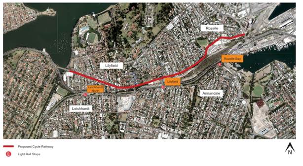
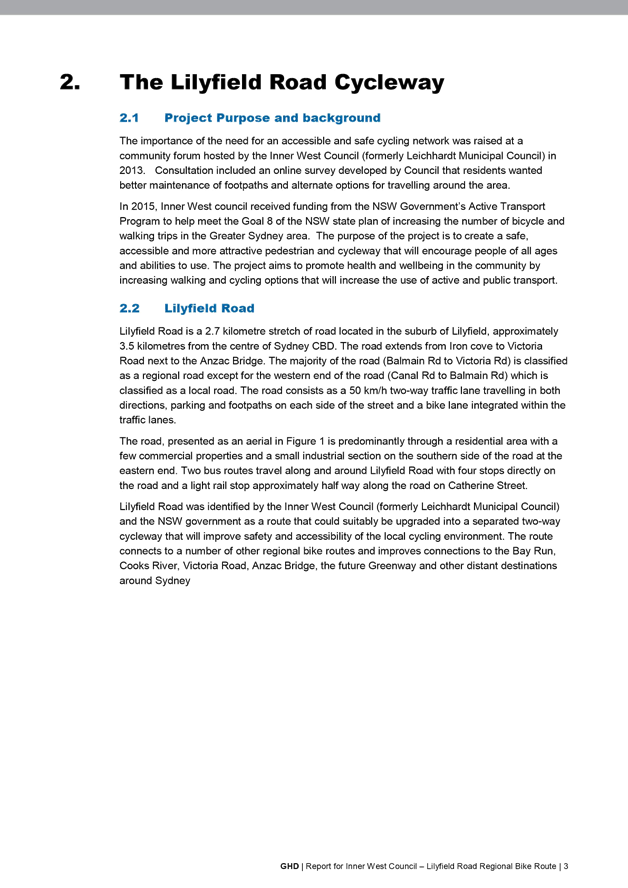
Route EW09 is a 2.7km regional route from Iron Cove to ANZAC Bridge via Lilyfield Road, the route connects to a number of other regional and local bike routes. It aims to improve connections to local destinations such as Cooks River, Bay Run, the future Greenway, Victoria Road, ANZAC Bridge and more distant destinations including Newtown and Sydney CBD.
Council received funding to prepare a detailed design for a separated cycleway along Lilyfield Road through the NSW Government’s Active Transport Program, and will facilitate meeting Goal 8 of the NSW State Plan 2021 to increase the number of bicycle and walking trips in the Greater Sydney area.
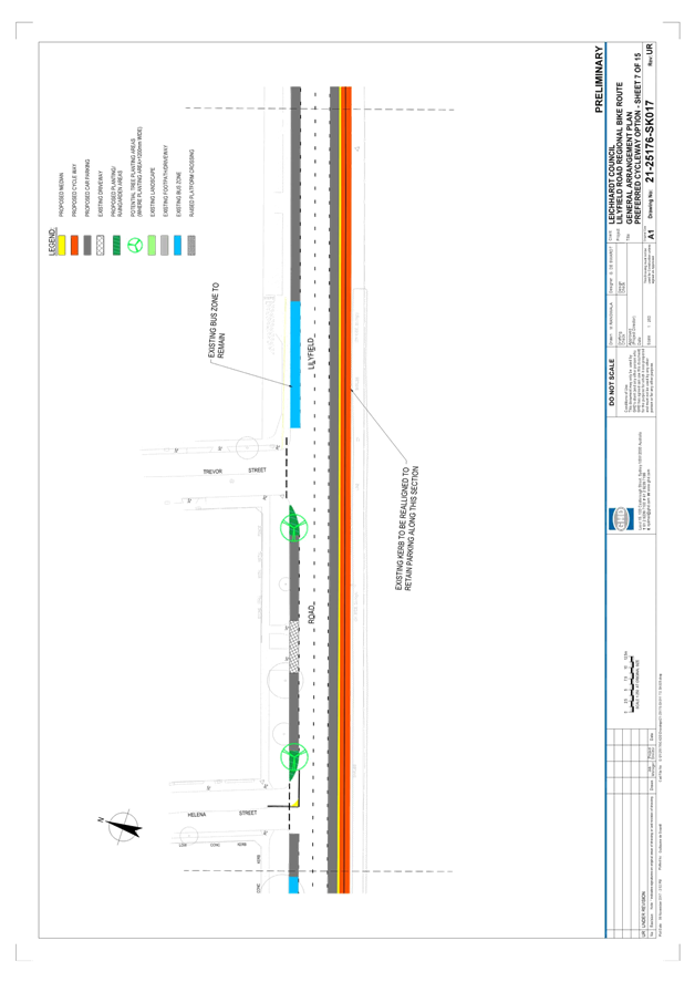
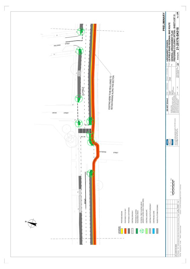
There is an existing on-road bike path on Lilyfield Road; however, the focus on Route EW09 was to create a safe and accessible cycling environment for all age groups to encourage new people to cycle, whilst improving safety for existing cyclists by providing a separated facility.
Council commissioned GHD in 2016 to undertake the design of the proposed separated cycleway.
During the design process, Council has held a number of meetings with Sydney Buses (STA), Roads and Maritime Services (RMS) and Transport for NSW to further develop the current revised concept plan prior to exhibiting to the public and other stakeholders. The project also includes significant streetscape and drainage improvements by providing water sensitive urban design.
FINANCIAL IMPLICATIONS
The design and construction of this project has been fully funded (100%) by the NSW Government’s Active Transport Program (Priority Cycleways).
OTHER STAFF COMMENTS
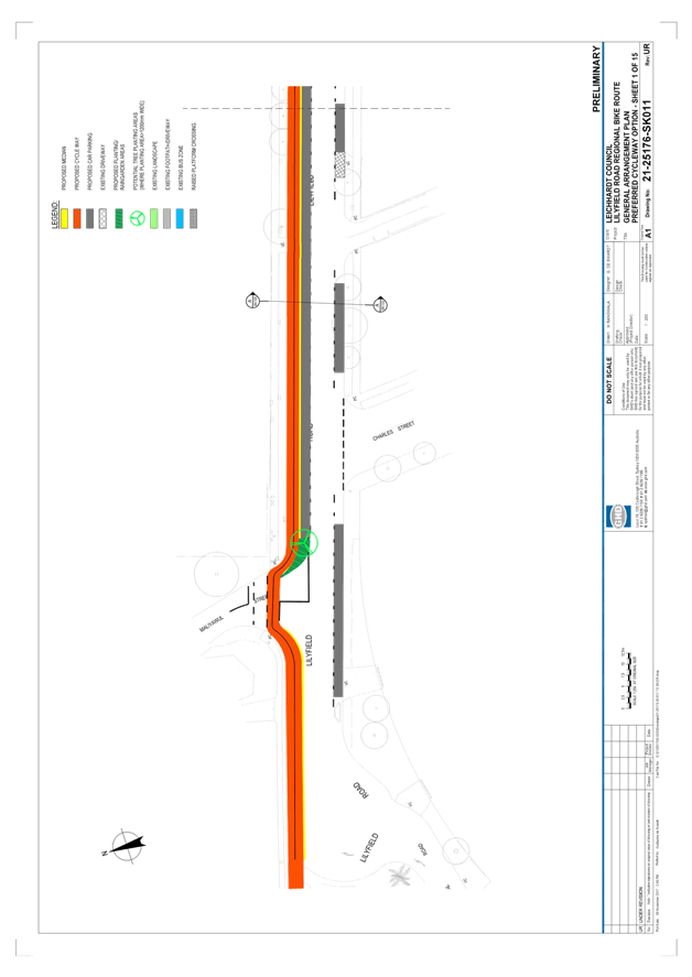
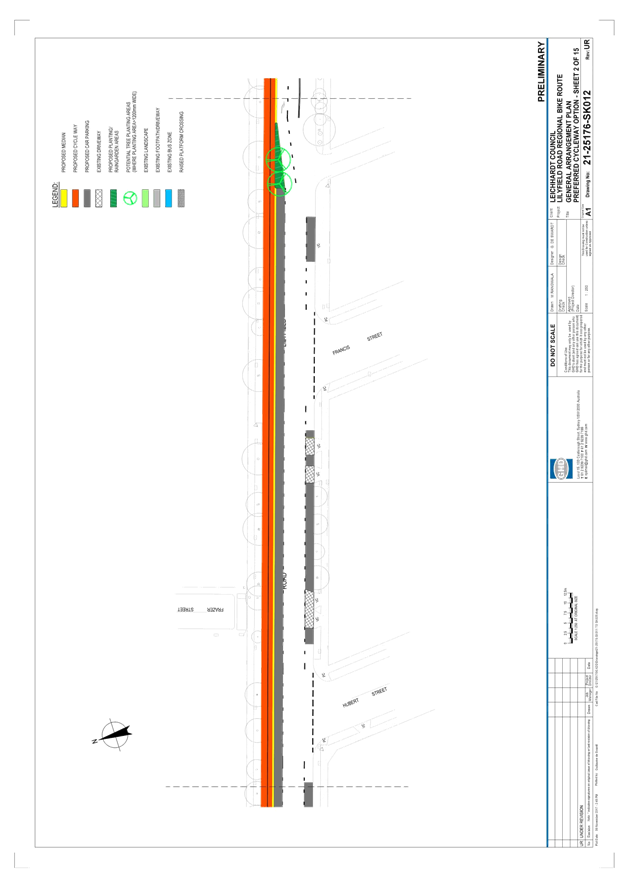
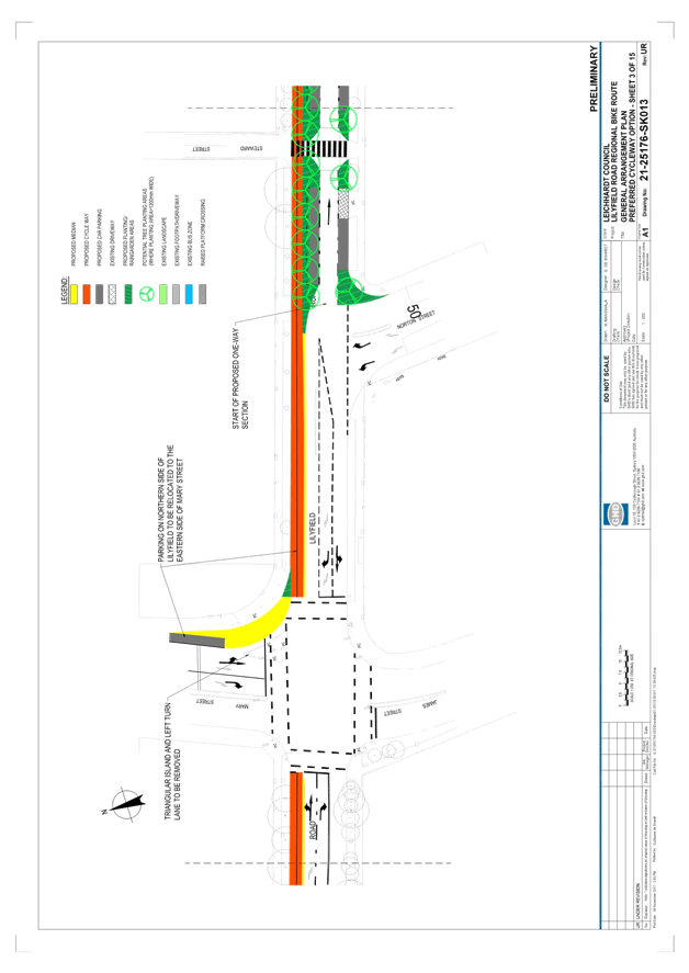
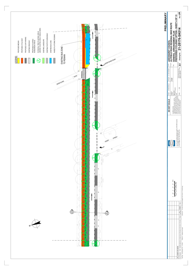
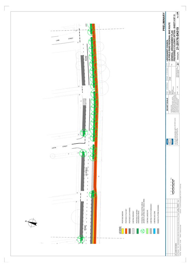
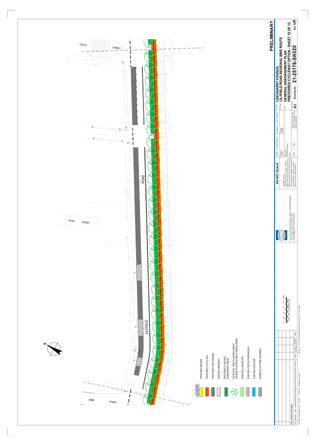
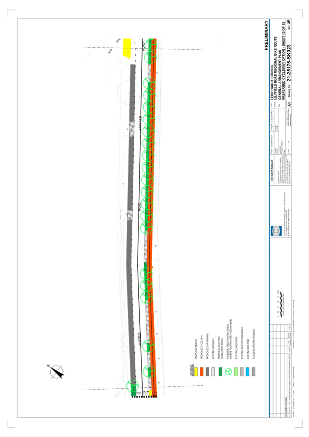
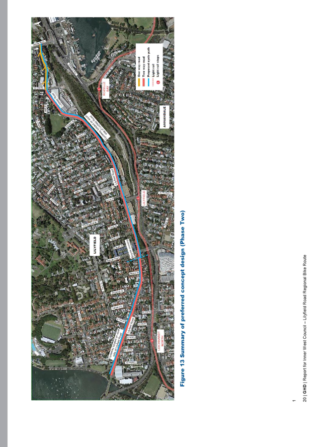
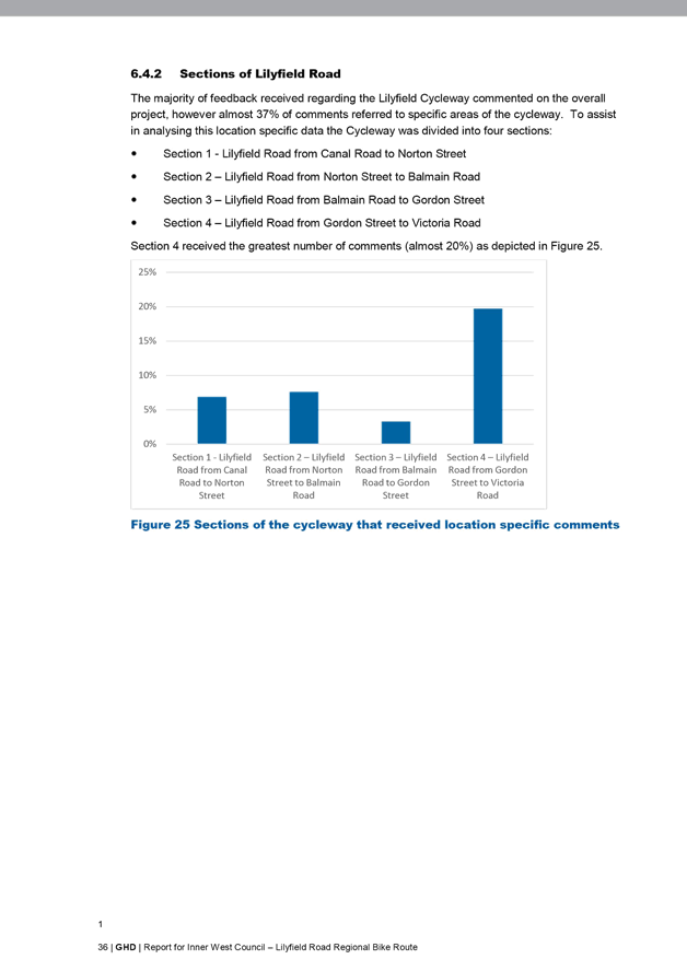
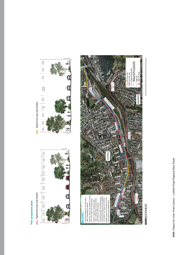
The revised concept plan for the Lilyfield Road separated cycleway (Route EW09) as proposed during community consultation between November 2017 and February 2018 is detailed in Attachment 1. Key features of this separated cycleway revised concept plan are summarised in the following section. The cycleway is also proposed to be constructed in stages commencing with Section 1.
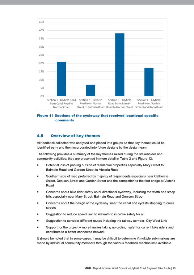
Section 1 – Lilyfield Road from Canal Road to Norton Street
Key features:
· Separated cycleway positioned adjacent to northern kerbline
· 2.8m bi-directional bike path proposed (1.6m uphill, 1.2m downhill)
· 5.4m two-way vehicle lane proposed
· Set back cycleway treatment across Maliyawul Street
· Bicycle phasing across the signalised Mary Street/James Street intersection
· Closure of left turn slip lane from Mary Street into Lilyfield Road to increase parking
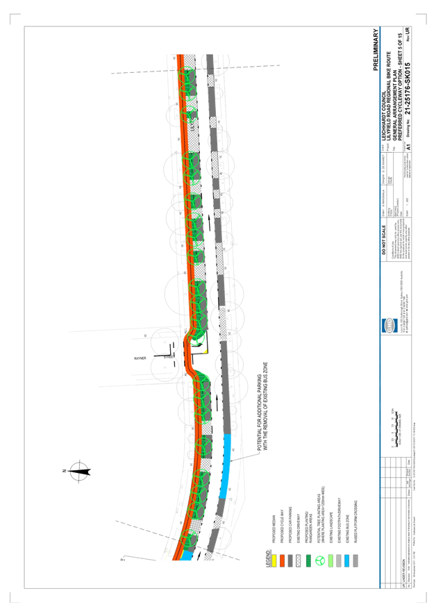
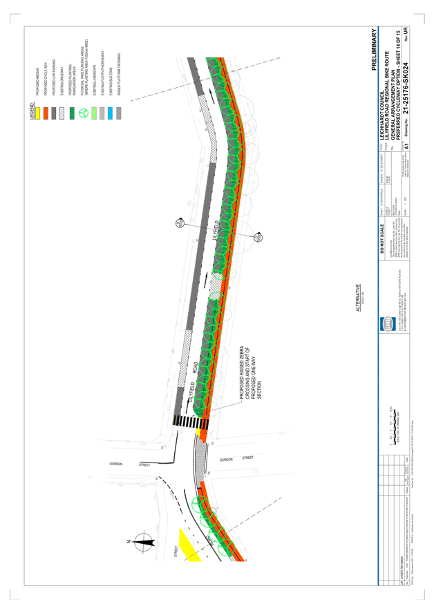
Section 2 – Lilyfield Road from Norton Street to Balmain Road
Key features:
· Separated cycleway positioned adjacent to northern kerbline
· 3.0m bi-directional bike path proposed (1.5m lanes in each direction)
· Two-way traffic flow to be altered to one-way (eastbound) to allow for parking to be retained (3.5m one-way lane)
· Set back cycleway treatment across Rayner Street
· Bicycle phasing across the signalised Balmain Road intersection
· Retain existing raised pedestrian (zebra) crossing at Steward Street
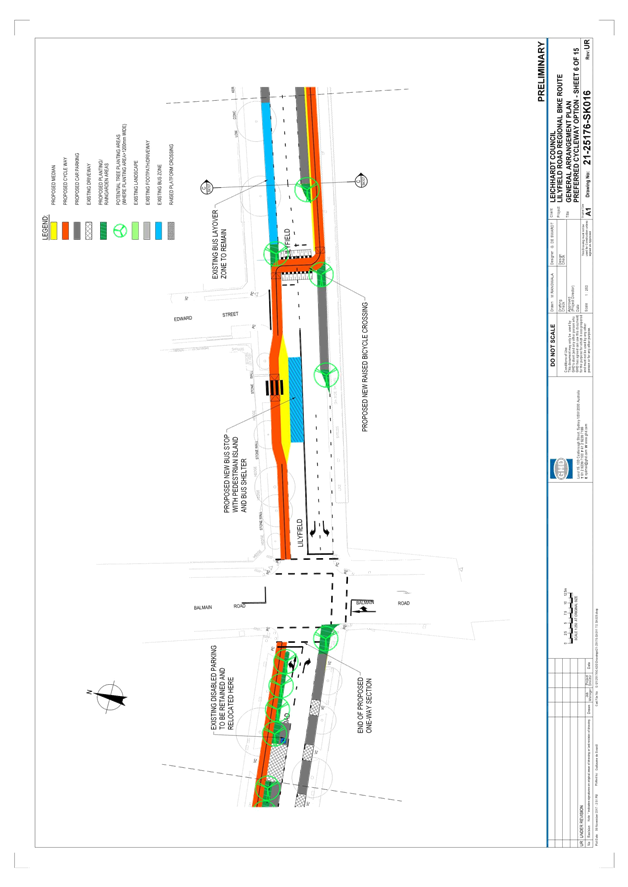
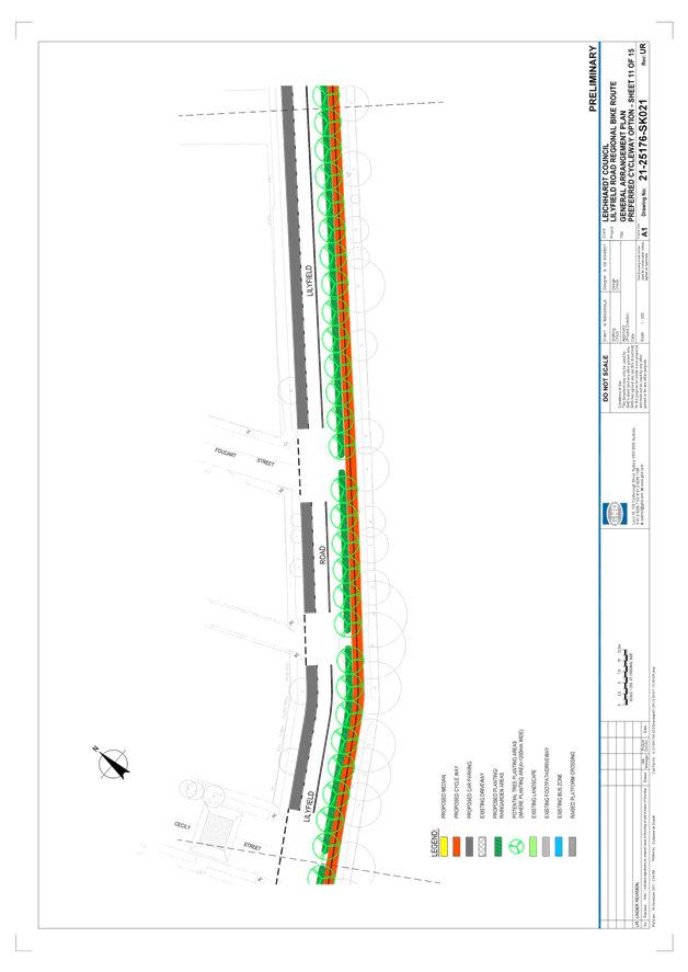
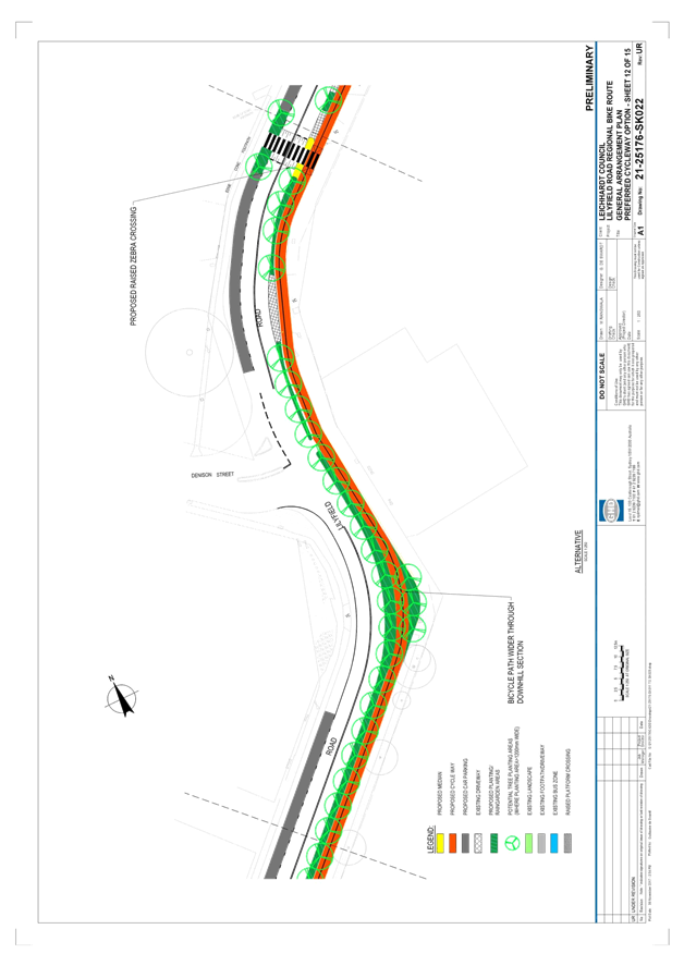
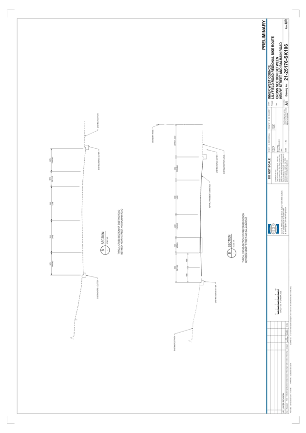
Section 3 – Lilyfield Road from Balmain Road to Gordon Street
Key features:
· Bicycle phasing across the signalised Balmain Road intersection
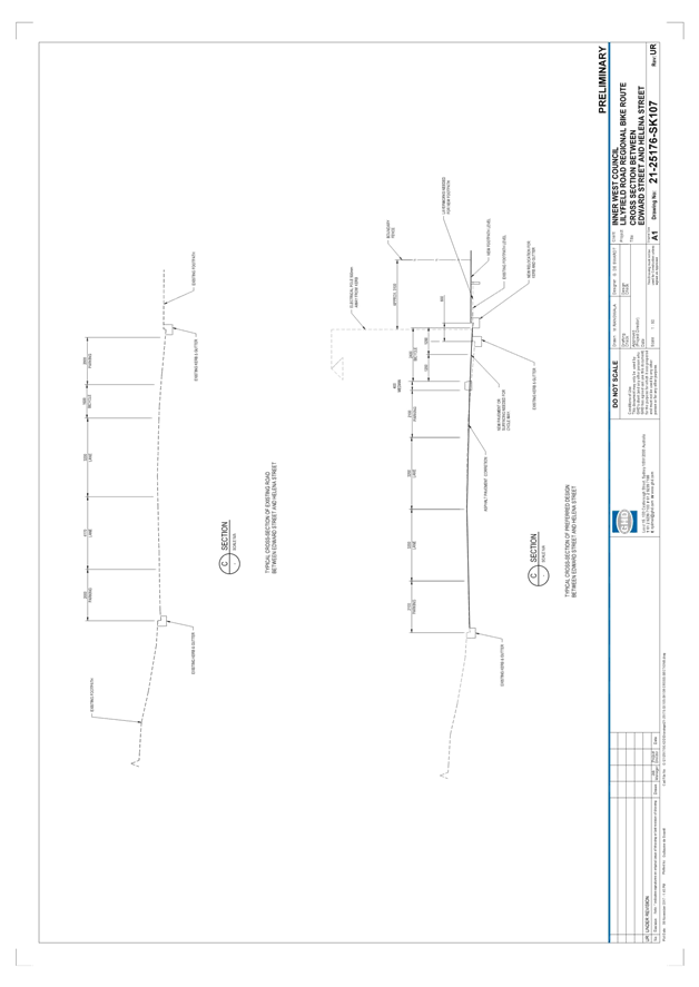
· Separated cycleway positioned adjacent to northern kerbline between Balmain Road and Edward Street. A bicycle crossing point is proposed to be placed immediately east of Edward Street and the separated cycleway will then continue on the southern side of Lilyfield Road between Edward Street and Gordon Street.
· 2.4m bi-directional bike path proposed (1.2m lanes in each direction)
· Bicycle crossing facility to provide priority for cyclists over vehicles (subject to detailed design)
· Upgraded bus stop with pedestrian island and bus shelter
· Set back cycleway treatment across Catherine Street and raised platform bicycle crossing across Gordon Street
· Approximately 115 parking spaces are lost, this parking is primarily boat/trailer parking on the southern side of Lilyfield Road adjacent to the Rozelle Rail Yards.
· New raised pedestrian (zebra) crossing east of Denison Street
· Retain existing raised pedestrian (zebra) crossing between Catherine Street and Grove Street
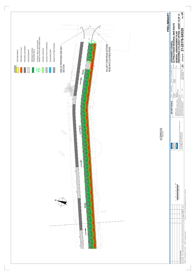
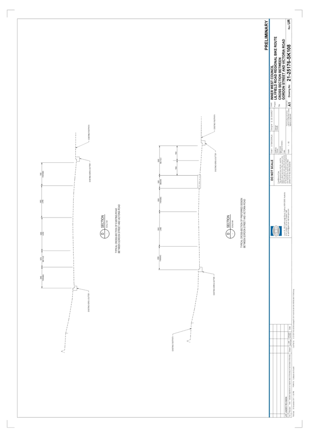
Section 4 – Lilyfield Road from Gordon Street to Victoria Road
Key features:
· Separated cycleway positioned adjacent to southern kerbline
· 3.0m bi-directional bike path proposed (1.5m lanes in each direction)
· Two-way traffic flow to be altered to one-way (eastbound) to allow for parking to be retained (3.5m one-way lane)
· Raised platform bicycle crossing across Gordon Street
· Upgrade raised threshold east of Gordon Street to a raised pedestrian (zebra) crossing
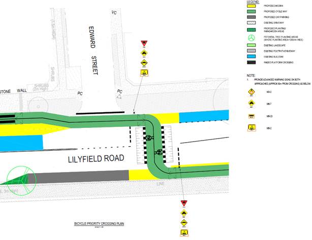
Bicycle Crossing
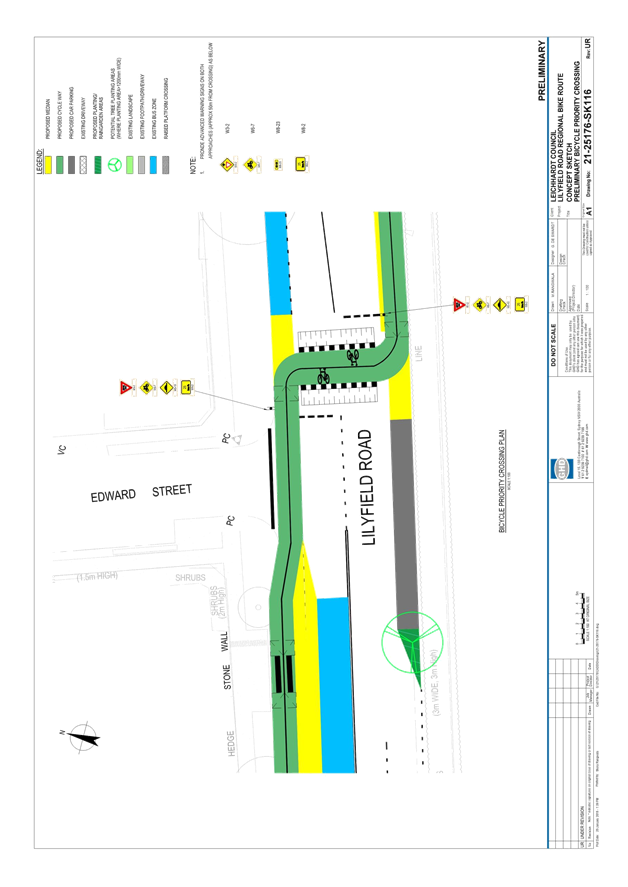
In order to minimise conflict with intersections, the separated cycleway is proposed to cross from the northern to southern kerblines of Lilyfield Road.
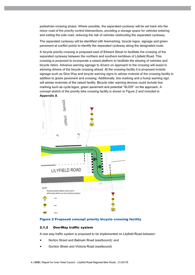
To maintain a continuous path for cyclists, it is proposed that this crossing point provide priority for cyclists over vehicles travelling in Lilyfield Road. To achieve this, it is proposed that a bicycle priority crossing is installed east of Edward Street with the following features:
· A raised platform to facilitate the slowing of vehicles and bicycle riders.
· Advance warning signage to drivers on approach to the crossing
· signage such as Give Way and bicycle warning signs to advise motorist of the crossing facility
· line marking and a speed hump warning sign will advise motorists of the raised facility.
· Bicycle rider warning devices could include line marking such as cycle logos, green pavement and potential “SLOW” pavement markings on the approaches.
A concept sketch of the priority bike crossing facility is shown in the following figure.
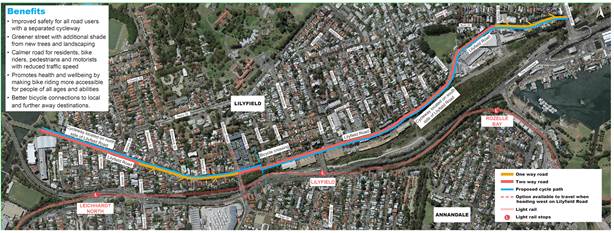
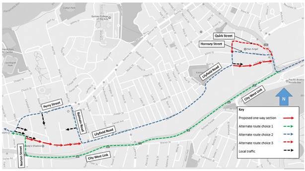
Proposed One-Way restrictions
A one-way traffic system is proposed to be implemented on Lilyfield Road between:
· Norton Street and Balmain Road (eastbound); and
· Gordon Street and Victoria Road (eastbound)
The one-way systems provide:
· Increase in kerbside parking (when compared to the option of a two way traffic system incorporating a separated cycleway) to address residents’ comments on impacts to parking availability;
· A reduction of potential “rat running” along Lilyfield Road westbound;
· A reduction in traffic volumes on Lilyfield Road (westbound); and
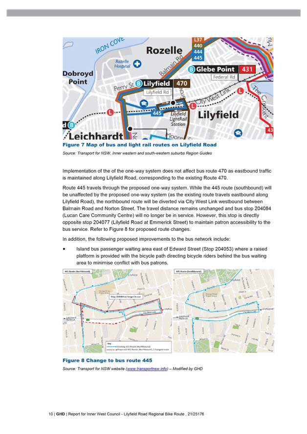
· The ability to maintain the existing regular, scheduled bus service access eastbound between Mary Street and Catherine Street. Transport for NSW and Sydney Buses have been consulted on this change and have agreed to amend bus routes to accommodate the one-way restriction. Existing bus patrons will continue to have access to the affected services.
The one-way system requires the modification of the signalised intersection of Lilyfield Road
and Balmain Road, where entry will not be permitted for vehicles in a westbound direction. The priority control intersection of Victoria Road and Lilyfield Road will be controlled by “No Entry” signage to advise motorists of the one-way restriction in this area.
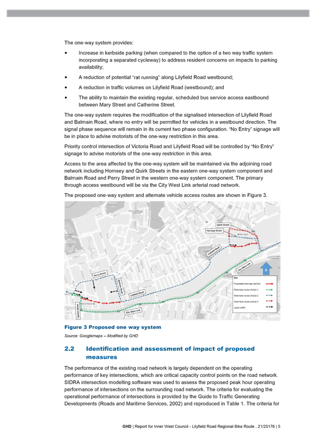
Access to the area affected by the one-way system will be maintained via the adjoining road
network including Hornsey and Quirk Streets in the eastern one-way system component and
Balmain Road and Perry Street in the western one-way system component. The primary through access westbound will be via the City West Link arterial road network.
The proposed one-way system and alternate vehicle access routes are shown in the following figure.
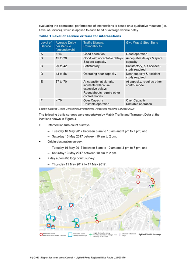
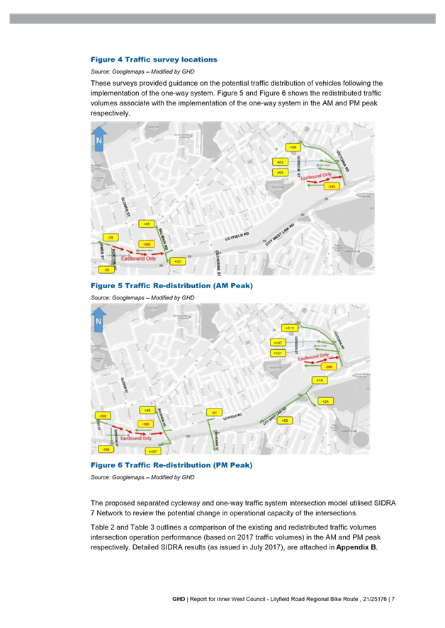
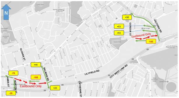
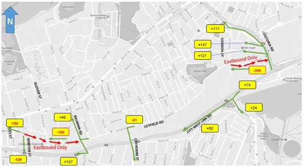
As part of the proposal RMS required a Traffic Management Plan (TMP) be prepared for the one-way traffic restrictions, this document is located in Attachment 2. It should be noted that the attached TMP is an extract and excludes Appendix B – SIDRA Analysis, a summary of the results are contained in the body of the report in Figure 5 and Figure 6 and reproduced in the following two plans.
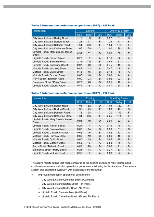
In order to develop the TMP, additional traffic counts were undertaken in 2017 to enable traffic modelling to analyse the impact of the redistributed traffic on the adjacent road network, including identified key intersections both signalised and unsignalised as shown in Figures 3, 5 and 6 of the TMP. Although there was a decrease in performance at 7 intersections, there was an improved performance at 9 intersections in the area. RMS modellers then reviewed Council’s analysis and then gave “in principle support” on the analysis of the road network that allowed Council to publicly exhibit the current revised concept design plans from November 2017. The TMP does not recommend the provision of mitigation measures for the proposed one-way systems and separated cycleway.
The AM Peak traffic redistribution:
The PM Peak traffic redistribution:
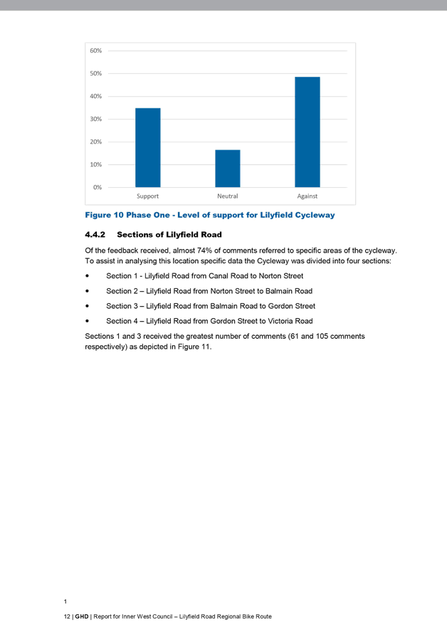
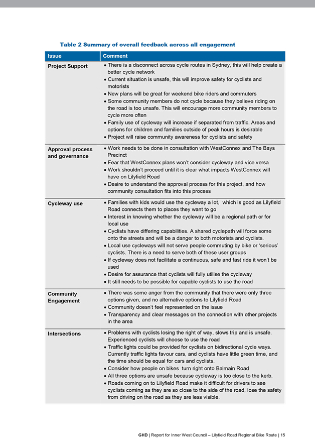
PUBLIC CONSULTATION
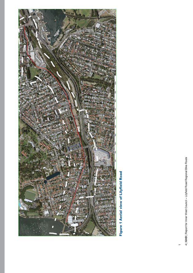
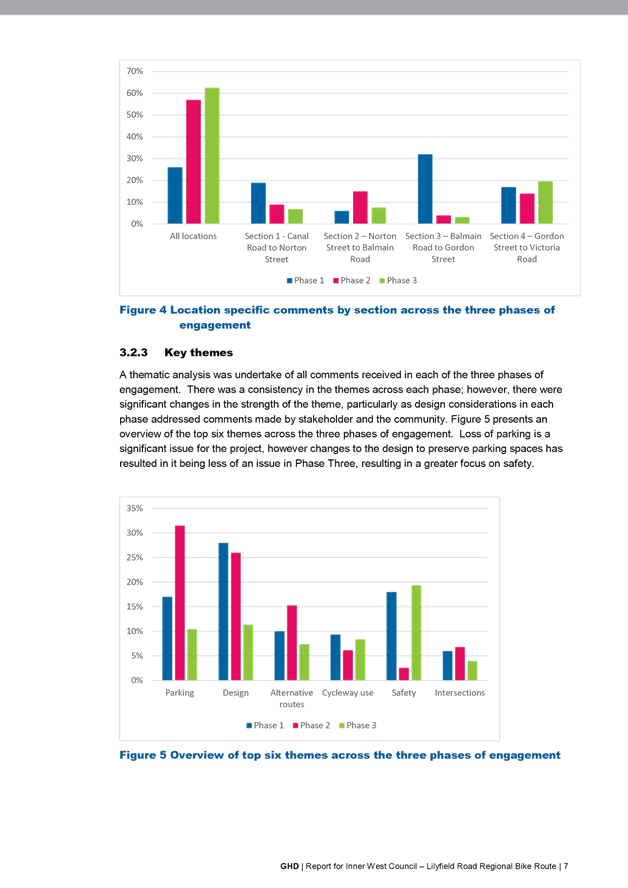
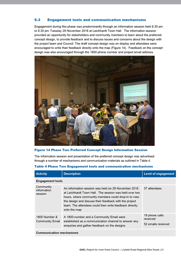
Council has undertaken three phases of community consultation from May 2016 until February 2018 to inform the community about the project, and gather feedback on the preliminary and draft concept designs. Following each phase of consultation, revisions have been made to the concept plans to take on board comments from the community.
There were three phases of engagement to get feedback from the community, bicycle riders and other stakeholders at each stage of the design. All of the feedback received was considered by the project team and where possible, incorporated into the following design stage.
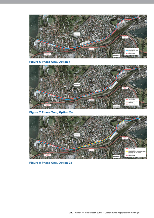
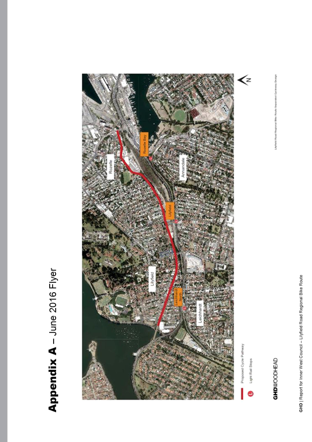
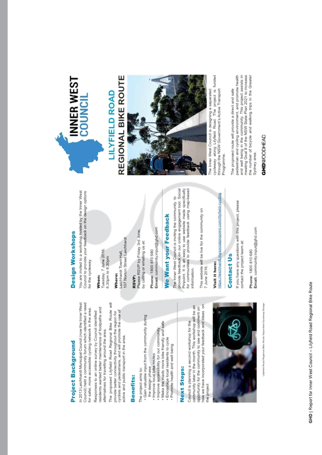
· Phase One: May – October 2016
o Objective: Determine preferred route from two design options and gain feedback to inform the development of the draft concept plan
o Design options:
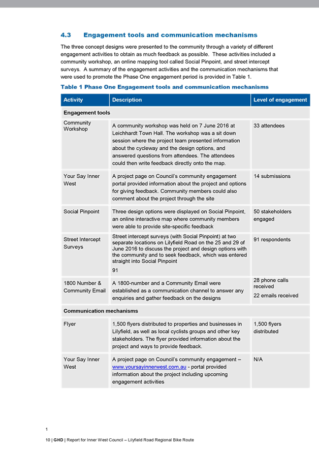
§ Option 1 – A two-way, separated cycleway on the northern side of Lilyfield Road between Victoria Road and the Hawthorne Canal.
§ Option 2a - A two-way, separated cycleway on the southern side of Lilyfield Road between Victoria Road and Hawthorne Canal.
§ Option 2b - A two-way, separated cycleway on the southern side of Lilyfield Road between Victoria Road and Hawthorne Canal with some kerb indentation near Lilyfield Light Rail Stop.
o Promotion:
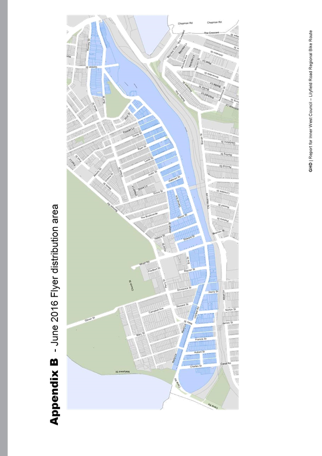
§ 1500 Flyers distributed to local residents and business and bicycle groups
§ Project page on www.yoursayinnerwest.com.au
o Engagement activities:
§ In person:
· Community workshop was held at Leichhardt Town Hall on 7 June 2016
· Intercept surveys on Lilyfield Road were held on two occasions (25th and 29th June 2016).
§ Online: through the feedback form on www.yoursayinnerwest.com.au and an interactive map
§ Email, telephone and website forwarded to GHD.
o Outcomes
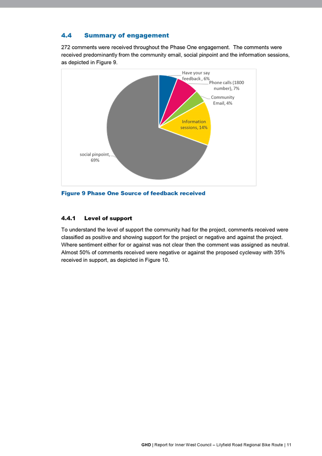
272 comments were received throughout the Phase One engagement. The comments were received predominantly from the community email, social pinpoint and the information sessions.
Summary of feedback received:
· Concerns about potential parking loss
· Southern side of road preferred by majority of respondents
· Concerns about bike rider safety on bi-directional cycleway, especially on hills
· Suggestion to reduce speed limit to 40 km/h to improve safety for all
· Suggestion to consider different routes including the railway corridor, City West Link
· Support for the project – more families taking up cycling, safer for current bike riders and contribute to a better connected network.
· Phase Two: November 2016 – June 2017
o Objective: Gain feedback from the community and other stakeholders on the draft concept plan
o Draft Concept Plan
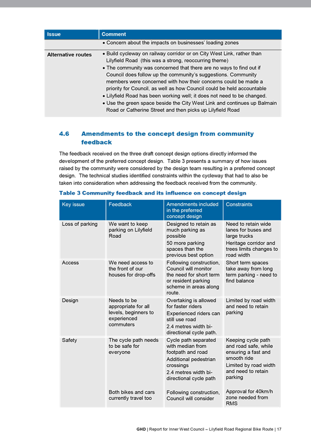
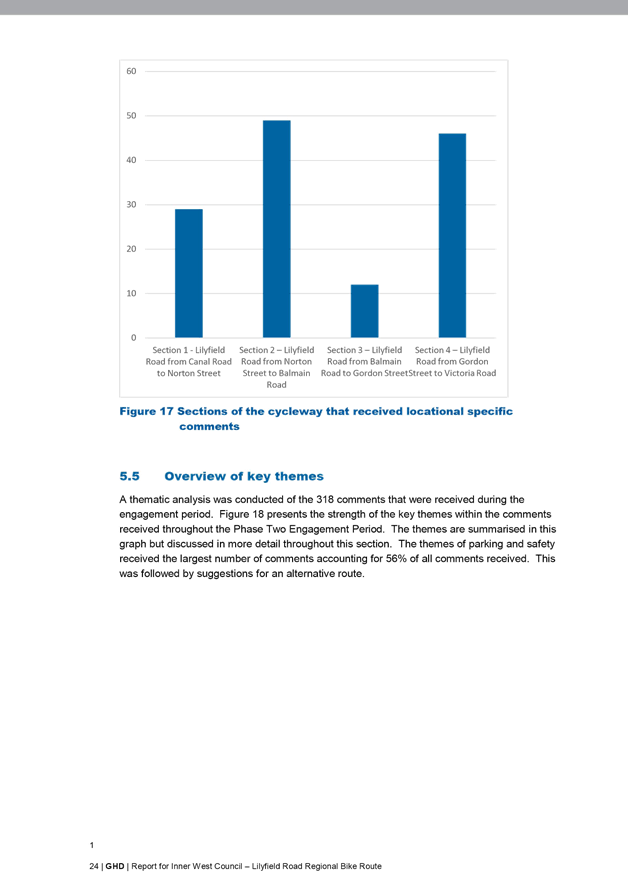
Based on feedback received in Phase One, a preferred concept design was chosen. This preferred plan was a hybrid of option 1 and 2b, the cycleway was proposed on the northern side of Lilyfield Road from Canal Road to just west of Balmain Road, it would then cross Lilyfield Road and continue to Victoria Road on the southern side of the street. Only the section between Gordon Street and Victoria Road was proposed to be one way at this point. Kerb indentation was provided on the southern side of Lilyfield Road between Balmain Road and Justin street to retain commuter parking near the Light Rail; however, a similar treatment wasn’t possible in the section between Norton Street and Balmain Road due to heritage trees in the grass verge, existing parking in this location would be lost due to road width constraints.
o Engagement activities:
§ In person: Community session was held at Leichhardt Town Hall on 29 November 2016
§ Email, telephone and website forwarded to GHD.
o Outcomes
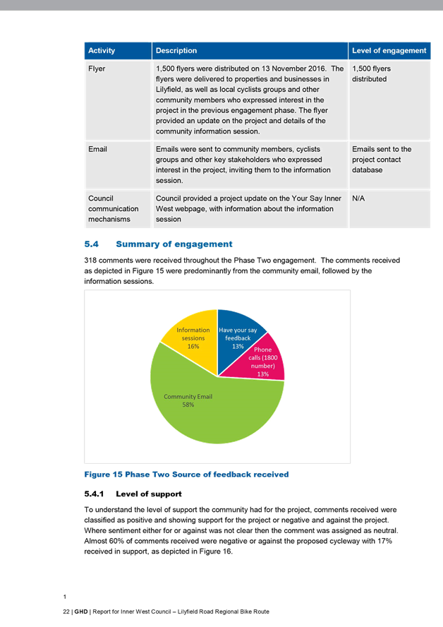
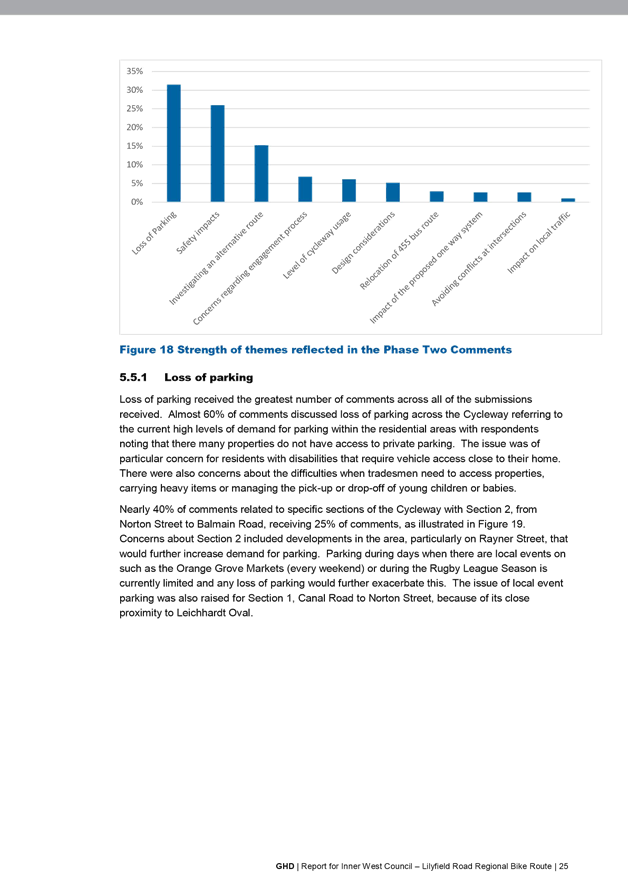
318 comments were received throughout the Phase Two engagement. The comments received were received predominantly from the community email, followed by the information sessions.
Summary of feedback received:
· Concerns about potential parking loss:
o Draft design doesn’t address this enough
o Potential flow on affect to nearby streets
o Potential impact to loading zones, customer parking, disabled spaces, access to properties
· Concern about access to driveways
· Suggestion to re-route buses off Lilyfield Road or change Norton Street to Balmain Road one way to allow for road widening to accommodate cyclepath and on-street parking
· One way section between Gordon Street and Victoria Road will increase travel time
· The community needs to be engaged more widely
· Support for the project – will be well used, facilitate more environmentally friendly ways of commuting, increase safety for pedestrians and bus patrons at Victoria Road intersection.
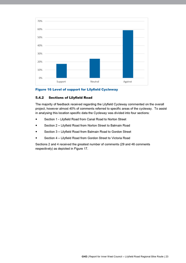
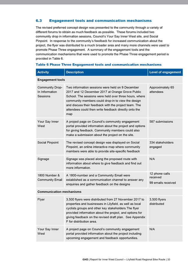
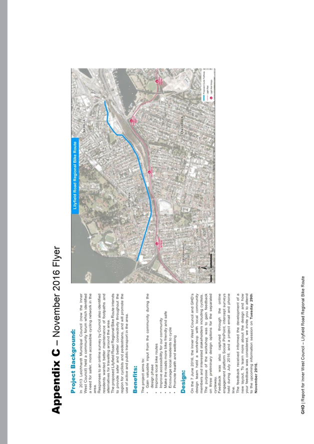
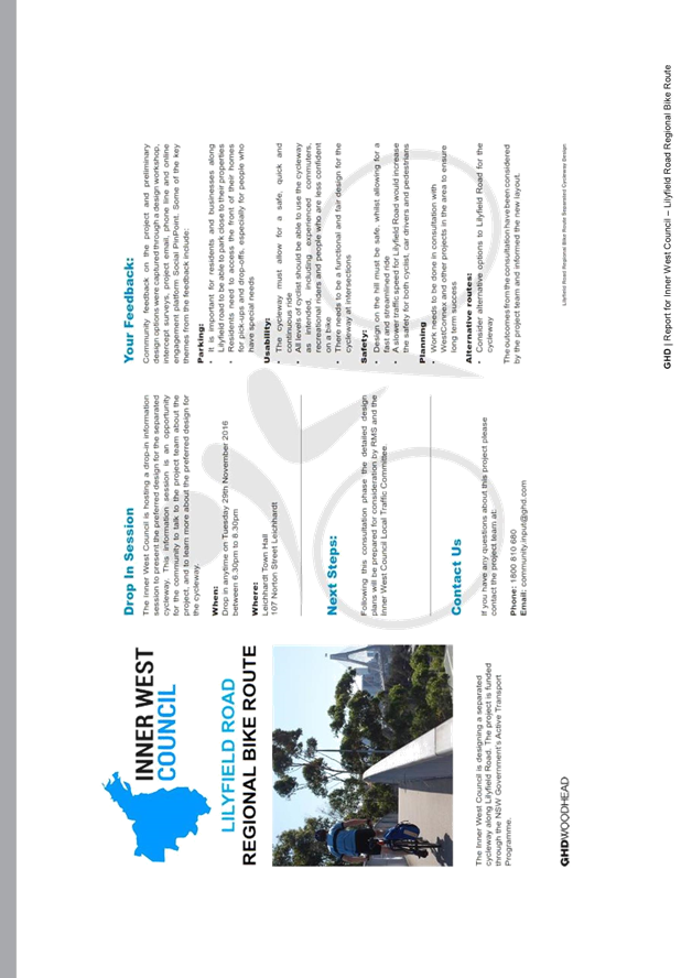
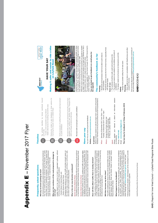
· Phase Three: November 2017 – February 2018
o Objective: Gain feedback from the community and other stakeholders on the final draft concept plan
o Current revised draft concept plan:
Based on the feedback from Phase Two, a revised concept plan was developed which provides an additional eastbound one-way section in Lilyfield Road between Norton Street and Balmain Road. This retained parking in this section which was the primary concern during Phase Two of the consultation. In addition, the bicycle crossing point was moved from west of Balmain Road to east of Balmain Road and the slip lane from Mary Street into Lilyfield Road was proposed to be removed to increase parking supply.
o Promotion:
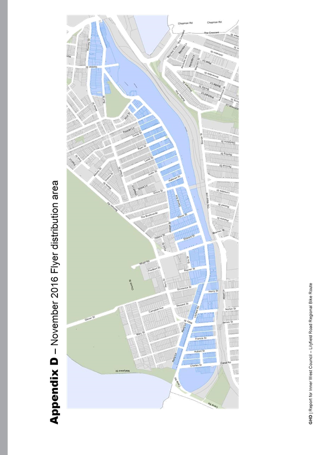
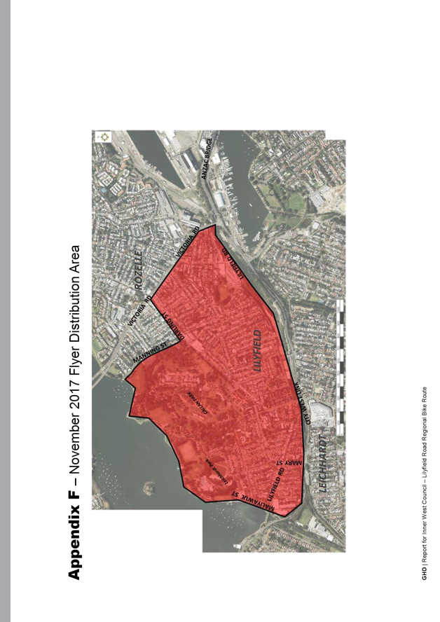
§ Flyer distributed to a local residents and business and bicycle groups. Responding to the community’s feedback that more residents needed to be engaged, the flyer was distributed to 3,500 properties.
§ Project page on www.yoursayinnerwest.com.au
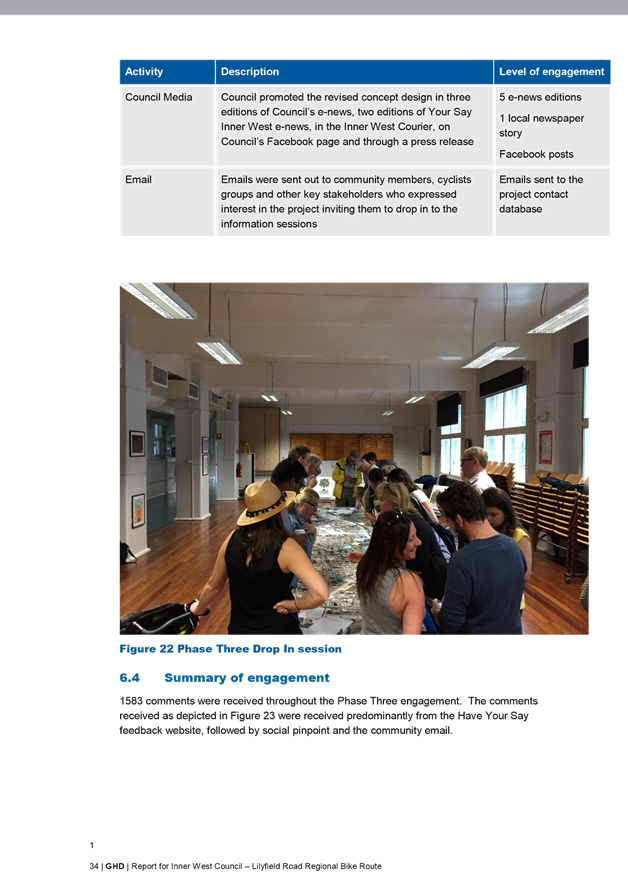
§ Three editions of Council’s e-news
§ Two editions of Your Say Inner West e-news
§ Council’s page in the Inner West Courier
§ Council’s Facebook page
§ Press release
§ Signage was placed along the route detailing information on how to lodge a submission
o Engagement activities:
§ In person:
· Two community sessions were held at Orange Grove Public School (9 and 12 December 2017)
§ Online: through the feedback form on www.yoursayinnerwest.com.au and an interactive map
§ Email, telephone and website to GHD.
o Outcomes
The wider promotion of this phase of the project led to greater numbers of respondents. This is reflected in the table below and the summary of comments.
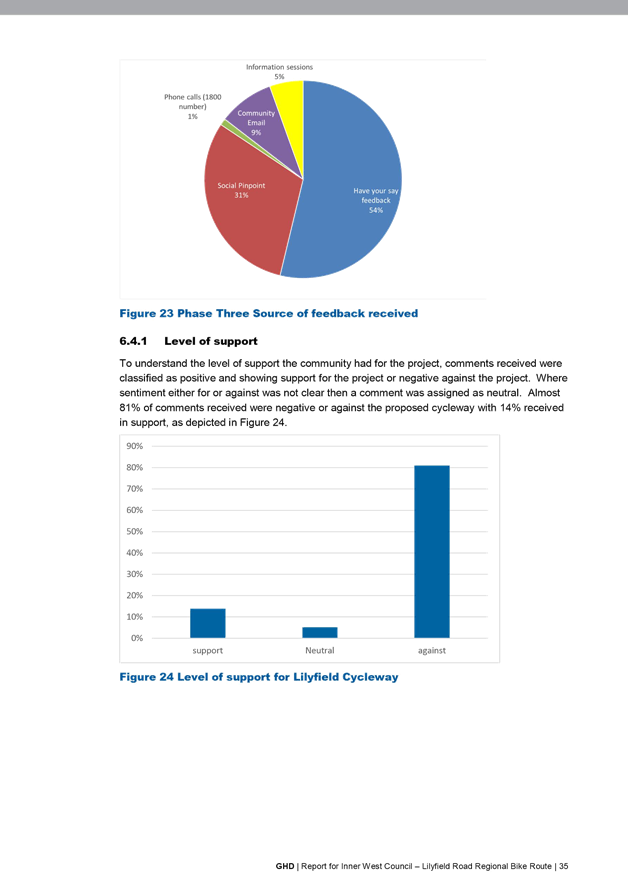
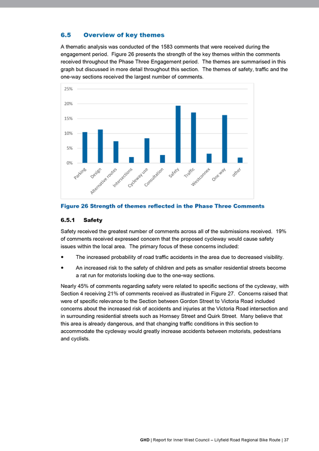
1583 comments were received throughout the Phase Three engagement. The comments received were received predominantly from Have Your Say feedback, followed by Social Pinpoint tool and community email.
Please note that the exhibition period initially closed on the 2nd February 2018 but was extended until the 20th February 2018 to allow further time for public submissions.
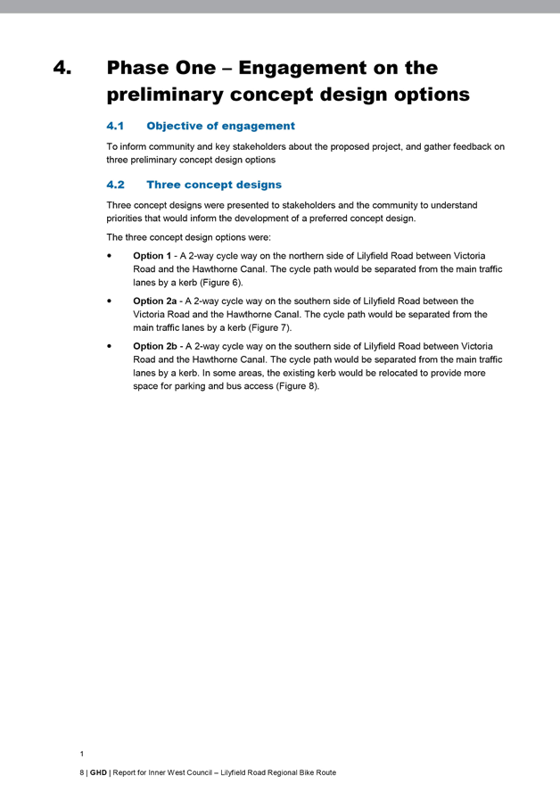
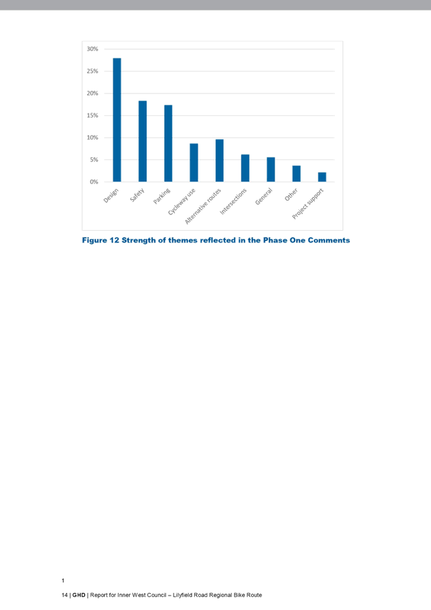
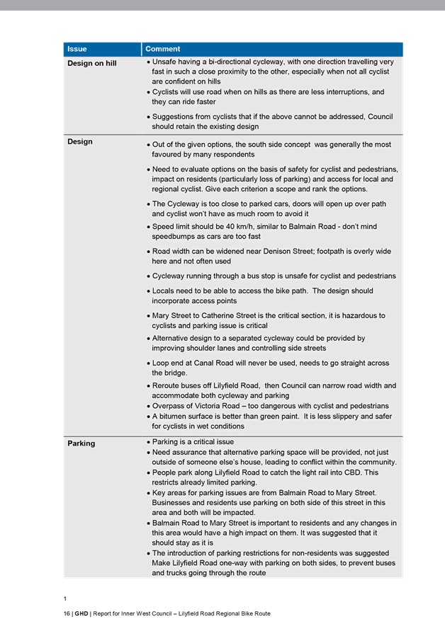
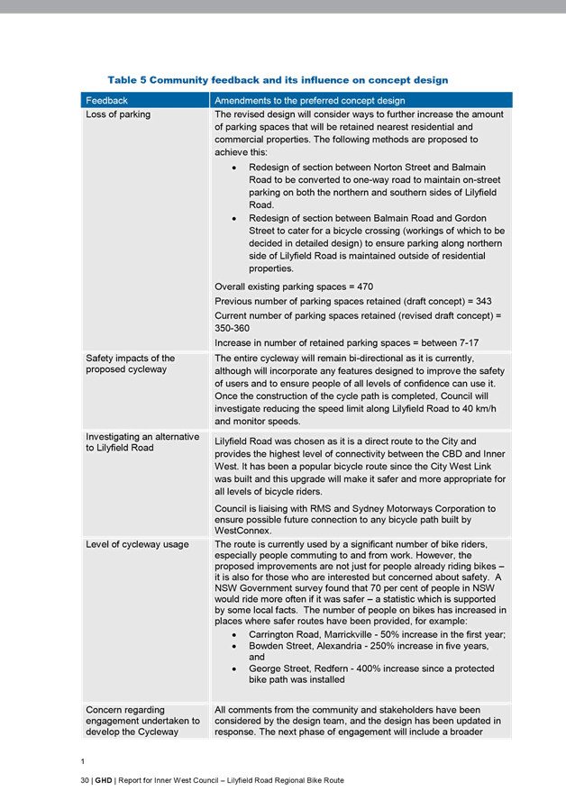
The main themes raised by residents during the current exhibition period is summarised below. A detailed summary of the comments received during community consultation is provided in the ‘Community Engagement Outcomes Report’ (Attachment 3).
This report didn’t count individuals and was based on number of comments received as it was considered to be a more accurate reflection on the strength of a theme. Also, it is difficult to measure whether multiple submissions were made.
|
Main themes |
Council’s response |
|
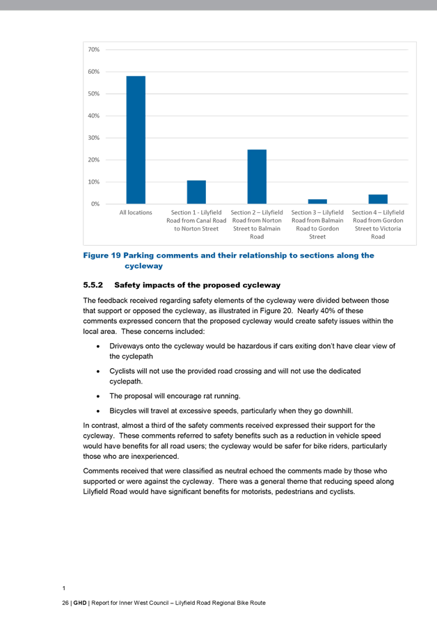
Safety
Issues listed in 6.5.1 & 6.5.6 Community Engagement Outcomes Report |
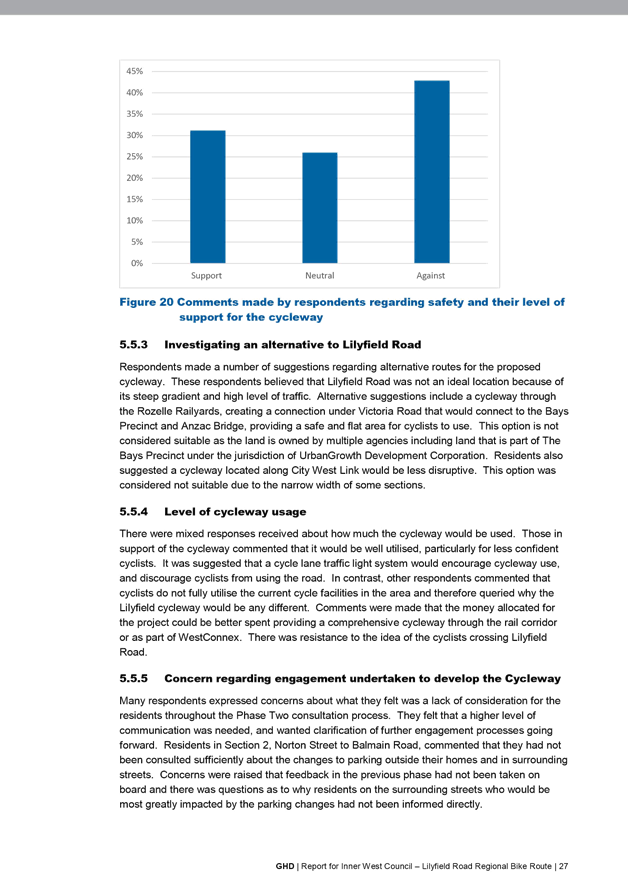
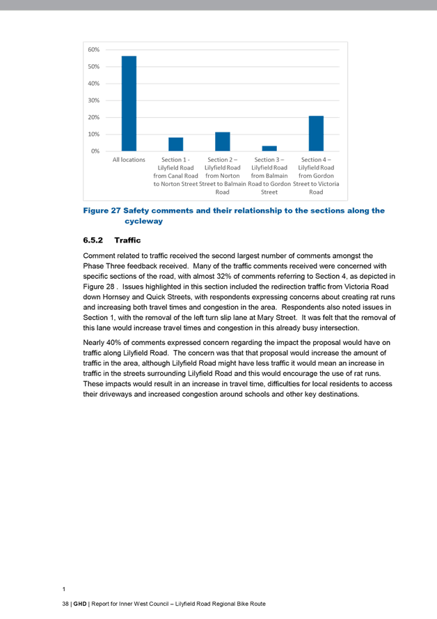
· Section 4 (Gordon Street to Victoria Road) received 21% of comments with concerns about the proposed one-way section and its impact on surrounding streets. It is proposed to further investigate their concerns as described in the following section of the report, ‘further investigation’.
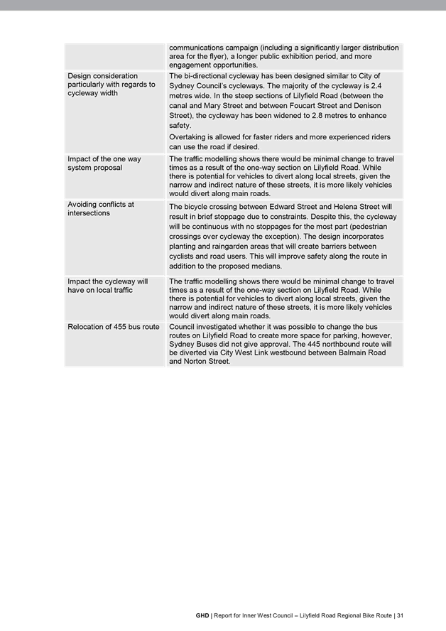
· The cycleway has been designed to meet existing safety standards. The detailed design will consider all RMS standards and specifications. The standard 2.4m wide bi-directional cycleway has been designed similar to City of Sydney Council’s cycleways. However, where possible the cycleway will be widened to be up to 3.0m wide. Overtaking is allowed for faster riders and more experienced riders are still allowed to use the road if desired.
· The bicycle crossing between Edward Street and Helena Street may result in brief stoppage due to constraints. Despite this the cycleway will be continuous with no stoppages for the most part (pedestrian crossings over cycleway the exception). The current proposed bicycle crossing will provide a raised platform, line marking treatment, give-way control and advance warning signs to improve safety.The bicycle crossing point will continue to be examined to ensure the optimal crossing location and treatment is provided.
· Once the construction of the cycle path is completed, Council intends to reduce the speed limit along Lilyfield Road to 40 km/hr and monitor speeds. 40 km/hr speed limit proposal will need to be approved by RMS.
|
|
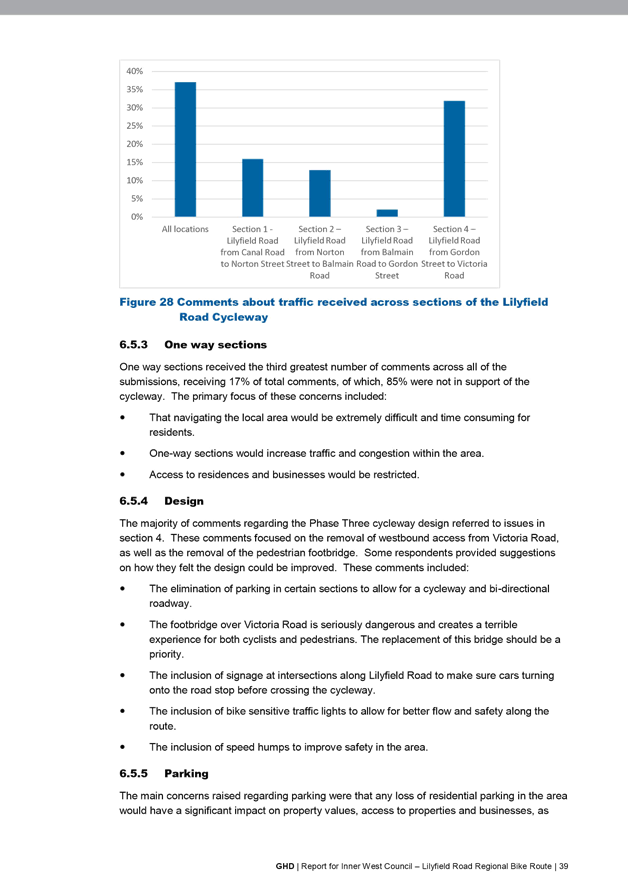
Traffic and One-way sections
Issues listed in 6.5.2 & 6.5.3 Community Engagement Outcomes Report |
· The one-way sections were incorporated into the design to reduce the amount of on-street parking lost on Lilyfield Road.
· Under the consulted proposal, traffic modelling of the area shows that there would be a small increase in traffic on Balmain Road and City West Link and a small decrease on Norton Street. The biggest increase on residential sections of Balmain Road would be an average of 10 additional cars every 10 minutes during the afternoon/ evening peak hour. The TMP does not recommend the provision of mitigation measures for the proposed one-way system and separated cycleway.
· Given community concerns with the one-way restrictions in Lilyfield Road between Gordon Street and Victoria Road, it is proposed to undertake a detailed review on reversing the travel direction from eastbound to westbound.
· Concerns have also been received regarding the removal of the left turn slip lane from Mary Street onto Lilyfield Road. The removal of the left turn slip lane from Mary Street into Lilyfield Road will be reconsidered in the next revised concept plan.
|
|
Design
Issues listed in 6.5.4 Community Engagement Outcomes Report |
· Respondents provided suggestions on how they felt the design could be improved. The comments will be considered as part of the next revised concept plan and subsequent detailed design. |
|
Parking
Issues listed in 6.5.5 Community Engagement Outcomes Report |
· Council will investigate further opportunities to reduce parking loss along the route.
· There will be a loss of approximately 115 parking spaces between Balmain Road and Gordon Street; however, this parking is primarily to boat/trailer parking on the southern side of Lilyfield Road adjacent to the Rozelle Rail Yards.
· Following construction, Council would review the need for resident parking restrictions in sections of Lilyfield Road.
|
|
Alternative routes
Issues listed in 6.5.7 Community Engagement Outcomes Report |
· Lilyfield Road was identified in the Inner Sydney Regional Bike Plan and Leichhardt Council’s 2016 Bike Plan as a route that could be upgraded to a separated, two-way cycleway.
· Lilyfield Road was chosen as the route as it is a direct route to the City and provides the highest level of connectivity between the CBD and Inner West. It has been a popular bicycle route since the City West Link was built and this upgrade will make it safer and more appropriate for all levels of bicycle riders.
· There is a connectivity issue with the alternate City West Link cycleway in the Rozelle railyards as there was no access provided prior to the extension of the light rail and the cost of construction would be prohibitive and require closure of the light rail west of Lilyfield Light Rail Stop for tunnel construction.
· Note, Council is liaising with RMS and Sydney Motorways Corporation to ensure possible future connection to a bicycle path between Lilyfield Road and WestConnex cycleway should this be constructed by WestConnex.
|
Council has also received detailed submissions from the Inner West Bicycle Coalition. These comments primarily relate to design elements and will be considered as part of the next revised concept plan and when undertaking detailed design.
Inner West Bicycle Coalition will be consulted during the design phase.
FURTHER INVESTIGATION
In order to further address resident comments raised during Phase Three of consultation, it is proposed to investigate additional treatment options to improve amenity for local residents. These are outlined below.
Section 1 - Lilyfield Road from Canal Road to Norton Street
· Investigate retaining the left turn slip lane from Mary Street onto Lilyfield Road
Both the option of retaining or closing the slip lane is feasible. Closing the slip lane will allow an increase in parking supply for nearby residents however will increase delay for motorists at the intersection of Mary Street and Lilyfield Road.
· Investigate options to allow cyclists to enter a mixed traffic treatment in the westbound direction from Mary Street to Canal Road
The entire cycleway will remain bi-directional as it is currently; however, Council will investigate options to allow cyclists travelling westbound to enter a mixed traffic treatment when travelling downhill from Mary Street to Canal Road westbound. This option would likely cause additional traffic delay for vehicles and cyclists at the intersection of Mary Street and Lilyfield Road and traffic modelling is required to understand the impact of this option.
Section 2 – Lilyfield Road from Norton Street to Balmain Road
· Investigate opportunities to increase parking supply on Lilyfield Road
Council and GHD will review all existing and proposed parking spaces within this section of Lilyfield Road with a view of investigating options to improve parking supply.
Section 3 – Lilyfield Road from Balmain Road to Gordon Street
· Investigate opportunities to relocate bicycle crossing to the signalised crossing of Balmain Road and Lilyfield Road.
This option requires detailed discussions with RMS with regards to acceptable signal design. This option would likely cause additional traffic delay for vehicles and cyclists at the intersection of Balmain Road and Lilyfield Road but would improve safety as cyclists would cross the road at a signalised facility. Traffic modelling is required to understand the impact of this option. Parking will also be lost on the southern side of Lilyfield Road between Edward Street and Balmain Road in order to allow the cyclway to continue its southern alignment up to the traffic signals. Options to mitigate this loss in parking will be investigated.
Section 4 – Lilyfield Road from Gordon Street to Victoria Road
· Investigate reversal of proposed one-way restrictions from eastbound to westbound
This option would allow vehicles to enter Lilyfield Road from Victoria Road and travel westbound only. This would not address safety concerns (pedestrian/vehicular conflict and vehicular/bus conflict) at the intersection of Victoria Road and Lilyfield Road and would continue to allow ‘rat-running’ into Lilyfield Road from the city, however this amendment would prevent redistribution of traffic into Hornsey Street and Quirk Street. In this scenario traffic that would otherwise have travelled eastbound on Lilyfield Road in order to turn left onto Victoria Road would be redistributed to Gordon Street. The intersection of Gordon Street and Victoria Road is signalised and allows vehicles to turn left and right into Victoria Road, entry from Victoria Road into Gordon Street is banned although Gordon Street is two-way. Local traffic to Lilyfield Road properties between Gordon Street and Victoria Road would be redistributed via City West Link and Victoria Road.
Detailed modelling of this scenario would have to be undertaken to determine the level of impact onto the local and regional road network.
· Investigate traffic calming treatments to reduce ‘rat-running’
Further traffic calming measures will be considered subject to the previously mentioned investigation into the direction of the one-way restrictions in Lilyfield Road between Gordon Street and Victoria Road. A proposed eastbound traffic movement would result in traffic calming being investigated in Hornsey Street and Quirk Street whilst a proposed westbound traffic direction may require additional treatment to Lilyfield Road.
CONCLUSION
The current revised concept plan proposes bicycle route improvements that would encourage more local and regional trips by bicycle by providing a safer and easier bike path to local destinations such as Cooks River, Bay Run, the future Greenway, Victoria Road, ANZAC Bridge and more distant destinations including Newtown and Sydney CBD.
Once constructed, the Lilyfield Road cycleway would be a flagship bicycle route for the inner west, connecting both local and regional destinations. The project seeks to reduce long term private car dependency and greatly improve sustainable active transport alternatives for both the local and wider community.
This report recommends that in recognition of the level of objection to the project in its current form, the project not proceed to detailed design. Key concerns raised in the most recent exhibition period will be further investigated in order to develop a revised concept plan.
|
1.⇩ |
Revised concept plan for the Lilyfield Road Separated Cycleway (Route EW09) |
|
2.⇩ |
Lilyfield Road Bike Path_ Traffic Management Plan |
|
3.⇩ |
Lilyfield Road Cycleway - Consultation Outcomes Report |
|
Local Traffic Committee Meeting 6 March 2018 |

This page has been left intentionally blank


This page has been left intentionally blank

|
|
Local Traffic Committee Meeting 6 March 2018 |
Subject: Minor Traffic Facilities (Leichhardt Ward / Balmain Electorate / Leichhardt LAC)
Prepared By: Manod Wickramasinghe - Coordinator – Traffic and Parking Services
Authorised By: John Stephens - Traffic and Transport Services Manager
|
SUMMARY This report considers a late minor traffic facility application received by Inner West Council. |
|
RECOMMENDATION
THAT a 5.4m ‘Disabled Parking’ zone be installed in front of Nos. 45-47 Susan Street, Annandale. |
BACKGROUND
This report considers a late minor traffic facility application received by Inner West Council.
FINANCIAL IMPLICATIONS
Nil.
OTHER STAFF COMMENTS
1 Installation of ‘Disabled Parking’ Restriction – Nos. 45-47 Susan Street, Annandale
Council Ref: DWS 4726577
The resident of Nos. 45-47 Susan Street, Annandale has requested the installation of a ‘Disabled Parking’ zone in front of the resident’s property.
A site investigation has revealed the property does have off street parking.
However, Council has received a letter from an Occupational Therapist from Balmain Hospital who has reviewed the property and supports the resident's application. The issues identified during this assessment include:
· Steep driveway with no level surface for him to safely access/egress the vehicle
· Narrow driveway limiting space for him to safely mobilise with a mobility aid and his carer
· Large angled step at the top of the driveway and multiple steps at the bottom of the driveway which make it difficult for him to access the house from the driveway
The applicant does require the use of a wheelchair.
It is recommended that a 5.4m ‘Disabled Parking’ zone be installed in front of Nos. 45-47 Susan Street, Annandale adjacent to the property's driveway.
PUBLIC CONSULTATION
Nil.
CONCLUSION
Nil.
|
|
Local Traffic Committee Meeting 6 March 2018 |
Subject: Northumberland Lane East, Stanmore - Proposal to convert 'No Parking' to 'Unrestricted' Parking (Newtown Electorate/Stanmore Ward/Inner West LAC)
Prepared By: Mary Bailey - Project Officer
Authorised By: John Stephens - Traffic and Transport Services Manager
|
SUMMARY Council has received representation from a resident of Northumberland Avenue seeking to change parking restrictions in Northumberland Lane East to allow for parking in the laneway. Council undertook consultation with the affected properties and subsequent to that consultation, is now proposing to remove the existing ‘No Parking’ restriction. |
|
RECOMMENDATION
THAT the ‘No Parking’ in Northumberland Lane East (western side) between Macaulay Road and Macaulay Lane be converted to ‘unrestricted’ parking be APPROVED.
|
BACKGROUND
As part of the Parramatta road Corridor/Camperdown Parking Study endorsed by Council in August 2016, it was recommended to implement ‘No Parking’ on both sides of Northumberland Lane East between Corunna Lane and Salisbury Road.
Since implementing those proposed restrictions, Council has received numerous representations seeking to have the ‘No Parking’ restrictions in Northumberland Lane East (between Macaulay Road and Macaulay Lane) removed. The proposal is illustrated in Figure 1 below.
It should be noted that there is no gain in parking through the removal of the ‘No parking’ signage on the western side of the laneway, as there are numerous garages located on this side of the laneway.
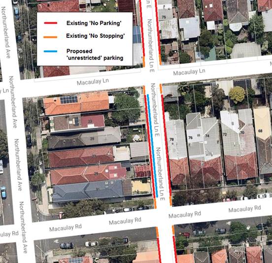
Figure 1: Proposed change to parking restriction - Northumberland Lane east
FINANCIAL IMPLICATIONS
The cost for the supply and installation of the signposting can be funded from Council's operational budget for signs and line marking.
PUBLIC CONSULTATION
On 19 January, letters were posted to affected residents. The closing date for comments was 14 February. In total six (6) letters were sent. There were no replies received either in support of, or objecting to, the proposal.
CONCLUSION
Converting parking in Northumberland Lane East (western side -between Macaulay Road and Macaulay Lane) from ‘No Parking’ to ‘unrestricted’ parking will allow for parking in the laneway as sought by the proponent for the change in parking restriction.