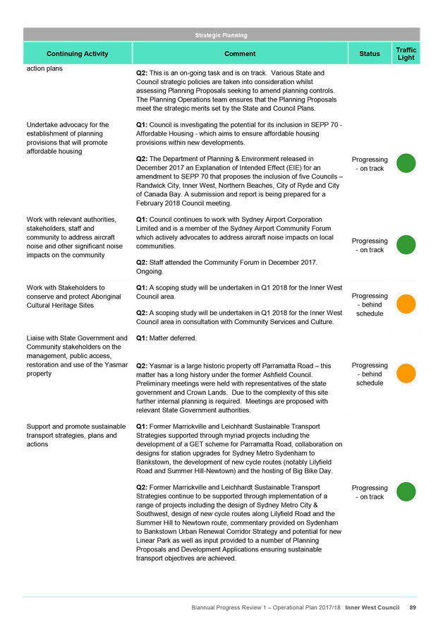
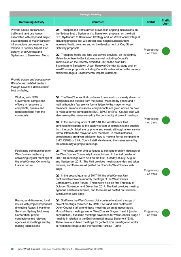
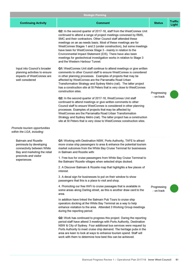
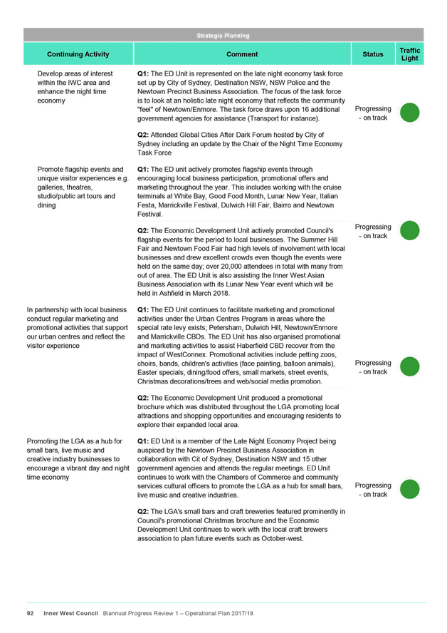
|
AGENDA R |

Council Meeting
TUESDAY 8 MAY 2018
6.30pm
|
|
Council Meeting 8 May 2018 |
Live Streaming of Council Meeting
In the spirit of open, accessible and transparent government, this meeting of the Inner West Council is being streamed live on Council’s website. By speaking at a Council meeting, members of the public agree to being recorded and must ensure their speech to the Council is respectful and use appropriate language. A person who uses defamatory, discriminatory or offensive language may be exposed to liability for which Council takes no responsibility. Any part of this meeting that is held in closed session will not be recorded
Pre-Registration to Speak at Council Meetings
Members of the public must register by 2pm of the day of the Meeting to speak at Council Meetings. If you wish to register to speak please fill in a Register to Speak Form, available from the Inner West Council website, including:
· your name;
· contact details;
· item on the Agenda you wish to speak to; and
· whether you are for or against the recommendation in the agenda.
Are there any rules for speaking at a Council Meeting?
The following rules apply when addressing a Council meeting:
· keep your address to the point, the time allowed for each speaker is limited to three minutes. This time limit applies, no matter how many items are addressed by the speaker;
· when addressing the Meeting you must speak to the Chairperson;
· only 3 speakers for and against an Agenda Item are allowed.
What happens after I submit the form?
Your request will then be added to a list that is shown to the Chairperson on the night of the meeting.
Where Items are deferred, Council reserves the right to defer speakers until that Item is heard on the next occasion.
Accessibility
Inner West Council is committed to ensuring people with a disability have equal opportunity to take part in Council and Committee Meetings. At the Ashfield Council Chambers there is a hearing loop service available to assist persons with a hearing impairment. If you have any other access or disability related participation needs and wish to know more, call 9392 5657.
Persons in the public gallery are advised that under the Local Government Act 1993, a person may NOT tape record a Council meeting without the permission of Council.
Any persons found recording without authority will be expelled from the meeting.
“Record” includes the use of any form of audio, video and still camera equipment or mobile phone capable of recording speech.
An audio recording of this meeting will be taken for the purpose of verifying the accuracy of the minutes.
|
|
Council Meeting 8 May 2018 |
|
PRECIS |
1 Acknowledgement of Country
2 Apologies
3 Notice of Webcasting
4 Disclosures
of Interest (Section 451 of the Local Government Act
and Council’s Code of Conduct)
5 Moment of Quiet Contemplation
6 Mayoral Minutes
Nil at the time of printing.
7 Staff Reports
ITEM Page
C0518 Item 1 Small Bars Proposed Amendment to Leichhardt Local Environmental Plan (LEP) 2013 5
C0518 Item 2 Proposed amendments to Standard Instrument - Retail land use definitions 10
C0518 Item 3 Glebe Island Aggregate Handling and Concrete Batching Facility - Environmental Impact Statement 64
C0518 Item 4 WestConnex Local Area Improvement Strategy 76
C0518 Item 5 Regulation and Enforcement of Long Term Trailer Parking Report 97
C0518 Item 6 Dogs in Parks-Elliot Park and Balmain Cove Companion Animal Review 103
C0518 Item 7 Local Participatory Democracy at Inner West 113
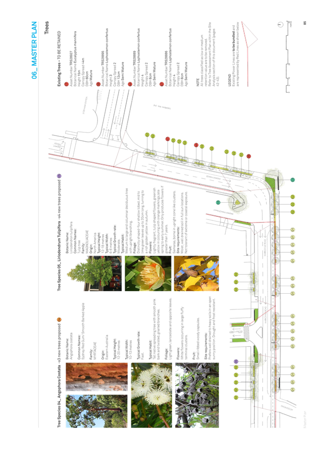
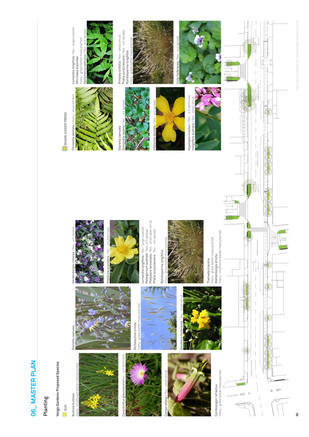
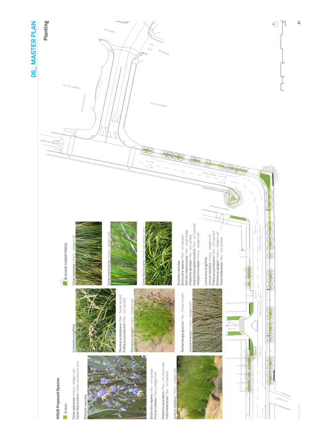
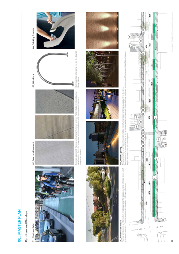
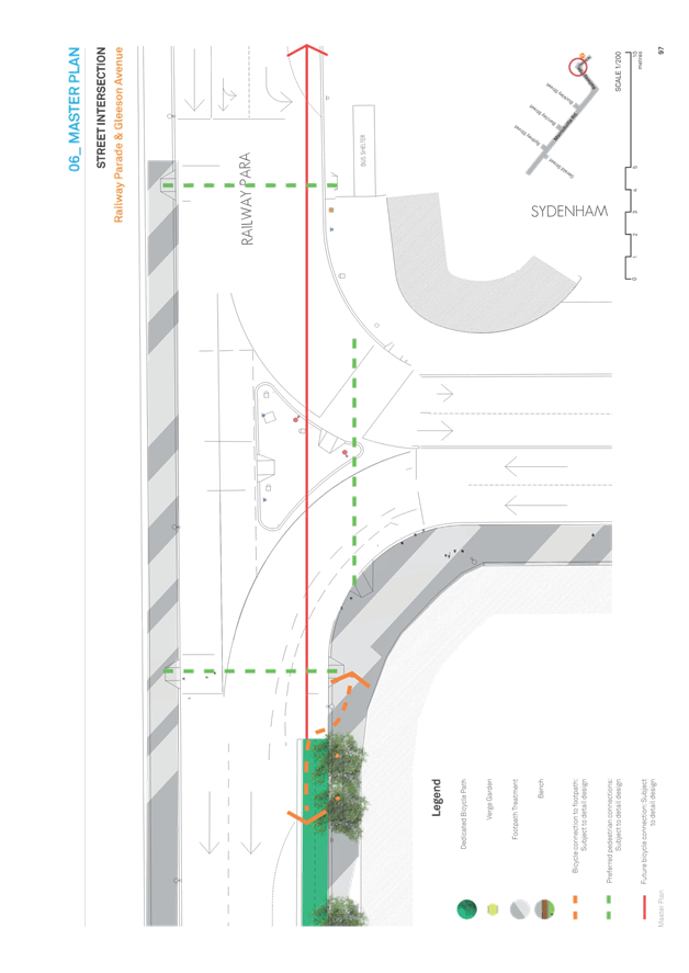
C0518 Item 8 Draft Marrickville Road (East) Public Doman Master Plan 138
C0518 Item 9 Short-term licenses at Thirning Villa 40 Arthur St Ashfield 256
C0518 Item 10 Biannual Review of Inner West Council Operational Plan FY17/18 258
C0518 Item 11 Policy Register 365
8 Notices of Motion
ITEM Page
C0518 Item 12 Notice of Motion: Commuter Carpark 371
C0518 Item 13 Notice of Motion: Improving Screens and Facilities in the Council Chambers 372
C0518 Item 14 Notice of Motion: Merger Two Years on: Informing the Community 373
C0518 Item 15 Notice of Motion: Council Maintenance and Inspections of Public Buildings 375
C0518 Item 16 Notice of Motion: Condolence Motion John Francis WALSH, PSM, GCM, BCM, JP 377
C0518 Item 17 Notice of Motion: Changes to Inner West Bus Services 378
9 Questions From Councillors
ITEM Page
C0518 Item 18 Question on Notice: Staffing Matters 379
10 Reports with Confidential Information
Reports appearing in this section of the Business Paper are confidential in their entirety or contain confidential information in attachments.
The confidential information has been circulated separately.
ITEM Page
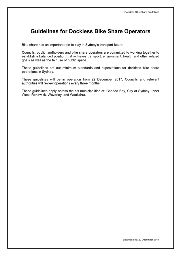
C0518 Item 19 Update on Dockless Bike Share 381
C0518 Item 20 Construction Lease to Sydney Metro
|
|
Council Meeting 8 May 2018 |
Subject: Small Bars Proposed Amendment to Leichhardt Local Environmental Plan (LEP) 2013
Prepared By: Katie Miles - Strategic Planner
Authorised By: David Birds - Group Manager Strategic Planning
|
SUMMARY The Small Bars Planning Proposal seeks to make a change of use between a restaurant and café to a small bar (and vice versa) in the B2 Local Centre zone exempt development in the Leichhardt Local Environmental Plan 2013 (LEP). Council has been requested by the Department of Planning and Environment (DPE) to withdraw the Planning Proposal. This report addresses DPE's request, and recommends a formal response seeking further consideration of the matter by the Minister for Planning and DPE in order to progress the Small Bars LEP Amendment.
|
|
THAT Council:
1. Resolves to not withdraw the Small Bars LEP Amendment; and
2. Writes to the Minister for Planning and the Department of Planning and Environment seeking reconsideration of the issue and requesting reversion to the approach initially supported by Parliamentary Counsel as outlined in the report.
|
BACKGROUND
The Small Bars Planning Proposal seeks to make a change of use between a restaurant and café to a small bar (and vice versa) in B2 Local Centre zones exempt development in the Leichhardt Local Environmental Plan 2013 (LEP). After a period of consultation the Inner West Council resolved to support the Small Bars Planning Proposal at its meeting on 6 December 2016. The proposed LEP Amendment was forwarded to the Department of Planning and Environment (DPE) to be made on 20 December 2016.
The State Government's Parliamentary Counsel Office must draft and finalise all LEP amendments. Initially, Parliamentary Counsel (PC) issued three drafts of the LEP clauses that accepted the proposed change of use exemption. However in August 2017 it is understood that the Deputy PC ruled that the amendment to make the change of use exempt development could not progress and that it should be changed to complying development.
The exempt development pathway would not have any associated costs and would not require an application to be made to carry out the activity. However the complying development pathway would require a formal application that would cost applicants an approximately $830 certification fee with a $250 inspection fee. Along with a 10 day application turnaround this additional cost application cost, and the associated costs of preparing an application, may inhibit the use of the Small Bars LEP Amendment.
In October 2017, Strategic Planning obtained legal advice from Council's General Counsel that contested PC's rationale as explained below. This was sent to the DPE but, on considering the matter it did not alter its position and in December 2017, Council received a letter from the DPE requesting that Council withdraw the Planning Proposal.
Council has since held discussions with various senior DPE officers seeking further consideration of the matter in the light of the advice of Council's General Counsel and requesting reversion to the approach initially supported by PC. This has culminated with a recent discussion with the newly appointed Regional Director who has undertaken to review the matter.
The intent of this report is to seek approval of a formal response to DPE’s request seeking further consideration of the matter by DPE in order to progress the Small Bars LEP Amendment. This request should also take into account the need for the planning system to enable more active leisure and entertainment uses in our local centres which is addressed in a separate report being made to Council on the recent DPE issued discussion paper on Planning for the Future of Retail.
Council should note that the related Small Bars Leichhardt Development Control Plan 2013 (DCP) Amendments to relax Plan of Management requirements for small bar development applications were adopted on 20 December 2016. This report relates only to the proposed LEP component.
POLICY DEVELOPMENT OF THE SMALL BARS LEICHHARDT LEP 2013 AMENDMENT
A report to the 25 March 2014 Leichhardt Council meeting explained changes to the Liquor Act 2007 and Standard Instrument (LEP) Order 2006 that defined a new type of "small bar" land use. The former Leichhardt Council resolved (C82/14) to prepare a 'draft' Planning Proposal to facilitate small bars in appropriate locations.
A key aim of the small bar licence for the State Government was to provide greater certainty around how these venues operate. Venues operating under a small bar licence are expected to appeal to patrons who are interested in smaller, more intimate licence venues, thereby lowering risks associated with larger venues such as poor patron behaviour and the impacts of alcohol consumption on the community.
The Standard Instrument definition is “a small bar within the meaning of the Liquor Act 2007” meaning it must have a small bar liquor licence. If any other type of liquor licence is obtained the establishment is no longer defined by the Standard Instrument as a small bar under the NSW Planning System.
However, restaurants can obtain an on-premise liquor licence (with primary service authorisation) and a pub with a general hotel licence. Both can effectively operate as a ‘small bar-type venue’.
The former Leichhardt Council endorsed a Small Bars Planning Proposal at its meeting on 6 October 2016 to be forwarded to the DPE for Gateway Determination based upon the following justification:
· Small bars and pubs encourage a diverse night time economy, multi-destination patronage, investment and the development of associated businesses.
· A reasonable agglomeration of small bars in late night trading locations, town centres and shopping streets can complement each other to create fine-grain precincts. This can reinforce desirable cultural characteristics in an area, such as artistic communities and retention of heritage properties.
· Small bars encourage and promote street activation, employment and tourism, and a unique sense of place.
· Small bars are considered low risk in terms of safety. The intimate nature of the bars and their more mature patrons, reduce the risk of anti-social behaviour and violent incidents. The provision of higher priced boutique alcohol, provision of food and seated drinking reduce binge drinking, and provide alternatives to high-risk venues such as pubs and clubs.
Given retail vacancies rates along Parramatta Road, Norton Street and Darling Street, the Small Bars Planning Proposal sought to boost the night time economies in these B2 Local Centre zones.
The DPE issued a Gateway Determination on 14 March 2016 and the Proposal was exhibited from 24 May 2016 to 21 June 2016. There was a delay in reporting the exhibition outcomes due to Council amalgamation. Council approved the making of the LEP Amendment at its 6 December 2016 meeting.
STATE GOVERNMENT SMALL BARS REVIEW (SEPTEMBER 2016)
The Liquor Act 2007 is reviewed every five years. The Small Bars Review 2016 found that there were only 50 small bars in NSW. There were no small bars in the former Leichhardt LGA, two in the former Marrickville LGA and one in the former Ashfield LGA. It appeared that the original 60 patron limit on small bars licences limited viability, it was suspected that few small bars would be created via the proposal LEP Amendment if it was finalised. However, in August 2017 the Liquor Licence Regulations were amended to increase small bar patron capacity to 100 persons. This appears to have increased potential viability and since then there has been growing interest in opening small bars across the Council area.
The Small Bars Review 2016 also concluded that:
“Process complexities involved in gaining regulatory approval for a small bar are further impeding the uptake of this licence. To open a small bar, aspiring venue operators must receive development approval (DA) from the local council and a liquor licence from the Independent Liquor and Gaming Authority. According to the Office of the NSW Small Business Commissioner, Small Bars Association and Coalition of City Liquor Accords, many aspiring operators find these licensing and approval processes to be onerous and time-consuming.’
The Review recommended two key initiatives that are relevant to this Planning Proposal:
1. Reduce administrative delays and complexity in the licensing approval process; and
2. Consider further opportunities for reforms to reduce red tape and administrative complexity, including potential expansion of the Service NSW Easy-to-do Business initiative and enhanced coordination of planning and liquor licensing processes.
The State Government resolved to adopt and implement these recommendations and the Small Bars Planning Proposal is aligned with the recommendations.
APPROVAL PROCESS FOR SMALL BARS
New small bars require development consent from Council. Development consent is also required when an amendment of approved hours of operation is sought or to vary conditions of a previous consent. This includes where an existing restaurant or café seeks a "change of use" to become a “wine bar” (where the primary activity is the sale of liquor) within its existing approved hours. Once consent is granted, an application for a liquor licence is made to the Independent Liquor and Gaming Authority.
The Small Bars LEP Amendment analysis prepared in 2014 found that restaurants and cafes with a general bar licence operate in much the same way as a small bar. At that time, both the former Marrickville and the City of Sydney councils considered that food and drink premises with capacity of 120 patrons or less should be assessed against many of the development controls that apply to small bars. That analysis concluded therefore that a change of use from café, restaurant to small bar and vice versa should be made exempt development in the B2 Local Centre zone as effectively no development or operational changes arises from this type of change of use.
REPORT
Council's proposed small bars LEP clause is similar to the State Government's Subdivision 10A Change of Use of Premises under the State Environmental Planning Policy (Exempt and Complying Developments Codes) 2008 (Codes SEPP). The Department accepted this premise when it issued the Gateway Determination for Council's Small Bar LEP Amendment. The proposal was generally well received by the community during the public exhibition.
The draft LEP Clause below was agreed between Council officers and Parliamentary Counsel (PC) in August 2017 prior to the change of position by PC.
"Amendment of Leichhardt Local Environmental Plan 2013
Schedule 2 Exempt Development
Change of use of land from restaurant or café to small bar or from small bar to restaurant or café
1) The land must be in Zone B2 Local Centre.
2) The new use must be in accordance with the conditions of development consent applying to the old use that relate to hours of operation, noise, car parking, loading, vehicular movement, traffic generation, waste management and landscaping.
Note. The use of a footpath as an outdoor dining area may be exempt development if it is associated with restaurant or café but cannot be exempt development if it is associated with a small bar: see State Environmental Planning Policy (Exempt and Complying Development Codes) 2008, Part 2, Division 1, Subdivision 20A (Footpaths - outdoor dining)."
The process for obtaining a small bar liquor licence via the NSW Office of Liquor and Gaming under the Liquor Act 2007 requires that the applicant submit a community impact statement. This involves the applicant consulting adjacent properties or any buildings within 100 metres of the boundary of the premises. These neighbours then have 30 days to prepare a submission. Other relevant stakeholders such as local police must also be contacted for comment. These licence applications are referred to Council for comment to ensure that community and local amenity issues are considered before a licence is issued.
The NSW Office of Liquor and Gaming consider Council comments and community submissions as part of their licence application assessment process. Consequently even if the change of use is exempt the community can still comment on proposed small bars. The LEP amendment would eliminate this regulatory duplication.
Parliamentary Counsel's change of position to a preference for a complying development clause is contrary to the contemporary understanding of exempt development within the State Government's own State Environmental Planning Policy (Exempt and Complying Developments Codes) 2008 (Codes SEPP), in particular Subdivision 10A Change of Use of Premises.
Council's General Counsel has advised that he does not consider "the basis upon which Parliamentary Counsel is approaching the Small Bars amendment to the Leichhardt Local Environmental Plan 2013 to be correct", and that he is "perplexed by PC’s position given that clauses 2.20A and 2.20B of State Environmental Planning Policy (Exempt and Complying Development Codes) 2008 classify “changes of use” for various categories as exempt development provided that, inter alia, conditions of any applicable consent are complied with. That is precisely what Council is pushing with respect to the Small Bars amendment. Could PC simply not accept a drafting of the amendment that accords with that in the SEPP?"
Council officers forwarded the legal opinion to the DPE in October 2017 requesting that PC reconsider the position but despite this legal advice, DPE informed Council that an exempt development provision was not supported and that PC would not be requested to reconsider their new preference for complying development. In December 2017, Council received a formal letter from the DPE requesting that the Small Bars LEP Amendment be withdrawn.
Following the receipt of the request from DPE Council has since held discussions with various senior DPE officers reiterating the need for a consistent approach from PC and the Government and seeking further consideration of the matter by PC in the light of the advice of Council's General Counsel. Whilst DPE legal officers appear to have considered the matter it does not appear to have been reconsidered by PC. The recent newly appointed DPE Regional Director has now undertaken to consider the matter and a response to this is currently awaited. In the meantime it is considered that Council should formally write to the Minister for Planning and DPE seeking support for PC to reconsider the issue and requesting the reversion to the approach initially supported by PC.
It is also recommended that when seeking a change to the approach being taken to the proposed amendment Council should highlight the need for the planning system to enable more active leisure and entertainment uses in local centres. This is a wider issue that it is considered the Government should consider when developing its approach to planning for retail and other uses in local centres. The matter is addressed in a separate report being made to Council on the recent DPE issued discussion paper on Planning for the Future of Retail.
If the outcome is that the LEP amendment as exempt development is not supported it is recommended that Council pursue the LEP amendment as complying development.
FINANCIAL IMPLICATIONS
Nil.
OTHER STAFF COMMENTS
Nil.
PUBLIC CONSULTATION
The outcomes of the public exhibition process were reported to Council on 6 December 2016.
CONCLUSION
Council's proposed Small Bars LEP Amendment would mean restaurant and café owners could make a change of use between a restaurant and café to a small bar (and vice versa) in B2 zones as exempt development in the Leichhardt Local Environmental Plan 2013 B2 Local Center zone. This would simplify the planning process and promote small businesses that provide character and vitality in local centres.
As the DPE is currently not supporting the proposal for legal reasons that conflict with the advice provided to Council by its General Counsel, and the initial approach taken by DPE and PC, it is recommended that Council writes to the Minister for Planning and DPE seeking further consideration of the matter. If the outcome is that the LEP amendment as exempt development is not supported it is recommended that Council pursue the LEP amendment as complying development.
ATTACHMENTS
|
|
Council Meeting 8 May 2018 |
Subject: Proposed amendments to Standard Instrument - Retail land use definitions
Prepared By: Peter Wotton - Strategic Planning Projects Coordinator
Authorised By: David Birds - Group Manager Strategic Planning
|
SUMMARY The Department of Planning and Environment has released a discussion paper on Planning for the Future of Retail and an associated discussion paper on proposed amendments to the Standard Instrument LEP including new definitions of ‘artisan premises’ (to include microbreweries) and a ‘neighbourhood supermarket’. The documents are on public exhibition until 18 May 2018.
This report, while generally supportive of the need for change to the way the planning system addresses planning for retailing and supporting our centres, outlines some concerns about the proposals. It recommends that a submission is made that supports a broader approach to improvements to planning for centres, including non-retail activities such as entertainment, arts and dining facilities in the daytime and in the evening, and also supports changes that enable the development of innovative new businesses, such as micro-breweries. The submission will also advocate support for associated current Council planning policy initiatives that support active uses for our centres and growing new local businesses. |
|
RECOMMENDATION
THAT Council makes a submission to the Department of Planning and Environment based on the recommendations made in this report and advising that Council:
a) Supports the need for change to the way the planning system addresses planning for retailing and supporting our centres;
b) Supports a broader approach to planning for centres, including supporting non-retail activities such as live entertainment, arts and dining facilities in the daytime and in the evening;
c) Supports the introduction of a new definition for artisan premises including microbreweries to support local businesses, subject to the proposed changes made in the report; and
d) Recommends that the Department carry out a holistic review of all the retail premises and other relevant definitions under the Standard Instrument LEP to help simplify and streamline planning approval processes for retailing and other supporting non-retail activities in centres, such as small bars.
|
BACKGROUND
The Department of Planning and Environment (DPE) has released a discussion paper on Planning for the Future of Retail (Attachment 1) that states that “it is developing a NSW Retail Strategy to better support retailers and the supply chain.
The Strategy will:
· balance regulatory clarity and certainty with flexibility and adaptability
· facilitate the changing needs of retail planning, while maintaining the existing centres hierarchy
· ensure the planning system can promote competition, contribute to jobs growth and meet consumer need.”
To support this work the DPE has released a Discussion Paper Proposed amendments to the Standard Instrument LEP – Better planning for the NSW retail sector (Attachment 2) outlining some initial amendments to the planning system it considers are needed as “it is clear that some immediate impediments within the planning system should be addressed through initial strategic amendments to the Standard Instrument (Local Environmental Plans) Order 2006 (Standard Instrument).” The initial strategic amendments proposed relate to proposed new planning definitions as follows:
· a new definition for ‘artisan premises’;
· an amended definition for ‘garden centres’;
· a new definition for ‘local distribution premises’;
· a new definition for ‘neighbourhood supermarkets’; and
· an amended definition for ‘bulky goods premises’ to be known as ‘specialised retail premises’.
DISCUSSION
1. Planning for Future Retail
The general aim of the Discussion Paper (Attachment 1) to review the planning system so that it addresses the State’s dynamic retail sector and enables it to flourish is supported. Retailing is an important source of employment across the Inner West as well as the provider of services to the community.
The Inner West is often at the forefront of new innovative approaches to the provision of retail services for the community in our centres, such as the growth of small scale sales outlets at microbreweries.
It is important that when modernising the planning system consideration is given to all activities that create our thriving local centres. This highlights that food and entertainment facilities may be particularly important in some centres, and the synergies between these activities and retailing that create attractive centres to visit, live and play in needs to be considered and supported. Hence the need to allow for innovative, contemporary retail and other entertainment and leisure solutions that match consumer need should also be considered when reviewing the planning controls for retail.
While the Discussion Paper notes that retail can help ‘activate’ a place by attracting people and activity and can contribute social and economic vibrancy to local places, it is considered that food, entertainment and leisure activities also play an important role in our centres, and this is particularly so in some Inner West centres.
Council welcomes the emphasis on strategic planning for retail and Council proposes to carry out important work to build the evidence base for future planning for retail in the Inner West through the development of the new local environmental plan.
The importance of planning for co-located retail and manufacturing is acknowledged and supported, and the identification of this issue in connection with artisan premises is an important one for the Inner West. It is proposed to seek support for enabling suitable retail floor space provision for microbreweries and other artisan premises as part of this policy development. Council has already raised this issue with the DPE and will continue to pursue it in discussions with DPE officers. Associated opportunities for streamlined planning approval processes for these activities should also be considered.
The reference made in the Discussion Paper to highly prescriptive planning controls that can present burdensome regulatory mechanisms is acknowledged and is a matter that Council will discuss further with the DPE in relation to difficulties that the DPE has raised with Council proposals to enable small bars to be more easily introduced in centres. It is considered that streamlined consent processes need to be considered for a range of uses that can support planning for retail and centres, including non-retail activities such as live entertainment, arts and dining facilities in the daytime and in the evening, and also support innovative developing new businesses such as micro-breweries.
However it is also important that planning for new retail takes account of investment already made in existing infrastructure that supports centres and enables the community to access local services. The continuing need to support our existing centres and enable them to flourish should be at the heart of planning for retail in the Inner West and care needs to be taken to ensure the importance of those centres is not undermined by unplanned development in inappropriate locations.
2. Proposed New and Amended Definitions
The Discussion Paper on definitions (Attachment 2) includes indicative definitions of new terms and amended terms. Whilst the aims of some of the proposed definitions are supported not all of the definitions generally follow well practiced legal drafting principles. Some of the indicative definitions are vague and do not appear to adequately address the proposed intentions of the terms stated in the Discussion Paper. It is recommended that Council offers to work with the DPE on the finalisation of the definitions and makes a detailed submission on related matters based on the comments made in this report. The submission would also refer to the need to investigate potential opportunities for exempt and complying development approval pathways to support the development of local businesses.
The following sections outline the proposals for each definition and concerns that it is recommended are raised with the DPE in a detailed submission.
A Artisan Premises
The proposed intent for the new land use term ‘artisan premises’ is to “provide clarity for the growing artisan and craft food and drink industry”.
The indicative definition for that term in the Discussion Paper is:
Artisan premises
A building or place used to produce and/or process foods and beverages on site, without being fully automated.
It can also include:
a) a restaurant or café;
b) tastings;
c) tours;
d) sales; and
e) workshops
The introduction of such a definition is generally supported and presents an opportunity for Council to introduce more detailed planning controls to encourage the development of more boutique types of industry that are emerging in the Inner West, such as specialised food producers and micro-breweries.
It will also enable Council to follow up on the aim of the recent resolution on micro-breweries at the 13 March 2018 meeting to write a letter to the state government seeking advice on the best options available to increase retail floor space and to clarify the definition of ‘ancillary use’ for micro-breweries.
Council wrote to DPE after the 13 March Council meeting on this issue and the current DPE proposal presents an opportunity for Council staff to continue to work with DPE to address these issues. A report updating on this matter will be prepared for the Council meeting on 22 May 2018.
It is proposed that the submission to DPE seeks finalisation of a suitable definition that enables appropriate floorspace for sales and the other activities listed in the proposed Artisan Premises definition to be provided unrestricted by other Standard Instrument LEP requirements, in particular Clause 5.4(4) which restricts retail floorspace in industrial retail outlets. It is considered that Artisan Premises should not be restricted by that clause. This would confine the exemption to a small group of industrial activities that requires the flexibility to include retail and other supporting activities such as a restaurant or bar. The details of the most suitable legal drafting for this will be discussed in the Council submission.
There are other legal drafting issues raised by the proposed definition that also need to be addressed. For example, nothing in the draft definition references or restricts the use to the production or processing of boutique, craft or artisan foods or beverages. Without such referencing the proposed definition would apply to all buildings or places used to produce and/or process food and beverages on site, if not fully automated. As a result the indicative definition as currently drafted could result in extremely broad land use interpretation issues and may not achieve the outcomes sought.
This difficulty is likely to be compounded as the definition of the use does not specify that the use ‘produce and/or process foods and beverages’ is the principal purpose that the building or place is used for. Hence it could be interpreted as applying to a restaurant or café, and would thus circumvent any current planning controls that prohibit restaurants and cafes in a zone where artisan premises are permitted. This is likely to be problematic as the Discussion Paper states that initially it is proposed to make artisan premises “permissible wherever light industry is permissible”. In the Council area under Ashfield Local Environmental Plan 2013, Leichhardt Local Environmental Plan 2013 and Marrickville Local Environmental Plan 2011 whilst light industries are permissible in the IN2 Light Industrial zone with consent, restaurants and cafes are prohibited.
It is proposed to raise these issues in a submission and to suggest changes to help address the issues identified above including suggested revised wording for the term such as:
Artisan and craft food and drink industry means a building or place principally used to carry out food processing and/or beverage manufacturing of locally produced boutique, craft or artisan food and/or beverages. It may include a restaurant, bar or café, tastings, tours, workshops and an industrial retail outlet.
Note. Artisan and craft food and drink industries are a type of light industry - see definition on that term in this Dictionary.
Council staff will continue to discuss the most suitable definitions that will support the development of local industries with local Business Chambers and the Inner West Breweries.
In this respect it is understood that the Inner West Breweries generally support the approach described in this report, but also favour the inclusion of a supporting new definition of microbrewery as a sub-set of the Artisan Premises definition. It is considered that this would also be helpful to clarify the matter and confirm that a microbrewery may include an on-site food and general liquor service. The introduction of a suitable liquor license for this activity is a matter Council staff have been discussing with Liquor and Gaming NSW and was referred to in the report made to Council on supporting this industry on 13 March 2018. It is proposed that this issue is also raised in the submission to DPE.
It is proposed that Council staff finalise a detailed submission that takes these issues into account.
B Neighbourhood Supermarket
The Discussion Paper proposes the introduction of a definition of Neighbourhood Supermarket which would be restricted to a maximum size of 1,500 sqm and would be made permissible in the B1 Neighbourhood Centre zone. The definition proposed is:
Neighbourhood Supermarket
A shop selling food and other household items where the selection of goods is organised on a self-service basis.
The intention is to enable small format local supermarkets that would generally be larger than the neighbourhood shops that are permitted in that zone which are restricted in size by local planning controls. In the Inner West Council area neighbourhood shops are currently restricted to a maximum of 100 sqm in the former Ashfield Council, 80 sqm in the former Leichhardt Council and 100 sqm in the former Marrickville Council areas.
The introduction of the term appears to be contrary to the only mandated objective for the B1 Neighbourhood Centre zone which is:
“To provide a range of small-scale retail, business and community uses that serve the needs of people who live or work in the surrounding neighbourhood.”
Apart from the use of the word ‘neighbourhood’ in the name of the proposed term, nothing in the definition would limit the sale of the food and other household items sold from the premises to those needed to “serve the needs of people who live and work in the surrounding neighbourhood”.
Rather than proposing an additional land use term to address the issue identified it is considered that it would be more appropriate to enable local councils to continue to address the issue by setting a maximum floorspace for neighbourhood shops in the B1 Neighbourhood Centre zone. Where local councils consider it suitable, taking local issues (e.g. traffic, parking, service and delivery related impacts associated with supermarkets) into account, a higher amount of floorspace can be identified. It is proposed that this be the basis of a submission to be made to the DPE.
C Specialised Retail Premises
It is proposed to replace the current definition of Bulky Goods Premises with a new definition with the intention of addressing the current needs of contemporary large format retailing. The proposed definition is:
Specialised Retail Premises
A building or place used to sell, display or hire:
a) Automotive parts and accessories;
b) Camping, outdoor and recreation goods;
c) Electrical light fittings;
d) Animal supplies;
e) Floor, wall and window coverings;
f) Furniture, bedding, furnishings, fabric and Manchester and homewares;
g) Household appliances, household electrical goods and home entertainment goods;
h) Party supplies;
i) Swimming pools and spas;
j) Office equipment and supplies;
k) Baby and children’s goods, children’s play equipment and accessories;
l) BBQs, fireplaces and gas appliances;
m) Sporting, cycling, leisure, fitness goods and accessories; or
n) Goods and accessories which:
· Require a large area for handling, display and storage of goods; or
· Require direct vehicle access to the building by customers for the purpose of loading or unloading goods into or from their vehicles after purchase or hire.
It does not include the sale of food, clothing or footwear unless it falls into one of the above categories.
The current definition of “bulky goods premises” is:
Bulky goods premises means a building or place the principal purpose of which is the sale, hire or display of bulky goods, being goods that are of such size or weight as to require:
(a) a large area for handling, display or storage, and
(b) direct vehicular access to the site of the building or place by members of the public for the purpose of loading or unloading such goods into or from their vehicles after purchase or hire,
and including goods such as floor and window supplies, furniture, household electrical goods, equestrian supplies and swimming pools, but does not include a building or place used for the sale of foodstuffs or clothing unless their sale is ancillary to the sale or hire or display of bulky goods.
The new definition aims to:
· Capture retail that serves a specialised purpose;
· Capture retail that supplies goods that are necessary but infrequently purchased; and
· Meet the consumer’s preference for convenient one stop specialised shopping.
While the intention of modernising the terminology used in planning for large format retailing is understood there are significant problems with the manner in which the proposed term would operate.
Primarily, in omitting any reference to retailing that “involves the sale, hire or display of bulky goods” there are no prerequisites for any of the types of retailing included to constitute a “specialised retail premise”. Consequently regardless of the size of the shop, or whether or not the use requires a large area for handling, display or storage, or direct vehicular access to the site of the building or place by members of the public for the purpose of loading or unloading such goods into or from their vehicles after purchase or hire, all the retail uses listed in part a) to m) inclusive in the indicative definition, would constitute a “specialised retail premise”.
This approach has the potential to be problematic as it would cause significant interpretation issues for local environmental plans made under the Standard Instrument and could have serious planning implications for development in many council areas.
As part of the preparation of their respective local environmental plans under the Standard Instrument, councils determined whether it was appropriate for bulky goods premises to be permitted with consent in Land Use zones other than those zones where the use was mandated under the Standard Instrument. Decisions as to the appropriateness of permitting bulky goods premises in other land use zones were based on the definition of “bulky goods premises” under the Standard Instrument, that existed at the time of preparing their LEPs.
As development for the purposes of “bulky goods premises” is not substantially the same as development for the purposes of “specialised retail premises”, councils may not have made the same decision as they had previously, i.e. to permit unrestricted “specialised retail premises” in those Land Use zones where they had previously determined it was appropriate to permit “bulky goods premises”. This could have the effect of making a much larger range of retail activities permissible in existing industrial areas than had been the intention of the council.
This issue is of particular concern to the Inner West Council as both Ashfield Local Environmental Plan 2013 and Leichhardt Local Environmental Plan 2013 permit “bulky goods premises” in their IN2 Light Industrial zones.
The proposed amendment to permit “specialised retail premises” on such zoned land has the potential to “reduce the total potential floor space for industrial uses in industrial zones” contrary to Part 4 (d) of Section 117 Direction 1.1 Business and Industrial zones.
It should be noted that those local environmental planning instruments were made before the Greater Sydney Commission’s Greater Sydney Region Plan. One of the objectives of the Greater Sydney Region Plan is “Industrial and urban services land is planned, retained and managed” (Objective 23). The proposed amendment would have the potential to seriously undermine this objective in the Inner West Council area. Furthermore the wide ranging nature of the new definition would restrict the ability of a council that wants to permit more limited “specialised retail premises” in its industrial zones to do so.
It is considered that the DPE should carry out a holistic review of all the different types of “retail premises” definitions under the Standard Instrument before making substantive changes to one development type in the manner proposed.
Whilst that holistic review is being carried it is would be reasonable to make a relative minor change to the Standard Instrument definition of “bulky goods premises”, to address the issue identified.
As detailed in the Discussion Paper the DPE has previously proposed to amendment the Standard Instrument definition of bulky goods premises by changing the current definition two part requirement that such premises must provide a large area for handling, display or storage of goods AND direct vehicle access for customers to load or unload their purchases to remove the need to satisfy both requirements by replacing the word ‘AND’ with the word ‘OR’. It is recommended that this approach be followed until a more holistic review of retail planning terms has been carried out. This would result in the amendment shown below (with the proposed changes to the current definition highlighted in red):
“bulky goods premises means a building or place the principal purpose of which is the sale, hire or display of bulky goods, being goods that are of such size or weight as to require:
(a) a large area for handling, display or storage, or
(b) direct vehicular access to the site of the building or place by members of the public for the purpose of loading or unloading such goods into or from their vehicles after purchase or hire,
and including goods such as floor and window supplies, furniture, household electrical goods, equestrian supplies and swimming pools, but does not include a building or place used for the sale of foodstuffs or clothing unless their sale is ancillary to the sale or hire or display of bulky goods.”
D Garden Centre
The indicative definition proposed for Garden Centre is:
A building or place where the principal purpose is the sale of:
a) plants; and/or
b) landscaping and gardening supplies and equipment
A garden centre may also include a restaurant or cafes and the sale of:
a) Outdoor furniture and furnishings;
b) Barbecues;
c) Shading and awnings;
d) Pools, spas and associated supplies;
e) Items associated with the construction, maintenance and improvement of outdoor areas;
f) Pets and pet supplies;
g) Fresh produce
The Discussion Paper describes the ‘Proposed Intent’ of the amendment as follows:
“The proposed amendment seeks to restructure the definition to clarify principal and contemporary uses. It replaces the term ‘ancillary’, lists the uses that may be associated with a garden centre and restructures the definition to remove ambiguity.”
The current wording included in the definition of garden centre in the Standard Instrument is consistent with the wording of other defined Standard Instrument terms which have a “principal purpose” and include ancillary uses in the definition of that term.
The current definition of “garden centre” under the Standard Instrument is:
Garden centre means a building or place the principal purpose of which is the retail sale of plants and landscaping and gardening supplies and equipment. It may, if ancillary to the principal purpose for which the building or place is used, include a restaurant or cafe and the sale of any the following:
(a) outdoor furniture and furnishings, barbecues, shading and awnings, pools, spas and associated supplies, and items associated with the construction and maintenance of outdoor areas,
(b) pets and pet supplies,
(c) fresh produce.
It is considered that the current definition of garden centre is not ambiguous. The indicative definition of ‘garden centre’ in the Discussion Paper removes the current requirement that the sale from such centres be restricted to “retail sale”. As a garden centre is a type of ‘retail premises’ the word ‘retail’ should be included in the definition.
The current definition requires the principal purpose of such premises to be “the retail sale of plants and landscaping and gardening supplies and equipment”. The indicative definition changes that ‘and’ to ‘and/or’. While the proposed change may appear insignificant because of the way other terms are defined in the Standard Instrument the proposed change could have unintended consequences of solely enabling “plant nursery” and “landscaping material supplies” on sites and may create interpretation issues for other defined land use terms in the Standard Instrument. The relevant Standard Instrument definitions are:
“plant nursery means a building or place the principal purpose of which is the retail sale of plants that are grown or propagated on site or on an adjacent site. It may include the on-site sale of any such plants by wholesale and, if ancillary to the principal purpose for which the building or place is used, the sale of landscape and gardening supplies and equipment and the storage of these items.”
“landscaping material supplies means a building or place used for the storage and sale of landscaping supplies such as soil, gravel, potting mix, mulch, sand, railway sleepers, screenings, rock and the like.”
As a consequence it is proposed that these issues are highlighted to the DPE in Council’s submission for further consideration by DPE.
E Local Distribution Premises
The Discussion Paper proposes an indicative definition for Local Distribution Premises:
A building or place used for storing or handing items purchased or ordered for local delivery, but from which no retail sales are initiated.
The Discussion Paper outlines the general intent of the term as follows:
“A new land term would facilitate the establishment of local distribution premises alongside other urban services and business activity centres in highly accessible locations. This would clarify that these facilities are intended to be of a scale appropriate for local deliveries, rather than those of a regional, national or even global scale.”
It is proposed to make Local Distribution Premises permissible wherever a warehouse or distribution centre is permissible, but to also allow councils to make them permissible in other locations that may be suitable for servicing by smaller vehicles as opposed to traditional large freight vehicles.
No objection is raised in principle to a new land use term being included in the Standard Instrument for what the Discussion Paper describes as the “last mile” distribution centres – places that support the final leg of the parcel delivery from a central distribution place to a place closer to the destination” where those “distribution centres are smaller in scale than traditional distribution centres…(and)… closer to where the customers receiving deliveries live.”
FINANCIAL IMPLICATIONS
Nil.
OTHER STAFF COMMENTS
Council’s Economic Development Section was consulted in the preparation of this report.
PUBLIC CONSULTATION
Nil.
CONCLUSION
This report, while generally supportive of the need for change to the way the planning system addresses planning for retailing and supporting our centres, outlines some concerns about the proposals in the discussion papers. It recommends that a submission is made that supports a broader approach to improvements to planning for centres, including non-retail activities such as live entertainment, arts and dining facilities in the daytime and in the evening, and also supports innovative developing new businesses such as micro-breweries. This will also support current Council planning policy initiatives that support active uses for our centres and growing new local businesses.
The report also identifies a number of issues with the proposed definition changes to be raised with DPE as follows:
i. The introduction of a new definition of “artisan premises” is supported in principle and presents an opportunity for Council to introduce more detailed planning controls to encourage the development of more boutique types of industry that are emerging in the Inner West, such as specialised food producers and micro-breweries. It will also enable Council to address some of the aims of the recent resolution on micro-breweries. Amendments are proposed to further support this intent.
ii. The introduction of a new definition of “neighbourhood supermarket” is not supported.
iii. The proposed new definition of “specialised retail premises” is not substantially the same as “bulky goods premises” (current Standard Instrument definition) and for reasons detailed in this submission this proposed amendment should not be progressed and the DPE formerly proposed amendment to “bulky goods premises” should be adopted.
iv. Issues identified concerning the operation of the proposed amended definition of garden centre should be considered by DPE.
v. The proposed new definition of “local distribution premises” is supported.
It is also recommended that the Department should carry out a holistic review of all the retail premises and other relevant definitions under the Standard Instrument LEP to help simplify and streamline planning approval processes for retailing and other supporting non-retail activities in centres, such as small bars.
|
1.⇩ |
Planning for the Future of Retail - DPE Discussion Paper |
|
DPE Discussion Paper - Proposed amendments to the Standard Instrument LEP - Better planning for the NSW retail sector |
|
Council Meeting 8 May 2018 |
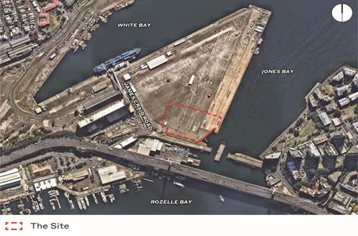
Subject: Glebe Island Aggregate Handling and Concrete Batching Facility - Environmental Impact Statement
Prepared By: Steve Roseland - Senior Strategic Planner
Authorised By: David Birds - Group Manager Strategic Planning
|
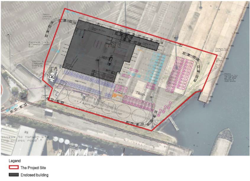
SUMMARY A public exhibition is currently underway for a State Significant Development (SSD) proposal from the NSW Government to construct and operate a new aggregate handling and concrete batching facility at Glebe Island, Rozelle. The facility would have the capacity to produce up to 1 million cubic metres of concrete per annum and operate 24 hours a day, seven days per week, and would including the following land uses:
· aggregate silos with enclosed conveyor feed for aggregate delivered by ship and for despatch of aggregate to other concrete batching facilities · warehouse accommodating heavy vehicle tipping bin area, concrete loading area, truck wash bay, concrete batch room and enclosed conveyor system · site offices and drivers room building · weighbridges and at grade truck and car parking.
The proposal involves the relocation of concrete batching plants located at Blackwattle Bay and Pyrmont to Glebe Island due to re-development of the Blackwattle Bay component of the Bays Precinct.
The SSD Application, Environmental Impact Statement (EIS) and accompanying documents are on public exhibition from Wednesday 11 April 2018 until Tuesday 15 May 2018.
This report identifies a range of concerns regarding the proposal and recommends these be included in a submission to the Department of Planning and Environment.
|
|
RECOMMENDATION
THAT Council:
1. Endorse a submission to the Department of Planning and Environment objecting to the following:
a. The EIS must be revised to address the failure to incorporate Council’s Secretary’s Environmental Assessment Requirements (SEARs) request for inclusion of cumulative impacts of all developments in the Bays Precinct during both construction and operational phases, including the Glebe Island Multi-User Facility and Western Harbour Tunnel;
i. The applicant’s intersection analysis must be revised to include and take into consideration traffic generated by the M4 – M5 link heavy vehicle stabling facility and the Glebe Island Multi-user Facility as these impacts must also be addressed in order to realistically analyse the deterioration of level of service and the operation of the adjacent road network;
ii. Assurance is required that Robert Street will not be used to provide any access, including relief access, for the concrete batching works as it is totally unsuitable for such use and would reduce access to the cruise passenger terminal, reduce access to parts of Balmain East, increase conflict and reduce safety at the Robert St/Mullens Street intersection;
iii. The Heritage Impact Statement (HIS) must be expanded to identify and describe the impacts on the remaining elements (including potential elements) of the former (first) Glebe Island Bridge, its embankments and potential archaeological evidence, including a site plan with proposed new structures overlaid on a drawing of existing state significant items. All fabric of state heritage significance associated with the both the former and current Glebe Island Bridge should be conserved and opportunities should be explored for erection of heritage interpretation;
iv. The EIS must be revised to address the permanent re-opening of the Glebe Island Bridge for an active transport route between Balmain/Rozelle and Pyrmont/Sydney CBD;
v. The level of significance ascribed within the HIS (Appendix C) to the former Glebe Island Bridge given its historical, technical and associational significance; and
vi. Further investigation of foreshore public access arrangements for the site must be incorporated into the final proposed design and confirmation must be given that the proposed works will not preclude future foreshore access and connections.
2. Write to the relevant NSW Ministers re-stating commitment to the permanent re-opening of the Glebe Island Bridge for active transport as included in the Inner West Council Integrated Transport Plan and Urban Growth’s Bays Precinct Transformation Strategy (pgs. 22 and 52). |
BACKGROUND
Hymix/Hanson currently operates a concrete batching facility at Blackwattle Bay and another in Pyrmont. Together the sites have a combined capacity of up to 1,000,000 cubic metres per annum and supply approximately 35% of Central Sydney’s concrete requirements. Collectively they employ approximately 67 full time equivalent employees.
Redevelopment of the Blackwattle Bay section of the Bays Precinct requires the relocation of these facilities. The current proposal will see them amalgamated and a new shoreside aggregate handling facility built. The Glebe Island location has been chosen due to its location, being able to service Sydney CBD and inner ring centres and suburbs permitting delivery of materials within 45 minutes to 1 hour. The Harbourside site would also permit access to Sydney’s deepwater port to allow aggregate importation by sea rather than road, reducing road-borne transit.
The proposed development will allow for the relocation of continued supply of concrete to a range of projects around Central Sydney in a way that aims to be efficient, reduce overall environmental impact and minimise regional road traffic impacts by securing ongoing aggregate shipping terminal capability.
The Bays Market District is part of the NSW Government’s masterplan for The Bays Precinct, redeveloping waterfront land on Sydney Harbour for a wide range of land uses including residential, commercial, industrial and public open space. The Bays Precinct sites include:
· Blackwattle Bay (Sydney Fish Market & Wentworth Park)
· White Bay Power Station & White Bay
· Rozelle Bay and Bays Waterways & Rozelle Rail Yards
· Glebe Island
In June 2017 Urban Growth NSW awarded the contract to Copenhagen based designers 3XN Architects to design the new Sydney Fish Market site. The designated location for the new market will require the relocation of Hanson’s concrete facility in Blackwattle Bay.
Urban Growth has stated the intention is for construction of the new Fish Market to begin late in 2018. Completion of construction and opening of the Fish Market and “foodie” destination is currently expected to be 2022.
In June 2017 Council was asked to provide input into the Department of Planning and Environment’s Assessment Requirements (SEARs) for the Environmental Impact Statement (EIS) to be prepared for the proposed concrete batching plant at Glebe Island.
Council officers considered the information provided and lodged a submission (July 2017) stating that there were key issues and concerns that needed to be addressed by the applicant regarding specific elements of the proposal. The issues to be addressed or mitigated included:
· Cumulative impacts of the operation of the proposed concrete batching plant and aggregate shipping terminal facilities in relation to:
- the construction of major transport infrastructure projects in the immediate vicinity of the proposed batching plant over the next ten years including WestConnex, Western Harbour Tunnel, Iron Cove Link and the West Metro; and
- possibly construction of elements of the Bays State Significant Precinct (SSP) during the next ten years that may incorporate mixed use development including residential uses, as well as public domain connections and adaptive reuse of the State-listed heritage White Bay Power Station.
· Traffic modelling to determine impact on surrounding road network of significant additional heavy vehicle traffic movements on-site and movements to-from the site.
· EIS measures that will ensure that the proposal will not compromise the permanent re-opening of the Glebe Island Bridge for active transport as indicated in the Inner West Council Integrated Transport Plan and the Urban Growth NSW Bays Precinct Transformation Strategy (October 2015).
· More generally the EIS must address other provisions of the Bays Precinct Transformation Strategy such as possible use as an innovation campus for emerging industries such as medical and biomedical research, international education, infrastructure and engineering, and maritime technology.
· The provision of a continuous public foreshore Bays Waterfront Promenade from Balmain to Pyrmont.
· Water quality maintenance or enhancement.
· Addressing the possible implications of the limited lifespan of remaining stocks of Australian sand suitable for cement production, particularly in the Sydney region.
· A thorough acoustic assessment to be carried out addressing the following:
- nominate the most affected residential premises/areas and impact of the proposed 24/7 operation and on the residential properties on the opposing side of White Bay;
- noise from truck movements such as reversing signals and engines revving;
- noise from shipping movements such as unloading of cargo onto the conveyor;
- noise from plant and equipment such as cranes, forklifts, ship’s engines, conveyors;
- acoustic
attenuation provided for all built structures housing noise
generating
machinery;
- construction
details of the sound proof fence along the northern boundary of the site;
and
- cumulative
noise impacts of the Exhibition Centre, Cruise Terminal and the Sand
Storage and Distribution Facility when operating.
CURRENT PROPOSAL
On 17 April 2018 Council was invited by the Department of Planning and Environment to comment on the State Significant Development EIS for the proposal, including any advice on recommended conditions of consent. Inner West Council is not the consent authority for the proposed development and is notified as a relevant stakeholder to provide comments to the Department of Planning and Environment (DPE) with the NSW Planning Minister recommending approval or refusal.
The EIS assesses the impact of constructing and operating a new aggregate handling and concrete batching facility at Glebe Island, Rozelle. The facility would have the capacity to produce up to 1 million cubic metres of concrete per annum and operate 24 hours a day, seven days per week and would include the following land uses:
· aggregate silos with enclosed conveyor feed for aggregate delivered by ship and for despatch of aggregate to other concrete batching facilities
· warehouse accommodating heavy vehicle tipping bin area, concrete loading area, truck wash bay, concrete batch room and enclosed conveyor system
· site offices and drivers room building
· weigh bridges and at grade truck and car parking.
Layout plan of proposed development
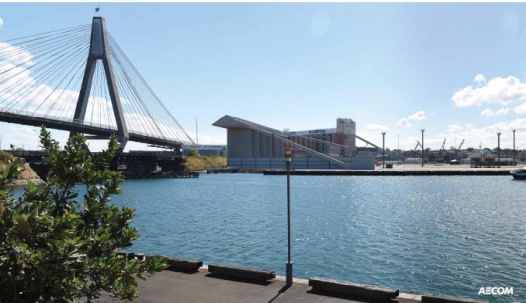
Photomontage of the proposed development when viewed from the open space parks at Pyrmont
Assessment
Council officers have reviewed the current EIS on public exhibition and raise the following matters for consideration.
Land Use
The subject site is not included within the former Leichhardt Municipality Local Environmental Plan (LEP) 2013. It is included within the area known as City West covered by the Sydney Regional Environmental Plan No. 26 – City West (SREP 26).
Under SREP 26 the proposed site is zoned ‘Port and Employment’ which aims to facilitate the continuation of commercial port uses, encourage development on Glebe Island and land adjoining White Bay that compliments this land use and to generate employment opportunities, particularly in relation to port and maritime uses.
The former Leichhardt Council was supportive of the continued function of port and maritime uses in the Bays Precinct prior to the preparation of a Masterplan.
The current proposal for a concrete batching plant with port/harbour access is compatible with the zoning and desired land uses for the site.
Future Use of Bays Precinct
Over the last 10 years Council has received and been invited to comment on numerous development proposals, development applications and modifications to existing approvals for the Bays Precinct Area and was a member of the Bays Precinct Taskforce participating in the development of the ‘Bays Precinct Strategic Framework Report to the NSW Government’ to guide long-term decision making within the Precinct.
Council’s long standing position in relation to the Bays Precinct, including White Bay / Glebe Island, is that cumulative impact of all developments in the area such as the Cruise Passenger Terminal, Rozelle Superyacht Facility, Baileys Marine Refuelling Facility and the Concrete Batching Plant need to be assessed and taken into consideration.
The Bays State Significant Precinct (SSP) preparation is currently on-hold following the cessation of negotiations with potential tenants for the core of the technology and innovation hub.
Glebe Island is identified in the “Transformation Plan: The Bays Precinct” (October 2015) as a longer term priority precinct, with Glebe Island currently an integral part of Sydney’s logistics capability for essential construction materials and working harbour services. Glebe Island and White Bay are the only deep-water wharves west of the Sydney Harbour Bridge. The transformation of the Bays Precinct could provide an opportunity to support “blue” economic activities of port and maritime industries, combined with a new mixed use innovation district (White Power Station site).
Even so the possible construction of elements of the SSP over the short to medium term that may incorporate mixed use development, public domain connections and adaptive reuse of the State-listed heritage White Bay Power Station should also be addressed in the EIS to minimise and mitigate any adverse impacts upon local residents.
Traffic and Transport
A Vehicular Access
The proposed access arrangements incorporate a single access point to the site from James Craig Road. Internally, there are several access and egress points located along the western site boundary. Due to the nature of the facility and the high volume of heavy vehicle movements, the access for heavy vehicles and employee/visitor parking has been separated to improve safety.
The combined employee/visitor car park is accessed via a 5.5m wide driveway, which can facilitate two-way flow at this location.
The B-Double access is located to the north of the site and is accessed by a one-way driveway of 7.8m in width, while the concrete truck access is located to the south of the B-Double access, and is accessed through a one-way roller door of 8m in width, leading to the weight bridge for the site. The width of the internal road network has been designed to accommodate the manoeuvring of the largest vehicle to use the facility, a 25 metre B-Double cement truck.
B Traffic Generation
Even though much of the aggregate for the concrete batching plant will arrive by sea the plant will still generate significant traffic volumes, particularly heavy vehicles.
The traffic assessment provided in the EIS anticipates:
· 35 cement trucks per day;
· 241 aggregate trucks per day; and
· 689 concrete trucks per day.
This suggests a total heavy vehicle trip generation in the order of 2,064 truck trips per day. Added to this is the possibility of some 100 employee car trips per day.
The applicant’s intersection analysis indicates that adjacent intersections will experience no deterioration in their level of service (LoS). This analysis, however, appears only to be based on the additional traffic generated by the concrete batching plant and does not take into consideration traffic generated by the M4 – M5 link heavy vehicle stabling facility or the Glebe Island Multi-user Facility. It is considered that these impacts must also be addressed in order to realistically analyse the operation of the adjacent road network.
C Cumulative Traffic Generation
Adding to the projected 2,064 heavy vehicle trips per day generated by the concrete batching works there are some 500 trips per day associated with the M4-M5 link stabling yards and 1,900 vehicles per day associated with the proposed multi-user facility.
This means that a total of over 4,500 additional trips will use the intersection of The Crescent and James Craig Road, with over 90% of these trips being made by heavy vehicles.
D Inconsistency of Intersection Analysis
The absence of a cumulative impact analysis is considered a critical gap in the assessment of this project. Particular concern arises when a comparison is made between traffic assessments of the various adjacent projects.
As an example, in relation to the intersection of City West Link/The Crescent, the concrete batching plant analysis indicates an unchanging PM LoS of C for 2018 and 2029, regardless of the presence of the concrete batching plant. In comparison the M4-M5 Link Environmental Impact Statement (M4-M5 EIS) indicates an anticipated 2021 LoS of B with LoS of C by 2033.
Additionally, the concrete batching plant analysis of the intersection of Victoria Road and The Crescent indicates a LoS of C in 2018 and of F in 2029, regardless of the presence of the concrete batching plant. In contrast; the M4-M5 Link EIS indicates improving of conditions at this location with a LoS of F in 2015, and of C by 2023.
This inconsistency between the traffic analysis of different projects in similar locations brings into question the reliability of such data and amplifies the need to carry out a cumulative assessment for all projects proposed for Glebe Island and the wider Bays Precinct.
E Consideration of the Western Harbour Tunnel
While it is recognised that details of the proposed Western Harbour Tunnel are limited at this time it is considered that this project will have major implications for the operation of traffic in this area and should be addressed.
F Medium – Long Term Implications for Transport
Analysis of the proposal’s medium-long term implications for transport should be provided including:
· consideration of any implications the aggregate handling facility may have on the future provision of enhanced ferry services for the Bays Precinct, including the permanent re-opening of Glebe Island Bridge; and
· consideration of possible flow-on effects of delays encountered at the James Craig Road/The Crescent intersection, particularly during the PM peak, for bus services on Victoria Road and Anzac Bridge.
G Robert Street, Balmain
Robert Street, Balmain runs immediately to the north of Glebe Island and is linked to Glebe Island via an internal access road. Access to the cruise passenger terminal and much of Balmain East is available via Robert Street and the route also includes two critical intersections; Robert Street/Mullens Street and Robert Street/Victoria Road. These intersections provide critical access to the Peninsula and currently have limited capacity.
Council seeks assurance that Robert Street will not be used to provide any access, including relief access, for the concrete batching works as it is totally unsuitable for such use and is likely to:
· reduce access to the cruise passenger terminal;
· reduce access to parts of Balmain East;
· increase conflict (and corresponding reduce safety at the Robert Street/Mullens Street intersection) which has limited storage for turning vehicles and poor sight lines; and
· result in delays in Mullens Street and Victoria Road, both of which accommodate important bus services.
H Suggested Traffic Mitigation Measures
On traffic and transport grounds the concept of Glebe Island being the site for the Bays Precinct’s centralised concrete batching is sound however it is essential that all aspects of its construction and operation be carefully considered and managed to ensure that impacts on the adjacent road network do not result in:
· delays to public transport;
· diversion of traffic to local streets;
· reductions in local amenity; and
· delays to critical projects such as proposed public and active transport links.
Operational management and mitigation is particularly important as the concrete batching plant will not be the only major facility on Glebe Island. Glebe Island will be the focus of intensive heavy vehicle operations including the concreate batching plant, Glebe Island Multi-user Facility and the M4-M5 Link truck stabling facility (potentially evolving into truck stabling for the Western Harbour Tunnel).
Additionally, the site has all access directed through the intersection of James Craig Road and The Crescent. Delays at this intersection may have significant flow-on effects for the City West Link, Victoria Road and the Anzac Bridge; particularly noting the importance of the latter two in relation of bus services.
I Glebe Island Bridge
The reinstatement of Glebe Island Bridge as an active transport link between the Balmain Peninsula and Pyrmont/Sydney CBD has been actively pursued by Council for over a decade. It is considered that both access to the site and the specific location of the concrete batching plant has the potential to jeopardise, or at least delay, the reinstatement of Glebe Island Bridge as an active transport link.
This has not been specifically addressed in the EIS and assurance is sought to guarantee that the concrete batching plant will not preclude opportunities for this project to proceed in a timely manner.
Public access to the Harbour Foreshore
Public access to the Sydney Harbour foreshore and increasing access are stated objectives for both Council and the NSW government, including within Sydney Regional Environmental Plan No. 26 – City West.
Council requests that the final proposed design examine opportunities to allow for public access to the Harbour foreshore, for both pedestrians and cyclists, while ensuring the potential operations of the facility are not compromised and public safety is ensured.
Noise and vibration impacts
The EIS finds that the cumulative construction noise impacts will be minimal due to the separation of the construction sites. Noise levels during construction comply with relevant standards except at one designated assessment location at Pyrmont (Bowman Street), the noise impact assessment conducted by the applicant’s consultants have found that residual impact to be negligible.
The expected and predicted vessel operations have been found to be consistent with the existing long-term use of the site.
The Noise Impact Assessment finds that the total traffic noise levels will exceed relevant noise criteria due to the existing base traffic flows and movements. As existing traffic already exceeds required standards the EIS finding is that any additional noise increases due to this facility alone shall be negligible.
The EIS fails to examine the cumulative operational noise impacts of all existing and proposed facilities and infrastructure projects in the Bays Precinct and immediate vicinity. This simplistic approach to the analysis of the impacts is inappropriate and this deficiency should be rectified.
FINANCIAL IMPLICATIONS
Nil.
OTHER STAFF COMMENTS
Heritage
The Statement of Heritage Impact (SOHI) does not currently provide a site plan that shows the proximity of the proposed new concrete batching plant to the significant elements identified in the Glebe Island Conservation Management Plan (CMP). This makes it very difficult to assess the impacts on the western approach and embankments. The aggregate silos are shown in close proximity to the embankment. The site plan provided does not indicate the position of any elements outside of the proposed plant so the position of the Glebe Island Bridge and its approaches and the current line of the foreshore are not shown.
The Glebe Island CMP was prepared by the Department of Public Works Heritage Group in 2000. The SOHI for the Glebe Island Concrete Batching Plant notes that it is difficult to apply the policies in the CMP to this project as commercial or large scale industrial uses of the adjacent land were not envisaged. The Glebe Island Bridge is listed on the State Heritage Register and the impact of the proposal needs to be more carefully assessed in relation to the surviving fabric of the Glebe Island Bridge, including the full extent of the embankments.
It has been a longstanding aim of the Councils whose land fronts the bays to create a foreshore walkway. The Glebe Island Bridge was intended to be utilised as part of the foreshore walking and cycling circuit. This proposal has been hampered by the development of the areas leased by Sydney Ports. Proposals in the vicinity should be designed so as to not limit the future inclusion of the State Heritage Register-listed bridge into the publicly accessible foreshore areas of Blackwattle and Johnston’s Bay. The current proposal places large structures adjacent to the embankments that would overshadow the bridge approaches.
Due to the undisturbed character of the embankments to the Glebe Island Bridge these areas now support various grasses and other vegetation. The landscape survey notes that there are ‘some plants’ on the embankments without going in to any detail as to the species, as no formal flora and fauna assessment has been undertaken. Local wisdom has it that species now growing there are rare (due to the extent of development in the area). Planting on the embankments would be shaded by the proposal in its current form. This is another aspect that should be considered in an updated CMP for the Glebe Island Bridge.
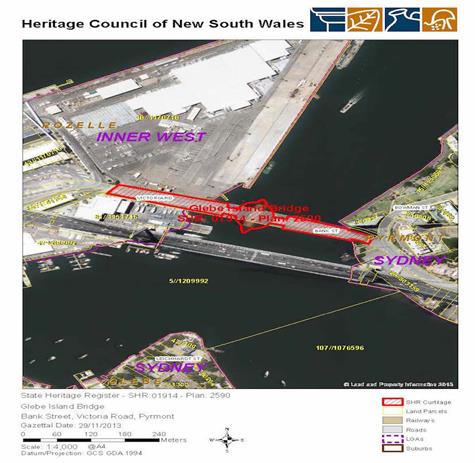
The SOHI identifies a zone of archaeological potential adjacent to the embankments which may contain archaeological evidence of the first Glebe Island Bridge, a private civil engineer working that was contemporary with the abattoirs designed by the Colonial Architect in the 1850s. This assessment is based on information compiled for the SOHI rather than undertaking the type of detailed research that underpins the assessment of significance in CMP for the Glebe Island Bridge. No proper justification is given as to the levels of significance ascribed for the first bridge and no mention is made of who designed and erected the structure. It is however noted that no drawings of the structure survive. No comparison is made with other sites of this era, which would indicate either rarity or representativeness and it is unclear why the potential remains have been deemed as not being likely to demonstrate the principal characteristics of a toll bridge.
The significance of the potential archaeology has not been adequately addressed. It is unclear why the first bridge has such a low level of significance in relation to the second bridge, yet both created a major route to the Sydney markets.
In other sections of the foreshore walkway the past evidence of the use of the foreshore has been incorporated into the walkway and interpreted. It is a lost opportunity to not fully investigate and potentially retain evidence of the first Glebe Island Bridge as part of the overall interpretation of Blackwattle and Johnston’s Bays.
The removal of significant evidence of the past development of Glebe Island does not meet the aim of the Leichhardt LEP to conserve the environmental heritage of the LGA and limits the long term proposals for the public use of the foreshores of Johnston’s and Blackwattle Bays.
PUBLIC CONSULTATION
The SSD Application, Environmental Impact Statement and accompanying documents are on public exhibition from Wednesday 11 April 2018 until Tuesday 15 May 2018.
CONCLUSION
While the proposed development is consistent with the zoning, objectives and existing land uses on the site the size, scale and operating hours of the proposed plant must be minimised and mitigated as much as possible to reduce or eliminate any adverse amenity impacts upon local residents.
The continued failure to examine the cumulative impacts of all developments in the Bays Precinct during both construction and operational phases is totally unacceptable and fails to address the matters raised by Council in its submission to the Department of Planning and the NSW Minister drafting and signing off on the SEARs.
Council has regularly and consistently advocated for over the last decade or more the re-instating and permanent re-opening of the Glebe Island Bridge for active transport as included in Inner West Council’s Integrated Transport Plan and Urban Growth’s Bays Precinct Transformation Strategy (pgs. 22 and 52).
The proposed concrete batching plant is immediately adjacent to the western approaches and structures of the bridge. Council raised the matter in its submission to the Department of Planning and the NSW Minister drafting and signing off on the SEARs. The EIS fails to adequately address the permanent re-opening of the Glebe Island Bridge for an active transport route between Balmain/Rozelle and Pyrmont/Sydney CBD.
|
|
Council Meeting 8 May 2018 |
Subject: WestConnex Local Area Improvement Strategy
Prepared By: Kendall Banfield - Manager WestConnex Unit
Authorised By: David Birds - Group Manager Strategic Planning
|
SUMMARY In late 2016 Council resolved to undertake a study to assess the operational traffic impacts WestConnex will have on residential streets in the Inner West Council area. In 2017 Council commissioned Veitch Lister Consulting (VLC) to undertake traffic modelling and Beca Australia to interpret the modelling and prepare a draft WestConnex Local Area Improvement Strategy (LAIS). The LAIS report due to its size (over 200 pages) can be accessed on Council’s website https://www.innerwest.nsw.gov.au/westconnex
The LAIS is intended to guide the design and ultimately implementation of a series of precinct improvement schemes designed to protect residential streets from increased traffic from WestConnex. The LAIS, developed by Beca with input from Council staff, has been guided by the VLC traffic model that predicts likely future traffic patterns in precincts around WestConnex portals.
The LAIS identifies streets likely to be affected by increased traffic and proposes precinct-wide treatments to protect and improve these streets, based on three typologies: · Typology 1: integrated traffic calming, e.g. slow points, thresholds, tadpoles, traffic islands/refuges and raised platforms; · Typology 2: intersection modifications, e.g. roundabouts, T-treatments, Give Way and Stop signs/prioritisation; and · Typology 3: traffic diversions, e.g. diagonal, partial and full road closures.
The proposed treatments are indicative and will require further investigation and community engagement before final draft schemes can be considered.
The LAIS study includes a strategic framework and broad cost estimates for traffic management, streetscape and water-sensitive urban design (WSUD) improvements for the following five precincts: · Precinct 1: Ashfield $1.0M to $4.0M; · Precinct 2: Haberfield $2.2M to $9.3M; · Precinct 3: Leichhardt West $1.5M to $6.0M; · Precinct 4: Johnston Street $1.8M to $7.2M; · Precinct 5: St Peters $0.5M to $2.2M; and · TOTAL all five precincts $7.0M to $28.7M.
It is recommended that Council seeks funding from Roads and Maritime Services (RMS) for the LAIS works. Subject to funding, the LAIS would be implemented in a similar way that all of Council’s Local Area Traffic Management (LATM) schemes are implemented, involving local community consultation, detailed design, approval and implementation.
|
|
RECOMMENDATION
THAT Council:
1. Adopts the draft WestConnex Local Area Improvement Strategy (LAIS); and
2. Writes to the Minister for Roads and other relevant ministers, forwarding the adopted LAIS with a request for funding of proposed LAIS works. Council to argue that Roads & Maritime Services (RMS) funding is justified as the need for these works is a direct result of WestConnex. |
BACKGROUND
The three stages of WestConnex
The NSW Government announced WestConnex in 2012. It comprises the following three stages:
· Stage 1 – includes M4 Widening, Parramatta to Homebush (completed) and M4 East, extension of the widened M4 between Homebush and Haberfield (70% complete) as twin tunnels (early 2016 to early 2019);
· Stage 2 – includes King Georges Road intersection upgrade (completed) and New M5 (50% complete) from Beverly Hills to St Peters as twin tunnels and St Peters Interchange (late 2016 to late 2019); and
· Stage 3 - M4–M5 Link – Haberfield to St Peters, as twin tunnels (late 2018 to 2023 if approved).
Council’s concerns about operational traffic
From the outset Council has been concerned about how operational traffic from WestConnex would affect the safety and amenity of residential neighbourhoods. This is particularly the case in the vicinity of the tunnel portals at Haberfield-Ashfield and St Peters. Should Stage 3 proceed with surface access at the Rozelle Rail Yards (RRY) site, it is expected that residential neighbourhoods in Annandale and Leichhardt West would also be affected.
Stage 1 Condition of Approval (CoA) E36 and Stage 2 CoA E40 require the proponent to prepare a Road Network Performance Review Plan one and five years after each stage of WestConnex is open to traffic. The plan is to include traffic modelling and is to identify rat-running on local roads, performance deficiencies of the road network, pre- and post-performance issues for all transport modes and measures to address these.
Whilst the Stage 1 and 2 Environmental Impact Statements (EISs) include traffic modelling for main roads, there is no assessment of WestConnex operational traffic on local roads. The abovementioned CoAs would require such an assessment one and five years after each stage of WestConnex opens, but Council does not believe this represents good practice for mitigating operational traffic impacts. It would allow some local residential streets to be affected for at least one year and would allow an intrusive traffic pattern to be established rather than ensuring that residential areas are protected from the outset. Council is strongly of the view that operational traffic impacts on local residential streets must be addressed before each stage of the project is open to traffic, not after.
Council is also concerned that the CoA requiring the proponent to address “performance deficiencies of the road network” would result in measures that would have negative impacts on local amenity and safety, such as clearway extensions and intersection widenings.
Council resolution related to operational traffic
In response to this deficiency Council resolved at its 6 December 2016 meeting that:
“Council immediately commission a study, including appropriate traffic modelling, to assess the impacts each stage of WestConnex will have on residential neighbourhoods and streets following the progressive opening of each stage of WestConnex;
1. The study recommend appropriate traffic management measures to respond to the impacts predicted to occur and Council use this to lobby the State Government to oppose WestConnex and fund the implementation of required measures which are to be put in place prior to any stages of WestConnex opening to traffic;
2. Council ensure that the study addresses what the impacts on Stage 1 (Haberfield/Ashfield) and Stage 2 (St Peters/Tempe) residential environments will be with and without Stage 3 of WestConnex, in order to shape Council’s and the community’s final position on Stage 3.”
Council’s argument for RMS funding is that if WestConnex is shown to be the cause of traffic impacts in residential neighbourhoods, then RMS (not Council) should fund measures necessary to protect them. As is mentioned above, it is imperative that these measures be implemented before WestConnex opens to traffic, not after.
Support from RMS & appointment of consultants
In early 2017 Council wrote to RMS to gain that agency’s technical support for the traffic-modelling task. Council also sought suitable consultants to undertake the traffic modelling and development of the strategy. VLC was the only consultant found to have a model suitable for the task, and as a result was directly appointed by Council. Beca was appointed to undertake the LAIS component of the study by a standard competitive process.
Appointment of these consultants was reported to Council in the first half of 2017 and subsequently endorsed. Both consultants commenced work in mid-2017 and have undertaken their work in the second half of 2017 and early 2018. The consultants have been assisted by RMS and Council staff, and by an initial community consultation process undertaken in October-November 2017. The consultation process is described below and in the LAIS report. The LAIS report due to its size (over 200 pages) can be accessed on Council’s website https://www.innerwest.nsw.gov.au/westconnex
Advocacy on the LAIS to date
Council has argued for funding and implementation of the LAIS in its October 2017 submission on the Stage 3 EIS, in its recent submission on the Stage 3 Submissions & Preferred Infrastructure Report (SPIR) and at a recent meeting with Department of Planning & Environment (DP&E) staff on the SPIR. Council had also issued a media release in November 2017 which included preliminary results of VLC’s traffic modelling. This release coincided with the preliminary LGA-wide consultation for development of the LAIS, which involved written input from the community via Your Say Inner West and a community drop-in session held at Lilyfield in November 2017.
The VLC traffic model
The VLC Zenith traffic model is a regional network-wide simulation using various data sources, including traffic counts, projected population counts and proposed road and public transport infrastructure. Outputs include traffic volume/capacity ratios, levels of service, average travel speeds and delay estimations. The model aims to show how travel behaviour alters in response to external factors, such as spatial population and employment changes, infrastructure changes and travel pricing. As the modelling was undertaken in 2017, it does not include some recently-announced (2018) projects, such as the proposed Glebe Island multi-user facility.
The Zenith model is accepted as the most appropriate strategic model for the Sydney region and is consistent with RMS’s traffic modelling methods. Consistency with RMS is considered essential, as the model’s results will underpin Council’s approach to RMS to fund the proposed LAIS treatments.
In order to best reflect network and population changes, the assessment periods were set as 2021 and 2031. Whilst 2021 does not coincide with the opening of WestConnex Stage 1, it provides a sufficiently robust output to justify implementation of LAIS measures, with the aim that these measures be implemented prior to the opening of Stage 1 in early 2019. Additionally the 2021 projections are considered to be conservative as they exclude the initial ‘novelty value’ traffic increases related to the opening of a new motorway.
Development of the LAIS by Beca
Beca’s task has been to develop a strategic response, based on outputs from the VLC model, to protect local residential streets from increased traffic from WestConnex. Note that the LAIS considers operational traffic only – not construction traffic. The latter is dealt with through relevant CoAs, which set the framework for the development of construction traffic management plans. All CoAs are monitored by DP&E.
In developing the LAIS Beca has proposed a three-stage planning process, as follows:
Figure 1 – Strategic Improvement Plan Process (source: LAIS report refer to web link)
Summary of key elements of the LAIS
In summary, the LAIS comprises:
· examination of existing traffic conditions;
· modelling of the medium-term (2021) operational impacts of WestConnex;
· modelling of the longer-term (2031) operational impacts of WestConnex;
· initial consultation with the community and consideration of other relevant stakeholders’ actions;
· development of a high-level draft strategy to ameliorate impacts of WestConnex on local streets;
· proposed additional community consultation through exhibition of the draft strategy; and
· refinement of the draft to provide a final strategy for adoption by Council and for presentation to RMS seeking funding support.
After finalisation of the strategy and subject to funding, it is proposed that development of precinct improvement schemes follow the same process as all of Council’s LATM schemes, i.e. detailed design, consultation, refinement of designs and implementation.
Initial community consultation for the LAIS
Initial community consultation for the LAIS involved two main components. The first was information on the project and call for comments on Council’s Your Say Inner West website between 19 October and 12 November 2017. The second was verbal comments received and recorded by Council staff and project consultants from community members at a drop-in session held in Lilyfield on the evening of 9 November 2017.
The main objective of the consultation was to determine the most important issues of concern for residents in relation to traffic, with a focus on operational impacts from WestConnex. Identifying these issues has assisted in identifying streets likely to be affected and corresponding amelioration measures.
A total of 510 individual responses were received during the consultation period – in the form of online comments and those received verbally and recorded as part of the drop-in session. Of the 510 comments received, 111 were considered to be outside of the scope of this project and were therefore not considered further. These comments were however retained by Council as general information that can be used to guide Council’s general management of traffic. The community’s comments are summarised within the LAIS report (refer to weblink)
Key themes from the consultation
The following themes emerged from the 399 project-relevant comments received:
· access – ability of residents to safely and efficiently to get to their property or intended destination by any means;
· amenity – community or heritage related amenity associated with Inner West neighbourhoods;
· compliance – with Council or government bylaws or laws, e.g. heavy vehicle ban bylaws;
· environmental – pollution, dust or similar environmental concerns;
· heavy vehicles – heavy vehicles operating on local streets;
· noise – as caused by WestConnex;
· parking – availability and provision of on-street parking;
· safety – traffic-related safety issues within the Inner West Council area;
· traffic performance – performance of traffic within the study area related to WestConnex;
· traffic speeds – excessive speeds on local streets; and
· traffic volumes – the potential for increased traffic as a result of WestConnex.
While all of these themes were used to inform development of the draft LAIS, the following three key strategic themes were evident as the community’s concerns:
Figure 2 – Key strategic themes arising from
community feedback (source: LAIS report refer to web link)
Recent councillor briefing
In addition to the community consultation, a briefing of councillors was held on the evening of 22 March 2018. Feedback from this briefing also assisted Beca and Council in refining the draft LAIS.
Analysis of modelling results
Beca and Council staff have reviewed the VLC modelling and have identified potential rat-running routes and their likely impacts for the following scenarios:
· 2021 Base Model - without WestConnex;
· 2021 Project Model - with Stages 1 and 2 completed;
· 2031 Base Model - with Stages 1 and 2 completed; and
· 2031 Project Model - with all three stages of WestConnex completed.
This model was used to examine the operational impacts on local residential streets, although it is acknowledged that certain residential streets are State Roads, such as Johnston and Frederick Streets. These streets have been included in the analysis because of their residential nature, the fact that they include sensitive uses (such as schools and local shopping centres) and because of the level of impact predicted. The main model output - traffic volume - can be used as a proxy for assessment of environmental amenity, as increased traffic usually directly increases road safety, noise and air pollution impacts.
Key operational traffic issues identified from the modelling
As illustrated in Figures 3 and 4 below, the VLC modelling raises the following operational traffic issues for the year 2021:
· absence of a link between Stages 1 and 2 generates increased traffic across the LGA between the Haberfield and St Peters portals;
· increased traffic will be encountered adjacent to the Haberfield-Ashfield portals; and
· increased traffic will occur on Bland Street, Ramsay Street / Marion Street, Waratah Street, Hawthorne Parade and Edgeware Road.
The VLC modelling raises the following points for 2031, if Stage 3 proceed:
· completion of Stage 3 is likely to take some traffic away from the surface road network with increased traffic being focussed on Haberfield-Ashfield and RRY site portals; and
· increased traffic would likely occur on Alt Street, Annandale Street, Johnston Street, Frederick Street and Unwins Bridge Road.
The modelling also indicates that reduced traffic can be expected on a number of streets for each of the periods modelled. Examination of these routes is technically not part of this project as the LAIS only considers streets that would have increased traffic from WestConnex. Wherever traffic is reduced, Council has always sought to reduce motor vehicle capacity to constrain car use and ensure traffic speeds do not increase. Spare road capacity should instead be used for improved amenity via public domain improvements (street trees/gardens, widened footways etc.) and improved public transport and active transport.
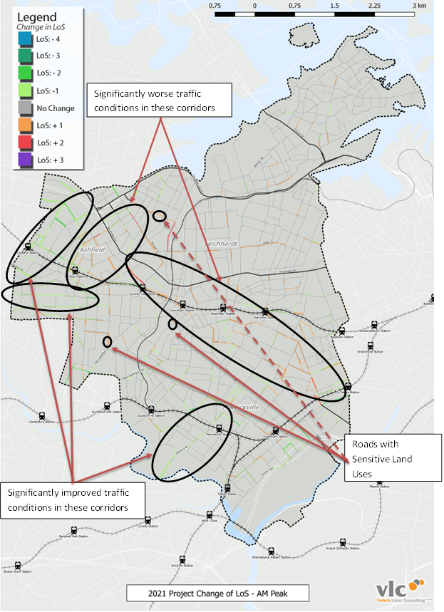
Figure 3 – areas identified with impact from WestConnex 2021 (source; LAIS report refer to web link)
In Figures 3 & 4 LoS means Level of Service for the road links shown (not intersections). The legend assigns colours to the change in the LoS (positive or negative) as a result of WestConnex.
Based on 2021 model outputs, Figure 3 above shows the areas of influence associated with Stage 1 and 2 of WestConnex. They identify the following areas as being of concern during this period:
· Haberfield-Ashfield area, both sides of Parramatta Road - particularly around the Ramsay Street / Wattle Street area;
· routes connecting to the St Peters Interchange, including Edgeware Road and Stanmore Road, as well as routes running parallel to these streets, e.g. Juliet Street;
· areas with sensitive land uses, including schools and shopping centres, such as Trinity Grammar School on Prospect Road, Petersham Primary School on Hunter Street, Ramsay Street shopping strip and St Pius School on Edgeware Road.
There are also areas identified that would have reduced traffic to the south and west of the St Peters and Haberfield portals.
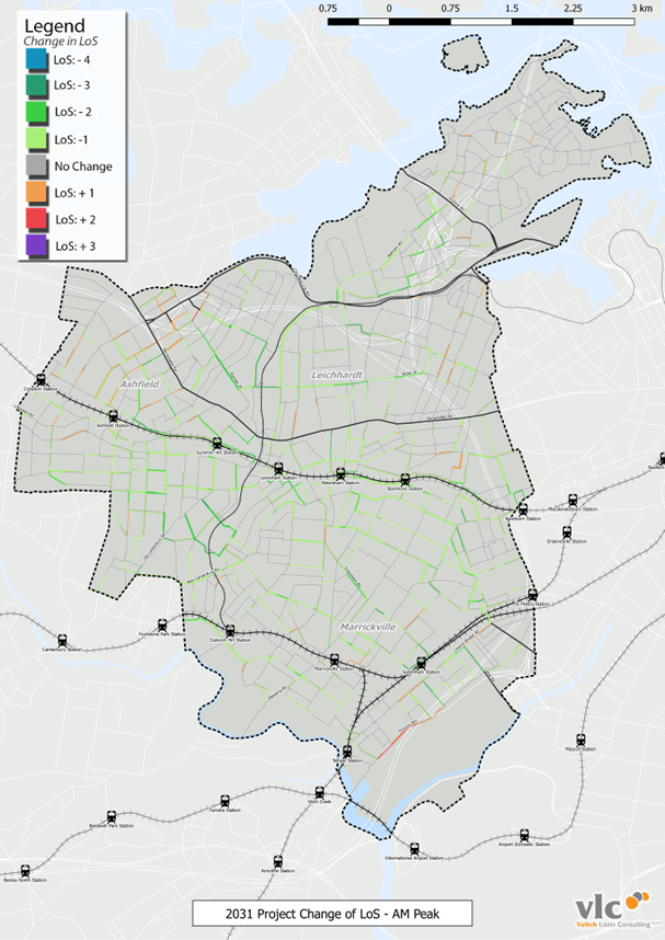
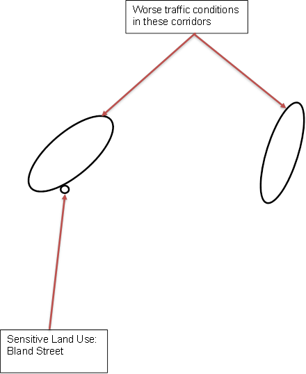
Figure 4 - areas identified with impact from WestConnex - 2031 (source: LAIS report refer to web link)
Based on 2031 modelling outputs, Figure 4 above shows the following areas of concern after completion of Stage 3:
· Haberfield-Ashfield area, on both sides of Parramatta Road and areas around the Wattle Street Interchange;
· Leichhardt-Rozelle, along routes between Parramatta Road and City West Link and connecting into the Rozelle Interchange; and
· areas with sensitive land uses around Bland Street at Ashfield, including De La Salle College, Bethlehem College and St Vincent’s Catholic Primary School.
As is the case for the other scenarios, a number of the streets are expected to have reduced traffic in 2031 as a result of WestConnex.
Finer-grained analysis of modelling results by Beca
A finer-grained analysis of altered traffic patterns resulting from WestConnex is shown in Figures 5 to 13 below. This analysis has been used to inform development of the draft LAIS.
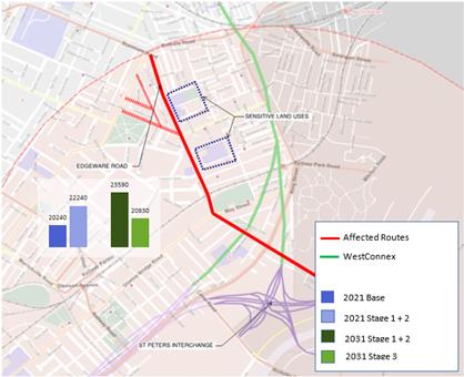
Figure 5 – WestConnex Traffic Impacts – Edgeware Road,
St Peters (source: LAIS report refer to web link)
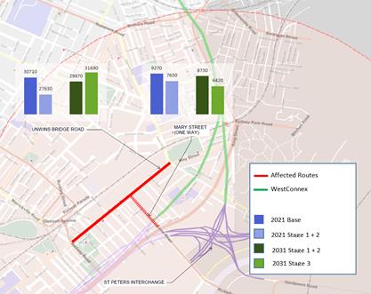
Figure 6 – WestConnex Traffic Impacts – Unwins Bridge road and
Mary Street, St Peters (source: LAIS report refer to web link)
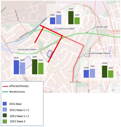
Figure 7 – WestConnex Traffic Impacts – Haberfield (source: LAIS
report refer to web link)
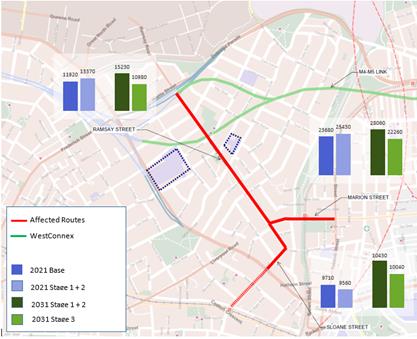
Figure 8 – WestConnex Traffic Impacts – Ramsay St and Marion St,
Haberfield/Leichhardt (source: LAIS report refer to web link)
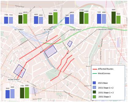
Figure 9 – WestConnex Traffic Impacts – Ashfield (source: LAIS
report refer to web link)
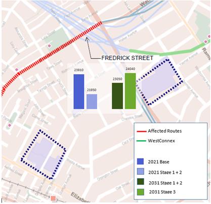
Figure 10 – WestConnex Traffic Impacts – Frederick Street,
Ashfield (source: LAIS report refer to web link)
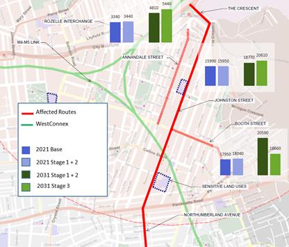
Figure 11 – WestConnex Traffic Impacts – Johnston Street,
Annandale (source: LAIS report refer to web link)
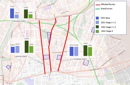
Figure 12 – WestConnex Traffic Impacts – Leichhardt (source: LAIS
report refer to web link)
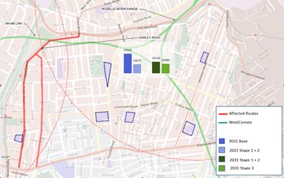
Figure 13 – WestConnex Traffic Impacts – Darley Road & Tebbutt
Street, Leichhardt (source: LAIS report refer to web link)
Precincts identified by the LAIS
Based on the VLC modelling, feedback from the initial community consultation and analysis of land uses sensitive to traffic, a draft LAIS has been developed. It focuses on firstly on safety, then amenity through reductions in traffic volumes and speeds. As shown in Figures 14 and 15 below, the draft LAIS identifies five precincts, coinciding with the WestConnex portals that bring traffic to the surface or attract traffic from the surface. The fifth precinct at St Peters is technically a route, but for the purposes of the LAIS is referred to as a precinct. These precincts are: Ashfield; Haberfield; Leichhardt West; Johnston Street, Annandale (including the RRY site portal); and Edgeware Road / Unwins Bridge Road / Campbell Street at St Peters.
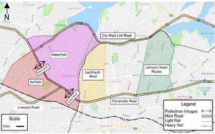
Figure 14 – precincts identified for precinct improvement
schemes (source: LAIS report refer to web link)
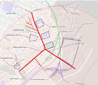
Figure 15 – St Peters route, referred to as the fifth precinct (source:
LAIS report refer to web link)
Precinct treatment typologies
The LAIS study identifies key routes likely to be impacted by WestConnex traffic and proposes precinct-wide treatments based on three typologies:
· Typology 1: integrated traffic calming, e.g. slow points, thresholds, tadpoles island/refuges and raised platforms;
· Typology 2: intersection modifications, e.g. roundabouts, T-treatments, Give Way and Stop signs/prioritisation; and
· Typology 3: traffic diversions, e.g. diagonal closures, partial and full road closures.
Examples of typical improvement measures within each typology are shown in the LAIS report. (refer to web link)
Potentially affected streets & indicative LAIS responses
Figures 16 to 20 below from the LAIS report show the streets affected by WestConnex and the draft LAIS’s proposed indicative responses. Note that these responses are not presented for consideration for approval, but indicate issues that will need to be discussed and examined in greater detail with the local community.
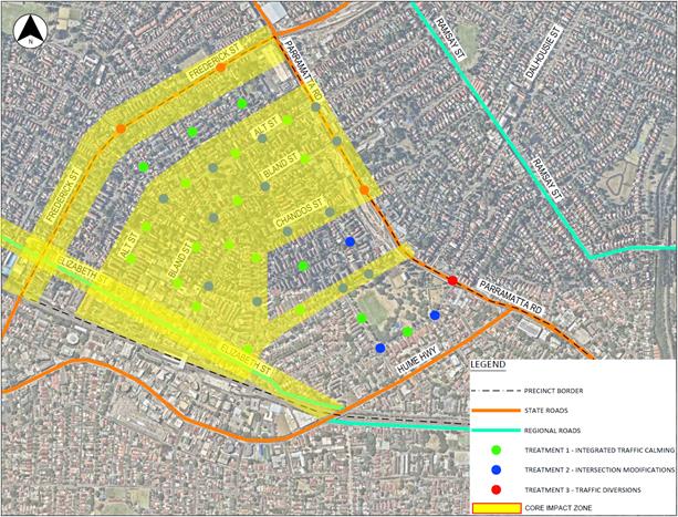
Figure 16 – Ashfield Precinct (source: LAIS report refer to web link)
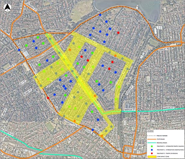
Figure 17 – Haberfield Precinct (source: LAIS report refer to web link)
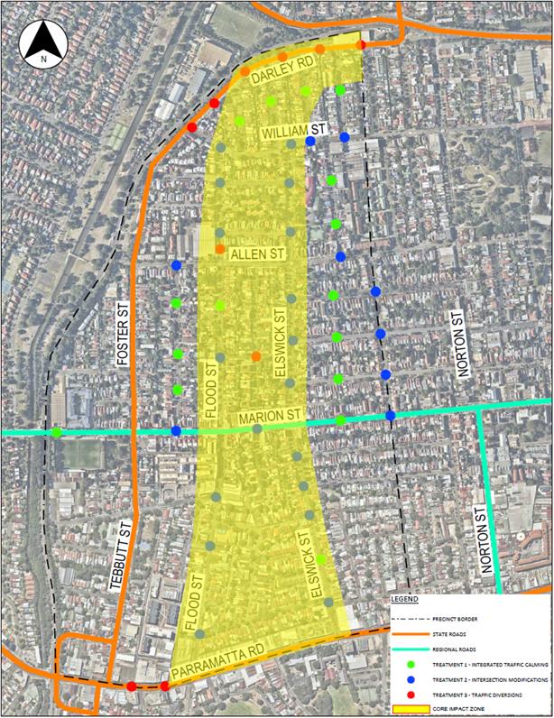
Figure 18 – Leichhardt West Precinct (source: LAIS report refer to web link)
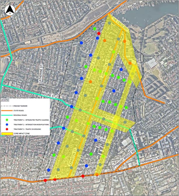
Figure 19 - Johnston Street, Annandale (source: LAIS report refer to web link)
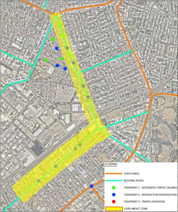
Figure 20– St Peters (source: LAIS report refer to web link)
Cost estimates for LAIS works
The LAIS report (refer to weblink) provides an estimate of costs for detailed design and construction of LAIS works for each of the precincts. As final LAIS designs would be subject to at least two more rounds of community consultation, the number and design of measures is likely to alter, hence costs would alter. Costs for each scheme will be dependent upon the specific measures used, the types of Water Sensitive Urban Design (WSUD) systems employed, landscaping style and types of materials used.
The LAIS includes strategic framework for traffic management, streetscape and sustainability improvements for the following five precincts. Cost estimates are as follows:
· Precinct 1: Ashfield $1.0M to $4.0M;
· Precinct 2: Haberfield $2.2M to $9.3M;
· Precinct 3: Leichhardt West $1.5M to $6.0M;
· Precinct 4: Johnston Street $1.8M to $7.2M; and
· Precinct 5: St Peters $0.5 to $2.2M.
· TOTAL all five precincts $7.0M to $28.7M
Next steps
This report recommends that Council adopts the draft LAIS and forwards it to the Minister for Roads and other relevant ministers with a request for RMS funding for implementation of the LAIS. Should RMS funding be forthcoming, the timing of the implementation of works within the five precincts will be determined, and the LAIS will follow a similar process as all of Council’s LATM schemes, i.e. detailed design, local consultation, approval (by Traffic Committee and Council) and implementation.
Should RMS funding not be forthcoming, this will be reported back with a recommendation that Council considers an allocation of funding to commence implementation of the LAIS works over time. Again, at that point, the timing of the implementation of works within the five precincts will be determined, and the LAIS follow a similar process as all of Council’s LATM schemes.
Regardless of funding arrangements and timing, implementation of LAIS works will involve community engagement within (and around) each of the five precincts. When that occurs, the community will have an opportunity to comment on LATM scheme options in greater detail. In the meantime, while Council is engaged in seeking funding, any comments from the community forwarded to Council will be considered during the LAIS implementation phase.
FINANCIAL IMPLICATIONS
At this stage there are no funding implications for Council from this report. Funding for the LAIS will be sought from RMS. Should full-funding of the LAIS not be forthcoming from RMS, Council will need to consider allocation of funding at a later stage.
OTHER STAFF COMMENTS
All relevant traffic and transport staff have had input into the consultants’ reports and the Council officer’s report.
PUBLIC CONSULTATION
Initial public consultation for this project was undertaken in late 2017. Subject to funding of the LAIS, local community engagement would be undertaken in the same way as for all of Council’s LATM schemes. In the meantime, while Council is engaged in seeking funding, any comments from the community forwarded to Council will be considered during the LAIS implementation phase.
|
|
Council Meeting 8 May 2018 |
Subject: Regulation and Enforcement of Long Term Trailer Parking Report
Prepared By: Graeme Palmer - Team Leader Ranger Services
Authorised By: Ryan Cole - Group Manager Development Assessment and Regulatory Services
|
SUMMARY This report aims to provide information regarding long term parking of boat, advertising and general trailers and the difficulties surrounding regulation and enforcement. |
|
RECOMMENDATION
THAT Council note:
1. That the amendments to the State Environmental Planning Policy No. 64 – Advertising and Signage (SEPP 64), in respect of advertising trailers, is suitable and has been successful in its application to date;
2. That the Inner West LGA becoming a ‘declared area’ for the purposes of Section 15A(1) of the Impounding Act 1993, will not bring relief from the issue of long term boat trailer parking and regulation can occur via specific parking signage;
3. That the long term parking of a registered trailer is not an offence and regulation can only occur via specific parking signage; and
4. That abandoned trailers are an insignificant issue within our LGA and is currently managed appropriately. |
BACKGROUND
Parking within the Inner West is a challenging issue for Council to manage. In doing so, Council strives to find a balance between the needs of local residents, businesses and those wishing to visit the area. In carrying out this function Council seeks to act fairly, consistently and effectively in its enforcement of the Road Rules and other relevant legislative provisions.
Throughout our LGA there are numerous trailers that remain in place for long periods of time and these are providing additional challenges, for both residents and Council enforcement staff alike. The parking of trailers for the long term, increases the pressure currently experienced by our residents by reducing the availability and turnover of on street parking spots, however it is important to note that the parking of a registered trailer in an unregulated area is not an offence.
Generally, trailers can be divided into four distinct categories, being advertising, boat, general registered and abandoned, they have been separated, as outlined below, for ease of reference:
Advertising Trailers
Advertising trailers are generally placed on roads with a high volume of traffic flow to maximise exposure. They may present a risk to drivers as they serve as a distraction from the road.
The main existing problem areas within the Inner West are as follows:
· Johnston Street, Annandale
· Frederick Street, Ashfield
· Old Canterbury Road, Ashfield/Dulwich Hill
· Ramsay Street, Haberfield
· Darley Road, Leichhardt
· Lilyfield Road, Lilyfield
· Liberty Street, Stanmore
· Railway Avenue, Stanmore
Legislation Changes:
On 1 March 2018, amendments to the State Environmental Planning Policy No. 64 – Advertising and Signage (SEPP 64) came into effect. These changes included the following:
· Banning advertisements on parked trailers on roads, road shoulders, footpaths and nature strips, excluding advertising that is ancillary to the dominant purpose of the trailer, e.g. trade trailers, and public authorities
· Requiring consent for displaying signage on trailers parked on private land in view from roads, road shoulders, footpaths and nature strips
Action Taken Since 1 March 2018
Since the amended legislation came into effect, the Ranger Services section commenced proactive investigations/enforcement of the initial ‘bulk lot’ of advertising trailers as listed in the table below.
The initial investigation/enforcement has been very successful and as such Ranger Services Officers will now undertake investigation of future 1-off trailers on an as observed/reported basis.
Please see table below, which represents the numbers of trailers investigated since 1 March 2018, and the level of success the initial evidence gathering and word of mouth has achieved.
|
Suburb |
Location |
No. of |
No. of |
Special Notes |
|
Annandale |
Johnston Street |
3 |
0 |
Note: **One other (Annandale Boat Hire) is technically not an "advertising trailer". Consideration currently being provided to addressing the matter via Consent Conditions and will be managed separately to this process. |
|
Ashfield |
Frederick Street |
10 |
0 |
Note: *All Advertising
trailers removed. |
|
Ashfield/Dulwich Hill |
Old Canterbury Road |
5 |
0 |
Note: *All Advertising
trailers gone. |
|
Haberfield |
Ramsay Street |
4 |
1 |
Note: *Investigation commenced and continuing into one remaining trailer |
|
Leichhardt |
Darley Road |
2 |
0 |
Note: *All Advertising
trailers gone. |
|
Lilyfield |
Lilyfield Road |
4 |
1 |
Note: *Approx 20 non
advert trailers, including caravans, boat trailers etc. |
|
Stanmore |
Liberty Street |
1 |
1 |
Investigation commenced and continuing into 1 remaining trailer. |
|
Stanmore |
Railway Avenue |
2 |
2 |
Note: *Approximately
20 non advert trailers, including caravans, boat trailers etc. |
|
Totals |
31 |
5 |
||
Boat Trailers
Boat trailers are being left for long periods of time in various locations across the Inner West LGA, this practise impacts the availability of on street parking and creates a ‘visual pollution’ within the local amenity. Potentially, as trailer ownership increases, on street parking may become increasingly scarce in these areas.
On 1 July 2016, the Impounding Act 1993 was amended by the Impounding Amendment (Unattended Boat Trailers) Act 2015 to allow councils and impounding authorities to ‘opt in’ to take impounding action against boat trailers parked for more than 28 days.
This change is to enable councils to improve the management of boat trailer parking on residential streets and encourage the use of off-street storage.
In any area where the provisions are applied, boat trailers must move at least every 28 days at least as far as a different block section of the same street. In addition, Council must provide notice of at least 15 days before impounding a trailer.
Why the legislation is impractical
· The ability for Council to determine that the trailer has not moved after 28 days can be difficult. If the owner was to claim that they had used the boat once within the 28 day period and re-parked it in its original location, it would be on the investigating Officer to prove otherwise.
· Once the Officer is satisfied that the boat has not moved after 28 days, they can proceed to issue a notice to the owner of Council’s intent to impound, this notice effectively gives the owner a further 15 days to move the trailer. During the 15 days, the owner must move the boat at minimum, across the nearest intersection on the same street. Once moved, the 28 day clock restarts and Council Officers must once again observe the trailer not moving for 28 days and reissue the notice. This practise can continue indefinitely.
It is also important to note that the legislation is designed for the impounding of boat trailers not necessarily boats on trailers, as such special considerations are required when undertaking enforcement action involving the potential impounding of a boat that is attached to a boat trailer, impounding authorities have been reminded to take into consideration:
a. that the owner of the vessel may differ to the owner of the boat trailer - attempts should therefore be made to identify the owner of both the trailer and the vessel before impounding action is taken,
b. the vessel is likely to be significantly more valuable than that of the boat trailer, and therefore there is likely to be significantly higher expectation from boat owners as to the appropriate handling and care taken by impounding officers when undertaking enforcement action involving vessels.
Both the above considerations may increase the financial risk to Council should a boat end up impounded incorrectly and any dispute arises over whether it was moved during the 28 period and/or claims of damage to the vessel during the impounding process.
Problem areas and extent of the issues
There are only three streets that maintain consistent issues with boat trailer parking, these are as follows:
· Lilyfield Road, LILYFIELD
· Darley Road, LEICHHARDT
· Railway Parade, ANNANDALE
What options are available?
Outside of solid enforceable legislation that the new amendments are not considered to provide the ability to adequately regulate, the options are effectively limited to the installation of signage.
Signposting streets with ‘No Parking 7AM-7PM – Motor Vehicles under 4.5t GVM Excepted’ signage is the only avenue for eliminating the parking of trailers generally on residential streets without a major legislative shift; however, it must be considered that the distribution of the trailers following signage implementation could be problematic and lead to the proliferation of required parking signage.
To prevent proliferation of the subject signage, consideration may be given to a signage strategy, whereby the signs are installed in a problematic area to prevent trailer congregation and subsequently removed after a period of time. This may require trialling to determine success rates and to monitor the return of trailers to the street. The implementation of this approach would require consideration by the Local Traffic Committee and further consideration by Council.
General Registered Trailers
Generally trailer parking has differing effects across the LGA dependant on the number of trailers congregating in one place.
Complaints regarding the congregation of trailers are very low; however, when it does occur, it can have a major impact on the affected street.
The regulation of this issue is limited to the aforementioned signage strategy.
Abandoned Trailers
The issue of abandoned trailers is insignificant across the Inner West LGA, the issue is easily remedied with the sufficient legislation already in place.
The Impounding Act 1993 is the appropriate legislation when looking at impounding abandoned vehicles. Trailers by definition are considered vehicles for the purpose of the Act.
The process of impounding abandoned trailers is indifferent to any other vehicle and takes approximately 2 weeks from the first inspection.
FINANCIAL IMPLICATIONS
There are financial implications associated with the implementation of a signage strategy, specifically the installation and removal costs, however, enforcement of the signage can be executed within existing resources.
OTHER STAFF COMMENTS
Traffic and Parking Services Manager
Leichhardt Council has installed 'No Parking 7AM-7PM – Motor Vehicles under 4.5t GVM Excepted’ signage in McKell Street and Church Street (Cameron Street-McKell Street), Birchgrove and in Railway Parade, Annandale adjacent to the existing resident parking scheme. The installation of the subject signage in Lilyfield Road, Lilyfield was deferred until the outcome of the investigation into the separated cycleway was known.
The installation of the subject signage on Darley Road, Leichhardt would require approval of RMS as Darley Road is a classified State road.
PUBLIC CONSULTATION
Nil
CONCLUSION
The implementation of new signage to restrict the parking of all trailer types (in affected streets) may be a suitable solution, however the dispersion of these trailers may subsequently impact nearby streets without such restrictions.
|
|
Council Meeting 8 May 2018 |
Subject: Dogs in Parks-Elliot Park and Balmain Cove Companion Animal Review
Prepared By: Aaron Callaghan - Parks Planning and Engagement Manager
Authorised By: Cathy Edwards-Davis - Group Manager Trees, Parks and Sports Fields
|
SUMMARY This report details the outcomes from the recent public survey undertaken to assess the potential public support for the establishment of an off leash companion animal area in Elliot Park and Balmain Cove, Rozelle. The report highlights the results of community engagement to date and recommends that an off leash trial period is held within the subject parks for a trial period of six months. An evaluation process will be undertaken towards the end of the trial period to assess residential and park user views. In addition, compliance and companion animal ranger presence will be present within the subject parks for the purposes of monitoring, education and compliance. The evaluation process will be reported back to Council at the end of the trial period with a recommendation pertaining to the future on or off leash status of these parks. |
|
RECOMMENDATION
THAT:
1. Council proceed with an off leash trial period in the areas highlighted in Attachment 3 at Elliot Park and Balmain Cove for a period of six months commencing from 1 June to 1 December 2018;
2. Council carry out an evaluation on the level of support for making the trial areas permanent at the conclusion of the trial period; and
3. Following the completion of the evaluation trail period, a further report on companion animal access at Elliot Park and Balmain Cove be brought back to Council for further consideration. |
BACKGROUND
In 2016 the former Leichhardt Council resolved to undertake a review of companion animal access to Balmain Cove and Elliot Park in Rozelle. On the 12 April 2016, Council resolved:
That Council review companion animal access to open space for Elliot Park, Rozelle as a part of the formal review of companion animal access to open space for the Leichhardt Local Government Area, scheduled for July 2017.
Presently both Balmain Cove and Elliot Parks are designated on leash areas for companion animals. The nearest open space within close proximity for off leash exercise is Bridgewater Park (refer to Fig 1.0).
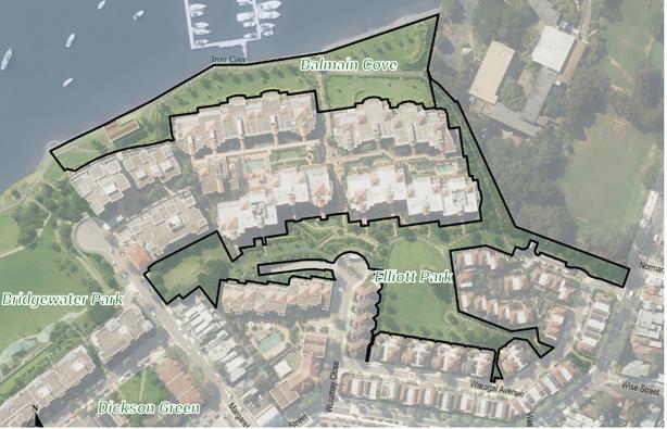
Fig 1.0 Site Location Balmain Cove and Elliot Park
FINANCIAL IMPLICATIONS
Council will need to design and install companion animal access signage for the trial period. The costs associated with this signage is approximately $1,000.
OTHER STAFF COMMENTS
Council’s Compliance Section-Animal Services has been consulted on the proposed trial period.
PUBLIC CONSULTATION
On 28th November 2017 Council launched a public survey on its Your Say Inner West website advertising a review of companion animal access in Elliot Park and Balmain Cove. A total of 1,700 flyers were distributed to residential properties within the Balmain Cove area and the public survey was also advertised in the respective park areas. The survey ran through to the 4th February 2018.
A copy of the flyer advertising the review is attached (refer to Attachment 1).
In total 574 people viewed the survey project page with a total of 239 people completing the public survey. In addition Council received four written submissions in relation to the survey. A summary of these submissions is attached (refer to Attachment 2).
During the survey process a petition with 27 signatures was also received, requesting that Council maintain the current on leash conditions within the two parks.
Dogs in Park Survey Analysis
Table Total Number of People Who Responded to the Survey.
|
Reason for visiting |
# |
% |
|
Visit with dog |
164 |
69% |
|
Visit for other reason |
69 |
29% |
|
Don't visit |
6 |
3% |
|
Total |
239 |
100% |

Table Comparison of Support for Change: Visitors with Dogs and Visitors Without Dogs.
|
Visitors with dogs |
Visitors without dogs |
|
|
Support for no change |
29% |
65% |
|
Support for change |
61% |
25% |
|
Support for trial off-leash |
93% |
31% |
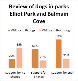
Based on the outcomes of the public survey and the support received for an off leash trail period, Council officers are recommending that Council proceed with the implementation of a six month off leash trial at Balmain Cove and within Elliot Park. The areas recommended for the trial period are highlighted in Attachment 3
Should Council support the implementation of an off leash trial period further community engagement and an evaluation of the trial will be held. Evaluation will include the following: included the following:
§ an evaluation survey on Inner West Your Say web site.
§ letterbox drop to residents adjacent to the trial area informing them of the off leash trial and evaluation process;
§ a designated email address will be set up for feedback during the duration of the trial; and
§ promoting awareness of the evaluation through Council Column and media release.
CONCLUSION
Support for an off leash trial for companion animal access improvements at Elliot Park and Balmain Cove has been well supported by the community. The public engagement process to date has highlighted significant support for an off leash trial period. Moving forward an off leash trial period is recommended for a period of six months following which further community engagement will be undertaken with respect to community views on making the trial areas a permanent arrangement within the subject parks.
|
1.⇩ |
Community Engagement Flyer |
|
2.⇩ |
Summary of Public Subissions |
|
3.⇩ |
Proposed On and Off Leash Trial Area |
|
|
Council Meeting 8 May 2018 |
Subject: Local Participatory Democracy at Inner West
Prepared By: Prue Foreman - Coordinator Communication and Engagement
Authorised By: Laura Stevens - Group Manager Communications, Engagement and Events
|
SUMMARY This report makes recommendations to strengthen local democracy at Inner West through an improved Strategic Reference Group/committee structure, additional engagement mechanisms and regular reporting to Council. |
|
RECOMMENDATION
THAT Council:
1. Make the following SRGs/Committees permanent:
a. Aboriginal and Torres Strait Islander; b. Environment; c. Housing and Affordability; d. Planning and Heritage; e. Social Inclusion ; f. Transport; and g. Young Leaders.
2. Replace the Economic Development SRG with the established quarterly forum of Inner West local business chambers and associations, with outcomes reported to Council;
3. Establish an Access advisory group with outcomes reported to Council;
4. Ensure the Environment SRG has representation from community members with an interest or expertise in the Cooks River and Parramatta River catchments;
5. Convene a Multicultural Roundtable bringing together community leaders from Inner West’s diverse communities, and scope development of Multicultural Communication and Engagement guidelines;
6. Determine to receive and note a bi-monthly Local Democracy report prepared by Council’s Engagement team. The report will include SRG meeting minutes and updates from relevant working groups, Access advisory group and Business Forum;
7. Determine that Council by resolution may refer items to SRGs, Business Forum or working groups for advice and recommendations to be reported back;
8. Endorse a trial of options including:
a. Hold an annual Councillor roadshow/community forum in each ward, encouraging a large and diverse group of local residents to participate in an engagement event in their local area; b. Support community-led independent resident groups through a small grants program to cover meeting costs such as venue hire; c. Establish a register of community groups for relevant engagements; and d. Implement a marketing campaign promoting ways to get involved in engagement processes and lodge service requests.
9. Update the Community Engagement Framework to:
a. Include any resolutions resulting from this report; b. Include information about the elected Council; and c. Review the Community Engagement Framework including the impact of any resolutions which result from this report and the functions of SRGs/committees, Business Forum, advisory and working groups in one year, and report back to Council.
|
BACKGROUND
At its meeting on 12 December 2017, Council considered a report on Local Participatory Democracy at Inner West (C1217 Item 8). The report included the results of an evaluation of the interim Strategic Reference Groups (SRGs) and made recommendations to strengthen local democracy.
Council resolved to defer the item to a briefing for further information on former committees and how Council will engage with specific communities. Council also resolved to continue the SRGs in the interim, and requested a process for policy matters to be referred to the SRGs by resolution of Council and recommendations to be reported back. The Councillor briefing was held on Thursday, 15 March 2018.
DISCUSSION
Council is committed to developing the capacity of the local community to participate in its decision-making. The community participates through:
· Project-specific engagement
o Strategy/policy development
o Service planning and review
o Infrastructure planning and delivery
· Engagement events:
o Roundtables
o Your Say stall at flagship events
o Public meetings
· SRGs
· Other Council-run groups:
o Committees/advisory groups/working groups
o Time-limited or special purpose groups
o Interagencies
· Council meeting speakers
![]()
The vast majority of the community participates in shaping the decisions of Council through project engagements and engagement events. Council has engaged the broad community on more than 50 projects in the current financial year. This type of engagement should be strongly supported as the key means to involve the majority of the community including those who experience barriers to engaging with Council. For example Council regularly translates materials into key community languages to support participation. A Your Say Inner West stall is held at flagship events to reach community members who may not otherwise connect with Council. In the last year, a stall has been held at Norton Street Festa, Marrickville Festival, Dulwich Hill Fair, Ashfield Carnival of Cultures and Celebrate 2044.
SRGs/committees and other groups offer opportunities to participate in an ongoing way, but it should be noted that there are not always items on which to engage outside of periods of strategy development and implementation. For example, the Transport SRG will be extremely useful over the next period as the Integrated Transport Strategy is developed, but meetings to date have mostly consisted of presentations as there was no opportunity to influence policy. Similarly, as the new Local Environmental Plan and Development Control Plan are developed over the next few years, there will be significant opportunities for the Planning and Heritage SRG to participate in the strategy development and these opportunities should be identified and meetings scheduled accordingly. Conversely the Young Leaders SRG is actively involved in coordinating Youth Week activities as well as an ongoing advisory role.
Access advisory group
There is an opportunity to strengthen Council’s engagement with community members who have lived experience of disability. It is proposed that Council establishes an Access advisory group to provide advice on implementation of Council’s Inclusion Action Plan adopted in May 2017. The Access advisory group would report to Council through the Social Inclusion SRG, and Council could refer items to the Access Advisory Group for advice.
Multicultural Roundtable and working group to develop guidelines
It is proposed that Council convene a Multicultural Roundtable, bringing together community leaders from the many communities representing the diversity of the Inner West.
There is also an opportunity to strengthen Council’s multicultural communications and engagement through development of guidelines based on evidence including demographic analysis. It is proposed to convene a Multicultural working group to inform development of the guidelines, once the project has been scoped and funded. The guidelines will contribute to the staff toolkit of resources that support good communication and engagement.
Environment Strategic Reference Group
At its meeting on 27 March 2018, Council resolved (C0318 Item 21) to ‘support the reinstatement of the Cooks River and Environment Committee run by the former Marrickville Council in the review of the new committee structure.’ Council however already has an Environment SRG which provides strategic advice for the whole LGA. Inner West is now one entity, and it would be divisive to reinstate a committee relating only to a former council area. It is however proposed that the Environment SRG membership include representation from community members with an interest or expertise in the Cooks River and Parramatta River catchments, and that the rivers are a standing item on the SRG agendas.
Additionally there are existing community groups including the Cooks River Valley Association and the Cooks River Alliance (chaired by the Inner West Mayor) which provide opportunities for community participation and input to Council.
Councillor Roadshow/Ward-based community forums
It is proposed to trial five engagement events in the 2018/19 financial year. The ward-based Councillor Roadshow/community forums would allow community members to connect with local projects, programs and services outlined in Council’s Delivery Program and annual Operational Plan. The objective would be to create an opportunity for a large and diverse group of local residents to participate in an event in their local area, to learn about what’s happening in their neighbourhoods, meet their Councillors, ask questions, contribute ideas, and hear from their peers about what’s important locally.
The events would be supported by an online campaign through which people who were unable to attend could submit questions and suggestions. The benefits are that the format would allow a wide range of people to participate in local democracy, in an ongoing way, connected to Council’s strategic objectives. The forums would supplement the SRGs and the extensive program of project-based engagement that occurs throughout the year. Local resident associations and groups would be invited to participate in the events.
Independent resident groups
Local resident groups are an important way for people to participate in the life of their community. It is proposed that Council’s Engagement team establish a register of community groups as a resource for all engagement projects.
It is also proposed that Council support local resident groups to defray the cost of hiring Council venues and printing meeting invitations through a small-grants program managed by the Engagement team. The groups could be promoted through Council’s communication channels and involved in local engagements including the proposed Councillor roadshows. The groups would be independent and not restricted by Council’s code of conduct, thereby free for example, to speak to the media on behalf of their group.
Reporting and process for referring items to Council’s groups for advice
Council currently receives regular reports on engagement projects and engagement events at relevant milestones. It is proposed to strengthen reporting to Council by a bi-monthly Local Democracy report, which includes SRG meeting minutes, and updates from relevant working groups, Access advisory group and Business Forum, prepared by Council’s Engagement team.
It is proposed that Council should have the capacity to refer items to SRGs, Business Forum or working groups for advice and recommendations to be reported back to Council.
Finally a further review of Local Participatory Democracy is recommended in one year with the results reported back for Council’s consideration.
FINANCIAL IMPLICATIONS
A trial of Councillor roadshows, and/or a small grants program for resident associations would require a budget allocation at the next quarterly budget review. It is estimated that a Councillor roadshow would cost approximately $9,000 per ward (excluding staffing costs), including advertising, printing and distribution of promotional material, audio-visual equipment and operation, and catering. A small-scale marketing campaign could be undertaken within existing resources. Development of Multicultural Communications and Engagement guidelines would require scoping.
OTHER STAFF COMMENTS
Staff from Strategic Planning, Environment and Sustainability, and Community and Culture were consulted in the preparation of the report.
PUBLIC CONSULTATION
Nil – community engagement informed prior report on SRG evaluation (C1217 Item 8).
CONCLUSION
The recommendations of this report aim to strengthen local participatory democracy, create opportunities for broad and specialist community input, build trust between Council and the community, enhance Council’s reputation as a leader in the field of community engagement, and ensure the community has a range of opportunities to help shape the future of the Inner West.
|
1.⇩ |
Community Engagement Framework - adopted June 2017 |
|
Council Meeting 8 May 2018 |
Subject: Draft Marrickville Road (East) Public Doman Master Plan
Prepared By: David Petrie - Coordinator Public Domain Planning
Authorised By: Josephine Bennett - Group Manager Recreation and Aquatics
|
SUMMARY This report is seeking Council’s endorsement of the draft public domain master plan for Marrickville Roast (East) to be placed on public exhibition for 28 days, with the results presented to Council recommending further action. |
|
RECOMMENDATION
THAT:
1. The draft public domain master plan for Marrickville Road East (ATTACHMENT 1) be placed on public exhibition for a period of 28 days and submissions be received for a further 14 days; and
2. The results of the public exhibition and community engagement process are presented to Council recommending further action.
|
BACKGROUND
The Public Domain Planning team has engaged across Council, with the community, businesses and State Government agencies to develop an integrated public domain improvement plan for Marrickville Road (East).
Project scope
The scope of the project includes the public domain elements along Marrickville Road from Meeks Road to the intersection with Railway Parade. The project also extends along Railway Parade from Marrickville Road to Gleeson Avenue at the Sydenham Railway Station. The project scope reviews the road intersections with Lower Railway Parade, Buckley Street, Barclay Street, Sydney Street, Gerald Street, and access into Fraser Park. The public domain elements contained in the master plan include:
· Pedestrian pavements
· Pedestrian furniture including seating, rubbish bins, and bollards
· Bicycle infrastructure including cycle lanes
· Street cross sections including travel lanes, kerb alignment and parking
· Kerb blisters
· Rain-gardens and other planting locations
· Street tree locations
· Pedestrian and feature lighting
· Public art strategies
Context
There are a number of drivers and aims for the initiation of the Marrickville Road East Master Plan. These include:
1. Asset renewal
Streetscape improvements were identified along Marrickville Road (East) for asset renewal and programed into the forward budgets. The project required strategic input for constructed outcomes to best meet the needs of the community. It was agreed between service delivery units a holistic master plan would be used to guide upgrades so construction works completed now would allow for further streetscape improvements in the future.
2. A Changing Marrickville
The Marrickville area has been a recent focus of new residential development and population increase. The increased population has placed additional pressure on the public domain to meet the needs of the area’s residents for circulation, recreation, transportation, social activities and commerce.
3. State Government Planning Proposals (Sydney Metro and Draft Sydenham to Bankstown Urban Renewal Corridor Strategy)
The New South Wales State Government is committed to delivering the Sydenham to Bankstown City Metro and Southwest with an upgraded station design at Sydenham. The State Government’s proposed rail upgrades will provide increased frequency of trains and faster access to the city and northern rail lines along with an upgraded equal access Sydenham Station. The Sydenham to Bankstown Urban Renewal Corridor Strategy includes plans to increase population along the rail corridor between Sydenham and Bankstown.
Marrickville Road (East) is already heavily used by pedestrians and cyclists particularly for commuters heading to Sydenham Station. The proposed increased use of Sydenham Station via the Sydney Metro project and densification around Marrickville has major implications for Marrickville Road (East). The street already has conflicts of use which will worsen with increased patronage. The master plan aims to plan for future uses and allow Council to negotiate outcomes from State Government agencies that will result in increased safety for all users.
4. Employment Lands and an industrial Marrickville
Council supports the use of the suburb of Sydenham as a place of employment and industry. The master plan aims to support this vision with streetscape improvements ensuring key existing uses are retained as requested by business; these include vehicles turning movements, driveway access and parking. Council is also conscious of streetscape improvements leading to gentrification and blandness of place. The master plan process aimed to understand and retain the areas distinct sense of place and industrial ‘gritty’ character that is unique to this street in Sydney’s inner west.
5. Sydenham Creative Hub
The Sydenham Creative Hub was an initiative of the former Marrickville Council to diversify the uses within the employment lands of the Sydenham area, specifically to encourage creative industry uses. The 12 December 2018 Inner West Council meeting reduced the scope of the Creative Hub to match that of the Marrickville Road (East) Public Domain Master Plan. The master plan aligns with the vision of the creative hub and can accommodate changes to industries, but is not dependent on the creative hub proposals proceeding.
Master Plan Process
Public Domain Planning has used its internal design team to develop the public domain master plan. Staff worked collaboratively with Council stakeholders, Businesses, the community and State Government agencies to develop an integrated public domain plan. Detailed site analysis reviewed site history, existing and proposed zoning, stormwater and drainage design, active transport options, pavement design and quality, street trees, overhead electrical infrastructure, road ownership, (large) vehicle turning requirements, urban heat island, bicycle infrastructure options, pedestrian connections and road crossings, pedestrian furniture and public art opportunities. The combination of site analysis and stakeholder input produced opportunities and constraints that were used to establish the master plan design strategies. The strategies were costed to understand financial implications of proposed upgrades and the integrated into Council forward capital budget.
DISCUSSION
Draft Master Plan
The draft master plan document comprises the following sections:
1. Project context: this section provides an introduction and background to the project including reference to existing Council policies, project objects and project methodology;
2. Site Analysis: the physical characteristics of the site area and its context are described with analysis in plan, text and images. The focus is on the physical site, but it also includes site and cultural history, sense of place and meaning to the community;
3. Community Engagement: this section provides an overview of the community engagement process and the feedback provided by the community;
4. Design Principles: each of the overarching project design principles have been described;
5. Design Options: Different street design options have been documents with a discussion of positives and negatives for each option. The options are presented as a record of the thought processes to arrive at the selected preferred option for the master plan design;
6. The Detailed Master Plan: the master plan compiled all the strategies to spatially illustrate the designed outcomes, supported by text and imagery; and
7. Project Costs and Implementation: This section outlines the probable costs for the project and articulates a potential staging and implantation strategy.
The draft master plan aims to deliver a pedestrian and cyclist environment that is safe, pleasant and enjoyable to use. The plans promote active transport and a better link between the Marrickville Town Centre and the Sydenham Railway Station. Specific strategies to deliver this aim include:
· Install new furniture elements including pedestrian seats, drink fountains, rubbish bins and bicycle racks;
· Provide pedestrian priority threshold treatments to pedestrian crossings at road intersections;
· Provide an additional north-south crossing point along Marrickville Road (East);
· Provide kerb blister enlargements at street intersections with rain-gardens in the planting areas. The kerb alignment has been designed to facilitate turning circles for 19m rigid vehicles and any new planting to be low to maintain required sightlines at intersections;
· New pedestrian pavements of concrete with two different textures (broom finished and shot-blast, sandblast or saw cut finishes);
· Provide a separated bicycle lane along Marrickville Road, connecting with the regional routes to the west (Meeks Road), north (along Sydney Street and Railway Avenue);
· Retain key existing tree specimens;
· Replace low quality trees with new advanced trees appropriate for their location (i.e. lower spreading tree canopies below overhead electrical infrastructure; and tall and large canopies where space allows);
· All tree plantings to have expanded tree pits or structure soil zones to maximise growing medium for trees;
· New pedestrian lighting along the street;
· Retain existing bus stop locations;
· Retain existing car parking configuration and business driveway accesses;
· Retain the existing heritage walls along Marrickville Road and Railway Parade; and
· Use the existing wall along Marrickville Road for future public art.
Public Exhibition
Public exhibition is proposed as the next phase of the master planning process. Public exhibition will allow the community and businesses another round of input on the draft master plan to ensure proposed strategies meet community requests.
The public exhibition period will be for a period of 28 days with submissions received for a further 14 days. The exhibition period will be initiated from Tuesday 15 May 2018. All submissions will be reviewed with feedback integrated in an updated master plan. The feedback will be presented back to Council in a schedule for transparency, along with the final draft master plan. The public exhibition will be advertised via the Inner West Courier, the Your Say Inner West website, Facebook posts and Twitter.
FINANCIAL IMPLICATIONS
The master plan costs have been estimated to total $4,091,118, excluding GST. The master plan has been developed to be implemented in six stages. The cost breakdown associated with the stages includes:
|
Stage |
Amount |
|
Stage 1A |
$1,162,017 |
|
Stage 1B |
$1,931,188 |
|
Stage 2 |
$269,096 |
|
Stage 3 |
$346,134 |
|
Stage 4 |
$324,505 |
|
Stage 5 |
$58178 |
|
|
|
|
Total (Excluding GST) |
$4,091,118 |
The master plan has been integrated into the forward capital works budget. The forward capital works budget has allowed for $1,620,000 over the following financial years:
|
Year |
Amount |
|
2018 / 2019 |
$ 120,000 |
|
2019 / 2020 |
$ 400,000 |
|
2020 / 2021 |
$ 1,100,000 |
|
TOTAL |
$ 1,620,000 |
Current budget allocation allows for the implementation of stage 1A and an additional stage to the cost of approximately $450,000. Additional budget would be sought from external funding sources such as grant applications for the additional stages of the master plan.
OTHER STAFF COMMENTS
The development of the master plan has been a collaborative process with input from all disciplines across Council. The feedback occurred at several times through the development of the plans, and staff comments have been integrated into the plans. The collaborative and iterative process has been helpful in developing multifunctional infrastructure that benefits many users. The internal stakeholders across Council have included representatives from:
· Development Assessment and Regulatory Service
· Trees, Parks and Sport fields
· Environment and Sustainability
· Roads and Stormwater
· Major Building Projects and Facilities
· Finance
· Strategic Planning
· Library and History Services
· Recreation and Aquatics
· Community Services and Culture
· Communications, Engagement and Events
There is support for the master plan from across Council. The plan is spatially locating many disciplines strategies including active transport initiatives, urban tree canopy, water sensitive cities as well as giving design guidance for Roads and Stormwater for the design of the streetscape outcomes. Roads and stormwater are ready to proceed with the next design phase for stage 1A with budget allocations for the 2018/2019 for detail design.
PUBLIC CONSULTATION
During February and March 2017 Council undertook community engagement with residents and businesses in Marrickville and Sydenham. Information was disseminated to the community via a number of means including Inner West Courier, email, Council website and a letter box mail out. A total of 1440 residents and businesses received the letter box mail out, centred on the nearby streets extending north to Sydenham Road and west to Illawarra Road. All advertising material provided details for the Inner West Council ‘Your Say Inner West’ website. The site contained information outlining key dates, an overview of the project and a link to an online survey. The Your Say Inner West website received 100 visits to the Marrickville Road East survey page; and from the 100 visits, 26 surveys were completed.
The most commonly raised items to improve the streetscape environment from the community were:
· Provide traffic calming measures along the street
· Planting of shade trees and low plantings
· Provide bicycle infrastructure including bike racks and cycle lanes
· Additional pedestrian crossings across Marrickville Road East
· Footpath surfaces need to be improved, widened to provide a safe pedestrian environment
· Provision of pedestrian lighting along the streets
Additional engagement occurred with all businesses along Marrickville Road (East) during November 2017. Each business was provided with a verbal presentation of the planning process, was questioned about what they need from the streetscape to help their business succeed and was provided with Council contacts for more information.
The community and business engagement information has directly influenced that strategies and plans developed for the public domain master plan. A full summary of the feedback is included in the master plan on page 69 of ATTACHMENT 1.
Engagement has also occurred with external stakeholders and agencies including Sydney Buses, Department of Planning and Roads and Maritime Service (RMS).
Roads and Maritime Service (RMS) Engagement
RMS has provided support of the project aims, objective design principles and Council’s aspirations. RMS has requested additional traffic modelling be undertaken in the context of the increased densification of Marrickville and Sydenham due to the State Governments Draft Sydenham to Bankstown Urban Renewal Corridor Strategy prior to full endorsement and construction occur. This modeling is being undertaken by the State Government and is approximately 6 to 12 months from being available.
RMS and Council’s traffic committee will be further consulted during detail design for all except stage 1A of the proposed stages of delivery. This will occur after RMS has the required traffic studies and information to input further on the street design including a separated bicycle lane. In the meantime, Stage 1A can proceed without RMS and traffic committee as no road assets are impacted by proposed work within the footpath environment.
CONCLUSION
The draft Marrickville Road East Public Domain Master Plan has followed the required collaborative process to establish the values consistent with the views of the local community and stakeholders. To ensure the plans meet the needs of the users it is now appropriate for the wider community to again have the opportunity for input through a public exhibition process.
|
1.⇩ |
Marrickville Road (East) Public Domain Master Plan |
|
Council Meeting 8 May 2018 |
Subject: Short-term licenses at Thirning Villa 40 Arthur St Ashfield
Prepared By: Olivia Patchett - Community Cultural Development Officer
Authorised By: Erla Ronan - Group Manager Community Services and Culture
|
SUMMARY This report recommends that Council endorse a process for short-term licenses at Thirning Villa (40 Arthur Street, Ashfield) for the purposes of community arts and cultural participation. This report seeks Council’s approval as it is the Trust Manager for this facility, which is part of the Pratten Park Reserve Trust.
|
|
RECOMMENDATION
THAT Council authorises the General Manager or his delegate to enter into short-term licenses for Thirning Villa at 40 Arthur St Ashfield upon conditions detailed in this report for the purposes of community arts and cultural participation. |
BACKGROUND
Thirning Villa is a self-contained historic two storey dwelling which was constructed in 1868. The Villa sits within the Pratten Park Reserve which provides a range of amenities and multiple uses, including a cricket oval (soccer in winter), a grandstand and associated change sheds, practice wickets, a bowls club, tennis club, a children’s playground area and sculpture gardens.
Thirning Villa has proved over the years to be an important facility for the Ashfield community. Since 2003, it has been the home of Council’s popular artist in residence program.
Pratten Park Reserve is a Crown reserve dedicated for public recreation in accordance with the Crown Lands Act 1989. It includes Council-owned land classified as community land under the Local Government Act 1993 and Crown reserve (P500002) for Public Park administered by the NSW Department of Lands under the Crown Lands Act 1989.
The Pratten Park Reserve Trust (P500002) was appointed on 08 September 1995 by the minister responsible for the Crown Lands Act 1989 and charged with its care, control and management. Inner West Council manages the affairs of the Trust.
Under Section 102 of the Crown Lands Act 1989, the Trust is responsible for issuing all tenures (leases and licences) over the Reserve. Thirning Villa is part of the Pratten Park Reserve (P500002).
Whilst Inner West Council undertakes the Land and Property Review and a longer term Community and Cultural Facilities Study, there is a need to create short-term licenses for Thirning Villa without undertaking an application process. Short-term licenses will apply in cases where previous leases/licenses have been concluded or lessees/licensees have moved on from Thirning Villa. Short term licenses will ensure that Thirning Villa continues to be occupied and used by the Community at the same time as Council is concluding its facilities reviews and studies.
Additionally, Thirning Villa will need to be closed due to capital works scheduled for 2018 – 2019 (roof and balcony repairs). Short term licences will ensure flexibility for Council to accommodate the works program.
The conditions of short-term licenses and licensees for Thirning Villa at 40 Arthur Street, Ashfield will be:
- Duration of licenses would be 3-6 months, with a month to month holdover option after the initial licenses expire of up to a maximum of 12 months.
- Fees for licenses and utilities comply with standards set by the Crown and implemented by Council. This is currently $117.75 (plus GST) per quarter.
- Short-term licenses would be identified under the following conditions:
- Demonstrated meeting of community need for an arts space;
- Delivery of a community development/engagement program during the residency. The form of engagement will be agreed and approved by Council prior to commencement of the residency; and
- Delivery of meaningful outcomes for the community, including participation in Council cultural and community programs, open days, etc.
This short-term licensee identification process would be managed by Community Services and Culture. It is understood that following Council’s Community Services and Culture Assets Audit, protocols for longer-term leases will be established, including implementation of an EOI and selection process. In accordance with Crown Lands Regulations, Council’s General Manager or delegate is able to sign temporary licenses for the site for any tenancies less than 12 months.
FINANCIAL IMPLICATIONS
Nil.
OTHER STAFF COMMENTS
Nil.
PUBLIC CONSULTATION
Nil.
CONCLUSION
Nil.
|
|
Council Meeting 8 May 2018 |
Subject: Biannual Review of Inner West Council Operational Plan FY17/18
Prepared By: Lawrence Hennessy - Manager Corporate Strategy and Communications
Authorised By: Laura Stevens - Group Manager Communications, Engagement and Events
|
SUMMARY This report provides Council with an overview of the progress in June-December 2017 (Q1-2 period) against the Operational Plan 2017/18. The full Q1-2 progress report is attached.
|
|
RECOMMENDATION
THAT the report be received and noted. |
BACKGROUND
A July to December (Q1-2) review of actions in Council’s Operational Plan 2017/18 is attached to this report. This is the first of two biannual progress reviews produced against this Operational Plan.
This review provides a high level snapshot of the progress of these actions across Council. These are arranged by Service Area, reflecting the structure of the Operational Plan and Budget 2017/18.
The report does not aim to cover the full and extensive range of achievements in the Q1-2 period. Please refer to the attached Q1-2 reviews for more details. This report and its attachments also do not address financial details or implications, which will be provided to Council independently of this report.
PROGRESS SNAPSHOT
Of the 364 actions in the Operational Plan 2017/18, 91% were ‘Completed’ or ‘Progressing – on track’ at 31 December 2017. Fewer than 6% of actions were ‘Not progressing’ or ‘Progressing – behind schedule’. Work on the remaining 3% of actions was not scheduled to begin in this reporting period.
Further details about statuses are outlined in the progress comments next to each action in the attached review.
The chart below provides a snapshot of action statuses overall and across Council’s key Service Areas.
FINANCIAL IMPLICATIONS
Financial details will be outlined in the Q1 and Q2 budget reviews provided to Council independently of this report.
OTHER STAFF COMMENTS
All Group Managers and Deputy General Managers contributed to this review through the delivery of their operational plans and reporting against their specific quarterly and annual actions.
PUBLIC CONSULTATION
The attached biannual review will be made available for viewing and download by the community on Inner West Council’s website after receipt by Council.
FUTURE REPORTING
A second biannual review of the Operational Plan 2017/18 will be produced at the end of the financial year, followed by an Annual Report. This will be the last of Council’s reporting to be conducted against plans developed in Council’s administration period.
CONCLUSION
The fourth Quarterly (Q4) Reviews detail the performance and achievements of the former Councils for 2015/16. While these are the final Quarterly Reports for the former Councils, many of the priorities, goals and projects will continue to be progressed through the 2016/17 Inner West Council Operational Plan.
|
1.⇩ |
Biannual Progress Review against the Operational Report FY17/18 |
|
Council Meeting 8 May 2018 |
Subject: Policy Register
Prepared By: Charmian King - Policy and Risk Services Manager
Authorised By: Adam Vine - Executive Manager, Enterprise Risk
|
SUMMARY This report provides an update to Council on the status of the Policy Register.
|
|
RECOMMENDATION
THAT Council:
1. Notes the Policy Register on Council’s website; and
2. Receives regular updates on the progress of policy review and drafting via the regular Councillor Newsletter email publication.
|
BACKGROUND
Council resolved at the 27 March 2018 Council Meeting, that in relation to the management and harmonization of Council policies:
1. At each Ordinary meeting, a report is provided listing Council policy documents which are being drafted, revised or recently approved. Brief information about the reasons for redrafting or revising of the policy documents as well as the key changes should be provided;
2. Council implement a Register of Policies on the website (as an HTML webpage not PDF); and
3. The Register includes links to the policies on Council’s website and when they were adopted.
This report provides an update on each of these resolutions.
Register of Policies on Website
The revised Policy Register has been updated on the website - https://www.innerwest.nsw.gov.au/council/policies-and-publications/policies. Each policy is clearly listed, and against each is the following:
- Legacy Council owner
- Date approved by Legacy Council
- Relevant Inner West Council business unit that is responsible for the policy.
- A hyperlink that provides a PDF copy of the policy.
Using the above, members of the community and media are able to contact the relevant business unit if they wish to seek further information about any particular policy. The Register will be continuously updated whenever Council resolves to adopt a new and/or review or rescind an old policy.
To avoid confusion and duplication, the legacy Policy Register web pages for the former Ashfield, Leichhardt and Marrickville Councils have been retired.
Regular Updates on Progress with Policies
The attached provides an update on the current status of all Council approved policies – this includes those from the Legacy Councils that were novated by the Proclamation, and those that have been approved by Inner West Council since Proclamation.
Group Managers are in the process of reviewing all policies for which they are responsible, and setting out a timeline for when each will be reviewed – consistent with their own operational priorities and constraints.
The process of policy adoption is set out as follows:
- All policies (new or revised) are to be adopted by Council;
- A key legislative step in the process of policy adoption is to present a draft version to Council, whereby resolution is sought to put the draft policy on public exhibition for the purpose of seeking public comment;
- Following public exhibition and consideration of comments by the community, the revised draft policy is again presented to Council for final adoption; and
- Once approved, a policy is then be updated on the Policy Register.
Engagement on the status of policy drafting and review is provided to the Councillors via regular councillor briefings, and also the Council Meeting papers. It is proposed that a regular update is also provided in the regular Councillor Newsletter email publication. Should there be a need for Councillors to seek further information regarding a particular policy; contact could then be made directly at any time with the relevant Group Manager.
This method is considered an efficient means of keeping Councillors informed of progress in relation to policy management, and is recommended to replace the requirement to provide a report to every Ordinary Meeting of Council.
As mentioned, every policy that is drafted new, or reviewed, is subject to the same statutory requirement for public exhibition and two Council resolutions. This is considered appropriate engagement with the community, and is in addition to the updated Policy Register on the website.
FINANCIAL IMPLICATIONS
The proposal to provide status updates on policy review and drafting via the regular Councillor Newsletter email publication is considered an efficient and effective means of ensuring Councillors are kept abreast of key policy matters.
OTHER STAFF COMMENTS
Nil.
PUBLIC CONSULTATION
Not applicable.
CONCLUSION
Current Council Policies are available for viewing on Council’s website. Updates on the drafting and/or review of policies are proposed to be provided to Councillors via the regular Councillor Newsletter email publication to ensure that Councillors are aware of policy review work in progress, and also who they can contact for further information.
|
1.⇩ |
IWC Policy Register |
|
|
Council Meeting 8 May 2018 |
|
Originating Council |
Approved Policy Name |
Adoption Date |
IWC Group Manager Owner |
|
Current Inner West Council |
Affordable Housing Policy |
1/11/2016 |
Group Manager Strategic Planning |
|
Current Inner West Council |
Procurement Policy |
2/11/2017 |
Group Manager Procurement and Fleet |
|
Current Inner West Council |
Code of Meeting Practice for Council Meetings |
21/11/2017 |
Group Manager Integration, Customer Service, and Business Excellence |
|
Current Inner West Council |
Councillor Expenses and Facilities Policy |
25/07/2017 |
Group Manager Integration, Customer Service, and Business Excellence |
|
Current Inner West Council |
Model Code of Conduct |
1/11/2015 |
Group Manager Integration, Customer Service, and Business Excellence |
|
Current Inner West Council |
Procedure for Administration of Model Code of Conduct |
1/03/2015 |
Group Manager Integration, Customer Service, and Business Excellence |
|
Current Inner West Council |
Public Access to Information Policy |
23/03/2017 |
Group Manager Information Communications Technology |
|
Current Inner West Council |
Development Advisory and Assessment Policy |
23/05/2017 |
Group Manager Development Assessment and Regulatory Services |
|
Current Inner West Council |
Community Engagement Framework |
27/06/2017 |
Group Manager Communications, Engagement and Events |
|
Current Inner West Council |
Media Policy |
19/03/2018 |
Group Manager Communications, Engagement and Events |
|
Current Inner West Council |
Social Media Policy |
19/03/2018 |
Group Manager Communications, Engagement and Events |
|
Current Inner West Council |
Council Audit and Risk Committee Charter |
27/09/2016 |
Executive Manager Enterprise Risk |
|
Current Inner West Council |
Internal Audit Charter |
27/09/2016 |
Executive Manager Enterprise Risk |
|
Former Ashfield |
Street Tree Strategy - Part B: Street Tree Management Guidelines & Policies |
10/11/2015 |
Group Manager Trees, Parks and Sportsfields |
|
Former Ashfield |
Mowing of Verges Policy |
2/04/1996 |
Group Manager Trees, Parks and Sportsfields |
|
Former Ashfield |
Noxious Weeds Policy 2012-2015 |
1/03/2012 |
Group Manager Trees, Parks and Sportsfields |
|
Former Ashfield |
Planting of Additional Trees in Parks and Reserves Policy |
30/07/1985 |
Group Manager Trees, Parks and Sportsfields |
|
Former Ashfield |
Smoke Free Public Parks and Sports Venues Policy |
9/11/2004 |
Group Manager Trees, Parks and Sportsfields |
|
Former Ashfield |
Assets Disposal Policy - Property and Other Assets |
no date |
Group Manager Properties, Major Buildings Projects and Facilities |
|
Former Ashfield |
Graffitti removal policy |
10/11/2009 |
Group Manager Properties, Major Buildings Projects and Facilities |
|
Former Ashfield |
Leasing Policy |
1/02/2016 |
Group Manager Properties, Major Buildings Projects and Facilities |
|
Former Ashfield |
Purchasing Policy and Procedure Non Tender |
1/07/2011 |
Group Manager Procurement and Fleet |
|
Former Ashfield |
Library Collection Development Policy |
10/11/1998 |
Group Manager Library and History Services |
|
Former Ashfield |
Library Public Use of Internet Policy |
23/12/1998 |
Group Manager Library and History Services |
|
Former Ashfield |
Library Use of Ashfield Library Policy |
1/02/2007 |
Group Manager Library and History Services |
|
Former Ashfield |
Council Work on Private Property Policy |
16/10/1990 |
Group Manager Legal |
|
Former Ashfield |
Mediation Policy |
7/10/1997 |
Group Manager Legal |
|
Former Ashfield |
Council Committee Structure and Terms of Reference |
30/11/1998 |
Group Manager Integration, Customer Service, and Business Excellence |
|
Former Ashfield |
Councillor Expenses and Facilities Policy - October 2015 |
27/10/2015 |
Group Manager Integration, Customer Service, and Business Excellence |
|
Former Ashfield |
Customer Complaints Policy |
23/12/2015 |
Group Manager Integration, Customer Service, and Business Excellence |
|
Former Ashfield |
Provision of Information to Councillors Policy 2011 |
1/11/2011 |
Group Manager Integration, Customer Service, and Business Excellence |
|
Former Ashfield |
Access to Council Information Policy |
1/09/2010 |
Group Manager Information Communications Technology |
|
Former Ashfield |
Computer Software and Hardware Policy |
11/12/1998 |
Group Manager Information Communications Technology |
|
Former Ashfield |
OHS Risk Management Policy |
1/11/1995 |
Group Manager Human Resources |
|
Former Ashfield |
Staff Expenses and Facilities Policy |
22/11/2011 |
Group Manager Human Resources |
|
Former Ashfield |
Staff Expenses Facilities Policy - Nov 2011 - Council Approved |
22/11/2011 |
Group Manager Human Resources |
|
Former Ashfield |
Volunteering Policy |
28/02/2012 |
Group Manager Human Resources |
|
Former Ashfield |
Boundary Roads Maintenance Agreement |
1/01/1967 |
Group Manager Footpaths, Roads, Traffic and Stormwater |
|
Former Ashfield |
Footpath Repair and Maintenance Policy |
8/02/2000 |
Group Manager Footpaths, Roads, Traffic and Stormwater |
|
Former Ashfield |
Resident Parking Permit Scheme 2013 |
1/04/2014 |
Group Manager Footpaths, Roads, Traffic and Stormwater |
|
Former Ashfield |
Stormwater_Management_Policy |
20/03/2014 |
Group Manager Footpaths, Roads, Traffic and Stormwater |
|
Former Ashfield |
Borrowings & Asset Financing (Debt) Policy |
1/04/2008 |
Group Manager Finance |
|
Former Ashfield |
Change of Property Numbers Policy |
10/11/1998 |
Group Manager Finance |
|
Former Ashfield |
Investment Policy - April 2015 |
30/04/2015 |
Group Manager Finance |
|
Former Ashfield |
Pensioner Rebates Policy |
28/10/2015 |
Group Manager Finance |
|
Former Ashfield |
Rates Hardship Policy |
10/02/2015 |
Group Manager Finance |
|
Former Ashfield |
Refund of Waste Charges Policy |
27/10/1998 |
Group Manager Finance |
|
Former Ashfield |
Sustainable Ashfield - Sustainable Development Policy |
1/04/2003 |
Group Manager Environment and Sustainability |
|
Originating Council |
Approved Policy Name |
Adoption Date |
IWC Group Manager Owner |
|
Former Ashfield |
Charitable Collections Policy |
1/11/2012 |
Group Manager Environment and Sustainability |
|
Former Ashfield |
Commercial Street Vending and Mobile Vending Vehicles Policy |
6/10/1993 |
Group Manager Environment and Sustainability |
|
Former Ashfield |
Garbage Bins Lost or Stolen Policy |
16/07/1991 |
Group Manager Environment and Sustainability |
|
Former Ashfield |
Supporting Car Share Parking Policy |
1/12/2015 |
Group Manager Environment and Sustainability |
|
Former Ashfield |
Companion Animals Management Plan 2009 |
1/01/2009 |
Group Manager Development Assessment and Regulatory Services |
|
Former Ashfield |
Filming In Ashfield Policy |
12/02/2013 |
Group Manager Development Assessment and Regulatory Services |
|
Former Ashfield |
Abandoned shopping trolleys policy |
1/05/2012 |
Group Manager Development Assessment and Regulatory Services |
|
Former Ashfield |
Colourbond Fencing Use Policy |
20/11/1990 |
Group Manager Development Assessment and Regulatory Services |
|
Former Ashfield |
Enforcement Policy |
1/01/2007 |
Group Manager Development Assessment and Regulatory Services |
|
Former Ashfield |
Food Safety Compliance And Enforcement |
25/08/2009 |
Group Manager Development Assessment and Regulatory Services |
|
Former Ashfield |
Local Orders Policy |
19/01/2000 |
Group Manager Development Assessment and Regulatory Services |
|
Former Ashfield |
Notification Policy |
8/07/2014 |
Group Manager Development Assessment and Regulatory Services |
|
Former Ashfield |
Outdoor Dining and Footpath Trading Policy |
1/11/2014 |
Group Manager Development Assessment and Regulatory Services |
|
Former Ashfield |
Ashfield Civic Centre Venue Usage Policy |
10/11/2015 |
Group Manager Community Services and Culture |
|
Former Ashfield |
Art Collection Policy |
20/04/2010 |
Group Manager Community Services and Culture |
|
Former Ashfield |
Audio Recording of Council Meetings Policy 2013 (196.00 KB) |
1/10/2013 |
Group Manager Community Services and Culture |
|
Former Ashfield |
Culturally Diverse Society Principles Policy |
4/02/1997 |
Group Manager Community Services and Culture |
|
Former Ashfield |
Local Ethnic Affairs Policy |
10/11/1998 |
Group Manager Community Services and Culture |
|
Former Ashfield |
Public Art Policy |
1/10/2015 |
Group Manager Community Services and Culture |
|
Former Ashfield |
Recognition of the Aboriginal Community Policy |
26/02/2013 |
Group Manager Community Services and Culture |
|
Former Ashfield |
Sponsorship and Small Donations Policy 2014 |
6/08/1996 |
Group Manager Community Services and Culture |
|
Former Ashfield |
Street Entertainment Policy |
22/02/2011 |
Group Manager Community Services and Culture |
|
Former Ashfield |
Council Information Guide (GIPA) - October 2013 |
1/06/2011 |
Group Manager Communications, Engagement and Events |
|
Former Ashfield |
Community Gardening Policy July 2012 |
14/08/2012 |
Group Manager Communications, Engagement and Events |
|
Former Ashfield |
Community_Engagement_Policy |
1/07/2008 |
Group Manager Communications, Engagement and Events |
|
Former Ashfield |
Media Relations Policy October 2015 |
30/10/2015 |
Group Manager Communications, Engagement and Events |
|
Former Ashfield |
Naming of Public Reserves Policy |
9/11/1998 |
Group Manager Communications, Engagement and Events |
|
Former Ashfield |
Social Media Policy |
1/02/2016 |
Group Manager Communications, Engagement and Events |
|
Former Ashfield |
Sustainable Event Management Policy |
14/10/2014 |
Group Manager Communications, Engagement and Events |
|
Former Ashfield |
Conflict of Interest Policy |
1/09/2011 |
Executive Manager Enterprise Risk |
|
Former Ashfield |
Register of Delegations: Mayor/General Manager/Deputy Mayor/committees of Counc |
1/10/2013 |
Executive Manager Enterprise Risk |
|
Former Ashfield |
Risk Management Procedure 2013 |
27/09/2011 |
Executive Manager Enterprise Risk |
|
Former Ashfield |
Fraund and Corruption Policy - Updated 24 November 2015 |
1/11/2015 |
Executive Manager Enterprise Risk |
|
Former Ashfield |
Gifts and Benefits Policy 2014 (368.92 KB) |
1/06/2014 |
Executive Manager Enterprise Risk |
|
Former Ashfield |
Internal Reporting Policy March 2015 |
24/03/2015 |
Executive Manager Enterprise Risk |
|
Former Ashfield |
Risk Management Policy |
27/09/2011 |
Executive Manager Enterprise Risk |
|
Former Leichhardt |
Local Companion Animals Management Plan and Open Space Strategy for Dogs Policy |
25/05/2004 |
Group Manager Trees, Parks and Sportsfields |
|
Former Leichhardt |
Tree Watering Policy |
|
Group Manager Trees, Parks and Sportsfields |
|
Former Leichhardt |
Trees - Damage to Public Trees Policy |
|
Group Manager Trees, Parks and Sportsfields |
|
Former Leichhardt |
Trees Obstructing Footpaths Policy |
|
Group Manager Trees, Parks and Sportsfields |
|
Former Leichhardt |
Damage to Public Trees.docx |
10/12/2013 |
Group Manager Trees, Parks and Sportsfields |
|
Former Leichhardt |
Dinghy and Watercraft Storage Policy |
22/11/2011 |
Group Manager Trees, Parks and Sportsfields |
|
Former Leichhardt |
Memorial Plantings and Plaques Policy |
8/03/2016 |
Group Manager Trees, Parks and Sportsfields |
|
Former Leichhardt |
Off Leash Dogs Policy |
22/05/2012 |
Group Manager Trees, Parks and Sportsfields |
|
Former Leichhardt |
Open Space Strategy for Dogs |
22/11/2005 |
Group Manager Trees, Parks and Sportsfields |
|
Former Leichhardt |
Tree Management Policy (interim) |
26/03/2013 |
Group Manager Trees, Parks and Sportsfields |
|
Former Leichhardt |
Tree Planting Programme Species Description |
21/05/1991 |
Group Manager Trees, Parks and Sportsfields |
|
Former Leichhardt |
Tree Planting Streets Trees Policy |
|
Group Manager Trees, Parks and Sportsfields |
|
Former Leichhardt |
Trees - Donation Trees on Private Property Policy |
|
Group Manager Trees, Parks and Sportsfields |
|
Former Leichhardt |
Trees Selection for Street Planting Policy |
|
Group Manager Trees, Parks and Sportsfields |
|
Former Leichhardt |
Urban Forest Policy |
23/11/2010 |
Group Manager Trees, Parks and Sportsfields |
|
Former Leichhardt |
Voluntary Planning Agreements Policy |
11/08/2015 |
Group Manager Strategic Planning |
|
Former Leichhardt |
Graffiti Management Policy |
23/03/2010 |
Group Manager Properties, Major Buildings Projects and Facilities |
|
Former Leichhardt |
Investment Policy |
26/03/2009 |
Group Manager Properties, Major Buildings Projects and Facilities |
|
Former Leichhardt |
Leasing Policy fo Residential |
27/07/2010 |
Group Manager Properties, Major Buildings Projects and Facilities |
|
Former Leichhardt |
Leasing Policy for Property |
23/01/2010 |
Group Manager Properties, Major Buildings Projects and Facilities |
|
Originating Council |
Approved Policy Name |
Adoption Date |
IWC Group Manager Owner |
|
Former Leichhardt |
Sale of Council Land Policy |
26/07/2011 |
Group Manager Properties, Major Buildings Projects and Facilities |
|
Former Leichhardt |
Lease of Airspace Policy |
22/05/2012 |
Group Manager Legal |
|
Former Leichhardt |
Councillor Policy For Payment Of Expenses & Provision Of Facilities |
25/11/2008 |
Group Manager Integration, Customer Service, and Business Excellence |
|
Former Leichhardt |
Meetings Between Councillors & Members Of Parliament and/or Government Departm |
28/09/2010 |
Group Manager Integration, Customer Service, and Business Excellence |
|
Former Leichhardt |
Precinct Committee System Policy |
22/02/2011 |
Group Manager Integration, Customer Service, and Business Excellence |
|
Former Leichhardt |
Service and Complaints Policy |
24/03/2009 |
Group Manager Integration, Customer Service, and Business Excellence |
|
Former Leichhardt |
Records Management Policy - Councillors |
9/06/2014 |
Group Manager Information Communications Technology |
|
Former Leichhardt |
Externally Initiated Redundancy Policy |
6/10/2015 |
Group Manager Human Resources |
|
Former Leichhardt |
Volunteer Policy |
01/09/2014 |
Group Manager Human Resources |
|
Former Leichhardt |
Resident Parking Scheme |
30/10/2007 |
Group Manager Footpaths, Roads, Traffic and Stormwater |
|
Former Leichhardt |
Resident Precinct Policy & Guidelines |
22/02/2011 |
Group Manager Footpaths, Roads, Traffic and Stormwater |
|
Former Leichhardt |
Road Closures |
27/09/1994 |
Group Manager Footpaths, Roads, Traffic and Stormwater |
|
Former Leichhardt |
Traffic Calming Policy |
27/03/2012 |
Group Manager Footpaths, Roads, Traffic and Stormwater |
|
Former Leichhardt |
Angle Parking Policy |
19/10/2010 |
Group Manager Footpaths, Roads, Traffic and Stormwater |
|
Former Leichhardt |
Asset Management Policy |
23/06/2009 |
Group Manager Footpaths, Roads, Traffic and Stormwater |
|
Former Leichhardt |
Naming of Roads Parks Reserves and Public Spaces Policy and Procedure |
1/01/2014 |
Group Manager Footpaths, Roads, Traffic and Stormwater |
|
Former Leichhardt |
Naming of Roads, Parks, Reserves & Public Spaces |
1/04/2014 |
Group Manager Footpaths, Roads, Traffic and Stormwater |
|
Former Leichhardt |
Weed Policy |
|
Group Manager Footpaths, Roads, Traffic and Stormwater |
|
Former Leichhardt |
Works Inspection Policy |
22/07/2014 |
Group Manager Footpaths, Roads, Traffic and Stormwater |
|
Former Leichhardt |
Pensioners Accruing Rates and Charges Policy |
25/03/2014 |
Group Manager Finance |
|
Former Leichhardt |
General Financial Policy |
16/05/2000 |
Group Manager Finance |
|
Former Leichhardt |
Pensioner Rates Concession |
25/03/2014 |
Group Manager Finance |
|
Former Leichhardt |
Pensioners - Accruing Rates and Charges |
25/03/2014 |
Group Manager Finance |
|
Former Leichhardt |
Rates Debt Recovery Policy |
25/03/2014 |
Group Manager Finance |
|
Former Leichhardt |
Rates Financial Hardship Policy |
25/03/2014 |
Group Manager Finance |
|
Former Leichhardt |
Reimbursement of Monies to Members of the public relating to Council Projects Policy |
23/11/2010 |
Group Manager Finance |
|
Former Leichhardt |
Car Share Policy |
01/07/2008 |
Group Manager Environment and Sustainability |
|
Former Leichhardt |
Pesticide Notification Plan |
24/04/2007 |
Group Manager Environment and Sustainability |
|
Former Leichhardt |
Local Approvals Policy |
9/05/2017 |
Group Manager Development Assessment and Regulatory Services |
|
Former Leichhardt |
Asbestos Policy |
1/01/2006 |
Group Manager Development Assessment and Regulatory Services |
|
Former Leichhardt |
Advertising Outdoors Public Benefit Policy |
11/08/2015 |
Group Manager Development Assessment and Regulatory Services |
|
Former Leichhardt |
Bird Control |
18/04/2006 |
Group Manager Development Assessment and Regulatory Services |
|
Former Leichhardt |
Busking Policy |
31/01/2014 |
Group Manager Development Assessment and Regulatory Services |
|
Former Leichhardt |
Compliance and Enforcement Policy |
1/01/2016 |
Group Manager Development Assessment and Regulatory Services |
|
Former Leichhardt |
Determination of Applications Policy |
7/12/2010 |
Group Manager Development Assessment and Regulatory Services |
|
Former Leichhardt |
Development Assessment Policy |
28/06/2011 |
Group Manager Development Assessment and Regulatory Services |
|
Former Leichhardt |
Encroachments Architectural Details Policy |
1/05/2011 |
Group Manager Development Assessment and Regulatory Services |
|
Former Leichhardt |
Live Music Venues Good Neighbour Policy |
26/02/2013 |
Group Manager Development Assessment and Regulatory Services |
|
Former Leichhardt |
Aboriginal and Torres Strait Islander Communication Protocols |
1/01/2015 |
Group Manager Community Services and Culture |
|
Former Leichhardt |
Community Garden Policy |
28/06/2011 |
Group Manager Community Services and Culture |
|
Former Leichhardt |
Naming Public Places with Aboriginal Names Policy |
18/06/1996 |
Group Manager Community Services and Culture |
|
Former Leichhardt |
Social Impact Assessment Policy |
22/09/2009 |
Group Manager Community Services and Culture |
|
Former Leichhardt |
Sponsorship Policy |
24/08/2004 |
Group Manager Community Services and Culture |
|
Former Leichhardt |
Flag Flying Policy |
14/04/2015 |
Group Manager Communications, Engagement and Events |
|
Former Leichhardt |
Communications Strategy |
16/04/2012 |
Group Manager Communications, Engagement and Events |
|
Former Leichhardt |
Community Engagement Policy |
6/11/2013 |
Group Manager Communications, Engagement and Events |
|
Former Leichhardt |
Event Policy |
01/01/2015 |
Group Manager Communications, Engagement and Events |
|
Former Leichhardt |
Fair Trade Community Policy |
27/05/2008 |
Group Manager Communications, Engagement and Events |
|
Former Leichhardt |
Grants and Community Resourcing Policy |
26/06/2012 |
Group Manager Communications, Engagement and Events |
|
Former Leichhardt |
Public Outreach Strategy |
22/05/2012 |
Group Manager Communications, Engagement and Events |
|
Former Leichhardt |
Social Media Strategy |
22/05/2012 |
Group Manager Communications, Engagement and Events |
|
Former Leichhardt |
Use of Council Facilities for After School Care |
22/07/2014 |
Group Manager Children and Family Services |
|
Former Leichhardt |
Public Interest (Protected Disclosures) Internal Reporting Policy |
28/02/2012 |
Executive Manager Enterprise Risk |
|
Former Leichhardt |
Risk Management Policy and Framework |
23/02/2013 |
Executive Manager Enterprise Risk |
|
Former Marrickville |
Sports Ground Allocation Policy |
4/06/2013 |
Group Manager Trees, Parks and Sportsfields |
|
Former Marrickville |
Urban Forest Policy and Urban Forest Strategy |
3/11/2010 |
Group Manager Trees, Parks and Sportsfields |
|
Former Marrickville |
Weed control policy |
1/11/1995 |
Group Manager Trees, Parks and Sportsfields |
|
Originating Council |
Approved Policy Name |
Adoption Date |
IWC Group Manager Owner |
|
Former Marrickville |
Commercial Fitness Training Policy (2016) |
16/02/2016 |
Group Manager Recreation and Aquatics |
|
Former Marrickville |
Recreation Policy and Strategy |
1/06/2013 |
Group Manager Recreation and Aquatics |
|
Former Marrickville |
Statement of Business Ethics |
1/01/2013 |
Group Manager Procurement and Fleet |
|
Former Marrickville |
Sustainable Procurement Policy (THINK Procurement) |
no date |
Group Manager Procurement and Fleet |
|
Former Marrickville |
Complaint Management Policy |
2/12/2014 |
Group Manager Integration, Customer Service, and Business Excellence |
|
Former Marrickville |
Councillor Expenses and Facilities Policy 2015/16 |
1/12/2015 |
Group Manager Integration, Customer Service, and Business Excellence |
|
Former Marrickville |
Access to Information policy |
no date |
Group Manager Information Communications Technology |
|
Former Marrickville |
Public Access to Information Policy |
1/10/2010 |
Group Manager Information Communications Technology |
|
Former Marrickville |
Equal Employment Opportunity Policy |
no date |
Group Manager Human Resources |
|
Former Marrickville |
Work Health and Safety (WHS) Policy Statements |
1/07/2013 |
Group Manager Human Resources |
|
Former Marrickville |
Angle parking in residential streets policy |
15/02/1999 |
Group Manager Footpaths, Roads, Traffic and Stormwater |
|
Former Marrickville |
Asset Management Policy |
16/02/2010 |
Group Manager Footpaths, Roads, Traffic and Stormwater |
|
Former Marrickville |
Drainage policy |
1/03/1994 |
Group Manager Footpaths, Roads, Traffic and Stormwater |
|
Former Marrickville |
Naming of Roads and Lanes Policy (2016) |
8/04/1997 |
Group Manager Footpaths, Roads, Traffic and Stormwater |
|
Former Marrickville |
Signs policy |
1/03/1994 |
Group Manager Footpaths, Roads, Traffic and Stormwater |
|
Former Marrickville |
Stormwater drainage in developments policy |
1/08/1995 |
Group Manager Footpaths, Roads, Traffic and Stormwater |
|
Former Marrickville |
Street lighting policy |
1/8/1995 |
Group Manager Footpaths, Roads, Traffic and Stormwater |
|
Former Marrickville |
Traffic and Transport policy |
1/03/1994 |
Group Manager Footpaths, Roads, Traffic and Stormwater |
|
Former Marrickville |
Vehicular Crossings policy |
1/02/1996 |
Group Manager Footpaths, Roads, Traffic and Stormwater |
|
Former Marrickville |
Car Share Policy |
20/05/2014 |
Group Manager Environment and Sustainability |
|
Former Marrickville |
Environmental Management policy |
1/9/2001 |
Group Manager Environment and Sustainability |
|
Former Marrickville |
Garbage collection policy |
1/03/1994 |
Group Manager Environment and Sustainability |
|
Former Marrickville |
A-frames, Other Advertising Structures and Display Goods for Sale (Policy MS.11) |
1/8/2012 |
Group Manager Development Assessment and Regulatory Services |
|
Former Marrickville |
Dividing fences policy (Policy PD.2) |
1/3/1994 |
Group Manager Development Assessment and Regulatory Services |
|
Former Marrickville |
Filming Rights in the Marrickville Area Policy |
19/05/1998 |
Group Manager Development Assessment and Regulatory Services |
|
Former Marrickville |
Food Services policy |
1/12/1995 |
Group Manager Development Assessment and Regulatory Services |
|
Former Marrickville |
Hotel Trading Hours Policy |
6/09/2005 |
Group Manager Development Assessment and Regulatory Services |
|
Former Marrickville |
Outdoor Commercial Seating (Policy MS.10) |
1/08/2012 |
Group Manager Development Assessment and Regulatory Services |
|
Former Marrickville |
Placement of Waste Storage Containers in a Public Place policy |
1/11/2000 |
Group Manager Development Assessment and Regulatory Services |
|
Former Marrickville |
Street trading policy |
1/10/1993 |
Group Manager Development Assessment and Regulatory Services |
|
Former Marrickville |
Street vending policy |
1/03/1994 |
Group Manager Development Assessment and Regulatory Services |
|
Former Marrickville |
Marrickville International Artist Exchange and Local and National Artist Residency Progr |
15/07/2003 |
Group Manager Community Services and Culture |
|
Former Marrickville |
Aboriginal Naming / Co Naming Policy (2016) |
1/03/2016 |
Group Manager Community Services and Culture |
|
Former Marrickville |
Arts Grant Scheme Policy |
19/08/2003 |
Group Manager Community Services and Culture |
|
Former Marrickville |
Chrissie Cotter Gallery Policy |
1/08/1995 |
Group Manager Community Services and Culture |
|
Former Marrickville |
Cultural Policy |
no date |
Group Manager Community Services and Culture |
|
Former Marrickville |
Neighbourhood Policy |
18/03/2014 |
Group Manager Community Services and Culture |
|
Former Marrickville |
Public Art policy |
10/04/2007 |
Group Manager Community Services and Culture |
|
Former Marrickville |
Sponsorship Policy |
1/07/2004 |
Group Manager Community Services and Culture |
|
Former Marrickville |
Sister Cities Policy |
1/03/2006 |
Group Manager Communications, Engagement and Events |
|
Former Marrickville |
Advertising Policy |
1/07/2006 |
Group Manager Communications, Engagement and Events |
|
Former Marrickville |
Marrickville Community Grants Program policy |
13/09/2005 |
Group Manager Communications, Engagement and Events |
|
Former Marrickville |
Sustainable Event and Meeting Management Policy |
14/06/2011 |
Group Manager Communications, Engagement and Events |
|
Former Marrickville |
Audit Committee Charter |
17/11/2015 |
Executive Manager Enterprise Risk |
|
Former Marrickville |
Disclosure of Interests Policy |
n/a |
Executive Manager Enterprise Risk |
|
Former Marrickville |
Fraud and Corruption Prevention Policy (2015) |
17/11/2015 |
Executive Manager Enterprise Risk |
|
Former Marrickville |
Internal Audit Charter (2015) |
17/11/2015 |
Executive Manager Enterprise Risk |
|
|
Council Meeting 8 May 2018 |
Subject: Notice of Motion: Commuter Carpark
From: Councillors Vittoria Raciti and Deputy Mayor, Julie Passas
|
Motion:
THAT: 1. Council write to the Premier of NSW commending her and her government on infrastructure that was ignored for far too long; and 2. A letter of thanks and appreciation be sent to the Premier of NSW and a copy of that letter be published in the Inner West Council page of the local paper. |
Background
The newly constructed carpark at Ashfield Station is up and running, welcomed and fully utilised by our ratepayers.
The commuter carpark has been a long running saga for many years and former and present Ashfield Councillors should be thanked for their ongoing commitment for this urgently required facility to be realised.
At the 2015 State Election the then Liberal Transport Minister and now Premier of NSW Gladys Berejiklian attended the site and made a promise to me the state Liberal candidate at the time, that the facility would be constructed.
I am very proud to say the Liberal State Government has fulfilled its' promise to the people of the Inner-West Council area.
The motion calls on Council to write to the Premier of NSW commending her and her government on infrastructure that was ignored for far too long.
Even more commendable is that this promised project was delivered in a strong Labor area.
Accordingly I move that a letter of thanks and appreciation be sent to the Premier of NSW and a copy of that letter be published in the Inner-West Council page of the local paper.
Officer’s Comments:
Comment from Group Manager Communication, Engagement and Events:
The cost of publishing the letter in the Inner West Courier in addition to the regular Inner West Council page will be $1,000.
|
|
Council Meeting 8 May 2018 |
Subject: Notice of Motion: Improving Screens and Facilities in the Council Chambers
From: Councillor John Stamolis
|
Motion:
THAT Council to provide an update in regard to improving screens and other facilities in the Council Chamber.
|
Background
The Ashfield Council Chambers currently has only one screen which is located at the front of the room. This is at a great distance from the gallery and even from some Councillors.
For Councillors and members of the public, it is very difficult to follow meeting proceedings without being able to view the screen. (I have had to ask the Mayor to read out amendments or final motions on several occasions due to not being able to see the screen.)
Next door to the Chamber is the Councillor meeting room – which is about one quarter the size of the Chamber. The meeting room has two screens.
The two new screens proposed for the Chamber should be placed so that the gallery can see one and the Councillors at the far end can see the other.
Additionally, there has been discussion about the need for improvements within the Chamber so that the ability to hear the meeting is enhanced.
Officer’s Comments:
Comment from Manager Civic and Executive Support:
The Civic and Executive Support Team have commenced work on a project to engage an audio visual company to upgrade the Council Chamber. This will include monitors for Councillors, 2 screens for the gallery and an upgrade of the audio system to improve the speech quality at meetings.
|
|
Council Meeting 8 May 2018 |
Subject: Notice of Motion: Merger Two Years on: Informing the Community
From: Councillors John Stamolis and Pauline Lockie
|
Motion:
THAT Council provide an update to the community on progress with the merger over the first two years including the main tasks done to date and, what is planned to be done over the next year.
|
Background
The merger of Ashfield, Marrickville and Leichhardt Council into the Inner West Council (in May 2016) is now two years in and there is still much more work to do. The merger will continue to consume large amounts of Council resources and funds for at least the next 3 to 5 years.
For some service contracts, it will take until 2023 or later before these are fully merged while the task of merging the key planning instruments (LEPs and DCPs) has barely started after two years.
The merger of our three Councils was not supported by our community and it is highly likely that the majority of residents today want their previous Councils restored.
The merger has had huge impacts on the senior management team of Council. The loss of all three General Managers and 8 of the 11 most senior Directors since the merger has seen a vast amount of skills, experience and many years of investment in these people wiped out over a short period. Further changes to staffing are expected in the years ahead.
When the merger occurred, all Council Committees and many voluntary groups were dismissed. People are still waiting to see if their former roles and activities will be reinstated by the Inner West Council. Local participative democracy has been weakened at a time when Council is heralding its commitment to community engagement - which is central to the Community Strategic Plan.
The vast majority of our community have little idea of the activities associated with the merger, the amount of resources and funds that it has consumed and still consumes. Nor are our community aware of the key milestones for the merger. Our community have largely been kept in the dark, yet the merger will be the biggest expenditure of their rates in their entire lives.
It is vital that our community is assured that approval of Council expenditure comes under scrutiny and detailed costing; especially given that a virtually unlimited waterfall of resources and funds is being allocated to the merger with little or no public transparency; nor oversight by Councillors.
It should be Councils’ responsibility to provide our community with regular updates on the progress of the merger and to demonstrate that this is an accountable and transparent process. This has not been done. Council should be advising the community about the main tasks done to date, what is planned for the years ahead and it should be frank and honest about the funds and resources being consumed.
Council should inform the community about progress with the merger using multiple channels such as the Mayoral column (Inner West Courier), a Council media release and flyers in rates notices (particularly as the merger consumes so much of ratepayers money).
Officer’s Comments:
Comment from Group Manager Civic and Executive Support, Integration, Customer Service and Business Excellence and Group Manager Communication, Engagement and Events:
The cost of implementing this resolution would depend upon what communication method is used to update the community on the progress of the merger. It is estimated that it would cost $2,300 being 21 hours of staff time to prepare the information. If the information is provided on Council’s website it would cost a further $350 in staff time to create the webpage and publish the information. A summary of the information could be included in the Mayor’s Colum at no cost but if a flyer was inserted into the rates notice the estimate cost to print and insert the flyer for all property owners is estimated to be $5000.
|
|
Council Meeting 8 May 2018 |
Subject: Notice of Motion: Council Maintenance and Inspections of Public Buildings
From: Councillor John Stamolis
|
Motion:
THAT Council:
1. Inspect and assess public entry and exit areas to its key public buildings on, at least, an annual basis;
2. Schedule quick response works where applicable; and 3. Report back to Council, on at least an annual basis, on the quality of the external appearance of key public buildings. |
Background
The photos below show the entry to the Balmain library which is on the main street of Balmain (Darling Street). The library is part of the Civic Precinct and on the ground floor of the Balmain Town Hall (a heritage building).
The current condition of this entry is poor and it is in need of immediate attention.
It is vital that Council maintains its key publicly buildings in a presentable state and demonstrates to the community and visitors that we have good standards in place.
Additionally, these buildings are in prominent locations and some are heavily used.
In the case of the entry to the Balmain Library, it appears that the maintenance works could be done without major cost and in a small number of days.
This motion does not negate that Council has scheduled other improvement works to public buildings. The inspections and/or works requested by this motion would be seen to be of a more regular and less expensive nature.
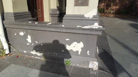
Officer’s Comments:
Comment from Group Manager Properties, Major Building Projects and Facilities:
The Annual Asset Management Plan reports on the condition of the building assets including the façade. Regular inspections and maintenance works are included as part of the Asset Management Plan for buildings. A full condition audit for all Inner West Council buildings was recently undertaken and the report is expected by June 2018. The low height paint touch ups at the Balmain Town Hall can be undertaken as part of regular maintenance work and will be scheduled over the next couple of months. Any more complex capital renewal works will need to be schedule based on available future capital budgets. The implementation of an annual report to Council on the condition of key public buildings would require 14 hours of staff time being a cost of $2000.
|
|
Council Meeting 8 May 2018 |
Subject: Notice of Motion: Condolence Motion John Francis WALSH, PSM, GCM, BCM, JP
From: Councillors Mark Drury and Lucille McKenna OAM
|
Motion:
THAT Council write a letter of condolence to the family of John Francis WALSH, PSM, GCM, BCM, JP, expressing our sadness at his passing and thanking them for his many years of service to the Inner West community. |
Background
On Tuesday 3rd April 2018 John Walsh died at his home in
Rutherglen VIC. John served Ashfield Council with distinction and was awarded
the Public Service Medal for outstanding service to the Council in 1991.
Prior to this he served his country and he continued to serve his community
until he moved to Rutherglen to live near his daughter and her family.
John was born at Marrickville NSW on 9 June 1941 and lived at Ashfield with his
beloved wife Joyce who sadly pre-deceased him. John served from 1960 to1968,
with 19th Coy & 3 Coy RAASC (Inf Div Tpt), as well as for a short period of
time in 5th Field Squadron, 1 Field Regiment RAE. He involved himself with many
community organisations.
With his late wife Joyce they formed an 'ANTIOCH' Youth Group at St Vincent's
Catholic Church, Ashfield from 1984 to 1990.
State President, St Vincent de Paul, Disaster Relief from 1989 to 1991, and he
worked on the Newcastle Earthquake disaster in 1989-90.
State President NSW National Serviceman's Association 1997 and 1998.
President of Ashfield RSL Club from 2003 to 2013 and President of Ashfield RSL
sub Branch from 2003 to 2013.
He was a Life Member of the Returned & Service League of Australia, and a
Life Member of Ashfield RSL Club.
Vice President of 8th Australian Division AIF Association.
Inaugural member of the Reserve Force Day Council.
Board Member of EXODUS Foundation, Ashfield, which was started by the Rev Bill
Crews AM.
The Gold Cross of Merit and Bronze Cross of Merit were awarded to him by the
Polish Government in Exile, London.
He is survived by his cherished daughter Karen and her loving family, and loved
brothers Bill and Matt and sister Mary and their families.
|
|
Council Meeting 8 May 2018 |

![]() Subject: Notice of Motion: Changes to Inner West Bus
Services
Subject: Notice of Motion: Changes to Inner West Bus
Services
From: Councillor Pauline Lockie
|
Motion:
THAT Council writes urgently to the Minister for Transport and Infrastructure and the Secretary of Transport for NSW (TfNSW) to ask that TfNSW:
1. Reverse planned changes to the 422 bus route so that it continues to terminate in Martin Place;
2. Reverse any planned changes to other Inner West bus services that result in a reduction of service to and from the Inner West; and
3. Correct potentially misleading information on the TfNSW website relating to route changes.
|
Background
Transport for NSW has recently publicised changes to a number of Inner West bus routes that will take effect from 6 May 2018. One of these changes will see the 422 bus route that currently runs to Martin Place terminate at Central instead.
This change will see residents in Camperdown, Newtown, St Peters, Sydenham and Tempe forced to catch two or more buses in order to complete their journeys to and from the CBD. As well as adding to travel times and inconveniencing commuters, this is likely to make using public transport even more difficult for people who are unable to switch services with ease.
The 422 service also runs through key destinations in the Inner West that draw people to our area. So while even though Council is working with local business association to promote visitation and build new opportunities for the night-time economy, the proposed changes to the route could end up making it more difficult for people to visit our area.
A number of changes to other Inner West bus routes have also been proposed, some of which involve route changes or withdrawals. These were published on the TfNSW website at https://transportnsw.info/news/2018/inner-west-bus-changes on 27 April 2018.
At least one of the descriptions of route changes on the aforementioned TfNSW link has the potential to mislead residents about the full impact of the change. For example, the L38 from Abbotsford to Martin Place, which services the Stanmore and Leichhardt wards, is advertised as having “5 additional weekly services, providing an additional afternoon peak service” from 6 May. However, while an 18:52 weekday service from the CBD to the inner west has been added to the new timetable, the current 15:06 service has been deleted. This means there is actually no net increase in services, and a later start to the afternoon service, which will now commence at 15:26.
|
|
Council Meeting 8 May 2018 |
Subject: Question on Notice: Staffing Matters
From: Councillor Rochelle Porteous
Comment by the General Manager:
Staff have provided answers to the questions below where the information is immediately available. The answers to the remaining questions require a considerable amount of time in accessing the three former systems and consolidating data. In addition to normal operating functions HR staff are currently engaged in a significant project to harmonise the payroll systems of the former councils. A response to the remaining questions will be provided by June 2018.
Questions:
Staff employments before and after the forced amalgamation:
What was the effective full time staff number at Leichhardt Council at the time of amalgamation?
What was the effective full time staff number at Marrickville Council at the time of amalgamation?
What was the effective full time staff number at Ashfield Council at the time of amalgamation?
What was the staff headcount at Leichhardt Council at the time of amalgamation?
What was the staff headcount at Marrickville Council at the time of amalgamation?
What was the staff headcount at Ashfield Council at the time of amalgamation?
What is the current effective full time staff level at Inner West Council?
Answer:
Current FTE as at 20/4/2018 is 1009 permanent and temporary staff
What is the current staff headcount at the Inner West Council?
Answer:
Current staff headcount as at 20/4/2018 is 1106 permanent and temporary staff.
Outdoor staff:
What was the outdoor staff headcount at Leichhardt Council at the time of amalgamation?
What was the outdoor staff headcount at Marrickville Council at the time of amalgamation?
What was the outdoor staff headcount at Ashfield Council at the time of amalgamation?
What is the current outdoor headcount at the Inner West Council?
![]() Answer:
Answer:
Current outdoor headcount as at 20/4/2018 is 313 permanent and temporary staff.
How many of the current outdoor staff at the Inner West Council are casual?
How many of the current outdoor staff at Inner West Council are on fixed contracts?
Redundancies and resignations:
How many staff have left their employment through early retirement, resignation or redundancy in the Inner West Council since May 12 2016?
Consultants and Labor Hire firms:
Does the IWC use a labor hire company or more than one?
If so how many staff are currently working for Council from a labor hire company?
|
|
Council Meeting 8 May 2018 |
Subject: Update on Dockless Bike Share
Prepared By: Simon Lowe - Strategic Transport Planner
Authorised By: David Birds - Group Manager Strategic Planning
|
SUMMARY Towards the end of 2017, Inner West was one of six inner city councils who prepared a set of guidelines to assist with the effective management of dockless bike share across the city. A three month review of the operation of the guidelines took place at the end of March 2018 that identified several continuing impacts of this activity. One of the most significant items highlighted by the operation of the guidelines is the lack of legislative powers available to support the management of dockless bike share. As a result the six councils consider it is imperative that the NSW Government addresses this issue as a matter of urgency.
This report recommends that Council, in a joint communication with the other councils where possible, writes to the NSW Government seeking urgent legislation or regulation to allow for the effective management of commercial bike share. |
|
RECOMMENDATION
THAT Council:
1. In a joint communication, where possible, with Canada Bay, City of Sydney, Randwick, Waverley and Woollahra Councils, writes to the NSW Government seeking urgent amendment to legislation or regulation to allow for the effective management of commercial bike share; and
2. Staff continue to liaise with staff from the other five councils to explore how the recommendations from the three month review can be implemented and report back to a future meeting on action options and potential costs to Council.
|
BACKGROUND
Dockless Bike Share began to appear in Sydney in mid to late 2017 and by the end of the year five bike share businesses were operating across the inner city.
At its meeting of 12 October 2017 Council approved a Mayoral Minute setting out support for bike share but noting that its success depended on the establishment of a sound regulatory framework and the development of a consistent approach across inner city councils.
Following this, consideration was given to examining how bike share could be supported whilst managing the impacts of its operation. Consequently Council responded to the introduction of bike share schemes by working with other inner city councils and the bike share operators towards a balanced position that achieves transport, environment, health and other related goals, as well as the fair use of public space.
As a result, and in response to the urgent need to manage the impacts of bike share operations, Inner West was one of six inner city councils (along with Canada Bay, City of Sydney, Randwick, Waverley and Woollahra) who subsequently worked together to develop the Inner Sydney Bike Share Guidelines.
![]() The Guidelines set out
minimum standards and expectations for dockless bike share operators across
these six council areas. At its meeting of 12 December 2017 Council
approved the guidelines (Attachment 1), which subsequently came into
operation on 22 December 2017. The five bike share operators committed to work
to meet the guideline requirements, with a reviewed stipulated after an initial
three month trial period of operation.
The Guidelines set out
minimum standards and expectations for dockless bike share operators across
these six council areas. At its meeting of 12 December 2017 Council
approved the guidelines (Attachment 1), which subsequently came into
operation on 22 December 2017. The five bike share operators committed to work
to meet the guideline requirements, with a reviewed stipulated after an initial
three month trial period of operation.

Three month review
The three month review (Attachment 2), jointly carried out by all six inner city councils, has generated data that shows that bike share is popular in Sydney. At the end of February 2018 there were 142,073 user registrations, and a total of 390,147 trips were made in January and February, averaging more than 6,600 trips a day. By comparison, Brisbane’s City Cycle scheme registered 87,238 trips in January and February 2017.
Central Station was the most popular location for bike share trips with 12,461 trips starting around the station during January and February 2018. Other popular locations were Green Square station (5,181), Bondi Beach (3,551), Newtown Station (1,731) and Rose Bay Wharf (1,296).
However, the review confirmed that there are significant issues which must be addressed if bike share is to become an effective, integrated segment of the transport network that does not negatively impact on public amenity and positively contributes to a liveable, sustainable and connected city.
Significant identified issues include haphazard bike parking, bike vandalism, lack of helmet use and their availability on share bikes and an increase in riding on the footpath. It is clear from the review that much work continues to be needed by bike share operators, councils, other land owners and state government in order to address these issues.
A principal issue has been highlighted by the review, which needs resolution to enable councils to effectively manage the impacts of the bike share industry. This is the lack of clear legislative regulatory powers under which dockless bike share operates and can be managed.
At a recent meeting of the six inner city Mayors that was convened to consider the initial outcomes of the review, it was agreed that the Councils should collectively write to the NSW Government seeking urgent amendment to legislation or regulation to allow for the effective management of dockless bike share. Without such action it is unlikely that all of the current issues that Sydney is experiencing with dockless bike share can be effectively addressed in a coordinated and efficient manner.
In the meantime Council staff will continue to liaise with staff from the other councils to explore how the remaining recommendations from the review can be implemented. This includes:
· How to work with NSW Police and Transport for NSW to optimise the use of existing and potential new compliance powers, including a possible permit scheme;
· Service level agreements with operators that include the removal of damaged and badly parked bikes;
· Identification, and encouraging use, of bike parking areas in high usage locations;
· Potential incentive and penalty schemes to encourage responsible user behaviours, reduce vandalism and increase helmet wearing; and
· Examining how to ensure the costs of any permit and compliance actions can be paid for by the operators.
This will include consideration of the use of the power Council currently has for Authorised Officers to impound an article (e.g. a bike) if the officer forms an opinion that it has been abandoned or left unattended in a public place under s15 of the Impounding Act 1993. Authorised Officers may exercise their powers on a discretionary basis, particularly where a bike is clearly damaged and unusable or a bike is dangerously positioned.
A further report will be prepared for Council updating on these actions, including any potential costs to Council.
FINANCIAL IMPLICATIONS
At present there are no financial commitments required to be made by Council, however managing the impacts of dockless bike share operations, such as bike removal, is placing resource implications on various sections of Council. Any additional financial implications (e.g. the installation of additional bike parking, costs of removal of bikes from the street) should be borne by the bike share operators.
OTHER STAFF COMMENTS
The nature of the very limited legal powers available to manage dockless bike share has been reviewed by the General Counsel who supports the recommendation.
PUBLIC CONSULTATION
Not applicable.
|
1.⇩ |
Inner Sydney Bike Share Guidelines |
|
2.⇩ |
Guidelines 3 Month Review |
|
Memorandum of advice regarding dockless bike share schemes - Confidential |
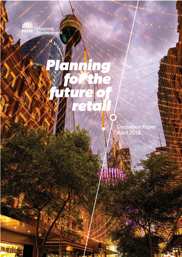


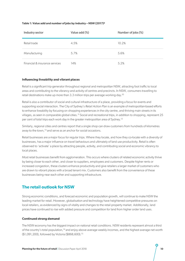
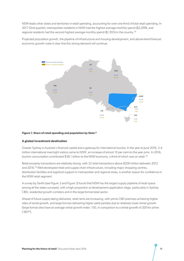
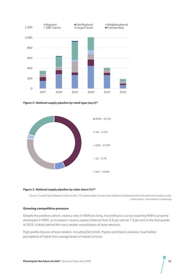
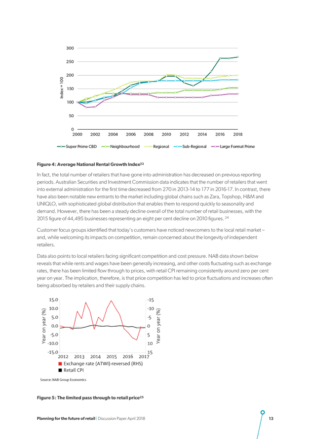

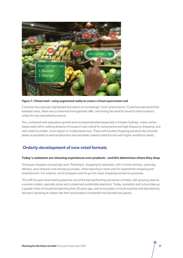
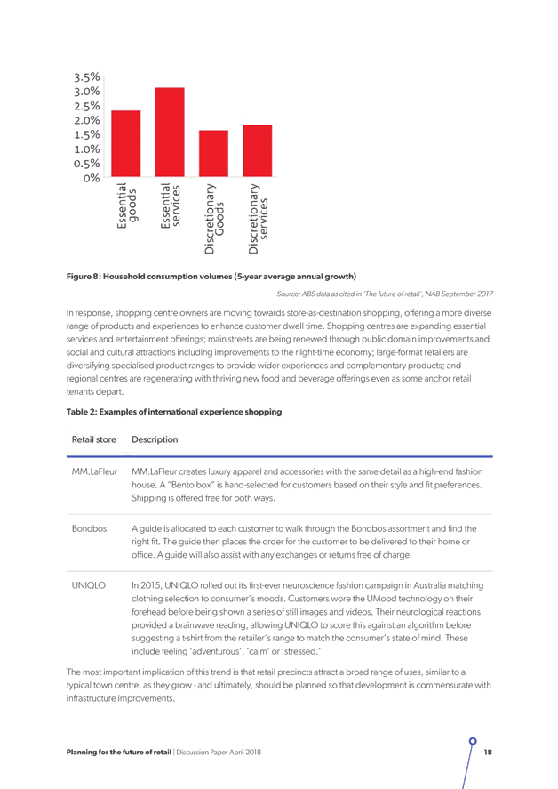

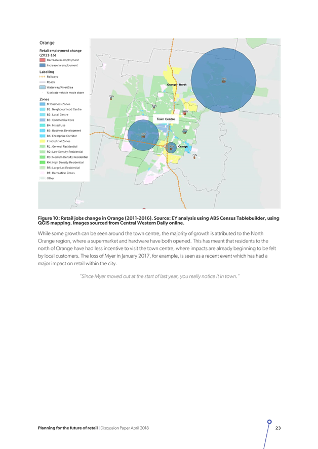
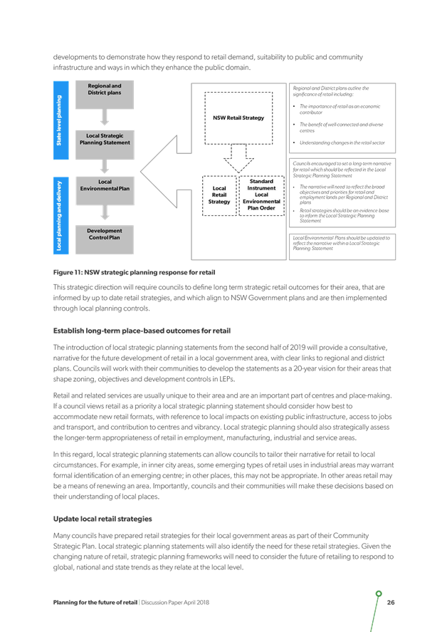
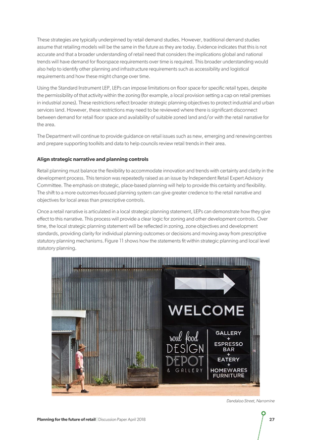
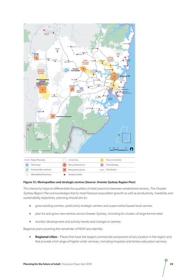
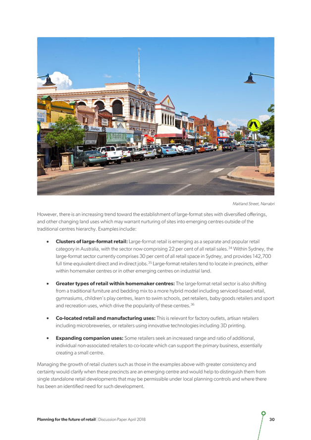
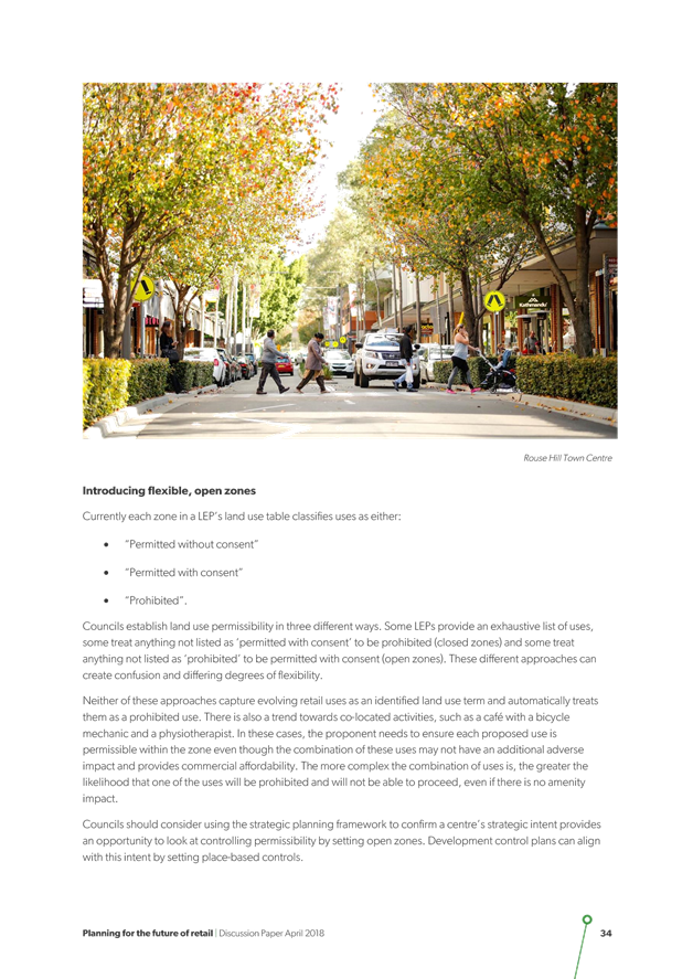
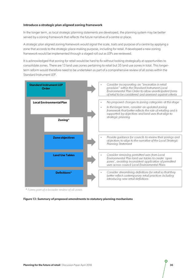


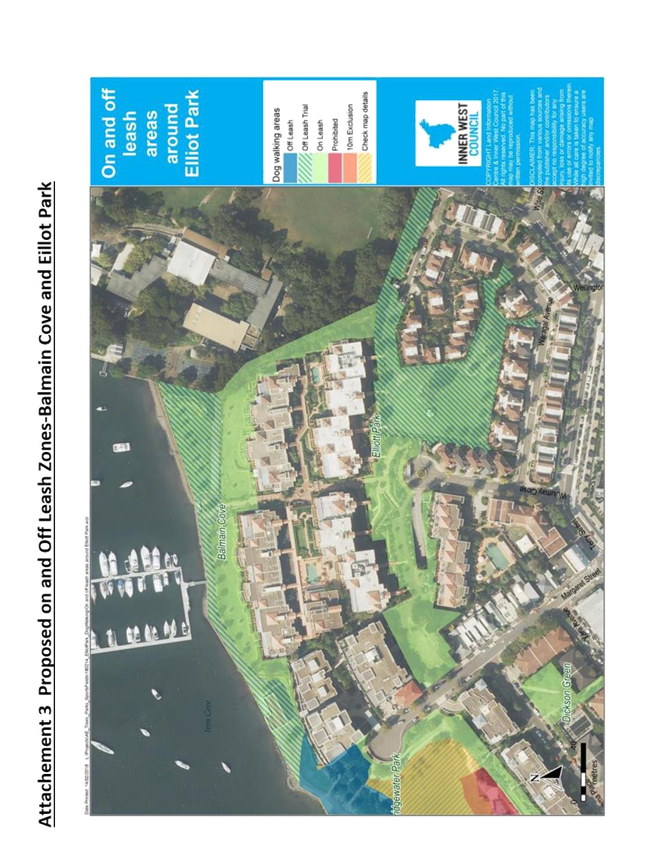


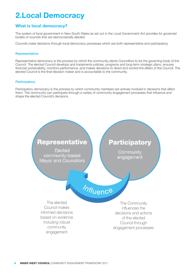


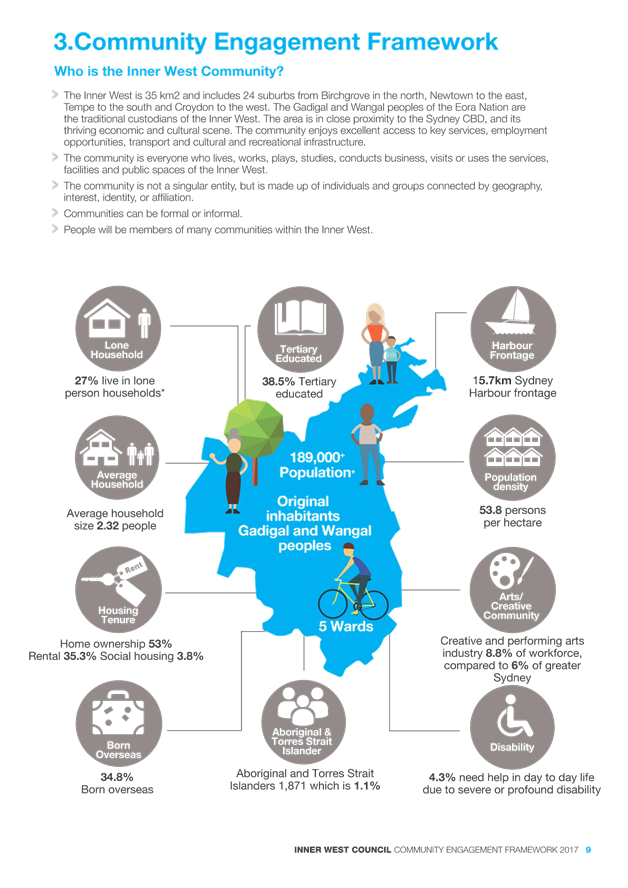
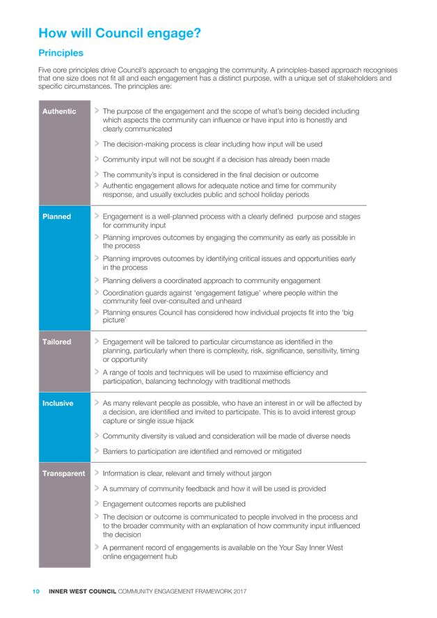
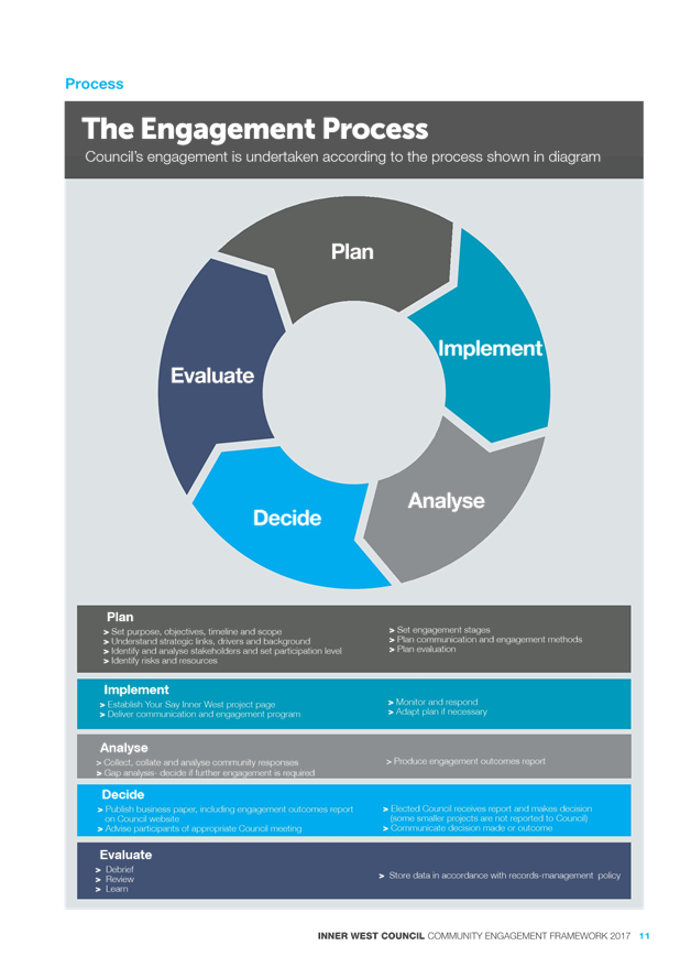
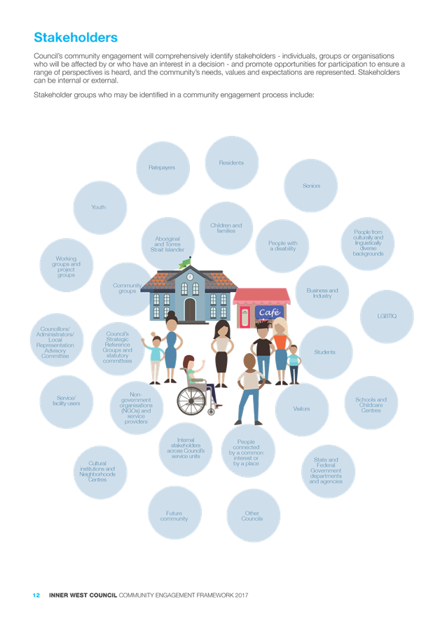
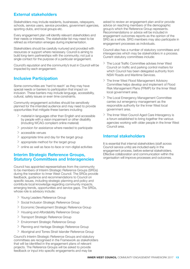
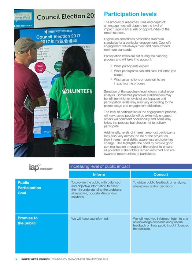


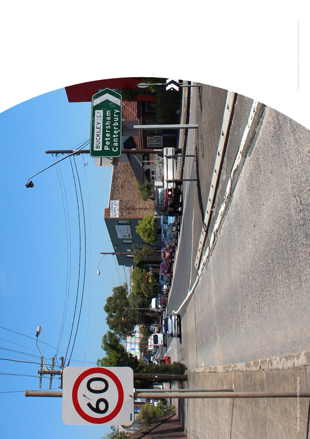


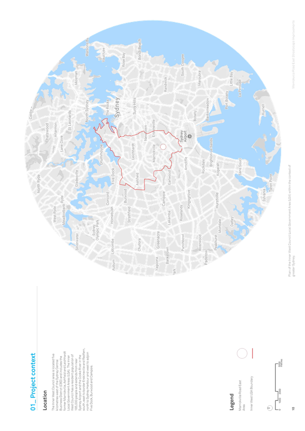
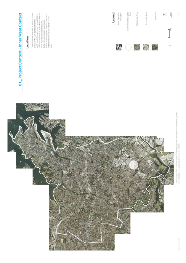
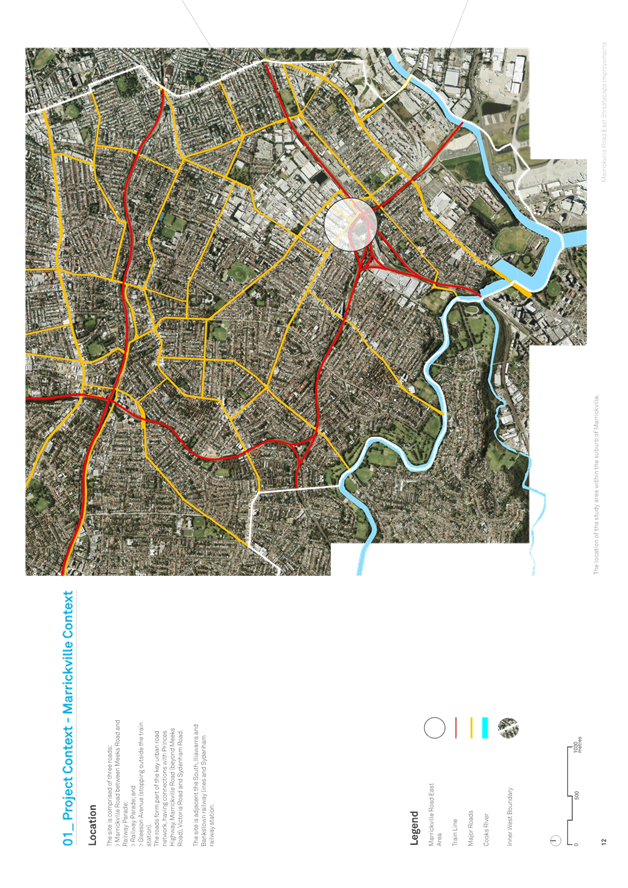
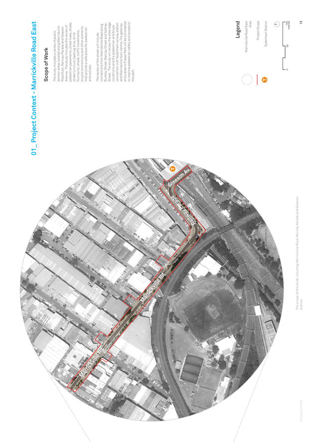

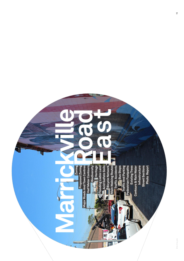
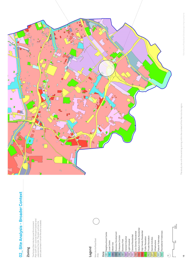
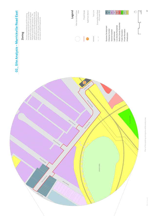
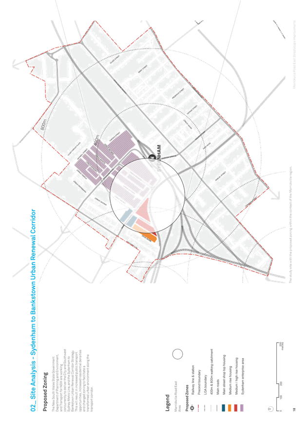
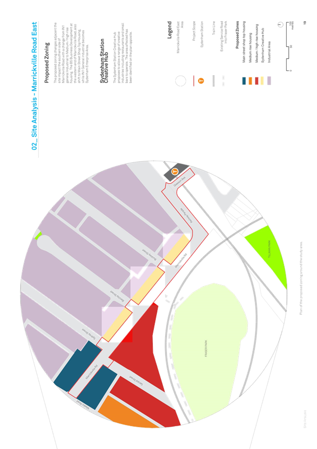
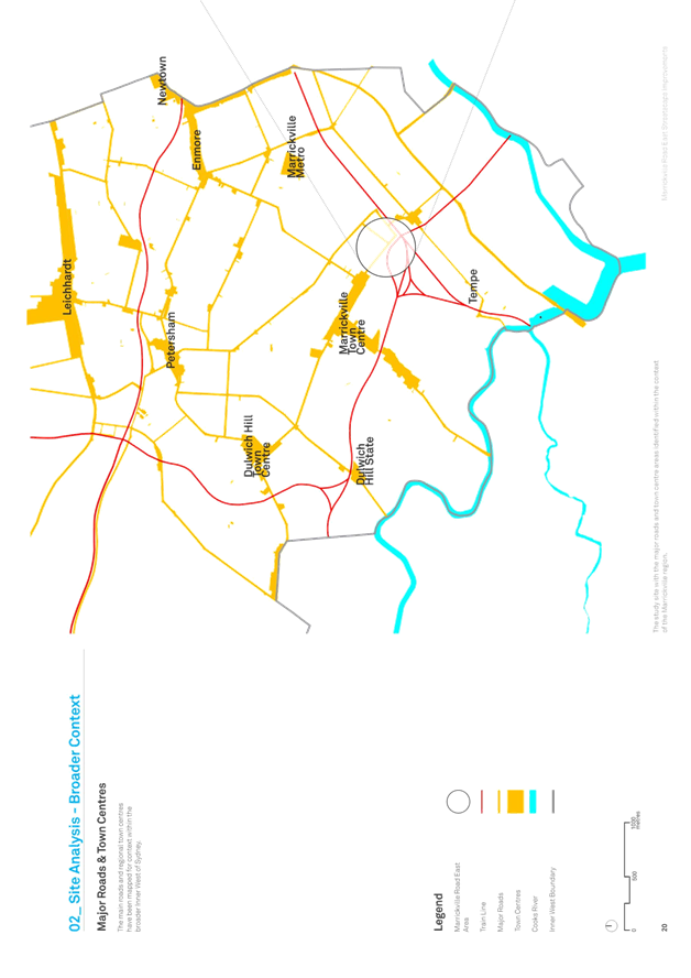
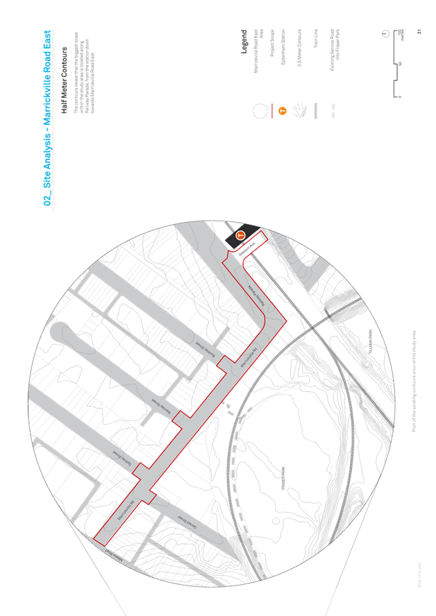
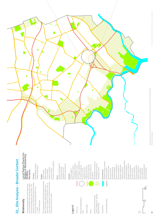
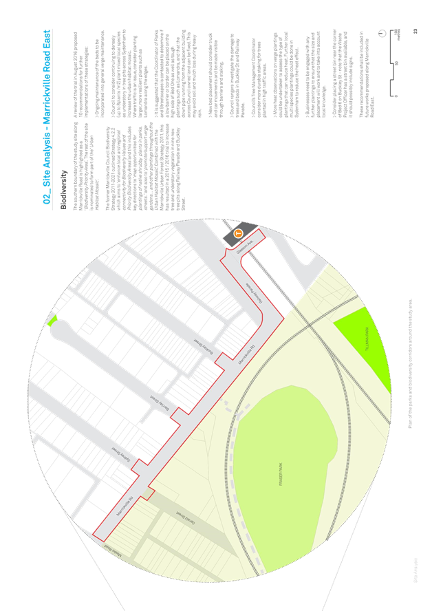
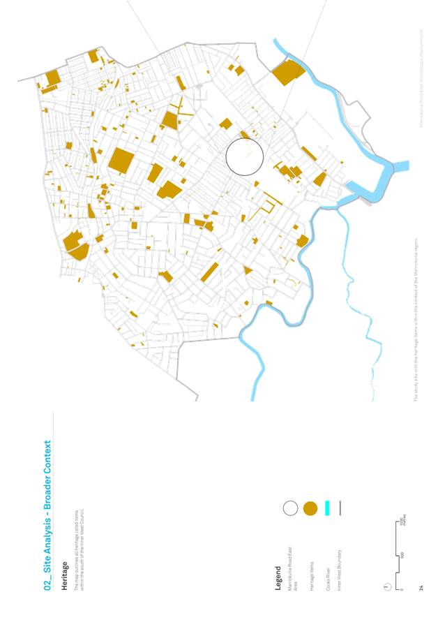
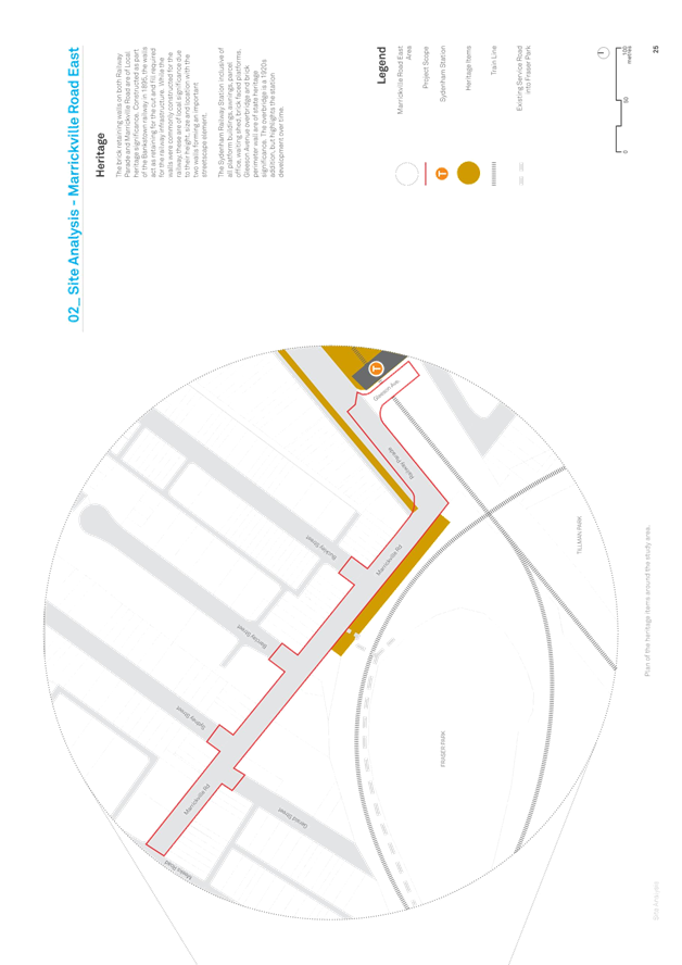
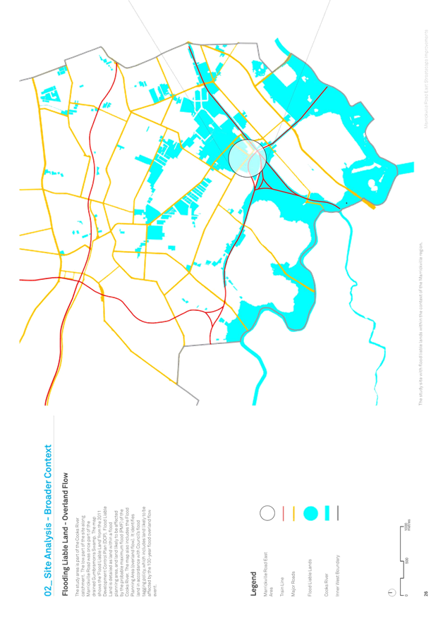
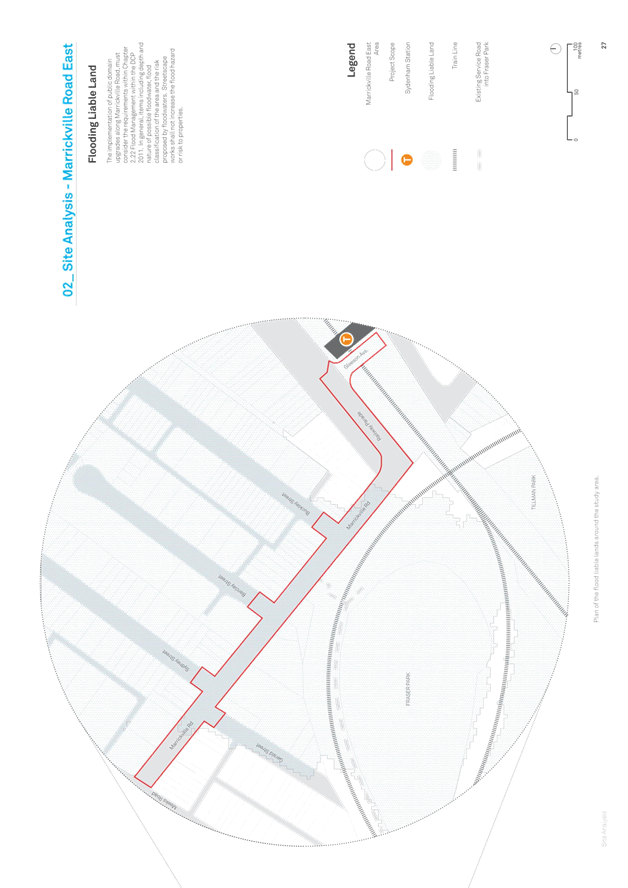
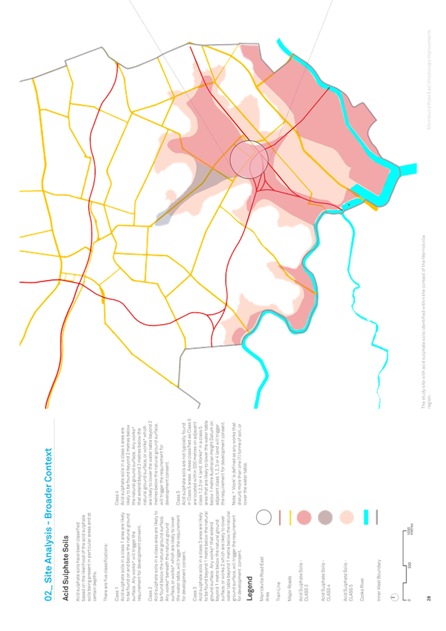
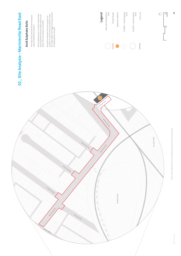
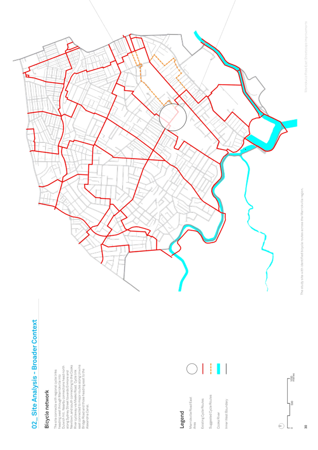
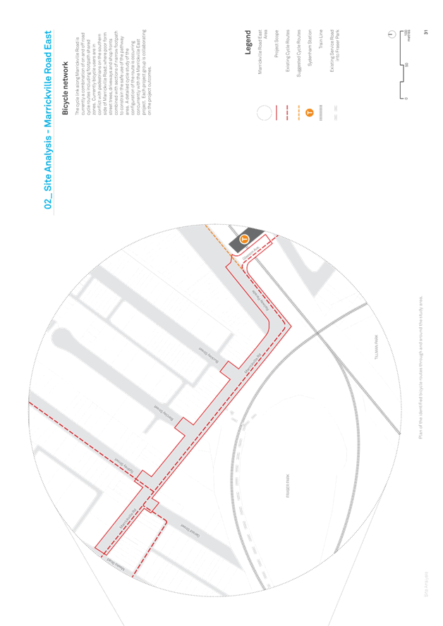
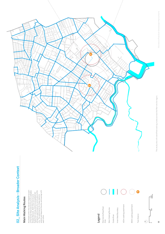
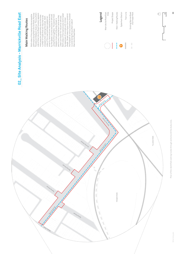
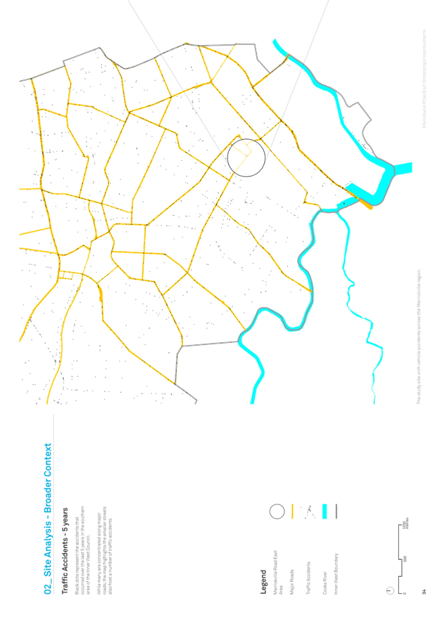
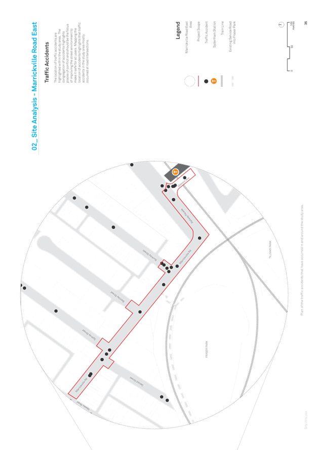
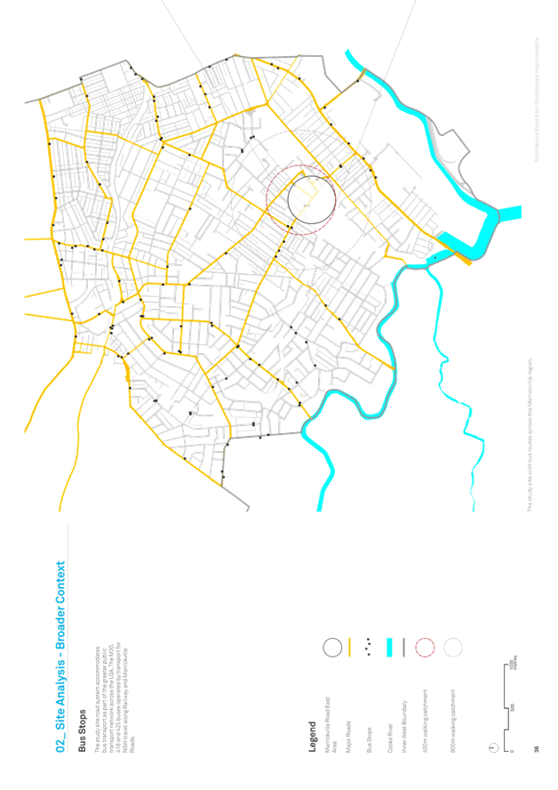
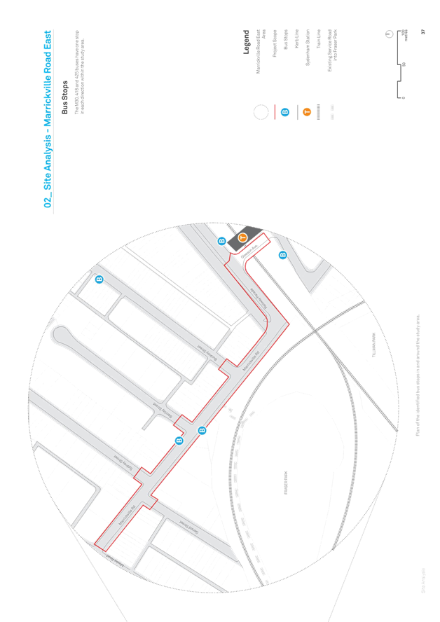
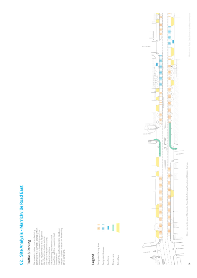
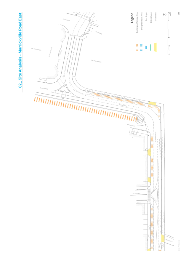
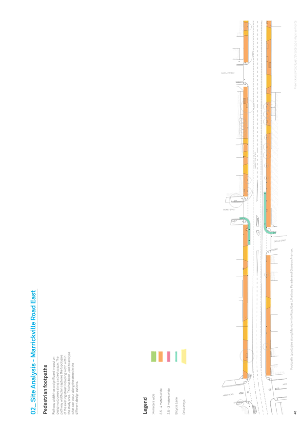
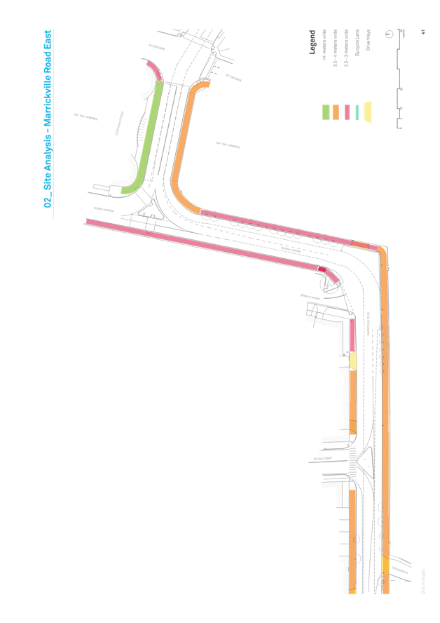
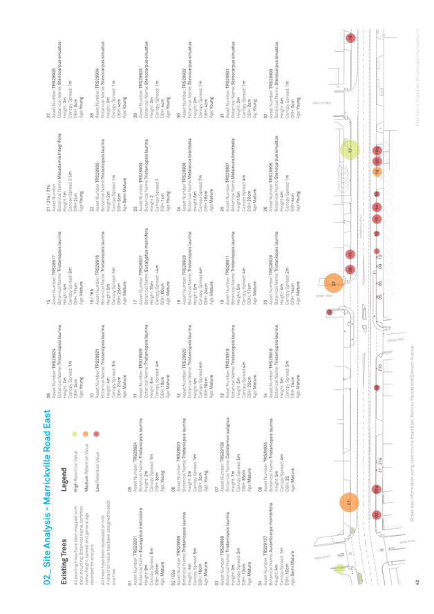
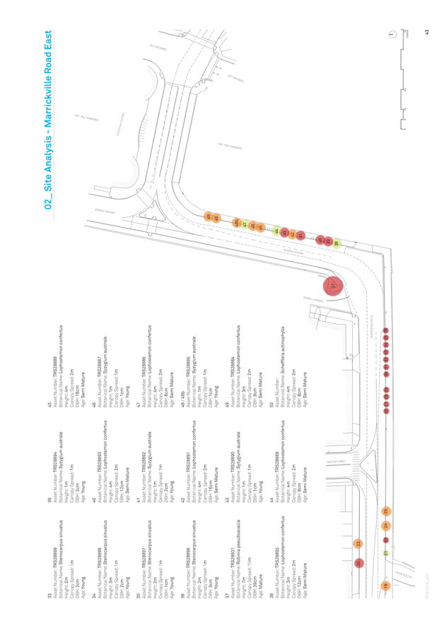
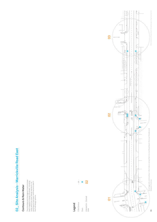
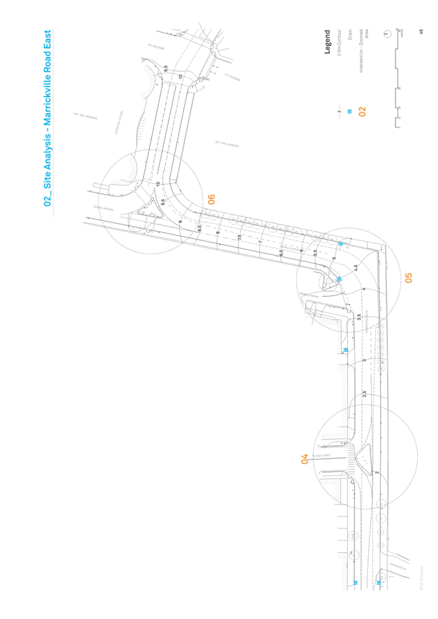
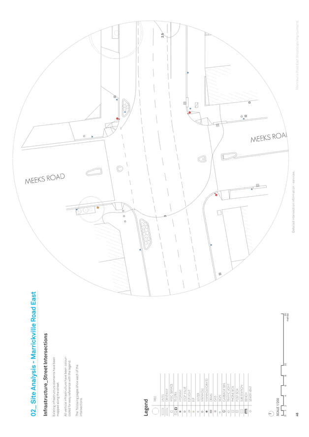
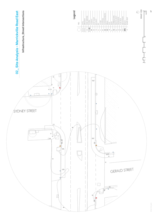
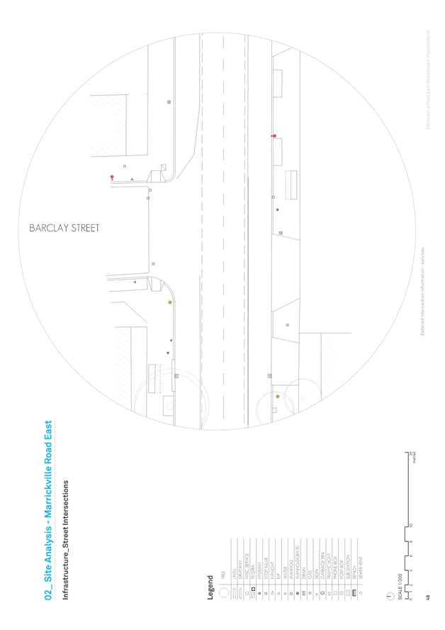
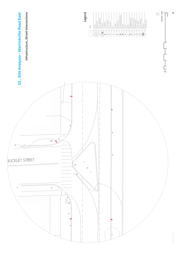
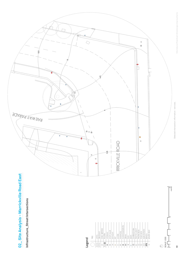
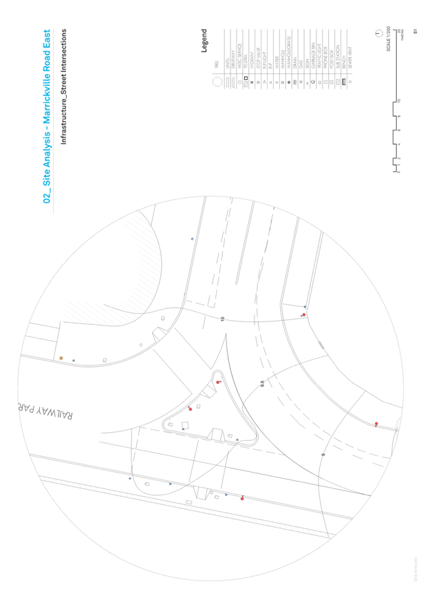
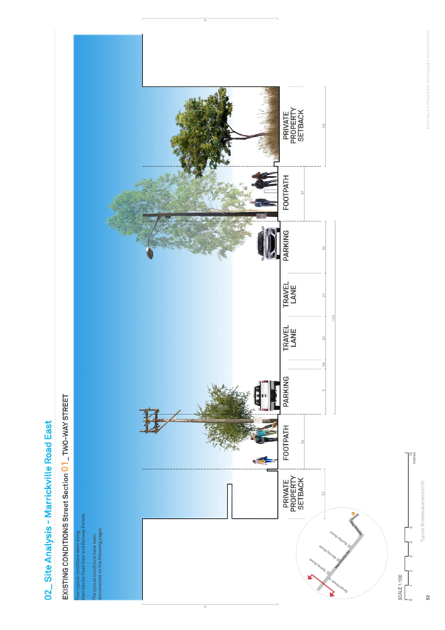
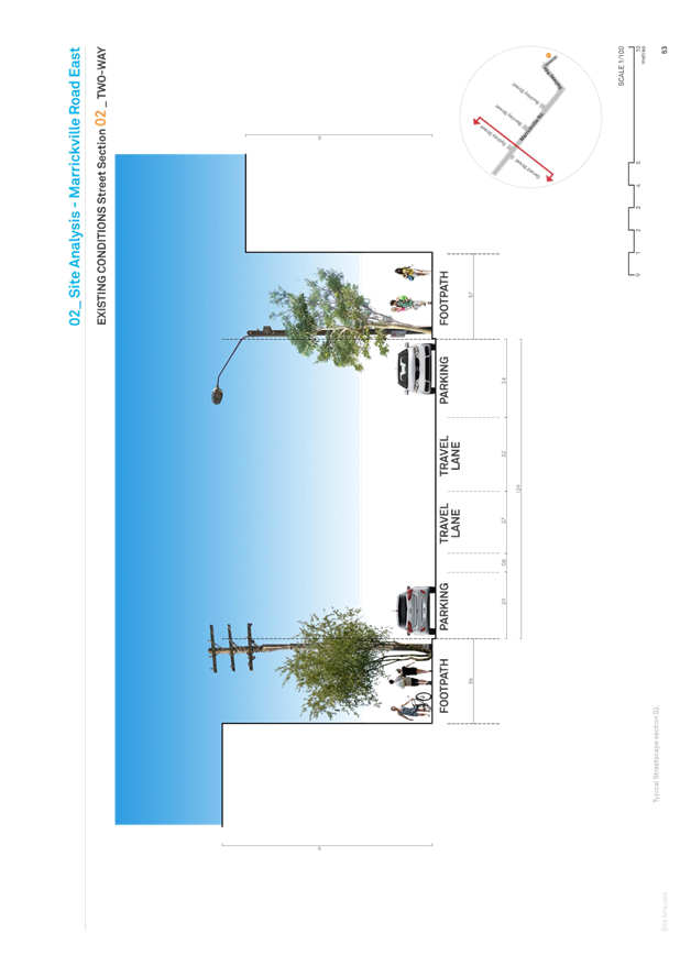
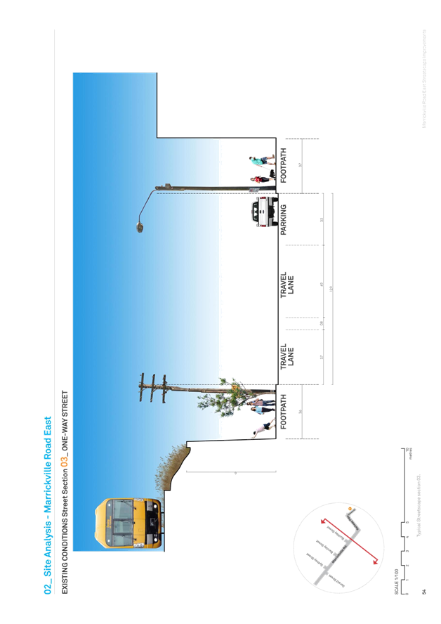
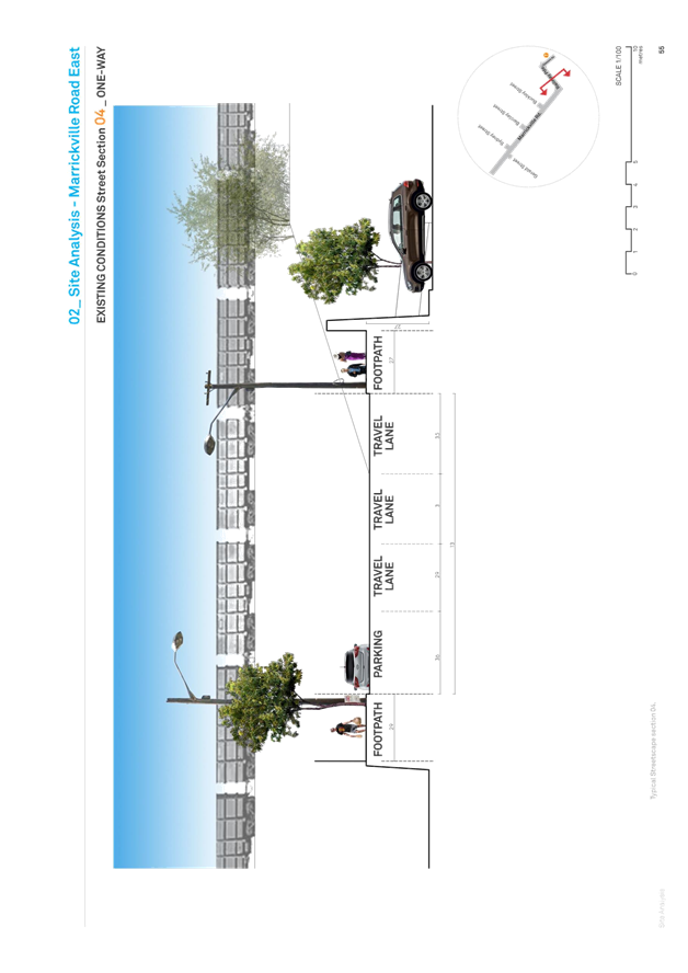
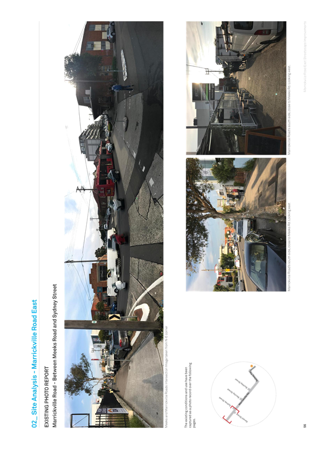
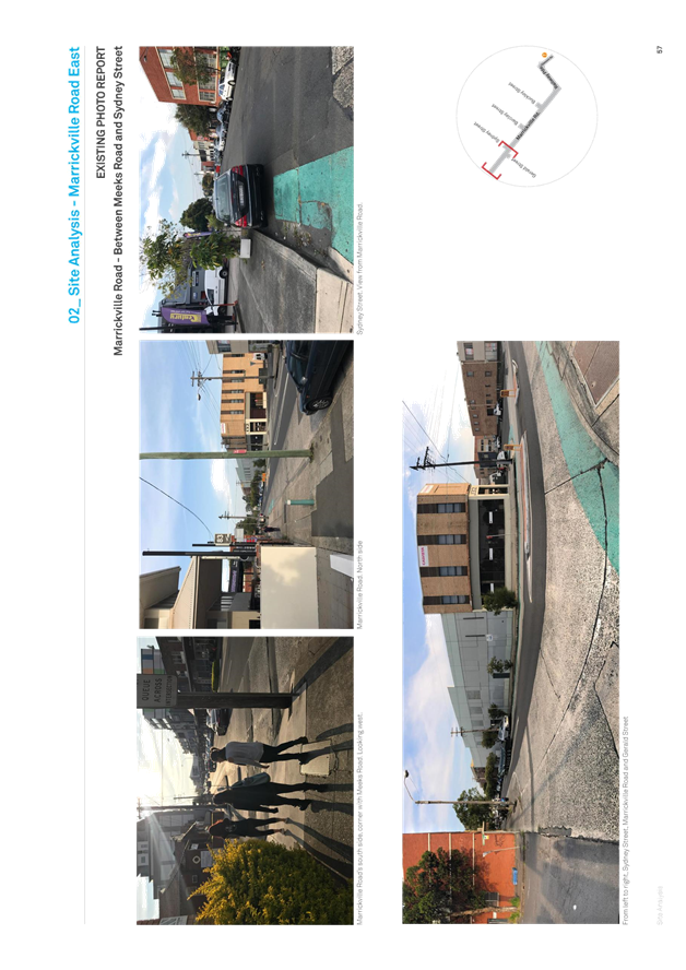
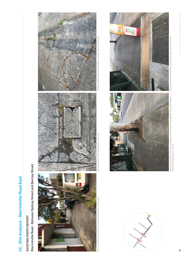
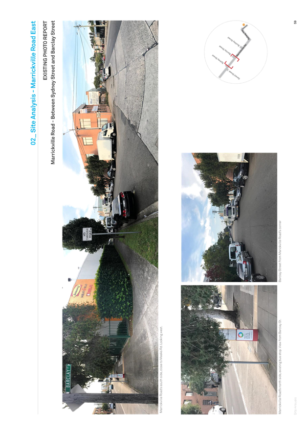
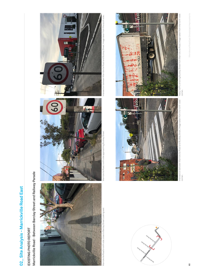
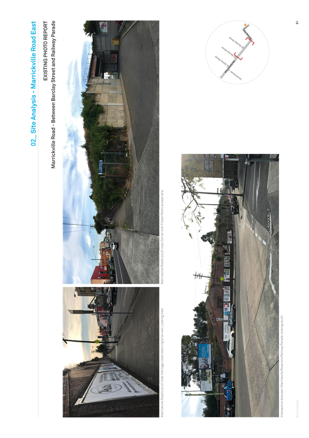
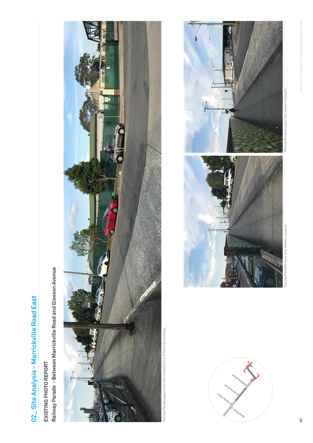
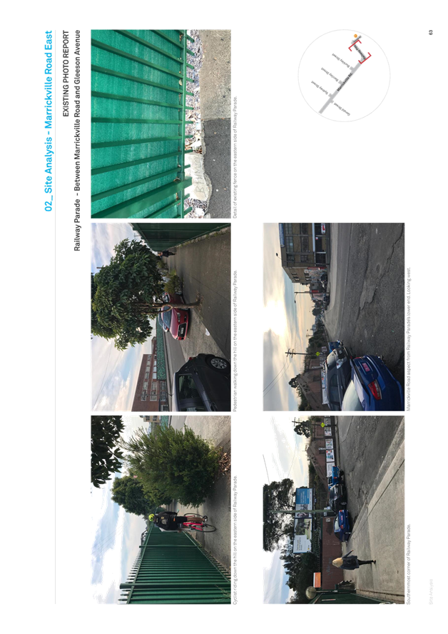
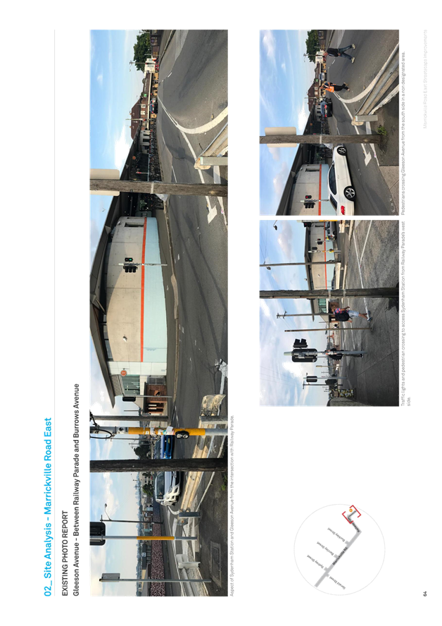
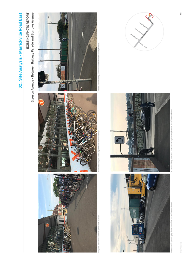

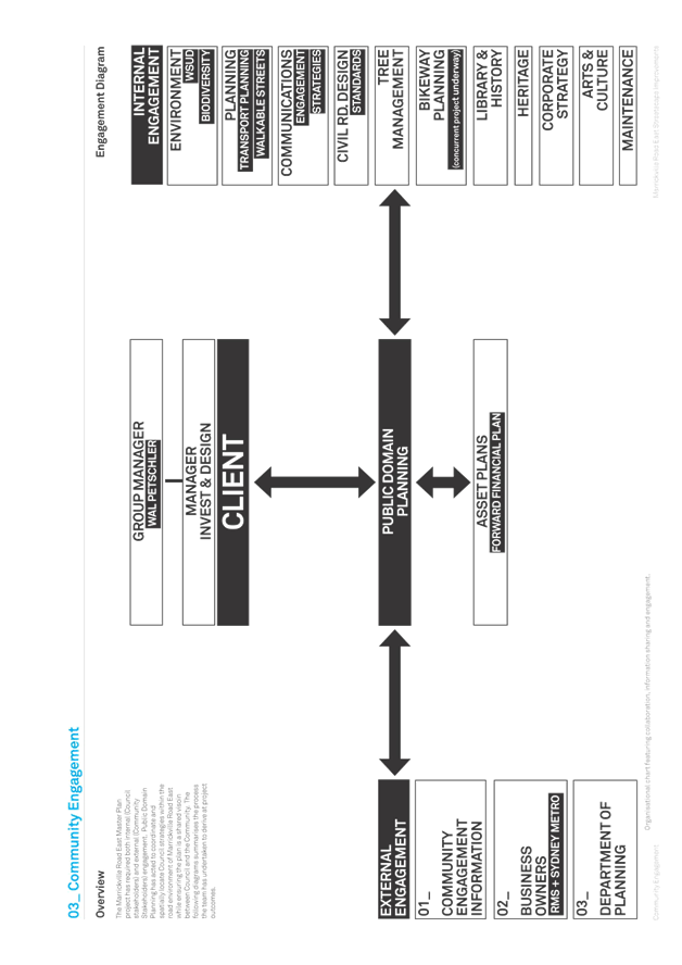
![[Type a quote from the document or the summary of an interesting point. You can position the text box anywhere in the document. Use the Drawing Tools tab to change the formatting of the pull quote text box.]](C_08052018_AGN_AT_files/image182.png)