|
AGENDA R |

Local Traffic Committee Meeting
TUESDAY 5 JUNE 2018
10.00am
|
|
Local Traffic Committee Meeting 5 June 2018 |
Function of the Local Traffic Committee
Background
Roads and Maritime Services (RMS) is legislated as the Authority responsible for the control of traffic on all NSW Roads. The RMS has delegated certain aspects of the control of traffic on local roads to councils. To exercise this delegation, councils must establish a local traffic committee and obtain the advice of the RMS and Police. The Inner West Council Local Traffic Committee has been constituted by Council as a result of the delegation granted by the RMS pursuant to Section 50 of the Transport Administration Act 1988.
Role of the Committee
The Local Traffic Committee is primarily a technical review and advisory committee which considers the technical merits of proposals and ensures that current technical guidelines are considered. It provides recommendations to Council on traffic and parking control matters and on the provision of traffic control facilities and prescribed traffic control devices for which Council has delegated authority. These matters are dealt with under Part A of the agenda and require Council to consider exercising its delegation.
In addition to its formal role as the Local Traffic Committee, the Committee may also be requested to provide informal traffic engineering advice on traffic matters not requiring Council to exercise its delegated function at that point in time, for example, advice to Council’s Development Assessment Section on traffic generating developments. These matters are dealt with under Part C of the agenda and are for information or advice only and do not require Council to exercise its delegation.
Committee Delegations
The Local Traffic Committee has no decision-making powers. The Council must refer all traffic related matters to the Local Traffic Committee prior to exercising its delegated functions. Matters related to State Roads or functions that have not been delegated to Council must be referred directly to the RMS or relevant organisation.
The Committee provides recommendations to Council. Should Council wish to act contrary to the advice of the Committee or if that advice is not supported unanimously by the Committee members, then the Police or RMS have an opportunity to appeal to the Regional Traffic Committee.
Committee Membership & Voting
Formal voting membership comprises the following:
· one representative of Council as nominated by Council;
· one representative of the NSW Police from each Local Area Command (LAC) within the LGA, being Newtown, Marrickville, Leichhardt and Ashfield LAC’s.
· one representative from the RMS; and
· State Members of Parliament (MP) for the electorates of Summer Hill, Newtown, Heffron, Canterbury, Strathfield and Balmain or their nominees.
Where the Council area is represented by more than one MP or covered by more than one Police LAC, representatives are only permitted to vote on matters which effect their electorate or LAC.
Informal (non-voting) advisors from within Council or external authorities may also attend Committee meetings to provide expert advice.
Committee Chair
Council’s representative will chair the meetings.
Public Participation
Members of the public or other stakeholders may address the Committee on agenda items to be considered by the Committee. The format and number of presentations is at the discretion of the Chairperson and is generally limited to 3 minutes per speaker. Committee debate on agenda items is not open to the public.
|
|
Local Traffic Committee Meeting 5 June 2018 |
|
AGENDA |
1 Apologies
2 Disclosures of Interest
3 Confirmation of Minutes
Minutes of 1 May 2018 Local Traffic Committee Meeting 5
4 Matters Arising from Council’s Resolution of Minutes
5 Part A – Items Where Council May Exercise Its Delegated Functions
Traffic Matters
ITEM PAGE #
LTC0618 Item 1 Centennial Street, Marrickville – Temporary Road Closure For Special Event On Saturday 28 July 2018 (Marrickville Ward/Summer Hill Electorate/Inner West LAC) 24
LTC0618 Item 2 Local Bicycle Route 3 (LR3) - Detailed Design Plans (Marrickville Ward/Summer Hill Electorate/Inner West LAC) 33
LTC0618 Item 3 Road Occupancy-Dalhousie Street and Ramsay Street, Haberfield-Temporary Road Closures For the annual/bi-annual 'Haberfield Festa' food festival, Sunday 25 November 2018. (Leichhardt Ward/Summer Hill Electorate/Ashfield LAC) 61
LTC0618 Item 4 Dalhousie Street, Haberfield - road & traffic improvements (Leichhardt Ward / Summer Hill Electorate / Ashfield LAC) 67
LTC0618 Item 5 Boomerang Street, Haberfield - Haberfield North LATM - Traffic calming improvements (Leichhardt Ward / Summer Hill Electorate / Ashfield LAC) 73
LTC0618 Item 6 Davis Street, Dulwich Hill – Proposed Line Markings Design Plans (Ashfield Ward/Summer Hill Electorate/Inner West LAC) 80
LTC0618 Item 7 Dulwich Street, Dulwich Hill – Proposed Line Markings Design Plans (Ashfield Ward/Summer Hill Electorate/Inner West LAC) 84
LTC0618 Item 8 Black Street, Marrickville – Proposed Kerb Extensions Design Plans (Marrickville Ward/Newtown Electorate/Inner West LAC) 88
LTC0618 Item 9 Victoria Road, Marrickville – Proposed Kerb Extensions Design Plans (Marrickville Ward/Newtown Electorate/Inner West LAC) 93
Parking Matters
ITEM PAGE #
LTC0618 Item 10 Intersection of Dudley Street and Waratah Street, Haberfield (Leichhardt Ward / Summer Hill Electorate / Ashfield LAC) 101
LTC0618 Item 11 Minor Traffic Facilities (All Wards / All Electorates / All LACs) 103
LTC0618 Item 12 Trafalgar Street, Rose Street, Nelson Street and Nelson Lane, Annandale - Resident Parking Scheme (Balmain Ward/Balmain Electorate/Leichhardt LAC) 106
LTC0618 Item 13 Philpott Street, Marrickville – Proposed Statutory No Stopping Restrictions (Marrickville Ward/Newtown Electorate/Inner West LAC) 111
LTC0618 Item 14 Samuel Lane, Tempe – Proposed Statutory No Stopping & No Parking Restrictions (Marrickville Ward/Heffron Electorate/Inner West LAC) 115
LTC0618 Item 15 Short Street, St Peters – Proposal to Extend Resident Permit Parking Restrictions – M12 119
LTC0618 Item 16 Addison Road, Marrickville – Removal Of Redundant Timed No Parking Restrictions & Proposal For Short Term Parking Restrictions (Marrickville Ward/Newtown Electorate/Inner West LAC) 124
LTC0618 Item 17 Elizabeth Street, between Bastable Street and Railway Street, Croydon-Amendment to parking restrictions. (Leichhardt Ward/Strathfield Electorate/Ashfield LAC) 128
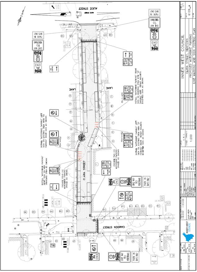
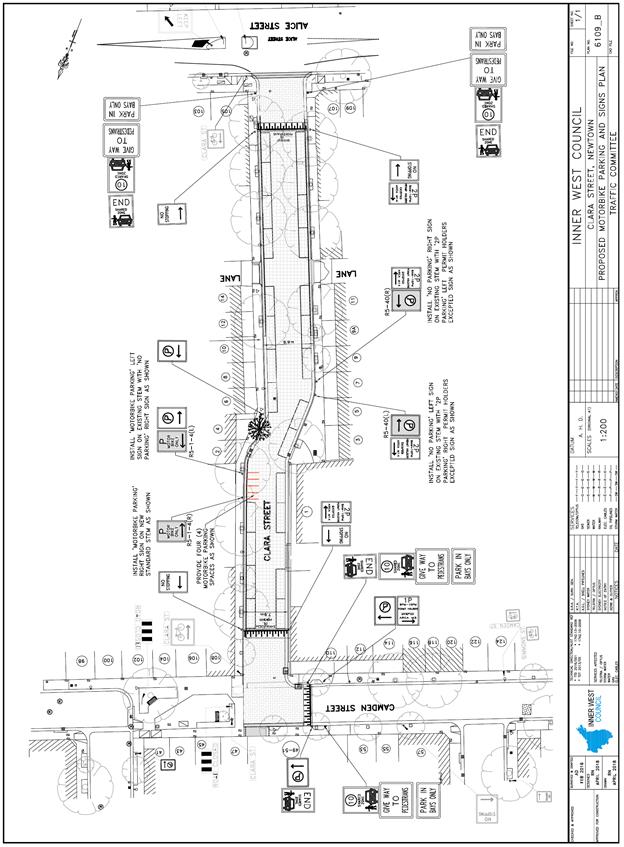
LTC0618 Item 18 Clara Street, Newtown – Amendment To Proposed Motor Bikes Only Parking Restrictions (Stanmore Ward/Newtown Electorate/Inner West LAC) 134
Late Items
Nil at time of printing.
6 Part B - Items for Information Only
Nil at the time of printing.
7 Part C - Items for General Advice
Nil at the time of printing.
8 General Business
9 Close of Meeting
|
|
Local Traffic Committee Meeting Minutes from 1 May 2018 |
Minutes of Local Traffic Committee Meeting
Held at Chamber Room, Petersham Service Centre on 1 May 2018
Meeting commenced at 10.00am
ACKNOWLEDGEMENT OF COUNTRY BY CHAIRPERSON
I acknowledge the Gadigal and Wangal people of the Eora nation on whose country we are meeting today, and their elders past and present.
COMMITTEE REPRESENTATIVES PRESENT
|
Clr Julie Passas |
Deputy Mayor – Ashfield Ward (Chair – 10am – 12pm) |
|
|
Mr Bill Holliday |
Representative for Jamie Parker MP, Member for Balmain |
|
|
Mr Chris Woods |
Representative for Ron Hoenig MP, Member for Heffron |
|
|
Ms Sarina Foulstone |
Representative for Jo Haylen MP, Member for Summer Hill |
|
|
Mr Kristian Calcagno |
Roads and Maritime Services |
|
|
Acting Sgt Charles Buttrose |
NSW Police - Leichhardt Area Command |
|
|
Sgt Paul Vlachos |
NSW Police - Inner West Area Command – Traffic Supervisor |
|
|
Sgt J. Micallef |
NSW Police - Burwood and Campsie Area Command |
|
|
|
|
|
|
COUNCILLORS AND OFFICERS IN ATTENDANCE |
|
|
|
|
|
|
|
Clr Marghanita Da Cruz |
Leichhardt Ward (Chair – 12pm – 12:41pm) |
|
|
Mr Wal Petschler |
IWC’s Group Manager FRTS |
|
|
Mr Boris Muha |
IWC’s Engineer – Traffic and Projects |
|
|
Mr Colin Jones |
Inner West Bicycle Coalition |
|
|
Mr David Torreson |
IWC’s Civil Engineer |
|
|
Mr David Yu |
IWC’s Engineer – Traffic and Parking Services |
|
|
Mr Emilio Andari |
IWC’s Engineer – Traffic and Parking Services |
|
|
Mr George Tsaprounis |
IWC’s Coordinator Traffic and Parking Services (South) |
|
|
Mr John Stephens |
IWC’s Traffic and Transport Services Manager |
|
|
Mr Manod Wickramasinghe |
IWC’s Coordinator Traffic and Parking Services (North) |
|
|
Sen Const Sam Tohme |
NSW Police - Burwood and Campsie Area Command |
|
|
Ms Brigid Meehan |
IWC’s Business Improvement and Support Officer |
|
|
Mr Ryan Hawken |
IWC’s Project Manager Greenway Delivery |
|
|
Sen Const Anthony Kenny |
NSW Police - Inner West Area Command |
|
|
Mr Robin Becdache |
State Transit Authority |
|
|
Ms Libby Bassey |
IWC’s Business Administration Officer |
|
|
|
|
|
|
VISITORS |
|
|
|
|
|
|
|
Mr Paul Burgis |
Item 1 |
|
|
Ms Kylie Squires |
Item 2 |
|
|
Ms Laura Phemister |
Item 2 |
|
|
Ms Marta Tambasco |
Item 2 |
|
|
Ms Anna Connellan |
Item 2 |
|
|
Ms Tania Ferfolja |
Item 2 |
|
|
Ms Dianne Friar |
Item 2 |
|
|
Ms Wendy Johnson |
Item 2 |
|
|
Mr Greg Bar |
Item 2 |
|
DISCLOSURES OF INTERESTS:
Nil.
CONFIRMATION OF MINUTES
|
The Minutes of the Local Traffic Committee Meeting held on Tuesday, 10 April 2018 were confirmed. |
MATTERS ARISING FROM COUNCIL’S RESOLUTION OF MINUTES
The Local Traffic Committee recommendations of its meeting held on 10 April 2018 were adopted at Council’s meeting held on 24 April 2018.
Late Item
LTC0518 Item 14 Minor Traffic Facilities (All Wards/All Electorates/All LACs)
SUMMARY
This report considers minor traffic facility applications received by Inner West Council, and includes ‘Disabled Parking’ requests.
Officer’s Recommendation
THAT:
DISCUSSION
Officers tabled a report outlining the following comments:
1 Installation of ‘Disabled Parking’ Restriction – Westbourne Street, Petersham
The resident of property No.91 Westbourne Street, Petersham has requested the installation of a ‘Disabled Parking’ zone in Westbourne Street at the front of the resident’s property.
A site investigation has revealed that the property does not have off-street parking.
The applicant does not require the use of a wheelchair.
It is recommended that a 6m ‘Disabled Parking’ zone be installed in front of No.91 Westbourne Street, Petersham.
2 Installation of ‘Disabled Parking’ Restriction – Smith Street, Balmain
The resident of property No.48 Smith Street, Balmain has requested the installation of a ‘Disabled Parking’ zone in Smith Street at the front of the resident’s property.
A site investigation has revealed that the property does not have off-street parking.
The applicant does not require the use of a wheelchair.
It is recommended that a 6m ‘Disabled Parking’ zone be installed in front of No.48 Smith Street, Balmain.
COMMITTEE RECOMMENDATION
THAT:
For motion: Unanimous
General Business
|
LTC0518 Item 16 Frederick Street, Ashfield |
|
RMS advised that Consultation letters had been sent out to the community regarding Frederick Street works near John Street.
|
LTC0518 Item 17 Sydney Buses
It was indicated that Sydney Bus representation on the Traffic Committee may be withdrawn. Council officers advised that Council has not received confirmation from Sydney Buses.
Meeting closed at 12.41pm.
ATTACHMENT 1
This page has been left intentionally blank
|
|
Local Traffic Committee Meeting 5 June 2018 |
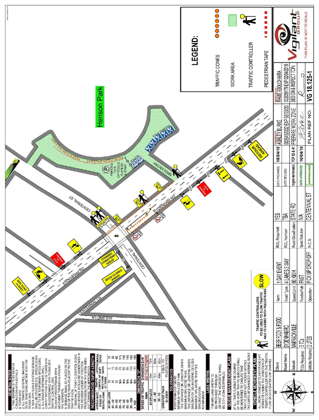
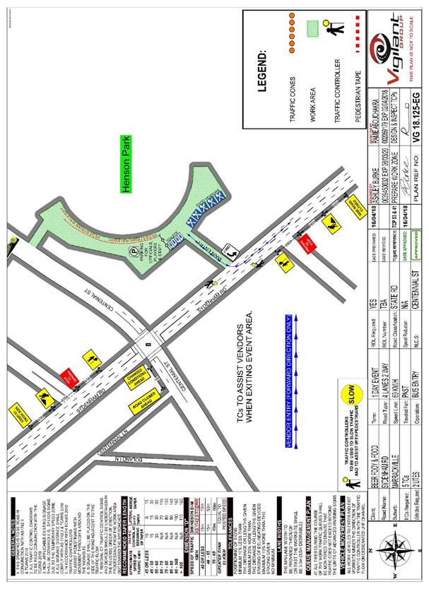
Subject: Centennial Street, Marrickville – Temporary Road Closure For Special Event On Saturday 28 July 2018 (Marrickville Ward/Summer Hill Electorate/Inner West LAC)
Prepared By: Emilio Andari - Engineer – Traffic and Parking Services
Authorised By: John Stephens - Traffic and Transport Services Manager
|
SUMMARY A Development Application was received from the Music & Booze Company together with the Newtown Rugby League Football Club to hold the Beer, Footy & Food Festival 2018 on Saturday 28 July 2018 at Henson Park Oval and on Centennial Street, Marrickville between Sydenham Road and the entrance gate to Henson Park Oval.
It is recommended that Council agree to the temporary full-road closure of the subject section of Centennial Street, Marrickville on Saturday 28 July 2018 (weather permitted) or alternatively on Saturday 18 August 2018 subject to complying with the following conditions; apply to the RMS for consent to close the subject road, subject to the event being advertised, a Traffic Management Plan be submitted to the RMS for approval, a Road Occupancy License be obtained from the Transport Management Centre and advice of the proposed event being forwarded to the appropriate authorities including emergency services. |
|
RECOMMENDATION
THAT:
1. The proposed temporary full-road closure of Centennial Street, Marrickville between Sydenham Road and the entrance gate to Henson Park Oval on Saturday 28 July 2018 between 8.00am and 8.00pm (weather permitted) or Saturday 18 August 2018 between 8.00am and 8.00pm, for the holding of the Beer, Footy & Food Festival 2018 at Henson Park Oval, be APPROVED, subject to the approval of the Development Application and the applicant complying with the following conditions:
a) A fee of $1,540.00 for the temporary road closure is payable by the applicant in accordance with Council’s Fees and Charges;
b) The temporary full road closure be advertised by the applicant in the local newspaper providing 28 days’ notice for submissions, in accordance with the Roads Act;
c) A Traffic Management Plan (TMP) be submitted by the applicant to the Roads and Maritime Services for consideration and approval;
d) A Traffic Control Plan (TCP) which has been prepared by a certified Traffic Controller, is to be submitted to Council for review with a copy of the Traffic Controller’s certification number attached to the plan, not less than 5 days prior to implementation of the closure;
e) A Road Occupancy License application be obtained by the applicant from the Transport Management Centre;
f) Notice of the proposed event is forwarded by the applicant to the NSW Police Local Area Commander, State Transit Authority, NSW Fire Brigades and NSW Ambulance Services;
g) Advance notifications signs advising of the proposed road closure and traffic diversions to be strategically installed and maintained by the applicant at least two (2) weeks prior to the event;
h) A 4-metre wide emergency vehicle access must be maintained through the closed road areas during the course of the event;
i) All affected residents and businesses shall be notified in writing by the applicant of the proposed temporary road closure at least two (2) weeks prior to the event, with the applicant making reasonable provision for residents and businesses;
j) Adequate vehicular traffic control shall be provided for the protection and convenience of pedestrians and motorists including appropriate signage and flagging. Workers shall be specially designated for this role (and carry appropriate certificates), as necessary to comply with this condition. This is to be carried out in accordance with the Australian Standard AS 1742.3 – Traffic Control Devices for works on roads;
k) Water filled barriers be placed at the road closure points to protect against any possible errant vehicles; and
2. The applicant be advised in terms of this report and that all costs for advertising the event and implementation of the road closure are to be borne by the applicant.
|
BACKGROUND
A Development Application was received from the Music & Booze Company together with the Newtown Rugby League Football Club to hold the Beer, Footy & Food Festival 2018 on Saturday 28 July 2018 between the hours of 12.00pm and 6.00pm at Henson Park Oval and on Centennial Street, between Sydenham Road and entrance gate to the Henson Park grounds.
Given that the event date falls within the winter season and it is held outdoors, the applicant requests for an alternative date for the event if there is adverse weather. If weather is impacted, the alternate date will be on Saturday 18 August 2018. All conditions of notification will be similarly met for this alternate date.
Henson Park is Council owned land for which the Newtown Jets have a pre-existing arrangement for the use of the site. The event has received Land Owners Consent from Council.
The Newtown Jets FC has a long-standing relationship with the Sydney Inner West community and with Council. The Newtown Jets have built a reputation on delivering regular sporting matches at Henson Park Oval that are family friendly and all inclusive. The Beer, Footy & Food Festival is an extension of the Newtown Jets regular Saturday matches which local residents are familiar with. It is anticipated that the event will attract between 4,000 to 6,000 people.
FINANCIAL IMPLICATIONS
Nil.
OFFICER COMMENTS
Site location & road network
|
Street Name |
Centennial Street |
|
Section |
Between Sydenham Road and to an end |
|
Carriageway Width (m) |
12.8 |
|
Carriageway Type |
Two-way road with one travel lane in each direction, in addition to kerbside parking lanes. |
|
Classification |
Local |
|
85th Percentile Speed (km/h) |
42.5 |
|
Vehicles Per Day (vpd) |
367 |
|
Reported Crash History (July 2011 – June 2016) |
No crashes recorded. |
|
Heavy Vehicle Volume (%) |
2.2 |
|
Parking Arrangements |
Unrestricted parking along both sides of the road. |
The temporary full-road closure of Centennial Street is required from 8.00am to 8.00pm on the day of the event to undertake the setup prior to the event and cleaning after the event, before the road can be reopened to traffic.
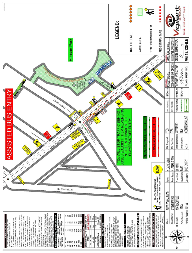
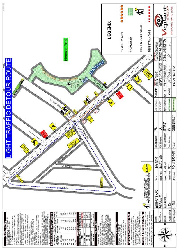
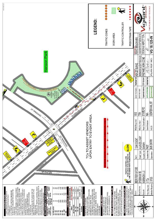
The applicant advised that traffic controllers and barricades will be located on Centennial Street at Sydenham Road and along Sydenham Road. Centennial Street will be providing vehicular access to only local residents, event staff, football coaches and football players, and emergency services. Event attendees will ingress and egress via the laneway access point from Sydenham Road and the access point at Woodland Street with security staff and traffic controllers monitoring (refer to Site Plan of Henson Park Oval and Traffic Control Plans).
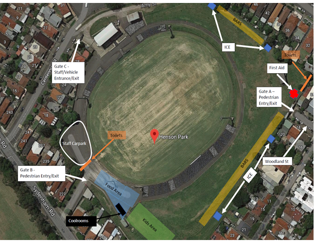
Site Plan of Henson Park Oval
A 4-metre wide emergency vehicle access must be maintained through the closed road areas during the course of the event. Special Event advance notice signs will be strategically installed at least two (2) weeks prior to the event to alert motorists of the proposed closures.
The subject section of Centennial Street carries a low volume of traffic and therefore will have no major impacts on surrounding road network. The event will be held on a Saturday when lower than weekday traffic volumes are expected.
The location of the event has access to public transport services, with Sydenham Railway Station located approximately 1km west along Sydenham Road and Marrickville Railway Station located approximately 1km south along Illawarra Road from the event location and bus routes (Route 412, 418, 426 & 428) operating along Livingstone Road, Marrickville Road and Addison Road.
PUBLIC CONSULTATION
The proposed full-road closure of Centennial Street, Marrickville between Sydenham Road and the entrance gate to Henson Park Oval is currently advertised in the newspaper for a period of 28 days. The advertising period commenced on 22 May 2018 and will conclude on 18 June 2018. A Traffic Management Plan is to be submitted to the RMS for consideration and approval.
The event organiser will need to notify all affected residents and businesses in writing of the proposed temporary full-road closure at least two weeks prior to the event and make reasonable provision for residents and businesses, where possible.
CONCLUSION
It is recommended that Council agree to the temporary full-road closure of the subject section of Centennial Street, Marrickville on Saturday 28 July 2018 (weather permitted) or alternatively on Saturday 18 August 2018 subject to complying with the following conditions; apply to the RMS for consent to close the subject road, subject to the event being advertised, a Traffic Management Plan be submitted to the RMS for approval, a Road Occupancy License be obtained from the Transport Management Centre and advice of the proposed event being forwarded to the appropriate authorities including emergency services.
Traffic Control Plan 1
Traffic Control Plan 2
Traffic Control Plan 3
Traffic Control Plan 4
Traffic Control Plan 5
 |
|
|
Local Traffic Committee Meeting 5 June 2018 |
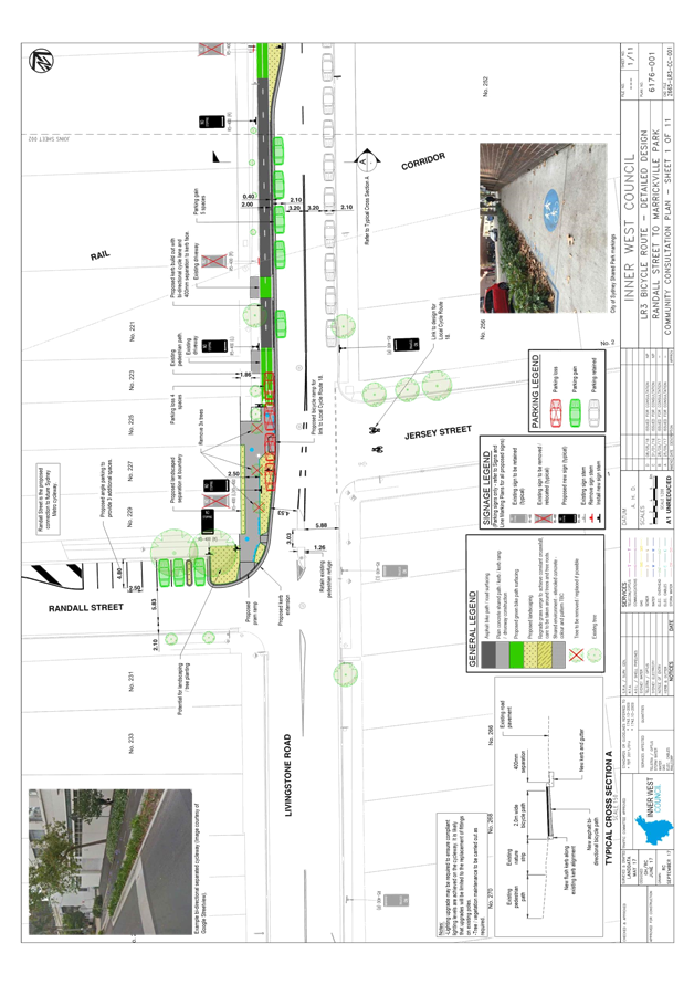
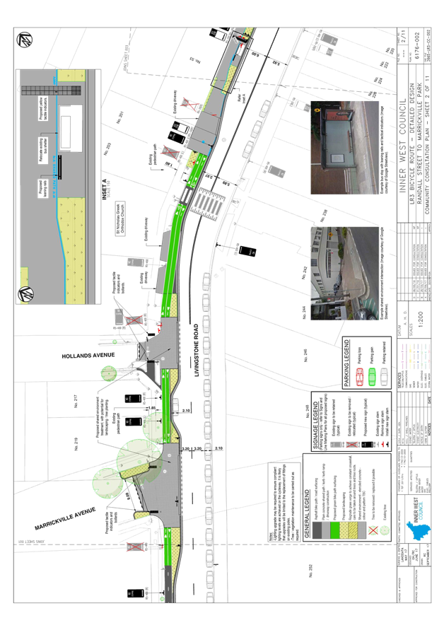
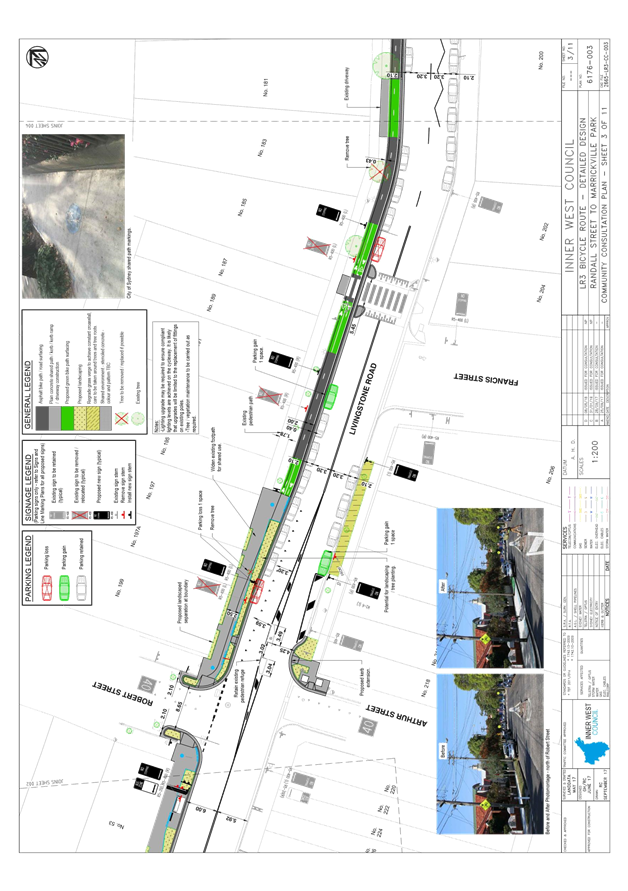
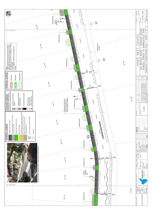
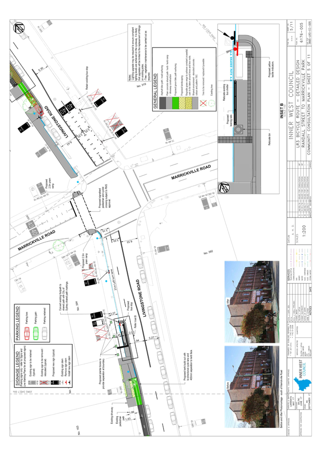
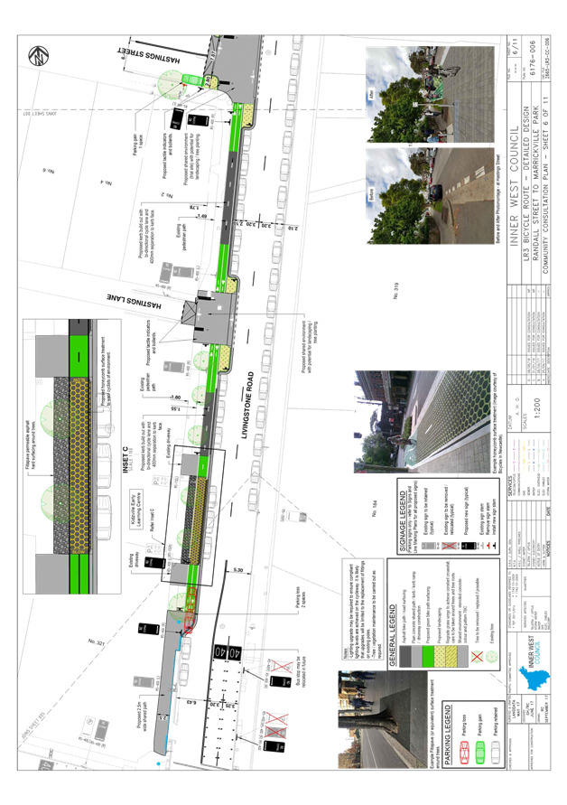
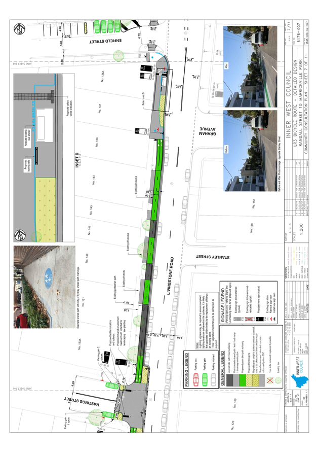
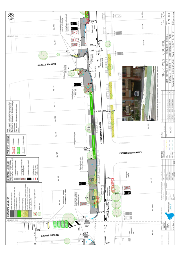
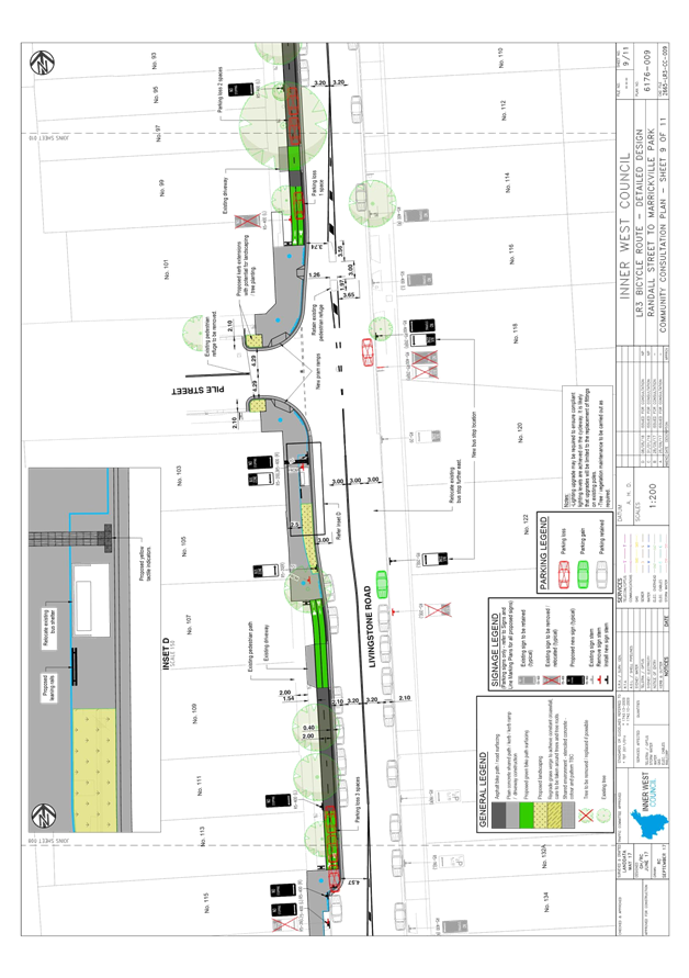
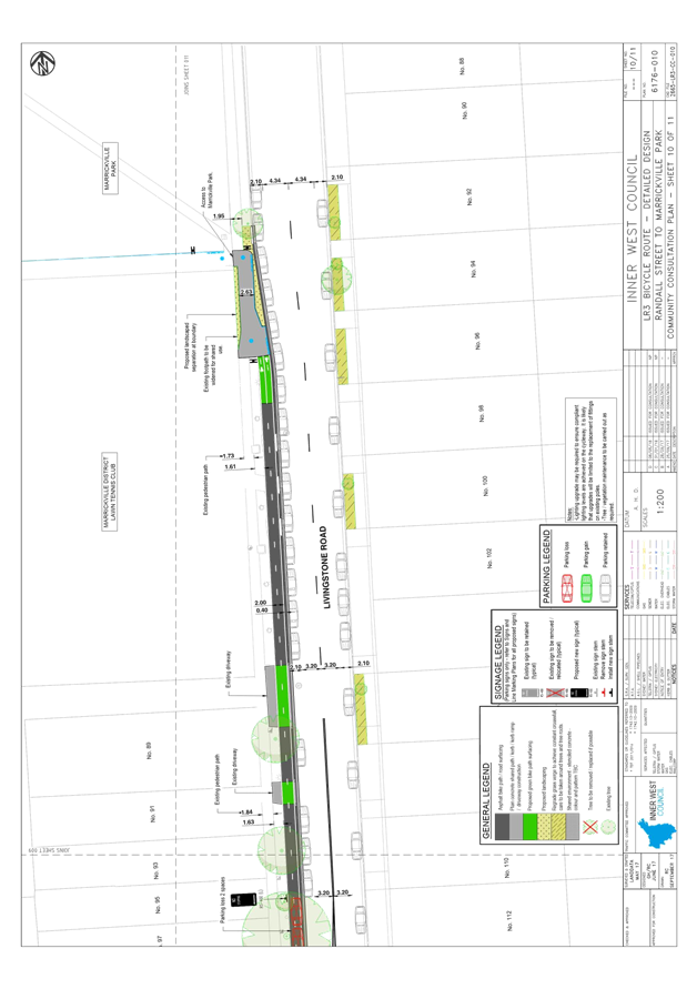
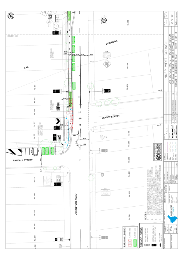
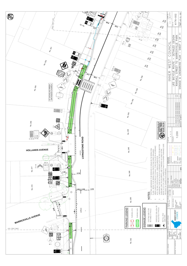
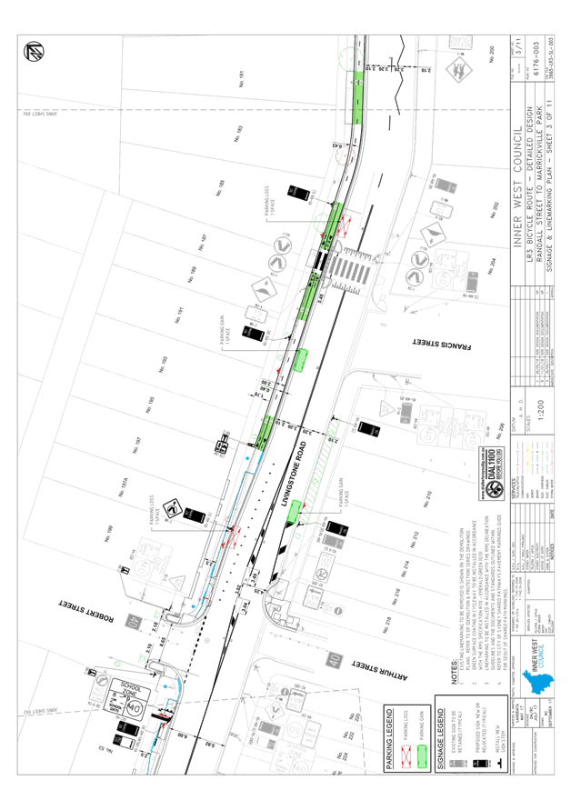
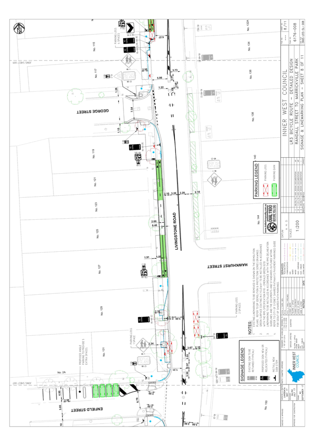
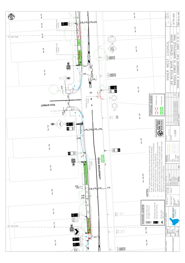
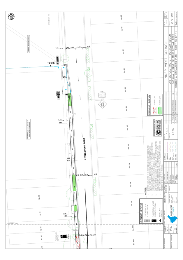
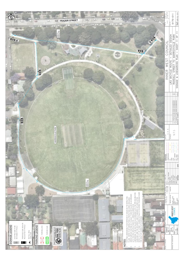
Subject: Local Bicycle Route 3 (LR3) - Detailed Design Plans (Marrickville Ward/Summer Hill Electorate/Inner West LAC)
Prepared By: Snezana Bakovic - Project Engineer Traffic
Authorised By: John Stephens - Traffic and Transport Services Manager
|
SUMMARY On November 2016, Council approved a final concept plan for improvement to Local Route 3, bicycle route identified in Council’s Bicycle Plan. LR3) is located on Livingstone Road, from Jersey Street to Marrickville Park.The aim of the proposal was to make LR3 bicycle route more safe, convenient and more enjoyable for people of all ages and ability to ride.
The draft design plans are based on the approved concept plan and are presented in this report for the Local Traffic Committee’s consideration. The proposed improvements will complete missing links in Council’s bicycle network and enhance bicycle access to public transport, local shops and other destinations.
This report recommends that the detail plans for LR3 be endorsed for community consultation for 28 days, with a further report to be prepared detailing outcomes of the consultation and the final detail design.
|
|
RECOMMENDATION
THAT:
1. The draft detail plan (Design Plan No 6176) for Local Bicycle Route 3 be endorsed for community consultation; and
2. Following community consultation, a further repot be prepared detailing outcomes of consultation and the final detail design plan.
|
BACKGROUND
In February and March 2016, Council invited the community to provide feedback about riding a bike along this route. The feedback received, along with technical assessments of the study area, was used to develop a draft concept plan. Community members were then invited to give feedback on the draft concept plan in June and August 2016 and the comments received informed a final concept plan. The final concept plan was then considered and approved by Council in November 2016.
PROPOSED WORKS
The draft design plans are based on the approved concept plan and proposed works include:
· Provision of a 2 m wide bi-directional separated cycleway on the western side of Livingstone Road.The separated cycleway would be built next to the existing nature strip and concrete footpath. This would occupy part of the existing parking lane while retaining most of the existing parking (within a 2.1 m parking lane). The traffic lanes would be unaffected and the nature strip would separate people walking from those on bikes.
Widening sections of footpath to create shared paths
Shared paths would be created near the intersections of Livingstone Road at Randall Street Robert Street, Marrickville Road, Enfield Street, George Street and Pile Street. This would provide continuity of the route in places where there isn’t enough space to build a separated cycleway. The width of the shared path is generally 2.5m, although there are some isolated reductions along the length to account for existing trees and other constraints. Where site conditions allow, the path width is increased up to 3.3m.
People on bikes need to give way to pedestrians on shared paths and motorists have right of way at the intersection.
· Installing shared environment intersections
Shared environments would be created at the intersections of Livingstone Road at Marrickville Avenue, Hollands Avenue, Hastings Lane and Hastings Street to improve safety and convenience for people walking and on bikes. At these intersections motorists need to give way to people walking or riding a bike.
· Increasing safety outside Kidsville Early Learning Centre
A textured, yellow surface would be installed on the path outside Kidzville near Marrickville Road to warn bike riders that they need to slow down. Signs and pavement markings would reinforce the message for people on bikes to reduce speed.
· Extending kerbs
Kerb extensions would be built at the intersections of Livingstone Road at Robert Street, George Street and Pile Street to reduce the crossing distances for people walking or riding a bike.
Other proposed features:
· Street tree replacement and removal – trees that are ailing or have been identified by Council for replacement would be removed as part of this proposal. New trees and additional landscaping would be investigated to balance the impact of any trees removed.
Bus stops – the location of bus stops will be mostly unaffected however some will be slightly repositioned which is outlined in the table below.
|
Location |
Comment |
|
Parish of St Nicholas, Livingstone Rd |
Relocated closer to intersection of Robert St and realigned to new kerb |
|
Livingstone Rd, opposite Brigid’s Church |
Location unaffected, realigned to new kerb |
|
Livingstone Rd at Enfield St |
Relocated further from intersection and realigned to new kerb |
|
Livingstone Rd at Pile St |
Relocated closer to intersection and realigned to new kerb |
|
Livingstone Rd opposite Pile St |
Relocated to be opposite bus stop on other side of the road |
· Signs and road marking – would be installed to improve motorists’ awareness of people on bikes and keep pedestrians and bike riders aware of each other on shared paths.
· Lighting – some sections of lighting will be upgraded on this route to improve safety.
FINANCIAL IMPLICATIONS
The concept design and detail design of this project has been funded (75%) by the NSW Government’s Active Transport Program (Priority Cycleways) and (25%) by Council. The preliminary design estimated cost is $3,000,000.
OTHER STAFF COMMENTS
The road characteristics are outlined below.
|
Road name |
Local road |
AADT veh/day |
Posted speed limit Km/h |
Road width |
Bus route |
Heavy traffic (%) |
Kerb height mm |
Proposed cycleway treatment |
|
Livingstone Road |
yes |
12-18, 500 |
50 |
12.8m |
Yes |
3.7 |
150-220 |
Separated cycleway |
As Livingston Road has high traffic volumes bi -directional separated cycleway treatment has been proposed (refer to Figure 1)
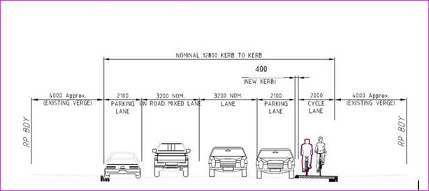
Figure 1: Typical cross-section on Livingstone Road (LR3) with 2.0m bike path and 2.1m parking lanes.
The kerb height was identified as a potential risk which might encourage drivers to park far away from the kerb which would decrease the safe buffer zone between a parked vehicles and vehicular traffic.
An assessment of the kerb heights on eastern side of Livingstone Road (opposite of proposed cycle way) has been undertaken and remedial measures has been identified and discussed below.
Narrow parking lane 2.1m width is unable to be improved given the existing road width of 12.8m and the requirement to maintain 3.2m traffic lane widths. Notwithstanding AS2890 states that 2.1m parking lane widths is within the acceptable range.
Assessment of the eastern Livingstone Road kerbline
In modifying the cross-sectional profile of the parking lanes and traffic lanes on Livingstone Road, an assessment of the kerb heights on the eastern side (opposite the proposed cycleway) has been undertaken.
The assessment concluded that, whilst kerb heights were generally acceptable, there were situations where an increased kerb height, together with the presence of a rolled grass verge meant that vehicle door opening may be an issue. The rolling of the verge resulted in an elevated section of grass immediately behind the kerb which would potentially compound any kerb height issue.
The assessment found that the locations with higher kerbs had kerb heights in the order of 200 - 220 mm. This height in itself is not considered an issue for the majority of standard vehicles, but when combined with a rolled verge with an increased level immediately behind the kerb, full door opening could be problematic.
The presence of trees immediately adjacent the kerb also created an issue, by either the trunk restricting full door opening, or the tree roots resulting in an elevated grass verge adjacent.
Remedial measures
Remedial measures have been identified to improve the ability of car doors to open when parked on the eastern side of Livingstone Road. In most situations, regrading the grass verge was identified as feasible and has been proposed as part of the design plans (refer to attached Design Plans No 6176). This would result in a reduced height behind the kerb and facilitate improved door opening. On some sections where this measure is proposed, existing mature trees would limit the extent of any verge regrading, but it is considered that these trees cause a similar issue for the current road layout.
In one location, immediately south of Hawkhurst Street, the No Stopping zone has been extended, resulting in the loss of two car parking spaces. Verge regrading was considered less feasible at this location as there are a number of mature trees closely spaced. The loss of parking at this location also improves the visibility to and from the adjacent pedestrian refuge where the existing No Stopping setbacks are below current standards.
Below is summary of the proposed measures to improve the overall accessibility to and from vehicles parked adjacent to the eastern kerbline. The assessment only considers locations where an issue has been identified, at all other locations there is considered no issues with car door opening.
|
Location |
Remedial Measure |
Comment |
|
Arthur St to Frances St |
Regrade grass verge to achieve a constant crossfall and to reduce height of the verge immediately behind the kerb. |
There will be a couple of locations where existing trees make the verge reduction less effective. |
|
Immediately South of Hawkhurst St |
Extend No Stopping to remove 2 x car parking spaces. |
Trees here are tightly spaced so regrading the verge to achieve an improvement is difficult. Suggest remove parking which will also improve visibility to the existing pedestrian refuge. Parking is removed from in front of a single corner property, meaning the resident could still park outside their house, albeit on Hawkhurst St. |
|
Immediately North of Hawkhurst St |
Regrade grass verge to achieve a constant crossfall and to reduce height of the verge immediately behind the kerb (outside No. 136 to 144). |
There will be a few locations where existing trees make the verge reduction less effective. |
|
North of Pile Street |
Regrade grass verge to achieve a constant crossfall and to reduce height of the verge immediately behind the kerb (outside No. 92-96, 100 and 106). |
There will be a few locations where existing trees make the verge reduction less effective |
Parking Impact
The following represents the parking impact of the scheme prior to the kerb height assessment:
|
Location |
Western Side of Road |
Eastern Side of Road |
Overall Parking Impact |
||
|
Gain |
Loss |
Gain |
Loss |
||
|
Randall Street (north side) |
3 |
0 |
|
|
+3 |
|
Livingstone Road; |
|
|
|
|
|
|
- Randall to Robert |
5 |
4 |
0 |
0 |
+1 |
|
- Robert to Marrickville |
1 |
2 |
1 |
0 |
0 |
|
- Marrickville to Enfield |
0 |
2 |
0 |
0 |
-2 |
|
- Enfield to Pile |
0 |
4 |
1 |
1 |
-4 |
|
- Pile to Marrickville Park |
0 |
3 |
0 |
0 |
-3 |
|
Hastings Street (north side) |
1 |
0 |
|
|
+1 |
|
Hastings Street (south side) |
1 |
0 |
|
|
+1 |
|
Enfield Street |
4 |
0 |
|
|
+4 |
|
|
Overall Parking Impact |
+1 |
|||
Prior to the kerb height assessment: The above indicates that there would have been a net gain of 1 parking space across the whole of the proposed project.
After the kerb height assessment: the below table indicates that there is now a net loss of 1 parking spaces across the whole of the proposed project. This is mainly due to the loss of 2 parking spaces immediately south of Hawkhurst Street.
|
Location |
Western Side of Road |
Eastern Side of Road |
Overall Parking Impact |
||
|
Gain |
Loss |
Gain |
Loss |
||
|
Randall Street (north side) |
3 |
0 |
|
|
+3 |
|
Livingstone Road; |
|
|
|
|
|
|
- Randall to Robert |
5 |
4 |
0 |
0 |
+1 |
|
- Robert to Marrickville |
1 |
2 |
1 |
0 |
0 |
|
- Marrickville to Enfield |
0 |
2 |
0 |
0 |
-2 |
|
- Enfield to Pile |
0 |
4 |
1 |
3 |
-6 |
|
- Pile to Marrickville Park |
0 |
3 |
0 |
0 |
-3 |
|
Hastings Street (north side) |
1 |
0 |
|
|
+1 |
|
Hastings Street (south side) |
1 |
0 |
|
|
+1 |
|
Enfield Street |
4 |
0 |
|
|
+4 |
|
|
Overall Parking Impact |
-1 |
|||
CONCLUSION
It is considered that the proposed Livinsgtone Road Cycleway (LR3) will assist to complete the missing links within the bicycle network for this area. It will also enhance bicycle connectivity to public transport, local destinations and shops and provide a safer cycling environment for those who will use the facility. Accordingly, iIt is recommended that the draft detail design for the Livinsgtone Road Cycleway (LR3) as per the Design Plan 6176 be endorsed and approved for community consultation. Following the completion of the community consultation, a further repot will be prepared detailing the outcomes of consultation and to present the final detail design plan for consideration.
|
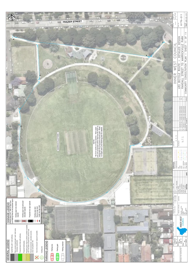
1.⇩ |
LR3 Community Consultation Plan |
|
2.⇩ |
LR3 Signage and Line Markings Plan |
|
Local Traffic Committee Meeting 5 June 2018 |
Subject: Road Occupancy-Dalhousie Street and Ramsay Street, Haberfield-Temporary road closures for the annual/bi-annual 'Haberfield Festa' food festival, Sunday 25 November 2018. (Leichhardt Ward/Summer Hill Electorate/Ashfield LAC)
Prepared By: Boris Muha - Engineer – Traffic and Parking Services
Authorised By: John Stephens - Traffic and Transport Services Manager
|
SUMMARY Council seeks the support of the Committee for the temporary closures of Dalhousie Street and Ramsay Street, Haberfield, for the annual/bi-annual Haberfield (Festa) food festival event on the Sunday 25 November 2018, as recommended below. |
|
RECOMMENDATION
THAT the road closure application for the ‘ Haberfield Festa Food Festival’ on the Sunday 25 November 2018 be supported, subject to the following conditions: 1. The road closure be restricted to occur from 6.00am and 6.00pm in Ramsay Street (between Gillies Avenue and St. David’s Road/Kingston Street) and Dalhousie Street (between Dickson Street and Winchombe Avenue);
2. A Traffic Management Plan (TMP) be submitted to and approved by RMS, and an application for a road Occupancy License be forwarded to and approved by the Transport Management Centre;
3. Notice of the proposed event is forwarded to the emergency services, i.e. NSW Police, Fire and Rescue NSW and NSW Ambulance Service;
4. A 4- metre wide emergency service access must be maintained through the closed road areas during the course of the event;
5. Council through its ‘Community Service’ notify/consult with all affected residents and/or businesses in the area, and conduct a letter-box/leaflet drop notifying the local community of the road closure event at least two (2) weeks prior to the event;
6. The temporary full road closure be advertised in the local newspaper providing 28 days’ notice for submissions, in accordance with the Roads Act;
7. Advance notification signs for the event are strategically installed at least one (1) weeks prior to the event; and
8. Adequate Vehicular traffic control shall be provided for the protection and convenience of pedestrians and motorists including appropriate signage and flagging. Workers shall be specifically designated for this role (and carry appropriate certificates), as necessary to comply with this condition. This is to be carried out in accordance with the Australian Standard AS 1742.3- Traffic Control Devices for works on roads. |
BACKGROUND
The Haberfield (Festa) Food Festival, Haberfield is a scheduled annual/biannual food festival events to be conducted in the Council Area of Haberfield in November 2018, and in conjunction with the Sydney wide food festival program.
FINANCIAL IMPLICATIONS
The costs associated with the temporary road closures are to be borne by Council as part of its major events or operational budget.
OTHER STAFF COMMENTS
Ramsay Street, between Gillies Avenue and St David’s Road/Kingston Street and Dalhousie Street, between Dickson Street and Winchombe Avenue, has been closed off in previous years. Traffic Committee support, with Council and RMS approval has been provided in the past for the road closure.
Although the event runs from 10am-4pm, from an operational point of view, in order to affectively clear parking in the area and set-up and dismantle for the event, the road closure will be affective from 6.00am-6.00pm.
In accordance with the RMS “Guide to Traffic and Transport Management for Special Events V3.4 August 2006, the event is classified either Special Event class 1 or 2. Relevant approval is required from the RMS for the closure of the roads and a road occupancy license needs to be obtained from the Transport Management Centre (TMC).
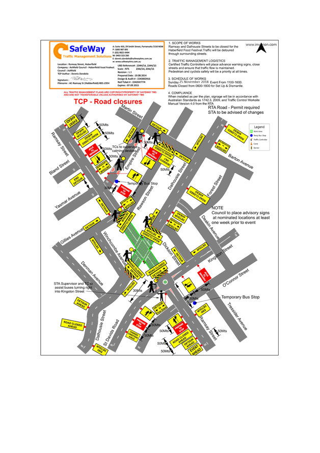
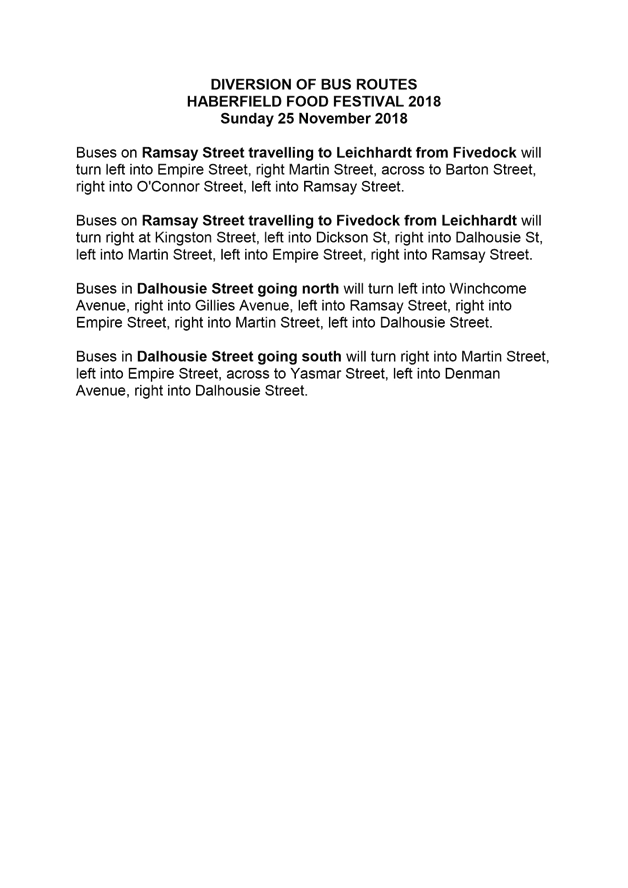
Attached is a copy of the Traffic Management Plan (TMP) and Traffic Control Plan (TCP) relevant in attaining the approval and road occupancy license from the TMC.
PUBLIC CONSULTATION
Notification of the event will be arranged by Council’s ‘Community Services’ via letter box/leaflet drop and local newspaper advertisement.
CONCLUSION
It is recommended that support be provided for Council to carry out the temporary full road closures of Ramsay Street (between Gillies Avenue and St David’s Road/Kingston Street) and Dalhousie Street (between Dickson Street and Winchombe Avenue), Haberfield, in association with the annual/bi-annual Haberfield (Festa) food festival event on Sunday 25 November 2018.
Council will apply for the Road Occupancy License and will forward the Traffic Management Plan and associated Traffic Control Plan to the RMS for approval to close the subject roads.
|
1.⇩ |
Traffic Management Plan |
|
2.⇩ |
Traffic Control Plan |
|
3.⇩ |
Diversion of Bus Routes |
|
|
Local Traffic Committee Meeting 5 June 2018 |
Subject: Dalhousie Street, Haberfield - road & traffic improvements (Leichhardt Ward / Summer Hill Electorate / Ashfield LAC)
Prepared By: Manod Wickramasinghe - Coordinator – Traffic and Parking Services
|
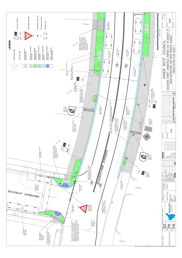
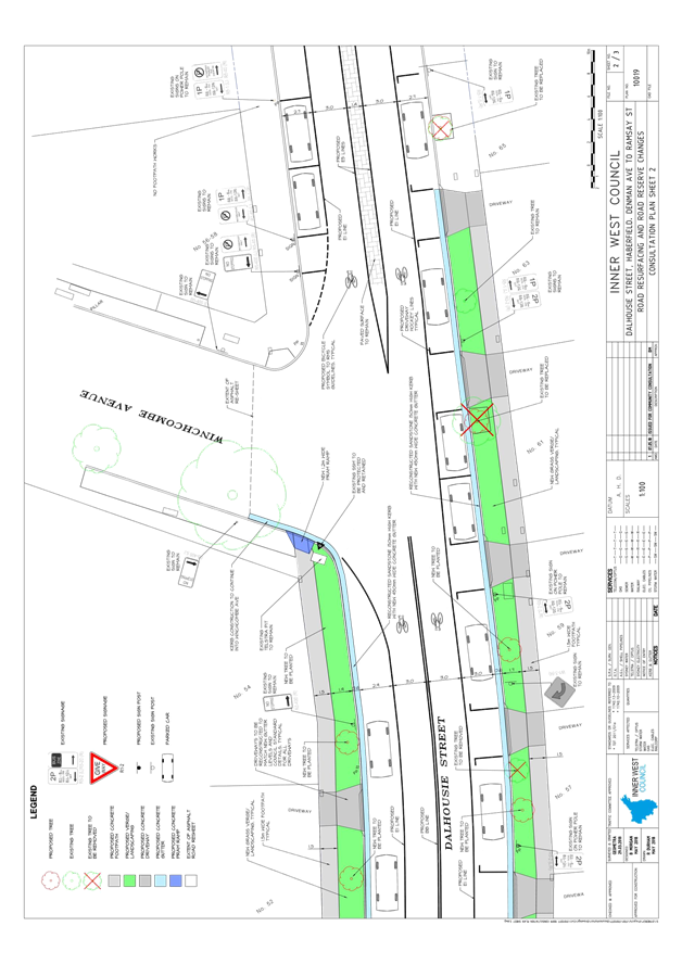
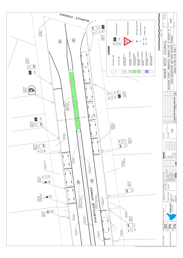
SUMMARY Detailed design plans have been finalised for the proposed road and traffic improvements in Dalhousie Street, Haberfield between Denman Avenue and Ramsay Street as part of Council’s 2018/19 Capital Works Program for Traffic Facilites.
The proposed works on Dalhousie Street include kerb & gutter reconstruction works, footpath reconstruction, resurfacing of roadway, additional landscaping, construction of kerb extensions, construction of a landscaped central median island and installation of associated line marking and signage. |
|
RECOMMENDATION
THAT the detailed design plans for the proposed landscaping works, maintenance works, construction of kerb extensions, construction of a landscaped central median island and installation of associated line marking and signage on Dalhousie Street, Haberfield between Denman Avenue and Ramsay Street (as per the attached plan No. 10019) be approved.
|
BACKGROUND
Council is proposing to improve the traffic conditions in Dalhousie Street, Haberfield, between Denman Avenue and Ramsay Street, as part of the 2018/19 Capital Works Program for Traffic Facilities.
The proposed works on Dalhousie Street include kerb & gutter reconstruction works, footpath reconstruction, resurfacing of roadway, additional landscaping, construction of kerb extensions, construction of a landscaped central median island and installation of associated linemarking and signage. The detailed design plans for these works have been finalised for the proposed devices together with the consultation and are presented in this report for consideration.
|
Street Name |
Dalhousie Street, Haberfield |
|
Section (s) |
Denman Avenue to Ramsay Street |
|
Carriageway width (m) |
12.9m |
|
Carriageway type |
Two-way road with one travel lane and one parking lane in each direction. |
|
Classification |
Local |
|
85th Percentile speed (km/hr) |
n/a (Closest speed count was at 11 & 18 Dalhousie Street, north of Parramatta Road on 5/11/13, recorded speed was 47.9 km/hr) |
|
Vehicles Per Day (vpd-AADT) |
5500 |
|
Reported Crash History (July 2012 – June 2017) |
(1) Dalhousie St at Denman Ave = 1 accident. Rum code: 13 – Right near (5/1/14). Accident resulted in injury. (2) 58a Dalhousie St = 1 accident (Rum Code: 71 – Left off carriageway into object/parked vehicle (2/6/16). Crash resulted in towaway. (3) 71 Dalhousie St (Carpark) = 1 accident (Rum Code: 7 – Driveway (20/6/13). Crash resulted in injury. |
|
Heavy Vehicle Volume |
2.0% |
|
Parking arrangements |
North side (Denman Ave to Winchcombe Ave): Unrestricted parking South Side(Denman Ave to Winchcombe Ave): 2P 8:30am to 6pm, Mon – Fri, 8:30am – 12:30pm Sat North Side(Winchcombe Ave to Ramsay St): 1P 8:30am to 6pm, Mon – Fri, 8:30am – 12:30pm Sat with disabled bus parking and motorcycle parking. South Side(Winchcombe Ave to Ramsay St): 1P 8:30am to 6pm, Mon – Fri, 8:30am – 12:30pm Sat 3 bus zones as shown on the plans. |
FINANCIAL IMPLICATIONS
OTHER STAFF COMMENTS
This detailed design plan shown in Attachment 1 outlines the proposed works on Dalhousie Street between Denman Avenue and Ramsey Street and includes the following treatments:
The proposed work includes:
· Reconstruction of sandstone kerb and concrete gutter on the northern side of Dalhousie Street between Denman Avenue and Winchcombe Avenue and the southern side of Dalhousie Street between Denman Avenue and the car park at No.69 Dalhousie Street ;
· Resurfacing of Dalhousie Street between Denman Avenue and Ramsey Street;
· Reconstruction of driveways and footpath on the northern side of Dalhousie Street between Denman Avenue and Winchcombe Avenue and the southern side of Dalhousie Street between Denman Avenue and the car park at No.69 Dalhousie Street as required;
· Provision of new grass verge with additional tree planting on the northern side of Dalhousie Street between Denman Avenue and Winchcombe Avenue and the southern side of Dalhousie Street between Denman Avenue and the car park at No.69 Dalhousie Street ;
· Construction of landscaped kerb blisters/extensions in Denman Avenue at Dalhousie Street;
· Construction of additional kerb ramps at some intersections;
· Construction of a landscaped central median island with tree planting on Dalhousie Street on the approach to Ramsay Street.
· Installation of associated signposting and line marking.
There is no loss of parking associated with the proposal. The consultation plan issued to residents show the number of parking spaces as per the Australian Standards. It is noted that in some cases there may be sufficient space to allow parking for two small cars, although the length of parking available is less than the Australian Standard for two cars.
All current vehicular access to adjoining properties will be retained.
PUBLIC CONSULTATION
A letter outlining the above parking proposal options was mailed out to the affected properties (50 properties) in Dalhousie Street, Haberfield as indicated on the following plan, requesting residents’ and businesses views regarding the proposal.
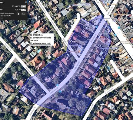
No responses were received.
CONCLUSION
It is recommended that the detailed design plans of the proposed treatments and associated
signs and line markings be approved, to improve conditions at these locations.
|
1.⇩ |
Plan 10019 Dalhousie Street_7-5-18 |
|
Local Traffic Committee Meeting 5 June 2018 |
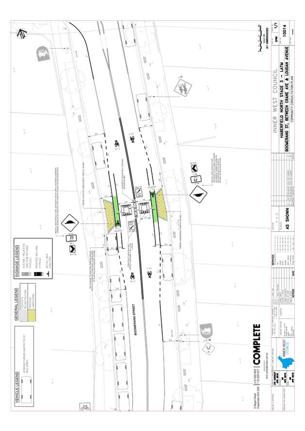
Subject: Boomerang Street, Haberfield - Haberfield North LATM - Traffic calming improvements (Leichhardt Ward / Summer Hill Electorate / Ashfield LAC)
Prepared By: Manod Wickramasinghe - Coordinator – Traffic and Parking Services
|
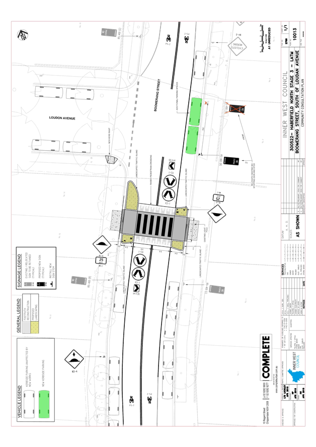
SUMMARY Detailed design plans have been finalised for the proposed road and traffic improvements in Boomerang Street, Haberfield as part of Council’s 2018/19 & 2019/20 Capital Works Program for Traffic Facilities.
The proposed works include the upgrade of an existing at-grade pedestrian (zebra) crossing to a raised pedestrian (zebra) crossing, introduction of speed calming devices and upgraded bicycle facilities with associated line marking and signposting. |
|
RECOMMENDATION
THAT the detailed design plans for the raised pedestrian crossing, traffic calming devices, bicycle facilities and kerb blisters with associated signposting and line marking in Boomerang Street, Haberfield (as per the attached plan Nos. 10013 & 10014) be approved.
|
BACKGROUND
Council is proposing to improve the traffic conditions in Boomerang Street, Haberfield between Waratah Street and Crane Avenue as part of the 2018/19 and 2019/20 Capital Works Program for Traffic Facilities.
The proposal is based on recommendations from the former Ashfield Council’s Traffic Management Strategy which were endorsed by Council on 23 August 2016, following a period of community engagement. It is also a continuation of the Local Area Traffic Management (LATM) measures recently completed in Waratah Street and Tillock Street, Haberfield.
The proposed works on Boomerang Street include the upgrade of an existing at-grade pedestrian (zebra) crossing to a raised pedestrian (zebra) crossing, introduction of speed calming devices and upgraded bicycle facilities with associated line marking and signposting. The detailed design plans have been finalised for the proposed devices together with the consultation and are presented in this report for consideration.
Site location & road network:
|
Street Name |
Boomerang Street, Haberfield |
|
Section (s) |
Waratah Street to Crane Avenue |
|
Carriageway width (m) |
12.8m |
|
Carriageway type |
Two-way road with one travel lane and one parking lane in each direction. |
|
Classification |
Local |
|
85th Percentile speed (km/hr) |
48.7 km/hr (27/5/15) |
|
Vehicles Per Day (vpd-AADT) |
7200 |
|
Reported Crash History (July 2012 – June 2017) |
(1) At pedestrian crossing = 2 accidents. RUM code: 44, Parking vehicles – resulted in tow-away (21/5/13); RUM code: 71, Off road left => object – resulted in tow-away (26/5/17). (2) At Boomerang St and Crane Ave = 1 accident. RUM Code: 40, U-turn – resulted in tow-away (11/4/15). |
|
Heavy Vehicle Volume |
3.5% |
|
Parking arrangements |
Unrestricted parking |
FINANCIAL IMPLICATIONS
Funding of $75,000 has been listed for the Pedestrian Crossing works in the 2018/19 Capital Works Program for Traffic Facilities and an additional $50,000 for the traffic calming devices and bicycle lane upgrade in the 2019/20 Capital Works Program for Traffic Facilities (subject to final Council approval).
OTHER STAFF COMMENTS
Design Plan No.10013.
This detailed design plan shown in Attachment 1 outlines the proposed works on Boomerang Street at Loudon Avenue and includes the following treatments:
· Upgrading the existing at-grade pedestrian (zebra) crossing to a raised pedestrian (zebra) crossing with landscaped kerb extensions;
· Constructions on landscaped traffic islands;
· Construction of new kerb ramp;
· Installation of associated linemarking and signage.
There will be a gain of two parking spaces associated with converting the existing at-grade pedestrian (zebra) crossing to a raised pedestrian (zebra) crossing.
Currently the pedestrian refuge in the existing crossing requires the edgeline to taper towards the kerbline in order to deflect southbound vehicles. In order to achieve this a 20m ‘No Stopping’ zone is provided on approach. The current proposal removes the refuge and instead allows construction of kerb extensions. The ‘No Stopping’ zone can therefore be reduced to 10m on the southbound approach to the pedestrian crossing, allowing two cars to park in front of No.7 Boomerang Street.
All current vehicular access to adjoining properties will be retained.
Design Plan No.10014.
This detailed design plan shown in Attachment 2 outlines the proposed works on Boomerang Street (midblock between Loudon Avenue and Crane Avenue) outside No.22 Boomerang Street and includes the following treatments:
· Reconstruction of the existing traffic median island; reconstruction of landscaped kerb blisters;
· Reconstruction of asphalt speed cushions with bicycle lanes;
· Resurfacing the subject section of roadway; and
· Installation of associated linemarking and signage.
The bicycle lane has been tapered to allow riders in the mixed traffic lane to ride around the traffic calming device, and then entering back into the mixed traffic lane. This proposed bicycle treatment is typical of other treatments on Boomerang Street and Dalhousie Street.
It has been noted that some of the bicycle symbols along the Boomerang Street route have faded and will be remarked accordingly to reflect the design intent of this device with the mixed traffic route which were proposed following requests from the local bicycle user group (AshBUG).
All current vehicular access to adjoining properties will be retained.
PUBLIC CONSULTATION
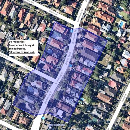
A letter outlining this traffic improvement proposal was mailed out to the affected properties (30 properties) in Boomerang Street, Haberfield as indicated on the below plan, requesting residents’ views regarding the proposal.
Design Plan No.10013.
Converting the existing pedestrian crossing to a raised pedestrian crossing with landscaped kerb extensions in the existing location.
A total of three (3) responses were received in total for this proposal, one (1) response was received in support of the proposal and two (2) responses were received against the proposal.
|
Residents’ Comments |
Officer Comments |
|
A resident of Boomerang Street commented against the proposal to raise the existing pedestrian crossing, and suggested that the location of the pedestrian crossing should be relocated closer to the roundabout at the intersection of Waratah Street, Dalhousie Street and Boomerang Street to cater for pedestrian movements. |
The existing pedestrian (zebra) crossing was installed at the current location prior to 2000, to cater for school children travelling to the Dobroyd Point Public School from north of Boomerang Street. Relocating the crossing would reduce pedestrian amenity for the school. It should be noted that the raised pedestrian crossing will also improve the speed profile along Boomerang Street.
It should also be noted that Council has received a grant from the RMS for blackspot funding to install 4 speed cushions on each of the 4 approaches to the roundabout at Waratah St, Boomerang St and Dalhousie St. This will improve pedestrian safety at this intersection whilst utilising the existing pedestrian refuge on Boomerang Street at the roundabout. These works are currently planned for 2018/19 subject to resident consultation, final approvals and budget allocation.
|
|
A resident of Boomerang Street commented against the proposal to raise the existing pedestrian crossing due to the noise associated with the device. |
The proposed height of the pedestrian crossing will be specified as 75mm to 90mm high as it is located on a bus route, instead of the typical 100mm high as per the RMS technical directions.
The ramps of the crossing will also be extended from 1.2m to 1.5m to create a more seamless transition from the existing road level over the proposed raised crossing which will reduce the noise impacts associated with a raised device whilst retaining a traffic calming impact.
|
|
Residents of Boomerang Street commented in support of the proposal to raise the existing pedestrian crossing for the following reasons: - it is extremely difficult to cross the road with the volume and speed of traffic. - they have witnessed many near misses between vehicles and pedestrians, and 2 years ago were on scene when a car crashed into the blister and bollards of the crossing and damaged a parked car. - as former school children they would cross at this crossing to go to Dobroyd Point Public School, as the safer point on Boomerang Street. |
Noted. |
Design Plan No.10014.
Reconstructing the existing traffic device at 22 Boomerang Street with asphalt speed cushions with bicycle lanes and landscaped kerb blisters.
A total of three (3) responses were received in total for this proposal. Three (3) responses were received in support of the proposal. No responses were received against the proposal.
|
Residents’ Comments |
Officer Comments |
|
A resident of Boomerang Street commented on their support for reinstating the speed humps at the proposed location for additional traffic calming between the roundabout and the traffic device on Boomerang Street, near Learmonth Street.
|
Noted.
|
|
A resident of Boomerang Street commented on their support for reinstating the speed humps at the proposed location and that the speed hump (which was previously removed) was part of an integrated traffic management plan implemented in Haberfield in the mid 1980s and successfully slowed traffic.
|
|
|
Residents of Boomerang Street commented on their support for reinstating the speed humps at the proposed location on safety grounds for pedestrians and residents in the area. The current slow point at 22 Boomerang Street is ineffective at slowing traffic down, and there is a curve in the road at this point which cars speed around and impacts viewing of vehicles when exiting residential driveways |
CONCLUSION
It is recommended that the detailed design plans of the proposed treatments and associated
signs and line markings be approved, to improve conditions at these locations.
|
1.⇩ |
10013 - 300522 Haberfield North LATM - LTC Plan - Site 1_B |
|
2.⇩ |
10014 - 300522 Haberfield North LATM - LTC Plan - Site 2_B |
|
|
Local Traffic Committee Meeting 5 June 2018 |
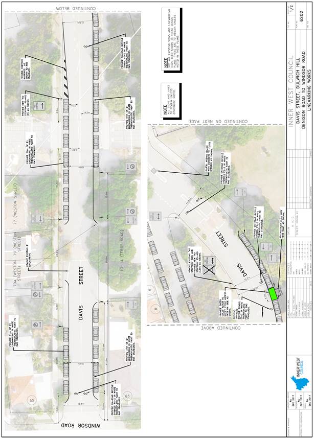
Subject: Davis Street, Dulwich Hill – Proposed Line Markings Design Plans (Ashfield Ward/Summer Hill Electorate/Inner West LAC)
Prepared By: Emilio Andari - Engineer – Traffic and Parking Services
Authorised By: John Stephens - Traffic and Transport Services Manager
|
SUMMARY A detailed design plan has been finalised for the proposed traffic calming improvements in Davis Street, Dulwich Hill, between Windsor Road and Denison Road, as part of the Dulwich Hill North LATM study implementation. The proposal for line markings with associated signs on Davis Street will improve safety and calm traffic.
Consultation was undertaken with owners and occupiers of properties adjacent to Davis Street, regarding the proposal. A summary of the consultation results are presented in this report for consideration. It is recommended that the proposed detailed design plans be approved. |
|
RECOMMENDATION
THAT the design plans for the proposed line markings with associated signs in Davis Street, Dulwich Hill, between Windsor Road and Denison Road (as per the attached design plan No. 6202) be APPROVED. |
BACKGROUND
Council is proposing to install line markings with associated signs in Davis Street, Dulwich Hill, between Windsor Road and Denison Road.
These proposals are a design which was included in the recently approved Dulwich Hill North Local Area Traffic Management Plan (LATM) which was on public exhibition (for community comment) mid-2017. The LATM provides rationale and recommended actions to address local traffic issues and support sustainable transport. This involves encouraging the use of public transport, walking and cycling. The Dulwich Hill North LATM was endorsed and approved by Council at its meeting held on 12 October 2017.
As part of the Dulwich Hill North LATM, a consultation session was held with the Denison Road Group to workshop traffic and parking options for Denison Road, Dulwich Hill. The Denison Road Group are a group of residents that have been campaigning for improved traffic and parking conditions along Denison Road, which functions as collector road within the Dulwich Hill North LATM study area.
The detail design plans have been finalised for the proposed devices together with the consultation and are presented in this report for consideration.
FINANCIAL IMPLICATIONS
Funding of $10,000 has been allocated by Council for the entire scope of works for Davis Street, Dulwich Hill between Windsor Road and Denison Road, under the Dulwich Hill North LATM Implementation 2018/2019. These works include installing line markings, chevron line markings, bicycle logos and colour hatching; reconstruct a kerb ramp and installation of associated signs.
OFFICER COMMENTS
Site location & road network
|
Street Name |
Davis Street |
|
Section |
Between Windsor Road and Denison Road |
|
Carriageway Width (m) |
12.8-10.3 |
|
Carriageway Type |
Two-way road with one travel lane in each direction, in addition to kerbside parking lanes. |
|
Classification |
Local |
|
85th Percentile Speed (km/h) |
42.5 |
|
Vehicles Per Day (vpd) |
1,311 |
|
Reported Crash History (July 2012 – June 2017) |
No crashes recorded. |
|
Heavy Vehicle Volume (%) |
1.8 |
|
Parking Arrangements |
Unrestricted parking along both sides of the road. |
At present, both intersections of Davis Street with Windsor Road and Davis Street with Denison Road are controlled by a ‘Give Way’ sign and line markings which have priority given to motorists travelling along Windsor Road and Denison Road. The intersection of Davis Street with Victoria Street is controlled by a ‘Give Way’ sign and line markings which has priority given to motorists travelling along Davis Street.
Design Plan – No. 6202
Detailed design plans for the provision of line markings with associated signs in Davis Street, Dulwich Hill, between Windsor Road and Denison Road (ATTACHMENT - design plans No. 6202) are submitted for consideration.
The proposed scope of work includes the following:
· Install new green coloured hatched area and reconstruct a new kerb ramp on Davis Street, Dulwich Hill, adjacent to Hoskins Park, as per design plan.
· Install three new ‘No Stopping’ signs along Davis Street as per design plan.
· Install edge line ‘E1’ line markings, chevron markings and bicycle symbols along both sides of Davis Street as per design plan.
The proposed treatment will not result in the loss of any legal on-street car parking spaces in Davis Street (refer to the attached design plans No. 6202). All current vehicular access to adjoining properties will be retained.
PUBLIC CONSULTATION
A notification letter as well as a copy of the detailed design plan was sent on 18 April 2018 to the owners and occupiers of the affected properties in Davis Street, Dulwich Hill, regarding the proposed design plans to implement line markings with associated signs along Davis Street, Dulwich Hill, between Windsor Road and Denison Road. A total of 25 letters were distributed. The closing date for submissions ended on 9 May 2018. There were no responses received regarding the proposal.
CONCLUSION
It is recommended that the detailed design plans of the proposed line markings and associated signs be approved, to improve safety and calm traffic.
|
|
Local Traffic Committee Meeting 5 June 2018 |
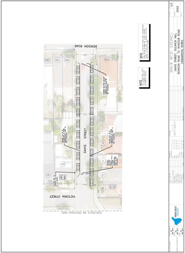
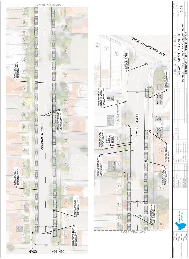
Subject: Dulwich Street, Dulwich Hill – Proposed Line Markings Design Plans (Ashfield Ward/Summer Hill Electorate/Inner West LAC)
Prepared By: Emilio Andari - Engineer – Traffic and Parking Services
Authorised By: John Stephens - Traffic and Transport Services Manager
|
SUMMARY A detailed design plan has been finalised for the proposed traffic calming improvements in Dulwich Street, Dulwich Hill, between Denison Road and New Canterbury Road, as part of the Dulwich Hill North LATM study implementation. The proposal for line markings with associated signs on Dulwich Street will improve safety and calm traffic.
Consultation was undertaken with owners and occupiers of properties adjacent to Dulwich Street, regarding the proposal. A summary of the consultation results are presented in this report for consideration. It is recommended that the proposed detailed design plans be approved. |
|
RECOMMENDATION
THAT the design plans for the proposed line markings with associated signs in Dulwich Street, Dulwich Hill, between Denison Road and New Canterbury Road (as per the attached design plan No. 6201) be APPROVED. |
BACKGROUND
Council is proposing to install line markings with associated signs in Dulwich Street, Dulwich Hill, between Denison Road and New Canterbury Road.
The design is a result of a proposal which was included in the recently approved Dulwich Hill North Local Area Traffic Management Plan (LATM) which was on public exhibition (for community comment) mid-2017. The LATM provides rationale and recommended actions to address local traffic issues and support sustainable transport. This involves encouraging the use of public transport, walking and cycling. The Dulwich Hill North LATM was endorsed and approved by Council at its meeting held on 12 October 2017.
The detail design plan has been finalised for the proposed devices together with the consultation and are presented in this report for consideration.
FINANCIAL IMPLICATIONS
Funding of $10,000 has been allocated by Council for the entire scope of works for Dulwich Street, Dulwich Hill between Denison Road and New Canterbury Road, under the Dulwich Hill North LATM Implementation 2018/2019. These works include installing line markings, bicycle logos and associated signs.
OFFICER COMMENTS
Site location & road network
|
Street Name |
Dulwich Street |
|
Section |
Between Denison Road and New Canterbury Road |
|
Carriageway Width (m) |
12.9 |
|
Carriageway Type |
Two-way road with one travel lane in each direction, in addition to kerbside parking lanes. |
|
Classification |
Local |
|
85th Percentile Speed (km/h) (Year 2003) |
55.2 |
|
Vehicles Per Day (vpd) |
1,877 |
|
Reported Crash History (July 2012 – June 2017) |
No crashes recorded. |
|
Heavy Vehicle Volume (%) |
4.5 |
|
Parking Arrangements |
Timed permit parking restrictions along the northern side of the road and unrestricted parking along the southern side of the road. |
At present, the intersection of Dulwich Street with New Canterbury Road is controlled by traffic signals.
Design Plan – No. 6201
A detailed design plan for the provision of line markings with associated signs in Dulwich Street, Dulwich Hill, between Denison Road and New Canterbury Road (ATTACHMENT - design plans No. 6201) are submitted for consideration.
The proposed scope of work includes the following:
· Install edge line ‘E1’ line markings, separation line ‘S1’ line markings and bicycle symbols along both sides of Dulwich Street as per design plan.
· Replace two existing ‘No Parking signs with two new ‘No Stopping’ signs and replace missing ‘No Parking Wedding and Funeral Vehicles Excepted’ sign in Dulwich Street as per design plan.
The proposed treatment will not result in the loss of any legal on-street car parking spaces in Dulwich Street (refer to the attached design plans No. 6201). All current vehicular access to adjoining properties will be retained.
PUBLIC CONSULTATION
A notification letter as well as a copy of the detailed design plan was sent on 18 April 2018 to the owners and occupiers of the affected properties in Dulwich Street, Dulwich Hill, regarding the proposed design plans to implement line markings with associated signs along Dulwich Street, Dulwich Hill, between Denison Road and New Canterbury Road. A total of 223 letters were distributed. The closing date for submissions ended on 9 May 2018.
There were a total of two (2) responses received with one (1) response supporting the proposal and one (1) response opposing the proposal. These responses are detailed below.
|
Residents’ Comments (supporting the proposal) |
Officer’s Response |
|
A resident of Dulwich Street is in support of the proposal. The resident raised concerns regarding speeding and suggested that speed display signage be installed in the street to encourage motorists to slow down. |
Received and noted.
The local road speed limit is 50km/hr. Dulwich Street is not warranted for a speed limit reduction. It should be noted that the proposed traffic calming measures for Dulwich Street will reduce average traffic speed. |
|
Residents’ Comments (opposing the proposal) |
Officer’s Response |
|
A local resident is opposing to the proposal. Concerns were raised regarding speed within the street and suggestions were made to install speed limit signs. The use of the existing timed ‘Bus Zone’ and section of ‘No Parking Wedding and Funeral Vehicles Excepted’ restrictions were in question by the resident. |
The local road speed limit is 50km/hr. Dulwich Street is not warranted for a speed limit reduction. It should be noted that the proposed traffic calming measures for Denison Road will reduce average traffic speed.
The existing timed ‘Bus Zone’ and section of ‘No Parking Wedding and Funeral Vehicles Excepted’ restrictions are in use and it has been confirmed with the adjacent property and nearby schools. |
CONCLUSION
It is recommended that the detailed design plans of the proposed line markings and associated signs be approved, to improve safety and calm traffic.
|
|
Local Traffic Committee Meeting 5 June 2018 |
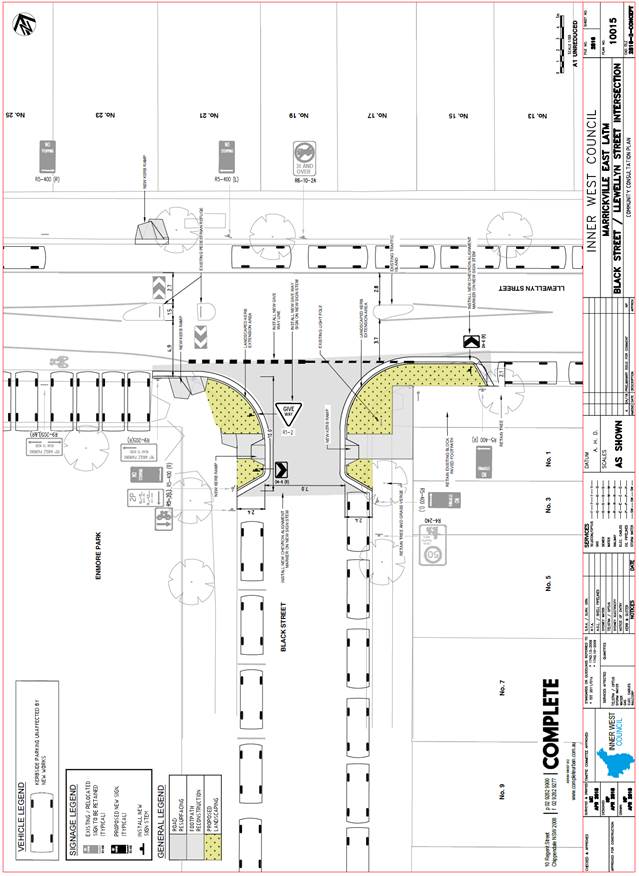
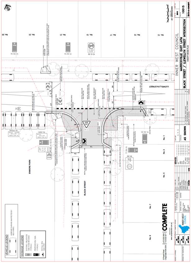
Subject: Black Street, Marrickville – Proposed Kerb Extensions Design Plans (Marrickville Ward/Newtown Electorate/Inner West LAC)
Prepared By: Emilio Andari - Engineer – Traffic and Parking Services
Authorised By: John Stephens - Traffic and Transport Services Manager
|
SUMMARY A detailed design plan has been finalised for the proposed traffic calming improvements in Black Street, Marrickville, at Llewellyn Street, as part of the Marrickville East LATM study implementation. The proposal for kerb extensions with a new kerb and gutter alignment and associated signs and line markings will improve pedestrian safety and traffic conditions at this location.
Consultation was undertaken with owners and occupiers of properties adjacent to Black Street and Llewellyn Street, regarding the proposal. A summary of the consultation results are presented in this report for consideration. It is recommended that the proposed detailed design plans be approved. |
|
RECOMMENDATION
THAT the design plans for the proposed kerb extensions with a new kerb and gutter alignment and associated signs and line markings in Black Street, Marrickville, at Llewellyn Street (as per the attached design plan No. 10015) be APPROVED. |
BACKGROUND
Council is proposing to reconstruct the footpath in Black Street, Marrickville, and construct new kerb extensions with a new kerb and gutter alignment and associated signs line markings. The purpose of the proposal is to widen the existing footpaths and narrow the road width in Black Street, Marrickville near its intersection with Llewellyn Street as part of the Marrickville East LATM study implementation.
The attached design is a result of a proposal which was included in the approved Marrickville East Local Area Traffic Management Plan (LATM) which was on public exhibition (for community comment) late-2016. The LATM provides rationale and recommended actions to address local traffic issues and support sustainable transport. This involves encouraging the use of public transport, walking and cycling. The Marrickville East LATM was endorsed and approved by Council at its meeting held on 28 February 2017.
The detail design plan has been finalised for the proposed devices together with the consultation and are presented in this report for consideration.
FINANCIAL IMPLICATIONS
Funding of $30,000 has been allocated by Council for the entire scope of works for Black Street, Marrickville, under the Marrickville East LATM Implementation 2018/2019. These works include reconstructing the existing footpaths and construct new kerb extensions with a new kerb and gutter alignment and associated signs and line markings in Black Street, Marrickville at its intersection with Llewellyn Street.
OFFICER COMMENTS
Site location & road network
|
Street Name |
Black Street |
Llewellyn Street |
|
Section |
Between Llewellyn Street and Victoria Road |
Between Enmore Road and Juliett Street |
|
Carriageway Width (m) |
11.8 |
12.8 |
|
Carriageway Type |
Two-way road with one travel lane in each direction, in addition to kerbside parking lanes. |
Two-way road with one travel lane in each direction, in addition to kerbside parking lanes. |
|
Classification |
Local |
Regional |
|
85th Percentile Speed (km/h) |
29.9 |
50.4 |
|
Vehicles Per Day (vpd) |
1,296 |
6,784 |
|
Reported Crash History (July 2012 – June 2017) |
1 crash (Rum Code: 95). Crash resulted in tow away. |
No crashes recorded. |
|
Heavy Vehicle Volume (%) |
3.6 |
3.2 |
|
Parking Arrangements |
Timed parking restrictions along the western side of the road and unrestricted parking along the southern side of the road. |
90 degree angle, rear-to-kerb parking restrictions along the southern side of the road and unrestricted parking along the northern side of the road. |
It should be noted that the proposed concept plan for traffic calming in Black Street, Marrickville, at Llewellyn Street, was to consider kerb extensions and include a pedestrian refuge island. However, during the detail design phase it was identified that the proposal to include both kerb extensions with a pedestrian refuge island was not feasible due to existing road width constraints. The proposed footpath kerb extensions with new kerb and gutter alignment in Black Street will improve pedestrian safety and calm traffic at the intersection without the loss of any on-street car parking spaces.
Design Plan – No. 10015
A detailed design plan for the provision of new kerb extensions with a new kerb and gutter alignment and associated signs and line markings in Black Street, Marrickville, at its intersection with Llewellyn Street (ATTACHMENT - design plans No. 10015) is submitted for consideration.
The proposed scope of work includes the following:
· Construct two new kerb extensions with new kerb and gutter alignment in Black Street at its intersection with Llewellyn Street and construct four new kerb ramps and install associated signage as per design plan.
· Install Give Way ‘TB & TB1’ line markings in Black Street, at its intersection with Llewellyn Street, as per design plan.
· Reseal the road pavement in Black Street, at its intersection with Llewellyn Street, as per design plan.
The proposed treatment will not result in the loss of any legal on-street car parking spaces in Black Street and Llewellyn Street (refer to the attached design plans No. 10015). All current vehicular access to adjoining properties will be retained.
PUBLIC CONSULTATION
A notification letter as well as a copy of the detailed design plan was sent on 7 May 2018 to the owners and occupiers of the affected properties in Black Street and Llewellyn Street, Marrickville, regarding the proposed design plans to implement kerb extensions with a new kerb and gutter alignment and associated signs and line markings in Black Street, at Llewellyn Street. A total of 47 letters were distributed. The closing date for submissions ended on 21 May 2018. There were no responses received regarding the proposal.
CONCLUSION
It is recommended that the detailed design plans of the proposed line markings and associated signs be approved, to improve safety and calm traffic.
|
|
Local Traffic Committee Meeting 5 June 2018 |
Subject: Victoria Road, Marrickville – Proposed Kerb Extensions Design Plans (Marrickville Ward/Newtown Electorate/Inner West LAC)
Prepared By: Emilio Andari - Engineer – Traffic and Parking Services
Authorised By: John Stephens - Traffic and Transport Services Manager
|
SUMMARY A detailed design plan has been finalised for the proposed traffic calming improvements in Victoria Road, Marrickville, at Leicester Street and at Bourne Street, as part of the Marrickville East LATM study implementation. The proposal for kerb extensions with a new kerb and gutter alignment and associated signs and line markings will improve pedestrian safety and traffic conditions at this location.
Consultation was undertaken with owners and occupiers of properties adjacent to Victoria Road, Leicester Street and Bourne Street, regarding the proposal. A summary of the consultation results are presented in this report for consideration. It is recommended that the proposed detailed design plans be approved. |
|
RECOMMENDATION
THAT the design plans for the proposed kerb extensions with a new kerb and gutter alignment and associated signs and line markings in Victoria Road, Marrickville, at Leicester Street and at Bourne Street (as per the attached design plan No. 10016) be APPROVED. |
BACKGROUND
Council is proposing to reconstruct the footpath in Victoria Road, Marrickville, and construct new kerb extensions with a new kerb and gutter alignment and associated signs and line markings. The purpose of the proposal is to improve pedestrian amenity and safety by widening the existing footpaths and narrow the road width in Victoria Road, Marrickville near its intersections with Leicester Street and Bourne Street as part of the Marrickville East LATM study implementation.
The attached design is a result of a proposal which was included in the approved Marrickville East Local Area Traffic Management Plan (LATM) which was on public exhibition (for community comment) late-2016. The LATM provides rationale and recommended actions to address local traffic issues and support sustainable transport. This involves encouraging the use of public transport, walking and cycling. The Marrickville East LATM was endorsed and approved by Council at its meeting held on 28 February 2017.
The detail design plan has been finalised for the proposed devices together with the consultation and are presented in this report for consideration.
FINANCIAL IMPLICATIONS
Funding of $70,000 has been allocated by Council for the entire scope of works for Black Street, Marrickville, under the Marrickville East LATM Implementation 2018/2019. These works include reconstructing the existing footpaths and construct new kerb extensions with a new kerb and gutter alignment and associated signs and line markings in Victoria Road, Marrickville at its intersections with Leicester Street and Bourne Street.
OFFICER COMMENTS
Site location & road network
|
Street Name |
Victoria Road |
Leicester Street |
Bourne Street |
|
Section |
Between Enmore Road and Bourne Street |
Between Victoria Road and an end |
Between Victoria Road and an end |
|
Carriageway Width (m) |
12.8 |
12.8 |
12.8 |
|
Carriageway Type |
Two-way road with one travel lane in each direction, in addition to kerbside parking lanes. |
Two-way road with one travel lane in each direction, in addition to kerbside parking lanes. |
Two-way road with one travel lane in each direction, in addition to kerbside parking lanes. |
|
Classification |
Local |
Local |
Local |
|
85th Percentile Speed (km/h) |
38.9 |
36.0 |
- |
|
Vehicles Per Day (vpd) |
1,139 |
185 |
- |
|
Reported Crash History (July 2012 – June 2017) |
2 crashes (Rum Code: 46 & 46). Crashes resulted in tow away. |
No crashes recorded. |
No crashes recorded. |
|
Heavy Vehicle Volume (%) |
2.9 |
4.6 |
- |
|
Parking Arrangements |
90 degree angle parking restrictions along the northern side of the road and unrestricted parking along the southern side of the road. |
90 degree angle, rear-to-kerb parking restrictions along the western side of the road and unrestricted parking along the eastern side of the road. |
90 degree angle, rear-to-kerb parking restrictions along the western side of the road and unrestricted parking along the eastern side of the road. |
It should be noted that the proposed concept plan for traffic calming in Victoria Road, Marrickville, near its intersection with Leicester Street, was to consider kerb extensions and include a pedestrian refuge island however; during the detail design phase it was identified that the proposal to include both kerb extensions with a pedestrian refuge island was not feasible due to existing road width constraints. The proposed footpath kerb extensions with new kerb and gutter alignment in Victoria Road will improve pedestrian safety and calm traffic at the intersection without the loss of any on-street car parking spaces.
Design Plan – No. 10016
A detailed design plan for the provision of new kerb extensions with a new kerb and gutter alignment and associated signs and line markings in Victoria Road, Marrickville, at its intersections with Leicester Street and at Bourne Street (ATTACHMENT - design plans No. 10016) are submitted for consideration.
The proposed scope of work includes the following:
· Construct two new kerb extensions with new kerb and gutter alignment with a landscaped kerb blister island in Victoria Road at its intersection with Leicester Street and construct three new kerb ramps and install associated signage as per design plan.
· Construct three new kerb extensions with new kerb and gutter alignment in Victoria Road at its intersection with Black Street and Bourne Street and construct five new kerb ramps and install associated signage as per design plan.
· Install Give Way ‘TB & TB1’ line markings, separation line ‘S1’ line markings, barrier line ‘BB’ line markings and bicycle symbols in Victoria Road, at its intersection with Llewellyn Street, as per design plan.
· Install two new ‘No Stopping’ signs at the intersection of Victoria Road and Leicester Street as per design plan.
· Install Give Way ‘TB & TB1’ line markings and bicycle symbols in Victoria Road, at its intersection with Black Street and Bourne Street, as per design plan.
· Reseal the road pavement in Victoria Road, at its intersections with Leicester Street and Bourne Street, as per design plan.
The proposed treatment will not result in the loss of any legal on-street car parking spaces in Victoria Road, Leicester Street, Black Street and Bourne Street (refer to the attached design plans No. 10016). All current vehicular access to adjoining properties will be retained.
PUBLIC CONSULTATION
A notification letter as well as a copy of the detailed design plan was sent on 7 May 2018 to the owners and occupiers of the affected properties in Victoria Road, Leicester Street, Black Street and Bourne Street, Marrickville, regarding the proposed design plans to implement kerb extensions with a new kerb and gutter alignment and associated signs and line markings in Black Street, at Llewellyn Street. A total of 472 letters were distributed. The closing date for submissions ended on 21 May 2018.
There were a total of seven (7) responses received and all seven (7) responses were generally supporting the proposal with a couple additional comments to consider. These responses are detailed below.
|
Residents’ Comments (supporting the proposal) |
Officer’s Response |
|
Five local residents within the precinct are in support of the proposal but raised concerns and consideration for a pedestrian crossing on Victoria Road, west of its intersection with Leicester Street.
|
Received and noted.
As part of the Marrickville East LATM study, survey counts including vehicle and pedestrian counts were undertaken for Victoria Road within the vicinity of Enmore Park at Leicester Street, Bourne Street and Black Street. None of the surveyed intersections met the RMS warrant for a marked pedestrian crossing. Therefore, the proposed kerb extensions are an alternate traffic calming measure which will improve pedestrian safety and calm traffic at these intersections. It should also be noted that the proposed treatment will not result in the loss of any legal on-street car parking spaces.
|
|
Two local residents within the precinct are in support of the proposal but raised concerns and consideration for a pedestrian crossing on Victoria Road, north of its intersection with Black Street.
|
Received and noted.
As part of the Marrickville East LATM study, survey counts including vehicle and pedestrian counts were undertaken for Victoria Road within the vicinity of Enmore Park at Leicester Street, Bourne Street and Black Street. None of the surveyed intersections met the RMS warrant for a marked pedestrian crossing. Therefore, the proposed kerb extensions are an alternate traffic calming measure which will improve pedestrian safety and calm traffic at these intersections. It should also be noted that the proposed treatment will not result in the loss of any legal on-street car parking spaces.
|
CONCLUSION
It is recommended that the detailed design plans of the proposed kerb extensions with a new kerb and gutter alignment and associated signs and line markings be approved, to improve pedestrian safety and traffic conditions.
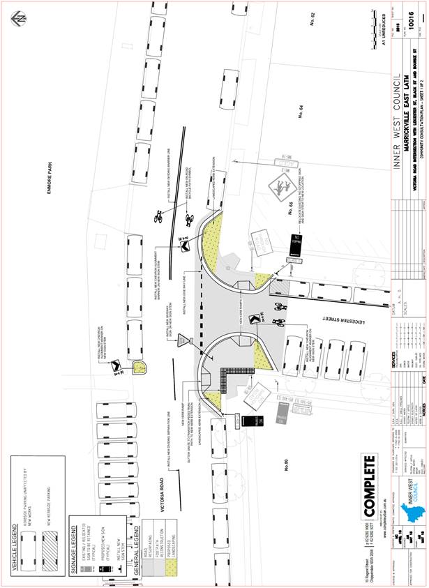 |
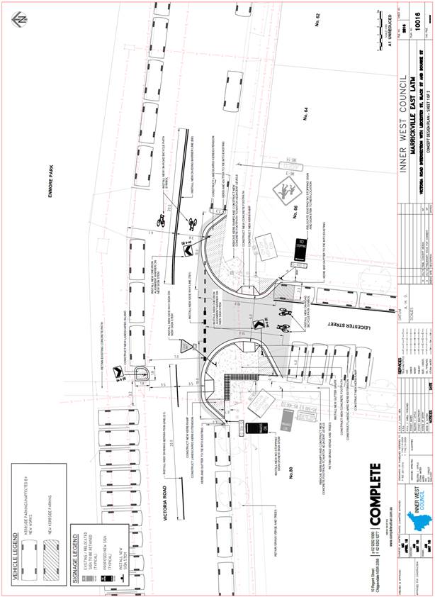 |
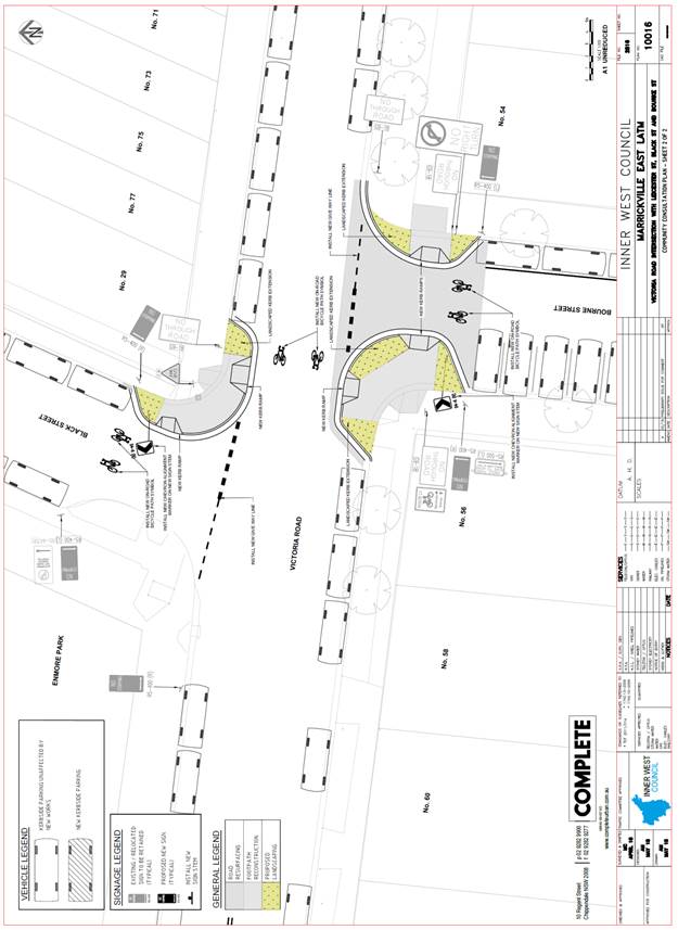
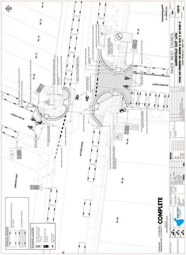
|
|
Local Traffic Committee Meeting 5 June 2018 |
Subject: Intersection of Dudley Street and Waratah Street, Haberfield (Leichhardt Ward / Summer Hill Electorate / Ashfield LAC)
Prepared By: Manod Wickramasinghe - Coordinator – Traffic and Parking Services
|
SUMMARY Council has received concerns regarding vehicles obstructing sight lines and manoeuvring space by parking too close to the intersection of Dudley Street at Waratah Street, Haberfield. |
|
RECOMMENDATION
THAT:
1. A 7.5m ‘No Stopping’ zone be installed on the eastern side of Dudley Street, north of Waratah Street; and
2. A 10m ‘No Stopping’ zone be installed on the northern side of Waratah Street, east of Dudley Street.
|
BACKGROUND
Council has received concerns regarding vehicles obstructing sight lines and manoeuvring space by parking too close to the intersection of Dudley Street at Waratah Street, Haberfield.
‘No Stopping’ zones are currently in place on the western side of Dudley Street, north of Waratah Street and on the northern side of Waratah Street, west of Dudley Street. However, there are currently no restrictions on the eastern side of Dudley Street, north of Waratah Street and on the northern side of Waratah Street, east of Dudley Street
FINANCIAL IMPLICATIONS
Nil.
OTHER STAFF COMMENTS
In order to alleviate this issue, it is proposed to signpost the following restrictions:
· 7.5m ‘No Stopping’ zone on the eastern side of Dudley Street, north of Waratah Street (noting that the existing street tree on the eastern side of Dudley Street prevents parking within 10m of the intersection in combination with this restriction).
· 10m ‘No Stopping’ zone on the northern side of Waratah Street, east of Dudley Street.
The proposal is shown on the following plan.
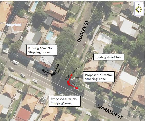
PUBLIC CONSULTATION
|
A letter outlining the above proposal was mailed out to the affected properties (17 properties) in Waratah Street and Dudley Street, Haberfield. No responses were received.
|
|
CONCLUSION
Nil.
|
|
Local Traffic Committee Meeting 5 June 2018 |
Subject: Minor Traffic Facilities (All Wards / All Electorates / All LACs)
Prepared By: Manod Wickramasinghe - Coordinator – Traffic and Parking Services, Idris Hessam - Road Access Engineer and Emilio Andari - Engineer – Traffic and Parking Services
|
SUMMARY This report considers minor traffic facility applications received by Inner West Council, and includes ‘Disabled Parking’ and ‘Works Zone’ requests. |
|
RECOMMENDATION
THAT:
1. The 6m ‘Disabled Parking’ zone in front of property No.2 Lonsdale Street, Lilyfield, be removed as it is no longer required;
2. The 6m ‘Disabled Parking’ zone in front of property No.25A Shaw Street, Petersham, be removed as it is no longer required; and
3. A 20m 'Works Zone 7.00am - 5.30pm Mon-Sat' be installed in front of No.31-33 Lewisham Street, Dulwich Hill for 6 months.
|
BACKGROUND
This report considers minor traffic facility applications received by Inner West Council, and includes ‘Disabled Parking’ and ‘Works Zone’ requests.
FINANCIAL IMPLICATIONS
Nil.
OFFICER COMMENTS
1 Removal of ‘Disabled Parking’ Restriction – Lonsdale Street, Lilyfield
Council has been notified by a neighbour that the applicant to the ‘Disabled Parking’ zone outside of property No.2 Lonsdale Street, Lilyfield has moved and so the ‘Disabled Parking’ zone is no longer required.
Council has contacted the applicant and confirmed that they have moved from the property.
It is recommended that the 6m ‘Disabled Parking’ zone in front of property No.2 Lonsdale Street, Lilyfield be removed as it is no longer required.
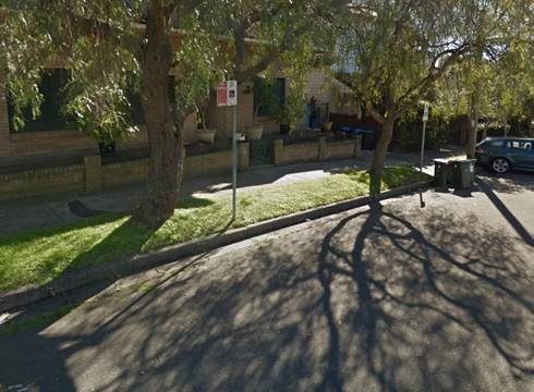
‘Disabled Parking’ zone outside of property No.2 Lonsdale Street, Lilyfield.
2 Removal of ‘Disabled Parking’ Restriction – Shaw Street, Dulwich Hill
Council has been notified by a neighbour that the applicant to the ‘Disabled Parking’ zone outside of property No.25A Shaw Street, Petersham, has moved and so the ‘Disabled Parking’ zone is no longer required.
Council has contacted the applicant and confirmed that they have moved from the property.
It is recommended that the 6m ‘Disabled Parking’ zone in front of property No.25A Shaw Street, Petersham, be removed as it is no longer required.
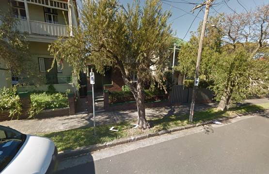
‘Disabled Parking’ zone outside of property No.25A Shaw Street, Petersham.
3 Installation of ‘Works Zone Restriction – Lewisham Street, Dulwich Hill
The applicant has requested the installation of a temporary 20m 'Works Zone 7.00am - 5.30pm Mon-Sat' in front of No.31-33 Lewisham Street, Dulwich Hill for 6 months.
It is recommended that a 20m 'Works Zone 7.00am - 5.30pm Mon-Sat' be installed in front of No.31-33 Lewisham Street, Dulwich Hill for 6 months
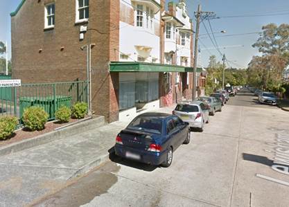
No.31-33 Lewisham Street, Dulwich Hill
PUBLIC CONSULTATION
Nil.
CONCLUSION
Nil.
|
|
Local Traffic Committee Meeting 5 June 2018 |
Subject: Trafalgar Street, Rose Street, Nelson Street and Nelson Lane, Annandale - Resident Parking Scheme (Balmain Ward/Balmain Electorate/Leichhardt LAC)
Prepared By: David Yu - Traffic Engineer
Authorised By: John Stephens - Traffic and Transport Services Manager
|
SUMMARY Council has received correspondence from a number of residents of Trafalgar Street, Rose Street, Nelson Street and Nelson Lane, requesting Area A1 Residential Parking Scheme (RPS) restrictions in their streets to deter commuter/long stay parking.
This report provides the result of the resident parking scheme investigation in Trafalgar Street, Rose Street, Nelson Street and Nelson Lane, Annandale. |
|
RECOMMENDATION
THAT the proposed Resident Parking Scheme in Trafalgar Street, Rose Street, Nelson Street, and Nelson Lane not be supported at the present time due to less than 50% support received from the consulted residents.
|
BACKGROUND
A number of residents from Trafalgar Street, Rose Street, Nelson Street and Nelson Lane, Annandale requested the implementation of a resident parking scheme in their street. Consequently, parking occupancy surveys were undertaken in the above mentioned streets in accordance with Council’s Resident Parking Scheme Policy that indicated high parking occupancy levels (equal to or over 85%) in certain sections of the street.
FINANCIAL IMPLICATIONS
Nil.
OTHER STAFF COMMENTS
A Resident Parking proposal was prepared for the installation of ‘2P 8am-6pm, Mon-Fri, Permit Holders Excepted, Area A1’ restrictions in the sections of street which met the parking occupancy requirements. These sections were:
· Both sides of Trafalgar Street between The Crescent and Rose Street.
· Both sides of Rose Street between Trafalgar Street and Nelson Lane.
· Both sides of Nelson Street between Rose Street and Booth Lane.
· Eastern side of Nelson Lane between Rose Street and Booth Lane (replacing the unrestricted parking only).
As shown on the following map.
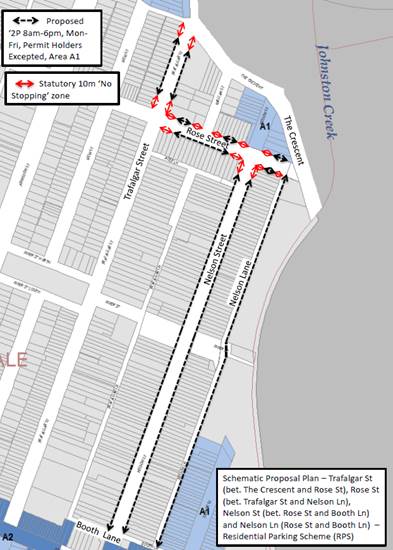
PUBLIC CONSULTATION
A letter outlining the above parking proposal options was mailed out to the affected properties (219 properties) in Trafalgar Street, Rose Street, Nelson Street and Nelson Lane, Annandale as indicated on the attached plan, requesting residents’ views regarding the proposal.
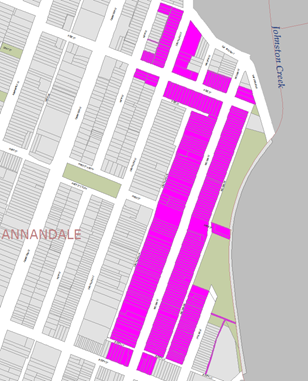
The table below shows some of the comments raised by the residents who did not support the proposal and the officer’s comments.
Comments from residents objecting to the proposal
|
Residents’ Comments |
Officer Comments |
|
The parking is currently an issue due to the builders working on the Harold Park site that are parking in the street. The construction works is almost complete and there is no point in having limited parking now as it will go back to how it used to be, which used to be no problem. |
At this stage, it is proposed that the Resident Parking Scheme in Trafalgar Street, Rose Street, Nelson Street and Nelson Lane, Annandale not be supported at the present time due to less than 50% support received from the consulted residents. |
|
We already went through this exercise before and it was rejected. By making it 2 hour parking it will only push the issue to other areas and will not fix the issue. |
|
|
The proposed parking scheme would severely restrict the ability of friends and relatives to visit us during the day as they would generally wish to stay for more than two hours. As we are elderly and virtually housebound that could leave us socially isolated. In addition we are dependent on support from various agencies for domestic help as well as health and medical support; it would be very difficult if parking restrictions were imposed. While Nelson Street can get busy, visitors have always been able to find parking within a reasonable distance of our house and so we do not accept that there is a problem in the first place. |
|
|
Please consider adding Johnston Street to this survey. |
Johnston Street, Annandale is a classified State Road and is therefore under the jurisdiction of the Roads and Maritime Service (RMS). RMS has previously indicated that they do not support Resident Parking Schemes on State Roads. |
|
We believe that the section of Rose Street between Trafalgar St and View Street and William Street that runs off Rose Street would also need to be included in this scheme. |
Parking occupancy surveys identified that the subject street had less than 85% parking occupancy and hence a proposal was not developed. |
|
Suggest residents restrict their own cars, trailers and boats to their garages and not the street. People use the street because their garages are used for alternative storage. |
Should a RPS have been implemented, permits would not be issued to boats/trailers and resident permits issued would reduce by the number of off-street parking spaces available, regardless of use. |
|
While I support the initiative for the eastern side of Nelson lane, I have concerns that this will result in more illegal parking on the western side of Nelson lane obscuring access to people's driveways/garages. |
Council’s Parking and Ranger Services team can enforce illegal parking such as that described. |
|
Whilst the proposed restrictions are welcome I believe them to be inadequate due to the high incidence of parking spaces being occupied by employees and customers of the nearby 'Tramsheds' which operates 7 days per week between 7:00AM and 10:00PM. |
At this stage, it is proposed that the Resident Parking Scheme in Trafalgar Street, Rose Street, Nelson Street and Nelson Lane, Annandale not be supported at the present time due to less than 50% support received from the consulted residents. Future investigations for a Resident Parking Scheme (RPS) will only be considered after the main construction works around the area are fully completed. Future investigations could consider a scheme with extended time and day restrictions. |
|
It is entirely unclear what the eligibility criteria are for a visitors permit |
Currently, one Visitor parking permit per eligible property is issued, as part of an approved Resident Parking Scheme (RPS).
|
|
If more spaces are needed, consider changing one side of Nelson St to 45 degree angle parking. |
If angled parking is feasible, an additional investigation and a separate item will be prepared as part of a future Local Traffic Committee Agenda. |
|
Pressure on parking spaces is most apparent late evenings; this indicates it is residents themselves, many of whom own multiple cars, who are responsible for the issues. The proposal would not address this issue at all. |
Noted. A Resident Parking Scheme (RPS) is unlikely to provide significant improves for a street that is having parking issues due to a high demand of on-street parking spaces by residents of that subject street. |
|
There will be a considerable loss of available safe parking spots with the 10m "No Stopping" zones. Yes, sometimes it is hard to find a spot but never impossible. |
10m ‘No Stopping’ zones must be installed at all intersections (as per NSW Road Rules) with the installation of the proposed 2P restrictions. The ‘No Stopping’ zones provide improved safety for pedestrians and drivers. It should be noted that ‘No Stopping’ zones are enforceable even without signage. |
Consultation survey results are summarised as follows:
Trafalgar Street, Annandale
Number of properties - 23
Number of properties responded - 13
Number of properties supported - 8
Overall Response Rate - 57%
Overall Support Rate - 35%
Rose Street, Annandale
Number of properties - 36
Number of properties responded - 24
Number of properties supported - 13
Overall Response Rate - 67%
Overall Support Rate - 36%
Nelson Street, Annandale
Number of properties - 160
Number of properties responded - 93
Number of properties supported - 41
Overall Response Rate - 58%
Overall Support Rate - 26%
Nelson Lane, Annandale
Number of properties - 89
Number of properties responded - 47
Number of properties supported - 24
Overall Response Rate - 53%
Overall Support Rate - 27%
Overall Support
Number of properties - 219
Number of properties responded - 130
Number of properties supported - 62
Overall Response Rate - 59%
Overall Support Rate - 28%
According to Council’s Resident Parking Policy, a minimum of 50% support based on all properties in the subject section of the street is required to consider the proposal favourably.
Based on the above results and the comments provided as part of the consultation process, less than 50% of the residents of Trafalgar Street, Rose Street, Nelson Street, and Nelson Lane, Annandale support a resident parking scheme in their street.
CONCLUSION
Based on the above results, the proposed Resident Parking Scheme in Trafalgar Street, Rose Street, Nelson Street and Nelson Lane not be supported at the present time due to less than 50% support received from the consulted residents.
|
|
Local Traffic Committee Meeting 5 June 2018 |
Subject: Philpott Street, Marrickville – Proposed Statutory No Stopping Restrictions (Marrickville Ward/Newtown Electorate/Inner West LAC)
Prepared By: Emilio Andari - Engineer – Traffic and Parking Services
Authorised By: John Stephens - Traffic and Transport Services Manager
|
SUMMARY A request has been received from a local resident for the provision of ‘No Stopping’ restrictions to deter illegal parking on the western side of Philpott Street, Marrickville, at its intersection with Gordon Street. The resident has advised that vehicles are regularly parked too close to the intersection, restricting sightlines for motorists turning into Philpott Street.
It is recommended that statutory 'No Stopping' restrictions be installed on the western side of Philpott Street, both north and south from its intersection with Gordon Street for a distance of 10 metres in order to deter illegal parking, increase safety and improve visibility and access for turning motorists. |
|
RECOMMENDATION
THAT:
1. The installation of a statutory ‘No Stopping’ restrictions on the western side of Philpott Street, Marrickville, for a distance of 10 metres, both north and south from its intersection with Gordon Street (adjacent to property no. 11-23 Gordon Street & property no. 2 Gordon Street) be APPROVED, in order to deter illegal parking, increase safety and improve motorist visibility and access for turning motorists; and
2. The applicant, affected residents and Council Rangers be advised in terms of this report.
|
BACKGROUND
Council has received a request from a local resident for the provision of ‘No Stopping’ restrictions to deter illegal parking on the western side of Philpott Street, Marrickville, at its intersection with Gordon Street. Residents have advised that vehicles are parked too close to the intersection, restricting available sightlines and access for turning motorists.
FINANCIAL IMPLICATIONS
The cost of the supply and installation of the signposting associated with the recommended ‘No Stopping’ restrictions are approximately $700 and can be met from Council’s operating budget.
OFFICER COMMENTS
Site location & road network
|
Street Name |
Philpott Street |
|
Section |
Between Cowper Street and Addison Road |
|
Carriageway Width (m) |
6.4 |
|
Carriageway Type |
Two-way road with one travel lane in each direction, in addition to kerbside parking lanes. |
|
Classification |
Local |
|
85th Percentile Speed (km/h) |
26.6 |
|
Vehicles Per Day (vpd) |
655 |
|
Reported Crash History (July 2011 – June 2016) |
No crashes recorded. |
|
Heavy Vehicle Volume (%) |
4.0 |
|
Parking Arrangements |
Unrestricted parking on both sides of the road. |
Site inspection
Council Officers have observed during site inspections undertaken in the morning and afternoon periods that the on-street parking spaces along Philpott Street were moderately utilised. At present, unrestricted parking is located predominantly on both sides of Philpott Street. A section of ‘No Parking’ restrictions apply on the western side of Philpott Street between Gordon Street and Addison Road.
Technical Issues
In accordance with the Australian Road Rules, a ‘No Stopping’ zone is mandatory for a distance of 10 metres from an intersecting road. Pursuant to the RMS’ Technical Directions, it is stated that signposting at an unsignalised intersection (without pedestrian crossing) “should only be required where there is a compliance problem or there is adjoining signposting”. In this case, it is shown to be a compliance and safety problem for motorists attempting to turn.
Locality Map – Philpott Street, Marrickville
![]()
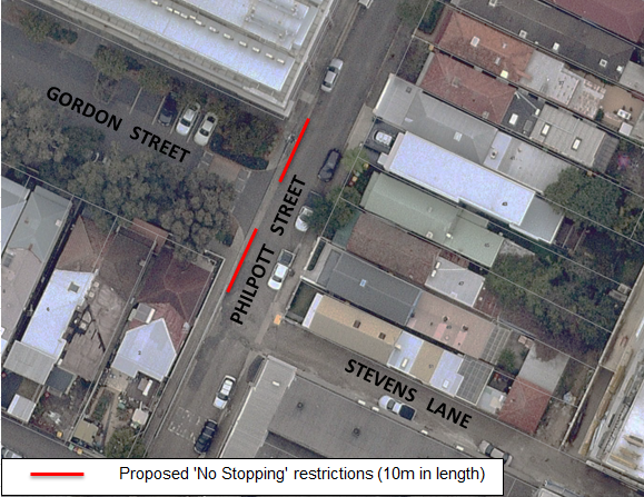
Photographs – Philpott Street, Marrickville
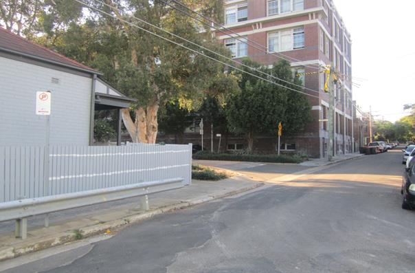
Intersection at Gordon Street (facing north-west)
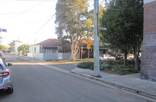
Intersection at Gordon Street (facing south-west)
PUBLIC CONSULTATION
A notification letter was sent on 9 May 2018 to owners and occupiers of the surrounding properties that are adjacent to the subject section in Philpott Street, Marrickville, at the intersection with Gordon Street regarding proposed statutory ‘No Stopping’ restrictions to address concerns regarding vehicles parked too close to the intersection, restricting available sightlines and access for turning motorists. The closing date for comments ended on 25 May 2018.
A total of one hundred and eighty-five (185) letters were sent out to the affected properties. There were a total of two (2) responses supporting the proposed ‘No Stopping’ restrictions and are detailed below. Comments received following completion of this report will be tabled at the committee meeting.
|
Residents’ Comments (supporting the proposal) |
Officer’s Response |
|
A resident of Philpott Street strongly supports the proposal. The resident also stated that the proposal will also improve vehicular access into their driveway. |
Received and noted.
|
|
A resident of Gordon Street are in support of the proposal as this will reduce congestion and improve sight lines for turning motorists at this particular intersection. |
Received and noted.
|
CONCLUSION
In order to deter illegal parking, increase safety and improve visibility and access for turning motorists at the intersection of Philpott Street at Gordon Street, it is recommended that the statutory 'No Stopping' restrictions be installed, for a distance of 10 metres on the western side of Philpott Street, both north and south from its intersection with Gordon Street.
|
|
Local Traffic Committee Meeting 5 June 2018 |
Subject: Samuel Lane, Tempe – Proposed Statutory No Stopping & No Parking Restrictions (Marrickville Ward/Heffron Electorate/Inner West LAC)
Prepared By: Emilio Andari - Engineer – Traffic and Parking Services
Authorised By: John Stephens - Traffic and Transport Services Manager
|
SUMMARY A request has been received from a local resident for the provision of ‘No Parking’ restrictions in Samuel Lane, Tempe, to address concerns regarding vehicles obstructing access to and from residential garages and to allow access through the laneway for vehicles.
It is recommended that statutory 'No Stopping' restrictions be installed on both sides of Samuel Lane, at its intersection with Samuel Street and its intersection with Lymerston Street, and that ‘No Parking’ restrictions be installed along both sides of Samuel Lane, between Samuel Street and Lymerston Street, in order to provide unobstructed vehicular access to the off-street car parking spaces, and to allow access through the laneway for vehicles and increase safety. |
|
RECOMMENDATION
THAT:
1. The installation of a statutory ‘No Stopping’ restrictions (10 metres in length) on both sides of Samuel Lane, Tempe, at its intersection with Samuel Street and its intersection with Lymerston Street, be APPROVED, in order to provide unobstructed vehicular access into the laneway, as well as to allow access through the laneway for vehicles and improve safety;
2. The installation of a ‘No Parking’ restrictions (55 metres in length) along both sides of Samuel Lane, Tempe, between Samuel Street and Lymerston Street, be APPROVED, in order to provide unobstructed vehicular access to the off-street car parking spaces, as well as to allow access through the laneway for vehicles and increase safety; and
3. The applicant, affected residents and Council Rangers be advised in terms of this report.
|
BACKGROUND
Council has received a request from a local resident for the provision of ‘No Parking’ restrictions in Samuel Lane, Tempe, to address concerns regarding vehicles obstructing access to and from residential garages. The resident have advised that vehicles are known to be parked in the laneway which obstructs access through the laneway for other vehicles.
FINANCIAL IMPLICATIONS
The cost of the supply and installation of the signposting associated with the recommended ‘No Stopping’ & ‘No Parking’ restrictions are approximately $1,200 and can be met from Council’s operating budget.
OFFICER COMMENTS
Site location & road network
|
Street Name |
Samuel Lane |
|
Section |
Between Samuel Street and Lymerston Street |
|
Carriageway Width (m) |
3.8-4.1 |
|
Carriageway Type |
Two-way road with one travel lane. |
|
Classification |
Local |
|
85th Percentile Speed (km/h) |
– |
|
Vehicles Per Day (vpd) |
– |
|
Reported Crash History (July 2011 – June 2016) |
No crashes recorded. |
|
Heavy Vehicle Volume (%) |
– |
|
Parking Arrangements |
Unrestricted parking on both sides of the road. |
Site inspection
Samuel Lane is a laneway which connects Samuel Street and Lymerston Street. The length of this laneway is approximately 75 metres and provides rear access to the properties fronting Unwins Bridge Road and side boundary access to a property fronting Lymerston Street and property fronting Samuel Street.
A site inspection undertaken by a Council officer revealed there are five (5) vehicular crossings located along the western side of Samuel Lane and there are three (3) vehicular crossings located along the eastern side of Samuel Lane.
It should be noted that laneways were generally built to provide service access for commercial/residential properties and access into their off-street parking facilities.
Technical Issues
In accordance with the Australian Road Rules, a ‘No Stopping’ zone is mandatory for a distance of 10 metres from an intersecting road. Pursuant to the RMS’ Technical Directions, it is stated that signposting at an unsignalised intersection (without pedestrian crossing) “should only be required where there is a compliance problem or there is adjoining signposting”. In this case, in the event of proposing ‘No Parking’ restrictions along both sides of Samuel Street, it is recommended to include a proposal for the statutory ‘No Stopping’ restrictions at the intersections.
Locality Map – Samuel Lane, Tempe
![]()
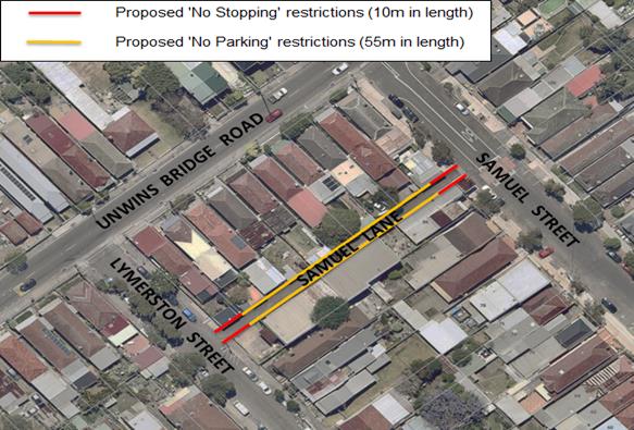
Photographs – Samuel Lane, Tempe
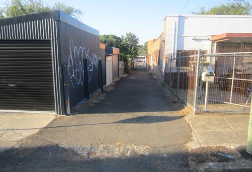
Intersection at Lymerston Street (facing north)
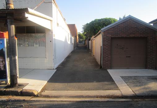
Intersection at Samuel Street (facing south)
PUBLIC CONSULTATION
A notification letter was sent on 9 May 2018 to owners and occupiers of the surrounding properties that are adjacent to Samuel Lane, Tempe, regarding proposed statutory ‘No Stopping’ restrictions and ‘No Parking’ restrictions to address concerns regarding vehicles obstructing access to and from residential garages and to allow access through the laneway for vehicles. The closing date for comments ended on 25 May 2018.
A total of fifteen (15) letters were sent out to the affected properties. There was a total of one (1) response supporting the proposed ‘No Stopping’ restrictions and ‘No Parking’ restrictions and is detailed below. Comments received following completion of this report will be tabled at the committee meeting.
|
Residents’ Comments (supporting the proposal) |
Officer’s Response |
|
A resident of Unwins Bridge Road strongly supports the proposal. The resident also stated their concerns regarding vehicles obstructing access to and from their garage. |
Received and noted.
|
CONCLUSION
In order to to provide unobstructed vehicular access to the off-street car parking spaces, and to allow access through the laneway for vehicles and increase safety, it is recommended that the statutory 'No Stopping' restrictions be installed, for a distance of 10 metres on both sides of Samuel Lane, at its intersection with Samuel Street and its intersection with Lymerston Street, and that ‘No Parking’ restrictions be installed along both sides of Samuel Lane, between Samuel Street and Lymerston Street.
|
|
Local Traffic Committee Meeting 5 June 2018 |
Subject: Short Street, St Peters – Proposal to Extend Resident Permit Parking Restrictions – M12
Prepared By: Jennifer Adams - Engineer – Traffic and Parking Services
Authorised By: John Stephens - Traffic and Transport Services Manager
|
SUMMARY Council received representations from a number of residents living in the St Peters area raising concerns regarding increased parking demands generated in Applebee Street and Short Street from parking associated with local businesses, new developments and external works (WestConnex and Metro Rail) and requested an extension to the existing residential permit parking scheme in place in Applebee Street and Lackey Street into Short Street, St Peters (M12)
This report provides the results of a localised ‘Resident parking scheme survey’ relating to the extension of the M12 residential permit parking scheme into Short Street, St Peters. There was a low return rate for the survey however, due to many localised issues, it is recommended that the proposed M12 extension be supported,
|
|
RECOMMENDATION
THAT:
1. The proposed extension of the M12 Residential Permit Parking Scheme of ‘2P 8.30am-6.00pm Mon-Fri Permit Holders Excepted Area M12’ restrictions on the southern side of Short Street, St Peters Approved; and
2. That the responding residents be informed of Council’s decision in this matter.
|
BACKGROUND
Council received representations from a number of residents living in the St Peters area raising concerns regarding increased parking demands generated in Applebee Street and Short Street from parking associated with local businesses, new developments and external works (WestConnex and Metro Rail) and requested an extension to the existing residential permit parking scheme in place in Applebee Street and Lackey Street into Short Street, St Peters (M12).
Typically Council introduce Residential Parking Permit schemes outside of residential properties to minimise impacts to other properties in the street which also generate a need for parking (ie. commuter, industrial, commercial, parks, churches etc). It is noted that Applebee Street and Lackey Streets already have ‘2P 8.30 – 6pm Mon–Fri - permit holders excepted – Area M12’ parking restrictions currently in place. These restrictions have been successful in deterring employee and commuter parking since their introduction. Similarly, workers from both WestConnex and Metro Rail would not be able to park in these streets over extended periods.
It should be noted that external works operating in the St Peters area both WestConnex and Metro Rail have strict construction traffic management conditions whilst their works are being carried out in the St Peters area. As part of the Conditions of Approval for WestConnex a parking and access strategy was required and this outlined the impacts on parking and provided strategies to mitigate that impact, including the use of a shuttle bus service and to contain the parking on-site.
Council undertook an investigation and consultation of the possibility of introducing limited permit parking in Short Street, St Peters and the results of that consultation are presented in this report for the Committee to consider.
FINANCIAL IMPLICATIONS
The cost of the supply and installation of the signposting, approximately $500, is to be funded from Council’s signs and line marking budget.
OFFICER COMMENTS
Short Street is a local road that links Applebee Street and The Princes Highway. Short Street carries around 250 vehicles per day and has ‘No Parking’ restrictions along its northern side and unrestricted parking along its southern side. Kerb to kerb it measures 5.2 metres in width. Statutory 10 metre ‘No Stopping’ restrictions are in place.
Observations have indicated a relatively high utilisation of the available on-street car parking spaces in Short Street and Applebee Street, St Peters.


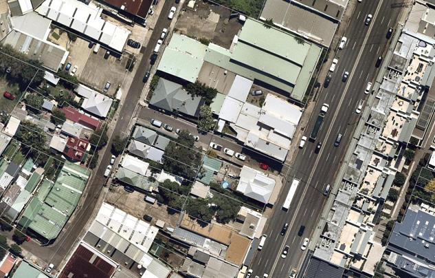
The proposal
The proposal outlined in the survey was to convert a section of ‘unrestricted’ parking in Short Street, between Applebee Street and Princes Highway, St Peters to ‘2P Permit Holders Excepted’ parking (‘2P 8.30am-6pm, Monday to Friday, Permit Holders Excepted (Area M12)). The proposal is illustrated on the map below.
![]()
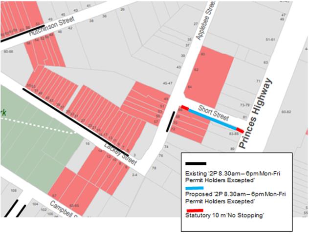
Council Policy/Guidelines
Council's adopted Policy for the introduction of a Permit Parking Area states "that before implementing a resident parking scheme in any area, a survey of residents be undertaken to ascertain the level of support for such a scheme and that such support should be in excess of 65% of submissions received provided that rate of return of submissions is reasonable (higher than 30%)".
CONSULTATION
A total of 25 survey questionnaire forms (with return envelopes) were distributed to owners and residents of all residential and commercial properties within the subject survey area surrounding Short Street, St Peters on 7 May 2018. At the end of the survey period (2 weeks), a total of 6 responses were received, four from within the survey area and two from outside the survey area representing an overall response rate of 24% (16% return from the actual surveyed area).
The level of overall response is lower than Council’s adopted Policy and would typically be considered insufficient, however considering that there are not enough on-street car parking spaces in comparison to the number of properties in Applebee Street and this being compounded with these properties located in an industrial / commercial area with many competing demands for the limited parking supply it is considered that providing some additional 2P 8.30am-6.00pm Mon-Fri Permit Holders Excepted Area M12’ restrictions would assist residents now and into the future, especially the precinct being subject to future development.
It is noted that one response from the survey area was against the proposed extension of the existing M12 Residential permit parking scheme into Short Street and three responses from the survey area were for the proposal. The other two responses from outside the survey area were in support of the proposal. The table below shows some of the comments raised by the residents.
|
Resident’s comments |
Officer’s comments |
|
Do not believe it to be necessary |
Noted |
|
Parking in the area is extremely problematic, primarily due to business activity and the terrace style housing which means few properties have off-street parking |
It is noted that many of the residences in the locality do not have off-street parking facilities and rely on-street parking |
|
The two hour zone should be extended the whole length of Applebee Street |
Residential permit parking restrictions are generally located outside residential properties not commercial / other uses. |
|
Businesses are currently choosing to park their vehicles over the evenings and weekends on the street rather than use their own premises |
Acceptable as long as the vehicles are registered and parked legally. |
|
The increase in building activity from development and WestConnex attracts workers to park on Applebee Street as one of the few untimed spaces |
WestConnex have strict construction traffic management conditions whilst their works are being carried out in the St Peters area. |
|
I have experienced significant parking issues at all times of the day / night and all 7 days. The reason being WestConnex workers park in the area, businesses in area leave their vehicles parked on the street over weekend and overnight rather than in their off street parking areas. My request is that existing fixed time parking in the area be extended to 10pm as a matter of urgency. In addition fixed term parking be put in place in Short Street |
WestConnex have strict construction traffic management conditions whilst their works are being carried out in the St Peters area. M12 resident permit parking restrictions are consistently applied and the recommended new restrictions are in accord. |
|
Request Short Street become a timed zone until 10pm 7 days a week … I suggest that Lackey and Hutchinson Streets should also be extended to 10pm 7 days. |
M12 resident permit parking restrictions are consistently applied and the recommended new restrictions are in accord. |
|
All parking spaces in Short Street, St Peters should be included in the scheme as there are currently far fewer spaces available than residents without alternative parking |
Noted |
|
Support proposal as increasingly, there is no free parking available to local residents due to .. increased use by local businesses, particularly staff who park all day |
Noted |
CONCLUSION
The proposal to extend the current M12 Residential Permit Parking scheme into Short Street, St Peters is supported and will protect residential amenity. The extension will also offset the impact of any planned multi-unit residential developments in the locality.
It is recommended that the proposed extension of the M12 Residential Permit Parking Scheme of ‘2P 8.30am-6.00pm Mon-Fri Permit Holders Excepted Area M12’ restrictions on the southern side of Short Street, St Peters be approved as shown in the diagram below.
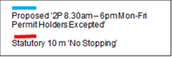
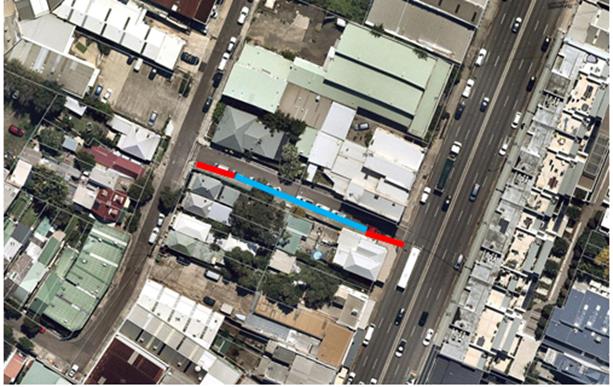
|
|
Local Traffic Committee Meeting 5 June 2018 |
Subject: Addison Road, Marrickville – Removal Of Redundant Timed No Parking Restrictions & Proposal For Short Term Parking Restrictions (Marrickville Ward/Newtown Electorate/Inner West LAC)
Prepared By: Emilio Andari - Engineer – Traffic and Parking Services
Authorised By: John Stephens - Traffic and Transport Services Manager
|
SUMMARY A request has been received from the owner of a small business on Addison Road, Marrickville, for the provision of short term parking restrictions outside their property to provide parking opportunities for visitors to the local businesses.
It is recommended to remove the existing ‘No Parking 7am-9am 4pm-6pm Mon-Fri’ restrictions on the northern side of Addison Road, Marrickville, between Philpott Street and Fotheringham Lane and convert these parking spaces to ‘1P 8.30am-6pm Mon-Fri, 8.30am-12.30pm Sat’ restrictions, in order to provide parking opportunities for visitors to the local businesses and in line with other parking restrictions along Addison Road, Marrickville adjacent to businesses. |
|
RECOMMENDATION
THAT:
1. The existing ‘No Parking 7am-9am 4pm-6pm Mon-Fri’ restrictions on the northern side Addison Road, Marrickville, between Philpott Street and Fotheringham Lane, be REMOVED, as the subject section of timed ‘No Parking’ restrictions are redundant; 2. The installation of ‘1P 8.30am-6pm Mon-Fri, 8.30am-12.30pm Sat’ restrictions on the northern side Addison Road, Marrickville, between Philpott Street and Fotheringham Lane, be APPROVED, in order to provide parking opportunities for visitors to the area and in line with other parking restrictions along Addison Road, Marrickville, adjacent to businesses; and 3. The applicant, affected properties and Council Rangers be advised in terms of this report.
|
BACKGROUND
Council has received a request from the owner of a small business on Addison Road, Marrickville, for the provision of short term parking restrictions outside their property. Given the recent development along Addison Road, additional commercial tenancies are occupied and therefore the proposed short term parking restrictions will benefit these businesses.
FINANCIAL IMPLICATIONS
The cost of the supply and installation of the signposting associated with the recommended ‘1P 8.30am-6pm Mon-Fri, 8.30am-12.30pm Sat’ restrictions are approximately $1,200 and can be met from Council’s operating budget.
OFFICER COMMENTS
Site location & road network
|
Street Name |
Addison Road |
|
Section |
Between Philpott Street and Fotheringham Lane |
|
Carriageway Width (m) |
10.8 |
|
Carriageway Type |
Two-way road with one travel lane in each direction, in addition to kerbside parking lanes. |
|
Classification |
Regional |
|
85th Percentile Speed (km/h) |
48.2 |
|
Vehicles Per Day (vpd) |
12,609 |
|
Reported Crash History (July 2011 – June 2016) |
No crashes recorded. |
|
Heavy Vehicle Volume (%) |
5.3 |
|
Parking Arrangements |
‘No Parking 7am-9am 4pm-6pm Mon-Fri’ restrictions along the northern side of the road and ‘No Parking 4pm-6pm Mon-Fri’ restrictions along the southern side of the road. |
Site inspection
Addison Road is a road which connects Livingstone Road and Enmore Road. The subject location is the eastern end of the street. It was noted that the intersection at Addison Road and Enmore Road is signalised. This intersection includes a designated left-turn slip lane for motorists traveling along Addison Road into Enmore Road. It should also be noted that there are parking restrictions along the northern side of Addison Road from Fotheringham Lane to Enmore Road which consist of the following;
· ‘No Stopping 7am-9am 4pm-6pm Mon-Fri’ restrictions;
· A section of ‘Loading Zone 9am-4pm Mon-Fri’ restrictions; and
· A short section of ‘Mail Zone’ restrictions.
The total length of the above restrictions along Addison Road is approximately 70 metres in length.
Several site inspections were undertaken by a Council officer during the morning and afternoon weekday peak periods. It was observed that the queuing of vehicles on the approach to the set of traffic signals on Addison Road (eastbound) at Enmore Road was satisfactory. That is, it was noted that queuing lengths did not appear greater than 50 metres (6 – 8 vehicles) at any given time.
Therefore, the existing parking restrictions on Addison Road, between Fotheringham Lane and Enmore Road, are sufficiently long enough to manage the signalised intersection. Therefore, the proposal to convert the existing ‘No Parking 7am-9am 4pm-6pm Mon-Fri’ restrictions on Addison Road, between Philpott Street and Fotheringham Lane, to ‘1P 8.30am-6pm Mon-Fri, 8.30am-12.30pm Sat’ restrictions would appear to be feasible.
Locality Map – Addison Road, Marrickville
![]()
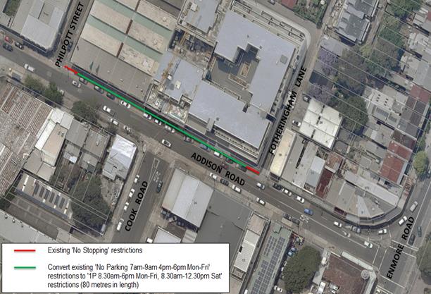
Photographs – Addison Road, Marrickville
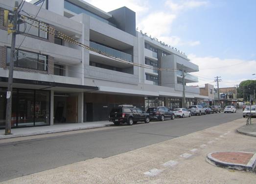
Parking along the northern side of the street (facing north-east)
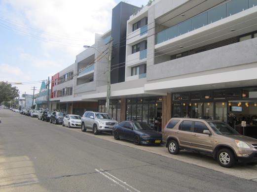
Parking along the northern side of the street (facing north-west)
PUBLIC CONSULTATION
A notification letter was sent on 14 May 2018 to owners and occupiers of the surrounding properties that are adjacent to Addison Road, Marrickville, between Philpott Street and Fotheringham Lane, regarding the proposal to introduce short term parking restrictions during business hours and remove the existing ‘No Parking’ restrictions during morning and afternoon weekday periods. The closing date for comments ended on 1 June 2018.
A total of eighteen (18) letters were sent out to the affected properties. There were no responses received to date. Comments received following completion of this report will be tabled at the committee meeting.
CONCLUSION
In order to provide parking opportunities for visitors to the area and in line with other parking restrictions along Addison Road, Marrickville, adjacent to businesses, it is recommended that the existing ‘No Parking 7am-9am 4pm-6pm Mon-Fri’ restrictions on the northern side Addison Road, Marrickville, between Philpott Street and Fotheringham Lane, be converted to ‘1P 8.30am-6pm Mon-Fri, 8.30am-12.30pm Sat’ restrictions.
|
|
Local Traffic Committee Meeting 5 June 2018 |
Subject: Elizabeth Street, between Bastable Street and Railway Street, Croydon-Amendment to parking restrictions. (Leichhardt Ward/Strathfield Electorate/Ashfield LAC)
Prepared By: Boris Muha - Engineer – Traffic and Parking Services
Authorised By: John Stephens - Traffic and Transport Services Manager
|
SUMMARY Council at its meeting held on the 27 February 2018 adopted the following recommendation to change the parking restrictions on the southern side of Elizabeth Street, between Bastable Street and Railway Street, Croydon, as follows:
THAT
1. The current ‘No Stopping, 3.30pm-6pm Mon-Fri’ restrictions on the southern side of Elizabeth Street between Bastable Street and Railway Street be removed;
2. Extend the existing full-time ‘No Stopping’ restrictions on the southern side of Elizabeth Street, across the driveway of No. 198 Elizabeth Street by approx. 9m (commencing 36m and west of Bastable Street); and
3. Install new ‘2P 9am- 3pm Mon-Fri’ restrictions for a distance of 23 m commencing 12 m west of Bastable Street. The changes were proposed following concerns from residents/shopkeepers about a lack of short term parking for customers on Elizabeth Street between Edwin Street North and Bastable Street, Croydon. Queries have also been received with regard to the ongoing need for the PM peak “No Stopping” restrictions on the southern side of Elizabeth Street.
Signposting as implemented, and as currently stands, is not in compliance to the adopted parking restrictions above. ‘2P 8.00am-6.00pm Mon-Fri’ has been installed on the southern side of Elizabeth Street between 12 metres and 45 metres west of Bastable Street. A review of the current sign posting in view of traffic safety and the need for short term parking to cater for customers to businesses has prompted the need to amend the parking restrictions as recommended below.
|
|
RECOMMENDATION
THAT:
1. That the existing full-time ‘No Stopping’ restrictions on southern side of Elizabeth Street from Railway Street, be extended across the driveway of No. 198 Elizabeth Street by approx. 9m (commencing 36 m west of Bastable Street); and
2. ‘2P 8.00am-6.00pm Mon-Fri’ be retained (in amendment) on the southern side of Elizabeth Street, between 12 m and 36 metres west of Bastable Street.
|
BACKGROUND
The area of concern is on southern side of Elizabeth Street between Bastable Street and Railway Street, Croydon. There are both business and residential properties in this area including; a books& records shop, a coffee shop and a conveyancer are all located on the eastern side of Railway Street as well as a furniture maker and a printing business located on Elizabeth Street western of Railway Street. As Croydon train station is located nearby the parking spaces at this location are often occupied by commuters during the day, thereby making it harder for visitors to the businesses or residents to access these spaces.
The previous signposting & proposed (adopted) parking restrictions in Elizabeth Street are presented in the attached diagram (Fig 1 and 2).
Concern was raised as to the reason to remove the PM peak ‘No Stopping’ restriction (i.e. from 3.00pm-6.00pm) located on the southern side of Elizabeth Street, between Bastable Street and Railway Street with unrestricted parking available at other times. The PM peak ‘No Stopping’ restrictions are old considered no longer required. PM peak ‘No Stopping’ restrictions used to continue on the southern side, from Bastable Street all the way to Edwin Street North.
The PM peak ‘No Stopping’ restrictions were gradually removed from Railway Street to Edwin Street North, given that traffic only flows in a single lane (at all times) in the westerly direction towards Edwin Street North. Favourable consideration was given to freeing up and providing short term parking in benefit to businesses in the area. The removal of the remaining PM peak ‘No Stopping’ between Bastable Street and Railway Street offered to further free up parking in benefit to businesses and residents.
FINANCIAL IMPLICATIONS
The cost of amending the signposting is approximatively $300-400 and can be met from Councils signs & the line marking budget.
OTHER STAFF COMMENTS
Signposting on the southern side of Elizabeth Street, from Bastable Street to outside No. 198 Elizabeth Street was changed back in April 2018, but not in accordance to approved restrictions. Any means to rectify the problem was hindered by the businesses wishing to retain the current restrictions in place (Figure 3). It is claimed that the current arrangement has since improved business activity in the area.
In saying this, it was considered best to monitor the effect of the current signposting arrangement in relation to traffic movement in the area. Particular attention was made to a small parking area allocated to the west side of the driveway No. 198 Elizabeth Street.
Both Elizabeth Street and Croydon Road are local (collector) roads carrying traffic volumes around 4800 vehicles per day in Elizabeth Street and around 7000-9500 vehicles per day in Croydon Road at the intersection location. Both roads are approximately 10.1 metres wide measured kerb to kerb. They are used as a by-pass for traffic avoiding the M4, Liverpool Road and Parramatta Road.
Council officers carried out further observation on site, morning and afternoon, during and after the school holidays to gauge traffic movement in the area with the current parking restrictions in place.
From these observations it was revealed that:
· Traffic westbound was seen to steadily move through Elizabeth Street and turning right at Croydon Road with no real delay or bank up.
· The allocated parking space to west side of the driveway No. 198 Elizabeth Street is considered relatively small with vehicles observed either to park over and obstruct the driveway, or parking forward into the No Stopping zone.
· The allocated parking space to the west side of the driveway No.198 Elizabeth Street prevents large vehicles, particularly buses, to veer left and wide on approach to properly and safely turn right into Croydon Road. This may well be further exacerbated with the likely increase in bus activity once the Ashfield Pool is re-opened and re-developed in due course. Vehicles are also forced close to the centreline turning right in Croydon Road, bearing likely conflict with vehicles turning right or left out from Croydon Road.
Based on the above observations, it could be said in order to overcome point 2, that a nominal length parking spot be marked forward of the No Stopping zone. However point 3 raises main concern, and to further attribute to allocating a proper parking spot in this location, may well contribute to traffic manoeuvring problems at the intersection. It is considered that this small area not be assigned for parking and that the existing No Stopping from Railway Street be extended over the driveway.
On the general basis of enhancing short term parking for customers, it could be considered that the 2P zone area between Bastable Street and the driveway to No. 198 Elizabeth Street, be retained as ‘2P 8.00am-6.00pm Mon-Fri’ in amendment to what was initially agreed to i.e. to assign the area as ‘2P 9.00am-3.00pm Mon-Fri’. Anyone can park longer periods of time after 4.00pm through to 10.00am the following day.
See figure 4 for proposed amendment to restrictions and Figure 5 identifying the small car space area in question west of the driveway 198 Elizabeth Street.
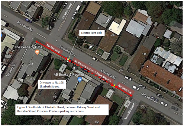
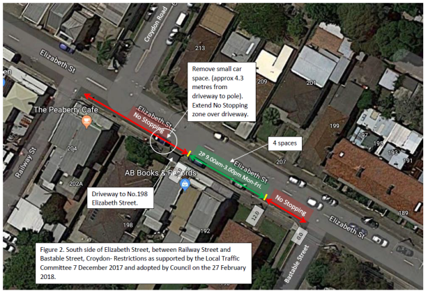
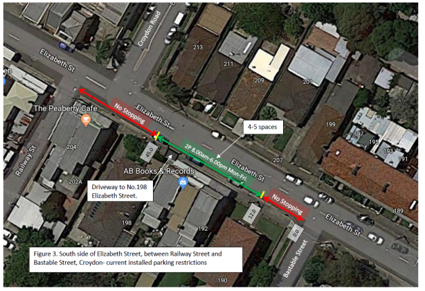
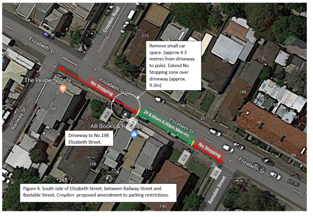
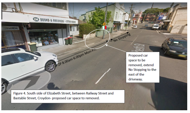
PUBLIC CONSULTATION
Council officers had discussed the matter with the owners of the book store No. 196 and café No 202 Elizabeth Street. The businesses were of the view that the current signposting arrangement (Figure 3) are satisfactory and that business in the area has improved. The café owner opposes to the removal of the small car space in question.
The resident owner of 198 was also consulted, and raised concern to vehicles parking near or over the driveway. The owner agreed that the vehicles be kept clear at least ½ metre from the driveway.
Officer response:
To further attribute to allocating a proper parking spot in this location, may well contribute to traffic manoeuvring problems at the intersection. Consideration could be made to retain the current 2P parking restrictions between Bastable Street and the driveway. The increased time limit serves added benefit to customers over that of the 2P times as approved initially (figure 2). This would be considered in compensation over the proposed removal of the small parking space west of the driveway.
The removal of the small parking space west of the driveway will greatly improve access to No. 198 Elizabeth Street.
CONCLUSION
It is viewed that under traffic safety and the acknowledgement to provide short term parking in the area, that consideration be given to retain the current 2P parking zone between Bastable Street and east of the driveway of No. 198 Elizabeth Street, as 2P 8.00am-6.00pm Mon-Fri., and that the small parking spot to the west of the driveway No.198 be removed. The existing ‘No Stopping’ restriction from Railway Street would be extended over to the east side of the driveway.
|
|
Local Traffic Committee Meeting 5 June 2018 |
Subject: Clara Street, Newtown – Amendment To Proposed Motor Bikes Only Parking Restrictions (Stanmore Ward/Newtown Electorate/Inner West LAC)
Prepared By: Emilio Andari - Engineer – Traffic and Parking Services
Authorised By: John Stephens - Traffic and Transport Services Manager
|
SUMMARY Following residents’ concerns to the original proposal for ‘Motor Cycle Only’ parking restrictions in Clara Street, Newtown, as part of the ‘Shared Zone’ design, an amended plan was consulted with the local residents to consider the relocation of the ‘Motor Cycle Only’ parking restrictions.
Consultation was undertaken with owners and occupiers of properties adjacent to Clara Street, Camden Street and Alice Street, regarding the proposal. A summary of the consultation results are presented in this report for consideration. It is recommended that the proposed amended detailed design plan be approved. |
|
RECOMMENDATION
THAT the amended design plan for the proposed ‘Motor Bikes Only’ parking restrictions with associated signs and line markings in Clara Street, Newtown (as per the attached design plan No. 6109_B) be APPROVED. |
BACKGROUND
Following residents’ concerns to the original proposal for ‘Motor Cycle Only’ parking restrictions in Clara Street, Newtown, as part of the ‘Shared Zone’ design, an amended plan was consulted with the local residents to consider the relocation of the ‘Motor Cycle Only’ parking restrictions.
The attached design (ATTACHMENT - design plan No. 6109_A) was consulted with the affected properties along with a questionnaire survey to seek residents’ preference on the location of the proposed ‘Motor Cycle Only’ parking restrictions in Clara Street, Newtown.
FINANCIAL IMPLICATIONS
The cost of implementing the motor cycle parking amendment to the original design is $600 and can be met from the Clara Street project budget.
OFFICER COMMENTS
Site location & road network
|
Street Name |
Clara Street |
|
Section |
Between Camden Street and Alice Street |
|
Carriageway Width (m) |
7.9-8.9 |
|
Carriageway Type |
Two-way road with one travel lane in each direction, in addition to kerbside parking lanes. |
|
Classification |
Local |
|
85th Percentile Speed (km/h) |
32.8 |
|
Vehicles Per Day (vpd) |
532 |
|
Reported Crash History (July 2011 – June 2016) |
1 crash recorded (Rum Code: 42). The crash resulted in only tow-away. |
|
Heavy Vehicle Volume (%) |
2.5 |
|
Parking Arrangements |
Unrestricted parking along both sides of the road. |
PUBLIC CONSULTATION
A notification letter with an attached copy of a questionnaire survey and detail design plan was sent on 24 April 2018 to the owners and occupiers of the affected properties in Clara Street, Camden Street and Alice Street regarding the proposed design plan to implement ‘Motor Cycle Only’ parking restrictions on both sides of Clara Street, Newtown, with a total of 6 dedicated line marked parking bays for motor bikes. A total of 102 letters were distributed. The closing date for submissions ended on 18 May 2018. There were a total of thirteen (13) responses received. These responses are detailed in the table below.
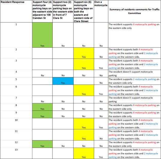
Given that the responses favoured motor bikes only parking be located on the northern side of Clara Street with 4 dedicated line marked parking bays and that 3 responses noted that they were current owners of a motor bike, it was recommended that the proposed ‘Motor Bikes Only’ parking restrictions with associated signs and line markings in Clara Street, Newtown, be located only on the northern side of the street (as per the attached design plan No. 6109_B).
CONCLUSION
It is recommended that the detailed design plan (as per the attached design plan No. 6109_B) of the proposed ‘Motor Bikes Only’ parking restrictions with associated signs and line markings in Clara Street, Newtown, be approved, in order to accommodate sufficient parking spaces for motor bike owners and to meet local residents’ request.