|
AGENDA R |

Local Traffic Committee Meeting
TUESDAY 3 JULY 2018
10.00am
|
|
Local Traffic Committee Meeting 3 July 2018 |
Function of the Local Traffic Committee
Background
Roads and Maritime Services (RMS) is legislated as the Authority responsible for the control of traffic on all NSW Roads. The RMS has delegated certain aspects of the control of traffic on local roads to councils. To exercise this delegation, councils must establish a local traffic committee and obtain the advice of the RMS and Police. The Inner West Council Local Traffic Committee has been constituted by Council as a result of the delegation granted by the RMS pursuant to Section 50 of the Transport Administration Act 1988.
Role of the Committee
The Local Traffic Committee is primarily a technical review and advisory committee which considers the technical merits of proposals and ensures that current technical guidelines are considered. It provides recommendations to Council on traffic and parking control matters and on the provision of traffic control facilities and prescribed traffic control devices for which Council has delegated authority. These matters are dealt with under Part A of the agenda and require Council to consider exercising its delegation.
In addition to its formal role as the Local Traffic Committee, the Committee may also be requested to provide informal traffic engineering advice on traffic matters not requiring Council to exercise its delegated function at that point in time, for example, advice to Council’s Development Assessment Section on traffic generating developments. These matters are dealt with under Part C of the agenda and are for information or advice only and do not require Council to exercise its delegation.
Committee Delegations
The Local Traffic Committee has no decision-making powers. The Council must refer all traffic related matters to the Local Traffic Committee prior to exercising its delegated functions. Matters related to State Roads or functions that have not been delegated to Council must be referred directly to the RMS or relevant organisation.
The Committee provides recommendations to Council. Should Council wish to act contrary to the advice of the Committee or if that advice is not supported unanimously by the Committee members, then the Police or RMS have an opportunity to appeal to the Regional Traffic Committee.
Committee Membership & Voting
Formal voting membership comprises the following:
· one representative of Council as nominated by Council;
· one representative of the NSW Police from each Local Area Command (LAC) within the LGA, being Newtown, Marrickville, Leichhardt and Ashfield LAC’s.
· one representative from the RMS; and
· State Members of Parliament (MP) for the electorates of Summer Hill, Newtown, Heffron, Canterbury, Strathfield and Balmain or their nominees.
Where the Council area is represented by more than one MP or covered by more than one Police LAC, representatives are only permitted to vote on matters which effect their electorate or LAC.
Informal (non-voting) advisors from within Council or external authorities may also attend Committee meetings to provide expert advice.
Committee Chair
Council’s representative will chair the meetings.
Public Participation
Members of the public or other stakeholders may address the Committee on agenda items to be considered by the Committee. The format and number of presentations is at the discretion of the Chairperson and is generally limited to 3 minutes per speaker. Committee debate on agenda items is not open to the public.
|
|
Local Traffic Committee Meeting 3 July 2018 |
|
AGENDA |
1 Apologies
2 Disclosures of Interest
3 Confirmation of Minutes PAGE
Minutes of 5 June 2018 Local Traffic Committee Meeting 6
4 Matters Arising from Council’s Resolution of Minutes
5 Part A – Items Where Council May Exercise Its Delegated Functions
Traffic Matters
ITEM PAGE
LTC0718 Item 1 Palmer Street and Donnelly Street, Balmain - Installation of Dividing (barrier) Lines (Balmain Ward / Balmain Electorate / Leichhardt LAC) 29
LTC0718 Item 2 Beattie Street and Mullens Street, Balmain - Proposed Raised Pedestrian (Zebra) Crossing 31
LTC0718 Item 3 Smith Street at Mansfield Street, Rozelle - Proposed Garden Beds (Balmain Ward / Balmain Electorate / Leichhardt LAC) 34
LTC0718 Item 4 Emma Street and Hill Street, Leichhardt - Proposed Intersection Treatment (Leichhardt Ward / Balmain Electorate / Leichhardt LAC) 38
LTC0718 Item 5 Proposed Temporary Road Closure to Hold Bay Run Event on Sunday, 5 August 2018. (Leichhardt Ward/Balmain Electorate/Leichardt LAC) 45
LTC0718 Item 6 Smith Street, Annandale - Proposed Temporary Road Closure for 2018 Footprints ECO Festival on Sunday 26 August 2018 (Balmain Ward/Balmain Electorate/Leichhardt Ward LAC) 58
LTC0718 Item 7 Marrickville Road, Marrickville – Temporary full Road Closures for Dulwich Hill Village Fair on Sunday 16 SEPTEMBER 2018 (ASHFIELD WARD/SUMMER HILL ELECTORATE/MARRICKVILLE LAC) 74
LTC0718 Item 8 Marrickville Road, Marrickville – Temporary Full Road Closures For Marrickville Festival On Sunday 21 October 2018 (MARRICKVILLE WARD/SUMMER HILL ELECTORATE/MARRICKVILLE LAC) 78
LTC0718 Item 9 Pearl Lane, Newtown – Proposed Statutory ‘No Stopping’ Restrictions South of Holmwood Street (Stanmore Ward/ Heffron electorate / Marrickville LAC) 87
LTC0718 Item 10 Applebee Street, St Peters - Temporary Road Closure to Carry Out Sewer Works. (Marrickville Ward/ Heffron Electorate/Newtown LAC) 90
LTC0718 Item 11 Lackey Street and Smith Street, Summer Hill - Temporary Road Closures For the Annual 'Summer Hill Neighbourhood Festa' on Sunday 7 October 2018. (Ashfield Ward/Summer Hill Electorate/Ashfield LAC) 97
Parking Matters
ITEM PAGE
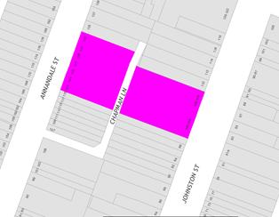
LTC0718 Item 12 Chapman Lane (rear of Nos. 127 to 133 Annandale Street), Annandale - Proposed Extension of "No Parking" Zone (Balmain Ward/Balmain Electorate/Leichhardt LAC) 109
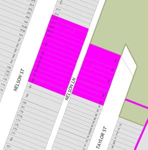
LTC0718 Item 13 Nelson Lane (Opp. Nos. 195 to 207A Nelson Street), Annandale - Extension of 'No Parking' zone (Balmain Ward/Balmain Electorate/Leichhardt LAC) 112
LTC0718 Item 14 Silver Lane - Proposed 'No Parking' Restrictions (Marrickville Ward/Electorate/Inner West LAC) 115
LTC0718 Item 15 Marian Lane, Enmore - Proposed 'No Parking' Restrictions (Stanmore Ward/Newtown Electorate/Inner West LAC) 119
LTC0718 Item 16 Hopetoun Lane, Camperdown - Proposed 'No Parking' Restrictions (Stanmore Ward/Newtown Electorate/Inner West LAC) 122
LTC0718 Item 17 McGill Street, Lewisham - Proposed 'No Stopping' Restrictions (Stanmore Ward/Summer Hill Electorate/Inner West LAC) 124
LTC0718 Item 18 Watson Avenue, Croydon Park - Request for One Hour (1P) Parking Restriction 126
LTC0718 Item 19 Nowranie Lane, Summer Hill - Proposed 'No Parking' Restrictions (ASHFIELD ARD/ SUMMER HILL ELECTORATE/ ASHFIELD LAC) 129
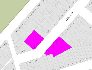
LTC0718 Item 20 Maida Street, Lilyfield - Proposed 'Motor Bike Only' Zone (Balmain Ward/ Balmain Electorate/ Leichhardt LAC) 132
LTC0718 Item 21 Minor Traffic Facilities (All Wards / All Electorates / All LACs) 134
LTC0718 Item 22 Railway Avenue, Stanmore; Darley Road, Leichhardt , Lilyfield Road, Lilyfield and Frederick Street, Ashfield - ‘No Parking 7am-7pm – Motor Vehicles under 4.5t GVM Excepted’ (All Ward / All Electorates / All LACs) 141
LTC0718 Item 23 Grosvenor Crescent, Summer Hill - Placement of 'No Stopping' Restrictions, Summer Hill (Ashfield Ward/Summer Hill Electorate/Ashfield LAC) 146
LTC0718 Item 24 Ash Lane, Cove Street, Northcote Street and Wolseley Street, Haberfield-Resident Parking Scheme (Leichhardt Ward/Summer Hill Electorate/Ashfield LAC) 148
LTC0718 Item 25 Walker Avenue, Allum Street, Alt Street, Denman Avenue, Bland Street and Yasmar Avenue, Haberfield - Resident Parking Scheme (Leichhardt Ward/Summer Hill Electorate/Ashfield LAC) 156
6 Part B - Items for Information Only
Nil at the time of printing.
7 Part C - Items for General Advice
ITEM PAGE
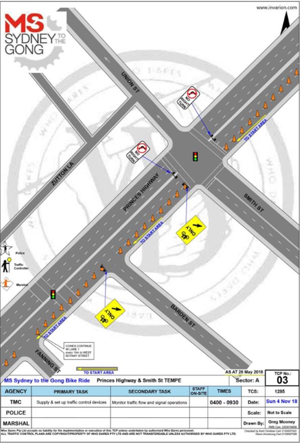
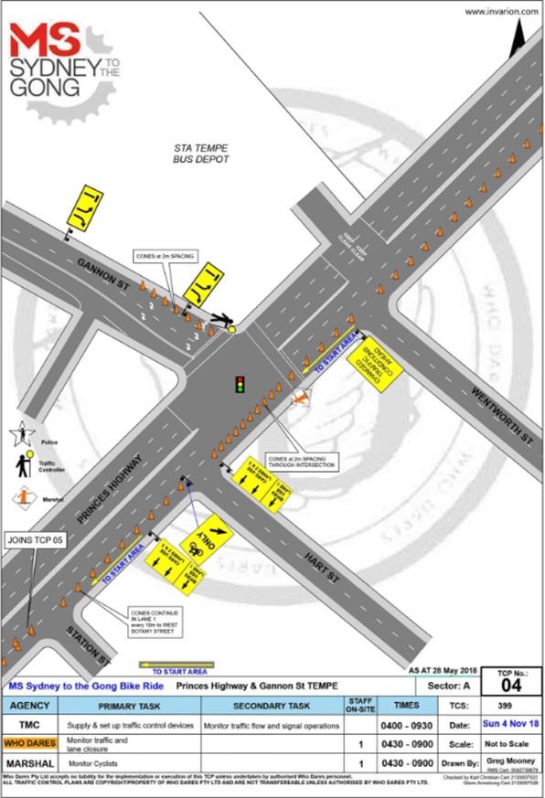
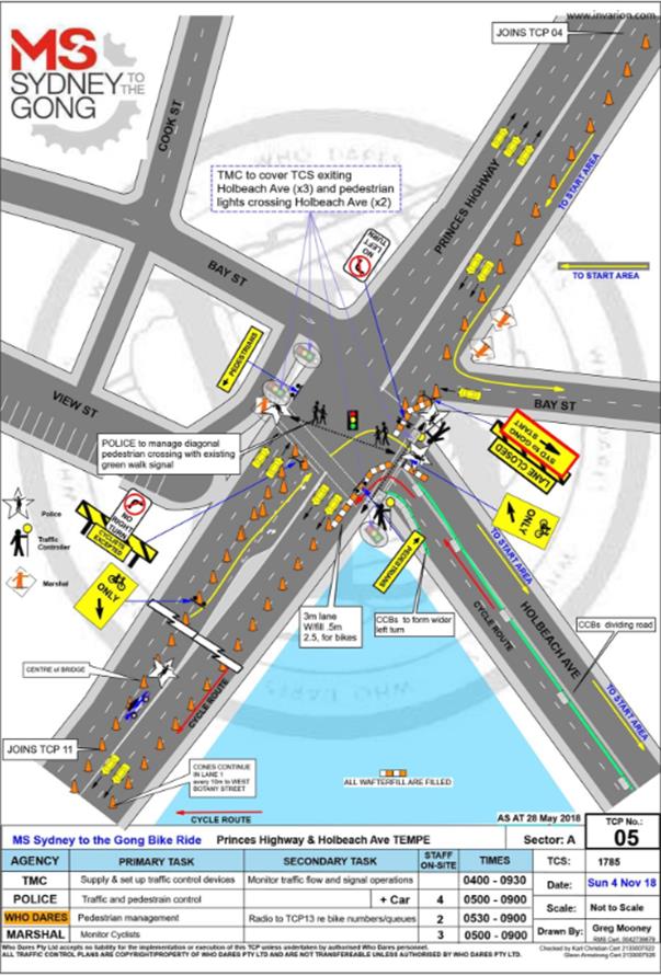
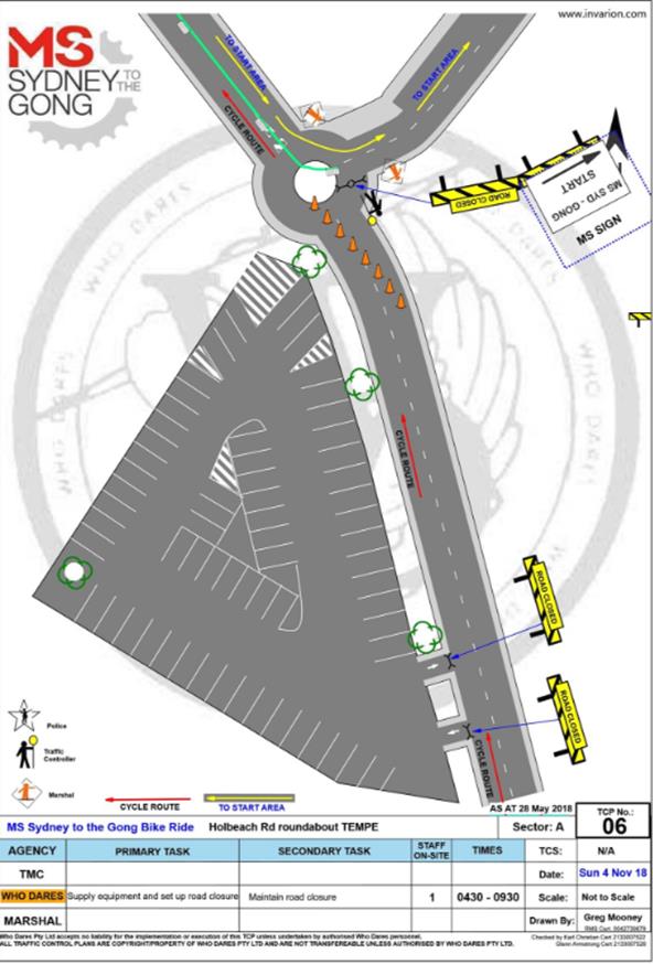
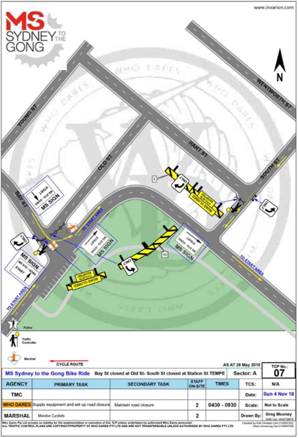
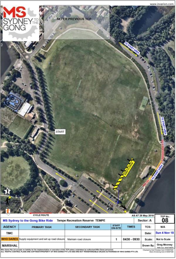
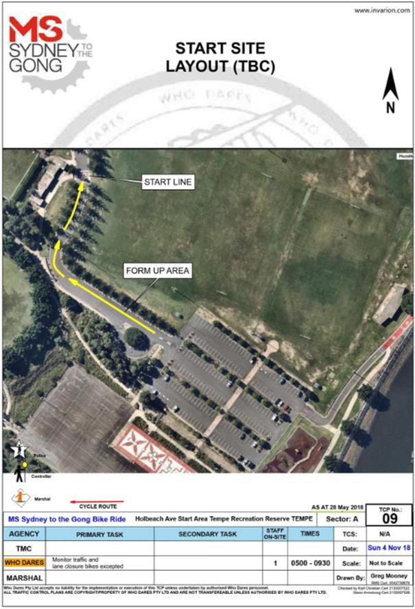
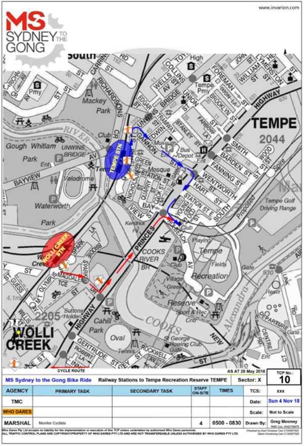
LTC0718 Item 26 Holbeach Avenue, Tempe – Temporary Full Road Closures for MS Sydney to the Gong Bike Ride on Sunday 4 November 2018 (Marrickville Ward/Heffron Electorate/Newtown LAC) 164
Late Items
Nil at time of printing.
8 General Business
9 Close of Meeting
|
|
Local Traffic Committee Meeting Minutes from 5 June 2018 |
Minutes of Local Traffic Committee Meeting
Held at Council Chambers, Petersham Service Centre, on 5 June 2018
Meeting commenced at 10.03am
ACKNOWLEDGEMENT OF COUNTRY BY CHAIRPERSON
I acknowledge the Gadigal and Wangal people of the Eora nation on whose country we are meeting today, and their elders past and present.
COMMITTEE REPRESENTATIVES PRESENT
|
|
|
|
Clr Marghanita Da Cruz |
Leichhardt Ward (Attended at 10.10am, Chair from 10.22am – 12:15pm) |
|
Mr Bill Holliday |
Representative for Jamie Parker MP, Member for Balmain |
|
Mr Chris Woods |
Representative for Ron Hoenig MP, Member for Heffron |
|
Mr Daryl Ninham |
Roads and Maritime Services |
|
LSC Alison Coleman |
NSW Police – Glebe and Leichhardt Area Command |
|
|
|
|
OFFICERS IN ATTENDANCE |
|
|
|
|
|
Mr Bruno Sinatambou |
State Transit Authority |
|
Mr Colin Jones |
Inner West Bicycle Coalition |
|
Mr Wal Petschler |
IWC’s Group Manager, Roads, Traffic and Stormwater (Chair from 10.03am–10.22am) |
|
Mr John Stephens |
IWC’s Traffic and Transport Services Manager |
|
Mr George Tsaprounis |
IWC’s Coordinator Traffic and Parking Services (South) |
|
Mr Joe Di Cesare |
IWC’s Coordinator Design Services |
|
Mr Boris Muha |
IWC’s Engineer – Traffic and Parking Services |
|
Mr David Yu |
IWC’s Engineer – Traffic and Parking Services |
|
Mr Emilio Andari |
IWC’s Engineer – Traffic and Parking Services |
|
Ms Jenny Adams |
IWC’s Engineer – Traffic and Parking Services |
|
Mr Vinoth Srinivasan |
IWC’s Engineer – Traffic and Parking Services |
|
Mr Davide Torresan |
IWC’s Civil Engineer |
|
Ms Snezana Bakovic |
IWC’s Project Manager – Traffic & Transport Projects |
|
Mr Nathan Parish |
Consultant – Complete Urban |
|
Mr Predrag Gudelj |
IWC’s Project Manager – Transport Infrastructure |
|
Ms Christina Ip |
IWC’s Business Administration Officer |
|
|
|
|
VISITORS |
|
|
|
|
|
Mr Jim Mitsopoulos |
Item 5 |
|
Mr Paul McGahen |
Item 5 |
|
Mr Sue Lord |
Item 9 |
|
Ms Caitlin Crawford |
Item 9 |
|
Mr Greg Croaker |
Item 12 |
|
Mr Charles Cameron |
Item 16 |
|
|
|
|
APOLOGIES: |
|
|
|
|
|
Ms Jo Haylen MP |
Member for Summer Hill |
|
Ms Sarina Foulstone |
Representative for Jo Haylen MP, Member for Summer Hill |
|
Clr Julie Passas |
Chair, Deputy Mayor – Ashfield Ward |
|
Mr Manod Wickramasinghe |
IWC’s Coordinator Traffic and Parking Services (North) |
DISCLOSURES OF INTERESTS: Nil.
CONFIRMATION OF MINUTES
|
The minutes of the Local Traffic Committee Meeting held on Tuesday, 1 May 2018 were confirmed. |
MATTERS ARISING FROM COUNCIL’S RESOLUTION OF MINUTES
The Local Traffic Committee recommendation of its meeting held on 1 May 2018 were adopted at Council’s meeting held on 22 May 2018, with the following changes:
GENERAL BUSINESS
Meeting closed at 12.15pm.
This page has been left intentionally blank
|
|
Local Traffic Committee Meeting 3 July 2018 |
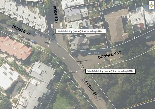
Subject: Palmer Street and Donnelly Street, Balmain - Installation of Dividing (barrier) Lines (Balmain Ward / Balmain Electorate / Leichhardt LAC)
Prepared By: Manod Wickramasinghe - Coordinator – Traffic and Parking Services
Authorised By: John Stephens - Traffic and Transport Services Manager
|
SUMMARY Concerns have been raised from several motorists regarding vehicles travelling on the wrong side of the street when approaching the intersection of Donnelly/Palmer/Booth Streets, and traveling eastbound from Palmer Street into Donnelly Street and westbound from Donnelly Street into Palmer Street. |
|
RECOMMENDATION
THAT:
1. 5m BB dividing (barrier) lines, including raised reflective pavement markers (RRPM) be provided on Palmer Street, west of Booth Street; and
2. 10m BB dividing (barrier) lines, including raised reflective pavement markers (RRPM) be provided on Donnelly Street, east of Booth Street.
|
BACKGROUND
Council has received concerns from several motorists regarding vehicles travelling on the wrong side of the street when approaching the intersection of Donnelly/Palmer/Booth Streets, and traveling eastbound from Palmer Street into Donnelly Street and westbound from Donnelly Street into Palmer Street.
There are limited sightlines to opposing vehicle movements at this intersection for the eastbound-westbound direction due to the road alignment with horizontal and vertical curves.
FINANCIAL IMPLICATIONS
Nil.
OTHER STAFF COMMENTS
In order to address this issue, it is proposed to provide linemarking at this intersection for both the eastbound and westbound movements from Palmer Street into Donnelly Street and vice versa.
This linemarking will include:
· 5m BB dividing (barrier) lines, including raised reflective pavement markers (RRPM) on Palmer Street, west of Booth Street
· 10m BB dividing (barrier) lines, including raised reflective pavement markers (RRPM) on Donnelly Street, east of Booth Street
It should be noted that these dividing (barrier) lines are to be placed within existing ‘No Stopping’ zones and no loss of parking will occur.
PUBLIC CONSULTATION
Nil.
CONCLUSION
Nil.
|
|
Local Traffic Committee Meeting 3 July 2018 |
Subject: Beattie Street and Mullens Street, Balmain - Proposed Raised Pedestrian (Zebra) Crossing
Prepared By: David Yu - Engineer - Traffic and Parking Services
Authorised By: Manod Wickramasinghe - Coordinator – Traffic and Parking Services
|
SUMMARY Council has received concerns from a number of residents regarding pedestrian safety when crossing Mullens Street, near the intersection Beattie Street, Balmain. A public meeting was held with concerned residents on 11th April 2018 to discuss the matter with a Mayoral Minute considered at 24th April 2018 Council meeting. |
|
RECOMMENDATION
THAT:
1. A proposed raised pedestrian (zebra) crossing in Mullens Street, Balmain (south of Beattie Street) be supported in principle and a detailed design be prepared, and affected residents be consulted; and
2. A further report, including the detailed design be brought back to the Traffic Committee for consideration.
|
BACKGROUND
Council has received requests from a number of residents for the provision of a pedestrian (zebra) crossing in Mullens Street, Balmain to provide a safer pedestrian crossing facility near the intersection of Beattie Street.
The former Leichhardt Council investigated signalising the intersection of Beattie Street and Mullens Street and engaged a traffic consultant to assess the feasibility. The assessment considered various traffic signal configuration options and identified that signalising options would have significant negative impact on intersection operation and on surrounding traffic conditions. It also identified that pedestrians may experience extensive delay times. The report concluded that none of the signalised intersection options were appropriate for achieving a balance between the needs of pedestrians and impacts on vehicle traffic.
Further investigation of the site confirmed that the RMS requirement for a marked pedestrian (zebra) crossing to be installed in Mullens Street, south of Beattie Street and in Beattie Street near Mullens Street was not met. Subsequently, Council constructed kerb ramps in Mullens Street, south of Beattie Street and in Beattie Street, west of Mullens, including a kerb extension to improve crossing conditions for pedestrians.
Following the recent community requests, a site meeting was held with representatives from RMS, Police and Transit Systems (new Region 6 bus operator) on Tuesday 5th June 2018.
During this meeting Council officers received in principle support for the proposed marked (zebra) crossing in Mullens Street, south of Beattie Street, subject to the following:
· Vehicle/pedestrian volumes to meet the Roads and Maritime Supplement to Austroads Guide to Traffic Management – Special Warrant for pedestrian (zebra) crossing.
· Speed volumes identifying appropriate speed conditions for a pedestrian crossing.
· Bus stops to be reconstructed to standards.
· 12.5m length required from an existing light pole on the western side of Mullens Street to accommodate bus swing.
· A minimum width of 3.2m required for the vehicle travel lanes to accommodate buses.
RMS Special Warrant for the installation of a marked pedestrian (zebra) crossing
The RMS warrant for the installation of a marked pedestrian (zebra) crossing based on a Special Warrant is shown below:
PV≥45,000 and P≥30 and V>200 with P = Pedestrian and V = Vehicle.
A pedestrian and vehicular count was undertaken in Mullens Street (intersection of Beattie Street) on Tuesday, 13th March 2018 with the results tabulated below:
|
Time Period |
Pedestrians |
Vehicles (veh/hr) |
PV |
|
Peak Period 7AM-8AM |
54 |
966 |
52,164 |
The above data was assessed against the RMS Special Warrant. The current pedestrian and vehicle volumes meet the RMS Special Warrant.
Additional circumstances warranting a pedestrian (zebra) crossing in Mullens Street are as follows:
· Mullens Street is a regional road within the Balmain Peninsular which is restricted with a 40km/h speed limit. The proposed raised pedestrian (zebra) crossing will not adversely impact on the road network and will assist in calming traffic.
· The crossing distance of the proposed pedestrian (zebra) crossing in Mullens Street is approximately 9.8 metres (kerb to kerb) and with a typical walking speed of 1.2m/s will take 8 seconds, therefore the delays would be minimal.
· The nearest crossing facility to the north is at Darling Street/Montague Street/Rowntree Street (285m) within the signalised intersection and to the south is Reynolds Street (240m) with a raised pedestrian (zebra) crossing.
· The proposed raised pedestrian (zebra) crossing will facilitate crossing Mullens Street for pedestrians accessing the nearby land uses e.g. hotel, local schools and shops, and adjacent bus stops.
· There is a proposed 90 place child care at 69-73 Beattie Street, Balmain, which is in close proximity of the proposed raised pedestrian (zebra) crossing.
· RMS, Police and Transit Systems have in principle supported the proposed pedestrian (zebra) crossing in Mullens Street.
· Pedestrian counts show a strong pedestrian desire line east-west through this intersection.
Also, speed counts are currently being collected and the results will be tabled at the meeting.
FINANCIAL IMPLICATIONS
The construction of the proposed raised pedestrian (zebra) crossing will be listed for consideration in the draft capital works program for 2018/2019.
OTHER STAFF COMMENTS
It is proposed that a raised pedestrian (zebra) crossing be constructed in Mullens Street, Balmain (south of Beattie Street, in the vicinity of the existing kerb ramps).
The proposal is shown on the plan below.
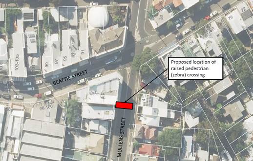
The existing ‘No Stopping’ zone on the western side of Mullens Street south of Beattie Street would have to be extended to a total of approximately 14m in order to provide adequate sightlines between vehicles and pedestrian on a formal crossing. This proposal may result in a loss of three (3) on-street parking spaces on the western side of Mullens Street. It is not expected that there will be a loss of parking on the eastern side of Mullens Street. However, this will be confirmed as part of the detailed design.
It should be noted that the raised platform improves the visibility of the crossing and forces motorist to slow down, thus reinforcing the existing 40km/h speed limit. The installation of a zebra crossing is therefore suitable in this low speed environment.
PUBLIC CONSULTATION
Affected residents have been notified of the proposal and that the matter was being considered at this meeting should they wish to attend. Any submissions received will be tabled at the meeting.
CONCLUSION
It is recommended that the proposed raised pedestrian (zebra) crossing in Mullens Street, Balmain (south of Beattie Street) be supported in principle and a detailed design be prepared, and affected residents be consulted. A further report, including the detailed design will be then brought back to the Committee for its consideration.
|
|
Local Traffic Committee Meeting 3 July 2018 |
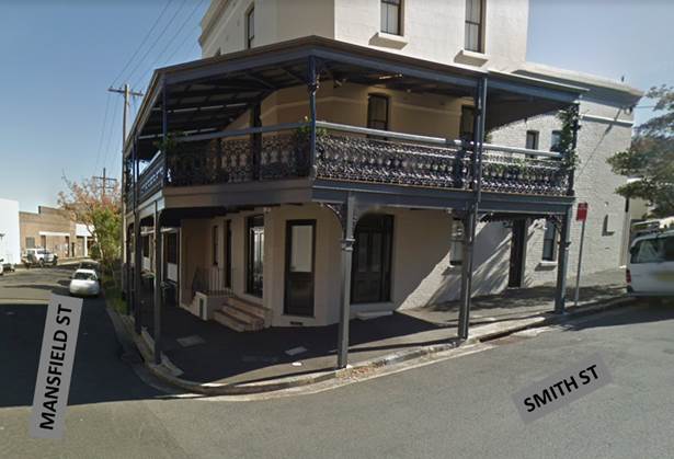
Subject: Smith Street at Mansfield Street, Rozelle - Proposed Garden Beds (Balmain Ward / Balmain Electorate / Leichhardt LAC)
Prepared By: Manod Wickramasinghe - Coordinator – Traffic and Parking Services
Authorised By: John Stephens - Traffic and Transport Services Manager
|
SUMMARY Council has received concerns regarding vehicles causing building damage to No. 31 Mansfield Street, Rozelle whilst manoeuvring near the corner of Mansfield Street and Smith Street. This has raised concerns for both the structural integrity of the building and pedestrian safety. |
|
RECOMMENDATION
THAT:
1. The proposed garden beds at the intersection of Smith Street and Mansfield Street, Rozelle be supported as detailed in Attachment 1;
2. That this project be listed for consideration in a forward works program; and
3. Prior to construction of any physical device, an interim treatment of a painted island and road flaps are provided in lieu of the garden beds. |
BACKGROUND
Concerns have been raised regarding vehicles causing building damage to No.31 Mansfield Street, Rozelle whilst manoeuvring near the corner of Mansfield Street and Smith Street.
At this location, the building awning supports are located adjacent to the road carriageway and errant vehicles have caused previous structural damage to the awning supports whilst parking and manoeuvring through the intersection.
This has raised concerns for both the structural integrity of the building and pedestrian safety. It should be noted that the awning is located over the public footpath.
Council’s Heritage Advisor has advised that this building is heritage listed under Leichhardt Local Environmental Plan 2013 (Item No.I782) and the awnings to the building contributes to their heritage significance.
FINANCIAL IMPLICATIONS
The construction of the proposed garden beds will be listed for consideration in a forward capital works program.
OTHER STAFF COMMENTS
In order to address this issue, it is proposed to provide garden beds within the existing ‘No Stopping’ zones of this intersection to protect the awning posts, as shown in Attachment 1.
This design includes:
· Construction of an 8m garden bed with sandstone kerb on the western side of Smith Street, north of Mansfield Street
· Construction of an 8m garden bed with sandstone kerb on the northern side of Mansfield Street, west of Smith Street
· Associated landscaping
· Construction of new kerb ramp to cross Smith Street at Mansfield Street
Due to the position of the garden beds within the existing ‘No Stopping’ zones, there will be no loss of on-street parking.
It is also proposed that prior to construction of any physical device, an interim treatment of a painted island and road flaps are provided in lieu of the garden beds.
PUBLIC CONSULTATION
|
A letter outlining the above proposal was mailed out to the affected properties (14 properties) in Smith Street and Mansfield Street, Rozelle. No responses were received.
|
|
CONCLUSION
Nil.
|
1.⇩ |
Mansfield-Smith Street, Rozelle Garden Beds Design |
|
|
Local Traffic Committee Meeting 3 July 2018 |
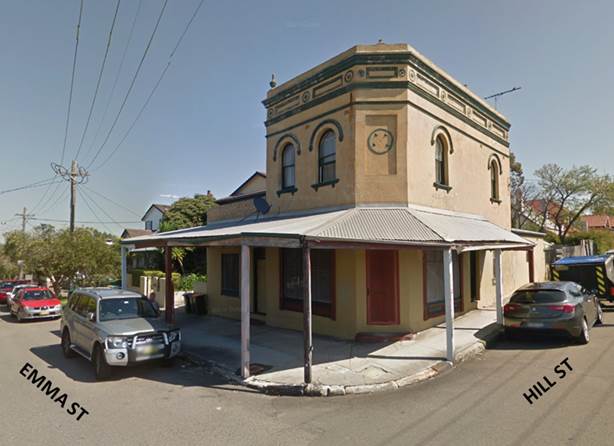
Subject: Emma Street and Hill Street, Leichhardt - Proposed Intersection Treatment (Leichhardt Ward / Balmain Electorate / Leichhardt LAC)
Prepared By: Manod Wickramasinghe - Coordinator – Traffic and Parking Services
Authorised By: John Stephens - Traffic and Transport Services Manager
|
SUMMARY Council has received concerns regarding vehicles causing building damage to No. 42 Emma Street, Leichhardt whilst manoeuvring near the corner of Emma Street and Hill Street, Leichhardt. This has raised concerns for both the structural integrity of the building and pedestrian safety. |
|
RECOMMENDATION
THAT:
1. The proposed garden bed/kerb extension at the intersection of Emma Street and Hill Street, Leichhardt be supported as detailed in Attachment 1;
2. That this project be listed for consideration in a forward works program; and
3. Prior to construction of any physical device, an interim treatment of a painted island and road flaps are provided in lieu of the garden bed/kerb extension. |
BACKGROUND
Concerns have been raised regarding vehicles causing building damage to No.42 Emma Street, Leichhardt whilst manoeuvring near the corner of Emma Street and Hill Street, Leichhardt.
At this location, the building awning supports are located adjacent to the road carriageway and errant vehicles have caused previous structural damage to the awning supports whilst parking and manoeuvring through the intersection.
This has raised concerns for both the structural integrity of the building and pedestrian safety. It should be noted that the awning is located over the public footpath.
Council’s Heritage Advisor has advised that this building is heritage listed under Leichhardt Local Environmental Plan 2013 (Item No.I653) and the awnings to the building contributes to their heritage significance.
In order to address this issue, it is proposed to provide kerb extensions and a garden bed within the existing ‘No Stopping’ zones of this intersection, as shown in the attached concept plan.
It is also proposed that prior to the construction of any physical device, an interim treatment of a painted island and road flaps are provided in lieu of the garden bed and kerb extension.
FINANCIAL IMPLICATIONS
The construction of the proposed garden beds will be listed for consideration in a forward capital works program.
OTHER STAFF COMMENTS
In order to address this issue it is proposed to provide a garden bed and kerb extension within the existing ‘No Stopping’ zones of this intersection to protect the awning posts, as shown in Attachment 1.
This design includes:
· Construction of a 7m garden bed with sandstone kerb on the western side of Emma Street, south of Hill Street
· Construction of a kerb extension on the southern side of Hill Street, west of Emma Street
· Associated landscaping and signage
· Construction of a new kerb ramp to cross Emma Street at Hill Street
· Reconstruction of the footpath
Due to the position of the garden beds within the existing ‘No Stopping’ zones, there will be no loss of on-street parking.
It is also proposed that prior to construction of any physical device, an interim treatment of a painted island and road flaps are provided in lieu of the garden beds.
PUBLIC CONSULTATION
|
A letter outlining the above proposal was mailed out to the affected properties (21 properties) in Hill Street and Emma Street, Leichhardt. Two (2) responses were received. One in support and one in objection. The table below shows the comments raised by the residents.
|
|
|
Residents’ Comments |
Officer Comments |
|
Broadly support the proposed kerb extension. However, we feel that any such extension must be matched by an extension of the existing No Parking zone on the north side of Hill Street to match the new kerb. We would suggest the existing No Parking area that ends at the top of Hill Street be extended to the next telegraph pole, which sits directly across the road from the end of the kerb extension outlined in the plan provided. Traffic on Hill street approaching Emma St is already often guilty of regularly veering onto the wrong side of the road while turning blind at the intersection. It is often a busy intersection due to the activities of the nearby auction houses, Just Screw It and the dance school. The proposed kerb extension, combined with existing parking which often sees large trucks and utilities parked opposite, would thin the approach to the intersection dangerously to the point where a car approaching on Emma Street could collide with a car turning the corner.
If the No Parking area on the north side of Hill Street was extended in line with the new kerb, it would ensure that the approach to the intersection remained safe as cars would veer to the left as the approached the intersection. In addition to the No Parking extension, we would also ask that you ensure that any interim treatment is not in any way extended beyond the proposed garden bed, as we do not want access to our driveway inhibited as would be the case should it extend any further. |
Council officers will separately investigate this request. |
|
Proposed works are redundant and in fact cause more congestion in a street that is already not coping with the traffic and size of the vehicles that drive through. On many occasions each day we witness garbage trucks, large freight trucks servicing the industrial site at the end bottom of Hill St and cars have to reverse to allow the oncoming traffic and parked cars to pass. In many other streets in the Inner West Council area they have a “Shared Zone” for pedestrians and cars to share the kerb and allow more room for vehicles driving through the street. This would reduce the damage to the parked cars and allow more room for oncoming traffic to pass. The proposed works will create a bottle nose of traffic at the point where the kerb extension and garden are planned to be which can also be dangerous as vehicles traveling for traffic on Emma St can’t see the reversing vehicles. |
The kerb extension on Hill Street has been the chosen treatment rather than a garden bed in order to minimise impact on the travel lanes. This extension will provide protection for the awning posts from the heavy vehicle movements described whilst minimising the impact on the carriageway.
In order to further consider the manoeuvring space at the intersection, Council officers will investigate whether the existing ‘No Parking’ zone on the northern side of Hill Street needs to be extended. |
CONCLUSION
Nil.
|
1.⇩ |
Emma Street Leichhardt - Garden Bed/Kerb Extension Design Plan |
|
Local Traffic Committee Meeting 3 July 2018 |
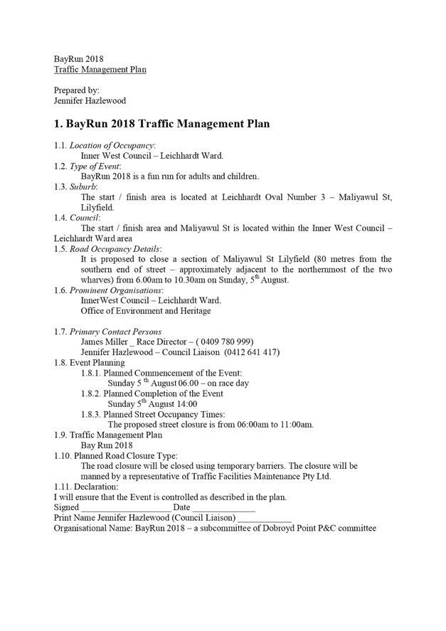
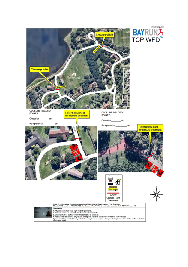
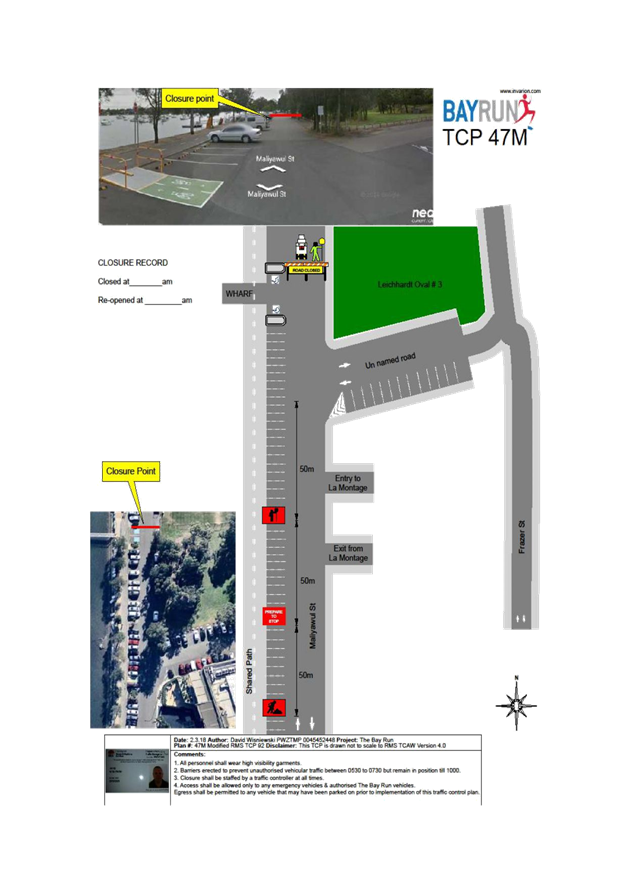
Subject: Proposed Temporary Road Closure to Hold Bay Run Event on Sunday, 5 August 2018. (Leichhardt Ward/Balmain Electorate/Leichardt LAC)
Prepared By: Vinoth Srinivasan - Engineer - Traffic and Parking Services
Authorised By: John Stephens - Traffic and Transport Services Manager
|
SUMMARY The Bay Run Committee has requested approval by the Local Traffic Committee and Council to conduct the annual Bay Run event (its sixteenth year) on Sunday, 5 August 2018.
The Bay Run follows the shore line of Iron Cove and is approximately 7km in length. The shared path on the Iron Cove Bridge will form part of the Bay Run.
This event will be held between 6.00am to 11.00am on 5 August 2018. The race participation includes approximately:
· 1600 runners · 150 walkers · 100 runners with dogs · 600 children (2km)
|
|
RECOMMENDATION
THAT:
1. The proposed temporary closure of Maliyawul Street, Lilyfield, north of Le Montage Function Centre on Sunday, 5 August 2018 between 6.00am to 11.00am be supported, subject to the TMP and TCP being approved by RMS;
2. The applicant be advised to contact the Office of Environment and Heritage (OEH) to seek approval for the proposed temporary closure of Waterfront Drive, between Central Avenue and Military Drive for the event (within Callan Park, Lilyfield);
3. The applicant be requested to implement the RMS approved Traffic Management Plan (TMP) and Traffic Control Plan (TCP) related to the temporary closure of Maliyawul Street and Waterfront Drive, Lilyfield at its own cost;
4. The applicant be requested to arrange a letter box drop to nearby properties, Le Montage, Leichhardt Park and Aquatic Centre, Leichhardt Rowing Club and Balmain Soccer Club (Callan Park) two weeks prior to the event;
5. The event organiser be requested to produce a current Public Liability Insurance Policy with Inner West Council being included as an Interested Party; and
6. Council’s Parks Engagement Officer be advised of the Committee’s recommendation. |
BACKGROUND
This is the sixteenth running of the Bay Run Event. The current Bay Run 2018 organising team has been involved in running the event for a number of years and is again requesting the closure of:
· Maliyawul Street, north of Le Montage Function Centre to arrange the finish line on the road in Maliyawul Street at Leichardt Oval No.3 and
· Waterfront Drive, between Central Avenue and Military Drive (within Callan Park).
The closure of Maliyawul Street will allow for the set-up of the event on the Sunday. The organiser has confirmed that security guards will be in attendance overnight to monitor the area. The participants are expected to arrive around 6am on the Sunday.
The proposed closure of Maliyawul Street is on Sunday, 5 August 2018, between 6.00am and 11.00am to allow for the set-up of the event. It should be noted that the subject section of Maliyawul Street is a ‘No Through’ road.
Since no matches would be permitted on Oval No. 3 at the time of this event, the closure of an 80m (from the closed end) section of Maliyawul Street should cause no significant impacts on parking during the event closure time. This closure has occurred at previous year’s events and has caused no traffic issues.
The closure of Waterfront Drive is to prevent conflicts with vehicles.
Non-event cyclists would not be able to use the closed sections of Maliyawul Street and Waterfront Drive. However, as a number of detours are available for non-event cyclists, the impact on them is considered minimal.
The TMP and TCP submitted by the event organiser as shown in Attachment 1 will be forwarded to RMS for approval.
The applicant has advised that they have ongoing public liability insurance to the amount of $50 million. As part of obtaining the public liability insurance a risk management plan has also been prepared.
FINANCIAL IMPLICATIONS
Nil.
PUBLIC CONSULTATION
The Bay Run organisers have advised that the event will be publicised via a range of public media in the lead up to the event including local banners, notifications on the Bay Run course, local media (print and radio) and via social media (Facebook). Inner West Council is a supporting partner of the event. Le Montage is aware of the event. Leichhardt Park Aquatic Centre, Leichhardt Rowing Club and Balmain District FC (Callan Park) will all be notified about the event in the lead up to the event.
The Office of Environment and Heritage (OEH) will be contacted by the applicant regarding closing the section of Waterfront Drive as outlined in the TMP.
As in 2017 there will be a letter box drop to residents in the nearby streets, by the organisers in the lead up to the event.
The temporary full road closure of Maliyawul Street has been advertised in a local newspaper for a period of 28 days and no submissions were received.
CONCLUSION
It is recommended that Council agree to the temporary road closure of the subject section of Maliyawul Street and Waterfront Drive on Sunday, 5 August 2018, subject to the applicant complying with the following conditions:
· the TMP and TCP being approved by RMS,
· the proposed temporary closure of Waterfront Drive being approved by OEH,
· arrange letter box drop to nearby properties, Le Montage, Leichhardt Park & Aquatic Centre, Leichhardt Rowing Club and Balmain Soccer Club (Callan Park) two weeks prior to the event,
· details of the proposed event being forwarded to the appropriate authorities, including emergency services and a current Public Liability Insurance Policy be provided to Inner West Council.
|
1.⇩ |
Bay Run 2018 - Traffic Management Plan |
|
Local Traffic Committee Meeting 3 July 2018 |
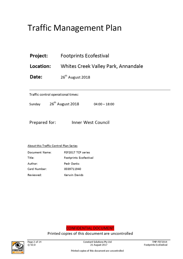
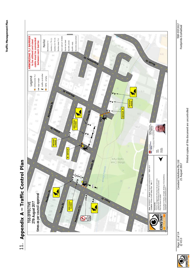
Subject: Smith Street, Annandale - Proposed Temporary Road Closure for 2018 Footprints ECO Festival on Sunday 26 August 2018 (Balmain Ward/Balmain Electorate/Leichhardt Ward LAC)
Prepared By: Felicia Lau - Engineer - Traffic and Parking Services
Authorised By: Manod Wickramasinghe - Coordinator – Traffic and Parking Services
|
SUMMARY The Footprints Eco Festival is an event run by Inner West Council with a focus on environmental sustainability of the local community. The event will focus on delivering information to participants on a variety of environmental topics via talks, workshops and information, and market stalls.
The event will be held at Whites Creek Valley Park in Annandale on Sunday, 26 August 2018 between 11:00am and 3:00pm. As part of the event, a TMP and TCP has been submitted for proposed temporary road closures to the road network frontage of the park, between Wisdom Street and Piper Street from 4:00am to 6:00pm on Sunday, 26 August 2018.
|
|
RECOMMENDATION
THAT:
1. The TMP and TCP (Attachment 1) for the temporary road closures from 4:00am to 6:00pm on Sunday, 26 August 2018 be supported. The road sections to be closed are: · Smith Street, between Piper Street and Gillies Street; · Gillies Street, west of Young Street; · Gillies Lane, between Gillies Street and Wisdom Street; · Wisdom Street, west of Gillies Lane;
2. All residents and businesses in and around the affected areas will be notified in advance (at least two weeks prior to the event) of the temporary internal road closures;
3. A four (4) metre unencumbered passage be available for emergency vehicles through all the closed section of internal roads at all times;
4. All advertising of the event encourage the use of Public Transport;
5. Those additional public transport services, if necessary, be organised in coordination with the STA;
6. All reasonable directions of Police be obeyed if such directions are given;
7. All barricades and signage provision are to be in accordance with Australian Standard AS1742.3-1996: Traffic Control Devices for Works on Roads;
8. All traffic controllers must hold RMS certification;
9. The local area Fire & Rescue NSW station be notified of the event details;
10. Council’s Manager Resource Recovery Services must be notified of the clean-up arrangements; and
11. The conduct of any activities or use of any equipment required in conjunction with the road closures must not result in any “offensive noise” as defined by the Protection of Environment Operations Act, 1997. |
BACKGROUND
The traffic management during the event will be in accordance with the attached TMP and TCP and similar to that used for last year’s event. There were no reported issues regarding traffic management from last year. The attached TMP and TCP will be forwarded to RMS for formal approval.
In order to allow stalls and structures to be erected it will be required to temporarily close Gillies Lane and Smith Street, between Wisdom Street and Piper Street, and Gillies Street, west of Young Street and Wisdom Street, west of Gillies Lane as shown in the figure below. The closure will restrict public traffic access between 4:00am to 6:00pm on Sunday, 26 August 2018.
The properties along Smith Street and Gillies Lane have rear vehicular access, however impact is expected to be low due to the event being an annual event and all properties also have access via Young Street.
The proposed road closure is to commence at 4:00am on Sunday, 26 August 2018. All traffic controllers on site will be required to hold RMS certification. Emergency vehicles will have access to all areas controlled by Traffic Controllers and Security Staff. First Aid Centre staff will be situated within the parklands. Residents will be advised prior to the event of closures and encouraged to pre-plan vehicle access before the temporary closure.
Inner West Council, as event organiser, carries public risk insurance cover with a minimum policy value $20,000,000. The policy will indemnify Inner West Council staff and Police staff rostered for duty on the day of the Event, against all claims for damage or injury that may result from activities associated with the Event and the occupation of that part of the public occupied during the Event.
FINANCIAL IMPLICATIONS
The costs associated with the temporary road closures are to be borne by Council as part of its major events or operational budget.
OTHER STAFF COMMENTS
Gillies Lane and Smith Street between Wisdom Street and Piper Street, has been closed off in previous years for the Footprints ECO Festival. Traffic Committee support, with Council and RMS approval has been provided in the past for the road closure.
As part of the application process, Council will notify all residents, businesses and establishments in and around the affected areas, by way of letterbox drop detailing times or proposed road closures and parking restrictions that will be put in place on the day of the event.
The Footprints Eco Festival will be advertised on Council’s website and in the local community newspapers informing local residents of the transportation options, revised traffic arrangements, road closures and parking restrictions that will be put in place on the day of the event. To further inform the public of the event, any advertising whether paid or free is to include notification of the closure and the potential for traffic delay in the area.
Traffic information services on commercial and community radio programs will be used to advice the public of the event and the road closure associated with the event.
PUBLIC CONSULTATION
Notification of the event will be arranged by Council via letter box drop and local newspaper advertisement.
The proposed closures of Smith Street and Gillies Lane (between Wisdom Street and Piper Street), Gillies Street west of Young Street and Wisdom Street west of Gillies Lane have been advertised in the local newspaper for a period of 28 days.
No objections were received.
CONCLUSION
It is recommended that the temporary road closures for the Footprints Eco Festival on Sunday, 26 August 2018 at the following streets be supported (subject to formal approval of the TMP and TCP by RMS):
· Smith Street, between Piper Street and Gillies Street;
· Gillies Street, west of Young Street;
· Gillies Lane, between Gillies Street and Wisdom Street; and
· Wisdom Street, west of Gillies Lane.
Council will forward the Traffic Management Plan and associated Traffic Control Plan to the RMS for formal approval.
|
1.⇩ |
Traffic Management Plan & Traffic Control Plan |
|
Local Traffic Committee Meeting 3 July 2018 |
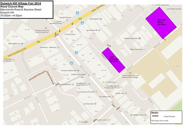
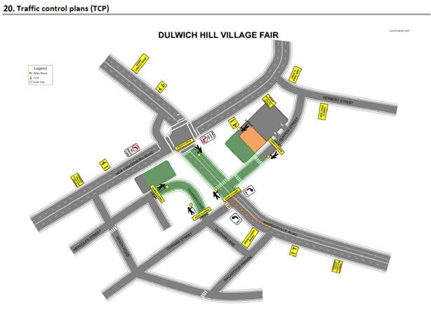
Subject: Marrickville Road, Marrickville – Temporary full Road Closures for Dulwich Hill Village Fair on Sunday 16 SEPTEMBER 2018 (ASHFIELD WARD/SUMMER HILL ELECTORATE/MARRICKVILLE LAC)
Prepared By: Jennifer Adams - Engineer – Traffic and Parking Services
Authorised By: John Stephens - Traffic and Transport Services Manager
|
SUMMARY ‘Dulwich Hill Village Fair' is an annual event and this year it will be held on Sunday 16 September 2018. As per previous years the event will necessitate the temporary full road closure of Marrickville Road (between New Canterbury Road and Durham Street), Seaview Street (between Marrickville Road and property no. 24 Seaview Street), Caves Lane, the Seaview Street car park (car park adjacent to Caves Lane), the Loftus Street car park and Durham Lane, Dulwich Hill (between Durham Street and Loftus Street car park).
|
|
RECOMMENDATION
THAT the proposed temporary full road closure of Marrickville Road (between New Canterbury Road and Durham Street), Seaview Street (between Marrickville Road and property No. 24 Seaview Street), Caves Lane, the Seaview Street car park (car park adjacent to Caves Lane), the Loftus Street car park and Durham Lane, Dulwich Hill (between Durham Street and Loftus Street car park), on Sunday 16 September 2018 between 3:00am and 8:00pm, for the holding of the annual ‘ Dulwich Hill Village Fair’ (Class 2 event under the RMS Special Events Guide), be APPROVED subject to the following conditions:
a. The temporary road closures be advertised in the local newspaper providing 28 days’ notice for submissions;
b. A Traffic Management Plan (TMP) be submitted to the Roads and Maritime Services for consideration and approval; and a Road Occupancy License application be submitted to the Transport Management Centre;
c. Notice of the proposed event be forwarded to the N.S.W. Police, State Transit Authority, Marrickville Local Area Commander, the NSW Fire Brigades and the NSW Ambulance Services;
d. Advance notification signs for the event be strategically installed at least two (2) weeks prior to the event;
e. 'No Parking – Special Event' signs be affixed over all existing parking restriction signage within the area of the festival, on the afternoon of the day prior to the event - i.e. by Saturday 15 September 2018;
f. A 4-metre wide emergency vehicle access must be maintained through the ‘closed’ road area during the course of the festival;
g. All affected residents and businesses in the closed road area be notified in writing through a letter box drop of surrounding properties at least two (2) weeks prior to event; and
h. Adequate vehicular traffic control shall be provided for the protection and convenience of pedestrians and motorists including appropriate signage and flagging. Workers shall be specially designated for this role (and carry appropriate certificates), as necessary to comply with this condition. This is to be carried out in accordance with the Australian Standard AS 1742.3 - Traffic Control Devices for works on roads.
|
BACKGROUND
Council's Events Coordinator has advised that this year's annual 'Dulwich Hill Village Fair' will be held on Sunday 16 September 2018. In this regard, the Coordinator has submitted a request for some temporary road closures between the hours of 3:00am and 8:00pm on the day of the event.
The ‘Dulwich Hill Village Fair’ is an annual event and this year will be held on Sunday 16 September 2018. As in previous years, it will be necessary to close Marrickville Road (between New Canterbury Road and Durham Street), Seaview Street (between Marrickville Road and property no. 24 Seaview Street), Caves Lane, the Seaview Street car park (car park adjacent to Caves Lane), the Loftus Street car park and Durham Lane, Dulwich Hill (between Durham Street and Loftus Street car park).
This year’s Dulwich Hill Village Fair will run between 10:00am and 4:00pm on Sunday 16 September 2018, however, the temporary full road closures are required from 3:00am and 8:00pm on Sunday 16 September 2018.
FINANCIAL IMPLICATIONS
Funding of $39,495 has been allocated by Council for organising the ‘Dulwich Hill Village Fair’ event under the 2018/2019 Major Community Events Program.
OFFICER COMMENTS
Temporary road closures are planned for the following locations (refer to the locality map below):
· Marrickville Road (between New Canterbury Road and Durham Street),
· Seaview Street (between Marrickville Road and property no. 24 Seaview Street),
· Caves Lane,
· Durham Lane (between Durham Street and the Loftus Street carpark),
· The Loftus Street car park, and
· The Seaview Street car park (car park adjacent to Caves Lane).
This event is classified as a Class 2 event under the RMS’ Special Events Guide where it impacts local traffic and transport systems but does not impact major traffic and transport systems and disrupts the non-event community in the area around the event but not over a wide area.
Council barricades will be used to affect the closures and a 4-metre wide emergency vehicle access will need to be maintained through the area during the course of the street fair.
Appropriate advance notice signs will be strategically installed at least two weeks prior to the event to alert motorists of the proposed closures. In addition, 'No Parking - Special Event' signs will be affixed over all existing parking restriction signs within the closed roads on the afternoon of the day prior to the event - Saturday 15 September 2018.
Locality Map - Temporary road closures
Impacts on traffic
Traffic will have to be directed to Beach Road and Durham Street during the closure. The traffic diverted from Marrickville Road and Seaview Street as a result of the proposed road closures, does not coincide with the peak traffic, as the Fair will be held on a Sunday when much lower than weekday traffic volumes are expected.
It is envisaged that the traffic generated as a result of the proposed festival will not have a major impact on the surrounding traffic network during the event. Furthermore the arrival and departure of attendees of the Fair is expected to be staggered as it is every year when this event takes place.
Impacts on buses
At present, bus services use Marrickville Road and cross New Canterbury Road then turn around in Dulwich Street. The temporary closure of Marrickville Road at its intersection with New Canterbury Road will require buses to use a different route during the closure. Consultation with STA regarding the alternative routes will be undertaken as in previous years.
No scheduled bus services operate in Seaview Street and the closure should have minimal impact on traffic movements in this street.
Traffic Management Plan
A Traffic Management Plan (TMP) has been supplied by Constant Solutions, the scope of which includes the provision for the safe movement of vehicular traffic in and out of the event areas at the Dulwich Hill Village Fair on Sunday 16 September 2018.
PUBLIC CONSULTATION
The proposed full-road closures of the event will be advertised in the local papers for a period of 28 days. The advertising period will commence around mid-August 2018 and will conclude early September 2018. The Traffic Management Plan is to be submitted to the RMS for consideration and approval and a Road Occupancy License application is to be submitted to the Transport Management Centre.
CONCLUSION
It is recommended that Council agree to the temporary road closures on Sunday 16 September 2018; apply to the RMS for consent to close the subject roads, subject to the event being advertised, a Traffic Management Plan be submitted to the RMS for approval, and advice of the proposed event being forwarded to the appropriate authorities, including emergency services and the Transport Management Centre.
|
|
Local Traffic Committee Meeting 3 July 2018 |
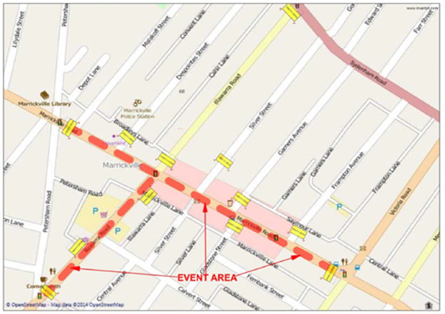
Subject: Marrickville Road, Marrickville – Temporary Full Road Closures For Marrickville Festival On Sunday 21 October 2018 (MARRICKVILLE WARD/SUMMER HILL ELECTORATE/MARRICKVILLE LAC)
Prepared By: Jennifer Adams - Engineer – Traffic and Parking Services
Authorised By: John Stephens - Traffic and Transport Services Manager
|
SUMMARY 'Marrickville Festival' is an annual event and this year it will be held on Sunday 21 October 2018. As per previous years the event will necessitate the temporary full road closure of Marrickville Road (between Petersham Road and Victoria Road), Illawarra Road (between Sydenham Road and Petersham Road), Alex Travellion Plaza and the Calvert Street car park in Marrickville. Short sections of Silver Street, Garners Avenue, Gladstone Street and Frampton Avenue where these streets intersect Marrickville Road will also be closed.
|
|
RECOMMENDATION
THAT:
1. The proposed temporary full road closure of Marrickville Road (between Petersham Road and Victoria Road), Illawarra Road (between Sydenham Road and Petersham Road), Alex Trevallion Plaza, the Calvert Street car park and short sections of Silver Street, Garners Avenue, Gladstone Street, Calvert Street and Frampton Avenue where these streets intersect Marrickville Road, Marrickville, from 11:00pm on Saturday 20 October 2018 to 12:00am on Monday 22 October 2018, for the holding of the annual 'Marrickville Festival' (Class 2 event under the RMS Special Events Guide), be APPROVED subject to the following conditions:
a. The temporary road closures be advertised in the local newspaper providing 28 days’ notice for submissions;
b. A Traffic Management Plan (TMP) be submitted to the Roads and Maritime Services for consideration and approval; and a Road Occupancy License application be submitted to the Transport Management Centre;
c. Notice of the proposed event be forwarded to the N.S.W. Police, State Transit Authority, Marrickville Local Area Commander, the NSW Fire Brigades and the NSW Ambulance Services;
d. Advance notification signs for the event be strategically installed at least two (2) weeks prior to the event;
e. 'No Parking – Special Event' signs be affixed over all existing parking restriction signage within the area of the festival, on the afternoon of the day prior to the event - Saturday 20 October 2018;
f. 'No Parking – Special Event' signs be affixed both sides of Petersham Road, Marrickville (between Illawarra Road and Marrickville Road) on the afternoon of the day prior to the event - Saturday 20 October 2018;
g. Traffic Controllers be located on Petersham Road to assist with the movement of the buses;
h. A 4-metre wide emergency vehicle access must be maintained through the ‘closed’ road area during the course of the festival;
i. All affected residents and businesses in the closed road area be notified in writing through a letter box drop of surrounding properties at least two (2) weeks prior to event;
j. Adequate vehicular traffic control shall be provided for the protection and convenience of pedestrians and motorists including appropriate signage and flagging. Workers shall be specially designated for this role (and carry appropriate certificates), as necessary to comply with this condition. This is to be carried out in accordance with the Australian Standard AS 1742.3 - Traffic Control Devices for works on roads; and
2. The existing Alcohol-Free Zone in the vicinity of Marrickville Road be suspended on Sunday 21 October 2018 for the purpose of holding this year’s ‘Marrickville Festival’.
|
BACKGROUND
A Development Application has been received for the holding of the annual ‘Marrickville Festival’ for a five year period (i.e. 22 October 2017, 21 October 2018, 20 October 2019, 18 October 2020 and 17 October 2021).
The 'Marrickville Festival' is an annual event and this year will be held on Sunday 21 October 2018. As in previous years, it will be necessary to close Marrickville Road (between Petersham Road and Victoria Road), Illawarra Road (between Sydenham Road and Petersham Road), Alex Travellion Plaza, the Calvert Street car park and short sections of Silver Street, Garners Avenue, Gladstone Street, Calvert Street, and Frampton Avenue where these streets intersect Marrickville Road, Marrickville.
This year’s Marrickville Festival will run between 10:00am and 5:00pm on Sunday 21 October 2018, however, the temporary full road closures are required from 11:00pm on Saturday 20 October 2018 to 12:00am on Monday 22 October 2018.
FINANCIAL IMPLICATIONS
Funding of $117,971 has been allocated by Council for organising the ‘Marrickville Festival’ event under the 2018/2019 Major Community Events Program.
OFFICER COMMENTS
The event area will be on Marrickville Road between Petersham Road and Victoria Road and Illawarra Road between Sydenham Road and Petersham Road (refer to the locality diagram below – Marrickville Festival Area).
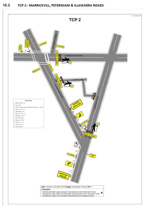
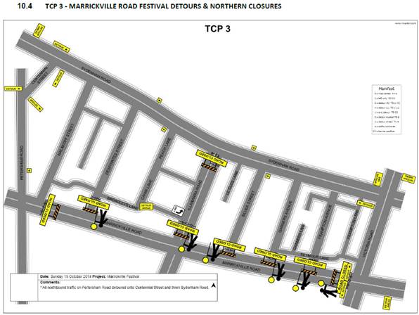
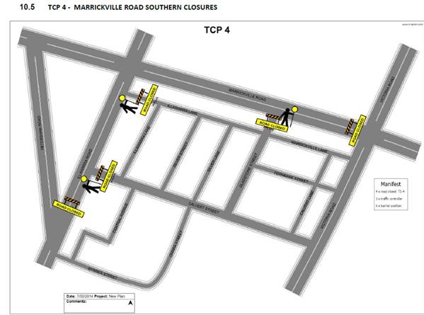
Temporary Closures are planned at the following locations (refer to the traffic control plans – TCP 1, 2, 3 & 4 below):
· Marrickville Road at Victoria Road,
· Marrickville Road at Petersham Road.
· Gladstone Street at Marrickville Road,
· Frampton Avenue at Marrickville Road,
· Garners Avenue at Marrickville Road,
· Silver Street at Marrickville Road,
· Despointes Street at Marrickville Road,
· Illawarra Road at Petersham Road,
· Illawarra Road at Sydenham Road,
· Calvert Street at Illawarra Road, and
· Peace lane at Despointes Street.
Locality Map – Marrickville Road & Illawarra Road, Marrickville - event area overview
![]()
Council barricades will be used to affect the road closures from 11:00pm on Saturday 20 October 2018 to 12:00am on Monday 22 October 2018 and a 4-metre wide emergency vehicle access will need to be maintained through the area during the course of the street festival.
Special Event advance notice signs will be strategically installed at least two (2) weeks prior to the event to alert motorists of the proposed closures. In addition, 'No Parking - Special Event' signs will be affixed over all existing parking signs within the area of the festival and on Petersham Road between Illawarra road and Marrickville Road on the afternoon of the day prior to the event - Saturday 20 October 2018.
Impacts on buses
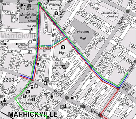
As per previous years, the following bus diversions will be in place (refer to the figure below):
![]()
![]() 418
to Tempe: Marrickville Rd, left Livingstone Rd, right Sydenham Rd,
right Victoria Rd, left Marrickville Rd then normal route.
418
to Tempe: Marrickville Rd, left Livingstone Rd, right Sydenham Rd,
right Victoria Rd, left Marrickville Rd then normal route.
![]() 418
to Burwood: Marrickville Rd, right Victoria Rd, left Sydenham Rd, left
Centennial St, Right Hawkhurst St, Left Livingstone Rd, right Marrickville Rd
then normal route.
418
to Burwood: Marrickville Rd, right Victoria Rd, left Sydenham Rd, left
Centennial St, Right Hawkhurst St, Left Livingstone Rd, right Marrickville Rd
then normal route.
![]() 423
to Circular Quay: Illawarra Rd, left Petersham Rd, left Francis St,
right Livingstone Rd, right Sydenham Rd, left Victoria Rd then normal route.
423
to Circular Quay: Illawarra Rd, left Petersham Rd, left Francis St,
right Livingstone Rd, right Sydenham Rd, left Victoria Rd then normal route.
![]() 423
to Kingsgrove: Victoria Rd, right Sydenham Rd, left Centennial St, Right
Hawkhurst St, left Livingstone Rd, left Marrickville Rd, right Petersham Rd,
right Illawarra Rd then normal route.
423
to Kingsgrove: Victoria Rd, right Sydenham Rd, left Centennial St, Right
Hawkhurst St, left Livingstone Rd, left Marrickville Rd, right Petersham Rd,
right Illawarra Rd then normal route.
![]() 426
to Circular Quay: Marrickville Rd, left Livingstone Rd, right Sydenham Rd,
left Victoria Rd then normal route.
426
to Circular Quay: Marrickville Rd, left Livingstone Rd, right Sydenham Rd,
left Victoria Rd then normal route.
![]() 426
to Dulwich Hill: Victoria Rd, right Sydenham Rd, left Centennial St, Right
Hawkhurst St, left Livingstone Rd, right Marrickville Rd then normal route.
426
to Dulwich Hill: Victoria Rd, right Sydenham Rd, left Centennial St, Right
Hawkhurst St, left Livingstone Rd, right Marrickville Rd then normal route.
In order to provide bus drivers with adequate manoeuvring space, the following is recommended:
a) that the parking be banned in Petersham Road (between Illawarra Road and Marrickville Road) on the day of the Festival; and/or
b) that Traffic Controllers be located in Petersham Road to assist with the movement of the buses.
No additional temporary bus stops will be required. Existing bus stops on Illawarra Road (near Marrickville Station) and on Marrickville Road (outside St Brigid's Church) are located close enough that intermediate bus stops may not be required.
Impacts on Parking
There are off-street and on-street parking spaces available within the vicinity of the proposed road closures. The car park off Calvert Street has access through Calvert Street and has 37 parking spaces. Some festival activities are proposed to be located in the Calvert Street car park.
There is a roof-top parking area, Banana Joe's car park, (opposite the Calvert Street car park) which has access through Tuohy Lane with approximately 80 parking spaces. As a result of the road closure at Petersham Road, access to this car park will also be restricted during the event.
Due to the proposed road closures the following car parking spaces will be impacted:
Marrickville Road
North side- between Victoria Road and Petersham Road
28 Parking spaces and 2 Bus Zones
South side- between Victoria Road and Petersham Road
43 Parking spaces and 2 Bus Zones
Illawarra Road
East Side – Between Marrickville Road and Petersham Road
21 parking spaces
West Side - None (unrestricted parking)
Parking surveys undertaken in the festival area in previous festivals indicated that there are many on-street parking spaces available to cater for parking in close proximity to the Street event.
Impacts on traffic
The traffic diverted from Marrickville Road and Illawarra Road as a result of the proposed road closures, does not coincide with the peak traffic, as the festival will be held on a Sunday when lower than weekday traffic volumes are expected. Therefore, the traffic generated as a result of the proposed festival will not have a major impact on the surrounding traffic network during the event. Furthermore the arrival and departure of attendees of the festival is expected to be staggered as it is every year when this event takes place.
Police vehicles travelling to and from the Police Station located in Despointes Street will have no access to Marrickville Road during the event, however, access to Sydenham Road will be available.
PUBLIC CONSULTATION
The proposed full-road closures of the event will be advertised in the local papers commencing in the week beginning 10 September 2018 for a period of 28 days. A Traffic Management Plan is to be submitted to the RMS for consideration and approval and a Road Occupancy License application is to be submitted to the Transport Management Centre.
CONCLUSION
It is recommended that Council agree to the temporary road closures on Sunday 21 October 2018; apply to the RMS for consent to close the subject roads, subject to the event being advertised, a Traffic Management Plan be submitted to the RMS for approval, parking on the western side of Petersham Road be temporarily banned, special temporary Bus Zones be installed on Marrickville Road for the duration of the closures and advice of the proposed event being forwarded to the appropriate authorities, including emergency services and the Transport Management Centre.
It is also recommended that the existing Alcohol-Free Zone in the vicinity of Marrickville Road be suspended on Sunday 21 October 2018 for the purpose of holding this year’s ‘Marrickville Festival’.
|
|
Local Traffic Committee Meeting 3 July 2018 |
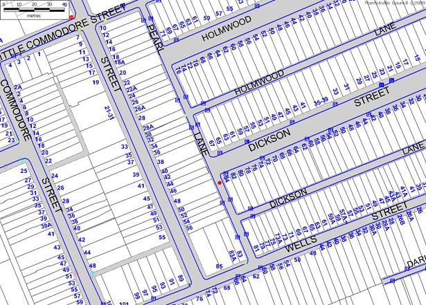
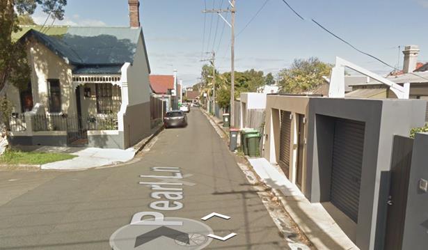
Subject: Pearl Lane, Newtown – Proposed Statutory ‘No Stopping’ Restrictions South of Holmwood Street (Stanmore Ward/ Heffron electorate / Marrickville LAC)
Prepared By: Jennifer Adams - Engineer – Traffic and Parking Services
Authorised By: John Stephens - Traffic and Transport Services Manager
|
SUMMARY A resident of Pearl Street, Newtown has raised concerns regarding vehicles being parked opposite to their garage in Pearl Lane, restricting access to their off-street parking facility. It should also be noted that the area opposite the garage access is also located with the statutory 10m ‘No Stopping’ zone from an intersection.
It is recommended that the installation of 'No Stopping' restrictions on the eastern side of Pearl Lane for the statutory distance of 10 metres south of its junction with Holmwood Street be approved, to improve vehicular access into off-street parking spaces.
|
|
RECOMMENDATION
THAT:
1. The installation of 'No Stopping' restrictions on the eastern side of Pearl Lane for the statutory distance of 10 metres south of its junction with Holmwood Street, Newtown, be APPROVED, to improve vehicular access into off-street parking spaces; and
2. The applicant be advised in terms of this report.
|
BACKGROUND
Council received a representation from a resident of Pearl Street, Newtown, regarding parked vehicles opposite their garage in Pearl Lane, Newtown. The applicant advised that vehicles are parked regularly at this location, restricting access to their off-street parking facility.
FINANCIAL IMPLICATIONS
The cost of the installation of the proposed ‘No Stopping’ sign is approximately $350 and will be funded through Council’s operating budget.
OFFICER COMMENTS
Pearl Lane is approximately 4.8 metres wide and runs north-south between Wells Street and Alice Lane, Newtown. The applicant’s property has vehicular access from Pearl Lane in the section between Holmwood Street and Holmwood Lane.
At present, there are signposted restrictions on parking on the north side of Pearl Lane and Holmwood Street and no restrictions on the south side of this intersection and when vehicles are parked directly south of its corner with Holmwood Street, vehicular access to the applicant’s garage is restricted (Refer to the attached locality map and photographs).
In accordance with the Australian Road Rules (ARR 170-3), a ‘No Stopping’ zone is mandatory from an intersecting road without traffic signals. RMS’ Technical Directions states that signposting and/or marking with a solid yellow line at an unsignalised intersection (without pedestrian crossing) “should only be required where there is a compliance problem or there is adjoining signposting”. In this case it is shown to be a compliance problem which is causing problems for the resident to access their off-street parking facilities.
PUBLIC CONSULTATION
No consultation is required, as the proposed markings would enforce the current Australian Road Rules. However, adjacent residents will be notified of the proposed changes prior to the installation of the signposting.
CONCLUSION
It is recommended that the installation of 'No Stopping' restrictions on the eastern side of Pearl Lane for the statutory distance of 10 metres south of its junction with Holmwood Street be approved, to improve vehicular access into off-street parking spaces.
Locality map – Pearl Lane, Newtown

![]()
![]()
![]()
Photographs – Pearl Lane, Newtown
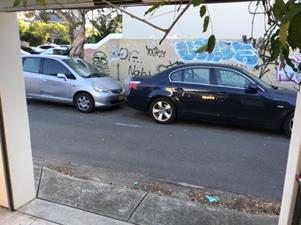
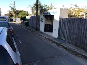
Proposed Statutory 10 metre ‘No Stopping’ restrictions in Pearl Lane east side south of Holmwood Street, Newtown
![]()

![]()
|
|
Local Traffic Committee Meeting 3 July 2018 |
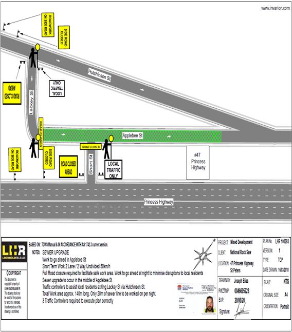
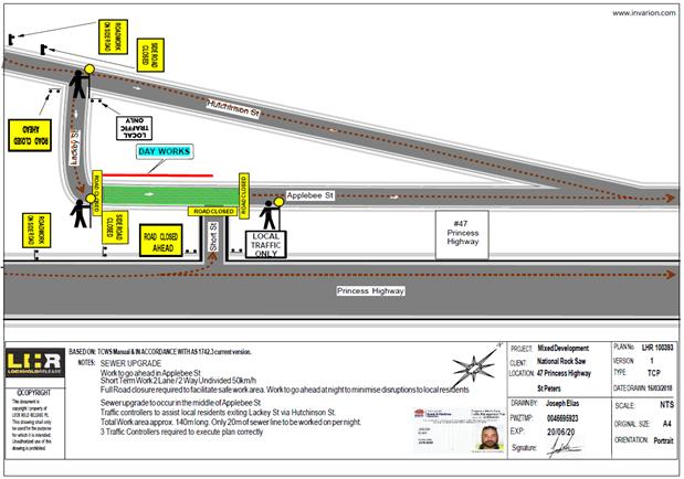
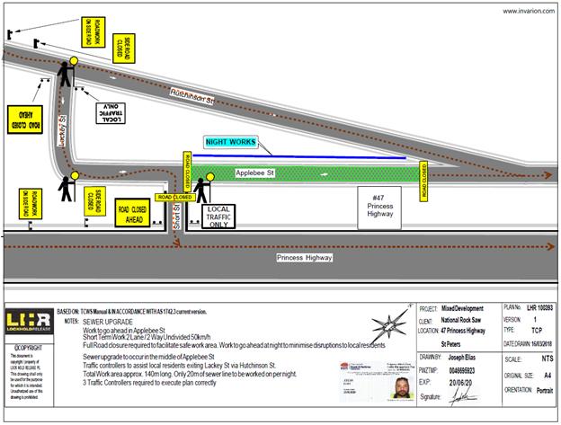
Subject: Applebee
Street, St Peters - Temporary Road Closure to Carry Out Sewer Works.
(Marrickville Ward/ Heffron Electorate/Newtown LAC)
Prepared By: Idris Hessam - Road Access Engineer
Authorised By: John Stephens - Traffic and Transport Services Manager
|
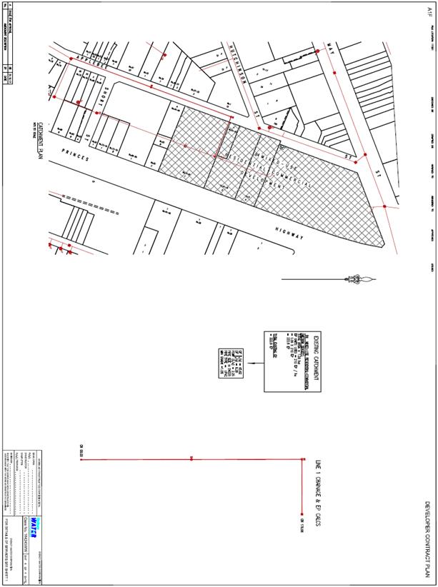
SUMMARY An application has been received from GJ Building and Contracting for the temporary full road closure of Applebee Street (between Lackey Street and Hutchinson Street) St Peters periodically between (9:00pm to 5:00am) from Hutchinson Street to Short Street and/or (7:00am to 5:30pm) from short Street to lackey Street for a period of two weeks from 30/7/2018 till 16/8/2018 with a further two weeks of contingency from 17/8/2018 till 31/8/2018 in order to carryout sewer works on Applebee Street, St Peters. It is recommended that the proposed temporary road closure be approved, subject to the conditions outlined in this report. |
|
RECOMMENDATION
THAT the proposed temporary full road closure of Applebee Street (between Lackey Street and Hutchinson Street) St Peters periodically between (9:00pm to 5:00am) from Hutchinson Street to Short Street and/or (7:00am to 5:30pm) from short Street to Lackey Street for a period of two weeks from 30/7/2018 till 16/8/2018 with a further two weeks of contingency from 17/8/2018 till 31/8/2018 in order to carryout sewer works on Applebee Street, St Peters, subject to the following conditions:
a) A fee of $1,540.60 for the temporary full road closure is payable by the applicant in accordance with Council’s Fees and Charges; b) The temporary full road closure be advertised in the local newspaper providing 28 days’ notice for submissions, in accordance with the Roads Act; c) A Traffic Management Plan (TMP) be submitted by the applicant to the Roads and Maritime Services for consideration and approval; d) A Traffic Control Plan (TCP) which has been prepared by a certified Traffic Controller, is to be submitted to Council for review with a copy of the Traffic Controllers certification number attached to the plan, not less than 5 days prior to implementation of closure; e) A Road Occupancy License be obtained by the applicant from the Roads and Maritime Services’ Transport Management Centre; f) Notice of the proposed closure be forwarded by the applicant to the NSW Police, the NSW Fire Brigades and the NSW Ambulance Services; g) Notification signs advising of the proposed road closures and new traffic arrangements to be strategically installed and maintained by the applicant at each end of the street at least 7 days prior to the closure; h) All affected residents and businesses shall be notified in writing, by the applicant, of the proposed temporary road closure at least 7 days in advance of the closure with the applicant making reasonable provision for residents; i) Vehicular and pedestrian access for residents and businesses to their off-street car parking spaces be maintained where possible whilst site works are in progress; j) Adequate vehicular traffic control shall be provided for the protection and convenience of pedestrians and motorists including appropriate signage and flagging. Workers shall be specially designated for this role, as necessary to comply with this condition. This is to be carried out in accordance with the Australian Standard AS 1742.3 - Traffic Control Devices for works on roads; k) The holder of this approval shall indemnify the Council against all claims, damages and costs incurred by, or charges made against, the Council in respect to death or injury to any person or damage in any way arising out of this approval. In this regard, a public liability insurance policy for an amount not less than $20,000,000 for any one occurrence is to be obtained and is to note the Council as an interested party. The holder of this approval shall inform its insurer of the terms of this condition and submit a copy of the insurance policy to the Council prior to commencement of the work the subject of this approval; l) The operator of any unit exercising this approval shall have this approval with them and produce it if required along with any other relevant authority approvals granted in the connection with the work; m) Mobile cranes, cherry packers or concrete boom pumps shall not stand within the public way for extended periods when not in operation under this approval; n) The operation of the mobile crane shall not give rise to an "offensive noise" as defined in the Protection of Environment Operations Act, 1997. Furthermore, vibrations and/or emission of gases that are created during its operations and which are a nuisance, or dangerous to public health are not permitted; o) All work is to be carried out in accordance with Work Cover requirements; and p) The costs to repair damages, as a result of these works, to Council's footway and roadway areas will be borne by the applicant. |
BACKGROUND
An application has been received from GJ Building and Contracting for the temporary full road closure of Applebee Street (between Lackey Street and Hutchinson Street) St Peters periodically between (9:00pm to 5:00am) from Hutchinson Street to Short Street and/or
(7:00am to 5:30pm) from short Street to lackey Street for a period of two weeks from 30/7/2018 till 16/8/2018 with a further two weeks of contingency from 17/8/2018 till 31/8/2018 in order to carryout sewer works on Applebee Street, St Peters.
FINANCIAL IMPLICATIONS
Under Council’s Fees & Charges, the applicant is to pay a fee of $1,540.00 for the temporary full road closure. This fee includes advertising the proposal in accordance with the Roads Act 1993.
PUBLIC CONSULTATION
The applicant is to notify all affected residents and businesses in writing at least 7 days prior to the commencement of works. The proposed road closure is to be advertised in the local newspaper in accordance with the Roads Act 1993.
CONCLUSION
It is recommended that the proposed temporary road closures be approved, subject to the conditions outlined in this report.
Traffic Control Plan submitted by the applicant – Applebee Street, St Peters
|
|
Local Traffic Committee Meeting 3 July 2018 |
Subject: Lackey Street and Smith Street, Summer Hill - Temporary Road Closures For the Annual 'Summer Hill Neighbourhood Festa' on Sunday 7 October 2018. (Ashfield Ward/Summer Hill Electorate/Ashfield LAC)
Prepared By: Boris Muha - Engineer – Traffic and Parking Services
Authorised By: John Stephens - Traffic and Transport Services Manager
|
SUMMARY In accordance to a Section S68 Development Application 10.2018.93, Council seeks the support of the Committee for the temporary road closures of Lackey Street and Smith Street, Summer Hill for the annual ‘Summer Hill Neighbourhood Feast’ festival on Sunday 7 October 2018, as recommended below. |
|
RECOMMENDATION
THAT the road closure application for the ‘Summer Hill Neighborhood Feast’ on the Sunday 7 October 2018 be supported, subject to the following conditions:
a) The road closure be restricted to occur from 6.00am and 6.00pm in Lackey Street (between Carlton Crescent and Smith Street), and Smith Street (between Hardie Avenue and Nowraine Street);
b) Hardie Avenue, between Smith Street and Lackey Street be closed at Lackey Street, to allow access only to the Summer Hill carpark;
c) A Traffic Management Plan (TMP) is submitted to and approved by RMS and an application for a Roads Occupancy License be forwarded to and approved by the Transport Management Centre;
d) Notice of the proposed event is forwarded to the emergency services, i.e. NSW Police, Fire and Rescue NSW and NSW Ambulance Services;
e) A 4 metre wide emergency service access must be maintained through the closed road areas during the course of the event;
f) Council through its ‘Events Management’ will notify/consult with all affected residents and/or businesses in the area, and conduct a letter-box/leaflet drop notifying the local community of the road closure event at least two (2) weeks prior to the event;
g) The temporary road closure be advertised in the local newspaper providing 28 days’ notice for submissions, in accordance with the Roads Act;
h) Advance notification signs for the event are strategically installed at least one (1) week prior to the event; and
i) Adequate Vehicular traffic control shall be provided for the protection and convenience of pedestrians and motorists including appropriate signage and flagging. Workers shall be specifically designated for this role (and carry appropriate certificates), as necessary to comply with this condition. This is to be carried out in accordance with the Australian Standard AS 1742.3- Traffic Control Devices for works on roads.
|
BACKGROUND
The ‘Summer Hill Neighbourhood Festa’ is a scheduled annual food festival event to be conducted in the Council Area of Summer Hill in 2018, and in conjunction with the Sydney wide food festival program.
FINANCIAL IMPLICATIONS
The costs associated with the temporary road closures are to be borne by Council as part of its major events or operational budget.
OTHER STAFF COMMENTS
The event has gained popularity over the years. The Event’s Management coordinator of Council has requested that Lackey Street (Carlton Crescent and Smith Street) and Smith Street (between Hardie Avenue and Nowraine Street) be temporarily closed off to accommodate the event -see ‘Traffic Control Plan’
Hardie Avenue between Smith Street and Lackey Street, will be closed at Lackey Street to through traffic. Access will be maintained to the Summer Hill Carpark from Smith Street.
Lackey Street and Smith Street has been closed off in previous years. The Local Traffic Committee and Roads and Maritime Services (RMS) has approved the event road closures in the past.
Although the event runs from 10am-4pm, from an operational point of view, in order to affectively clear parking in the area and set-up and dismantle for the event, the road closure will be affective from 6.00am-6.00pm.
In accordance with the RMS “Guide to Traffic and Transport Management for Special Events V3.4 August 2006, the event is classified either Special Event class 1 or 2. Relevant approval is required from the RMS for the closure of the roads and a road occupancy license needs to be obtained from the Transport Management Centre.
A Traffic Management Plan is also attached. This together with the Traffic Control Plan will be submitted to attain RMS approval and Road Occupancy License from the Traffic Management Centre.
PUBLIC CONSULTATION
Notification of the event will be arranged by Council’s Event Management via letter box/leaflet drop and local newspaper advertisement.
CONCLUSION
It is recommended that support be provided for Council to carry out the temporary road closures of Lackey Street (between Carlton Crescent and Smith Street) and Smith Street (between Hardie Avenue and Nowraine Street), Summer Hill, in association with the annual ‘Summer Hill Neighborhood Feast’ food festival event on Sunday 7 October 2018. This will be on the provision that Council applies for Road Occupancy Licensing and provides Traffic Management Plans to the RMS for approval in closing the roads.
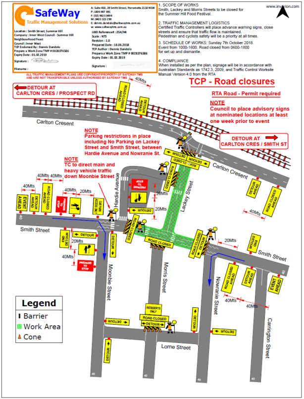
|
1.⇩ |
Traffic Management Plan |
|
|
Local Traffic Committee Meeting 3 July 2018 |
Subject: Chapman Lane (rear of Nos. 127 to 133 Annandale Street), Annandale - Proposed Extension of "No Parking" zone (Balmain Ward/Balmain Electorate/Leichhardt LAC)
Prepared By: David Yu - Engineer - Traffic and Parking Services
Authorised By: John Stephens - Traffic and Transport Services Manager
|
SUMMARY Council has received concerns regarding parking obstructing access to off-street parking in Chapman Lane (rear of Nos.127 to 133 Annandale Street), Annandale |
|
RECOMMENDATION
THAT:
1. A 7.2m ‘No Parking’ zone be installed on the eastern side of Chapman Lane (opposite the rear of No.127 Annandale Street); and
2. A 10.8m ‘No Parking’ zone be installed on the eastern side of Chapman Lane (opposite the rear of No.133 Annandale Street).
|
BACKGROUND
Council has received concerns from a resident of Annandale Street, Annandale regarding vehicles parking on the eastern side of Chapman Lane, Annandale and subsequently obstructing rear driveway access for property Nos.127 and 133 Annandale Street.
There is an existing ‘No Parking’ zone on the eastern side of Chapman Lane that extends opposite the rear boundaries of Nos.115 to 125 Annandale Street.
FINANCIAL IMPLICATIONS
Nil.
OTHER STAFF COMMENTS
It is proposed to signpost the remaining kerb space on the eastern side of Chapman Lane as a ‘No Parking’ zone (opposite the rear of Nos. 127 to 133 Annandale Street). This proposal includes a 7.2m ‘No Parking’ zone and 10.8m ‘No Parking’ zone as shown on the following plan.
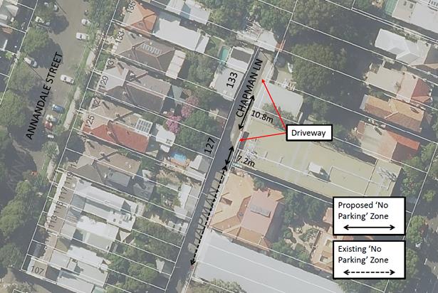
PUBLIC CONSULTATION
|
A letter outlining the above proposal was mailed out to the affected properties (25 properties) in Annandale Street and Johnston Street, Annandale. Six (6) responses were received. Five (5) in support and one (1) objecting to the proposal. The table below shows the comments raised by the residents.
|
|
|
Residents’ Comments |
Officer Comments |
|
Please put the signs up, there are always cars parked in this area which restricts access into our driveways/car parks. |
Noted. |
|
The cars obstruct the whole lane, not just the driveways. Sometimes it is difficult to access the carpark for 100-104 Johnston. There are still cars being parked in the no-parking zone, but they park half on the small paved area. |
This concern has been forwarded to Council’s Parking and Ranger Services section for inspection. |
|
|
|
|
We use the parking spot at the rear of our property frequently for parking and washing cars as do many other people. It does not obstruct the opposite garage entrances in the lane. I strongly oppose no parking signs |
It has been identified vehicles parking on the eastern side of Chapman Lane obstruct rear driveway access for properties between Nos.127 and 133 Annandale Street. |
CONCLUSION
Nil.
|
|
Local Traffic Committee Meeting 3 July 2018 |
Subject: Nelson Lane (Opp. Nos. 195 to 207A Nelson Street), Annandale - Extension of 'No Parking' Zone (Balmain Ward/Balmain Electorate/Leichhardt LAC)
Prepared By: David Yu - Engineer - Traffic and Parking Services
Authorised By: John Stephens - Traffic and Transport Services Manager
|
SUMMARY Council has received concerns regarding obstructed driveway access in Nelson Lane opposite the rear boundaries of Nos.195 to 207 Nelson Street, Annandale. |
|
RECOMMENDATION
THAT the existing ‘No Parking’ zone on the eastern side of Nelson Lane, Annandale be extended northwards to include the 48m unrestricted parking area opposite the rear boundaries of Nos. 195 to 207A Nelson Street, Annandale.
|
BACKGROUND
Council has received concerns from some of the residents of Nos. 195 to 207 Nelson Street, Annandale regarding vehicles parking on the eastern side of Nelson Lane, Annandale and subsequently obstructing rear driveway access.
Nelson Lane is approximately 5.6m wide. There is an existing ‘No Parking’ zone on the eastern side of Nelson Lane that extends south from directly opposite the rear of No. 193 Nelson Street.
FINANCIAL IMPLICATIONS
Nil.
OTHER STAFF COMMENTS
It is proposed to signpost the eastern side of Nelson Lane opposite Nos. 195 to 207A Nelson Street as a ‘No Parking’ zone. The proposal is shown on the following plan.
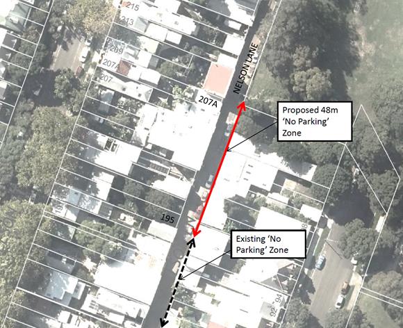
PUBLIC CONSULTATION
|
A letter outlining the above proposal was mailed out to the affected properties (18 properties) in Nelson Street and Taylor Street, Annandale. Eight (8) responses were received. Four (4) in support, three (3) objecting and one (1) neutral to the proposal The table below shows the comments raised by the residents.
|
|
|
Residents’ Comments |
Officer Comments |
|
I support the decision as it is impossible to access my driveway/ garage when a car is parked in Nelson lane. |
Noted. |
|
There are only garages and/or parking spaces associated with 195 to probably 203 Nelson Lane. 205 Nelson Street it has a single door suitable for vehicle access, but has never been used for that purpose. No. 207 has a garage at the rear. No. 207a has a garage door, but it is permanently sealed. Furthermore, there is a vehicle entry to No. 102 Taylor Street directly opposite, which is a ‘No Parking’ zone in any case. The Restricted Parking should only be applied to the rear of 195-203 Nelson Lane. Most of the Nelson Street properties and a couple of Taylor street residents use the laneway to park. Most of us have given up trying to find parking in Nelson Street and now access our properties from Nelson Lane. For the most part those residents that have lived in Nelson Street for some time work around access. A 'No Parking Zone' will force us residents to compete, with trades people, for a smaller number of parking spots. |
Council has investigated this request as a number of residents have raised concerns with accessibility to off-street parking. It has been identified vehicles parking on the eastern side of Nelson Lane obstruct rear driveway access for properties between No. 195 to 207 Nelson Street.
This proposal will allow those residents to safely access their off-street parking by allowing them to use the full width of the lane to make the manoeuvre. |
|
Parking on the eastern side of Nelson Lane: 1) Makes it difficult to enter and exit the off-street parking on the western side. 2) Makes the lane unsafe as it funnels cars into a very narrow thoroughfare on the western side where cars are exiting off-street parking and people are exiting houses to go to the park. Removing the parking on the eastern side will encourage residents that are parking in the lane to use their off-street parking. |
Noted. |
CONCLUSION
Nil.
|
|
Local Traffic Committee Meeting 3 July 2018 |
Subject: Silver Lane - Proposed 'No Parking' Restrictions (Marrickville Ward/Electorate/Inner West LAC)
Prepared By: Mary Bailey - Parking Planner
Authorised By: John Stephens - Traffic and Transport Services Manager
|
SUMMARY Following representations from the community, it is proposed to install ‘No Parking’ in Silver Lane, Marrickville to ensure access to off street parking and vehicular thoroughfare. Public consultation has been carried out regarding the proposal. |
|
RECOMMENDATION
THAT conversion of unrestricted parking to ‘No Parking’ in Silver Lane, Marrickville (eastern side) between existing ‘No Stopping’ at Marrickville Lane and existing ‘No Parking’ at the rear of property No. 31 Gladstone Street be approved to allow for access to an off-street parking space.
|
BACKGROUND
At present, ‘No Parking’ restrictions are in place along the western side of Silver Lane
‘No Parking’ restrictions are also in place along the eastern side of Silver Lane at the rear of property 33-35 Gladstone Street. (See Figure 1).
When vehicles are parked directly opposite a garage entrance, ingress/egress can be extremely difficult. It should be noted that laneways were generally built to provide service access for properties and access into off-street parking facilities. Removal of long stay parking will help achieve this goal (refer to Figure 2).
Given the need to provide clear vehicular access through the laneway and to off-street car parking facilities; and to provide continuity and consistency of existing parking restrictions, it is recommended that full-time ‘No Parking’ restrictions be approved on the eastern side of Silver Lane, Marrickville (replacing the unrestricted parking area between the rear of properties No. 3 to 31 Gladstone Street).
According to Council’s Laneway Guidelines (December 2015) Laneways can be used for a variety of purposes which are listed below:
· Access for garbage collection trucks and deliveries where required
· Access to existing off-street parking within properties
· Access for emergency vehicles, pedestrians and cyclists
· Accessible parking for people with disabilities where appropriate
· Parking where space is available and access is maintained.
Silver Lane is 4.5m wide. The Laneway Guidelines also state that, “For parking to be allowed in a narrow laneway, the Australian Standards require that parallel parking spaces be at least 2.1 metres wide and NSW Road Rules requires that at least 3 metres must be available between a parked car and the kerb or edge of the laneway to allow moving vehicles to pass safely. Therefore, laneway widths that are less than 5.1 metres wide are too narrow to allow parking as any parked vehicle would prevent traffic from using the laneway.”
In this case, Council has received concerns that access to a garage is being restricted because of parking in the laneway. Furthermore, the laneway is only is 4.5m wide and therefore according to Council’s Laneway Guidelines not wide enough to cater for parking it is considered that the proposal to implement ‘No Parking’ restrictions as recommended will provide improved access to off street parking and also allow for the passage of vehicles.
All residents in properties having a boundary with Silver Lane will be advised prior to the installation of signage.
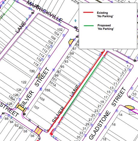
Figure 1. Existing and proposed parking restrictions Silver Lane
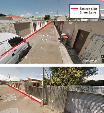
Figure 2. Silver Lane looking south and north
FINANCIAL IMPLICATIONS
The costs of the supply and installation of the ‘No Parking’ signage can be funded from Council’s signs and line markings budget.
PUBLIC CONSULTATION
A total of fifty one (51) letters were sent to affected owners/occupiers on 30 May 2018 seeking submission by 18 June 2018. A total of ten (10) responses were received. Five (5) of the respondents objected to the proposal and five (5) supported the proposal. Of the five (5) that supported the proposal four (4) did not provide an address.
|
Response |
Number |
Comment |
Council Officer response |
|
Object |
5 |
Objectors cited the following reasons 1. Children play in the laneway 2. People park across their driveways/garages 3. There is insufficient ‘unrestricted’ parking in nearby streets |
Council does not promote or support the use of laneways for other than access to service vehicles and access to off-street parking. Parking across driveways does not comply with Australian Road Rules and the proposed ‘No Parking’ signs cater for drop off and pick and loading/unloading.
|
|
Support |
5 |
Supporters cited the following reasons 1. Access to off street parking 2. Access for other vehicles through the laneway |
These issues are addressed through the report. |
CONCLUSION
Given the narrow width of the laneway and request from a resident to allow for access to off street parking, it is recommended to restrict parking for the remaining ‘unrestricted’ section of Silver Lane.
|
|
Local Traffic Committee Meeting 3 July 2018 |
Subject: Marian Lane, Enmore - Proposed 'No Parking' Restrictions (Stanmore Ward/Newtown Electorate/Inner West LAC)
Prepared By: Mary Bailey - Parking Planner
Authorised By: John Stephens - Traffic and Transport Services Manager
|
SUMMARY Following representation from a resident, Council is proposing to restrict parking in a section of Marian Lane, Enmore. All affected properties had been notified of the proposal and no objections have been received. Given the narrowness of the laneway and the difficulty experienced by the resident in accessing off street parking, it is recommended to proceed with the implementation of a section of ‘No Parking’ restriction in the laneway. |
|
RECOMMENDATION
THAT the conversion of unrestricted parking to a 5m section of ‘No Parking’ restriction in Marian Lane at the rear of property No. 69 Marian Street (opposite the rear of No. 52 Metropolitan Road, Enmore) be supported to improve access into the property.
|
BACKGROUND
Council is proposing to convert a section of unrestricted parking in Marian Lane to ‘No Parking’
The proposal is illustrated in Figure 1.
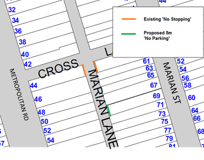
Figure 1: Existing and proposed parking restrictions in subject section of Marian Lane
The resident has experienced difficulty accessing the property over a number of years. The Newtown/Enmore Parking Study endorsed by Council in April 2017, considered parking restrictions along the entire length of Marian Lane. However, there were a number of objections to this proposal and as a result it was decided that requests for parking restrictions in Marian Lane would be dealt with on a case by case basis. Following the request by a resident, a site investigation was carried out by Council officers. The section of Marian Lane which the proposal pertains to is shown in Figure 2 and the garage entrance which is affected is shown in Figure 3.
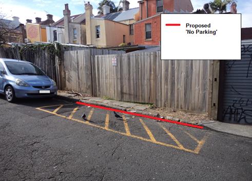
Figure 2: Section of Marian Lane at the rear of No.69 Marian Street
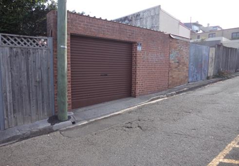
Figure 3: Garage entrance opposite proposed ‘No Parking’ restriction
According to Council’s Laneway Guidelines (December 2015), Laneways can be used for a variety of purposes which are listed below:
-Access for garbage collection trucks and deliveries where required
-Access to existing off-street parking within properties
-Access for emergency vehicles, pedestrians and cyclists
-Accessible parking for people with disabilities where appropriate
-Parking where space is available and access is maintained.
When vehicles are parked directly opposite a garage entrance, ingress/egress can be difficult. It should be noted that laneways were generally built to provide service access for properties and access into off-street parking facilities. Removal of long stay parking will help achieve this goal (refer to Figure 2).
Marian Lane is 4.8m wide. The Laneway Guidelines also state that, “For parking to be allowed in a narrow laneway, the Australian Standards require that parallel parking spaces be at least 2.1 metres wide and NSW Road Rules requires that at least 3 metres must be available between a parked car and the kerb or edge of the laneway to allow moving vehicles to pass safely. Therefore, laneway widths that are less than 5.1 metres wide are too narrow to allow parking as any parked vehicle would prevent traffic from using the laneway.”
FINANCIAL IMPLICATIONS
The cost for the supply and installation of the signposting can be funded from Council's operational budget for signs and line marking.
PUBLIC CONSULTATION
On 24 May 2018, letters detailing the proposal and seeking feedback were sent to seven (7) properties affected by the proposal. Recipients were advised of a closing date of Wednesday 13 June 2018 for submissions. No responses were received.
Typically, all affected residents will be advised prior to the installation of signage.
CONCLUSION
Given the need to provide clear vehicular access through the laneway and to off-street car parking facilities and to provide continuity and consistency of existing parking restrictions, it is recommended that full-time ‘No Parking’ restrictions be approved at the rear of No.69 Marian Street (opposite rear of No.52 Metropolitan Road)
|
|
Local Traffic Committee Meeting 3 July 2018 |
Subject: Hopetoun Lane, Camperdown - Proposed 'No Parking' Restrictions (Stanmore Ward/Newtown Electorate/Inner West LAC)
Prepared By: Mary Bailey - Parking Planner
Authorised By: John Stephens - Traffic and Transport Services Manager
|
SUMMARY Following representation from a resident, Council is proposing to extend a section of ‘No Parking’ in Hopetoun Lane to allow for access to a property that is currently being obstructed by vehicles parking across the gate. There have been no objections received to the proposal through the consultation process. |
|
RECOMMENDATION
THAT conversion of unrestricted parking to ‘No Parking’ in Hopetoun Lane between existing ‘No Parking’ at rear of property no. 49 Hopetoun Street to rear of property no. 45 Hopetoun Street be APPROVED to improve access into the property on the opposite side of the laneway. |
BACKGROUND
Council is proposing to convert a section of ‘unrestricted’ parking’ in Hopetoun Lane to ‘No Parking’ The proponent has indicated that it is necessary to gain access to the rear of the property to transport work related items and that often there are vehicles parked obstructing the access/egress through the gate to the property. The proposal is illustrated in Figure 1 below.
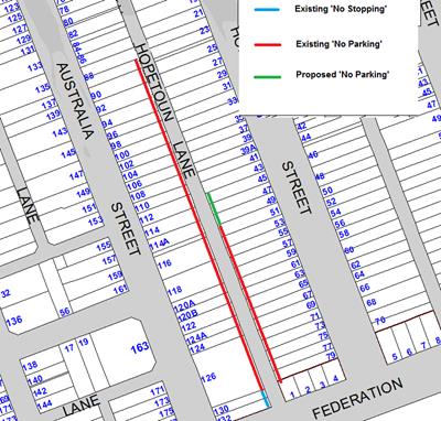
Figure 1: Existing and proposed restriction Hopetoun Lane
FINANCIAL IMPLICATIONS
The cost for the supply and installation of the signposting can be funded from Council's operational budget for signs and line marking.
PUBLIC CONSULTATION
On 23 May 2018 Council sent fourteen (14) letters to affected residents. The closing date for submission was stated as 13 June 2018. No responses were received.
Typically all affected residents are advised prior to the installation of signage.
CONCLUSION
There have been no objections to the proposal to implement a section of ‘No Parking’ at the rear of the subject property, therefore in order to allow for the resident to access the rear gate to their property it is recommended to proceed with the proposal.
|
|
Local Traffic Committee Meeting 3 July 2018 |
Subject: McGill Street, Lewisham - Proposed 'No Stopping' Restrictions (Stanmore Ward/Summer Hill Electorate/Inner West LAC)
Prepared By: Mary Bailey - Parking Planner
Authorised By: John Stephens - Traffic and Transport Services Manager
|
SUMMARY Following community representations Council is proposing to implement a number of restrictions in McGill Street, Lewisham in order to improve safety and access in McGill Street. |
|
RECOMMENDATION
THAT 10m statutory ‘No Stopping’ restriction in McGill Street at Old Canterbury Road (western side); and 10m statutory ‘No Stopping’ restriction in McGill Street at Hudson Street (both sides) be approved to improve safety and access to McGill Street, Lewisham.
|
BACKGROUND
Council is proposing to implement of ‘No Stopping’ restrictions in McGill Street, Lewisham.’
McGill Street, Hudson Street and adjoining sections of Old Canterbury Road have been subject to a significant level of high density development, resulting in an increase in vehicular traffic within the precinct. It is proposed to implement statutory 10m ‘No Stopping’ at a number of intersection locations in order to ensure manoeuvrability and safety for pedestrians and motorists alike.
The proposals are illustrated in Figure 1 below.
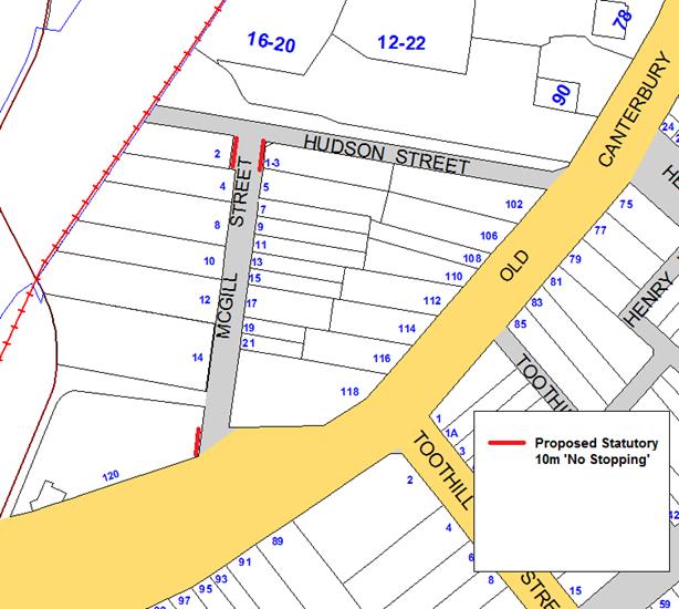
Figure 1: Map showing proposed parking measures
FINANCIAL IMPLICATIONS
The cost for the supply and installation of the signposting can be funded from Council's operational budget for signs and line marking.
PUBLIC CONSULTATION
One hundred and seventy three (173) letters were sent to all affected owners/occupiers on 15 May 2018 with a closing date of 4 June 2018. There were no responses received.
CONCLUSION
Installation of ‘No Stopping’ restrictions in McGill Street at Old Canterbury Road and at Hudson Street will improve access and safety for pedestrians and motorists alike.
|
|
Local Traffic Committee Meeting 3 July 2018 |
Subject: Watson Avenue, Croydon Park - Request for One Hour (1P) Parking Restriction
Prepared By: Anca Eriksson - Traffic Officer
Authorised By: George Tsaprounis - Coordinator – Traffic and Parking Services
|
SUMMARY Council is proposing to introduce a one hour parking limit on the western side of Watson Avenue, Croydon Park to the existing parking spaces in front of the shops at 2-4 Georges River Road, Croydon Park as shown on the attached map.
The following proposal addresses the need to have an appropriate turnover of parking for customers in order to assist the existing businesses in this section of Watson Avenue. |
|
RECOMMENDATION
THAT:
1. The installation of ‘1P, 8.30am-6.00pm M-F., 8.30am-12.30pm Sat.’ in Watson Street, Croydon Park adjacent 2-4 Georges River Road be approved to facilitate a turn over parking for adjacent businesses; and
2. The installation of statutory ‘No Stopping’ sign on the north-western side of Watson Avenue, 10m south of Georges River Road, Croydon Park, be approved;
|
BACKGROUND
Council has received correspondence from the shop owner on 2-4 Georges River Road, Croydon Park requesting that the existing spaces of unrestricted parking on Watson Avenue, to the side of his shop be changed to nominal business parking to assist in customer and visitors parking. The restrictions are considered adequate for parking needs for the surrounding businesses and visitors to Child Care Centre at 1 Watson Avenue, Croydon Park.
The nominal ‘1P, 8.30am-6.00pm M-F., 8.30am-12.30pm Sat.’ restriction was chosen to increase the availability of parking spaces for people visiting the shops and businesses located on Georges River Road, Croydon Park during business operating hours.
At present, parking is unrestricted on the both sides of Watson Avenue, Croydon Park.
FINANCIAL IMPLICATIONS
The cost of installing the parking signs can be met from Council’s signs and line marking operating budget.
OTHER STAFF COMMENTS
The parking spaces in question are outside neighboring businesses.
The provision of customer parking in Watson Avenue will benefit all the business in the area, and visitors to Child Care Centre at 1 Watson Avenue, Croydon Park.
Map – Watson Avenue, Croydon Park (at Georges River Road)
![]()
![]()
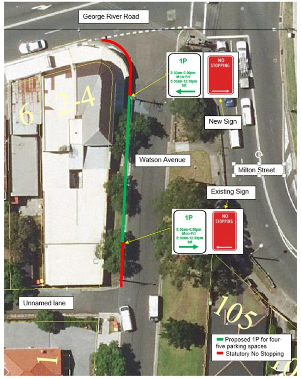
PUBLIC CONSULTATION
Twelve letters were sent out on 14 May 2018 to business owners and property owners/occupiers within the vicinity potentially affected by the proposed parking changes inviting comment. The community survey closed on 4 June 2018.
Council received one submission supporting Councils proposal. Additionally the citizen is strongly recommending that a statutory ‘No Stopping’ sign also be placed on the eastern side of Watson Avenue, from Georges River Road to the commencement of the proposed 1P parking space to make the section of road safer, both for pedestrians and for vehicles.
Existing resident parking elsewhere in Watson Avenue is considered adequate to facilitate ‘short term’ for customers as well. On this basis, it is recommended to support the proposal for 1P parking spaces in western side of Watson Avenue outside the shop businesses at 2-4 Georges River Road
CONCLUSION
It is recommended that the existing unrestricted parking spaces in Watson Avenue, outside 2-4 Georges River Road, Croydon Park be changed to parking ‘1P, 8.30am-6.00pm M-F., 8.30am-12.30pm Sat.’
The restrictions are considered adequate for parking needs for the surrounding businesses.
Additionally it is recommended that statutory 'No Stopping' restriction be installed on the north-western side of Watson Avenue, at its intersection with Georges River Road, Croydon Park.
|
|
Local Traffic Committee Meeting 3 July 2018 |
Subject: Nowranie Lane, Summer Hill - Proposed 'No Parking' Restrictions (ASHFIELD ARD/ SUMMER HILL ELECTORATE/ ASHFIELD LAC)
Prepared By: Anca Eriksson - Traffic Officer
Authorised By: George Tsaprounis - Coordinator – Traffic and Parking Services
|
SUMMARY Following community representations and site investigations it is proposed to introduce a section of ‘No Parking’ restrictions in Nowranie Lane, Summer Hill. Given the support for the proposal, it is recommended to proceed with the ‘No Parking’ restrictions in order to improve sight lines for turning motorists and increase safety by prohibiting motorists from parking within the specified zone in Nowranie Lane. |
|
RECOMMENDATION
THAT the installation of full-time ‘No Parking’ restrictions (33 meters in length) on the western side of Nowranie Lane, between the rear of property no. 2A Nowranie Street (southern boundary), Summer Hill and the rear of property no. 10 Nowranie Street (northern boundary) Summer Hill, be APPROVED, in order to allow for vehicular access on the lane.
|
BACKGROUND
Following representation from the local community, Council is proposing to introduce a section of ‘No Parking’ restrictions in Nowranie Lane, Summer Hill to improve sight lines for turning motorists and increase safety. ‘No Parking’ restrictions will prohibit motorists from parking within the specified zone over an extended period of time; however, they can legally stop to load/unload passengers and/or goods.
The subject section of laneway on the eastern side of the lane is currently limited to ‘No Parking’ on Mondays (6.00am to 3.00 pm) too allow Council’s Waste Collection Services to access the lane. The lane is approx. 5.4 m wide between kerb lines.
Parking on the western side of the lane is currently unrestricted. Access to Nowranie Lane is obstructed due to parked vehicles impeding driveway or laneway access or obstructing the turning paths at its intersection with Smith Lane. There are multiple off-street car parking spaces in Nowranie Street which are accessed via Nowranie Lane.
Given that there is a high demand for on-street parking in the area vehicles are now (legally) parked on both sides of the lane, blocking the lane.
This could be rectified by the provision of a length of ‘NO PARKING’ on the western side of the laneway (approximately 33m in length to improve vehicular access to off-street parking spaces and to improve the ease of access for residents).
The proposal is illustrated in Figure 1 below:
 |
|||
![]()
![]()
![]()
![]()
![]()
![]()
![]()
![]()
![]()
![]()
![]()
![]()
![]()
![]()
![]()
![]()
![]()
![]()
![]()
![]()

![]()
![]()
![]()
![]()
![]()
![]()
![]()
![]()
![]()
Figure 1: Map showing proposed implementation of ‘No Parking’ restrictions in Nowranie Lane, Summer Hill.
FINANCIAL IMPLICATIONS
The cost of the supply and installation of the signposting associated with the recommended ‘No Parking’ restrictions is approximately $700 and can be met from Council’s signs and line marking operating budget.
PUBLIC CONSULTATION
Twenty seven (27) letters were sent to residents of affected properties on 30 May 2018 with a closing date for comments of 21 June 2018. There were two (2) responses received in support of the proposal and no responses objecting to the proposal.
CONCLUSION
In order to provide unobstructed vehicular access for the residents’ to their off-street car parking spaces via Nowranie Lane, it is recommended that full-time ‘No Parking’ restrictions be installed for a section along the western side of Nowranie Lane, Summer Hill, between the rear of property no. 2A Nowranie Street (southern boundary), Summer Hill, and the rear of property no. 10 Nowranie Street (northern boundary), Summer Hill.
|
|
Local Traffic Committee Meeting 3 July 2018 |
Subject: Maida Street, Lilyfield - Proposed 'Motor Bike Only' Zone (Balmain Ward/ Balmain Electorate/ Leichhardt LAC)
Prepared By: David Yu - Engineer - Traffic and Parking Services
Authorised By: John Stephens - Traffic and Transport Services Manager
|
SUMMARY Council has received concerns regarding blocked vehicular access to the driveway of No. 32 and No. 34 Maida Street, Lilyfield because of vehicles over-hanging the driveways, when parking against the short section of kerb between the driveways.
|
|
RECOMMENDATION
THAT 3m of ‘Motor Bike Only’ parking be installed on the eastern side of Maida Street between the driveways of Nos. 32 and 34 Maida Street, Lilyfield. |
BACKGROUND
Concerns have been raised regarding blocked vehicular access to the driveway of No. 32 and No. 34 Maida Street, Lilyfield because of vehicles over-hanging both driveways.
The existing kerb space between No. 32 and No. 34 Maida Street is approximately 3.5m which is insufficient to accommodate a standard vehicle without impeding driveway access to No. 32 or No. 34 Maida Street.
FINANCIAL IMPLICATIONS
Nil.
OTHER STAFF COMMENTS
In order to prevent vehicles impeding driveway access whilst making use of this redundant space, it is proposed to install 3m of ‘Motor Bike Only’ parking on the eastern side of Maida Street between the driveways of No. 32 and No. 34 Maida Street.
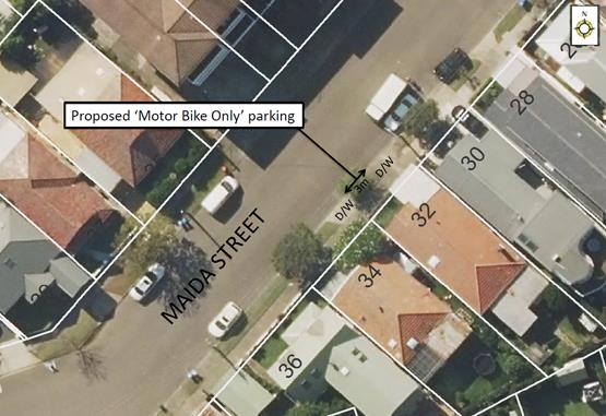
PUBLIC CONSULTATION
|
A letter outlining the above proposal was mailed out to the affected properties (7 properties) in Maida Street, Lilyfield as shown in the following map. A response was received from one property, in support of the proposal.
|
|
CONCLUSION
In order to prevent blocked vehicular access to the driveways of No. 32 and No. 34 Maida Street, Lilyfield, it is recommended that a 3m ‘Motor Bike Only’ parking restriction be installed on the eastern side of Maida Street between the driveways of No. 32 and No. 34 Maida Street, Lilyfield.
|
|
Local Traffic Committee Meeting 3 July 2018 |
Subject: Minor Traffic Facilities (All Wards / All Electorates / All LACs)
Prepared By: Vinoth Srinivasan - Engineer - Traffic and Parking Services and Idris Hessam - Road Access Engineer
Authorised By: John Stephens - Traffic and Transport Services Manager
|
SUMMARY This report considers minor traffic facility applications received by Inner West Council, and includes ‘Disabled Parking’ and ‘Works Zone’ requests. |
|
RECOMMENDATION
THAT:
1. A 20m 'Works Zone 7.00am - 5.30pm Mon-Sat' be installed in front of Nos. 20-22 George Street, Marrickville for 6 months;
2. A 9m ‘Works Zone 7.00am – 5.00pm Mon-Fri, 7.00am – 1.00pm Sat’ be installed in front of No. 14 Reserve Street, Annandale;
3. A 9m 'Works Zone 7.00am - 5.30pm Mon-Sat' be installed in front of No. 41Fisher Street, Petersham for 6 months;
4. A 5.5m ‘Disabled Parking’ zone is installed in Macquarie Terrace in front of No.8A Macquarie Terrace, Balmain;
5. A 5.5 m ‘Disabled Parking’ zone is installed in Joseph Street on the side boundary of No.25 May Street, Lilyfield;
6. A 6m ‘Disabled Parking’ zone be installed in front of property No. 1 Sloane Street, Newtown; and
7. A 6m ‘Disabled Parking’ zone be installed in front of No. 25 Dock Road, Birchgrove (including provision of a kerb ramp). |
BACKGROUND
This report considers minor traffic facility applications received by Inner West Council, and includes ‘Disabled Parking’ and ‘Works Zone’ requests.
FINANCIAL IMPLICATIONS
Nil.
OFFICER COMMENTS
1. Installation of ‘Works Zone’ Restriction – George Street, Marrickville
The applicant has requested the installation of a temporary 20m 'Works Zone 7.00am - 5.30pm Mon-Sat' in front of Nos.20-22 George Street, Marrickville for 6 months.
It is recommended that a 20m 'Works Zone 7.00am - 5.30pm Mon-Sat' be installed in front of Nos.20-22 George Street, Marrickville for 6 months
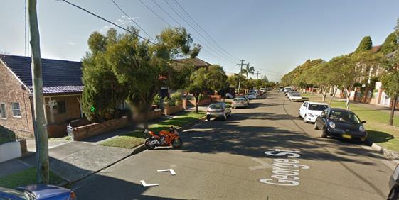
Nos. 20-22 George Street, Marrickville
2. Installation of ‘Works Zone’ Restriction – Fisher Street, Petersham
The applicant has requested the installation of a temporary 9m 'Works Zone 7.00am - 5.30pm Mon-Sat' in front of No.41 Fisher Street, Petersham for 6 months.
It is recommended that a 9m 'Works Zone 7.00am - 5.30pm Mon-Sat' be installed in front of No. 41 Fisher Street, Petersham for 6 months.
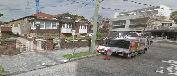
No. 41 Fisher Street, Petersham
3. Installation of ‘Works Zone’ Restriction – Reserve Street, Annandale
The applicant has requested the installation of a temporary 9m “Works Zone 7.00am – 5.00pm, Mon-Fri, 7.00am – 1.00pm Sat” in front of No.14 Reserve Street, Annandale.
The subject development is located on No.114 Ferris Street, Annandale. Due to the narrow frontages of properties in Ferris Street, the ‘Work Zone’ will extend across the frontage of neighbouring properties and was unable to get concurrence from directly affected residents. Therefore, the applicant has requested the installation of a temporary work zone in front of No.14 Reserve Street, Annandale.
Council has already received written consent from residents of No.14 Reserve Street.
It is recommended that a 9m “Works Zone 7.00am – 5.00pm Mon-Fri, 7.00am – 1.00pm Sat’ be installed in front of No.14 Reserve Street, Annandale for 12 weeks.
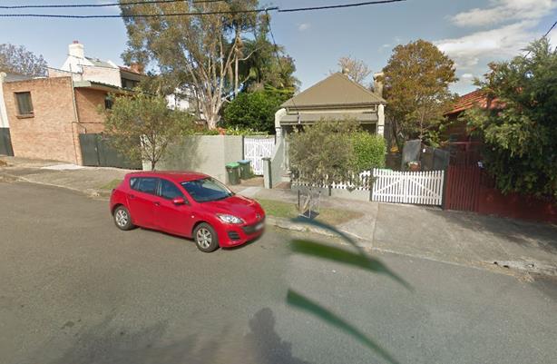
No. 14 Reserve Street, Annandale
4. Installation of ‘Disabled Parking’ Restriction – Macquarie Terrace, Balmain
The resident of No.8A Macquarie Terrace, Balmain has requested the installation of a ‘Disabled Parking’ zone in front of the resident’s property.
A site investigation has revealed the property does not have off street parking.
The applicant does require the use of a wheelchair.
It is recommended that a 5.5m ‘Disabled Parking’ zone be installed in front of No.8A Macquarie Terrace, Balmain, adjacent to the existing ‘No Stopping’ zone and replacing the existing 2P resident parking restrictions.
No. 8A Macquarie Terrace, Balmain
5. Installation of ‘Disabled Parking’ Restriction – Joseph Street, Lilyfield.
The resident of No.25 May Street, Lilyfield has requested the installation of a ‘Disabled Parking’ zone in Joseph Street on the side boundary of the resident’s property.
A site investigation has revealed the property has off street parking however the driveway width is 2.4m and is below standard.
The applicant does not require the use of a wheelchair; however, the use of a walker is currently required.
It is recommended that a 5.5m ‘Disabled Parking’ zone be installed in Joseph Street on the side boundary of No.25 May Street, Lilyfield, adjacent to the driveway.
Opposite No. 1 Joseph Street, Lilyfield
6. Installation of ‘Disabled Parking’ Restriction – Sloane Street, Newtown
Council Ref: Merit 1465132
The resident of property No.1 Sloane Street, Newtown has requested the installation of a ‘Disabled Parking’ zone in Sloane Street at the front of the resident’s property.
A site investigation has revealed that the property does not have off-street parking.
The applicant does not require the use of a wheelchair.
It is recommended that a 6m ‘Disabled Parking’ zone be installed in Sloane Street in front of property No.1 Sloane Street, Newtown.
 No. 1 Sloane Street, Newtown
7. Installation of ‘Disabled Parking’ Restriction – Dock Road, Birchgrove
The resident of No.25 Dock Road, Birchgrove has requested the installation of a ‘Disabled Parking’ zone in front of the resident’s property.
A site investigation has revealed the property has off street parking accessed via Rowntree Street at the rear of the property; however, the applicant requires use of a wheelchair and there is a set of stairs between the off street parking space and the building.
It is recommended that a 6m ‘Disabled Parking’ zone be installed in front of No.25 Dock Road, Birchgrove (including provision of a kerb ramp).
No. 25 Dock Road, Birchgrove
PUBLIC CONSULTATION
Nil.
CONCLUSION
Nil.
|
|
Local Traffic Committee Meeting 3 July 2018 |
Subject: Railway Avenue, Stanmore; Darley Road, Leichhardt , Lilyfield Road, Lilyfield and Frederick Street, Ashfield - ‘No Parking 7am-7pm – Motor Vehicles under 4.5t GVM Excepted’ (All Ward / All Electorates / All LACs)
Prepared By: Manod Wickramasinghe - Coordinator – Traffic and Parking Services
Authorised By: John Stephens - Traffic and Transport Services Manager
|
SUMMARY Council at its meeting held on 8 May 2018 considered an item on the regulation and enforcement of long term trailer parking. Council subsequently resolved to develop a signage strategy aimed at implementing ‘No Parking 7AM-7PM – Motor Vehicles under 4.5t GVM Excepted’ restrictions in certain problematic locations. |
|
RECOMMENDATION
THAT:
1. ‘No Parking 7AM-7PM – Motor Vehicles under 4.5t GVM Excepted’ restrictions be installed (replacing unrestricted parking spaces only) on the southern side of Railway Avenue between Liberty Street and approx. 50m west of Surrey Street, Stanmore;
2. ‘No Parking 7AM-7PM – Motor Vehicles under 4.5t GVM Excepted’ restrictions be installed (replacing unrestricted parking spaces only) on the southern side of Lilyfield Road between Denison Street and the Unnamed Laneway running parallel between Justin Street and Lamb Street, Lilyfield, subject to the outcome of the Lilyfield Road Separated Cycleway investigation;
3. A request for the implementation of ‘No Parking 7AM-7PM – Motor Vehicles under 4.5t GVM Excepted’ restrictions on the northern/western side of Darley Road, Leichhardt between Allen Street and Hubert Street (replacing unrestricted parking spaces only) be forwarded to RMS for approval; and
4. It be noted that trailer parking on Frederick Street, Ashfield has ceased following enforcement of advertising trailers and no action is currently proposed.
|
BACKGROUND
Council at its meeting held on 8 May 2018 considered an item on the regulation and enforcement of long term trailer parking.
Council subsequently resolved to develop a signage strategy aimed at implementing ‘No Parking 7AM-7PM – Motor Vehicles under 4.5t GVM Excepted’ restrictions in problem locations and monitoring subsequent success rates.
The following locations have been identified as have being impacted by long term parking of trailers and boats:
· Railway Avenue, Stanmore (Local Road)
· Darley Road, Leichhardt (State Road)
· Lilyfield Road, Lilyfield (Local Road)
· Frederick Street, Ashfield (State Road)
FINANCIAL IMPLICATIONS
Nil.
OTHER STAFF COMMENTS
Railway Avenue, Stanmore (Local Road)
· This is a Local Road, under the jurisdiction of Council.
· Boat and trailer parking has been observed on the southern side of the street, particularly in the section between Warwick Street and Stafford Street.
· It is proposed to install ‘No Parking 7AM-7PM – Motor Vehicles under 4.5t GVM Excepted’ restrictions on the southern side of Railway Avenue between Liberty Street and approx. 50m west of Surrey Street as shown on the following plan.
· No changes are proposed to the northern side of Railway Avenue.
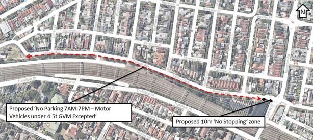
Darley Road, Leichhardt (State Road)
· This is a State Road, under the jurisdiction of RMS.
· Boat and trailer parking has been observed on the western/northern side of the street, particularly in the section between William Street and Charles Street.
· Recommended that Council forward a request for the implementation of ‘No Parking 7AM-7PM – Motor Vehicles under 4.5t GVM Excepted’ restrictions on the northern/western side of Darley Road, Leichhardt between Allen Street and Hubert Street to RMS for its approval and installation.
Lilyfield Road, Lilyfield (Local Road)
· This is a Local Road, under the jurisdiction of Council.
· Boat and trailer parking has been observed on the southern side of the street, particularly in the section between Ryan Street and Denison Street.
· It is proposed to install ‘No Parking 7AM-7PM – Motor Vehicles under 4.5t GVM Excepted’ restrictions on the southern side Lilyfield Road between Denison Street and the Unnamed Laneway running parallel between Justin Street and Lamb Street.
· No changes are proposed to the northern side of Lilyfield Road.
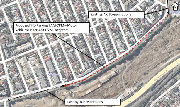
Frederick Street, Ashfield (State Road)
· This is a State Road, under the jurisdiction of RMS.
· Trailer parking has ceased since the amendments to the State Environmental Planning Policy No. 64 – Advertising and Signage (SEPP 64) came into effect (from 1 March 2018). This amendment resulted in the banning of advertisements on parked trailers on roads, road shoulders, footpaths and nature strips, excluding advertising that is ancillary to the dominant purpose of the trailer, e.g. trade trailers, and public authorities. It also requires consent for displaying signage on trailers parked on private land in view from roads, road shoulders, footpaths and nature strips.
· No further action is currently proposed.
PUBLIC CONSULTATION
Railway Avenue, Stanmore
Council has notified affected properties (314 properties) of this proposal in Railway Avenue, Stanmore; Surrey Street, Warwick Street, Rosevear Street, Durham Street, Lincoln Street, Stafford Street and Cardigan Street, Stanmore; and Kingston Road, Camperdown; as shown below.
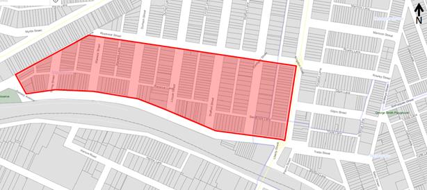
No objections were received. One resident queried regarding the potential redistribution of the trailer parking to the northern side of Railway Avenue. Council officers advised that this redistribution is not expected based on previous trials of these restrictions; however, the site will be monitored following installation of the signage to determine if further action is required.
Lilyfield Road, Lilyfield
Council has notified affected properties (271 properties) of this proposal in Lilyfield Road, Lilyfield/Rozelle; Halloran Street, Justin Street, Lamb Street, Ryan Street and Cecily Street, Lilyfield; Foucart Street, Hutchinson Street, Cashman Street, Denison Street and Albert Street, Rozelle; as shown below.
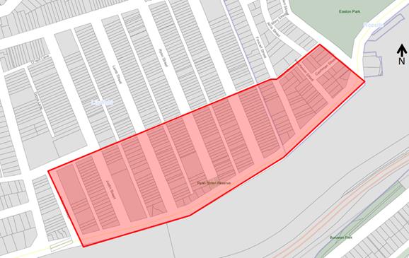
No objections were received. Two residents queried regarding the potential redistribution of the trailer parking to the northern side of Lilyfield Road. Council officers advised that this redistribution is not expected based on previous trials of these restrictions; however, the site will be monitored following installation of the signage to determine if further action is required.
CONCLUSION
In order to address ongoing concerns regarding boat and trailer parking in the Inner West, it is proposed to implement ‘No Parking 7AM-7PM – Motor Vehicles under 4.5t GVM Excepted’ restrictions in identified locations, including Lilyfield Road, Lilyfield (subject to the outcome of the Lilyfield Road Separated Cycleway investigation); Railway Avenue, Stanmore and Darley Road, Leichhardt (subject to RMS approval) and review the success of this signage strategy.
|
|
Local Traffic Committee Meeting 3 July 2018 |
Subject: Grosvenor Crescent, Summer Hill - Placement of 'No Stopping' Restrictions, Summer Hill. (Ashfield Ward/Summer Hill Electorate/Ashfield LAC)
Prepared By: Boris Muha - Engineer – Traffic and Parking Services
Authorised By: John Stephens - Traffic and Transport Services Manager
|
SUMMARY Council Officers seek endorsement of ‘No Stopping’ restrictions installed on traffic safety grounds along the inside curve section of Grosvenor Crescent, Summer Hill from Carlton Crescent to west of the railway overbridge, Summer Hill. |
|
RECOMMENDATION
THAT the installation of ‘No Stopping’ along the inside curve of Grosvenor Crescent, Summer Hill, from Carlton Crescent and past the railway overpass to (opposite) the western end of Cadigal Reserve, be endorsed.
|
BACKGROUND
Complaints have been received with regard to the hazard and danger of vehicles parking around the inside curve of the road in Grosvenor Crescent, west of the Railway overpass.
FINANCIAL IMPLICATIONS
The costs associated with signposting can be met under Council’s operational budget for signs and line marking.
OTHER STAFF COMMENTS
In the past, vehicles normally parked beyond the curve. However, recently it has been observed that vehicles encroach and park within the curve section of the road (see Figure 1). There is no sign posting along this length of road to control and regulate the parking.
The Police have identified that
this presents a problem when drivers are attempting to enter or alight from
their vehicles. Furthermore, driver's travelling around the bend may encounter
these persons and neither will have sufficient warning of each other.
This increases the risk of a collision and physical injury.
The Police further advised the situation is made worse as there are no lane lines to separate the parking lane from the traffic lane which is closest to the centre of the road. As a result of this lack of delineation, a driver travelling under the railway overpass will most likely drive closer to the kerb and not expect a vehicle to be parked close to the apex on their exit. Again this creates a scenario where a crash may result. For both reasons the Police have supported the installation of the ‘NO STOPPING' signs.
The ‘No Stopping’ restrictions extend from Carlton Crescent to the west of the Railway overpass to a location opposite the western end of Cadigal Reserve (see figure 2).
Council Officers have proceeded to install signposting on the basis of road safety.
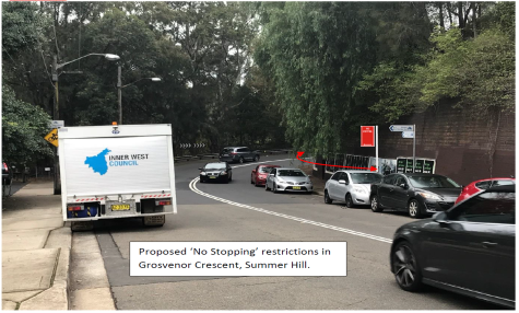
Figure 1- Vehicles parking along the curve section of Grosvenor Crescent.
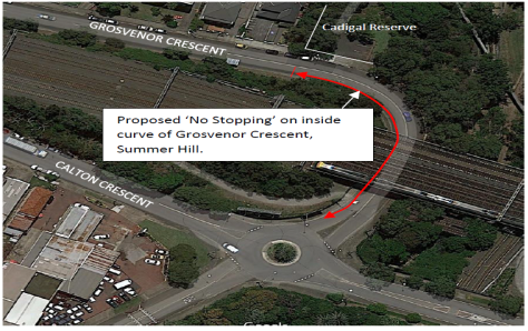
Figure 2- Extent of ‘No Stopping’ restrictions around the curve section of Grosvenor Crescent.
PUBLIC CONSULTATION
Residents in the area have been notified of the need to place ‘No Stopping’ restrictions along the inside curve of the road on the basis of road safety.
CONCLUSION
Officers seek endorsement of the installation of the ‘No Stopping’ restrictions along the inside curve of the road in Grosvenor Crescent, Summer Hill, from Carlton Crescent past the railway overpass to (opposite) the western end of Cadigal Reserve.
|
|
Local Traffic Committee Meeting 3 July 2018 |
Subject: Ash Lane, Cove Street, Northcote Street and Wolseley Street, Haberfield-Resident Parking Scheme. (Leichhardt Ward/Summer Hill Electorate/Ashfield LAC)
Prepared By: Boris Muha - Engineer – Traffic and Parking Services and Anca Eriksson - Traffic Officer
Authorised By: John Stephens - Traffic and Transport Services Manager
|
SUMMARY In response to correspondence from a number of residents of Haberfield regarding parking in streets near the WestConnex construction site in Haberfield, Council has investigated the introduction of H1 Resident Parking Scheme (RPS) restrictions ‘2P 8.00am-6.00pm Mon-Fri., 8.00am-1.00pm Sat’ in streets bounded and located north of Wattle Street, east of Parramatta Road and west of Ramsay Street, namely: · Ash Lane, between Wolseley Street and Northcote Street; · Cove Street, between Dobroyd Parade and Wolseley Street; · Wolseley Street, between Parramatta Road and Ramsay Street; and · Northcote Street, between Parramatta Road and Ramsay Street. This report provides the result of the resident parking scheme investigation in Ash Lane, Cove Street, Wolseley Street and Northcote Street, with the recommendation as shown below. |
|
RECOMMENDATION
THAT the proposed Resident Parking Scheme in Ash Lane, Cove Street, Northcote Street and Wolseley Street, Haberfield not be supported at the present time due to less than 50% support received from the consulted residents. |
BACKGROUND
A number of residents in Haberfield nearest the WestConnex construction sites have requested the implementation of a new resident parking scheme in their streets in Haberfield. Council proceeded to conduct a parking occupancy study in the area in August 2017 which showed high occupancy rates in certain streets (equal to or over 85%).
Given that WestConnex construction sites are located south and north of Wattle Street Haberfield, residents have raised concern that much of the on-street parking activity has been exacerbated largely due to WestConnex employees parking their vehicles on the street.
FINANCIAL IMPLICATIONS
Nil.
OTHER STAFF COMMENTS
In accordance with the Council’s (Ashfield) Resident Parking Scheme Policy, occupancy rates of 75% and over has instigated investigation of a Resident Parking Scheme (RPS) in the area. However, a minimum 50% resident support from the properties within the proposed RPS area is required to proceed with the installation of any proposed RPS.
The proposing of an RPS in the area was also prompted by the Strathfield Council establishing a Resident Parking Scheme in its roads in the Homebush area affected by WestConnex ongoing M4 extension/widening works in August 2016.
The proposal was to install ‘2P 8.00am-6.00pm Mon-Fri; 8.00am-1.00pm Sat, Permit Holders Excepted, Area H1 restrictions on the one side of those streets which have met the parking occupancy requirements or are likely to, subject to overflow of parking in the near vicinity.
· Ash Lane, west side between Wolseley Street and Northcote Street;
· Cove Street, west side;
· Northcote Street, north side, between Parramatta Road and Ramsay Street; and
· Wolseley Street, south side between Parramatta Road and Ramsay Street.
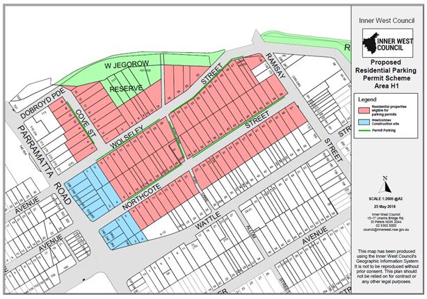
Figure 1. Proposed streets under the H1 Resident Parking Scheme and residential properties (in red) within the RPS area eligible to apply for parking permits.
Council’s (Ashfield) Resident Parking Scheme Policy permits the issue of permits only to residents and is based on the availability of off-street parking. An extract of the ‘Frequently Asked Questionnaire’ explaining the eligibility of permit issue is shown as Attachment 1.
Period parking limits are only being applied along one side of the street so that the available parking spaces along the street are shared more equitably between residents, visitors and workers in the area. Not all residents are able to apply for permits for all their vehicles and visitors are not able to apply for permits, the introduction of restrictions only on one side of the street still permits those vehicles to park on a long term basis on one side of the street.
Any vehicle registered and roadworthy is entitled to park on the public road, including those vehicles owned by WestConnex workers.
WestConnex has also issued a flyer to residents in ‘How to lodge a complaint’ regard to any behavioral issues with WestConnex vehicle activity in the area, e.g. noise, fumes, out- of- hour works, traffic.
The provision of restricted parking to the one side of the street also aims to reduce knock-on effect or transfer of parking to outer fringe streets of the RPS area or streets outside of the RPS area, by evenly dispersing the parking in the area.
PUBLIC CONSULTATION
A letter outlining the above parking was mailed out to the affected residential properties (103) in the proposed Residential Parking Scheme Area H1 (Ash Lane, Cove Street, Northcote Street, Wolseley Street, Ramsay Street) - see Figure1. (14) additional letters were also sent out to non-residing owners of properties in the area.
The consultation strategy was comprised of the following forms of communication:
· A letter box drop was made to each household within the proposed RPS scheme area, with information sheet and maps (of the proposed resident parking scheme area/signposting). Residents were advised that they may respond to a web based survey or in person. Few responses were received via email.
· A page was created on Council’s website with an easy link for on-line submissions plus links to Frequently Asked Questions, Resident Parking Permit Scheme Policy, area maps and other relevant background information.
· Copies of all documentation were available at Council’s Customer Services Counter with Customer Services and Engineering staff available to respond to enquiries.
· The last day to complete the survey was Monday, 14th May 2018. Another week was permitted for late responses.
· If the proposal was to succeed, it was anticipated that the Resident Permit Parking Area may be in place by October 2018. It would then be reviewed in five years or at the completion of the WestConnex project, whichever comes first.
· Residents with frontages to streets or corner accesses to streets within the RPS area are eligible to participate in consultation of the scheme.
· Approximately (82) Notification letters were also issued out to residents/businesses in the surrounding block areas outside of the proposed RPS Area informing them of proposal. Any comments from these residents were not captured in the table below. As they are not eligible to participate in consultation of the RPS scheme, they have not been included in the survey results.
Consultation Feedback information.
The statistical results following the completion of the survey are summarised as follows:
|
Respond by Location Area H1 |
(A) Number of properties within the street
|
(B) Number of properties Responded |
( C) Number of properties Supported |
(D) Number of properties in non- Support |
( E) *Overall response rate % |
(F) **Overall Support Rate % |
|
Ash Lane |
0 |
^1 |
0 |
1 |
^25% |
0% |
|
Cove Street |
16 |
3 |
0 |
3 |
19% |
0% |
|
Northcote Street |
52 |
22 |
6 |
16 |
42% |
12% |
|
Wolseley Street |
35 |
9 |
4 |
5 |
26% |
11% |
|
TOTAL |
103 |
35 |
10 |
25 |
34% |
10% |
Note: * Overall response rate (E) is the percentage of the number properties responded (B) over that of number of properties surveyed within the street under the proposed Resident Parking Scheme Area H1. (A)
** Overall Support Rate is the percentage of number of properties supported (C) over the number of properties surveyed within the street under the proposed Resident Parking Scheme Area H1. (A)
^ One (1) of 4 corner properties responded in non-support or restrictions in Ash Lane between Wolseley Street and Northcote Street.
There were a number of recurrent issues that were raised in the general comments section of the consultation response form by residents in non-support of the proposal. These key issues are described below with a response made to the concerns.
|
Issues most frequently raised in community consultation feedback H1 |
Council officer response |
|
Unnecessary and too late to introduce RPS in October 2018 in Haberfield. WestConnex project is expected to be completed 2019/2020. Parking requirements should revert to the previous conditions. Waste of money and resources.
|
The M4 East WestConnex project is expected to end mid next year, however there may be expected continued worker activity in the area with M4-M5 Link tunnel works to proceed next year.
|
|
The parking situation to be far from critical and does not warrant further controls. |
Council conducted a parking occupancy study in the area in August 2017 which showed high occupancy rates. This has instigated the need to examine a resident parking scheme.
|
|
Workers taking all the parking spots, they are creating the issues, residents don’t have parking problems. Parking is very heavy in both sides of the street are comprehensively used all through the day and in particular early morning.
|
The restrictions are mainly to provide relief to those residents with inadequate parking off-street and also assist to control WestConnex vehicle parking in the area. |
|
WestConnex workers block the access through the lanes, are partially blocking the driveways,
|
There would be an increase in ranger enforcement in the area should the scheme proceed. |
|
The WestConnex workers leave their rubbish behind on the nature strip & in the gutter. These include dust, noise starting very early in the morning, street closures and road surface damage as well as increased traffic in particular trucks using local streets.
|
WestConnex has issued a flyer to residents in ‘How to lodge a complaint ’with regard to any behavioural issues with WestConnex vehicle activity in the area. |
|
Haberfield is a conservation area. New parking signs on those streets will ruin the look of the heritage and federation appeal. |
Signage where possible will be placed on telegraph poles and limit use of new posts.
|
|
By introducing RPS will just move the problem to somewhere else. |
As any changes to parking in streets nearest WestConnex construction site could impact the parking availability in the adjoining streets, and to avoid parking pressures to intensify into the fringe streets, Council proposes RPS to one side of the street only. |
|
We have terrible footpaths and driveways that have been damaged by WestConnex. |
Noted. This has been referred to Council's WestConnex unit to follow up. |
|
Visitors regularly and invariably cannot get a parking space. RPS unduly penalise visitors to the street.
|
Visitors will have the choice to park short- term in the restricted permit parking area or longer period of time in the ‘unrestricted’ side of the street. |
|
It would be unfair for those that won’t have parking; their spots will be used by WestConnex workers and visitors to shops and adjacent houses.
|
The restrictions are mainly to provide relief to those residents with inadequate parking off-street and also assist to control WestConnex vehicle parking in the area. The restrictions will allow short term parking and control for visitor parking to shops and adjacent houses. It is viewed that Visitors will mainly use the short-term parking areas, rather than the ‘unrestricted’ parking areas. |
|
RPS is useless, requiring a permit will only affect the householder registered vehicles and their visitors. Every resident should have at least one free parking permit and ability to get visitor parking.
|
Council's current resident parking policy only issues permits to residents. The Policy is structured under RMS guidelines for the issue of permits based on off-street parking availability.
|
|
The vast majority of households have enough off-street parking. Even the small number of semi-detached properties has at least a carport or space for one. This obviously reduces the demand for on-street parking. The permit scheme will not help residents, as they will not be eligible for parking permits. Certain residents are concerned about the eligibility for parking permits for residents on those streets.
|
Those residents ineligible for parking permits will have the choice to park short- term in the restricted parking area or longer period of time on the ‘unrestricted’ opposite side of the street. |
|
Residents propose implementation of RPS on both sides of the streets in Area H1. Parking restriction on one side of the street will create inconvenience by burdening the unrestricted side of the street. Residents consider that parking restrictions will reduce number of available parking spaces on the streets |
The majority of residential properties have adequate off-street parking. It is proposed to introduce resident parking restrictions only on one side of the respective streets to balance the parking demands for permit and non- permit holders.
|
|
Resident is concerned that there is a risk that the restrictions will remain permanent after WestConnex project is over.
|
The RPS would be reviewed in five years or at the completion of the WestConnex project whichever comes first. Residents at the time will have the opportunity to comment in the removal or retention of the scheme. |
|
WestConnex should solve the commuting issue for their staff by providing bus transport for their workers from train stations etc and provide space for storage of tools and materials. They have been and still are the sole problem.
|
Noted. This has been referred to Council's WestConnex unit to follow up. |
|
Heavy vehicle traffic around the streets is a problem. |
Noted. This has been referred to Council's WestConnex unit to follow up. |
|
The WestConnex construction site is 24 hrs. The parking problem at night is as big a problem as during the day. I think the restricted parking hours need to be extended into the night. We often come home from work and can't park anywhere in the street. |
The RPS scheme operates in times there is concentration of worker parking activity during the day and when enforcement is considered effective. The RPS is limited in time to revert to unrestricted parking at other times in benefit to those users, particularly resident/visitors ineligible of permits. |
CONCLUSION
The Overall support rate is approximately 10% of all properties with the proposed Residential Parking Scheme Area H1 with the majority of responses not supporting the scheme.
It is recommended that the proposed Resident Parking Scheme in Ash Lane, Cove Street, Northcote Street and Wolseley Street, Haberfield not be supported at the present time due to less than 50% support received from the consulted residents.
|
1.⇩ |
Extract- Frequently Asked Questions-eligibility for Resident Permit Parking. |
|
Local Traffic Committee Meeting 3 July 2018 |
Subject: Walker Avenue, Allum Street, Alt Street, Denman Avenue, Bland Street
and Yasmar Avenue, Haberfield - Resident Parking Scheme.
(Leichhardt Ward/Summer Hill Electorate/Ashfield
LAC)
Prepared By: Boris Muha - Engineer – Traffic and Parking Services and Anca Eriksson - Traffic Officer
Authorised By: John Stephens - Traffic and Transport Services Manager
|
SUMMARY In response to correspondence from a number of residents of Haberfield regarding parking in streets near the WestConnex construction site in Haberfield, Council has investigated the introduction of H2 Resident Parking Scheme (RPS) restrictions limited ‘2P 8.00am-6.00pm Mon-Fri; 8.00am-1.00pm Sat’ in streets bounded and located south of Wattle Street, east of Parramatta Road, west of Ramsay Street, and north of Yasmar Street (Yasmar Street inclusive). These streets are namely: · Allum Street, between Walker Avenue and Alt Street; · Alt Street, between Parramatta Road and Ramsay Street; · Bland Street, Between Parramatta Road and Ramsay Street; · Denman Avenue, between Alt Street and Yasmar Avenue; · Walker Avenue, between Parramatta Road and Ramsay Street;and · Yasmar Avenue, between Denman Avenue and House No.16 Yasmar Avenue. This report provides the result of the resident parking scheme investigation in Allum Street, Alt Street, Bland Street, Denman Avenue, Walker Avenue and Yasmar Avenue, with the recommendation as shown below. |
|
RECOMMENDATION
THAT the proposed Resident Parking Scheme in Allum Street, Alt Street, Bland Street, Denman Avenue, Walker Avenue and Yasmar Avenue, Haberfield not be supported at the present time due to less than 50% support received from the consulted residents. |
BACKGROUND
A number of residents in Haberfield nearest the WestConnex construction sites have requested the implementation of a new resident parking scheme in their streets in Haberfield. Council proceeded to conduct a parking occupancy study in the area in August 2017 which showed high occupancy rates in certain streets (equal to or over 85%).
Given that WestConnex construction sites are located south and north of Wattle Street Haberfield, residents have raised concern that much of the on-street parking activity has been exacerbated largely due to WestConnex employees parking their vehicles on the street.
FINANCIAL IMPLICATIONS
Nil.
OTHER STAFF COMMENTS
In accordance with the Council’s (Ashfield) Resident Parking Scheme Policy, occupancy rates of 75% and over has instigated investigation of a Resident Parking Scheme (RPS) in the area. However, a minimum 50% resident support from the properties within the proposed RPS area is required to proceed with the installation of any proposed RPS.
The proposal of an RPS in the area has also been prompted by the Strathfield Council establishing a Resident Parking Scheme in its roads in the Homebush area affected by WestConnex ongoing M4 extension/widening works in August 2016.
The proposal is to install ‘2P 8.00am-6.00pm Mon-Fri; 8.00am-1.00pm Sat, Permit Holders Excepted, Area H2 restrictions on one side of the streets which have met the parking occupancy requirements or are likely, subject to overflow of parking in the near vicinity.
· Allum Street, east side, between Walker Avenue and Alt Street.
· Alt Street, north side, between Parramatta Road and Ramsay Street.
· Bland Street, south side, between Parramatta Road and Haberfield Public School & south side, between Bland Street and No.161 Bland Street.
· Denman Avenue, west side, between Alt Street and Bland Street & east side between Bland Street and Yasmar Avenue.
· Walker Avenue, south side, between Parramatta Road and Rasmay Street.
· Yasmar Avenue, north side, between Denman Avenue and No.16 Yasmar Avenue.
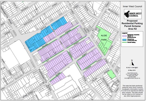
Figure 1. Proposed streets under the H2 Resident Parking Scheme and residential properties (in purple) within the RPS area eligible to apply for parking permits.
Period parking limits are only being applied along one side of the street so that the available parking spaces along the street are shared more equitably between residents, visitors and workers in the area. Not all residents are able to apply for permits for all their vehicles and visitors are not able to apply for permits, the introduction of restrictions only on one side of the street still permits those vehicles to park on a long term basis on one side of the street.
Any vehicle registered and roadworthy is entitled to park on the public road, including those vehicles owned by WestConnex workers.
The provision of restricted parking to the one side of the street also aims to reduce knock-on effect or transfer of parking to outer fringe streets of the RPS area or streets outside of the RPS area, by evenly dispersing the parking in the area.
PUBLIC CONSULTATION
A letter outlining the proposal was mailed out to the affected residential properties (192) in the proposed Residential Parking Scheme Area H2 (Allum Street, Alt Street, Bland Street, Denman Avenue, Walker Avenue and Yasmar Avenue) - see Figure1. (28) additional letters were also sent out to non-residing owners of properties in the area.
The consultation strategy comprised the following forms of communication.
· A letter box drop was made to each household within the proposed RPS scheme area, with information sheet and maps (of the proposed resident parking scheme area/signposting). Residents were advised that they may respond to a web based survey or in person. Few responses were received via email.
· A page was created on Council’s website with an easy link for on-line submissions plus links to Frequently Asked Questions, Resident Parking Permit Scheme Policy, maps and other relevant background information.
· Copies of all documentation were available at Council’s Customer Services Counter with Customer Services and Engineering staff available to respond to enquiries.
· The last day to complete the survey was Monday, 14th May 2018. Another week was permitted for late responses.
· If the proposal was to succeed, it was anticipated that the Resident Permit Parking Area may be in place by October 2018. It would then be reviewed in five years or at the completion of the WestConnex project whichever comes first.
· Approximately 120 Notification letters were also issued out to residents/businesses in the surrounding block areas outside of the proposed RPS Area informing them of proposal.
Consultation Feedback information.
The statistical results following the completion of the survey are summarised as follows:
|
Respond by Location Area H2 |
(A) Number of properties within the street
|
(B) Number of properties Responded |
( C) Number of properties Supported |
(D) Number of properties in non- Support |
( E) *Overall response rate % |
(F) **Overall Support Rate % |
|
Allum Street |
0 |
^2 |
0 |
2 |
^50% |
0% |
|
Alt Street |
56 |
19 |
8 |
11 |
34% |
14% |
|
Bland Street |
45 |
11 |
3 |
8 |
24% |
7% |
|
Denman Avenue |
10 |
2 |
1 |
1 |
20% |
10% |
|
Walker Avenue |
54 |
22 |
7 |
15 |
41% |
13% |
|
Yasmar Avenue |
27 |
13 |
1 |
12 |
48% |
4% |
|
TOTAL |
192 |
69 |
20 |
49 |
36% |
10% |
Note: * Overall response rate (E) is the percentage of number properties responded (B) over that of number of properties surveyed within the street under the proposed Resident Parking Scheme Area H2. (A)
** Overall Support Rate is the percentage of number of properties supported (C) over the number of properties surveyed within the street under the proposed Resident Parking Scheme Area H2. (A)
^ Two (2) of 4 corner properties responded in non-support of restrictions in Allum Street between Walker Avenue and Alt Street.
There were a number of recurrent issues that were raised in the general comments section of the consultation response form by residents in non-support of the proposal. These key issues are described below with a response made to the concerns.
|
Issues most frequently raised in community consultation feedback H2 |
Council officer response |
|
The parking has only been a problem in the streets because of WestConnex. At completion of the project this will no longer be a problem, this is just a temporary problem due to WestConnex |
Implementation of resident parking restrictions ‘2P 8.00am-6.00pm Mon-Fri, 8.00am-1pm Sat, Permit Holders Excepted Area H2’ was proposed to control this parking activity. The scheme would then be reviewed in five years or at the completion of the WestConnex project whichever comes first.
|
|
Don’t want any parking restrictions. This is a bad idea. Parking has only been a problem created by WestConnex. Certain Residents are angry about proposed parking scheme and are strongly opposing the implementation RPS.
|
The restrictions are mainly to provide relief to those residents with inadequate parking off-street and also assist to control WestConnex vehicle parking in the area. |
|
There is a risk that the restrictions will remain permanent after WestConnex is over. |
The RPS would be reviewed in five years or at the completion of the WestConnex project whichever comes first. Residents at the time will have the opportunity to comment in the removal or retention of the scheme. |
|
Current situation is not too bad.
|
Council conducted a parking occupancy study in the area in August 2017 which showed high occupancy rates. This has instigated the need to examine a resident parking scheme.
|
|
The WestConnex workers leave their rubbish behind on the nature strip & in the gutter. These include dust, noise starting very early in the morning, street closures and road surface damage as well as increased traffic in particular trucks using local streets.
|
WestConnex has issued a flyer to residents in ‘How to lodge a complaint ’with regard to any behavioural issues with WestConnex vehicle activity in the area. |
|
Expect all residents to be entitled to a parking permit regardless of property access. If we need to park on the street to allow access to tradespeople, we will require a parking permit. |
Council's current resident parking policy only issues permits to residents. The Policy is structured under RMS guidelines for the issue of permits based on off-street parking availability. It is proposed to introduce resident parking restrictions only on one side of the respective streets to balance the parking demands for permit and non- permit holders.
|
|
Haberfield is conservation area. New parking signs on those streets will ruin the look of the heritage and federation appeal.
|
Signage where possible will be placed on telegraph poles and limit use of new posts. |
|
By introducing RPS will just move the problem to somewhere else. Shifts the problem to other streets
|
Council proposes RPS to one side of the street only in order to limit the redistribution of parking. |
|
It will be costly to implement, it is not ok to waste tax payers money. Parking restrictions is only a revenue source for Council.
|
Signage where possible will be placed on telegraph poles and limit use of new posts to minimise costs. The intention of the RPS scheme assists to control parking in the area, and provides parking relief to those residents with inadequate off-street parking.
|
|
A lot of residents would not qualify for a Parking permit.
|
It is proposed to introduce resident parking restrictions only on one side of the respective streets to balance the parking demands for permit and non- permit holders. |
|
Propose implementation of RPS on both sides of the streets. Parking restriction on one side of the street will create inconvenience by burdening the unrestricted side of the street.
|
|
|
Resident finds ease and convenience in parking on-street. Driveway use is difficult and access/sight view blocked at times with vehicles parked either side of the driveway
|
Unrestricted parking will still be provided for within the street, or residents (ineligible for permits) can park short-term in the restricted parking zones. |
CONCLUSION
The Overall support rate for the scheme was approximately 10% of all properties with the proposed Residential Parking Scheme Area H2 with the majority of responses not supporting the scheme.
It is recommended that the proposed Resident Parking Scheme in Allum Street, Alt Street, Bland Street, Denman Avenue, Walker Avenue and Yasmar Avenue, Haberfield not be supported at the present time due to less than 50% support received from the consulted residents.
|
1.⇩ |
Extract- Frequently Asked Questions-Eligibility Resident Permit Parking |
|
|
Local Traffic Committee Meeting 3 July 2018 |
Subject: Holbeach Avenue, Tempe – Temporary Full Road Closures for MS Sydney to the Gong Bike Ride on Sunday 4 November 2018 (Marrickville Ward/Heffron Electorate/Newtown LAC)
Prepared By: Jennifer Adams - Engineer – Traffic and Parking Services
Authorised By: John Stephens - Traffic and Transport Services Manager
|
SUMMARY Council has received an application (S68201800006) under Section 68 of the Local Government Act 1993 to use Holbeach Avenue and Tempe Recreation Reserve to hold the annual 'MS Sydney to the Gong Bike Ride' supported by Multiple Sclerosis (MS) Australia on Sunday 4 November 2018. This event will necessitate the temporary full road closure of Holbeach Avenue, Tempe and southbound lane closures on Princes Highway from the car park entrance of IKEA to Cooks River.
It is recommended that the comments of the Local Traffic Committee be referred to Council’s Development Assessment Section for consideration in determining the Development Application.
|
|
RECOMMENDATION
THAT the report be received and noted. |
BACKGROUND
Council has received an application under Section 68 of the Local Government Act 1993 to use Holbeach Avenue and Tempe Recreation Reserve to hold the annual 'MS Sydney to the Gong Bike Ride' supported by Multiple Sclerosis (MS) Australia on Sunday 4 November 2018.
The application is required to be referred to the Local Traffic Committee for consideration under State Environmental Planning Policy (Infrastructure) 2007.
This year will be the 37th year that this event will operate and due to the construction of the WestConnex project, previous year’s start site at Sydney Park (City of Sydney Council) is no longer available. Last year after a considerable search, Tempe Reserve was identified as a location that is suitable for such a large event and is close to the course used in previous years and was successfully ultised as the start site in 2017.
This year’s course will mostly follow that of previous years with the 82Km start location in Tempe Recreation Reserve Tempe, and the 58Km start location in Cooper Reserve Engadine. The riders then join the 82Km riders on Princes Highway following the traditional course through the Royal National Park, traveling south along the coast to Thirroul, riding over Sea Cliff Bridge then following Sandon Point Reserve, at the end of the cycle way through Woonona, East Corrimal, Towradgi, Fairy Meadow, North Wollongong to Finish in W. A. Lang Park, Wollongong.
The number of participant registrations for the 2018 Gong Bike Ride will remain capped at 10,000.
FINANCIAL IMPLICATIONS
Nil.
OFFICER COMMENTS
MS Australia will ultilise the IKEA car park as a drop off zone and riders will ride down Princes Highway (southbound) to the starting location at Tempe Recreation Reserve via Holbeach Avenue to ensure they are not riding down residential streets. The traffic management company will put in an access lane along Princes Highway to keep riders safe while entering the event at Tempe Recreation Reserve where this location will be the start of the cycling course.
The event will start at Tempe Recreation Reserve, Tempe (see Figure below). On departing, cyclists will ride west on Holbeach Avenue and then turn left onto Princes Highway. Cyclists will then ride along the southbound lanes on Princes Highway as they make their way south over the Cooks River Bridge and beyond.
The applicant advised that support of the NSW Police and RMS will be sought and a detailed Traffic Management Plan has been forwarded to the RMS, NSW Police and relevant Councils and authorities.
NSW Police and the MS Australia Course Marshals will be at critical locations to ensure that participants and motorists follow all proposed traffic management measures. The event will be held on a Sunday morning where traffic volumes are expected to be lower than average.
It is proposed that the traffic control measures would be in place between 4:00am and no later than 9:30am as the event commences at 6.00am and is expected to be concluded by 9.00am. The Bump in and out plan is reproduced at the end of this report. Affected residents and businesses will be allowed access at Police discretion.
PUBLIC CONSULTATION
The applicant advised that the traffic control management on the day of the event will be controlled by NSW Police and MS Australia Course Marshals. The Traffic Control Plans for specific locations are reproduced at the end of this report.
A Traffic Management Plan will be submitted to the Roads and Maritime Services for consideration and approval as well as a Road Occupancy License application will be submitted to the Transport Management Centre.
CONCLUSION
It is proposed that the following traffic related comments be forwarded to Council’s Development Assessment section.
Based on the information presented in the applicant’s submission to Council with regards to the proposed cycling event on Sunday 4 November 2018 with the inclusion of a temporary full road closure of Holbeach Avenue, Tempe, it is acknowledged that the event will be controlled by NSW Police and the MS Australia Course Marshals. Therefore, Council supports the temporary full road closure of Holbeach Avenue, Tempe during the course of the event subject to the applicant submitting a Traffic Management Plan to the RMS for consideration and approval, a Road Occupancy License be obtained from the Transport Management Centre and advice of the proposed event being forwarded all affected properties and to the appropriate authorities including emergency services.
![]()