|
AGENDA R |

Local Traffic Committee Meeting
TUESDAY 4 SEPTEMBER 2018
10.00am
|
|
Local Traffic Committee Meeting 4 September 2018 |
Function of the Local Traffic Committee
Background
Roads and Maritime Services (RMS) is legislated as the Authority responsible for the control of traffic on all NSW Roads. The RMS has delegated certain aspects of the control of traffic on local roads to councils. To exercise this delegation, councils must establish a local traffic committee and obtain the advice of the RMS and Police. The Inner West Council Local Traffic Committee has been constituted by Council as a result of the delegation granted by the RMS pursuant to Section 50 of the Transport Administration Act 1988.
Role of the Committee
The Local Traffic Committee is primarily a technical review and advisory committee which considers the technical merits of proposals and ensures that current technical guidelines are considered. It provides recommendations to Council on traffic and parking control matters and on the provision of traffic control facilities and prescribed traffic control devices for which Council has delegated authority. These matters are dealt with under Part A of the agenda and require Council to consider exercising its delegation.
In addition to its formal role as the Local Traffic Committee, the Committee may also be requested to provide informal traffic engineering advice on traffic matters not requiring Council to exercise its delegated function at that point in time, for example, advice to Council’s Development Assessment Section on traffic generating developments. These matters are dealt with under Part C of the agenda and are for information or advice only and do not require Council to exercise its delegation.
Committee Delegations
The Local Traffic Committee has no decision-making powers. The Council must refer all traffic related matters to the Local Traffic Committee prior to exercising its delegated functions. Matters related to State Roads or functions that have not been delegated to Council must be referred directly to the RMS or relevant organisation.
The Committee provides recommendations to Council. Should Council wish to act contrary to the advice of the Committee or if that advice is not supported unanimously by the Committee members, then the Police or RMS have an opportunity to appeal to the Regional Traffic Committee.
Committee Membership & Voting
Formal voting membership comprises the following:
· one representative of Council as nominated by Council;
· one representative of the NSW Police from each Local Area Command (LAC) within the LGA, being Newtown, Marrickville, Leichhardt and Ashfield LAC’s.
· one representative from the RMS; and
· State Members of Parliament (MP) for the electorates of Summer Hill, Newtown, Heffron, Canterbury, Strathfield and Balmain or their nominees.
Where the Council area is represented by more than one MP or covered by more than one Police LAC, representatives are only permitted to vote on matters which effect their electorate or LAC.
Informal (non-voting) advisors from within Council or external authorities may also attend Committee meetings to provide expert advice.
Committee Chair
Council’s representative will chair the meetings.
Public Participation
Members of the public or other stakeholders may address the Committee on agenda items to be considered by the Committee. The format and number of presentations is at the discretion of the Chairperson and is generally limited to 3 minutes per speaker. Committee debate on agenda items is not open to the public.
|
|
Local Traffic Committee Meeting 4 September 2018 |
|
AGENDA |
1 Apologies
2 Disclosures of Interest
3 Confirmation of Minutes
Minutes of 7 August 2018 Local Traffic Committee Meeting 5
4 Matters Arising from Council’s Resolution of Minutes
5 Part A – Items Where Council May Exercise Its Delegated Functions
Traffic Matters
ITEM PAGE #
LTC0918 Item 1 Traffic Management Plan for the 2018 New Year's Eve Event (Balmain Ward / Balmain Electorate / Leichhardt LAC) 37
LTC0918 Item 2 Batty Street, Rozelle - Proposed Kerb Extension Design Plan (Balmain Ward/ Balmain Electorate/ Leichhardt LAC) 72
LTC0918 Item 3 Booth Street Bridge Widening over Johnston Creek, Annandale 76
LTC0918 Item 4 Boomerang Street, Haberfield - Haberfield North LATM - Traffic calming improvements (Leichhardt Ward / Summer Hill Electorate / Ashfield LAC) 81
LTC0918 Item 5 Victoria Road at Leicester Street, Marrickville – Revised Proposed Kerb Extensions Design Plan – No.10016 (Marrickville Ward / Newtown Electorate / Inner West LAC) 90
LTC0918 Item 6 Pedestrian Safety - Balmain East Transport Interchange - Darling Street, Balmain East (Balmain Ward / Balmain Electorate / Leichhardt LAC) 99
Parking Matters
ITEM PAGE #
LTC0918 Item 7 Edgar Street, Tempe - Proposed '2P Permit Holders Excepted' Parking (Marrickville Ward/Hefron Electorate/Inner West LAC) 103
LTC0918 Item 8 Blamire Lane, Marrickville - Proposed 'No Parking ' (Marrickville Ward/Summer Hill Electorate/Inner West LAC) 108
LTC0918 Item 9 Rowley Lane, Camperdown - Proposed 'No Parking' restrictions(Stanmore Ward/Newtown Electorate/Inner West LAC) 112
LTC0918 Item 10 Elswick Street North, Charles Street, Hubert Street, Francis Street, James Street, Leichhardt - Resident Parking Scheme (Leichhardt Ward/ Balmain Electorate/ Leichhardt LAC) 117
LTC0918 Item 11 Margaret Street at Yara Avenue, Rozelle - Proposed 'No Stopping' Restrictions (Balmain Ward/ Balmain Electorate/ Leichhardt LAC) 126
LTC0918 Item 12 Weynton Street at Piper Lane, Annandale - Proposed 'No Stopping' Restrictions (Balmain Ward/ Balmain Electorate/ Leichhardt LAC) 129
LTC0918 Item 13 O'Neill Lane, Lilyfield (rear of No. 9 O'Neill Street) - Proposed Extension of 'No Stopping' Zone (Balmain Ward/Balmain Electorate/Leichhardt LAC) 132
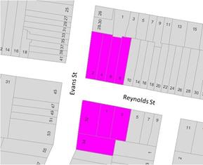
LTC0918 Item 14 Reynolds Street at Evans Street, Balmain - Proposed 'No Stopping' zones (Balmain Ward/ Balmain Electorate/ Leichhardt LAC) 134
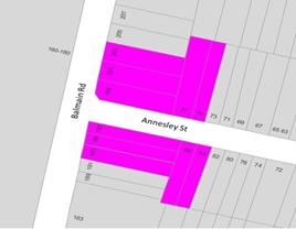
LTC0918 Item 15 Annesley Street at Balmain Road, Leichhardt - Proposed 'No Stopping' zones (Leichhardt Ward/ Balmain Electorate/ Leichhardt LAC) 136
LTC0918 Item 16 Minor Traffic Facilities (All Wards/ All Electorates/ All LACs) 138
Late Items
Nil at time of printing.
6 Part B - Items for Information Only
Nil at the time of printing.
7 Part C - Items for General Advice
ITEM PAGE #
LTC0918 Item 17 2018 Norton Street Italian Festa - Special Event (Leichhardt Ward/ Balmain Electorate/ Leichhardt LAC) 146
8 General Business
9 Close of Meeting
|
|
Local Traffic Committee Meeting Minutes from 7 August 2018 |
Minutes of Local Traffic Committee Meeting
Held at Council Chambers, Petersham Service Centre on 7 August 2018
Meeting commenced at 10.03am
ACKNOWLEDGEMENT OF COUNTRY BY CHAIRPERSON
I acknowledge the Gadigal and Wangal people of the Eora nation on whose country we are meeting today, and their elders past and present.
COMMITTEE REPRESENTATIVES PRESENT
|
|
|
|
Clr Marghanita Da Cruz |
Leichhardt Ward (Chair) |
|
Mr Kieren Ash |
Representative for Ron Hoenig MP, Member for Heffron |
|
Sgt John Micallef |
NSW Police – Burwood Police Area Command |
|
A/Sgt Charles Buttrose |
NSW Police – Leichhardt Police Area Command |
|
Sgt Paul Vlachos |
NSW Police – Inner West Police Area Command |
|
Mr Daryl Ninham |
Roads and Maritime Services |
|
|
|
|
COUNCILLORS AND OFFICERS IN ATTENDANCE |
|
|
|
|
|
SC Sam Tohme |
NSW Police – Burwood Police Area Command |
|
Mr Asith Nagodavithane |
Transit Systems – Inner West Bus Services |
|
Mr Colin Jones |
Inner West Bicycle Coalition |
|
Mr Wal Petschler |
IWC’s Group Manager Roads, Traffic and Stormwater |
|
Mr John Stephens |
IWC’s Traffic and Transport Services Manager |
|
Mr Manod Wickramasinghe |
IWC’s Coordinator Traffic and Parking Services (North) |
|
Ms Jenny Adams |
IWC’s A/Coordinator Traffic and Parking Services (South) |
|
Mr Joe Di Cesare |
IWC’s Coordinator Design Services |
|
Mr Davide Torresan |
IWC’s Civil Engineer |
|
Ms Christina Ip |
IWC’s Business Administration Officer |
|
|
|
|
VISITORS |
|
|
|
|
|
Ms Carolyn Ridley |
Item 4 – Resident |
|
Mr Sava Savcic |
Item 4 – Resident |
|
Mr Peter Cassilles |
Item 8 – Resident |
|
Mr Cameron Crew |
Item 13 – Resident |
|
Resident |
Item 13 – Resident |
|
Mr Ken Moxham |
Item 21 – Resident |
|
Ms Jenny Griffith |
Item 21 – Resident |
|
Mr Graham Griffith |
Item 21 – Resident |
|
Mr Philip Drew |
Item 21 – Bunnings |
|
Mr Ross Nettle |
Item 21 – TTPA Traffic Consultant Bunnings |
|
|
|
|
APOLOGIES: |
|
|
|
|
|
Ms Jo Haylen MP |
Member for Summer Hill |
|
Ms Sarina Foulstone |
Representative for Jo Haylen MP, Member for Summer Hill |
|
Ms Cathy Peters |
Representative for Jenny Leong MP, Member for Newtown |
|
Clr Julie Passas |
Deputy Mayor – Ashfield Ward |
|
Mr George Tsaprounis |
IWC’s Coordinator Traffic and Parking Services (South) |
DISCLOSURES OF INTERESTS:
Nil.
CONFIRMATION OF MINUTES
|
The minutes of the Local Traffic Committee Meeting held on Tuesday, 3 July 2018 were confirmed. |
MATTERS ARISING FROM COUNCIL’S RESOLUTION OF MINUTES
The Local Traffic Committee recommendations of its meeting held on 3 July 2018 were adopted at Council’s meeting held on 24 July 2018, subject to staff reviewing the proposal to remove parking spaces in Item 19 Nowranie Lane Summer Hill – Proposed ‘No parking’ restrictions.
LATE ITEM
OFFICER COMMENTS
|
Subject Location |
Classification of Road |
Road Description |
|
Edgeware Road, Newtown |
Regional Road carrying around 15,500 vpd |
Two-way street 13.5m in width with lane side parking on either side that runs north-south between Enmore Road/Stanmore Road and Bedwin Road overpass. |
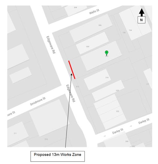
310 Edgeware Road, Newtown
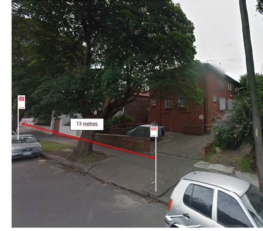
The subject property is located on the eastern side of Edgeware Road, Newtown. The proposed ‘Works Zone’ will be 13 metres in length and located on the eastern side of Edgeware Road adjacent to the site. It will be required for a period of approximately six (6) months, to be utilised by construction vehicles during deliveries and loading and unloading activities (refer to the below locality map and photographs).
At present, unrestricted parking is permitted on the eastern side of Edgeware Road Newtown. The parking spaces in the subject section of Edgeware Road are highly utilised by local residents. Therefore, the provision of a ‘Works Zone’ would provide a safe facility for loading and unloading activities at the subject site during the construction period.
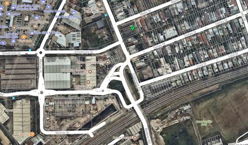
Locality Map – 310 Edgeware Road, Newtown (Edgeware Road Frontage)
Photographs – Edgeware Road, Newtown (infront of 310 Edgeware Road, Newtown)
The proposed location of the ‘Works Zone’ in Edgeware Road, Newtown
PUBLIC CONSULTATION
A notification letter will be distributed to adjoining residents prior to the ‘Works Zone’ being installed.
CONCLUSION
approved for the construction works subject to Council fees and charges.
COMMITTEE RECOMMENDATION
THAT:
GENERAL BUSINESS
Nil.
Meeting closed at 11.43am.
This page has been left intentionally blank.
|
|
Local Traffic Committee Meeting 4 September 2018 |
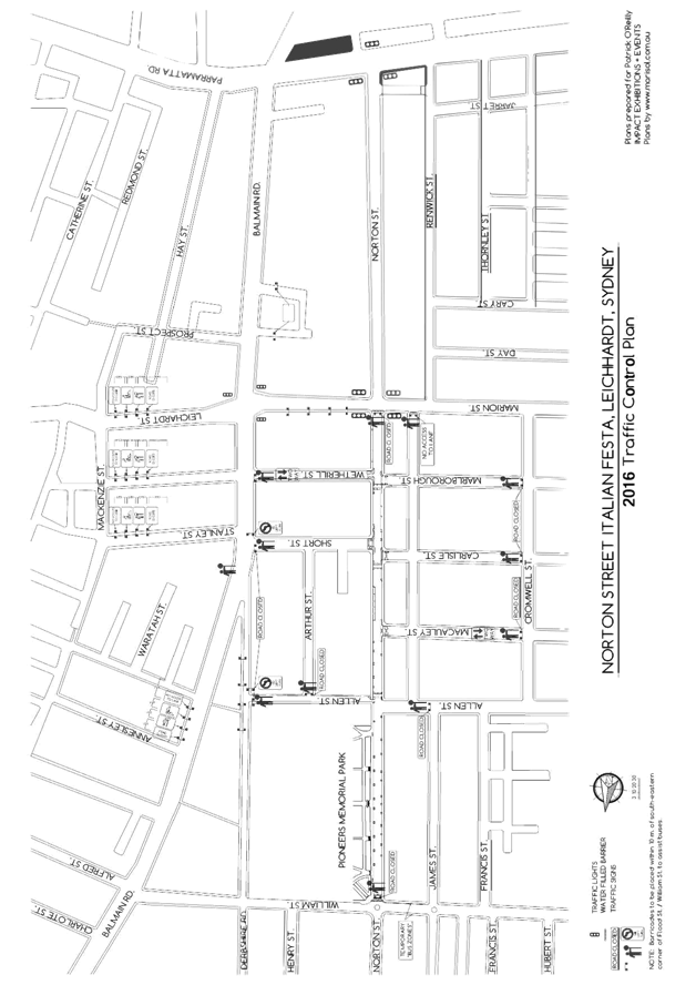
Subject: Traffic Management Plan for the 2018 New Year's Eve Event (Balmain Ward / Balmain Electorate / Leichhardt LAC)
Prepared By: Manod Wickramasinghe - Coordinator – Traffic and Parking Services
Authorised By: John Stephens - Traffic and Transport Services Manager
|
SUMMARY As instructed by the Police, access to the Balmain peninsula is closed to vehicular traffic every New Year’s Eve. This report outlines the traffic management associated with the event. |
|
RECOMMENDATION
THAT:
1. the Traffic Management Plan (Attachment 1) detailing the traffic arrangements for the 2018 New Year’s Eve be supported; 2. the Traffic Management Plan (Attachment 1) be forwarded to Council’s Parks and Streetscapes Coordinator, Transport Management Centre and the Major Events & Incidents Group (NSW Police); 3. a temporary ‘No Stopping’ zone be installed on the eastern side of Montague Street between Darling Street and Beattie Street, Balmain; 4. That the following modifications to bus stops be approved: a. On the northern side of Darling Street: i. Install temporary ‘Bus Zones’ between Mort Street and Ford Street ii. Extend the ‘Bus Zone’ between Ford Street and McDonald Street iii. Extend the ‘Bus Zone’ between McDonald Street and Curtis Road, outside Nos.217-223 Darling Street b. On the southern side of Darling Street: i. Install a temporary ‘Bus Zone’ between Booth Street and Beattie Street, outside No. 244-270 Darling Street. 5. The Police representative be requested to provide bike unit resources to improve traffic/crowd controls around the Darling Street/Curtis Road intersection (roundabout); 6. The Police be requested to liaise directly with the Roads and Maritime Services in regards to the installation of variable message signs (“Balmain Peninsula is closed” and “Alcohol Free Zone”) on the main access roads into Balmain Peninsula a few days in advance of the event; 7. Confirmation be sought regarding the areas to be declared alcohol free and the Police and Transit Systems representatives be advised; 8. The Transit Systems representative be requested to place adequate notices on buses regarding the establishment of an alcohol free zone in the Balmain East area (details to be provided by Council); 9. The taxi/hire car access to the Peninsula be restricted from 7:00pm. 10. Taxis/hire cars carrying mobility impaired or infirmed residents be permitted access at all hours into the Peninsula; and 11. The NSW Taxi Council be advised of the Committee’s recommendation. |
BACKGROUND
As instructed by the Police, access to the Balmain peninsula is closed to vehicular traffic every New Year’s Eve.
It should be noted that the alcohol ban areas were extended following the 2014 event. Also, a temporary ban on taxi access to the peninsula after 7pm on New Year’s Eve was introduced to minimise traffic congestion in the peninsula and improve pedestrian safety.
FINANCIAL IMPLICATIONS
Funding for costs associated with New Year’s Eve including labour, notifications and permits have been budgeted for in the 2018-19 operational plan.
OTHER STAFF COMMENTS
Traffic Management
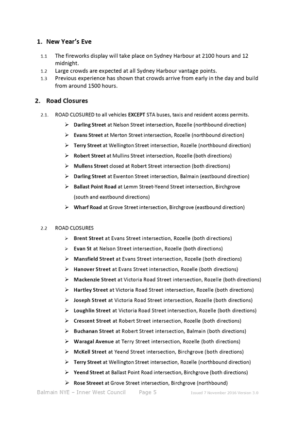
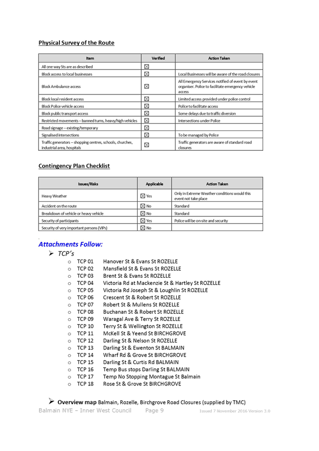
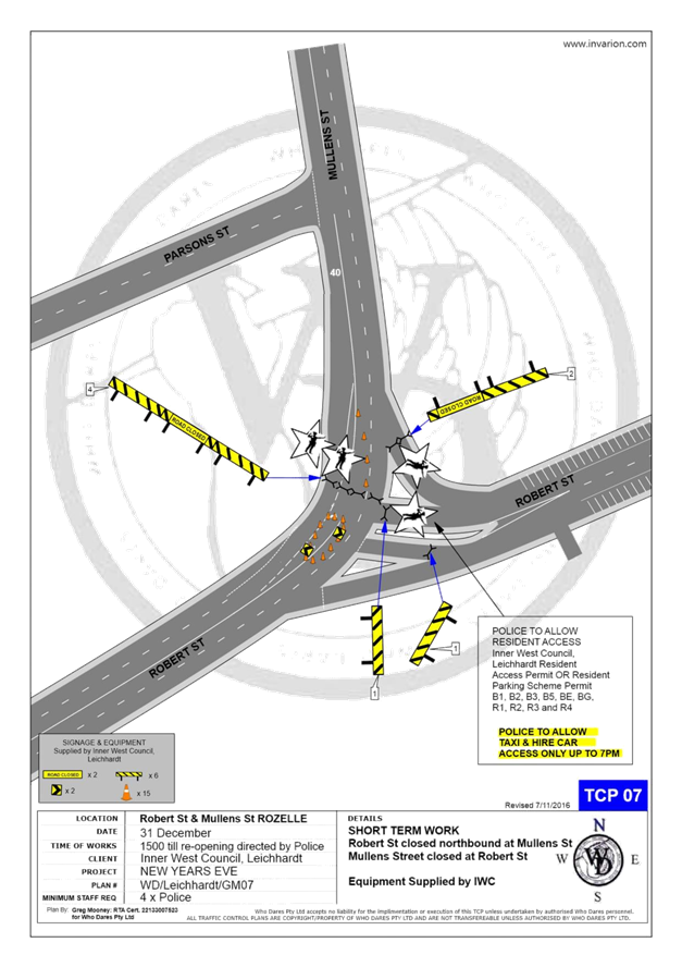
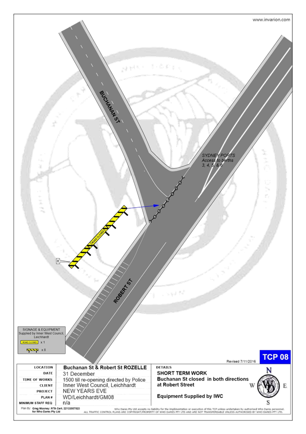
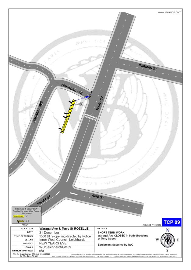
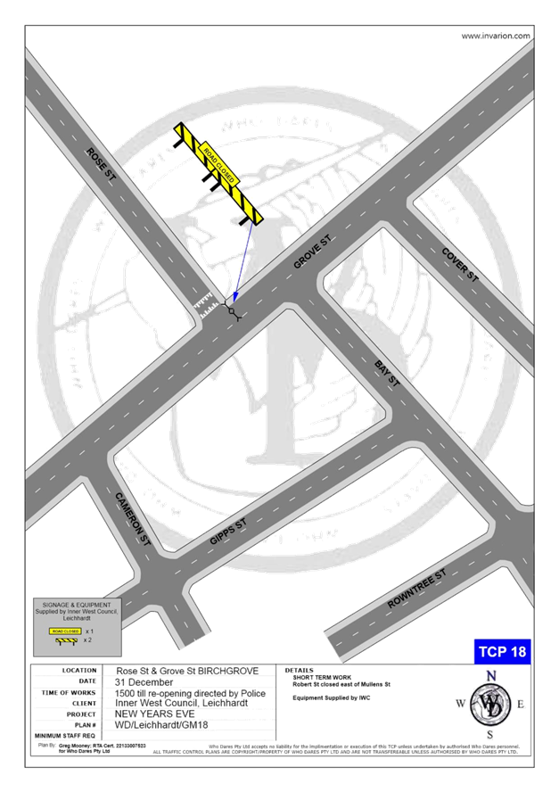
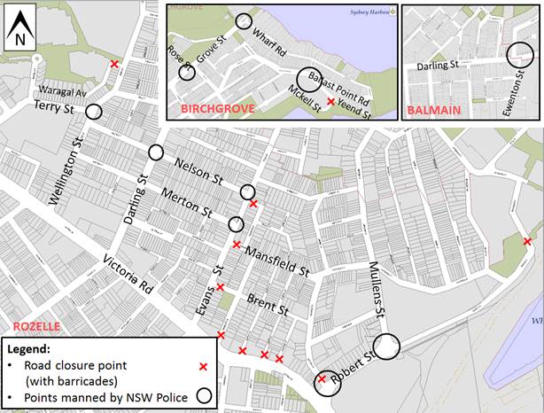
The following roads will be closed to all vehicular traffic between 3:00pm Monday, 31 December 2018 and 12:00am on Tuesday, 1 January 2019 to cater for the New Year’s Eve celebrations:
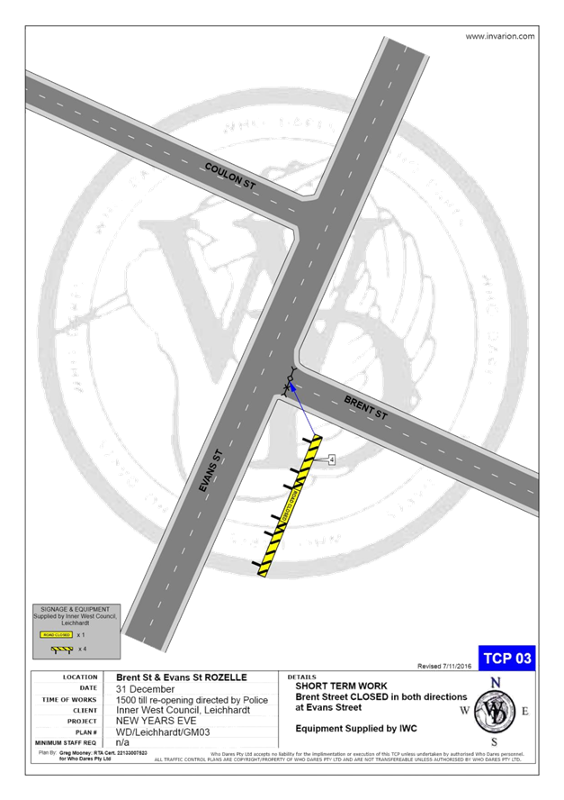
· Brent Street at Evans Street intersection, Rozelle (both directions)
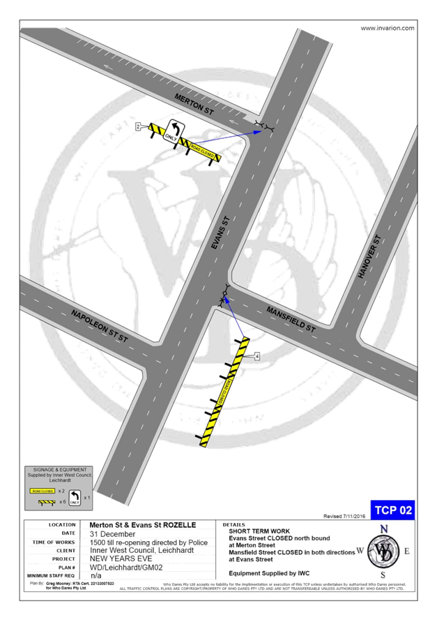
· Mansfield Street at Evans Street intersection, Rozelle (both directions)
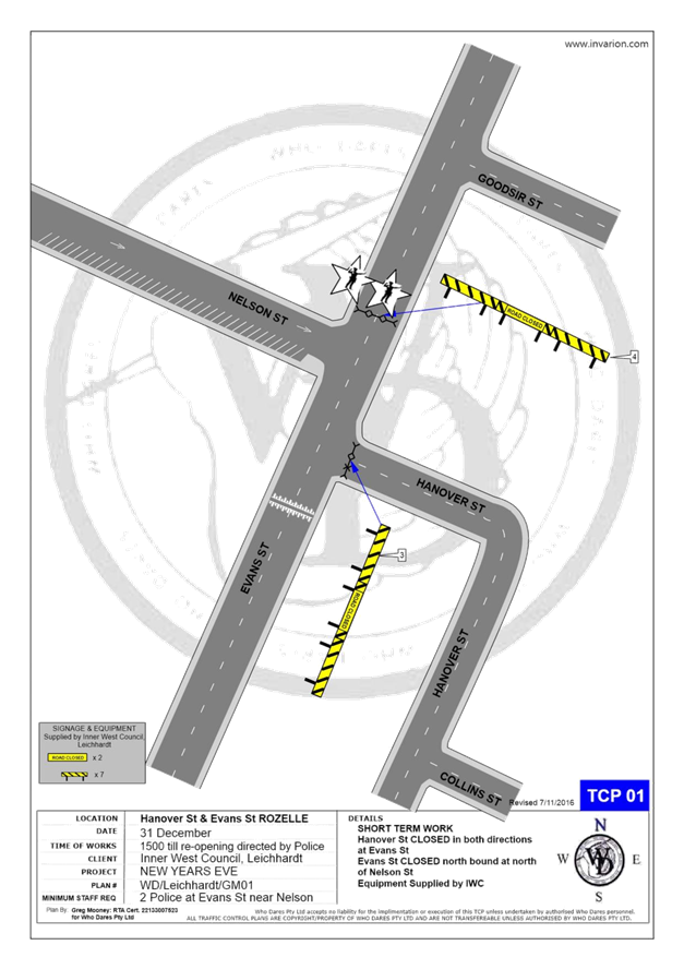
· Hanover Street at Evans Street intersection, Rozelle (both directions)
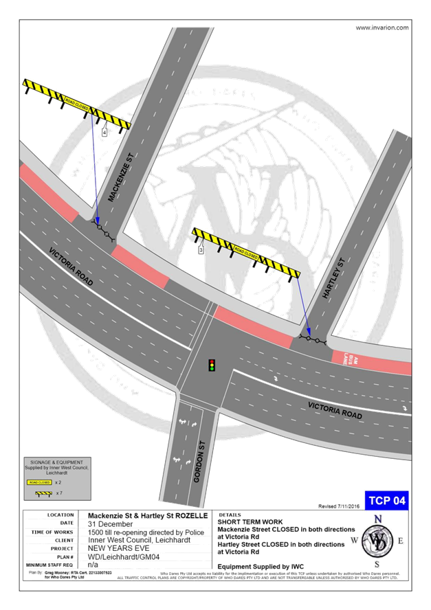
· Mackenzie Street at Victoria Road Street intersection, Rozelle (both directions)
· Hartley Street at Victoria Road Street intersection, Rozelle (both directions)
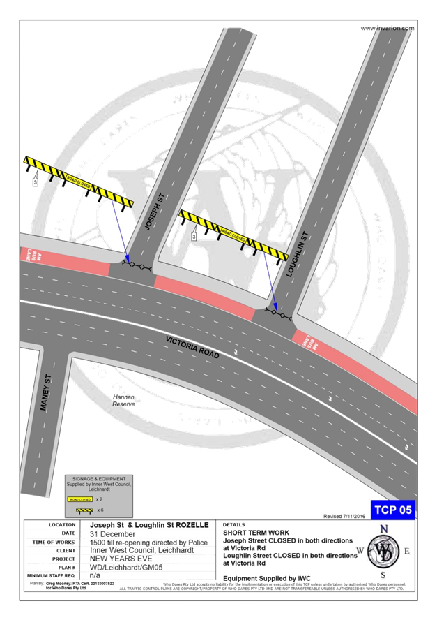
· Joseph Street at Victoria Road Street intersection, Rozelle (both directions)
· Loughlin Street at Victoria Road Street intersection, Rozelle (both directions)
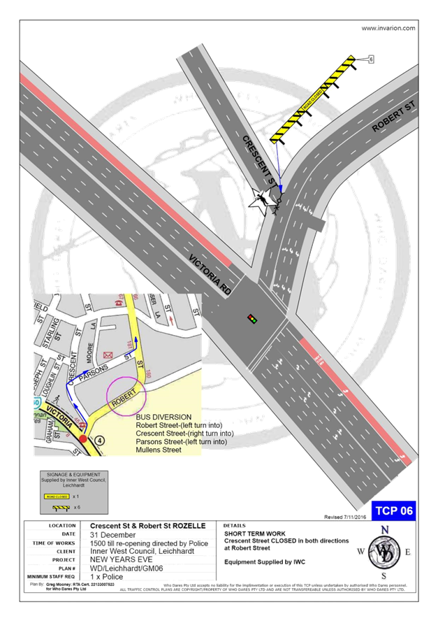
· Crescent Street at Robert Street intersection, Rozelle (both directions)
· Buchanan Street at Robert Street intersection, Balmain (both directions)
· Waragal Avenue at Terry Street intersection, Rozelle (both directions)
· McKell Street at Yeend Street intersection, Birchgrove (both directions)
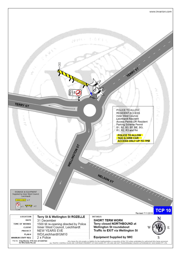
In addition, the following roads will be closed to all vehicular traffic except State Transit Authority/Transit Systems buses, Taxis, Hire Cars and Balmain Access Permit holders and will be manned by NSW Police officers between 3:00pm Monday, 31st December 2018 and 12:00am on Tuesday, 1st January 2019:
· Terry Street at Wellington Street intersection, Rozelle (northbound direction)
· Darling Street at Nelson Street intersection, Rozelle (northbound direction)
· Darling Street at Ewenton Street intersection, Balmain (eastbound direction)
· Evans Street at Merton Street intersection, Rozelle (northbound direction)
· Mullens Street at Robert Street intersection, Rozelle (both directions)
· Ballast Point Road at Lemm Street-Yeend Street intersection, Birchgrove (south and eastbound directions)
· Wharf Road at Grove Street intersection, Birchgrove (eastbound direction)
· Robert Street at Crescent Street, Rozelle (northbound direction)
· Grove Street at Rose Street, Birchgrove (eastbound direction)
The following plan indicates the road closure points.
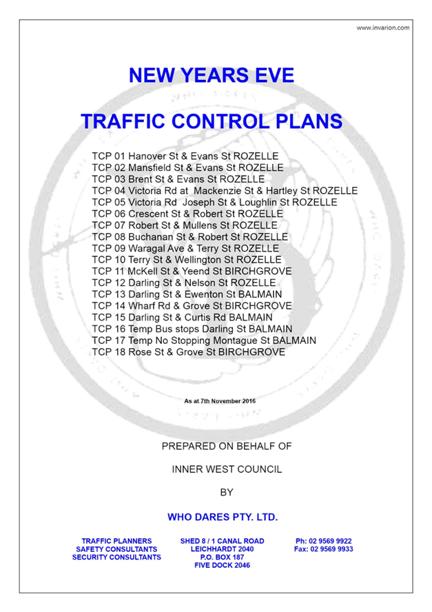
A Traffic Management Plan including Traffic Control Plans outlining the above road closures and the bus route changes is attached in Attachment 1.
Taxi Access
As previously recommended, the NSW Taxi Council will again be requested to inform their members of the proposed taxi access restriction after 7pm and to use the following drop-off point locations:
· Taxis entering Terry Street - In the unrestricted parking on the eastern side of Terry Street or ‘Bus Zone’ and timed kerbside parking along Wellington Street
· Taxis entering Darling Street - In the ticket parking areas along Darling Street and Nelson Street
· Taxis entering Robert Street – In the restricted parking area and ‘Bus Zone’
Public Transport Access
Transit Systems will be scheduling additional services into the Balmain peninsula to cater for the New Year’s Eve celebrations.
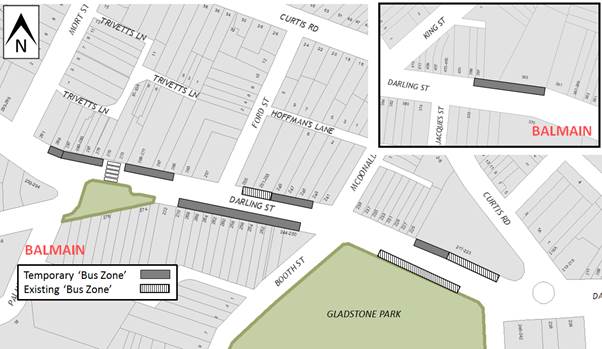
As such, temporary ‘Bus Zones’ will be installed at the following locations:
· Darling Street and the existing ‘Bus Zones’ on Darling Street between Mort Street and Curtis Road, Balmain
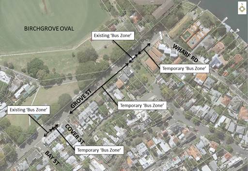
· Eastern side of Grove Street between Wharf Road and Bay Street, Birchgrove from 12 noon on New Year's Eve.
The ‘Bus Zones’ on Grove Street will be used by Transit Systems and the Police to store buses on New Year's Eve. This is required for the safe bump out of the general public from Birchgrove as identified from a debrief from a previous New Year's Eve event conducted in the Balmain Peninsular.
The signs defining the temporary restrictions be in place after 12 Noon on the 31st of December 2018 and will be removed the following day.
Based on discussions held in previous years regarding disruptions to bus services leaving Gladstone Park/Curtis Road roundabout due to the gathering of large crowds, the Glebe Local Area Command representative introduced Police bike units to manage the crowds in the area.
In addition, to avoid delays that occurred at the Robert Street/Mullens Street intersection (which is a Police check point), buses entering Robert Street from Victoria Road are proposed to use Crescent Street and Parsons Street to access Mullens Street (see TCP 06/07 in Attachment 1).
Temporary ‘No Stopping’ Restrictions
Following a previous year’s event, the Sydney Buses representative advised that several vehicles parked on Montague Street out from the kerb thus narrowing the carriageway and preventing buses from passing each other. Therefore, it is proposed to install temporary ‘No Stopping’ zone on the eastern side of Montague Street between Darling Street and Beattie Street. The residents will be advised of this arrangement in advance of the event.
Resident Access
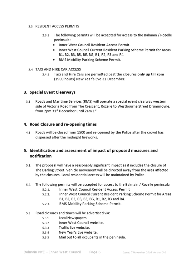
To ensure resident access is maintained, the following permits will be accepted for access to the Balmain / Rozelle peninsula:
· Inner West Council Resident Access Permit.
· Inner West Council current Resident Parking Scheme Permit for Areas; B1, B2, B3, B5, BE, BG, R1, R2, R3 & R4.
· Australian Disability Parking permit
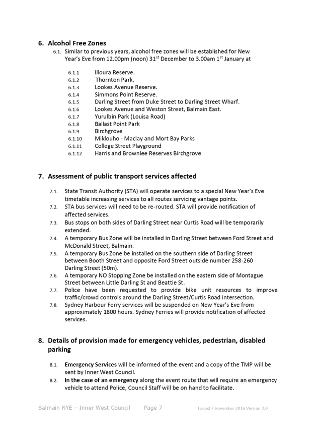
Alcohol Free Zones
At the August 2015 Council Ordinary meeting (former Leichhardt Council), Council re-established the Alcohol Free Areas for the New Year’s Eve celebrations in 2015, 2016, 2017 & 2018 at the following locations:
· Illoura Reserve
· 2-8 Weston Street
· Thornton Park
· Lookes Avenue Reserve
· Simmons Point Reserve
· Yurulbin Park
· Birchgrove Park
· Miklouho-Maclay Park
· Mort Bay Park
· College Street playground
· Harris Reserve
· Brownlee Reserves
· Darling Street from Duke Street to Darling Street Wharf
· Darling Street Wharf, Balmain East;
· Lookes Avenue
· Weston Street
These alcohol restrictions are proposed to be in place from 12.00pm (noon) 31st December 2018 to 3.00am 1st January 2019.
It should be noted that NSW Police introduced alcohol ban restrictions in 2014 at Ballast Point Park which is managed by the Sydney Harbour Foreshore Authority.
PUBLIC CONSULTATION
The road closures have been advertised in a local newspaper for a period of 28 days from 31st July to 28th August 2018. No comments have been received.
In December, the details of these traffic arrangements will be re-advertised in local newspapers, on Council’s website and via a mail out to all occupants in the Balmain peninsula.
The road closures and other event information will also be available on the Sydney New Year’s Eve Event website.
Similar to previous years, the TMC is requested to provide variable message signs: “Balmain Peninsula is closed” at the entry points from Victoria Road.
CONCLUSION
Nil.
|
1.⇩ |
New Year's Eve - Balmain - TMP |
|
Local Traffic Committee Meeting 4 September 2018 |
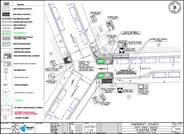
Subject: Batty Street, Rozelle - Proposed Kerb Extension Design Plan (Balmain Ward/ Balmain Electorate/ Leichhardt LAC)
Prepared By: Felicia Lau - Engineer - Traffic and Parking Services
Authorised By: John Stephens - Traffic and Transport Services Manager
|
SUMMARY A detailed design plan has been finalised for the proposed treatment in Batty Street, Rozelle at its intersection with Mansfield Street.
The proposal includes installing kerb extensions to reinforce the existing ‘No Entry’ restriction that prohibits northbound entry into Batty Street from Mansfield Street, and to install pedestrian kerb ramps to improve pedestrian safety.
Consultation was undertaken with the owners and occupiers of properties adjacent to the intersection regarding the proposal. A summary of the consultation results are presented in this report for consideration. |
|
RECOMMENDATION
THAT the detailed design plan for the kerb extensions and associated signs and line markings at the intersection of Batty Street and Mansfield Street, Rozelle (as per the attached design plan no.10025) be approved.
|
BACKGROUND
At the Leichhardt Council Traffic Committee meeting held on 7 April 2016, it was recommended that:
a) In principle support be given to the following treatments at the intersection of Batty Street and Mansfield Street:
· Kerb extension on the western corner of Batty Street and Mansfield Street, reducing the carriageway to one southbound travelling lane.
· Additional ‘No Entry’, ‘No Right Turn’ and ‘No Left Turn’ signage be installed in appropriate locations to warn road user of the prohibited northbound entry.
· Linemarking of a ‘UA1’ straight ahead arrow be marked on Batty Street, near Mansfield Street, directing motorists south towards the Mansfield Street intersection.
b) A detailed design be prepared and brought back to the Committee.
This recommendation was adopted by Council and subsequently Council implemented temporary mitigation treatment of additional pavement marking and signage to reinforce the existing ‘No Entry’/banned entry northbound into Batty Street from Mansfield Street.
Detailed design plans for a physical treatment have now been finalised together with the accompanied consultation results and are presented in this report for consideration.
FINANCIAL IMPLICATIONS
Funding of $15,000 has been allocated for the proposal under the 2018/2019 Capital Works Program for Traffic Facilities.
OTHER STAFF COMMENTS
Site location & road network
|
Street Name |
Batty Street |
|
Section |
At its intersection with Mansfield Street |
|
Carriageway Type |
One-way southbound with kerbside parking lanes |
|
Classification |
Local |
|
Carriageway Width (m) |
8.5m |
|
Reported Crash History (July 2012 – June 2017) |
No crashes recorded |
|
Parking Arrangements |
Western Side – 2P resident parking scheme Eastern Side – unrestricted parking |
Four Weeks Historical Survey Data (2015)
Average Daily Traffic (ADT) in Batty Street: 238 vpd (6.4% heavy vehicles)
ADT in Batty Street northbound (illegal movement: 19 vpd (14.4% heavy vehicles)
85th percentile speed: 23.4km/h
Design Plan No.10025
The proposed scope of work includes the following:
· Installation of kerb extensions on Batty Street at Mansfield Street
· Provision of kerb ramps and reconstruction of footpath
· Provision of landscaping
· Installation of associated signage
· Replacement of any damaged signs and faded road markings
The proposal aims to deter vehicles from entering Batty Street (a one-way southbound street) from Mansfield Street. Through the installation of kerb extensions, it also improves pedestrian safety by providing a shorter crossing point and by preventing illegal manoeuvres at the intersection. There is no loss of existing on-street parking spaces and all current vehicular accesses to adjoining properties will be retained.
PUBLIC CONSULTATION
Consultation was conducted between 27 July 2018 and 17 August 2018. A letter as well as a copy of the design plan was sent to the local residents in Batty Street, Mansfield Street and Reynolds Avenue, Rozelle. A total of 126 letters were distributed.
There were six (6) responses from five (5) different properties received during the consultation period of the proposed entry treatment in Batty Street at its intersection with Mansfield Street, Rozelle. One (1) response supported the proposal and four (4) responses opposed the proposal. The responses received are detailed below.
|
Resident’s Comment |
Officer’s Response |
|
Support |
|
|
Resident agrees to the proposal and requested Council to implement it as a matter of urgency. A near miss happened recently by a vehicle travelling the wrong way in Batty Street. |
The proposed treatment will reinforce the 'No Entry' restriction and deter vehicles from entering in the wrong direction from Mansfield Street. |
|
Object |
|
|
Resident does not think the proposal is necessary and requested consideration to install a sign at the entrance to Reynolds Avenue to restrict large truck to enter the street. |
The resident will be advised that two more requests are required from separate properties to initiate an investigation to restrict truck access in Reynolds Avenue. |
|
Resident does not support the proposal and is concerned in losing waste bin area and the proposed kerb extension will restrict bin collection. |
The existing entry treatment is a temporary treatment while Council developed the detailed design plans to submit to the LTC for final approval. Swept paths for medium rigid vehicle (MRV) have been considered in the design.
There are no changes proposed to the existing bin location. Feedback from the Resource Recovery Services Manager indicated that the proposed would not restrict waste collection.
|
|
Resident does not support the proposal, requested the safety data that supports the proposal and thinks the proposal is a safety hazard, especially for large commercial vehicles. |
|
|
Resident does not support the proposal and thinks that the existing treatment is adequate and safe. Also, thinks that the proposal will restrict access for the garbage trucks and removals trucks. |
|
|
Resident does not support the proposal and thinks that the existing treatment is adequate and safe. Resident also express concern that the proposal will restrict vehicles exiting the basement car park of property No.1 Batty Street. |
Swept path analysis for standard vehicles exiting the basement car park indicated that the left turn manoeuvre out of the basement car park of property No.1 Batty Street would not be restricted. |
CONCLUSION
It is recommended that the design of the proposed treatment and associated signs and line markings be approved, to improve pedestrian safety and traffic conditions in Batty Street at its intersection with Mansfield Street, Rozelle.
|
|
Local Traffic Committee Meeting 4 September 2018 |
Subject: Booth Street Bridge Widening over Johnston Creek, Annandale
Prepared By: Manod Wickramasinghe - Coordinator – Traffic and Parking Services
Authorised By: John Stephens - Traffic and Transport Services Manager
|
SUMMARY A detailed design plan has been prepared for the Booth Street Bridge widening over Johnston Creek. The proposal adds a separated unidirectional cycleway in the southbound direction as well as footpath and linemarking amendments.
It is recommended that the proposed detailed design plans be approved.
|
|
RECOMMENDATION
THAT:
1. The design plans for the proposed Booth Street Bridge Widening over Johnston Creek, Annandale (as per the attached design plans No. C101.3 and C101.5) be approved; and
2. Additional PS-2 bicycle logos be provided in the northbound direction on both approach and departure to the proposed treatment. |
BACKGROUND
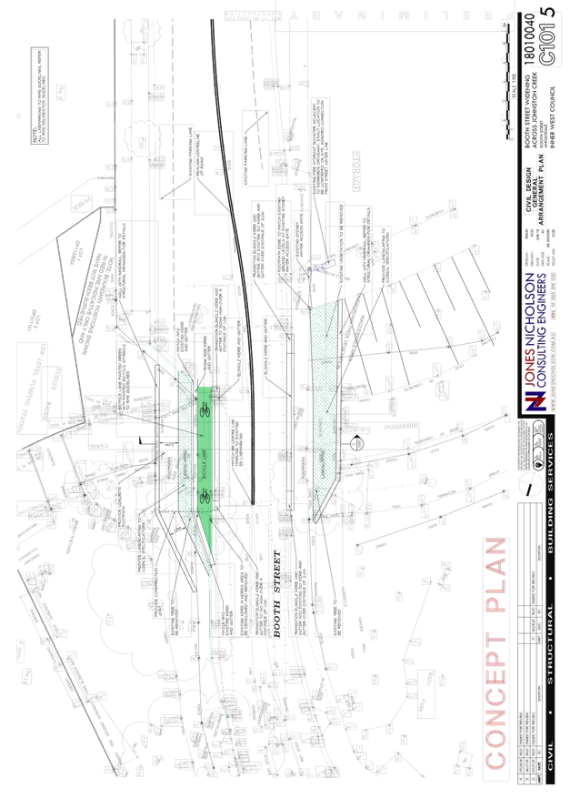
The Booth Street Bridge, Annandale (Figures 1 and 2) spans the Johnston Creek Sydney Water stormwater channel south of Wigram Road and is jointly owned and managed by the City of Sydney (northeast side of bridge) and Inner West Council (southwest side of bridge).
The Booth Street carriageway is located above the Booth Street Bridge but is not structurally connected with the bridge itself. Between the Booth Street carriageway and the bridge arch is approximately 3.0m of fill.
Structural investigations of both the bridge and the carriageway identified the need for remediation and strengthening works to be undertaken to the bridge arch and reconstruction works to be undertaken to the spandrel walls and carriageway of Booth Street. The remediation works to the bridge arch were the subject of a separate project completed in December 2017.
This project is for:
· Design of works to strengthen the bridge arch against foundation movement,
· Design for reconstruction of both spandrel walls as vertical walls integrated with new retaining wall transitions from the widened road to the existing carriageway.
· Design for reconstruction of the Booth Street carriageway where it lies above the bridge arch to install traffic barriers and allow for future widening of Booth Street
Site location & road network
Booth Street, Annandale is a two-way unclassified regional road carrying approximately 13,000 vehicles per day. The bridge over Johnston Creek is located on Booth Street, just south of Wigram Road as shown in the following figures.
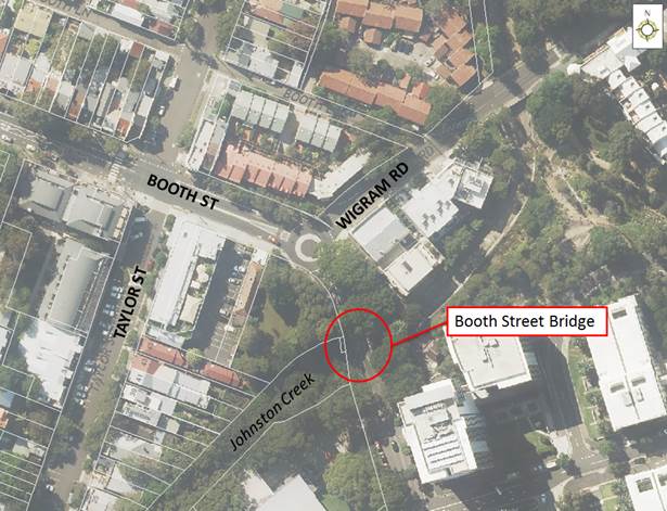
Figure 1 – Site location
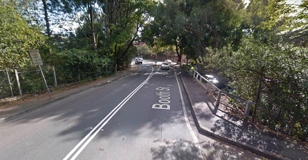
Figure 2 - Existing Booth Street Bridge over Johnston Creek, Annandale, looking northwards
FINANCIAL IMPLICATIONS
This project has been jointly funded by Inner West Council and City of Sydney through a 50-50 cost sharing agreement. The Inner West Council costs are funded through the NSW Government, Stronger Communities Grant.
OTHER STAFF COMMENTS
Design Plan C101.3
Detailed design plans for the widening of Booth Street Bridge over Johnston Creek (Attachment 1 - design plans Nos. C101.3 and C101.5) are submitted for consideration.
The proposed scope of work includes the following:
· Provision of separated unidirectional cycleway in the southbound direction (City of Sydney side)
· Retention of mixed traffic arrangement in the northbound direction (Inner West Council side)
· Re-marking edge line markings and centre line markings.
· Installation of Elsholz kerb and gutter (provides traffic deflection at low speeds without the need for a guard rail)
· Provision of landscaping
· Provision of handrails
The proposed treatment will not result in the loss of any on-street in Booth Street. All current vehicular access to adjoining properties will be retained.
City of Sydney may investigate extending the separated unidirectional cycle path towards Wigram Road in future, subject to investigation and funding.
Construction methodology
Booth Street is a significant transport connection between Annandale and Parramatta Road. Public transport routes and heavy vehicles accessing the commercial premises on the eastern side of Johnston Creek regularly use the bridge. Alternative viable routes around the bridge are not available.
Consequently, closure of the road except for short periods of time outside of morning and afternoon peak hour will not be permitted during construction. The design must allow for one lane of traffic to be open at all times while the works are being undertaken.
A suitable Traffic Control Plan must be provided to Council prior to the commencement of works. The applicant will also have to apply for a Road Occupancy License.
PUBLIC CONSULTATION
Nil.
CONCLUSION
It is recommended that the detailed design plans of the proposed for the widening of Booth Street Bridge over Johnston Creek be approved.
|
1.⇩ |
Booth Street Bridge Widening - Typical Section |
|
2.⇩ |
Booth Street Bridge Widening - General Arrangement |
|
|
Local Traffic Committee Meeting 4 September 2018 |
Subject: Boomerang Street, Haberfield - Haberfield North LATM - Traffic calming improvements (Leichhardt Ward / Summer Hill Electorate / Ashfield LAC)
Prepared By: Manod Wickramasinghe - Coordinator – Traffic and Parking Services
Authorised By: John Stephens - Traffic and Transport Services Manager
|
SUMMARY Detailed design plans have been finalised for the proposed road and traffic improvements in Boomerang Street, Haberfield as part of Council’s 2018/19 & 2019/20 Capital Works Program for Traffic Facilities.
The proposed works include the upgrade of an existing at-grade pedestrian (zebra) crossing to a raised pedestrian (zebra) crossing, introduction of speed calming devices and upgraded bicycle facilities with associated line marking and signposting. |
|
RECOMMENDATION
THAT the detailed design plans for the raised pedestrian crossing, traffic calming devices, bicycle facilities and kerb blisters with associated signposting and line marking in Boomerang Street, Haberfield (as per the attached plan Nos. 10041, 10013B & 10014) be approved.
|
BACKGROUND
At the Traffic Committee meeting held on 5 June 2018, a report was considered outlining a proposal to improve the traffic conditions in Boomerang Street, Haberfield between Waratah Street and Crane Avenue as part of the 2018/19 and 2019/20 Capital Works Program for Traffic Facilities.
The proposal was based on recommendations from the former Ashfield Council’s Traffic Management Strategy which were endorsed by Council on 23 August 2016, following a period of community engagement. It is also a continuation of the Local Area Traffic Management (LATM) measures recently completed in Waratah Street and Tillock Street, Haberfield.
Following resident and Committee discussion the Committee recommended:
THAT the detailed design plans for the raised pedestrian crossing, traffic calming devices, bicycle facilities and kerb blisters with associated signposting and line marking in Boomerang Street, Haberfield (as per plan Nos. 10013 & 10014) be deferred for further review and incorporate proposals for traffic calming under the Black Spot Program.
Site location & road network:
|
Street Name |
Boomerang Street, Haberfield |
|
Section (s) |
Waratah Street to Crane Avenue |
|
Carriageway width (m) |
12.8m |
|
Carriageway type |
Two-way road with one travel lane and one parking lane in each direction. |
|
Classification |
Local |
|
85th Percentile speed (km/hr) |
48.7 km/hr (27/5/15) |
|
Vehicles Per Day (vpd-AADT) |
7200 |
|
Reported Crash History (July 2012 – June 2017) |
(1) At pedestrian crossing = 2 accidents. RUM code: 44, Parking vehicles – resulted in tow-away (21/5/13); RUM code: 71, Off road left => object – resulted in tow-away (26/5/17). (2) At Boomerang St and Crane Ave = 1 accident. RUM Code: 40, U-turn – resulted in tow-away (11/4/15). (3) At roundabout of Boomerang St, Dalhousie St & Waratah Sts = 5 accidents. RUM Code: 4 x 10, Cross Traffic. RUM Code: 0, Near side pedestrian – resulted in serious injury (21/5/14) |
|
Heavy Vehicle Volume |
3.5% |
|
Parking arrangements |
Unrestricted parking |
The proposed works on Boomerang Street include the upgrade of an existing at-grade pedestrian (zebra) crossing to a raised pedestrian (zebra) crossing, introduction of a widened pedestrian refuge, introduction of speed calming devices and upgraded bicycle facilities with associated line marking and signposting.
The detailed design plans have been finalised for the proposed devices together with the consultation and are presented in this report for consideration.
FINANCIAL IMPLICATIONS
Plan 10041
Council has received funding through the Australian Government’s Black Spot Program for the 2018-19 financial year to improve safety at the roundabout of Boomerang, Dalhousie and Waratah Streets. Funding of $44,000 has been listed in the 2019/20 Capital Works Program for Traffic Facilities.
Plan 10013B
Funding of $75,000 has been listed for the Pedestrian Crossing works in the 2018/19 Capital Works Program for Traffic Facilities.
Plan 10014
Funding of $50,000 has been listed for the traffic calming devices and bicycle lane upgrade in the 2019/20 Capital Works Program for Traffic Facilities.
OTHER STAFF COMMENTS
Design Plan No. 10041.
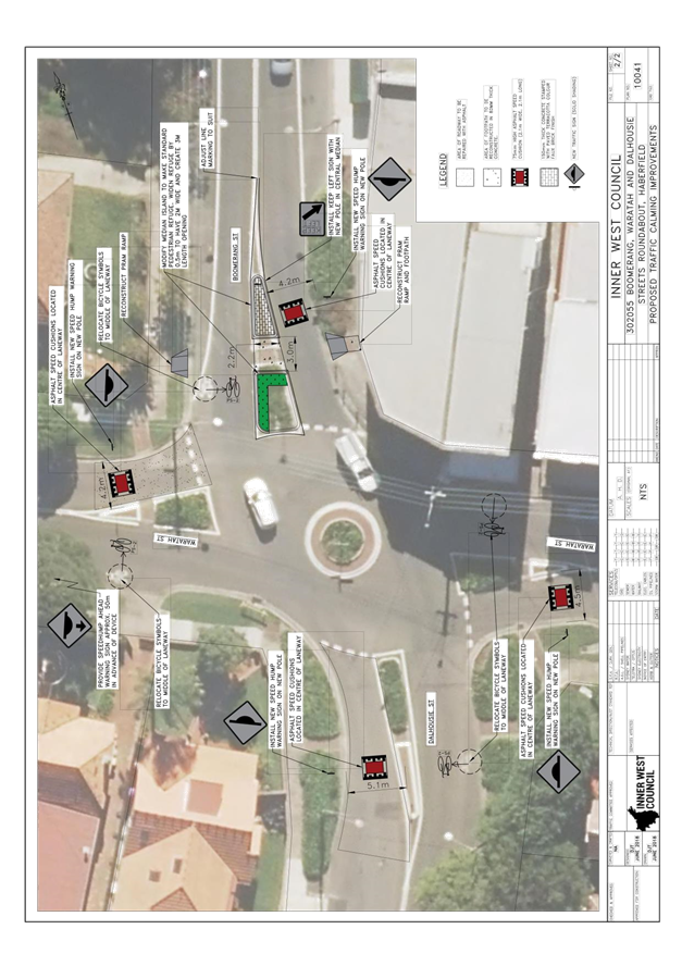
This detailed design plan shown in Attachment 1 outlines the proposed works at the intersection of Boomerang Street /Dalhousie Street/Waratah Street and includes the following treatments:
· Reconstructing the existing median in Boomerang Street, on the approach to the roundabout, to accommodate a wider pedestrian refuge
· Providing four (4) x asphalt speed cushions on each approach to the roundabout
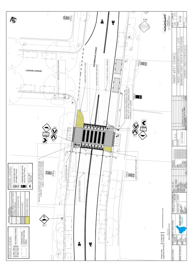
Design Plan No.10013B.
This detailed design plan shown in Attachment 2 outlines the proposed works on Boomerang Street at Loudon Avenue and includes the following treatments:
· Upgrading the existing at-grade pedestrian (zebra) crossing to a raised pedestrian (zebra) crossing with landscaped kerb extensions
· Construction of landscaped traffic islands
· Construction of new kerb ramp
· Installation of associated linemarking and signage
There will be a gain of two parking spaces associated with converting the existing at-grade pedestrian (zebra) crossing to a raised pedestrian (zebra) crossing.
Currently the pedestrian refuge in the existing crossing requires the edgeline to taper towards the kerbline in order to deflect southbound vehicles. In order to achieve this a 20m ‘No Stopping’ zone is provided on approach. The current proposal removes the refuge and instead allows construction of kerb extensions. The ‘No Stopping’ zone can therefore be reduced to 10m on the southbound approach to the pedestrian crossing, allowing two cars to park in front of No.7 Boomerang Street.
All current vehicular access to adjoining properties will be retained.
Council officers have considered two options for the reconstruction of the pedestrian crossing which included one design of the pedestrian crossing containing a pedestrian refuge and one design of the pedestrian crossing with kerb extensions and no pedestrian refuge. The option with kerb extensions has been chosen as the preferred treatment as it is the current standard for raised pedestrian crossings (rather than a refuge), provides improved sightlines between pedestrians and motorists, and creates a clear indication that pedestrians have priority through the entire length of the crossing.
Council officers also considered the relocation of the pedestrian crossing from the current location towards the roundabout at Boomerang, Dalhousie and Waratah Streets following feedback from a resident. The existing pedestrian (zebra) crossing was installed at the current location prior to 2000, to cater for school children travelling to the Dobroyd Point Public School from north of Boomerang Street. Relocating the crossing would reduce pedestrian amenity for the school. It should be noted that the raised pedestrian crossing will also improve the speed profile along Boomerang Street. As per design plan 10041, it is also proposed to separately improve pedestrian safety at the roundabout at the intersection of Boomerang, Dalhousie and Waratah Streets by providing a pedestrian refuge and managing traffic speeds through the intersection.
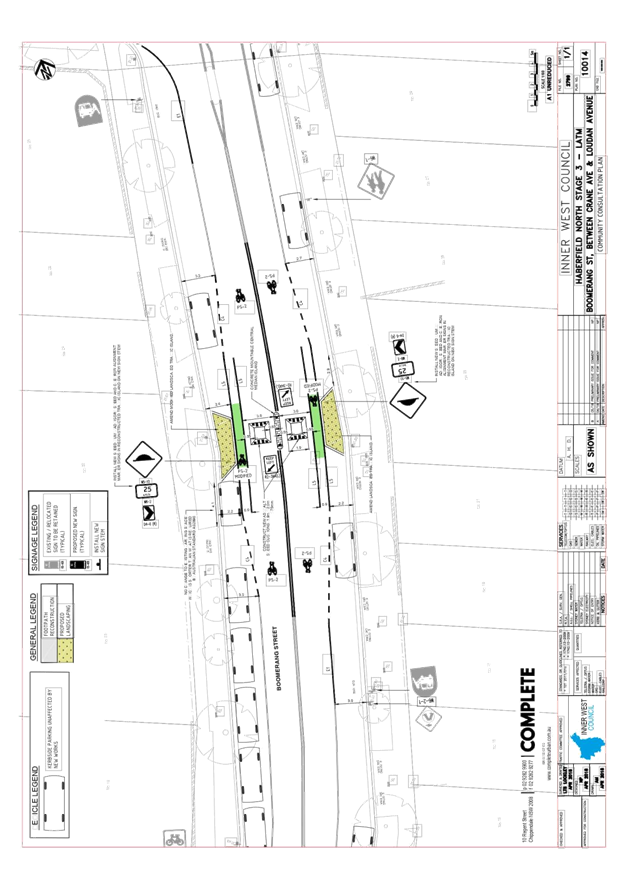
Design Plan No.10014.
This detailed design plan shown in Attachment 3 outlines the proposed works on Boomerang Street (midblock between Loudon Avenue and Crane Avenue) outside No.22 Boomerang Street and includes the following treatments:
· Reconstruction of the existing traffic median island; reconstruction of landscaped kerb blisters
· Reconstruction of asphalt speed cushions with bicycle lanes
· Resurfacing the subject section of roadway
· Installation of associated linemarking and signage
The bicycle lane has been tapered to allow riders in the mixed traffic lane to ride around the traffic calming device, and then entering back into the mixed traffic lane. This proposed bicycle treatment is typical of other treatments on Boomerang Street and Dalhousie Street.
It has been noted that some of the bicycle symbols along the Boomerang Street route have faded and will be remarked accordingly to reflect the design intent of this device with the mixed traffic route which were proposed following requests from the local bicycle user group (AshBUG).
All current vehicular access to adjoining properties will be retained.
Police and RMS have provided in-principal support for the 3 design plans listed.
PUBLIC CONSULTATION
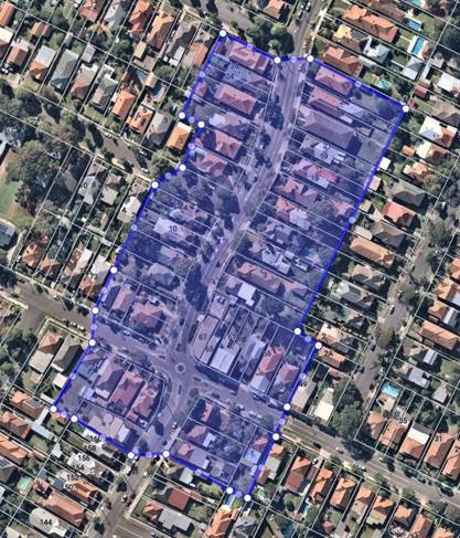
A letter outlining this traffic improvement proposal was mailed out to the affected properties (52 properties) in Boomerang Street, Waratah Street and Dalhousie, Haberfield as indicated on the below plan, requesting residents’ views regarding the proposal.
Design Plan Nos. 10041 10013B, and 10014:
A total of six (6) responses from five (5) properties were received in total for this proposal, four (4) responses were received in support of the proposal and two (2) responses were received against the proposal.
|
Residents’ Comments |
Officer Comments |
|
June Consultation |
|
|
In the engagement undertaken in June 2018 residents commented that the location of the pedestrian crossing should be relocated closer to the roundabout at the intersection of Waratah Street, Dalhousie Street and Boomerang Street, and noise issues. In the engagement undertaken in June 2018 residents also commented on their support for the previous proposals to raise the pedestrian crossing and install speed cushions along Boomerang Street. |
The plans have since been reviewed and amended.
|
|
Current Consultation |
|
|
Residents in Boomerang Street commented on their support for the entire proposal shown in plans 10013B, 10014 and 10041. |
Support noted. |
|
A resident at the roundabout of Boomerang, Dalhousie and Waratah Sts commented on their support for proposals, particularly the speed cushions and the bicycle logos being placed centrally in the laneways. |
Support noted. |
|
A resident in Boomerang Street commented on their support for the proposal to improve safety for children in the area. |
Support noted. |
|
A resident commented that the pedestrian crossing is on a bus route and will impact on buses, which currently have a wheel base wider that the speed cushions used all the way along Dalhousie and Boomerang and would also pose major noise impacts.
|
The proposed height of the pedestrian crossing will be specified as 75mm to 90mm high as it is located on a bus route, instead of the typical 100mm high as per the RMS technical directions.
The ramps of the crossing will also be extended from 1.2m to 1.5m to create a more seamless transition from the existing road level over the proposed raised crossing which will reduce the noise impacts associated with a raised device whilst retaining a traffic calming impact.
|
|
Residents commented that most foot traffic utilises the crossing point across Boomerang Street at the roundabout for pedestrians walking to and from Dobroyd Point Public School , as well as the shops and the Timbrell Park playground. A pedestrian crossing near the roundabout on Boomerang Street would provide better public safety and amenity. There would then be a bus stop and raised pedestrian crossing on one side of the roundabout, similar to Norton Street near William Street, Leichhardt. There are other locations where pedestrian crossings are in place next to roundabouts like Booth at Nelson Street, Annandale and intersection of Lords Road and Flood Street, Leichhardt.
The residents also commented that Council should remove the existing pedestrian crossing and install a raised pedestrian crossing at 22 Boomerang Street instead of the proposed speed cushion. This new crossing would cater for pedestrians travelling to and from Dobroyd Public School from the northern end of Boomerang Street, as the existing pedestrian crossing does.
|
The existing pedestrian (zebra) crossing was installed at the current location prior to 2000, to cater for school children travelling to the Dobroyd Point Public School from north of Boomerang Street. Relocating the crossing would reduce pedestrian amenity for the school. It should be noted that the raised pedestrian crossing will also improve the speed profile along Boomerang Street.
As per design plan 10041, it is also proposed to separately improve pedestrian safety at the roundabout at the intersection of Boomerang, Dalhousie and Waratah Streets by providing a pedestrian refuge and speed cushions to manage traffic speeds through the intersection.
|
|
Resident commented that due to the camber of the road, raising the crossing would result in a large drop at the gutter end of each side of the roundabout, creating pedestrian hazards. |
The proposed raised pedestrian crossing would provide a pedestrian grate over the gutter so there will be no impact to the stormwater and pedestrians would be unaffected by the camber of the road. |
CONCLUSION
It is recommended that the detailed design plans of the proposed treatments and associated
signs and line markings be approved, to improve conditions at these locations.
|
1.⇩ |
Plan 10041 |
|
2.⇩ |
Plans 10013B |
|
3.⇩ |
Plans 10014 |
|
|
Local Traffic Committee Meeting 4 September 2018 |
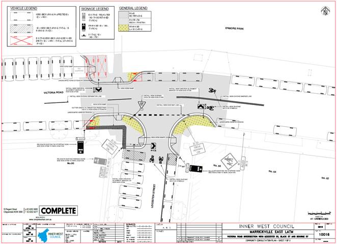
Subject: Victoria Road at Leicester Street, Marrickville – Revised Proposed Kerb Extensions Design Plan – No.10016 (Marrickville Ward / Newtown Electorate / Inner West LAC)
Prepared By: Jennifer Adams - Engineer – Traffic and Parking Services
Authorised By: John Stephens - Traffic and Transport Services Manager
|
SUMMARY A revised design plan has been finalised for the proposed traffic calming improvements in Victoria Road at Leicester Street, Marrickville as part of the Marrickville East LATM study implementation. The revised proposal for kerb extensions with a new kerb and gutter alignment and associated signs and line markings will improve pedestrian safety and traffic conditions at this location.
Consultation was undertaken with owners and occupiers of properties adjacent to Victoria Road and Leicester Street regarding the revised proposal. It is recommended that the revised proposed detailed design plan be approved.
In addition, pedestrian counts in Victoria Road at Leicester Street, Marrickville have been undertaken and RMS warrants for a pedestrian crossing cannot be met at this location; however, the proposed kerb blisters will facilitate safe crossing for pedestrians by reducing crossing widths providing pedestrians a shorter distance to cross the road.
|
|
RECOMMENDATION
THAT the design plan for the revised proposed kerb extensions with a new kerb and gutter alignment and associated signs and line markings in Victoria Road at Leicester Street, Marrickville (as per the attached design plan No. 10016) be APPROVED. |
BACKGROUND
Design plans for traffic calming works in Victoria Road, at Leicester Street and at Bourne Street, Marrickville as part of the Marrickville East LATM study implementation were presented at the Local Traffic Committee (LTC) meeting held on 1 June 2018 - Item 9. The Committee members agreed with the Officer’s recommendation with an additional recommendation to undertake pedestrian counts on Victoria Road.
COMMITTEE RECOMMENDATION - THAT:
“1. The design plans for the proposed kerb extensions with a new kerb and gutter alignment and associated signs and line markings in Victoria Road, Marrickville, at Leicester Street and at Bourne Street (as per design plan No. 10016) be APPROVED; and
2. Council Officers undertake an analysis to determine whether RMS warrants can be met for a marked pedestrian (zebra) crossing in Victoria Road at Leicester Street intersection.”
Comments received from residents at the 1 June 2018 LTC meeting have also been reviewed and Council has improved the design of the proposed crossing facility at Victoria Road and Leicester Street, Marrickville to include a road narrowing device with kerb extensions which will improve pedestrian safety and control vehicle speeds in the area.
Presented in this report for consideration is the detailed revised design plan for Victoria Road at Leicester Street, Marrickville along with the results of the pedestrian counts and observation surveys in Victoria Road.
FINANCIAL IMPLICATIONS
Funding has been allocated in the current budget.
OFFICER COMMENTS
Site location & road network
Victoria Road, between Enmore Road and Bourne Street, is a local street which carries around 1,150 vehicles per day and has an 85th percentile speed of 39km/h. The carriageway is 12.8 metres wide and it is a two-way road with one travel lane in each direction. In addition to kerbside parking lanes there are 90 degree angle parking restrictions along the northern side of the road and unrestricted parking along the southern side of the road.
Leicester Street is a 12.8 metre wide dead end local street which carries around 185 vehicles per day. It has 90 degree angle, rear-to-kerb parking restrictions along the western side of the road and unrestricted parking along the eastern side of the road.
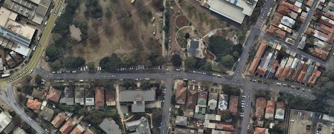
Observation of all road user activity during site inspections indicated a moderate interaction of pedestrian activity amidst light traffic activity. At both intersections there is adequate manoeuvring room for vehicles including Council waste vehicles and buses and turning paths are adequate. All road user activity observed was considered to be of a safe nature. Traffic volumes and 85th percentile speeds are low on Victoria Road and Leicester Street.
A review of the last five years of RMS reported crash data (July 2012 to June 2017) reveals no injury traffic crashes in the vicinity of the intersection of Victoria Road and Leicester Street, Marrickville.
Essentially, traffic data and site observations suggest that the existing traffic and parking configuration at the intersection of Victoria Road and Leicester Street, Marrickville is operating at an acceptable level. Sightlines are considered satisfactory on all legs on the intersection from all directions. Pedestrian crossing sight distances are also considered satisfactory at the intersection.
Pedestrian survey
Any formal pedestrian crossing facility in Victoria Road at Leicester Street, Marrickville would have to meet Roads and Maritime Services’ (RMS) warrants for a pedestrian zebra crossing. The RMS Guidelines for Traffic Facilities states that;
"In order to establish the justification for the installation of a marked foot crossing a set of warrants has been established. A marked foot crossing should be considered for approval where;
a) the product of the measured pedestrian flow per hour (P) and the measured vehicular traffic flow per hour (V), PV, is equal to or greater than 60,000; AND
b) the measured flows, P and V are equal to or greater than 30 and 500 respectively; AND
c) the measured flows apply for three periods of one hour in any day."
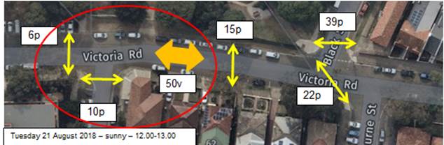
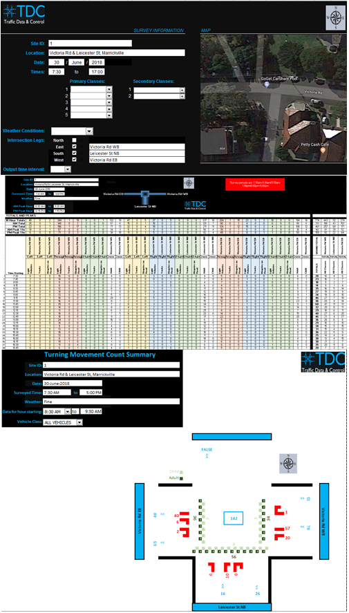
An external party conducted pedestrian verses vehicle counts in the morning and afternoon on 30 June 2018 to gauge whether the subject location would meet RMS warrants. The results of this investigation is summarised below and reproduced at the end of this report:
|
Period
|
Pedestrians (P) |
Vehicles (V) |
(P) X (V) |
|
8.30 – 9.30am
|
13 |
133 |
1729 |
|
4.00 - 5.00pm
|
36
|
142 |
5112 |
(pph – pedestrians per hour, vph – vehicles per hour)
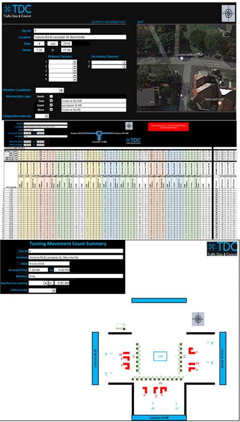
In addition, a pedestrian observation survey was undertaken in the locality of Victoria Road and Leicester Street, Marrickville on Tuesday 21 August 2018 during the lunch hour peak. Numbers of both vehicles and pedestrians fall well short of the RMS requirements for a formalised pedestrian crossing facility on any legs of the intersection.
The traffic survey data collected indicates that the site does not meet the above warrants for a marked foot crossing. Crossings where pedestrian volumes are low should be avoided as motorists don't expect pedestrians; therefore, the risk of an incident is higher. In these cases shifting the onus to pedestrians by the provision of facilities such as pedestrian refuges is a safer option.
Furthermore, survey results and site observations reveal that the present pedestrian movements across Victoria Road in the vicinity of Leicester Street are considered satisfactory at this time and RMS warrants cannot be met at the subject location at this time.
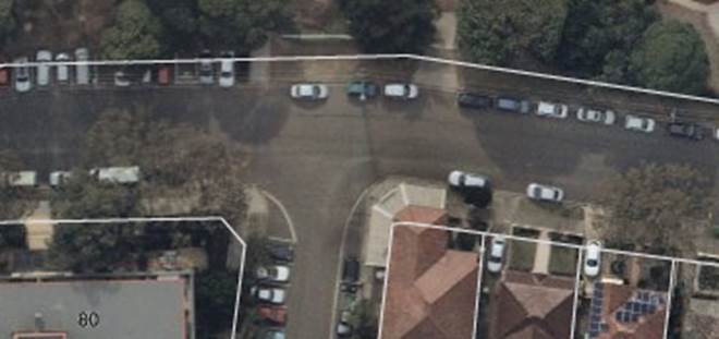
Revised design plan
Council has now improved the design of the proposed crossing facility at Victoria Road and Leicester Street, Marrickville to include a road narrowing device with kerb extensions which will improve pedestrian safety and control vehicle speeds in the area.
It is noted that following the introduction of the road narrowing device with kerb extensions on Victoria Road at Leicester Street, the proposal would result in the loss of three on-street
parking spaces. The plans for Victoria Road and Bourne Street remain unchanged and as such these plans have not been included in the latter consultation letter. Please refer to the attached photographs and plans for more details.
The proposed works include:
· constructing landscaped kerb extensions in Victoria Road at Leicester Street to reduce the crossing distance for pedestrians;
· reconstructing footpath near the kerb extensions;
· constructing kerb ramps at the kerb extension locations;
· installing all associated signage, replacing any damaged signs and repairing faded linemarkings;
· Painting new bicycle symbols.
· Resurfacing the road in the vicinity of the works.
All current vehicular access to adjoining properties will be retained.
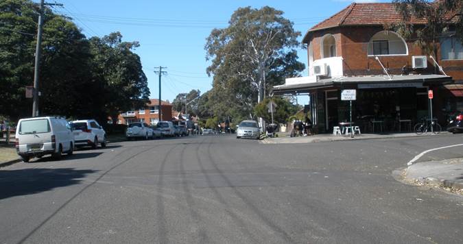
Victoria Road at Leicester Street, Marrickville
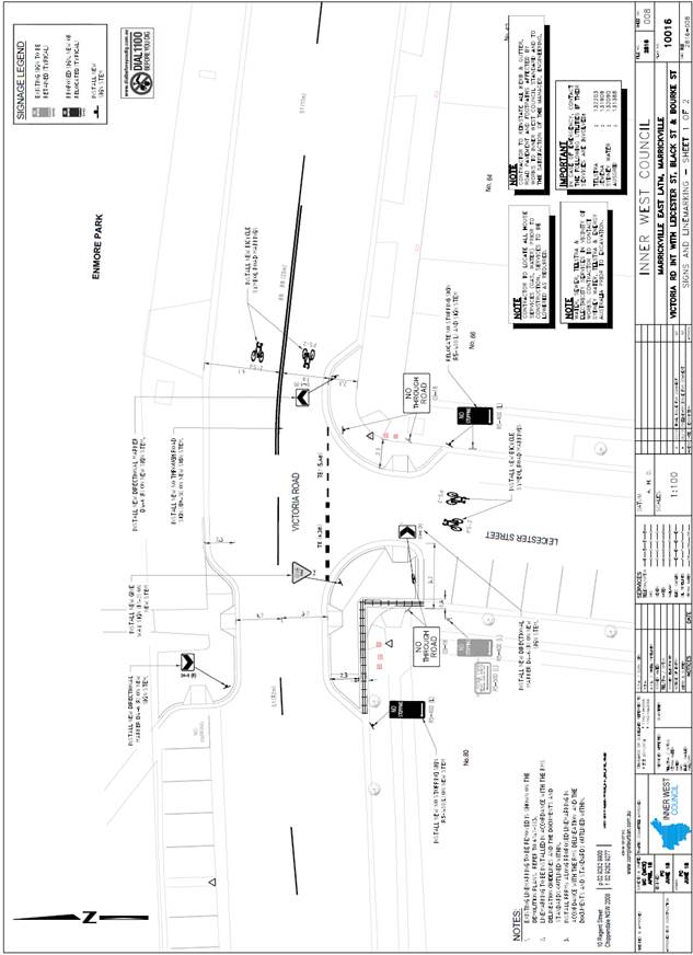
PUBLIC CONSULTATION
A second consultation letter was sent out for the revised works proposed for the intersection of Victoria Road and Leicester Street, Marrickville on 2 August 2018 and closed on 24 August 2018.
Two (2) responses were received regarding this revised proposal and are summarised below:
|
Residents’ Comments |
Officer’s Response |
|
Residents requested a pedestrian crossing in Victoria Rd at Leicester Street. |
Counts including vehicle and pedestrian counts were undertaken for Victoria Road within the vicinity of Enmore Park at Leicester Street. These do not meet the RMS warrant for a pedestrian zebra crossing. Therefore, the kerb extensions proposed act as an alternative pedestrian crossing facility which can be retrofitted with a pedestrian zebra crossing in the future if the location does meet RMS warrants. |
CONCLUSION
It is recommended that the revised detailed design plan of the proposed kerb extensions with a new kerb and gutter alignment and associated signs and line markings at the intersection of Victoria Road and Leicester Street, Marrickville be approved, to improve pedestrian safety and traffic conditions at this locality.
|
|
Local Traffic Committee Meeting 4 September 2018 |
Subject: Pedestrian Safety - Balmain East Transport Interchange - Darling Street, Balmain East (Balmain Ward / Balmain Electorate / Leichhardt LAC)
Prepared By: Manod Wickramasinghe - Coordinator – Traffic and Parking Services
Authorised By: John Stephens - Traffic and Transport Services Manager
|
SUMMARY Concerns have been raised regarding pedestrian safety at the Balmain East Transport Interchange. In order to address these concerns it is proposed to relocate and redesign the existing pedestrian ramps to provide a diagonal crossing point which would improve sight distance for pedestrians and motorists. |
|
RECOMMENDATION
THAT:
1. The 15m of the existing ‘Bus Zone’ restrictions on the northern side of Darling Street, immediately west of the dead-end be signposted as ‘Bus Zone 2 Minutes Parking Maximum’;
2. That the existing pedestrian ramp on the northern footpath of Darling Street, east of Weston Street opposite be relocated approximately 10m east; and
3. That the existing pedestrian ramp on the southern footpath of Darling Street, east of Weston Street be redesigned to allow the ramp grade to match the new direction of travel to the relocated pedestrian ramp on the northern footpath.
|
BACKGROUND
Council has received concerns regarding the placement of the existing pedestrian ramps across Darling Street at the Balmain East transport interchange. The ramps provide a pedestrian crossing point from the Ferry Wharf accessed by the northern footpath of Darling Street to the Bus Stop on the southern footpath (Stop 204133).
The existing pedestrian access arrangement was constructed as part of the Balmain East Transport Interchange Upgrade completed in 2016. The pedestrian ramps across Darling Street assist in providing step free access between the Ferry Wharf and the Bus Stop on the southern footpath/kerb extension.
Figure 1: Balmain Transport interchange prior to upgrade
Figure 2: Balmain Transport interchange following upgrade
The northern side of Darling Street adjacent to Thornton Park is signposted as a ‘Bus Zone’ and can accommodate a layover area for 2 buses (approx. 36m) with an additional bus drop-off area (approx. 15m) on the eastern end. This eastern most bus space is only used by buses dropping passengers off prior to utilising the bus turning circle to leave the Transport Interchange. Buses do not layover at this location as it may prevent other buses utilising the bus turning circle. This restriction is only indicated by linemarking at the end of the layover area which states “no bus parking beyond this point”.
Buses picking up passengers at the Transport Interchange do so from the kerb extension on the southern side of Darling Street where there is sufficient space to accommodate a bus shelter and any overflow of bus patrons awaiting pick-up.
The Balmain East Transport Interchange currently services bus routes; 442, 444 & 445 and ferry route F4.
Figure 3: Existing Conditions – looking southwest toward bus stop 204133
FINANCIAL IMPLICATIONS
This project will be funded from Council’s operational budget.
OTHER STAFF COMMENTS
The existing pedestrian ramps provide the shortest crossing distance between the northern and southern footpaths of Darling Street; however, sightlines are often restricted by buses utilising the layover area. The ramps are also not on the pedestrian desire line between the Ferry Wharf and Bus Stop (see photo above).
An on-site meeting was held between Council and Transit Systems officers in August 2018 to explore opportunities to improve pedestrian conditions at this location.
In order to improve pedestrian safety at this location, it is proposed to relocate and redesign the pedestrian ramps to provide a diagonal crossing path. Although this lengthens the crossing distance from 9m to 14m, the arrangement will improve sightlines as buses do not layover in the eastern-most space. This proposed arrangement may provide an approach sight distance of up to 20m as shown in Figure 4.
Site observations have shown that this crossing path would also align with the pedestrian desire line between the Ferry Wharf and southern Bus Stop.
Proposed ramps on both sides of Darling Street would be designed to align with one another and direct pedestrians along the proposed diagonal direction of travel.
Figure 4: Proposed modification to pedestrian conditions
A copy of Figure 4 was forwarded to Transit Systems and in-principal support was received for the proposed relocation and redesign of the pedestrian ramps.
PUBLIC CONSULTATION
Nil.
CONCLUSION
In order to improve pedestrian safety at the Balmain East Transport Interchange, it is proposed to relocate and redesign the existing pedestrian ramps to provide a diagonal crossing point. This provides improved sight lines for pedestrians and minimizes conflict with vehicles.
|
|
Local Traffic Committee Meeting 4 September 2018 |
Subject: Edgar Street, Tempe - Proposed '2P Permit Holders Excepted' Parking (Marrickville Ward/Hefron Electorate/Inner West LAC)
Prepared By: Mary Bailey - Parking Planner
Authorised By: John Stephens - Traffic and Transport Services Manager
|
SUMMARY A petition was received from residents requesting permit parking be introduced in Edgar Street, Tempe. Council undertook parking surveys and consultation with all affected residents and owners. As a result of the investigations, Council is now proposing a permit parking scheme in Edgar Street, Tempe to increase parking opportunities for residents. |
|
RECOMMENDATION
THAT conversion of unrestricted parking to ‘2P Permit Holders Excepted 8:30am-10pm Monday to Friday Area M18’ in Edgar Street, Tempe (southern side) between Unwins Bridge Road and the cul-de-sac, be approved. |
BACKGROUND
Council considered parking in Tempe including Edgar Street as part of the Tempe Parking Study in 2012. At that time there was insufficient support from residents of Tempe for the introduction of permit parking restrictions. Council Officers received a petition from residents of Edgar Street in late 2017 raising concerns with the availability of parking in Edgar Street. As a result of a petition received, parking surveys undertaken and results of the community engagement process, Council is now proposing to implement ‘2P Permit Holders Excepted 8:30am-10pm Mon-Fri Area M18’ restrictions in Edgar Street Tempe (southern side). See Figure 1 below.
Edgar Street is a cul-de-sac located off the northern side of Unwins Bridge Road, near Richardsons Crescent. It is 105 metres in length. On the northern side of Edgar Street is the intersection with Edgar Lane. Residents have complained that there is a parking impact from the multi-unit development known as ‘The Quarry’ at 15-25 Edgar Street.
Relevant excerpts from the Part B Conditions of Consent from the Modified Land and Environment Court Order 10554 0f 2009 are provided below.
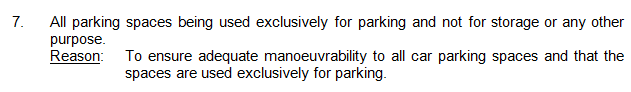
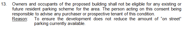
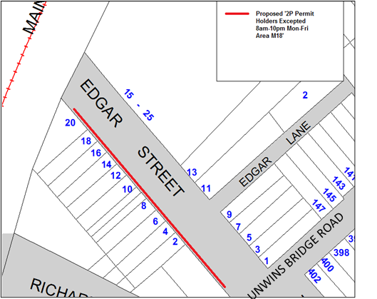
Figure 1: Proposed parking restrictions in Edgar Street
Parking Surveys
Initial parking surveys were undertaken by Council in April 2018. The results of that survey are detailed in Table 1below. The survey showed that there was a high occupancy during the day (80% or higher).
Table 1: Parking Occupancy Survey Edgar Street April 2018
|
DATE: |
11/04/2018 |
SIDE: |
SOUTH |
|
|
DAY: |
WEDNESDAY |
|||
|
STREET: |
EDGAR STREET, TEMPE |
|||
|
BETWEEN: |
UNWINS BRIDGE ROAD & END |
|||
|
TOTAL No. of Spaces |
15 |
|
|
|
|
No. of Spaces Occupied |
14 |
12 |
12 |
13 |
|
7.00AM |
11.00AM |
2.00PM |
5.00PM |
|
|
% OCCUPIED |
93.33% |
80.00% |
80.00% |
86.67% |
|
DATE: |
11/04/2018 |
SIDE: |
NORTH |
|
|
STREET: |
EDGAR STREET, TEMPE |
|||
|
BETWEEN: |
END & UNWINS BRIDGE ROAD |
|||
|
TOTAL No. of Spaces |
11 |
|
|
|
|
No. of Spaces Occupied |
10 |
9 |
9 |
7 |
|
7.00AM |
11.00AM |
2.00PM |
5.00PM |
|
|
% OCCUPIED |
90.91% |
81.82% |
81.82% |
63.64% |
|
|
|
|
|
|
Further surveys undertaken in June 2018 indicated that there is up to 80% parking occupancy rate during the day and that the evening occupancy is very high on the Thursday at an average of 97% and moderately high on the Tuesday with an average of 77%. The results of the June 2018 parking surveys are detailed in See Table 2 below.
Table 2: Parking Occupancy Surveys Edgar Street June 2018
|
Thursday 21st June 2018 |
|
8:00 AM |
12:00 PM |
4:00 PM |
8:00 PM |
Avg Spaces Occupied 8:00am - 8:00pm |
Max Spaces Occupied 8:00am - 8:00pm |
|
|||||
|
Description |
Supply |
Occ |
% |
Occ |
% |
Occ |
% |
Occ |
% |
|
|||
|
Edgar St from Unwins Bridge Rd to Edgar Lane |
5 |
2 |
40% |
2 |
40% |
2 |
40% |
5 |
100% |
3 |
5 |
|
|
|
Edgar St from Edgar Lane to street end |
11 |
7 |
70% |
7 |
70% |
7 |
70% |
10 |
100% |
8 |
10 |
|
|
|
Edgar St from end of street to Unwins Bridge Rd |
15 |
12 |
80% |
11 |
73% |
12 |
80% |
14 |
93% |
12 |
14 |
|
|
|
Grand Total |
31 |
21 |
70% |
20 |
67% |
21 |
70% |
29 |
97% |
23 |
29 |
||
|
Tuesday 26th June 2018 |
|
8:00 AM |
12:00 PM |
4:00 PM |
8:00 PM |
Avg Spaces Occupied 8:00am - 8:00pm |
Max Spaces Occupied 8:00am - 8:00pm |
||||
|
Description |
Supply |
Occ |
% |
Occ |
% |
Occ |
% |
Occ |
% |
||
|
Edgar St from Unwins Bridge Rd to Edgar Lane |
5 |
2 |
40% |
5 |
100% |
4 |
80% |
1 |
20% |
3 |
5 |
|
Edgar St from Edgar Lane to street end |
11 |
5 |
50% |
4 |
40% |
6 |
60% |
9 |
90% |
6 |
9 |
|
Edgar St from end of street to Unwins Bridge Rd |
15 |
13 |
87% |
9 |
60% |
12 |
80% |
13 |
87% |
12 |
13 |
|
Grand Total |
31 |
20 |
67% |
18 |
60% |
22 |
73% |
23 |
77% |
21 |
23 |
FINANCIAL IMPLICATIONS
The cost for the supply and installation of the signposting can be funded from Council's operational budget for signs and line marking.
PUBLIC CONSULTATION
A petition received by Council seeking permit parking for residents in Edgar Street stated that, “Since the arrival of 'The Quarry' (many townhouses) on the north side of Edgar Street, their cars, and the cars of their visitors make parking a difficult task. Many of us have to park in alternate streets on the other side of Unwins Bridge Road which creates a challenge/safety hazard when you have shopping and children in tow.”
In order to consult with affected residents and owners, on 16 July, 2018, Council sent sixty one (61) surveys to owners and occupiers of affected residences with a closing date for submissions of 6 August 2018. Recipients were advised that the matter would be considered at the Local Traffic Committee of 4 September 2018 and at the Council meeting of 25 September 2018. (Seventeen of those surveys were sent to single unit households in Edgar Street/Edgar Lane and the remaining surveys were sent to the multiunit dwellings and owners of properties in the subject streets.)
Fifteen (15) single unit dwellings of the total seventeen (17) single unit dwellings in Edgar Street/Edgar Lane responded to the survey (88%). This response rate of 88% exceeds the threshold for response rate of the 30% of households required for consideration of permit parking schemes, as per Council guidelines. Of the fifteen (15) responses, eleven (11 – 73%) supported the proposal and four (4 – 27%) objected.
There were five (5) responses from the units at 15-25 Edgar Street, and of those, two (2) were in support of the proposal and three (3) objected.
Taking these responses into account the total response of 20 surveys; thirteen (13 - 66%) supported the proposal and seven (7 - 33%) objected. The support rate is above the 65% of respondents as per Council guidelines.
|
|
Resident Comments |
Officer Comments |
|
Support |
Residents comment that there is insufficient parking especially during the evening.
Also, there is concern that when there is no parking available in Edgar Street, parking has to be sought in streets on the eastern side of Unwins Bridge Road. There are few pedestrian facilities to assist in the safe crossing of Unwins Bridge Road especially for those carrying groceries/with children.
|
Introducing permit parking from 8am-10pm on one side of Edgar Street will provide opportunities for residents who are eligible for permits, however since it is likely that the demand is to a certain extent generated by residents of Edgar Street and Unwins Bridge Road, the proposed restrictions will probably only partially address the parking demand in Edgar Street |
|
Object |
Those residents who objected stated that there was no difficulty in finding parking and that introducing permit parking would make parking for visitors difficult. |
The proposal is to introduce permit parking on one side of the street only. This will allow for unrestricted parking on the other side for visitors, and those who are not eligible or do not wish to participate in the scheme |
|
|
Several residents of 15-25 Edgar Street objected to the proposal indicating that this would make parking more difficult. |
The Conditions of Consent for the development state that parking by residents of the development should not “reduce the amount of “on street” parking currently available.” (See relevant documentation) |
CONCLUSION
The parking occupancy survey results indicate that there is up to 80% parking occupancy rate during the day and that the evening occupancy is very high on the Thursday at an average of 97% and moderately high on the Tuesday with an average of 77%.
The response rate and the level of support for the proposal are sufficient to warrant the consideration of the permit parking proposal.
There are fifteen (15) parking spaces on the southern side of Edgar Street which would be designated as ‘2P Permit Holders Excepted 8am-10pm Monday to Friday. The balance between the number of permits issued and the number of parking spaces available should be considered as Council cannot issue more permits than there are spaces available as this would undermine the effectiveness of any proposed scheme.
Therefore, the proposal is supported noting that given the limited number of parking spaces available and the high level of demand in the evening hours, the proposal will ameliorate the existing parking difficulties to a limited extent as the demand is likely a result of there being more residents seeking parking than there are spaces available.
|
|
Local Traffic Committee Meeting 4 September 2018 |
Subject: Blamire Lane, Marrickville - Proposed 'No Parking ' (Marrickville Ward/Summer Hill Electorate/Inner West LAC)
Prepared By: Mary Bailey - Parking Planner
Authorised By: John Stephens - Traffic and Transport Services Manager
|
SUMMARY Council has received representations seeking parking restrictions in Blamire Lane. Concerns have been expressed by residents regarding access and safety issues at the intersection of Unnamed Lane and Blamire Lane. It is proposed to implement ‘No Parking’ in Blamire Lane (both sides) and Statutory 10m 'No Stopping’ restrictions at Blamire Lane and the unnamed lane in order to improve access and safety. The results from the community consultation process indicated that there is support for a proposal to install ‘No Parking’ and ‘No Stopping’ restrictions in Blamire Lane. |
|
RECOMMENDATION
THAT:
1. ‘No Parking’ restrictions be installed in Blamire Lane (both sides) between unnamed lane and the rear of property no 34-36 Grove Street, and
2. ‘No Stopping’ signs be installed in Blamire Lane (both sides) from the intersection of the Unnamed Lane for the statutory distance of 10m. |
BACKGROUND
Following representations from the community, Council is proposing to implement ‘No Parking’ and ‘No Stopping’ restrictions in Blamire Lane, Marrickville.
Permit parking restrictions are currently in place on one side of the street only in Schwebel Street and Grove Street - Area M2. (See Figure 1). This ensures there is unrestricted parking available for residents, visitors and those who are not eligible or do not wish to participate in the scheme. There are also a number of multi-unit dwellings in Schwebel Street which have access to off-street parking from Blamire Lane.
It should be noted that when vehicles are parked directly opposite a garage entrance in laneways, ingress/egress can be extremely difficult. Laneways were generally built to provide service access for properties and access into off-street parking facilities. Removal of long stay parking will help achieve this goal.
Given the need to provide clear vehicular access through the laneway and to off-street car parking facilities; and to provide continuity and consistency of existing parking restrictions, it is recommended that full-time ‘No Parking’ restrictions be approved. Also, to improve safety, ingress and egress at the unnamed lane and Blamire Lane, it is proposed to implement 10m Statutory ‘No Stopping’ (See Figure 1).
According to Council’s Laneway Guidelines (December 2015) Laneways can be used for a variety of purposes which are listed below:
· Access for garbage collection trucks and deliveries where required
· Access to existing off-street parking within properties
· Access for emergency vehicles, pedestrians and cyclists
· Accessible parking for people with disabilities where appropriate
· Parking where space is available and access is maintained.
Blamire Lane is 4.5m wide. The Laneway Guidelines state that, “For parking to be allowed in a narrow laneway, the Australian Standards require that parallel parking spaces be at least 2.1 metres wide and NSW Road Rules requires that at least 3 metres must be available between a parked car and the kerb or edge of the laneway to allow moving vehicles to pass safely. Therefore, laneway widths that are less than 5.1 metres wide are too narrow to allow parking as any parked vehicle would prevent traffic from using the laneway.”
In this case, Council has received concerns that access to off-street parking is being restricted because of parking in the laneway. Furthermore, the laneway is only is 4.5m wide. Therefore, according to Council’s Laneway Guidelines Blamire Lane is not wide enough to cater for parking, it is considered that the proposal to implement ‘No Parking’ restrictions as recommended will provide improved access to off-street parking and also allow for the passage of vehicles, including service vehicles. The proposal is illustrated in Figure 1 below.
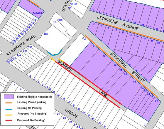
Figure 1: Existing and proposed restriction – Blamire Lane, Marrickville
FINANCIAL IMPLICATIONS
The costs of the supply and installation of the ‘No Parking’ and 'No Stopping' signage can be funded from Council’s operational budget.
PUBLIC CONSULTATION
There have been a number of historical complaints from residents who have expressed concerns that their access to off-street parking in Blamire Lane is obstructed by parked vehicles. Some measures have been taken including marking of driveways; however, the complaints have persisted.
As a result of the ongoing complaints, Council carried out a consultation on the proposed ‘No Parking’ solution with affected residents and owners. See Figure 2 for the distribution list for the consultation letters. One hundred and seventy four (174) letters were sent to owners and occupiers for all affected properties in Grove Street and Schwebel Street. A total of nine (9) responses were received. One (1) of the respondents objected to the proposal and eight (8) supported the proposal. Of the eight (8) that supported the proposal one (1) did not provide an address.
|
Response |
Number |
Comment |
Council Officer response |
|
Object |
1 |
Objector cited the following reasons 1. Even though the objector has off-street parking, the objector expressed concern for residential development in the area and the difficulty others have in finding parking. |
Residential development in the area is carried out according to Council’s DCP and parking provided in accordance with the DCP provisions. Given the narrowness of the laneway, the support for the proposed restrictions, it is recommended to proceed with the proposal. |
|
Support |
8 |
Supporters cited the following reasons 1. Access to off-street parking 2. Access for other vehicles through the laneway (including rubbish trucks). Three (3) respondents specifically noted the difficulty rubbish trucks experience as a result of parked vehicles in the laneway. |
These issues are addressed through the report. |
All residents in properties having a boundary with Blamire Lane will be advised prior to the installation of signage.
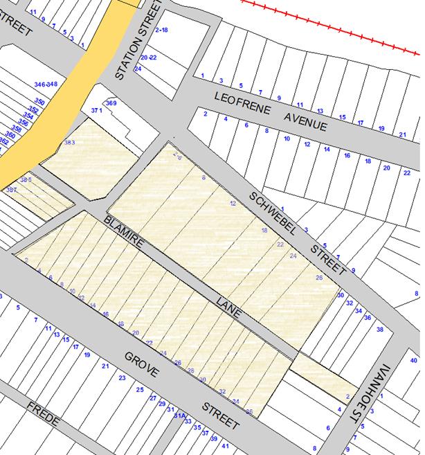
Figure 2: Mailing list for community consultation
CONCLUSION
Given the narrow width of the laneway and request from a resident to allow for access to off-street parking, it is recommended that parking be restricted in Blamire Lane, Marrickville.
|
|
Local Traffic Committee Meeting 4 September 2018 |
Subject: Rowley Lane, Camperdown - Proposed 'No Parking' restrictions(Stanmore Ward/Newtown Electorate/Inner West LAC)
Prepared By: Mary Bailey - Parking Planner
Authorised By: John Stephens - Traffic and Transport Services Manager
|
SUMMARY Following community representations, Council is proposing to convert ‘unrestricted’ parking’ in Rowley Lane to ‘No Parking’. Community consultation has been carried out and the proposal has been assessed against the current Laneway Guidelines (December 2015). Given the narrowness of the lane, reported damage by service vehicles and the obstruction to off-street parking spaces by parked vehicles, it is recommended to restrict parking in Rowley Lane, Camperdown. |
|
RECOMMENDATION
THAT the proposal to install ‘No Parking’ restrictions in Rowley Lane (both sides) between Kingston Lane and St Marys Lane be approved. |
BACKGROUND
Following representations from the community, Council is proposing to implement ‘No Parking’ restrictions in Rowley Lane, Camperdown.
While parking is at a premium in the area, there is some unrestricted parking available. Permit parking restrictions are in place on one side of the street only in Rowley Street and Marmion Street - Area M3. See Figure 1 below. This ensures there is unrestricted parking available for residents, visitors and those who are not eligible or do not wish to participate in the scheme.
When vehicles are parked directly opposite a garage entrance, ingress/egress can be extremely difficult. It should be noted that laneways were generally built to provide service access for properties and access into off-street parking facilities. Removal of long stay parking will help achieve this goal.
Given the need to provide clear vehicular access through the laneway and to off-street car parking facilities; and to provide continuity and consistency of existing parking restrictions, it is recommended that full-time ‘No Parking’ restrictions be approved. (See Figure 1).
According to Council’s Laneway Guidelines (December 2015) Laneways can be used for a variety of purposes which are listed below:
· Access for garbage collection trucks and deliveries where required
· Access to existing off-street parking within properties
· Access for emergency vehicles, pedestrians and cyclists
· Accessible parking for people with disabilities where appropriate
· Parking where space is available and access is maintained.
Rowley Lane is 4.5m wide. The Laneway Guidelines also state that, “For parking to be allowed in a narrow laneway, the Australian Standards require that parallel parking spaces be at least 2.1 metres wide and NSW Road Rules requires that at least 3 metres must be available between a parked car and the kerb or edge of the laneway to allow moving vehicles to pass safely. Therefore, laneway widths that are less than 5.1 metres wide are too narrow to allow parking as any parked vehicle would prevent traffic from using the laneway.”
In this case, Council has received complaints that access to off-street parking is being restricted because of parking in the laneway. It is considered that the proposal to implement ‘No Parking’ restrictions as recommended will provide improved access to off-street parking and also allow for the passage of vehicles including service vehicles.
The proposal is illustrated in Figure 1 below.
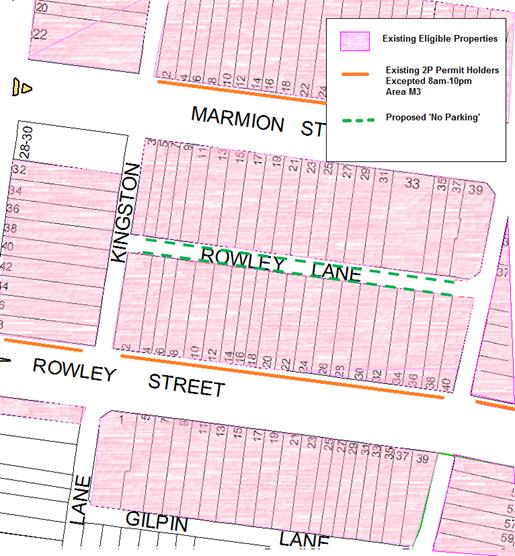
Figure1: Existing and Proposed restrictions in area
FINANCIAL IMPLICATIONS
The cost for the supply and installation of the signposting can be funded from Council's operational budget.
PUBLIC CONSULTATION
Initially all affected residents were advised by letter that the proposal to introduce ‘No Parking’ in Rowley Lane would be considered at the Local Traffic Committee held on 1 May 2018. There were submissions both in favour and objecting to the proposal requiring Council to undertake additional investigations. All residents who made submissions were advised that Council had postponed the consideration of the proposal.
On 12 July 2018 Council sent letters to all residents who made submissions regarding the proposal advising that the matter would be considered at the 4 September 2018 Traffic Committee meeting and at the 25 September Council meeting (for endorsement if the proposal was supported by the Traffic Committee).
|
|
Respondents Comments |
Officer Response |
|
1. Support |
I support the proposal to convert Rowley Lane from unrestricted parking to no parking with the following caveat. Residents of properties backing onto Rowley Lane should be permitted to have vehicles dwell for short periods of time for the purpose of load in / load out, car cleaning and other purposes that are facilitated by access to the rear of their properties. |
According to the NSW Road Rules ‘No Parking’ means “You must not stop for more than two minutes in a No Parking area. You must remain in or within 3 metres of the vehicle. Hours of operations may apply to some signs. This means restrictions apply for those times only. Mobility Parking Permit holders are allowed to park for up to 5 minutes in a No Parking area.”
|
|
2. Support |
I support no parking in Rowley street lane way. However there should be an allowance for quick car parking (30 minutes - 1 hour only) to cover use by tradespeople who need to drop off equipment or materials via the back laneway, or for residents to wash their cars or deliver groceries by the back entrance. Could there be a quick park permit for such use? |
|
|
3. Support |
I understand and support the council’s decision for No Parking on both sides in Rowley Lane. I accept the reasons why neighbours/residents do want to park there but this then promotes the message of “it‘s ok for visitors to park there” causing garage access problems within the neighbourhood.
I have experienced times when it has been difficult to manoeuvre in and out of my garage space with cars parked opposite my garage door at the rear of my property.
As recent as 31st July ’18, a visitor’s car had parked not too far from a neighbour's parked car and close to my exit and entry to my garage door.
Another issue, Rowley lane has been created with a high crown and on occasion I have witnessed the larger service vehicles attempting to pass parked vehicles in the lane lean more than usual and accidentally collect and knock over bins and snag on creeping fence plants etc. And on occasion wheels rolling over and cracking sandstone curbs.
|
Proposal addresses respondents concerns. |
|
4. Support |
I support the no parking restriction.
|
|
|
5. Support |
I support this initiative as have found an increasing number of cars parking in the lane, obstructing access to garages and to service vehicles passing through. I have contacted council at times to complain about cars obstructing my off street parking. One day I was unable to drive my car out or in of our garage for almost 24 hours as a car was parked immediately opposite my garage in this lane. The car was fined by the council services; but I think the lack of distinct NO PARKING signs leads people to believe they can park in the rear lane at their convenience.
|
|
|
6. Support |
I fully support the proposal for making this lane a no parking zone as there are cars that regularly park in the lane and make it difficult to access my property. On Monday mornings I often here the ‘bin men’ having problems getting around cars too (sounding of horns etc.…). |
|
|
7. Support |
Fully support the No Parking proposal in Rowley Lane
|
|
|
8. Object |
I'm writing to oppose the proposed No Parking in Rowley Lane.
Rowley Lane is a lane that is hardly ever used for longer term parking, but it is great to have it as an option for residents for several reasons outlined below.
1. Ease of property access for deliveries. With most residences in both streets having small 3-5m frontage with only a normal sized door, deliveries of household furniture and goods via Rowley Lane is essential for long term living.
2. Ease of property access for builders and tradesmen. Builders and tradesmen usually have no hope of parking on the street as half of both Rowley and Marmion are 2hr only and the other all day parking is always full. Rowley Lane makes it possible for builders and tradesmen to conduct work on your home without needing to park streets away, risking a ticket, or charging additional fees for limited access to our properties. Not to mention they then free up street parking for residents. This is a huge benefit of living on both streets and saves residents money and parking spaces as Rowley Lane is rarely used by residents for parking. |
As per the NSW Road Rules – “The conditions of the ‘No Parking’ restriction are that a vehicle can park for 2 minutes and the driver should stay within 3 metres of the vehicle “
If the proposed restrictions are implemented, deliveries and trades parking would need to be carried out within these provisions.
A tradesperson permit is available for trades people to carry out work on behalf of residents. The proposed ‘No Parking’ restrictions will allow for drop off of materials and equipment, whilst the tradesperson permit will allow the same trades person to park their vehicle all day on-street. |
|
9. Object |
There are about 10 off street parking driveways in Rowley Lane. The removal of parking in the lane will result in the loss of at least 20 parking spaces in the lane.
The council should not be preferentially representing the owners of new multi-million-dollar developments with off-street parking over other residents.
There are many parking spaces in Rowley Lane that do not obstruct any off street parking spaces. There is no reason to penalise local residents just because they do not have the money to demolish large parts of their homes to develop off street parking—which uses more space than street parking per car anyway. |
Council Laneway Guidelines (Dec 2015) prioritise access and off-street parking for laneways and laneways under 5.1m are not suitable for parking. Parking in Rowley Lane is resulting in access for rubbish trucks and access to off-street parking for a number of residents being obstructed. It is recommended to proceed with the proposal. |
|
10. Object |
As we already have restrictions on Rowley and Marmion Street, Rowley Lane is often the only choice we have sometimes to find a park. I realise that there are very few spots that people can park without blocking a garage. However, if Council did something to make sure people did not leave their wheelie Bins strewn about down the lane way permanently there would actually be some parking spots there. |
There is unrestricted parking available in both Marmion Street and Rowley Street |
|
11. Object |
I object to your proposal as a resident on the southern side of Marmion Street that regularly uses the space within the currently unrestricted parking area on Rowley Lane directly behind my house. My rented property does not have a drive way, car port or garage. Though your letter makes reference to “Improved parking in Rowley Lane, Camperdown”, I note that the proposal is for nothing more than the re-zoning of the existing unrestricted parking area to eliminate parking space in the local area, with no proposal on how to improve or otherwise offer different or commensurate parking allowance elsewhere…. |
|
|
12. Object |
I am writing this letter concerning the 'No Parking' proposal for Rowley Lane. …It would be very awkward and inconvenient not to be able to park here as it would require me to walk a long distance as my other parking options are Rowley or Marmion Street. Another issue I face with this proposal is that I have had trouble gaining a parking permit… |
All residents in properties having a boundary with Rowley Lane will be advised prior to the installation of signage.
CONCLUSION
While a number of people have objected to the restriction on parking in Rowley Lane, there is support for the restriction from people who report having difficulty accessing off-street parking. There are also a number of reports of damage being caused by rubbish trucks. Council’s Laneway Guidelines prioritise access of service vehicles and access to off-street parking in relation to laneways. Given the complaints about access to off street parking, reports of damage by service vehicles and the fact that the lane is not considered suitable for parking as per the Laneway Guidelines, the proposal to restrict parking on both sides of Rowley Lane is recommended.
|
|
Local Traffic Committee Meeting 4 September 2018 |
Subject: Elswick Street North, Charles Street, Hubert Street, Francis Street, James Street, Leichhardt - Resident Parking Scheme (Leichhardt Ward/ Balmain Electorate/ Leichhardt LAC)
Prepared By: David Yu - Engineer - Traffic and Parking Services
Authorised By: Manod Wickramasinghe - Coordinator – Traffic and Parking Services
|
SUMMARY Council has received correspondence from a number of residents of Elswick Street North, Charles Street, Hubert Street, Francis Street, and James Street, requesting Residential Parking Scheme (RPS) restrictions in their streets to deter commuter/long stay parking.
This report provides the result of the resident parking scheme investigation in Elswick Street North, Charles Street, Hubert Street, Francis Street, and James Street, Leichhardt. It also provides the results of the investigation for the proposed truck ban bounded by Darley Road – James Street – William Street – Elswick Street North. |
|
RECOMMENDATION
THAT:
1. The proposed Resident Parking Scheme in Elswick Street North, Charles Street, Hubert Street, Francis Street, and James Street, Leichhardt not be supported at the present time due to less than 50% support received from the consulted residents; and
2. The proposed truck bans in the streets bounded by Darley Road – James Street – William Street – Elswick Street North, Leichhardt be approved, subject to RMS approval of the TMP. |
BACKGROUND
A number of residents from Elswick Street North, Charles Street, Hubert Street, Francis Street, and James Street, Leichhardt requested the implementation of a resident parking scheme in their street.
Also, at the Council meeting held on 12 June 2018, a Mayoral Minute was considered regarding the Traffic and Parking Management on Darley Road and it was resolved to consult with the community regarding solutions to help manage and mitigate parking impacts as a result of WestConnex construction work at the proposed Darley Road Dive Site at No.7 Darley Road.
It also specified for consultation with the community regarding solutions to help manage construction traffic impacts as a result of WestConnex construction work at the proposed Darley Road Dive Site.
Since that time, WestConnex has opted to not proceed with a dive site at No.7 Darley Road.
However, as concerns regarding parking have historically been raised in these streets due to commuters utilising the nearby Light Rail station, consultation still proceeded.
FINANCIAL IMPLICATIONS
Nil.
OTHER STAFF COMMENTS
A Resident Parking proposal was prepared for the installation of ‘2P 8am-10pm, 7 days, Permit Holders Excepted, Area LN’ restrictions in the following sections of street:
· West side of Elswick Street North between Darley Road and William Street.
· West side of Charles Street between Darley Road and William Street.
· West side of Hubert Street between Darley Road and William Street.
· East side of Francis Street between Darley Road and William Street.
· West side of James Street between Darley Road and William Street.
As shown on the following map.
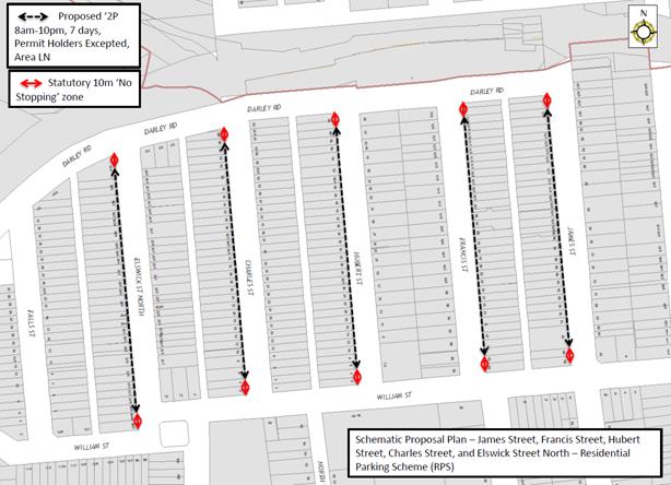
Also, residents were consulted on a truck ban proposal banning trucks bypassing through local residential streets bounded by Darley Road – James Street – William Street – Elswick Street North. The only exceptions will be trucks with a legitimate destination in the subject streets (e.g. emergency vehicles, removalist trucks, delivery vehicles, etc).
PUBLIC CONSULTATION
Resident Parking Scheme
A letter outlining the above parking proposal options was mailed out to the affected properties (376 properties) in Elswick Street North, Charles Street, Hubert Street, Francis Street, and James Street, Leichhardt as indicated on the attached plan, requesting residents’ views regarding the proposal.
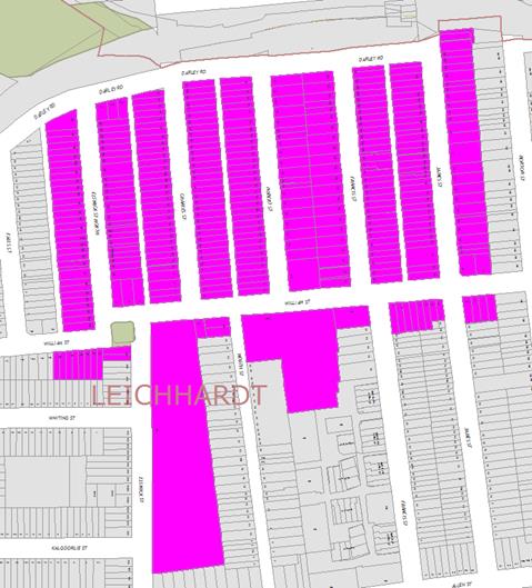
The table below shows some of the comments raised by the residents who did not support the proposal and the officer’s comments.
Comments from residents objecting to the proposal
|
Residents’ Comments |
Officer Comments |
|
The proposed 10m exclusion zone would prevent me from parking outside my own house, I believe this to be unfair to the residents on the ends of each street. |
10m ‘No Stopping’ zones must be installed at all intersections (as per NSW Road Rules) with the installation of the proposed 2P restrictions. The ‘No Stopping’ zones provide improved safety for pedestrians and drivers. It should be noted that ‘No Stopping’ zones are enforceable even without signage. |
|
Would not think restricted parking is required now that the dive site is not proceeding. Would be opposed to speed bumps on Elswick street north. Think the no right hand turn out of Elswick street north is already satisfactory. Do not want to see Elswick Street north closed off on the Darley road end now that the dive site is not proceeding. |
Noted.
|
|
There is no longer a WestConnex works issue here. The parking situation in our street is fine. It does not need to change. The introduction of parking restrictions would be a punishment for local residents. |
|
|
We do not suffer from commuter parking issues. However, we need to increase capacity so that the residents can park on their own street. We would like angle 60 degree forward parking.
We have an issue with cars rat running up our street from Darley Road, often doing an illegal right-hand turn when there is congestion on Darley Road (they rat run to William and then Norton Street towards the City West link). We would like Council and the RMS to consider closing our street at the Darley Road end. If that is not possible, the intersection needs to be configured to make it harder to do an illegal right hand turn. Perhaps some of the road narrowing initiatives as per Elswick Street (near Parramatta Road) could be used. |
A minimum of 3 enquiries or a petition signed by 3 or more residents from different properties in the subject section of the street within a year is required to initiate an investigation for the installation of angle parking.
Concerns regarding illegal right turning vehicles at the intersection of Elswick Street North and Darley Road have been forwarded to NSW Police who have conducted surveillance at the intersection. |
|
More parking spaces are required on Charles Street, preferably in the form of angled parking. |
The car parking occupancy surveys, which were completed on 13th and 14th February (morning and afternoon periods) showed low parking occupancies and did not meet the 85% threshold on all of the 4 survey periods. Therefore, considering the low occupancies the investigation for angled parking in Charles Street, Leichhardt will not proceed any further at the present time. |
|
All other streets in the vicinity have it on both sides of the street so why is this being restricted to the west side of each street? |
To provide flexibility for residents and visitors, it was proposed for Resident Parking to be provided on only one side of the street. However, at this stage, it is proposed that the Resident Parking Scheme in Elswick Street North, Charles Street, Hubert Street, Francis Street, and James Street, Leichhardt not be supported at the present time due to less than 50% support received from the consulted residents. |
|
If restricted parking is to apply it should be to both sides of streets and only for period between 9am and 5pm Monday to Friday. This would allow visitors to come to local houses. I do not believe restricted parking is needed. |
|
|
Please introduce speed humps or traffic islands to slow down the huge numbers of speeding traffic on William street.
|
Council requires a minimum of three residents from the subject street requesting a review of current speed levels to initiate an investigation of the installation of appropriate traffic calming measures.
|
|
I have witnessed countless people speeding up and down Francis Street in order to avoid Darley Road traffic. |
|
|
Parking restrictions on Elswick Street need to be extended to Marion Street because residents in this section have limited parking due to non-residents parking unrestricted. |
A minimum of 3 requests or a petition signed by 3 or more residents from different properties in the subject section of the street within a year is required to initiate an investigation of the installation of a Resident Parking Scheme. |
|
What is proposed for all the trucks/ trailers/ boats parked along Darley Road. |
Darley Road is a classified State Road and is therefore under the jurisdiction of the Roads and Maritime Service (RMS). Council has requested RMS consider parking restrictions along Darley Road to deter boat/trailer parking. |
|
Some households have 3 or more cars and permits should not be limited to 2. What happens to the additional vehicles? |
The maximum number of resident parking permits eligible per household is two. Vehicles without permits would be able to park on the unrestricted side of the street. |
|
The map indicates that the Disabled Parking spot will be lost and turned into a 2P area. |
The proposed plan was a schematic plan. Existing ‘Disabled Parking’ spaces would not have been removed as part of the scheme. |
|
When the Light Rail was extended beyond Lilyfield, local residents registered concerns to the State Government & Council, about commuter car parking in local streets. Residents were assured that car spaces would be provided. Commuter car parking has not eventuated.
At the end of Charles Street, barriers were erected around the two corners of Charles Street & Darley Road. It blocked easy pedestrian access across Darley Road. Negotiate with Dan Murphy’s for a gate from their eastern car park directly on to the Southern Light Rail platform or provide a gap in the barrier.
Charles St. Service Lane extension down from North Street. Vehicles speed down the lane, which is extremely dangerous for residents. Possible solution is to place three “Speed humps” along the lane. |
Light Rail is under the jurisdiction of Transport for NSW. It is understood that the request for commuter car parking has previously been forwarded to Transport for NSW for their consideration.
Darley Road which is a State Road under the jurisdiction of RMS; Council, following its meeting held on 21 August 2018, has resolved to write to the Minister for Transport and Infrastructure, and Minister for Roads, Maritime and Freight to request improved pedestrian crossing facilities, including Darley Road on the eastern (Dan Murphy) side of the roundabout at the intersection with Charles Street.
Council has initiated the investigation of the need for traffic calming measures in Charles Street and the service lane. Traffic tube counters have been installed on-site to gather data.
|
|
Some kind of island is needed at the William Street / Elswick Street North intersection. There needs to be a pedestrian crossing for children from the park side, near daycare to the corner of William Street and Elswick Street North |
Council is currently investigating potential treatment options for the William Street/ Elswick Street North intersection. Vehicle volumes on William Street would be insufficient to meet the warrants for a pedestrian crossing. |
|
Currently there is plenty of room to park on James Street without parking restrictions. |
Noted. |
Consultation survey results are summarised as follows:
Elswick Street North, Leichhardt
Number of properties - 51
Number of properties responded - 12
Number of properties supported - 1
Overall Response Rate - 24%
Overall Support Rate - 2%
Charles Street, Leichhardt
Number of properties - 64
Number of properties responded - 24
Number of properties supported - 7
Overall Response Rate - 38%
Overall Support Rate - 11%
Hubert Street, Leichhardt
Number of properties - 61
Number of properties responded - 20
Number of properties supported - 3
Overall Response Rate - 33%
Overall Support Rate - 5%
Francis Street, Leichhardt
Number of properties - 53
Number of properties responded - 11
Number of properties supported - 4
Overall Response Rate - 21%
Overall Support Rate - 8%
James Street, Leichhardt
Number of properties - 56
Number of properties responded - 12
Number of properties supported - 7
Overall Response Rate - 21%
Overall Support Rate - 13%
Overall Support
Number of properties - 285
Number of properties responded - 78
Number of properties supported - 21
Overall Response Rate - 27%
Overall Support Rate - 7%
According to Council’s Resident Parking Policy, a minimum of 50% support based on all properties in the subject section of the street is required to consider the proposal favourably.
Based on the above results and the comments provided as part of the consultation process, less than 50% of the residents of Elswick Street North, Charles Street, Hubert Street, Francis Street and James Street, Leichhardt support a resident parking scheme in their street.
Truck Ban
An advertisement regarding the proposed truck ban was published in the Inner West Courier for 4 weeks and a letter outlining the proposed truck ban was mailed out to affected residents. There were 80 responses received, 70 in support and 10 in objection to the proposal.
The table below shows some of the comments raised by the residents who did not support the proposal and the officer’s comments.
|
Residents’ Comments |
Officer Comments |
|
I use my truck for work and to be mindful its only 4.6 tonne small truck that I have been allocated with to use for my job. If the proposal goes through it will disrupt my everyday living and become harder to maintain my job on a daily basis. Please consider that I've been living in Leichhardt since I was a child and nothing like this has made me more devastated of my lively hood. |
It should be noted that trucks with a legitimate destination in the subject streets will be exempted from this proposed truck ban. |
|
There should be a bus ban on these streets including William Street where there is no designated bus route. |
This will be discussed with Transit Systems so that depot buses only use the main road system and William Street, east of Norton Street. |
|
The proposal for a truck ban could affect me in a detrimental way by opening up a rat run closer to where I live (Kalgoorlie Street), Allen Street and Flood Street. Before pursuing such a change I ask that you look at the potential problems for residents in the surrounding area. |
Should the proposed truck ban be implemented, surrounding streets would be monitored. |
CONCLUSION
Based on the above results, the proposed Resident Parking Scheme in Elswick Street North, Charles Street, Hubert Street, Francis Street, and James Street should not be supported at the present time due to less than 50% support received from the consulted residents.
The proposed truck bans in the streets bounded by Darley Road – James Street – William Street – Elswick Street North should be supported and the attached TMP be submitted for RMS approval.
|
1.⇩ |
TMP - Leichhardt North Proposed Truck Ban |
|
|
Local Traffic Committee Meeting 4 September 2018 |
Proposed Truck Ban James Street, Francis Street, Hubert Street, Charles Street, Elswick Street North and William Street, Leichhardt
A: Description or detailed plan of proposed measures.
Inner West Council is proposing to install signage banning trucks in the streets bounded by Darley Road – James Street – William Street – Elswick Street North.
The following streets are included in this proposal:
· James Street between Darley Road and William Street, Leichhardt
· Francis Street between Darley Road and William Street, Leichhardt
· Hubert Street between Darley Road and William Street, Leichhardt
· Charles Street between Darley Road and William Street, Leichhardt
· Elswick Street North between Darley Road and William Street, Leichhardt
· William Street between Elswick Street North and James Street, Leichhardt
Key characteristics of these streets are as follows:
· Local Roads
· Two-way traffic is permitted
· Low vehicle volumes
· Primarily residential
B: Identification and assessment of impact of proposed measures.
Existing vehicle volumes in these streets are low (typically less than 500 vehicles in the minor streets) and are typically made up of local residents and businesses. This proposal will only displace heavy vehicles which do not have a destination within these local streets.
It is expected that this redistribution of traffic can be accommodated by Darley Road which is a State Road and is more appropriate for heavy vehicles.
C: Measure to ameliorate the impact of re-assigned traffic.
No measures are proposed. There is currently a low volume of heavy vehicles using the subject streets. Therefore, it is expected that the proposal would have a minimal impact on the surrounding street network.
D: Assessment of public transport services affected.
There will be no impact on adjoining public transport.
E: Details of provision made for emergency vehicles, heavy vehicles, cyclists and pedestrians.
There will be no impact on emergency vehicle, cyclist and pedestrian access. The truck ban will not include trucks that have a destination/purpose in the subject streets (eg. emergency vehicles, removalist trucks, delivery trucks, etc.).
F: Assessment of effect on existing and future developments with transport implications in the vicinity of proposed measures.
The proposal is not expected to affect any future developments.
G: Assessment of effect of proposed measures on traffic movements in adjoining Council areas.
There will be no impact on adjoining Council areas.
H: Public consultation process.
The proposed truck ban has been advertised in a local newspaper for a period of 28 days. And residents in the affected area were consulted. There were 80 responses received, 70 in support and 10 in objection to the proposal.
The table below shows some of the comments raised by the residents who did not support the proposal and the officer’s comments.
|
Residents’ Comments |
Officer Comments |
|
I use my truck for work and to be mindful its only 4.6 tonne small truck that I have been allocated with to use for my job. If the proposal goes through it will disrupt my everyday living and become harder to maintain my job on a daily basis. Please consider that I've been living in Leichhardt since I was a child and nothing like this has made me more devastated of my lively hood. |
It should be noted that trucks with a legitimate destination in the subject streets will be exempted from this proposed truck ban. It is expected that given your situation, your truck will be exempted from this restriction. |
|
There should be a bus ban on these streets including William Street where there is no designated bus route. |
Council will not be considering a bus ban as part of this proposal. |
|
The proposal for a truck ban could affect me in a detrimental way by opening up a rat run closer to where I live (Kalgoorlie Street), Allen Street and Flood Street. Before pursuing such a change I ask that you look at the potential problems for residents in the surrounding area. |
Should the proposed truck ban result in truck rat-running issues in surrounding streets, alternative treatment options could be considered. |
|
Local Traffic Committee Meeting 4 September 2018 |
Subject: Margaret Street at Yara Avenue, Rozelle - Proposed 'No Stopping' Restrictions (Balmain Ward/ Balmain Electorate/ Leichhardt LAC)
Prepared By: David Yu - Engineer - Traffic and Parking Services
Authorised By: Manod Wickramasinghe - Coordinator – Traffic and Parking Services
|
SUMMARY Council has received a request to signpost the statutory ‘No Stopping’ restrictions at the corners of the Margaret Street and Yara Avenue (Rozelle) intersection, in order to prevent illegal parking and improve sight lines. |
|
RECOMMENDATION
THAT:
1. A 10m ‘No Stopping’ zone be installed on the southern side of Yara Avenue, west of Margaret Street, Rozelle;
2. A 14m ‘No Stopping’ zone be installed on the northern side of Yara Avenue, west of Margaret Street, Rozelle;
3. An 11m ‘No Stopping’ zone be installed on the western side of Margaret Street, north of Yara Avenue, Rozelle; and
4. A 7m ‘No Stopping’ zone be installed on the western side of Margaret Street, south of Yara Avenue, Rozelle.
|
BACKGROUND
Concerns have been raised by residents regarding vehicles parking too close to the intersection of Margaret Street and Yara Avenue, Rozelle.
This illegal parking behaviour obstructs sight lines as well as access into and out of Yara Avenue.
It should be noted that the parking on the western side of Margaret Street and northern side of Yara Avenue is indented. The following proposal recommends ‘No Stopping’ restrictions up to the start of these indented bays.
FINANCIAL IMPLICATIONS
Nil.
OTHER STAFF COMMENTS
In order to alleviate the sight visibility and manoeuvring space issues, it is proposed to signpost the statutory ‘No Stopping’ zones at the following locations:
· The southern side of Yara Avenue, west of Margaret Street (10m ‘No Stopping’ zones).
· The northern side of Yara Avenue, west of Margaret Street (14m ‘No Stopping’ zone).
· The western side of Margaret Street, north of Yara Avenue (11m ‘No Stopping’ zone).
· The western side of Margaret Street, south of Yara Avenue (7m ‘No Stopping’ zone).
The proposal is shown on the following plan:
PUBLIC CONSULTATION
|
A letter outlining the above proposal was mailed out to the affected properties (115 properties) in Margaret Street, Terry Street and Yara Avenue, Rozelle. Two responses was received, one in support and one in objection to the proposal.
|
|
|
Residents’ Comments |
Officer Comments |
|
Vehicles parking at the corner are frequently a problem. |
The proposed 'No Stopping' restrictions are intended to improve sight distance and manoeuvring at the subject intersection.
|
|
It is impossible to park at the moment in the evenings and weekends as it is. Sometimes my only resource is to park at Yara Avenue in front of the restaurant, which would fall into the no stopping zone. Margaret street should be ticket parking, with parking bays marked on one side of the street (at least), as it is highly sought after spaces.
Residents should at least be exempt of these restrictions and be able to park at Nagurra place and Terry Street anytime. We deal with people parking any way shape and form, taking two car spaces and blocking driveways. |
It is illegal to park within 10 metres of an intersection without traffic lights, unless a parking control sign applies indicating that the driver is permitted to park. There are no plans to install Ticket parking in Margaret Street.
The ‘No Stopping’ zones provide improved safety for pedestrians and drivers.
Eligible residential properties could apply for a resident parking permit. It should be noted that multi-unit dwellings and the strata subdivision of residential flat buildings approved after January 2001 are not allowed to participate in a RPS as off-street parking should be provided in accordance with Council’s parking DCP. |
CONCLUSION
Nil.
|
|
Local Traffic Committee Meeting 4 September 2018 |
Subject: Weynton Street at Piper Lane, Annandale - Proposed 'No Stopping' Restrictions (Balmain Ward/ Balmain Electorate/ Leichhardt LAC)
Prepared By: David Yu - Engineer - Traffic and Parking Services
Authorised By: Manod Wickramasinghe - Coordinator – Traffic and Parking Services
|
SUMMARY Council has received a request to signpost the statutory ‘No Stopping’ restrictions at the corners of the Weynton Street and Piper Lane (Annandale) intersection, in order to prevent illegal parking and improve sight lines. |
|
RECOMMENDATION
THAT:
1. A 10m ‘No Stopping’ zone be installed on the southern side of Weynton Street, east of Piper Lane, Annandale; and
2. A 10m ‘No Stopping’ zone be installed on the southern side of Weynton Street, west of Piper Lane, Annandale.
|
BACKGROUND
Concerns have been raised by residents regarding vehicles parking too close to the intersection of Weynton Street and Piper Lane, Annandale.
This illegal parking behaviour obstructs sight lines as well as access into and out of Piper Lane, Leichhardt.
FINANCIAL IMPLICATIONS
Nil.
OTHER STAFF COMMENTS
In order to alleviate the sight visibility and manoeuvring space issues, it is proposed to signpost the statutory ‘No Stopping’ zones at the following locations:
· The southern side of Weynton Street, east of Piper Lane (10m ‘No Stopping’ zones).
· The southern side of Weynton Street, west of Piper Lane (10m ‘No Stopping’ zone).
The proposal is shown on the following plan:
PUBLIC CONSULTATION
|
A letter outlining the above proposal was mailed out to the affected properties (22 properties) in Weynton Street, Johnston Street and Annandale Street, Annandale. Two responses were received in objection to the proposal.
|
|
|
Residents’ Comments |
Officer Comments |
|
I would suggest that in this specific circumstance 10 metres is deemed excessive when it is not a main/busy intersection. Should this be not negotiable, I stress at least a reduction to a maximum of 5 metres as with no rear access or off street car spaces, parking is certainly a premium as a result of urban sprawl.
|
It should be noted that under the NSW Road Rules, it is illegal to park within 10 metres of an intersection without traffic lights, unless a parking control sign applies indicating that the driver is permitted to park.
The ‘No Stopping’ zones provide improved safety for pedestrians and drivers. A reduction of the ‘No Stopping’ zone to 5 metres is not expected to provide sufficient improvements to sight lines. |
|
I do not support this installation as I park there; it is in front of my house. I do not have any sight line issues. The challenge with sight lines is because some vehicles park too far away from the kerb. That is what obstructs sight lines. |
It should be noted that under the NSW Road Rules, it is illegal to park within 10 metres of an intersection without traffic lights, unless a parking control sign applies indicating that the driver is permitted to park.
The ‘No Stopping’ zones provide improved safety for pedestrians and drivers. |
CONCLUSION
Nil.
|
|
Local Traffic Committee Meeting 4 September 2018 |
Subject: O'Neill Lane, Lilyfield (rear of No. 9 O'Neill Street) - Proposed Extension of 'No Stopping' Zone (Balmain Ward/Balmain Electorate/Leichhardt LAC)
Prepared By: Felicia Lau - Engineer - Traffic and Parking Services
Authorised By: John Stephens - Traffic and Transport Services Manager
|
SUMMARY Council has received concerns regarding parked vehicles obstructing access to off-street parking in O’Neill Lane (between Grove Street and Grove Lane), Lilyfield. |
|
RECOMMENDATION
THAT a 18m ‘No Stopping’ zone (including the statutory 10m ‘No Stopping’ zone from an intersection) be installed on the southern side of O’Neill Lane, west of Grove Lane, Lilyfield. |
BACKGROUND
Council has received concerns from a resident of O’Neill Street, Lilyfield regarding vehicles parking on the southern side of O’Neill Lane (between Grove Street and Grove Lane), Lilyfield outside of the existing ‘No Stopping’ zone and subsequently obstructing rear driveway access to their property.
The existing ‘No Stopping’ zone on the southern side of O’Neill Lane extends from Grove Street to the rear of No.7 O’Neill Street.
O’Neill Lane is only 4.7m wide in this section and is therefore not wide enough to support parking opposite a driveway.
FINANCIAL IMPLICATIONS
Nil.
OTHER STAFF COMMENTS
It is proposed to extend the existing ‘No Stopping’ zone along the remaining kerb space (18m) on the southern side of O’Neill Lane between rear of No.7 O’Neill Street and Grove Lane. The proposal is shown in the following plan.
PUBLIC CONSULTATION
A letter outlining the above proposal was mailed out to the affected properties (13 properties) in O’Neill Street, Grove Street and Justin Street, Lilyfield.
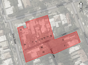
No objections have been received during the consultation period.
CONCLUSION
Nil.
|
|
Local Traffic Committee Meeting 4 September 2018 |
Subject: Reynolds Street at Evans Street, Balmain - Proposed 'No Stopping' zones (Balmain Ward/ Balmain Electorate/ Leichhardt LAC)
Prepared By: Vinoth Srinivasan - Engineer - Traffic and Parking Services
Authorised By: John Stephens - Traffic and Transport Services Manager
|
SUMMARY Council has received a request to signpost the statutory ‘No Stopping’ restrictions in Reynolds Street at the intersection of Evans Street, Balmain in order to prevent illegal parking and improve sight lines. |
|
THAT:
1. A 10m ‘No Stopping’ zone be installed on the northern side of Reynolds Street, east of Evans Street, Balmain; and
2. A 10m ‘No Stopping’ zone be installed on the southern side of Reynolds Street, east of Evans Street, Balmain.
|
BACKGROUND
Concerns have been raised by residents regarding vehicles parking in Reynolds Street too close to the intersection of Evans Street and Reynolds Street, Balmain.
This illegal parking behaviour obstructs sight lines as well as access into and out of Evans Street.
FINANCIAL IMPLICATIONS
Nil.
OTHER STAFF COMMENTS
In order to alleviate the sight visibility and manoeuvring space issues, it is proposed to signpost the statutory ‘No Stopping’ zones at the following locations:
· The northern side of Reynolds Street and east of Evans Street (10m ‘No Stopping’ zone).
· The southern side of Reynolds Street and east of Evans Street (10m ‘No Stopping’ zone).
The proposal is shown on the following plan:
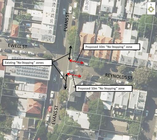
PUBLIC CONSULTATION
|
A letter outlining the above proposal was mailed out to the affected properties (8 properties) in Reynolds Street and Evans Street, Balmain.
No objections were received.
|
|
CONCLUSION
Nil.
|
|
Local Traffic Committee Meeting 4 September 2018 |
Subject: Annesley Street at Balmain Road, Leichhardt - Proposed 'No Stopping' zones (Leichhardt Ward/ Balmain Electorate/ Leichhardt LAC)
Prepared By: Vinoth Srinivasan - Engineer - Traffic and Parking Services
Authorised By: John Stephens - Traffic and Transport Services Manager
|
SUMMARY Council has received a request to signpost the statutory ‘No Stopping’ restrictions at the intersection of Annesley Street and Balmain Road, Leichhardt in order to prevent illegal parking and improve sightlines. |
|
THAT:
1. A 10m ‘No Stopping’ zone be installed on the northern side of Annesley Street, east of Balmain Road;
2. A 10 ‘No Stopping’ zone be installed on the southern side of Annesley Street, east of Balmain Road; and
3. A 10m ‘No Stopping’ zone be installed on the eastern side of Balmain Road, north of Annesley Street.
|
BACKGROUND
Concerns have been raised by residents regarding vehicles parking too close to the intersection of Annesley Street and Balmain Road, Leichhardt.
The illegal parking behaviour obstructs sight lines as well as access into and out of Balmain Road, Leichhardt.
FINANCIAL IMPLICATIONS
Nil.
OTHER STAFF COMMENTS
In order to alleviate the sight visibility and manoeuvring space issues, it is proposed to signpost the statutory ‘No Stopping’ zones at the following locations:
· The northern side of Annesley Street and east of Balmain Road (10m ‘No Stopping’ zone).
· The southern side of Annesley Street and east of Balmain Road (10m ‘No Stopping’ zone).
· The eastern side of Balmain Road and north of Annesley Street (10m ‘No Stopping’ zone).
The proposal is shown on the following plan.
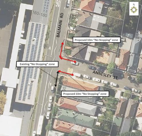
PUBLIC CONSULTATION
|
A letter outlining the above proposal was mailed out to the affected properties (10 properties) in Annesley Street and Balmain Road, Leichhardt.
Two responses were received in support of Council’s proposal. They also requested Council implement a resident parking scheme in Annesley Street. This matter will be investigated separately.
One response was received regarding an unrelated matter.
|
|
CONCLUSION
Nil.
|
|
Local Traffic Committee Meeting 4 September 2018 |
Subject: Minor Traffic Facilities (All Wards/ All Electorates/ All LACs)
Prepared By: Vinoth Srinivasan - Engineer - Traffic and Parking Services
Authorised By: John Stephens - Traffic and Transport Services Manager
|
SUMMARY This report considers minor traffic facility applications received by Inner West Council, including ‘Disabled Parking’ and ‘Work Zone’ requests. |
|
RECOMMENDATION
THAT:
1. A 6m ‘Disabled Parking’ zone be removed in front of No.48 Smith Street, Balmain as it is no longer required; 2. A 6m ‘Disabled Parking’ zone be installed in front of No.47 St Davids Road, Haberfield; 3. A 3.7m (60-degree angle parking) ‘Disabled Parking’ zone be installed in front of No.23 Charlotte Street, Lilyfield; 4. A 9m (2 x 45-degree angle parking spaces) ‘Disabled Parking’ zone be installed in front of No.213 Elswick Street, Leichhardt (St Columba’s Church), south of the existing pedestrian (zebra) crossing; 5. ‘Disabled Parking’ signs be installed in the Marrickville and District Hardcourt Tennis Club car park at No.33 Centennial St, Marrickville, to supplement the existing line marked ‘Disabled Parking’ bays; 6. A 10m ‘Works Zone 7.00am – 6.00pm Mon – Fri and 7.00am – 1.00pm Sat’ be installed in front of No.114 and No.116 Louisa Road, Birchgrove; 7. An 11m ‘Works Zone 7.00am – 6.00pm Mon – Fri and 7.00am – 1.00pm Sat’ be installed in front of No.300 and No.302 Darling Street, Balmain; and 8. A 12m ‘Works Zone 7.00am – 6.00pm Mon – Fri and 8.00am – 1.00pm Sat’ be installed in front of No.2 Dougan Street, Ashfield. |
BACKGROUND
This report considers minor traffic facility applications by Inner West Council, including ‘Disabled Parking’ and ‘Work Zone’ requests.
FINANCIAL IMPLICATIONS
Nil.
OFFICER COMMENTS
1. Removal of ‘Disabled Parking’ Restriction – Smith Street, Balmain
Council has been notified by a neighbour that the applicant to the ‘Disabled Parking’ zone outside property No.48 Smith Street, Balmain has moved and so the ‘Disabled Parking’ zone is no longer required.
Council has contacted the applicant and confirmed that they have moved from the property.
It is recommended that the 6m ‘Disabled Parking’ zone in front of No.48 Smith Street, Balmain be removed as it is no longer required.
2. Installation of a ‘Disabled Parking’ Restriction – St Davids Road, Haberfield
The resident of No.47 St Davids Road, Haberfield has requested the installation of a ‘Disabled Parking’ zone in front of the resident’s property.
A site investigation has revealed the property does not have off street parking.
The applicant does not require the use of a wheelchair.
It is recommended that a 6m ‘Disabled Parking’ zone be installed in front of No.47 St Davids Road, Haberfield.
No.47 St Davids Road, Haberfield
3. Installation of a ‘Disabled Parking’ Restriction – Charlotte Street, Lilyfield
The resident of No.23 Charlotte Street, Lilyfield has requested the installation of a ‘Disabled Parking’ zone in front of the resident’s property.
A site investigation has revealed the property does not have off street parking.
The applicant does not require the use of a wheelchair.
It is recommended that a 3.7m (60-degree angle parking) ‘Disabled Parking’ zone be installed in front of No.23 Charlotte Street, Lilyfield.
No.23 Charlotte Street, Lilyfield
4. Installation of a ‘Disabled Parking’ Restriction – Elswick Street, Leichhardt
St Columba’s Catholic Church has requested the installation of a ‘Disabled Parking’ zone in front of the church to improve accessibility for patrons with mobility issues.
Community consultation has been conducted with nearby residents regarding this proposal. No comments have been received.
It is recommended that a 9m (2 x 45-degree angle parking) ‘Disabled Parking’ zone be installed in the first two available spaces on the eastern side of Elswick Street outside No.213 Elswick Street, Leichhardt (St Columba’s Church).
No.213 Elswick Street, Leichhardt
5. Installation of ‘Disabled Parking’ Restriction – Marrickville and District Hardcourt Tennis Club car park
A request has been received from Council’s Property Officer for the installation of a disability parking sign on the southern side of Marrickville and District Hardcourt Tennis Club Car Park.
A site investigation has revealed that the existing ‘Disabled Parking’ line marking has been repainted; however, no ‘Disabled Parking’ signs have been provided.
It is recommended that the ‘Disabled Parking’ signs be installed to supplement the existing line marking as per attached photo.
Marrickville and District Hardcourt Tennis Club car park
6. Installation of a ‘Work Zone’ restriction – Louisa Road, Birchgrove
The applicant has requested the installation of a temporary 10m ‘Works Zone 7.00am – 5.00pm Mon-Fri, 7.00am – 1.00pm Sat’ in front of No.114 and No.116 Louisa Road, Birchgrove for works at No.116 Louisa Road.
Council has already received written concurrence from the residents of No.114 Louisa Road, Birchgrove.
It is recommended that a 10m 'Works Zone 7.00am – 5.00pm Mon-Fri, 7.00am – 1.00pm Sat’ be installed in front of No.114 and No.116 Louisa Road, Birchgrove for 12 weeks, replacing the existing resident parking restrictions.
No.114 and No.116 Louisa Road, Birchgrove
7. Installation of a ‘Work Zone’ Restriction – Darling Street, Balmain
The applicant has requested the installation of a temporary 11m ‘Works Zone 7.00am – 5.00pm Mon-Fri, 7.00am – 1.00pm Sat’ in front of No.300 and No.302 Darling Street, Balmain, for works to No.302 Darling Street.
It is recommended that an 11m ‘Works Zone 7.00am – 5.00pm Mon – Fri, 7.00am – 1.00pm Sat’ be installed in front of No.300 and No.302 Darling Street, Balmain for 10 weeks, replacing the existing ticket parking restrictions. This is subject to the applicant receiving written concurrence from the business owners at No.300 Darling Street, Balmain.
No.300 and No.302 Darling Street, Balmain
8. Installation of a ‘Work Zone’ Restriction – Dougan Street, Ashfield
The applicant has requested the installation of a temporary 12m ‘Works Zone 7.00am – 6.00pm Mon – Fri and 8.00am – 1.00pm Sat’ in front of No.2 Dougan Street, Ashfield for 26 weeks.
It is recommended that a 12m ‘Works Zone 7.00am – 6.00pm Mon-Fri and 8.00am – 1.00pm Sat’ be installed in front of No.2 Dougan Street, Ashfield for 26 weeks.
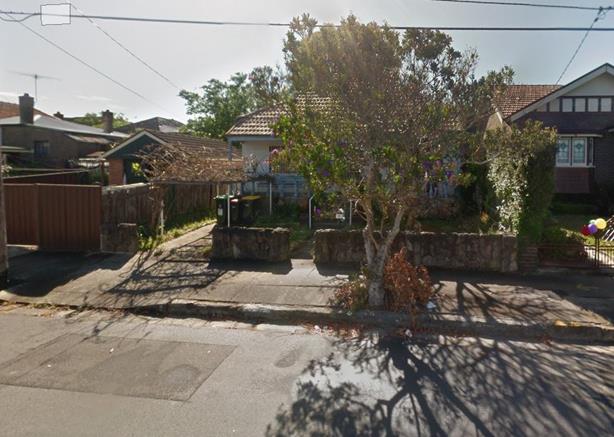
No.2 Dougan Street, Ashfield
PUBLIC CONSULTATION
Nil.
CONCLUSION
Nil.
|
|
Local Traffic Committee Meeting 4 September 2018 |
Subject: 2018 Norton Street Italian Festa - Special Event (Leichhardt Ward/ Balmain Electorate/ Leichhardt LAC)
Prepared By: Vinoth Srinivasan - Engineer - Traffic and Parking Services
Authorised By: John Stephens - Traffic and Transport Services Manager
|
SUMMARY The proposed event, the Norton Street Italian Festa, is a street festival held annually celebrating the traditional Italian culture that is considered an essential part of the Leichhardt community.
To facilitate the event, it is proposed to close the following roads in the area between 3.00am and 8.00pm on Sunday, 28 October 2018.
· Norton Street from Marion Street to William Street; · Marlborough Street from Norton Street to Cromwell Street; · Short Street from Norton Street to Balmain Road; · Carlisle Street from Norton Street to Cromwell Street; · Allen Street from Cromwell Street to Derbyshire Road; · Arthur Street from Allen Street to Short Street.
It is recommended that the 2018 Italian Festa Event to be held on Sunday, 28 October 2018 be supported, subject to complying with the following conditions:
The TMP and TCP being approved by the RMS as well as the Transport Management Centre, installation of a ‘Special Event Clearway’ restriction in Norton Street prior to the event, parking for the event be reserved in Short Street on both sides between Norton Street and the unnamed lane for Emergency Service vehicles, approval to conduct a public assembly be obtained from the NSW Police, all affected businesses, residents and other occupants be notified of the road closures, proposed event being forwarded to the appropriate authorities, including emergency services and a current Public Liability Insurance Policy be provided to Inner West Council, nominating Council as an interested party. |
|
RECOMMENDATION
THAT:
1) The road closure application for the ‘Norton Street Italian Festa 2018’ on Sunday, 28 October 2018 be supported subject to the following conditions: a) The road closures be restricted to occur between 3:00am and 8:00pm on Sunday, 28 October 2018 at the following locations: i. Norton Street from Marion Street to William Street; ii. Marlborough Street from Norton Street to Cromwell Street; iii. Short Street from Norton Street to Balmain Road; iv. Carlisle Street from Norton Street to Cromwell Street; v. Allen Street from Cromwell Street to Derbyshire Road; and vi. Arthur Street from Allen Street to Short Street. b) Approval from RMS for the TMP and to install a ‘Special Event Clearway’ restriction in Norton Street be obtained prior to the event; c) Wetherill Street (Norton Street – Balmain Road) and Macauley Street (Cromwell Street – Norton Street) function as two way roads when Norton Street is closed to provide access for residents etc; d) Parking for the event be reserved in: · Short Street on both sides between Norton Street and the unnamed lane for Emergency Service vehicles; · William Street on the southern side between Norton Street and Derbyshire Road (Pioneers Memorial Park side). The angle parking in this area will be temporarily amended to allow parallel parking for Police horse floats etc; e) Approval from the Transport Management Centre to close the roads is obtained prior to the event; f) A three (3) metre unencumbered passage be available for emergency vehicles through the closed section of Norton Street at all times; g) Approval to conduct a public assembly be obtained from the NSW Police prior to the event. A copy of the NSW Police approval must be forwarded to Council’s Traffic Section prior to the event. h) The applicant be requested to provide free bicycle valet parking at a central location (i.e. Short Street or Allen Street) including adequate ‘way finding’ signage to the public and include the availability of this service in promoting the event; i) Additional signs indicating ‘Bicycles Expected’ and ‘cyclists dismount’ be included with the road closure signs provided at the road closure points; j) The occupation of the road carriageway must not occur until the road has been formally closed; k) That the set up and break down times occur at 3:30am and 7:00pm respectively and include additional waste staff at the break down to expedite the road openings; l) The entrance to the access way into Pioneers Memorial Park in Allen Street opposite Arthur Street be temporarily closed by barricades for security purposes during the event; m) All advertising of the event must encourage the use of Public Transport; n) All affected businesses, residents and other occupants be notified of the road closures, activities, parking changes and changes to public transport arrangements. Any concerns or requirements raised by business proprietors, residents and other occupants must be resolved or reasonably accommodated. The notification shall involve the following, at minimum an information letterbox drop distributed two weeks prior to the commencement of the event. The proposed information, distribution area and distribution period is to be submitted to Council’s Traffic Section for approval one week prior to distribution; o) The approved Traffic Management Plan must be implemented at the applicant’s expense; p) Where applicable, that the applicant provides and erects barricades and signage in accordance with Australian Standard AS 1742.3-1996: Traffic Control Devices for Works on Roads; q) All traffic controllers must hold RMS certification; r) The areas to be used for the activities must be maintained in a clean and tidy condition to the satisfaction of Council’s Group Manager Roads and Stormwater, or else the applicant will be required to reimburse Council for any extraordinary cleaning costs; s) Council’s Manager Resource Recovery Services must be notified of the cleanup arrangements; t) The conduct of any activities or use of any equipment required in conjunction with the road closures must not result in any “offensive noise” as defined by the Protection of Environment Operations Act 1997; u) Copies of approvals from Council, NSW Police, RMS and the approved Traffic Management Plan must be available on the site for inspection by NSW Police, WorkCover Inspectors, RMS Inspectors, or Council Officers; v) Applicant shall comply with any reasonable directive from Council’s Officers; w) A notice of the proposed closure be forwarded by the applicant to the NSW Police, Fire and Rescue NSW and the NSW Ambulance Services; x) Council and RMS must be indemnified against all claims for damage or injury that may result from either the activities or from the occupation of part of the public way during the road closures. The applicant must produce evidence of public risk insurance cover (under which the Council and RMS are indemnified) with a minimum policy value of at least $20,000,000; 2) The following measures be provided to accommodate buses: i. Install temporary ‘Bus Zones’ to accommodate two buses on both sides of William Street between Norton Street and James Street; ii. Place barricades within 10m at the south-eastern corner of the Flood Street/William Street intersection to assist buses; and iii. No trucks (Festa) to be parked in the Marion Street ‘Bus Zone’ at the Norton Street intersection, outside the Town Hall. 3) The Leichhardt Bus Depot be notified of the road closure and associated activities. Any concerns or requirements raised by the Leichhardt Depot manager must be resolved or accommodated by the applicant; and 4) Council reserves the right to cancel the road closure approval at any time. |
BACKGROUND
A request for approval to conduct the Norton Street Italian Festa 2018 on Sunday, 28 October 2018 between 10:00am and 5:00pm has been received from the organiser of the event, Impact Exhibitions.
This annual event involves the temporary closure of Norton Street between Marion Street and William Street, including associated side streets.
In accordance with the RMS “Guide to Traffic and Transport Management for Special Events V3.4 August 2006”, and based on information supplied by the organiser, the event is classified as a Special Event Class 2.
The organiser has submitted the Traffic Management Plan (TMP) and Traffic Control Plan (TCP) to RMS for approval (Attachment 1 and 2).
Road Closures
To facilitate the event, it is proposed to close the following roads between
3:00am and 8:00pm on Sunday, 28 October 2018:
· Norton Street from Marion Street to William Street;
· Marlborough Street from Norton Street to Cromwell Street;
· Short Street from Norton Street to Balmain Road;
· Carlisle Street from Norton Street to Cromwell Street;
· Allen Street from Cromwell Street to Derbyshire Road;
· Arthur Street from Allen Street to Short Street.
Other Arrangements
Macaulay Street from Norton Street to Cromwell Street and Wetherill Street from Norton Street to Balmain Road are to function as temporary two way roads to provide access for residents.
Public Transport
For the duration of the road closures, bus services will be diverted down Flood Street and Balmain Road, similar to previous years. As previously requested by the STA representative, barricades will need to be placed around the south-eastern corner of the Flood Street/William Street intersection to prevent vehicles parking in the 10m ‘No Stopping’ zones. This arrangement will facilitate the buses diverted via Flood Street.
In accordance with Council’s policy on bicycle users, the applicant has been advised to provide free bicycle valet parking to the public at the venue and include the availability of this service in promoting this event.
FINANCIAL IMPLICATIONS
Nil.
OTHER STAFF COMMENTS
Nil.
PUBLIC CONSULTATION
As in previous years, all affected businesses, residents and other occupants will be notified of the road closures, activities, parking changes and changes to public transport arrangements. The notification will be distributed at least two weeks prior to the commencement of the event. The proposed information, distribution area and distribution period will be reviewed and approved by Inner West Council’s Traffic Section one week prior to distribution.
The proposed full-road closures are currently advertised in the newspaper for a period of 28 days. The advertising period commenced on 14 August 2018 and will conclude on 11 September 2018. No comments have been received to date.
CONCLUSION
It is recommended that the Norton Street Italian Festa 2018 Event scheduled for Sunday, 28 October 2018 be supported as per the submitted TMP and TCPs.
|
1.⇩ |
Norton Street Italian Festa 2018 Event TMP |
|
2.⇩ |
Norton Street Italian Festa 2018 Event - TCP |