|
AGENDA R |

Council Meeting
TUESDAY 12 FEBRUARY 2019
6.30pm
|
|
Council Meeting 12 February 2019 |
Live Streaming of Council Meeting
In the spirit of open, accessible and transparent government, this meeting of the Inner West Council is being streamed live on Council’s website. By speaking at a Council meeting, members of the public agree to being recorded and must ensure their speech to the Council is respectful and use appropriate language. A person who uses defamatory, discriminatory or offensive language may be exposed to liability for which Council takes no responsibility. Any part of this meeting that is held in closed session will not be recorded
Pre-Registration to Speak at Council Meetings
Members of the public must register by 2pm of the day of the Meeting to speak at Council Meetings. If you wish to register to speak please fill in a Register to Speak Form, available from the Inner West Council website, including:
Are there any rules for speaking at a Council Meeting?
The following rules apply when addressing a Council meeting:
What happens after I submit the form?
Your request will then be added to a list that is shown to the Chairperson on the night of the meeting.
Where Items are deferred, Council reserves the right to defer speakers until that Item is heard on the next occasion.
Accessibility
Inner West Council is committed to ensuring people with a disability have equal opportunity to take part in Council and Committee Meetings. At the Ashfield Council Chambers there is a hearing loop service available to assist persons with a hearing impairment. If you have any other access or disability related participation needs and wish to know more, call 9392 5657.
Persons in the public gallery are advised that under the Local Government Act 1993, a person may NOT tape record a Council meeting without the permission of Council.
Any persons found recording without authority will be expelled from the meeting.
“Record” includes the use of any form of audio, video and still camera equipment or mobile phone capable of recording speech.
An audio recording of this meeting will be taken for the purpose of verifying the accuracy of the minutes.
|
|
Council Meeting 12 February 2019 |
|
PRECIS |
1 Acknowledgement of Country
2 Apologies
3 Notice of Webcasting
4 Disclosures
of Interest (Section 451 of the Local Government Act
and Council’s Code of Conduct)
5 Moment of Quiet Contemplation
6 Confirmation of Minutes Page
Minutes of 11 December 2018 Council Meeting 5
7 Mayoral Minutes
Nil at the time of printing.
8 Condolence Motions
Nil at the time of printing.
9 Staff Reports
ITEM Page
C0219(2) Item 1 Recreation Needs Study: A Healthier Inner West - Update on priority actions 25
C0219(2) Item 2 Parkfit-Alternative Sites for Fitness Stations in Parks 29
C0219(2) Item 3 Library fines for lost or late items 46
C0219(2) Item 4 Harmonising of Library operating hours 49
C0219(2) Item 5 Draft Compliance and Enforcement Policy 55
C0219(2) Item 6 Lilyfield Rd - Assessment of Supplementary Cycle Routes 118
C0219(2) Item 7 Planning Proposal - 67-75 Lords Road, Leichhardt 148
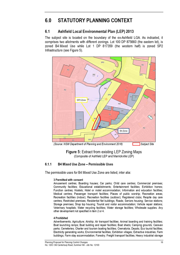
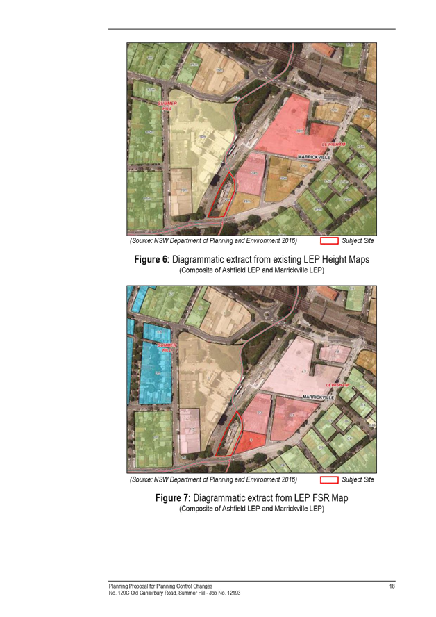
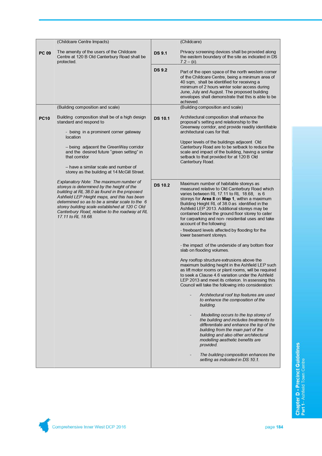
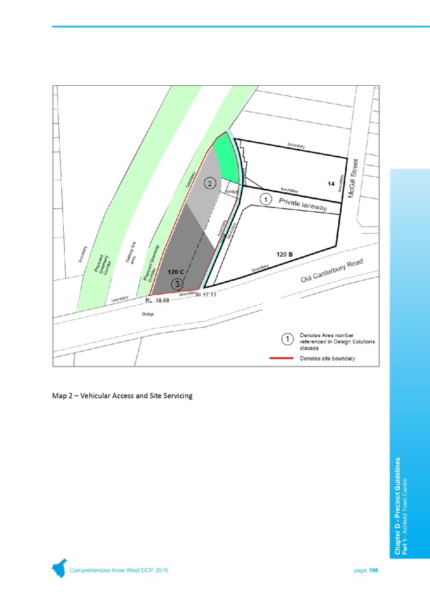
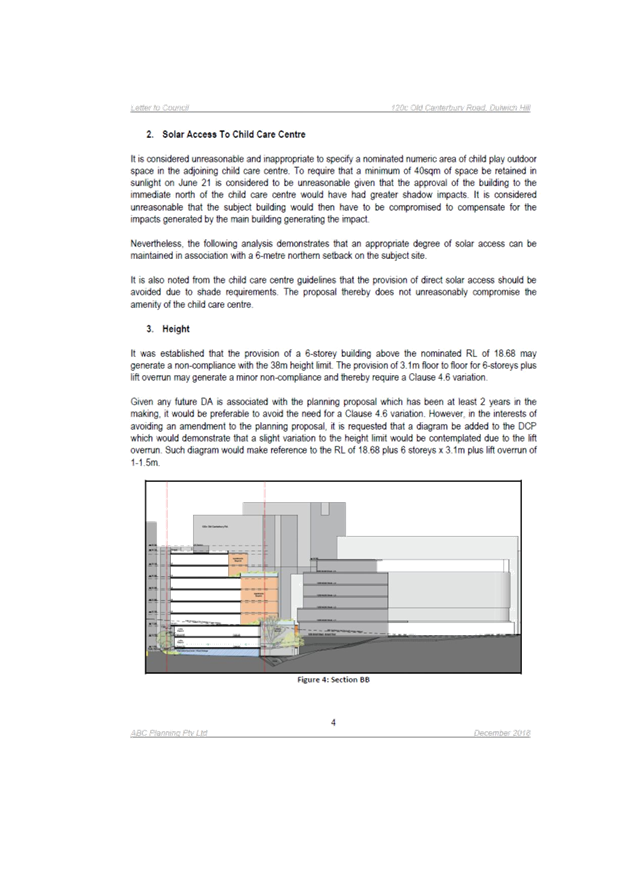
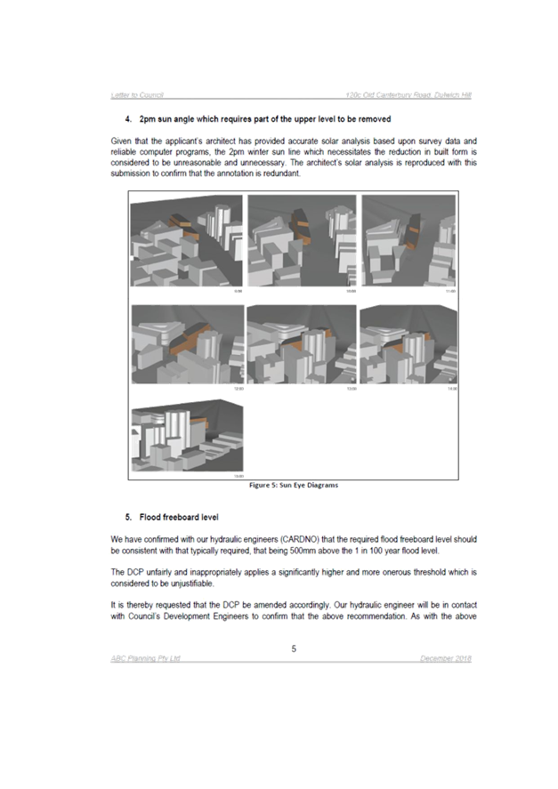
C0219(2) Item 8 Planning Proposal - 120C Old Canterbury Road, Summer Hill 440
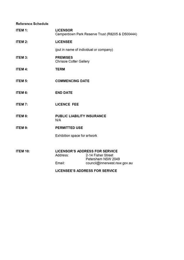
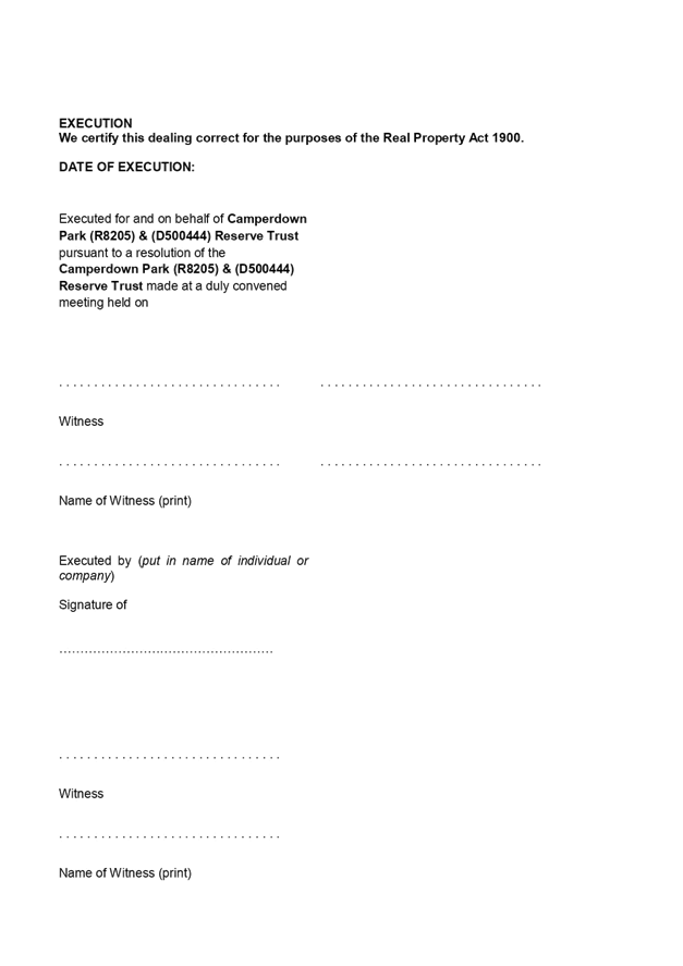
C0219(2) Item 9 License agreements for Chrissie Cotter gallery 598
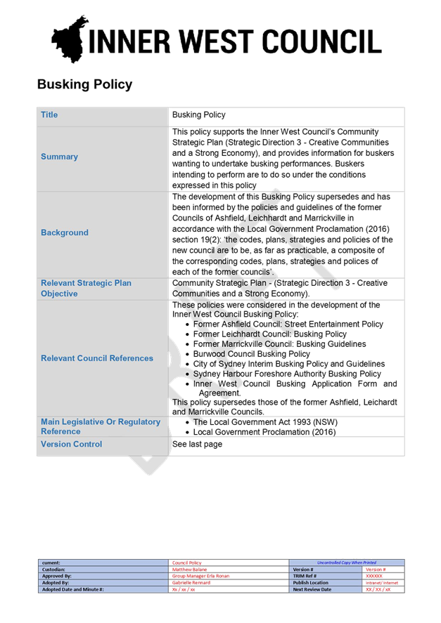
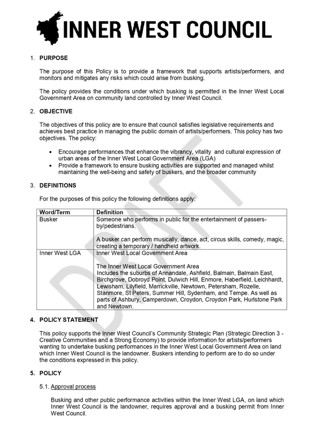
C0219(2) Item 10 Inner West Council Draft Busking Policy 609
C0219(2) Item 11 Conduct of the Local Government Election 2020 614
C0219(2) Item 12 2018/19 Second Quater Budget Review 618
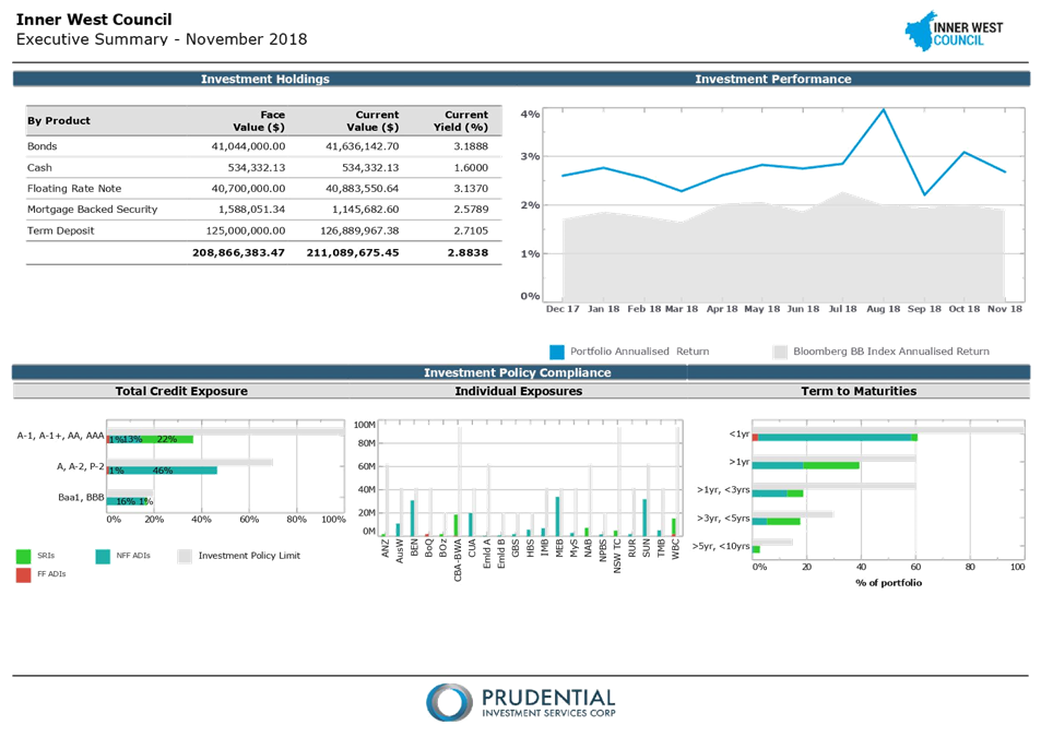
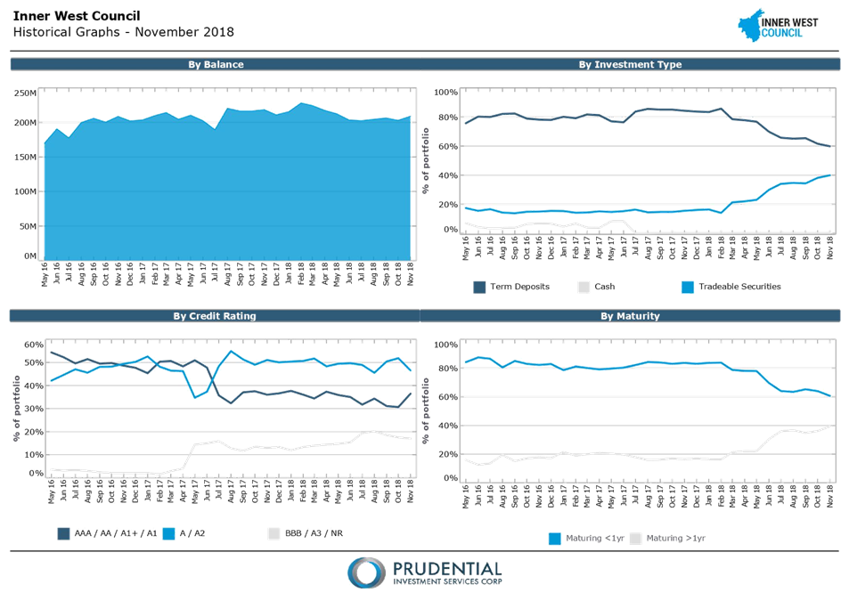
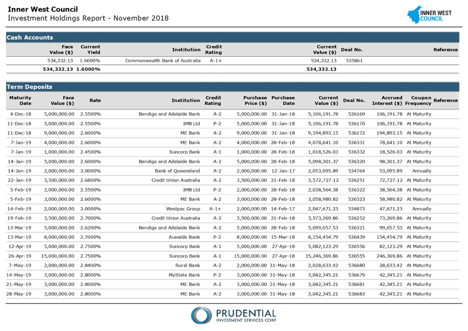
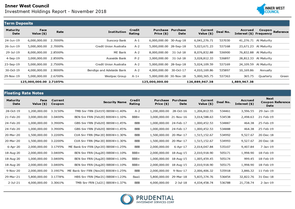
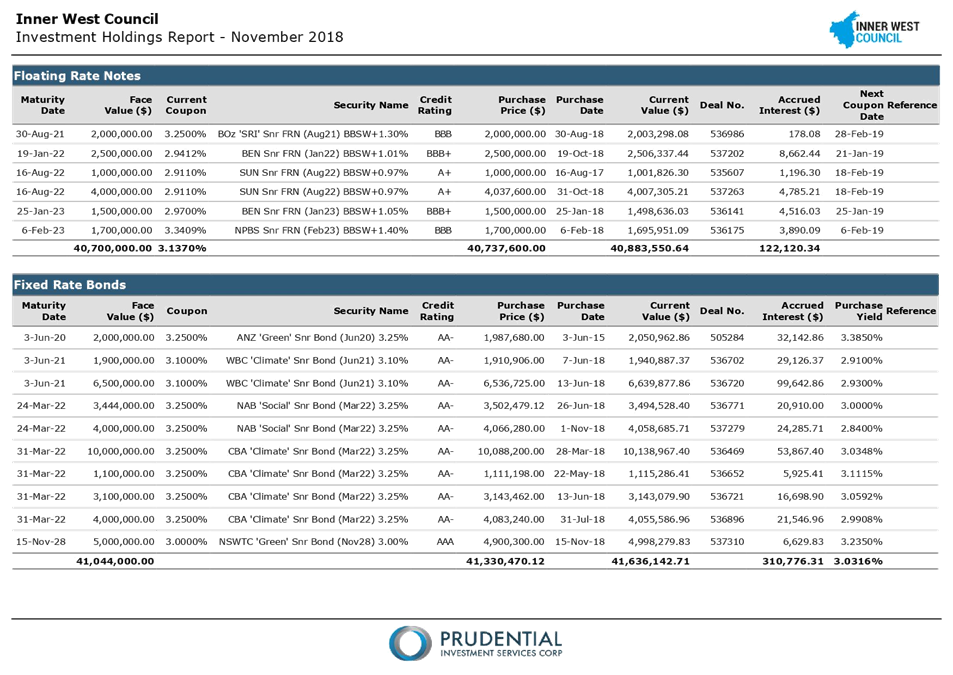
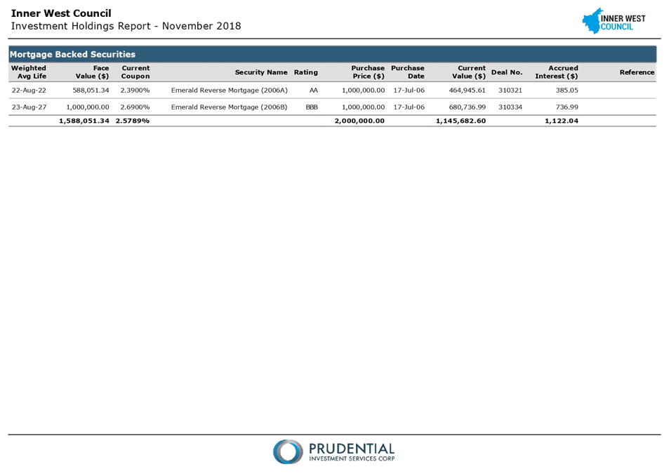
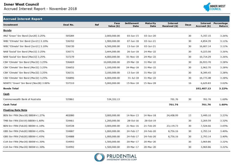
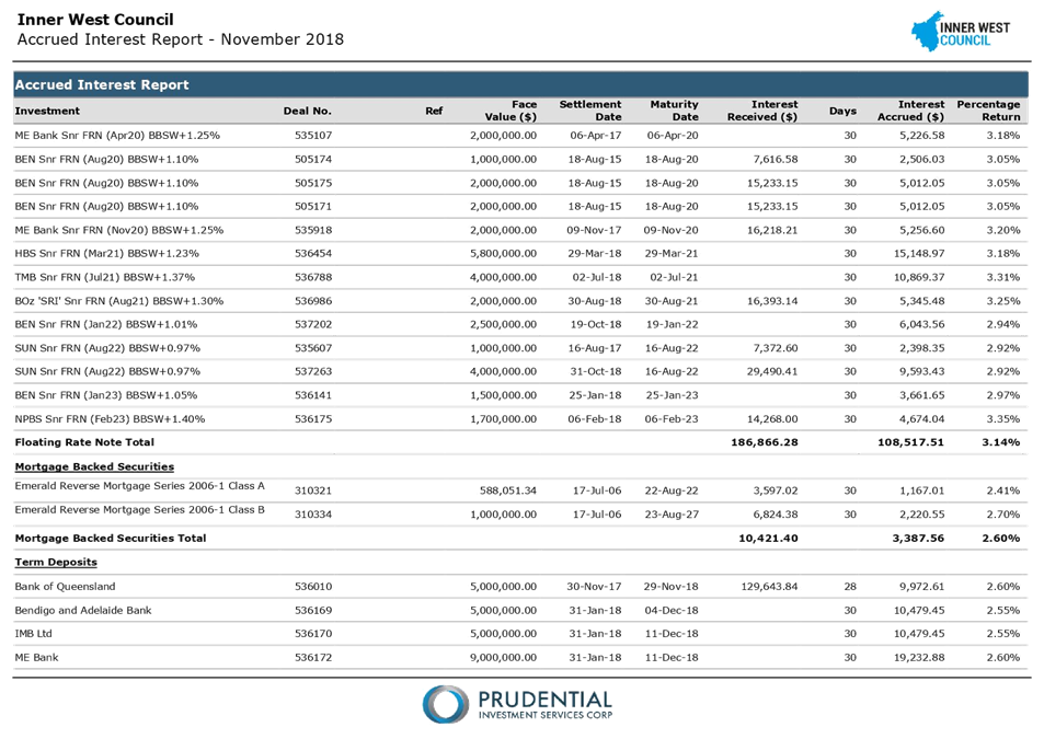
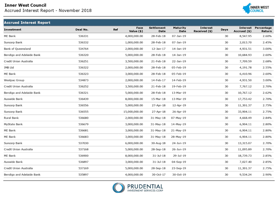
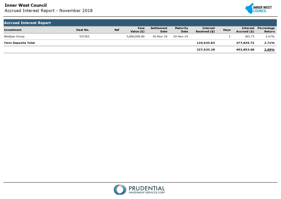
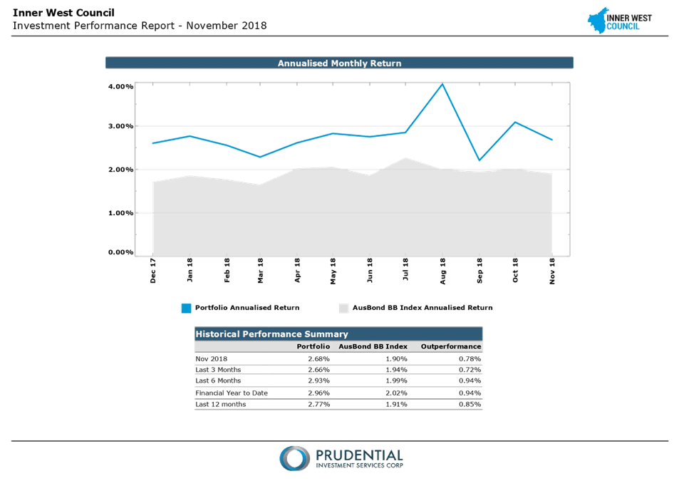
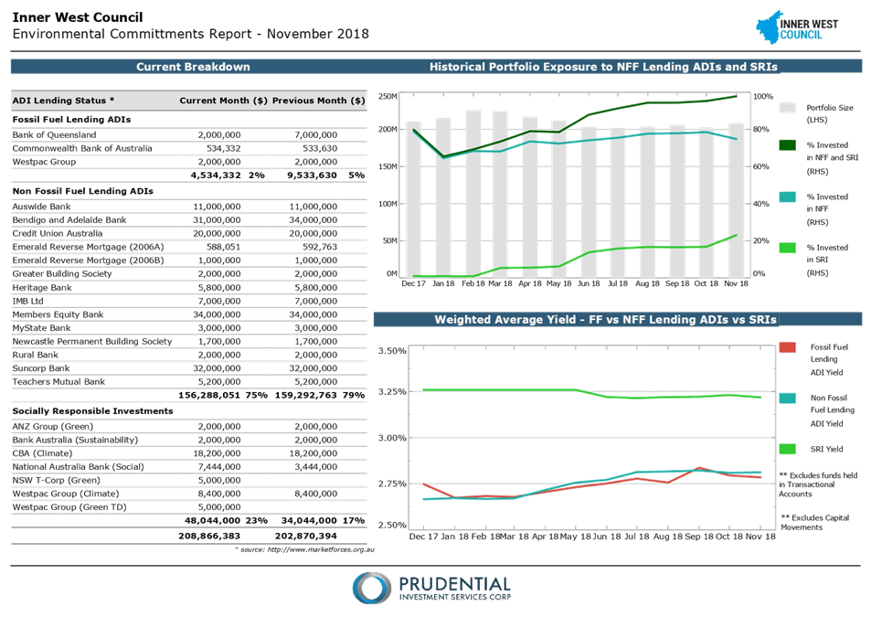
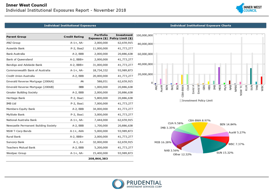
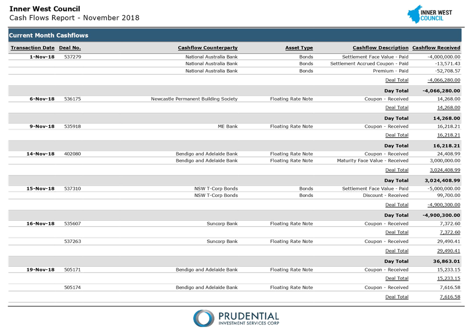
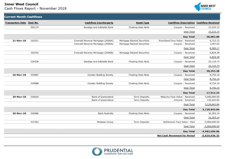
C0219(2) Item 13 Investment Report as at 30th November 2018 631
10 Notices of Motion
ITEM Page
C0219(2) Item 14 Notice of Motion: Disability Employment 658
C0219(2) Item 15 Notice of Motion: Warren Road, Marrickville 660
C0219(2) Item 16 Notice of Motion: Council Advertising 661
C0219(2) Item 17 Notice of Motion: Reversing Inner West Bus Privatisation 662
C0219(2) Item 18 Notice of Motion: Report on 290-292 Illawarra Road as Council Affordable Housing 663
C0219(2) Item 19 Notice of Motion: Air Pollution Levels Dangerously High Along Westconnex Route 665
11 Reports with Confidential Information
Reports appearing in this section of the Business Paper are confidential in their entirety or contain confidential information in attachments.
The confidential information has been circulated separately.
ITEM Page
C0219(2) Item 20 Recruitment of CEO
C0219(2) Item 21 Code of Conduct Complaint Investigation 667
|
|
Council Meeting 12 February 2019 |
Minutes of Ordinary Council Meeting held on 11 December 2018
Meeting commenced at 6.33 pm
|
Present: |
|
|
Darcy Byrne Victor Macri Marghanita Da Cruz Mark Drury Lucille McKenna OAM Colin Hesse Sam Iskandar Tom Kiat Pauline Lockie Julie Passas Rochelle Porteous Vittoria Raciti John Stamolis Louise Steer Anna York Elizabeth Richardson |
Mayor Deputy Mayor Councillor Councillor Councillor Councillor Councillor Councillor Councillor Councillor Councillor (6.38pm) Councillor Councillor Councillor Councillor General Manager Deputy General Manager Assets and Environment |
|
Michael Tzimoulas |
Deputy General Manager Chief Financial and Administration Officer |
|
John Warburton |
Deputy General Manager Community and Engagement |
|
Nellette Kettle
David Birds Cathy Edwards-Davis Erla Ronan Simon Watts Deborah Lennis Jan Orton Adam Vine Brooke Martin Harjeet Atwal Ian Naylor Katherine Paixao |
Group Manager Civic and Executive Support, Integration, Customer Service and Business Excellence Group Manager Strategic Planning Group Manager Trees, Parks and Sports Fields Group Manager Community Services and Culture Social and Cultural Planning Manager, Aboriginal Programs Supervisor Group Manager Environment and Sustainability Executive Manager, Enterprise Risk Group Manager Properties, Major Building Projects and Facilities Group Manager Development Assessment & Regulatory Services Manager Civic and Executive Support Business Paper Coordinator |
APOLOGIES: Nil
DISCLOSURES OF INTERESTS: Nil
CONFIRMATION OF MINUTES:
|
Motion: (Drury/McKenna OAM)
THAT the Minutes of the Council Meeting held on Tuesday, 27 November 2018 be confirmed as a correct record.
Motion Carried For Motion: Crs Byrne, Da Cruz, Drury, Hesse, Iskandar, Kiat, Lockie, Macri, McKenna OAM, Passas, Raciti, Stamolis, Steer and York Against Motion: Nil |
Condolence Motion – Marcia Tydeman
Councillor Passas advised the meeting of the passing of long term Ashfield resident Marcia Tydeman and requested that Council acknowledge her passing.
Motion: (Passas/Byrne)
THAT Council send flowers to the funeral of Marcia Tydwman on Thursday 13 December 2018.
Motion Carried
For Motion: Crs Byrne, Da Cruz, Drury, Hesse, Iskandar, Kiat, Lockie, Macri, McKenna OAM, Passas, Raciti, Stamolis, Steer and York
Against Motion: Nil
Councillor Porteous entered the Meeting at 6:38 pm.
|
C1218(1) Item 49 Mayoral Minute: Reigniting the Case for Trackless Trams |
|
Motion: (Byrne)
THAT Council:
1. Explore opportunities for Professor Peter Newman to include the Parramatta Road Corridor as a case study for his current paper: Delivering Integrated Transit, Land Development and Finance - A Guide and Manual with Application to Trackless Trams, and that this is to include the consideration of the resources required to implement such a scheme; 2. Approach other councils and key stakeholders along the Parramatta Road Corridor between the City and Strathfield, including Sydney University and Royal Prince Alfred Hospital, to support the Trackless Tram project for the Parramatta Road Corridor; and 3. Convene a forum with key stakeholders with a view to encouraging the State Government to pursue a preliminary feasibility study to examine suitability of applying Trackless Tram technology to the Parramatta Road Corridor and other locations in the metropolitan area, to assist in facilitating its revitalisation.
|
|
Motion Carried For Motion: Crs Byrne, Da Cruz, Drury, Hesse, Iskandar, Kiat, Lockie, Macri, McKenna OAM, Passas, Raciti, Stamolis, Steer and York Against Motion: Cr Porteous |
|
C1218(1) Item 50 Mayoral Minute: Rushed WestConnex Stage 3B Contract |
|
Motion: (Byrne)
THAT Council write to the NSW Government requesting that it does not enter into any contract for the construction of WestConnex Stage 3B until after next year’s State Election.
|
|
Motion Carried For Motion: Crs Byrne, Da Cruz, Drury, Hesse, Iskandar, Kiat, Lockie, Macri, McKenna OAM, Passas, Porteous, Raciti, Stamolis, Steer and York Against Motion: Nil |
Deferral of Items to 12 February 2019 Council Meeting
Motion: (Byrne/Stamolis)
THAT Council defer Items 1, 2, 3, 8, 9, 11 and 26 until the Ordinary Council meeting on the 12 February 2019.
Motion Carried
For Motion: Crs Byrne, Da Cruz, Drury, Hesse, Iskandar, Kiat, Lockie, Macri, McKenna OAM, Passas, Porteous, Raciti, Stamolis, Steer and York
Against Motion: Nil
Suspension of Standing Orders
Motion: (Byrne/Macri)
THAT Council Suspend Standing Orders to hear from the registered speakers for Items 12, 14, 15, 29, 32, 36, 39 and 46.
Motion Carried
For Motion: Crs Byrne, Da Cruz, Drury, Hesse, Iskandar, Kiat, Lockie, Macri, McKenna OAM, Passas, Porteous, Raciti, Stamolis, Steer and York
Against Motion: Nil
Councillor Passas left the Meeting at 7:02 pm.
Councillor Passas returned to the Meeting at 7:17 pm.
Councillor York left the Meeting at 7:25 pm.
Suspension of Standing Orders
Motion: (Byrne/Lockie)
THAT Council further Suspend Standing Orders to deal with urgent priority Items 6, 10, 13, 15, 17 and 21.
Motion Carried
For Motion: Crs Byrne, Da Cruz, Drury, Hesse, Iskandar, Kiat, Lockie, Macri, McKenna OAM, Passas, Porteous, Raciti, Stamolis and Steer
Against Motion: Nil
Absent: Cr York
Councillor Passas left the Meeting at 7:36 pm.
Councillor York returned to the Meeting at 7:43 pm.
Councillor Passas returned to the Meeting at 7:44 pm.
Councillor Macri left the Meeting at 7:55 pm.
|
C1218(1) Item 6 Live Music Action Plan |
|
Motion: (Byrne/York)
THAT Council:
1. Adopt the Live Music Action Plan;
2. Amend the definition of the Live Music Action Plan to include all live performance;
3. Promote the establishment of the Live Music Planning Liaison Service to all identified live music and potential live music venues and report back in March on uptake of the service;
4. Defer the consideration of the Live Music Grant guidelines pending information about the uptake of the Planning Liaison Service;
5. Refer both the Live Music Action Plan and the Live Music Grants Program to Council's Arts and Culture Strategic Reference Group for advice about their effectiveness;
6. Officers prepare a further report assessing the NSW Parliamentary Inquiry recommendations in reference to their applicability to the Inner West Local Government Area;
7. Officers table at the first March Council meeting the components of the City of Sydney's Late Night DCP (currently on public exhibition) which relate to King Street Precinct to allow Council to consider how they can be harmonised. This report should also outline how Council's adopted position of initiating exempt or complying development for small scale music and arts uses in King Street and Enmore Road can be progressed;
8. Write to the NSW Government and Opposition seeking a meeting to discuss locating the Live Music Hub, proposed in the Inquiry recommendations, in the Inner West Municipality;
9. Seek to address the need for loading zones for musicians, raised in the Inquiry Recommendations, in Council's revision of the LEP and DCP;
10. Note the Live Music Grant Program seeks to activate more public and commercial spaces in the Inner West for the performance and enjoyment of Live Music;
11. Note the Inner West is home to approximately 60 venues that currently offer live music in some form. There is the opportunity for expansion of live music in the Inner West amongst the existing 100 pubs and clubs, 200 small bars and breweries, 600 cafes and restaurants and 150 art galleries and other spaces;
12. In order to activate these spaces for live music as well as providing advice and support through the Live Music Planning Liaison Service, should consider establishing a grants/loans system to assist with minor to moderate building works in venues which would enable them to offer live music; and
13. Receive a further report to the first March Council Meeting outlining how small to medium grants or loans can be made available to Inner West venue owners/ tenants to undertake building works which will enable live music to be offered at their venue.
|
|
Motion Carried For Motion: Crs Byrne, Da Cruz, Drury, Hesse, Iskandar, Kiat, Lockie, Macri, McKenna OAM, Porteous, Raciti, Stamolis, Steer and York Against Motion: Cr Passas Absent: Cr Macri |
|
C1218(1) Item 10 Open Inner West 2018/19 Program for Endorsement |
|
Motion: (Lockie/Byrne)
THAT Council:
1. Receive and note the report;
2. Council note evaluations have been received for 2017-18 programs;
3. Council note the festival dates for 2018-19; and
4. Council endorse funding the 19 applications as outlined in Attachment 1. Successful Grant Recipients 2018-19, totalling $59,994 for the OIW 2018-19 grants Program.
|
|
Motion Carried For Motion: Crs Byrne, Da Cruz, Drury, Hesse, Iskandar, Kiat, Lockie, McKenna OAM, Passas, Porteous, Raciti, Stamolis, Steer and York Against Motion: Nil Absent: Cr Macri |
Councillor Macri returned to the Meeting at 8:05 pm.
|
Urgency Motion - Notice of Motion to Rescind: Yeo Park and Gough Reserve Plan of Management
|
|
Councillor Drury requested that the meeting consider an Urgency Motion with regards to a Notice of Motion to Rescind: Yeo Park and Gough Reserve Plan of Management
Motion: (Drury/Macri)
THAT the motion be considered as a matter of urgency.
Motion Carried For Motion: Crs Byrne, Da Cruz, Drury, Hesse, Iskandar, Kiat, Lockie, McKenna OAM, Passas, Porteous, Raciti, Stamolis, Steer and York Against Motion: Nil
The Mayor declared this matter was urgent.
Motion: (Drury/Macri)
THAT Council rescind Council’s resolution of 9 October 2018, C1018(1) Item 3 Yeo Park and Gough Reserve Plan of Management.
Motion Carried For Motion: Crs Byrne, Da Cruz, Drury, Hesse, Iskandar, Kiat, Lockie, Macri, McKenna OAM, Passas, Porteous, Raciti, Stamolis, Steer and York Against Motion: Nil |
|
C1218(1) Item 13 Yeo Park and Gough Reserve Plan of Management - Administration Error |
|
Motion: (Drury/Macri)
THAT:
1. Council adopt the Yeo Park and Gough Reserve Plan of Management dated September 2018 (Attachment 2);
2. Council, as land manager of Yeo Park (D 500212) Reserve Trust, refers the Plan of Management dated 29 November 2018 as it relates to Yeo Park (Crown Reserve) to the Minister of Primary Industries, Land and Water for consideration for adoption;
3. Council undertake independent cost analysis of the proposed park improvements, notably a future restoration of the historic Yeo Park Bandstand/Rotunda and report these costs back to Council for consideration in the ten year capital works plan;
4. To ensure continued community access and enjoyment of the park as a whole, Council negotiate a formal license agreement with the NSW Department of Education for community access to the Department of Education land within the park; and
5. The following words be inserted into the history section of the Yeo Park Plan of management:
“The area known today as Ashfield and the undulating countryside around Yeo Park was of high significance to the Aboriginal peoples. This area was often used to bring family units together for celebrations and gatherings to connect to country and community by sharing stories and teaching of lore.”
|
|
Motion Carried For Motion: Crs Byrne, Da Cruz, Drury, Hesse, Iskandar, Kiat, Lockie, Macri, McKenna OAM, Passas, Porteous, Raciti, Stamolis, Steer and York Against Motion: Nil |
Councillor Passas left the Meeting at 8:11 pm.
Councillor Passas returned to the Meeting at 8:15 pm.
|
C1218(1) Item 15 Balmain Leagues Club Precinct Development Control Plan Amendment |
|
Motion: (Byrne/Stamolis)
THAT:
1. Council endorse the preparation of amended development control plan provisions for the Balmain Leagues Club Precinct under Leichhardt Development Control Plan 2000 that reflect the recommendations of the urban design and heritage analysis undertaken by Conybeare Morrison (CM+) and the peer review undertaken by SGS Economics & Planning;
2. Once prepared, the amended development control plan be exhibited for a minimum of 28 days in accordance with the Environmental Planning and Assessment Regulation 2000 in early 2019;
3. Following exhibition, a report on the revised development control plan and any submissions be presented to the Council for consideration; 4. Council
note the information provided by the Administrator of the Balmain Leagues
Club about the proposed Deed of Company Arrangement for the 5. Council
reaffirm its opposition to the compulsory acquisition of the site by the
NSW Government for construction of the
proposed Western Harbour Tunnel; 6. Council reiterate its support for the planning proposal developed by Leichhardt Council in 2015 which reduced the FSR to 1:9:1 and reduced the height to 6-8 storeys as the appropriate intensity of development on this site.
|
|
Motion Carried For Motion: Crs Byrne, Drury, Iskandar, Lockie, Macri, McKenna OAM, Passas, Raciti, Stamolis and York Against Motion: Crs Da Cruz, Hesse, Kiat, Porteous and Steer
|
|
Foreshadowed Motion: (Porteous)
THAT Council:
This Foreshadowed Motion Lapsed. |
|
C1218(1) Item 17 Amendment to Inner West DCP 2016 for 2-6 Cavill Avenue Ashfield |
|
Motion: (Drury/Macri)
THAT Council adopt the site specific amendments for 2-6 Cavill Avenue, Ashfield to the “Inner West Comprehensive Development Control Plan 2016 for Ashbury, Ashfield, Croydon, Croydon Park, Haberfield, Hurlstone Park and Summer Hill” (DCP) as recommended in the report to Council of 24 July 2018 on the Planning Proposal and DCP for the site, and:
a) Carry out the procedures under the Environmental Planning and Assessment Act 1979 for making the amendment to the Development Control Plan; and
b) Place an advertisement in the local newspaper advising that Council has adopted the amendments to the Development Control Plan, which will come into force in the event and at the time Planning Proposal PP_2017_IWEST_012_00 LEP amendment for 2-6 Cavill Avenue Ashfield is published on the Legislation website.
|
|
Motion Carried For Motion: Crs Byrne, Da Cruz, Drury, Hesse, Iskandar, Kiat, Lockie, Macri, McKenna OAM, Passas, Porteous, Raciti, Stamolis, Steer and York Against Motion: Nil |
Councillor Raciti left the Meeting at 8:26 pm.
|
C1218(1) Item 21 Proposed Change to the Boarding House Provisions under State Environmental Planning Policy (Affordable Rental Housing) 2009 to Limit Boarding Houses in the R2 Low Density Residential zone to a Maximum of 12 Rooms |
|
Motion: (Macri/Kiat)
THAT:
1. The report be received and noted; and
2. The Department of Planning and Environment be forwarded a copy of this report as Council’s response to the consultation and be advised that:
i. For the reasons detailed in the report, to ensure that the size and intensity of boarding house developments are compatible with the R2 Low Density Residential zone and to ensure that the design of all new boarding houses is compatible with the scale and character of the surrounding local area, the limit on the capacity of boarding houses on such zoned land should be based on the maximum number of residents rather than the maximum number of boarding rooms.
ii. As detailed in the report the boarding house provisions in the State Environmental Planning Policy (Affordable Rental Housing) 2009 (ARHSEPP) do not apply to all land zoned R2 Low Density Residential zone under the Standard Instrument. To address the issues identified in the report and to ensure that a limit on the size of boarding houses applies to all land zoned R2 Low Density Residential under the Standard Instrument—Principal Local Environmental Plan regardless as to whether or not that land is within an “accessible area”, Clause 5.4 Controls relating to miscellaneous permissible uses should be amended to include an additional subclause reading as follows:
“(11) Boarding houses on certain zoned land
If development for the purposes of a boarding house is permitted under this Plan, the maximum capacity of the boarding house must not exceed 12 lodgers if the boarding house is on land zoned R2 Low Density Residential.”
iii. The ARHSEPP provisions relating to boarding houses should be reviewed in a holistic manner rather than in the ad hoc approach proposed to ensure that a genuinely affordable housing product results.
|
|
Motion Carried For Motion: Crs Byrne, Da Cruz, Drury, Hesse, Iskandar, Kiat, Lockie, Macri, McKenna OAM, Passas, Porteous, Stamolis, Steer and York Against Motion: Nil Absent: Cr Raciti |
Resumption of Standing Orders
Motion: (Byrne/Passas)
THAT Standing Orders be Resumed.
Motion Carried
For Motion: Crs Byrne, Da Cruz, Drury, Hesse, Iskandar, Kiat, Lockie, Macri, McKenna OAM, Passas, Porteous, Stamolis, Steer and York
Against Motion: Nil
Absent: Cr Raciti
Councillor Raciti returned to the Meeting at 8:41 pm.
|
C1218(1) Item 4 Aboriginal Frontier War Memorial |
|
Motion: (Byrne/Iskandar)
THAT Council:
1. Endorse the recommendations from the Aboriginal community to reflect the story of the Aboriginal peoples survival through the erection of a series of monuments;
2. Receive a report from staff detailing how the recommendations can be implemented including scalable budgetary options that could be considered as part of council’s 19/20 budget process;
3. Other prestigious locations in the Marrickville area be considered for the installation of, in consultation with the Aboriginal and Torres Strait Islander working group and Aboriginal Lands Council through the process; and
4. Receive a further report into the process of creating and installing a monument and other ways in which the Inner West Council can reflect the story of the Aboriginal peoples’ survival.
|
|
Motion Carried For Motion: Crs Byrne, Da Cruz, Drury, Hesse, Iskandar, Kiat, Lockie, Macri, McKenna OAM, Porteous, Stamolis, Steer and York Against Motion: Crs Passas and Raciti |
Councillor Passas left the Meeting at 8:58 pm.
Councillor Passas returned to the Meeting at 9:08 pm.
|
C1218(1) Item 5 Aboriginal Names for Inner West Council Wards |
|
Motion: (Drury/McKenna OAM)
THAT Council:
1. Notes the staff process of Aboriginal community engagement; and
2. Adopts the recommendations of the Aboriginal community in Naming of the Council Wards as follows:
Ashfield Ward – Djarrawunang (Magpie) Balmain Ward – Baludarri (Leather Jacket) Leichhardt Ward – Gulgadya (Grass Tree) Marrickville Ward – Midjuburi (Lillypilly) Stanmore Ward – Damun (Port Jackson Fig).
|
|
Motion Carried For Motion: Crs Byrne, Da Cruz, Drury, Hesse, Iskandar, Kiat, Lockie, Macri, McKenna OAM, Porteous, Raciti, Stamolis, Steer and York Against Motion: Cr Passas
|
|
Foreshadowed Motion (Stamolis)
THAT Council to request a further option for the Aboriginal naming of Council wards as there has been no proposal put before Council which has sought to use the original Aboriginal names of the land, nations, peoples or specific Aboriginal persons; for example Eora, Wangal, Gadigal, Birrabirragal. A proposal which includes these Aboriginal names or names of a similar nature would be valuable in assisting Council to make its decision. Such a proposal will also ensure that Council has considered those Aboriginal names which were, and still are, used by the first peoples of our area and how we wish these names to remain at the forefront of the community consciousness in the Inner West.
This Foreshadowed Motion Lapsed. |
ADJOURNMENT
9.09pm - The Mayor, Clr Byrne adjourned the meeting for a short recess.
9.23pm– The Mayor, Clr Byrne resumed the meeting.
Suspension of Standing Orders
Motion: (Byrne/Drury)
THAT Council Suspend Standing Orders to deal with Items 12, 14, 15, 29, 32, 36 and 39 which had registered speakers.
Motion Carried
For Motion: Crs Byrne, Da Cruz, Drury, Hesse, Iskandar, Kiat, Lockie, Macri, McKenna OAM, Passas, Stamolis, Steer and York
Against Motion: Nil
Absent: Crs Porteous and Raciti
Councillors Porteous and Raciti re-entered the Meeting at 9:30 pm.
|
C1218(1) Item 12 Camperdown Memorial Rest ParkSafe Update on the Outcomes of Community Engagement |
|
Motion: (Lockie/Steer)
THAT Council:
10. Review Lennox Street Lighting with the aim of reducing light spillage affecting residents.
Motion Carried For Motion: Crs Byrne, Da Cruz, Drury, Hesse, Lockie, Macri, McKenna OAM, Passas, Porteous, Raciti, Stamolis, Steer and York Against Motion: Crs Iskandar and Kiat
Amendment (Kiat/Iskandar)
THAT point 2 be deleted in regards to the establishment of an alcohol free zone.
Motion Lost For Motion: Crs Hesse, Iskandar and Kiat Against Motion: Crs Byrne, Da Cruz, Drury, Lockie, Macri, McKenna OAM, Passas, Porteous, Raciti, Stamolis, Steer and York |
Councillor Passas left the Meeting at 09:55 pm.
Councillor Macri left the Meeting at 10:00 pm.
Councillor Macri returned to the Meeting at 10:03 pm.
Councillor Passas returned to the Meeting at 10:06 pm.
|
C1218(1) Item 14 Pathway to Carbon Neutral Council |
|
Motion: (York/Byrne)
THAT Council:
1. Endorses the final draft Pathway to a Carbon Neutral Council for inclusion in the Draft Climate and Renewables Strategy;
2. Notes that the University of NSW has reviewed the technical report on which the Pathway to a Carbon Neutral Council is based, and found the report to be thorough, detailed, soundly based and practical;
3. Notes that the capital program for solar and energy efficiency projects will proceed to the detailed design and procurement phase with installation to commence in 2019/20;
4. Commence procurement for a second Power Purchase Agreement for renewable energy;
5. Notes
the options for target dates and endorses a 100% carbon neutral and
6. Write to SSROC seeking for them to prioritise the implementation of Stage 2 of the Street Lighting Improvement Project (SLIP) for main roads;
7. Dedicate the funds held in the Environment Reserve to infrastructure projects (such as on-site renewable energy) arising from the Carbon Neutral Council strategy, and real budget savings be returned to the Reserve to fund future renewable energy projects;
8. Begins investigating the transition to electric vehicles by working with the leaders in the field (such as the Electric Vehicle Council, Australian Renewable Energy Agency, the NRMA and their partners) to establish an e-vehicles plan for Council; and
9. Joins the Charge Together Fleet Program coordinated by the Electric Vehicle Council, which will give Council staff free access to workshops with experts, drive days where they can test drive electric vehicles, and access to a low emissions fleet vehicle portal.
|
|
Motion Carried For Motion: Crs Byrne, Da Cruz, Drury, Hesse, Iskandar, Kiat, Lockie, Macri, McKenna OAM, Passas, Porteous, Raciti, Stamolis, Steer and York Against Motion: Nil |
Confidential Session
Motion: (Drury/McKenna OAM)
THAT Council move into Confidential session to consider Items of business containing Confidential Information.
Motion Carried
For Motion: Crs Byrne, Da Cruz, Drury, Hesse, Iskandar, Kiat, Lockie, Macri, McKenna OAM, Passas, Porteous, Raciti, Stamolis, Steer and York
Against Motion: Nil
Members of the public were asked to leave the Chamber.
Motion: (Byrne/McKenna OAM)
THAT Council return to open session to read out the recommendations from the
Closed Session.
Motion Carried
For Motion: Crs Byrne, Da Cruz, Drury, Hesse, Iskandar, Kiat, Lockie, Macri, McKenna OAM, Passas, Porteous, Raciti, Stamolis, Steer and York
Against Motion: Nil
The Mayor read out to the Meeting the recommendation from the Closed Session of
Council.
Reports with Confidential Information
|
C1218(1) Item 43 Organics Processing Tender |
|
Motion: (McKenna OAM/Drury)
THAT Council:
a) process the Food Organics and Garden Organics (FOGO) stream for single unit dwellings across the Inner West as FOGO (not AWT processing); and b) provide a FOO service to multi-unit dwellings in the West (Ashfield) Service Area as soon as practicable.
6.
Approach
the State and Federal Governments, including the NSW EPA, ARENA
and relevant Ministers about the urgent need for investment in the food
recycling plants and transfer stations in the Sydney Metropolitan Area;
and 7. Investigate the potential to establish a food recycling transfer station or procession plant in the Inner West Municipality. This should include seeking State and Federal Government Investment and an initial assessment of the commercial viability of such facilities.
|
|
Motion Carried For Motion: Crs Byrne, Da Cruz, Drury, Hesse, Iskandar, Kiat, Lockie, Macri, McKenna OAM, Passas, Porteous, Raciti, Stamolis, Steer and York Against Motion: Nil |
|
C1218(1) Item 44 Council Approval of the Licence of Leichhardt Oval No.1 to Sydney Football Club Pty Ltd |
|
Motion: (McKenna OAM/Drury)
THAT:
1. Inner West Council as the Land Manager of Leichhardt Park (D500207) Reserve Trust:
a) Resolves to grant a one year Temporary Licence (Licence) of Leichhardt Park Oval to Sydney Football Club Pty Ltd (Sydney FC) for football matches and training; and
b) Authorises the General Manager (or Delegate) to negotiate terms and execute the Licence on Council’s behalf.
2. Council work with the Leichhardt chamber of commerce to convene a meeting of local business in Leichhardt and Lilyfield to plan for joint promotion on the day of the games
|
|
Motion Carried For Motion: Crs Byrne, Da Cruz, Drury, Hesse, Iskandar, Kiat, Lockie, Macri, McKenna OAM, Passas, Porteous, Raciti, Stamolis, Steer and York Against Motion: Nil |
|
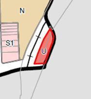
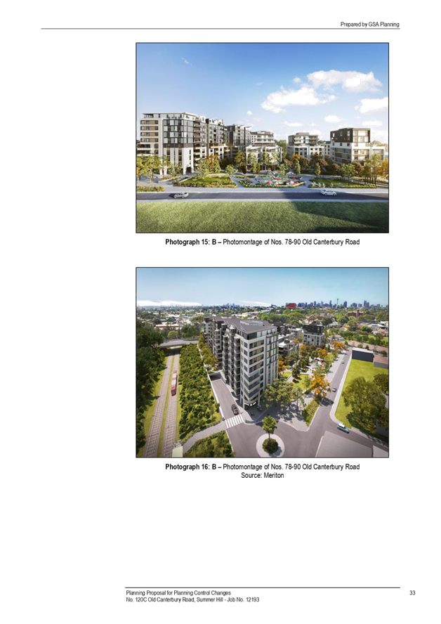
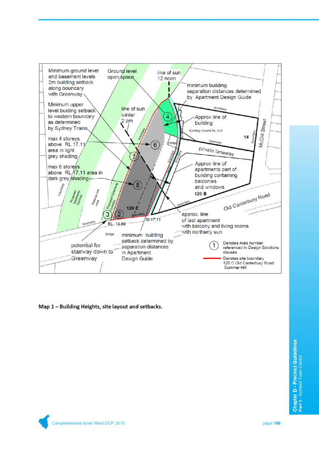
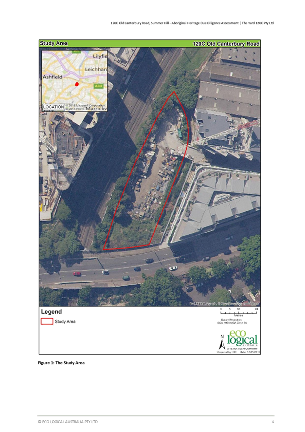
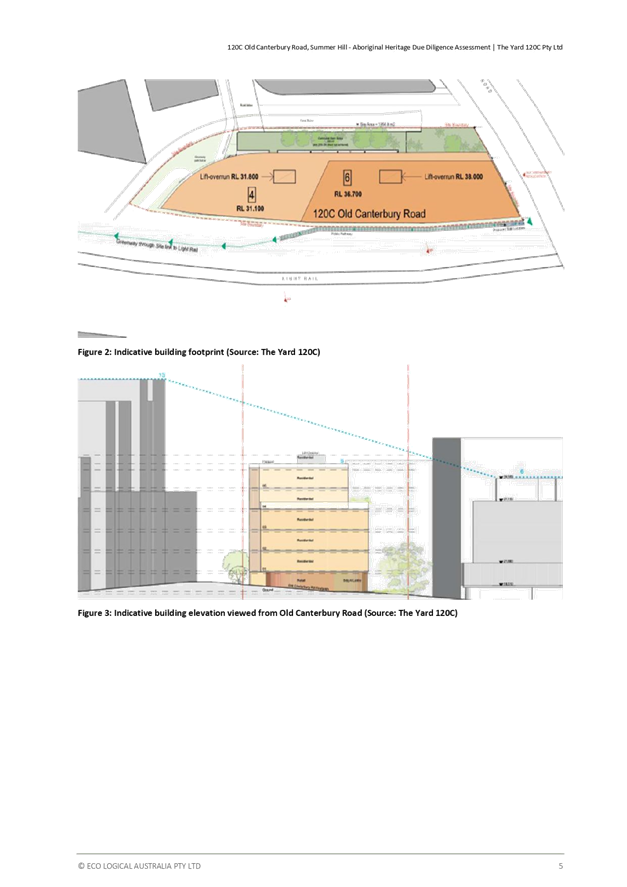
C1218(1) Item 45 120C Old Canterbury Road, Summer Hill - VPA |
|
Motion: (McKenna OAM/Drury)
THAT the proposed Voluntary Planning Agreement for 120C Old Canterbury Road, Summer Hill be:
1. Endorsed in principle, subject to The Yard 120C Pty Ltd (the proponent):
a) Construct a park of approximately 300m2 located within the Land and to provide rights of way for public access through the park to the Greenway corridor and the Lewisham Light Rail station from Old Canterbury Road and McGill Street;
b) Provide 2 studio units which will be allocated
to Affordable Housing units. The ownership of the units will be transferred
to Inner West Council at the completion of the project; c) Community Office Space located within retail Ground Floor – 5 Year Rental Agreement $1 Peppercorn rent per year – 35sqm office area; and
d) Provide Council a payment of $1,045,000 million to be used for public works in the community and surrounding area (Inner West Council will provide a summary of how this payment will be allocated at later date)
2. Placed on public exhibition for a minimum of 28 days; and
3. Reported back to Council after public exhibition.
|
|
Motion Carried For Motion: Crs Byrne, Da Cruz, Drury, Hesse, Iskandar, Kiat, Lockie, Macri, McKenna OAM, Passas, Porteous, Raciti, Stamolis, Steer and York Against Motion: Nil |
|
C1218(1) Item 46 Land & Property Strategy Initiatives |
|
Motion: (McKenna OAM/Drury)
THAT Council:
1. Defer the proposal for Chester Street Carpark Petersham until the February 2019 Council Meeting;
2. Undertake an Expression of Interest process and award the lease for the property known as Balmain Pump House;
3. Undertake an Expression of Interest process and award the lease for the property known as New Marrickville Library Development – Commercial Tenancy;
4. Undertake an Expression of Interest process and award the lease of the property known as New Marrickville Library Development – Café;
5. Undertake an expression of Interest process for the Marrickville Town Hall Reuse and report to Council on the outcomes of the Expression of Interest;
6. Prioritise the establishment of a premises for a reuse centre.
|
|
Motion Carried For Motion: Crs Byrne, Da Cruz, Drury, Hesse, Iskandar, Kiat, Lockie, Macri, McKenna OAM, Passas, Porteous, Raciti, Stamolis, Steer and York Against Motion: Nil |
Extension of Time
Motion: (Drury/Lockie)
THAT Council extend the meeting for 15 Minutes.
Motion Carried
For Motion: Crs Byrne, Da Cruz, Drury, Hesse, Iskandar, Kiat, Lockie, Macri, McKenna OAM, Passas, Porteous, Raciti, Stamolis, Steer and York
Against Motion: Nil
Councillor York retired from the Meeting at 11:11 pm.
Extension of Time
Motion: (Drury/Da Cruz)
THAT the meeting be extended until 11.45pm.
Motion Carried
For Motion: Crs Byrne, Da Cruz, Drury, Hesse, Iskandar, Kiat, Lockie, Macri, McKenna OAM, Passas, Porteous, Raciti, Stamolis and Steer
Against Motion: Nil
Absent: Cr York
Councillor Passas retired from the Meeting at 11:27 pm.
|
C1218(1) Item 47 Appointment of External Member to Audit, Risk and Improvement Committee (ARIC) |
|
Motion: (McKenna OAM/Drury)
THAT:
1. Council resolve to invite councillors to attend ARIC meetings, following advanced registration, as observers; and
2. Request the chair of ARIC to brief councillors on a yearly basis to report to councillors on the work of the committee.
|
|
Motion Carried For Motion: Crs Byrne, Da Cruz, Drury, Hesse, Iskandar, Kiat, Lockie, Macri, McKenna OAM, Porteous, Raciti, Stamolis and Steer Against Motion: Nil Absent: Crs Passas and York |
|
C1218(1) Item 48 Buruwan Park Annandale Compulsory Acquisition Under S175 Of The Roads Act Or Offer To Purchase The Lease Interest
|
|
Councillor Byrne requested that the meeting consider an Urgency Motion with regards to Buruwan Park Annandale Compulsory Acquisition Under S175 Of The Roads Act Or Offer To Purchase The Lease Interest.
Motion: (Byrne/McKenna OAM)
THAT the motion be considered as a matter of urgency.
Motion Carried For Motion: Crs Byrne, Da Cruz, Drury, Hesse, Iskandar, Kiat, Lockie, McKenna OAM, Passas, Porteous, Raciti, Stamolis, Steer and York Against Motion: Nil Absent: Crs Passas and York
The Mayor declared this matter was urgent.
Motion: (McKenna OAM/Drury)
THAT:
1. The General Manager (or delegate) negotiate the terms and executes documents with TfNSW in relation to Council relinquishing its lease for property identified as Buruwan Park Annandale, Lot 31 / DP1055559; and
2. The compensation funds be allocated to the maintenance or upgrade of Whites Creek Park.
|
|
Motion Carried For Motion: Crs Byrne, Da Cruz, Drury, Hesse, Iskandar, Kiat, Lockie, Macri, McKenna OAM, Porteous, Raciti, Stamolis and Steer Against Motion: Nil Absent: Crs Passas and York |
|
|
Suspension of Standing Orders
Motion: (Drury/Hesse)
THAT Council further Suspend Standing Orders to deal with Item 24.
Motion Carried
For Motion: Crs Byrne, Da Cruz, Drury, Hesse, Iskandar, Kiat, Lockie, Macri, McKenna OAM, Porteous, Raciti, Stamolis and Steer
Against Motion: Nil
Absent: Crs Passas and York
|
C1218(1) Item 24 Post Exhibition Report - Glebe Island Silos VPA |
|
Motion: (Drury/Stamolis)
THAT Council enter into the Voluntary Planning Agreement for Glebe Island Silos provided ATTACHMENT 1.
Motion Carried For Motion: Crs Byrne, Da Cruz, Drury, Hesse, Iskandar, Kiat, Lockie, Macri, McKenna OAM, Porteous, Raciti, Stamolis and Steer Against Motion: Nil Absent: Crs Passas and York
|
|
Amendment (Porteous/Hesse)
THAT Council notes that this Development Application has been approved, however that Council opposes the use of heritage buildings as billboards.
The Mayor ruled this amendment out of order as it would require the lodgement of a rescission motion with due notice for this amendment to be considered. |
Suspension of Standing Orders
Motion: (McKenna OAM/Drury)
THAT Council further Suspend Standing Orders to deal with Item 29.
Motion Carried
For Motion: Crs Byrne, Da Cruz, Drury, Hesse, Iskandar, Kiat, Lockie, Macri, McKenna OAM, Porteous, Raciti, Stamolis and Steer
Against Motion: Nil
Absent: Crs Passas and York
|
C1218(1) Item 29 Inner West Council Land and Property Policy and Strategy |
|
Motion: (Drury/Lockie)
THAT:
1. The draft Land & Property Policy and Strategy be placed on public exhibition for a minimum period of 28 days;
2. The results of the public exhibition and community engagement process be presented to Council recommending further action;
3. Council note the outcomes of the Building audit will be incorporated into the 2019 Asset Management Plan;
4. Council note the draft implementation plans;
5. Council invite all of its existing tenants to make a submission during the exhibition period, with notification to include clear explanation of the proposed benchmarks in relation to cost neutrality; and
6. Council receive a further report addressing the likely impact of achieving the proposed 'Cost Neutrality' benchmarks on existing our tenants (or similar types of tenants) and our ability to deliver community focused benefits.
|
|
Motion Carried For Motion: Crs Byrne, Da Cruz, Drury, Hesse, Iskandar, Kiat, Lockie, Macri, McKenna OAM, Porteous, Raciti, Stamolis and Steer Against Motion: Nil Absent: Crs Passas and York
|
|
Amendment (Da Cruz/Steer)
THAT Council amend point 1 to:
|
|
Motion Lost For Motion: Crs Da Cruz, Hesse, Kiat, Porteous, Stamolis and Steer Against Motion: Crs Byrne, Drury, Iskandar, Lockie, Macri, McKenna OAM and Raciti, Absent: Crs Passas and York |
Meeting closed at 11.46pm
The following Items will be considered at the Ordinary Council Meeting on 12 February 2018; Items 1, 2, 3, 7, 8, 9, 10, 11, 16, 18, 19, 20, 22, 23, 25, 26, 27, 28, 30, 32, 33, 34, 35, 36, 37, 38, 39, 40, 41 and 42.
Public Speakers:
|
Item #
|
Speaker |
Suburb |
|
Item 12: |
Nathan Smith John Cruthers Lindsey Chandler Philip Swynny |
Newtown Newtown Newtown Newtown |
|
Item 14: |
Behyad Jafari |
Sydney |
|
Item 15: |
Brian Hood Kate Bartlett Joe Ingui |
Sydney Sydney Rozelle |
|
Item 29: |
Naomi Brennan |
Marrickville |
|
Item 32 |
Peter Meldrum |
Marrickville |
|
Item 36: |
Philip McCrea |
Haberfield |
|
Item 39: |
Corey Mendonca |
Marrickville |
|
Item 46: |
Mish Pony David Haynes |
Summer Hill Stanmore |
|
|
Council Meeting 12 February 2019 |
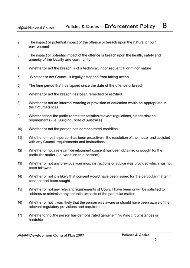
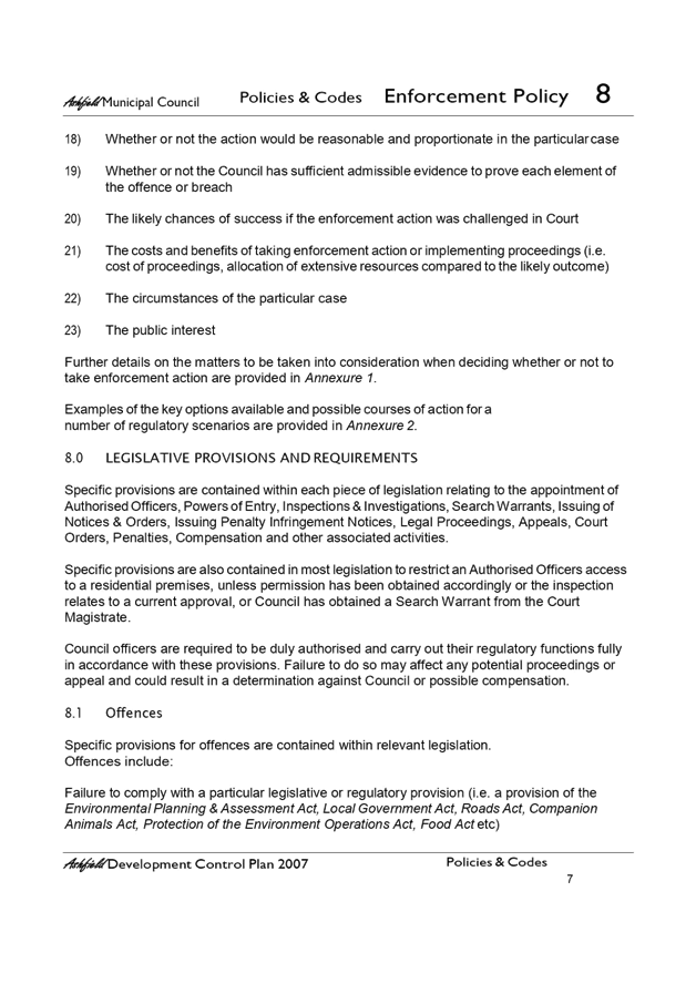
Subject: Recreation Needs Study: A Healthier Inner West - update on priority actions.
Prepared By: Peter Montague - Recreation Planning and Programs Manager
Authorised By: Cathy Edwards-Davis - Group Manager Trees, Parks and Streetscapes
|
SUMMARY This report provides an update on priority actions as identified by Council in the Recreation Needs Study: A Healthier Inner West 2018. |
|
RECOMMENDATION
THAT the report be received and noted.
|
BACKGROUND
At the meeting of 30 October 2018 Council resolved:
THAT:
1. Council endorse the Recreation Needs Study: A Healthier Inner West report;
2. The Recreation Needs Study: A Healthier Inner West report is used to inform the development of a Recreation Strategy, Section 7.11 Contributions Plan and other relevant Council planning documents;
3. All residents and stakeholders who expressed an interest are notified of Council’s decision and thanked for their contribution; and
4. That a further report, outlining the implementation timeline and funding options for the following priority actions within the study, be reported to Council in February 2019:
· Drafting of the recommended amendments to the Local Environment Plan and Development Control Plan to encourage provision of recreation facilities in new developments;
· Confirmation of the timeline for completion of the artificial surfacing of sporting fields study;
· Identification of a laneway or laneways where a pilot activation of the space for recreational use can be undertaken;
· Increasing investment in the upgrades of pocket parks in areas identified as having relative open space deficiencies;
· Review of the potential for partnerships with schools to improve sporting facilities and to make them available outside of school hours for community sport;
· Providing a pilot nature based play space for children within an existing park; and
· An audit of lighting across Council sporting facilities to identify where new lighting could increase the use, capacity and safety of sporting fields.
Shortly after the Recreation Needs Study: A Healthier Inner West (RNS) was adopted, all residents and stakeholders who expressed an interest were notified of Council’s decision and thanked for their contribution.
The remainder of this report provides an update on the priority actions identified in point 4 above.
At the meeting of 9 October 2018 Council resolved:
Council commence investigations about the possible use of non-council sports fields and facilities such as at schools
The report also addresses this resolution.
Local Environmental Plan / Development Control Plan
Council’s Urban Strategy Team is currently preparing a draft Local Strategic Planning Statement, which will support the preparation of a consolidated LEP and DCP for the Inner West. It is envisaged that the new LEP and DCP will contain provisions to encourage (or require) the provision of appropriate recreational facilities in new developments. It will also support a consolidated Contributions Plan which will consider contributions towards public recreational facilities through s7.11/7.12 developer contributions. A draft Local Strategic Planning Statement is programmed to be considered by Council in the first half of 2019.
Feasibility Study for installation of synthetic turf sporting fields.
A project team has been formed with relevant stakeholders and a project plan developed and agreed. The project includes the following milestones and timelines:
|
Activity |
Timeline |
|
Preparation of consultant brief |
November 2018 |
|
Engage consultant |
January 2019 |
|
Feasibility study Explore partnerships (e.g. schools) |
January 2019 – April 2019 |
|
Councillor briefing |
March 2019 |
|
Community Engagement – Draft feasibility study findings and recommended site/s |
March 2019 |
|
Report to Council – Feasibility study report, endorsement of recommended site/s for detailed design. |
April 2019 |
|
Detailed design |
April 2019 – June 2019 |
It is anticipated that the initial synthetic turf installation resulting from the project will be scheduled in 2019-2020. A preliminary budget has been included in the draft 2019-2020 capital program pending identification of and cost estimation for a suitable site through the planned feasibility study and community engagement.
Pilot laneway activation project
Engagement is currently being undertaken on potential locations for a ‘Play Streets’ pilot program to activate local streets or laneways. The pilot will inform a longer term position on community led street play programs for the LGA.
The anticipated timeline for the project is outlined below:
|
Activity |
Timeline |
|
Phase 1 – initial engagement gathering location suggestions via Your Say Inner West (YSIW). |
current – 24 Feb 2019 |
|
Council officers to short-list 5-6 locations based on selection criteria for further resident engagement. |
25 Feb – 1 Mar 2019 |
|
Update memo to Councillors. |
11 March 2019 |
|
Phase 2 – engagement with residents around short listed location (YSIW, letterbox drop, site meetings). |
11 March – 7 April 2019 |
|
Report to Council on outcomes of engagement with shortlisted locations and recommendation for pilot implementation at up to 3 locations. |
30 April 2019 |
|
Pilot planning with local residents, and approvals process (including Traffic Committee). |
May – July 2019 |
|
Pilot implementation. |
Sept 19 – Feb 2020 |
|
Evaluation of pilot projects and report to Council on the outcomes of the projects. |
March – May 2020 |
Costs are not anticipated to be significant and funded through the operational budget.
Upgrades of pocket parks in areas with an undersupply of open space
Pocket park upgrades included in the capital program for 2019-2020 include Elizabeth Street Playground, Ashfield, Bell Reserve (new park), Croydon and Rowe Playground, Dulwich Hill. The shade sail program will also provide improved shade at a number of pocket park playgrounds.
A prioritised program for pocket park upgrades will be developed in 2019-2020 and future generic Plan of Management for pocket parks. These plans will be prepared consistent with project specific community engagement, reference to the areas of undersupply identified in the Recreation Needs Study and park asset renewal requirements. The capital program will be reviewed to reflect the priorities identified through this planning and upgrades will be completed within existing budgets.
Potential partnerships to make school facilities available for community sport
School Infrastructure NSW (SI NSW) has established a dedicated work unit to oversee projects for the shared use of school facilities. Representatives from Tree Parks and Streetscapes, Community Services and Culture and Strategic Planning service units met with SI NSW in October 2018. SI NSW outlined their process to develop ‘Joint Use’ agreements with Councils with the intent of prioritising projects that have mutually beneficial outcomes for schools and communities. There are a number of facilities in NSW which have been built through this process with funding contributions proportionate to the level of use by school and community.
The anticipated timeline for the process for potential partnership projects with SI NSW is:
|
Activity |
Timeline |
|
Introductory meeting between Council and SI NSW to outline ‘joint use’ process. |
Oct 2018 |
|
Enter into Joint Use Project Agreement (JUPA) – General Partnership Memorandum of Understanding (MOU) with NSW Department of Education. |
Feb 2019 |
|
Planning workshop with SI NSW representatives to discuss potential projects and establish an investigation program. |
Apr 2019 |
|
Undertake investigation program of potential projects. |
Apr – Sep 2019 |
|
Project specific planning (project feasibility, design and assessment, costings etc. |
Oct onwards |
Following adoption of the RNS, Officers have followed up leads with a number of local schools concerning potential joint use projects including Marrickville High School, Globe Wilkins Primary School and Ashfield Boys High School.
The cost of reviewing potential partnership opportunities with local schools is funded through the operational budget. Should an appropriate partnership project be identified, this will be considered as part of future capital works programs.
Pilot nature based play space
A number of nature play elements are included in the design of the inclusive play space at Steel Park, Marrickville and the Cooks River Kids Area at Warren Park. These projects are funded in the current capital works budget and are anticipated to be completed by June 2019.
Potential nature play locations have been identified in the Greenway Master Plan at Gadigal Reserve (implementation priority ‘B’), at Hawthorne Canal (implementation priority ‘C’) precincts and another is being considered in the development of the Master Plan for Marrickville Golf Course.
Sports lighting audit
In 2018-2019 an audit of structural condition of all lighting towers will be completed as a priority to ensure the safety of Council lighting assets. A structural engineer has advised that for safety reasons, Council must urgently remove the lights at Pratten Park. The demolition will occur in February 2019 and a design will be commenced shortly. Funding for replacement lights has been included in the draft budget for 2019-2020. The clubs have been kept informed.
An audit of sports lighting levels and compliance with Australian Standards at all Council sporting grounds will be completed in 2019-2020. The lighting audit will be funded through existing budgets.
FINANCIAL IMPLICATIONS
The projects identified above include specific reference to funding. Future capital budgets will be informed by park masterplans, Plans of Management, the Recreation Needs Study findings, various specific strategies and the Asset Management Plans.
OTHER STAFF COMMENTS
This report has been prepared with input from teams within the Trees Parks and Streetscapes and Strategic Planning work units.
PUBLIC CONSULTATION
Relevant community engagement will be undertaken as outlined for each project.
|
|
Council Meeting 12 February 2019 |
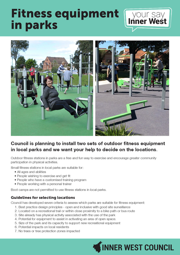
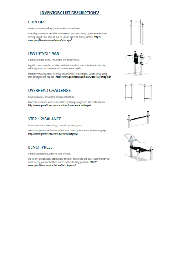
Subject: Parkfit-Alternative Sites for Fitness Stations in Parks
Prepared By: Aaron Callaghan - Parks Planning and Engagement Manager
Authorised By: Cathy Edwards-Davis - Group Manager Trees, Parks and Sports Fields
|
SUMMARY This report outlines the results of community engagement associated with the selection of alternative sites for fitness stations in parks in the Leichhardt and Balmain wards. Based on the outcomes of community engagement, the report recommends that Council proceed with the delivery of fitness stations at Ewenton Park in Balmain, 36th Battalion Park in Leichhardt and at Cohen Park in Annandale. |
|
RECOMMENDATION
THAT:
1. Council proceed with the installation of Fitness Stations at Ewenton Park in Balmain, 36th Battalion Park in Leichhardt and at Cohen Park in Annandale; and
2. Council note the potential for fitness station locations in the future at Birchgrove Park.
|
BACKGROUND
At its Ordinary Meeting on the 14th August 2018 Council resolved the following:
THAT Council:
1. Not proceed with the proposed fitness stations at Gladstone Park and Smith, Hogan and Spindler’s Park and instead bring a further report following consultation with ward councillors and residents on possible locations within the former Leichhardt Local Government Area where the stations could be located including:
- Ewenton Park;
- Cohen Park;
- Adjacent to Leichhardt No. 3 ground (near Le Montage); and
- 36th Battalion Park.
2. Endorse the former Leichhardt Councils opposition to locating a light rail station in Gladstone Park; and
3. Details criteria for where fitness stations should be put prior to the selection of any park.
REPORT
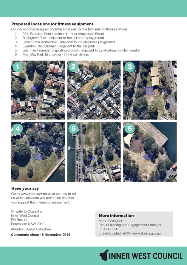
Proposed locations for fitness equipment
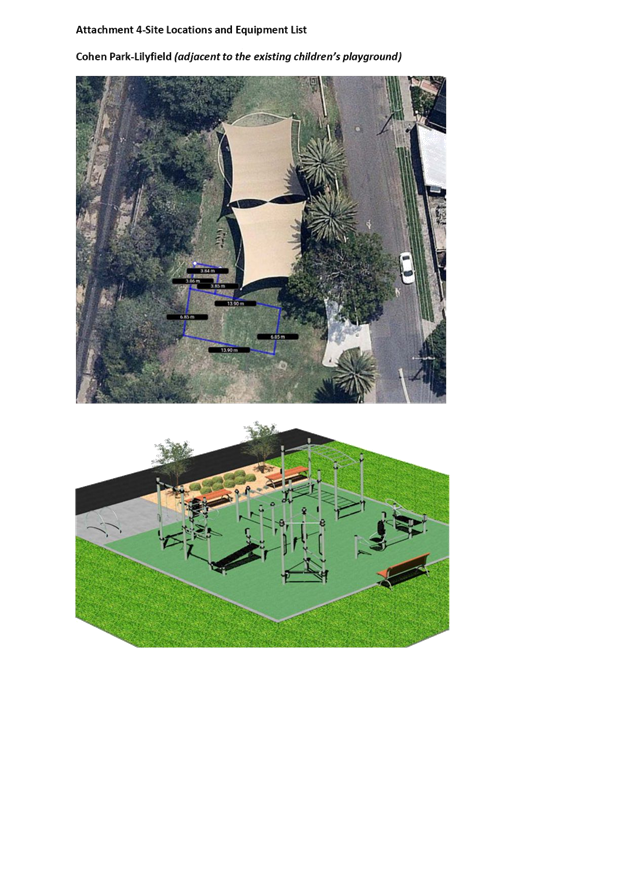
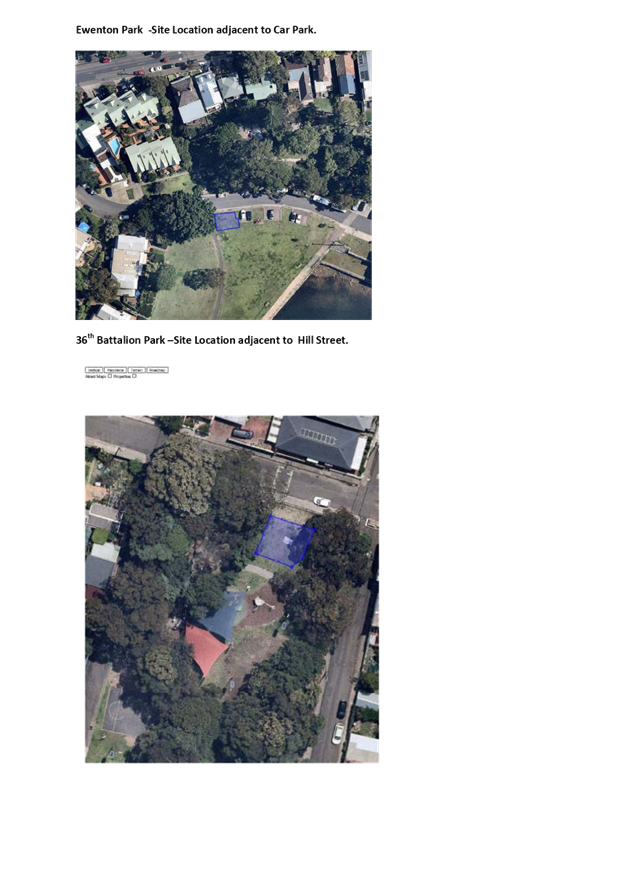
In line with the Council resolution, Council officers included the four locations which Council requested be included as part of the community engagement process. In addition to this, two other potential locations were also identified and included in the community engagement survey. The sites included in the survey are as follows:
1. 36th Battalion Park Leichhardt-near Mackenzie Street
2. Birchgrove Park - adjacent to the children's playground
3. Cohen Park - adjacent to the children's playground
4. Ewenton Park - adjacent to the car park
5. Mort Bay Park- Birchgrove-in the cul-de-sac
6. Leichhardt No. 3 Sporting ground (near La Montage)
Site 6, Leichhardt Number 3, has subsequently been ruled out of contention as a potential site due to the subsequent Council resolution pertaining to the development of a skate park facility on this site.
Key Criteria for Selecting Locations
As pursuant to the Council resolution, Council officers developed a number of key criteria around the selection of parks for where fitness stations should be installed prior to the selection of that park.
Council officers developed seven criteria to assess parks suitable for fitness equipment. The criteria which was developed is outlined as follows:
1. Best practice design principles - open and inclusive with good site surveillance
2. Located on a recreational trail or within close proximity to a bike path or bus route
3. Site already has physical activity associated with the use of the park
4. Potential for equipment to assist in activating an area of open space.
5. Size of the park and its capacity to support new recreational equipment
6. Potential impacts on local residents
7. No trees or tree protection zones impacted
The key criteria was utilised as a benchmark tool in the community engagement process. A public survey was developed to assess community support for fitness stations in parks in the subject locations and support for the criteria which Council officers developed. The community engagement process was widely advertised with 7,800 flyers distributed across neighborhood catchments within close proximity to the nominated park areas. A copy of the Fitness Stations in Parks flyer can be viewed in Attachment 1. In addition to the letter box drop, A3 posters were also displayed in each of the park areas.
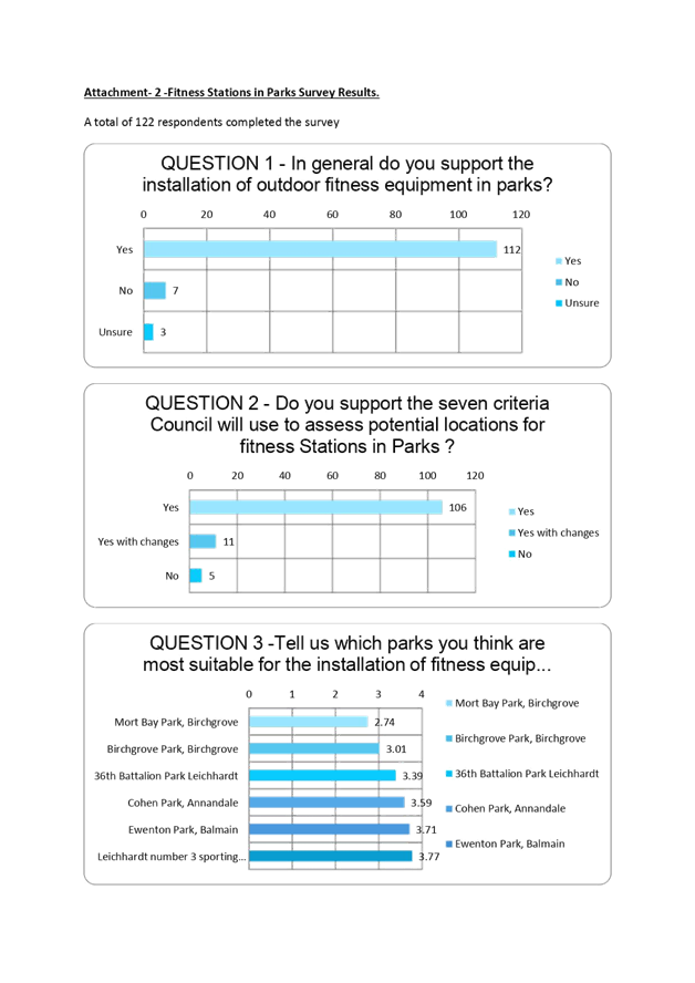
Public Survey Results
The public survey was placed on Council’s Your Say Inner West web site and was open for community input from the 24th October 2018 through to the 18th November 2018. Key highlights in terms of the web site survey are listed as follows:
· 135 people visited the survey page.
· 122 respondents made submissions on the public survey site.
The following highlights have been noted from the survey:
· 112 respondents support having fitness stations in parks.
· 106 respondents supported the seven criteria Council developed to assess potential locations in parks for fitness stations in parks.
· Out of the six parks listed, the top three parks which were viewed as most suitable locations were (in priority order and excluding Leichhardt 3 –potential future skate park site) were Ewenton Park in Balmain, Cohen Park in Annandale and 36th Battalion Park in Leichhardt.
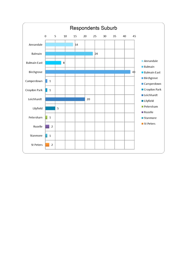
· The greatest number of respondents were from Birchgrove with 43 respondents out of the total number of 114.
A graphical analysis of the survey results is provided in Attachment 2.
Public comments collated as part of the community engagement have been summarised in Attachment 3.
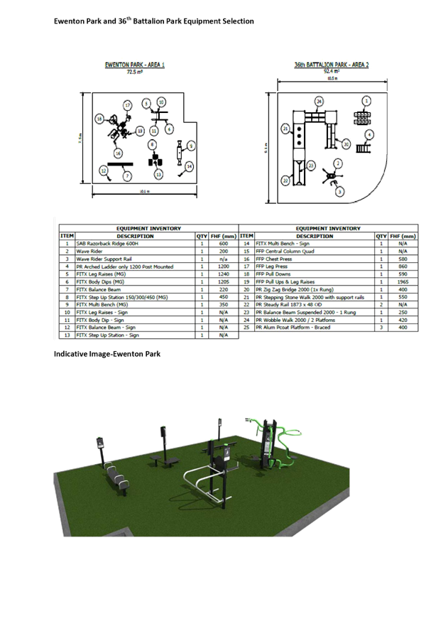
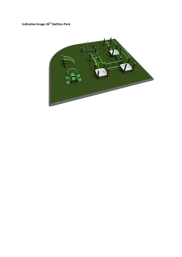
Following on from the outcomes of the community engagement process, detailed site plans have been developed for Cohen Park, 36th Battalion Park and Ewenton Park highlighting the locations for the proposed fitness stations. The locations recommended align with the key criteria which Council officers have developed in terms of the Key Criteria for selecting locations. The final and recommended design locations (including a list of the equipment proposed) are highlighted in Attachment 4.
FINANCIAL IMPLICATIONS
Council has a budget remaining of $131,599.00 to deliver fitness station projects. Given the outcomes of the community engagement process and in order to address deficiencies in fitness equipment provision within the northern part of the LGA, Council staff are recommending that the equipment be equally distributed over the three top ranked sites highlighted in the community engagement process.
OTHER STAFF COMMENTS
Nil
PUBLIC CONSULTATION
Council has undertaken extensive community engagement as outlined in the body of the report.
CONCLUSION
Parks and open space areas are provided by Council to meet a wide range of community recreational, health and social wellbeing needs. Council’s adopted Recreation and Needs Study, “A Healthier Inner West” highlights the short supply of open space within the Inner West and recommends that Council consider improving the recreational value of parks by adopting principles that support the key drivers of sharing, generosity, co-design and quality. Parks provide a range of health benefits for the community and strategically it is important that facilities which promote outdoor recreation are distributed equitably across the local government area. Improvements to open space should be focussed on the community needs as a whole, with the key consideration that “parks are for everyone.” Council’s community engagement process has highlighted support for fitness stations within parks within the Leichhardt and Balmain ward areas. Three sites have rated highly, that of Cohen Park in Lilyfield, 36th Battalion Park in Leichhardt and Ewenton Park in Balmain. It is proposed that Council move forward with the delivery of fitness stations at these parks.
|
1.⇩ |
Attachment 1 Parkfit Flyer |
|
2.⇩ |
Attachment 2 Public Survey Results |
|
3.⇩ |
Attachment 3 Public Submissions/ Comments |
|
4.⇩ |
Attachment 4 Site Locations and Fitness Selection |
|
Council Meeting 12 February 2019 |
Subject: Library fines for lost or late items
Prepared By: Caroline McLeod - Group Manager Library and History Services
Authorised By: John Warburton - Deputy General Manager Community and Engagement
|
SUMMARY The paper proposes that Council wipes the debt from existing Library customers for lost or overdue items as part of the launch of the new Library Management System. The paper recommends that fines only be charged for adults (18 years+) and that borrowing rights be suspended if a fine exceeds $100. It recommends that a customer be referred to a collection agency if their fines exceeds $100 and they have not responded to the Library after 90 days.
|
|
RECOMMENDATION
THAT Council endorses:
1. Writing off the existing Library late fines debt of $538,792 as part of a fine amnesty to launch the new Library Management System and that all library accounts will be cleared.
2. Late fines will only be charged for members 18 years and over.
3. All library members, regardless of age, will need to cover the costs associated with lost or damaged items.
4. If a library fine or total cost of overdue items exceeds $100, the customer will be banned from borrowing and referred to a collections agency (following four notices being sent to the customer).
|
BACKGROUND
Inner West Council charges library customers fees for overdue items in an effort to encourage Library users to return items within the three week borrowing period so the item is available for other members of the community and to cover the cost of lost items. Fines are not charged to raise revenue for the Council.
In the 2017-18 financial year Library & History received $86,003.11 from late fees and charges for lost items. As at November 2018, the balance of overdue fines or lost items, dated from the year 2000 equalled $538,792 from 28,944 users.
The table over provides a breakdown by Library overview of the existing fines to date.
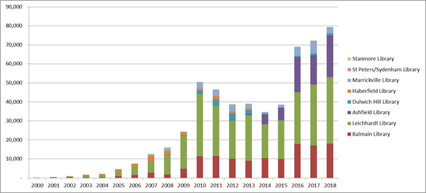
Notes on table:
• 75% from Leichhardt and Balmain Branches
• 12,400 with balance >$10 ($478,231)
• $319,511 Net recoverable amount from collection agency (balances >$10)
An overview of the current borrowing conditions are listed below:
· Customers can borrow up to 40 items at a time for a 21 day period.
· If a customer would like to keep an item longer, and it has not been reserved by another library user, they are able to renew an item online, by phone or by a staff member in the library (up to three times).
· Children 12 years and under are not charged overdue fees, but are charged for lost or damaged items.
· Fees are capped at $10 / item (as per the Library Act 1939)
· For a lost or damaged item, customers are charged the cost of the item plus a processing fee.
· The Branch Librarian and above are authorised to waive fines for compassionate reasons.
· There is category called a “Claims Returned” when a customer claims / insists they have returned the item. At the discretion of the Branch Librarian and above, this can be waived.
· If a customer owes more than $20 in fines, their borrowing rights are suspended. However, the customer can pay a 10% of their fines per visit to the Library for the borrowing rights to be lifted.
Since amalgamation Library & History fees and charges have been harmonised, however, the process for notifying customers about late or lost items and the subsequent collection of unpaid fines has remained as per the three former Councils procedures due to the Library Management System encompassing differing policies and procedures.
It is recommended the following changes occur to the implementation of fees and charges:
· Only customers 18 years and older will be charged fines for overdue items (a raise in age from 12 to 18 years).
· All customers, regardless of age, will continue to be charged for lost or damaged items (once 60 days overdue).
· Library accounts are suspended when the fine reaches $100 or more (raised from $20).
· Customers receive four notices over a 90 day period advising their item/s is due / now overdue
· If the account is over $100 that Council refer the account to a collections agency at a cost of $12.50 / account.
The appointment of a collections agency will be new for the members of the former Ashfield and Leichhardt Council library services. It is an existing practice of the former Marrickville Council, noting that at Marrickville customers are currently referred to if they owe $35 or more. The agency reports the process yields a return on investment at 9.18 to 1 and are cost effective for balances over a certain amount.
Implementation of new Library Management System and late / lost fines
To launch the new system and process for overdue / lost items it is recommended that all existing fees and charges be wiped and all customers start with a zero balance. The reasons for this include:
· To promote the new integrated system and encourage library customers to visit / borrow from one of Inner Council’s eight libraries.
· The cost and effort of retrieving the unpaid funds (via a collection agency) is not equal to the amount of money Council would receive or the costs incurred would not cover the value of the amount owed.
· An unknown number of customers will have moved so would not be contactable.
· Given that some of the former Council’s did not actively pursue fines, Council could appear very heavy handed.
· Items more than two years old may no longer be considered desirable as part of the library collection and therefore not worth pursuing.
FINANCIAL IMPLICATIONS
Council will be required to write-off $538,792.
It is difficult to assess what the financial implications of these changes will be as there has not been a consistent approach to retrieving the fines. However, going forward Council could expect to see the outstanding library balances to be more in-line with the amounts indicated by the former Marrickville libraries in the graph above. It is recommended that this be assessed at the end of the 2019/20 financial year to assess the impact.
OTHER STAFF COMMENTS
Nil.
PUBLIC CONSULTATION
Nil.
CONCLUSION
A consistent approach to the management of lost or overdue items is required for Library and History services and Library customers.
|
|
Council Meeting 12 February 2019 |
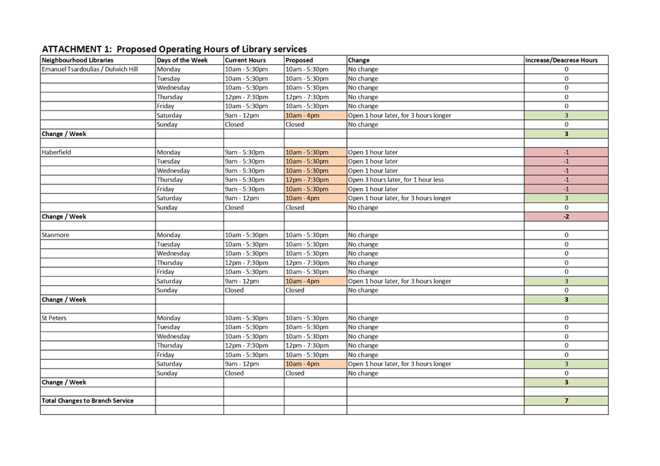
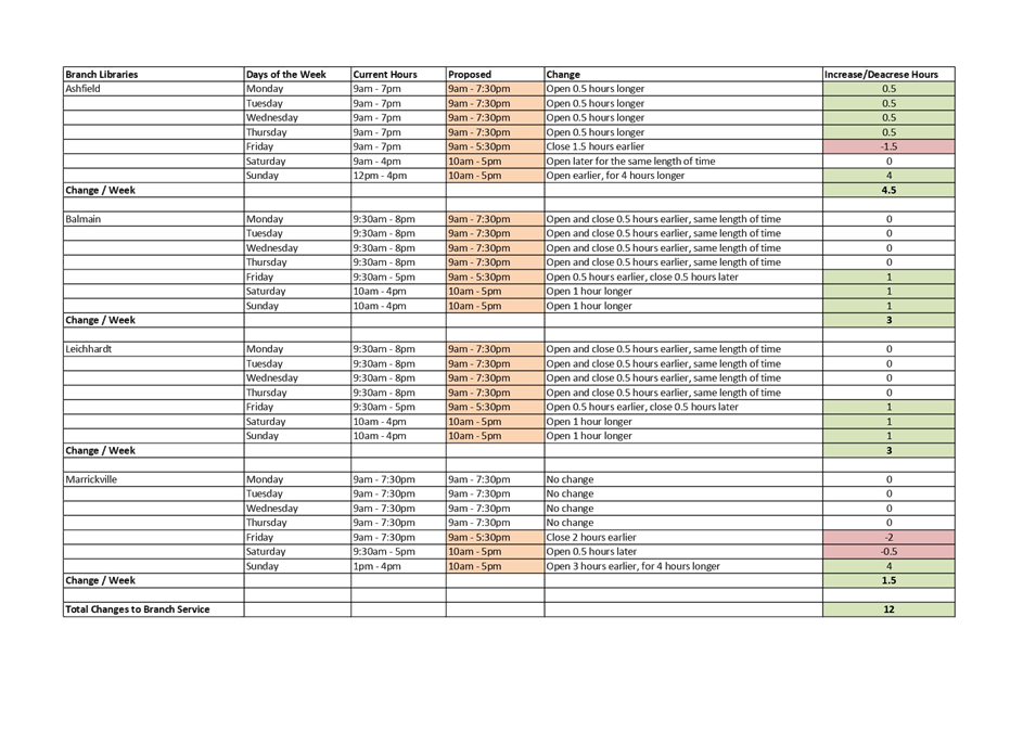
Subject: Harmonising of Library operating hours
Prepared By: Caroline McLeod - Group Manager Library and History Services
Authorised By: John Warburton - Deputy General Manager Community and Engagement
|
SUMMARY As part of harmonising Library & History Services, it is proposed that Library operating hours be streamlined from 1 July 2019. The paper is seeking Council’s approval to put the proposed operating hours for Council’s branch and neighbourhood libraries on public exhibition for 28 days. Following the public exhibition, a further report will be bought back to Council.
|
|
RECOMMENDATION
THAT Council:
1. Place on public exhibition the proposed Library operating hours shown in Table 1, for 28 days;
2. Notes that Library staff will conduct head counts at the four branch libraries at the beginning and end of the day and report back following the public exhibition over a four week period.
|
BACKGROUND
Inner West Council delivers Library services across eight locations in the Inner West with various operating hours.
To ensure consistency of service across the LGA, to make it easier for customers to recall library operating hours and to assist with rostering / staffing, it is recommended library operating hours be harmonised.
The libraries are divided into two categories:
· Branch Libraries - Ashfield, Balmain, Leichhardt and Marrickville
These libraries have longer operating hours, larger collections, more programming, more staffing and behind the scenes functions such as collection development, home library etc.
· Neighbourhood Libraries - Emanuel Tsardoulias, Haberfield, Stanmore, St Peters
These libraries are staffed by two people. are smaller in size, with smaller collections and reduced hours. These libraries are significantly quieter than the branch libraries.
It is proposed the following library operating hours be placed on public exhibition.
Table one – Proposed library hours to go on exhibition
|
Opening days / hours |
Branch Libraries
|
Neighbourhood Libraries |
|
Monday – Wednesday |
9am-7.30pm |
10am-5.30pm |
|
Thursday |
9am-7.30pm |
12pm-7.30pm |
|
Friday |
9am-5.30pm |
10-5.30pm |
|
Saturday |
10am-5pm |
10-4pm |
|
Sunday |
10am-5pm |
Closed |
Following the public exhibition, a further report would be bought back to Council for consideration.
Should the proposed Library operating hours go ahead, this would result in an increase of 19 openings hours across the service. Attachment 1 provides an overview of the existing library operating hours and highlights what changes would occur at each location should the proposed operating hours be endorsed.
It is to be noted that should Library and History Services be conducting an author talk or event that goes beyond the proposed operating hours, the Libraries would remain open to the event.
Determining the hours
Library and History Services recently conducted community consultation with the community to prepare for the Library and History strategy (not yet reported to Council). When asked if they were happy with the existing opening hours:
· 507 respondents were happy
· 128 were not happy
Those that were not happy were asked what operating hours they would prefer (and had the opportunity to respond to more than one answer):
· 27 said the library should be open earlier Monday to Friday
· 58 said the library should be open later Monday to Friday
· 75 said the library should be open longer on Saturdays and
· 87 said the library should be open longer on a Sunday
Resulting from this feedback the recommended operating hours were established following discussions with the Library Operations Manager and the Branch Librarians. The Branch Librarians have reported that all libraries are generally quiet from 6.30pm.
The feedback from the Branch Librarians was given more weight when determining the operating hours than the door counts as the current available information only provides information on how many visitors pass through the door but does not indicate whether they are entering or exiting the library ie between 6.30pm and 7pm, we cannot determine whether a lot of people are visiting library or they are all exiting. To address this, Library staff will randomly monitor the number of people in (and entering the libraries) at the beginning and end of the day to assist with the decision making over a four week period. This information will be reported back following the public exhibition.
Implementation
Should the proposed hours be accepted, it would be proposed that the new operating hours for Marrickville, Haberfield and St Peters Libraries not be implemented until their new facilities have been completed.
FINANCIAL IMPLICATIONS
The current proposal would be possible within Library and History Service’s existing budget.
Should Council wish to consider extending the Sunday operating hours for the neighbourhood libraries, the annual price would be approximately $25,000 per neighbourhood library to operate for four hours on a Sunday totalling $100,000. However, given the low numbers at the neighbourhood libraries, this is not recommended.
OTHER STAFF COMMENTS
Nil.
PUBLIC CONSULTATION
It is recommended the proposed operating hours be placed on public exhibition for 28 days. Following this a further paper will be bought to Council. .
|
1.⇩ |
Proposed Library Operating Hours |
|
Council Meeting 12 February 2019 |
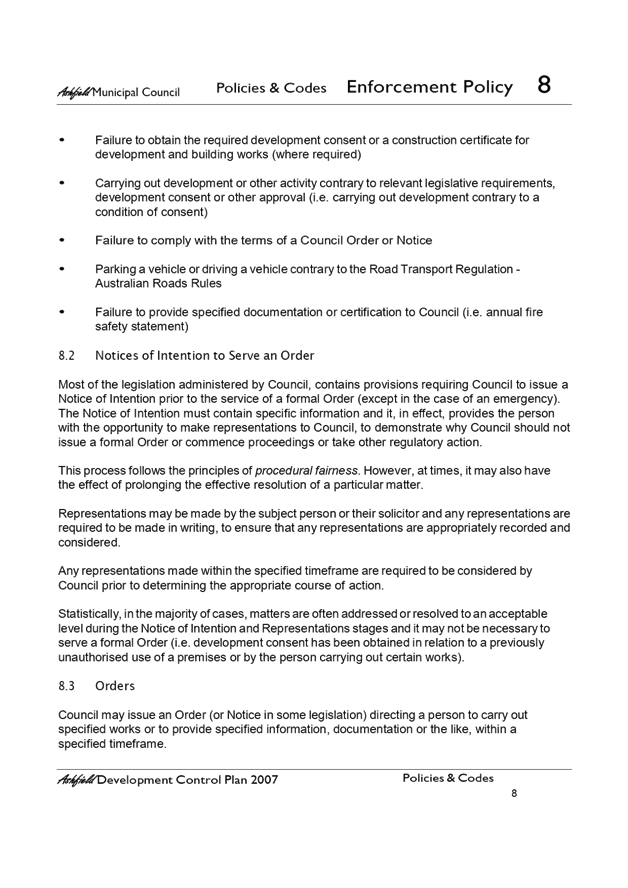
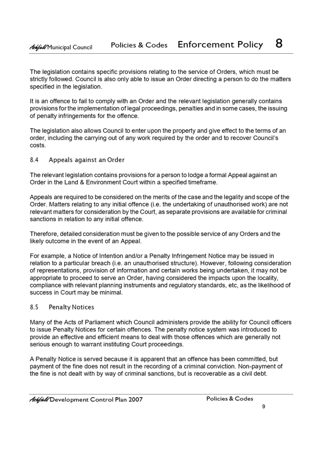
Subject: Draft Compliance and Enforcement Policy
Prepared By: Simon Grierson - Environmental Health & Building Regulation Section
Authorised By: Harjeet Atwal - Group Manager Development Assessment and Regulatory Services
|
SUMMARY On 30 October 2018 Council resolved to place the draft Compliance and Enforcement Policy on public exhibition for 28 days. The draft Policy was placed on public exhibition from 17 November 2018 to 18 December 2018. This report provides a summary of the outcomes of the public exhibition and community engagement process and presents the final Compliance and Enforcement Policy for adoption.
|
|
RECOMMENDATION
THAT:
1. Council adopt the Inner West Council Compliance and Enforcement Policy. 2. Council rescinds the Enforcement Policy of the former Ashfield Council and Compliance and Enforcement Policy of the former Leichhardt Council. 3. The Compliance and Enforcement Protocol be received and noted.
|
BACKGROUND
At the Council meeting on the 30 October 2018, the following was resolved:
“THAT:
1. The draft Compliance and Enforcement Policy be placed on public exhibition for a period of 28 days;
2. The results of the public exhibition are presented to Council along with a final Compliance and Enforcement Policy for adoption; and
4. The Compliance and Enforcement Protocol be received and noted.
4. Council officers investigate and report to Council on:
a) The use of technology in parking management and enforcement including:
· Mobile Phone Payment Solutions;
· Electronic Permit Systems;
· Vehicle Detection Sensor Systems;
· License Plate Recognition Systems.
5. The process to integrate such technology within Council's existing parking infrastructure;
6. A
project plan which includes costings and timeframe to implement and deliver the
technology; and
7. A Report come back to Council with Information on Council’s Regulatory Services Including a Contact Phone Number to Report Issues, The Hours They Work And How Many Staff Are Employed In This Team.”
This report addresses points 1 to 3 of the above resolution. The draft Policy was placed on public exhibition from 17 November 2018 to 18 December 2018. This report provides a summary of the outcomes of the public exhibition and community engagement process and presents the final Compliance and Enforcement Policy for adoption.
In relation to points 4 to 6 Council Officers are currently preparing scopes and project plans to facilitate the investigation of technology in parking management and enforcement. This is a large project and requires extensive investigation and a report will be presented to Council of the outcomes.
In relation to point 7 Council Officers are currently preparing a report providing information on the matter.
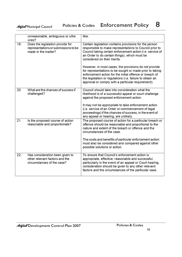
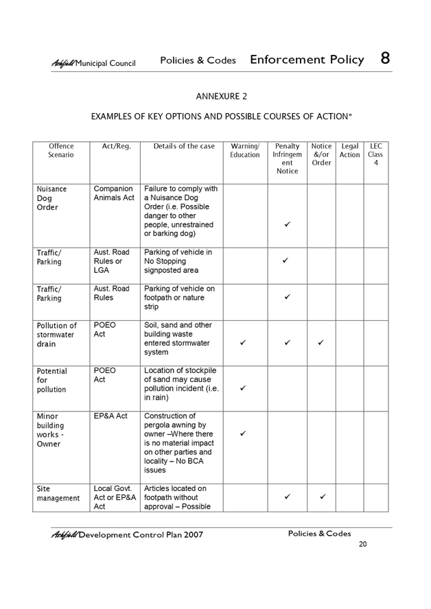
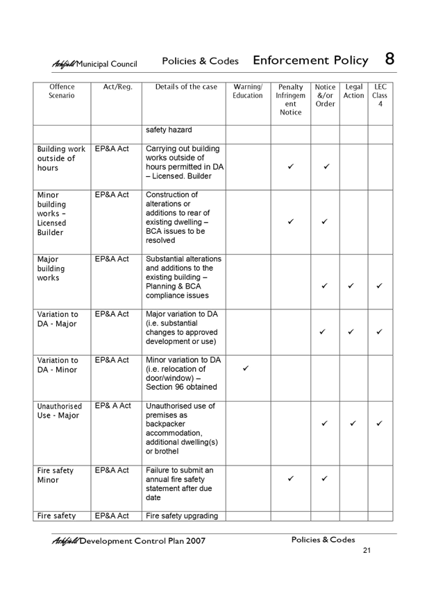
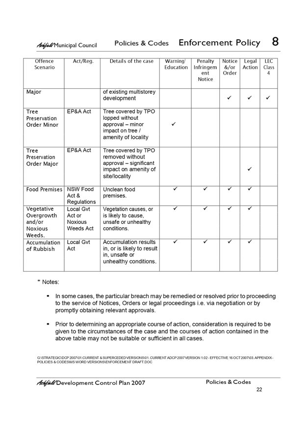
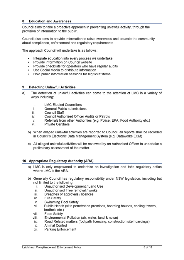
POLICY DISCUSSION
Council is responsible for unlawful activity compliance and enforcement under various legislations with delegated/authorised officers responsible for the investigation of such matters.
The NSW Ombudsman’s office encourages as best practice councils to have an adopted policy which covers this area and for that Policy and associated Protocol to be publically available.
The intent of the Compliance and Enforcement Policy (Attachment 1) is to establish:
§ Council's compliance and enforcement principles;
§ how reports alleging unlawful activity will be dealt with by Council;
§ how Council’s limited resources will be deployed in addressing allegations of unlawful activity;
§ how confidentiality of people who report allegations of unlawful activity will be managed;
§ what Council expects from people who report allegations of unlawful activity;
§ what parties can expect from Council staff;
§ how Council deals with complaints about Council's enforcement action; and
§ how Council deals with anonymous reports.
The Policy also provides advice and guidance on the role of Councillors in compliance and enforcement.
The Policy and the Compliance and Enforcement Protocol (Attachment 2) are to be read together and provides a guide to officers responsible for unlawful activity compliance and enforcement to ensure that investigations are undertaken in a manner that is lawful, accountable and transparent, consistent, proportional and timely.
The Protocol addresses the resource limitations in Council’s compliance and enforcement activities and how such resources are to be utilised.
The Protocol also outlines for the community matters to be considered at the various stages of the compliance and enforcement process from the receipt and investigation of reports alleging unlawful activity, through to what, if any, enforcement option Council will choose and whether to commence criminal or civil proceedings.
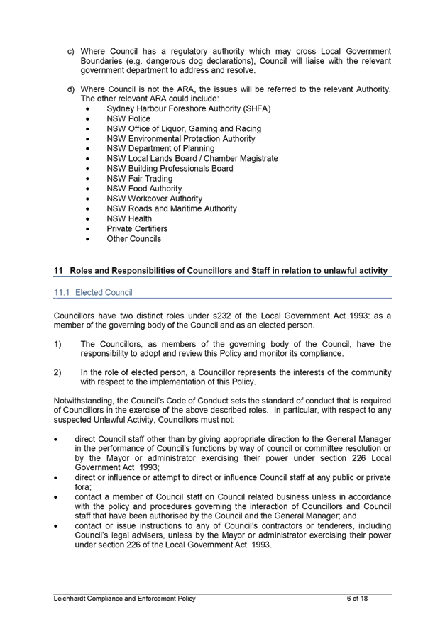
In certain circumstances Council will have shared compliance and enforcement responsibilities with other regulatory authorities. The Protocol sets out a cooperative approach to such matters. Advice and guidance is also provided on the role of Council in building and construction compliance matters where there is a private certifier.
PUBLIC EXHIBITION: COMMUNITY COMMENTS AND OFFICER RESPONSE
The draft Compliance and Enforcement Policy was placed on public exhibition on Your Say Inner West from 17 November 2018 to 18 December 2018. The draft Policy exhibition was promoted via social media channels and on Council pages in Inner West Courier.
There were 61 aware participants who visited the Your Say project page with the draft Policy, with 43 downloaded documents. 2 submissions were made on the draft Policy through Your Say Inner West. 1 submission was anonymous and did not support the draft Policy and did not provide any comments. The other submission offered conditional support of the draft Policy and the comments provided are addressed below:
|
Community comments |
Council officer response |
|
As part of the policy there should be a section dealing
with how the policy is communicated appropriately including the mechanisms
for reporting. Perhaps even an implementation plan or similar talking about
how the policy will be implemented and link in with Council workflows. For
example having appropriate information on the "report an issue"
page.
Can the policy also clarify the scope? For example does it refer to reports about possible council corruption? If so then it should be explicitly mentioned. If now then there should be a reference to the appropriate policy.
|
The policy will be available online on Councils website where all other adopted policies are located. In addition, links will be embedded at appropriate locations (including on the ‘report an issue’ page) throughout the Council website which direct customers who are interested to the policy.
The ‘report an issue’ page on Council’s website goes through step by step process to log unlawful activity for Council’s investigation and action as defined by the Compliance and Enforcement Policy in Council’s Customer Request Management System. The request system allows on-line tracking of the request.
The policy outlines principles on how Council will implement the policy.
Section 7.6 of the draft Policy deals with this and states that reports of this nature will be recorded separately and handled in accordance with Council's Complaints Handling Policy and Procedures. |
FURTHER AMENDMENTS
Following the public exhibition period, no comments were received which necessitated amendment of the policy with any changes only administrative in nature.
LEGACY COUNCIL/S’ POLICIES TO BE RESCINDED
In developing this new Policy, the following policies were considered:
· Enforcement Policy of former Ashfield Council (Attachment 3)
· Compliance and Enforcement Policy of former Leichhardt Council (Attachment 4)
It is appropriate that on adoption of the new Policy, the former Ashfield and Leichhardt Policy be rescinded by Council.
It is noted that Marrickville Council did not have an adopted Policy on Compliance and Enforcement, rather an internal working protocol only. Hence no rescission is required.
FINANCIAL IMPLICATIONS
There are no financial implications arising from the Policy.
OTHER STAFF COMMENTS
Feedback from the following stakeholders was previously received, reviewed and incorporated where appropriate in the draft Compliance and Enforcement Policy and Protocol: Council’s Trees, Parks and Sportsfields Group, Council’s Footpaths, Roads, Traffic and Stormwater Group, Council’s Environment and Sustainability Group, Council’s Integration, Customer Service and Business Excellence Group, Council’s Legal, Development Assessment and Regulatory Services Group and the NSW Internal Ombudsman.
CONCLUSION
· The purpose of Compliance and Enforcement Policy and Protocol are to guide Council officers responsible for unlawful activity compliance and enforcement in a manner that is accountable and transparent, consistent, proportional and timely and to assist the community in understanding its role and the role of Council in relation to unlawful activity compliance and enforcement.
·
This report is seeking Council’s adoption of the Compliance and Enforcement Policy and the recession of the two legacy policies.
|
1.⇩ |
Compliance and Enforcement Policy |
|
2.⇩ |
Compliance and Enforcement Protocol |
|
3.⇩ |
Enforcement Policy of Former Ashfield Council |
|
4.⇩ |
Compliance and Enforcement Policy of Former Leichhardt Council |
|
|
Council Meeting 12 February 2019 |
Compliance and Enforcement Policy
DOCUMENT PROFILE
|
Title |
Compliance and Enforcement Policy |
|
Summary |
To guide officers responsible for unlawful activity compliance and enforcement in a manner that is accountable and transparent, consistent, proportional and timely and to assist the community in understanding its role and the role of Council in relation to unlawful activity compliance and enforcement.
|
|
Background |
Council is responsible for unlawful activity compliance and enforcement under various legislations with delegated/ authorised officers responsible for the investigation of such matters.
The NSW Ombudsman’s office encourages as best practice councils to have an adopted policy which covers this area and for that policy to be publically available.
|
|
Policy Type |
Council
|
|
Relevant Strategic Plan Objective |
Strategic Direction 1: An ecologically sustainable Inner West Strategic Direction 2: Unique, liveable, networked neighbourhoods
|
|
Relevant Council References |
§ Compliance and Enforcement Protocol § Code of Conduct Policy § Complaints Handling Policy and Procedure
|
|
Main Legislative Or Regulatory Reference |
§ Local Government Act 1993 § Environmental Planning and Assessment Act 1979 § Companion Animals Act 1998 § Roads Act 1993 § Food Act 2003 § Protection of the Environment Operations Act 1997 § Impounding Act 1993
|
|
Applicable Delegation Of Authority |
As per delegations' register |
|
Other External References |
NSW Ombudsman website |
|
Attachments |
Nil |
|
Record Notes |
External available document |
|
Version Control |
See last page |
1. PURPOSE
This Policy provides a guide to officers responsible for unlawful activity compliance and enforcement to ensure that investigations are undertaken in a manner that is lawful, accountable and transparent, consistent, proportional and timely. This Policy also addresses the resource limitations in Council’s enforcement activities and how such resources are to be utilised.
The Policy also outlines for the community how reports alleging unlawful activity will be dealt with by Council, how Council treats the confidentiality of people who report alleged unlawful activity, what Council expects from people who report allegations of unlawful activity and the process for complaints about Council’s enforcement action.
This Policy also sets out the role of Councillors in compliance and enforcement.
2. OBJECTIVE
The intent of this Policy is to establish:
§ Council's compliance and enforcement principles;
§ how reports alleging unlawful activity will be dealt with by Council;
§ how Council’s limited resources will be deployed in addressing allegations of unlawful activity;
§ how confidentiality of people who report allegations of unlawful activity will be managed;
§ what Council expects from people who report allegations of unlawful activity;
§ what parties can expect from Council staff;
§ how Council deals with complaints about Council's enforcement action; and
§ how Council deals with anonymous reports.
The policy also provides advice and guidance on:
§ the role of Councillors in compliance and enforcement.
3. SCOPE
This Policy applies to all areas within the Inner West local government area and the officers who are authorised to investigate unlawful activity including but not limited to:
§ development and building control
§ pollution control
§ environmental health
§ public health and safety
§ weeds control (Biosecurity)
§ companion animals
§ roads and footpaths
§ parks and reserves
§ food safety
§ fire safety
§ tree preservation
§ illegal dumping
4. DEFINITIONS
Complaint means an expression of dissatisfaction made about Council services, staff or the handling of a request for service/notification of unlawful activity, where a response or resolution is explicitly or implicitly expected or legally required.
For the purposes of this Policy, a complaint does not include:
§ a report alleging unlawful activity (see definition below)
§ a request for information about a Council policy or procedure
§ a request for an explanation of actions taken by Council
§ a request for internal review of a Council decision
Council means Inner West Council.
Enforcement means actions taken in response to serious or deliberate contraventions of laws.
Officer means a Council officer authorised to undertake unlawful activity compliance and enforcement investigations.
Regulation means using a variety of tools and strategies to influence and change behaviour to achieve the objectives of an Act, Regulation or other statutory instrument administered by Council.
Report alleging unlawful activity means an expression of concern or a request for service in relation to alleged unlawful activity, where a response or resolution is explicitly or implicitly expected or legally required.
Unlawful activity means any activity or work that has been or is being carried out contrary to and/or failure to take required action in order to be compliant with:
§ the terms or conditions of a development consent, approval, permit or licence.
§ an environmental planning instrument that regulates the activities or work that can be carried out on particular land.
§ a legislative provision regulating a particular activity or work.
§ a required development consent, approval, permission or licence.
§ signage regulating a particular activity.
5. POLICY STATEMENT
This Policy covers all elected members of Council, all personnel employed by Council, any person or organisation contracted to or acting on behalf of Council, any person or organisation employed to work on Council premises or facilities and all activities of the Council.
This Policy does not confer any delegated authority upon any person. All delegations to staff are issued by the General Manager.
6. POLICY
6.1. Compliance and Enforcement Principles:
6.1.1. Lawful:
a) Council will only engage in enforcement action where it has legislative authority to take such action.
b) Any enforcement activity, including investigation methods, will be carried out in accordance with any legislative restraints.
c) Enforcement activities will be carried out having regard to general principles of justice including the presumption of innocence and the need for evidence that proves, to the necessary standard, that enforcement action is lawfully available to Council.
6.1.2. Accountable and Transparent:
a) Acting in the best interests of public health and safety and in the best interests of the environment.
b) Ensuring accountability for decisions to take or not take action.
c) Acting fairly and impartially and without bias or unlawful discrimination.
d) Providing information about compliance and enforcement priorities and reasons for decisions to improve understanding and certainty and promote trust by the regulated community.
e) Ensuring meaningful reasons for decisions are given to all relevant parties.
f) Acting on any complaints or concerns about the conduct of Officers in accordance with Council's Complaints Handling Policy and Procedure advising people and organisations subject to enforcement action of any avenues available to seek an internal or external review of a decision.
g) Advising people and organisations subject to enforcement action of any avenues available to seek an internal or external review of a decision.
6.1.3. Consistent:
a) Ensuring all compliance and enforcement action is implemented consistently as far as practicable.
b) Encouraging reports about possible unlawful activity by acting reasonably in response to the circumstances and facts of each matter.
6.1.4. Proportional:
a) Ensuring the level of enforcement action is proportionate to the level of risk and seriousness of the breach.
b) Making cost-effective decisions about enforcement action noting the limited resources available to Council to address unlawful activity.
c) Taking action to address harm and deter future unlawful activity.
6.1.5. Timely:
a) Ensuring responses to reports alleging unlawful activity and decision making in relation to those is timely.
6.2. How reports alleging unlawful activity will be dealt with by Council:
6.2.1. Council will record and assess every report alleging unlawful activity.
6.2.2. Council will respond to every such report unless the person raising the matter has indicated they do not wish to receive a response about Council's handling of the matter, or the report is anonymous.
6.2.3. Reports of unlawful activity will be processed in the order in which they are received, irrespective of the source of the report, and prioritised according to the risks associated with the activity under report. In particular, priority will be given to matters that pose serious risks including scenarios that are life threatening or constitute serious health situations, are associated with significant environmental harm or that repeatedly detrimentally affect a significant number of people.
6.2.4. Generally speaking, Council's objectives when dealing with reports alleging unlawful activity are to:
a) maintain the collective good and welfare of the community;
b) prevent or minimise harm to health, welfare, safety, property or the environment;
c) consider the broader public interest having regard to Council's priorities and any resource limitations including the avoidance of deploying a disproportionate amount of resources to matters that are primarily of a private nature.
6.2.5. Not all reports will need to be investigated. A preliminary assessment of all matters will be made to determine the priority, and whether investigation or other action is required.
6.2.6. Anonymous reports will be recorded and assessed in accordance with this policy and associated procedure. However, because it is not possible to seek clarification or additional information about a matter, it may be more difficult to evaluate the allegations and therefore, if there is insufficient information, these reports are less likely to warrant investigation.
6.3. How confidentiality of people who report allegations of unlawful activity will be managed:
6.3.1. People who report allegations of unlawful activity should not expect that their identities will remain confidential from the subject of their report in all circumstances. Council may have to disclose information that identifies them in the following cases:
a) the disclosure is necessary to investigate the matter;
b) their identity has already been disclosed to the subject of their report directly or in a publicly available document;
c) the individual was consulted following receipt of a Government Information (Public Access) Act 2009 application and did not object to the disclosure;
d) the individual consents in writing to their identity being disclosed;
e) the disclosure is required to comply with principles of procedural fairness;
f) documents associated with the court process;
g) the need for complainants to attend Court to provide evidence to assist in Council enforcement action; and
h) other legislation requiring Council to provide the information.
6.3.2. Council will take seriously any concerns an individual may have about their physical safety being endangered as a result of making a report. However, this may limit Council's ability to investigate the matter.
6.4. What Council expects from people who report allegations of unlawful activity:
6.4.1. Council expects that people who report allegations of unlawful activity will cooperate and act in good faith in respect of any investigations conducted by Council.
6.4.2. If these expectations of the individual are not met, Council may need to set limits or conditions on the continuation of the investigation or may need to restrict any further communications with the individual. In particular, Council may not be able to take civil or criminal action if the individual does not agree to provide evidence in any Court action.
6.4.3. Any unreasonable conduct will be dealt with in accordance with the principles of the NSW Ombudsman's Managing Unreasonable Complainant Conduct – a model policy and procedure 2013 and any applicable Council policy.
6.5. What parties can expect from Council staff:
6.5.1. Parties who report alleged unlawful activity, as well as individuals or businesses that are subject to investigation and any enforcement action, can expect that Council staff will:
a) treat them with courtesy and respect;
b) advise them of the progress of an investigation at agreed intervals if the investigation is protracted, the outcome (if required) of the investigation, including an explanation of the reasons why that outcome was considered to be reasonable in the circumstances;
c) make full and proper records in relation to the assessment and investigation of reported alleged unlawful activity, including reasons for any decisions;
d) clearly explain decisions in plain English;
e) provide information about any relevant internal and external appeal processes that may be available;
f) carefully assess any new information provided by any party after a decision has been made and advise whether further action will be taken.
6.6.
Complaints about Council's enforcement action:
6.6.1. Any complaints about Council's handling of reports alleging unlawful activity will be recorded separately and handled in accordance with Council's Complaints Handling Policy and Procedure and as relevant, the Internal Ombudsman Shared Service Governance Charter.
6.6.2. Where a person or organisation subject to enforcement action merely disputes Council's decision to take enforcement against them, they will be directed to make representations in accordance with any relevant internal and external appeal processes.
6.6.3. Council staff will act on any complaints about the conduct of Officers in accordance with Council's Complaints Handling Policy and Procedure and the Council Code of Conduct and as relevant, the Internal Ombudsman Shared Service Governance Charter.
6.7. The role of Councillors in enforcement:
6.7.1. Decision making relating to the investigation of reports alleging unlawful activity and taking enforcement action is the responsibility of appropriately authorised Council staff or the Council itself.
6.7.2. In accordance with the Code of Conduct, individual Councillors do not have the right to direct Council staff in their day-to-day operational activities. Councillors can help individuals who raise concerns with them by satisfying themselves that their Council's policies are being carried out correctly, however they cannot ignore or alter a policy in order to satisfy the demands of special groups.
6.7.3. The General Manager may present certain decisions to be ratified by the elected Council if this is necessary or desirable, and the Councillors may also have the right to call for a report about particular issues to a Council meeting.
7. RESPONSIBILITIES
Council staff delegations for taking action under this policy are included in Council's Delegation Register.
8. ASSOCIATED PROCEDURES
Compliance and Enforcement Protocol
Version Control – POLICY HISTORY:
Governance Use only – The history of modifications and approval to the Policy must be detailed in the table below post adoption.
Governance Use only:
|
Version |
Amended By |
Changes Made |
Date |
TRIM # |
|
1 |
Governance: Policy and Risk |
New IWC Policy replacing pre-merged versions |
June2017 |
74655.17 |
|
2 |
|
|
|
|
|
Council Meeting 12 February 2019 |
Compliance and Enforcement Protocol
DOCUMENT PROFILE
|
Title |
Compliance and Enforcement Protocol |
|
Summary |
To guide unlawful activity compliance and enforcement in a manner that is accountable and transparent, consistent, proportional and timely and to assist the community in understanding its role and the role of Council in relation to unlawful activity compliance and enforcement
|
|
Background |
Council is responsible for unlawful activity compliance and enforcement under various legislations with delegated/ authorised officers responsible for the investigation of such matters. Council has an adopted Compliance and Enforcement Policy and the NSW Ombudsman’s office encourages as best practice Councils to have a protocol which covers this area and for that protocol to be publically available.
|
|
Document Type |
Protocol |
|
Relevant Council References |
§ Compliance and Enforcement Policy § Code of Conduct Policy § Complaints Handling Policy and Procedure
|
|
Applicable Delegation Of Authority |
As per delegations' register |
|
Other External References |
NSW Ombudsman website |
|
Attachments |
See Appendixes |
|
Record Notes |
External available document |
|
Version Control |
See last page |
The Compliance and Enforcement Policy and this Protocol provides a guide to officers responsible for unlawful activity compliance and enforcement to ensure that investigations are undertaken in a manner that is lawful, accountable and transparent, consistent, proportional and timely. This Policy also addresses the resource limitations in Council’s enforcement activities and how such resources are to be utilised.
The Policy and Protocol also outlines for the community how reports alleging unlawful activity will be dealt with by Council, how Council treats the confidentiality of people who report alleged unlawful activity, what Council expects from people who report allegations of unlawful activity and the process for complaints about Council’s enforcement action.
2. OBJECTIVE
The intent of the Compliance and Enforcement Policy and this Protocol is to establish:
§ Council's compliance and enforcement principles;
§ how reports alleging unlawful activity will be dealt with by Council;
§ how Council’s limited resources will be deployed in addressing allegations of unlawful activity;
§ how confidentiality of people who report allegations of unlawful activity will be managed;
§ what Council expects from people who report allegations of unlawful activity;
§ what parties can expect from Council staff;
§ how Council deals with complaints about Council's enforcement action; and
§ how Council deals with anonymous reports.
3. SCOPE
The Compliance and Enforcement Policy and this Protocol applies to all areas within the Inner West local government area and the officers who are authorised to investigate unlawful activity including but not limited to:
§ development and building control
§ pollution control
§ environmental health
§ public health and safety
§ weeds control (Biosecurity)
§ companion animals
§ roads and footpaths
§ parks and reserves
§ food safety
§ fire safety
§ tree preservation
§ illegal dumping
4. PROTOCOL STEPS
4.1. Responding to concerns about unlawful activity:
4.1.1. How reports alleging unlawful activity will be dealt with by Council:
a) Council will record and assess every report alleging unlawful activity.
b) Council will respond to every such report unless the person raising the matter has indicated they do not wish to receive a response about Council's handling of the matter, the report is anonymous or it is obvious the matter has been resolved.
c) Reports of unlawful activity will be processed in the order in which they are received, irrespective of the source of the report, and prioritised according to the risks associated with the activity under report. In particular, priority will be given to matters that pose serious risks including scenarios that are life threatening or constitute serious health situations, are associated with significant environmental harm or that repeatedly detrimentally affect a significant number of people.
d) Generally speaking, Council's objectives when dealing with reports alleging unlawful activity are to:
§ maintain the collective good, safety and welfare of the community;
§ prevent or minimise harm to health, welfare, safety, property or the environment;
§ consider the broader public interest having regard to Council's priorities and any resource limitations;
§ consider the report fairly and impartially.
e) Not all reports will need to be investigated. A preliminary assessment of all matters will be made to determine the priority for a response, and whether investigation or other action is required.
f) An investigation of alleged unlawful activity may take a significant amount of time to complete, particularly where the issues are complex. If Council decides to investigate, staff will give the person who reported the alleged unlawful activity regular feedback on the progress of the investigation, and any reasons for delay. This does not mean that the individual can expect to be given details about every aspect of the investigation or information that would compromise the integrity of the investigation.
g) Decisions about what action should be taken by Council are made at the Council's discretion. This means the objective is that reports alleging unlawful activity will be resolved to the satisfaction of Council and its legislative and policy requirements, not necessarily the person raising the matter. Council will generally try to resolve matters as quickly and informally as possible so as to avoid the need to take formal action.
h) Council staff will endeavour to manage the expectations of people who report alleged unlawful activity, and in particular explain that in the absence of sufficient evidence of unlawful activity, Council may be unable to take further action. Staff will also explain that Council does not have unlimited resources and powers to deal with reports alleging unlawful activity. If Council is unable to fully investigate or take action on a matter because it is restricted by any legal, proportionality or resource limitations, this will be explained to the individual.
i) While there are certain statutory requirements that must be met in relation to notices and orders, Council staff will ensure that all explanatory communications are made in plain English and explain any technical language the law requires to be used.
4.1.2. Unlawful activity outside business hours:
a) Unlawful activity can occur outside business hours. In particular, Council may receive reports about matters such as offensive noise, park and reserve usage and failure to comply with limitations on consents and permits of operation during nights and weekends.
b) Due to resource and operational capability restraints on Council, investigations into alleged unlawful activity outside business hours will be assessed on the basis of risk of harm to health, welfare, safety, property or the environment or it is otherwise in the public interest to take such action.
4.2. Neighbour disputes:
4.2.1. Council will at times receive reports from parties involved in neighbour disputes seeking Council's involvement. When a dispute between two neighbours is a civil matter, Council will often have no authority to resolve the issue in dispute. Some reports will raise several matters, some of which will require Council's involvement and some of which will be personal to the parties.
4.2.2. Council staff will thoroughly assess such reports to determine whether there is evidence of any possible unlawful activity requiring action by Council. Care will be taken to explain which aspects of a report Council can deal with and which cannot be dealt with and why. Where possible, individuals will be provided with information about how to resolve neighbour disputes including referral information resources such as LawAccess NSW and Community Justice Centres.
4.2.3. It is possible that one party will provide further information about a matter which changes Council's decision about whether it will become involved. In such circumstances, Council staff will carefully consider the matter before taking action and document reasons for the new decision. Relevant parties will be advised about the reasons Council has changed its position on a matter. Council staff will not change a decision about whether or not Council should be involved purely as a response to the conduct of an individual such as persistent demands or threats.
4.3. Investigating alleged unlawful activity:
4.3.1. Not all reports alleging unlawful activity will warrant investigation. A preliminary assessment of all matters will be made to determine whether investigation or other action is required. Council will prioritise matters on the basis of risk to public safety, human health and environment.
4.3.2. If there is insufficient information in the report to undertake a preliminary assessment, further information may need to be sought from the person who made the report or an inspection undertaken.
4.3.3. Circumstances where no action will be taken:
a) Council will take no further action if, following a preliminary assessment, it is identified that:
§ Council does not have jurisdiction to investigate or is not the appropriate authority to take action on the issues raised. Where there is another appropriate authority or course of action, Council may bring the matter to the attention of the authority or provide information and contact details to the individual. For example, SafeWork NSW for workplace safety matters; the NSW Environment Protection Authority for possible environmental offences and Community Justice Centres NSW for personal disputes;
§ the report relates substantially to a matter previously determined by Council and no new or compelling information is presented which would cause Council to change its earlier decision. In this case, staff will acknowledge the report and advise that no further action will be taken as no new information had been provided (other than where the person has previously been advised they would receive no further response);
§ the allegations relate to a lawful activity (eg where there is an existing approval or the activity is permissible without Council approval or consent being required);
§ the report is not supported with evidence or appears to have no substance;
§ the relevant Manager, Group Manager, Deputy General Manager or the General Manager determines that investigation or other action would have an unreasonable impact on resources and/or is unlikely to achieve an outcome sufficient to justify the expenditure of resources.
4.3.4. Relevant factors guiding decisions as to whether to take action:
a) When deciding whether to investigate, Council will consider a range of factors including whether:
§ the activity is having a significant detrimental effect on the environment or it constitutes a risk to public safety;
§ the report is premature as it relates to some unfinished aspect of work that is still in progress;
§ the activity or work is permissible with or without permission;
§ all conditions of consent are being complied with;
§ much time has elapsed since the events the subject of the report took place;
§ another body is a more appropriate agency to investigate and deal with the matter;
§ it appears there is a pattern of conduct or evidence of a possible wide spread problem;
§ the person or organisation reported has been the subject of previous reports;
§ the report raises matters of special significance in terms of the Council's existing priorities;
§ there are significant resource implications in relation to an investigation and any subsequent enforcement action;
§ it is in the public interest to investigate the report.
The above are factors for Council to consider and weigh in making a determination. Council staff are not limited in their use of discretion by these considerations and may decide to investigate based on these and other factors.
4.3.5. The objective of the processes Council staff use when investigating incidents of alleged unlawful activity is to:
a) determine the cause of the incident;
b) determine if there has been a contravention of law, policy or standards;
c) gather evidence to the required standard to support any required enforcement action;
d) determine any necessary action to mitigate the possibility of reoccurrence of similar incidents.
4.3.6. Any decision not to investigate an allegation of unlawful activity will be recorded and the reasons for that decision clearly stated.
4.4. Taking enforcement action:
4.4.1. When deciding whether to take enforcement action in relation to a confirmed case of unlawful activity, Council will consider the full circumstances and facts of the matter and the public interest.
4.4.2. The following common considerations will assist Council staff in determining the most appropriate response in the public interest:
Considerations about the alleged offence and impact:
a) The nature, extent and severity of the unlawful activity, including whether the activity is continuing.
Consideration should be given to the nature, extent and severity of any actual or potential impact of the unlawful activity. If there is actual or potential detriment to the natural or built environment, to the health or safety of residents or the amenity of an area, this would normally warrant a decision to take action to remedy or restrain the breach. It is also important to consider whether the unlawful activity is ongoing or has ceased.
b) The harm or potential harm to the environment or public health, safety or amenity caused by the unlawful activity.
Consideration should be given to whether the likely costs and benefits of any enforcement action is justifiable where breaches result in no material impacts upon any other party or the health, safety and amenity of the environment and community. A breach of a technical, inconsequential or minor nature, in the absence of any other aggravating factor, will generally not warrant a decision to take action to remedy or restrain the breach.
c) The seriousness of the breach, including whether the breach is merely technical, inconsequential or minor in nature. Legislation may provide time limits in which to commence proceedings and take enforcement action, and sometimes prosecution will be statute barred despite good evidence that unlawful activity has taken place.
d) The time period that has lapsed since the date of the unlawful activity.
In addition, consideration should be given to the time which the offence or breach occurred and the reasonableness of taking enforcement action if a significant time has lapsed since the time of the offence or breach.
Considerations about the alleged offender:
a) Any prior warnings, instructions, advice that was issued to the person or organisation reported or previous enforcement action taken against them.
Consideration should be given to the previous history of the offender. If prior warnings, instructions or advice has been issued to the person or organisation reported which was not followed, a more formal and coercive enforcement approach would appear more appropriate.
b) Whether the offender is, or at least should be expected to be, familiar with the law applicable to their circumstances due to their profession, training or expertise.
c) Whether the offence was committed with intent.
Consideration should be given to whether the offence was committed deliberately, recklessly or with gross negligence. It may be appropriate that cases of this nature are more likely to result in prosecution. Where an offence was committed as a result of an accident or genuine mistake, providing education and guidance or a formal warning may be more suitable in achieving desired outcomes.
d) Whether the person or organisation reported has been proactive in the resolution of the matter and assisted with any Council requirements and instructions.
Where the offender has been proactive in the resolution of the matter and has assisted Council in the resolution of the matter, it may be that the public interest would not be best served by prosecuting the offender, especially if the offending conduct or work has been rectified. If the offender has demonstrated a lack of contrition and is uncooperative with the investigation or remediation, a prosecution or monetary penalty would appear more appropriate.
e) Any mitigating or aggravating circumstances demonstrated by the alleged offender. Any particular circumstances of hardship affecting the person or organisation reported, whether the person or organisation being reported is a community based non-for-profit.
Consideration should be given to any genuine mitigating circumstances of the offender such as age, physical or mental health, disability and any financial hardship of the offender resulting in an inability to pay.
Considerations about the impact of any enforcement action:
a) The need to deter any future unlawful activity;
b) Whether an educative approach would be more appropriate than a coercive approach in resolving the matter.
If there is evidence of a significant issue of unlawful activity and that matter can be easily remedied by some action on the part of the person the subject of the report, there is a less compelling case for enforcement action, depending on the other circumstances of the case such as the conduct of the offender.
If retrospective approval is possible, it may be reasonable to allow an opportunity to obtain this prior to taking other enforcement action. In some cases, compliance by informal means may be the most efficient way to resolve the matter and other enforcement action may not be necessary.
This needs to be balanced with other considerations such as the public interest in enforcing the law;
c) The prospect of success if the proposed enforcement action was challenged in court;
d) The costs and benefits of taking formal enforcement action as opposed to taking informal or no action;
e) What action would be proportionate and reasonable in response to the unlawful activity;
f) Whether Council is prevented from taking action based on earlier advice given, i.e. whether an estoppel situation has been created.
Considerations about the potential for remedy:
a) Whether the breach can be easily remedied;
b) Whether it is likely consent would have been given for the activity if it had been sought:
c) Whether there is a draft planning instrument on exhibition that would make the unauthorised use legal.
4.4.3.
Legal or technical issues:
a) Where legal and/or technical issues are in question, Council staff will consider whether legal advice or professional advice (for example heritage, arborist, environmental, engineering etc) from duly qualified staff or other experts should be obtained and considered.
b) Council may also require a person subject to possible enforcement action to obtain professional advice in relation to issues of concern to Council for assessment as to whether further action is required.
4.4.4. Requirements of Council staff considering enforcement action:
a) Prior to taking enforcement action, Council staff will take into account the above considerations as well as the evidence gathered during their investigation. Council staff must act impartially, be mindful of their obligations under Council's Code of Conduct and not act as a decision-maker in relation to any matter in which they have a personal interest. Enforcement action will not be taken purely as a response to the conduct of an individual such as persistent demands or threats.
b) Council staff are required to maintain records about critical thinking and decision-making processes in relation to reports alleging unlawful activity and any enforcement action, as well as records of interactions with relevant parties. Council staff will at all times adhere to Council's internal approval processes prior to the commencement of any enforcement action.
c) Council staff will take steps to ensure that any enforcement action is taken against the correct person or organisation. Where there are multiple possible parties to an alleged unlawful activity, it will generally not be appropriate to take enforcement action against every person who may be liable for the alleged unlawful activity. In such circumstances, Council staff will be guided by legal advice in determining the appropriate person/s to pursue.
4.5. Options for dealing with confirmed cases of unlawful activity:
4.5.1. Council will try to use the quickest and most informal option to deal with unlawful activity wherever possible unless there is little likelihood of compliance with such options. Council staff will use discretion to determine the most appropriate response to confirmed cases of unlawful activity and may take more than one approach.
Any enforcement action taken by Council will depend on the full circumstances and facts of each case, with any decision being made on its merits.
4.5.2. At all times, Council's key concerns are:
a) to prevent or minimise harm to health, welfare, safety, property or the environment;
b) to influence behaviour change for the common good and on behalf of the community.
4.5.3. The following enforcement options to be considered by Council are ordered to reflect an escalation in response that is proportionate to the level of risk, the seriousness of the confirmed breach or the need for a deterrent:
a) Level of Risk/ Seriousness/ Need for Deterrent: Very Low
Enforcement options:
§ take no action on the basis of minor technical issue with no impact or some other appropriate reason;
§ provision of information/advice on how to be compliant.
b) Level of Risk/ Seriousness/ Need for Deterrent: Low
Enforcement options:
§ negotiating with the person to obtain voluntary undertakings or an agreement to address the issues of concern;
§ issuing a warning or a formal caution.
c) Level of Risk/ Seriousness/ Need for Deterrent: Medium
Enforcement options:
§ issuing a letter requiring work to be done or activity to cease in lieu of more formal action;
§ issuing a notice of intention to serve an order or notice under relevant legislation, and then serving an order or notice if appropriate.
d) Level of Risk/ Seriousness/ Need for Deterrent: High
Enforcement options:
§ issuing a penalty notice;
§ carrying out the works specified in an order at the cost of the person served with the order.
e) Level of Risk/ Seriousness/ Need for Deterrent: Very High
Enforcement options:
§ seeking an injunction through the courts to prevent future or continuing unlawful activity;
§ commence legal proceedings for an offence against the relevant Act or Regulation.
4.5.4. Following up enforcement action:
a) All enforcement action will be reviewed and monitored to ensure compliance with any undertakings given by the subject of enforcement action or advice, directions or orders issued by Council.
b) Reports alleging continuing unlawful activity will be assessed and further action taken if necessary. If the unlawful activity has ceased or the work has been rectified, the matter will be resubmitted for follow up action to ensure compliance outcomes are met.
c) Should initial enforcement action be found to have been ineffective, Council staff will consider other enforcement options based on resources and public interest.
4.6.1. The Council and its delegated staff will be guided by legal advice in deciding whether to commence criminal or civil proceedings and will consider the following:
a) whether there is sufficient evidence to establish a case to the required standard of proof;
b) whether there is a reasonable prospect of success before a court;
c) whether the public interest warrants legal action being pursued.
Whether there is sufficient evidence to establish a case to the required standard of proof:
a) Council considers the decision to take legal action a serious matter, and as such will only initiate and continue proceedings once it has been established that there is admissible, substantial and reliable evidence to the required standard of proof.
b) The basic requirement of any criminal prosecution is that the available evidence establishes a prima facie case. The prosecutor is required to prove the elements of the offence beyond reasonable doubt.
c) In civil enforcement proceedings, Council will require sufficient evidence to satisfy the court that an actual or threatened breach has occurred on the balance of probabilities.
Whether there is a reasonable prospect of success before a court:
a) Given the expense of legal action, Council will not take legal action unless there is a reasonable prospect of success before a court. In making this assessment, Council staff will consider the availability, competence and credibility of witnesses, the admissibility of the evidence, all possible defences, and any other factors which could affect the likelihood of a successful outcome.
Whether the public interest requires legal action be pursued:
a) The principal consideration in deciding whether to commence legal proceedings is whether to do so is in the public interest. In making this determination, the same factors to be considered when taking enforcement action apply. (See Section 4.4 - Taking Enforcement Action).
b) The following considerations relate more specifically to the decision to commence legal proceedings and will assist Council and its delegated staff in making this determination:
§ the availability of any alternatives to legal action;
§ whether an urgent resolution is required (court proceedings may take some time);
§ the possible length and expense of court proceedings;
§ any possible counter-productive outcomes of prosecution;
§ what the effective sentencing options are available to the court in the event of conviction;
§ whether the proceedings or the consequences of any resulting conviction would be unduly harsh or oppressive.
Time within which to commence proceedings:
Council staff must be aware of legislative time limits in which enforcement proceedings must be commenced. Sometimes legal action will be statute barred despite good evidence that unlawful activity has occurred.
4.7. Shared enforcement responsibilities:
4.7.1. Some reports will raise matters involving shared regulatory responsibilities between Council and other authorities including the Environment Protection Authority; the NSW Police Force; the Office of Liquor, Gaming and Racing; NSW Fair Trading; NSW Food Authority and Crown Lands.
4.7.2. Council recognises that collaboration and cooperation between authorities to address issues of shared regulatory responsibility is the best approach. To this end, where there are shared legislative responsibilities, Council staff will liaise with relevant authorities to establish:
a) which authority will take the leading role on any joint investigation;
b) which activities each authority will carry out;
c) responsibilities for updating an individual where relevant;
d) protocols for exchanging confidential information between the relevant authorities.
4.7.3. Council will reasonably endeavour to respond to requests for information or assistance on joint regulatory matters in a timely manner.
4.8.
Role of Council where there is a principal
certifier:
4.8.1. Council retains its regulatory role and enforcement powers where a certifier has been appointed the principal certifier. However, a principal certifier is the first point of contact to take steps to address non-compliance with the consent.
4.8.2. Principal certifiers have limited enforcement powers. They have the power to issue a notice of intention to issue an order to the owner or builder to comply with the conditions of consent or rectify any breaches. A copy of any notice of intention issued by a principal certifier must be provided to Council for assessment as to whether Council will enforce the notice by issuing an order.
4.8.3. Council (when appropriate) and the principal certifier will work together to resolve any issues when they arise to achieve compliance with the development consent or complying development certificate. Council staff when contacted will take steps to ensure individuals are clear about which agency performs which role and when.
4.8.4. If a principal certifier has been notified of a non-compliance (when the reported issue clearly relates to the consent) and has had sufficient time to investigate but fails to act Council will investigate.
5. RELATED LEGISLATION, POLICIES AND PROCEDURES/ PROTOCOLS
· Compliance and Enforcement Policy
· Code of Conduct Policy
· Complaints Handling Policy and Procedure
· Internal Ombudsman Shared Service Governance Charter
6. DEFINITIONS
Complaint means an expression of dissatisfaction made about Council services, staff or the handling of a complaint, where a response or resolution is explicitly or implicitly expected or legally required.
For the purposes of this policy, a complaint does not include:
§ a report alleging unlawful activity (see definition below)
§ a request for information about a Council policy or procedure/ protocol
§ a request for an explanation of actions taken by Council
§ a request for internal review of a Council decision
Council means Inner West Council.
Enforcement means actions taken in response to serious or deliberate contraventions of laws.
Estoppel is a legal principle that precludes a person from alleging facts that are contrary to his previous claims or actions. In other words, estoppel prevents someone from arguing something contrary to a claim made or act performed by that person previously.
Officer means a Council officer authorised to undertake unlawful activity compliance and enforcement investigations.
Prima facie means something that has been proven or assumed to be true unless there is evidence presented to the contrary.
Regulation means using a variety of tools and strategies to influence and change behaviour to achieve the objectives of an Act, Regulation or other statutory instrument administered by Council.
Report alleging unlawful activity means an expression of concern or a request for service in relation to alleged unlawful activity, where a response or resolution is explicitly or implicitly expected or legally required.
Unlawful activity means any activity or work that has been or is being carried out contrary to and/or failure to take required action in order to be compliant with:
§ the terms or conditions of a development consent, approval, permit or licence.
§ an environmental planning instrument that regulates the activities or work that can be carried out on particular land.
§ a legislative provision regulating a particular activity or work.
§ a required development consent, approval, permission or licence.
§ signage regulating a particular activity.
Version Control – POLICY HISTORY:
Governance Use only – The history of modifications and approval to the Policy must be detailed in the table below post adoption.
Governance Use only:
|
Version |
Amended By |
Changes Made |
Date |
TRIM # |
|
1 |
Governance: Policy and Risk |
New IWC Policy replacing pre-merged versions |
June2017 |
74655.17 |
|
2 |
|
|
|
|
|
Council Meeting 12 February 2019 |
Subject: Lilyfield Rd - Assessment of Supplementary Cycle Routes
Prepared By: Predrag Gudelj - Project Manager
Authorised By: Wal Petschler - Group Manager Footpaths, Roads, Traffic and Stormwater
|
SUMMARY At its meeting of 13th November 2018, Council considered a report concerning the Lilyfield Rd Cycleway and subsequently requested a further report providing an assessment of the alternative proposals and the capacity of Council to undertake further planning for the project internally.
The report provides a preliminary assessment of options for a supplementary route presented by the Inner West Bicycle Coalition at the public meeting in May 2018. The majority of these supplementary routes are currently designated as cycle routes with varying levels of treatment. Preliminary assessment indicates that upgrades to these routes are generally feasible. The level of upgrade achievable is however likely to be variable due to differing site constraints and would be subject to design and engagement outcomes. |
|
RECOMMENDATION
THAT the report be received and noted. |
BACKGROUND
In considering concepts for the proposed upgrade of the Lilyfield Road cycleway Council, at its March 2018 meeting, adopted the Local Traffic Committee recommendation:
THAT:
I. In recognition of the level of objection to the project in its current form, the project not proceed to detailed design at this time;
2. A revised concept plan be developed for the Lilyfield Road Separated Cycleway (Route EW09) following investigation into the following options:
a. Investigation of an amendment to the proposed one-way restriction on Lilyfield Road between Gordon Street to Victoria Road from eastbound to westbound traffic.
b. Investigation of further treatments to discourage ‘rat-running’.
c. Investigation of opportunities to relocate bicycle crossing to the signalised crossing of Balmain Road and Lilyfield Road.
d. Investigation of opportunities to increase parking supply.
e. Investigation of opportunities to retain left turn slip lane from Mary Street into Lilyfield Road.
f. Investigation of options to allow cyclists to enter mixed traffic treatment in the westbound direction from Mary Street to Canal Road whilst retaining the bidirectional bicycle treatment in this section.
g. Investigation of increasing width of cycle path where possible to 3.0m.
3. Alternative routes which address the issues raised during consultation be considered.
In addition Council required a public meeting to inform changes that should be incorporated in the redesign and to look at possibility of using the Rozelle goods yards for the cycleway. The public meeting was held on 29 May 2018. At this meeting the Inner West Bicycle Coalition gave a presentation of alternate or supplementary options for part of the route essentially between the canal and Balmain Rd.
DISCUSSION
Inner West Bicycle Coalition presented three (3) supplementary routes for Iron Cove to Anzac Bridge, Rozelle cycleway. Site inspections were undertaken along the routes to provide a high level feasibility assessment which is detailed in Attachment 1. The routes can be summarized as follows:
a. Route 1: Canal Road, Darley Road, Francis Street, Allen Street, Derbyshire Road and Balmain Road
The majority of this route is currently a designated cycle route and consists of:
I. Mixed traffic environment with marked pavement logos (Canal Rd north of City West Link; Darley Rd; Allan St between Norton St and Derbyshire St; Derbyshire St and Balmain Rd north of City West Link);
II. On road, uni-directional cycleway lanes (Allen St between Francis St & Norton St); and
III. Shared paths for cyclists/pedestrians (Canal Rd south of City West Link, Moore St, Balmain Rd between Moore St and City West Link).
Sections not currently marked as bike route include Francis Street.
An improvement to the existing cycleway treatments is feasible with renewal of existing infrastructure and wayfinding providing better cycleway facilities. Some short sections of the route have gradients approximating 5% providing less desirable cycling environment. The ability to upgrade existing treatments to a higher level of treatment such as uni-directional or separated cycleway will be constrained along the route in some sections due to existing traffic and parking environment and road reserve widths.
Further assessment would be required to determine if changes/upgrade of the existing traffic lights crossings along the route (Darley Rd and Balmain Rd) would be required. Further assessment would also be required for Allan St at Norton St crossing point where there is an existing pedestrian crossing at which cyclist are required to dismount the bike should they wish to use it.
b. Route 2: Waratah Street, Hawthorne Parade, Greenway, Darley Road, Lyall Street, Flood Street, Allen Street, Derbyshire Road and Balmain Rd.
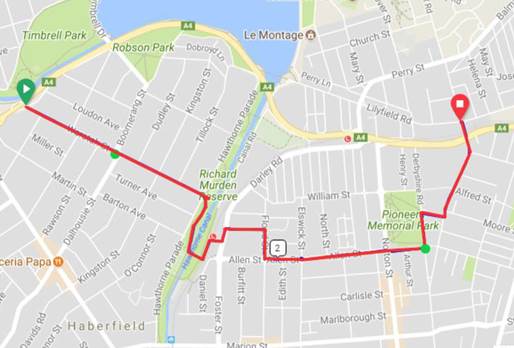
The majority of the route is currently a designated cycle route and consists of:
I. Mixed traffic environment with marked pavement logos (Waratah St, Allen St between Norton St & Derbyshire St, Derbyshire St, and Balmain Rd north of City West Link);
II. On road, uni-directional cycleway lanes (Flood St and Allan St between Flood St & Norton St); and
III. Shared paths for cyclists/pedestrians (Richard Murden Reserve, Darley Rd, Moore St, and Balmain Rd between Moore St and City West Link).
Sections not currently marked as bike route include Lyall Street.
Similarly for this route, there are some sections with longitudinal gradients approximating 5%. These include sections along Waratah St (Boomerang St to Hawthorne Pde); Lyall St, Flood St and part of Allan St.
This route intersects with light rail and at this crossing, cyclists have to dismount to cross the rail lines. The existing crossing point at Darley St may benefit from improvement to better accommodate the proposed route.
Comments made in Route 1 assessment for overlapping sections (Allan St to Lilyfield Rd) apply to Route 2 assessment.
c. Route 3: Waratah Street, Hawthorne Parade, Greenway, Darley Road, Lyall Street, Flood Street, Allen Street, Derbyshire Road, Moore Street and Catherine Street.
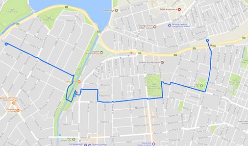
This Route is essentially the same as outlined for Route 2 with a proposed extension along Moore Street and Catherine Street rather than Balmain Rd. Discussions with Bike Groups have confirmed that this is the least preferred of the three options presented given there is already a well established cycle route treatment along Balmain Rd.
RMS funding of up to $300,000 has been allocated for the 2018/19 financial year to progress design review and development. This external funding enables Council to source the necessary additional resources externally to undertake the investigation and design work. It is intended that project management and review of the new design consultancy, management of public engagement activities and reporting will be undertaken with in-house resources. However detailed site investigations, survey and design services are proposed to be outsourced to make best use of the available funding and minimise impact on other project delivery. Existing in-house civil design resources are fully engaged on Council’s existing capital works program to achieve delivery within budget timeframes. With timeframes and resource allocation to complete planning, design, engagement and approvals for the proposed cycleway expected to cover some 12 months outsourcing of investigation and design phase is preferred so as not to impact on other capital projects. Specific expertise, not necessarily readily available inhouse, can also be brought to bear including urban/ landscape architecture, surveying, route lighting assessment and design, traffic signal modifications, quantity surveying, arborists and the like.
Should Council decide to undertake such planning and design work internally, the existing capital programs would be re-phased to free up the necessary in-house design resources.
FINANCIAL IMPLICATIONS
RMS funding of up to $300,000 has been allocated for the 2018/19 financial year to progress design review and development.
OTHER STAFF COMMENTS
Nil.
PUBLIC CONSULTATION
Discussions have been held with Bike Group representatives to confirm the supplementary route options to be included in the next stage of planning and design. Further public engagement will be undertaken as part of project development.
|
1.⇩ |
Feasibility Review – Supplementry Cycle Routes to Lilyfield Rd |
|
Council Meeting 12 February 2019 |
Subject: Planning Proposal - 67-75 Lords Road, Leichhardt
Prepared By: Daniel East - Acting Manager Planning Operations
Authorised By: David Birds - Group Manager Strategic Planning
|
SUMMARY This report contains an assessment of a Planning Proposal for 67-75 Lords Road, Leichhardt which seeks to amend the Leichhardt Local Environmental Plan 2013 (LLEP 2013) to rezone the site from IN2 Light Industrial to R3 Medium Density Residential, increase the floor space ratio from 1:1 to 2.4:1 and introduce a maximum building height control of RL35. The Planning Proposal seeks to facilitate a redevelopment of the site including approximately 23,158sqm of residential floor space, comprising 235 dwellings, and 3,000sqm of non-residential floor space across five (5) buildings ranging from three to nine storeys, positioned around 1,650sqm of centrally located open space.
The report recommends that Council should not support the Planning Proposal. Accordingly, it is recommended that Council should not refer the planning proposal to the NSW Department of Planning and Environment (DPE) for a Gateway Determination in accordance with section 3.33 of the Environmental Planning and Assessment Act 1979 (EP&A Act).
The Planning Proposal fails the Strategic Merit test of DPE’s “A Guide to Preparing Planning Proposals” and is inconsistent with key objectives, priorities and actions of State, District and Council plans and policies. The Planning Proposal is also inconsistent with all 6 criteria of the ‘Out of Sequence’ checklist of the Parramatta Road Corridor Urban Transformation Implementation Plan 2016-2023.
The site is located in the Taverners Hill Precinct of the Parramatta Road Corridor Urban Transformation Strategy (PRCUTS), but is not earmarked for redevelopment until 2023 (i.e. medium to long term). This Planning Proposal has been submitted at a critical time in strategic and infrastructure planning for the Inner West Council (IWC) area and the Parramatta Road Corridor. There are several relevant strategic planning projects currently underway at local and State level, most notably the Comprehensive Inner West Local Environmental Plan and Development Control Plan, Local Housing Strategy, Employment Lands Review and the Local Infrastructure Contributions Plan.
These broad-scale strategic planning projects are considered to be the best means for reviewing the planning controls for the subject site and other sites in the Parramatta Road Corridor (PRC) and local government area (LGA). |
|
RECOMMENDATION
THAT:
1. Council not support the Planning Proposal for 67-75 Lords Road, Leichhardt for the reasons outlined in the report including that:
a) It fails the Strategic Merit Test of "A guide to preparing planning proposals" pursuant to Section 3.33(2)(c) of the Environmental Planning and Assessment Act 1979;
b) The proposal does not have merit and fails all of the six (6) criteria when assessed against the Parramatta Road Implementation Plan 2016 - 2023 'Out of Sequence Checklist'. In particular, the proposal:
i. Fails to satisfy Criteria 1 in that it does not adequately demonstrate that it meets the strategic, land use and development objectives outlined in the PRCUTS Implementation Plan and does not provide significant delivery, contribution or benefits for the Strategy's Corridor wide and Precinct vision. It is inconsistent with the recommended built form recommendations and does not demonstrate that the new development will achieve design excellence. The Proposal is also out of alignment with the short term growth projections identified in the strategy and does not demonstrate any significant net community, economic and environmental benefits for the Precinct; ii. Fails to satisfy Criteria 2 in that the Integrated Infrastructure Delivery Plan (IIDP) is inadequate because it is based on a concept plan for 235 dwellings in 23,158sqm of residential floorspace which at average large residential flat building dwelling gross floor area sizes of 76.35sqm could produce 303 dwellings at the development application stage; iii. Fails to satisfy Criteria 3 in that the community engagement is inadequate, has not demonstrated that there is an appropriate level of support or agreement for the proposal and has not demonstrated adequate readiness in terms of the extent of planning or business case development for key infrastructure projects; iv. Fails to satisfy Criteria 4 in that there is no certainty that the proposal achieves or exceeds the sustainability targets identified in this Strategy; v. Fails to satisfy Criteria 5 in that the proposal does not sufficiently demonstrate development feasibility analysis to meet this criterion given the Economic Impact Assessment and the feasibility advice is flawed and contains numerous assumptions, disclaimers and conclusions which are not supported; and vi. Fails to satisfy Criteria 6 in that the proposal does not sufficiently demonstrate a land use and development scenario that aligns with and responds to market conditions for the delivery of housing and employment for 2016 to 2023.
c) The Parramatta Road Corridor Transformation Strategy new dwelling targets for the Taverners Hill Precinct can readily be met and surpassed without rezoning this site;
d) In the context of persistent demand and a low and decreasing supply of industrial land, a rezoning such as this would dilute Council’s ability to provide sufficient industrial land to accommodate demand. The planning proposal would also result in: i. inconsistency with the Leichhardt Industrial Lands Study 2014 (SGS, 2014), Leichhardt Employment and Economic Development Plan (EEDP) and the Leichhardt Industrial Precincts Planning Report (SGS, 2015); ii. a net loss of jobs in the local government area; iii. the loss of an economically viable employment precinct containing local services, light industrial and other non-industrial activities which contribute to the diversity of the economy, community activities and employment opportunities; iv. a lack of merit when assessed against the criteria established by the Leichhardt Employment and Economic Development Plan 2013-2023; and v. the lack of an appropriate Net Economic and Community Benefit Test as it does not address the wider issue of cumulative loss of employment lands in the local government area.
e) It is inconsistent with the infrastructure sequencing of the PRCUTS and the submitted Integrated Infrastructure Delivery Plan (IIDP) and the offer to enter into a Voluntary Planning Agreement (VPA) are unsatisfactory given the lack of adequate contributions;
f) It is inconsistent with numerous Ministerial Directions pursuant to Section 9.1 of the Environmental Planning and Assessment Act 1979 including Directions 1.1 - Business and Industrial Zones, 7.1 - Implementation of A Plan for Growing Sydney and 7.3 - Parramatta Road Corridor Urban Transformation Strategy;
g) It is inconsistent with the Inner West Council Community Strategic Plan: Our Inner West 2036 – Direction 2: Unique, liveable, networked neighbourhoods and Strategic Direction 3: Creative communities and a strong economy;
h) It is inconsistent with the following elements of the Parramatta Road Corridor Urban Transformation Strategy:
Ø Policy context and the Strategy's vision and key actions for the Corridor and Taverners Hill precinct including all seven (7) principles of the Strategy; Ø Implementation Tool Kit including the Implementation Plan 2016-2023, Planning and Design Guidelines (including the Corridor wide, built form and Taverners Hill Guidelines), Infrastructure Schedule and Urban Amenity Improvement Plan; and Ø Reference Reports including the Precinct Transport Report, Economic Analysis, Fine Grain Study and Sustainability Implementation Plan.
i) It is premature in the light of the prospective outcomes of strategic planning studies and projects underway at State and Local Government levels, particularly having regard to the lack of the Precinct-wide traffic study and supporting modelling which is required under the PRCUTS to be completed to consider the recommended land uses and densities, as well as future WestConnex conditions, and identify the necessary road improvements and upgrades required as part of any proposed renewal in the Precinct;
j) It does not make an adequate contribution towards the provision of affordable housing as it is inconsistent with Council's Affordable Housing Policy 2016 which seeks a 15% contribution of gross floor area of the development as affordable housing and dedicated to Council in perpetuity;
k) It exceeds the Parramatta Road Corridor Urban Transformation Strategy recommended density by 500m² without satisfactorily demonstrating that the proposal would achieve better built form outcomes or design excellence;
l) It fails to adequately assess the following matters given the insufficient or unsatisfactory supporting studies:
i. Flooding in that the proposal is currently located within the southwest corner of the site where the flood depth is greatest and other unresolved design issues associated with the flood hazard on the site; ii. Heritage in that the Heritage Impact Statement does not adequately consider the potential heritage value of the existing buildings or whether there will be any adverse impacts on the heritage value of the nearby heritage items including the item at Lambert Park and Kegworth Public School; iii. Land contamination and State Environmental Planning Policy No 55 – Remediation of Land requirements in that the submitted Remedial Action Plan does not locate the known contamination on the site and relies on outdated sampling information; iv. Traffic impacts given an inadequate Traffic Report and supporting information is provided, particularly having regard to the likely impacts on Davies Lane of increased traffic generation; v. Public domain works and connections given the lack of an adequate outline of the proposed works and satisfactory arrangements being made with the relevant stakeholders for connections and linkages within and outside the site; vi. Economic analysis of the loss of employment land given the Economic Impact Analysis did not adequately justify this loss as it relied on the Regional and District Plans excluding the PRCUTS area from the overwhelming evidence contained in the relevant economic and industrial land literature on the loss of employment land; and vii. Sustainability targets and measures given the Sustainability Report was a generic and theoretical analysis of potential measures and failed to demonstrate that the proposal complies with the sustainability targets of the PRCUTS. m) It fails to adequately demonstrate consistency with a number of design quality principles of State Environmental Planning Policy No 65 – Design Quality of Residential Apartment Development and subsequently results in a number of urban design concerns with subsequent adverse impacts on both internal amenity and the amenity of adjoining properties including:
i. Adverse impact in terms of context having regard to the proposal being out of character within the surrounding low density residential area and therefore inconsistent with Design Quality Principle 1; ii. Setback and separation, height and articulation of the built form concerns resulting in the proposal being inconsistent with the bulk form and scale requirements of Design Quality Principle 2; iii. The proposed FSR exceeds the PRCUTS controls and the scale of residential floor space proposed on this site is not required to meet the PRCUTS projections, thereby being inconsistent with Design Quality Principle 3; iv. The proposed height of the nine storey development (35m AHD or 32m) exceeds the PRCUTS recommended maximum height of 30m; v. The proposal does not satisfy the sustainability requirements of the PRCUTS and is inconsistent with Design Quality Principle 4; vi. Potential impacts on the amenity of the area and the site which is inconsistent with Design Quality Principle 6 including:- - visual impact from the bulk and scale of buildings, - overlooking of Davies Street properties, - inadequate location and quantity of common and public open space which lacks a sufficient interface with the public domain to be considered public space and overshadowing of open space. 2. Should the Proponent request a Rezoning Review by the NSW Department of Planning and Environment, delegation is given to the Group Manager Strategic Planning to lodge a submission to the review process in accordance with this report and Council's related resolution. |
1.0 BACKGROUND
A pre-planning proposal application for 67-75 Lords Road, Leichhardt was submitted on 9 August 2018 by Platino Properties. It outlined the following amendments to Leichhardt Local Environmental Plan 2013 (LLEP 2013):
· Rezone the site from IN2 Light Industrial to R3 Medium Density Residential
· Modify the FSR for the site from 1:1 to 2.4:1
· Introduce a maximum height of buildings of 30m
· Introduce a site-specific provision:
- allowing a range of additional non-residential uses including recreation facility (indoor), office premises, business premises, light industry, industrial retail outlet, and restaurant or café;
- requiring a minimum of 3,000sqm of non-residential uses to be provided on the site; and
- enabling a multi-use facility associated with Lambert Park to be provided as an FSR bonus.
Council’s response of 17 October 2018 identified a number of issues with the proposal, including:
- loss of industrial land;
- workability of a mixed use development;
- prematurity of a planning proposal for the site and the requirements of the Out of Sequence Checklist, contained within the PRCUTS Implementation Plan 2016-2023, not being satisfied;
- inadequate justification for the planning controls sought;
- inconsistency with the Inner West Affordable Housing Policy; and
- lack of contribution to open space and public domain.
Council received the subject Planning Proposal on 25 October 2018. A site-specific Development Control Plan (DCP) accompanied the Planning Proposal. The site is located in the Taverners Hill Precinct of the Parramatta Road Corridor Urban Transformation Strategy (PRCUTS), released in November 2016. PRCUTS is the NSW Government’s 30-year plan to drive and inform land use planning and development decisions as well as long-term infrastructure delivery programs in the Parramatta Road Corridor. In accordance with the PRCUTS Implementation Plan 2016 - 2023, the site is not earmarked for redevelopment until after 2023 (i.e. in the medium to long term). The key targets in the Strategy for the Taverners Hill Precinct are:
· 3,300 new people for 2050
· 1,300 new homes for 2050
· 4,100 new jobs for 2050.
2.0 OVERVIEW OF PROPOSAL
The Planning Proposal submitted to Council by Platino Properties Pty Ltd seeks to amend Leichardt Local Environmental Plan 2013 (LLEP 2013) to facilitate the redevelopment of 67-75 Lords Road, Leichhardt. The Planning Proposal is accompanied by a proposed amendment to Leichhardt Development Control Plan 2013 (LDCP 2013) to include site specific controls for the property.
The key components of the Planning Proposal are:
· Rezoning the site from Light Industrial (IN2) to Medium Density Residential (R3);
· Amending the maximum Floor Space Ratio (FSR) for the site from 1:1 to 2.4:1;
· Introduction of a new maximum height control for the site of RL 35m;
· Introduction of a site-specific provisions to allow the following:
- A range of additional non-residential uses including recreation facility (indoor), office premises, business premises, light industry, industrial retail outlet, and restaurant or café;
- Requiring a minimum of 3,000sqm of non-residential uses to be provided on the site;
- Allowing the FSR to exceed 2.4:1 but only if the increase is provided as a public benefit in the form of a multi-use facility to be used in conjunction with Lambert Park; and
- Requiring a site-specific DCP to be endorsed by the Planning Proposal authority prior to any development approval.
The future redevelopment of the site seeks to provide approximately 23,158sqm of residential floor space comprising 235 dwellings across five (5) buildings located around the perimeter of the site ranging from three to nine storeys. The composition of apartments is proposed to include:
· 15-30% studio apartment,
· 25-45% one bedroom,
· 25-45% two bedrooms and
· 7-15% three or four bedroom apartments.
A central publicly accessible area of open space of approximately 1,650sqm and at least 3,000sqm of non-residential floor space to support a range of employment generating and community uses are also proposed. Affordable housing, in the form of 35 apartments, is also proposed. The proposal also includes an offer to enter into a Voluntary Planning Agreement (VPA) to provide:
· Public benefit items including a 500sqm multi-purpose space to be transferred to Council and to be directly accessible from Lambert Park (FSR is not to be included in the overall FSR for the site) and upgrade to the lighting in Lambert Park.
· Local infrastructure items including public art (near tunnel entrance under the adjoining railway reserve), publicly accessible open space (central open space on the site – 1,650sqm), shareway and through site links, railway land regeneration, streetscape planting along Kegworth Street and Lords Road and public domain upgrades, roadworks and landscaping.
· Affordable housing comprising 35 apartments (approximately 14.9%) to be owned and managed by Bridge Housing for a minimum of 10 years in a separate stratum.
3.0 SITE AND SURROUNDING CONTEXT
The site is located on the northern side of Lords Road, with public open space, public roads or railway land adjoining the site on all boundaries. The site is approximately 400 metres from Parramatta Road and 7km from the Sydney CBD. The location of the site is illustrated in Figure 1.
The site comprises two (2) allotments and is legally described as Lot 1 in DP 940543 and Lot 1 in DP 550608. The site is known as 67-75 Lords Road, Leichhardt and is a relatively regular shaped lot. It has a 77 metre frontage to Lords Road along the southern boundary and 76 metre northern boundary to Lambert Park. The eastern and western side boundaries comprise 111.3 metres and 133.24 metres respectively with a total site area of 10,691sqm (Figures 2 and 3).
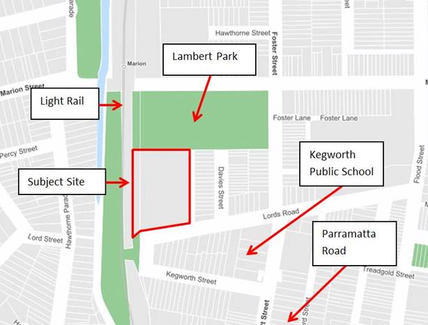
Figure 1: Location of the site with red outline
![]()

![]()
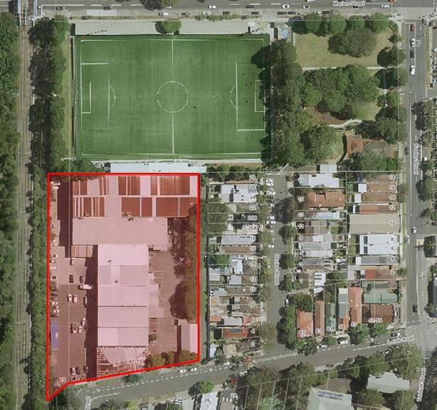
Figure 2: Subject site shaded red
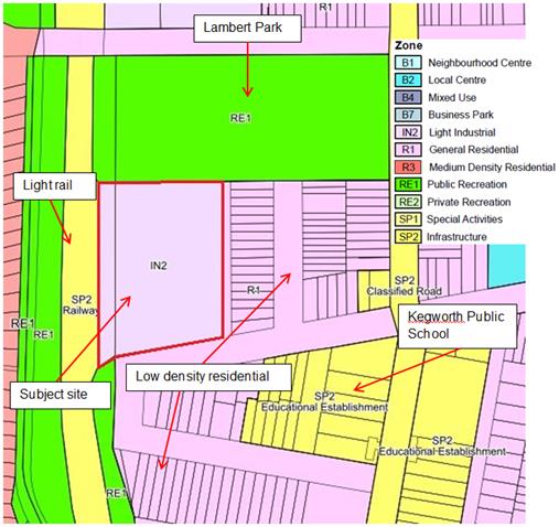
Figure 3 - Extract from the zoning map of Leichhardt LEP 2013
The site currently accommodates a range of light industrial and commercial uses including warehousing/storage, small scale manufacturing uses including furniture and joinery businesses as well as a private art school. As outlined in the social impacts of the Planning Proposal, the majority of these businesses are having difficulty finding alternative premises given the scarcity of industrial land within the IWC area, particularly as they are businesses which need to be proximate to their customers.
The existing buildings on the site comprise three (3) buildings directly adjoining each other, comprising two (2) storeys and of brick and metal construction and a detached single storey brick and metal roof building in the front eastern corner of the site. The maximum height of the existing buildings on the site is approximately 11.5 metres.
Various attached metal awnings also exist on the site as well as bitumen car parking areas on the eastern and western sides of the buildings. Vehicle access is currently obtained from two separate driveways from Lords Road. The site currently contains approximately 9,979sqm of floor space, consisting of 17 tenancies. The existing development on the site is illustrated in Figures 4 and 5.
Figure 4: Subject Site - lower, western side of existing industrial/commercial complex
Figure 5: Subject site - Eastern higher side of existing industrial/commercial development
Directly adjoining the site to the north is Lambert Park, which is predominantly occupied by a soccer field used by the APIA Club, with the eastern end comprising a playground and Leichhardt Family Day Care (located in a former cottage).
The light rail corridor forms the western boundary with a steep vegetated embankment occurring along this boundary. The Hawthorne Canal is located beyond the light rail corridor which also contains a pedestrian and cyclist link to the nearby Marion Light Rail Stop, approximately 150 metres to the north beyond Lambert Park. This area also forms part of the GreenWay, a 5.8km environmental and active travel corridor linking the Cooks River at Earlwood with the Parramatta River at Iron Cove, largely following the route of the Inner West Light Rail and Hawthorne Canal.
The eastern boundary adjoins Davies Lane, a narrow laneway primarily used for access to the low density detached dwellings facing Davies Street. The area to the south beyond Lords Road comprises low density residential development as well as another light industrial use and Kegworth Primary School to the south-east. The adjoining development is illustrated below in Figures 6 to 11.
Figure 6: Adjoining to the north-east - Lambert Park playground
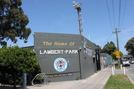
Figure 7: Adjoining to the north-west - Lambert Park Soccer Field
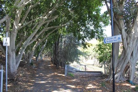
Figure 8: Adjoining to the west - GreenWay and Hawthorne Canal (looking south)
Figure 9: Marion Light Rail Stop to the north
Figure 10: Davies Lane - eastern boundary of the site to the left and rear of Davies Road properties to the right
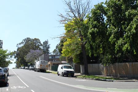
Figure 11: Adjoining development to the south across Lords Road
The site falls approximately three (3) metres from the eastern boundary to the western boundary towards Hawthorne Canal. The eastern part of the site has significantly higher existing ground levels varying from RL 5m AHD to RL 8.5m with the majority of this area above RL 6.75m AHD.
The nearest water body is Hawthorne Canal, located approximately 70 metres to the west of the site, with surface water from the site flowing to the canal. The site is affected by the 1 in 100 year flood event along the western boundary, while the majority of the remainder of the site is affected by the Probable Maximum Flood (PMF). Only the south-east corner of the site is not affected by any flood hazard. The site has a Flood Planning Level (FPL) of RL 4.6m AHD.
The site is located in close proximity to a range of services including retail at Leichhardt Marketplace, 150 metres to the east, as well as other shops along Marion and Norton Streets. Kegworth Public School is located on the opposite side of Lords Road, while nearby public transport services include the light rail stops of Marion and Taverners Hill (400m) and heavy rail at Summer Hill and Lewisham approximately 800 metres to the south west of the site.
The site is zoned IN2 Light Industrial under LLEP 2013 which states the following objectives for the zone:
· To provide a wide range of light industrial, warehouse and related land uses.
· To encourage employment opportunities and to support the viability of centres.
· To minimise any adverse effect of industry on other land uses.
· To enable other land uses that provide facilities or services to meet the day to day needs of workers in the area.
· To support and protect industrial land for industrial uses.
· To retain existing employment uses and foster a range of new industrial uses to meet the needs of the community.
· To ensure the provision of appropriate infrastructure that supports Leichhardt’s employment opportunities.
· To retain and encourage waterfront industrial and maritime activities.
· To provide for certain business and office premises and light industries in the arts, technology, production and design sectors.
The site currently has a maximum permissible FSR of 1:1 and no height control under LLEP 2013. The public reserve to the north of the site is zoned RE1 Public Recreation.
The site does not contain heritage items and is not within a heritage conservation area but is located adjacent to a heritage item, Lambert Park, and in close proximity to Kegworth Pubic School which is also listed as a local heritage item.
This site represents approximately 7% of the former Leichhardt LGA’s industrial land supply and is one of only eleven (11) industrial precincts within the former LGA. Therefore, it is a highly strategic site in terms of the provision of industrial land in the Inner West.
The site is located in the West Leichhardt precinct of LDCP 2013.
4.0 STRATEGIC CONTEXT
The site is located in the Taverners Hill Precinct of the Parramatta Road Corridor Urban Transformation Strategy (PRCUTS), a State Government endorsed strategy for the revitalisation of the Parramatta Road Corridor, given statutory force via a Section 9.1 Ministerial Direction (formerly s117) in November 2016. It is important to note that this Ministerial Direction is one of several which have direct relevance to the Planning Proposal.
PRCUTS is a plan to drive and inform land use planning and development decisions as well as long term infrastructure delivery programs in the Parramatta Road Corridor. The Strategy is supported by an Implementation Tool Kit and comprises the following documents:
· Parramatta Road Urban Transformation Strategy; and
· Implementation Tool Kit comprising the following:
Ø Implementation Plan 2016 – 2023
Ø Planning and Design Guidelines
Ø Infrastructure Schedule
Ø Urban Amenity Improvement Plan.
Delivery of the Strategy relies on the implementation of the principles in PRCUTS and will occur over 30 years in the following indicative timeframes:
· Short term – 2016 - 2023
· Medium term – 2023 - 2036
· Long term – 2036 - 2050
The site is outside the '2016 - 2023 Release Area' for the Taverners Hill Precinct which means that the redevelopment of the site should ideally be in the medium to long term between 2024 and 2054. The Strategy is to be implemented through:
· State Environmental Planning Policies for priority precincts (in the corridor to the west of the IWC local government area);
· Planning proposals prepared by landowners or developers;
· Comprehensive LEP reviews undertaken by councils.
The key targets in the Strategy for the Taverners Hill Precinct are:
· 3,300 new people for 2050
· 1,300 new homes for 2050
· 4,100 new jobs for 2050.
Figure 12 illustrates the broad PRCUTS land use policy directions for the Taverners Hill Precinct.
![]()
![]()
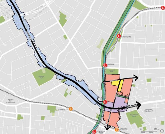
Figure 12: Structure Plan for the redevelopment of the Taverners Hill Precinct
PRCUTS sets out key actions associated with land uses; transport and movement; place-making; and open space, linkages and connections; and makes recommendations for future zoning, height and density controls to ensure a place-based approach for future development of the Corridor. Key actions related to the subject site and the Taverners Hill Precinct is considered in more detail later in this report.
The PRCUTS Implementation Plan 2016 - 2023 provides a methodological and sequential approach for growth and the alignment of infrastructure provision with that growth. As noted earlier, the subject site is outside the '2016 - 2023 Release Area' for the Taverners Hill Precinct which means that the redevelopment of the site should ideally be in the medium to long term between 2024 and 2054 and should not occur in the short term, up to 2023. This is illustrated in Figure 13 below.


Figure 13: Extract from the PRCUTS Implementation Plan - Taverners Hill Precinct
Proposals that depart from this staging plan need to be assessed on their merit against the PRCUTS 'Out of Sequence Checklist' criteria to ensure that changes to the land use zones and development controls are timely and can be justified against the Principles and Strategic Actions of the Strategy. Council’s assessment of the Planning Proposal against the Out of Sequence Checklist is included as Attachment 2.
The important aspects of the PRCUTS to note are that it is a Strategy that provides the long-term vision and framework to support co-ordinated employment and housing growth in the Corridor in response to significant transport and infrastructure investment, economic and demographic shifts, and industrial and technological advances.
The relationship between growth in population, housing, jobs and employment land is very closely associated with the provision of infrastructure. The importance of the timing of such growth is also highlighted via the Implementation Plan. This plan includes Action Plans for each Precinct which sets out when the growth is needed. This is so such growth can be tied to the infrastructure requirements.
The other key message is that the Strategy makes recommendations on future zoning and development controls, however, essentially leaves the implementation to local Council’s when assessing planning proposals or undertaking amendments to local environmental plans (page 7 of the Implementation Plan). For these reasons, it is important to note that the PRCUTS and the associated Section 9.1 Ministerial Direction which gives the Strategy statutory force, is one consideration in this assessment along with the infrastructure readiness for such growth and whether such growth is needed in the short, medium or long terms.
It is also noted that there have been numerous studies and reports prepared by the former Leichhardt Council in relation to the supply of industrial land in the LGA. These reports and strategies are considered in light of the PP. The overwhelming evidence from these studies and strategies is that industrial lands are scarce and they are disappearing which directly contradicts the Eastern City District Plan which seeks to cast aside this evidence to support the rezoning of large areas of employment land to residential, as recommended by the PRCUTS.
PRCUTS recommendations and requirements as well as other strategic documents and plans have been taken into consideration in the assessment of this Planning Proposal as outlined in this report.
5.0 PREVIOUS PLANNING PROPOSAL
In May 2014, a Planning Proposal was submitted to Council which sought to rezone the site from IN2 Light Industrial to R3 Medium Density Residential and increase the maximum FSR from 1:1 to 2.4:1 to facilitate the redevelopment of the site. The Planning Proposal included the following:
· Four (4) residential blocks ranging from four (4) to eight (8) storeys containing approximately 315 units;
· A one-way shareway through the site, entering off Lords Road and exiting onto Davies Lane;
· A separate basement parking entrance and exit off Lords Road;
· Communal open space as a central feature of the site;
· Child care centre and café located within the southernmost building;
· VPA for the provision of 5% of total dwellings as affordable housing, public domain elements including streetscape enhancements and cycle paths etc and a pedestrian path benefitting Council.
Council officers met with the proponents on a number of occasions between 2012 and the lodgement of the Planning Proposal in 2014.
It is noted that the previous Planning Proposal was for 67-73 Lords Road while the current proposal relates to 67-75 Lords Road.
A report to the former Leichhardt Council of 26 August 2014 recommended not to support the Planning Proposal due to a range of issues, including:
· Loss of employment lands and the cumulative impact of the loss of employment lands;
· The inadequacy of the supporting specialist reports (including the Economic Justification Report and the Social Impact Assessment);
· The strategic fit of the proposal as assessed against the aims and objectives of various planning instruments, strategies and plans including the LLEP 2013, LDCP 2013 and the relevant Regional Strategies;
· Unsatisfactory design of the proposal including built form, height and bulk particularly from Lords Road and Davies Lane, potential amenity impacts including overshadowing and overlooking of adjacent properties, inadequate open space (size, location and overshadowing), traffic and parking impacts and inconsistencies with SEPP 65 and the then Residential Flat Design Code;
· Prematurity of the proposed rezoning given the uncertainty of the status of surrounding industrial lands within the LGA as a result of NSW Government announcements in relation to WestConnex Motorway and Urban Revitalisation Projects and the NSW Government Bays Precinct Urban Renewal Program.
In September 2014, a pre-Gateway review request was lodged with the DPE. The relevant planning authority was the Sydney Eastern City Planning Panel following the then Leichhardt Council refusing this role.
Following review by the then Joint Reginal Planning Panel (JRPP), the DPE, as delegate for the Greater Sydney Commission, issued a gateway decision that the proposal should proceed subject to conditions in July 2016. These conditions included that the Planning Proposal was to be updated prior to public exhibition to address the following:
· Social impact of the proposal (capacity of existing, and future need for affordable housing, education, health and emergency services);
· Demonstrate consistency with s.117 Direction 4.1 Acid Sulfate Soils and Direction 4.3 Flood Prone Land,
· Include current and proposed Land Zoning and Floor Space Ratio maps; and
· Include satisfactory arrangements for contributions to designated State public infrastructure identified as part of a draft or final strategic planning review for the Parramatta Road corridor.
A further condition was that prior to finalisation, the planning proposal was to be amended to demonstrate consistency with any available findings of a draft or final strategic planning review for the Parramatta Road corridor.
On 31 August 2017, the Sydney Central Planning Panel determined that the proposed instrument in the Planning Proposal should not be made. The decision was not unanimous with the chair using her casting vote, to vote against the proposal. The compelling reason for not supporting the proposal was the loss of employment land (which was considered contrary to Ministerial Direction 1.1) and that the proposal was out of sequence with the Implementation Plan of the Parramatta Road Corridor Urban Transformation Strategy (PRCUTS). The other panel members wanted to defer the matter to allow the Proponent to lodge an Out of Sequence Checklist.
On 16 March 2018, the DPE, as delegate for the Greater Sydney Commission, and consistent with the former Sydney Central Planning Panel’s determination, decided not to make the plan. In this determination, the DPE stated that the Planning Proposal did not demonstrate the protection of employment land and did not meet the requirements of the PRCUTS.
6.0 THE PLANNING PROPOSAL
The subject Planning Proposal seeks to amend the provisions of LLEP 2013 for land use, FSR and height of building as they apply to the site. It proposes to rezone the site to R3 Medium Density Residential, increase the FSR to 2.4:1, introduce a maximum height control of RL 35 and allow a range of non-residential uses. The application is supported by information as follows:
· Urban Design Study by Hollenstein Pullinger for five (5) mixed use buildings of between two (2), three (3), five (5), six (6), seven (7) and nine (9) storeys and two levels of basement;
· Landscape Plan by Umbaco
· Site-specific LDCP 2013 amendment by FPD;
· Letter of offer for VPA;
· Economic Impact Assessment by AEC;
· Traffic Study by TTPP;
· Acoustic Assessment by Acoustic Logic;
· Flooding and Stormwater Management Report by Tooker & Associates;
· Contamination Report by Benviron Group;
· Social Impact Assessment by Cred Consulting;
· Affordable Housing Report by Housing Action Network;
· Sustainability Report by Northrop;
· Consultation Report by Chikarovski & Associates;
· Advice from Transport for NSW;
· Benefits of Urban Consolidation by Hill PDA;
· Draft LEP maps;
· Commercial 3 Zone Practice Note (Victorian Government);
· Utility Capacity advice by various agencies;
· Light Spill by Eco light;
· Heritage Impact Assessment by Architelle;
· Integrated Infrastructure Delivery Plan by Northrop;
· Survey;
· Feasibility advice by Cushman and Wakefield;
· PRCUTS Out of Sequence Checklist (within the PP document).
The application primarily relies on the land use and development controls recommended in the PRCUTS including zoning and height recommendations to justify the Planning Proposal. The Proposal heavily relies on the recommended height control (30m) in PRCUTS to justify the increased FSR of 2.4:1. The proposal would result in five (5) mixed use buildings of varying heights from two (2) to nine (9) storeys comprising 235 apartments and two levels of basement car parking (shown as indicative only). The following table (Table 1) provides a comparative analysis of the site’s current controls, PRCUTS recommended controls and the proponent's proposed controls:
Table 1: Comparison of existing, PRCUTS and proposed planning controls for the site
|
Criteria |
Current LEP controls |
PRCUTS recommendations |
Proposed Controls |
|
Zoning |
IN2 Light Industrial |
R3 Medium Density Residential |
R3 Medium Density Residential with a proposed site-specific provision to allow non-residential uses |
|
FSR |
1:1 |
2.4:1 |
2.4:1 (plus 500sqm for community uses) |
|
Height |
No control |
30m (or 7-8 storeys) |
RL 35m (or 9 storeys) |
The Planning Proposal seeks to introduce a site-specific provision allowing a number of non-residential uses including recreation facility (indoor), office premises, business premises, light industry, industrial retail outlet, and restaurant or café; and requiring a minimum of 3,000sqm of non-residential floor space on site.
7.0 ASSESSMENT OF THE PLANNING PROPOSAL
The Proponent’s Planning Proposal and supporting documentation have been assessed with regard to current planning strategies and controls at State and local level, strategic planning projects currently underway and the Department of Planning and Environment’s ‘A Guide to Preparing Planning Proposals’.
Overall, it is considered that adequate documentation has been provided for Council to determine whether the Planning Proposal has merit to proceed to the Gateway Stage. However there are key issues, discussed further in this report, which indicate that the Planning Proposal should not be supported in its current form. The tabulated analysis below assesses the adequacy of the supporting information supplied with the Planning Proposal and whether it meets the aims and objectives of the strategic framework in DPE’s ‘Guide to Preparing Planning Proposals’. A detailed assessment of the Planning Proposal is also provided in the Planning Proposal Assessment Checklist attached to this report (Attachment 1).
Part 1 Objectives and intended outcomes
|
|
Guideline Requirements |
|
2.1 |
Requires a concise statement setting out the objective or intended outcomes of the planning proposal. |
|
|
The proponent's stated objectives or intended outcomes are unsatisfactory because:
· 'A Guide to Preparing Planning Proposals' requires a concise statement setting out the objectives or intended outcomes of the planning proposal. The proponent's statement is not specific enough to accurately reflect the desired outcome of the proposal as required by the Guidelines.
· There are concerns with the following objectives: - To facilitate redevelopment of an under-utilised site in close proximity to a range of services, open space and public transport options. - Remove heavy vehicles associated with existing industrial uses from the predominantly residential area.
These objectives tend to indicate that the site is under-utilised and that the future uses of the site will not include any form of industrial development given the supposed removal of heavy vehicles. Firstly, the under-utilised status of the site is highly questionable. The site is better described as a fully tenanted light industrial precinct accommodating 160 jobs and at least 17 tenants which appear to be operating viable businesses. The removal of heavy vehicles tends to indicate that the proposed non-residential uses are likely to be much more commercial than industrial, which defeats the purpose of having such non-residential floor space on the site.
· The objective regarding the provision of 235 apartments comprising 23,158m² is also highly questionable and not supported. Such an apartment yield would result in the average unit size being 98.5m², which is unlikely when the proposal is said to mainly comprise 1 and 2 bedroom units and studio apartments. Only 7-15% of the units are likely to be 3 bedrooms (page 17 of the Planning Proposal Document). The average gross floor area of units in recent Leichhardt residential flat building is 73.6sqm.
· In terms of overall strategic merit, the site is located in the PRCUTS area which has a recommendation for rezoning from industrial to medium density residential. However, the Planning Proposal is inconsistent with a number of other key recommendations of PRCUTS as detailed later in this report and consequently, should not be supported.
· The Planning Proposal suggests it would provide affordable housing via a Voluntary Planning Agreement. The Proponent's objective is misleading as affordable housing that might be provided at the rezoning stage is inconsistent with Council’s Affordable Housing Policy.
· The Proposal also seeks to provide open space within the site as well as connections to Marion light rail stop and other nearby places. The Proponent's objective is considered acceptable; but no clear provision has been made in the Proposal to make this useable public open space (considered in detail later in this report). |
Part 2 Explanation of Provisions
|
|
Guideline Requirements |
|
2.2 |
Requires a more detailed statement of how the objectives or intended outcomes are to be achieved. |
|
|
The proponent has addressed this requirement but the Planning Proposal is not supported for the reasons expressed above and in other sections of this report. |
Part 3 Justification
|
|
Guideline Requirements |
|||||||||||||||||||||||||||||||||
|
2.3 |
Requires adequate justification documentation to be provided for the specific land use and development standards proposed to the LEP. |
|||||||||||||||||||||||||||||||||
|
2.3.1 |
Questions to consider when demonstrating the justification |
|||||||||||||||||||||||||||||||||
|
Section A - Need for Planning Proposal |
||||||||||||||||||||||||||||||||||
|
Q1 |
Is the planning proposal part of any strategic study or report? |
|||||||||||||||||||||||||||||||||
|
|
The subject site forms part of the PRCUTS which recommends future planning controls for the site. However, as detailed later in this report and within the attached checklists (Attachments 1 and 2), the Proposal is inconsistent with the requirements of PRCUTS, including the Implementation Plan 2016 - 2023 Out of Sequence checklist and Planning and Design Guidelines, and should not be supported. |
|||||||||||||||||||||||||||||||||
|
Q2 |
Is the planning proposal the best means of achieving the objectives or intended outcomes, or is there a better way? |
|||||||||||||||||||||||||||||||||
|
|
The PRCUTS includes the Parramatta Road Corridor Implementation Toolkit which recommends that one of the pathways to implement the recommended land uses and development controls identified within the Strategy is the LEP Gateway (Planning Proposal) process.
However, this Planning Proposal departs from the staging identified under the Implementation Plan 2016 - 2023 and comes in advance of studies and strategies underway at the local and State government level to inform future development controls for the PRCUTS corridor and the new Inner West Council local government area.
The future of the Proposal site should be considered as part of the broader strategic planning framework rather than an ad hoc Planning Proposal. This would ensure a systematic approach to determining the future development of the site and the surrounding area. It would be best, therefore, to defer any amendment of the planning framework for the site until the Local Housing Strategy and the Employment Lands Review and the precinct Wide Traffic study required by PRCUTS have been completed.
It should be noted, in particular, that rezoning this site to residential is entirely unnecessary to meet the new dwelling objectives PRCUTS has for the Taverners Hill Precinct. These are 451 dwellings by 2023 and an additional 849-899 dwellings by 2050; 410 have already been built and occupied on the Kolotex/Labelcraft site at 22-40 George Street, Leichhardt. At an average dwelling size of 76.35sqm and using the PRCUTS 1350 dwelling target, the Precinct only needs to provide another approximately 71,730sqm of residential gross floor area.
The average dwelling size of 76.35sqm is derived from the total number of dwellings and residential gross floor area of the four largest recent residential flat building consents in the Leichhardt Local Government Area at Terry Street, Rozelle, George Street and Allen Street, Leichhardt. The method of calculation used is simply to divide the total number of dwellings with the residential floor space and includes common areas.
The total projected additional residential gross floor area, including the Kolotex/Labelcraft site, that could be provided under the possible rezonings, floor space ratio and building height increases suggested by PRCUTS is 217,000sqm. Kolotex/Labelcraft has delivered 31,506sqm and 410 dwellings. This leaves the possibility of up to another 185,494sqm of additional residential floor area. It has already been established that only 71,730 sqm of this 185,494sqm is required to meet the PRCUTS dwelling target.
This also means that only 71,730sqm of additional residential floor area is required to demonstrate compliance with the Section 9.1 Direction for PRCUTS.
The clear consequence of this conclusion is that the rezoning of the Lords Road industrial and urban services site is not required to meet the objectives of PRCUTS. Indeed if the proposed 23,158sqm of residential floorspace at Lords Road was to be deducted from the post Kolotex/Labelcraft residual PRCUTS additional 185,494sqm there would still be the potential to provide an additional 162,336sqm of residential floor space. This figure means another 93,336sqm is potentially still available by 2050 over the 69,000sqm required to meet the PRCUTS total precinct dwelling target.
So even without the rezoning of Lords Road the remainder of the PRCUTS proposed planning controls can meet the PRCUTS dwelling targets and hypothetically provide an additional approximately 1220 dwellings in the Precinct, over and above the 1350 target.
Table 2: Analysis of whether Lords Road site is required to meet PRCUTS proposed dwelling projections and residential GFA
PRCUTS proposed dwelling projections and Council's estimated dwellings
PRCUTS proposed indicative land use mix and Council's estimates for Taverners Hill Precinct and Frame Area
* Note: This equates to an average dwelling size of 377.9sqm which is unrealistic for an inner city apartment.
** Note: these have been calculated on the basis of average dwelling size approved in recent large residential flat buildings in Leichhardt LGA which equates to 76.3sqm.
In addition, the Planning Proposal acknowledges that it does not fully comply with the PRCUTS, particularly in relation to the proposed land uses given the Strategy recommended purely residential development on the site. It is also noted that there is a disparity between the recommended controls as shown in the mapping and the text in the PRCUTS in that a maximum FSR of 2.4:1 and a maximum height of 30 metres is recommended yet the text refers to ‘appropriately scaled residential uses’ and ‘town houses and terrace type dwellings’ in this location.
Accordingly, it is considered that the Planning Proposal is not the best means of achieving the objectives or intended outcomes given the significant concerns in relation to housing yield, loss of industrial land and jobs and the inconsistencies with the Out of Sequence Checklist of the PRCUTS as outlined in this report.
|
|||||||||||||||||||||||||||||||||
|
Section B - Relationship to strategic planning framework |
||||||||||||||||||||||||||||||||||
|
Q3a |
Does the proposal have strategic merit? Is it: |
|||||||||||||||||||||||||||||||||
|
i. |
Consistent with the relevant regional plan outside of the Greater Sydney Region, the relevant district plan within the Greater Sydney Region, or corridor/precinct plans applying to the site, including any draft regional, district or corridor/precinct plans released for public comment. |
|||||||||||||||||||||||||||||||||
|
|
The following regional/district/corridor plans apply to the site:
· Greater Sydney Region Plan 2018 (GSRP) - A Metropolis of Three Cities · Eastern City District Plan (ECDP) 2018 · Parramatta Road Corridor Urban Transformation Strategy (2016)
The Planning Proposal is consistent with some of the objectives and actions of the GSRP and ECDP, but fails to achieve sufficient consistency with the following key objectives of GSRP and priorities of ECDP. A detailed analysis of the Proposal against these directions, objectives and priorities is provided in Attachment 1.
Direction 1: A city supported by infrastructure
· Objective 2: Infrastructure aligns with forecast growth - growth infrastructure compact. · Strategy 2.1 - Align forecast growth with Infrastructure. · Strategy 2.2 - Sequence infrastructure provision across Greater Sydney using a place-based approach.
· Planning Priority E1: Planning for a city supported by infrastructure. · Action 3 - Align forecast growth with infrastructure. · Action 4 - Sequence infrastructure provisions using a place-based approach
Direction 3: A city for people
· Objective 6: Services and infrastructure meets communities' changing needs. · Strategy 6.1 - Deliver social infrastructure that reflects the needs of the community now and in the future. · Strategy 6.2 - Optimise the use of available public land for social infrastructure.
· Objective 9: Greater Sydney celebrates the arts and supports creative industries and innovation. · Strategy 9.1 - Facilitate opportunities for creative and artistic expression and participation, wherever feasible with a minimum regulatory burden, including: - arts enterprises and facilities and creative industries - interim and temporary uses - appropriate development of the night-time economy.
· Planning Priority E3: Providing services and social infrastructure to meet people's changing needs. · Action 8 - Deliver social infrastructure that reflects the needs of the community now and in the future. Councils, other planning authorities and State agencies · Action 9 - Optimise the use of available public land for social infrastructure.
· Planning Priority E4: Fostering healthy, creativity, culturally rich and socially connected communities. · Action 14 - Facilitate opportunities for creative and artistic expression and participation, wherever feasible with a minimum regulatory burden, including: a. arts enterprises and facilities, and creative industries b. interim and temporary uses c. appropriate development of the night-time economy.
Direction 4: Housing the city
· Objective 10: Greater housing supply. · Action 3: Prepare housing strategies. · Action 4: Develop 6-10 year housing targets.
· Planning Priority E5: Providing housing supply, choice and affordability with access to jobs and services. · Action 16 - Prepare local or district housing strategies. Action 17 - Prepare Affordable Rental Housing Target Schemes following development of implementation arrangements.
Direction 5: A city of great places
· Objective 13: Environmental heritage is identified, conserved and enhanced. · Strategy 13.1 - Identify, conserve and enhance environmental heritage by: - engaging with the community early in the planning process to understand heritage values and how they contribute to the significance of the place - applying adaptive re-use and interpreting heritage to foster distinctive local places managing and monitoring the cumulative impact of development on the heritage values and character of places.
· Planning Priority E6: Creating and renewing great places and local centres, and respecting the District's heritage. · Action 20 - Identify, conserve and enhance environmental heritage by: a. engaging with the community early in the planning process to understand heritage values and how they contribute to the significance of the place b. applying adaptive re-use and interpreting heritage to foster distinctive local places c. managing and monitoring the cumulative impact of development on the heritage values and character of places.
Direction 7: Jobs and skills for the city
· Objective 23: Industrial and urban services land is planned, retained and managed. · Strategy 23.1 - Retain, review and plan industrial and urban services land in accordance with the principles for managing industrial and urban services land.
· Planning Priority E12: Retaining and managing industrial and urban services land. · Action 51 - Retain and manage industrial and urban services land, in line with the Principles for managing industrial and urban services land in the Eastern City District by safeguarding all industrial zoned land from conversion to residential development, including conversion to mixed use zones. In updating local environmental plans, councils are to conduct a strategic review of industrial land. · Action 52 - Facilitate the contemporary adaptation of industrial and warehouse buildings through increased floor to ceiling heights.
Direction 8: A city in its landscape
· Objective 27: Biodiversity is protected, urban bushland and remnant vegetation is enhanced. · Strategy 27.1 - Protect and enhance by: - supporting landscape-scale biodiversity conservation and the restoration of bushland corridors - managing urban bushland and remnant vegetation as green infrastructure - managing urban development and urban bushland to reduce edge effect impacts.
· Objective 30: Urban tree canopy cover is increased. · Strategy 30.1 - Expand urban tree canopy in the public realm.
· Objective 31: Public open space is accessible, protected and enhanced. · Strategy 31.1 - Maximise the use of existing open space and protect, enhance and expand public open space by: - providing opportunities to expand a network of diverse, accessible, high quality open spaces that respond to the needs and values of communities as populations grow - investigating opportunities to provide new open space so that all residential areas are within 400 metres of open space and all high density residential areas (over 60 dwellings per hectare) are within 200 metres of open space - requiring large urban renewal initiatives to demonstrate how the quantity of, or access to high quality and diverse local open space is maintained or improved - planning new neighbourhoods with a sufficient quantity and quality of new open space - delivering shared and co-located sports and recreational facilities including shared school grounds and repurposed golf courses - delivering or complementing the Greater Sydney Green Grid - providing walking and cycling links for transport as well as leisure and recreational trips.
· Objective 32: The Green Grid links parks, open spaces, bushland and walking and cycling paths. · Strategy 32.1 - Progressively refine the detailed design and delivery of: - Greater Sydney Green Grid priority corridors - opportunities for connections that form the long term vision of the network - walking and cycling links for transport as well as leisure and recreational trips.
· Planning Priority E15: Protecting and enhancing bushland and biodiversity. · Action 62: Protect and enhance biodiversity by: a. supporting landscape-scale biodiversity conservation and the restoration of bushland corridors b. managing urban bushland and remnant vegetation as green infrastructure c. managing urban development and urban bushland to reduce edge-effect impacts.
· Planning Priority E17: Increasing urban tree canopy cover and delivering Green Grid connections. · Action 65 - Expand urban tree canopy in the public realm. · Action 66 - Progressively refine the detailed design and delivery of: a. Greater Sydney Green Grid priority corridors and projects important to the District b. opportunities for connections that form the long-term vision of the network c. walking and cycling links for transport as well as leisure and recreational trips.
· Planning Priority E18: Delivering high quality open space. · Action 67. Maximise the use of existing open space and protect, enhance and expand public open space by: a. providing opportunities to expand a network of diverse, accessible, high quality open spaces that respond to the needs and values of communities as populations grow. b. investigating opportunities to provide new open space so that all residential areas are within 400 metres of open space and all high density residential areas (over 60 dwellings per hectare) are within 200 metres of open space. c. requiring large urban renewal initiatives to demonstrate how the quantity of, or access to, high quality and diverse local open space is maintained or improved. d. planning new neighbourhoods with a sufficient quantity and quality of new open space. e. delivering shared and co-located sports and recreational facilities including shared school grounds and repurposed golf courses. f. delivering or complementing the Greater Sydney Green Grid g. providing walking and cycling links for transport as well as leisure and recreational trips.
Direction 9: An efficient city
· Objective 33: A low-carbon city contributes to net-zero emissions by 2050 and mitigates climate change. · Strategy 33.1 - Support initiatives that contribute to the aspirational objective of achieving net-zero emissions by 2050 especially through the establishment of low-carbon precincts in Planned Precincts, Growth Areas and Collaboration Areas.
· Objective 34: Energy and water flows are captured, used and re-used. Strategy 34.1 - Support precinct-based initiatives to increase renewable energy generation and energy and water efficiency especially in Planned Precincts and Growth Areas, Collaboration Areas and State Significant Precincts.
· Objective 35: More waste is re-used and recycled to support the development of a circular economy. · Strategy 35.1 - Protect existing, and identify new, locations for waste recycling and management. · Strategy 35.2 - Support innovative solutions to reduce the volume of waste and reduce waste transport requirements.
· Planning Priority E19: Reducing carbon emissions and managing energy, water and waste efficiently. · Action 68: Support initiatives that contribute to the aspirational objective of achieving net-zero emissions by 2050, especially through the establishment of low-carbon precincts in Planned Precincts, Collaboration Areas, State Significant Precincts and Urban Transformation projects
The Planning Proposal is inconsistent with Parramatta Road Corridor Strategy documents in the following ways:
Parramatta Road Corridor Urban Transformation Strategy (PRCUTS) 2016
The Planning Proposal is inconsistent with all of the principles of the Strategy as outlined elsewhere in this Report and the Out of Sequence Checklist at Attachment 2.
The Planning Proposal does not adequately contribute towards achievement of the following Key Actions for the Taverners Hill Precinct:
Land Uses
· appropriately scaled residential development in select locations to attract and retain people in the core of the Precinct – The Planning Proposal is not considered to provide an appropriately scaled residential development given the urban design concerns with the proposal (outlined in Question 8).
Open space, linkages and connections
· Leverage new development to provide new open space and high-quality and active public domains – While the Planning Proposal provides open space in the centre of the site, it is unlikely that this will be utilised by the public given it has limited interface with the public domain. Such a location is unlikely to be used by the wider community.
· Capitalise on the proximity to light rail by providing increased connectivity for pedestrians and cyclists where possible – While improvements to the public domain for pedestrian linkages across the Lords Road frontage are proposed, there are no details of such linkages provided. Similarly, the Planning Proposal makes reference to facilitating a secondary GreenWay link on-site adjacent to the western boundary, however there has been no consideration by the relevant stakeholders and hence the likelihood of this eventuating is unknown.
The Planning Proposal is not required to meet the dwelling targets for the Taverners Hill Precinct (see Section 5 of this report Part 3 Justification Q2 Assessment).
PRCUTS Implementation Plan 2016 – 2023
The Planning Proposal departs from the staging/sequencing identified under the Taverners Hill Action Plan 2016 – 2023 (Chapter 8). It also does not meet the criteria of the Out of Sequence Checklist (as detailed in Attachment 2) and therefore, should not be supported.
The PP is inconsistent with the following: · Strategic land uses - The prematurity of this PP may put at risk the immediate supply of industrial land given the only other area in the precinct which could provide employment is the mixed use area on Tebbutt Street and Parramatta Road. · Road improvements and upgrades - The required Precinct-wide traffic study and supporting modelling have not been completed. · Funding framework or satisfactory arrangements - The proponents Integrated Infrastructure Delivery Plan has applied out of date rates and costs; has not had any responses from key infrastructure agencies such as Sydney Local Health District to confirm their requirements; and has underestimated the likely number of dwellings and population in the proposed development at 235 dwellings rather than the more likely output of 300+ dwellings.
PRCUTS Planning and Design Guidelines
The PP is inconsistent with various aspects of the PRCUTS Planning and Design Guidelines, which are considered in detail in Attachment 1 and briefly outlined below. These issues are also further discussed in the urban design comments contained in this report.
The Planning Proposal is inconsistent with numerous requirements contained within Part 3: Corridor Guidelines, including the following:
· 3.1 – Urban Structure · 3.2 – Heritage and Fine Grain · 3.4 – Open Space and Public Domain · 3.6 – Traffic and Transport · 3.8 – Car Parking and Bicycle Parking · 3.9 – Active Transport · 3.10 – Sustainability and Resilience.
The Planning Proposal is inconsistent with the following sections of Part 4: Built Form Guidelines:
· 4.1 – Block Configuration and Site Planning · 4.2 – Building Massing, Scale and Building Articulation · 4.3 – Setbacks and Street Frontage Heights · 4.4 – Transition Zones and Sensitive Interfaces · 4.5 – Building Typologies · 4.8 – Amenity
The large bulk and scale of the proposal, in association with its approach to urban design and relationship to the surrounding area make the Planning Proposal inconsistent with the following sections of the Taverners Hill Guidelines:
· 10.4 – Future Character and Identity · 10.5 – Open Space, Linkages and Connections and Public Domain · 10.7 – Fine Grain Study Requirements · 10.8 – Green edge setbacks, Transitions and Activity and Commercial Zones · 10.9 – Recommended Planning Controls - Land use (textual) - Building Heights (textual) - Densities (Map)
In particular, as already established in this report this site does not need to be rezoned to meet either the short term or long term additional dwelling targets identified in Section 10.4.
PRCUTS Infrastructure Schedule
The Planning Proposal is supported by an Integrated Infrastructure Delivery Plan (IIDP) prepared by Northrop dated October 2018 (Attachment 35) which attempts to populate the Infrastructure Schedule for the Taverners Hill Precinct. There are reservations about the methodology used, the formulas applied and conclusions of the IIDP. It is considered that the PRCUTS's Infrastructure Schedule cannot be readily applied to determine accurate infrastructure contributions as the Council and State Government have not yet completed the infrastructure, transport and traffic studies necessary to update the 2016 cost estimates or capture the costs of infrastructure not covered by the Schedule.
In this context, the Schedule acknowledges that it is based on a high level analysis of population, dwelling and employment projections for the Corridor and requires additional detailed investigation. Many projects included in the Schedule require further investigation and modelling. It is noted that the estimated costs included in the Schedule are frequently unrealistically low, out of date and have not been reviewed since June 2016.
To illustrate this point, the IIDP uses the PRCUTS Infrastructure Schedule “Prioritised Cycling Link” (this is for marked cycle ways on an existing road) costs of $255.00 per linear metre for a 2.5m to 3m wide path. Even a basic path of this width costs $1800 to $2000 for design, lighting and construction. The Greenway Connections width design, lighting, landscaping, public art, recreation and public domain improvements have even higher construction rates. The link between Parramatta Road and Old Canterbury Road (excluding tunnels) will cost around $8,000 per linear metre.
Overall, it is noted that the Proponent has underestimated the construction rates for projects listed, but not quoted in the Infrastructure Schedule. A detailed analysis of the proposed rates in the Infrastructure Schedule is provided below.
More broadly, Council’s Property Capital Projects team has identified the following issues with the proposed construction rates (p.34 of the IIDP):
Active Transport Network
· Items 1 –7: These works cannot be precisely estimated as the scope of works is broad and generic. Notwithstanding, the proposed base rate of $225/m is very low and the recommended rate should be approximately $350/m with some works such as site establishment being as high as $950/m.
Community Infrastructure: · Item 8 Meeting and cultural space: Proponent’s rate equates to $2500/sqm for a new building. This is very low and should be approximately $3,500/sqm or $1.5m for a meeting space. · Item 10 & 12 Childcare: Council recently completed a 60 places childcare building at Leichhardt Park for $3.5mil. Using this rate would mean 36 places by 2023 equates to $2.1mil and 114 places by 2054 equates to $6.65mil. The rate quoted ($1.4mil) for 36 places and $4.56mil for 114 places is poor and probably excludes landscaping, furniture, fixtures and equipment. · Item 11& 13 Outside of School hours: Should be the same as above. · Item 16 Cultural Space: The comments on Item 8 are likely to apply to Item 16.
Road/ Intersection Upgrade
· Item 17: This rate cannot be adequately determined until the completion of RMS’s and Council’s precinct wide traffic modelling.
Open Space and Recreation: · Item 18 – 21: All the proposed rates are too generic and may apply to other areas of Sydney, however all IWC grounds usually have some form of contamination and the remediation costs are high. The rate should be almost double, approximately $400/sqm.
Public Transport Network:
· Item 22 Rail and Light Rail: TfNSW in their comments (see Attachments 19 and 27) on the IIDP have pointed out that the PRCUTS required traffic study should be completed prior to any rezoning. The study is not complete and therefore the proposed rates in the IIDP have no reliable foundation.
Taverners Hill Urban Amenity Improvement Plan
· Items 23 – 24: See the comment above about actual Greenway Construction costs.
There are also gaps in this Schedule which cannot be adequately determined until such time as Council implements a new local Contributions Plan. As a part of amending/ updating of local contributions plans, councils are required to undertake additional analysis including audits of existing facilities and preparation of needs studies beyond the Corridor's boundaries.
This core work is currently underway within Council's Urban Strategy team. In the absence of this critical information, Council officers are currently not in a position to critically comment on the proponent's calculations and rates. Support of this Proposal will compromise the holistic and inclusive basis of wider strategic planning projects underway at local and state government levels and is likely to undermine the objectivity of Council's decision-making process.
Council is currently preparing its new developer contributions plan which will build financial capacity for provision of additional infrastructure in the Corridor and support future population growth in the Inner West LGA. In the absence of this critical information, Council officers are not in a position to reliably confirm the Proponent's calculations and rates. Local infrastructure cannot be adequately levied for this type of proposed spot rezoning in the PRCUTS corridor until IWC adopts a new developer contributions plan. This indicates the general prematurity of the proposal and inappropriateness of bringing forward the redevelopment of the site, particularly given the additional burden on local infrastructure without an appropriate mechanism to recoup costs to Council.
Social Infrastructure
The PRCUTS Infrastructure Schedule is specific for Taverners Hill in that planning proposals are required to be contributing to:
· Embellishing an existing community centre · Expanding a local library · Supporting new childcare spaces · Supporting out of school hours care · An additional meeting room in a relocated Leichhardt Library or at Marketplace (not a strata community room in the development as suggested by the Proponent) · A cultural space · New intersections · Hockey facilities at Lambert Park · Embellish existing sportsground facilities (there is no evidence that APIA need a new 500sqm space) · Embellish outdoor sportsground · New linear park from Tebbutt to Upward Streets · Improved heavy rail and light rail services · Greenway connections · Enhanced bus priority measures · New primary and secondary school and classroom provision · Hospital beds and services at RPA
The IIDP obfuscates the relationship between the proposal and the infrastructure requirements by asserting that essentially the development does not create enough demand to justify new or enhanced infrastructure. This justification fails to recognise that any development in the precinct and the PRCUTS corridor will have a cumulative impact. By avoiding making proportionate contributions now, the Proponent would simply be passing the responsibility down the line to future developers, State agencies and the Council.
The IIDP suggests that consultation requirements can be met by simply writing to agencies such as the Department of Education and Sydney Local Health District. The IIDP then assumes that if no comments are received, those agencies have no concerns or requirements. This is not the case and the IIDP needs to show a clear and transparent contribution towards each of the above list of infrastructure items.
None of the listed Council items above are covered in the existing s94 Plans so they need to cover these PRCUTS identified infrastructure items as additional items within the IIDP.
The IIDP proposed 500sqm multi use facility to be used by the neighbouring APIA soccer club does not meet any of the Infrastructure Schedule requirements listed above.
Support of this Proposal could compromise the holistic and inclusive basis for achieving wider strategic planning objectives at local and State government level. It is recommended that this Planning Proposal should not be supported.
PRCUTS Urban Amenity Improvement Plan (UAIP)
The UAIP is a $198 million initiative attached to the Strategy, to be used to stimulate the transformation of the Corridor. The UAIP identifies a suite of early local amenity improvement works to be rolled out in various locations throughout the Corridor to help realise the vision and principles of the Strategy.
The UAIP identifies the following works for the Taverners Hill Precinct:
· Greenway connection under Parramatta Road; and · Greenway connection under Longport Street.
Neither of these projects directly affects the site as shown in Figure 14 below.
Figure 14 – Extract from the PRCUTS UAIP indicating the proposed works for Taverners Hill
Notwithstanding the lack of specific works for the subject site, the Planning Proposal should not be supported until such time as Council completes its Local Contributions Plan and other broader strategic planning works which would assist in making an informed decision regarding the redevelopment of this site.
PRCUTS Precinct Transport Report
The following matters require consideration under this Report:
Timing of Release/Rezoning
The redevelopment of the site is intended post-2023. The Report states that beyond 2023, population growth and transformation of the Corridor will need to be supported by longer term rail improvements and light rail options in order to proceed.
Furthermore, the Report notes that “further traffic modelling will be required for each Precinct as part of subsequent planning stages, including assessment of the cumulative impacts of the Strategy including working with TfNSW and the RMS to understand the changing Parramatta Road function and up-to-date opportunities to deliver or complement this” (p.22).
The Government is currently investigating public transport options which will be required to support the scale, timing, and staging of longer term land use changes. Given the PP is out of sequence, none of these issues have been satisfactorily resolved at this time.
Traffic Generation
From a transport and traffic perspective, based on information currently available, it is considered that the projected traffic volumes generated by the development (both the Proponent’s and Council’s estimates) are generally at an acceptable level for the adjacent street network. In addition, as the Precinct develops, public transport along Parramatta Road is likely to be enhanced and mode share should increasingly move towards more sustainable transport modes.
Car Parking
The Report considers the future parking requirements for the area and locates the site within category 1 (High Accessibility Location) land. The Report emphasises that parking should be minimised, decoupled and unbundled where possible. The Planning Proposal does not address these requirements and envisages a parking provision beyond the amounts outlined in the Leichhardt DCP 2013.
The proposed design is for 235 apartments with the following car parking requirements and proposed provision:
The Planning Proposal indicates that the PRCUTS (146 spaces required), LDCP 2013 (159-261 spaces required) and the RMS Guide to Traffic Generating Developments (320 spaces required) all outline different car parking requirements. It is proposed to provide 270-310 spaces in a basement on the site.
The Planning Proposal has not indicated that unbundled or decoupled parking has been considered to further reduce car parking provision, particularly in relation to the split between residential and non-residential uses on the site. The Proposal fails to demonstrate how reduced parking is to be provided, particularly as it is proposes more spaces than required by PRCUTS and the LDCP 2013.
Precinct Wide Traffic Study
The Report outlines future character and strategic transport network requirements for Taverners Hill (Sections 9.3 and 9.4) and requires the following:
Prior to any rezoning commencing, a Precinct wide traffic study and supporting modelling will be required to be completed which considers the proposed land uses and densities, as well as future WestConnex conditions, and identifies the necessary road improvements and upgrades that will be required to be delivered as part of any proposed renewal in the Taverners Hill Precinct.
Future rezoning proposals should also model the impacts of future development on the Flood Street/Parramatta Road intersection in this context, in addition to any other intersections likely to be impacted.
The Report also requires that Prioritised Walking Links are provided for Lords Road between light rail line and Flood Street.
While the Planning Proposal addresses the prioritised walking link in a general sense, there are no details, firm commitments or consideration of the relevant requirements of authorities with jurisdiction over the public domain in this area. In addition, the Precinct Wide Traffic Study is yet to be completed. This Planning Proposal comes in advance of this work being completed and therefore, should not be supported
PRCUTS Fine Grain Study
The Proposal has been assessed in detail against the requirements of the Fine Grain Study in Attachments 1 and 2 to this report.
The Planning Proposal does not adequately meet the PRCUTS Fine Grain Study and Planning and Design Guidelines, and therefore, should not be supported. The Planning Proposal is contrary to Key Guidelines 5 and 6 for Taverners Hill since the ground level setbacks do not respond to the established street alignments of surrounding streets and the setback of upper levels does not reduce the visual impact of the built form to the streetscape.
PRCUTS Sustainability Implementation Plan
The Sustainability Implementation Plan details the sustainability strategies and key development controls for the PRCUTS corridor and precincts. The Plan does this through built form sustainability strategies across building efficiency, renewable energy, strategic parking, public domain and sustainable infrastructure.
The Sustainability Planning Report provided with the Planning Proposal is a generic and theoretical description of the potential sustainability measures which could be provided in the future redevelopment of the site. There are very limited references to the site or the proposal.
In effect, the Planning Proposal relies on a future Development Application to demonstrate consistency with PRCUTS Sustainability and Resilience Principles. This is inconsistent with achieving the recommendations of the Strategy which requires a Planning Proposal to sufficiently demonstrate that it would achieve or exceed the sustainability targets identified in PRCUTS.
There is no referencing or consideration of the sustainability requirements under the Sustainability Implementation Plan, one of several PRCUTS reference reports. The Proponent’s Sustainability Planning Report does not address the Precinct specific sustainability targets nor does it address the car parking requirements of unbundled, decoupled and reduced car parking for the site. The Planning Proposal is inconsistent with this Plan.
Economic Analysis Report
This report does not specifically address the subject site but it does form the basis of the land uses and development controls recommended in PRCUTS. Importantly, the Report states that “any rezoning should be mindful of the displacement of existing businesses, particularly those who play a local service role and require a central location from which to service their key markets” (p.15). The Report indicates that many inner and middle ring suburban locations were experiencing an incremental rezoning of light industrial lands to facilitate mixed use residential, thereby reducing the pool of potential alternate locations for local service businesses that are displaced. This is particularly relevant to this Planning Proposal.
The Report also highlights the demand for industrial floor space across the Parramatta Road Corridor, whilst modest in comparison to other land use categories, is nevertheless still important to support businesses that play a local service role. These businesses could include food manufacturers and suppliers, smash repairers, alarm and security system installers and technicians, construction businesses, etc. and in most cases require accessible locations proximate to their key markets and suppliers.
The Report recommends that ‘destination commercial’ premises (where visibility and exposure is not as critical) are suitable in the Taverners Hill Precinct given the poorly connected layout and disparate configuration of the precinct. Uses which require high exposure and visibility are unlikely to be attracted to this area. The Report explains that there are pockets of industrial properties within the Precinct and although most are occupied, rents are modest, particularly those surrounded by residential uses.
The report outlines that large gains in employment have been observed in health care & social assistance, accommodation & food services, construction, education & training and retail trade. This employment growth profile of the Corridor is considered a clear reflection of the response of industry to population growth. The Report also notes that the health care & social assistance industry is highly represented in Taverners Hill (18.8%).
Generally, the Report emphasises making Taverners Hill a services precinct given its proximate location to other retail services and the movement of more heavy industry to Western Sydney. The Report also indicates that Taverners Hill would also be a logical location for a range of car showrooms, large format bulky and broad commercial office tenancies.
The Planning Proposal is generally contrary to this Plan which emphasises that industrial land is still required and that the Taverners Hill Precinct can continue to accommodate destination commercial, or in this case light industrial, uses.
The PP is considered to be generally inconsistent with the regional and district plans and the Parramatta Road Corridor Urban Transformation Strategy.
|
|||||||||||||||||||||||||||||||||
|
ii. |
Consistent with a relevant local council strategy that has been endorsed by the Department. |
|||||||||||||||||||||||||||||||||
|
|
At this stage, there are no relevant local strategies that have been endorsed by the Department that are applicable to the site.
Inner West Council is currently preparing a wide range of broader strategic planning work including, but not limited to:
· Local Housing Strategy · Local Strategic Planning Statement · Employment Lands Review · Local Infrastructure Contributions Plan · Integrated Transport Plan · Comprehensive IWC LEP and DCP · Affordable Housing Contribution Scheme · Camperdown Ultimo Collaboration area framework · PRCUTS precinct wide traffic modelling
This work is currently underway and is likely to be endorsed by the Department over the next 1-3 years. This work will be the key to making informed decisions in relation to the future development and rezoning of this site and other sites in the Parramatta Road Corridor.
Given the significance and timing of this strategic planning work, it is recommended that a detailed analysis of PRCUTS and any implementation of recommendations be undertaken through the comprehensive LEP accelerated program as opposed to an progressing a planning proposal in an ad hoc manner. This will allow Council to apply an integrated land use and infrastructure approach across the local government area to deliver coordinated outcomes for housing, jobs, transport infrastructure, social infrastructure, open spaces and urban services land.
Support of this Proposal in its current form and timing would compromise the holistic and inclusive basis of this wider strategic planning exercise and weaken Council's decision making process.
It is recommended that the Planning Proposal should not be supported.
|
|||||||||||||||||||||||||||||||||
|
iii. |
Responding to a certain change in circumstances, such as investment in new infrastructure or changing demographic trends that have not been recognised by existing planning controls. |
|||||||||||||||||||||||||||||||||
|
|
PRCUTS identifies changing demographic trends for the Corridor and provides possible future land use and built form controls to respond to these trends. The Planning Proposal comes in advance of any infrastructure improvements including public transport improvements in the Parramatta Road Corridor.
The Proposal is inconsistent with the projected demographic trends in the PRCUTS for the Taverners Hill Precinct. The Strategy forecasts that there would be 1,350 new dwellings and 4,110 jobs in the precinct by 2050. However, the largest increase in residential floor space is not proposed until the longer term in 2050 when it is expected to increase to 170,000sqm. The short term (to 2023) increase of 47,000sqm in residential floor space does not include the subject site. The employment floor space is proposed to increase by the same amount, 35,000sqm, in both the short and long term periods as shown in Figure 15 below:
Figure 15 - Extract from PRC Planning and Design Guidelines (p. 202) Review of the PRCUTS Growth Projections for the Precinct of 451 new dwellings by 2023 and 1,350 by 2050 (see Section 5 of this report Part 3 Justification Q2 assessment Table 2) has demonstrated that residential development on this site is not required to meet these targets.
The demographic implications of the Planning Proposal are further assessed in the consideration of the social impacts.
|
|||||||||||||||||||||||||||||||||
|
Q3(b) |
Does the proposal have site-specific merit with regard to the following: |
|||||||||||||||||||||||||||||||||
|
i. |
the natural environment (including known significant environmental values, resources or hazards) |
|||||||||||||||||||||||||||||||||
|
|
The Proposal is considered to be unsatisfactory in this regard. The site is affected by a flood hazard along the western boundary. The Flood Report notes that the site is impacted by flood storage along the western boundary in the 100 year ARI storm event. It is noted that this area also serves as a floodway through to Marion Street in the PMF event as water levels exceed the existing embankment levels of Lambert Park and overtop the embankment before continuing to flow downstream.
Any proposed building footprint must be supported by additional flood modelling demonstrating no adverse impact to flood levels within Lords Road, against the railway embankment, and through Lambert Park during both the 100 year ARI and PMF events. The proposal to provide compensatory flood storage (within tanks or otherwise) within the building footprint to offset a loss of natural flood storage area within the site is not supported. This will likely require amendment to the proposed building footprint within the southwest corner of the site where the flood depth is greatest.
All floor levels (residential and commercial) must be raised above the Flood Planning Level. All access to the basement (vehicle and pedestrian) should be provided clear of the flood affected area, or raised sufficiently above the PMF level. In this regard, the proposed DCP locates the basement access towards the east of the site, which is supported.
The Flood Report recommends providing for vertical flood evacuation to higher levels within the building. Reliance on on-site evacuation as the sole means of evacuation protection, as outlined in the Planning Proposal, is not considered appropriate. An evacuation route should be provided to the eastern side of Lords Road.
As currently proposed, the Planning Proposal is unacceptable in relation to flooding.
|
|||||||||||||||||||||||||||||||||
|
ii. |
the existing uses, approved uses, and likely future uses of land in the vicinity of the proposal |
|||||||||||||||||||||||||||||||||
|
|
The Proposal comes in advance of broader strategic planning work underway at local and state levels including the Local Housing Strategy and Employment Lands Review. These studies are fundamental to making an informed decision in relation to the future uses of the site and its rezoning. Until this work is complete, the Proposal cannot demonstrate that there is adequate site-specific merit to support rezoning.
It is also considered that the loss of 9,979sqm of industrial floor space and the existing 160 jobs on the site is too great, given only token commercial uses, which may generate 96 to 128 jobs, is proposed.
|
|||||||||||||||||||||||||||||||||
|
iii. |
The services and infrastructure that are or will be available to meet the demands arising from the proposal and any proposed financial arrangements for infrastructure provision. |
|||||||||||||||||||||||||||||||||
|
|
The Planning Proposal would result in increased population density which will place pressure on existing services and infrastructure. The Proposal is out of alignment with the proposed infrastructure delivery schedule for the Parramatta Road Corridor.
The Proposal does offer to make financial contributions towards infrastructure provision at local and state level within the IIDP, but the contributions and scope of works are too limited. Refer to the detailed comments Section 5 of this report and Out of Sequence Assessment checklist in Attachment 2.
It is clear however, that none of the proposed new, enhanced or expanded infrastructure required by the PRCUTS Infrastructure Schedule has been provided nor would it be by this proposed development.
Council is preparing a new infrastructure contributions plan, which intends to build financial capacity for provision of additional infrastructure in the Corridor to support the future population in the Inner West. Local infrastructure cannot be adequately levied for this type of spot rezoning along the PRCUTS corridor until IWC completes this new contributions plan.
In the absence of a contributions plan, Council cannot make a fully informed decision regarding the funding required to resource the future growth and provide additional infrastructure. Consequently the Proposal should not be supported until this work is completed by Council.
|
|||||||||||||||||||||||||||||||||
|
|
Strategic and Site-Specific Merit Test Conclusion:
Following a thorough consideration of the matters under the Strategic Merit and Site-Specific Merit tests, it is concluded that the Planning Proposal fails to meet both of these tests. In relation to the Strategic Merit test, the Planning Proposal is inconsistent with the GSRP, ECDP and PRCUTS, numerous local Council Strategies and does not respond to changes in infrastructure demand or demographic trends. The Planning Proposal also does not exhibit site-specific merit given the significant loss of industrial land, inconsistency with the existing and desired future character of the Precinct, mitigation of the flooding hazard on the site has not been satisfactorily demonstrated, and it has not been demonstrated that there will be adequate infrastructure for the proposal.
|
|||||||||||||||||||||||||||||||||
|
Q4 |
Is the planning proposal consistent with a council's strategy or other local strategic plan? |
|||||||||||||||||||||||||||||||||
|
|
In general, this question has been poorly addressed by the Planning Proposal. The Planning Proposal addresses only Council’s Community Strategic Plan - Our Inner West 2036 - and the Leichhardt Employment and Economic Plan (EEDP). This assessment concludes that the site is a run-down, fragmented industrial site which is now unviable and needs to be redeveloped. It addresses the criteria of the EDDP, essentially concluding that the rezoning is the best outcome for the site.
This consideration lacks an assessment of the other Council Strategies and Strategic Plans including the following: · Leichhardt Integrated Transport Plan · Inner West Council Affordable Housing Policy 2016 · Leichhardt Industrial Lands Study (2014) (this is considered in this report under the GSRP and ECDP) and the Leichhardt Industrial Precinct Planning (2016).
The Planning Proposal is inconsistent with the following local council strategies and plans:
Inner West Council Community Strategic Plan – Our Inner West 2036 (See Attachment 1 for detailed assessment)
· Strategic Direction 1: An ecologically sustainable inner west o 1.1 The people and infrastructure of Inner West contribute positively to the environment and tackling climate change. o 1.2 Inner West has a diverse and increasing urban forest that supports connected habitats for flora and fauna.
· Strategic Direction 2: Unique, liveable, networked neighbourhoods o 2.1 Development is designed for sustainability and makes life better. o 2.2 The unique character and heritage of neighbourhoods is retained and enhanced. o 2.3 Public spaces are high-quality, welcoming and enjoyable places, seamlessly connected with their surroundings. o 2.4 Everyone has a roof over their head and a suitable place to call home. o 2.5 Public transport is reliable, accessible, connected and enjoyable. o 2.6 People are walking, cycling and moving around Inner West with ease.
· Strategic Direction 3: Creative communities and a strong economy o 3.1 Creativity and culture are valued and celebrated. o 3.2 Inner West is the home of creative industries and services. o 3.3 The local economy is thriving. o 3.4 Employment is diverse and accessible.
· Strategic Direction 5: Progressive local leadership o 5.3 Government makes responsible decisions to manage finite resources in the best interest of current and future communities. Leichhardt Integrated Transport Plan The Planning Proposal comes in advance of the completion of traffic and transport studies underway to determine the cumulative traffic impacts that will arise from implementation of PRCUTS and other infrastructure and development projects.
There are concerns regarding the area-wide implications of the cumulative effect of PRCUTS developments. Support of this Planning Proposal ahead of the current IWC Parramatta Road Corridor traffic modelling would set an adverse precedent in the area and would be inconsistent with the requirements of Out of Sequence Checklist. Detailed comments are provided in Attachment 2. Although the Proposal may not result in significant detrimental impacts on adjacent intersections, there are concerns regarding the potential cumulative effects of PRCUTS. Support of this Planning Proposal ahead of precinct wide traffic modelling would set an adverse precedent in the area and would be inconsistent with the requirements of Out of Sequence Checklist in the PRCUTS.
Leichhardt Economic and Employment Development Plan (EEDP) (2013) (See Attachment 1 for detailed assessment)
Outcome 2 – Meet People’s Needs
The Report states that this objective is important because greater convenience, choice and diversity can benefit the wellbeing of the local community and the vitality of the local economy. The loss of industrial land as contemplated in this Planning Proposal will result in the reduction of land available for population-serving industries currently located on this site and similarly zoned industrial land.
Outcome 3 – Embrace the New Economy
Although the Planning Proposal suggests it will provide 3,000m² of non-residential floor space to offset the loss of the industrial site, on balance this loss would undermine the EEDP objectives to: · Support small businesses and start-ups (Strategy 3.1). · Support the growth of creative industries (Strategy 3.3).
Outcome 4 – Protect and Leverage Economic Assets
There are currently a number of contradictory policies at State and local level regarding the protection of industrial land. These include the Leichhardt EEDP. The Leichhardt EEDP complements the Leichhardt Industrial Lands Study 2014 by setting out a more detailed analytical methodology for the review of proposed rezoning of Employment Lands.
The Proponent acknowledges that there are currently a number of contradictory legislative measures and policies at State and local level regarding the approach to retain/transition industrial land, including Leichhardt EEDP. The proponent gives precedence to PRCUTS and the associated s9.1 Ministerial direction to make the case for rezoning from industrial to residential. The Planning Proposal proposes 2,500sqm of non-residential floor space that could create 97-128 jobs in community uses, light industrial and urban services, creative industries, health facilities, education uses, gymnasium, restaurant/cafes and local service business. Essentially, the Planning Proposal asserts that this will offset the loss of 160 jobs and almost 10,000sqm of industrial land. The functionality of such land, however, is questionable and it is unlikely that any significant ‘industrial activity’ is likely to be carried out on the site given the inherent problems with noise, servicing and the like.
The Planning Proposal’s justification for the loss of industrial land by providing 2,500sqm of non-residential floor space, creating fewer jobs in the area, is considered unsatisfactory. The industrial lands are required for their important employment and service functions and providing 2,500sqm of non-residential floor space, which is unlikely to be used for any industrial activity, is not an adequate replacement. Furthermore, the PRCUTS recommendation to rezone the site to residential is in itself somewhat at odds with the Taverners Hill Precinct's future role as a transit orientated development which encourages appropriately scaled residential uses and a mix of employment and non-residential uses precinct. The EEDP advocates the use of standardised criteria which have been designed to qualify the suitability of sites from a quantitative perspective (i.e. is there enough industrial land to meet current and forecast demand), a qualitative perspective (i.e. does the industrial land have the attributes required by potential tenants) and from the perspective of economic viability (i.e. are industrial uses viable on the land). This standard criteria is considered in detail in Attachment 1 in the consideration of Planning Priority E12 of the Eastern City District Plan – Retaining and managing industrial and urban services land.
It is agreed that the Planning Proposal has some merit for rezoning in the context of Section 9.1 Ministerial Direction 7.3 ‘Parramatta Road Corridor Urban Transformation Strategy’ and policy direction for PRCUTS. However, Council has reservations regarding the loss of any industrial land in the Taverners Hill Precinct as discussed in the previous sections of this Report. In addition, the Proponent's justification based on provision of non-residential (commercial) space is inadequate as it does not fully address the foremost issue of loss of urban services land given the inherent incompatibility between such uses and residential development. In this respect, retention of industrial land is required for employment and service functions rather than the number of jobs.
Council's support for this Proposal would be a departure from a consistently held evidence-based position to resist rezoning industrial lands for residential or mixed use purposes in the former Leichhardt Council LGA. Any form of residential development within the precinct may set an undesirable precedent for further development resulting in the loss of employment generating land. Council will be reviewing all its employment lands as part of the wider LEP integration work. The Planning Proposal is considered to be premature in this respect and should not be supported. The site and its future uses should be planned holistically in the context of the Taverners Hill Precinct's contribution to the revitalisation of the Parramatta Road Corridor rather than in a fragmented manner. This Planning Proposal is inconsistent with Council's intention to retain all industrial lands in response to the projected shortfall of urban services and employment land (discussed in detail later in the report) and therefore, should not be supported. The PP is also inconsistent with Strategy 4.1 of this Plan which requires proposals to protect and enhance key employment lands. Inner West Council’s Affordable Housing Policy 2016 (See Attachment 1 for detailed assessment)
The Planning Proposal is inconsistent with this Policy given: · it provides only 8% of total GFA as affordable housing and not the required 15% for this size and type of development; · the composition of the proposed affordable apartments is not provided and may not provide a spread of affordable units across the studio, 1, 2 and 3 bedroom unit types; and · The title is not transferred to Council in perpetuity |
|||||||||||||||||||||||||||||||||
|
Q5 |
Is the planning proposal consistent with applicable State Environmental Planning Policies? |
|||||||||||||||||||||||||||||||||
|
|
A detailed analysis of the Planning Proposal against the SEPPs has been provided in Attachment 1. The Planning Proposal fails to demonstrate consistency with the following:
SEPP 55 – Remediation of Contaminated Land
The Proponent has provided a Remedial Action Plan (RAP) prepared by Benviron Group, dated October 2018, which followed a preliminary investigation that identified some areas of contamination, including asbestos. The RAP concludes that the site can be made suitable for the proposed residential use subject to remediation being carried out as outlined in the plan. This includes following the “excavate and dispose” strategy given excavation for the basement is proposed on the site.
There are numerous concerns with this RAP including the following: · This RAP refers to an earlier study which was prepared by Environmental Monitoring Services titled ‘Detailed Site Investigation’ (DSI), dated March 2006. The RAP states that this DSI undertook a sampling program in which 21 boreholes were carried out on the site and that two (2) were found to contain levels of Benzo(a)pyrene concentrations above the NSW EPA levels while another two (2) boreholes recorded fragments or loose bundles of Chrysotile asbestos. The RAP states that this DSI concluded that “….a RAP would be required to ensure the removal of the contamination was managed in accordance with the requirements of the NSW EPA”. · It is noted that the DSI was not provided with the RAP or Planning Proposal and the map provided in the RAP did not identify the location of the boreholes upon which the RAP is based and which was prepared for the DSI. Therefore the location of the earlier documented contamination is not shown in the RAP. Accordingly, the RAP cannot be used as evidence demonstrating that the issue of potential land contamination on the site can be adequately remediated for the proposed use. · The data from the DSI, being from 2006, is considered to be outdated and should not be used for assessment purposes. It is unknown whether thresholds have changed in that time or that any new uses have occurred on the subject site in the intervening time period which may have led to further contamination. Accordingly, it is considered that the issue of potential land contamination has not been adequately considered in this Planning Proposal.
SEPP 65 – Design Quality of Residential Apartment Development
The Planning Proposal has not adequately considered any of the of the design quality principles of SEPP 65 and is unlikely to be consistent with the following:
· Principle 1: Context and neighbourhood character · Principle 2: Built form and scale · Principle 3: Density
A detailed analysis of the proposed design scheme is provided under Q8 in this report.
The Proponent has provided only a cursory assessment of the proposed design against the Apartment Design Guide (ADG) provisions. Overall, while the Planning Proposal attempts to address some of the design issues of the ADG, there is insufficient information and assessment against the ADG. This is particularly in relation to the public domain interface, communal and public open space, apartment size and layout, private open space & balconies, common circulation & spaces, storage and facades.
Furthermore, the Planning Proposal does not consider the proposal against the design quality principles of SEPP 65 with only a few diagrams illustrating setbacks, solar access, cross ventilation, communal open space and deep soil zone and two references in the Urban Design Report referring to SEPP 65 and the ADG.
From the information provided, it is considered that the Planning Proposal is contrary to the following controls of the ADG: · 3B Orientation and 4A Solar and daylight access – Insufficient analysis of potential building envelopes with respect to potential overshadowing of adjoining properties as well as within the development. Availability of solar access to the units is inadequately demonstrated.
· 4S Mixed use – It is unlikely that the non-residential uses which have been proposed, including employment uses, will be compatible with the residential development on the site. These impacts are likely to arise from noise, servicing and parking. There is insufficient information on layout and configuration of the non-residential uses to adequately consider if the commercial areas are appropriately configured.
A review of the urban design aspects of the proposal identified various concerns having regard to the ADG and other related design issues, including:
· Building height (2C) · Floor space ratio (2D) · Building separation (2F) · Visual Privacy (3F) · Facades (4M) · Communal open space (3D) · Solar and daylight access (4A) · Landscape design (4O) · Vehicle access (3H)
SEPP 70 – Affordable Housing (Revised Schemes)
IWC has recently been included in the SEPP 70 application area to secure affordable housing in accordance with the Policy. To apply IWC's Affordable Housing Policy under SEPP 70, Council will need to prepare an affordable housing contribution scheme to support each new Planning Proposal where contributions for affordable housing are required. This work has not yet been completed.
While the Planning Proposal includes a commitment to affordable housing under the proposed VPA, such affordable housing is inconsistent with Council’s Affordable Housing Policy. Support of this Planning Proposal in the absence of Council's broader strategic planning work and a commitment consistent with Council’s Policy, may compromise Council's ability to exercise integrated planning for affordable housing.
|
|||||||||||||||||||||||||||||||||
|
Q6 |
Is the planning proposal consistent with applicable Ministerial Directions (s. 117 Directions)? |
|||||||||||||||||||||||||||||||||
|
|
A detailed analysis of the Planning Proposal against the relevant Section 9.1 Directions (formerly section 117 directions) has been undertaken in Attachment 1.
It is important to note that Section 9.1 Directions comprise only one matter to be considered in the assessment of planning proposals, pursuant to Section 3.33(2) of the EP&A Act. In particular, Section 3.33(2)(c) states (emphasis added):
(2) The planning proposal is to include the following: (a) a statement of the objectives or intended outcomes of the proposed instrument, (b) an explanation of the provisions that are to be included in the proposed instrument, (c) the justification for those objectives, outcomes and provisions and the process for their implementation (including whether the proposed instrument will give effect to the local strategic planning statement of the council of the area and will comply with relevant directions under section 9.1), (d) if maps are to be adopted by the proposed instrument, such as maps for proposed land use zones; heritage areas; flood prone land—a version of the maps containing sufficient detail to indicate the substantive effect of the proposed instrument, (e) details of the community consultation that is to be undertaken before consideration is given to the making of the proposed instrument.
The justification forms a significant part of the Planning Proposal however, making it clear that it must comply with relevant directions under section 9.1. What is not abundantly clear, is the hierarchy of these Directions given the two which have the most relevance to this Planning Proposal are in total contradiction. Direction 1.1 requires that employment land in business and industrial zones is to be protected, while Direction 7.3 requires that the Planning Proposal gives effect to the PRCUTS. In this case, the PRCUTS envisages a medium density residential zoning on the site.
On balance, it is considered that Direction 1.1 takes precedence in this matter. It was issued most recently and is consistent with the vast majority of Council and District studies which encourage the retention and protection of all industrial land. There are numerous studies which suggest that industrial land, particularly land which can be used for urban services and population-serving light industrial uses in close proximity to the population are not only important but are diminishing. Coupled with the other inconsistencies that the proposal exhibits in relation to the PRCUTS, it is considered that the loss of industrial land is too great and the out of sequence nature of the Planning Proposal makes the proposal unsatisfactory.
Furthermore, the development of the site for residential purposes is premature and unwarranted given that IWC is currently developing a comprehensive LEP and DCP, to be completed within the next two years.
The Planning Proposal fails to demonstrate consistency with the following Section 9.1 Directions:
1.1 Business and Industrial Zones This Section 9.1 Direction intends to retain the business and industrial zones but it contradicts Section 9.1 Direction 7.3 in relation to implementation of Parramatta Road Corridor Urban Transformation Strategy which recommends rezoning of the site from industrial to residential.
Former Leichhardt Council's policies and draft strategies oppose loss of existing industrial land because of the high demand for such land and its critical function in supporting a growing population and economy. Recently completed employment lands peer reviews for industrial land rezoning proposals in IWC confirmed that there is now an even higher demand for, and a shortfall of, available industrial land in South Sydney and North Shore industrial markets (Inner West is in the South Sydney industrial submarket). This is reflected by current high rents and market prices of industrial land in the area.
In the context of this shortfall of employment land at a sub-regional level, as acknowledged in the GSRP and ECDP, and the Section 9.1 Direction 1.1 in relation to protection of employment land in business and industrial zones; it is recommended that the Planning Proposal is not supported.
7.1 Implementation of A Plan for Growing Sydney
A Plan for Growing Sydney has been superseded by the Greater Sydney Region Plan 2018. As discussed earlier in this report, the Planning Proposal is inconsistent with the Region Plan and therefore with this Direction 7.1.
7.3 Parramatta Road Corridor Urban Transformation Strategy As discussed under Q1, the proposal does not fully comply with PRCUTS in the following ways: · It does not adequately address the Strategic Key Actions (of the Strategy) relating to Land uses and Open spaces, linkages and connections for the Taverners Hill Precinct. · It departs from the staging identified in the PRCUTS Implementation Plan 2016 – 2023 for the Taverners Hill Precinct. · It does not adequately meet the requirements of the Out of Sequence Checklist: o It fails to demonstrate that it can significantly contribute towards the Strategy’s corridor wide and Precinct specific vision. o It is inconsistent with elements of all seven land use and transport planning principles of the Strategy and does not and cannot fulfil all the relevant Strategic Actions for each Principle. o It fails to demonstrate any significant net community, economic and environmental benefits for the Corridor and the Taverners Hill Precinct. o It is inconsistent with the land uses and building height recommendations in the text of the PRCUTS Planning and Design Guidelines as well as the density, open space, active transport and built form plans for the Taverners Hill Precinct. o It fails to demonstrate that it can achieve outcomes aligned with the desired future character and growth projections for the area identified in the Strategy. o It does not achieve satisfactory design excellence in relation to built form, density and sustainability outcomes. o It cannot make an appropriate contribution towards the provision of local and state infrastructure as it comes in advance of the Council’s new local contributions plan and the State Government's State Infrastructure Contribution levy. o It does not demonstrate that it can achieve the sustainability targets of PRCUTS. As an out of sequence proposal, it should exceed the targets stipulated in the Strategy. o It does not provide a thorough land use and development scenario to demonstrate economic feasibility with regard to the likely costs of infrastructure and the proposed funding arrangements for its delivery in the Taverners Hill Precinct area. o It does not demonstrate a land use and development scenario that aligns with and responds to the market conditions for the delivery of housing and employment. · It is inconsistent with the built form envisaged in the Planning and Design Guidelines for both the Corridor as a whole and the Taverners Hill Precinct. · It is inconsistent with the type of residential uses recommended in the PRCUTS which should be low density housing such as townhouses and terrace houses.
A detailed assessment of the Planning Proposal against the PRCUTS has been provided previously in this table under Q3 and an assessment against the Out of Sequence Checklist is included in Attachment 2.
The Proposal is inconsistent with the following objectives of this direction: a) facilitate development within the Parramatta Road Corridor that is consistent with the Parramatta Road Corridor Urban Transformation Strategy (November, 2016) and the Parramatta Road Corridor Implementation Tool Kit, b) provide a diversity of jobs and housing to meet the needs of a broad cross - section of the community, and c) guide the incremental transformation of the Parramatta Road Corridor in line with the delivery of necessary infrastructure.
As outlined in the discussion in relation to Q3, the PP does not adequately meet the following requirements of Clause 4 of the Ministerial Direction:
a) give effect to the objectives of this Direction, b) be consistent with the Strategic Actions within the Parramatta Road Corridor Urban Transformation Strategy (November, 2016), c) be consistent with the Parramatta Road Corridor Planning and Design Guidelines (November, 2016) and particularly the requirements set out in Section 3 Corridor-wide Guidelines and the relevant Precinct Guidelines, d) be consistent with the staging and other identified thresholds for land use change identified in the Parramatta Road Corridor Implementation Plan 2016 – 2023 (November, 2016), e) contain a requirement that development is not permitted until land is adequately serviced (or arrangements satisfactory to the relevant planning authority, or other appropriate authority, have been made to service it) consistent with the Parramatta Road Corridor Implementation Plan 2016 – 2023 (November, 2016) f) be consistent with the relevant District Plan.
The Proposal also fails to meet the merit tests of the Out of Sequence Checklist in the Parramatta Road Corridor Implementation Plan 2016 – 2023 to support its rezoning ahead of the staging plan as discussed in detail in Attachment 2. There are also concerns regarding the proposed design and layout of the proposal which is inconsistent with the recommendations of the PRCUTS Planning and Design Guidelines and would potentially result in an adverse precedent for the surrounding area in terms of built form, setbacks and transitions.
The Proponent has prepared this Planning Proposal in response to the PRCUTS, but it fails to satisfactorily meet all the requirements of the Strategy. In particular, it is noted that PRCUTS requires a substantial contribution towards the Strategy's wider vision for proposals outside the 2016 - 2023 Release Area, yet the submitted IIDP is unsatisfactory.
The most appropriate way to review the development controls for the site is considered to be at the IWC comprehensive LEP/ DCP stage. Work on this has commenced. This will also align with the staging sequence recommended in the PRCUTS Implementation Plan.
The Planning Proposal is inconsistent with this Direction and therefore should not be supported. |
|||||||||||||||||||||||||||||||||
|
Q7 |
Is there any likelihood that critical habitat or threatened species, populations or ecological communities or their habitats will be adversely affected as a result of the proposal? |
|||||||||||||||||||||||||||||||||
|
|
There are no critical known habitat, threatened species, populations or ecological communities or their habitats on the subject site.
There are several trees and other vegetation along the eastern and southern boundaries of the site adjoining the Davies Lane and Lords Road which contribute to the leafy streetscape character of the area.
The GreenWay is located in close proximity to the western boundary which includes large areas of vegetation, which contribute to the green corridor.
The Proponent's concept design provides a 6 metre setback on the ground level to the GreenWay boundary. Greater setbacks are required to provide the green corridor along the GreenWay and enhance the environmental value of this area. There are also some trees proposed to be removed at the Lords Road and Davies Lane corner of the site which should be retained. These issues are considered below.
|
|||||||||||||||||||||||||||||||||
|
Q8 |
Are there any other likely environmental effects as a result of the planning proposal and how are they proposed to be managed? |
|||||||||||||||||||||||||||||||||
|
|
A detailed analysis of the Proposal's environmental effects is provided below:
Urban Design and Built form The Planning Proposal envisages a large-scale residential development on the site which is of a significantly larger bulk and scale than the surrounding residential development. Council commissioned an external consultant to undertake a peer review of the proposed urban design scheme accompanied with the Planning Proposal. Conybeare Morrison International (CM+) were engaged to undertake an independent peer review of the proposed urban design scheme (Appendix 4). The scope of the peer review for external consultants was limited to assessing the proposed design with regard to the recommendations of Parramatta Road Corridor Urban Transformation Strategy 2016, Parramatta Road Corridor Implementation Plan 2016 - 2023 and the Parramatta Road Corridor Urban Transformation Strategy Planning and Design Guidelines. This was to ensure that a thorough analysis of the proposed design is carried out since the proponent intends to realise the recommendations of PRCUTS through this proposal.
Council's own analysis of the proposed urban design scheme alongside peer review by CM+ concludes that there are several urban design issues relating to building bulk, height, setbacks and access, and there are a number of areas where the information supplied by the Proponent is insufficient; and therefore, the proposed design cannot be supported. These issues have been discussed in detail in the peer review (Appendix 4) and Council's own analysis below.
Whilst the proposal seeks to partially implement the recommendations of PRCUTS in terms of zoning, building height and density, the proposal fails to adequately demonstrate that the proposed development controls are acceptable due to non-compliances with SEPP65, ADG and PRCUTS Planning and Design Guidelines. It is also noted that the proposal seeks to vary the recommendations of the PRCUTS relating to maximum building height of 30 metres by putting forward a proposal with building height over 32 metres without adequately justifying the need for additional height or any such variation.
In terms of adequacy of the documentation, the Planning Proposal does not consider the proposal against the design quality principles of SEPP 65. Only a few diagrams are provided, illustrating setbacks, solar access, cross ventilation, communal open space and deep soil zone and two references in the Urban Design Report (UDR) referring to SEPP 65 and the Apartment Design Guide (ADG). In this way, the Planning Proposal is also inconsistent with Section 4.5: Building Typologies of the PRCUTS Planning and Design Guidelines (Part 4.5; page 59) which require that development complies with the ADG. There is insufficient information and assessment against the ADG, particularly in relation to the public domain interface, communal and public open space, apartment sizes and layout, private open space & balconies, common circulation & spaces, storage and facades.
The main urban design issues with the Planning Proposal include the following:
· Context – Contextually, whilst the current low-scale houses to the east and south of the site will over time likely increase in height and density, in the short-to-medium term it will be important for any development on the site to transition in height and overall built form to this current low-scaled adjoining areas. These adjoining areas are also outside the 2016 - 2023 release area and as such are likely to remain a low-density residential area until at least that time.
This contextual relationship between the proposal and the existing area is illustrated in Figures 16 and 17 below.
Figure 16: Existing residential development (Davies Road) Figure 17: Proposed building envelope (UDR, Page 22) It is also noted that whilst the surrounding area is proposed to be upzoned from low density residential to R3 Medium Density Residential in the medium to long term, PRCUTS envisages these medium density buildings to be town houses and terrace type dwellings. This is confirmed in the Land Use recommendations in the PRCUTS Planning and Design guidelines which have been reiterated below:
‘Low density residential uses are recommended for the remainder of the Precinct, however a R3 Medium Density zone is shown in recognition of the need to permit town houses and terrace type dwellings given the good proximity to public transport.’ (PRCUTS Planning and Design Guidelines, pg. 214)
In this regard, whilst the Planning Proposal may be consistent with the PRCUTS ‘mapped’ recommendations for zoning, and density, the proposed nine storey redevelopment is extremely inconsistent with the envisaged/ desired future character of the area which would predominantly consist of town houses and terrace type dwellings.
The inconsistencies in the PRCUTS text and map recommendations pose a conundrum for Council to directly translate the controls and support spot-rezonings which are seeking to implement these recommendations. Council is yet to undertake a detailed analysis of PRCUTS and is likely to implement the recommendations through the comprehensive LEP accelerated program. The site should be looked at holistically in terms of its relationship with the surrounding area and the desired built form. Support of this Planning Proposal without detailed consideration of the future desired context would result in adverse impacts on the streetscape and amenity of the neighbourhood notwithstanding the loss of industrial and urban services.
In addition, Design quality principle 1 (Context and neighbourhood character) of SEPP 65 states that good design responds and contributes to its context. Context comprises the key natural and built features of an area, their relationship and the character they create when combined. Responding to this context involves identifying the desirable elements of an area’s existing or future character. Consideration of local context is important for all sites, including sites in established areas, those undergoing change or identified for change.
In this instance, while it is acknowledged that the area is to undergo a transition to a medium density residential area in the future, the proposal is out of sequence with the PRCUTS Action Plan for Taverners Hill and will not achieve this context, certainly in the short term. The proposal also needs to consider that the recommended FSR and height controls for the adjoining areas are significantly lower and as such it needs to have greater regard for the transitions to the areas to the south and east in particular. The lack of articulation and inadequate setbacks (discussed below) further exacerbate the adverse impacts of this proposal on the surrounding area. An adequate contextual relationship with the surrounding area has not been achieved by the Planning Proposal.
The Planning Proposal is also inconsistent with the Block Configuration and Site Planning controls of the PRCUTS Planning and Design Guidelines (Part 4.1, pg. 51). The Proposal does not respond to the scale of surrounding buildings given the height exceeds the 30 metre maximum height and is not compatible with surrounding development, which would be a maximum of 17 metres or 4 storeys, stepping down to 2 and 3 storeys further from the site.
The Planning Proposal does not protect or enhance the valued character of the corridor as the excessive height and scale of the buildings and the lack of articulation and setbacks would adversely impact the area. Buildings 2 and 4 are 55 metres long and Building 3 is 87 metres long without any proposed articulations. The proposed buildings along the Lords Road frontage have no street setbacks and comprise up to 7 storeys. The Planning Proposal does not arrange building forms to reinforce the future desired structure and character of the area and as such the height and scale of the development is unacceptable.
The Planning Proposal is unacceptable in terms of defining the street edge with low rise buildings to create a pedestrian scale at the street. The street frontage height of 3 and 5 storeys on a nil front setback in a future low-medium density residential area is unacceptable. While the upper levels are setback and larger buildings are towards the rear and adjoining the light rail corridor, the distribution of bulk across the site is unacceptable in the context.
The Planning Proposal does not provide an adequate contextual response and fails to provide alternate development scenarios for testing the proposed built form controls, therefore it cannot be supported in its current form.
· Built form and scale – The proposal involves five (5) separate buildings with the number of storeys varying from 2 storeys (Building 3) through to 9 storeys (Building 2), with the remainder varying in height from 2/3/5/6 and 7 storeys (Buildings 1, 4 and 5). The proposed built form is illustrated in Figure 18.
Figure 18: Proposed Master Plan for the site (Source: UDR, page 19) Design quality principle 2 (built form and scale) of SEPP 65 states that good design achieves a scale, bulk and height appropriate to the existing or desired future character of the street and surrounding buildings. Good design also achieves an appropriate built form for a site and the building’s purpose in terms of building alignments, proportions, building type, articulation and the manipulation of building elements. Appropriate built form defines the public domain, contributes to the character of streetscapes and parks, including their views and vistas, and provides internal amenity and outlook.
Having considered this design principle in relation to the design of the proposal, there are a number of concerns with the setbacks, height and articulation. These concerns include the following:
i. Setback and separation – There are several proposed setbacks and building separation distances which are inadequate in the proposal, including:
§ The general level of amenity for the ground floor apartments of Building 5 is likely to be relatively low given they face directly on to the adjoining Building 4 and are unlikely to receive adequate solar access. There are also visual privacy and amenity concerns due to insufficient separation distance between the habitable rooms of buildings which is also inconsistent with the minimum requirements of the ADG as shown in the Figure - 19 below.
Figure 19: Proposed solar access and cross ventilation (Extract from page 24 of UDR)
§ Breaks between Buildings 1 and 2 and Buildings 4 and 5 should be shown as indicated on Page 32 of the Proponent’s UDR (Figure 20), and not as shown in Figure 21. This would result in inadequate building separation and likely visual and acoustic privacy concerns. The controls of Part 3F visual provisions of the ADG are also of relevance in this instance.
§ Further setbacks are required at the corner of Lords Road and Davies Lane to mitigate the scale. This would require setting the building back between 3 metres and 7 metres from the Davies Lane boundary. This would also provide sufficient width for a footpath and landscaping along this laneway. A setback along Lords Road of 6 metres is required to protect the existing mature trees along this frontage.
§ Should the Planning Proposal proceed, the building form and scale should be redesigned to avoid hard edge environmental outcomes and to ensure that the built form is not overwhelming for the residential dwellings to the east and south and for the users of the GreenWay public domain corridor.
§ The proposal is also considered to be inconsistent with the setbacks and street frontage height controls of the PRCUTS Planning and Design Guidelines (Part 4.1, pg. 51). In this regard, the Planning Proposal is inconsistent with the building setbacks and street frontage heights of Table 4.1 given the Lords Road frontage street wall height is 5 storeys on a nil front setback (when 3-6m is required). As discussed above, the frontage on the corner of Davies Lane and Lords Road has a 3 to 6 storey street wall height on a nil front setback, also contrary to the Guidelines. There is limited pedestrian amenity due to lack of adequate street setbacks and excessive street wall height for a low to medium density area.
§ The Planning Proposal is inconsistent with the Transition Zones and Sensitive Interfaces controls of the PRCUTS Planning and Design Guidelines (Part 4.4, pg. 57). These controls state that changes in height and scale will require transitions at the corridors edges, to heritage buildings and conservation areas and to adjoining existing low scale neighbourhoods. New development will be required to respond to the overall scale and form of existing elements or Precincts to preserve visual scale and to avoid overshadowing or loss of amenity. The Planning Proposal is considered to be inconsistent with these controls as outlined below:
- Lords Road – requires compliance with PRCUTS Table 4.1 (Local Street – all other conditions) – maximum street frontage height of 18m and front setback of 3-6m is required. The Planning Proposal is inconsistent with these controls given nil front setback has been provided. PRCUTS Planning and Design Guidelines (PRCUTS P&DG) also provide an example of transition of Local Street – heritage and all other conditions in Figure 4.13 – street frontage height of 14m and front setback of 3-6m. The Planning Proposal is inconsistent with this figure and the preferred street frontage height/setbacks. - Davies Lane – requires compliance with PRCUTS P&DG Figure 4.8 (transition to low rise across a lane) – street frontage height of 9m (3 storeys) and front setback of 3m. The Planning Proposal inconsistent with these controls given the proposed buildings exceed the recommended height of 9m and the corner building at Lords Road and Davies Lane intersection provides no street setback. - Greenway - requires compliance with PRCUTS P&DG Table 4.1 (Local Street - all other conditions) - maximum street wall frontage of 18m and street frontage setback of 3 - 6m, upper level setback 0-6m. The Planning Proposal is inconsistent with this requirement as it proposes a 9 storey building facing the Greenway with nil secondary setback. - Greater transitions and setbacks to the street are required as outlined above. Furthermore, the Planning Proposal is not complementary in scale to existing surrounding lower density development as well as future surrounding development which is to be around 2-4 storeys. Having considered these issues, it is evident that the proposal is inconsistent with the design quality Principle 2 (built form and scale) of SEPP 65
. Figure 20: Proposed Public Domain Diagram (Source: UDR, page 32)
Figure 21: Proposed setbacks and separation distance (Source: UDR, page 31) · Setback to western side boundary and GreenWay: The proposed design does not contribute towards the enhancement of the adjoining GreenWay corridor as it only provides a minimal (6m) setback to the western site boundary and nil secondary setbacks to the proposed nine storey development. The proposed building setback is also insufficient to mitigate flooding impacts as outlined elsewhere in this report.
The site's interface with the western side boundary is highly significant as it could potentially form a new pedestrian connection to Marion light rail stop to the north. The Proposal has the potential to contribute towards the enhancement of this corridor by providing adequate setbacks and building transition, however, fails to do so. The upper levels of the proposed building in this portion of the site should also be appropriately setback to create a better transition towards this western boundary to reduce any potential visual and overshadowing impacts.
ii. Height –The current proposal involves an overall height of 9 storeys (proposed height control 35m AHD or 32.4m), exceeding the PRCUTS maximum height limit of 30m (refer to Figures 22 & 23). Furthermore, the Planning Proposal should follow the standard LEP definition of building height which is a maximum height for all building elements from natural ground level. The flooding hazard on the site will need to be accounted for within the maximum height limit.
Figure 22: Height of the Proposal exceeding the PRCUTS recommended height (Source: UDR, page 28)
Figure 23: Proposed building heights and setbacks (Source: UDR, page 20)
iii. Articulation – There are concerns with the lack of articulation of some of the building forms including the following:
§ The scale of the southern elevation of Building 3 (adjoining Lambert Park) is unacceptable and requires further recessing or other articulation measures. This building is 87 metres long with no changes in alignment or modulations. This is also inconsistent with the Building Articulation Principles of PRCUTS which recommend that the maximum building length should not exceed 60m and that the maximum wall length without articulation should be 45m.
§ Building 2 (adjoining the western boundary), the tallest building on the site, is also unacceptable in its current form given the 55m long wall of nine (9) storeys facing the GreenWay, resulting in a brutal hard-edge to this green corridor. Further articulation along its long western façade is required and a reduction in the height of this building. The extent of building articulation proposed is unclear. A well-articulated built form, including an upper-level setback, should be considered to reduce the scale of this building which will help soften its appearance and impact on the Greenway corridor. This building will also be visible from the Haberfield Conservation Area on the western side of Hawthorne Canal.
In its current form, the proposed development would result in a bulky building block facing the GreenWay without adequate transitions or articulations. The proposed building elements which appear to have limited articulation result in a poor urban design outcome.
§ The Planning Proposal is also inconsistent with Building Massing, Scale and Building Articulation controls of the PRCUTS Planning and Design Guidelines (Part 4.2, pg. 52-55). The Planning Proposal envisages a maximum height of up to 35 metres AHD and 9 storeys, which exceeds the maximum height of 30m or around 7 storeys recommended in the PRCUTS. The proposed design is considered to be incompatible with the surrounding context which under the PRCUTS would comprise of buildings in the range of 4 storeys or 17 metres, stepping down to 2 and 3 storeys only one block from the site.
§ There are inconsistencies in PRCUTS in relation to the maximum height recommended for Lords Road. Whilst the map recommends a maximum height of 30m (U1 on pg. 217 Planning and Design Guidelines), the supporting text on page 216 identifies a height control of 32m or 8 storeys for the site. Furthermore, page 214 states that “low density residential uses” are recommended for this location, including town house and terrace type dwellings. PRCUTS is inconsistent in many ways when making recommendations for this site and the Planning Proposal is anyhow inconsistent with these recommendations.
In addition, the controls contained in PRCUTS are only recommendations, and any future built form is still required to respond to the scale of surrounding buildings and protect and enhance the character of the Corridor, particularly those elements that contribute to a sense of place and identity. The proposed buildings are not appropriately scaled to address and define the surrounding character of the area. Floor plates above 8 storeys are likely to exceed 750sqm for Building 2 (9 storeys), inconsistent with the PRCUTS building massing and scale requirements (Planning and Design Guidelines, pg. 52).
The Planning Proposal is also inconsistent with a number of the building articulation principles of the indicative site layout for buildings east of Hawthorne Canal (Figures 4.5 & 4.7) of the Planning and Design Guidelines: - Communal open space on 6-7 storey buildings instead of on low-rise buildings; - Upper level setback occurs at 3 storeys instead of 2 storeys; - Poorly defined street edge to Lords Road given nil front setback; - Setback above 3-4 storeys is not provided for Buildings 1 and 2; - Length of Building 2 is 87m contrary to maximum building length of 60m; - Length of Building 2 (55m) which exceeds the recommended maximum tower length of 45m; - Building 2 and 4 both exceed the maximum wall length without articulation of 45m (except for stairs). This limited articulation increases the bulk and scale of the buildings; - Insufficient information on materials and façade treatments.
Given these concerns outlined above, it is considered that the proposal does not achieve Design quality principle 2 (built form and scale) of SEPP 65.
· Density – While a maximum FSR of 2.4:1 is recommended by PRCUTS, the FSR needs to be responsive to the site and be designed such that the proposal achieves the other design requirements such as open space, building bulk and scale and overshadowing. There is no evidence that alternative built form outcomes have been tested (apart from the location of the open space) to arrive at the best outcome for the site in terms of density. It may be the case in this instance that this maximum FSR recommended by PRCUTS may not be achievable on this site, based on the urban design concerns outlined in this report.
Design quality Principle 3 of SEPP 65 relates to density. It states that good design achieves a high level of amenity for residents and each apartment, resulting in a density appropriate to the site and its context. As outlined below, the potential solar access requirements and other amenity considerations such as private open space, apartment size and the like cannot be assessed in detail given the lack of information provided with the Planning Proposal. The potential amenity of the individual units, therefore, cannot be ascertained.
Appropriate densities are those that are consistent with an area’s existing or projected population and that can be sustained by existing or proposed infrastructure, public transport, access to jobs, community facilities and the environment. Given this proposal is out of sequence with the 2016 - 2023 Action Plan for Taverners Hill and the supporting IIDP is inadequate, this proposal does not achieve this principle of SEPP 65.
Furthermore, the proposed density is 500m² over the recommended density of 2.4:1 under PRCUTS. In addition, the proposal also underestimates the FSR calculations as the proposed additional parking spaces which exceed the LDCP parking requirements have not been accounted in the FSR calculations. The FSR calculations are also based on the assumption that Gross Floor Area (GFA) would be 85% of the Gross Building Area (GBA) which is against the PRCUTS recommendation that GFA is to be no more than 75% of the building envelope. As a result this would lead to a proposal that is considerably above 2.4:1. Accordingly, it is considered that the Planning Proposal represents an inappropriate density for the site as proposed and is inconsistent with Principle 3 of SEPP 65.
In addition, such a GFA to GBA ratio will result in a tight building envelope with minimal articulations and modulations. Building envelopes should allow for a ‘loose fit’ and room for articulation and modulation as built form massing and articulation is fundamental to the character and identity of streetscapes and neighbourhoods. The proposal is unsatisfactory in this regard and will result in poor built form outcomes due to its ‘tight fit’. This is an additional reason that the proposed density on the site may not be achievable and therefore, cannot be supported.
· Sustainability and Ecology – The Planning Proposal does not achieve the sustainability targets and requirements outlined in PRCUTS. Such consistency with these sustainability targets would also assist the proposal to comply with Principle 4: Sustainability of SEPP 65. Good sustainable design includes use of natural cross ventilation and sunlight for the amenity and liveability of residents (considered below in the amenity context). The proposal currently does not satisfy Principle 4 of SEPP 65. There is also no certainty in the proposed LEP amendment that the development will implement any of the sustainability and ecology measures discussed in the report. Criteria 4 of the Out of Sequence Checklist requires that proposals departing from the staging outlined in the Implementation Plan 2016 - 2023 are to achieve or exceed the sustainability targets identified in the Strategy.
· Landscape – Principle 5 of SEPP 65 requires landscape and buildings to operate as an integrated and sustainable system, resulting in attractive developments with good amenity. It is unclear from the Planning Proposal whether there will be roof top gardens and the location of the planting strip along the western boundary which varies between the UDR and the Landscape Masterplan (both indicated against the building and offset from the building).
In relation to Part 40 of the ADG, it is recommended that should the Planning Proposal proceed, the row of trees at the Lords Road and Davies Lane corner be retained to provide screening of any new development. There are also numerous ecological concerns which are outlined in the Checklist in Attachment 1. The landscape regime requires further consideration having regard to the other concerns raised in this report including the potential connections to Marion light rail stop and the prioritised pedestrian linkage along the Lords Road frontage of the site.
· Amenity – Principle 6: Amenity of SEPP 65 states that good design positively influences internal and external amenity for residents and neighbours and achieving good amenity contributes to positive living environments and resident well-being. Appropriate room dimensions and shapes, access to sunlight, natural ventilation, outlook, visual and acoustic privacy, storage, indoor and outdoor space, efficient layouts and service areas and ease of access for all age groups and degrees of mobility all result in good amenity.
The aspects of amenity which are important in this proposal include the following:
§ Access to sunlight for the proposed apartments – a solar access study has been provided with the Planning Proposal which provides 3D diagrams of the likely overshadowing of the proposed apartments and central communal open space. This is shown in Figure 24 below.
The Planning Proposal has failed to demonstrate, as required by the ADG, that the percentage of proposed units that cannot receive any sunlight between 9am and 3pm in mid-winter is less than 15%. This appears to have been complied with given the UDR indicates that 80% of units receive at least 2 hours of sunlight. It would be more useful for the shadow study being provided in a plan view format for further assessment. Furthermore, a shadow study should be provided in a plan view format for further assessment of the open space in the central portion of the site. The Planning Proposal needs to demonstrate that the proposal is consistent with Part 4A of the ADG.
The proposed communal open space on the ground level of the development is unlikely to receive adequate solar access as it is completely overshadowed in mid-winter between 9am and 10am and again with the majority in shadow from around 1.30pm in the afternoon as shown in the image below. Accordingly, there is likely to be less 2 hours of sunlight to this area in mid-winter. This would adversely impact the amenity of the future residents of the development. Part 4.8 of the PRCUTS Planning and Design Guidelines outlines the relevant amenity controls including that communal open space receives adequate sunlight. This has not been adequately demonstrated in this case.
Figure 24: Overshadowing analysis of the proposal (Source: UDR, page 29) § Orientation – In relation to Part 3B Orientation of the ADG, there is insufficient analysis of potential building envelopes and orientation with respect to potential overshadowing of adjoining properties and access to sunlight for the proposed apartments within the development. Availability of solar access to the units is inadequately demonstrated. The overshadowing analysis should outline the testing of different layouts and scenarios which seek to reduce overshadowing both within and external to the site and which have been designed to maximise solar access. § Overlooking – As discussed previously, the proposal will result in visual privacy and overlooking impacts on the surrounding properties and the development itself as it proposes insufficient setbacks and separation distances. § Cross ventilation – The Planning Proposal provides an indicative high level plan of the units stating that 65% of the apartments achieve natural cross ventilation. It is unlikely that such an estimation could be made given the layout of the apartments is not provided nor apartment widths or depths dimensioned. § Communal Open Space – The proposal does not adequately identify the location of the communal open space as it vaguely comments in the UDR that since the site coverage is only 50%, the proposal would be able to easily achieve the minimum communal open space ADG requirement. Due to this, it is also hard to confirm whether the communal open space would receive adequate sunlight in accordance with the minimum requirements of the ADG. As also discussed previously, the proposal does not provide plan view of the overshadowing diagrams (solar access study is in 3D) to determine the solar access/overshadowing of communal open space.
· Access – The Planning Proposal does not clearly outline the traffic circulation strategy including providing the minimum clear width required for the shared path with regard to standard vehicles, delivery trucks, garbage trucks, and if required by authorities, emergency vehicles. It is also unclear if the shared ways are for one or two way traffic and whether these would be available for community use. There are also numerous inconsistencies between the Landscape Concept Plan and the UDR. The potential connection to the Marion Light rail stop is also poorly outlined as discussed elsewhere in this report.
· Mixed use – It is unlikely that the type of non-residential uses which have been proposed, including employment uses, will be compatible with residential development on the site. These impacts are likely to arise from noise, potential odour and/or smoke/exhaust, servicing and parking. There is insufficient information on the layout and configuration of the non-residential uses to adequately consider if the commercial areas are appropriately configured. In this way, it is unlikely to comply with Part 4S Mixed Use of the ADG.
· Consistency of urban design documents – There are numerous inconsistencies in the documentation across the UDR and the Planning Proposal and DCP. All documents, diagrams, plans and 3D illustrations should be consistent in their dimensioning of the proposed setbacks.
· Roof form and materials – The Draft DCP should provide development controls which address the design of roof forms and building materiality, in line with the Guidelines.
· Visual impact – The Proponent has not provided any visual impact assessment to determine the built form impact on the neighbouring area. In the absence of this information, the proposed building height of 9 storeys cannot be supported.
· Proposed location of ‘publically accessible open space’ – A ‘publically accessible open space’ is proposed at the centre of the development. Whilst this location is appropriate to serve the open space requirements of the future residents of the development itself, it would act as an enclosed green space and not a ‘public space’ and would not offer public benefits as claimed by the proponent. Its public use is likely to be limited to people visiting the businesses, offices, studios and community facilities and is unlikely to be visited by the neighbouring residents.
The Proponent has failed to demonstrate consistency with PRCUTS Planning and Design Guidelines, Apartment Design Guide, SEPP 65 and that the proposed density and height can be achieved without negatively impacting the character of the local area. In order to resolve the urban design issues, the proposal will have to be revised to provide appropriate scale, setbacks, transitions and articulations which would reduce the building height and density. The proposed scale of the planning proposal is considered to be out of character with the local area which, at least in the short term envisioned under PRCUTS, will remain a low density residential area until at least 2023 as outlined in the Action Plan for the Taverners Hill Precinct.
At this stage, even if the rezoning from IN2 Light Industrial to R3 Medium Density Residential was to be supported, an appropriate FSR/ height for the site cannot be arrived at in the absence of alternate built form scenario testing and other urban design issues outlined in this report.
In addition to the numerous urban design issues with the proposal, Council officers have serious concerns regarding the PRCUTS density and height recommendations which seem to be excessive for this site. The proponent has failed to provide an appropriate built form to implement the PRCUTS density and height recommendations. CM+’s peer review alongside Council's own assessment indicates that the recommended FSR of 2.4:1 may not be achievable on this site particularly given that there is a mismatch within PRCUTS between the recommendations for FSR and built form guidelines.
Council's analysis and the CM+ peer review are limited to providing recommendations with regard to the merit of the proposal in consideration of the PRCUTS guidelines. Given the inconsistencies in PRCUTS relating to density, height, building typology recommendations for this site; it cannot be relied upon in its entirety despite the associated Ministerial Direction. Council is yet to undertake a merit analysis of the PRCUTS recommendations and intends to do this as a part of the accelerated LEP program for the Inner West LGA.
Council has not yet undertaken an independent urban design analysis to determine the most appropriate controls for the site irrespective of the PRCUTS built form recommendations. Should the Planning Proposal proceed to the Gateway Determination Stage, it is highly recommended that further urban design work be undertaken to establish appropriate built form controls for the site which sensitively respond to the nature of the surrounding area rather than solely relying on the PRCUTS recommendations which seem to be inconsistent for this site in any case.
Accordingly, it is considered that the Planning Proposal is unsatisfactory having regard to urban design and cannot be supported.
Traffic and Transport
Prior to any rezoning commencing, the PRCUTS Implementation Plan requires the completion of a precinct-wide traffic study and supporting modelling which considers the recommended land uses and densities, as well as future Westconnex conditions, and identifies the necessary road improvements and upgrades required to be delivered as part of any proposed renewal in the Precinct. The above-mentioned study is being undertaken in collaboration with the Department of Planning and Environment (DPE) and its completion is not anticipated until the end of March 2019. Consultation outlined in the Planning Proposal indicates that both Transport for NSW and the Traffic and Parking Impact Report prepared by TTPP, dated September 2018, acknowledge this requirement.
It is unlikely that a planning proposal could be supported prior to the completion of this study as there are concerns regarding the potential area-wide implications of a cumulative rezoning/up zoning of sites in the Parramatta Corridor in the absence of adequate public transport infrastructure improvements.
In future, as the Precinct develops and Parramatta Road is enhanced and mode share moves more towards sustainable transport modes, the Proponent's projected traffic volumes which are generally acceptable for the adjacent street network will tend to fall further.
Streets in the area are frequented by a mix of traffic and many of the footpaths are narrow and/or in poor condition. This is likely to result in increased pedestrian/vehicle conflict associated with pedestrian’s using the carriageway rather than footpaths. Consequently, care should be taken to ensure pedestrian (and cyclist) safety in the neighbourhood, if new residential developments were to proceed.
In general, there are several areas of concern having regard to the traffic and transport issues for this Planning Proposal, which include the following:
· Increased use of Davies Lane and the possibility that vehicles associated with the new dwellings fronting Davies Lane may try to park (even temporarily) in Davies Lane, severely restricting access to the rear garages of properties fronting Davies Street. This would be further exacerbated by the internal road exiting onto Davies Lane. · While the active transport link through Lambert Park is discussed, there is no formal commitment to this from either party. This connection is unlikely to be achieved unless Lambert Park is reconfigured. · Car share facilities should be provided on-site and accessible to the public rather than on a nearby site. · The proposed vehicular access point is located in close proximity to the 90 degree road bend in Lords Road which may result in unsafe conditions for vehicles turning right in/ right out of the site. · The current proposal will generate additional pedestrian traffic in Davies Lane. To ensure pedestrian safety, provision of a 1.5m wide footpath would need to be considered. This would require the dedication of land along the length of Davies Lane. · To enable vehicles to exit Davies Lane in a forward direction, a "Y" turning head may be required at the northern end of the lane. · Concern is raised regarding the potential for additional right turn movements at the Foster/Tebbutt/Kegworth Street intersection, particularly during school peak period.
There are numerous concerns with the Traffic and Parking Impact Assessment prepared by The Transport Planning Partnership dated 25 September 2018. These concerns include:
· "Scenario 3" indicates Level of Service F at the Marion/Foster intersection for 2028, however no assessment of the public transport impacts (either delay due to the LoS F, or the increased population) on spare public transport capacity by 2028. · The intersection surveys raw data have not been provided. · An overall rate of 1.69 trip per 100sqm was applied to all office/community space type uses. The RMS guide specifies 1.6 trips (AM peak) and 1.2 trips (PM peak) per 100sqm for offices. Traffic generation rates should be revised in accordance with the RMS guide. · Table 6.1 notes that the traffic generation of the existing development is estimated using the RMS guidelines. An overall rate of 1 trip per 100sqm was applied to all light industrial type uses which result in a higher generation rate for 'warehouse and storage' use. The RMS guide specifies 0.5 trips per 100sqm for warehouses and 1 trip per 100sqm for factories. Traffic generation rates should be revised in accordance with the RMS guide. · Notwithstanding the overall reduction in the peak traffic generation identified, the most critical times for the location are during school pick-up and set down. As such, the likely traffic movements at these times should be demonstrated (through surveys of similar developments in the inner west). As a minimum, the intersection analysis for AM Peak should be analysed coincide with the morning school peak. · The report used RMS (TDT2013/04) Sydney Average traffic generation rate for high density residential flat dwellings of just 0.19 peak vtph per unit. The surveys used to derive this rate include those from St Leonards and Chatswood, which have very different traffic generation rates than the inner west. The traffic generation rates shall be amended to use a rate of 0.3 peak vtph per unit which is derived from the RMS survey data, excluding St Leonards and Chatswood. · Both Figure 6.1 and Figure 6.2 show the PM peak hour traffic volume generated from the study area. AM peak is not presented. The raw data for both 2013 and 2018 has not been provided. The raw data can further justify the existing heavy vehicle volumes accessing the site that may be reduced by the proposed development. · Further justification regarding the traffic distribution for the traffic generated by the proposed development at the Lords Road/Foster Street intersection and Kegworth/ Tebutt Street intersection is required. It appears that the existing turn distribution had been used, however, for the change in type of land use journey to work data should be used in determining the traffic distribution. · Concerns with Section 7: Intersection Capacity Analysis include the requirement to clarify and outline the growth rate that was used in the analysis and the SIDRA calibration and validation report has not been provided for review (Model intersection layout, evidence that signal phasing and timing used in the analysis is as per existing).
Given these inherent traffic and transport concerns and the lack of a precinct-wide traffic study and supporting modelling, it is considered that the Planning Proposal is unacceptable in its current form and timing and therefore cannot be supported.
Public Domain
The scale of this proposal requires consideration of the connection with the public domain. The potential improvements to the public domain are given only a cursory description in this Planning Proposal. There are, for example, various references to the “improved street connection” along Lords Road and other references to a greater emphasis for pedestrians along this strip. This connection is outlined in the PRCUTS and would allow for greater pedestrian safety and comfort by linking Kegworth Public School and other locations to the east of the site with the Hawthorne Canal underpass and subsequently to the GreenWay. This concept is supported by Council in principle, however is inadequately described and outlined in the Planning Proposal. The document simply states in Section 5.2 Urban Design, “a low traffic/pedestrian priority publicly accessible shareway linking Lords Road to Davies Lane”. A graphic is included on the Landscape Plan in Appendix E of the Planning Proposal with a large arrow which states ‘Improved Street Connection’.
There are no drawings which indicate whether the current road layout, particularly in terms of width, is sufficient to accommodate any potential public domain works which may need to be undertaken to this area to enable the connection. Lords Road is fairly wide and opportunities for traffic calming measures incorporating WSUD elements within the road reserve should be explored. In addition, the option of providing angled parking in Lords Road should also be investigated.
The proposal also includes ground floor residential entries with pedestrian access directly onto Davies Lane. To provide for pedestrian safety a 1.5m footpath would need to be investigated in Davies Lane.
As well as the lack of detail of any potential public domain works likely to be required for the proposal, there has been no discussion with Council as to the carrying out of such works. Accordingly, the proposed public domain interface with the proposal has been inadequately considered in the Planning Proposal. This matter was a reason for refusal (Reason l) of the previous planning proposal (Resolution C263/14).
Heritage
The subject site is located adjacent to a heritage item located within Lambert Park and within close proximity to Kegworth Primary School. It is also proximate to the Haberfield Heritage Conservation Area located to the west of the site beyond the Hawthorne Canal. The Planning Proposal does not adequately demonstrate that there will be no adverse impacts on the heritage value of the adjoining and nearby heritage items and conservation areas, failing to even identify Kegworth Primary School as a nearby item. It does not detail or illustrate the impact of the proposed development on views to or from the heritage items.
The heritage impact statement incorporates a 1943 aerial photograph showing the existing buildings on the site which are proposed for demolition, but it does not address the history or significance of these buildings.
Noise impact
The site is located adjoining or in close proximity to various noise sources including:
· Light rail line (adjoining to the west); · Lambert Park and the APIA Club (adjoining to the north); · Road traffic noise from Marion Street (located to the north-west of the site); · Aircraft noise (the site is beyond the ANEF 20 Contour and accordingly is not required to be assessed).
The Planning Proposal was accompanied by a Noise Impact Assessment prepared by Acoustic Logic dated 9 August 2018 (Acoustic Report). The Acoustic Report concluded the following:-
The proposed development includes measures to mitigate noise impacts including:
· The residential building proposed along the northern site boundary will have a solid façade facing Lambert Park. For this building, the orientation of the openings away from the Park addresses noise impacts from the Park, and the building also largely screens the remainder of the site from this noise source. · Other dwellings will have wintergardens that will act as a noise buffer to habitable spaces. · Acoustically rated glazing is proposed in addition to the above measures.
The Acoustic Report states that with these measures in place, “the requirements of all relevant noise-related planning instruments will be satisfied, and the future dwellings will provide an acceptable level of acoustic amenity. In particular, noise from the operation of Lambert Park will not adversely impact any of the proposed dwellings”. If the Planning Proposal proceeds, detailed consideration of these potential acoustic impacts having regard to the final design of the proposal will be required.
In terms of the proposed land uses and their potential to generate acoustic impacts for existing surrounding development, this issue can be considered at the detailed design stage.
Stormwater Management and Flooding
The subject site is impacted by the 1 in 100 year ARI level (average recurrence interval) along the western boundary in the southwestern portion of the site. It is noted that this area along the western site boundary also serves as a floodway through to Marion Street in the PMF event as water levels exceed the existing embankment levels of Lambert Park and overtop the embankment before continuing to flow downstream. The Probable Maximum Flood (PMF) also affects the majority of the remainder of the site with the exception of the southeast corner at the intersection of Lords Road and Davies Lane. The flood hazard on the site is illustrated below.
Figure 25: Flooding Hazards on the site (Source: IWC Flood Certificate dated 24 October 2018)
Any proposed building footprint must be supported by additional flood modelling demonstrating no adverse impact to flood levels within Lords Road, against the railway embankment, and through Lambert Park during both the 100 year ARI and PMF events. Note that the proposal to provide compensatory flood storage (within tanks or otherwise) within the building footprint to offset any loss of natural flood storage area within the site is not supported. This will likely require amendment to the proposed building footprint within the southwest corner of the site where the flood depth is greatest.
All floor levels (residential and commercial) must be raised above the Flood Planning Level which for this site is RL 4.6m AHD. All access to the basement (vehicle and pedestrian) should be provided clear of the flood affected area, or raised sufficiently above the PMF level. In this regard, the proposed DCP locates the basement access towards the east of the site, which is supported.
The Flood Report recommends providing for vertical flood evacuation to higher levels within the building. Reliance on evacuation on site as the sole measure of evacuation protection, as outlined in the Planning Proposal, is not appropriate. Such an evacuation route should be provided to the eastern side of Lords Road.
In terms of stormwater management, Council’s trunk stormwater drainage passes through the site adjacent to the western boundary. Any structures on the western side of the property, including basement excavation, must be sufficiently set back from the pipeline such that it does not impose loads within the zone of influence of Council’s drainage system, and continues to provide sufficient access for maintenance and potential replacement. The pipeline should be fully surveyed and located to determine the required setback. Note that the proposed western boundary setback may need to be increased to accommodate this requirement.
Any stormwater quality targets, discharge rates, and water reuse targets should be in accordance with the general requirements of the Leichhardt DCP2013. In this regard it is noted that the report prepared by Tooker and Associates, dated 11 September 2018, indicates that on-site detention (OSD) would not be required as part of this development as the existing site cover is fully impermeable. This is contrary to the requirements of the Leichhardt DCP2013, which requires OSD for all developments except for minor alterations and additions only.
Should the Planning Proposal proceed, any future development must respond appropriately to these environmental and associated flooding issues.
Landscape
The site contains a number of existing trees along the eastern and south-eastern boundaries of the site adjoining Davies Lane and Lords Road. These trees are important in maintaining the leafy character of the surrounding streets an currently assist in screening the existing development from the street and the surrounding low density residential area. It is recommended that the proposal be amended to retain and protect the existing trees as per Part C Section 1 C1.14 of Leichhardt DCP 2013. The position of the deep soil area in the proposal reduces the potential for increasing urban forest canopy and augmenting the GreenWay corridor to the west of the site.
Should the Planning Proposal proceed to Gateway stage, the following design amendments would have to be made to the proposal:
· Setback to the GreenWay increased, overshadowing reduced and wide native plant buffer provided. · An urban forest canopy target for the site of 25% should be achieved. This reflects the Draft Regional and District Plans goals of increasing urban forest canopy, and also those of the urban forest policies of Inner West Council. 25% is considered an appropriate target for inner city multi-storey residential development. · Compliance with the deep soil zone requirements of the Apartment Design Guide. Contamination The subject site has been associated with industrial uses and accordingly potential land contamination must be considered in this assessment. The Proponent has provided a Remedial Action Plan (RAP) prepared by Benviron Group, dated October 2018, which concludes that the site can be made suitable for the proposed residential use. This RAP refers to an earlier study which was prepared by Environmental Monitoring Services titled Detailed Site Investigation (DSI), dated March 2006. The RAP states that the DSI undertook a sampling program in which 21 boreholes were carried out on the site and that two (2) were found to contain levels of Benzo(a)pyrene concentrations above the NSW EPA levels, while another two (2) boreholes recorded fragments or loose bundles of Chrysotile asbestos. The RAP states that the DSI concluded that “….a RAP would be required to ensure the removal of the contamination was managed in accordance with the requirements of the NSW EPA”. It is noted that this DSI was not provided with the RAP or Planning Proposal and that the map provided in the RAP did not identify the location of the boreholes upon which the RAP is based and which was prepared for the DSI (notwithstanding that there is a key on this map referencing the boreholes). Therefore the location of the earlier documented contamination is not located for the purposes of this RAP. The RAP cannot be used as evidence demonstrating that the issue of potential land contamination on the site can be adequately remediated for the proposed use when there is no location plan of the earlier contamination. The data from the DSI, being from 2006, is outdated and should not be used for assessment purposes. It is unknown whether thresholds have changed in that time or that any new uses have occurred on the subject site in the intervening time period which may have led to further contamination. Accordingly, it is considered that the issue of potential land contamination has not been adequately considered in this Planning Proposal. Conclusion The proposal in its current form is likely to result in unreasonable environmental impacts including setting an adverse built form precedent for the surrounding area. The proposal's built form may also be an impediment to achieving the vision of PRCUTS in relation to a new prioritised pedestrian link along Lords Road and the provision of low density and appropriately scaled residential development in the Precinct.
Whilst it is acknowledged that some of these issues can be resolved by amending the FSR in the Planning Proposal and the proposed built form envelope in the DCP; given the broader strategic planning issues relating to the land use, traffic studies and the inconsistency of the Planning Proposal with the Out of Sequence Checklist requirements of PRCUTS, it would be inappropriate to investigate these issues further as part of this report.
|
|||||||||||||||||||||||||||||||||
|
Q9 |
Has the planning proposal adequately addressed any social and economic effects? |
|||||||||||||||||||||||||||||||||
|
|
Social impact
As outlined earlier in the report, the Planning Proposal does not make adequate contribution towards the provision of affordable housing. There are concerns regarding the availability of sufficient social and community infrastructure if the redevelopment of the corridor occurs out of alignment with the recommended PRCUTS Implementation Plan.
The social impacts of the proposal have been considered in the Social Impact Assessment (SIA) prepared by Cred Consulting, dated 26 September 2018. This SIA outlines the positive and negative social impacts which are described in the context of the changes made to the proposal following the community consultation and local needs.
The positive social impacts arising from the proposal as cited in the SIA include the provision of:
· Increased housing supply; · Affordable housing; · Relocation of Art Est; · Public open space including a 1,650m² internal publicly accessible park and small corridor green spaces of between 115m² and 400m²; · Multi-purpose room to be dedicated to Council for the use of the APIA Club (500m²); · Non-residential floor space comprising approximately 2,500m² and the creation of 87-119 jobs; · New LED lighting at Lambert Oval (to reduce energy costs and light spill); · Improved pedestrian connection from light rail underpass to Kegworth Public School; · Central through site link and secondary GreenWay link with potential to connect to Marion light rail stop; · Improved pedestrian connection along Lords Road (between light rail tunnel and Kegworth Public School); · Commitment to a contribution toward regeneration along the Greenway; · Highly connected and walkable neighbourhood.
The positive social impact of increased housing supply, including a mix of diverse housing in line with Inner West’s affordable housing targets of 5% studio and 5% one bedroom strata area to increase housing affordability in line with Council and State government strategies, is unclear. The Planning Proposal does not outline or indicate the mix of the apartment types for affordable housing as discussed below.
The increase in housing supply through the provision of 23,158m² as a positive social impact is also questionable. The PRCUTS outlines the following proposed growth projections for Taverners Hill:
Proposed Growth projections
Proposed indicative land use mix (additional)
The proposal includes 23,158m² of residential floor space (given 3,000sqm is proposed for non-residential and community uses) which represents 49.3% of the total residential floor space required by 2023 under PRCUTS for the Taverners Hill Precinct (i.e. of the 47,000sqm) in the short term, notwithstanding that this site is not required until the medium to long term (post 2023 and up to 2050).
In addition, with recent residential flat building average dwelling gross floor areas at 76.4sqm, this development could actually provide up to 300 dwellings or 65 more than the proposal puts forward.
The Kolotex/Labelcraft development, comprising approximately 410 units (31,506sqm of residential floor space), was granted consent in parallel with the preparation of the PRCUTS and has almost met the PRCUTS target for the Taverners Hill first stage up to 2023 of 451 dwellings. The dwellings and their residential population are not included in the PRCUTS 2011 Census Taverners Hill baseline dwelling numbers and therefore contribute to PRCUTS targets.
Consequently Kolotex/Labelcraft already comprises 91% of the projected growth in dwellings by 2023. This means that only 41 additional dwellings are required in the Taverners Hill Precinct by 2023 to meet the housing target. This is likely to be accounted for over the next five (5) years elsewhere in the Precinct.
If this Planning Proposal was to be implemented, it would, in conjunction with the Kolotex/Labelcraft site, provide for between 645 and 710 dwellings for the Precinct either with consent or built and occupied by 2020/2021, which exceeds the short term growth projection for the Precinct by between 194 and 259 dwellings prior to 2023. Not only is this housing growth ahead of time, it is likely to be without the necessary infrastructure. The necessary infrastructure which may be required over and above the dwelling projections of 451 dwellings by 2023 has not been planned for at this stage.
Looking at the longer term projections to 2050, this would result in only 705 dwellings being needed and if 300 dwellings were built at Lords Road, rather than 235, only 640 dwellings being needed in addition to Kolotex/Labelcraft and Lords Road by 2050 or in 32 years. It is considered that the Precinct’s dwelling target of 1,350 dwellings (or 1300 in the actual Strategy document, pg. 106) in the long term up to 2050 would translate to the need for around 900 new dwellings without this Planning Proposal (i.e. 1,300 minus Kolotex/Labelcraft site at 410 = 890). This is likely to be met elsewhere in the Precinct without losing this site and its intrinsic value to the supply of industrial and urban services land/floor space.
The proposed indicative land use projection to 2050 of 217,000sqm of residential floor space (which is the sum of the short term residential GFA and long term figures of 47,000sqm and 170,000sqm respectively) and a projected growth in dwellings of 1,350 by 2050 equates to an approximate dwelling size of 160.7sqm per dwelling. This appears to be excessive, given the vast majority of these future dwellings will be within a medium density setting, within either the R3 medium density zone as townhouses or apartments or as apartments above ground level as part of a mixed use development. The average size of GFA of recent large residential flat building units in Leichhardt is 76.3sqm.
In conclusion, the proposed development is not needed to satisfy the PRCUTS Taverners Hill dwelling targets of 451 to 2023 and 1350 to 2050.
In terms of the employment floor space and jobs projections, the Taverners Hill Precinct has a target of 3,720 jobs by 2023 and 4,110 jobs by 2050. The employment floor space projections to 2023 are 35,000sqm by 2023 and a further 35,000sqm by 2050. Having considered these figures in detail, the projections for jobs and employment floor space do not match up, with the likely workspace ratio (WSR) being very low for this inner city location at 9.4sqm and 8.5sqm of floor area per employee for 2023 and 2050 respectively. A more appropriate WSR to use would be between 37.9sqm (City of Sydney’s figure) and 51sqm (derived for the Leichhardt Precinct). This would result in a jobs projection of between 686 and 923 jobs for 2023 and 4,110 jobs for 2050 but with an employment floor space between 155,679m² and 209,610m² (instead of 35,000m²).
Retaining the Lords Road IN2 zoning will help to redress this imbalance and to achieve these employment targets.
Given the extensive loss that would be suffered to the supply of industrial land and the loss of potential for employment by rezoning this site to residential, coupled with the fact that the site is not required for residential floor space, the social and economic cost is too great to support this proposal. Further contributing to the inappropriateness of the proposal at this time is the lack of strategic studies and plans which are still being drafted. The housing targets are likely to be met elsewhere in the Precinct with the cost of supplying more housing at inappropriate times not worth the loss to industrial and employment floor space which would eventuate under this proposal.
In terms of these other reported positive impacts, there are concerns with the proposed provision of affordable housing given it is inconsistent with Council’s Policy in terms of the percentage of floor space as well as the lack of dedication to Council in perpetuity. It is also unclear how targeted the dwellings are towards meeting local housing needs. There are many studios and 1 bed apartments but no larger size apartments or allocation to families for affordable housing. The Affordable Housing report prepared by Housing Action Network, dated September 2018, labels the affordable housing targets set by Council’s Policy as “ambitious”, being much higher than other policies, however, does not attempt to contradict Council’s analysis or policy with any other alternative study.
The relocation and/or removal of Art Est from the site is considered in the SIA as a positive impact since the Proponent is to ‘investigate ways’ to retain them on the site both during the construction and operational phases of the proposal. This seems at odds with the fact that this use is an education and employment generator benefiting the local community and stimulating economic development through the use of creative spaces. “Every year the school gives work to more than 60 local artists, hosts more than a thousand students, holds exhibitions that attract hundreds of visitors, and is instrumental in building an immaterial network of creativity” (Cultural Creation and Production in the Inner West LGA draft study, Western Sydney University). The school has educated almost 16,000 students since 2008, with 2,208, 2,406 and 2,861 students in 2016, 2017 and 2018 respectively. The school hosts art exhibitions and has resources such as a gallery, kiln and other equipment, and is currently connecting with the community and contributing to the local economy. It is also inconsistent with the knowledge that this business, along with other existing businesses on the site, is experiencing difficulties in finding alternative locations either in the short and/or long terms in which to establish their businesses. It is considered that this consequence of the proposal is inadequately detailed and considered in the Planning Proposal.
Even temporary displacement of the art school would create great upheaval to the community networks and to local economy. This disruption is likely to be around two years during construction which is a significant time frame for a business. This is an essential community and economic resource for the area as well as a hub for creative expression and connection. The commitment for continuity of tenancy on the site for the Art Est. School is another aspect of this proposal which is supported by Council in principle yet lacks a firm commitment and an actual agreement by the Proponent to finding the school a temporary location during the construction period so this poses a serious economic and cultural risk.
The Planning Proposal simply states “the applicant is committed to negotiating a commercial agreement that will allow Art Est to return to the site when the development is completed”. The short term disruption and the uncertainty surrounding the long term retention of this use on the site are both significant concerns with this proposal in terms of such an important creative arts use of the site and its prominence in the local community.
The loss of industrial floor space, and particularly the loss of creative arts uses, is a major adverse impact arising from the proposal and cannot be considered to be a positive impact. Furthermore, the loss cannot be mitigated under the current proposal given the inherent incompatibility between industrial and residential uses. The likely non-residential uses which are being proposed in this Planning Proposal include community uses, light industrial and urban services, creative industries, health facilities, education uses, gymnasium, restaurants/café and local service business. Such uses are quite distinct from light industrial sues which are currently undertaken (and permissible) on the site.
It is also unclear how the proposed 500sqm multi-purpose rooms, for use in association with the APIA Club and Lambert Park, will benefit the incoming community on this site. Correspondence from the Proponent (Platino) to the APIA Soccer Club, dated 1 August 2018, and submitted with the pre-planning proposal states “we propose that an internal area of 500m2 is set aside for the exclusive use of the club’s members within the existing building that adjoins the boundary in perpetuity at no cost to the Club”. This suggests that the 500sqm multi-purpose room, for which an FSR bonus is being sought, is unlikely to have any true community benefit.
In relation to the public open space and improved connections to the Marion light rail stop (both to the north and via Lords Road and the School), neither of these initiatives, while supported by Council in principle, have been adequately detailed nor provided for in terms of land tenure arrangements and layout. These cannot be counted as positive social impacts until such items are fully documented and agreed with the relevant stakeholders. The positive impact of the site being located within a highly connected and walkable neighbourhood is supported although is not attributed to the proposal.
The negative social impacts outlined in the SIA include:
· Increased population (additional 446 residents placing pressure on existing social infrastructure); · Change in land use from industrial to residential; · Impact on pre-existing areas and uses; · Late night operation of APIA club.
The SIA states that the negative impact of increased population on the site is mitigated through the provision of open space, communal open space on the rooftops and the contributions proposed via the Integrated Infrastructure Delivery Plan to accommodate the final PRCUTS increased population. While the SIA states that this population growth is minimal, it also states that it will result in demand for 5 childcare places, 11 primary school places, 6 high school places and 40sqm of community centre space. The SIA purports that existing infrastructure has capacity to support this growth, and communal meeting space will be provided in residential blocks. These could be used for music, study, or gathering spaces. There are no details provided of these rooms.
The concerns with these mitigation measures are that, as outlined elsewhere in this report, the open space areas are not sufficiently detailed and are inappropriately located and the IIDP is not supported. Furthermore, the site and the Planning Proposal are out of sequence with the Taverners Hill Action Plan of the PRCUTS and accordingly it is unclear as to whether the existing infrastructure (social, physical and transport related) is sufficient for the proposal.
It is also considered that confining the communal open space for the proposal to the rooftops, to satisfy the need for social gatherings and to reduce impact on existing social infrastructure, is an acknowledgement that recreation space is limited and space to gather is getting more cramped as the population increases. There is also acknowledgment by the Proponent that the current allocation of publicly accessible open space on the site (which is assumed to be referring to the open space area in the centre of the site) falls below the current benchmark of 13.3m² per person. While some mitigations are proposed, it is not clear whether opportunities to collaborate with the nearby Kegworth Public School on joint use of the playing field has been (or are being) considered and how the shared use of space would be designed and negotiated.
The late night operation of the APIA club, and its potential negative impact on the future population on the site, is addressed in the Acoustic Report. The proposed Building 3 has also been designed to mitigate potential future noise issues. This issue could be addressed at the detailed design stage if appropriate.
The largest negative impact is that the Planning Proposal will result in a loss of jobs and industrial floor space. The site currently contains 9,979sqm of industrial floor space, houses approximately 17 tenants and provides around 160 jobs (2017 on-site audit).
The Planning Proposal includes 2,500sqm of non-residential floor space, which would represent a loss of around 7,500sqm of industrial floor space. Using figures from PRCUTS on the WSR of 9.4sqm/employee for the Taverners Hill Precinct, this would result in the loss of 797 jobs. While it is considered that some of the PRCUTS figures and calculations are relatively inaccurate, it seems clear that the reduction in this amount of floor space results in less space for new employment opportunities. In this way, the proposal does not protect affordable commercial and industrial spaces and local jobs and is inconsistent with the economic policies of Council which have all recommended the retention of existing industrial land. Ideally, the provision of large, versatile, unembellished and preferably affordable non-residential spaces at the site which could help support and grow the creative industries which the Inner West Light Rail/GreenWay corridor is already known for should be encouraged.
Notwithstanding that the Planning Proposal indicates that it will create between 87 and 119 jobs, the nature of these jobs and the proposed future non-residential floor space will result in a change to the type of jobs and floor space created. For example, the Planning Proposal will result in the loss of around 70 teacher/artists jobs which is up to 45% of the workforce currently on the site, among other employment losses. This significant negative impact will have a ripple effect on the local economy and wellbeing of these residents and their families and it is unclear as to whether these jobs can be retained on the site in the future. While the 2,500sqm of non-residential uses could be used for creative industries as outlined in the Planning Proposal, such uses are not necessarily going to be undertaken on the site, and may require larger and more affordable spaces than the proposal will facilitate.
Furthermore, the servicing of these non-residential uses are likely to be problematic given the narrow shared ways which traverse the site and the likely incompatibility of larger trucks to service the site with pedestrian areas, open space and residential uses adjoining these future ‘commercial’ uses.
Even if the proposed future employment figures are accurate, which is unlikely given the layout of the proposed non-residential floor space is not provided, not only will there be less jobs created on the site, but the nature of these jobs are likely to be very different. The proposed uses of the non-residential floor space is described as more commercial in nature, co-sharing work spaces and the like, however, what is needed in the area is light industrial land for urban services and population-serving light industrial uses.
Given the inherent incompatibility of residential and commercial and light industrial uses and the amenity impacts which may arise, it is likely that these non-residential uses will be eroded over time.
At a minimum, there is a need to retain and attract industrial space for the creative industries and create jobs in keeping with the local population which has a higher than average interest and employment in the creative arts.
It is quite clear that there is significant community opposition to this proposal and despite both Council and the Department of Planning and Environment requiring extensive engagement with residents, the community engagement is still inadequate. In general, the Planning Proposal does not demonstrate that the negative social and economic impacts (discussed below) are outweighed or addressed through positive impacts and is not supported on the social impact grounds. This outcome is not in the spirit of the IWC’s vision of working together in a way that is creative, caring and just as required by the Council’s Community Strategic Plan, Our Inner West 2036. Put simply, these social and economic concerns justify the retention of the current industrial land use on the site.
Economic Impact
The Proponent provided an Economic Assessment Impact (EIA) report prepared by AEG, dated September 2018. The EIA concludes that the Planning Proposal will respond to housing and employment needs by:
· Catering to an observed industry growth in services employment, given the decline in manufacturing and wholesaling sectors; · Addressing a market gap by providing co-shared work spaces on the site; · Contributing to housing by providing housing close to transport and services.
The EIA presents the following positive economic impacts:
· A range of net increases in economic activity through the direct flow-on impacts including the creation of 84 to 116 jobs; · Increase to household expenditure which will support additional economic activity; · The construction phase bringing jobs and investment; · The Planning Proposal being consistent with the ECDP by providing greater housing supply and concentrating new development within centres to maximise use of existing infrastructure; and · The Planning Proposal being consistent with the Out of Sequence Checklist of PRCUTS.
There are numerous economic and industrial lands policies which have relevance to this Planning Proposal which have generally not been considered by the EIA and the Planning Proposal in general. These include the following:
· Leichhardt Employment and Economic Development Plan (2013-2023); · Leichhardt Industrial Lands Study (2014); · Subregional Industrial Precinct Review (2015); · Leichhardt Industrial Precincts Planning Report (2016); · Sydney’s Urban Services Land: Establishing a Baseline Provision (2017) · Metropolis that Works (2018); · GSRP and ECDP (2018)
All of these studies and reports recommend the retention of industrial land and are discussed in detail in Question 3 of the Planning Proposal Checklist (Attachment 1). Interestingly, the Planning Proposal ignores the Leichhardt Industrial Lands Study and does not consider its recommendations for the retention of industrial lands. While the Subregional Industrial Precinct Review identifies potential for rezoning, by rating the site low importance due to its small size and location within Leichhardt, all of the other documents outline the importance of industrial land, particularly urban services land and population-serving industrial lands in close proximity to the population.
The Leichhardt Industrial Lands Study indicates that even under various scenarios, testing degrees of development within the former LGA’s industrial precincts, Leichhardt is projected to have a shortfall of between 7,570sqm and 54,965sqm of industrial land by 2036. Leichhardt saw a net loss of almost 5 hectares of industrial land, or 4.5% of the LGA’s 2011 total, in just the following four years to 2015. This site, representing 7% of this total industrial land, would significantly add to these losses. Therefore, a precautionary approach should be applied, as once a rezoning occurs there is no reversion.
The current policy direction identified in these studies (PRCUTS aside) supports a retain and manage approach for industrial and urban service lands in the Eastern District by recognising the value of industrial lands and the pressure to retain these uses due to a reduction, particularly in the Eastern City District. The PRCUTS comes into direct conflict with all of these industrial land supply reports and strategies as well as local strategic policy where Inner West Council seeks to retain its industrial lands. While some non-residential land is proposed, there are significant concerns with this floor space given it is often described as ‘adaptable’, has generally been described as commercial rather than industrial, and is likely to be inherently incompatible with residential development.
Contrary to this overwhelming evidence for the need to retain and protect industrial land and the predicted shortfall in such land in the future, the Planning Proposal advocates for the rezoning based solely on the recommendations of the PRCUTS. It does this by relying on the Section 9.1 Ministerial Direction 7.3 which requires planning proposals to give effect to the PRCUTS.
The Ministerial Directions are for consideration and are a statutory guidance via Section 9.1 of the EP&A Act. The PRCUTS clearly states in the Implementation Plan 2016 – 2023 (page 7) in relation to ‘Who will use the Implementation Plan’, that local councils (or other relevant planning authorities) will use the plan when assessing planning proposals or undertaking amendments to local environment plans. The Planning and Design Guidelines also indicate that they will ‘assist planning professionals in local and State Government to inform changes to Local Environmental Plans and Development Control Plan’.
Accordingly, the Section 9.1 Ministerial Direction No. 7.3 compels Council to consider PRCUTS, however the onus is on Council to decide on how to best meet the Strategy based on local requirements.
Council commissioned SGS Economics and Planning (SGS) to undertake a peer review (Attachment 3) of the Proponent’s Economic Impact Assessment (EIA) and to consider the Planning Proposal against Criteria 5 (Feasibility) and Criteria 6 (Market viability) of the Out of Sequence Checklist.
In summary, the peer review identifies the following issues with the Planning Proposal: · Loss of industrial and urban service lands · The adaptable nature of the non-residential component · Potential for future land use conflict between residential land uses and certain non-residential land uses · Selective data use.
There are numerous criticisms of the EIA which include the following:
· The EIA did not explore the loss of industrial land in any depth, but simply stated that lands within the PRCUTS are not subject to the industrial land strategies and actions of the Region Plan (page v and 32). This appears to ignore the significant evidence within the various economic and industrial lands policies outlined above, that all industrial land should be retained and protected for its employment generating potential and provision of land for urban services.
Interestingly, the Economic Analysis Report, dated November 2016, one of the reference reports to the PRCUTS, indicates that any rezoning should be mindful of ‘the displacement of existing businesses, particularly those who play a local service role and require a central location from which to service their key markets’. The report further notes that many inner and middle ring suburban locations are experiencing an incremental rezoning of light industrial lands to facilitate mixed use residential, thereby reducing the pool of potential alternate locations for local service businesses that are displaced. The Report states that “the demand for industrial floor space across the PRC whilst modest in comparison to other land use categories, is nevertheless still important to support businesses that play a local service role” (p. 96). This is further evidence of the importance of industrial land in the Corridor.
· The EIA did not consider the likely amenity impacts of the proposed non-residential uses on the site and the likely erosion of any light industrial/urban services uses due to conflict with residential. The proposed industrial and urban services land uses seem almost a token consideration of the Proposal, included because of the policy context, history and stakeholder comments that have shown support for these uses.
· The EIA did not consider that the flexible and adaptable nature of the non-residential space provides no guarantee that light industrial or urban services would be located in this space. Therefore, the development could result in a total loss of industrial and urban services land for the area.
· In relation to the assessment of the Leichhardt Employment and Economic Development Plan (2013-2023) in the EIA, the following points are relevant:
§ The decline of industrial related employment in the area could simply be attributed to the re-zoning of light industrial and urban services land in the area to other uses, rather than an actual decline in demand for such services. There appears to be a case of mixing observed demand and underlying demand. The fact that the ECDP and the GSRP both promote the ‘retain and manage industrial land’ argument, it seems that the retention for the current land use is valid. § The EIA does not make any reference to the Leichhardt Industrial Lands Study (2014) (LILS) when considering the strategic context of the proposal. Council policy falls under the LILS that supports retention of the small, fragmented industrial lands in Leichhardt. The response also does not directly answer the question about what impact the re-zoning would have on Council’s employment targets. § The site currently operates with some industrial uses and accordingly the characteristics of the site do continue to align with the characteristics required by light industrial uses.
· The EIA concluded that the proposal is feasible based on the lack of any proposed developments or significant market activity occurring in recent times within large portions of the Taverners Hill 2016-2023 Release Area, and that due to this lack of development or sales activity, that the subject site “represents a valuable opportunity to achieve the objectives of the PRCUTS for the Precinct”. In essence, the EIA argues that since no other sites have been developed (or sold) that it makes this site more attractive for development. This suggestion seems at odds with the approval of the significant development at the Kolotex/Labelcraft site which resulted in 410 apartments being approved within the Precinct. It would seem that this development should qualify as ‘development activity’.
To arrive at this conclusion regarding a lack of market or development activity, however, the EIA makes two assumptions both of which have no basis and are not supported. The first is that since there has been little development activity elsewhere in the Precinct up until this time, this trend will continue and there will be limited development in the area in the short term, 2016 - 2023, making way (and capacity) for this Planning Proposal. The reason for the lack of uptake of these lands was stated as being that the required densities for feasible development are higher than those proposed under PRCUTS while the other reason was that there were difficulties with site consolidation with the majority of sites being sized between 300sqm and 600sqm.
While the subject site does not suffer from the site consolidation issues being a large site of 10,691sqm, the EIA states that sites require a density (FSR) greater than 1.4:1 to make it feasible to redevelopment from existing uses. This last point is not an argument for feasibility given the majority of the 2016 - 2023 Release Area comprises land which has a recommended FSR of 2.15:1 or above.
The second assumption inferred in the EIA is that this will allow for the current Planning Proposal to utilise infrastructure that is already provided for in the 2016 - 2023 Infrastructure Schedule. That is, as a consequence of this lack of development activity and/or uptake of the rezoning potential of the PRCUTS, no additional infrastructure over and above that already proposed in the Infrastructure Schedule will be required for the Planning Proposal. This argument and assumption fails on two accounts. The first is that there has been no assessment of whether the infrastructure items (or required contributions) within the 2016 - 2023 release area are suitable for the proposal given the Planning Proposal is out of sequence. The second concern is that there is no definite method to ascertain if or when any uptake of these lands that could potentially be rezoned will occur in the next few years (up to 2023).
In essence, an uptake of these lands, whether gradual or rapid, is possible and therefore cannot be discounted. That is, should there be one or numerous planning proposals submitted to rezone land which takes up this ‘spare infrastructure capacity’, then in theory there would then be a shortfall of infrastructure which may not cover this Planning Proposal, which is out of sequence. This justification is not supported given there are many factors which may influence property sales. To assume that there will be no significant residential development undertaken in the area in the short term (up to 2023) when the Action Plan for the precinct clearly sets out a maximum of 47,000sqm of gross floor area, seems implausible and unsupportable.
· The catchment used for the employment profile is considered too small, resulting in several concerns. The first is that the growth and/or decline of a particular industry can be significantly impacted by changes to one site. In this case, the conversion of 1.5Ha at the nearby Kolotex/Labelcraft site (former industrial precinct) is likely to significantly change the employment profile in the catchment between census periods. This enables inferences about decline in jobs in the EIA which suggest industry is declining when, in fact, it could be that those jobs have just been displaced due to the rezoning of the site.
· Market and business activity – This discussion contains several contradictory and unsubstantiated assumptions and conclusions made in relation to the types of uses which are now in demand, having regard to the uses currently on the site. The analysis indicates that demand has evolved from traditional industrial occupiers (automotive users, warehousing, and trades) towards more service-based and/or creative users, particularly small-scale food and drink manufacturing, gyms and fitness studios. The analysis then outlines that local agents note many traditional industrial occupiers have found it difficult to compete in the current market given they typically require lower rents to be commercially viable compared to these newer uses which are now in demand. Interestingly, this analysis does not indicate that demand for other non-traditional industries is low, with demand from this sector also potentially high.
This analysis also considered the housing impacts and concluded that the proposal would maximise the development potential of the site and that it would deliver ‘much needed’ residential development. This conclusion is disputed, particularly having regard to the tenuous population, dwelling and jobs projections contained in the PRCUTS, which is further discussed in the social impacts of this Planning Proposal in this report. This analysis also concluded that since PRCUTS recommended that the site be rezoned to residential, notwithstanding the displacement of existing businesses and employment, consideration of these and other impacts ‘were satisfied as part of the statutory process’ under the Section 9.1 Ministerial Direction. This conclusion lacks any detailed analysis as to why residential development was must happen on this site aside from the PRCUTS recommendations.
The review undertaken by SGS identified four key issues with the Planning Proposal:
· Loss of industrial and urban service lands – The Proposal has acknowledged the intent of the GSRP to retain and manage industrial and urban service lands in the District, however the Planning Proposal focuses on all other benefits that the development provides to the area. The Planning Proposal also suggests that the inclusion of industrial and urban services as a land use for the non-residential component is supportive of State and local strategies. However, the actual inclusion of this land use is unclear and seems unlikely given the potential for land use conflict, current design concepts and omissions in support of these land uses in the Proposal. The strategic intent of Inner West Council to retain industrial lands has not been addressed. The Proposal also heavily rests on the statutory authority of the PRCUTS that land that falls under the PRCUTS is not subject to objectives of the GSRP and ECDP to retain industrial and urban services land.
The submission does not address either the Leichhardt Industrial Lands Study or Marrickville Employment Lands Study when considering existing local policy direction and evidence regarding the impact of loss of industrially-zoned land. The importance of this site, as highlighted by the LILS, is that in a ‘predominantly residential area, this lot and building size, coupled with its relative isolation from surrounding residential uses, makes it an important precinct to accommodate the future industrial demands within the LGA’.
The LILS identifies there will be a shortfall of between 7,570sqm and 54,965sqm of such space by 2036. As mentioned above and identified in the GSRP and the ECDP these lands fulfil an important operational role and function within a city. These aspects strengthen the maintenance of current uses.
While the planning proposal contains a quantum of floorspace that may be suited to certain light industrial uses, it is not afforded the protection of zoning as the proposal seeks an R3 zoning.
· The adaptable nature of the non-residential component – The inadequate description or details on the configuration of the intended use of the proposed non-residential spaces makes it difficult to assess the extent to which the development would contribute to the overall strategic direction for the Eastern District to retain and manage industrial and urban service land and whether it would contribute to further loss of these spaces. The risk is that this flexible, adaptable non-residential space may just be a use that makes the residential component more attractive and does not retain or protect employment generating land and does not satisfy the greater objectives of the area or retaining needed uses for the area. This concern is exacerbated by the fact that the proposal seeks a residential zoning, rather than a mixed-use zoning.
Given the potential for land use conflict, current design concepts and the particular inclusions/omission of analysis and consultation it seems the site would result in an overall loss of industrial and urban services land use.
· Potential for future land use conflict between residential land uses and certain non-residential land uses – The Proposal has not addressed the potential for land use conflict between residential and non-residential components of the development.
The introduction of residential uses creates a land use conflict risk if the industrially-related businesses that seek the new floorspace are permitted to operate. On the one hand, certain businesses that do locate there may have extended operating hours, require truck access or create noise. This may lead to issues with residential units directly above and limit their operability. It is noted, however, that the site does currently operate adjacent to a residential area and that the introduction of new ‘noisy’ businesses may be limited. A more likely scenario may be that these businesses that seek to locate in the area cannot and are forced to look elsewhere. As the Leichhardt and Marrickville studies indicate however, supply is low in the surrounding areas.
Another major concern is that the non-residential component is proposed under a residential zoning (R3). The lack of protection afforded by the residential zoning raises a concern about the long-term nature of this Proposal’s intent to retain these uses. This has flow on effects with the value that is placed on the new floor space and the inherent risks that redevelopment floor space is likely to attract higher rents which in turn may price-out numerous local businesses. A risk is that if the development incurs higher rents, those businesses that are seeking to locate in the area may be priced out.
· Selective data use – The Proposal appears to have made selective use of data to support the development, while also appearing to cater to objectives and comments made by State, local and community authorities. Selective data use has been included in strategic plan analysis, site analysis and functionality, employment and market demand analysis and representation of stakeholder comments. This strengthens the argument to transition the site to residential and reduce industrial and urban service at the subject site. This selective use of data includes a lack of consideration of Inner West Council strategies for economic development and industrial land, urban design tending towards non-industrial uses, employment demand suggesting trends to service employment for the area and representation of stakeholder comments that support non-industrial uses.
In concluding, the peer review notes that “retaining (the) current use of this site is of value to the Inner West and Greater Sydney. A precautionary principle, therefore, should be applied, as once a rezoning occurs there is no reversion”.
As outlined in the preceding sections of this report and the attached checklists (Attachments 1 and 2), Council is currently preparing or participating in the formulation of wider strategic planning polices including a Local Housing Strategy, Local Strategic Planning Statement, Employment Lands Review, Local Infrastructure Contributions Plan and a comprehensive IWC LEP/DCP. This core work is imperative in determining the future land use controls for the site. Whilst the change of zoning for the subject site is supported by PRCUTS, it is believed that an informed decision cannot be made until such time as Council completes this broader suite of strategic planning work.
Whilst Council officers broadly accept PRCUTS and its recommendations in relation to rezoning, development controls and implementation; there are key concerns regarding rezoning any part of Taverners Hill Precinct to allow residential or non-industrial uses. Encroachment of non-industrial uses would be inconsistent with the Leichhardt Industrial Lands Study and other plans and policies which are outlined above, which recommend retention of industrial uses. The Leichhardt Industrial Precinct Planning report formed the basis of Council's comments to UrbanGrowth (now Landcom) in relation to the Strategy.
Council support for this Proposal would be a departure from the consistently held strategic planning position to resist rezoning industrial lands for residential or mixed use purposes in the former Leichhardt Council LGA as outlined above. Any form of residential development within the site is likely to set a precedent for further development resulting in loss of urban services and employment generating land. Council will be reviewing all its employment lands as part of the wider LEP integration work.
In the context of imminent outcomes of strategic planning projects currently underway at both State and local level including the IWC Employment Lands Review and IWC Local Housing Strategy, the Planning Proposal is considered to be premature and therefore, should not be supported. The site and its future uses should be planned holistically in the context of its contribution to the revitalisation of Parramatta Road Corridor.
The conclusions of the GSRP, ECDP and LILS strongly support protection of Leichhardt’s industrially-zoned precincts for their important employment and service function. Having regard for Leichhardt’s projected shortfall of industrial land by 2036, rezoning this site is likely to have an adverse cumulative impact on the area and will progressively deteriorate as other sites are picked off for rezoning in a similar fashion, particularly if falling under the PRCUTS.
Accordingly, it is considered that on balance the economic impacts are too great in terms of the loss of industrial land for the proposal to be supported. Furthermore, the EIA is not supported due to the numerous concerns with this analysis as outlined above.
|
|||||||||||||||||||||||||||||||||
|
Q10 |
Is there adequate public infrastructure for the planning proposal? |
|||||||||||||||||||||||||||||||||
|
|
As outlined above, there are critical issues with the timing of this Planning Proposal as it comes in advance of any public infrastructure improvements along the Corridor including provision of open space, schools, public transport, hospital beds etc. The Planning Proposal is considered to be inadequate in this regard and therefore, should not be supported. |
|||||||||||||||||||||||||||||||||
|
Q11 |
What are the views of State and Commonwealth public authorities consulted in accordance with Gateway Determination? |
|||||||||||||||||||||||||||||||||
|
|
There has been some consultation with local and state public authorities for this proposal. Should the Planning Proposal proceed further, a favourable Gateway determination would identify a full list of public authorities to be consulted as part of the exhibition process. |
|||||||||||||||||||||||||||||||||
|
2.4 |
Mapping |
|||||||||||||||||||||||||||||||||
|
|
The Planning Proposal includes amendments to the zoning, FSR and Height of Building Maps of the LLEP 2013.
Given the broader strategic issues and insufficient support for the Proposal, the proposed mapping amendments are not supported. In the case that Council decides to proceed with the Gateway process, it is recommended that the Planning Proposal be revised. |
|||||||||||||||||||||||||||||||||
|
2.5 |
Community Consultation |
|||||||||||||||||||||||||||||||||
|
|
If the Planning Proposal was to be supported, given a Gateway Determination and Council was the Planning Proposal Authority; the Proposal would be formally exhibited in accordance with the requirements of the Gateway Determination and Council's Community Engagement Framework. |
|||||||||||||||||||||||||||||||||
|
2.6 |
Project timeline |
|||||||||||||||||||||||||||||||||
|
|
The Planning Proposal provides a timetable as required, however this would have to be updated if Council decides to submit the Planning Proposal to the NSW Department of Planning and Environment for a Gateway Determination. The Gateway Determination, if granted, would determine the actual milestones and maximum timeline required to complete the LEP amendment. |
|||||||||||||||||||||||||||||||||
8.0 ASSESSMENT OF AMENDMENTS TO LEICHHARDT DEVELOPMENT CONTROL PLAN 2013
As discussed in the previous sections, there are significant concerns with the proposed building envelope, setbacks, separation distances and incompatibility of the proposal with the surrounding low density residential area. The high-level assessment of the proposed controls in the draft DCP is synonymous with the assessment of environmental impacts under Question 8 (justification) in the table above in relation to the urban design, built form, landscaping, traffic and transport and flooding impacts.
The draft DCP amendment is not supported in its current form. It is considered that the most appropriate way to amend the development controls for the site would be to do so in conjunction with the Council's broader strategic planning work, comprising the Local Character Statements, Local Housing Strategy and a Comprehensive IWC LEP and DCP to deliver coordinated outcomes for land use and infrastructure and to appropriately manage potential amenity impacts.
9.0 VOLUNTARY PLANNING AGREEMENT (VPA)
Platino Properties has submitted a Letter of Offer (Attachment 17) to enter into a Voluntary Planning Agreement (VPA) and make monetary contributions for the provision of local infrastructure. The draft Planning Agreement suggests that the owners of the site, Lord Sixty Seven Pty Ltd, would make contributions to public domain items and local infrastructure items to support the Planning Proposal.
This VPA states that it is expected that the Proponent will either pay a future Special Infrastructure Contribution or negotiate a separate VPA with the State Government should one be required having regard to Section 7.24 of the EP&A Act. The VPA also states that the Proponent would like to discuss an appropriate offset for local infrastructure items pursuant to Sections 7.11 and 7.12 (contributions required by a condition of development consent) of the EP&A Act.
The Proponent's calculations for infrastructure contributions are based on its own Integrated Infrastructure Delivery Plan (IIDP) prepared by Northrop consultants (Attachment 34). There are reservations about the methodology used, formulas applied and conclusions of the IIDP. As discussed previously, the PRCUTS infrastructure schedule methodology cannot be readily deployed to determine accurate infrastructure contribution rates. The PRCUTS Schedule is based on a high level analysis of population, dwelling and employment projections for the Corridor and requires a much more detailed and transparent analysis than provided in the IIDP.
The inadequacies of the IIDP are underlined by the Proponent’s own independent assessment of the likely costs of infrastructure by Cushman and Wakefield. It states “our feasibility assessment is decidedly subjective and based upon numerous assumptions”. It is noted that the estimated costs included in the Schedule are out of date and haven't been reviewed since June 2016. There are also gaps in this Schedule which cannot be adequately determined until such time as Council implements a new local contributions plan. As a part of amending/ updating its local contributions plan, the Council will be required to undertake additional analysis, including audits of existing facilities and the preparation of needs studies beyond the Corridor’s boundaries.
In addition, it is noted that while the Proposal intends to make contributions towards affordable housing comprising 35 apartments, this allocation and use of a local housing provider (and not the Council) are inconsistent with Council's Affordable Housing Policy and the objectives of the Sydney Region Plan and District Plan (being inconsistent with Council’s Policy).
If Council were to enter into negotiations on a potential VPA, the negotiations should seek the provision of:
· An adequate affordable housing contribution in accordance with the provisions of Council’s Affordable Housing Policy (2016);
· Public domain improvements along the western side boundary (adjoining the light rail to augment the GreenWay) with connection to the Marion light rail stop and the eastern and southern boundaries adjoining Davies Lane and Lords Road including the provision of prioritised pedestrian connection along Lords Road and a widening of the footpath along Davies Lane;
· Sustainability provisions in accordance with the requirements of PRCUTS; and
· GreenWay Masterplan items in close proximity to the site, potentially including the following:
§ Item 1.39 Informal path linking Marion, Walter and Loftus Streets
§ 1.41 relocation of Marion St traffic lights and narrow to 3 lanes
§ 1.42 explore potential for public toilets in Lambert Park
§ 2.17 upgrade pedestrian bridge across canal and footpaths to shared paths
§ 2.08 retention of existing vegetation and staged understorey planting to maintain habitat value + maintenance of existing Lords Rd GreenWay bush care site
§ 2.01 create informal path and vegetation from Hathern to Beeson to Kegworth to Marion (utilising the existing rail corridor/easement on the western edge of the Lords Rd Estate site)
It is considered that the proposed VPA currently has too much of a focus on the internal community open space, which is of limited benefit to the broader community, rather than on other relevant items from the PRCUTS Infrastructure Schedule for Taverners Hill
Should the proposal proceed to Gateway determination stage and be approved for exhibition, the VPA would have to be negotiated by Council and exhibited concurrently with the Planning Proposal. Council can only negotiate a VPA relating to the Planning Proposal if it is the Planning Proposal Authority.
10.0 INNER WEST LOCAL PLANNING PANEL
A version of this report was presented to the Inner West Local Planning Panel for advice on 17 December 2018. This referral is required under section 2.19 of the EP&A Act and must be carried out in accordance with the section 9.1 Local Planning Panels Direction for Planning Proposals.
The Panel concurred with the conclusions of the Council officer’s report, and in advising Council that it does not support the Planning Proposal made additional recommendations. These can be summarised as follows:
a) Noted Council’s long standing position of preserving industrial land and that this Planning Proposal would diminish Council’s past efforts to retain this site for industrial uses.
b) Noted Council’s intention to review all its employment and residential lands as part of the wider comprehensive LEP work and the studies currently underway. As such, investigations are incomplete for the future cumulative social and physical infrastructure needs of this PRCUTS precinct.
c) The Planning Proposal is considered to be premature in relation to the completion of these strategic planning projects. The site and its future uses should be planned holistically in the context of the Taverners Hill Precinct and its contribution to the revitalisation of Parramatta Road Corridor.
d) That Council draws the Department of Planning and Environment’s attention to the need to update the PRCUTS particularly indicative land uses in light of more recent information in relation to employment lands. The Panel notes that PRCUTS will ultimately be replaced by Council’s accelerated timeframe Comprehensive Inner West LEP and DCP.
The Panel's advice (Attachment 5) has been taken into consideration when making a recommendation to Council in this report.
11.0 OVERALL ANALYSIS
The Planning Proposal for 67-75 Lords Road, Leichhardt has been reviewed taking into consideration:
· The Parramatta Road Corridor Urban Transformation Strategy endorsed by the State Government in November 2016 and then given statutory force through Section 9.1 Ministerial Direction in December 2016;
· Principles of the NSW Department of Planning document 'A guide to preparing planning proposals' and 'A guide to preparing local environmental plans'; and
· Applicant's justification to support the Planning Proposal with a timing that varies from the recommendations of PRCUTS Planning and Design Guidelines and Implementation Plan 2016 - 2023.
Council officers acknowledge the overarching recommendations of PRCUTS for the site including:
· R3 Medium Density Residential Zone
· Maximum height of 30 metres; and
· Maximum FSR of 2.4:1.
It is noted that there are several discrepancies in the recommendations of PRCUTS as the proposed maps and corresponding text do not match up. In this regard, whilst the site has been recommended for rezoning to R3 Medium Density Residential; the Key Actions in the Strategy and Planning and Design Guidelines emphasise that these residential uses should focus on low density housing and appropriately scaled residential uses.
The Strategy also envisages a seven storey development with a 30m height control which would create a higher development given its proximity to the light rail line. There are also minor anomalies relating to the short-term growth projections for proposed dwelling numbers and residential gross floor area targets in the Taverners Hill precinct.
Most critically, however, as demonstrated at various points throughout this report, the PRCUTS dwelling targets for the Taverners Hill Precinct can be easily met and surpassed without rezoning this site.
Overall, the Planning Proposal fails the Strategic Merit Test as demonstrated in this report and is inconsistent with a number of key objectives, priorities and actions of the Greater Sydney Region Plan, Eastern Harbour City District Plan and PRCUTS.
Whilst the redevelopment of site could potentially contribute towards more housing and diversity in the local area, its rezoning at this point in time is not crucial (or required) to meet the short term housing supply for Inner West LGA and would result in the loss of a very valuable light industrial precinct.
This Planning Proposal has been prepared as a response to the PRCUTS but it fails to adequately address the Strategy's Vision and Key Actions. It departs from the staging identified under the PRCUTS Implementation Plan 2016 – 2023, fails to meet the Out of Sequence Test and is inconsistent with the recommended density in the Planning and Design Guidelines.
The Planning Proposal does not provide any 'significant net community, economic and environmental benefits for the Corridor Area' nor contribute 'significantly towards the Strategy's Corridor wide and Precinct Specific vision'. It would result in net loss of jobs and reduce the availability of employment lands and urban services as it would rezone a light industrial zoned site to residential. The Planning Proposal is also inconsistent with the PRCUTS Principle 2 – Diversity and Economy which recommends the use of innovative mechanisms when rezoning sites to broaden the role of urban support service industries.
In fact, as outlined in this Report and accompanying checklist, the Planning Proposal fails to achieve all of the seven (7) principles of the PRCUTS comprising housing choice and affordability, diverse and resilient economy, accessible and connected., vibrant community places, green spaces and links, sustainability and resilience and delivery.
The Strategy in conjunction with the Greater Sydney Region Plan and the Eastern Harbour City District Plan underlines the importance of the Taverners Hill Precinct as reinforcing its existing mix of warehouse and service industries interspersed with residential dwellings with the potential to contribute towards employment. In this regard, PRCUTS recommends rezoning of a large part of the Taverners Hill precinct on the north side of the Parramatta Road for medium density residential uses. The northernmost part of the precinct which includes the subject site has been recommended for rezoning from industrial to residential uses which is inconsistent with the wider objectives of GSRP, ECDP and Leichhardt Council's Leichhardt’s Industrial Lands Study, EEDP and Industrial Precincts Planning Report.
In particular, the ECDP also noted that research prepared for the Greater Sydney Commission identified a benchmark requirement of 3sqm of industrial land per capita for urban services activities. The current and projected per capita level of provision in the Eastern Harbour City is already well below this benchmark. For these reasons, it is considered that a precautionary approach should be taken to this site, notwithstanding that the PRCUTS essentially excludes this part of the Plan from applying given the significant loss of industrial land which has been occurring in recent years as outlined in this report.
Further studies emphasising the need to retain and protect industrial land includes the Greater Sydney Commission’s thought paper, ‘A Metropolis that Works’ (2018), Sydney’s Urban Services Lad Establishing A Baseline provision (2017) and the Section 9.1 Ministerial Direction 1.1 - Business and Industrial Zones (May 2017). Therefore, the planning proposal is contrary to an overwhelming literature basis of plans and strategies supporting the retention and protection of industrial lands, particularly those lands located in close proximity to the local population for urban services uses and population-serving uses.
Whilst Council officers broadly accept PRCUTS and its recommendations in relation to rezoning, development controls and implementation; there are key concerns regarding rezoning this parcel of land within the Taverners Hill Precinct to allow residential or non-industrial uses as encroachment of non-industrial uses which could compromise Council's ability to realise the vision for job creation and employment land targets in the wider LGA. Furthermore, supporting this proposal would be contrary to Council’s long standing position of preserving industrial land and would diminish Council’s past efforts to retain this site for industrial uses comprising two separate planning proposals since 2014.
Council intends to review all its employment lands as part of the wider comprehensive LEP work. Council in collaboration with the State Government is also undertaking a range of broader Strategic planning work and studies including but not limited to:
· Local Housing Strategy
· Local Strategic Planning Statement
· Employment Lands Review
· Local Infrastructure Contributions Plan
· Integrated Transport Plan
· Comprehensive IWC LEP and DCP
· Affordable Housing Contribution Scheme
· PRCUTS precinct wide traffic modelling
The Planning Proposal is considered to be premature in relation to the completion of these strategic planning projects. These projects will provide comprehensive evidence based strategies and innovative visions to direct future strategic planning documents and design parameters for land uses, infrastructure, public domain works, urban design and place making community/social benefits; economic development and appropriate distribution of development uplift for long term sustainable changes throughout the IWC. The site and its future uses should be planned holistically in the context of the Taverners Hill Precinct and its contribution to the revitalisation of Parramatta Road Corridor rather than in an ad hoc piecemeal manner such as via this planning proposal.
Support of this Planning Proposal in its current form and timing, in advance of this broader strategic planning work and specifically the Local Housing Strategy and Employment Lands Review would compromise Council's ability to exercise integrated land use and infrastructure planning for the delivery of coordinated outcomes for housing, jobs, transport infrastructure, social infrastructure, open spaces and urban services land.
The Parramatta Road Section 117 Ministerial Direction and Strategy explicitly states that 'Consent authorities must not approve planning proposals or development applications that are inconsistent with the Corridor Strategy or Implementation Tool Kit unless the consent authority considers that such a decision is justifiable in light of the circumstances of the case'. This Planning Proposal is inconsistent with the Corridor Strategy and the Implementation Tool Kit; and it fails to adequately justify the variations from the Strategy that it proposes.
The significant loss of this industrial land proposed in this planning proposal, being around 10,000m² of industrial floor space and 160 jobs existing on the site, is too great to support this proposal. This site represents approximately 7% of the IWC areas industrial land supply and is one of only eleven (11) industrial precincts within the Leichhardt area. The Industrial lands studies reviewed in this report indicate that even within various scenarios that test degrees of development within these precincts, Leichhardt is projected to have a shortfall of between 7, 570sqm and 54,965sqm of industrial land by 2036.
Although already small, Leichhardt’s industrially-zoned lands are continuing to reduce. The overwhelming evidence is that industrial lands are scarce and they are disappearing which directly contradicts the ECDP which seeks to cast aside this evidence to support large areas of employment lands under the PRCUTS to be rezoned to residential.
Between 2011 and 2015, Leichhardt saw a net loss of almost 5 hectares, 4.5% of the LGA’s 2011 total which, coupled with Leichhardt’s small amount of industrial land has meant that continued demand, in particular for population-serving industries such as self-storage services or automobile maintenance and repairs, are facing increasing pressures.
The types of uses on this site, including creative industries and local population-serving uses such as the construction industry, cannot be replaced on the site in the current proposal given the likely smaller spaces and the encroachment of residential uses which are inherently incompatible with light industry uses. Furthermore, it has been well documented from the existing industrial tenants on this site that they are finding it difficult to find alternate accommodation for their businesses. The references to the proposed non-residential spaces on this site under this proposal are described as ‘flexible’ and is more likely to be commercial in nature than industrial.
The planning proposal is also considered to be out of character with the local area which, at least in the short term, will remain a low density residential area until at least 2023 as outlined in the Action Plan for the Taverners Hill Precinct.
The Inner West Local Planning Panel concurred with the Council officer conclusions and strengthened their opposition to the Planning Proposal through additional recommendations in their advice to Council.
It is recommended that the Planning Proposal for 67-75 Lords Road, Leichhardt should not be supported by Council. There are also several significant urban design issues with the proposal which result in the current design scheme being unacceptable.
12.0 FINANCIAL IMPLICATIONS
The Proponent has paid fees for the Council's consideration of a Planning Proposal ($100,000) and DCP amendment ($35,000) in accordance with IWC's 2018/2019 Fees & Charges. In accordance with the Fees & Charges, costs associated with the peer review of the Proponent’s documentation and referral to the Inner West Planning Panel will be recovered from the Proponent.
13.0 PUBLIC CONSULTATION
The Proponent has undertaken community consultation to comply with the PRCUTS Out of Sequence Checklist criteria for stakeholder engagement (Criteria 3).
As a part of his stakeholder engagement process, the Proponent undertook an online survey to understand the issues of concern to the Community. The Proponent, through their consultant, Chikarovski & Associates, provided letters to the surrounding business owners, residents and landowners via a letter box drop and placed a newspaper advertisement in the Inner West Courier on 26 June 2018 advising them of the online survey. Residents who expressed strong opposition to the earlier proposal were also notified of the survey and direct notification was provided to existing tenants encouraging them to forward the survey onto their staff and patrons.
A total of 26 responses were received to the online survey. The survey asked, among other things, what the community wanted to see result from the proposal. Creative arts space and green space (both 20% of responses) were the most wanted uses followed by 16% who wanted to the site to remain in its current use. Cafes/restaurants (12%), retail (11%) and childcare and a gymnasium (both 7%) were further responses. The fact that 16% of respondents wanted the site left in its current zone and use has not been emphasised in the Planning Proposal.
A community information (drop-in) session was also held on 22 September 2018 in Haberfield, which was attended by 22 people. This session was advertised in the Inner West Courier and by letter box drop to approximately 50 dwellings in Lords Road, Davies Street and Kegworth Street.
While it was noted that three (3) people indicated support for the proposal, it would appear from the Consultation report that the vast majority of people objected to the proposal. The main issues raised by the submissions included the following:
· Overdevelopment
· Noise
· Traffic and parking
· Height and overshadowing
· Loss of local employment particularly warehousing spaces
· Lack of green space.
It was also noted that existing tenants were having trouble finding alternative premises. Again, this aspect of the Planning Proposal has not been emphasised, and has been glossed over by the fact that the Planning Proposal will provide 2500sqm of non-residential floor space. This floor space is considered to be tokenistic and in response only to objections raised in relation to the Planning Proposal.
The above issues have been taken into consideration in the assessment of this Proposal.
Should the Planning Proposal proceed to the Gateway Determination Stage, any Council community consultation would be undertaken in accordance with the conditions of the Gateway Determination and Council's Community Engagement Framework.
14.0 CONCLUSION
This report contains an assessment of the Planning Proposal for 67-75 Lords Road, Leichhardt and recommends that Council should not refer the planning proposal to the NSW Department of Planning and Environment for a Gateway Determination in accordance with section 3.33 of the Environmental Planning and Assessment Act 1979 (EP&A Act).
A Strategic Merit assessment has been carried out against the Department of Planning and Environment's (DPE) "A Guide to preparing Planning Proposals" (dated August 2016).
The Planning Proposal fails to meet the requirements of this strategic merit test. It is also inconsistent with the key objectives of Greater Sydney Region Plan 2018, Eastern City District Plan 2018 and the recommendations of the PRCUTS.
There is overwhelming evidence highlighting the need to retain industrial and urban service lands in the LGA, Eastern City and Greater Sydney. Given the extensive loss to the supply of industrial and urban service land that would be suffered by rezoning this site to residential, coupled with the fact that the site is not required for residential floor space, the social and economic costs are too great to support this proposal.
This Planning Proposal has been submitted at a critical time in strategic and infrastructure planning for the broader Inner West Council (IWC) area and the Parramatta Road Corridor (PRC). There are several relevant strategic planning projects currently underway at local and State level, most notably the Comprehensive Inner West Local Environmental Plan and Development Control Plan, Local Housing Strategy, Employment Lands Review and the Local Infrastructure Contributions Plan.
These broad-scale strategic planning projects are considered to be the best means for reviewing the planning controls for the subject site and other sites in the PRCUTS area and local government area (LGA).
15.0 LIST OF ATTACHMENTS
Available as hard copy in Council agenda:
1. Council’s Planning Proposal Assessment Checklist
2. Council’s Out of Sequence Checklist
3. SGS Economic Impact Assessment Peer Review
4. CM+ Urban Design Peer Review
5. Minutes of Inner West Planning Panel 17 December 2018
Available online as electronic attachments - Please follow the link below to directly access the relevant attachment:
7. Response to Council Comments on Pre-Planning Proposal
10. Pre-Planning Proposal Advice
11. Appendix A - Consideration against the Eastern City District Plan
12. Appendix B - Urban Transformation Strategy - Vision
13. Appendix C - Urban Transformation Strategy - Principles and Strategic Actions
14. Appendix D - Urban Design Study
15. Appendix E – Landscape Plan
16. Appendix F – Draft Development Control Plan
17. Appendix G – VPA letter of offer
18. Appendix H – Economic Impact
19. Appendix I – Traffic Study & Green Travel Plan
20. Appendix J – Acoustics Report
21. Appendix K – Flooding and stormwater advice
22. Appendix L – Contamination advice
23. Appendix M – Social Impact Assessment
24. Appendix N – Affordable Housing Report
25. Appendix O – Sustainability Report
26. Appendix P – Consultation report
27. Appendix Q – Advice from Transport for NSW
28. Appendix R – Benefits of Urban Consolidation
29. Appendix S – Draft LEP maps
30. Appendix T – Commercial 3 zone practice note
31. Appendix U - Utility Providers Letters
35. Appendix Y - IIDP Advice Letter
36. Appendix Z - Infrastructure
Schedule
|
1.⇩ |
Council's Planning Proposal Assessment Checklist |
|
2.⇩ |
Council's Out of Sequence Checklist |
|
3.⇩ |
SGS Economic Impact Assessment Peer Review |
|
4.⇩ |
CM+ Urban Design Peer Review |
|
5.⇩ |
Minutes of Inner West Local Planning Panel 17 December 2018 |
|
Council Meeting 12 February 2019 |
Subject: Planning Proposal - 120C Old Canterbury Road, Summer Hill
Prepared By: Alan Qi Chen - Strategic Planner, Con Colot - Senior Strategic Planner & Projects and Daniel East - Acting Manager Planning Operations
Authorised By: David Birds - Group Manager Strategic Planning
|
SUMMARY This report advises Council on the outcomes of the community consultation carried out in October/November 2018 for a Planning Proposal and associated Development Control Plan (DCP) amendment for 120C Old Canterbury Road, Summer Hill.
The Planning Proposal will amend the Ashfield Local Environmental Plan (ALEP 2013) along with an amendment to the Inner West Development Control Plan 2016. The western lot SP2 Infrastructure rezoning will change to B4 Mixed Use to be the same zoning as the eastern lot, with a maximum Floor Space Ratio of 2.5:1, and a maximum Height of Building of RL 38.0 equivalent to 6 storeys above Old Canterbury Road. This will enable the development for a 6 storey building of up to 62 apartments with ground floor retail and 2 lower ground car parking levels.
The report recommends that Council endorse the Planning Proposal and proceed to finalise the amendments to the ALEP 2013 and adoption of the draft Development Control Plan (DCP) amendment subject to minor changes identified in the report.
An associated draft Voluntary Planning Agreement (VPA) has already been approved by Council for public exhibition which is due to take place in February 2019. |
|
RECOMMENDATION
THAT Council:
1. Amend the Ashfield Local Environmental Plan 2013 for 120C Old Canterbury Road, Summer Hill, as indicated in the report, in the terms of recommendation (3) below;
2. Liaise with the Department of Planning and Environment (DPE) and Parliamentary Counsel’s Office to draft and finalise the LEP Amendment;
3. Finalise the post-exhibited Voluntary Planning Agreement with the Proponent in accordance with the Environmental Planning & Assessment Act 1979 (EP&A Act);
4. Following the completion of (3) above request DPE to notify the Plan;
5. Adopt the site specific amendments for 120C Old Canterbury Road, Summer Hill in the “Inner West Comprehensive Development Control Plan 2016 for Ashbury, Ashfield, Croydon, Croydon Park, Haberfield, Hurlstone Park and Summer Hill” recommended in the report; and
6. Delegate the making of the LEP amendments and the adoption of the amended site specific Development Control Plan as indicated in this report to the Group Manager Strategic Planning.
|
1.0 Background
A Planning Proposal has been submitted for 120C Old Canterbury Road, Summer Hill (Figure 1) seeking a change of Land Use Zoning for part of the site and increases in the Maximum Building Height and Maximum Floor Space Ratio controls in the Ashfield LEP 2013 as summarised below in Table 1.
Table 1- Summary proposed changes to Ashfield LEP 2013.
|
Control |
Existing |
Proposed |
|
Land Zoning: |
East side - B4 - Mixed Use |
No Change |
|
|
West side – SP2 Infrastructure |
B4 - Mixed Use |
|
Max. Floor Space Ratio |
East side -1.0:1 |
2.5:1 |
|
|
West Side – no FSR |
2.5:1 |
|
Max. Height of Buildings (MBH) |
East side lot – 20m, as measured from natural ground level which varies at approx. RL 9.55 to RL 10.
Equivalent of varying maximum height between RL 29.55 to RL 30. |
Maximum Building Height - RL 38.
This is 6 storeys relative to Old Canterbury Road, and 8-9 storeys relative to the lower part of the site adjacent the railway corridor. |
|
|
West side lot - no MBH. |
MBH - RL 38 |
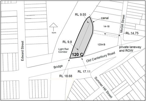
Figure 1 - location of site shown in grey. Note the existing site levels are substantially lower than Old Canterbury Road.
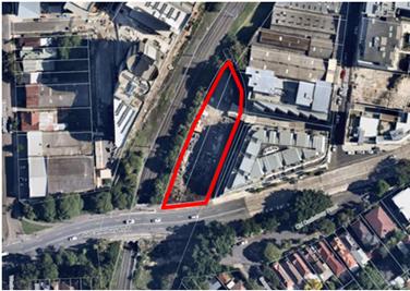
Figure 2- aerial photo of the site (within the red boundary)
Figure 3 - The site with the trees in the Transport for NSW (TfNSW) light rail property. On the right is a stormwater canal and a terrace level for the childcare centre at 120 A/B Old Canterbury Road with apartments above that.
The proposal was put on preliminary exhibition in early 2017 and reported to Council on 25 July 2017 (Attachment 4).
The former Ashfield Council as part of consideration of submissions on the Draft Ashfield LEP had resolved in 2012 to receive a Planning Proposal for a revised land use zoning, maximum FSR and maximum building height. The report to Council in July 2017 recommended that the buildings heights and FSR should be reduced to a maximum of 6 storeys relative to Old Canterbury Road. It also advised that more intensive development on the site might be possible providing flooding was addressed by a study and an appropriate building design.
Council resolved (Attachment 4) to support the Planning Proposal subject to the July 2017 report recommendations to reduce the maximum Floor Space Ratio to 2.5:1 and to reduce the maximum building height to 6 storeys. These amendments were made and the Planning Proposal was submitted to DPE on 10 October 2017. Council also resolved to produce a site specific DCP.
A Gateway Determination (Attachment 5) was received on 25 October 2017 making Council the Planning Proposal Authority. Prior to commencement of the Community Consultation stage the Determination required the approval of a flood study by DPE. The proponent submitted the required flood study to Council’s engineer’s satisfaction in August 2018. Council’s engineers approved the proponent’s flood study in August 2018 and DPE approved it in October 2018. The Planning Proposal (Attachment 1) was updated to reflect the requirements of the October 2017 Gateway Determination.
2.0 Public Exhibition
Condition 2 of the Gateway Determination required the Planning Proposal to be placed on public exhibition for a minimum of 28 days and in accordance with section 5.5.2 of A guide to preparing local environmental plans. The Planning Proposal (Attachment 1) and site specific DCP amendments (Attachment 2) were placed on public exhibition between 16 October 2018 – 13 November 2018. The public exhibition was notified in the Inner West Courier, on Council’s Have Your Say website and letters sent to residents in the vicinity of the site.
The following State agencies identified in the Gateway Determination were also notified:
• Transport for NSW;
• Sydney Water;
• NSW Roads and Maritime Services;
• Office of Environment and Heritage;
• Transdev.
During this period, the public exhibition materials were made available at the Ashfield Customer Service Centre.
2.1 Submissions from public
A total of 40 submissions were received from the public (7 support and 34 objections). The majority of the submissions were submitted on Have Your Say with one submission submitted by email. The submissions are summarised below.
Table 2 – Submissions supporting the Proposal
|
Support Reasons |
Officer’s Comments |
|
“Want to move into area and buy one of the dwellings”.
Support development. |
Noted. |
Table 3 – Submissions objecting to Proposal
|
Objections from adjacent apartment buildings at 14-18 McGill Street and 120 A/B Old Canterbury Road |
Officer’s Comments |
|
I. Height
is taller than existing buildings, should be maximum 4 storeys. |
The site fronts Old Canterbury Road and so this is the reference point used to explain the scale of the building, given that there is a 7-8 metre drop from the road to the lower natural ground level of the site.
The proposed 6 storey scale is the same as the building at 120 A/B Old Canterbury Road, noting this building has a setback at the 6th level. The draft site specific DCP also requires a setback at the 6th level and so this will match the scale set by the adjacent building. The proposed height is therefore compatible with the established building scale and has an acceptable visual impact on nearby houses to the south in Summer Hill Street which are already affected by the existing 6 storey buildings. |
|
II. Maximum Floor Space Ratio should be reduced. |
The Maximum FSR has been reduced from 3.0:1 as originally submitted to 2.5:1 as resolved by Council in July 2017. This FSR is a LEP development standard which sets the parameters for the maximum that must not be exceeded. It generally accords with the potential building heights and envelopes in the illustrative Design Concept (Attachment 11). It will ensure 2 hours winter solar access and adequate building separation to adjacent apartments at 120 A/B Old Canterbury Road and 14-18 McGill Street.
The Development Application (DA) stage will need to ensure the detailed building design uses an FSR which achieves the site specific DCP objectives. |
|
III. Resulting building will be too close, affect privacy and block solar access to apartments at 120 A/B Old Canterbury Road. |
The draft DCP makes reference to the Apartment Design Guide which has the minimum building separation distances, shows the position of the sun between 12 noon and 2 pm to identify where there must be a lower building form to achieve 2 hrs winter solar access, and has a clause to require a deep soil podium level planter box for tree planting screening between apartments.
The illustrative Design Concept (Attachment 11) shows that it is possible to have a building layout which maximises the number of apartments that are oriented to the west and not towards adjacent apartments. |
|
IV. Resulting buildings will block views from 120 A/B Old Canterbury Road toward the railways land (future potential Greenway). |
The eastern part of the site already has a B4 zoning, FSR of 1:1 and maximum building height of 20m. Development under these provisions would have potentially led to a slim new building blocking these views in any event.
The current Planning Proposal combines lots to have a wider site with a 12m setback to 120 A/B Old Canterbury Road building. This will ensure there are northerly sideway views from existing apartment balconies towards a future GreenWay. |
|
V. Health concerns resulting from construction and noise and dust. |
This matter will be addressed at Development Application stage with conditions to contain dust and restrict construction times. |
|
VI. The
existing right of way used to access the site on the adjacent site at 120 A/B
Old Canterbury Road will suffer congestion, restrict traffic flows, and
create safety problems. Proposal will add to congestion in McGill Street and adversely affect traffic flow in the area. |
The proposed DCP has clause DS4.1 to address this and, for example, requires that the onsite parking level has a design which will accommodate vehicular queuing and turning areas to avoid vehicles waiting in the shared laneway.
The RMS and Council engineers have not objected to additional traffic on McGill Street and surrounding roads. |
|
VII. There is no on-street parking in the surrounding area. |
Any residential development of the site is required to provide the minimum parking numbers stipulated in State Environmental Planning Policy 65 and its referenced Apartment Design Guide. Any carparking for a non-residential component must comply with the Inner West DCP 2016. |
|
VIII. Public transport, including light rail, is beyond capacity at peak hour. |
TfNSW has not advised this is the case.
|
|
IX. Need more open space on the site and in the area. |
Provision of on site open space is considered at Development Application stage.
The Apartment Design Guide requires 25 percent communal open space to be provided on the site.
Due to flooding at natural ground level the Design Concept for the Planning Proposal shows it is possible to provide some communal open space on the roof above the 4th storey with the residue at the northern corner of the site at ground level. This is proposed as a ‘pocket park’ in the VPA. The draft DCP has clauses to reflect this scenario.
Implementation of the Council’s GreenWay masterplan will provide additional open space, pedestrian trails and linkages for recreation and exercise. There is also a current development application for the GreenWay ‘Central Missing Links’ works relating to the area opposite the site on the west side of the GreenWay corridor. |
|
Objections from Local Residents |
Officer’s Comments |
|
X. McGill Street has no safe footpath width for children or prams, constant traffic and no safe crossing area. |
Pedestrian access to the site will be from 3m wide footpaths on Old Canterbury Road not McGill street. |
|
XI. Concerns from parents of children using childcare centre during construction stage such as dust. |
This would be addressed at Development Application stage by applying conditions of approval for construction stages such as having boundary screening, and watering of building components and ground level material storage areas.
|
|
XII. Impacts on future GreenWay including:
Marrickville “Hoskins Park” DCP applies which outlines requirements for development adjacent to the Greenway Corridor below, and the proposal does not comply with this.
Proposal should provide links to the Greenway.
Building material and elevations should complement the Greenway.
Buildings should be stepped back from the future Greenway so as to provide a human scale.
Trees adjacent to the boundary of the site within the GreenWay and within the northern part of the site should be preserved as they provide habitat for small birds and biodiversity for the area. |
The Former Marrickville’s 9.11 Hoskins Park (Precinct 11) DCP does not apply. The site relates to the Comprehensive Inner West Development Control Plan (DCP) 2016.
The draft DCP has provisions for a ground level open space at the northern part of the site adjacent the future GreenWay corridor as reflected in the Design Concept (Attachment 11). Use of this area will depend on future negotiations with Council and what use any future adjacent GreenWay corridor is put to, including the following:
To the west of the site along the light rail corridor the present GreenWay development application shows the GreenWay area planted out with dense trees for biodiversity and visual scenic value. The GreenWay area adjacent to the site contains high voltage electrical cabling and existing trees that should be retained for biodiversity and habitat reasons (refer to Tree Manager’s comments below).
Any future building will provide a visual backdrop to the GreenWay. There are clauses in the draft DCP which require serious consideration be given to architectural composition, including use of “green walls”.
The Design Concept does not propose this as any alternative location would result in more building on the eastern side of the site and compromising the amenity, solar access and outlook, of apartments at 120 A/B Old Canterbury Road. Other buildings along the railways land in the McGill Street precinct have not applied any significant setbacks. Also this eastern part of the future GreenWay adjacent to the site contains mostly the light rail tracks and includes high voltage cable rendering the area unusable by pedestrians.
The substantial trees are located adjacent to, but not within the site and consist of Camphor Laurel, Date Palm and Privet which are classed as “noxious weeds”. Also TfNSW who have jurisdiction of this land may elect to remove them at any time.
Refer to part 4 below and comments from Council’s Manager of Trees that recommend that those trees should be retained by TfNSW for biodiversity reasons. Whilst this is agreed with in principle, practically Council is not in control of this. The current GreenWay Development Application proposes that a high number of new trees be planted in the corridor.
|
|
XIII. Adverse impact on Fred Street bush care site – loss of visual amenity, light (night time) pollution affecting nocturnal biodiversity(animals) loss of connectivity to north as a result of affecting “weedy habitat”. |
Fred Street Bush Care is located to the south of Old Canterbury Road.
The subject site is substantially separated from the bush care site by the Old Canterbury Road embankment.
|
|
XIV. Resulting buildings will shadow houses in Summer Hill.
|
Nearby houses to the south of Old Canterbury Road and to the east in Edward Street will not have any reduction in their current solar access. |
|
XV. Impacts on adjacent Childcare Centre at 120 A/B Old Canterbury road including : Loss of natural light and solar access
Construction vehicles blocking vehicular access to carpark.
Heath concerns for children noise and dust from construction.
|
The draft DCP has clause DS9.2 that will ensure there is a minimum two hours winter solar access to 40 sqm of the existing Childcare external terrace play areas. For other periods of the year a greater amount of the solar access will be available to these terraces - noting that for health reasons children should have limited amount of exposure to the sun.
There is a stormwater canal and reservation approximately 3.3m wide adjacent to the childcare centre and any future building will have the required building separation and so there will be adequate daylight for the childcare centre.
The proposed DCP has clause DS4.1 to address this and for example requires that the on-site parking level has a design which will accommodate vehicular queuing and turning areas to avoid vehicles waiting in the laneway.
This would be addressed at Development Application stage by applying conditions of approval for construction stages such as having boundary screening, and watering of building components and ground level material storage areas. |
|
XVI. A submission on the site specific DCP was also received from the proponent/site owner and each part is commented on in detail in Attachment 7 of this report and summarised with a recommendation given below in Part 6 of this report.
|
3.0 Referrals and submissions from State Agencies
Condition
3 of the Gateway Determination required consultation with the community and the
following State Agencies:
• Transport for NSW;
• Sydney Water;
• NSW Roads and Maritime Services;
• Office of Environment and Heritage;
• Transdev.
Comments from these agencies are as outlined in the tables below. Full copies of the agencies’ comments are in Attachment 6.
Table 4 - Consultation with Public Authorities
|
Transport for NSW |
Officer comments |
|
State no objection |
|
|
Stated: “Resulting buildings are required to have an adequate setback from the TfNSW railways land boundary to enable maintenance. They must not rely on use of railways land”. Separate email recommends there should be a minimum of 1.5 m.
|
Council officer’s original position was that there should be a 3m building setback to provide a landscaped backdrop to the GreenWay. However the applicants advised that TfNSW would allow a 1 metre building setback and given this a 3 m setback was not reasonable. Hence the draft DCP control states a minimum upper level building of 1 m but also requires a “green wall” beyond this to provide a backdrop to the GreenWay which will likely mean a 1.2 m setback to the building walls to account for that structure.
It is recommended that the building setback be a minimum of 1.5 m. This would logically account for room needed for machinery such as a cherry picker platform to access the building walls. The draft DCP should be amended as underlined.
|
|
Sydney Water via Urban Growth |
Officer comments
|
|
No objection was raised. |
Noted. |
|
Office of Environment and Heritage (OEH) |
Officer Comments |
|
Noted the flood study and illustrative building design and raised no objections to these items. |
|
|
Acknowledged that:
· subject site is not shown on their Aboriginal Heritage Information Management System (AHIMS) register to be in a potential area of aboriginal archaeological sensitivity · subject site is not heritage listed in the Ashfield Local Environmental Plan (ALEP) 2013 · subject site and surrounding areas and sites have had significant ground level disturbance · ALEP 2013 has provisions that provide for Aboriginal Archaeological remains or heritage significance that are applicable at future Development Application Stage
The submission suggested that the site is in a potential area of aboriginal sensitivity and there should be an archaeological and cultural heritage assessment, including land excavations prior to rezoning.
OEH considers that without such a detailed assessment, the proposal is inconsistent with Ministerial Direction 9.1: 2.3 Heritage Conservation. |
It is Council’s role as the Planning Proposal Authority to ensure that any objections from a State Agency are addressed. OEH have not objected to the Planning Proposal but have instead made a recommendation as indicated in the left column.
The Gateway Determination was issued by DPE without requiring the actions sought by OEH given that the site is not identified as a heritage item or having any archaeological relics and the standard Clause 5.10 of the Ashfield LEP already had provisions for addressing any potential aboriginal archaeology that might be found.
Ministerial Direction 9.1 2.3 - Heritage Conservation requires that there are LEP (Planning Proposal) provisions in place where there are already identified heritage places or relics or similar in order to protect such items. There is no such identification for the subject site. The site is not identified under the Heritage Act 1977 in its State Heritage Register. It is not identified under the National Parks and Wildlife Act 1974 which deals with aboriginal areas, places and relics. Previous local heritage studies have not identified the site. The proposal is therefore consistent with Direction 2.3.
The applicants submitted an Aboriginal Heritage Due Diligence assessment to Council on 22 January 2019 (Attachment 9) prepared by a professional archaeologist. This confirms the site does not require full heritage assessment prior to rezoning. This is primarily because of the very large degree of land disturbance on this site, surrounding sites including the 2.5 hectare former Flour Mill site and the light rail corridor. The assessment also refers to a previous aboriginal heritage study for the adjacent Flour Mill site which included consultation with representatives of the aboriginal community.
Clause 5.10 of the Ashfield LEP already protects aboriginal heritage and comes into play when a Development Application is lodged.
This clause ensures that Council can require the preparation of a heritage management plan that assesses the extent to which the development might affect aboriginal heritage significance of the site. The OEH recommendation can be addressed through this LEP provision.
This is practical since to adequately examine whether a site has archaeological remains that have not yet been discovered first requires the entire site to be examined to a required depth, prior to any land disturbance or commencement of construction. Both of these situations require prior development consent. The Inner West DCP 2016, Chapter E1 Clause 1.6 also protects Aboriginal Heritage. In addition flooding issues on this site mean that there will not be any basement levels and a substantial ground level open void is required under the lower carparking basement level. In this situation there are no obstacles to carefully examining what is under the ground prior to any construction and structural column locations can be adjusted to reflect any archaeological features that might be identified through the DA related investigation.
|
|
Recommends that for sustainability reasons a future Development Application should have green walls and green roofs, and advises that green roofs can be used for native plant species and habitat. |
There are already numerous interrelated building design matters that must be considered for achieving sustainable building design which are covered by legislation which architects must address. A future development application for residential development must comply with the BASIX SEPP including energy efficiency and water usage. At Construction Certificate stage compliance must be achieved with Australian Construction Code for energy efficiency thresholds. SEPP 65 and the Apartment Design Guide also have guidelines for particular building components and location of vegetation.
Clause DS1.2 of the DCP recommends a “green wall” along any west side building wall to complement the GreenWay. |
|
Biodiversity - recommends that an ecological study be undertaken prior to removal of any trees from the site, and Council be satisfied removal will not impact on any threatened species or fauna. |
The trees are in the TfNSW curtilage and TfNSW can remove them at their discretion. Should this occur any fauna (animals) utilising these trees are able to use the “bushcare site” on the south side of Old Canterbury Road. These trees are also adjacent to high voltage lines and the ground level area has been significantly disturbed by the construction of the light rail tracks and surrounds.
Council’s Manager of Trees has advised that the trees are Campher Laurels and Privet species classed as ‘weeds”. Refer to his comments in Part 4 below. |
|
Roads and Maritime Services (RMS) |
Officer comments |
|
Did not object to Planning Proposal but stated as follows: |
|
|
Would not support future vehicular access off Old Canterbury Road – must be off the private right of way laneway at the rear of 120 A/B Old Canterbury Road. |
This is indicated in the draft DCP. |
|
There should be on-site parking. |
This is indicated in the draft DCP. |
|
Garbage trucks are not to service (park) along Old Canterbury Road, and are to use the right of way lane at the rear of 120 A/B Old Canterbury Road. |
This is indicated in the draft DCP. |
|
Suggest Council put in any DCP maximum carparking controls, and this will encourage use of public transport. |
On-site parking requirements for residential flat development are contained in SEPP 65 and the Apartment Design Guide which already references the RMS carparking standards. A DCP cannot be more onerous than these.
It is also necessary to recognise that the area already has over 1,000 new apartments in the Flour Mills and McGill Precinct. The former Ashfield and Marrickville Councils and local community raised numerous concerns about loss of on-street parking and additional traffic congestion. In the locality, Council should minimise “spill over” into local residential areas and avoid further loss of on-street local parking. |
|
No stopping should be implemented on Old Canterbury Road from the corner Old Canterbury Road and Edward Street, to approx. 30m west of corner Old Canterbury Road and McGill Street. This should be indicated in DCP. |
Agreed. |
|
Transdev |
Officers Comment |
|
|
No responses were received from Transdev who are responsible for the light rail corridor. |
4.0 Staff Comments
|
Staff comments |
Planning Comments |
|
Council Engineer
They have assessed the proponents flood report and found it acceptable.
Have no objections to the Planning Proposal being finalised.
Support the draft DCP and consider the clauses pertaining to carparking design, servicing, truck turning circles within the site and waste collection are essential for future development on the site and catering for the use of the shared right of way in order to minimise any traffic flow disruption.
Stated the minimum floor levels stipulated in the applicant’s Cardno Flood Report to accommodate flooding must be referenced in the draft DCP as it was on this basis that support was given for the Planning Proposal.
|
This has been taken into consideration. |
|
Environmental Engineer
The SEPP 55 report on potential land contamination (Attachment 10) was examined, found to be sound and following the procedures of the Land Contamination Guidelines for consideration of LEP amendments. Further more detailed investigations will occur at a future development application stage.
|
This has been taken into consideration.
|
|
Urban Forest Manager
Advised trees on the site appear to be a mix of Camphor Laurel, Date Palm and Privet, and are not affected by the Ashfield LEP 2013 and the Inner West DCP 2016 for tree preservation. It was noted they contribute to the ecology and canopy cover of the area, and if they were to be retained that any future buildings will need to be adequately setback to protect those trees.
Also advised that the NSW Department of Planning and Environment have announced the '5 Million trees' program which is tasked with the objective of increasing Greater Sydney's tree canopy by 40% by 2030. The Inner West's overall canopy cover is currently under 20%.
|
As advised above in the report these trees are within the TfNSW light rail corridor and TfNSW can elect to remove them at any time.
The current GreenWay Development Application for works on the railways land has shown new dense tree planting in the current open space areas on the west side of the rail tracks. If the subject trees on the east were removed they could be replaced with suitable tree species. |
5.0 Assessment of Planning Proposal
Under Clause 3.35 of the EP&A Act Council as the delegated Planning Proposal Authority is responsible for the content of the Planning Proposal and its adequacy.
An assessment of the updated Planning Proposal against the A guide to Preparing Planning Proposals 2016 (the Guidelines) is provided in a compliance table (Attachment 12). The Planning Proposal complies with the criterion in the Guidelines as indicated in the Attachment, including the relevant State Plans, compliance with State Environmental Plans and being consistent with relevant Ministerial directions.
What follows is a more detailed assessment of the specific salient proposed Ashfield LEP amendments for Land Use Zoning and Development standards for maximum building height and floor space ratio.
5.1 Land Use Zoning
Figure 4 – Existing and Proposed Land Use Zoning
|
|
|
|
Existing Zoning
Site is within the red boundary. Existing Land Use zoning map only has the eastern allotment as a B4 mixed use zone.
|
Proposed Zoning
Site is within the red boundary. Proposed map shows the entire site with a B4 mixed use zone.
|
Officer Comment
Amending the western lot to a B4 zone is evidently consistent with the adjacent B4 zone within the same site, consistent with adjacent lots to the east of and around McGill Street, and should be supported. The land was sold by the State Government to the site owner and should be able to accommodate a viable land use and not left in a vacant, deteriorating state.
5.2 Maximum Building Height
Figure 5 – Existing and Proposed Height
|
|
|
|
Existing Height
Site is within the red boundary. Existing map shows Code Q which denotes a maximum height of 20 m. This is measured from natural ground level which is mostly on average of RL 9.5 – 10 resulting at approximately RL 30m, or the equivalent of 4 storeys above Old Canterbury Road.
|
Proposed Height
Site is within the red boundary. Proposed map shows “38” in grey shade for the site. This denotes RL 38.0 which is the equivalent of 6 storeys above Old Canterbury Road.
|
Officer comment
As stated above in Table 3 (submissions) of this report: The proposed 6 storeys is the same as the neighbouring building at 120 A/B Old Canterbury Road, noting this building has a setback at the 6th level. The draft site specific DCP also calls for a setback at the 6th level of the proposed new building to match the scale set of the adjacent building. The proposed height is compatible with the now established scale of existing buildings along Old Canterbury Road. It would have a modest visual impact on nearby houses to the south in Summer Hill Street as there are already affected by existing buildings. The proposed Maximum Building Height should be supported.
5.3 Maximum Floor Space Ratio
Figure 6 – Existing and Proposed FSR
|
|
|
|
Existing FSR
Site is within the red boundary. Existing map shows Code N which denotes a maximum FSR of 1:1 for the eastern lot part of the site (presently zoned B4 Mixed Use).
|
Proposed FSR
Site is within the red boundary. Proposed map shows Code U which denotes a maximum FSR of 2.5:1 over the entire site.
|
Officer comment:
The Maximum FSR is an LEP development standard which should not be exceeded. It accords with the potential building heights and envelopes illustrated in the applicant’s Design Concept in Attachment 11 and ensures there would be 2 hours winter solar access solar and adequate building separation to affected apartments at 120 A/B Old Canterbury Road. The proposed Maximum FSR should be supported. At Development Application stage the precise FSR will be established which accommodates all the detailed design issues that must be addressed.
6.0 Draft Site Specific Development Control Plan (DCP)
Council resolved in July 2017 to also exhibit the DCP (Attachment 2) to provide key controls to address the unique site constraints, including having building envelopes that achieve adequate amenity, privacy and minimum levels of winter solar access for adjacent apartments. The DCP will ensure that the proposed buildings would be configured to have adequate servicing arrangements and account for flooding by having raised sections.
The site owner has lodged a submission on the draft DCP which is commented on in Attachment 7. It essentially seeks to remove key controls. It is considered the content of the DCP should remain substantially as exhibited, except for the minor amendments underlined in the attachment. This response is necessary to ensure adequate solar access and privacy for affected apartments at 120 A/B Old Canterbury Road.
Council should adopt the DCP amendments subject to the minor clerical and information amendments indicated in Attachment 8.
8.0 Voluntary Planning Agreement (VPA)
Council’s Properties, Major Building Projects and Facilities Group is responsible for the assessment and processing of any VPA. This is a type of contractual document setting out how a site owner/proponent explicitly and strictly offers to carry out certain works as a result of a particular proposal such as an amendment to a Local Environmental Plan.
A final draft VPA from the site owner was reported to Council on 11 December 2018. Council resolved to have the proposed VPA proceed to exhibition as follows:
1. Endorsed in principle, subject to The Yard 120C Pty Ltd (the proponent):
a) Construct a park of approximately 300m2 located within the Land and to provide rights of way for public access through the park to the Greenway corridor and the Lewisham Light Rail station from Old Canterbury Road and McGill Street;
b) Provide 2 studio units which will be allocated to Affordable Housing units. The ownership of the units will be transferred to Inner West Council at the completion of the project;
c) Community Office Space located within retail Ground Floor – 5 Year Rental Agreement $1 Peppercorn rent per year – 35sqm office area; and
d) Provide Council a payment of $1,045,000 million to be used for public works in the community and surrounding area (Inner West Council will provide a summary of how this payment will be allocated at later date)
2. Placed on public exhibition for a minimum of 28 days; and
3. Reported back to Council after public exhibition.
Council’s Property Services has advised that the exhibition of the VPA will occur during February 2019.
FINANCIAL IMPLICATIONS
Nil
CONCLUSION
In accordance with the Environmental Planning and Assessment Act 1979 and the “Guide to preparing local environmental plans” this report has considered the submissions made during the Community Consultation Process as discussed in Part 2 of this report. Concerns raised by adjacent affected apartment residents, including solar access and privacy, will be addressed by the site specific Development Control Plan as discussed in this report. Part 3 of this report advises that no objections were raised by the Roads and Maritime Services, Sydney Trains, Transport NSW or Transdev. OEH has made a submission and its concerns have been addressed in this report.
The exhibited proposed site specific Development Control Plan and ancillary amendments to the “Inner West DCP 2016” should be adopted by Council as recommended in Part 6 of this report. This will provide guidelines for ensuring future buildings are designed to have satisfactory impacts on adjacent apartment buildings and the future GreenWay.
A draft Voluntary Planning Agreement (VPA) for 120C Old Canterbury Road was approved for public exhibition by Council on 11 December 2018. Procedurally the gazettal of the Planning Proposal should as far as possible coincide with the legal finalisation of the VPA.
Council should now progress the Planning Proposal to the final stages for the making of the ALEP amendment which includes referral to Parliamentary Counsel. Subject to the exhibition of the VPA and its finalisation, Council should request Department of Planning and Environment to publish the Ashfield LEP amendment on the NSW Legislation website. To enable this process Council should resolve to delegate completion of the LEP making process within the terms of this report to the Group Manager Strategic Planning.
Attachments are available as hard copies in the Council Agenda except for the following which are available online as electronic attachments:
4. Council Report and Minutes of 25 July 2017
5. Gateway Determination and Letter
10. SEPP 55 Report
11. Design Concept Plan
13. Flood Report
The online attachments can be viewed on the following link on Council's website: https://www.innerwest.nsw.gov.au/develop/planning/planning-proposals/planning-proposal-tracker/120c-old-canterbury-road-summer-hill
|
1.⇩ |
Planning Proposal Exhibited |
|
2.⇩ |
Site Specific DCP amendments exhibited |
|
3.⇩ |
Proposed LEP Maps |
|
4.⇩ |
Council Report and Minutes of 25 July 2017 |
|
5.⇩ |
Gateway Determination and Letter |
|
6.⇩ |
State Agency Submissions |
|
7.⇩ |
Council's response to proponent's draft DCP submission |
|
8.⇩ |
Amendments to the Draft DCP |
|
9.⇩ |
Aboriginal Heritage Assessment |
|
10.⇩ |
SEPP 55 Report |
|
11.⇩ |
Design Concept Plan |
|
12.⇩ |
Planning Proposal Guidelines Assessment |
|
13.⇩ |
Flood Report |
|
|
Council Meeting 12 February 2019 |
Subject: License agreements for Chrissie Cotter gallery
Prepared By: Amanda Buckland - Living Arts Manager
Authorised By: Erla Ronan - Group Manager Community Services and Culture
|
SUMMARY This report recommends Council as the land manager of Camperdown Park Reserve Trust endorse a process for short-term licenses at Chrissie Cotter Gallery, Pidcock Street Camperdown.. |
|
RECOMMENDATION
THAT:
1. The report be received and noted; and
2. Council acting as the council manager of Camperdown Park Reserve Trust authorises the General Manager or his delegate to enter into and sign short-term licenses for the use of Chrissie Cotter Gallery, Pidcock Street Camperdown upon conditions detailed in this report.
|
BACKGROUND
Camperdown Park is Crown Land that is comprised of land parcels that were reserved (R8205) and dedicated (D500444) for the purposes of public recreation. Council was appointed as Trust Manager for the Camperdown Park Reserve Trust on 20 July 1995. Pursuant to section 10A and section 11(5) of Schedule 7 – Savings, Transitional and Other provisions of the Crown Land Management Act 2016 (“Act”) Inner West Council is the council manager of the Camperdown Park - Chrissie Cotter Gallery Pidcock Street Camperdown 2050 is part of Camperdown Park. Since 1996, former Marrickville Council and since 2016 Inner West Council has provided the Gallery for the use of local residents and organisations as an exhibition and cultural events venue.
Under the Act Camperdown Park is to be managed in accordance with the requirements of the Local Government Act 1993. Camperdown Park has been classified community land and requires a plan of management. The granting of leases and licenses has to be authorized by the plan of management. Camperdown Park does not have a plan of management authorized by the Minister of Primary Industry however under regulation 70(3) of the Crown Land Management Regulation 2018 (“Regulation”) short term licenses can be granted in the pre–POM term (3 years).
The conditions of short-term licenses at Chrissie Cotter Gallery would be as follows:
· 2-3 weeks duration
· no license fee will be charged
· the minimum rent set by the Regulation requires no less than $493.00 plus GST per annum, therefore a 15% commission will be charged on artwork sales to meet this condition
· a $200 refundable bond
· no electricity or water charges.
Short-term licenses at Chrissie Cotter gallery are allocated through an expression of interest process managed by Living Arts, Community Services and Culture.
FINANCIAL IMPLICATIONS
A minimum rent per annum of no less than $493.00 plus GST will be derived from 15% commission charged for artwork sales.
OTHER STAFF COMMENTS
Property & Assets Manager supports this approach.
Report prepared in collaboration with Property and Legal Services
PUBLIC CONSULTATION
In response to the annual call for expressions of interest over 30 submissions were received from artists and creatives to exhibit at Chrissie Cotter Gallery during 2019. A panel consisting of two local artists, a curator and three Community Services and Culture Officers selected 23 applicants to be granted a license to exhibit their artwork.
CONCLUSION
As Inner West Council undertakes a review of its facilities, there is a need to create short-term licenses at Chrissie Cotter Gallery, Pidcock Street Camperdown 2050 to ensure that the facility continues to be occupied and well used by the community.
|
1.⇩ |
License agreement for Chrissie Cotter Gallery |
|
Council Meeting 12 February 2019 |
Subject: Inner West Council Draft Busking Policy
Prepared By: Matthew Balane - Community Projects Officer
Authorised By: Erla Ronan - Group Manager Community Services and Culture
|
SUMMARY This report presents Council’s updated draft Busking Policy for adoption for public exhibition. |
|
RECOMMENDATION
THAT:
1. The Draft Busking Policy be placed on public exhibition for a period of 28 days; and
2. A further report come to Council after the exhibition period detailing the submission received.
|
BACKGROUND
Cohesive and consolidated approach to activate civic and community spaces through busking, drawing on The development of this policy is in response to the Local Government Proclamation (2016) section 19(2) that codes, plans, strategies and policies of the new council are to be, as far as practicable, a composite of the corresponding codes, plans, strategies and polices of each of the former councils.
FINANCIAL IMPLICATIONS
Nil additional cost, and minimal revenue foregone. In 2017, Inner West Council received 42 busking permit applications between the Leichhardt and Ashfield areas, generating less than $600. Cancelling fees, will also reduce the administrative cost of processing permits.
OTHER STAFF COMMENTS
The following teams have had input into the development of the draft Policy: Customer Service, Community Services & Culture, and Development Assessment & Regulatory Services.
PUBLIC CONSULTATION
Nil
CONCLUSION
Nil
|
1.⇩ |
Inner West Council Draft Busking Policy |
|
Council Meeting 12 February 2019 |
Subject: Conduct of the Local Government Election 2020
Prepared By: Ian Naylor - Manager Civic and Executive Support
Authorised By: Nellette Kettle - Group Manager Customer Service & Civic Governance
|
SUMMARY The Office of Local Government has issued a circular to all NSW councils on 12 December 2018, advising that each Council must make a resolution by 11 March 2019 to decide whether to engage the NSW Electoral Commission to conduct the local government election or appoint the General Manager to administer the local government election. |
|
RECOMMENDATION
THAT Council:
1. Pursuant
to s. 296(2) and (3) of the Local Government Act 1993 (NSW) (“the
Act”)
2. Pursuant to s. 296(2) and (3) of the Act, as applied and modified by s. 18, enter into a council poll arrangement by contract for the Electoral Commissioner to administer all council polls of the Council; and
3. Pursuant to s. 296(2) and (3) of the Act, as applied and modified by s. 18, enter into a constitutional referendum arrangement by contract for the Electoral Commissioner to administer all constitutional referenda of the Council. |
BACKGROUND
Under section 296AA of the Local Government Act 1993 (the Act), NSW councils must make a decision on how their September 2020 ordinary elections are to be administered no later than 11 March 2019. Each council must resolve either:
• to enter into an election arrangement with the NSW Electoral Commissioner (NSWEC) to administer all the council’s elections, polls and constitutional referenda; or
• that the council’s elections are to be administered by the general manager of the council.
If a council fails to resolve to engage the NSWEC to administer its elections by 11 March 2019, it will be required to administer its own elections.
The 2017 local government election was conducted by the NSW Electoral Commission. The result of the election was confirmed within one week of the election day, which is a quicker turnaround than previous elections. Council received no complaints on the conduct of the election by the NSW Electoral Commission.
Alternatively, Council may consider administering their own election by engaging a private company with experience in running elections. This option may result in a cost saving but from the experience of councils who have done this in past elections, this has resulted in additional staff resources to assist the private company in locating suitable returning officer accommodation and polling booths, refunding candidate nomination deposits and providing election support for candidates. The other disadvantage is that the counting centre may not be located in metropolitan Sydney. The risk with engaging a private company is that the service may not be as fast as the NSW Electoral Commission, does not have the backing of the State Government and the timing of the result could depend on the amount of resources the private company dedicates to the election.
The Inner West Council had 130,677 enrolments for the 2017 local government election. This figure is expected to rise towards 135,000 by the time of the 2020 local government election. Given the large number of voters in our local government area, the additional staffing resources that may be required in engaging a private company and the risk with engaging a private company to undertake the election, it is recommended that Council resolve to enter into a contract with the NSW Electoral Commission for all the council’s elections, polls and constitutional referenda for the following reasons:-
· The running of elections is not Council’s core business and the NSWEC has more equipped resources than Council to manage an election process
· Retaining the NSWEC is a low risk option as the NSWEC is known to be capable of carrying out a successful election
· Voter familiarity and public confidence in the NSW electoral commission
· Would require less diversion of internal resources to partner with the NSWEC than to contract management and partner with a new private provider
FINANCIAL IMPLICATIONS
The cost of the 2017 local government election was approximately $1,000,000 and Council staff have budgeted $1,300,000 in the 2020/21 Financial Year to cover these costs.
OTHER STAFF COMMENTS
Nil.
PUBLIC CONSULTATION
Nil.
CONCLUSION
Nil.
|
1.⇩ |
Circular from the Office of Local Government - Decision required on Local Government Elections |
|
Council Meeting 12 February 2019 |
Subject: 2018/19 Second Quater Budget Review
Prepared By: Daryl Jackson - Financial Partnering and Analytics Manager
Authorised By: Michael Tzimoulas - Deputy General Manager Chief Financial and Administration Officer
|
SUMMARY Clause 203 of the Local Government (General) Regulations 2005 requires that a quarterly budget review be considered by Council, which shows revised estimates for income and expenditure for the financial year indicating whether Council’s financial position is satisfactory and makes recommendations for remedial action where needed.
The Quarterly Budget Review Statement (QBRS) are prepared in accordance with the requirements of the Code of Accounting Practice and Financial Reporting. This report provides a comprehensive high level overview of Council’s financial position as at 31 December 2018 in accordance with the Code, together with supplementary information. Any forecast results are projections as at 30 June 2019. |
|
RECOMMENDATION
THAT:
1. The report be received and noted; and 2. Council approves the budget adjustments required.
|
BACKGROUND
This report provides an overview of Council’s quarterly financial position as at 31 December 2018. The QBRS report is prepared in accordance with the Code of Accounting Practice and Financial Reporting. It includes information on Council’s Operating, Capital and Net Budget Position as at 31 December 2018.
During the quarter, a detailed review of both the operating and capital budgets were undertaken to reconfirm the budget projections for the current financial year.
Council has updated its projected budget result to $6.1 million including capital revenue against that reported in the 2018/19 Adopted Q1 Quarter Budget Review of $5.9 million, this is an improvement of $0.2million. Excluding capital revenue, a deficit of $12.8 million has been projected against the 2018/19 Adopted Q1 Quarter Budget Review Budget Deficit of $13.7 million.
It is important to note that the change in our budgeted result is predominantly due to the following adjustments made in the Q2 QBRS:
1. Property Leases – a review of all leases in place was undertaken and the accounts now reflect the actual leasing income against an estimate which was previously booked. The incremental income was $1.1m.
2. Capital Grants and Contributions – Council have been advised by RMS that capital grants submissions amounting to $0.8m for a number of cycleway projects have been unsuccessful. These projects have been deferred to future years.
3. An increase in Council’s Operating Expenditure of $0.1m which includes a decrease in employee costs of $0.2m and materials & contractors of $2.4m offset by an increase in Other Expenses of $2.6m – detail information can be found within the Movement Summary.
At this point no surplus funds are available $1.1m leasing income increase has been offset against the $5.5m Efficiency Saving.
The Capital Budget will be reviewed throughout the financial year on an ongoing basis with the capital works managers. Changes to the Capital Works will be brought to Council through future QBRS.
Cash Flow forecasts of major projects will be monitored ensuring the expenditure remains in line with the budget. December 2018 year to date capital expenditure totals approximately $16.1 million.
Currently Unfunded Council Resolutions.
The following Council resolutions were resolved to be considered at the next Quarterly Budget Review. The proposed budget adjustments do not include these projects and they are proposed to be considered at the next QBRS in Quarter 3:
· WestConnex Air Quality & Noise Monitoring - $250k
· C0618 Item 5 Branding Competition Prizes - $30k
· C0918 Item 19 – Allocation of budget to Strategic Planning for ongoing notification about infrastructure projects, rezoning proposals and public meetings - $200k per annum ($2m over 10 year LTFP)
· C1018(2) Item 7 Swimming In Parramatta River – New Site for Inner West $45k
Council has resolved C1018(2) item 2 Dawn Fraser Upgrade to determine funding post grant outcome and C0818(3) Item 5 Balmain Public Square Heritage Project Funding to be considered in the LTFP if existing funds cannot be found in QBRS. As such, they have not been considered in this QBRS.
Summary of Budget Movements.
The following are key movements with a brief explanation and impact on Council’s budget:
- Decrease in Capital Expenditure of ($5.6m) which were predominantly funded by capital grants and contributions no longer available -
· Trees, Parks and Sportsfields Capital Projects – ($0.9m) - refer to Item 2 below.
· Property Capital Projects – ($3.6m) - refer to Item 4 below.
· Footpaths, Roads, Traffic and Stormwater – ($1.0m) - refer to Item 1 below.
· Community Services & Culture – ($0.1m) – refer to Item 10 below.
· ICT Capital Projects – $0.1m - refer to Item 3 below.
- Forecast decrease in revenue relating to Capital & Operational Grants & Contributions
· Footpaths, Roads, Traffic & Stormwater - $0.8m (grant funding applications for various cycleways was unsuccessful. These projects have been deferred to future years and a new application for grant funding will be lodged with RMS).
- Forecast increase in revenue relating to Other Income -
· Property Services $1.1m - a review of all current leases in place has been completed generating adjusted income against the estimates previously used.
- Forecast decrease in Employee Costs –
· Human Resources $0.1m – reduction in operating expenses as a staff member who was not part of operating headcount retired.
- Forecast decrease in Materials and Contracts –
· Corporate Support Services $2.6m – reclassification of software costs to Other Expenses in line with OLG Reporting requirements.
- Forecast increase in Other Expenses –
· Corporate Support Services $2.6m – reclassification of software costs from Materials and Contracts in line with OLG Reporting requirements.
Further details can be found in the December 2018 QBRS Movements section of this report.
Report by the Responsible Accounting Officer of Council
Section 203(2) of the Local Government (General) Regulation 2005 requires a report by Council’s responsible accounting officer regarding the Council’s financial position at the end of each quarter.
The responsible accounting officer is of the opinion that the Quarterly Budget Review Statement for the Inner West Council for the quarter ended 31 December 2018 indicates that Council’s projected financial position at 30 June 2019 will be satisfactory.
FINANCIAL IMPLICATIONS
The proposed budget adjustments will see a net decrease in Council working funds of $5.8million ($5.6m for reduced capital expenditure & $0.2m decreased in operating profit). This includes unfinished projects from 2017/18 which will be completed in the current financial.
OTHER STAFF COMMENTS
All relevant staff have been consulted during the budget adjustment process.
PUBLIC CONSULTATION
Nil.
1) Primary Financial Statement
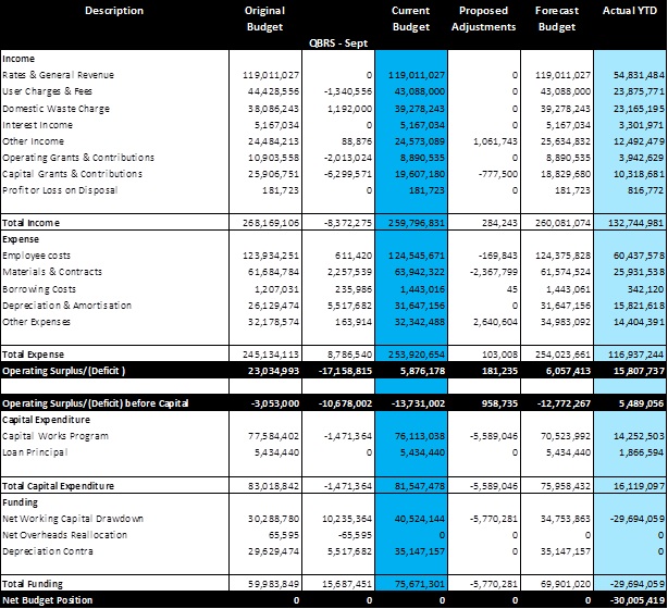
2) December 2018 QBRS Movements
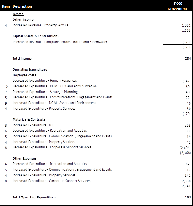
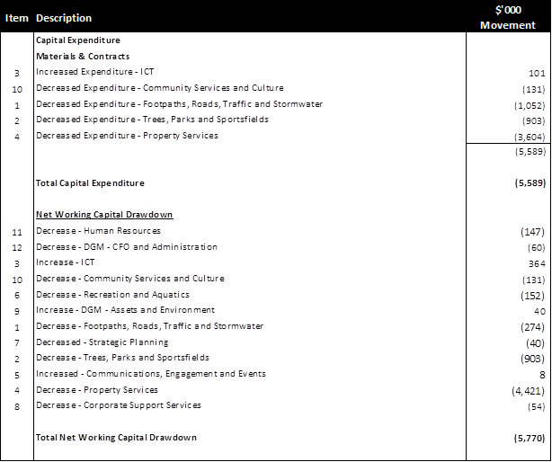
ITEM 1 - Footpaths, Roads, Traffic & Stormwater
Decrease Capital Grants & Contributions $778k
§ RMS grants applications were unsuccessful for a number of cycleway projects
Ø Longport Street to Eliza Street – design
Ø West Street – design & construction
Ø Livingstone Road to Frazer Street – construction
Ø Enmore Park to Livingstone Road – design
Ø Richardsons Crescent, Cooks River to St Peters – design & construction
Decrease Capital Expenditure $1,052k
§ $1.0m worth of cycleway projects funded by the RMS which have not received grant funding, projects listing in the above point – Decrease in capital grants and contributions.
§ $554k Local Roads and Footpath Projects deferred due to developer construction on the following streets and roads (Murray Lane, Ewart Street to Bayley Street; Hill St, Denison Road to the end of the road; Lilydale Street, Marrickville Road to Stanley Street; Darling Street to Macquarie Terrace, St Peters Street Campbell Street to the end of the street) which impact Council’s ability to start the projects and extensive design works in 2019/20 at Fred Street, Summerhill Street to Eltham Street with investigation work to occur in the current financial year.
§ $75k Kerb & Gutter at Albert Street (National Street--Flood Street) deferred to 2020/21 as the location is not ready for construction.
§ $505k of 2019/20 projects have been transferred in the current financial due to other projects being deferred to 2019/20.
§ Increase 100k for Chester St Footbridge.
The above changes have decreased the Net Working Funds by $266k being Council’s contribution to the cycleway project deferred to future years.
ITEM 2 - Trees, Parks & Sportsfields
Decrease Capital Expenditure $903k
Decrease Transfer from Net Working Funds $903k
§ Callan Park skate park $476k – project deferred to 2019/20 due to the Office of Environment & Heritage not supporting the selected location and Council resolved to move the skate park to Leichhardt Oval #3. A new design is currently in progress.
§ Bell Reserve $150k – to fund the demolition of the existing house on the property, the design and community engagement for new park, the construction has been deferred to 2019/20.
§ Hawthorne Canal Shared Path $100k - deferred to coordinate with Greenway northern links design program to 2019/20.
§ Simpson Park upgrade $186k - project deferred to 2019/20 due to WestConnex works affecting Campbell Road.
ITEM 3 – ICT
Increase Materials & Contracts $263k
Increase Capital Expenditure $101k
Increase Transfer from Net Working Funds $364k
§ $263k increase for the purchase of additional mobility devices for the Assets Team.
§ $101k increase for the Geographical Information Systems desktop editing software replacing the old out of date system.
ITEM 4 - Property Services
Increase Other Income $1,061k
Increase Employee Costs $60k
Increase Materials & Contracts $42k
Increase Other Expenses $142k
Decrease Capital Expenditure $3,604k
Decreased Capital Expenditure -
§ Upgrade work for the following projects have been deferred to future year –
§ Telstra Site $1.1m
§ Haberfield Library $360k
§ Dawn Fraser Pool $400k
§ Marrickville Town Hall $180k
§ Petersham Town Hall $500k
§ St Peters Town Hall $320k
§ Weekley Park $589k
§ Depot improvement works $100k
§ Camperdown Memorial Park new toilets $332k
§ King George Park storage facility upgrade $70k
§ Increased cost of Ashfield Aquatics Centre redevelopment ($346k).
Offset by an increase of –
§ $1,061k Property lease income review for 2018/19. In past years income was booked based on an estimated income. This adjustment represents the alignment of income for all the current property leases in place against the estimated amount.
§ $60k Staff member seconded to the Property Services team from the CFO & Administration team.
§ $42k reactive maintenance work required to be completed.
§ $142k is the result of a review of Council’s water and electricity usage cost aligning to the actual cost invoiced by the supplier.
The above has resulted in the following change in working funds -
Decrease Transfer from Internal Working Funds $1,646k
Decrease Transfer from S94 Funds $2,775k
ITEM 5 - Communications, Engagement & Events
Decrease Salary & Wages $22k
Increase Materials & Contracts $19k
Increase Other Expenses $12k
Increase Transfer from Net Working Funds $8k
§ Salaries and wages savings from open positions have been used to fund Council resolutions - the increase in sponsorship for the Summer Hill Community Feast and Local Democracy Groups.
ITEM 6 - Recreation & Aquatics
Decrease Materials & Contracts $88k
Decrease Other Expenses $63k
Decrease Transfer from Net Working Funds $152k
§ The commencement of the redevelopment of the Ashfield Aquatics Centre has been delayed due to contract negotiations.
ITEM 7 - Strategic Planning
Decrease Employee Costs $40k
Decrease Transfer from Net Working Funds $40k
§ New staff opted for a motor car against the budgeted car allowance.
ITEM 8 - Corporate Support Services
Decrease Materials & Contracts $2,604k
Increase Other Expenses $2,550k
Decrease Transfer from Net Working Funds $54k
§ Reclassification of software costs in line with OLG Reporting requirements.
§ $54k for the new wireless network lease.
ITEM 9 - Asset & Environment
Increase Employee Costs $40k
Increase Transfer from Net Working Funds $40k
§ Alignment of the salary budget to the actual salaries.
ITEM 10 - Community Services & Culture
Decrease Capital Expenditure $131k
Decrease Transfer from Net Working Funds $131k
§ Merriton site & Marion Street artworks has been delayed. The budget has been deferred 2019/20.
ITEM 11 - Human Resources
Decrease Employee Costs $147k
Increase Transfer from Net Working Funds $147k
§ Reduction in operating expenses as a staff member who was not part of the operating headcount retired.
ITEM 12 - CFO & Administration
Decrease Employee Costs $60k
Decrease Transfer from Net Working Funds $60k
§ This is for the secondment of a staff member to the Property Services Unit.
3) Summary Profit & Loss Statement
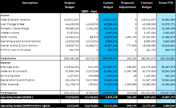
4) Service Unit P&L Summary
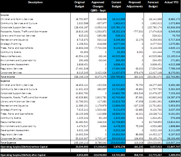
5) Capital Expenditure Statement
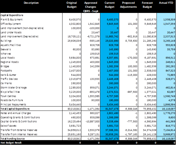
6) Cash & Investments – Restricted Held
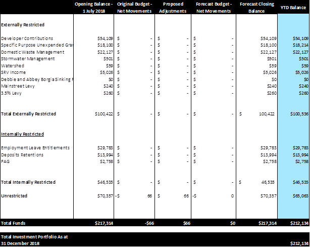
Council’s cash position sees an unrestricted balance of $65.1 million as at 31 December 2018. The unrestricted balance will continue to diminish as Council expends it on operational expenses and capital projects during the financial year. The funds have been invested in accordance with Council’s investment portfolio which saw Council’s non fossil fuel investment at approximately $205.3m or 98% of its total portfolio as at the end of December 2018.
7) Contract Listing
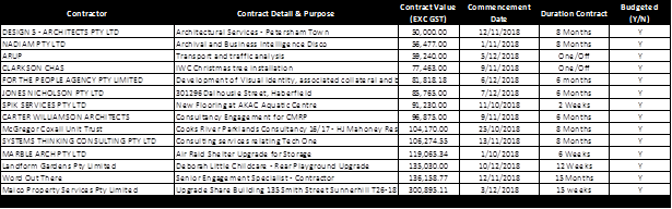
Above is a listing of contracts Council entered into during the period 1 October to 31 December 2018.
8) Consultancy & Legal Expenses
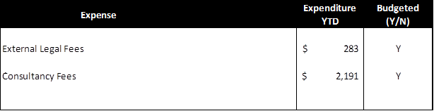
A consultant is a person or organisation engaged under contract on a temporary basis to provide recommendations or high level specialist or professional advice to assist decision making by management. Generally it is the advisory nature of the work that differentiates a consultant from other contractors.
Where any expenses for Consultancy or Legal Fees (including Code of Conduct expenses) have not been budgeted for, an explanation is to be given. Report on external expenses only (not internal expenses).
|
|
Council Meeting 12 February 2019 |
Subject: Investment Report as at 30th November 2018
Prepared By: Brendhan Barry - Manager Financial Services
Authorised By: Michael Tzimoulas - Deputy General Manager Chief Financial and Administration Officer
|
SUMMARY In accordance with the requirements of clause 212 of the Local Government (General) Regulation 2005, Council is provided with a listing of all investments made pursuant to section 625 of the Local Government Act 1993 and reported for period ending 30 November 2018.
|
|
RECOMMENDATION THAT the report be received and noted.
|
Clause 212 of the Local Government (General) Regulation 2005 requires that a report be presented to Council each month listing all investments with a certification from the Responsible Accounting Officer. Attached to this report are further reports from Council’s Investment Advisors, Prudential Investment Services.
FINANCIAL IMPLICATIONS
The Investment Holdings report (Attachment 1) for the period ending 30 November 2018 reflects Council’s holding in various investment categories these are listed in the table below. Council’s portfolio size sits at $208.9m, of which 83% was rated A rated or above. All Socially Responsible Investments (SRI’s) are investments that comply with the Non Fossil Fuel standards.
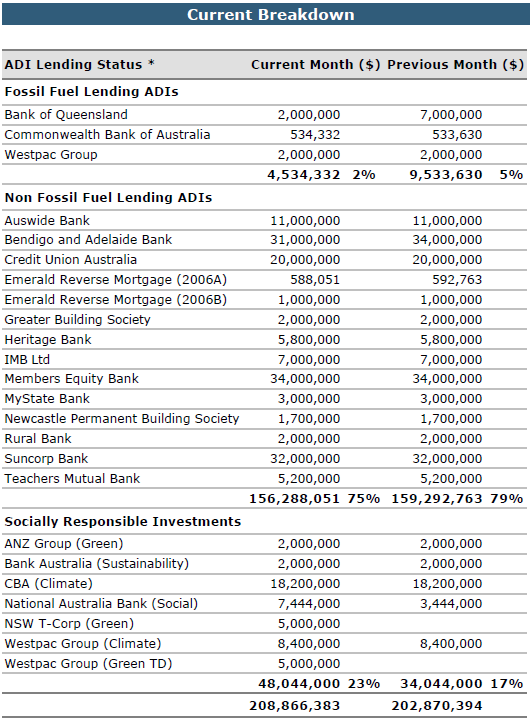
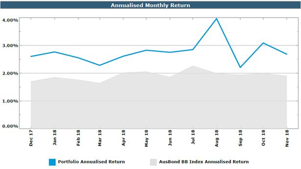
Council’s annualised return continues to exceed the bank bill index benchmark. The period ending 30 November 2018, the portfolio for Inner West Council had a One-Month Portfolio Investment Return of 2.68%, above the UBSWA Bank Bill Index Benchmark (2.02%).
Council has a well-diversified portfolio with 83% of the portfolio spread among the top three credit rating categories (A long term / A2 short term and higher).
Council has a well-diversified portfolio invested among a range of term deposits and floating rate notes from highly rated Australian ADIs. The graph above shows Council’s individual institution exposure compared with the investment policy limits.
The graph above demonstrates the term to maturity for Council’s investments compared to Council’s approved investment policy limits.
Environmental and Socially Responsible Commitments
The graph above illustrates the gap between yields received from Socially Responsible Investments (SRI), Fossil Fuel (FF) and Non Fossil Fuel (NFF) Investments. All Socially Responsible Investments are also Non Fossil Fuel Investments.
Council’s holdings in NFF / SRI’s was $204.3m with the relative total portfolio percentage of 98%.
Council’s holdings in NFF investments were $156.3m with the relative total portfolio percentage of 75%.
Council’s holdings in SRI’s were $48.0m, with the relative total portfolio percentage of 23%.
The attachments to this report summarise all investments held by Council and interest returns for periods ending 30 November 2018.
The Current Market value is required to be accounted for. The Current Market Value is a likely outcome if Council were to consider recalling the investment prior to its due date.
All investments made for the month of November 2018 have been made in accordance with the Local Government Act, Local Government Regulations and the Inner West Council Investment Policy.
|
1.⇩ |
IWC Nov18 |
|
2.⇩ |
IWC Economic and Investment Portfolio Commentary Nov 18 |
|
|
Council Meeting 12 February 2019 |
Subject: Notice of Motion: Disability Employment
From: Councillor Julie Passas
|
Motion:
THAT Council receive a report back on how many staff have disabilities which are employed under the Inclusion Action Plan (for People with a Disability) 2017-21.. |
Background
The Inner West Council has an obligation as other organisations to employ people with disabilities. I propose that a report be brought to council which informs council how many staff there are currently employed by Council which are employed under the disability inclusion action plan and does Inner West Council have a disability employment scheme or policy. If not the report also include a policy that is used at other councils.
Officer’s Comments:
Comment from Group Manager Human Resources:
Council currently operates with the following plans regarding employment of people with disability:
a. Inclusion Action Plan (People with Disability) 2017-2021 and
b. EEO management Plan 2018 - 2022
Inclusion Action Plan (People with Disability)
Under action 6.4.13 in the Inclusion Action Plan (People with Disability), Human Resources is tasked to develop benchmarks and targets to work towards Councils workforce mirroring the demographics of the Inner West community in relation to persons with disability. The targets were established in 1 July 2018 and has been met. Please see results from the EEO Management plan.
EEO Management Plan 2018-2022
From our recent EEO staff survey report. We approximately have 5.1% of staff respondents that have self-identified of having disability/s. It is noted that this may be under represented, due to the limitations of self-nominating.
5.1% is representing 31 members of staff.
Our community profile indicates that our local government area has a population of 4.5 per cent[1] of residents requiring assistance in their day-to-day lives due to disability. Council’s EEO data in Chart 8 indicates that 5.1 per cent have identified that they are living with disability. However a greater proportion of 8.1 per cent have preferred not to identify. Against, other NSW Councils, Inner West have employed more staff with disability compared to the average of 1.45 per cent of staff with disability[2].This demonstrates that Inner West has and operates with some disability confidence.
This data will be in an update on the EEO Management Plan being reported to Council at it’s next Meeting.
|
|
Council Meeting 12 February 2019 |
Subject: Notice of Motion: Warren Road, Marrickville
From: Deputy Mayor, Councillor Victor Macri
|
Motion:
THAT Council:
1. Complete the necessary study and investigations for a proposed conversion of Warren Road, Marrickville from its current two-way traffic flow operation to one-way; and
2. Recommendations be submitted to the Local Traffic Committee for consideration.
|
Background
Representations have been received from residents of Warren Rd., Marrickville to convert Warren Rd (between Carrington Rd and Illawarra Rd) to a one-way traffic operation. The narrow width street has on-street parking which often restricts the road to one trafficable lane over significant lengths. This often leads to traffic congestion with two-way traffic movements and reports of damage to parked vehicles. Conversion to a one-way street would remove this problem.
Officer’s Comments:
Comment from Group Manager Roads & Stormwater:
The conversion of Warren Rd to one-way westbound was previously considered by Marrickville Council in 2011. Ultimately this was not proceeded with due to difficulty in resolving suitable alternative truck routes for deliveries to Woolworths and concerns regarding diversion of traffic volumes to adjacent streets. In implementing the motion a precinct Local Area Traffic Management (LATM) study & review would need to be undertaken to assess traffic volumes, options, impacts on surrounding streets, undertake public engagement and facilitate preparation of a Traffic Management Plan supporting a change in traffic flow for submission to RMS for their approval. Estimated cost including staff time approx. $10,000 which can be funded from existing operational expenses.
|
|
Council Meeting 12 February 2019 |
Subject: Notice of Motion: Council Advertising
From: Councillor Julie Passas
|
Motion:
THAT Council: 1. Abandon all advertising in the Courier apart from the statutory required notices and council expand on its quarterly newsletter that is hand delivered and that the draft newsletter be approved by Councillors prior to distribution; and 2. Review all aspects of our advertising and public notices, councils aim should be to inform as many residents as possible in a fiscally reasonable manner and that a report on all aspects of our notification obligations be made available to councillors as soon as possible. |
Background
The Council page and advertising in the Courier is costing the ratepayers in the Inner West Council Local Government Area $458,000.00 per annum.
I am aware that under the Local Government Act Council is obligated to notify residents of Development Applications and tenders this amount Council is spending cannot be justified. Given that the courier newspaper is not widely distributed. Balmain, Haberfield and Marrickville are a few of the suburbs that have not received a hard copy for years. My area in Ashfield receives a copy one week then nothing for months.
The courier may argue that they have a high degree of internet readership which that in itself should be cost effective also a vast majority of our residents are not computer literate. However, residents need to pay for a subscription to view the Courier online.
Officer’s Comments:
Comment from Group Manager Communications, Engagement and Events:
We estimate the cost for staff time (investigating and writing report) would be approximately $2,000.
A few of the claims in the NOM are incorrect. For example, stating that the Courier is not delivered to certain suburbs when we have checked with staff living in those suburbs who do receive the paper. The newspaper is the paper is distributed to our whole LGA – including Marrickville, Balmain and Haberfield – with a circulation of approx. 86,000 (43,000 for the Inner West and City editions).
The approval of the newsletter, is considered an operational matter for staff to determine and not Councillors.
|
|
Council Meeting 12 February 2019 |
Subject: Notice of Motion: Reversing Inner West Bus Privatisation
From: Councillor Tom Kiat
|
Motion:
THAT Council write to the Minister for Transport, and the state transport spokespeople for the ALP and the Greens (with copies to their local state MPs), requesting that they publicly commit to:
a) reversing the privatisation of the Inner West buses (bus region 6) as soon as possible (including through good faith negotiations for early exit from the current contract); and
b) reversing and opposing the privatisation of our public transport network, including metro and proposed metro lines like the Sydenham to Bankstown line.
|
Background
On 12 October 2017, Council resolved to oppose the Inner West bus privatisation announced by the NSW government and called on the government to reverse its decision. In February 2018, the government announced the contract had been awarded to Transit Systems for an 8 year contract, with a 5 year review period.
Privatisation of our public transport system lowers service standards, working conditions and most importantly, democratic accountability of our public services.
With the state election looming, for the good of our residents, we should take the opportunity to extract a commitment from the major parties represented in this Council that they will reverse the privatisation that has occurred in the Inner West, and that is occurring across the State. Our request should go directly to the Transport Minister/spokespersons, with copies to state MPs for electorates within our LGA.
|
|
Council Meeting 12 February 2019 |
Subject: Notice of Motion: Report on 290-292 Illawarra Road as Council Affordable Housing
From: Councillor Tom Kiat
|
Motion:
THAT Council receive a report on how Council’s property at 290-292 Illawarra Road can be redeployed in accordance with part 2.6 of our Affordable Housing Policy. The report should address options for necessary renovations, opportunities for partnership especially with an Aboriginal Community Housing Provider (CHP), and the financial implications of the project including income from rent and possible contributions toward necessary renovations by the partnering CHP.
|
Background
The population of Aboriginal and Torres Strait Islander people in our LGA is lower than the state average. One reason for this may be general unaffordability in the private housing market and a very low stock of public housing.
Part 2.6 of our Affordable Housing Policy, ‘Partnerships to Increase Affordable Housing’ states:
“Council will seek to enter into affordable housing development and management partnerships with a relevant Community Housing Providers and/or the private sector to ensure: … Opportunities for the efficient use of any resources redeployed by Council (e.g. lots or housing dedicated to affordable housing from Council owned or other public land) … Council will ensure the proper management of affordable housing resources created through entering into an MOU or other legal agreement with an appropriate Community Housing Provider (CHP).”
Using houses in Council’s property portfolio as Council housing managed by a CHP meets our community’s expectation that we take action to improve affordability and diverse housing in the Inner West. Financially, it provides Council with an additional steady stream of revenue. Partnering with an Aboriginal Community Housing Provider is a small way Council can ‘pay the rent’ to First Nations people whose land we occupy.
Councillors were briefed on this property in November 2018. It is 335 square meters zoned B2 on Illawarra Road. It was acquired by Council as part of the Marrickville LEP 2001 for road widening. It is no longer required for this purpose, and a residential lease operated until September 2017. The briefing suggested that the house could be sold rather than renovated for continued ownership and use by Council. The briefing noted there are some accessibility issues with the property, this should be addressed in detail in the report with reference to CHP requirements and the cost of modifications.
The small upfront cost to retain this valuable asset is a sound investment. It is also possible that there will be a CHP willing to contribute toward the renovation.
Officer’s Comments:
Comment from Group Manager Strategic Planning:
This property is part of the Land and Property Strategy. A report on options for this property was scheduled to be reported to Council in March but if this motion is supported the further investigations would delay the report by 1-2 months.
|
|
Council Meeting 12 February 2019 |
Subject: Notice of Motion: Air Pollution Levels Dangerously High Along Westconnex Route
From: Councillor Rochelle Porteous
|
Motion:
THAT:
1. The Mayor on behalf of Council writes to the CEO of the Environmental Protection Agency (EPA) requesting an urgent meeting of the Mayor and interested Councillors with the CEO of the EPA to address the unacceptably high PM 2.5 levels which have been exceeding the National Limit of 8 and WHO limit of 10 for an extended period of time;
2. The Mayor on behalf of Council writes to the Minister for Roads and Maritime outlining the numerous breaches in national limits of PM 2.5 and the failure to produce any recent monitoring results since September 2018 and the fact that these high levels already exceed the maximum predicted levels in the M4East EIS and the M4/M5 EIS and requesting an urgent meeting (Mayor and interested Councillors) and response from the Minister as to why there have been no monitoring results since September 2018 and report on the origin of these dangerously high air pollution levels along the WestConnex route further no plan to address these high pollution levels;
3. The Mayor on behalf of Council writes to the Premier and Leader of the Opposition outlining the dangerously high air pollution levels along the WestConnex route which have now persisted for an extended period of time, requests an urgent meeting (Mayor and interested Councillors) with the Premier and with the Leader of the Opposition calls on them to commit to take urgent action to address this unacceptable risk to the health of people, including many children in the Inner West Council area;
4. The Mayor on behalf of Council writes to the Minister and Shadow Minister for Planning outlining the dangerously high air pollution levels along the WestConnex route which have already exceeded the maximum predicted levels in the M4East EIS and M4/M5 EIS; noting that the premises on which these EISs have been developed is wrong and that SMC and RMT are likely to be in breach of the conditions of consent for these projects and the EIS for the Stage 3B; further also requesting a meeting of the Mayor and interested Councillors with the Minister and with the Shadow Minister;
5. Councillors
be provided with the minutes of all meetings convened to discuss air
pollution concerns with WestConnex- affected Councils; and 6. Council seeks partnerships with local universities to commission a comprehensive report to investigate the health impacts of the high air pollution levels along the WestConnex route. That this comprehensive study into the health impacts of WestConnex includes construction and operational health impacts and predicts the further health impacts on local Inner West families with the very high air pollution levels which will be generated by the compounding impact of WestConnex if it is opened. Funding for this report to come from the next quarterly budget review. |
Background
The WestConnex Haberfield air quality baseline monitors between January and December 2018 have consistently recorded PM 2.5 levels above the national limit. The national limit is 8 and the WHO limit is 10. Particulate matter is measured in micrograms per cubic metre of air, abbreviated to ug/m3.
As noted in a recent report by Professor Wendy Bacon,
“A monitor on Ramsay Street Haberfield near Wattle Street recorded 11.6 µg/m³. Another monitor inside the grounds of Haberfield Public School recorded 11.2 µg/m³.”
“According to OEH records, only once since 1997, when monitoring of PM 2.5 began, has a NSW monitor recorded an annual average above 11 µg/m³ and that was at Liverpool in 2002. Until these 2018 results, only one other NSW monitor had recorded more than 10 µg/m³ and that was at Muswellbrook in the Hunter Valley in 2012.”
“Extensive scientific research has shown that there is no safe level of PM 2.5, which is linked to heart disease, cancer, premature birth and can impact lung and brain development. There is also evidence that it may be linked to diabetes, depression in adolescents and dementia.”
It is particularly concerning that very high levels are being recorded in the busy shopping strip and at Haberfield School with:
Ramsay Street Haberfield - 46% higher
Haberfield School - 40% higher
The Parents and Citizens of Haberfield School have been constantly warning the Government about the impact these high air pollution levels will have on the health of their children and the Government has done nothing.
Further, the Council has up until now continued to deflect the responsibility for a comprehensive health report on to the LNP State Government. It seems clear that the State Government does not care about the dangerously high air pollution levels and the health of Inner West citizens. They clearly intend to spend no funds and allocate no resources to addressing the urgent need for a comprehensive health report. The responsibility therefore lies with Council and is is recommended that a partnership be sought with a local university to undertake this report.
See also as background the report by Professor Wendy Bacon “WestConnex Haberfield monitors recorded highest PM 2.5 levels in NSW in 2018” www.wendybacon.com
Officer’s Comments:
Comment from Group Manager Strategic Planning:
In accordance with a Council resolution, a meeting was held with relevant staff from WestConnex-affected councils on air quality issues on 5 September 2018. The agenda and minutes of that meeting have been forwarded to all Councillors.
In 2018 Council staff attended a seminar at the Centre for Air pollution, energy and health Research (CAR) at the Woolcock Institute of Medical Research, located in Glebe. Opportunities for collaboration on air quality research were discussed at the seminar. Subsequently, in accordance with a Council resolution, Council wrote to relevant universities seeking a discussion of opportunities for collaboration on air pollution studies. As a result, CAR has contacted Council to arrange such a meeting which is being planned for the second-half of March 2019.
|
|
Council Meeting 12 February 2019 |
Subject: Code of Conduct Complaint Investigation
Prepared By: Suellen Bullock - Internal Ombudsman
Authorised By: John Warburton - Acting General Manager
|
SUMMARY In August 2018, Council received a complaint alleging a breach of the Code of Conduct by a Councillor. The complaint was referred to a conduct reviewer in accordance with the Procedures for the Administration of the Model Code of Conduct for NSW councils (the Procedures). As required, the complaint was referred by the General Manager to Council’s Complaints Coordinator, who under the Procedures, referred the matter to a conduct reviewer from Council’s appointed panel of conduct reviewers. The matter was investigated and the conduct reviewer’s final report is submitted for Council’s consideration in accordance with Clause 8.43 of the Procedures. |
|
RECOMMENDATION
THAT Council consider the conduct reviewer’s report and take action in accordance with the Procedures as outlined in this report.
|
BACKGROUND
The subject complaint has been administered under the Procedures for the Administration of the Model Code of Conduct for NSW councils (the Procedures).
The Procedures state:
Final investigation report
Clause 8.43
Where the investigator has determined that there has been a breach of the code of conduct and makes a recommendation or recommendations under clause 8.35, paragraphs (d) to (h), the complaints coordinator must, where practicable, arrange for the investigator’s report to be reported to the next ordinary council meeting for the council’s consideration unless the meeting is to be held within the 4 weeks prior to an ordinary local government election, in which case the report must be reported to the first ordinary council meeting following the election.
Consideration of the final investigation report by Council
Clauses 8.44-8.59
8.44 The role of the council in relation to a final investigation report is to impose a sanction where an investigator determines that there has been a breach of the code of conduct and makes a recommendation in their final report under clause 8.35, paragraphs (d) to (h).
8.45 The council is to close its meeting to the public to consider the final investigation report where it is permitted to do so under section 10A of the Act.
8.46 Where the complainant is a councillor, they must absent themselves from the meeting and take no part in any discussion or voting on the matter. The complainant councillor may absent themselves without making any disclosure of interests in relation to the matter unless otherwise required to do so under the Act or the Model Code
8.47 Prior to imposing a sanction, the council must provide the subject person with an opportunity to make an oral submission to the council. The subject person is to confine their submission to addressing the investigator’s recommendation/s.
8.48 Once the subject person has completed their oral submission they must absent themselves from the meeting and, where they are a councillor, take no part in any discussion or voting on the matter.
8.49 The council must not invite oral submissions from other persons for the purpose of seeking to rehear evidence previously considered by the investigator.
8.50 Prior to imposing a sanction, the council may by resolution:
· request that the investigator make additional enquiries and/or provide additional information to it in a supplementary report, or
· seek an opinion by the Division in relation to the report.
8.51 The council may, by resolution, defer further consideration of the matter pending the receipt of a supplementary report from the investigator or an opinion from the Division.
8.52 The investigator may make additional enquiries for the purpose of preparing a supplementary report.
8.53 Where the investigator prepares a supplementary report, they must provide copies to the complaints coordinator who shall provide a copy each to the council, the subject person and the complainant.
8.54 The investigator is not obliged to notify or consult with any person prior to submitting the supplementary report to the complaints coordinator.
8.55 The council is only required to provide the subject person a further opportunity to address it on a supplementary report where the supplementary report contains new information that is adverse to them.
8.56 A council may by resolution impose one or more of the following sanctions on a subject person:
a) that the subject person apologise to any person or organisation affected by the breach in such a time and form specified by the resolution,
b) that findings of inappropriate conduct be made public,
c) in the case of a breach by the general manager, that action be taken under the general manager’s contract for the breach,
d) in the case of a breach by a councillor, that the councillor be formally censured for the breach under section 440G of the Act,
e) in the case of a breach by a councillor:
i. that the councillor be formally censured for the breach under section 440G of the Act, and
ii. that the matter be referred to the Division for further action under the misconduct provisions of the Act.
8.57 The council is not obliged to adopt the investigator’s recommendation/s. Where the council does not adopt the investigator’s recommendation/s, the council must resolve not to adopt the recommendation and state in its resolution the reasons for its decision.
8.58 The council may, by resolution, impose a sanction on the subject person under clause 8.56 different to the sanction recommended by the investigator in their final report.
8.59 Where the council resolves not to adopt the investigator’s recommendation/s, the complaints coordinator must notify the Division of the council’s decision and the reasons for it.
FINANCIAL IMPLICATIONS
The costs for this investigation as at 22 January 2019 were $11,000 (excl. GST).
OTHER STAFF COMMENTS
Not applicable.
PUBLIC CONSULTATION
Not applicable. The substance of this matter is for consideration in closed meeting in accordance with the Local Government Act 1993 and the Procedures.
CONCLUSION
This report is submitted to Council in accordance with clause 8.43 of the Procedures.
Council must consider the report of the conduct reviewer and impose a sanction (Clause 8.44 of the Procedures).
In considering the conduct reviewer’s report, Council must close the meeting (clause 8.45) and the subject person must be given the opportunity to make an oral submission to council addressing only the conduct reviewer’s recommendations (clause. 8.47). Furthermore, once the subject person has completed their oral submission, they must absent themselves from the meeting and as a Councillor, take no further part in any discussion or voting on the matter (clause 8.48). Council must not, in its consideration of the matter, invite oral submissions from other persons for the purpose of seeking to rehear evidence previously considered by the investigator (clause 8.49).
Prior to imposing a sanction, the Council may:
· defer the matter and request the conduct reviewer to make additional enquiries (Clause 8.50 a) of the Procedures)
· defer the matter and seek an opinion from the Office of Local Government (Clause 8.50 b) of the Procedures)
Council is not obliged to adopt the conduct reviewer’s recommendations, and where this is the case must state in its resolution the reasons for its decision (Clause 8.57 of the Procedures).
It is also open to the Council to impose a sanction on the subject person that is different to the sanction recommended by the conduct reviewer (clause 8.58 of the Procedures) where the Council considers this an appropriate course of action.
|
1.⇩ |
Procedures for the Administration of the Model Code of Conduct for Local Councils in NSW (March 2013) |
|
Conduct Reviewer's Final Investigation Report - Confidential |
[1] Australian Bureau of Statistics 2016, Inner West Council area: Need for assistance, .idcommunity demographic resources, accessed December 2018, <https://profile.id.com.au/inner-west/assistance>
[2] Local Government NSW: Management Solutions; January 2018, 2017 NSW Local Government HR Metrics Benchmarking: Generic Summary Report, p.8