|
AGENDA R |

Local Traffic Committee Meeting
MONDAY 4 FEBRUARY 2019
10.00am
|
|
Local Traffic Committee Meeting 4 February 2019 |
Function of the Local Traffic Committee
Background
Roads and Maritime Services (RMS) is legislated as the Authority responsible for the control of traffic on all NSW Roads. The RMS has delegated certain aspects of the control of traffic on local roads to councils. To exercise this delegation, councils must establish a local traffic committee and obtain the advice of the RMS and Police. The Inner West Council Local Traffic Committee has been constituted by Council as a result of the delegation granted by the RMS pursuant to Section 50 of the Transport Administration Act 1988.
Role of the Committee
The Local Traffic Committee is primarily a technical review and advisory committee which considers the technical merits of proposals and ensures that current technical guidelines are considered. It provides recommendations to Council on traffic and parking control matters and on the provision of traffic control facilities and prescribed traffic control devices for which Council has delegated authority. These matters are dealt with under Part A of the agenda and require Council to consider exercising its delegation.
In addition to its formal role as the Local Traffic Committee, the Committee may also be requested to provide informal traffic engineering advice on traffic matters not requiring Council to exercise its delegated function at that point in time, for example, advice to Council’s Development Assessment Section on traffic generating developments. These matters are dealt with under Part C of the agenda and are for information or advice only and do not require Council to exercise its delegation.
Committee Delegations
The Local Traffic Committee has no decision-making powers. The Council must refer all traffic related matters to the Local Traffic Committee prior to exercising its delegated functions. Matters related to State Roads or functions that have not been delegated to Council must be referred directly to the RMS or relevant organisation.
The Committee provides recommendations to Council. Should Council wish to act contrary to the advice of the Committee or if that advice is not supported unanimously by the Committee members, then the Police or RMS have an opportunity to appeal to the Regional Traffic Committee.
Committee Membership & Voting
Formal voting membership comprises the following:
· one representative of Council as nominated by Council;
· one representative of the NSW Police from each Local Area Command (LAC) within the LGA, being Newtown, Marrickville, Leichhardt and Ashfield LAC’s.
· one representative from the RMS; and
· State Members of Parliament (MP) for the electorates of Summer Hill, Newtown, Heffron, Canterbury, Strathfield and Balmain or their nominees.
Where the Council area is represented by more than one MP or covered by more than one Police LAC, representatives are only permitted to vote on matters which effect their electorate or LAC.
Informal (non-voting) advisors from within Council or external authorities may also attend Committee meetings to provide expert advice.
Committee Chair
Council’s representative will chair the meetings.
Public Participation
Members of the public or other stakeholders may address the Committee on agenda items to be considered by the Committee. The format and number of presentations is at the discretion of the Chairperson and is generally limited to 3 minutes per speaker. Committee debate on agenda items is not open to the public.
|
|
Local Traffic Committee Meeting 4 February 2019 |
|
AGENDA |
1 Apologies
2 Disclosures of Interest
3 Confirmation of Minutes Page
Minutes of 4 December 2018 Local Traffic Committee Meeting 6
4 Matters Arising from Council’s Resolution of Minutes
5 Part A – Items Where Council May Exercise Its Delegated Functions
Traffic Matters
ITEM Page
LTC0219 Item 1 Mullens Street, near Beattie Street, Balmain - Raised Pedestrian (Zebra) Crossing (Balmain Ward/Balmain Electorate/Leichhardt PAC) 28
LTC0219 Item 2 Smidmore Street, Marrickville – Road Occupancy - Request by BreastScreen NSW to position a Mobile X-ray Unit on Street between 11 March 2019 and 9 May 2019 (Marrickville Ward / Summer Hill Electorate / Inner West PAC) 31
LTC0219 Item 3 Darling Street between Mort Street and Curtis Road, Balmain - Road Occupancy - ANZAC Day Dawn Service (Balmain Ward/Balmain Electorate/Leichhardt PAC) 34
LTC0219 Item 4 Audley Street, Sadlier Crescent, Fisher Street, and parking lanes on New Canterbury Road Petersham – Temporary Full Road Closures For Special Event On Sunday 10 March 2019 – Bairro Portuguese Food and Wine Fair (Stanmore Ward/Newtown Electorate/Marrickville PAC) 40
LTC0219 Item 5 Temporary Road Closure - Cook Street (between Angelini Street and Brockley Street), Rozelle (Balmain Ward/Balmain Electorate/Leichhardt PAC) 45
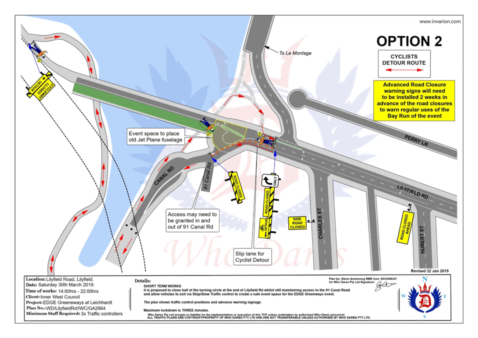
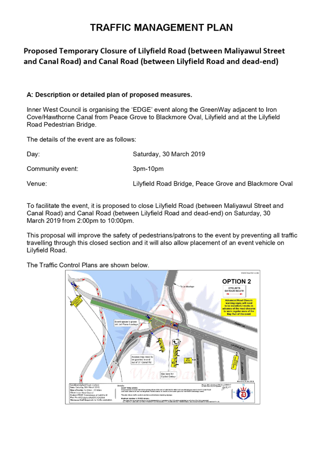
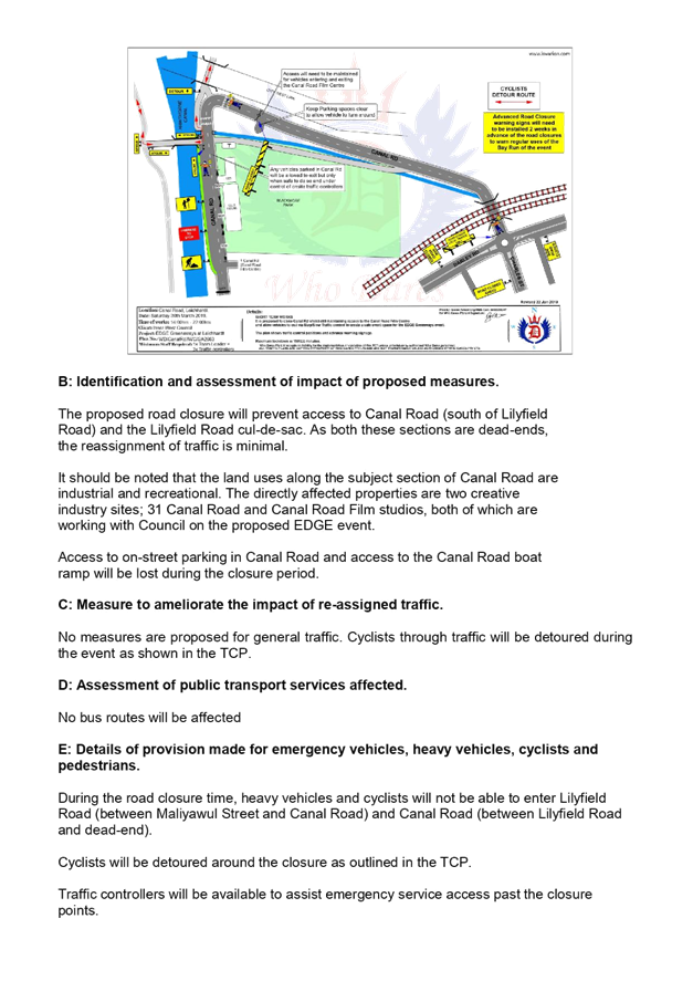
LTC0219 Item 6 Canal Road and Lilyfield Road, Lilyfield - Temporary Road Closure for EDGE Greenway event (Leichhardt Ward / Balmain Electorate / Leichhardt PAC) 49
LTC0219 Item 7 Council Street, St Peters - Proposed Parking Restrictions (Marrickville Ward/ Heffron Electorate/Inner West PAC) 57
LTC0219 Item 8 Gannon Lane, Tempe - Proposed Parking Restrictions (Marrickville Ward/Heffron Electorate/Inner West PAC) 60
LTC0219 Item 9 Lord Street, Newtown - Proposed kerb blister islands (Stanmore Ward, Newtown Electorate, Inner West PAC) 63
Parking Matters
ITEM Page
LTC0219 Item 10 Unnamed Lane - rear of No.39 Warren Road, Marrickville - Proposed 'No Parking' restriction (Marrickville Ward/Summer Hill Electorate/Inner West PAC) 66
LTC0219 Item 11 Rosieville Lane, Balmain - Proposed 'No Parking' Restriction (Balmain Ward/Balmain Electorate/Leichhardt PAC) 69
LTC0219 Item 12 Longport Street, Lewisham - Proposed extension of Peak Hour Parking Restricitons (Ashfield Ward/Summer Hill Electorate/Inner West PAC) 72
LTC0219 Item 13 Cavey Street, Marrickville - Proposed 'No Parking' in cul de sac (MarrickvilleWard/Summer Hill Electorate/Inner west PAC) 82
LTC0219 Item 14 Roach Street, Marrickville - 'Proposed No Parking' in cul de sac (Marrickville Ward/Summer Hill Electorate/Inner West PAC) 84
LTC0219 Item 15 Cannon Lane, Stanmore - Proposed 'No Stopping' and 'No Parking' restrictions (Stanmore Ward/Newtown Electorate/Inner West PAC) 87
LTC0219 Item 16 Silver Street, St Peters - Proposed 10m No Stopping at intersection with Edith Lane (Marrickville Ward/Heffron Electorate/Inner West PAC) 91
LTC0219 Item 17 Brighton Street, Petersham Intersection with Unnamed Lane - Proposed Parking Restrictions (Stanmore Ward,/Newtown Electorate/Inner West PAC) 94
LTC0219 Item 18 Grove Street, Dulwich Hill - Extension of Existing Resident Permit Scheme Hours (Ashfield Ward/Summer Hill Electorate/Inner West PAC) 100
LTC0219 Item 19 Chapman Lane (rear of Nos.129 - 133 Annandale Street), Annandale - Proposed Extension of 'No Parking' zone (Leichhardt Ward/Balmain Electorate/Leichhardt PAC) 104
LTC0219 Item 20 Short Street, Dulwich Hill- Proposed Permit Parking restrictions (Ashfield Ward/Summer Hill Electorate/LAC) 107
LTC0219 Item 21 Little Theodore Street, Balmain - Proposed Extension of 'No Parking' zone (Balmain Ward/Balmain Electorate/Leichhardt PAC) 109
LTC0219 Item 22 Frampton Lane, Marrickville - Request for ‘No Parking’ Restrictions (Marrickville Ward / Newtown Electrorate / Inner West PAC) 113
LTC0219 Item 23 Minor Traffic Facilities (All Wards/All Electorates/All LAC's) 117
LTC0219 Item 24 Susan Lane, Annandale - Extension of Existing Resident Parking Scheme (Leichhardt Ward/Balmain Electorate/Leichhardt PAC) 127
LTC0219 Item 25 King Lane, Balmain - 'No Parking' zone (Balmain Ward/Balmain Electorate/Leichhardt PAC) 129
LTC0219 Item 26 Rawson Street, Haberfield - Proposed '15 Minute' Parking Zone (Leichhardt Ward/Summer Hill Electorate/Burwood PAC) 132
LTC0219 Item 27 Parramatta Road, Leichhardt - Proposed '1 hour' Parking Zone (Leichhardt Ward/Balmain Electorate/Leichhardt PAC) 134
LTC0219 Item 28 Young Street at Collins Street, Annandale - Proposed modification to existing 'No Stopping' zone (Leichhardt Ward/Balmain Electorate/Leichhardt PAC) 137
LTC0219 Item 29 Old Canterbury Road, Dulwich Hill- Proposed 'No Stopping' restrictions between Constitution Road and No.275 Old Canterbury Road, Dulwich Hill. (Ashfield Ward/ Summer Hill Electorate/ Inner West PAC) 139
Late Items
Nil at time of printing.
6 Part B - Items for Information Only
ITEM Page
LTC0219 Item 30 Liberty Street and Bedford Street, Stanmore – Temporary full road closure for rail overbridge refurbishment works – notice of change of date of works in March 2019 (STANMORE WARD /NEWTOWN ELECTORATE/ INNER WEST PAC) 143
LTC0219 Item 31 The ‘Gear Up Girl’ Bicycle Event (Marrickville Ward/Summer Hill & Heffron Electorate/Inner West PAC) 154
LTC0219 Item 32 WestConnex New M5 Operational Parking & Access Strategy Consultation (Marrickville Ward/Heffron Electorate/Inner West PAC) 162
7 Part C - Items for General Advice
ITEM Page
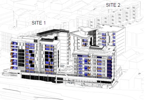
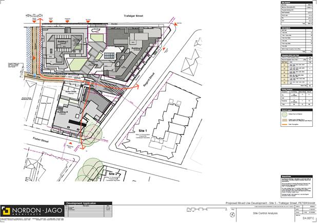
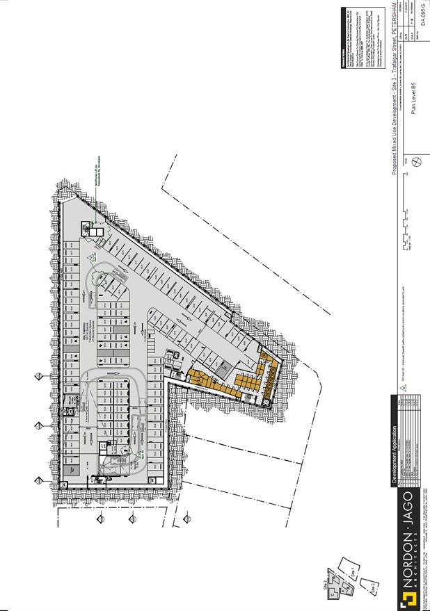
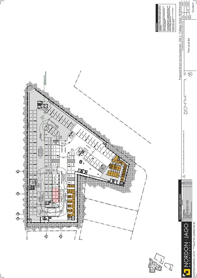
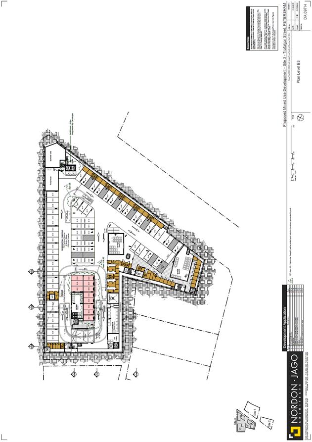
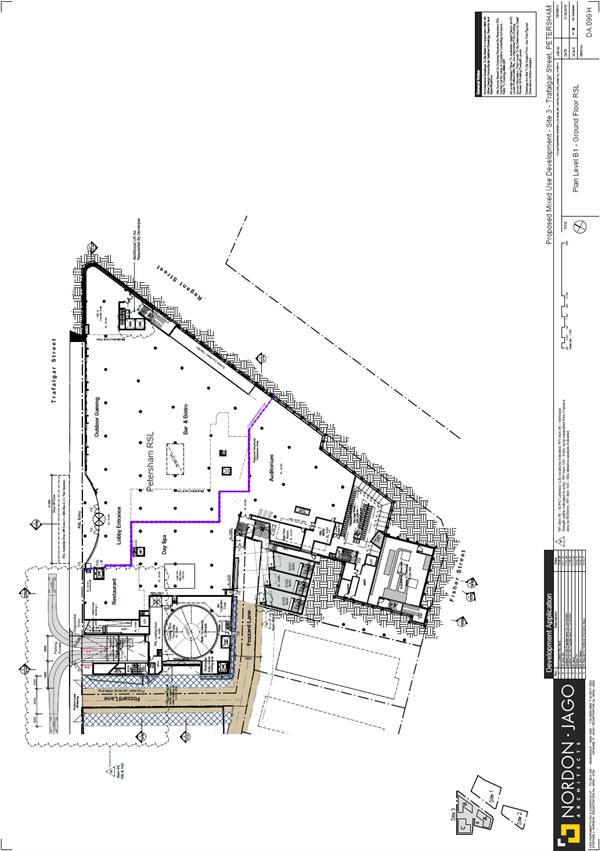
LTC0219 Item 33 3-7 & 13-17 Regent Street, 287-309 Trafalgar Street & 16-20 Fisher Street, Petersham - DA201800173 – Residential and Mixed Use Development and RSL Relocation over 3 Sites (Stanmore Ward / Newtown Electorate / Inner West PAC) 164
8 General Business
9 Close of Meeting
|
|
Local Traffic Committee Meeting 4 February 2019 Minutes from 4 Decemeber 2018 |
Minutes of Local Traffic Committee Meeting
Held at Petersham Service Centre on 4 December 2018
Meeting commenced at 10.01am
ACKNOWLEDGEMENT OF COUNTRY BY CHAIRPERSON
I acknowledge the Gadigal and Wangal people of the Eora nation on whose country we are meeting today, and their elders past and present.
COMMITTEE REPRESENTATIVES PRESENT
|
Clr Marghanita da Cruz |
Chair – Councillor – Leichhardt Ward |
|
Bill Holliday |
Representative for Jamie Parker MP, Member for Balmain |
|
Chris Woods |
Representative for Ron Hoenig MP, Member for Heffron |
|
Cathy Peters |
Representative for Jenny Leong, Member for Newtown |
|
Sgt John Micallef |
NSW Police – Burwood & Campsie Police Area Command |
|
Marina Nestoriadis |
NSW Police – Leichhardt Police Area Command |
|
SC Sam Tohme |
NSW Police – Burwood Police Area Command |
|
Ryan Horne |
Roads and Maritime Services |
|
|
|
|
OFFICERS IN ATTENDANCE |
|
|
|
|
|
Asith Nagodavithane |
Transit Systems – Inner West Bus Services |
|
Colin Jones |
Inner West Bicycle Coalition |
|
Wal Petschler |
IWC’s Group Manager, Roads, Traffic and Stormwater |
|
John Stephens |
IWC’s Traffic and Transport Services Manager |
|
Manod Wickramasinghe |
IWC’s Coordinator Traffic and Parking Services (North) |
|
Felicia Lau |
IWC’s Engineer – Traffic and Parking Services |
|
David Yu |
IWC’s Engineer – Traffic and Parking Services |
|
Boris Muha |
IWC’s Engineer – Traffic and Parking Services |
|
Brinthaban Baskaran |
IWC’s Student Traffic Engineer |
|
Sunny Jo |
IWC’s Traffic and Parking Planner |
|
Christina Ip |
IWC’s Business Administration Officer |
|
|
|
|
VISITORS |
|
|
|
|
|
Rene Holmes |
Item 7 and 8 - Resident |
|
|
|
|
APOLOGIES: |
|
|
|
|
|
Clr Vic Macri |
(Chair) Deputy Mayor – Marrickville Ward |
|
Jo Haylen MP |
Member for Summer Hill |
|
Sarina Foulstone |
Representative for Jo Haylen MP, Member for Summer Hill |
|
Sgt Paul Vlachos |
NSW Police – Inner West Police Area Command |
|
A/Sgt Charles Buttrose |
NSW Police – Leichhardt Police Area Command |
|
SC Tony Kenny |
NSW Police – Inner West Police Area Command |
|
George Tsaprounis |
IWC’s Coordinator Traffic and Parking Services (South) |
DISCLOSURES OF INTERESTS:
Nil.
CONFIRMATION OF MINUTES
The representative for the Member for Balmain requested that Item 17 of the minutes for the Local Traffic Committee meeting held on 6 November 2018 be amended to include that Ms Marion Rae stated that one of her neighbours shares a similar issue to her in that she attends the Chris O’Brien Lifehouse Cancer Centre in the early hours of the day when bus services are not currently running.
The minutes of the Local Traffic Committee Meeting held on Tuesday, 6 November 2018 were confirmed with that amendment.
MATTERS ARISING FROM COUNCIL’S RESOLUTION OF MINUTES
The Local Traffic Committee recommendations of its meeting held on 6 November were adopted at Council’s meeting held on 27 November 2018.
|
LTC1218 Item 1 Draft Newtown Local Area Traffic Management Strategy (Stanmore Ward/Newtown Electorate/Inner West PAC) |
|
SUMMARY
The draft Newtown Local Area Traffic Management (LATM) study and recommendations are attached for the Committee’s consideration.
Officer’s Recommendation
THAT:
1. The Committee endorse the draft Newtown LATM study and the recommended treatments for community consultation; and
2. The draft report be placed on Public Exhibition, providing a minimum 28 days for submissions.
DISCUSSION
The RMS representative advised that for RMS to approve the proposed 10km/h shared zones, the full length of the pavement needs to be changed. The representative also stated that there are a number of issues with the shared zones that need to be addressed before RMS can provide in principle support and the proposal be placed on Public Exhibition. The Committee members agreed that the recommendation could be amended to state that RMS principle support for the 10km/h shared zones be obtained before the proposal goes on Public Exhibition.
The representative for the Member for Newtown expressed support for the proposal and asked whether the truck restrictions will extend to Alice Street. The representative stated that there are concerns that King Street, Edgeware Road and Alice Street will experience a further increase in truck movements that could last six years.
Council Officers advised that a gateway treatment is proposed for the southern end of Princes Highway to prevent the intrusion of further traffic in King Street and divert traffic towards Euston Road.
COMMITTEE RECOMMENDATION
THAT:
For motion: Unanimous |
|
LTC1218 Item 2 Draft Newington Local Area Traffic Management Strategy (Stanmore Ward/Newtown Electorate/Inner West PAC) |
|
SUMMARY
The draft Newington Local Area Traffic Management (LATM) study and recommendations are provided for the Committee’s consideration. Amongst the options listed in the report, it is recommended that Council progress with implementing treatments, mainly the raised thresholds for a 50km/h environment and a number of other treatments.
Officer’s Recommendation
THAT:
1. The Committee endorse the draft Newington LATM study and the following treatments for community consultation:
a. Raised threshold in Albert Street near Marr Playground;
b. Two raised thresholds in Bright Street near No.26 and No.6 Bright
Street; c. Change of priority at the intersection of Tupper Street and Newington Road, including removal of existing speed hump near No.36 Newington Road and No Parking 7am-7pm Mon-Fri opposite Tupper Street in Newington Street;
d. Pedestrian refuge island in Addison Road between Denby and
Philpott Streets; e. Implementation of mixed traffic bicycle facilities within the
study area; and f. Changes at signalised intersections at Enmore Road/Llewelyn Street, Enmore Road/Addison Road and Addison Road/Agar Street/Illawarra Road.
2. The draft report be placed on Public Exhibition, providing a minimum 28 days for submissions.
DISCUSSION
The RMS representative requested that the proposed 40km/h zones not be included in public consultation until technical details are confirmed with Council Officers.
The Committee members agreed with the Officer’s recommendation.
COMMITTEE RECOMMENDATION
THAT:
1. The Committee endorse the draft Newington LATM study and the following treatments for community consultation:
a. Raised threshold in Albert Street near Marr Playground;
b. Two raised thresholds in Bright Street near No.26 and No.6 Bright Street; c. Change of priority at the intersection of Tupper Street and Newington Road, including removal of existing speed hump near No.36 Newington Road and No Parking 7am-7pm Mon-Fri opposite Tupper Street in Newington Street;
d. Pedestrian refuge island in Addison Road between Denby and
Philpott Streets; e. Implementation of mixed traffic bicycle facilities within the
study area; and f. Changes at signalised intersections at Enmore Road/Llewelyn Street, Enmore Road/Addison Road and Addison Road/Agar Street/Illawarra Road.
2. The draft report be placed on Public Exhibition, providing a minimum 28 days for submissions.
For motion: Unanimous |
|
LTC1218 Item 3 Darling Street at Denison Street, Rozelle - Intersection Improvements - Design Plan 10046 (Balmain Ward/ Balmain Electorate/ Leichhardt LAC) |
|
SUMMARY
Design plans have been prepared for the proposed footpath works on the southern side of Darling Street (between Red Lion Street and Denison Street) and for intersection improvements at the intersection of Darling Street and Denison Street, Rozelle. The works will improve road safety for pedestrians and motorists and is part of the Town Centre Upgrade Capital Works Program.
Consultation has been undertaken with owners and occupiers of affected properties in Darling Street, Rozelle regarding the proposal. It is recommended that the proposed detailed design plan be approved (Design Plan – 10046).
Officer’s Recommendation
THAT the detailed design plan for intersection improvements, including removing an existing concrete median in Denison Street and installing new line markings at the intersection of Darling Street and Denison Street, Rozelle (as per Design Plan No. 10046) be approved.
DISCUSSION
The Committee members agreed with the Officer’s recommendation.
COMMITTEE RECOMMENDATION
THAT the detailed design plan for intersection improvements, including removing an existing concrete median in Denison Street and installing new line markings at the intersection of Darling Street and Denison Street, Rozelle (as per Design Plan No. 10046) be approved.
For motion: Unanimous
|
|
LTC1218 Item 4 Warayama Place and Yara Avenue, Rozelle - Proposed 'No Stopping' Restrictions (Balmain Ward/ Balmain Electorate/ Leichhardt LAC) |
|
SUMMARY
Council has received a request to signpost a ‘No Stopping’ restriction on the eastern side of Yara Avenue south of Warayama Place, Rozelle in order to prevent illegal parking and improve sight lines.
Officer’s Recommendation
THAT a 12m ‘No Stopping’ zone be installed on the eastern side of Yara Avenue, south of Warayama Place, Rozelle.
DISCUSSION
The Committee members agreed with the Officer’s recommendation.
COMMITTEE RECOMMENDATION
THAT a 12m ‘No Stopping’ zone be installed on the eastern side of Yara Avenue, south of Warayama Place, Rozelle.
For motion: Unanimous
|
|
LTC1218 Item 5 Ash Lane at Wolseley Street and Northcote Street, Haberfield - Proposed 'No Stopping' Restrictions (Leichhardt Ward/ Summer Hill Electorate/ Burwood PAC) |
|
SUMMARY
Council has received a request to signpost the statutory ‘No Stopping’ restriction at the intersections of Ash Lane/Wolseley Street and Ash Lane/Northcote Street, Haberfield, in order to prevent illegal parking and improve sight lines.
Officer’s Recommendation
THAT:
1. A 10m ‘No Stopping’ zone be installed on the western side of Ash Lane, south of Wolseley Street, Haberfield;
2. A 10m ‘No Stopping’ zone be installed on the western side of Ash Lane, north of Northcote Street, Haberfield; and
DISCUSSION
The Committee members agreed with the Officer’s recommendation.
COMMITTEE RECOMMENDATION
For motion: Unanimous
THAT:
1. A 10m ‘No Stopping’ zone be installed on the western side of Ash Lane, south of Wolseley Street, Haberfield;
2. A 10m ‘No Stopping’ zone be installed on the western side of Ash Lane, north of Northcote Street, Haberfield; and
3. A 10m ‘No Stopping’ zone be installed on the western side of Ash Lane, south of Northcote Street, Haberfield.
|
|
LTC1218 Item 6 Cheltenham Street at Foucart Street and Brockley Street at Denison Street, Rozelle - Proposed 'No Stopping' Restrictions (Balmain Ward/ Balmain Electorate/ Leichhardt LAC) |
|
SUMMARY
Council has received a request to signpost the statutory ‘No Stopping’ restrictions at the intersections of Cheltenham Street/Foucart Street and Denison Street/Brockley Street, Rozelle, in order to prevent illegal parking and improve sight lines.
Officer’s Recommendation
THAT:
1. A 10m ‘No Stopping’ zone be installed on the southern side of Cheltenham Street, east of Foucart Street, Rozelle; and
2. 10m ‘No Stopping’ zones be installed on the western side of Denison Street, north and south of Brockley Street, Rozelle;
DISCUSSION
The Committee members agreed with the Officer’s recommendation.
COMMITTEE RECOMMENDATION
THAT:
1. A 10m ‘No Stopping’ zone be installed on the southern side of Cheltenham Street, east of Foucart Street, Rozelle; and
2. 10m ‘No Stopping’ zones be installed on the western side of Denison Street, north and south of Brockley Street, Rozelle;
For motion: Unanimous
|
|
LTC1218 Item 7 Croydon Road, Croydon - Proposed Pedestrian and Traffic Calming treatments. (Leichhardt Ward/Strathfield Electorate/Burwood PAC) |
|
SUMMARY
The Traffic Committee at its meeting held on 6 November 2018 deferred an item on the ‘Proposed pedestrian and traffic calming treatments’ along Croydon Road, Croydon (inclusive of proposed improvements to the intersection of Church Street and Croydon Road) for further investigation.
Council’s at its meeting on the 22 May 2018 adopted the recommendation of the Local Traffic Committee meeting of 1 May 2018 to support in principle to pursue various conceptual traffic facility proposals, for pedestrian and road safety improvements along Croydon Road from Elizabeth Street to Parramatta Road, Croydon, subject to further detail design and resident consultation. The treatments are proposed at intersections in effort to minimise the impact on parking.
This report provides consultation feedback from the community on the various traffic facilities proposed along Croydon Road, exclusive of the proposed improvement works at the intersection of Croydon Road and Church Street which is being reported separately to the Committee.
In relation to this report, from approximately 2200 consultation letters sent out to the residents of the Croydon/Ashfield area bounded by Parramatta Road to the north, Frederick Street to the east, Elizabeth Street to the south and the Burwood/Inner West Council boundary, 75 submissions were received representing around a 3.5% response rate of overall area surveyed. The majority of residents supported the proposals developed by Council under this report.
It is recommended to proceed to detail design on the various treatments along Croydon Road, with further consultation to be undertaken with the affected residents at each location.
Officer’s Recommendation
THAT:
1. The report be received and noted;
2. The following proposed treatments as listed below be approved in principle subject to detailed design and further consultation with affected residents at each location:
a) Provide a speed cushion in Croydon Road on the approach to Elizabeth Street (Figure 2-Location 1);
b) Widen the north-west corner of Anthony Street and Croydon Road, provide a refuge facility in Croydon Road south of Anthony Street, and speed cushion in Croydon Road north of Anthony Street (Figure 3-Location 2);
c) Provide kerb-blisters in Edwin Street North at the intersection to Anthony Street (Figure 4-Location 3);
d) Remove the horizontal deflection device and replace it with a pedestrian refuge island facility in Croydon Road between Kenilworth Street and Gregory Avenue, and provide speed cushions in Croydon Road on both approaches to Kenilworth Street and Gregory Avenue (Figure 5- Location 4);
e) Provide a pedestrian refuge in Croydon Road between Ranger Road and John Street, and a 10 metre length double white centreline in John Street at the approach to Croydon Road (Figure 6-Location 5);
f) Provide a pedestrian refuge opening in the splitter island in Croydon Road, north of the roundabout intersection with Church Street, and provide a speed cushion in Croydon Road on the southern end approach to Queen Street (Figure 7-Location 6);
g) Provide short length painted double white centre lines in Bay Street at the approach to Croydon Road, and in Croydon Road south of Bay Street (Figure 8-Location 8); and
h) Provide a central median island in Dalmar Street at Croydon Road (Figure 9- Location 9);
3. The existing ‘No Stopping’ restriction on the western side of Elizabeth Street be extended by 2-3m from 10m to a distance of approx. 12-13m north of Croydon Road;
4. A ‘No Stopping’ restriction on the eastern side of Elizabeth Street be installed at a distance of approx. 12-13m north of Croydon Road; and
5. ‘No Stopping’ restrictions be installed in Anthony Street for a distance of 5 metres west and 7 metres east of the laneway, between Edwin Street and Croydon Road.
DISCUSSION
Public speakers: Rene Holmes attended at 10.13am
Ms Holmes stated that:
Committee members were advised that the centre linemarking in Bay Street is appropriate as it is near a high volume collector road and improves delineation for general vehicle movement in the street.
Police representatives stated that the proposed placement of speed cushions along Croydon Road is suitable with the exception of the speed cushion proposed for the southbound approach to Gregory Avenue where vehicles could easily manoeuvre around. The representatives suggested installing speed cushions across the width of the road. Council Officers stated that this can be investigated during the detailed design phase.
The RMS representative stated that RMS does not support the proposed road level textured/coloured entry threshold treatment on Bay Street and John Street as there is no change in speed or conditions in those streets. Police representatives agreed with the RMS position.
The Committee members agreed with the Officer’s recommendation with the addition of a recommendation to investigate extending the speed cushion on Croydon Road near Gregory Avenue and removing the proposed road level textured/coloured entry threshold treatment on Bay Street and John Street from the design.
COMMITTEE RECOMMENDATION
THAT:
1. The report be received and noted;
2. The following proposed treatments as listed below be approved in principle subject to detailed design and further consultation with affected residents at each location:
a) Provide a speed cushion in Croydon Road on the approach to Elizabeth Street (Figure 2-Location 1);
b) Widen the north-west corner of Anthony Street and Croydon Road, provide a refuge facility in Croydon Road south of Anthony Street, and speed cushion in Croydon Road north of Anthony Street (Figure 3-Location 2);
c) Provide kerb-blisters in Edwin Street North at the intersection to Anthony Street (Figure 4-Location 3);
d) Remove the horizontal deflection device and replace it with a pedestrian refuge island facility in Croydon Road between Kenilworth Street and Gregory Avenue, and provide speed cushions in Croydon Road on both approaches to Kenilworth Street and Gregory Avenue (Figure 5- Location 4);
e) Provide a pedestrian refuge in Croydon Road between Ranger Road and John Street, and a 10 metre length double white centreline in John Street at the approach to Croydon Road (Figure 6-Location 5);
f) Provide a pedestrian refuge opening in the splitter island in Croydon Road, north of the roundabout intersection with Church Street, and provide a speed cushion in Croydon Road on the southern end approach to Queen Street (Figure 7-Location 6);
g) Provide short length painted double white centre lines in Bay Street at the approach to Croydon Road, and in Croydon Road south of Bay Street (Figure 8-Location 8); and
h) Provide a central median island in Dalmar Street at Croydon Road (Figure 9- Location 9);
3. The existing ‘No Stopping’ restriction on the western side of Elizabeth Street be extended by 2-3m from 10m to a distance of approx. 12-13m north of Croydon Road;
4. A ‘No Stopping’ restriction on the eastern side of Elizabeth Street be installed at a distance of approx. 12-13m north of Croydon Road; and
For motion: Unanimous
|
|
LTC1218 Item 8 Croydon Road and Church Street, Croydon - Proposed improvements to intersection. (Leichhardt Ward/Strathfield Electorate/Burwood PAC) |
|
SUMMARY
The Traffic Committee at its meeting held on the 6 November 2018 deferred an item on the ‘Proposed pedestrian and traffic calming treatments’ along Croydon Road, Croydon (inclusive of proposed improvements to the intersection of Church Street and Croydon Road) for further investigation.
This report provides consultation feedback on two (2) alternate options to modify the existing 'STOP' control at the intersection of Church Street and Croydon Road. These two options were recommended for further resident consultation by the Local Traffic Committee at its meeting held on the 7 September 2017 and was subsequently adopted by Council at its meeting on the 24 April 2018.
The consultation was undertaken in line with other proposed treatment works along Croydon Road. See Attachment 1 - Consultation letter with locality map (Location 7). The optional treatment works as proposed for the intersection of Croydon Road and Church Street with community consultation feedback are provided in this report. The proposed works to this intersection would be undertaken separate and independent of other treatment works along Croydon Road.
Option 1 (Figure 5) involves the inclusion of a right turn lane in Church Street (east), provide ‘No Stopping’ restrictions to the intersection corners and proposes a speed hump in Croydon Road, north of Church Street, to improve the operation, visibility and the speed control around the intersection. Option 2 (Figure 6) retains the existing physical conditions of the intersection, provides ‘No Stopping’ restrictions to the intersection corners and proposes a speed hump in Croydon Road, north of Church Street, to generally improve the visibility and speed control around the intersection.
From approximately 2200 consultation letters sent out to the residents of the Croydon/Ashfield area bounded by Parramatta Road to the north, Frederick Street to the east, Elizabeth Street to the south and the Burwood/Inner West Council boundary, 75 submissions were received representing around a 3.5% response rate of the overall area surveyed.
There was more support for Option 1 over Option 2.
Also, Council's consultant recommended Option 1 as it provided an improved operation of the intersection, coupled with improved visibility and speed control at the intersection in benefit of the local community.
It is recommended to proceed to detail design on this option, with further consultation to be undertaken with the affected residents at this location.
Also, it is intended to investigate the feasibility of providing a pedestrian facility in Croydon Road near/at the intersection of Church Street separate to the proposed intersection treatment.
Officer’s Recommendation
THAT:
1. The proposed ‘right turn lane’ in Church Street (east) with associated ‘No Stopping’ restrictions at the intersection of Croydon Road and speed hump/cushion in Croydon Road, north of Church Street be approved in principle, subject to detailed design and further consultation with affected residents at this location; and
2. The feasibility of providing a pedestrian facility in Croydon Road near/at its intersection with Church Street be investigated, separate to the proposed treatment in Item 1 above.
DISCUSSION
Ms Holmes stated that:
Ms Holmes left at 10.22am.
The RMS representative and Police representatives supported Option 1.
Clr da Cruz asked whether fencing could be provided at the corner of Croydon Road and Church Street where the footpath is proposed to be narrowed to protect pedestrians. Council Officers advised that fencing is not recommended as it would further narrow the footpath.
The Committee members agreed with the Officer’s recommendation.
COMMITTEE RECOMMENDATION
THAT:
1. The proposed ‘right turn lane’ in Church Street (east) with associated ‘No Stopping’ restrictions at the intersection of Croydon Road and speed hump/cushion in Croydon Road, north of Church Street be approved in principle, subject to detailed design and further consultation with affected residents at this location; and
2. The feasibility of providing a pedestrian facility in Croydon Road near/at its intersection with Church Street be investigated, separate to the proposed treatment in Item 1 above.
For motion: Unanimous
|
|
LTC1218 Item 9 Lennox Street, Newtown – Proposed Redesign and Upgrade Works at Lennox Street Car Park - Amended Design Plan 6088_A (Stanmore Ward/ Newtown Electorate / Inner West PAC) |
|
SUMMARY
Council is planning to redesign and upgrade Lennox Street Car Park to bring it up to current car parking space size and alignment standards. The works will improve safety for drivers and pedestrians and increase car park functionality. Detailed design plans have now been finalised for the proposed improvements to the car park.
Consultation was undertaken with 25 owners and occupiers of properties in the locality regarding the proposal as well as being advertised on-site with 2 proposal notices and on Council’s website. Subsequent to feedback during the consultation process the original design plan (6088) has been slightly amended and is presented in this report – Design Plan 6088_A.
Overall, there is a net loss of 11 legal parking spaces as a result of the proposal to upgrade the existing layout to current Australian Standards. A summary of the consultation results are presented in this report for consideration. It is recommended that the amended detailed design plan be approved.
Officer’s Recommendation
THAT the detailed amended design plan (Design Plan No.6088_A) for the proposed upgrade and improvements to the Lennox Street Car Park be APPROVED.
DISCUSSION
The representative for the Member for Newtown expressed concerns with the loss of 11 parking spaces. The representative asked whether it is necessary for the size of the parking spaces to meet standards and whether there is a designated car share space in the car park.
Council Officers advised that there are no car share spaces in the car park and it is up to the car share companies to approach Council with any proposal for a designated car share space. Council Officers also advised that any modifications to parking spaces must meet current Australian Standards.
Clr da Cruz commented that the use of electric cargo bikes are increasing and thus Council should consider how bike parking is installed in terms of access. Clr da Cruz suggested that fencing might be better than installing bike parking vertical to the footpath which could cause obstructions to the footpath. It was also suggested that the bike parking in the Lennox Street car park be installed along the landscaping.
The majority of Committee members agreed with the Officer’s recommendation. The representative for the Member for Newtown did not support the recommendation due to the loss of parking.
COMMITTEE RECOMMENDATION
THAT the detailed amended design plan (Design Plan No.6088_A) for the proposed upgrade and improvements to the Lennox Street Car Park be APPROVED, including provision of parking for bicycles.
For motion: Majority
|
|
LTC1218 Item 10 31 Fort Street, Petersham - Proposed 'No Parking' and P15 minute 7am-3pm restrictions (Stanmore Ward/Newtown Electorate/Inner West PAC) |
|
SUMMARY
Following community representation, Council is proposing to implement ‘No Parking’ and short term parking restrictions in Fort Street, Petersham to improve access to parking for the boarding house at No.33 Fort Street which in a charitable capacity, provides free accommodation for people from the Pacific Islands to enable them to receive specialist medical treatment. The boarding house generates a constant turnover of people who are requiring assistance getting in and out of taxis and specialist transport, often with substantial luggage.
The provision of the proposed ‘No Parking’ zone will increase opportunities for taxis and shuttle buses to pick up and drop off patrons, and the proposed short term parking will enable taxis and other transport vehicles to park and collect people with mobility issues, thus improving the safety for drivers and patrons by reducing the friction with passing traffic.
Officer’s Recommendation
THAT the installation of:
1. A 10m ‘No Parking' restriction in Fort Street (southern side) at Kirkpatrick Lane (both sides of lane); and 2. A 8m ‘P15 minute 7am-3pm restriction in Fort Street (southern side from proposed ‘No Parking’ restriction) to property No.31 Fort Street, be approved.
DISCUSSION
The Committee members agreed with the Officer’s recommendation.
COMMITTEE RECOMMENDATION
THAT the installation of:
1. A 10m ‘No Parking' restriction in Fort Street (southern side) at Kirkpatrick Lane (both sides of lane); and 2. A 8m ‘P15 minute 7am-3pm restriction in Fort Street (southern side from proposed ‘No Parking’ restriction) to property No.31 Fort Street, be approved. For motion: Unanimous
|
|
LTC1218 Item 11 Unnamed Laneway (Rear of Nos.55A-57 Albert Street), Leichhardt - Proposed Extension of 'No Stopping' Zone (Leichhardt Ward/ Balmain Electorate/ Leichhardt LAC) |
|
SUMMARY
Council has received concerns regarding parked vehicles obstructing driveway access to off-street parking at the rear of House Nos. 55A and 57 Albert Street in an unnamed Laneway, east of Flood Street, Leichhardt.
Officer’s Recommendation
THAT the existing ‘No Stopping’ restriction on the northern side of the unnamed laneway at the rear of Nos.55A and 57 Albert Street, at the intersection of Flood Street, Leichhardt be extended to 10 metres.
DISCUSSION
The Committee members agreed with the Officer’s recommendation.
COMMITTEE RECOMMENDATION
THAT the existing ‘No Stopping’ restriction on the northern side of the unnamed laneway at the rear of Nos.55A and 57 Albert Street, at the intersection of Flood Street, Leichhardt be extended to 10 metres.
For motion: Unanimous
|
|
LTC1218 Item 12 James Lane, Balmain East - Proposed Extension of 'No Parking' Restriction (Balmain Ward/ Balmain Electorate/ Leichhardt LAC) |
|
SUMMARY
Council has received concerns regarding pedestrian accessibility to No.1 James Lane, Balmain East due to vehicles that are parked on the northern side of James Lane directly in front of the property.
Officer’s Recommendation
THAT the existing ‘No Parking’ zone be extended to the west to include the 3.4m unrestricted parking area on the northern side of James Lane, Balmain East (in front of No.1 James Lane).
DISCUSSION
The Committee members agreed with the Officer’s recommendation.
COMMITTEE RECOMMENDATION
THAT the existing ‘No Parking’ zone be extended to the west to include the 3.4m unrestricted parking area on the northern side of James Lane, Balmain East (in front of No.1 James Lane).
For motion: Unanimous
|
|
LTC1218 Item 13 Silver Street at Unwins Bridge Road, St Peters - Proposed installation of 'No Stopping' restrictions (Marrickville Ward/Heffron Electorate/Inner West LAC) |
|
SUMMARY
Following community representation, it is proposed to signpost statutory ‘No Stopping’ restrictions in Silver Street, St Peters, at its intersection with Unwins Bridge Road, in order to prevent illegal parking and improve safety at the entry into Silver Street.
Officer’s Recommendation
THAT the installation of 10m ‘No Stopping’ restrictions on both sides of Silver Street at Unwins Bridge Road, St Peters be approved.
DISCUSSION
The Committee members agreed with the Officer’s recommendation.
COMMITTEE RECOMMENDATION
THAT the installation of 10m ‘No Stopping’ restrictions on both sides of Silver Street at Unwins Bridge Road, St Peters be approved.
For motion: Unanimous
|
|
LTC1218 Item 14 Minor Traffic Facilities (All Wards/ All Electorates/ All LACs) |
|
SUMMARY
This report considers minor traffic facility applications received by Inner West Council, including ‘Disabled Parking’ and ‘Works Zone’ requests.
Officer’s Recommendation
THAT:
1. A 6m ‘Disabled Parking’ zone be removed in front of No.9 Foucart Street, Rozelle as it is no longer required;
2. A 5.5m ‘Disabled Parking’ zone be installed in front of No.50 Henry Street, Lilyfield;
3. A 6m ‘Disabled Parking’ zone be installed in front of No.16 Loughlin Street, Rozelle replacing the existing resident parking scheme restrictions;
4. A 10m ‘Works Zone 7.00am – 5.00pm Mon-Fri and 7.00am – 1.00pm Sat’ be installed in front of No.109 Birchgrove Road, Birchgrove for 12 weeks;
5. An 9m ‘Works Zone 7.00am – 5.00pm Mon – Fri and 7.00am – 1.00pm Sat’ be installed in front of No.406 and No.408 Darling Street, Balmain, subject to the applicant receiving written concurrence from the business owners at No.406 Darling Street, Balmain; 6. A 9m ‘Works Zone 7.00am – 5.00pm Mon-Fri and 7.00am – 1.00pm Sat’ be installed in front of Nos.219-221 Enmore Road, Enmore for 12 weeks;
7. A 13m ‘Works Zone 7.00am – 5.00pm Mon – Fri, 7.00am – 1.00pm Sat’ be installed in front of No.52 Florence Street, St Peters for 12 weeks;
8. A 20m ‘Works Zone 7.00am – 5.00pm Mon-Fri and 7.00am – 1.00pm Sat’ be installed on Applebee Street along the rear boundary of Nos.47-61 Princess Highway, St Peters for 12 weeks;
9. A 6m ‘Disabled Parking’ zone be installed in front of No.116 Darley Street, Newtown extending across the redundant crossing;
10. A 6m ‘Disabled Parking’ zone be installed in front of No.93 Silver Street, St Peters;
11. A 6m ‘No Parking 4pm-6pm Mon-Fri; Disabled Parking At Other Times’ zone be installed in front of No.46 Unwins Bridge Road, St Peters;
12. A 5.5m ‘Disabled Parking’ zone be installed in front of No.163 Old Canterbury Road, Dulwich Hill, subject to RMS approval as Old Canterbury Road is a classified State Road;
13. A 5.5m ‘Disabled Parking’ zone be installed in front of No.81 Windsor Road, Dulwich Hill.
DISCUSSION
The Committee members agreed with the Officer’s recommendation.
COMMITTEE RECOMMENDATION
THAT:
1. A 6m ‘Disabled Parking’ zone be removed in front of No.9 Foucart Street, Rozelle as it is no longer required;
2. A 5.5m ‘Disabled Parking’ zone be installed in front of No.50 Henry Street, Lilyfield;
3. A 6m ‘Disabled Parking’ zone be installed in front of No.16 Loughlin Street, Rozelle replacing the existing resident parking scheme restrictions;
4. A 10m ‘Works Zone 7.00am – 5.00pm Mon-Fri and 7.00am – 1.00pm Sat’ be installed in front of No.109 Birchgrove Road, Birchgrove for 12 weeks;
5. An 9m ‘Works Zone 7.00am – 5.00pm Mon – Fri and 7.00am – 1.00pm Sat’ be installed in front of No.406 and No.408 Darling Street, Balmain, subject to the applicant receiving written concurrence from the business owners at No.406 Darling Street, Balmain; 6. A 9m ‘Works Zone 7.00am – 5.00pm Mon-Fri and 7.00am – 1.00pm Sat’ be installed in front of Nos.219-221 Enmore Road, Enmore for 12 weeks;
7. A 13m ‘Works Zone 7.00am – 5.00pm Mon – Fri, 7.00am – 1.00pm Sat’ be installed in front of No.52 Florence Street, St Peters for 12 weeks;
8. A 20m ‘Works Zone 7.00am – 5.00pm Mon-Fri and 7.00am – 1.00pm Sat’ be installed on Applebee Street along the rear boundary of Nos.47-61 Princess Highway, St Peters for 12 weeks;
9. A 6m ‘Disabled Parking’ zone be installed in front of No.116 Darley Street, Newtown extending across the redundant crossing;
10. A 6m ‘Disabled Parking’ zone be installed in front of No.93 Silver Street, St Peters;
11. A 6m ‘No Parking 4pm-6pm Mon-Fri; Disabled Parking At Other Times’ zone be installed in front of No.46 Unwins Bridge Road, St Peters;
12. A 5.5m ‘Disabled Parking’ zone be installed in front of No.163 Old Canterbury Road, Dulwich Hill, subject to RMS approval as Old Canterbury Road is a classified State Road;
13. A 5.5m ‘Disabled Parking’ zone be installed in front of No.81 Windsor Road, Dulwich Hill.
For motion: Unanimous
|
|
LTC1218 Item 15 Tramway Street, Tempe - Proposed 'No Parking' in the cul de sac (Marrickville Ward/Heffron Electorate/ Inner West PAC) |
|
SUMMARY
Following community representation and investigation, Council is proposing to implement ‘No Parking’ restrictions in Tramway Street to improve vehicle access and manoeuvrability in the vicinity of the end of the cul de sac. Concerns were raised by residents at the parking impact of the drivers from the Tempe Bus Depot parking their private vehicles in the cul de sac section of Tramway Street. Following consultation with affected residents, there have been no objections received to the proposal.
Officer’s Recommendation
THAT the installation of a 10m ‘No Parking' restriction in Tramway Street (southern side) between the end of the street and opposite property No. 8 Tramway Street, Tempe be approved.
DISCUSSION
The representative for the Member for Heffron tabled the following comments:
The Member for Heffron, Ron Hoenig MP supports the recommendation but is concerned about parking problems in the street and is requesting that:
The representative for Transit Systems will clarify the use of the emergency exit gate and advise the Member for Heffron accordingly.
The Committee members agreed with the Officer’s recommendation with the addition of recommendations based on comments from the Member for Heffron.
COMMITTEE RECOMMENDATION
THAT
For motion: Unanimous
|
|
LTC1218 Item 16 Holden Street, Ashfield - Proposed relocation of Bus Zone to outside the Ashfield Baptist Church. (Ashfield Ward/Summer Hill Electorate/Burwood PAC) |
|
SUMMARY
Concerns have been raised regarding vehicle congestion and movement out of the Ashfield Mall carpark onto Holden Street partially due to the location of an existing 'Bus Zone' on the western side of Holden Street, between the carpark exit and Liverpool Road.
It is proposed that the existing 'Bus Zone' be relocated south of the entry/exit driveway of Ashfield Mall carpark to outside the Ashfield Baptist Church in Holden Street (north of Norton Street). This will improve traffic flow out of the carpark and increase vehicle storage capacity in Holden Street approaching the traffic signals at Liverpool Road.
Officer’s Recommendation
THAT:
1. The 'Bus Zone' on the western side of Holden Street, north of the Ashfield Mall carpark exit be relocated to a position outside the Ashfield Baptist Church, north of Norton Street, Ashfield, replacing a section of 'No Stopping' restriction; and
2. The kerb space in Holden Street, at the location of the existing 'Bus Zone', be replaced with full-time ‘No Stopping’ restrictions between the Ashfield Mall carpark exit and Liverpool Road.
DISCUSSION
Council Officers advised that the Ashfield Baptist Church raised the following concerns with the proposed relocation of the ‘Bus Zone’ outside the Church:
Committee members discussed the operation of the bus service through Holden Street and noted that:
The Committee members noted the recent advice from the Church and agreed that the ‘Bus Zone’ on the western side of Holden Street remain at its existing location.
COMMITTEE RECOMMENDATION
THAT the 'Bus Zone' on the western side of Holden Street, north of the Ashfield Mall carpark exit remain at its current location.
For motion: Unanimous
|
|
LTC1218 Item 17 Forbes Street, Croydon Park – Introduction of short term parking restrictions (Ashfield Ward / Summer Hill Electorate / Burwood PAC) |
|
SUMMARY
A request for short term parking has been received from the proprietor of a business fronting Georges River Road adjacent to Forbes Street, Croydon Park. It is recommended that the existing 34 metre section of angle parking on Forbes Street at Georges River Road be converted from “unrestricted” to “Two Hour Parking” to provide parking opportunities for visitors / patrons attending the local businesses in the area.
Officer’s Recommendation
THAT:
1. The installation of ‘2P 8:30am-6pm Monday to Friday, and 8:30am-12:30pm Saturday’ restrictions on the western side of Forbes Street, Croydon Park, for a distance of approximately 34 metres south of the existing statutory “No Stopping’ restriction at the junction with Georges River Road be APPROVED, in order to provide short term parking for visitors / patrons of local businesses; and
2. The applicant, responders and Council Rangers be advised in terms of this report.
DISCUSSION
The Committee members agreed with the Officer’s recommendation.
COMMITTEE RECOMMENDATION
THAT:
1. The installation of ‘2P 8:30am-6pm Monday to Friday, and 8:30am-12:30pm Saturday’ restrictions on the western side of Forbes Street, Croydon Park, for a distance of approximately 34 metres south of the existing statutory “No Stopping’ restriction at the junction with Georges River Road be APPROVED, in order to provide short term parking for visitors / patrons of local businesses; and 2. The applicant, responders and Council Rangers be advised in terms of this report. For motion: Unanimous
|
|
LTC1218 Item 18 Wharf Road, Birchgrove - Extension of 'No Parking' restrictions (Balmain Ward/ Balmain Electorate/ Leichhardt LAC) |
|
SUMMARY
Concerns have been raised regarding vehicles parking on the footpath and obstructing pedestrian and off-street parking access to No. 40 Wharf Road, Birchgrove.
Officer’s Recommendation
THAT the existing ‘No Parking’ zone on the southern side of Wharf Road outside No. 40 Wharf Road, Birchgrove be extended across the property’s driveway.
DISCUSSION
The Committee members agreed with the Officer’s recommendation.
COMMITTEE RECOMMENDATION
THAT the existing ‘No Parking’ zone on the southern side of Wharf Road outside No. 40 Wharf Road, Birchgrove be extended across the property’s driveway.
For motion: Unanimous
|
|
LTC1218 Item 19 168 Norton Street, Leichhardt (D/2018/490) - Development Application (Leichhardt Ward/ Balmain Electorate/ Leichhardt LAC) |
|
SUMMARY
A Development Application has been received for the construction of a five-storey building comprising of independent living units (ILUs) and retail space at 168 Norton Street, Leichhardt.
Comments of the Local Traffic Committee will be referred to Council’s Development Assessment Section for consideration in determining the Development Application.
Officer’s Recommendation
THAT the report be received and noted.
DISCUSSION
Clr da Cruz asked whether the development would provide a drop off and pick up zone. Council Officers advised that visitor parking is proposed on site which will include disabled parking.
The Committee members agreed with the Officer’s recommendation.
COMMITTEE RECOMMENDATION
THAT the report be received and noted.
For motion: Unanimous
|
General Business
|
LTC1218 Item 20 Construction truck movements in Newtown
|
|
The representative for the Member for Newtown raised concerns regarding management of construction truck movements along King Street and Edgeware Road in Newtown and their impacts to safety on the commercial and residential areas, especially around schools, over the next six years whilst WestConnex is under construction. The representative contacted WestConnex regarding trucks using King Street and Edgeware Road and was advised that WestConnex vehicles should not be travelling along these streets and should be using Princes Highway.
The RMS representative advised that RMS encourages trucks to use State roads instead of local roads. It was advised that King Street is a classified State road and RMS cannot ban trucks on State roads.
Police representatives stated that there have been no major truck collisions in the area and there have only been minor incidents of vehicles being scraped by trucks.
|
|
LTC1218 Item 21 Funding for a pedestrian refuge in Darley Street, Leichhardt
|
|
Clr da Cruz asked for an update on funding for the pedestrian refuge in Darley Road, Leichhardt. The RMS representative advised that the funding application has been resubmitted under the Active Transport program after the last application was unsuccessful.
|
Meeting closed at 11.15am.
|
|
Local Traffic Committee Meeting 4 February 2019 |
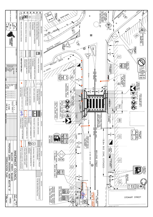
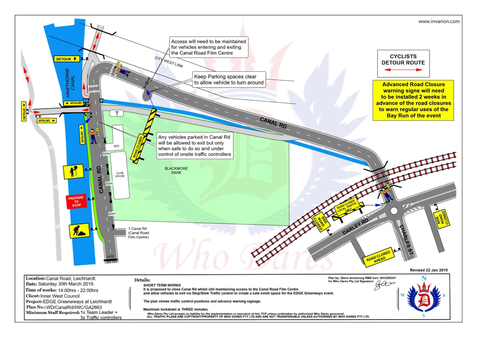
Subject: Mullens Street, near Beattie Street, Balmain - Raised Pedestrian (Zebra) Crossing (Balmain Ward/Balmain Electorate/Leichhardt PAC)
Prepared By: David Yu - Engineer - Traffic and Parking Services
Authorised By: John Stephens - Traffic and Transport Services Manager
|
SUMMARY Detailed design plans have been finalised for the proposed raised pedestrian (zebra) crossing in Mullens Street, Balmain.
The proposed works includes the construction of a raised pedestrian (zebra) crossing, relocation of existing ‘Bus Zone’, installation of signage and road markings, provison of motorcycle parking and upgrade of street-lighting. |
|
RECOMMENDATION
THAT the detailed design plan for the raised pedestrian (zebra) crossing with associated signposting and line marking in Mullens Street, Balmain (as per the attached plan No. 10052) be approved. |
BACKGROUND
Council has received requests from a number of residents for the provision of a pedestrian (zebra) crossing in Mullens Street, Balmain to provide a safer pedestrian crossing facility near the intersection of Beattie Street. A Mayoral Minute was considered by Council on 24th April 2018 and resolved that officers provide a report to the Traffic Committee detailing all options for improving pedestrian safety on Mullens and Beattie Streets.
The Traffic Committee at its meeting held on 3rd July 2018 considered a report outlining a proposal for the installation of a pedestrian (zebra) crossing and it was recommended:
"THAT:
1. A proposed raised pedestrian (zebra) crossing in Mullens Street, Balmain (south of Beattie Street) be supported in principle and a detailed design be prepared, and affected residents be consulted;
2. A Residential Parking Scheme in Mullens Street, Balmain (between Beattie Street and Roseberry Street) be investigated; and
3. A further report, including the detailed design be brought back to the Traffic Committee for consideration."
This recommendation was subsequently adopted by Council.
The detailed design plans have been finalised for the proposed works together with community consultation and are presented in this report for consideration.
FINANCIAL IMPLICATIONS
Funding of $75,000 has been allocated to this project for construction in the 2018/19 Financial Year.
OTHER STAFF COMMENTS
This detailed design plan shown in Attachment 1 outlines the proposed works on Mullens Street, near the intersection of Beattie Street and includes the following treatments:
· Construction of a raised pedestrian (zebra) crossing
· Relocation of existing ‘Bus Zone
· Installation of motorcycle parking
· Upgrading existing street-lighting to flood lights.
· Installation of associated line-marking and signage
All current vehicular access to adjoining properties will be retained.
The previous report indicated the possible loss of three on-street parking spaces; however, through the detailed design process only one car parking space will be loss due to the ‘Bus Zone’ relocation and there is sufficient kerb space remaining to provide 3 ‘Motor Bike’ parking spaces in its place. In accordance with Council's previous resolution, a parking occupancy survey will be conducted following the construction of the raised pedestrian zebra crossing to ascertain the need to extend the resident parking scheme into Mullens Street at this location.
PUBLIC CONSULTATION
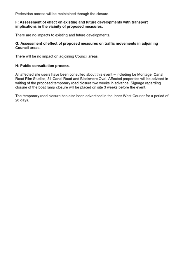
A letter outlining this pedestrian improvement proposal was mailed out to the affected properties (17 properties) in Mullens Street and Beattie Street, Balmain, requesting residents’ views regarding the proposal (as indicated on the following plan).
One (1) response was received in support of the proposal.
CONCLUSION
It is recommended that the detailed design plan of the proposed raised pedestrian (zebra) crossing and associated signs and line markings be approved, to improve pedestrian conditions at the intersection of Mullens Street and Beattie Street, Balmain.
|
1.⇩ |
Mullens Street, Balmain - Design Plan |
|
|
Local Traffic Committee Meeting 4 February 2019 |
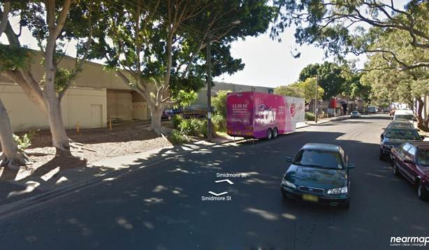
Subject: Smidmore Street, Marrickville – Road Occupancy - Request by BreastScreen NSW to position a Mobile X-ray Unit on Street between 11 March 2019 and 9 May 2019 (Marrickville Ward / Summer Hill Electorate / Inner West PAC)
Prepared By: Jennifer Adams - Engineer – Traffic and Parking Services
Authorised By: John Stephens - Traffic and Transport Services Manager
|
SUMMARY A request has been received from ‘BreastScreen New South Wales’ to position a mobile x-ray Unit within the existing ‘No parking’ zone on the northern side of Smidmore Street adjacent Marrickville Metro Shopping Centre, Marrickville, between 11 March 2019 and 9 May 2019 (a period of approximately eight (8) weeks) as in previous years. It is recommended that the request be approved, on the basis of this being an annual occurrence with no major problems being encountered previously.
|
|
RECOMMENDATION
THAT the road occupancy for the BreastScreen NSW mobile x-ray unit on the northern side of Smidmore Street, Marrickville, approximately 55 metres east of Edinburgh Road, outside the Marrickville Metro Shopping Centre be supported for a period of nine (9) weeks from Monday, 11 March 2019 to Thursday, 9 May 2019, subject to the following conditions:
1. The existing ‘No Parking’ restrictions (for the length of unit) be temporarily removed for the proposed duration (i.e. 11 March to 9 May 2019); 2. All affected businesses, residents and other occupants must be notified of the road occupancy and activities at least one week prior to the commencement of the event. Any concerns or requirements raised by business proprietors, residents and other occupants must be resolved or accommodated by the applicant; 3. The applicant contact Energy Australia/Ausgrid in relation to power access to the mobile laboratory; 4. The areas to be used for the activities must be maintained in a clean and tidy condition to the satisfaction of Council’s Group Manager Roads and Stormwater, or else the applicant will be required to reimburse Council for any extraordinary cleansing costs; 5. The Council and RMS must be indemnified against all claims for damage or injury that may result from either the activities or from the occupation of part of the public way during the activities. The applicant must therefore produce evidence of its public risk insurance cover (under which Council is indemnified) with a minimum policy value of at least $10,000,000; 6. A copy of the Council approval letter must be made available on the site for inspection by relevant officers: 7. The applicant must comply with any reasonable directive from Council’s Compliance Officers; and 8. Council reserves the right to cancel this approval at any time. |
BACKGROUND
The Health Promotion Officer for ‘Breast Screen New South Wales’ has submitted an application to Council dated 19 December 2018, seeking permission to position a mobile x-ray van on the northern side of Smidmore Street in close proximity to the Marrickville Metro Shopping Centre, as in previous years (refer to the attached location map).
The van would be on site for a period of approximately eight (8) weeks, from Monday, 11 March 2019 to Thursday, 9 May 2019. The positioning of this van at this location has been occurring annually.
FINANCIAL IMPLICATIONS
Nil
OFFICER COMMENTS
The site requested is on the northern side of Smidmore Street, approximately 55 metres east of Edinburgh Road. The location is within a section of 'No Parking' restrictions and has been used for several years for the same purpose without any problems. The location is away from the main entrance to the Marrickville Metro Shopping Centre, ‘Taxi Stand’ and ‘Bus Zone’ so it does not interfere with pedestrian or vehicular movements.
It is noted that a copy of BreastScreen NSW public risk insurance has been provided.
PUBLIC CONSULTATION
Nil.
CONCLUSION
That the road occupancy for a Breast Screen NSW mobile x-ray Unit within the existing ‘No Parking’ zone on the northern side of Smidmore Street adjacent Marrickville Metro Shopping Centre, Marrickville, between 11 March 2019 and 9 May 2019, be supported subject to the conditions listed in the officer’s recommendation.
|
|
Local Traffic Committee Meeting 4 February 2019 |
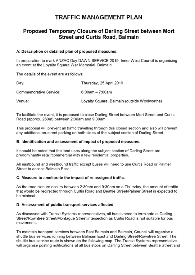
Subject: Darling Street between Mort Street and Curtis Road, Balmain - Road Occupancy - ANZAC Day Dawn Service (Balmain Ward/Balmain Electorate/Leichhardt PAC)
Prepared By: David Yu - Engineer - Traffic and Parking Services
Authorised By: John Stephens - Traffic and Transport Services Manager
|
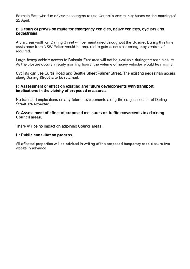
SUMMARY In preparation to mark the ANZAC Day Dawn Service 2019 on Thursday, 25 April 2019, Inner West Council is organising an event at the Loyalty Square War Memorial, Balmain. To facilitate the event, it is proposed to close Darling Street between Mort Street and Curtis Road between 2:30am and 9:30am |
|
RECOMMENDATION
THAT:
1. The road closure application for the ‘ANZAC Day Dawn Service’ on Darling Street (Mort Street to Curtis Road), Balmain on Thursday, 25 April 2019 between 2.30am and 9.30am be supported as per the submitted TCP;
2. All residents and businesses in and around the affected area, including NSW Fire & Rescue (Balmain) to be notified by the applicant in advance (7 days prior to the event) of the temporary road closure;
3. A minimum four (4) metre unencumbered passage be available for emergency vehicles through the closed section of Darling Street, Balmain;
4. The occupation of the road carriageway must not occur until the road has been physically closed;
5. That Transit Systems be requested to terminate all bus services either at Grove Street or in Mullens Street;
6. That three parking spaces on the northern side of Grove Street (even numbered side, No. 22, 24, 26A) near Deloitte Avenue be temporarily converted to a ‘Bus Zone’ and affected residents notified; and
7. That NSW Police be requested to provide traffic control in Darling Street at Rowntree Street/Montague Street to restrict bus/truck access into Darling Street, east of Rowntree Street, Balmain.
|
BACKGROUND
In preparation to mark the ANZAC Day Dawn Service 2019, Council is organising an event at the Loyalty Square memorial, Balmain.
The details of the event are as follows:
Day: Thursday, 25 April 2019
Commemorative Service: 6.00am – 7.00am
Venue: Loyalty Square, Balmain (outside Woolworths)
Procession: There will be no march down Darling Street for 2019
FINANCIAL IMPLICATIONS
Nil.
OTHER STAFF COMMENTS
To facilitate the event, it is proposed to close Darling Street between Mort Street/Beattie Street and Curtis Road (approximately 260m) between 2.30am and 9.30am. This road closure will prevent all traffic travelling through this closed section and also will prevent any additional on-street parking on both sides of the subject section of Darling Street.
It should be noted that although the land uses in this area are predominantly retail/commercial, there are a number of residential properties in this section of Darling Street.
The Traffic Management Plan prepared for the event is attached.
All businesses/residents in the affected area will be advised to avoid parking in the subject section of Darling Street.
Based on the discussions held with the Transit Systems representative, buses would need to terminate at Darling Street/Rowntree Street/Montague Street intersection as Curtis Road is not suitable for bus movements. To maintain transport services between East Balmain and Balmain, Council will organise two shuttle bus services running between Balmain East and Darling Street/Rowntree Street/Montague Street. The shuttle bus service routes are shown on the attached TCP (Attachment 2).
The Transit Systems representative will post notifications at all bus stops on Darling Street between Beattie Street and Balmain East wharf to advise passengers to use Council’s community buses on the morning of 25 April 2019. All other eastbound and westbound traffic will need to use Curtis Road or Palmer Street to access Balmain East.
The Transit Systems representative has also requested the temporary expansion of the bus turning area at Grove Street to accommodate additional buses. Therefore, it is proposed to temporarily remove three parking spaces on the northern side even numbered side (No. 22, 24, 26A) of Grove Street near Deloitte Avenue, Birchgrove. Affected residents will be notified.
PUBLIC CONSULTATION
The proposed temporary full-road closure has been advertised in the local newspaper for a period of 28 days.
Council’s Community Events Coordinator will organise a notification letter outlining the closure of Darling Street (Mort Street/ Beattie Street-Curtis Road) to all affected properties and the emergency services, including Balmain Hospital of the temporary road closure.
The road closures and alternate public transport options will be advertised on Council’s website and in local newspapers.
CONCLUSION
It is recommended that the proposed temporary closure of Darling Street (Mort Street and Curtis Road) between 2:30am and 9:30am be approved, in order to facilitate the ANZAC Day Dawn Service 2019 scheduled for Thursday, 25 April 2019.
|
1.⇩ |
TMP - Darling Street (Beattie Street-Curtis Road) ANZAC Day Dawn Service |
|
2.⇩ |
TCP - Darling Street (Beattie Street-Curtis Road) ANZAC Day Dawn Service |
|
|
Local Traffic Committee Meeting 4 February 2019 |
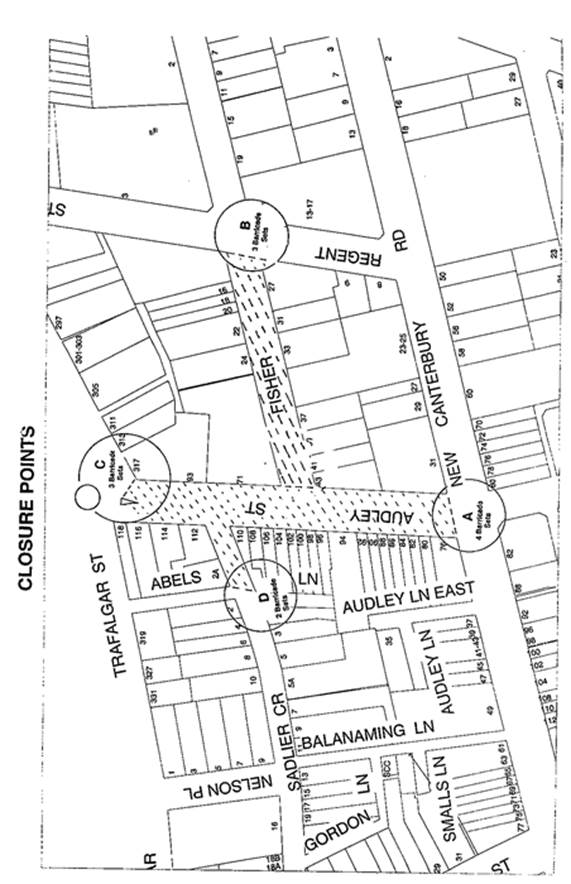
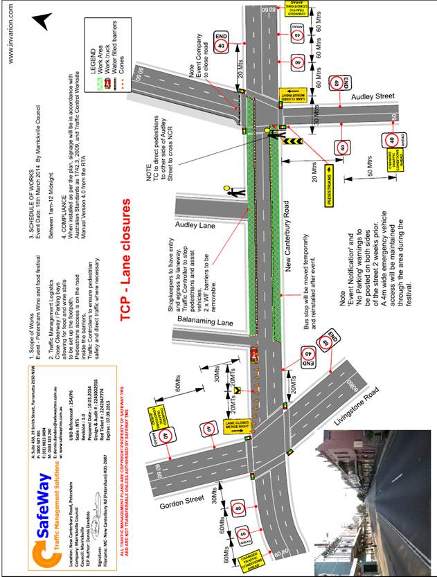
Subject: Audley Street, Sadlier Crescent, Fisher Street, and parking lanes on New Canterbury Road Petersham – Temporary Full Road Closures For Special Event On Sunday 10 March 2019 – Bairro Portuguese Food and Wine Fair (Stanmore Ward/Newtown Electorate/Marrickville PAC)
Prepared By: Jennifer Adams - Engineer – Traffic and Parking Services
Authorised By: John Stephens - Traffic and Transport Services Manager
|
SUMMARY A Development Application (DA201700624) was approved in 2018 for the holding of the annual ‘Bairro Portuguese Food and Wine Fair’ for a five year period (i.e. 4 March 2018, 17 March 2019, 15 March 2020, 14 March 2021 and 13 March 2022).
This year’s event will be held on Sunday 10 March 2019 (not 17 March 2019) and will necessitate the temporary closure of Audley Street (between Trafalgar Street and New Canterbury Road), Sadlier Crescent (between Audley Street and Abels Lane) and Fisher Street (between Audley Street and Regent Street), as well as the parking lanes on New Canterbury Road (between Gordon Street and Audley Street), Petersham from 1.00am until 12.00 midnight as in previous years.
It is recommended that Council agree to the temporary road closures on Sunday 10 March 2019; apply to the RMS for consent to close the subject roads, subject to the event being advertised, a Traffic Management Plan be submitted to the RMS for approval and advice of the proposed event being forwarded to the appropriate authorities, including the Transport Management Centre. |
|
RECOMMENDATION
THAT the proposed temporary road closure of Audley Street (between Trafalgar Street and New Canterbury Road), Sadlier Crescent (between Audley Street and Abels Lane) and Fisher Street (between Audley Street and Regent Street), as well as the parking lanes on New Canterbury Road (between Gordon street and Audley Street), Petersham, on Sunday 10 March 2019, from 1.00am to 12.00 midnight, for the holding of the annual ‘Bairro Portuguese Food and Wine Fair’, be SUPPORTED subject to the applicant complying with but not limited to the following conditions;
1. A Traffic Management Plan (TMP) is submitted to and approved by the Roads and Maritime Services; and an application for a Road Occupancy Licence and a temporary Speed Zone Authorisation is forwarded to and approved by the Transport Management Centre;
2. Notice of the proposed event is forwarded to all affected residnets and businesses, including the N.S.W. Police, Transit Systems Marrickville Local Area Commander, the Fire & Rescue NSW and NSW Ambulance;
3. Transit Systems – Inner West Bus Services be requested to implement a revised routing for scheduled bus services in Audley Street on the day of the event and install temporary bus stops as required; and
4. The occupation of the road carriageways must not occur until the roads have been physically closed.
|
BACKGROUND
Temporary road closures have been implemented in previous years to hold the annual ‘Bairro Portuguese Food and Wine Fair’. This annual Fair aims to showcase Petersham's businesses and services, attracts people to the area and has a multicultural theme. On all previous occasions, the closures were successful and no major problems were experienced.
FINANCIAL IMPLICATIONS
Funding of $68,000 has been allocated by Council for organising the ‘Bairro Portuguese Food and Wine Fair’ event under the 2018/2019 Major Community Events Program.
OFFICERS COMMENTS
Council has applied for the temporary closure of Audley Street (between Trafalgar Street and New Canterbury Road), Sadlier Crescent (between Audley Street and Abels Lane) and Fisher Street (between Audley Street and Regent Street), as well as the parking lanes on New Canterbury Road (between Gordon street and Audley Street), Petersham, on Sunday 10 March 2019, between the hours of 1.00am and 12.00 midnight for the holding of the ‘Bairro Portuguese Food and Wine Fair’ (Refer to the attached locality map and Traffic Control Plan for proposed road closures). This is an extension of a Class 2 Event.
Other conditions that need to be complied with include:
· The temporary road closure be advertised in the local newspaper providing 28 days' notice for submissions;
· Advance notifications signs for the event are strategically installed at least two (2) weeks prior to the event;
· "No Parking - Special Event" signs are affixed over all existing timed parking restriction signs within the sections of streets to be closed on the afternoon of the day prior to the event;
· A 4-metre wide emergency vehicle access must be maintained through the closed road areas during the course of the event;
· The applicant is to consult with all affected residents and/or businesses in the area in writing and to conduct a letter box drop of surrounding properties at least two weeks prior to event; and
· Adequate vehicular traffic control shall be provided for the protection and convenience of pedestrians and motorists including appropriate signage and flagging. Workers shall be specially designated for this role (and carry appropriate certificates), as necessary to comply with this condition. This is to be carried out in accordance with the Australian Standard AS 1742.3 - Traffic Control Devices for works on roads.
Lane closures of New Canterbury Road
As per previous events held, it is proposed to close the parking lanes on New Canterbury Road (between Gordon Street and Audley Street) as shown on the Traffic Control Plan (TCP) prepared by SafeWay Traffic Management Solutions (Attached).
In previous years the event attracted approximately 15,000 attendees prompting the event coordinators to look at ways to ease congestion at the main site and make access easier from New Canterbury Road. The closure of the parking lanes on New Canterbury Road improves access to the area where the main event is to be conducted and improves the amenity of the footpath dining outside a number of the eateries along New Canterbury Road which are adjacent to the closure.
There is significant improvement in the access for people with disabilities as congestion will reduced and there will be no obstacles such as tables, chairs, planter boxes, light/sign poles and bins in the closed lanes. The solid barriers will separate the pedestrians from the moving traffic on the adjacent lane and will also help prevent young children who may be separated from their custodians escaping onto the main thoroughfare and possibly being hit by passing traffic.
The TCP indicates that a reduced temporary speed limit of 40km/h is required on New Canterbury Road (between Gordon Street and Audley Street) during the closure of the parking lanes for the subject event. An application for a Road Occupancy Licence will be forwarded to the RMS Transport Management Centre for approval.
The time-span for the road closure is necessary to allow stalls and stages to be set up before the event and dismantled after the event. The closure will be affected by the placement of barricades at the following locations:
· Junction of Audley Street and New Canterbury Road;
· Junction of New Canterbury Road and Gordon Street;
· Junction of Audley Street and Trafalgar Street;
· Junction of Fisher Street and Regent Street; and
· Junction of Sadlier Crescent and Abels Lane.
Special advance notice signs will be strategically installed at least two weeks prior to the event to alert motorists of the proposed closures. These signs will be installed at the following locations:-
· Junction of Railway Terrace and Gordon Street;
· Junction of New Canterbury Road and Audley Lane;
· Junction of Trafalgar Street and Audley Street;
· Junction of Regent and Fisher Streets; and
· Junction of Nelson Place and Sadlier Crescent.
In addition, 'No Parking - Special Event' signs will be affixed over all existing timed parking restrictions signs in the area to be closed on the afternoon before the day of the event. Residents in Fisher Street will be allowed access into and out of their properties.
Audley Street is used by scheduled Transit Systems bus services and they will need to implement the re-routing of services on the day as in previous years.
PUBLIC CONSULTATION
The proposed full-road closures for the event are currently advertised in the local papers for a period of 28 days. The advertising period commenced on 15 January 2019 and will conclude on 11 February 2019. A Traffic Management Plan is to be submitted to the RMS for consideration and approval and a Road Occupancy License application is to be submitted to the Transport Management Centre.
CONCLUSION
It is recommended that Council agree to the temporary road closures on Sunday 10 March 2019; apply to the RMS for consent to close the subject roads, subject to the event being advertised, a Traffic Management Plan be submitted to the RMS for approval and advice of the proposed event being forwarded to the appropriate authorities, including the Transport Management Centre.
Locality Map - Temporary road closures
|
|
Local Traffic Committee Meeting 4 February 2019 |
Subject: Temporary Road Closure - Cook Street (between Angelini Street and Brockley Street), Rozelle (Balmain Ward/Balmain Electorate/Leichhardt PAC)
Prepared By: Felicia Lau - Engineer - Traffic and Parking Services
Authorised By: John Stephens - Traffic and Transport Services Manager
|
SUMMARY An application has been received from Charles Lake Architect for the temporary full road closure of Cook Street (between Angelini Street and Brockley Street - 220m), Rozelle and partial road closure of Denison Street, Rozelle in the southbound parking and traffic lanes in front of Nos.18-20 Denison Street. The closure is to be undertaken on Monday, 11 March 2019, with a further one week contingency thereafter to carryout sewer works between 7am and 3pm. It is recommended that the proposed temporary full and partial road closure be approved, subject to the conditions outlined in the report. |
|
RECOMMENDATION
THAT:
1. The proposed temporary full road closure of Cook Street, between Angelini Street and Brockley Street, Rozelle and partial road closure of Denison Street in the southbound parking and traffic lanes in front of Nos.18-20 Denison Street, Rozelle from 7am to 3pm, Monday 11 March 2019, with a further one week contingency thereafter, be approved in order to carryout sewer works as per the submitted TCP;
2. A Road Occupancy License be obtained by the applicant from the Transport Management Centre (where applicable);
3. All affected residents and businesses, including the NSW Police Local Area Commander, Fire & Rescue NSW and the NSW Ambulance Services be notified in writing, by the applicant, of the proposed temporary road closure at least 7 days in advance of the closure with the applicant making reasonable provision for stakeholders; and
4. The occupation of the road carriageway must not occur until the road has been physically closed. |
BACKGROUND
An application has been received from Charles Lake Architect for the temporary full road closure of Cook Street (between Angelini Street and Brockley Street), Rozelle and partial road closure of Denison Street (in the southbound parking and traffic lanes in front of Nos.18-20 Denison Street), Rozelle between 7am and 3pm, Monday, 11 March 2019, with a further one week contingency, in order to carryout sewer works.
FINANCIAL IMPLICATIONS
Under Council’s Fees & Charges, the applicant has paid the fee for the temporary full road closure. This fee includes advertising the proposal in accordance with the Roads Act 1993.
OTHER STAFF COMMENTS
The Traffic Control Plan submitted by the applicant is attached.
Vehicular access for local residents will be maintained during the closure, where possible. Authorised traffic controllers will be on-site during all shifts and are to be positioned at the closure points when required to provide vehicular access to local residents and ensure the safety of motorists, cyclists and pedestrians.
PUBLIC CONSULTATION
The applicant is to notify all affected residents and businesses in writing at least 7 days prior to the commencement of works.
The proposed temporary full road closure has been advertised in the local newspaper in accordance with the Roads Act 1993 on Tuesday, 22 January 2019.
CONCLUSION
It is recommended that the proposed temporary road closures be approved, subject to the conditions outlined in the report.
|
1.⇩ |
TCP (Full Road Closure) |
|
2.⇩ |
TCP (Partial Road Closure) |
|
|
Local Traffic Committee Meeting 4 February 2019 |
Subject: Canal Road and Lilyfield Road, Lilyfield - Temporary Road Closure for EDGE Greenway event (Leichhardt Ward / Balmain Electorate / Leichhardt PAC)
Prepared By: Manod Wickramasinghe - Coordinator – Traffic and Parking Services
Authorised By: John Stephens - Traffic and Transport Services Manager
|
SUMMARY Inner West Council is proposing to hold the ‘EDGE Greenway’ event on Saturday, 30 March 2019 along the Greenway, Lilyfield Road Bridge, Peace Grove and Blackmore Oval and will require the closure of Lilyfield Road and Canal Road, Lilyfield to facilitate the event. |
|
RECOMMENDATION
THAT:
1. The proposed temporary full road closure of Lilyfield Road (between Maliyawul Street and Canal Road) and Canal Road (between Lilyfield Road and dead-end) for the ‘EDGE Greenway’ Event on Saturday, 30 March 2019 between 2:00pm and 10:00pm be approved as per the submitted TMP and TCP;
2. All residents and businesses in and around the affected area, including the NSW Police Local Area Commander, Fire & Rescue NSW (Leichhardt) and the NSW Ambulance Services to be notified of the temporary road closure in writing by the applicant in advance (at least 7 days prior to the event) with the applicant making reasonable provision for stakeholders;
3. A minimum four (4) metre unencumbered passage be available for emergency vehicles through the closed section; and
4. The occupation of the road carriageway must not occur until the road has been physically closed.
|
BACKGROUND
EDGE is a Council arts and cultural program that celebrates local creatives and the vibrant local community.
As part of this program, Inner West Council is organising the ‘EDGE GreenWay’ event along the Greenway adjacent to Iron Cove/Hawthorne Canal from Peace Grove to Blackmore Oval, Lilyfield and at the Lilyfield Road Pedestrian Bridge. Artists will set up environmental artworks, pop up spaces etc, adjacent to Iron Cove, on the Lilyfield Road Pedestrian Bridge and inside the nearby creative studios.
The details of the event are as follows:
Day: Saturday, 30 March 2019
Community event: 3pm-10pm
Venue: Lilyfield Road Bridge, Peace Grove and Blackmore Oval
The following activities have been confirmed; display of an old jet fuselage on Lilyfield Road near Canal Road, a community picnic for the Italian fishing community in Peace Grove, Art on the Greenway environmental trail of 13 art sites, Ours and Talks program, use of Blackmore Oval for a cyclists gathering event and hospitality area, and a sunset finale event directed by ‘Legs on the Wall’ with community groups on and under Lilyfield Road bridge. There will also be a solar powered lantern and Sabot vessels land and water procession to acknowledge Earth Hour (8.30pm-9.30pm).
FINANCIAL IMPLICATIONS
Nil.
OTHER STAFF COMMENTS
To facilitate the event, it is proposed to close Lilyfield Road (between Maliyawul Street and Canal Road) and Canal Road (between Lilyfield Road and dead-end) on Saturday, 30 March 2019 from 2:00pm to 10:00pm.
It should be noted that the land uses in this area are predominantly recreational/commercial.
The Traffic Management Plan prepared for the event is shown in Attachment 1 and the supporting Traffic Control Plans are shown in Attachment 2.
PUBLIC CONSULTATION
The proposed temporary full-road closure has been advertised in the local newspaper for a period of 28 days, ending on Tuesday, 26 February 2019.
Council’s Living Arts Manager will organise a notification letter outlining the closure of Lilyfield Road and Canal Road to all affected properties and the emergency services.
CONCLUSION
Nil.
|
1.⇩ |
TCP - EDGE Greenway |
|
2.⇩ |
TMP - EDGE Greenway |
|
Local Traffic Committee Meeting 4 February 2019 |
Subject: Council Street, St Peters - Proposed Parking Restrictions (Marrickville Ward/ Heffron Electorate/Inner West PAC)
Prepared By: Scipio Tam - Engineer - Traffic and parking Services (South)
Authorised By: John Stephens - Traffic and Transport Services Manager
|
SUMMARY A request has been received from a resident to improve access due to the current parking situation on Council Street, St Peters. It has been reported that on numerous occasions, vehicles parked on both sides of Council Street, St Peters between Goodsell Street and the cul-de-sac have obstructed access for Transport for NSW utility vehicles along Council Street.
The northern end of Council Street at the cul-de-sac serves as a corridor for Transport for NSW utility vehicles to access the railway land. On several occasions, a resident had witnessed utility vehicles unable to successfully manoeuvre along Council Street, resulting in damage to parked vehicles.
Additionally, parking is presently unrestricted on the western side of Council Street, between May Street and Goodsell Street. It is recommended that the ‘No Parking’ restrictions be extended along the western side of Council Street to prevent vehicles from parking along this kerb given the width constraints and permissible parking on the eastern side of Council Street between May Street and Goodsell Street.
It is recommended that the installation of ‘No Parking’ restrictions be approved, in order to ensure safe thoroughfare of all vehicles along Council Street as the road width does not support parking on both sides of the street.
|
|
RECOMMENDATION
That the installation of ‘No Parking’ restrictions in Council Street, St Peters along the western side between May Street and the cul-de-sac (excluding the 90 degree angled parking spaces at the rear to the amenities building for Camdenville Oval) be APPROVED, in order to ensure safe thoroughfare of all vehicles along Council Street as the road width does not support parking on both sides of the street.
|
BACKGROUND
Concerns have been raised by a resident after their vehicles have been damaged numerous times by Transport for NSW utility vehicles.
The minimum and maximum road width of Council Street, St Peters is 5.8 metres and 6.2 metres respectively. The minimum width required for parking lanes is 2.1 metres and the minimum width required for travel lanes is 3 metres. Therefore, the minimum required road width for one (1) travel lane and two (2) parking lanes is 7.2 metres.
On the western side of Council Street between May Street and Goodsell Street, St Peters parking is unrestricted; however, given the width of the road and 2P parking area on the eastern side of the roadway, it is proposed to signpost this section to ensure vehicle access is maintained through this section of Council Street.
FINANCIAL IMPLICATIONS
The cost of the signposting will be funded from Council’s operational budget for signs and linemarking.
OTHER STAFF COMMENTS
|
Street Name |
Council Street |
|
Section |
Between May Street to Cul-de-sac |
|
Carriageway Width (m) |
5.8-6.2 |
|
Classification |
Local |
PUBLIC CONSULTATION
|
A letter outlining the proposal was mailed out to the nearby properties (15 properties) in Goodsell Street and Council Street, Tempe. Three (3) responses were received objecting to the proposal. |
|
|
Resident Comment |
Officer Response |
|
Object. Parking is limited for residents’ second car and trades vehicle during the day |
Austroad guide to Road designs specify the minimum lane width of car parking lane is 2.1 metres and the minimum lane width for general traffic for use on low speed roads with low truck volumes is 3.0 metres. Therefore, for a street to support parking on both sides, the minimum width of a road is required to be 7.2 metres. The maximum and minimum widths along Council Street are 6.4 metres and 5.8 metres respectively. |
|
Object. Car parking in area is challenging. Parking is even more limited during soccer season. Vehicles parked illegally around Caroline Lane. |
|
|
Object. Residents and businesses require the parking. Existing parking situation is of shortage. |
CONCLUSION
It is recommended that the proposed ‘No Parking’ on the western side of Council Street, St Peters be approved to improve access and manoeuverability of all vehicles along Council Street, St Peters.
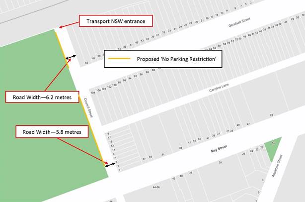
|
|
Local Traffic Committee Meeting 4 February 2019 |
Subject: Gannon Lane, Tempe - Proposed Parking Restrictions (Marrickville Ward/Heffron Electorate/Inner West PAC)
Prepared By: Scipio Tam - Engineer - Traffic and parking Services (South)
Authorised By: John Stephens - Traffic and Transport Services Manager
|
SUMMARY A concern has been raised by a resident from Gannon Lane regarding obstructed off-street parking access for residents and occupiers due to visitor vehicles parking over driveway crossings along Gannon Lane, Tempe. |
|
RECOMMENDATION
That a proposal for ‘No Parking’ restrictions on the eastern side of Gannon Lane, Tempe NOT be supported at the present time due to insufficient support at present. |
BACKGROUND
A concern has been raised by a resident regarding obstructed off-street parking access for residents and occupiers due to visitor vehicles parking over driveway crossings along Gannon Lane.
The western side of the lane has been signposted as ‘No Parking’ since 2002 in order to provide unimpeded access to the off-street parking facilities of the properties along Gannon Lane.
The eastern side of the lane has ‘No Parking 5.00AM to 10.00AM Fridays’ restriction since 2010 to allow waste collection vehicles to turn around and service properties on the southern side of Gannon Street. Although there is insufficient kerb space along the eastern side of the lane to accommodate a standard vehicle without impeding driveway access to the properties, residents in the past had an understanding regarding parking across their own driveways and not impeding access for adjoining residents to their driveways.
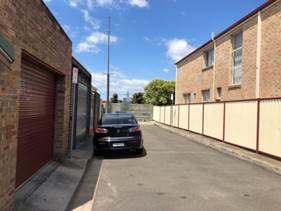 |
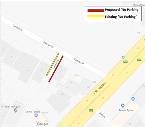 |
FINANCIAL IMPLICATIONS
There are no cost implications as a result of this proposal.
OTHER STAFF COMMENTS
|
Street Name |
Gannon Lane |
|
Section |
Between Gannon Street to Cul-de-sac |
|
Carriageway Width (m) |
5.0 |
|
Classification |
Local |
PUBLIC CONSULTATION
|
A letter outlining the above proposal was mailed out to the nearby properties (9 properties) in Gannon Lane and Gannon Street, Tempe. Three (3) responses were received objecting to the proposal. |
|
|
Resident Comment |
Officer Response |
|
Residential parking is essential in Gannon Lane. |
It is illegal to block access to a driveway under the Road Rules. Matter of parking across driveway will be managed on a case by case basis by parking officers at present.
|
|
Parking across driveway is essential for loading and unloading at rear of business. The parking around the area is already very competitive. |
|
|
Resident parks car in front of their own driveway which does not disturb other neighbours. As parking is scarce in the area, the only parking available for residents in Gannon Lane is in-front of their own driveway. |
CONCLUSION
The proposed ‘No Parking’ restriction on the eastern side of Gannon Lane, Tempe not be supported at the present time.
|
|
Local Traffic Committee Meeting 4 February 2019 |
Subject: Lord Street, Newtown - Proposed kerb blister islands (Stanmore Ward, Newtown Electorate, Inner West PAC)
Prepared By: Scipio Tam - Engineer - Traffic and parking Services (South)
Authorised By: John Stephens - Traffic and Transport Services Manager
|
SUMMARY Design plans have been developed for a proposed kerb blister island in Lord Street, Newtown, outside Nos.17-21 Lord Street, Newtown. It is recommended that the installation of kerb blister islands with associated signs and line markings be APPROVED as it will improve residents’ vehicular access. |
|
RECOMMENDATION
That the proposed kerb blister islands in Lord Street, Newtown outside property Nos.17-21 Lord Street, Newtown, including associated signs and line markings, be APPROVED. |
BACKGROUND
A submission has been received from the strata manager of 17-21 Lord Street, Newtown for the installation of kerb blister islands on either side of the driveway to the apartment’s off street parking area to assist with vehicle ingress and egress. When vehicles are parked adjacent to the driveway, vehicle movements entering and exiting the driveway are often restricted. Additionally, sight lines for vehicles egressing are obstructed when vehicles are parked adjacent to the driveway.
FINANCIAL IMPLICATIONS
It is estimated that the provision of two kerb blister islands would cost approximately $8,000. All costs are borne by the applicant.
OTHER STAFF COMMENTS
Lord Street is a narrow one way street which is 6.9m wide and caters for parking on both sides of the street. Vehicles parked opposite this driveway make it difficult for residents wanting to exit the complex, especially when vehicles are parked up to the edge of the driveway. In this case Council had previously installed ‘No Parking’ signs either side of the driveway and line marking of either side of the driveway has also been installed.
Following a site inspection conducted by Council Officer, it is recommended the installation of kerb blister islands on the northern side of Lord Street, on either side of the driveway crossing to property Nos.17-21 be approved, in order to improve vehicle access and increased sight distance at the subject location, subject to all costs being borne by the applicant.
PUBLIC CONSULTATION
A notification letter regarding the proposed design plan to implement kerb blister islands with associated signs and line marking as well as a copy of the detailed design plans was sent out on 19 November 2018 to the owners and occupiers of nearby properties along Lord Street, Newtown. A total of 86 letters were distributed. The closing date for submissions ended on 21 December 2018.
There were no responses received
CONCLUSION
It is recommended that the proposed kerb blister treatment with associated signs and line markings be approved, to access to the property at 17-21 Lord street.
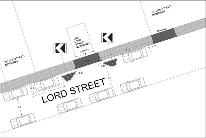
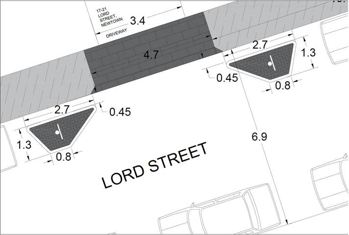
|
|
Local Traffic Committee Meeting 4 February 2019 |
Subject: Unnamed Lane - rear of No.39 Warren Road, Marrickville - Proposed 'No Parking' restriction (Marrickville Ward/Summer Hill Electorate/Inner West PAC)
Prepared By: Mary Bailey - Parking Planner
Authorised By: John Stephens - Traffic and Transport Services Manager
|
SUMMARY Following representations from the community, Council is proposing to implement a section of ‘No Parking’ in the Unnamed Lane at the rear of No.39 Warren Road, Marrickville in order to facilitate access to off-street parking spaces for residents. |
|
RECOMMENDATION
That the installation of ‘No Parking’ restrictions on the southern side of the Unnamed Laneway, across the rear boundary of No.39 Warren Road, Marrickville (between Warren Road and Church Street) be approved. |
BACKGROUND
It should be noted that when vehicles are parked directly opposite a garage entrance in laneways, ingress/egress can be extremely difficult. Laneways were generally built to provide service access for properties and access into off-street parking facilities. Removal of long stay parking will help achieve this goal.
According to Council’s Laneway Guidelines (December 2015) Laneways can be used for a variety of purposes which are listed below:
· Access for garbage collection trucks and deliveries where required
· Access to existing off-street parking within properties
· Access for emergency vehicles, pedestrians and cyclists
· Accessible parking for people with disabilities where appropriate
· Parking where space is available and access is maintained.
The Unnamed Lane is 4.8m wide. The Laneway Guidelines state that, “For parking to be allowed in a narrow laneway, the Australian Standards require that parallel parking spaces be at least 2.1 metres wide and NSW Road Rules requires that at least 3 metres must be available between a parked car and the kerb or edge of the laneway to allow moving vehicles to pass safely. Therefore, laneway widths that are less than 5.1 metres wide are too narrow to allow parking as any parked vehicle would prevent traffic from using the laneway.”
In this case, Council has received concerns that access to off-street parking is being restricted because of parking in the laneway. Furthermore, the laneway is only is 4.8m wide. Therefore, according to Council’s Laneway Guidelines the Unnamed Lane is not wide enough to cater for parking, where it obstructs access to off-street parking spaces. The proposal is illustrated in Figure 1 below.
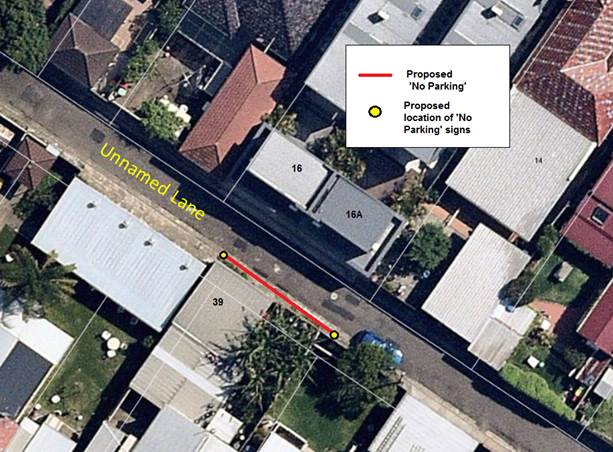
Figure 1. Illustration of proposed ‘No Parking’ restrictions
FINANCIAL IMPLICATIONS
The cost of the supply and installation of the signage will be funded from Council’s signs and line markings budget.
PUBLIC CONSULTATION
In mid November 2018 letters were sent to affected residents as illustrated by the highlighted properties in Figure 2 below.
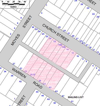
Figure 2: Addresses for letter distribution
There were two responses, one in support and one objecting to the proposal.
|
Resident Feedback |
Officer’s Comments |
|
Support Resident seeks to have parking restrictions installed in order to have access to off-street parking spaces associated with the property |
Installation of the proposed parking will facilitate entrance to the residents off-street parking in this narrow laneway |
|
Object Resident claims that they share the parking space for business to drop off and pick up business related items |
There are alternative spaces to park nearby that will not obstruct access to any driveways. |
CONCLUSION
Given the narrowness of the laneway and the reports of off-street parking being obstructed by vehicles parked in the laneway, the proposal to restrict parking in the laneway is supported.
|
|
Local Traffic Committee Meeting 4 February 2019 |
Subject: Rosieville Lane, Balmain - Proposed 'No Parking' Restriction (Balmain Ward/Balmain Electorate/Leichhardt PAC)
Prepared By: Felicia Lau - Engineer - Traffic and Parking Services
Authorised By: John Stephens - Traffic and Transport Services Manager
|
SUMMARY Council has received concerns regarding obstructed access to off-street parking in Rosieville Lane (opposite the rear of No.82 Glassop Street), Balmain. |
|
RECOMMENDATION
THAT a 5.5m ‘No Parking’ zone be installed on the south eastern side of Rosieville Lane, along the rear boundary of No.467 Darling Street, Balmain. |
BACKGROUND
Council has received concerns from the resident of No.82 Glassop Street who has rear driveway access in Rosieville Lane, Balmain regarding vehicles parking on the south eastern side of Rosieville Lane (rear of No.467 Darling Street) and subsequently obstructing rear driveway access to their property.
Rosieville Lane is 5.2m wide in this section and is therefore not wide enough to support parking opposite a driveway without obstructing access.
FINANCIAL IMPLICATIONS
Nil.
OTHER STAFF COMMENTS
It is proposed to install a 5.5m ‘No Parking’ zone on the south eastern side of Rosieville Lane, along the rear boundary of No.467 Darling Street, Balmain. The proposal is shown in the following plan.
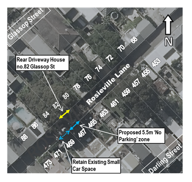
PUBLIC CONSULTATION
A letter outlining the above proposal was mailed out to the affected properties (12 properties) in Glassop Street and Darling Street, Balmain.
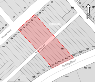
Two responses were received objecting to the proposal and are shown in the table below.
|
Resident’s Response |
Officer’s Comment |
|
Object to the proposal. Claims that the rear access that is blocked by parked vehicles has and never will be used by the owner. The proposed would result in one parking space loss which is not favourable. |
The consultation was initiated as the resident’s access was obstructed and contacted Council with this concern. |
|
Object to the proposal. Uses the current parking zone to pick up/drop off elderly visitors, daily loading and unloading of goods when parking is not available in the frontage street. |
A ‘No Parking’ zone allows a driver to temporarily stop in the area for up to two minutes and must remain within three metres of the vehicle. This includes pick up/drop off passenger and/or load/unloading activity. |
|
|
Local Traffic Committee Meeting 4 February 2019 |
Subject: Longport Street, Lewisham - Proposed extension of Peak Hour Parking Restricitons (Ashfield Ward/Summer Hill Electorate/Inner West PAC)
Prepared By: Mary Bailey - Parking Planner
Authorised By: John Stephens - Traffic and Transport Services Manager
|
SUMMARY Following representation for the community, Council is proposing to extend the existing “No parking” restriction in Longport Street, Lewisham; in order to facilitate the flow of traffic through the intersection at Longport Street and Old Canterbury Road. |
|
RECOMMENDATION
That the existing ‘No Parking Mon-Fri 6:30am-9:30am; 3:30pm-6:30pm restrictions in Longport Street (opposite its intersection with Brown Street) be extended by a further 25m west. |
BACKGROUND
Longport Street is a Regional road and Old Canterbury Road is a State road. There is a reported obstruction to traffic flow being caused due to parked vehicles in Longport Street, preventing vehicles from accessing the left turn lane from Longport Street to Old Canterbury Road. The proposal is illustrated in Figure 1 below.
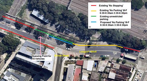
Figure 1: Existing and Proposed restrictions in Longport Street, Lewisham
The road layout at the location can be seen in Figure 2 below.
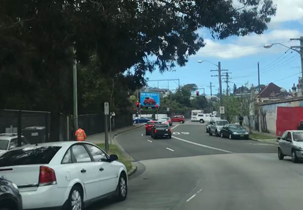
Figure 2: Photo showing approach to Old Canterbury Road from Longport Street (looking east)
Queue Length Surveys
Council undertook queue length surveys of the Longport Street, Old Canterbury Road intersection (western approach) during weekday AM and PM peak periods as well as Saturday peak (10am-1pm) The purpose of the surveys was to determine if the existing parking arrangement were having a significant impact on the operation of the intersection, particularly with respect to the left turn movement from Longport Street into Old Canterbury Road. Figure 3, below, indicates the queuing point of 15 vehicles and this is the length of queue where the parked vehicles obstruct vehicles from entering into the kerb lane or left-turn lane. (Also see Figure 1)
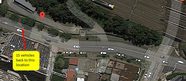
Figure 3: Illustration of Queue Length of 15 Vehicles (See Figure 1 also)
The results of the Queue Length Surveys indicate that the Queue Length reaches the 15 vehicle mark regularly throughout the survey periods.
Collated results of the Queue Length Surveys are detailed in Figure 4 below
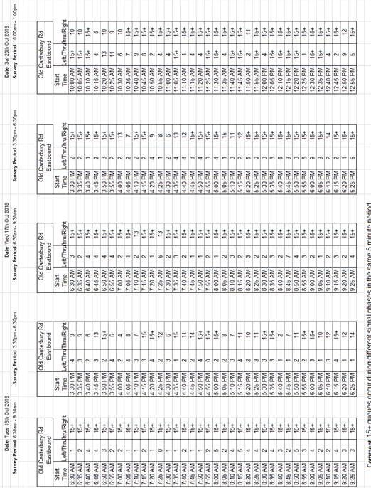
Figure 4: Collated Queue Length results for Tuesday, Wednesday and Saturday Surveys
The Queue Length Surveys indicate that the queues are consistently 15+ vehicles in the peak periods on all survey days and periods. Further information about turning movements can be found in the completed survey results (attached)
FINANCIAL IMPLICATIONS
The cost of the supply and installation of the signage will be funded from Council’s signs and line markings budget.
PUBLIC CONSULTATION
Prior to undertaking detailed investigation and developing this proposal, Council has received ’support in principle’ from the Roads and Maritime Services (RMS)
Details of the proposal were sent by letter to all affected properties in William Street and old Canterbury Road on 15 November 2018. The closing date for submissions was 14 January 2019. No submissions were received.
CONCLUSION
Given the concerns expressed regarding traffic flow by the local community and the fact that there were no objections to the proposal; the proposal is supported.
|
1.⇩ |
Longport - Traffic Queue Survey Results Tuesday |
|
|
Local Traffic Committee Meeting 4 February 2019 |
Subject: Cavey Street, Marrickville - Proposed 'No Parking' in cul de sac (MarrickvilleWard/Summer Hill Electorate/Inner west PAC)
Prepared By: Mary Bailey - Parking Planner
Authorised By: John Stephens - Traffic and Transport Services Manager
|
SUMMARY Following representation from the community, Council is proposing to implement a section of ‘No Parking’ in the cul-de-sac of Cavey Street, Marrickville in order to improve the manoeuvring for vehicles within the cul-de-sac without having to utilise private driveways or motorists having to reverse along Cavey Street in an attempt to exit the street. |
|
RECOMMENDATION
That 'No Parking’ restrictions be installed in Cavey Street, Marrickville as follows; · From boundary of property No.20A, 10 metres to the end of the street (eastern side) to a position of 6.5 metres from the cul-de-sac, (western side) and inclusive of all the area between the two signs. |
BACKGROUND
Cavey Street is a narrow dead-end street with no adequate turning circle in the cul-de-sac.
Council has received representation from the local to improve the potential for vehicles to turn in the cul-de-sac. The proposal is illustrated in Figure 1 below.
Figure 1: Proposal to implement parking restriction in Cavey Street, Marrickville
FINANCIAL IMPLICATIONS
The cost of the supply and installation of the signage will be funded from Council’s signs and line markings budget.
PUBLIC CONSULTATION
Letters were sent to affected owners/occupiers on 15 November 2018 with a closing date for submissions of 14 January 2019. There were three (3) written submissions supporting the proposal and one (1) objecting (by phone message). The responses are summarised in Table 1 below.
Table 1: Summary of Resident Feedback
|
Resident Feedback |
Officer Comment |
|
Support 1. The proposed parking changes has got our full support on the basis that it would allow for safe maneuvering of the vehicle to turn around at the end of the road. Well done Council. 2. I am in favour of this proposal to make the end of Cavey Street "No Parking". 3. In your proposal for no parking at the eastern side (boundary
20A to end of street, the end of cul-de-sac and the western side)
I would be in full support of this proposed no parking area. When cars park
in this area its make it very hard for cars trying to turn around at the
bottom of the street some get a bit stuck. |
Implementation of the proposal will provide increased maneuvering room for vehicles to turn at the cul-de-sac of Cavey Street and potentially reduce the risk of damage to property from vehicles turning in residential driveways (as reported) |
|
Object No reason given |
|
CONCLUSION
Given the reported issues with turning in the cul-de-sac and the obstruction caused by parked vehicles sometimes necessitating vehicles having to reverse along Cavey Street and given the support from residents it is recommended that the proposal be supported.
|
|
Local Traffic Committee Meeting 4 February 2019 |
Subject: Roach Street, Marrickville - 'Proposed No Parking' in cul de sac (Marrickville Ward/Summer Hill Electorate/Inner West PAC)
Prepared By: Mary Bailey - Parking Planner
Authorised By: John Stephens - Traffic and Transport Services Manager
|
SUMMARY Following representations from the community Council is proposing to install ‘No Parking’ signage in the cul-de-sac of Roach Street, Marrickville to facilitate access to driveways and off-street parking for a number of residences which have reported their access being obstructed leading to Enforcement Officers attending the location on a number of occasions. |
|
RECOMMENDATION
THAT the installation of full time ‘No Parking’ restrictions in the cul-de-sac commencing immediately south of the existing ‘Mobility Parking’ zone outside property No.2 Roach Street to a position one (1) metre to the north of the driveway of property No.3 Roach Street be approved. |
BACKGROUND
Roach Street, Marrickville is a cul-de-sac where there is limited on-street parking.
Council has received correspondence from residents of Roach Street regarding an ongoing problem with the access to driveways being blocked by parked vehicles. There is evidence that Enforcement Officers have attended the site on a number of occasions since the problems arose in May 2018. Council is proposing to install ‘No Parking’ signs in the cul-de-sac in order to ensure access to driveways on the cul-de-sac as well as ensuring that adequate space is available for turning vehicles. The proposal is illustrated in Figure 1.
Figure 1: Proposed parking restrictions in Roach Street, Marrickville
FINANCIAL IMPLICATIONS
The cost of the supply and installation of the signage will be funded from Council’s operational budget.
PUBLIC CONSULTATION
Twenty eight (28) letters outlining the proposal were sent to all affected owners/occupiers on 15 December 2018 advising of a closing date of 14 January 2019 for submissions. There were three (3) submissions; two (2) supporting the proposal and one (1) objecting. A summary of the responses and comments are shown in Table 1 below.
Table 1: Summary of Residents’ Feedback
|
Residents’ Feedback |
Officers Comments |
|
Support 1. I am in full support of the proposed traffic plan. The current parking situation is very unsafe and has significant double parking (as your aerial shows), with car lined up behind each other in the cul de sac. I have experienced being boxed in when parked nose in to the cul de sac. On a couple of occasions the driveway to 3 Roach Street has been completely blocked. Exiting the driveway is always very difficult and a higher chance of hitting parked cars. The vehicle turning paths are very compromised and tight. There is also a significant pedestrian link through the park. Sighting pedestrians is also very difficult. This is a great solution that is safe for pedestrians and residents of the street and the local area. I welcome the change.
|
Implementation of ‘No Parking’ as per the proposal will ensure that there is a sign-posted restriction to support Enforcement Officers when patrolling this location which has had a history of parking controversy amongst residents due to parking in the cul-de-sac and blocking the driveway of the multi unit development . |
|
2. Since moving in back in 2017, we have had constant issues with cars parking and blocking the driveway to our units. Not only do they park one car deep, but often 3 or 4, blocking the entire street. It also detracts from the streetscape aesthetics. I welcome Council's decision to implement no parking but as mentioned, also provide the suggestion that perhaps 'no standing' is considered. I worry that regardless of the change in regulation, people will still park here and block the driveway, so hope that this will be monitored and patrolled regularly |
|
|
Object 1. One resident reports difficulty parking and requests resident parking, but has access to a driveway and off street parking |
Council is not considering permit parking for this street as there is significant off street parking available at the existing residences. |
CONCLUSION
Given the history of complaints to Council about access to driveways/off-street parking being obstructed; the proposal to implement ‘No Parking’ in the cul-de-sac of Roach Street, Marrickville is supported.
|
|
Local Traffic Committee Meeting 4 February 2019 |
Subject: Cannon Lane, Stanmore - Proposed 'No Stopping' and 'No Parking' restrictions (Stanmore Ward/Newtown Electorate/Inner West PAC)
Prepared By: Mary Bailey - Parking Planner
Authorised By: John Stephens - Traffic and Transport Services Manager
|
SUMMARY Following representations from the community, Council is proposing to restrict parking in Cannon Lane between Corunna Road and Westbourne Street, Stanmore; in order to allow for access to off-street parking spaces for residents and to facilitate the passage of service vehicles, including Council garbage trucks. |
|
RECOMMENDATION
THAT:
1. Installation of statutory 10 meters ‘No Stopping’ in Cannon Lane (both sides) at Corunna Road; 2. Installation of statutory 10 meters ‘No Stopping’ in Cannon Lane (both sides) at Westbourne Street; and 3. Installation of ‘No Parking’ in Cannon Lane (both sides) from proposed ‘No Stopping’ zones between Corunna Road and Westbourne Street; be approved. |
BACKGROUND
It should be noted that when vehicles are parked directly opposite a garage entrance in laneways, ingress/egress can be extremely difficult. Laneways were generally built to provide service access for properties and access into off-street parking facilities.
According to Council’s Laneway Guidelines (December 2015) Laneways can be used for a variety of purposes which are listed below:
· Access for garbage collection trucks and deliveries where required
· Access to existing off-street parking within properties
· Access for emergency vehicles, pedestrians and cyclists
· Accessible parking for people with disabilities where appropriate
· Parking where space is available and access is maintained.
Cannon Lane is 4.8m wide. The Laneway Guidelines state that, “For parking to be allowed in a narrow laneway, the Australian Standards require that parallel parking spaces be at least 2.1 metres wide and NSW Road Rules requires that at least 3 metres must be available between a parked car and the kerb or edge of the laneway to allow moving vehicles to pass safely. Therefore, laneway widths that are less than 5.1 metres are too narrow to allow parking as any parked vehicle would prevent traffic from using the laneway.”
In this case, Council has received concerns that access to off-street parking is being restricted because of parking in the laneway. Furthermore, the laneway is only is 4.8m wide. Therefore, according to Council’s Laneway Guidelines Cannon Lane is not wide enough to cater for parking.
Given the need to provide clear vehicular access through the laneway and to off-street car parking facilities; and to provide continuity and consistency of existing parking restrictions, it is recommended that full-time ‘No Parking’ restrictions be approved. Also, to improve safety, ingress and egress at the intersections of Corunna Road and Westbourne Street with Cannon Lane, it is proposed to implement 10m Statutory ‘No Stopping’ (See Figure 1).
Revised proposal
In mid December 2018, Council wrote to residents with a proposal to install parking restrictions in Cannon Lane, Stanmore in order to address resident concerns about lack of access to off-street parking for residents of Cannon Street. Further to Council’s initial proposal, Council Officers have noted that due to the narrowness of the laneway service vehicles, (including Council garbage trucks) also experience access problems; also there are a number of additional residents who are being obstructed from their off-street parking spaces due to vehicles parking in the laneway.
In a follow up letter in mid January 2019, Council then proposed to extend the ‘No Parking’ restrictions to include both sides in the section of Cannon Lane between Corunna Road and Westbourne Street. Also, it is now proposed to installed ‘No Stopping’ zones on both sides in Cannon Lane at the intersection with Westbourne Street and at the intersection with Corunna Road. (See Figure 1).
The initial proposal, which has now been revised is illustrated in Figure 2.
Figure 1: Revised proposal for parking restrictions Cannon Lane, Stanmore (current)
Figure 2: Initial proposal for parking restrictions Cannon Lane, Stanmore
FINANCIAL IMPLICATIONS
The cost of the supply and installation of the signage will be funded from Council’s signs and line markings budget.
PUBLIC CONSULTATION
Twenty nine (29) letters outlining the initial proposal were sent to all affected owners/occupiers on 22 November 2018 advising of a closing date of 14 January 2019 for submissions There were two (2) submissions received. One of those was from the original proponent reinforcing the claim that there was a continuing issue with the blocking of access to their off-street parking space by vehicles parked in the laneway. The second submission sought to have the ‘No Parking’ extended to the rear of (and including) the property at No. 24 Cannon Street. Also it was noted that service vehicles (including Council garbage trucks) have difficulty accessing the laneway due to vehicles parking in the narrow laneway. No objections were received to the initial proposal.
A revised proposal has been distributed to affected properties advising of the process to give feedback and giving details of the Traffic Committee meeting where the item is being discussed.
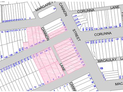
Figure 3: Map of distribution of revised proposal to affected properties
|
Support |
Officers Comments |
|
Two (2) submissions were, one (1) supporting the original proposal and one (1) calling for an extension of the “No Parking’ restrictions |
A revised proposal has been distributed to all affected properties advising of details of making representations to relevant Traffic Committee meeting |
|
Object |
|
|
There were no objections to the initial proposal |
Any comments received prior to 31 January 2019 will be tabled at the Traffic Committee meeting |
CONCLUSION
Given the narrowness of the laneway (4.8m wide) and the representations from residents to ensure access to off-street parking spaces, the recommendation to restrict parking in Cannon Lane, Stanmore is supported.
|
|
Local Traffic Committee Meeting 4 February 2019 |
Subject: Silver Street, St Peters - Proposed 10m No Stopping at intersection with Edith Lane (Marrickville Ward/Heffron Electorate/Inner West PAC)
Prepared By: Mary Bailey - Parking Planner
Authorised By: John Stephens - Traffic and Transport Services Manager
|
SUMMARY Following representations from residents regarding the visibility of pedestrians (including school children) at the intersection of Silver Street at Edith Street, St Peters; Council is proposing to install a 10m ‘No Stopping’ zone on the western side of Silver Street north of its intersection with Edith Lane. This proposal is designed to address pedestrian and vehicle visibility and manoeuvrability issues at this intersection. |
|
RECOMMENDATION
THAT the installation of a Statutory 10m ‘No Stopping’ zone in Silver Street, St Peters, (western side) - at its intersection with Edith Lane (adjacent to property No. 2 Silver Street) be approved. |
BACKGROUND
Following community representations expressing concern at the safety issues created for children and their carers walking to school in the Silver Street area, Council is proposing to implement a 10m ‘No Stopping’ zone in Silver Street at its intersection with Edith Lane. An illustration of the proposal can be seen in Figure 1.
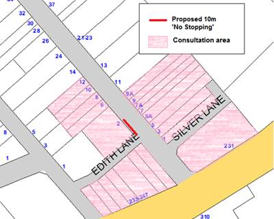
Figure 1. Proposed restrictions and consultation area
An illustration of the visibility and maneuverability issues created by vehicles parking too close to the intersection can be seen in Figure 2.
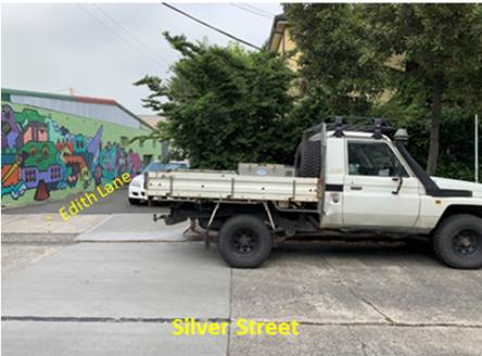
Figure 2. Visibility issues are caused by vehicle parking too close to intersection
FINANCIAL IMPLICATIONS
The cost of the supply and installation of the signage will be funded from Council’s signs and line marking budget.
PUBLIC CONSULTATION
On 11 January 2019 letters were delivered to affected properties in the area (see Figure 1). Residents were advised to make submissions by 31 January 2019 and provided with details of the Traffic Committee meeting should they wish to attend and make representations. At the time of writing, there have been two (2) submissions received, one in support and one objecting. No reason was given for the objection. Any additional feedback received will be tabled at the Traffic Committee meeting.
|
|
|
|
|
Officers Comment |
|
Support 1. Overall it’s a good idea as it does get dangerous trying to exit our car park opposite Edith Lane when you have cars parked opposite
|
Introduction of the proposed ‘No Stopping’ will provide additional safety and maneuverability at the intersection |
|
Object No reason given |
CONCLUSION
The implementation of the signage in the Statutory 10m ‘No Stopping’ zone outside property No.2 Silver Street will address concerns expressed by residents regarding visibility of pedestrians including school children; and provide for improved sight lines and maneuverability at the subject intersection. The proposal is supported.
|
|
Local Traffic Committee Meeting 4 February 2019 |
Subject: Brighton Street, Petersham Intersection with Unnamed Lane - Proposed Parking Restrictions (Stanmore Ward,/Newtown Electorate/Inner West PAC)
Prepared By: Mary Bailey - Parking Planner
Authorised By: John Stephens - Traffic and Transport Services Manager
|
SUMMARY Following community representation, it is proposed to signpost statutory ‘No Stopping’ restrictions in Brighton Street, Petersham, at its intersection with an Unnamed Lane (located 30m east of Railway Street), in order to prevent illegal parking and improve safety at the entry into Brighton Street. Community feedback supporting implementation of parking restrictions and a revision to the proposal was sought. The revision is to implement ‘No Parking’ instead of ‘No Stopping’ on the western side of the laneway in Brighton Street due to the existence of a driveway in part of the proposed location. The proposal for ‘No Stopping’ restriction in Brighton Street east of the laneway was supported. |
|
RECOMMENDATION
THAT:
1. The installation of 10m ‘No Stopping’ restriction in Brighton Street, Petersham east of Unnamed Lane (located 30m east of Railway Street) , and
2. The installation of 10m ‘No Parking’ restriction Brighton Street, Petersham west of Unnamed Lane (located 30m east of Railway Street); be approved.
|
BACKGROUND
Concerns have been raised by residents regarding vehicles parking in Brighton Street too close to its intersection with an Unnamed Lane (located 30m east of Railway Street).
This illegal parking behaviour obstructs sight lines as well as access in and out of the Unnamed Lane. Following feedback from resdinets the initial proposal has been revised to change ‘No Stopping’ to “No Parking’ on the western side of the laneway in Brighton Street.
The revised proposal is illustrated in Figure 1 below.
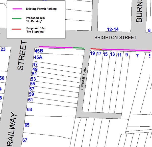
Figure 1: Revised Proposal for ‘No Parking’ and ‘No Stopping’ restrictions
The initial proposal was for ‘No Stopping’ in Brighton Street on both sides of the Unnamed Lane. A resident sought to have the proposed ‘No Stopping’ as originally proposed changed to ‘No Parking’ on the western side of the laneway in Brighton Street. The initial proposal is illustrated in Figure 2 below.
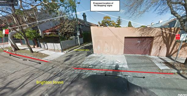
Figure 2: Initial proposal for ‘No Stopping’ in Brighton Street both side of the Unnamed Lane
The Unnamed Lane provides access to a significant number of off-street car parking spaces associated with surrounding resindences in Brighton Street as well as Terminus Street. See Figure 3 for illustration of off-street parking assocaited with the Unnamed Lane. This results in a the use of the laneway by a number of resdeints and there has been concerns expressed about the safety and visibility at the intersection of Brighton Street and the Unnamed Lane. The proposal is designed to improve safety and visibility for vehicels turning into and out of the Unnamed Lane while accessing their off-street car parking spaces.
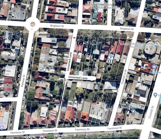
Figure 2:
FINANCIAL IMPLICATIONS
The cost of the supply and installation of the signage will be funded from Council’s signs and line marking budget.
PUBLIC CONSULTATION
On 23 November, Council distributed thirty five (35) letters to affected owners and occupiers, detailing the proposal. There were six (6) responses, four (4) strongly supported the proposal, one supported the proposal from a safety point of view but noted the demand for parking in the area and sought to have a reduced length for the proposed ‘No Stopping’ /’No Parking’ zones.. One (1) was strongly opposed (2) were opposed on the grounds that parking is scarce in the area. One of the respondents who supported the principle of restricting parking at the intersection sought to have the proposed restriction of ‘No Stopping’ amended to a ‘No Parking’ restriction in Brighton Street on the western side of the Unnamed Lane. A summary of the submissions can be seen below in Table 1 below.
Table 1: Summary of Resident Feedback
|
Resident Feedback |
Officer’s Comment |
|
Object 1. As a local resident I am opposed to council's plan to install no stopping signs on either side of the lane behind Railway St on Brighton St. First, one of the proposed locations is in front of a garage, so this is already not a valid parking spot, but this space does however provide a place for residents to stop briefly (for example in order to close their back gates in the lane, or to drop things off). Perhaps if necessary a better alternative for this space would be a no parking sign. The other side of the lane offers a parking space, which is a rare commodity in this area, and even rarer now that council has installed a set of no stopping signs in Railway St, reducing available spots by at least 3 or 4. 2. One resident supported the safety impact of the proposal but sought to have the length of the zones reduced from 10m.
|
1. The revised proposal recommends ‘No Parking’ in front of the garage on the western side of the laneway as requested. There is strong support for the ‘No Stopping’ on the eastern side due to the current reported lack of visibility of approaching vehicles. 2. Considering the geometry of the intersection and the speed and volume of vehicles in Brighton Street, 10m is considered an appropriate length for the proposed ‘No Parking’ and ‘No Stopping’ zones. |
|
Support 1. Good to see something finally happening |
The proposal will address the issues of concern with lack of visibility for vehicles turning out of the Unnamed Lane into Brighton Street |
|
2. I give *very strong support* for the proposal to install No Stopping signs either side of the unnamed lane on Brighton St. I am a frequent user of that lane because my garage is on the lane. Turning into the lane from Brighton St is often difficult because cars are parked very close to the corner. But more importantly, it is often VERY hazardous exiting from the lane again because parked cars close to the corner mean that visibility is extremely poor. It can be very hard to see cars coming down Brighton St from Crystal (gaining speed), and it is very hard for those cars to see a car exiting from the lane. This makes for a very dangerous intersection. I have twice written to the council asking that no parking signs be installed to prevent cars parking close to the corner, and both times my request was rejected for reasons that were never explained. So I am delighted to see that the council is finally taking this mater seriously. I had thought it might require someone to have a serious accident there before action would be taken. 3. In the long term, can you please install no standing or no parking signs across the lane? There are sign posts in the street that a sign could be attached to. At the moment, given this is now registered with Council as an issue; the Council will be liable for any injury or damage caused by it which is not a good situation. |
CONCLUSION
Given the concern for safety caused by parked vehicles obstructing visibility of oncoming vehicles for those turning out from the Unnamed Lane; and the support for the installation of parking restrictions at the intersection of Brighton Street and the Unnamed Lane, the proposal to implement ‘No Stopping’ on the eastern side of the laneway and ‘No Parking’ on the western side of the laneway is supported.
|
|
Local Traffic Committee Meeting 4 February 2019 |
Subject: Grove Street, Dulwich Hill - Extension of Existing Resident Permit Scheme Hours (Ashfield Ward/Summer Hill Electorate/Inner West PAC)
Prepared By: Mary Bailey - Parking Planner
Authorised By: John Stephens - Traffic and Transport Services Manager
|
SUMMARY Following community representations, Council proposed an extension to the permit parking hours in Grove Street, Dulwich Hill. Consultation with owners and occupiers in Grove Street indicated that there was insufficient support to carry out any extension of the permit parking hours at the present time. |
|
RECOMMENDATION
THAT the proposal to extend the existing ‘2P Permit Holders Excepted 8:30am-6:00pm Mon-Fri’ Area M6 restrictions on the southern side of Grove Street, Dulwich Hill to ‘2P Permit Holders Excepted 8:30am-10:00pm Mon-Fri Area M6’ not be supported due to insufficient resident support at the present time. |
BACKGROUND
Parking in Grove Street was considered as part of the Dulwich Hill Parking Study endorsed by Council in September 2016. Council implemented the 2P Resident Parking Scheme to address the parking issues raised by residents of Grove Street and other nearby streets regarding commuter parkers using the light rail station and from the builders working on the development site (north side of Grove Street). Based on community consultation and parking occupancy surveys, permit parking was recommended by the study and implementation took place in early 2017.
At that time a multi-unit development was proposed to be built on the western side of Grove Street. This development has now been completed. The previous use of the site and associated parking ratios were taken into account in the analysis of the parking proposal for Grove Street.
The existing hours of permit parking in Grove Street, Dulwich Hill (8:30am-6:00pm Monday to Friday Area M6) are consistent with the permit parking restrictions in similar nearby streets, that is Hill Street, Denison Street and Constituion Road (west of Denison Road). Some streets further to the east of Grove Street have extended permit parking restriction hours (i.e. Saturday morning) due to the proximity to the commerical centre in New Canterbury Road, Dulwich Hill.
Council received a request from a Grove Street resident to investigate the extension of the permit parking hours in Grove Street to 10pm. The proposal is illustrated in Figure 1 below. Council Officers undertook community engagement with residents as well as undertaking parking occupancy surveys. The results of the community engagement are detailed in the “Public Consultation” section below. The results of the parking occupancy surveys are shown in Table 1 below.
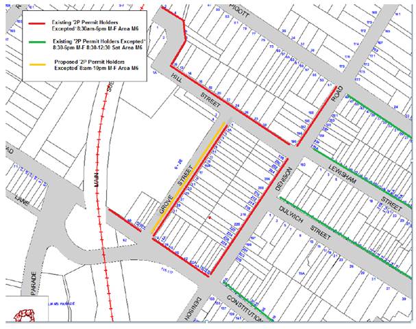
Figure 1: Existing and proposed parking restrictions, Grove Street, Dulwich Hill
Council carried out parking occupancy surveys in mid November 2018. The results of the surveys are detailed in Table 1 below. The survey shows that there is a high parking occupancy on weekday evenings (93-98%).
Table 1: Parking Occupancy Survey results
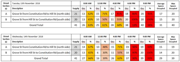
FINANCIAL IMPLICATIONS
Nil
PUBLIC CONSULTATION
On 1 December 2019, three hundred and thirty two (332) letters outlining the proposal were delivered to all owners and occupiers in Grove Street and affected residents in nearby streets advising of a closing date for submissions of 14 January 2019 .
The distribution of the letters is shown in Figure 2 below.
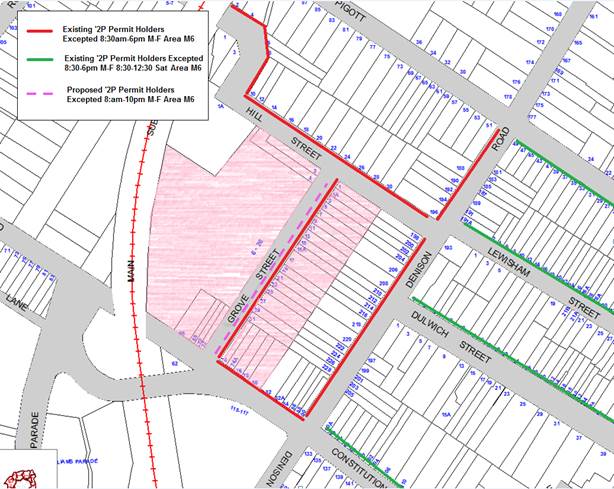
Figure 2: Distribution of letters highlighted in pink
There are twenty (20) single unit dwellings in Grove Street. Even though letters detailing the proposal were delivered to the multi-unit development in Grove Street, in general Council places a higher emphasis on responses from the residents of the single unit dwellings in making a determination when dealing with resident parking schemes.
Recipients of the consultation letter were advised that the closing date for submissions was 14 January, 2019. As of that date there were three (3) submissions received, one (1) objecting and two (2) supporting the proposal. There was one (1) response from the Arlington Grove complex which objected on the grounds that parking for visitors would be difficult and also suggested that the existing parking restrictions were operating satisfactorily
As at 24 January, 2019 a further three (3) responses have been received from residents of Grove Street single unit dwellings, making a total of five (5) responses.
Former Marrickville Council guidelines state that there should be a response rate of 30% of households that were surveyed, with 65% of respondents supporting the proposal.
Given that there are twenty (20) single-unit households in Grove Street and only five (5) responses, this is only a 25% response rate. A 30% response rate is the minimum required. Therefore, in this case there is not a sufficient response from the community to progress this matter further. Note: In order to best gauge the level of support of directly affected residents, the response-rate analysis in this case was conducted on the basis of considering only single unit dwellings in Grove Street
|
Residents’ Feedback |
Officer Comment |
|
Support 1. There were five (5) comments supporting the proposal, citing parking difficulty in the evenings Object 2. The one objecting proposal was from a resident of the multi-unit development, Arlington Grove. There was one (1) response from the Arlington Grove complex which objected on the grounds that parking for visitors would be difficult and also suggested that the existing parking restrictions were operating satisfactorily. |
1. Insufficient response to the proposal for Council to support the recommendation to extend the permit parking hours
2. Since the apartment complex is not eligible for permits, the objection is noted but is not considered in the decision making process.
|
CONCLUSION
Given the insufficient response rate from residents of Grove Street, the proposal to extend permit parking hours is not supported.
|
|
Local Traffic Committee Meeting 4 February 2019 |
Subject: Chapman Lane (rear of Nos.129 - 133 Annandale Street), Annandale - Proposed Extension of 'No Parking' zone (Leichhardt Ward/Balmain Electorate/Leichhardt PAC)
Prepared By: David Yu - Engineer - Traffic and Parking Services
Authorised By: John Stephens - Traffic and Transport Services Manager
|
SUMMARY Council has received concerns regarding parked vehicles obstructing access to off-street parking in Chapman Lane (rear of Nos.129 - 133 Annandale Street), Annandale. This matter was previously considered by the Committee last year and deferred for further consideration. |
|
RECOMMENDATION
THAT a 10.8m ‘No Parking’ zone be installed on the eastern side of Chapman Lane (opposite the rear of Nos.129 - 133 Annandale Street), Annandale.
|
BACKGROUND
Council has received concerns from residents of Annandale Street, Annandale regarding vehicles parking on the eastern side of Chapman Lane, Annandale and subsequently obstructing rear driveway access for property Nos.129 -133 Annandale Street.
At the previous Traffic Committee meeting in 2018, a report was considered regarding vehicles parking in Chapman Lane and obstructing driveway access, the report recommended that two ‘No Parking’ zones be installed on the eastern side of Chapman Lane to address these concerns.
A resident attended the meeting and expressed concern for the proposed loss of parking and the Traffic Committee recommended that:
1. A 7.2m ‘No Parking’ zone be installed on the eastern side of Chapman Lane (opposite the rear of No.127 Annandale Street); and
2. A 10.8m ‘No Parking’ zone be deferred for further consideration on the eastern side of Chapman Lane (opposite the rear of Nos.129 to 133 Annandale Street).
The recommendation was subsequently adopted by Council.
Note, there is an existing ‘No Parking’ zone on the eastern side of Chapman Lane that extends opposite the rear boundaries of Nos.115 to 127 Annandale Street.
FINANCIAL IMPLICATIONS
Nil.
OTHER STAFF COMMENTS
Council Officers have now reinvestigated the deferred 10.8m ‘No Parking’ zone on the eastern side of Chapman Lane (opposite the rear of Nos.129 -133 Annandale Street). Swept path analysis has identified that vehicle accessibility to Nos. 131 and 133 Annandale Street, opposite the subject kerb section will be impeded when a vehicle is parked at this location, this is shown in Attachment 1.
Therefore, it is proposed to signpost the remaining kerb space on the eastern side of Chapman Lane as a 10.8m ‘No Parking’ zone (opposite the rear of Nos.129 - 133 Annandale Street) as shown on the following plan.
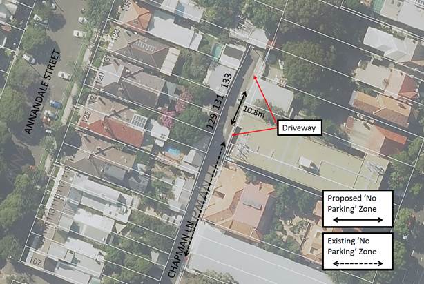
PUBLIC CONSULTATION
The previous respondents have been notified regarding the outcome of the additional investigation.
CONCLUSION
Nil.
|
1.⇩ |
Chapman Lane, Annandale - Swept Path Analysis (Entry and Exit) |
|
|
Local Traffic Committee Meeting 4 February 2019 |
Subject: Short Street, Dulwich Hill- Proposed Permit Parking restrictions (Ashfield Ward/Summer Hill Electorate/LAC)
Prepared By: Mary Bailey - Parking Planner
Authorised By: John Stephens - Traffic and Transport Services Manager
|
SUMMARY Following representations to Council from the community, Council is proposing to implement permit parking restrictions in Short Street, Dulwich Hill; consistent with permit parking restrictions in nearby streets. |
|
RECOMMENDATION
THAT:
1. Installation of 2P Permit Holders Excepted 8:30am-6pm Monday to Friday Area M7) restrictions in Short Street, Lewisham (south side); and
2. Installation of 6m ‘No Stopping’ restriction in Short Street (south side) at its intersection with Victoria Street; be approved. |
BACKGROUND
Parking in Short Street, Lewisham was considered as part of the Lewisham Parking review endorsed by Council in November 2016. Although permit parking restrictions were recommended for a number of nearby streets, at that time there were no recommendations made to implement permit parking in Short Street due to the potential loss of parking associated with the statutory 10m ‘No Stopping’ zones which would be required, given that Short Street is only 26m long.
Subsequent to the installation of the permit parking restrictions in nearby streets, residents of Short Street have indicated to Council that they are experiencing parking problems and that they are in favour of implementing permit parking in Short Street.
Council is therefore proposing to install permit parking on the southern side of Short Street as illustrated in Figure 1. Given the fact that Short Street is only 26m long, it is proposed to install a reduced ‘No Stopping’ zone (6 meters instead of 10 meters) as indicated in Figure 1.
It is also noted that residents of Short Street who are eligible to participate in the permit parking scheme will have the opportunity to park in other streets in the M7 area including the adjoining Victoria Street. The existing permit parking is also illustrated in Figure 1 by a pink line.
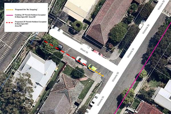
Figure 1: Proposed parking restrictions in Short Street
FINANCIAL IMPLICATIONS
The cost of the supply and installation of the signage will be funded from Council’s signs and line marking budget.
PUBLIC CONSULTATION
On 3 December 2018, letters were sent to all affected residents. There were two (2) responses received, both in support of the proposal.
No objections were received.
CONCLUSION
Given the support for the proposed permit parking restrictions in Short Street and the fact that other nearby streets are designated with permit parking restrictions, the proposal to introduce permit parking restrictions in Short Street, Dulwich Hill is supported.
|
|
Local Traffic Committee Meeting 4 February 2019 |
Subject: Little Theodore Street, Balmain - Proposed Extension of 'No Parking' zone (Balmain Ward/Balmain Electorate/Leichhardt PAC)
Prepared By: Vinoth Srinivasan - Engineer - Traffic and Parking Services
Authorised By: John Stephens - Traffic and Transport Services Manager
|
SUMMARY Council has received concerns regarding obstructed driveway and pedestrian access in Little Theodore Street at the rear of No.46A Llewellyn Street, Balmain. |
|
RECOMMENDATION
THAT the existing 8.7m ‘2P 8am-10pm Permit Holders Excepted Area B1’ parking zone on the northern side of Little Theodore Street rear to No.44 Llewellyn Street, Balmain be reduced by 2.7m by extending the existing ‘No Parking’ zones on both the eastern and western sides of the parking space by 1.35m each.
|
BACKGROUND
Council has received concerns regarding obstructed driveway and pedestrian access in Little Theodore Street at the rear of No.46A Llewellyn Street, Balmain.
The existing parking zone at the rear of No.44 Llewellyn Street, Balmain is 8.7m in length and it is not long enough for two small cars to be parked in the area without overhanging into the ‘No Parking’ zone. In any occasion when two small cars are parked in the area, driveway and pedestrian access is obstructed.
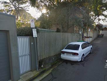
FINANCIAL IMPLICATIONS
Nil.
OTHER STAFF COMMENTS
It was initially proposed to extend the existing ‘No Parking’ zone on the northern side of Little Theodore Street rear to No.44 Llewellyn Street, Balmain by 2.7m as shown on the following plan.
The proposal would have reduced the existing parking zone to 6m where one standard vehicle space is retained.
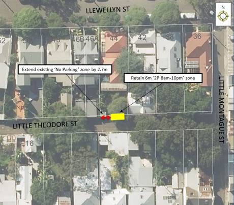
PUBLIC CONSULTATION
A letter outlining the above parking proposal was mailed out to the affected properties (8 properties) in Little Theodore Street, Balmain, requesting residents’ views regarding the proposal (as indicated on the below plan).
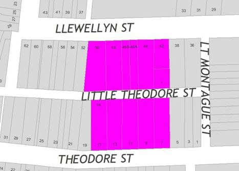
Four (4) responses were received in objection to Council’s proposal to reduce the existing ‘2P’ zone on the northern side of Little Theodore Street rear to No.44 Llewellyn Street, Balmain to 6m.
The table below shows the comments raised by the residents.
|
Residents’ Comments |
Officer Comments |
|
We do not oppose extending the ‘No Parking’ zone. However, extending only the western side by 2.7m will force cars to park further to the eastern end, inhibiting our ability to get access to our garage.
We propose to extend the zones at both the eastern and western ends by 1.35m. This will give residents of No.44 Llewelyn Street enough space to access their garage and pedestrian gate, while also allowing us enough room to access our property. |
Council’s modified proposal seeks to reduce the length of the parking space by 1.35m on both the eastern and western ends.
|
|
I propose that the existing ‘No Parking’ zone be extended by 0.7m on the western end and 2.0m on the eastern end so there will be more room at both ends of the parking zone. |
|
|
The street parking should be re-configured to increase the parking area in order to comfortably accommodate two (2) vehicles. |
Based on the location of the existing off-street parking, Council is unable to re-configure the existing parking layout to accommodate for two (2) parking spaces. |
|
The subject location has never had two (2) cars parking in it as there is not enough room. |
Noted. |
MODIFIED PROPOSAL
Council is proposing to modify the consulted proposal to address the objections raised by the affected residents.
As per the consultation table, concerns have been raised that reducing the existing parking space at the rear of No.44 Llewellyn Street on Little Theodore Street by 2.7m on the western side will force vehicles to overhang and obstruct access to the rear of No.42 Llewellyn Street.
In order to alleviate this issue, it is proposed to extend the existing ‘No Parking’ zones both east and west of the ‘2P’ parking space by 1.35m and retain a 6m ‘2P 8am-10pm Permit Holders Excepted Area B1’ parking space.
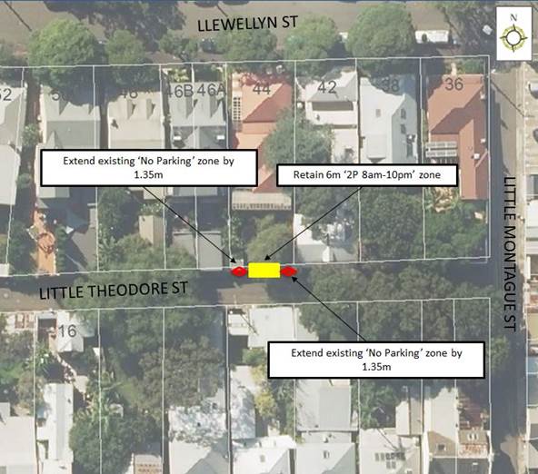
CONCLUSION
Nil.
|
|
Local Traffic Committee Meeting 4 February 2019 |
Subject: Frampton Lane, Marrickville - Request for ‘No Parking’ Restrictions (Marrickville Ward / Newtown Electrorate / Inner West PAC)
Prepared By: Jennifer Adams - Engineer – Traffic and Parking Services
Authorised By: John Stephens - Traffic and Transport Services Manager
|
SUMMARY Representations have been received from a local resident for the installation of full time ‘No Parking’ restrictions in Frampton Lane, Marrickville on the western side of Frampton Lane, northward of the junction of Seymour Lane and Central Lane, to improve access to off-street parking as vehicular access is often blocked by parked vehicles in the laneway. Residents have been notified of the proposal. It is recommended that the proposal be approved.
|
|
RECOMMENDATION
THAT:
1. The installation of a 15 metre ‘No Parking’ zone on the western side of Frampton Lane, northward of the junction of Seymour Lane and Central Lane, adjacent to property No.289 Victoria Road, Marrickville be APPROVED, in order to provide unobstructed vehicular access to the off-street car parking spaces; and
2. The applicant and Council’s Parking Officers be advised in terms of this report.
|
BACKGROUND
Council is proposing to install 15 metre length of ‘No Parking’ restrictions on the western side of Frampton Lane, northward of the junction of Seymour Lane and Central Lane, to improve access to off-street parking. (Refer to the plan below).
It should be noted that laneways were generally built to provide service access for properties into off-street parking facilities. Also, the laneway is very narrow and access for trucks, including waste collection vehicles, is extremely difficult when vehicles are parked in the laneway.
FINANCIAL IMPLICATIONS
The cost of the supply and installation of the signposting associated with the recommended ‘No Parking’ restrictions is approximately $600 and can be met from Council’s operating budget for signs and line marking.
OFFICER COMMENTS
Frampton Lane is a local laneway and in the subject location it is narrow having a carriageway width of 4.9 metres. At present parking is unrestricted on both sides of the laneway.
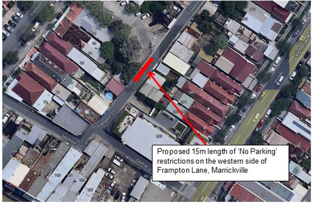
Proposed ‘No Parking’ restrictions (western side) in Frampton Lane, Marrickville
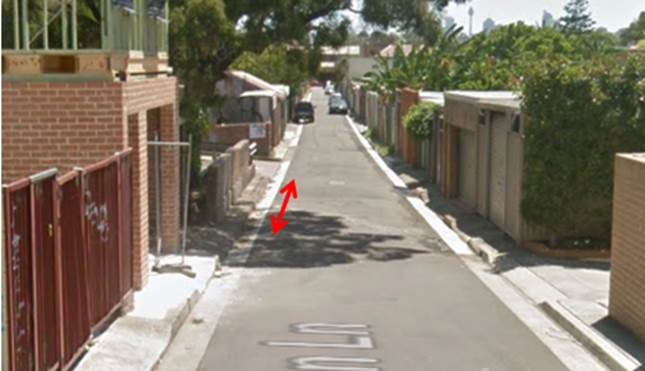
Parking in laneways
This proposal will provide unobstructed vehicular access to adjoining properties. It was observed during the site inspection that the off-street parking facilities were utilised. It was also noted that there is a high demand for parking in the area and vehicles were parked along the both sides of the laneway further northward, yet there were available spaces in the adjacent Council car park.
It should be noted that laneways were generally built to provide service access for properties and access into off-street parking facilities. Prohibiting parking in the subject location will help achieve this goal.
Former adopted ‘Laneway Parking Guidelines’ outline the priorities for using narrow laneways and the actions and processes that Council will use to manage access and parking. These guidelines were developed to provide consistency for evaluating the need for parking controls and manage the use of narrow streets and laneways to maintain access and maximise parking. The need for parking controls is based on the width of the laneway shown below in Table 1.
Table 1: Laneway Parking Guideline Laneway Width
|
Laneway Width (between property boundaries or kerbs/driveways) |
Parking and Access Arrangements |
|
5.1 metres or more wide
|
· Parking allowed on at least one side of the laneway · Allows access for emergency, delivery and waste collection trucks at all times · Complies with Australian Standards and Road Rule 208(7) |
|
Less than 5.1 metres
|
· Parking NOT permitted in the laneway · Allows vehicle access at all times and complies with Australian Standards and Road Rule 208(7) |
For parking to be allowed in a narrow laneway, the Australian Standards require that parallel parking spaces be at least 2.1 metres wide and NSW Road Rules requires that at least 3 metres must be available between a parked car and the kerb or edge of the laneway to allow moving vehicles to pass safely. Therefore, laneway widths that are less than 5.1 metres wide are too narrow to allow parking as any parked vehicle would prevent traffic from using the laneway (see Table 1 above and Figure 1 below).
Figure 1: Recommended minimum width of laneway for parking – 5.1 metres
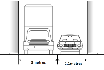
PUBLIC CONSULTATION
A notification letter was sent to 42 owners/ occupiers of properties that are adjacent to the subject location of Frampton Lane regarding the proposal to install the 15 metre length of full-time ‘No Parking’ restrictions. The closing date for submissions ended on 14 December 2018.
Resident survey findings - A total of two (2) responses were received from residents. Both of these submissions supported the proposal.
CONCLUSION
Frampton Lane is quite narrow and should a vehicle be parked close to or opposite a driveway, vehicle access can be impeded. No Parking’ restrictions would assist residents with rear garage areas who may be experiencing access difficulties. Therefore, in order to provide clear vehicular access to the applicant's and other responding resident’s off-street parking facilities, it is recommended that a 15 metre length of full-time ‘No Parking’ restrictions on the western side of Frampton Lane, northward of the junction of Seymour Lane and Central Lane, adjacent to property No. 289 Victoria Road, Marrickville be approved.
Installation Diagram – Frampton Lane, Marrickville
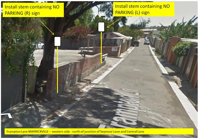
|
|
Local Traffic Committee Meeting 4 February 2019 |
Subject: Minor Traffic Facilities (All Wards/All Electorates/All LAC's)
Prepared By: Vinoth Srinivasan - Engineer - Traffic and Parking Services
Authorised By: John Stephens - Traffic and Transport Services Manager
|
SUMMARY This report considers minor traffic facility applications received by Inner West Council, including ‘Disabled Parking’ and ‘Works Zone’ requests. |
|
RECOMMENDATION THAT:
1. The 6m ‘1 hour Parking’ space in lieu of a Disabled Parking zone in front of No.32 Lamb Street, Lilyfield be removed as the zone is no longer required;
2. A 5.5m ‘Disabled Parking’ zone be installed in front of No.2-4 Lookes Avenue, Balmain East;
3. A 5.5m ‘Disabled Parking’ zone be installed in front of No.2/18 and No.3/18 George Street, Balmain;
4. A 5.5m ‘Disabled Parking’ zone be installed in front of No.24 John Street, Ashfield;
5. A 6m ‘Disabled Parking’ zone be installed in front of No.36 Tupper Street, Enmore;
6. A 5.5m ‘Disabled Parking’ zone be installed front of No.39 Shaw Street Petersham;
7. A 3.5m (45-degree angle parking) ‘Disabled Parking’ zone be installed in front of No.158 Trafalgar Street, Annandale;
8. A 6m ‘Disabled Parking’ zone be installed in front of No.18 Foreman Street, Tempe;
9. A 9m ‘Works Zone 7.00am – 5.00pm Mon-Fri and 8.00am – 1.00pm Sat’ be installed in front of No.23 Darling Street, Balmain for 12 weeks, temporarily replacing the resident parking restrictions;
10. A 12m ‘Works Zone 7.00am – 5.00pm Mon-Fri and 8.00am – 1.00pm Sat’ be installed in front of No.67 and No.69 Audley Street, Petersham for 12 weeks, temporarily replacing the resident parking restrictions;
11. A 9m ‘Works Zone 7.00am – 5.00pm Mon-Fri and 8.00am – 1.00pm Sat’ be installed in front of No.32 George Street, Marrickville for 10 weeks;
12. An 11m ‘Works Zone 7.00am – 5.00pm Mon-Fri and 8.00am – 1.00pm Sat’ be installed in front of No.19 Margaret Street, Stanmore for 8 weeks; and
13. A 14m 'Works Zone 7:00am – 5:00pm Mon-Fri and 8.00am-1.00pm Sat' be installed in Eton Street, along the side boundary of No. 101 Australia Street, Camperdown for 12 weeks. |
BACKGROUND
This report considers minor traffic facility applications by Inner West Council, and includes ‘Disabled Parking’ and ‘Work Zone’ requests.
FINANCIAL IMPLICATIONS
Nil.
OTHER STAFF COMMENTS
1. Removal of ‘1 hour Parking’ Restriction – Lamb Street, Lilyfield
A family member of the applicant of the ‘1 hour Parking’ zone in lieu of a Disabled Parking zone in front of No.32 Lamb Street, Lilyfield has notified Council that the applicant has passed away and thus the ‘1 hour Parking’ zone is no longer required.
It is recommended that the 6m ‘1 hour Parking’ space in lieu of a Disabled Parking zone in front of No.32 Lamb Street, Lilyfield be removed as the zone is no longer required.
2. Installation of a ‘Disabled Parking’ Restriction – Lookes Avenue, Balmain East
The resident of No.5 Lookes Avenue, Balmain East has requested the installation of a ‘Disabled Parking’ zone on the opposite side of the street, in front of No.2-4 Lookes Avenue.
A site investigation has revealed the property does not have off street parking and there are existing ‘No Parking’ restrictions directly in front of the resident’s property.
A letter outlining a proposal to install a ‘Disabled Parking’ zone opposite the applicant’s property was mailed out to the affected properties (10 in total) in Lookes Avenue, Balmain East. No objections were received to Council’s proposal.
The applicant does not require the use of a wheelchair.
It is recommended that a 5.5m ‘Disabled Parking’ zone be installed in front of No.2-4 Lookes Avenue, Balmain East, replacing the existing 2P parking restrictions.
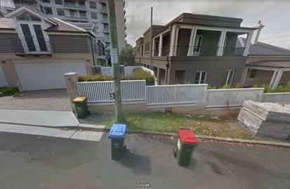
No.2-4 Lookes Avenue, Balmain East
3. Installation of ‘Disabled Parking’ Restriction – George Street, Balmain
The resident of No.2/18 George Street, Balmain has requested the installation of a ‘Disabled Parking’ zone in front of the property boundary of the resident’s property and No.3/18 George Street.
A site investigation has revealed the property has off street parking however the driveway width is 2.4m and is below standard.
The applicant does not require the use of a wheelchair.
Concurrence from residents of No.3/18 George Street was received for the installation of a ‘Disabled Parking’ zone on the property boundary.
It is recommended that a 5.5m ‘Disabled Parking’ zone be installed in front of the property boundary of No.2/18 and No.3/18 George Street, Balmain.
No.2/18 – No.3/18 George Street, Balmain
4. Installation of ‘Disabled Parking’ Restriction – John Street, Ashfield
The resident of No.24 John Street, Ashfield has requested the installation of a ‘Disabled Parking’ zone in front of the resident’s property.
A site investigation has revealed the property does not have off street parking.
The applicant does not require the use of wheelchair.
It is recommended that a 5.5m 'Disabled Parking Zone’ be installed in front of No.24 John Street, Ashfield.
No.24 John Street, Ashfield
5. Installation of ‘Disabled Parking’ Restriction – Tupper Street, Enmore
The resident of No.36 Tupper Street, Enmore has requested the installation of 'Disabled Parking Zone’ in front of the resident’s property.
A site investigation has revealed the property does not have off street parking.
The applicant does not require the use of wheelchair.
It is recommended that a 6m 'Disabled Parking Zone’ be installed in front of No.36 Tupper Street, Enmore.
No.36 Tupper Street, Enmore.
6. Installation of ‘Disabled Parking’ Restriction – Shaw Street, Petersham
The resident of No.1/39 Shaw Street, Petersham has requested the installation of a ‘Disabled Parking’ zone in front of the apartment block in Shaw Street.
A site investigation has revealed the property does not have off street parking.
A letter outlining the parking proposal was mailed out to the affected properties in Shaw Street, Petersham. No objections were received to Council’s proposal.
The applicant does not require the use of a wheelchair.
It is recommended that a 5.5m ‘Disabled Parking’ zone be installed in front of No.39 Shaw Street, Stanmore.
No.39 Shaw Street, Petersham
7. Installation of ‘Disabled Parking’ Restriction – Trafalgar Street, Annandale
The resident of No. 158 Trafalgar Street, Annandale has requested the installation of 'Disabled Parking’ zone in front of the resident’s property.
A site investigation has revealed the property does not have off street parking.
The applicant does not require the use of wheelchair.
It is recommended that 3.5m (45-degree angle parking) 'Disabled Parking’ zone be installed in front of No.158 Trafalgar Street, Annandale.
No.158 Trafalgar Street, Annandale
8. Installation of ‘Disabled Parking’ Restriction – Foreman Street, Tempe
The resident of No.18 Foreman Street, Tempe has requested the installation of ‘Disabled Parking’ zone in front of the resident’s property.
A site investigation has revealed the property does not have off street parking.
The applicant does not require the use of a wheelchair.
It is recommended that a 6m ‘Disabled Parking’ zone be installed in front of No.18 Foreman Street, Tempe.
18 Foreman Street, Tempe.
9. Installation of ‘Works Zone’ Restriction – Darling Street, Balmain
The applicant (No.23 Darling Street) has requested the installation of a temporary 9m 'Works Zone 7.00am – 5:00pm Mon-Fri and 8.00am-1.00pm Sat' in front of No.21-23 Darling Street, Balmain.
The owners of the neighbouring properties have provided the concurrence for the proposed ‘Works Zone’ to be placed in front of their houses (1/21 and 2/21 Darling Street).
It is recommended that a 9m 'Works Zone 7.00am – 5:00pm Mon-Fri and 8.00am-1.00pm Sat' be installed in front of No.23 Darling Street, Balmain for 12 weeks, temporarily replacing the resident parking restrictions.
No.21-23 Darling Street, Balmain
10. Installation of ‘Works Zone’ Restriction – Audley Street, Petersham
The applicant (No.78-80 New Canterbury Road) has requested the installation of a temporary 12m 'Works Zone 7.00am – 5:00pm Mon-Fri and 8.00am-1.00pm Sat' in front of No.67 and No.69 Audley Street, Petersham.
As there are ‘No Stopping’ restrictions on all frontages to the development site, the ‘Works Zone’ is proposed to be placed in front of No.67 and No.69 Audley Street. The owners have provided written concurrence for the ‘Works Zone’ to be placed in front of their properties.
It is recommended that a 12m 'Works Zone 7.00am – 5:00pm Mon-Fri and 8.00am-1.00pm Sat' be installed in front of No.67 and No.69 Audley Street, Petersham for 12 weeks, temporarily replacing the resident parking restrictions.
No.67-69 Audley Street, Petersham
11. Installation of ‘Works Zone’ restriction – George Street, Marrickville
The applicant has requested the installation of a temporary 9m 'Works Zone 7.00am – 5:00pm Mon-Fri and 8.00am-1.00pm Sat' in front of No.32 George Street, Marrickville.
It is recommended that a 9m 'Works Zone 7.00am – 5:00pm Mon-Fri and 8.00am-1.00pm Sat' be installed in front of No.32 George Street, Marrickville for 10 weeks.
No.32 George Street, Marrickville
12. Installation of ‘Works Zone’ restriction – Margaret Street, Stanmore
The applicant has requested the installation of a temporary 11m 'Works Zone 7.00am – 5:00pm Mon-Fri and 8.00am-1.00pm Sat' in front of No.19 Margaret Street, Stanmore for a period of 8 weeks.
It is recommended that an 11m 'Works Zone 7.00am – 5:00pm Mon-Fri and 8.00am-1.00pm Sat' be installed in front of No.19 Margaret Street, Stanmore for 8 weeks.
No.19 Margaret Street, Stanmore
13. Installation of ‘Works Zone’ Restriction – Eton Street, Camperdown
The applicant has requested the installation of a temporary 14m 'Works Zone 7:00am – 5:00pm Mon-Fri and 8.00am-1.00pm Sat' in Eton Street, along the side boundary of No.101 Australia Street, Camperdown for 12 weeks.
It is recommended that a 14m 'Works Zone 7:00am – 5:00pm Mon-Fri and 8.00am-1.00pm Sat' be installed in Eton Street, along the side boundary of No. 101 Australia Street, Camperdown for 12 weeks.
Side boundary of No.101 Australia Street, Camperdown
PUBLIC CONSULTATION
Nil.
|
|
Local Traffic Committee Meeting 4 February 2019 |
Subject: Susan Lane, Annandale - Extension of Existing Resident Parking Scheme (Leichhardt Ward/Balmain Electorate/Leichhardt PAC)
Prepared By: Felicia Lau - Engineer - Traffic and Parking Services
Authorised By: John Stephens - Traffic and Transport Services Manager
|
SUMMARY Council has received correspondence from a number of residents of Susan Lane, Annandale requesting an extension to the existing Resident Parking Scheme (RPS) in Susan Lane northwards towards the closed section (frontage of No.30 Susan Lane) to address issues with long stay parking by non-resident vehicles.
This report provides the result of the RPS investigation in Susan Lane, Annandale. |
|
RECOMMENDATION
THAT the existing ‘2P, 8am-6pm Mon-Fri, Permit Holders Excepted, Area A1’ restrictions in Susan Lane, Annandale be extended northwards to the closed section (along the frontage of No.30 Susan Lane).
|
BACKGROUND
At the Local Traffic Committee held in December 2015, it was recommended that a Resident Parking Scheme (RPS) be implemented in Susan Lane, Annandale. The proposed ‘2P, 8am-6pm, Mon-Fri, Permit Holders Excepted, Area A1’ restrictions were subsequently installed on the eastern side of Susan Lane (even numbered properties) between Chester Street and No.22 Susan Lane.
Susan Lane is a ‘10km/h Shared Zone’ with parking only being permitted in marked parking bays. Since the implementation of the RPS, three additional parking spaces were marked towards the closed section of Susan Lane (frontage of No.30 Susan Lane) and these spaces are currently unrestricted.
Correspondence has now been received from residents of Susan Lane requesting the extension of the existing RPS to include these additional marked parking spaces.
Parking occupancy surveys in Susan Lane have indicated high parking occupancy levels (above 85%).
FINANCIAL IMPLICATIONS
Nil.
OTHER STAFF COMMENTS
A resident parking scheme (RPS) extension proposal was prepared for the installation of ‘2P, 8am-6pm Mon-Fri, Permit Holders Excepted, Area A1’ restrictions for the three marked parking spaces towards the closed end of Susan Lane, Annandale as shown in the following plan.
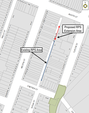
PUBLIC CONSULTATION
A letter outlining the above proposal was mailed out to the affected properties (as shown in the figure below).
There were four (4) responses received in support of the proposal.
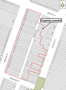
CONCLUSION
It is therefore proposed to extend the existing RPS restrictions northwards to provide consistent parking restrictions in Susan Lane and improve opportunities for residents to secure parking in the lane.
|
|
Local Traffic Committee Meeting 4 February 2019 |
Subject: King Lane, Balmain - 'No Parking' zone (Balmain Ward/Balmain Electorate/Leichhardt PAC)
Prepared By: Felicia Lau - Engineer - Traffic and Parking Services
Authorised By: John Stephens - Traffic and Transport Services Manager
|
SUMMARY Council has received a request to convert an existing ‘2P 8am-10pm Permit Holders Excepted Area B1’ zone to a ‘No Parking’ zone in King Lane, Balmain on the side boundary of Nos.24-26 King Street to allow access to a newly constructed garage at the rear of No.35 Birchgrove Road. |
|
RECOMMENDATION
THAT the existing 12.5m ‘2P 8am-10pm Permit Holders Excepted Area B1’ resident parking zone in King Lane on the side boundary of Nos.24-26 King Street be converted to a ‘No Parking’ zone. |
BACKGROUND
The development application D/2015/597 for property No.35 Birchgrove Road, Balmain was approved by Inner West Council Development Assessment Section in March 2016 with a modification later approved in March 2017. The development application includes construction of a garage in the rear lane; King Lane. As part of the approval consent, Condition 1a states that the garage shall not be used for vehicle parking without the approval of the Local Traffic Committee, as the use of the garage will require amendment to the King Lane parking allocation.
The garage has recently been constructed with access in King Lane at the rear of No.35 Birchgrove Road, Balmain and the property owner has now requested removal of the parking opposite his driveway to allow access. King Lane is currently 4.4m wide and the access to the garage is obstructed by the two existing ‘2P 8am-10pm Permit Holders Excepted Area B1’ on-street parking spaces (12.5m) opposite the driveway.
FINANCIAL IMPLICATIONS
Nil.
OTHER STAFF COMMENTS
It is proposed to convert the existing ‘2P 8am-10pm Permit Holders Excepted Area B1’ parking zone in King Lane, on the side boundary of Nos. 24-26 King Street to a ‘No Parking’ zone. The proposal is shown in the following plan.
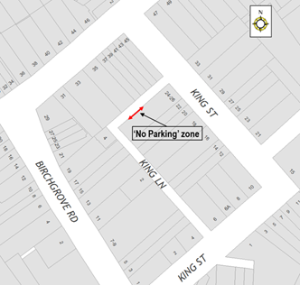
PUBLIC CONSULTATION
A letter outlining the above proposal was mailed out to the affected properties.
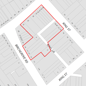
Three responses were received, two in support and one in objection.
|
Resident’s response |
Officer response |
|
Can you retain one parking space.
|
It is required to remove both on-street parking spaces to allow vehicular access to the garage.
|
|
The lane is too narrow for private vehicles and garbage trucks that result in damaging either the vehicle or the property while accessing the lane. The existing restricted parking spaces also restrict access to other driveways adjacent to them. |
Noted. |
CONCLUSION
It is therefore proposed that the existing ‘2P 8am-10pm Permit Holders Excepted Area B1’ resident parking zone in King Lane on the side boundary of Nos. 24-26 King Street be converted to a ‘No Parking’ zone to provide unobstructed access to the rear garage of No.35 Birchgrove Road, Balmain.
|
|
Local Traffic Committee Meeting 4 February 2019 |
Subject: Rawson Street, Haberfield - Proposed '15 Minute' Parking Zone (Leichhardt Ward/Summer Hill Electorate/Burwood PAC)
Prepared By: Vinoth Srinivasan - Engineer - Traffic and Parking Services
Authorised By: John Stephens - Traffic and Transport Services Manager
|
SUMMARY Council has received a request to install short term parking in Rawson Street, close to the intersection of Ramsay Street to improve accessibility for patrons of Haberfield Post Office with mobility issues. |
|
RECOMMENDATION
THAT:
1. The existing 9 metre ‘1P 8.30am – 6.00pm Mon-Fri, 8.30am – 12.30pm Sat’ and ‘No Parking – Australia Post Vehicles Excepted’ zones on the eastern side of Rawson Street, north of Ramsay Street be reduced to 6 metre zones.
2. An additional 6m ‘P15 minute 8.30am-6.00pm Mon-Fri, 8.30am-12.30pm Sat’ zone be installed immediately north of the 6m ‘No Parking – Australia Post Vehicles Excepted’ zone.
|
BACKGROUND
Council has received a request to install short term parking in Rawson Street, close to the intersection of Ramsay Street to improve accessibility for patrons of Haberfield Post Office with mobility issues.
There are currently two (2) oversized car spaces in this subject section of Rawson Street, which is located on the eastern side of Rawson Street, north of Ramsay Street. The subject section is currently signposted as a 9m ‘No Parking – Australia Post Vehicles Excepted’ zone and a 9m ‘1P 8.30am – 6.00pm Mon-Fri, 8.30am – 12.30pm Sat’ zone.
FINANCIAL IMPLICATIONS
Nil.
OTHER STAFF COMMENTS
In order to improve accessibility for patrons of Haberfield Post Office with mobility issues, Council is proposing to reduce the two existing 9 metre ‘1P 8.30am – 6.00pm Mon-Fri, 8.30am – 12.30pm Sat’ and ‘No Parking – Australia Post Vehicles Excepted’ zones to 6 metre zones and install an additional 6m ‘P15 Minute 8.30am-6.00pm Mon-Fri, 8.30am-12.30pm Sat’ zone.
It should be noted that a 15-minute parking space would allow 30-minute parking by holders of a ‘Mobility Parking Scheme’ permit.
The proposal is shown on the plan below.
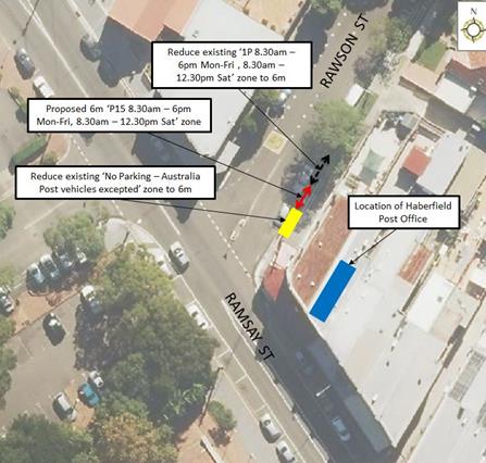
PUBLIC CONSULTATION
|
A letter outlining the above proposal was mailed out to the affected properties (13 properties) in Rawson Street and Ramsay Street, Haberfield.
No responses were received.
|
|
CONCLUSION
Nil.
|
|
Local Traffic Committee Meeting 4 February 2019 |
Subject: Parramatta Road, Leichhardt - Proposed '1 hour' Parking Zone (Leichhardt Ward/Balmain Electorate/Leichhardt PAC)
Prepared By: Vinoth Srinivasan - Engineer - Traffic and Parking Services
Authorised By: John Stephens - Traffic and Transport Services Manager
|
SUMMARY Council has received a request from a local business to convert the existing ‘1/2P’ parking restriction to a ‘1P’ restriction on the northern side of Parramatta Road, between Rofe Street and Renwick Street, Leichhardt to ensure customers have sufficient time to visit the nearby businesses. |
|
RECOMMENDATION
THAT the existing ‘1/2P 10am-3pm Mon-Fri, 8:30am-12:30pm Sat’ parking restrictions on the northern side of Parramatta Road between Rofe Street and Renwick Street, Leichhardt be converted to ‘1P 10am-3pm Mon-Fri, 8:30am-12:30pm Sat’ restrictions, subject to RMS approval.
|
BACKGROUND
Council has received concerns from a local business that the existing ‘1/2P’ restrictions on the northern side of Parramatta Road, between Rofe Street and Renwick Street are insufficient for the customer needs of the businesses in this section.
Parramatta Road is a State road under the care and control of RMS and the existing ‘1/2P restrictions operate outside of morning and afternoon clearway periods.
FINANCIAL IMPLICATIONS
Nil.
OTHER STAFF COMMENTS
It is proposed to convert the existing ‘1/2P 10am-3pm Mon-Fri, 8:30am-12:30pm Sat’ parking restrictions on the northern side of Parramatta Road between Rofe Street and Renwick Street, Leichhardt to ‘1P 10am-3pm Mon-Fri, 8:30am-12:30pm Sat’.
There is an existing ‘Works Zone 10am-3pm Mon-Fri; 8:30am-12:30pm Sat’ in this section of Parramatta Road which is temporarily replacing some of the ‘1/2P’ parking restrictions. As part of this proposal, the ‘Works Zone’ will be replaced by the ‘1P’ restrictions upon completion of the works.
The proposal is shown on the plan below.
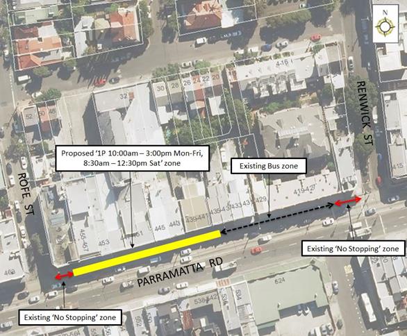
PUBLIC CONSULTATION
A letter outlining the above parking proposal was mailed out to the affected businesses (25 businesses) in Parramatta Road, Rofe Street and Renwick Street, Leichhardt, requesting business owners’ views regarding the proposal (as indicated on the plan below). The consultation closes 1 February 2019.
No responses were received to date; any further comments will be tabled at the meeting.

CONCLUSION
Nil.
|
|
Local Traffic Committee Meeting 4 February 2019 |
Subject: Young Street at Collins Street, Annandale - Proposed modification to existing 'No Stopping' zone (Leichhardt Ward/Balmain Electorate/Leichhardt PAC)
Prepared By: Vinoth Srinivasan - Engineer - Traffic and Parking Services
Authorised By: John Stephens - Traffic and Transport Services Manager
|
SUMMARY Concerns have been raised from a resident that the existing ‘No Stopping’ zone in Young Street at the intersection of Collins Street, Annandale restricts temporary drop-off and pick-up across the driveway of No.52 Collins Street, Annandale. |
|
RECOMMENDATION
THAT the existing 18.4m ‘No Stopping’ zone be reduced to 13.4m on the eastern side of Young Street, south of Collins Street, Annandale.
|
BACKGROUND
Concerns have been raised from a resident that the existing ‘No Stopping’ zone in Young Street at the intersection of Collins Street, Annandale restricts temporary drop-off and pick-up across the driveway of No.52 Collins Street, Annandale.
No.52 Collins Street, Annandale is a corner block and the driveway is located in Young Street.
FINANCIAL IMPLICATIONS
Nil.
OTHER STAFF COMMENTS
In order to alleviate this issue, it is proposed that the existing 18.4m ‘No Stopping’ zone on the eastern side of Young Street, south of Collins Street be reduced to 13.4m. The proposed ‘No Stopping’ zone will no longer extend across the property driveway which will revert to statutory ‘No Parking’ restrictions and enable temporary drop-off and pick-up across the property driveway.
The proposal is shown on the following plan.
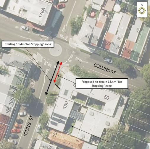
PUBLIC CONSULTATION
As the proposal does not impact on parking on Young Street, no resident consultation was undertaken.
CONCLUSION
Nil.
|
|
Local Traffic Committee Meeting 4 February 2019 |
Subject: Old
Canterbury Road, Dulwich Hill- Proposed 'No Stopping' restrictions between
Constitution Road and No.275 Old Canterbury Road, Dulwich Hill.
(Ashfield Ward/ Summer Hill Electorate/ Inner West PAC)
Prepared By: Boris Muha - Engineer – Traffic and Parking Services
Authorised By: John Stephens - Traffic and Transport Services Manager
|
SUMMARY Council has received complaints regarding congestion and delay/banking up of traffic along Old Canterbury Road between Constitution Road and Abergeldie Street as a result of vehicles turning right into Henson Street from Old Canterbury Road, and with vehicles parking adjacent to the kerb side lane.
It is proposed to remove or limit parking with full-time and part-time ‘No Stopping’ restrictions on the southern side of Old Canterbury Road from Constitution Road to the west side of driveway of No. 275 Old Canterbury Road.
This would allow adequate length of clearance along the kerb side lane for traffic to generally travel and manoeuvre around waiting vehicles turning right into Henson Street.
Support is therefore sought on the following recommendation. |
|
RECOMMENDATION
THAT:
1. The kerb space on the southern side of Old Canterbury Road between Constitution Road and 10 metres west of an existing pedestrian refuge be signposted full-time “No Stopping”; and
2. The kerb space thereafter on the southern side of Old Canterbury Road to the west side of the driveway of No. 275 Old Canterbury Road be signposted as “No Stopping 8.00am-9.30am; 2.30pm-4.00pm Mon-Fri School Days Only”.
|
BACKGROUND
Council has received complaints regarding congestion and delay/banking of traffic along Old Canterbury Road between Constitution Road and Abergeldie Street as a result of vehicles turning right into Henson Street from Old Canterbury Road, and with vehicles parking adjacent to the kerb side lane.
It was requested that ‘No Stopping’ be applied on the southern side of Old Canterbury Road, between Constitution Road and Abergeldie Street.
FINANCIAL IMPLICATIONS
NIL
OTHER STAFF COMMENTS
In the examination of traffic movement, it is considered at this point of time to limit and apply ‘No Stopping’ restrictions on occasion of peak times around school hour activity in the area. Vehicles turning right into Henson Street at these times are mainly destined to travel to various schools within the Summer Hill area.
10 metres of full-time ‘No Stopping’ restriction would apply further west of an existing pedestrian refuge island located just west of Constitution Road in Old Canterbury Road. This is required for sight view of pedestrians and traffic movement though the refuge in accordance to RMS technical directions.
The restrictions thereafter would read “No Stopping 8.00am-9.30am.,2.30pm-4.00pm Mon-Fri School Days Only”, and would lead up to premises No 275 Old Canterbury Road.
See proposed plan below.
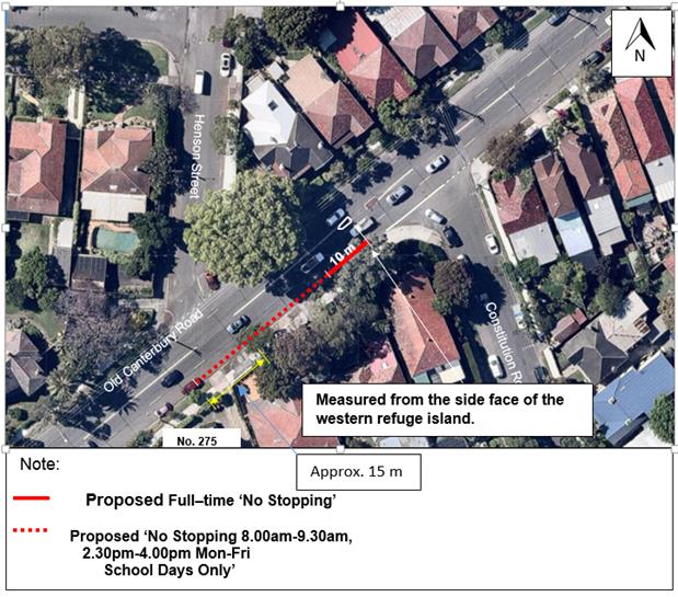
PUBLIC CONSULTATION
Approximately (37) consultation letters were distrubuted to resident households in the surrounding area as shown below. (3) responses were received.
These responses are addressed below.
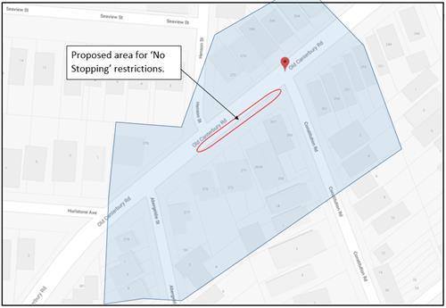
|
Resident comments. |
Officer’s Response |
|
One resident commented the ‘No Stopping’ should be extended (at least) along the entire length on the southern side of Old Canterbury Road between Consitution Road and Abergeldie Street. · Allowing cars to park outside of No.275 Old Canterbury Road does not allow enough room for large trucks to get around cars turning right into Henson Street. Old Canterbury Road is full of large trucks.
· Site lines are very poor in the area, particular with an unkept landscape planting area on front of the nature strip in front of No. 277 ( to the south of No.275). The view out of Abergeldie Street is affected. Cars turning into and out of Constitution Road and Hurlstone Avenue are also of concern.
|
The intent, at this point of time, is to minimise and remove/limit parking (to a certain extent) so as to allow traffic to generally manoeuvre around vehicles waiting to turn right into Henson Street. Larger vehicles, if necessary, may need to wait before contining to travel on the inside lane of Old Canterbury Road. Maintaining full–time parking (up to 2 spaces) outside of No. 275 Old Canterbury Road, would assist to control and move traffic back into the inside lane away from the corner of Abergeldie Street at all times. This is considered to minimise likely conflict with vehicles exiting out of Abergeldie Street. The existing spaces are set back approx. 18m in distance from the corner of Abergeldie Street, allowing for adequate sight view.
The proposed 10 metres of full-time “No Stopping” west of Constitution Road would improve the sight view of traffic in Old Canterbury Road, left of Constitution Road.
The matter of the unkept landscaped verge area outside No.277 has been referred to the Council’s Streetscape and Park’s Operation Group for appropraite investigation and action. |
|
Two residents commented on damage to the landscape verge area with vehicles riding over from the driveways or corner of Abergeldie Street. |
The matter of the damaged landscaped verge area outside No.277 has been referred to the Council’s Streetscape and Park’s Operation Group for appropraite investigation and action. |
CONCLUSION
In view to the report above, it is recommended that the kerb space on the southern side of Old Canterbury Road between Constitution Road and 10 metres west of an existing pedestrian refuge be signposted full-time “No Stopping”. Thereafter, on the southern side of Old Canterbury Road to the west side of the driveway of No. 275 Old Canterbury Road, the kerb space be signposted as “No Stopping 8.00am-9.30am; 2.30pm-4.00pm Mon-Fri School Days Only”.
|
|
Local Traffic Committee Meeting 4 February 2019 |
Subject: Liberty Street and Bedford Street, Stanmore – Temporary full road closure for rail overbridge refurbishment works – notice of change of date of works in March 2019 (STANMORE WARD /NEWTOWN ELECTORATE/ INNER WEST PAC)
Prepared By: Jennifer Adams - Engineer – Traffic and Parking Services
Authorised By: John Stephens - Traffic and Transport Services Manager
|
Notice of changes in dates for rail overbridge works and pending road closures of Liberty Street and Bedford Street, Stanmore in March 2019 November have been received from Sydney Trains. Due to special events two closedowns have been rescheduled for the road closures. Temporary full road closures that were scheduled for Liberty Road (between Railway Avenue and Trafalgar Street) and Bedford Street (between Liberty Street and Pierce Street), Stanmore on Friday 8 to Monday 11 March 2019 are now scheduled for Friday 15 March to Monday 18 March 2019 and those scheduled for Friday 1 to 4 November 2019 are now scheduled for Friday 11 October to Monday 14 October 2019.
The streets will be temporarily closed to all vehicular traffic, including emergency vehicles and local residents. It is recommended that the proposed change of date for the temporary full road closures be approved, subject to the conditions outlined in this report.
|
|
RECOMMENDATION
THAT the proposed temporary full road closure of Liberty Road (between Railway Avenue and Trafalgar Street) and Bedford Street (between Liberty Street and Pierce Street), Stanmore on 15 to 18 March 2019 and 11 to 14 October 2019 be approved, in order to carry out refurbishment works on the Liberty Street Stanmore rail over bridge subject biut not limited to the following conditions:
1. A Road Occupancy License be obtained by the applicant from the Transport Management Centre;
2. All affected residents and businesses, including the NSW Police Local Area Commander, Fire & Rescue NSW and the NSW Ambulance Services be notified in writing, by the applicant, of the proposed temporary road closure at least 7 days in advance of the closure with the applicant making reasonable provision for stakeholders; and
3. The occupation of the road carriageway must not occur until the road has been physically closed.
|
BACKGROUND
A report went to the 6 November 2018 Local Traffic Committee detailing the application by Sydney Trains TfNSW for temporary full road closures of Liberty Road (between Railway Avenue and Trafalgar Street) and Bedford Street (between Liberty Street and Pierce Street), Stanmore on 3 separate occurrences being 18 to 21 January 2019, 5 to 8 April 2019 and 1 to 4 November 2019 in order to carry out refurbishment works on the Liberty Street Stanmore rail overbridge. The proposed works were to be conducted over three separate weekends:
|
1st Weekend ROL |
8-11th March 2019 (WE36) |
|
2nd Weekend ROL |
5-8th April 2019 (WE40) |
|
3rd Weekend ROL |
1-4th November 2019 (WE18) |
Now notice of changes in dates for rail overbridge works and pending road closures of Liberty Street and Bedford Street, Stanmore in March 2019 November have been received from Sydney Trains. Due to special events two closedowns have been rescheduled for the road closures. Temporary full road closures that were scheduled for Liberty Road (between Railway Avenue and Trafalgar Street) and Bedford Street (between Liberty Street and Pierce Street), Stanmore on Friday 8 to Monday 11 March 2019 are now scheduled for Friday 15 March to Monday 18 March 2019 and those scheduled for Friday 1 to 4 November 2019 are now scheduled for Friday 11 October to Monday 14 October 2019.
|
1st Weekend ROL |
Friday
15 to Monday 18 March 2019 (WE37) |
|
3rd Weekend ROL |
Friday
11 to Monday 14 October 2019 (WE15) |
A copy of the report that went to the 6 November 2018 Local Traffic Committee is reproduced at the end of this report for information.
FINANCIAL IMPLICATIONS
The applicant has previously paid for the temporary full road closure.
OFFICER COMMENTS
Liberty Street is a regional road which carries around 24,000 vehicles per day. At the railway over bridge the width of the roadway is approximately 11 metres in width. It is noted that the full road closure will divert traffic to either Crystal Street or King Street, both of which are remote from Liberty Street.
Traffic Control Plans have been previously submitted by the applicant.
PUBLIC CONSULTATION
The applicant is to notify all affected residents and businesses in writing at least 7 days prior to the commencement of works.
The change of dates for the road closures has been advertised in the local newspaper in accordance with the Roads Act 1993
CONCLUSION
It is recommended that the proposed temporary full road closures be approved, subject to the conditions outlined in this report.
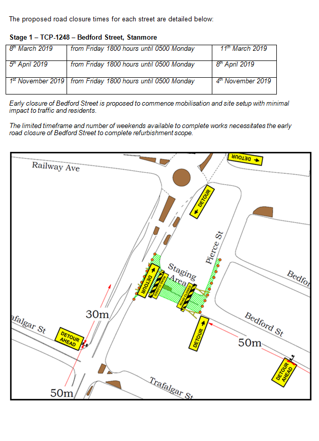
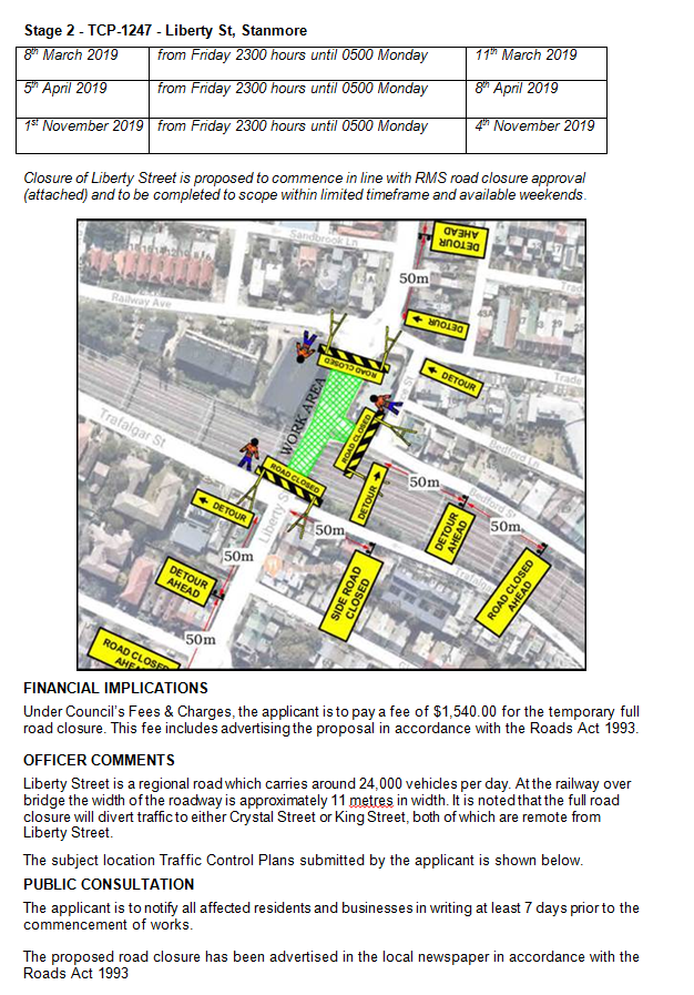
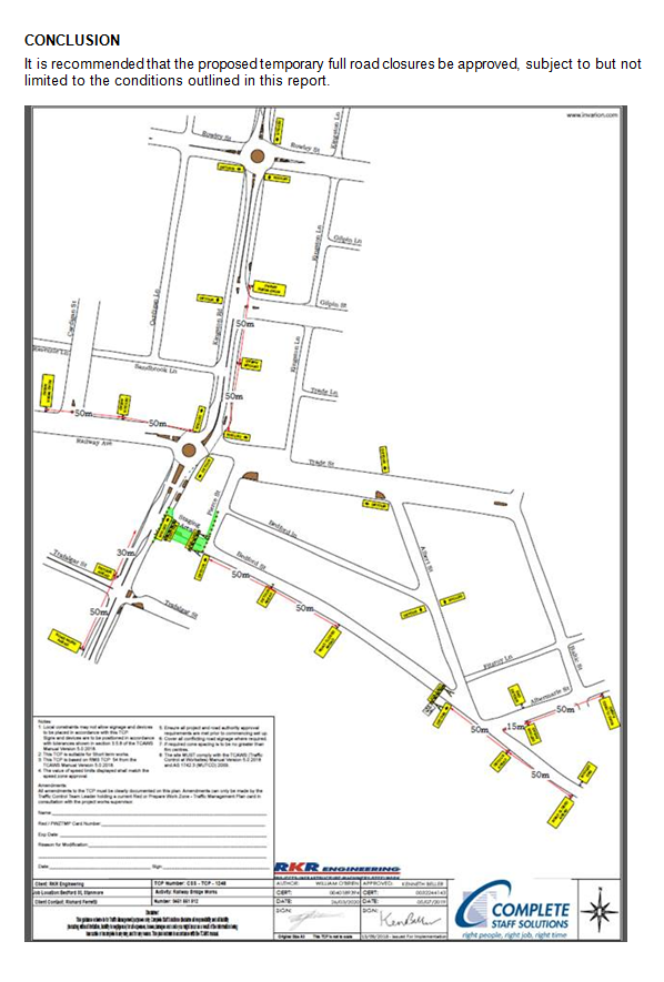
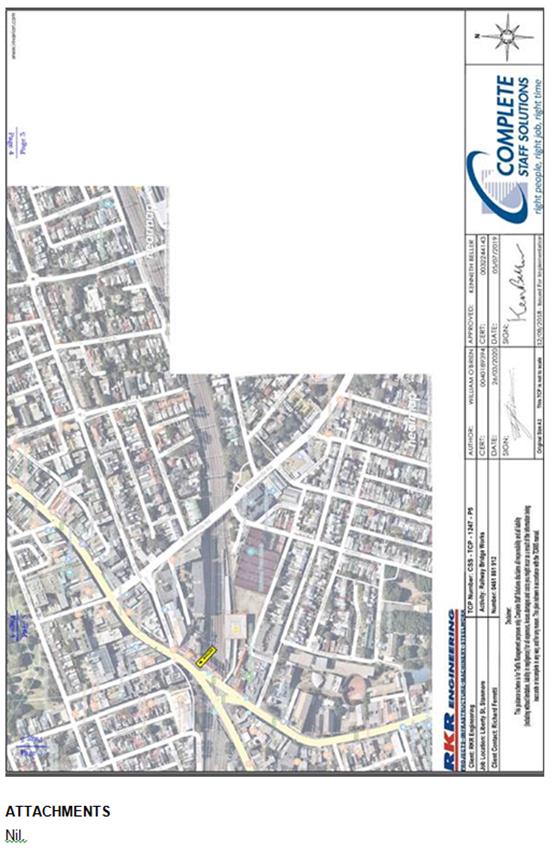
|
|
Local Traffic Committee Meeting 4 February 2019 |
Subject: The
‘Gear Up Girl’ Bicycle Event (Marrickville Ward/Summer Hill &
Heffron Electorate/Inner West PAC)
Prepared By: Scipio Tam - Engineer - Traffic and parking Services (South)
Authorised By: John Stephens - Traffic and Transport Services Manager
|
SUMMARY Advice has been received from Bicycle NSW regarding the 'Gear Up Girl' bicycle challenge to be held on Sunday, 10 March 2019, which will involve cycling through the Inner West Local Government Area (LGA).
It is recommended that Council supports the proposed cycling event, subject to the event being advertised, a Traffic Management Plan be submitted to the RMS for approval and advice of the proposed event be forwarded to the appropriate authorities and affected properties by the applicant. |
|
RECOMMENDATION
THAT the ‘Gear Up Girl’ bicycle event to be held on Sunday 10 March 2019 be supported subject to the applicant complying with the following conditions:
1. The event being advertised in the local newspapers by the applicant in advance of the event; 2. A Traffic Management Plan being submitted by the applicant to the Roads and Maritime Services for consideration and approval; 3. Details of the proposed event be forwarded by the applicant to the Transport Management Centre, Transit Systems, Inner West PAC, Fire & Rescue NSW and NSW Ambulance Service; and 4. Adequate traffic control shall be provided for the protection and convenience of pedestrians, cyclists and motorists including appropriate signage and flagging. Workers shall be specially designated for this role (and carry appropriate certificates), as necessary to comply with this condition. This is to be carried out in accordance with the Australian Standard AS 1742.3 – Traffic Control Devices for works on roads. |
BACKGROUND
A submission has been received from Bicycle NSW advising that this year’s ‘Gear Up Girl’ bicycle challenge will be held on Sunday, 10 March 2019 and will involve cycling through the Inner West LGA. The applicant seeks Council’s support for this year’s event as in previous years.
FINANCIAL IMPLICATIONS
Nil.
OTHER STAFF COMMENTS
The applicant advised that the ‘Gear up Girl’ bicycle challenge has rides to cater for women of
all ages and abilities, and is enjoyed year after year as a positive experience for all women who participate. Where possible the ride utilises routes on off -road cycle ways/shared
pathways or dedicated on-road cycle lanes.
The routes chosen showcase Inner West Council’s cycling infrastructure, particularly the
Cooks River cycle way.
In 2019 Gear Up Girl offers 20km, 40km, 60km and 80km ride length options:
20km Beach Ride – Cooks cycleway, start at Wolli Creek to Cronulla.
Start – Riders are released in waves between 8.00am and 11.50am from Cahill Park
(west), Wolli Creek and finish at Don Lucas Reserve, Cronulla.
Participants are restricted to 100.
40km Classic Ride – Sydney Olympic Park to Cronulla.
Start – 7.30am from Bicentennial Park, Sydney Olympic Park and finish at Cronulla.
Participants are restricted to 450.
60km Coast Ride – Sydney Olympic Park to Cronulla, including Kurnell.
Start – 7.00am from Bicentennial Park, Olympic Park and finish at Don Lucas Reserve,
Cronulla. This ride is a loop ride out to Kurnell and return.
Participants are restricted to 450.
80km Challenge Ride – Sydney Olympic Park to Cronulla, including Kurnell.
Start – 6.50am from Bicentennial Park, Olympic Park and finish at Don Lucas Reserve,
Cronulla. This ride is a loop ride out to Kurnell and return.
Participants are restricted to 200.
The applicant advised that the Road Occupancy Licence for the event is being negotiated with
the Transport Management Centre (TMC). Both the TMC and NSW Police support the event.
The proposed cycle route travels along the cycle way, from Illawarra Road, through Mackey
Park and Kendrick Park and on the footpath on Princes Highway, Tempe, along the Cooks
River (refer to the attached Traffic Control Plans submitted by the applicant).
Illawarra Road will be monitored by traffic controllers and traffic marshals with ‘Stop/Slow’
traffic control. Richardsons Crescent and Princes Highway will be monitored by traffic
marshals at the signalised pedestrian crossing. It should be noted that there are no temporary
road closures through the Inner West LGA.
Where required, NSW Police are contracted for event traffic management in the planning and
delivery of the event. Police will be located at any intersections as stated on Traffic Control
Plans. Bicycle Patrol Unit Police are also recruited to perform a ‘mobile’ Police presence
ensuring participant and community safety along the cycle route.
PUBLIC CONSULTATION
Bicycle NSW advised that a letter will be distributed to all relevant residents and businesses
containing advice about the event, and any changed traffic conditions, along with a map
showing the changes. This communication will be confirmed in consultation with the local
Council and the Transport Management Centre and will be distributed two weeks prior to the
event.
Posters outlining basic details will be installed prior to the event at various locations along any
shared pathways used in the event. Local newspaper notices will be allocated to relevant
publications detailing any changed traffic conditions as another method of advising residents
of the road closures. Newspaper notices will be placed one week prior to the event.
CONCLUSION
As this event was successfully implemented in previous years, it is recommended that the
'Gear Up Girl' bicycle event held on Sunday 10 March 2019 be supported subject to the
applicant complying with the following conditions;
1. The event being advertised in the local newspapers by the applicant in advance of the event;
2. A Traffic Management Plan being submitted by the applicant to the Roads and Maritime Services for consideration and approval;
3. Details of the proposed event be forwarded by the applicant to the Transport Management Centre, Transit Systems, Inner West PAC, Fire & Rescue NSW and the NSW Ambulance Services; and
4. Adequate traffic control shall be provided for the protection and convenience of pedestrians, cyclists and motorists including appropriate signage and flagging. Workers shall be specially designated for this role (and carry appropriate certificates), as necessary to comply with this condition. This is to be carried out in accordance with the Australian Standard AS 1742.3 - Traffic Control Devices for works on roads.
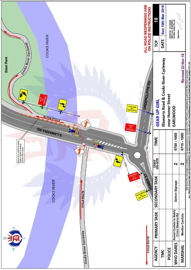
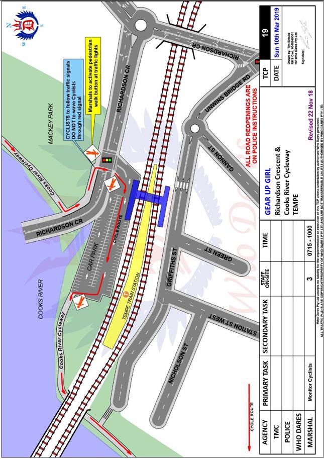
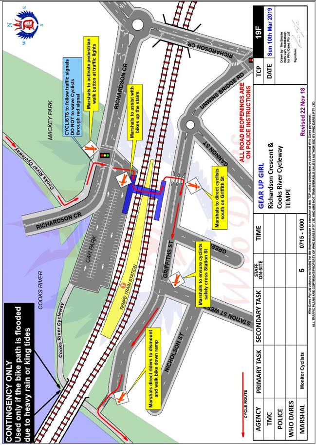
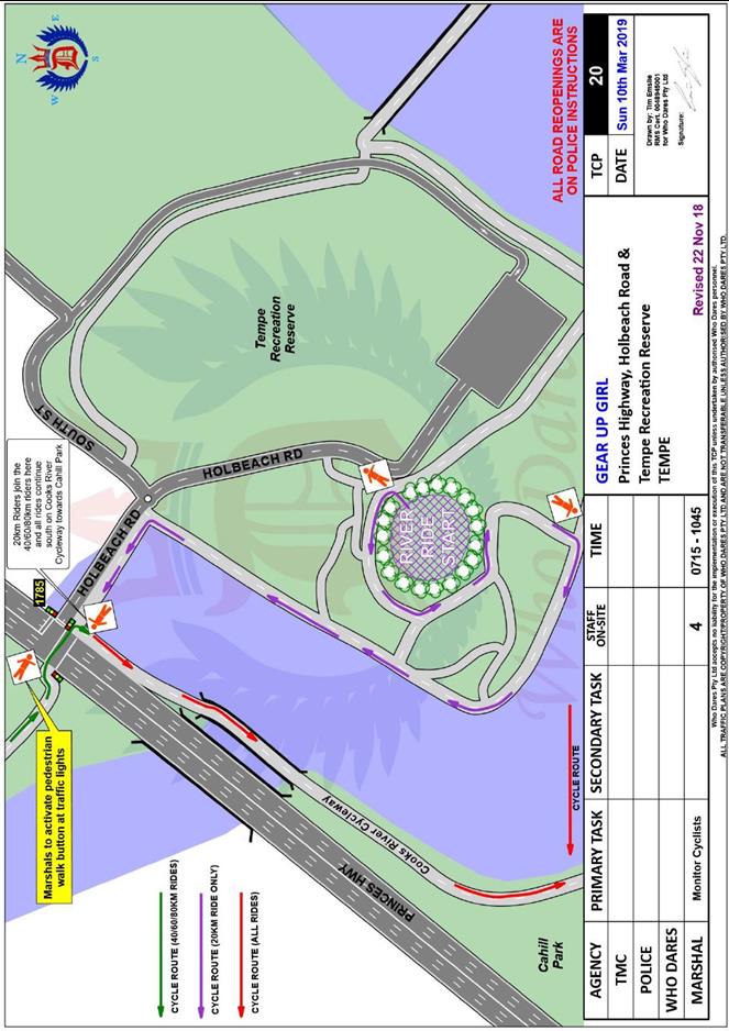
|
|
Local Traffic Committee Meeting 4 February 2019 |
Subject: WestConnex New M5 Operational Parking & Access Strategy Consultation (Marrickville Ward/Heffron Electorate/Inner West PAC)
Prepared By: Sunny Jo - Traffic and Parking Planner
Authorised By: John Stephens - Traffic and Transport Services Manager
|
SUMMARY Council has been invited to provide feedback on the WestConnex New M5 Operational Parking & Access Strategy. The document outlines the temporary and permanent changes to on-street parking supply in St Peters and Alexandria. Council officers have reviewed the document and provided feedback based on the issues received from the community. |
|
RECOMMENDATION
THAT this report be received and noted. |
BACKGROUND
On 15 January 2019 Council was invited to provide feedback on the WestConnex Stage 2 New M5 Operational Parking & Access Strategy. The strategy describes the final parking and access arrangements that will be implemented during operation of the New M5. The strategy was prepared in accordance with Condition of Approval (CoA) E42 and intended to seek community feedback regarding the strategy. The report was prepared by CPB Dragados Samsung Joint Venture (CDS-JV) whom is responsible for the design and construction of the WestConnex Stage 2 Project.
A copy of the strategy can be found through the link:
As the consultation period ended on 31 January 2019, Council has provided feedback back to CDS-JV, highlighting the need to retain minimal loss of on-street parking spaces. The issues raised comprise of the following:
· New intersection layout of Unwins Bridge Road, Bedwin Road, May Street and Campbell Street. Kerbside approach and departure lanes appear to have extensive full time parking restrictions in place and this was considered unnecessary. It was requested that existing parking on approach and departure be retained along Unwins Bridge Road and May Street as a trial and then be reviewed by Roads and Maritime Services (RMS) with Council input after 12 months.
· New angle parking spaces in Campbell Street between St Peters Street and Florence Street would be a public area and uncontrolled, there are limited parking management options at this location.
· Parking figures outlined in the strategy was not consistent with the Council’s revised figures.
· Parking occupancy data within the strategy is based on average daytime occupancy rates, and not considered maximum occupancy levels on local roads which typically occur between 10pm and 6am.
With Council’s recommendations, the revised permanent loss of parking in Inner West Council LGA was 78 spaces, with 59 new spaces being provided as part of the works, resulting in a net loss of 19 spaces.
Since the consultation was undertaken during the January school holidays, it was recommended that CDS-JV extend the consultation period until 22 February 2019.
FINANCIAL IMPLICATIONS
There are no financial implications.
OTHER STAFF COMMENTS
Nil.
PUBLIC CONSULTATION
The consultation was undertaken by CDS-JV as this is a NSW Government key infrastructure project.
CONCLUSION
Feedback response from Council has been submitted to CDS-JV with a copy being sent to RMS and uploaded on Council’s website.
|
|
Local Traffic Committee Meeting 4 February 2019 |
Subject: 3-7 & 13-17 Regent Street, 287-309 Trafalgar Street & 16-20 Fisher Street, Petersham - DA201800173 – Residential and Mixed Use Development and RSL Relocation over 3 Sites (Stanmore Ward / Newtown Electorate / Inner West PAC)
Prepared By: Jennifer Adams - Engineer – Traffic and Parking Services
Authorised By: John Stephens - Traffic and Transport Services Manager
|
SUMMARY Council has received a development application for 3-7 & 13-17 Regent Street, 287-309 Trafalgar Street & 16-20 Fisher Street, Petersham to demolish existing improvements for the staged construction of 357 apartments over 3 sites with associated basement parking. 3-7 Regent Street is to be comprised of a residential flat building ranging from 5 to 8 storeys containing 108 apartments with basement parking. 13-17 Regent Street is to be comprised of 3 residential buildings ranging from 6 to 7 storeys with 50 apartments and basement parking. 287-309 Trafalgar Street and 16-20 Fisher Street is to be comprised of a mixed use building ranging from 2 to 11 storeys in height containing a new registered club premises for the Petersham RSL Club fronting Trafalgar Street, café and 3 residential flat buildings containing 196 apartments and 3 x 2 storey Soho apartments fronting Fozzard lane with associated basement parking and public domain works linking Regent Street to Fozzard Lane. Approval is also sought for the subdivision of land to accommodate widening of Fozzard Lane as well as the stratum subdivision of lots in the development.
The application is required to be referred to the Local Traffic Committee for consideration under State Environmental Planning Policy (Infrastructure) 2007.
Comments of the Local Traffic Committee will be referred to Council’s Development Assessment Section for consideration in determining the Development Application. |
|
RECOMMENDATION
THAT the report be received and noted. |
BACKGROUND
The Petersham RSL Club has been in ongoing discussions with Council for a number of years concerning the fragmentation of its operation over the three sites that it currently occupies and its desire to redevelop and relocate all of its facilities (including car parking) to a single consolidated site on the western side of Regent Street.
The Petersham RSL currently own 3 main sites namely:
· (Site 1) 3-7 Regent Street;
· (Site 2) 13-17 Regent Street; and
· (Site 3) 287 Trafalgar Street & 16-20 Fisher Street, Petersham.
These three sites are all zoned R4 – High Density Residential under Marrickville Local Environmental Plan (MLEP) 2011. A “registered club” is a prohibited form of development in the R4 – High Density Residential zone, however Clause 14 in Schedule 1 – Additional Permitted Uses of MLEP 2011 allows a “registered club” to be permitted with consent on the sites known as 3-7 Regent Street, 287 Trafalgar Street and 16-20 Fisher Street, Petersham.
On 10 June 2016, Council received a planning proposal relating to the three sites that include the properties known as 3-7 Regent Street (Site 1); 13-17 Regent Street (Site 2); and 287-309 Trafalgar Street & 16-20 Fisher Street (Site 3), Petersham. The planning proposal sought to amend Marrickville Local Environmental Plan (MLEP) 2011 to make a “registered club” a permissible use on the property known as 297-309 Trafalgar Street (this use is currently permissible on the properties known as 287 Trafalgar Street and 16-20 Fisher Street under Schedule 1 of MLEP 2011). This amendment will allow the existing club at 3-7 Regent Street to relocate to the opposite side of Regent Street as part of a mixed use development to be erected on the site known as 287-309 Trafalgar Street & 16-20 Fisher Street, Petersham. The planning proposal also sought to increase the height and floor space ratio (FSR) development standards applying to the three sites under the terms of Marrickville Local Environmental Plan 2011 (MLEP 2011) to accord with contemporary town planning practice relating to transit-oriented development.
The proposed changes to the maximum FSR development standards will result in an increase in the gross floor area (GFA) yield of the development across the three sites by some 5,922sqm from 24,542sqm to 30,464sqm. The new Club will have a GFA of 3,600sqm.The planning proposal was referred to Council’s Architectural Excellence Panel (AEP) and the Panel was generally supportive of the increased densities (given the proximity of the sites to Petersham Railway Station) subject to modifications to some of the proposed building envelopes.
The development proposal was assessed and reported at the 27 June 2017 Council meeting. Council resolved that:
1. Council supports the planning proposal subject to:
(i) The resident car parking on site to be capped at the rate contained in Part 2.10 of Marrickville Development Control Plan (MDCP) 2011;
(ii) The proponent must engage an arborist to investigate the opportunities to retain the significant trees located on the corner of Regent Street and Fisher Street (Site 3) and adjust the building envelopes as may be required;
2. Council officers consider the Voluntary Planning Agreement (VPA) Offer in accordance with Council’s interim VPA Policy;
3. forward the planning proposal to the Minister for Planning for a Gateway determination in accordance with Section 56 of the Environmental Planning & Assessment Act 1979;
4. request that Council be delegated plan making functions in relation to the planning proposal; and
5. resolves to develop site specific planning controls to apply to the future development at 3-7 Regent Street (Site 1); 13-17 Regent Street (Site 2); and 287-309 Trafalgar Street & 16-20 Fisher Street (Site 3), Petersham for inclusion in Part 9.6 (Precinct 6) of MDCP 2011 and that these be publicly exhibited concurrently with the planning proposal.
In accordance with the above resolution Council sent the development proposal to the Department of Planning & Environment (DPE). The DPE, on 11 October 2017, issued a Gateway Determination to the effect that:
• the proposed development should proceed subject to a number of conditions relating to procedural matters;
• a public hearing was not required to be held under Section 56(2)(e) of the EP&A Act, i.e. in relation to the zoning and development standards included in the proposed development; and
• the Minister’s authority for the making of the plan resulting from the proposed development was delegated to Council.
The proposed development was publicly exhibited between 21 November 2017 and 30 January 2018. Details of the consultation undertaken and recommended changes to the Planning Proposal and draft MDCP 2011 in accordance with the consultation were the subject of a report that went to Council’s meeting on 10 April 2018. Council resolved that:
1. Council amend the Marrickville Local Environmental Plan 2011 at 3-7, 13-17 Regent Street, 287-309 Trafalgar Street and 16-20 Fisher Street, Petersham in accordance with the report;
2. Council liaise with the Department of Planning and Environment and Parliamentary Counsel’s Office to draft and finalise the LEP amendment;
3. Council delegate the making of the LEP amendment to the Group Manager Strategic Planning;
4. Following completion of (3) above, request the Department of Planning and Environment to notify the plan;
5. Council place any proposed VPA on public exhibition prior to the finalisation of making the LEP amendment;6. Council delegate the adoption of the Marrickville Development Control Plan 2011 (Amendment No. 8) to amend Part 9.6 (Precinct 6) MDCP 2011 in accordance with the exhibited draft and the revised figures and recommendations contained within this report to the Group Manager Strategic Planning;
7. Council request the Proponent to work with Council’s Traffic Engineer to provide detailed information to enable resolution of the exact location of the median strip and to undertake consultation with Sydney Trains in regard to access to their training facility to determine what land may need to be dedicated at 287-309 Trafalgar Street to ensure a left-in/left-out to the new Club without compromising pedestrian safety and road efficiency as part of a future development application for Site 3;
8. Council place a notice in a local newspaper advising of commencement of MDCP 2011 (Amendment No. 8);
9. Council notify those persons who made a submission in relation to the draft MLEP and Draft MDCP 2011 to inform them of Council’s resolution; and
10. The amended diagram tabled by the proponent, replace the relevant diagram indicating the retail frontages in the plans to be adopted.
On 16 April 2018 Council received a development application (DA201800173), the subject of this report, on the above property to demolish existing improvements for the staged construction of 357 apartments over 3 sites with associated basement parking. 3-7 Regent Street is to be comprised of a residential flat building ranging from 5 to 8 storeys containing 108 apartments with basement parking. 13-17 Regent Street is to be comprised of 3 residential buildings ranging from 6 to 7 storeys with 50 apartments and basement parking. 287-309 Trafalgar Street and 16-20 Fisher Street is to be comprised of a mixed use building ranging from 2 to 11 storeys in height containing a new registered club premises for the Petersham RSL Club fronting Trafalgar Street, café and 3 residential flat buildings containing 196 apartments and 3 x 2 storey Soho apartments fronting Fozzard lane with associated basement parking and public domain works linking Regent Street to Fozzard Lane. Approval is also sought for the subdivision of land to accommodate widening of Fozzard Lane as well as the stratum subdivision of lots in the development.
Specific relevant extracts from the 10 April 2018 Council report (C0418 Item 6) citing comments from Council’s Traffic Engineering Section, RMS and TfNSW regarding this development proposal are reproduced below for completeness to this background overview.
Council’s Traffic Engineering Services
“Council’s Traffic Engineers have advised the following:
· A splay corner shall be provided on Site 3 at the intersection of Trafalgar Street and Regent Street to allow for a slight road widening at this corner. This will provide an improvement for turning vehicles at the intersection, particularly vehicles turning left from Regent Street into Trafalgar Street;
· Information on routes expected to include heavy (waste service) vehicles to the three sites and potential access points (i.e. are these vehicles expected to enter via the proposed driveway on Trafalgar Street or Fozzard Lane at Site 3) are required. It is preferable to have these types of vehicles enter the site for waste pick-ups.
On 9 March 2018 the Roads and Maritime Services (RMS) provided Council with comments in relation to the Planning Proposal. Council’s Traffic Engineers reviewed the RMS comments and provided the following comments:
· Point 3 – Left-in/left-out - An examination of the preliminary drawing provided by the Proponent of the existing road widths and the proposed location of the median island to provide only left-in and left-out movements, from Site 3 on Trafalgar Street, was undertaken.
The proposal within the preliminary drawing may not work as the traffic lanes are required to be 3.2 metres wide (absolute minimum) and the cycle path along the north will be in the parking lane taking 2.4 metres of road width with a 400mm width for a kerb barrier. Trafalgar Street is 11.9 metres wide and it is acknowledged that the far western end of the site on Trafalgar Street (on the approach to the roundabout intersection) the road widens. However, if a proposed median island is placed in the centre of the road this will also restrict turn movements into the carpark of the Transport for NSW training facility (located opposite to Site 3 along Trafalgar Street). The movements into this carpark may also result in left-in/left-out as it is directly opposite the club access on the northern side of Trafalgar Street.
Transport for NSW staff from this site will need to be advised of the proposal and consider whether the median island will have impacts on their driveway access. If the access to adjacent driveways is satisfied by the property owners with the inclusion of the proposed centre median island, the proposed development site (Petersham RSL) will have to dedicate part of their land to provide enough width within the roadway for the 900mm wide median island while maintaining the current lane widths of the proposed Regional Route 7 design plans. Action: Investigate the option of road widening of Trafalgar Street to accommodate the proposed raised centre median island.
· Point 4 - Right turn ban during peak periods (weekday PM) from Regent Street into New Canterbury Road – Council’s Traffic Engineers raise no objection to this right turn ban. It should be noted that the right turn movements from New Canterbury Road in Regent Street are to be kept open at all times as this provides motorists access into the area north of New Canterbury Road as there is a current full-time right turn restriction from New Canterbury Road in Audley Street (at the traffic signals).
· Point 5 – No Stopping - The RMS states that ‘Trafalgar Street and New Canterbury Road frontages will need to be signposted as “No Stopping”, at no cost to Roads and Maritime and Council, and conditioned as part of any future DAs’.
Council’s Traffic Engineers do not support this recommendation without further data from RMS providing more justification for the proposed full-time ‘No Stopping’ restrictions on these roads. Further, clarification is required on the section of the subject roads where the proposed ‘No Stopping’ zones is to be provided. This matter will be dealt with as part of the Traffic Management Plan for the area and considered with the redevelopment.
· All other general comments raised by the RMS are considered to be appropriate and that Council’s Traffic Engineers support the recommendations made by RMS.
In relation to Regional Route 7 (RR7) this is an important east-west route between Lewisham and Newtown which links the inner west to Sydney CBD. The NSW Government identified RR7 as a priority route and is funding the development of the upgrade plans.
Consultation with the community commenced in 2016 with the final concept plan approved by Council in February 2017.
Draft design plans have been developed based on the approved concept plan. These plans provide more detail for constructing the route improvements and are currently on exhibition. An extract from the exhibited design for the route along Trafalgar Street is provided below.”
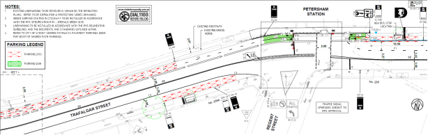
Roads and Maritime Services
“On 20 February 2018 RMS provided in principle support for the Planning Proposal subject to the resolution of detail primarily for the upgrade of the intersection of Regent and Trafalgar Streets, Petersham. A response to the matters raised was prepared and forwarded to RMS.
A meeting was held on the 8 March 2018 with Council, RMS, DPE and the Proponent to discuss the upgrade of the intersection including the design detail for Regional Bike Route 7 on the northern side of Trafalgar Street. At this meeting it was agreed that a signalised intersection at Regent and Trafalgar Streets was not required and that a median strip in Trafalgar Street needed to fit within the road reserve or land be dedicated from Site 3 to ensure 2 bus capable lanes and a regional bike route, and footpaths on Trafalgar Street could be provided.
Subsequently, on 9 March 2018 RMS provided the following revised comments:
1. The Proponent does not wish to pursue the signalisation of the intersection of Regent Street and Trafalgar Street proposed in the exhibited Traffic Impact Assessment, dated 11 November 2017. As this is not a requirement of RMS and as the intersection performance of Regent Street and Trafalgar Street will remain at an acceptable level of service as a left-in/left-out configuration, there are no objections to the signalisation not being pursued.
2. In the absence of the above intersection improvement, the Proponent should provide improvements to pedestrian footpath facilities on Trafalgar Street and Regent Street to provide improved links to the bus stops and existing signalised pedestrian crossing on Trafalgar Street to Petersham train station.
Council may wish to consider requiring the Proponent to upgrade the pedestrian refuge islands on Regent Street and Trafalgar Street as part of any public domain improvement works required under the VPA, DCP and/or by inclusion of conditions on any future DAs.
The future development may need to allow a setback (and potentially land dedication to Council) along the Trafalgar Street frontage to ensure adequate footpath widths for future pedestrian demands can be provided and designed in accordance with Austroads requirements.
3. Future vehicular access to Trafalgar Street from Site 3 will be required to be restricted to left-in/left-out. A 900mm raised concrete median on Trafalgar Street will be required in front of the proposed access to physically restrict right turn movements at the access.
It is noted that Control C10 of the amended Part 9.6 of MDCP 2011 sets out this requirement, which is supported by RMS. Any land required from the frontage of Site 3 to accommodate the treatment will be required to be dedicated as public road at no cost to Council and RMS.
Civil design for the median will need to be provided with any future DA for Site 3. The design will need to be in accordance with Austroads standards and will need to coordinate with Council’s Regional Route 7 bike plans impacting Trafalgar Street. RMS also recommends consultation with Sydney Trains as this may impact their access on the northern side of Trafalgar Street.
4. RMS supports the proposed peak period right turn ban at the intersection of Regent Street onto New Canterbury Road detailed in the addendum traffic statement dated 22 February 2018. In this regard, a Traffic Management Plan (TMP) will need to be prepared and submitted to Council’s Local Traffic Committee for consideration and approval by RMS and Council during the DA stage.
5. Trafalgar Street and New Canterbury Road frontages will need to be signposted as “No Stopping”, at no cost to RMS and Council, and conditioned as part of any future DAs. The Proponent would be required to undertake consultation with any affected residents/landowners in relation to the loss of on-street parking.
6. Council should be satisfied that appropriate funding mechanism/s (such as Section 94 Plan and VPA) are in place to ensure developer contributions are made for local and regional transport infrastructure upgrades required as a result of future growth in the Petersham South precinct.
7. RMS supports Council’s proposal to undertake a broader precinct traffic and transport study to identify future infrastructure needs to support future growth in the precinct.
RMS also provided detailed comment on the SIDRA modelling and the concept design submitted for the intersection which needs to be addressed if an intersection upgrade is ever pursued.
Based on the above considerations, RMS raised no objection to the Planning Proposal, subject to the above matters being addressed in the finalisation of a suitable funding mechanism and/or DCP (where appropriate) and being addressed in any future DA consent.
It is recommended that the advice of the RMS to upgrade the pedestrian crossings at the intersection of Regent and Trafalgar Streets be supported and that the draft MDCP be amended with a new control that ensures sufficient land is made available to accommodate the median strip, bus lanes, regional bike route and footpaths and if not that land be dedicated from the Site 3 frontage to make it work.
While the Proponent has provided preliminary diagrams Council’s Traffic Engineers require more detailed work to establish whether or not land dedication is required to ensure a left-in/left-out to the new Club within Site 3. It is recommended that the Proponent work with Council’s Traffic Engineer to provide detailed information to enable resolution of the exact location and width of the median strip without compromising road efficiency and to undertake consultation with Sydney Trains in regard to access to their training facility.
A detailed response to the matters raised by RMS is under the heading “Council’s Traffic Engineering Services” within the Internal Comments section of this report.”
Transport for NSW (TfNSW)
“TfNSW reviewed the proposal and provided the following comments:
· TfNSW notes the proposed traffic control signals at the Trafalgar and Regent Streets intersection and subsequent approved relocation of the bus stop on Trafalgar Street by Council’s Local Traffic Committee. Any future plans for this should consider the safety and amenity of passengers to Petersham Train Station, including Disability Discrimination Act (DDA) compliance.
· TfNSW does not currently have funding allocated for an accessibility upgrade of Petersham Train Station. The provision of such an upgrade will continue to be considered as part of the Transport Access Program (TAP) ongoing prioritisation process.
· TfNSW agrees that the consolidation of access points, particularly on Trafalgar Street will aid pedestrian access and safety.
· The development site is located within the vicinity of the Sydney Metro City & Southwest Project, and the WestConnex Stage 2 Project. Several construction projects, including those just mentioned could occur at the same time as future development on the site. The cumulative increase in construction vehicle movements from these projects could have the potential to impact on general traffic, bus operations, and the safety of pedestrians and cyclists particularly during commuter peak periods. Any future DA should address these cumulative construction related impacts in consultation with TfNSW (Sydney Coordination Office).
· TfNSW provided conditions to be imposed on a DA consent for the proposal relating to the preparation of a Construction Pedestrian and Traffic Management Plan (CPTMP).
Council’s Strategic Community Project Officer - Access and Inclusion advised that the Planning Proposal may be impacted on by future works by TfNSW in addressing their legislative and compliance responsibilities under the Disability Standards for Accessible Public Transport (DSAPT) which requires all stations to be accessible by 2022.
Access changes therefore to the Petersham train station have potential to change the nature of the intersection and pedestrian/vehicle patterns on Trafalgar Street including bus locations and the Regional Bike Route 7.
Council in consultation with Roads and Maritime Services (RMS) has sought to improve the intersection of Regent and Trafalgar Street with the Planning Proposal. At risk is that it will require redesign in the future to align with the railway station’s access compliance needs including as an interchange with buses.
Council officers recently held an initial meeting with TfNSW regarding a potential upgrade to Petersham Train Station and the detailed cycle plan is now on exhibition for Regional Route 7. As this was a preliminary meeting further meetings are proposed to align the two projects.
Resolution of an upgrade to the station with the Regional Bike Route and works related to the relocation of the Club will take some time to finalise so in order for the Planning Proposal to progress it is recommended that these matters be explored concurrent to the LEP being made and be finalised as part of any DA that is submitted or underway. Notwithstanding, a control to clarify pedestrian movement upgrades to the intersection of Regent and Trafalgar Streets as well as resolution of the median strip along Trafalgar Street, as discussed in this report, are proposed to be included in the final MDCP 2011”.
The 10 April 2018 Council report concluded:
“The proposal to increase the building heights and FSRs at has the potential to generate an additional 67 dwellings over what could be achieved under the current controls. As a comprehensive development across three sites it allows the relocation of the Petersham RSL Club to a new site on the corner of Regent and Trafalgar Streets, Petersham.
Amendments to the height, building setbacks and articulation have been recommended by the AEP. These changes have been reflected in a new height of buildings LEP map and updated DCP figures and written controls.
The response from relevant agencies has been assessed within this report. There are no outstanding agency objections enabling the Planning Proposal to proceed under Council delegation.
Traffic implications have been assessed by Council’s Traffic Engineer and the RMS and a number of measures recommended to the road system and for improved pedestrian safety and amenity.
These measures will restrict traffic for a new RSL Club to left-in/left-out on Trafalgar Street and will be considered in conjunction with the Regional Bike Route 7 on the northern side and relocation of bus stops. It is also proposed to limit vehicle movement turning right from Regent Street onto New Canterbury Road during weekday peak and will be the subject of a future Traffic Management Plan.
DPE advised that Parliamentary Counsel (PC) in drafting a provision for the MLEP will determine the most appropriate way to ensure 150 off street car parking spaces for the RSL Club on Site 3 are not considered to represent ‘gross floor area’.
It is recommended that the planning proposal be approved, the draft MDCP 2011 be finalised and adopted, and the VPA be exhibited prior to the making of the amendment to the MLEP 2011.”
In response to Resolution 7 of the 10 April 2018 Council report a meeting was held on 29 August 2018 between Council’s Traffic Section and the Developers. The Developer was asked whether consultation regarding the median had taken place with Sydney Rail. On 13 September 2018 the Developer provided documentation they claimed confirmed that the .900mm medium strip has nil impact on vehicles entering Sydney Trains property and they attached Sydney Trains earlier correspondence confirming concurrence.
On 14 September 2018 Council wrote to the Applicant listing various items that remained outstanding including traffic issues concerning parking, insupportable kerb-side waste collection, non-support of delivery turntable, the low traffic generation rates used, and question of adequacy of vehicular crossings. In November 2018 the applicant responded to the concerns. This report comments on traffic related issues of this proposal to date.
FINANCIAL IMPLICATIONS
Nil.
OFFICER COMMENTS
Site location
![]()
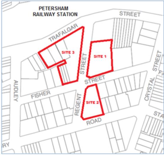
Site 1 has frontage to Regent Street and Fisher Street and contains the existing 2 storey licensed club premises occupied by the Petersham RSL.
Site 2 has frontage to Regent Street, Fisher Street and New Canterbury Road and currently comprises an at-grade off-street car park used in connection with the Club.
Site 3 is directly opposite Petersham Railway Station and has frontage to Trafalgar Street, Regent Street, Fisher Street and Fozzard Lane and contains:
· A total of 81 car parking spaces used in connection with the Club provided at grade and in a 2 storey structure on 287 Trafalgar Street;
· Three vacant industrial buildings on 297-309 Trafalgar Street; and
· Three x 3 storey terraces on 16-20 Fisher Street.
The area surrounding the three sites consists of a mixture of building types including single dwelling houses; residential flat buildings; boarding houses; industrial buildings and an administration building containing the Petersham Service Centre of the Inner West Council. The subject sites are also located in close proximity of the Petersham Commercial Precinct which is centred on New Canterbury Road and Audley Street. The Petersham Commercial Precinct is a retail shopping strip with building heights ranging from 1 to 6 storeys.
Locality and road network
The proposed development sites are located in the suburb of Petersham and are primarily serviced by Trafalgar Street, Regent Street, Fisher Street and New Canterbury Road.
New Canterbury Road is classified as a State road, constituting part of Route A34 connecting Enmore with Liverpool. The road is orientated in a north east – south west alignment. Within the vicinity of the development site the carriageway carries two lanes in each direction, with clearway restrictions on the outermost lanes between 6am-10am and 3pm-7pm east and west respectively. The road has a posted speed limit of 60km/h. It carries around 27,100 vehicles per day at Audley Street, Petersham.
Trafalgar Street is a Regional road and carries around 11,500 vehicles per day between Audley Street and Regent Street, It has a sealed road width of 12.5m from kerb to kerb. It has two carriageways, one travel lane in each direction with kerb side parking lanes on both sides of the road. There is a two way cross fall with a crest along the centreline of the road. Concrete footpaths exist on both sides of the road. The posted speed limit along the road is 50km/h.
Regent Street is a local road and has a sealed road width of 12.5m from kerb to kerb. It has two carriageways, one travel lane in each direction with kerb side parking lanes on both sides of the road. There is a one way cross fall falling from east to west. Concrete footpaths exist on both sides of the road. The posted speed limit along the road is 50km/h.
![]()
![]()
![]()
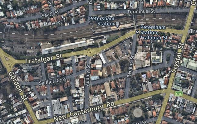
Fisher Street is a local road with a carriageway width of 10 metres. It comes to a dead-end at Council’s Administration Building car park. Parking is unrestricted generally in the street.
Fozzard Lane is a small rear lane approximately 4m wide. The north-south orientated portion of the lane is concrete for the full width of the lane with kerb and gutter along the eastern side. The east-west orientated portion of the lane is predominately unformed (grass). To the east the lane ends at Petersham RSL’s existing car park which is approximately 4m higher than the lane. The lane provides rear access to a number of lots fronting Trafalgar Street, Regent Street, Fisher Street and Audley Street.
Traffic conditions on the road system in the area are generally satisfactory however congestion is presently experienced at peak periods at most intersections. It is noted that traffic count data used in the applicant’s Traffic report were dated Wednesday 26 October 2016 and Thursday 27 July 2017.
The Proposal
The application seeks approval for the demolition of the improvements on the land and the
construction of:
Site 1 – A 5 to 8-storey residential flat building containing 108 residential units
· 68 x 1 bedroom units (including 12 adaptable)
· 40 x 2 bedroom units (including 10 adaptable)
· 115 car parking spaces including 24 Council parking spaces and 1 car wash bay (a total of 91 off-street car parking spaces for use in connection with the apartments; and 24 off-street car parking spaces for general public use, the ownership of which is to be transferred to Council)
· 15 motorcycle spaces and 92 bicycle spaces
Site 2 – A 6 to 7-storey residential flat building containing 50 residential units
· 18 x 1 bedroom units (including 3 adaptable)
· 32 x 2 bedroom units (including 7 adaptable)
· 45 car parking spaces and 1 car wash bay – (correspondence dated 2 November 2018 states that “The basement plans for Site 2 are being re-designed to accommodate 50 car parking spaces.” - To date these plans have not been sighted)
· 5 motorcycle spaces and 29 bicycle spaces
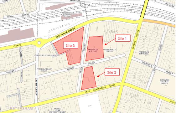
Site 3 – A 2 to 11-storey mixed-use complex containing RSL plus 196 residential units + 3 SOLO apartments
· New registered club premises for the Petersham RSL Club fronting Trafalgar Street (3031m2 GFA) – 90 staff
· RSL Office (445m2 GFA)
· RSL Café adjacent to the corner of Trafalgar and Regent Streets (100m2 GFA)
· A total of 321 car parking spaces in total (including 150 spaces for the RSL, 1 space for RSL retail/café and 1 car wash bay and 169 spaces for residential use)
· A total of 23 motorcycle spaces and 159 bicycle spaces ( 12 motorcycle spaces and 21 bicycle spaces for the RSL Club and 11 motorcycle spaces and 138 bicycle spaces for the residential apartments)
· 3 x residential flat buildings containing 196 apartments:
− 100 x 1 bedroom units (including 29 adaptable)
− 95 x 2 bedroom units (including 14 adaptable)
− 1 x 3 bedroom unit
− 3 x 2 storey SOHO apartments fronting Fozzard Lane
− a publicly accessible urban area linking Regent Street to Fozzard Lane
The overall proposed development includes a total of 75 accessible/adaptable rooms and 82 accessible parking spaces, 7 of which are for Club patron use.
Thus, the application seeks development consent for the above staged building works of 357 apartments over three sites and associated basement car parking and a new registered club including the fit-out of the club premises. Works include the subdivision of site 3 to accommodate Fozzard Lane widening and the stratum subdivision of Site 1 and Site 3.
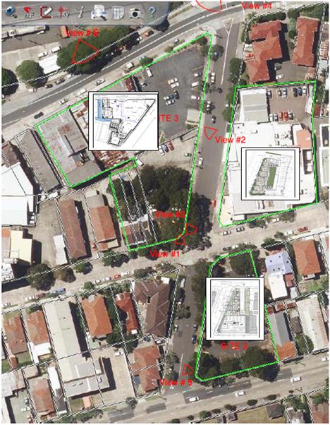
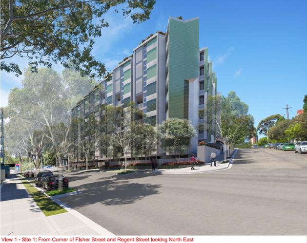
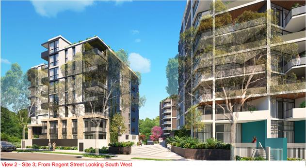
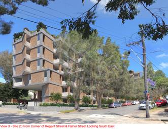
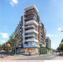
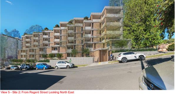
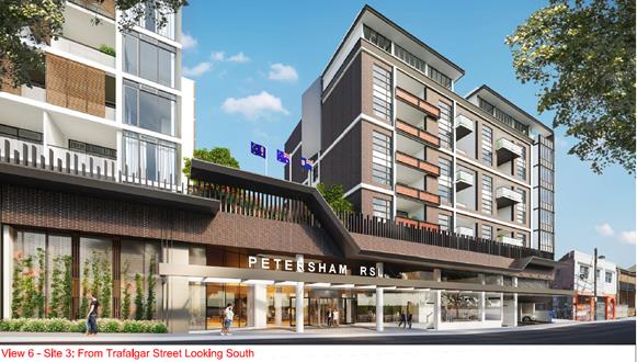
The applicant’s Traffic and Parking Impact Assessment Report concludes that the subject site ‘is suitable for the proposed development in relation to traffic impact, car parking provision, vehicle and pedestrian access and safety considerations.’ It is noted that peak hour Traffic generation rates used in their analysis are nominally very low at 0.15 (PM) - 0.19 (AM).
The applicant’s SEE report notes that ‘an analysis indicates that the development will generate an estimated additional 44 AM peak hour vehicle trips and will not alter the number of PM peak hour vehicle trip in this area when compared to the traffic generated by the existing development on the land.” and “The assessment concludes that development, including its traffic generation, trip distribution and access locations, is appropriate and would not require any further traffic mitigation works.”
However, it is noted that the proposal, as stated in the applicant’s Social Impact report, ‘represents a significant change to the existing situation on all three sites. The proposed development represents an intensification of use on all three sites and a significant visual departure from the existing site presentations. ….. There are potential impacts in terms of the increased population, as well as traffic and parking generation as a result of the proposed development and visual impact and visual amenity.’
Public Transport
The proposed development sites are located within walking distance to Petersham Railway Station, which services T2 Inner West and Leppington lines. It is noted that Petersham Railway Station is not currently wheelchair accessible, and there are currently no plans for the station to be upgraded. As earlier noted ‘TfNSW does not currently have funding allocated for an accessibility upgrade of Petersham Train Station.’ despite ‘legislative and compliance responsibilities under the Disability Standards for Accessible Public Transport (DSAPT) which requires all stations to be accessible by 2022’.
There is a traffic signalised pedestrian crossing at the Trafalgar Street/Regent Street intersection which provides the principal entry point to Petersham from the Railway Station.
There are currently six bus routes which operate within easy walking distance of the site. These bus services comprise the 428, L28, 444 and 445 bus services which operate along New Canterbury Road as well as the 412 and N50 bus services which operate along Trafalgar Street.
Parking Provision
Council's DCP 2011 Part 2.10 lists the requirements for off-street parking provisions for proposed developments. Sites 1 and 3 are located in Parking Area 1 while Site 2 is located in Parking Area 2. Parking provision requirements for off-street parking for each site is as follows:
Site 1 – Parking Area 1 (108 residential units)
· Residential flat building (non-adaptable units) - 86
- 0.4 parking space per 1-bedroom apartments (56 units – 22.4 spaces)
- 0.8 parking space per 2-bedroom apartments (30 units – 24 spaces)
· Residential flat building (adaptable units) - 22
- 1 mobility parking space per apartment (22 units – 22 spaces M)
Therefore, Site 1 should provide a total of 69 car parking spaces (22 of which are mobility spaces). As previously detailed Site 1 is to provide a total of 91 off-street car parking spaces for use in connection with the apartments and 24 off-street car parking spaces for general public use, the ownership of which is to be transferred to Council (ie. 115 car parking spaces in total) and1 car wash bay.
Basically, 91 off-street car parking spaces are proposed on the site which is 22 more car parking spaces than is required by Part 2 of the Marrickville DCP 2011.
Site 2 – Parking Area 2 (50 residential units)
· Residential flat building (non-adaptable units)
- 0.5 parking space per 1-bedroom apartments (15 units – 7.5 spaces)
- 1.0 parking space per 2-bedroom apartments (25 units – 25 spaces)
- 0.1 visitor parking space per apartment (40 units – 4.0 spaces visitor)
· Residential flat building (adaptable units)
- 1.0 mobility parking space per apartment (10 units – 10 spaces M)
- 0.25 visitor mobility parking space per unit (10 units – 2.5 spaces M)
To comply with Council’s current DCP Site 2 should provide a total of 50 car parking spaces (13 of which are mobility spaces). The proposal as originally presented provided 45 parking spaces and one car wash bay; yet it is noted that in a letter from the applicant dated 2 November 2018 at Item No. 104 it is stated:
“The basement plans for Site 2 are being re-designed to accommodate 50 car parking spaces.”
To date Traffic Section has not seen the redesigned basement plans for Site 2 and thus confirm whether 50 parking spaces can be provided or are now proposed for Site 2.
Site 3 – Parking Area 1 (RSL + office + café; 196 residential units + 3 SOLO apartments)
· Residential flat building (non-adaptable units) - 153
- 0.4 parking space per 1-bedroom apartments (71 units – 28.4 spaces)
- 0.8 parking space per 2-bedroom apartments (81 units – 64.8 spaces)
- 1.1 parking spaces per 3-bedroom apartment (1 unit – 1.1 spaces)
· Residential flat building (adaptable units) – 43 (29 1-bedroom and 14 2-bedroom)
- 1 mobility parking space per apartment (43 units – 43 spaces M)
· SOHO apartments – 3 x 2 storey – 203 m² GFA (commercial + residential)
- 1 per ‘dwelling house’ (3 units – 3 spaces)
---------------------------------
140.3 spaces (43 of which are M)
· RSL Café (100m² GFA) - Business / Retail (up to 500m2)
- 1 per 100m2 GFA for customers and staff. (retail 100m² GFA = 1 space)
· Petersham RSL Club – (3031m² GFA) +RSL office (445m² GFA) – Total GFA = 3476m²)
- 1 space / 6 staff for patrons and staff for new registered club premises (approx.. 15)
It is cited ‘pursuant to the requirements contained in Marrickville Development Control Plan (MDCP) 2011, car parking for a registered club must be provided at a rate of 1 space / 6 staff for patrons and staff. In relation to the proposed club this requirement would equate to between 10 and 15 car parking spaces. The Club, however has stipulated that 150 spaces is the minimum number of spaces required to accommodate its operations, noting that the existing club at 3-7 regent Street has access to 152 car parking spaces (across the three sites).
The 150 car parking spaces provided to service the club is assessed as appropriate.’
In summary, the parking requirements contained in Section 2.10 of MDCP 2011 require 259 residential parking spaces (69 spaces - Site 1 + 50 spaces - Site 2 + 140 spaces - Site 3) while the proposal shows 305 residential car parking spaces for the 357 (354+3) apartments/’units. In essence, there is an over provision of resident car parking, which has previously not been supported by Council ‘on transport sustainability and traffic grounds’ and it was recommended that ‘residential car parking on the three sites be capped by the rate contained in Part 2.10 of Marrickville Development Control Plan (MDCP) 2011.’
According to the applicant’s Traffic Report “it is proposed to provide 480 car parking spaces for the entire development, comprising of 305 residential spaces, 24 Council spaces, 150 spaces for the Petersham RSL, 1 for the RSL retail/café, plus 3 car wash bays.’ The surplus car parking spaces are seemingly justified by the following reasons:
“• The proposed 305 residential spaces comply with the SEPP65 minimum parking requirement of 259 spaces as required by Council’s DCP.
• The residential component proposed is 39 spaces less than that required by the RMS guide.
• Strictly complying with the car parking rates outlined in Marrickville Council’s DCP would result in a development that would have insufficient car parking to cater for residential component of the development.”
Interestingly, the proposal on one hand claims to be a ‘transit orientated development’ then on the other hand provides excess on-site parking (409 required yet 480 provided) . It is cited from Council correspondence that:
“the residential car parking spaces provided for each of the three sites as identified in the submitted architectural drawings are in excess of the rates stipulated in MDCP 2011 and even the rates in RMS ‘Guide to Traffic Generating Development’, with little justification for such a deviation. This contradicts the central premise of the planning proposal that the additional height and FSR are warranted given the proximity to Petersham Railway Station (i.e. transport oriented development).”
It is noted that all proposed parking facilities must be in accordance with the requirements AS/NZS 2890.1,AS 2890.2 and AS/NZS 2890.6 – Off-street Parking for People with Disabilities (AS/NZS 2890.1).
It should be further noted that residents of the proposed development, if approved, will not be eligible to participate in any existing or future Permit Parking Schemes in adjoining streets.
Bicycle and motorcycle parking
Council's DCP 2011 (incorporating Amendment No.4) requires provision of bicycle parking for a Residential flat building of ‘1 per 2 units for residents + 1 per 10 units for visitors’.
Site 1 – 108 residences – 69 spaces 54 + 10.8 = 65 bicycle spaces
Site 2 – 50 residences – 50 spaces 25 + 5 = 30 bicycle spaces
Site 3 – 199 residences – 140 spaces 99.5 + 19.9 = 119.4 = 120 bicycle spaces
- RSL club - 1 per 25m² GFA bar area for staff + 1 per 100m² GFA other areas for patrons; Clothes lockers at rate of 1 per 3 staff spaces; Showers – 1 + extra on merit
3,500m² / 90 staff = using GFA total average rate only 3500/100 = 35 bicycle spaces
- Café 100m² - 1 per 100m² GFA for staff + 1 per 50m² GFA for customers; Clothes lockers at rate of 1 per 3 staff spaces; Showers – 1+ extra on merit = 3 bicycle spaces
The development would thus require providing bicycle parking of 215 spaces for residents and 36 spaces for visitors for the residential flat buildings and 38 associated with the RSL; a total of 251 bicycle spaces. It is noted that all bicycle parking must be secure yet accessible.
The development proposes 260 bicycle spaces across the three sites, an excess of 9 spaces.
Council's DCP 2011 (incorporating Amendment No.4) requires motorcycle (and motor scooter) parking to be provided at a rate of 5% of the car parking required for the development. The total car parking requirement for the proposed development is 409 spaces therefore 20.45 (20) motorcycle spaces are required to be provided. The development proposes 31 motorcycle parking spaces.
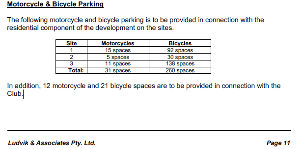
.
More bicycle and motorcycle spaces than required is proposed for the development.
It is noted there is no reference to any on-site ‘Car Share’ provision at all. Consideration could be given to replace excess bicycle parking with Car Share spaces
Vehicular Access and Internal traffic circulation
In relation to access the applicant’s traffic consultant’s report stated that:
“The access to site 1 is proposed from Regent Street, site 2 from Fisher Street and site 3 from Trafalgar Street as a left in/left out arrangement which will be enforced by a 900mm centre median.
The site 3 access is proposed on Trafalgar Road as the best design outcome for a basement car park as the northwest corner of site 3 is at the lowest point. This precludes potential protrusion of the basement car park. Section 5 details the operating outcome of providing an access on Trafalgar Street. There is no significant adverse impact on the operation of the surrounding roads and intersections. As Trafalgar Street is an arterial road, this has been discussed with RMS to which they have expressed no objection.
The entry/exit driveways generally comply with AS/NZS 2890.1-2004 Parking Facilities – Off Street Car Parking (AS/NZS 2890.1), AS 2890.2-2002 Parking Facilities – Off Street Commercial Vehicle Facilities (AS 2890.2) and Council’s DCP requirements. They also comply with Figure 3.3 – Minimum Sight Distance for Pedestrian Safety AS/NZS 2890.1 and the proposed driveway gradients comply with AS/NZS 2890.1.”
It is noted that all ramps and car parking spaces must be (not ‘generally’) in accordance with Australian Standard AS2890.1-2004 Parking Facilities and AS2890.6-2009 Off-street parking for people with disabilities.
It is noted that Council’s Development Engineering Section will evaluate the adequacy of the proposed development’s driveway, ramps, car parking layouts and circulation patterns.
It is noted also that all vehicles are to enter and exit the sites in a forward direction.
Waste Management (Collection) and Service Vehicles
Council’s DCP controls require the following service and delivery vehicle areas:
Residential component – one service vehicle space per 50 units (above the first 50) up to 200 apartments plus one space per 100 apartments thereafter
Commercial premises – one truck space per 4,000m² GFA up to 20,000m² GFA plus one truck space per 8,000m² thereafter (50%of spaces adequate for trucks)
It is noted that the applicant’s SEE report and traffic consultant report do not specifically detail service vehicle areas for the three sites other than for Site 3. Provision must be made for servicing of each of the sites. Service vehicles will be required for residential moving operations and general delivery reasons. Elaboration is required as to where such vehicles will park if there are no available on-street parking spaces and/or whether this may lead to possible illegal parking of larger service vehicles.
The applicant’s traffic consultant’s report in relation to ‘Service Vehicles’ stated that:
“Residential waste will be collected by Council’s residential waste services from the loading bay area in site 3. Waste collection from site 1 and 2 will be kerb-side pickup. Commercial waste from the RSL on site 3 will be collected by a commercial waste contractor.
The loading area on site 3 is via Fozzard Lane and is serviced by a turntable. The largest design vehicle is for a 12m-long HRV delivery vehicle for the RSL which the swept path and turntable are able to facilitate. The swept path analysis for Site 3 is attached in Appendix E.”
![]()
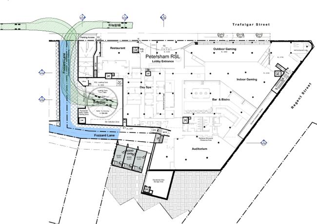
Greater detail of the turntable supplied by the applicant is reproduced below.
The applicant’s SEE report states: “The collection/loading bay is to be located off the widened Fozzard Lane and a turntable is to be installed to enable trucks to enter and leave the site in a forward direction.”
Regardless, of the turntable enabling service vehicles to ‘enter and leave in a forward direction’ the question remains what happens when a service vehicle that may be on the turntable breaks down and requires to be towed. The towing vehicle would have to ‘back’ into Fozzard Lane contrary to the requirement that ‘all vehicles are to enter and exit the sites in a forward direction.’ For this reason it is noted that the use of a ‘turntable’ to service Site 3 is not supported, specifically not for Council’s waste vehicles.
Further, no detail is elaborated upon about a ‘holding area’ for servicing vehicles at Site 3. What is the Management Plan for when three or more servicing vehicles want to attend Site 3 at the same time – are they going to park on Trafalgar Street?
Observations over time at Petersham RSL’s loading bay on Fisher Street, Petersham have revealed at times up to three trucks have been lined up for loading/unloading activities at the RSL Club.
It is further noted that Council normally does not support kerb-side waste collection.
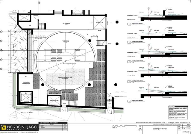
Turntable detail
Estimated Traffic Generation
The applicant's SEE / traffic report stated that the estimated traffic generation from the proposed development will be an estimated additional 44 AM peak hour vehicle trips and will not alter the number of PM peak hour vehicle trip (ie. zero pm peak hour vehicle trips) in the vicinity when compared to the traffic generated by the existing development on the land.
The applicant’s traffic report used peak hour Traffic generation rates of 0.15 (PM) - 0.19 (AM) per unit in their analysis, however it is noted that in a report that went to Council’s 25 December 2017 Local Representation Advisory Committee Meeting – it was stated that Council’s Traffic Engineers reviewed the original planning proposal and made the following comment:
· In the assessment of the traffic generation, the Traffic and Parking Impact Assessment Report has used the RMS Sydney Average traffic generation rate for high density residential flat dwellings of 0.19 peak vtph per unit. The surveys used to derive this rate include surveys from St Leonards and Chatswood that have very different traffic generation rates than Inner West Sydney. The Traffic Impact Assessment Report should use a traffic generation rate of 0.3 peak vtph per unit which is derived from the RMS survey data excluding St Leonards and Chatswood.
Should the rate of 0.3 peak vehicle trips per hour (vtph) per unit have been used as suggested this would have increased the estimated AM peak traffic generation from the proposed development to 107 vtph from the applicant’s traffic report estimate of 68 – a difference of 39.
Despite the applicant’s traffic report detailing minimal effects on future Level of Services of adjoining intersections within the vicinity it is noted that some locations already experience saturation (eg. New Canterbury Road/ Crystal Street; Trafalgar Street / Crystal Street; New Canterbury Road / Regent Street and New Canterbury Road / Audley Street) and any additional traffic in the locality would exuberate congestion already experienced.
It is anticipated that upgrade works are warranted at the signalized intersection of Trafalgar Street and Regent Street to provide pedestrian crossings on all legs of the intersection to facilitate increases in pedestrian numbers generated by the development and safe access for pedestrians using Petersham Railway Station.
Any proposal by Council to undertake a broader precinct traffic and transport study to identify future infrastructure needs to support future growth in the precinct is wholly supported and recommended.
PUBLIC CONSULTATION
Consultation/notification regarding the proposal would normally be undertaken by Council's Development and Planning Services as part of the development application process.
CONCLUSION
The applicant is required to address the following traffic concerns in relation to this application:
· The applicant is required to provide a pedestrian orientated redesign of the traffic signals the intersection of Trafalgar Street and Regent Street and modifications on site (to RMS and Council satisfaction) prior to construction certificate being issued.
· Concern remains about the lack of provision of a holding area for service vehicles wanting to load/unload at the servicing dock area on Site 3.
· Concerns remain about the lack of service/loading facilities for Sites 1 and 2.
· It is noted there is no reference to any on-site ‘Car Share’ provision at all. Consideration could be given to replace excess bicycle parking with Car Share spaces.
· All bicycle parking must be provided in secure areas and be easily accessible.
· Traffic generation rates used in the applicant’s analysis are considered to be nominally low at 0.15 (PM) - 0.19 (AM) in light of it being suggested to the applicant to specifically use a traffic generation rate of 0.3 peak vtph per unit for the analysis.
It is recommended that the above traffic related comments be forwarded to Council’s Development Assessment Section.
Site 1
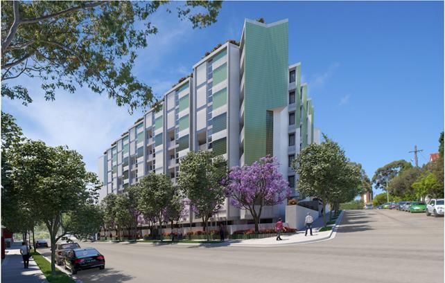
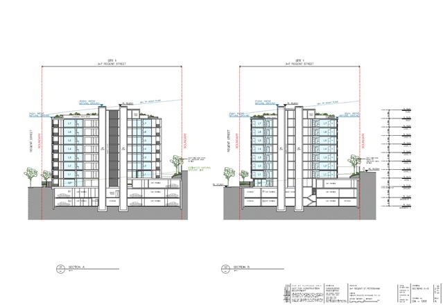
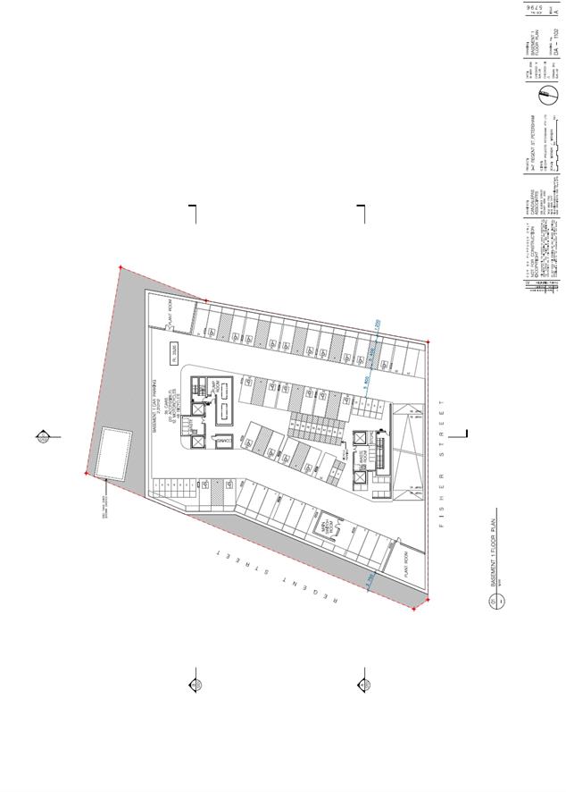
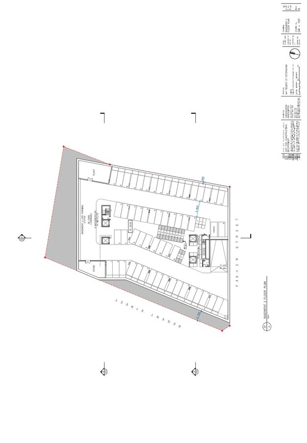
Site 2
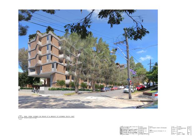
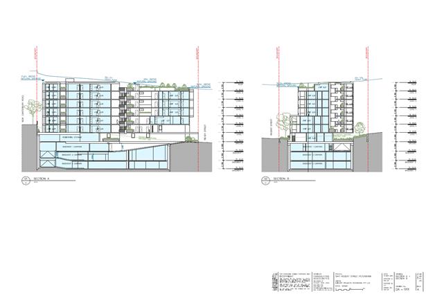
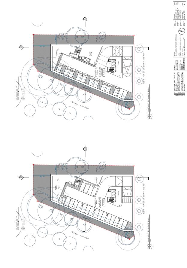
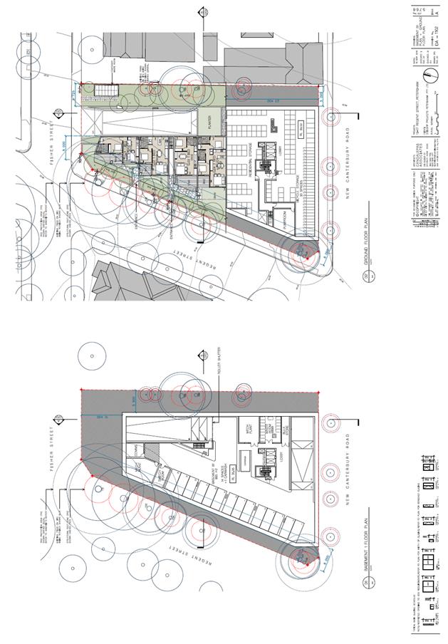
Site 3