|
AGENDA R |

Local Traffic Committee Meeting
MONDAY 6 MAY 2019
10.00am
|
|
Local Traffic Committee Meeting 6 May 2019 |
Function of the Local Traffic Committee
Background
Roads and Maritime Services (RMS) is legislated as the Authority responsible for the control of traffic on all NSW Roads. The RMS has delegated certain aspects of the control of traffic on local roads to councils. To exercise this delegation, councils must establish a local traffic committee and obtain the advice of the RMS and Police. The Inner West Council Local Traffic Committee has been constituted by Council as a result of the delegation granted by the RMS pursuant to Section 50 of the Transport Administration Act 1988.
Role of the Committee
The Local Traffic Committee is primarily a technical review and advisory committee which considers the technical merits of proposals and ensures that current technical guidelines are considered. It provides recommendations to Council on traffic and parking control matters and on the provision of traffic control facilities and prescribed traffic control devices for which Council has delegated authority. These matters are dealt with under Part A of the agenda and require Council to consider exercising its delegation.
In addition to its formal role as the Local Traffic Committee, the Committee may also be requested to provide informal traffic engineering advice on traffic matters not requiring Council to exercise its delegated function at that point in time, for example, advice to Council’s Development Assessment Section on traffic generating developments. These matters are dealt with under Part C of the agenda and are for information or advice only and do not require Council to exercise its delegation.
Committee Delegations
The Local Traffic Committee has no decision-making powers. The Council must refer all traffic related matters to the Local Traffic Committee prior to exercising its delegated functions. Matters related to State Roads or functions that have not been delegated to Council must be referred directly to the RMS or relevant organisation.
The Committee provides recommendations to Council. Should Council wish to act contrary to the advice of the Committee or if that advice is not supported unanimously by the Committee members, then the Police or RMS have an opportunity to appeal to the Regional Traffic Committee.
Committee Membership & Voting
Formal voting membership comprises the following:
· one representative of Council as nominated by Council;
· one representative of the NSW Police from each Local Area Command (LAC) within the LGA, being Newtown, Marrickville, Leichhardt and Ashfield LAC’s.
· one representative from the RMS; and
· State Members of Parliament (MP) for the electorates of Summer Hill, Newtown, Heffron, Canterbury, Strathfield and Balmain or their nominees.
Where the Council area is represented by more than one MP or covered by more than one Police LAC, representatives are only permitted to vote on matters which effect their electorate or LAC.
Informal (non-voting) advisors from within Council or external authorities may also attend Committee meetings to provide expert advice.
Committee Chair
Council’s representative will chair the meetings.
Public Participation
Members of the public or other stakeholders may address the Committee on agenda items to be considered by the Committee. The format and number of presentations is at the discretion of the Chairperson and is generally limited to 3 minutes per speaker. Committee debate on agenda items is not open to the public.
|
|
Local Traffic Committee Meeting 6 May 2019 |
|
AGENDA |
1 Apologies
2 Disclosures of Interest
3 Confirmation of Minutes Page
Minutes of 1 April 2019 Local Traffic Committee Meeting 5
4 Matters Arising from Council’s Resolution of Minutes
5 Part A – Items Where Council May Exercise Its Delegated Functions
Traffic Matters
ITEM Page
LTC0519 Item 1 Curtis Road and Mort Street, Balmain - Intersection Improvement Works (Baludarri - Balmain Ward/Balmain Electorate/Leichhardt PAC) 18
LTC0519 Item 2 Park Street, Rozelle - Proposed Speed Hump (Baludarri-Balmain Ward/ Balmain Electorate/ Leichhardt PAC) 22
LTC0519 Item 3 Starling Street, Rozelle - Proposed Kerb Blister (Baludarri-Balmain Ward/ Balmain Electorate/ Leichhardt PAC) 26
LTC0519 Item 4 Darling Street at Elliott, Balmain - Proposed Speed Cushions (Baludarri-Balmain Ward/ Balmain Electorate/ Leichhardt PAC) 30
LTC0519 Item 5 Temporary Full Road Closure – Smith Street (between Lackey Street and Nowraine Street, Summer Hill, for Development sewer work connection. (Djarrawunang-Ashfield Ward/Summer Hill Electorate/ Burwood PAC) 34
LTC0519 Item 6 Lawson Avenue, Marrickville – Amended Raised Threshold Design Plan No. 6198_A (Midjuburi-Marrickville Ward/ Summer Hill Electorate/ Inner West PAC) 44
LTC0519 Item 7 Queen
Street, Croydon - Proposed Pedestrian Refuge
(Gulgadya-Leichardt Ward/Strathfield Electorate/Burwood PAC) 48
LTC0519 Item 8 Minor Traffic Facilities (All Wards/ All Electorates/ All PACs) 53
Parking Matters
ITEM Page
LTC0519 Item 9 Smith Street, Marrickville - Proposed Permit Parking (Midjuburi-Marrickville Ward/ Summer Hill Electorate/ Inner West PAC) 59
LTC0519 Item 10 Kingston Lane, Camperdown - Proposed Parking Restrictions (Damun-Stanmore Ward/ Newtown Electorate/ Inner West PAC) 62
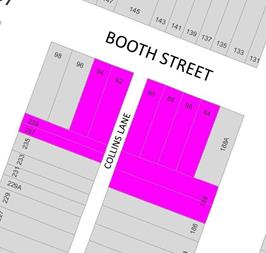
LTC0519 Item 11 Booth Street at Collins Lane, Annandale - Proposed 'No Stopping' restriction (Gulgadya-Leichhardt Ward / Balmain Electorate / Leichhardt PAC) 65
LTC0519 Item 12 Collins Lane, Annandale - Proposed 'No Parking' zone (Gulgadya-Leichhardt Ward/ Balmain Electorate/ Leichhardt PAC) 68
LTC0519 Item 13 Derbyshire Road and Moore Street West, Leichhardt - 'No Parking' and 'No Stopping' restrictions (Gulgadya-Leichhardt Ward / Balmain Electorate / Leichhardt PAC) 71
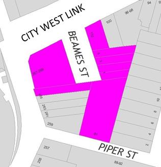
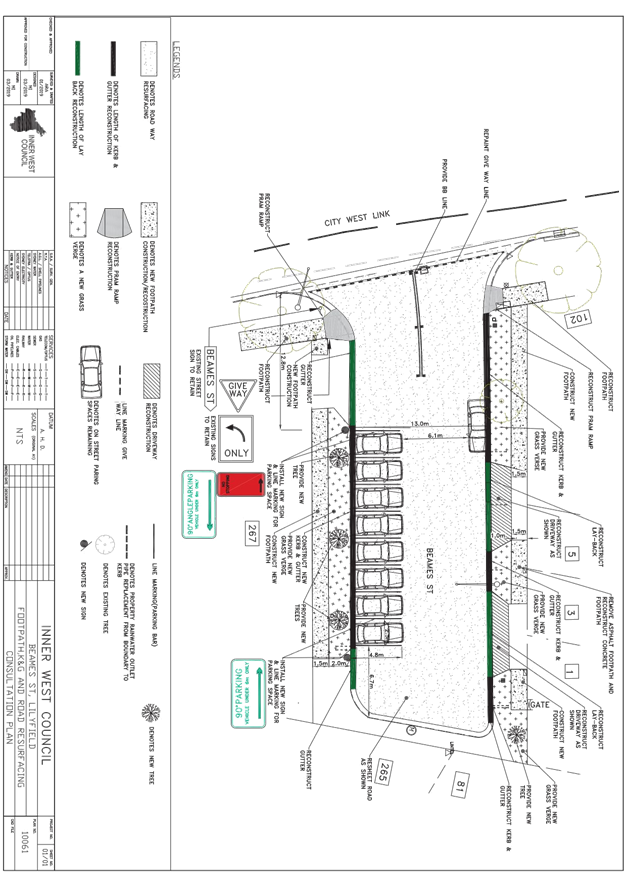
LTC0519 Item 14 Beames Street, Lilyfield - Angle Parking and Road Reconstruction (Baludarri-Balmain Ward / Balmain Electorate / Leichhardt PAC) 74
LTC0519 Item 15 Hercules Street, Ashfield – Amendment to Disabled Parking Signage. (Djarrawunang-Ashfield Ward/Summer Hill Electorate/ Burwood PAC) 78
LTC0519 Item 16 Ramsay Street at Walker Avenue, Haberfield - Proposed 'No Stopping' restriction (Gulgadya-Leichhardt Ward/ Summer Hill Electorate/ Burwood PAC) 80
LTC0519 Item 17 New Street, Ashfield – Proposed statutory ‘No Stopping’ in New Street at intersection with Queen Street. (Djarrawunang-Ashfield Ward/ Summer Hill Electorate/ Burwood PAC) 82
LTC0519 Item 18 Stanmore Lane, Stanmore - Proposed 'No Parking' restrictions Damun-Stanmore Ward/ Newtown Electorate/ Inner West PAC) 84
LTC0519 Item 19 Edith Street and Regent Street, Leichhardt - Proposed 'No Stopping' restrictions (Gulgadya-Leichhardt Ward / Balmain Electorate / Leichhardt PAC) 87
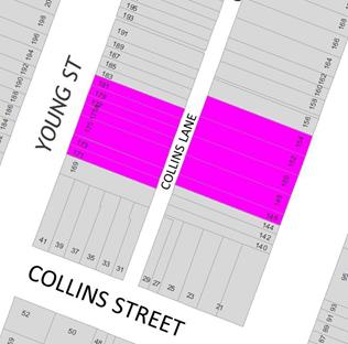
LTC0519 Item 20 Collins Lane, Annandale - Proposed 'No Parking' zone (Gulgadya-Leichhardt Ward/Balmain Electorate/Leichhardt PAC) 90
LTC0519 Item 21 Norton Street, Leichhardt - Proposed Metered Parking Restriction (Gulgadya-Leichhardt Ward/Balmain Electorate/Leichhardt PAC) 94
Late Items
Nil at time of printing.
6 Part B - Items for Information Only
Nil at the time of printing.
7 Part C - Items for General Advice
Nil at the time of printing.
8 General Business
9 Close of Meeting
|
|
Local Traffic Committee Meeting 6 May 2019 Minutes from 1 April 2019 Meeting |
Minutes of Local Traffic Committee Meeting
Held at Petersham Service Centre on 1 April 2019
Meeting commenced at 10.02am
ACKNOWLEDGEMENT OF COUNTRY BY CHAIRPERSON
I acknowledge the Gadigal and Wangal people of the Eora nation on whose country we are meeting today, and their elders past and present.
COMMITTEE REPRESENTATIVES PRESENT
|
Clr Victor Macri |
Councillor – Midjuburi Ward (Chair) |
|
Bill Holliday |
Representative for Jamie Parker MP, Member for Balmain |
|
Chris Woods |
Representative for Ron Hoenig MP, Member for Heffron |
|
Sarina Foulstone |
Representative for Jo Haylen MP, Member for Summer Hill |
|
Cathy Peters |
Representative for Jenny Leong MP, Member for Newtown |
|
Sgt Paul Vlachos |
NSW Police – Inner West Police Area Command |
|
Ryan Horne |
Roads and Maritime Services |
|
|
|
|
OFFICERS IN ATTENDANCE |
|
|
|
|
|
Asith Nagodavithane |
Transit Systems – Inner West Bus Services |
|
Clr Marghanita da Cruz |
Councillor – Gulgadya Ward |
|
John Stephens |
IWC’s Traffic and Transport Services Manager |
|
George Tsaprounis |
IWC’s Coordinator Traffic and Parking Services (South) |
|
Manod Wickramasinghe |
IWC’s Coordinator Traffic and Parking Services (North) |
|
David Yu |
IWC’s Engineer – Traffic and Parking Services |
|
Vinoth Srinivasan |
IWC’s Engineer – Traffic and Parking Services |
|
Christina Ip |
IWC’s Business Administration Officer |
|
|
|
|
VISITORS |
|
|
|
|
|
Jeremy Lawrance |
Item 5 – Resident |
|
John Sanderson |
Item 5 – Resident |
|
Rae Owen |
Item 6 – Resident |
|
Jeffrey Sheather |
Item 8 – Resident |
|
John Frangipane |
Item 9 – Resident |
|
|
|
|
APOLOGIES: |
|
|
|
|
|
Wal Petschler |
IWC’s Group Manager Roads and Stormwater |
DISCLOSURES OF INTERESTS:
Nil.
CONFIRMATION OF MINUTES
|
The Minutes of the Local Traffic Committee Meeting held on Monday, 4 March 2019 were confirmed. |
MATTERS ARISING FROM COUNCIL’S RESOLUTION OF MINUTES
Minutes of the Local Traffic Committee Meeting held on Monday, 4 March 2019 are awaiting adoption.
|
LTC0419 Item 1 Minor Traffic Facilities (All Wards/All Electorates/All PACs) |
|
SUMMARY
This report considers minor traffic facility applications by Inner West Council, and includes ‘Disabled Parking’ and ‘Works Zone’ requests.
Officer’s Recommendation
THAT:
1. A 6m ‘Disabled Parking’ zone be removed and the 1P resident parking be reinstated in Red Lion Street, on the side boundary of No.207 Evans Street, Rozelle;
2. A 6m 'Disabled Parking’ zone be installed in front of No.5 Burfitt Street, Leichhardt;
3. A 6m 'Disabled Parking’ zone be installed in front of No.5 High Street, Balmain;
4. A 5.5m 'Disabled Parking’ zone be installed in front of No.12 Kroombit Street, Dulwich Hill;
5. A 6m 'Disabled Parking’ zone be installed in front of No.105 Trafalgar Street, Annandale;
6. A 6m 'Disabled Parking’ zone be installed in Piper Street on the side boundary of No.227 Annandale Street, Annandale;
7. A 5.5m 'Disabled Parking’ zone be installed in front of No.56 Renwick Street, Marrickville;
8. A 20m 'Works Zone 7:00am – 6:00pm Mon-Fri and 8.00am-1.00pm Sat' be installed in Barwon Park Road at the back of No.44-46 Princes Highway, St Peters for 12 weeks;
9. A 9m 'Works Zone 7:00am – 6:00pm Mon-Fri and 8.00am-1.00pm Sat' be installed in front of No.93 Louisa Road, Birchgrove for 12 weeks;
10. A 9m 'Works Zone 7:00am – 6:00pm Mon-Fri and 8.00am-1.00pm Sat' be installed in front of No.112 Edith Street, Leichhardt for 26 weeks;
11. A 9m 'Works Zone 7:00am – 6:00pm Mon-Fri and 8.00am-1.00pm Sat' be installed in front of No.132 Evans Street, Rozelle for 12 weeks;
12. A 10m 'Works Zone 7.00am – 6:00pm Mon-Fri and 8.00am-1.00pm Sat' be installed in front of No.109 Birchgrove Road, Birchgrove for 12 weeks; and
13. A 9m 'Works Zone 7:00am – 6:00pm Mon-Fri and 8.00am-1.00pm Sat' be installed in front of No. 9 Johnston Street, Balmain East for 12 weeks.
DISCUSSION
The Committee members agreed with the Officer’s recommendation.
COMMITTEE RECOMMENDATION
THAT:
1. A 6m ‘Disabled Parking’ zone be removed and the 1P resident parking be reinstated in Red Lion Street, on the side boundary of No.207 Evans Street, Rozelle;
2. A 6m 'Disabled Parking’ zone be installed in front of No.5 Burfitt Street, Leichhardt;
3. A 6m 'Disabled Parking’ zone be installed in front of No.5 High Street, Balmain;
4. A 5.5m 'Disabled Parking’ zone be installed in front of No.12 Kroombit Street, Dulwich Hill;
5. A 6m 'Disabled Parking’ zone be installed in front of No.105 Trafalgar Street, Annandale;
6. A 6m 'Disabled Parking’ zone be installed in Piper Street on the side boundary of No.227 Annandale Street, Annandale;
7. A 5.5m 'Disabled Parking’ zone be installed in front of No.56 Renwick Street, Marrickville;
8. A 20m 'Works Zone 7:00am – 6:00pm Mon-Fri and 8.00am-1.00pm Sat' be installed in Barwon Park Road at the back of No.44-46 Princes Highway, St Peters for 12 weeks;
9. A 9m 'Works Zone 7:00am – 6:00pm Mon-Fri and 8.00am-1.00pm Sat' be installed in front of No.93 Louisa Road, Birchgrove for 12 weeks;
10. A 9m 'Works Zone 7:00am – 6:00pm Mon-Fri and 8.00am-1.00pm Sat' be installed in front of No.112 Edith Street, Leichhardt for 26 weeks;
11. A 9m 'Works Zone 7:00am – 6:00pm Mon-Fri and 8.00am-1.00pm Sat' be installed in front of No.132 Evans Street, Rozelle for 12 weeks;
12. A 10m 'Works Zone 7.00am – 6:00pm Mon-Fri and 8.00am-1.00pm Sat' be installed in front of No.109 Birchgrove Road, Birchgrove for 12 weeks; and
13. A 9m 'Works Zone 7:00am – 6:00pm Mon-Fri and 8.00am-1.00pm Sat' be installed in front of No. 9 Johnston Street, Balmain East for 12 weeks.
For motion: Unanimous
|
|
LTC0419 Item 2 Elliott Street at Terry Street and Glassop Street, Balmain - Proposed Intersection treatments (Baludarri Ward/ Balmain Electorate/ Leichhardt PAC) |
|
SUMMARY
Concerns have been raised by a number of residents and motorists regarding safety at the intersection of Elliott Street/Terry Street/Glassop Street, Balmain.
Officer’s Recommendation
THAT the intersection improvement works at the intersection of Elliott Street, Terry Street and Glassop Street, Balmain, which includes installation of barrier lines, chevron painted islands and relocation of 'STOP' holding line be approved.
DISCUSSION
The Committee members agreed with the Officer’s recommendation.
COMMITTEE RECOMMENDATION
THAT the intersection improvement works at the intersection of Elliott Street, Terry Street and Glassop Street, Balmain, which includes installation of barrier lines, chevron painted islands and relocation of 'STOP' holding line be approved.
For motion: Unanimous
|
|
LTC0419 Item 3 Railway Parade, Marrickville (between Sydenham Road and Buckley Lane) – Temporary Full Road Closure for ‘Bad Friday 2019’ event (Midjuburi Ward/Summer Hill Electorate/Inner West PAC) |
|
SUMMARY
A S68 Application has been received to use lower Railway Parade, Marrickville and hold a commercial special event known as ‘Bad Friday’ on Friday, 19 April 2019. ‘Bad Friday 2019’ is a ticketed access event presenting live music acts that starts at 1.00pm and ends at 11.00pm. The erection of the stage, stalls and associated works will include a temporary full- road closure of Railway Parade, Marrickville between Sydenham Road and Buckley Lane from 3:00pm Thursday, 18 April to 6.00pm on Saturday, 20 April 2019.
Officer’s Recommendation
THAT:
1. The proposed temporary road closure of Railway Parade, Marrickville between Sydenham Road and Buckley Lane from 3:00pm Thursday, 18 April to 3:00pm Saturday, 20 April 2019, for the holding of the ‘Bad Friday’ event on Railway Parade be supported, subject to the applicant seeking consent from RMS and forwarding a TMP;
2. A Road Occupancy License be obtained by the applicant from the Transport Management Centre;
3. All affected residents and businesses, including the NSW Police Local Area Commander, Fire & Rescue NSW and the NSW Ambulance Services be notified in writing, by the applicant, of the proposed temporary road closure at least 7 days in advance of the closure with the applicant making reasonable provision for stakeholders; and
4. The occupation of the road carriageway must not occur until the road has been physically closed.
5. Fees and charges in relation to roadway occupation and closure of the roadway be met by the applicant.
DISCUSSION
The RMS representative stated that the event organisers have provided TCPs that are inadequate and RMS are not yet satisfied that Sydenham Road can be closed. RMS still require clarification regarding egress time and duration and whether the closure will be under the control of Police or RMS certified controllers. Council Officers will clarify these issues with the event organisers and will advise the RMS accordingly.
The Committee members agreed with the Officer’s recommendation.
COMMITTEE RECOMMENDATION
THAT:
1. The proposed temporary road closure of Railway Parade, Marrickville between Sydenham Road and Buckley Lane from 3:00pm Thursday, 18 April to 3:00pm Saturday, 20 April 2019, for the holding of the ‘Bad Friday’ event on Railway Parade be supported, subject to the applicant seeking consent from RMS and forwarding a TMP;
2. A Road Occupancy License be obtained by the applicant from the Transport Management Centre;
3. All affected residents and businesses, including the NSW Police Local Area Commander, Fire & Rescue NSW and the NSW Ambulance Services be notified in writing, by the applicant, of the proposed temporary road closure at least 7 days in advance of the closure with the applicant making reasonable provision for stakeholders; and
4. The occupation of the road carriageway must not occur until the road has been physically closed.
5. Fees and charges in relation to roadway occupation and closure of the roadway be met by the applicant.
For motion: Unanimous
|
|
LTC0419 Item 4 Beattie Street at High Street, Balmain - Proposed 'No Stopping' zones (Baludarri Ward/Balmain Electorate/Leichhardt PAC) |
|
SUMMARY
Concerns have been raised by residents regarding vehicles parking too close to the intersection of High Street and Beattie Street, Balmain.
The illegal parking behaviour obstructs sight lines as well as access into and out of Beattie Street and High Street, Balmain.
Officer’s Recommendation
THAT:
1. A 10m ‘No Stopping’ zone be installed on the northern side of Beattie Street, east of High Street; and
2. A 10m ‘No Stopping’ zone be installed on the northern side of Beattie Street, west of High Street.
DISCUSSION
Council Officers tabled and outlined submissions received after the consultation period closed.
The Committee members agreed with the Officer’s recommendation.
COMMITTEE RECOMMENDATION
THAT:
1. A 10m ‘No Stopping’ zone be installed on the northern side of Beattie Street, east of High Street; and
2. A 10m ‘No Stopping’ zone be installed on the northern side of Beattie Street, west of High Street.
For motion: Unanimous
|
|
LTC0419 Item 5 Tilba Avenue and Phoebe Street, Balmain - Proposed 'No Stopping' zone (Baludarri Ward/Balmain Electorate/Leichhardt PAC) |
|
SUMMARY
Concerns have been raised by residents regarding obstructed sight lines and manoeuvring space for vehicles turning from Carieville Street into Tilba Avenue, Balmain due to parked vehicles.
Officer’s Recommendation
THAT A 10m ‘No Stopping’ zone be installed on the eastern side of Tilba Avenue, north of Carieville Street, Balmain.
DISCUSSION
Public speakers: Jeremy Lawrance and John Sanderson attended at 10.03am
Mr Lawrance tabled a suhmission and photos illustrating parking at the intersection of Tilba Avenue, Phoebe Street and Carieville Street. Mr Lawrance requested that due to local demand for on-street parking, the proposed 10m ‘No Stopping’ zone be reduced to 8m to preserve one parking space. Mr Lawrance indicated that:
Mr Sanderson tabled an email supporting Council’s proposal. Mr Sanderson indicated that:
(Mr Lawrance and Mr Sanderson left at 10.26am)
The RMS representative agreed that the northern side of Phoebe Street needs to be signposted 10m ‘No Stopping’ to provide clear sightlines. The representative stated that RMS can agree to an 8m ‘No Stopping’ zone on the eastern side of Tilba Avenue if Council can demonstrate it is safe and provided that the 10m ‘No Stopping’ zone on the northern side of Phoebe Street is installed.
The representative for the Member for Balmain supported a reduced 8m ‘No Stopping’ zone on Tilba Avenue to provide an extra car space and access to Mr Sanderson’s gate and suggested Council reinvestigate a Shared Zone for Tilba Avenue.
Council Officers tabled and outlined further submissions received after the consultation period closed.
COMMITTEE RECOMMENDATION
THAT:
For motion: Unanimous
|
|
LTC0419 Item 6 Gannon Lane, Tempe - Proposed Installation of 'No Stopping' signage, replacing current 'No Parking 5am-10am Fridays' restrictions (Midjuburi Ward/Heffron Electorate/Inner West PAC) |
|
SUMMARY
A request has been received from a local resident for the provision of 10m ‘No Stopping’ restrictions to deter illegal parking on the eastern side of Gannon Lane, adjacent to the corner of Gannon Street, Tempe. The resident has advised that vehicles are regularly illegally parking within 10m of the corner, often blocking the rear driveway of No.767 Princes Highway restricting their ingress and egress movements from their off-street parking.
Officer’s Recommendation
THAT the installation of 10m ‘No Stopping’ signage on the eastern side of Gannon Lane, Tempe, between the rear access of property Nos.767 & 769 Princes Highway (replacing the current ‘No Parking 5am-10am Fridays’ signage) be APPROVED.
DISCUSSION
Public speaker: Rae Owen attended at 10.37am
Ms Owen stated that her property on Princes Highway is a Council approved commercial property. The current ‘No Parking’ restrictions, allow for delivery vehicles to stop in Gannon Lane at the rear of Ms Owen’s property. Ms Owen stated that deliveries cannot be accepted from the front of her property due to it facing Princes Highway, thus the proposed changes would prevent deliveries to her property entirely. Ms Owen requested that the proposed ‘No Stopping’ signage be amended to ‘No Parking’ to allow delivery vehicles to stop in Gannon Lane and to assist her in entering and exiting her property safely.
(Ms Owen left at 10.38am)
Council Officers advised that deliveries to Ms Owen’s property would also not be possible in Gannon Street due to parking restrictions.
The Committee members agreed to amend the recommendation to install 10m ‘No Parking’ signage on the eastern side of Gannon Lane.
COMMITTEE RECOMMENDATION
THAT the installation of 10m ‘No Parking’ signage on the eastern side of Gannon Lane, Tempe, between the rear access of property Nos.767 & 769 Princes Highway (replacing the current ‘No Parking 5am-10am Fridays’ signage) be APPROVED.
For motion: Unanimous
|
|
LTC0419 Item 7 Albion Street, Annandale - Proposed Extension of 'No Stopping' zone (Gulgadya Ward/Balmain Electorate/Leichhardt PAC) |
|
SUMMARY
Concerns have been raised regarding blocked vehicular access to the driveway of No.1 and No.3 Albion Street, Annandale due to vehicles over-hanging the driveway.
The existing kerb space between the driveways of No.1 and No.3 Albion Street is 2.6m long and so is insufficient to accommodate a vehicle without impeding driveway access to both properties.
Officer’s Recommendation
THAT the existing 12m ‘No Stopping’ zone on the northern side of Albion Street be extended to 14.6m, west of Susan Street, Annandale.
DISCUSSION
It was suggested to implement motorbike parking on the 2.6m section of Albion Street proposed to be an extension of the existing ‘No Stopping’ zone. Council Officers advised that the 2.6m space could accommodate two motorbike parking spaces without affecting access to driveways.
The Committee members agreed.
COMMITTEE RECOMMENDATION
THAT Motorbike Only parking be installed in the 2.6m section of road adjacent to the existing 12m ‘No Stopping’ zone on the northern side of Albion Street, west of Susan Street, Annandale.
For motion: Unanimous
|
|
LTC0419 Item 8 Wardell Road, Dulwich Hill - Request for extension to existing school drop off zone adjacent to St Maroun's College at Nos.149-206 Wardell Road (Djarrawunang Ward/Summer Hill Electorate/Inner West PAC) |
|
SUMMARY
Representations have been received from the Principal of St Maroun’s College and parents of children attending the school for an extension to the existing school drop off / pick up zone on Wardell Road, Dulwich Hill. Originally the request was for the school drop off zone to be extended to the north eastern corner of Gilbert Barry Memorial Park incorporating the parks frontage; however, the request was subsequently restricted to the north-east school boundary line only and consultation was carried out on the latter proposal.
Officer’s Recommendation
THAT:
1. The existing 'No Parking 8.00am-9.30am; 2.30pm-4.00pm School Days’ restrictions adjacent to St Maroun’s College on Wardell Road (southern side of roadway) be extended 10 metres eastward (to the school boundary line west of Gilbert Barry Reserve) to improve road safety outside St Maroun’s College; and
2. Council's Parking Officers be requested to regularly enforce the parking restrictions outside St Maroun's College in Wardell Road, Dulwich Hill during morning and afternoon school peak periods.
DISCUSSION
Public speaker: Jeffrey Sheather attended at 10.40am.
Mr Sheather stated that: · He lives in the block of units across from St Maroun’s College and moved in before the school was built. · Over time as the school expanded, parking in the street has worsened. · Parking in the section of Wardell Road between Margaret Street and Beach Road is particularly difficult as unit blocks do not have sufficient off-street parking. · The introduction of parking restrictions in Wardell Road from Dulwich Hill station to Margaret Street has made parking increasingly difficult. · He objects to the proposed changes as it removes up to three unrestricted parking spaces which residents use. · There is no supervision or enforcement of the ‘No Parking’ zone. · If the proposal is adopted, Council should consider a Resident Parking Scheme for residents in the section of Wardell Road between Margaret Street and Beach Road.
(Mr Sheather left at 10.45am)
Council Officers advised that a Resident Parking Scheme may not address the parking problems as there are more residents in the section of the street where he lives than there are parking spaces. Council Officers also advised that surveys conducted in Margaret Street indicate that there is some parking availability in Margaret Street during the day.
The RMS representative stated that extending the ‘No Parking’ zone is unlikely to resolve road safety issues and suggested that in the first instance, the school manage pick-up and drop-off times at the ‘No Parking’ zone.
Council Officers advised that Council’s Road Safety Officer can liaise with the school regarding management of pick-up and drop-off times within the existing ‘No Parking’ zone.
The Committee members agreed to defer the item pending Council’s Road Safety Officer liaising with the school to improve management of the pick-up and drop-off zone.
COMMITTEE RECOMMENDATION
THAT:
1. The extension of the existing 'No Parking 8.00am-9.30am; 2.30pm-4.00pm School Days’ restrictions adjacent to St Maroun’s College on Wardell Road be deferred.
2. Council's Road Safety Officer be requested to liaise with St Maroun's College regarding management of school pick-up and drop-off in the existing ‘No Parking 8.00am-9.30am; 2.30pm-4.00pm School Days’ zone.
For motion: Unanimous
|
|
LTC0419
Item 9 Charles Street, Leichhardt - Proposed Angled Parking |
|
SUMMARY
A number of residents of Charles Street, Leichhardt requested the implementation of angle parking in their street to address concerns with limited parking availability. Parking occupancy surveys undertaken in Charles Street have indicated high parking occupancy levels.
Officer’s Recommendation
THAT
a) ‘45 degree angle parking, rear to kerb, vehicles under 6 metres only’ restrictions be installed on the eastern side of Charles Street, Leichhardt from the driveway of No.53A Charles Street to the boundary of No.7/9 Charles Street; and
b) Existing bike logos be amended to accommodate 45 degree angle parking layout
c) 10m ‘No Stopping’ zones be installed on the eastern and western side of Charles Street, north of William Street.
DISCUSSION
Public speaker: John Frangipane attended at 10.57am.
Mr Frangipane stated that he does not support the proposal and that:
(Mr Frangipane left at 11.02am)
It was noted that:
The Committee members agreed with the Officer’s recommendation.
COMMITTEE RECOMMENDATION
THAT
a) ‘45 degree angle parking, rear to kerb, vehicles under 6 metres only’ restrictions be installed on the eastern side of Charles Street, Leichhardt from the driveway of No.53A Charles Street to the boundary of No.7/9 Charles Street; and
b) Existing bike logos be amended to accommodate 45 degree angle parking layout
c) 10m ‘No Stopping’ zones be installed on the eastern and western side of Charles Street, north of William Street.
For motion: Unanimous
|
General Business
LTC0419 Item 10 Pedestrian access to Leichhardt North light rail from Darley Road, Leichhardt
The representative for the Member for Balmain stated that the pedestrians should be able to directly access the Leichhardt North light rail station through Dan Murphy’s eastern car park rather than walking east on Darley Road up a steep hill or walking west towards Charles Street and using the walkway to access the station. A resident has suggested this to Dan Murphy’s and they are receptive to the idea. The representative requested Council investigate this issue.
The RMS representative advised that RMS has received complaints about impeded access to the light rail station because of the Dan Murphy’s site. The representative advised that a public pedestrian walkway through a car park would not be supported by RMS.
Council Officers stated that a public walkway to the light rail station would need to be separated from a public car park and that the change of leasehold was an opportunity to investigate the feasibility of a walkway with Transport for NSW.
LTC0419 Item 11 Traffic around Petersham Station development
The representative for the Member for Newtown reported that traffic diversion around development sites in the vicinity of Petersham Station are chaotic with detours causing confusion for motorists.
LTC0419 Item 12 Request for red light camera on corner of Princes Highway and Canal Road, St Peters
A request for a red light camera on the corner of Princes Highway and Canal Road was made to the Member for Newtown. The RMS representative advised that the Centre for Road Safety manages the red light camera program and nominations for a red light camera location can be made through its website.
LTC0419 Item 13 Heavy traffic around Sydney Metro, WestConnex and Marrickville Metro sites
The representative for the Member for Newtown stated that a resident has reported seeing heavy traffic along streets surrounding the Sydney Metro, WestConnex and Marrickville Metro development sites, including Edgeware Road, Unwins Bridge Road, May Street and Campbell Street. The resident reported there has been aggressive driver behaviour and she witnessed a near miss with a truck. The resident stated that the situation is dangerous when dropping off children to school and day care and asked what kind of monitoring is being undertaken in the area.
Council Officers advised that if the trucks can be identified, Council can approach the appropriate authorities.
The Police representative for Inner West PAC stated that complaints have been received regarding trucks speeding and vehicles not giving way to pedestrians at the crossing on Campbell Street. Police have been monitoring traffic and the pedestrian crossing on Campbell Street and issues with speeding have been referred to the Highway Patrol for monitoring.
LTC0419 Item 14 Vehicles not stopping at ‘Stop’ signs on Cook Street and Barker Street, Lewisham
The RMS representative stated that a complaint was received regarding motorists proceeding through ‘Stop’ signs without stopping on Cook Street and Barker Street, Lewisham. All associated linemarking at the ‘Stop’ signs are present. The RMS representative referred the matter to Police for enforcement.
LTC0419 Item 15 Motorists stopping in middle of pedestrian crossings
Clr da Cruz enquired regarding enforcement of motorists who stop in the middle of a signalised pedestrian crossing. It was advised that Police would need to be present at pedestrian crossings and witness such incidents to take enforcement action.
The RMS representative stated that the pedestrian crossing stop lines are being converted from unbroken lines to broken lines to prevent confusion as to where motorists should be stopping. The representative stated that RMS can update linemarking at locations where motorists are regularly stopping at or after the pedestrian crossing line.
Meeting closed at 11.34am.
This page has been left intentionally blank.
|
|
Local Traffic Committee Meeting 6 May 2019 |
Subject: Curtis Road and Mort Street, Balmain - Intersection Improvement Works (Baludarri - Balmain Ward/Balmain Electorate/Leichhardt PAC)
Prepared By: David Yu - Engineer - Traffic and Parking Services
Authorised By: John Stephens - Traffic and Transport Services Manager
|
RECOMMENDATION
THAT the detailed design plan for the kerb extension with associated garden beds, reconstruction of footpath and pedestrian ramps, associated signposting and line marking, and replacement of rubber speed cushion with asphalt speed cushion in Curtis Road at Mort Street, Balmain (as per the attached plan No. 171876) be approved, subject to the existing ‘No Stopping’ zone on Mort Street on the south-eastern corner of the intersection being retained in its current position and the proposed garden bed being modified accordingly. |
BACKGROUND
Council is proposing intersection improvement works at the intersection of Curtis Road and Mort Street, Balmain to improve pedestrian amenity and reduce vehicle speeds through the intersection.
The detailed design plans have been finalised for the proposed works together with community consultation and are presented in this report for consideration.
Site location & Road Network
|
Street Name(s) |
Curtis Road and Mort Street |
|
Section |
intersection |
|
Traffic Volume |
- |
|
Recorded Accident History (5 year) |
1 (moderate injury - vehicle cross traffic) |
|
Recorded 85% speed |
- |
|
Speed Limit |
40km/h |
|
Carriageway width |
Mort Street – approx. 9.5m Curtis Road – approx. 10m |
|
Carriageway Type |
Two way with one travel lane in each direction and kerb side parking. |
|
Road Classification (State, Regional, Local) |
Local |
FINANCIAL IMPLICATIONS
Funding of $70,000 has been allocated to this project for construction in the 2019/2020 capital works program
OTHER STAFF COMMENTS
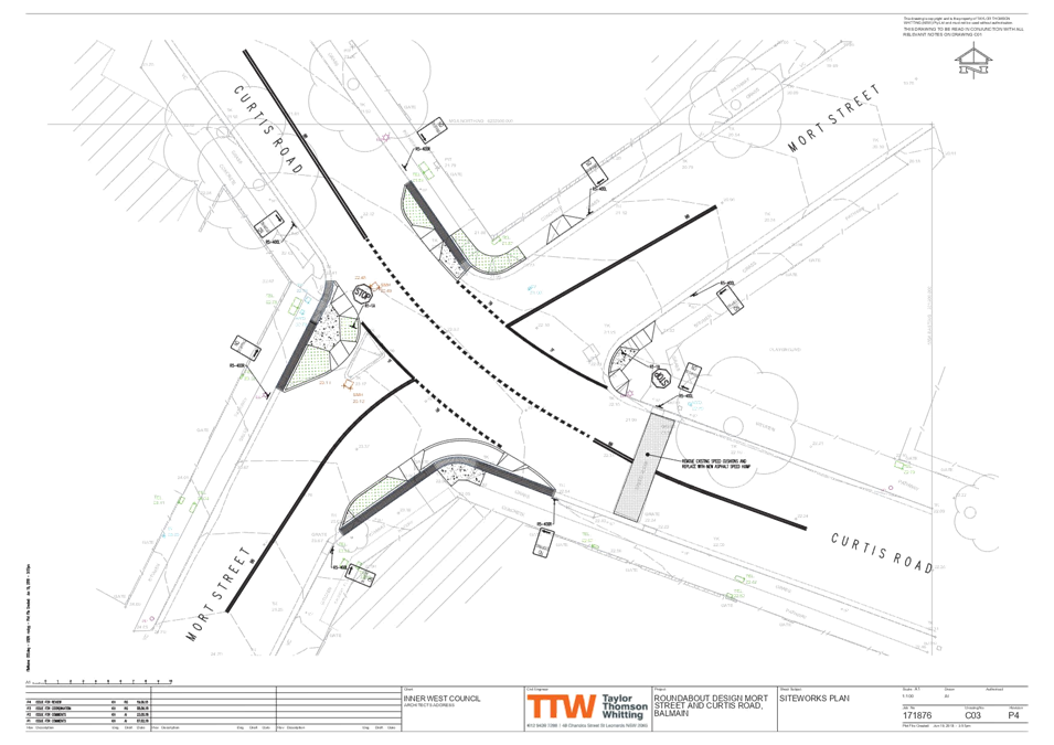
The detailed design plan shown in Attachment 1 outlines the proposed works on Curtis Road at Mort Street and includes the following treatments:
· Removal of left turn slip lane from Mort Street into Curtis Road.
· Construction of kerb blister islands;
· Reconstruction of footpaths;
· Construction of kerb ramps;
· Replacement of rubber speed cushion with asphalt speed hump;
· Install new signage and road linemarkings; and
All current vehicular access to adjoining properties will be retained.
PUBLIC CONSULTATION
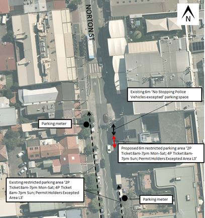
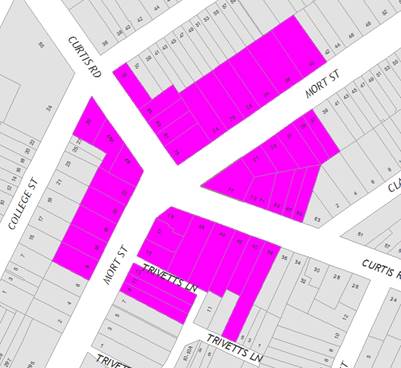
A letter outlining this intersection improvement proposal was mailed out to the affected properties (40 properties) in Curtis Road, Mort Street, and College Street, Balmain, requesting residents’ views regarding the proposal as indicated on the following plan.
A total of two (2) responses were received, in objection of the proposal. Both objections related to the same issue.
|
Residents’ Comments |
Officer Comments |
|
Your plan shows a ‘No Stopping’ sign being erected near the grate and tree at the kink of Mort St outside the building which contains numbers 17 and 19 Mort Street. The proposed ‘No Stopping’ sign reduces the 2 parking spaces outside 17 and 19 Mort St down to just 1 parking space. We only have 1 car for each residence.
It is always difficult to get parking in this section of Mort Street most times.
I strongly object to the reduction of any further parking spaces in Mort Street. |
The existing location of the 'No Stopping' signs at the south-eastern corner of the Mort Street and Curtis Road intersection (in front of 17 and 19 Mort Street) will be retained.
The plans will be updated as part of the detailed design to retain the existing parking. |
|
1.⇩ |
Design Plan - Curtis Road and Mort Street, Balmain |
|
|
Local Traffic Committee Meeting 6 May 2019 |
Subject: Park Street, Rozelle - Proposed Speed Hump (Baludarri-Balmain Ward/ Balmain Electorate/ Leichhardt PAC)
Prepared By: David Yu - Engineer - Traffic and Parking Services
Authorised By: John Stephens - Traffic and Transport Services Manager
|
RECOMMENDATION
THAT the detailed design plan for the watts profile speed hump and associated signposting and line marking in Park Street, Rozelle (as per the attached plan No. 10068) be approved.
|
BACKGROUND
As part of the 2019/20 Traffic Facilities (LATM) Capital Works Program, Council is proposing a speed hump in Park Street, Rozelle to improve safety and calm traffic in the street. The works have been proposed in response to residents’ concerns about speeding vehicles in the street.
The provision of a speed calming device at this location was previously supported by the Traffic Committee and this report now considers the detailed design plan associated with the previously supported proposal.
Park Street is the most western of four two-way streets which connects Darling Street to Moodie Street which subsequently joins Victoria Road. These streets can be used as a by-pass to access the westbound lanes of Victoria Road thus avoiding the traffic lights at the intersection of Darling Street and Victoria Road. Furthermore, Park Street is also the narrowest of these four streets with parking only permitted on the western side.
Currently, the only existing speed calming treatment in Park Street is the raised threshold near Moodie Street. Similar treatments exist in the other three parallel streets and additional asphalt speed humps have been installed in Cambridge Street and Waterloo Street.
A detailed design plan has been finalised for the proposed works together with community consultation and are presented in this report for consideration.
Site location & Road Network
|
Street Name(s) |
Park Street, Rozelle |
|
Section |
Between Darling Street and Moodie Street |
|
Traffic Volume |
- |
|
Recorded Accident History (5 year) |
Nil. |
|
Recorded 85% speed |
- |
|
Speed Limit |
50km/h |
|
Carriageway width |
6.1m |
|
Carriageway Type |
Two way with kerb side parking on the western side of the street |
|
Road Classification (State, Regional, Local) |
Local |
FINANCIAL IMPLICATIONS
Funding of $10,000 has been allocated to this project for construction in the 2019/20 capital works program.
OTHER STAFF COMMENTS
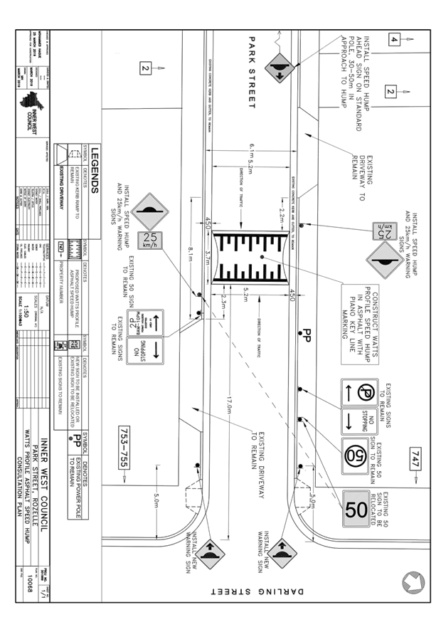
The detailed design plan shown in Attachment 1 outlines the proposed works in Park Street and includes the following treatments:
· Construction of a Watts Profile asphalt speed hump
· Installation of associated line-marking and signage
There will be no loss of parking spaces associated with the construction of the speed hump and associated works.
PUBLIC CONSULTATION
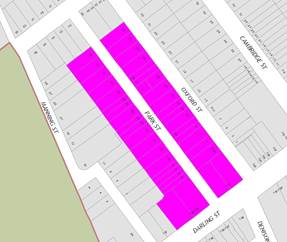
A letter outlining this proposal was mailed out to the affected properties (38 properties) in Park Street, Darling Street and Oxford Street, Rozelle, requesting residents’ views regarding the proposal (as indicated on the following plan).
A total of two (2) responses were received, one in support and one with conditional support of the proposal.
|
Residents’ Comments |
Officer Comments |
|
While we certainly need one at the proposed site, while probably appropriate for the warning signs, it is arguably the least effective place for the actual hump, in a place where everyone is going slow of necessity anyway, having just turned the corner, or just approached it. The through traffic is then offered the full downhill stretch, where all the residents actually live, to speed up on their way through – and even if they observe the 25kmh sign that’s not exactly slow in a narrow street like Park Street. |
It should be noted that an additional speed hump was previously proposed midblock in Park Street; however, the proposal was not supported by residents due to noise concerns. The outcome of the investigation was reported to the Traffic Committee in July 2017. |
|
I’m writing in support of the proposed installation of a speed hump in Park St Rozelle. The proposed location on plan needs to go ahead. |
Support noted. |
|
1.⇩ |
Design Plan - Proposed Speed Hump Park Street, Rozelle |
|
|
Local Traffic Committee Meeting 6 May 2019 |
Subject: Starling Street, Rozelle - Proposed Kerb Blister (Baludarri-Balmain Ward/ Balmain Electorate/ Leichhardt PAC)
Prepared By: David Yu - Engineer - Traffic and Parking Services
Authorised By: John Stephens - Traffic and Transport Services Manager
|
RECOMMENDATION
THAT the detailed design plan for a kerb blister with associated garden beds, asphalt re-sheeting and associated signposting and line marking in Starling Street at Mansfield Street, Rozelle (as per the attached plan No. 10067) be approved.
|
BACKGROUND
Council is proposing intersection improvement works in Starling Street at the intersection of Mansfield Street, Rozelle.
Concerns have been raised regarding vehicles causing building damage to No.92 Mansfield Street, Rozelle whilst manoeuvring near the corner of Mansfield Street and Starling Street, Rozelle.
At this location, the building’s balcony extends up to the road carriageway. Errant vehicles have previously caused structural damage to the balcony whilst parking and manoeuvring through the intersection.
This has raised concerns for both the structural integrity of the building and pedestrian safety. It should be noted that the balcony is located over the public footpath.
A report on this matter was previously considered by Traffic Committee at its meeting held in March 2015 and it was recommended that a painted kerb blister with rumble bars be provided on the eastern side of Starling Street, north of Mansfield Street. However, this treatment does not physically restrict vehicle movements.
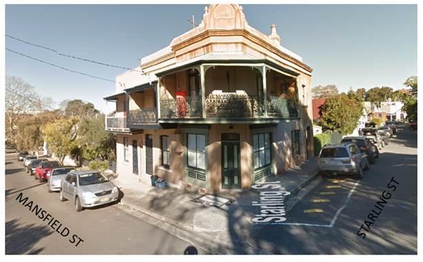
Figure 1 – existing treatment
As part of the Traffic Facilities (LATM) Capital Works Program, Council is proposing to upgrade the existing rumble bar treatment to a landscaped kerb blister island in Starling Street at its intersection with Mansfield Street, Rozelle. This is proposed to prevent illegal parking within the existing ‘No Stopping’ zone and to prevent trucks travelling too close to the property balcony.
The detailed design plans have been finalised for the proposed works together with community consultation and are presented in this report for consideration.
Site location & Road Network
|
Street Name(s) |
Starling Street and Mansfield Street |
|
Section |
Intersection |
|
Traffic Volume |
- |
|
Recorded Accident History (5 year) |
Nil. |
|
Recorded 85% speed |
- |
|
Speed Limit |
40km/h |
|
Carriageway width |
5.5m |
|
Carriageway Type |
Two way with one travel lane in each direction and kerb side parking on the eastern side |
|
Road Classification (State, Regional, Local) |
Local |
FINANCIAL IMPLICATIONS
Funding of $12,000 has been allocated to this project for construction in the 2019/2020 capital works program.
OTHER STAFF COMMENTS
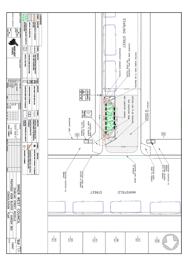
This detailed design plan shown in Attachment 1 outlines the proposed works on Starling Street at Mansfield Street and includes the following treatments:
· Construction of kerb blister island with associated garden bed
· Removal of existing rumble bars
· Asphalt re-sheeting on roadway
· Installation of associated line-marking and signage
All current vehicular access to adjoining properties will be retained.
There will be no loss of parking spaces associated with the construction of the kerb blister island and associated works.
PUBLIC CONSULTATION
A letter outlining this intersection improvement proposal was mailed out to the affected properties (9 properties) in Starling Street, Mansfield Street, and Brent Street, Rozelle, requesting residents’ views regarding the proposal (as indicated on the following plan).
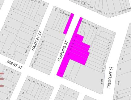
No responses were received in regards to the proposal.
|
1.⇩ |
Design Plan - Proposed Kerb Blister Island Starling Street, Rozelle |
|
|
Local Traffic Committee Meeting 6 May 2019 |
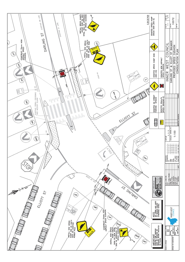
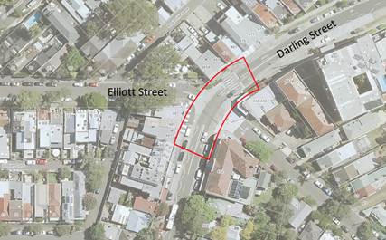
Subject: Darling Street at Elliott, Balmain - Proposed Speed Cushions (Baludarri-Balmain Ward/ Balmain Electorate/ Leichhardt PAC)
Prepared By: Felicia Lau - Engineer - Traffic and Parking Services
Authorised By: John Stephens - Traffic and Transport Services Manager
|
RECOMMENDATION
THAT the detailed design plan for two asphalt speed cushions and associated signs and line marking on approach to the raised pedestrian (zebra) crossing on Darling Street near Elliott Street, Balmain (Design Plan No.10072) be approved.
|
BACKGROUND
A detailed design plan has been finalised for a proposed speed calming treatment in Darling Street at Elliott Street, Balmain.
The proposed works includes installation of two asphalt speed cushions, associated signage and line markings on approach to the raised pedestrian (zebra) crossing on Darling Street at Elliott Street, Balmain to improve pedestrian safety.
Consultation was undertaken with the owners and occupiers of properties adjacent to the intersection regarding the proposal. A summary of the consultation results is presented in this report for consideration.
Site location & Road Network
|
Street Name(s) |
Darling Street, Balmain |
|
Section |
At Elliott Street intersection |
|
Traffic Volume |
11,092 (2016 count in Darling Street between Young Street and Hampton Street) |
|
Recorded Accident History (5 year) |
2 (1 x vehicle door; 1 x right-through) |
|
Recorded 85% speed |
47km/h (2016 count in Darling Street between Young Street and Hampton Street) |
|
Speed Limit |
40km/h |
|
Carriageway width |
12.8m |
|
Carriageway Type |
Two way with one travel lane in each direction and kerb side parking on both sides on the street |
|
Road Classification (State, Regional, Local) |
Regional |
FINANCIAL IMPLICATIONS
Funding of $10,000 has been allocated in Council’s 2019/20 capital works program for the project.
OTHER STAFF COMMENTS
The detailed design plan shown in Attachment 1 outlines the proposed works in Darling Street and includes the following treatments:
· Construction of two asphalt speed cushions
· Installation of associated line-marking and signage
There will be no loss of parking spaces associated with the construction of the speed hump and associated works. The height of the speed cushions will be 75mm as Darling Street forms a bus route.
It should be noted that there were two prior fatalities at this pedestrian (zebra) crossing, one of which occurred after the at-grade pedestrian (zebra) crossing was upgraded to a raised pedestrian (zebra) crossing. Both of these incidents occurred prior to the current 5 year accident history.
Provision of speed cushions on approach to this raised pedestrian (zebra) crossing will reinforce the 40km/h speed limit on the Balmain Peninsula and improve motorist awareness of the crossing, thus providing improved safety for both pedestrians and motorists.
PUBLIC CONSULTATION
Community engagement was conducted between 2 April 2019 and 18 April 2019. A letter and a copy of the design plan were sent to the local residents in 2 April 2019. A total of 172 letters were distributed.
There were five responses received during the consultation period. One response supported the proposal, three opposed the proposal and one suggested a modified location for one of the speed humps. The comments received are shown below.
|
Resident’s Comment |
Officer’s Response |
|
Why are speed bumps being installed just before a raised pedestrian crossing that is effectively a speed bump that vehicles have to slow down for anyway? Additional speed bumps will increase noise and pollution and make it more difficult for bikes and ambulances.
The road is a 40kmh zone so why are speed bumps being installed with a 25kmh recommended speed? |
The project originates from concerns and previous pedestrian accidents/fatalities on the pedestrian crossing in Daring Street at Elliott Street, Balmain. Installation of speed cushions will improve safety by further reducing vehicle speed and improving driver awareness on approach to the crossing.
The speed cushions have a narrow profile which allows some vehicles to straddle the device and hence produces less noise compared to a full length speed hump.
|
|
The position of the speed humps would be safer for all if placed at 501 Darling Street. |
|
|
The plastic speed cushions also break and collapse thus causing further hazards.
|
The proposed speed cushions are asphalt and hence will be more durable compared to the rubber speed cushions that have been used in other locations. |
|
Supports the installation of Speed cushion. Proposed Speed hump but 25km/h sign on new post will not fit under the awning of the shop. Install the sign on nearby power pole. |
The location of signage has been modified. |
|
1.⇩ |
Detailed Design Plan |
|
|
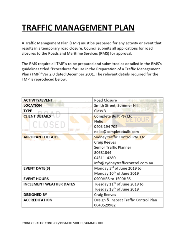
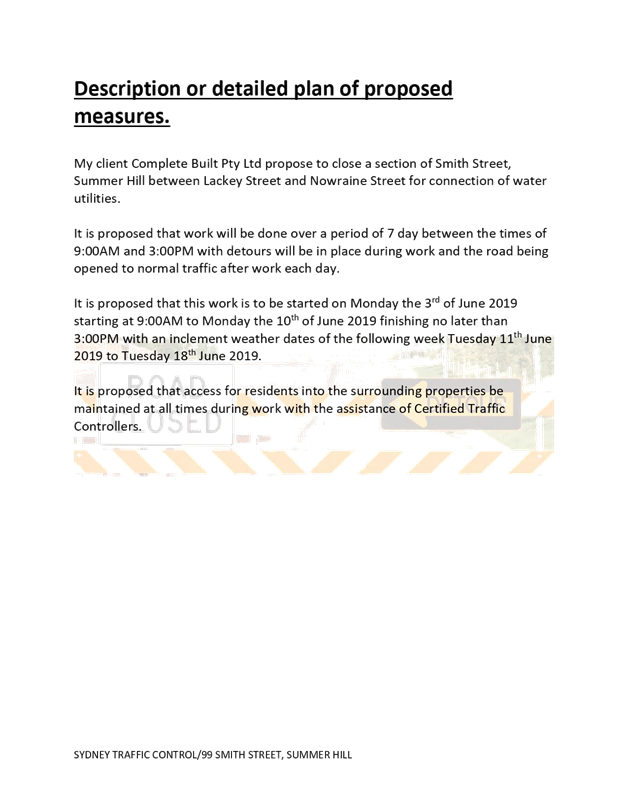
Local Traffic Committee Meeting 6 May 2019 |
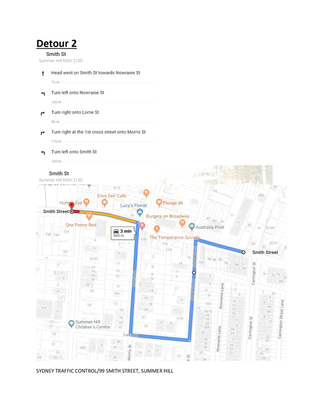
Subject: Temporary Full Road Closure – Smith
Street (between Lackey Street and Nowraine Street, Summer Hill, for Development
sewer work connection. (Djarrawunang-Ashfield Ward/Summer Hill Electorate/
Burwood PAC)
Prepared By: Boris Muha - Engineer – Traffic and Parking Services
Authorised By: John Stephens - Traffic and Transport Services Manager
SUMMARY
An application has been received from Complete Build Pty Ltd for the temporary full road closure of Smith Street, between Lackey Street and Nowraine Street, Summer Hill. The closure is to be undertaken from Monday 3 June to 17 June 2019, between 9.00am-3.00pm (includes one week for any contingencies), for development sewer work connection. It is recommended that the proposed temporary full road closure be approved, subject to the conditions outlined in the report.
|
RECOMMENDATION
THAT the proposed temporary full road closure of Smith Street (between Lackey Street and Nowraine Street, Summer Hill, from Monday, 3 June to 17 June 2019, between 9.00am-3.00pm for sewer works be approved; subject to, but not limited to, the following conditions: 1. A Road Occupancy License be obtained by the applicant from the Transport Management Centre; 2. All affected residents and businesses, including the NSW Police Area Commander, Fire & Rescue NSW and the NSW Ambulance Services be notified in writing, by the applicant, of the proposed temporary full road closure at least 7 days in advance of the closure with the applicant making reasonable provision for stakeholders; and 3. The occupation of the road carriageway must not occur until the road has been physically closed.
|
BACKGROUND
An application has been received from Complete Build Pty Ltd for the temporary full road closure of Smith Street, between Lackey Street and Nowraine Street, Summer Hill. The closure is to be undertaken from Monday 3 June to 17 June 2019, between 9.00am-3.00pm (includes one week for any contingencies), for development sewer work connection to the opposite side of the street from the mixed (commercial and residential) development site at No.99 Smith Street, Summer Hill. It is recommended that the proposed temporary full road closure be approved, subject to the conditions outlined in the report.
FINANCIAL IMPLICATIONS
Under Council’s Fees & Charges, the applicant is required to pay the fee for the temporary full road closure. This fee includes advertising the proposal in accordance with the Roads Act 1993.
OTHER STAFF COMMENTS
Deep excavation is required to connect a property sewer line to the main sewer line opposite No.99 Smith Street. The service is required to go under a major water line and similarly a deep pit is required to be constructed at the main line sewer connection. Safe work practice and effective operation of works requires the full road closure of the above section of Smith Street at times and duration shown above.
Smith Street is two-way, four lane width with parking either side of the street.
Traffic is detoured via:
1. Morris Street, Lorne Street and Nowraine Street or
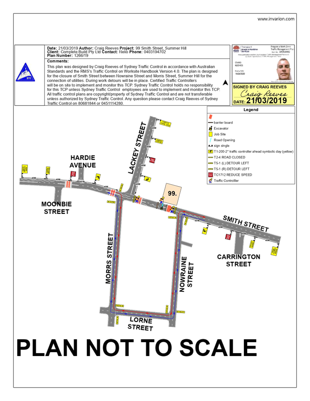
2. Lackey Street and Carlton Crescent (to the north)- See Attachment 1: Traffic Control Plan (TCP)
Vehicular access for local residents will be maintained during the closure, where possible. The applicant has indicated that traffic controllers will be on-site during all shifts and are to be positioned at the closure points to ensure the safety of motorists, cyclists and pedestrians. See also Attachment 2: Traffic Management Plan (TMP).
PUBLIC CONSULTATION
The applicant is to notify all affected residents and businesses in writing at least 7 days prior to the commencement of works.
The closure has been advertised in the local newspaper on the week commencing 9 April 2019 for a period of 28 days. The applicant has met the cost for the advertisement.
CONCLUSION
It is recommended that the proposed temporary full road closure be approved, subject to the conditions outlined in the report.
|
1.⇩ |
Traffic Management Plan |
|
2.⇩ |
Traffic Control Plan |
|
|
Local Traffic Committee Meeting 6 May 2019 |
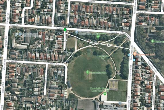
Subject: Lawson Avenue, Marrickville – Amended Raised Threshold Design Plan No. 6198_A (Midjuburi-Marrickville Ward/ Summer Hill Electorate/ Inner West PAC)
Prepared By: Jennifer Adams - Engineer – Traffic and Parking Services
Authorised By: John Stephens - Traffic and Transport Services Manager
SUMMARY
An amended detailed design plan has been finalised for the proposed raised threshold treatment in Lawson Avenue, Marrickville. The works are part of road, footpath and flooding improvements in Lawson Avenue, Marrickville.
Consultation was undertaken with owners and occupiers of adjoining properties in Lawson Avenue regarding the amended proposal. It is recommended that the amended detailed design plan 6198_A be approved.
|
RECOMMENDATION
THAT the amended detailed design plan (Design Plan No.6198_A) for the raised threshold in Lawson Avenue, Marrickville be APPROVED. |
BACKGROUND
Design plans for works as part of road, footpath and flooding improvements in Lawson Avenue, Marrickville were presented at the Local Traffic Committee (LTC) meeting held on 4 March 2019 – Item 5. The Committee members agreed with the Officer’s recommendation; however, in later discussions and realisation of the significant flooding issues at the site the relocation of the threshold was considered to be necessary. The approved design plan has subsequently been amended and is presented to the Committee again for endorsement.
The proposed works include construction of a raised threshold, road re-sheeting, footpath rehabilitation, kerb and gutter reconstruction, drainage works and associated signage and line marking.
The works are part of the local roads renewal capital works program to improve the streetscape of local streets such as Lawson Avenue, Marrickville where the asphalt road and concrete footpath are in poor condition. In this case Council has also taken the opportunity to improve pedestrian safety by including a raised threshold in Lawson Avenue as part of the proposed works. Various surrounding land uses generate significant pedestrian activity along Frazer Street passing over Lawson Avenue intersection, therefore the proposed raised threshold works will slow vehicles in Lawson Avenue as they approach Frazer Street, thereby increasing pedestrian safety.
Moreover, the proposed raised threshold has been found to be beneficial for mitigating flooding issues along Lawson Avenue. This is achieved by the threshold redirecting stormwater away from the intersection of Lawson Avenue and Frazer Street towards the Marrickville Playground and into Marrickville Oval. The amendment to the location of the threshold was required when further information regarding localised flooding issues became available.
FINANCIAL IMPLICATIONS
Funding of $180,000 has been allocated in Council’s 2018/19 capital works program for the project.
OTHER STAFF COMMENTS
Site Location
Lawson Avenue, Marrickville is one of five streets surrounding Marrickville Park. As Marrickville Park hosts Marrickville Croquet Club, Marrickville Lawn Tennis Club and various sporting activity on Marrickville Oval, pedestrian activity along Frazer Street, crossing Lawson Avenue is relatively high.
Lawson Street is approximately 62m long and 6.1m wide, with Frazer Street on the northern end and a cul-de-sac on the southern end. It serves as an access road and on-street parking for 10 residential properties and short-term parking for Marrickville Park visitors.

Design Plan 6198 – that went to 4 March 2019 and was approved
The proposed works included the following:
· Reconstruction of concrete footpath and new grass verge on the western side of Lawson Avenue,
· Reconstruction of concrete footpath and provide new swale in Marrickville Park (subject to detail design and budget allocation)
· Reconstruction of concrete kerb and/or gutter,
· Construction of new concrete raised threshold,
· Installing associated traffic signs and line marking
· Installing new stormwater pipes and pits,
· Resurfacing asphalt roadway,
· Reconstruction of two (2) kerb ramps,
· Planting of seven (7) new trees.
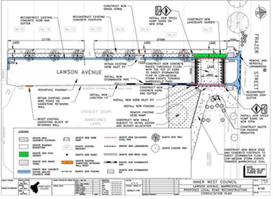
Amended design plan 6198_- showing relocation of threshold to mitigate potential flooding
The amended detailed design plan (Design Plan 6198_A) is shown below and outlines the proposed works along the length of Lawson Avenue, Marrickville. There is no loss in on-street parking in the proposed works and all current vehicular access to adjoining properties will be retained.
The amendment includes:
· Repositioning of new concrete raised threshold at approximately 10m from dish drain
· Construction of kerb opening to divert the stormwater to the Marrickville Park
· Construction of full width concrete footpath with landscaped tree pits
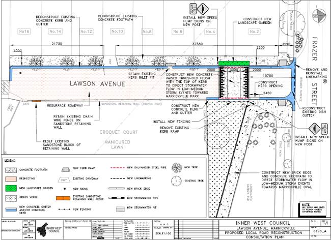
PUBLIC CONSULTATION
The amended design plan was sent out to 4 surrounding properties and no responses were received. Consultation period started on 18 March and closed on 15 April 2019.
CONCLUSION
It is recommended that the amended detailed design plan (Design Plan No. 6198_A) for the proposed raised threshold be APPROVED to improve pedestrian safety and traffic conditions at this intersection and to aid mitigating current local flooding issues.
|
|
Local Traffic Committee Meeting 6 May 2019 |
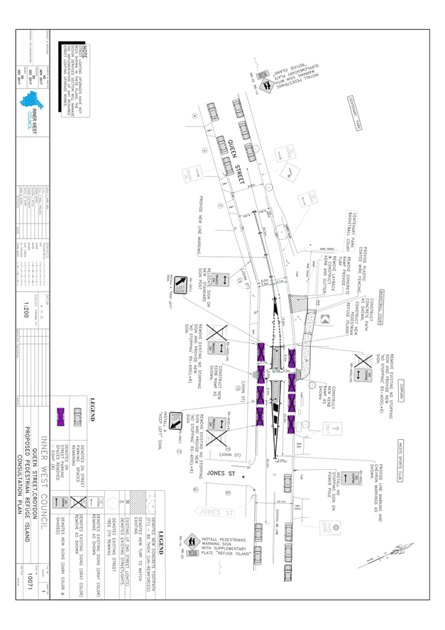
Subject: Queen Street, Croydon - Proposed Pedestrian
Refuge
(Gulgadya-Leichardt Ward/Strathfield Electorate/Burwood PAC)
Prepared By: Boris Muha - Engineer – Traffic and Parking Services
Authorised By: John Stephens - Traffic and Transport Services Manager
|
RECOMMENDATION
THAT
1. The detailed design plan (Design Plan No. 10071) for the proposed pedestrian refuge in Queen Street, west of Jones Street, Croydon, be approved; and
2. A ‘Caution Driveway’ sign (W2-206-1) be considered following installation of the refuge on the eastern approach to the refuge facing westbound traffic, if required.
|
BACKGROUND
Requests over time have been made by residents for a safe crossing facility to be provided in Queen Street, Croydon, near Jones Street to access various sporting and recreational facilities in the area.
As part of Council’s capital works program, a proposed pedestrian refuge facility is listed for construction at the above location to improve pedestrian safety and provide traffic calming.
Various on-site investigation/surveys had established insufficient pedestrian numbers to warrant a ‘marked (zebra) foot-crossing’ under the RMS guidelines and a pedestrian refuge was therefore considered in lieu of a pedestrian (zebra) crossing.
FINANCIAL IMPLICATIONS
Funding in the amount of $70,000 is available to carry out the work under the Capital Works-Traffic Facility Program.
OTHER STAFF COMMENTS
With reference made to the Locality and Consultation Area Map below and the detailed plan (Attachment 1), the following comments are provided.
Site Conditions/surveys
· Queen Street is a Local Road, two-way traffic with a volume around 5000 vehicle per day. It connects at Croydon Road and continuous to link traffic movement to Lucas Road in Burwood.
· Queen Street west of the proposed location of the refuge borders Burwood Council and Inner West Council. The proposed works are wholly within the Inner West Council area.
· Queen Street in the area around the proposed refuge is approximately 8.0 metres kerb to kerb at the road bend widening out to 10.1 metres at the location of the refuge.
· Recent traffic counts conducted from 12 April to 18 April 2019, west of the bend in approach to the refuge, measured 85th percentile speeds of 52.9 km/h eastbound and 51.4 km/h westbound.
· Apart from the roundabout intersection at Croydon Road and Queen Street, no accidents were recorded along Queen Street from Croydon Road to properties No.2 to No.4 Queen Street from available RMS crash statistics in the last 5 years.
Design elements:
The following works are proposed and are illustrated on the attached plan;
- Construct a new pedestrian refuge in Queen Street.
- Construct new kerb ramps on both side of the proposed pedestrian island.
- Extend existing path;
- Remove existing concrete ramp and provide turf
- Remove existing lay-back and provide kerb & gutter
- Extend wire fence along the path
- Implement new line marking and signage to facilitate better traffic flow and for pedestrian safety.
General comments:
· The refuge is proposed in Queen Street, west of Jones Street near the sporting fields (Centenary Park) and Basketball and playground areas to primarily cater for pedestrian movements to those facilities west and east of Queen Street.
· The refuge can also assist pedestrian access, to the West Sports Club and unleashed dog park entrance located on the northern side, opposite Jones Street.
· The proposal is considered to supplement and compliment proposed pedestrian facility improvements along Croydon Road.
· Pedestrians are observed to cross near the bend of the road. Apart from the refuge providing improved pedestrian amenity, it is considered that the refuge would improve the safety of pedestrians crossing at the location, and similarly provide for traffic calming in and out of the bend.
· Approximately 8 parking spaces would need to be removed to accommodate the refuge. Generally no vehicles are observed to park on the northern side of Queen Street for sake of traffic movement coming around the bend and veering out near towards the kerb. Affected properties in the consultation area were observed to have adequate off-street parking or provision to park off-street. The West Sports Club carpark is currently open though the day and the club gates from Queen Street are closed Sun-Thu 10.30pm to 7.00am and Fri-Sat 12.30am to 8.00am. The community is observed and known to use the carpark during the day.
PUBLIC CONSULTATION
31 consultation letters were distributed to affected residents in the vicinity of the proposed works as shown on the locality and consultation area map in the following diagram.
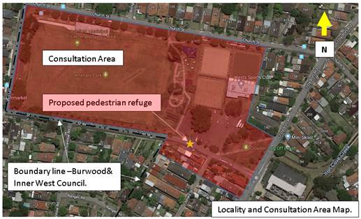
The closure of submissions was on the 12 April 2019.
Burwood Council was also notified on the proposed installation of the pedestrian refuge and invited to comment.
One (1) resident response was received with concern to the proposed refuge location. Burwood Council also responded advising no objection to the proposal. The details of the responses are tabled below.
|
Resident/neighbouring Council Comments |
Officers Response |
|
Resident concerns:
· The island extends all the way between the turning out of Jones Street, the current carpark of West Sport Club, and it also interferes with access to my current driveway (No.15 Queen Street). · It extends at the bending corner of Queen Street, where visibility is poor and even dangerous for driver and pedestrians- not helpful for pedestrian of this area. · If a refuge island or speed hump is required it should be opposite the current dog park(where most people is crossing) or after the bend-to also help slowing down the traffic at the turning point and downhill slope
· The resident at No.2 Queen Street has raised concerns about the speed of vehicles travelling westbound and the fact that their driveway is located directly after the bend. The refuge should help address any speed issues, however it would be appreciated if a ‘Caution Driveways’ sign could also be considered as part of the design.
Burwood Council response:
· Burwood Council raises no objections to the plan and believe it will be of great benefit to the community.
|
· The physical refuge islands do not interfere in access to the West Sports Club and No.15 Queen Street. The painted island linemarking was broken (in amendment to the plan) for vehicles to access the driveway of No.15 Queen Street. The painted island linemarking will also be broken at the point where vehicles turn left into the entry driveway of the club, west of Jones Street, if necessary. · Vehicle turning movements in access to the driveways has been checked to be satisfactory. · Stopping sight distance in respect to visibility (from the proposed kerb ramps) has been investigated to be within acceptable distance based on the 85th percentile speed under Austroads guidelines. The refuge will also act to lower vehicular speeds and further improve the stopping sight distance. · The location is considered appropriate to mainly cater for pedestrian movements to and from the sports and playground areas both west and east of Queen Street. It is situated away from the bend to allow the safe and proper flow of traffic, operation and construction of the refuge. The presence of the facility on the crest of the road east of the bend is more evident in view of traffic in both directions of travel.
· The sign is a W2-206-1 warning sign which can be delegated under authority of Council. This will be considered under final amendment of the design and placed on the eastern approach to the refuge and bend of the road.
· Noted. |
CONCLUSION
It is recommended that the detailed design plan (Design Plan No. 10071) of the proposed pedestrian refuge be approved to improve pedestrian safety and provide traffic calming in the vicinity of the various sporting and recreational facilities in the area.
|
1.⇩ |
Queen Street, Croydon - Proposed Pedestrian Refuge |
|
|
Local Traffic Committee Meeting 6 May 2019 |
Subject: Minor Traffic Facilities (All Wards/ All Electorates/ All PACs)
Prepared By: Brinthaban Baskaran - Student Traffic Engineer
Authorised By: John Stephens - Traffic and Transport Services Manager
|
RECOMMENDATION
THAT:
1. A 6m ‘Disabled Parking’ zone be removed in front of No. 20 Silver Street, Marrickville;
2. A 6m ‘Disabled Parking’ zone be removed in front of No. 42 Hubert Street, Leichhardt;
3. A 6m ‘Disabled Parking’ zone be removed in front of No. 1 Pearson Street, Balmain East, and the 2P resident parking be reinstated;
4. A 6m ‘Disabled Parking’ zone be removed in front of No. 9 Don St, Newtown;
5. A 6m 'Disabled Parking’ zone be installed in front of No. 24 Annesley Street, Leichhardt;
6. A 6m 'Disabled Parking’ zone be installed in front of No. 169 Elswick Street, Leichhardt;
7. A 6m 'Disabled Parking 8am-5pm’ zone be installed in front of No. 2 Herbert Street, Dulwich Hill replacing the existing 1P parking restrictions;
8. A 9m 'Works Zone 7:00am – 6:00pm Mon-Fri and 8.00am-1.00pm Sat' be installed in front of No. 3 Hartley Street, Rozelle for 12 weeks;
9. A 12m 'Works Zone 7:00am – 6:00pm Mon-Fri and 8.00am-1.00pm Sat' be installed in front of No. 7 Palace Street, Petersham for 6 weeks;
10. A 9m 'Works Zone 7:00am – 6:00pm Mon-Fri and 8.00am-1.00pm Sat' be installed in front of No.110-112 Edith Street, Leichhardt for 26 weeks and then be reviewed for a time extension and;
11. A 45m 'Works Zone 7:00am – 6:00pm Mon-Fri and 8.00am-1.00pm Sat' be installed in Hunter Street, on the side boundary of No.127 New Canterbury Road, Lewisham for 12 weeks, subject to written consent being received from the directly affected property. |
BACKGROUND
This report considers minor traffic facility applications by Inner West Council, and includes
‘Disabled Parking’ and ‘Works Zone’ requests.
FINANCIAL IMPLICATIONS
Nil.
OTHER STAFF COMMENTS
1. Removal of ‘Disabled Parking’ restriction – Silver Street, Marrickville
A resident has advised that the ‘Disabled Parking’ zone in front of No.20 Silver Street, Marrickville, is not being utilised. Council staff have contacted the original applicant and they have confirmed that the ‘Disabled Parking’ zone is no longer required.
It is recommended that the 6m ‘Disabled Parking’ zone in front of No. 20 Silver Street, Marrickville be removed.
2. Removal of ‘Disabled Parking’ restriction – Hubert Street, Leichhardt
A resident has advised that the ‘Disabled Parking’ zone in front of No.42 Hubert Street, Leichhardt, is not being utilised. Council staff have contacted the original applicant and they have confirmed that the ‘Disabled Parking’ zone is no longer required.
It is recommended that the 6m ‘Disabled Parking’ zone in front of No.42 Hubert Street, Leichhardt be removed.
3. Removal of ‘Disabled Parking’ restriction – Pearson Street, Balmain East
A resident has advised that the ‘Disabled Parking’ zone in front of No.1 Pearson Street, Balmain East, is not being utilised. Council staff have contacted the original applicant and they have confirmed that the ‘Disabled Parking’ zone is no longer required.
It is recommended that the 6m ‘Disabled Parking’ zone in front of No.1 Pearson Street, Balmain East be removed and the 2P resident parking be reinstated.
4. Removal of ‘Disabled Parking’ restriction – Don Street, Newtown
The applicant to the ‘Disabled Parking’ zone in front of No.9 Don Street, Newtown, has advised that the ‘Disabled Parking’ zone in front of the property is no longer required.
It is recommended that the 6m ‘Disabled Parking’ zone in front of No.9 Don Street, Newtown be removed.
5. Installation of ‘Disabled Parking’ restriction – Annesley Street, Leichhardt
The resident of No.24 Annesley Street, Leichhardt has requested the installation of 'Disabled Parking Zone’ in front of the resident’s property. A site investigation has revealed that the property does not have off street parking. The applicant does not require the use of wheelchair.
It is recommended that a 6m 'Disabled Parking Zone’ be installed in front of No.24 Annesley Street, Leichhardt.
No. 24 Annesley Street, Leichhardt.
6. Installation of ‘Disabled Parking’ restriction – Elswick Street, Leichhardt
The resident of No.169 Elswick Street, Leichhardt has requested the installation of 'Disabled Parking Zone’ in front of the resident’s property. A site investigation has revealed the property does not have off street parking. The applicant does not require the use of wheelchair.
It is recommended that a 6m 'Disabled Parking Zone’ be installed in front of No.169 Elswick Street, Leichhardt.
No. 169 Elswick Street, Leichhardt
7. Installation of ‘Disabled Parking’ Restriction – Herbert Street, Dulwich Hill
Sunnyfield Disability services have requested the installation of a 'Disabled Parking’ zone in front of their business premises at No.2 Herbert Street, Dulwich Hill for use by the organisation’s vehicles and as a drop-off/pick-up space for visitors. A site investigation has revealed the property does not have off street parking. The users of the ‘Disabled Parking’ space may require the use of wheelchair.
It is recommended that a 6m 'Disabled Parking 8am-5pm’ zone be installed in front of No.2 Herbert Street, Dulwich Hill replacing the existing 1P parking restrictions.
No. 2 Herbert Street, Dulwich Hill
8. Installation of ‘Works Zone’ restriction – Hartley Street, Rozelle
The applicant (No.3 Hartley Street) has requested the installation of a temporary 9m 'Works Zone 7:00am – 6:00pm Mon-Fri and 8.00am-1.00pm Sat' restriction in front of No.3 Hartley Street, Rozelle for 12 weeks.
It is recommended that a 9m 'Works Zone 7.00am – 6:00pm Mon-Fri and 8.00am-1.00pm Sat' restriction be installed in front of No.3 Hartley Street, Rozelle for 12 weeks.
No. 3 Hartley Street, Rozelle.
9. Installation of ‘Works Zone’ Restriction – Palace Street, Petersham
The applicant (No.7 Palace Street) has requested the installation of a temporary 12m 'Works Zone 7:00am – 6:00pm Mon-Fri and 8.00am-1.00pm Sat' restriction in front of No.7 Palace Street, Petersham for 6 weeks.
It is recommended that a 12m 'Works Zone 7.00am – 6:00pm Mon-Fri and 8.00am-1.00pm Sat' restriction be installed in front of No.7 Palace Street, Petersham for 6 weeks.
No.7 Palace Street, Petersham
10. Installation of ‘Works Zone’ Restriction – Edith Street, Leichhardt
The applicant (No.112 Edith Street) has requested the installation of a temporary 9m 'Works Zone 7:00am – 6:00pm Mon-Fri and 8.00am-1.00pm Sat' restriction in front of Nos.110-112 Edith Street, Leichhardt for 40 weeks. The owners of the neighbouring property (No.110 Edith Street) have provided concurrence for the proposed ‘Works Zone’ to extend along their frontage.
It is recommended that a 9m 'Works Zone 7:00am – 6:00pm Mon-Fri and 8.00am-1.00pm Sat' restriction be installed in front of Nos.110-112 Edith Street, Leichhardt for 26 weeks and then be reviewed for a time extension.
No. 110-112 Edith Street, Leichhardt
11. Installation of ‘Works Zone’ restriction – Hunter Street, Lewisham
The applicant (No.147 New Canterbury Road) has requested the installation of a temporary 45m 'Works Zone 7:00am – 6:00pm Mon-Fri and 8.00am-1.00pm Sat' in Hunter Street on the side boundary of No.127 New Canterbury Road, Lewisham for 12 weeks.
It is recommended that a 'Works Zone 7:00am – 6:00pm Mon-Fri and 8.00am-1.00pm Sat' be installed in Hunter Street on the side boundary of No.127 New Canterbury Road, Lewisham for 12 weeks.
Hunter Street, Lewisham – side boundary of on the side boundary of No.127 New Canterbury Road
PUBLIC CONSULTATION
Nil.
|
|
Local Traffic Committee Meeting 6 May 2019 |
Subject: SMITH STREET, MARRICKVILLE - PROPOSED PERMIT PARKING (MIDJUBURI-MARRICKVILLE WARD/ SUMMER HILL ELECTORATE/ INNER WEST PAC)
Prepared By: Mary Bailey - Parking Planner
Authorised By: John Stephens - Traffic and Transport Services Manager
|
RECOMMENDATION
THAT:
1. Implementation of ‘2P Permit Holders Excepted 8:30am-6:30pm Monday to Friday Area M19’ in Smith Street (northern side) between 1 meter east of driveway on boundary of property no. 53A Smith Street and 1 meter west of Smith Street entrance to driveway of 62 Fitzroy Street (total length approx. 13.3 meters) be approved;
2. Implementation of ‘2P Permit Holders Excepted 8:30am-6:30pm Monday to Friday Area M19’ in Smith Street (southern side) between 5.5 meters east of driveway of property no. 36 Smith Street and 1 meter west of driveway of property no. 50 Smith Street (total length approx. 24 meters) be approved; and
3. Implementation of ‘2P Permit Holders Excepted 8:30am-6:30pm Monday to Friday Area M19’ in Smith Street (southern side) directly adjacent to property Nos. 54-56 Smith; be approved.
|
BACKGROUND
Council is proposing the introduction of permit parking restrictions in Smith Street, Marrickville following representations from residents. The area is a mixed industrial and residential use and it is recognised that parking for the industrial users should also be considered. The permit parking proposal is limited to sections outside residential homes. Smith Street adjoins Fitzroy Street when in February 2019, permit parking was introduced between Smith Street and Edinburgh Road.
The permit parking was a result of a petition from Fitzroy Street residents. At that time there was no proven support for any extension of the proposed permit parking into Smith Street and the approach was taken to limit the extent of permit parking to that which was supported.
Subsequent to the implementation of the permit parking in Fitzroy Street, Council received a petition from residents in Smith Street and a consultation was carried out on an initial proposal. Following feedback from a resident in Smith Street Council has developed a revised proposal extending the proposed permit parking by an additional 2 spaces. The original proposal is shown in Figure 1 and the revised proposal in Figure 2. Residents were re-notified of the revised proposed and provided with details of giving feedback and the procedure for attending the Traffic Committee meeting.
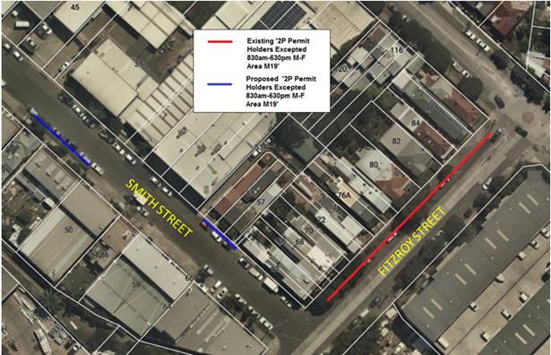
Figure 1: Initial Proposal for Permit Parking Smith Street
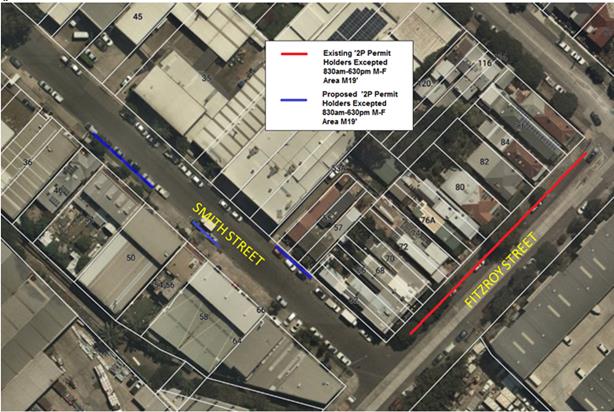
Figure 2: Revised Proposal for Permit Parking Smith Street
Parking surveys undertaken on Wednesday and Thursday 25 and 26 July 2018 showed that there was a high daytime occupancy in Smith Street. (See Table 1). The parking occupancy generally ranged between 88% to 96% with the lowest daytime occupancy being 69% at 5pm on the Wednesday. It is considered that there is sufficient occupancy to warrant the proposal for limited permit parking.
Table 1:
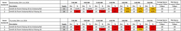
There are a total of nine (9) households in Smith Street and the proposal is for the provision of ten (10) permit parking spaces.
FINANCIAL IMPLICATIONS
The cost of the signposting will be funded from Council’s operating budget for signs and line marking.
PUBLIC CONSULTATION
In early March 2019, a petition was received from residents in Smith Street seeking the implementation of permit parking. A letter was sent to affected residents on 29 March 2019.
There were four (4) responses to the original proposal. All respondents were in favour of the proposal to implement permit parking and one resident recommended extending the permit parking to cover Nos.54-56 Smith Street. A separate representation was received from the proprietor of the coffee shop (residence above) property at No.54 Smith Street, seeking short term parking. The revised proposal will provide turnover of parking near this property.
No objections to the proposal were received.
|
|
Resident Comment |
Officer Comment |
|
Support |
I would love permit parking in Smith Street. It is impossible to find parking most days |
|
|
|
A very welcome move thank you |
|
CONCLUSION
Given that parking occupancy is high during the proposed permit parking hours and the strong support from residents, the proposal to introduce permit parking in Smith Street, Marrickville is supported.
|
|
Local Traffic Committee Meeting 6 May 2019 |
Subject: KINGSTON LANE, CAMPERDOWN - PROPOSED PARKING RESTRICTIONS (DAMUN-STANMORE WARD/ NEWTOWN ELECTORATE/ INNER WEST PAC)
Prepared By: Mary Bailey - Parking Planner
Authorised By: John Stephens - Traffic and Transport Services Manager
|
RECOMMENDATION
THAT the implementation of ‘No Parking’ in Kingston Lane, Camperdown (eastern side) between Rowley Lane and Rowley Street, be approved
|
Following representations from a resident, Council is proposing to introduce ‘No Parking’ restrictions in Kingston Lane between Rowley Lane and Rowley Street in order to improve access to off-street parking and the thoroughfare.
The section of Kingston Lane opposite the proposed parking restrictions consists of garage doors along the length; therefore, no parking restrictions are required on the western side. The proposal is illustrated in Figure 1 below.
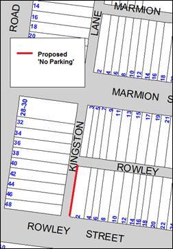
Figure 1: Proposed restrictions in Kingston Lane
The illustrations shown below (Figure 2) of the subject section of Kingston Lane indicates that parking in this section of laneway is a regular occurrence.
|
4 March 2019 |
27 Dec 2018
|
|
21 Jan 2019 |
11 April 2018
|
Figure 2: parking conditions in subject section of Kingston Lane over period of time
It should be noted that when vehicles are parked directly opposite a garage entrance in laneways, ingress/egress can be extremely difficult. Laneways were generally built to provide service access for properties and access into off-street parking facilities.
According to Council’s Laneway Guidelines (December 2015) Laneways can be used for a variety of purposes which are listed below:
· Access for garbage collection trucks and deliveries where required.
· Access to existing off-street parking within properties.
· Access for emergency vehicles, pedestrians and cyclists.
· Accessible parking for people with disabilities where appropriate.
· Parking where space is available and access is maintained.
Kingston Lane is approximately 4.9m wide. The Laneway Guidelines state that, “For parking to be allowed in a narrow laneway, the Australian Standards require that parallel parking spaces be at least 2.1 metres wide and NSW Road Rules requires that at least 3 metres must be available between a parked car and the kerb or edge of the laneway to allow moving vehicles to pass safely. Therefore, laneway widths that are less than 5.1 metres are too narrow to allow parking as any parked vehicle would prevent traffic from using the laneway.”
In this case, Council has received concerns that access to off-street parking is being restricted because of parking in the laneway. Furthermore, the laneway is only is 4.8m wide. Therefore, according to Council’s Laneway Guidelines, Kingston Lane is not wide enough to cater for parking.
FINANCIAL IMPLICATIONS
The cost of the signposting will be covered from Council’s operating budget for signs and line marking.
PUBLIC CONSULTATION
Council sent the proposal by letter to affected residents on 20 March 2019. There were four (4) submissions all in favour of the proposal.
|
Support |
Officers Comments |
|
Vehicles often park too close to the corner of Rowley Street in Kingston Lane. I feel the proposal, as above, should be implemented. |
The proposal addresses residents’ concerns |
|
Can a ‘No Parking’ sign be installed in the laneway as cars are parking behind the garage door |
|
|
I support the proposed ‘No parking’ restriction in Kingston lane |
CONCLUSION
Given the evidence of parking in the laneway, complaints from residents about access to off street parking being obstructed; the laneway being less than 5.1m wide and the support from residents; the proposal is supported.
|
|
Local Traffic Committee Meeting 6 May 2019 |
Subject: BOOTH STREET AT COLLINS LANE, ANNANDALE - PROPOSED 'NO STOPPING' RESTRICTION (GULGADYA-LEICHHARDT WARD / BALMAIN ELECTORATE / LEICHHARDT PAC)
Prepared By: Vinoth Srinivasan - Engineer - Traffic and Parking Services
Authorised By: John Stephens - Traffic and Transport Services Manager
|
RECOMMENDATION
THAT a 15m ‘No Stopping’ zone be installed on the southern side of Booth Street, east of Collins Lane, Annandale. |
BACKGROUND
Council has received concerns regarding vehicles parking too close to the intersection of Booth Street and Collins Lane, Annandale, within the statutory 10m ‘No Stopping’ zone. Parking in this manner obstructs manoeuvring space, as well as vehicle to vehicle sightlines and vehicle to pedestrian sightlines.
Site location & road network
|
Street Name(s) |
Booth Street and Collins Lane, Annandale |
|
Section |
Intersection |
|
Traffic Volume |
- |
|
Recorded Crash History (5 year) |
Nil. |
|
Recorded 85% speed |
- |
|
Speed Limit |
Booth Street - 50km/h west of Collins Lane and 40km/h HPAA east of Collins Lane Collins Lane – 50km/h |
|
Carriageway Width |
Booth Street – approx. 12.8m Collins Lane – approx. 5m |
|
Carriageway Type |
Booth Street - two way street with one travel lane in each direction, eastbound bicycle lanes and kerb side parking lanes. Collins Lane - two way laneway. |
|
Road Classification (State, Regional, Local) |
Collins Lane – Local Booth Street - Regional |
FINANCIAL IMPLICATIONS
Nil.
OTHER STAFF COMMENTS
In order to alleviate the sight visibility and manoeuvring space issues, it is proposed to signpost a 15m ‘No Stopping’ zone on the southern side of Booth Street, east of Collins Lane. The 15m ‘No Stopping’ zone would include the statutory 10m ‘No Stopping’ zone and the driveway of No.88 Booth Street.
The proposal is shown on the following aerial photo.
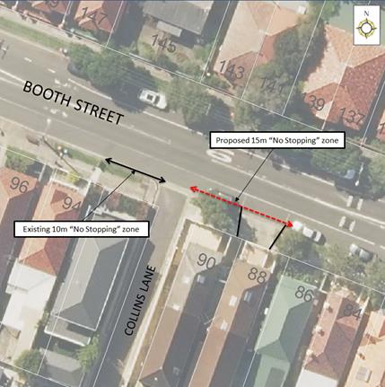
PUBLIC CONSULTATION
|
A letter outlining the above proposal was mailed to the affected 9 properties in Booth Street and Collins Lane, Annandale, requesting residents’ views regarding the proposal. |
|
Two (2) responses were received regarding Council’s proposal to install a 15m ‘No Stopping’ restriction on Booth Street, east of Collins Lane, Annandale.
The following table details the comments raised by the residents.
|
Residents’ Comments |
Officer Comments |
|
I do not support Council’s proposal as there is currently a shortage of on-street car parking spaces on Booth Street for residents like myself who don’t have off-street parking. There are currently 17 houses on Booth Street, between Young Street and Annandale Street and there are a total of 16 parking spots (12 on-street spots and 4 off-street). I believe on average every household has 1-2 vehicles each, requiring a maximum 34 cars to park within close proximity. Residents utilising the lane have off-street parking and do not share the same frustration as we do. I am unable to find a parking spot close to home most nights and find it difficult to carry my groceries and move my children when I have to park far away. |
Several concerns were received from residents of the area, regarding sight visibility issues when vehicles parked too close to the intersection, within the statutory 10 metre ‘No Stopping’ zone.
Site investigations have identified that vehicles parked close to the intersection impeded sight visibility. Signposting the ‘No Stopping’ zone is required to improve the safety for both pedestrians and motorists at the intersection.
Council will investigate the possibility of installing the statutory 10m ‘No Stopping’ restrictions at the intersection of Collins Street and Collins Lane as a separate matter. |
|
We do not support Council’s proposal as many residents use the subject location as a parking spot and we have not witnessed any issues in the past 40 years we’ve been living here. A parked vehicle at the proposed location will not obstruct the view of oncoming traffic as Booth Street has an inclination that enables to see ‘up’ the street. Furthermore, a car being parked in this location stops vehicles coming down Booth Street that sometimes veer to the left to avoid the speed hump altogether. When a car is not parked in this location, cars will continue at a higher speed and dangerously veer left to avoid the speed hump. We would also like Council to consider installing statutory 10m ‘No Stopping’ restrictions at the intersection of Collins Street and Collins Lane as there is a great safety concern in that location. Vehicles are often parked less than a metre away from the intersection, forcing vehicles to pull out further onto Collins Street to look for oncoming traffic before pulling into Collins Street. |
|
|
Local Traffic Committee Meeting 6 May 2019 |
Subject: COLLINS LANE, ANNANDALE - PROPOSED 'NO PARKING' ZONE (GULGADYA-LEICHHARDT WARD/ BALMAIN ELECTORATE/ LEICHHARDT PAC)
Prepared By: Vinoth Srinivasan - Engineer - Traffic and Parking Services
Authorised By: John Stephens - Traffic and Transport Services Manager
|
RECOMMENDATION
THAT a 3.5m ‘No Parking’ zone be installed on the eastern side of Collins Lane, between the driveways of No.150 and No.148 Annandale Street and opposite the rear garage of No.175A Young Street, Annandale. |
BACKGROUND
Council received concerns from a resident of Young Street, Annandale regarding vehicles parking on the eastern side of Collins Lane, Annandale and subsequently obstructing rear driveway access for property No.175A Young Street.
Site location & Road Network
|
Street Name(s) |
Collins Street, Annandale |
|
Section |
Between Collins Street and Booth Street |
|
Traffic Volume |
- |
|
Recorded Accident History (5 year) |
Nil. |
|
Recorded 85% speed |
- |
|
Speed Limit |
50km/h |
|
Carriageway width |
Approx. 5m |
|
Carriageway Type |
Two way laneway |
|
Road Classification (State, Regional, Local) |
Local |
FINANCIAL IMPLICATIONS
Nil.
OTHER STAFF COMMENTS
In order to alleviate this issue, it is proposed to install a 3.5m ‘No Parking’ zone in the eastern side of Collins Lane, opposite the rear garage of No.175A Young Street, Annandale.
The proposal is shown on the following aerial photo.
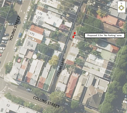
PUBLIC CONSULTATION
|
A letter outlining the above proposal was mailed out to the affected 12 properties in Young Street and Annandale Street, Annandale, requesting residents’ views regarding the proposal.
One (1) response was received in objection to the proposal. |
|
|
Residents’ Comments |
Officer Comments |
|
I object to Council’s proposal as I frequently use Collins Lane and do not see cars parked in the subject location other than the odd construction vehicle. Furthermore, a couple of residents including myself, use the kerb space to place garbage bins which allows vehicles to navigate through the lane easier. |
The proposed ‘No Parking’ zone will not restrict residents from placing bins in the kerb space.
|
|
|
Local Traffic Committee Meeting 6 May 2019 |
Subject: DERBYSHIRE ROAD AND MOORE STREET WEST, LEICHHARDT - 'NO PARKING' AND 'NO STOPPING' RESTRICTIONS (GULGADYA-LEICHHARDT WARD / BALMAIN ELECTORATE / LEICHHARDT PAC)
Prepared By: Vinoth Srinivasan - Engineer - Traffic and Parking Services
Authorised By: John Stephens - Traffic and Transport Services Manager
|
RECOMMENDATION
THAT:
1. The existing ‘No Parking’ zone on the western side of Derbyshire Road, south of William Street be extended to include the Moore Street West Cul-de-sac (approx. 60m extension); and
2. A 12.2m ‘No Stopping’ zone followed by a 7.5m ‘No Parking’ zone be installed on the eastern side of Derbyshire Road, south of William Street, subject to activation of the car park at No.29 Derbyshire Road.
|
BACKGROUND
Concerns have been raised by Sydney Secondary College regarding vehicles parking in the cul-de-sac at the rear of the Sydney Secondary College on Moore Street West, Leichhardt and subsequently obstructing vehicular manoeuvrability and access for waste collection.
Council has also been informed by the College that the existing disused car park at No.29 Derbyshire Road may be activated in the near future for use by the College. Concerns were raised that vehicular access to the carpark is currently restricted as vehicles are parked across the carpark gates.
Council is also awaiting a response from the NSW Police Commissioner on Council's request to make available the disused car park for the parking of bus drivers' private vehicles adjacent to Leichhardt Bus Depot in order to facilitate on-street parking for local residents.
Site location & Road Network
|
Street Name(s) |
Derbyshire Road and Moore Street West, Leichhardt |
|
Section |
Between William Street and cul-de-sac |
|
Traffic Volume |
- |
|
Recorded Accident History (5 year) |
Nil. |
|
Recorded 85% speed |
- |
|
Speed Limit |
50km/h |
|
Carriageway width |
Derbyshire Road - Approx. 5.5m Moore Street West – Varies (min. 8m) |
|
Carriageway Type |
Two way with kerb side parking on the eastern side of Derbyshire Street |
|
Road Classification (State, Regional, Local) |
Local |
FINANCIAL IMPLICATIONS
Nil.
OTHER STAFF COMMENTS
In order to alleviate the manoeuvring space issues, it is proposed to extend the existing ‘No Parking’ zone on the western side of Derbyshire Road, south of William Street to include the cul-de-sac on Moore Street West and continue through to the eastern side of Derbyshire Road, Leichhardt.
Council is also proposing to implement a 12.2m ‘No Stopping’ zone followed by a 7.5m ‘No Parking’ zone on the eastern side of Derbyshire Road, south of William Street to allow vehicular access to the currently disused carpark. The installation of these restrictions will be subject to the activation of the disused car park at No.29 Derbyshire Road, Leichhardt.
Both proposals are shown on the following aerial photo layout.
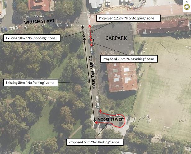
PUBLIC CONSULTATION
Sydney Secondary College has indicated support for the proposal.
|
|
Local Traffic Committee Meeting 6 May 2019 |
Subject: Beames Street, Lilyfield - Angle Parking and Road Reconstruction (Baludarri-Balmain Ward / Balmain Electorate / Leichhardt PAC)
Prepared By: Vinoth Srinivasan - Engineer - Traffic and Parking Services
Authorised By: John Stephens - Traffic and Transport Services Manager
|
RECOMMENDATION
THAT the ‘90 degree angle parking, vehicles under 6m only’ restrictions; ‘No Stopping’ restrictions; kerb and gutter, footpaths and roadway improvements with associated linemarking and signposting in Beames Street, Lilyfield (as per Design Plan No. 10061) be approved.
|
BACKGROUND
Detailed design plans have been prepared for the provision of ‘90 degree angle parking, vehicles under 6m only’ restrictions; ‘No Stopping’ restrictions; improvements to the kerb and gutter, footpath and roadway in Beames Street, Lilyfield (between City West Link and the dead-end).
The detailed design plans have been finalised for the proposed works together with community consultation and are presented in this report for consideration.
Site location & Road Network
|
Street Name(s) |
Beames Street, Lilyfield |
|
Section |
Between City West Link and dead-end |
|
Traffic Volume |
- |
|
Recorded Accident History (5 year) |
Nil. |
|
Recorded 85% speed |
- |
|
Speed Limit |
50km/h |
|
Carriageway width |
13m |
|
Carriageway Type |
Two way with kerb side parking on both sides of the road |
|
Road Classification (State, Regional, Local) |
Local |
FINANCIAL IMPLICATIONS
Funding of $95,000 has been allocated to this project for construction in the 2019/20 capital works program.
OTHER STAFF COMMENTS
Beames Street is a dead-end street accessed via City West Link and is wide enough to support parking on both sides of the street. Parallel parking occurs on the eastern side of the street; however, on the western side of the street, vehicles angle park on the grass verge as there is no existing kerb and gutter to prevent this parking behaviour.
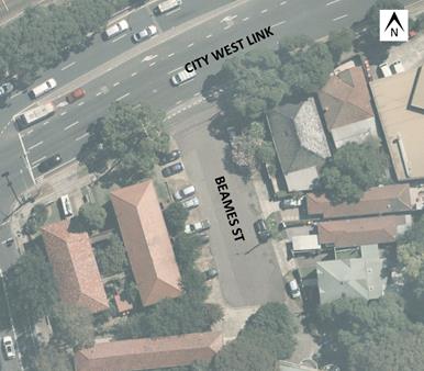
Figure 1 – site locality
As part of this project, kerb and gutter will be provided on the western side of the street and the angle parking will be formalised on the road. The carriageway width will be 13 metres wide from kerb to kerb. The proposed cross section of road will include: 4.8m angle parking lane (90 degree angle parking), 6.1m travel lane and 2.1m parallel parking lane. The angle parking spaces will be against a low kerb, allowing for 600mm overhang.
Design Plan No. 10061
A detailed design plan is shown in Attachment 1 for the angle parking, kerb and gutter, footpath and roadway improvements in Beames Street, Lilyfield and is submitted for consideration.
The proposed scope of works includes the following:
· Construction of new footpath on both sides of the street;
· Construction of new kerb & gutter on the western side of Beames Street;
· Removal of existing asphalt footpath and construction of new concrete footpath;
· Reconstruction of kerb ramps at the City West Link and Beames Street intersection;
· Removal of damaged kerb and gutter and construction of new concrete kerb and gutter;
· Resurfacing of the road (asphalt);
· Reconstruction of driveways, as required to match new works, and removal of any illegal steel plates within the road reserve;
· Replacement of any damaged stormwater outlets from boundary to kerb;
· Provision of new trees;
· Signposting of a 12.8m ‘No Stopping’ zone on the western side of Beames Street, south of City West Link;
· Signposting of 20m ’90 degree angle parking, vehicles under 6m only’ restrictions;
· Linemarking of angle parking bays; and
· Linemarking of 8m double (barrier) linemarking (BB line type) with raised reflective pavement markers (RRPMs) in Beames Street, just south of City West Link.
This proposal will not result in the loss of any on-street parking spaces.
PUBLIC CONSULTATION
|
Consultation was conducted between 20 March 2019 and 12 April 2019. A letter as well as a copy of the design plan was sent to the local residents in Beames Street, Piper Street and Balmain Road, Lilyfield. A total of 51 letters were distributed (as indicated in the plan).
One (1) response was received which was non-traffic related. |
|
|
1.⇩ |
Detailed Design Plan - Beames Street, Lilyfield |
|
|
Local Traffic Committee Meeting 6 May 2019 |
Subject: Hercules Street, Ashfield – Amendment to
Disabled Parking Signage. (Djarrawunang-Ashfield Ward/Summer Hill Electorate/
Burwood PAC)
Prepared By: Boris Muha - Engineer – Traffic and Parking Services
Authorised By: John Stephens - Traffic and Transport Services Manager
SUMMARY
An audit of the current signage in Hercules Street, Ashfield by Council Officers has found that current operation times on the Disabled Parking sign were incorrect and need to be amended.
|
RECOMMENDATION
THAT the ‘Disabled Parking’ restrictions on the eastern side of Hercules Street, between Brown Street and Drakes Lane, be amended from ‘2P Disabled Parking 10am-6pm Mon –Sun’ to ‘Disabled Parking Only 10am-6pm Mon –Sun’ to cover the time outside the Loading Zone period. |
FINANCIAL IMPLICATIONS
Nil
OTHER STAFF COMMENTS
The zone comprising of two parking spaces is in a shared parking area of a 'Loading Zone' and ‘Disabled Parking Zone’. The zones are currently signposted as ‘Loading Zone 6am-10am Mon-Fri; 2P Disabled Parking 10am-6pm Mon –Sun’.
The proposed changes to the signage are ‘Loading Zone 6am-10am Mon-Fri; P Disabled Parking Only 10am-6pm Mon – Sun’ as shown in the following diagram.
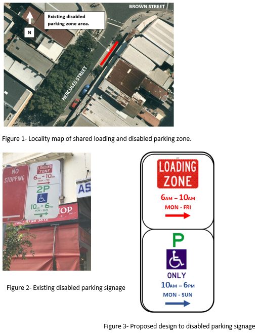
PUBLIC CONSULTATION
Notification letters have been forwarded to the nearby shopkeepers informing them of the changes required to the Disabled Parking signs.
CONCLUSION
It is recommended that the amended ‘Disabled Parking’ signs be supported.
|
|
Local Traffic Committee Meeting 6 May 2019 |
Subject: Ramsay Street at Walker Avenue, Haberfield - Proposed 'No Stopping' restriction (Gulgadya-Leichhardt Ward/ Summer Hill Electorate/ Burwood PAC)
Prepared By: Brinthaban Baskaran - Student Traffic Engineer
Authorised By: John Stephens - Traffic and Transport Services Manager
|
RECOMMENDATION
THAT a 10m ‘No Stopping’ restriction be installed on the western side of Ramsay Street, south of Walker Avenue, Haberfield. |
BACKGROUND
Council has received concerns regarding vehicles parking too close to the intersection of Ramsay Street and Walker Avenue, Haberfield, within the statutory 10m ‘No Stopping’ zone. Parking in this manner obstructs manoeuvring space, as well as vehicle to vehicle sightlines and vehicle to pedestrian sightlines.
Site location & road network
|
Street Name(s) |
Ramsay Street and Walker Avenue, Haberfield |
|
Section |
Intersection |
|
Traffic Volume |
- |
|
Recorded Crash History (5 year) |
Nil. |
|
Recorded 85% speed |
- |
|
Speed Limit |
50km/h |
|
Carriageway Width |
Ramsay Street - approx. 12m Walker Avenue – approx. 11.5m |
|
Carriageway Type |
Two way with one travel lane in each direction and kerb side parking lanes |
|
Road Classification (State, Regional, Local) |
Ramsay Street – Regional Walker Avenue – Local |
FINANCIAL IMPLICATIONS
Nil.
OTHER STAFF COMMENTS
In order to alleviate this issue, it is proposed to signpost a 10m ‘No Stopping’ zone on the western side of Ramsay Street, south of Walker Avenue as shown on the following plan.
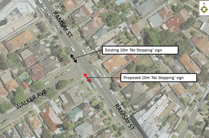
PUBLIC CONSULTATION
A letter outlining the above proposal was mailed out to the affected properties (10 properties) in Ramsay Street and Walker Avenue, Haberfield.
One response was received in support of the proposal.
|
Residents’ Comments |
Officer Comments |
|
I support Council’s proposal as it is currently difficult to turn right into Ramsay Street from Walker Avenue as vehicles are often parked close to the intersection, restricting sight lines.
Due to WestConnex workers, there are also vehicles parking all along Walker Avenue up to the intersection of Ramsay Street. This makes it difficult to turn left into Walker Avenue from Ramsay Street as vehicles are often parked less than a metre from the intersection. Drivers are forced to turn left into the middle of Walker Avenue which is dangerous as there is oncoming traffic from the northern side. |
Noted. Illegal parking in Walker Avenue will be investigated as a separate matter. |
|
|
Local Traffic Committee Meeting 6 May 2019 |
Subject: New Street, Ashfield – Proposed
statutory ‘No Stopping’ in New Street at intersection with Queen
Street. (Djarrawunang-Ashfield Ward/ Summer Hill Electorate/ Burwood
PAC)
Prepared By: Boris Muha - Engineer – Traffic and Parking Services
Authorised By: John Stephens - Traffic and Transport Services Manager
|
RECOMMENDATION
THAT statutory 10 metres of ‘No Stopping’ restriction be placed on the southern side of New Street, west of Queen Street, Ashfield.
|
BACKGROUND
A request has been made by a resident in New Street to have statutory 10 metres of ‘No Stopping’ placed on the southern corner of New Street at Queen Street, Ashfield. The restriction will aid to improve visibility and vehicle manoeuvrability at the intersection. The proposal will supplement the existing 'No Stopping' restriction on the opposite side of New Street.
FINANCIAL IMPLICATIONS
Nil.
OTHER STAFF COMMENTS
New Street is a cul-de-sac street approximately 7.5 metres in width. The resident has advised that with an existing having kerb blister islands around the corner in Queen Street, motorists are unaware of the distance they should be parking from the corner of the intersection. Kerb blister islands do not form part of an extension of the kerb and footway. Vehicles in this case should not be park within 10 metres of the corner as measured from the prolongation of the side street kerb line.
Furthermore, due to the narrowness of New Street, the proposed ‘No Stopping’ restriction will assist to clear parking from the corner for sake of traffic movement around the intersection –see following diagram.
PUBLIC CONSULTATION
Notification letters have been issued out to residents in the vicinity advising that Council proposes to signpost the above corner with a statutory ‘No Stopping’ restriction.
CONCLUSION
It is recommended that a 'No Stopping’ restriction be placed on the southern side of New Street 10 metres from Queen Street, Ashfield.
|
|
Local Traffic Committee Meeting 6 May 2019 |
Subject: Stanmore Lane, Stanmore - Proposed 'No Parking' restrictions Damun-Stanmore Ward/ Newtown Electorate/ Inner West PAC)
Prepared By: Mary Bailey - Parking Planner
Authorised By: John Stephens - Traffic and Transport Services Manager
|
RECOMMENDATION
THAT the installation of ‘No Parking’ restrictions in Stanmore Lane – southern side from its intersection with Rosevear Street (road closure) to its intersection with Douglas Street/Railway Avenue, Stanmore (road closure); be approved.
|
BACKGROUND
Representations have been received for the introduction of ‘No Parking’ restrictions in Stanmore Lane between the road closures at Rosevear Street and Douglas Street/Railway Avenue, in order to improve access to off-street parking and the thoroughfare.
The section opposite the proposed parking restrictions consists of driveways and garage doors along the length, therefore no parking restrictions are required on the northern side.
It should be noted that when vehicles are parked directly opposite a garage entrance in laneways, ingress/egress can be extremely difficult. Laneways were generally built to provide service access for properties and access into off-street parking facilities.
According to Council’s Laneway Guidelines (December 2015) Laneways can be used for a variety of purposes which are listed below:
· Access for garbage collection trucks and deliveries where required
· Access to existing off-street parking within properties
· Access for emergency vehicles, pedestrians and cyclists
· Accessible parking for people with disabilities where appropriate
· Parking where space is available and access is maintained.
Stanmore Lane is approximately 4.8m wide. The Laneway Guidelines state that, “For parking to be allowed in a narrow laneway, the Australian Standards require that parallel parking spaces be at least 2.1 metres wide and NSW Road Rules requires that at least 3 metres must be available between a parked car and the kerb or edge of the laneway to allow moving vehicles to pass safely. Therefore, laneway widths that are less than 5.1 metres are too narrow to allow parking as any parked vehicle would prevent traffic from using the laneway.”
In this case, Council has received concerns that access to off-street parking is being restricted because of parking in the laneway. Furthermore, the laneway is only is 4.8m wide. Therefore, according to Council’s Laneway Guidelines Stanmore Lane is not wide enough to cater for parking.
The proposed ‘No Parking’ restrictions are illustrated below.
Figure 1: Proposed restrictions in Stanmore Lane
FINANCIAL IMPLICATIONS
The cost of the signposting will be funded from Council’s operating budget for signs and line marking.
PUBLIC CONSULTATION
Council received initial correspondence from residents of Salisbury Road who complained of not being able to access off street parking spaces due to vehicles parking in Stanmore Lane. Council sent the proposal by letter to affected residents on 25 March 2019. There were submissions from three (3) households; two (2) in favour of the proposal and one (1) objecting.
|
|
Officers Comments |
|
Support Cars parking on the southern side of the laneway make it difficult if not impossible to back out of garages
Emergency vehicles sometimes struggle to get through the laneway, residents are finding it difficult to enter and exit driveways with cars parking in the laneway |
The proposal will address the concerns residents have about thoroughfare and access to off street parking |
|
Object Use laneway on daily basis and never encountered issue with parked cars |
This proposal addresses concerns of residents’ who access parking directly off Stanmore Lane. |
|
|
|
CONCLUSION
Given the complaints from residents about access to off street parking and thoroughfare for emergency vehicles being obstructed; the laneway being less than 5.1m wide; the proposal is supported.
|
|
Local Traffic Committee Meeting 6 May 2019 |
Subject: Edith Street and Regent Street, Leichhardt - Proposed 'No Stopping' restrictions (Gulgadya-Leichhardt Ward / Balmain Electorate / Leichhardt PAC)
Prepared By: Brinthaban Baskaran - Student Traffic Engineer
Authorised By: John Stephens - Traffic and Transport Services Manager
|
RECOMMENDATION
THAT:
1. An 11m ‘No Stopping’ zone be installed on the western side of Edith Street, south of Regent Street;
2. A 10m ‘No Stopping’ zone be installed on the eastern side of Edith Street, south of Regent Street; and
3. A 10m ‘No Stopping’ zones be installed on the southern side of Regent Street, east and west of Edith Street, Leichhardt.
|
BACKGROUND
Council has received concerns regarding vehicles parking too close to the intersection of Edith Street at Regent Street, Leichhardt, within the statutory 10m ‘No Stopping’ zones. Parking in this manner obstructs manoeuvring space, as well as vehicle to vehicle sightlines and vehicle to pedestrian sightlines. Parking too close to an intersection may also obstruct pedestrian crossing points at the intersection.
Site location & road network
|
Street Name(s) |
Edith Street and Regent Street, Leichhardt |
|
Section |
Intersection |
|
Traffic Volume |
- |
|
Recorded Crash History (5 year) |
1 (2015 Minor/Other injury) |
|
Recorded 85% speed |
- |
|
Speed Limit |
50km/h |
|
Carriageway Width |
13m Edith Street and 10m Regent Street |
|
Carriageway Type |
Both streets are two way with one travel lane in each direction and kerb side parking lanes |
|
Road Classification (State, Regional, Local) |
Local |
FINANCIAL IMPLICATIONS
Nil.
OTHER STAFF COMMENTS
In order to alleviate this issue, it is proposed to signpost ‘No Stopping’ zone at the following locations:
· 10m ‘No Stopping’ zone on the eastern side of Edith Street, south of Regent Street
· 11m ‘No Stopping’ zone on the western side of Edith Street, south of Regent Street
· 10m ‘No Stopping’ zones on the southern side of Regent Street, east and west of Edith Street
The proposals are shown on the following aerial photo.
PUBLIC CONSULTATION
A letter outlining the above proposal was mailed out to the affected properties (26 properties) in Edith Street, Leichhardt.
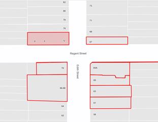
Two responses were received, one in support and one in objection to the proposal.
|
Residents’ Comments |
Officer Comments |
|
I support Council’s proposal however I would like to ensure the ‘No Stopping’ zone will not include the kerb space between the driveways of No.70 and Nos.66-68 Edith Street. I own the business on No.70 Edith Street and currently use the subject kerb space to park my scooter. |
The kerb space between the driveways of No.66-68 and No.70 Edith Street is not within the proposed 11m ‘No Stopping’ zone. |
|
We object to Council’s proposal for a number of reasons. Firstly, this is Council’s fourth attempt to propose parking changes on Edith Street, and the previous three times have been unsuccessful due to a lack of residents support. Secondly, there are many intersections around the area that don’t have the statutory 10m ‘No Stopping’ restrictions and therefore am uncertain as to why Edith Street is made subject to these changes. Furthermore, we don’t believe there is either a sightline or manoeuvring problem. We would like Council to consider implementing a Resident Parking Scheme and determine whether Council’s enforcement team can take any action rather than installing the proposed ‘No Stopping’ restrictions. |
Several concerns were received from residents of the area regarding sight line issues when vehicles parked too close to the intersection within the statutory 10 metre ‘No Stopping’ zone.
Site investigations have identified vehicles parked close to the intersection and impeded sight lines. Signposting the statutory 10m ‘No Stopping’ zones is required to improve the safety for pedestrians and motorists at the intersection.
A Resident Parking Scheme in Edith Street, Leichhardt was investigated in late 2018. The resident survey results showed that there was less than 50% support for the scheme and therefore the scheme was not implemented. |
|
|
Local Traffic Committee Meeting 6 May 2019 |
Subject: Collins Lane, Annandale - Proposed 'No Parking' zone (Gulgadya-Leichhardt Ward/Balmain Electorate/Leichhardt PAC)
Prepared By: Brinthaban Baskaran - Student Traffic Engineer
Authorised By: John Stephens - Traffic and Transport Services Manager
|
RECOMMENDATION
THAT the existing 12m unrestricted parking space on the western side of Collins Lane at the rear of Nos.215-219 Young Street, Annandale be reduced to 5.5m by installing a 3.5m and 3m ‘No Parking’ zone on the southern and northern sides of the parking space respectively.
|
BACKGROUND
Council has received concerns regarding obstructed driveway access in Collins Lane opposite the rear garage of No.176 Annandale Street, Annandale.
|
Street Name(s) |
Collins Lane |
|
Section |
Between Booth Street and Collins Street |
|
Traffic Volume |
- |
|
Recorded Crash History (5 year) |
Nil |
|
Recorded 85% speed |
- |
|
Speed Limit |
50km/h |
|
Carriageway Width |
Approx. 5m |
|
Carriageway Type |
Two way laneway |
|
Road Classification (State, Regional, Local) |
Local |
FINANCIAL IMPLICATIONS
Nil.
OTHER STAFF COMMENTS
It is illegal to park a vehicle in a way that obstructs access to a property. In order to alleviate this issue, it was originally proposed to install a 12m ‘No Parking’ zone on the western side of Collins Lane, opposite the rear garage of No.176 and No.174 Annandale Street, Annandale as shown in the following aerial photo.
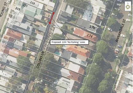
PUBLIC CONSULTATION
A letter outlining the above proposal was mailed out to the affected properties (12 properties) in Young Street and Annandale Street, Annandale.
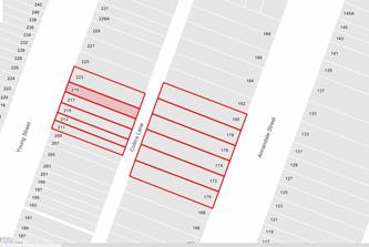
Four responses were received, two in support and two in objection to the proposal.
|
Residents’ Comments |
Officer Comments |
|
I support Council’s proposal.
It should also be noted cars are often parked along the rear driveway of No.219 Young Street as the properties garage is not used for parking cars. As a result, this is affecting my driveway access.
Could Council also consider converting the space between the rear of Nos.174-178 Annandale Street, a ‘No Parking’ zone as there are vehicles constantly parking within a metre of my driveway?
Furthermore, the parking spot situated at the corner of Collins Lane and Booth Street obstructs vision for residents leaving Collins Lane. The existing speed humps do not act as a traffic calming device as there is still excessive speeding.
|
Noted.
The existing kerb space between the rear of No.174-178 Annandale Street is insufficient to accommodate a standard size vehicle without impeding driveway access to No.176 Annandale Street or No.174 Annandale Street. Enforcement action should be considered in the first instance to address these concerns.
A separate report regarding ‘No Stopping’ restrictions at the intersection of Booth Street and Collins Lane is being reported to the May 2019 Traffic Committee. |
|
I object to Council’s proposal as the potential ‘No Parking’ zone restricts my access to my property which I have owned for the past 65 years. I will be restricted from parking in front of my property when I require making deliveries or undergoing renovations.
I believe residents from No.176 Annandale Street have a generous unobstructed area to exit onto Collins Lane as the rear access of No.215 Young Street is two properties away from No.176.
|
‘No Parking’ zones allow a driver to temporarily stop in the area for up to two minutes and must remain within three metres of the vehicle. These restrictions allow the pick-up/drop-off of passengers and loading/unloading activity.
Notwithstanding the above, a modified proposal will be recommended to retain some on-street parking. |
|
We have not noticed any cars that have been parked or obstructing driveway access in Collins Lane opposite the rear garage of No. 176 Annandale Street, Annandale, at any time day or night.
There is an abundance of parking spaces on Young and Annandale Streets, Annandale therefore there is no need for cars to park in Collins Lane.
|
MODIFIED PROPOSAL
Noting resident concern, a swept path analysis has been undertaken to determine whether the proposal can be modified to retain some on-street parking.
The swept path analysis has determined that the existing 12m unrestricted parking space could be reduced to allow unobstructed driveway access whilst retaining parking.
It is therefore proposed that the existing 12m unrestricted parking space on the western side of Collins Lane at the rear of Nos.215-219 Young Street, Annandale be reduced to 5.5m by installing a 3.5m and 3m ‘No Parking’ zone on both the southern and northern sides of the parking space respectively.
Modified Proposal
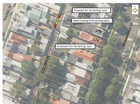
|
|
Local Traffic Committee Meeting 6 May 2019 |
Subject: Norton Street, Leichhardt - Proposed Metered Parking Restriction (Gulgadya-Leichhardt Ward/Balmain Electorate/Leichhardt PAC)
Prepared By: Brinthaban Baskaran - Student Traffic Engineer
Authorised By: John Stephens - Traffic and Transport Services Manager
|
RECOMMENDATION
THAT a 6m ‘2P Ticket 8am-7pm Mon-Sat; 4P Ticket 8am-7pm Sun; Permit Holders Excepted Area L3’ restriction be installed on the eastern side of Norton Street outside of property Nos.47-51 Norton Street, replacing the existing unrestricted parking space. |
BACKGROUND
The redevelopment of Nos.47-51 Norton Street, Leichhardt has been recently completed and this has created a 6m unrestricted parking space due to the redesign/relocation of the property’s driveway, redesign/relocation of the existing garden bed and relocation of the ‘No Stopping - Police Vehicles Excepted’ restriction. This section of Norton Street, Leichhardt, between Parramatta Road and Marion Street is currently a metered parking area.
Site location & road network
|
Street Name(s) |
Norton Street, Leichhardt |
|
Section |
Between Marion Street and Parramatta Road |
|
Traffic Volume |
11,484 |
|
Recorded Crash History (5 year) |
Nil at subject location |
|
Recorded 85% speed |
37.7km/h |
|
Speed Limit |
40km/h |
|
Carriageway Width |
12.8m |
|
Carriageway Type |
Two way with one travel lane in each direction and kerb side parking lanes |
|
Road Classification (State, Regional, Local) |
Regional |
FINANCIAL IMPLICATIONS
Nil.
OTHER STAFF COMMENTS
Metered parking restrictions are currently in place on Norton Street between Parramatta Road and Allen Street. To be consistent with these restrictions, it is proposed to replace the 6m unrestricted parking space with 6m ‘2P Ticket 8am-7pm Mon-Sat; 4P Ticket 8am-7pm Sun; Permit Holders Excepted Area L3’ on the eastern side of Norton Street outside of property Nos.47-51 Norton Street as shown in the following plan. There are existing parking meters in close proximity that can service this parking space.