|
AGENDA R |

Local Traffic Committee Meeting
MONDAY 3 JUNE 2019
10.00am
|
|
Local Traffic Committee Meeting 3 June 2019 |
Function of the Local Traffic Committee
Background
Roads and Maritime Services (RMS) is legislated as the Authority responsible for the control of traffic on all NSW Roads. The RMS has delegated certain aspects of the control of traffic on local roads to councils. To exercise this delegation, councils must establish a local traffic committee and obtain the advice of the RMS and Police. The Inner West Council Local Traffic Committee has been constituted by Council as a result of the delegation granted by the RMS pursuant to Section 50 of the Transport Administration Act 1988.
Role of the Committee
The Local Traffic Committee is primarily a technical review and advisory committee which considers the technical merits of proposals and ensures that current technical guidelines are considered. It provides recommendations to Council on traffic and parking control matters and on the provision of traffic control facilities and prescribed traffic control devices for which Council has delegated authority. These matters are dealt with under Part A of the agenda and require Council to consider exercising its delegation.
In addition to its formal role as the Local Traffic Committee, the Committee may also be requested to provide informal traffic engineering advice on traffic matters not requiring Council to exercise its delegated function at that point in time, for example, advice to Council’s Development Assessment Section on traffic generating developments. These matters are dealt with under Part C of the agenda and are for information or advice only and do not require Council to exercise its delegation.
Committee Delegations
The Local Traffic Committee has no decision-making powers. The Council must refer all traffic related matters to the Local Traffic Committee prior to exercising its delegated functions. Matters related to State Roads or functions that have not been delegated to Council must be referred directly to the RMS or relevant organisation.
The Committee provides recommendations to Council. Should Council wish to act contrary to the advice of the Committee or if that advice is not supported unanimously by the Committee members, then the Police or RMS have an opportunity to appeal to the Regional Traffic Committee.
Committee Membership & Voting
Formal voting membership comprises the following:
· one representative of Council as nominated by Council;
· one representative of the NSW Police from each Local Area Command (LAC) within the LGA, being Newtown, Marrickville, Leichhardt and Ashfield LAC’s.
· one representative from the RMS; and
· State Members of Parliament (MP) for the electorates of Summer Hill, Newtown, Heffron, Canterbury, Strathfield and Balmain or their nominees.
Where the Council area is represented by more than one MP or covered by more than one Police LAC, representatives are only permitted to vote on matters which effect their electorate or LAC.
Informal (non-voting) advisors from within Council or external authorities may also attend Committee meetings to provide expert advice.
Committee Chair
Council’s representative will chair the meetings.
Public Participation
Members of the public or other stakeholders may address the Committee on agenda items to be considered by the Committee. The format and number of presentations is at the discretion of the Chairperson and is generally limited to 3 minutes per speaker. Committee debate on agenda items is not open to the public.
|
|
Local Traffic Committee Meeting 3 June 2019 |
|
AGENDA |
1 Apologies
2 Disclosures of Interest
3 Confirmation of Minutes
Minutes of 6 May 2019 Local Traffic Committee Meeting 5
4 Matters Arising from Council’s Resolution of Minutes
5 Part A – Items Where Council May Exercise Its Delegated Functions
Traffic Matters
ITEM PAGE
LTC0619 Item 1 Wharf Road, Birchgrove - 10km/h Shared Zone and Footpath Parking proposal (Baludarri-Balmain Ward/Balmain Electorate/Leichhardt PAC) 24
LTC0619 Item 2 Mullens, Beattie and Montague Streets, Balmain - Proposed Intersection Treatments (Baludarri-Balmain Ward/Balmain Electorate/Leichhardt PAC) 31
LTC0619 Item 3 Crescent Street and Boomerang Street, Haberfield - Proposed Refuge Island and Speed Cushion (Gulgadya-Leichhardt Ward/ Summer Hill Electorate/ Burwood PAC) 35
LTC0619 Item 4 Centennial Street, Marrickville – Temporary Road Closure For Special Event at Henson Park – Beer, Footy and Food Festival on Saturday 27 July 2019 (Midjuburi-Marrickville Ward/Summer Hill Electorate/Inner West PAC) 39
LTC0619 Item 5 Burrows Avenue and Hogan Avenue, Sydenham – Sydney Metro Sydenham Station and Junction (SSJ) Works – Temporary traffic control arrangements (Midjuburi Ward / Heffron Electorate / Inner West PAC) 60
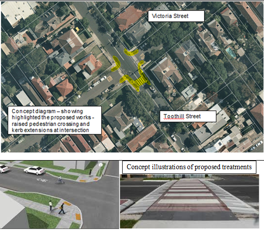
LTC0619 Item 6 Toothill Street at Victoria Street, Lewisham – Concept plan for Raised Pedestrian crossing with kerb extensions on all approaches of intersection (Damum - Stanmore Ward/ Summer Hill Electorate/ Inner West PAC) 74
LTC0619 Item 7 Minor Traffic Facilities (All Wards/All Electorates/All PACs) 81
Parking Matters
ITEM
PAGE
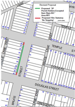
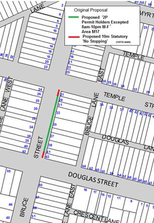
LTC0619 Item 8 Bruce Street, Stanmore - Proposed Permit Parking Area M17 (Damun-Stanmore Ward/Newtown Electorate/Inner West PAC) 84
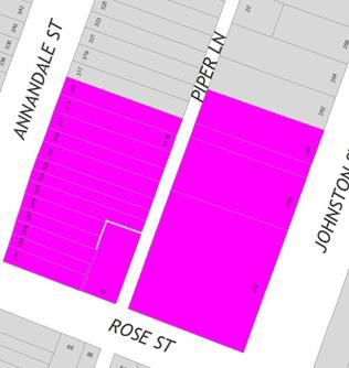
LTC0619 Item 9 Piper Lane, Annandale - Proposed 'No Stopping' and 'No Parking' zones (Baludarri-Balmain Ward/Balmain Electorate/Leichhardt PAC 88
LTC0619 Item 10 Blackwood Lane, Dulwich Hill - Proposed section of 'No Parking' (Ashfield - Djarrawunang Ward/Summer Hill) Electorate/Inner West PAC) 91
LTC0619 Item 11 Mitchell Lane, Marrickville - Proposed parking restrictions (Midjuburi- Marrickville Ward/Summer Hill Electorate/Inner West PAC) 95
LTC0619 Item 12 Edgeware Road, Enmore - Proposed Permit Parking (Stanmore - Damun Ward/Newtown Electorate/Inner West PAC) 98
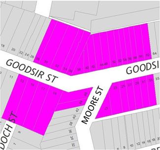
LTC0619 Item 13 Goodsir Street, Rozelle - Proposed removal of existing 'No Parking, 8AM-6PM Mon-Fri' Zone (Baludarri-Balmain Ward/Balmain Electorate/Leichhardt PAC) 101
LTC0619 Item 14 Queen
Street, Ashfield – Proposed ‘No Stopping’ in Queen Street at
intersection with Harland Street,
(Djarrawunang – Ashfield Ward/Summer Hill Electorate/ Burwood PAC) 104
LTC0619 Item 15 Croydon
Road, Croydon – Proposed removal of parking on the eastern side between
Parramatta Road and West Street.
(Gulgadya–Leichhardt Ward /Strathfield Electorate/ Burwood PAC) 107
Late Items
Nil at time of printing.
6 Part B - Items for Information Only
ITEM PAGE
LTC0619 Item 16 Code of Conduct for Council Committee Members, Delegates of Council and Council Advisers (All Wards / All Electorates / All PACs) 111
LTC0619 Item 17 Report back on Mainstreet meter switch off at 7pm in Balmain, Rozelle and Leichhardt (Baludarri-Balmain; Gulgadya-Leichhardt Wards/Balmain Electorate/Leichhardt PAC) 149
LTC0619 Item 18 Sydenham Road, Sydenham - Permanent Pedestrian mid-block signalised pedestrian crossing (Temporary configuration) – Sydney Metro City & Southwest (Midjuburi- Marrickville Ward / Heffron Electorate / Inner West PAC) 154
7 Part C - Items for General Advice
Nil at the time of printing.
8 General Business
9 Close of Meeting
|
|
Local Traffic Committee Meeting 3 June 2019 Minutes of 6 May 2019 Meeting |
Minutes of Local Traffic Committee Meeting held on 6 May 2019
Meeting commenced at 10.00am
ACKNOWLEDGEMENT OF COUNTRY BY CHAIRPERSON
I acknowledge the Gadigal and Wangal people of the Eora nation on whose country we are meeting today, and their elders past and present.
COMMITTEE REPRESENTATIVES PRESENT
|
Clr Victor Macri |
Councillor – Midjuburi-Marrickville Ward (Chair) |
|
Bill Holliday |
Representative for Jamie Parker MP, Member for Balmain |
|
Chris Woods |
Representative for Ron Hoenig MP, Member for Heffron |
|
Cathy Peters |
Representative for Jenny Leong MP, Member for Newtown |
|
Sgt John Micallef |
NSW Police – Burwood Police Area Command |
|
Sgt Paul Vlachos |
NSW Police – Inner West Police Area Command |
|
LSC Marina Nestoriaros |
NSW Police – Leichhardt Police Area Command |
|
|
|
|
OFFICERS IN ATTENDANCE |
|
|
|
|
|
Asith Nagodavithane |
Transit Systems – Inner West Bus Services |
|
Colin Jones |
Inner West Bicycle Coalition |
|
Clr Marghanita da Cruz |
Councillor – Gulgadya-Leichhardt Ward |
|
Wal Petschler |
IWC’s Group Manager Roads and Stormwater |
|
John Stephens |
IWC’s Traffic and Transport Services Manager |
|
George Tsaprounis |
IWC’s Coordinator Traffic and Parking Services (South) |
|
Manod Wickramasinghe |
IWC’s Coordinator Traffic and Parking Services (North) |
|
Boris Muha |
IWC’s Engineer – Traffic and Parking Services |
|
Mary Bailey |
IWC’s Parking Planner |
|
Mohammed Islam |
IWC’s Civil Engineer |
|
Anup Bajracharya |
IWC’s Civil Engineer |
|
Christina Ip |
IWC’s Business Administration Officer |
|
|
|
|
VISITORS |
|
|
|
|
|
Kathleen Sexton |
Item 7 – Resident |
|
Brian Allen |
Item 11 – Resident |
|
Irene Allen |
Item 11 - Resident |
|
|
|
|
APOLOGIES: |
|
|
|
|
|
Mr Ryan Horne |
Roads and Maritime Services |
|
|
|
DISCLOSURES OF INTERESTS:
Nil.
CONFIRMATION OF MINUTES
|
The Minutes of the Local Traffic Committee Meeting held on Monday, 1 April 2019 were confirmed with the following amendments: · The representative for the Member for Heffron be noted as an apology.
Minutes of LTC meetings will be circulated to Committee members prior to presentation at Council meetings.
|
MATTERS ARISING FROM COUNCIL’S RESOLUTION OF MINUTES
The Local Traffic Committee recommendations of its meeting held on 1 April 2019 were adopted at Council’s meeting held on 30 April 2019, with the following amendments:
a) In regards to LTC0419 Item 6 - Gannon Lane, Tempe - Proposed Installation of 'No Stopping' signage, replacing current 'No Parking 5am-10am Fridays' restrictions (Midjuburi Ward/Heffron Electorate/Inner West PAC) – the recommendation be changed to “no action”; and
b) In regards to LTC0419 Item 5 - Tilba Avenue and Phoebe Street, Balmain - Proposed 'No Stopping' zone (Baludarri Ward/Balmain Electorate/Leichhardt PAC) that point 2 of the recommendation be deleted.
|
LTC0519 Item 1 Curtis Road and Mort Street, Balmain - Intersection Improvement Works (Baludarri - Balmain Ward/Balmain Electorate/Leichhardt PAC) |
|
SUMMARY
Council is proposing intersection improvement works at the intersection of Curtis Road and Mort Street, Balmain to improve pedestrian amenity and reduce vehicle speeds through the intersection.
Officer’s Recommendation
THAT the detailed design plan for the kerb extension with associated garden beds, reconstruction of footpath and pedestrian ramps, associated signposting and line marking, and replacement of rubber speed cushion with asphalt speed cushion in Curtis Road at Mort Street, Balmain (as per the attached plan No. 171876) be approved, subject to the existing ‘No Stopping’ zone on Mort Street on the south-eastern corner of the intersection being retained in its current position and the proposed garden bed being modified accordingly.
DISCUSSION
The Committee members agreed with the Officer’s recommendation.
COMMITTEE RECOMMENDATION
THAT the detailed design plan for the kerb extension with associated garden beds, reconstruction of footpath and pedestrian ramps, associated signposting and line marking, and replacement of rubber speed cushion with asphalt speed cushion in Curtis Road at Mort Street, Balmain (as per the attached plan No. 171876) be approved, subject to the existing ‘No Stopping’ zone on Mort Street on the south-eastern corner of the intersection being retained in its current position and the proposed garden bed being modified accordingly.
For motion: Unanimous |
|
LTC0519 Item 2 Park Street, Rozelle - Proposed Speed Hump (Baludarri-Balmain Ward/ Balmain Electorate/ Leichhardt PAC) |
|
SUMMARY
As part of the 2019/20 Traffic Facilities (LATM) Capital Works Program, Council is proposing a speed hump in Park Street, Rozelle to improve safety and calm traffic in the street. The works have been proposed in response to residents’ concerns about speeding vehicles in the street.
Officer’s Recommendation
THAT the detailed design plan for the watts profile speed hump and associated signposting and line marking in Park Street, Rozelle (as per the attached plan No. 10068) be approved.
DISCUSSION
The Committee members agreed with the Officer’s recommendation.
COMMITTEE RECOMMENDATION
THAT the detailed design plan for the watts profile speed hump and associated signposting and line marking in Park Street, Rozelle (as per the attached plan No. 10068) be approved.
For motion: Unanimous
|
|
LTC0519 Item 3 Starling Street, Rozelle - Proposed Kerb Blister (Baludarri-Balmain Ward/ Balmain Electorate/ Leichhardt PAC) |
|
SUMMARY
Council is proposing intersection improvement works in Starling Street at the intersection of Mansfield Street, Rozelle. Concerns have been raised regarding vehicles causing building damage to No.92 Mansfield Street, Rozelle whilst manoeuvring near the corner of Mansfield Street and Starling Street, Rozelle.
Officer’s Recommendation
THAT the detailed design plan for a kerb blister with associated garden beds, asphalt re-sheeting and associated signposting and line marking in Starling Street at Mansfield Street, Rozelle (as per the attached plan No. 10067) be approved.
DISCUSSION
The Committee members agreed with the Officer’s recommendation.
COMMITTEE RECOMMENDATION
THAT the detailed design plan for a kerb blister with associated garden beds, asphalt re-sheeting and associated signposting and line marking in Starling Street at Mansfield Street, Rozelle (as per the attached plan No. 10067) be approved.
For motion: Unanimous |
|
LTC0519 Item 4 Darling Street at Elliott, Balmain - Proposed Speed Cushions (Baludarri-Balmain Ward/ Balmain Electorate/ Leichhardt PAC) |
|
SUMMARY
A detailed design plan has been finalised for a proposed speed calming treatment in Darling Street at Elliott Street, Balmain. The proposed works includes installation of two asphalt speed cushions, associated signage and line markings on approach to the raised pedestrian (zebra) crossing on Darling Street at Elliott Street, Balmain to improve pedestrian safety.
Officer’s Recommendation
THAT the detailed design plan for two asphalt speed cushions and associated signs and line marking on approach to the raised pedestrian (zebra) crossing on Darling Street near Elliott Street, Balmain (Design Plan No.10072) be approved.
DISCUSSION
The Inner West Bicycle Coalition representative requested the relocation of the speed cushion on the western approach to Elliot Street. The representative stated that as the speed cushion is adjacent to the parking lane, cyclists are at risk of being doored when manoeuvring around the speed cushion. Council Officers stated that the speed cushion could be moved slightly towards Elliot Street so that it is not located next to the parking lane.
The Inner West Bicycle Coalition representative also requested that the bike symbols on Darling Street be re-marked if the speed cushions are installed on top of the existing symbols. The representative tabled an email from the Leichhardt Bicycle User Group requesting the reinstatement of bike symbols after the installation of speed cushions. Council Officers agreed to this request.
Council Officers tabled late comments from a resident generally supporting the recommendation.
The Committee members agreed with the Officer’s recommendation.
COMMITTEE RECOMMENDATION
THAT the detailed design plan for two asphalt speed cushions and associated signs and line marking on approach to the raised pedestrian (zebra) crossing on Darling Street near Elliott Street, Balmain (Design Plan No.10072) be approved, subject to the relocation of the speed cushion on the western approach to Elliot Street slightly towards Elliot Street away from the parking lane.
For motion: Unanimous
|
|
LTC0519 Item 5 Temporary Full Road Closure – Smith Street (between Lackey Street and Nowraine Street, Summer Hill, for Development sewer work connection. (Djarrawunang-Ashfield Ward/Summer Hill Electorate/ Burwood PAC) |
|
SUMMARY
An application has been received from Complete Build Pty Ltd for the temporary full road closure of Smith Street, between Lackey Street and Nowraine Street, Summer Hill, for development sewer work connection.
Officer’s Recommendation
THAT the proposed temporary full road closure of Smith Street (between Lackey Street and Nowraine Street, Summer Hill, from Monday, 3 June to 17 June 2019, between 9.00am-3.00pm for sewer works be approved; subject to, but not limited to, the following conditions: 1. A Road Occupancy License be obtained by the applicant from the Transport Management Centre; 2. All affected residents and businesses, including the NSW Police Area Commander, Fire & Rescue NSW and the NSW Ambulance Services be notified in writing, by the applicant, of the proposed temporary full road closure at least 7 days in advance of the closure with the applicant making reasonable provision for stakeholders; and 3. The occupation of the road carriageway must not occur until the road has been physically closed.
DISCUSSION
Council Officers advised that RMS supported the proposal, subject to RMS approval of the TMP.
The Committee members agreed with the Officer’s recommendation.
COMMITTEE RECOMMENDATION
THAT the proposed temporary full road closure of Smith Street (between Lackey Street and Nowraine Street, Summer Hill, from Monday, 3 June to 17 June 2019, between 9.00am-3.00pm for sewer works be approved; subject to, but not limited to, the following conditions: 1. A Road Occupancy License be obtained by the applicant from the Transport Management Centre; 2. All affected residents and businesses, including the NSW Police Area Commander, Fire & Rescue NSW and the NSW Ambulance Services be notified in writing, by the applicant, of the proposed temporary full road closure at least 7 days in advance of the closure with the applicant making reasonable provision for stakeholders; and 3. The occupation of the road carriageway must not occur until the road has been physically closed.
For motion: Unanimous
|
|
LTC0519 Item 6 Lawson Avenue, Marrickville – Amended Raised Threshold Design Plan No. 6198_A (Midjuburi-Marrickville Ward/ Summer Hill Electorate/ Inner West PAC) |
|
SUMMARY
An amended detailed design plan has been finalised for the proposed raised threshold treatment in Lawson Avenue, Marrickville. The works are part of road, footpath and flooding improvements in Lawson Avenue, Marrickville.
Officer’s Recommendation
THAT the amended detailed design plan (Design Plan No.6198_A) for the raised threshold in Lawson Avenue, Marrickville be APPROVED.
DISCUSSION
The Committee members agreed with the Officer’s recommendation.
COMMITTEE RECOMMENDATION
THAT the amended detailed design plan (Design Plan No.6198_A) for the raised threshold in Lawson Avenue, Marrickville be APPROVED.
For motion: Unanimous
|
|
LTC0519
Item 7 Queen Street, Croydon - Proposed Pedestrian Refuge |
|
SUMMARY
Requests over time have been made by residents for a safe crossing facility to be provided in Queen Street, Croydon, near Jones Street to access various sporting and recreational facilities in the area. As part of Council’s capital works program, a proposed pedestrian refuge facility is listed for construction at the above location to improve pedestrian safety and provide traffic calming.
Officer’s Recommendation
THAT
1. The detailed design plan (Design Plan No. 10071) for the proposed pedestrian refuge in Queen Street, west of Jones Street, Croydon, be approved. 2. A ‘Caution Driveway’ sign (W2-206-1) be considered following installation of the refuge on the eastern approach to the refuge facing westbound traffic, if required.
DISCUSSION
Public speaker: Ms Kathleen Sexton attended at 10.06am.
Ms Sexton stated that she supported the proposed pedestrian refuge and believes she represents the residents of Jones Street in supporting the proposal.
(Ms Sexton left at 10.11am)
The Committee members agreed with the Officer’s recommendation.
COMMITTEE RECOMMENDATION
THAT
1. The detailed design plan (Design Plan No. 10071) for the proposed pedestrian refuge in Queen Street, west of Jones Street, Croydon, be approved. 2. A ‘Caution Driveway’ sign (W2-206-1) be considered following installation of the refuge on the eastern approach to the refuge facing westbound traffic, if required.
For motion: Unanimous
|
|
LTC0519 Item 8 Minor Traffic Facilities (All Wards/ All Electorates/ All PACs) |
|
SUMMARY
This report considers minor traffic facility applications by Inner West Council, and includes ‘Disabled Parking’ and ‘Works Zone’ requests.
Officer’s Recommendation
THAT:
1. A 6m ‘Disabled Parking’ zone be removed in front of No. 20 Silver Street, Marrickville;
2. A 6m ‘Disabled Parking’ zone be removed in front of No. 42 Hubert Street, Leichhardt;
3. A 6m ‘Disabled Parking’ zone be removed in front of No. 1 Pearson Street, Balmain East, and the 2P resident parking be reinstated;
4. A 6m ‘Disabled Parking’ zone be removed in front of No. 9 Don St, Newtown;
5. A 6m 'Disabled Parking’ zone be installed in front of No. 24 Annesley Street, Leichhardt;
6. A 6m 'Disabled Parking’ zone be installed in front of No. 169 Elswick Street, Leichhardt;
7. A 6m 'Disabled Parking 8am-5pm’ zone be installed in front of No. 2 Herbert Street, Dulwich Hill replacing the existing 1P parking restrictions;
8. A 9m 'Works Zone 7:00am – 6:00pm Mon-Fri and 8.00am-1.00pm Sat' be installed in front of No. 3 Hartley Street, Rozelle for 12 weeks;
9. A 12m 'Works Zone 7:00am – 6:00pm Mon-Fri and 8.00am-1.00pm Sat' be installed in front of No. 7 Palace Street, Petersham for 6 weeks;
10. A 9m 'Works Zone 7:00am – 6:00pm Mon-Fri and 8.00am-1.00pm Sat' be installed in front of No.110-112 Edith Street, Leichhardt for 26 weeks and then be reviewed for a time extension and;
11. A 45m 'Works Zone 7:00am – 6:00pm Mon-Fri and 8.00am-1.00pm Sat' be installed in Hunter Street, on the side boundary of No.127 New Canterbury Road, Lewisham for 12 weeks, subject to written consent being received from the directly affected property.
DISCUSSION
The Committee members agreed with the Officer’s recommendation.
COMMITTEE RECOMMENDATION
THAT:
1. A 6m ‘Disabled Parking’ zone be removed in front of No. 20 Silver Street, Marrickville;
2. A 6m ‘Disabled Parking’ zone be removed in front of No. 42 Hubert Street, Leichhardt;
3. A 6m ‘Disabled Parking’ zone be removed in front of No. 1 Pearson Street, Balmain East, and the 2P resident parking be reinstated;
4. A 6m ‘Disabled Parking’ zone be removed in front of No. 9 Don St, Newtown;
5. A 6m 'Disabled Parking’ zone be installed in front of No. 24 Annesley Street, Leichhardt;
6. A 6m 'Disabled Parking’ zone be installed in front of No. 169 Elswick Street, Leichhardt;
7. A 6m 'Disabled Parking 8am-5pm’ zone be installed in front of No. 2 Herbert Street, Dulwich Hill replacing the existing 1P parking restrictions;
8. A 9m 'Works Zone 7:00am – 6:00pm Mon-Fri and 8.00am-1.00pm Sat' be installed in front of No. 3 Hartley Street, Rozelle for 12 weeks;
9. A 12m 'Works Zone 7:00am – 6:00pm Mon-Fri and 8.00am-1.00pm Sat' be installed in front of No. 7 Palace Street, Petersham for 6 weeks;
10. A 9m 'Works Zone 7:00am – 6:00pm Mon-Fri and 8.00am-1.00pm Sat' be installed in front of No.110-112 Edith Street, Leichhardt for 26 weeks and then be reviewed for a time extension and;
11. A 45m 'Works Zone 7:00am – 6:00pm Mon-Fri and 8.00am-1.00pm Sat' be installed in Hunter Street, on the side boundary of No.127 New Canterbury Road, Lewisham for 12 weeks, subject to written consent being received from the directly affected property.
For motion: Unanimous
|
|
LTC0519 Item 9 Smith Street, Marrickville - Proposed Permit Parking (Midjuburi-Marrickville Ward/ Summer Hill Electorate/ Inner West PAC) |
|
SUMMARY
Council is proposing the introduction of permit parking restrictions in Smith Street, Marrickville following representations from residents. The area is a mixed industrial and residential use and it is recognised that parking for the industrial users should also be considered. The permit parking proposal is limited to sections outside residential homes. Smith Street adjoins Fitzroy Street when in February 2019, permit parking was introduced between Smith Street and Edinburgh Road.
Officer’s Recommendation
THAT:
1. Implementation of ‘2P Permit Holders Excepted 8:30am-6:30pm Monday to Friday Area M19’ in Smith Street (northern side) between 1 meter east of driveway on boundary of property no. 53A Smith Street and 1 meter west of Smith Street entrance to driveway of 62 Fitzroy Street (total length approx. 13.3 meters) be approved;
2. Implementation of ‘2P Permit Holders Excepted 8:30am-6:30pm Monday to Friday Area M19’ in Smith Street (southern side) between 5.5 meters east of driveway of property no. 36 Smith Street and 1 meter west of driveway of property no. 50 Smith Street (total length approx. 24 meters) be approved; and
3. Implementation of ‘2P Permit Holders Excepted 8:30am-6:30pm Monday to Friday Area M19’ in Smith Street (southern side) directly adjacent to property Nos. 54-56 Smith; be approved.
DISCUSSION
The Committee members agreed with the Officer’s recommendation.
COMMITTEE RECOMMENDATION
THAT:
1. Implementation of ‘2P Permit Holders Excepted 8:30am-6:30pm Monday to Friday Area M19’ in Smith Street (northern side) between 1 metre east of driveway on boundary of property no. 53A Smith Street and 1 metre west of Smith Street entrance to driveway of 62 Fitzroy Street (total length approx. 13.3 metres) be approved;
2. Implementation of ‘2P Permit Holders Excepted 8:30am-6:30pm Monday to Friday Area M19’ in Smith Street (southern side) between 5.5 metres east of driveway of property no. 36 Smith Street and 1 metre west of driveway of property no. 50 Smith Street (total length approx. 24 metres) be approved; and
3. Implementation of ‘2P Permit Holders Excepted 8:30am-6:30pm Monday to Friday Area M19’ in Smith Street (southern side) directly adjacent to property Nos. 54-56 Smith; be approved.
For motion: Unanimous
|
|
LTC0519 Item 10 Kingston Lane, Camperdown - Proposed Parking Restrictions (Damun-Stanmore Ward/ Newtown Electorate/ Inner West PAC) |
|
SUMMARY
Following representations from a resident, Council is proposing to introduce ‘No Parking’ restrictions in Kingston Lane between Rowley Lane and Rowley Street in order to improve access to off-street parking and the thoroughfare.
Officer’s Recommendation
THAT the implementation of ‘No Parking’ in Kingston Lane, Camperdown (eastern side) between Rowley Lane and Rowley Street, be approved.
DISCUSSION
The Committee members agreed with the Officer’s recommendation.
COMMITTEE RECOMMENDATION
THAT the implementation of ‘No Parking’ in Kingston Lane, Camperdown (eastern side) between Rowley Lane and Rowley Street, be approved.
For motion: Unanimous |
|
LTC0519 Item 11 Booth Street at Collins Lane, Annandale - Proposed 'No Stopping' restriction (Gulgadya-Leichhardt Ward / Balmain Electorate / Leichhardt PAC) |
|
SUMMARY
Council has received concerns regarding vehicles parking too close to the intersection of Booth Street and Collins Lane, Annandale, within the statutory 10m ‘No Stopping’ zone. Parking in this manner obstructs manoeuvring space, as well as vehicle to vehicle sightlines and vehicle to pedestrian sightlines.
Officer’s Recommendation
THAT a 15m ‘No Stopping’ zone be installed on the southern side of Booth Street, east of Collins Lane, Annandale.
DISCUSSION
Public speaker: Mr Brian Allen and Ms Irene Allen attended at 10.13am.
Ms Allen and Mr Allen did not support the proposal as it will inhibit parking at the front of their property.
(Mr Allen and Ms Allen left at 10.16am)
Officers requested to investigate whether the ‘No Stopping’ zone on the southern side of Booth Street at the corner of Annandale Street could be reduced to accommodate one extra parking space, its proximity to a pedestrian refuge being noted. It was noted that parking is permitted in the adjacent laneway and that Booth Street west of View Street does not have a Resident Parking Scheme and parking in the street is often utilised by bus commuters.
The Committee members agreed with the Officer’s recommendation.
COMMITTEE RECOMMENDATION
THAT a 15m ‘No Stopping’ zone be installed on the southern side of Booth Street, east of Collins Lane, Annandale.
For motion: Unanimous
|
|
LTC0519 Item 12 Collins Lane, Annandale - Proposed 'No Parking' zone (Gulgadya- Leichhardt Ward/ Balmain Electorate/ Leichhardt PAC) |
|
SUMMARY
Council received concerns from a resident of Young Street, Annandale regarding vehicles parking on the eastern side of Collins Lane, Annandale and subsequently obstructing rear driveway access for property No.175A Young Street.
Officer’s Recommendation
THAT a 3.5m ‘No Parking’ zone be installed on the eastern side of Collins Lane, between the driveways of No.150 and No.148 Annandale Street and opposite the rear garage of No.175A Young Street, Annandale.
DISCUSSION
The Committee members agreed with the Officer’s recommendation.
COMMITTEE RECOMMENDATION
THAT a 3.5m ‘No Parking’ zone be installed on the eastern side of Collins Lane, between the driveways of No.150 and No.148 Annandale Street and opposite the rear garage of No.175A Young Street, Annandale.
For motion: Unanimous
|
|
LTC0519 Item 13 Derbyshire Road and Moore Street West, Leichhardt - 'No Parking' and 'No Stopping' restrictions (Gulgadya-Leichhardt Ward / Balmain Electorate / Leichhardt PAC) |
|
SUMMARY
Concerns have been raised by Sydney Secondary College regarding vehicles parking in the cul-de-sac at the rear of the Sydney Secondary College on Moore Street West, Leichhardt and subsequently obstructing vehicular manoeuvrability and access for waste collection.
Officer’s Recommendation
THAT:
1. The existing ‘No Parking’ zone on the western side of Derbyshire Road, south of William Street be extended to include the Moore Street West Cul-de-sac (approx. 60m extension); and
2. A 12.2m ‘No Stopping’ zone followed by a 7.5m ‘No Parking’ zone be installed on the eastern side of Derbyshire Road, south of William Street, subject to activation of the car park at No.29 Derbyshire Road.
DISCUSSION
The Committee members agreed with the Officer’s recommendation.
COMMITTEE RECOMMENDATION
THAT:
1. The existing ‘No Parking’ zone on the western side of Derbyshire Road, south of William Street be extended to include the Moore Street West Cul-de-sac (approx. 60m extension); and
2. A 12.2m ‘No Stopping’ zone followed by a 7.5m ‘No Parking’ zone be installed on the eastern side of Derbyshire Road, south of William Street, subject to activation of the car park at No.29 Derbyshire Road.
For motion: Unanimous
|
|
LTC0519 Item 14 Beames Street, Lilyfield - Angle Parking and Road Reconstruction (Baludarri-Balmain Ward / Balmain Electorate / Leichhardt PAC) |
|
SUMMARY
Detailed design plans have been prepared for the provision of ‘90 degree angle parking, vehicles under 6m only’ restrictions; ‘No Stopping’ restrictions; improvements to the kerb and gutter, footpath and roadway in Beames Street, Lilyfield (between City West Link and the dead-end).
Officer’s Recommendation
THAT the ‘90 degree angle parking, vehicles under 6m only’ restrictions; ‘No Stopping’ restrictions; kerb and gutter, footpaths and roadway improvements with associated linemarking and signposting in Beames Street, Lilyfield (as per Design Plan No. 10061) be approved.
DISCUSSION
The Committee members agreed with the Officer’s recommendation.
COMMITTEE RECOMMENDATION
THAT the ‘90 degree angle parking, vehicles under 6m only’ restrictions; ‘No Stopping’ restrictions; kerb and gutter, footpaths and roadway improvements with associated linemarking and signposting in Beames Street, Lilyfield (as per Design Plan No. 10061) be approved.
For motion: Unanimous
|
|
LTC0519 Item 15 Hercules Street, Ashfield – Amendment to Disabled Parking Signage. (Djarrawunang-Ashfield Ward/Summer Hill Electorate/ Burwood PAC) |
|
SUMMARY
An audit of the current signage in Hercules Street, Ashfield by Council Officers has found that current operation times on the Disabled Parking sign were incorrect and need to be amended.
Officer’s Recommendation
THAT the ‘Disabled Parking’ restrictions on the eastern side of Hercules Street, between Brown Street and Drakes Lane, be amended from ‘2P Disabled Parking 10am-6pm Mon –Sun’ to ‘Disabled Parking Only 10am-6pm Mon –Sun’ to cover the time outside the Loading Zone period.
DISCUSSION
The Committee members agreed with the Officer’s recommendation.
COMMITTEE RECOMMENDATION
THAT the ‘Disabled Parking’ restrictions on the eastern side of Hercules Street, between Brown Street and Drakes Lane, be amended from ‘2P Disabled Parking 10am-6pm Mon –Sun’ to ‘Disabled Parking Only 10am-6pm Mon –Sun’ to cover the time outside the Loading Zone period.
For motion: Unanimous |
|
LTC0519 Item 16 Ramsay Street at Walker Avenue, Haberfield - Proposed 'No Stopping' restriction (Gulgadya-Leichhardt Ward/ Summer Hill Electorate/ Burwood PAC) |
|
SUMMARY
Council has received concerns regarding vehicles parking too close to the intersection of Ramsay Street and Walker Avenue, Haberfield, within the statutory 10m ‘No Stopping’ zone. Parking in this manner obstructs manoeuvring space, as well as vehicle to vehicle sightlines and vehicle to pedestrian sightlines.
Officer’s Recommendation
THAT a 10m ‘No Stopping’ restriction be installed on the western side of Ramsay Street, south of Walker Avenue, Haberfield.
DISCUSSION
The Committee members agreed with the Officer’s recommendation.
COMMITTEE RECOMMENDATION
THAT a 10m ‘No Stopping’ restriction be installed on the western side of Ramsay Street, south of Walker Avenue, Haberfield.
For motion: Unanimous
|
|
LTC0519 Item 17 New Street, Ashfield – Proposed statutory ‘No Stopping’ in New Street at intersection with Queen Street. (Djarrawunang-Ashfield Ward/ Summer Hill Electorate/ Burwood PAC) |
|
SUMMARY
A request has been made by a resident in New Street to have statutory 10 metres of ‘No Stopping’ placed on the southern corner of New Street at Queen Street, Ashfield. The restriction will aid to improve visibility and vehicle manoeuvrability at the intersection. The proposal will supplement the existing 'No Stopping' restriction on the opposite side of New Street.
Officer’s Recommendation
THAT statutory 10 metres of ‘No Stopping’ restriction be placed on the southern side of New Street, west of Queen Street, Ashfield.
DISCUSSION
The Committee members agreed with the Officer’s recommendation.
COMMITTEE RECOMMENDATION
THAT statutory 10 metres of ‘No Stopping’ restriction be placed on the southern side of New Street, west of Queen Street, Ashfield.
For motion: Unanimous
|
|
LTC0519 Item 18 Stanmore Lane, Stanmore - Proposed 'No Parking' restrictions (Damun-Stanmore Ward/ Newtown Electorate/ Inner West PAC) |
|
SUMMARY
Representations have been received for the introduction of ‘No Parking’ restrictions in Stanmore Lane between the road closures at Rosevear Street and Douglas Street/Railway Avenue, in order to improve access to off-street parking and the thoroughfare.
Officer’s Recommendation
THAT the installation of ‘No Parking’ restrictions in Stanmore Lane – southern side from its intersection with Rosevear Street (road closure) to its intersection with Douglas Street/Railway Avenue, Stanmore (road closure); be approved.
DISCUSSION
Council Officers tabled a late submission from a resident who supported the proposed ‘No Parking’ restrictions in Stanmore Lane.
The Committee members agreed with the Officer’s recommendation.
COMMITTEE RECOMMENDATION
THAT the installation of ‘No Parking’ restrictions in Stanmore Lane – southern side from its intersection with Rosevear Street (road closure) to its intersection with Douglas Street/Railway Avenue, Stanmore (road closure); be approved.
For motion: Unanimous
|
|
LTC0519 Item 19 Edith Street and Regent Street, Leichhardt - Proposed 'No Stopping' restrictions (Gulgadya-Leichhardt Ward / Balmain Electorate / Leichhardt PAC) |
|
SUMMARY
Council has received concerns regarding vehicles parking too close to the intersection of Edith Street at Regent Street, Leichhardt, within the statutory 10m ‘No Stopping’ zones. Parking in this manner obstructs manoeuvring space, as well as vehicle to vehicle sightlines and vehicle to pedestrian sightlines. Parking too close to an intersection may also obstruct pedestrian crossing points at the intersection.
Officer’s Recommendation
THAT:
1. An 11m ‘No Stopping’ zone be installed on the western side of Edith Street, south of Regent Street;
2. A 10m ‘No Stopping’ zone be installed on the eastern side of Edith Street, south of Regent Street; and
3. A 10m ‘No Stopping’ zones be installed on the southern side of Regent Street, east and west of Edith Street, Leichhardt.
DISCUSSION
The Committee members agreed with the Officer’s recommendation.
COMMITTEE RECOMMENDATION
THAT:
1. An 11m ‘No Stopping’ zone be installed on the western side of Edith Street, south of Regent Street;
2. A 10m ‘No Stopping’ zone be installed on the eastern side of Edith Street, south of Regent Street; and
3. A 10m ‘No Stopping’ zones be installed on the southern side of Regent Street, east and west of Edith Street, Leichhardt.
For motion: Unanimous
|
|
LTC0519 Item 20 Collins Lane, Annandale - Proposed 'No Parking' zone (Gulgadya- Leichhardt Ward/Balmain Electorate/Leichhardt PAC) |
|
SUMMARY
Council has received concerns regarding obstructed driveway access in Collins Lane opposite the rear garage of No.176 Annandale Street, Annandale.
Officer’s Recommendation
THAT the existing 12m unrestricted parking space on the western side of Collins Lane at the rear of Nos.215-219 Young Street, Annandale be reduced to 5.5m by installing a 3.5m and 3m ‘No Parking’ zone on the southern and northern sides of the parking space respectively.
DISCUSSION
The Committee members agreed with the Officer’s recommendation.
COMMITTEE RECOMMENDATION
THAT the existing 12m unrestricted parking space on the western side of Collins Lane at the rear of Nos.215-219 Young Street, Annandale be reduced to 5.5m by installing a 3.5m and 3m ‘No Parking’ zone on the southern and northern sides of the parking space respectively.
For motion: Unanimous
|
|
LTC0519 Item 21 Norton Street, Leichhardt - Proposed Metered Parking Restriction (Gulgadya-Leichhardt Ward/Balmain Electorate/Leichhardt PAC) |
|
SUMMARY
The redevelopment of Nos.47-51 Norton Street, Leichhardt has been recently completed and this has created a 6m unrestricted parking space due to the redesign/relocation of the property’s driveway, redesign/relocation of the existing garden bed and relocation of the ‘No Stopping - Police Vehicles Excepted’ restriction. This section of Norton Street, Leichhardt, between Parramatta Road and Marion Street is currently a metered parking area.
Officer’s Recommendation
THAT a 6m ‘2P Ticket 8am-7pm Mon-Sat; 4P Ticket 8am-7pm Sun; Permit Holders Excepted Area L3’ restriction be installed on the eastern side of Norton Street outside of property Nos.47-51 Norton Street, replacing the existing unrestricted parking space.
DISCUSSION
The Committee members agreed with the Officer’s recommendation.
COMMITTEE RECOMMENDATION
THAT a 6m ‘2P Ticket 8am-7pm Mon-Sat; 4P Ticket 8am-7pm Sun; Permit Holders Excepted Area L3’ restriction be installed on the eastern side of Norton Street outside of property Nos.47-51 Norton Street, replacing the existing unrestricted parking space.
For motion: Unanimous |
|
LTC0519 Item 22 Stewart Lane, Sydenham - Road Closure for Traffic Works (Midjuburi-Marrickville Ward/Heffron Electorate/ Inner West PAC) |
|
SUMMARY
Council has been advised that the Roads and Maritime Services (RMS) is planning to carry out upgrading work to the intersection of Railway Road and the Princes Highway, Sydenham, which will involve the closure of Stewart Lane for a period of 3 months from 31st May 2019. The works and road closure will be managed by the RMS under their authority.
Officer’s Recommendation
THAT:
1. The temporary road closure of Stewart Lane, Sydenham for a period of 3 months from 31st May 2019 be approved by Roads and Maritime Services (RMS); and
2. The Traffic Management Plan as presented within the report by Roads and Maritime Services (RMS) for the temporary road closure of Stewart Lane, Sydenham be noted.
DISCUSSION
The Committee members agreed with the Officer’s recommendation.
COMMITTEE RECOMMENDATION
THAT:
1. The temporary road closure of Stewart Lane, Sydenham for a period of 3 months from 31st May 2019 be approved by Roads and Maritime Services (RMS); and
2. The Traffic Management Plan as presented within the report by Roads and Maritime Services (RMS) for the temporary road closure of Stewart Lane, Sydenham be noted.
For motion: Unanimous |
General Business
LTC0519 Item 23 Parking on Petersham Road, Marrickville
Complaint regarding vehicles being parked on both sides of Petersham Road between Marrickville Road and Marrickville High School reducing the travel lanes to one lane and causing traffic issues. Council Officers will investigate extending the ‘No Parking’ zone in Petersham Road to prevent parking on both sides of the road.
LTC0519 Item 24 Pedestrian crossings on Carrington Road, Tempe
Tempe High School P&C have made representations requesting Council investigate installing a pedestrian crossing on Carrington Road at the corner of Renwick Street and adjacent Mackey Park as students frequently cross Carrington Road to access Mackey Park. Council Officers to investigate.
LTC0519 Item 25 Pedestrian crossing signals at Richardson Crescent and Unwins Bridge Road, Tempe
A request was made to review the pedestrian crossing signal time at the intersection of Richardson Crescent and Unwins Bridge Road to allow pedestrians sufficient time to cross the road. Matter to be taken up with RMS.
LTC0519 Item 26 Parking on Croydon Road at Parramatta Road, Ashfield
Parked vehicles on the eastern side of Croydon Road between Parramatta Road and West Street are forcing buses to cross double lines in Croydon Road. Transit Systems has been liaising with Council Officers and community consultation will be undertaken soon on the issue.
LTC0519 Item 27 Heavy vehicles parked on Illawarra Road, Marrickville
Concern regarding heavy vehicles parked on the southern end of Illawarra Road obstructing traffic sightlines for motorists turning into the road from Wharf Street. To be investigated.
LTC0519 Item 28 Reducing speed limit in Sydenham Road, Marrickville
Council Officers provided an update regarding a request to reduce the speed limit in Sydenham Road from 60km/h to 50km/h. Based on advice received from RMS regarding the criteria to meet in reducing speed limits, Council will be making a formal submission to RMS.
LTC0519 Item 29 Fatality at intersection of Milton Street and Georges River Road, Ashfield
A recent pedestrian fatality at the signalised intersection of Milton Street and Georges River Road, Ashfield is currently being investigated by the Centre for Road Safety.
LTC0519 Item 30 Pedestrian crossing on City-West Link Road at Waratah Street, Haberfield
The representative for the Member for Balmain stated that groups of students cross at the new signalised pedestrian crossing on City-West Link Road at Waratah Street. The pedestrian refuge in the middle of the crossing appears to be too small to fit groups of students and could be dangerous.
LTC0519 Item 31 Accident Statistics in the Inner West
The representative for the Member for Newtown requested statistics on the number of cyclist injuries and fatalities in the Inner West area. The representative also stated that 40km/h speed zones are being implemented in many residential streets in the City of Sydney area. It was advised that Council has recently moved to investigate installing 40km/h speed zone in residential streets of Inner West.
LTC0519 Item 32 Bus Stop on Marion Street at Flood Street, Leichhardt
It was stated that when two buses are parked in the bus stop in front of Market Place at the corner of Marion Street and Flood Street, the pedestrian crossing is blocked and this pushes pedestrians into traffic.
Transit Systems stated that an extension of the bus stop could be investigated and a memo can be sent to bus drivers to be aware of the problem and not proceed into the bus zone until there is sufficient space to accommodate a bus.
LTC0519 Item 33 Proposed parking restrictions in Longport Street, Lewisham
Council Officers advised that the proposal was adopted by Council and letters notifying residents of the implementation of new parking restrictions will be distributed soon.
Meeting closed at 10.42am.
This page has been left intentionally blank.
|
|
Local Traffic Committee Meeting 3 June 2019 |
Subject: Wharf Road, Birchgrove - 10km/h Shared Zone and Footpath Parking proposal (Baludarri-Balmain Ward/Balmain Electorate/Leichhardt PAC)
Prepared By: Manod Wickramasinghe - Coordinator – Traffic and Parking Services
|
RECOMMENDATION
THAT a ‘10km/h Shared Zone’ and footpath parking scheme be installed in Wharf Road, Birchgrove between Grove Street and Lemm Street as per Attachment 1, subject to RMS approval.
|
BACKGROUND
In response to concerns raised by residents regarding parking conditions in Wharf Road, Council is proposing to provide a 10km/h Shared Zone and Footpath Parking Scheme in Wharf Road between Lemm Street and Grove Street, Birchgrove. Wharf Road was previously listed in the former Leichhardt Council’s ‘narrow streets program’ and was identified as having a high demand for on-street parking. Site inspections and parking occupancy surveys undertaken by Council officers have indicated that a number of vehicles are parked on the footpath, particularly on the western section of the street.
This scheme would legalise parking on the footpath within marked parking bays, whilst maintaining a clear travel lane and provide improved pedestrian amenity.
Site Location & Road Network
|
Street Name(s) |
Wharf Road, Birchgrove |
|
Section |
Grove Street to Lemm Street |
|
Traffic Volume |
210 (2019 Traffic Count) |
|
Recorded Accident History (5 year) |
Nil. |
|
Recorded 85% speed |
31.5km/h (2019 Traffic Count) |
|
Speed Limit |
40km/h |
|
Carriageway width |
Approx. 6.2m |
|
Carriageway Type |
Two way street with kerb side parking |
|
Road Classification (State, Regional, Local) |
Local |
FINANCIAL IMPLICATIONS
Funding of $30,000 has been allocated to this project for construction in the 2019/20 capital works program.
OTHER STAFF COMMENTS
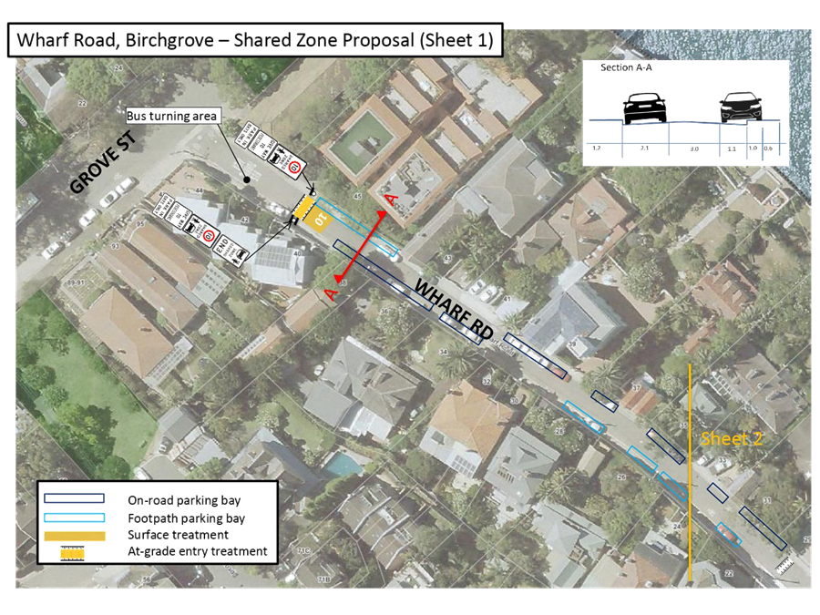
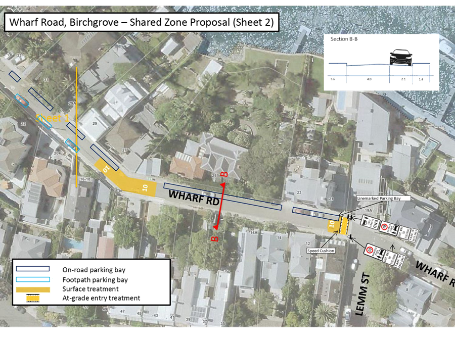
The initial concept plan has been revised as a result of the community consultation.
The revised concept plan is shown in Attachment 1 outlines the proposed works on Wharf Road between Grove Street and Lemm Street and includes the following treatments:
· ‘10km/h Shared Zone’ in Wharf Road between Grove Street and Lemm Street
· At-grade thresholds as an entry treatment
· Pavement surface colouring to modify the street environment to make drivers and pedestrians aware of the difference in the street environment from the surrounding road network.
· On-road marked parking bays
· Footpath parking bays
· Associated signposting and linemarking
This proposal will ensure pedestrian safety, access and amenity is maintained. It also ensures that a clear travel lane is maintained for emergency service vehicle access.
A gap between marked parking bays will be incorporated into the design to allow clear passage for pedestrians to access the primary access of their property where sufficient residual footpath is not provided.
A detailed design will be prepared based on the revised concept plan and residents comments.
PUBLIC CONSULTATION
|
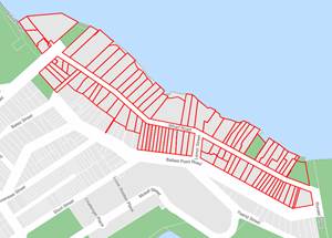
A letter outlining the above proposal was mailed to the affected 129 properties in Wharf Road, Grove Street and Ballast Point Road, requesting residents’ views regarding the proposal (as indicated on the following plan).
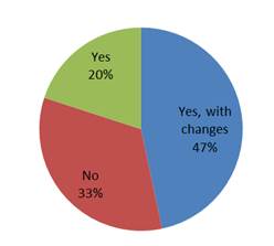
30 responses were received with 6 in support, 14 in general support with request for changes and 10 in objection.
Resident comments related to the proposal have been outlined below. |
|
|
Residents’ Comment |
Officer Comments |
|
Traffic and Parking Comments |
|
|
The bay on the south side of Wharf Road immediately west of Lemm Street may restrict sight lines for vehicles turning into the street.
(2 similar comments) |
The concept plan has been modified to address these concerns and individual comments will be further considered in the detailed design. |
|
Parking bay obstructs potential for future driveways of Nos.37, 39, 41 Ballast Point Road.
(1 similar comments) |
|
|
Current plan shows a parking bay across my front gate.
(3 similar comments) |
|
|
Footpath parking is not required in the section between No.25 Wharf Road and Lemm Street where the parking demand is less due to limited residential frontages and provision of off-street parking to residents.
(5 similar comments) |
|
|
Could be difficult for large vehicles to pass through the street with footpath parking.
(2 similar comments) |
A 3m unobstructed travel lane will be provided. |
|
Footpath parking should be provided on both sides of the street in narrower sections.
(1 similar comments) |
|
|
Heavy vehicles (garbage trucks) have difficulty passing through Wharf Road and footpath parking will assist.
(1 similar comments) |
|
|
Speed calming is not required as it is already a low-speed environment and humps create noise issues.
(7 similar comments) |
The speed cushions have been removed in the revised concept plan and replaced with at-grade thresholds as an entry treatment.
|
|
I support the traffic calming devices.
(2 similar comments) |
|
|
Is currently a viable space outside No.20 Wharf Road and between Nos.20 and 22 Wharf Road.
(1 similar comments) |
These spaces have been added to the revised concept plan and individual comments will be further considered in the detailed design. |
|
A further parking space can be provided between Nos.31 and 33 Wharf Road.
(3 similar comments) |
|
|
There is currently a parking space in front of No.16-18 Wharf Road (1 similar comments) |
This request will be considered as part of the detailed design. |
|
A convex mirror should be provided around No.25/27 Wharf Road to improve sightlines.
(2 similar comments) |
Convex mirrors are not supported as they distort speed, distance and the size of pedestrians and motorists. |
|
Investigate one-way restrictions in Wharf Road.
(4 similar comments) |
One-way restrictions reduce accessibility and encourage an increase in vehicle speeds which is not appropriate for a ‘10km Shared Zone’ environment.
Wharf Road experiences low traffic volumes and passing opportunities are adequate to accommodate two way movement. |
|
Driveway and Pedestrian Access Comments |
|
|
Footpaths should be for the exclusive use of pedestrians for safety. |
This proposal provides a ‘10km/h Shared Zone’ to allow pedestrians to walk along the road as they do now. |
|
Can there be consistency in having on-street parking on the entire northern side of Wharf Road and footpath parking on the south side (where the footpath is obstructed anyway).
(2 similar comments) |
Footpath parking has been provided in a manner to maximise parking and avoid sections of high-kerb. |
|
Speed calming devices should be moved closer to Grove Street and should not interfere with driveway access.
(1 similar comments) |
The speed cushions have been removed in the revised concept plan and replaced with at-grade thresholds as an entry treatment.
|
|
Parking adjacent to driveways may obstruct garage access.
(2 similar comments) |
The Concept Plan has been modified to address some of these concerns and individual comments will be further considered in the detailed design through a swept path analysis. |
|
Parking opposite to driveway may obstruct garage access.
(3 similar comments) |
|
|
General Comments |
|
|
Bus drivers turning into the bus turning area cause damage when they fail to raise their bus. They should also be advised how far they can enter Wharf Road.
(2 similar comments) |
Council will liaise with Transit Systems to ensure bus drivers are aware of the requirement to raise the bus and will investigate whether improved signage and road pavement marking is required. |
|
Does Council propose to introduce roll-top kerb as part of the proposal.
(1 similar comments) |
Roll top kerb is not proposed. Footpath parking has generally been provided at locations with a standard or low kerb which has proved successful in other Footpath Parking schemes. |
|
The proposal will harm the heritage aspect of the street.
(5 similar comments) |
Supplementary mid-block signage has been removed from the revised concept plan. |
|
Signage should be reduced due to the heritage nature of the area.
(1 similar comments) |
|
|
The eastern section Wharf Road from Lemm Street to Ronald Street should be included in the Shared Zone scheme (near Ballast Point Park) to reduce vehicle speeds.
(3 similar comments) |
Footpath parking does not occur in this section of Wharf Road and so a 10km/h Shared Zone’ and Footpath Parking scheme has not been proposed. Vehicle speeds in this section can be reviewed as a separate matter. |
|
Residents should be able to park in front of their garages.
(2 similar comments) |
It is illegal to park in front of a garage even if it is your own. Council is unable to mark a parking bay in front of a garage as part of this proposal and so it will effectively be a ‘No Parking’ zone and only allow drop-off and pick-up. |
|
Is a 10km/h shared zone only applicable in the coloured area indicated.
(1 similar comments) |
The entire section of Wharf Road between Grove Street and Lemm Street is proposed to be a ‘10km/h Shared Zone’. The coloured areas are a coloured treatment to show a change in road environment and there is a midblock treatment to reinforce this change in environment. |
|
There was a significant amount of construction previously in Wharf Road which has ceased. It could be wrong to change the parking conditions as this congestion has ceased.
(1 similar comments) |
This proposal has been provided in response to resident concerns regarding the existing Footpath Parking. |
|
The area has been working well in an informal way and no change should be made.
(2 similar comments) |
|
CONCLUSION
The initially consulted concept plan has been refined based on resident feedback and is presented in this report for approval. A detailed design will be prepared for further consultation with residents prior to being forwarded to RMS for its approval.
|
1.⇩ |
Wharf Road Birchgrove - revised concept plan |
|
Local Traffic Committee Meeting 3 June 2019 |
Subject: Mullens, Beattie and Montague Streets, Balmain - Proposed Intersection Treatments (Baludarri-Balmain Ward/Balmain Electorate/Leichhardt PAC)
Prepared By: Vinoth Srinivasan - Engineer - Traffic and Parking Services
Authorised By: John Stephens - Traffic and Transport Services Manager
|
RECOMMENDATION
THAT the detailed design plan for the speed cushions and associated signs and line marking on approach to the roundabout at Mullens Street, Beattie Street and Montague Street, Balmain (as per Design Plan No.10075) be APPROVED.
|
BACKGROUND
The roundabout at the intersection of Mullens Street, Beattie Street and Montague Street, Balmain has been identified as a location that requires traffic calming measures to improve safety at the intersection.
A review of 5 year RMS crash history (June 2012 to June 2017) has revealed that there had been six injury crashes at the roundabout and further analysis of the crash data revealed that speed was a main contributor in a number of these crashes.
Council is proposing to install three (3) new speed cushions and associated signage at the roundabout on Mullens Street, Beattie Street and Montague Street, Balmain to reduce speeds and improve road safety for pedestrians and motorists at the intersection.
The detailed design plans have been finalised for the proposed works together with community consultation and are presented in this report for consideration.
Site Location & Road Network
|
Street Name(s) |
Mullens Street, Beattie Street and Montague Street |
|
Section |
Intersection |
|
Traffic Volume |
Mullens Street (Reynolds to Goodsir Street) – 12,308 vpd (2012 Traffic Count) Beattie Street (Lawson Street to Evans Street) – 5,246 vpd (2014 Traffic Count) |
|
Recorded Accident History (5 year) |
6 injury crashes |
|
Recorded 85% speed |
Mullens Street (Reynolds to Goodsir Street) – 41km/h (2012 Traffic Count) Beattie Street (Lawson Street to Evans Street) – 35.9km/h |
|
Speed Limit |
40km/h |
|
Carriageway width |
Mullens Street – approx 9.5m Beattie Street – approx. 9.6m Montague Street – approx 9.6m |
|
Carriageway Type |
All streets are two way with one travel lane in each direction and kerb side parking lanes |
|
Road Classification (State, Regional, Local) |
Mullens Street – Regional road Beattie Street – Local road Montague Street – Regional road |
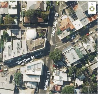
Figure 1 – site locality
FINANCIAL IMPLICATIONS
Funding of $34,300 has been allocated to this project for construction in the 2019/2020 Capital Works Program and the proposal has received RMS funding as part of the 2019/20 Safer Roads Program.
OTHER STAFF COMMENTS
Council has recently installed a raised pedestrian (zebra) crossing on Mullens Street, on the southern approach of the existing roundabout to improve traffic conditions and road safety at this location.
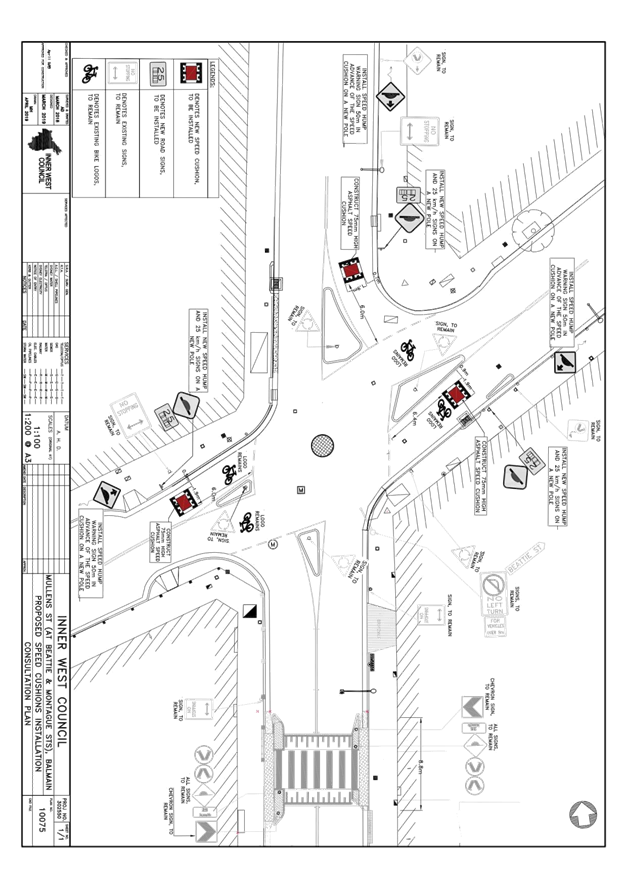
Design Plan No. 10075
A detailed design plan is shown in Attachment 1 for the proposed installation of three (3) speed cushions and associated signage at the intersection of the Mullens, Beattie and Montague Streets, Balmain and is submitted for consideration.
The proposed scope of works includes the following:
· Construction of three (3) asphalt speed cushions at the intersection of Beattie Street/Mullens Street/Montague Street (on the western, northern, and eastern approaches), and
· Installation of associated signage and line marking.
These speed cushions will assist in reducing vehicular speeds approaching the roundabout noting that there is limited deflection achieved in the current roundabout layout due to the site constraints and narrow carriageways.
This proposal will not result in the loss of any on-street parking spaces.
PUBLIC CONSULTATION
|
Consultation was conducted between 16 April 2019 and 17 May 2019. A letter as well as a copy of the design plan was sent to the local residents in Montague Street, Beattie Street and Mullens Street, Balmain. A total of 170 letters were distributed (as indicated in the plan).
Two (2) responses were received.
|
|
|
Residents’ Comments |
Officer Comments |
|
We support Council’s proposal as traffic volumes and speed on Beattie Street has increased as it is used as an unofficial shortcut. Council should investigate speed cushions in the section of Beattie Street between Mullens Street and Palmer Street (closer to Balmain village) to match the rest of Beattie Street. |
The request for further traffic calming measures on Beattie Street will be listed for investigation as part of a future Local Area Traffic Management (LATM) study in this area. |
|
I believe proposed cushions should be located further away from the intersection as speeding occurs midblock of all three streets. |
The speed cushions are in place to address speed levels through the intersection and are not intended to address midblock speeding issues. |
|
1.⇩ |
Detailed Design Plan - Montague Street, Beattie Street and Mullens Street |
|
|
Local Traffic Committee Meeting 3 June 2019 |
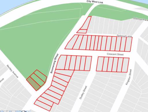
Subject: Crescent Street and Boomerang Street, Haberfield - Proposed Refuge Island and Speed Cushion (Gulgadya-Leichhardt Ward/ Summer Hill Electorate/ Burwood PAC)
Prepared By: David Yu - Engineer - Traffic and Parking Services
Authorised By: John Stephens - Traffic and Transport Services Manager
|
RECOMMENDATION
THAT the detailed design plan for the kerb blister islands, speed cushions and associated signposting and linemarking in Crescent Street and Boomerang Street, Haberfield (as per the attached plan No. 10074) be approved.
|
BACKGROUND
As part of the 2019/20 Traffic Facilities (LATM) Capital Works Program, Council is proposing to construct a pedestrian refuge island in Crescent Street at Boomerang Street and install speed cushions in Boomerang Street, north of Crescent Street, Haberfield to improve safety and calm traffic in the street.
Currently, there are only existing median islands at all approaches to the intersection of Boomerang Street and Crescent Street, Haberfield.
A detailed design plan has been finalised for the proposed works together with community consultation and are presented in this report for consideration.
Site location & Road Network
|
Street Name(s) |
Crescent Street and Boomerang Street, Haberfield |
|
Section |
Intersection |
|
Traffic Volume |
- |
|
Recorded Accident History (5 year) |
Nil. |
|
Recorded 85% speed |
- |
|
Speed Limit |
50km/h |
|
Carriageway width |
Crescent Street - 12.6m Boomerang Street - 11.6m |
|
Carriageway Type |
Boomerang Street - Two way with kerb side parking on both sides of the street Crescent Street - Two way with kerb side parking on both sides of the street |
FINANCIAL IMPLICATIONS
Funding of $40,000 has been allocated to this project for construction in the 2019/20 capital works program.
OTHER STAFF COMMENTS
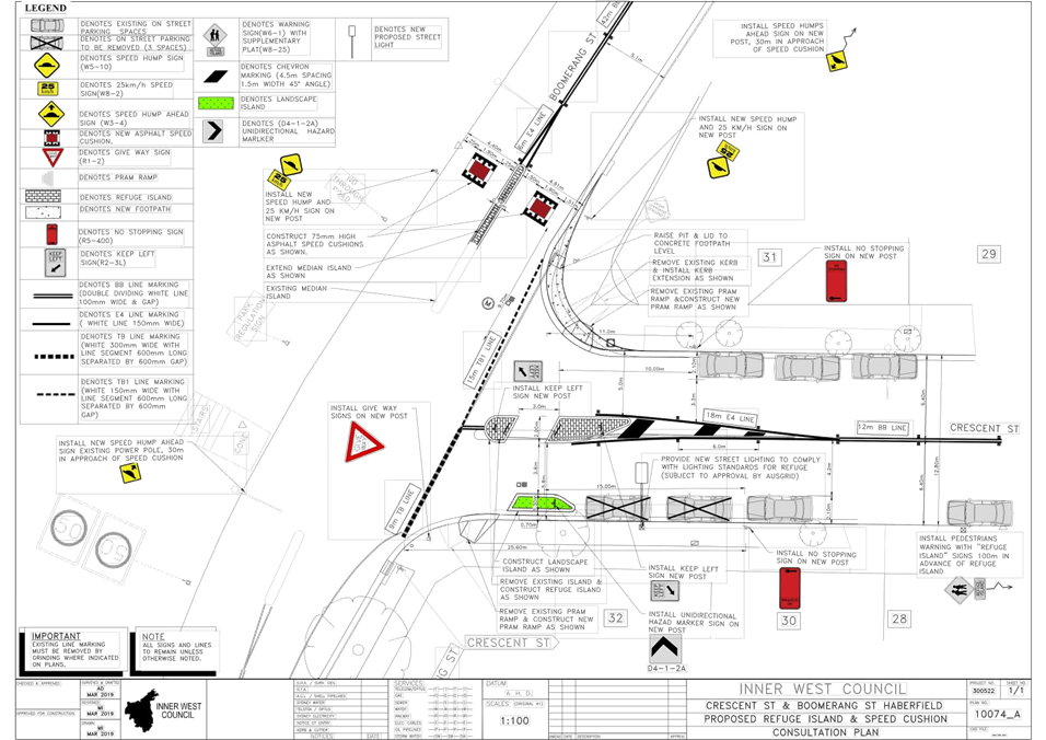
The detailed design plan shown in Attachment 1 outlines the proposed works at the Crescent Street and Boomerang Street intersection and includes the following treatments:
· Construction of a new pedestrian refuge island in Crescent Street at Boomerang Street;
· Reconstruction of kerb ramps;
· Construction of a kerb extension on the north-east corner of the Crescent Street and Boomerang Street intersection;
· Installation of two asphalt speed cushions on Boomerang Street, north of Crescent Street;
· Construction of a kerb blister island on Crescent Street; and
· Installation of associated signage and linemarking
There will be a loss of two (2) parking spaces associated with the construction works.
It should be noted that there is a bus route along Crescent Street and Boomerang Street (Route 406), and the proposal can accommodate the bus movements as confirmed by a separate swept path analysis.
PUBLIC CONSULTATION
A letter outlining this proposal was mailed out to the affected properties (36 properties) in Crescent Street and Boomerang Street, Haberfield, requesting residents’ views regarding the proposal (as indicated on the following plan).
A total of two (2) responses were received, both in objection of the proposal.
|
Residents’ Comments |
Officer Comments |
|
The proposed new pedestrian refuge will remove two of the three car parking spaces immediately in front of our house. |
The proposal has been modified to retain one of the three (3) car parking spaces that were originally proposed to be removed. Therefore, the amended proposal would result in a loss of two (2) car parking spaces.
|
|
There is much more pedestrian traffic across Boomerang Street than across Crescent Street.
There is relatively little pedestrian traffic across Crescent St at this intersection.
The more useful pedestrian refuge would be on Boomerang Street, south of the intersection with Crescent Street.
It may also be possible to construct a kerb extension on the eastern gutter of Boomerang Street (immediately south of the intersection). |
The proposed treatments were identified in the Ashfield Traffic Management Strategy (ATMS) to address speed related issues at the intersection of Boomerang Street and Crescent Street, Haberfield.
The proposal is expected to provide a traffic calming impact at the intersection and will improve pedestrian amenity by reducing the crossing distance (currently 20m) in Crescent Street, which is wider than Boomerang Street.
Improvements to the crossing points around Robson Park can be considered as part of a future Local Area Traffic Management scheme.
|
|
Large trucks sometimes struggle to negotiate this intersection because of the placement of the existing islands and associated signage. |
Swept path analysis has been undertaken to consider trucks and buses turning at the intersection of Crescent Street and Boomerang Street. |
|
1.⇩ |
Crescent Street and Boomerang Street, Haberfield - Proposed Traffic Calming Measures |
|
|
Local Traffic Committee Meeting 3 June 2019 |
Subject: Centennial Street, Marrickville – Temporary Road Closure For Special Event at Henson Park – Beer, Footy and Food Festival on Saturday 27 July 2019 (Midjuburi-Marrickville Ward/Summer Hill Electorate/Inner West PAC)
Prepared By: Jennifer Adams - Engineer – Traffic and Parking Services
Authorised By: John Stephens - Traffic and Transport Services Manager
SUMMARY
A S68 Application (201900002) has been received from the Music & Booze Company together with the Newtown Rugby League Football Club to hold the Beer, Footy and Food Festival 2019 on Saturday 27 July 2019 at Henson Park Oval and on Centennial Street, Marrickville between Sydenham Road and the entrance gate to Henson Park Oval.
It is recommended that Council agree to the temporary full road closure of the subject section of Centennial Street, Marrickville on Saturday 27 July 2019 (weather permitting) or alternatively on Saturday 24 August 2019 between 8.00am and 8.00pm, subject to complying with the following conditions; apply to the RMS for consent to close the subject road, subject to the event being advertised, a Traffic Management Plan be submitted to the RMS for approval, a Road Occupancy License be obtained from the Transport Management Centre and advice of the proposed event being forwarded to the appropriate authorities including emergency services.
|
THAT the proposed temporary full road closure of Centennial Street, Marrickville between Sydenham Road and the entrance gate to Henson Park Oval on Saturday 27 July 2019 between 8.00am and 8.00pm (weather permitting) or Saturday 24 August 2019 between 8.00am and 8.00pm, for the holding of the Beer, Footy & Food Festival 2019 at Henson Park Oval, be APPROVED, subject to the approval of the S68 Application and the applicant complying with, but not limited to, the following conditions:
1. A Road Occupancy License application be obtained by the applicant from the Transport Management Centre;
2. All affected residents and businesses, including NSW Police Local Area Commander, Transit Systems, Fire and Rescue NSW and NSW Ambulance Services, shall be notified in writing by the applicant of the proposed temporary road closure at least 7 days prior to the event, with the applicant making reasonable provision for residents and businesses;
3. The occupation of the road carriageway must not occur until the road has been physically closed.; and
4. The applicant be advised in terms of this report and that all costs for the event and implementation of the road closure are to be borne by the applicant. |
BACKGROUND
A S68 Application has been received from the Music & Booze Company together with the Newtown Rugby League Football Club to hold the Beer, Footy & Food Festival 2019 on Saturday 27 July 2019 between the hours of 12.00pm and 6.00pm at Henson Park Oval and on Centennial Street, between Sydenham Road and entrance gate to the Henson Park grounds.
Given that the event date falls within the winter season and it is held outdoors, the applicant requests for an alternative date for the event if there is adverse weather. If the event is impacted by weather, the alternate date will be on Saturday 24 August 2019. All conditions of notification will be similarly met for this alternate date.
Henson Park is Council owned land for which the Newtown Jets have a pre-existing arrangement for the use of the site. The event has received Land Owners Consent from Council.
The Newtown Jets FC has a long-standing relationship with the Sydney Inner West community and with Council. The Newtown Jets have built a reputation on delivering regular sporting matches at Henson Park Oval that are family friendly and all inclusive. The Beer, Footy & Food Festival is an extension of the Newtown Jets regular Saturday matches which local residents are familiar with. It is anticipated that the event will attract between 7,000 to 9,000 people.
The event was launched in June 2016 and this years’ event makes it the fourth year the event has been running. In 2018 the event had 7000 people attend and the hope is to go bigger in 2019. The 2018 festival was successfully delivered, meeting all Council conditions of the approved DA S68-201600004.
The event will be on 27 July 2019 starting at 12pm (noon). The period of Site operation is listed as Friday, 26 July 2:00pm - Sunday, 28 July 12:00pm 2019 with the Period of Event operation being Saturday, 12:00pm – 6:00pm 27 July 2019.
It is noted that a fee of $1,578.50 for the temporary road closure is payable by the applicant in accordance with Council’s Fees and Charges.
FINANCIAL IMPLICATIONS
Under Council’s Fees & Charges, the applicant has to pay the fee for the temporary full road closure. This fee includes the cost of an advertisement in accordance with the Roads Act 1993.
OFFICER COMMENTS
Site location & road network
![]()
|
Street Name |
Centennial Street |
|
Section |
Between Sydenham Road and northern end |
|
Carriageway Width (m) |
12.8 |
|
Carriageway Type |
Two-way road with one travel lane in each direction, in addition to kerbside parking lanes. |
|
Classification |
Local |
|
85th Percentile Speed (km/h) |
42.5 |
|
Vehicles Per Day (vpd) |
367 |
|
Reported Crash History (July 2011 – June 2016) |
No crashes recorded. |
|
Heavy Vehicle Volume (%) |
2.2 |
|
Parking Arrangements |
Unrestricted parking along both sides of the road. |
The temporary full-road closure of Centennial Street is required from 8.00am to 8.00pm on the day of the event to undertake the setup prior to the event and cleaning after the event, before the road can be reopened to traffic.
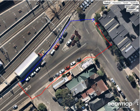
The applicant advised that traffic controllers and barricades will be located on Centennial Street at Sydenham Road and along Sydenham Road. Centennial Street will be providing vehicular access to only local residents, event staff, football coaches and football players, and emergency services.
Event attendees will ingress and egress via the laneway access point from Sydenham Road and the access point at Woodland Street with security staff and traffic controllers monitoring (refer to Site Plan below of Henson Park Oval and TMP/Traffic Control Plans at the end of this report).
![]()
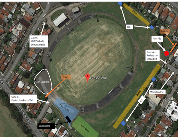
A 4-metre wide emergency vehicle access must be maintained through the closed road areas during the course of the event. Special Event advance notice signs will be strategically installed at least two (2) weeks prior to the event to alert motorists of the proposed closures.
It is noted that adequate vehicular traffic control shall be provided for the protection and convenience of pedestrians and motorists including appropriate signage and flagging. Workers shall be specially designated for this role (and carry appropriate certificates), as necessary to comply with this condition. This is to be carried out in accordance with the Australian Standard AS 1742.3 – Traffic Control Devices for works on roads. Further, it is noted that water filled barriers will be placed at the road closure points to protect against any possible errant vehicles.
The subject section of Centennial Street carries a low volume of traffic and therefore will have no major impacts on the surrounding road network. The event will be held on a Saturday when lower than weekday traffic volumes are expected.
The location of the event has access to public transport services, with Sydenham Railway Station located approximately 1km west along Sydenham Road and Marrickville Railway Station located approximately 1km south along Illawarra Road from the event location and bus routes (Route 412, 418, 426 & 428) operating along Livingstone Road, Marrickville Road and Addison Road.
PUBLIC CONSULTATION
The proposed temporary full road closure of Centennial Street, Marrickville between Sydenham Road and the entrance gate to Henson Park Oval is currently advertised in the newspaper allowing a period of 28 days for submissions. The advertising period commenced on 28 May 2018 and will conclude on 24 June 2019. A Traffic Management Plan is to be submitted to the RMS for its consideration and approval.
The event organiser will need to notify all affected residents and businesses in writing of the proposed temporary full-road closure at least 7 days prior to the event and make reasonable provision for residents and businesses, where possible.
CONCLUSION
It is recommended that Council approves the temporary full road closure of the subject section of Centennial Street, Marrickville on Saturday 27 July 2019 (weather permitting) or alternatively on Saturday 24 August 2019 subject to complying with the following conditions; apply to the RMS for consent to close the subject road, subject to the event being advertised, a Traffic Management Plan be submitted to the RMS for approval, a Road Occupancy License be obtained from the Transport Management Centre and advice of the proposed event being forwarded to the appropriate authorities including emergency services.

|
|
Local Traffic Committee Meeting 3 June 2019 |
Subject: Burrows Avenue and Hogan Avenue, Sydenham – Sydney Metro Sydenham Station and Junction (SSJ) Works – Temporary traffic control arrangements (Midjuburi Ward / Heffron Electorate / Inner West PAC)
Prepared By: Jennifer Adams - Engineer – Traffic and Parking Services
Authorised By: John Stephens - Traffic and Transport Services Manager
|
RECOMMENDATION
THAT the design of the temporary traffic control arrangements in Burrows Avenue and temporary pedestrian refuge and associated signs and line markings in Hogan Avenue, Sydenham (as per attached design plans prepared by Bitzios and dated 10 May 2019) be approved, subject to additional controls at the intersection of Hogan Avenue and Burrows Road being further investigated by JHLORJV and necessary treatments provided to satisfy the issues raised in the Road Safety Audit.
|
BACKGROUND
Sydney Metro have engaged John Holland Pty Ltd and Laing O’Rourke Australia Construction Pty Ltd (JHLORJV) to undertake the Sydenham Station and Junction works to facilitate the new Sydney Metro line and part of these works involve the construction of a new concourse and plaza. These works necessitate that pedestrians are (temporarily) crossed over from the Station side of Burrows Ave to take them away from construction activities for the new Southern Plaza. Design plans have been submitted to Council for the temporary traffic control arrangements in Burrows Avenue and Hogan Avenue, Sydenham as part of the Sydney Metro Sydenham Station and Junction (SSJ) works. The design plans and subsequent Road Safety Audit is attached for the Committee’s consideration.
FINANCIAL IMPLICATIONS
All costs of recommended temporary works will be borne by Sydney Metro Sydenham Station and Junction (SSJ).
DISCUSSION
The site location is adjacent Sydenham Railway Station. Burrows Avenue and Hogan Avenue form a minor collector route connecting between Unwins Bridge Road and Gleeson Avenue, Sydenham.
![]()
|
Street Name
|
Burrows Avenue |
|
Section |
Between Gleeson Avenue and George Street |
|
Carriageway Width (m) |
12.8 |
|
Carriageway Type |
Two-way road with one travel lane in each direction, in addition to kerbside parking lanes. |
|
Classification |
Local |
|
85th Percentile Speed (km/h) |
47.5 |
|
Vehicles Per Day (vpd) |
7,296 |
|
Reported Crash History (July 2011 - June 2016) |
No RMS recorded crashes. |
|
Heavy Vehicle Volume (%) |
5.1 |
|
Parking Arrangements |
Various on northern side of the road since Sydney Metro SSJ construction works being carried out. Southern side of the road consists of ‘No Parking’ restrictions with a section of ‘2P 8:30am-6pm Mon-Fri, 8:30am-12:30pm Sat’ restrictions. |
|
Street Name
|
Hogan Avenue |
|
Section |
Between Burrows Avenue/ Bolton Street intersection and Unwins Bridge Road |
|
Carriageway Width (m) |
12.8 |
|
Carriageway Type |
Two-way road with one travel lane in each direction, in addition to kerbside parking lanes. |
|
Classification |
Local |
|
85th Percentile Speed (km/h) |
N/A |
|
Vehicles Per Day (vpd) |
N/A |
|
Reported Crash History (July 2011 - June 2016) |
One RMS reported tow-away crash on 20/1/2012 at 4.00am on Hogan Avenue 7 metres south of Burrows Avenue. RUM 80 – car travelling east ran off the road to the left on a right hand bend. |
|
Heavy Vehicle Volume (%) |
N/A |
|
Parking Arrangements |
Eastern side of the road consists of unrestricted parking with sections of ‘No Parking’ restrictions. Western side of the road consists of ‘2P 8:30am-10pm Permit Holders Excepted – Area M4’ restrictions. |
Proposed temporary works
During construction of the Sydney Metro Sydenham Station and Junction (SSJ) works temporary changes to the existing pedestrian routes in the locality are required. Pedestrians using Burrows Avenue on the southern side of Sydenham Railway Station often utilise the northern side of Burrows Avenue to access the commuter car parking in Bolton Street and/or local destinations in the area such as Hogan Avenue. This route is directly adjacent the construction area alternative arrangements were deemed necessary by the contractors.
The diagram below summaries the changes in pedestrian routes that are required. Essentially, the proposal for the Burrows Avenue / Hogan Avenue pedestrian crossing routes improves the configuration currently in operation by introducing a new temporary refuge on Hogan Avenue. A number of temporary additional road and footpath upgrades are proposed. These include:
|
|
Burrows Avenue
· The current pedestrian refuge island will be widened to align with the proposed improved ramps on either side.
· The current pedestrian ramp on the rail side will be widened.
· The temporary yellow ramp on the southern side (adjacent to George Street) will be removed and replaced with a wider concrete ramp.
Hogan Avenue:
· The temporary yellow ramps on either side of the road will be removed and replaced with wider concrete ramps.
· A new refuge island will be installed to connect pedestrians and align with the new concrete ramps.
· Loss of two (2) parking spaces along Hogan Avenue intersection with Burrows Avenue.
The road and footpath changes will remain in place for at least two years.
Sign and line markings diagrams are included along with swept path diagrams. It is noted that JHLORJV also propose to replace all plastic ramps with concrete pram ramps as well as realign the pram ramp crossings on Burrows Avenue to suit the existing the refuge alignment.
The design of the temporary traffic control arrangements in Burrows Avenue and temporary pedestrian refuge and associated signs and line markings in Hogan Avenue, Sydenham (as per attached design plans prepared by Bitzios and dated 10 May 2019)
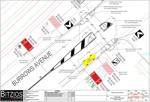
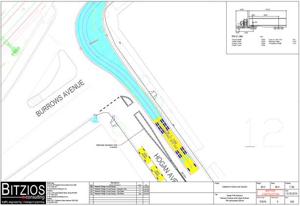
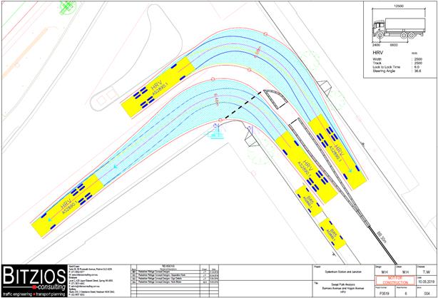
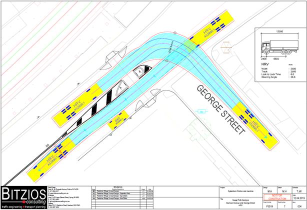
Road Safety Audit
Council Officers requested that all road safety aspects of the proposed pedestrian refuge designs be identified and that a road safety audit be prepared. In response JHLORJV commissioned Bitzios Consulting to undertake a Road Safety Audit of the two proposed temporary pedestrian refuges located adjacent to the Sydenham Station and Junction (SSJ) project site. Specifically, their report addressed the pedestrian refuge concept designs and local site conditions.
The Road Safety Audit identified the two proposed refuges as follows:
Hogan Avenue
Located immediately south of the Hogan Avenue, Bolton Avenue, Burrows Ave Intersection
Primarily consists of Saferoads Separation (recycled rubber) kerb with posts
temporary concrete kerb ramps built into existing kerb and footpath on each side of the road
Relocation of parking and signage to allow for mandatory 'No Stopping' zones on both sides of the road
Burrows Avenue
Immediately west of the Burrows Avenue and George Street intersection (near existing refuge)
Primarily concrete refuge island construction
temporary concrete kerb ramps built into existing kerb and footpath on each side of the road
Introduction of new linemarking and chevron marking leading up to and around refuge island
Relocation of kerbside parking and signage to allow for mandatory no stopping zones on both sides of the road.
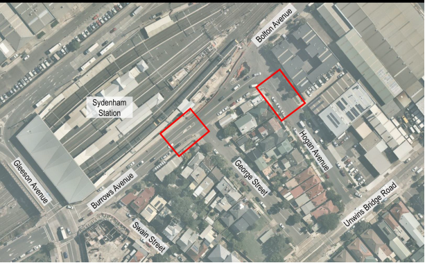
It was stated that the road safety audit was undertaken in accordance with the procedure set out in the Austroads – Road Safety Audit (2009) Manual and the RMS Guide to Road Safety Practices. The audit involved a review of the proposed plans and a day time and night time site visit of the two locations outlined in the above diagram.
A summary of the Road Safety Audit (RSA) findings and JHLORJV’s responses are reproduced below:
Hogan Avenue
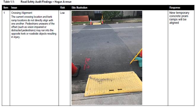
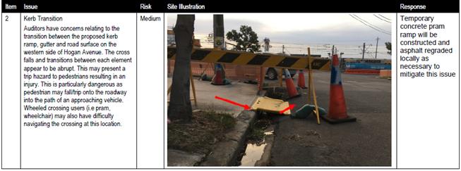
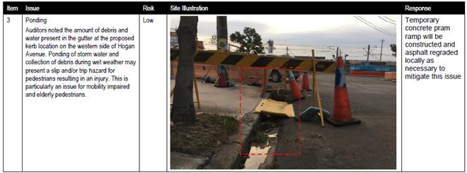
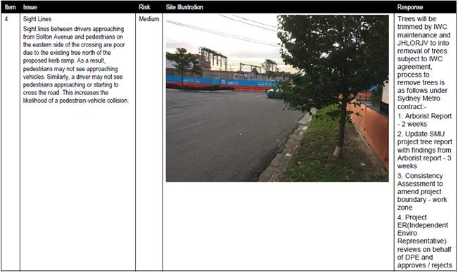
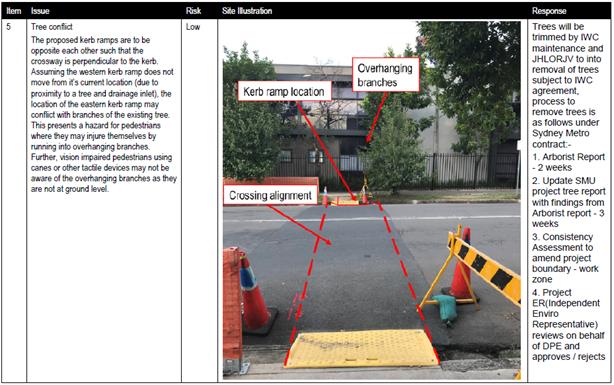
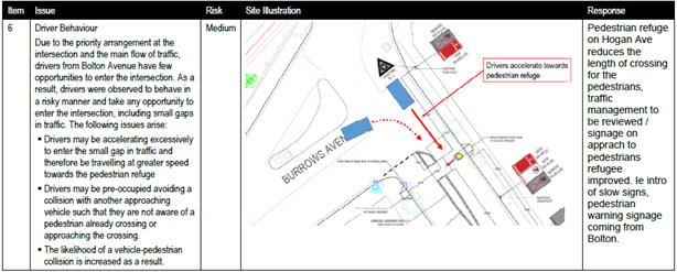
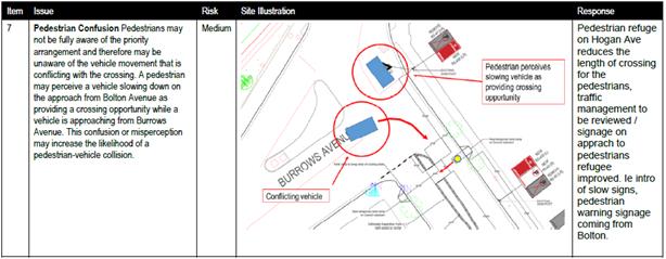
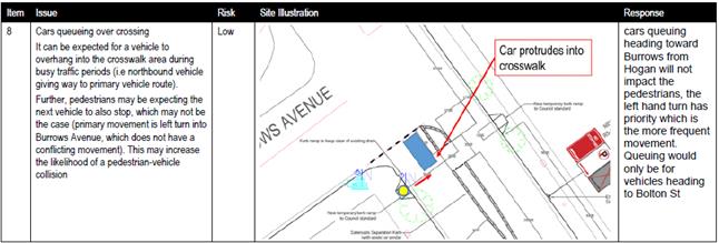
Burrows Avenue
![]()
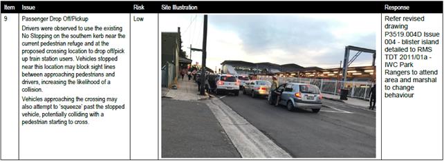
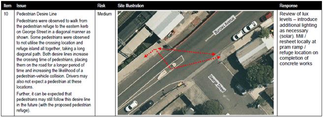
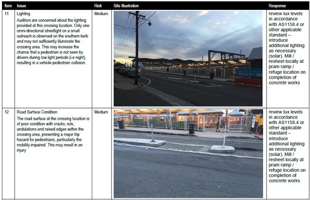
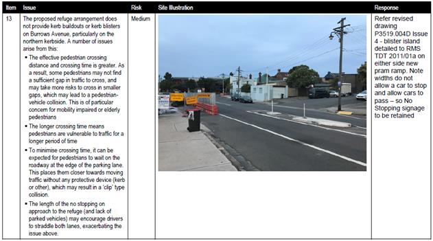
The Road Safety Audit examined the concept plans and site conditions relating to the proposed pedestrian refuges and identified any features of the project which could be altered or removed to improve safety for road users and others. The issues identified were prioritised based on Austroads’ standard risk assessment. JHLORJV responded to each of the identified issues as outlined above.
PUBLIC CONSULTATION
Sydney Metro Sydenham Station and Junction (SSJ) are responsible for any consultation requirements. At regular Sydney Metro SSJ update meetings, attended by Council’s Traffic Section, a report is given detailing what consultation has been carried out and itemise any concerns residents / businesses have raised. To date one concern by a George Street resident has been received where the resident was enquiring about whether the present works would be formalised.
In response to Traffic Section’s request for local residents / businesses to be consulted specifically on the formalisation of the works SSJ have supplied a copy of a flyer ( reproduced below) which has been distributed locally to all residents / businesses. Any responses and concerns will be tabled at the Traffic Committee meeting.
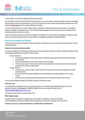
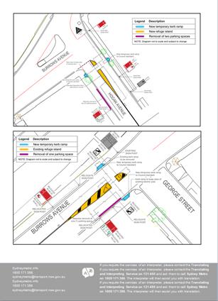
CONCLUSION
It is recommended that the report be received and noted and that approval of the design plans for the temporary traffic control be determined by the Traffic Committee at its meeting.
Generally, the mitigation measures as responded by JHLORJV to the issues raised in the Road Safety Audit are acceptable. However, additional controls at the intersection of Hogan Avenue and Burrows Road requires further investigation and treatment to satisfy the issues raised in the Road Safety Audit.
It is noted that the issue with the tree in Hogan Avenue (Issue 5) may not be able to be resolved satisfactorily without the tree being removed completely and replaced nearby with another tree. Adequate sight lines for pedestrians are paramount for satisfactory road safety outcomes. Should approval be forthcoming it is recommended that the tree be removed and replaced nearby.
In regards to illegal drop-off / pick-up movements by motorists in Burrows Avenue (Issue 9) it is suggested that a recommendation, should approval be forthcoming, that Council’s Parking Officers regularly monitor the location.
|
|
Local Traffic Committee Meeting 3 June 2019 |
Subject: Toothill Street at Victoria Street, Lewisham – Concept plan for Raised Pedestrian crossing with kerb extensions on all approaches of intersection (Damum - Stanmore Ward/ Summer Hill Electorate/ Inner West PAC)
Prepared By: Jennifer Adams - Engineer – Traffic and Parking Services
Authorised By: John Stephens - Traffic and Transport Services Manager
|
RECOMMENDATION
THAT:
1. The concept proposal to raise the existing pedestrian zebra crossing on Toothill Street at its intersection with Victoria Street, Lewisham and construct kerb blister extensions on all approaches of the intersection in order to improve pedestrian safety, especially school children, at the location be supported in principle and listed within Council’s Forward Capital Works Program; and
2. Responding residents be advised in terms of this report.
|
BACKGROUND
Residents have raised concerns about the safety of pedestrians using the pedestrian zebra crossing on Toothill Street adjacent to its intersection with Victoria Street, Lewisham. A concept plan showing potential improvements at the intersection was distributed locally to get feedback on a proposal to raise the existing pedestrian zebra crossing and construct kerb blister extensions on all approaches of the intersection in order to improve pedestrian safety, especially for school children at the location.
Subsequent to consultation and support for the proposed treatment, it is recommended that the proposal be supported in principle and the project be listed within Council’s Forward Capital Works Program.
Council regularly monitors the subject crossing and has initiated various measures over time at the crossing to improve sightlines for both pedestrians and motorists approaching this crossing - removal of hedges; large chevron signage has been replaced with more compact chevron signage; pedestrian signs have been upgraded to fluorescent type to improve visibility of the crossing facility; along with regular remarking of the pedestrian crossing panels. Warning zig-zag lines are installed at the crossing. Incidents of motorists not stopping at the crossing have been reported to NSW Police.
FINANCIAL IMPLICATIONS
The construction of the proposed raised pedestrian crossing and kerb blister extensions will be listed for consideration in the future capital works program.
OTHER STAFF COMMENTS
|
Street Name
|
Toothill Street |
Victoria Street |
|
Section |
Between Victoria Street and The Boulevarde
|
Between Summer Hill Street and Eltham Street |
|
Carriageway Width (m)
|
7.3 |
9.6 |
|
Carriageway Type |
Two-way road with one travel lane, in addition to kerbside parking lanes. |
Two-way road with one travel lane in each direction, in addition to kerbside parking lanes. |
|
Classification |
Regional
|
Local |
|
85th Percentile Speed (km/h) |
43.2
|
38.5 |
|
Vehicles Per Day (vpd) |
9,180
|
984 |
|
Reported Crash History (July 2011 – June 2016) |
2 injury crashes at intersection Toothill Street / Victoria Street |
No crashes recorded Victoria Street / Toothill Street. |
|
Heavy Vehicle Volume (%) |
2.1
|
3.0 |
|
Parking Arrangements |
Unrestricted parking on the southern side and permit parking restrictions on the northern side of the road. |
Sections of unrestricted parking and sections of resident permit parking restrictions |
The subject pedestrian crossing on Toothill Street is just south of its intersection with Victoria Street, Lewisham.
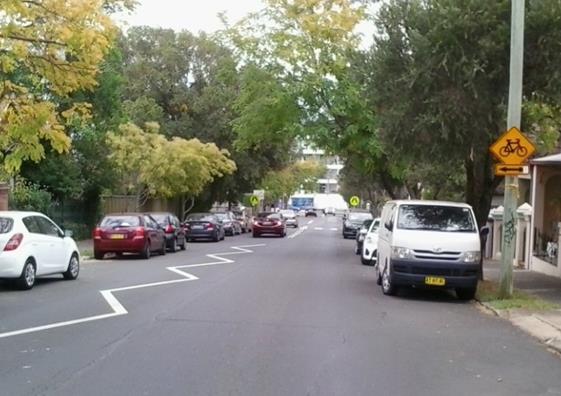
Looking north along Toothill Street towards Victoria Street
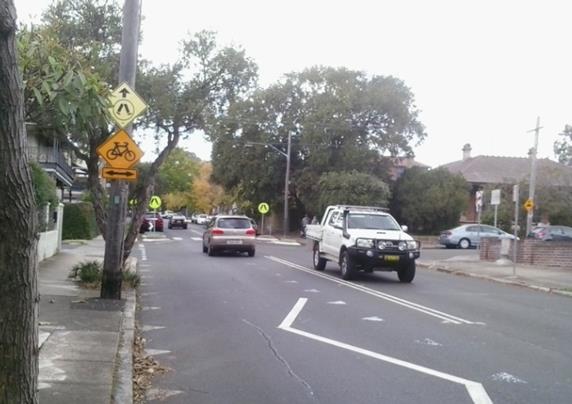
Looking south along Toothill Street towards Victoria Street
PUBLIC CONSULTATION
The concept plan was delivered to 130 surrounding properties and 10 responses were received, eight in support and two opposing the proposal. Consultation period started on 10 May and closed on 24 May 2019.
|
Improving pedestrian safety, especially for school children, in Toothill Street at Victoria Street, Lewisham
|
The map below shows the survey area and the list below outlines resident comments and concerns with Officer’s responses.
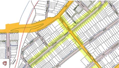
|
Resident Comments (supporting the concept proposal and any concerns raised)
|
Officer’s Response |
|
The resident thanked council for its “thoughtful and proactive approach to road safety” noting that it would make it safer for their children to walk to Lewisham Station. Another resident “fully supports” the proposal to raise the pedestrian crossing on Toothill Street. They state that they have had “countless close calls on that crossing both day and night where people come down Toothill Street too fast and don’t see people on the crossing or waiting to cross.” Another resident supports the proposal. They say that “the proposed upgrading work is necessary and very useful for the pedestrians; also very useful to minimize the traffic safety concerns. There are lots of school children using Toothill Street every day. The current condition of the crossing is too simple, not noticeable enough for such a position with busy traffic every day.” They noted they are looking forward to seeing the upgrading work done. Another resident says “In principle they welcome the proposal given the significant use of the crossing by school children.” They add that cars often speed in the area and that the suggested works will help slow traffic at the intersection |
Pedestrian safety is a major consideration in proposing the concept plan for potential improvements at the intersection. Residents have previously commented about speeding vehicles in the locality and the proposed raised crossing would slow traffic in Toothill Street and improve safety of pedestrians when crossing the road.
|
|
A resident says that the proposal is urgently needed however noted that additional treatment works are required to mitigate other site conditions and risks:
- increased traffic congestion in the area due to recent development growth - poor sight lines due to cars parked either side of the crossing on the north side of the intersection - overgrown trees that obstruct signage and - there should be road markings advising drivers of upcoming crossing.
|
In accordance to the Australian Standards (AS1742.10-2009), the design requirements for an on-street line marked pedestrian crossing must consist of ‘No Stopping’ prohibition within the vicinity of the crossing. This is to increase visibility for pedestrians and improve safety. The proposed new kerb extensions would be incorporated into the design to minimise the loss in car parking spaces.
It is noted that ‘zig zag’ lines are already present as an advance warning of the existing pedestrian crossing. |
|
The resident raised concerns regarding safety of cyclists and asked that consideration be given to how cyclists can be allowed to navigate any kerb extensions built as they can force cyclists to swerve into the main car flow of traffic. |
The resident’s concerns regarding cyclists’ safety would be taken into consideration in the design stage. |
|
A resident of Victoria Street said that the proposed upgrade to the pedestrian crossing is warranted with the amount of foot traffic using the crossing during morning and afternoon peak / school hours as Toothill Street has a lot of vehicular traffic (school buses, trucks and cars) from Old Canterbury Road to New Canterbury Road. The resident reiterated that when looking at the kerb extensions please consider that Victoria Street is used by school and Transit System buses turning from Victoria Street into Toothill Street towards Old Canterbury Road; and noted that kerb extensions on the western side of Victoria Street would block traffic flow if there was a vehicle turning right into Victoria Street.
|
The resident’s concerns regarding buses and trucks using the intersection and possible traffic congestion due to not enough room on Toothill Street for vehicles turning right into Victoria Street, without impeding eastbound traffic on Toothill Street would be taken into consideration in the design stage should the concept plan be approved in principle. |
|
One resident raised concerns about traffic noise being increased due to raising the crossing, especially in light of the significant recent increase in traffic volumes due to the increase in local development in the locality.
|
The concerns regarding increased noise are noted. |
|
A local resident supported the raising of the crossing saying that “the current facility is inadequate and is an accident waiting to happen as cars regularly travel, at speed, through this crossing.” They asked specifically “how many car parking spaces will be lost on either side of Toothill Street”. |
In accordance to the Australian Standards (AS1742.10-2009), the design requirements for an on-street line marked pedestrian crossing must consist of ‘No Stopping’ prohibition within the vicinity of the crossing. This is to increase visibility for pedestrians and improve safety. The proposed new kerb extensions would be incorporated into the design to minimise the loss in car parking spaces. |
|
Residents’ Comments (opposing the concept proposal)
|
Officer’s Response |
|
The resident opposes the proposal and stated that “gridlock is likely to be created by installing blister kerbs on all 4 corners of Toothill and Victoria Streets. Toothill a narrow street, is a major artery connecting Old Canterbury and Stanmore roads and the proposed blisters would likely slow down traffic considerably. They would also make entry to and from Victoria Street and Toothill more difficult than it presently is.” Adding that congestion is an issue and adding kerb blisters would not solve the ‘real traffic problem’ in the locality.
|
Received and noted. It is noted that the proposed kerb extensions in addition to the raising of the pedestrian crossing will improve safety of pedestrians when crossing the road. |
|
Another resident opposes the proposed works noting that evidence has not been provided that “the proposal would benefit the neighbourhood compared to Council resources being utilised elsewhere” and that the proposal may result in the loss of on-street car parking spaces. |
Received and noted. On-street parking is a major consideration during the development of any design plans. Generally, current design practices endeavour to minimise the loss of any legal on-street parking spaces by placing kerb extensions / blisters within the existing statutory 10 metre ‘No Stopping’ zones at intersections. |
CONCLUSION
Subsequent to consultation and support for the proposed works, it is recommended that the proposal be supported in principle and the project be listed in Council’s forward Capital Works Program.
|
|
Local Traffic Committee Meeting 3 June 2019 |
Subject: Minor Traffic Facilities (All Wards/All Electorates/All PACs)
Prepared By: Davide Torresan - Coordinator - Road Access Services
Authorised By: John Stephens - Traffic and Transport Services Manager
|
RECOMMENDATION
THAT:
1. A 6m ‘Disabled Parking’ zone be removed in front of No.3 Merton Street, Stanmore; 2. A 6m ‘Disabled Parking’ zone be removed opposite No.16 Prospect Street, Leichhardt and the resident parking restrictions be reinstated; 3. A 6m ‘Disabled Parking’ zone be removed in front of No.92 Denison Road, Lewisham and the resident parking restrictions be reinstated; 4. A 6m 'Disabled Parking’ zone be installed in front of No.4 Queen Street, Marrickville; 5. A 6m 'Disabled Parking’ zone be installed in front of No.13 Reuss Street, Leichhardt.
|
BACKGROUND
This report considers minor traffic facility applications by Inner West Council, and includes
‘Disabled Parking’ and ‘Works Zone’ requests.
FINANCIAL IMPLICATIONS
Nil.
OTHER STAFF COMMENTS
1. Removal of ‘Disabled Parking’ restriction – Merton Street, Stanmore
A resident advised that the ‘Disabled Parking’ zone in front of No.3 Merton Street, Stanmore, was not being utilised. Council staff contacted the original applicant and they have confirmed that the ‘Disabled Parking’ zone is no longer required.
It is recommended that the 6m ‘Disabled Parking’ zone in front of No.3 Merton Street, Stanmore, be removed.
2. Removal of ‘Disabled Parking’ restriction – Prospect Street, Leichhardt
A resident advised that the ‘Disabled Parking’ zone opposite No.16 Prospect Street, Leichhardt, was not being utilised. Council staff contacted the original applicant and they have confirmed that the ‘Disabled Parking’ zone is no longer required.
It is recommended that the 6m ‘Disabled Parking’ zone in front of No.16 Prospect Street, Leichhardt, be removed, and the resident parking restrictions be reinstated.
3. Removal of ‘Disabled Parking’ restriction – Denison Road, Lewisham
A resident advised that the ‘Disabled Parking’ zone in front of No.92 Denison Road, Lewisham, was not being utilised. Council staff contacted the original applicant and they have confirmed that the ‘Disabled Parking’ zone is no longer required.
It is recommended that the 6m ‘Disabled Parking’ zone in front of No.92 Denison Road, Lewisham, be removed, and the resident parking restrictions be reinstated.
4. Installation of ‘Disabled Parking’ Restriction – Queen Street, Marrickville
The resident of No.4 Queen Street, Marrickville has requested the installation of 'Disabled Parking Zone’ in front of the resident’s property. A site investigation has revealed the property does not have off street parking. The applicant does not require the use of wheelchair.
It is recommended that a 6.0m 'Disabled Parking Zone’ be installed in front of No.4 Queen Street, Marrickville.
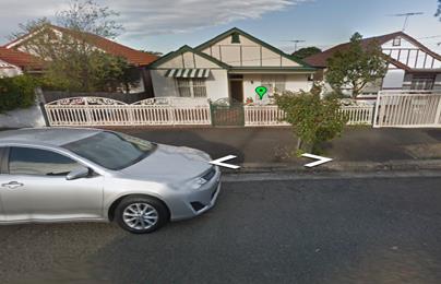
No. 4 Queen Street, Marrickville
5. Installation of ‘Disabled Parking’ Restriction – Reuss Street, Leichhardt
The resident of No.13 Reuss Street, Leichhardt has requested the installation of 'Disabled Parking Zone’ in front of the resident’s property. A site investigation has revealed the property does not have off street parking. The applicant does not require the use of wheelchair. The owners of the neighbouring property No.11 Reuss Street have also provided written concurrence for the proposed ‘Disabled Parking Zone’ in Reuss Street.
It is recommended that a 6.0m 'Disabled Parking Zone’ be installed in front of No.13 Reuss Street, Leichhardt.
No.13 Reuss Street, Leichhardt
PUBLIC CONSULTATION
Nil
|
|
Local Traffic Committee Meeting 3 June 2019 |
Subject: Bruce Street, Stanmore - Proposed Permit Parking Area M17
(Damun-Stanmore Ward/Newtown Electorate/Inner West PAC)
Prepared By: Mary Bailey - Parking Planner
Authorised By: John Stephens - Traffic and Transport Services Manager
|
RECOMMENDATION
THAT:
· Implementation of ‘2P Permit Holders Excepted 8am-10pm Mon-Fri Area M17' restrictions in Bruce Street between Douglas Street and Temple Street (western side); · Implementation of 10m Statutory ‘No Stopping' restrictions in Bruce Street, north of Douglas Street (western side); and · Implementation of 10m Statutory ‘No Stopping’ restrictions in Bruce Street, south of Temple Street (western side); be approved.
|
BACKGROUND
Following receipt of a petition from residents, Council carried out resident and parking surveys to determine whether permit parking should be considered for the section of Bruce Street, Stanmore, between Temple Street and Douglas Street in order to provide additional parking opportunities for residents.
|
Street Name and Suburb |
Bruce Street, Stanmore |
|
Section |
Between Douglas Street and Temple Street |
|
Carriageway Width (m) |
12.8m |
|
Carriageway Type |
Two-way street |
|
Classification |
local |
|
85th Percentile Speed (km/h) |
46.6 |
|
Vehicles Per Day (vpd) |
1998 most recent count (794 vpd) |
|
Reported Crash History (July 2013 - June 2017) |
N/A |
|
Heavy Vehicle Volume (%) |
2% |
|
Parking Arrangements |
Unrestricted
parking. |
Residents were consulted on a proposal to implement ‘Permit Parking’ in Bruce Street, Stanmore. Feedback received as a result of the initial consultation phase resulted in a revised proposal being developed. The rationale for the revision of the proposal was that the consultation resulted in stronger support for the implementation of permit parking from residents on the western side of Bruce Street and not on the eastern side as originally proposed. An analysis of the feedback from residents is detailed in the Public Consultation section of this report below.
The revised proposal is as follows;
· Implement ‘2P Permit Holders Excepted 8am-10pm Mon-Fri Area M17' - Bruce Street between Douglas Street and Temple Street (western side)
· Implement 10m Statutory ‘No Stopping' - Bruce Street north of Douglas Street (western side)
· Implement 10m Statutory ‘No Stopping’ - Bruce Street south of Temple Street (western side)
The revised proposal is illustrated in Figure 1 below and the original proposal is illustrated in Figure 2 below.
|
|
|
|
Figure 1: Revised Proposal for Permit Parking western side of Bruce Street, Stanmore |
Figure 2: Original Proposal for Permit Parking on eastern side of Bruce Street, Stanmore |
Parking Occupancy
To determine parking demand officers carried out parking occupancy surveys at 8am; 12:00pm; 4:00pm and 6:00pm on Wednesday, 13 February 2019, in the section of Bruce Street between Myrtle Street and Douglas Street.
The parking survey results indicated that there was a high parking demand in Bruce Street between Temple Street and Douglas Street where the permit parking is being proposed with demand above 90% through the daytime hours. This demand exceeds the required 85% occupancy for consideration of permit parking. The results are mapped in Figure 3 below and detailed in Table 1 below.
It can also be observed in Table 1 below that parking surveys undertaken for the section of Bruce Street between Temple Street and Myrtle Street showed that the average occupancy for both sides of the subject section of the street during the daytime was very near 85% (77% and 100% (avg 88%) at 12 noon and 69% and 100% (avg 85%) at 4pm). There was insufficient support from residents of this section to consider permit parking. Further details are available in the Public Consultation section of the report.
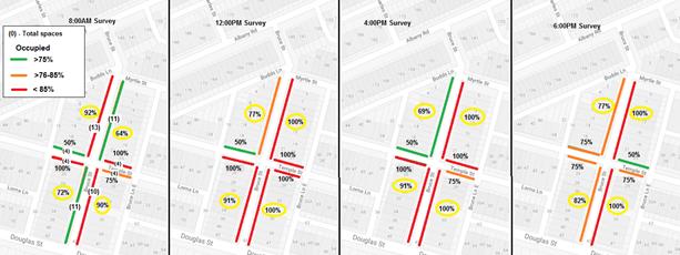
Figure 3: Results of Parking Occupancy Survey mapped
Table 1: Parking Survey results for Bruce Street, Stanmore
|
BRUCE STREET, STANMORE WEDNESDAY 13/02/2019 |
|||||
|
BETWEEN: |
TEMPLE STREET & DOUGLAS STREET EAST SIDE |
||||
|
TOTAL No. of Spaces |
10 |
|
|
||
|
No. of Spaces Occupied |
9 |
10 |
10 |
10 |
|
|
% OCCUPIED |
90.00% |
100.00% |
100.00% |
100.00% |
|
|
BRUCE STREET, STANMORE WEDNESDAY 13/02/2019 |
|||||
|
BETWEEN: |
DOUGLAS STREET & TEMPLE STREET WEST SIDE |
||||
|
TOTAL No. of Spaces |
11 |
|
|
||
|
No. of Spaces Occupied |
8 |
10 |
10 |
9 |
|
|
% OCCUPIED |
72.73% |
90.91% |
90.91% |
81.82% |
|
|
BRUCE STREET, STANMORE WEDNESDAY 13/02/2019 |
|||||
|
8AM |
12PM |
4PM |
6PM |
||
|
BETWEEN: |
MYRYLE STREET & TEMPLE STREET EAST SIDE |
||||
|
TOTAL No. of Spaces |
11 |
|
|
||
|
No. of Spaces Occupied |
7 |
11 |
11 |
11 |
|
|
% OCCUPIED |
63.64% |
100.00% |
100.00% |
100.00% |
|
|
BRUCE STREET, STANMORE WEST SIDE WEDNESDAY 13/02/2019 |
|||||
|
8AM |
12PM |
4PM |
6PM |
||
|
BETWEEN: |
MYRTLE STREET AND TEMPLE STREET WEST SIDE |
||||
|
TOTAL No. of Spaces |
13 |
|
|
||
|
No. of Spaces Occupied |
12 |
10 |
9 |
10 |
|
|
% OCCUPIED |
92.31% |
76.92% |
69.23% |
76.92% |
|
|
86%-100% |
|
||||
|
76%-85% |
|
||||
|
60-75% |
|
||||
FINANCIAL IMPLICATIONS
The cost of the signposting to be funded from Council’s operating budget.
PUBLIC CONSULTATION
Subsequent to receiving a petition from residents of eleven (11) households in Bruce Street between Douglas Street and Temple Street, Council sent by letter to affected residents a proposal to implement permit parking on the eastern side of Bruce Street in the section between Douglas Street and Temple Street. Following the initial letter being sent, Council extended the consultation area.
Council requires that there is a 30% response rate from the households in the subject section of road where surveys were sent. There are seventeen (17) households in the section of Bruce Street between Temple Street and Douglas Street and there were twelve (12) responses to the survey, a 64% response rate. Of the twelve (12) respondents, nine (9) were petitioners, two of the petitioners did not respond to the survey.
There were five (5) petitioners from the eastern side and six (6) petitioners from the western side in the subject section of Bruce Street.
Initially, a proposal to implement permit parking on the eastern side was developed following site investigation to determine the number of driveways in the street as well as the number of off-street parking spaces available to Bruce Street residents via Bruce Street Lane East and Bruce Lane West.
Feedback received from community engagement indicated there was stronger support for permit parking from residents on the western side of Bruce Street between Temple Street and Douglas Street, than on the eastern side. Overall there were respondents from six (6) separate households in support of permit parking on the western side of the street and four (4) in support of permit parking on the eastern side of the street. (Note: five (5) of the seven (7) total responses from the western side indicated they supported the proposal only if it incorporated the western side of the street)
A notification was sent to all affected residents on 10 May 2019 advising of the revision and details that the matter was to be considered at this meeting.
It should be noted that the residents of Bruce Street between Temple Street and Myrtle Street were also consulted due to possible flow-on effects. Residents in this section of Bruce Street did not have the same issue with regards to parking and there was no support for an RPS in this section of Bruce Street.
CONCLUSION
Given the high parking occupancy in Bruce Street between Temple Street and Douglas Street and the support for permit parking, the proposal is supported.
|
|
Local Traffic Committee Meeting 3 June 2019 |
Subject: Piper Lane, Annandale - Proposed 'No Stopping' and 'No Parking' zones (Baludarri-Balmain Ward/Balmain Electorate/Leichhardt PAC
Prepared By: Vinoth Srinivasan - Engineer - Traffic and Parking Services
Authorised By: John Stephens - Traffic and Transport Services Manager
|
THAT a 10m statutory ‘No Stopping’ zone and subsequent 39.4m ‘No Parking’ zone be installed on the eastern side of Piper Lane, Annandale, north of Rose Street.
|
BACKGROUND
Council has received concerns from residents of Annandale Street regarding vehicles parking on the eastern side of Piper Lane, Annandale and subsequently obstructing rear driveway access for properties Nos.301–305 Annandale Street.
There is an existing 6.6m ‘No Parking’ zone on the eastern side of Piper Lane that is located opposite the rear boundary of No.307 Annandale Street which prevents driveway obstruction to that property.
Site Location & Road Network
|
Street Name(s) |
Piper Lane, Annandale |
|
Section |
Between Rose Street and Weynton Street |
|
Traffic Volume |
79 (2013 Traffic Count) |
|
Recorded Accident History (5 year) |
Nil. |
|
Recorded 85% speed |
28.8km/h (2013 Traffic Count) |
|
Speed Limit |
50km/h |
|
Carriageway width |
Approx. 5m |
|
Carriageway Type |
Two way laneway |
|
Road Classification (State, Regional, Local) |
Local |
FINANCIAL IMPLICATIONS
Nil.
OTHER STAFF COMMENTS
In order to provide unobstructed driveway access to Nos.301-305 Annandale Street, it is proposed to provide a 10m ‘No Stopping’ zone and subsequent 39.4m ‘No Parking’ zone on the eastern side of Piper Lane, north of Rose Street, Annandale. The proposal is shown on the following plan.
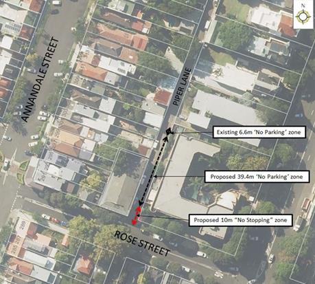
PUBLIC CONSULTATION
|
A letter outlining the above proposal was mailed out to the affected 16 properties in Piper Lane and Rose Street, Annandale, requesting residents’ views regarding the proposal.
One (1) response was received in objection to Council’s proposal to install the statutory 10m ‘No Stopping’ zone. |
|
|
Residents’ Comments |
Officer Comments |
|
I support Council’s proposal to extend the existing ‘No Parking’ zone, however object to Council’s proposal to install a 10 metre ‘No Stopping’ zone. I regularly turn right into Rose Street when travelling south on Piper Lane and do not have problems with parked vehicles on Piper Lane restricting my view. Vehicles on Rose Street are parked too close to the intersection of Piper Lane and imposing a parking restriction on Piper Lane will not remedy this. |
Signposting of the statutory ‘No Stopping’ restriction is required to complete the proposed length of ‘No Parking’ restrictions. Parking in Piper Lane immediately north of Rose Street (side boundary of No.85 Rose Street) is typically on the western side of the lane and so the section of the proposed restrictions opposite the side boundary of No.65 Rose Street only formalises existing parking behavior.
|
|
|
Local Traffic Committee Meeting 3 June 2019 |
Subject: Blackwood Lane, Dulwich Hill - Proposed section of 'No Parking' (Ashfield - Djarrawunang Ward/Summer Hill) Electorate/Inner West PAC)
Prepared By: Mary Bailey - Parking Planner
Authorised By: John Stephens - Traffic and Transport Services Manager
|
RECOMMENDATION
THAT implementation of ‘No Parking’ in Blackwood Lane, Dulwich Hill for a 5m section immediately south from the driveway of No.13 Blackwood Avenue (northern side); be approved. |
BACKGROUND
Following representations from a resident, Council is proposing to introduce a section of ‘No Parking’ in Blackwood Lane, Dulwich Hill, in order to improve access to off-street parking and the lane thoroughfare. Since Blackwood Lane has been made one-way, the resident reports it is now more difficult to enter and exit their garage as there are fewer options for manoeuvring.
|
Street Name and Suburb |
Blackwood Lane, Dulwich Hill |
|
Section |
Between Blackwood Avenue and MacArthur Parade, Dulwich Hill |
|
Carriageway Width (m) |
4.9m |
|
Carriageway Type |
One-way lane |
|
Classification |
Local |
|
85th Percentile Speed (km/h) |
Not available |
|
Vehicles Per Day (vpd) |
Not Available |
|
Reported Crash History (July 2013 - June 2017) |
N/A |
|
Heavy Vehicle Volume (%) |
Not Available |
|
Parking Arrangements |
Unrestricted parking. |
Blackwood Lane is a one-way lane west to east and is approximately 4.9 metres wide.
The proposal for parking restrictions to allow for access to and from off-street parking is illustrated in Figure 1 below.
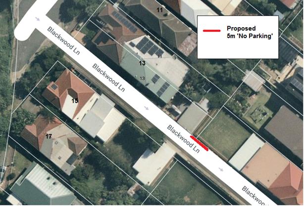
Figure 1: Proposed restrictions in Blackwood Lane
The photographs shown below (Figure 2 and Figure 3) illustrate the obstruction caused by vehicles parked in the laneway for those entering and exiting the Blackwood Lane access to off-street parking for the residence in Blackwood Street.
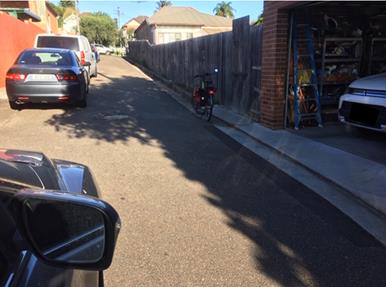
Figure 2: Parking conditions in subject section of Blackwood Lane
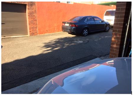
Figure 3: Parking conditions in the subject section of Blackwood Lane
It should be noted that when vehicles are parked directly opposite a garage entrance in laneways, ingress/egress can be extremely difficult. Laneways were generally built to provide service access for properties and access into off-street parking facilities.
According to Council’s Laneway Guidelines (December 2015) Laneways can be used for a variety of purposes which are listed below:
· Access for garbage collection trucks and deliveries where required
· Access to existing off-street parking within properties
· Access for emergency vehicles, pedestrians and cyclists
· Accessible parking for people with disabilities where appropriate
· Parking where space is available and access is maintained.
Blackwood Lane is approximately 4.9m wide. The Laneway Guidelines state that, “For parking to be allowed in a narrow laneway, the Australian Standards require that parallel parking spaces be at least 2.1 metres wide and NSW Road Rules requires that at least 3 metres must be available between a parked car and the kerb or edge of the laneway to allow moving vehicles to pass safely. Therefore, laneway widths that are less than 5.1 metres are too narrow to allow parking as any parked vehicle would prevent traffic from using the laneway.”
In this case, Council has received concerns that access to off-street parking is being restricted because of parking in the laneway. Furthermore, the laneway is only is 4.9m wide. Therefore, according to Council’s Laneway Guidelines Blackwood Lane is not wide enough to cater for parking.
FINANCIAL IMPLICATIONS
The cost of the signposting will be funded from Council’s operating budget for signs and line marking.
PUBLIC CONSULTATION
Council sent the proposal by letter to affected residents and as at the closing date for submissions no responses were received.
CONCLUSION
Given that the 4.9 metre wide lane is one-way, and this limits manoeuvrability for those accessing off street parking at the subject location; and, given that no objections have been received; the proposal is supported.
|
|
Local Traffic Committee Meeting 3 June 2019 |
Subject: Mitchell Lane, Marrickville - Proposed parking restrictions (Midjuburi- Marrickville Ward/Summer Hill Electorate/Inner West PAC)
Prepared By: Mary Bailey - Parking Planner
Authorised By: John Stephens - Traffic and Transport Services Manager
|
RECOMMENDATION
THAT:
1. Implementation of 10m ‘No Stopping’ in Mitchell Lane (western side) at its intersection with Mitchell Street; 2. Implementation of ‘No Parking’ in Mitchell Lane (western side) from proposed 10m ‘No Stopping’ zone to driveway of loading dock at rear of No.2 Mitchell Street; 3. Implementation of ‘No Parking’ in Mitchell Lane (eastern side) from driveway rear of Property No. 157 Victoria Road to driveway rear of Nos.165-169 Victoria Road; be approved. |
BACKGROUND
Following representation from the community, Council is proposing parking restrictions in Mitchell Lane, Marrickville in order to address safety and access issues.
|
Street Name and Suburb |
Mitchell Lane, Marrickville |
|
Section |
Between Mitchell Road and cul-de-sac |
|
Carriageway Width (m) |
4.9m |
|
Carriageway Type |
Two-way lane |
|
Classification |
Local |
|
85th Percentile Speed (km/h) |
Not available |
|
Vehicles Per Day (vpd) |
Not Available |
|
Reported Crash History (July 2013 - June 2017) |
N/A |
|
Heavy Vehicle Volume (%) |
Not Available |
|
Parking Arrangements |
Unrestricted parking. |
Currently there are no parking restrictions in the subject section of Mitchell Lane. Due to feedback from local businesses about damage to parked vehicles and reports of obstruction of access to off street parking/loading areas, Council is proposing to implement 'No Parking’ restrictions in the laneway.
In Mitchell Lane (south) at Mitchell Street, a ‘No Stopping’ zone is being proposed to address reported safety and manoeuvrability issues.
The proposal is illustrated in Figure 1 below.
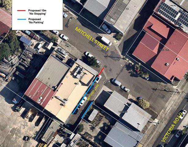
Figure 1: Proposed parking restrictions in Mitchell Lane, Marrickville
According to Council’s Laneway Guidelines (December 2015) Laneways can be used for a variety of purposes which are listed below:
· Access for garbage collection trucks and deliveries where required.
· Access to existing off-street parking within properties.
· Access for emergency vehicles, pedestrians and cyclists.
· Accessible parking for people with disabilities where appropriate.
· Parking where space is available and access is maintained.
Mitchell Lane is 5 metres wide. The Laneway Guidelines state that, “For parking to be allowed in a narrow laneway, the Australian Standards require that parallel parking spaces be at least 2.1 metres wide and NSW Road Rules requires that at least 3 metres must be available between a parked car and the kerb or edge of the laneway to allow moving vehicles to pass safely. Therefore, laneway widths that are less than 5.1 metres are too narrow to allow parking as any parked vehicle would prevent traffic from using the laneway.”
FINANCIAL IMPLICATIONS
The cost of the signposting will be covered from Council’s operating budget.
PUBLIC CONSULTATION
Council sent letters to all affected properties on 2 May 2019. No submissions were received by the closing date 20 May 2019.
CONCLUSION
In this case, Council has received concerns that parked vehicles are being damaged by other vehicles seeking thoroughfare and access to off-street parking/loading area that is being restricted because of parking in the laneway. Furthermore, the laneway is only is 5m wide. Therefore, according to Council’s Laneway Guidelines, Mitchell Lane is not wide enough to cater for parking. Given the factors related to access and safety and the narrowness of the lane, the proposal is supported.
|
|
Local Traffic Committee Meeting 3 June 2019 |
Subject: Edgeware Road, Enmore - Proposed Permit Parking (Stanmore - Damun Ward/Newtown Electorate/Inner West PAC)
Prepared By: Mary Bailey - Parking Planner
Authorised By: John Stephens - Traffic and Transport Services Manager
|
RECOMMENDATION
THAT: · Implementation of ‘2P Permit Holders Excepted 8am-10pm Area M14’ – Edgeware Road between the existing ‘No Stopping’ zones at Darley Street and Lord Street; be approved. |
BACKGROUND
|
Street Name and Suburb |
Edgeware Road, Enmore |
|
Section |
Between Darley Street and Lord Street |
|
Carriageway Width (m) |
12.8m |
|
Carriageway Type |
Two-way lane, parking both sides |
|
Classification |
Local |
|
85th Percentile Speed (km/h) |
Not available |
|
Vehicles Per Day (vpd) |
Not Available |
|
Reported Crash History (July 2013 - June 2017) |
No reported crashes |
|
Heavy Vehicle Volume (%) |
Not Available |
|
Parking Arrangements |
Unrestricted parking on both sides |
Following representation from the community, Council is proposing to install permit parking in a short section of Edgeware Road between Darley Street and Lord Street to provide opportunity for residents to park in an area where there is a high demand for parking due to workers from construction projects in the area, residents from nearby parking-restricted streets; and workers from nearby commercial and industrial premises. This proposal seeks to increase the amount of parking available for residents of Edgeware Road on the eastern side of the road.
The proposal is illustrated in the following Figure 1.
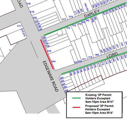
Figure 1. Existing and Proposed Parking at subject location
The designation of this section of Edgeware Road as permit parking would assist eligible residents of Darley and Lord Streets as well as allowing eligible residents of Edgeware Road to access permits to park in the wider M14 area.
FINANCIAL IMPLICATIONS
The cost of signposting will be funded from Council’s operational budget.
PUBLIC CONSULTATION
On 15 April 2019 letters were sent to affected properties advising that submissions on the proposal should be received by Wednesday 15 May 2019. Submissions were received from four (4) households. Of those, there was one (1) objection and three were supportive of the proposal. Feedback and Officer Comments are detailed in the following Table 1.
Table 1: Summary of Feedback
|
Support |
Officer Comment |
|
Given that Lord and Darley street are set up this way does it not stand to reason residents like myself on Edgeware Road, that are closer to the Sydney Metro Dive site and other commercial businesses in the area which are likely to use unrestricted parking areas, have an equal or greater need for a resident parking permit. |
Given the demand for parking in this area, the installation of permit parking as proposed will provide residents of this section of Edgeware Road with increased permit parking opportunities both along their street as well as nearby Streets. |
|
Object |
|
|
We love having unrestricted parking as it gives us and our guest’s flexibility to park where we want. We don’t support the introduction of more fees from Council. |
The proposal only covers one side of the roadway and there is unrestricted parking available in nearby streets including Lord Street and Darley Street. |
CONCLUSION
Given the support from residents and the fact that both adjoining streets (Lord Street and Darley Street) have permit parking, the proposal will result in increased parking opportunities for residents, therefore the proposal is supported.
|
|
Local Traffic Committee Meeting 3 June 2019 |
Subject: Goodsir Street, Rozelle - Proposed removal of existing 'No Parking, 8AM-6PM Mon-Fri' Zone (Baludarri-Balmain Ward/Balmain Electorate/Leichhardt PAC)
Prepared By: Vinoth Srinivasan - Engineer - Traffic and Parking Services
Authorised By: John Stephens - Traffic and Transport Services Manager
|
RECOMMENDATION
THAT the existing ‘No Parking, 8am-6pm Mon-Fri’ zone in Goodsir Street, outside Goodsir Street Reserve, Rozelle be removed. |
BACKGROUND
A number of residents in Goodsir Street, Rozelle have requested a review of the existing ‘No Parking, 8am-6pm Mon-Fri’ zone in Goodsir Street, outside Goodsir Street Reserve (opposite Moore Street).
‘No Parking restrictions were initially provided outside Goodsir Street Reserve to allow access for maintenance/mowing vehicles to the Reserve. In September 2008, the Traffic Committee recommended that the full-time ‘No Parking’ restriction be changed to the current ‘No Parking, 8am-6pm Mon-Fri’ zone to provide additional parking after work hours and on weekends.
Site Location & Road Network
|
Street Name(s) |
Goodsir Street, Rozelle |
|
Section |
Evans Street to Mullens Street |
|
Traffic Volume |
398 (2008 Traffic Count) |
|
Recorded Accident History (5 year) |
Nil. |
|
Recorded 85% speed |
40.3km/h (2008 Traffic Count) |
|
Speed Limit |
40km/h |
|
Carriageway width |
Approx. 8m |
|
Carriageway Type |
Two way street with kerb side parking lanes on both sides of the street |
|
Road Classification (State, Regional, Local) |
Local |
FINANCIAL IMPLICATIONS
Nil.
OTHER STAFF COMMENTS
As the parking demand is high in this area, Council is proposing to remove the existing ‘No Parking, 8am-6pm Mon-Fri’ zone. This will allow for two extra vehicles to park in the subject location.
Council’s Parks and Streetscapes Coordinator has supported the proposed removal of the existing ‘No Parking’ restriction.
The turning area for a standard (B85) vehicle at the intersection of Moore Street and Goodsir Street will not be affected by vehicles parked in the existing ‘No Parking’ zone.
The proposal is shown on the following plan.
PUBLIC CONSULTATION
|
A letter outlining the above proposal was mailed out to the affected 29 properties in Goodsir Street and Moore Street, Rozelle, requesting residents’ views regarding the proposal.
Seven (7) responses were received in support of Council’s proposal.
|
|
|
Residents’ Comments |
Officer Comments |
|
Residents commented that the proposal would benefit the community due to the high demand for parking caused by: · Commuter Parking · Passengers of the White Bay Cruise Terminal · Resident overflow from streets with restricted parking A resident also requested Council consider Resident Parking Scheme restrictions in the street. |
Council can investigate the possibility of implementing a Resident Parking Scheme (RPS) on Goodsir Street as a separate matter should sufficient formal requests be received and when reviewing parking in this area. |
|
|
Local Traffic Committee Meeting 3 June 2019 |
Subject: Queen Street, Ashfield – Proposed ‘No
Stopping’ in Queen Street at intersection with Harland Street,
(Djarrawunang – Ashfield Ward/Summer Hill Electorate/ Burwood PAC)
Prepared By: Boris Muha - Engineer – Traffic and Parking Services
Authorised By: John Stephens - Traffic and Transport Services Manager
|
RECOMMENDATION
THAT 12.7 metres of ‘No Stopping’ be placed on the eastern corner of Queen Street south of the intersection with Harland Street, Ashfield. |
BACKGROUND
A request has been received to install ‘No Stopping’ signage on the eastern corner of Queen Street, at Harland Street, Ashfield to improve both sight lines to and from the driveway access for No.228 Queen Street as well as improving traffic manoeuvrability at the intersection of Harland Street.
It is proposed to install a 12.7m ‘No Stopping’ restriction up to the driveway of No.228 Queen Street. The restriction will assist to remove illegal parking and prevent obstruction to and provide visibility to the driveway access. It will also improve the visibility and traffic manoeuvrability around the intersection of Harland Street.
Site Location &Road Network
|
Street Name(s) |
Queen Street |
|
Section |
Intersection with Harland Street. |
|
Traffic Volumes |
10,860 (2018 count in Queen Street, south of Harland Street.) |
|
Recorded Accident History (5 Years) |
No RMS recorded accidents at intersection. 1 (non-injury, veer into central median-March 2019, north side of intersection-Police report) |
|
Recorded 85% speed |
48 |
|
Speed Limit |
50 |
|
Carriageway width |
Approx. 10.3m |
|
Carriageway Type |
Two-way with one travel lane in each direction, and kerb side parking on both sides of the street, south of Harland Street. |
|
Road Classification (State, Regional, Local) |
Local (collector) |
FINANCIAL IMPLICATIONS
Nil.
OTHER STAFF COMMENTS
· There is a high volume of traffic in Queen Street and the traffic travels and flows near towards the kerb at the intersection;
· The area is insufficient in length to legally park a vehicle which then encroaches into the statutory 'No Stopping' distance of 10 metres from the intersection;
· The clearance will prevent obstruction and provide visibility to driveway access at No.228 Queen Street; and
· The clearance improves visibility and traffic manoeuvrability around Harland Street.
PUBLIC CONSULTATION
Consultation letters have been issued out to 9 residential properties to the intersection of Harland Street and Queen Street. Closure of submissions was 21 May 2019. No responses have been received leading up to the preparation of this report prior to the closure of submissions. Any responses received will be tabled at the meeting.
CONCLUSION
It is recommended that a ‘No Stopping’ restriction be installed up to the driveway of No.228 Queen Street, approximately 12.7metres in distance on the eastern corner side of Queen Street, south of Harland Street, Ashfield, to improve traffic conditions at the intersection.
|
|
Local Traffic Committee Meeting 3 June 2019 |
Subject: Croydon Road, Croydon – Proposed removal
of parking on the eastern side between Parramatta Road and West Street.
(Gulgadya–Leichhardt Ward /Strathfield Electorate/ Burwood PAC)
Prepared By: Boris Muha - Engineer – Traffic and Parking Services
Authorised By: John Stephens - Traffic and Transport Services Manager
|
RECOMMENDATION
THAT:
1. The existing ‘No Stopping’ restriction on the eastern side of Croydon Road be extended from 12m to 20m south of the Parramatta Road property boundary line; 2. A ‘No Parking’ restriction be installed on the eastern side of Croydon Road approximately from 20m to 40m south of Parramatta Road; and 3. The existing ‘Bus Zone’ on the eastern side of Croydon Road from 40m to 62m south of Parramatta Road be retained. |
BACKGROUND
Council has received complaints from Transit Systems (operating government buses) and the general public regarding the difficultly of buses turning right from Parramatta Road into Croydon Road, Croydon and traffic passing parked vehicles on the eastern side of Croydon Road between Parramatta Road and West Street.
Subsequently, Transit Systems have requested that the parking be removed along the eastern side of Croydon Road between Parramatta Road and West Street.
It is advised that traffic, particularly buses, when passing the parked vehicles on the eastern side of Croydon Road, cross the centreline causing possible conflict and hazard with the opposing traffic when manoeuvring around the intersection. Furthermore, buses cannot pull in properly and safely close to the kerb at the bus stop located just south of the intersection with vehicles parking north of the ‘Bus Zone’.
Site Location & Road Network
|
Street Name(s) |
Croydon Road |
|
Section |
Between Parramatta Road and West Street. |
|
Traffic Volumes |
Approx. 9,000 (2018 count in Croydon Road, south of Parramatta Road) |
|
Recorded Accident History (5 Years) |
At intersection of Parramatta Road and Croydon Road/Arlington Street 3 cross-traffic (2013, 2014, 2018. (2) injury, (1) non-injury)) 2 rear-ends (2014, (1) injury, (1) non-injury))
|
|
Recorded 85% speed |
46 |
|
Speed Limit |
50 |
|
Carriageway width |
Approx. 9.9-10.1m |
|
Carriageway Type |
Two-way with one travel lane south bound and two travel lanes northbound near the intersection. West side of the above road section (from Parramatta Road) has existing Full-time ‘No Stopping’; 'Bus Zone' and Part time 'No Stopping' AM and PM peak Mon-Fri. restrictions. East side (from Parramatta Road) has Full-time ‘No Stopping’; unrestricted parking; 'Bus Zone' and 'No Parking' restrictions. |
|
Road Classification (State, Regional, Local) |
Local (collector) |
Existing parking layout
Proposed parking layout
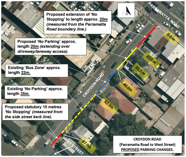
FINANCIAL IMPLICATIONS
OTHER STAFF COMMENTS
The following comments are provided:
· Croydon Road between Parramatta Road and Church Street services frequent main bus routes 490 and 492 between Drummoyne and Hurstville/Rockdale stations.
· The double white barrier centreline approximately 32 m in length leads up to the driveway and rear laneway in Croydon Road as shown in the diagrams. The driveway and rear laneway services the shops/business on the south-east corner of Parramatta Road and Croydon Road.
· The double white barrier centreline, separating northbound and southbound traffic near the intersection is slightly offset to the east to accommodate the two marked travel lanes on the northbound approach.
· Traffic generally queues along Croydon Road back south of the signalised intersection in both travel lanes to turn right, left or travel through the intersection.
· Buses were observed to cross well over the centreline when vehicles park on the east side of the road. Buses are required at times to stop or crawl in path and await opposing vehicle clearance for them to move over the centreline. South bound traffic is held back to the intersection.
· Owing to the narrow width of the southbound lanes (approx. 4.8m) and with parked cars to the eastern side of the road, buses at times encroach out into the southbound travel area in approach to the Bus Stop. Hence, vehicles queue on the opposing travel lanes thus obstructing the clear passageway for southbound traffic.
· The southbound carriageway near the intersection is below the recommended minimum of 5.1 metres to the centreline (2.1 metres for parking and 3.0m travel lane.)
· Parked cars can be vulnerable to side swipe particular from buses.
· Rear lane parking is provided to the shops/businesses on the south-eastern corner of Parramatta Road and Croydon Road, or unrestricted parking is provided within the side streets (e.g. Dalmar Street/West Street) in proximity to the intersection.
· Minimum of 20 metres of ‘No Stopping’ is required under the RMS technical directions on the departure side of a signalised intersection.
PUBLIC CONSULTATION
Consultation letters were forwarded to 23 shop/business properties within proximity of the intersection of Parramatta Road and Croydon Road, and along Croydon Road between Parramatta Road and West Street.
Closure of submissions was on 21 May 2019. No responses have been received leading up to the preparation of this report prior to the closure of submissions. Any responses received will be tabled at the meeting.
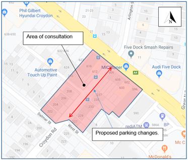
CONCLUSION
It is recommended that parking changes be undertaken to remove the parking on the eastern side of Croydon Road between Parramatta Road and West Street to avoid conflict with the opposing traffic and relieve congestion south of the intersection with Parramatta Road.
|
|
Local Traffic Committee Meeting 3 June 2019 |
Subject: Code of Conduct for Council Committee Members, Delegates of Council and Council Advisers (All Wards / All Electorates / All PACs)
Prepared By: Manod Wickramasinghe - Coordinator – Traffic and Parking Services
SUMMARY
This report introduces the new Code of Conduct.
|
RECOMMENDATION
THAT this report be received and noted.
|
BACKGROUND
Council‘s Civic Governance Manager has advised that in March 2019, Council adopted a Code of Conduct for Council Committee Members, Delegates of Council and Council Advisers. The Code of Conduct is applicable to all Councillors, staff and members of Council Committees (which are not advisory in nature).
The Code of Conduct is divided into the following sections:
· Part 1 – The Introduction
· Part 2 – Definitions
· Part 3 – General Conduct Obligations
· Part 4 – Pecuniary Interests
· Part 5 – Non-Pecuniary Conflicts of Interests
· Part 6 – Personal Benefit
· Part 7 – Access to Information and Council Resources
· Part 8 – Maintaining the Integrity of this code
· Schedule 1 & 2
All Committee Members should make themselves familiar with the Code of Conduct (Attachment 1).
|
1.⇩ |
Code of conduct for council committee members, delegates of council and council advisers |
|
Local Traffic Committee Meeting 3 June 2019 |
Subject: Report back on Mainstreet meter switch off at
7pm in Balmain, Rozelle and Leichhardt (Baludarri-Balmain; Gulgadya-Leichhardt
Wards/Balmain Electorate/Leichhardt PAC)
Prepared By: Manod Wickramasinghe - Coordinator – Traffic and Parking Services
|
RECOMMENDATION
THAT this report be received and noted. |
BACKGROUND
Following a previous Council resolution, the parking meters and regulatory signage in Leichhardt, Rozelle and Balmain were updated to cease parking meter operations on the mainstreets at 7pm instead of 10pm. This equates to a reduction in operating hours from 14 hours to 11 hours.
Parking Meter Strategy
Parking meters in the former Leichhardt Municipality are located in the Leichhardt, Rozelle and Balmain town centres and were originally installed in 2001 to better manage the high demand for, and utilisation of, parking in each business area. The parking meters formed part of Council’s parking management strategy with objectives to:
· Ensure on-street parking turnover
· Provide improved access to on-street car parking for business customers
· Discourage illegal / overstay parking
· Discourage commuter parking
· Encourage the use of public transport.
A number of nearby Councils in Sydney operate parking meter schemes including: City of Sydney, Burwood, Canada Bay, Waverley, North Sydney and Woollahra.
This approach recognised:
· There is generally a shortfall of car parking for the current mix of businesses.
· There is very limited capacity to increase off street car parking.
· Staff parking took up valuable parking spaces within the Town Centre parking schemes. However, in recent years, the number of business permits issued has been reduced following the introduction of a fee and more strict limits.
· Balmain, Rozelle and Leichhardt are desirable places to visit that need an Integrated Transport Plan that focuses on a wide range of transport options, not just reliance and promotion of the motor car.
Current Parking Meter Operation
Existing hours of operation of the parking meters in the mainstreets of Leichhardt, Rozelle and Balmain now span from 8.00am to 7.00pm, 7 days per week. Parking on the mainstreets requires a motorist to display a paid or a 30-minute free ticket. There are 70 mainstreet parking meters in Leichhardt, Rozelle and Balmain.
Existing hours of operation of the parking meters in the side streets of Leichhardt, Rozelle and Balmain span from 8.00am to 10.00pm, 7 days per week. Parking on the side streets requires a motorist to display a paid ticket, 30-minute free ticket (only operating for 10 parking meters in locations adjacent to the mainstreets) or valid parking permit. There are 214 side street parking meters in Leichhardt, Rozelle and Balmain. Residents in the metered side streets are eligible for parking permits which provide preferential parking by exempting them from parking meter payments and time limits on the parking control signs.
OTHER STAFF COMMENTS
Parking Management Impacts
Detailed parking occupation surveys have been conducted in 2015 and 2017, prior to the change in parking meter operational hours on Norton Street, Leichhardt and Darling Street, Rozelle and Balmain. These results have been compared to recent surveys conducted in 2019 approximately 1 year after the change to mainstreet parking restrictions. Note the survey results are based on an average of Thursday, Friday and Saturday occupancies. The results are summarised in the following graphs:
Norton Street, Leichhardt – Supply approx. 91 parking spaces
Darling Street, Balmain – Supply approx. 108 parking spaces
Darling Street, Rozelle – Supply approx. 81 parking spaces
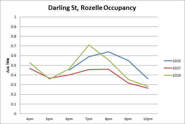
The overall results show that, with the exception of Rozelle, parking occupancy rates have been consistently high over a number of years. The high and stable occupancies in Leichhardt and Balmain in both 2017 and 2019 (before and after the reduction in parking meter operational hours) suggest that the previous parking meter tariff was not necessarily deterring motorists from parking in each business centre.
It should be noted that Rozelle has only a small number of businesses which operate at night which is reflected in lower occupancy rates compared to Balmain and Leichhardt. As the parking occupancy was well below capacity, the removal of the parking meter fee after 7pm has resulted in an increase in parking occupancy.
The surveys demonstrate that there is still a strong evening demand for parking within each of the mainstreet shopping centres and this needs to continue to be managed through effective parking management strategies.
It should be noted that parking turnover rates remained steady between the 2017 and 2019 parking surveys.
Consistency of parking meters operations across the Inner West Council LGA
The current allocation of parking meters in Leichhardt, Rozelle, Balmain and Newtown/Enmore have been provided in business precincts with similar business characteristics, a shortfall of on-street parking supply, high parking demand and strong inter-suburb visitation demand. A number of nearby Councils in Sydney also operate parking meter schemes in precincts similar to those in the Inner West Council LGA. These Councils include: City of Sydney, Burwood Canada Bay, Waverley, North Sydney and Woollahra.
Current parking meter operations within Leichhardt, Rozelle, Balmain and Newtown/Enmore serve an important function by increasing turnover for businesses and maximising the use of Council’s kerb space. Parking occupancy surveys have demonstrated that the parking meter fee is not deterring use of the kerb space and can be retained at its current level.
It should also be noted that parking meters may also provide preferential parking for residents when in operation in side streets adjacent to the mainstreet. When residents of metered side streets were surveyed in 2018 regarding the potential to reduce parking meter operational hours in side streets to match mainstreets, only 10% supported switching off parking meters at 7pm due to the potential to induce additional demand in the residential side streets.
Future parking strategies for both metered and non-metered parking near business precincts within the Inner West Council LGA should be considered through detailed Precinct Parking Strategies.
|
|
Local Traffic Committee Meeting 3 June 2019 |
Subject: Sydenham Road, Sydenham - Permanent Pedestrian
mid-block signalised pedestrian crossing (Temporary configuration) –
Sydney Metro City & Southwest (Midjuburi- Marrickville Ward / Heffron
Electorate / Inner West PAC)
Prepared By: Jennifer Adams - Engineer – Traffic and Parking Services
Authorised By: John Stephens - Traffic and Transport Services Manager
SUMMARY
Council has been notified by Sydney Metro SSJ of the temporary configuration for the Sydenham Road permanent crossing (mid-block signalised pedestrian crossing). The works are part of Sydney Metro City & Southwest and Sydenham Station and Junction works.
|
RECOMMENDATION
THAT this report be received and noted. |
BACKGROUND
The Sydenham Station and Junction (SSJ) scope of works involves remodelling of the existing Station to allow for Sydney Metro City & Southwest operations, including a new aerial concourse constructed at the city end of the Sydenham Station to give access to all platforms and enable passenger interchange between train services, new platforms, new station buildings, station entries and forecourts, and new transport interchanges.
The northern Metro entrance at Sydenham is located at the western end of Railway Terrace beside the curved road that transitions between Sydenham Road in the south to Railway Parade in the west.
The gate line is strategically positioned to establish direct sightline from Sydenham Road in the north. As customers approach the staircase that marks the beginning of the station plaza, they will be presented with the entrance gates beyond the plaza, signified by a simple entrance canopy and framed with tree landscaping, retail units and an integrated customer touch point.
The station entrance features two glass fronted tenancy units and a bicycle storage facility along the public facing frontages of the northern services building on Railway Terrace. The roof of the building extends outwards to provide weather protection for outdoor seating of the tenancy units. See concept diagrams of the Northern Station entrance and plaza below.
FINANCIAL IMPLICATIONS
Nil. There are no financial implications for Council associated with this matter.
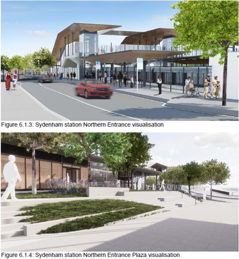
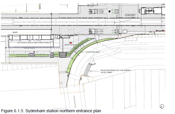
OFFICER COMMENTS
It is noted that Sydenham Road / Railway Parade / Gleeson Avenue are classified State Roads, therefore the road changes will be managed by the RMS.
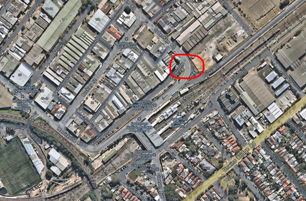
The design considerations regarding the Roads and Finishes for the Sydenham Station Upgrade works on Railway Parade / Sydenham Road were described in the Sydney Metro SSJ publication (Sydenham Station and Junction Works - Roads & Road Finishes – Design Report Stage: 3 Package: 220 Document Number: SMCSWSSJ-JHL-WSS-CE-REP-220001 Revision: C Date: 21 January 2019).
Railway Parade is located to the northern side of Sydenham Station and grades up from Sydenham Road at the north eastern end of the existing station (parallel to Platform 1) to tie into the Gleeson Avenue Overbridge.
The below road modifications are proposed at this intersection (refer to Figure 7):
• The section of road adjacent to the bus stops on Railway Parade graded at 1 in 40 to ensure DDA compliant access between the bus stops and the new northern station entrance.
• The kerbing along the southern edge of Railway Parade is to be adjusted to suit the proposed Northern Plaza. Further coordination is required to ensure that the urban plaza design allows for the proposed kerb alignment. RMS Type ‘SM’ barrier kerbing is proposed for much of the reconstruction, with flush kerbing at the maintenance vehicle entry to the plaza.
• A signalised pedestrian crossing across Sydenham Road will be installed at the
northern end of the works.
• Driveway entry into the Primary Plaza area for maintenance access vehicles.
• Emergency vehicle access will be provided from Sydenham Road and will be detailed
further within the Plaza design package
• Pedestrian ramps are to be installed at the crossing to the carpark entrance on the western side of Sydenham Road.
• Amendments to line marking along Sydenham Road/Railway Parade for realigned kerbing adjacent the plaza
• Associated signage and line marking with pedestrian crossing at Sydenham Road/Railway Parade
• Proposed modifications to the existing pit/pipe system to suit the new kerb line, thereby retaining existing drainage conditions. It is noted that the existing drainage will not satisfy the required criteria for a 10 year ARI (consultation ongoing).
It is to be noted that there are no proposed modifications to the kerbing along the north-western edge of Railway Road/Sydenham Road, nor any changes to the road pavement levels to ensure that existing cover can be maintained to existing utilities.
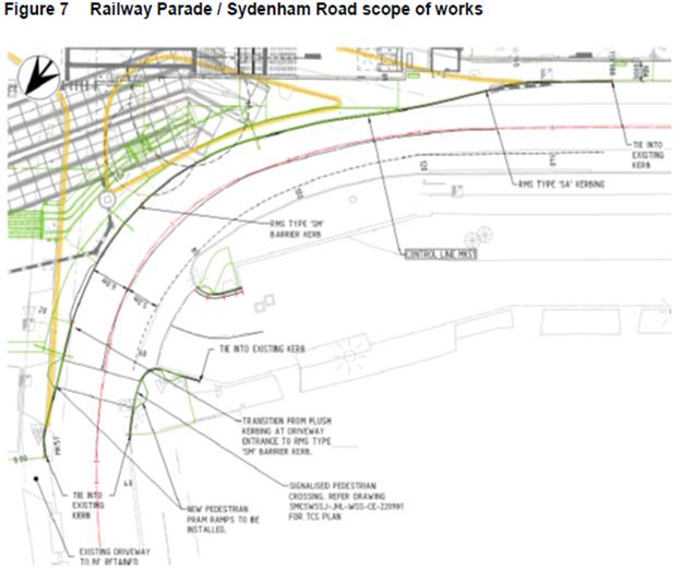
The Sydney Metro City & Southwest update (as at 7 May 2019) identifies the following works in regards to the Sydenham Road permanent pedestrian crossing (Temporary configuration):
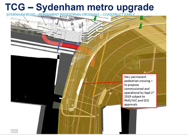
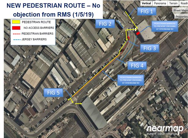
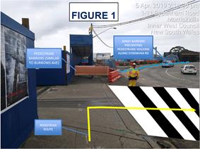
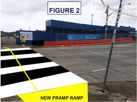
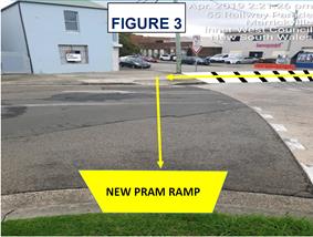
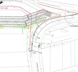
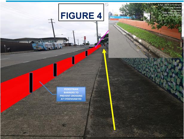
It is noted that a number of car parking spaces in the locality will be lost due to the works.
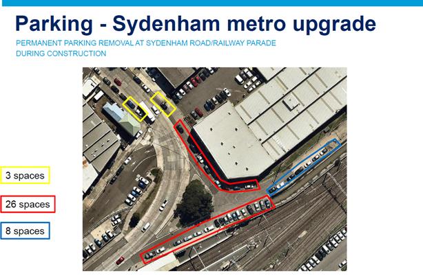
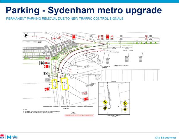
PUBLIC CONSULTATION
The project is being managed by Sydney Metro and RMS.
CONCLUSION
It is recommended that this report be received and noted.