|
Supplementary AGENDAR |
Distributed on 28 January 2020

Local Traffic Committee Meeting
MONDAY 3 FEBRUARY 2020
10.00am
|
Supplementary AGENDAR |
Distributed on 28 January 2020
Local Traffic Committee Meeting
MONDAY 3 FEBRUARY 2020
10.00am
|
|
Local Traffic Committee Meeting 3 February 2020 |
|
MEETING AGENDA – PRECIS SUPPLEMENTARY ITEMS |
The following report/s appear as late item/s as information required for the preparation of the report/s was not available at the time of distribution of the Business Paper.
1 Part B - Items for Information Only
ITEM PAGE #
LTC0220 Item 18 182-198 Victoria Road and 28-30 Faversham Street, Marrickville – DA 201900096 – Mixed Residential Commercial Use Development (Midjuburi - Marrickville Ward / Summer Hill Electorate / Inner West PAC) 3
|
|
Local Traffic Committee Meeting 3 February 2020 |
Subject: 182-198 Victoria Road and 28-30 Faversham Street, Marrickville – DA 201900096 – Mixed Residential Commercial Use Development (Midjuburi - Marrickville Ward / Summer Hill Electorate / Inner West PAC)
Prepared By: Jennifer Adams - Engineer – Traffic and Parking Services
Authorised By: George Tsaprounis - Coordinator – Traffic and Parking Services
SUMMARY
Council has received an application to demolish existing improvements and construct a mixed-use development ranging from 6 storeys to 12 storeys in height comprising 2,387sqm of ground floor retail floorspace, 272 residential apartments and two levels of associated basement car parking, including the provision of public domain and landscaping works.
The application is required to be referred to the Local Traffic Committee for consideration under State Environmental Planning Policy (Infrastructure) 2007.
Comments of the Local Traffic Committee will be referred to Council’s Development Assessment Section for consideration in determining the Development Application.
|
RECOMMENDATION
THAT the report be received and noted. |
BACKGROUND
The application relates to a type of development that the Minister for Planning has categorised as being of regional significance. Under the Environmental Planning and Assessment Act the Sydney Eastern City Planning Panel is the consent authority for the purposes of determining the application.
Originally TOGA, as the applicant, lodged the Development Application (DA201900096) on 20 March 2019. The application sought approval to demolish existing improvements and construct a mixed-use development ranging from 6 storeys to 14 storeys in height comprising 2,351sqm of ground floor retail floorspace, 270 residential apartments (101 x 1-bedroom apartments, 156 x 2-bedroom apartments, and 13 x 3-bedroom apartments) and two levels of associated basement car parking (214 car parking spaces for the residential component, plus 1 car wash bay; 65 retail spaces (including 2 adaptable spaces), 27 visitor vehicle spaces (including 5 adaptable spaces), and 16 motorbike parking spaces and 143 bicycle parking spaces), including the provision of public domain and landscaping works.
The RMS submission response (dated 13 May 2019), to the original development proposal, raised no objections to the proposed development, subject to the following conditions being included in any consent issued by Council:
“1. All buildings and structures, together with any improvements integral to the future use of the site shall be wholly within the freehold property (unlimited in height or depth), along the Victoria Road boundary.
2. Vehicular access into the development from Victoria Road shall be limited to left-in only. A median island shall be constructed on Victoria Road to restrict right turn movements into the subject site.
3. All vehicles are to enter and exit the site in a forward direction.
4. The layout of the proposed car parking areas associated with the subject development (including, driveways, grades, turn paths, sight distance requirements in relation to landscaping and/or fencing, aisle widths, aisle lengths, and parking bay dimensions) should be in accordance with AS 2890.1-2004, AS2890.6-2009 and AS 2890.2-2018. Parking Restrictions may be required to maintain the required sight distances at the driveway.
5. Consideration should also be given to providing bicycle parking facilities either within the development or close to it to support and encourage active transport.
6. The proposed development will generate additional pedestrian movements in the area. Pedestrian safety is to be considered in the vicinity.
7. A Construction Pedestrian Traffic Management Plan (CPTMP) detailing construction vehicle routes, number of trucks, hours of operation, access arrangements and traffic control should be submitted to Council for approval prior to the issue of a Construction Certificate
8. A Road Occupancy Licence (ROL) should be obtained from Transport Management Centre for any works that may impact on traffic flows on Victoria Road and Sydenham Road during construction activities”.
In addition to the above, Roads and Maritime provided the following advisory comments to Council for consideration in its determination of the development application:
“1.0 In accordance with Marrickville Local Environmental Plan 2011 clause 6.18, development consent must not be granted for development on the land unless the Secretary has certified in writing to the consent authority that satisfactory arrangements have been made to contribute to the provision of designated State public infrastructure.
2.0 The swept path of the longest vehicle (including garbage trucks, building maintenance vehicles and removalists) entering and exiting the subject site, as well as manoeuvrability through the site, shall be in accordance with AUSTROADS. In this regard, a plan shall be submitted to Council for approval, which shows that the proposed development complies with this requirement.”
In relation to condition 2 above it should be noted that on Wednesday 15 January 2020 Transport (previously RMS) informed Council that they had reviewed the requirement for the median island listed as item 2 in their letter dated 13 May 2019. They stated that:
“TfNSW (previously RMS) is agreeable to the deletion of item 2 considering this section of Victoria Road is a regional road which is the responsibility of Council and that the median has not been incorporated into the Victoria Road Precinct Development Control Plan or Contributions Plan, which governs the planning of the precinct and which was adopted by Council.”
Subsequently, the applicant reconsidered the proposed development and made several changes and, in a letter, dated 11 November 2019 (Ethos Urban) submitted an ‘Amended’ Development Application (DA201900096). Key changes included the reduction of building height from 14 storeys to 12 storeys to accommodate Sydney Airport’s (SACL) Obstacle Limitation Surface requirements and the reallocation of floorspace across the site, with increased floorplate sizes for Levels 8-12. Other changes include:
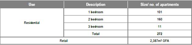
· A minor increase of residential apartments from 270 to 272, comprising the following apartment mix: 101 x 1-bedroom apartments; 160 x 2-bedroom apartments; and 11 x 3-bedroom apartments
· A minor increase of retail floor space from 2,368m2 to 2,387m2, located on the ground level and comprising a variety of tenancies.
· The reconfiguration of car parking spaces proposed in the two-level basement for resident, staff and visitor use, incorporating:
− 224 car parking spaces for the residential component, plus 1 car wash bay (addition of 10 spaces)
− 65 retail spaces (including 2 adaptable spaces) (no change)
− 22 visitor vehicle spaces (including 5 adaptable spaces) (reduction of 5 spaces)
− 16 motorbike parking spaces and 143 bicycle parking spaces (no change).
This report comments on the traffic aspects of the latest amended proposal for the proposed mixed-use development at 182-198 Victoria Road and 28-30 Faversham Street, Marrickville.
The proposed development now incorporates 272 residential apartments and 2,387 square metres of ground floor retail/ commercial, including 1,500 square metres of mini major supermarket.
FINANCIAL IMPLICATIONS
Nil.
OTHER OFFICER’S COMMENTS
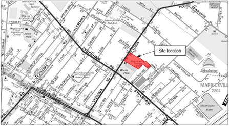
Site location
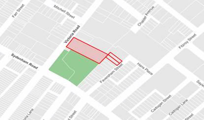
The site is located at 182-198 Victoria Road and 28-30 Faversham Street, Marrickville within the Inner West Council Local Government Area. The land is owned by Danias Holdings Pty Ltd and Dina Danias, and has an approximate total area of 10,677m2. The site is located within the north-western portion of the Sydenham-Marrickville industrial precinct and sits within a sub-precinct known as the Victoria Road Precinct.
The site is approximately one kilometre north of Sydenham Station (via Victoria Road and Sydenham Road) and is approximately up to 250 metres from four bus stops located on Victoria Road.
Source – Traffic Impact Report
Locality and road network
Victoria Road is a regional road, running north to south, connecting Enmore and Marrickville. There are two lanes in each direction with kerbside parking on both sides outside of ‘No Parking’ restrictions during peak hours;
· Northbound (western side) – ‘No Parking 7am-9am Mon-Fri’,
· Southbound (eastern side) – ‘No Parking 4pm-6pm Mon-Fri’.
Victoria Road carries approximately 17,000 vehicles per day, 5% of which are trucks and the 85th percentile speed is listed as 58.3km/h. The posted speed limit is 60km/h. Victoria Road intersects with Sydenham Road 110 metres south of the site. The intersection of Sydenham Road and Victoria Road is busy and is generally congested throughout the day. Many of the side streets abutting Victoria Road and Sydenham Road experience significant delays.
Sydenham Road is a State road under the jurisdiction of RMS and has a posted speed limit of 60km/h.
Hans Place and Faversham Street are local roads servicing the local industrial area. They are low volume roads carrying around 550 and 400 vehicles per day respectively. Both have a high truck ratio percentage of 16.5% and 10.8% respectively. The speed limit is 50km/h and the 85th percentile speed for each road is around 30km/h.
Fitzroy Street is also a local road carrying around 5,800 vehicles per day with a 85th percentile speed of 56.2km/h. The speed limit is 50km/h. Trucks make up around 12% of the total volume.
Key intersections in the surrounding network include:
· Victoria Road and Sydenham Road – signalised.
· Sydenham Road and Faversham Street
· Sydenham Road and Fitzroy Street – pedestrian crossing on Fitzroy Street
· Hans Place and Fitzroy Street.
As noted, the intersection of Victoria Road and Sydenham Road is at capacity now and is often congested throughout the day. Further, the added traffic exiting from the proposed development into the relatively quiet streets of Faversham Street and Hans Place will have significant impacts as will it on the intersection of Fitzroy Street and Sydenham Road, which is currently operating at a ’D” or ‘E’ Level of Service according to the applicants Traffic Report.
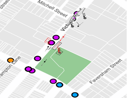
The intersections along Victoria Road, in the vicinity of the proposed site were examined in relation to their accident history over the past five years (using the RMS crash data). A summary of crashes is provided in the table below.
|
Intersection |
Number of recorded crashes |
Severity of crash |
|
Victoria Road/Chalder Street |
5 |
2*injury, 2*tow-away |
|
Victoria Road/Mitchell Street |
3 |
3*tow-away |
|
Victoria Road/Chapel Street |
11 |
1*fatal, 7*injury, 3*tow-away |
|
Victoria Road/Smith Street |
8 |
7*injury, 1*tow-away |
Furthermore, at the signalised intersection of Victoria Road and Sydenham Road there have been 5 injury crashes and one tow-away crash in the last 5 years of recorded RMS crash data. One of the injury crashes involved a pedestrian, 2 were ‘right thru’ incidents and the remainder were rear ends (inclusive of one side-swipe).
Near the intersection of Sydenham Road and Fitzroy Street there is a significant cluster of crashes – 10 injury and 2 tow-away. Half of these were RUM code 30s crashes, indicating speeding and/or congestion issues. Three other injury crashes occurred on Sydenham Road in the section near Meeks Road and Faversham Street. Refer to the diagram below
![]() The
proposal
The
proposal
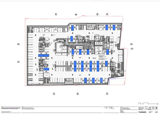
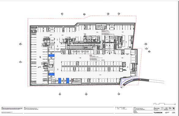
The proposed site layout and proposed ground floor plan is shown in the figure below as presented in the applicant’s Traffic report.
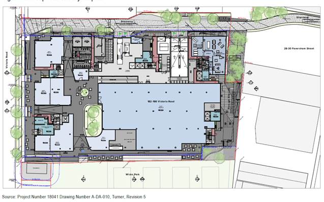
An artist view of the proposed development from Victoria Road is shown in the first diagram below and some elevations and cross sections indicate the scale and layout of the proposal:
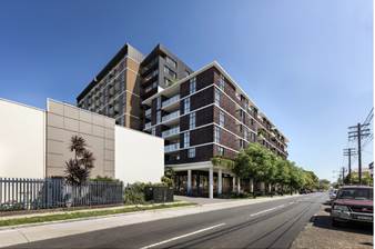

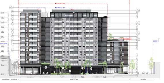
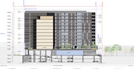
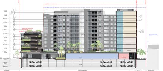
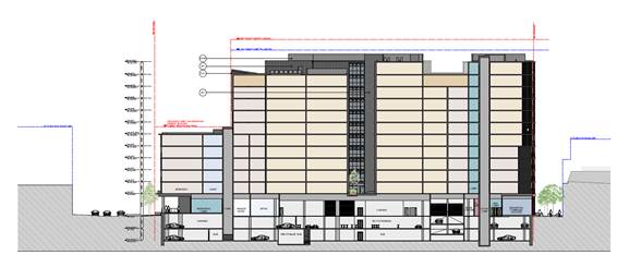
The amended development proposal, as at November 2019, is for 272 residential apartments and 2,387 square metres of ground floor retail/ commercial, including 1,500 square metres of mini major supermarket.
Site access
The proposed site access consists of a single one-way private road along the northern boundary of the site and allows for both right turn and left turns in from Victoria Road. The proposal to have right turning vehicles into the site off Victoria Road is not ideal due to road safety concerns (increased potential for crashes) and possible congestion / queuing along Victoria Road back into its signalized intersection with Sydenham Road.
RMS initially required a median island to be installed on Victoria Road disallowing any right turns into the proposed development, however they have since written back to Council advising that “…considering this section of Victoria Road is a regional road which is the responsibility of Council and that the median has not been incorporated into the Victoria Road Precinct Development Control Plan or Contributions Plan, which governs the planning of the precinct and which was adopted by Council.”
The intersection analysis performed by the applicant’s traffic consultant for Victoria Road and the private road resulted in satisfactory levels of service at the intersection during the morning and afternoon peaks, however it is not known what the effect is to the adjacent signalised intersection of Victoria Road and Sydenham Road as a result right turning movements at the proposed new intersection. There would be flow on effects from introducing a new intersection and additional traffic generation from the proposed development. Moreover, in a review of the crash history at adjacent intersections along Victoria Road found that accidents were prevalent at these intersections and a similar type of accident history could be expected if the current one way arrange into the private road was to change as a result of future development. In this case a median island would more than likely be necessary.
However, under the current proposed arrangement, in the absence of a median island a condition requiring the installation of signage restricting right turns into the subject site from Victoria Road will be essential, particularly during peak hours is supported.
Proposed one-way share way
Along the course of the development application the applicant moved from calling the shared accessway from Victoria Road a ‘shared zone’ to a ‘private access road’ and the design amended accordingly. “The private access road that proposes to provide vehicle access to the basement car park and at-grade loading dock is not intended to be in the formal shared zone, as required to be approved via formal application to Roads and Maritime Services. It is noted that it definitely does not fit the definition of an RMS ‘Shared Zone’ and as such is not supported as a shared zone.
Public Transport
Bus stops are located on Victoria Road south of Chapel Street intersection, approximately 250m north of the site and on Victoria Road south of Sydenham road intersection approximately 170 metres south of the site. The site is approximately a kilometre from Sydenham Station.
Parking
The proposed development lies within Council’s Parking Area 2 and Council's DCP 2011 (incorporating Amendment 4) requires the provision of off-street parking as follows:
· Residential flat building (non-adaptable units) – 217 units requiring 194 parking spaces
− 0.5 parking space per 1-bedroom unit (93 units – 46.5 spaces)
− 1 parking space per 2-bedroom unit (114 units – 114 spaces)
− 1.2 parking spaces per 3-bedroom unit (10 units – 12 spaces)
− 0.1 visitor parking space per unit (217 units – 21.7 spaces)
· Residential flat building (adaptable units) -55 adaptable units requiring 68.75 spaces (69)
- 1 mobility parking space per unit (regardless of size) (55 units – 55 spaces)
+ 0.25 visitor mobility parking space per unit (55 units – 13.75 spaces)
· Business premises; Retail premises; shops / Supermarket (Over 1,000m2) – 2,387m² requiring 66.2 spaces (66)
- 20 + 1 per 30m2 GFA over 1,000m2 GFA for customers and staff (20 + 46.2 spaces)
Therefore, to comply with Council’s current DCP the proposed development should provide a total of 329 car parking spaces as follows:
- 227 spaces for residents parking (including 55 accessible parking spaces), 172+55
- 36 spaces for visitor parking, and
- 66 spaces for retail/commercial parking.
In comparison, RMS’s Guide to Traffic Generating Developments for a high density residential flat building and commercial operation would require well in excess of 350+ spaces (274 + 72> with very conservative GLFA 1,200m2)
According to the applicant’s Submission of amended development application to Council dated 11 November 2019 the proposed development will provide a total of 311 car parking spaces:
“The reconfiguration of car parking spaces proposed in the two-level basement for resident, staff and visitor use, incorporating; − 224 car parking spaces for the residential component, plus 1 car wash bay (addition of 10 spaces)
− 65 retail spaces (including 2 adaptable spaces) (no change)
− 22 visitor vehicle spaces (including 5 adaptable spaces) (reduction of 5 spaces)
− 16 motorbike parking spaces and 143 bicycle parking spaces (no change). “
The proposal indicated provision of 306 car parking spaces. The Traffic Impact Assessment as well as the Statement of Environmental Effects assessed a shortfall of 18 spaces against the DCP. The site falls within a nominated Parking Area 2 under the MDCP 2011 (an area that is further away from shops and transit services and possibly resulting in greater car use and thus greater need of parking facilities). There are bus services along Victoria Road and Sydenham Station is approximately 1km away.
It was stated in the RTS report that the proposed parking provision seeks to mostly meet the MDCP 2011 retail parking requirements so as to adequately accommodate retail demand wholly within the site, while marginally reducing residential parking provision to encourage a mode shift away from daily travel by private car. It is noted, though commendable, ‘a green travel plan’ may not inspire people to take up active transport or use car sharing opportunities and they may remain to rely on private car travel.
It should also be noted that Council’s DCP has been developed with active and public transport in mind and the car parking rates have been reduced significantly in the DCP from the former Roads and Maritime Service guidelines for traffic generating developments to encourage a mode shift from private vehicle into sustainable transport.
Car Share pods are provided in Victoria Road and Edinburgh Road are located some 500m and 550m respectively and are not located conveniently for residents of this proposed development.
Therefore, the shortfall in car parking is not supported.
Motorcycle and Bicycle parking
Provision for motorcycle parking is 5% of car parking requirements therefore the proposed development requires 16.45 motorcycle spaces and 16 motorcycle spaces are to be provided.
Council requires 176 bicycle parking spaces estimated as follows:
− Residential flat building – 1 per 2 units for residents + 1 per 10 units for visitors (272 units)
§ 272 units = 136 + 27 = 163
− Business / retail premises – 1 per 300m² GFA for staff + 1 per 500m² GFA for customers if premises over 1000m² GFA
§ 2,387m² = 8 + 5 = 13
The applicant’s Traffic report says “the proposed development provides 168 bicycle storage spaces in the basement car park and on ground level for use by residents and staff. Capacity for bicycle racks has also been allowed for as part of the public domain on the ground level,
accommodating 32 spaces for visitors. As such, the proposed bicycle parking provision meets DCP 2011 requirements.”
Car park access and layout
All ramps and car parking spaces must be in accordance with Australian Standard AS2890.1-2004 Parking Facilities and AS2890.6-2009 Off-street parking for people with disabilities.
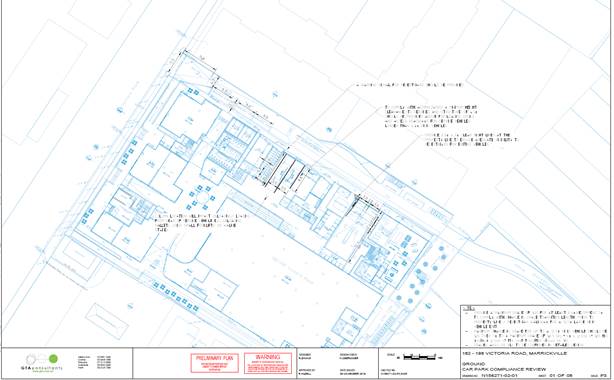
It is noted that Council’s Development Engineering Section will evaluate the adequacy of the proposed development’s driveway, ramps, servicing area dimensions and swept paths, car parking and circulation patterns.
Servicing
Proposals must meet Council’s minimum requirements for the parking of service and delivery vehicles, as detailed below:
|
Table 6: Service and delivery vehicle areas Type of development |
Minimum requirements |
|
Supermarkets, shops and restaurants |
One truck space per 400m2 GFA up to 2,000m2 GFA plus one truck space per 1,000m2 thereafter (all spaces adequate for trucks) |
|
Residential flat buildings and residential components of mixed use developments |
One service vehicle space per 50 apartments (above first 50) up to 200 apartments plus one space per 100 apartments thereafter |
In addition, the following design principles should be considered in the design of service vehicle areas, as detailed in RMS Guide to Traffic Generating Developments (2002):
· The layout of the service area must be designed to facilitate operations relevant to the development;
· Service areas must be a physically defined area which is not used for other purposes, such as storage of goods and equipment or parking areas;
· Separation of service vehicle and car movements must be a design objective;
· All vehicles must enter and leave the property in a forward direction; and
· Internal circulation roadways must be adequate for the largest vehicle anticipated to use the site.
According to Council requirements the proposed development requires 2 truck spaces to service the retail aspect of the proposed development and 5 service spaces to service the residential aspect of the proposed development. The proposed development proposes two loading bays only, which is deficient of 5 service spaces. No holding area is designated for any waiting trucks and thus, the potential exists for the roadway being congested due to waiting trucks. Residents and retail customers also require access to the basement carpark during times trucks/service vehicles will be reversing into the loading area.
Given the access is intended to be retained on private land and not delegated to Council at any time (in accordance with the Victoria Road Precinct (Precinct 47) DCP), the day to day management and operation on-site will be the responsibility of the landowner. All service vehicles would reverse into the loading dock on entry, and exit in a forward direction. As discussed, dock management measures will need to be in place, with the dock manager to manage as required on-site.
It is also important to note that the private access road has been designed to comply with the DCP masterplan for the Wicks Park sub-precinct (see Section 9.47.5) and has been designed to the requirements for reservation width by proposing an 8.5m private access road with kerb, pedestrian footpath, and 5 designated loading spaces.”
The applicant’s Traffic report notes that the parking area on the northern boundary of the site could also be for use by smaller service vehicles and garbage trucks at specific times of the day, however this is not a feasible on-going solution for adequate servicing arrangements for the site as in future the northern spaces will not be available with future redevelopment of the adjoining site. Dock management measures can only control so much and without adequate servicing provision congestion is possible in the roadway which also has the potential to spill out onto Victoria Road. In addition to servicing retail users, residents will want to move furniture in etc.
In summary, reversing movements from a public road into a development in this day and age are not considered as acceptable in most cases and other solutions should be considered to provide for a forward movement into and out of the loading docks. Given that there is also a shortfall in the number of loading docks provided, concerns are raised of how service vehicles will be managed in a safe and convenient manner for all road users using the private road. A plan of management at minimum is to be prepared by the applicant indicating of how service vehicles to the site will be managed and this may include but not limited to management of delivery times, restricting times of access, provision of certified traffic control to assist in control of movements at the time of delivery.
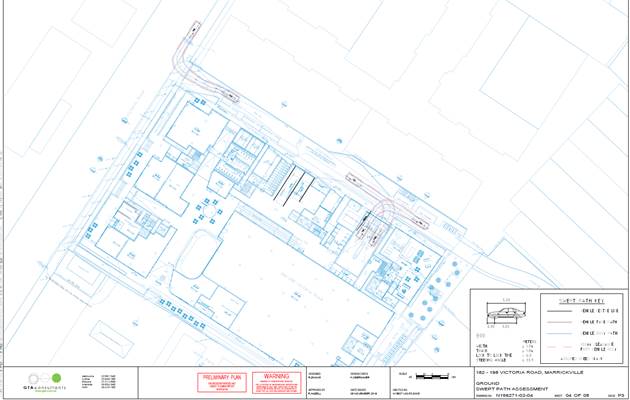
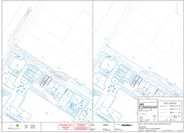
The applicant’s Traffic report provided swept paths for the loading area, which are reproduced below.
Estimated Traffic Generation
The proposal has 272 units and retail area of 2,387 m2 GFA (Supermarket 1,500m2 and specialty retail 887m2 thus, say leasable retail area is 75% of Gross floor area - 1,790m2 GLFA).
RMS’s Guide to Traffic Generating Developments / Technical Direction TDT 2013-4b gives a peak hour rate for high density residential flats of 0.29 vehicle trips per unit and the peak hour rate for shopping centres <10,000m2 GLFA of 16.3 vehicle trips per 100 m2 GLFA.
Therefore, with 272 proposed units, this calculates to be 78.88 (79) vehicle trips per peak hour and with a proposed total of 1,790m2 GLFA for the retail tenancies, this calculates to be 291.77 vehicle trips per peak hour. The proposed multi-storey residential and retail components of the development proposal thus yields a traffic generation potential of approximately 371 vehicle trips per peak hour. This equates roughly to an ADT of 3,710 vehicle trips per day.
It has been noted that all these vehicle trips have to leave the site via Hans Place and Faversham Street, which are local roads servicing the surrounding industrial area and currently carry around 550 and 400 vehicles per day respectively. Such an influx of generated traffic onto these relatively quiet local streets is going to be significant. – its reasonable to say the traffic generated by the proposed development will literally swamp the adjoining road network As too, it will significantly impact Fitzroy Street and its adjoining intersections connecting the wider road network (which are at times already saturated and operating at poor LoSs).
The applicant's traffic report states that the estimated traffic generation from the proposed mixed use multi-storey residential flat building development would be 189 vehicle trips per hour during the AM Peak, 315 vehicle trips per hour during the PM Peak and 384 vehicle trips per hour during Saturday peak. The report also notes that retail rates can be reduced by 20% to take into account internal trips from residents of the development, in addition, to deducting current use generated traffic rates of 77 vehicle trips in any peak hour concluding that “the proposed development would generate a net increase of between approximately 90 and 240 vehicle trips during any peak hour.”
It is noted that by even taking off current traffic generation for existing uses of 77 vehicle trips in any peak hour a difference of 54 vehicle trips remain between that estimated by the applicant and what is estimated in this report (371 - 77= 294 - 240=54). Traffic generation of 240 – 371 vehicle trips in any peak hour is significant and will definitely have an impact on the surrounding road network which may not be acceptable to many local residents who complained of such intrusion in the submission stage of this DA.
As noted earlier, the intersection of Victoria Road and Sydenham Road is at capacity now and is often congested throughout the day. Further, the added traffic exiting from the proposed development will have significant impacts on the intersection of Fitzroy Street and Sydenham Road, which is currently operating at a ’D” / ‘E’ Level of Service according to the applicants Traffic Report.
Hans Place and Faversham Street are currently a two way streets with parking provided on both sides of the roadway. The increase in traffic as a result of the proposed development could result in the loss of parking in Hans Place, Faversham Street and/or Fitzroy Street and Sydenham Road. A signage and carparking plan is required to be developed by the applicant which maximises the retention of existing on-street parking whilst providing for efficient and safer movement of vehicles through the provision of passing bays and intersection controls/treatments for both Hans Place and Faversham Street.
PUBLIC CONSULTATION
Consultation/notification regarding the proposal would normally be undertaken by Council's Development and Planning Services as part of the development application process.
CONCLUSION
The submitted development application has been reviewed and several concerns remain regarding the proposed development and its potential impact on the amenity of the surrounding area and road network.
· In light of no median strip being installed in Victoria Road to stop right hand turns into the site a condition, should consent be forthcoming, requiring the installation of regulatory signage restricting right turns into the subject site from Victoria Road will be essential, particularly during peak hours. Furthermore, should future conditions indicate a median strip is warranted for road safety reasons the possibility of one being installed should not be eliminated.
· Concern remains about the lack of provision of a holding area for service vehicles wanting to load/unload at the servicing dock area.
· The development proposal currently provides an unsatisfactory solution in relation to the management of service vehicles to the site including issues relating to access and provision of spaces. A plan of management at minimum is to be prepared by the applicant indicating of how service vehicles to the site will be managed and this may include but not limited to management of delivery times, provision of additional spaces/holding area, restricting times of access, provision of certified traffic control to assist in control of movements at the time of delivery.
· the proposed development does not comply with Council’s Parking requirements. It has a short fall of 18 car parking spaces which is not supported.
· A signage and carparking plan is required to be developed by the applicant which maximises the retention of existing on-street parking whilst providing for efficient and safer movement of vehicles through the provision of passing bays and intersection controls/treatments for both Hans Place and Faversham Street.
It is noted that Council’s Development Engineering Section will evaluate the adequacy of the proposed development’s driveway, ramps, servicing area dimensions and swept paths, car parking and circulation patterns.
It is recommended that the above traffic related comments be forwarded to Council’s Development Assessment Section.