Header Logo

Local Traffic Committee Meeting

7 September 2017


Minutes of Local Traffic Committee Meeting

Held at Leichhardt Town Hall, 107 Norton Street, Leichhardt


Meeting commenced at 10.12am


ACKNOWLEDGEMENT OF COUNTRY BY CHAIRPERSON

Acknowledgement by Chairperson:

“I acknowledge the Gadigal and Wangal people of the Eora nation on whose country we are meeting today, and their elders past and present.”


COMMITTEE REPRESENTATIVES PRESENT


Mr John Stephens

IWC’s Traffic and Transport Services Manager (Chair)

Mr Bill Holliday

Representative for Jamie Parker MP, Member for Balmain

Mr Chris Woods

Representative for Ron Hoenig MP, Member for Heffron

Ms Cathy Peters

Representative for Jenny Leong MP, Member for Newtown

Sgt John Micallef

NSW Police – Ashfield

SC Anthony Kenny

NSW Police – Newtown

SC Stephen Flanagan

NSW Police – Marrickville


OFFICERS IN ATTENDANCE


SC Sam Tohme

NSW Police – Ashfield

Mr Peter Whitney

State Transit Authority

Mr Manod Wickramasinghe

IWC’s Traffic & Planning Engineer

Mr David Yu

IWC’s Traffic Engineer

Mr Boris Muha

IWC’s Traffic Projects Engineer

Mr Davide Torresan

IWC’s Restorations and Assistant Design Engineer

Mr Joshua Staines

IWC’s Community Development Worker

Mr Emilio Andari

IWC’s Traffic Engineer

Mr Felix Liu

IWC’s Traffic Management Planner

Ms Jenny Adams

IWC’s Road Safety Officer

Mr Pierre Ayoub

IWC’s Civil Engineer

Ms Ranji Nadarajah

IWC’s Senior Civil Engineer

Ms Christina Ip

IWC’s Administration Assistant


VISITORS


Ms Amelia Lawson

Item 1

Mr Peter Edwick

Item 1

Mr Mark Quigley

Item 7

Mr Ben Hendricks

Item 8

Ms Rene Holmes

Item 15 and 16

Ms Rada Cvetkovic-Todorovic

Item 17

Mr Justin Foong

Item 17, representing EG Developments

Mr Khanh Nguyen

Item 26, representing Traffix Group


APOLOGIES


Mr Nicolas Kocoski

Roads and Maritime Services (emailed support)

Ms Sarina Foulstone

Representative for Jo Haylen MP, Member for Summer Hill

Sgt Dan Chilvers

NSW Police – Leichhardt (emailed support)

Mr George Tsaprounis

IWC’s Coordinator Traffic Engineering Services


ADDENDUM: Ms Foulstone emailed her apology and raised questions on the following two Items:


Item 9 –  Drivers passing the pedestrian crossing on Chapel Street near Shepherd Street are not expecting another crossing as they approach Illawarra Road. Ms Foulstone wanted to know about the use of the zig zag road markings in the lead up to the crossings to alert drivers to the crossing and suggested this could also be used for the crossing on Illawarra Road.


Council Officers advised that:


·         The proposed design had intended on keeping the existing zig zag linemarking along Illawarra Road and Council’s Design Engineers have been made aware that the zig zag linemarking on the approach to the crossing is to remain during implementation.

·         Speed count data indicates that the 85th percentile speed at the existing pedestrian crossing on Chapel Street near Shepherd Street is 40.7km/hr.

·         There were no recorded crashes/accidents between July 2011 – June 2016 at this location.

·         Council Officers will undertake further investigation to  determine whether zig zag linemarking on approach to the pedestrian crossing on Chapel Street should be introduced. 


Item 10 – Ms Foulstone requested confirmation that there is enough space for at least one vehicle between the crossing and Toothill Street, to eliminate any vehicles being on the crossing whilst checking for traffic before entering that intersection.


Council Officers advised that the distance between the proposed pedestrian crossing linemarking and the proposed relocation of the ‘Stop’ holding line is 6.6 metres in length. The proposed raised pedestrian crossing in Denison Road has been relocated to provide sufficient space for one vehicle to wait at the ‘Stop’ line intersection without impeding the pedestrian crossing linemarking.


The Local Member advised that she was satisfied with the information for both of the Items.


DISCLOSURES OF INTERESTS:          Nil.


CONFIRMATION OF MINUTES


Minutes of the Local Traffic Committee Meeting held on Thursday, 3 August 2017 are awaiting adoption. In order to meet the event date for the Dulwich Hill Village Fair 2017, the unanimous recommendation by the Local Traffic Committee concerning Item 6 Marrickville Road, Marrickville – Temporary Full Road Closures for Dulwich Hill Village Fair On Sunday 10 September 2017 has been approved by Roads & Maritime Services.


MATTERS ARISING FROM COUNCIL’S RESOLUTION OF MINUTES


Nil.


T0917 Item 1      Dulwich Hill North LATM Final Report

SUMMARY


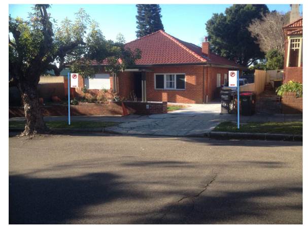
This is a recommendation to endorse the final Dulwich Hill North Local Area Traffic

Management report. The proposals within the report are based on community input and

analysis of the submissions from the Public Exhibition period through 17 May and 14 June

2017. There were 108 submissions from individual households relating to specific streets or

treatments. 70 (65%) submissions indicated support or support with changes to the proposals.


Officer’s Recommendation


THAT the final Dulwich Hill LATM report be endorsed for implementation including the following Table 1 Final LATM treatments:


Item No.

Street

Recommended Measures

1.1

Constitution Rd

Install cast in-situ rumble bars or fully mountable splitter islands at Denison Rd roundabout

1.2

Reconstruct southern Splitter island to include pedestrian refuge at Williams Pde

1.3

Install cast in-situ rumble bars along the centreline between Denison Rd and Williams Pde

1.4

Install a fixed radar speed display east of Grove St for eastbound traffic.

1.5

Linemark on-road bicycle symbols between Old Canterbury Rd and New Canterbury Rd.

2.1

Denison Rd

Reconstruct existing road hump to a two-way one-lane slow point near H/N 152

2.2

Install cast in-situ rumble bars or fully mountable splitter islands at Eltham St roundabout.

2.3

Change intersection priority at Dulwich St

2.4

Change intersection priority at Pigott St

2.5

Introduce AM peak “No Left Turn” restriction from New Canterbury Rd, subject to further traffic survey at New Canterbury Rd

2.6

Linemark 2.1m wide parking lane

2.7

Linemark on-road bike symbols

3.1

Windsor Rd

Construct pedestrian refuge island between Rosedale St and Weston St.

3.2

Construct entry threshold treatment at Old Canterbury Rd

3.3

Linemark on-road bicycle symbols

4.1

Union St

Construct entry threshold treatment at New Canterbury Rd

4.2

Construct kerb extension within No Stopping area and linemark opposite parking lane at Abergeldie St

4.3

Linemark on-road bicycle symbols

5.1

Arlington St

Construct kerb extension within No Stopping area at Abergeldie St

5.2

Construct kerb extension within No Stopping area at Dixson Ave

5.3

Change intersection priority at Abergeldie St

5.4

Linemark 2.1m wide parking lane

5.5

Linemark on-road bike symbols

6

Dixson Ave

Construct entry threshold treatment at Old Canterbury Rd

7

Gelding St

Construct kerb extension within No Stopping area at Maddock St

8.1

Hampstead St

Construct kerb extension within No Stopping area at Gelding St

8.2

Linemark on-road bicycle symbols

9

Lewisham St

Convert to one-way northbound and associated kerb extension between New Canterbury Rd and The Boulevarde.

10.1

Davis St

Linemark 2.1m wide parking lane

10.2

Linemark on-road bike symbols

11.1

Dulwich St

Linemark 2.1m wide parking lane

11.2

Linemark on-road bike symbols

12

Williams Pde

Construct splitter island to include pedestrian refuge at Constitution Rd

13

Elizabeth Ave

Construct a mid-block watts profile speed hump near H/N 29


DISCUSSION


Public speakers: Ms Amelia Lawson and Mr Peter Edwick (attended at 10.18am)


Ms Lawson stated that she and a group of Dension Road residents support the proposed measures for Dension Road, and provided the following comments:


·         The most effective measures proposed are the changes to the intersection priority at Dulwich Street and Pigott Street and the two-way one-lane slow point. Council should consider relocating the proposed slow point from outside house No.152 to No.133 as No.133 has off-street parking and would be less impacted by any removal of street parking.


·         Denison Road measures are given priority and expedited when Council adopts the recommendations.


·         There are concerns that the LATM measures will not be enough to prevent Denison Road from becoming busier due to high-density development.


·         During initial community consultation, residents requested a second two-way one lane slow point in the street as well as a No Left Turn from Davis Street during peak hour. Residents however were not further surveyed about these options during subsequent consultation.


Mr Edwick stated that speeding and overtaking is an issue in Denison Road during the morning and this leads to issues such as difficulty reversing out of driveways and difficulty crossing the road. He expressed his support for the proposed Denison Road treatments and agreed with the suggestion to relocate the slow point. Mr Edwick also requested that Denison Road works be expedited following Council approval.


(Ms Lawson and Mr Edwick left at 10.28am)


Council’s Traffic Management Planner advised that attempts will be made to locate the slow point to a position that minimises the impact to street parking during the detailed design process.


Council Officers stated that a second slow point is yet to be considered. Furthermore, initial analysis suggested that the benefits of prohibiting left turns from Davis Street into Denison Road (i.e. ‘No Left Turn’ restriction) would be minimal and there would be difficulties with enforcing the rule at this particular intersection.


Council Officers also stated that the residents of 133 Denison Road have not been consulted yet in relation to locating the proposed slow point near their property. This would need to occur prior to any further action.


The Committee members agreed with the Officer’s recommendation subject to residents’ requests being further investigated.


COMMITTEE RECOMMENDATION


THAT:


1.    The final Dulwich Hill LATM report be endorsed for implementation including the following Table 1 Final LATM treatments:


Item No.

Street

Recommended Measures

1.1

Constitution Rd

Install cast in-situ rumble bars or fully mountable splitter islands at Denison Rd roundabout

1.2

Reconstruct southern Splitter island to include pedestrian refuge at Williams Pde

1.3

Install cast in-situ rumble bars along the centreline between Denison Rd and Williams Pde

1.4

Install a fixed radar speed display east of Grove St for eastbound traffic.

1.5

Linemark on-road bicycle symbols between Old Canterbury Rd and New Canterbury Rd.

2.1

Denison Rd

Reconstruct existing road hump to a two-way one-lane slow point near H/N 152

2.2

Install cast in-situ rumble bars or fully mountable splitter islands at Eltham St roundabout.

2.3

Change intersection priority at Dulwich St

2.4

Change intersection priority at Pigott St

2.5

Introduce AM peak “No Left Turn” restriction from New Canterbury Rd, subject to further traffic survey at New Canterbury Rd

2.6

Linemark 2.1m wide parking lane

2.7

Linemark on-road bike symbols

3.1

Windsor Rd

Construct pedestrian refuge island between Rosedale St and Weston St.

3.2

Construct entry threshold treatment at Old Canterbury Rd

3.3

Linemark on-road bicycle symbols

4.1

Union St

Construct entry threshold treatment at New Canterbury Rd

4.2

Construct kerb extension within No Stopping area and linemark opposite parking lane at Abergeldie St

4.3

Linemark on-road bicycle symbols

5.1

Arlington St

Construct kerb extension within No Stopping area at Abergeldie St

5.2

Construct kerb extension within No Stopping area at Dixson Ave

5.3

Change intersection priority at Abergeldie St

5.4

Linemark 2.1m wide parking lane

5.5

Linemark on-road bike symbols

6

Dixson Ave

Construct entry threshold treatment at Old Canterbury Rd

7

Gelding St

Construct kerb extension within No Stopping area at Maddock St

8.1

Hampstead St

Construct kerb extension within No Stopping area at Gelding St

8.2

Linemark on-road bicycle symbols

9

Lewisham St

Convert to one-way northbound and associated kerb extension between New Canterbury Rd and The Boulevarde.

10.1

Davis St

Linemark 2.1m wide parking lane

10.2

Linemark on-road bike symbols

11.1

Dulwich St

Linemark 2.1m wide parking lane

11.2

Linemark on-road bike symbols

12

Williams Pde

Construct splitter island to include pedestrian refuge at Constitution Rd

13

Elizabeth Ave

Construct a mid-block watts profile speed hump near H/N 29


2.    A second two-way one-lane slow point on Denison Road be investigated.

3.    The relocation of the two-way one-lane slow point located outside No. 152 Denison Road (tabled recommendation 2.1) to outside No. 133 Denison Road be investigated.


For motion: Unanimous


T0917 Item 2      Wells Street, Annandale Annual Road Occupancy (Street Party)
(Leichhardt Ward/Balmain Electorate/Leichhardt LAC)

SUMMARY


Council has received an application for approval of a street party in Wells Street between

Booth Street and Collins Street to be held on Sunday, 26th November 2017 between 4.00pm

and 7.00pm.


Officer’s Recommendation


THAT:


1.   The temporary road closure of Wells Street between Booth Street and Collins Street, Annandale on Sunday, 26th November 2017 between 4.00pm and 7.00pm be supported, subject to the following conditions:


a.   That an unencumbered passage minimum 4.0m wide be available for emergency vehicles through the closed section of Wells Street, Annandale;

b.   The occupation of the road carriageway must not occur until the road has been physically closed;

c.   That the organiser be advised to arrange accredited traffic controllers to manage the road closure;

d.   That the barbeque activities be undertaken on the footpath, subject to no fire restrictions;

e.   That the applicant notifies all affected businesses, residents and other occupants of the temporary road closure prior to the event.  Any concerns or requirements in relation to the road closure raised by business proprietors, residents and other occupants must be resolved or accommodated. The notification shall involve at the minimum an information letterbox drop distributed one week prior to the commencement of the event.  The proposed information, distribution area and period must be submitted to Council’s Traffic section for approval two weeks before the event;

f.    That the supported Traffic Control Plan (TCP) be implemented at the applicant’s expense;

g.   That the Fire Brigade (Glebe) be notified of the intended closure by the applicant;

h.   That the applicant provide and erect barricades and signs, in accordance with the current Australian Standard AS 1742.3: Traffic Control Devices for Works on Roads.  As a minimum the following must be erected at both ends of the road closure area:

i.    Barrier Boards;

ii.    ‘Road Closed’ (T2-4) signs; and

iii.   ‘Detour’ (T5-1) signs.

i.    That the applicant be advised Council provides barricades and ‘Road Closed’ signs free or at minimum cost.  The applicant is required to arrange delivery by Council at cost, or arrange pickup from and return to Council’s Depot at no cost. Any non-standard signs may be provided at cost;

j.    That the areas to be used for the activities must be maintained in a clean and tidy condition to the satisfaction of Council’s Group Manager Roads & Stormwater, or else the applicant will be required to reimburse Council for any extraordinary cleaning costs;

k.   That the conduct of any activities or use of any equipment required in conjunction with the road occupancy and temporary road closure not results in any ‘offensive noise’ as defined by the Noise Control Act;

l.    That a copy of the Council approval be available on site for inspection by relevant authorities;

m.  That Council reserves the right to cancel the approval at any time; and

n.   That the applicant complies with any reasonable directive from Council Officers and NSW Police.


2.   That the applicant be advised of the Committee’s recommendation.


DISCUSSION


The Committee members agreed with the Officer’s recommendation.


COMMITTEE RECOMMENDATION


THAT:


1.   The temporary road closure of Wells Street between Booth Street and Collins Street, Annandale on Sunday, 26th November 2017 between 4.00pm and 7.00pm be supported, subject to the following conditions:


a.   That an unencumbered passage minimum 4.0m wide be available for emergency vehicles through the closed section of Wells Street, Annandale;

b.   The occupation of the road carriageway must not occur until the road has been physically closed;

c.   That the organiser be advised to arrange accredited traffic controllers to manage the road closure;

d.   That the barbeque activities be undertaken on the footpath, subject to no fire restrictions;

e.   That the applicant notifies all affected businesses, residents and other occupants of the temporary road closure prior to the event.  Any concerns or requirements in relation to the road closure raised by business proprietors, residents and other occupants must be resolved or accommodated. The notification shall involve at the minimum an information letterbox drop distributed one week prior to the commencement of the event.  The proposed information, distribution area and period must be submitted to Council’s Traffic section for approval two weeks before the event;

f.    That the supported Traffic Control Plan (TCP) be implemented at the applicant’s expense;

g.   That the Fire Brigade (Glebe) be notified of the intended closure by the applicant;

h.   That the applicant provide and erect barricades and signs, in accordance with the current Australian Standard AS 1742.3: Traffic Control Devices for Works on Roads.  As a minimum the following must be erected at both ends of the road closure area:

i.    Barrier Boards;

ii.    ‘Road Closed’ (T2-4) signs; and

iii.   ‘Detour’ (T5-1) signs.

i.    That the applicant be advised Council provides barricades and ‘Road Closed’ signs free or at minimum cost.  The applicant is required to arrange delivery by Council at cost, or arrange pickup from and return to Council’s Depot at no cost. Any non-standard signs may be provided at cost;

j.    That the areas to be used for the activities must be maintained in a clean and tidy condition to the satisfaction of Council’s Group Manager Roads & Stormwater, or else the applicant will be required to reimburse Council for any extraordinary cleaning costs;

k.   That the conduct of any activities or use of any equipment required in conjunction with the road occupancy and temporary road closure not results in any ‘offensive noise’ as defined by the Noise Control Act;

l.    That a copy of the Council approval be available on site for inspection by relevant authorities;

m.  That Council reserves the right to cancel the approval at any time; and

n.   That the applicant complies with any reasonable directive from Council Officers and NSW Police.


2.   That the applicant be advised of the Committee’s recommendation.


For motion: Unanimous


T0917 Item 3      NSW Aboriginal Rugby League Knockout 2017 – Traffic Management Plan (Leichhardt Ward /Balmain Electorate/Leichhardt LAC)

SUMMARY


The Inner West Council has entered into a partnership with the Redfern All Blacks to host the NSW Aboriginal Rugby League Knockout 2017 at the Leichhardt Park Precinct. The event is being held over a 4 day period from Friday, 29th September 2016 to Monday, 2nd October 2017.


A number of temporary traffic changes are proposed which are detailed in the report.


Officer’s Recommendation


THAT:

1.   The Traffic Management Plan detailing the traffic arrangements for the NSW Aboriginal Rugby League Knockout 2017 be supported;

2.   That the Traffic Control Plans (TCP) be implemented by Event Services International (ESI), including RMS accredited traffic controllers;

3.   The Traffic Management Plan be forwarded to Council’s Area Base Coordinator, Transport Management Centre and the Major Events & Incidents Group (NSW Police) by the applicant;

4.   The applicant be requested to advise all affected residents and businesses in advance of the temporary parking changes and temporary internal partial road closures in the subject area;

5.   A four (4) metre unencumbered passage be available for emergency vehicles though all the closed section of internal roads at all times;

6.   All advertising of the event must encourage the use of Public Transport;

7.   The applicant be requested to liaise with the STA to organise additional public       transport services if necessary;

8.   The NSW Fire Brigade be notified of the intended closure;

9.   The applicant provide and erect barricades and signs, in accordance with the current Australian Standard AS 1742.3: Traffic Control Devices for Works on Roads.  As a minimum the following must be erected at the appropriate locations:

a.   Barrier Boards (Barricades);

b.   ‘Road Closed’ (T2-4) signs;

c.   ‘Road Closed Ahead’ (T2-Q02A); and

d.   ‘On Side Road’ (TC-1325).

10. The areas to be used for the activities must be maintained in a clean and tidy condition to the satisfaction of Council’s Group Manager Roads & Stormwater, or else the applicant will be required to reimburse Council for any extraordinary cleaning costs;

11. The conduct of any activities or use of any equipment required in conjunction with the road occupancy and temporary road closure not results in any ‘offensive noise’ as defined by the Protection of the Environment Operations Act 1997;

12. A copy of the Council approval be available on site for inspection by relevant authorities;

13. Council reserves the right to cancel the approval at any time;

14. The applicant complies with any reasonable directive from Council Officers and NSW Police; and

15. The applicant be advised of the Committee’s recommendation.


DISCUSSION


Council’s Community Development Worker tabled an updated Traffic Management Plan and Traffic Control Plan for the event which details plans for a shuttle bus service to pick up and drop off participants and increased security at the main entrance. The Officer noted that Blackmore Oval will not be used at this event due to problems with its use last year.  


The officer also advised that Leichhardt Police and Leichardt Fire and Rescue agree with the amendments, and a copy of the updated plans have been provided to Council’s Traffic team.


The representative for the Member for Balmain asked whether special event parking restrictions in the surrounding area would come into effect during the duration of this event. Council Officers stated that an updated parking management scheme for residents around Leichhardt Oval 1 is being discussed with RMS, and will be presented at a future Committee meeting.


The Committee members agreed with the Officer’s recommendation.


COMMITTEE RECOMMENDATION


THAT:

1.   The Traffic Management Plan detailing the traffic arrangements for the NSW Aboriginal Rugby League Knockout 2017 be supported;

2.   That the Traffic Control Plans (TCP) be implemented by Event Services International (ESI), including RMS accredited traffic controllers;

3.   The Traffic Management Plan be forwarded to Council’s Area Base Coordinator, Transport Management Centre and the Major Events & Incidents Group (NSW Police) by the applicant;

4.   The applicant be requested to advise all affected residents and businesses in advance of the temporary parking changes and temporary internal partial road closures in the subject area;

5.   A four (4) metre unencumbered passage be available for emergency vehicles though all the closed section of internal roads at all times;

6.   All advertising of the event must encourage the use of Public Transport;

7.   The applicant be requested to liaise with the STA to organise additional public       transport services if necessary;

8.   The NSW Fire Brigade be notified of the intended closure;

9.   The applicant provide and erect barricades and signs, in accordance with the current Australian Standard AS 1742.3: Traffic Control Devices for Works on Roads.  As a minimum the following must be erected at the appropriate locations:

a.   Barrier Boards (Barricades);

b.   ‘Road Closed’ (T2-4) signs;

c.   ‘Road Closed Ahead’ (T2-Q02A); and

d.   ‘On Side Road’ (TC-1325).

10. The areas to be used for the activities must be maintained in a clean and tidy condition to the satisfaction of Council’s Group Manager Roads & Stormwater, or else the applicant will be required to reimburse Council for any extraordinary cleaning costs;

11. The conduct of any activities or use of any equipment required in conjunction with the road occupancy and temporary road closure not results in any ‘offensive noise’ as defined by the Protection of the Environment Operations Act 1997;

12. A copy of the Council approval be available on site for inspection by relevant authorities;

13. Council reserves the right to cancel the approval at any time;

14. The applicant complies with any reasonable directive from Council Officers and NSW Police; and

15. The applicant be advised of the Committee’s recommendation.


For motion: Unanimous


T0917 Item 4      Big Bike Day 2017 Special Event
(Leichhardt Ward/Balmain Electorate/Leichhardt LAC)

SUMMARY


As part of NSW Bike Week 2017, Council is running free events and the last event the ‘Big

Bike Day’ is to be held on Sunday, 24th September 2017.


Officer’s Recommendation


THAT:


The Big Bike Day 2017 event proposed to be held on Sunday, 24th September 2017 be supported.


DISCUSSION


The Committee members agreed with the Officer’s recommendation.


COMMITTEE RECOMMENDATION


THAT:


The Big Bike Day 2017 event proposed to be held on Sunday, 24th September 2017 be supported.


For motion: Unanimous


T0917 Item 5      Traffic Management Plan for the 2017 New Year’s Eve Event       
(Balmain Ward/Balmain Electorate/Leichhardt LAC) 

SUMMARY


As instructed by the Police, access to the Balmain peninsula is closed to vehicular traffic every New Year’s Eve. This report outlines the traffic management associated with the event.


Officer’s Recommendation


THAT:


1.       The Traffic Management Plan detailing the traffic arrangements for the 2017 New Year’s Eve be supported;

2.       The Traffic Management Plan be forwarded to Council’s Parks and Streetscapes Coordinator, Transport Management Centre and the Major Events & Incidents Group (NSW Police);

3.       A temporary ‘No Stopping’ zone be installed on the eastern side of Montague Street between Darling Street and Beattie Street, Balmain;

4.       That the following modifications to bus stops be approved:

          On the northern side of Darling Street:

i. Install temporary ‘Bus Zones’ between  Mort Street and Ford Street;

ii. Extend the ‘Bus Zone’ between Ford Street and McDonald Street; and

iii.  Extend the ‘Bus Zone’ between McDonald Street and Curtis Road, outside Nos.217-223 Darling Street.

          On the southern side of Darling Street:

iv. Install a temporary ‘Bus Zone’ between Booth Street and Beattie Street, outside No. 244-270 Darling Street.

5.       The Police representative be requested to provide bike unit resources to improve traffic/crowd controls around the Darling Street/Curtis Road intersection (roundabout);

6.       The Police be requested to liaise directly with the Roads and Maritime Services in regards to the installation of variable message signs (“Balmain Peninsula is closed” and “Alcohol Free Zone”) on the main access roads into Balmain Peninsula a few days in advance of the event;

7.       Confirmation be sought regarding the areas to be declared alcohol free and the Police and Sydney Buses representatives be advised;

8.       The Sydney Buses representative be requested to place adequate notices on buses regarding the establishment of an alcohol free zone in the Balmain East area (details to be provided by Council);

9.       The taxi/hire car access to the Peninsula be restricted from 7:00pm.

10.     Taxis/hire cars carrying mobility impaired or infirmed residents be permitted access at all hours into the Peninsula; and

11.     The Taxi Council be advised of the Committee’s recommendation.


DISCUSSION


The Committee members agreed with the Officer’s recommendation.


COMMITTEE RECOMMENDATION


THAT:


1.       The Traffic Management Plan detailing the traffic arrangements for the 2017 New Year’s Eve be supported;

2.       The Traffic Management Plan be forwarded to Council’s Parks and Streetscapes Coordinator, Transport Management Centre and the Major Events & Incidents Group (NSW Police);

3.       A temporary ‘No Stopping’ zone be installed on the eastern side of Montague Street between Darling Street and Beattie Street, Balmain;

4.       That the following modifications to bus stops be approved:

          On the northern side of Darling Street:

i. Install temporary ‘Bus Zones’ between  Mort Street and Ford Street;

ii. Extend the ‘Bus Zone’ between Ford Street and McDonald Street; and

iii.  Extend the ‘Bus Zone’ between McDonald Street and Curtis Road, outside Nos.217-223 Darling Street.

          On the southern side of Darling Street:

iv. Install a temporary ‘Bus Zone’ between Booth Street and Beattie Street, outside No. 244-270 Darling Street.

5.       The Police representative be requested to provide bike unit resources to improve traffic/crowd controls around the Darling Street/Curtis Road intersection (roundabout);

6.       The Police be requested to liaise directly with the Roads and Maritime Services in regards to the installation of variable message signs (“Balmain Peninsula is closed” and “Alcohol Free Zone”) on the main access roads into Balmain Peninsula a few days in advance of the event;

7.       Confirmation be sought regarding the areas to be declared alcohol free and the Police and Sydney Buses representatives be advised;

8.       The Sydney Buses representative be requested to place adequate notices on buses regarding the establishment of an alcohol free zone in the Balmain East area (details to be provided by Council);

9.       The taxi/hire car access to the Peninsula be restricted from 7:00pm.

10.     Taxis/hire cars carrying mobility impaired or infirmed residents be permitted access at all hours into the Peninsula; and

11.     The Taxi Council be advised of the Committee’s recommendation.


For motion: Unanimous


T0917 Item 6      2018 St Jerome’s Laneway Festival (Balmain Ward / Balmain Electorate / Leichhardt LAC) Traffic Management Plan and Traffic Control Plan

SUMMARY


The proposed event, the St. Jerome's Laneway Festival 2018, is a music festival held annually at Sydney University College of Arts, Rozelle Campus, Callan Park.


Assure Event Safety Services has submitted a Development Application including a Traffic

Management Plan for the upcoming “St Jerome’s Laneway Music Festival”, to be held in

Callan Park on Sunday, 4th February 2018.


Officer’s Recommendation


THAT:


That the Traffic Management Plan (TMP) dated 23rd August 2017 submitted by the event organiser for the St Jerome’s Laneway Festival 2018 at Callan Park to be held on Sunday, 4th February 2018 between 11am and 11pm be supported, subject to the following:


1.   The TMP be implemented at the applicant’s cost;

2.   The maximum number of tickets sold to be 12,500, subject to NSW Police approval;

3.   Operating the Event as ‘car free’ (no parking is available at the venue);

4.   The applicant must obtain approval from the Transport Management Centre for the ‘Special Event Clearway’ restrictions on the northern side (Callan Park side) of Balmain Road and Darling Street (from 200m west of the main entrance to Callan Park at Cecily Street, to Victoria Road) from 2pm to Midnight;

5.   Use standard parking restriction signage: ‘No Parking’ (R5-40) and ‘Pick up & Set down Area”’ (R9-301), Bus Zone (R5-20) and Taxi Zone (R5-21) at the locations identified in the TMP;

6.   Liaise with Transport for NSW to ensure train and light rail services operate at full capacity (no rail close downs);

7.   The applicant must arrange additional special event buses with Sydney Buses (State Transit Authority);

8.   Close vehicular access to Callan Park at the Balmain Road/Cecily Street intersection and at the Cottage Way/South Crescent intersection;

9.   Arrange crowd control barriers along both sides of Balmain Road south of Cecily Street; and

10. Provide a current Public Liability Insurance Policy to Inner West Council.


DISCUSSION


The Committee members agreed with the Officer’s recommendation.


COMMITTEE RECOMMENDATION


THAT:


That the Traffic Management Plan (TMP) dated 23rd August 2017 submitted by the event organiser for the St Jerome’s Laneway Festival 2018 at Callan Park to be held on Sunday, 4th February 2018 between 11am and 11pm be supported, subject to the following:


1.   The TMP be implemented at the applicant’s cost;

2.   The maximum number of tickets sold to be 12,500, subject to NSW Police approval;

3.   Operating the Event as ‘car free’ (no parking is available at the venue);

4.   The applicant must obtain approval from the Transport Management Centre for the ‘Special Event Clearway’ restrictions on the northern side (Callan Park side) of Balmain Road and Darling Street (from 200m west of the main entrance to Callan Park at Cecily Street, to Victoria Road) from 2pm to Midnight;

5.   Use standard parking restriction signage: ‘No Parking’ (R5-40) and ‘Pick up & Set down Area”’ (R9-301), Bus Zone (R5-20) and Taxi Zone (R5-21) at the locations identified in the TMP;

6.   Liaise with Transport for NSW to ensure train and light rail services operate at full capacity (no rail close downs);

7.   The applicant must arrange additional special event buses with Sydney Buses (State Transit Authority);

8.   Close vehicular access to Callan Park at the Balmain Road/Cecily Street intersection and at the Cottage Way/South Crescent intersection;

9.   Arrange crowd control barriers along both sides of Balmain Road south of Cecily Street; and

10.  Provide a current Public Liability Insurance Policy to Inner West Council.


For motion: Unanimous


T0917 Item 7      Ross Street & Derby Street, Camperdown – Proposed Kerb Extensions & Kerb Blister Design Plan
(Stanmore Ward/Newtown Electorate/Newtown LAC)

SUMMARY


Detailed design plans have been finalised for the proposed footpath improvements in Ross

Street and Derby Street, Camperdown as part of Council’s Capital Works Program for

footpaths. The proposal for kerb extensions with a new kerb and gutter alignment and

associated signs and linemarking in Ross Street at its intersection with Eton Street and the

proposal for a kerb blister in Derby Street at its intersection with Denison Street will improve

pedestrian safety and traffic conditions at these locations.


Officer’s Recommendation


THAT the detailed design plans of the kerb extensions with a new kerb and gutter alignment and associated signs and linemarking in Ross Street, Camperdown at its intersection with Eton Street and the kerb blister in Derby Street, Camperdown at its intersection with Denison Street (as per design plan No. 6166) be APPROVED.


DISCUSSION


Public speaker: Mr Mark Quigley (attended at 10.35am)


Mr Quigley, resident in Ross Street, expressed his concerns with the proposed plans and made the following comments:


·         Parking in Ross Street is unrestricted and as a result it is often occupied during the day by students and workers at the nearby university and RPA Hospital. The proposed design will remove a parking space which will make it more difficult for residents to park in the street.

·         The speaker’s property does not have off-street parking. A recent driveway application for his property was rejected due to the width of the proposed driveway falling below the standard requirement. Having an off-street parking space on the property would mitigate the proposed loss of parking in the street.


(Mr Quigley left at 10.42am)


Council Officers noted that Eton Street has a Resident Parking Scheme on one side of the street and while Ross Street does not currently have a parking scheme, it is possible for one on the western side of Ross Street and this can be investigated.


The Committee members agreed with the Officer’s recommendation and agreed that a Resident Parking Scheme on the western side of Ross Street should be investigated.


COMMITTEE RECOMMENDATION


THAT:


1.    The detailed design plans of the kerb extensions with a new kerb and gutter alignment and associated signs and linemarking in Ross Street, Camperdown at its intersection with Eton Street and the kerb blister in Derby Street, Camperdown at its intersection with Denison Street (as per design plan No. 6166) be APPROVED; and

2.    A Resident Parking Scheme on the western side of Ross Street be investigated.


For motion: Unanimous


T0917 Item 8      Thompson Street, Marrickville – Proposed Kerb Extensions Design Plan
(Marrickville Ward/Summer Hill Electorate/Marrickville LAC)

SUMMARY


A detailed design plan has been finalised for the proposal to widen the existing footpaths and

narrow the road width in Thompson Street, Marrickville near its intersection with Edward Street as part of the Henson LATM study implementation. The proposal for kerb extensions with a new kerb and gutter alignment and associated signs will improve pedestrian safety at this location.


Officer’s Recommendation


THAT the detailed design plan of the kerb extensions with a new kerb and gutter alignment and associated signs in Thompson Street, Marrickville near its intersection with Edward Street (as per design plan No. 6178) be APPROVED.


DISCUSSION


Public speaker: Mr Ben Hendricks (attended at 10.53am)


Mr Hendricks stated that he supports the proposed kerb extension; however, he does not support the proposed ‘No Stopping’ zone on the southern side of Thompson Street, adjacent to his property at 2 Thompson Street. Mr Hendricks made the following comments:


·         Parking in Thompson Street is often occupied by nearby workers which leaves few parking spaces for residents during the day.

·         There is a proposal endorsed by Council to rezone the Victoria Road  precinct which will likely exacerbate existing parking problems in Thompson Street.

·         The ‘No Stopping’ zone removes  2 parking spaces in front of his property which makes it more difficult for his elderly parents to access his home.

·         Council does not appear to install ‘No Stopping’ zones in streets that have similar pedestrian access treatments. Photos of pedestrian crossings on Premier Street, Addison Road and Union Street and near Stanmore Public School were tabled as examples of this.

·         Pedestrian traffic in the street predominantly occurs at the start and end of school days.

Mr Hendricks stated that while he does not support the ‘No Stopping’ zone as proposed, he would support a ‘No Stopping’ zone if the restrictions are during school hours only.


(Mr Hendricks left at 11.01am)


Council Officers indicated that pedestrian safety would still be of concern if the ‘No Stopping’ zone is only during school hours and recommended the restrictions be full time. Council Officers advised that 7.3% of traffic volumes in Thompson Street are from heavy vehicles that travel through the street to access Illawarra Road. It was noted that the design proposes to extend the regulatory 10m ‘No Stopping’ zone by 5m to improve safety and sightlines for pedestrian access, particularly for children crossing the road to attend Marrickville Public School.


The Committee members agreed with the Officer’s recommendation.


COMMITTEE RECOMMENDATION


THAT the detailed design plan of the kerb extensions with a new kerb and gutter alignment and associated signs in Thompson Street, Marrickville near its intersection with Edward Street (as per design plan No. 6178) be APPROVED.


For motion: Unanimous


T0917 Item 9      Illawarra Road, Marrickville – Proposed Raised Pedestrian Crossing & Kerb Extensions Design Plan
(Marrickvlle Ward/Summer Hill Electorate/Marrickville LAC)

SUMMARY


A detailed design plan has been finalised for the proposal to upgrade the existing raised

pedestrian crossing on Illawarra Road, Marrickville near its intersection with Chapel Street as part of the Henson LATM study implementation. The proposal to upgrade the existing raised pedestrian crossing with kerb extensions and associated signs and line markings will improve pedestrian safety and traffic conditions at this location.


Consultation was undertaken with owners and occupiers of properties adjacent to Illawarra

Road and Woodland Street, regarding the proposal. A summary of the consultation results are presented in this report for consideration. It is recommended that the proposed detailed design plan be approved.


Officer’s Recommendation


THAT the design of the raised pedestrian crossing with new kerb extensions and associated signs and line markings on Illawarra Road, Marrickville, at the intersection with Chapel Street and new kerb extensions in Illawarra Road, Marrickville, at the intersection with Woodland Street (as per design plan No. 6147) be APPROVED.


DISCUSSION


The Committee members agreed with the Officer’s recommendation.


COMMITTEE RECOMMENDATION


THAT the design of the raised pedestrian crossing with new kerb extensions and associated signs and line markings on Illawarra Road, Marrickville, at the intersection with Chapel Street and new kerb extensions in Illawarra Road, Marrickville, at the intersection with Woodland Street (as per design plan No. 6147) be APPROVED.


For motion: Unanimous


T0917 Item 10    Denison Road, Lewisham – Proposed Raised Pedestrian Crossing & Kerb Extensions Design Plan
(Stanmore Ward/Summer Hill Electorate/Marrickville LAC)

SUMMARY


A detailed design plan has been finalised for the proposal to upgrade the existing at-grade

pedestrian crossing in Denison Road, Lewisham at its intersection with Toothill Street as part of the NSW Government’s Pedestrian Infrastructure Safety Around Schools Program. The proposal to upgrade the existing at-grade pedestrian crossing to a new raised pedestrian crossing with kerb extensions and associated signs and line markings will improve pedestrian safety at this location.


Consultation was undertaken with owners and occupiers of properties adjacent to Denison

Road and Toothill Street, regarding the proposal. A summary of the consultation results are presented in this report for consideration. It is recommended that the proposed detailed design plan be approved.


Officer’s Recommendation


THAT the design of the raised pedestrian crossing with new kerb extensions and associated signs and line markings in Denison Road, Lewisham, at the intersection of Toothill Street (as per design plan No. 6168) be APPROVED.


DISCUSSION


The Committee members agreed with the Officer’s recommendation.


COMMITTEE RECOMMENDATION


THAT the design of the raised pedestrian crossing with new kerb extensions and associated signs and line markings in Denison Road, Lewisham, at the intersection of Toothill Street (as per design plan No. 6168) be APPROVED.


For motion: Unanimous


T0917 Item 11    2017 Norton Street Italian Festa (Leichhardt Ward/Balmain Electorate/Leichhardt LAC)
Traffic Management Plan and Traffic Control Plan For The 2017 Italian Festa Event

SUMMARY


The proposed event, The Norton Street Italian Festa, is a street festival held annually

celebrating the traditional Italian culture that is considered an essential part of the Leichhardt community.


To facilitate the event, it is proposed to close a number of roads in the area the following roads between 3:00am and 8:00pm on Sunday, 29th October 2017

·  Norton Street from Marion Street to William Street;

·  Marlborough Street from Norton Street to Cromwell Street;

·  Short Street from Norton Street to Balmain Road;

·  Carlisle Street from Norton Street to Cromwell Street;

·  Allen Street from Cromwell Street to Derbyshire Road;

·  Arthur Street from Allen Street to Short Street;


It is recommended that the 2017 Italian Festa Event to be held on Sunday, 29th October 2017 be supported, subject to complying with the following conditions:


The TMP and TCP being approved by the RMS as well as the Transport Management Centre, installation of a ‘Special Event Clearway’ restriction in Norton Street prior to the event, parking for the event be reserved in Short Street on both sides between Norton Street and the unnamed lane for Emergency Service vehicles, approval to conduct a public assembly be obtained from the NSW Police, all affected businesses, residents and other occupants be notified of the road closures, proposed event being forwarded to the appropriate authorities, including emergency services and a current Public Liability Insurance Policy be provided to Inner West Council, nominating Council as an interested party.


Officer’s Recommendation


THAT:


1)  The road closure application for the ‘Norton Street Italian Festa 2017’ on Sunday, 29th October 2017 be supported, subject to the following conditions:      

a)  The road closures be restricted to occur between 3:00am and 8.00pm on Sunday, 29th October 2017  at the following locations:

i.    Norton Street from Marion to William Street;

ii.    Marlborough Street from Norton Street to Cromwell Street;

iii.   Short Street from Norton Street to Balmain Road;

iv.  Carlisle Street from Norton Street to Cromwell Street;

v.   Allen Street from Cromwell Street to Derbyshire Road; and

vi.  Arthur Street from Allen Street to Short Street.

b)  Approval from RMS for the TMP and to install a ‘Special Event Clearway’ restriction in Norton Street be obtained prior to the event;

c)  Wetherill Street (Norton Street – Balmain Road) and Macauley Street   (Cromwell Street – Norton Street) function as two way roads when Norton Street is closed to provide access for residents etc;

d)  Parking for the event be reserved in:

·   Short Street on both sides between Norton Street and the unnamed lane for Emergency Service vehicles; 

·   William Street on the southern side between Norton Street and Derbyshire Road (Pioneers Memorial Park side).  The angle parking in this area will be temporarily amended to allow parallel parking for Police horse floats etc;

e)  Approval from the Transport Management Centre to close the roads is obtained prior to the event;

f)  A three (3) metre unencumbered passage be available for emergency vehicles though the closed section of Norton Street at all times;

g)  Approval to conduct a public assembly be obtained from the NSW Police prior to the event. A copy of the NSW Police approval must be forwarded to Council’s Traffic Section prior to the event;

h)  The applicant be requested to provide free bicycle valet parking at a central location (ie. Short Street or Allen Street) including adequate ‘way finding’ signage to the public and include the availability of this service in promoting the event;

i)   Additional signs indicating ‘Bicycles Excepted’ and ‘cyclists dismount’ be included with the road closure signs provided at the road closure points;

j)   The occupation of the road carriageway must not occur until the road has been formally closed;

k)  That the set up and break down times occur at 3.30am and 7:00pm respectively and include additional waste staff at the break down to expedite the road openings;

l)   The entrance to the access way into Pioneers Memorial Park in Allen Street opposite Arthur Street be temporarily closed by barricades for security purposes during the event;

m)         All advertising of the event must encourage the use of Public Transport;

n)  All affected businesses, residents and other occupants be notified of the road closures, activities, parking changes and changes to public transport arrangements. Any concerns or requirements raised by business proprietors, residents and other occupants must be resolved or reasonably accommodated. The notification shall involve the following, at minimum an information letterbox drop distributed two weeks prior to the commencement of the event.  The proposed information, distribution area and distribution period is to be submitted to Council’s Traffic Section for approval one week prior to distribution;

o)  The temporary full road closure be advertised in the local newspaper providing 28 days’ notice for submissions, in accordance with the Roads Act;

p)  The approved Traffic Management Plan must be implemented at the applicant’s expense;

q)  Where applicable, that the applicant provides and erects barricades and signage in accordance with Australian Standard AS 1742.3-1996: Traffic Control Devices for Works on Roads;

r)  All traffic controllers must hold RMS certification;

s)  The areas to be used for the activities must be maintained in a clean and tidy condition to the satisfaction of Council’s Group Manager Roads and Stormwater, or else the applicant will be required to reimburse Council for any extraordinary cleansing costs;

t)   Council’s Manager Works & Waste Services must be notified of the cleanup arrangements;

u)  The conduct of any activities or use of any equipment required in conjunction with the road closures must not result in any “offensive noise” as defined by the Noise Control Act;

v)  Copies of approvals from Council, NSW Police, RMS and the approved Traffic Management Plan must be available on the site for inspection by NSW Police, WorkCover Inspectors, RMS Inspectors, or Council Officers;

w) Applicant shall comply with any reasonable directive from Council’s Officers;

x)  Council and RMS must be indemnified against all claims for damage or injury that may result from either the activities or from the occupation of part of the public way during the road closures.  The applicant must produce evidence of public risk insurance cover (under which the Council and RMS are indemnified) with a minimum policy value of at least $20,000,000;

2)  The following measures be provided to accommodate buses:

i.   Install temporary ‘Bus Zones’ to accommodate two buses on both sides of William Street between Norton Street and James Street;

ii.  Place barricades within 10m at the south-eastern corner of the Flood Street/William Street intersection to assist buses; and

iii.  No trucks (Festa) to be parked in the Marion Street ‘Bus Zone’ at the Norton Street intersection, outside the Town Hall.

3)    The Sydney Buses Leichhardt Depot be notified of the road closure and associated activities. Any concerns or requirements raised by Sydney Buses Leichhardt Depot must be resolved or accommodated by the applicant; and

4)    Council reserves the right to cancel the road closure approval at any time.


DISCUSSION


The Committee members agreed with the Officer’s recommendation.


COMMITTEE RECOMMENDATION


THAT:


1)  The road closure application for the ‘Norton Street Italian Festa 2017’ on Sunday, 29th October 2017 be supported, subject to the following conditions:      

a)  The road closures be restricted to occur between 3:00am and 8.00pm on Sunday, 29th October 2017  at the following locations:

i.    Norton Street from Marion to William Street;

ii.    Marlborough Street from Norton Street to Cromwell Street;

iii.   Short Street from Norton Street to Balmain Road;

iv.  Carlisle Street from Norton Street to Cromwell Street;

v.   Allen Street from Cromwell Street to Derbyshire Road; and

vi.  Arthur Street from Allen Street to Short Street.

b)  Approval from RMS for the TMP and to install a ‘Special Event Clearway’ restriction in Norton Street be obtained prior to the event;

c)  Wetherill Street (Norton Street – Balmain Road) and Macauley Street   (Cromwell Street – Norton Street) function as two way roads when Norton Street is closed to provide access for residents etc;

d)  Parking for the event be reserved in:

·   Short Street on both sides between Norton Street and the unnamed lane for Emergency Service vehicles; 

·   William Street on the southern side between Norton Street and Derbyshire Road (Pioneers Memorial Park side).  The angle parking in this area will be temporarily amended to allow parallel parking for Police horse floats etc;

e)  Approval from the Transport Management Centre to close the roads is obtained prior to the event;

f)  A three (3) metre unencumbered passage be available for emergency vehicles though the closed section of Norton Street at all times;

g)  Approval to conduct a public assembly be obtained from the NSW Police prior to the event. A copy of the NSW Police approval must be forwarded to Council’s Traffic Section prior to the event;

h)  The applicant be requested to provide free bicycle valet parking at a central location (ie. Short Street or Allen Street) including adequate ‘way finding’ signage to the public and include the availability of this service in promoting the event;

i)   Additional signs indicating ‘Bicycles Excepted’ and ‘cyclists dismount’ be included with the road closure signs provided at the road closure points;

j)   The occupation of the road carriageway must not occur until the road has been formally closed;

k)  That the set up and break down times occur at 3.30am and 7:00pm respectively and include additional waste staff at the break down to expedite the road openings;

l)   The entrance to the access way into Pioneers Memorial Park in Allen Street opposite Arthur Street be temporarily closed by barricades for security purposes during the event;

m)         All advertising of the event must encourage the use of Public Transport;

n)  All affected businesses, residents and other occupants be notified of the road closures, activities, parking changes and changes to public transport arrangements. Any concerns or requirements raised by business proprietors, residents and other occupants must be resolved or reasonably accommodated. The notification shall involve the following, at minimum an information letterbox drop distributed two weeks prior to the commencement of the event.  The proposed information, distribution area and distribution period is to be submitted to Council’s Traffic Section for approval one week prior to distribution;

o)  The temporary full road closure be advertised in the local newspaper providing 28 days’ notice for submissions, in accordance with the Roads Act;

p)  The approved Traffic Management Plan must be implemented at the applicant’s expense;

q)  Where applicable, that the applicant provides and erects barricades and signage in accordance with Australian Standard AS 1742.3-1996: Traffic Control Devices for Works on Roads;

r)  All traffic controllers must hold RMS certification;

s)  The areas to be used for the activities must be maintained in a clean and tidy condition to the satisfaction of Council’s Group Manager Roads and Stormwater, or else the applicant will be required to reimburse Council for any extraordinary cleansing costs;

t)   Council’s Manager Works & Waste Services must be notified of the cleanup arrangements;

u)  The conduct of any activities or use of any equipment required in conjunction with the road closures must not result in any “offensive noise” as defined by the Noise Control Act;

v)  Copies of approvals from Council, NSW Police, RMS and the approved Traffic Management Plan must be available on the site for inspection by NSW Police, WorkCover Inspectors, RMS Inspectors, or Council Officers;

w) Applicant shall comply with any reasonable directive from Council’s Officers;

x)  Council and RMS must be indemnified against all claims for damage or injury that may result from either the activities or from the occupation of part of the public way during the road closures.  The applicant must produce evidence of public risk insurance cover (under which the Council and RMS are indemnified) with a minimum policy value of at least $20,000,000;

2)  The following measures be provided to accommodate buses:

i.   Install temporary ‘Bus Zones’ to accommodate two buses on both sides of William Street between Norton Street and James Street;

ii.  Place barricades within 10m at the south-eastern corner of the Flood Street/William Street intersection to assist buses; and

iii.  No trucks (Festa) to be parked in the Marion Street ‘Bus Zone’ at the Norton Street intersection, outside the Town Hall.

3)    The Sydney Buses Leichhardt Depot be notified of the road closure and associated activities. Any concerns or requirements raised by Sydney Buses Leichhardt Depot must be resolved or accommodated by the applicant; and

4)    Council reserves the right to cancel the road closure approval at any time.


For motion: Unanimous


T0917 Item 12    George Street, Leichhardt – Temporary Road Closure (Leichhardt Ward / /Balmain Electorate / Leichhardt LAC)

SUMMARY


An application has been received from Construction Solutions for the temporary full

road closure of George Street (Between Treadgold Street South and McAleer Street),

Leichhardt from :


·  6:00am Tuesday 10/10/17 to midnight (17 hours continuous) with a backup date of

17/10/17; and

·  6:00am Thursday 12/10/17 to midnight (17 hours continuous) with a backup date of

19/10/17


The closure will allow for the dismantling of two cranes. It is recommended that the proposed temporary road closure be approved, subject to the conditions outlined in this report.


Officer’s Recommendation


THAT:


The proposed temporary full road closure of George Street (Between Treadgold Street South and McAleer Street), Leichhardt from 6:00am to midnight on Tuesday 10/10/17 (backup date 17/10/17) and Thursday 12/10/17 (backup date 19/10/17) in order to dismantle a crane be approved, subject to the following conditions:

1.   A fee of $1,540 for the temporary full road closure is payable by the applicant in accordance with Council’s Fees and Charges;

2.   The temporary full road closure be advertised in the local newspaper providing 28 days’ notice for submissions, in accordance with the Roads Act;

3.   A Traffic Management Plan (TMP) be submitted by the applicant to the Roads and Maritime Services for consideration and approval;

4.   A Traffic Control Plan (TCP) which has been prepared by a certified Traffic Controller, is to be submitted to Council for review with a copy of the Traffic Controllers certification number attached to the plan, not less than 5 days prior to implementation of closure;

5.   A Road Occupancy License be obtained by the applicant from the Transport Management Centre;

6.   Notice of the proposed closure be forwarded by the applicant to the NSW Police, the Fire and Rescue NSW and the NSW Ambulance Services;

7.   Notification signs advising of the proposed road closures and new traffic arrangements to be strategically installed and maintained by the applicant at each end of the street at least 7 days prior to the closure;

8.   All affected residents and businesses shall be notified in writing, by the applicant, of the proposed temporary road closure at least 7 days in advance of the closure with the applicant making reasonable provision for residents;

9.   Vehicular and pedestrian access for residents and businesses to their off-street car parking spaces be maintained where possible whilst site works are in progress;

10. Adequate vehicular traffic control shall be provided for the protection and convenience of pedestrians and motorists including appropriate signage and flagging. Workers shall be specially designated for this role, as necessary to comply with this condition. This is to be carried out in accordance with the Australian Standard AS 1742.3 - Traffic Control Devices for works on roads;

11. The holder of this approval shall indemnify the Council against all claims, damages and costs incurred by, or charges made against, the Council in respect to death or injury to any person or damage in any way arising out of this approval. In this regard, a public liability insurance policy for an amount not less than $20,000,000 for any one occurrence is to be obtained and is to note the Council as an interested party. The holder of this approval shall inform its insurer of the terms of this condition and submit a copy of the insurance policy to the Council prior to commencement of the work the subject of this approval;

12. The operator of any unit exercising this approval shall have this approval with them and produce it if required along with any other relevant authority approvals granted in the connection with the work;

13. Mobile cranes, cherry pickers or concrete boom pumps shall not stand within the public way for extended periods when not in operation under this approval; and

14. The operation of the heavy plant shall not give rise to an "offensive noise" as defined in the Protection of Environment Operations Act, 1997. Furthermore, vibrations and/or emission of gases that are created during its operations and which are a nuisance, or dangerous to public health are not permitted; all work is to be carried out in accordance with Work Cover requirements; and the costs to repair damages, as a result of these works, to Council's footway and roadway areas will be borne by the applicant.


DISCUSSION


The Committee members agreed with the Officer’s recommendation.


COMMITTEE RECOMMENDATION


THAT:


The proposed temporary full road closure of George Street (Between Treadgold Street South and McAleer Street), Leichhardt from 6:00am to midnight on Tuesday 10/10/17 (backup date 17/10/17) and Thursday 12/10/17 (backup date 19/10/17) in order to dismantle a crane be approved, subject to the following conditions:

1.   A fee of $1,540 for the temporary full road closure is payable by the applicant in accordance with Council’s Fees and Charges;

2.   The temporary full road closure be advertised in the local newspaper providing 28 days’ notice for submissions, in accordance with the Roads Act;

3.   A Traffic Management Plan (TMP) be submitted by the applicant to the Roads and Maritime Services for consideration and approval;

4.   A Traffic Control Plan (TCP) which has been prepared by a certified Traffic Controller, is to be submitted to Council for review with a copy of the Traffic Controllers certification number attached to the plan, not less than 5 days prior to implementation of closure;

5.   A Road Occupancy License be obtained by the applicant from the Transport Management Centre;

6.   Notice of the proposed closure be forwarded by the applicant to the NSW Police, the Fire and Rescue NSW and the NSW Ambulance Services;

7.   Notification signs advising of the proposed road closures and new traffic arrangements to be strategically installed and maintained by the applicant at each end of the street at least 7 days prior to the closure;

8.   All affected residents and businesses shall be notified in writing, by the applicant, of the proposed temporary road closure at least 7 days in advance of the closure with the applicant making reasonable provision for residents;

9.   Vehicular and pedestrian access for residents and businesses to their off-street car parking spaces be maintained where possible whilst site works are in progress;

10. Adequate vehicular traffic control shall be provided for the protection and convenience of pedestrians and motorists including appropriate signage and flagging. Workers shall be specially designated for this role, as necessary to comply with this condition. This is to be carried out in accordance with the Australian Standard AS 1742.3 - Traffic Control Devices for works on roads;

11. The holder of this approval shall indemnify the Council against all claims, damages and costs incurred by, or charges made against, the Council in respect to death or injury to any person or damage in any way arising out of this approval. In this regard, a public liability insurance policy for an amount not less than $20,000,000 for any one occurrence is to be obtained and is to note the Council as an interested party. The holder of this approval shall inform its insurer of the terms of this condition and submit a copy of the insurance policy to the Council prior to commencement of the work the subject of this approval;

12. The operator of any unit exercising this approval shall have this approval with them and produce it if required along with any other relevant authority approvals granted in the connection with the work;

13. Mobile cranes, cherry pickers or concrete boom pumps shall not stand within the public way for extended periods when not in operation under this approval; and

14. The operation of the heavy plant shall not give rise to an "offensive noise" as defined in the Protection of Environment Operations Act, 1997. Furthermore, vibrations and/or emission of gases that are created during its operations and which are a nuisance, or dangerous to public health are not permitted; all work is to be carried out in accordance with Work Cover requirements; and the costs to repair damages, as a result of these works, to Council's footway and roadway areas will be borne by the applicant.


For motion: Unanimous


T0917 Item 13    Gallimore Avenue, Balmain East – Temporary Road Closure (Balmain Ward / /Balmain Electorate / Leichhardt LAC)

SUMMARY


An application has been received from Beebo Constructions for the temporary full road closure of Gallimore Avenue (Between Nos.5-11 Gallimore Ave), Balmain East from 7:00am to 5:00pm on one day in the period from 9th October until 27th of October 2017, in order to stand a boom pump for a concrete pour. It is recommended that the proposed temporary road closure be approved, subject to the conditions outlined in this report.


Officer’s Recommendation


THAT:


The proposed temporary full road closure of Gallimore Avenue (Between Nos.5-11 Gallimore Ave), Balmain East from 7:00am to 5:00pm on one day in the period from 9th October until 27th of October 2017, in order to stand a boom pump for a concrete pour in Gallimore Avenue between Ns. 5-11 Gallimore Avenue be approved, subject to the following conditions:

1.   A fee of $1,540 for the temporary full road closure is payable by the applicant in accordance with Council’s Fees and Charges;

2.   The temporary full road closure be advertised in the local newspaper providing 28 days’ notice for submissions, in accordance with the Roads Act;

3.   A Traffic Management Plan (TMP) be submitted by the applicant to the Roads and Maritime Services for consideration and approval;

4.   A Traffic Control Plan (TCP) which has been prepared by a certified Traffic Controller, is to be submitted to Council for review with a copy of the Traffic Controllers certification number attached to the plan, not less than 5 days prior to implementation of closure;

5.   A Road Occupancy License be obtained by the applicant from the Transport Management Centre;

6.   Notice of the proposed closure be forwarded by the applicant to the NSW Police, the Fire and Rescue NSW and the NSW Ambulance Services;

7.   Notification signs advising of the proposed road closures and new traffic arrangements to be strategically installed and maintained by the applicant at each end of the street at least 7 days prior to the closure;

8.   All affected residents and businesses shall be notified in writing, by the applicant, of the proposed temporary road closure at least 7 days in advance of the closure with the applicant making reasonable provision for residents;

9.   Vehicular and pedestrian access for residents and businesses to their off-street car parking spaces be maintained where possible whilst site works are in progress;

10. Adequate vehicular traffic control shall be provided for the protection and convenience of pedestrians and motorists including appropriate signage and flagging. Workers shall be specially designated for this role, as necessary to comply with this condition. This is to be carried out in accordance with the Australian Standard AS 1742.3 - Traffic Control Devices for works on roads;

11. The holder of this approval shall indemnify the Council against all claims, damages and costs incurred by, or charges made against, the Council in respect to death or injury to any person or damage in any way arising out of this approval. In this regard, a public liability insurance policy for an amount not less than $20,000,000 for any one occurrence is to be obtained and is to note the Council as an interested party. The holder of this approval shall inform its insurer of the terms of this condition and submit a copy of the insurance policy to the Council prior to commencement of the work the subject of this approval;

12. The operator of any unit exercising this approval shall have this approval with them and produce it if required along with any other relevant authority approvals granted in the connection with the work;

13. Mobile cranes, cherry pickers or concrete boom pumps shall not stand within the public way for extended periods when not in operation under this approval; and

14. The operation of the heavy plant shall not give rise to an "offensive noise" as defined in the Protection of Environment Operations Act, 1997. Furthermore, vibrations and/or emission of gases that are created during its operations and which are a nuisance, or dangerous to public health are not permitted; all work is to be carried out in accordance with Work Cover requirements; and the costs to repair damages, as a result of these works, to Council's footway and roadway areas will be borne by the applicant.


DISCUSSION


The Committee members agreed with the Officer’s recommendation.


COMMITTEE RECOMMENDATION


THAT:


The proposed temporary full road closure of Gallimore Avenue (Between Nos.5-11 Gallimore Ave), Balmain East from 7:00am to 5:00pm on one day in the period from 9th October until 27th of October 2017, in order to stand a boom pump for a concrete pour in Gallimore Avenue between Ns. 5-11 Gallimore Avenue be approved, subject to the following conditions:

1.   A fee of $1,540 for the temporary full road closure is payable by the applicant in accordance with Council’s Fees and Charges;

2.   The temporary full road closure be advertised in the local newspaper providing 28 days’ notice for submissions, in accordance with the Roads Act;

3.   A Traffic Management Plan (TMP) be submitted by the applicant to the Roads and Maritime Services for consideration and approval;

4.   A Traffic Control Plan (TCP) which has been prepared by a certified Traffic Controller, is to be submitted to Council for review with a copy of the Traffic Controllers certification number attached to the plan, not less than 5 days prior to implementation of closure;

5.   A Road Occupancy License be obtained by the applicant from the Transport Management Centre;

6.   Notice of the proposed closure be forwarded by the applicant to the NSW Police, the Fire and Rescue NSW and the NSW Ambulance Services;

7.   Notification signs advising of the proposed road closures and new traffic arrangements to be strategically installed and maintained by the applicant at each end of the street at least 7 days prior to the closure;

8.   All affected residents and businesses shall be notified in writing, by the applicant, of the proposed temporary road closure at least 7 days in advance of the closure with the applicant making reasonable provision for residents;

9.   Vehicular and pedestrian access for residents and businesses to their off-street car parking spaces be maintained where possible whilst site works are in progress;

10. Adequate vehicular traffic control shall be provided for the protection and convenience of pedestrians and motorists including appropriate signage and flagging. Workers shall be specially designated for this role, as necessary to comply with this condition. This is to be carried out in accordance with the Australian Standard AS 1742.3 - Traffic Control Devices for works on roads;

11. The holder of this approval shall indemnify the Council against all claims, damages and costs incurred by, or charges made against, the Council in respect to death or injury to any person or damage in any way arising out of this approval. In this regard, a public liability insurance policy for an amount not less than $20,000,000 for any one occurrence is to be obtained and is to note the Council as an interested party. The holder of this approval shall inform its insurer of the terms of this condition and submit a copy of the insurance policy to the Council prior to commencement of the work the subject of this approval;

12. The operator of any unit exercising this approval shall have this approval with them and produce it if required along with any other relevant authority approvals granted in the connection with the work;

13. Mobile cranes, cherry pickers or concrete boom pumps shall not stand within the public way for extended periods when not in operation under this approval; and

14. The operation of the heavy plant shall not give rise to an "offensive noise" as defined in the Protection of Environment Operations Act, 1997. Furthermore, vibrations and/or emission of gases that are created during its operations and which are a nuisance, or dangerous to public health are not permitted; all work is to be carried out in accordance with Work Cover requirements; and the costs to repair damages, as a result of these works, to Council's footway and roadway areas will be borne by the applicant.


For motion: Unanimous


T0917 Item 14    Elswick Street at Macauley Street, Carlisle Street & Marlborough Street, Leichhardt– Proposed Traffic Calming/Intersection Treatment (Leichhardt Ward /Balmain Electorate / Leichhardt LAC)

SUMMARY


Council has been investigating the traffic conditions in Elswick Street, Leichhardt. A number of residents have expressed concerns regarding the speed of vehicles and accidents that have occurred in Elswick Street, between Allen Street and Marion Street.


In order to improve intersection safety and reduce the speed of traffic, it is proposed to install

intersection treatments in Elswick Street in the form of raised traffic islands at the following

locations:

·  Intersection of Macauley Street

·  Intersection of Carlisle Street

·  Intersection of Marlborough Street


Officer’s Recommendation


THAT:


The proposed intersection treatments and associated linemarking (Attachment 1) in Elswick Street at the intersections of Macauley Street, Carlisle Street and Marlborough Street be supported.


DISCUSSION


The Committee members agreed with the Officer’s recommendation.


COMMITTEE RECOMMENDATION


THAT:


The proposed intersection treatments and associated linemarking (Attachment 1) in Elswick Street at the intersections of Macauley Street, Carlisle Street and Marlborough Street be supported.


For motion: Unanimous


T0917 Item 15    Traffic Calming – Church Street, Croydon, Between Lang Street and Croydon Road, Croydon
(Leichhardt Ward/Strathfield Electorate/Ashfield LAC) 

SUMMARY


Council is proposing to improve pedestrian and motorist safety in Church Street, between

Lang Street and Croydon Road. The proposal is based on recommendations from the formal

Ashfield Council's Traffic Management Strategy which was endorsed by Council on 23rd

August 2016 following a period of community engagement.


The proposed work includes:

·  introducing landscaped kerb blisters on Church Street, west of Birriga Road;

·  constructing landscaped kerb extensions in front of No.97 Church Street;

·  installing kerb ramps on both kerb extensions in front of No.97 Church Street;

·  introducing bus friendly speed cushions in front of No.115 Church Street and No.97

    Church Street; and

·  painting associated line markings.


Officer’s Recommendation


THAT:


The following traffic calming devices be installed:


1.    Bus friendly speed cushions in front of No.115 Church Street with one landscaped kerb blister on the northern side of Church Street, west of Birriga Road (See drawing 537 Edition 1); and

2.   Bus friendly speed cushions in front of No.97 Church Street with two kerb extensions and pram ramps, and 'No Stopping' signs (See drawing 537 Edition 2).


DISCUSSION


Council Officers advised that a resident has requested the removal of the bus stop on the southern side of Church Street opposite No. 107 to provide 3 parking spaces. After consultation with STA, approval from Transport NSW was received for the removal of that bus stop. Council Officers propose to undertake this removal during the traffic calming works. In addition, Council Officers propose to signpost the bus stop on the northern side of Church Street outside No. 129, subject to resident consultation, to prevent cars parking in the bus zone. The Committee members agreed with the Officer’s recommendation and the proposed additional works to the bus stops in Church Street.


Public speaker: Ms Rene Holmes (arrived at 11.19am)


Ms Holmes stated that Sydney Buses and emergency services were opposed to the installation of chicanes in Church Street when it was first proposed in 2001 as it would be difficult for buses and emergency services to travel through the devices. She noted that the chicanes were proposed because Church Street is close to a children’s playground; however, a fence has since been erected around the playground to improve safety for its users.


COMMITTEE RECOMMENDATION


THAT:


1.    Bus friendly speed cushions be installed in front of No.115 Church Street with one landscaped kerb blister on the northern side of Church Street, west of Birriga Road. (See drawing 537 Edition 1);

2.   Bus friendly speed cushions be installed in front of No.97 Church Street with two kerb extensions and pram ramps, and 'No Stopping' signs. (See drawing 537 Edition 2):

3.  The bus stop on the southern side of Church Street opposite No. 107 be removed; and

4.   The bus stop on the northern side of Church Street outside No. 129 be formalised as a ‘Bus Zone’ with regulatory signposting.


For motion: Unanimous


T0917 Item 16    Traffic Calming – Intersection of Croydon Road And Church Street, Croydon
(Leichhardt Ward/Strathfield Electorate/Ashfield LAC)

SUMMARY


The feasibility of providing a roundabout at the intersection of Church Street and Croydon

Road, Croydon following requests from residents has included various investigations by the

former Ashfield Council over a number of years.


The findings of a study report into the provision of a roundabout are detailed in the report in conjunction with a feasibility report provided by an independent traffic consultant that does not recommend the installation of a roundabout at the above location.


It is proposed to consult residents on two alternate treatment options in maintaining the current 'STOP' control at the intersection, with or without providing an additional right turn lane on the eastern approach of Church Street at Croydon Road. Also, associated 'No Stopping' restrictions at the intersection and a speed hump (or cushions) treatment in Croydon Road on the northern approach is proposed under the two options.


Officer’s Recommendation


THAT:


Based on the report findings and draft concept options prepared, that resident consultation be undertaken on the following two options:

1.   Option 1 (drawing No.2684.01A) Retention of existing 'Stop' controlled intersection with additional right turn lane on eastern approach in Church Street at Croydon Road with:

a.   Installation of speed hump (or cushions) in Croydon Road, approximately 60m north of Church Street;

b.   Installation of 'No Stopping' restrictions for 21m on both sides of Church Street, east of Croydon Road;

c.   Installation of 'No Stopping' restrictions for 15m on east side of Croydon Road, north of Church Street and for 22m on east side of Croydon Road, south of Church Street; and

d.   Installation of 'No Stopping' restrictions for 16m on west side of Croydon Road, north of Church Street.


2.   Option 2: (existing conditions) Retention of existing 'Stop' controlled intersection on Church Street, with;

a.   Installation of speed hump (or cushions) on Croydon Road, approximately 60m north of Church Street;

b.   Installation of 'No Stopping' restrictions for 15m on east side of Croydon Road, north of Church Street and for 22m on east side of Croydon Road, south of Church Street; and

c.   Installation of 'No Stopping' restrictions for 16m on west side of Croydon Road, north of Church Street.


DISCUSSION


Ms Holmes expressed her frustration that after many requests from residents since 2001 for a roundabout at the intersection of Church Street and Croydon Street, Council has not taken action to install one. Ashfield Council approved roundabout concept plan on 26 March 2002. Ms Holmes stated that traffic volumes in Church Street east increased when traffic lights were installed on Frederick Street in 1997. She stated that motorists use Croydon Road and Church Street to bypass congestion and traffic lights at Frederick Street and Parramatta Road, and the increase in traffic has resulted in more accidents at the intersection which often go unreported.  Ms Holmes stated a roundabout can and should be built at the intersection of Church and Croydon Streets to improve safety for motorists and residents.


(Ms Holmes left at 11.33am)


Council Officers tabled the following figures for a recent traffic count taken in Church Street, between Croydon Road and Knocklayde Street, Croydon. The traffic count was taken over the week of 30 August to 6 September 2017:


·         An average of 4,418 vehicles per day travelled in both directions

·         An average of 1,776 vehicles per day travelled westbound

·         An average of 2,640 vehicles per day travelled eastbound

·         85% percentile speed was 47.2km/h

·         97.2% Class 1 vehicles (cars)

Council Officers stated that the two options recommended for community consultation was based on analysis of the intersection’s topography, geometry, bus movements, reported crash history and advice from an independent traffic consultant.


The representative for Ashfield Police stated that they determined on site that a roundabout at the Church Street and Croydon Street intersection would not be feasible because the height of the roundabout would have to be low enough for buses to move through; however, it would have to be so low that cars would travel over the roundabout instead of manoeuvring around it. Ashfield Police stated they also observed that congestion at the intersection mainly occurred during school start and end times.


The Committee members agreed with the Officer’s recommendation.


COMMITTEE RECOMMENDATION


THAT:


Based on the report findings and draft concept options prepared, that resident consultation be undertaken on the following two options:

1.   Option 1 (drawing No.2684.01A) Retention of existing 'Stop' controlled intersection with additional right turn lane on eastern approach in Church Street at Croydon Road with:

a.   Installation of speed hump (or cushions) in Croydon Road, approximately 60m north of Church Street;

b.   Installation of 'No Stopping' restrictions for 21m on both sides of Church Street, east of Croydon Road;

c.   Installation of 'No Stopping' restrictions for 15m on east side of Croydon Road, north of Church Street and for 22m on east side of Croydon Road, south of Church Street; and

d.   Installation of 'No Stopping' restrictions for 16m on west side of Croydon Road, north of Church Street.


2.   Option 2: (existing conditions) Retention of existing 'Stop' controlled intersection on Church Street, with;

a.   Installation of speed hump (or cushions) on Croydon Road, approximately 60m north of Church Street;

b.   Installation of 'No Stopping' restrictions for 15m on east side of Croydon Road, north of Church Street and for 22m on east side of Croydon Road, south of Church Street; and

c.   Installation of 'No Stopping' restrictions for 16m on west side of Croydon Road, north of Church Street.


For motion: Unanimous


T0917 Item 17    Old Canterbury Road, Dulwich Hill – Proposed Traffic Signals & Permanent Full Road Closure Concept Plan (Ashfield Ward/Summer Hill Electorate/Ashfield & Marrickville LAC)

SUMMARY


As part of the approved mix-used development proposal at 2-32 Summer Hill Flour Mill,

Summer Hill, conditions were imposed on the developer to signalise the intersection at Old

Canterbury Road, Edward Street and Weston Street, Dulwich Hill. The intersection design has progressed into a concept design and is awaiting RMS comments on proposed signal design plan.


A concept design plan has been finalised for the proposed traffic signals at the intersection of Old Canterbury Road, Edward Street and Weston Street, Dulwich Hill and the permanent full road closure of a section of Old Canterbury Road, Dulwich Hill, between Weston Street and the Light Rail corridor.


Consultation was undertaken with owners and occupiers of properties adjacent to Illawarra

Road and Woodland Street, regarding the proposal. A summary of the consultation results is presented in this report for consideration. It is recommended that the signs and line markings associated with the proposed concept plan be approved in principal subject to the concurrence of the RMS.


Officer’s Recommendation


THAT:


The concept design of the proposed traffic signals and associated signs and line markings at the intersection of Old Canterbury Road, Edward Street and Weston Street, Dulwich Hill and the permanent full road closure of a section of Old Canterbury Road, Dulwich Hill, between Weston Street and the Light Rail corridor, adjacent to property no. 115 Old Canterbury Road to no. 123 Old Canterbury Road (as per design plan No. 5725 CSK2-C) be APPROVED in principal subject to;


1.    The detailed design plan be presented to the Local Traffic Committee for consideration and include the GreenWay Project (Iron Cove to Cooks River) improvements with a kerb extension on the eastern side of Weston Street at Old Canterbury Road, Dulwich Hill; and

2.    The detailed design plan be forwarded to the Roads & Maritime Services for consideration and approval.


DISCUSSION


Public speaker: Ms Rada Cvetkovic-Todorovic (attended at 11.48am)


Ms Cvetkovic-Todorovic tabled a letter to Council outlining her objections to the proposed permanent full road closure of a section of Old Canterbury Road and stated the following:


·         Removing vehicle access to the front of her property at 115 Old Canterbury Road will decrease its value by 10%.

·         The potential to redevelop her property would be limited if the road is permanently closed.

·         Emergency vehicles would have difficulty locating and accessing the property if vehicle access to the front of the property is removed.

·         A sewage access point in Edward Lane is located behind her property and access to her off-street parking is often blocked by sewage maintenance vehicles.

·         The main sewer line for the area runs though the rear of No.115. In cases of major sewage problems and works, the back of her property will be inaccessible.

·         The garage of her property becomes flooded during heavy rain. If parking at the front of her property is removed and her garage is inaccessible, she would have to find parking several hundred metres away from the property which is inconvenient when carrying shopping bags, particularly in bad weather. It also raises safety concerns when walking in the quiet streets at night.

·         Edward Lane is narrow and access to off-street parking in the lane would be more difficult if cars are parked in the lane. Her family also owns a 5.8 metre boat and it would be impossible to pass cars parked in Edward Lane.

·         In the 8 years she has lived in No.115, she and her family and have not witnessed any accidents involving traffic or pedestrians at the intersection of Old Canterbury Road and Weston Street and believes the intersection is not dangerous.

·         She has spoken to affected residents and they also share her objections to the proposed road closure and hope there is another solution to addressing safety concerns at the proposed signalised intersection.


(Ms Rada Cvetkovic-Todorovic left at 11.59am)


Public speaker: Mr Justin Foong (arrived at 12pm)


Mr Justin Foong, from EG Developments, stated that it is not the developer’s preference to permanently close the section of Old Canterbury Road, Dulwich Hill, between Weston Street and the Light Rail corridor. He stated that the road closure was proposed after exhausting various options to address safety concerns at the proposed signalised intersection raised by Council engineers and RMS.


Mr Foong noted that during community consultations, only one resident at 119 Old Canterbury Road made submissions and that was a request to maintain the buffer between their property and Old Canterbury Road. He acknowledged that the resident at No.115 has raised issues with the proposed road closure that the developer was not previously aware of. The developer had previously assumed that rear lane access would provide sufficient parking after the road closure; however, they were not aware that the resident at No.115 has two cars and a boat which would make parking in the lane impractical.


The speaker advised that if the section of road is kept open, once signalisation of the intersection is complete, there will still be a reduction of three parking spaces in Old Canterbury Road due to the ‘No Stopping’ signage required and the distances from signals required.


(Mr Foong left at 12.05pm)


The representative for Ashfield Police stated that removing vehicle access to the street would make it difficult for emergency vehicles to locate and access the affected properties. He noted that the properties with rear lane access are not identifiable from the rear.


The Committee members agreed that more consideration of the design is required to account for emergency vehicle access to 115-123 Old Canterbury Road, Dulwich Hill.


COMMITTEE RECOMMENDATION


THAT:


The concept design of the proposed traffic signals and associated signs and line markings at the intersection of Old Canterbury Road, Edward Street and Weston Street, Dulwich Hill and the permanent full road closure of a section of Old Canterbury Road, Dulwich Hill, between Weston Street and the Light Rail corridor, adjacent to property no. 115 Old Canterbury Road to no. 123 Old Canterbury Road (as per design plan No. 5725 CSK2-C) be APPROVED in principal subject to;


1.    The detailed design plan be presented to the Local Traffic Committee for consideration and include the GreenWay Project (Iron Cove to Cooks River) improvements with a kerb extension on the eastern side of Weston Street at Old Canterbury Road, Dulwich Hill, with the inclusion of a vehicle access point into the permanent road closure area to provide emergency vehicle access only to the front of properties 115-123 Old Canterbury Road; and

2.    The detailed design plan be forwarded to the Roads & Maritime Services for consideration and approval.


For motion: Unanimous


T0917 Item 18    Corunna Road, Stanmore - Proposal to Implement Permit Parking Scheme
(Stanmore Ward/Newtown Electorate/Newtown LAC)

SUMMARY


Residents of Stanmore have requested Council to extend the streets covered by the M15

Resident Permit Parking Scheme to include Corunna Road between Canon Street and

Northumberland Avenue, to Macaulay Road between Percival Avenue (Lane and

Northumberland Lane West. Community consultation and parking occupancy surveys have

informed a number of recommendations which will increase the number of parking

opportunities for residents. The recommendations provide a balanced approach allowing for visitors, businesses and residents by applying permit parking to only one side of the road.


Officer’s Recommendation


THAT:

1.   Conversion of  ‘unrestricted’ parking to ‘2P Permit Holders Excepted’ 8:30am to 6pm Monday to Friday (Area M15) in Corunna Road Canon Street to Percival Road (northern side) be APPROVED;

2.   Conversion of  ‘unrestricted’ parking to ‘2P Permit Holders Excepted’ 8:30am to 6pm Monday to Friday (Area M15) in Corunna Road - Percival Road to Northumberland Avenue (southern side) be APPROVED;

3.   Conversion of ‘unrestricted’ parking to ‘2P Permit Holders Excepted’ 8:30am to 6pm Monday to Friday (Area M15) Corunna Road Northumberland Avenue to Northumberland  Lane East (northern side) be APPROVED;

4.   Conversion of  ‘unrestricted’ parking to ‘2P Permit Holders Excepted’ 8:30am to 6pm Monday to Friday (Area M15)Macaulay Road - Percival Avenue (Lane)  to Northumberland Lane West (southern side) be APPROVED; 

5.   Conversion of existing ‘1P 8:30am to 6pm Monday to Friday, 8:30am – 12:30pm Saturday’  to ‘1P Permit Holders Excepted 8:30am to 6pm Monday to Friday, 8:30am – 12:30pm Saturday’ (Area M15) in Percival Road from Corunna Lane to Corunna Road  (eastern side) be APPROVED; and

6.   Implementation of ‘Statutory 10m ‘No Stopping’ zones with all permit parking where required be APPROVED.


DISCUSSION


The Committee members agreed with the Officer’s recommendation.


COMMITTEE RECOMMENDATION


THAT:

1.   Conversion of  ‘unrestricted’ parking to ‘2P Permit Holders Excepted’ 8:30am to 6pm Monday to Friday (Area M15) in Corunna Road Canon Street to Percival Road (northern side) be APPROVED;

2.   Conversion of  ‘unrestricted’ parking to ‘2P Permit Holders Excepted’ 8:30am to 6pm Monday to Friday (Area M15) in Corunna Road - Percival Road to Northumberland Avenue (southern side) be APPROVED;

3.   Conversion of ‘unrestricted’ parking to ‘2P Permit Holders Excepted’ 8:30am to 6pm Monday to Friday (Area M15) Corunna Road Northumberland Avenue to Northumberland  Lane East (northern side) be APPROVED;

4.   Conversion of  ‘unrestricted’ parking to ‘2P Permit Holders Excepted’ 8:30am to 6pm Monday to Friday (Area M15)Macaulay Road - Percival Avenue (Lane)  to Northumberland Lane West (southern side) be APPROVED; 

5.   Conversion of existing ‘1P 8:30am to 6pm Monday to Friday, 8:30am – 12:30pm Saturday’  to ‘1P Permit Holders Excepted 8:30am to 6pm Monday to Friday, 8:30am – 12:30pm Saturday’ (Area M15) in Percival Road from Corunna Lane to Corunna Road  (eastern side) be APPROVED; and

6.   Implementation of ‘Statutory 10m ‘No Stopping’ zones with all permit parking where required be APPROVED.


For motion: Unanimous


T0917 Item 19    Requests for Mobility Parking Spaces
(Marrickville & Stanmore Wards/Newtown & Heffron Electorates / Marrickville & Newtown LACS)

SUMMARY


A number of requests have been received from residents for the provision of dedicated

mobility parking space outside their residence. It is recommended that the following 'Mobility Parking' spaces be approved as the applicants current medical conditions warrant the provision of the space and they have constrained or no off-street parking opportunities.


Officer’s Recommendation


THAT the following locations:


1.       Northern side of Westbourne Street, Stanmore infront of property no. 50 Westbourne Street, Stanmore;

2.       Northern side of Denison Road, Lewisham infront of property no. 34 Denison Road, Lewisham;

3.       Southern side of Hutchinson street, St Peters infront of property no. 55 Hutchinson street, St Peters;

be APPROVED as a ‘mobility parking’ space, subject to:

a)      The operation of the dedicated parking space be valid for twelve (12) months from the date of installation;

b)      The applicant advising Council of any changes in circumstances affecting the need for the special parking space; and

c)      The applicant is requested to furnish a medical certificate and current mobility permit justifying the need for the mobility parking space for its continuation after each 12 months period.


DISCUSSION


The Committee members agreed with the Officer’s recommendation.


COMMITTEE RECOMMENDATION


THAT the following locations:


1.       Northern side of Westbourne Street, Stanmore infront of property no. 50 Westbourne Street, Stanmore;

2.       Northern side of Denison Road, Lewisham infront of property no. 34 Denison Road, Lewisham;

3.       Southern side of Hutchinson street, St Peters infront of property no. 55 Hutchinson street, St Peters;

be APPROVED as a ‘mobility parking’ space, subject to:

a)      The operation of the dedicated parking space be valid for twelve (12) months from the date of installation;

b)      The applicant advising Council of any changes in circumstances affecting the need for the special parking space; and

c)      The applicant is requested to furnish a medical certificate and current mobility permit justifying the need for the mobility parking space for its continuation after each 12 months period.


For motion: Unanimous


T0917 Item 20    Macaulay Lane at Bridge Road, Stanmore - Conversion of 'No Parking' To Unrestricted
(Stanmore Ward/Newtown Electorate/Newtown LAC)

SUMMARY


Council has received representation from a business located on the corner of Bridge Road and Macaulay Lane for a review or the ‘No Parking’ restriction in Macaulay Lane. Following a review of the existing conditions a proposal is being made to convert a section of the laneway to ‘unrestricted’ parking in order to increase parking opportunities for business and visitors to the area.


Officer’s Recommendation


THAT:


The conversion of a section of Macaulay Lane between Bridge Road and the western end of the  loading dock of 10 Bridge Road (southern side); from ‘No Parking’ to ‘unrestricted’ parking be APPROVED to increase parking opportunities in the area


DISCUSSION


The Committee members agreed with the Officer’s recommendation.


COMMITTEE RECOMMENDATION


THAT:


The conversion of a section of Macaulay Lane between Bridge Road and the western end of the  loading dock of 10 Bridge Road (southern side); from ‘No Parking’ to ‘unrestricted’ parking be APPROVED to increase parking opportunities in the area


For motion: Unanimous


T0917 Item 21    Requests for ‘Works Zone’ Adjacent to Construction Site
(Marrickville Ward / Summer Hill Electorate / Marrickville LAC)

SUMMARY


A request has been received from Quality Construction Management for the provision of

'Works Zone' adjacent to 24 Premier Street, Marrickville to facilitate construction deliveries and permit the parking of construction vehicles during loading and unloading activities.

It is recommended that the 'Works Zone' be approved for the construction works subject to

Council fees and charges.


Officer’s Recommendation


THAT:


1.       The installation of a ‘Works Zone 7AM-5.30PM Mon-Sat’ (total of 16 metres in length) on the southern side of Premier Street adjacent to property 24 Premier  Street, Marrickville be APPROVED for a period of twelve (12) months, for the proposed construction works; and


2.       The costs of supply, installation and removal of the signs and ‘Works Zone’ fees in accordance with Council’s Fees and Charges are to be borne by the applicant.


DISCUSSION


The Committee members agreed with the Officer’s recommendation.


COMMITTEE RECOMMENDATION


THAT:


1.       The installation of a ‘Works Zone 7AM-5.30PM Mon-Sat’ (total of 16 metres in length) on the southern side of Premier Street adjacent to property 24 Premier  Street, Marrickville be APPROVED for a period of twelve (12) months, for the proposed construction works; and


2.       The costs of supply, installation and removal of the signs and ‘Works Zone’ fees in accordance with Council’s Fees and Charges are to be borne by the applicant.


For motion: Unanimous


T0917 Item 22    Glassop Street, Balmain – Motorbike Parking
(Balmain Ward/Balmain Electorate/Leichhardt LAC)

SUMMARY


Council has received concerns regarding blocked vehicular access to the driveway of No.106 Glassop Street, Balmain because of vehicles over-hanging the driveway.


Officer’s Recommendation


THAT:


3m of ‘Motor Bike Only’ parking be installed on the southern side of Glassop Street between the driveways of No. 106 and No. 108 Glassop Street, Balmain.


DISCUSSION


The Committee members agreed with the Officer’s recommendation.


COMMITTEE RECOMMENDATION


THAT:


3m of ‘Motor Bike Only’ parking be installed on the southern side of Glassop Street between the driveways of No. 106 and No. 108 Glassop Street, Balmain.


For motion: Unanimous


T0917 Item 23    Schultz Street, Balmain – No Stopping Zone
(Balmain Ward/Balmain Electorate/Leichhardt LAC)

SUMMARY


Council has received concerns from a resident regarding traffic obstructions when there are vehicles parked on both sides of Shultz Street, Balmain (west of Memory Lane).


Officer’s Recommendation


THAT the existing ‘No Stopping’ zone currently in place on the southern side of Schultz Street west of Memory Lane be extended by 5m to the west.


DISCUSSION


The Committee members agreed with the Officer’s recommendation.


COMMITTEE RECOMMENDATION


THAT the existing ‘No Stopping’ zone currently in place on the southern side of Schultz Street west of Memory Lane be extended by 5m to the west.


For motion: Unanimous


T0917 Item 24    Minor Traffic Facilities (Leichhardt & Balmain Wards/ Balmain Electorate/ Leichhardt LAC)

SUMMARY


This report deals with minor traffic facility applications received by Inner West Council,

Leichhardt and includes ‘Disabled Parking’ and ‘Works Zone’ applications.


Officer’s Recommendation


THAT:


1.   A 6m ‘Disabled Parking’ zone be installed in front of No.70 Allen Street, Leichhardt;

2.   A 6m ‘Disabled Parking’ zone be installed in front of No.31Harris Street, Balmain (overhanging No.33 Harris Street by 1.8m) replacing the existing 2P ticket parking restrictions;

3.   A 23m 'Works Zone 7.00am - 5.00pm Mon-Fri, 7.00am - 1.00pm Sat' be installed in front of No.47-51Norton Street, Leichhardt for 12 weeks including the temporary removal of the existing ‘No Stopping Police Vehicles Excepted’ restrictions;

4.   A 10m 'Works Zone 7.00am - 5.00pm Mon-Fri, 7.00am - 1.00pm Sat' be installed in front of No.15 Rose Street, Annandale for 12 weeks subject to concurrence being received from the residents of No.13 Rose Street; and

5.   A 30m 'Works Zone 7.00am - 5.00pm Mon-Fri, 7.00am - 1.00pm Sat' be installed in Thornton Street on the side boundary of Nos.551-557 Darling Street, Rozelle including the installation of the statutory 10m ‘No Stopping’ zone on the southern side of Thornton Street, west of Darling Street.


DISCUSSION


Council Officers advised that the proposed Works Zone to be installed in front of No.13 and No.15 Rose Street, Annandale (part 4 of the Officer’s recommendation) has been amended to the front of No.15 and No.17 Rose Street, Annandale.


COMMITTEE RECOMMENDATION


THAT:


1.   A 6m ‘Disabled Parking’ zone be installed in front of No.70 Allen Street, Leichhardt;

2.   A 6m ‘Disabled Parking’ zone be installed in front of No.31Harris Street, Balmain (overhanging No.33 Harris Street by 1.8m) replacing the existing 2P ticket parking restrictions;

3.   A 23m 'Works Zone 7.00am - 5.00pm Mon-Fri, 7.00am - 1.00pm Sat' be installed in front of No.47-51Norton Street, Leichhardt for 12 weeks including the temporary removal of the existing ‘No Stopping Police Vehicles Excepted’ restrictions;

4.   A 10m 'Works Zone 7.00am - 5.00pm Mon-Fri, 7.00am - 1.00pm Sat' be installed in front of No.15 Rose Street, Annandale for 12 weeks subject to concurrence being received from the residents of No.17 Rose Street; and

5.   A 30m 'Works Zone 7.00am - 5.00pm Mon-Fri, 7.00am - 1.00pm Sat' be installed in Thornton Street on the side boundary of Nos.551-557 Darling Street, Rozelle including the installation of the statutory 10m ‘No Stopping’ zone on the southern side of Thornton Street, west of Darling Street.


For motion: Unanimous


T0917 Item 25    Salisbury Road, Camperdown – Proposal for Car Share Parking Space (Stanmore Ward/Newtown Electorate/Newtown LAC)

SUMMARY


Requests have been received from local residents of Salisbury Road, Camperdown and

GoGet Car Share representatives for the installation of an on-street dedicated car share

parking space nearby their properties along Salisbury Road, Camperdown. Council officers

have now undertaken consultation with affected residents and the results of the consultation are presented in this report for consideration.


It is recommended that the installation of the proposed on-street dedicated car share parking

space detailed in this report be approved.


Officer’s Recommendation


THAT:


1.   The installation of 'No Parking - Council Authorised Car Share Vehicles Excepted' restrictions on the southern side of Salisbury Road, Camperdown, adjacent to property no. 143 Salisbury Road, Camperdown be APPROVED, in order to provide parking opportunities for local residents who participate in the car share scheme; and

2.   The costs of the supply and installation of the signposting be borne by the applicant.


DISCUSSION


The Committee members agreed with the Officer’s recommendation.


COMMITTEE RECOMMENDATION


THAT:


1.   The installation of 'No Parking - Council Authorised Car Share Vehicles Excepted' restrictions on the southern side of Salisbury Road, Camperdown, adjacent to property no. 143 Salisbury Road, Camperdown be APPROVED, in order to provide parking opportunities for local residents who participate in the car share scheme; and

2.   The costs of the supply and installation of the signposting be borne by the applicant.


For motion: Unanimous


T0917 Item 26    Hillcrest Street, Tempe – Proposed New Child Care Centre At No. 22a – DA201700339 (Marrickville Ward /Heffron Electorate / Newtown LAC)

SUMMARY


A Development Application (DA201700339) has been received to construct a new 2 storey 69 place child care centre with associated landscaping and basement car parking (on Lot No.5) 22A Hillcrest Street, Tempe.


It is recommended that the comments of the Local Traffic Committee be referred to Council’s Development Assessment section for consideration in determining the development application.


Officer’s Recommendation


THAT the report be received and noted.


DISCUSSION


Public speaker: Mr Khanh Nguyen (attended at 12.22pm)


Mr Nguyen, representing the DA applicant, made the following comments in response to the Officer’s report:


·         It was acknowledged that there was an error in the applicant’s traffic modelling results which suggested that the level of service on Way Street and Unwins Bridge Road will improve. The applicant has sent an amended Traffic Impact Assessment report to Council’s Planners indicating that the level of service in those streets will stay the same based on traffic modelling. 

·         The applicant stands by their calculation that the development only requires 13 parking spaces rather than 14. It is believed that the provision of a service vehicle space is not required on the development based on the rate in Council’s DCP which states that one service vehicle is required per 2,000m2 Gross Floor Area (GFA). The proposed development is only 386m2 GFA, therefore a service vehicle space should not be a requirement.

·         The applicant believes that there is a shortfall of two parking spaces out of a required 13 spaces and is proposing that the shortfall be made up by two 90-degree angle parking spaces on Hillcrest Street. These two parking spaces would be used for drop-offs and pick-ups. Council’s DCP states that on-street parking spaces can be used for child care centre service due to the nature of the morning and afternoon usage.

·         Parking surveys show that Hillcrest Street has the capacity to provide two parking spaces to service the proposed child care centre. Hillcrest Street has 66 parking spaces and survey data showed that during morning and afternoon peak times, up to 25 spaces were vacant.

·         The applicant agreed that Hillcrest Lane should not be used for child care centre parking. This can be addressed as part of the approval process and the applicant can post ‘No Parking’ on both sides of the lane if that is required.

·         It is noted that the development does not provide a motorcycle parking space. The applicant proposes to incorporate a motorcycle space by removing one of the six bicycle spaces originally planned on the site.

(Mr Nguyen left at 12.32pm)


The representative for the Member for Heffron requested that the concerns from Council Officers and residents regarding the shortfall of on-site parking and the unsuitability of the two parking spaces proposed on Hillcrest Street, be noted as a Committee recommendation.


COMMITTEE RECOMMENDATION


THAT:


1.    The concerns from Council Officers and residents regarding inadequate on-site parking in the proposed development be noted.

2.    The report be received and noted.


For motion: Unanimous


Late Item             Request For ‘No Parking’ Restrictions Across Driveway 57 Walker                            Avenue, Haberfield

                             (Leichhardt Ward/Summer Hill Electorate/Ashfield LAC)

SUMMARY


A request has been made by an organisation ‘Advocate for People with Disabilities’ on behalf of a resident No. 57 Walker Avenue, Haberfield for ‘No Parking’ restrictions to be placed across her driveway for ambulance emergency access into the property.


The recommendation to provide ‘No Parking’ restrictions across the driveway would prevent illegal parking of vehicles and ensure that clearance and property access is available at all times for ambulances and other carer organisations.


Under exceptional circumstances as detailed below, the following recommendation is made.


BACKGROUND


The request is made on behalf of the resident, whose husband was involved in a serious accident some 10 years ago causing profound intellectual and physical disability, and who requires regular 24 hour care as a result of this accident.


It has been advised that on life threatening occasions, it has been necessary to rush him to Concord Hospital and RPA Hospitals by ambulances. It is vital that he receives medical support in the shortest possible time. Access into the property is requested to be made clear for ambulance and carer services at all times.


A copy of letter from the organisation ‘Advocate for People with Disabilities’ on behalf of the

resident No. 57 Walker Avenue, Haberfield, was tabled at the meeting and is attached.


FINANCIAL IMPLICATIONS


The proposed signage will be funded from Council’s operating budget.


OFFICER COMMENTS


The internal driveway to the property has been modified to cater for ambulance access with ramp construction to the front door of the property. There has been occasions when vehicles have parked across the driveway denying immediate and proper access for ambulances. It is also claimed that parking problems in the street are associated with West Connex workers and restaurant patrons in the area.


Signposting single dwelling properties with either ‘No Parking’ or ‘No Stopping’ signage would only add to signage clutter and creates an on-going maintenance demand for Council and thus is avoided in general. In this particular situation, ‘No Parking’ restrictions across the driveway could be considered under exceptional circumstances. The wife is prepared to accept that the restrictions could be placed in temporarily and monitored and reviewed every 6 months.


PUBLIC CONSULTATION


Not required. The addition of ‘No Parking’ restrictions across the driveway regulates and reinforces the Road Rules that vehicles must not park across driveways.


CONCLUSION


It is recommended that a full time 'No Parking' restriction be installed across the driveway of No. 57 Walker Avenue, Haberfield, and that the ‘No Parking’ restriction be monitored and reviewed every 6 months for continued use of the restriction across the driveway.


ATTACHMENTS

Proposed ‘No Parking’ across driveway of No. 57 Walker Avenue, Haberfield.


Copy of letter- ‘Advocate for People with Disabilities’ for resident No. 57 Walker Avenue, Haberfield.


Officer’s Recommendation


THAT:

          1.  A full time 'No Parking' restriction be installed across the driveway of No. 57 Walker

               Avenue, Haberfield.

          2.  The ‘No Parking’ restrictions be monitored and reviewed every 6 months for

               continued use of the restrictions across the driveway.


DISCUSSION


Following the meeting, the RMS, Police and State Member representatives advised by email of their support for the Officer’s Recommendation.


COMMITTEE RECOMMENDATION


THAT:

          1.  A full time 'No Parking' restriction be installed across the driveway of No. 57 Walker

               Avenue, Haberfield.

          2.  The ‘No Parking’ restrictions be monitored and reviewed every 6 months for

               continued use of the restrictions across the driveway.


For motion: Unanimous


Meeting closed at 12.58pm.