Local Traffic Committee Meeting

Minutes 6 July 2020


Minutes of Local Traffic Committee Meeting


Held electronically in July 2020


ACKNOWLEDGEMENT OF COUNTRY BY CHAIRPERSON


I acknowledge the Gadigal and Wangal people of the Eora nation on whose country we are meeting today, and their elders past and present.


COMMITTEE REPRESENTATIVES PRESENT


Clr Victor Macri

Councillor – Midjuburi-Marrickville Ward (Chair)

Bill Holliday

Representative for Jamie Parker MP, Member for Balmain

Maryanne Duggan

Representative for Jodi McKay MP, Member for Strathfield

Cathy Peters

Representative for Jenny Leong MP, Member for Newtown

SC Tony Kenny

NSW Police – Inner West Police Area Command

SC Stephen Flanagan

NSW Police – Leichhardt Police Area Command

Tanmila Samin Islam

Transport for NSW (TfNSW)


NON VOTING MEMBERS IN ATTENDANCE


Clr Marghanita da Cruz

Councillor – Gulgadya-Leichhardt Ward (Alternate Chair)

Bob Moore

Inner West Bicycle Coalition

Adrian Prichard

Transit Systems – Inner West Bus Services

Manod Wickramasinghe

IWC’s Traffic and Transport Planning Manager

Christina Ip

IWC’s Business Administration Officer

George Tsaprounis

IWC’s Coordinator Traffic Engineering Services

Stephen Joannidis

IWC’s Urban Amenity Improvement  Delivery Manager


VISITORS


Nil.


APOLOGIES:    


Nil.


DISCLOSURES OF INTERESTS:


Nil.


CONFIRMATION OF MINUTES


The minutes of the Local Traffic Committee meeting held in June 2020 were confirmed.


MATTERS ARISING FROM COUNCIL’S RESOLUTION OF MINUTES


The Local Traffic Committee recommendations of its meeting held in June 2020 were adopted at Council’s meeting held on 23 June 2020.


EMAIL CONFIRMATION OF OFFICER’S RECOMMENDATION


The representative for NSW Police – Inner West supported the Officer’s recommendations for the items in their PAC.


LTC0720 Item 1  Terrace Road / Ness Avenue, Dulwich Hill – Temporary Full Road Closure of Rail Underpass just north of the roundabout at Ewart Street – Sydney Metro (SSJ) continuation of early enabling works on T3 Line (Djarrawunang-Ashfield Ward / Summer Hill Electorate / Inner West PAC)

SUMMARY


An application has been received from Sydney Metro (SSJ) for the temporary full road closure of the rail underpass on Terrace Road / Ness Avenue just north of the roundabout at Ewart Street, Dulwich Hill for a two day period being 12.00am Saturday, 8 August 2020 until 12.00am Monday, 10 August 2020 in order to carry out the  continuation of early enabling works on the Rail bridge and the standing of an Elevated Work Platform (EWP).  The road will be temporarily closed to all vehicular traffic, including emergency vehicles and local residents.


Officer’s Recommendation


THAT the proposed temporary full road closure of the rail underpass on Terrace Road / Ness Avenue just north of the roundabout at Ewart Street, Dulwich Hill for a two day period being 12.00am Saturday, 8 August 2020 until 12.00am Monday, 10 August 2020

be approved in order to carry out the continuation of early enabling works on the Rail Bridge and the standing of an Elevated Work Platform (EWP) subject to, but not limited to, the following conditions:


1.   A Road Occupancy License be obtained by the applicant from the Transport Management Centre;


2.   All affected residents and businesses, including the NSW Police Area Commander, Fire & Rescue NSW and the NSW Ambulance Services be notified in writing, by the applicant, of the proposed temporary full road closure at least 7 days in advance of the closure with the applicant making reasonable provision for stakeholders; and


3.   The occupation of the road carriageway must not occur until the road has been physically closed.


DISCUSSION


Clr da Cruz requested for advance pedestrian detour signs on approach to the closed section of road. Council Officers will forward this request to the applicant for action. 


The Committee members agreed with the Officer’s recommendation.


COMMITTEE RECOMMENDATION


THAT the proposed temporary full road closure of the rail underpass on Terrace Road / Ness Avenue just north of the roundabout at Ewart Street, Dulwich Hill for a two day period being 12.00am Saturday, 8 August 2020 until 12.00am Monday, 10 August 2020

be approved in order to carry out the continuation of early enabling works on the Rail Bridge and the standing of an Elevated Work Platform (EWP) subject to, but not limited to, the following conditions:


1.   A Road Occupancy License be obtained by the applicant from the Transport Management Centre;


2.   All affected residents and businesses, including the NSW Police Area Commander, Fire & Rescue NSW and the NSW Ambulance Services be notified in writing, by the applicant, of the proposed temporary full road closure at least 7 days in advance of the closure with the applicant making reasonable provision for stakeholders; and


3.   The occupation of the road carriageway must not occur until the road has been physically closed.


For motion: Unanimous


LTC0720 Item 2  Smith Street, Summer Hill - Proposed Refuge Island east of Flour Mill Way – Plan 10127 (Djarrawunang - Ashfield Ward / Summer Hill Electorate / Burwood PAC)

SUMMARY


Council has finalised a design plan for pedestrian safety improvement works in Smith Street, Summer Hill. The proposed works address concerns about pedestrian safety and driver behaviour in the area.


Officer’s Recommendation


THAT the detailed design plan for the new pedestrian refuge island and new adjacent kerb ramps and associated signs and line markings in Smith Street, Summer Hill (as per Plan No.10127) be APPROVED.


DISCUSSION


The representative for TfNSW commented that the distance of the ‘No Stopping’ on approach to the refuge island is unclear on the plan and stated that the distance should be 20m. Council Officers confirmed that the distance of the ‘No Stopping’ zone will be 20m from the refuge island.  Clr da Cruz requested confirmation of flat footpath widths adjacent to the kerb ramps. Officers advised that there will be approx. 1.2 and 3m of footpath that is not impacted by the kerb ramps on the northern and southern sides of Smith Street respectively.


The Committee members agreed with the Officer’s recommendation.


COMMITTEE RECOMMENDATION


THAT the detailed design plan for the new pedestrian refuge island and new adjacent kerb ramps and associated signs and line markings in Smith Street, Summer Hill (as per Plan No.10127) be APPROVED.


For motion: Unanimous


LTC0720 Item 3  Edinburgh Street, Murray Street and Railway Parade, Marrickville – Marrickville Metro Expansion Works  (Midjuburi – Marrickville Ward / Newtown Electorate / Inner West PAC)

SUMMARY


Council has received an application from John R Keith P/L (contractor to Marrickville Metro Shopping Centre expansion works) for approval of a temporary full road closure of Edinburgh Street, Murray Street and Railway Parade, Marrickville for a 27 day period starting from Monday 6 July to Saturday 1 August 2020 (10 day contingency period Saturday 1 August to Saturday 10 August 2020) for the purpose of undertaking excavation works for a sewer connection to the main line. The street would be temporary closed to all vehicular traffic, including emergency vehicles. It is recommended that the proposed temporary full road closure be approved, subject to the conditions outlined in this report.


Officer’s Recommendation


THAT the proposed temporary full road closure of Edinburgh Street, Murray Street and Railway Parade, Marrickville for a 27 day period starting from Monday 6 July to Saturday 1 August 2020 (10 day contingency period Saturday 1 August to Saturday 10 August 2020) be approved for the purpose of sewer connection works relating to Marrickville Metro Expansion works subject to, but not limited to, the following conditions:


1.   A Road Occupancy License be obtained by the applicant from the Transport Management Centre;


2.   All affected residents and businesses, including the NSW Police Area Commander, Fire & Rescue NSW and the NSW Ambulance Services be notified in writing, by the applicant, of the proposed temporary full road closure at least 7 days in advance of the closure with the applicant making reasonable provision for stakeholders; 


3.   The occupation of the road carriageway must not occur until the road has been physically closed; and


4.   Written concurrence from Sydney Metro TSE Group is provided to Council. 


DISCUSSION


The TfNSW representative stated that although Road Occupancy Licenses are not usually required for closures on local roads, the Transport Management Centre should be informed of the works. The representative asked for clarity on whether the Smidmore Street works for Marrickville Metro will also be occurring at the same time as the proposed temporary road closure. If this is the case the detour route proposed via Smidmore Street will need to be reviewed.  


The Transit Systems representative stated that the Transit Systems 308 Route and the State Transit 355 Route currently operate through Edinburgh Road, Murray Street and Smidmore Road. The representative stated that the proposed diversion via Victoria Road and Murray Street is not wide enough for buses to travel through due to the pedestrian refuge and on-road parking. In addition, the left turn from Murray Street into Smidmore Road is not acceptable for a 12.5m vehicle. Transit Systems requested that work at this location be completed in stages so that a stop slow setup can be run to allow buses to continue using Edinburgh Road and Murray Street. 


In response to the concerns raised by Transit Systems, part four of the recommendation was amended to state that the proposal also receive concurrence from Transit Systems. The Committee members agreed to this amendment.


COMMITTEE RECOMMENDATION


THAT the proposed temporary full road closure of Edinburgh Street, Murray Street and Railway Parade, Marrickville for a 27 day period starting from Monday 6 July to Saturday 1 August 2020 (10 day contingency period Saturday 1 August to Saturday 10 August 2020) be approved for the purpose of sewer connection works relating to Marrickville Metro Expansion works subject to, but not limited to, the following conditions:


1.   A Road Occupancy License be obtained by the applicant from the Transport Management Centre;


2.   All affected residents and businesses, including the NSW Police Area Commander, Fire & Rescue NSW and the NSW Ambulance Services be notified in writing, by the applicant, of the proposed temporary full road closure at least 7 days in advance of the closure with the applicant making reasonable provision for stakeholders; 


3.   The occupation of the road carriageway must not occur until the road has been physically closed; and


4.   Written concurrence from Sydney Metro TSE Group and Transit Systems is  provided to Council. 


For motion: Unanimous


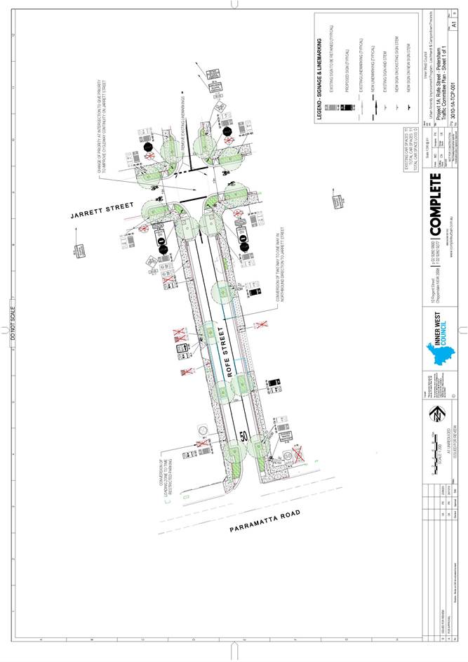
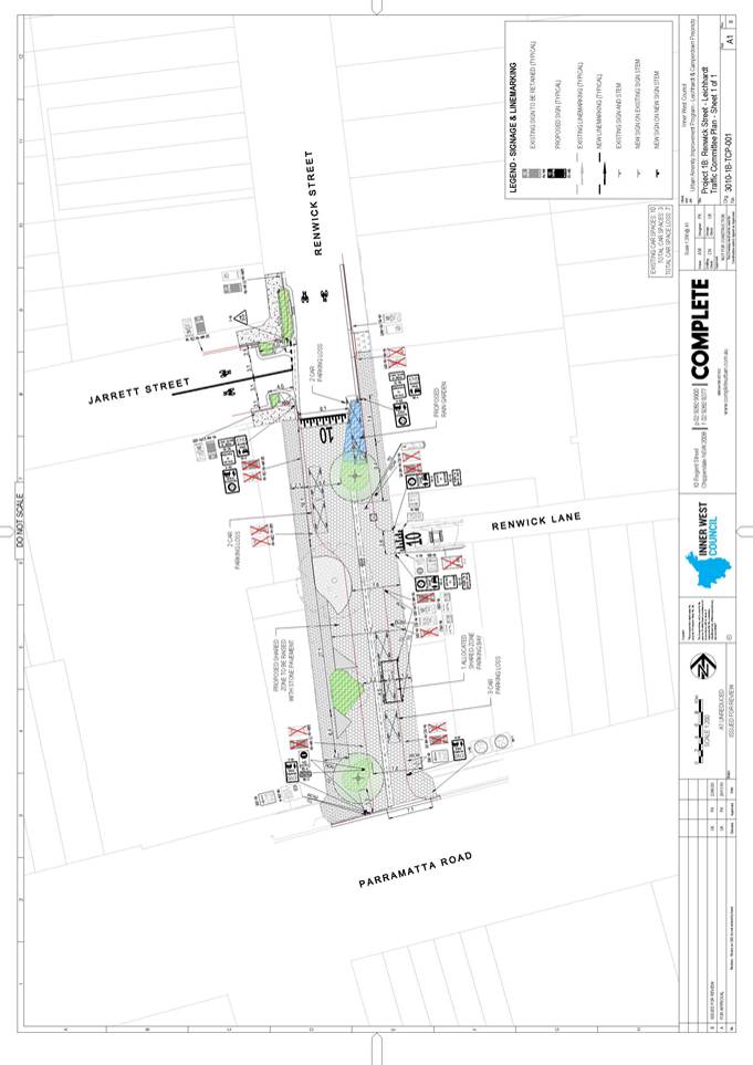
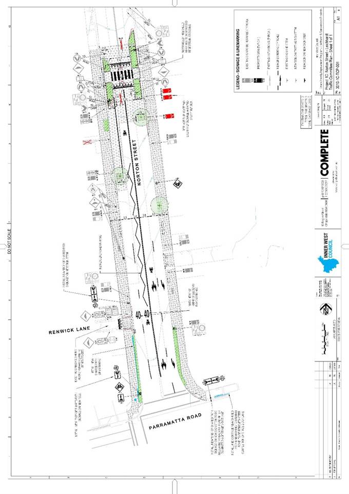
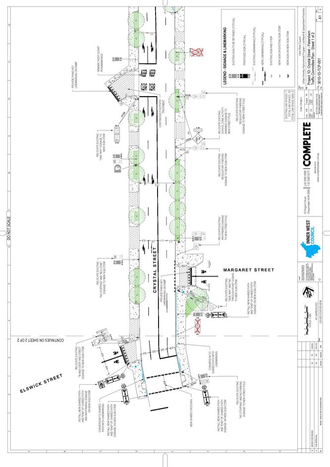
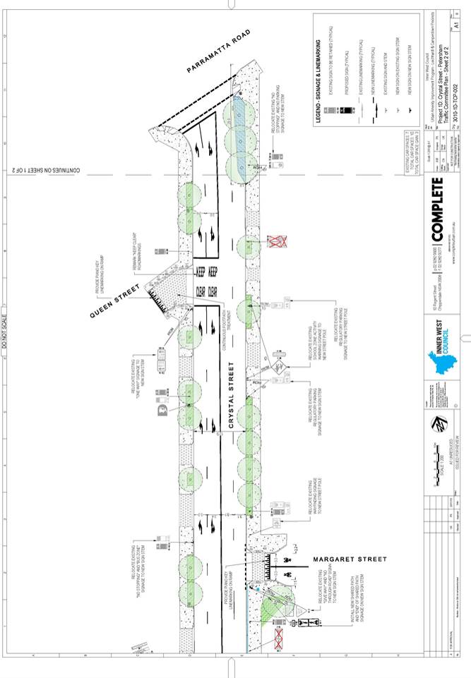
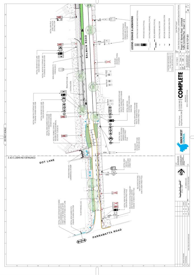
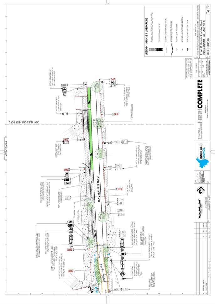
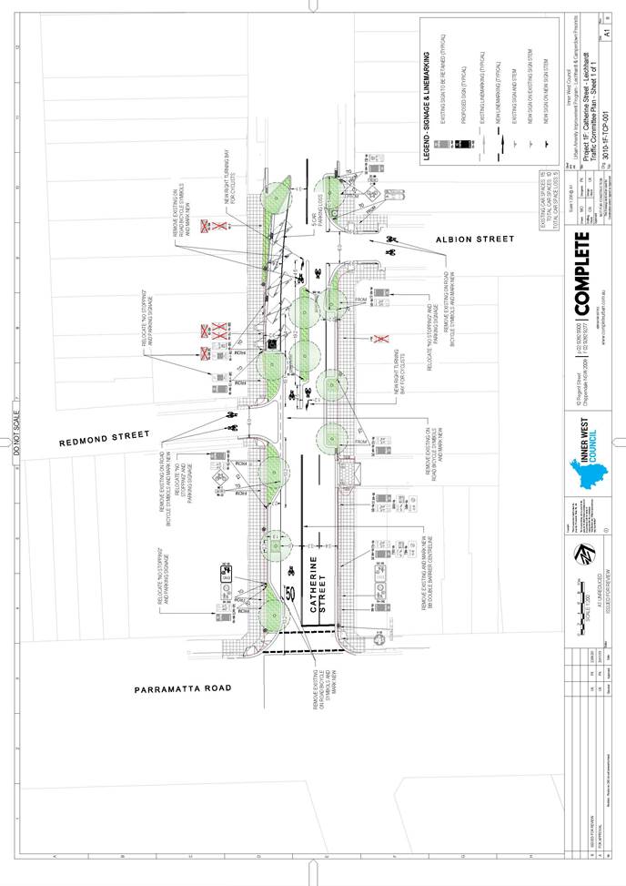
LTC0720 Item 4  Westconnex M5 – St Peters Interchange Active Transport Works – Part 1 (Midjuburi – Marrickville Ward / Heffron Electorate / Inner West PAC)

SUMMARY


The St Peters Interchange project results from a request by the TfNSW and WestConnex for Council to deliver two (2) active transport projects around the M5 WestConnex Interchange at St Peters.  The provision of such walking and cycling facilities with 1km of the St Peters Interchange is a condition of consent for the WestConnex M5 project. 


The proposal presented reflects the outcomes of a recent concept design stage, including community consultation, and updates the status of the project in which the concept design was presented to the Local Traffic Committee in November 2019. The proposals includes a combination of a two way separated cycleway and shared path on the southern side of Burrows Avenue, adjacent to Sydenham Station and widening the shared path along Mary Street and upgrades to the existing on road cycle route along the other streets including George Street, Henry Street, Grove Street, Bakers Lane.


Following development of the concept designs, two rounds of community engagement, Local Traffic Committee endorsement in November 2019 to progress with the detailed design and implementation and subsequent preparation of detailed design plans. It is recommended that these detailed design plans be approved.


Officer’s Recommendation


THAT:


1.   The final design solution for the M5 - St Peters Interchange Active Transport Works (plan no’s. 2997-01 to 2997-07) be approved to enable tender documentation to be prepared and a construction contract advertised; and


2.   The TCS designs resulting from this project be forwarded to TfNSW for approval


DISCUSSION


The representative for the Member for Balmain commented that there is a risk of cyclist ‘dooring’ on the shared path near the bidirectional cycle path on the southern side of Burrows Avenue opposite Sydenham Station. Council Officers advised that the bidirectional cycle path terminates east of the car parking bays, and a shared path is proposed adjacent to the car parking. The alignment of the connection is such that it directs cyclists away from the parking to minimise the risk of dooring. Therefore, there is no specific offset distance as cyclists can be positioned anywhere within the shared path. In addition it was noted that there is shared path linemarking indicated on the plans adjacent to the parked cars to guide cyclists away from the car dooring area.


The representative for the Member for Balmain asked for clarity on the cyclist connection near the intersection of Burrows Avenue and Gleeson Avenue.  Council Officers advised that the cycle route for this project at the intersection comprises the shared path on the southern side of Burrows Avenue, a shared signalised crossing on Burrows Avenue on the eastern side of the intersection, and a shared signalised crossing on Gleeson Avenue on the northern side of the intersection.  The continuation of the cycle route north then links to the proposed shared path on the western side of Gleeson Avenue (on the overbridge) which is to be implemented as part of the Marrickville Road cycleway project.


The TFNSW representative raised a number of issues with the plans as follows:


·         The direction at which cyclists are meant to travel in the intersection of Burrows Avenue and George Street is unclear. Council Officers stated that directional signage will be added to the design plan.


·         There should be ‘No Parking’ or ‘No Stopping’ at the kerb extension on the northern side of Burrows Avenue. Council Officers stated that ‘No Stopping’ signage can be added if it is a requirement; however, Council has not proposed this at this kerb extension as it is clear that a vehicle cannot park adjacent to the kerb extension and Council has tried to avoid sign clutter. 


·         The high angle of the pedestrian crossing at the intersection of Princes Highway and Mary Street is unlikely to be supported by TfNSW. Obscure angles can result in reduced sight distance to pedestrians and other concerns.  Council Officers stated that the crossing is to be approved via the TCS process; however, the proposed crossing alignment is considered better at providing  sight distance than the current alignment.  


·         There are concerns with the size of the gaps in the island at the intersection of Unwins Bridge Road and George Street. However, this can be dealt with during the TCS reviews.


·         Each of the TCS components will need to be reviewed separately and changes to the entire design layout may be required, subject to TCS approval. 


·         TfNSW plan checking and admin fees will apply. 


The Committee members agreed with the Officer’s recommendation.


COMMITTEE RECOMMENDATION


THAT:


1.   The final design solution for the M5 - St Peters Interchange Active Transport Works (plan no’s. 2997-01 to 2997-07) be approved to enable tender documentation to be prepared and a construction contract advertised; and


2.   The TCS designs resulting from this project be forwarded to TfNSW for approval


For motion: Unanimous


LTC0720 Item 5  Urban Amenity Improvement Program – Leichhardt and Camperdown Precincts (Gulgadya - Leichhardt & Damun-Stanmore Wards/Balmain & Newtown Electorates/Leichhardt & Inner West PACs)

SUMMARY


The Urban Amenity Improvement Program (UAIP) aims to reverse the urban decay and lack of design cohesion along Parramatta Road and is a NSW State Government initiative. 


Within the Inner West Council LGA, the program comprises 10 separate locations as follows: Rofe Street – Parramatta Road to Jarrett Street, Renwick Street – Parramatta Road to Jarrett Street, Norton Street – Parramatta Road to the Italian Forum, Crystal Street – Parramatta Road to Elswick Street, Balmain Road – Parramatta Road to end of Italian Forum, Catherine Street – Parramatta Road to Albion Street, Dot Lane – Balmain Road to Hay Street, Petersham Street – Parramatta Road to Queen Street, Johnstons Creek, Wigram Road and Pyrmont Bridge Road – Parramatta Road to Booth Street


Following development and approval of the UAIP, Council is now progressing with the detailed design and aims to inform and seek approval of the Local Traffic Committee for the measures proposed under the program. 


Officer’s Recommendation


THAT the design proposals as discussed in this report and as indicated on the attached plans be approved at the following locations:


1.   Rofe Street (plan no. 3010-1A-TCP-001) – public domain upgrades and conversion to a one way road (subject to TfNSW approval of the TMP);


2.   Renwick Street (plan no. 3010-1B-TCP-001) – public domain upgrades and provision of a 10km/hr shared zone (subject to TfNSW approval of the speed limit reduction);


3.   Norton Street (plan no. 3010-1C-TCP-001) – public domain upgrades;


4.   Crystal Street (plan no. 3010-1D-TCP-001 sheets 1 and 2) – public domain upgrades;


5.   Balmain Road (plan no. 3010-1E-TCP-001 sheets 1 and 2) – public domain upgrades and cycleway connection;


6.   Catherine Street (plan no. 3010-1F-TCP-001) – public domain upgrades and cycleway connection;


7.   Dot Lane (plan no. 3010-2A-TCP-001) – new cycleway connection;


8.   Petersham Street (plan no. 3010-3-TCP-001) – new pocket park (subject to TfNSW approval of the TMP);

9.   Johnstons Creek and Wigram Road – new pedestrian and cycleway connection; and


10. Pyrmont Bridge Road (plan no. 3010-4A-TCP-001 sheets 1 to 3) – public domain upgrades and cycleway connection (subject to TfNSW approval).


DISCUSSION


Officers tabled revised plans which replace Attachment 1 of Item 5. The updates consist of:

·         Page 1 & 2 - Rofe Street & Renwick Street ‘bicycles excepted’ restrictions on the ‘No Entry’ signs to allow bicycle contraflow.

·         Page 9 - Increase of shared path width to a min. 3.5m between Balmain Road and Hay Street with adjustment to car park layout.

·         Page 3 & 6 - Temporary shared path between Norton Street and Balmain Road to be used until Dot Lane connection is finalised.


The representative for the Member for Balmain requested that the subgrade at the proposed pedestrian crossing in Norton Street be strengthened to prevent damage to the road surface from bus traffic. Council Officers advised that this will be considered during preparation of the construction detail.


The TfNSW representative made the following comments:


·         It was noted that crossing priority is provided for cyclists on Wigram Road at Booth Lane; however, signage be included to indicate priority to pedestrians, such as a ‘Give Way’ sign. Council Officers will pass this request onto the designers for inclusion. 


·         The refuge island at the roundabout on Wigram Road needs to be altered to be at least 2m wide and 3m long for the safe storage of prams and wheelchairs. All refuge islands must accommodate at least the 2m width of the island.


·         TfNSW do not approve the recommendations for Pyrmont Bridge Road (State Road) through this Committee. There are concerns with the Pyrmont Bridge Road proposal which will be considered separately. 


The TfNSW comments were sent to the consultant for consideration.


The Inner West Bicycle Coalition representative requested for:


·         a ‘Bicycles Excepted’ sign be included on the ‘One Way’ signs on Renwick Street and Rofe Street. Council Officers advised that the updated plans, issued to the Committee on 2 July 2020, have now accommodated this request to allow bicycle contraflow.


·         a shared path be provided from Norton Street to Balmain Road. The updated plans include a temporary shared path between Norton Street and Balmain Road, to be used until the Dot Lane connection is finalised.


·         the shared path between Balmain Road and Hay Street be at least 3m wide to facilitate connection to urban amenities. Council Officers advised that, in the updated plans, the width of the shared path has been increased to a minimum of 3.5m with adjustment to the car park layout.


·         a shared path be provided from Nelson Street to Pyrmont Bridge Road to allow cyclists to complete the EW02 route from Albion Street to Pyrmont Bridge Road until a connection across Johnson Creek is developed. Council Officers advised that the potential for such a shared path is still in concept design phase, pending and subject to completion of the WestConnex Dive Site and TfNSW approvals.


·         a ‘pop-up’ lane on Pyrmont Bridge Road from Parramatta Road to Booth Street for city bound cyclists. Council Officers stated that this would require consideration and discussion with TfNSW, noting that this is a State Road. 


Clr da Cruz requested for:


·         consistent road markings be provided for the 10km/h shared zones on Renwick Lane and Renwick Street. Council Officers advised that 10km/h line marking symbols exist in Renwick Lane and will be added to the drawing.


·         provision of bicycle parking. Council Officers advised that bicycle parking is proposed for Norton Street, Renwick Street and Catherine Street, and will be included in the detailed design plans. 


·         pedestrian refuge or pram ramps on Catherine Street to provide a safe crossing from Albion Street to Redmond Street. Council Officers advised that a pedestrian refuge was considered but due to the volume of traffic and pedestrian movements generated by the Function Centre, the Parramatta Road/Catherine Street traffic lights were considered the safest crossing point.


COMMITTEE RECOMMENDATION


THAT the design proposals as discussed in this report and as indicated on the attached plans be approved at the following locations:


1.   Rofe Street (plan no. 3010-1A-TCP-001) – public domain upgrades and conversion to a one way road (subject to TfNSW approval of the TMP);


2.   Renwick Street (plan no. 3010-1B-TCP-001) – public domain upgrades and provision of a 10km/hr shared zone (subject to TfNSW approval of the speed limit reduction);


3.   Norton Street (plan no. 3010-1C-TCP-001) – public domain upgrades;


4.   Crystal Street (plan no. 3010-1D-TCP-001 sheets 1 and 2) – public domain upgrades;


5.   Balmain Road (plan no. 3010-1E-TCP-001 sheets 1 and 2) – public domain upgrades and cycleway connection;


6.   Catherine Street (plan no. 3010-1F-TCP-001) – public domain upgrades and cycleway connection;


7.   Dot Lane (plan no. 3010-2A-TCP-001) – new cycleway connection;


8.   Petersham Street (plan no. 3010-3-TCP-001) – new pocket park (subject to TfNSW approval of the TMP);


9.   Johnstons Creek and Wigram Road – new pedestrian and cycleway connection; and


10. Pyrmont Bridge Road (plan no. 3010-4A-TCP-001 sheets 1 to 3) – public domain upgrades and cycleway connection (subject to TfNSW approval).


For motion: Unanimous


LTC0720 Item 6  Goddard Street, Newtown - Proposed continuous footpath treatment in Goddard Street at King Street – Final Signage and Line Marking Plan 10134 (Damum - Stanmore Ward / Newtown Electorate / Inner West PAC)

SUMMARY


Council has finalised a design plan for a continuous footpath treatment in Goddard Street at King Street, Newtown. It is envisaged that the proposed works will have a positive impact on pedestrian and motorist safety and address concerns about pedestrian safety and driver behaviour in the area.


Officer’s Recommendation


THAT the detailed design plan for the continuous footpath treatment and associated signs and line markings in in Goddard Street at King Street, Newtown (as per Design Plan No.10134) be approved.  


DISCUSSION


The representative for TfNSW requested that signage be included to indicate priority to pedestrians, such as a ‘Give Way’ sign. Council Officers will pass this request onto the designers for inclusion. 


The Committee members agreed with the Officer’s recommendation.


COMMITTEE RECOMMENDATION


THAT the detailed design plan for the continuous footpath treatment and associated signs and line markings in in Goddard Street at King Street, Newtown (as per Design Plan No.10134) be approved.  


For motion: Unanimous


LTC0720 Item 7  Dulwich Hill Station Precinct Public Domain Improvements (Djarrawunang-Ashfield Ward / Summer Hill Electorate / Inner West PAC)

SUMMARY


A traffic and transport assessment for the detailed design of the Dulwich Hill Station Precinct Public Domain Improvements has now been undertaken.


The works will be delivered in 4 stages: Stage A, Stage B, Stage C and Stage D.


Stage A - Wardell Road - Dudley Street Intersection works, Dudley Street footpath works.

Stage B - Raised Entry Thresholds on Wardell Road, Bedford Cres and Wardell Road - Ewart Street intersection.

Stage C - Road works on Wardell Road from Wilga Ave to Ewart Street.

Stage D - Road works on Ewart Street between Murray Lane and Ewart Lane.


This assessment is only for Stage A of the Master Plan and the detailed design of Stage A has now been progressed. The following works are proposed to be undertaken within the Stage A:

·         Raised signalised intersection at Wardell Road / Dudley Street for improved safety and pedestrian movement;

·         A 40km/h High Pedestrian Activity Area proposed around the station precinct with relevant signage to further improve the safety of pedestrians;

·         New in road trees, raingarden and footpath treatments; and

·         Extended footpath areas to allow space for pedestrians, footpath dining, street gathering spaces, trees and planting; 


Overall the upgrades for stage A aligns well with the existing and planned pedestrian and cycling networks and are expected to improve the safety and efficiency of the station precinct. In particular, the raised, signalised intersection at Wardell Road / Dudley Street will help to address safety issues at the existing pedestrian crossing where crashes have been recorded, particularly as pedestrian movement increases with the implementation of the Sydney Metro upgrades. The intersection is proposed to be a scramble crossing to maximise space for pedestrian movement and allow pedestrians to cross in any direction at once.


Officer’s Recommendation


THAT the following proposed works to be undertaken as part of Stage A be APPROVED:


1.   Raised signalised intersection at Wardell Road / Dudley Street for improved safety and pedestrian movements (subject to separate TfNSW approval of TCS design);


2.   A 40 km/hr High Pedestrian Activity Area along Wardell Road from Ewart Street to Keith Street, Dudley Street from Wardell Road to Bailey Street and Bedford Crescent from Wardell Road to cul-de-sac (subject to separate TfNSW approval of the speed limit reduction).


3.   Extended footpath areas to allow space for pedestrians, footpath dining, street gathering spaces, trees and planting; and


4.   New in-road trees, raingarden and footpath treatments.


DISCUSSION


Councillor da Cruz requested a 30km/h speed zone be introduced at the High Pedestrian Activity Area around the station precinct. Council Officers advised that speed zoning is subject to TfNSW approval and a 30km/h speed limit is currently not supported as the TfNSW guidelines for High Pedestrian Activity Areas is set at 40km/h which is consistent with the speed limit within the existing school zone.


The Transit Systems representative requested that the height of the raised signalised intersection at Wardell Road and Dudley Street not exceed 75mm for safe passage of Transit Systems vehicles.


The TfNSW representative advised that each of the elements needs to be reviewed separately by TfNSW through the appropriate processes and the proposals are presented to the Committee only for information and any community input.


The Committee members agreed with the Officer’s recommendation.


COMMITTEE RECOMMENDATION


THAT the following proposed works to be undertaken as part of Stage A be APPROVED:


1.   Raised signalised intersection at Wardell Road / Dudley Street for improved safety and pedestrian movements (subject to separate TfNSW approval of TCS design);


2.   A 40 km/hr High Pedestrian Activity Area along Wardell Road from Ewart Street to Keith Street, Dudley Street from Wardell Road to Bailey Street and Bedford Crescent from Wardell Road to cul-de-sac (subject to separate TfNSW approval of the speed limit reduction).


3.   Extended footpath areas to allow space for pedestrians, footpath dining, street gathering spaces, trees and planting; and


4.   New in-road trees, raingarden and footpath treatments.


For motion: Unanimous


LTC0720 Item 8  Flood Street, Leichhardt - Road Occupancy (Gulgadya Ward/ Balmain Electorate/ Leichhardt PAC)

SUMMARY


This report considers a request received from BreastScreen NSW for the temporary placement of their mobile lab unit on the western side of Flood Street adjacent to Leichhardt Market Place within the existing ‘Taxi Zone’, for the duration of eight (8) weeks starting from Friday, 7 August to Saturday, 3 October 2020.


Officer’s Recommendation


THAT the road occupancy for the BreastScreen NSW mobile lab unit on the western side of Flood Street, adjacent to Leichhardt Market Place within the existing ‘Taxi Zone’, for the duration of eight (8) weeks starting from Friday, 7 August to Saturday, 3 October 2020 be supported.


DISCUSSION


The Committee members agreed with the Officer’s recommendation.


COMMITTEE RECOMMENDATION


THAT the road occupancy for the BreastScreen NSW mobile lab unit on the western side of Flood Street, adjacent to Leichhardt Market Place within the existing ‘Taxi Zone’, for the duration of eight (8) weeks starting from Friday, 7 August to Saturday, 3 October 2020 be supported.


For motion: Unanimous


LTC0720 Item 9  Seven Bridges Walk - Special Event (Gulgadga - Leichhardt & Baludarri - Balmain Ward/ Balmain Electorate/ Leichhardt PAC)

SUMMARY


The Cancer Council NSW Seven Bridges Walk event will be held on Sunday, 25 October 2020 at various locations in Sydney, including areas within the Inner West Council. The Event is in its fifteenth year of operation and the applicant seeks approval again in 2020.


Officer’s Recommendation


THAT the Cancer Council NSW Seven Bridges Walk to be held on Sunday, 25 October

2020 be approved, subject to a current Public Liability Insurance Policy which includes

the Inner West Council being an interested party being submitted by the event organiser

prior to the event.


DISCUSSION


The Committee members agreed with the Officer’s recommendation.


COMMITTEE RECOMMENDATION


THAT the Cancer Council NSW Seven Bridges Walk to be held on Sunday, 25 October

2020 be approved, subject to a current Public Liability Insurance Policy which includes the Inner West Council being an interested party being submitted by the event organiser prior to the event.


For motion: Unanimous


General Business


LTC0720 Item 9  Illuminated sign outside Haberfield Rowers Club

The representative for the Member for Balmain asked for a progress update regarding the glare from the Haberfield Rowers Club illuminated sign on the City West Link. Council Officers advised that Council’s Development Compliance Officers have been in discussions with the Club and have had the illumination levels on the LED pylon decreased. The Club has advised that the decrease in brightness has now come into effect.


LTC0720 Item 10  Request for in-road traffic detector in Mary Street, Leichhardt

The representative for the Member for Balmain requested that an in-road traffic detector be installed in the right turn lane in Mary Street at the intersection of Lilyfield Road. This request was sent to TfNSW for comment. 


LTC0720 Item 11  Condition of Hawthorne Parade, Haberfield

The representative for the Member for Balmain commented that Hawthorne Parade is in poor condition with numerous potholes and asked whether this was due to heavy vehicles from WestConnex construction.  The representative requested that, if the damage was caused by WestConnex, Council endeavour to have WestConnex maintain Hawthorne Parade during their operations and return it to its original condition when they finish. Council Officers will forward this request to Council’s Assets team.


LTC0720 Item 12  Johnson Street, Annandale work site

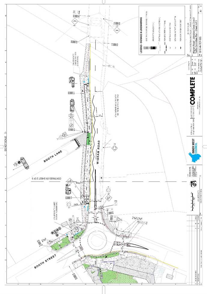
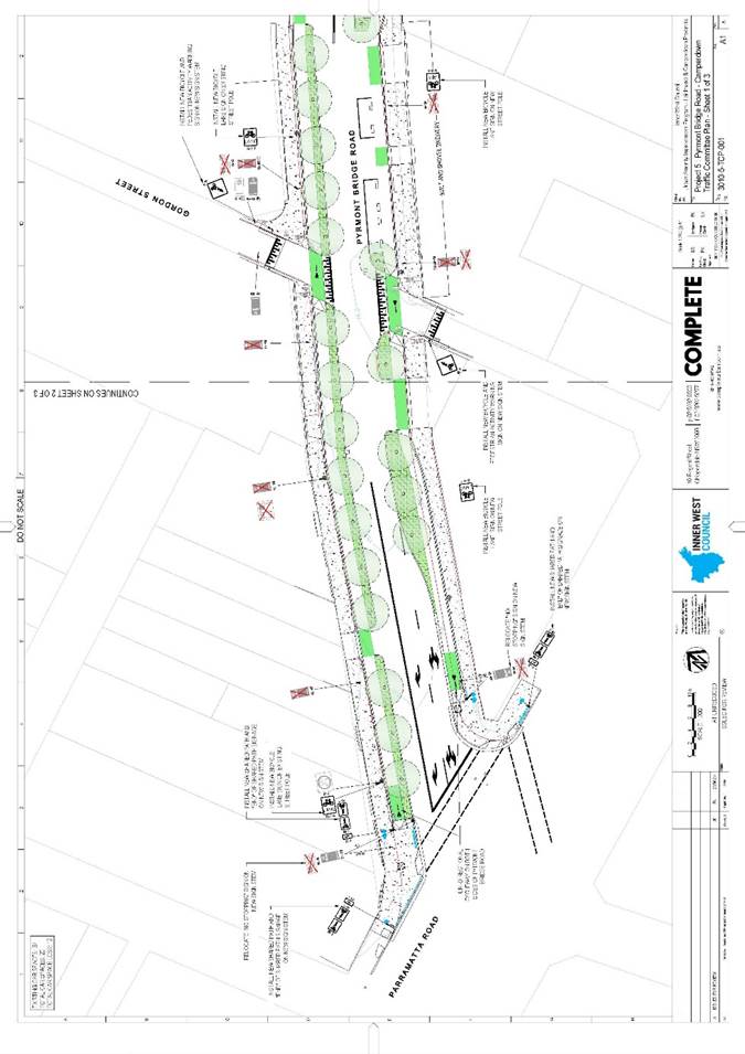
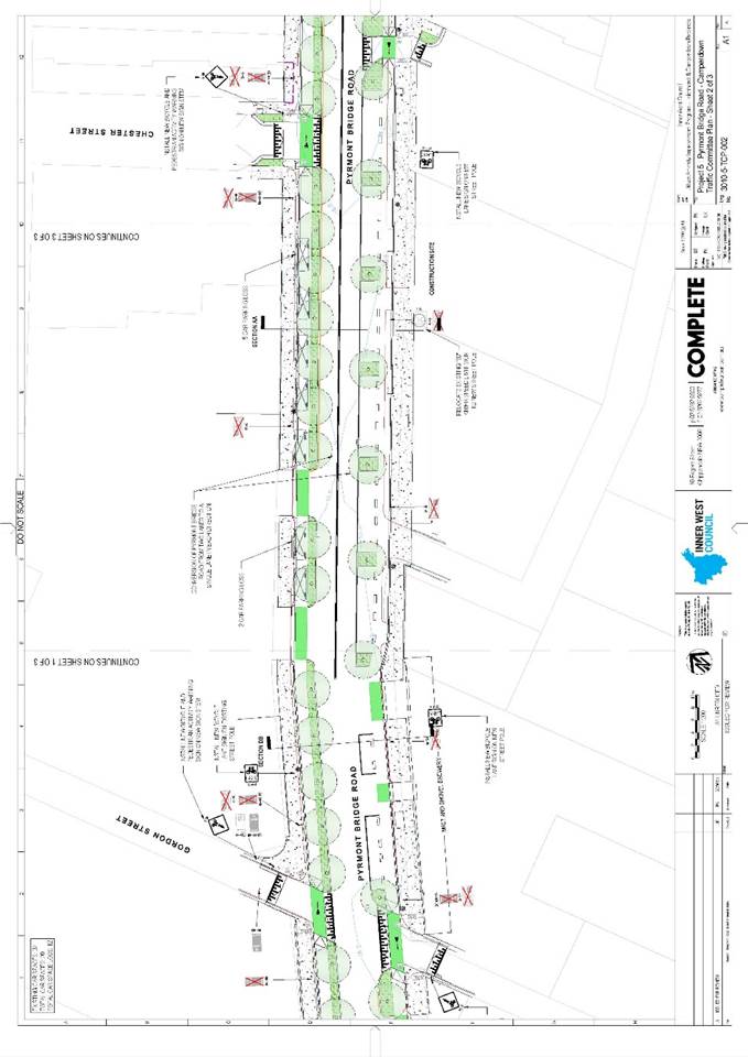
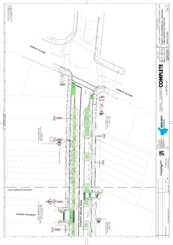
The Inner West Bicycle Coalition representative requested that the barrier on the Johnson Street bridge work site be moved east about a metre to remove the pinch zone between the refuge and the end of the works, or a ‘No Overtaking’ sign be displayed at the Wigram Road end of the works. This will tie in with the City of Sydney pop-up lane on Pyrmont Bridge Road and improve safety. The representative also requested a temporary pedestrian crossing be installed on Booth Street at Alexandra Drive so pedestrians and cyclists do not need to travel 300 metres to the traffic lights and back to cross the road. 


LTC0720 Item 13 Update on Croydon Road and Parrramatta Road intersection improvements

The representative for the Member for Strathfield asked for an update on the improvements proposed for the Croydon Road/Parramatta Road intersection previously raised in the June 2020 meeting. Council Officers stated that TfNSW have indicated that they are finalising the community engagement report to publish by the month end.


This concluded the business of the meeting.


ATTACHMENT  (ITEM 5)


A picture containing text, map

Description automatically generated

A close up of a map

Description automatically generated

A close up of a map

Description automatically generated


A close up of a map

Description automatically generated


A close up of a map

Description automatically generated


A close up of a map

Description automatically generated

A close up of a map

Description automatically generated

A close up of a map

Description automatically generated

A picture containing text, map

Description automatically generated


A picture containing text, map

Description automatically generated

A close up of a map

Description automatically generated


A close up of a map

Description automatically generated

A close up of a map

Description automatically generated

A picture containing text, map

Description automatically generated

A picture containing text, map

Description automatically generated

A picture containing text, map

Description automatically generated

A picture containing screenshot

Description automatically generated