|
AGENDA R |

Local Traffic Committee Meeting
MONDAY 15 NOVEMBER 2021
10.00AM
|
AGENDA R |
Local Traffic Committee Meeting
MONDAY 15 NOVEMBER 2021
10.00AM
|
|
Local Traffic Committee Meeting 15 November 2021 |
Function of the Local Traffic Committee
Background
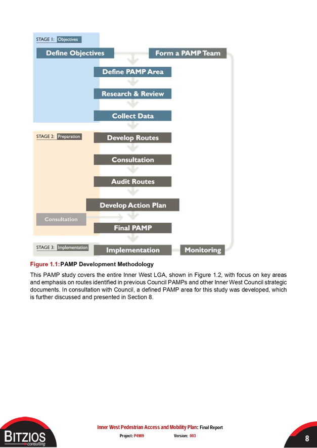
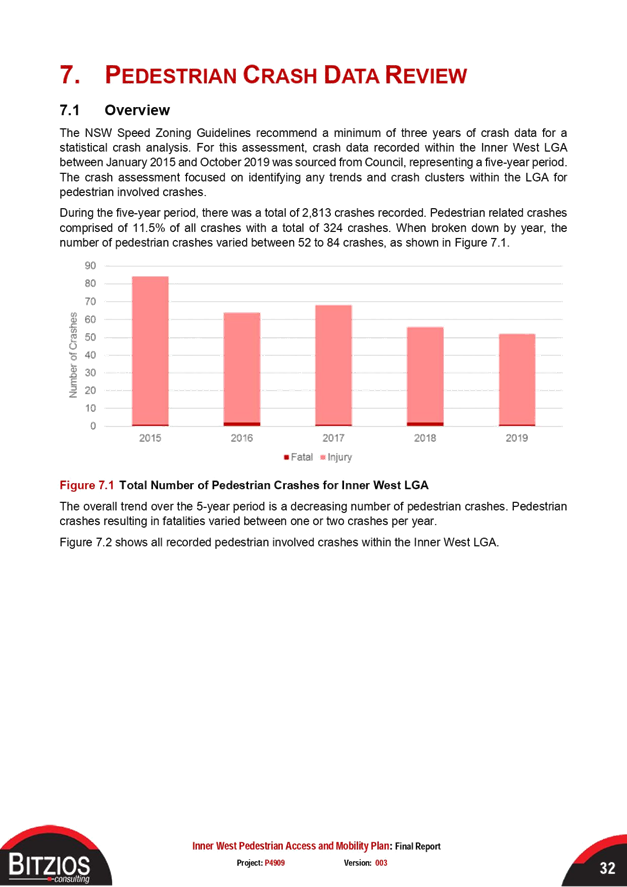
Roads and Maritime Services (RMS) is legislated as the Authority responsible for the control of traffic on all NSW Roads. The RMS has delegated certain aspects of the control of traffic on local roads to councils. To exercise this delegation, councils must establish a local traffic committee and obtain the advice of the RMS and Police. The Inner West Council Local Traffic Committee has been constituted by Council as a result of the delegation granted by the RMS pursuant to Section 50 of the Transport Administration Act 1988.
Role of the Committee
The Local Traffic Committee is primarily a technical review and advisory committee which considers the technical merits of proposals and ensures that current technical guidelines are considered. It provides recommendations to Council on traffic and parking control matters and on the provision of traffic control facilities and prescribed traffic control devices for which Council has delegated authority. These matters are dealt with under Part A of the agenda and require Council to consider exercising its delegation.
In addition to its formal role as the Local Traffic Committee, the Committee may also be requested to provide informal traffic engineering advice on traffic matters not requiring Council to exercise its delegated function at that point in time, for example, advice to Council’s Development Assessment Section on traffic generating developments. These matters are dealt with under Part C of the agenda and are for information or advice only and do not require Council to exercise its delegation.
Committee Delegations
The Local Traffic Committee has no decision-making powers. The Council must refer all traffic related matters to the Local Traffic Committee prior to exercising its delegated functions. Matters related to State Roads or functions that have not been delegated to Council must be referred directly to the RMS or relevant organisation.
The Committee provides recommendations to Council. Should Council wish to act contrary to the advice of the Committee or if that advice is not supported unanimously by the Committee members, then the Police or RMS have an opportunity to appeal to the Regional Traffic Committee.
Committee Membership & Voting
Formal voting membership comprises the following:
· one representative of Council as nominated by Council;
· one representative of the NSW Police from each Local Area Command (LAC) within the LGA, being Newtown, Marrickville, Leichhardt and Ashfield LAC’s.
· one representative from the RMS; and
· State Members of Parliament (MP) for the electorates of Summer Hill, Newtown, Heffron, Canterbury, Strathfield and Balmain or their nominees.
Where the Council area is represented by more than one MP or covered by more than one Police LAC, representatives are only permitted to vote on matters which effect their electorate or LAC.
Informal (non-voting) advisors from within Council or external authorities may also attend Committee meetings to provide expert advice.
Committee Chair
Council’s representative will chair the meetings.
Public Participation
Members of the public or other stakeholders may address the Committee on agenda items to be considered by the Committee. The format and number of presentations is at the discretion of the Chairperson and is generally limited to 3 minutes per speaker. Committee debate on agenda items is not open to the public.
|
|
Local Traffic Committee Meeting 15 November 2021 |
|
AGENDA |
1 Apologies
2 Disclosures of Interest
3 Confirmation of Minutes Page
Minutes of 18 October 2021 Local Traffic Committee Meeting 5
4 Matters Arising from Council’s Resolution of Minutes
5 Part A – Items Where Council May Exercise Its Delegated Functions
Traffic Matters
ITEM Page
LTC1121(1) Item 1 Gladstone
Lane, Newtown - Proposed Signage and Linemarking
associated with Public Domain Works Damun - Stanmore Ward/ Newtown Electorate/
Inner West PAC 19
LTC1121(1) Item 2 Bland
Street, Ashfield – Proposed new raised pedestrian
crossing - Design Plan 10174 (Djarrawunang-Ashfield Ward/Summer Hill
Electorate/Burwood PAC) 22
LTC1121(1) Item 3 Bland
Street, Haberfield - Proposed Raised Pedestrian Crossing
(Gulgadya-Leichhardt Ward/Summer Hill Electorate/Burwood PAC) 25
LTC1121(1) Item 4 Waratah
Street, Haberfield - Proposed Raised Pedestrian
Crossing (Gulgadya-Leichhardt Ward/Summer Hill Electorate/Burwood PAC) 27
LTC1121(1) Item 5 Victoria
Road, Marrickville at the Rail overbridge between
Charlotte Avenue and Meeks Street – temporary full road closure - 2-week
period - Christmas Shutdown for the Southwest Metro Upgrade Project - Sydney
Metro City & Southwest (Midjuburi-Marrickville Ward / Summer Hill
Electorate / Inner West PAC) 29
LTC1121(1) Item 6 Albermarle
Street at the Rail Overbridge south of Challis Avenue,
Marrickville – Temporary Full Road Closure - 2 week period - Christmas
Shutdown for the Southwest Metro Upgrade Project - Sydney Metro City &
Southwest (MIDJUBURI-Marrickville Ward / Summer Hill Electorate / Inner West
PAC) 53
Parking Matters
Nil at the time of printing.
Late Items
Nil at time of printing.
6 Part B - Items for Information Only
Nil at the time of printing.
7 Part C - Items for General Advice
ITEM Page
LTC1121(1) Item 7 Pedestrian Access and Mobility Plan Study (All wards/All Electorate/ All PACS) 79
8 General Business
9 Close of Meeting
|
|
Local Traffic Committee Meeting 15 November 2021 |
Minutes of Local Traffic Committee Meeting
Held remotely on 18 October 2021
Meeting commenced at 10.04AM
ACKNOWLEDGEMENT OF COUNTRY BY CHAIRPERSON
I acknowledge the Gadigal and Wangal people of the Eora nation on whose country we are meeting today, and their elders past and present.
COMMITTEE REPRESENTATIVES PRESENT
|
Cr Victor Macri |
Councillor – Midjuburi-Marrickville Ward (Chair) |
|
Bill Holliday |
Representative for Jamie Parker MP, Member for Balmain |
|
Aislinn Stein-Magee |
Representative for Jo Haylen MP, Member for Summer Hill |
|
Cathy Peters |
Representative for Jenny Leong MP, Member for Newtown |
|
Solon Ghosh |
Transport for NSW (TfNSW) |
|
|
|
|
NON VOTING MEMBERS IN ATTENDANCE |
|
|
|
|
|
Cr Marghanita da Cruz |
Councillor – Gulgadya-Leichhardt Ward (Alternative Chair) |
|
Colin Jones |
Inner West Bicycle Coalition (IWBC) |
|
Manod Wickramasinghe |
IWC’s Traffic and Transport Planning Manager |
|
George Tsaprounis |
IWC’s Coordinator Traffic Engineering Services (South) |
|
Sunny Jo |
IWC’s Coordinator Traffic Engineering Services (North) |
|
Joe di Cesare |
IWC’s Design Services Coordinator |
|
Mohammed Haque |
IWC’s Civil Engineer |
|
Pierre Ayoub |
IWC’s Civil Engineer |
|
Christina Ip |
IWC’s Business Administration Officer |
|
|
|
|
VISITORS |
|
|
|
|
|
Nil. |
|
|
|
|
|
APOLOGIES: |
|
|
|
|
|
Adrian Prichard |
Transit Systems – Inner West Bus Services |
|
SC Anthony Kenny |
NSW Police – Inner West Police Area Command |
|
Maryanne Duggan |
Representative for Jodi MacKay MP, Member for Strathfield |
DISCLOSURES OF INTERESTS:
Nil.
CONFIRMATION OF MINUTES
MATTERS ARISING FROM COUNCIL’S RESOLUTION OF MINUTES
The Local Traffic Committee recommendations of its meeting on 20 September 2021 were adopted at Council’s meeting on 12 October 2021 with the following amendments:
a) That the Mayor write to Transport for NSW to raise concerns with the WestConnex widening the road at the intersection of Victoria Road and Toelle Street, Rozelle. (General Business item 4); and
b) That given that a broad range of community concerns remain with Item 2 Balmain East Parking Study that it be deferred further for these to be resolved.
EMAIL CONFIRMATION OF OFFICER’S RECOMMENDATION
The representative for NSW Police – Inner West supported the Officer’s recommendations for the items in their PAC.
The representative for Transit Systems supported all the Officer’s recommendations.
|
LTC1021(1) Item 3 Intersection of Hardy Street/ Church Street and Princess Street, (at suburb boundaries) Canterbury/Ashbury/Hurlstone Park - Proposed roundabout - Design Plan CBC No. 01470 (Djarrawunang-Ashfield Ward/ Canterbury Electorate/ Ashfield PAC) |
|
Canterbury Bankstown Council in conjunction with Inner West Council has finalised a plan to propose a roundabout at the intersection of Hardy Street/Church Street and Princess Street, Canterbury/Ashbury/Hurlstone Park. The intersection is bounded by both Councils. The proposed roundabout would replace the current crossroad treatment at the intersection to improve safety for all road users.
Officer’s Recommendation
THAT the detailed design plan for a proposed roundabout at the intersection Hardy Street/Church Street and Princess Street, Canterbury/Ashbury/Hurlstone Park, with the removal of a slip lane and associated signs and line markings (as per Plan CBC No.01470) be APPROVED.
DISCUSSION
It was noted that this matter was adopted by the Canterbury-Bankstown Council’s LTC last week.
The IWBC has proposed that Hardy Street become a designated route under the Inner West Bicycle Plan and the IWBC representative requested that bike logos be installed on the road. Council Officers will consider the request as part of the Inner West Bicycle Plan.
The Committee members agreed with the Officer’s recommendation.
COMMITTEE RECOMMENDATION
THAT the detailed design plan for a proposed roundabout at the intersection Hardy Street/Church Street and Princess Street, Canterbury/Ashbury/Hurlstone Park, with the removal of a slip lane and associated signs and line markings (as per Plan CBC No.01470) be APPROVED.
For motion: Unanimous |
|
LTC1021(1) Item 5 Dudley Street, Dulwich Hill; Illawarra Road, Marrickville; and (Lower) Railway Parade, Sydenham - Bus replacements during major rail shutdown 26 December 2021 to 9 January 2022 - Temporary parking changes during T3 Line upgrade for Sydney Metro (Midjuburi -Marrickville Ward / Summer Hill Electorate / Inner West PAC) |
|
Council has been notified by Transport for NSW (TfNSW) that Sydney Metro works will involve a major rail shutdown of the Sydenham to Bankstown rail line (T3) between Sunday 26 December 2021 to Sunday 9 January 2022 (inclusive). During the shutdown buses will replace train services along the T3 line and to accommodate the increased bus movements and necessary holding areas some short-term parking changes are required at a number of locations. Specifically, TfNSW is requesting approval for the temporary conversion of multiple parking spaces at the following locations: Dudley Street, Dulwich Hill; Illawarra Road, Marrickville; and Railway Parade (lower section), Sydenham. It is recommended that no objections be raised, and Council approves the temporary short-term parking changes at the identified locations during the rail shutdowns. TfNSW will reinstate all existing parking arrangements and signage by/on Monday 10 January 2022.
Officer’s Recommendation
THAT this report be received and noted and the following temporary short-term parking changes from Sunday 26 December 2021 to Sunday 9 January 2022 be approved and implemented by TfNSW:
Dudley Street - Dulwich Hill Station Precinct (5 parking spaces) 1. The short-term conversion of 7m (1 parking space) ‘Loading Zone 8:30 am – 6 pm Mon – Fri & 8:30 am – 12:30 pm Sat’ on the northwestern side of Dudley Street (between Wardell Road and School Parade) to a ‘Bus Zone’ be APPROVED in order to provide an additional bus bay with adequate draw-in length; 2. The short-term conversion of 18m (3 parking spaces) ‘P30 min 8:30 am – 6 pm Mon – Fri & 8:30 am – 12:30 pm Sat’ on the northern side of Dudley Street (between Wardell Road and School Parade) to a ‘Bus Zone’ be APPROVED in order to provide an additional bus bay with adequate draw-in length; and 3. The short-term conversion of 7m (1 parking space) ‘Works Zone 7 am – 5:30 pm Mon – Sat’ on the southeastern side of Dudley Street (between School Parade and Wardell Road) to a ‘Bus Zone’; be APPROVED in order to provide an additional bus bay with adequate draw-in length.
Illawarra Road - Marrickville Station Precinct (1 parking space)
4. The short-term conversion of 7m (1 parking space) ‘1P 8:30 am – 6 pm’ on the northern side of Illawarra Road (between Warburton Street and Greenbank Street) to a ‘Bus Zone Mon-Fri only’; be APPROVED in order to provide an additional bus bay with adequate draw-in length.
Lower Railway Parade - Sydenham Station Precinct (62 parking spaces)
5. The short-term conversion of 69m (11 parking spaces) ‘unrestricted parking’ on the southeast kerb of Railway Parade (between Gleeson Avenue and Marrickville Road) to a ‘Bus Zone’ be APPROVED in order to provide additional layover bus bays with adequate draw-in length;
6. The short-term conversion of 118m (40 parking spaces) ‘unrestricted parking’ on the northwest kerb of Railway Parade (Lower) (between Sydenham Road and Marrickville Road) to a ‘Bus Zone’; be APPROVED in order to provide additional layover bus bays with adequate draw-in length;
7. The short-term conversion of 32m (11 angle parking spaces) ‘4P 8:30 am – 6 pm Mon - Fri’ on the northwest kerb of Railway Parade (Lower) (between Gleeson Avenue and Marrickville Road) to a ‘Bus Zone’; be APPROVED in order to provide additional layover bus bays with adequate draw-in length; and
8. The applicant and Council Rangers be advised in terms of this report.
DISCUSSION
The Committee members agreed with the Officer’s recommendation.
COMMITTEE RECOMMENDATION
THAT this report be received and noted and the following temporary short-term parking changes from Sunday 26 December 2021 to Sunday 9 January 2022 be approved and implemented by TfNSW:
Dudley Street - Dulwich Hill Station Precinct (5 parking spaces) 1. The short-term conversion of 7m (1 parking space) ‘Loading Zone 8:30 am – 6 pm Mon – Fri & 8:30 am – 12:30 pm Sat’ on the northwestern side of Dudley Street (between Wardell Road and School Parade) to a ‘Bus Zone’ be APPROVED in order to provide an additional bus bay with adequate draw-in length; 2. The short-term conversion of 18m (3 parking spaces) ‘P30 min 8:30 am – 6 pm Mon – Fri & 8:30 am – 12:30 pm Sat’ on the northern side of Dudley Street (between Wardell Road and School Parade) to a ‘Bus Zone’ be APPROVED in order to provide an additional bus bay with adequate draw-in length; and 3. The short-term conversion of 7m (1 parking space) ‘Works Zone 7 am – 5:30 pm Mon – Sat’ on the southeastern side of Dudley Street (between School Parade and Wardell Road) to a ‘Bus Zone’; be APPROVED in order to provide an additional bus bay with adequate draw-in length.
Illawarra Road - Marrickville Station Precinct (1 parking space)
4. The short-term conversion of 7m (1 parking space) ‘1P 8:30 am – 6 pm’ on the northern side of Illawarra Road (between Warburton Street and Greenbank Street) to a ‘Bus Zone Mon-Fri only’; be APPROVED in order to provide an additional bus bay with adequate draw-in length.
Lower Railway Parade - Sydenham Station Precinct (62 parking spaces)
5. The short-term conversion of 69m (11 parking spaces) ‘unrestricted parking’ on the southeast kerb of Railway Parade (between Gleeson Avenue and Marrickville Road) to a ‘Bus Zone’ be APPROVED in order to provide additional layover bus bays with adequate draw-in length;
6. The short-term conversion of 118m (40 parking spaces) ‘unrestricted parking’ on the northwest kerb of Railway Parade (Lower) (between Sydenham Road and Marrickville Road) to a ‘Bus Zone’; be APPROVED in order to provide additional layover bus bays with adequate draw-in length;
7. The short-term conversion of 32m (11 angle parking spaces) ‘4P 8:30 am – 6 pm Mon - Fri’ on the northwest kerb of Railway Parade (Lower) (between Gleeson Avenue and Marrickville Road) to a ‘Bus Zone’; be APPROVED in order to provide additional layover bus bays with adequate draw-in length; and
8. The applicant and Council Rangers be advised in terms of this report.
For motion: Unanimous |
|
LTC1021(1) Item 6 Lords Road and Flood Street, Leichhardt - Proposed raised pedestrian crossings (Gulgadya-Leichhardt Ward/Balmain Electorate/Leichhardt PAC) |
|
SUMMARY
Council is planning to improve pedestrian safety in Lords Road and Flood Street, Leichhardt by converting the two (2) existing at-grade pedestrian crossings into raised pedestrian crossings at these locations. The proposed works aim to improve pedestrian safety by narrowing the width of road that needs to be crossed and addresses concerns about driver behaviour by slowing traffic as they enter the streets.
Officer’s Recommendation
THAT the attached detailed design plan (Design Plan No.10179) for the proposed upgrade of the existing two (2) pedestrian crossings into raised pedestrian crossings at Lords Road and Flood Street, Leichhardt be approved.
DISCUSSION
Cr da Cruz requested for a pedestrian crossing on the northern side of the roundabout on Flood Street, or a pedestrian refuge upgrade if a crossing is not possible. This is to reduce the number of roads pedestrians need to cross to access shops and bus stops. Council Officers will investigate the request separately.
The TfNSW representative requested that the speed hump warning signs be removed from the signage as they are not standard for a raised zebra crossing. The representative also asked that Council Officers ensure that the proposed lighting meets the technical specifications.
The IWBC representative stated that the bike logos on Lord Street proposed to be replaced should not be there at all as the road is narrow and the bike lane is in the ‘door zone’ of parked cars. Council Officers advised that this will be reviewed in the Council’s upcoming Bike Plan, including suggestion to mark bike logos in the centre of the carriageway to move cyclists away from parked cars.
The Committee members agreed with the Officer’s recommendation.
COMMITTEE RECOMMENDATION
THAT the attached detailed design plan (Design Plan No.10179) for the proposed upgrade of the existing two (2) pedestrian crossings into raised pedestrian crossings at Lords Road and Flood Street, Leichhardt be approved.
For motion: Unanimous |
|
LTC1021(1) Item 7 Probert Street, Walenore Avenue & Holt Street, Newtown - Dedicated car share parking restrictions (Damun - Stanmore Ward/ Newtown Electorate/ Inner West PAC) |
|
SUMMARY
A request has been received from a GoGet Car Share representative for the installation of three (3) on-street dedicated ‘Car Share’ parking spaces for existing floating car share vehicles around Newtown.
Officer’s Recommendation
THAT the following ‘No Parking Authorised Car Share Vehicles Excepted’ restrictions be approved:
1. A 5.5m restriction in the first parking space on the western side of Probert Street, Newtown, immediately north of Lennox Street; 2. A 5.5m restriction in the first parking space on the western side of Walenore Avenue, Newtown, immediately south of driveway servicing Property No. 32-60 Alice Street, Newtown; and 3. A 5.5m restriction in the first parking space on the southern side of Holt Street, Newtown, immediately west of King Street.
DISCUSSION
The Committee members agreed with the Officer’s recommendation.
COMMITTEE RECOMMENDATION
THAT the following ‘No Parking Authorised Car Share Vehicles Excepted’ restrictions be approved:
1. A 5.5m restriction in the first parking space on the western side of Probert Street, Newtown, immediately north of Lennox Street; 2. A 5.5m restriction in the first parking space on the western side of Walenore Avenue, Newtown, immediately south of driveway servicing Property No. 32-60 Alice Street, Newtown; and 3. A 5.5m restriction in the first parking space on the southern side of Holt Street, Newtown, immediately west of King Street.
For motion: Unanimous |
|
LTC1021(1) Item 8 James Street, Leichhardt - Proposed extension to time restriction in existing Resident Parking Scheme (Gulgadya- Leichhardt Ward/Balmain Electorate/Leichhardt PAC) |
|
SUMMARY
Council has received correspondence from a number of residents of James Street, Leichhardt, requesting the extension to the time restriction in the existing Residential Parking Scheme (RPS) streets to deter daytime long stay parking.
Currently James Street between William Street and Allen Street has a ‘2P 6pm-10pm Permit Holders Excepted Area L1’ restriction.
This report provides the result of the resident parking scheme investigation in James Street, Leichhardt.
Officer’s Recommendation
THAT the proposed changes to the existing Resident Parking Scheme in James Street, Leichhardt not be supported at the present time due to low level of support from the community.
DISCUSSION
The Committee members agreed with the Officer’s recommendation.
COMMITTEE RECOMMENDATION
THAT the proposed changes to the existing Resident Parking Scheme in James Street, Leichhardt not be supported at the present time due to low level of support from the community. For motion: Unanimous |
|
LTC1021(1) Item 9 Lilyfield Road, Lilyfield - Proposed removal of existing Bus Zone (Gulgadya-Leichhardt Ward/Balmain Electorate/ Leichhardt PAC) |
|
SUMMARY
Council has received a request to remove a redundant existing ‘Bus Zone’ on the northern side of Lilyfield Road, Lilyfield (in front of 147 Lilyfield Road) to reinstate unrestricted parking at this location.
Officer’s Recommendation
THAT the existing 20m ‘Bus Zone’ zone on the northern side of Lilyfield Road, Lilyfield (in front of 147 Lilyfield Road) be removed and reinstated with unrestricted parking. No Stopping (L) sign east of Perry Lane be retained.
DISCUSSION
The Committee members agreed with the Officer’s recommendation.
COMMITTEE RECOMMENDATION
THAT the existing 20m ‘Bus Zone’ zone on the northern side of Lilyfield Road, Lilyfield (in front of 147 Lilyfield Road) be removed and reinstated with unrestricted parking. No Stopping (L) sign east of Perry Lane be retained.
For motion: Unanimous |
|
LTC1021(1) Item 10 Nowranie Lane, Summer Hill- Proposed extension of ‘No Stopping’ and installation of ‘No Parking’ Zone (Djarrawunang- Ashfield Ward/Summer Hill Electorate/Ashfield PAC) |
|
SUMMARY
Council has received complaints regarding vehicles parking in Nowranie Lane obstructing driveway access and vehicle movement near to the intersection of Smith Lane, Summer Hill. To alleviate this issue, it is proposed that the western corner side of Nowranie Lane, south of Smith Lane, have its existing ‘No Stopping’ restrictions extended from 5 metres to 10 metres and introduce ‘No Parking’ to a distance of approximately 16 metres south thereof.
Officer’s Recommendation
THAT the western corner side of Nowranie Street, south of Smith Lane, Summer Hill be signposted with an extended distance of ‘No Stopping’ (from 5 metres) to 10 metres commencing from Smith Lane followed by ‘No Parking’ approximately 16 metres south thereof.
DISCUSSION
Members clarified the length of the zone and the need for the zone. The Committee members agreed with the Officer’s recommendation.
COMMITTEE RECOMMENDATION
THAT the western corner side of Nowranie Street, south of Smith Lane, Summer Hill be signposted with an extended distance of ‘No Stopping’ (from 5 metres) to 10 metres commencing from Smith Lane followed by ‘No Parking’ approximately 16 metres south thereof.
For motion: Unanimous |
General Business
LTC1021(1) Item 11 Request for resident parking in Grove Street, Birchgrove
The Mayor and Cr Stamolis have received representations from residents requesting a Resident Parking Scheme in Grove Street, Birchgrove. Council Officers will investigate the request.
LTC1021(1) Item 12 Improvements to the Terry Street, Glassop Street and Elliot Street intersection in Balmain
Cr Macri has received representations from a resident regarding safety improvements to the intersection of Terry Street, Glassop Street and Elliot Street. Council Officers advised that in addition to the line marking improvements implemented at the intersection, Council consulted on a proposed roundabout at the intersection as part of the Rozelle North LATM study. The roundabout was supported by residents and a final draft LATM report with the proposed roundabout will be presented to the LTC in a future meeting.
LTC1021(1) Item 13 Accidents in Marion Street, Leichhardt intersections
Cr da Cruz raised concerns with the recent accidents on Marion Street, Flood Street and Parramatta Road, Leichhardt, and asked if Council received reports on these accidents to help improve road safety for pedestrians and cyclists. Cr da Cruz also asked whether the Marion Street and Flood Street were designated truck routes.
Council Officers advised that Council receives reports from the Centre for Road Safety if there is a fatality on a local road and the site of the incident is reviewed to determine if improvements can be made to prevent future incidents. If the incident occurred at traffic signals or on a State road, TfNSW will undertake the review. Council Officers stated that Marion Street is a regional regional road, as such it is expected to carry higher truck volumes than local roads. The TfNSW representative advised that approved truck routes can be found on the TfNSW website.
Cr da Cruz requested that the Marion Street and Flood Street intersection be a designated high pedestrian area as it is a busy shopping district and supported continued investigations to improve the intersection following the pedestrian fatality.
LTC1021(1) Item 14 Anti-social driving on Lilyfield Road, Lilyfield and the cycleway
Cr da Cruz stated that residents are petitioning to stop anti-social driving on Lilyfield Road which is currently a cycle route. Cr da Cruz asked for a progress update on the cycleway improvements on Lilyfield Road. Council Officers will follow up on the plans to modify the cycleway to improve interactions with the Rozelle parklands and provide an update.
LTC1021(1) Item 15 Intersection of City West Link and Waratah Street, Haberfield
The IWBC representative requested a review of the intersection of the City West Link and Waratah Street to prevent vehicles from hitting the pedestrian refuge. The representative also requested that improvements be made to the pedestrian crossing signals on the City West Link at Waratah Street to prevent confusion where pedestrians are crossing the western section of the road on the red pedestrian phase when the green pedestrian phase is only active for the eastern section of the road. TfNSW will investigate these issues.
LTC1021(1) Item 16 Pedestrian refuges on Darley Road, at Lyall Street and Allen Street. Leichhardt
Cr da Cruz asked for an update to TfNSW’s investigation into pedestrian refuges on Darley Road, at Lyall Street and Allen Street. The TfNSW representative advised that works are underway to redesign the refuge splitter island on the northern side of the Darley Road and Allen Street roundabout. Cr da Cruz commented that Lyall Street is used by cyclists and pram users, and pedestrian refuges or speed humps are needed to slow vehicles down.
LTC1021(1) Item 17 Request for improvements to pedestrian crossing facilities near Marketplace Leichhardt
The representative for the Member for Balmain requested that refuge islands and countdown timers be installed at the signalised pedestrian crossings adjacent to Marketplace Leichhardt to facilitate safer access to the shopping centre.
LTC1021(1) Item 18 Traffic accident data
The representative for the Member for Balmain asked where blackspot and traffic accident data comes from. The representative was advised that NSW Police provide accident reports to TfNSW and the data is then provided to Council. The Centre for Road Safety collates the accident statistics and publishes them online. Council is notified of road fatalities within a few days and the Centre for Road Safety updates published statistics of fatalities within two months. Other crash data can take longer to be published.
LTC1021(1) Item 19 Cycleway in Livingstone Road, Marrickville
Cr Macri stated that residents have raised concerns with the cycleway treatment on Livingstone Road which has narrowed the carriageway such that buses can no longer pass each other. Concerns were raised that there is no splay at the corner of Hastings Street and Livingstone Road which has made turning left into Hastings Street more dangerous. Concerns with flooding in the street were also raised. These concerns will be passed onto Council's Civil Design team for investigation.
LTC1021(1) Item 20 Sydney Park Junction plan
Concerns have been raised with the Office of Jenny Leong regarding the proposed banning of right turns into May Street from Princes Highway as part of the Sydney Park Junction plan. The representative from the Office asked whether Council has made a submission on the project. Cr Macri advised that these concerns were raised with Council and residents were encouraged to provide submissions to Council’s Senior Transport Planner who is handling Council’s submission on the plan.
LTC1021(1) Item 21 Pedestrian safety on Canal Road and Charles
Street, Lilyfield
The representative for the Member for Balmain reiterated his request for a pedestrian crossing or speed cushions on the eastern approach to Charles Street, Lilyfield. Council Officers advised that investigations are ongoing.
Meeting closed at 11.25am.
|
|
Local Traffic Committee Meeting 15 November 2021 |
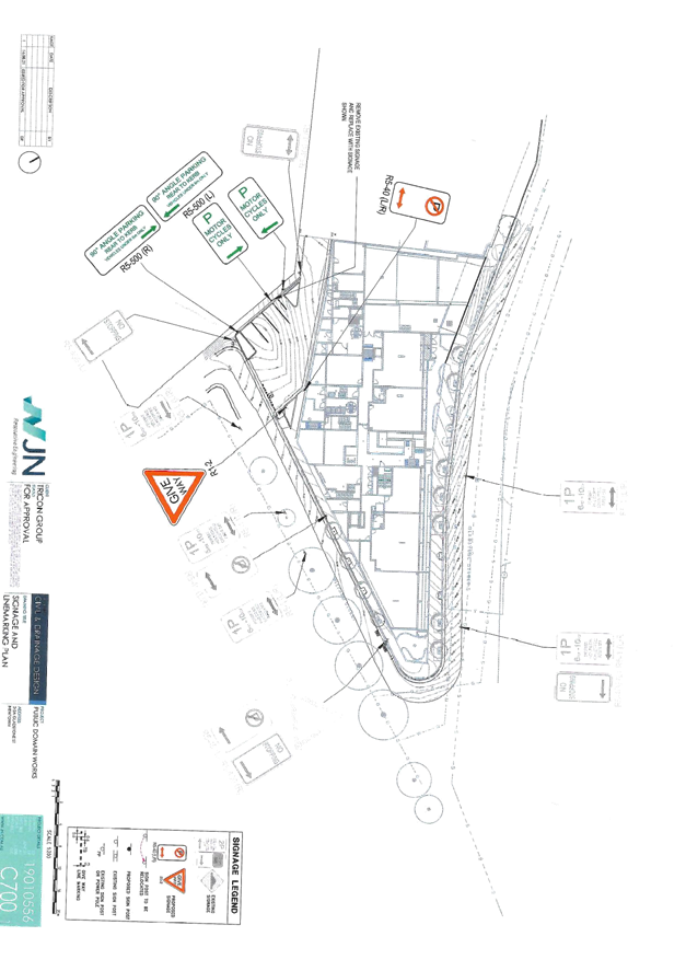
Subject: Gladstone Lane, Newtown - Proposed Signage and
Linemarking associated with Public Domain Works
Damun - Stanmore Ward/ Newtown Electorate/ Inner West PAC
Prepared By: Scipio Tam - Engineer – Traffic and Parking Services
Authorised By: Manod Wickramasinghe - Traffic and Transport Planning Manager
SUMMARY
As part of the development for Property No. 2-2A Gladstone Street, Newtown, the applicant has requested Council’s Local Traffic Committee approval for the proposed Public Domain Works as per applicant’s Condition of Approval. Public Domain works including formalising vehicular parking on the western side of Gladstone Lane and introducing parking restrictions on the eastern side of Gladstone Lane, as well as introducing Give Way restrictions.
|
RECOMMENDATION
THAT the following restrictions be approved as shown on Attachment 1:
1. Three (3) line marked car spaces signposted as ‘90 degree Angle Parking Rear to kerb’ on the western side of Gladstone Lane, Newtown; 2. Two (2) line marked ‘Motorcycle Parking Only’ spaces on the western side of Gladstone Lane, Newtown; 3. ‘No Parking’ restrictions on the eastern side of Gladstone Lane, immediately north of the intersection with Wilford Street; and 4. ‘Give Way’ signage and line marking for vehicles exiting Gladstone Lane onto Wilford Street.
|
BACKGROUND
As part of the development for Property No. 2-2A Gladstone Street, Newtown, as per applicant’s Condition of Approval, Public Domain works including traffic and parking restrictions along the eastern and western sides of Gladstone Lane are required.
OTHER STAFF COMMENTS
As part of the Public Domain works along Gladstone Lane, Newtown, the applicant is to provide:
· 90 degree ‘Rear to kerb’ restriction signage with three (3) line marked car spaces on the western side;
· ‘Motorcycle Parking Only’ restriction signage with two (2) line marked vehicle bays on the western side;
· ‘No Parking’ restrictions on the eastern side, immediately north of the intersection with Wilford Street; and
· ‘Give Way’ signage and line marking for vehicles exiting Gladstone Lane onto Wilford Street.
The applicant has submitted a signage and line marking plan along with vehicular swept path plans to ensure unincumbered ingress and egress of vehicles from parking bays.
Please see attached plan for more details.
PUBLIC CONSULTATION
Public consultation was undertaken by applicant. A letter outlining the proposal was mailed out by the applicant to properties in close proximity to the proposal area. These include:
· 2-44 Wilford Street, Newtown;
· All associated townhouses in 2B Gladstone Street, Newtown;
· 2C Gladstone Street, Newtown;
· 76 Wilford Street, Newtown; and
· 83-99 Enmore Road, Newtown.
No responses were received.
|
1.⇩ |
2-2A Gladstone Street, Newtown - Public Domain Works - Signage and Line Marking Plan |
|
|
Local Traffic Committee Meeting 15 November 2021 |
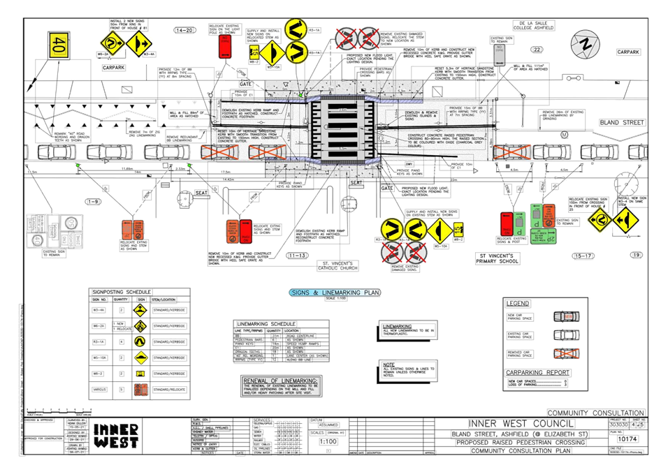
Subject: Bland Street, Ashfield – Proposed new raised pedestrian crossing - Design Plan 10174 (Djarrawunang-Ashfield Ward/Summer Hill Electorate/Burwood PAC)
Prepared By: Boris Muha - Engineer – Traffic and Parking Services
Authorised By: Manod Wickramasinghe - Traffic and Transport Planning Manager
SUMMARY
Council has finalised design plans to construct a new raised pedestrian (zebra) crossing in lieu of the existing at-road level crossing in Bland Street north of Elizabeth Street, Ashfield. The proposed works will improve pedestrian and motorist safety and addresses various concerns about pedestrian safety and driver behaviour in the area.
|
RECOMMENDATION
THAT the detailed design plan for a new raised pedestrian (zebra) crossing (with associated signs and line marking) in lieu of the existing at-road level crossing in Bland Street north of Elizabeth Street, (as per Plan No.10174) be APPROVED.
|
BACKGROUND & OTHER STAFF COMMENTS
Bland Street is a 2-way road measuring approximately 7.6m in width from kerb to kerb. It is a local collector road, linking traffic between Elizabeth Street and Parramatta Road, and carrying around 3500 vehicle per day with 85 percentile speeds within the 50km/h speed limit. Parking is permitted on the eastern side with ‘No Stopping’ throughout on the western side in the section of Bland Street between Elizabeth Street and Charlotte Street.
The existing at- road level crossing is located on Bland Street, approximately 90m north of Elizabeth Street. It is used by students at adjacent schools being Bethlehem College Girls High, De La Salle College Boys High and St Vincent’s Catholic Primary School. Vehicles park close to the existing crossing impairing on sight view and traffic movement through the crossing.
In order to improve safety at the existing crossing, the following works are proposed and are illustrated on the attached plan (Attachment 1).
Bland Street, Ashfield (Plan No. 10174):
· Constructing new Raised Pedestrian Crossing.
· Resetting some of the sandstone kerb to new levels
· Constructing “gutter bridges” with heel safe grating to provide safe access over existing kerb and guttering to the new raised pedestrian crossing;
· Constructing new concrete footpath leads on both sides of the proposed pedestrian crossing;
· Resurfacing some of the existing road pavement with new asphalt on either end of the raised crossing
· Installing associated pavement line marking and signage as required;
· Implementing new ‘No Stopping’ zones and signage;
· Providing new flood lighting by installing two (2) new flood lights and power poles
Parking Changes
It is proposed under road safety to adjust existing “No Stopping” zones and signage to ensure current TfNSW minimum standards are met for crossings and that Australian Road rules apply in that vehicles do not park within 3 metres of double barrier centreline. This will result in the loss of three (3) on-street parking spaces on the east side of Bland Street.
FINANCIAL IMPLICATIONS
The estimate cost of the works is $88,000 and is funded from an Australian Government stimulus program for works to be conducted for the 2021-2022 financial period.
PUBLIC CONSULTATION
Consultation was conducted between the 14 October 2021 to 2 November 2021. A total of 11 letters along with a copy of the design plan was sent to properties around the crossing, capturing the local church institutions, Bethlehem College and St Vincent’s’ Primary School. Although not directly affected, a notification letter was sent to De La Salle College for its information on the proposal. No responses were received at the time of compiling this report.
|
1.⇩ |
Bland Street, Ashfield - Raised Pedestrian Crossing - Design Plan |
|
|
Local Traffic Committee Meeting 15 November 2021 |
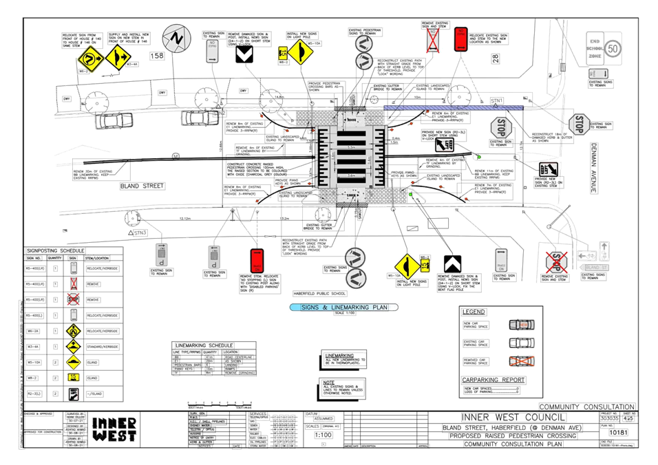
Subject: Bland Street, Haberfield - Proposed Raised Pedestrian Crossing (Gulgadya-Leichhardt Ward/Summer Hill Electorate/Burwood PAC)
Prepared By: Vinoth Srinivasan - Engineer - Traffic and Parking Services
Authorised By: Manod Wickramasinghe - Traffic and Transport Planning Manager
SUMMARY
Council is planning to upgrade an existing pedestrian crossing in Bland Street, Haberfield near Denman Avenue by constructing a raised pedestrian crossing. The proposed works will improve pedestrian and motorist safety near Haberfield Public School.
|
RECOMMENDATION
THAT the attached detailed design plan (Design Plan No.10181) for the proposed installation of a new raised pedestrian (zebra) crossing at Bland Street, Haberfield near Denman Avenue be approved. |
BACKGROUND & OTHER STAFF COMMENTS
The detailed design plan shown in Attachment 1 outlines the proposed works on Bland Street, Haberfield near Denman Avenue and includes the following treatments:
- Installation of new raised pedestrian (zebra) crossing;
- Installation of associated pavement line marking and signage as required;
- Construction of new concrete footpath on both sides of the proposed pedestrian crossing;
- Implementation of new ‘No Stopping’ zones and signage, without impacting the existing car parking spaces;
The proposal will not result in any loss of on-street parking spaces. However, some adjustments to the ‘No Stopping’ signage on the south side of Bland Street is proposed to ensure vehicles do not park over the existing kerb ramp.
FINANCIAL IMPLICATIONS
Funding of $40,000 has been allocated to this project for construction in the 2021/2022 Capital Works Program.
PUBLIC CONSULTATION
A letter outlining the proposal was mailed out to 6 properties in Bland Street and Denman Avenue, Haberfield. No responses were received regarding to the proposal.
|
1.⇩ |
Detailed Design Plan - Bland Street, Haberfield - Proposed raised pedestrian crossing. |
|
|
Local Traffic Committee Meeting 15 November 2021 |
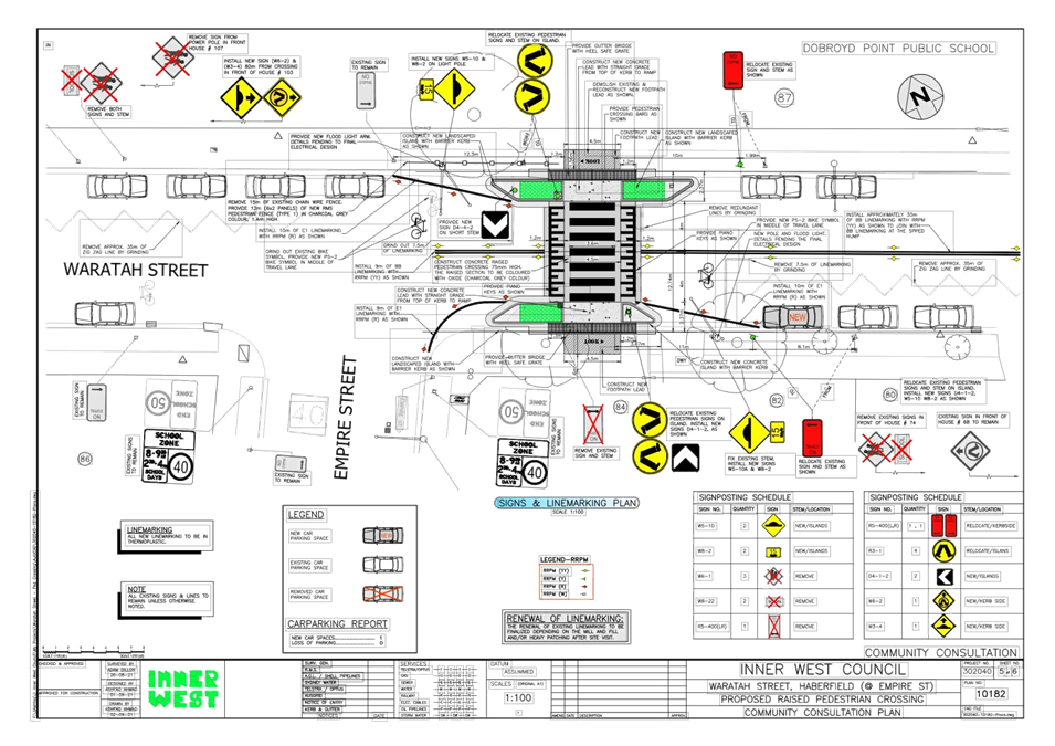
Subject: Waratah Street, Haberfield - Proposed Raised Pedestrian Crossing (Gulgadya-Leichhardt Ward/Summer Hill Electorate/Burwood PAC)
Prepared By: Vinoth Srinivasan - Engineer - Traffic and Parking Services
Authorised By: Manod Wickramasinghe - Traffic and Transport Planning Manager
SUMMARY
Council is planning to upgrade an existing pedestrian crossing in Waratah Street, Haberfield near Empire Street by constructing a new raised pedestrian crossing. The proposed works will improve pedestrian motorist safety near Dobroyd Point Public School.
|
RECOMMENDATION
THAT the attached detail design plan (Design Plan No.10182) for the proposed installation of a new raised pedestrian (zebra) crossing at Waratah Street, Haberfield near Empire Street be approved. |
BACKGROUND & OTHER STAFF COMMENTS
The detailed design plan shown in Attachment 1 outlines the proposed works on Waratah Street, Haberfield near Empire Street and includes the following treatments:
- Installing new raised pedestrian crossing;
- Constructing new landscaped kerb blister islands;
- Constructing “gutter bridges” with heel safe grating to provide safe access over existing kerb and guttering to the new raised pedestrian crossing;
- Constructing new concrete footpath leads on both sides of the proposed pedestrian crossing;
- Installing associated pavement line marking and signage as required;
- Adjusting existing ‘No Stopping’ zones and signage to meet current standards, thus creating one (1) additional on-street car parking space;
- Providing new flood lighting by installing two (2) new flood lights and power poles.
It is proposed to construct kerb extensions to minimise pedestrian crossing distances and to meet the current technical directions for ‘No Stopping’ zones. The proposed arrangement will optimise the on-street kerbspace available for parking and will result in the increase of one (1) space on the south side of Waratah Street.
FINANCIAL IMPLICATIONS
Funding of $80,000 has been allocated to this project for construction in the 2021/2022 Capital Works Program.
PUBLIC CONSULTATION
A letter outlining the proposal was mailed out to seven (7) properties in Empire Street and Waratah Street, Haberfield. No responses were received to the proposal.
|
1.⇩ |
Detailed Design Plan - Waratah Street, Haberfield - Proposed raised pedestrian crossing |
|
|
Local Traffic Committee Meeting 15 November 2021 |
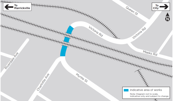
Subject: Victoria Road, Marrickville at the Rail overbridge between Charlotte Avenue and Meeks Street – temporary full road closure - 2-week period - Christmas Shutdown for the Southwest Metro Upgrade Project - Sydney Metro City & Southwest (MIDJUBURI-MARRICKVILLE WARD / SUMMER HILL ELECTORATE / INNER WEST PAC)
Prepared By: Jennifer Adams - Engineer – Traffic and Parking Services
Authorised By: Manod Wickramasinghe - Traffic and Transport Planning Manager
SUMMARY
An application (ENRC/2021/0039) has been received from Sydney Metro City & Southwest for the temporary full road closure of Victoria Road, Marrickville at the Rail overbridge between Charlotte Avenue and Meeks Street, for a 2-week period scheduled for 0200 hours Sunday 26 December 2021 to 0500 hours Monday 10 January 2022 (contingency up to Monday 31 January 2022 0500 hours) in order to facilitate the Christmas Shutdown Rail Possession activities at the Victoria Road Bridge location. The road will be temporarily closed to all vehicular traffic, including emergency vehicles. It is recommended that the proposed temporary full road closures be approved, subject to the conditions outlined in this report.
|
RECOMMENDATION
THAT the proposed temporary full road closure of Victoria Road, Marrickville at the Rail overbridge between Charlotte Avenue and Meeks Street, for a 2-week period scheduled for 0200 hours Sunday 26 December 2021 to 0500 hours Monday 10 January 2022 (contingency up to Monday 31 January 2022 0500 hours) be approved, in order to facilitate the Christmas Shutdown Rail Possession activities at the Victoria Road Bridge location subject to, but not limited to, the following conditions:
1. A Road Occupancy License be obtained by the applicant from the Transport Management Centre;
2. All affected residents and businesses, including the NSW Police Local Area Commander, Fire & Rescue NSW and the NSW Ambulance Services be notified in writing, by the applicant, of the proposed temporary road closure at least 7 days in advance of the closure with the applicant making reasonable provision for stakeholders; and
3. The occupation of the road carriageway must not occur until the road has been physically closed.
|
BACKGROUND
Sydney Metro City & Southwest works involve the upgrading to metro rail standards the more than 125-year-old Bankstown Line between Sydenham and Bankstown. The joint venture John Holland Pty Ltd and Laing O’Rourke Australia Construction Pty Ltd, has been appointed to undertake the works which includes:
· Upgrading 15 bridges that cross over or under the railway, including installation of safety screens;
· Civil construction including work on retaining walls, culverts and track drainage;
· Fencing along the rail corridor and the segregation of the existing freight line from the new driverless railway tracks;
· Rail systems work including new track crossovers, upgrading and refurbishing overhead wiring and work to support signalling and communication equipment; and
· Utility modifications.
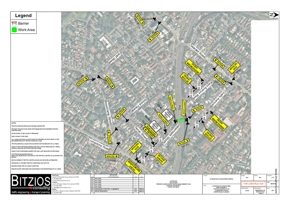
Sydney Metro works will also involve a major rail shutdown of the Sydenham to Bankstown rail line (T3) between Sunday 26 December 2021 to Sunday 9 January 2022 (inclusive). This temporary full road closure is to facilitate the Christmas Shutdown Rail Possession activities at the Victoria Road Bridge location and covers the 14-day period Sunday 26th December 2021 02:00am to Monday 10th January 2022 05:00am.
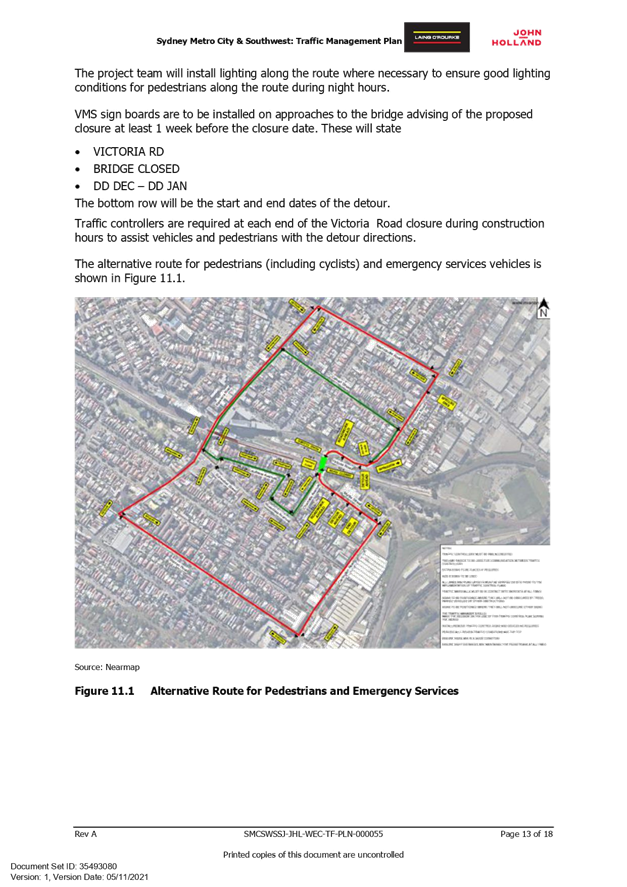
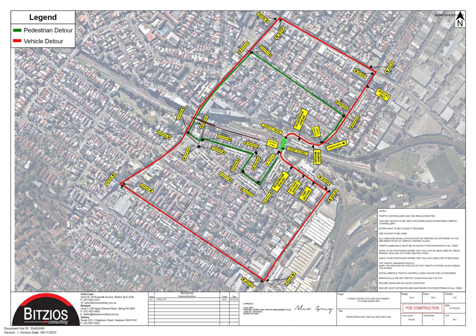
· Road closure on Victoria Road, Marrickville (rail underbridge section) between Meeks Road and Charlotte Avenue. Please see following map.
· Vehicle diversions will be in place. From the southern side of Victoria Road diversions will be via Carrington Road, Schwebel Street, Illawarra Road and onto Marrickville Road. From the northern side of Victoria Road diversions will be from Calvert Street, Gladstone Street and onto Marrickville Road.
· Pedestrian access will be maintained during the road closure.
· Traffic control and directional signage will be in place for the safety of workers and the community.
· There may be an increase in traffic movements around the local area.
· Motorists may experience minor delays.
Equipment used across all of the above work will include excavators, vacuum trucks, motorised saws, concrete trucks, sucker trucks, delivery vehicles, borehole drillers, rollers, generators, whacker packers, dump trucks, telehandlers, drilling rigs, lifting machinery, elevated work platforms, mounted trucks, bobcats, concrete pumps, cranes, cable pulling equipment, road sweeper, compactors, lighting towers, forklifts, water carts, road sweepers, vibrating plates, and hand and power tools.
Access to buildings and driveways will be maintained at all times. Some of this work may be noisy, however Sydney Metro will take every possible step to minimise noise such as switching off equipment when not in use and installing non-tonal reversing beepers on vehicles.
- Victoria Road Full Road Closure
o Duration 26/12/21 to 10/1/22 (24hr closure)
o Detour route on Illawarra Road
o Pedestrians can be managed through the worksite
- Livingstone Road 2 of 4 Lane Closure – One lane both ways to remain open
o Duration 26/12/21 to 10/1/22 (24hr closure)
o Detour route no longer required
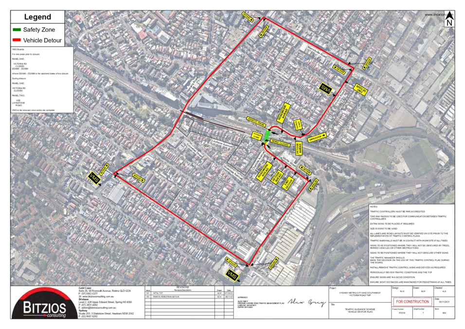
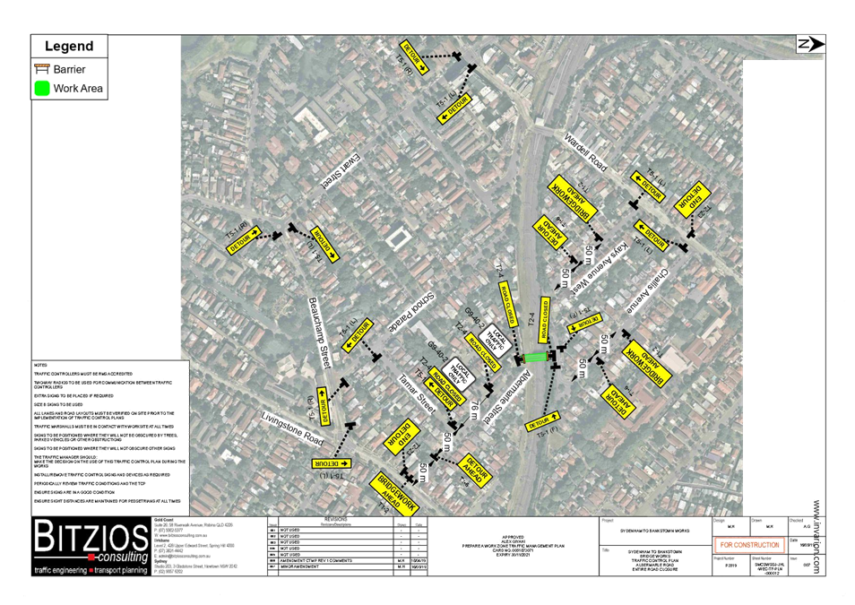
- Albermarle Street Full Road Closure & Contraflow
o Full road closure duration 26/12/21 to 4/1/22 (24hr closure)
o Contraflow setup duration 5/1/22 to 10/1/22 (24hr closure) – changed to facilitate the single lane closure on Wardell Road
o Detour route on Wardell Road during full road closure
Albermarle Street, between Challis Avenue and Kays Avenue East, carries around 1,600 vehicles per day. At the railway overbridge the width of the road is approximately 5.7 metres in width. It is noted that the full road closure will divert traffic to either Wardell Road in the west or Livingstone Road in the west.
The Traffic Management Plan for the Christmas Shutdown Full Closure of Victoria Road for the Southwest Metro Upgrade Project is provided in Attachment 1.
Traffic movements will be managed in accordance with the TCP in Attachment 2. Traffic controllers will be on duty to assist both pedestrians and vehicle movements.
FINANCIAL IMPLICATIONS
Under Council’s Fees & Charges, the applicant is to pay a fee for the temporary full road closure. This fee includes advertising the proposal in accordance with the Roads Act 1993.
The applicant is to notify all affected residents and businesses in writing at least 7 days prior to the commencement of works.
Community notification by Sydney Metro (SSJ) will include:
· Residents within a 200m radius of the works will be door knocked 7 days prior to any works commencing.
· Notification will be distributed 7 days prior to work commencing to the suburb and surrounding suburbs along the rail corridor.
· A door knock of local businesses with the potential to be impacted will be carried out 14 days before work commences.
The proposed road closure has been advertised on Council’s website in accordance with the Roads Act 1993.
CONCLUSION
It is recommended that the proposed temporary full road closure be approved, subject to but not limited to the conditions outlined in this report.
|
1.⇩ |
Traffic Management Plan |
|
2.⇩ |
Traffic Control Plan |
|
|
Local Traffic Committee Meeting 15 November 2021 |
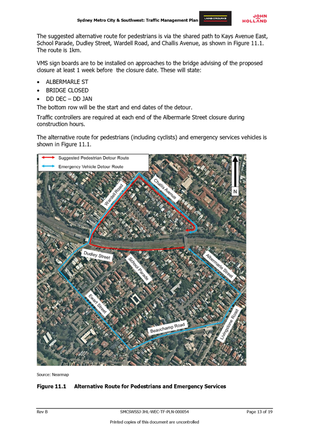
Subject: Albermarle Street at the Rail Overbridge south of Challis Avenue, Marrickville – Temporary Full Road Closure - 2 week period - Christmas Shutdown for the Southwest Metro Upgrade Project - Sydney Metro City & Southwest (MIDJUBURI-MARRICKVILLE WARD / SUMMER HILL ELECTORATE / INNER WEST PAC)
Prepared By: Jennifer Adams - Engineer – Traffic and Parking Services
Authorised By: Manod Wickramasinghe - Traffic and Transport Planning Manager
SUMMARY
An application (ENRC/2021/0046) has been received from Sydney Metro City & Southwest for the temporary full road closure of the rail over bridge on Albermarle Street just south of Challis Avenue, Marrickville for a 2-week period scheduled for 0200 hours Sunday 26 December 2021 to 0500 hours Monday 10 January 2022 (contingency up to Monday 31 January 2022) in order to facilitate the Christmas Shutdown Rail Possession activities at the Albermarle Street Bridge location. A contra flow system will operate in the last week of the closure between 5 and 10 January 2022 to facilitate a single lane closure on Wardell Road. The road will be temporarily closed to all vehicular traffic, including emergency vehicles and local residents. It is recommended that the proposed temporary full road closures be approved, subject to the conditions outlined in this report.
|
RECOMMENDATION
THAT the proposed temporary full road closure of Albermarle Street (between Challis Avenue and Kays Avenue East), Marrickville for a 2-week period scheduled for 0200 hours Sunday 26 December 2021 to 0500 hours Monday 10 January 2022 (contingency up to Monday 31 January 2022 0500 hours) be approved, in order to facilitate the Christmas Shutdown Rail Possession activities on the Rail Overbridge subject to, but not limited to, the following conditions:
1. A Road Occupancy License be obtained by the applicant from the Transport Management Centre;
2. All affected residents and businesses, including the NSW Police Local Area Commander, Fire & Rescue NSW and the NSW Ambulance Services be notified in writing, by the applicant, of the proposed temporary road closure at least 7 days in advance of the closure with the applicant making reasonable provision for stakeholders; and
3. The occupation of the road carriageway must not occur until the road has been physically closed.
|
BACKGROUND
Sydney Metro City & Southwest works involve the upgrading to metro rail standards the more than 125-year-old Bankstown Line between Sydenham and Bankstown. The joint venture John Holland Pty Ltd and Laing O’Rourke Australia Construction Pty Ltd, has been appointed to undertake the works which includes:
· Upgrading 15 bridges that cross over or under the railway, including installation of safety screens;
· Civil construction including work on retaining walls, culverts and track drainage;
· Fencing along the rail corridor and the segregation of the existing freight line from the new driverless railway tracks;
· Rail systems work including new track crossovers, upgrading and refurbishing overhead wiring and work to support signalling and communication equipment; and
· Utility modifications.
The T3 Line between Sydenham and Bankstown will be closed from 26 December 2021 to 10 January 2022 for upgrade works. In December 2021 and January 2022, work will continue along the rail corridor and at Dulwich Hill Station (weather and site conditions permitting). Access to the rail corridor will be via existing rail corridor/pedestrian access gates.
Between 26 December 2021 and 10 January 2022 there will be upgrade work taking place in the rail corridor. To accommodate these activities, there will be a temporary road closure along Albermarle Street Bridge, Dulwich Hill.
Due to the nature of some activities and for the safety of workers, work will occur during a number of rail shutdown weekends when trains are not running on the following dates:
• 2am Sunday 26 December 2021 to 2am Monday 10 January 2022
The temporary road closure on Albermarle Street Bridge between Albermarle Street and Challis Avenue, Marrickville will include the below features:
· Pedestrian footpath closure along Albermarle Street Bridge.
· Traffic and pedestrian diversions together with traffic control and directional signage will be in place for the safety of workers and the community.
· There may be an increase in traffic movements around the local area.
· Motorists may experience minor delays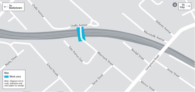
Equipment used across all of the above work will include excavators, vacuum trucks, motorised saws, concrete trucks, sucker trucks, delivery vehicles, borehole drillers, rollers, generators, whacker packers, dump trucks, telehandlers, drilling rigs, lifting machinery, elevated work platforms, mounted trucks, bobcats, concrete pumps, cranes, cable pulling equipment, compactors, lighting towers, forklifts, water carts, road sweepers, vibrating plates, and hand and power tools.
Access to buildings and driveways will be maintained at all times. Some of this work may be noisy, however we will take every possible step to minimise noise such as switching off equipment when not in use and installing non-tonal reversing beepers on vehicles.
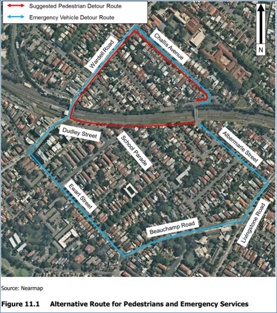
It is noted that Victoria Road underpass will simultaneously also be closed between 26th December to 4th January 2022. Livingstone Road will operate with one lane in each direction during the Christmas shutdown period.
- Albermarle Street Full Road Closure & Contraflow
o Full road closure duration 26/12/21 to 4/1/22 (24hr closure)
o Contraflow setup duration 5/1/22 to 10/1/22 (24hr closure) – changed to facilitate the single lane closure on Wardell Road
o Detour route on Wardell Road during full road closure
- Victoria Road Full Road Closure
o Duration 26/12/21 to 10/1/22 (24hr closure)
o Detour route on Illawarra Road
o Pedestrians can be managed through the worksite
- Livingstone Road 2 of 4 Lane Closure – One lane both ways to remain open
o Duration 26/12/21 to 10/1/22 (24hr closure)
o Detour route no longer required
Albermarle Street, between Challis Avenue and Kays Avenue East, carries around 1,600 vehicles per day. At the railway overbridge the width of the road is approximately 5.7 metres in width. It is noted that the full road closure will divert traffic to either Wardell Road to the north or Livingstone Road to the south. The Traffic Management Plan is included as Attachment 1. The Traffic Control Plan submitted by the applicant is shown in Attachment 2.
FINANCIAL IMPLICATIONS
Under Council’s Fees & Charges, the applicant is to pay a fee for the temporary full road closure. This fee includes advertising the proposal in accordance with the Roads Act 1993.
PUBLIC CONSULTATION
The applicant is to notify all affected residents and businesses in writing at least 7 days prior to the commencement of works.
Community notification by Sydney Metro (SSJ) will include:
· Residents within a 200m radius of the works will be door knocked 7 days prior to any works commencing.
· Notification will be distributed 7 days prior to work commencing to the suburb and surrounding suburbs along the rail corridor.
· A door knock of local businesses with the potential to be impacted will be carried out 14 days before work commences.
The proposed road closure has been advertised on Council’s website in accordance with the Roads Act 1993.
CONCLUSION
It is recommended that the proposed temporary full road closure be approved, subject to but not limited to the conditions outlined in this report.
|
1.⇩ |
Traffic Management Plan |
|
2.⇩ |
Traffic Control Plan |
|
|
Local Traffic Committee Meeting 15 November 2021 |
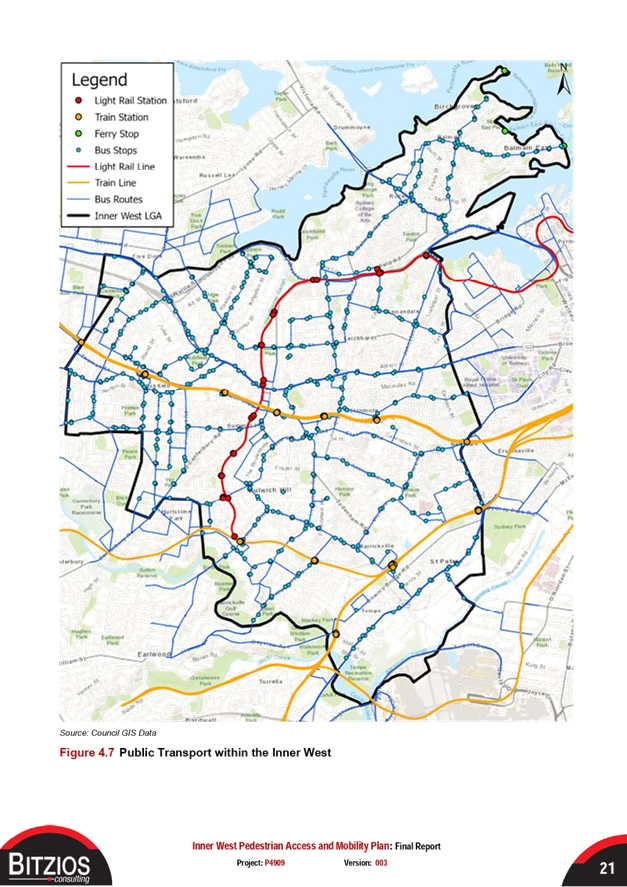
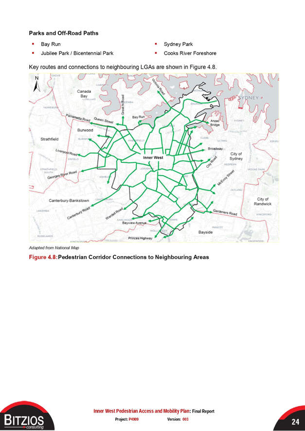
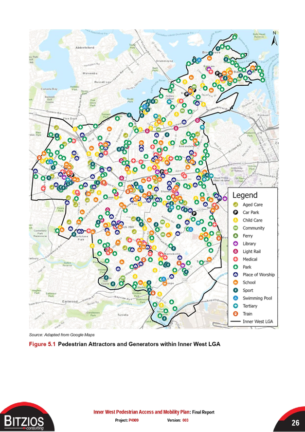
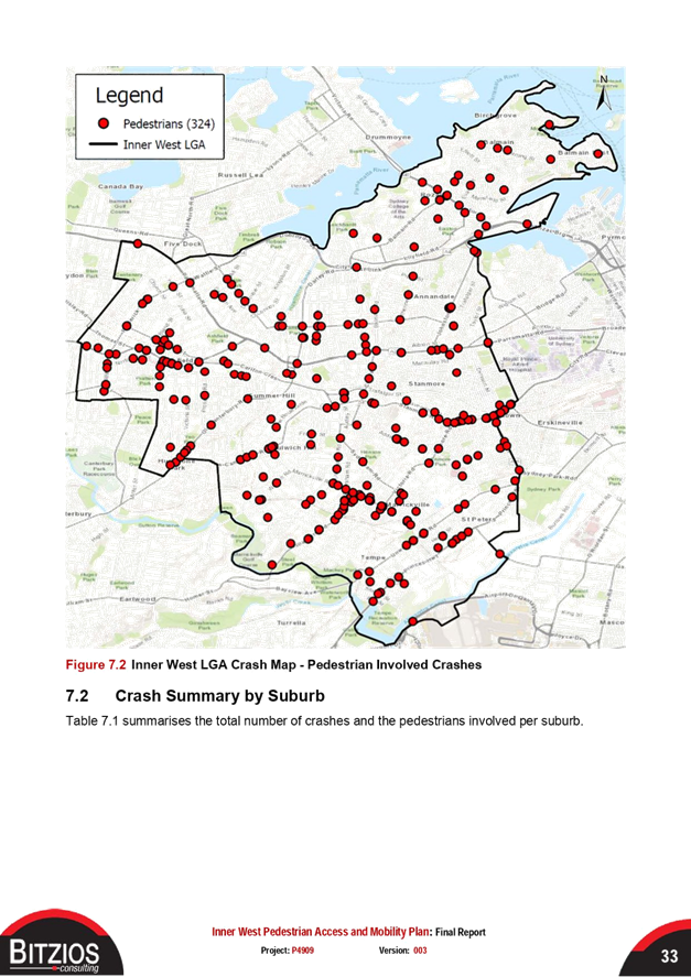
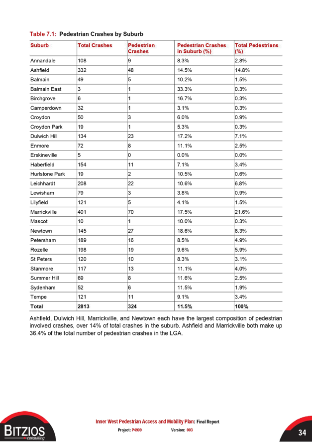
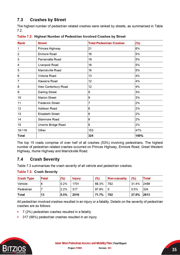
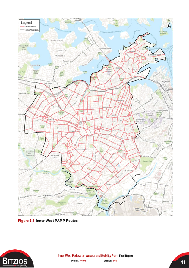
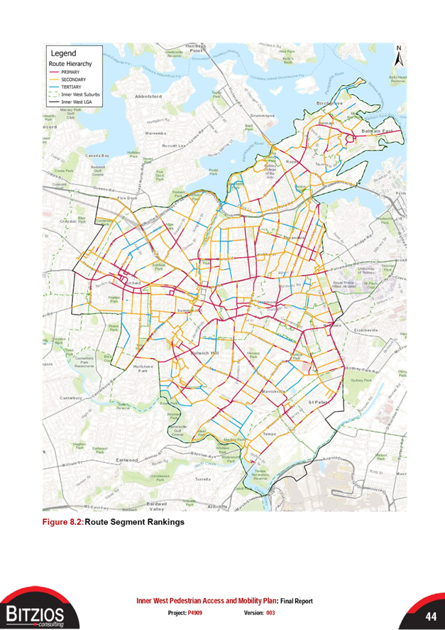
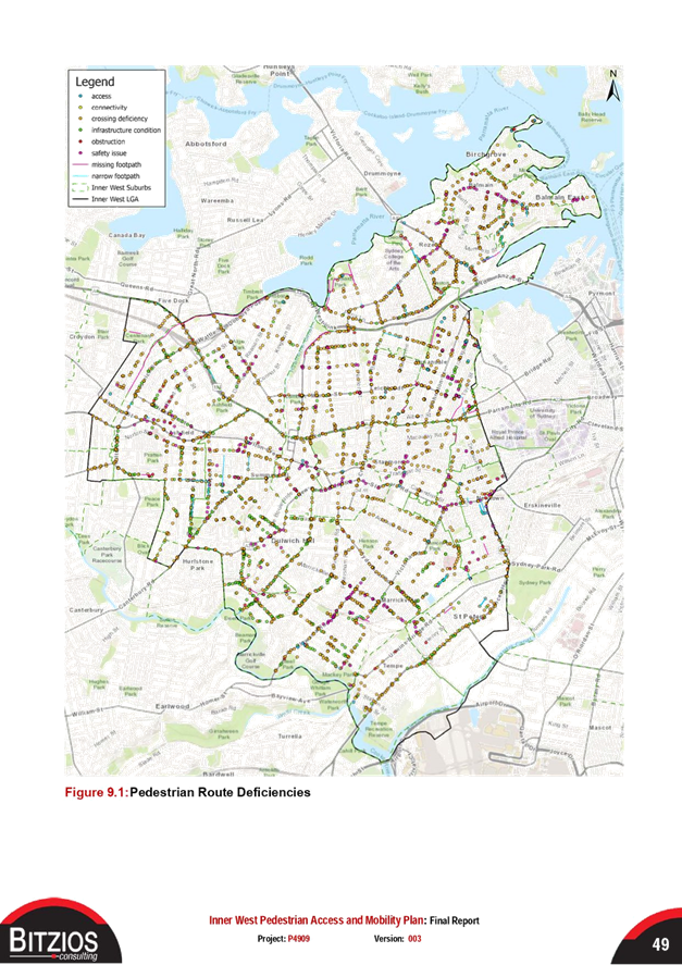
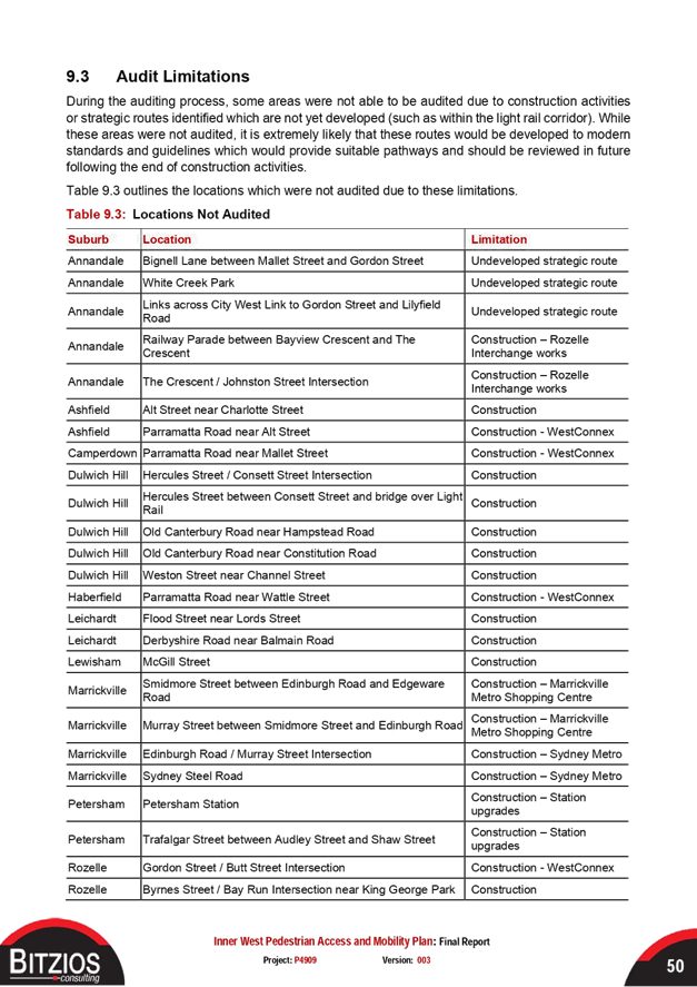
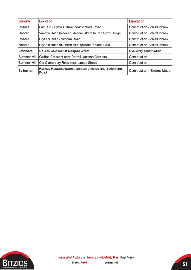
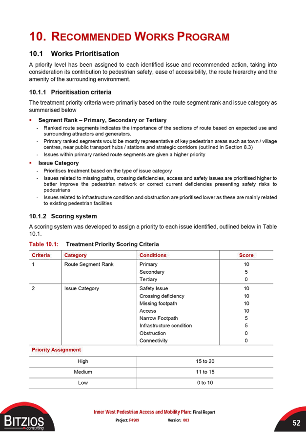
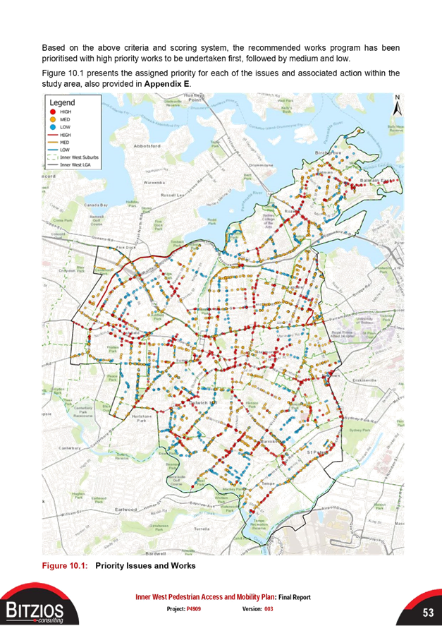
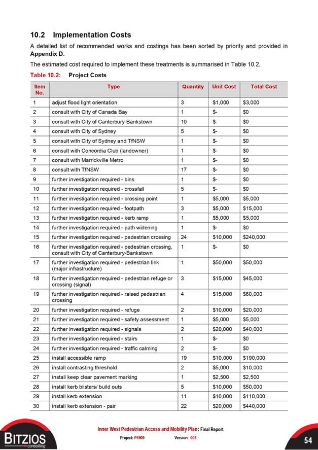
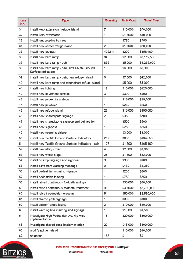
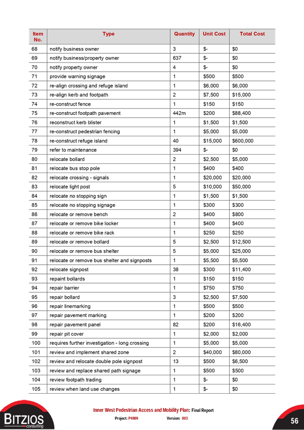
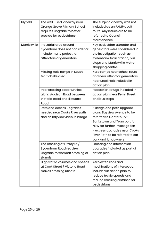
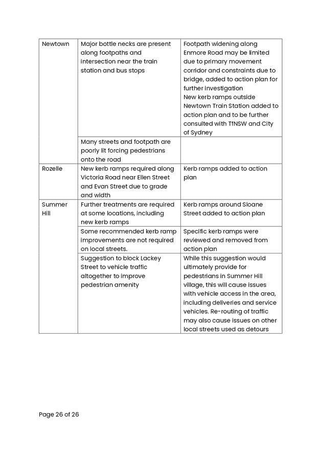
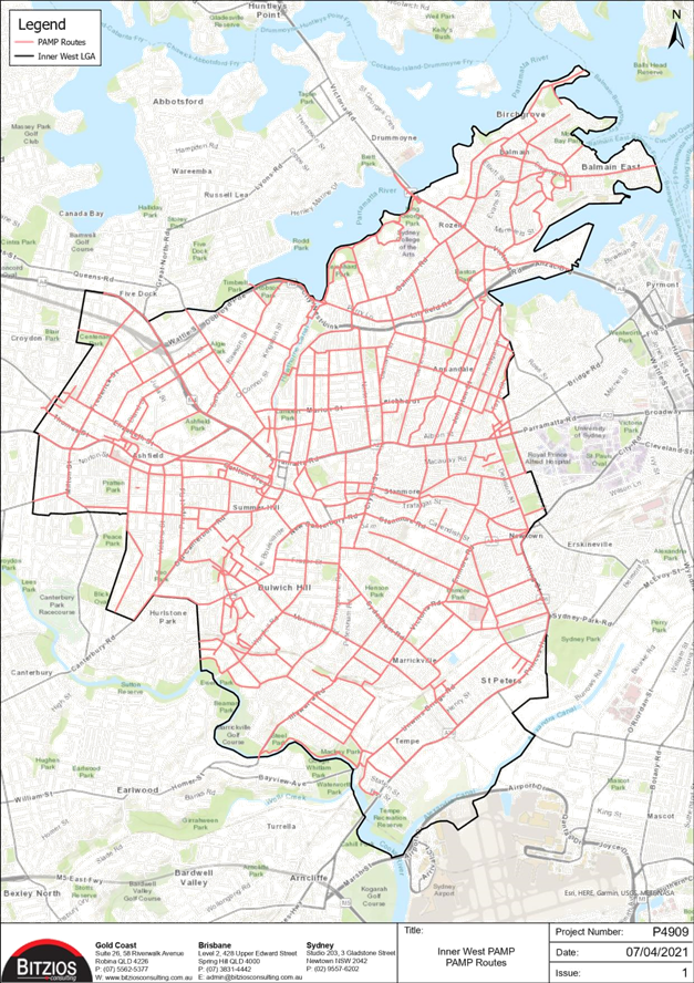
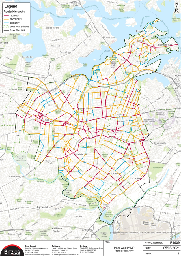
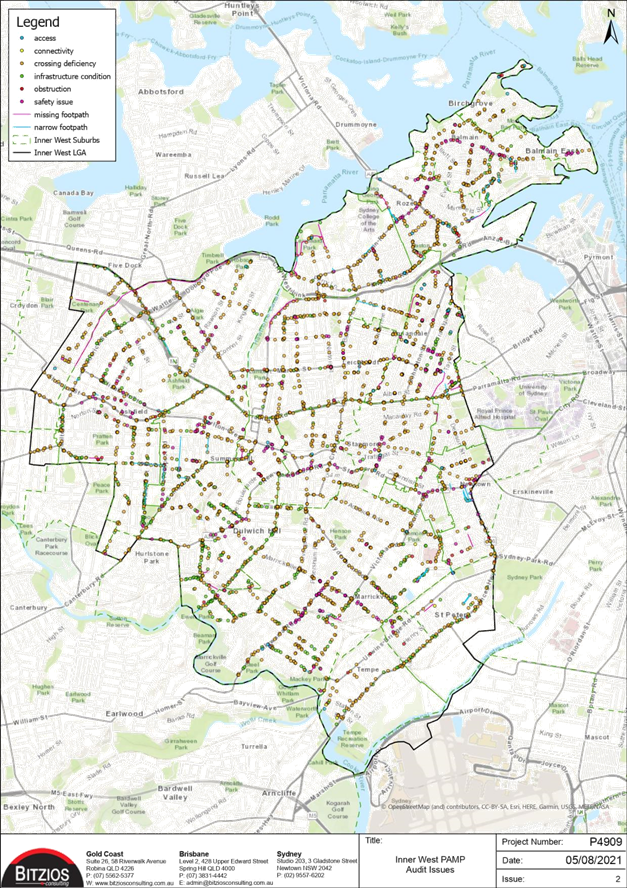
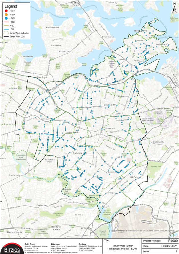
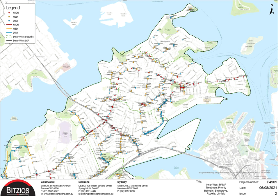
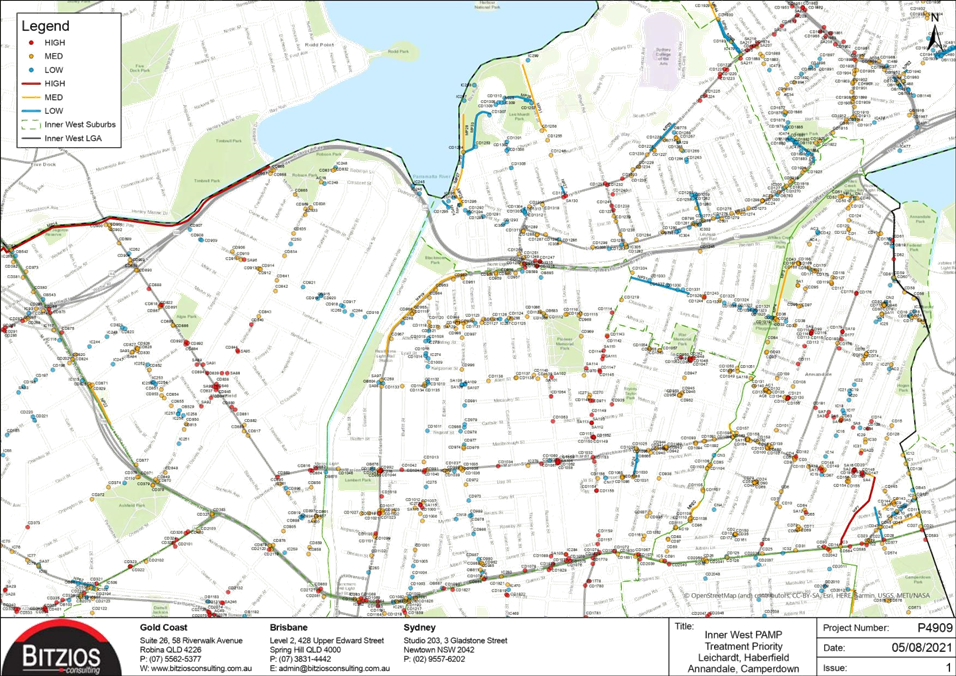
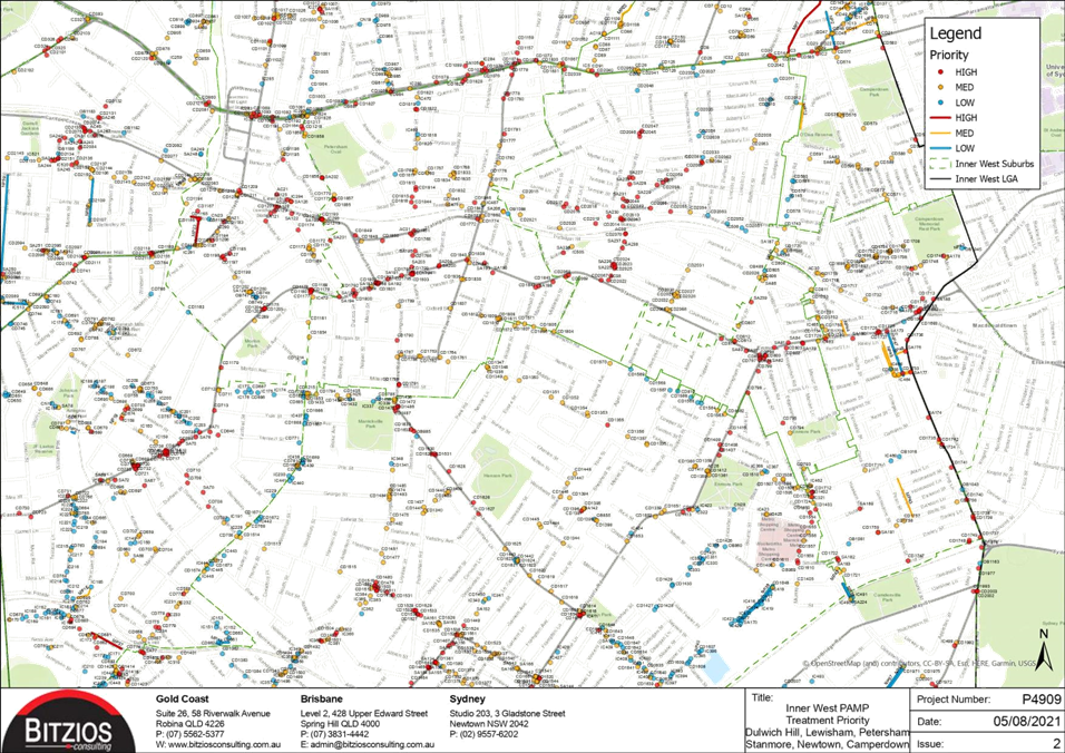
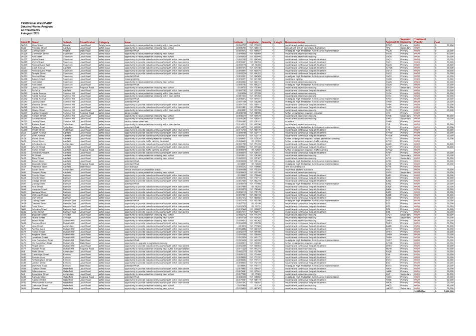
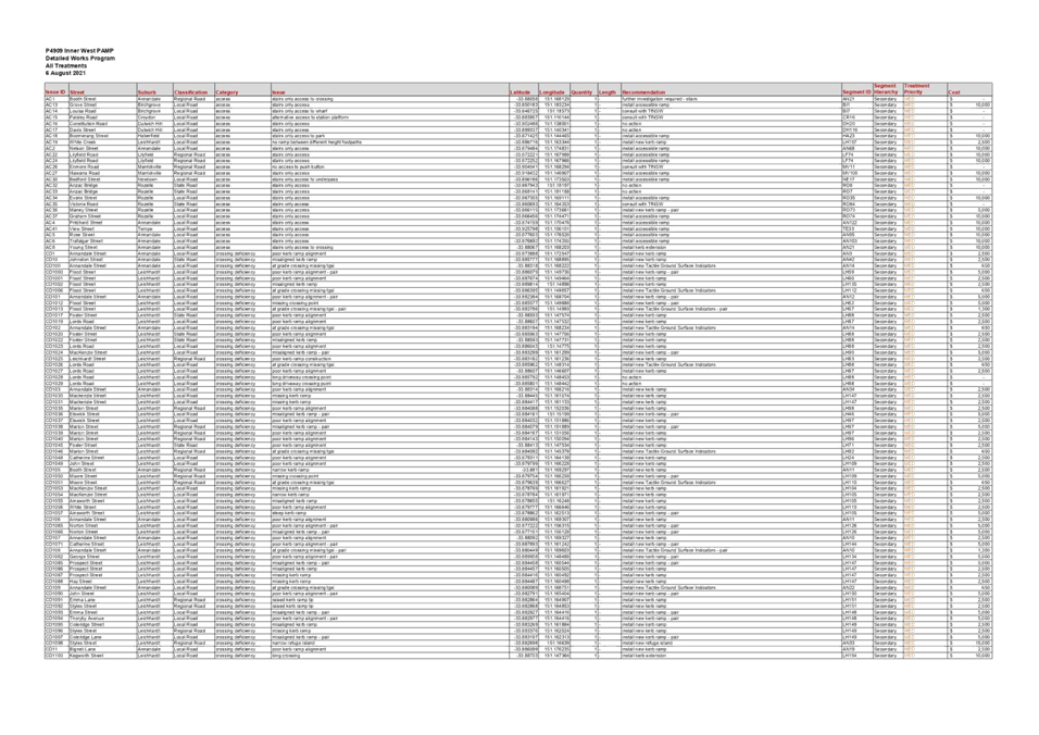
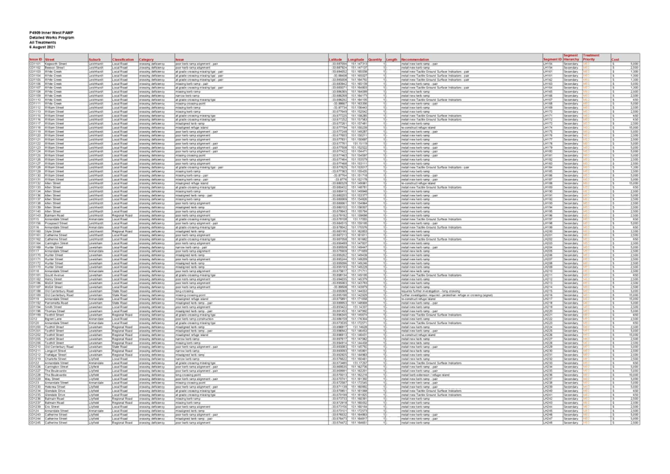
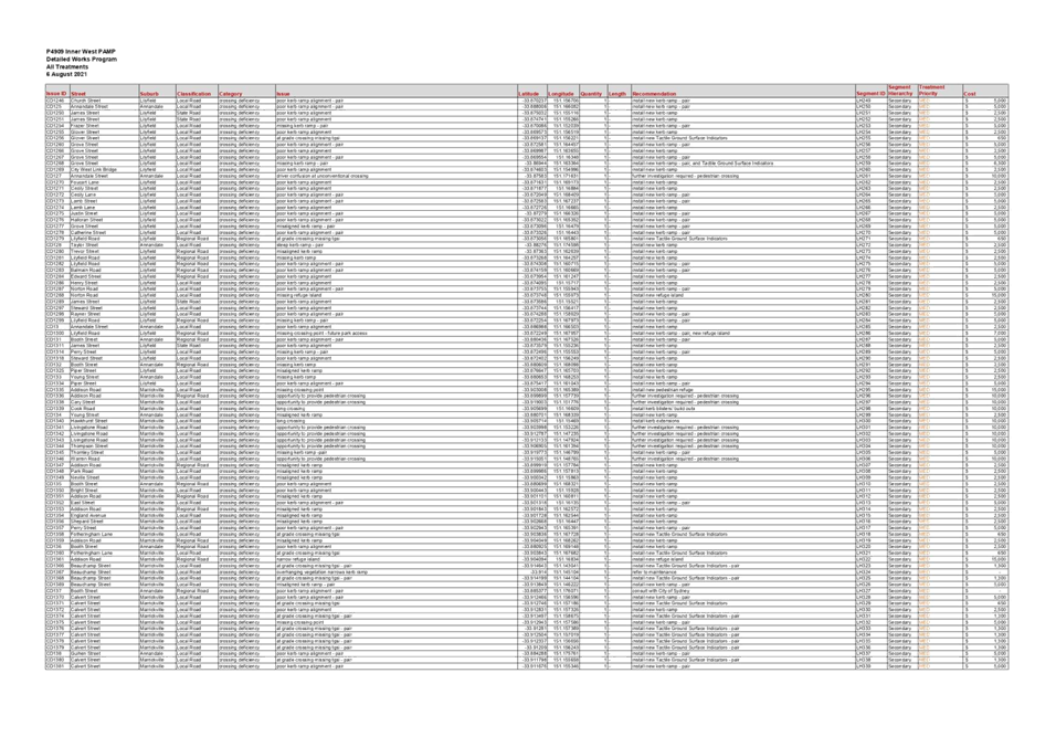
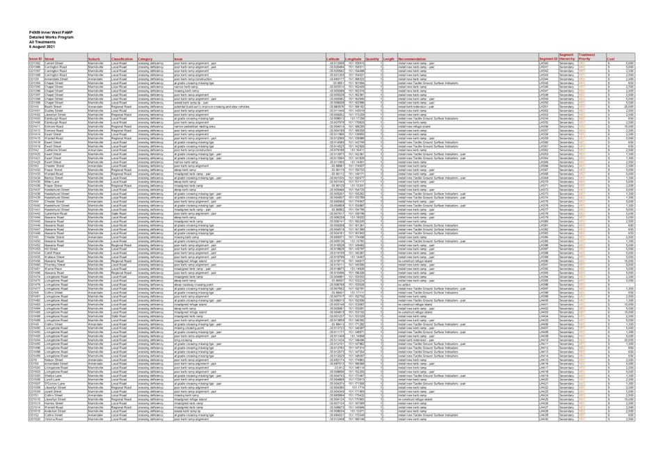
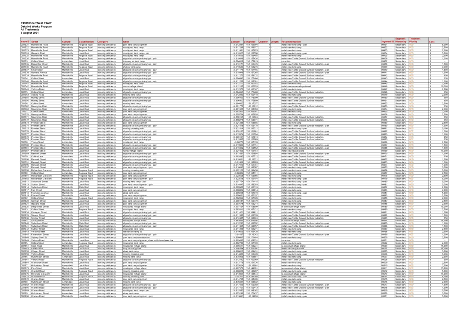
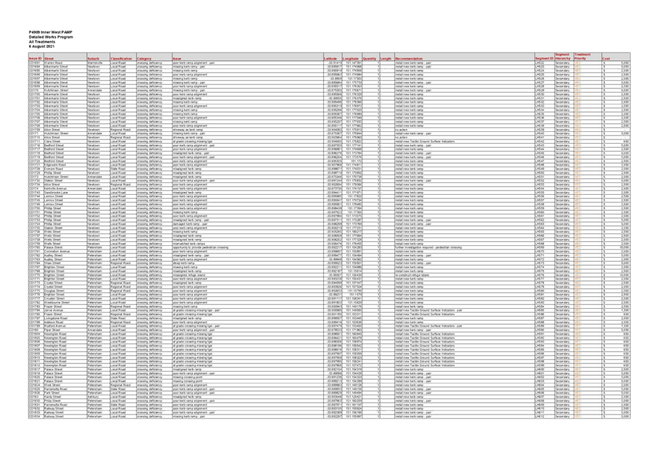
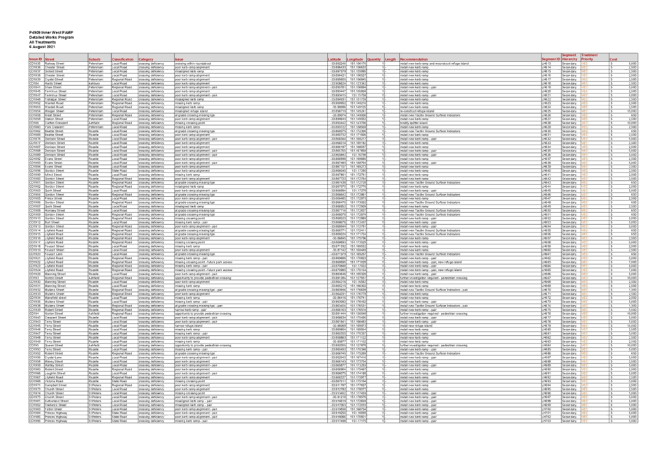
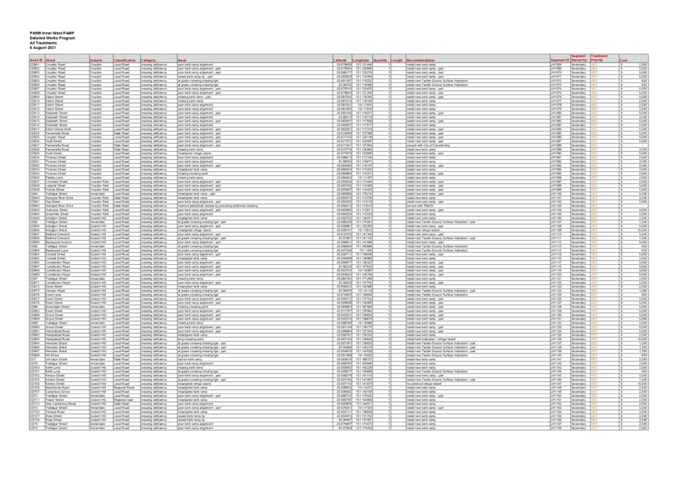
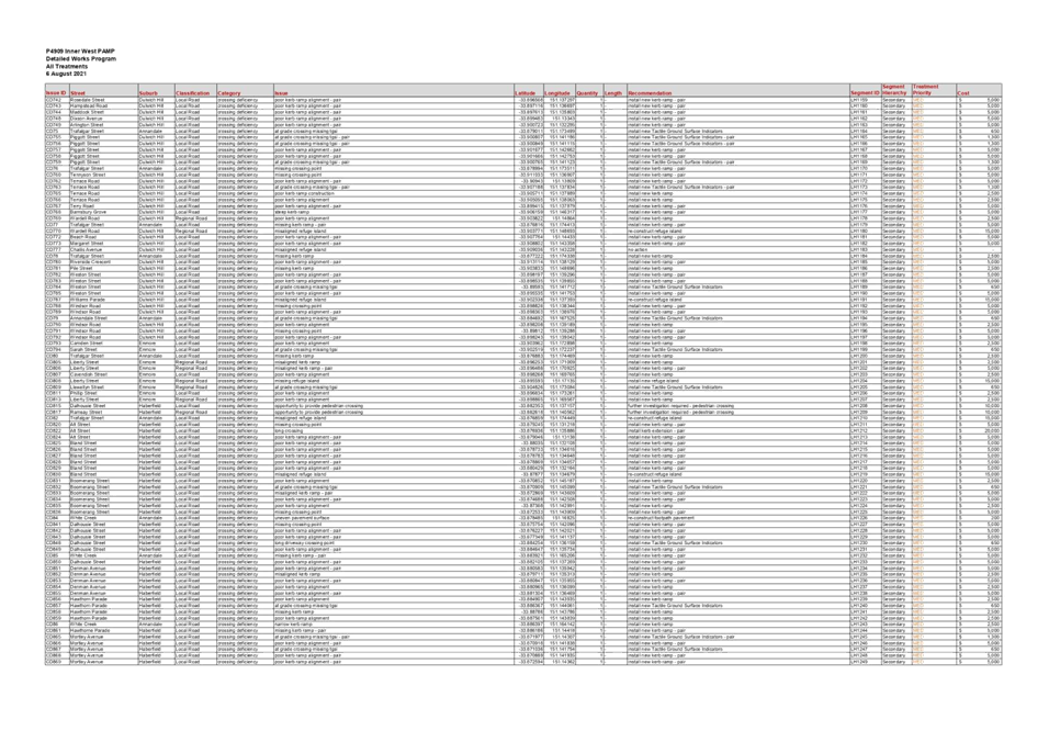
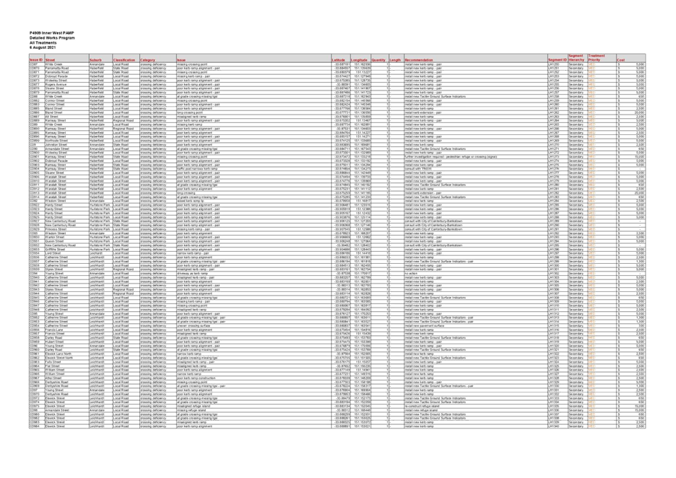
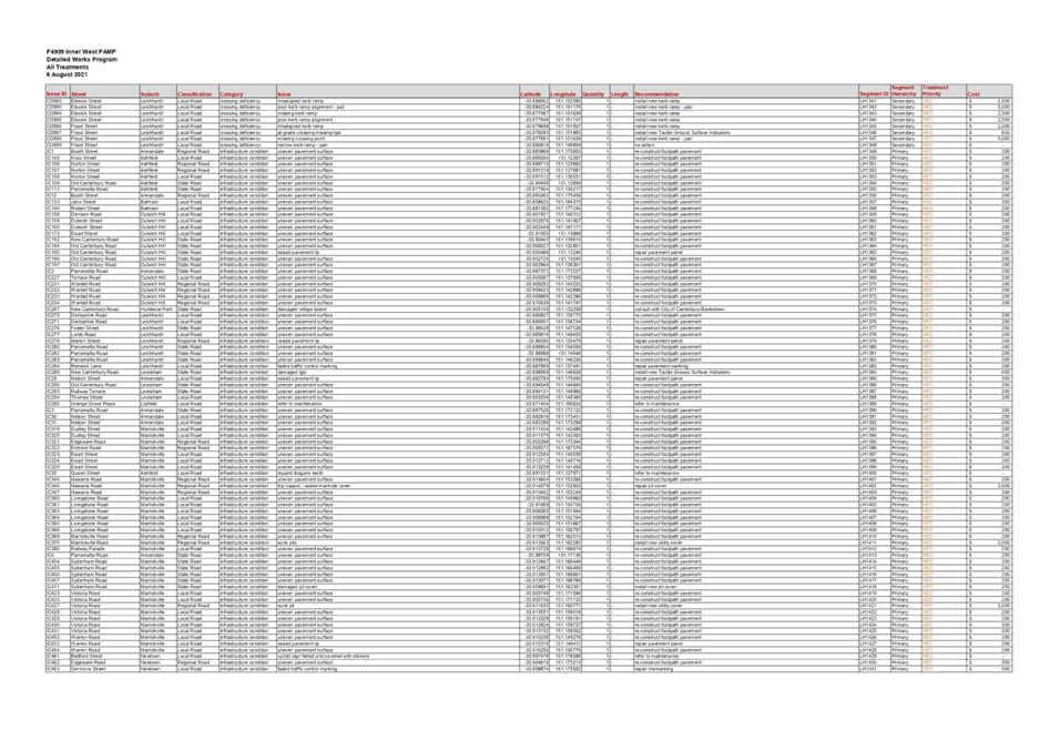
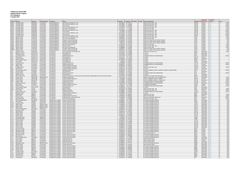
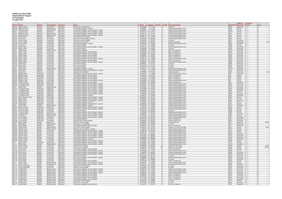
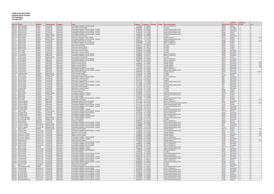
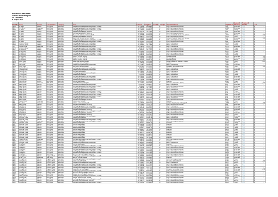
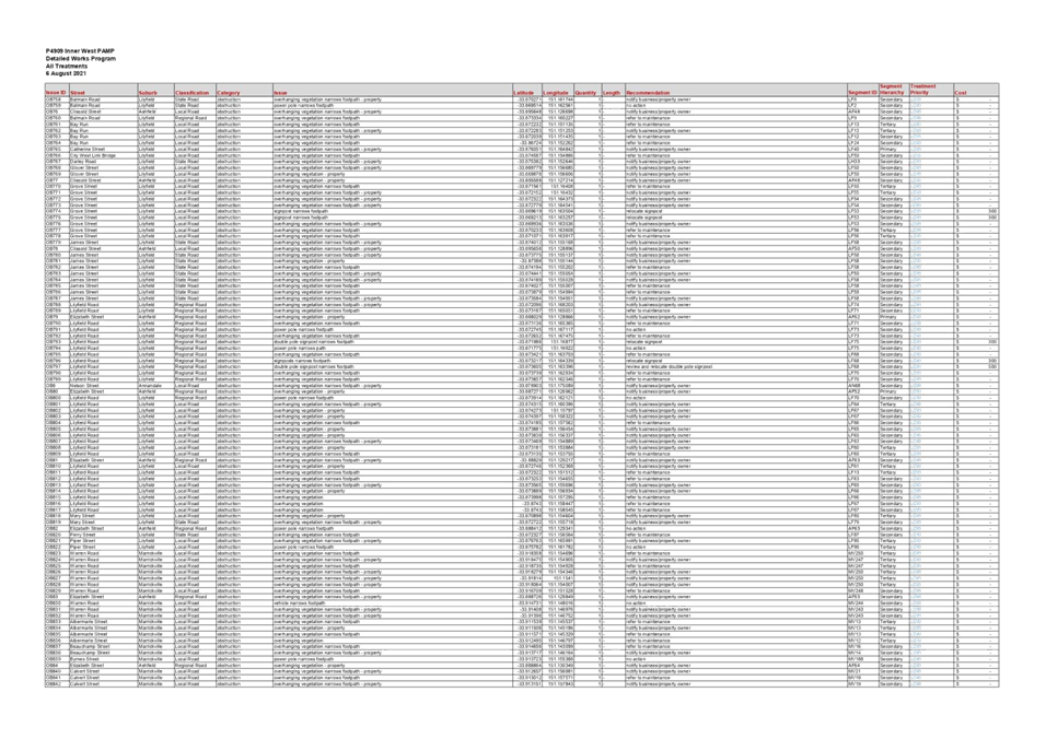
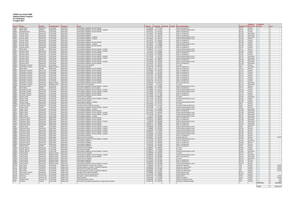
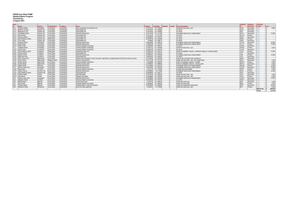
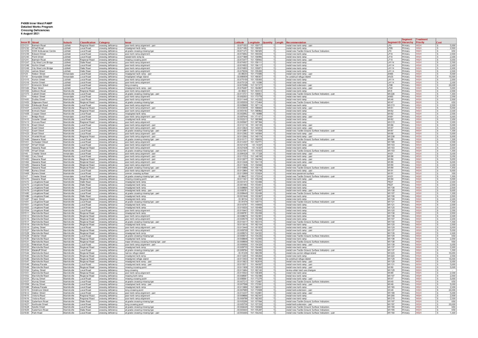
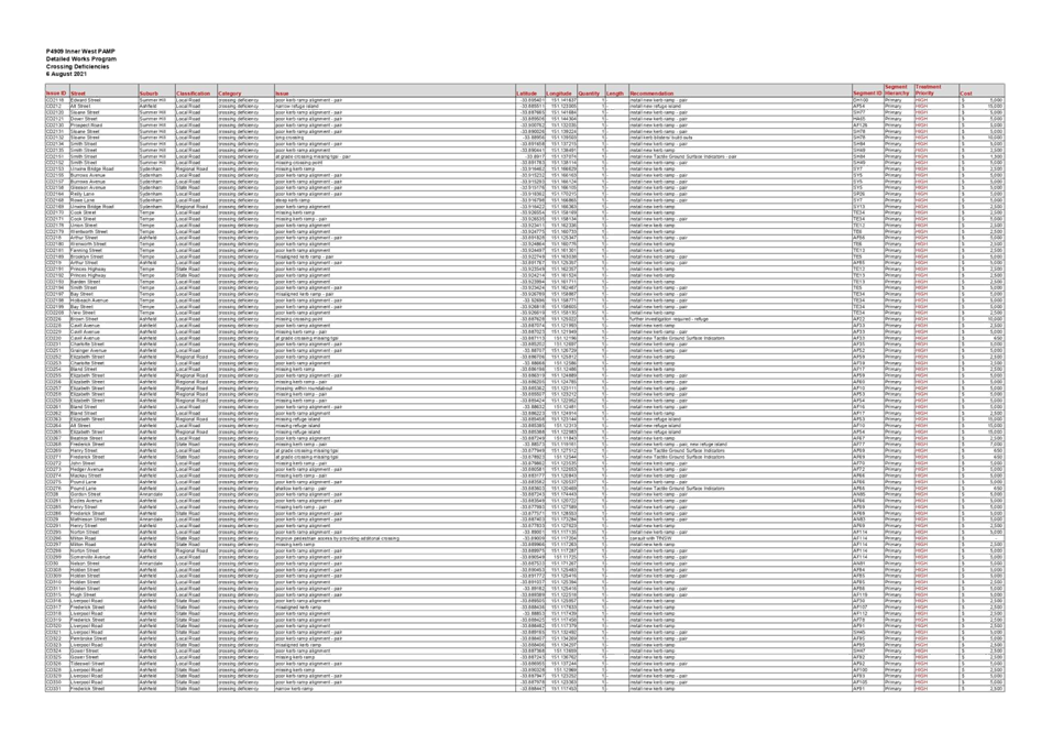
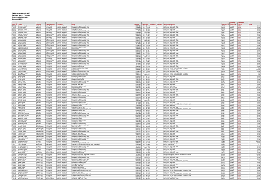
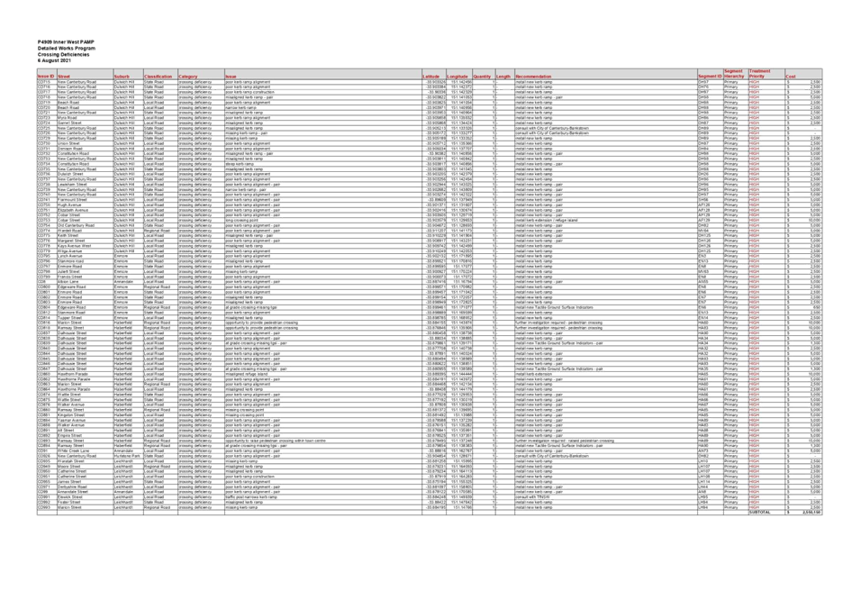
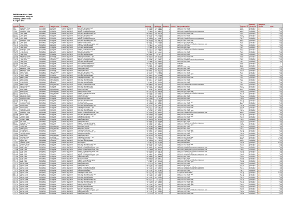
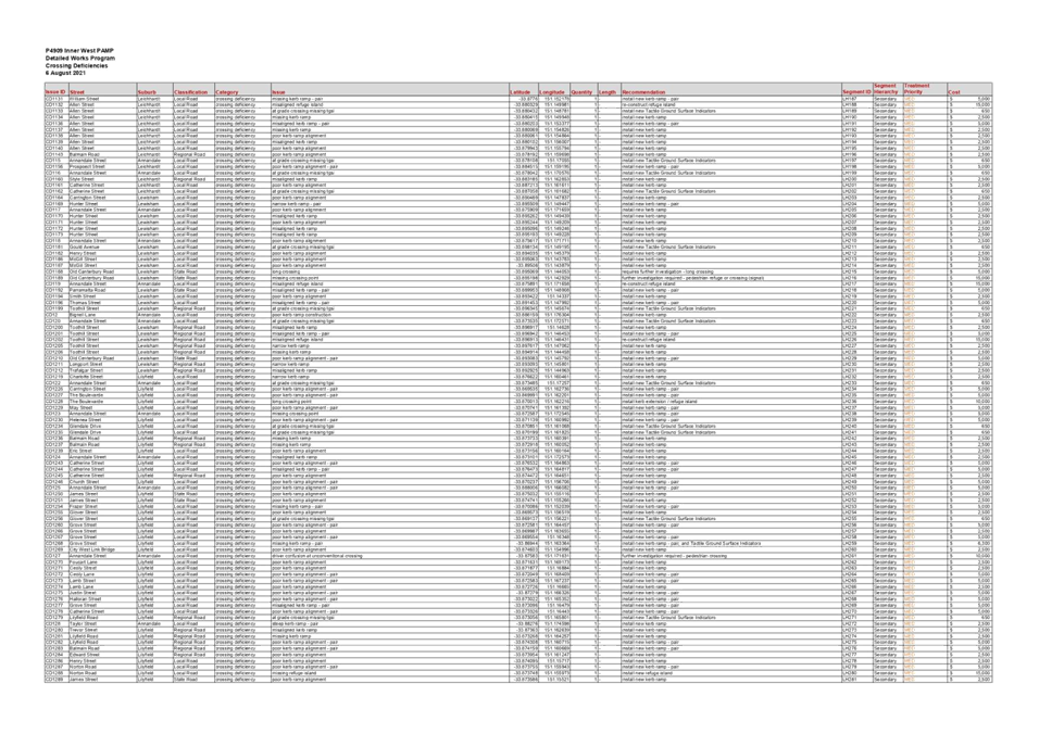
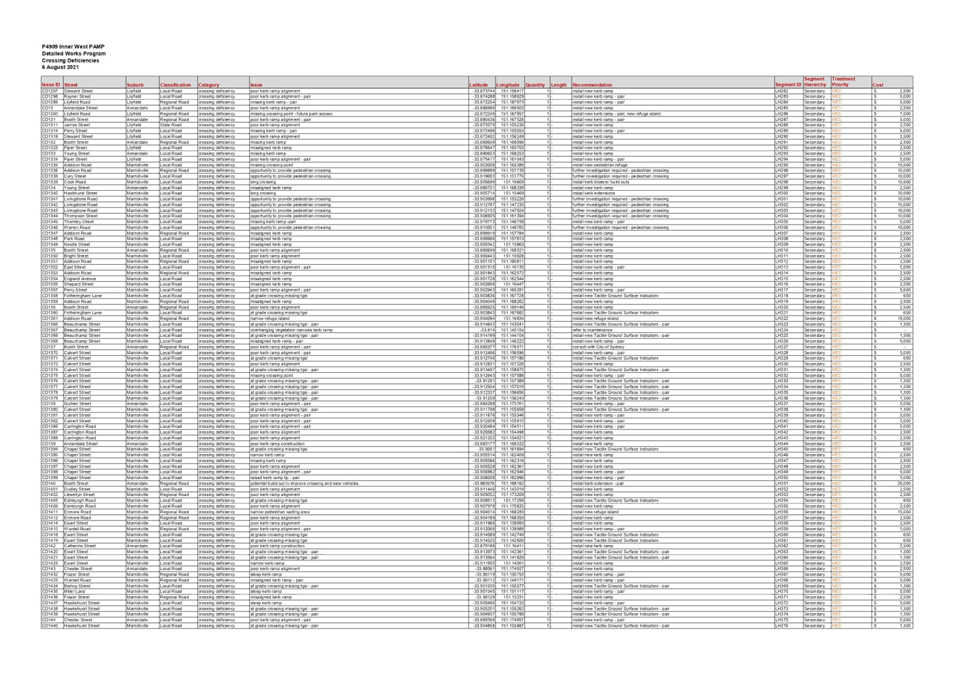
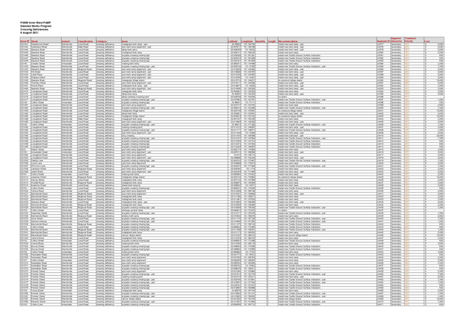
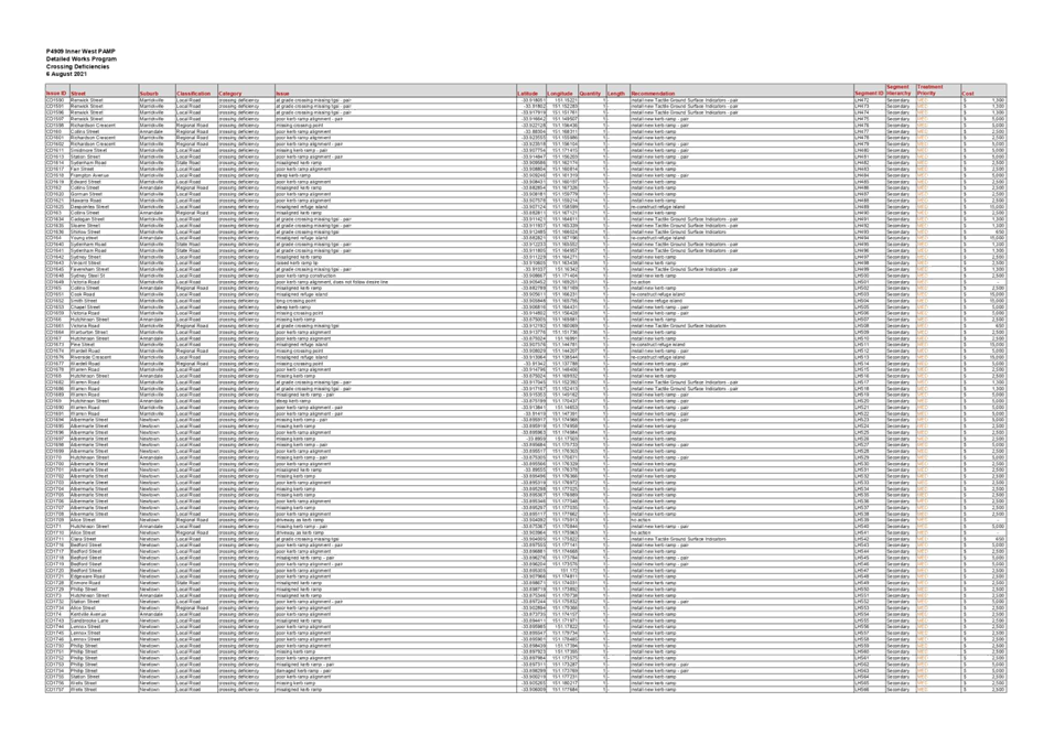
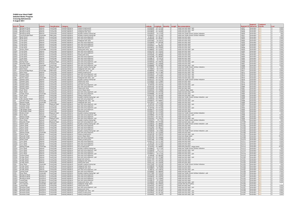
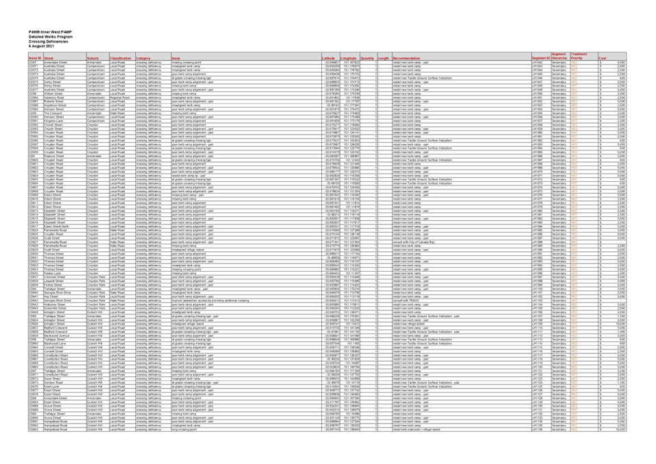
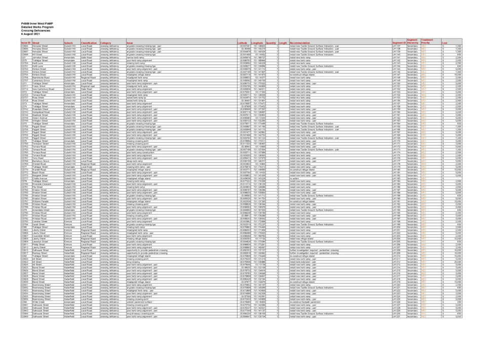
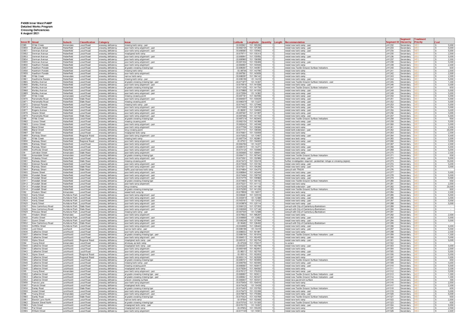
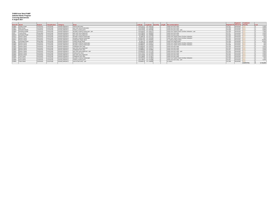
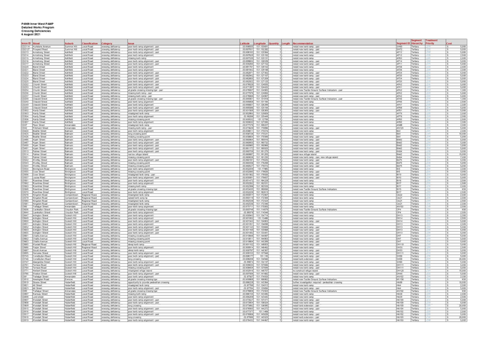
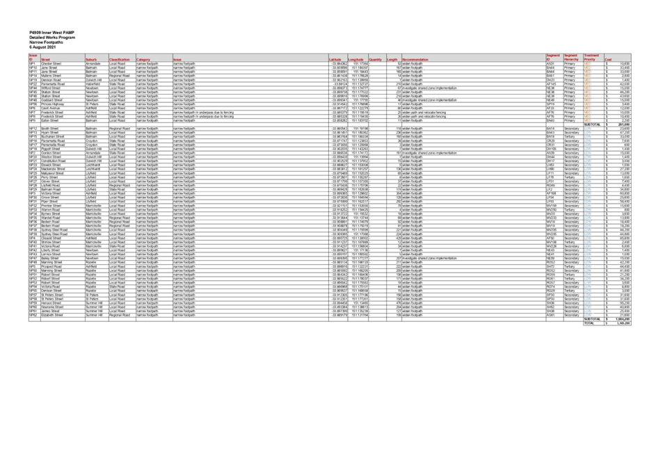
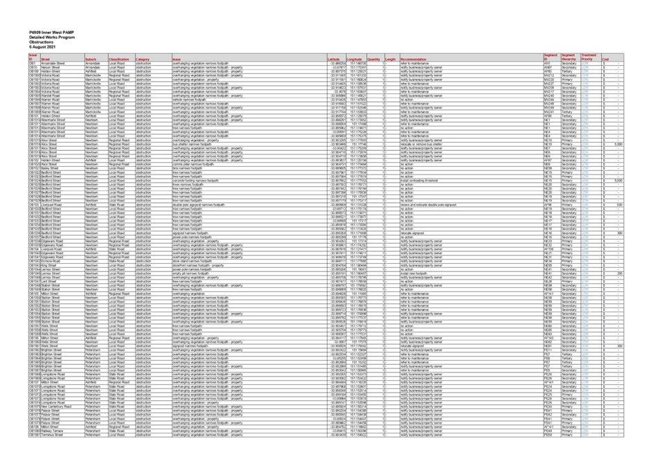
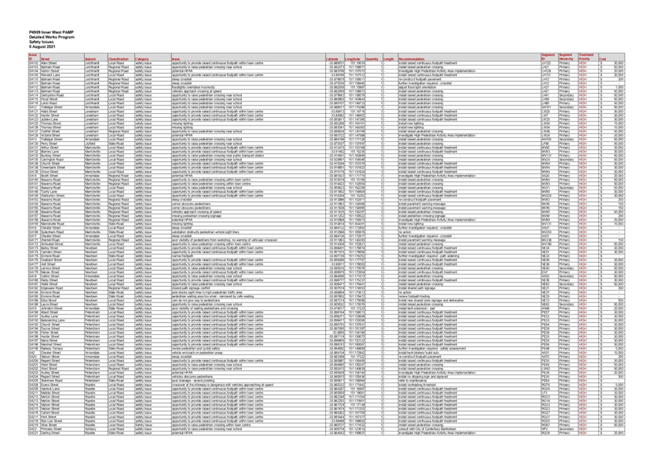
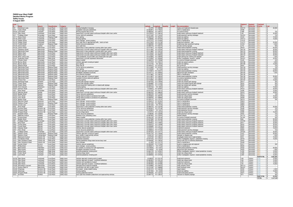
Subject: Pedestrian Access and Mobility Plan Study (All wards/All Electorate/ All PACS)
Prepared By: Felicia Lau - Engineer - Traffic and Parking Services
Authorised By: Manod Wickramasinghe - Traffic and Transport Planning Manager
A Pedestrian Access and Mobility Plan (PAMP) is a comprehensive strategic action plan used to develop pedestrian policies and build pedestrian facilities.
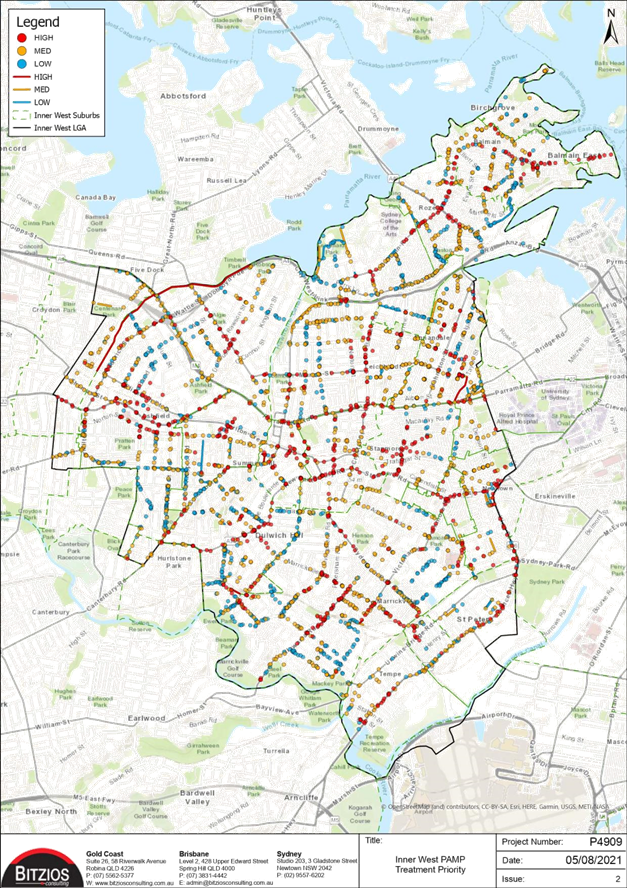
The draft PAMP study was put to Public Exhibition for 28 days in May and June 2021. Community feedback was collated and assessed to develop the final PAMP Action Plan as outlined in Attachment 1.
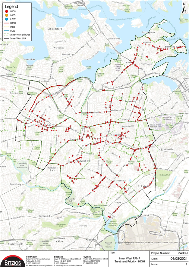
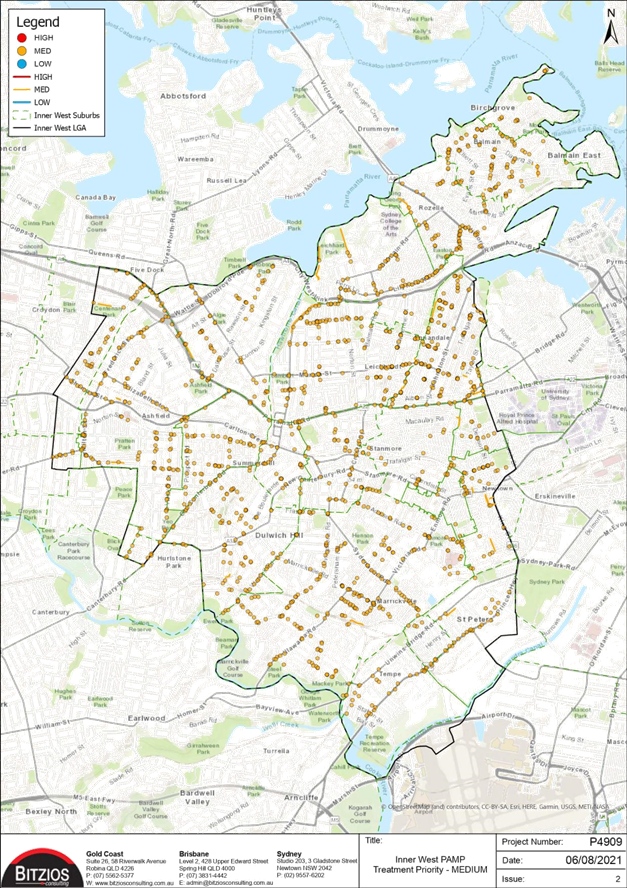
The final PAMP identifies maintenance and capital works to a value of approximately $18 million of which $8 million are high priority items. These works are recommended to be incorporated into Council’s Operational Program and Capital Works Program as well as grant funding applications. It is envisaged that the PAMP will be reviewed and updated approximately every 5 years in order to identify arising issues and rebalance priorities.
|
RECOMMENDATION
THAT:
1. The final Pedestrian Access and Mobility Plan (PAMP) report be adopted; and 2. The PAMP action plan detailing maintenance and capital works be supported to be included in Council’s operational program and Capital Works Program, noting some implementation may subject to further Local Traffic Committee and Council approval of detailed designs.
|
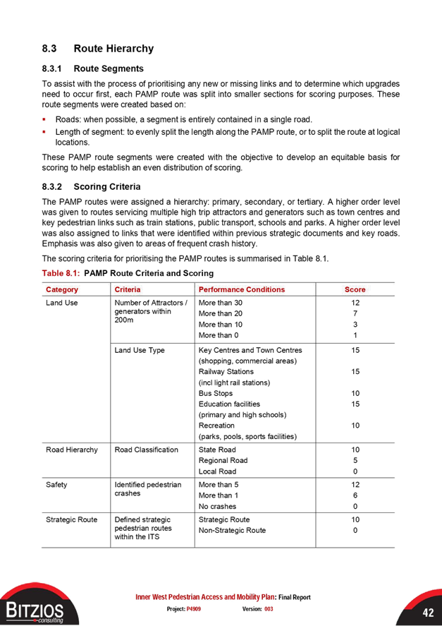
BACKGROUND & OTHER STAFF COMMENTS
The most recent PAMP was commissioned by former Ashfield Council in 2015/16, whilst the Leichhardt PAMP was updated in 2014 and the Marrickville PAMP was updated in 2009. Since amalgamation, there have been a number of changes to land use, policy and infrastructure which triggered a need to develop an Inner West PAMP. The development of an Inner West PAMP for the entire LGA was one of recommendations in the action plan in Council’s adopted Integrated Transport Strategy.
A PAMP is a comprehensive strategic report that builds an updated and prioritised Action Plan for pedestrian facilities with a focus on encouraging and increasing localised pedestrian activity. This has been developed in accordance with Transport for NSW’s guide ‘How to Prepare a Pedestrian Access and Mobility Plan’.
The collected data and site inspections have led to the development of the PAMP Action Plan. The main aims of the Action Plan are to provide a programme for the implementation of pedestrian facilities that can be readily identified, budgeted and prioritised so that the existing facilities may be maintained or upgraded and new facilities can be constructed.
The Action Plan has been staged implementation of high, medium and low priorities to be undertaken over a period of ten years. The works include proposals such as pedestrian crossings, signposting and linemarking, resealing, footpath upgrades/widening, kerb ramps, accessible ramps, speed cushions, pedestrian refuges, lighting upgrades, rough surface upgrades, tree trimming and pedestrian fencing.
The estimated total cost to implement the PAMP project over a period of 10 years is approximately $18 million. A detailed list of all works necessary and budget is presented in the Appendix E of the final report.
FINANCIAL IMPLICATIONS
The final PAMP Action Plan details maintenance and capital works to a value of approximately $18 million of which $8 million are high priority items. It has been recommended that works are programmed over 10 years, although this timeframe will vary depending upon funding levels allocated by:
· Council’s Operational Program and Capital Works Program, some implementation is subject to further Local Traffic Committee support and adoption by Council.
· State or Federal Government grant applications.
· Potential implementation of relevant Section 7.11 and 7.12 development contributions plans in proposed uplift areas.
PUBLIC CONSULTATION
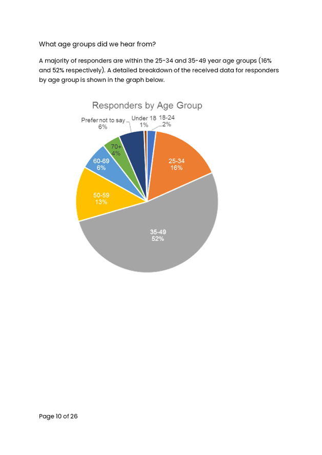
Public Exhibition of the PAMP commenced on 26 May 2021, this included high priority recommendations being displayed on an interactive map through Council’s website. Feedback was provided via an online form or through direct channels, such as emails.
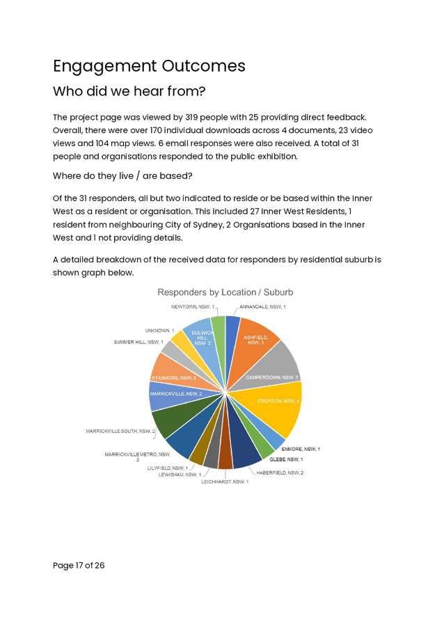
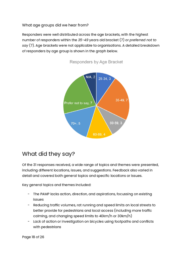
The PAMP project page was viewed 319 times with 25 providing direct feedback. Overall, there were over 170 individual downloads across 4 documents, 23 video views and 104 map views. Additional six responses provided via email, resulting in a total 31 responses during the public exhibition period.
The feedback related to pedestrian infrastructure has been collated and included in the final PAMP report and include:
§ Raising existing at-grade marked pedestrian crossings within high pedestrian traffic areas.
§ Investigation study to convert Prospect Street, Leichhardt to shared zone.
§ Masterplan study to investigate better pedestrian connectivity along Johnston’s Creek.
REVIEW PROCESS
It is envisaged that the PAMP will be reviewed and updated approximately every 5 years in order to identify arising issues and rebalance priorities. Between these plans, specific pedestrian investigations will continue during Local Area Traffic Management studies and ad-hoc investigations.
CONCLUSION
The proposed PAMP Action Plan in Appendix E outlines the recommended maintenance and capital works, categorizing into high, medium and low priority. It is recommended that these works be supported and included in Council’s Operational Program and Capital Works Program.
|
1.⇩ |
PAMP Study Final Report |
|
2.⇩ |
Appendix A - Engagement Outcome Report |
|
3.⇩ |
Appendix B - PAMP Audit Routes |
|
4.⇩ |
Appendix C - PAMP Route Hierarchy |
|
5.⇩ |
Appendix D - Audit Findings |
|
6.⇩ |
Appendix E - PAMP Action Plan |