|
AGENDA R |

Flood Management Advisory Committee Meeting
TUESDAY 30 AUGUST 2022
2.00PM
|
|
Flood Management Advisory Committee Meeting 30 August 2022 |
|
AGENDA |
1 Apologies
2 Disclosures of Interest
3 Confirmation of Minutes
Minutes of 12 December 2019 Flood Management Advisory Committee Meeting 4
4 Matters Arising from Council’s Resolution of Minutes
Late Items
Nil at time of printing.
5 Staff Reports
ITEM PAGE #
FMACC0822(1) Item 1 Inner West Council Flood Response 8
FMACC0822(1) Item 2 Community Engagement - Johnstons Creek and
Whites Creek Flood Risk Management Plan and
Alexandra Canal Flood Risk Management Plan 11
6 Review of Terms of Reference
7 General Business
6 Close of Meeting
|
|
Flood Management Advisory Committee Meeting 30 August 2022 |
Minutes of Flood Management Advisory Committee Meeting held on
12 December 2019 at Ashfield Service Centre
Meeting commenced at 4.10pm
COMMITTEE REPRESENTATIVES PRESENT
|
Voting Members |
|
|
Clr Lucille McKenna OAM (Chair) |
Inner West Council |
|
Clr Louise Steer |
Inner West Council |
|
Lois Gray |
Community Representative |
|
Tim Harnett |
Community Representative (4:43pm) |
|
Alexander Bailey |
NSW SES – Ashfield-Leichhardt |
|
Robert Baker |
NSW SES – Marrickville |
|
|
|
|
Non-voting Technical Advisory Members |
|
|
James Ogg |
Inner West Council |
|
David Paton |
Inner West Council |
|
Cathy Edwards-Davis |
Inner West Council |
|
Sadeq Zaman |
NSW Department of Planning, Industry and Environment |
|
David Grasby |
Sydney Water |
|
Asad Suman |
Canterbury-Bankstown Council |
|
Pablo Barreto |
Burwood Council |
|
Klaus Neuscheler |
NSW SES – Marrickville |
|
|
|
|
VISITORS |
|
|
Erin Askew |
WMA Water |
APOLOGIES:
Motion: McKenna / Steer
THAT apologies from the following committee members and Council officers be accepted.
|
Clr Colin Hesse |
Inner West Council |
|
Shad Wall |
Community Representative |
|
Lindy Junkari |
Community Representative |
|
Inner West Council |
Harjeet Atwall |
|
Inner West Council |
Gwilym Griffiths |
|
Inner West Council |
Ian McCann |
|
Josi Hollywood |
NSW Department of Primary Industries |
|
Ashraf Awadalla |
Transport for NSW – Roads & Maritime |
|
City of Sydney |
Shah Alam |
Motion Carried Unanimously
TERMS OF REFERENCE
The Committee is advisory in nature and any recommendations are not binding on Council. The Committee currently has nine voting members of which six voting members were present, satisfying a quorum of 50% for the meeting.
DISCLOSURES OF INTERESTS:
Councillor McKenna declared a non-pecuniary, non-significant matter in Item 1 as her daughter owns a property within the subject catchment area. As no planning changes are being proposed as part of this report, the matter was considered sufficient.
CONFIRMATION OF MINUTES
|
That the Minutes of the Flood Management Advisory Committee Meeting held on Thursday, 28 March 2019 be confirmed. |
|
Motion Carried Unanimously
|
Questions Arising:
STAFF REPORTS
GENERAL BUSINESS
· Council has tendered for Consultants for Flood Risk Management Studies and Plans for the Alexandra Canal and Johnstons Creek and Whites Creeks catchments and intend to commence these studies early in the new year.
· Council will invite quotes for an overland Flood Study for the Marrickville South catchment, which is the final catchment area within the LGA without a current overland flood study.
Meeting closed at 5:25pm.
|
|
Flood Management Advisory Committee Meeting 30 August 2022 |
Subject: Inner West Council Flood Response
Prepared By: James Ogg - Stormwater and Development Engineer
Authorised By: Manod Wickramasinghe - Acting Director Infrastructure
|
RECOMMENDATION
That Council receive and note the report.
|
DISCUSSION
Inner West Council has experienced a total rainfall of 1700mm up to late July 2022, which is greater than the total rainfall of both 2020 and 2021, and twice the rainfall experienced in each of 2017, 2018 and 2019. This volume of rainfall is comparable with the total yearly rainfall experienced in 1988 and 1990 – two years which experienced well publicised flooding across Sydney.
The rainfall has been delivered as either long duration events or short intense bursts, including week-long periods in February, March and July. The greatest daily rainfall observed was 170mm over two hours on 23rd February followed by 150mm over four hours on 8th March, both of which caused substantial flooding across the local government area. Smaller events were also experienced in April and July.
So far this year, Council staff have responded to over 1,074 requests relating to stormwater and flooding, with 692 of these requests directly associated with the above flood events.
Flooding Background
Flooding within Inner West Council is considered flash flooding – defined as occurring typically within 6 hours of the contributory rain – and is usually caused by sudden local or nearby heavy rainfall. The nature of the flooding results from the topography of the Council area, its heavily urbanised nature and associated history of development, as well as the overall age and capacity of the existing stormwater drainage system.
In particular, the catchment of Marrickville is unique within greater Sydney in that much of the suburb, including the industrial areas around Carrington Road and Sydney Street, are largely contained within the former Gubramorra wetland area. This large area collected the rainwater from the wider Marrickville area and the surrounding suburbs of Petersham, Stanmore, Newtown and Enmore. Prior to development, the wetland would hold water before slowly releasing into Cooks River. The overall elevation of the area means that the stormwater network – with elements owned by both Council and Sydney Water - cannot simply drain by gravity directly to the river. Instead, these systems drain stormwater from Marrickville to Sydney Water pumping stations in Sydenham Basin and two low points in Carrington Road, which hold then pump water to Cooks River at a controlled rate.
Flood Response
Under the Inner West Emergency Management Plan, NSW SES is the lead response agency, with Council acting in support undertaking actions including:
- Provision of barricades for planned road closures
- Reactive road closures and re-openings
- Provision of over 1000 sandbags to Marrickville and Ashfield-Leichhardt SES
- Proactive drain cleaning in locations of known localised flooding
- Removal of debris when floodwaters have receded
- Support for tree and branch removal
- Provision of operational call-out staff to assist the SES and NSW Police if needed after-hours
Flood Planning & Mitigation
Inner West Council continues the work commenced in 2009 by the former Ashfield, Leichhardt and Marrickville Councils in undertaking flood studies across the 15 catchments within its LGA in accordance with the NSW Flood Prone Land Policy.
To date, Council has completed 9 Flood Studies, identifying the existing flood impacts for 12 of its 15 catchments and representing approximately 90% of the Local Government Area.
During the recent flood events this year, flooding was generally experienced as localised overland flow with peak depths rising and falling quickly and some minor ponding remaining for a number of hours. More prolonged flooding was experienced within the industrial areas of Marrickville around Sydney Street and Carrington Road. This flooding was consistent with the flood modelling established by each of Council’s flood studies. These studies guide the flood response strategies of Council and SES.
In addition, Council has completed four Flood Risk Management Studies & Plans (FRMSP) which outline proposed mitigations options across eight of the catchment areas.
- Eastern Channel Subcatchment Management Plan (Golder Associates, 2011)
- Marrickville Valley Flood Risk Management Study & Plan (Cardno, 2017)
- Leichhardt Flood Risk Management Study & Plan (Cardno, 2017)
- Dobroyd Canal and Hawthorne Canal Flood Risk Management Study and Plan (WMA, 2019)
These studies provide a list of mitigation works covering almost 80% of the LGA. Council is also currently undertaking Flood Risk Management Plans for Alexandra Canal and Johnstons Creek & Whites Creek, with initial community engagement to occur in August and September.
Each of the completed FRMSPs make recommendations for several structural management options, such as stormwater drainage upgrades, ranked according to cost and benefit. The estimated cost of these structural mitigation works is approximately $260 million, with projects to the value of approximately $83 million considered the highest priority.
The studies acknowledge wholesale upgrade of the stormwater drainage networks would not remove the risk of flooding in larger events. The focus is instead on measures to improve efficiencies and reduce flood depths in smaller events, the duration of impact, and the capacity to recover following flood events, resulting in reduced damage and costs to the community.
These FRMSPs do not provide a prescribed schedule for implementation, rather they identify mitigation measures that have merit for implementation as funding becomes available or when the opportunity arises through major development. These plans provide a sound basis from which Council can make decisions concerning the undertaking of works, planning decisions and developing response arrangements to reduce the impact of flooding.
Council aligns mitigation projects with its existing stormwater renewal program, the timing of redevelopment, and the support of NSW Government funding through the Department of Planning and Environment. One such example is the Lord Street drainage upgrade in Newtown, which is currently under design for delivery in 2023/24 and 2024/25 as a result of recent opportunities associated with the Sydney Metro development at Sydenham and the planned renewal of the existing pipelines in this area.
Council has also provided Sydney Water with details of identified upgrades to their components of the drainage network within Whites Creek, Hawthorne Canal, White Bay and Marrickville for consideration in the development of their 2025-2030 capital works program. Council continues to advocate for these projects with both Sydney Water and the Department of Planning and Environment.
Under the NSW Flood Prone Land Policy, Council convenes a Flood Risk Advisory Committee to review flood risks, flood response, and the continued progress of Council’s Flood Studies and Flood Risk Management Plans. This committee did not meet over the last three years in response to COVID restrictions; however, a renewed committee is planned to commence meeting in the second half of 2022.
|
|
Flood Management Advisory Committee Meeting 30 August 2022 |
Subject: Community Engagement - Johnstons Creek and Whites Creek Flood Risk Management Plan and Alexandra Canal Flood Risk Management Plan
Prepared By: James Ogg - Stormwater and Development Engineer
|
RECOMMENDATION
THAT:
The Committee supports the commencement of Community Engagement for the Johnstons Creek and Whites Creek Flood Risk Management Plan and the Alexandra Canal Flood Risk Management Plan
|
DISCUSSION
Background
Inner West Council, and its predecessors, has been undertaking Flood Risk Studies across the 11 catchments within its LGA since 2009 in accordance with the NSW Flood Prone Land Policy. The policy specifies a staged approach to the floodplain management process, as identified in Figure 1 below.
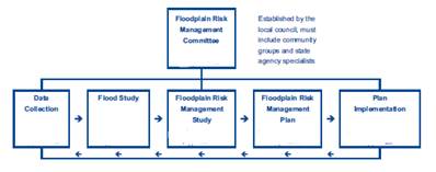
Figure 1 - Summary of the Floodplain Risk Management Process
To date, Council has completed 9 Flood Studies, identifying the existing flood impacts for 12 of its 15 catchments and representing approximately 90% of the Local Government Area.
In addition, Council has completed four Flood Risk Management Studies & Plans (FRMSP) which outline proposed mitigations options across eight of the catchment areas.
- Eastern Channel Subcatchment Management Plan (Golder Associates, 2011)
- Marrickville Valley Flood Risk Management Study & Plan (Cardno, 2017)
- Leichhardt Flood Risk Management Study & Plan (Cardno, 2017)
- Dobroyd Canal and Hawthorne Canal Flood Risk Management Study and Plan (WMA, 2019)
These studies provide a list of mitigation works covering almost 80% of the LGA.
The Flood Risk Management Studies commenced for Johnstons Creek and Whites Creek and Alexandra Canal will increase this total to 90% of the Local Government Area.
Current Study Progress
Council has engaged an external consultant Cardno to undertake both the Johnstons Creek and Whites Creek Flood Risk Management Study and the Alexandra Canal Flood Risk Management Study.
Work to date has been focused on amending existing models to the current rainfall standard (Australian Rainfall & Runoff 2019) to develop hazard mapping and identify areas where early response is required.
Proposed Community Engagement
Flood hazard management and mitigation methods are broadly categorised into three categories
- property modification (reducing the impact of flooding through a site by sensitive design)
- emergency response (modifying the behaviour of people during a flood event to reduce the consequence of a flood risk)
- flood modification measures (structural modification of flood behaviour to reduce the risk of flooding).
The proposed community engagement will seek the community’s understanding and appreciation of flooding and flood risk, as well as areas of interest and appetite for the above measures.
Community engagement is expected to commence on September 12 and continue for four weeks. It will include a page on Your Say Inner West with details of flooding, allowing residents to identify areas of concern and make recommendations for further work and investigation. Further questions will ask residents to outline their own understanding and experience of flooding in the area. In addition to the online engagement, two public drop-in information sessions for members of the Whites Creek and Johnston Creek area and two targeted sessions for the Alexandra Canal – one for residential impacts, and one for the business in the area.