|
AGENDA R |

Local Traffic Committee Meeting
MONDAY 17 APRIL 2023
11.00am
|
|
Local Traffic Committee Meeting 17 April 2023 |
Function of the Local Traffic Committee
Background
Roads and Maritime Services (RMS) is legislated as the Authority responsible for the control of traffic on all NSW Roads. The RMS has delegated certain aspects of the control of traffic on local roads to councils. To exercise this delegation, councils must establish a local traffic committee and obtain the advice of the RMS and Police. The Inner West Council Local Traffic Committee has been constituted by Council as a result of the delegation granted by the RMS pursuant to Section 50 of the Transport Administration Act 1988.
Role of the Committee
The Local Traffic Committee is primarily a technical review and advisory committee which considers the technical merits of proposals and ensures that current technical guidelines are considered. It provides recommendations to Council on traffic and parking control matters and on the provision of traffic control facilities and prescribed traffic control devices for which Council has delegated authority. These matters are dealt with under Part A of the agenda and require Council to consider exercising its delegation.
In addition to its formal role as the Local Traffic Committee, the Committee may also be requested to provide informal traffic engineering advice on traffic matters not requiring Council to exercise its delegated function at that point in time, for example, advice to Council’s Development Assessment Section on traffic generating developments. These matters are dealt with under Part C of the agenda and are for information or advice only and do not require Council to exercise its delegation.
Committee Delegations
The Local Traffic Committee has no decision-making powers. The Council must refer all traffic related matters to the Local Traffic Committee prior to exercising its delegated functions. Matters related to State Roads or functions that have not been delegated to Council must be referred directly to the RMS or relevant organisation.
The Committee provides recommendations to Council. Should Council wish to act contrary to the advice of the Committee or if that advice is not supported unanimously by the Committee members, then the Police or RMS have an opportunity to appeal to the Regional Traffic Committee.
Committee Membership & Voting
Formal voting membership comprises the following:
· one representative of Council as nominated by Council;
· one representative of the NSW Police from each Local Area Command (LAC) within the LGA, being Newtown, Marrickville, Leichhardt and Ashfield LAC’s.
· one representative from the RMS; and
· State Members of Parliament (MP) for the electorates of Summer Hill, Newtown, Heffron, Canterbury, Strathfield and Balmain or their nominees.
Where the Council area is represented by more than one MP or covered by more than one Police LAC, representatives are only permitted to vote on matters which effect their electorate or LAC.
Informal (non-voting) advisors from within Council or external authorities may also attend Committee meetings to provide expert advice.
Committee Chair
Council’s representative will chair the meetings.
Public Participation
Members of the public or other stakeholders may address the Committee on agenda items to be considered by the Committee. The format and number of presentations is at the discretion of the Chairperson and is generally limited to 3 minutes per speaker. Committee debate on agenda items is not open to the public.
|
|
Local Traffic Committee Meeting 17 April 2023 |
|
AGENDA |
1 Apologies
2 Disclosures of Interest
3 Confirmation of Minutes Page
Minutes of 20 March 2023 Local Traffic Committee Meeting 5
4 Matters Arising from Council’s Resolution of Minutes
5 Part A – Items Where Council May Exercise Its Delegated Functions
Traffic Matters
ITEM Page
LTC0423(1) Item 1 Terry Street Near Wise Street, Rozelle - Proposed Line Marking Treatments (Baludarri-Balmain Ward/Balmain Electorate/Leichhardt PAC) 17
LTC0423(1) Item 2 Wardell Road/Riverside Crescent, Dulwich Hill- Proposed Bicycles Excepted Signposting (Djarrawunang-Ashfield Ward/Summer Hill Electorate/Inner West PAC) 19
LTC0423(1) Item 3 Holden Street, Ashfield - Proposed Pedestrian Refuge, Mobility (Disabled) Parking Space And Postal Space Adjacent To Lewis Herman Reserve (Djarrawunang-Ashfield Ward/Summer Hill Electorate/Burwood PAC) 21
LTC0423(1) Item 4 Northcote Street, Marrickville – Pedestrian Safety Improvement Works – Project 303082 - Design Plan 10239– New Pedestrian Refuge (Midjuburi - Marrickville Ward/ Summer Hill Electorate/ Inner West PAC) 75
LTC0423(1) Item 5 Fairfowl Street at Pile Street, Dulwich Hill – Proposed Streetscape Improvements – Project 302892 - Design Plan 10206-A - Formalisation of Road Closure (Djarrawunang – Ashfield Ward /Summer Hill Electorate /Inner West LAC) 82
LTC0423(1) Item 6 Cavendish Street At Holt Street, Stanmore – Pedestrian Safety Improvement Works – Project 303082 – Design Plan 10243-1 - Raised Pedestrian Crossings (Damun - Stanmore Ward/ Newtown Electorate/ Inner West PAC) 88
Parking Matters
ITEM Page
LTC0423(1) Item 7 Lyall Street at Flood Street, Leichhardt – Proposed Kerb Ramp Realignment and Landscaped Blister Island Modification (Gulgadya - Leichhardt Ward/ Balmain Electorate/ Leichhardt PAC) 93
LTC0423(1) Item 8 Chester Street at Gehrig Lane, Annandale - Proposed 'No Stopping' restrictions (Gulgadya - Leichhardt Ward/ Balmain Electorate/ Leichhardt PAC) 95
Late Items
Nil at time of printing.
6 Part B - Items for Information Only
Nil at the time of printing.
7 Part C - Items for General Advice
Nil at the time of printing.
8 General Business
9 Close of Meeting
|
|
Local Traffic Committee Meeting 17 April 2023 |
Minutes of Local Traffic Committee Meeting
Held on 20 March 2023 at Ashfield Service Centre
Meeting commenced at 11.00am
ACKNOWLEDGEMENT OF COUNTRY BY CHAIRPERSON
I acknowledge the Gadigal and Wangal people of the Eora nation on whose country we are meeting today, and their elders past and present.
COMMITTEE REPRESENTATIVES PRESENT
|
Mayor Darcy Byrne |
Councillor – Baludarri-Balmain Ward (Chair) |
|
Bill Holliday |
Representative for Jamie Parker MP, Member for Balmain |
|
Graeme McKay |
Representative for Jo Haylen MP, Member for Summer Hill |
|
Patricia Arcilla |
Representative for Jenny Leong MP, Member for Newtown |
|
Sgt Charles Buttrose |
NSW Police – Leichhardt Police Area Command |
|
Jerimia Tukadra |
Transport for NSW (TfNSW) |
|
|
|
|
NON VOTING MEMBERS IN ATTENDANCE |
|
|
|
|
|
Van Le |
Transport for NSW (TfNSW) |
|
Colin Jones |
Inner West Bicycle Coalition (IWBC) |
|
Manod Wickramasinghe |
IWC’s Traffic and Transport Services Manager |
|
Sunny Jo |
IWC’s Coordinator Traffic Engineering Services (North) |
|
George Tsaprounis |
IWC’s Coordinator Traffic Engineering Services (South) |
|
Jason Scoufis |
IWC’s Traffic and Parking Planner |
|
Charbel El Kazzi |
Graduate Civil Engineer – Traffic Services |
|
Zara Helal |
Engineer – Traffic and Parking Services |
|
Christina Ip |
IWC’s Business Administration Officer |
|
|
|
|
VISITORS |
|
|
|
|
|
Nil. |
|
|
|
|
|
APOLOGIES: |
|
|
|
|
|
Jason Yat-sen Li MP |
Member for Strathfield |
|
|
|
DISCLOSURES OF INTERESTS:
Nil.
CONFIRMATION OF MINUTES
|
The Minutes of the Local Traffic Committee meeting held on 20 February 2023, and the Minutes of the Extraordinary Local Traffic Committee meeting held on 28 February 2023 were confirmed. |
MATTERS ARISING FROM COUNCIL’S RESOLUTION OF MINUTES
The Local Traffic Committee recommendations of its meeting held on 20 February 2023, and the Extraordinary Local Traffic Committee recommendations of its meeting held on 28 February 2023 were adopted at Council’s meeting on 14 March 2023.
|
LTC0323(1) Item 3 Stevens Lane, Marrickville - Proposed installation of 'No Parking' restrictions along both sides of the laneway (Midjuburi – Marrickville Ward / Newtown Electorate / Inner West PAC) |
|
Concerns have been raised with Inner West Council regarding the inconsistency of ‘No Parking’ restrictions along Stevens Lane, Marrickville especially after recent development in the area. This situation has been reviewed and a proposal has been developed which will provide a consistency of restrictions along the laneway. The proposal is to install full time ‘No Parking’ restrictions along both sides of the laneway.
Officer’s Recommendation
That statutory 10m ‘No Stopping’ restrictions and full-time ‘No Parking’ restrictions be installed along both sides of Stevens Lane, Marrickville between Philpott Street and Fotheringham Lane in order to provide consistency of ‘No Parking’ restrictions along the laneway.
DISCUSSION
The Committee members agreed with the Officer’s recommendation.
COMMITTEE RECOMMENDATION
That statutory 10m ‘No Stopping’ restrictions and full-time ‘No Parking’ restrictions be installed along both sides of Stevens Lane, Marrickville between Philpott Street and Fotheringham Lane in order to provide consistency of ‘No Parking’ restrictions along the laneway.
For motion: Unanimous
|
|
LTC0323(1) Item 5 Dudley Street, Dulwich Hill; Burrows Avenue, Railway Road, Gleeson Avenue and (Lower) Railway Parade, Sydenham - Temporary Parking Changes During Major Rail Shutdown Of T3 Line For Sydney Metro Upgrade Works - Bus Replacements For 4 Days Between Thursday 20 April To Sunday 23 April 2023 (Midjuburi - Marrickville Ward / Summer Hill Electorate / Inner West PAC) |
|
Council has been notified by Transport for NSW (TfNSW) that Sydney Metro works will require a major rail shutdown of the Sydenham to Bankstown rail line (T3) for a 4 day period between Thursday, 20 April to Sunday, 23 April 2023 (inclusive). During the shutdown buses will replace train services along the T3 line and to accommodate the increased bus movements and necessary holding areas some short-term parking changes are required at a number of locations. Specifically, TfNSW is requesting approval for the temporary conversion of multiple parking spaces at the following locations: Dudley Street, Dulwich Hill; Burrows Avenue, Railway Road, Gleeson Avenue and (Lower) Railway Parade, Sydenham. It is recommended that no objections be raised, and Council approves the temporary short-term parking changes at the identified locations during the rail shutdowns.
Officer’s Recommendation
THAT this report be received and noted and the following temporary short-term parking changes from Thursday 20 April to Sunday 23 April 2023 (inclusive) be approved and implemented by TfNSW:
Dulwich Hill Station Precinct - Dudley Street (4 parking spaces) 1. The short-term conversion of 7m (1 parking space) ‘Loading Zone 8:30 am – 6 pm Mon – Fri & 8:30 am – 12:30 pm Sat’ on the northern side of Dudley Street (between Wardell Road and School Parade) to a ‘Bus Zone’ be approved in order to provide an additional bus bay with adequate draw-in length; 2. The short-term conversion of 18m (3 parking spaces) ‘P30 min 8:30 am – 6 pm Mon – Fri & 8:30 am – 12:30 pm Sat’ on the northern side of Dudley Street (between Wardell Road and School Parade) to a ‘Bus Zone’ be approved in order to provide an additional bus bay with adequate draw-in length;
Sydenham Station Precinct - Burrows Avenue (23 parking spaces)
3. The short-term conversion of 50m (14 parking spaces) rear to kerb ‘unrestricted parking’ on the northern kerb of Burrows Avenue (west of Gleeson Avenue) to a ‘Bus Zone’ be approved in order to provide additional bus bays for adequate bus draw-in/draw-out length;
4. The short-term conversion of 58m (9 parking spaces) ‘unrestricted parking’ on the southern kerb of Burrows Avenue (west of Gleeson Avenue) to a ‘Bus Zone’ be APPROVED in order to provide additional bus bays for bus layover purposes;
Sydenham Station Precinct – Railway Road (3 parking spaces)
5. The short-term conversion of 18m (3 parking spaces) ‘2P 8:30 am – 10 pm Mon - Fri’ on the eastern side kerb of Railway Road (between Burrows Avenue and Gleeson Avenue) to a ‘Bus Zone’ be approved in order to provide additional bus bays for bus layover purposes; Sydenham Station Precinct - Gleeson Avenue (2 parking spaces)
6. The short-term conversion of 12m (2 parking spaces) ‘1P 9:00 am – 3:30 pm Mon - Fri and No Parking 6 am-9 am & 3:30 pm – 6:30 pm’ on the eastern kerb of Gleeson Avenue (between Burrows Avenue and Unwins Bridge Road) to a ‘Bus Zone’ be approved in order to provide a bus stop extension with adequate draw-in/draw-out length; Sydenham Station Precinct -
7. The short-term conversion of 122m (46 parking spaces) 45 degree angled ‘unrestricted parking’ on the southern side kerb of Lower Railway Parade (between Sydenham Road and Marrickville Road) to a ‘Bus Zone’ be approved in order to provide additional layover and standby bus bays;
8. The short-term conversion of 32m (11 parking spaces) 45 degree angled parking ‘4P 8:30 am – 6 pm Mon - Fri’ on the southwest kerb of Lower Railway Parade (between Gleeson Avenue and Marrickville Road) to a ‘Bus Zone’ be approved in order to provide additional layover bus bays with adequate draw-in length; and
9. The applicant and Council Rangers be advised in terms of this report.
DISCUSSION
The Committee members agreed with the Officer’s recommendation.
COMMITTEE RECOMMENDATION
THAT this report be received and noted and the following temporary short-term parking changes from Thursday 20 April to Sunday 23 April 2023 (inclusive) be approved and implemented by TfNSW:
Dulwich Hill Station Precinct - Dudley Street (4 parking spaces) 1. The short-term conversion of 7m (1 parking space) ‘Loading Zone 8:30 am – 6 pm Mon – Fri & 8:30 am – 12:30 pm Sat’ on the northern side of Dudley Street (between Wardell Road and School Parade) to a ‘Bus Zone’ be approved in order to provide an additional bus bay with adequate draw-in length; 2. The short-term conversion of 18m (3 parking spaces) ‘P30 min 8:30 am – 6 pm Mon – Fri & 8:30 am – 12:30 pm Sat’ on the northern side of Dudley Street (between Wardell Road and School Parade) to a ‘Bus Zone’ be approved in order to provide an additional bus bay with adequate draw-in length;
Sydenham Station Precinct - Burrows Avenue (23 parking spaces)
3. The short-term conversion of 50m (14 parking spaces) rear to kerb ‘unrestricted parking’ on the northern kerb of Burrows Avenue (west of Gleeson Avenue) to a ‘Bus Zone’ be approved in order to provide additional bus bays for adequate bus draw-in/draw-out length;
4. The short-term conversion of 58m (9 parking spaces) ‘unrestricted parking’ on the southern kerb of Burrows Avenue (west of Gleeson Avenue) to a ‘Bus Zone’ be APPROVED in order to provide additional bus bays for bus layover purposes;
Sydenham Station Precinct – Railway Road (3 parking spaces)
5. The short-term conversion of 18m (3 parking spaces) ‘2P 8:30 am – 10 pm Mon - Fri’ on the eastern side kerb of Railway Road (between Burrows Avenue and Gleeson Avenue) to a ‘Bus Zone’ be approved in order to provide additional bus bays for bus layover purposes; Sydenham Station Precinct - Gleeson Avenue (2 parking spaces)
6. The short-term conversion of 12m (2 parking spaces) ‘1P 9:00 am – 3:30 pm Mon - Fri and No Parking 6 am-9 am & 3:30 pm – 6:30 pm’ on the eastern kerb of Gleeson Avenue (between Burrows Avenue and Unwins Bridge Road) to a ‘Bus Zone’ be approved in order to provide a bus stop extension with adequate draw-in/draw-out length; Sydenham Station Precinct -
7. The short-term conversion of 122m (46 parking spaces) 45 degree angled ‘unrestricted parking’ on the southern side kerb of Lower Railway Parade (between Sydenham Road and Marrickville Road) to a ‘Bus Zone’ be approved in order to provide additional layover and standby bus bays;
8. The short-term conversion of 32m (11 parking spaces) 45 degree angled parking ‘4P 8:30 am – 6 pm Mon - Fri’ on the southwest kerb of Lower Railway Parade (between Gleeson Avenue and Marrickville Road) to a ‘Bus Zone’ be approved in order to provide additional layover bus bays with adequate draw-in length; and
9. The applicant and Council Rangers be advised in terms of this report.
For motion: Unanimous |
General Business
Meeting closed at 11.17am.
|
|
Local Traffic Committee Meeting 17 April 2023 |
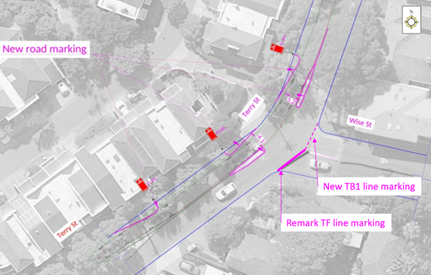
Subject: Terry Street near Wise Street, Rozelle - Proposed Line Marking Treatments (Baludarri-Balmain Ward/Balmain Electorate/Leichhardt PAC)
Prepared By: Zara Helal - Engineer - Traffic and Parking Services
Authorised By: Manod Wickramasinghe - Traffic and Transport Planning Manager
SUMMARY
Council is proposing linemarking improvements at the intersection of Terry Street and Wise Street, Rozelle. This proposal was one of the recommendations from the Rozelle North Local Area Traffic Management (LATM) Study adopted by Council in September 2022.
This section of Terry Street is used by students from the Sydney Secondary College Balmain Campus to cross Terry Street to access the Darling Street shopping village. The changes will discourage speeding behavior and thereby improve safety for all road users.
The proposed line marking provisions include new edge lines around the existing median islands and edge lines on Terry Street and Give Way lines across Wise Street.
The proposed treatment does not result in the loss of on-street parking.
|
RECOMMENDATION
That the proposed linemarking treatment at the intersection of Terry Street and Wise Street, Rozelle including new edge lines around the existing median islands and edge lines on Terry Street, and TB lines across Wise Street, as shown in the attached linemarking plan be APPROVED. |
BACKGROUND & OTHER STAFF COMMENTS
The Rozelle North LATM study has recommended minor line marking improvements be implemented to reduce vehicle speeds by defining the travel path along the intersection of Terry Street near Wise Street. The proposed line marking will guide vehicles away from the median islands, on-street parked cars on Terry Street, and the intersection with Wise Street.
The concept plan below illustrates the proposed line marking treatment to be implemented in this area.
The proposed treatment does not result in the loss of on-street parking.
FINANCIAL IMPLICATIONS
The costs of installation of the line marking as recommended can be funded within Council's signs and line marking budget.
PUBLIC CONSULTATION
Nil.
Nil.
|
|
Local Traffic Committee Meeting 17 April 2023 |
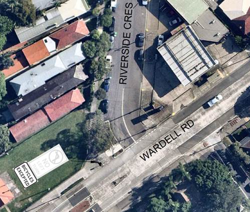
Subject: Wardell Road/Riverside Crescent, Dulwich Hill- Proposed Bicycles Excepted Signposting (Djarrawunang-Ashfield Ward/Summer Hill Electorate/Inner West PAC)
Prepared By: Jason Scoufis - Traffic and Parking Planner
Authorised By: Manod Wickramasinghe - Traffic and Transport Planning Manager
SUMMARY
Council is planning to improve cyclists’ connectivity by introducing a ‘Bicycles Excepted’ sign in association with the existing ‘No Left Turn’ sign at the Wardell Road/Riverside Crescent intersection which will allow cyclists heading northeast in Wardell Road to make a left turn into Riverside Crescent.
|
RECOMMENDATION
That the existing ‘No Left Turn’ restriction be supplemented with ‘Bicycles Excepted’ signposting at the Wardell Road/Riverside Crescent intersection.
|
BACKGROUND
Council has received representations from the Inner West Bicycle Coalition requesting cyclists be allowed to turn left into Riverside Crescent when heading northeast in Wardell Road. Under the current ‘No Left Turn’ signposting, cyclists are banned from making this maneuver.
A review of the intersection indicates that the road geometry allows clear sight lines between cyclists heading northeast in Wardell Road making a left turn into Riverside Crescent and vehicles heading southwest in Wardell Road making a right turn into Riverside Crescent.
The proposal will improve cyclist connectivity to the Greenway and is shown on the following plan.
FINANCIAL IMPLICATIONS
Nil.
PUBLIC CONSULTATION
Not applicable.
Nil.
|
|
Local Traffic Committee Meeting 17 April 2023 |
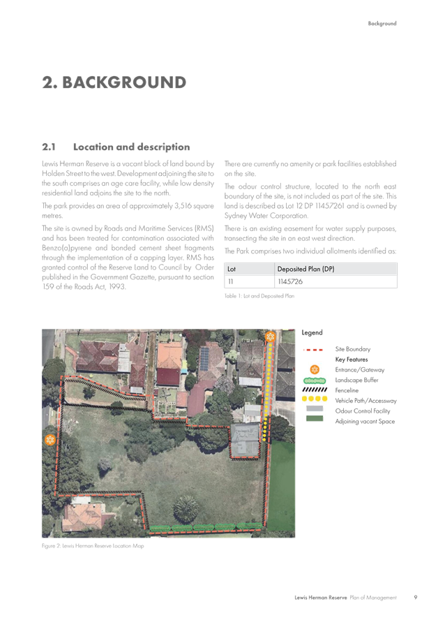
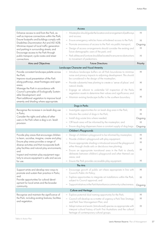
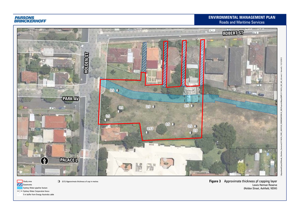
Subject: Holden Street, Ashfield - Proposed pedestrian
refuge, mobility (disabled) parking space and postal space adjacent to Lewis
Herman Reserve.
(Djarrawunang-Ashfield Ward/Summer Hill Electorate/Burwood PAC)
Prepared By: Boris Muha - Engineer – Traffic and Parking Services
Authorised By: Manod Wickramasinghe - Traffic and Transport Planning Manager
SUMMARY
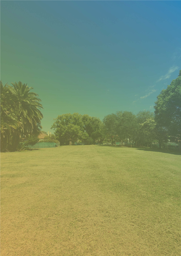
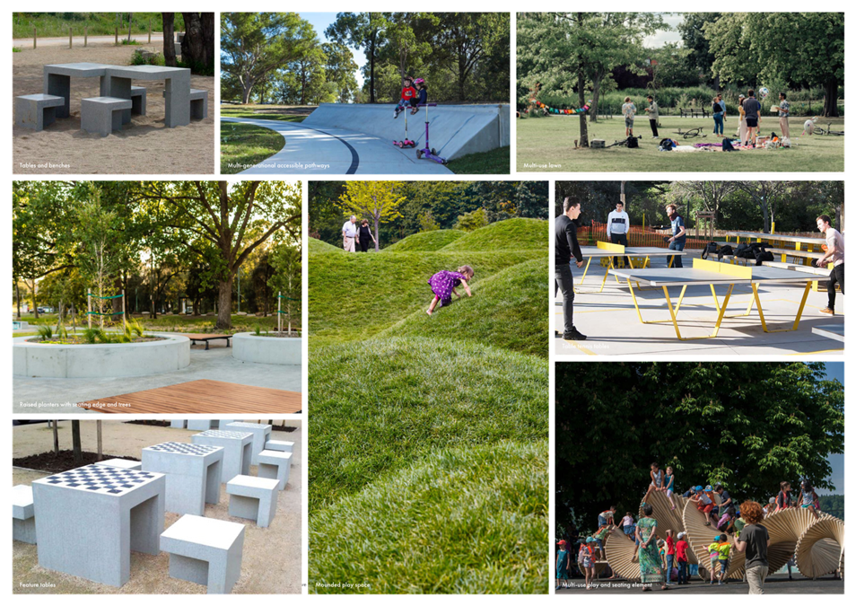
The Lewis Herman Reserve in Ashfield is currently being developed under a Plan of Management for community recreational purposes. The Park is being designed to be a family park with a special emphasis on older adults needs including being Sydney’s first dementia friendly park.
In association with this development a pedestrian refuge is proposed adjacent to the reserve in Holden Street to improve pedestrian safety for visitors accessing the reserve whilst crossing Holden Street.
Similarly, a mobility parking space is also proposed adjacent to the reserve to cater for mobility impaired or elderly visitors attending the reserve. An existing Australia Post Box facility in the area will be formally designated as ‘No Parking Australia Post Vehicles Excepted’.
|
RECOMMENDATION
That the design concept plan Option 2 (attachment 3) be APPROVED in principle and listed for consideration on Council’s capital works program, subject to detailed design and community consultation being undertaken on the following measures:
1. A pedestrian refuge be constructed in Holden Street, Ashfield, to the north of Park Avenue, outside the Lewis Herman Reserve, with a kerb blister extension only to the eastern side of the street. 2. A 7.8m mobility parking space (line marked and with a pram ramp) be allocated on the eastern side of Holden Street at the southern end of The Lewis Herman Reserve. 3. A ‘No Parking Australia Post Vehicle Excepted’ zone 8-10 metres in length be allocated and signposted south of the mobility parking space at the end of the park.
|
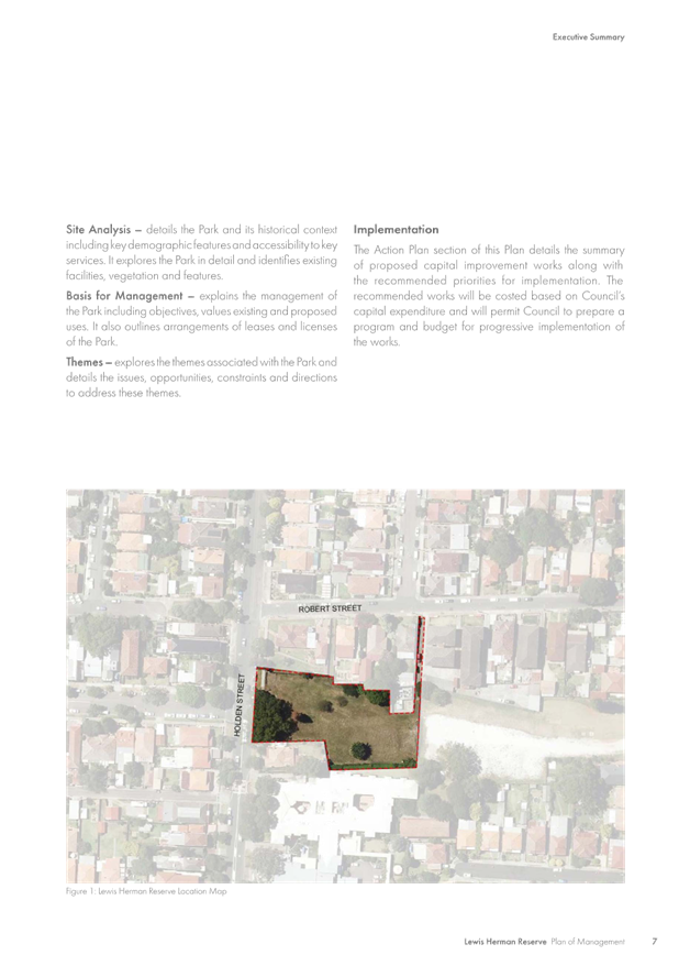
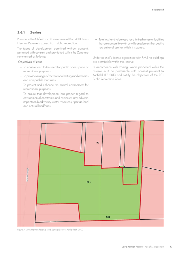
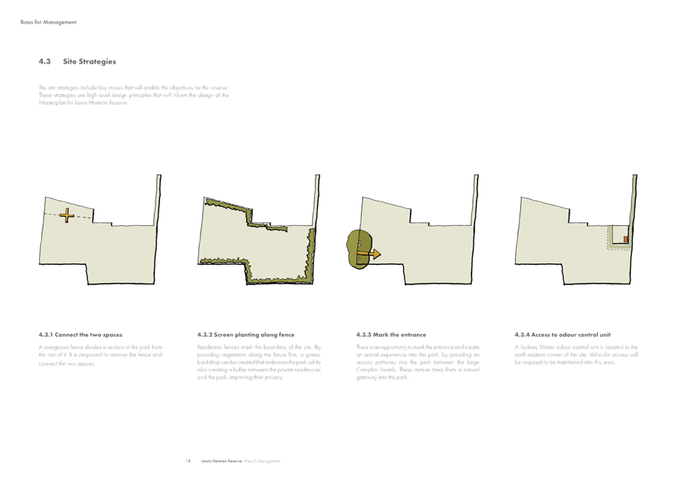
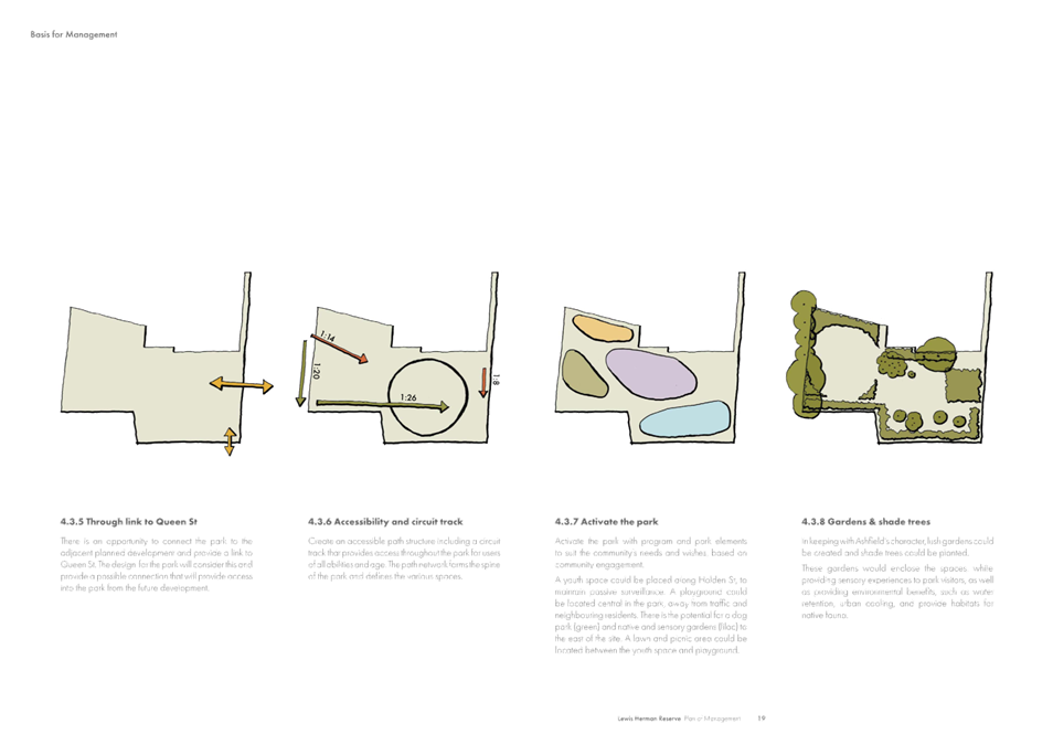
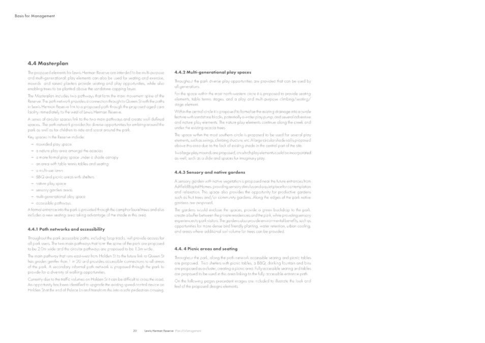
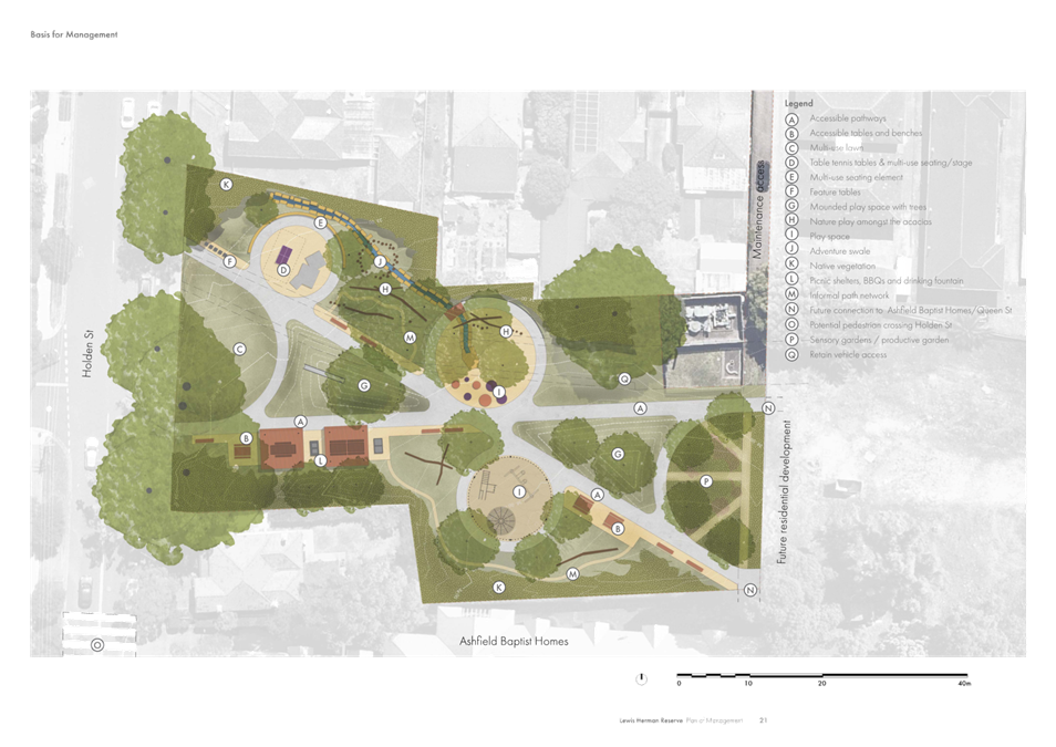
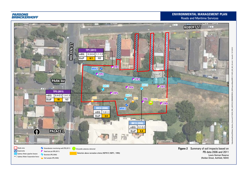
BACKGROUND
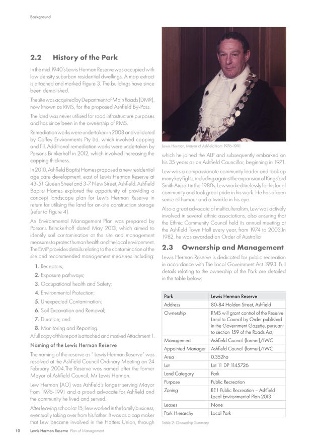
The Plan of Management as shown in Attachment 1 details the history and naming of the Reserve after the former Mayor of Ashfield, Mr Vale Lewis Herman (1976-1991), including the purpose and future management of the park.
On 1 February 2019, Inner West Council signed an agreement with the Roads and Maritime Services (as the road reserve owner) for the use of the land as public reserve.
‘Investigate and report back to Council’s Traffic Committee on community feedback in relation to expressed community needs for a pedestrian crossing to the new reserve in Holden Street, Ashfield.’
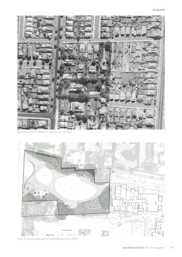
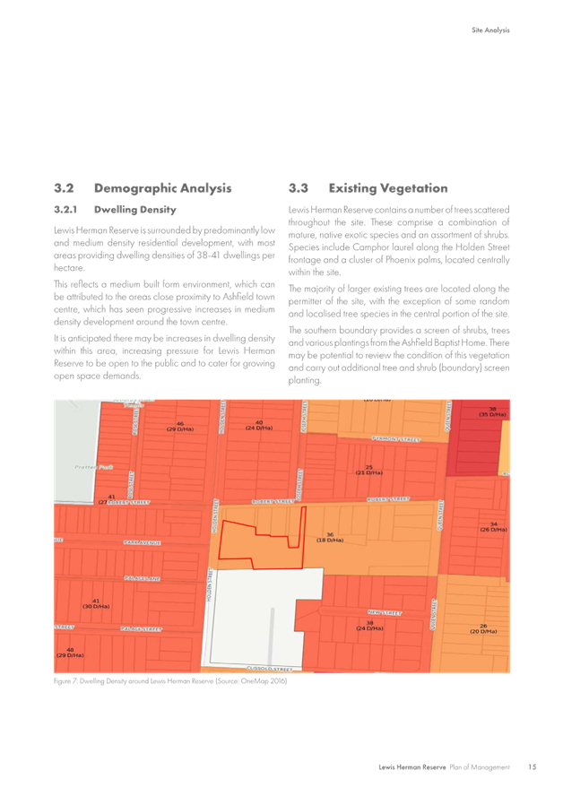
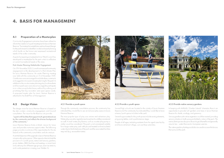
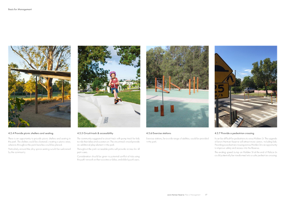
Diagram 1 below shows the development of the park extracted from The Plan of Management document. A pedestrian crossing has been suggested where an existing speed hump is currently located in Holden Street (next to Palace Lane, approximately 30m south of the park entry).
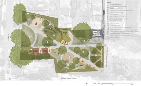
Diagram 1. Recreational development of Lewis Herman Reserve.
FINANCIAL IMPLICATIONS
OTHER STAFF COMMENTS
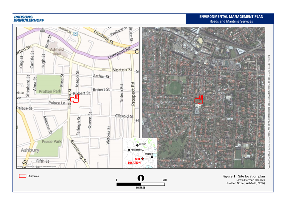
Site location and Road Network
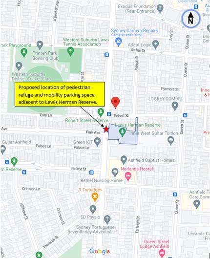
Diagram 2. Locality Plan.
|
Street Name |
Holden Street (at intersection with Park Avenue) |
|
Carriageway width (m) kerb to kerb |
Varies from approx.10.4m to 12.5m |
|
Carraigeway type |
Two-way, one travel lane each direction, kerb side parking both sides. |
|
Classification |
Local |
|
Speed Limit km/h |
50 |
|
85th percentile speed km/h |
48-50 |
|
Vehicles per day (vpd) |
8500-9500 |
|
Reported crash history July 2016-Dec 2021 |
No accidents in the vicintiy of the intersection and outside the Lewis Herman Reserve. |
|
Parking arrangements |
Eastside, unrestricted parking. Westside, Bus zone and No Parking/No Stopping in area of the intersection with Park Avenue. |
|
Side streets |
Park Avenue - local street -approx.12.8m wide- around 2600vpd. |
Examination into the pedestrian crossing.
Prior to consulting the community of any planed pedestrian safety measures in the area, it was necessary to establish through whether a pedestrian crossing could be justified under a reduced warrant with practicing guidelines the Transport for NSW utilises in accordance with the Supplement to Australian Standards AS 1742.10-2009.
It was considered that a crossing facility be best positioned adjacent to the park for easier access, and to cater for likely desire line movement of pedestrians south and north of Holden Street, and west of Park Avenue.
Pedestrian movements on site were observed to be very low with less than 5 pedestrians per hour in peak periods of the day. Holden Street being a local-collector road links high volumes of traffic movement from Liverpool Road in Ashfield to south of the LGA towards Canterbury Road, Canterbury. Traffic volumes were observed to be up to 950 vehicles per hour in peak periods of the day. Pedestrian numbers are required to be equal to or over 30 per hour to meet the reduced warrant for a crossing. Traffic volumes are over the required 200 per hour under reduced warrant. Both pedestrian numbers and traffic volumes must be met to consider a pedestrian crossing.
Noting the low pedestrian volumes but considering the need for improved pedestrian safety in the area, it is proposed that a pedestrian refuge be implemented in Holden Street at the intersection with Park Avenue as an alternative measure for pedestrian safety failing the warrant of a pedestrian crossing at this point of time. A refuge allows pedestrians to cross safely in two stages. Pedestrians can stand safely within the refuge in the middle of the road before crossing under the second stage.
Location of the Pedestrian refuge.
The refuge is proposed in Holden Street to the northern side of the intersection with Park Avenue. By doing so this provides least impact to parking changes and avoids removing any parking adjacent to residential properties. Any parking changes associated with the refuge is generally contained within the boundary of the Lewis Herman Reserve. The refuge would be so designed to retrofit and upgrade to a pedestrian crossing if pedestrian activity to the park increases in future and if revised warrants and other criteria (e.g. sight view distances) are considered to be met.
Two (2) conceptual plan options are shown below with the refuge and associated parking changes. The purpose of this report is to show to the committee the technical design aspects of the proposal and to consider the best option to then go out to community consultation.
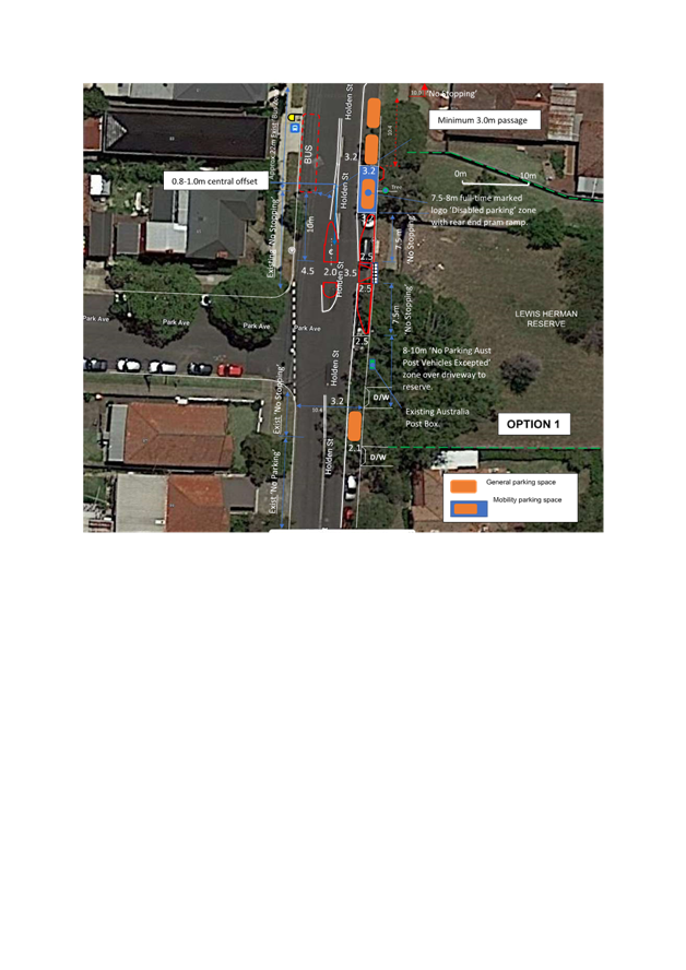
Option 1 (Attachment 2)
· The refuge is to the northern side of the intersection.
· The refuge is 2m wide and offset in the middle of the road closer to the western side.
· A kerb island blister 2.5m wide is provided and connected to the footway with a steel (grid) plated fixture going over the gutter.
· No kerb blister island is provided to the western side, as buses need to approach close and parallel to the Bus Stop 10 metres to the north of the refuge.
· A mobility parking space is provided to the north of the refuge outside the park. As the space will serve for general disability requirements, it will be signposted, bay marked with a disabled logo insignia, together with a pram ramp added to coincide with Australian Standard practice. The space will be dimensioned 7.8m long and 3.2m wide.
· ‘No Stopping’ on approach and departure sides on the eastern side to the refuge will be 7.5m in length, acceptable under the TfNSW Technical directions where there is a kerb extension/blister connection of 2.5m wide.
· The existing Australia Post Box (having infrequent collection times) and located to the north of the maintenance driveway to the park will be formalised with signposting reading ‘No Parking Australia Post Vehicles Excepted’. The zone will be extended over the driveway to provide an additional length and clearance opportunity for the public to drop off and pick up of passengers to the park.
· Three (3) unrestricted parking spaces would be lost on the eastern side of Holden Street. One (1) additional parking space will be converted as a mobility parking space. All parking changes are carried out within the boundary length of the park.
· No parking spaces are affected to the western side of the refuge facility.
Option 2 (Attachment 3)
All the points above remain the same with the exception that the mobility parking space is proposed to the south of the refuge and that the Australia Post box space designated with signposted zone will be placed to the south of the maintenance driveway access and main pathway to the reserve. Current ‘No Parking’ to the western side of Holden Street south of Park Avenue will be converted to ‘No Stopping’ to allow further offset in centreline marking for south bound traffic to veer around the mobility parking space. No vehicles park to the western side of Holden Street leading back to the speed hump located approximately 30 metres south of the park entry.
Option 1 serves to provide a mobility parking space near to a secondary pathway located to the northern end of the reserve. -see diagram 1. The mobility parking space would be positioned and protected from traffic by vehicles parking to the north. An existing tree at this location may pose obstruction for proper mobility vehicular access. Southbound traffic may need to swerve/kink around the widened mobility parking space in approach to the refuge.
Option 2 serves to provide a mobility parking space near to the main pathway located to the southern end of the reserve. An existing Australia Post Box would need to be relocated to the south of the driveway servicing the park. This will in turn allow full footway clearance access to the mobility parking space. The current unrestricted parking spot to the south of the maintenance driveway (still within the frontage of the park) will be converted to accommodate ‘No Parking Australia Post Vehicles Excepted’ zoned area. The southern end of the physical kerb blister can be lengthened out to guide traffic away from the mobility parking zone. Southbound traffic would have a cleaner approach into the refuge with the kerb space width to the north being down to 2.5m. Traffic can veer to the west coming around the mobility parking space south of the refuge.
Both options have the pedestrian refuge proposed in Holden Street, just north of Park Avenue.
Option 2 is considered more appropriate as the mobility parking space is positioned near/outside the main pathway to the park. Traffic is considered to have a cleaner approach into the refuge and departure out of the refuge. Edge lines and centreline markings will be incorporated to guide and control traffic though the refuge and around the mobility parking space.
Parking Changes
It is proposed under the design concept plan Option 2 that three (3) unrestricted parking spaces will need to be lost on the eastern side of Holden Street to accommodate the refuged kerb blister and required ‘No Stopping’ zones for pedestrian sight view. An additional one (1) unrestricted parking spot will be converted to accommodate the mobility parking space. Under the Road Rules vehicles should not park within 3 metres of an Australian Post box. The Australian Post box will be relocated to the south of the driveway and zoned 8-10 metres in length spanning over the maintenance driveway. The loss or conversion of parking is within the boundary length of the park.
Streetlighting
The lighting in the area will be examined under detailed design.
PUBLIC CONSULTATION
CONCLUSION
In view of the above, for improved pedestrian safety and needed parking changes outside the Lewis Herman Reserve in Holden Street, Ashfield, it is recommended that the design concept plan Option 2 (attachment 3) be APPROVED in principle, subject to detailed design and community consultation being undertaken on the following measures:
1. A pedestrian refuge be constructed in Holden Street, Ashfield, to the north of Park Avenue, outside the Lewis Herman Reserve, with a kerb blister extension only to the eastern side of the street.
2. A mobility parking space 3.2 metres wide and signposted approximately 7.5-8.0 metres in length (line marked and logoed together with a pram ramp) be allocated on the eastern side of Holden Street at the southern end of The Lewis Herman Reserve.
3. A ‘No Parking Australia Post Vehicle Excepted’ zone 8-10 metres in length be allocated and signposted south of the mobility parking space at the end of the park.
|
1.⇩ |
Plan of Management for Lewis Herman Reserve |
|
2.⇩ |
Proposed pedestrian refuge and parking changes- Option 1 |
|
3.⇩ |
Proposed pedestrian refuge and parking changes-Option 2 |
|
|
Local Traffic Committee Meeting 17 April 2023 |
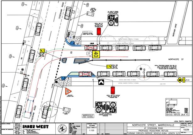
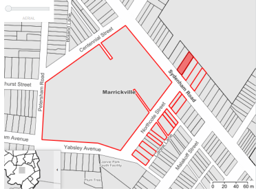
Subject: Northcote Street, Marrickville – Pedestrian Safety Improvement Works – Project 303082 - Design Plan 10239– new pedestrian refuge (MIDJUBURI - MARRICKVILLE WARD/ SUMMER HILL ELECTORATE/ INNER WEST PAC)
Prepared By: Jennifer Adams - Engineer – Traffic and Parking Services
Authorised By: Manod Wickramasinghe - Traffic and Transport Planning Manager
SUMMARY
|
RECOMMENDATION
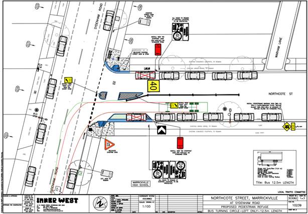
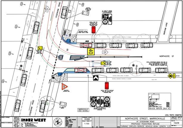
That the detailed design plan for the installation of a pedestrian refuge island, a landscaped kerb blister and new adjacent kerb ramps and associated signs and line markings in Northcote Street at Sydenham Road, Marrickville (as per Plan No. 10239) be APPROVED.
|
BACKGROUND
Council is planning to improve safety for pedestrians by installing a pedestrian refuge island as well as a landscaped kerb blister island in Northcote Street (intersection with Sydenham Road), Marrickville. The proposal aims to improve safety for pedestrians and school children by providing a safe storage area at the centre of the road as they cross, whilst also better defining traffic lanes for motorists as they approach the intersection. This report details the design plan for those improvement works and its related consultation results.
FINANCIAL IMPLICATIONS
The project is listed on Council’s Traffic Facilities Capital Works budget (PAMP) for 2023/24 and funding of $62,000 has been allocated to this project.
OTHER STAFF COMMENTS
The proposed scope of works is shown in Attachment 1 and includes the following:
· Construct a concrete pedestrian refuge island together with associated signage and line markings;
· Construct a landscaped kerb blister island;
· Construct 2 new concrete kerb ramps;
· Reconstruct damaged sections of concrete footpath with new concrete footpath (where shown on plans);
· Resurface the existing asphalt road with new asphalt (where shown on plans);
· Install 2 new “No Stopping” signs on either side of Northcote Street in the vicinity of the new pedestrian refuge island to comply with statutory requirements.
Parking Changes
This proposal will require 2 new “No Stopping” signs to be installed which will result in the loss of two (2) on-street parking spaces in Northcote Street near Sydenham Road. Please refer to the attached Plans.
Streetlighting
The existing lighting is deemed adequate and therefore there will be no changes to the existing street lighting due to the proposed works.
Turning circles
Turning circle diagrams are shown below for a 12.5 metre bus turning out of Northcote Street onto Sydenham Road and for a 8.8 metre service truck turning in and out of Northcote Street.
PUBLIC CONSULTATION
Two (2) residents responded, both raised the issue of local flooding in the area not being addressed as opposed to the design plan for the new pedestrian refuge. One resident wanted to know whether the proposed pedestrian refuge will compound the existing flooding issues on Northcote Street, Marrickville. Their concerns are listed below.
|
Resident’s Comments |
Officer’s response |
|
Support subject to below caveats: Prioritisation
of commitments. The resident noted that the
most pressing issue affecting residents, school staff and families, and pedestrians
is the frequent and repeated flooding of Northcote Street, which makes the
street both inaccessible and unsafe. They understand various stormwater
upgrades are being designed this financial year, to be constructed in
2023/2024. Should it be necessary to prioritise funding or timing of works
for these two initiatives, priority should be given to addressing the issue
of flooding. |
General support noted. The implementation of this project will not impact or intensify the flooding issues experienced in Northcote Street It is noted that the gutter width at the proposed kerb blister island (garden bed) is proposed to be 600mmn wide instead of normal 450mm wide. which will aid in the movement of any water. Council’s Stormwater Team will be asked to see if a priority can be put on any proposed stormwater upgrades in Northcote Street. There is no foreseen impact on flooding due to the implementation of this pedestrian refuge island project.
|
|
A number of existing flooding issues in Northcote Street, Carew and Warham Lanes were raised opposed to any comment on the proposed pedestrian refuge. |
It is noted that this PAMP project is the installation of a pedestrian refuge for pedestrians, students, visitors to improve their safety while crossing Northcote Street at Sydenham Road. Many of the issues raised are outside the scope of the project and as the project does not impact any existing flooding and drainage issues all detailed concerns raised by the resident will be internally referred to Council’s Stormwater Team for investigation and action. All supplied photos will also be forwarded to Council’s Stormwater Team. |
CONCLUSION
It is recommended that the detailed design plan for the proposed pedestrian refuge and associated signs and line markings be supported to improve pedestrian safety at this location.
|
1.⇩ |
303082-10239-Consultation-Plans |
|
Local Traffic Committee Meeting 17 April 2023 |
Subject: Fairfowl Street at Pile Street, Dulwich Hill – Proposed Streetscape Improvements – Project 302892 - DESIGN PLAN 10206-A - Formalisation of road closure (Djarrawunang – Ashfield Ward /Summer Hill Electorate /Inner West LAC)
Prepared By: Jennifer Adams - Engineer – Traffic and Parking Services
Authorised By: Manod Wickramasinghe - Traffic and Transport Planning Manager
SUMMARY
Council has prepared a design plan to formalise the existing road closure at the intersection of Fairfowl Street and Pile Street, Dulwich Hill. The intention of the proposal is to improve the overall amenity and streetscape of this location by providing landscaping, improving pedestrian and vehicular access and formalising parking arrangements in the vicinity of the road closure whilst also replacing deteriorated road and footpath assets.
|
RECOMMENDATION
That the detailed design plan for the formalisation of the road closure at the intersection of Fairfowl Street and Pile Street, Dulwich Hill and associated signs and line marking (as per Plan No.10206-A) be APPROVED. |
BACKGROUND
As part of the Traffic Facilities Capital Works Program, it is proposed to upgrade the intersection of Fairfowl Street and Pile Street, Dulwich Hill. The project was initiated via a local resident petition (35 properties) requesting an upgrade the existing streetscape of this intersection.
This project also includes improvement to pedestrian and motorist safety by providing new footpaths, a crossover facility and designated on-street parking.
Due to a number of objections to the loss of one on-street parking (in front of 3A Fairfowl Street) as proposed in the initial consultation plan (No.10206), Council has amended the original consultation plan (No.10206-A) accordingly to address the issue. This report details the final amended design plan for those improvement works and its related consultation results.
FINANCIAL IMPLICATIONS
Funding of $15,000 has been allocated to this project for design only in the 2022/23 Capital Works Program. The project is listed on Council’s Traffic Facilities Capital Works budget for 2023/2024 and further funding of $159,000 will be allocated to this project.
OTHER STAFF COMMENTS
The following works are proposed and are illustrated on the attached consultation plan (Plan No. 10206-A). The proposed works will improve the overall amenity and streetscape of this location and improve pedestrian and vehicular access by formalising parking arrangements in the vicinity of the road closure.
Specifically, the proposed scope of works includes the following:
· Construct new sandstone kerb (where possible, if not concrete) and concrete gutter to new design levels in Fairfowl Street and Pile Street to formalise and create a new landscaped road closure. Landscaping will consist of native grasses species, ground cover as well as one new street tree;
· Construct 2 new landscaped kerb blister islands in Pile Street to incorporate / formalise 8 x 90 degree angle parking spaces;
· Construct 1 new landscaped kerb blister island incorporating a kerb ramp, as well as a kerb ramp on the opposite side of the road, to provide an accessible crossing point for pedestrians (on the north side of Pile Street);
· Remove existing concrete footpath and construct new concrete footpaths (where shown on plans);
· Construct 1 new stormwater drainage inlet pit in front of No.3A Fairfowl Street to provide drainage for the street and connect to the existing drainage outlet in Pile Street with new stormwater pipes;
· Remove any redundant street stormwater pits and pipes which are no longer required due to the new works;
· Repair any damaged existing private stormwater lines leading from your property (only between the front boundary and gutter) and only within the excavated area of footpath work;
· Resurface some of the road pavement with new asphalt in both Pile Street & Fairfowl Street (where shown on plans);
Please refer to the attached Plan (No. 10206-A) at the end of this report which illustrates the proposed works.
Parking Changes
The original proposal would have resulted in the loss of one (1) on-street parking space (in front of 3A Fairfowl Street), refer to the section of original plan reproduced below. The amended plan results in the loss of no on-street parking spaces. It is noted that some street parking may be affected temporarily to facilitate the construction activities during construction.
PUBLIC CONSULTATION
Consultation was conducted between 28/02/2023 and 17/03/2023. A letter along with a copy of the design plan was sent to residents / businesses in the immediate locality. A total of 53 letters were distributed.
There were six (6) responses. Two (2) objected to the proposal and four (4) were in general support of the proposal.
|
Resident’s Comments |
Officer’s response |
|
Objection. Resident asks for an outline by whom or why this proposal was instigated and associated costs.
Resident notes a number of parking issues in the street and locality due to lack of parking generally and use by non-residents and requests timed parking for residents. Lack of parking for residents is exuberated by overspill from new surrounding multi-residential development and proximity to Dulwich Hill High School.
Resident has concerns about the narrow width of Fairfowl Street at its corner with Pile Street saying that it is a tight corner and there is minimal room to navigate now especially when another vehicle is travelling in the opposite direction. Having vehicles reverse parking simultaneously will add to the unsafe situation. Angle parking should be sited on the northern side of Pile Street as those properties do not have off-street parking.
TransGrid recent works have left the street a mess and it needs resurfacing. |
The project was initiated via a local resident petition requesting to make the location pedestrian friendly. The estimated cost is around $159,000.
In order for Council to investigate the possibility of introducing a Resident Parking Scheme and/or extend an existing one Council's current policy requires that requests be received from at least 10 individual properties in the street before consideration will be given to the introduction of any new schemes.
TfNSW recorded crash data reveals no incidents along Fairfowl Street between Herbert Street and Pile Street. Converting the north side of Pile Street into angle parking requires a number of considerations to be met under Australian Standards such as the camber of the road, the number of driveways, the placement of trees and the width of the road, kerb height and clearances. Overall parking provision would be reduced if placed on the northern side mainly due to the statutory 10m ‘No Stopping’ restriction (10 to 7 spaces).
Noted. This information will be provided to the Road Access team for action. |
|
General support. No concern to new landscaping but the resident does not want large tree.
Resident objects to the loss of the one (1) parking spot as lack of parking is an issue in the area. They suggest reducing the size of the landscaped area to retain the space.
The resident raised concerns about the narrowness of Fairfowl Street and its corner with Pile Street and that ambulances / waste service vehicles have limited access.
Resident requests Council to consider restricting parking in Charlecot, Fairfowl and Pile streets to residents only and everyone else limited to 2 hours only outside school and business hours. They state that there is an increasing number of cars coming and going at all hours of the night and leaving and dumping rubbish.
|
Noted. The tree (Angophora Costata) will be a medium size tree.
In response to feedback the original consultation plan has now been amended and the size of the landscaping has been reduced and kerb set back to retain the on-street parking space.
Noted. Concerns raised are out of scope of the project. The proposal will not affect the existing width of the road.
In order for Council to investigate the possibility of introducing a Resident Parking Scheme and/or extend an existing one Council's current policy requires that requests be received from at least 10 individual properties in the street before consideration will be given to the introduction of any new schemes. |
|
General Support (2 similar responses). Resident objects to the loss of 1 parking spot. She suggests reducing the size of the landscaped area
Resident asks for restricted parking in the area |
In response to feedback the original consultation plan has now been amended and the size of the landscaping has been reduced and kerb set back to retain the on-street parking space.
In order for Council to investigate the possibility of introducing a Resident Parking Scheme and/or extend an existing one Council's current policy requires that requests be received from at least 10 individual properties in the street before consideration will be given to the introduction of any new schemes.
|
|
Support. Resident agrees with the proposal to reconstruct their driveway. Resident asks whether it's possible to add linemarkings to prevent vehicles parking right up to the garage. Resident has a slight concern of the distance of the crossover facility to the driveway.
Resident requests traffic calming on Fairfowl Street to discourage non-residential traffic and speeding. |
A 600mm wing allows additional space for the resident to leave and enter their garage The 1000mm distance from the garage to the kerb ramp is sufficient for both pedestrian and motorist safety. The new kerb blister also acts as a buffer to discourage vehicles to be parked too close to the garage.
Noted. Previous request for traffic calming responded to separately.
|
|
Objection. Resident asks that repairs to footpaths and other local streets are carried out before this project is implemented.
Resident has concerns that Council will not maintain the new streetscape corner.
TransGrid recent works over the last two years have left the street a mess and caused a lot of disruption. The Resident believes further disruption for little gain is not preferable. Resident believes that there is potential for further rates rises to cover these costs
|
Council continually assesses the condition of existing footpaths and lists works in its future Capital Program. This project was identified and works planned for a period of time.
It is noted that all new verge maintenance is undertaken on a 20 working day cycle from October to March, and a 40 working day cycle from April to September.
Noted. The costs for this project will be provided for under the Traffic Facilities program. It should be noted that this project was created due to a petition raised by 35 properties from this area. |
CONCLUSION
It is recommended that the detailed design plan of the proposed traffic treatment and associated signs and line markings be supported to improve traffic conditions at this location.
|
1.⇩ |
302892 - 10206-A - Consultation Plan (Amended) |
|
|
Local Traffic Committee Meeting 17 April 2023 |
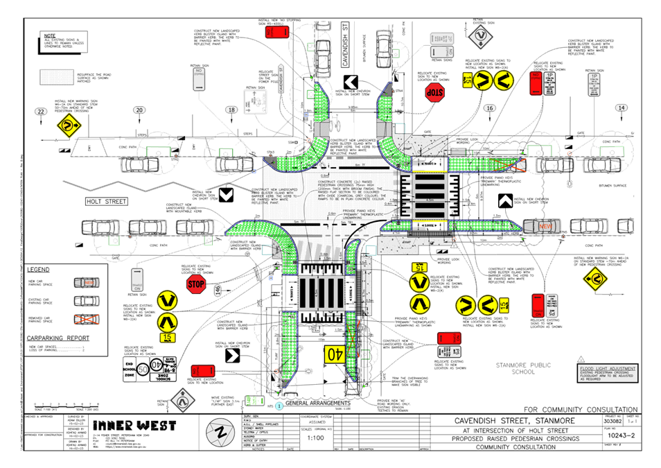
Subject: Cavendish Street at Holt Street, Stanmore – Pedestrian Safety Improvement Works – Project 303082 – Design Plan 10243-1 - raised pedestrian crossings (DAMUN - STANMORE WARD/ NEWTOWN ELECTORATE/ INNER WEST PAC)
Prepared By: Jennifer Adams - Engineer – Traffic and Parking Services
Authorised By: Manod Wickramasinghe - Traffic and Transport Planning Manager
SUMMARY
Council has finalised a design plan for pedestrian safety improvement works in Cavendish Street and Holt Street, Stanmore. The proposed works will include raising the existing pedestrian zebra crossings and will also improve pedestrian safety in the locality.
|
RECOMMENDATION
That the detailed design plan for the raising of the two existing pedestrian crossings and new adjacent kerb ramps and associated signs and line markings in Cavendish Street and Holt Street, Stanmore (as per Plan No.10243-1) be APPROVED. |
BACKGROUND
Council is planning to improve pedestrian safety in Cavendish Street, & Holt Street Stanmore by converting the 2 existing at-grade pedestrian crossings to raised pedestrian crossings. The proposal aims to improve pedestrian safety and motorist safety and addresses concerns about pedestrian safety and driver behaviour in the area, particularly during busy periods. This report details the design plan for those improvement works and its related consultation results.
FINANCIAL IMPLICATIONS
The project is listed on Council’s Traffic Facilities Capital Works budget (PAMP) for 2023/2024 and funding of $122,000 has been allocated to this project.
OTHER STAFF COMMENTS
The following works are proposed and are illustrated on the attached consultation plan (Plan No. 10243-1). The proposed works will improve pedestrian safety and addresses concerns about pedestrian and driver behaviour in the area.
Specifically, the proposed scope of works includes the following:
· Construct a new raised concrete pedestrian crossing on Cavendish Street at Holt Street replacing the existing at grade pedestrian crossing
· Construct a new raised concrete pedestrian crossing on Holt Street at Cavendish Street replacing the existing at grade pedestrian crossing
· Both new pedestrian crossings will be slightly relocated from the existing locations - in Holt Street by approx. 3m, in Cavendish Street by approx. 5m (as shown on the attached plan)
· Construct “gutter bridges” with heel safe grating to provide safe access over existing kerb and guttering to the new raised pedestrian crossings (where required).
· Construct landscaped kerb blister islands as shown on attached plan
· Reconstruct some of the concrete footpath on both sides of the proposed pedestrian crossing
· Resurface some of the existing damaged asphalt road with new asphalt;
· Adjusting the existing ‘No Stopping’ signage and zones and provide new ‘No Stopping’ signs which affects some of the existing on-street parking (where shown on plan);
· Install associated pavement line marking and signage as required;
· Incorporate kerb build outs in Holt Street and Cavendish Street.
Parking Changes
It is proposed to adjust the existing ‘No Stopping’ and ‘Parking’ signage and zones in both Holt Street and Cavendish Street to accommodate the new raised and relocated pedestrian crossings. This will result in the loss of 2 existing on-street parking spaces ie 1 in Cavendish Street & 1 in Holt Street. Conversely, 1 new on-street parking space will also be created in Holt Street (on the west side).
Therefore, the proposal will result in the overall loss of 1 on-street parking space (refer to the attached plans).
Streetlighting
The existing flood lighting for the pedestrian crossings is deemed adequate for the new raised pedestrian crossings. Other than a slight adjustment to the orientation of the existing flood lights so they align with the new pedestrian crossing locations, no other changes are proposed to the existing street lighting due to the works.
PUBLIC CONSULTATION
Consultation was conducted between 9 March 2023 and 24 March 2023. A letter along with a copy of the design plan was sent to residents / businesses in the immediate locality. A total of 46 letters were distributed. There were three (3) responses.
|
Resident’s Comments |
Officer’s response
|
|
Cavendish Early Learning Centre noted that parking in the area was challenging, especially on school days and additional works vehicles in the area will compound the situation.
Concern was raised in regards to the loss of a parking spot within the existing 15min parking area in Cavendish Street (in front of Learning Centre) and it was requested that the existing three 15min spaces be maintained.
Concerns were raised regarding the street lighting level in Cavendish Street (No.142 to Merchant Street) not being sufficient. |
It is noted that the works will be constructed in 2023/2024 and will take approximately 2-3 weeks to complete and support will be forthcoming to have works planned for school holidays if possible.
The existing 15min Parking Zone is 21m long. The proposal required adjustment of an existing No Stopping sign by 2.7m which would have reduced the available 15m Parking Zone length by 2.7m. Plans were subsequently amended to relocate the existing 15min Parking Zone sign by 3.1m so as to provide a 18m long 15min Parking zone which is adequate for 3 parking spaces. Accordingly, there is now no reduction in the number of existing parking spaces in the 15m parking Zone.
The area noted is outside the scope of this project. Design team will check lighting as a separate issue. |
|
Number of concerns raised. Concerns were raised as to why the project (ie to raise both existing pedestrian crossings) is being undertaken and the costs involved verses the benefit.
Concern raised to the proposed loss one (1) parking spot in Cavendish Street - suggests building raised crossings in same locations as existing crossings to minimise this parking loss. Also, existing ‘No Stopping’ zones for the existing pedestrian crossings are there - so just keep these as is so the parking spot can be maintained.
It was questioned why the raised threshold (associated with the new raised crossing) is being placed at the top of the hill to calm the traffic – resident states that this is not needed at this location (top of hills) but rather they are required at bottom of hills.
Resident notes that car parking spaces are at a premium and should not be lost. Criticism towards bureaucrats and politicians for not recognising this and their views towards car ownership by various policies now being implemented.
Concerns raised in regard to proposed plantings in the landscaped kerb blister islands and impact to sight distances for pedestrians and drivers given the location of the raised crossings on the ridge.
|
Council’s PAMP study identified these 2 pedestrian crossings as requiring a safety upgrade by raising them. The project is being implemented to improve safety for pedestrians and school children who use these crossings. The cost is considered justified based on safety improvements.
The existing pedestrian crossing (at-grade) in Cavendish Street is skewed. A skewed raised pedestrian crossing is not possible without affecting drive quality for motorists and is considered not safe. The proposal is to relocate the pedestrian crossing east into Cavendish Street and build it to be perpendicular to the existing kerb alignments for safety. The new location is considered better suited generally from a design and safety point of view. The loss of 1 on-street parking space in Cavendish Street is unavoidable as standards require a minimum ‘No Stopping’ zone on the departure side.
The pedestrian crossing is being raised generally at its existing location in Holt Street (ie on the top of the hill) primarily to improve safety for pedestrians. The raised crossing is not being implemented primarily to calm traffic/manage speed of vehicles at this location.
Noted - the loss of 1 on-street parking space in Cavendish Street is unavoidable (as per comments above).
Final Design plans will specify low level native grasses (0.4-0.5m maximum height) and ground covers will be provided so as to not impede on sight distances.
|
|
General support. Resident supports the proposal and is happy with it. Also happy with similar works completed at the intersection of Holt Street and Cambridge Street, Stanmore.
Resident expressed frustration at trailers and caravans using on-street parking around this intersection.
|
Support noted.
Council’s Rangers and Parking Services team can be contacted to investigate any long term parking of trailers/caravans/boats. |
CONCLUSION
It is recommended that the detailed design plan for the proposed raised pedestrian crossings and associated signs and line markings be supported to improve pedestrian safety at this location.
1. Proposed raised pedestrian crossing
|
|
Local Traffic Committee Meeting 17 April 2023 |
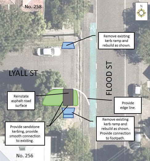
Subject: Lyall Street at Flood Street, Leichhardt – Proposed Kerb Ramp Realignment and Landscaped Blister Island Modification (GULGADYA - LEICHHARDT WARD/ BALMAIN ELECTORATE/ LEICHHARDT PAC)
Prepared By: Zara Helal - Engineer - Traffic and Parking Services
Authorised By: Manod Wickramasinghe - Traffic and Transport Planning Manager
SUMMARY
Council is planning to improve pedestrian access and safety in Lyall Street at its intersection with Flood Street, Leichhardt, in response to concerns regarding pedestrian access. The proposed works modify the existing landscaped blister island to include an opening to allow pedestrians to cross Lyall Street safely.
|
RECOMMENDATION
That the proposed realignment of kerb ramps and modification of landscaped blister island to include an opening for pedestrian access in Lyall Street at its intersection with Flood Street, be approved. |
BACKGROUND & OTHER STAFF COMMENTS
Concerns have been raised regarding pedestrian safety in Lyall Street at its intersection with Flood Street, Leichhardt, as the access between two kerb ramps is obstructed by a landscaped blister island. The proposed works will be carried out as part of the Pedestrian Access and Mobility Plan (PAMP) delivery program and will alleviate current access issues by removing the obstruction and providing a safe crossing path.
The proposed treatment will not result in the loss of any legal on-street car parking spaces in Lyall Street. All current vehicular access to adjoining properties will be retained.
It is expected that the dish drain and poor road surface at this intersection will be repaired by the developer for No.141 Allen Street, Leichhardt.
A concept design of the proposed changes is illustrated below.
Concept Design:
FINANCIAL IMPLICATIONS
The cost of the proposed realignment of kerb ramps and modification of existing landscaped blister island is estimated at $15,000. Works are to be implemented as part of Council’s PAMP delivery program.
PUBLIC CONSULTATION
Nil.
Nil.
|
|
Local Traffic Committee Meeting 17 April 2023 |
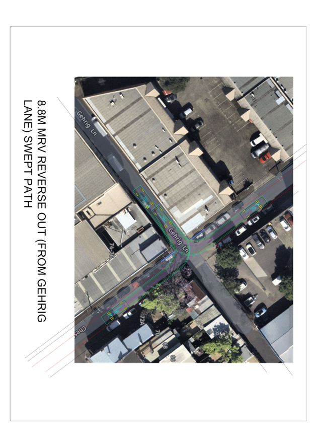
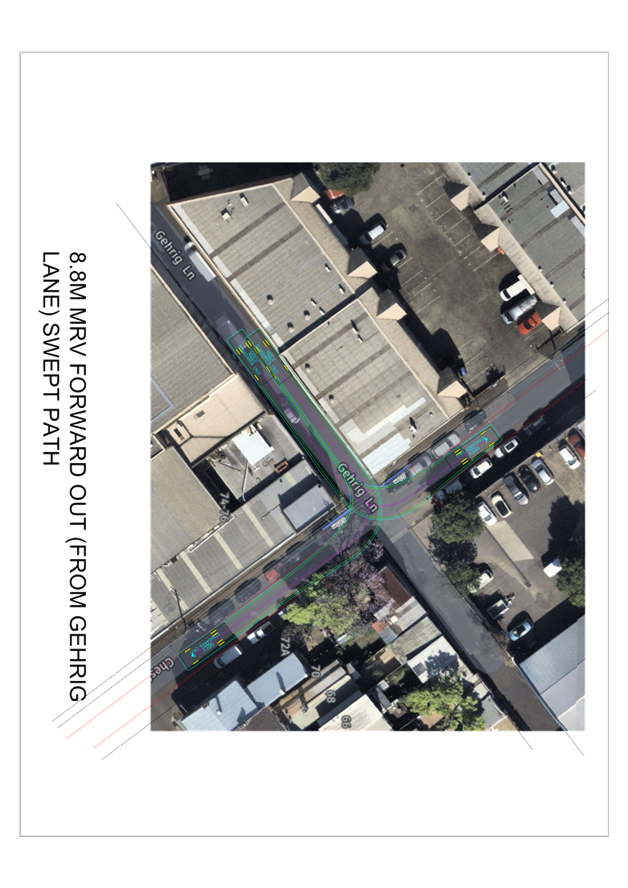
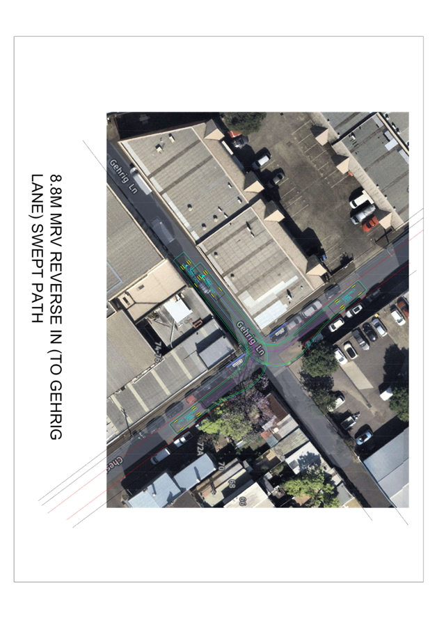
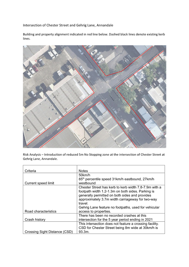
Subject: Chester Street at Gehrig Lane, Annandale - Proposed 'No Stopping' restrictions (Gulgadya - Leichhardt Ward/ Balmain Electorate/ Leichhardt PAC)
Prepared By: Vinoth Srinivasan - Engineer - Traffic and Parking Services
Authorised By: Manod Wickramasinghe - Traffic and Transport Planning Manager
SUMMARY
Council has received concerns regarding vehicles being parked close to the intersection of Chester Street at Gehrig Lane, Annandale and as a result obstructing sight lines and manoeuvring space. An investigation has now been completed and is presented in this report.
|
RECOMMENDATION
That the following parking restrictions be APPROVED:
1. 5m ‘No Stopping’ zone on the western side of Chester Street, north of Gehrig Lane.
2. 5m ‘No Stopping’ zone on the western side of Chester Street, south of Gehrig Lane.
|
BACKGROUND & OTHER STAFF COMMENTS
Council has received concerns regarding vehicles frequently being parked less than 10m metres on the west side of Chester Street at Gehrig Lane, Annadale. The parking of vehicles close to the intersection would obstruct sight lines and manoeuvring space.
Currently the west side of Chester Street near Gehrig Lane has no parking restrictions whilst the east side is signposted with a ‘No Stopping’ zone. It is proposed to signpost a reduced ‘No Stopping’ zones at the following locations and as shown on the plan:
· 5m ‘No Stopping’ zone on the western side of Chester Street, north of Gehrig Lane.
· 5m ‘No Stopping’ zone on the western side of Chester Street, south of Gehrig Lane.
Due to the existing building walls along the property boundaries, the proposed 5m ‘No Stopping’ zones does not reduce sight lines (SSID and MGSD) at the intersection of Chester Street at Gehrig Lane, Annandale as shown in the attached Risk Assessment. It is also noted that Gehrig Lane is a dead-end lane servicing a small number of properties and so carries minimal traffic volumes.
A swept path analysis was undertaken using an 8.8m service vehicle as shown in Attachment 1 and it is deemed acceptable. This location is not a bus route.
![]()
FINANCIAL IMPLICATIONS
Nil.
PUBLIC CONSULTATION
A notification letter will be mailed out to the affected properties in Chester Street and Gehrig Lane prior to the installation of the ‘No Stopping’ signs.
|
1.⇩ |
Swept path analysis - Chester Street at Gehrig Lane |
|
2.⇩ |
Risk Assessment - Chester Street at Gehrig Lane |