|
AGENDA R |

Local Traffic Committee Meeting
MONDAY 19 MAY 2025
11:00 AM
|
|
Local Traffic Committee Meeting 19 May 2025 |
Function of the Local Traffic Committee
Background
Roads and Maritime Services (RMS) is legislated as the Authority responsible for the control of traffic on all NSW Roads. The RMS has delegated certain aspects of the control of traffic on local roads to councils. To exercise this delegation, councils must establish a local traffic committee and obtain the advice of the RMS and Police. The Inner West Council Local Traffic Committee has been constituted by Council as a result of the delegation granted by the RMS pursuant to Section 50 of the Transport Administration Act 1988.
Role of the Committee
The Local Traffic Committee is primarily a technical review and advisory committee which considers the technical merits of proposals and ensures that current technical guidelines are considered. It provides recommendations to Council on traffic and parking control matters and on the provision of traffic control facilities and prescribed traffic control devices for which Council has delegated authority. These matters are dealt with under Part A of the agenda and require Council to consider exercising its delegation.
In addition to its formal role as the Local Traffic Committee, the Committee may also be requested to provide informal traffic engineering advice on traffic matters not requiring Council to exercise its delegated function at that point in time, for example, advice to Council’s Development Assessment Section on traffic generating developments. These matters are dealt with under Part C of the agenda and are for information or advice only and do not require Council to exercise its delegation.
Committee Delegations
The Local Traffic Committee has no decision-making powers. The Council must refer all traffic related matters to the Local Traffic Committee prior to exercising its delegated functions. Matters related to State Roads or functions that have not been delegated to Council must be referred directly to the RMS or relevant organisation.
The Committee provides recommendations to Council. Should Council wish to act contrary to the advice of the Committee or if that advice is not supported unanimously by the Committee members, then the Police or RMS have an opportunity to appeal to the Regional Traffic Committee.
Committee Membership & Voting
Formal voting membership comprises the following:
· one representative of Council as nominated by Council;
· one representative of the NSW Police from each Local Area Command (LAC) within the LGA, being Newtown, Marrickville, Leichhardt and Ashfield LAC’s.
· one representative from the RMS; and
· State Members of Parliament (MP) for the electorates of Summer Hill, Newtown, Heffron, Canterbury, Strathfield and Balmain or their nominees.
Where the Council area is represented by more than one MP or covered by more than one Police LAC, representatives are only permitted to vote on matters which effect their electorate or LAC.
Informal (non-voting) advisors from within Council or external authorities may also attend Committee meetings to provide expert advice.
Committee Chair
Council’s representative will chair the meetings.
Public Participation
Members of the public or other stakeholders may address the Committee on agenda items to be considered by the Committee. The format and number of presentations is at the discretion of the Chairperson and is generally limited to 3 minutes per speaker. Committee debate on agenda items is not open to the public.
|
|
Local Traffic Committee Meeting 19 May 2025 |
|
AGENDA |
1 Apologies
2 Disclosures of Interest
3 Confirmation of Minutes
Minutes of 14 April 2025 Local Traffic Committee 5
4 Matters Arising from Council’s Resolution of Minutes
5 Part A – Items Where Council May Exercise Its Delegated Functions
Traffic Matters
ITEM Page
LTC0525(1) Item 1 12 Month Review of Pedestrian Crossing Warrant Policy (All Wards / All Electorates / All PACs) 21
LTC0525(1) Item 2 Eaton Street south of Gladstone Street, Balmain - Proposed Raised Pedestrian Crossing (BALUDARRI-BALMAIN WARD/BALMAIN ELECTORATE/LEICHHARDT PAC) 34
LTC0525(1) Item 3 King Street, Birchgrove Road and Darling Street, Balmain - Proposed Intersection Improvements (Baludarri-Balmain Ward/Balmain Electorate/Leichhardt PAC) 39
LTC0525(1) Item 4 Schwebel Street, Marrickville - Traffic Study Report for a proposed one-way treatment at Schwebel Street between Illawarra Road and Carrington Road (Midjuburi - Marrickville Ward / Summer Hill Electorate / Inner West PAC) 43
LTC0525(1) Item 5 The Boulevarde, Lilyfield - Proposed Streetscape Improvements and Civil Works (Baludarri-Balmain Ward/Balmain Electorate/Leichhardt PAC) 60
LTC0525(1) Item 6 Livingstone Road and Hill Street, Marrickville – Traffic safety Investigation (Midjuburi-Marrickville Ward /Summer Hill Electorate /Inner West LAC) 65
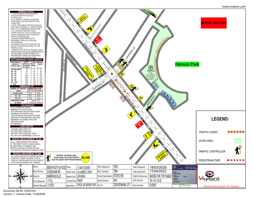
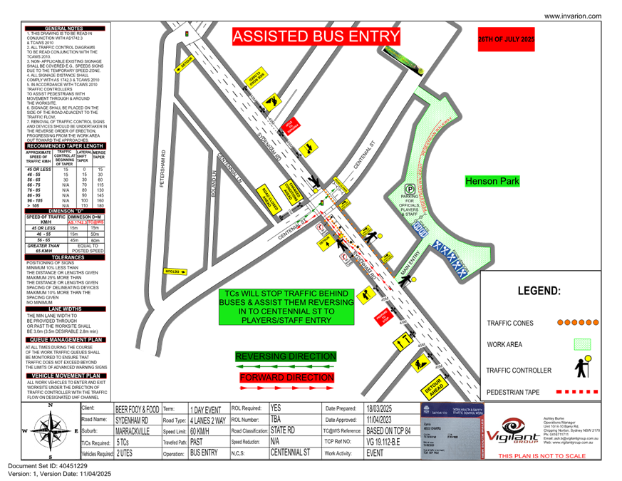
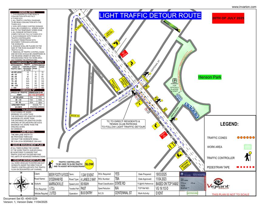
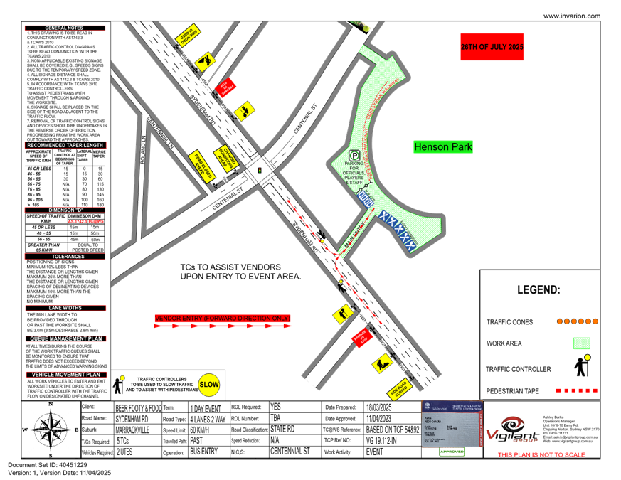
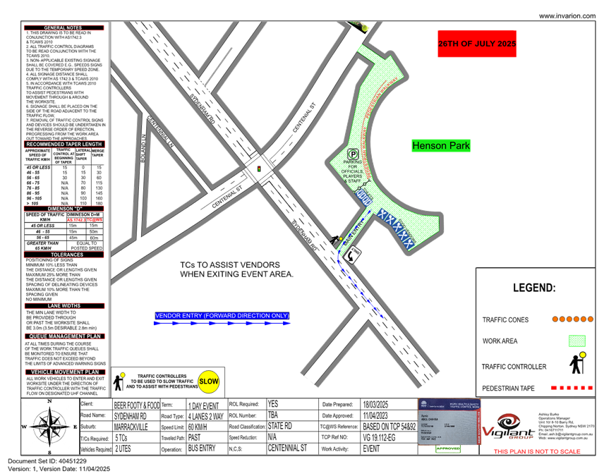
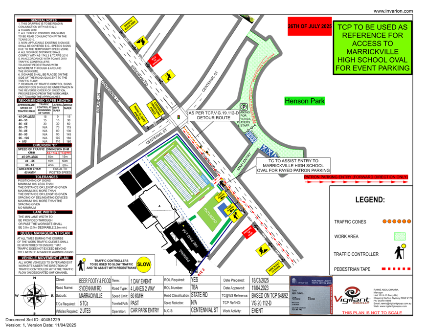
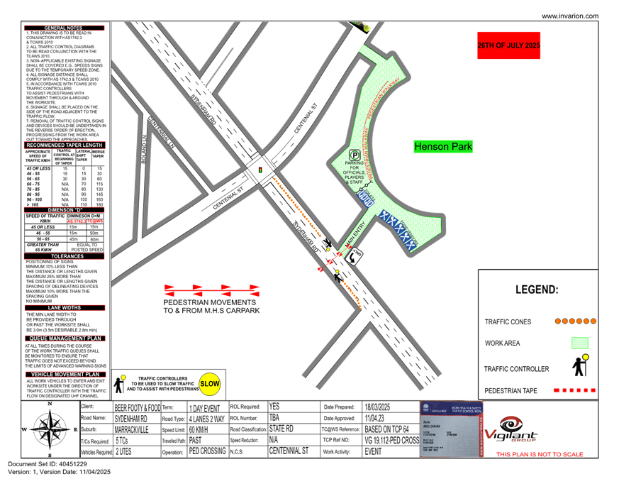
LTC0525(1) Item 7 Centennial Street, Marrickville – Temporary Road Closure for Special Event at Henson Park – 2025 Beer, Footy and Food Festival on Saturday 26 July 2025 - (Midjuburi-Marrickville Ward /Summer Hill Electorate /Inner West LAC) 78
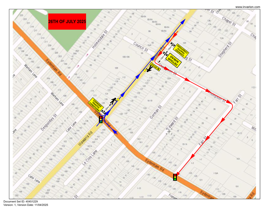
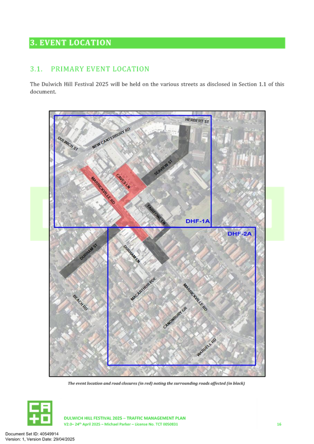
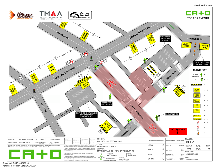
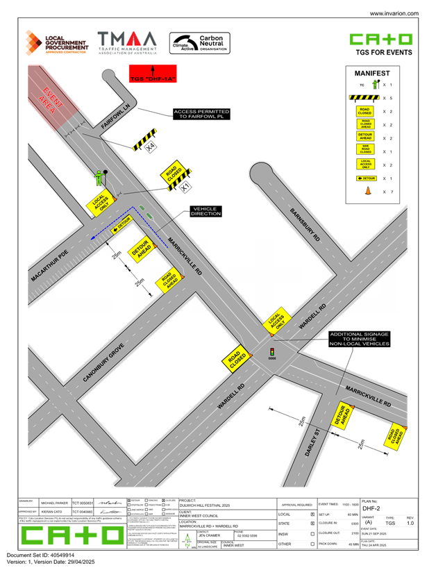
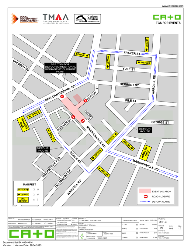
LTC0525(1) Item 8 Marrickville Road, part of Seaview Street and Durham Street, Caves Lane, Marrickville – Temporary full Road Closures for Dulwich Hill Village Fair – Sunday 21 September 2025 (Djarrawunang-Ashfield Ward / Summer Hill Electorate / Inner West PAC) 101
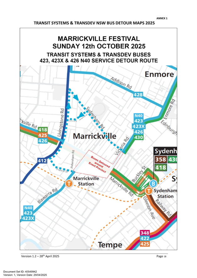
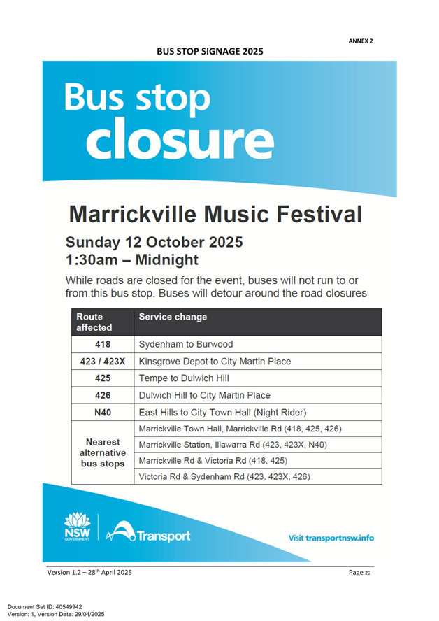
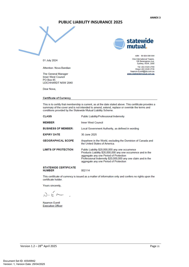
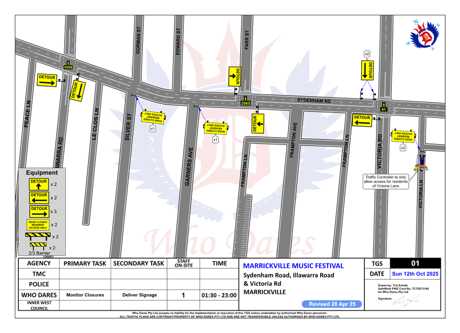
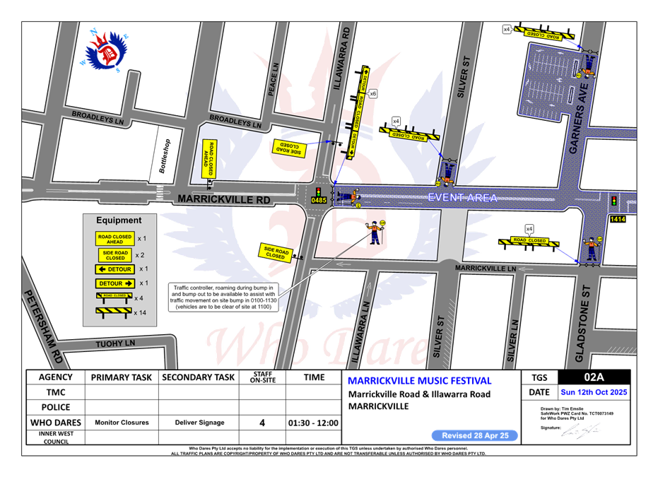
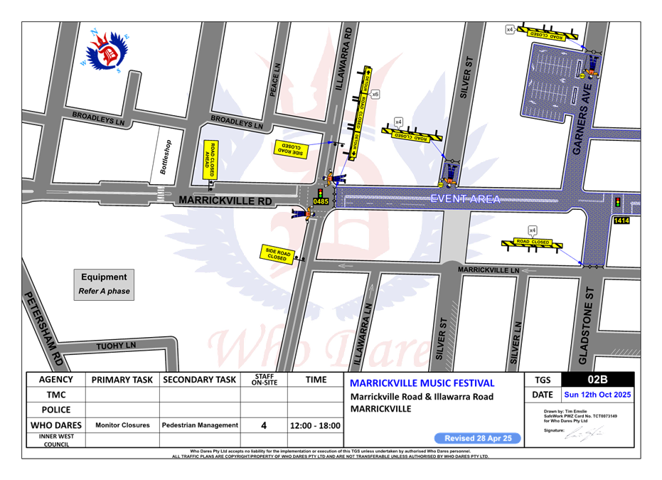
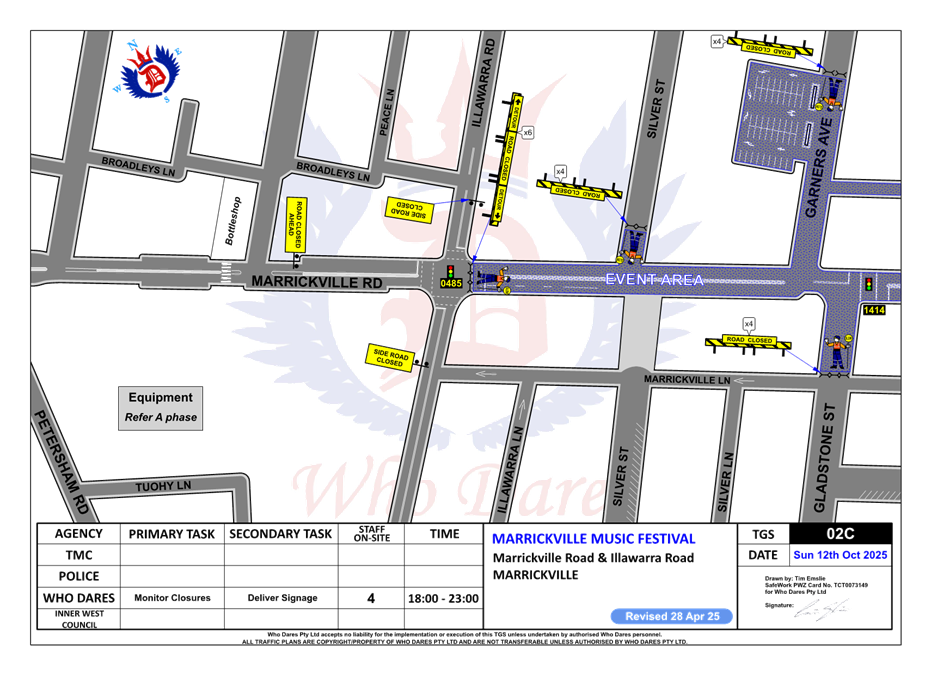
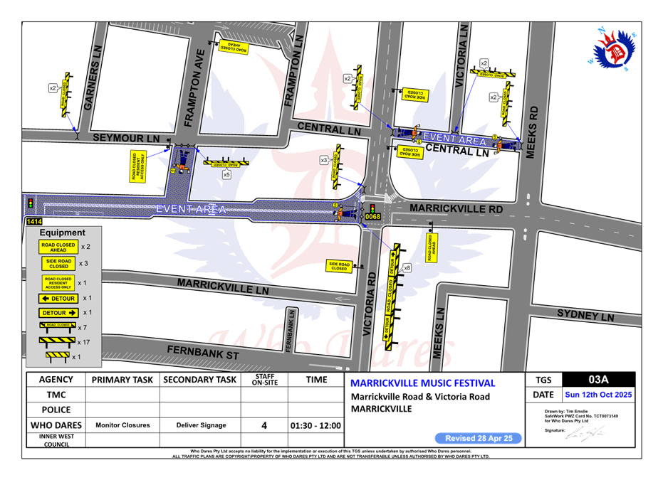
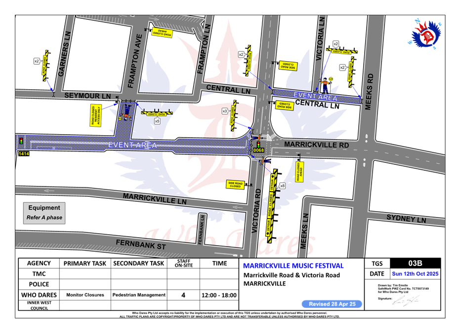
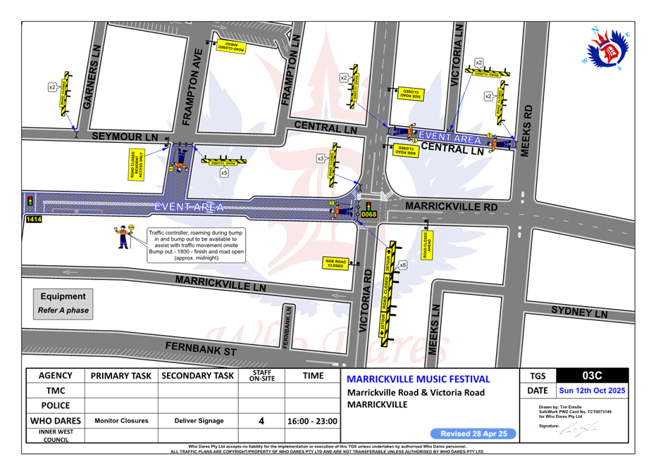
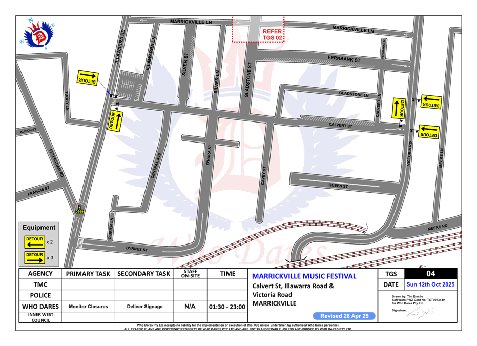
LTC0525(1) Item 9 Marrickville Road, Marrickville – Temporary full road closure for Marrickville Music Festival – Sunday 12 October 2025 (Midjuburi - Marrickville Ward / Summer Hill Electorate / Inner West PAC) 149
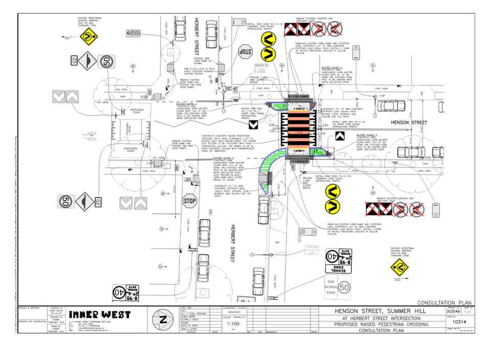
LTC0525(1) Item 10 Henson Street (at Herbert Street), Summer Hill-Proposed New Raised pedestrian crossing (Djarrawunang-Ashfield Ward/Summer Hill Electorate/Burwood PAC) 186
LTC0525(1) Item 11 Warham Lane, Marrickville – Notice of Motion – Parking traffic plan for Henson Park events (Midjuburi-Marrickville Ward /Summer Hill Electorate /Inner West LAC) 191
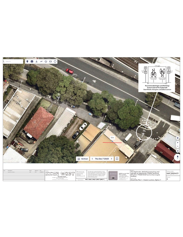
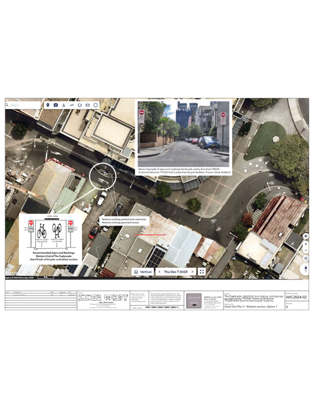
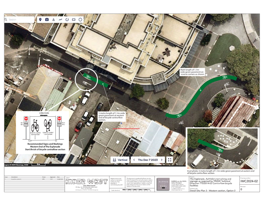
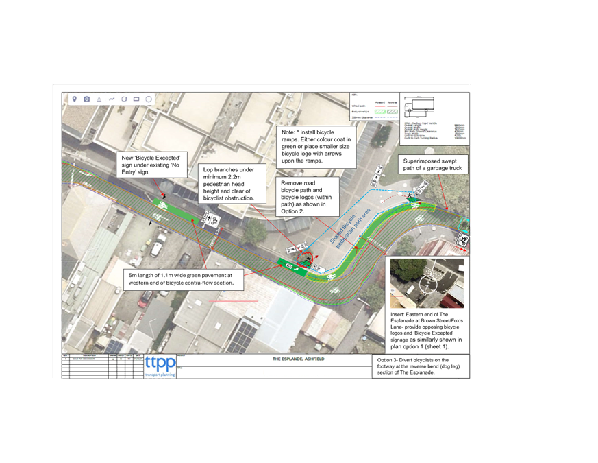
LTC0525(1) Item 12 The Esplanade/Markham Place, Ashfield-Proposed bicycle contra-flow facility (Djarrawunang-Ashfield Ward/Summer Hill Electorate/Burwood PAC) 197
Parking Matters
ITEM Page
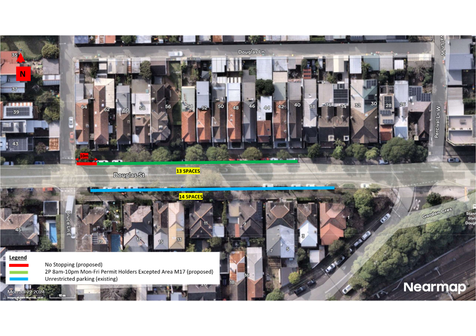
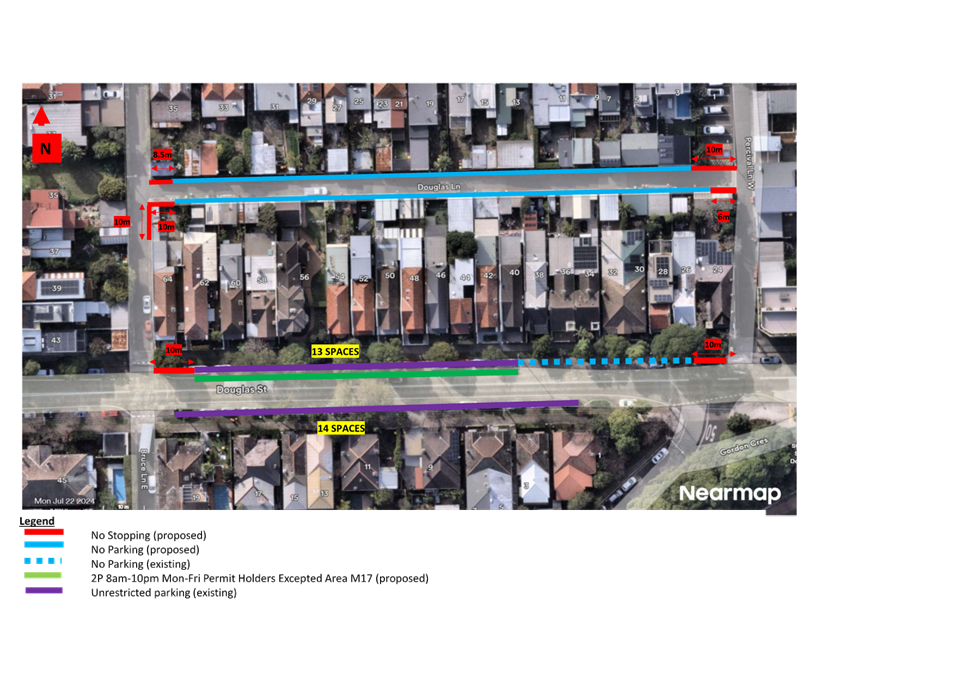
LTC0525(1) Item 13Douglas Street and Douglas Lane, Stanmore - Resident Parking Scheme Survey Results and proposed 'No Parking' and 'No Stopping' restrictions (Damun-Stanmore Ward/Newtown Electorate/Inner West PAC) 208
LTC0525(1) Item 14 Arthur Street at Holborow Street, Ashfield-Proposed 'No Stopping' at the corners of Arthur Street (Djarrawunang-Ashfield Ward/Summer Hill Electorate/Burwood PAC) 213
Late Items
Nil at time of printing.
6 Part B - Items for Information Only
Nil at the time of printing.
7 Part C - Items for General Advice
Nil at the time of printing.
8 General Business
9 Close of Meeting
|
|
Local Traffic Committee Meeting 19 May 2025 |
Minutes of Meeting held on 14 April 2025
Meeting commenced at 11:03 AM
ACKNOWLEDGEMENT OF COUNTRY BY CHAIRPERSON
I acknowledge the Gadigal and Wangal people of the Eora nation on whose country we are meeting today, and their elders past and present.
COMMITTEE REPRESENTATIVES PRESENT
|
Victor Macri |
Councillor –Midjuburi - Marrickville Ward (Chair) |
|
Liz Atkins |
Councillor – Damun - Stanmore Ward |
|
Bill Holliday |
Representative for Kobi Shetty MP, Member for Balmain |
|
Miriama Tamata |
Representative for Jenny Leong MP, Member for Newtown |
|
Nina Fard |
Transport for NSW (TfNSW) |
|
|
|
|
NON VOTING MEMBERS IN ATTENDANCE |
|
|
|
|
|
Michael Takla |
Representative for Transit Systems |
|
Jason Scoufis |
IWC’s Acting Traffic and Transport Planning Manager |
|
Sunny Jo |
IWC’s Coordinator Traffic Engineering Services (North) |
|
George Tsaprounis |
IWC’s Coordinator Traffic Engineering Services (South) |
|
Christy Li |
IWC’s Business Administration Officer |
|
|
|
|
VISITORS |
|
|
|
|
|
Rebecca Bestic |
Public Speaker (Item 11) |
|
Resident Of 26 Empire Street |
Public Speaker (Item 12) |
|
James Pullar |
Public Speaker (Item 13) |
|
George Piazza |
Public Speaker (Item 13) |
|
Bernhard Huber |
Public Speaker (Item 14) |
|
Jon Farry |
Public Speaker (Item 14) |
|
|
|
|
APOLOGIES: |
|
|
|
|
|
Sgt Charles Buttrose |
NSW Police – Leichhardt Police Area Command |
|
Graeme McKay |
Representative for Jo Haylen MP, Member for Summer Hill |
DISCLOSURES OF INTERESTS:
Nil.
CONFIRMATION OF MINUTES
|
That the Minutes of the Local Traffic Committee held on Monday, 17 March 2025 be confirmed. |
MATTERS ARISING FROM COUNCIL’S RESOLUTION OF MINUTES
Nil.
|
LTC0425(1) Item 3 Gower Street, Summer Hill - Proposed Kerb Extensions (Djarrawunang-Ashfield Ward/Summer Hill Electorate/Burwood PAC.) |
|
Officers Recommendation:
That the detailed design plan (10327) for proposed new kerb extensions to the corners of Gower Street at Sloane Street, with associated pram ramps, signs, line marking, and drainage (as shown in Attachment 1) be approved.
DISCUSSION:
The Representative for Transport for NSW requested that the BB line marking be modified to comply with the relevant delineation guidelines.
The Committee agreed with the amended recommendation.
COMMITTEE RECOMMENDATION:
That the detailed design plan (10327) for proposed new kerb extensions to the corners of Gower Street at Sloane Street, with associated pram ramps, signs, line marking, and drainage (as shown in Attachment 1) be approved and that the BB linemarking be modified to comply with the relevant delineation guidelines.
For Motion: Unanimous |
General Business:
|
Item 16 – Review of Clearway restrictions on Parramatta Road |
|
The Representative for the Member for Newtown advised that a constituent had written in to request an evaluation of the current clearway restrictions on Parramatta Road. It was noted that the constituent had reached out to the Local Members’ office regarding the Clearways from 6am to 10am and 3pm to 7pm between Phillip Street and Missenden Road, Petersham advising that the traffic flows do not necessitate these current restrictions being in place and that there is an impact to local businesses along Parramatta Road. The Representative for Transport for NSW noted the concerns raised by the Representative for the Member for Newtown and noted that there is currently a ‘Parramatta Road Integrated Transport Strategy’ being reviewed where the team will be looking at all the existing restrictions on Parramatta Road and how it benefits the local residents and through traffic on Parramatta Road. It was noted that the issues raised by the Representative of the Member of Newtown will be part of the review.
|
|
Item 17 – Request for enforcement of illegal parking in Hubert Street, Lilyfield |
|
The Representative for the Member for Balmain noted that there have been instances of people illegally parking and blocking the footpaths and requested Council’s parking enforcement team to patrol the area. Council Officers advised they will pass on the information to the relevant team.
|
|
Item 18 – Update on the width of the angled parking spaces proposed for Elswick Street North and William Street Leichhardt |
|
The Chairperson noted that he had received correspondence from a resident requesting an update on the width of the angled parking spaced proposed in the March LTC meeting; LTC0325(1) Item 2 - Elswick Street North and William Street, Leichhardt - Proposed Angle Parking and Raised Pedestrian Crossing. Council Officers advised they would follow up with the relevant team members and will provide an update to the Chairperson.
|
|
Item 19 – Request for additional speed limit signage along The Boulevarde, Lewisham |
|
The Chairperson requested a review for additional speed limit signage along The Boulevarde, Lewisham and Dulwich Hill as there are a lot of motorists who speed down the street. It was also requested that Council investigate potential traffic counts to get some speed/traffic data along the street.
|
Meeting closed at 12.47pm.
CHAIRPERSON
Councillor Macri
|
|
Local Traffic Committee Meeting 19 May 2025 |
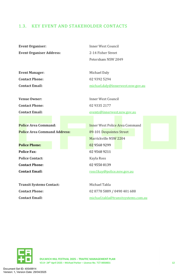
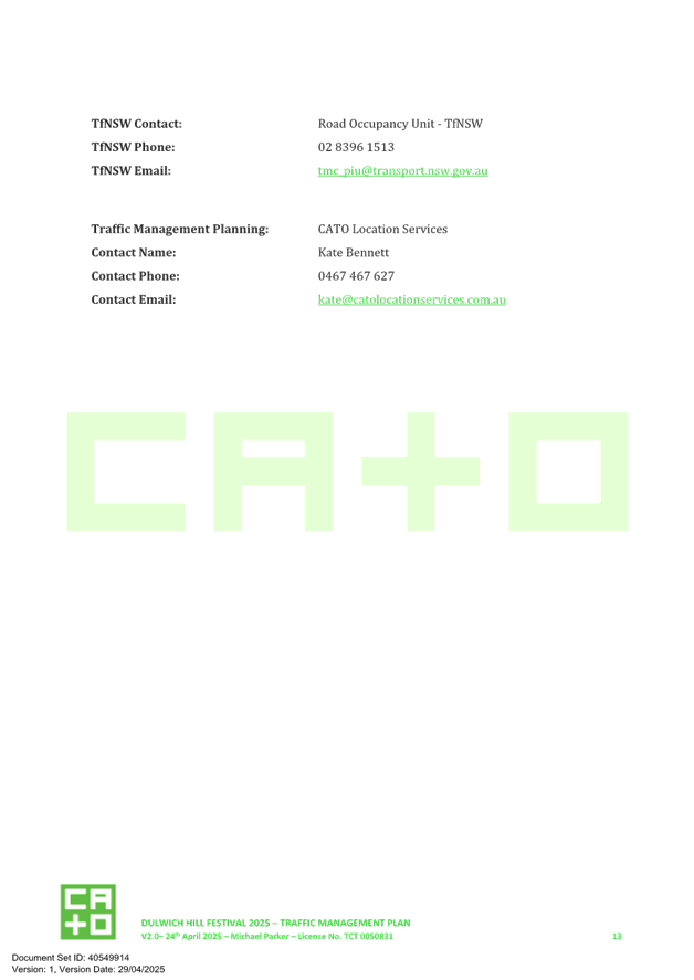
Subject: 12 Month Review of Pedestrian Crossing Warrant Policy (All Wards / All Electorates / All PACs)
Prepared By: Zara Helal - Traffic Engineer
Authorised By: Jason Scoufis - Acting Traffic and Transport Planning Manager
|
RECOMMENDATION
That the report be received and noted. |
STRATEGIC OBJECTIVE
This report supports the following strategic directions contained within Council’s Community Strategic Plan:
|
2: Liveable, connected neighbourhoods and transport |
|
|
Council resolved to undertake a 12-month review of the Pedestrian Crossing Warrant Policy adopted in 2024, including consideration of reasons for approvals and refusals.
A review has been undertaken and outlines 63 pedestrian crossing investigations that have been completed with consideration of the Policy from the December 2023 Traffic Committee to the April 2025 Traffic Committee.
53 of these sites have been approved for the installation of pedestrian crossing which will represent a significant improvement to pedestrian connectivity within the Inner West when construction is completed. It is therefore considered that the Policy is operating effectively in identifying and prioritising pedestrian crossing locations and no changes to the Policy are proposed.
BACKGROUND
In 2024, Council adopted a Pedestrian Crossing Warrant Policy as detailed in Attachment 1 to be used when assessing the suitability of locations on local and regional roads for pedestrian (zebra) crossings. This Policy sets out a warrant for the installation of a pedestrian (zebra) crossing on local and regional roads.
When Council, at its meeting held on 5 March 2024, considered the December 2023 Traffic Committee minutes recommending the adoption of the Policy, it was resolved to adopt the Pedestrian Crossing Warrant Policy with the following amendments.
4. The following amendments to LTC1223(1) Item 3:
a) that the clause on page 7 of the policy that allows for
crossings to be provided at less than the numerical warrant be amended to read
as follows:
‘A pedestrian (zebra) crossing
may also be considered at locations where there is a deviation
from meeting the warrant, such as where the pedestrian crossing would
serve as an essential link to an overall network of pedestrian facilities, or for a
vulnerable group such as children, the elderly or mobility impaired’; and
b) that a report be provided to Council 12 months after the adoption of the policy about any new pedestrian crossings that have been approved or refused under the new policy, with reasons for the approvals and refusals to be included in the report.
This report outlines the pedestrian crossing investigations undertaken, commencing from the December 2023 Traffic Committee (where the Policy was supported) to the April 2025 Traffic Committee.
A copy of the adopted Pedestrian Crossing Warrant Policy is attached.
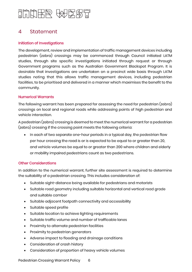
DISCUSSION
The following table outlines the pedestrian crossings investigated following adoption of the Policy.
A total of 63 investigations have been completed through Local Area Traffic Management (LATM) studies as well as investigations that occurred as a result of resident requests or Council resolution. 53 of the sites were appropriate for a pedestrian crossing under the requirements in the Policy.
|
Pedestrian Crossing Location |
Outcome |
Reason |
|
Liberty Street at Railway Parade, Stanmore |
Supported |
Numerical warrant met |
|
Grove Street at Lilyfield Road |
Not Supported |
Numerical warrant not met – low vehicle volumes |
|
Mary Street at Perry Street, Lilyfield |
Supported |
Numerical warrant met |
|
Carrington Road at Renwick Street, Marrickville |
Supported |
Numerical warrant met, issues with road geometry issues to be investigated |
|
Lilyfield Road at Ryan Street, Lilyfield |
Supported |
Numerical warrant met |
|
Lilyfield Road at Ryan Street, Lilyfield |
Supported |
Numerical warrant met |
|
William Street, Leichhardt |
Supported |
Numerical warrant met |
|
Evans Street between Napoleon Street and Mansfield Street, Rozelle |
Supported |
Numerical warrant met |
|
Beattie Street west of Mullens Street, Balmain |
Supported |
Numerical warrant met |
|
Beattie Street east of Darling Street, Rozelle |
Supported |
Numerical warrant met |
|
Darling Street south of Merton Street, Rozelle |
Supported |
Numerical warrant met |
|
Wellington Street, south of Terry Street, Rozelle |
Supported |
Numerical warrant met |
|
Terry Street, west of Wellington Street, Rozelle |
Supported |
Numerical warrant met |
|
Curtis Road at Darling Street, Balmain |
Supported |
Numerical warrant met |
|
Curtis Road at McDonald Street, Balmain |
Supported |
Numerical warrant met |
|
Brighton Street between Wentworth Street and The Avenue, Petersham (Petersham Pk) |
Supported |
Numerical warrant met |
|
Palace Street, north of Andreas Street, Petersham |
Supported |
Numerical warrant met |
|
Andreas Street, west of Palace Street, Petersham |
Supported |
Numerical warrant not met – low vehicle volumes - Considered essential link |
|
Brighton Street, east of Railway Street, Petersham |
Supported |
Numerical warrant met |
|
Railway Street, south of Brighton Street, Petersham |
Supported |
Numerical warrant not met – low vehicle volumes - Considered essential link |
|
Brighton Street, east of Palace Street, Petersham |
Supported |
Numerical warrant met |
|
Brighton Street, west of Palace Street, Petersham |
Supported |
Numerical warrant met |
|
Palace Street, south of Brighton Street, Petersham |
Supported |
Numerical warrant not met – low vehicle volumes - Considered essential link |
|
Terminus Street east of Palace Street, Petersham |
Supported |
Numerical warrant not met – Considered essential link |
|
Alice Street west of Pearl Street, Newtown |
Supported |
Numerical warrant met |
|
Brighton Street west of The Avenue, Petersham |
Not supported |
Too close to other proposed pedestrian crossing |
|
Palace Street north of Brighton Street, Petersham |
Not supported |
Road geometry constraints. Doesn’t meet warrant. |
|
Alice Street west of Walenore Avenue, Newtown |
Supported |
Numerical warrant met |
|
The Avenue at Brighton Street, Petersham |
Not supported |
Numerical warrant not met – low vehicle and pedestrian volumes |
|
Terminus Street west of Railway Avenue, Petersham |
Not supported |
Numerical warrant not met – low vehicle volumes |
|
Edgeware Road south of Bedwin Road, Newtown |
Supported |
Pedestrian volumes met. Considered essential link. |
|
Renwick Street at Illawarra Road, Marrickville |
Supported |
Numerical warrant met |
|
Murray Street at Edinburgh Road, Marrickville |
Supported |
Numerical warrant met |
|
Victoria St, Seaview St to Harland Ave, Ashfield |
Supported |
Numerical warrant met |
|
Prospect Rd near Norton Street, Summer Hill |
Supported |
Numerical warrant met |
|
Victoria Street & Seaview Street intersection, Ashfield |
Supported |
Numerical warrant not met – low vehicle volumes - Considered essential link |
|
Seaview Street at Yeo Avenue, Ashfield |
Not supported |
Numerical warrant not met |
|
Queen Street at Seaview Street & Hillcrest Avenue, Ashfield |
Supported |
Numerical warrant met |
|
Queen Street at Clissold Street, Ashfield |
Supported |
Numerical warrant met |
|
Clissold Street and Victoria Street, Ashfield |
Supported |
Numerical warrant met |
|
Smith Street east of Henson Street |
Supported |
Numerical warrant met |
|
Clissold Street at Holden Street, Ashfield |
Supported |
Numerical warrant met |
|
Robert Street at Holden Street, Ashfield |
Supported |
Numerical warrant not met – low vehicle volumes - Considered essential link |
|
Drynan Street at Prospect Road, Summer Hill |
Supported |
Numerical warrant not met – low vehicle volumes - Considered essential link |
|
Henson Street at Smith Street, Summer Hill |
Supported |
Numerical warrant not met – low vehicle volumes - Considered essential link |
|
Victoria Street at Robert Street, Ashfield |
Supported |
Numerical warrant met |
|
Holden Street and Palace Street, Ashfield |
Supported |
Numerical warrant met |
|
Allen Street at Norton Street, Leichhardt |
Supported |
Numerical warrant met |
|
Styles Street at Whites Creek Lane, Annandale |
Supported |
Numerical warrant met |
|
Piper Street at Whites Creek, Annandale |
Supported |
Numerical warrant not met – low vehicle volumes - Considered essential link |
|
Brenan Street at Whites Creek (between White Street and Railway Parade), Annandale |
Supported |
Numerical warrant not met – low vehicle volumes - Considered essential link |
|
Piper Street west of Annandale Street, Annandale |
Supported |
Numerical warrant not met – low vehicle volumes - Considered essential link |
|
Styles Street, Leichhardt at the Leichhardt Street/Mackenzie Street/Styles Street intersection |
Supported |
Numerical warrant met |
|
Piper Street South immediately west of View Street, Annandale |
Supported |
Numerical warrant not met – low vehicle volumes - Considered essential link |
|
Trafalgar Street (southern leg) at Albion Street, Annandale |
Supported |
Numerical warrant not met – low vehicle volumes - Considered essential link |
|
Trafalgar Street between Piper Street South and Piper Street North, Annandale |
Supported |
Numerical warrant not met – low vehicle volumes - Considered essential link |
|
Piper Street North at Johnston Street, Annandale |
Supported |
Numerical warrant not met – low vehicle volumes - Considered essential link |
|
Annandale Street north of Rose Street, Annandale |
Supported |
Numerical warrant not met - Considered essential link |
|
Rose Street east of Annandale Street, Annandale |
Supported |
Numerical warrant not met - Considered essential link |
|
Bayview Crescent at Prichard Street, Annandale |
Not Supported |
Numerical warrant not met – Continuous footpath proposed |
|
Piper Street North, west of View Street, Annandale |
Not Supported |
Numerical warrant not met – kerb extensions proposed |
|
Piper Street South, east of Johnston Street, Annandale |
Not Supported |
Numerical warrant not met – geometric constraints |
|
Collins Street east of Trafalgar Street, Annandale |
Not Supported |
Too close to pedestrian crossing at western leg of intersection. |
It should be noted that for the purposes of assessment, pedestrian crossings which provide ‘essential links’ have been defined as being a connection along a pedestrian corridor, connections to schools or connections to support a significant land use change. These assessments have generally been established through completed Local Area Traffic Management studies.
FINANCIAL IMPLICATIONS
There are no financial implications associated with the implementation of the proposed recommendations outlined in the report.
The construction of the approved raised pedestrian crossings are being progressively constructed under Council’s Traffic Facilities capital works program and submitted for grant funding opportunities where relevant.
CONCLUSION
It is considered that the Pedestrian Crossing Warrant Policy is operating effectively noting the significant number of sites determined to be appropriate for pedestrian crossings.
|
1.⇩ |
Attachment - Pedestrian Crossing Warrant Policy |
|
Local Traffic Committee Meeting 19 May 2025 |
Subject: Eaton Street south of Gladstone Street, Balmain - Proposed Raised Pedestrian Crossing (BALUDARRI-BALMAIN WARD/BALMAIN ELECTORATE/LEICHHARDT PAC)
Prepared By: Zara Helal - Traffic Engineer
Authorised By: Jason Scoufis - Acting Traffic and Transport Planning Manager
|
RECOMMENDATION
1. That the installation of a raised pedestrian crossing in Eaton Street south of Gladstone Street, Balmain, be supported in-principle and included in Council’s Capital Works program subject to detailed design investigations and community consultation.
2. That the detailed design for the proposed raised pedestrian crossing be brought back to the Traffic Committee for consideration.
|
STRATEGIC OBJECTIVE
This report supports the following strategic directions contained within Council’s Community Strategic Plan:
|
2: Liveable, connected neighbourhoods and transport |
|
|
EXECUTIVE SUMMARY
Council has received requests from Father John Therry Catholic Primary School and Balmain Public School to upgrade the existing Children’s crossing in Eaton Street that operates part time during drop off and pick up times to a full-time raised pedestrian crossing.
In response to this, it is proposed to install a raised pedestrian crossing to replace the existing Children’s crossing on Eaton Street immediately south of Gladstone Street, with associated kerb blisters.
The proposal aims to improve pedestrian accessibility and safety at this location by highlighting pedestrian priority to vehicles at all times.
The proposal will result in the loss of one (1) existing on-street parking spaces during school drop-off/pick-up times, and five (5) existing on-street parking spaces at all other times in Eaton Street.
BACKGROUND
Table 1 outlines the features of Eaton Street.
|
Eaton Street, Balmain |
|
|
Kerb to Kerb Width |
8.3m approx. |
|
Carriageway Type |
One-way northbound, one travel lane |
|
Classification |
Local |
|
Speed Limit |
40 km/h |
|
Available TfNSW recorded crash history last 5 years (Q3 2019 – Q2 2024) |
No reported crashes at Eaton Street. |
|
Parking Arrangements |
Parking permitted on both sides. ’P 5 minute 8am-9am, 2.45pm-3.30pm’ restriction applies during school drop-off/pick-up times. ‘4P ticket 9am-2.45pm, 3.30pm-10pm school days, 8am-10pm other days, permit holders excepted area B2’ restriction applies at other times. |
The preliminary assessment included a review into the crash history, traffic count data, and previous safety concerns, including numerical warrants for installing a pedestrian crossing in accordance with Council’s Pedestrian Crossing Policy.
Father John Therry Catholic Primary School and St Augustine's Catholic Church are situated on the eastern side of Eaton Street, and Balmain Public School and Gladstone Park are situated on the western side. As such, there is a high number of pedestrians, namely children, that cross Eaton Street to travel to these locations. School drop-off / pick-up zones are situated along Eaton Street on both sides.
The school crossing operates between 8.15am-9.15am and 2.30pm-3.30pm and is facilitated by a school crossing supervisor. It is proposed to install a raised pedestrian crossing to replace the existing school crossing on Eaton Street immediately south of Gladstone Street to improve pedestrian accessibility and safety at this location.
Council completed pedestrian and vehicle counts to determine if the volumes satisfy the warrants for a pedestrian crossing as required in Council’s Pedestrian Crossing Warrant Policy.
Table 2 outlines the pedestrian and vehicle traffic count data.
|
Pedestrian and vehicle count Eaton Street at Gladstone Street, Balmain |
||||
|
Date |
Time |
Pedestrian (adult) |
Pedestrian (child) |
Vehicle |
|
7 May 2025 |
3.00pm – 4.00pm |
67 |
102 |
77 |
|
9 May 2025 |
8.15am – 9.15am |
90 |
90 |
115 |
The numerical warrant is met in regard to the pedestrian requirements (greater than 20); however, the vehicle requirements is not met (greater than 200). Whilst noting that the overall warrant is not met, it is recommended that the school crossing be upgraded to a raised pedestrian crossing slightly north of its existing location because it forms as part of an essential link that connects schools to nearby residential properties, school drop-off / pick-up zones, and local shopping strip, parks, and public transport.
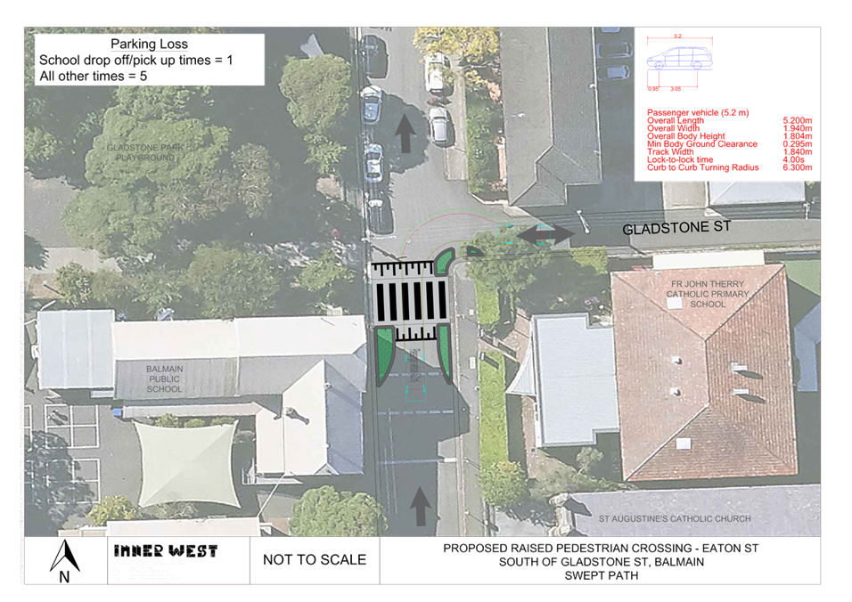
A concept design for the proposed raised pedestrian crossing is provided in Attachment 1 and Swept path provided in Attachment 2.
PUBLIC CONSULTATION
An on-site meeting was held on Tuesday 18 March 2025 with Principals from Father Therry Catholic Primary School and Balmain Public School to gather feedback relating to improving safety at the Children’s crossing in Eaton Street. It was requested that Council either install a raised pedestrian crossing in place of the existing children’s crossing or implement a Shared zone treatment along Eaton Street.
A Shared zone has since been determined to be inappropriate for this location as the road has kerb and gutter and footpaths. A shared zone is also not conducive to a safe crossing environment for children in this location as it would result in pedestrians crossing at all different locations. A raised pedestrian crossing has been deemed an appropriate measure to enhance pedestrian safety and lower vehicular speeds and highlight pedestrian priority at the crossing location with the addition of the school crossing supervisor.
The schools also requested that the crossing location be shifted further north towards the intersection of Gladstone Street to better reflect the pedestrian crossing desire line which has bene included as part of the design. Concerns were also raised regarding vehicles illegally performing left turns from Gladstone Street into Eaton Street against the one-way direction. To deter such movements, it is also proposed to install a kerb extension in Gladstone Street at its intersection with Eaton Street on the south side.
Further consultation will be undertaken during the detailed design stage.
FINANCIAL IMPLICATIONS
Works are to be considered as part of Council’s Capital Works program for Traffic Facilities with final costing to be finalised following completion of detailed design.
|
1.⇩ |
Proposed Raised Pedestrian Crossing - Eaton Street south of Gladstone Street, Balmain |
|
2.⇩ |
Swept Path - Proposed Raised Pedestrian Crossing - Eaton Street south of Gladstone Street, Balmain |
|
|
Local Traffic Committee Meeting 19 May 2025 |
Subject: King Street, Birchgrove Road and Darling Street, Balmain - Proposed Intersection Improvements (Baludarri-Balmain Ward/Balmain Electorate/Leichhardt PAC)
Prepared By: Jackie Ng - Graduate Traffic Engineer
Authorised By: Jason Scoufis - Acting Traffic and Transport Planning Manager
|
RECOMMENDATION
That the proposed signage and linemarking improvements at the intersection of King Street, Birchgrove Road and Darling Street, Balmain shown in Attachment 1 be approved. |
STRATEGIC OBJECTIVE
This report supports the following strategic directions contained within Council’s Community Strategic Plan:
|
2: Liveable, connected neighbourhoods and transport |
|
|
EXECUTIVE SUMMARY
This report outlines the safety concerns at the intersection of King Street, Birchgrove Road and Darling Street, Balmain. The current arrangement leads to confusion amongst motorists due to the geometric layout of the intersection. A considerable number of pedestrians were observed crossing the intersection and vehicles observed in conflict when exiting Birchgrove Road into King Street whilst other vehicles make a left turn from Darling Street into King Street. A review has been undertaken and it is proposed that signage works, and linemarking be upgraded at the intersection to improve safety for all road users.
BACKGROUND
Council has received safety concerns from the community regarding the intersection of King Street, Birchgrove Road and Darling Street, Balmain. This intersection facilitates both local residential and visitor traffic and is adjacent to the local businesses and facilities in Darling Street.
The current road layout was reported to cause confusion between vehicles entering the intersection from King Street and Birchgrove Road due to the road geometry. This has resulted in frequent and occasional near misses amongst motorists. Additionally, the existing Give Way line in King Street is located before the pedestrian kerb ramp, and well before approaching the intersection of Darling Street, exacerbating the confusion and hesitation between vehicles and pedestrians.
It is proposed that the following improvements be undertaken at the intersection as shown in Attachment 1:
· Linemark painted islands with chevrons at the kerb return as detailed on the attached plan.
· Install Stop (TF) line in Birchgrove Road at King Street intersection.
· Replace existing ‘Give Way’ sign with a ‘Stop’ sign at the Birchgrove Road and King Street, Balmain intersection.
· Reposition existing Give Way line at the King Street and Darling Street, Balmain intersection, as shown in the attached plan.
· Relocate existing “No Parking, 8am-10pm, Excepted While Charging” sign 1m north of existing location.
· Install 6m length ‘4P, Ticket 8am-10pm, Permit Holders Excepted, Area B1’ south of the ‘No Parking, 8am-10pm, Excepted While Charging’ zone.
The proposed works will provide one (1) additional on-street parking space.
DISCUSSION
Consultation was conducted with the immediately impacted property who supported the proposal.
FINANCIAL IMPLICATIONS
The cost of installation of the proposed signage works and line marking can be funded within Council’s signs and line marking budget.
|
1.⇩ |
King Street, Birchgrove Road and Darling Street, Balmain - Proposed Intersection Improvements |
|
2.⇩ |
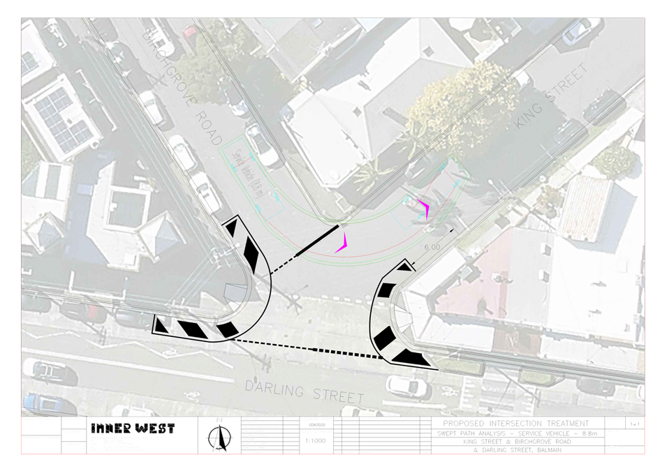
King Street, Birchgrove Road and Darling Street, Balmain - Swept Path Analysis |
|
|
Local Traffic Committee Meeting 19 May 2025 |
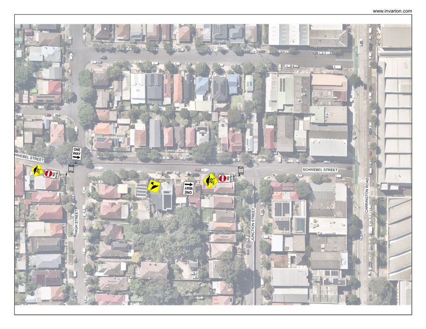
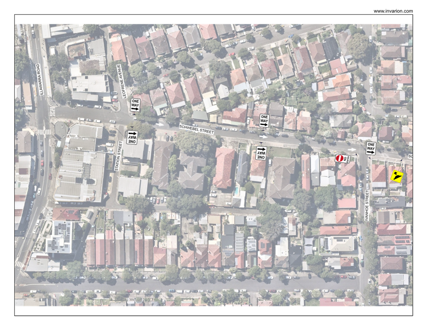
Subject: Schwebel Street, Marrickville - Traffic Study Report for a proposed one-way treatment at Schwebel Street between Illawarra Road and Carrington Road (Midjuburi - Marrickville Ward / Summer Hill Electorate / Inner West PAC)
Prepared By: Daniel Li - Student/Graduate Traffic Engineer
Authorised By: Jason Scoufis - Acting Traffic and Transport Planning Manager
|
RECOMMENDATION
1. That the following traffic study report at Schwebel Street be received and noted by Council.
2. That traffic management proposals within this report be approved in principle and that community consultation be undertaken on the proposals within this report |
STRATEGIC OBJECTIVE
This report supports the following strategic directions contained within Council’s Community Strategic Plan:
|
2: Liveable, connected neighbourhoods and transport |
|
|
EXECUTIVE SUMMARY
A notice of motion was raised at Council’s meeting on the 3rd of December 2024 to investigate the eastbound one-way conversion of Schwebel Street from Illawarra Road to Carrington Road. To determine the feasibility of the proposed one-way treatment in Schwebel Street, Council’s Traffic Engineering team has undertaken a technical analysis into the traffic implications of the proposal via a traffic study report.
This traffic study report considers three options to address resident concerns and provides an analysis into the traffic redistribution of westbound traffic into surrounding streets, likelihood of increased vehicle speeds and non-compliance of the proposed one-way. Having considered the traffic safety report, it is recommended that Council support the three proposed options for community consultation.
BACKGROUND
At the Council meeting on 3 December 2024, a Notice of Motion was raised with Council’s Traffic and Transport Planning team to investigate the following:
1. That Council progress plans to make Schwebel Street one-way in a west to east direction from Illawarra Road to Carrington Road.
2. That Council report to the Local Traffic Committee no later than May 2025 with:
a) plan, indicative budget and timeline to develop and design road treatments to make Schwebel Street one-way and to undertake community consultation;
b) an assessment of whether Schwebel Street is suitable for new active transport connections and opportunities to upgrade and improve lighting on the stairs between Schwebel Street and Charlotte Avenue; and
c) Consideration of improvements at the intersection of Illawarra Road and Schwebel/Warburton Streets.
DISCUSSION
Former Studies in Marrickville Area
Marrickville Council has previously undertaken a review of Schwebel Street and has provided various proposals as part of the South Marrickville Local Area Traffic Management Scheme in 2012. Table 1 below summarises previous traffic management strategies to mitigate the traffic issues found along Schwebel Street.
|
Year of Proposal |
Proposal Description |
Outcome |
|
August 1999 |
Parking restrictions along one side of Schwebel Street. |
Not supported as very few residences have any form of off-street parking and are reliant on on-street parking. The loss of parking would not be strongly supported by residents. |
|
August 1999 |
Speed humps to reduce traffic speeds |
Insufficient support for the proposal and to be considered for future Local Area Traffic Management studies. |
|
April 2008 |
Road carriageway widening |
Not supported as it was cost prohibitive and would result in an unacceptable narrowing of footpaths. It would also require the relocation of existing power poles and utility services. |
|
May 2011 |
Proposed one-way (eastbound) from Illawarra Road to Carrington Road |
Insufficient support for the proposal. The proposal at the time only had a 7% support rate (26 of the quantifiable votes). |
Table
1. Historical summary of Schwebel Street traffic management strategies
Existing Conditions
Schwebel Street is a residential
street running east-west between Illawarra Road and Carrington Road with
varying road widths as shown in Table 2. Despite Schwebel Street between
Station Street and Junction Street being incapable of accommodating concurrent
two-way traffic movements, Schwebel Street currently operates as a two-way road
where drivers are expected to utilise driveways and parking areas to pass
oncoming vehicles.
|
Street Name |
Schwebel Street |
|
Carriageway width (m) kerb to kerb |
· Between Station Street and High Street – 7.3m · Between High Street and Junction Street – 6.8m · Between Junction Street and Carrington Road – 12.8m |
|
Carriageway type |
Two-way with vehicles utilising driveways and parking areas to pass oncoming vehicles |
|
Classification |
Local |
|
Speed Limit (km/h) |
50 |
|
Annual Average Daily Traffic (AADT) |
· Between Leofrene Avenue and Ivanhoe Street – 3,784 · Between High Street and Junction Street – 3,927 |
|
85th percentile speed (km/h) |
· Between Leofrene Avenue and Ivanhoe Street – 41.6 · Between High Street and Junction Street – 46.8 |
|
Parking Arrangements |
· ‘2P 8.30am – 6pm Mon-Fri, 8.30am – 12.30pm Sat, Permit Holders Excepted’ on the southern side of Schwebel Street between Leofrene Avenue and Ivanhoe Street. · Unrestricted parking on the northern side. · Unrestricted parking east of Ivanhoe Street to Carrington Road |
Table 2. Road Network Detail
Accident History
Traffic accident data collected from the Transport for NSW crash registry for the 5-year period from 2020 – 2024 are shown in the crash locations below. From October 2014, the NSW Police has ceased reporting towaway accidents with the exception where there are any persons killed or injured, or where a driver fails to swap details, or where a driver is suspected to be under the influence of drug or alcohol.
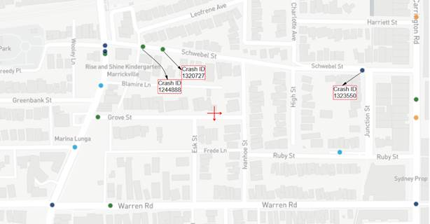
Figure 1. Recorded crashes at Schwebel Street between 2020 – 2024.
|
Street |
Crash ID |
Year |
Crash Type |
Road User Movement Code (RUM) |
|
Schwebel Street |
1244888 |
2020 |
Non-casualty (towaway) |
71 (Left off carriageway into object – parked vehicle) |
|
Schwebel Street |
1320727 |
2023 |
Non-casualty (towaway) |
93 (Parked vehicle run away into object / parked vehicle) |
|
Schwebel Street |
1323550 |
2023 |
Moderately Injured |
73 (Off road right – object on road) |
Table 3. Crashes at Schwebel Street between 2020 – 2024 and listed RUM Code.
Based on the traffic accident history between 2020 – 2024 as seen in Table 3, only three (3) traffic incidents were officially recorded with the Transport for NSW crash registry. Amongst the three recorded crashes, the two crashes between Station Street and Ivanhoe Street had a Road User Movement code (RUM) of 71 and 93 which indicates vehicle side swiping. Despite the low amount of recorded traffic accidents within Schwebel Street, Council has received numerous resident requests, suggesting a higher rate of non-recorded vehicle side swiping incidents after October 2014.
Traffic Management Options for Schwebel Street
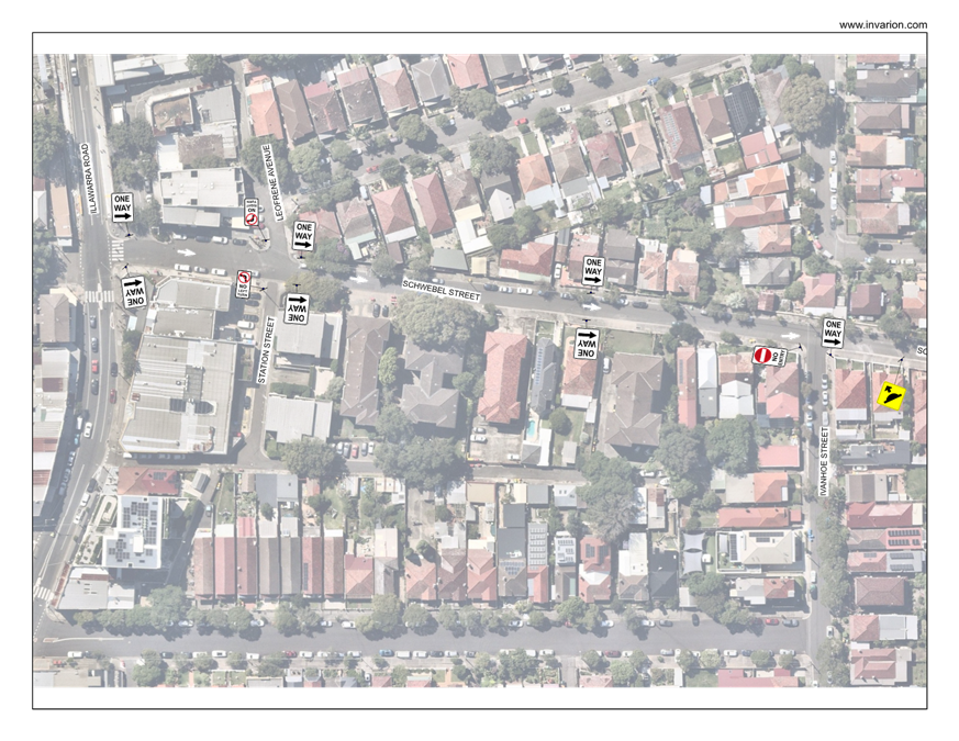
Option A: One-way Traffic Proposal in Schwebel Street between Illawarra Road and Carrington Road
In 2011, the South Marrickville LATM proposed an eastbound one-way system on Schwebel Street from Illawarra Road to Carrington Road to compliment the westbound one-way along Warren Road. Following community feedback, Council was unable to proceed with the above proposal due to low support rates with residents commenting on the longer driving times to arrive at their intended destination as seen in attachment 1.
In general, converting a two-way road to one way traffic would result in an improvement to congestion and a likely reduction of traffic volume. However, the change will have wider impacts as existing traffic movement in the opposing direction of the one way will be diverted to adjacent streets and increased travel distances for residents and visitors under this arrangement. The wider carriageway for one way travel could also result in minor non-compliance of the one way for drivers. A concept plan of the proposed one-way between Illawarra Road and Carrington Road can be seen in Figure 2.
Notwithstanding, while it is anticipated that a proposed one-way will increase traffic speeds, to facilitate a one-way system in Schwebel Street between Illawarra Road and Carrington Road, the following would also be required:
· Speed cushions outside number 38 Schwebel Street and 52 Schwebel Street;
· Installation of ‘No Entry’ and ‘No Left Turn’ restrictions at Leofrene Avenue, Station Street, Ivanhoe Street, High Street and Junction Street;
· Installation of approximately 11 ‘One-Way’ signs throughout Schwebel Street (as seen in the signage plan in Attachment 2);
· Installation of approximately 6 pavement arrows;
· A Traffic Management Plan for the one way proposal to be approved by TfNSW;
· Secondary Local Traffic Committee report with community consultation results; and
· Public advertisement of the one way as required by the Roads Act for 28 days.
Figure 2. One Way Concept Plan in Schwebel Street between Illawarra Road and Carrington Road
|
Option A: One Way Traffic Eastbound in Schwebel Street between Illawarra Road and Carrington Road |
|
|
Advantages |
Disadvantages |
|
· Localised congestion is minimised compared to a two-way traffic through narrow road space · No loss of on-street parking spaces · Overall traffic volume may decrease · Reduced likelihood of vehicle side swiping
|
· Residents will travel longer distances to travel to and from their homes · Prevailing traffic flow will be diverted to adjacent streets, likely Warren Road (one-way) or Grove Street · Vehicle speeds will likely increase · Drivers could disobey road rules and drive against the one way to avoid travelling around, particularly to and from destinations at each end of the street.
|
Table 4. Advantages and disadvantages of a one-way system between Illawarra Road and Carrington Road
Option B: One-way Traffic Proposal in Schwebel Street between Leofrene Avenue/Station Street and Junction Street
Noting community feedback, instead of a one-way system being proposed for the entirety of Schwebel Street, a proposed one-way at Schwebel Street between Leofrene Avenue/Station Street and Junction Street would be a more suitable solution to address the narrow sections which are unable to facilitate two-way traffic movements.
In comparison to Option A, this option will enable kiss and ride users of Marrickville Railway Station to exit onto Illawarra Road without needing to travel eastbound along Schwebel Street. Additionally, a one-way system in Schwebel Street between Station Street and Junction Street will provide sufficient notice to westbound traffic from Carrington Road to react/adapt to the proposed road network changes whilst diverting onto Junction Road or undertaking a U-turn manoeuvre to exit onto Carrington Road as shown in Figure 3.
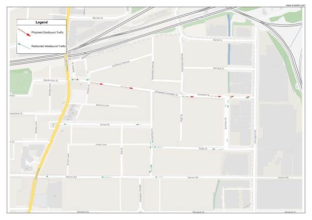
Figure 3. One Way Concept Plan in Schwebel Street between Station Street and Junction Street
At the time of the initial one-way proposal in 2011, relevant traffic counts conducted in November 2006 provided traffic volumes of 1,470 vehicles per day and an 85th percentile speed of 51km/h. In comparison, the traffic counts collected in February 2025 indicate that the traffic volumes have since doubled to approximately 3,800 vehicles per day (2,000 eastbound and 1,800 westbound), simultaneously reducing the 85th percentile speed to 41.5 km/h between Leofrene Avenue and Ivanhoe Street and 46.8 km/h between Junction Street and Carrington Road, both within the signposted speed limits of 50 km/h.
Notwithstanding, while it is anticipated that a proposed one-way will increase traffic speeds, to facilitate a one-way system in Schwebel Street between Leofrene Avenue/Station Street and Junction Street, the following would also be required:
· Speed cushions outside number 38 Schwebel Street and 52 Schwebel Street;
· Installation of ‘No Entry’ and ‘No Left Turn’ restrictions at Ivanhoe Street, High Street and Junction Street (as seen in the signage plan in Attachment 3);
· Installation of approximately 8 ‘One-Way’ signs throughout Schwebel Street;
· Installation of approximately 5 pavement arrows ;
· A Traffic Management Plan for the one way proposal to be approved by TfNSW;
· Secondary Local Traffic Committee report with community consultation results; and
· Public advertisement of the one way as required by the Roads Act for 28 days.
An examination of the peak hour traffic flow and the road network indicate that with a one-way eastbound arrangement in Schwebel Street, the majority of the westbound traffic flow would most likely be diverted to Warren Road or Grove Street during the AM and PM peak hours. Figure 4 shows the peak AM and PM traffic volumes in Schwebel Street and the surrounding space.
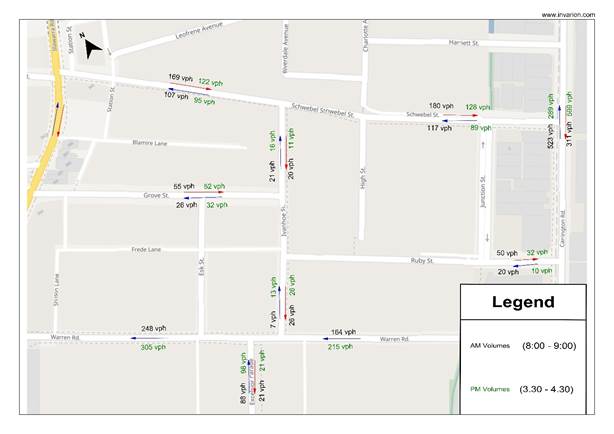
Figure 4. Existing AM and PM peak hour traffic volume in Schwebel Street and surrounding roads
The projected traffic redistribution results in a minor increase of approximately 117 vehicles in the morning peak hours into Grove Street and Warren Road. Assuming a redistribution rate of 70% and 20% into Warren Road and Grove Street respectively, the traffic redistribution will result in an increase of 74 westbound vehicles into Warren Road, 21 vehicles into Grove Street and 11 vehicles into Schwebel Street. Such a low amount of traffic being redistributed would have minor impacts to the surrounding road network. A traffic redistribution diagram can be seen in Figure 5.
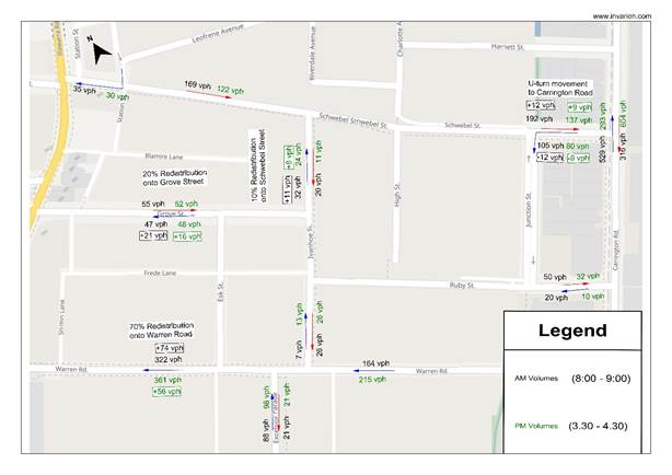
Figure 5. Projected redistribution of AM and PM peak hour traffic volumes in Schwebel Street and surrounding roads
|
Advantages |
Disadvantages |
|
· Localised congestion is minimized compared to a two-way traffic through narrow road space · No loss of on-street parking spaces · Overall traffic volume may decrease · Reduced likelihood of vehicle side swiping · Allows kiss and ride users to exit onto Illawarra Road without travelling eastbound into Schwebel Street. · Allows westbound traffic from Carrington Road to adequately react to the one-way and divert onto Junction Street. |
· Residents will travel longer distances to travel to and from their homes · Prevailing traffic flow will be diverted to adjacent streets, likely Warren Road (one-way) or Grove Street · Vehicle speeds will likely increase · Drivers could disobey road rules and drive against the one way to avoid travelling around, particularly to and from destinations at each end of the street.
|
Table 5. Advantages and disadvantages of a proposed one-way between Station Street and Junction Street
Option C: Provide Passing Bays in Schwebel Street between Station Street and High Street
This arrangement in Schwebel Street proposes short sections of ‘No Parking’ zones in regular spacing to provide two way passing opportunities for vehicles approaching in opposing directions. This option provides a balance between traffic flow and resident’s need to retain on-street parking in Schwebel Street.
The passing bays would be signposted as full time ‘No Parking’ with an option for a part time ‘No Parking 8.30am – 6pm Mon – Fri’ and ‘No Parking 8.30am – 12.30pm Sat’ zone consistent with the existing parking conditions situated on the southern side of Schwebel Street. A concept plan of the proposed passing bays can be seen in Figure 6.
![]()
![]()
Figure 6. Proposed concept plan of passing bays in Schwebel Street
|
Option C: Provide Passing Bays in Schwebel Street between Station Street and High Street |
|
|
Advantages |
Disadvantages |
|
· Some improvement to two-way traffic flow in Schwebel Street · Minimal traffic diverted to neighbouring streets · Vehicle speeds to remain low or unchanged, appropriate for pedestrians and cyclists in a residential road. |
· Loss of 5 on-street parking spaces in Schwebel Street with a loss of 3 on-street spaces from Statutory ‘No Stopping’
· Schwebel Street may be used as a street to bypass traffic signals along Illawarra Road. |
Table 6. Advantages and disadvantages of a proposed passing bays between Station Street and High Street
Active Transport Connections
It is not recommended that Schwebel Street be considered for active transport connections. The narrowness and high traffic volumes of Schwebel Street in conjunction with existing two-way traffic movements would increase the risk of collision with active transport users. Even if Schwebel Street was to be converted into a one way, the narrower sections of Schwebel Street would make it difficult to introduce an active transport corridor.
Notwithstanding, as part of the Sydney Metro project and the Southwest Link, Leofrene Avenue has been temporarily designated as an active transport connection from Sydenham Station to Hurlstone Park via Dulwich Hill and Marrickville. Given that Leofrene Avenue provides much lower traffic volumes in comparison to Schwebel Street, Leofrene Avenue is more suitable for potential active transport projects. It should be noted that an active transport link as part of EWPCL is being constructed along the back of Leofrene Street (adjacent to the railway line) and this route will connect to both Sydenham Station and beyond to the east and Dulwich Hill Station and beyond to the west.
Intersection Improvements at Illawarra Road and Schwebel Street / Warburton Street
In July 2012, a proposal was submitted by former Marrickville Council to Roads and Maritime Services (currently Transport for NSW) to install traffic signals at the intersection of Illawarra Road and Schwebel Street.
This proposal was not supported by Transport for NSW at the time due to the following:
· Section 2.5 of the Traffic Signal Design Guide stating that signalised mid-block crossings must be avoided within 130 meters of an adjacent signalized intersection. The proposed location for traffic signals is approximately only 65 metres from the current signalised mid-block crossing on the bridge at the entrance to Marrickville Railway Station.
· At the time of the proposal, the traffic volumes for the intersection of Illawarra Road and Schwebel Street did not meet the warrants of Transport for NSW.
While traffic volumes have increased since the initial proposal in 2012, the proposed traffic signals are still within proximity of the midblock traffic signal at the entrance to Marrickville Railway Station. Furthermore, between 2020-2024, only two traffic accidents have occurred with 1x cross traffic (RUM 10) and 1x pedestrian nearside (RUM 0) and therefore does not meet the warrants for a traffic signal and further intersection improvements.
FINANCIAL IMPLICATIONS
The financial costs associated with the eastbound one-way proposal at Schwebel Street (option A and B) is approximately $27,000 and $20,000 respectively. This is inclusive of all required signage and line marking installations, public advertisements and the asphalt speed cushions to reduce vehicle speeds to the sign posted speed limit of 50 km/h. Contrastingly, the financial costs associated with the proposed passing bays (Option C) is approximately $5,000 to install the required signage and no parking restrictions.
CONCLUSION
Having considered the above traffic report, Council officers are able to support all proposals in this report subject to community consultation and Council support for preference of the traffic treatment in Schwebel Street. It is therefore recommended that Council note and support the proposed recommendations and provide approval for community consultation to be undertaken in the Marrickville South area. Following the conclusion of the community consultation, a supplementary traffic report will be submitted to the Local Traffic Committee for support of preferred proposal from residents.
|
1.⇩ |
Summary of Schwebel Street one-way proposal in South Marrickville LATM 2011 |
|
2.⇩ |
Signage plan of proposed eastbound one-way on Schwebel Street between Illawarra Road and Carrington Road |
|
3.⇩ |
Signage plan of proposed eastbound one-way on Schwebel Street between Station Street and Junction Street |
|
Local Traffic Committee Meeting 19 May 2025 |
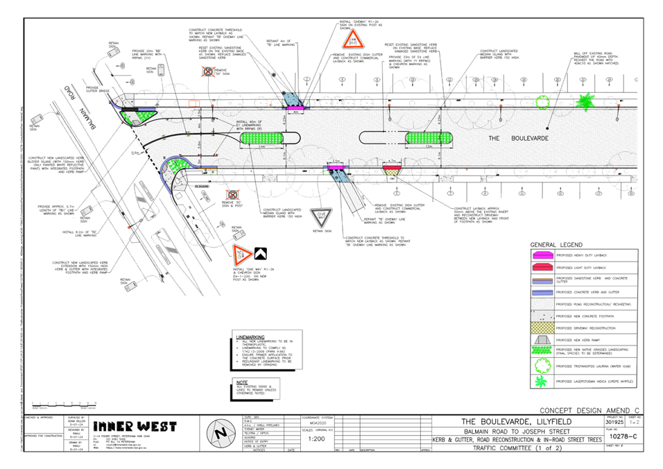
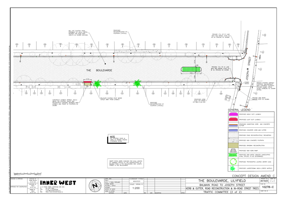
Subject: The Boulevarde, Lilyfield - Proposed Streetscape Improvements and Civil Works (Baludarri-Balmain Ward/Balmain Electorate/Leichhardt PAC)
Prepared By: Sunny Jo - Coordinator Traffic Engineering Services North
Authorised By: Jason Scoufis - Acting Traffic and Transport Planning Manager
|
RECOMMENDATION
That the attached detailed design plan No.10278-C for the proposed streetscape improvements and civil works on The Boulevarde between Balmain Road and Joseph Street, Lilyfield, be approved. |
STRATEGIC OBJECTIVE
This report supports the following strategic directions contained within Council’s Community Strategic Plan:
|
2: Liveable, connected neighbourhoods and transport |
|
|
EXECUTIVE SUMMARY
Council is planning to undertake streetscape improvement works in The Boulevarde, Lilyfield. The works are intended to improve pedestrian and motorist safety at the intersection of The Boulevarde and Balmain Road by constructing kerb extensions as well as improving the general amenity of the street by providing landscaped islands, including repairing the road and footpath.
The proposed works does not change the existing parking in The Boulevarde.
The Local Traffic Committee on 16 September 2024 recommended to defer the matter pending further community consultation as there were strong concerns from residents about the proposed layout with the proposed in-road trees. Additional consultation was carried out which included a public meeting held with the Mayor, Council officers and residents on 6 February 2025. Revised plans were distributed to residents and the final version of the design plans are attached for consideration.
The attached detailed design plan No.10278-C were approved at the Council meeting on 29 April 2025.
BACKGROUND
The Local Traffic Committee on 16 September 2024 recommended to defer the detailed design plan for the proposed streetscape improvements and civil works on The Boulevarde pending further community consultation as there were strong concerns from residents about the proposed layout with the proposed in-road trees. At the time, 9 of the 20 submissions did not support the design.
DISCUSSION
Additional consultation was subsequently carried out which included a public meeting held with the Mayor, Council officers and residents on 6 February 2025. Revised plans were distributed to residents.
As part of the consultation revised plans were distributed which included:
· Footpath widening at the intersection of Balmain Road.
· Modification of driveways and laneway entrances to reduce vehicle scraping.
· Resurfacing the asphalt road surface and footpath repairs.
At the end of the consultation period, 6 submissions were received from residents and the following issues were raised:
· 1 resident supported the revised proposal with the removal of the trees and median islands.
· 1 submission requested angled parking.
· 1 submission requested angled parking, with in road trees included in landscaped islands.
· 3 submissions supported the original proposal for in road tree planting.
At the on-site meeting there were a number of issues raised including:
· Concerns that the trees were not going to be planted and would result in a lost opportunity to reduce the heat island effect, increase the urban tree canopy and restore the original heritage features of The Boulevarde.
· Consideration should be given to angled parking (2 residents).
· Consideration of reducing vehicle speeds and introducing traffic calming (some
· residents did not agree that this was an issue).
· Issues of the flush footpath at the Joseph Street intersection and potential danger to
· pedestrians with cars cutting the corner.
· Consideration of the large number of children that cross the street near the lane.
· Repairs needed to road surface and some locations of footpaths.
· Extra trees wanted on the verge.
· Better maintenance of existing street trees.
The key themes of the meeting discussions were the need for improved pedestrian safety, traffic speed management and asset repairs to the road and footpaths.
To investigate traffic vehicle speeds, a traffic vehicle count measuring the number of vehicles using the street and their speed was carried out over 1 week period. This investigation indicated that there was not a serious speeding issue in the street.
However, some traffic calming measures were considered appropriate to address any isolated instances of speeding that may occur on infrequent occasions.
Taking into consideration the comments made in the 2 rounds of community consultation and the on-site meeting, a revised plan has been prepared as attached. The revised plan seeks to create a lower speed environment with improved pedestrian safety in The Boulevard by creating entrance treatments into The Boulevard: from Balmain Road and extending beyond the lane, and from Joseph Street. In this regard, the features of the revised plan are:
· The kerb extensions at the Balmain Road intersection remain unchanged as they will reduce the speed of vehicles entering the street, improve pedestrian safety and were generally supported by the residents.
· It is proposed to install 2 landscaped median islands (without trees) on either side of the laneway. This will aid a lower speed environment. Note a typical pedestrian refuge is not feasible at this location as it would block vehicles turning into the lanes and result in a loss of parking.
· To improve pedestrian safety at the Joseph Street intersection, it is proposed to replace the asphalt footpath at the western corner with concrete to better delineate the boundary between the road and the footpath, to reinstate the marker bollards and provide line marking around the corners to further keep vehicles away from the footpath. To further improve safety and reduce vehicle speeds around the corner, a landscaped median island is proposed at the southern end of the street.
· Resurfacing the asphalt road surface, adjustment of levels at the lanes and driveways and footpath repairs were supported by the residents and remain as originally proposed.
· An investigation of additional verge plantings has been carried out and 4 additional trees are proposed to be planted in the grass verge.
It is worth noting to construct kerb extensions at the Joseph Street intersection has significant drainage implications which are cost prohibitive, with the proposed works representing the greatest value for money.
The final version of the design plans No.10278-C are attached for consideration.
As the concept
plans have not significantly changed from the version originally endorsed by
the Local Traffic committee, it is considered that another round of
consultation is not required.
However it is necessary to present the revised plan to the Local Traffic
committee for their
final endorsement.
As such, the following timeline for project delivery is proposed:
• Presentation to Local Traffic Committee – May 2025
• Detailed design completed – July 2025
• Procurement of construction contractors – September 2025
• Completion of Construction – December 2025
FINANCIAL IMPLICATIONS
The cost of the proposed work is estimated to be $550,000.
There is currently $330,000 in the 2024/25 Local Roads Program, which is proposed to be rephased to 2025/26 as part of the Q3 Quarterly Budget Review to align budget phasing to project delivery.
It is proposed to fund the balance of $220,000 from the 2025/26 Pedestrian Access and Mobility Program as the additional works are being carried out to improve pedestrian safety.
|
1.⇩ |
The Boulevarde, Lilyfield - Detailed Design Plan |
|
Local Traffic Committee Meeting 19 May 2025 |
Subject: Livingstone Road and Hill Street, Marrickville – Traffic safety Investigation (Midjuburi-Marrickville Ward /Summer Hill Electorate /Inner West LAC)
Prepared By: Jennifer Adams - Traffic Engineer
Authorised By: Jason Scoufis - Acting Traffic and Transport Planning Manager
|
RECOMMENDATION
That the report be received and noted. |
STRATEGIC OBJECTIVE
This report supports the following strategic directions contained within Council’s Community Strategic Plan:
|
2: Liveable, connected neighbourhoods and transport |
|
|
EXECUTIVE SUMMARY
Council at its meeting held on 3 September 2024 raised a Notice of Motion for the intersection of Livingstone Road and Hill Street, Marrickville which involved the consideration and determining whether any additional traffic calming measures (such as a roundabout) are required at the intersection of Livingstone Road and Hill Street, Marrickville (Item C0924(1) Item 48), Part 2 and Part 3). This report provides an assessment of the safety of the intersection and feasibility of a proposed roundabout at this location along with a summary of any local resident feedback in relation to the intersection.
BACKGROUND
At the Council Meeting held on 3 September 2024, Council resolved the following:
1. That Council note that residents report a several accidents and incidents at the intersection of Hill Street and Livingstone Road, Marrickville.
2. That Council investigate the installation of a roundabout at the intersection to improve safety at the intersection.
3. That Council formally review safety at the intersection, including surveying local residents, and report back to the Local Traffic Committee by the end of 2024
This report provides an assessment of the safety of the intersection of Livingstone Road and Hill Street, Marrickville and discusses whether any additional traffic calming measures (such as a roundabout) are required at the intersection. It also highlights local resident feedback in relation to the intersection and any concerns that have been raised in relation to the intersection.
DISCUSSION
Local road network
Hill Street is classified as a local road and between Beauchamp Street and Livingstone Road, it has an average daily traffic volume of 2,136 vehicles per day and an 85th percentile speed of 42.1km/h.
Hill Street has priority at its intersection with Livingstone Road. The road alignment of Hill Street through the intersection is curved which naturally tends to slow drivers down when travelling through Hill Street section of the intersection.
Livingstone Road is classified as a local road between Harnett Avenue and Hill Street, it has an average daily traffic volume of 3,096 vehicles per day and an 85th percentile speed of 50.4km/h. STOP controls are in place on Livingstone Road at Hill Street, Marrickville. Livingstone Road has a slight curve on the northern leg of its intersection with Hill Street. The roadway also slopes downward north to south.
Recent traffic and pedestrian works completed
The intersection of Livingstone Road and Hill Street was previously investigated as part of a Local Area Traffic Management (LATM) Scheme for the area – Riverside (Area 18). The LATM Scheme was approved by Council in 2014. The proposal which Council implemented included the construction of pedestrian refuge islands and kerb blister islands on the western, northern and southern legs of the intersection. The proposal was aimed at improving safety of pedestrians as well as reducing vehicle speeds. Given the relatively low traffic volumes along this section of Livingstone Road and Hill Road, this proposal was seen as the optimum proposal to address the issue of pedestrian safety whilst reducing the speed of traffic on approach to the intersection. It also made the intersection more visible on approach. Speed humps were also placed before the curves on Hill Street to assist in reducing speeds along Hill Street.
The design plans for this proposal were endorsed by Local Traffic Committee in May 2015 and Council in June 2015. Works were completed in February 2016.
Crash history / road safety investigation
The latest Centre for Road Safety crash data reveals that there were no reported crashes at this intersection in the last 5 years of data ending June 2023.
Current intersection performance
SIDRA model analysis and results for the intersection of Hill Street and Livingstone Road, Marrickville reveal that generally the intersection on all legs operates at a Level of Service (LoS) of A. That is, currently the intersection on all legs represents free-flow traffic conditions with high mobility and low delay. The intersection is thus operating at optimum.
Very similar results are achieved for SIDRA analysis for a roundabout at the intersection. Thus, affectively, at this time, there would be no benefit for the cost to justify the installation of a roundabout.
Copies of both SIDA model analyses are reproduced at the end of this report.
Roundabout
Generally, roundabouts are installed where there is a crash history involving a number of cross traffic incidents and it is often used to treat blackspot locations as a result of this type of crash history. Although there may have been near misses at the intersection, this cannot be used as justification for such treatments. It should be noted that Council can only focus on the recorded data provided by TfNSW.
In accordance with the Austroads Guide to Traffic Management Part 8 – Local Area Traffic Management (LATM), one key consideration for the provision of a roundabout relates to crash history. The guide states that it is only appropriate to consider a roundabout at intersections where the crash history indicates a high number of right-angle and right-turn-through crashes. Based on this and the data summarised above, there is currently no warrant for the introduction of a roundabout at the intersection of Livingstone Road and Hill Street, Marrickville.
The Guide also notes that traffic volume data, along with crash history, is important when investigating whether a particular intersection is suitable for a roundabout treatment. It states suitable intersections ideally would have approximately equal traffic flow from all approaches and be local streets in residential areas that have a high volume of unnecessary through traffic. Noting also that locations with marked uneven flows of traffic are unsuitable for roundabouts. This criterion also supports that there is currently no warrant for the introduction of a roundabout at the intersection of Livingstone Road and Hill Street, Marrickville.
There is no single preferred treatment for safely accommodating cyclists and pedestrians at roundabouts and each case requires careful consideration before committing to a course of action. There are potential dangers for cyclists and pedestrians at roundabouts if they are not appropriately designed and which is one of the main disadvantages of the installation of a roundabout.
The previous works completed at the intersection of Livingstone and Hill Street (pedestrian refuge islands and kerb blister islands on the western, northern and southern legs of the intersection) appears to have adequately addressed past pedestrian safety issues whilst reducing the speed of traffic on approaches to the intersection.
Consultation
A review of Council’s system revealed that there is a very limited history of complaints (i.e. only complaints from one resident) regarding safety at the intersection of Livingstone Road and Hill Street, Marrickville. In the 2013-14 Riverside LATM Strategy review Hill Street was only second to Livingstone Road in relation to community complaints and the majority of complaints were regarding vehicle speed which had been addressed within the LATM review.
Consultation has now been conducted in the local area surrounding the subject intersection. The letter noted that Council is reviewing road safety, walking and cycling in the area of Hill Street and Livingstone Road, Marrickville and asked the residents for their views on walking, cycling and driving in their neighbourhood. The localised study area is detailed on the plan below.
The consultation period was from 27 February 2025 to 28 March 2025. In total 270 letters were distributed. There were 13 responses a return rate of 4.8%.
It is noted that four (4) additional responses came in well after the consultation period had finished and all raised similar concerns and did not have any resident details listed so have been discounted in this assessment.
The main issues raised by residents are grouped below and Council officers’ response to issues raised is detailed below each grouped issue.
Speeding
· Vehicles drive too fast up and down Hill Street
· poor visibility at the intersection and vehicles speeding in all directions
· motorist’ use Livingstone road, between Hill and Warren try to break the land speed record
· the current speed humps do nothing to deter cars
· Safety - speeding cars along Livingstone Rd cutting to or from Illawarra Road via Wharf Rd.
· Traffic has increased drastically, Illawarra Rd to Livingstone Rd has become a racetrack
Officer Comments: The existing speed cushions in Hill Street and Livingstone Road were installed as recommended in the 2013/14 Riverside LATM Review to slow motorists along those roads. It is acknowledged that 85th percentile speeds of 42.1km/h on Hill Street and 50.4km/h on Livingstone Road are around the present 50km/h urban speed limit and satisfactory for local streets. It is nevertheless envisioned that when Council finishes implementing the InnerWest@40 proposal which seeks to reduce the speed limit from 50 km/h to 40 km/h on local streets this will improve overall road safety of the intersection and along the adjoining streets.
Intersection
· There is a high level of vehicle non-compliance with stop signs in Livingstone Road making it dangerous for pedestrians and drivers crossing both streets.
· Lane delineation at the intersection of Hill St and Livingstone Road is vague.
· Any modifications to the intersection would only cause more safety and parking issues to the already busy area
· a roundabout with crosswalks should be created to help slow down the traffic.
· A roundabout would be the most effective way to manage traffic flow, providing a clear right of way and naturally slowing vehicles - particularly those coming downhill from Dulwich Hill
Officer Comments: The STOP control on Livingstone Road at Hill Street was installed in August 1986 so has been in place many years. Non-compliance at a STOP control is an enforcement issue. The Livingstone Road and Hill Street intersection does not have straight legs and due to slope and curvature issues there are inherent lateral sight distance restrictions which residents may perceive to be vague lane delineation. It is noted that when the current safety improvement works of 3 pedestrian refuges and kerb blisters were implemented in 2015 at the Livingstone Road and Hill Street intersection the original design plan was rejected by residents due to the potential loss of up to 9 on-street parking spaces subsequently the design was modified, and on-street parking loss was reduced to 4 spaces.
Pedestrians
· extremely dangerous for pedestrians crossing Hill Street because the speeding vehicles
· tricky spot to cross the road for pedestrians as the hill decline promotes speed,
· The distance pedestrians have to travel across Hill Street from Livingston Road on both sides is large. It’s a busy street that could use a pedestrian crossing and kerb blisters, especially adjacent to the bus stop.
· Ped crossing is required at this location to assist school children
Officer Comments:
The 3 pedestrian refuges and the traffic islands that were installed in 2015 at the intersection of Livingstone Road and Hill Street were designed in compliance with relevant standards. The purpose of the blister traffic islands is to reduce traffic lanes and thus to slow vehicles speed at the intersection which in turn improves safety for pedestrians with shorter distances to cross.
The provision of pedestrian zebra crossings which can operate safely necessitates certain criteria to be met including sufficient pedestrian volumes. Marked crossings tend to be poorly respected by drivers if there is relatively low pedestrian usage throughout the day. A much safer pedestrian treatment in such environments is the provision of pedestrian refuge islands as provided. Thus, at this time there are no plans to introduce further crossing facilities at this intersection.
Parking
· parking has increased in difficulty since spaces were removed,
· parking supply must be increased, 45 deg angle parking. Parking gradually getting worse
· Street parking - lack of street parking
Officer Comments: Council acknowledges that it is difficult to find parking in some areas and Council continually seeks to take a balanced approach to ensuring that the needs of residents are balanced with other users such as visitors, business and commercial users. As noted when the current safety improvement works of 3 pedestrian refuges and kerb blisters were implemented in 2015 at the Livingstone Road and Hill Street intersection the original design plan was rejected by residents due to the potential loss of up to 9 on-street parking spaces subsequently the design was modified, and on-street parking loss was reduced to 4 spaces. Angle parking was also raised a number of times in the 2014 consultation process and considered not viable.
Buses
· Hill Street is dangerous for regular bus services as it is too narrow, forcing buses to cross centre lines
· the busses are extremely loud
· The bus traffic has become concerning due to the speed and frequency of buses travelling along the road
Officer Comments: During the current T3 shutdown period for the Sydney Metro upgrade works replacement buses are using Hill Street. TfNSW has stated that Hill Street is used for TTP bus operations due to its relatively direct path between Marrickville and Dulwich Hill, width, and ability to accommodate both inbound and outbound bus movements. It is one of the only streets between the Marrickville and Dulwich Hill suitable for bus movements. TfNSW notes also alternate options for bus movements in the area are very limited due to several factors including narrow road widths, on-street parking, tree canopy coverage and numerous one-way streets. Both Wharf Street and Warren Road, were deemed unsuitable for TTP bus operations. Once the Sydney Metro line is open the bus movement issues will no longer be significant.
Cyclists
· cycle lanes or modifications added to this proposed area would only create the same safety and parking issues that are currently happening further down the road now
· It would also be great to see cycle infrastructure, although parking is already tight
Officer Comments: At this time, the Livingstone Road cycleway (Local Route 3) from Randall Street to Marrickville Park, Marrickville is complete and will not be extended to the intersection of Livingstone Road and Hill Street. Local routes aim to connect residential streets with local destinations, such as schools and local shops, and regional bicycle routes. It is noted that loss of parking was raised as one of the main concerns related to the Livingstone Road cycleway. The concept plan was subsequently amended in response to community concerns to significantly reduce proposed parking impacts on Livingstone Road between Marrickville Park and the Bankstown Line rail corridor. The final constructed plan proposed an overall gain of 7 on-street parking spaces (6 of which were in Enfield Street created by providing angled parking in the section west of Livingstone Road).
Conclusion
Both the speed and traffic volumes in Hill Street and Livingstone Road, Marrickville are within acceptable limits for local roads and there are no TfNSW recorded crashes within the last five years. Therefore, currently there is no warrant or cost benefit at this time for the introduction of a roundabout at the intersection of Livingstone Road and Hill Street, Marrickville. It is noted that Council has treated this intersection successfully in the past through construction of median island stop treatments which has improved both control and delineation of this intersection and reduced the previous significant crash history.
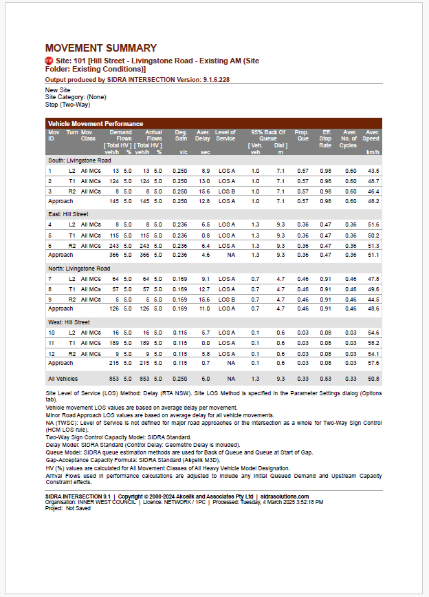
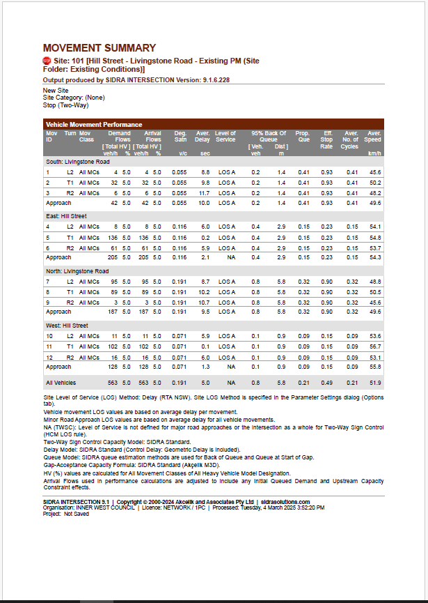
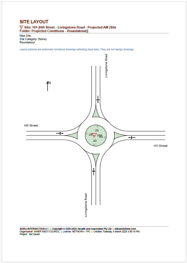
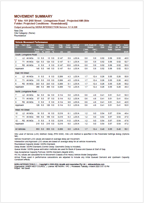
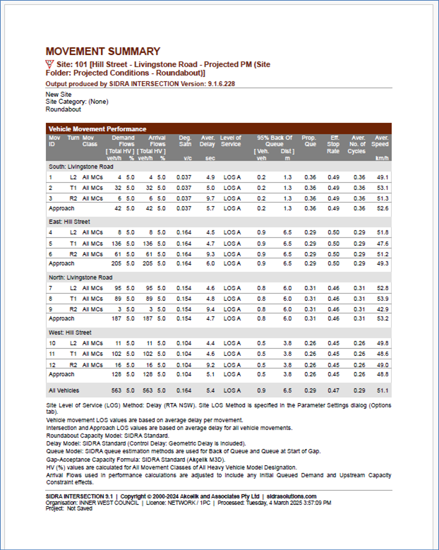
Nil.
|
|
Local Traffic Committee Meeting 19 May 2025 |
Subject: Centennial Street, Marrickville – Temporary Road Closure for Special Event at Henson Park – 2025 Beer, Footy and Food Festival on Saturday 26 July 2025 - (Midjuburi-Marrickville Ward /Summer Hill Electorate /Inner West LAC)
Prepared By: Jennifer Adams - Traffic Engineer
Authorised By: Jason Scoufis - Acting Traffic and Transport Planning Manager
|
RECOMMENDATION
That the proposed temporary full road closure (ENRC/2025/0027) of Centennial Street, Marrickville between Sydenham Road and the entrance to Henson Park and Marrickville & District Hardcourt Tennis Club car park, between 10.00am and 8.00pm on Saturday 26 July 2025 (contingency period of two months) for the purpose of holding the ‘Beer, Footy and Food Festival 2025’ event be approved, subject to the approval of the S68 Application and the applicant complying with, but not limited to, the following conditions: a) A Road Occupancy License application be obtained by the applicant from the Transport Management Centre; b) All affected residents and businesses, including NSW Police Local Area Commander, Transit Systems, Fire and Rescue NSW and NSW Ambulance Services, shall be notified in writing by the applicant of the proposed temporary road closure at least 7 days prior to the event, with the applicant making reasonable provision for residents and businesses; c) A VMS be placed displaying that there is ‘No Public Parking’ in Centennial Street; d) The occupation of the road carriageway must not occur until the road has been physically closed; and e) Subject to written concurrence from Transport for New South Wales.
|
STRATEGIC OBJECTIVE
This report supports the following strategic directions contained within Council’s Community Strategic Plan:
|
2: Liveable, connected neighbourhoods and transport |
|
|
An application has been received from the Music & Booze Company together with the Newtown Rugby League Football Club (the Jets) to hold the 2025 Beer, Footy and Food Festival between 10.00am and 8.00pm on Saturday 26 July 2025 at Henson Park Oval. The event requires the temporary full road closure of Centennial Street, Marrickville between Sydenham Road and the entrance gate to Henson Park Oval. It is recommended that Council agree to the temporary full road closure subject to the applicant complying with the above conditions and obtaining concurrence from Transport for NSW as the closure entails lane closures on Sydenham Road, Marrickville.
BACKGROUND AND STAFF COMMENTS
Centennial Street, east of Sydenham Road, will be closed to traffic thoroughfare so the event as proposed can successfully occur. The road will be accessible to all residents, emergency services, Event staff, Coaches and players and allowance will also be made for disability parking to come through the road closure.
Centennial Street is a dead-end local two-way street with one travel lane in each direction, in addition to kerbside parking lanes. It carries around 400 vehicles per day. Parking is unrestricted along both sides of the road. It is a residential local road and an entry point to Henson Park.
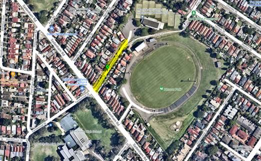
The Beer Footy Food event will be held between 11am and 7pm and the road closure hours will be between 10am and 8pm to allow for bump in and out activities.
The following traffic control measures are diagrammatically shown and detailed in the attached TMP and Traffic Guidance Schemes (TGSs):
VG. 19.112-1, Pick up and Drop off
VG. 19.112-B. E, Bus entry assisted
VG. 19.112-D, Detour route/ Light Traffic entry to Centennial Street
VG. 19.112-IN, Ingress for Vendors and Staff
VG. 19.112-EG, Egress for Vendors and Staff
· Road Closure, on Centennial Street, however allowing access to Residents, Players, Coaches, event staff & Patrons of the Tennis Club.
· Light traffic entry to Centennial Street - light traffic will be detoured along Sydenham Road to turn left into Petersham Road and turn left onto Centennial Street, before continuing straight through the lights on to the closed section of Centennial Street. This control measure is to alleviate traffic congestion attempting to turn right from Sydenham Road on to Centennial Street.
· All Residents and business effected by this closure will be notified 1 month and 1 week prior to the Event.
· 1 Traffic Controller will be in place on the southwest corner of the Centennial Street and Sydenham Road intersection, they will assist anyone attempting to enter the Road Closure at Centennial Street by directing them towards the light traffic detour.
· Special Event Clearways
Sydenham Road, between Centennial Street and Holmesdale Street to allow room for the drop off area, just outside the gates to Henson Park.
· Bus Entry
Bus entry will be conducted under guidance by RMS accredited Traffic Controllers. Upon approach all traffic will be stopped in both directions and the road closure opened, the bus driver will be instructed to drive into Centennial Street (south) and then reverse into Centennial Street (north) where they will be assisted by a spotter to a safe parking spot.
· Pedestrian Crossing
Traffic Controllers (TCs) will assist all pedestrians across the road safely, from the main entry/exit to the Marrickville High School parking lot. This is a preventative measure to ensure all patrons leave the Event safely and in an orderly fashion. TCs will hold pedestrians from crossing the road until such time as the supervisor deems it safe, has stopped traffic and cleared an area to cross. This will avoid people rushing onto the road in between slow traffic and causing more congestion as well as keeping the public safe.
· Lane closures on Sydenham Road
Sydenham Road, northbound right turning lane at Centennial Street intersection
Traffic cones will merge traffic into the left lane 30 meters prior to the intersection.
Sydenham Road, northbound left lane parking Clearway.
Traffic management personnel will be directing motorists parking for the event into Marrickville High School grounds via Sydenham Road gate entrance.
Sydenham Road, southbound left lane parking Clearway.
Traffic management personnel will direct motorists into this lane as a “drop-off” zone for the event.
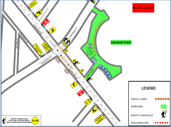
· Site map
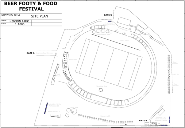
FINANCIAL IMPLICATIONS
All works and costs of implementation will be borne by the applicant
PUBLIC CONSULTATION
The applicant is to notify all affected residents and businesses in writing at least 7 days prior to the commencement of works. The proposed road closure has been advertised on Council’s website in accordance with the Roads Act 1993.
CONCLUSION
It is recommended that Council support the temporary full road closure on Saturday 26 July 2025 subject to complying with the recommendations stated in this report along with all standard conditions for temporary full road closures.
|
1.⇩ |
Henson LATM final 0197D14E.00B
|
|
Local Traffic Committee Meeting 19 May 2025 |
Subject: Marrickville Road, part of Seaview Street and Durham Street, Caves Lane, Marrickville – Temporary full Road Closures for Dulwich Hill Village Fair – Sunday 21 September 2025 (Djarrawunang-Ashfield Ward / Summer Hill Electorate / Inner West PAC)
Prepared By: Jennifer Adams - Traffic Engineer
Authorised By: Jason Scoufis - Acting Traffic and Transport Planning Manager
|
RECOMMENDATION
1. That the proposed temporary full road closure of Marrickville Road (between New Canterbury Road and Fairfowl Street), part of Seaview Street (between Marrickville Road and south of the entrance to the car park south of Herbert Street), Durham Street (between Marrickville Road and Durham Lane), Caves Lane, and the Seaview Street car park (car park adjacent to Caves Lane), Dulwich Hill for the ‘Dulwich Hill Village Fair’ Event on Sunday 21 September 2025 between the hours of 3:00am and 9:00pm be approved as per the submitted TMP and TGSs;
2. That a Road Occupancy License application be obtained from the Transport Management Centre;
3. That notice of the proposed event be forwarded to the NSW Police Local Area Commander, Transit Systems, the NSW Fire Brigades and the NSW Ambulance Services;
4. That all residents and businesses in and around the affected area are to be notified of the temporary road closure in writing by the applicant in advance (at least 7 days prior to the event) with the applicant making reasonable provision for stakeholders; 4. That a minimum four (4) metre unencumbered passage be available for emergency vehicles through the closed section; and 5. That the occupation of the road carriageway must not occur until the road has been physically closed.
|
STRATEGIC OBJECTIVE
This report supports the following strategic directions contained within Council’s Community Strategic Plan:
|
2: Liveable, connected neighbourhoods and transport |
|
|
EXECUTIVE SUMMARY
BACKGROUND
Council's Events Coordinator has advised that this year's annual 'Dulwich Hill Village Fair' will be held on Sunday 21 September 2025 and has submitted a request for some temporary road closures between the hours of 3:00am and 9:00pm on the day of the event.
The Dulwich Hill Village Fair is a local event celebrating the growth of bars and eateries sprouting on the hill. The fair provides family entertainment mixed with food fair such as cheese plates and artisan bakery offerings. markets displaying eco-friendly clothing, handmade jewelry, gifts and locally made items. There will also be music, a martial arts display, dance acts and a kids play area.
This year’s Dulwich Hill Village Fair will run between 11:00am and 4:00pm on Sunday 21 September 2025, however, the temporary full road closures are required from 3:00am and 9:00pm on Sunday 21 September 2025 for bump in and bump out activities:
OFFICER COMMENTS
Temporary full road closures are planned for the following locations (refer to the site map below):
· Marrickville Road (between New Canterbury Road and Fairfowl Street),
· Durham Street (between Marrickville Road and Durham Lane)
· Seaview Street (between Marrickville Road and south of the entrance to the car park south of Herbert Street),
· Caves Lane, and The Seaview Street car park (car park adjacent to Caves Lane).
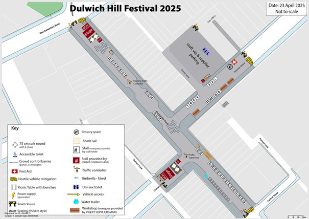
The event is classified as a Class 2 event under the TfNSW’ Special Events Guide where it impacts local traffic and transport systems but does not impact major traffic and transport systems and it disrupts the non-event community in the area around the event but not over a wide area. The event requires the involvement of Police and Local Council and a detailed Transport Management Plan (TMP).
Council barricades will be used to affect the closures and a 4-metre-wide emergency vehicle access will need to be maintained through the area during the course of the street fair. Appropriate advance notice signs will be strategically installed at least two weeks prior to the event to alert motorists of the proposed closures. In addition, 'No Parking - Special Event' signs will be affixed over all existing parking restriction signs within the closed roads on the afternoon of the day prior to the event - Saturday 20 September 2025.
Adequate vehicular traffic control shall be provided for the protection and convenience of pedestrians and motorists including appropriate signage and flagging. Workers shall be specially designated for this role (and carry appropriate certificates), as necessary to comply with this condition. This is to be carried out in accordance with the Australian Standard AS 1742.3 - Traffic Control Devices for works on roads.
Traffic Management Plan and Traffic Guidance Schemes
A Traffic Management Plan (TMP) has been supplied by CATO Location Services, the scope of which includes the provision for the safe movement of vehicular traffic in and out of the event areas at the Dulwich Hill Village Fair on Sunday 21 September 2025. The TMP is attached at the end of this report. The Traffic Guidance Schemes (TGS) are reproduced below.
Authorised traffic controllers will install barricades and signage and maintain closure points as per the Traffic Guidance Schemes.
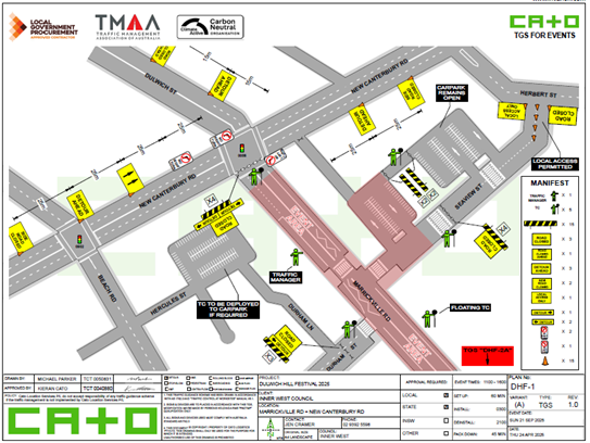
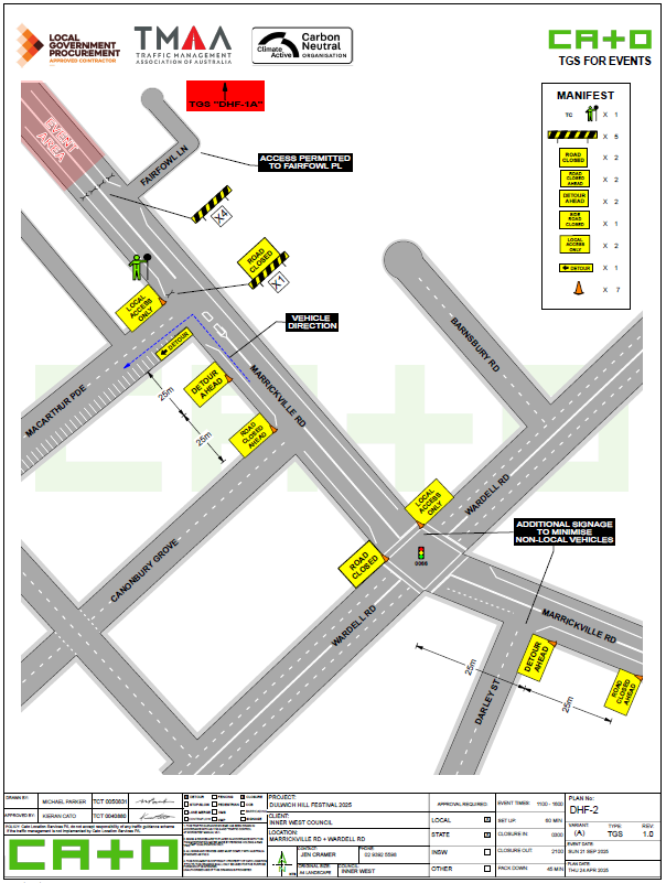
Impacts on traffic
Access around the event area will involve detours. Traffic will have to be directed to Wardell Road and Frazer Street or Beach Road and Durham Street during the closure. Refer to the detour plan below.
The traffic diverted from Marrickville Road and Seaview Street as a result of the proposed road closures, does not coincide with the peak traffic, as the Fair will be held on a Sunday when much lower than weekday traffic volumes are expected. There should be no impact to heavy vehicles. At present there should not be any construction works that will be impact the event. There are no traffic calming devices or traffic generating developments along the route.
It is envisaged that the traffic generated as a result of the proposed festival will not have a major impact on the surrounding traffic network during the event. Furthermore, the arrival and departure of attendees of the Fair is expected to be staggered as in previous years when this event took place.
Impacts on buses
At present, bus services use Marrickville Road and cross New Canterbury Road then turn around in Dulwich Street. The temporary closure of Marrickville Road at its intersection with New Canterbury Road will require buses to use a different route during the closure. Bus amended route changes ae detailed below:
Buses will be diverted off Marrickville Road and Canterbury Road using Frazer Street and Wardell Road as a detour.
The following arrangements apply to the applicable service routes for the event date.
The TMP states that “All other services around the Inner West Council area will not be affected by the road closures. The bus service provider will advise public transport users via their websites, bus stop flyers and smart phone applications. Advice will also be provided on the event page on Council’s website and social media platforms.”
The following stops will be closed during the event and reopen at the completion of the event:
Services heading East - Dulwich Hill, Marrickville Road Nr New Canterbury Rd Stop 220317 Dulwich Hill, Marrickville Road Nr Fairfowl Street Stop 220339 Dulwich Hill Marrickville Road Nr Wardell Street Stop 220340.
Services heading West - Dulwich Hill, Marrickville Road Nr Macarthur Parade Stop 220341 Dulwich Hill, Marrickville Road Nr New Canterbury Road 220342
Transit Systems & Transdev - Trains
It is anticipated that there will be no impact on Sydney Trains, its services, passengers and stations. The nearest train station is Dulwich Hill train station located southwest to the event location.
Light Rail Services
It is anticipated that there will be no impact on Sydney Light Rail, its services, passengers and stations. The nearest light rail stations are Dulwich Hill, Dulwich Grove and Arlington located west to the event location.
Taxi and Rideshare providers
Taxis and ride-share providers will continue to have access to the road network around the closures as per other road users. No additional drop off or pick up standing zones will be arranged for these providers.
Special Event Clearways
No Special Event Clearways are proposed for the event. Council will install NO-STOPPING signage around the area (including 20 spaces in Seaview St carpark) to warn of the upcoming event.
Detailed letter box drops and communications will be forwarded to local resident and commercial operators advising of the road closures, and parking management arrangements.
There are sufficient street parking spaces available and local carparks outside the event road closures for patrons to access, however it is anticipated majority of patrons will arrive on foot, by public transport or Taxi / rideshare.
Impacts on Parking
“No Stopping” signs will be used to reserve parking spaces within the road closure area prior to the road closure time. Council will install “No Stopping Authorised Vehicles Only” in 20 parking bays of the southern Seaview Street carpark for VIP, Performer, Staff and Contractor parking. This will be done by Council officers.
Emergency Lane
A minimum 4 metre emergency lane will be maintained along the entire closure. Traffic controllers will be onsite to assist emergency vehicle through the closure points.
Hostile Vehicle mitigation strategies may be undertaken within the road closure in accordance with the event risk assessment and NSW Police direction.
PUBLIC CONSULTATION
The proposed road closure has been advertised on Council’s website in accordance with the Roads Act 1993.
The applicant is to notify all affected residents and businesses in writing at least 7 days prior to the commencement of works. A copy of the draft notification letter is attached below.
The Traffic Management Plan is to be submitted to TfNSW for consideration and approval and a Road Occupancy License application is to be submitted to the Transport Management Centre by CATO Location Services.
Funding of $105,100 has been allocated by Council for organising the ‘Dulwich Hill Festival event under the 2025/2026 Major Community Events Program.
CONCLUSION
It is recommended that Council support the temporary full road closure on Sunday 21 September 2025 subject to complying with the recommendations stated in this report along with all standard conditions for temporary full road closures as detailed in Condition 10 of the S68201800008 development consent for the event.
|
1.⇩ |
2025 TMP_inc_TGS_Dulwich Hill Festival |
|
Local Traffic Committee Meeting 19 May 2025 |
Subject: Marrickville Road, Marrickville – Temporary full road closure for Marrickville Music Festival – Sunday 12 October 2025 (Midjuburi - Marrickville Ward / Summer Hill Electorate / Inner West PAC)
Prepared By: Jennifer Adams - Traffic Engineer
Authorised By: Jason Scoufis - Acting Traffic and Transport Planning Manager
|
RECOMMENDATION
1. That the proposed temporary full road closure of Marrickville Road (between Illawarra Road and Victoria Road), Central Lane (between Victoria Road and Meeks Road), Seymour Lane (between Garners Lane and Garners Avenue and between Frampton Avenue and Garners Lane), Garners Lane (north of Seymour Lane) along with short sections of Silver Street, Garners Avenue, Gladstone Street, and Frampton Avenue where these streets intersect with Marrickville Road, Marrickville be APPROVED for the purpose of holding the ‘Marrickville Music Festival’ Event on Sunday 12 October 2025 between 01:30am and 11:00pm as per the submitted TMP and TGSs and subject to the following conditions and all standard Council conditions for temporary full road closures.
2. That a Road Occupancy License application be obtained from the Transport Management Centre.
3. That notice of the proposed event be forwarded to the NSW Police Local Area Commander, Transit Systems, the NSW Fire Brigades and the NSW Ambulance Services.
4. That all residents and businesses in and around the affected area are to be notified of the temporary road closure in writing by the applicant in advance (at least 7 days prior to the event) with the applicant making reasonable provision for stakeholders. 5. That a minimum four (4) metre unencumbered passage be available for emergency vehicles through the closed sections. 6. That the occupation of the road carriageway must not occur until the road has been physically closed.
|
STRATEGIC OBJECTIVE
This report supports the following strategic directions contained within Council’s Community Strategic Plan:
|
2: Liveable, connected neighbourhoods and transport |
|
|
EXECUTIVE SUMMARY
Inner West Council is presenting Marrickville Music Festival on Sunday 12 October 2025 from 12:00noon until 6:00pm. The event will feature multiple outdoor live music stages across the festival site. Including activation of Marrickville laneways through music and art. As part of the event there will be a temporary full road closure of Marrickville Road and Central Lane. This will require some road detours and bus diversions in surrounding streets. Event bump in will occur from 01:30am and bump out will conclude by 11:00pm. It is recommended that Council agree to the temporary full road closures subject to all standard Council conditions for a temporary full road closure.
BACKGROUND
Marrickville Festival is an annual event successfully held over numerous years. This year Marrickville Music Festival will be another celebration of live music in the Inner West. The event will run on Sunday 12 October 2025 from 12noon to 6pm and will feature multiple outdoor live music stages across the festival site.
Stages will be set up across the event site including the activation of Marrickville laneways through music and art. The Marrickville Music Festival will be a showcase of music talent from the Inner West, with over 40 acts to play in the one-day event. Stages will host both established and up and coming bands from the Inner West. Music venues in Marrickville will be also encouraged to participate in the festival program to highlight the vibrant array of venues that reside in the Marrickville area.
As part of the Marrickville Music Festival site furniture will be set up within the space created by the temporary road closure, allowing patrons to purchase food from local Marrickville businesses and enjoy the atmosphere while supporting local businesses and enhancing economic activity over the day. Visitors to the festival will be encouraged to engage with local businesses within their retail spaces increasing footfall, and as such experience the true Marrickville and embrace the precinct for its vast array of unique businesses and food experiences.
The Marrickville Music Festival will also host an Inner West Brewery showcase, with local breweries setting up stalls so patrons can taste Inner West offerings. Food and art stalls will be located in pockets around the site to showcase local Inner West product and creativity. Programming for families will be available along with cultural experiences from local creatives.
As part of the event there will be a partial road closure of Marrickville Road and Central Lane. This will require some road detours and bus diversions in surrounding streets. To facilitate the event the following roads will be affected from 01.30 hours to 23.00 hours Sunday 12 October 2025:
· Marrickville Road between Illawarra Road and Victoria Road
· Silver Street between Marrickville Road and 25 metres north of Marrickville Road
· Garners Avenue between Garners Avenue Carpark and Marrickville Road
· Seymour Lane between Garners Lane and Garners Avenue
· Frampton Avenue between Seymour Lane and Marrickville Road
· Gladstone Street between Marrickville Road and Marrickville Lane
· Silver Street between Sydenham Road and 25 metres north of Marrickville Road (Resident Access Excepted)
· Garners Avenue between Illawarra Road and Garners Avenue Carpark (Resident Access Excepted)
· Seymour Lane between Frampton Avenue and Garners Lane (Resident Access Excepted)
· Garners Lane north of Seymour Lane (Resident Access Excepted)
· Central Lane between Victoria Road and Meeks Road
· Victoria Lane between Sydenham Road and Central Lane (Resident Access Excepted)
OFFICER COMMENTS
The event area will be on Marrickville Road between Illawarra Road and Victoria Road (refer to the site map below – Marrickville Music Festival Area). This year Council’s Event Coordinator has appointed ‘Who Dares Pty Ltd’ to prepare the Traffic Management Plan (TMP) and Traffic Guidance Schemes (TGS) for the event. A copy of the TMP and TGSs are attached at the end of this report.
Site map
Access around the event site will be maintained by a detour. The detour loop will include Illawarra Road, Sydenham Road, Victoria Road and Calvert Street.
No special event clearways will be installed for this event. Inner West Council will instead install No Stopping signage throughout the event precinct prior to the event. Any remaining vehicles will be towed and parked in a nearby location on the morning of the event.
This event is classified as a Class 2 event under the TfNSW’ Special Events Guide where it impacts local traffic and transport systems but does not impact major traffic and transport systems and it disrupts the non-event community in the area around the event but not over a wide area. The event requires the involvement of Police and Local Council and a detailed Transport Management Plan (TMP).
Adequate vehicular traffic control shall be provided for the protection and convenience of pedestrians and motorists including appropriate signage and flagging. Workers shall be specially designated for this role (and carry appropriate certificates), as necessary to comply with this condition. This is to be carried out in accordance with the Australian Standard AS 1742.3 - Traffic Control Devices for works on roads.
Impacts on buses - Transit Systems & Transdev NSW Buses amended route changes
Transit Systems services 418, 423, 423X, 425 & 426 & Transdev NSW N40 service will all be impacted by the event road closures. These services will be detoured around the event precinct. Council will arrange for signage will be placed at impacted bus stops to direct passengers to the nearest stop. Refer to Annex 1 of the attached TMP for Transit Systems and Transdev Bus detour maps at a larger scale and to Annex 2 for Bus Stop signage.
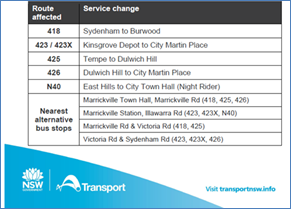
Impacts Sydney Trains
The closest train station is Sydenham Station. It is approximately 680 metres walk from the event precinct.
The extension of Sydney Metro services from Sydenham to Bankstown will now be completed in 2026. During this time there is a temporary closure of the T3 Bankstown Line - Sydenham to Bankstown. Fare free Southwest Link buses are replacing trains between Sydenham and Bankstown.
The SW1, SW2 & SW3 routes are impacted by Marrickville Music Festival. Bus detour reroutes to be determined in conversation with Sydney Metro and will be included in a subsequent version of this TMP. For public transport information please visit https://transportnsw.info/
Impacts on pedestrians and cyclists
There will be no major effect to pedestrians in the area. Pedestrians will be able to use the existing pedestrian paths outside of and within the event area.
There are no cycleways directly impacted by this event. Cyclists entering the event site will be requested to dismount.
Impacts on Parking
Parking will only be available in surrounding residential streets and a few small public carparks around the event site. Parking will as such be limited, and the event organiser will be recommending public transport to all event patrons.
Impacts on traffic
The traffic diverted from Marrickville Road as a result of the proposed road closures, does not coincide with the peak traffic, as the festival will be held on a Sunday when lower than weekday traffic volumes are expected. Therefore, the traffic generated because of the proposed festival will not have a major impact on the surrounding traffic network during the event. Furthermore, the arrival and departure of attendees of the festival is expected to be staggered as it is every year when this event takes place.
At present, there is no indication of construction works that will be impact the event. There are no traffic calming devices or traffic generating developments along the route.
Heavy vehicles may experience slight delays due to increased traffic around the event precinct. Heavy vehicles should follow signposted detours.
A minimum four (4) metre emergency lane will be maintained along the entire closure. Traffic controllers will be onsite to assist emergency vehicles through the closure points.
Hostile Vehicle mitigation strategies may be undertaken within the road closure in accordance with the event risk assessment and NSW Police direction.
Traffic Management Plan and Traffic Guidance Schemes
An accredited Who Dares Traffic Manager will oversee implementation of the Traffic Guidance Schemes, including road closures.
Temporary traffic control signage, barricades and equipment as per the supplied Traffic Guidance Schemes must be installed by TfNSW or SafeWork accredited traffic controllers with a current “Implement Traffic Control Plan” certificate. Any person operating a Stop/Slow bat onsite must hold a current “Traffic Controller” certificate.
A Traffic Management Plan (TMP) has been supplied by Who Dares Pty Ltd, the scope of which includes the provision for the safe movement of vehicular traffic in and out of the event areas at the Marrickville Festival on Sunday 12 October 2025. The TMP and Traffic Guidance Schemes (TGS) are reproduced in full at the end of this report.
TGS 01A Sydenham Road, Illawarra Road & Victoria Road MARRICKVILLE
TGS 01B Sydenham Road, Illawarra Road & Victoria Road MARRICKVILLE
TGS 01C Sydenham Road, Illawarra Road & Victoria Road MARRICKVILLE
TGS 02A Marrickville Road & Illawarra Road MARRICKVILLE
TGS 02B Marrickville Road & Illawarra Road MARRICKVILLE
TGS 02C Marrickville Road & Illawarra Road MARRICKVILLE
TGS 03A Marrickville Road & Victoria Road MARRICKVILLE
TGS 03B Marrickville Road & Victoria Road MARRICKVILLE
TGS 03C Marrickville Road & Victoria Road MARRICKVILLE
TGS 03D Marrickville Road & Victoria Road MARRICKVILLE
TGS 03E Marrickville Road & Victoria Road MARRICKVILLE
TGS 04 Calvert Street, Illawarra Road & Victoria Road MARRICKVILLE
The Traffic Management Plan is to be submitted to TfNSW for consideration and approval and a Road Occupancy License application is to be submitted to the Transport Management Centre by Who Dares Pty Ltd.
PUBLIC CONSULTATION
The proposed temporary full road closures have been advertised in accordance with the Roads Act 1993.
Advice of the proposed event must be forwarded to all the appropriate authorities, including emergency services. A copy of the draft notification letter is attached at the end of this report.
The TMP states that: “All affected residents will be notified of the event through:
• Letterbox drop will be conducted for impacted residents within and near the road closure precinct at least two weeks prior to the event.
• Date & time specific corflute “Special Event – Road Closed” signs to be placed around the event precinct 14 days prior to the event.”
There is no VMS placement for this event
Funding of $178,000 has been allocated by Council for organising the Marrickville Music Festival under the 2025/2026 Major Community Events Program.
CONCLUSION
It is recommended that Council agree to the temporary full road closures on Sunday 12 October 2025 subject to complying with the recommendations stated in this report along with all standard conditions for temporary full road closures.
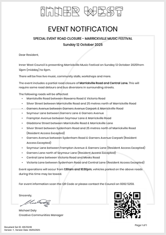
ATTACHMENTS
|
1.⇩ |
Marrickville Music Festival 2025 - TMP - |
|
2.⇩ |
Marrickville Music Festival 2025 - TGS - Version 1.2 |
|
Local Traffic Committee Meeting 19 May 2025 |
Subject: Henson Street (at Herbert Street), Summer Hill-Proposed New Raised pedestrian crossing (Djarrawunang-Ashfield Ward/Summer Hill Electorate/Burwood PAC)
Prepared By: Boris Muha - Traffic Engineer
Authorised By: Jason Scoufis - Acting Traffic and Transport Planning Manager
|
RECOMMENDATION
|
STRATEGIC OBJECTIVE
This report supports the following strategic directions contained within Council’s Community Strategic Plan:
|
2: Liveable, connected neighbourhoods and transport |
|
|
EXECUTIVE SUMMARY
Council is planning to improve safety in Henson Street, Summer Hill by constructing a new raised pedestrian crossing near Herbert Street to replace the existing “at-grade” flat pedestrian crossing. The proposal aims to improve pedestrian and motorist safety by better defining safe pedestrian crossing points and addresses pedestrian safety and driver behaviour at this location.
BACKGROUND
DISCUSSION
The following information is provided in discussion.
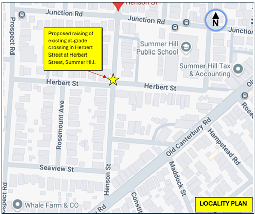
Figure 1. Locality Plan
|
Street Name |
Henson Street
|
|
Carriageway width (m) kerb to kerb |
12.8 |
|
Carriageway type |
Two-way, one travel lane each direction. |
|
Classification |
Local |
|
Speed Limit km/h |
50 |
|
85th percentile speed km/h |
46 |
|
Vehicles per day (vpd) |
2,500 |
|
TfNSW available reported crash history (last 5 years) |
NIL in vicinity of the intersection. |
|
Parking arrangements |
Unrestricted parking both sides |
|
|
|
|
Side intersecting street |
Herbert Street |
Table 1. Road Network detail.
The Plan
The following works are proposed and are illustrated on the attached plan in Attachment 1.
Henson Street (at Herbert Street), Summer Hill (Plan No. 10314):
· Construct a new raised concrete pedestrian crossing with “gutter bridge” crossings to replace the existing “at-grade” flat pedestrian crossing. (refer to attached Plans):
· Construct landscaped kerb blister islands.
· Construct kerb ramps
· Install associated signage associated with the works as required and where shown on the Plan.
Parking Changes
The proposal will not impact on existing parking arrangements in the street. Please refer to the attached plan.
Streetlighting
The new raised pedestrian crossing will require new flood lighting to be provided in order for it to comply with current standards. This will involve the provision of at least 1 (or 2) floodlight (s) on existing or new power poles typical of other locations with pedestrian crossings. At this stage, this design is not complete and will be undertaken by a specialist lighting consultant at a later stage.
FINANCIAL IMPLICATIONS
The project is listed in Council’s Traffic Facilities Capital Works program to be carried out in 2025/2026, subject to funding and programming. The work is estimated to be around $85,000.
A letter outlining the proposal was mailed out to (22) properties (45 letters) including the Summer Hill Public School, in Henson and Herbert Street, Summer Hill. (see also map of consultation area Figure 2).
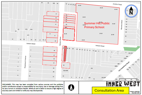
Figure 2- Consultation Area
Two (2) resident submission was received against the proposal.
The resident concerns are tabled below together with the officer’s response.
|
Residents Comments |
Officers Response |
|
Two (2) residents provided similar comments. Against the proposal as doesn’t think it’s a good use of Council’s money and has not witnessed any near misses. Would rather the money be spent on the dangerous Smith St crossing or other dangerous crossings. One of the residents added that he does not want additional lighting in the area |
The proposal aims to improve safety for the school children who frequent the crossing, as well as providing additional traffic calming features in the area.
The Smith Street crossing (east of Moonbie Street) is being investigated under a proposed pedestrian/ streetscape improvement treatment around Lackey Street and Hardie Avenue.
Other crossings are regular monitored.
Additional lighting is to make the pedestrian crossing compliant to standards.
|
CONCLUSION
It is recommended that the detailed design plan (10314) for a proposed new raised crossing in Henson Street at Herbert Street, with associated signs and line marking (as shown in Attachment 1) be approved.
|
1.⇩ |
Proposed new raised crossing in Henson Street at Herbert Street, Ashfield. |
|
|
Local Traffic Committee Meeting 19 May 2025 |
Subject: Warham Lane, Marrickville – Notice of Motion – Parking traffic plan for Henson Park events (Midjuburi-Marrickville Ward /Summer Hill Electorate /Inner West LAC)
Prepared By: Jennifer Adams - Traffic Engineer
Authorised By: Jason Scoufis - Acting Traffic and Transport Planning Manager
|
RECOMMENDATION
That a 15-metre length of “No Parking’ restrictions along with statutory 10 metre ‘No Stopping’ restrictions be installed on the section of Warham Lane between Carew Lane and Malakoff Street, Marrickville in order to improve access to resident’s off-street parking.
|
STRATEGIC OBJECTIVE
This report supports the following strategic directions contained within Council’s Community Strategic Plan:
|
2: Liveable, connected neighbourhoods and transport |
|
|
EXECUTIVE SUMMARY
At the Council Meeting held 12 November 2024 a Notice of Motion (NoM) for ‘Parking traffic plan for Henson Park events’ (C1124(1) Item 20) was resolved. Part 2 was for consideration of consulting local residents of Sydenham Road to determine whether ‘No Parking’ restrictions were required in Warham Lane. This report provides the outcome of the local consultation conducted.
BACKGROUND
At the Inner West Council meeting of 12 November 2024, Council acknowledged outcomes resulting from recent sporting events at Henson Park.
It was noted that the popularity of the Sydney Swans Women’s and Giants AFL at Henson Park attracts fans from all over Sydney. Many prefer to drive which is impacting surrounding residents due to limited parking. Game days start at 10am continuing through to 6pm, creating traffic and parking issues during these times.
The properties opposite Henson Park on Sydenham Road have rear lane access in Warham Lane but are often unable to enter/exit their properties on game days as spectators park in the lane, opposite their garages, obstructing access.
Subsequently, Council resolved the following:
That Council consult the residents of Sydenham Road (Warham Lane) that are impacted by the parking in the rear lane impeding access to their garages by signposting no parking signs.
Separately, in relation to this NoM, it is noted that Council has also requested that AFL ACT/NSW undertake the following:
1. Provide a Traffic Management Plan (TMP) to close Centennial Street north to all traffic except for residents and Tennis Court/Restaurant users only, on game days (a TMP was provided for the same issue in nearby Woodlands Street in 2024).
2. Collaborate with Transport for NSW (TfNSW) to investigate options to provide shuttle bus services between Henson Park and both Sydenham Station and Stanmore Station to encourage patrons to travel by public transport
Additionally, Council is also exploring options with Marrickville High School to allow pay-parking for spectators within the school grounds on game days.
This report, however, provides an outcome of the requested consultation survey conducted of the residents on Sydenham Road backing onto Warham Lane, Marrickville.
DISCUSSION
Warham Lane is a narrow lane 166 metres in length and 4.9 metres kerb to kerb. It runs north south parallel to Sydenham Road between Northcote Street and Despointes Street and is bisected mid-way by Malakoff Street on the western side, with each section being further bisected with Carew Lane and Convent Lane respectfully. It provides access to residential properties fronting Sydenham Road.
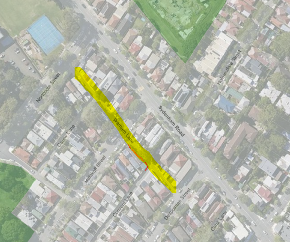
In 2021 Council received concerns of illegal parking at the intersection of Warham Lane and Convent Lane, Marrickville, resulting in access issues for waste collection vehicles and damage to private property. Community engagement at that time revealed that rear lane off-street parking issues were experienced by some residents, therefore additional restrictions were recommended to alleviate issues. The following recommendations were proposed and installed (refer to diagram below):
• A 10m statutory ‘No Stopping’ zone on southern side of Warham Lane, Marrickville, west of its intersection with Convent Lane,
• A 10m statutory ‘No Stopping’ zone on western side of Convent Lane, Marrickville, south of its intersection with Warham Lane,
• A 10m statutory ‘No Stopping’ zone on southern side of Warham Lane, Marrickville, east of its intersection with Malakoff Street, and
• A 15m ‘No Parking’ zone on southern side of Warham Lane, Marrickville, between Malakoff Street and Convent Lane.
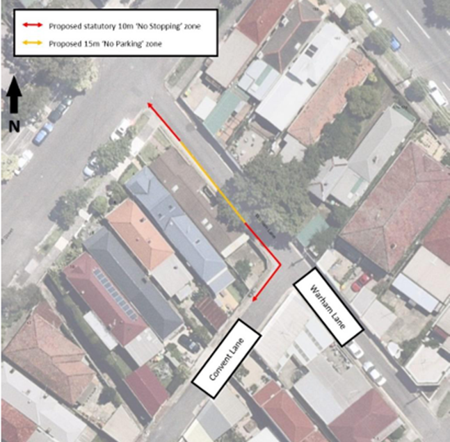
Consultation
As part of the investigation into parking requirements related to events at Henson Park consultation was conducted between 27 March 2025 and 18 April 2025. A letter outlining a proposal to install ‘No Parking’ restrictions on the southern side of Warham Lane, Marrickville between Northcote Street and Despointes Street (not including the already ‘No Parking’ section between Malakoff Street and Convent Lane) to improve access to off-street parking for adjacent residents was sent to residents / businesses in the immediate locality. (Refer to the consultation plan below).
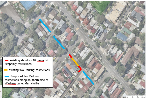
A total of 17 letters were distributed. There were three (3) responses a return rate of 18%. Resident’s responses are discussed below.
|
Residents’ Comments |
Officer Comments |
|
I am a resident of Sydenham Road, Marrickville, where I
have lived since 2017. Throughout this time, I have consistently parked my
vehicle behind my house on Warham Lane. |
Comments noted. |
|
Resident wants to know if Warham Lane is going to be designated No Parking/ No Stopping. Resident says that he didn't receive notification and it is going to affect him badly as he lives alongside this lane. |
Noted. The subject section of Warham Lane adjacent the resident’s property is already designated ‘No Parking’ along with statutory 10 metre “No Stopping’ restrictions. |
|
In addition to having 'No Parking' restrictions on the Southern Side of Warham Lane, is it possible to also have 'No Parking' restrictions on the Northern Side of Warham Lane? I ask this because as a resident, I use Warham Lane to access my car spot on my property via Warham Lane - however, on occasions, especially when there is a sporting event at Henson Park - people have parked in front of my garage and left it there for the day. When contacting police and council - their response is 'But does it say 'No Parking'? (I would assume having a garage there would mean no parking ???) |
The subject section of Warham Lane between Carew Lane and Malakoff Street is at present unrestricted parking and ‘No Parking’ restrictions will be installed within this section along with statutory ‘No Stopping’ restrictions. Due to garages being along the northern side it is advocated that the restrictions at this time will only be on the southern side (opposite garages).
|
Conclusion
At this time, it appears that some residents are impacted by parking in the laneway associated with events at Henson Park however there was no decisive endorsement for ‘No Parking’ restrictions along the whole southern side of Warham Lane, between Northcote Street and Despointes Street (not including the already ‘No Parking’ section between Malakoff Street and Convent Lane).
For the section of Warham Lane between Carew Lane and Malakoff Street it is recommended to install a 15-metre length of “No Parking’ restrictions along with statutory 10 metre ‘No Stopping’ restrictions. (as per the diagram below) in order to improve access to resident’s off-street parking.
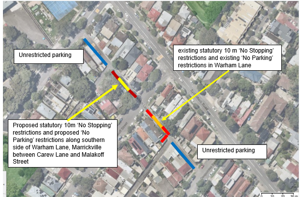
Nil.
|
|
Local Traffic Committee Meeting 19 May 2025 |
Subject: The Esplanade/Markham Place, Ashfield-Proposed bicycle contra-flow facility (Djarrawunang-Ashfield Ward/Summer Hill Electorate/Burwood PAC)
Prepared By: Boris Muha - Traffic Engineer
Authorised By: Jason Scoufis - Acting Traffic and Transport Planning Manager
|
RECOMMENDATION
That the design plan (Option 3) of a contra-flow facility in the Esplanade/Markham Place, Ashfield, between Brown Street/Fox’s Lane and Markham Lane with signs and markings along the road and use of a section of footway as shared path (as shown in Attachment 3) be approved.
|
STRATEGIC OBJECTIVE
This report supports the following strategic directions contained within Council’s Community Strategic Plan:
|
2: Liveable, connected neighbourhoods and transport |
|
|
EXECUTIVE SUMMARY
Council is proposing a bicycle contra-flow facility in the one-way section of The Esplanade/Markham Place, Ashfield, to allow for bicycle path movement in the back lane areas of the Ashfield CBD from Liverpool Road/Cavill Avenue to Brown Street/Ashfield Station.
The contra-flow facility will prevent the un-safe need for cyclists to travel down Liverpool Road through the CBD to reach either Fox’s Lane or Hercules Street to reach Brown Street or Ashfield Station.
BACKGROUND
A contra- low facility in the Esplanade/Markham Place has been requested by the Bicycle Users Group as part to providing various improved bicycle facility treatments throughout the Inner West Council.
The Esplanade/Markham Place (between Brown Street/Fox Lane and Markham Lane) measures
in road width from approximately 3.7 along the Esplanade to 6.5m (at the dog leg-reverse kerb section of the laneway) down to approximately 4.9-5.2m in Markham Place.
The Esplanade/Markham Place (between Brown Street/Fox Lane and Markham Lane)
is one-way westbound. This one-way westbound system has been well established over the years and prevents traffic from rat-running from Liverpool Road to Brown Street.
The subject section of the Esplanade/Markham Place is mainly ‘No Stopping’ on both sides with an indented loading zone bay to the eastern side of the dogleg, and section of ‘No Parking’ on the southern side of Marham Place closer to Markham Lane.
The existing road width conditions and traffic directions of the Esplanade/Markham Place and surrounding streets are shown in Figure1. Existing street view photos of the Esplanade/Markham Place are shown in Figure 2.
![]()
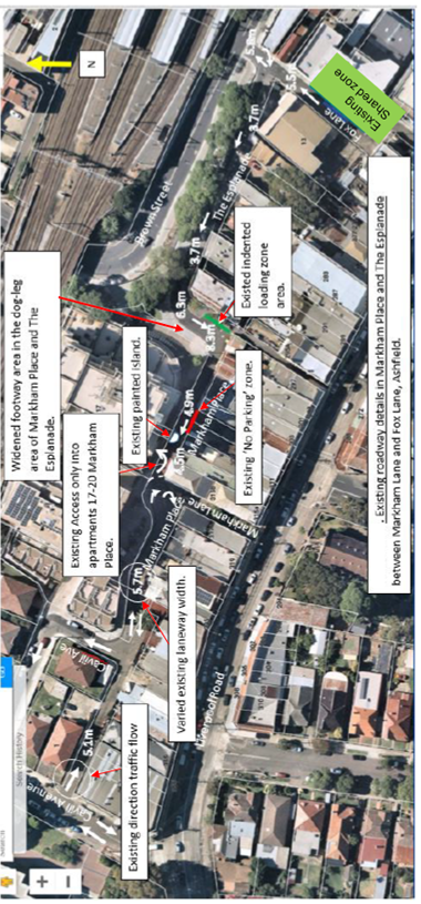
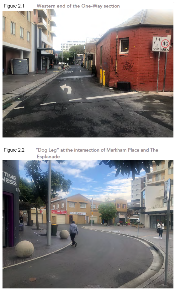
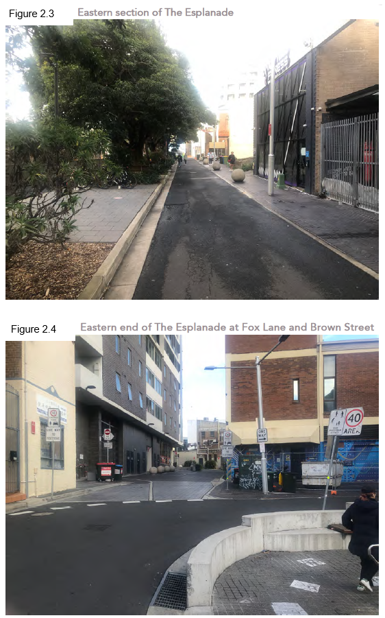
DISCUSSION
The following information is provided in discussion.
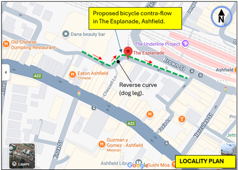
Figure 1. Locality Plan
|
Street Name |
The Esplanade/Markham Place |
|
Carriageway width (m) kerb to kerb |
3.7m near Fox’s Lane to 8.3m to 4.9m near Markaham Place. |
|
Carriageway type |
One-way westbound. |
|
Classification |
Local |
|
Speed Limit km/h |
40 (high pedestrian activity area) |
|
85th percentile speed km/h |
32 |
|
Vehicles per day (vpd) |
Less than 1000 |
|
TfNSW available reported crash history (last 5 years) |
NIL in the last 5 years, (1)x 2014- Pedestrian walking with Traffic RUM 4- minor injury. (1) x2010 vehicle turning left from intersection at Fox’s Lane into object- non-casualty. |
|
Parking arrangements |
No Stopping/ No Parking. Indented Loading zone area eastern side of the dog-leg. |
|
Side intersecting street |
Fox’s Lane and Markham Lane |
Table 1. Road Network detail.
(2) design options were initially provided for under a report by Barros Van den Dool Active Transport Pty Ltd in reference to the TfNSW Technical Directions for Bicycle contra-flow facilities.
These were as follows:
Option 1-
Provide simply "Bicycles Excepted” (R9-3) signs at each end and in the reverse curve, supported by bicycle pavement stencil (PS2) – see plan in Attachment 1.
This may be suitable for a full straight section of road with clear vision of traffic and bicycles in the opposing direction under low speed and traffic volume conditions.
Option 2-
Option 1 plus green pavement contra-flow lane designation at each end and in the reverse curve of the lane to emphasise the educational strength of the facility and enforce bicyclists to keep to the left-hand side of the lane.
This would be more applicable when the sight distance of vehicles and bicyclists around a bend of a road is restricted. - see plan in Attachment 2.
Traffic counts and observations on site reveal that The Esplanade/Markham Place provides service vehicle access to the rear of various properties, with large vehicle movements up to 5% in volume of traffic. Swept path movements of a design garbage truck shows such vehicles needing to turn wide coming around the corner of the reverse curve (dog leg) from The Esplanade into Markham Place. Other vehicles are similar noted to turn out wide with restricted sight view of opposing bicycles. Bicyclists are then at risk with vehicles blindly turning into the path of any oncoming bicyclist at the dog leg.
In view of this, an alternate and preferred Option 3 is therefore considered and shown in plan Attachment 3. This option provides design elements of Option 1 and 2 but allows for bicyclists to come off safely onto the western footway side of the dog leg section of the lane. Cyclists can reemerge back onto to the road at the straight section of The Esplanade in view of opposing traffic.
The plan for option 3 is as follows:
Ø Provide ‘Bicycles Excepted’ signage under the existing ‘No Entry’ to the western side of Markham Place (east of Markham Lane) and under the one-way signs at the eastern end of The Esplanade.
Ø Provide 5 metres of short length green pavement bicycle lane marking and bicycle pavement stencils at the start on the western end of the Esplanade/Markham Place, and at the corner of the dog leg section of the Esplanade to keep cyclists to left hand side and direct them onto the footpath.
Ø Build bicycle ramps onto and out from the footpath at the corners to the dog leg section of the Esplanade/Markham Place.
Ø Define a shared path zone area for pedestrian and bicycles via way of signage in accordance with the Technical Directions/ NSW Bicycle guidelines. Note that the zone is identified on public land. The footpath or footway elsewhere is under private land to the adjoining property. The shared path zone area is also located away of any concentrated pedestrian traffic.
Ø Provide warning bicycle ‘use footpath’ and ‘watch for’ bicyclist signage.
Ø Provide bicycle pavement stencils along The Esplanade. A green pavement length of bicycle lane marking is not provided at the end of the Esplanade with Fox’s Lane/Brown Street as vehicles turn close to the corner and there is insufficient road width to formally apply lane marking according to the TfNSW bicycle guidelines.
It should be noted that Council at its meeting on 25 February 2020 did adopt the following recommendation of its traffic committee that:
‘A bicycle contra-flow treatment in Markham Place/The Esplanade, Ashfield, between Markham Lane and Fox Lane/Brown Street, be approved in principle and listed on Council’s future Capital Works Program.’
This report however outlines further and detailed examination to reinforce and propose option 3.
FINANCIAL IMPLICATIONS
The project is listed in Council’s Traffic Facilities Capital Works program to be carried out in 2025/2026, subject to funding and programming. The work is estimated to be around $14,000.
CONSULTATION
No consultation is required as the proposal does not impact on any parking or vehicle servicing off the lane. Residents will be notified accordingly.
CONCLUSION
It is recommended that the design plan (Option 3) of a contra-flow facility in the Esplanade/Markham Place, Ashfield, between Brown Street/Fox’s Lane and Markham Lane with signs and markings along the road and use of a section of footway as shared path (as shown in Attachment 3) be approved.
|
1.⇩ |
Plan Option 1 -Contra-flow bicycle facility- signs and bicycle logo markings. (2 plan sheets) |
|
2.⇩ |
Plan Option 2- Contra-flow bicycle facility- signs, bicycle logos and bicycle pavement lane markings. |
|
3.⇩ |
Plan Option 3- Contra-flow bicycle facility- signs, bicycle logos, bicycle pavement lane marking and footway shared path. |
|
|
Local Traffic Committee Meeting 19 May 2025 |
Subject: Douglas Street and Douglas Lane, Stanmore - Resident Parking Scheme Survey Results and proposed 'No Parking' and 'No Stopping' restrictions (Damun-Stanmore Ward/Newtown Electorate/Inner West PAC)
Prepared By: James Nguyen - Traffic Engineer
Authorised By: Jason Scoufis - Acting Traffic and Transport Planning Manager
|
RECOMMENDATION
1. That the proposal to implement Resident Parking Scheme restrictions ‘2P 8am-10pm Mon-Fri Permit Holders Excepted Area M17’ along the northern side of Douglas Street between Percival Lane West and Bruce Lane East be approved.
2. That ‘No Parking’ restrictions on both sides of Douglas Lane between Percival Lane West and Bruce Lane East, Stanmore be approved.
3. That ‘No Stopping’ restrictions at the intersections on Douglas Lane and Bruce Lane East be approved.
|
STRATEGIC OBJECTIVE
This report supports the following strategic directions contained within Council’s Community Strategic Plan:
|
2: Liveable, connected neighbourhoods and transport |
|
|
EXECUTIVE SUMMARY
This report outlines further investigations completed to improve parking conditions in Douglas Lane, Stanmore. A report was presented to the Local Traffic Committee at its meeting on 9 December 2024 proposing to install ‘No Stopping’ and ‘No Parking’ restrictions on both sides of Douglas Lane between Percival Lane West and Bruce Lane East.
The Local Traffic Committee representatives recommended that the proposed ‘No Parking’ and ‘No Stopping’ restriction in Douglas Lane, be deferred for further investigation, and investigate the extension of the Resident Permit Parking Scheme to Douglas Street.
Council officers have subsequently completed a community consultation on a proposal to install timed permit parking restrictions on the northern side of Douglas Street, Stanmore between Percival Lane West and Bruce Lane East.
Council received a response rate of 23 per cent, which is slightly under the 30 per cent response rate required for consideration of a Resident Parking Scheme. The support rate received was 86 per cent. Given Council received a high support rate, and the required response rate threshold of 30 per cent was short by two (2) responses, it is recommended that timed permit parking restrictions signposted as ‘2P 8am-10pm Mon-Fri Permit Holders Excepted Area M17’ be installed on the northern side of Douglas Street.
BACKGROUND
A proposal to install ‘No Parking’ and ‘No Stopping’ restrictions on both sides of Douglas Lane, Stanmore between Percival Lane West and Bruce Lane East was referred to the Local Traffic Committee meeting of 9 December 2024. At the meeting, the Committee representatives recommended that this proposal be deferred for further investigation including investigating further a Resident Permit Parking Scheme expansion to Douglas Street.
Accordingly, Council officers have completed further investigations and carried out a community consultation on a proposal to install timed permit parking restrictions signposted as ‘2P 8am-10pm Mon-Fri Permit Holders Excepted Area M17’ on the northern side of Douglas Street between Percival Lane West and Bruce Lane East to improve parking conditions on Douglas Lane.
The provision of timed permit parking restrictions on Douglas Street will improve parking opportunities on this street which may currently be occupied by commuter parking which subsequently pushes resident parking into Douglas Lane.
DISCUSSION
Council officer’s completed a parking occupancy survey on Douglas Street between Percival Lane West and Bruce Lane East in August 2024. The parking survey results indicate high parking utilisation on Douglas Street, and exceeds the 85 per cent threshold utilisation to warrant consideration for a resident parking scheme (RPS). The results are shown in Table 1 below:
|
Street |
Between |
Side |
Average occupancy rate (10am and 2pm) |
|
Douglas Street |
Percival Lane West and Bruce Lane East |
North |
79% (11/14) |
|
South |
96% (13/14) |
||
|
|
88% (24/28) |
||
To ensure consistency with the nearby streets which currently have timed permit parking restrictions, parking restrictions signposted as ‘2P 8am-10pm Mon-Fri Permit Holders Excepted Area M17’ are proposed on the northern side of Douglas Street. Whilst the northern side had lower utilisation, the parking restrictions are proposed on the northern side to encourage less parking in Douglas Lane which is affecting garage/driveway and laneway access.
PUBLIC CONSULTATION
A total of 30 consultation letters were sent out households on Douglas Street between Percival Lane West and Bruce Lane East. The consultation plan is shown in Attachment 1.
There were six (6) responses received supporting and one (1) response opposing the proposal. The overall response rate was 23 per cent of which 86 per cent supported and 14 per cent opposed the proposal. The response rate is less slightly less than the 30 per cent response rate threshold, however this is two (2) responses short. Given the high support rate (86 per cent), combined with the current driveway/garage and laneway access issues faced within Douglas Lane, a Resident Parking Scheme could assist with addressing these issues. As such, it is recommended to proceed despite the response rate being slightly under 30 per cent.
|
No of properties |
30 |
|
Responses |
7 |
|
Response rate |
23% |
|
Support |
6 |
|
Oppose |
1 |
|
Support rate |
86% |
|
Resident’s comments |
Officer’s response |
|
Issues are with laneway access and not on-street parking on Douglas Street. Laneway access needs to be rectified first.
|
The proposed timed permit parking restrictions are intended to take parking pressure off Douglas Lane. ‘No Parking’ and ‘No Stopping’ restrictions are proposed Douglas Lane to ensure laneway and driveway/garage access. |
|
Install on both sides of Douglas Street, not one side. Furthermore, Douglas Street on the southern side is the more problematic location.
|
Residential parking schemes have been generally placed on one side of the street. This approach aims to give eligible households in the scheme area, who take up a permit, a greater chance of finding parking closer to their property whilst still providing parking opportunities for other users such as businesses in the area, their patrons, visitors to the area and households that are not eligible to participate in the scheme.
The proposed timed permit parking restrictions are installed on the northern side of Douglas Street due to current parking issues in Douglas Lane (at the rear of the properties on the northern side) |
|
Difficulty finding parking on Douglas Street and have to park on Bruce Street |
Noted. |
|
Commuter parking is affecting the ability to park on Douglas Street. Some households have mobility parking permits and cannot walk long distances. Parking has become worse over time on Douglas Street due to commuter parking |
Timed permit parking restrictions are proposed on the northern side of Douglas Street to assist households on Douglas Street find a parking space close to their premises and deter commuter parking. |
FINANCIAL IMPLICATIONS
The installation of the signs is to be funded from the signs and line marking budget.
|
1.⇩ |
Resident parking scheme - consultation plan |
|
2.⇩ |
Final parking proposal - Douglas Lane Stanmore |
|
|
Local Traffic Committee Meeting 19 May 2025 |
Subject: Arthur Street at Holborow Street, Ashfield-Proposed 'No Stopping' at the corners of Arthur Street (Djarrawunang-Ashfield Ward/Summer Hill Electorate/Burwood PAC)
Prepared By: Boris Muha - Traffic Engineer
Authorised By: Jason Scoufis - Acting Traffic and Transport Planning Manager
|
RECOMMENDATION
1. That ‘No Stopping’ in the length of 13.5m be signposted on the approach side corners of Arthur Street at Holborow Street, Ashfield.
2. That ‘No Stopping’ at the statutory length of 10m be signposted on the departure side corners of Arthur Street at Holborow Street, Ashfield.
|
STRATEGIC OBJECTIVE
This report supports the following strategic directions contained within Council’s Community Strategic Plan:
|
2: Liveable, connected neighbourhoods and transport |
|
|
EXECUTIVE SUMMARY
‘No Stopping’ to the corners of Arthur Street, at the cross- street intersection with Holborow Street, Ashfield is part of remedial treatment to address concerns with accident or near miss vehicle incidences occurring at the intersection.
BACKGROUND
Residents have raised concerns with vehicles not stopping at Holborow Street under assigned STOP control. These concerns have been exacerbated owing to a recent accident with a courier motor/pedal cyclist being hit by a vehicle crossing from the southern side of Holborow Street.
Remedial action was undertaken to remark the STOP lines (which was observed to be faded) and other associated longitudinal line marking. Additional STOP and new advance warning signs have been placed to alert drivers ahead of time to slow down and stop at the intersection.
It is also revealed that sight lines out of Holborow Street are obstructed by vehicles parking close to the corners of Arthur Street.
DISCUSSION
To alleviate the issue of vehicles parking close to the corners of Arthur Street, it is proposed in this case, and in discussion with Police, that ‘No Stopping’ be signposted in Arthur Street 13.5 m on the critical right-hand corner (approach) sides to Holborow Street, and at a statutory distance of 10m to the left-hand corner sides to Holborow Street. This would improve sight view for vehicles coming out of Holborow Street and assist to regulate and control vehicle parking at the corners. The intersection would be monitored thereafter to determine if any other improvement or treatment of the intersection is required. See diagram below.
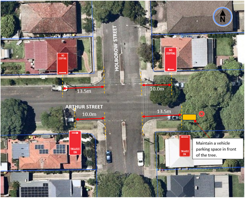
It should be noted that one car space is maintained on the southern side of Arthur Street, east of Holborow Street, by going back 13.5 m from the intersection. On occasions it has been observed that two vehicles have parked in this location up to a tree with the first vehicle infringing into the statutory 10 m parking zone from the intersection. Similarly, a large size truck has been observed to park in this area further limiting the sight view of a vehicle crossing from the southern side of Holborow Street.
Warning signs located on the northern kerbside area of Arthur Street adjacent to a speed hump near the intersection east of Holborow Street, have also been repositioned in attempt to provide an additional parking space in the area. Any net loss of legal parking is therefore considered minimal if not nil.
FINANCIAL IMPLICATIONS
Funding for the work will come out of the Council’s signs and line marking budget.
CONSULTATION
Consultation letters were sent out to (20) household properties in Holborow Street seeking resident comments-see consultation area map below.
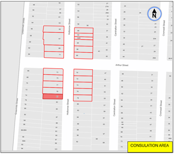
One (1) resident was in support and (2) against the proposal.
Those against were concerned in loss of parking commenting that sight view was not the issue, but with vehicles not stopping at the intersection, and suggested that a roundabout be best considered in this regard.
The proposal is an additional measure to improve the sight line distance at this cross-street intersection on road safety grounds. Other remedial measures have been incorporated as explained above. The loss of parking is considered minimal if not nil under this proposal.
Council does not typically favour roundabouts at intersections where one street has lower traffic volumes than the other. In this case Holborow Street is designated as the minor and quite street
(less than 900 vehicle per day), with the STOP control being assigned to this street. Roundabouts would require further removal of parking to allow clearance in traffic movement on all four legs of the intersection. Also, roundabouts can encourage traffic down the minor street thereby arousing resident complaints. The recorded accident history in the area (2 in the last 5 years) is considered low not to justify the inclusion of a roundabout at this point of time.
Council will seek the assistance of Police to monitor the area and determine if other improvements of treatment of the intersection is required.