Local Transport Forum Meeting
MONDAY 18 MAY 2026
11:00 AM
|
|
Local Transport Forum Meeting 18 May 2026 |
Function of the Local Transport Forum
Background
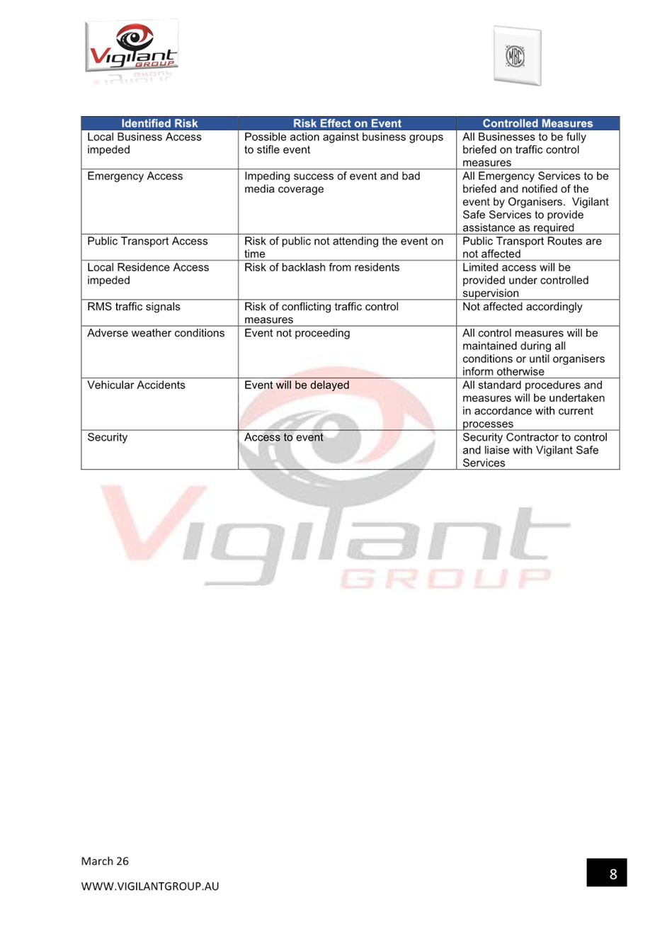
Transport for NSW (Transport) is legislated as the Authority responsible for the control of traffic on all NSW Roads. Transport has delegated certain aspects of the control of traffic on local roads to councils.
Transport’s (2025) Authorisation and Delegation Instrument authorises councils to use prescribed traffic control devices under s122 of the Road Transport Act 2013 and delegates Transport’s power under s115 of the Roads Act 1993 to regulate traffic for any purpose.
The (2025) Authorisation and Delegation Instrument revokes and replaces both the (2011) Delegation to Councils and the (2023) Temporary Delegation to Councils No.2.
One of the conditions of the Instrument is that councils establish a Local Transport Forum (LTF - formerly known as Local Traffic Committee). The LTF provides advice, technical review, and coordination of works and events. It does not vote, issue approvals, or make decisions.
Role of the Local Transport Forum
The LTF is primarily a technical review and advisory forum which considers the technical merits of proposals and ensures that current technical guidelines are considered. It provides advice to Council on traffic and parking control matters and on the provision of traffic control facilities and prescribed traffic control devices for which Council has delegated authority. These matters are dealt with under Part A of the agenda.
In addition to its formal role as the LTF, Forum members may also be requested to provide informal traffic engineering advice on traffic matters not requiring Council to exercise its delegated function at that point in time, for example, advice to Council’s Development Assessment Section on traffic generating developments. These matters are dealt with under Part C of the agenda and are for information or advice only and do not require Council to exercise its delegation.
LTF Delegations
The LTF has no decision-making powers. Council must refer all relevant traffic related matters to the LTF prior to exercising its delegated functions. Matters related to State Roads or functions that have not been delegated to Council must be referred directly to the Transport or relevant organisation.
The LTF provides advice to Council. Where Transport has concerns about a proposal and the concerns are not resolved in discussion, Transport may inform the LTF that it intends to issue a Statement of Concern (SoC) within seven days.
Forum Membership
The LTF comprises the following Members:
· one representative of Council as nominated by Council;
· one representative of the NSW Police from each Local Area Command (LAC) within the LGA, being Newtown, Marrickville, Leichhardt and Ashfield LAC’s.
· one representative from Transport for NSW ; and
· State Members of Parliament (MP) for the electorates of Summer Hill, Newtown, Heffron, Canterbury, Strathfield and Balmain or their nominees.
· Operator of any public passenger service likely to be affected by the proposal.
Informal advisors from within Council or external authorities may also attend the LTF to provide expert advice.
LTF Chair
Council’s representative will chair the meetings.
Public Participation
Members of the public or other stakeholders may address the LTF on agenda items to be considered by the Members. The format and number of presentations is at the discretion of the Chairperson and is generally limited to 3 minutes per speaker. LTF debate on agenda items is not open to the public.
|
|
Local Transport Forum Meeting 18 May 2026 |
|
AGENDA |
1 Apologies
2 Disclosures of Interest
3 Confirmation of Minutes Page
Minutes of 20 April 2026 Local Transport Forum 5
1 Matters Arising from Council’s Resolution of Minutes
2 Part A – Items Where Council May Exercise Its Delegated Functions
Traffic Matters
ITEM Page
LTF0526(1) Item 1 Darling Street and Curtis Road, Balmain - Proposed Raised Pedestrian Crossing and Roundabout Improvements (Baludarri - Balmain Ward/Balmain Electorate/Lechhardt PAC) 17
LTF0526(1) Item 2 Nelson Lane,Annandale - Proposed 'No Parking' Zone Extension (Baludarri-Balmain Ward/Balmain Electorate/Leichhardt PAC) 23
LTF0526(1) Item 3 Warburton Street, Marrickville - Proposed Kerb Blister (Midjuburi - Marrickville Ward / Summer Hill Electorate / Inner West PAC) 27
LTF0526(1) Item 4 Bunnings Tempe South LATM works - Proposed temporary full road closures at multiple locations over a five-week period (Midjuburi-Marrickville Ward / Heffron Electorate / Inner West PAC) 32
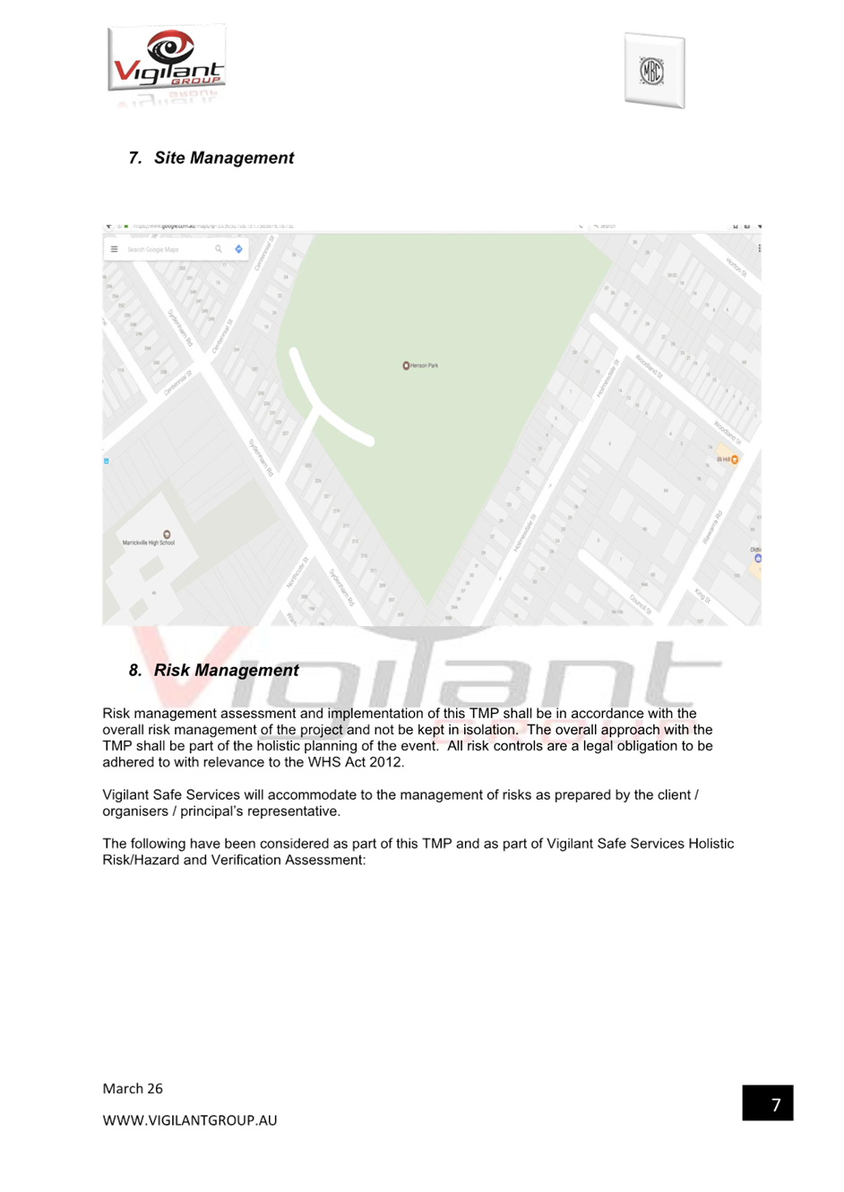
LTF0526(1) Item 5 Centennial Street, Woodland Street and Holmesdale Street, Marrickville – Temporary Road Closures for Special Event at Henson Park – 2026 Beer, Footy and Food Festival on Saturday 18 July 2026 (Midjuburi-Marrickville Ward /Summer Hill Electorate /Inner West LAC) 76
LTF0526(1) Item 6 Illawarra Road at Wharf Street, Marrickville – Proposed raised pedestrian crossing - Design Plan 10379 (Midjuburi-Marrickville Ward / Summer Hill Electorate / Inner West PAC) 100
LTF0526(1) Item 7 Illawarra Road at Grove Street, Marrickville – Proposed raised pedestrian crossing - Design Plan 10385 (Midjuburi-Marrickville Ward / Summer Hill Electorate / Inner West PAC) 104
LTF0526(1) Item 8 Smidmore Street, Marrickville at the signalised intersection with Edinburgh Road - Proposed Extension of 'No Stopping' restrictions at the signalised intersection (Midjuburi-Marrickville Ward / Summer Hill Electorate / Inner West PAC) 110
LTF0526(1)
Item 9 Nowranie Street at Smith Street, Summer Hill -
Proposed kerb extensions - (Djarrawunang-Ashfield Ward/Summer Hill
Electorate/Burwood PAC) 114
LTF0526(1)
Item 10 Hardy Street at Mount Street, Ashbury - New proposed raised pedestrian
(zebra) crossing and kerb extensions -
(Djarrawunang-Ashfield Ward/Canterbury Electorate/Burwood PAC) 119
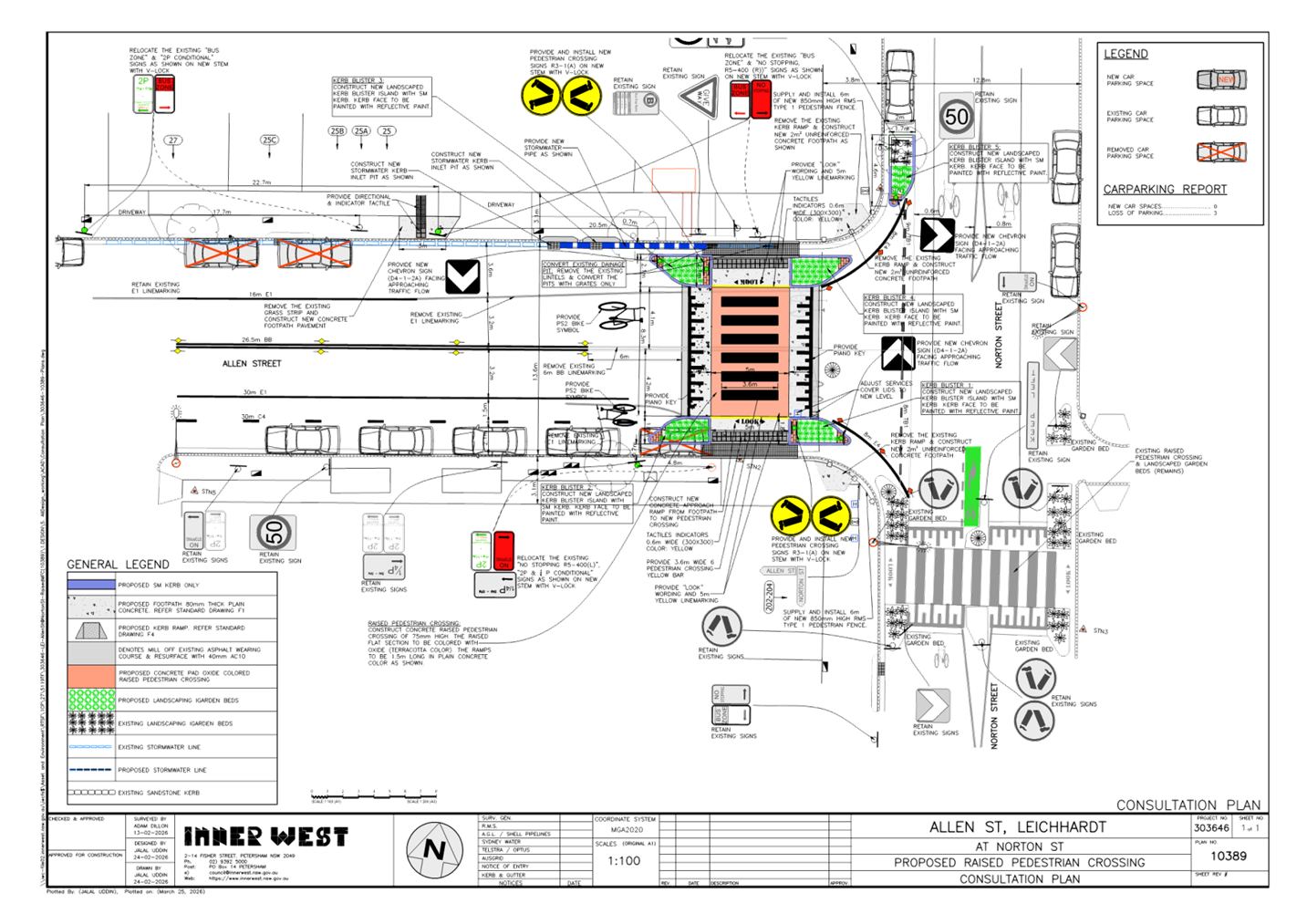
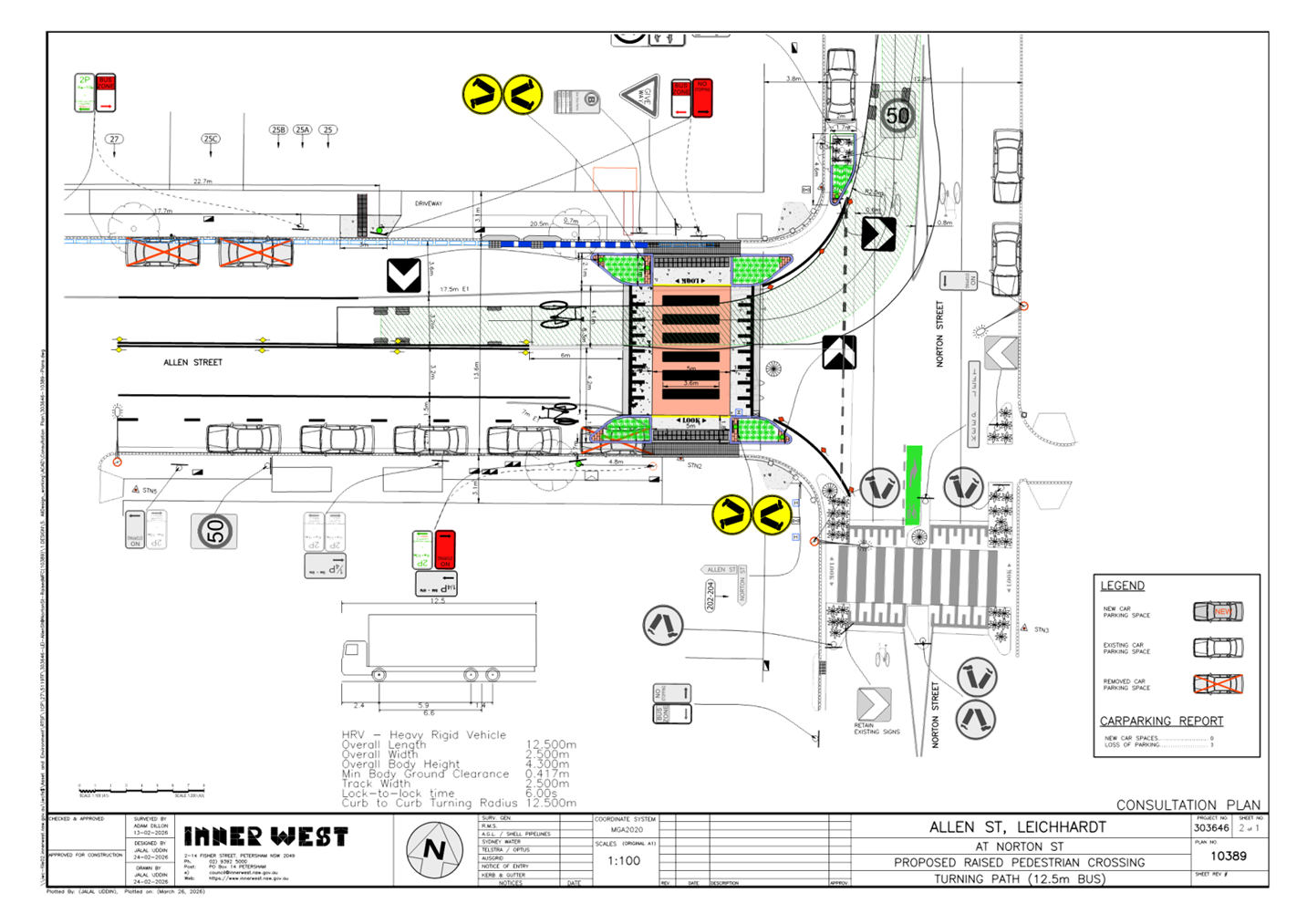
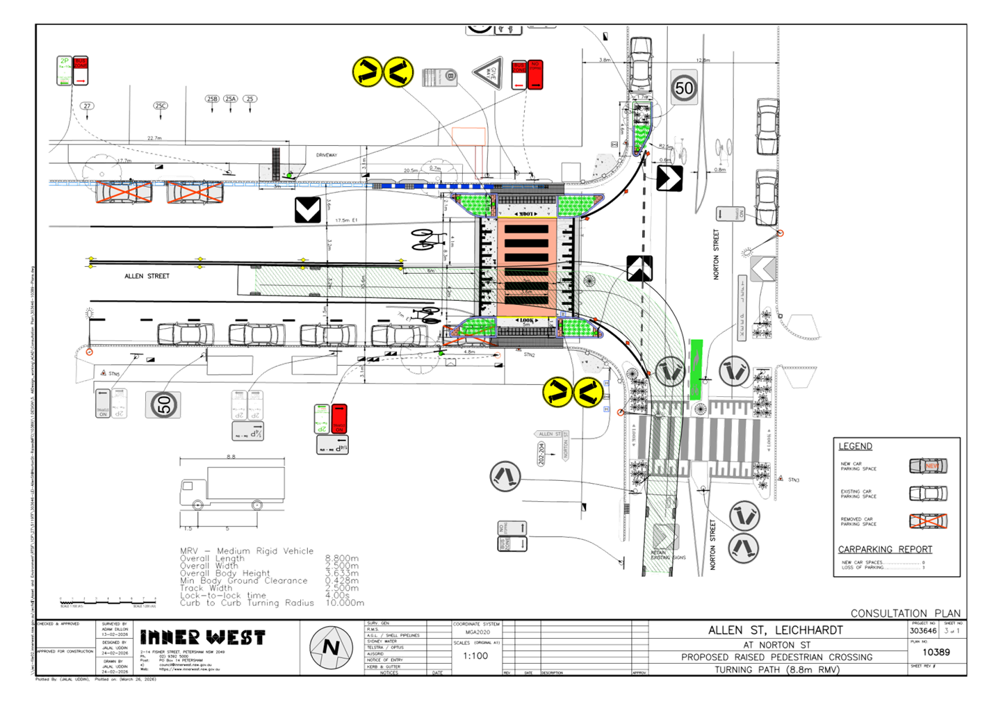
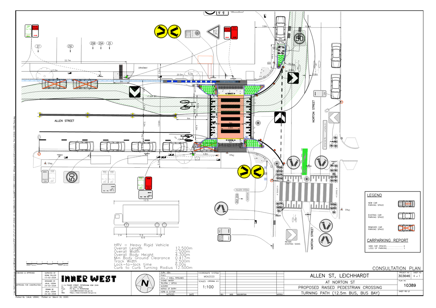
LTF0526(1) Item 11 Allen Street, Leichhardt- Proposed Raised Pedestrian Crossing(Gulgadya-Leichhardt Ward/Balmain Electorate/Leichhardt PAC) 124
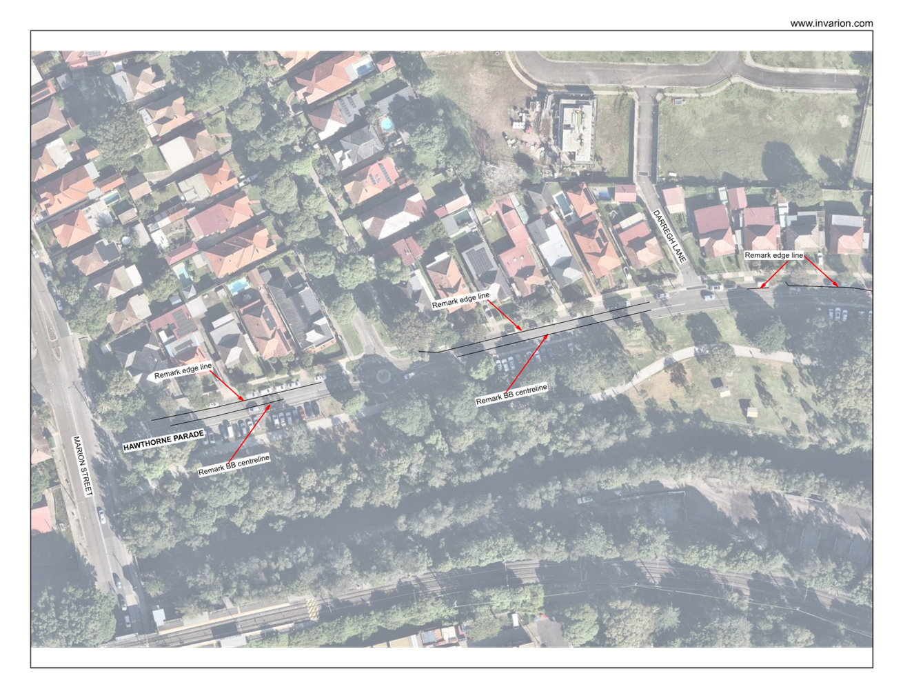
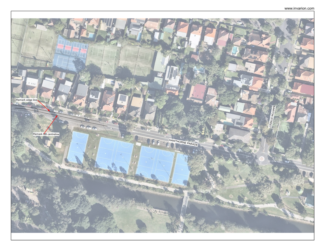
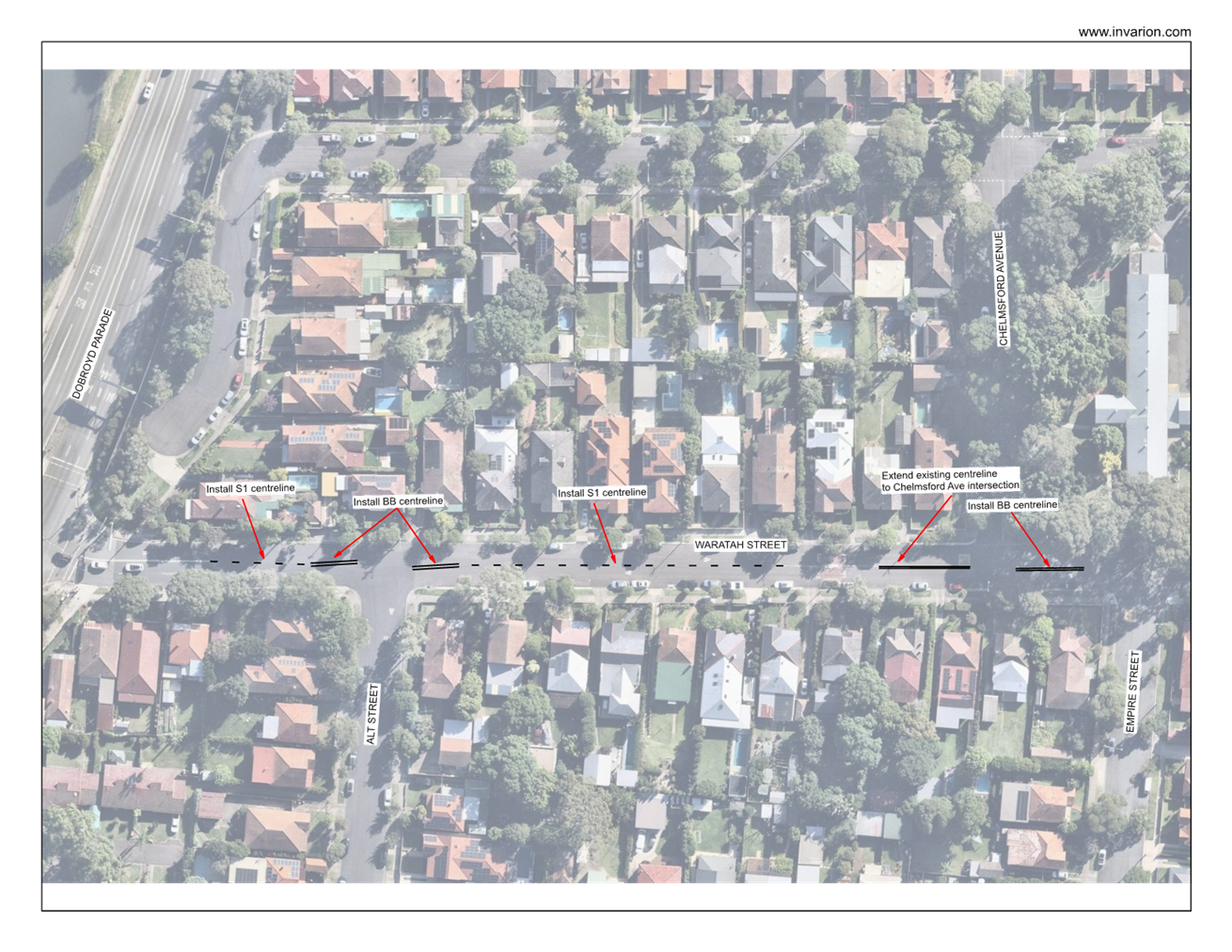
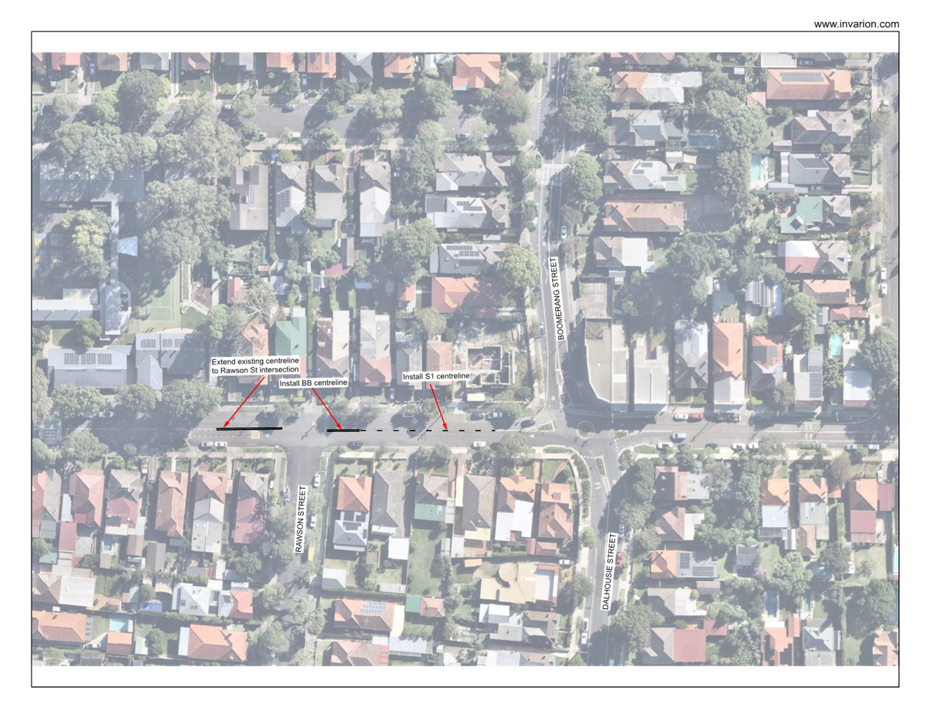
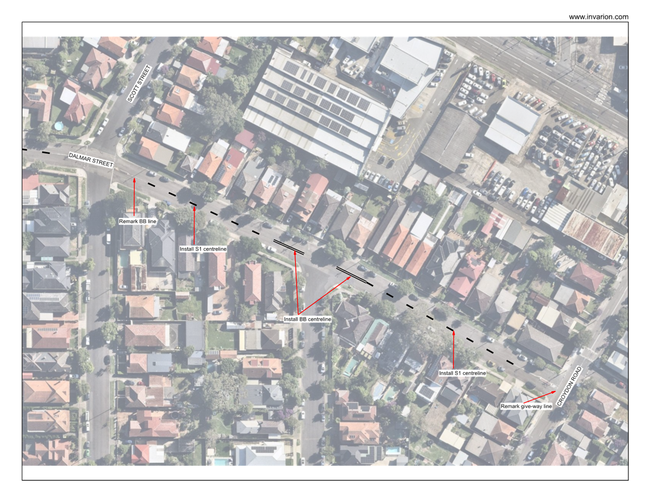
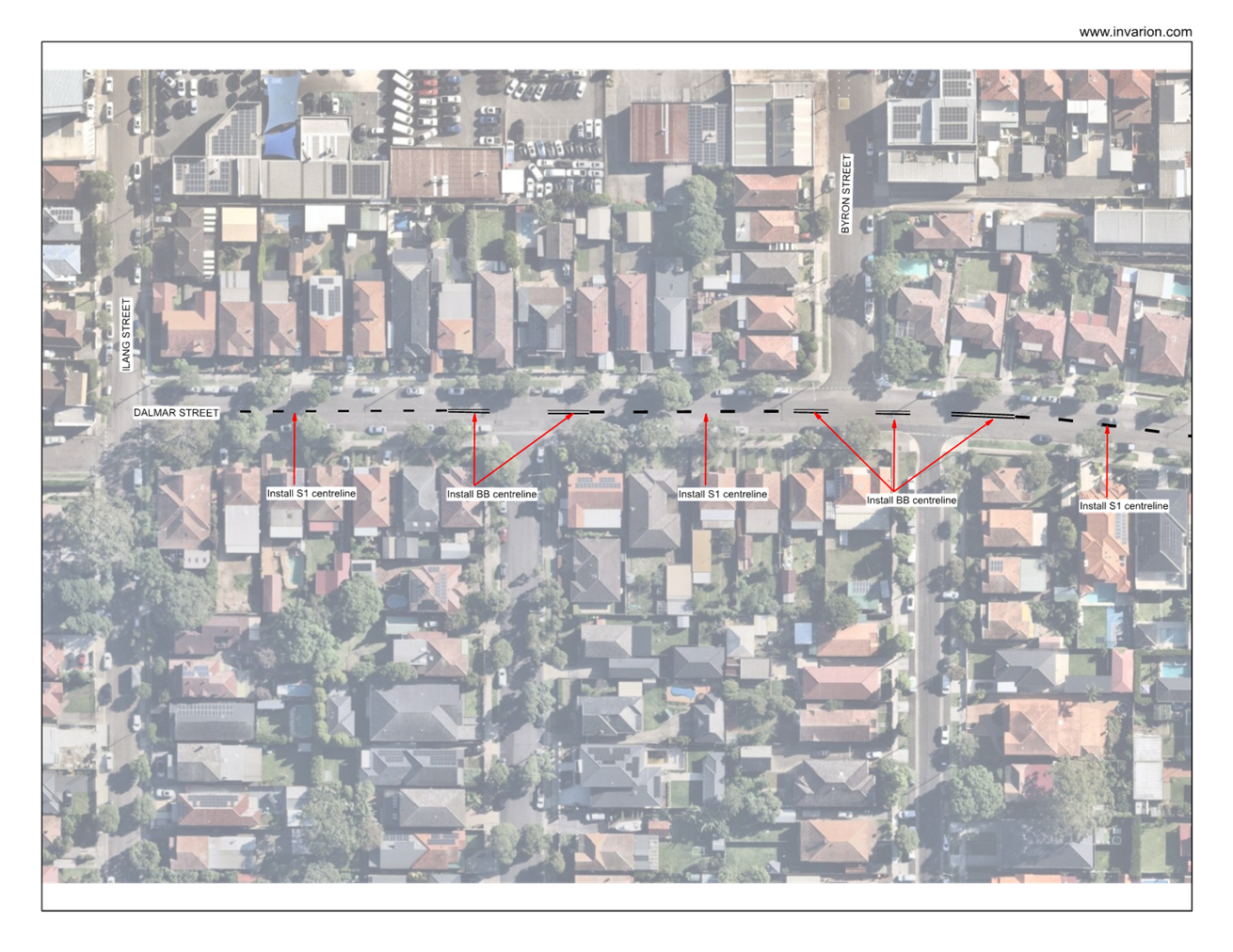
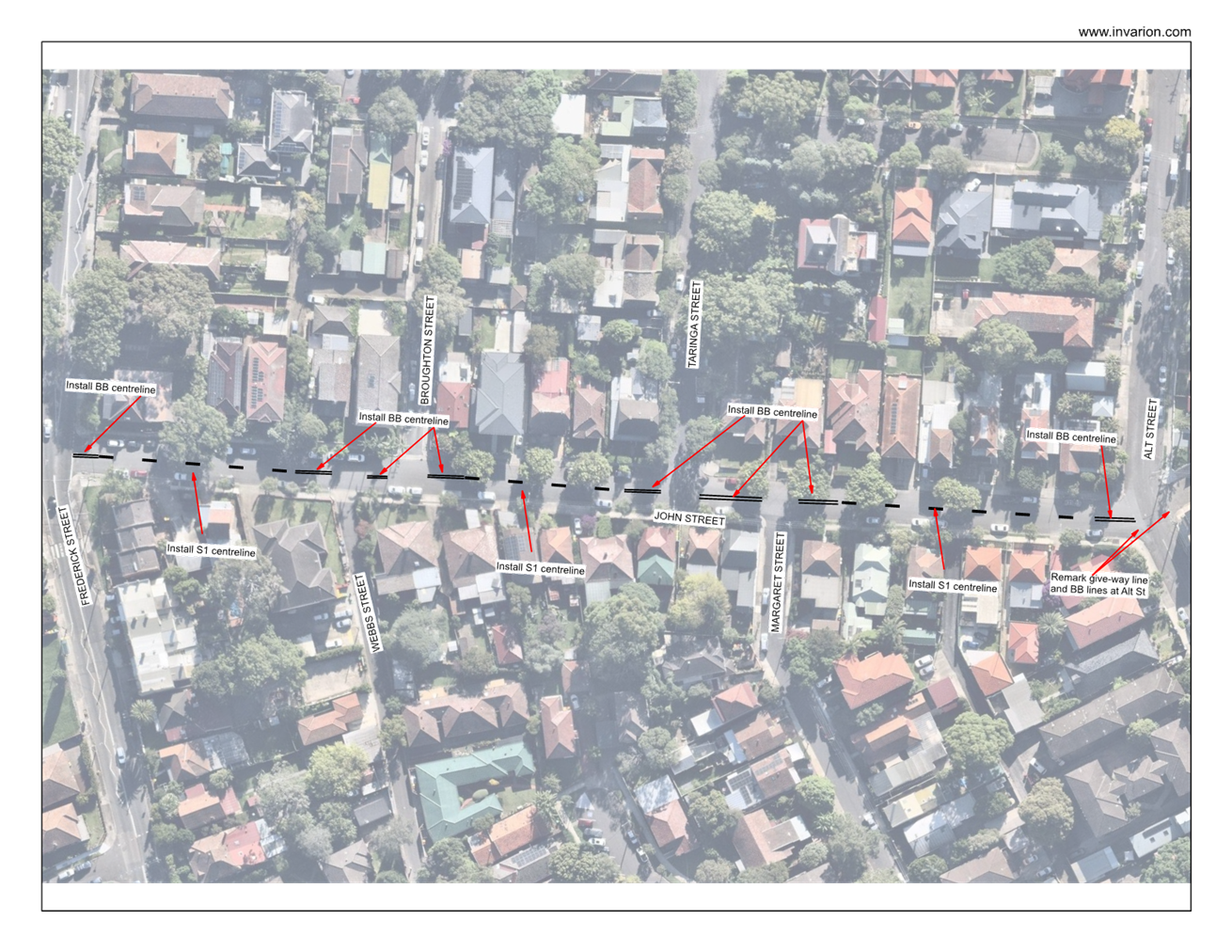
LTF0526(1) Item 12 InnerWest@40 - Area 2 Rozelle and Lilyfield; Area 11 Ashfield North; Area 1 Haberfield - Proposed Speed Limit Reduction from 50km/h to 40km/h (Djarrawunang - Ashfield, Baludarri - Balmain and Gulgadya - Leichhardt Wards / Balmain, Summer Hill and Strathfield Electorates / Burwood and Leichhard PAC) 131
Parking Matters
ITEM Page
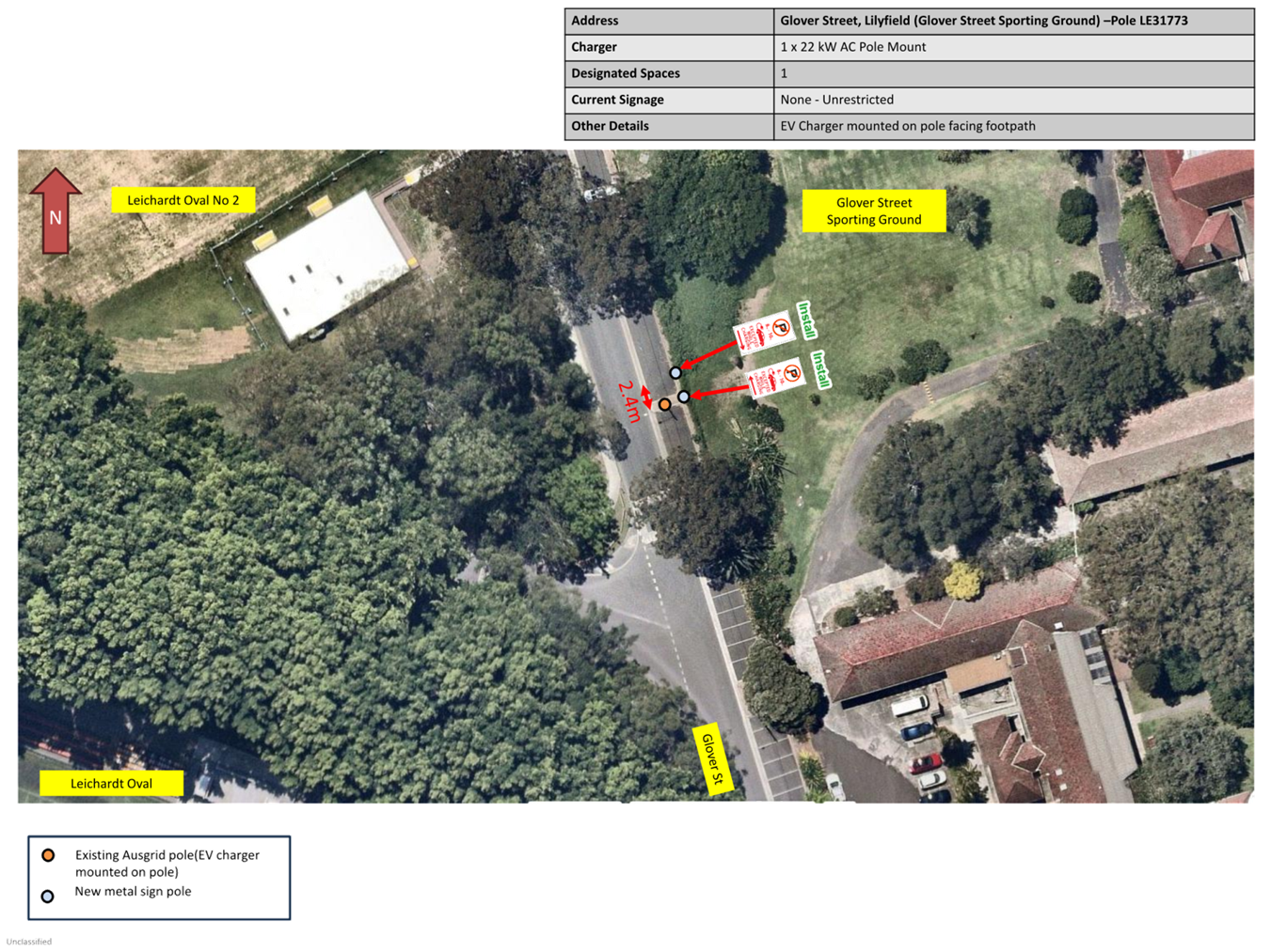
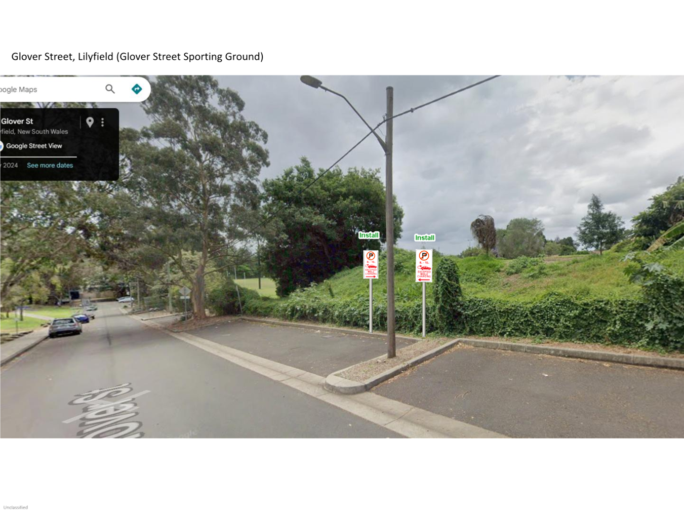
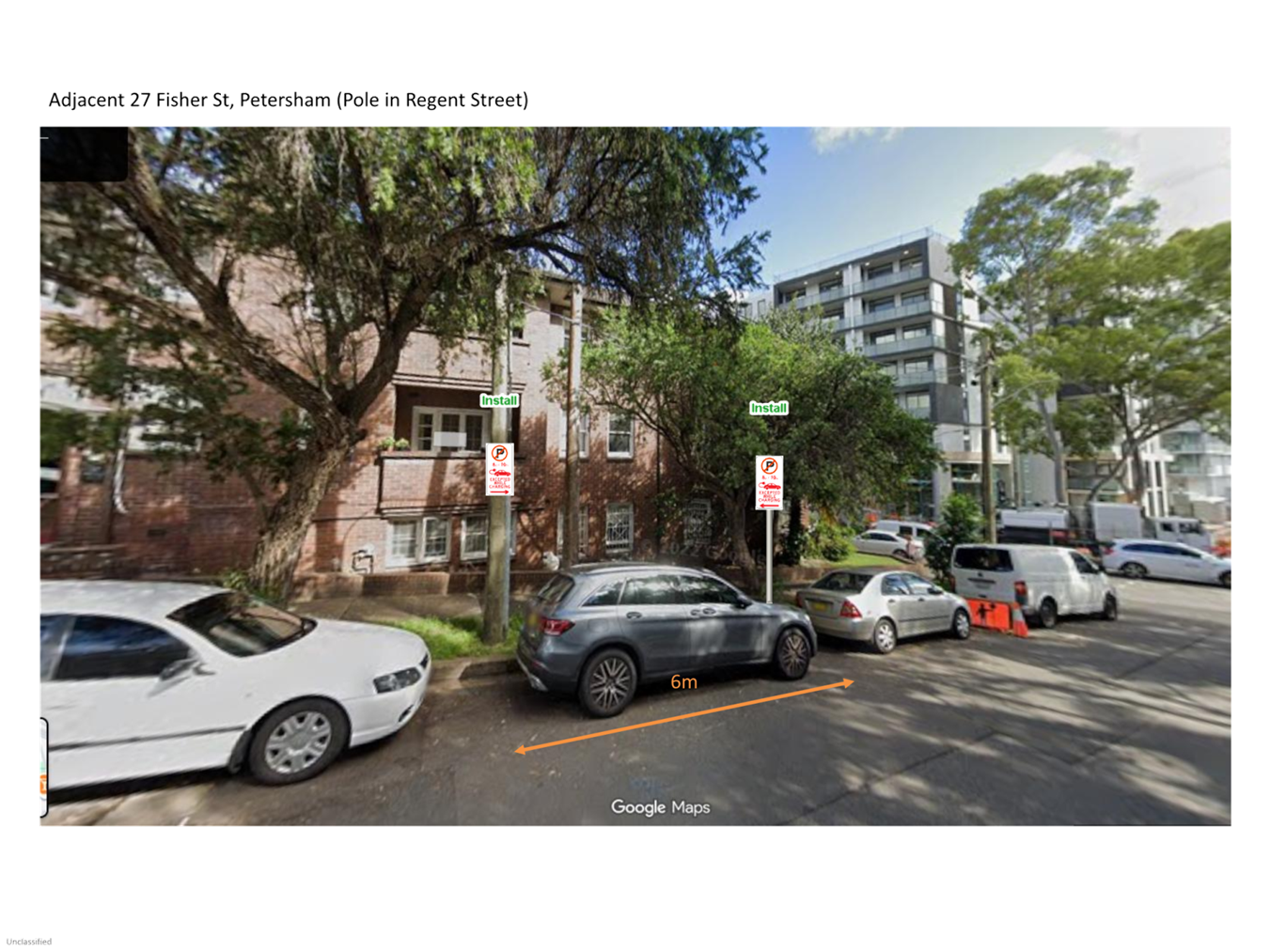
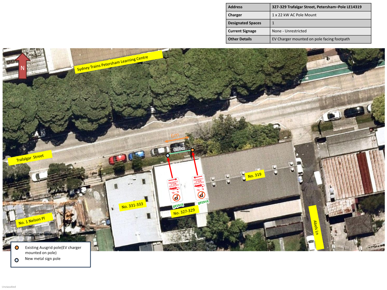
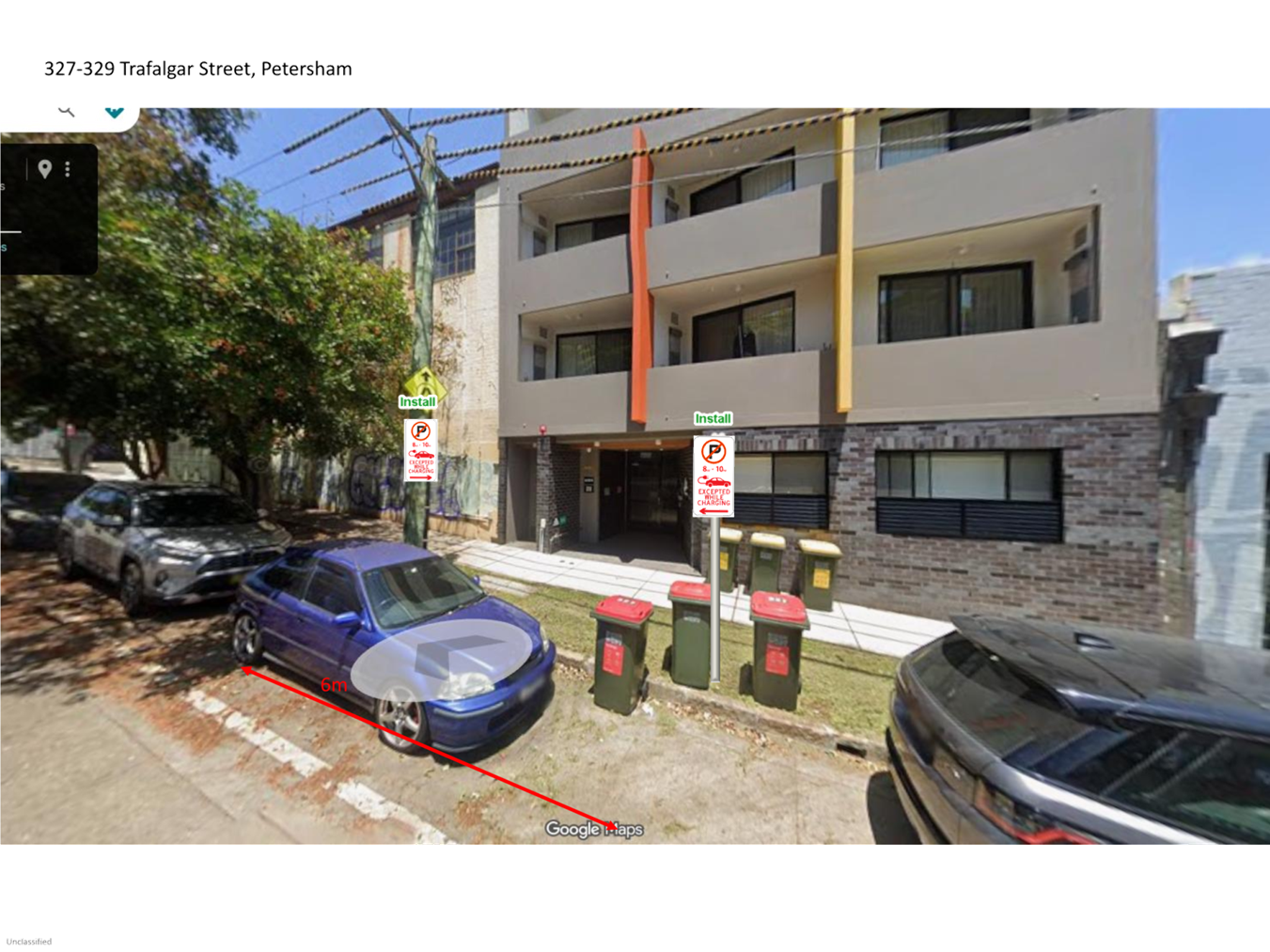
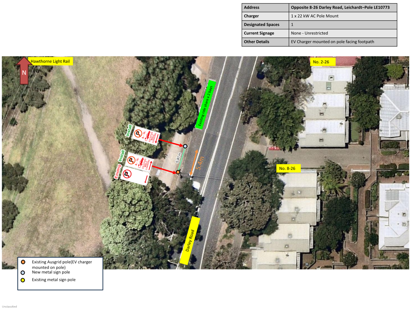
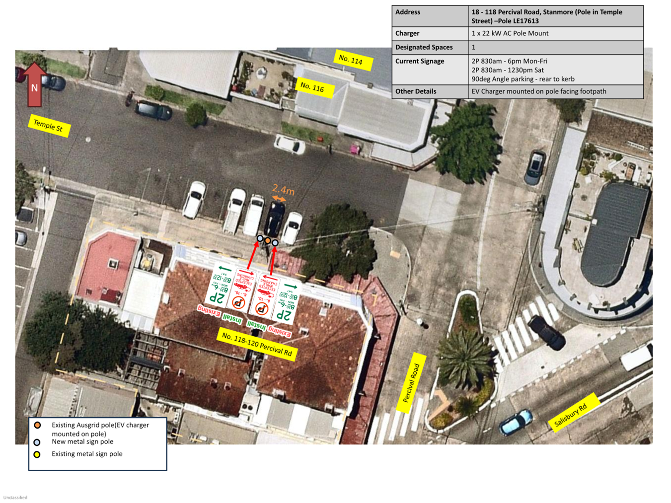
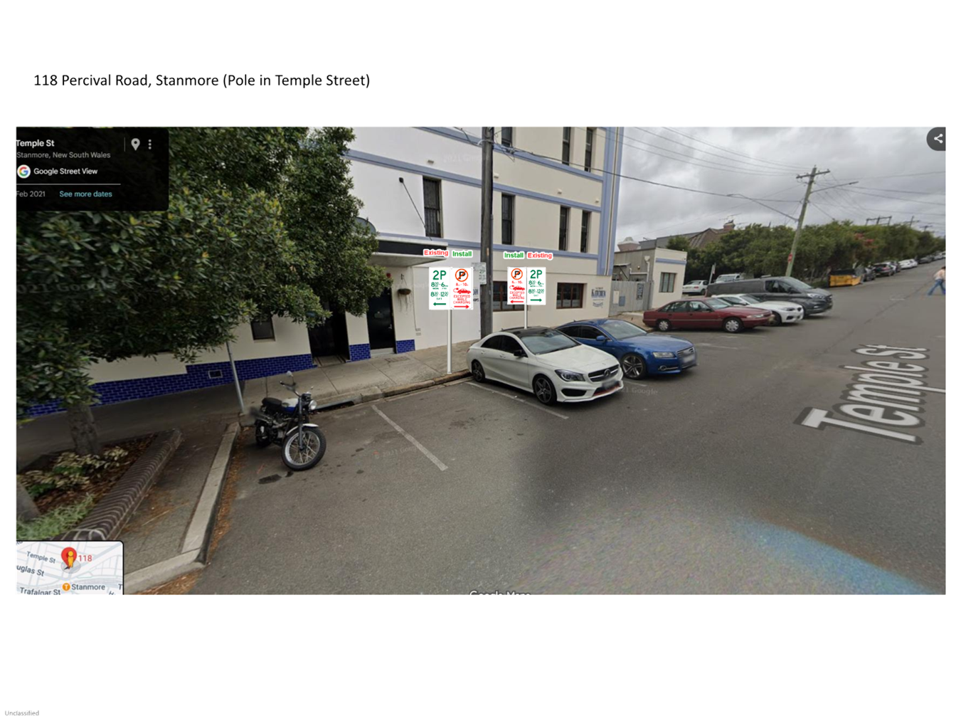
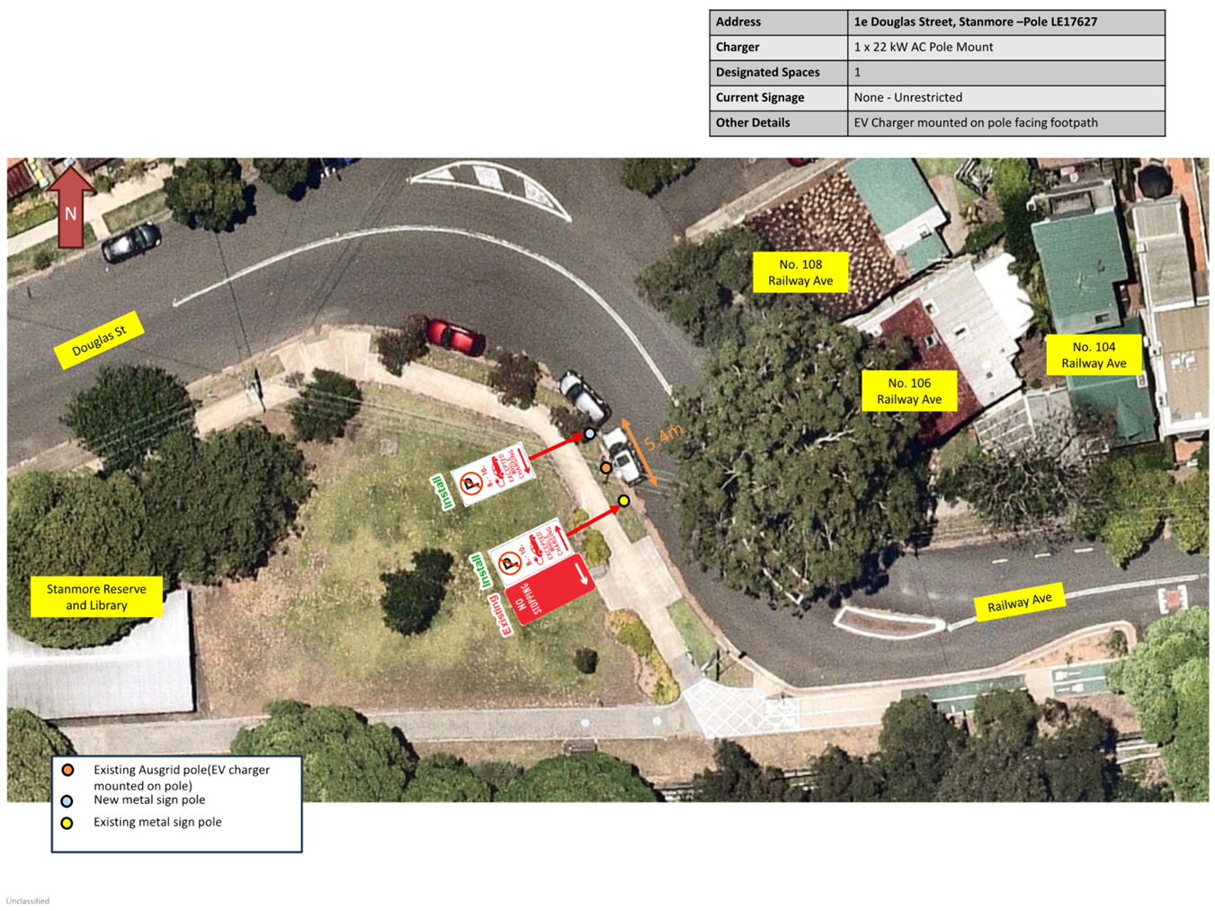
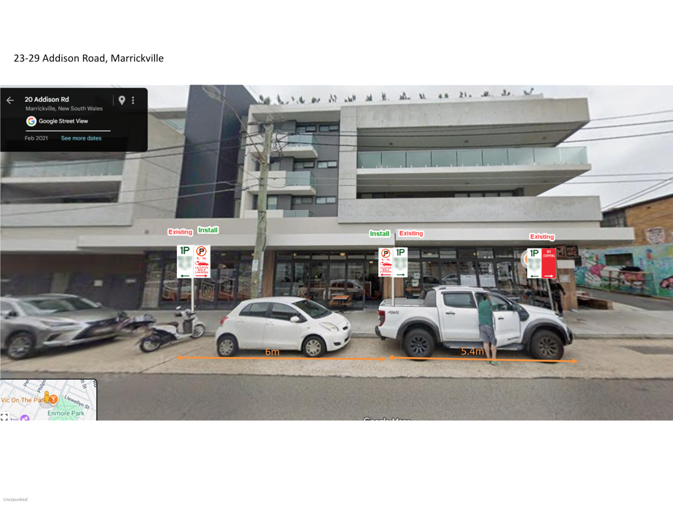
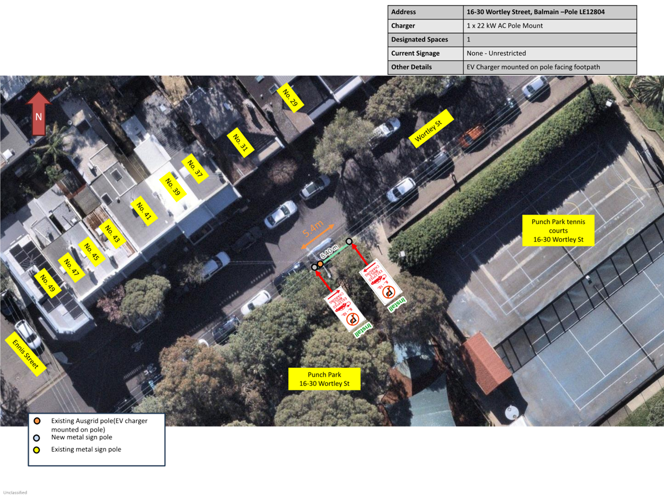
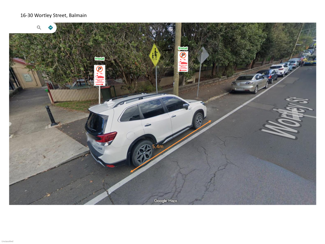
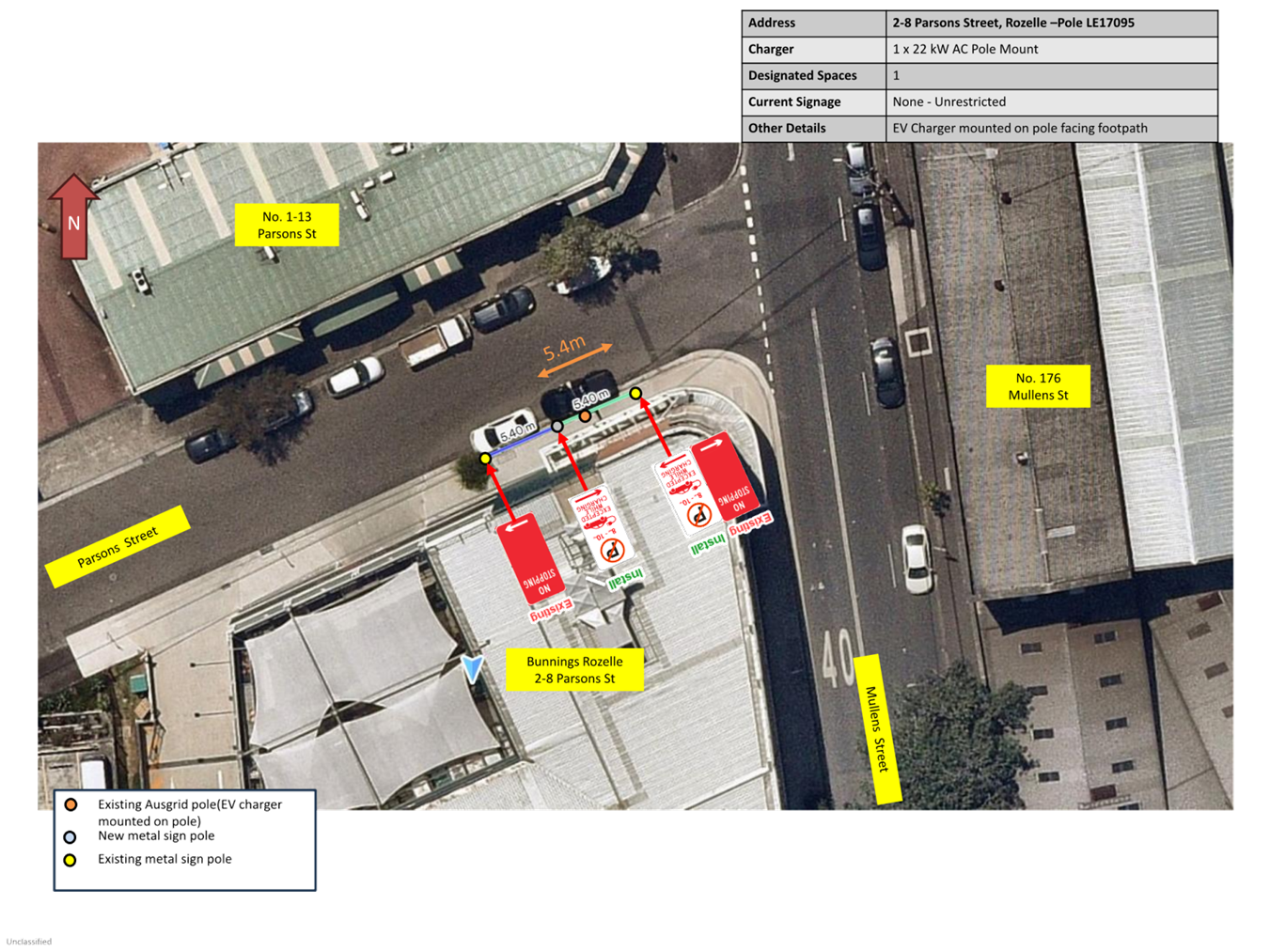
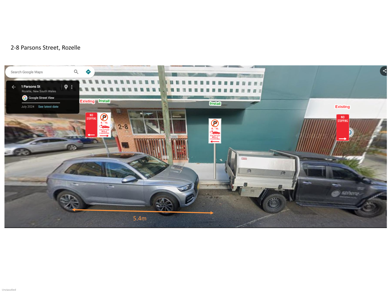
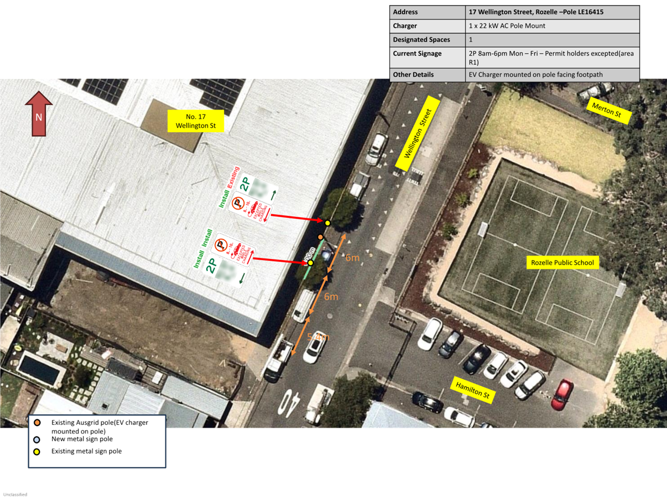
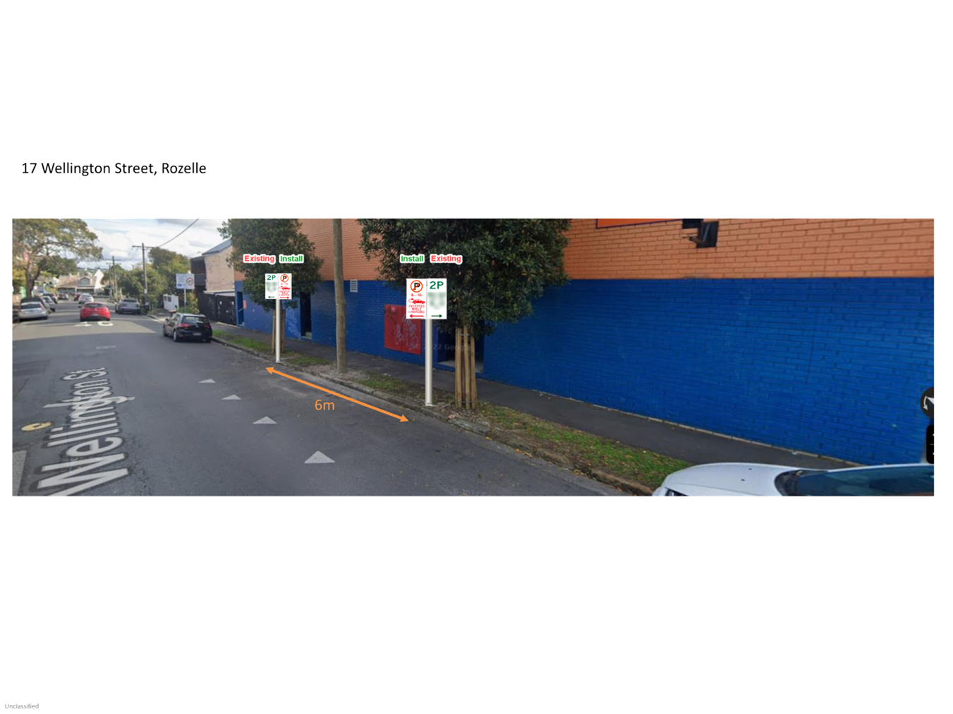
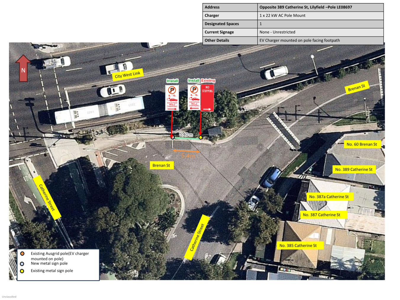
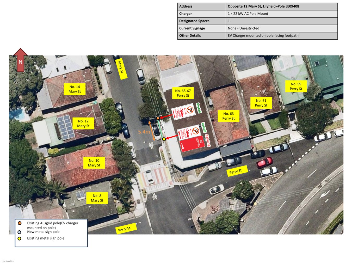
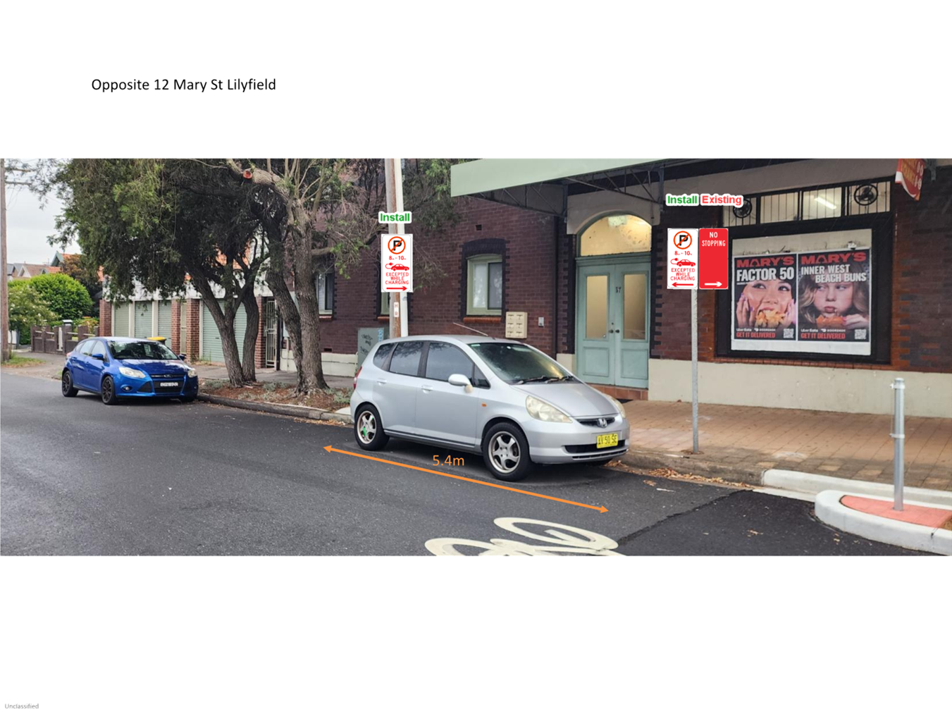
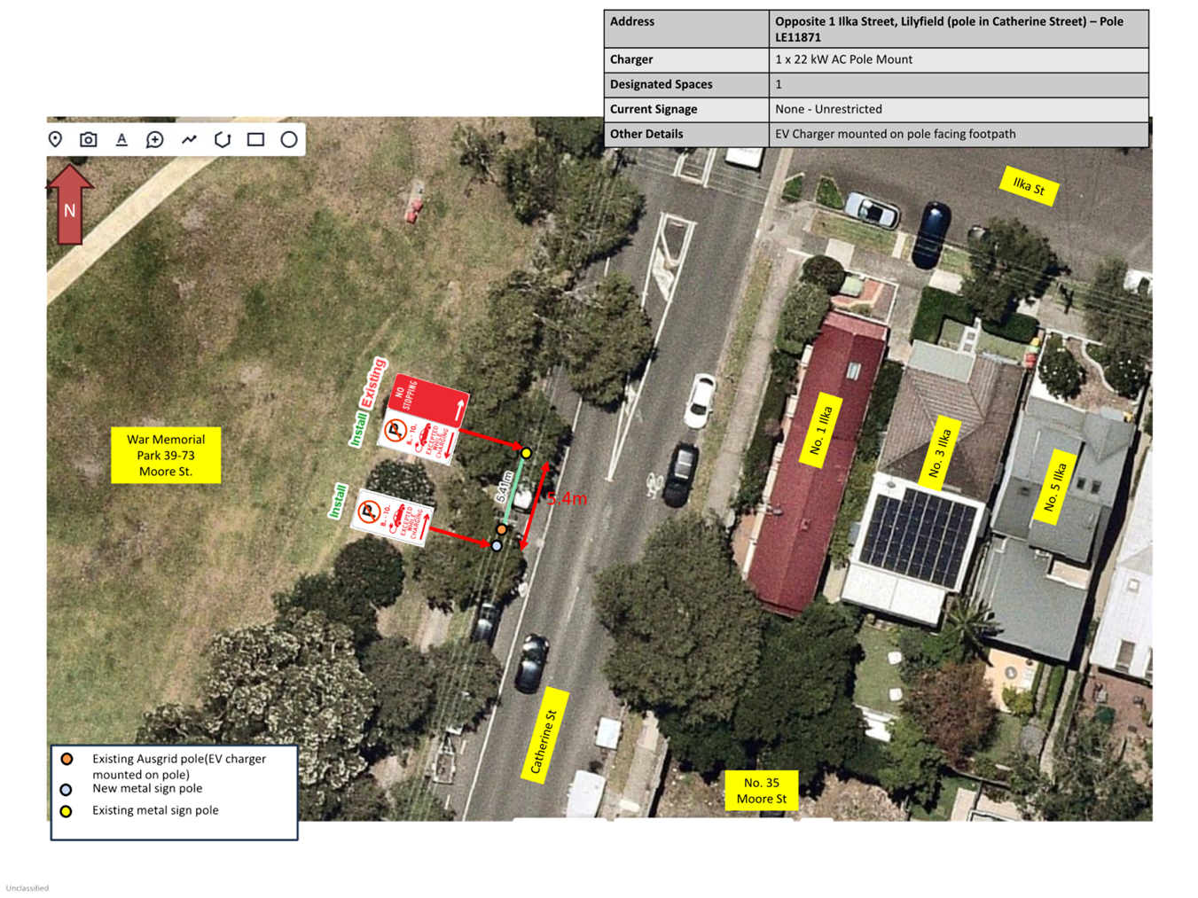
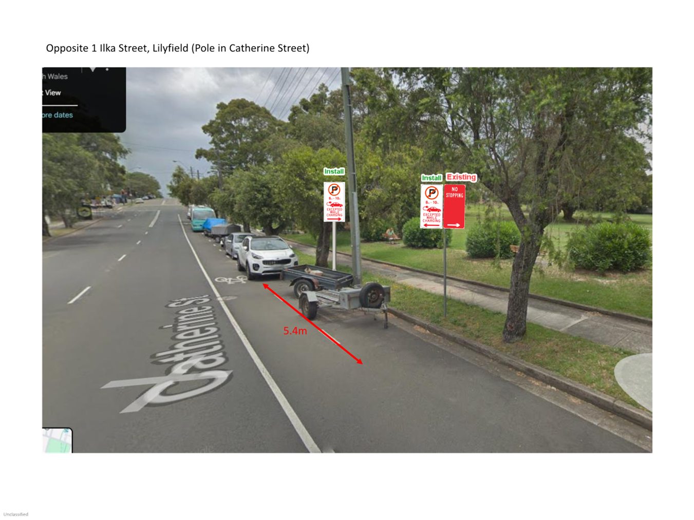
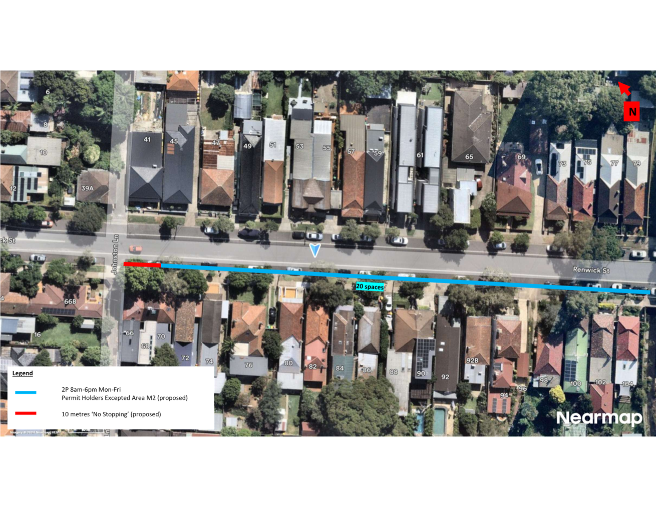
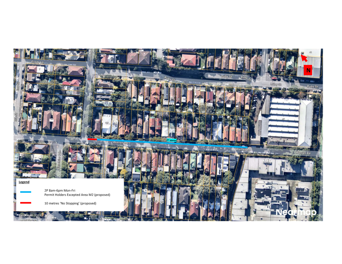
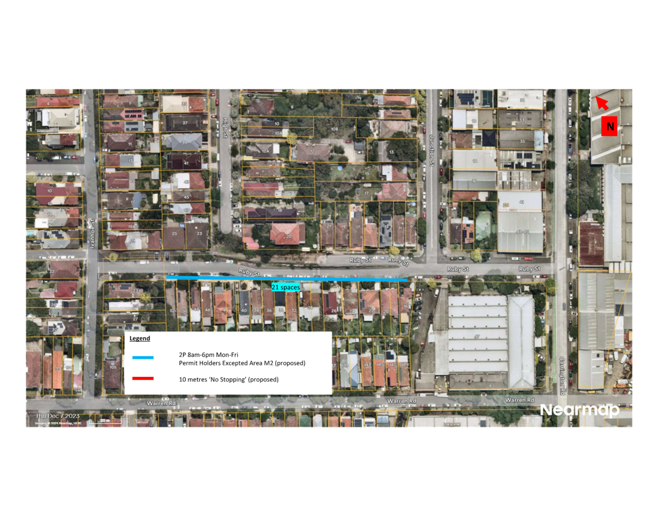
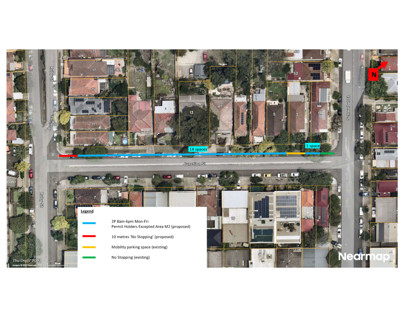
LTF0526(1) Item 13 Proposed EV Kerbside Charging Locations (All Wards / All Electorates / All PACs) 149
LTF0526(1) Item 14 Mackey Park Resident Parking Scheme (Midjuburi - Marrickville Ward / Summer Hill Electorate / Inner West PAC) 186
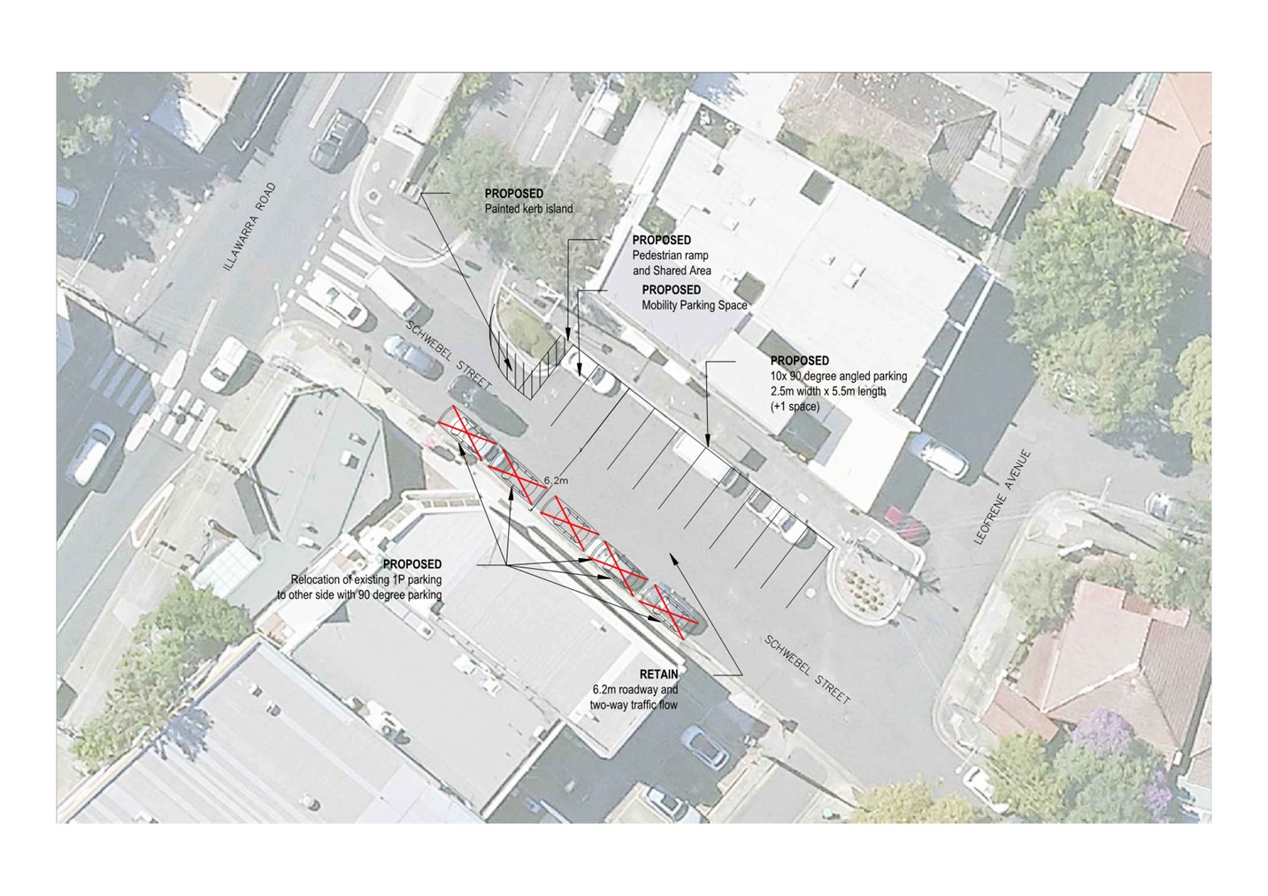
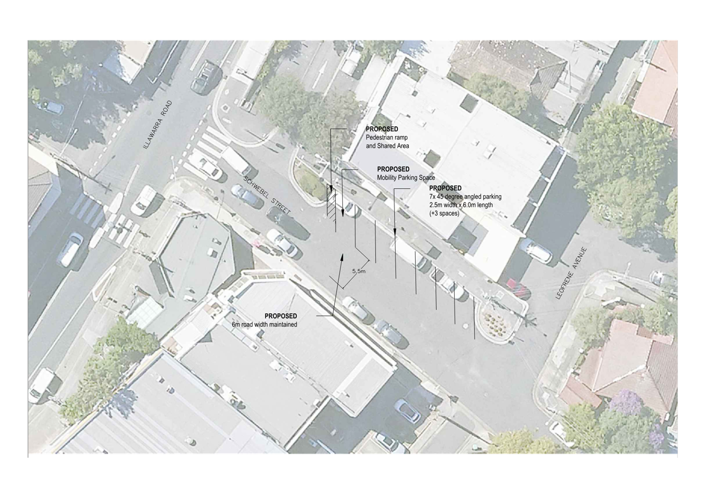
LTF0526(1) Item 15 Schwebel Street, Marrickvlle - Proposed 45 degree angled parking in Schwebel Street between Station Street and Leofrene Avenue. 197
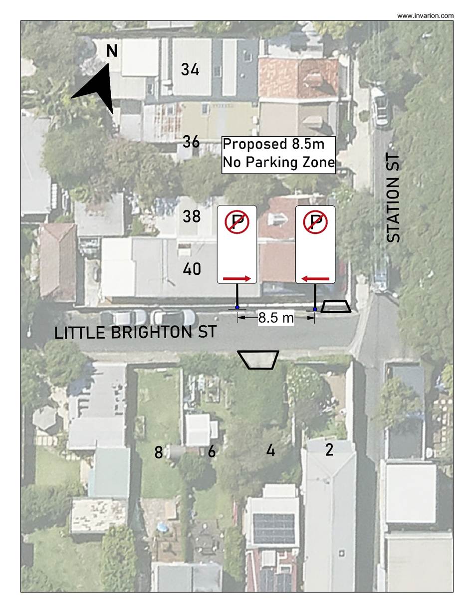
LTF0526(1) Item 16 Little Brighton Street, Petersham - Proposed 'No Parking' Restriction (Damun - Stanmore Ward / Newtown Electorate / Inner West PAC) 202
LTF0526(1) Item 17 Lords Road and Davies Street Resident Parking Scheme Gulgadya-Leichhardt Ward/Balmain Electorate/Leichhardt PAC 207
Late Items
Nil at time of printing.
6 Part B - Items for Information Only
Nil at the time of printing.
7 Part C - Items for General Advice
Nil at the time of printing.
8 General Business
9 Close of Meeting
|
|
Local Transport Forum Meeting 18 May 2026 |
Minutes of Meeting held on 20 April 2026
Meeting commenced at 11:10 AM
ACKNOWLEDGEMENT OF COUNTRY BY CHAIRPERSON
I acknowledge the Gadigal and Wangal people of the Eora nation on whose country we are meeting today, and their elders past and present.
FORUM MEMBERS PRESENT
|
Clr Victor Macri |
Councillor –Midjuburi - Marrickville Ward (Chair) |
|
Clr Liz Atkins |
Councillor – Damun - Stanmore Ward |
|
Rebecca Fernandez |
Representative for Kobi Shetty MP, Member for Balmain |
|
Graeme McKay |
Representative for Jo Haylen MP, Member for Summer Hill |
|
Miriama Tamata |
Representative for Jenny Leong MP, Member for Newtown |
|
Colin Jones |
Representative for Inner West Bicycle Coalition (IWBC) |
|
Vinoth Srinivasan |
Transport for NSW (TfNSW) |
|
Olivia Lin |
Transport for NSW (TfNSW) |
|
Manod Wickramasinghe |
IWC’s Director Engineering (Acting) |
|
Predrag Gudelj |
IWC’s Roads Manager (Acting) |
|
Sunny Jo |
IWC’s Traffic and Transport Planning Manager (Acting) |
|
Felicia Lau |
IWC’s Coordinator Traffic Engineering Services (North) (Acting) |
|
George Tsaprounis |
IWC’s Coordinator Traffic Engineering Services (South) |
|
Brinthaban Baskaran |
IWC’s Project Manager |
|
Kurt Henkel |
IWC’s Team Leader Public Domain Planning |
|
Abigail Chayadi |
IWC’s Graduate Traffic Engineer |
|
Christy Li |
IWC’s Business Administration Officer |
|
|
|
|
VISITORS |
|
|
|
|
|
Sander Ottes |
Public Speaker (Item 1 & 4) |
|
Terry Freshwater |
Public Speaker (Item 4) |
|
Bruce Ashley |
Public Speaker (Item 4) |
|
Robert Moore |
Public Speaker (Item 4) |
|
Ben Brander |
Public Speaker (Item 4) |
|
Todd Napthali |
Public Speaker (Item 4) |
|
Ann King |
Public Speaker (Item 4) |
|
Leonie Derwent |
Public Speaker (Item 4) |
|
Melissa McIntosh |
Public Speaker (Item 4) |
|
Emmanuel Christou |
Public Speaker (Item 4) |
|
|
|
|
APOLOGIES: |
|
|
|
|
|
Nil. |
Nil. |
|
|
|
DISCLOSURES OF INTERESTS:
Nil.
CONFIRMATION OF MINUTES
|
That the Minutes of the Local Transport Forum held on Monday, 16 March 2026 be confirmed. |
MATTERS ARISING FROM COUNCIL’S RESOLUTION OF MINUTES
The minutes of the Local Transport Forum meeting held on 16 February 2026 were adopted at Council’s meeting held on Tuesday, 17 March 2026, subject to the following amendments:
a) Item 13: Bunnings Tempe Local Area Traffic Management - Design Plan No. HD202, point 2 be amended to read:
2. That Council in principle support a 10km/h shared zone on Union St, Tempe, between Princes Highway and School Lane (Drawing No. LATM7 and LATM8) subject to approval from TfNSW and trial the installation of a Local Traffic Only sign at the entrance to Brooklyn Street from the Princes Hwy for a period of 6 months, reporting any findings as part of the 6 month review of the Tempe South LATM scheme.
b) Item 17: Unnamed Laneway, Marrickville rear of Church Street and Warren Road - Adjustment to No Parking Restriction) be amended to read:
1. That the existing ‘No Parking’ restriction on the southern side of the laneway (at the rear of Church Street and Warren Road, Marrickville) be extended west by 2m, up to the gate of No.43 Warren Road (Option 1).
2. Council Officers investigate upgrading parking restrictions at bend in the laneway as well the intersection of Church Street and the Unnamed Lane.
|
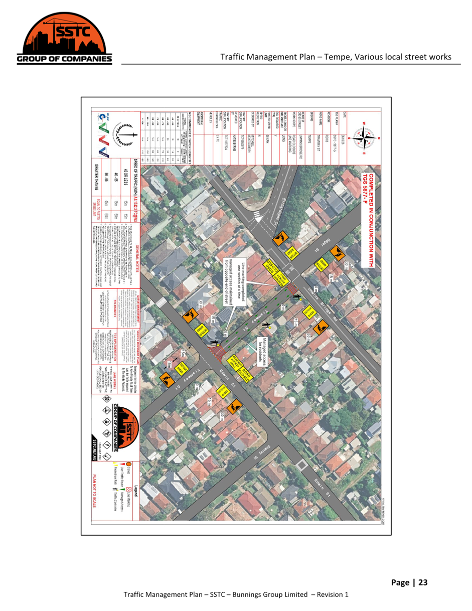
LTF0426(1) Item 6 Norton Street and Lapish Avenue, Ashfield - Proposed at-grade pedestrian (zebra) crossing. (Djarrawunang-Ashfield Ward/Summer Hill Electorate/Burwood PAC) |
|
Council is proposing to improve safety for pedestrians by introducing an at-grade pedestrian (zebra) crossing with associated kerb extension in Norton Street at Lapish Avenue, Ashfield. The proposal aims to improve pedestrian and motorist safety by better defining safe pedestrian crossing points, improving sight distances, reducing traffic speeds and conflicts with traffic movements at this location. Officers Recommendation: That the attached concept plan for an at-grade pedestrian (zebra) crossing with kerb extension in Norton Street at Lapish Avenue, Ashfield, be supported in-principle and listed in Council’s Traffic Facilities Program subject to detailed design and community consultation. LTF Advice: The Representative for the Inner West Bicycle Coalition questioned why the crossing was at grade crossing instead of a raised pedestrian crossing. Council Officers noted that there were drainage issues associated with the location which substantially increased the cost of a raised crossing facility. It was noted that further consideration of raising the crossing will be undertaken when the design commences. No further advice provided by LTF members
RECOMMENDATION: That the attached concept plan for an at-grade pedestrian (zebra) crossing with kerb extension in Norton Street at Lapish Avenue, Ashfield, be supported in-principle and listed in Council’s Traffic Facilities Program subject to detailed design and community consultation. |
General Business:
Item 8 – Thank you to Christy Li – Business Administration Officer
The Forum members expressed its appreciation to Ms Christy Li for her contribution and assistance to the Local Transport Forum.
Meeting closed at 12.55 pm.
CHAIRPERSON
Clr Victor Macri
|
|
Local Transport Forum Meeting 18 May 2026 |
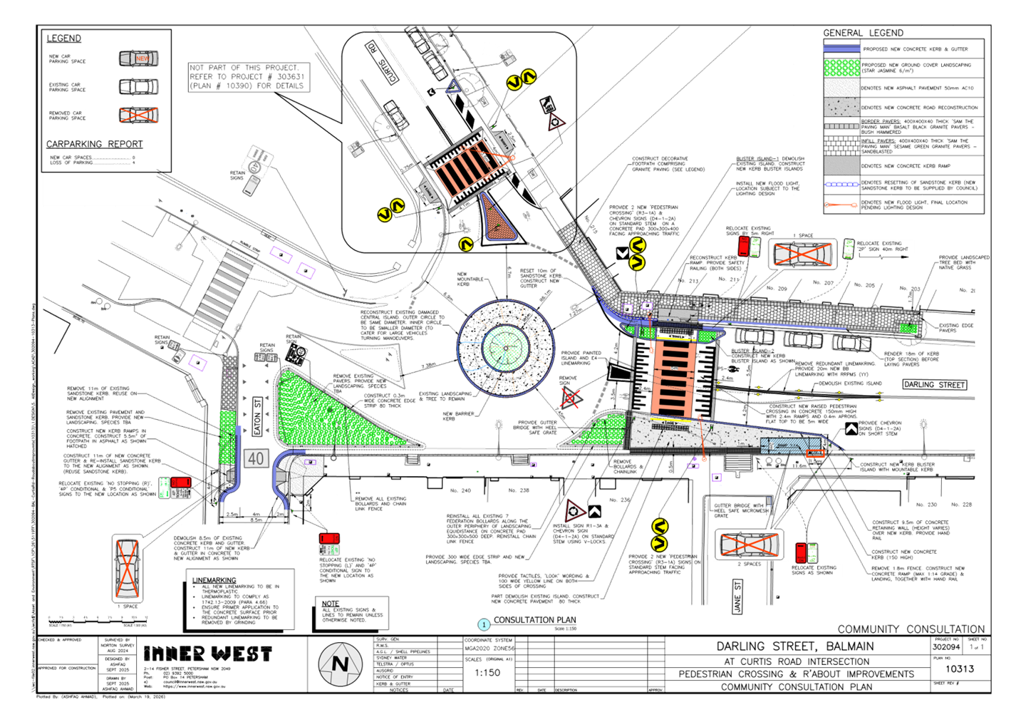
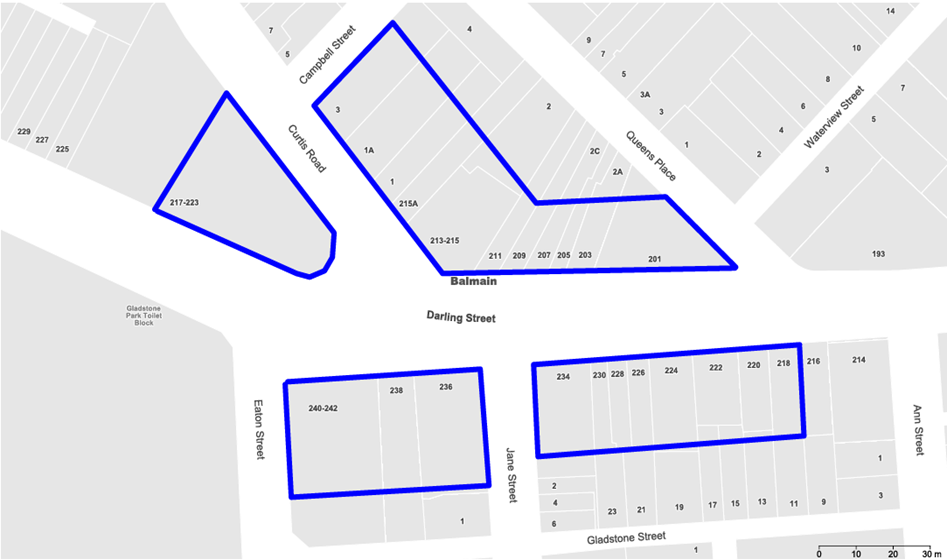
Title: Darling Street and Curtis Road, Balmain - Proposed Raised Pedestrian Crossing and Roundabout Improvements (Baludarri - Balmain Ward/Balmain Electorate/Lechhardt PAC)
Author: Charbel El Kazzi - Traffic Engineer
Authoriser: Sunny Jo - Acting Traffic and Transport Planning Manager
|
RECOMMENDATION
That the attached detailed design plan (Design Plan 10313) for the proposed raised pedestrian crossing in Darling Street, east of Curtis Road and roundabout reconstruction works at the intersection of Darling Street and Curtis Road in Balmain be approved. |
STRATEGIC DIRECTION
This report supports the following strategic directions contained within Council’s Community Strategic Plan:
|
2: Liveable, connected neighbourhoods and transport |
EXECUTIVE SUMMARY
Council is planning to improve pedestrian safety in Darling Street at Curtis Road, Balmain by constructing a new raised pedestrian crossing and reconstructing the existing roundabout central island. The proposal aims to enhance both pedestrian and motorist safety, and to address concerns regarding pedestrian safety and driver behaviour in the area, particularly during peak periods.
As part of the proposal. it is proposed to adjust existing ‘No Stopping’ signs and zones in both Darling Street and Eaton Street to provide the required minimum standards for sight distances. This will result in the loss of four (4) on-street parking spaces in total as shown in Attachment 1.
BACKGROUND
The detailed design plan shown in Attachment 1 outlines the proposed works on Darling Street, Balmain and includes the following:
Darling Street, Balmain (Plan No. 10313):
Pedestrian Crossing
· Construct a 150 mm height new raised concrete pedestrian crossing;
· Construct kerb ramps and a micromesh gutter bridge with handrails on the northern side of the proposed crossing;
· Demolish the existing integral kerb extension on the northern side of the crossing and construct a new landscaped kerb blister island;
· Demolish the existing splitter island on eastern approach and replace with a painted splitter island to improve vehicle manoeuvring;
· Modify the existing kerb blister island on the southern side of Darling Street and align with the new raised pedestrian crossing, improve vehicle delineation on approach to the roundabout;
· Construct access ramp on the southern side of Darling Street from the upper footpath level to the road level;
· Remove existing bollards and chain links from the southern blister islands.
· Install tactile ground surface indicators at both ends of the crossing; and
· Provide new flood lighting by installing up to two floodlights on new power poles to meet pedestrian crossing lighting standards, with final locations subject to detailed electrical design.
Roundabout
· Demolish existing damaged roundabout central island and reconstruct in concrete with new mountable outer kerb and barrier inner kerb to protect the landscaped zone; and
· Within the central island, provide new landscaping where required to match existing. The existing tree will be retained.
Footpath works
· On the northern side of Darling Street, remove the existing asphalt footpath and construct a new footpath comprising two tone granite paving for the infill panel and border pavers; and
· Reset or replace some existing sandstone kerb at the kerb return on the northern side of Darling Street.
Road works
· The road pavement within the roundabout and approaches may be resurfaced as part of this project, however this will be subject to further investigation and available budget. A final decision will be made during prior to the construction;
· Relocate existing ‘No Stopping’ and parking signs on both sides of Darling Street (east of the roundabout) as shown on the attached plan; and
· Install other signage and line markings associated with the works.
Eaton Street, Balmain (Plan No. 10313):
· Construct kerb and gutter to the new alignment at the intersection with Darling Street to improve pedestrian access by aligning the kerb ramps better;
· Reconstruct kerb ramps to meet the new kerb alignment; and
· Relocate existing ‘No Stopping’ and parking signs on both sides of Eaton Street.
DISCUSSION
A letter outlining the proposal was issued to the properties shown in the distribution map below. Five (5) submissions were received in response to this proposal, and three (3) submissions were in objection to the proposal. Comments are summarised within the table below.
|
Resident Concerns |
Officer Feedback |
|
Parking is an issue for residents and concerns of on-street parking permits being abused by some residents and premises. The removal of 4 parking spaces proposed by the changes to the local amenity will only exacerbate the current parking issues. It needs to be looked at in the context of a large proposed development at 189 Darling Street with the construction of 40+ residential dwellings. Council needs to better manage the number of on street parking permits issued to residents. There needs to be a limit which is managed per property with respect to the issue of on street parking permits. There is a proposal for a large redevelopment of 189 Darling Street in front of council. In light of the proposal to change traffic and parking at Darling + Curtis, there must be a condition that none of the dwellings will be eligible for parking permits. |
Council has noted the concerns regarding the loss of parking along with demand and have endeavored to minimise the loss of existing parking spaces during the design. The proposal aims to improve safety for pedestrians and vehicles. It is considered that the safety and accessibility benefit will far outweigh the loss of parking.
The management of parking permits is beyond this project. However, please note that Councils resident parking policy reduces availability for properties with existing off street parking spaces. Under the parking policy, any new multi-dwelling is not eligible to participate in the scheme. Additionally, new developments would need to comply with councils development control (DCP) and provide sufficient off street parking space to residents. |
|
It would make more sense to have any potential new flood lighting in front of the commercial premises at the corner of Darling Street and Curtis Road, not infront of residential addresses. The proposed expanded pedestrian crossing with tiles and chevron signs on a residential street is not in keeping with the street scape and the heritage conservation area? Why would there be ground cover landscaping considered in front of the commercial premises on Darling Street and not infront of Curtis Road? I strongly request you commission a heritage report, the street scape, the established heritage conservation area and the residential impact to consider this properly rather than rushing these decisions through. |
The proposed works are focused on improving pedestrian safety and visibility at the Curtis Road and Darling Street intersection.
In relation to flood lighting, any new lighting would be located to luminate the approach section of the road, to meet pedestrian crossing lighting requirements. It would not be installed for commercial activation purposes.
The proposed tiles, chevron signs and crossing treatments are standard pedestrian safety infrastructure. While the area includes residential properties and heritage considerations, the works are limited to the road reserve and are not intended to alter the heritage of surrounding buildings.
Ground cover landscaping has been proposed where feasible within the available kerb and footpath space. The Darling Street and Curtis Road frontages have different constraints, including available verge width, pedestrian paths, vehicle movements and crossing visibility requirements. Landscaping cannot be placed where it would obstruct sightlines, pedestrian access or vehicle movements.
Based on the limited nature of the works within the public road reserve, a heritage report is not deemed necessary for the proposed road works. |
|
The
Proposed Location Contradicts Pedestrian Behaviour and Safety Principles |
The location of the proposed pedestrian crossing has been determined based on the existing road geometry, vehicle turning movements, proximity to the intersection and the need to improve driver awareness at the crossing point.
Please note that informal crossing patterns (including in front of the commercial premises), typically occurs in the absence of formalised infrastructure. One of the objectives of the proposal is to formalise pedestrian movements into a single, safer and controlled crossing point rather than reinforce dispersed mid-block crossings. The design also incorporates supporting safety measures such as signage, linemarking, refuge treatments, and kerb modifications to reinforce the crossing location and guide pedestrian behaviour. Driveways are a common consideration in urban environments. The proposed design has been developed to ensure adequate visibility and separation distances are maintained so that conflicts are minimised. |
FINANCIAL IMPLICATIONS
The project has an estimated cost of $450,000 and are to be funded under Council’s Capital Works Program.
|
1.⇩ |
Detailed Design Plan 10313 - Darling Street and Curtis Road, Balmain |
|
|
Local Transport Forum Meeting 18 May 2026 |
Title: Nelson Lane,Annandale - Proposed 'No Parking' Zone Extension (Baludarri-Balmain Ward/Balmain Electorate/Leichhardt PAC)
Author: Amir Falamarzi - Traffic Engineer
Authoriser: Sunny Jo - Acting Traffic and Transport Planning Manager
|
RECOMMENDATION
That ‘No Parking’ zone in Nelson Lane opposite the rear boundary of No.265 Nelson Street, Annandale, be approved. |
STRATEGIC DIRECTION
This report supports the following strategic directions contained within Council’s Community Strategic Plan:
|
2: Liveable, connected neighbourhoods and transport |
EXECUTIVE SUMMARY
To support resident’s vehicular access to their property and maintaining consistency with the existing ‘No Parking’ zone arrangements in Nelson Lane, it is recommended that the ‘No Parking’ zone in Nelson Lane be extended to include the opposite to the rear boundary of No.265 Nelson Street, Annandale.
BACKGROUND
Council has received concerns from a resident in Nelson Lane regarding vehicle access to the garage at No. 265 Nelson Street, Annandale. Currently, a 6.4m length of unrestricted parking exists along a stretch of ‘No Parking’ zone on the east side of Nelson Lane between rear of property No. 273 and 259 Nelson Street.
The resident has requested an extension of the existing ‘No Parking’ zone opposite No. 265 Nelson Street to improve vehicle access to and from the driveway.
The current parking arrangements and the proposed extension are shown in Figure 1.
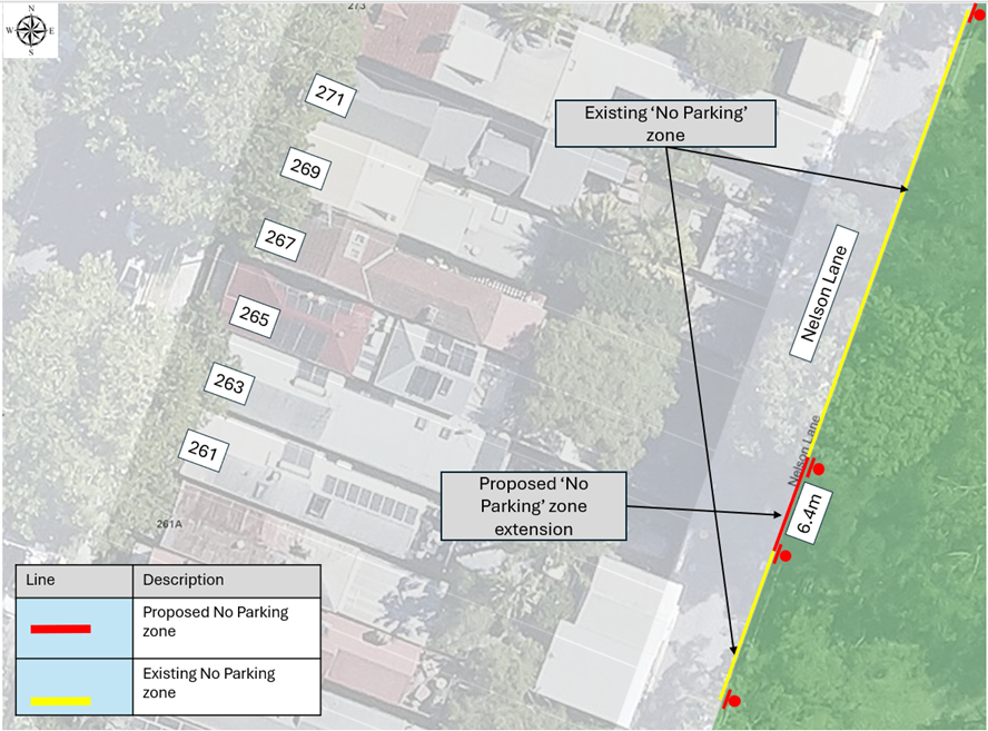
Figure 1: Parking arrangement on Nelson Lane
DISCUSSION
A community consultation with affected residents on Nelson Lane was undertaken between 24 February and 24 March 2026 proposing to extend the ‘No Parking’ zone opposite to the rear of No.265 Nelson Street. The consultation area is shown in Figure 2.
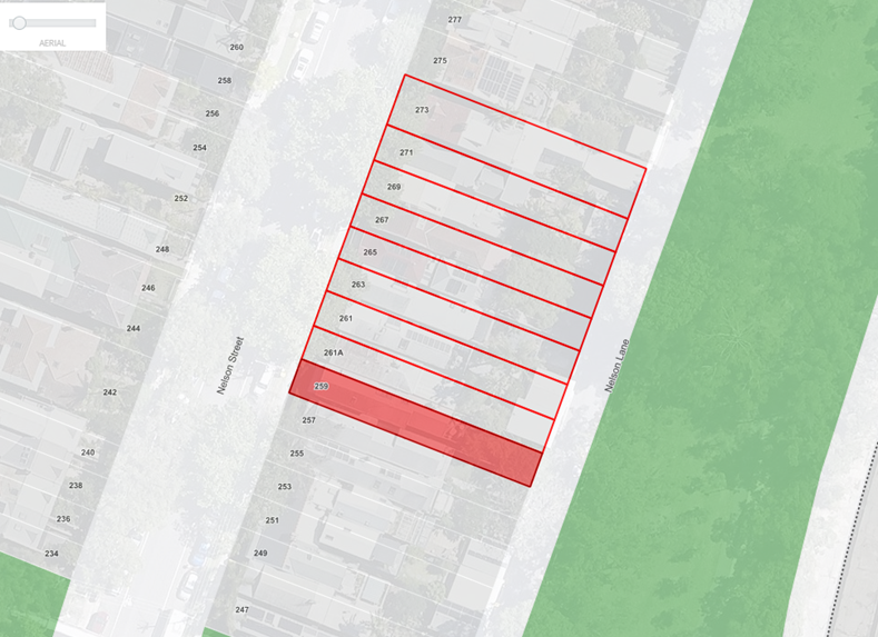
Figure 2: Consultation area in Nelson Lane
A total of 11 letters were sent to affected residents and two responses were received with one objection. These responses, along with Council’s officer comments, are summarised below:
|
You Said |
Comment |
|
I reside along this section of the lane and wish to retain parking availability behind my property. Currently, due to the previous removal of parking behind a neighbouring property (which I objected to at the time), parking access behind my property has been significantly reduced. As a result, only one parking space now remains available along this section of Nelson Lane. I therefore object to the removal of parking behind my property and would support retaining parking directly adjacent to it. |
Council prioritises resident access to off-street parking over on-street parking within laneways. While laneways provide connections to adjoining streets, they also serve key functions to provide vehicular access to off-street parking, and pedestrian and cycling routes. It is noted that there are on-street parking opportunities in Nelson Street. |
|
We support the proposed No Parking restriction opposite our property, as parked vehicles, particularly larger ones, have at times prevented safe entry to and exit from our garage. This has caused inconvenience and, on occasion, delays in getting to work due to limited public transport options. There has also been an incident where a vehicle was accidentally scraped while reversing into the garage because of reduced manoeuvring space, a situation we wish to avoid in the future. The garage was constructed pursuant to an approved DA, and it would be fair and consistent to extend the existing No Parking zones to this location to ensure safe and reliable access to residential garages. |
Noted. |
FINANCIAL IMPLICATIONS
There are no financial implications associated with the implementation of the proposed recommendations outlined in the report.
Nil.
|
|
Local Transport Forum Meeting 18 May 2026 |
Title: Warburton Street, Marrickville - Proposed Kerb Blister (Midjuburi - Marrickville Ward / Summer Hill Electorate / Inner West PAC)
Author: Jackie Ng - Traffic Engineer
Authoriser: Sunny Jo - Acting Traffic and Transport Planning Manager
|
RECOMMENDATION
1. That the proposed kerb blister on Warburton Street near Illawarra Road, Marrickville be approved in principle and a detailed design for the proposed kerb blister be brought back to the Local Transport Forum for consideration, including the results of community engagement.
2. That the proposed kerb blister on Warburton Street be included for consideration in Council’s Traffic Facilities Capital Works Program for funding.
|
STRATEGIC DIRECTION
This report supports the following strategic directions contained within Council’s Community Strategic Plan:
|
2: Liveable, connected neighbourhoods and transport |
EXECUTIVE SUMMARY
A request has been received from Vesbar Espresso café to investigate opportunities to improve pedestrian safety at Warburton Street near Illawarra Road, Marrickville.
The café expressed concerns regarding cars and trucks mounting or swiping the kerb when turning left into Illawarra Road from Warburton Street.
An assessment has been undertaken, and it is proposed that a kerb blister be installed to improve pedestrian safety at the location. The kerb blister will reduce the overall crossing distance of the road, provide future outdoor dining opportunities and reduce conflict between vehicles and pedestrians.
BACKGROUND
A request has been received from Vesbar Espresso café to investigate opportunities to improve pedestrian safety at the intersection of Warburton Street and Illawarra Road, Marrickville .
Recent work at the Marrickville Metro Station resulted in the removal of a power pole situated at the corner of Vesbar Espresso. Prior to this, the power pole served as a physical barrier between customers at the café and motorists on Illawarra Road.
It has been mentioned that vehicles and trucks often mounted or swipe the kerb when turning left from Warburton Street into Illawarra Road, which has increased the concern for safety surrounding pedestrians at this location.
Investigation has subsequently been undertaken to consider treatments to improve pedestrian safety.
DISCUSSION
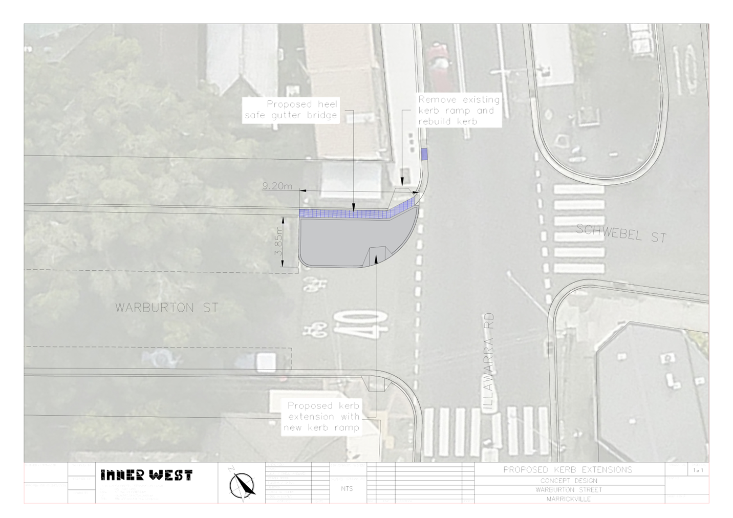
Warburton Street is a two-way road with a kerb-to-kerb width of 12.6m, allowing a combination of 90-degree angle parking and parallel parking along both sides of the road.
The intersection is located along a key pedestrian link connecting pedestrians to the Marrickville Train Station and Marrickville Town Centre. There are currently two kerb ramps which allow pedestrians to cross Warburton Street.
It is expected that pedestrians travelling southbound are required to walk further into the roadway for better visibility due to the existing 90 degree parking adjacent to the intersection.
The café located at the corner of the intersection (Vesbar Espresso) has an outdoor dining arrangement which occupies the footpath along Warburton Street. It is also noted that customers of the café occupy the length of the footpath along Illawarra Road whilst waiting for orders, reducing the width of the footpath.
Accordingly, it is proposed that a kerb blister be installed on Warburton Street to improve pedestrian safety. The kerb blister will reduce the pedestrian crossing distance across Warbuton Street by approximately 4m, provide future outdoor dining opportunities and reduce conflict between pedestrians and vehicles.
The proposal will result in no loss of on-street parking spaces. There has been a single crash (between 2020-2024) recorded at this intersection on Illawarra Road involving a cross-traffic incident in daylight causing moderate injury.
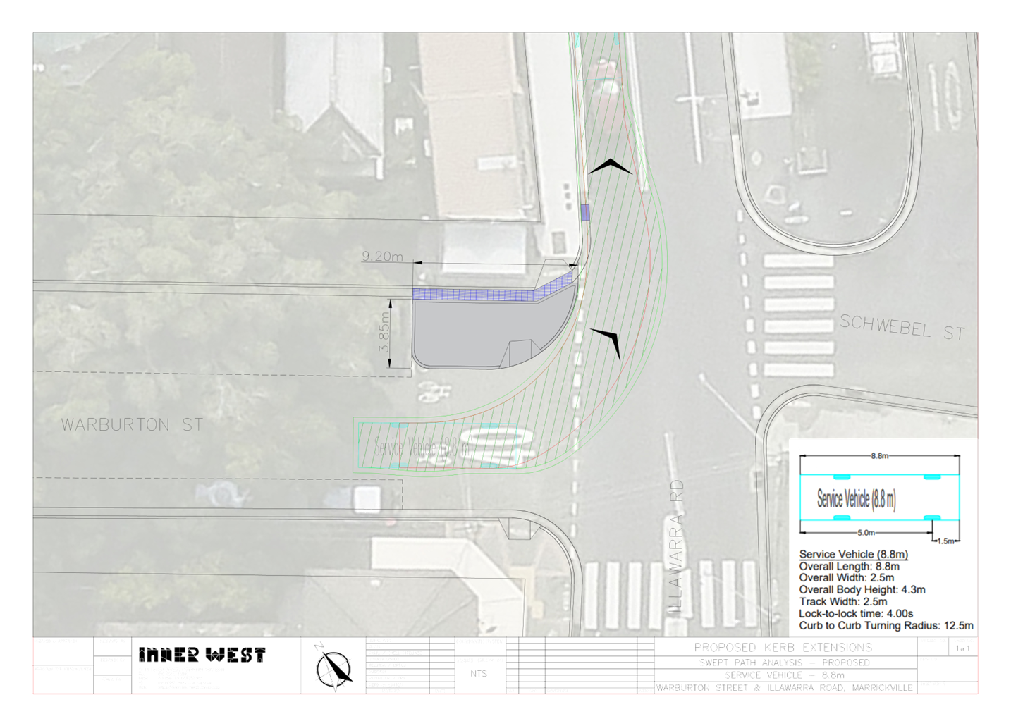
Swept path analysis has been completed for an 8.8m service vehicle and is shown in the attachments. The existing arrangement indicates that the service vehicle could encroach on the southbound lane on Illawarra Road when turning left from Warburton Road, which is the current arrangement at this location.
Council will carry out community engagement with residents and businesses during the detailed design stage of the process.
FINANCIAL IMPLICATIONS
The cost of the work is initially estimated at $20,000 and the project will need to be included in Council’s Traffic Facilities budget for future funding. A final cost estimate will be prepared during the detailed design stage.
|
1.⇩ |
Warburton Street, Marrickville - Concept Plan |
|
2.⇩ |
Warburton Street, Marrickville - Proposed Swept Path (8.8m Service Vehicle) |
|
3.⇩ |
Warburton Street, Marrickville - Existing Swept Path (8.8m Service Vehicle) |
|
|
Local Transport Forum Meeting 18 May 2026 |
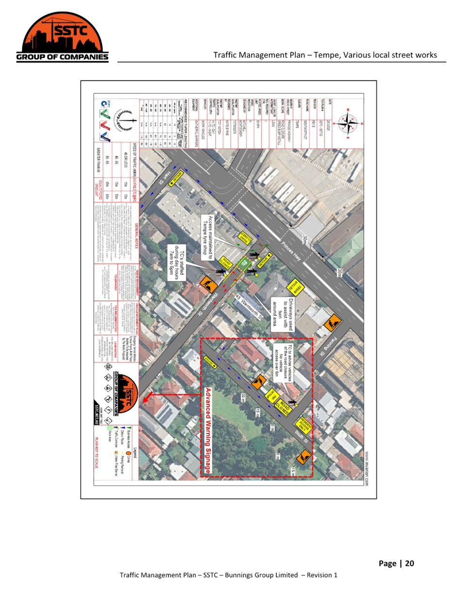
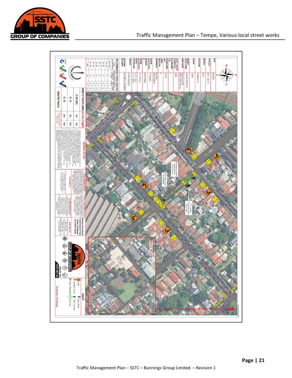
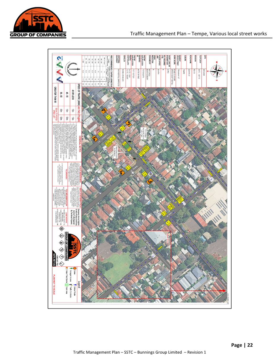
Title: Bunnings Tempe South LATM works - Proposed temporary full road closures at multiple locations over a five-week period (Midjuburi-Marrickville Ward / Heffron Electorate / Inner West PAC)
Author: Jennifer Adams - Traffic Engineer
Authoriser: Sunny Jo - Acting Traffic and Transport Planning Manager
|
RECOMMENDATION
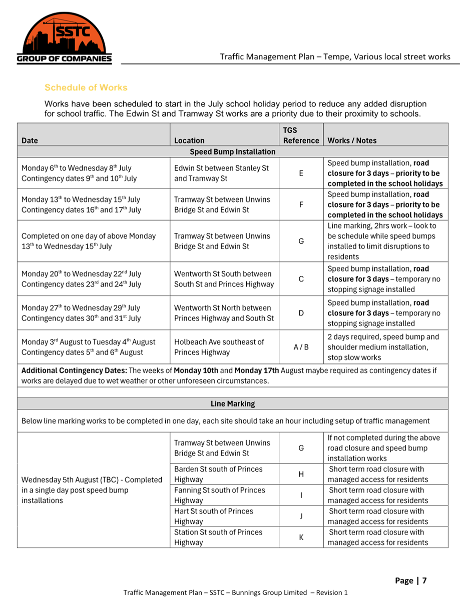
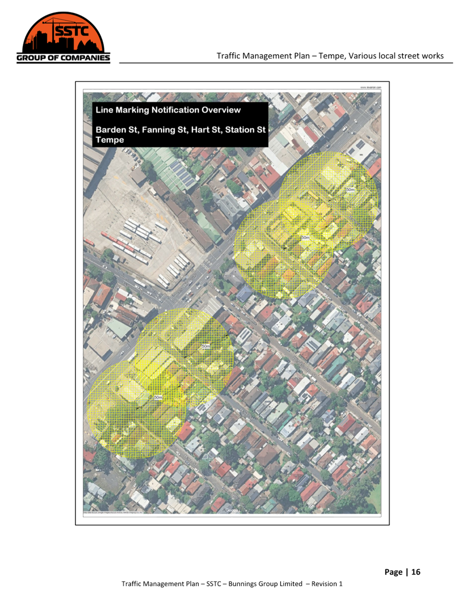
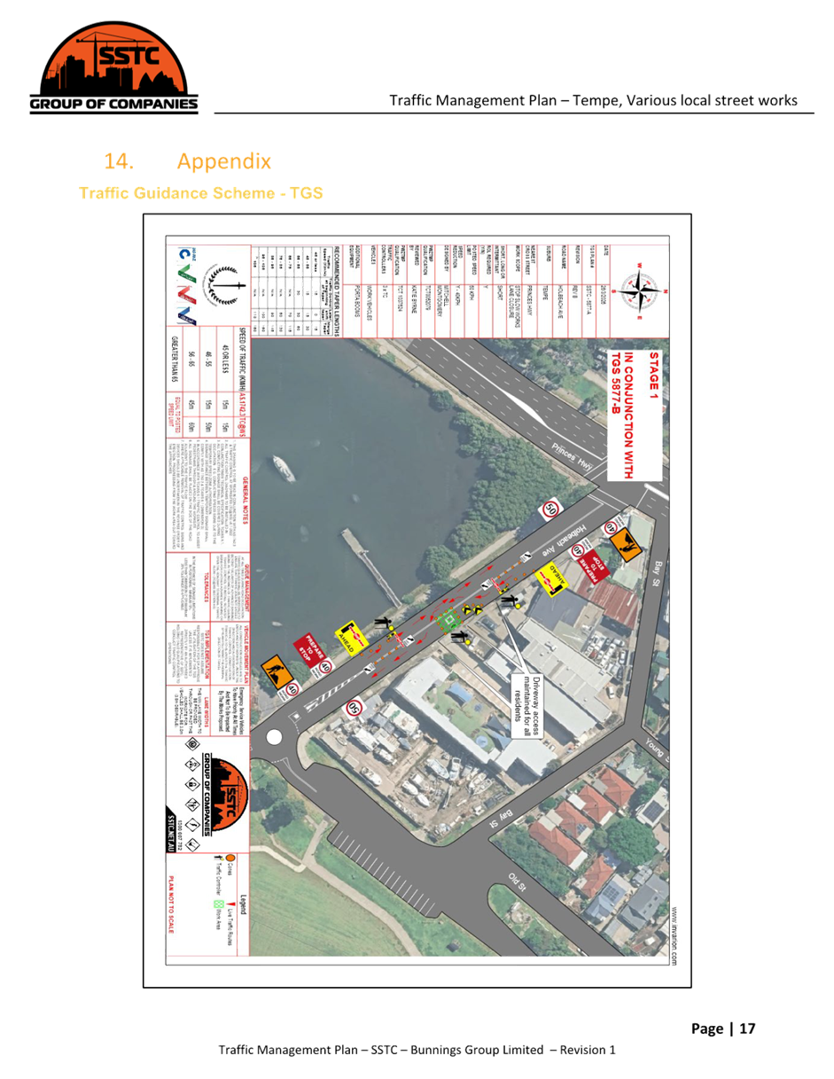
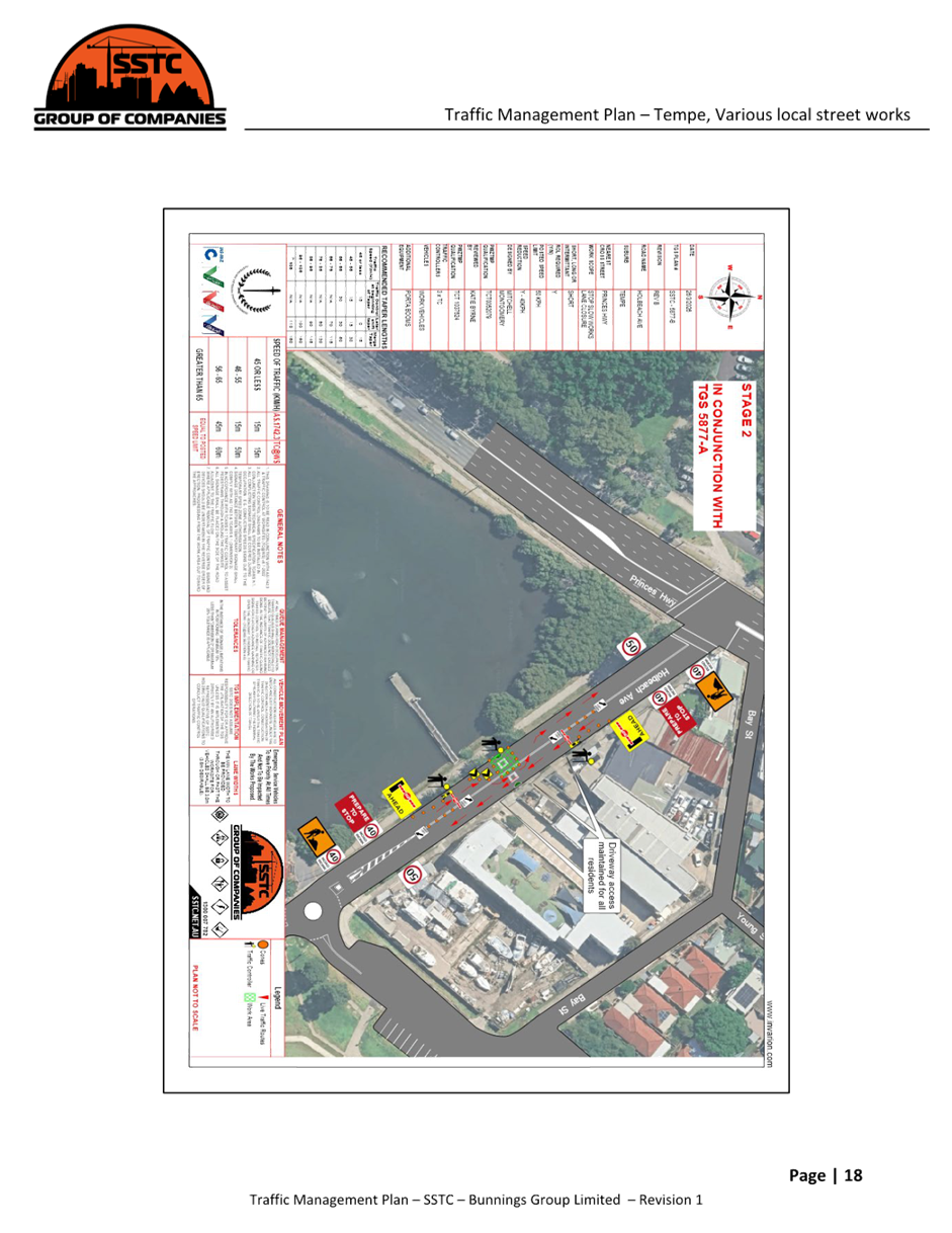
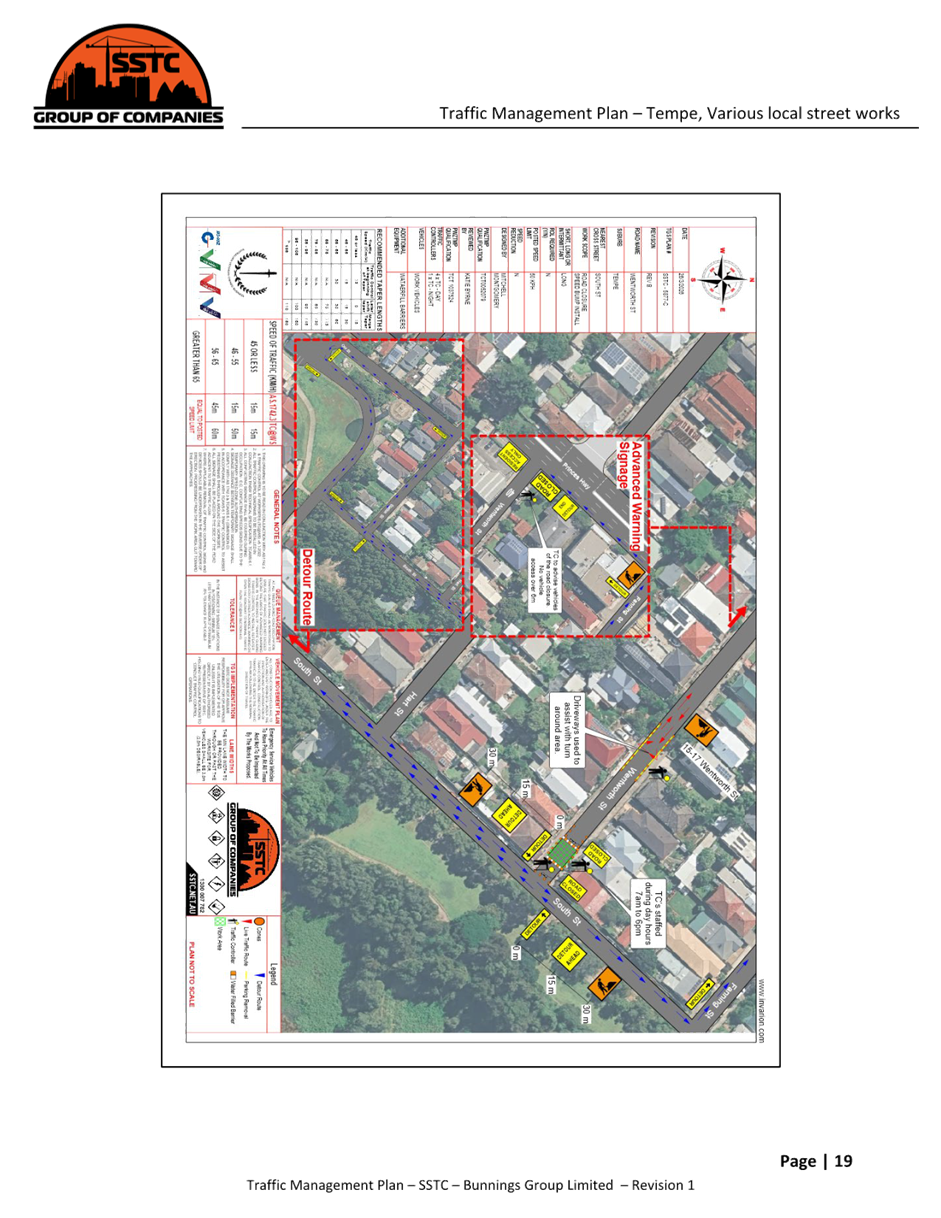
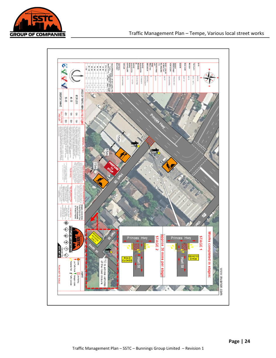
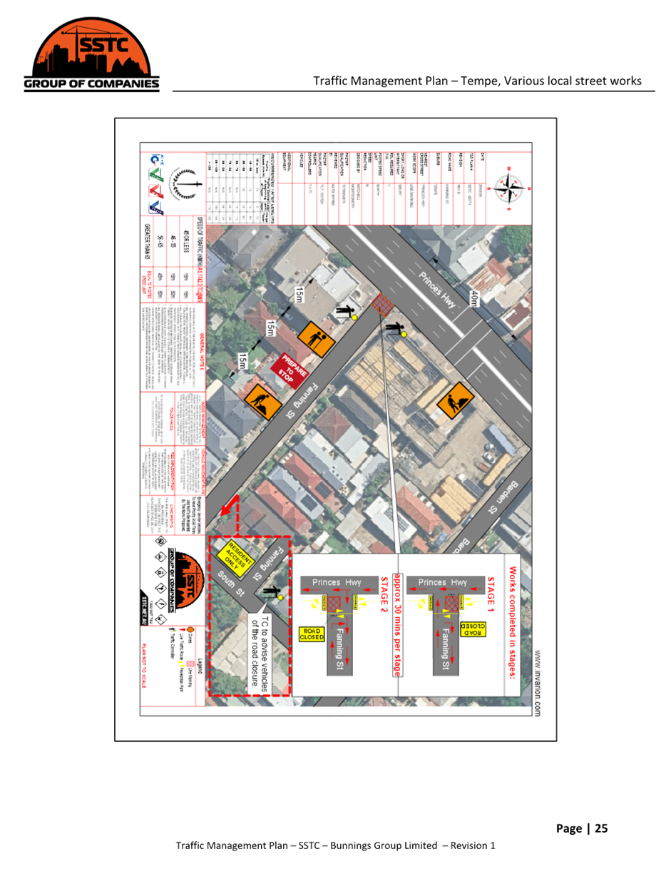
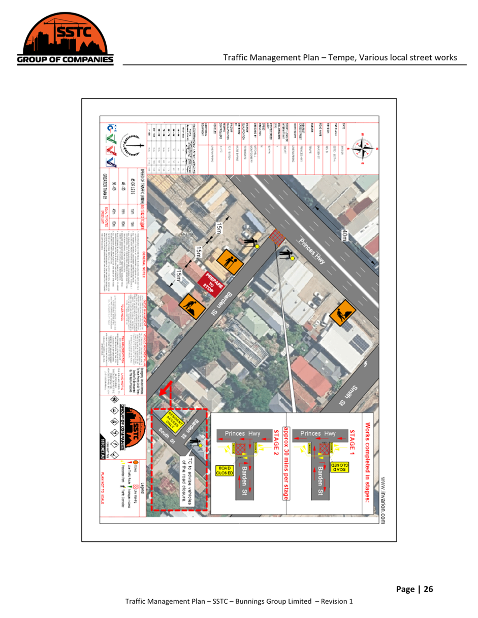
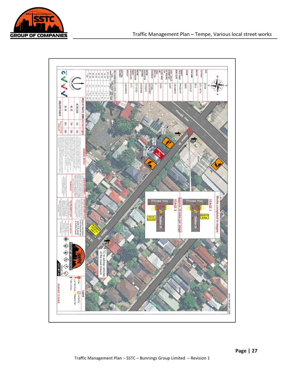
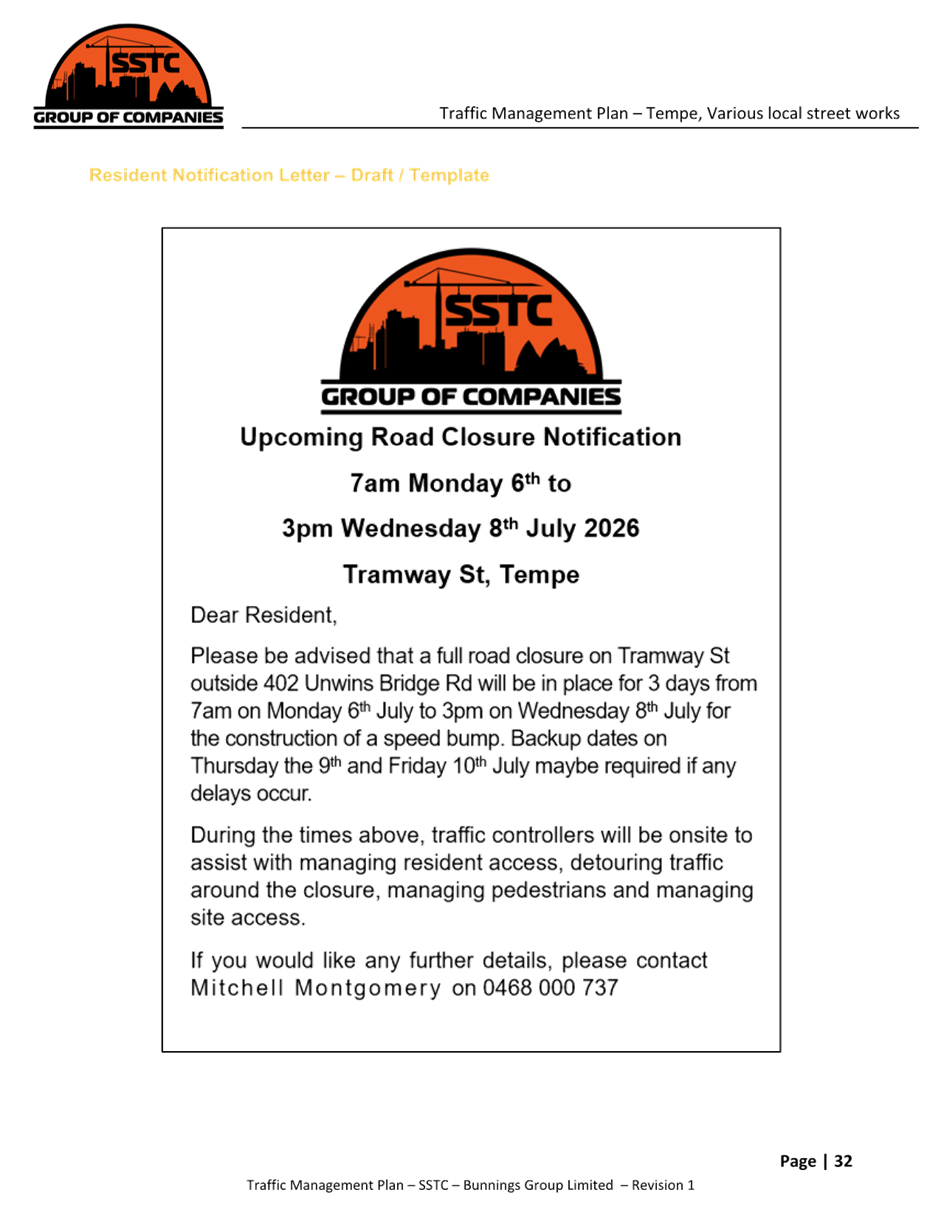
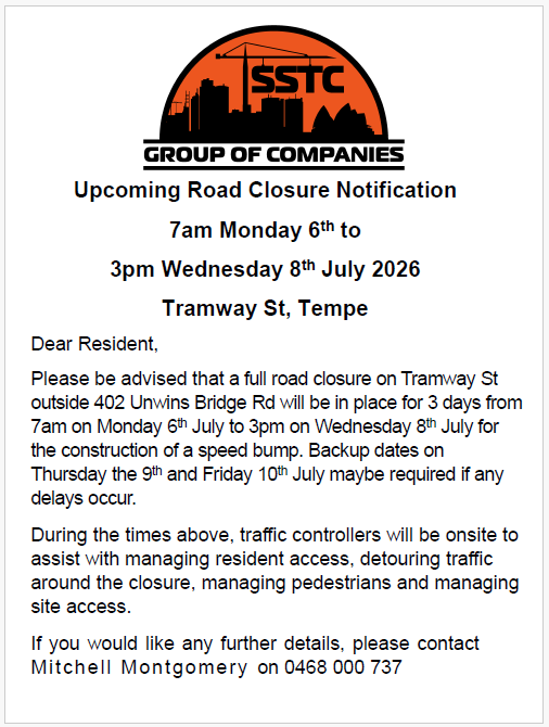
1. That the proposed temporary full and partial road closures of: a) Edwin Street between Stanley Street and Tramway Street, Tempe on Monday 6 July to Wednesday 8 July 2026 (full closure) b) Tramway Street between Unwins Bridge Road and Edwin Street, Tempe on Monday 13 July to Wednesday 15 July 2026 (full closure) c) Wentworth Street South between South Street and Princes Highway, Tempe on Monday 20 July to Wednesday 22 July 2026 (full closure) d) Wentworth Street North between Princes Highway and South Street, Tempe on Monday 27 July to Wednesday 29 July 2026 (full closure) e) Holbeach Avene southeast of Princes Highway, Tempe on Monday 3 August to Tuesday 4 August 2026 (partial road closure) f) Line marking 1-2 hour short duration road closures - Tramway Street, Barden Street, Fanning Street, Hart Street and Station Street, Tempe on Wednesday 5 August 2026
(with a contingency period of two weeks for each road closure) be approved, as per the submitted Traffic Management Plans (TMP) and Traffic Guidance Schemes(TGS), in order to carry out Bunnings Tempe South Local Area Traffic Management (LATM) works subject to, but not limited to, the following conditions: a) The application and TMP/TGSs be submitted to TfNSW for approval; b) A Road Occupancy License be obtained by the applicant from the Transport Management Centre; c) All affected residents and businesses, including NSW Police Local Area Commander, Transit Systems, Fire and Rescue NSW and NSW Ambulance Services, shall be notified in writing by the applicant of the proposed temporary road closures at least 7 days prior to the event, with the applicant making reasonable provision for all stakeholders, residents and businesses; d) That the occupation of the road carriageway must not occur until the road has been physically closed. e) The applicant be advised in terms of this report and that all costs for the road closures and implementation of the road closures are to be borne by the applicant.
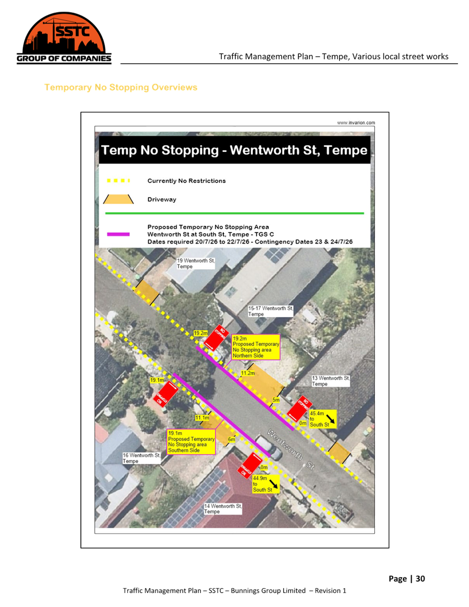
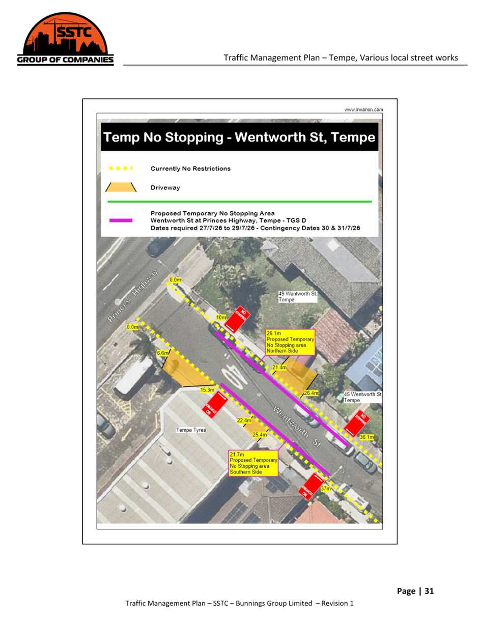
2. That installation of the temporary ‘No Stopping’ restrictions on Wentworth Street, Tempe at Princes Highway (26.1m length on northern side outside No.49 to 45 and 21.7m length on the southern side outside Tempe Tyres and No.46) and north of South Street (19.2m length on northern side outside No.13 to 15-17 and 19.1m length on the southern side outside No.14 and 16) be approved subject to the applicant installing and removing the signage at their cost. |
STRATEGIC DIRECTION
This report supports the following strategic directions contained within Council’s Community Strategic Plan:
|
2: Liveable, connected neighbourhoods and transport |
EXECUTIVE SUMMARY
A request has been received from Bunnings Group Limited for the temporary full road closure of multiple streets in Tempe over a five-week period in order to carry out approved Bunnings Tempe South LATM works (ENRC20260013).
This report details the temporary full road closures required for the adopted traffic calming treatments to be constructed in Holbeach Avenue, Wentworth Street, Edwin Street, Tramway Street, Barden Street, Fanning Street, Hart Street and Station Street, Tempe.
BACKGROUND
Bunnings Tempe LATM Design Plan HD202 was the subject of a report to the Committee on 16 February 2026 (Item 13). The report detailed the design plans for the traffic treatments in the Tempe South Precinct and recommended approval with changes due to the results of community consultation. The final adopted recommendation was:
1. That the detailed design plans (No. HD202, revision 4) be approved for the:
a) Construction of landscaped kerb blisters and speed cushions on Holbeach Avenue, Tempe (Drawing No. LATM4).
b) Construction of a raised concrete threshold with the inclusion of bollards and chains (on footpath) near South Street on Wentworth Street, Tempe (Drawing No. LATM5).
c) Construction of a raised concrete threshold with the exclusion of bollards and chains (on footpath) near Princes Highway on Wentworth Street, Tempe (Drawing No. LATM6).
d) Construction of a raised concrete threshold and renewal of linemarking with the exclusion of rumble bars on Edwin Street, Tempe (Drawing No. LATM9 and LATM11).
e) Construction of a raised concrete threshold, installation of an at-grade contrasting pavement treatment, and renewal of linemarking with the exclusion of rumble bars on Tramway Street, Tempe (Drawing No. LATM10 and LATM11).
f) Installation of an at-grade contrasting pavement treatment on Barden Street, Tempe (Drawing No. LATM12).
g) Installation of an at-grade contrasting pavement treatment on Fanning Street, Tempe (Drawing No. LATM13).
h) Installation of an at-grade contrasting pavement treatment on Hart Street, Tempe (Drawing No. LATM14).
i) Installation of an at-grade contrasting pavement treatment on Station Street, Tempe (Drawing No. LATM15).
2. That Council in principle support a 10km/h shared zone on Union St, Tempe, between Princes Highway and School Lane (Drawing No. LATM7 and LATM8) subject to approval from TfNSW and trial the installation of a Local Traffic Only sign at the entrance to Brooklyn Street from the Princes Hwy for a period of 6 months, reporting any findings as part of the 6 month review of the Tempe South LATM scheme.
The proposed two raised thresholds in Stanley Street, Tempe were removed from the list of works due to no support from the community (Drawing No. LATM5 and LATM6). It is noted also that Stanley Street was recently signposted as a 40km/h zone through the InnerWest@40 project.
This report details the necessary temporary full road closures required for the adopted traffic calming treatments to be constructed in Holbeach Avenue, Wentworth Street, Edwin Street, Tramway Street, Barden Street, Fanning Street, Hart Street and Station Street, Tempe.
DISCUSSION
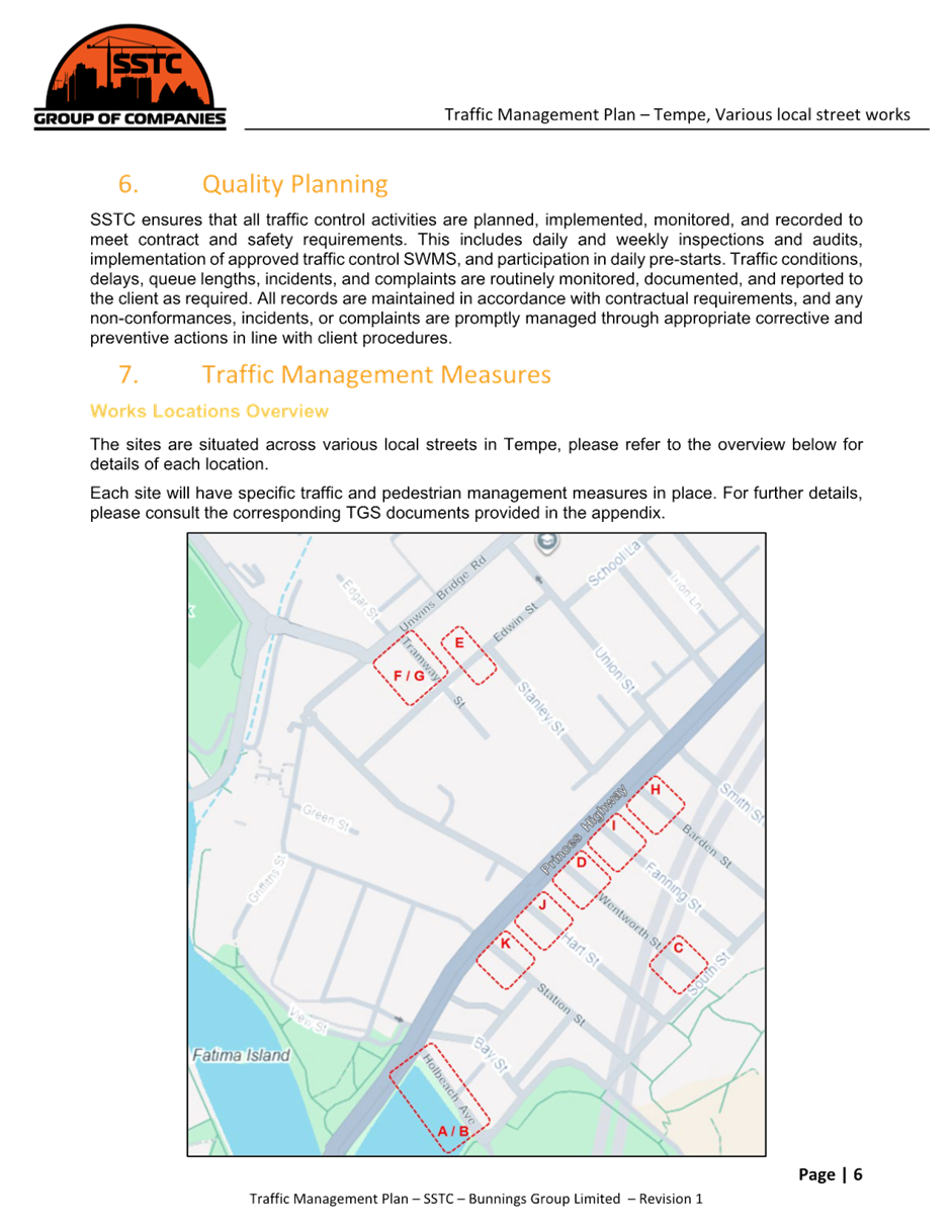
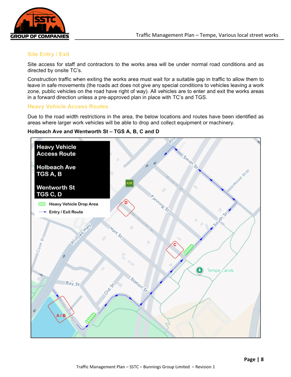
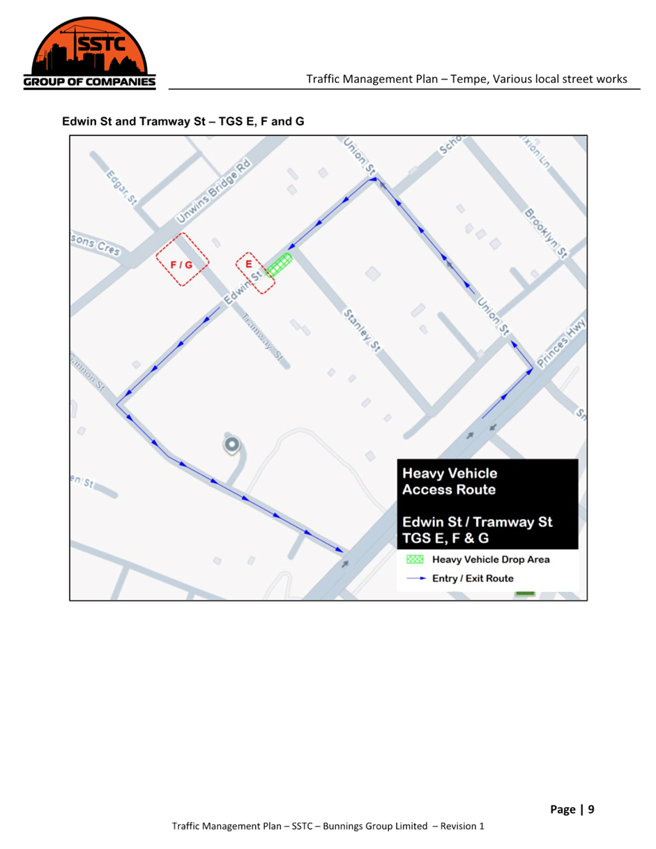
The sites are situated across various local streets in Tempe, please refer to the overview below for details of each location. Each site will have specific traffic and pedestrian management measures in place.
Works have been scheduled to start in the July school holiday period to reduce any added disruption for school traffic. The Edwin Street and Tramway Street works are a priority due to their proximity to schools.
Traffic Guidance Schemes (TGS) have been developed to outline any changes to normal conditions, direct public vehicles and manage related works vehicles on and around the surrounding roads network while optimizing the traffic flows.
A Traffic Management Plan (TMP) has been supplied and attached at the end of this report.

An overview of the proposed planned works is given below.
The below TGS references given in the below summary refer to TGSs in the TMP.
Road Closures
Road closures of varied lengths will be required for speed bump installations of approximately 72hrs (Tramway Street, Edwin Street and Wentworth Street) and short term 1hr line marking across various local street locations in Tempe. During the hours of 7am to 6pm, Traffic Controllers (TC) will be in place to restrict local traffic to any closed roads, manage pedestrians, maintain traffic flows and manage work vehicles to and from site. Outside of these hours, a single TC will be staffed to maintain the traffic management.
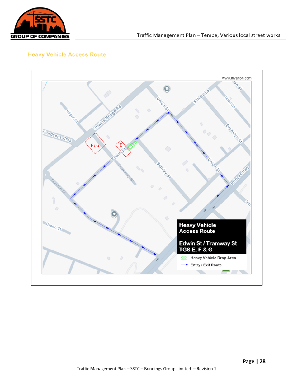
Road closure – Edwin Street between Stanley Street and Tramway Street
|
• Start date: 7am – Monday 6th July 2026 Finish date: 3pm – Wednesday 8th July 2026 • Contingency date: 9th and 10th July 2026 Remains installed overnight • Works scope: Speed hump installation, full road closure in place, detours via other roads, resident access only • TGS reference: E (refer to TMP)
|
|
Road closure – Tramway Street between Unwins Bridge Road and Edwin Street
|
• Start date: 7am – Monday 13th July 2026 Finish date: 3pm – Wednesday 15th July 2026 • Contingency date: 16th and 17th July 2026 Remains installed overnight • Works scope: Speed hump installation, full road closure in place, detours via other roads, resident access only • TGS reference: F
|
|
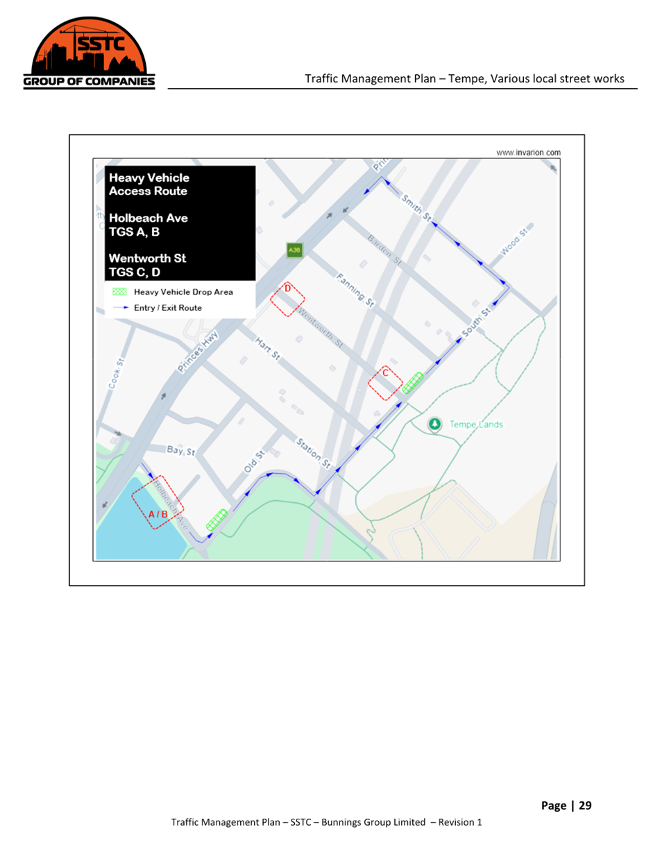
Road closure – Wentworth Street south between South Street and Princes Highway
|
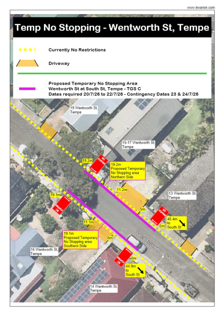
• Start date: 7am – Monday 20th July 2026 Finish date: 3pm – Wednesday 22nd July 2026 • Contingency date: 23rd and 24th July 2026 Remains installed overnight • Works scope: Speed hump installation, full road closure in place, detours via other roads, resident access only • TGS reference: C
|
|
Road closure – Wentworth Street north between South Street and Princes Highway
|
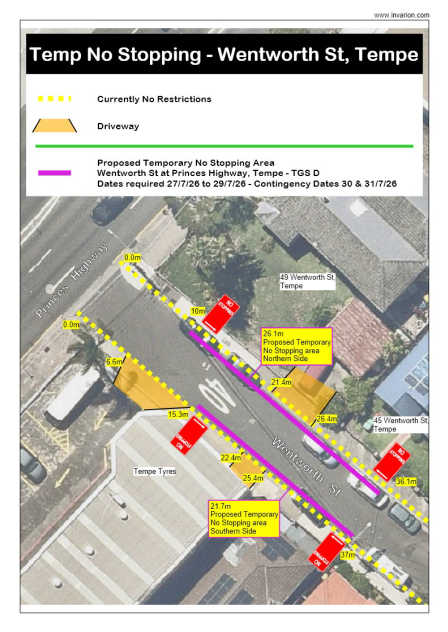
• Start date: 7am – Monday 27th July 2026 Finish date: 3pm – Wednesday 29th July 2026 • Contingency date: 30th and 31st July 2026 Remains installed overnight • Works scope: Speed hump installation, full road closure in place, detours via other roads, resident access only • TGS reference: D
|
|
Short Term Road Closures – Approx 1hr lengths per location
Locations of short term are summarised below and all TGS references are detailed in the TMP.
|
Tramway St between Unwins Bridge St and Edwin St – TGS G – this location to be completed during the closure of TGS F of the speed bump installation to minimise any further disruptions to local traffic
|
|
Barden St south of Princes Highway – TGS H
Fanning St south of Princes Highway – TGS I
Hart St south of Princes Highway – TGS J
Station St south of Princes Highway – TGS K
· Start date: 7am to 3pm – Wednesday August 2026
· Contingency date: 6th and 7th August 2026 All works completed in single day
· Works scope: Line marking on roadway, half road closure in place (if safe to do so), detours via other roads, resident access only
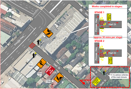
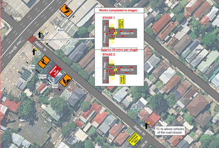
Stop / Slow Works
Holbeach Ave will require stop / slow works using portable booms to reduce trafficable lanes to be singular where both eastbound and westbound traffic use the same lane for travel. Traffic will be held and intermittently released one at a time so that only one direction of traffic will be on the road at any one time. TC’s spotters will be in place if the length of work deems it necessary, with the use radios to clearly communicate between all parties. The appropriate council channels will be follow to gain the permit required to complete these works.
· Start date: Monday 3 August 2026 Finish date: Tuesday 4 August 2026
· Install time: 7am Removal time: 3pm Installed and removed daily
· Works scope: Installation of single lane speed bump and shoulder medium / garden bed,
· TGS reference: A / B (refer to TMP)
Speed limit reductions will be required on Holbeach Ave where the posted speed limit is 50kph and will be reduced to 40km/h. If workers are within 1.2m to the nearest edge of a trafficable lane then a speed reduction to 40km/h should be enacted. These reductions should commence just prior to the work (area) and conclude immediately at the end of the work area.
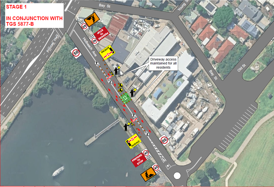
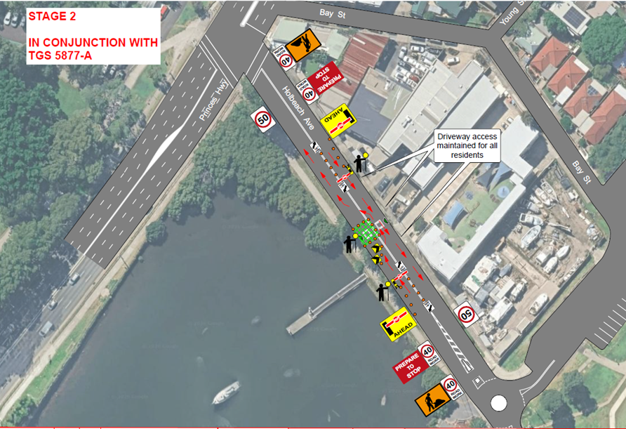
Detour Routes
Detour routes have been developed to maintain traffic flows around the road closures and work areas minimising delays. All detour routes and associated signage are detailed within each specific site TGS.
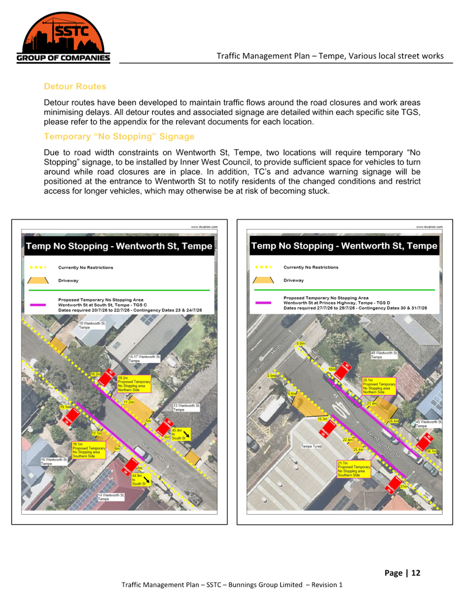
Temporary “No Stopping” Signage
Due to road width constraints on Wentworth Street, Tempe, two locations will require temporary ‘No Stopping’ signage, to be installed to provide sufficient space for vehicles to turn around while road closures are in place. In addition, TC’s and advance warning signage will be positioned at the entrance to Wentworth Street to notify residents of the changed conditions and restrict access for longer vehicles, which may otherwise be at risk of becoming stuck.
It is noted that the installation of the temporary ‘No Stopping’ restrictions on Wentworth Street, Tempe at Princes Highway (26.1m length on northern side outside No.49 to 45 and 21.7m length on the southern side outside Tempe Tyres and No.46) and north of South Street (19.2m length on northern side outside No.13 to 15-17 and 19.1m length on the southern side outside No. 14 and 16) will be subject to the applicant installing and removing the signage at their cost.
Pedestrian Management
Footpaths are to remain open for the duration of the works; signage will be used to direct pedestrians around works area.
All construction works to have site fencing and WHS signage installed to delineate between pedestrians and the works areas.
Cyclists
Cyclists will be subjected to normal road rules and shall follow the same routes as vehicles, unless authorised by the onsite TC’s.
Emergency vehicles
Emergency vehicles approaching the site with emergency lighting on and as per general road conditions all other vehicles will be required to give way to them. Traffic control shall give priority where safe to do so and escort emergency vehicles through if required.
PUBLIC CONSULTATION
The proposed road closures have been advertised on Council’s website in accordance with the Roads Act 1993.
The applicant is to notify all relevant stakeholders and all affected residents and businesses in writing at least 7 days prior to the commencement of works.
The TMP (page 14) states:
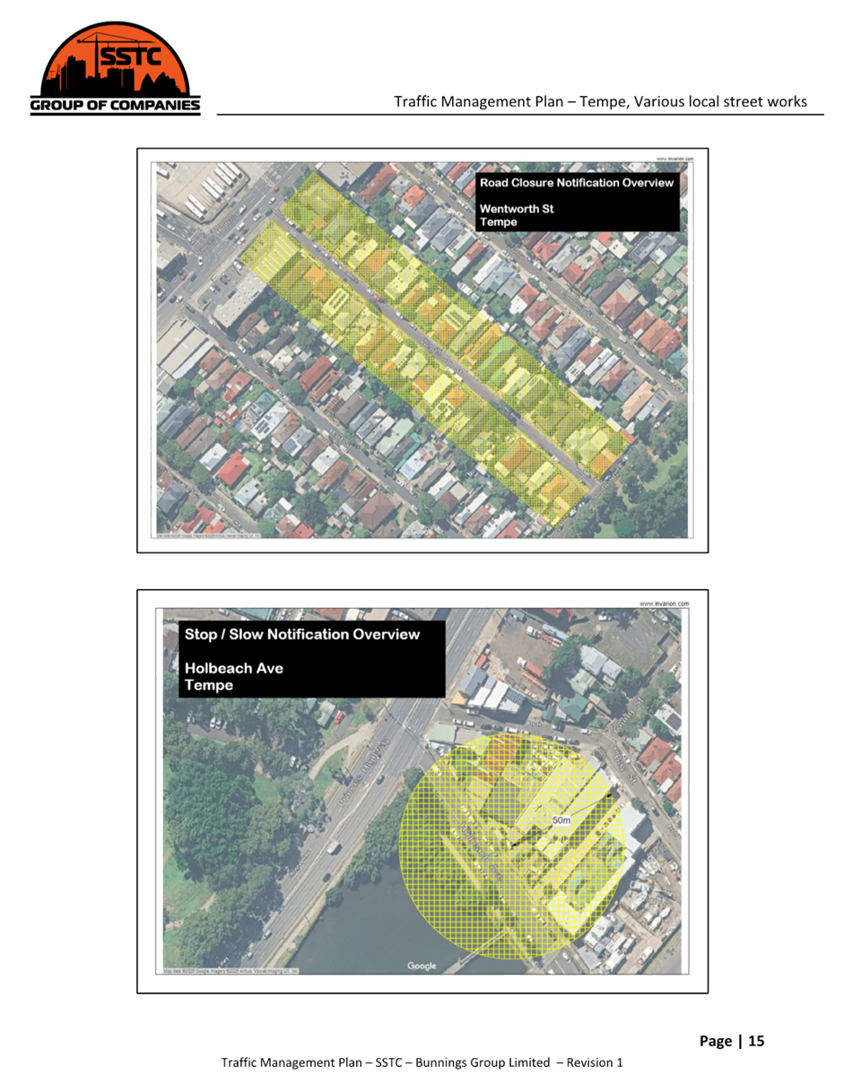
“Prior to commencement of works, Bunnings Group Limited will notify residents within a 50m radius of the works area and/or located on a street with planned road closures via letter box drop at least 14 days prior of upcoming activities, including work locations, expected durations, and potential delays, with relevant details incorporated into the TMP where applicable. Communication will be maintained throughout the works with affected parties such as residents, emergency services, the travelling public, local authorities, businesses, and schools. Adjacent property access will be maintained at all times, with driveways or entrances only impacted where prior approval has been obtained.
All affected parties will be provided with SSTC’s phone (or principal contractors) number where they will be able to call and settle any queries, please see appendix for a drafted resident notification letter.” Refer to draft consultation letter reproduced below.
|
|
|
|
|
|
|
|
FINANCIAL IMPLICATIONS
There are no financial implications for Council associated with this matter. The cost of all works will be borne by the applicant.
|
1.⇩ |
TMP 5877_Bunnings Group Limited Tempe_2.4.26 |
|
|
Local Transport Forum Meeting 18 May 2026 |
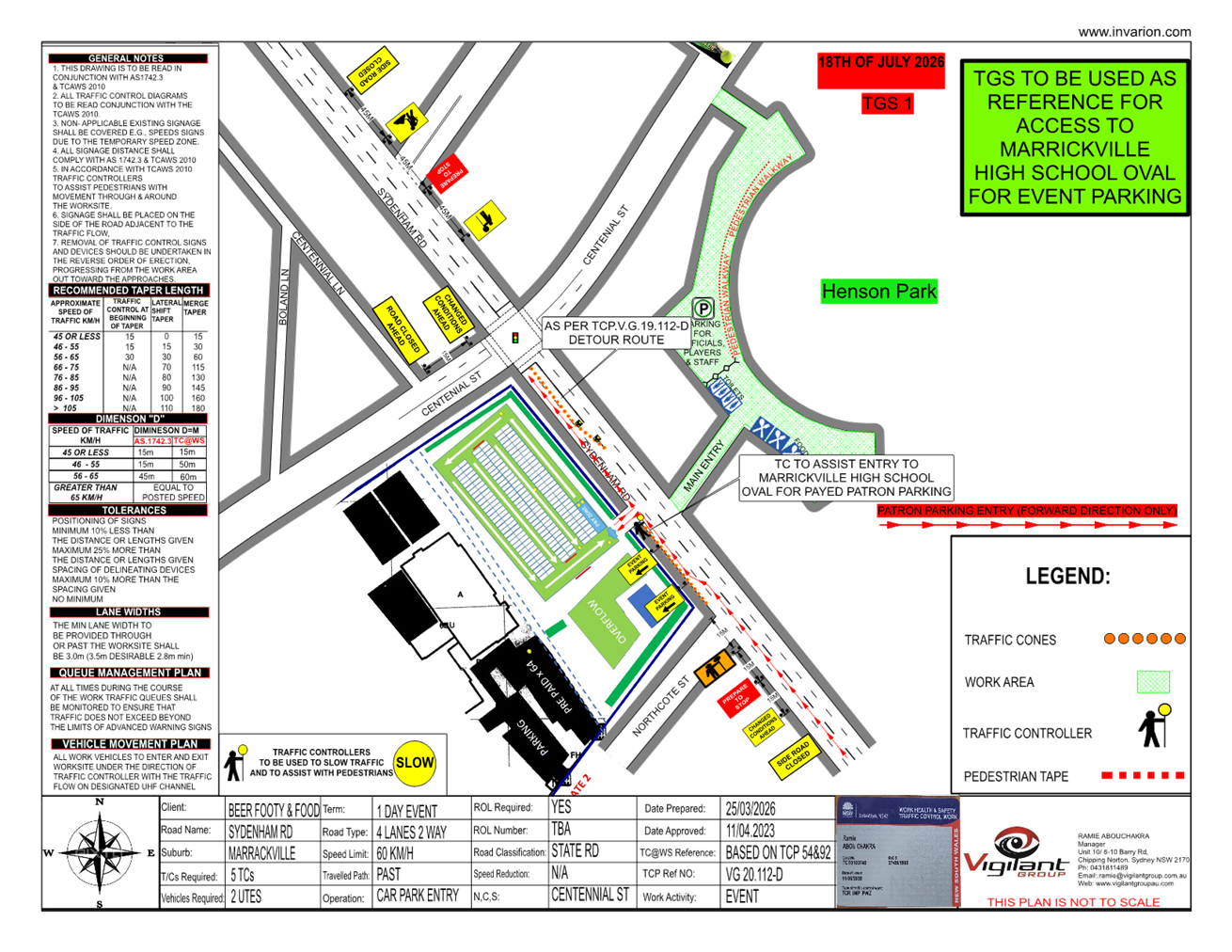
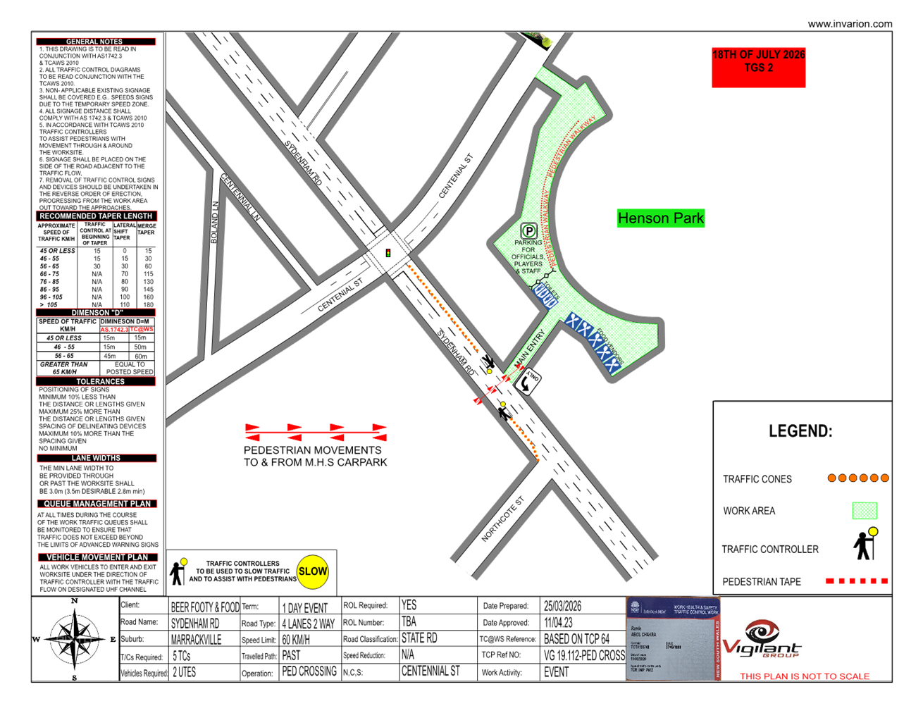
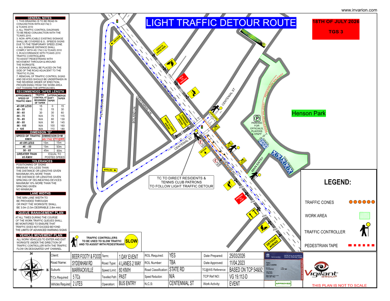
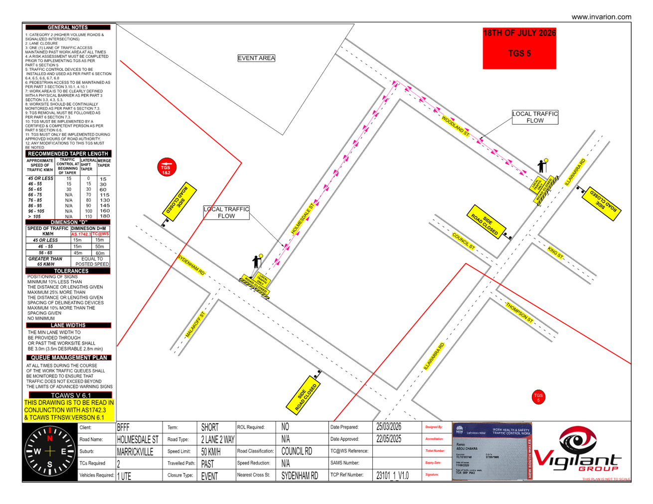
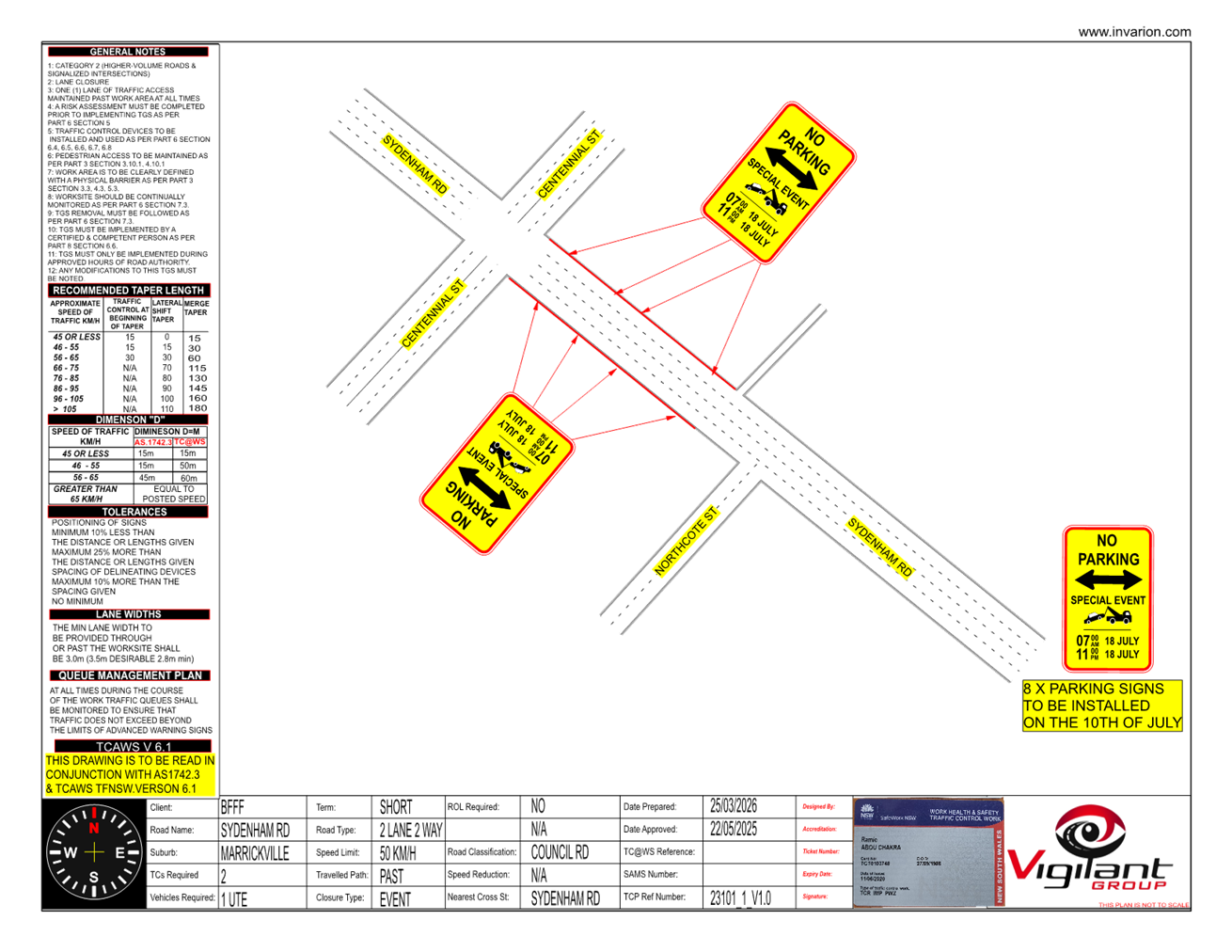
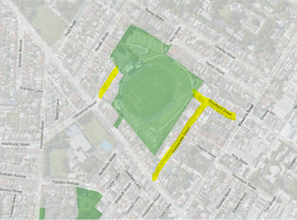
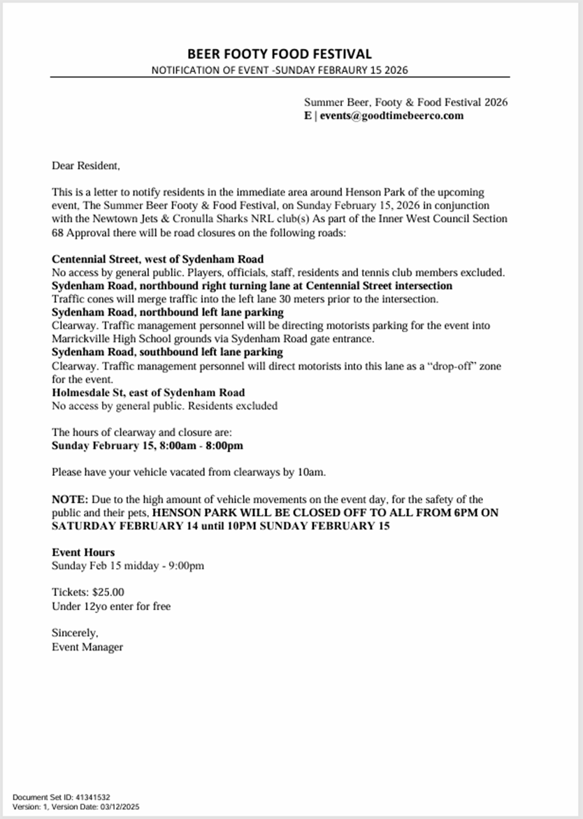
Title: Centennial Street, Woodland Street and Holmesdale Street, Marrickville – Temporary Road Closures for Special Event at Henson Park – 2026 Beer, Footy and Food Festival on Saturday 18 July 2026 (Midjuburi-Marrickville Ward /Summer Hill Electorate /Inner West LAC)
Author: Jennifer Adams - Traffic Engineer
Authoriser: Sunny Jo - Acting Traffic and Transport Planning Manager
|
RECOMMENDATION
That the proposed temporary full road closure of Centennial Street, Marrickville between Sydenham Road and the entrance to Henson Park and Marrickville & District Hardcourt Tennis Club car park; Woodland Street, between Illawarra Road and dead-end and Holmesdale Street, between Sydenham Road and Woodland Street, Marrickville between 10.00am and 9.00pm on Saturday 18 July 2026 (contingency period of two months) for the purpose of holding the ‘Beer, Footy and Food Festival 2026’ event be approved, subject to the approval of the S68 Application and the applicant complying with, but not limited to, the following conditions:
1. A Road Occupancy License application be obtained by the applicant from the Transport Management Centre;
2. All affected residents and businesses, including NSW Police Local Area Commander, Transit Systems, Fire and Rescue NSW and NSW Ambulance Services, shall be notified in writing by the applicant of the proposed temporary road closure at least 7 days prior to the event, with the applicant making reasonable provision for residents and businesses;
3. A VMS be placed displaying that there is ‘No Public Parking’ in Centennial Street;
4. Barriers at Woodland Street at Illawarra Road and Holmesdale Street at Sydenham Road will be set back to accommodate any right turning vehicles should they try to enter the closed roads (TGS 5);
5. The occupation of the road carriageway must not occur until the road has been physically closed; and
6. Subject to written concurrence from Transport for New South Wales.
|
STRATEGIC DIRECTION
This report supports the following strategic directions contained within Council’s Community Strategic Plan:
|
2: Liveable, connected neighbourhoods and transport |
EXECUTIVE SUMMARY
An application (ENRC/2026/0016) has been received from Good Time Beer Co. to hold the 2026 Beer, Footy and Food Festival between 10.00am and 9.00pm on Saturday 16 July 2026 at Henson Park Oval. The event requires the temporary full road closure of Centennial Street, Marrickville between Sydenham Road and the entrance gate to Henson Park Oval as well as Woodland Street, between Illawarra Road and dead-end and Holmesdale Street, between Sydenham Road and Woodland Street, Marrickville. It is recommended that Council approve the temporary full road closures subject to the applicant complying with the above conditions and obtaining concurrence from Transport for NSW as the closure entails lane closures on Sydenham Road (a State Road).
DISCUSSION
Centennial Street, east of Sydenham Road, will be closed to traffic thoroughfare so the event as proposed can successfully occur. The road will be accessible to all residents, emergency services, Event staff, Coaches and players and allowance will also be made for disability parking to come through the road closure.
Centennial Street is a dead-end local two-way street with one travel lane in each direction, in addition to kerbside parking lanes. It carries around 400 vehicles per day. Parking is unrestricted along both sides of the road. It is a residential local road and an entry point to Henson Park.
Woodland Street and Holmesdale Street will also be closed to all traffic throughfare however accessible to all residents and emergency vehicles. Both Woodland Street and Holmesdale Street are local roads servicing mainly residential properties and carry nominal traffic volumes of around or less than 500 vehicles per day. Holmesdale Street has a one-way northbound restriction. Parking is unrestricted in both streets.
The Beer Footy Food event will be held between 12noon and 7pm and the road closure hours will be between 10am and 9pm to allow for bump in and out activities.
The following traffic control measures are diagrammatically shown and detailed in the attached TMP and Traffic Guidance Schemes (TGSs):
TGS1. Event parking.
TGS2. Vendor bump in & out.
TGS3. Event, lane closure.
TGS4. Detour route/ Light Traffic entry to Centennial st
TGS5. Road closure at Holmesdale & Woodland ST.
TGS6. Parking sign (installation)
TGS7. Pedestrian plan.
· Road Closures, on Centennial Street, however allowing access to Residents, Players, Coaches, event staff & Patrons of the Tennis Club. And on Holmesdale Street and Woodland Street, allowing access to residents.
· Light traffic entry to Centennial Street - light traffic will be detoured along Sydenham Road to turn left into Petersham Road and turn left onto Centennial Street, before continuing straight through the lights on to the closed section of Centennial Street. This control measure is to alleviate traffic congestion attempting to turn right from Sydenham Road on to Centennial Street.
· All Residents and business effected by this closure will be notified 1 month and 1 week prior to the Event.
· 1 Traffic Controller will be in place on the southwest corner of the Centennial Street and Sydenham Road intersection, they will assist anyone attempting to enter the Road Closure at Centennial Street by directing them towards the light traffic detour.
· Special Event Clearways
Sydenham Road, between Centennial Street and Holmesdale Street to allow room for the drop
off area, just outside the gates to Henson Park. To be installed on 10 July 2026.
· Bus Entry
Bus entry will be conducted under guidance by TfNSW accredited Traffic Controllers. Upon approach all traffic will be stopped in both directions and the road closure opened, the bus driver will be instructed to drive into Centennial Street (south) and then reverse into Centennial Street (north) where they will be assisted by a spotter to a safe parking spot.
· Pedestrian Crossing
Traffic Controllers (TCs) will assist all pedestrians across the road safely, from the main entry / exit to the Marrickville High School parking lot. This is a preventative measure to ensure all patrons leave the Event safely and in an orderly fashion. TCs will hold pedestrians from crossing the road until such time as the supervisor deems it safe, has stopped traffic and cleared an area to cross. This will avoid people rushing onto the road in between slow traffic and causing more congestion as well as keeping the public safe.
· Lane closures on Sydenham Road
Sydenham Road, northbound right turning lane at Centennial Street intersection
Traffic cones will merge traffic into the left lane 30 meters prior to the intersection.
Sydenham Road, northbound left lane parking Clearway.
Traffic management personnel will be directing motorists parking for the event into Marrickville High School grounds via Sydenham Road gate entrance.
Sydenham Road, southbound left lane parking Clearway. Traffic management personnel will direct motorists into this lane as a “drop-off” zone for the event.
The TGSs are to be submitted to TfNSW for consideration and approval and a Road Occupancy License (ROL) application is to be submitted to the Transport Management Centre by the applicant
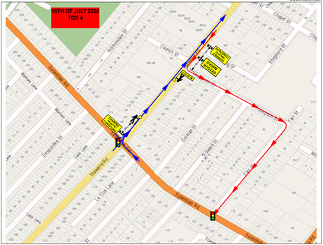
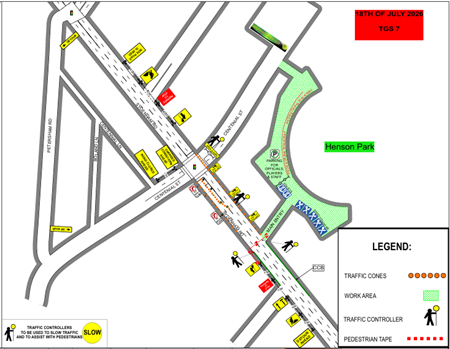
Local access for resident’s vehicles and pedestrians will be provided at all times and traffic controllers will be on site to safely assist residents to their properties and manage pedestrians
Barriers at Woodland Street at Illawarra Road, Holmesdale Street at Sydenham Road and Centennial Street at Sydenham Road will be set back to accommodate any right turning vehicles should they try to enter the closed roads.
Car parking is limited to on-street parking in surrounding suburban streets.
Public Transport
428 bus operates from Martin Place via City, City Road, Newtown to stop Addison Road opposite Addison Road Community Centre (220445) – 600m walk to Woodland Street gate.
412 bus operates from Martin Place via City, City Road, Camperdown to stop Livingstone Road opposite Marrickville Park (220491) – 650m walk to Sydenham Road gate.
Sydenham Train Station is a 1.5km walk.
PUBLIC CONSULTATION
The applicant is to notify all affected residents and businesses in writing at least 7 days prior to the commencement of work. A draft notification letter is reproduced below. The proposed road closure has been advertised on Council’s website in accordance with the Roads Act 1993.
FINANCIAL IMPLICATIONS
All works and costs of implementation will be borne by the applicant.
|
1.⇩ |
Centennial Street Marrickville - Traffic Management Plan Henson Park TMP_30117 |
|
|
Local Transport Forum Meeting 18 May 2026 |
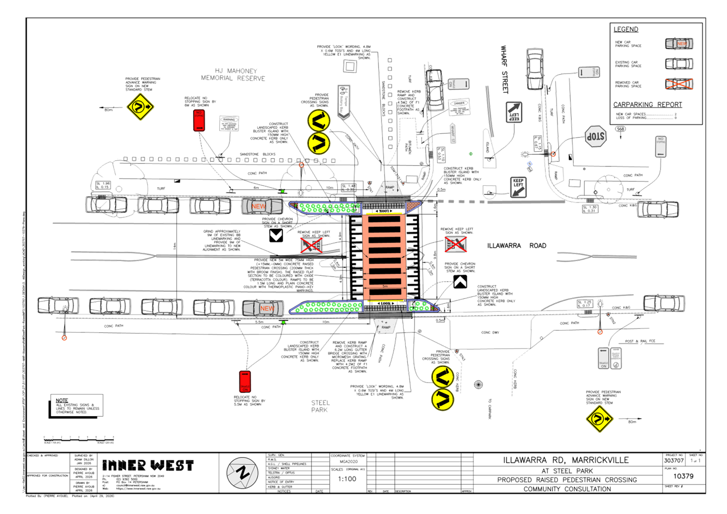
Title: Illawarra Road at Wharf Street, Marrickville – Proposed raised pedestrian crossing - Design Plan 10379 (Midjuburi-Marrickville Ward / Summer Hill Electorate / Inner West PAC)
Author: Jennifer Adams - Traffic Engineer
Authoriser: Sunny Jo - Acting Traffic and Transport Planning Manager
|
RECOMMENDATION
That the detailed design plan (No.10379) for the proposed new raised pedestrian crossing on Illawarra Road at Wharf Street, Marrickville and associated signs and line markings be approved. |
STRATEGIC DIRECTION
This report supports the following strategic directions contained within Council’s Community Strategic Plan:
|
2: Liveable, connected neighbourhoods and transport |
EXECUTIVE SUMMARY
Design plans have been finalised for the construction of a raised pedestrian crossing on Illawarra Road at Wharf Street, Marrickville which aligns with the upgrade of Steel Park as an inclusive playground. The existing pedestrian refuge is proposed to be upgraded to a new raised pedestrian crossing. It is recommended that the detailed design plan and associated signs and line markings be supported to improve pedestrian safety in the locality.
BACKGROUND
At the Council Meeting held on 23 September 2025, a Notice of Motion (NoM) for 'Steel Park Illawarra Road Pedestrian Crossing' (C0825(1) Item 49) was considered. The subsequent resolution itemised that Council construct a raised pedestrian crossing on Illawarra Road to replace the existing at-grade pedestrian island on Illawarra Road at Wharf Street aligning with the upgrade of Steel Park as an inclusive playground.
It was noted that concerns were raised regarding pedestrian access and safety at the existing pedestrian arrangement at Illawarra Road and Wharf Road. The crossing is utilised by pedestrians and cyclists following the Cooks River cycleway and pathway, access to Steel Park playground and waterplay park, Steel Park Oval, Mahoney Reserve, basketball and skate facilities, as well as Marrickville Golf Club and Parklands.
At the Local Traffic Forum meeting, held on 17 November 2025, the committee resolved the following:
1. That a raised pedestrian crossing be approved in principle on Illawarra Road to replace the existing at-grade pedestrian island at Illawarra Road and Wharf Road aligning with the upgrade of Steel Park as an inclusive playground.
2. That the proposed raised pedestrian crossing on Illawarra Road be included for consideration in Council's Traffic Facilities Capital Works Program for funding in 2026/27 financial year.
3. That a detailed design for the proposed pedestrian crossing be brought back to the Local Traffic Forum for consideration, including the results of community engagement.
The Minutes of the Local Traffic Forum meeting held on 17 November 2025 were adopted at Council’s meeting held on 9 December 2025.
This report details the design plan for the improvement works.
DISCUSSION
Illawarra Road is a Regional Road carrying around 14,500 vehicles per day. It is also a bus route. It links Inner West Council with Canterbury Bankstown Council at Cooks River. Due to the proximity of existing parklands, facilities and amenities near the intersection of Illawarra Road and Wharf Street, high pedestrian numbers and vehicular traffic volumes raise concerns for pedestrian access and safety during weekend sporting and casual events/activity. Further, the upgrade of Steel Park as an inclusive playground is expected to generate more pedestrian and vehicle traffic.
Council’s Pedestrian Crossing Warrant Policy outlines the numerical warrant for a pedestrian (zebra) crossing if the location meets the following criteria:
In each of two separate one-hour periods in a typical day, the pedestrian flow per hour crossing the road is or is expected to be equal to or greater than 20, and vehicle volumes be equal to or greater than 200 where children and elderly or mobility impaired pedestrians count as two pedestrians.
Current traffic conditions indicate that hourly vehicle movements would exceed 200 vehicles per hour, and that pedestrians movements would be expected to be higher than 20 per hour on the AM and PM peak with the upgrade of Steel park.
Design plans have been finalised for the construction of the raised pedestrian crossing on Illawarra Road at Wharf Street, Marrickville which align with the upgrade of Steel Park as an inclusive playground.
Specifically, the proposed scope of works includes the following:
· Construct a new raised concrete pedestrian crossing to replace the existing at-grade pedestrian refuge;
· Construct landscaped kerb blister islands in the road adjacent to the new raised pedestrian crossing. Landscaping to be suitable species of native grasses;
· Install ‘LOOK’ stenciling;
· Install associated pavement line marking and signage as required.
Parking Changes
This proposal will result in formalising two new parking spaces. Some street parking will be affected temporarily to facilitate the construction activities during construction.
Streetlighting
The project will require at least 2 new floodlights to comply with Australian Standards for pedestrian crossing lighting.
The lighting design will be undertaken by a separate accredited lighting consultant.
PUBLIC CONSULTATION
Consultation was not conducted on the final design plan as the proposal does not directly affect any residential properties, that is the location is adjacent to Steel Park and HJ Mahoney Memorial Reserve. Furthermore, the proposal does not result in any loss of parking or other negative impacts.
FINANCIAL IMPLICATIONS
The project is listed on Council’s Traffic Facilities Capital Works Program for funding in 2026/27 financial year. Estimated cost is $150,000. Project number is 303707.
|
1.⇩ |
Design Plan - Illawarra Road at Wharf Street, Marrickville 303707-10379 |
|
|
Local Transport Forum Meeting 18 May 2026 |
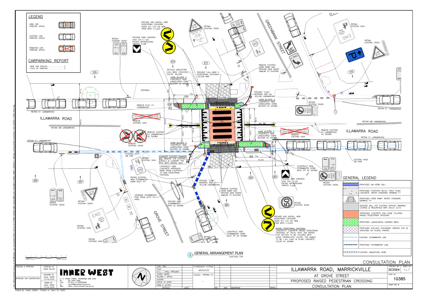
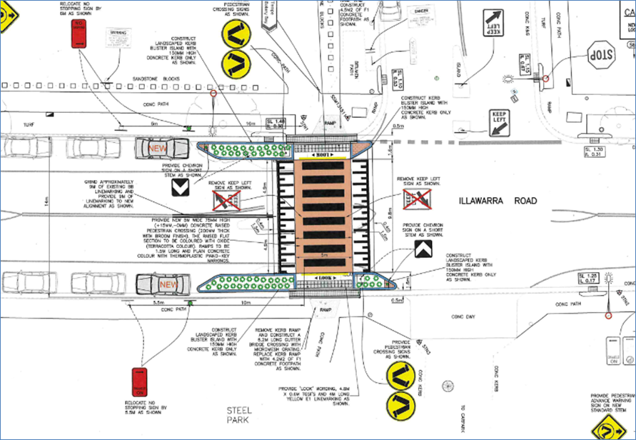
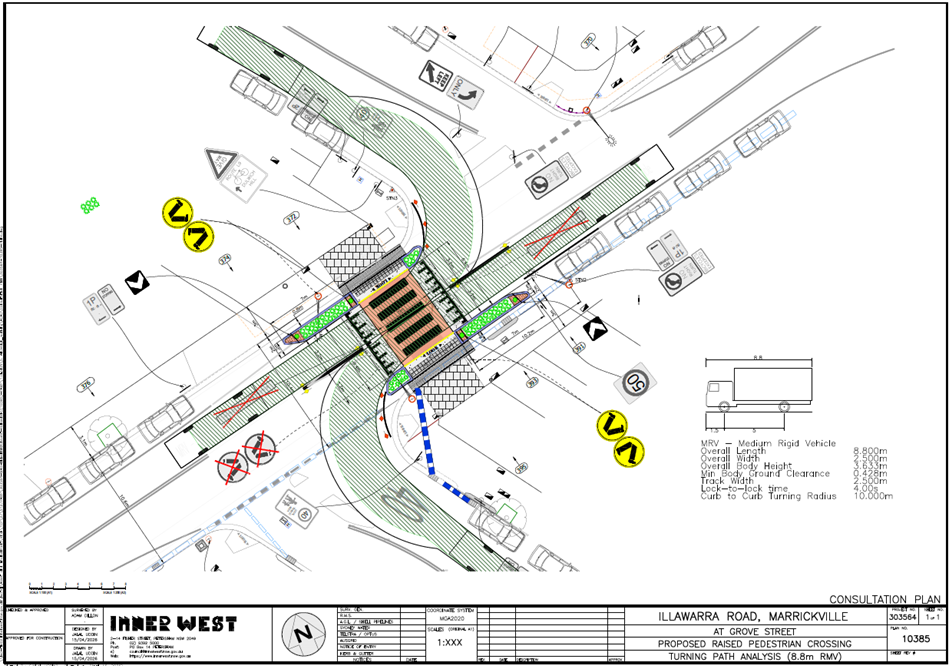
Title: Illawarra Road at Grove Street, Marrickville – Proposed raised pedestrian crossing - Design Plan 10385 (Midjuburi-Marrickville Ward / Summer Hill Electorate / Inner West PAC)
Author: Jennifer Adams - Traffic Engineer
Authoriser: Sunny Jo - Acting Traffic and Transport Planning Manager
|
RECOMMENDATION
That the detailed design plan (No.10385) for the proposed raised pedestrian crossing on Illawarra Road at Grove Street, Marrickville and associated signs and line markings be approved. |
STRATEGIC DIRECTION
This report supports the following strategic directions contained within Council’s Community Strategic Plan:
|
2: Liveable, connected neighbourhoods and transport |
EXECUTIVE SUMMARY
Council is planning to improve safety for pedestrians on Illawarra Road at Grove Street, Marrickville by converting the existing ‘at-grade’ pedestrian crossing to a raised pedestrian crossing together with landscaped kerb blister islands. The proposal aims to improve pedestrian and motorist safety by better defining safe pedestrian crossing points; improve sight distances, reduce traffic speeds and conflicts with traffic movements at this location. The proposal has been consulted with no submissions received.
BACKGROUND
DISCUSSION
The following works are proposed and are illustrated on the attached Consultation Plan (Plan No. 10385). The proposed works aim to improve pedestrian safety by better defining and prioritising pedestrian movements across Illawarra Road whilst also reducing traffic speeds.
Specifically, the proposed scope of work includes the following:
· Construct a new raised concrete pedestrian crossing, with cross over paths to provide safe access over existing kerb and guttering to the new raised pedestrian crossing. Tactile indicators will also be provided either side of the new raised pedestrian crossing;
· Construct landscaped kerb blister islands on both sides of the road adjacent to the new raised pedestrian crossing. Landscaping to be suitable species of native grasses;
· Reconstruct some kerb and gutter as needed to facilitate the new raised pedestrian crossing;
· Remove existing redundant kerb ramps and re-construct footpaths (concrete and decorative paved paths);
· Adjust existing floodlighting (2 currently exist) as required for the new raised pedestrian crossing;
· Provide additional drainage pits and pipes to assist managing stormwater flows;
· Provide tactiles indicator and directional tactiles in approach slab of the pedestrian crossing as shown; and
· Install new and adjust existing signage and line marking associated with the works as required and as shown on Plan.
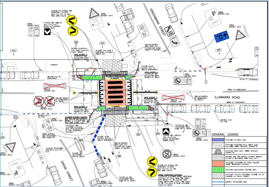
Parking Changes
Except for the provision of signage associated with the new raised pedestrian crossing, no changes are proposed to the existing on-street parking signage and arrangements. Therefore, the proposal will result in the loss of no existing on-street parking spaces.
Streetlighting
The existing flood lighting at the location is deemed adequate for the new raised pedestrian crossing. Therefore, no changes are proposed to the existing street lighting due to the works.
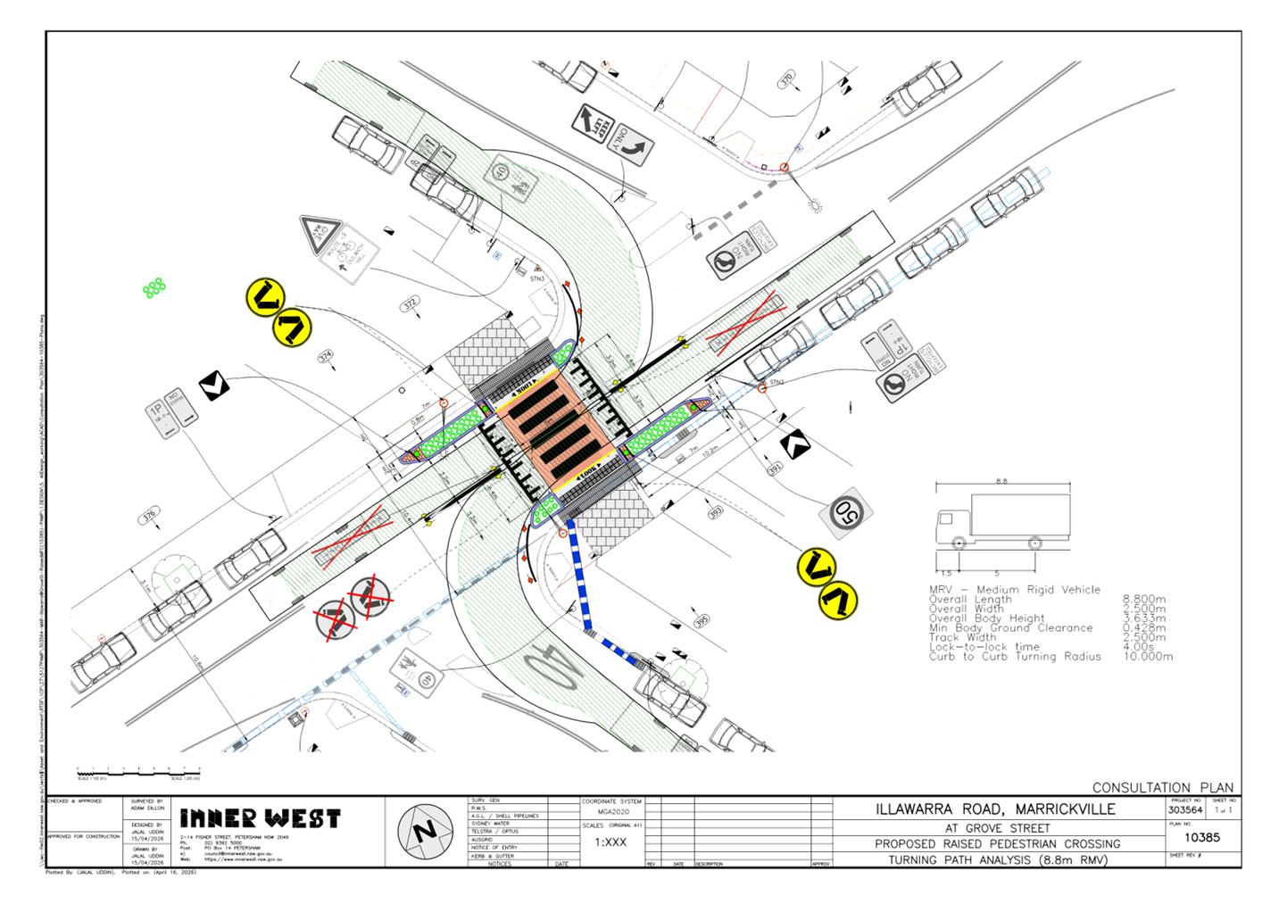
Swept Path Analysis
Swept path analysis has been completed to assess the turning movements of a design vehicle – 8.8m medium rigid vehicle (MRV) and is reproduced below.
PUBLIC CONSULTATION
Consultation was conducted between 16 March and 1 May 2026. A letter along with a copy of the design plan was sent to residents / businesses in the immediate locality. A total of 109 letters were distributed along with a letter to the local Bike Group. No submissions were received.
FINANCIAL IMPLICATIONS
The project is listed on Council’s 2025/2026 PAMP Capital Program for construction and the estimated cost is $120,000. Project number is 303564.
CONCLUSION
It is recommended that the detailed design plan of the proposed traffic treatment and associated signs and line markings be supported to improve pedestrian safety at this location.
|
1.⇩ |
303564-10385-Consultation Plan & Turning Path Analysis |
|
|
Local Transport Forum Meeting 18 May 2026 |
Title: Smidmore Street, Marrickville at the signalised intersection with Edinburgh Road - Proposed Extension of 'No Stopping' restrictions at the signalised intersection (Midjuburi-Marrickville Ward / Summer Hill Electorate / Inner West PAC)
Author: Jennifer Adams - Traffic Engineer
Authoriser: Sunny Jo - Acting Traffic and Transport Planning Manager
|
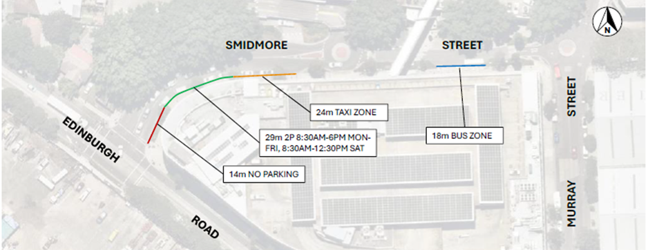
RECOMMENDATION
1. That the existing 14m ‘No Stopping’ zone on the eastern approach leg on Smidmore Street at its signalised intersection with Edinburgh Road, Marrickville be extended northward by 17m (replacing current ‘2P 8.30am-6pm Mon-Fri 8.30am-12.30pm Sat’ restrictions).
2. That 12m (2 car parking spaces) of short-term 'P10minute 8am-6pm' restrictions be installed between the adjusted ‘No Stopping’ restrictions and the Taxi Zone (also replacing the current ‘2P 8.30am-6pm Mon-Fri 8.30am-12.30pm Sat’ restrictions).
|
STRATEGIC OBJECTIVE
This report supports the following strategic directions contained within Council’s Community Strategic Plan:
|
2: Liveable, connected neighbourhoods and transport |
EXECUTIVE SUMMARY
Concerns have been raised by Marrickville Metro Shopping Centre regarding significant congestion occurring near the Edinburgh Road and Smidmore Street signalised intersection, due to limited kerbside lane storage. This has resulted in a reduced intersection performance and queuing extending east along Smidmore Street toward the Centre’s entry roundabout and carpark ramp.
It is proposed to extend the existing ‘No Stopping’ restrictions at the Smidmore Street approach to improve intersection performance and safety. It is also recommended to introduce two P10 minute parking spaces for use by rideshare vehicles.
BACKGROUND
Ason Group on behalf of GPT Group (Management company for Marrickville Metro Shopping Centre) have requested that the existing ‘No Stopping’ restrictions on the eastern approach leg on Smidmore Street at its signalised intersection with Edinburgh Road, Marrickville be extended to improve traffic flow at this location.
Concurrently, Council was investigating traffic congestion in the area and also reviewing an issue of rideshare drivers parking in the Taxi Zone.
Smidmore Street includes two southbound lanes on approach to Edinburgh Road signalised intersection. The kerbside lane on approach to the intersection has an effective lane length of only 14m due to the existing ‘No Stopping’ and 2P on-street parking controls. This is further compounded by limited visibility on approach to the intersection due to the horizontal curvature of the road. Refer to the diagram below (courtesy of Ason Group).
This short kerbside lane results in operational inefficiency due to frequent obstructions caused by a combination of queued vehicles in the centre lane and parked vehicles in the kerbside lane. CCTV footage supplied by Ason Group highlight these constraints, with queues forming due to both left and right turning vehicles restricting other vehicles accessing the respective lanes, as shown in Figure 1 and Figure 2 below.

Figure 1: Vehicle queues on Smidmore Street
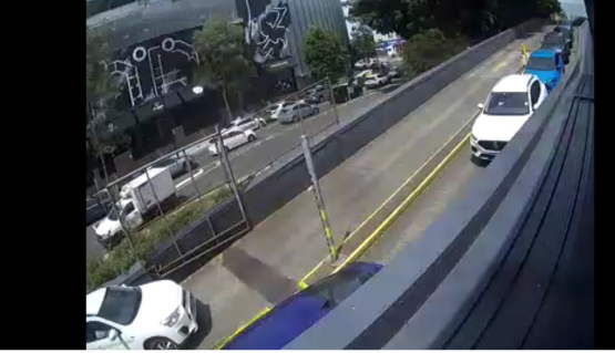
Figure 2: Queues extending into and up car park ramp
Ason Group supplied Council with data supporting the request for changes at the subject location. In the Christmas trading period in December 2025 Centre Management commissioned Cato Group to manage temporary traffic control and the ‘2P’ parking was converted to ‘No Parking’ which produced a notable improvement in traffic flow along Smidmore Street. Despite 9% higher centre visitation, congestion was observed to be minimal, with smaller and less frequent queues, dissipated quickly.
DISCUSSION
To improve traffic flow on Smidmore Street it is recommended that the existing 14m ‘No Stopping’ zone on the eastern approach leg on Smidmore Street at its signalised intersection with Edinburgh Road, Marrickville be extended northward by 17m (replacing current ‘2P 8.30am-6pm Mon-Fri 8.30am-12.30pm Sat’ zone) to a total of 31m. This will provide sufficient storage capacity at the intersection and improve intersection performance.
To locally accommodate rideshare drivers parking, Council proposes to introduce a short 12m length of short term parking (2 car parking spaces of 'P10minute 8am-6pm' restrictions) in lieu of existing ‘2P 8.30am-6pm Mon-Fri 8.30am-12.30pm Sat’ restrictions. These restrictions will provide improved turnover to the existing 2P parking spaces as shown in Figure 3 and Figure 4.
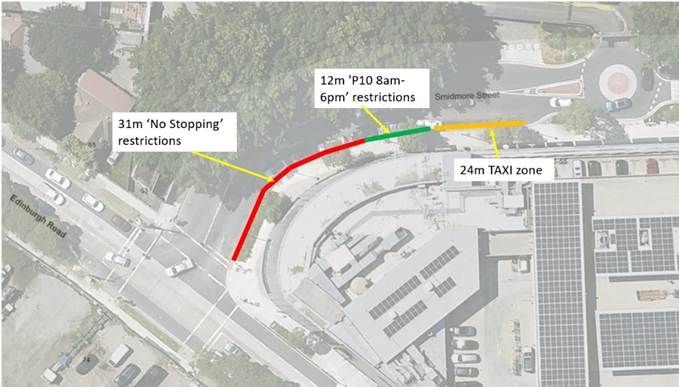
Figure 3: Proposed changes to parking in Smidmore Street
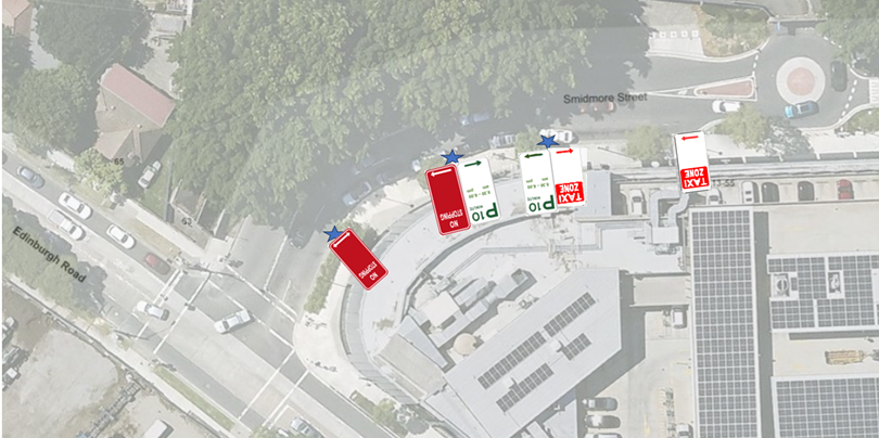
Figure 4: Proposed changes and existing ‘taxi zone’ signage
PUBLIC CONSULTATION
Marrickville Metro Shopping Centre management are supportive of the proposed parking restriction changes.
FINANCIAL IMPLICATIONS
The of installation of the parking restrictions as recommended will be funded within Council’s operational signs and line marking budget.
Nil.
|
|
Local Transport Forum Meeting 18 May 2026 |
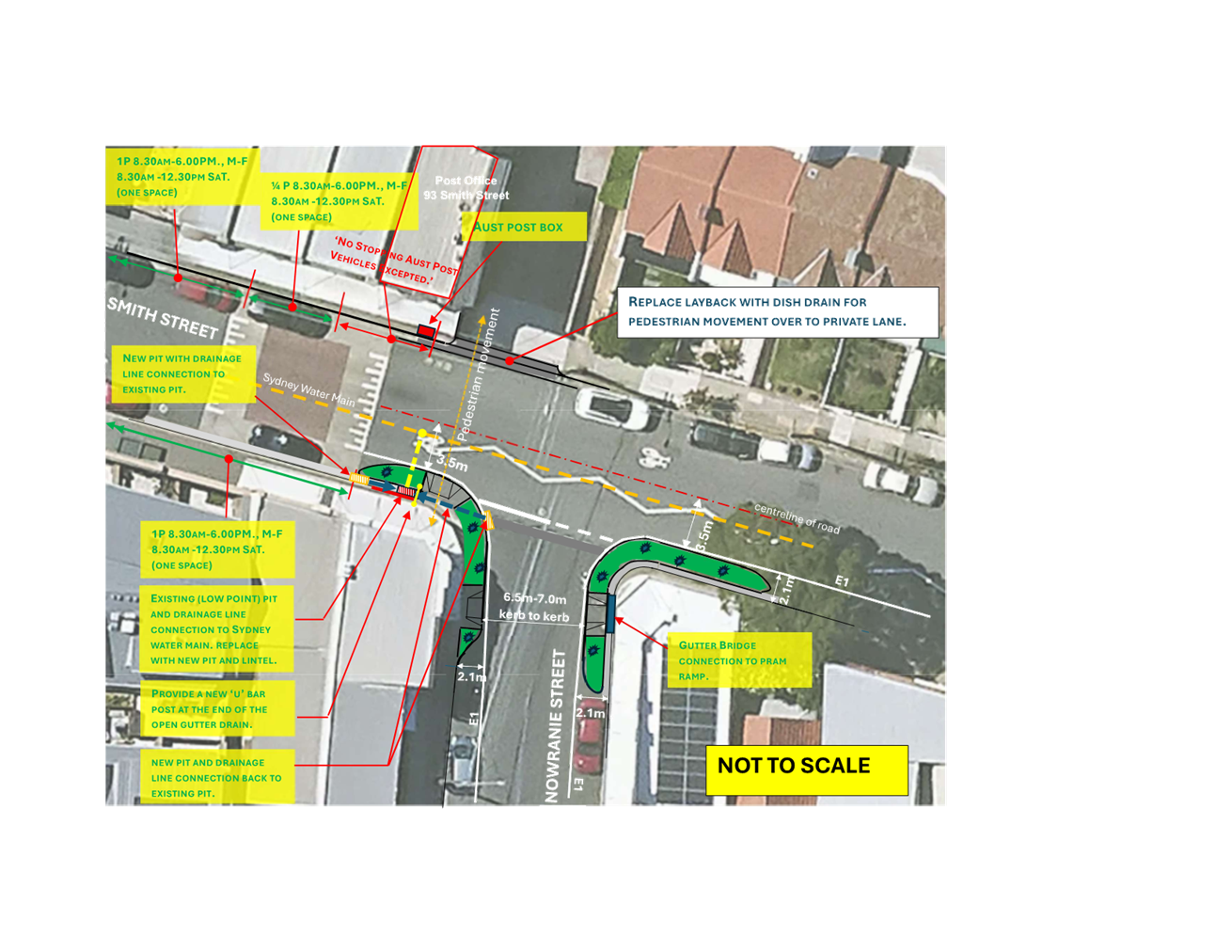
Title: Nowranie Street at Smith Street, Summer Hill -
Proposed kerb extensions - (Djarrawunang-Ashfield Ward/Summer Hill
Electorate/Burwood PAC)
Author: Boris Muha - Traffic Engineer
Authoriser: Sunny Jo - Acting Traffic and Transport Planning Manager
|
RECOMMENDATION
1. That the proposed kerb extensions and blister islands at the intersection of Nowranie Street and Smith Street, Summer Hill as shown in the attached concept plan, be supported in-principle and a detailed design for the proposed works be brought back to the Local Transport Forum for consideration, including the results of community engagement.
2. That the proposed kerb extensions and blister islands on Nowranie Street be included for consideration in Council’s Traffic Facilities Capital Works Program for funding.
|
STRATEGIC OBJECTIVE
This report supports the following strategic directions contained within Council’s Community Strategic Plan:
|
2: Liveable, connected neighbourhoods and transport |
EXECUTIVE SUMMARY
Council is proposing to introduce kerb extensions and blister islands in Nowranie Street and Smith Street, Summer Hill. The proposal aims to improve pedestrian and motorists safety by better defining safe pedestrian crossing points, improving sight distances, reducing traffic speeds and conflicts with traffic movements at this location.
BACKGROUND
The proposed new kerb extension and pram ramp facilities address various community requests and is recognised under the Inner West Council Pedestrian Access and Mobility Plan (PAMP) to improve pedestrian safety and accessibility in Nowranie Street and Smith Street, Summer Hill.
It also addresses concerns regard to illegal parking to the corners and traffic calming at the intersection.
DISCUSSION
The following information is provided in discussion.
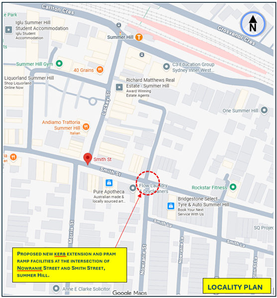
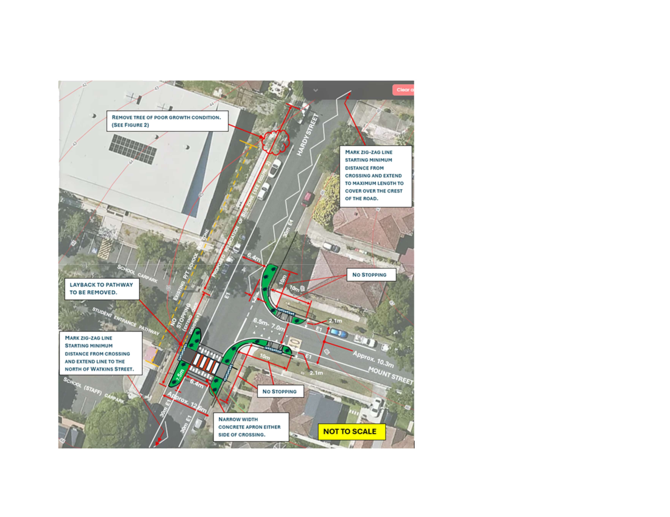
Figure 1. Locality Plan
|
Street Name |
Nowraine Street and Smith Street |
|
Carriageway width (m) kerb to kerb |
Aproximately 10m in both streets. |
|
Carraigeway type |
Two way in both streets |
|
Classification |
Local Roads |
|
Speed Limit (km/h) |
40 kph in a High Pedestrian Activity Area (HPAA) |
|
85th percentile speed(km/h) |
Estimated 30-40km/h in approach to the intersection |
|
Vehicles per day (vpd) |
Approximately 800-1,000 in Nowranie Street Approximatley 5,000-6,000 in Smith Street |
|
TfNSW available reported crash history (last 5 years) |
In the vicinity of the intersection in last 5 years. One (1) crash 2022 Smith Street at Nowranie Street, RUM 71, off road left=>object, non- casualty (towaway)
One (1) crash 2019 Nowranie Street at Smith Street, RUM 2, pedestrian hit far side, minor/other injury
In vicinity of the intersection prior to 2020- One (1) crash 2011 Smith Street, west of Nowranie Street, RUM 63, vehicle door hit whilst opening
|
|
Parking arrngements |
Restricted and Unrestricted parking to both sides of the road |
|
Side intersecting street |
Nowranie Street and Smith Street |
Table 1. Road Network detail
The Plan
The following works are proposed and are illustrated on the concept plan in Attachment 1.
· Construct a landscaped kerb extension (integrated into footpath) on the southwestern corners of Smith Street and Nowranie Street with new a new pram ramp to the southwest corner of Smith Street;
· Construct a landscaped kerb-blister island on the southeastern corner with a ‘gutter bridge’ to the pram ramp in Nowranie Street. Details would be subject to vehicle swept path movements under final design;
· Replace the existing drainage pit at the southwestern corner of Smith Street and provide an additional pit and short length drainage line;
· Provide an additional pit and short length drainage and line connection;
· Replace layback to the private lane with a dish drain to the northern side of Smith Street;
· Provide a holding rail at the end of the open gutter drain on the southwestern corner for pedestrian safety; and
· Install all required signage (e.g. Stop, chevron-directional alignment markers) and other line marking associated in the under final design.
No legal parking is proposed to be removed under this proposal as the kerb extension and blister islands are being built within the 10m regulatory ‘ No Stopping’ zones at the intresection.
Existing lighting is considered adequate in the area. However, this will be investigated during the detailed design stage of the project.
Additional Information
A request was made to investigate crossing paths near the intersection of Smith Street and Nowranie Street, Summer Hill. It was observed that a noticeable amount of pedestrian activity on the western side of the intersection, accessing the nearby Post Office, and adjacent shops in this area. It was found that approximately 40-50 pedestrian movements have been observed in one-hour periods around late morning and mid-afternoon during Post Office trading hours with pedestrians crossing over Smith Street on the western side of the intersection.
It is noted, however, that there are three existing pedestrian crossings nearby in short distance to the west which appropriately services general community needs and a pedestrian desire line to and from the Summer Hill Town Centre.
A crossing directing to the Post Office and a few adjacent shops is not considered appropriate as the location is 50m east of an existing raised pedestrian crossing near Lackey Street. A new crossing would result in the loss of on-street parking in a high demand area.
Pedestrian numbers across Nowranie Street are noticeably high around 50-80 movements per hour in a peak period. However, volumes are observed to be low in the vicinity of 50-100 vehicles per hour in peak period. As the volumes are lower than 200 vehicles per hour, warrant for a crossing in Nowranie Street cannot be achieved under Council’s policy for a pedestrian crossing.
To improve pedestrian and road safety in Smith Street at Nowranie Street it is proposed to install kerb blister islands in Nowranie Street and Smith Street. The works will reduce the crossing distance and improve sightlines. In this proposal, pedestrians are directed across Smith Street to a private lane way. The driveway layback to the lane will be modified for pedestrian access.
The lane is a dead-end servicing only rear shop and unit properties and is of low volume. Many pedestrians are known to currently cross over from the laneway. Pedestrians are also noted to walk along and within the laneway.
The works at the intersection will prevent illegal parking near intersections and minimise U-turns at the intersection.
Pedestrian safety fence
Traffic speeds at the intersection are low owing due to the presence of a raised threshold just to the west of the intersection. It was originally considered that a pedestrian fence be added to the southern side of the threshold to prevent pedestrians crossing, however vehicles are observed to generally park over the sides of the raised threshold signifying that this is not a crossing. Pedestrians are generally observed to use caution if electing to cross over the threshold between parked vehicles. As a fence can deny access to the shops on the southern side, it is viewed that a pedestrian safety fence on southern side of the raised threshold in Smith Street not be included at this point of time.
PUBLIC CONSULTATION
The project will be listed under the Council’s Traffic Facilities Capital Works program for final design and consultation once work is funded and programmed to be carried out. It is proposed that consultation of nearby shops and residents be undertaken during the design phase.
FINANCIAL IMPLICATIONS
The project is listed in Council’s Traffic Facilities Capital Works program to be carried out in as and when funding can be allocated and work can be programed. The work for the proposed kerb extension and kerb-blister islands with drainage improvements, signposting and line marking is estimated to be around $125,000.
It is recommended that the attached concept plan to provide new kerb extension and pram ramp facilities in Nowranie Street and Smith Street, Summer Hill as shown in Attachment 1, be supported in-principle, subject to detail design and community consultation.
|
1.⇩ |
Nowranie Street, Summer Hill Concept Plan - Proposed kerb blisters |
|
|
Local Transport Forum Meeting 18 May 2026 |
Title: Hardy Street at Mount Street, Ashbury - New
proposed raised pedestrian (zebra) crossing and kerb extensions -
(Djarrawunang-Ashfield Ward/Canterbury Electorate/Burwood PAC)
Author: Boris Muha - Traffic Engineer
Authoriser: Sunny Jo - Acting Traffic and Transport Planning Manager
|
1. That the proposed raised pedestrian (zebra) crossing with kerb extensions in Hardy Street at the intersection with Mount Street, Ashbury as shown in the attached concept plan, be supported in-principle and a detailed design for the proposed crossing be brought back to the Local Transport Forum for consideration, including the results of community engagement.
2. That the proposed raised pedestrian crossing in Hardy Street be included for consideration in Council’s Traffic Facilities Capital Works Program for funding.
|
STRATEGIC OBJECTIVE
This report supports the following strategic directions contained within Council’s Community Strategic Plan:
|
2: Liveable, connected neighbourhoods and transport |
EXECUTIVE SUMMARY
Council is proposing to improve safety for pedestrians by introducing a new raised pedestrian (zebra) crossing with kerb extensions in Hardy Street at Mount Street adjacent to Canterbury Boy’s High School, Ashbury. Kerb extension treatment is also proposed in Mount Street leading around into Hardy Street for road narrowing of the intersection. The proposal aims to improve pedestrian and motorist safety by better defining safe pedestrian crossing points, improving sight distances, reducing traffic speeds and conflicts with traffic movements at this location.
BACKGROUND
The proposed crossing and kerb extension at the intersection of Hardy Street and Mount Street is also intended to support future investigation and consideration of traffic calming measures along Hardy Street (between Queen Street and Princess Street) as part of a corridor treatment under any future Local Area Traffic Management studies.
DISCUSSION
The following information is provided in discussion:
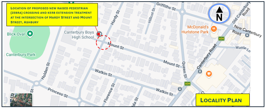
|
Street Name |
Hardy Street |
|
Carriageway width (m) kerb to kerb |
Aproximately 12.8m |
|
Carraigeway type |
Two-way traffic |
|
Classification |
Local road |
|
Speed Limit km/h |
50km/h and 40km/h School Zone between 8am-9.30am, 2.30pm-4pm School Days. It is proposed that both Hardy Street and Mount Streets will soon have a 40km/h speed limit under InnerWest@40 program. |
|
85th percentile speed km/h |
55km/h |
|
Vehicles per day (vpd) |
Approx. around 2,800-3,500 |
|
TfNSW available reported crash history (last 5 years) |
NIL in the vicinity of the intersection in last 5 years. In vicinty of the intersection prior to 2019, One (1) x 2019 RUM 30 rear end, north of Mount Street – minor/other injury. One (1) x 2012 RUM 21, at intresection with Mount Street, right through , non-casualty (towaway). One (1) x 2014 RUM 42, south of Mount Street, leaving parking, non-casualty (towaway). |
|
Parking arrngements |
Unrestricted parking to both sides of the road |
|
Side intersecting street |
Mount Street. (approx 10m in width) |
Table 1: Road Network detail
The Plan
The following works are proposed and are illustrated on the concept plan in Attachment 1.
· Construct a new raised pedestrian crossing;
· Construct kerb-blister islands on both sides of the crossing with ‘gutter bridges’ and extend out approx. 3.0-3.2m in width from the kerb line. Tactile indicators and <LOOK> pavement marking will be installed on both sides of the new pedestrian crossing;
· Construct kerb blister islands on the north-east corner of Hardy Street and north and southern corners of Mount Street. The islands are to continue to connect from Hardy Street into Mount Street, varying in width from 1.0- 3.2m as measured from the kerb line and as shown on plan;
· Provide two (2) new floodlights to the crossing on existing telegraph poles or new poles;
· Remove the layback from a pedestrian student pathway to the school;
· Provide zig-zag road markings on both approaches to the crossing;
· Reconstruct portions of kerb and footpath and resurface the road as required under final design; and
· Install all required signage (e.g. crossing leg, advance crossing, chevron-directional alignment markers) and other line marking associated with the works as shown in the plan and as required under final design.
One (1) practical on-street parking space is envisaged to be removed between the two carparks of the school on the school frontage side, and one (1) on-street parking space would be removed on the eastern corner of Hardy Street and Mount Street. This is required to accommodate the crossing and allow ‘No Stopping’ clearance distance to the crossing under Transport for NSW guidelines.
A part-time school Bus Stop (8.15 am-9.15am, 3pm-4pm School Days) partly located over the area of the proposed crossing may need to be relocated in the northerly direction by approximately 17.0m with the Bus Zone extended to the northern boundary line of the school as shown in Figure 2 below. This will need to be discussed with the school if there is a need to relocate the Bus Zone under proposed works to establish a pedestrian crossing.
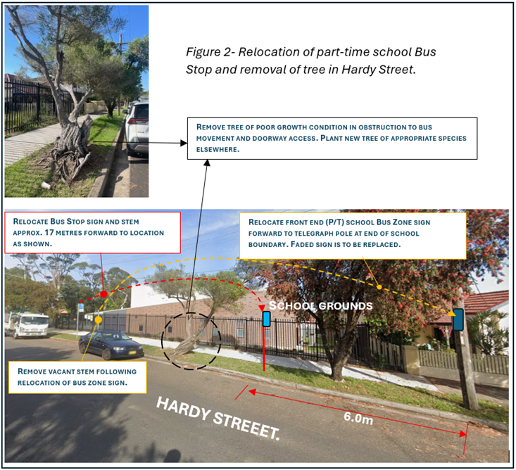
Flood lighting is to be provided at the location as required under Australian Standards for a zebra marked-foot crossing.
Additional Information
Observation last observed on site during May-July 2023 revealed that school students predominately cross at this location, with 50-110 pedestrians as factored in per hour (i.e. each child and elderly counted as two pedestrians under Councils Pedestrian Crossing Warrant Policy) in the AM (8.00am-9.00am) and PM (3.00pm-4.00pm) peaks of the day.
Traffic volumes also indicate that approximately 350 vehicles per hour through the location during the AM and PM peak periods of the day. The location qualifies under Council’s Pedestrian Crossing Warrant Policy for a marked crossing, where the policy requires that 2 periods of one hour of the day requires 20 or more pedestrians (as factored in) to be equal or be greater than 20 per hour and that volumes are equal or greater than 200 vehicles per hour.
Pedestrians are generally observed to cross on the southern side of the intersection in connectivity and desire path movement to and from a student entrance of the school and along Mount Street and down south towards Watkins Street.
Student entrance off Hardy Street
A school student entrance is located between the two car parks of the school. The pathway has a driveway layback which would need to be removed to position the crossing according to the plan. Previous discussions with the principal of the school revealed that the entrance or pathway is not used for vehicular access and has agreed for the layback to be removed. Confirmation will need to be made with the school on the removal of the layback prior to final design proceedings and community consultation.
Removal of existing tree in Hardy Street
Figure 2 identifies a large tree which would impose obstruction with the movement of buses and passenger boarding buses if the bus stop is moved forward under this proposal.
The tree is of poor growth condition, with severe over leaning and concerns to instability and inconsistency with the streetscape of the area. It poses also a hazard to pedestrian movement particularly if the Bus Stop is moved forward. The tree will be requested to be investigated for possible removal under this project, if not beforehand.
Regardless of whether the Bus Zone is moved forward, this tree would be removed on general safety grounds during proposed works of introducing the crossing, or prior to the works.
PUBLIC CONSULTATION
No consultation is provided in this report for the concept of the crossing and kerb extensions, as the work is not allocated of funding and programmed for construction in the short term. The project will be listed under the Council’s Traffic Facilities Capital Works program for final design and consultation once work is funded and programmed to be carried out.
FINANCIAL IMPLICATIONS
The project is listed in Council’s Traffic Facilities Capital Works program to be carried out in as and when funding can be allocated and work can be programed. The proposed raised crossing and kerb extension or blisters with flood lighting and associated signs and line marking is estimated to be around $182,000.
It is recommended the attached concept plan to provide a new raised pedestrian crossing with kerb extensions in Hardy Street at the intersection with Mount Street, Ashbury as shown in Attachment 1, be supported in-principle subject to detail design and community consultation.
ATTACHMENTS
|
1.⇩ |
Concept Plan- Proposed new raised pedestrian (zebra) crossing and kerb extension facilities |
|
|
Local Transport Forum Meeting 18 May 2026 |
Title: Allen Street, Leichhardt- Proposed Raised Pedestrian Crossing(Gulgadya-Leichhardt Ward/Balmain Electorate/Leichhardt PAC)
Author: Amir Falamarzi - Traffic Engineer
Authoriser: Sunny Jo - Acting Traffic and Transport Planning Manager
|
RECOMMENDATION
That the detailed design plan (No. 10389) for the proposed raised pedestrian crossing, including the relocation of existing ‘No Stopping’ and ‘Bus Zone’ signs be approved.
|
STRATEGIC OBJECTIVE
This report supports the following strategic directions contained within Council’s Community Strategic Plan:
|
2: Liveable, connected neighbourhoods and transport |
|
|
EXECUTIVE SUMMARY
The Local Traffic Committee (LTC) at its meeting on 14 April 2025 supported in-principle a concept design for a new raised pedestrian crossing on Allen Street at Norton Street, Leichhardt.
A detailed design is now complete, the proposal includes a raised pedestrian crossing, upgraded lighting, drainage modifications, and new signage and line marking. Minor adjustments to parking and the Bus Zone were also required as part of this project.
Community engagement was undertaken and one response was received with a request to modify the location of signage
BACKGROUND
At the Local Traffic Committee meeting held on 14 April 2025, the following was recommended:
1. That the installation of a raised pedestrian crossing on Allen Street at Norton Street, Leichhardt, be supported in principle and included in Council’s Capital Works Program, subject to detailed design investigations and community consultation.
2. That the detailed design for the proposed raised pedestrian crossing be brought back to the Traffic Committee for consideration.
DISCUSSION
A detailed design plan as shown in Attachment 1 was prepared. The proposed works aim to improve pedestrian safety by clearly defining and prioritising pedestrian movements across Allen Street, while also functioning as a traffic calming device.
The proposed scope of works includes the following:
· Construction of a new raised concrete pedestrian crossing and landscaped kerb blister islands, including crossover paths to provide safe access over existing kerb and gutter, and tactile ground surface indicators on both sides of the crossing;
· Construction of new concrete kerb and gutter incorporating heel-safe gutter bridge channels to facilitate pedestrian movement between the footpath and crossing;
· Upgrade of the existing kerb blister island in Norton Street (north of Allen Street) to improve greening opportunities;
· Removal of redundant kerb ramps and construction of new concrete footpaths.
· Provision of compliant lighting for the new raised pedestrian crossing, comprising one (1) or two (2) new floodlights on existing or new poles, subject to final lighting design by a qualified electrical consultant;
· Relocation and installation of new ‘No Stopping’ and ‘Bus Zone’ signs to comply with minimum clearance and safety requirements, including associated tactile indicators at the bus stop;
· Modification of two (2) existing kerb inlet pits to grate-only pits beneath the proposed heel-safe grates and gutter on the north side of the pedestrian crossing;
· Construction of two (2) new kerb inlet drainage pits and associated pipes, as shown on the plan; and
· Installation of new signage and line marking associated with the works.
Parking Changes
The proposed relocation of existing ‘No Stopping’ and ‘Bus Zone’ signs to support bus operational requirements would result in a loss of three (3) existing on-street parking spaces. This was shown in the consultation letter prepared during the design stage of this project.
Swept Path Analysis
Swept path analysis has been completed to assess the turning movements of a 12.5m length bus and an 8.8m length Service Vehicle, showing satisfactory operations. Details of the swept path assessment are provided in Attachment 2.
CONSULTATION
Community consultation was conducted between 26 March 2026 and 28 April 2026. A letter along with a copy of the design plan was sent to residents and businesses in the immediate locality with a distribution map shown below, including to the Inner West Council Bicycle Group. A total of 38 letters were distributed. At the time of this report one response was received which is summarised within the table below.
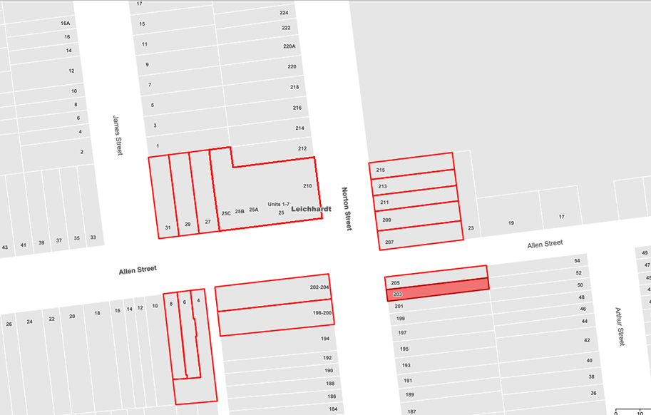
|
Resident feedback |
Council response |
|
Request that associated Bus Zone sign proposed to be located west of the driveway of No.27 be relocated to the east side of driveway. |
The proposed arrangement will have buses utilising the kerb space in front of the driveway as a draw-in manoeuvre to the Bus Zone, however the driveway is not expected to be obstructed when a bus has stopped at the bus stop. This is consistent with other Bus Zones at other locations where space is limited. The relocation of the sign to the east of the driveway of No.27 Allen Street is not supported. |
FINANCIAL IMPLICATIONS
The cost of the works is estimated at $125,000 and scheduled to be delivered under Council’s Capital Works Program 2026/27.
|
1.⇩ |
Proposed Raised Pedestrian Crossing - Allen Street, Leichhardt Detailed Design |
|
2.⇩ |
Proposed Raised Pedestrian Crossing - Allen Street, Leichhardt Swept Path Assessment |
|
|
Local Transport Forum Meeting 18 May 2026 |
Title: InnerWest@40 - Area 2 Rozelle and Lilyfield; Area 11 Ashfield North; Area 1 Haberfield - Proposed Speed Limit Reduction from 50km/h to 40km/h (Djarrawunang - Ashfield, Baludarri - Balmain and Gulgadya - Leichhardt Wards / Balmain, Summer Hill and Strathfield Electorates / Burwood and Leichhard PAC)
Author: Daniel Li - Student/Graduate Traffic Engineer
Authoriser: Sunny Jo - Acting Traffic and Transport Planning Manager
|
RECOMMENDATION
That the proposed signage and line marking plans to support the reduction in posted speed limit from 50km/h to 40km/h in local roads in Haberfield (area 1), Rozelle and Lilyfield (area 2) and Ashfield North (area 11) of the InnerWest@40 study, be approved. |
STRATEGIC DIRECTION
This report supports the following strategic directions contained within Council’s Community Strategic Plan:
|
2: Liveable, connected neighbourhoods and transport |
EXECUTIVE SUMMARY
At Council’s meeting on Tuesday 5 March 2024, Council adopted the InnerWest@40 “Investigation in Potential Local Road Speed Limit Reductions” Study and requested that Council officers seek approval and funding from Transport for NSW to expedite the implementation of 40km/h speed limits on local streets within the Local Government Area (LGA).
As part of the Australian Government Blackspot Program (AGBS), Council received funding to implement the reduced speed limits in Area 6 (Enmore & Marrickville East) and Area 7 (Marrickville & Tempe). Both areas were completed in mid-2025 with the subsequent areas being scheduled for implementation in early 2026.
Funding has been approved to continue the implementation of reduced speed limits during the 2025/26 year with Haberfield (area 1), Rozelle and Lilyfield (area 2) and Ashfield North (area 11) currently proposed for a speed limit reduction.
BACKGROUND
Council’s Integrated Transport Strategy, ‘GOING PLACES’, has identified a key project of reducing the speed limit from 50 km/h to 40 km/h on the local road network within the Inner West Council Area. Accordingly, Council commissioned Beca Consulting to prepare the Innerwest@40 study, with the study findings showing that reductions in signposted speed limits are likely to significantly improve safety with only minimal impacts on travel times.
The Innerwest@40 study was adopted by Council in March 2024. This study has identified priority areas for the staged implementation of the area-wide 40km/h limit in the Council area. This is shown in Figure 1.
Following the implementation of reduced speed limits in Area 5, 6, 7 and 8 and the scheduled implementation of Areas 4, 9 and 10, it is proposed to expand the reduced speed limits to Area 1, 2 and 11. These areas have existing street environments that are self-enforcing the proposed 40km/h speed limit in line with TfNSW’s expectation for the rollout.
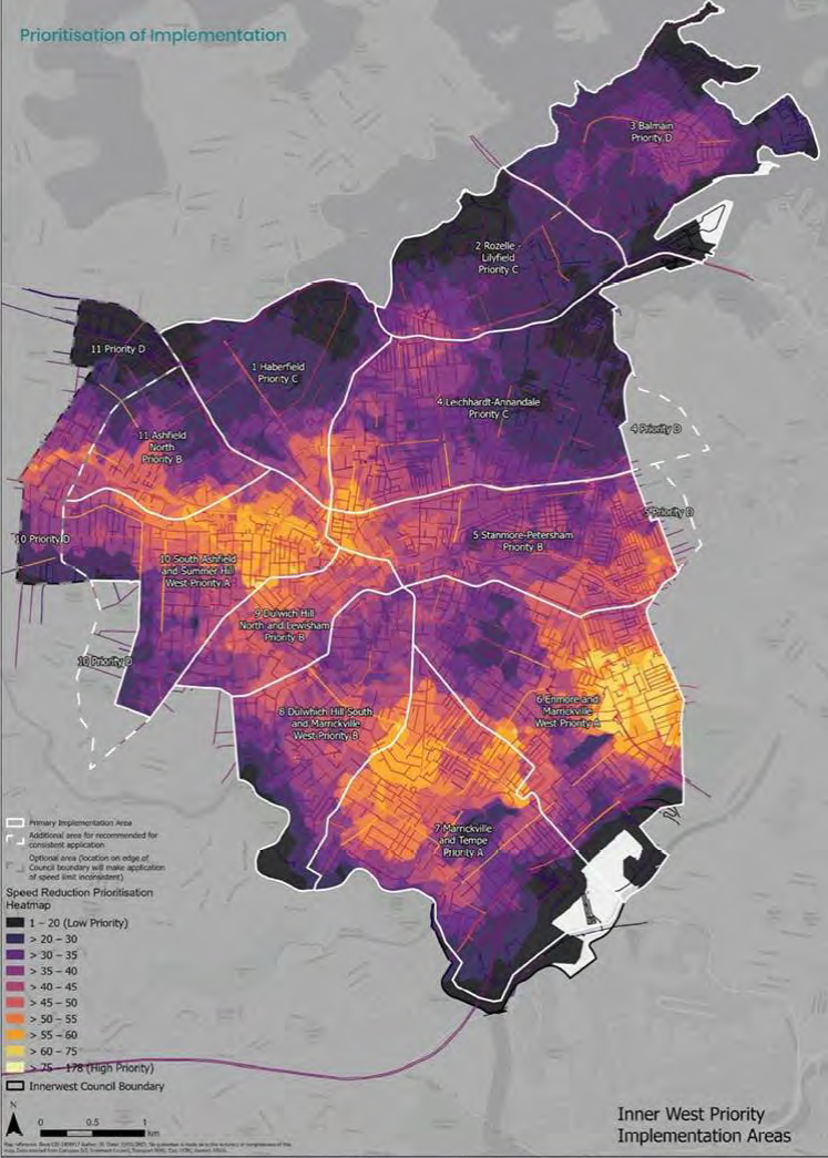
Figure 1: Prioritisation of 40km/h speed limit reduction (source: Innerwest@40 study)
DISCUSSION
The InnerWest@40 report has presented that 60% of roads within the LGA were recorded to have 85th percentile speeds of below 40km/h due to the narrowness of streets which are commonly found in the Inner West as well as the presence of traffic calming schemes to reduce vehicle speeds.
The 85th percentile speeds for Area 1, 2 and 11 are shown in Figures 2-4 below.
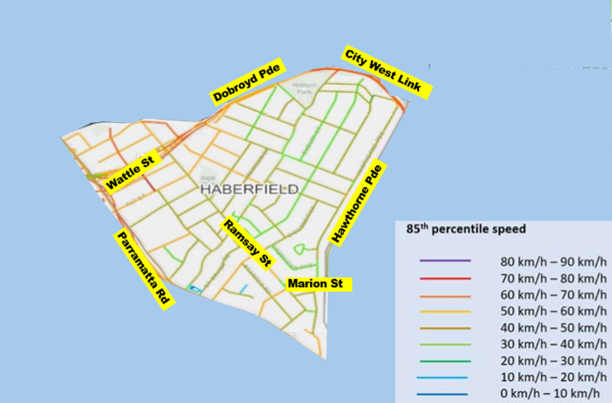
![]() Figure 2: 85th
percentile speed profile for Haberfield (area 1)
Figure 2: 85th
percentile speed profile for Haberfield (area 1)
Figure 3: 85th percentile speed profile for Lilyfield and Rozelle (area 2)
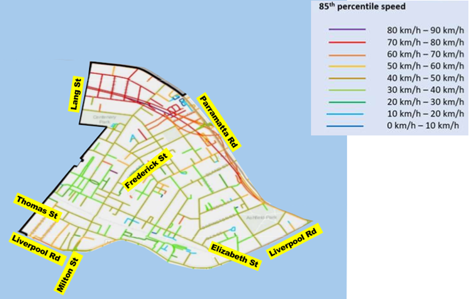
Figure 4: 85th percentile speed profile for Ashfield North (area 11)
Any local street that has a recorded 85th percentile speed of less than 45km/h falls within acceptable limits and has been considered self-enforcing. It is proposed to install entry treatments in the form of new R4-240n ‘Local Traffic Area 40’ signs and pavement patches to these local roads (shown in Figures 5, 6, 7 and 8).
It should be noted that as part of the implementation of the next phases of InnerWest@40, Transport for NSW is reviewing speed reduction on regional and state roads to ensure a consistent application of speed limits throughout the LGA. This review is still underway at the time of this report.
A small number of local streets have been identified to be marginally higher than the benchmark of 45km/h and will require additional speed reduction treatments to provide an environment that will be self-enforcing. These streets are listed in Table 1 below and the line marking plans are provided in Attachment 1. It is expected that these linemarking treatments along with associated signage are expected to reduce vehicle speeds to an acceptable level.
|
Street |
Between |
Suburb |
Area |
Treatment |
|
Hawthorne Parade |
Marion Street and Barton Street |
Haberfield |
1 |
1x edge line and centre line |
|
Waratah Street |
Dobroyd Parade and Boomerang Street |
Haberfield |
1 |
Centre line and edge line |
|
Helena Street |
Lilyfield Road and Balmain Road |
Lilyfield |
2 |
10m BB centre line at intersection and Stop intersection |
|
Campbell Avenue |
Perry Street and Church Street |
Lilyfield |
2 |
10m BB centre line and TB1 Give-Way |
|
Trevor Street |
Joseph Street and Lilyfield Road |
Lilyfield |
2 |
10m BB centre line and TB1 Give-Way |
|
Alberto Street |
Balmain Road and O’Neill Street |
Lilyfield |
2 |
BB centre line and S1 centre line |
|
Dalmar Street |
Lang Street and Croydon Road |
Croydon |
11 |
BB centre line and S1 centre line |
|
John Street |
Federick Street and Alt Street |
Ashfield |
11 |
BB centre line and S1 centre line |
Table 1: Streets requiring additional speed reduction treatments
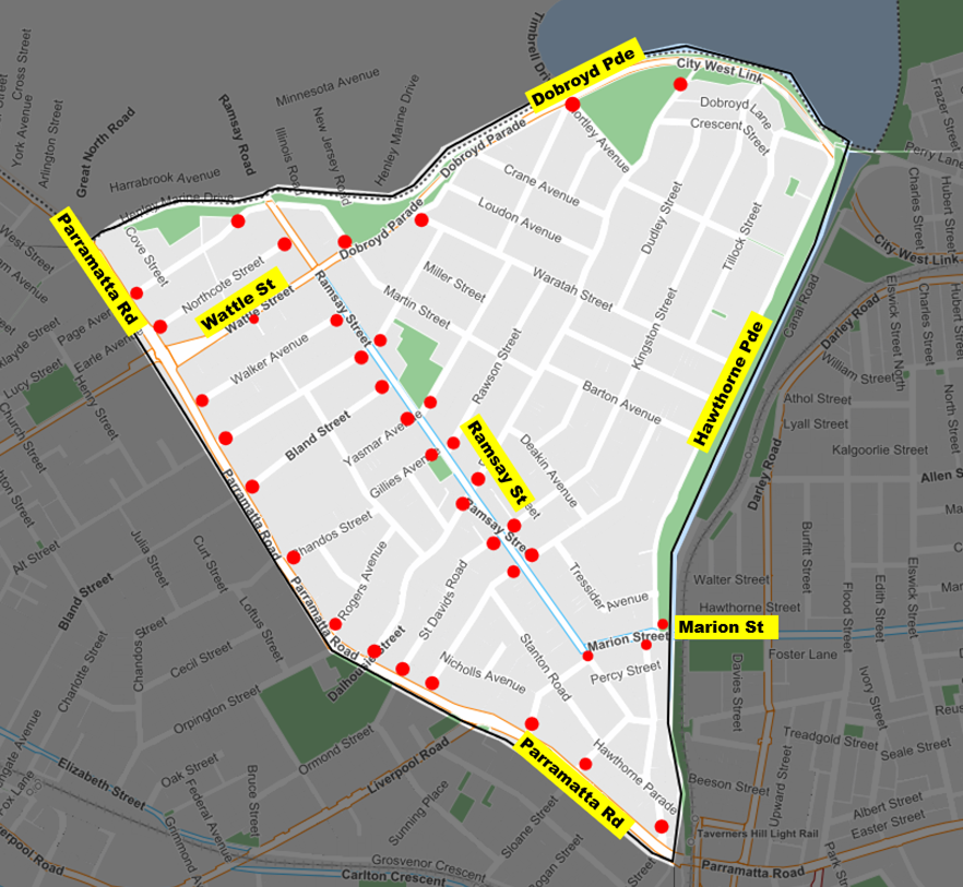
Figure 5: Proposed entry treatment locations for Haberfield (area 1)

Figure 6. Proposed entry treatment locations for Rozelle and Lilyfield (area 2)
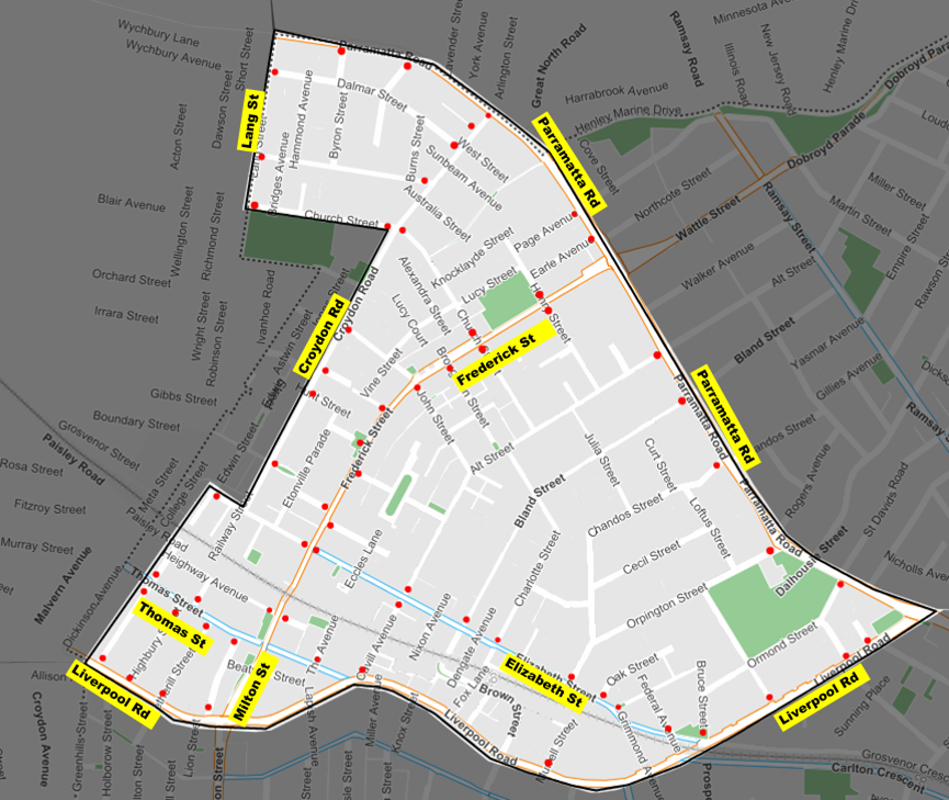
Figure 7. Proposed entry treatment locations for Ashfield North (area 11)
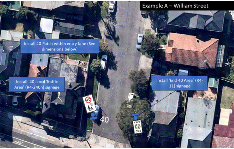
Figure 8: Example of Entry Treatment Signages
FINANCIAL IMPLICATIONS
Grant funding has been provided for approximately $1.8M received under the Safe Speed Program from Transport for NSW for the project over the 2024/25 and 2025/26 financial years.
|
1.⇩ |
Inner West@40 Haberfield (area 1) - linemarking plan |
|
2.⇩ |
Inner West@40 Rozelle & Lilyfield (area 2) - linemarking plan |
|
3.⇩ |
Inner West@40 Ashfield North (area 11) - linemarking plan |
|
|
Local Transport Forum Meeting 18 May 2026 |
Item: LTF0526(1) Item 13
Title: Proposed EV Kerbside Charging Locations (All Wards / All Electorates / All PACs)
Author: Caroline Mugwevi - Project Manager - Electric Vehicle and Transport Infrastructure and Sarah Guan - Strategic Transport Planner
Authoriser: Sunny Jo - Acting Traffic and Transport Planning Manager
|
RECOMMENDATION
That the EV charging sites identified in Table 2 be supported and signposted as ‘No Parking 8am-10pm EV excepted while charging’ space as shown in the signage and line marking plans provided in Attachment 1. |
STRATEGIC DIRECTION
This report supports the following strategic directions contained within Council’s Community Strategic Plan:
|
2: Liveable, connected neighbourhoods and transport |
EXECUTIVE SUMMARY
Council is committed to supporting and encouraging the use of electric vehicles (EVs) in the Inner West. Following the adoption of “Powering Ahead”, Council’s Electric Vehicle Encouragement Strategy in 2023, Council has partnered with several Kerbside charging providers and has been successful in gaining State Government Funding for the provision of Kerbside EV charging.
The current rollout of chargers will be installed by PLUS ES. This work is being delivered under the Transport and Infrastructure State Environmental Planning Policy, which allows them to install chargers without a development application.
To ensure EV owners can easily use the chargers, Council is proposing to establish ‘No Parking 8am–10pm EV excepted while charging’ zones at a number of charging sites. Targeted engagement has been undertaken, and a summary of the engagement outcomes has been provided with associated recommendations and signage and line marking plans.
BACKGROUND
In Round 1 of the NSW EV Kerbside Charging Grant, Council's EV Kerbside Charging Partners were successful in receiving grant funding for 148 EV charging ports. These are installed and operational across the Inner West Council area. Of the 148 charging ports, 82 have dedicated EV charging bays.
On 9 July 2025, Council's Charging Partners received further grant funding for 47 charging ports. Of the 47 charging ports, 25 dedicated EV charging bays have been rolled out, bringing the total number of dedicated charging bays in the Inner West LGA up to 107. These charging ports are being installed as exempt development under the Transport and Infrastructure State Environmental Planning Policy.
To improve charging opportunities for EV owners, Council is proposing to change parking restrictions to ‘No Parking 8am-10pm EV excepted while charging’.
Charging partners, in collaboration with Ausgrid, State Government and Council, selected the sites in this proposal using site selection criteria including:
· Network capacity to support EV charging;
· Prioritising areas with high projected EV uptake and limited off-street parking access;
· Expanding public charging access with thoughtful integration into residential areas; and
· Assessing sites for safety, visibility and accessibility.
Council reviewed community feedback on the selected sites to measure overall support and understand how impacts would be distributed among different groups of residents. In determining whether dedicated EV charging spaces are suitable at each site, the following factors were considered:
· A review of consultation feedback to understand public opinion;
· Each location was assessed individually due to unique site characteristics and constraints;
· Direct impact on the adjacent dwelling(s) was specifically evaluated;
· Broader impacts on residents who regularly park in the same street were considered; and
· Benefits to the wider area and implications for residents within the proposed EV charging network were considered.
DISCUSSION
Figure 1 shows the proposed public EV charging locations on targeted consultation from 16 March to 22 April. It also shows the locations of existing public EV kerbside chargers from previous rounds of rollout.
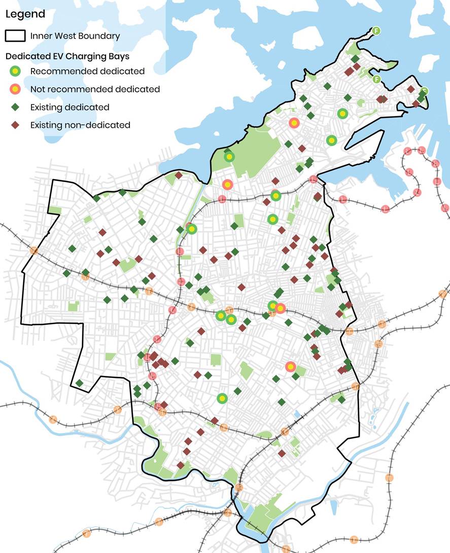
Figure
1: Map of proposed and existing public EV kerbside charging locations and
dedicated bays
|
|
Local Transport Forum Meeting 18 May 2026 |
Notification letters were sent to residents in close proximity to each location. Residents were able to respond to multiple locations on the suitability of each location for dedicated EV charging bays. It is noted that four (4) contributors selected “Yes” for a broad range of locations (between 4 and 14 sites). Since the survey was to gather community feedback on the suitability of each location for dedicated EV charging bays rather than support for public EV chargers, these votes have been tabulated in the Support Rate (Table 1) for completeness, their comments have been attributed solely to the location nearest to each contributor’s residence.
Table 1. Targeted consultation and responses
|
Location |
Support Rate |
Resident Comment |
Officer Response |
|
Glover Street, Lilyfield (Glover Street Field) |
Total 3 votes in support
|
Contributors responded ‘Yes’ with no further comments. |
Noting that there were no objections from the street, this location is recommended for a dedicated EV charging ‘No Parking 8am-10pm EV excepted while charging’ space. |
|
Adjacent 27 Fisher Street, Petersham (Pole in Regent Street) |
Total 10 votes 8 in support 2
objections |
Respondents have raised the below views: · Strong demand for EV charging from nearby apartment residents without home charging access. · Preference for fast chargers or placement in council car parks. · Concern that reduced free parking in an area where there is already high demand and ongoing development negatively affects local residents. |
EV charging spaces are proposed to be operational between 8am-10pm, this seeks to maximise parking for households to use the unrestricted hours (10pm-8am) for parking. This allows for better turnover and relocating any EV vehicles that may already be in the nearby streets. The adjacent apartment building has access to off-street parking and it is expected that this EV charging station will be well utilised and so the proposed location is recommended for a dedicated EV charging ‘No Parking 8am-10pm EV excepted while charging’ space. |
|
327-329 Trafalgar Street, Petersham |
Total 4 votes in support |
Like all of these locations, they should be located as close as possible to older style apartments and homes where there is no or limited off-site parking and EV charging is problematic. |
The proposed location is in a commercial location, and it allows for better turnover and relocating any EV vehicles that may already be in the nearby streets. This location is recommended for a dedicated EV charging ‘No Parking 8am-10pm EV excepted while charging’ space. |
|
Opposite 8-26 Darley Road, Leichhardt |
Total 6 votes 4 in support in 2 objections |
Respondents have raised the below views: · Recognition of the need to expand EV charging infrastructure to support the transition to low-emission transport. · Existing nearby chargers are frequently occupied or hard to access due to limited dedicated parking · High demand for limited on-street parking from residents, visitors, deliveries, and light rail users. · Concern that removing parking spaces would reduce accessibility, particularly for elderly and mobility-impaired users of nearby transport and public facilities. |
The proposed location is frontage of Shields Playground near the Hawthorne Light Rail. Darley Road is a state road under the jurisdiction of Transport for NSW and there were no objections for the location. It is also expected to allow for a better turnover and relocating any EV vehicles that may already be in the nearby streets. This location is recommended for a dedicated EV charging ‘No Parking 8am-10pm EV excepted while charging’ space. |
|
118 Percival Road, Stanmore |
Total 6 votes 5 in support 1 objection
|
Respondents have raised the below views: · support for EV charger installation and expansion of charging access. · Recognition of strong demand for public charging, particularly in areas with a high concentration of apartments where residents lack access to private charging facilities, with a suggestion to install multiple chargers at a single location. · Concerns about high traffic volume and safety risks in the area. · Concern that existing parking shortages may be worsened by the removal of spaces for EV charging infrastructure. |
The Transport for NSW crash database shows that there are no reported crashes in the last 5 years. Generally, when implementing EV chargers, Council along with providers will identify and prioritise high traffic generating locations (e.g. town centres, train stations, schools, parks etc) to ensure that EV chargers are adequately used by the community. It should also be noted that the proposed space is within the Stanmore Town Centre and aims to replace an existing visitor space designated as restricted 2P parking without any resident parking schemes, thereby having no impact on residential parking amenities. As such, this location is recommended for a dedicated EV charging ‘No Parking 8am-10pm EV excepted while charging’ space. |
|
1E Douglas Street, Stanmore |
Total 8 votes 4 in support 4 objections |
Respondents have raised the below views: · Support for EV charging stations near older apartments or homes without off-street parking. · Suggestions for alternative, safer locations such as Railway Avenue and the local Library. · Safety concerns due to proximity to a bend and high traffic volumes, with potential for increased congestion and accidents. · Concerns about antisocial behaviour risks, including loitering, vandalism, and increased noise and disturbance at night. |
Based on the survey results, this location is not recommended as a dedicated EV space. |
|
Opposite 311 Marrickville Road, Marrickville (Pole in Lilydale Street) |
Total 6 votes 5 in support 1 objection |
Respondents have raised the below views: · The library vicinity is considered a suitable and convenient location for EV charging infrastructure. · Noted shortage of EV charging stations in the Marrickville area, with support for additional sites. · Limited parking availability, with preference for installing chargers in council car parks rather than on-street spaces. · Concerns that overall EV charging coverage in the broader area remains insufficient despite support for expansion. |
The proposed location allows for better turnover and relocating any EV vehicles that may already be in the nearby streets. This location is recommended for a dedicated EV charging ‘No Parking 8am-10pm EV excepted while charging’ space. |
|
23-29 Addison Road, Marrickville
|
Total 10 votes 6 in support 4 objections |
Respondents have raised the below views: · Support for EV charging rollout and recognition of the need for increased availability in the Marrickville area. · Suggestions for alternative locations such as Llewellyn Street, Victoria Road, and sites further from Addison Road. · Concerns that the busy corridor/intersection may experience increased congestion from vehicles queuing or circulating for charging bays. · High existing parking demand, with concern that converting spaces to EV charging would reduce availability for residents, visitors, and local businesses. |
Based on the survey results, this location will not be recommended as a dedicated EV space. |
|
16-30 Wortley Street, Balmain |
Total 4 votes in support
|
Respondents have raised the below views:
· Concern about a shortage of EV charging points in the surrounding area, with limited existing infrastructure. · The proposal is supported as it enables EV ownership and encourages uptake of sustainable transport in the Inner West Council area. |
This location is recommended for a dedicated EV charging ‘No Parking 8am-10pm EV excepted while charging’ space, based on the survey outcome. |
|
2-8 Parsons Street, Rozelle |
Total 2 votes in support
|
Contributors responded ‘Yes’ with no further comments. |
This location is recommended for a dedicated EV charging ‘No Parking 8am-10pm EV excepted while charging’ space, based on the survey outcome. |
|
17 Wellington Street, Rozelle |
Total 16 votes 3 in support 11 objections |
Respondents have raised the below views: · Support for EV charging expansion and sustainable transport initiatives, with suggestions for less congested locations and council car parks. · Concern about proximity of the proposed site to a hydrant booster and pump room. · Concern that the street experiences severe existing parking constraints due to nearby businesses and local activity. · Concern that EV charging could increase vehicle movements, including circling or waiting for spaces. · Concern that dedicating public parking exclusively to EV users may be inequitable, with preference for relocation to less constrained or council-managed car parks. |
Based on the survey results, this location will not be recommended as a dedicated EV space due to insufficient support. |
|
Opposite 389 Catherine Street, Lilyfield |
Total 2 votes in support |
Contributors responded ‘Yes’ with no further comments. |
This location is recommended for a dedicated EV charging ‘No Parking 8am-10pm EV excepted while charging’ space, based on the survey outcome. |
|
Opposite 12 Mary Street, Lilyfield |
Total 8 votes 3 in support 5 objections |
Respondents have raised the below views: · Indication of likely use of the charging station if installed, with suggestions for alternative locations. · Concern about limited parking availability on Mary Street. · Concerns about proximity to residential dwellings, including potential noise impacts and suitability of locating charging infrastructure directly outside homes. |
Based on the survey results, this location will not be recommended as a dedicated EV space. |
|
Opp 1 Ilka Street frontage of War Memorial Park (Pole in Catherine Street) |
Total 3 votes 2 in support 1 objection |
Respondents have raised the below views: · Support for expansion of EV charging across the Inner West, recognising its role in enabling sustainable transport. · Concern that the proposed installation may limit future cycling infrastructure upgrades. · Safety concerns regarding existing cycling conditions, particularly dooring risks associated with the on-road bike lane configuration. |
The proposed location is currently an unrestricted on-street parking space and the conversion to a dedicated EV space would not impact on the existing bicycle lane configuration. This location is recommended for a dedicated EV charging ‘No Parking 8am-10pm EV excepted while charging’ space. |
Based on the comments in Table 1, a list of recommended restrictions has been summarised in Table 2.
|
|
Local Transport Forum Meeting 18 May 2026 |
Table 2. Summary of Proposed Location.
|
Address |
No. of Bays |
Existing restriction |
Proposed restriction |
Image ref. |
|
Glover Street, Lilyfield (Glover Street Field) |
1 |
Unrestricted |
No Parking 8am-10pm EV Vehicles Excepted While Charging |
A1 |
|
Adjacent 27 Fisher Street, Petersham |
1 |
Unrestricted |
No Parking 8am-10pm EV Vehicles Excepted While Charging |
A2 |
|
327-329 Trafalgar Street Petersham |
1 |
Unrestricted |
No Parking 8am-10pm EV Vehicles Excepted While Charging |
A3 |
|
Opposite 8-26 Darley Road, Leichhardt |
1 |
Unrestricted |
No Parking 8am-10pm EV Vehicles Excepted While Charging |
A4 |
|
118 Percival Road, Stanmore |
1 |
2P 830am - 6pm Monday -Friday 2P 830am - 1230pm Saturday |
No Parking 8am-10pm EV Vehicles Excepted While Charging |
A5 |
|
Opposite 311 Marrickville Road, Marrickville |
1 |
Unrestricted |
No Parking 8am-10pm EV Vehicles Excepted While Charging |
A6 |
|
16-30 Wortley Street Balmain |
1 |
Unrestricted |
No Parking 8am-10pm EV Vehicles Excepted While Charging |
A7 |
|
2-8 Parsons Street Rozelle |
1 |
Unrestricted |
No Parking 8am-10pm EV Vehicles Excepted While Charging |
A8 |
|
Opposite 389 Catherine Street Lilyfield |
1 |
Unrestricted |
No Parking 8am-10pm EV Vehicles Excepted While Charging |
A9 |
|
Opp 1 Ilka Street frontage of War Memorial Park (Pole in Catherine Street) |
1 |
Unrestricted |
No Parking 8am-10pm EV Vehicles Excepted While Charging |
A10 |
FINANCIAL IMPLICATIONS
This round of EV kerbside chargers is fully funded by NSW Government and Council's EV Kerbside Charging Partners.
It was found that there is strong community support for expanding EV charging infrastructure across the proposed locations, reflecting recognition of the need to support growing EV uptake and the transition to more sustainable transport. At the same time, feedback consistently highlights concerns about the suitability of specific sites, particularly in relation to limited parking and impacts on residential amenity.
|
1.⇩ |
EV Kerbside Charging - Signage and Linemarking Plans |
|
|
Local Transport Forum Meeting 18 May 2026 |
Title: Mackey Park Resident Parking Scheme (Midjuburi - Marrickville Ward / Summer Hill Electorate / Inner West PAC)
Author: Daniel Li - Student/Graduate Traffic Engineer
Authoriser: Sunny Jo - Acting Traffic and Transport Planning Manager
|
RECOMMENDATION
1. That the proposed ‘2P 8am-6pm Mon-Fri, Permit Holders Excepted Area M2’ restrictions on the northern side of Junction Street, Marrickville not be supported.
2. That the proposed ‘2P 8am-6pm Mon-Fri, Permit Holders Excepted Area M2’ restrictions on the southern side of Renwick Street, Marrickville between no.66 and no.104 be approved.
3. That the proposed 2P 8am-6pm Mon-Fri, Permit Holders Excepted Area M2’ restrictions on the southern side Ruby Street, Marrickville between no.16 and no.52 be approved.
4. That the proposed ‘2P 8am-6pm Mon-Fri, Permit Holders Excepted Area M2’ restrictions on the northern side Warren Road, Marrickville between no.105 and no.149 be approved.
5. That the proposed ‘2P 3pm-9pm Mon-Fri; 6P 8am-6pm Saturday-Sunday’ restrictions on the southern side of Carrington Road, Marrickville be approved.
6. That the proposed ‘2P 3pm-9pm Mon-Fri; 6P 8am-6pm Saturday-Sunday’ restrictions on the western side of Richardson’s Crescent, Marrickville be approved. |
STRATEGIC DIRECTION
This report supports the following strategic directions contained within Council’s Community Strategic Plan:
|
2: Liveable, connected neighbourhoods and transport |
EXECUTIVE SUMMARY
Council resolved to undertake community consultation to extend the Resident Parking Scheme (RPS) Area M2 to the industrial precinct around Carrington Road, Cary Street and Renwick Street, Marrickville. This report presents the results of the second phase of consultation completed in the following streets:
· Junction Street between Ruby Street and Schwebel Street;
· Ruby Street between Junction Street and Ivanhoe Street;
· Renwick Street between Johnston Lane and Carrington Road;
· Warren Road between Johnston Lane and Carrington Road;
· Richardson Crescent, east of Carrington Road; and
· Carrington Road between Premier Street and Richardson Crescent.
The results from the community consultation
between July and August 2024 indicated a low response rate from the area of
consultation with a high support rate for resident parking schemes within the
area. Due to the low response rate, the proposed parking restrictions were not
recommended for installation. To address concerns regarding the low
response rate but high support rate received from the respondents, Council has
undertaken a separate community consultation that focused on the streets with high
support rate from earlier consultation and to ensure that the response rate was
not affected by neighbouring streets.
Based on the breakdown of support
rate, it is recommended that parking restrictions be approved in Renwick
Street, Warren Road, Ruby Street, Carrington Road and Richardsons Crescent and
that parking restrictions not be installed in Junction Street at this time.
BACKGROUND
Council previously resolved to undertake community consultation on extending the Resident Permit Parking Scheme Area M2 to the industrial precinct around Carrington Road, Cary Street and Renwick Street, Marrickville.
Following community consultation and a parking survey between July and August 2024, a report detailing the results was submitted to Council. The results of the survey indicated a low response rate from the area of consultation with a high support rate from respondents, especially from Cary Street for the proposed parking restrictions, and as such, Council was unable to recommend the installation of parking restrictions within the Marrickville South region.
To address concerns regarding the response and support rate received from the respondents, Council officers have followed up with a separate community consultation that focuses on streets that responded with a high support rate for a RPS including:
· Junction Street between Ruby Street and Schwebel Street;
· Ruby Street between Junction Road and Ivanhoe Street;
· Renwick Street between Johnston Lane and Carrington Road;
· Warren Road between Johnston Lane and Carrington Road;
· Richardsons Crescent, east of Carrington Road; and
· Carrington Road between Premier Street and Richardson's Crescent.
DISCUSSION
Residents were consulted on the proposals:
· Junction Street – introduction of ‘2P 8am-6pm Mon-Fri, Permit Holders Excepted Area M2’ on the northern side of Junction Street (between no.1 and side boundary of no.9 Ruby Street)
· Renwick Street – introduction of ‘2P 8am-6pm Mon-Fri, Permit Holders Excepted Area M2’ on the southern side of Renwick Street (between no.66 and no.104)
· Ruby Street – introduction of ‘2P 8am-6pm Mon-Fri, Permit Holders Excepted Area M2’ on the southern side of Ruby Street (between no.16 and no.52)
· Warren Road – introduction of ‘2P 8am-6pm Mon-Fri, Permit Holders Excepted Area M2’ on the northern side of Warren Road (between no.105 and no.149)
· Richardsons Crescent – Introduction of timed parking restrictions ‘2P 3pm-9pm Mon-Fri; 6P 8am-6pm Sat-Sun’ on the southern side of Richardsons Crescent (east of Carrington Road, next to Mackey Park);
· Carrington Road – Introduction of timed parking restrictions ‘2P 3pm-9pm Mon-Fri; 6P 8am-6pm Sat-Sun’ on the eastern side of Carrington Road (between Richardsons Crescent and Premier Street)
Survey Results
Table 1 below presents a summary of the parking survey results and investigations into determining which streets may benefit from timed permit parking restrictions. It should be noted that parking utilisation thresholds were in most cases close but did not meet Council's requirement of 85% occupancy.
|
Street |
Average Parking Occupancy (both sides) |
Remarks |
|
Renwick Street between Carrington Road and Johnston Lane |
82% |
· Average for both sides less than 85% utilisation requirement · Parking utilisation on northern side was 93% · Most households on southern side do not have off-street parking |
|
Warren Road between Carrington Road and Johnston Lane |
82% |
· Average for both sides slightly less than 85% utilisation threshold · Parking utilisation on the southern side adjacent to the park was 84% · Most households on both sides do not have off-street parking and transfer of parking demand may affect these households |
|
Ruby Street between Carrington Road and Ivanhoe Street |
69% |
· Average for both sides less than 85% utilisation threshold · Parking utilisation on the southern side was 81% and higher than the total average between Carrington Road and Ivanhoe Street · Most households on both sides have limited to nil off-street parking and transfer of parking demand may affect these households |
|
Junction Street between Ruby Street and Schwebel Street |
81% |
· Average for both sides slightly less than 85% utilisation threshold · Most households on both sides have limited to nil off-street parking and transfer of parking demand may affect these households. |
|
Richardson Crescent, south of Carrington Road |
86% |
· Parking utilisation on the southern side adjacent to the park was 91% · Timed parking restrictions adjacent to the park may transfer demand to adjacent streets |
|
Carrington Road between Premier Street and Cary Street |
79% |
· Average for both sides less than 85% utilisation threshold · Parking utilisation on eastern side adjacent to the park was 88% · Timed parking restrictions adjacent to the park may transfer demand (approximately 13 spaces) to adjacent streets |
Table 1. Parking occupancy rates in the proposed areas for parking restrictions
Public Consultation
A total of 136 consultation letters outlining the proposal was mailed out to residents and businesses residing in Renwick Street, Warren Road, Ruby Street, Junction Street and Carrington Road. The consultation period commenced on 11 March 2026, ending on 15 April 2026. Table 2 provides a summary of the support rate received and Table 3 provides a summary of comments that were received during consultation.
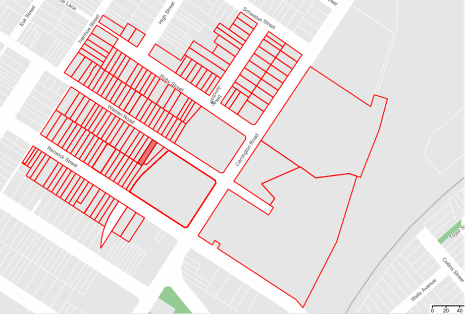
Figure 1. Consultation area of proposed parking restrictions
Additionally, Council's adopted Policy for the introduction of Permit Parking Areas states "that before implementing a resident parking scheme in any area, a survey of residents be undertaken to ascertain the level of support for such a scheme and that such support should be in excess of 65% of submissions received provided that the rate of return of submissions is reasonable” (higher than 30%).
Based on
the results, all of the surveyed streets with the exception of Junction Street
have met the required return of submissions of 30%, and all surveyed streets
have met the required criteria of 65% support rate for RPS implementation. It
should also be noted that Carrington Road and Richardsons Crescent were
consulted in two phases. In the first phase of consultation, Carrington Road
and Richardsons Crescent did not meet the criteria for timed parking
restrictions. However, the inclusion of these two streets in the second phase
has resulted in adequate support for the timed parking restrictions to be
considered.
|
Proposal |
Total responses received |
Number of votes supporting |
Number of votes against |
|
Junction Street |
3/18 (17%) |
2 (67%) |
1 (33%) |
|
Renwick Street |
18/47 (38%) |
13 (72%) |
5 (28%) |
|
Ruby Street |
19/21 (90%) |
13 (68%) |
6 (32%) |
|
Warren Road |
19/44 (43%) |
14 (75%) |
5 (25%) |
|
Richardsons Crescent & Carrington Road (second phase) |
55/130 (42%) |
39 (71%) |
16 (29%) |
|
Richardson’s Crescent & Carrington Road (both phases combined) |
93/236 (39%) |
62 (67%) |
31 (33%) |
Table 2. Public consultation results
|
Street |
Theme |
Resident Comments |
Officer’s Response |
|
Junction Street |
Resident Parking Scheme |
Implementation of RPS will disrupt all parking in this area. |
Noted. Due to a low response rate, Council will not be proceeding with RPS in Junction Street. |
|
RPS should be introduced in Junction Street as it is always at capacity on weekdays and weekends. |
Refer to above response. |
||
|
Driveways should be line marked to prevent parked vehicles obstructing access and should be marked wider for improved turning movements. |
Council permits residents to make their own arrangements for driveway line markings as long as residents follow Council guidelines for such line markings. |
||
|
Renwick Street |
Resident Parking Scheme |
Implementing RPS on one side will increase parking demands on the northern side. |
Council will only consider RPS for one side of the street only whilst leaving the other side as unrestricted. This will ensure that non-eligible residents/visitors can also access on-street parking. |
|
· RPS does not extend far enough along Renwick Street · RPS should be extended to the front of no.73-79. · RPS should be extended to no.106 to prevent taxis parking |
Refer to above comment for extending the RPS to the northern side of Renwick Street. Council may consider extending the RPS to no.106 in the future, however the RPS has been proposed between no.66 and no.104 as it is believed that there will be more usage from residential properties. |
||
|
‘No Stopping’ in Johnston Lane |
This will result in loss of parking and impact location as a future EV charging location |
The subject location is positioned under 10m of the intersection. The Road Rules prohibit parking within 10m of an intersection. |
|
|
Ruby Street |
Resident Parking Scheme |
Ruby Street provides essential parking for Carrington Road workers and suggests ‘2P 8am-4pm’ from Carrington Road up to no.16 |
Noted. Industrial/employment operations are not considered to be short-term activities in which 2P parking is suitable for the needs of workers. |
|
Restrictions need to be applied to northern side of Ruby Street as well. |
Council will only consider RPS for one side of the street only whilst leaving the other side as unrestricted. This will ensure that non-eligible residents/visitors can also access on-street parking. |
||
|
RPS should also be installed between no.9 and 21 as it is unreasonable for motorists to walk up and down the hill |
Council may consider installing RPS between no.9 and no.21 Ruby Street as long as majority of the residents within this block are supportive of the proposed changes. |
||
|
Warren Road |
Employees, boats and trailers |
Parking is taken up by factory workers and abandoned boats / trailers. If RPS proceeds, it should be installed on both sides. |
Council will only consider RPS for one side of the street only whilst leaving the other side as unrestricted. This will ensure that non-eligible residents/visitors can also access on-street parking. Additionally, abandoned vehicles, boats and trailers can be reported to Council’s parking officers and may be relocated following an investigation. |
|
Signage |
Proposal needs to be well signposted given that Warren Road is also one-way. |
Noted. |
|
|
Richardsons Crescent & Carrington Road |
Timed parking restrictions |
Businesses and employees will be affected by the parking changes |
Noted. Restrictions on one side is proposed to offer long term employee parking opportunities and visitors. |
|
Parking changes should be installed on both sides of Richardson Crescent |
Noted. |
||
|
Timed parking should not be included between 3pm to 9pm, only 9am-5pm Mon-Fri is busy. |
Council has identified that outside of the 9am-5pm times, Mackey Park is major traffic generating area for sporting events and clubs. |
Table 3. Summary of comments
FINANCIAL IMPLICATIONS
The proposed restrictions will be funded with Council’s signs and line marking budget.
|
1.⇩ |
Mackey Park Resident Parking Scheme Consultation Plans |
|
|
Local Transport Forum Meeting 18 May 2026 |
Title: Schwebel Street, Marrickvlle - Proposed 45 degree angled parking in Schwebel Street between Station Street and Leofrene Avenue.
Author: Daniel Li - Student/Graduate Traffic Engineer
Authoriser: Sunny Jo - Acting Traffic and Transport Planning Manager
|
RECOMMENDATION
That ‘45° Angle Parking, rear to kerb’ on the northern side of Schwebel Street, Marrickville between Station Street and Leofrene Avenue, Marrickville be approved.
|
STRATEGIC DIRECTION
This report supports the following strategic directions contained within Council’s Community Strategic Plan:
|
2: Liveable, connected neighbourhoods and transport |
EXECUTIVE SUMMARY
Council on 9 December 2025 made an amendment to the recommendations contained in Item 4 of the November 2025 Local Transport Forum. The amendment included the following “That Council investigate and consult with residents and businesses about installing angled parking on the north side of Schwebel Street between Station Street and Leofrene Avenue and report back to a future Local Transport Forum”.
Based on the feedback of surrounding businesses and residents, it is recommended that 45-degree angled parking be installed on the northern side of Schwebel Street between Station Street and Leofrene Aveune, Marrickville.
BACKGROUND
At its meeting on Tuesday 9 December 2025 Council considered a report from the Local Transport Forum and made the following decision:
That Council receive and adopt the recommendations of the Local Transport Forum meeting held on 17 November 2025, with the following amendments:
b) An additional point 5 be added to the recommendations for Item 4: Schwebel Street - Proposed one-way eastbound treatment at Schwebel Street between Station Street/Leofrene Avenue and Junction Road, that reads, “That Council investigate and consult with residents and businesses about installing angle parking on the north side of Schwebel Street between Station Street and Leofrene Avenue and report back to a future Local Transport Forum.”
DISCUSSION
Surrounding businesses and residents were consulted on the below options for angled parking in Schwebel Street, Marrickville:
· Option A: Proposed 90o angled parking in Schwebel Street between Station Street and Leofrene Avene (as shown in Attachment 1)
· Option B: Proposed 45o rear-to-kerb angled parking in Schwebel Street between Station Street and Leofrene Avenue (as shown in Attachment 2)
· Option C: No change to current parking arrangements.
A summary table of the features of each proposal can be seen below.
|
Proposal |
Features |
|
Option A |
· Parking spaces on the southern side of Schwebel Street will be relocated to the northern side to facilitate two-way traffic movements. · This will result in (1) space being gained, for a total of 11 parking spaces · Motorists will be able to exit on either Illawarra Road or travel along the one-way section of Schwebel Street |
|
Option B |
· Install 45o angled parking rear to kerb with vehicle facing eastbound direction and parking on the southern side of Schwebel Street being retained. · This will result in three (3) parking spaces being gained, for a total of 12 parking spaces · Motorists will be required to exit onto the one-way eastbound direction of Schwebel Street or through Blamire Lane. |
|
Option C |
· Wider roadway is maintained · No additional parking spaces gained (total of 9 parking spaces) |
Table 1 Features of parking proposals
Consultation Results:
A total of 90 letters were mailed out to surrounding businesses and residents in accordance with the consultation map below.
Figure 1: Consultation map
Three (3) responses were received with two (2) from local businesses were in support of Option B being implemented and one response supporting Option C. A summary of responses can be seen in the table below.
|
Proposal |
General Comments |
Officer’s Response |
|
Option A |
Between the two angled parking options, Option A would be preferred.
Strongly opposed to prohibiting drivers exiting onto Illawarra Road as per option B.
Drivers should not be required to take a detour to get back onto Illawarra Road or travel through Blamire Lane as it is a vehicle access point for a child care centre
The proposal should allow easy access for pick up and drop off purposes at the station. |
Council may further investigate alternative routes in the future following the implementation of the one-way in Schwebel Street in mid-2026 and the completion of Sydney Metro works. It is acknowledged that Option B will require vehicles to detour onto side streets such as Ivanhoe Street, Grove Street or Warren Road to re-enter Illawarra Road.
The angled parking spaces have not been designated for kiss and ride purposes. These angled parking spaces have been designated as 2P parking to support short-term activities required by surrounding businesses. There are dedicated pick-up and drop-off spaces in Station Street.
|
|
Option B |
The 45o angle car parking provides the best interest for businesses and residents as well as customers visiting the Marrickville area. |
Noted. |
|
Choosing any option that reduces parking availability would be a step backwards. The option with the highest number of parking spaces should be considered to support the businesses in this area. |
Noted. |
|
|
Option C |
For safety reasons, Option C is preferred. The gain of one parking space does not warrant the extra risk associated with converting parallel to angled parking and reducing visibility for drivers. |
While angled parking may reduce sightlines from vehicles, a rear-to -kerb arrangement allows vehicles to park in a forwardly manner towards the roadway and have improved sightlines of vehicles travelling into Schwebel Street in comparison to a front-to-kerb arrangement. |
Table 2 Consultation results
FINANCIAL IMPLICATIONS
The financial costs associated with implementing the proposed angle parking in Schwebel Street between Station Street and Leofrene Avenue is approximately $10,000 which includes the demolition and reconstruction of the kerb island.
The signs and linemarking associated with the angled parking will be funded with Council’s signs and line marking budget.
ATTACHMENTS
|
1.⇩ |
Schwebel Street Option A 90 degree angled parking - concept plan |
|
2.⇩ |
Schwebel Street option B 45 degree angled parking - concept plan |
|
|
Local Transport Forum Meeting 18 May 2026 |
Title: Little Brighton Street, Petersham - Proposed 'No Parking' Restriction (Damun - Stanmore Ward / Newtown Electorate / Inner West PAC)
Author: Jackie Ng - Traffic Engineer
Authoriser: Sunny Jo - Acting Traffic and Transport Planning Manager
|
RECOMMENDATION
That 8.5m length ‘No Parking’ zone in Little Brighton Street immediately west of the driveway of No.40 Station Street, Petersham, be approved.
|
STRATEGIC DIRECTION
This report supports the following strategic directions contained within Council’s Community Strategic Plan:
|
2: Liveable, connected neighbourhoods and transport |
EXECUTIVE SUMMARY
A request has been received to improve access to off-street parking at the rear of Searl Street in Little Brighton Street, Petersham.
Concerns have been raised by residents regarding vehicles parking on the northern footpath of Little Brighton Street obstructing access to a rear garage.
An assessment has been undertaken, and it is proposed that a 8.5m length ‘No Parking’ zone be introduced adjacent to the driveway of No.40 Station Street, Petersham to improve access to the rear of No.4 Searl Street, Petersham. The proposal will provide improved access to the garage in the eastbound direction.
BACKGROUND
Concerns have been raised regarding access to a rear garage at No.4 Searl Street on Little Brighton Street, Petersham. In March 2025, Council consulted with residents in the immediate locality regarding the introduction of a 15m length ‘No Parking’ zone in Little Brighton Street to improve access to a rear garage. The proposal did not progress due to an objection being received during the consultation.
Since then, residents have continued to raise issues with access to off-street parking and Council has subsequently conducted further consultation to introduce ‘No Parking’ in Little Brighton Street.
DISCUSSION
Little Brighton Street is a comprises of a road width of approximately 4.2m between kerbs, with two-way traffic providing access to rear of residential properties and adjacent laneways. Vehicles of residents, patrons of the Petersham Bowling Club and Fanny Durack Aquatic Centre have been observed to park on the footpath along the northern side of the road obstructing vehicle movements to a rear access garage.
Council is proposing to install a 8.5m length ‘No Parking’ zone adjacent to the driveway at No.40 Station Street, Petersham to improve access to the rear garage of No.4 Searl Street, Petersham. The proposal will provide improved access in the eastbound direction of the street.
The proposal does not remove any legal parking spaces as the narrow road width will result in less than 3m carriageway for passage of traffic, and vehicles parking over the footpath is illegal under the NSW Road Rules.
A swept path analysis of a B85 vehicle has been reproduced below indicating that a driver cannot exit the garage if a vehicle is parked opposite the driveway.
Consultation was conducted between 30 March 2026 and 26 April 2026. A letter along with a copy of the proposal was sent to residents in the immediate locality. A total of six (6) letters were distributed. There were three (3) responses received, two (2) supporting the proposal and one (1) objection. A summary of the main concerns is tabled below.
|
Summary of main concerns: |
Council response: |
|
Commuters and visitors who attend the bowling club park on the footpath damaging it and obstructing access not only to properties with rear garages, but those who have rear gates. |
The proposal formalizes the ‘No Parking’ zone to improve access to the rear garage of No.4 Searl Street. Council can consider formalizing the ‘No Parking’ in other parts of Little Brighton Street as part of a future proposal if there are continuous access issues. |
|
The current road layout has been in place for many years without issue. There is no evidence that the current parking conditions cause road safety or access issues for residents. Parking controls are not required, particularly on a street where parking is permitted. |
It is illegal to park on a footpath unless otherwise signposted per NSW Road Rules. The observed parking arrangement does not provide the 3m road width when cars are parked on the footpath.
|
|
Majority of the issue is related to the residents not being able to reverse into their garage. If the driver was able to reverse into their garage, then there would be no issue. |
Swept path analysis shows that the vehicle cannot exit in a forward direction if a car is parked opposite to the driveway. The arrangement would also prevent the driver from reversing into their garage. |
|
The proposed 8.5m ‘No Parking’ zone may not solve the problem and should extend from the corner of Little Brighton Street and Station Street to the unofficial ‘No Standing’ sign on the fence of No.40 Station Street, Petersham. |
The proposal will provide improved access in one direction of the street. Council typically does not signpost ‘No Parking’ across a driveway as it is illegal under the Road Rules. Additionally, the corner of Little Brighton Street and Station Street is comprised of a driveway and a kerb ramp which is illegal to park across. |
FINANCIAL IMPLICATIONS
The cost of installation of signs as recommended can be funded within Council’s sign and line marking budget.
|
1.⇩ |
Little Brighton Street, Petersham - Proposed Signage Plan |
|
|
Local Transport Forum Meeting 18 May 2026 |
Title: Lords Road and Davies Street Resident Parking Scheme Gulgadya-Leichhardt Ward/Balmain Electorate/Leichhardt PAC
Author: Felicia Lau - Acting Coordinator Traffic Engineering Services North
Authoriser: Sunny Jo - Acting Traffic and Transport Planning Manager
|
RECOMMENDATION
That ‘2P 8am-6pm Mon-Fri, Permit Holders Excepted, Area L1’ be installed in the following streets:
1. Both sides of Davies Street, north of Lords Road, Leichhardt
2. Northern side of Lords Road, between Foster Street and Davies Street, Leichhardt
3. Southern side of Lords Road, between Upward Street and George Street, Leichhardt
|
EXECUTIVE SUMMARY
Council has undertaken a further review of the consultation results of the Leichhardt West Stage 2 Marketplace and Stage 3 Taverners Hill Precinct Resident Parking Scheme which was adopted by Council on 21 April 2026. The review identified that the combined level of support from residents in Lords Road and Davies Street would have met the criteria for implementation of the scheme.
Therefore, it is recommended that ‘2P 8am-6pm Mon-Fri, Permit Holders Excepted, Area L1’ be introduced on both sides of Davies Street and northern side of Lords Road, Leichhardt as shown in Figure 1 below.
STRATEGIC DIRECTION
This report supports the following strategic directions contained within Council’s Community Strategic Plan:
|
2: Liveable, connected neighbourhoods and transport |
BACKGROUND
Council adopted the Leichhardt West Stage 2 Marketplace and Stage 3 Taverners Hill Precinct Resident Parking Scheme Study on 21 April 2026. As part of the implementation around Marketplace Precinct, Kegworth Street, southern side between Lords Road and Tebbutt Street, Leichhardt it was initially proposed to introduce a ‘2P 8am-6pm Mon-Fri, Permit Holders Excepted, Area L1’ restriction to sections of Elswick Streets, Albert Street and Kegworth Street, Leichhardt as they have met the resident support levels for implementation.
The current proposal would result in Lords Road and Davies Street isolated from the Resident Parking Scheme (RPS) and hence, Council has further undertaken a review of the proposed parking changes and previous consultation results and has proposed a further extension to the scheme around the Marketplace precinct.
DISCUSSION
A further review of the community engagement outcomes from the October/November 2025 consultation for the Marketplace precinct achieved the results shown in Table 1 below.
Table 1: Summary of Response Rate and Support Rate for Davies and Lords Road
|
Street Name and section |
Response Rate |
Support Rate |
Requirement Met |
|
Davies Street and Lords Road (west of Foster Street |
36% |
71% |
Yes |
|
Northern side of Lords Road (between Marketplace and Foster Street) |
33% |
0% |
No |
|
Southern side of Lords Road (between Upward Street and George Street) |
67% |
67% |
Yes |
Table 1 outlines the summary of support and response rates for both Davies Street and Lords Road, Leichhardt and whether it meets the Inner West Public Domain Parking Policy (requiring a minimum of 30% response rate and 65% support rate), with the following definitions:
· Response rate is defined as the number of valid votes compared to the number of properties for the section of street expressed as a percentage; and
· Support rate is defined as the number of valid votes that support the proposal compared to the number of responses received for the section of street expressed as percentage.
Therefore, it is recommended to install ‘2P 8am-6pm Mon-Fri, Permit Holders Excepted Area L1’ due to majority support in the following sections as shown in Figure 1:
· Both sides of Davies Street, north of Lords Road, Leichhardt;
· Northern side of Lords Road, between Foster Street and Davies Street, Leichhardt; and
· Southern side of Lords Road, between Upward Street and George Street, Leichhardt.
Figure 1: Proposed Resident Parking Scheme in Lords Road and Davies Street, Leichhardt
A summary of comments from the community engagement has been tabled below.
|
You Said |
Feedback |
|
Proposal does nothing to alleviate the parking problem in Davies St due Lambert Park. It would make parking more difficult for visitors to our unit during the week. |
The proposed parking restrictions allow unrestricted parking for visitors between 4pm until 10am the next day on weekdays and weekends will remain unrestricted. |
|
Parking is already difficult for Lords Road residents due to Lambert Park. Parking restrictions will not solve the problem, it will make residents compete for spaces. |
The proposed parking scheme aims to provide some parking opportunities for residents to park closer to their properties. |
|
Road markings should be painted at driveways in Lords Road to stop driveways being blocked. |
Council allows residents to paint driveway linemarking at their driveway and the specification can be found on the Council website. |
|
We don’t need parking restrictions in Davies Street. We have never had problems parking at all times of the day.
|
This scheme has been developed as there has been a number of concerns raised by residents in the area that are experiencing parking difficulties. |
|
Signage should be installed on existing street poles to avoid clutter. |
Parking signs always utilise existing poles where possible. |
|
Restrictions should apply to boats and trailers. |
Residents’ parking permits do not include boats and trailers as outlined in the permit parking guidelines established by Transport for NSW. |
|
Proposal should include weekends. |
The proposal at this stage does not include weekends as the majority of concerns are for weekdays only. |
|
Remove statutory 10m ‘No Stopping’ fronting 12 Lords, as it eliminates a car space. |
The 10m ‘No Stopping’ is a statutory requirement that cannot be removed. This rule would still apply if ‘No Stopping’ signs are not installed. |
FINANCIAL IMPLICATIONS
There are no financial implications associated with the implementation of the proposed recommendations outlined in the report.