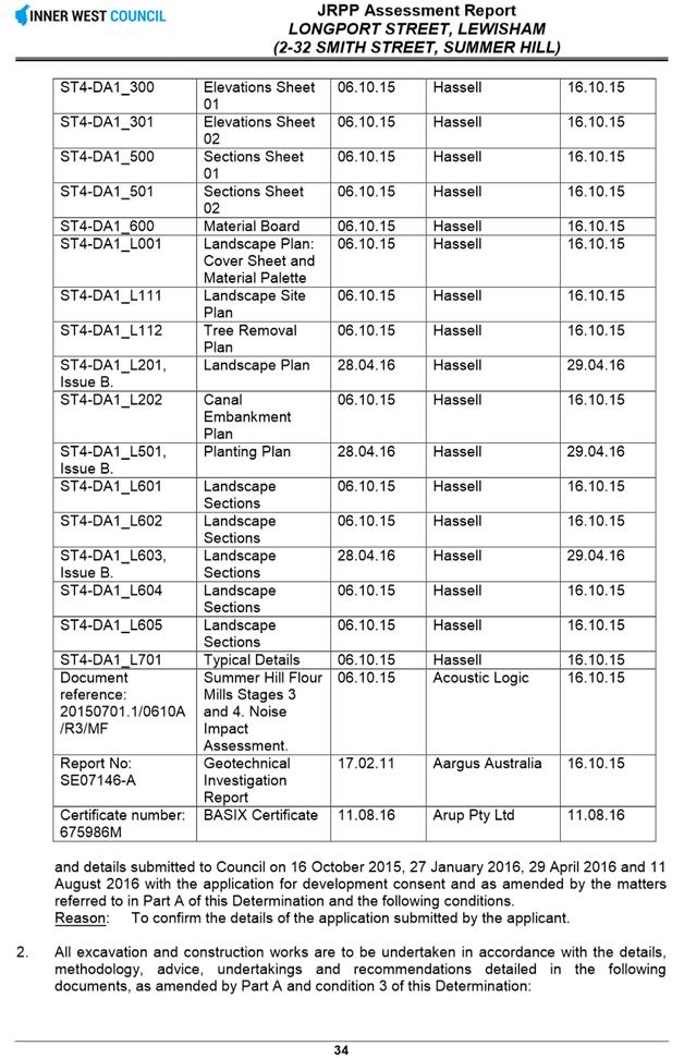
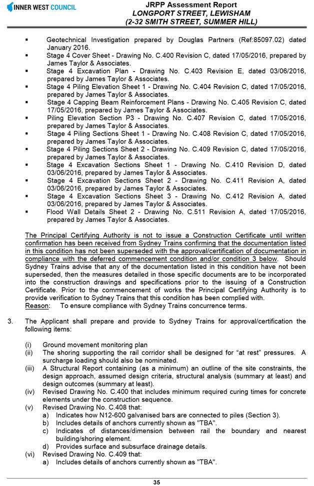
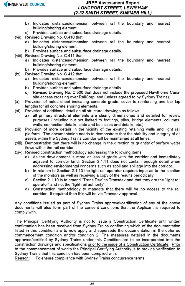
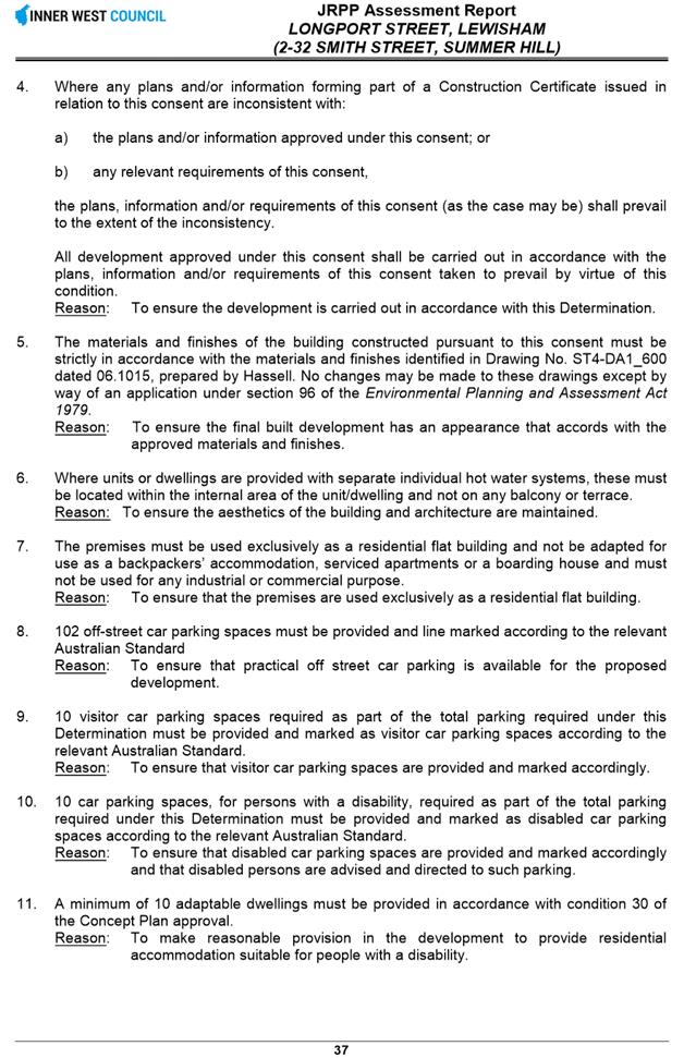
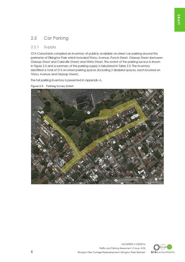
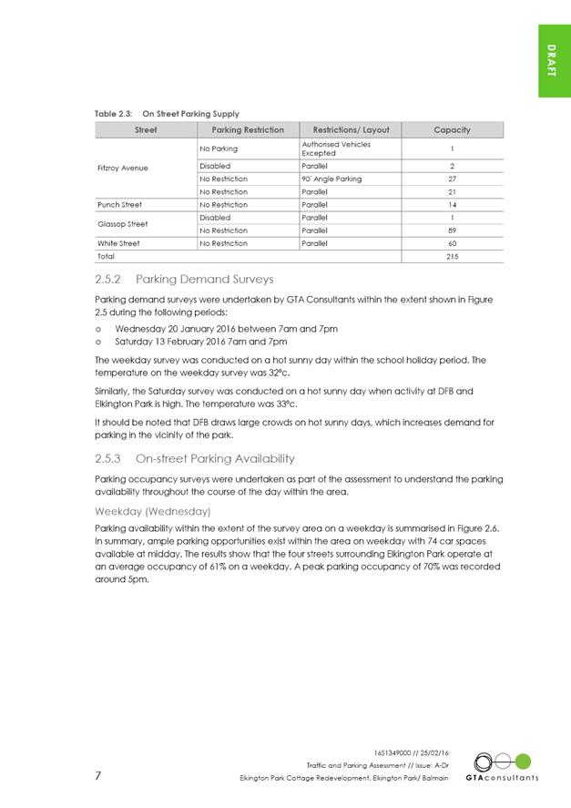
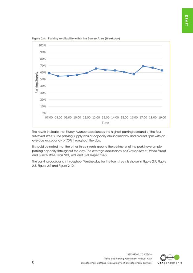
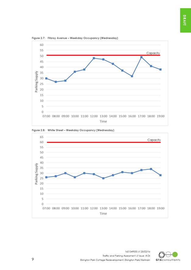
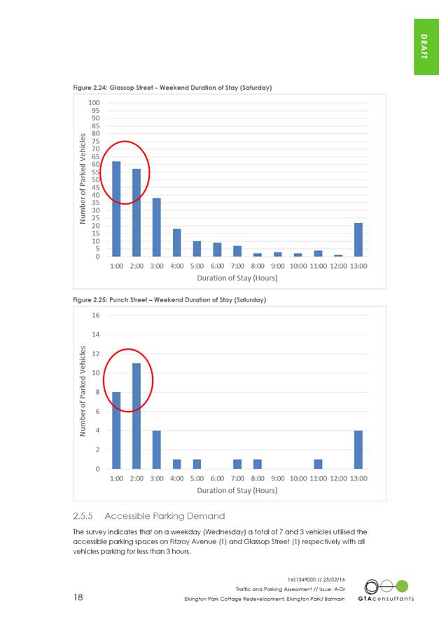
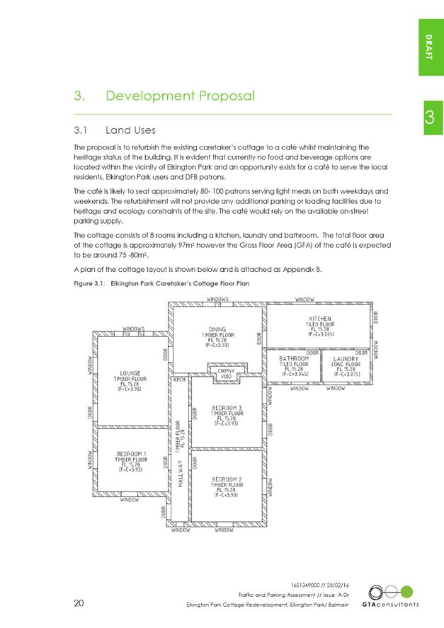
|
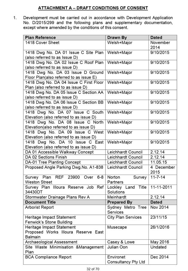
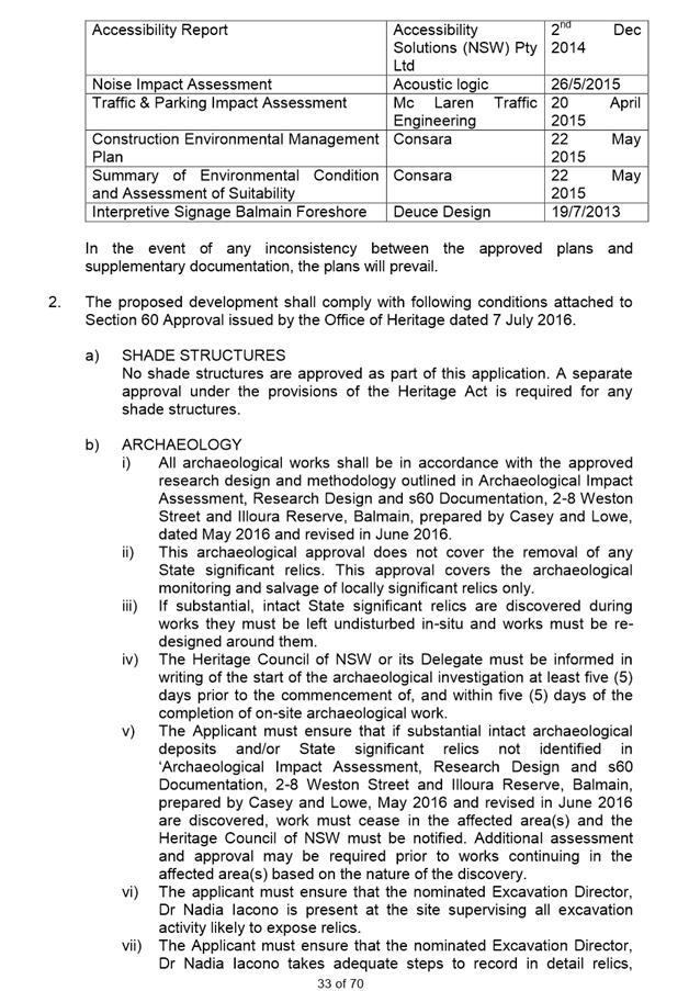
AGENDA R |

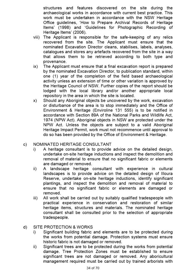
Council Meeting
TUESDAY 23 AUGUST 2016
6.30pm
Council is encouraging members of the public to pre-register their interest to speak at Council Meetings as the Meeting venues have a maximum number they can hold. Members of the public can pre-register up until 2pm of the day of the Meeting.
If you wish to register your interest please fill in a Register to Speak Form, available from the Inner West Council website, including:
· your name;
· contact details;
· item on the Agenda you wish to speak to; and
· whether you are for or against the recommendation in the agenda.
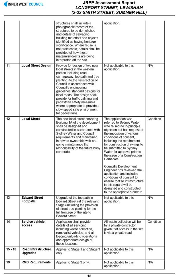
Members of the public who pre-register will be asked to show photo ID upon entry to verify the pre-registration application.
What happens after I submit the form?
Your request will then be added to a list that is shown to the Chairperson on the night of the meeting.
Are there any rules for speaking at a Council or Committee Meeting?
The following rules apply when addressing a Council or Committee meeting:
· keep your address to the point, the time allowed for each speaker is limited to three minutes with one extension of not more than three minutes with the approval of the Council/Committee. This time limit applies, no matter how many items are addressed by the speaker;
· when addressing the Meeting you must speak to the Chairperson;
· the Chairperson may curtail public participation where the information being presented is considered repetitive or irrelevant.
Where Items are deferred, Council reserves the right to defer speakers until
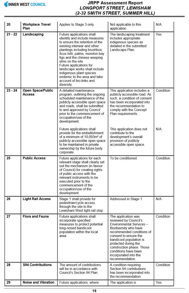
that Item is heard on the next occasion.
Accessibility
Inner West Council is committed to ensuring people with a disability have equal opportunity to take part in Council and Committee Meetings. If you have any access or disability related participation needs and wish to know more ring 9335 2222.
Persons in the public gallery are advised that under the Local Government Act 1993, a person may NOT tape record a Council meeting without the permission of Council.
Any persons found recording without authority will be expelled from the meeting.
“Record” includes the use of any form of audio, video and still camera equipment or mobile phone capable of recording speech.
An audio recording of this meeting will be taken for the purpose of verifying the accuracy of the minutes.
|
|
Council Meeting 23 August 2016 |
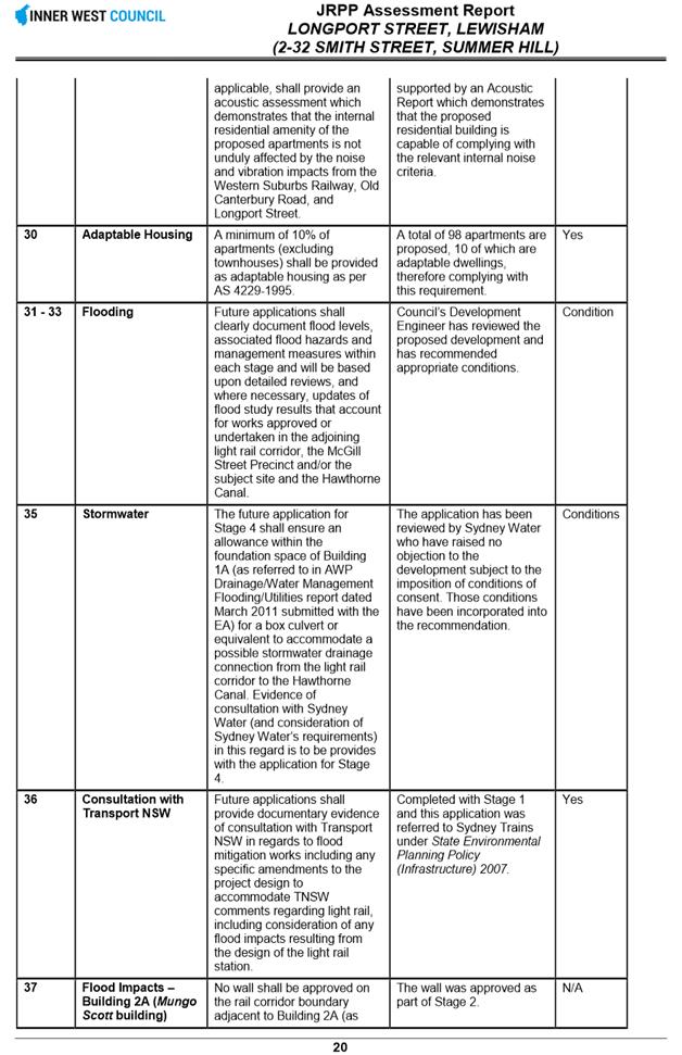
|
INDEX |
1 Acknowledgement of Country
2 Disclosures
of Interest (Section 451 of the Local Government Act
and Council’s Code of Conduct)
3 Confirmation of Minutes Page
Minutes of 26 July 2016 Council Meeting 4
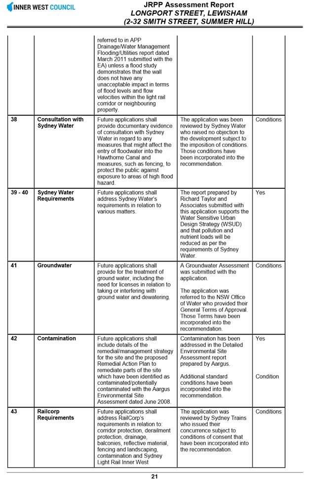
4 Administrator’s Minutes
Nil at time of printing.
5 Staff Reports
C0816 Item 1 Minutes of Local Representation Advisory Committee and Implementation Advisory Group Meetings held in August 2016 9
C0816 Item 2 Local Traffic Committee Meeting held on 4 August 2016 26
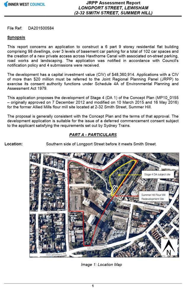
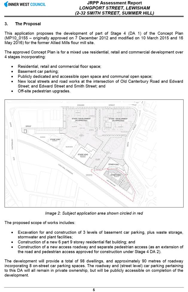
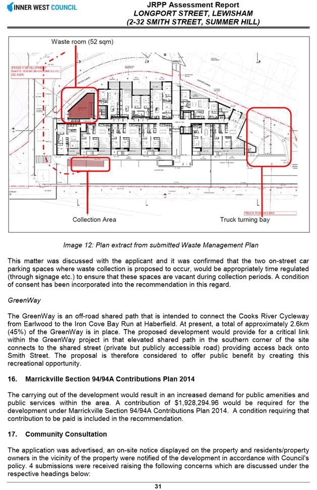
C0816 Item 3 Development Application - 2-32 Smith Street Summer Hill 46
C0816 Item 4 Development Application - 317-331 Liverpool Road, Ashfield 152
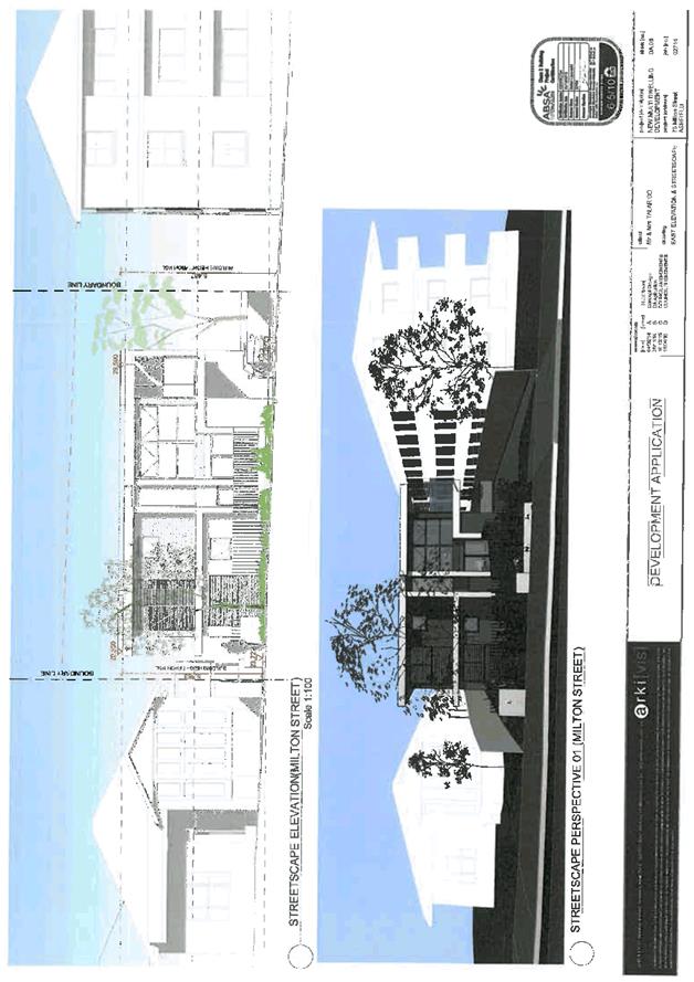
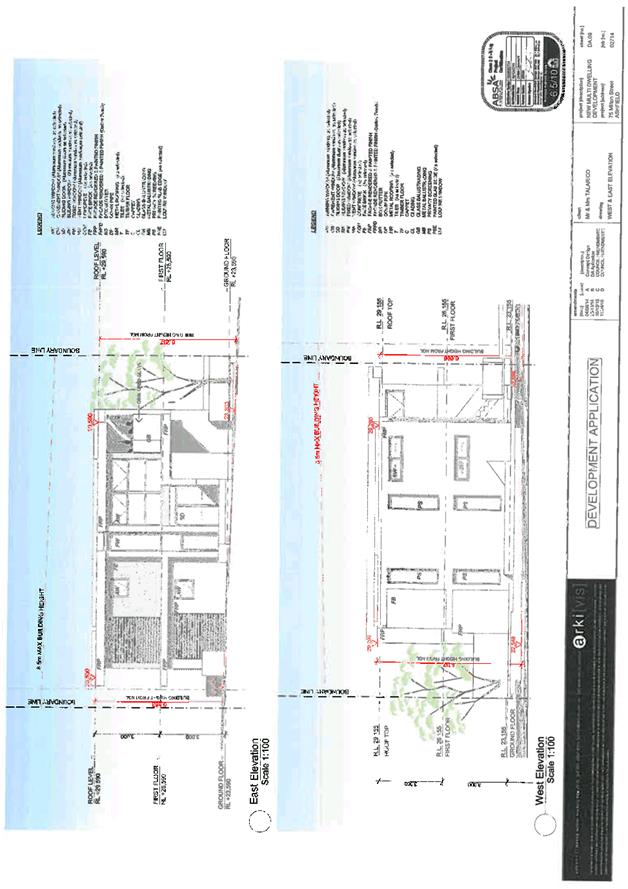
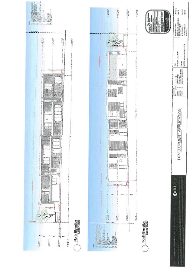
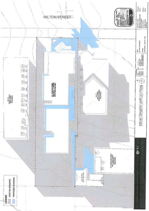
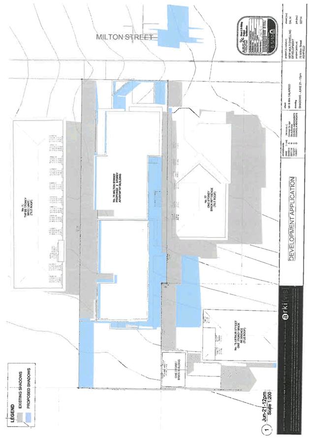
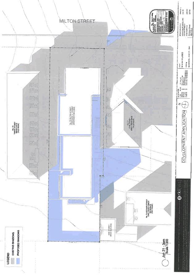
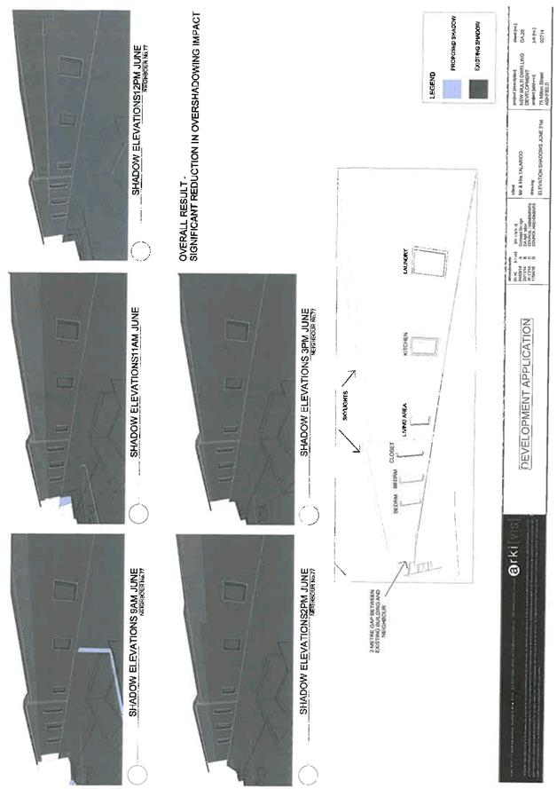
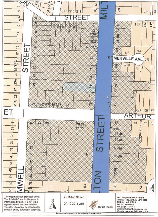
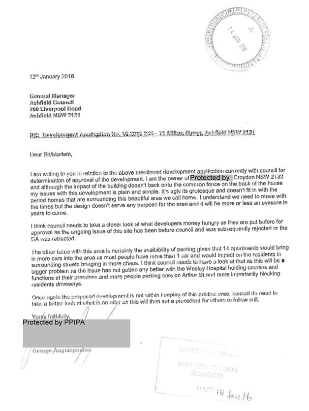
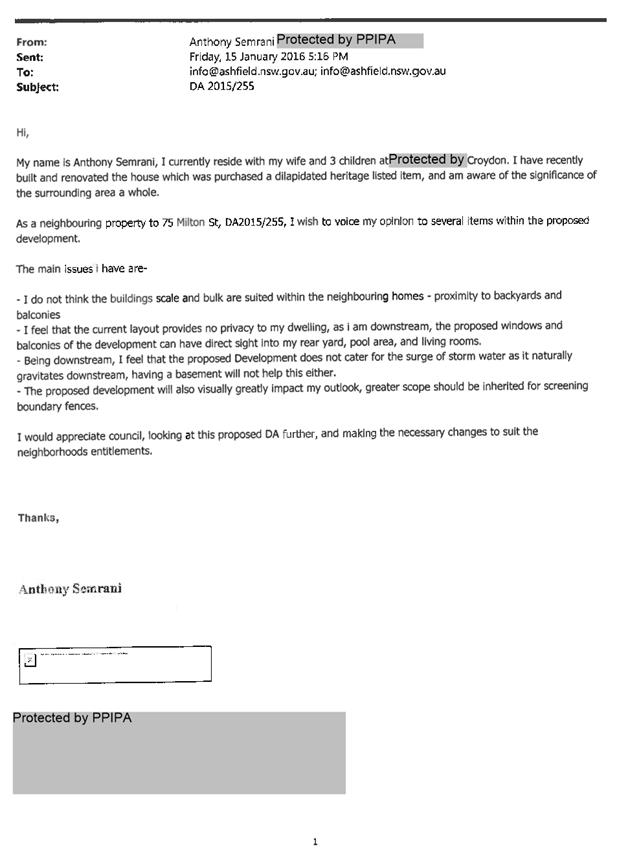
C0816 Item 5 Development Application - 75 Milton Street, Ashfield 263
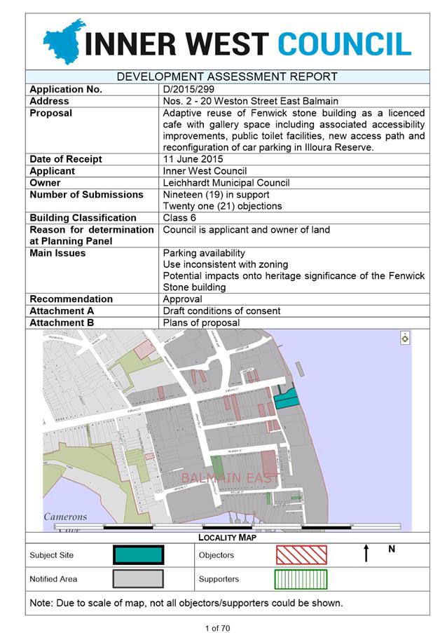
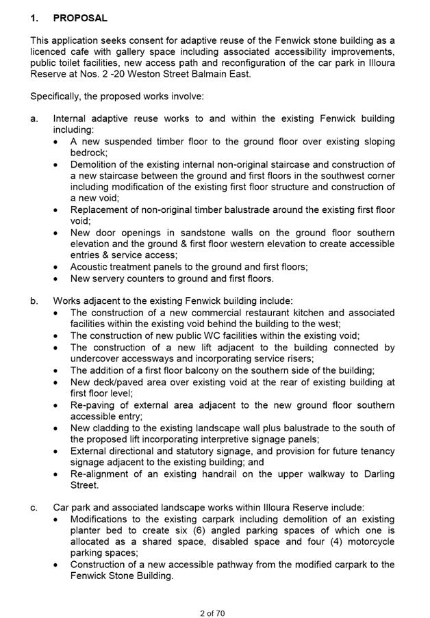
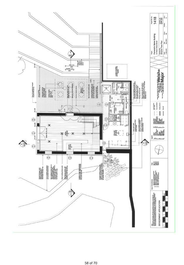
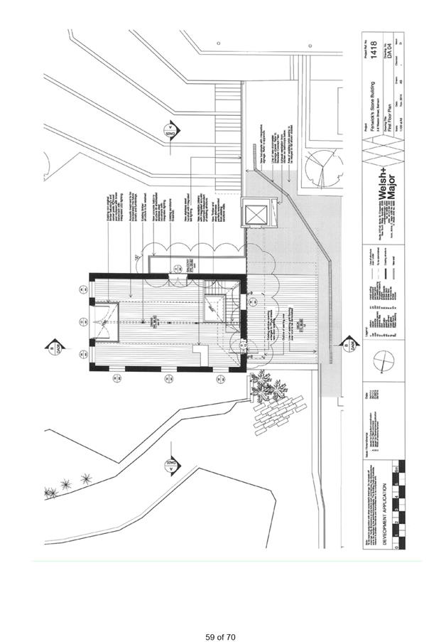
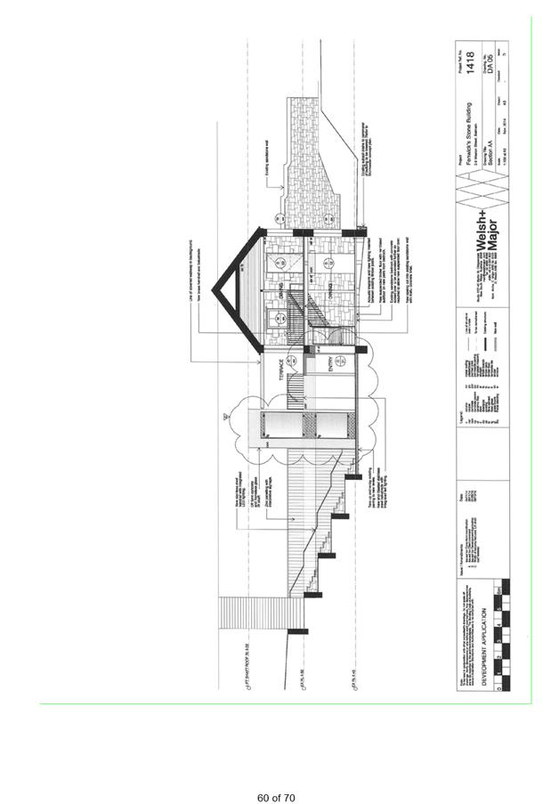
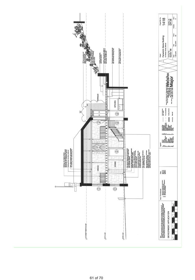
C0816 Item 6 Development Application - 2-20 Weston Street, Balmain East 320
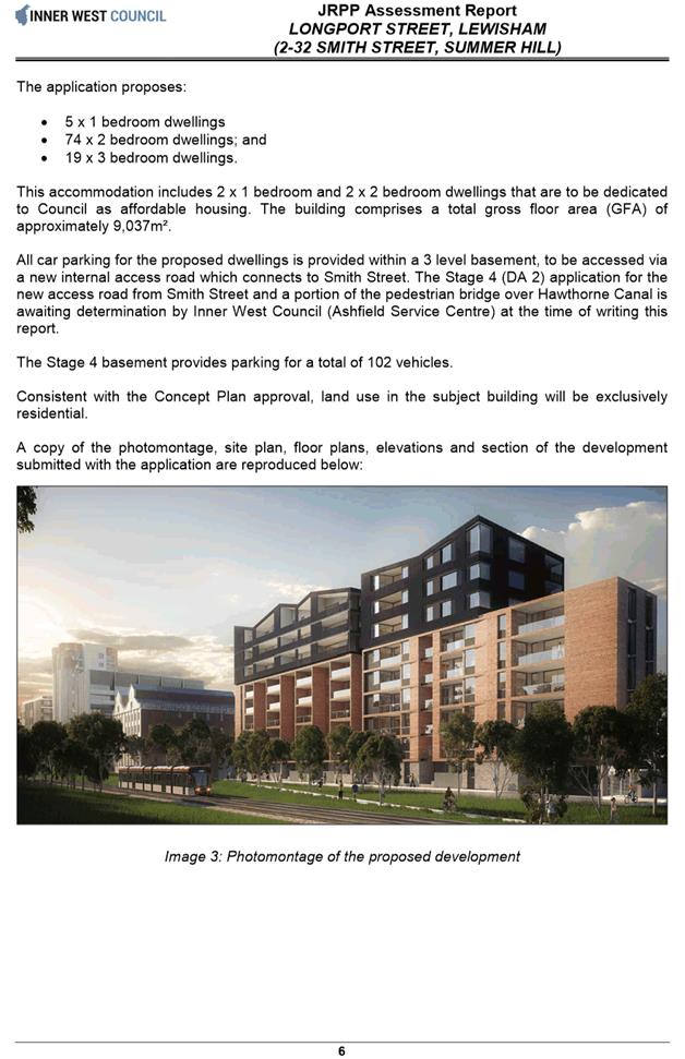
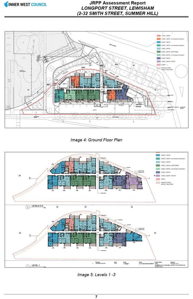
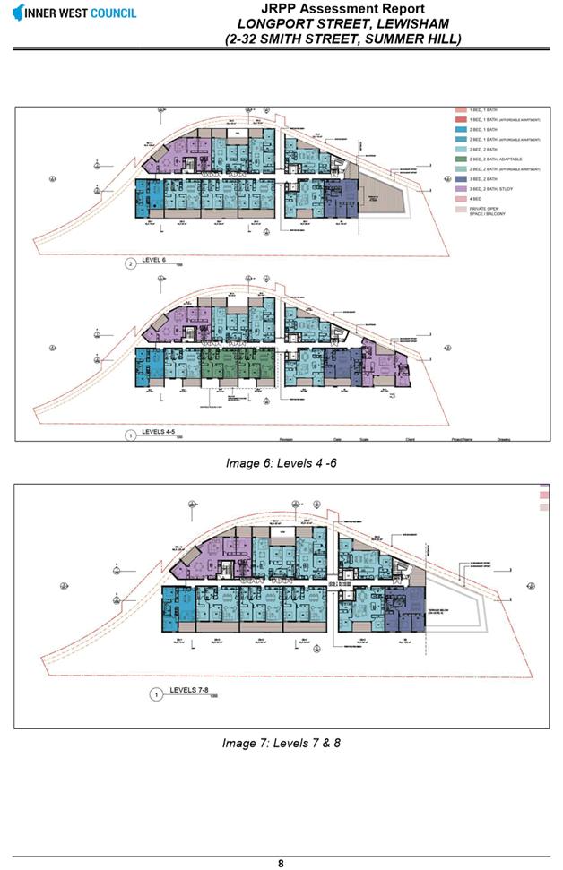
C0816 Item 7 Development Application - Longport Street, Lewisham (2 - 32 Smith Street, Summer Hill) 392
C0816 Item 8 Development Application - 23 Croydon Street, Petersham 456
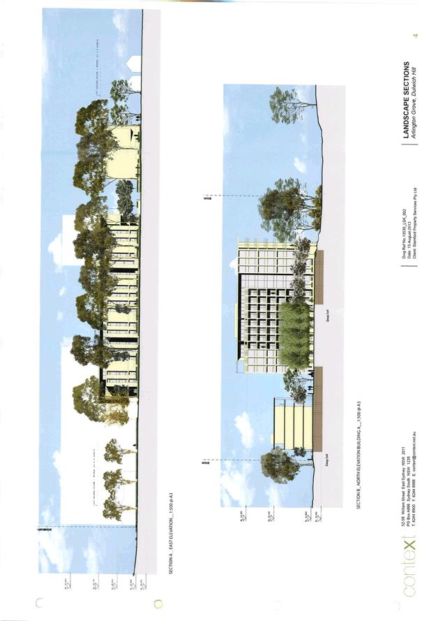
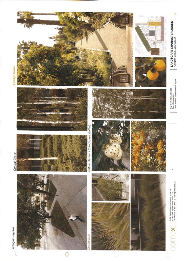
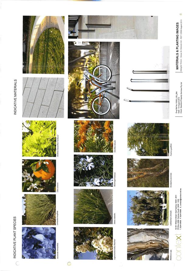
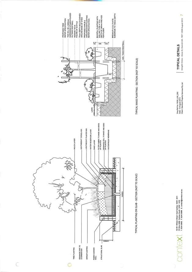
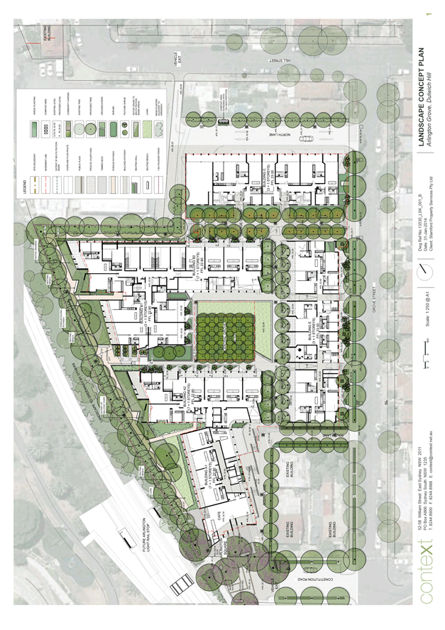
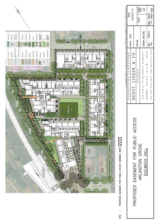
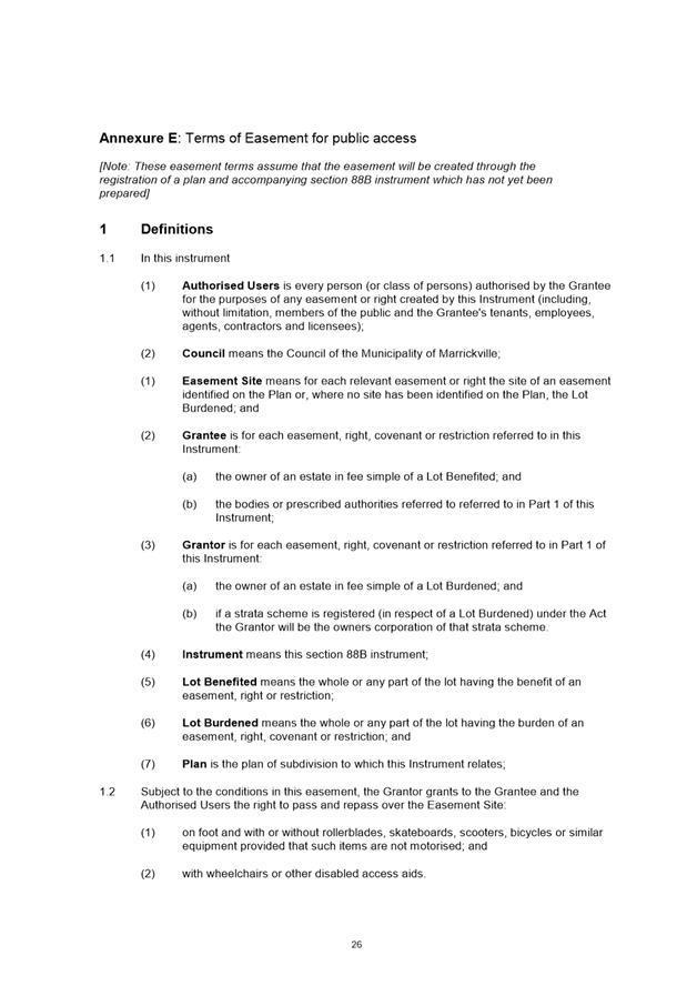
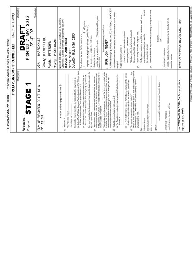
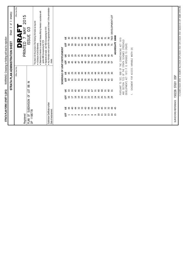
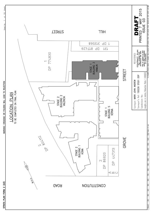
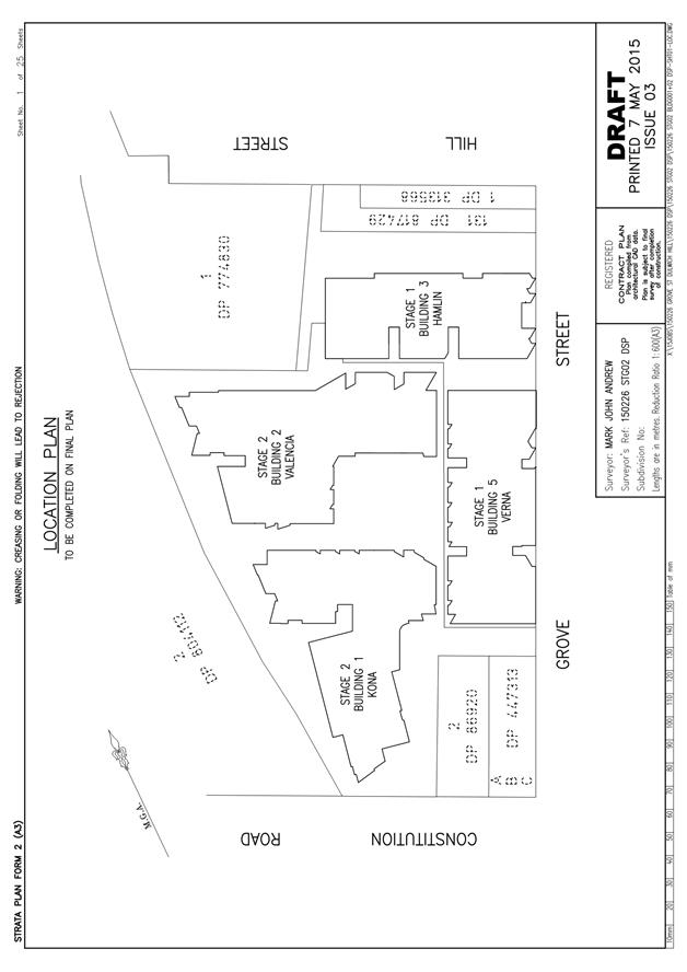
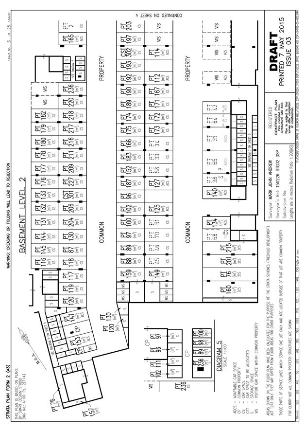
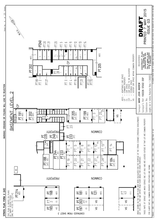
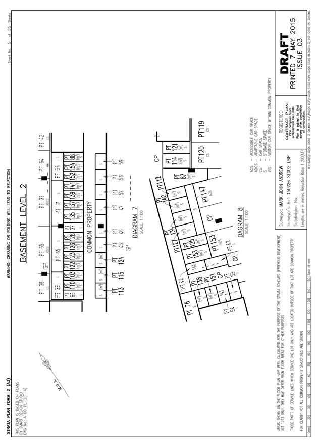
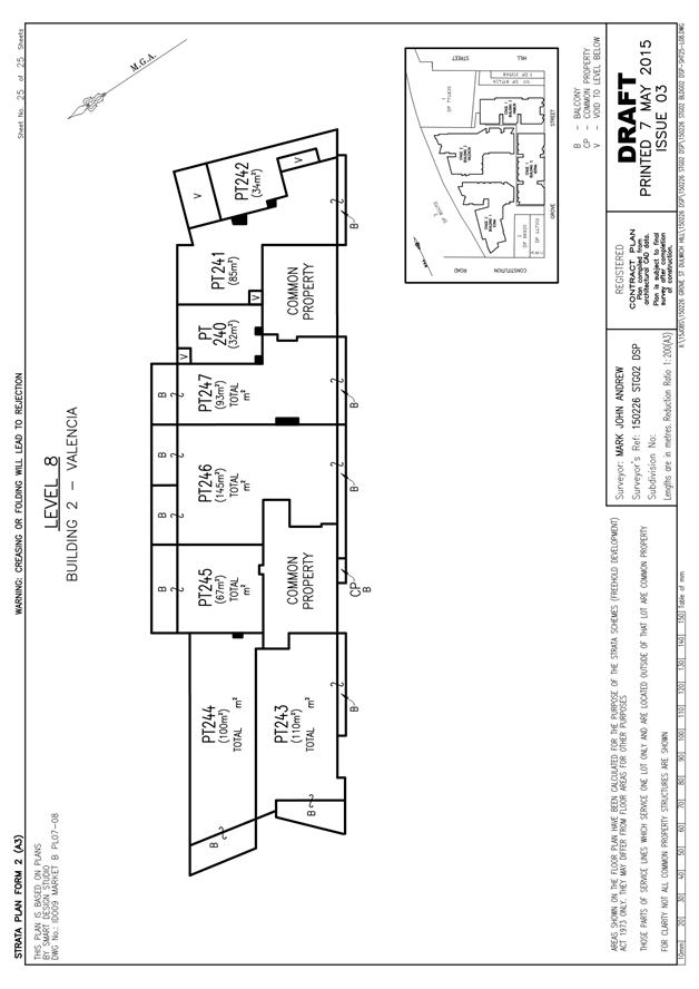
C0816 Item 9 Amendment to Approved Voluntary Planning Agreement - Grove Street, Dulwich Hill 509
C0816 Item 10 Seasonal Allocation of Sports Grounds in the former Marrickville Area for the 2016/17 Summer Season 653
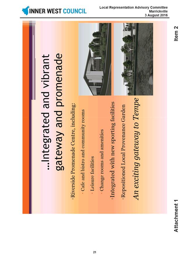
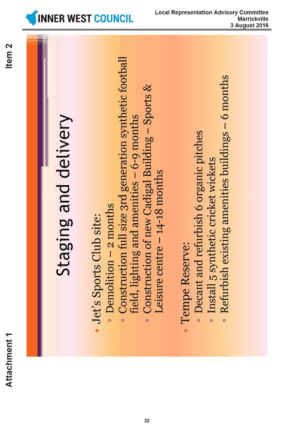
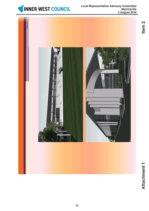
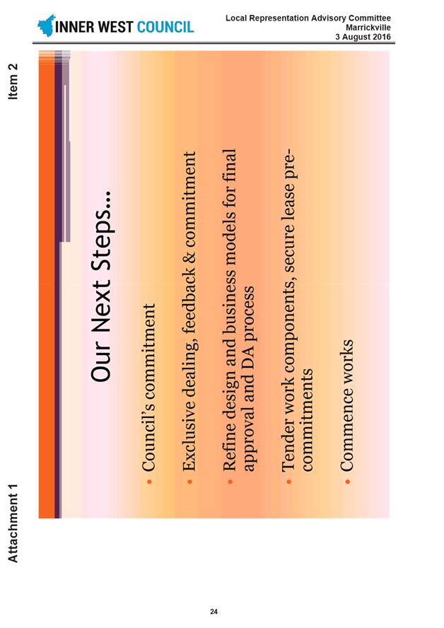
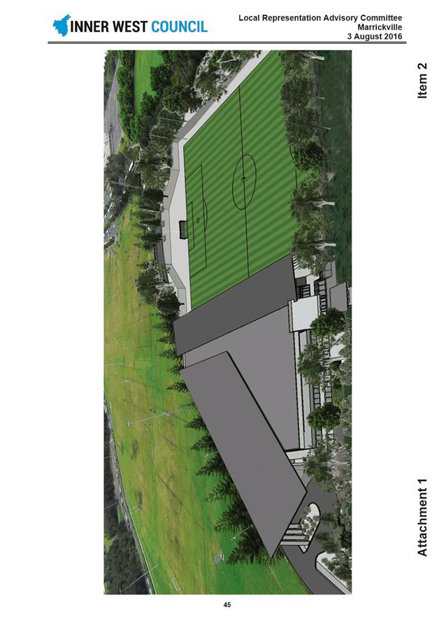
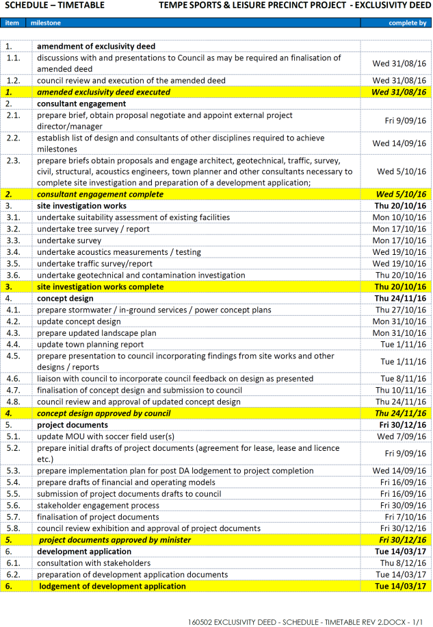
C0816 Item 11 Tempe Reserve Sydney Olympic Park Redevelopment 658
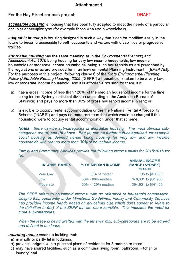
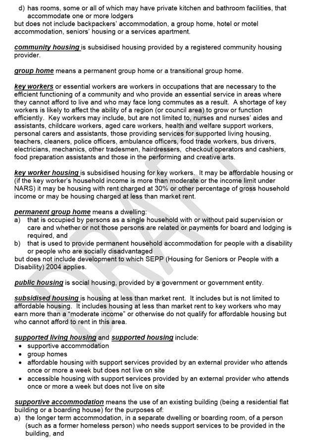
C0816 Item 12 Affordable Housing over Hay Street Car Park, Leichhardt 695
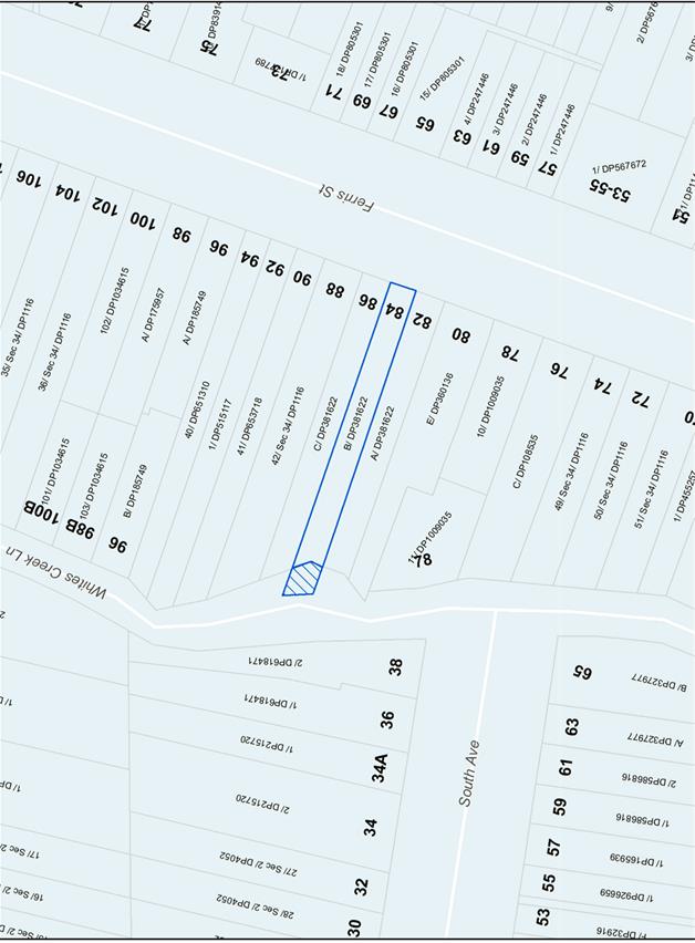
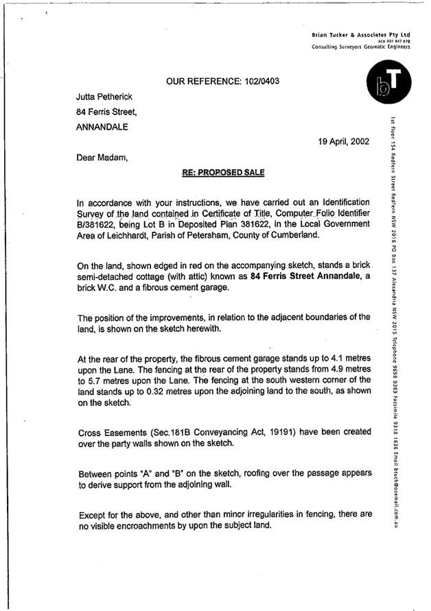
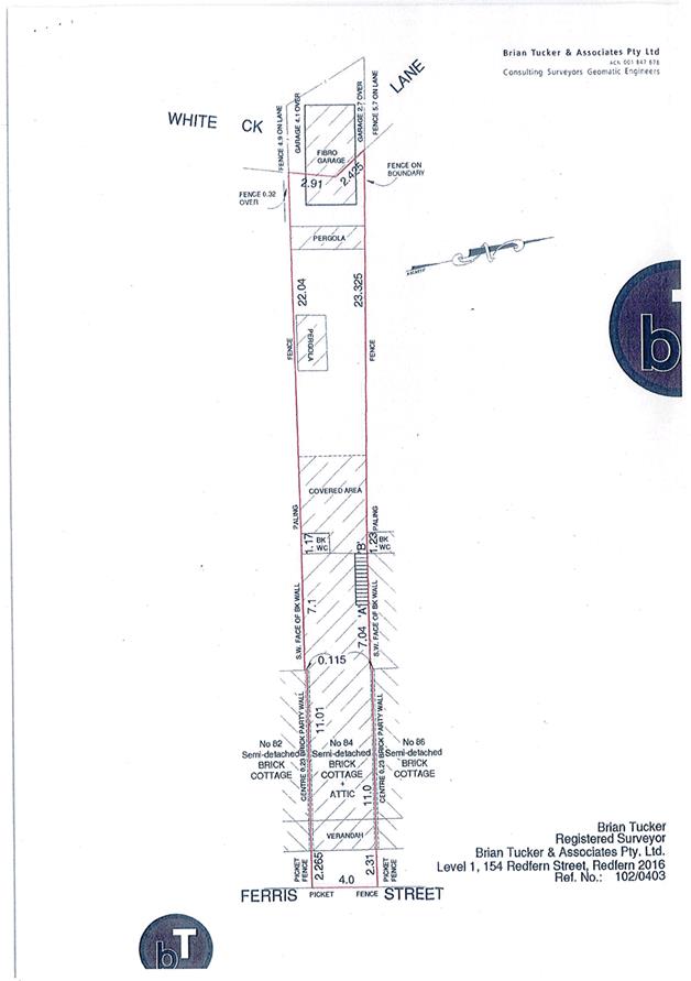
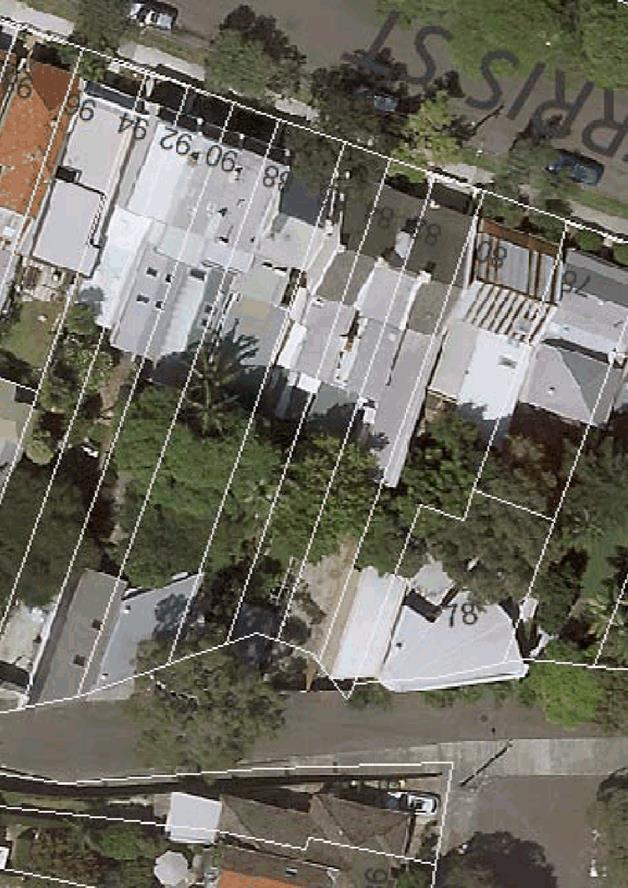
C0816 Item 13 Application for Road Closure and Sale - Part White Creek Lane behind 84 Ferris Street Annandale 703
C0816 Item 14 Proposed Easement - Elkington Park, Balmain - Cockatoo Island Service Upgrade 711
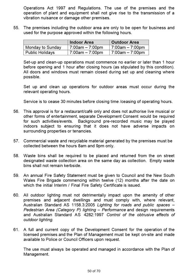
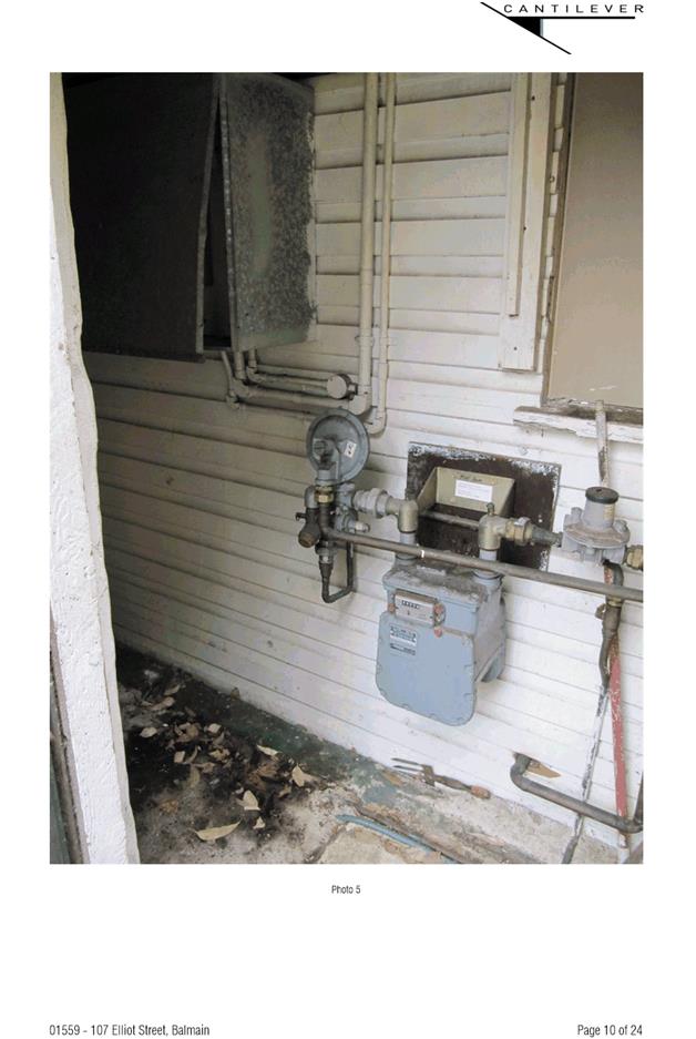
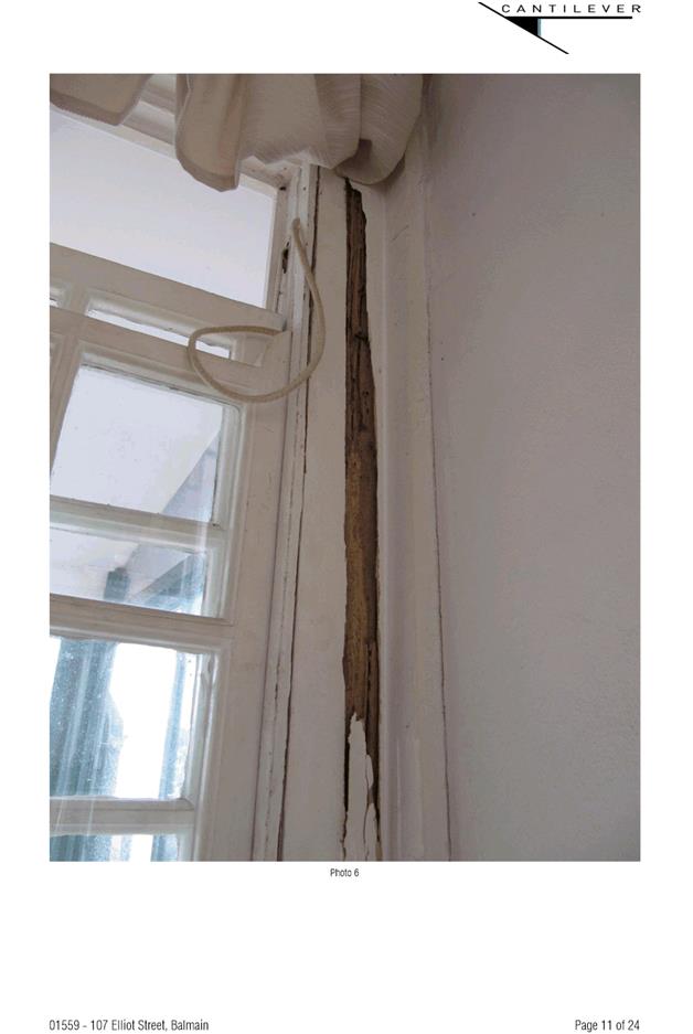
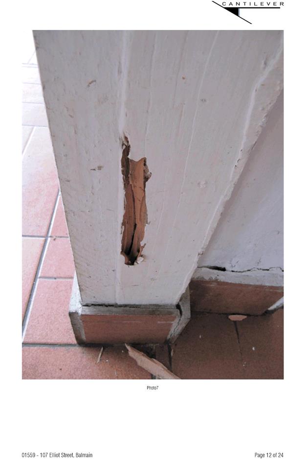
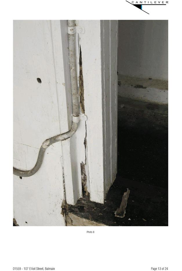
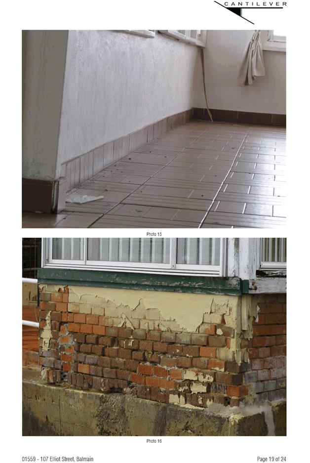
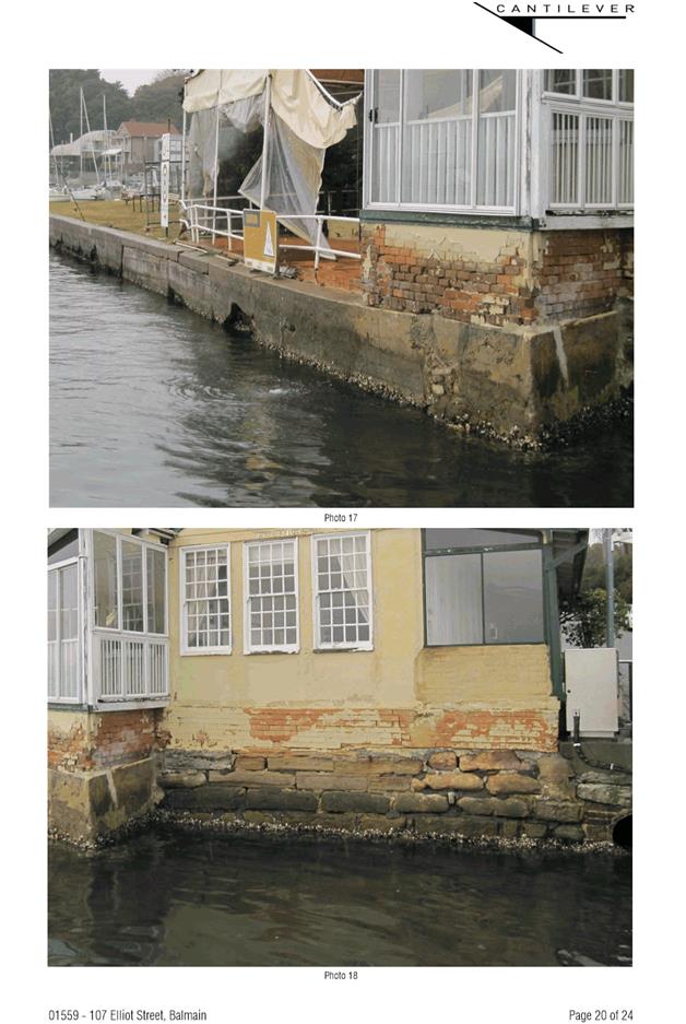
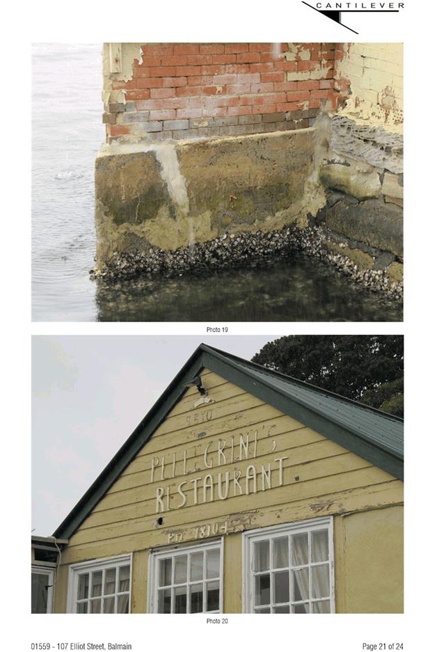
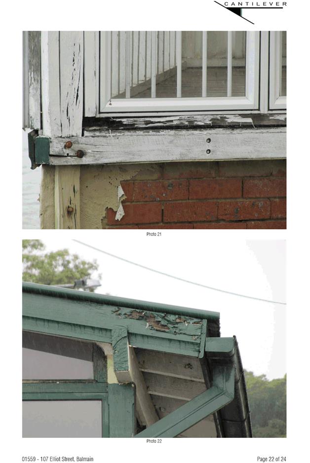
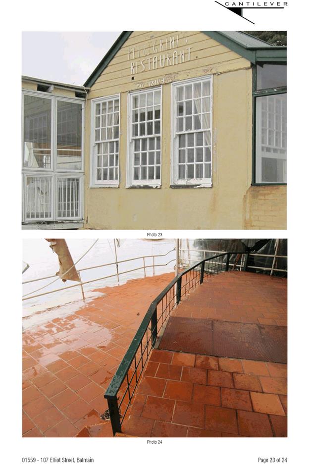
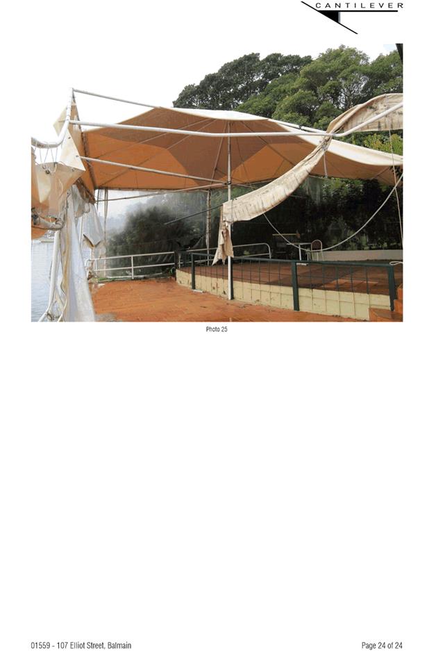
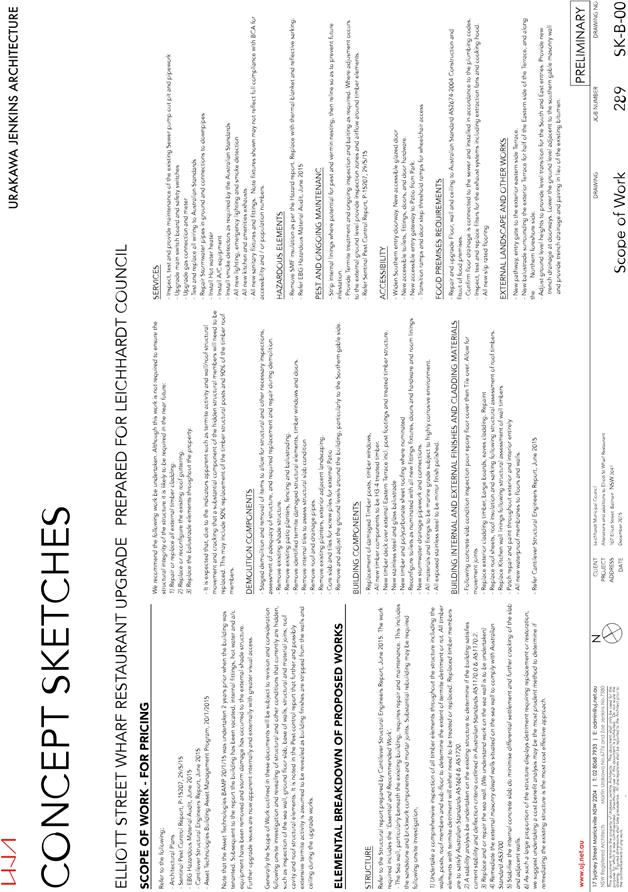
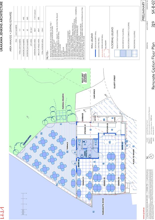
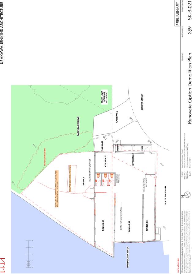
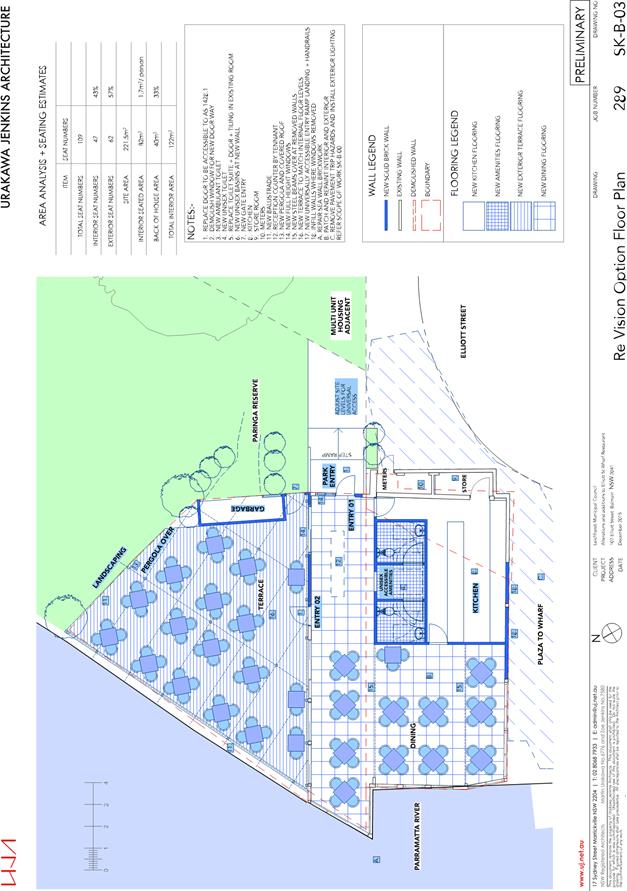
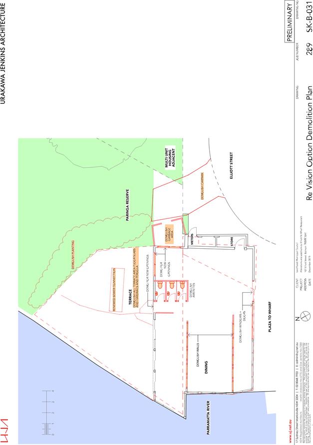
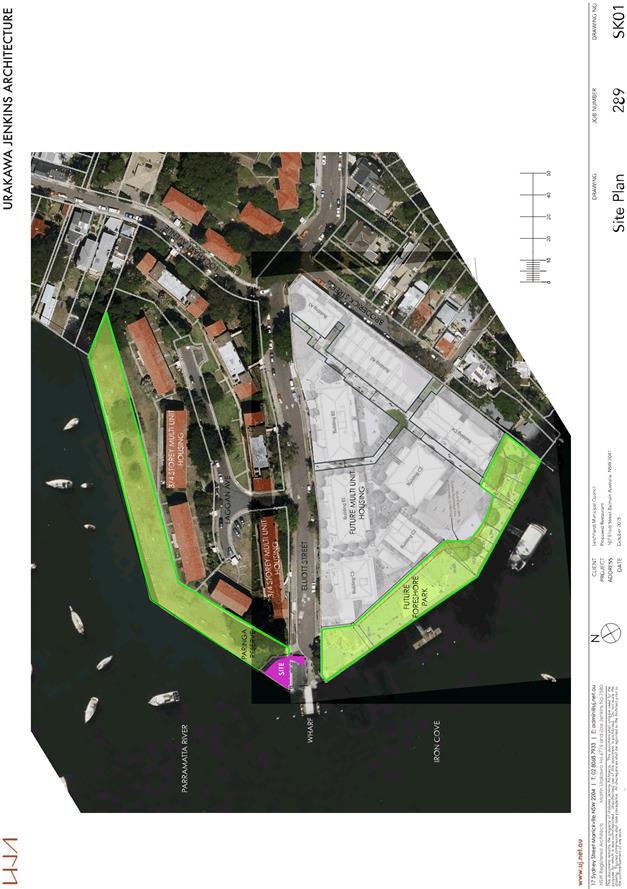
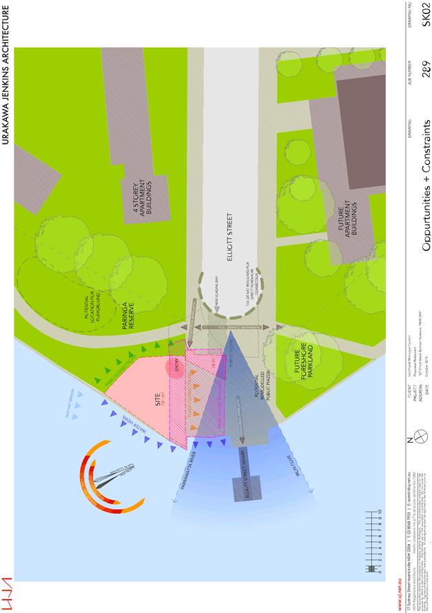
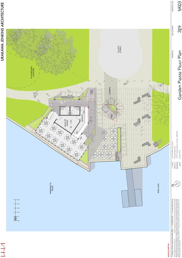
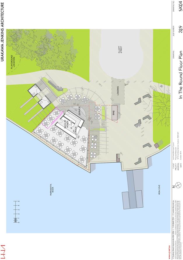
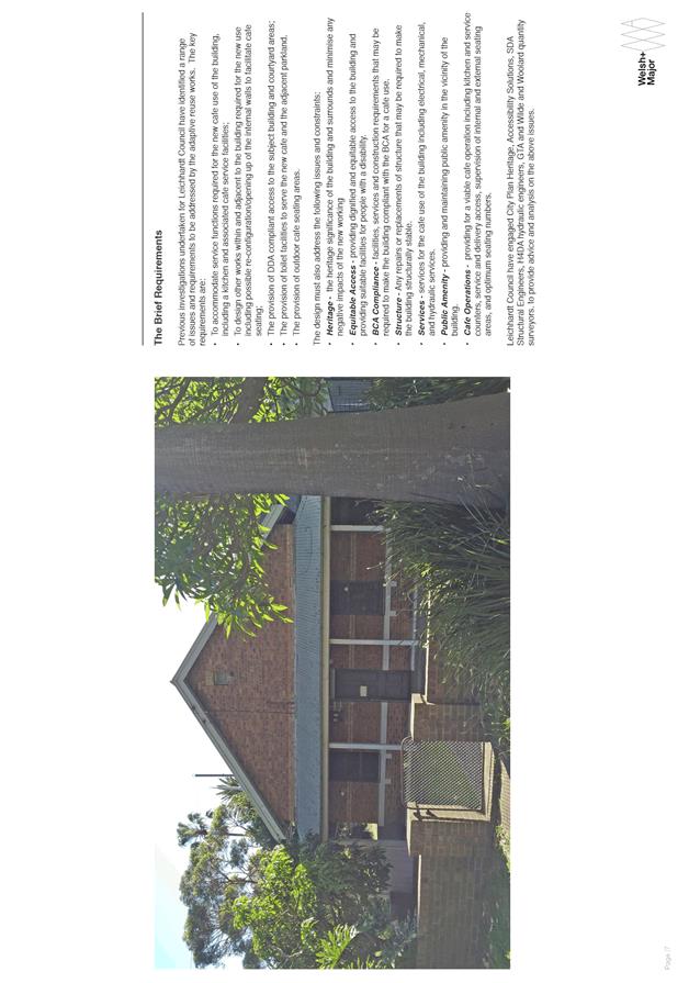
C0816 Item 15 Restaurant/Café at 107 Elliott Street, Balmain 714
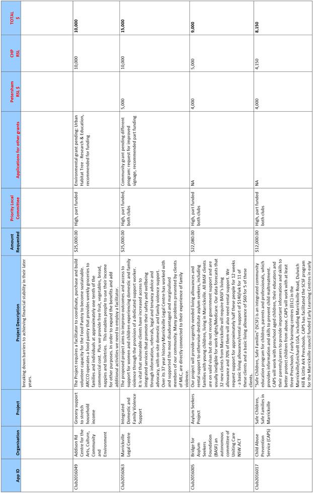
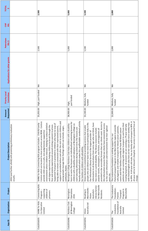
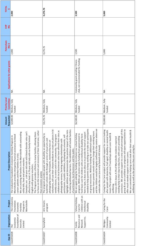
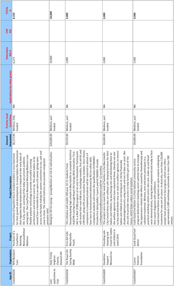
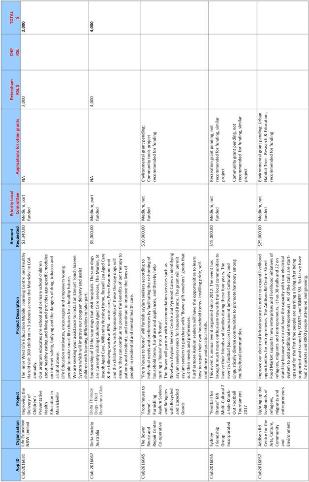
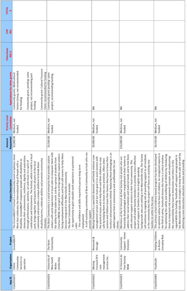
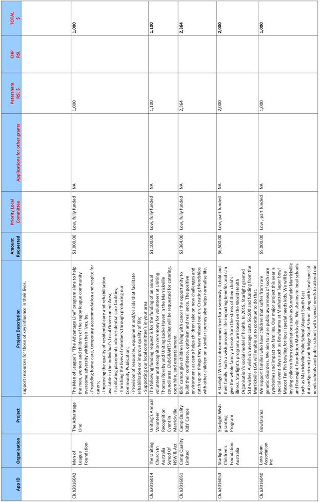
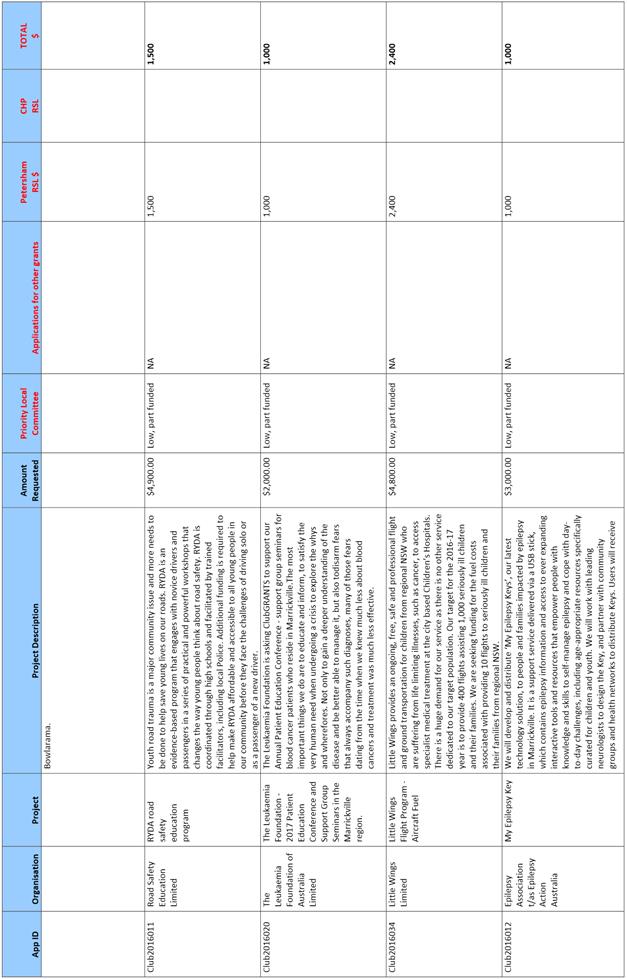
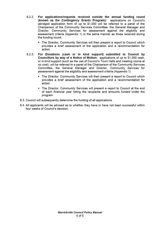
C0816 Item 16 Club Grants Allocations and Community Grants Program 2016 762
C0816 Item 17 Endorsement of Floodplain Risk Management Committee Charter 791
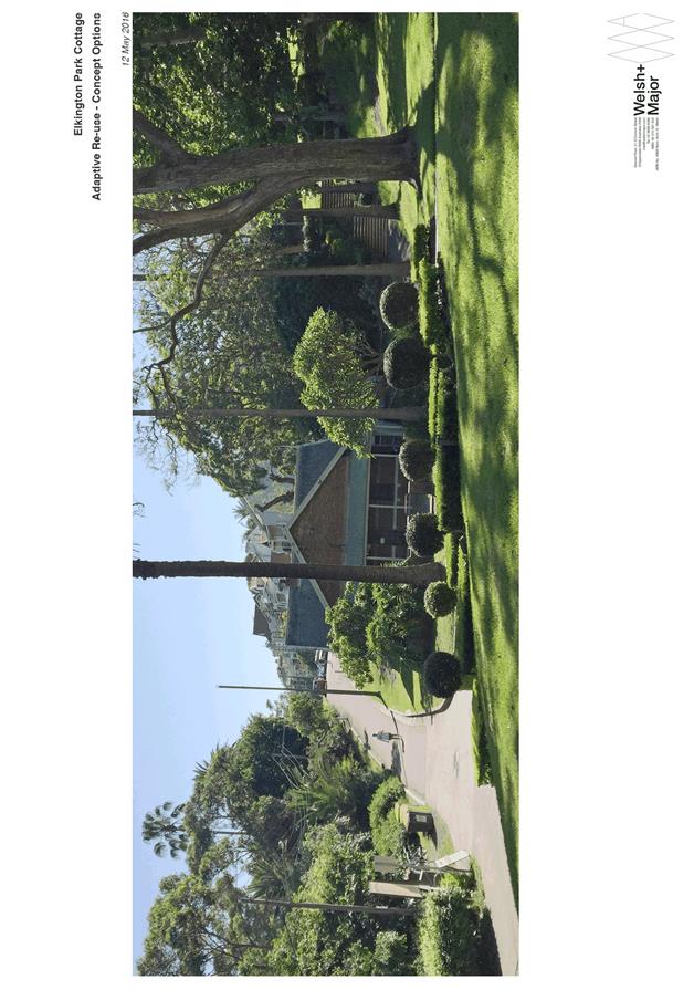
C0816 Item 18 Elkington Park Cottage, Balmain - Possible Conversion to Cafe 802
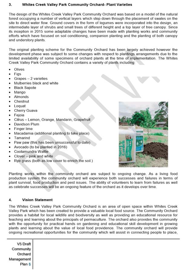
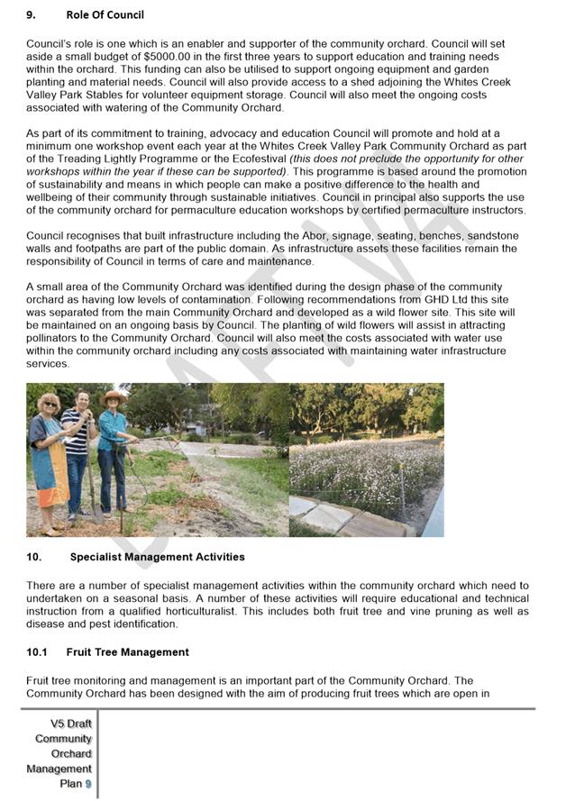
C0816 Item 19 Whites Creek Community Orchard Management Plan 886
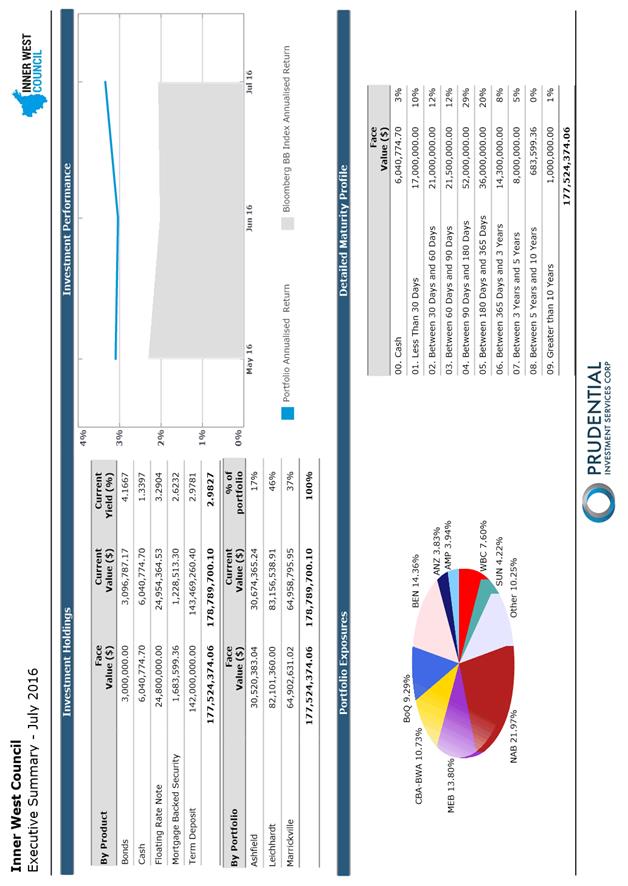
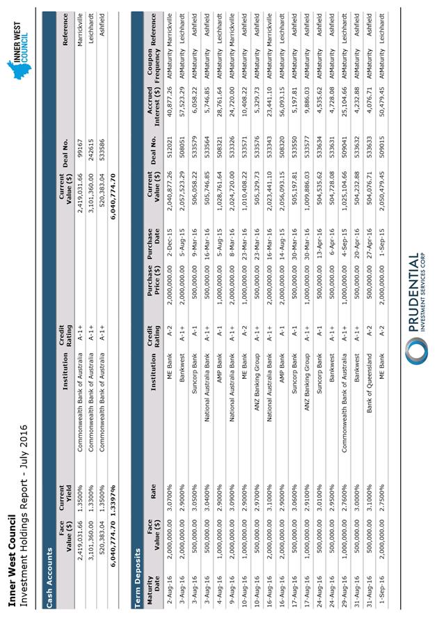
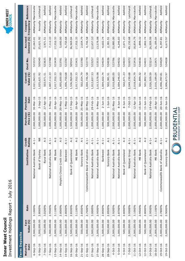
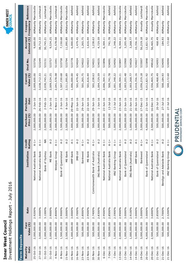
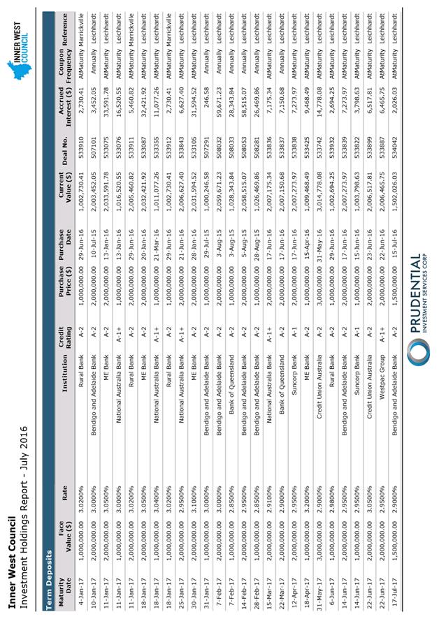
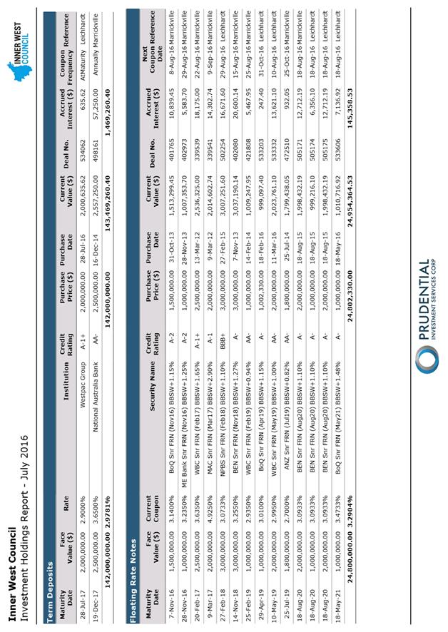
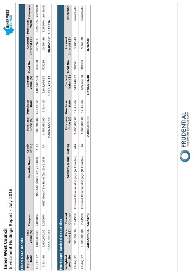
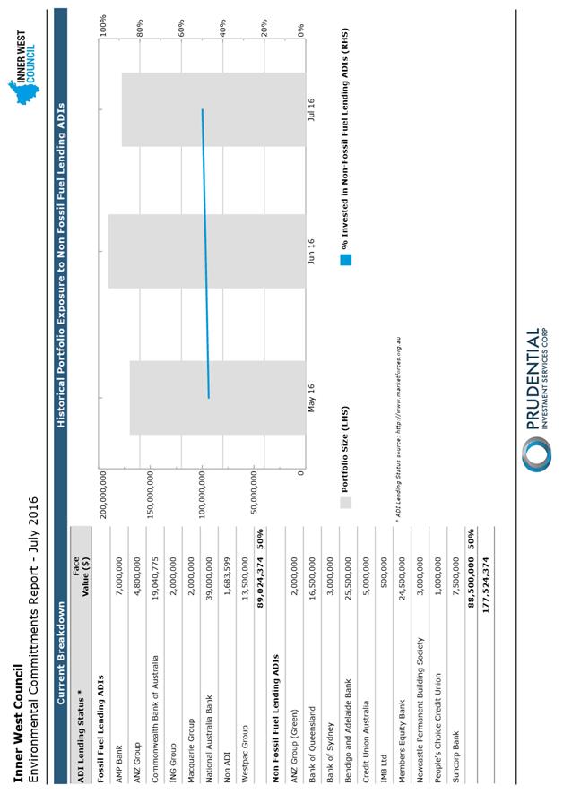
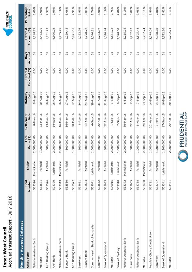
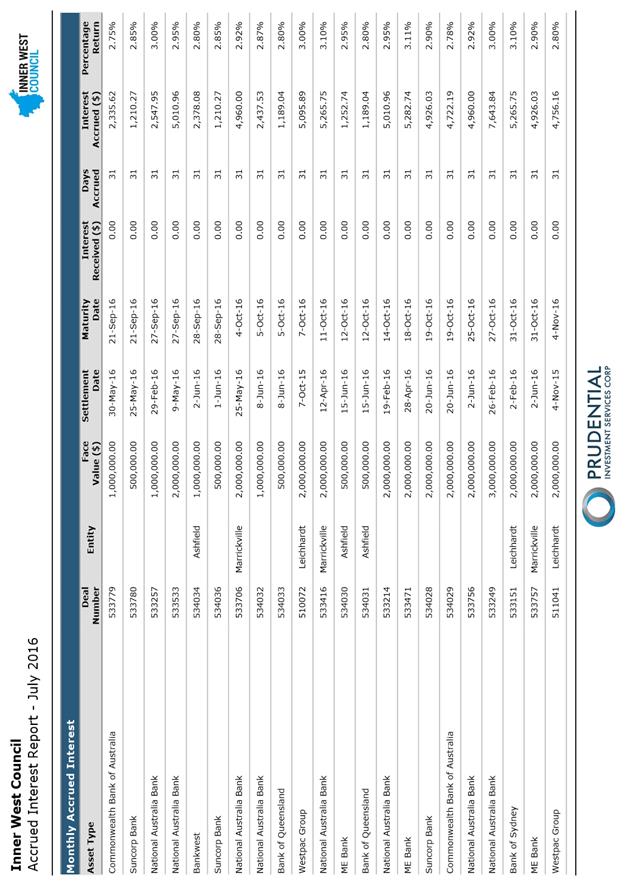
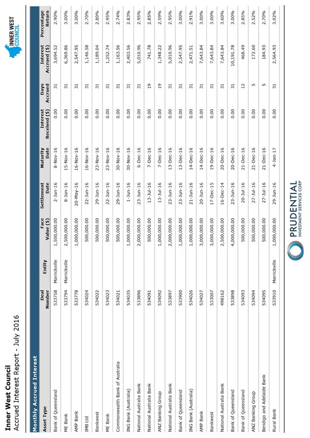
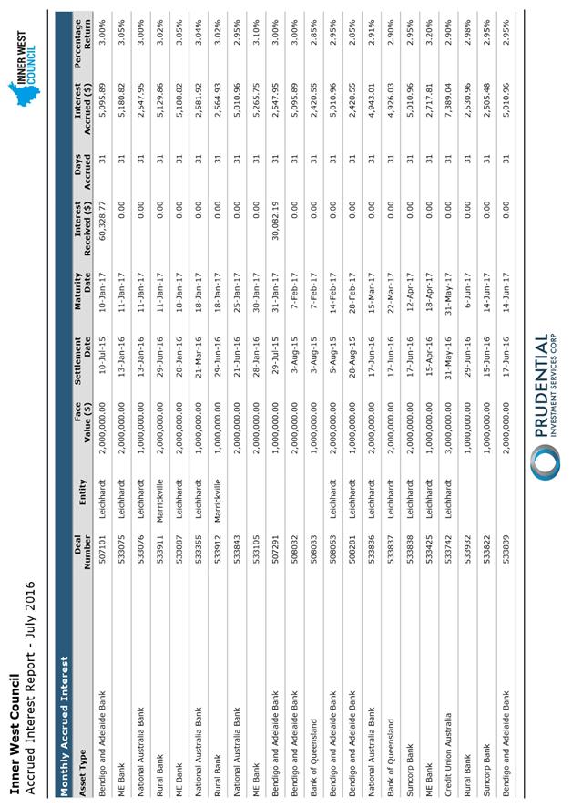
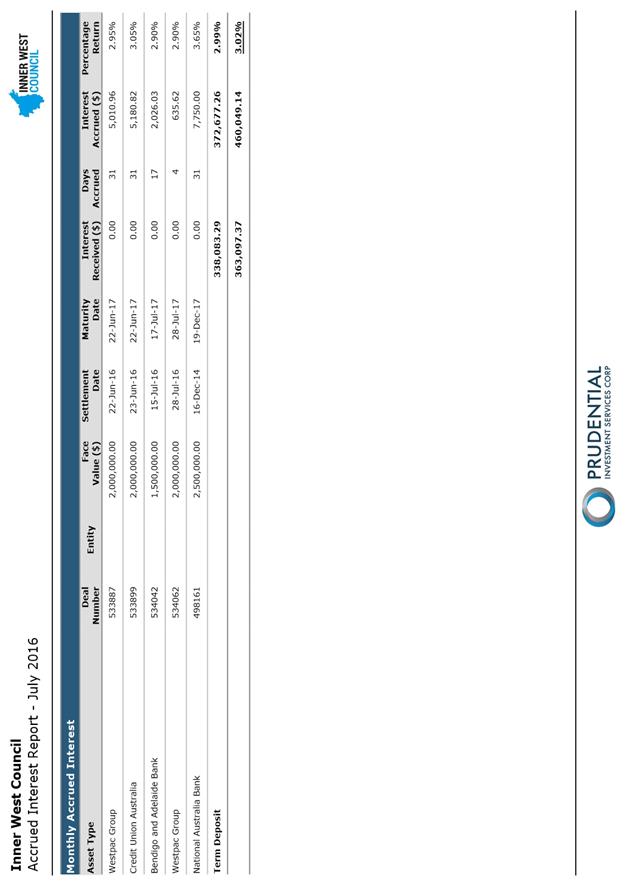
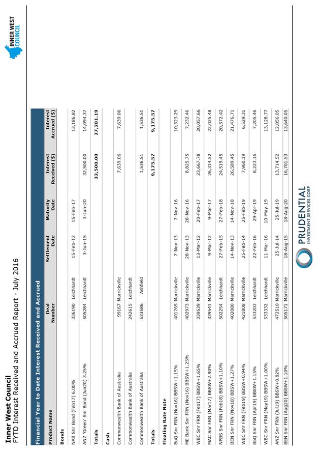
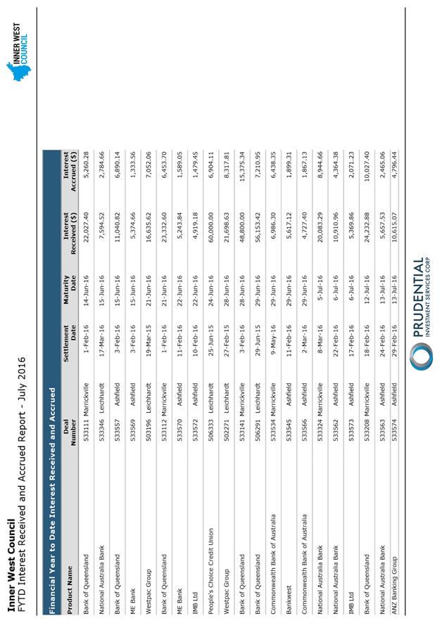
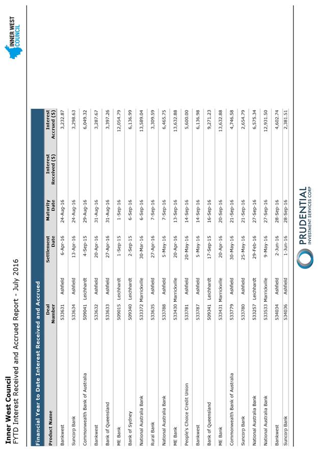
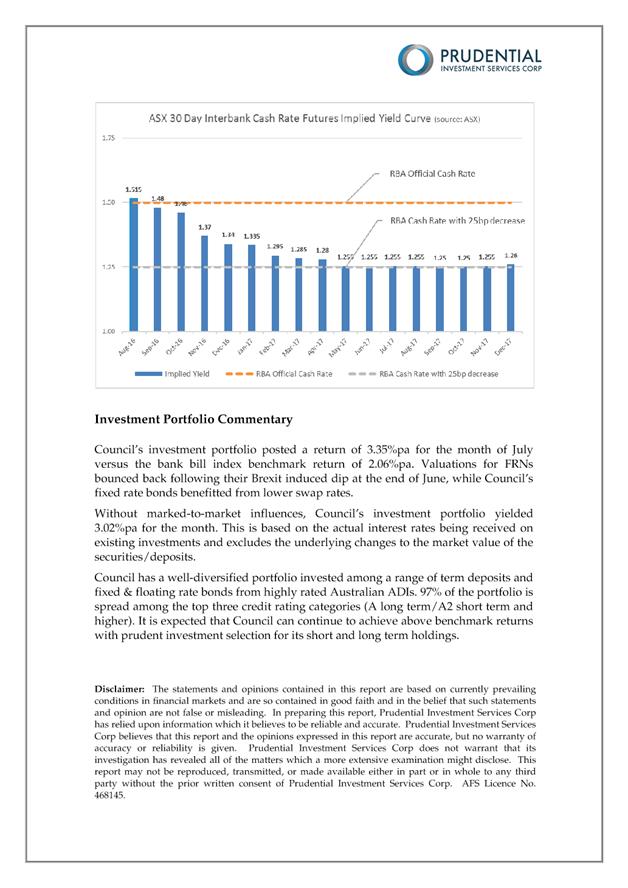
C0816 Item 20 Inner West Council Investments as at 31 July 2016 900
6 Reports with Confidential Information
Reports appearing in this section of the Business Paper are confidential in their entirety or contain confidential information in attachments.
The confidential information has been circulated to Council separately.
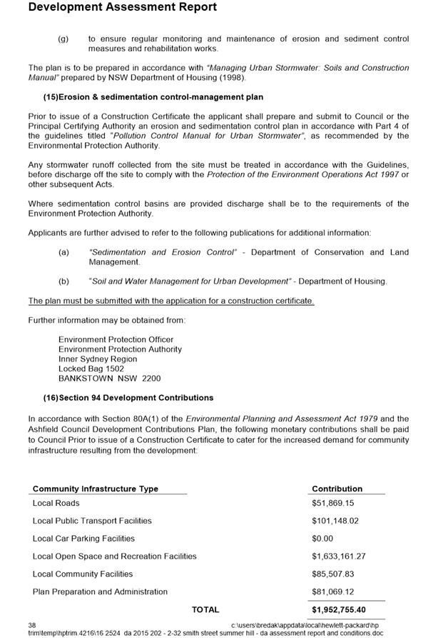
C0816 Item 21 Proposed Airspace Lease Smidmore Street Marrickville 940
C0816 Item 22 SSROC Tender for the Provision of Tree Pruning Services 942
C0816 Item 23 Sale of Land for Unpaid Rates 944
|
|
Council Meeting 23 August 2016 |
Minutes of Council Meeting
held at Ashfield Service Centre on Tuesday 26 July 2016
Meeting commenced at 6.30pm
Present:
|
Richard Pearson |
Administrator |
|
Vanessa Chan |
Interim General Manager |
|
Nellette Kettle |
Director Innovation and Strategy |
|
Simone Schwarz |
Director Service Delivery |
|
Phil Sarin |
Director Planning and Environment |
|
Cathy Edwards-Davis |
Director Public Works |
|
Peter Gainsford |
Director Major Projects and Engineering |
|
Popy Mourgelas |
Manager Corporate Governance, Ashfield |
|
Ian Naylor |
Manager Governance and Administration, Leichhardt |
|
Helen Tola |
Manager Customer Service and Corporate Planning, Leichhardt |
|
Tanya Whitmarsh |
Manager Governance and Risk, Marrickville |
|
Rad Miladinovic |
Coordinator Governance and Administration, Marrickville (Minute Taker) |
|
Katerina Maros |
Governance Officer, Leichhardt |
Public speakers: see last two pages of these minutes.
Apologies: Matt Phillips, Director Corporate Services
1. Acknowledgement Of Country By Chairperson
I acknowledge the Gadigal and Wangal people of the Eora nation on whose country we are meeting today, and their elders past and present.
2. Disclosures Of Interests: Nil
3. Confirmation Of Minutes:
|
The Administrator determined that the Minutes of the Council Meeting held on Tuesday, 17 May 2016, Extraordinary Council Meeting held on Tuesday, 24 May 2016, Extraordinary Council Meeting held on Thursday, 30 June 2016 and Extraordinary Council Meeting held on Tuesday, 5 July 2016 be confirmed. |
4. Minutes of Committee Meetings:
|
C0716 Item 1 Minutes of Implementation Advisory Group Held on 14 July 2016 |
|
The Administrator determined that the Minutes of the Implementation Advisory Group held on 14 July 2016 be received and the recommendations adopted.
|
|
C0716 Item 2 Minutes of Joint Local Representation Advisory Committee Meeting Held on 12 July 2016 |
|
The Administrator determined that the Minutes of the Joint Local Representation Advisory Committee (JLRAC) meeting held on the 12 July 2016 be received and the recommendations adopted.
|
5. Staff Reports:
|
C0716 Item 3 WestConnex - Status Update - July 2016 and Determination of Applications/Notices for Project Works |
|
The Administrator determined that:
Council: 1. not grant approval for geotechnical investigations to occur at the Cove Street Depot, Cove Street, Haberfield; 2. staff review and provide technical comments in response to the Technical Report –Flood Mitigation Strategy: Project Wide – Permanent Works Final Design (FD) (M4E-AEH-TR-00-120-100001_D_00); 3. staff review and provide technical comments in response to the Technical Report – Flood Mitigation Strategy: WS – Temporary Works Final Design (FD) (M4E-AEH-TR-40-120-100001_D_00); 4. officers continue to liaise with Sydney Motorway Corporation in an effort to protect the interests of the Inner West Community and continue to demonstrate the resolute position of the Inner West Council on the WestConnex Motorway project; 5. reiterate to the Joint Venture that Vehicles exiting the Northcote Street site (C7) must not utilise Wattle Street and Dobroyd Parade. They must exit the site directly onto Parramatta Road, in a westerly direction; 6. staff review and provide technical comments in response to the Technical Report – Stormwater Drainage Report: Wattle Street Temporary Works Site Final Design (FD) (M4E-AEH-TR-40-120-106001_D_00); 7. staff review and provide technical comments in response to the Technical Report – Stormwater Drainage Report: Parramatta Road Temporary Works Site Final Design (FD) (M4E-AEH-TR-50-120-106001_D_00); 8. remain opposed to the closure of footpaths on Parramatta Road, Dobroyd Parade and Wattle Street; 9. in relation to those notices inviting Council comment, Council lodged a submission outlining its expectations for the protection of infrastructure, specifications for infrastructure restorations and traffic management; 10. Council does not approve the applications submitted for approval. Comments provided by officers be submitted to the SMC and Joint Venture to safeguard Council’s infrastructure; and 11. Council not approve the road opening permit for new electricity main for Westconnex interchange site at St Peters.
|
|
C0716 Item 4 Parramatta Road Urban Transformation Strategy |
|
The Administrator determined that:
Council:
1. provide feedback to UrbanGrowth NSW prior to finalisation of the Parramatta Road Urban Transformation Strategy highlighting key issues with the proposed Strategy as it affects the Inner West LGA;
2. demand that UrbanGrowth NSW re-exhibit the draft Strategy prior to it being presented to the NSW Government for endorsement; and
3. advise that Council does not propose to finalise rezonings associated with the Parramatta Road Strategy during the period under Administration.
|
|
C0716 Item 5 Street Tree Pruning by Ausgrid - Update |
|
The Administrator determined that:
1. Council’s arborists provide oversight of Ausgrid’s street tree pruning in the Inner West area over the final few weeks of their current program of works; 2. Council works collaboratively with Ausgrid to develop a fit for purpose agreement to manage future urban tree pruning and associated works in the Inner West Council area, including a review of the guidelines and improved notification and consultation with the community; and 3. Council seeks an urgent meeting with the Minister for Energy to raise concerns with the extent of pruning works undertaken by Ausgrid.
|
|
C0716 Item 6 Development Application - 230 Victoria Street, Ashfield |
|
The Administrator determined that:
PART A THAT Council as the consent authority pursuant to Clause 80(1) (a) of the environmental Planning and Assessment Act 1979 (as amended) approve Development Application No. 10.2016.53.1 for the carrying out of alterations to the existing building for use as a cafe on Lot: 11 DP: 1002099, known as Yeo Park 230 Victoria Street, Ashfield subject to conditions outlined in Attachment 6.
PART B THAT Council investigate and consider the following: 1. the erection of signage in Yeo Park notifying users of Council’s smoking policy within parks; 2. the erection of additional signage in Yeo Park outlining leash requirements for dog owners and the provision of additional litter bins; and 3. the erection of speed limits signs outside Yeo Park Infants School.
|
|
C0716 Item 7 Local Traffic Committee Meeting held on 7 July 2016 |
|
The Administrator determined that the Minutes of the Local Traffic Committee Meeting held on 7 July 2016 be received and the recommendations be adopted.
|
|
C0716 Item 8 Operational Land Classification |
|
The Administrator determined that Council classifies land at Lot 70 at 362-370 New Canterbury Road, Dulwich Hill as operational land for the purposes of the Local Government Act 1993.
|
|
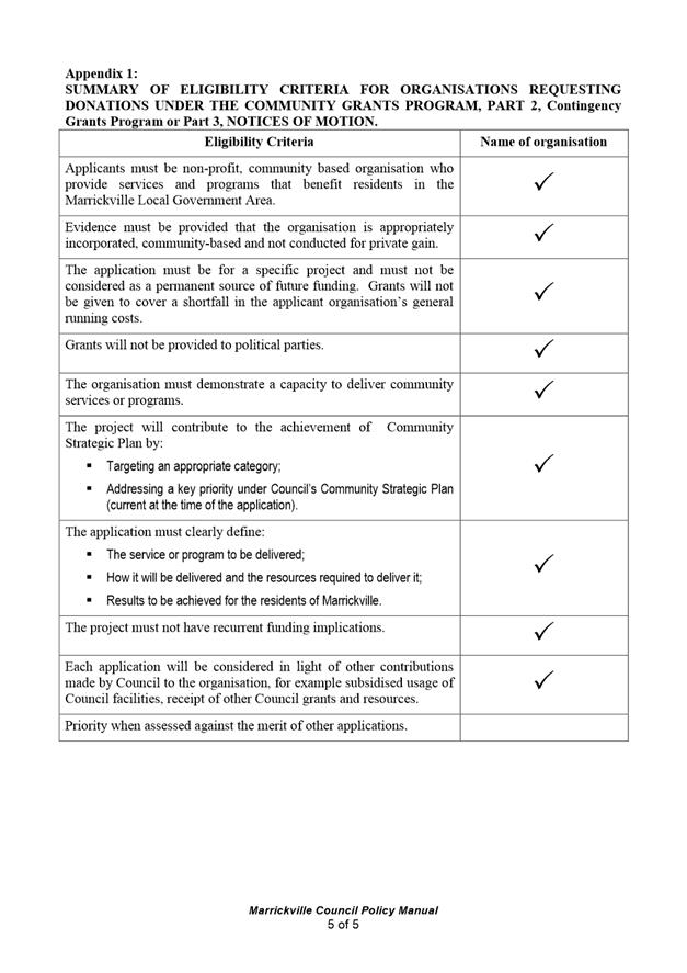
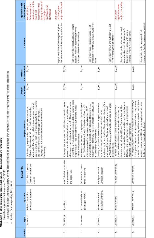
C0716 Item 9 Marrickville Arts and Culture Grants 2016 |
|
The Administrator determined that Council endorses funding for 19 grant applications as outlined in Attachment 1, totalling $65,000 for the 2016 Marrickville Arts and Culture Grants Program.
|
|
C0716 Item 10 Marrickville Independent Artist Grants 2016 |
|
The Administrator determined that Council endorses funding for the 10 applications as outlined in Attachment 1, totalling $30,000 for the 2016 Independent Artist Grants Program.
|
|
C0716 Item 11 Marrickville Recreation Grants 2016 |
|
The Administrator determined that Council endorses funding for 17 grant applications as outlined in Attachment 1, totalling $30,000 for the 2016 Marrickville Recreation Grants Program.
|
|
C0716 Item 12 Draft Expenses and Facilities Policy for IAG and LRAC Committee Members |
|
The Administrator determined that:
1. the Draft Expenses and Facilities Policy for LRAC/IAG committee members as shown attached to the report, be placed on public exhibition in accordance with Section 252 of the Local Government Act; and 2. after the conclusion of the public exhibition period, Council receive a further report on submissions received during the public exhibition period.
|
|
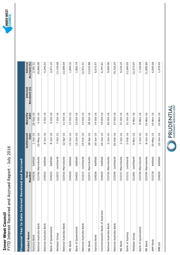
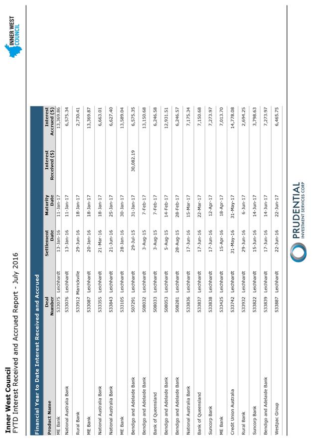
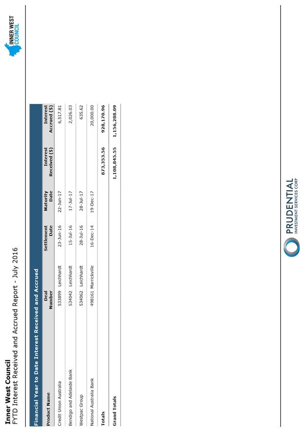
C0716 Item 13 Inner West Council Investments as at 30 June 2016 |
|
The Administrator determined that the report be received and noted.
|
The Administrator moved into closed session at 11.02pm to consider items of business containing confidential information.
The Administrator returned to open session at 11.12pm to resolve as follows in relation to Items 14, 15, 16 and 17.
6. Reports with Confidential Information
|
C0716 Item 14 Annette Kellerman Aquatic Centre - Mechanical Works Tender |
|
The Administrator determined that:
1. Council resolves that Confidential Attachments 1, 2 and 3 to the report be treated as confidential in accordance with Section 10A(2)(c) of the Local Government Act 1993 as it would, if disclosed, confer a commercial advantage on a person with whom the council is conducting (or proposes to conduct) business; and
2. Council declines to accept any Tenders and that, in accordance with clause 178(3)(e) of the Local Government (General) Regulation 2005, Council enter into negotiations with any person with a view to entering into a contract in relation to the subject matter of the Tenders.
|
|
C0716 Item 15 Tender 07/16 Security Surveillance, Patrols and Services |
|
The Administrator determined that:
1. Council resolves that Confidential Attachment 1 to the report be treated as confidential in accordance with Section 10A (4) of the Local Government Act 1993, as they relate to a matter specified in Section 10A(2)(c) & (d) of the Local Government Act 1993; 2. the report be received and noted; and 3. Council adopts the recommendation contained in the Confidential Attachment 1 for the duration of the contract.
|
|
C0716 Item 16 Hiring Agreement for the Wests Tigers to use Leichhardt Oval No. 1 |
|
The Administrator determined that:
1. Council resolves that Confidential Attachments 1 and 2 to the report be treated as confidential in accordance with Section 10A (2) (c) and (2) (d)(i) and (ii) of the Local Government Act 1993; and
2. that authority is delegated to the General Manager to make any minor amendments that may be required and to sign the hiring agreement on behalf of Council.
|
|
C0716 Item 17 ADMINISTRATOR'S MINUTE: WESTCONNEX LEGAL ADVICE - INITIAL ADVICE
|
|
The Administrator determined that:
1. Mr Robertson’s first memorandum of advice be further considered by Council but it is noted that the prospect of successful challenge on the basis of the advice received is low; and 2. the Department of Planning and Environment Compliance Officer be requested to further consider and advise Council whether the conditions of approval relating to heritage salvage are being properly implemented.
|
Meeting closed at 11.15pm.
CHAIRPERSON
|
|
Council Meeting 23 August 2016 |
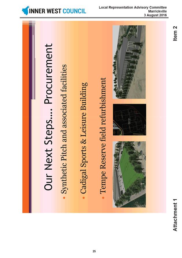
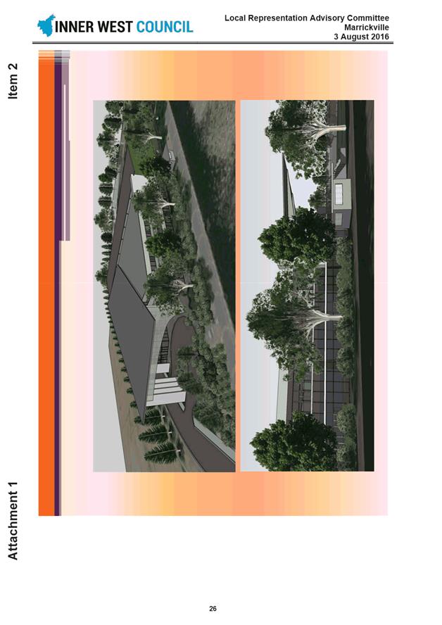
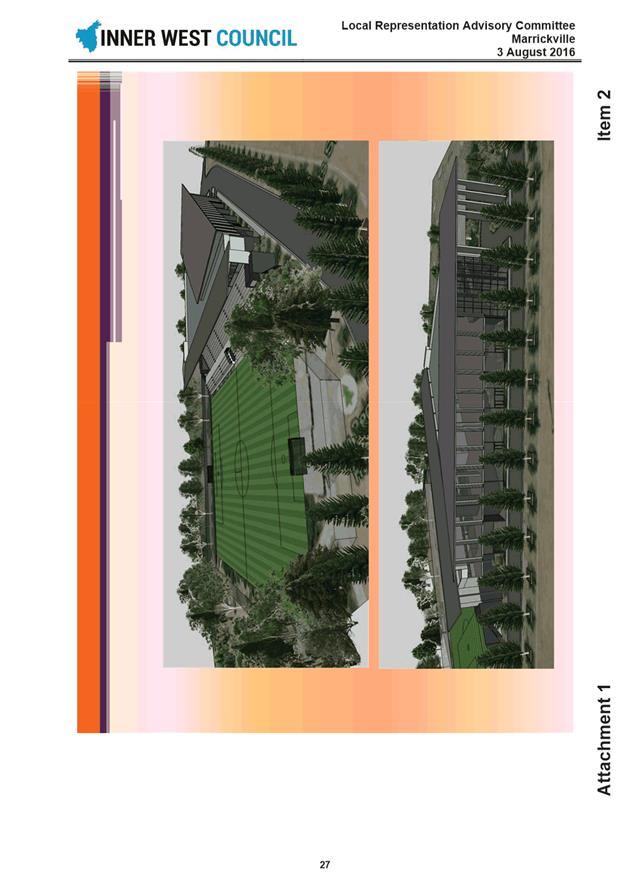
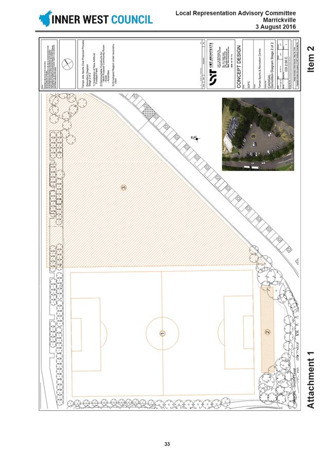
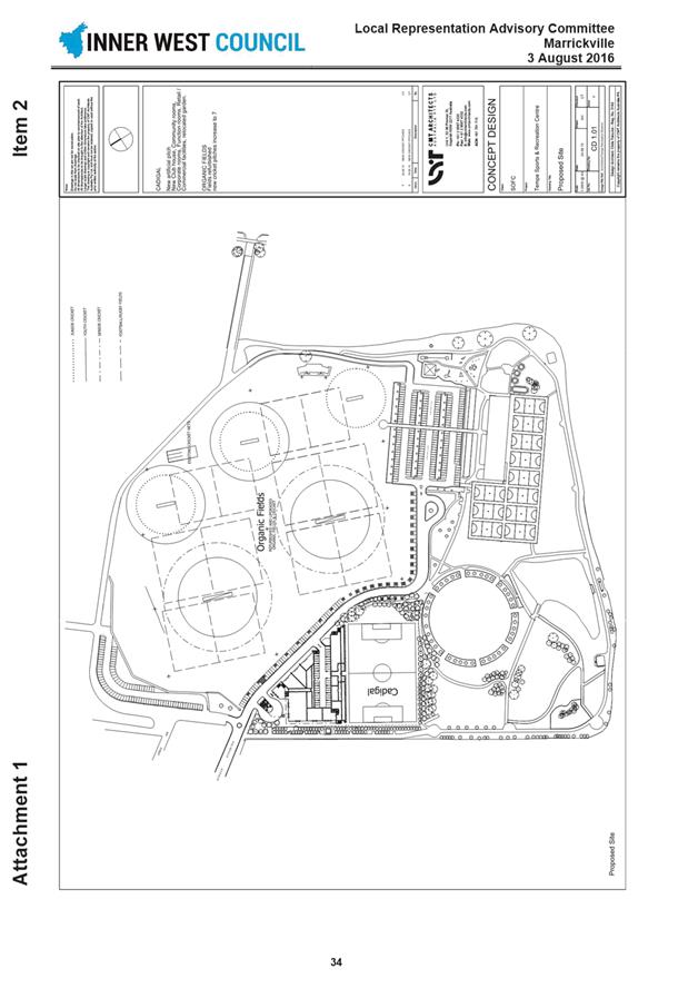
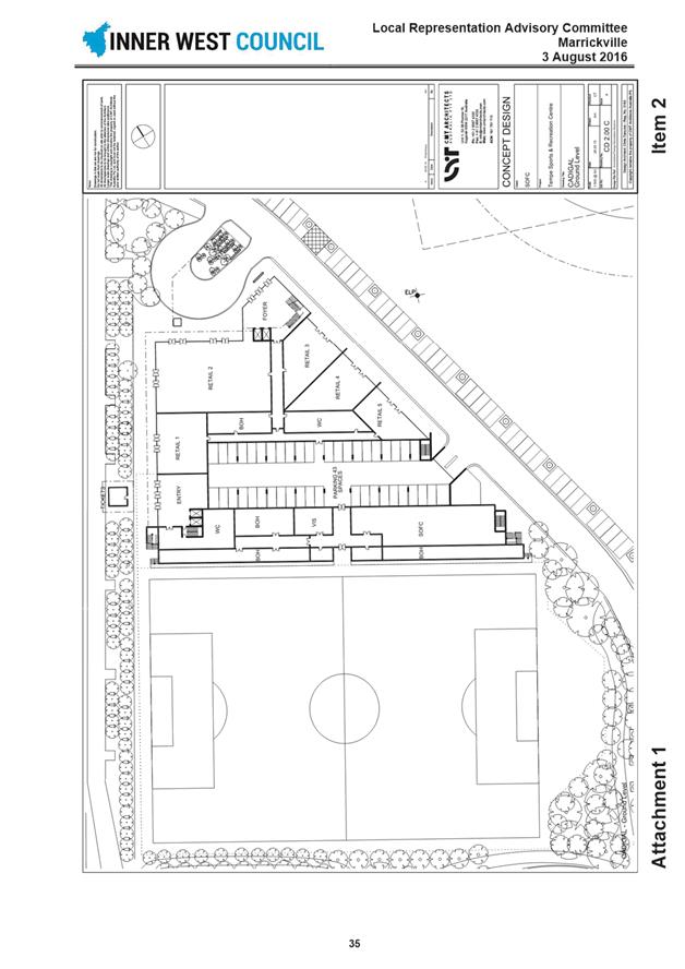
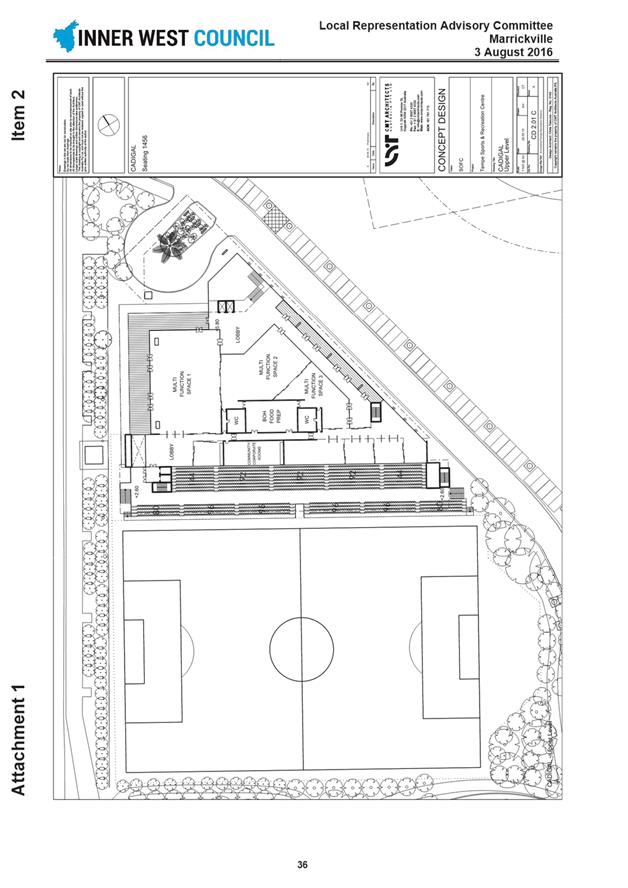
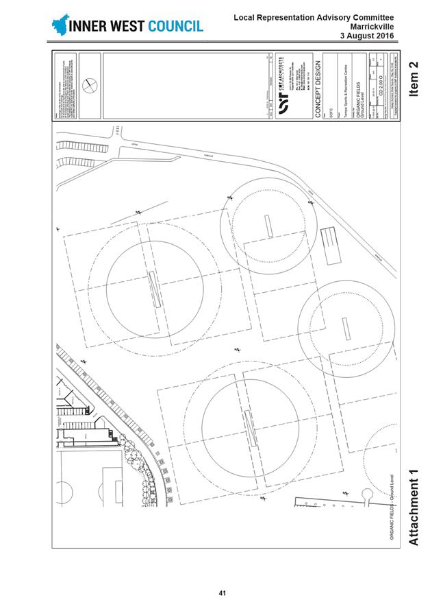
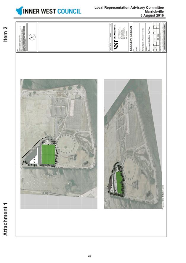
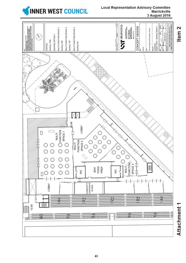
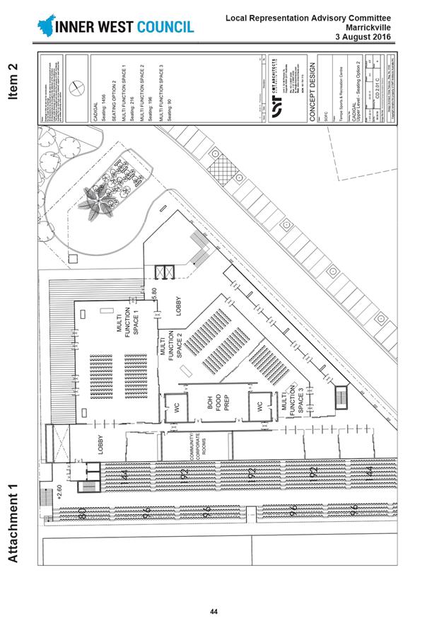
Subject: Minutes of Local Representation Advisory Committee and Implementation Advisory Group Meetings held in August 2016
File Ref: 16/4718/91180.16
Prepared By: Ian Naylor - Manager Governance and Administration, Leichhardt
Authorised By: Peter Gainsford - Director, Corporate Services
|
SUMMARY The Local Representation Advisory Committee and Implementation Advisory Group Meetings were held in August 2016 and this report presents the minutes of the meeting for consideration by the Administrator.
|
|
RECOMMENDATION
THAT the minutes of the Ashfield, Leichhardt and Marrickville Local Representation Advisory Committee Meetings and the Implementation Advisory Group Meeting held in August 2016 be received.
|
BACKGROUND
To present to Council the minutes of the Ashfield, Leichhardt and Marrickville Local Representation Advisory Committee's and the Implementation Advisory Group Meetings held in August 2016.
The minutes of the meetings are attached as follows:
Attachment 1 - Minutes of the Ashfield Local Representation Advisory Committee held on 9 August 2016.
Attachment 2 - Minutes of the Leichhardt Local Representation Advisory Committee held on 2 August 2016.
Attachment 3 - Minutes of the Marrickville Local Representation Advisory Committee held on 3 August 2016.
Attachment 4 - Minutes of Implementation Advisory Group held on 15 August 2016.
It is recommended that the Minutes of the Ashfield, Leichhardt and Marrickville Local Representation Advisory Committee's and the Implementation Advisory Group held in August 2016 be received.
|
1.⇩ |
Minutes of Ashfield LRAC Meeting held 9 August 2016 |
|
2.⇩ |
Minutes of Leichhardt LRAC Meeting held 2 Aug 2016 |
|
3.⇩ |
Minutes of Marrickville LRAC Meeting held 3 August 2016 |
|
4.⇩ |
Minutes of Implementation Advisory Group Meeting - 15 August 2016 |
|
Council Meeting 23 August 2016 |
Subject: Local Traffic Committee Meeting held on 4 August 2016
File Ref: 16/4718/88403.16
Prepared By: John Stephens - Traffic Manager, Leichhardt
Authorised By: Wal Petschler - Director, Major Projects and Engineering
|
SUMMARY To present the minutes of the Local Traffic Committee Meeting held on 4 August 2016. |
|
RECOMMENDATION
THAT the Minutes of the Local Traffic Committee Meeting held on 4 August 2016 be received and the recommendations be adopted.
|
BACKGROUND
The second meeting of the Inner West Council Local Traffic Committee was held on 4 August 2016 at Leichhardt. The minutes of the meeting are shown at Attachment 1.
FINANCIAL IMPLICATIONS
Nil.
OTHER STAFF COMMENTS
Nil.
PUBLIC CONSULTATION
Members of the public attended the meeting to address the committee on specific items.
CONCLUSION
Nil.
|
1.⇩ |
Minutes of Local Traffic Committee Meeting held on 4 August 2016 |
|
Council Meeting 23 August 2016 |
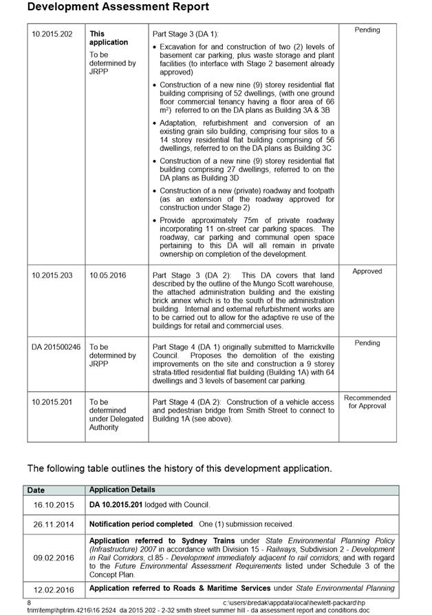
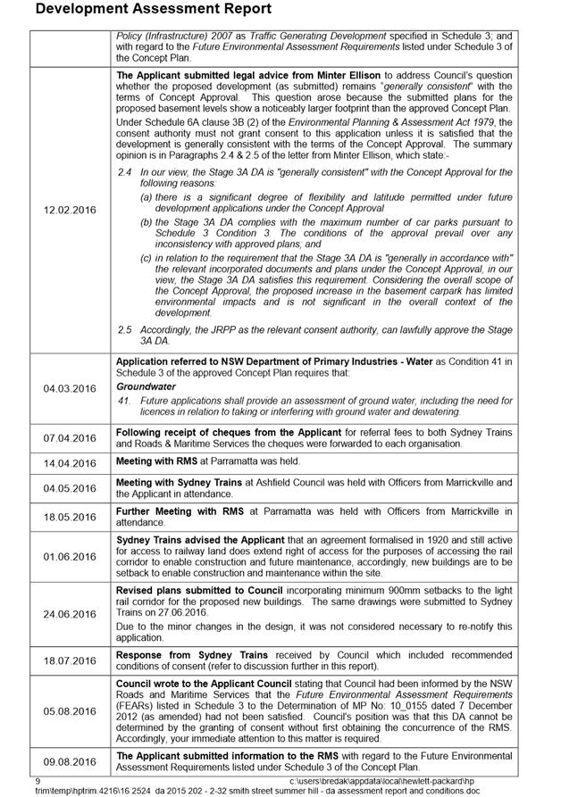
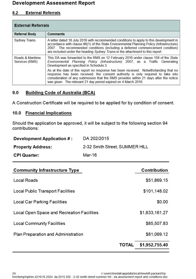
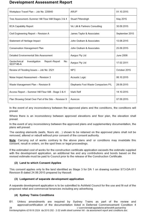
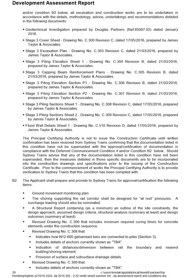
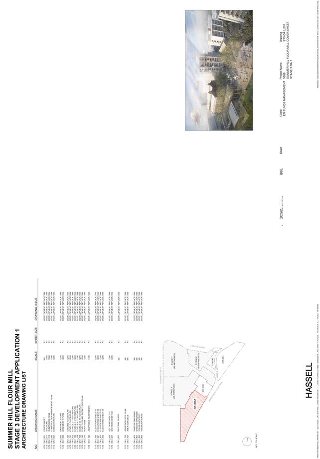
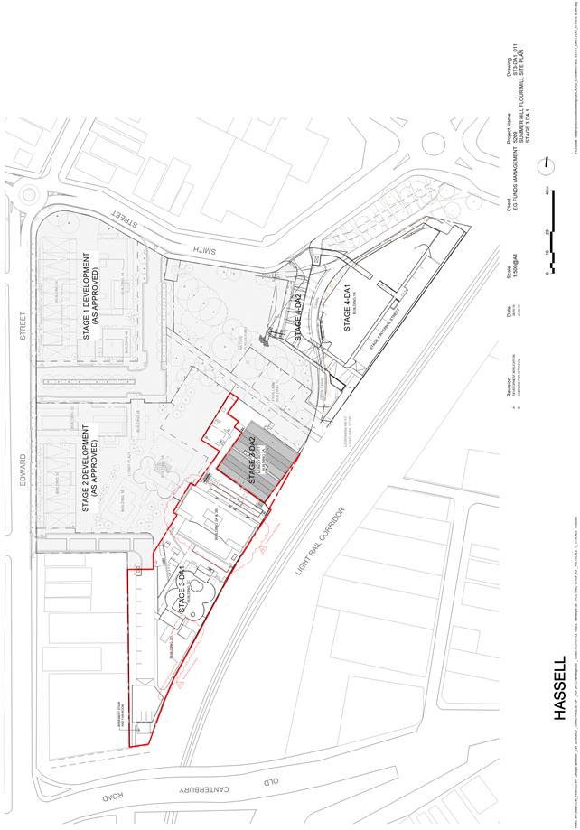
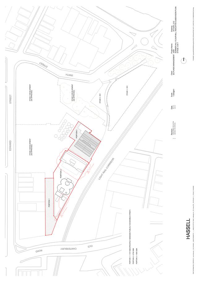
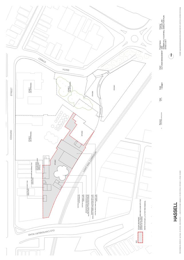
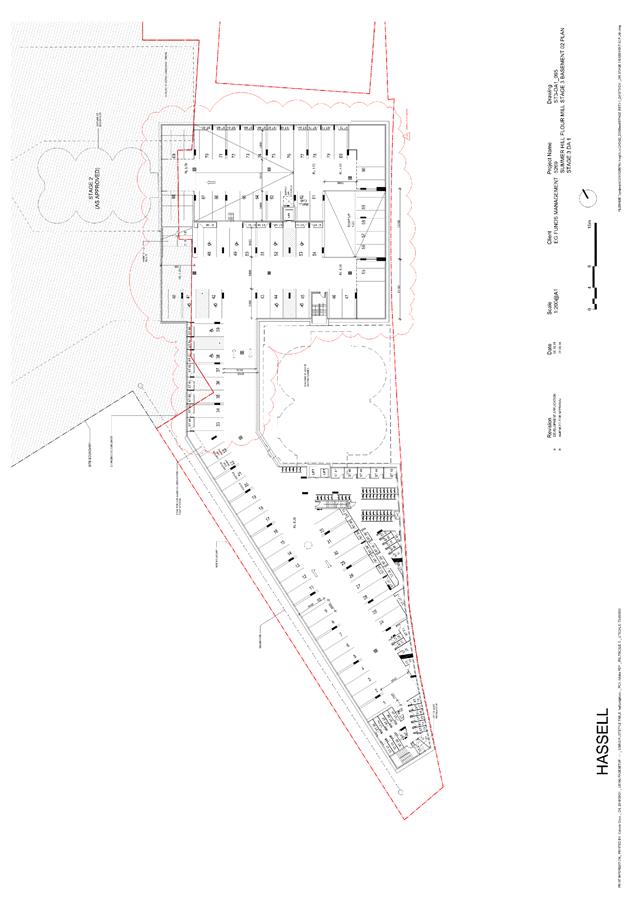
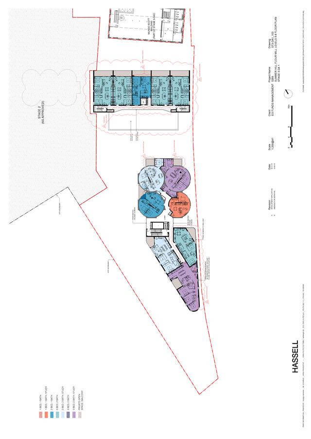
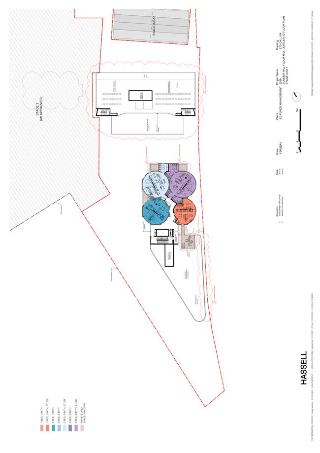
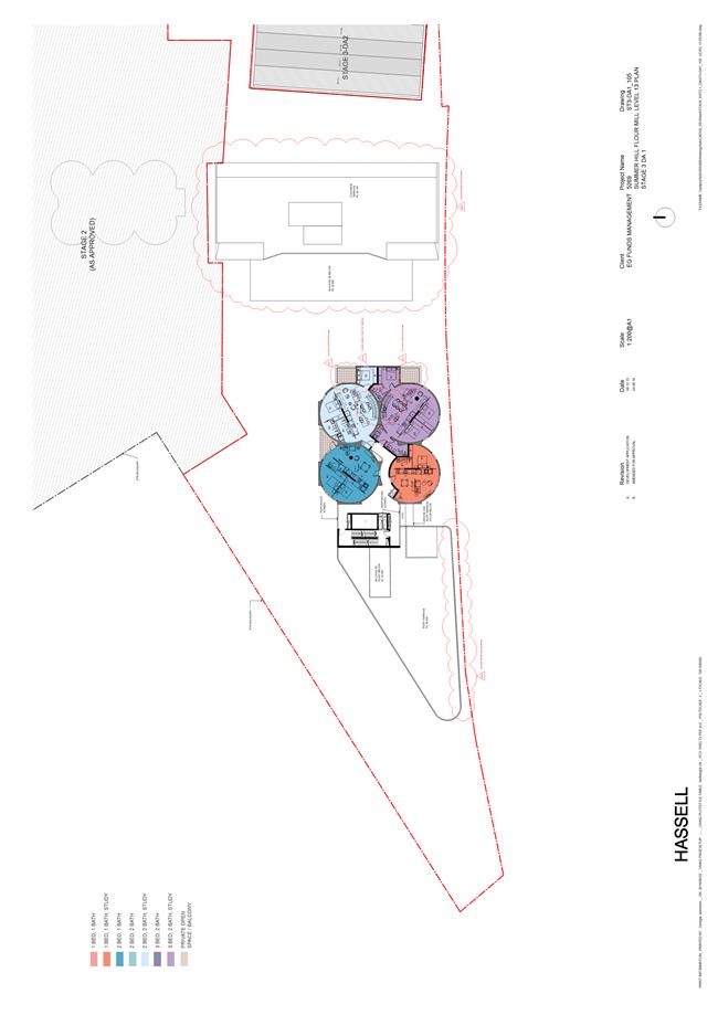
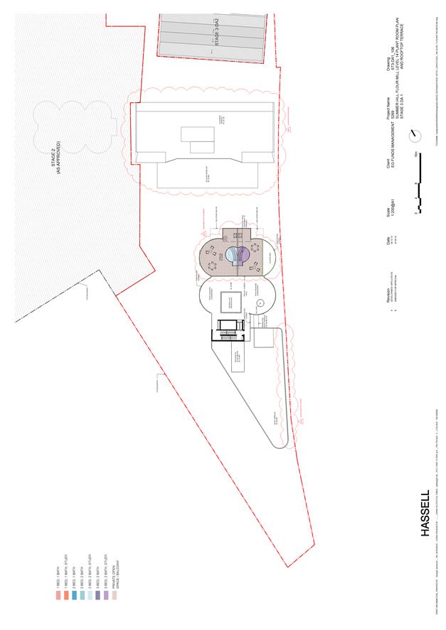
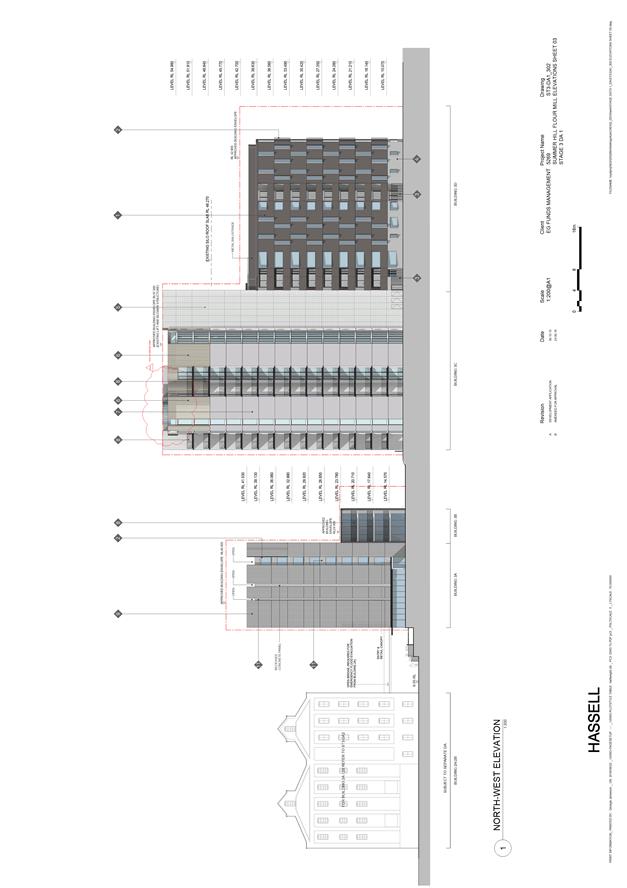
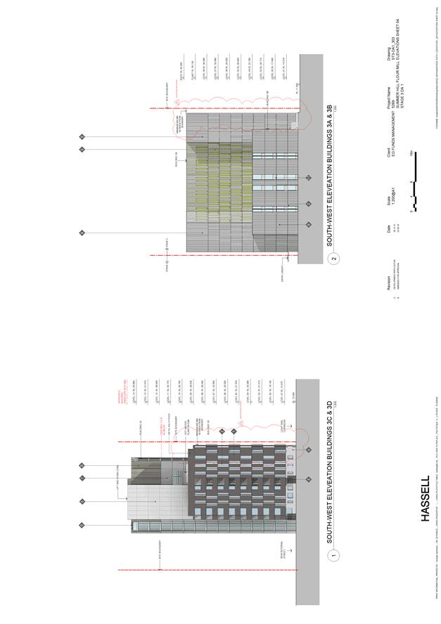
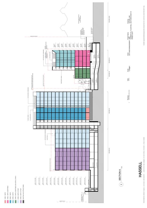
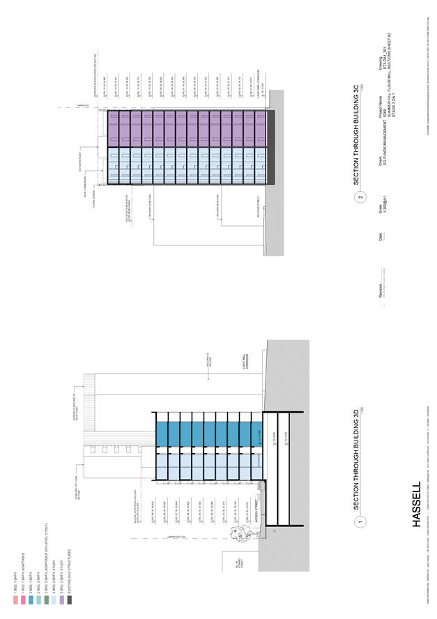
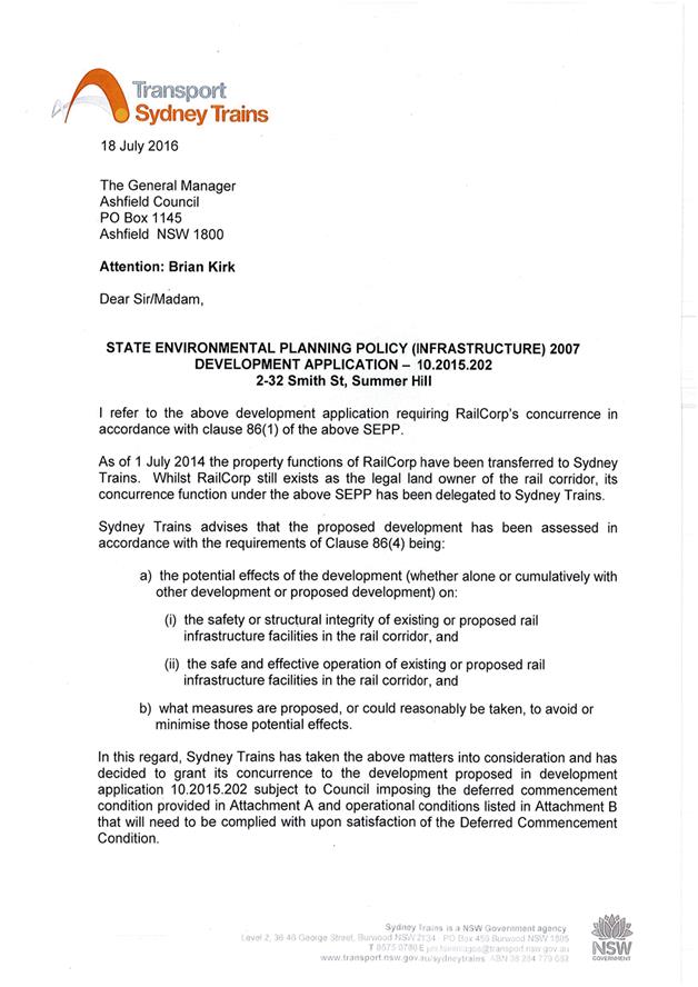
Subject: Development Application - 2-32 Smith Street Summer Hill
File Ref: 16/4718/93444.16
Prepared By: Brian Kirk - Consultant Planner
Authorised By: Phil Sarin - Director, Planning and Environment
|
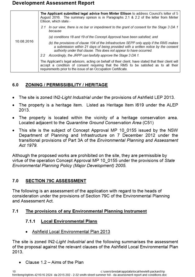
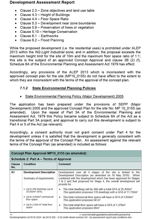
SUMMARY This application seeks development consent for Stage 3 (DA1) of the Concept Plan approval for the Summer Hills Flour Mills development issued for the site under the State Environmental Planning Policy (Major Development) 2005 (MP10_0155 as modified).
|
|
RECOMMENDATION
THAT Council determine whether it wishes to make a submission to the Panel in relation to the proposal, and if so, the contents of such submission.
|
Overview of Report
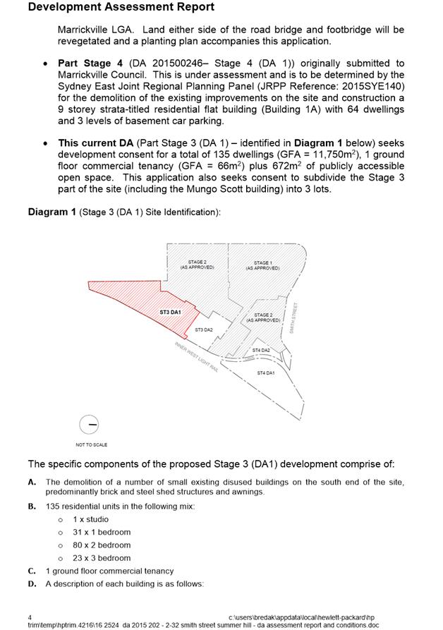
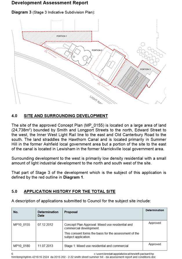
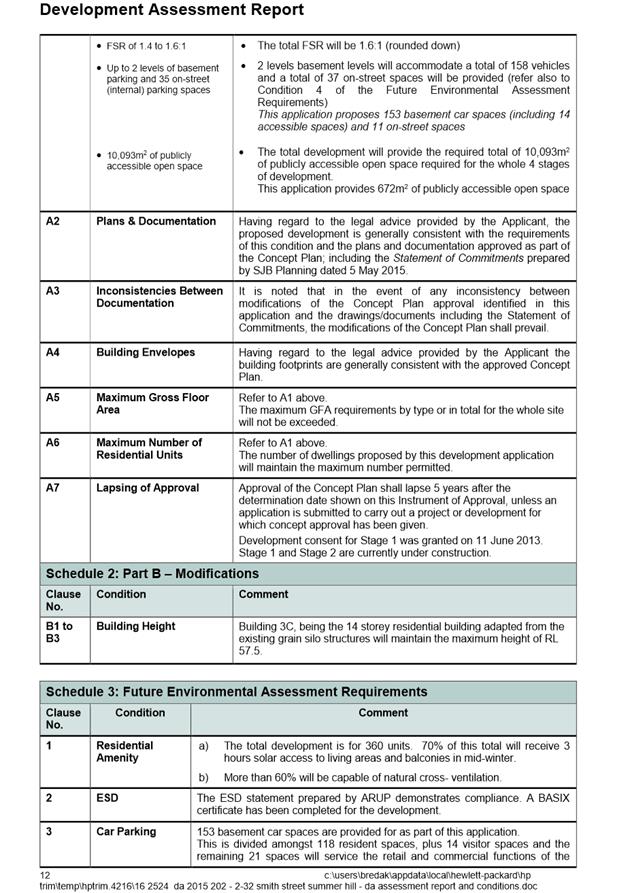
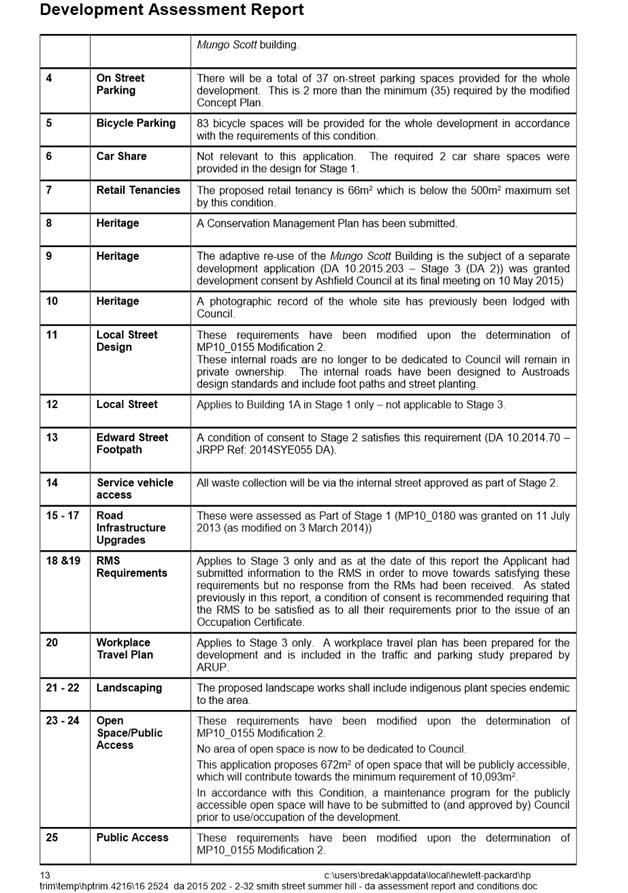
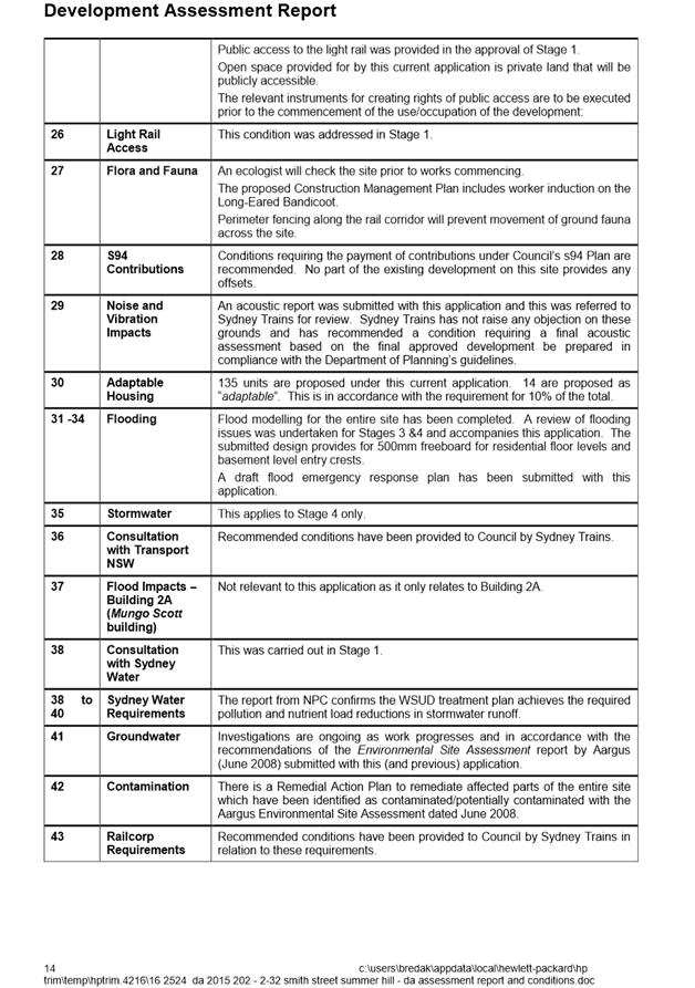
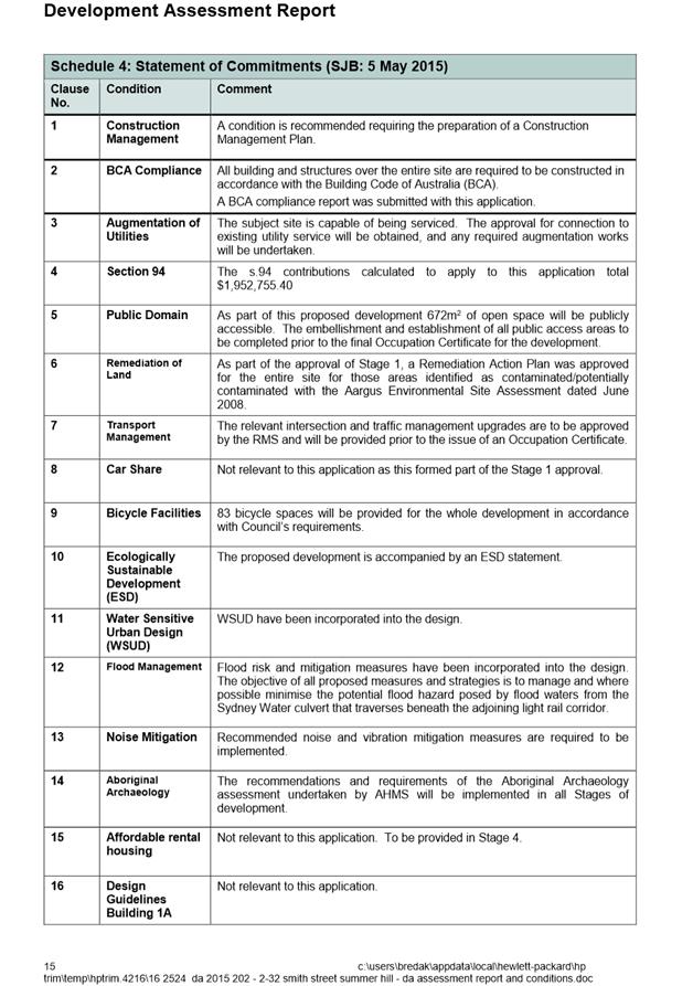
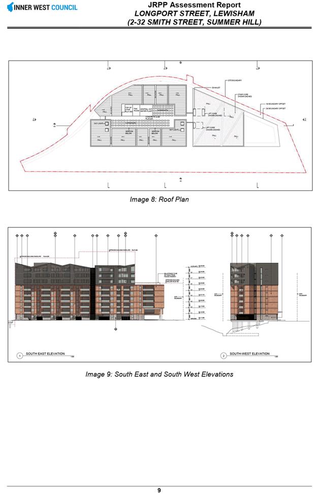
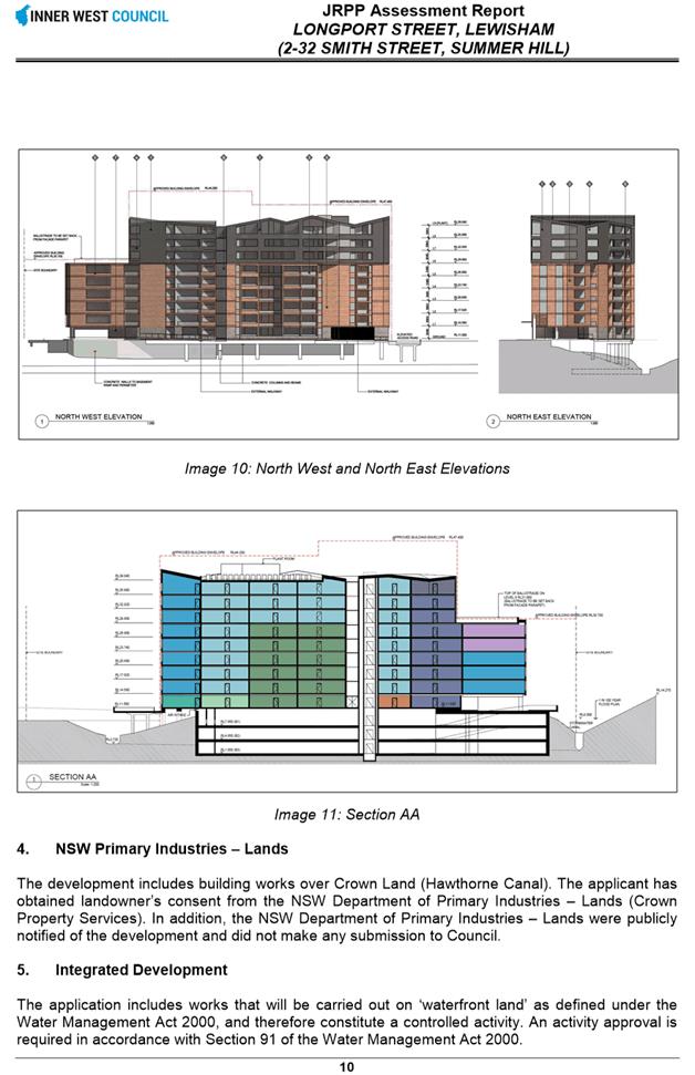
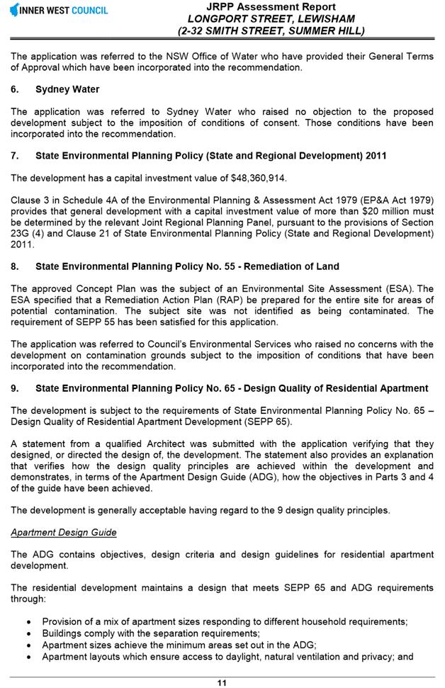
The proposal involves Part 1 of Stage 3 of the approved concept plan for a total of 135 new dwellings (11,750m2), 1 new retail tenancy (66m2) and 672m2 of publicly accessible open space.
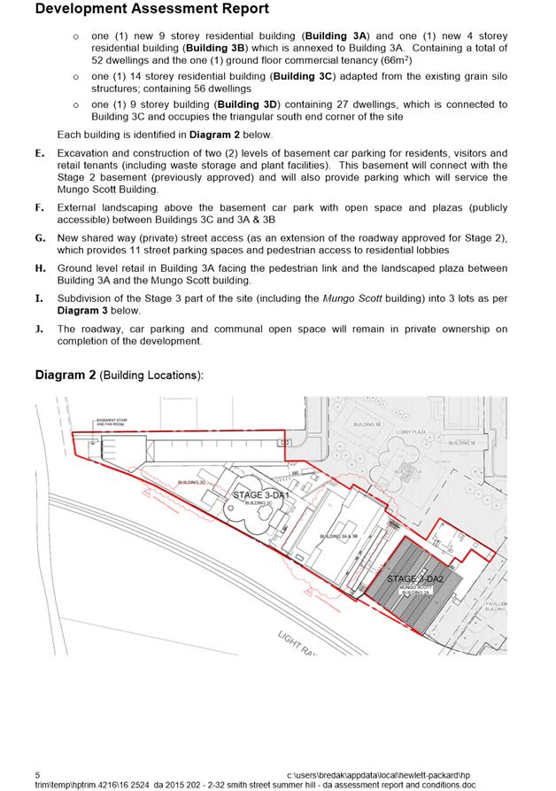
This application proposes the construction of three (3) new residential flat buildings (with one ground floor retail tenancy) (Buildings 3A, 3B and 3D) over a new 2 level basement car park; plus the adaptation, refurbishment and conversion of an existing grain silo building into a residential flat building over 14 levels, known as the four pack Building 3C.
Executive Summary
The site of the approved Concept Plan is located on a large area of land of 24,738m2 bounded by Smith and Longport Streets to the north, Edward Street to the west, the Inner West Light Rail line to the east and Old Canterbury Road to the south. The land straddles the Hawthorn Canal and is located primarily in Summer Hill but the small portion of the site to the east of the canal is located in Lewisham and is the subject of a separate development application under assessment by the Inner West - Petersham.
Stage 3 of the development which is the subject of this application is located on Lot 14, DP 315 which is bound by Smith Street to the north, Old Canterbury Road to the south, the Inner West Light Rail line to the east and adjacent lots fronting Edward Street to the west. The subject application occupies the southern wedge of this lot.
Compliance of the proposal with the approved Concept Plan is generally satisfactory. The application also performs adequately when assessed against both Council’s controls and relevant Environmental Planning Instruments to the extent that they apply.
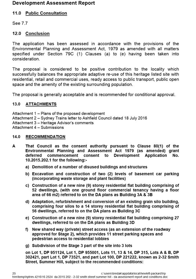
The proposal is considered to be positive contribution to the locality which successfully balances the appropriate adaptive re-use of this heritage listed site with residential, retail and commercial uses, ready access to public transport, public open space and the amenity of the existing surrounding population. The development is recommended for deferred conditional approval.
The development application relates to a type of development that the Minister of Planning has categorised as being of regional significance. The Sydney East Joint Regional Planning Panel is the consent authority for the purposes of determining the application.
Council officers have carried out an assessment of the application and the report is to be forwarded to the Sydney East Joint Regional Planning Panel for the Panel’s consideration. A copy of the Council officer’s report on the development application, which recommends approval of the proposal, is attached.
The SEJRPP will be holding a meeting at 3 Spring Street, Sydney, Wednesday, 15 September 2016 to consider the matter.
Council needs to determine whether it wishes to make a submission to the panel in relation to the proposal, and if so, the contents of such submission.
Council representation to a Joint Regional Planning Panel
Section 4.6 of the Department of Planning’s ‘Procedures for the operation of Joint Regional Planning Panels’ relates to Council representation to the Regional Panel. That section reads as follows:-
“4.6 Council representation to the Regional Panel
A council may make a submission on a development application that is to be determined by a Regional Panel during and up to seven (7) days before the Panel Meeting. The applicant may consider it appropriate to provide a briefing to council prior to the council framing its submission to the Panel.
The council submission should be forwarded to the Panel Secretariat. A Regional Panel will give consideration to a council submission in its determination of the application. A council submission, however, is not a matter that must be specifically addressed in the assessment report or recommendations prepared by the council staff.”
Conclusion
Council needs to determine whether it wishes to make a submission to the Panel. Given the short timeframe between Council’s consideration of the matter and the Panel meeting, any comments that the Council does make will be both forwarded and presented to the Panel.
|
1.⇩ |
Council Officer's Report on the Development Application |
|
Council Meeting 23 August 2016 |
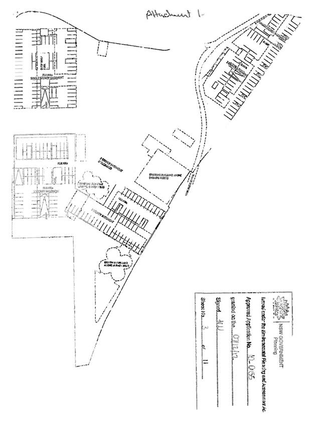
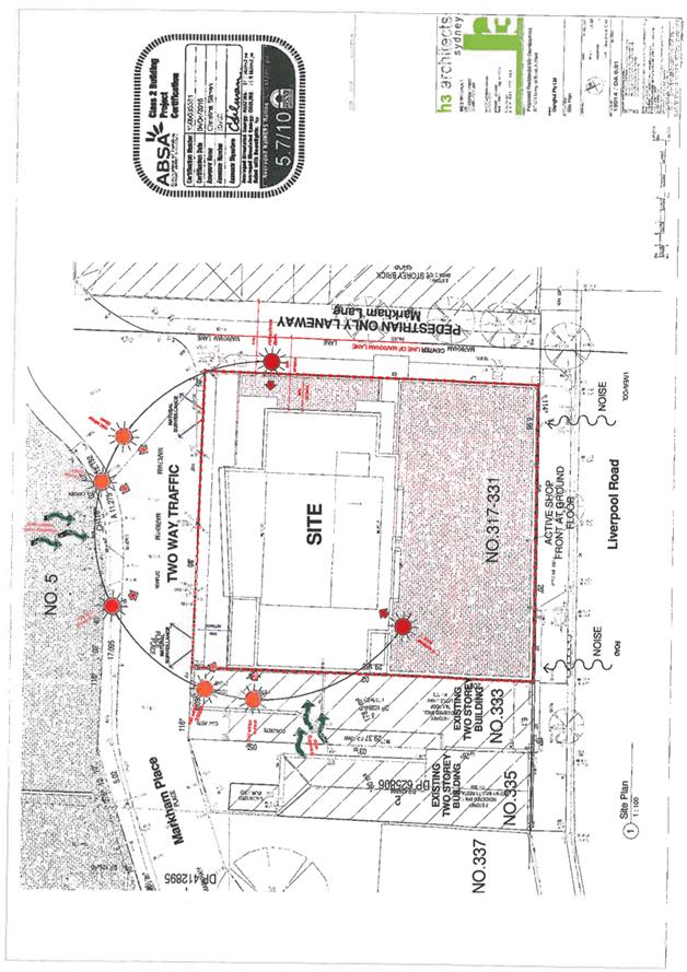
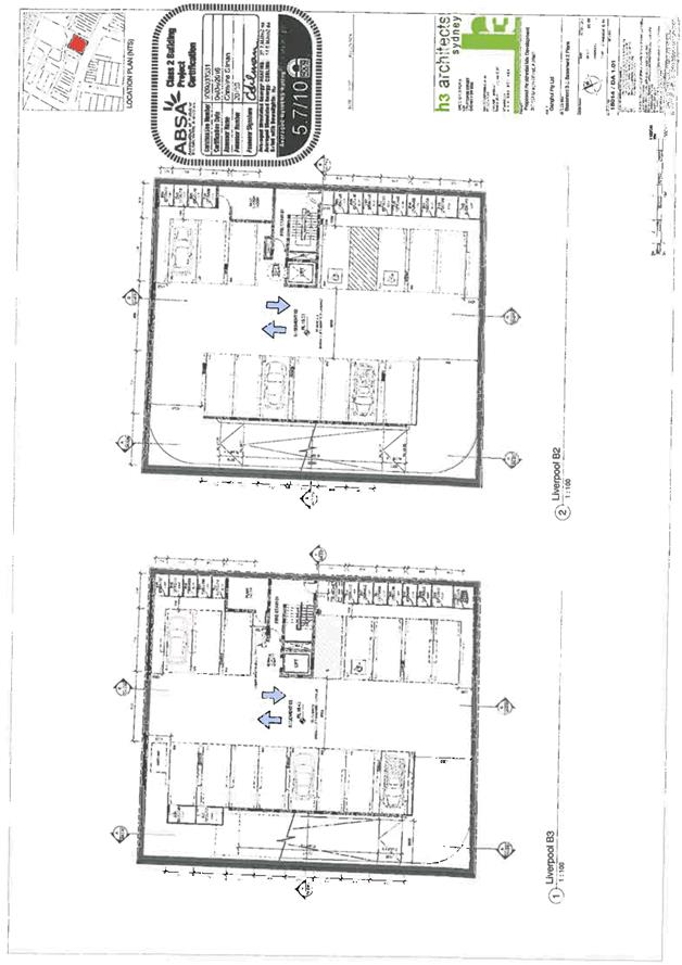
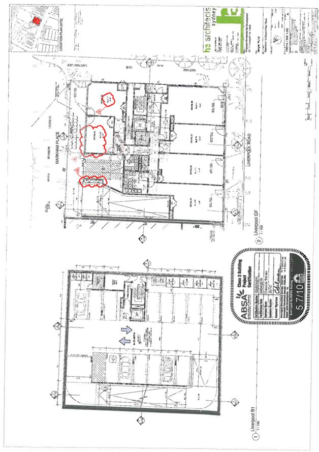
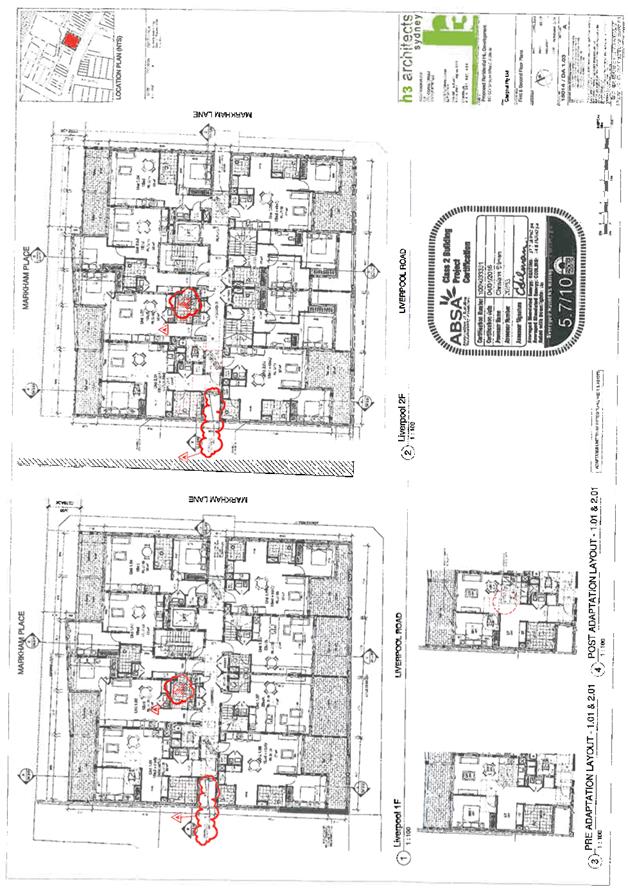
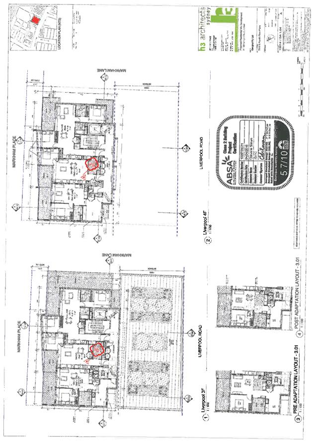
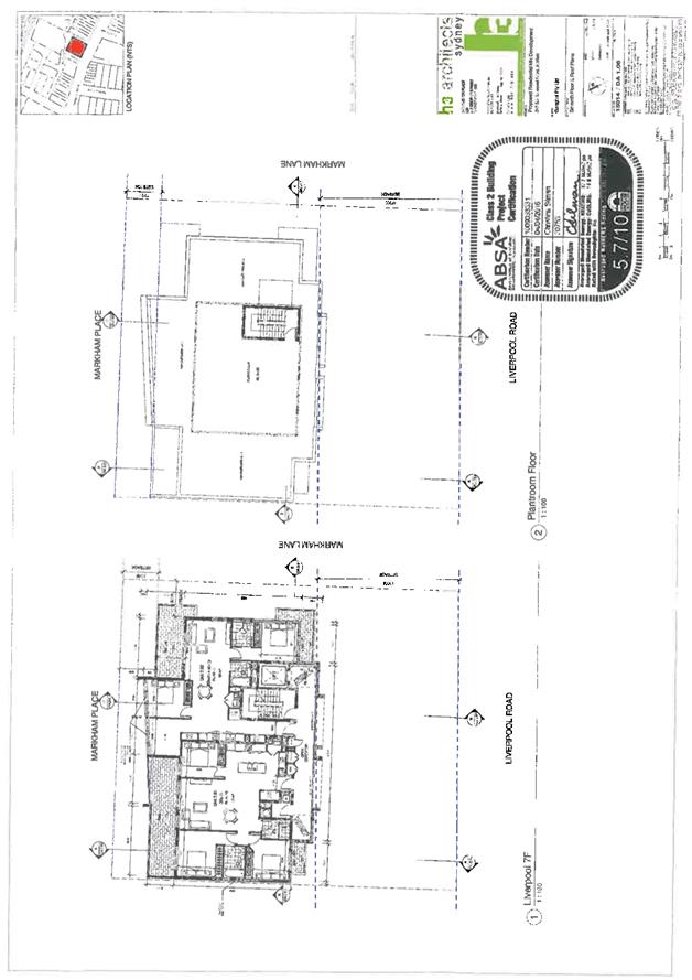
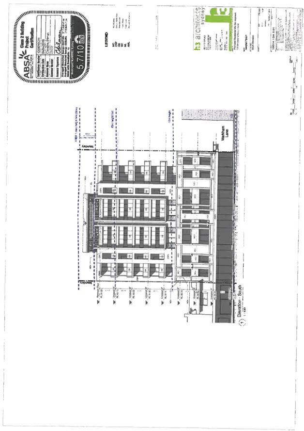
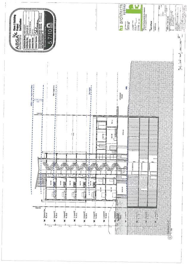
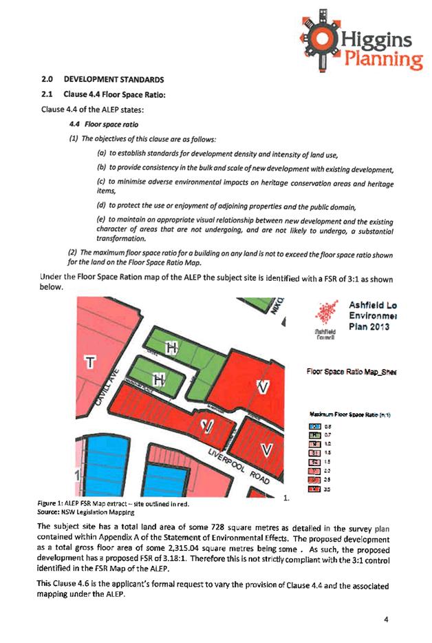
Subject: Development Application - 317-331 Liverpool Road, Ashfield
File Ref: 16/4718/93146.16
Prepared By: Philip North - Specialist Planner, Ashfield
Authorised By: Phil Sarin - Director, Planning and Environment
|
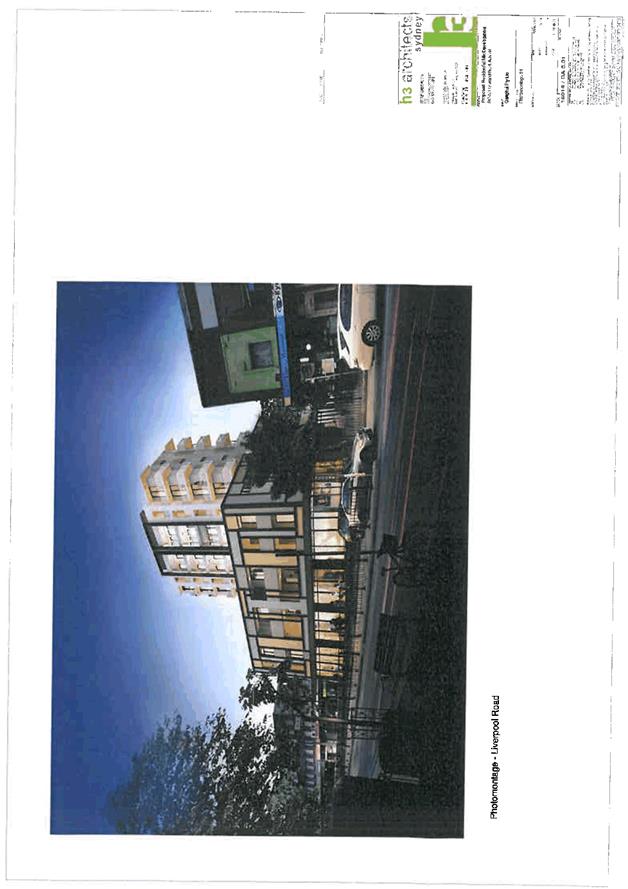
SUMMARY This proposal for construction of an 8 storey mixed use development consisting of 6 retail tenancies at ground level complies with the provisions of Ashfield Local Environmental Plan 2013 (ALEP 2013) and all other planning provisions applicable to the site with the exception of floor space ratio and street setback requirements of ALEP 2013. The variations sought are minor in nature and will not compromise the objective of the controls. Furthermore, due to site amalgamation, it provides a coherent urban design response to its location and effectively activates three street frontages including a side pedestrian lane and the rear lane where it will also interact positively with the development currently under construction at 5 Markham Place. The proposal provides a 3m wide pedestrian right of way along the Markham Place frontage to allow safe pedestrian circulation where none existed previously. The proposal also provides a high level of residential amenity for future occupants and avoids adverse impacts upon adjacent properties. There are some minor engineering issues which require further detailed resolution, but these can be addressed by way of deferred commencement conditions of consent. |
|
RECOMMENDATION
THAT the proposal is acceptable and is recommended for deferred commencement consent.
|
REPORT OVERVIEW
1.0 Description of Proposal
Pursuant to Clause 78A (1) of the Environmental Planning and Assessment (EP&A) Act 1979 (as amended) this application seeks Council’s consent for:-
· Demolition of all existing structures;
· Construction of an 8 storey mixed use development consisting of 6 retail tenancies at ground level;
· Provision of a total of 28 residential apartments above ground level comprising of:-
o 4 X 1 bedroom units;
o 16 X 1 bedroom plus study units;
o 6 X 2 bedroom units;
o 1 X 2 bedroom plus study units;
o 1 X 3 bedroom unit; and
· Construction of 3 basement car parking levels accommodating 43 vehicles.
2.0 Application Details
Applicant : Ganghui Pty Ltd
Owner : Ganghui Pty Ltd
Value of work : $10,243,986
Lot/DP : Lots 1, 2, 3 & 4, DP 10284
Date lodged : 4.5.2016
Building classification : 2 & 6
Application Type : Local
Construction Certificate : No
3.0 Site and Surrounding Development
The subject site is located on the northern side of Liverpool Road in Ashfield and faces directly onto Markham Place to its rear. Markham Lane is located to the east, and Cavill Avenue to the west. The site consists of the following individual lots:-
|
Street Address |
Lot No. |
Deposited Plan |
Title System |
Total Site Area (by title) |
|
317 Liverpool Road |
1 |
10284 |
Torrens |
199.3m2 |
|
319 Liverpool Road |
2 |
10284 |
Torrens |
175.1m2 |
|
319 Liverpool Road |
3 |
10284 |
Torrens |
176.2m2 |
|
331 Liverpool Road |
4 |
10284 |
Torrens |
177.4m2 |
|
TOTAL AREA |
728m2 |
|||
Surrounding development includes commercial and retail uses along Liverpool Road while mixed use residential and commercial developments are located along Markham Place at the rear. The site is serviced well by public transportation including the Ashfield Railway Station which is located to the rear of the site.
Council recently approved a mix use development located on 5 Markham Place which is directly opposite to the subject site. The 5 Markham Place approval incorporates a public plaza that is accessible 24/7. The proposal provides a 3m wide pedestrian right of way along the Markham Place street frontage to allow safe pedestrian circulation where none existed previously.
The proposed 3.0m wide public pedestrian right of way will interact positively with the proposed public plaza located at 5 Markham Place development currently under construction to create street activation and improved pedestrian amenity. From an urban design perspective the proposal in connection with 5 Markham Place will create an interesting and vibrant public space and will positively add to Council’s future vision to improve the public domain in this locality.
4.0 Development History
4.1 Previous building and development applications
|
317Liverpool Road |
|||
|
No. |
Determination Date |
Proposal |
Determination |
|
10.2008.114.1 |
08.07.2008 |
Change of use from florist to restaurant |
Approved |
|
21.06.2011 |
21.06.2011 |
Alterations and additions to mixed use building |
Approved |
|
319-321 Liverpool Road |
|||
|
No. |
Determination Date |
Proposal |
Determination |
|
6.1968.6881.1 |
20.08.1968 |
Cool room for funeral parlour |
Approved |
|
6.1968.6881.1 |
17.09.1968 |
Internal alterations to funeral parlour |
Approved |
|
6.1975.9960.1 |
09.12.1975 |
Alterations to Undertakers |
Approved |
|
10.2014.230.1 |
25.11.2014 |
Shop top housing |
Refused |
Parts of 319-321 have been used as funeral home for a significant period of time.
4.2 Previous DA and Land & Environment Court Appeal
DA 10.2014.230 seeking approval for the construction of shop top housing located at 319 – 331 Liverpool Road, Ashfield was refused by Council on 25 November 2014 and was also subject of a Land & Environment Court appeal. During the appeal process it was discussed that development of 319 to 331 would isolate the adjoining lot at 317 Liverpool Road, Ashfield and that site amalgamation should occur with a view to incorporate 317 Liverpool Road.
The current DA, subject of this report, now incorporates 317 Liverpool Road, Ashfield thus resolving site isolation issues.
4.3 Background to the current application
|
Application Milestones |
||
|
Date |
Event |
File no |
|
12.04.2016 |
Provisional development application submitted. |
17.2016.85 |
|
04.05.2016 |
Development Application lodged “As-is” |
10.2016.89.1 |
5.0 Zoning/Permissibility/Heritage
The site is zoned B4-Mixed Use under the provisions of Ashfield LEP 2013.
The property contains a heritage item, being 317 Liverpool Road, Ashfield and is located within the Ashfield Town Centre.
The proposed works are permissible with Council consent.
The proposal involves total demolition of heritage listed item located at 317 Liverpool Road, Ashfield. Council’s heritage advisor has reviewed the proposal and submitted heritage management document and is of the view that in this instance it is considered to be acceptable to demolish the heritage item for two main reasons, firstly the item’s retention is not considered worthy and secondly, a better urban design outcome is facilitated by its demolition.
During the LEC appeal, detailed investigation was carried out of the significance of the heritage item. It was revealed that the heritage item suffered significant damage to the internal fabric and there was no element worthy of retention. The only heritage significance was its detailing to the external front portion of the building where it displayed a moderate heritage value. In the circumstances of the case it was considered that that a better planning and urban design outcome can be achieved if the sites were amalgamated and redeveloped in its entirety. The external detailing to the front portion of the existing item is not unique and is represented in other more significant heritage buildings in the locality.
6.0 Section 79C Assessment
The following is an assessment of the application with regard to the heads of consideration under the provisions of Section 79C of the Environmental Planning and Assessment Act.
6.1 The provisions of any Environmental Planning Instrument
6.1.1 Ashfield Local Environmental Plan 2013
Ashfield Local Environmental Plan 2013 (ALEP 2013) was gazetted on 23 December 2013 and applies to the proposal. The following table summarises the compliance of the application with ALEP 2013.
|
Ashfield Local Environmental Plan 2013 Summary Compliance Table |
||||
|
Clause No. |
Clause |
Standard |
Proposed |
Complies |
|
2.3 |
Zone objectives and land use table |
Zone B4 Mixed Use |
Shop top housing (mix use development) |
Yes |
|
2.3(2) |
Zone objectives and land use table |
The consent authority must have regard to the objectives for development in the zone when determining a development application in respect of land within that zone.
Zone B4 Mixed Use Objectives of Zone: · To encourage the orderly and efficient development of land through the consolidation of lots. |
The site consolidates four lots into one and avoids the isolation of any adjacent sites.
|
Yes |
|
4.1 |
Minimum subdivision lot size |
N/A |
728m2 |
N/A |
|
4.3 |
Height of buildings |
Max 23.0m if no affordable housing proposed
Max 30.0m if affordable housing proposed |
29.18m (affordable housing proposed) |
Yes (relies on cl. 4.3A) |
|
4.3(2A) |
Height of buildings |
If a building is located on land in Zone B4 Mixed Use, any part of the building that is within 3 metres of the height limit set by sub-clause (2) must not include any area that forms part of the gross floor area of the building and must not be reasonably capable of modification to include such an area:
Therefor in this case the max height is 27.0m for the reason affordable housing is proposed |
25.5m |
Yes (relies on cl. 4.3A) |
|
4.3A |
Exception to maximum height of buildings in Ashfield town centre |
Overall max building height is 30.0m if affordable housing is proposed. |
29.18m affordable housing is proposed.
|
Yes |
|
Maximum habitable building height is 27.0m measured to the top of habitable floor & must have 25% of the top 2 levels allocated to affordable rental housing. |
25.5m to top of habitable floor and must have minimum of 2 units allocated to affordable rental housing |
Yes condition imposed |
||
|
4.3B |
Ashfield town centre – maximum height for street frontages on certain land |
Max 12.0m building height at Liverpool Road street frontage with a 12.0m setback for podium level. |
12.0m building height at Liverpool Road street frontage however 11.5m setback for podium level |
No (see cl. 4.6) |
|
4.4 |
Floor space ratio |
3:1 |
3.18:1 |
No (see cl.4.6) |
|
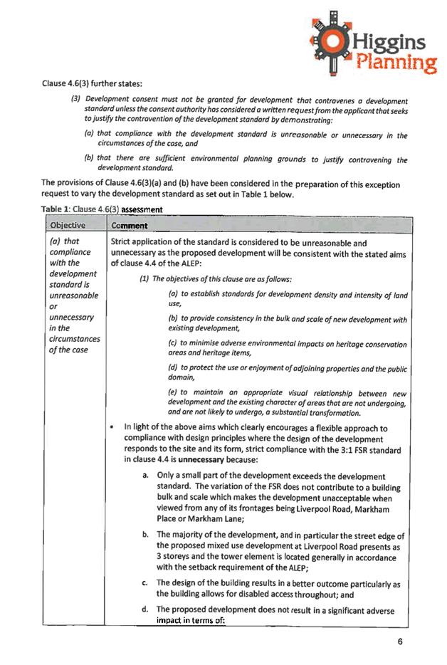
4.6(3) |
Exceptions to development standards |
Development consent must not be granted for development that contravenes a development standard unless the consent authority has considered a written request from the applicant that seeks to justify the contravention of the development standard by demonstrating. |
Written requests submitted for variations to cl. 4.3B & cl. 4.4. |
Yes |
|
4.6(3)(a) |
Exceptions to development standards |
That compliance with the development standard is unreasonable or unnecessary in the circumstances of the case. |
Demonstrated in both cases that compliance is unnecessary: · Cl. 4.3B (Street Wall Height): The height non-compliance results from the intrusion of a blade wall façade element on the tower section into the 12m setback zone by about 0.5m. This is a minor and incidental intrusion that does not impact on the appropriate perception of a street wall height of 12m and is consistent with the objectives of the standard. Therefore strict compliance is unnecessary. · Cl. 4.4 (FSR): The contravention results from the adoption of the height bonus in cl. 4.3A to provide affordable housing which cannot be implemented without a variation to the FSR standard; this variation is specifically envisaged by cl. 2.3, Part C3, Ashfield Interim Development Assessment Policy. As such, it is consistent with the objectives of the standard and strict compliance is unnecessary. |
Yes |
|
4.6(3)(b) |
Exceptions to development standards |
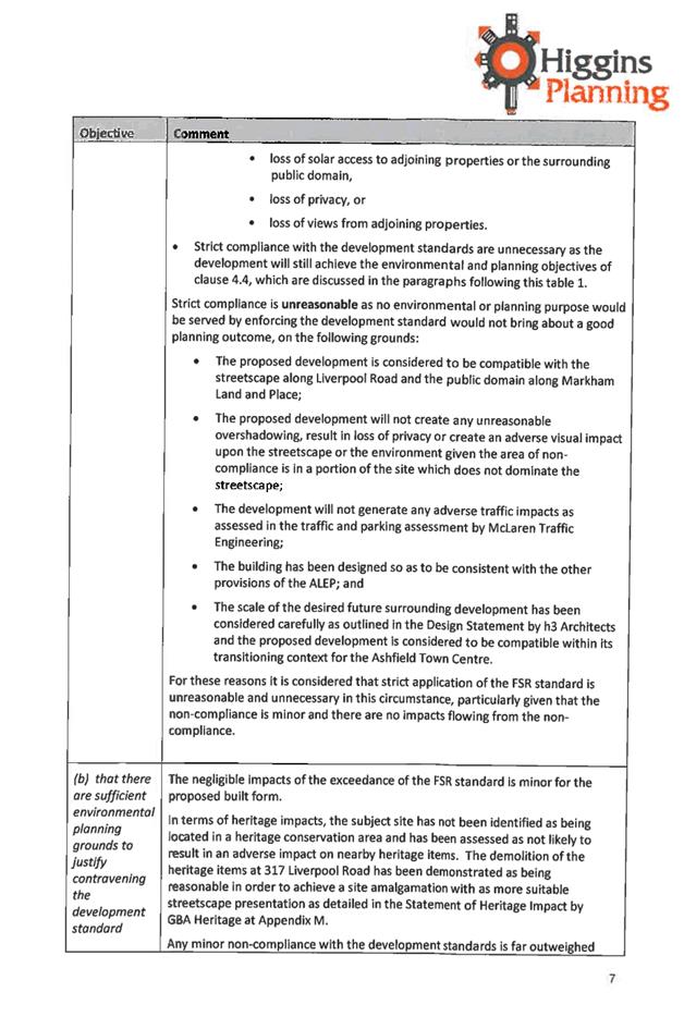
That there are sufficient environmental planning grounds to justify contravening the development standard. |
Demonstrated in both cases: · Cl. 4.3B (Street Wall Height): The contravention results from minor decorative blade wall elements on the tower section that improve the articulation of the building and its architectural presentation. This is a desirable planning outcome and is considered sufficient environmental planning grounds. · Cl. 4.4 (FSR): The contravention results from the adoption of the height bonus in cl. 4.3A to provide affordable housing which cannot be implemented without a variation to the FSR standard; this variation is specifically envisaged by cl. 2.3, Part C3, Ashfield Interim Development Assessment Policy. As such, this is a desirable planning outcome and is considered sufficient environmental planning grounds. |
Yes |
|
4.6(4) |
Exceptions to development standards |
Development consent must not be granted for development that contravenes a development standard unless: |
||
|
4.6(4)(a) |
Exceptions to development standards |
The consent authority is satisfied that: |
||
|
4.6(4)(a)(ii) |
Exceptions to development standards |
The applicant’s written request has adequately addressed the matters required to be demonstrated by sub-clause (3), and |
Demonstrated. |
Yes |
|
4.6(4)(a)(iii) |
Exceptions to development standards |
The proposed development will be in the public interest because it is consistent with the objectives of the particular standard and the objectives for development within the zone in which the development is proposed to be carried out, and |
The proposed development is consistent with the objectives of both the development standards and of the zone. |
Yes |
|
4.6(4)(b) |
Exceptions to development standards |
The concurrence of the Director-General has been obtained. |
Concurrence has been granted to Council by the Director-General. |
Yes |
|
5.10 |
Heritage Conservation |
Part of site contains: · Heritage Item No. 214 (317 Liverpool Road, Ashfield)
This building is to be demolished in its entirety. |
||
|
5.10(4) |
Effect of proposed development on heritage significance |
The consent authority must, before granting consent under this clause in respect of a heritage item or heritage conservation area, consider the effect of the proposed development on the heritage significance of the item or area concerned. This sub-clause applies regardless of whether a heritage management document is prepared under sub-clause (5) or a heritage conservation management plan is submitted under sub-clause (6). |
Heritage management document has been submitted.
|
Yes |
|
5.10(5) |
Heritage assessment |
The consent authority may, before granting consent to any development: (a) on land on which a heritage item is located, or (b) on land that is within a heritage conservation area, or (c) on land that is within the vicinity of land referred to in paragraph (a) or (b),
require a heritage management document to be prepared that assesses the extent to which the carrying out of the proposed development would affect the heritage significance of the heritage item or heritage conservation area concerned. |
Heritage management document has been submitted. Assessed as satisfactory by Council’s Heritage Advisor – in particular the heritage item on the site is not considered worthy of retention and a better urban design outcome is facilitated by its demolition. |
Yes |
As demonstrated in the above table above table, the proposed development satisfies all the provisions of ALEP 2013 except for:
· Clause 4.3B, Ashfield town centre – maximum height for street frontages on certain land; and
· Clause 4.4, Floor space ratio.
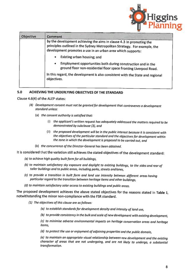
In both instances, however, a request to vary the development standard has been submitted which satisfactorily demonstrates that compliance would be unnecessary as the proposal is consistent with the objectives of the standard and that there are sound environmental planning grounds for the variation.
6.2 Regional Environmental Plans
6.2.1 Sydney Regional Environmental Plan (Sydney Harbour Catchment) 2005
An assessment has been made of the matters set out in Clause 20 of the Sydney Regional Environmental Plan (Sydney Harbour Catchment) 2005. It is considered that the carrying out of the proposed development is generally consistent with the objectives of the Plan and would not have any adverse effect on environmental heritage, the visual environmental, the natural environment and open space and recreation facilities.
6.3 State Environmental Planning Policies
6.3.1 State Environmental Planning Policy No. 55 - Remediation of land
The applicant has submitted a Stage 1 (Preliminary) Environmental Site Assessment which concludes that:
· a further detailed contamination assessment is not required; and
· the site is considered to be suitable for the proposed development.
As such, remediation of the site is not required prior to the carrying out of the proposed development.
6.3.2 State Environmental Planning Policy No. 65 - Design Quality of Residential Flat Development
The proposed development includes a residential flat building as defined by the SEPP in that it comprises 3 or more storeys and 4 or more self contained dwellings. The proposal is therefore subject to the provisions of the SEPP. The proposal is accompanied by a suitable Design Verification Statement as required by The Regulations.
|
State Environmental Planning Policy No. 65: Design Quality of Residential Flat Development |
|||||
|
Clause |
Standard |
Proposed |
Complies |
||
|
28 |
Determination of Development Applications |
||||
|
28(1) |
After receipt of a development application for consent to carry out development to which this Policy applies (other than State significant development) and before it determines the application, the consent authority is to refer the application to the relevant design review panel (if any) for advice concerning the design quality of the development. |
The application has been referred to Council’s SEPP 65 review officer for comment. |
Yes
|
||
|
28(2) |
In determining a development application for consent to carry out development to which this Policy applies, a consent authority is to take into consideration (in addition to any other matters that are required to be, or may be, taken into consideration): (a) the advice (if any) obtained from the design review panel, and (b) the design quality of the development when evaluated in accordance with the design quality principles, and (c) the Apartment Design Guide. |
Yes |
|||
|
28(2)(b) |
The design quality principles |
||||
|
1. |
Principle 1: Context and neighbourhood character Good design responds and contributes to its context. Context is the key natural and built features of an area, their relationship and the character they create when combined. It also includes social, economic, health and environmental conditions. Responding to context involves identifying the desirable elements of an area’s existing or future character. Well designed buildings respond to and enhance the qualities and identity of the area including the adjacent sites, streetscape and neighbourhood. Consideration of local context is important for all sites, including sites in established areas, those undergoing change or identified for change. |
The proposal responds appropriately to desired future character of the B4 zone in Liverpool Road. In particular, it: · Successfully terminates the street wall against Markham Lane; · Activates not only Liverpool Road but also Markham Lane at the side and Markham Place at the rear; · Adopts a massing which creates a suitable model for future development in the strip which can connect to it. |
Yes |
||
|
2. |
Principle 2: Built form and scale Good design achieves a scale, bulk and height appropriate to the existing or desired future character of the street and surrounding buildings. Good design also achieves an appropriate built form for a site and the building’s purpose in terms of building alignments, proportions, building type, articulation and the manipulation of building elements. Appropriate built form defines the public domain, contributes to the character of streetscapes and parks, including their views and vistas, and provides internal amenity and outlook. |
The scale is consistent with the LEP and DCP controls for the site and is appropriate for the three dimensional built form intended for this site and this section of the town centre generally. |
Yes |
||
|
3. |
Principle 3: Density Good design achieves a high level of amenity for residents and each apartment, resulting in a density appropriate to the site and its context. Appropriate densities are consistent with the area’s existing or projected population. Appropriate densities can be sustained by existing or proposed infrastructure, public transport, access to jobs, community facilities and the environment. |
The density is generally consistent with the FSR nominated for the site by ALEP 2013. Despite a small exceedance, this is envisaged by AIDAP 2013 in order to facilitate the additional height permitted for the provision of affordable rental housing. |
Yes |
||
|
4. |
Principle 4: Sustainability Good design combines positive environmental, social and economic outcomes. Good sustainable design includes use of natural cross ventilation and sunlight for the amenity and liveability of residents and passive thermal design for ventilation, heating and cooling reducing reliance on technology and operation costs. Other elements include recycling and reuse of materials and waste, use of sustainable materials and deep soil zones for groundwater recharge and vegetation. |
The proposal has been accompanied by a BASIX certificate demonstrating compliance with fundamental sustainability requirements.
|
Yes |
||
|
5. |
Principle 5: Landscape Good design recognises that together landscape and buildings operate as an integrated and sustainable system, resulting in attractive developments with good amenity. A positive image and contextual fit of well designed developments is achieved by contributing to the landscape character of the streetscape and neighbourhood. Good landscape design enhances the development’s environmental performance by retaining positive natural features which contribute to the local context, co-ordinating water and soil management, solar access, micro-climate, tree canopy, habitat values and preserving green networks. Good landscape design optimises useability, privacy and opportunities for social interaction, equitable access, respect for neighbours’ amenity and provides for practical establishment and long term management. |
Due to the locality in the town centre, the landscaping, is, by necessity, limited to the rooftop of the podium level. Notwithstanding this, it provides: · in excess of minimum communal open space areas on the roof of the podium facing Liverpool Road; · open space directly accessible from the main vertical circulation areas of the building; · generous rooftop planting. |
Yes |
||
|
6. |
Principle 6: Amenity Good design positively influences internal and external amenity for residents and neighbours. Achieving good amenity contributes to positive living environments and resident well being. Good amenity combines appropriate room dimensions and shapes, access to sunlight, natural ventilation, outlook, visual and acoustic privacy, storage, indoor and outdoor space, efficient layouts and service areas and ease of access for all age groups and degrees of mobility. |
Residential amenity is adequate: · Suitable internal layouts; · Adequate solar access and cross ventilation; · Adequate visual and acoustic privacy; · Suitable site layout. |
Yes |
||
|
7. |
Principle 7: Safety Good design optimises safety and security within the development and the public domain. It provides for quality public and private spaces that are clearly defined and fit for the intended purpose. Opportunities to maximise passive surveillance of public and communal areas promote safety. A positive relationship between public and private spaces is achieved through clearly defined secure access points and well lit and visible areas that are easily maintained and appropriate to the location and purpose. |
Safety and security is optimised due to: · Significantly increased passive surveillance of Markham Lane and Markham Place where none existed previously; · Activation of Markham Place and Markham Lane by both retail tenancies and the residential lobby. |
Yes |
||
|
8. |
Principle 8: Housing diversity and social interaction Good design achieves a mix of apartment sizes, providing housing choice for different demographics, living needs and household budgets. Well designed apartment developments respond to social context by providing housing and facilities to suit the existing and future social mix. Good design involves practical and flexible features, including different types of communal spaces for a broad range of people and providing opportunities for social interaction among residents. |
A suitable range of unit sizes is provided from 1 to 3 bedrooms.
|
Yes |
||
|
9. |
Principle 9: Aesthetics Good design achieves a built form that has good proportions and a balanced composition of elements, reflecting the internal layout and structure. Good design uses a variety of materials, colours and textures. The visual appearance of a well designed apartment development responds to the existing or future local context, particularly desirable elements and repetitions of the streetscape. |
The aesthetic resolution is sophisticated, well resolved and suitable for the evolving streetscape character of Liverpool Road. |
Yes |
||
|
28(2)(c) |
Apartment Design Guide |
||||
|
Part 3 |
Siting the development |
||||
|
3B |
Orientation |
On merit.
|
Orientation to the street is appropriate in the context. |
Yes |
|
|
3C |
Public domain interface |
On merit.
|
Appropriate in the context |
Yes |
|
|
3D-1 |
Communal open space |
Communal open space: min. 25% site area: 182m2 |
39% (286m2) |
Yes |
|
|
|
|
Solar access to communal open space |
Adequate solar access to rooftop communal open space. |
Yes |
|
|
3D-3 |
Communal open space is designed to maximise safety |
Safety |
Podium rooftop level communal open space is open and well observed by units above. |
Yes |
|
|
3E-1 |
Deep soil zones |
7% min dimension 3m: 51m2 |
0% (0m2)
This is considered acceptable given the built up urban town centre context of the site. |
Acceptable |
|
|
3F1 |
Building Separation (5-8 storeys) |
9m between habitable rooms/balconies and side boundaries
4.5m between non-habitable rooms |
South (Liverpool Road): · 12m |
Yes |
|
|
North (Markham Place): · 3m (but in excess of 18m from adjacent tower across Markham Place) |
Yes |
||||
|
East (Markham Lane): Blank walls or with high-light windows only. These require a 4.5m separation. · 3m (but 6m to centerline of laneway). Any future tower on the facing building could be expected to be set back similarly from the laneway and would consequently exceed the total separation distance of 9m. |
Acceptable |
||||
|
West (Markham Lane): · 0m Blank wall designed to tie in with blank wall on adjacent development and is appropriate in the town centre context. |
Acceptable |
||||
|
3F-2 |
Privacy |
|
Communal open spaces adequately separated from private open spaces and windows. |
Yes |
|
|
3J-1 |
Car parking · 88m of railway or light rail station; or · In or within 400m of B3/B4 land |
Guide to Traffic Generating Developments prevails: Residential: · 0.6/1 Bed unit = 12 · 0.9/2 Bed unit = 6.3 · 1.4/3 Bed unit = 1.4 TOTAL: 20 Residential Visitors: · Spaces: 1/5 units = 5.6 TOTAL: 6
TOTAL RESIDENTIAL: 26 |
Residential: · 29 (incl. 3 accessible) Residential Visitors: · 6 (incl. 1 accessible)
TOTAL RESIDENTIAL: 35 |
Yes |
|
|
Part 4 |
Designing the Building |
||||
|
4A-1(1) |
Solar & daylight access |
70% of living rooms and private open spaces: min. 2 hours solar access between 9am and 3pm in mid-winter. |
79% |
Yes |
|
|
4A-1(3) |
Solar & daylight access |
No direct sunlight at the above time: max. 15% |
7% |
Yes |
|
|
4B-3(1) |
Natural ventilation |
Natural cross ventilation: min. 60% of apartments |
75% |
Yes |
|
|
4B-3(2 |
Natural ventilation |
Maximum depth of cross through apartments: 18m glass to glass |
12m |
Yes |
|
|
4C-1 |
Ceiling heights |
· Habitable rooms: 2.7m · Non-habitable: 2.4m · 2 storey: 2.4m 2nd storey · Attics: 1.8m at edge of room with 30 deg slope · Commercial: 3.3m ground and first floor. |
2.7m |
Yes |
|
|
4D-1(1) |
Apartment size and layout |
Minimum internal areas: · Studio: 35m2 · 1 bed: 50m2 · 2 bed: 70m2 · 3 bed: 90m2 |
All units exceed the minimum areas. |
Yes |
|
|
4D-1(2) |
Apartment size and layout |
All habitable rooms to have window in external wall min. 10% floor area. |
All units exceed the minimum areas. |
Yes |
|
|
4D-2 |
Apartment size and layout |
Max. Habitable room depth: 8m |
All units comply. |
Yes |
|
|
4D-3(1) |
Apartment size and layout |
Min areas: · Master bedroom: 10m2 · Other bedrooms: 9m2 |
All units comply. |
Yes |
|
|
4D-3(2) |
Apartment size and layout |
Min. Bedroom dimension (excl. Robe): 3m |
All units comply. |
Yes |
|
|
4D-3(3) |
Apartment size and layout |
Min. Living room dimension: · 1 Bed Unit: 3.6m · 2 Bed Unit: 4.0m |
All units comply. |
Yes |
|
|
4E-1(1) |
Private open space & balconies |
Min. Balcony size/depth: · Studio: 4m2/- · 1 Bed: 8m2/2m · 2 Bed: 10m2/2m · 3 Bed: 12m2/2.4m |
All units comply. |
Yes |
|
|
4E-1(2) |
Private open space & balconies |
Min. Courtyard size/depth: · 15m2/3m |
No ground floor units are proposed. |
N/A |
|
|
4F-1(1) |
Common circulation spaces |
Max. apartments off a single core: 8 |
8 |
Yes |
|
|
4F-1(2) |
Common circulation spaces |
Max. apartments sharing single lift: 40 (10 storeys and over) |
28 |
Yes |
|
|
4G-1(1) |
Storage |
Minimum storage: · Studio: 4m3 · 1 Bed: 6m3 · 2 Bed: 8m3 · 3 Bed: 10m3 50% to be in apartment (not bedroom/kitchen) |
All units comply. |
Yes |
|
|
4H-1 |
Acoustic privacy |
Noise transfer is minimised through the siting of buildings and building layout. |
Layout is considered appropriate to address acoustic privacy issues. |
Yes |
|
|
4H-2 |
Acoustic privacy |
Noise impacts are mitigated within apartments through layout and acoustic treatments. |
Layout is considered appropriate to address acoustic privacy issues. |
Yes |
|
|
4J-1 |
Noise and pollution |
In noisy or hostile environments the impacts of external noise and pollution are minimised through the careful siting and layout of buildings. |
Layout is considered appropriate to address acoustic privacy issues. |
Yes |
|
|
4J-2 |
Noise and pollution |
Appropriate noise shielding or attenuation techniques for the building design, construction and choice of materials are used to mitigate noise transmission. |
The acoustic report recommends suitable acoustic treatment which will be addressed through conditions of consent. |
Yes |
|
|
4K-1 |
Apartment mix |
A range of apartment types and sizes is provided to cater for different household types now and into the future. |
A variety of apartment types is provided. |
Yes |
|
|
4L-1 |
Ground floor apartments |
Street frontage activity is maximised. |
All lower level apartments directly address the street. |
Yes |
|
|
4L-2 |
Ground floor apartments |
Private courtyards elevated above the street by 1m-1.5m |
No ground floor units are proposed. |
N/A |
|
|
4M-1 |
Facades |
Building facades provide visual interest and respect character of local area. |
The building façade provides a variety of materials and finishes which provides good articulation and a visual character suitable to the existing and evolving context of the locality. |
Yes |
|
|
4M-1 |
Facades |
Building functions are expressed on the facade. |
The building functions are suitably expressed on the façade. |
Yes |
|
|
4N-1 |
Roof design |
Roof treatments are integrated into the building design and positively respond to the street. |
The roof is appropriate to the context. |
Yes |
|
|
4N-2 |
Roof design |
Opportunities to use roof space for residential accommodation and open space are maximised. |
The roof of the podium level has been utilised for a large area of communal open space which also includes landscaping, eating areas, sitting areas and general open space. |
Yes |
|
|
4N-3 |
Roof design |
Roof design incorporates sustainability features. |
The roof includes planting areas which reduce heat gain to the units below. |
Yes |
|
|
4O |
Landscape design |
|
The landscape design is considered appropriate in respect of its treatment of the rooftop terrace. |
Yes |
|
|
4P-1 |
Planting on structures |
Min. Soil depths: · 12-18m trees: 1.2m deep & 10m x 10m · 8-12m trees: 1.0m deep & 6m x 6m · 6-8m trees: 0.8m deep & 3.5m x 3.5m · Shrubs: 0.5m – 0.6m deep · Ground cover: 0.3m – 0.45m deep · Turf: 0.2m deep |
Soil depths are generally 1m which is adequate for the type of planting proposed. |
Yes |
|
|
4Q-2 |
Universal design |
Adaptable housing in accordance with Council policy. |
3 of the units are adaptable & consistent with Council’s policy. |
Yes |
|
|
4R-1 |
Adaptive reuse |
New additions to existing buildings are contemporary and complementary and enhance an area’s identity and sense of place. |
New construction - not applicable. |
N/A |
|
|
4S-2 |
Mixed use |
Residential uses of the building are integrated within the development, and safety and amenity is maximised for residents. |
Suitably integrated. |
Yes |
|
|
4T-1 |
Awnings and signage |
Awnings are well located and complement and integrate with the building design. |
Awnings are suitably designed. |
Yes |
|
|
4T-2 |
Awnings and signage |
Signage responds to the context and desired streetscape character. |
No signage proposed at this stage – not applicable. |
N/A |
|
|
4U |
Energy efficiency |
|
A BASIX certificate has been submitted which demonstrates compliance with this provision. |
Yes |
|
|
4V |
Water management |
|
A BASIX certificate has been submitted which demonstrates compliance with this provision. |
Yes |
|
|
4W |
Waste management |
|
The garbage room is of adequate size to accommodate the number of bins required; and the waste management and collection arrangements would be satisfactory. |
Yes |
|
|
4X-3 |
Building maintenance |
Material selection reduces ongoing maintenance costs. |
The proposal is finished in painted render and metal cladding which is suitable for upper levels. Painted render is not appropriate, however, at street level & conditions of consent will require the use of more durable materials of either face brick, stone or tile. |
Yes |
|
As identified in the above table, the proposal generally satisfies the requirements of the SEPP.
6.3.3 State Environmental Planning Policy (Infrastructure) 2007
The proposal is located on a site with frontage to a classified road and is subject to the provisions of the SEPP. Note that under the terms of the SEPP, Council is not required to refer this application to RMS.
|
State Environmental Planning Policy (Infrastructure) 2007 Summary Compliance Table |
|||
|
Clause No. |
Standard |
Proposed |
Complies |
|
101 |
Development with frontage to classified road |
||
|
101(2) |
The consent authority must not grant consent to development on land that has a frontage to a classified road unless it is satisfied that: |
||
|
101(2)(a) |
where practicable, vehicular access to the land is provided by a road other than the classified road, and |
Vehicular access is proposed off Markham Place. |
Yes |
|
101(2)(b) |
the safety, efficiency and ongoing operation of the classified road will not be adversely affected by the development as a result of: |
||
|
(i) |
the design of the vehicular access to the land, or |
Council’s engineer has not raised concerns with the design of the access in relation to the classified road. |
Yes |
|
(ii) |
the emission of smoke or dust from the development, or |
No dust or smoke is likely to result from the development. |
Yes |
|
(iii) |
the nature, volume or frequency of vehicles using the classified road to gain access to the land, and |
Council’s engineer has not raised concerns with the volume of traffic in relation to the classified road. |
Yes |
|
101(2)(c) |
the development is of a type that is not sensitive to traffic noise or vehicle emissions, or is appropriately located and designed, or includes measures, to ameliorate potential traffic noise or vehicle emissions within the site of the development arising from the adjacent classified road. |
Being a residential development, the proposal is one which is inherently sensitive to traffic noise. Nevertheless, adequate measures have been implemented in the form of louvres and winter gardens on the balconies to protect the inhabitants from excessive traffic noise. In addition, any recommendations of the acoustic report will be included as consent conditions. |
Yes |
Given the above, it is considered that the proposal satisfies the requirements of the SEPP.
6.4 The provisions of any Draft Environmental Planning Instrument that is or has been placed on public exhibition and details of which have been notified to the consent authority.
No draft environmental planning instruments apply to the site.
6.5 The provisions of any Development Control Plan.
The Ashfield Interim Development Assessment Policy IDA specifically addresses how the ADCP 2007 is to be interpreted in the context of ALEP 2013. Please see Section 7.8 below.
6.6 Any matters prescribed by the regulations that apply to the land to which the development application relates.
These matters have been considered as part of the assessment of the development application.
6.7 The likely impacts of that development, including environmental impacts on both the natural and built environments, and social and economic impacts on the locality.
The proposal would not result in any adverse impacts upon the surrounding locality.
6.8 The suitability of the site for the development
These matters have been considered as part of the assessment of the development application. There are no natural hazards or other site constraints that are likely to have a significant adverse impact upon the proposed development.
6.9 Any submissions made in accordance with this Act or the regulations
The proposal was notified to all adjoining and nearby affected property owners and occupants, and Councilors from 10 May 2016 until 3 June 2016. Notification was checked during site inspection and was acceptable.
No submissions were received during the notification of the development application.
6.10 The public interest
The proposal is considered to meet the aims and objectives of Ashfield Interim Development Assessment Policy 2013. Specifically to the following Parts:
|
Ashfield Interim Development Assessment Policy 2013 Summary Compliance Table |
||||
|
No. |
Standard |
Required |
Proposed |
Complies |
|
Part C1 |
Access, Adaptability and Mobility |
|||
|
2.3 |
Universal Accessible Design |
i. Villas and townhouses: ii. Low rise Flats iii. Residential Flat Buildings |
Part of proposal is classed as a residential flat building. |
Yes |
|
2.4 |
Adaptable Housing |
10% |
11% |
Yes |
|
2.5 |
Variations to Universal Accessible Design Requirements |
Site conditions |
No variations proposed due to site conditions. |
N/A |
|
7.4 |
Visitability |
All apartments must be visitable from the street and the basement car park. |
All apartments are visitable. |
Yes |
|
7.5 |
Interior dwelling design |
The interior elements shall be adequately sized to allow wheelchair circulation. |
Adequate circulation area provided except for bathrooms. Each unit is to have at least one bathroom which can be used by a person in a wheelchair. A condition will be applied to the consent requiring this. |
Condition |
|
7.6 |
Access to private open space |
Private open space shall be accessible and adequately sized to allow wheelchair access and use. |
Private open space areas are accessible. |
Yes |
|
7.7 |
Access to car parking |
Access to and from the car parking area for people with a disability, preferably by lift. |
Suitable lift access is provided to and from the car park. |
Yes |
|
7.8 |
Access to communal garden space |
Where there is communal open space on the site, it must be accessible from all dwellings required to have a universal accessible design, and by all visitors to the site. |
The communal open space is accessible and suitably proportioned for use by wheelchairs. |
Yes |
|
Part C3 |
Ashfield Town Centre |
|||
|
1.1 |
Building Appearance |
mixed developments shall be of a traditional architectural language: · basic tripartite arrangements to facades, employing symmetry and proportion · punctuated extremities, which signal the boundaries of the building. · solid walls, which have punched openings for balconies and windows, and have vertically emphasized proportions. · expression of architectural detailing, such as expression of datum lines and string courses, and a colour palette of materials of medium to dark monotone face brickwork and rendered coloured surfaces. |
Building is of a contemporary aesthetic but follows traditional architectural compositional practice in that: · It adopts a base, middle and top; · It expresses the extremities; · It has a strong pattern of solid and void; · It expresses the form of the building with architectural expression of the facade elements. |
Yes |
|
1.3 |
|
buildings employing contemporary or non-historic building styles shall achieve a high compositional standard. |
The architectural expression is considered to be of a high compositional standard. |
Yes |
|
1.4 |
|
Shopfront Design to be compatible with the existing townscape. |
The shopfront design is appropriate to the context. |
Yes |
|
1.5 |
|
Blank side wall facades without windows be modelled to provide an articulated and attractive appearance. |
The western side wall which is built on the boundary has been designed to be publicly visibly until such time as an adjacent development conceals it. |
Yes |
|
1.6 |
New Main Street Building Facades |
Front facades above ground level to: · Be predominantly masonry; · contain openings of proportions found in the existing townscape; · take architectural cues from the existing townscape. |
The façade along Liverpool Road, although in a contemporary aesthetic, is appropriately configured and presented. |
Yes |
|
1.7 |
|
Alterations to existing front facades above ground level to be sympathetic to the existing architectural composition and townscape. |
N/A |
N/A |
|
1.8 |
Human Building Scale |
Development to comply with the “street wall height zone” in accordance with Clause 4.1AA of the Ashfield LEP 2013. |
The proposal is generally consistent with the street wall height zone. |
Yes |
|
1.9 |
Public Open Space |
Development identified in Section 3 – Landscape to contribute to the provision of public open space. |
N/A |
N/A |
|
1.10 |
|
Sites identified in Section 4 to provide weather protection for pedestrians over public open space. |
Not required. |
N/A |
|
1.11 |
Vibrant and Safe Town Centre |
Maximize public safety and create a lively Town Centre with shopfront & building design & ground floor commercial uses. |
Ample active frontages have been provided by way of retail spaces on all three exposed ground floor frontages. |
Yes |
|
1.12 |
Signage |
Signage to be subservient to existing architectural composition. |
No signage proposed at this stage. Will be the subject to future DA if necessary. |
N/A |
|
2.1 |
Maximum Building height |
Max. number of storeys: 6 + 2 bonus=8 |
8 |
Yes |
|
2.2 |
Site Amalgamations |
Site amalgamation may be necessary to achieve adequate site area to achieve maximum heights. |
4 lots have been amalgamated to achieve a coherent and efficient development site which yields high quality urban design benefits. |
Yes |
|
2.3 |
Exceptions to maximum permitted height of buildings |
A height bonus of up to 7 metres available for development within Area 1 subject to Clause 4.3A of Ashfield LEP 2013. |
The application proposes the required proportion of affordable housing to activate the height bonus. |
Yes |
|
2.4 |
Solar access for adjoining properties |
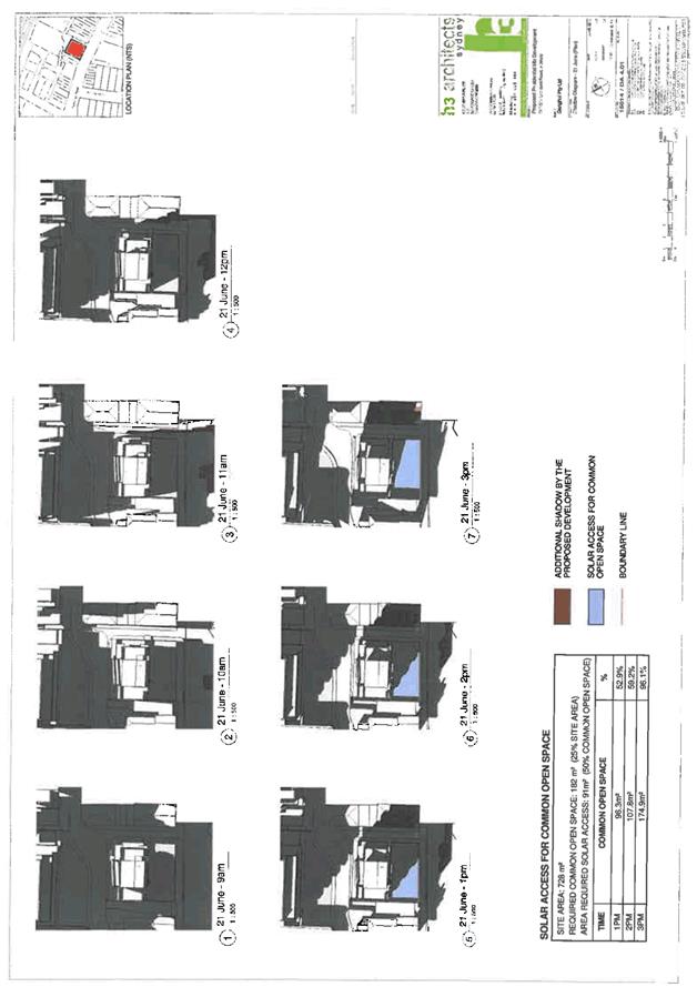
Must not compromise ability of adjacent sites to build to full floor space ratio potential and maintain solar access. |
Does not overshadow adjoining properties unacceptably as high rise element overshadows public open space and the road surface. |
Yes |
|
2.5 |
Street Wall Height Zones |
Area 1 “street wall height zone”, maximum street wall height of 12 metres for 12 metres from the main street frontage. Council will consider variations where suitable. |
Complies with the street wall height zone of 12m except for minor decorative façade elements on the tower which serve to improve its aesthetic presentation. |
Yes |
|
2.6 |
Facades parallel to Street |
External facades of buildings, including buildings above the street frontage height, are to be parallel with the primary street boundary of the property. |
Facades are parallel where appropriate. |
Yes |
|
3.1 |
Setbacks for public open space |
Development specified in Clause 4, and shown on Map 4 shall provide “development setbacks” in accordance with clause 2. |
Complies. |
Yes |
|
3.2 |
|
“Development setback” means that the development allotment is reduced in size in order to create a “residue lot” to be dedicated for public open space in accordance with clause 3. The land area dedicated to Council will be included when calculating allowable floor space ratio and as a credit towards any required Section 94 contributions. |
N/A |
N/A |
|
3.3 |
|
A “residue lot” is an allotment created for: · enabling a public verge /footpath area wide enough for external public seating tree planting, and pedestrian flow. · the residue lot is dedicated to Council at the completion of development. |
N/A |
N/A |
|
3.4 |
|
Development types listed below, and which are identified on the areas designated on Map 4 are required to provide a “development setback”. Development setbacks will be required for: · - mixed use development such as ground floor businesses and upper level apartments buildings up to 8 storeys in height. · site development areas larger than 1000 m2 |
N/A |
N/A |
|
3.6 |
Security |
Communal open space requirements identified in Residential Design Flat Code: Residential flat developments/mixed developments on sites areas greater than 2000 sqm. Are to provide a minimum of 25 percent communal open space pursuant to the Residential Flats Design Code.
Development affected by Clause 8 below and which provides a development setback may provide a smaller communal open space area. |
Communal open space exceeds minimum requirements. |
Yes |
|
3.7 |
|
Communal open space required pursuant to clause 6 may be located in the following positions: · on the roof of the residential flat building · at ground level where it abuts or will abut a major civic public open space identifies in this Part or Public Domain Strategy and is be designed to integrate with that space. |
The communal open space is located as follows on the podium roof and is considered satisfactory. |
Yes |
|
Yes |
|
|||
|
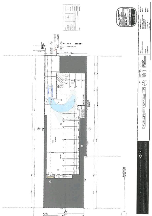
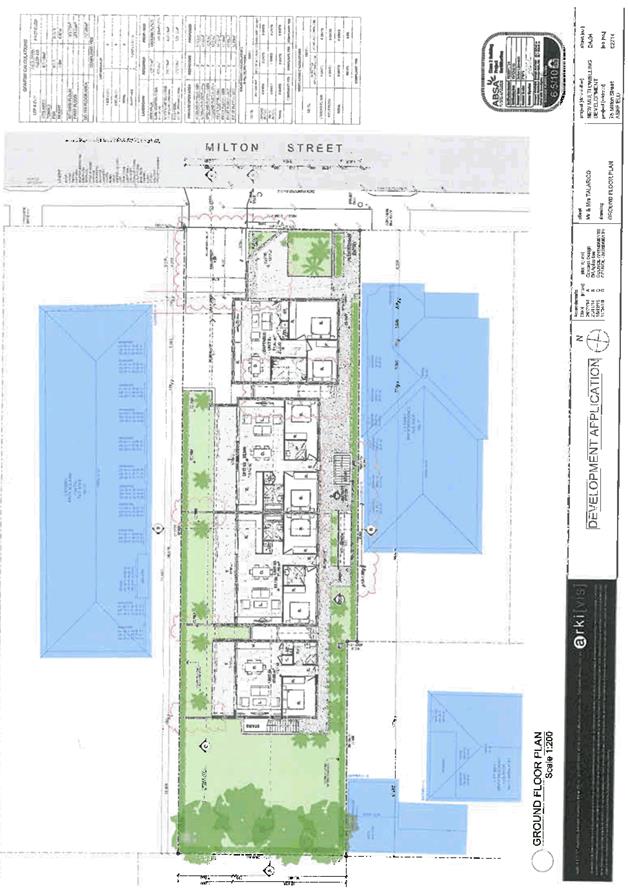
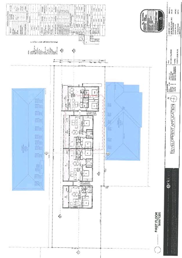
3.9 |
|
Planter boxes shall: · provide soil depth, soil volume and soil area appropriate to the size of the plants to be established, in accordance with Table 1; · provide appropriate soil conditions and irrigation methods; and · providing adequate drainage, including water drainage spouts. |
Planter boxes comply. |
Yes |
|
4.1 |
Active Street Frontages definition |
Active frontage uses are defined as one of a combination of the following at street level: · entrance to shops and commercial premises · shop front, · clear glazed entries to commercial and residential lobbies, · café or restaurant if directly accessed from the street, · active office uses, such as reception areas, if visible from the street, · public building or community facilities if directly accessed from the street. |
Active frontages satisfy these criteria. |
Yes |
|
4.2 |
Active Street Frontages - required location |
Active street frontages are required in the areas shown on Map 7 |
Provided in excess of requirements. |
Yes |
|
4.3 |
Visibility of street |
Sites affected by Clause 2 shall have shopfronts which are predominantly glazed, in order to ensure that adequate visibility of the street occurs, with the minimum amount of glazed area being as follows : Shopfronts shall have as part of their ground level façade, a glazed area which is a minimum of 80 percent of the width of the shopfront, measured vertically from ground level to a minimum of 2.1 metres above ground level. The glazed area shall be transparent, so as to enable visibility of the street from the interior of the building. |
Active frontages satisfy these criteria. |
Yes |
|
4.4 |
Location of parking |
Any on grade (ground level) car parks are to be set back behind an active street frontage, and designed in accordance with the controls set out in Part C11, Clause 5.3. |
No at grade parking provided. |
N/A |
|
4.5 |
Street address |
‘Street address’ is defined as: · entries, lobbies, and habitable rooms with clear glazing overlooking the street, and · excludes car parking areas. |
Noted. |
Noted |
|
4.6 |
|
A street address is required on ground level of all areas identified in Map 5. |
Street address consisting of the main lobby is located as required and activates Markham Lane. |
Yes |
|
4.7 |
Street Awnings |
Awnings along street frontages are to be provided for all new developments as indicated in Map 5. Awnings are to be designed to be in accordance with the following: · constructed out of metal framing and steel roofing material; · have a minimum ground level clearance of 3m,or which matches approximately the height of existing or adjacent awnings; · lighting installed to the underside in accordance of the awning in accordance with Council requirements |
Suitable awnings are provided on all three frontages of the proposal. |
Yes |
|
4.8 |
Access ( people with disabilities) |
Refer to Part C1 of Ashfield Interim Development Assessment Policy for requirements for access to buildings for people with disabilities. |
Some minor non-compliances. Conditions proposed to achieve compliance. |
Condition |
|
4.9 |
Safety |
Residential development along rear lanes is specified to ensure that windows contained in residential flat building are positioned to ensure that surveillance occurs of those lane areas. |
The rear facing upper levels have been set back the same distance from the rear boundary as the ground floor which provides the ability for passive surveillance and increases safety. |
Yes |
|
4.10 |
|
The following security devices shall be required in Residential Flat Buildings : · Ground and first floor levels shall have fitted security devices which comply with the Australian Standard. |
Condition of consent proposed. |
Condition |
|
6.1 |
Proportion of ground level commercial space |
In mixed development majority of ground floor area of should be business use. Service functions to be kept to a minimum. |
The entire ground floor has been allocated to retail use except for the necessary access and service elements to the residential component above. |
Yes |
|
6.2 |
Car parking |
Car parking to be below ground, for substantial developments. |
All car parking is located below ground level. |
Yes |
|
6.3 |
Servicing requirements |
Service Areas for commercial development to be provided. |
Service areas have been provided as necessary. |
Yes |
|
6.4 |
Minimum ground floor ceiling |
Ground floor commercial use, as a minimum 3m - 3.6m and adequate height between the ceiling and the first floor slab for installation of services. |
3.0m |
Yes |
|
6.6 |
Shopfront composition |
The minimum amount of glazed area. |
Shopfronts are predominantly glazed. |
Yes |
|
6.7 |
|
Shopfronts not to have “roll-a-door” grille or opaque security shutters, unless predominantly transparent. |
Not proposed. |
Yes |
|
6.8 |
|
Ground level shopfronts to complement the building style of the façade. |
Yes |
Yes |
|
6.9 |
Awnings |
Awnings to be provided in the locations stipulated on Map 6. |
Awnings have been provided on all three frontages in excess of minimum requirements. |
Yes |
|
6.11 |
Air-conditioning units and satellite dishes |
Air-conditioning units and satellite dishes: a) not located on front façade and positioned at the rear. b) at least 1.5 m from all adjoining property boundaries. c) Use non-reflective materials. d) diameter must not exceed 1.8 m on roof. |
Not proposed. |
Yes |
|
6.12 |
Strata subdivision of offices |
Strata subdivision of offices must address wall partitioning and fire egress, allocation of bathroom and kitchen facilities, waste storage locations, business signage and parking. |
Not proposed at this stage. |
N/A |
|
8.1 |
Location of driveways |
Driveways to be provided from lanes and secondary streets identified on Map 8. |
Located from Markham Place. |
Yes |
|
8.2 |
Access ways to underground parking |
Access ways to underground parking to minimise noise impacts on adjacent or nearby habitable rooms, including bedrooms. |
Access driveway is suitably designed and is not directly adjacent any bedrooms. |
Yes |
|
8.3 |
Location of parking |
Car parking shall be located below ground level for major development. |
All parking is located below ground level. |
Yes |
|
8.4 |
Amount of Parking |
Car parking to be as per Part C11 - Parking. |
See Part C11. |
Noted |
|
8.5 |
Waste (garbage) storage, collection and location requirements |
An area to be provided to accommodate bins for garbage collection and recycling of waste, with waste storage and collection areas (see Clause 6). A waste generation management plan is to show the waste to be generated on a weekly basis, how it will be transferred to the waste storage area, and this is to be reflected on the plans and sizes for the waste storage area and ancillary areas. |
Garbage collection facilities are located on ground floor service areas and also in chute deposit hatches on each floor. |
Yes |
|
8.6 |
Loading/unloading areas |
Adequate facilities to be provided for the loading and unloading of service/delivery vehicles (see Clause 7). |
A loading bay is provided off the rear lane. |
Yes |
|
8.7 |
Design of service areas |
Vehicular access to parking areas, waste collection, loading and unloading, are to be minimised but functional. This shall be demonstrated by a “service area function plan” (see Fig 3), to show: · Waste collection room areas, including garbage bins, recycling bins, other bins, using the data in Information Sheet No 1. · Required truck manoeuvring areas, and parking areas, shown in plan and section for the emptying of bins onto trucks and the manoeuvring of bins to and from Waste collection room areas, using Council’s truck turning templates on Information Sheet No 1. (see Part C11 - Section 5). |
Suitably designed. |
Yes |
|
8.8 |
|
Service doors and loading docks are to be adequately screened from street frontages and from overlooking by existing development. |
All service areas are well screened. |
Yes |
|
8.9 |
Mail boxes |
Mail boxes to be provided in one accessible location adjacent the main entrance and be integrated into a wall where possible and be of materials compatible with the building. Mail boxes shall be secure and large enough to accommodate articles such as newspapers. |
Mail boxes are centrally located in the lobby area. |
Yes |
|
8.10 |
Communication structures, air conditioners and service vents |
Satellite dish and telecommunication antennae, air conditioning units, ventilation stacks and any ancillary structures should be located: · away from the street frontage, · integrated into the roof design and not to become a skyline feature at the top of any building, and · adequately setback from the perimeter wall or roof edge. |
Not proposed at this stage. |
Yes |
|
9.4 |
Clothes Drying Locations |
Balconies are to accommodate an area for clothes drying and screen the drying area from view from the street. |
Not proposed at this stage but can be included as condition of consent. |
Condition |
|
9.5 |
Reflectivity |
Avoid glare that causes discomfort or threatens safety of pedestrians or drivers. |
Proposal consists of low reflectivity materials. |
Yes |
|
9.6 |
|
Light reflectivity from building materials used on the facades of new buildings should not exceed 20%. |
Proposal consists of low reflectivity materials. |
Yes |
|
9.7 |
|
A Reflectivity Report that analyses potential solar glare from the proposed development on pedestrians or motorists may be required. |
Not necessary given the nature of materials proposed. |
N/A |
|
9.8 |
Waste and recycling, amount of bins, truck sizes |
A “waste generation schedule” should show g the amount of waste day to day activities will generate, and a description of how occupants of the development will transfer their waste to waste collection areas on the site. |
Schedule has been provided. |
Yes |
|
Part C11 |
Parking |
|||
|
3.3 |
Parking Credits |
Do not apply if more than 50% of the building is being demolished. |
100% of the existing buildings are to be demolished and as such no parking credits are applicable. |
N/A |
|
4.1 |
Car Parking for People with Disabilities |
5 designated spaces per 100 required spaces = 1.3 |
4 |
Yes |
|
4.2 |
Bicycle and Motor Cycle Parking |
Residential: · Spaces: 1/10 units =3 Residential Visitors: · Spaces: 1/10 units = 3 Retail: · Spaces: 1/20 staff = 1 Retail Visitors: · Spaces: 1/250m2 = 1 TOTAL: 8 |
TOTAL: 12 |
Yes |
|
Motor Cycle · Spaces: 1/25 car parking spaces = 1 |
Motor Cycle · Spaces: 1 |
Yes |
||
|
4.3 |
Parking Rates for Specific Land Uses |
Resident spaces: Defer to SEPP 65 rates: · TOTAL: 26 spaces |
TOTAL: 35 spaces |
Yes |
|
Commercial spaces: · 1/40m2 = 4
|
Commercial spaces: · 8 |
Yes
|
||
|
Courier spaces: · 1 courier space/200m2 = 1 space |
Courier spaces: · 1 space (loading bay) |
Yes |
||
|
Carwash: · 1 |
Carwash: · 1 |
Yes |
||
|
5.0 |
Design Requirements |
Compliance with relevant Australian Standards and detailed requirements of the Part. |
Can be modified to comply by way of condition of consent. See comments by traffic engineer. |
Condition |
|
Part C12 |
Public Notification |
|||
|
Section 2 |
Notification Process |
|
The application was notified in accordance with this part. |
Yes |
|
Part D1 |
Planning for Less Waste |
|||
|
|
Bin Numbers
|
Residential (28 dwellings): · 1 x 240L garbage bin/2 dwellings=14 bins (x 50% for compaction) = 7 · 1 x 240L recycling bin/2 dwellings=14 bins · TOTAL: 21 bins |
Residential: · 7 x 240L garbage bin · 14 x 240L recycling bin TOTAL: 21 bins |
Yes |
|
|
|
Retail (166m2): ·50L/100m2/day=581L garbage/week=3 bins ·25L/100m2/day=291L recycle/week=1 bins · TOTAL: 4 bins |
Retail (166m2): · 6 x 240L garbage bin · 3 x 240L recycling bin TOTAL: 9 bins |
Yes |
|
|
Bulky Goods Storage |
Bulky goods storage area is required. |
Bulky goods storage area provided in garbage room. |
Yes |
|
|
Bin Presentation |
|
Adequate space along Markham Place frontage for placement of up to 14 recycle bins once a fortnight and 7 waste bins once a week (different days). Full bins will be held in bin holding room in the interim. |
Condition |
It is considered the application complies with the parts of the Ashfield Interim Development Assessment Policy 2013 as indicated and ultimately achieves the aims and objectives of the AIDP 2013.
7.0 Referrals
|
Internal Referrals |
||
|
Officer |
Comments |
Support |
|
Building Surveyor |
Supported subject to conditions. |
Yes |
|
Traffic Engineer |
Supported subject to conditions. |
Yes |
|
Drainage Engineer |
Supported subject to deferred commencement conditions. |
Yes |
|
Heritage Advisor |
No objection. |
Yes |
|
Environmental Health Officer |
No objection. |
Yes |
|
SEPP 65 Advisor |
No objection. |
Yes |
|
Waste Management |
No objection. |
Yes |
8.0 Building Code of Australia (BCA)
A Construction Certificate will be required to be applied for by condition of consent.
9.0 Financial Implications
Section 94 contribution applies to the development. A total contribution amount of $309,479.75 applies to the proposal.
10.0 Conclusion
The application has been assessed in accordance with the provisions of the Environmental Planning and Assessment Act, 1979 as amended with all matters specified under Section 79C (1) Clauses (a) to (e) having been taken into consideration.
Although the proposal breaches two development standards, these are minor in nature. In all other respects, the proposal complies with the provisions of Ashfield LEP 2013 and all other planning provisions applicable to the site. Furthermore, due to site amalgamation, it provides a coherent urban design response to its location at the end of a street wall and effectively activates three frontages including a side pedestrian lane and the rear lane where it will also interact positively with the development currently under construction at 5 Markham Place. It will also provide a 3m wide pedestrian right of way along the Markham Place frontage to allow safe pedestrian circulation where none existed previously.
The proposal also provides a high level of residential amenity for future occupants and avoids adverse impacts upon adjacent properties.
As noted in the report, there are some minor engineering issues which require further detailed resolution, but these can be addressed by way of deferred commencement conditions of consent.
The proposal is acceptable and is recommended for deferred commencement consent.
|
1.⇩ |
Plans of Proposal |
|
2.⇩ |
Locality Map |
|
3.⇩ |
Clause 4.6 Variation |
|
4.⇩ |
Heritage Advice |
|
5.⇩ |
Conditions |
|
Council Meeting 23 August 2016 |
Subject: Development Application - 75 Milton Street, Ashfield
File Ref: 16/4718/91467.16
Prepared By: Philip North - Specialist Planner, Ashfield
Authorised By: Phil Sarin - Director, Planning and Environment Planning and Environment
|
SUMMARY This application seeks Council’s consent for demolition of existing structures and construction of a two storey residential flat building comprising 8 dwellings with basement parking. The proposal is generally compliant with the planning controls applicable to the site, has acceptable amenity impacts, and results in a well-mannered insertion into a diverse streetscape. Although it orientates the majority of its units towards the north side boundary potentially creating privacy issues with the adjacent residential flat building, particularly at the upper level, this has been managed by way of a combination of adjustable privacy screens and landscaping. There are, however, some outstanding issues in respect of stormwater drainage which require further resolution which should be addressed by way of deferred commencement conditions. |
|
RECOMMENDATION
THAT the application be granted a deferred commencement consent.
|
1.0 Description of Proposal
Pursuant to Clause 78A(1) of the Environmental Planning and Assessment (EP&A) Act 1979 (as amended) this application seeks Council’s consent for demolition of existing structures and construction of a 2 storey residential flat building comprising 8 dwellings with basement parking.
2.0 Application Details
Applicant : Arkivis Design Studio
Owner : Mr A Talarico
Value of work : $2,462,772
Lot/DP : LOT: 31 DP: 707858
Date lodged : 16/12/2015
Building classification : 2
Application Type : Local
Construction Certificate : No
3.0 Site and Surrounding Development
The subject site is located on the western side of Milton Street, bounded by Arthur Street to the South and Summerville Avenue to the North. An existing dwelling house is located on the site. Surrounding development comprises dwelling houses and residential flat buildings. Refer to Attachment 1 for a locality map. The site consists of the following individual lots:
|
Street Address |
Lot No. |
Deposited Plan |
Title System |
Total Site Area (by title) |
|
75 Milton Street |
31 |
707858 |
Torrens |
928.7 m2 |
|
TOTAL AREA |
928.7m2 |
|||
4.0 Development Application History
Previous building and development applications submitted to Council for the subject site include:
|
No. |
Determination Date |
Proposal |
Determination |
|
06.1952.958 |
02.06.1987 |
Unknown |
Unknown |
The following table shows the background to the current application:
|
Application Milestones |
||
|
Date |
Event |
File no |
|
02.02.2015 |
Provisional Development Application submitted to Council |
17.2015.16 |
|
30.09.2014 |
Letter sent to applicant raising the following issues: · Council’s Heritage Advisor has reviewed the proposal and has raised the following concerns. Please amend your application to resolve these issues.
Two heritage items are located in Cromwell Street and at the rear of the subject site. The proposed building presents a plain, largely undeveloped elevation to the rear where the separation distance from the boundary is substantial and would support adequate screening. The manner in which the proposed loft floor (second floor) of the building would exceed the 8.5m maximum permitted building height would accentuate the scale and visibility of the building and conformity with the envelope limit would seem a reasonable request.
Adjacent to the south side of the property is a substantial Federation cottage with a notable front bay window. The design of the proposed development includes a screen / shelter element formed by extension of the floor line of the first floor laterally to the south boundary. This element visually constricts the space between the development and the Federation cottage and should be deleted. This omission would mean that the floor line / edge line is similar at both sides.
· The proposal fails to comply with the maximum FSR requirement of Ashfield LEP 2013. Whilst a Clause 4.6 – Exceptions to development Standards request has been submitted, Council will not support any variation to the FSR. Please also note that the semi open breeze with privacy screen is also to be included in the FSR calculations. As the FSR is excessive, the proposal must be modified to comply as no variation from the development standard will be supported. Please provide a plan showing the gross floor area areas included for the purpose of FSR calculations. · The proposal fails to comply with the Height control of Ashfield LEP 2013. Whilst a Clause 4.6 – exception to Development Standards has been lodged Council will not support any variation to the standard. In addition Council is of the view that compliance can be achieved without materially altering the substance of the design. · The proposed landscaped area fails to meet the required 35% of the overall site area. The proposal should be amended to comply. · The upper balconies are undersized and should be at least 2m in depth. · The semi open breezeway despite the privacy screens would have adverse privacy impacts upon the adjacent property to the south and should be fully enclosed with any outlook controlled by translucent glazing or suitable screening. · A correct design verification statement has not been provided. · Please provide more detail regarding the masonry structure located on the southern boundary immediately adjacent to unit 1. · The driveway gradients in particular1 in 20 transition immediately at the driveway entrance inside the property do not comply with the relevant Australian Standard and should amended to comply. · The car parking layout in particular the space dimensions i.e. blind aisle appear not comply with AS2890.1. · Elevational shadow diagrams showing the northern walls of both the proposed development and the adjacent property to the south (no. 77 Milton Street) are to be submitted which show both existing and proposed shadows as well as the use of the rooms served by any north facing windows. Please note that solar access must be maintained in accordance with the requirements of Ashfield Interim Development Assessment Policy 2013. |
17.2015.16 |
|
21.04.2015 |
Meeting held at Council with applicant. The owner of the site explained that he wanted to discuss the height and FSR of the proposal and that it is appropriate in this instance to vary the FSR and height control for the reason that the building is existing.
The owner/applicant was requested to further justify as to the reasons and appropriateness from a planning view point why Council’s height and FSR control should be varied.
The owner/applicant indicated additional details would be provided for Council to consider.
It was agreed that Council would wait for the applicant/owners revised plans and that a 3 week period be given to provide the information. |
17.2015.16 |
|
25.06.2015 |
7 day reminder letter sent to applicant. |
17.2015.16 |
|
01.10.2015 |
Submission returned to applicant due to lack of response. |
17.2015.16 |
|
16.12.2015 |
Development Application lodged “As-is” which failed to address a number of the issues originally raised. |
10.2015.255.1 |
|
08.03.2016 |
Reported to Council meeting of 8 March with a recommendation for refusal. |
10.2015.255.1 |
|
08.03.2016 |
Council resolved that the matter be deferred in order for the proponent to address the deficiencies noted in the report. |
10.2015.255.1 |
|
07.04.2016 |
Reminder letter sent to applicant regarding amended plans. |
10.2015.255.1 |
|
11.04.2016 |
Amended plans prepared. |
10.2015.255.1 |
|
16.06.2016 |
Meeting regarding deficiencies in amended plans. |
10.2015.255.1 |
|
25.07.2016 |
Further amended plans received. |
10.2015.255.1 |
The above issues have been generally addressed in the submitted plans except as noted in this report.
5.0 Zoning/Permissibility/Heritage
The site is zoned R2 Low Density Residential under the provisions of Ashfield LEP 2013.
The property is located within the vicinity of heritage items.
The proposed works for a residential flat building would ordinarily be prohibited in the R2 zone but are rendered permissible with Council consent by virtue of Ashfield LEP 2013, Schedule 1, Additional permissible uses, Clause 3: residential flat building permissible.
6.0 Section 79C Assessment
The following is an assessment of the application with regard to the heads of consideration under the provisions of Section 79C of the Environmental Planning and Assessment Act.
6.1 The provisions of any Environmental Planning Instrument
6.1.1 Local Environmental Plans
Ashfield Local Environmental Plan 2013
Ashfield Local Environmental Plan 2013 (ALEP 2013) was gazetted on 23 December 2013 and applies to the proposal. The following table summarises the compliance of the application with ALEP 2013.
|
Ashfield Local Environmental Plan 2013 Summary Compliance Table |
||||||
|
Clause No. |
Clause |
Standard |
Proposed |
Complies |
||
|
2.3 |
Zone objectives and land use table |
Zone R2 Low density residential
(Schedule 1, Additional permissible uses, cl. 3: residential flat building permissible) |
Residential flat building |
Yes |
||
|
4.3 |
Height of buildings |
8.5m |
6.95m |
Yes |
||
|
4.4 |
Floor space ratio |
0.7:1 |
0.58:1 |
Yes |
||
|
5.10 |
Heritage Conservation |
Located in the vicinity of: · Heritage Item I-422 (69 Milton Street); · Heritage Item I-378 (24 Cromwell Street); · Heritage Item I-376 (22 Cromwell Street); |
||||
|
5.10(4) |
Effect of proposed development on heritage significance |
The consent authority must, before granting consent under this clause in respect of a heritage item or heritage conservation area, consider the effect of the proposed development on the heritage significance of the item or area concerned. This subclause applies regardless of whether a heritage management document is prepared under subclause (5) or a heritage conservation management plan is submitted under subclause (6). |
No comment provided.
|
N/A |
||
|
5.10(5) |
Heritage assessment |
The consent authority may, before granting consent to any development: (a) on land on which a heritage item is located, or (b) on land that is within a heritage conservation area, or (c) on land that is within the vicinity of land referred to in paragraph (a) or (b),
require a heritage management document to be prepared that assesses the extent to which the carrying out of the proposed development would affect the heritage significance of the heritage item or heritage conservation area concerned. |
No heritage management document has been submitted, however, impacts on items in vicinity of the subject land are considered acceptable.
|
Acceptable |
||
As demonstrated in the above table above table, the proposed development generally satisfies the provisions of ALEP 2013.
6.1.2 Regional Environmental Plans
Sydney Regional Environmental Plan (Sydney Harbour Catchment) 2005
An assessment has been made of the matters set out in Clause 20 of the Sydney Regional Environmental Plan (Sydney Harbour Catchment) 2005. It is considered that the carrying out of the proposed development is generally consistent with the objectives of the Plan and would not have any adverse effect on environmental heritage, the visual environmental, the natural environment and open space and recreation facilities.
6.1.3 State Environmental Planning Policies
State Environmental Planning Policy No. 55 - Remediation of land
Due to long standing established residential use on the site, there is no cause to suspect that contamination exists on the land.
6.2 The provisions of any Draft Environmental Planning Instrument that is or has been placed on public exhibition and details of which have been notified to the consent authority.
Not applicable.
6.3 The provisions of any Development Control Plan.
The Ashfield Interim Development Assessment Policy IDAP specifically addresses how the ADCP 2007 is to be interpreted in the context of ALEP 2013. A summary compliance table follows below:
|
Ashfield Interim Development Assessment Policy 2013 Part C1: Access, Adaptability and Mobility Summary Compliance Table (Design Checklist 1) |
|||||
|
No. |
Standard |
Required |
Proposed |
Complies |
|
|
Part C1 |
Access, Adaptability and Mobility |
||||
|
2.3(ii)
|
Universal Accessible Design |
Low rise flats without lifts must have all ground level apartments must comply with universal accessible design principles in design checklist |
Low rise flats.
|
Yes |
|
|
2.4 |
Adaptable Housing |
10% |
10%
|
Yes |
|
|
2.5 |
Variations to Universal Accessible Design Requirements |
Site conditions |
The site conditions are not such that they could be relied upon to justify any variations to the requirements. |
N/A |
|
|
6.2 |
Universal Accessible Design |
All buildings referred to in clause 6.1 of this Part, shall be “accessible” as required in the Building Code of Australia and in addition have a universal accessible design for the interior design of the dwellings that meets the requirements of Section 6 of this Part. |
All ground floor units are accessible. |
Yes |
|
|
6.3 |
Construction |
In order to achieve an “implementation principle”, that considers design issues at Development Application stage in sufficient detail to ensure that at construction certificate stage and during construction compliance is achieved |
Inadequate detail provided. Condition recommended.
|
Condition |
|
|
6.4 |
Access from street to dwelling entry |
Access from the street into the entry area of each ground floor unit by a person with a disability. |
All ground floor units can be accessed.
|
Yes |
|
|
6.5 |
Interior dwelling design |
The interior elements of all apartments shall be adequately sized to allow wheelchair circulation to all necessary areas
(f) All ground floor levels of townhouses must contain an area which contains a toilet and which is visitable by a person with disabilities. |
Only Unit 01 complies. Compliance of other ground floor units can be addressed by way of condition of consent.
|
Condition |
|
|
6.6 |
Access to private open space |
(a) Private open space garden dimensions shall be wide enough to be able to accommodate a path accessible by wheelchair users. (b) Garden dimensions shall be wide enough to allow tree planting and also meet the requirements of clause (a). (c) Any balconies or verandahs shall be accessible. |
Acceptable. |
Yes |
|
|
6.7 |
Access to car parking |
Access to and from the car parking area for people with a disability by lift. |
A chair lift is proposed to the basement car park. |
Yes |
|
|
6.8 |
Access to communal garden space |
Where there is communal open space on the site, it must be accessible from all dwellings required to have a universal accessible design, and by all visitors to the site. |
The communal open space is accessible. |
Yes |
|
|
Ashfield Interim Development Assessment Policy 2013 Part C5: Multi-unit Development in Residential Flat Zones Summary Compliance Table |
|||||
|
Clause No. |
Standard |
Required |
Proposed |
Complies |
|
|
3 |
Preferred Development |
||||
|
3.2 |
Ashfield’s Housing Character |
Developments must meet the following criteria: a) the defining characteristics of the site, its streetscape, community, and neighbourhood locality are understood; b) the proposed architectural style is suitable for the site; c) the proposed development has the potential to contribute to Ashfield’s housing heritage. |
The form and character of the proposal is consistent with the diverse architectural character of the surrounding buildings. |
Yes |
|
|
3.5(a) |
Building Appearance and Neighbourhood Character |
Buildings at the front must be orientated to the principal street frontage, and dwellings adjacent to a public street must address the street by having a front door or living room or kitchen windows facing the street; |
The form and character of the proposal is consistent with the diverse architectural character of the surrounding buildings. |
Yes |
|
|
3.5(b) |
|
The building generally conforms with the building line on adjoining land and in the immediate locality; |
The front setback is consistent with those of adjacent properties. |
Yes |
|
|
3.5(c) |
|
Building facades are to have: · a clearly defined base-middle-top; · well-balanced vertical and horizontal proportions; · modulation, including breaking up large horizontal facades into smaller articulated sections, which are also compositionally integrated with the whole building; · architectural features which give human scale at street level, such as entry porches, pergolas and fences. |
The building is well articulated. |
Yes |
|
|
3.5(d) |
|
Building design, roof form, detailing and materials visible from public areas and adjoining properties should not be in strong visual contrast with any positive and characteristic features of neighbouring properties. Generally the materials and finishes of the building to be similar to the traditional finishes predominating in Ashfield. Buildings to usually be in bi-chromatic (two colour) face brick with gabled/hipped terra cotta tiled pitched roof forms with no reflective materials that may cause glare. |
As noted previously, the finishes and materials are consistent with the diverse architectural character of the surrounding buildings.
|
Yes |
|
|
3.5(e) |
|
Building design enables individual dwellings to be identified from public streets. |
The front units are identifiable from the street. |
Yes |
|
|
3.5(f) |
|
Carports and garages to be compatible with the building design and not dominate the street frontage. |
All parking located in basement garage. |
Yes |
|
|
3.5(g) |
|
Entries to underground parking not to be visible from the street front. |
The visibility of the basement ramp has been minimised with the use of dark recessive finishes. This will be reinforced by consent conditions. |
Condition |
|
|
3.6 |
Fences and walls |
|
|
|
|
|
3.6(a) |
|
Front fences and walls to be compatible with the streetscape. |
The proposed front fence is appropriate in the context. |
Yes |
|
|
3.6(b) |
|
Front fences and walls to be no more than 1.2m high if solid and forward of the building line. Height may be increased to 1.8m if the fence has openings which make it not less than 50% transparent; |
The front fence exceeds the maximum height. A condition has been recommended to reduce its height to 1.2m. |
Condition |
|
|
4 |
Housing Density |
||||
|
4.3 |
Floor Space Ratios |
0.7:1 |
0.58:1 |
Yes |
|
|
4.10 |
Subdivision |
Strata subdivision size will be considered on its merits |
Satisfactory. |
Yes |
|
|
4.11 |
Maximum dwelling size |
Maximum gross floor area of a dwelling should not exceed 125m2. Smaller apartments are encouraged. |
No dwellings exceed this size. |
Yes |
|
|
5 |
Siting, Building Height and Solar Access |
||||
|
5.4 |
Front Setback |
To be consistent with the predominant setback of the buildings in the street. |
Front setback is consistent with adjacent properties. |
Yes |
|
|
5.6 |
Orientation and Siting |
Side and rear setbacks to be determined by amenity and urban design. Development should not significantly affect adjoining property or resident amenity by: a) increased overshadowing, b) reduction in the level of privacy, c) obstruction of views, d) reduction in levels of daylight and ventilation. |
Privacy and overshadowing issues have been adequately addressed. |
Yes |
|
|
5.8 |
|
Rear setbacks to allow adequate provision of green space between adjoining properties |
The rear setback provides the required amount of communal open space. |
Yes |
|
|
5.9 |
Building Height |
Defer to ALEP 2013 |
6.95m |
Yes |
|
|
5.9(a) |
|
Not applicable in R2 zone |
N/A |
N/A |
|
|
5.9(b) |
|
Maximum roof pitch of 30 degrees may contain a 4th attic storey, |
No fourth storey proposed. |
N/A |
|
|
5.11 |
|
Not applicable in R2 zone |
N/A |
N/A |
|
|
5.12 |
|
Not applicable in R2 zone |
N/A |
N/A |
|
|
5.13 |
|
Not applicable in R2 zone |
N/A |
N/A |
|
|
5.15 |
Solar Access |
80% of units to have at least one living room window with a northerly aspect |
100% |
Yes |
|
|
5.16 |
|
Maximum amount of overshadowing: |
|||
|
5.16(a) |
|
Sunlight to at least 50% (or 35m² with minimum dimension 2.5m, whichever is the lesser area) of the principal private area of ground level private open space of adjacent properties not to be reduced to less than three (3) hours between 9am and 3pm on 21 June. Where existing overshadowing by buildings and fences is greater than this, sunlight is not further reduced by more than 20% at any one time. |
Acceptable. |
Yes |
|
|
5.16(b) |
|
Private courtyards within a development to receive 3 hours of sunlight over 50% of area, between 9am and 3pm on 21 June. |
The courtyard to Unit 2 would not receive adequate sunlight due to the large residential flat building located on the site to the north. This is considered acceptable given the difficult site constraints. |
Yes |
|
|
5.16(c) |
|
Existing solar access should be maintained to at least 40% of the glazed areas of any neighbouring north facing living room/dining room windows, for at least 3 hours between 9am and 3pm in mid-winter (on 21 June). If existing solar access is already less than this standard, it should not be further reduced by more than 20% at any time. |
The building to the south is already completely overshadowed at these times by the existing development. The proposal would not alter this situation. |
Yes |
|
|
5.16(d) |
|
North facing windows within a new development should achieve the same standard of solar access. |
The majority of north facing windows will receive adequate solar access except those to Unit 2 due to the large residential flat building located on the site to the north. This is considered acceptable given the difficult site constraints. |
Yes |
|
|
6 |
Privacy, Views and Outlook |
||||
|
6.3 |
Visual privacy |
Visual privacy is required to meet the following standards, both within developments as well as across boundaries: |
|||
|
6.3(a) |
|
Ground level direct facing windows to be a minimum of 9 metres apart or, where screening devices or planting is used, 6 metres apart. Direct facing includes an arc of 45º on either side of a window. If screening is used, the view of the area overlooked must be restricted within 9 metres and beyond an angle of 45º from the plane of the wall containing the opening, measured from a height of 1.7m above floor level. |
The context of the site which includes a large carriage style walk up flat building to the north is very challenging. This has been addressed with the provision of privacy screens to the north facing balconies of the proposed building. While some overlooking would still be possible, this is considered acceptable given the provision of: · sliding privacy screens on balconies; · Screen planting along the boundary. |
Yes |
|
|
6.3(b) |
|
As an alternative to 6.3 (a), windows to have minimum sill heights of 1.7m above floor level, or have fixed obscure glazing in any part of the window below 1.7m above floor level. |
N/A |
N/A |
|
|
6.3(c) |
|
Balconies, terraces and decks to be placed a minimum 12 metres away from any facing window or other balcony. |
Balconies are 5.5m away from facing windows but suitable privacy measures compensate for this. |
No |
|
|
6.3(d) |
|
Windows and balconies not to overlook adjoining areas of private open space. An outlook from windows, balconies, stairs, landings, terraces and decks or other private, communal or public areas within a development to be obscured or screened where a direct view is available into adjoining areas of private open space. |
Screening provided to southern elevation. In addition, a condition has been recommended requiring south facing upper level windows to consist of translucent glass up to a height of 1.65m above floor level. |
Yes |
|
|
6.3(e) |
|
no screening is required where: · windows are in bathrooms, toilets, laundries, storage rooms or other non-habitable rooms and they have translucent glazing or sill heights of at least 1.7m; · windows are in habitable rooms and they have sill heights of 1.7m or more above floor level or translucent glazing to any part of a window less than 1.7m above floor level. |
These measures are applied where necessary. |
Yes |
|
|
6.4 |
|
these standards must be achieved within developments, as well as across boundaries. |
Privacy is considered adequate. |
Yes |
|
|
6.5 |
Acoustic Privacy |
The level of acoustic privacy is required to meet the following standards, both within developments as well as across boundaries: |
|||
|
6.5(a) |
|
bedroom windows are to be at least 3 metres from shared streets, driveways and parking areas of other dwellings. |
Complies. |
Yes |
|
|
6.5(b) |
|
bedrooms of one dwelling are not to share walls with living rooms or garages of adjacent dwellings. |
Complies. |
Yes |
|
|
6.8 |
Views and outlook |
Distant views available from neighbouring properties should be maintained where possible, in keeping with principles of view sharing. |
Complies. |
Yes |
|
|
6.9 |
|
High walls in close proximity to neighbours’ windows or open space should be reasonably set back, irrespective of shadowing or privacy impacts. |
Setbacks are appropriate to the streetscape and consistent with those on the adjacent properties. |
Yes |
|
|
6.10 |
|
All dwellings should have an open outlook to an area of landscaping or open space not compromised by privacy measures. |
Considered acceptable given the local context. |
Yes |
|
|
8 |
Open Space and Landscaping |
||||
|
8.6 |
Private and Communal Open Space |
Each dwelling to have a private outdoor area which: a) does not encroach upon the front setback; b) is directly related to a main living area; c) is private and protected from overlooking; d) meets solar access standards; e) minimises overlooking of neighbours; f) accommodates various uses; g) is accessible by someone with a disability. |
Complies. |
Yes |
|
|
8.7 |
|
If at ground level, · Minimum area: 35m² · Minimum width 3m: |
All ground level units comply. |
Yes |
|
|
8.8 |
Balcony Size |
If no private outdoor area at ground level, to be provided by a balcony or deck, with a minimum area of 10m², and a minimum dimension of 2m. |
All balconies comply. |
Yes |
|
|
8.9 |
Communal Open Space |
Communal open space exclusive of any drying or service areas to include a single open area with minimum dimensions of 10 metres by 12 metres. If more than 6 units, the area to be increased by 5m2 per unit. Area should be adapted for active and passive recreation and may include children’s play areas, barbeque areas and the like.
Required: 130m2 |
177m2
|
Yes |
|
|
8.10 |
Landscaping Standards |
Minimum landscaped area: 35% of the site area. To be at finished ground level with a minimum width of 2 metres. |
35%
|
Yes |
|
|
8.11 |
Tree Preservation |
A Tree Preservation Order covers all trees over 5 metres in height with a trunk girth of 350mm at ground level, (excluding Leyland Cypress Pine, privet, oleander, umbrella trees, cotoneaster, rubber trees, citrus and mulberry trees. |
No significant tree removal proposed. |
Yes |
|
|
8.13 |
|
Retain sufficient curtilage around existing trees to ensure their retention. |
No significant tree removal proposed. |
N/A |
|
|
8.14 |
|
Avoid removal or significant modification of any existing street tree along the frontage of the site. |
No significant tree removal proposed. |
N/A |
|
|
9 |
Safety and Security |
||||
|
9.2 |
Security |
Buildings adjacent to public or communal streets or open space to have at least one habitable room window with an outlook to that area. |
All buildings overlook all communal circulation areas. |
Yes |
|
|
9.3 |
|
Visitors should be visible without the need to open the front door. |
Would require intercom system or eye hole. |
Condition |
|
|
9.4 |
|
Shared entries to serve a maximum of eight dwellings and be lockable. |
Single entry path serves 11 dwellings but this is not unusual/problematic for this type of layout. |
Acceptable |
|
|
10 |
Design for Climate |
||||
|
10.1 |
Energy Conservation |
BASIX Certificate must be provided. |
BASIX Certificate has been provided. |
Yes |
|
|
10.2 – 10.7 |
Water Conservation |
BASIX Certificate must be provided. |
BASIX Certificate has been provided. |
Yes |
|
|
10.8 |
Air movement |
Harness breezes and provide fresh air indoors |
All units have excellent cross ventilation. |
Yes |
|
|
10.11 |
Services, lighting and appliances |
Dwelling design should encourage energy efficiency. |
BASIX Certificate has been provided. |
Yes |
|
|
10.16 |
Noise on rail/traffic routes |
Where road or rail noise is an issue, buildings to be sited to: · minimise the infiltration of noise into the buildings and the lot; · provide an acoustic barrier for private and communal open space; · reduces reflection of noise on to other buildings; · ensure affected windows are acoustically treated from road or rail noise. |
The development is well separated from the road and rail line and as such should experience minimal road or rail noise. |
Yes |
|
|
11 |
Stormwater Drainage |
||||
|
11.1 |
Objectives |
a) to provide safety for the public in major storm events, and protect property from damage by flooding; b) to ensure adequate stormwater detention and run-off controls are provided for site drainage; c) to improve urban amenity through maintenance of natural drainage lines; d) to protect and maintain existing infrastructure of the LGA. |
The stormwater plans are not satisfactory but can be addressed by way of deferred commencement conditions.
|
Condition |
|
|
12 |
Site Facilities |
||||
|
12.8 |
Storage |
Must be adequately screened from frontage. |
Storage in basement. |
Yes |
|
|
12.9 |
Mailboxes |
To be located close to each ground-floor dwelling entry or close to the major pedestrian entrance to the site. |
Mailbox location has not been nominated. |
Condition |
|
|
12.10 |
Clothes drying |
Communal clothes drying facilities to be easily accessible to all residents and screened from streets and communal recreational areas. |
Location of clothes drying facilities has not been nominated. |
Condition |
|
|
12.11 |
|
External clothes-drying area shall to be provided at the rate of 1.5 square metres per unit. |
Location of clothes drying facilities has not been nominated. |
Condition |
|
|
12.12 |
Television aerials |
Only one television reception device per strata title development screened from public view. |
Not nominated. |
Condition |
|
|
Ashfield Interim Development Assessment Policy 2013 Part C11: Parking Summary Compliance Table |
||||
|
No. |
Standard |
Required |
Proposed |
Complies |
|
3.3 |
Parking Credits |
Do not apply if more than 50% of the building is being demolished. |
100% of the existing buildings are to be demolished and as such no parking credits are applicable. |
N/A |
|
4.1 |
Car Parking for People with Disabilities |
5% of required parking spaces to be accessible. TOTAL = 1 space |
1 space |
Yes |
|
4.2 |
Bicycle and Motor Cycle Parking |
Bicycle spaces: · 1 space per 10 units =1 Motor cycle spaces: · 1 space per 25 spaces = 0 |
Bicycle spaces: 0 Motor cycle spaces: 0 (note: could be easily located in basement). |
Condition |
|
4.3 |
Parking Rates for Specific Land Uses |
Residential spaces: · 1 space per unit , + 1 for every 5 two bed units + 1 per every 2 three bedroom units = 9 Visitor spaces: · 1 space per 5 units = 2 Car wash bay: · 1 space = 1 TOTAL: 12 |
Residential spaces: · 9
Visitor spaces: · 2
Car wash bay: · 1 space = 1
|
Yes
Condition space 13 as car wash bay |
|
5.0 |
Design Requirements |
Compliance with relevant Australian Standards and detailed requirements of the Part. |
Design is compliant with Australian Standard. |
Yes |
|
Ashfield Interim Development Assessment Policy 2013 Part C12: Public Notification Summary Compliance Table |
||||
|
No. |
Standard |
Required |
Proposed |
Complies |
|
Section 2 |
Notification Process |
|
The application was notified in accordance with this part. |
Yes |
|
Ashfield Interim Development Assessment Policy 2013 PartD1: Planning for Less Waste Summary Compliance Table |
||||
|
No. |
Standard |
Required |
Proposed |
Complies |
|
|
Bin Numbers
|
Residential (8 dwellings): · 1 x 240L garbage bin/2 dwellings=4 bins · 1 x 240L recycling bin/2 dwellings=4 bins · TOTAL: 8 bins |
Residential: · 4 x 240L garbage bins · 4 x 240L recycling bins TOTAL: 8 bins
|
Yes |
|
|
Bin Presentation |
|
Adequate kerb space to present 8 waste bins along the kerb. |
Yes |
It is considered the application generally complies with the parts as indicated and achieves the aims and objectives of the AIDAP 2013.
6.4 Any matters prescribed by the regulations that apply to the land to which the development application relates.
These matters have been considered as part of the assessment of the development application.
6.5 The likely impacts of that development, including environmental impacts on both the natural and built environments, and social and economic impacts on the locality.
These matters have been considered as part of the assessment of the development application. It is considered that the proposed development will not have any significant adverse environmental, social or economic impacts upon the locality.
6.6 The suitability of the site for the development
These matters have been considered as part of the assessment of the development application. There are no natural hazards or other site constraints that are likely to have a significant adverse impact upon the proposed development.
6.7 Any submissions made in accordance with this Act or the regulations
The original proposal was notified to all adjoining and nearby affected property owners and occupants and Councillors from 21 December 2015 until 18 January 2016. Notification was checked during site inspection and was acceptable. It was not considered necessary to re-notify the amended plans given that they lessened the impacts of the proposal and the amendments address the issues raised by objectors.
6.7.1 Summary of submissions
Three submissions (Attachment 3) were received during the notification of the development application.
|
Submission from |
Address |
|
G. Angelopopoulos |
Ashfield NSW 2131 |
|
A. & T. Scavo |
Ashfield NSW 2131 |
|
A. Semrani |
Kingsgrove NSW 2208 |
|
Submission Issue |
Assessing Officer’s Comment |
|
Ugly and out of keeping with surrounding period homes. |
Although the design is contemporary, the site is not located in a conservation area and the aesthetic is considered acceptable given the local context, which has varying architectural styles. |
|
Inadequate parking. |
The number of parking spaces has been increased and is now compliant. |
|
Southern setback is inadequate and would result in privacy impacts on property to rear. |
The proposal has been amended to minimise privacy impacts to the rear. |
|
Overlooking of property to rear and its swimming pool and rear garden. |
Upper level windows to the rear have been minimised. Notwithstanding this, conditions have been recommended which require the provision of translucent glass on these windows to eliminate any privacy concerns. |
6.8 The public interest
Matters of the public interest have been taken into consideration in the assessment of the application. The proposal is considered acceptable, subject to the imposition of appropriate conditions of consent.
7.0 Referrals
|
Internal Referrals |
||
|
Officer |
Comments |
Support |
|
Building Surveyor |
Supported subject to conditions. |
Yes |
|
Drainage Engineer |
Supported subject to deferred commencement conditions. |
Deferred commencement condition |
|
Traffic Engineer
|
Supported subject to conditions. |
Yes |
|
Heritage Advisor |
No objection. |
Yes |
|
Environmental Health Officer |
Supported subject to conditions. |
Yes |
|
Waste Management |
Supported subject to conditions:
|
Yes |
9.0 Building Code of Australia (BCA)
A Construction Certificate will be required to be applied for by condition of consent.
FINANCIAL IMPLICATIONS
Section 94 contributions are payable to Council should the application be approved.
OTHER STAFF COMMENTS
See 7.0.
PUBLIC CONSULTATION
See 6.7.1
CONCLUSION
The application has been assessed in accordance with the provisions of the Environmental Planning and Assessment Act, 1979 as amended with all matters specified under Section 79C (1) Clauses (a) to (e) having been taken into consideration.
The subject land is compromised by the location a substantial residential flat development to the north which both overshadows and creates privacy impacts through extensive overlooking of the site.
In this context the proposal is an acceptable development for the site which is compliant with the principal planning controls of building height, floor space, setbacks and other standards. Although it orientates the majority of its units towards the north side boundary potentially creating privacy issues with the adjacent residential flat building this has been managed by way of a combination of privacy screens and landscaping.
The outstanding issues in respect of stormwater drainage, which require further resolution, can be addressed by way of deferred commencement conditions. The proposal is acceptable and is recommended for deferred commencement approval.
|
1.⇩ |
Plans of Proposal |
|
2.⇩ |
Locality Map |
|
3.⇩ |
Heritage Advice |
|
4.⇩ |
Conditions |
|
5.⇩ |
Submissions |
|
Council Meeting 23 August 2016 |
Subject: Development Application - 2-20 Weston Street, Balmain East
File Ref: 16/4718/94081.16
Prepared By: Elizabeth Richardson - Manager Assessments, Leichhardt
Authorised By: Phil Sarin - Director, Planning and Environment
|
SUMMARY Development Application D/2015/299 seeks consent for the adaptive reuse of Fenwick stone building as a licenced cafe with gallery space including associated accessibility improvements, public toilet facilities, new access path and reconfiguration of car parking in Illoura Reserve. Council is the applicant and landowner. The application has been considered by the Leichhardt Planning Panel, and is now referred to an Ordinary meeting for determination. |
|
RECOMMENDATION
THAT the application be determined in accordance with the recommendation of the Leichhardt Planning Panel.
|
BACKGROUND
The most recent resolution of the former Leichhardt Council on this matter is as follows:
C123/15P RESOLVED McKENZIE/ JOBLING
1. That Council consent to the lodgement of a new Development Application for the adaptive re-use of the Fenwick’s Stone Building as a licenced café with gallery space with associated accessibility improvements and public toilet facilities as per the plans produced by Welsh and Major Architects (WMA) DA 01 to DA 11 and Leichhardt Council (LMC) DA 01-02 Accessible Walkway and A1-838 Illoura Reserve Proposed Angled Parking.
2. That the proposed Development Application for the adaptive re-use of the Fenwick’s stone building be amended to exclude seating on the first floor external western terrace and the first floor external southern balcony.
3. That tenders for the construction of the fit out works be called after the Development Application has been assessed and approved.
4. That the seating in the café be restricted to a maximum of 80 persons.
5. That in order to facilitate linking of parks and to promote biodiversity on the Peninsula there should be 15 native trees and shrubs planted on the Eastern and Southern sides of the site as per recommendation of April 2013.
6. That Council rescinds its earlier delegation to the General Manager for the development application for Fenwick’s store.
7. That Council refers the development application for Fenwick’s Store to the IHAP for its consideration.
8. That Council determines the development application for Fenwick’s Store based on the IHAP recommendation.
9. That the trading hours of the café be 7am to 7pm.
10. That within the EOI process consideration be given to Council retaining care, control and management of the gallery space.
Report
Development Application D/2015/299 seeks consent for the adaptive reuse of Fenwick stone building as a licenced cafe with gallery space including associated accessibility improvements, public toilet facilities, new access path and reconfiguration of car parking in Illoura Reserve.
Officers consider that section 47E of the Local Government Act 1993 prevents this application being determined by a delegate of the Council (including the Leichhardt Planning Panel).
In accordance with the resolution of Leichhardt Council above, the Leichhardt Planning Panel considered the Development Assessment Report provided at Attachment 1.
The Panel resolved:
The panel recommends that Council determine the application in accordance with the officer’s recommendation subject to the following changes;
· Condition 4, reference to the existing building should be replaced with reference to “New Work”
· Add new condition 3a, prior to release of a Construction Certificate confirmation of the appointment of the Heritage Consultant (referred to in condition 2 is to be received).
· Condition 24, to be amended to read: A Landscape Plan generally in accordance with the Tree Planting Concept is to be prepared by a qualified Landscape Architect or Landscape Consultant must be approved by Council.…(Remainder of condition unchanged).
· Change Condition 40 to 40A
· Add Condition 40B, prior to the issue of an Occupation Certificate the nominated Heritage Consultant is to certify that the work has been carried out in accordance with this approval.
Panel Notes: It is recommended that a lockable gate to the public toilet area be considered.
The essence of the additional conditions recommended by the Panel are extra oversight by a heritage consultant during the building process; and for the landscape plan referred to in Condition 24 to be generally in accordance with the submitted Tree Concept Plan.
No objections are raised by officers to the conditions.
FINANCIAL IMPLICATIONS
Nil.
OTHER STAFF COMMENTS
Council’s Manager Urban Design & Project Management, Leichhardt raises no concern or objection to the additional conditions recommended by the Leichhardt Planning Panel.
With respect to the lockable gate recommended by the Panel, a lockable security screen is proposed at the threshold into the public toilet area. Whilst 24-hour access to the public toilets is currently proposed, this will be the subject of review and on-going management by Council.
PUBLIC CONSULTATION
The applicant and all submitters will be advised of the determination of this application.
CONCLUSION
The application has been assessed in accordance with the provisions of the Environmental
Planning and Assessment Act, 1979 as amended with all matters specified under Section 79C (1) Clauses (a) to (e) having been taken into consideration.
The proposal is considered acceptable and it is recommended that the application be determined in accordance with the recommendation of the Leichhardt Planning Panel.
|
1.⇩ |
Development Assessment Report |
|
Council Meeting 23 August 2016 |
Subject: Development Application - Longport Street, Lewisham (2 - 32 Smith Street, Summer Hill)
File Ref: DA201500584/90216.16
Prepared By: Patrick Nash - Town Planner Development Assessment, Marrickville
Authorised By: Phil Sarin - Director, Planning and Environment
|
SUMMARY This report concerns an application to construct a 6 part 9 storey residential flat building comprising 98 dwellings, over 3 levels of basement car parking for a total of 102 car spaces and the creation of a new private access across Hawthorne Canal with associated on-street parking, road works and landscaping. This application proposes the development of Stage 4 (DA 1) of the Concept Plan (MP10_0155 – originally approved on 7 December 2012 and modified on 10 March 2015 and 16 May 2016) for the former Allied Mills flour mill site located at 2-32 Smith Street, Summer Hill. The development application relates to a type of development that the Minister of Planning and Environment has categorised as being of regional significance. The Sydney East Joint Regional Planning Panel is the consent authority for the purposes of determining the application. Council officers have carried out an assessment of the application and the Council officer’s report on the application will be forwarded to the Sydney East Joint Regional Planning Panel for the Regional Panel’s consideration. A copy of the Council officer’s assessment report on the development application is provided as Attachment 1. The officer’s report recommends that the application be approved. The matter has been set down for hearing by the Panel on Thursday 15 September 2016 at the Christie Centre, Level 3, 3 Spring Street, Sydney.
RECOMMENDATION
THAT Council determine whether a submission to the Panel will be made in relation to the proposal, and if so, the contents of such submission.
|
PART A - PARTICULARS
A development application (DA201500584) was submitted to Council on 16 October 2015, seeking consent to construct a 6 part 9 storey residential flat building comprising 98 dwellings, over 3 levels of basement car parking for a total of 102 car spaces and the creation of a new private access across Hawthorne Canal with associated on-street parking, road works and landscaping.
The application was notified in accordance with Council's Notification Policy and 4 submissions were received in response to the neighbour notification.
Council officers have carried out an assessment of the application and the officer’s report on the application will be forwarded to the Sydney East Joint Regional Planning Panel for the Regional Panel’s consideration. The officer’s report recommends that the application be approved.
A copy of the report on the application for the Joint Regional Planning Panel’s consideration is provided as Attachment 1.
2. Council representation to a Joint Regional Planning Panel
Section 4.11 of the Department of Planning and Environment’s “Joint Regional Planning Panels Operational Procedures” relates to “Council representation to the Regional Panel”. That section of the Procedures reads as follows:
“4.11 Council representation to the Regional Panel
An elected council may make a submission on a DA within their LGA that is to be determined by a regional panel up to seven days before the regional panel meeting. The applicant may consider it appropriate to provide a briefing to council prior to the council prior to the council framing its submission to the panel.
After the assessment report has been forwarded to the secretariat, it may be provided to the elected council to assist in its decision as to whether it will be making a submission to the regional panel. The elected council’s submission should not be prepared by persons involved in the assessment of the application, and should be prepared by another council officer, or a consultant.
A council submission may not be specifically addressed in the assessment report or recommendations prepared by the council staff. If council makes a submission, a staff representative or individual Councillors may register to address the regional panel at the meeting to express the views of council.
Councillors who are also panel members have an independent role because they have been nominated by their council as its nominee to the regional panel. They should declare any interest in a DA for regional development that comes before their council (or council committee) meeting. They should also not remain in the council chamber during council’s deliberations.”
3. Conclusion
The Panel Secretariat has advised that the matter has been scheduled for hearing by the Joint Regional Planning Panel on Thursday 15 September 2016 in the Christie Centre Conference Centre, 3 Spring Street, Sydney.
Council needs to determine whether it wishes to make a submission to the Panel in relation to the proposal, and if so, the contents of such submission. It should be noted that specific time constraints apply to the Council making a submission on a development application that is required to be determined by a Joint Regional Planning Panel.
Under the Department of Planning and Environment’s “Procedures for the operation of Joint Regional Planning Panels” any submission that the Council make in relation to the proposal should be received by Panel Secretariat no later than Thursday 8 September 2016, on the basis of the matter being considered by the Panel on Thursday 15 September 2016.
|
PART E - RECOMMENDATION
THAT Council determine whether a submission to the Joint Regional Planning Panel – Sydney East will be made in relation to the proposal, and if so, the contents of such submission.
|
|
1.⇩ |
Officer's JRPP Report |
|
Council Meeting 23 August 2016 |
Subject: Development Application - 23 Croydon Street, Petersham
File Ref: DA201500665/93098.16
Prepared By: Kaitlin Zieme - Town Planner Development Assessment, Marrickville
Authorised By: Phil Sarin - Director, Planning and Environment
|
SUMMARY This report concerns an application to demolish part of the premises and carry out alterations and additions to an existing residential flat building fronting Croydon Street (Building A) containing 4 dwellings with a communal kitchen and BBQ area and the construction of a new 3 storey residential flat building to the rear (Building B) containing 18 dwellings with basement car parking. The application was notified in accordance with Council's notification policy and 15 submissions were received. Amended plans were received during the assessment of the application and were not required to be renotified as they had a lesser impact than the original proposal. The development results in a departure ranging from 1.27 to 1.5 metres (13.4% to 15.8%) from the height of building development standard and 608.75m² (53%) from the FSR development standard prescribed by Marrickville Local Environmental Plan (MLEP) 2011. The application was accompanied by written requests under Clause 4.6 of MLEP 2011 in support of the proposed variations which are accepted for the reasons outlined in this report. The extent of the proposed non-compliances is not considered to result in any adverse impacts on the amenity of the adjoining development and/or the streetscape. The proposal incorporates sympathetic adaptation of a contributory building which is an important element of the Croydon Street streetscape and Petersham North Heritage Conservation Area. The application is referred to Council for determination in view of the extent of the departures from the maximum building height and FSR development standards, which exceeds officer’s delegation.
RECOMMENDATION
THAT the application be approved subject to the imposition of conditions in accordance with Part E of this report, and including endorsement of actions B and C contained therein.
|
PART A - PARTICULARS
Location: Southern side of Croydon Street, Petersham between Railway Street and Palace Street.
Image 1: Location Map
D/A No: 201500665
Application Date: 24 November 2015. Additional information submitted on 23 February 2016, 20 April 2016, 6 May 2016, 10 June 2016, 20 July 2016 and 9 August 2016.
Proposal: To demolish part of the premises and carry out alterations and additions to an existing residential flat building fronting Croydon Street (Building A) containing 4 dwellings with a communal kitchen and BBQ area and the construction of a new 3 storey residential flat building to the rear (Building B) containing 18 dwellings with basement car parking.
Estimated Cost: $6,099,330.00
Applicant: Ciderstorm Pty Limited
Zoning: R1 - General Residential
PART B - THE SITE AND ITS ENVIRONMENT
Improvements: 2 storey residential flat building
Image 2: The Site
Current Use: Residential
Prior Determinations: No relevant prior determinations.
Environment: Residential
PART C - REQUIREMENTS
1 Zoning
Is the proposal permissible under zoning provisions? Yes
2 Development Standards (Statutory Requirements):
Type Required Proposed
Height of Buildings (max) 9.5 metres 11 metres
Floor Space Ratio (max) 0.6:1 0.92:1
3 Departures from Development Control Plan:
Type Required Proposed
Car Parking Refer to body of report
Landscaping and Open Space Refer to body of report
Dwelling Mix Refer to body of report
Site Coverage Refer to body of report
Setbacks Refer to body of report
4 Community Consultation:
Required: Yes (newspaper advertisement, on site notice and resident notification)
Submissions: 15 submissions
5 Other Requirements:
ANEF 2033 Affectation: 20-25 ANEF
Marrickville Section 94/94A Contributions Plan 2014: $308,295.15
PART D - ASSESSMENT
1. The Site and Surrounds
The site is located on the southern side of Croydon Street, Petersham between Railway Street and Palace Street. The legal description of the site is Lot 15 in Deposited Plan 54392 and Lot B in Deposited Plan 361172, more commonly known as 23 Croydon Street, Petersham.
The site is irregular in shape being an inverted L shaped block with a 20.115 metre frontage to Croydon Street and 23.24 metre frontage to the rear of 25 and 27 Croydon Street. The rear boundary is 39.085 metres and adjoins Brighton Street Park.
The front of the site currently contains a 2 part 3 storey residential flat building with vehicular and pedestrian access from Croydon Street, whilst the rear of the site is vacant and contains a centrally located large camphor laurel tree.
The surrounding area is characterised by residential development with single and 2 storey dwelling houses and 2 and 3 storey residential flat buildings and is located in the Petersham Estate Heritage Conservation Area listed under Schedule 5 of Marrickville Local Environment Plan 2011. The adjoining site to the east at 21 Croydon Street contains a single storey brick dwelling house and to the west at 25 Croydon Street is a 2 storey brick dwelling house.
2. Background
On 9 February 2016, Council sought additional information from the applicant to address issues outlined by Council’s Heritage and Urban Design Officer, Tree Management Officer and Waste Management Section regarding pedestrian access, architectural expression, ceiling heights the impact of the car park access on neighboring trees, shortfall in replacement planting, and bin storage.
On 23 February 2016, additional information including amended plans was submitted addressing the heritage and urban design and waste management issues.
On 20 April 2016, additional information including amended plans regarding tree management issues was submitted to Council.
On 22 April 2016, Council requested additional information regarding parking and requesting revised Clause 4.6 variation requests.
On 6 May 2016, further additional information was submitted relating to vehicular access and the neighboring properties tree, car parking, and including revised Clause 4.6 variation requests to the height of building control and FSR as a result of the amended plans submitted.
On 10 June 2016, amended plans were submitted including a work method statement for the works proposed to existing retaining walls and tree management.
On 30 June 2016, Council met with the applicant to discuss the application and requested that amendments be made to the western portion of the northern elevation of Building B to comply with Council’s setback controls.
On 20 July 2016 amended plans were submitted increasing the setbacks of the western portion of the northern elevation of Building B behind 25 and 27 Croydon Street. Subsequently revised Clause 4.6 variations were submitted in support of the variations to building height and FSR. The addition of 4 double car stackers to the basement was also included as part of these amended plans.
On 9 August 2016 revised plans were submitted indicating the in apartment storage areas for the development.
The final version of the amended plans is the subject of this report.
3. The Proposal
Approval is sought to demolish part of the premises and carry out alterations and additions to an existing residential flat building fronting Croydon Street (Building A) to comprise 4 dwellings with a communal kitchen and BBQ area to be located in the centre of the site and the construction of a new 3 storey residential flat building to the rear (Building B) containing 18 dwellings with basement car parking.
The development proposes the demolition of the western section and rear wing of the existing residential flat building. The restoration and modification to the existing building results in 4 residential units being retained within the existing building to be known as Building A and construction of a driveway and ramp to the rear of the site along the western boundary. A 3 storey RFB with basement car parking identified as Building B is proposed to be constructed at the rear of the site containing 18 residential units. The development will result in a total of 7 x 1 Bedroom and 15 x 2 Bedroom apartments, with 4 of the 22 apartments being accessible.
A copy of the amended site plan, floor plans and elevations of the development submitted with the application are reproduced below:
Image 3: Basement Floor Plan
Image 4: Lower Ground Floor Plan
Image 5: Ground Floor Plan
Image 6: Level 1 Floor Plan
Image 7: Level 2 Floor Plan
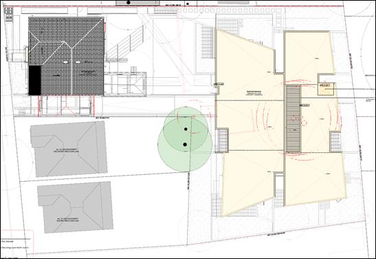
Image 8: Roof Plan
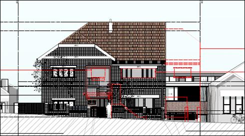
Image 9: Front Elevation (Croydon Street)
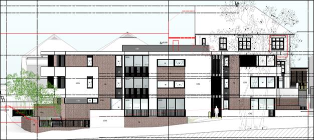 Image 10: Rear Elevation
(Facing Brighton Street Park)
Image 10: Rear Elevation
(Facing Brighton Street Park)
Image 11: Western Side Elevation
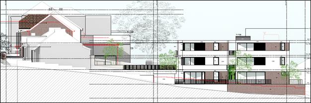
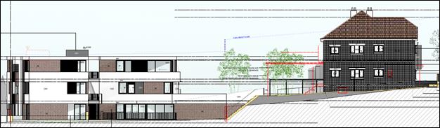 Image 12: Eastern Side
Elevation
Image 12: Eastern Side
Elevation
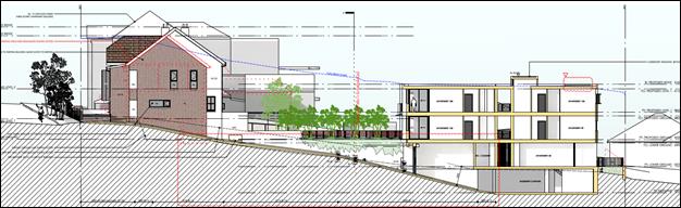 Image 13: Section
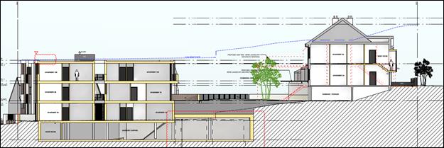 Image 14: Section
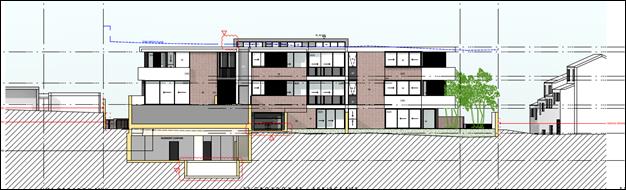
Image 15: Section
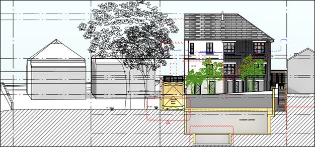
Image 16: Section
4. State Environmental Planning Policy No. 55 - Remediation of Land
State Environmental Planning Policy No. 55 - Remediation of Land (SEPP 55) provides planning guidelines for remediation of contaminated land. Marrickville Development Control Plan 2011 (MDCP 2011) provides controls and guidelines for remediation works.
Given the residential history of uses on the site, it is considered unlikely that the site would be contaminated and unsuitable for the development. As such, the proposal satisfies the relevant provisions contained within SEPP 55.
5. State Environmental Planning Policy No. 65 - Design Quality of Residential Apartment Development (Amendment 3)
The development is subject to the requirements of State Environmental Planning Policy No. 65 – Design Quality of Residential Apartment Development (SEPP 65). SEPP 65 prescribes 9 design quality principles to guide the design of residential apartment development and to assist in assessing such developments. The principles relate to key design issues including context and neighbourhood character, built form and scale, density, sustainability, landscape, amenity, safety, housing diversity and social interaction and aesthetics.
A statement from a qualified Architect was submitted with the application verifying that they designed, or directed the design of, the development. The statement also provides an explanation that verifies how the design quality principles are achieved within the development and demonstrates, in terms of the Apartment Design Guide (ADG), how the objectives in Parts 3 and 4 of the guide have been achieved.
In accordance with Clause 30 of the SEPP if the development satisfies the following design criteria, the consent authority must not refuse the application on the following matters:
· if the car parking for the building will be equal to, or greater than, the recommended minimum amount of car parking specified in Part 3J of the ADG,
· if the internal area for each apartment will be equal to, or greater than, the recommended minimum internal area for the relevant apartment type specified in Part 4D of the ADG,
· if the ceiling heights for the building will be equal to, or greater than, the recommended minimum ceiling heights specified in Part 4C of the ADG.
Compliance with the above is discussed in greater detail below. Overall, the development is generally acceptable having regard to the 9 design quality principles.
Apartment Design Guide
The ADG contains objectives, design criteria and design guidelines for residential apartment development. In accordance with Clause 6A of the SEPP the requirements contained within MDCP 2011 in relation to visual privacy, solar and daylight access, common circulation and spaces, apartment sizes and layout, ceiling heights, private open space and balconies, natural ventilation and storage have no effect. In this regard objectives design criteria and design guidelines set out in Parts 3 and 4 of the ADG prevail.
The development has been assessed against the relevant design criteria within Part 3 and 4 of the ADG as follows:
Communal Open Space
The ADG prescribes the following requirements for communal and open space:
· Communal open space has a minimum area equal to 25% of the site.
· Developments achieve a minimum of 50% direct sunlight to the principal usable part of the communal open space for a minimum of 2 hours between 9 am and 3 pm on 21 June (mid-winter).
The application proposes 254sqm of communal open space in the form of a landscaped area and communal facility between Building A and B which equates to 13.4% of the site area. The proposed communal open space is considered high quality as it is centrally located on the site between the 2 buildings and would provide for active recreation use and would comprise 50% deep soil. A communal kitchen and BBQ area is proposed with large, medium and small stature trees to be planted for future canopy cover and embellishment. The significant size of the space and use as a main pedestrian thoroughfare to Building B would ensure a high level of surveillance over this area.
Whilst the development does not meet the minimum requirement of 25% of the site being provided as communal open space, all apartments within Building B contain large private balconies, with the ground floor level units having large areas of deep soil landscaping all in excess of the minimum requirements of the ADG. The location of the site sharing a rear boundary with Brighton Street Park provides a unique opportunity for a private link to the public open space and surveillance opportunities for both the development and existing park. It is considered that the communal open space proposed, whilst non-compliant with the numerical requirement of the ADG would be a high quality, useable space and given the size of the balconies proposed to each unit combined with the proximity of the site to the existing park the future occupants of the development would have access to ample public and private open space areas for recreation.
The communal open space receives solar access from 12pm on 21 June, however due to the orientation of the site and the space being located between the 2 buildings and surrounding developments, only 36% of the space receives a minimum of 2 hours direct sunlight access, with this increased to 43% between 2pm and 3pm on 21 June. Whilst the development does not meet the minimum requirement, the area that would receive the 2 hours is 91sqm in size which is considered to provide sufficient area for passive recreation and does not compromise the usability of the communal open space. In addition the proposed covered bbq area and adjoining communal kitchen would be unaffected by solar access and could be utilized in all types of weather providing a high level of usability for the future occupants of the development.
Deep Soil Zones
The ADG prescribes the following minimum requirements for deep soil zones:
|
Site Area |
Minimum Dimensions |
Deep Soil Zone (% of site area) |
|
Less then 650m2 |
- |
7% |
|
650m2 - 1,500m2 |
3m |
|
|
Greater than 1,500m2 |
6m |
|
|
Greater than 1,500m2 with significant existing tree cover |
6m |
The application proposes 4.8% of the site with deep soil landscaping which has a minimum dimension of 6 metres and is not located over the basement car park which does not meet the required 7%. However, the development would include a 3 metre wide deep soil landscaped area is at the rear of Building B adjoining the park providing an additional 95sqm with a or 5% deep soil area which is co-located with the park and considered a consistent transition from public to private open space. The 2 spaces combined provide 9.8% of the site with deep soil landscaping and although the entire area would not meet the minimum dimension of 6 metres, the areas would provide adequate deep soil zones for the provision of landscaping and replacement tree planting and is considered acceptable.
Visual Privacy/Building Separation
The ADG prescribes the following minimum required separation distances from buildings to the side and rear boundaries:
|
Building Height |
Habitable rooms and balconies |
Non-habitable rooms |
|
Up to 12 metres (4 storeys) |
6 metres |
3 metres |
Existing Building A will be maintained with the exception of the western side boundary which will be increased from a nil boundary side setback to have a 3.8 metre side boundary setback, whilst habitable rooms are proposed within the existing building and 5 new openings on this elevation, it is considered that the increase to the existing side boundary setback will be an improvement in terms of privacy, solar access and reduction in bulk and scale to the side boundary.
Building B is proposed to have a 3 metre rear (southern) boundary setback to Brighton Street Park along the southern elevation. Whilst habitable rooms and balconies are proposed within the 6 metre required separation, the non-compliance is considered acceptable given that there will be no visual or acoustic privacy impacts to the park. The increase in passive surveillance and active interface between the development and the park is considered acceptable.
The western elevation of Building B is proposed to be setback a minimum of 3.5 metres to the lower ground floor terrace of apartment 5B and 4.5 metres to the terrace and bedroom of apartment 4B. Given the western side boundary adjoins a common driveway servicing townhouses at 31 Croydon Street the actual separation between habitable rooms and balconies of the proposed development and the neighboring development is a minimum of 10.5 metres.
The eastern elevation of Building B is proposed to be setback a minimum 2.4 metres to the lower ground floor terrace of apartment 1B and a 4.5 metre setback to the terrace of apartment 2B. On the upper levels there would be a minimum 4.2 metres setback to the habitable rooms and 4.5metres to the balconies. The eastern side boundary of Building B adjoins the rear boundary of No.46 Railway Street and the rear of No.21 Croydon Street. The subject site experiences a fall to the south towards the rear boundary and as a result the proposed development would be set below the natural ground level of the adjoining properties. The lower ground floor level of Building B has a Finished Floor Level of RL32.250 and ground floor level has an RL of 35.35 whilst the rear yard of 21 Croydon Street has an RL of 34.45 adjacent to the existing outbuilding with the outbuilding at the rear of 46 Railway Street having a roof with an RL of 36.2, meaning that the entire lower ground floor level of the proposal will sit below the adjoining property boundary fencing and would not have any privacy or amenity impacts.
The dwelling house of 21 Croydon Street is setback 10.5 metres from Building B, similarly the dwelling at 46 Railway Street is setback 19 metres from the boundary. Whilst the ground and first floor would be visible from the adjoining properties, the 4.5 metre setback of Building B to the boundary and large setback of the buildings on the neighboring properties to the site and location of outbuildings would restrict sight lines into the adjoining properties and ensure the development has minimal privacy impacts.
During the assessment of the application the western half of the northern elevation of Building B was amended to provide increased setbacks to the adjoining properties at 25 and 27 Croydon Street. The northern elevation as amended has a minimum 4.779 metre setback to the terrace of the lower ground floor apartment and 6 metres to the habitable room with window of apartment 5B on the lower ground floor level. The terrace of this apartment would have a 4 metre setback, however is screened by a brick wall. Similarly the slope of the site and design of the building stepping down with the slope results in the lower ground floor and terraces having a finished floor level that is at minimum 0.66 metres below the natural ground level of the rear yards of the adjoining properties at 25 and 27 Croydon Street. The existing dwellings at 25 and 27 Croydon Street are setback more than 14 metres to the shared property boundary and this combined with the compliant setback of Building B to the boundary and existing mature vegetation and proposed new tree plantings will provide an acceptable level of privacy between the development and adjoining properties.
The ADG prescribes the following minimum required separation distances from buildings within the same site:
|
Room Types |
Minimum Separation |
|
Habitable Rooms/Balconies to Habitable Rooms/Balconies |
12 metres |
|
Habitable Rooms to Non-Habitable Rooms |
9 metres |
|
Non-Habitable Rooms to Non-Habitable Rooms |
6 metres |
The proposed development has a minimum 21.212 metre setback between Building A and Building B thereby complying with the separation requirement prescribed.
Solar and Daylight Access
The ADG prescribes the following requirements for solar and daylight access:
· Living rooms and private open spaces of at least 70% of apartments in a building receive a minimum of 2 hours direct sunlight between 9.00am and 3.00pm at mid-winter.
· A maximum of 15% of apartments in a building receive no direct sunlight between 9.00am and 3.00pm at mid-winter.
18 of the 22 units, i.e. 81% of the dwellings will receive solar access in accordance with the above requirements thereby complying with the solar and daylight access controls, affording good amenity for future occupants.
Natural Ventilation
The ADG prescribes the following requirements for natural ventilation:
· At least 60% of apartments are naturally cross ventilated in the first 9 storeys of the building. Apartments at 10 storeys or greater are deemed to be cross ventilated only if any enclosure of the balconies at these levels allows adequate natural ventilation and cannot be fully enclosed.
· Overall depth of a cross-over or cross-through apartment does not exceed 18 metres, measured glass line to glass line.
72% of the apartments proposed will have natural cross ventilation. None of the apartments would have a depth exceeding 18 metres.
Ceiling Heights
The ADG prescribes the following minimum ceiling heights:
|
Minimum Ceiling Height |
|
|
Habitable Rooms |
2.7 metres |
|
Non-Habitable |
2.4 metres |
|
For 2 storey apartments |
2.7 metres for main living area floor 2.4 metres for second floor, where its area does not exceed 50% of the apartment area |
|
Attic Spaces |
1.8 metres edge of room with a 30 degree minimum ceiling slope |
|
If located in mixed used area |
3.3 for ground and first floor to promote future flexibility of use |
All of the apartments would have minimum 2.7 metre ceiling heights. The existing garage within building A which would be converted to bicycle parking, bin storage and the communal kitchen have existing ceiling heights of 2.1 metres which do not comply, however as the building is existing and the spaces would not be used as habitable rooms this is considered acceptable.
Apartment Size
The ADG prescribes the following minimum apartment sizes:
|
Apartment Type |
Minimum Internal Area |
|
Studio apartments |
35m2 |
|
1 Bedroom apartments |
50m2 |
|
2 Bedroom apartments |
70m2 |
|
3 Bedroom apartments |
90m2 |
All of the proposed dwellings comply with the minimum internal apartment size requirements. Existing apartments 1A and 4A in Building A have an internal floor area of 48sqm which does not meet the minimum requirement for a 1 bedroom unit. The shortfall of 2sqm is acceptable as these are apartments are existing and maintain a contributory building in the heritage conservation area.
Apartment Layout
The existing and proposed apartment layouts comply with the prescribed ADG requirements in the following manner:
· Every habitable room must have a window in an external wall with a total minimum glass area of not less than 10% of the floor area of the room. Daylight and air may not be borrowed from other rooms.
· Habitable room depths are limited to a maximum of 2.5 x the ceiling height.
· In open plan layouts (where the living, dining and kitchen are combined) the maximum habitable room depth is 8 metres from a window.
· Master bedrooms have a minimum area of 10m2 and other bedrooms 9m2 (excluding wardrobe space).
· Bedrooms have a minimum dimension of 3 metres (excluding wardrobe space).
· Living rooms or combined living/dining rooms have a minimum width of:
§ 3.6 metres for studio and 1 bedroom apartments.
§ 4 metres for 2 and 3 bedroom apartments.
· The width of cross-over or cross-through apartments are at least 4 metres internally to avoid deep narrow apartment layouts.
Private Open Space and Balconies
The ADG prescribes the following sizes for primary balconies of apartments:
|
Dwelling Type |
Minimum Area |
Minimum Depth |
|
Studio apartments |
4m2 |
- |
|
1 Bedroom apartments |
8m2 |
2 metres |
|
2 Bedroom apartments |
10m2 |
2 metres |
|
3+ Bedroom apartments |
12m2 |
2.4 metres |
Note: The minimum balcony depth to be counted as contributing to the balcony area is 1 metres.
The ADG also prescribes for apartments at ground level or on a podium or similar structure, a private open space area is provided instead of a balcony. It must have a minimum area of 15m2 and a minimum depth of 3 metres.
All of the proposed apartments within Building B and 2 of the 4 existing apartments within Building A meet the above requirements. Apartment 2A and 3A within Building A do not have any private open space or balconies. The retention of the existing building which does not afford these apartments with private open space is considered acceptable given the nature of the development in maintaining the existing contributory building. The development provides a large communal open space at the rear of Building A and adjoins Brighton Street Park and as a result in this instance the existing non-compliance is considered acceptable.
Common Circulation and Spaces
The ADG prescribes the following requirements for common circulation and spaces:
· The maximum number of apartments off a circulation core on a single level is 8.
· For buildings of 10 storeys and over, the maximum number of apartments sharing a single lift is 40.
The maximum number of apartments off a circulation core on each single level is 6 which complies with this requirement.
Storage
The ADG prescribes the following storage requirements in addition to storage in kitchen, bathrooms and bedrooms:
|
Apartment Type |
Minimum Internal Area |
|
Studio apartments |
4m3 |
|
1 Bedroom apartments |
6m3 |
|
2 Bedroom apartments |
8m3 |
|
3+ Bedroom apartments |
10m3 |
Note: At least 50% of the required storage is to be located within the apartment.
All of the apartments have storage provided within the unit and the basement car park. The existing apartments within Building A do not have a minimum of 50% of the required storage provided within the unit, however as the apartments are existing this is considered acceptable. The development has a total of 164m3 of storage area within the basement and further storage area within the garbage/storage area of Building A. This combined with the in apartment storage meets the requirements above. A condition is included in the recommendation requiring that each unit be provided with access to an individual storage cage within the development.
6. State Environmental Planning Policy (Building Sustainability Index: BASIX) 2004
A BASIX Certificate was submitted with the application indicating that the proposal achieves full compliance with the BASIX requirements. Appropriate conditions are included in the recommendation to ensure the BASIX Certificate commitments are implemented into the development.
7. Marrickville Local Environmental Plan 2011
(i) Land Use Table and Zone Objectives (Clause 2.3)
The site is zoned R1 – General Residential under the provisions of MLEP 2011. The development is permissible with Council's consent under the zoning provisions applying to the land.
The development is acceptable having regard to the objectives of the R1 - General Residential zone.
(ii) Demolition (Clause 2.7)
Clause 2.7 of MLEP 2011 states that the demolition of a building or work may be carried out only with development consent. The application seeks consent for demolition works. Council’s standard conditions relating to demolition works are included in the recommendation.
(iii) Height (Clause 4.3)
A maximum building height of 9.5 metres applies to the land under MLEP 2011. The development has a maximum building height of 11 metres (existing building height of retained building) which does not comply with the development standard.
A written request, in relation to the development’s non-compliance with the building height development standard in accordance with Clause 4.6 (Exception to Development Standards) of MLEP 2011, was submitted with the application. That request is discussed later in this report under the heading “Exceptions to Development Standards (Clause 4.6)”.
(iv) Floor Space Ratio (Clause 4.4)
A maximum floor space ratio (FSR) of 0.6:1 applies to the development under MLEP 2011.
The development has a gross floor area (GFA) of 1746.38sqm which equates to a FSR of 0.92:1 on the 1896sqm site which does not comply with the development standard.
A written request, in relation to the development’s non-compliance with the FSR development standard in accordance with Clause 4.6 (Exception to Development Standards) of MLEP 2011, was submitted with the application. That request is discussed later in this report under the heading “Exceptions to Development Standards (Clause 4.6)”.
(v) Exceptions to Development Standards (Clause 4.6)
As detailed earlier in this report, the development exceeds the maximum building height development standard prescribed under Clause 4.3 of MLEP 2011 and floor space ratio development standard prescribed under Clause 4.4 of MLEP 2011. A written request in relation to the contravention to the building height and floor space ratio development standards in accordance with Clause 4.6 (Exceptions to Development Standards) of MLEP 2011 was submitted with the application.
Building Height
The application proposes a maximum building height of 11 metres for Building A which is existing and would remain unchanged and represents a 1.5 metre or 15.8% variation to the height of building control. Proposed Building B at the rear of the site would have a maximum building height, of 10.77 metres which represents a 1.27 metre or 13.4% variation. The applicant considers compliance with the development standard to be unreasonable and unnecessary for the following reasons:
- The proposal has been designed with consideration for the building height control, the retention of an existing contributory building and is a reasonable response to the context and setting of the site surrounding residential development and in close proximity to the public park;
- The development maintains majority of the existing contributory building that makes a positive contribution to the Petersham North Heritage Conservation Area;
- The height of Building B has been stepped down with the slope of the site as far as practically possible with constraints on the level of excavation for the driveway due to the required retention of the liquid amber tree on the adjoining property;
- The overall height of Building B is generally lower than the setting created by the existing surrounding buildings;
- It is highly likely that surrounding properties will be re-developed to higher densities due to the higher bonus density provisions applying to those properties, as a result the height of the development would not be out of character with the future built form or context;
- The overshadowing on the adjoining property at 25 Croydon Street will be reduced due to the demolition of the western portion of Building A and increase in the side boundary setback of the building by 4 metres;
- The minor portion of Building B which exceeds the maximum building height will have negligible increased overshadowing over the adjoining park and all adjoining properties will receive the minimum solar access requirements in accordance with the planning controls;
- The non-compliance of Building B in the form of clerestory windows on the roof of the new building provide natural light to the upper level apartments without creating overlooking impacts to neighbouring properties;
- The retention of the existing contributory building provides an upper level to the transition in building height within the locality and the siting of Building B will utilise an infill opportunity at the rear of the site without impacting on the streetscape or amenity of adjoining properties;
- The development meets the objectives of the R1 General Residential Zone by providing upgraded housing in the existing building and new apartments with a variety of sizes and layouts, the residential flat building will complement the existing variety of housing being terraces, townhouses, detached dwelling and small residential flat buildings;
- Improvements to the existing non-compliant building will retain and enhance the role of the existing building in the HCA;
- Strict compliance with the height of building control would be counterproductive in terms of heritage integrity, internal amenity, streetscape and impacts to neighbouring properties;
- The proposal will allow for improved passive surveillance of the adjoining park;
- The existing building presentation to Croydon Street will be improved through a high quality urban outcome; and
- The architecturally designed residential flat buildings will provide an improved streetscape presentation and building form that includes good quality finishes and materials and will activate the locality.
The justification provided in the applicant’s written submission is considered to be well founded and worthy of support. It is considered that there are sufficient environmental planning grounds as to why the Height development standard should be varied in this particular circumstance based on the outcomes of planning law precedents such as those contained in Wehbe v Pittwater Council [2007] NSWLEC827, Four2Five Pty Ltd v Ashfield Council [2015] NSWLEC90 and Moskovich v Waverley Council [2016]. As detailed in this report, it is considered that the proposed development would not result in adverse environmental impacts on the surrounding neighbourhood.
Compliance with the development standard is considered to be unreasonable and unnecessary in the circumstances and there are sufficient environmental planning grounds to justify contravening the development standard given that:
· The site has a significant fall from Croydon Street to the rear adjoining Brighton Street Park, the proposed transition in height from the existing non-compliant residential flat building on the site and surrounding properties to the proposed residential flat building provides an appropriate transition in scale, the 1.27 metre or 13.4% variation is considered appropriate given the context of the site;
· The non-compliance with the standard does not contribute to adverse environmental impacts in terms of overshadowing, visual impacts or view loss. The reduction in building footprint of the existing building would improve solar access and visual privacy to the adjoining property at 25 Croydon Street;
· The site is a deep lot and represents a unique opportunity to provide for increased housing density that is contained away from the main street frontage and has active connection with Brighton Street Park; and
· The high quality architectural design of Building B and high quality restoration works and improvement proposed to existing Building A promotes a high standard of design in the private and public domain in accordance with Clause 1.2 of MLEP 2011.
It is considered that the applicant’s written submission has satisfactorily addressed the relevant matters under Clause 4.6 of MLEP 2011 and as such the proposal’s non-compliance with the height development standard is considered acceptable. The contravention of the development standard does not raise any matter of significance for State and regional environmental planning, and that there is no public benefit in maintaining the development standard for the development.
Floor Space Ratio
The application proposes a maximum floor area of 1746.38sqm resulting in an FSR of 0.92:1 on the 1896sqm site and a variation of 608.75sqm or 53%. The applicant contests that the common circulation space/breezeways are not contained by the external walls and are secured by open gates and balustrades and therefore not part of the gross floor area, siting the case of GGD Danks Street Pty Ltd and CR Danks Street P/L v Council of the City of Sydney [2015] (NSWLEC). Council officers do not concur with the interpretation of this judgement, however if the breezeways and open lobbies on all 3 levels of Building B are excluded, the development would have of a maximum floor area of 1588.07sqm resulting in an FSR of 0.83:1 which represents a variation of 450.47sqm or 39.5% which is slightly higher than that calculated by the applicant being an FSR of 0.82:1 and variation of 425sqm or 37%.
The applicant considers compliance with the development standard to be unreasonable and unnecessary for the following reasons:
- The density and built form proposed for the site is compatible with the variety of residential development in the existing and anticipated neighbourhood;
- The design and layout of the development has given consideration to the dimensions of the site and retention of majority of the existing residential flat building to meet the desired future character of the heritage conservation area;
- The bulk and scale of the existing residential flat building will be reduced through the demolition of the western wing of the building resulting in increased amenity for adjoining properties and facilitating parking on site through the construction of a driveway to the rear basement;
- The reduction in floor area and bulk and scale at the front of the site, being the narrower portion of the site is appropriately accommodated at the rear of the site where bulk and scale will be screened from the streetscape and HCA and set on the wider portion of the site;
- The 3 storey form is highly appropriate given the context of the site and surrounding development, with siting providing adequate separation from adjoining properties;
- The bulk of the development being building B achieves deep soil plating along the boundaries, when shared with adjoining residential properties further enhances the quality of the separation distance and protect visual amenity for adjoining properties;
- The rear building complies with the relevant height controls with the exception of a small portion of the south-west corner and therefore the overall building footprint is compliant with the parameters that would be reasonably anticipated for the redevelopment of the site;
- The subject site has been excluded for no obvious reason from being provided with a bonus FSR of 0.25:1 for the development of a residential flat building which is benefitted by majority of the surrounding properties, in any case the proposed FSR would still be less than those surrounding site at 0.85:1 and would therefore be a smaller scale of development and will not detract from the existing or desired future character of the locality;
- Whilst the development would result in additional overshadowing, all adjoining properties will continue to receive in excess of the 2 hours of direct sunlight access in mid-winter;
- All living areas and private open space areas have been orientated to the common open space and front and rear boundary where possible. All lower ground floor level apartments are set entirely below the ground floor level of the surrounding development and therefore would be no direct line of sight between these dwellings and the adjoining properties;
- Strict compliance with the FSR control would be counterproductive in terms of heritage integrity, internal amenity, streetscape, impacts to neighbouring properties and constraining a high quality residential development in a highly accessible location;
- The provision of majority of the new floor space within Building B at the rear of the site will protect the curtilage of the existing building, create adequate separation between the building on the site and adjoining properties and provide a central communal open space;
- The site represents a rare set of circumstances where variation to FSR is warranted as the adjoining properties are envisaged to support a higher density than that proposed on the subject site.
The justification provided in the applicant’s written submission is considered to be well founded and worthy of support. It is considered that there are sufficient environmental planning grounds as to why the FSR development standard should be varied in this particular circumstance based on the outcomes of planning law precedents such as those contained in Wehbe v Pittwater Council [2007] NSWLEC827, Four2Five Pty Ltd v Ashfield Council [2015] NSWLEC90 and Moskovich v Waverley Council [2016]. As detailed in this report, it is considered that the proposed development would not result in adverse environmental impacts on the surrounding neighbourhood.
Compliance with the development standard is considered to be unreasonable and unnecessary in the circumstances and there are sufficient environmental planning grounds to justify contravening the development standard given that:
· The FSR control bonus applicable to the surrounding sites that also contain existing residential flat buildings provides a context to justify additional floor space;
· The development is generally compliant with height subject to a minor variation of the existing building to be retained and to provide improved solar access to top floor apartments in Building B, a compliant development would not result in a building of a lower height, if the floor space was to be constrained it would result in a disproportionate form;
· The non-compliance with the standard does not contribute to adverse environmental impacts in terms of overshadowing, visual impacts or view loss;
· The retention of the majority of the existing residential flat building and high quality restoration works fronting Croydon Street will result in improved urban design and streetscape activation of the heritage conservation area; and
· The development of a largely vacant lot of land through the construction of second residential flat building which will largely be screened from the street, has high architectural merit and will provide for increased housing opportunities on a unique site which benefits from direct connections with a public open space.
The current development proposes to vary the FSR development standard, however, the outcome is considered to be better than a compliant development. The majority of the additional floor area fits within the building height envisaged by Council’s controls. The height and scale of the buildings proposed are consistent with the desired future character contemplated by Council’s controls. The massing has been appropriately designed in the heritage context of this area of Petersham.
It is considered that the applicant’s written submission has satisfactorily addressed the relevant matters under Clause 4.6 of MLEP 2011 and relevant court principles and as such the proposal’s non-compliance with the FSR development standard is considered acceptable. The contravention of the development standard does not raise any matter of significance for State and regional environmental planning, and that there is no public benefit in maintaining the development standard for the development.
(vi) Preservation of Trees or Vegetation (Clause 5.9)
Clause 5.9 of MLEP 2011 concerns the protection of trees identified under Marrickville Development Control Plan 2011.
The application was referred to Council’s Tree Officer for comment given the proposed removal of a number of protected trees including a large Camphor Laurel located in the centre of the rear portion of the site and proposed construction near protected trees on the adjoining properties.
An Arboricultural Impact Assessment (AIA) report was submitted as part of the DA. The removal of all trees on the subject property was recommended and is supported by Council. Impacts upon trees in neighbouring properties were assessed and unacceptable impacts were identified in relation to trees on the adjoining property at 25 Croydon Street adjacent to the entry driveway ramp and basement due to excavation that encroached majorly into the Tree Protection Zones (TPZ) and Structural Root Zone (SRZ).
During the assessment of the application and upon advice from the project arborist the ramp was redesigned to minimise excavation and the project arborist confirmed acceptability with respect to the impact upon the trees in the neighbouring property.
The landscape plan was amended to include five Angophora costata and 22 other smaller trees and which are considered to provide adequate and appropriate compensatory tree planting for the trees to be removed on the site.
The proposal is considered acceptable with respect to the removal of existing trees, the appropriate protection of trees on neighbouring properties and the provision of adequate and appropriate compensatory tree planting subject to conditions included in the recommendation.
(vii) Heritage Conservation (Clause 5.10)
The site is located within a Heritage Conservation Area under MLEP 2011 (Heritage Conservation Area C3 – Petersham Estate) and within the vicinity of a proposed heritage item being the Electricity Substation at 30 Brighton Street, Petersham. The site contains an adaption of an inter-war style California Bungalow which is currently as a residential flat building.
A Statement of Heritage Impact was submitted with the application and satisfactorily addresses the relevant heritage conservation provisions contained in Clause 5.10 of MLEP 2011. The application was also referred to Council’s Heritage and Urban Design Officer who raised no objection to the proposed development.
The development would involve demolition of the western and southern rear portion of the existing residential flat building to provide for vehicular access to the rear of the site and to increase the side boundary setback of the development to 25 Croydon Street and create an additional open space area. The retention of the majority of the existing contributory residential flat building with restoration and improvement works to the front entry and new side elevation wall would ensure that minimal impacts on the streetscape are incurred.
The proposed new residential flat building at the rear of the site to be known as building B would be setback 35 metres from the front boundary and would not exceed the existing height of the building fronting Croydon Street. The new building would only slightly be visible through the proposed driveway opening on the western side of the site and given the slope of the site to the rear and large setback to the new building there would be a minimal visual impact to Croydon Street.
Having regard to the above, the development would not have any significant impacts on the heritage conservation area or neighbouring draft heritage item and is considered acceptable with regards to Clause 5.10 of MLEP and Part 8 of MDCP 2011.
(viii) Earthworks (Clause 6.2)
Clause 6.2 of MLEP 2011 requires the consent authority to have regard to certain matters where earthworks that require development consent are proposed. The site contains a downward sloping topography from Croydon Street to the Brighton Street Park. The development includes excavation for the basement car parking, which subject to conditions included in the recommendation, is unlikely to have a detrimental impact on environmental functions or processes, neighbouring sites, cultural or heritage items or features of the surrounding land.
(ix) Development in areas subject to Aircraft Noise (Clause 6.5)
The land is located within the 20-25 Australian Noise Exposure Forecast (2033) Contour.
The development is likely to be affected by aircraft noise and the he carrying out of development would result in an increase in the number of people affected by aircraft noise.
The development would need to be noise attenuated in accordance with AS2021:2000. An Acoustic Report was submitted with the application which details that the development could be noise attenuated from aircraft noise to meet the indoor design sound levels shown in Table 3.3 (Indoor Design Sound Levels for Determination of Aircraft Noise Reduction) in AS2021:2000. The report contains recommendations to be incorporated into the development in order to mitigate acoustic impacts.
Appropriate conditions are included in the recommendation to ensure the requirements recommended within the Acoustic Report are incorporated into the development.
8. Marrickville Development Control Plan 2011
An assessment of the development having regard to the relevant provisions of Marrickville Development Control Plan 2011 (MDCP 2011) is provided below.
PART 2 – GENERIC PROVISIONS
(i) Urban Design (Part 2.1)
The development is acceptable having regard to the relevant aspects of the 12 urban design principles.
(ii) Site and Context Analysis (Part 2.3)
A site and context analysis was submitted with the application and is acceptable.
(iii) Equity of Access and Mobility (Part 2.5)
The development proposes 18 new residential units which would require a minimum of 4 adaptable dwellings, 4 accessible resident parking spaces and 1 accessible visitor parking spaces. In addition, all areas of the development are required to be accessible by persons with a disability.
The application proposes 4 adaptable units over the 3 levels of Building B. All of the units would be accessible via the lift within the building and via the pedestrian walkway through the site from Croydon Street. The development also proposes a complaint number of accessible residential parking spaces and accessible visitor parking spaces.
The development is acceptable with regard to Part 2.5 of MDCP 2011.
(iv) Acoustic and Visual Privacy (Part 2.6)
Part 2.6 of MDCP 2011 contains objectives and controls relating to acoustic and visual privacy.
To ensure the development maintains acoustic and visual privacy for the surrounding residential properties and for future occupants of the development, the following measures are proposed:
· The demolition of the western wing of existing Building A would increase the side setback from nil to 3.8 metres which would improve visual and acoustic privacy impacts to the adjoining property at 25 Croydon Street;
· The new window on the western elevation of Apartment 1 of level 1 would service the living room and would be long and narrow and horizontally proportioned. The window would have a minimum sill height of 1.4 metres. The 2 new windows on level 2 of apartment 4A would service the living room and laundry area/walkway to the bathroom of apartment 4A, and the windows would be long and narrow and vertically proportioned;
· The new windows on the western elevation of Building A would be setback 3.8 metres from the adjoining side boundary which is considered to provide an appropriate level of privacy to the adjoining property at 25 Croydon Street;
· Mix of solid rendered concrete balustrades and louvered privacy screens on the northern, eastern and western facades to alleviate impacts on adjoining properties and within the development and allows sufficient separation between the dwellings to maintain visual privacy for the occupants;
· Terraces and balconies facing Brighton Street Park (southern elevation) and are not considered to present any visual privacy concerns given that they face the public domain;
· Appropriate noise attenuation conditions are included with the recommendation; and
· Deep soil areas varying between 2.5 to 4.5 metres are provided around the perimeter of Building B to allow the establishment of small, medium and large scale vegetation to provide screening between the site and adjoining properties.
The layout and design of the development would ensure that the visual and acoustic privacy currently enjoyed by residents of adjoining residential properties is protected. The development maintains a high level of acoustic and visual privacy for the surrounding residential properties and would ensure a high level of acoustic and visual privacy for future occupants of the development itself.
(v) Solar Access and Overshadowing (Part 2.7)
Overshadowing
The shadow diagrams submitted with the application illustrate the extent of overshadowing on adjacent properties and demonstrate that the development complies with Council’s overshadowing controls because direct solar access to windows of principal living areas and principal areas of open space of nearby residential accommodation would not be reduced to less than 2 hours between 9.00am and 3.00pm on 21 June.
Solar Access
The plans and shadow diagrams submitted with the application illustrate that 81% or 18 of the 22 units on the site would receive adequate solar access in accordance to principal living areas in accordance with Part 2.7.5.2 of MDCP 2011.
(vi) Social Impact Assessment (Part 2.8)
The application involves 18 residential units and as a result does not require the submission of a Social Impact Comment or Assessment. The applicant has addressed the economic and social impacts of the development within the Statement of Environmental Effects and concludes that the development would have the following positive social impacts:
- The development sensitively provides infill housing whilst respecting the scale and form of development in the Croydon Street streetscape and the broader heritage conservation area;
- The proposal will improve opportunities for passive surveillance of Brighton Street park with living room windows and private open space areas oriented to the park;
- The proposed accessible access to the park will be secured with an automated security system to allow convenient and safe access for residents and visitors to and from the park whilst preventing unauthorised access; and
- The proposal includes 1 and 2 bedroom apartments and adds variety to the existing housing stock within the locality.
(vii) Community Safety (Part 2.9)
The development is considered reasonable having regard to community safety for the following reasons:
· The proposed restoration of the front entrance to the existing residential flat building is obvious, secure, legible and visible from the street;
· Two of the apartments within the existing building being retained will have balconies overlooking Croydon Street and the other 2 apartments have windows servicing the living areas of the apartments facing Croydon Street which would offer opportunities for casual surveillance over the public domain;
· The south facing apartments of Building B, all contain balconies overlooking Brighton Street Park which will improve passive surveillance of the park; and
· Way finding signage is proposed along the pedestrian path of travel from the front of the sign to Building B at the rear to improve the safety and legibility of the entry.
(viii) Parking (Part 2.10)
Car, Bicycle and Motorcycle Parking Spaces
The site is located in Parking Area 2 under Part 2.10 of MDCP 2011. The following table summarises the car, bicycle and motorcycle parking requirements for the development:
|
Component |
Control |
Required |
Proposed |
Complies? |
|
Car Parking |
||||
|
Resident Car Parking |
0.5 car parking spaces per 1 bedroom unit |
3 x 1 bed units = 1.5 spaces |
16 spaces (including 8 as parking stackers
4 X accessible spaces |
No |
|
1 car parking space per 2 bedroom unit |
15 x 2 bed unit = 15 spaces |
|||
|
1 car parking space per 1 adaptable dwelling |
4 accessible spaces |
|||
|
|
TOTAL: |
21 spaces |
|
|
|
Visitor Car Parking |
0.1 car parking space per unit |
18 units = 2 spaces |
2 X visitor spaces 1 X visitor accessible space |
Yes |
|
1 accessible visitor’s car parking space per 4 accessible car parking spaces |
1 accessible space |
|||
|
Bicycle Parking |
||||
|
Resident Bicycle Parking |
1 bicycle parking space per 2 units |
22 units = 11 spaces |
Unspecified no. of spaces |
Yes |
|
Visitor Bicycle Parking |
1 bicycle parking space per 10 units |
22 units = 2 spaces |
||
|
Motorcycle Parking |
||||
|
Motorcycle Parking |
5% of the total car parking requirement |
23 car parking spaces required = 1 space |
1 space |
Yes |
Table 1: Car, Bicycle and Motorcycle Parking Control Compliance Table
As detailed above, the development does not comply with the car, bicycle and motorcycle parking requirements.
Part 2.10 of MDCP 2011 requires 17 car spaces whilst the proposal includes 16 parking spaces, with 8 of those being provided within 4 parking stackers which represent a numerical shortfall of 1 parking space. It is proposed to provide 16 of the 22 apartments with on-site parking. The parking arrangements, whilst not strictly conforming to the numerical requirements is considered to be acceptable given the minor variation and proximity of the site being in an accessible area within 300 metres walking distance of Petersham Railway Station. The development will improve on-site parking availability to the existing building which currently contains 5 residential units and 2 on-site garage parking spaces which do not meet the minimum dimensions of AS2890.
The application includes the provision of a bicycle parking area within the garage of the existing residential flat building. It has not been indicated on the plans or within the Statement of Environmental Effects as to how many spaces the bicycle storage area will contain, however it is considered that the area should be large enough to accommodate the required 13 spaces.
Conditions have been included in the recommendation to confirm the number of spaces for each vehicle type.
(ix) Fencing (Part 2.11)
Part 2.11.3 prescribes controls for the modification to the front fencing of a contributory building within a heritage conservation area. The development proposes to maintain the existing front fence and provide new steel infill panels on top to improve security. New automated gates would also be provided to the proposed driveway on the western side of the existing building and for the temporary bin storage area to the eastern side of the site. The fencing is considered sympathetic to the style of the existing building and materials and finishes proposed for the restoration of the existing building.
(x) Water Sensitive Urban Design (Part 2.17)
Part 2.17 of MDCP 2011 contains objectives and controls relating to Water Sensitive Urban Design (WSUD) including requirements for new residential developments with gross floor areas greater than 700sqm and less than 2,000sqm.
The application was referred to Council’s Development Engineer who recommended conditions of consent to ensure that the development complies with the WSUD requirements contained within Part 2.17 of MDCP 2011. Those conditions have been incorporated into the recommendation.
(xi) Landscaping and Open Spaces (Part 2.18)
Part 2.18.11.6 of MDCP 2011 prescribes landscaped area, private and common open space controls for residential flat buildings.
The development meets the requirements of Part 2.18.1.6 of MDCP 2011 in that:
- The front setback of the development will remain relatively unchanged in terms of landscaping, being pervious with the exception of driveways and pathways;
- The development would have a total of 36% of the site as landscaped area, whilst not meeting the minimum requirement of 45% of the total site, given the large site area the 678.9sqm of landscaping proposed is considered to provide for a high level of amenity for the development and transition to the adjoining Brighton Street Park;
- The application proposes the planting of 5 large stature trees and 22 other smaller trees to compensate for tree removal on the site; and
- All of the apartments with the exception of existing units 2A and 3A would have access to individual balconies or terraces in excess of the minimum area 8sqm and 2 metre width. The lower ground floor apartments are all proposed to have large areas of landscaped private open space directly accessible from the balcony or terrace area of the apartments.
A landscape plan and maintenance schedule was submitted with the application and subsequently amended during the assessment of the application due to advice from the project arborist and Council’s requirements for tree replacement on the site. The application was referred to Council’s Tree Management Officer who raised no objections to the amended development subject to conditions which are included in the recommendation.
(xii) Tree Management (Part 2.20)
This matter has been discussed earlier in this report.
(xiii) Site Facilities and Waste Management (Part 2.21)
2.21.2 Clothes drying facilities
Under the provisions of Part 2.21.2 of MDCP 2011, external clothes drying areas are required at a rate of 3.75m² per dwelling, with a minimum 6 metres of clothes line for each dwelling.
The balconies proposed for each dwelling are considered to be capable of accommodating suitable clothes drying facilities for future occupants.
2.21.3 Public utilities
The design and provision of public utilities will be required to conform with the requirements of the relevant servicing authority in accordance with the conditions included in the recommendation.
2.21.4 Mail boxes
Details regarding the location of mail boxes for the development were indicated on the plans submitted with the application. The location of the mailboxes at the front of the development is considered consistent with Part 2.21.3.3 of MDCP 2011.
2.21.5 Building identification numbers
A condition is included in the recommendation requiring appropriate numbering to be placed on the site and the application for street numbering be approved by Council before the issue of an Occupation Certificate.
2.21.7 Recycling and Waste Management Plan
A Recycling and Waste Management Plan (RWMP) in accordance with Council's requirements was submitted with the application and is considered to be adequate.
2.21.11 Residential Waste
A minimum of 14 x 240 litre recycling (collected fortnightly) , 7 x 240 litre general waste bins and 6 x 240 litre green waste bins are required to be provided for the development which generates a total requirement of 27 x 240 litre bins.
2 bin storage areas are proposed within the development, 1of the existing garages below the existing residential flat building would provide storage for 8 x 240 litre bins, a second bin storage room within the basement car park is proposed with capacity for 22 x 240 litre bins, having a total capacity of 30 x 240 litre bins.
An interim partially enclosed bin storage area is proposed in the north-eastern corner of the site fronting Croydon Street with capacity for 8 X 240 litre bins which would have a sliding gate for Council to access the bins. All bins would be presented to the bin storage area and any overflow to the street and collected and returned to the respective bin storage rooms on garbage collection day.
The development is considered reasonable with respect to the required waste facilities for recycling and general waste under Part 2.21 subject to conditions included in the recommendation.
(x) Stormwater Management (Part 2.25)
The application includes the provision of an easement for stormwater drainage through the adjoining Brighton Street Park. The application was referred to Council’s Development Engineer who raised no objection to the development subject to conditions which have been included in the recommendation.
PART 3 -SUBDIVISION, AMALGAMATION AND MOVEMENT NETWORKS
Part 3.3 of MDCP 2011 contains controls relating to subdivision. The site currently contains 2 allotments and is legally described as:
· Lot 15 in DP 54392; and
· Lot B in DP 361172.
In order to facilitate the development of the site the consolidation of the 2 separate lots into 1 is required. Part 3 requires amalgamation of properties prior to the issue of a Construction Certificate. A condition has been included in the recommendation to this effect.
Part 4 - RESIDENTIAL DEVELOPMENT
Part 4.2 – Multi Dwelling Housing and Residential Flat Buildings
Part 4.2 of MDCP 2011 provides controls relating to Multi Dwelling Housing and Residential Flat Buildings provisions including building form, building detail and desired future character guidelines and controls for specific centres. An assessment of the development having regard to the relevant provisions of Part 4.2 of MDCP 2011 is provided below.
(i) General Controls (Part 4.2.3)
Part 4.2.3 of MDCP 2011 prescribes the following unit mix requirements for residential flat buildings containing 6 or more dwellings:
“C1 New developments with six or more dwellings must provide the following mix of dwelling types:
i. Studio 5% - 20%;
ii. 1 bedroom 10% -40%;
iii. 2 bedroom 40% - 75%; and
iv. 3 bedroom or bigger 10% - 45%.”
The development includes 7 x 1 bedroom dwellings (31 % of 22), 15 x 2 bedroom dwellings (68 % of 22) which does not comply with the abovementioned unit mix requirements.
Having regard to the local area, the development is considered to provide a suitable dwelling mix to meet the demand for the local demographics. The development includes an appropriate mix of 1 bedroom and 2 bedroom dwellings and is not considered to oversupply of any one form of dwelling size for the local area. It is envisaged that a greater complementary mix of dwellings will be provided through other larger scale developments within the local area over time.
(ii) Built Form and Character (Part 4.2.4)
4.2.1.1 Floor Space Ratio and Site Coverage
The floor space ratio of the development has been discussed earlier in this letter under the provisions of Marrickville Local Environmental Plan 2011.
Part 4.2.4.1 MDCP 2011 specifies the following maximum site coverage controls for residential flat buildings:
|
Development Type |
Maximum Site Coverage |
|
Residential flat building |
45% for one storey 35% for two storey 30% for three or more storeys |
Council considers the site coverage of a development to be “the proportion of the allotment occupied by the ground floor plan area of a building or buildings, including garages, carports, awnings, out buildings, etc, expressed as a percentage ratio”.
The site coverage for this proposal, measured in accordance with the above, equates to 38% of the site area which does not comply with such requirement.
The development proposed would result in a site coverage that exceeds the maximum prescribed by part 4.2.4.2 of MDCP 2011. As discussed earlier in this report whilst the development exceeds the maximum FSR and Height controls for the site, the proposal would result in a development that is compatible with the zoning and desired future character of the site and surrounding area and would ensure the adequate provision of deep soil planning, landscaping, footpaths, driveways and outdoor recreation areas and therefore meets the objectives of the control.
4.2.4.2 Building Heights
This matter has been discussed earlier in this letter under the provisions of Marrickville Local Environmental Plan 2011.
4.2.4.3 Building Setbacks
Part 4.2.4.3 of MDCP 2011 prescribes front, side and rear setback controls. Setbacks are generally required to allow neighbours adequate access to sunlight, for view sharing, to preserve established tree and vegetation corridors and provide adequate separation between buildings to maintain privacy.
In accordance with MDCP 2011, the development is required to have a minimum 9 metre front setback and 4.5 metre side/rear setbacks. The development involves the retention of the existing residential flat building on the front of the site, known as Building A. The setbacks of the existing building would remain unchanged with the exception of the western side boundary which will be increased from a nil boundary side setback to a 3.8 metre setback which will improve the amenity to the adjoining property at 25 Croydon Street and will facilitate the construction of a driveway to the rear of the site.
The development involves the construction of a second residential flat building at the rear of the site known as Building B with the following setbacks:
|
Boundary |
Control |
Proposed |
Complies? Y/N |
|
Western (Side) |
LGF: 3.5metres GF: 4metres FF:4.5metres |
LGF: 3.5metres GF: 4.3metres FF: 4.3metres |
Yes Yes No |
|
Eastern (Side) |
LGF: 3.5metres GF: 4metres FF:4.5metres |
LGF: 2.4metres GF: 4.2metres FF: 4.2metres |
No Yes Yes |
|
Northern (Western Portion parallel with Croydon Street facing rear boundaries of 25 and 27 Croydon Street) |
LGF: 3.5metres GF: 4metres FF:4.5metres |
LGF: 4.7metres GF: 4.7metres FF: 4.7metres |
Yes Yes Yes |
|
Southern (Rear) |
LGF: 3.5metres GF: 4metres FF:4.5metres |
LGF: 3metres GF: 3metres FF: 3metres |
No No No |
The issue of setbacks has been discussed in more detail in Section 4 of this report. It is considered that setbacks proposed have been tailored to the topography of the site and adjoining properties, with majority of Building B being set below the natural ground level of the adjoining properties the development reads as a 2 storey development when viewed from the north. The scale of the built form and building footprint respond to the existing and desired future character of development in the streetscape and ensure a high level of amenity for the future occupants and adjoining properties in terms of solar access and visual and acoustic privacy.
(iii) Streetscape, General Appearance and Materials (Part 4.2.5)
The application was referred to Council’s Heritage and Urban Design Advisor who raised no objection to the development subject to some minor modifications which have been adopted through amended plans during the assessment of the application. The application satisfies Part 4.2.5 of MDCP 2011 for the following reasons:
- The external materials and finishes proposed throughout the development are contemporary and of a high quality;
- The proposed improvements to the period building and the contemporary interpretation on the west elevation of Building A are supported;
- The architectural expression of Building B is well-considered;
- The development provides an obvious pedestrian access to the existing building that will establish a street identity;
- The development addresses the principal street frontage and provides an enhanced attractive visible façade from the street. The siting of Building B will ensure its visibility is reduced from Croydon Street and therefore would not have any detrimental impacts on the heritage conservation area; and
- The internal layout and orientation of the residential units are well‐considered and the communal open space between Buildings A and B will provide good amenity to the residents, in addition to generously sized private outdoor spaces and Brighton Street Park.
(iv) Parking and Access (Part 4.2.6)
The car, bicycle and motorcycle parking requirements for this proposal have been discussed earlier in this report.
PART 9 – STRATEGIC CONTEXT
The land is located in the Petersham North Planning Precinct (Precinct 2) under Marrickville Development Control Plan 2011.
The development is considered to meet the desired future character as follows:
- Development involves the retention and preservation including the sympathetic alteration and restoration to a contributory building to the heritage conservation area and precinct;
- Allows for mixed density within the residential character of the precinct;
- Provides for increased off-street car parking;
- Will improve pedestrian access to the public domain for the future residents through a new connection to Brighton Street Park;
- Protection of the values of the Petersham North Heritage Conservation Area; and
- Will allow for higher density development which demonstrates a high level of urban design through the use of quality materials and finishes and by providing quality apartments and private and communal open space; and
- Will allow for the retention of an existing building and construction of a new residential flat building that will maintain the amenity of adjoining properties.
9. Referrals
Marrickville Heritage Society
The application was referred to the Marrickville Heritage Society for comment given its location within the Petersham Estate Heritage Conservation Area. A response was received which does not support the removal of western garage wing of the existing residential flat building and advises that the use of face brick on the end wall is inappropriate and should be rendered and painted to match the eaves of the side of the building to create a symmetrical main façade.
As discussed in Section 6 of this report a Statement of Heritage Impact was submitted with the application and the application was referred to Council’s Heritage and Urban Design Advisor who is satisfied that the proposed works to the existing residential flat building and contribution to the Heritage Conservation area meet the relevant heritage conservation provisions contained in Clause 5.10 of MLEP 2011.
It is considered that the development would not have any significant impacts on the heritage conservation area or neighbouring draft heritage item given and is considered acceptable with regards to Clause 5.10 of MLEP and Part 8 of MDCP 2011.
10. Marrickville Section 94/94A Contributions Plan 2014
The carrying out of the development would result in an increased demand for public amenities and public services within the area. A contribution of $308,295.15 would be required for the development under Marrickville Section 94/94A Contributions Plan 2014. A condition requiring that contribution to be paid is included in the recommendation.
11. Community Consultation
The application was advertised, an on-site notice displayed on the property and residents/property owners in the vicinity of the property were notified of the development in accordance with Council's policy. 15 submissions were received in response to the original plans raising the following concerns which have already been discussed throughout the main body of this report:
(i) Non-compliance with Floor Space Ratio;
(ii) Non-compliance with Height Control;
(iii) Setbacks;
(iv) Communal Open Space;
(v) Parking and Traffic;
(vi) Waste Management;
(vii) Tree Removal;
(viii) Acoustic and Visual Privacy;
(ix) Heritage;
(x) Solar Access and Overshadowing;
(xi) Deep Soil Planting; and
(xii) Stormwater Management.
In addition to the above, the submissions raised the following concerns which are discussed under the respective headings below:
(i) The development of 1 bedroom apartments will bring a transient population to the area.
Comment:
The development of a residential flat building is permissible on the site, including the provision of 1 bedroom apartments. No evidence has been submitted to support the above assertion.
(ii) Works to Retaining Walls.
Comment:
There are a number of retaining walls on the existing property and located between the site and adjoining property at 31 Croydon Street, and between the site and 25 Croydon Street. The application is supported by recommendations for work methods for demolition and reconstruction of the retaining walls on the property boundaries by the applicant’s arborist and would be subject to negotiations between the owner of the site and adjoining properties in accordance with the Diving Fences Act 1991.
(iii) Potential damage to adjoining properties.
Comment:
A condition is included in the recommendation of this report requiring the provision of a dilapidation report. Furthermore any development application approved would include standard conditions requiring a site be kept secure during construction through the use of temporary fencing to reduce impacts or damage to adjoining properties.
(iv) Views of lift shaft would be unsightly.
Comment:
During the assessment of the application Council requested the applicant remove the lift overrun from the roof of Building B and relocate this to the basement which was complied with.
All relevant matters raised in the submissions able to be considered under the provisions of Section 79C of the Environmental Planning and Assessment Act have been discussed in the report.
12. Conclusion
The application seeks to demolish part of the premises and carry out alterations and additions to an existing residential flat building fronting Croydon Street (Building A) containing 4 dwellings with a communal kitchen and BBQ area and the construction of a new 3 storey residential flat building to the rear (Building B) containing 18 dwellings with basement car parking.
The heads of consideration under Section 79C of the Environmental Planning and Assessment Act, 1979, as are of relevance to the application, have been taken into consideration in the assessment of this application. The proposal generally complies with the aims, objectives and design parameters contained in Marrickville Local Environmental Plan 2011 and Marrickville Development Plan 2011.
The development will not result in any significant impacts on the amenity of adjoining premises and the streetscape. The application is suitable for approval subject to the imposition of appropriate conditions.
|
PART E - RECOMMENDATION
A. THAT the development application to demolish part of the premises and carry out alterations and additions to an existing residential flat building fronting Croydon Street (Building A) containing 4 dwellings with a communal kitchen and BBQ area and the construction of a new 3 storey residential flat building to the rear (Building B) containing 18 dwellings with basement car parking be APPROVED subject to the following conditions:
GENERAL
1. The development must be carried out in accordance with plans and details listed below:
and details submitted to Council on 24 November 2015, 23 February 2016, 20 April 2016, 6 May 2016, 10 June 2016, 20 July 2016 and 9 August 2016 with the application for development consent and as amended by the following conditions. Reason: To confirm the details of the application submitted by the applicant.
2. Where any plans and/or information forming part of a Construction Certificate issued in relation to this consent are inconsistent with:
a) the plans and/or information approved under this consent; or
b) any relevant requirements of this consent,
the plans, information and/or requirements of this consent (as the case may be) shall prevail to the extent of the inconsistency.
All development approved under this consent shall be carried out in accordance with the plans, information and/or requirements of this consent taken to prevail by virtue of this condition. Reason: To ensure the development is carried out in accordance with this Determination.
3. In order to ensure the architectural and urban design excellence of the development is retained: i. The design architect is to have direct involvement in the design documentation, contract documentation and construction strategies of the project; ii. The design architect is to have full access to the site and is to be authorised by the applicant to respond directly to the consent authority where information or clarification is required in the resolution of design issues throughout the life of the project; iii. Evidence of the design architect’s commission is to be provided to the Council prior to the release of the construction certificate. iv. The design architect of the project is not to be changed without prior notice and approval of the Council’s Director Planning and Environmental Services. Reason: To ensure design excellence is maintained.
4. The materials and finishes of the building constructed pursuant to this consent must be strictly in accordance with the materials and finishes identified in Drawing Nos. DA33, Revision E dated 23.2.16, prepared by Carter Williamson. No changes may be made to these drawings except by way of an application under section 96 of the Environmental Planning and Assessment Act 1979. Reason: To ensure the final built development has an appearance that accords with the approved materials and finishes.
5. Where units or dwellings are provided with separate individual hot water systems, these must be located within the internal area of the unit/dwelling and not on any balcony or terrace. Reason: To ensure the aesthetics of the building and architecture are maintained.
6. The premises must be used exclusively as a residential flat building and not be adapted for use as a backpackers’ accommodation, serviced apartments or a boarding house and must not be used for any industrial or commercial purpose. Reason: To ensure that the premises are used exclusively as a residential flat building.
7. 23 off-street car parking spaces must be provided and maintained at all times in accordance with the standards contained within Part 2.10 of Marrickville Development Control Plan 2011 - Parking. The parking must be allocated as follows:
a) A minimum of 16 spaces being allocated to the residential dwellings, with 1 car space being allocated per dwelling with the exception of the car stacker spaces which must be allocated together to 2 apartments; b) 4 accessible car parking spaces with 1 accessible car space per adaptable dwelling; and c) 3 visitor car parking spaces, 1 of which is designed as an accessible space.
All accessible car spaces must be provided and marked as disabled car parking spaces. Reason: To ensure practical off-street car parking is available for the use of the premises.
8. A minimum of 4 adaptable dwellings must be provided in accordance with Part 2.5 of Marrickville Development Control Plan 2011 - Equity of Access and Mobility. One disabled parking space must be allocated to each adaptable dwelling. Reason: To make reasonable provision in the development to provide residential accommodation suitable for people with a disability.
9. 13 off-street bicycle parking spaces must be provided, paved and maintained at all times in accordance with the standards contained within Part 2.10 of Marrickville Development Control Plan 2011 - Parking. Reason: To ensure practical off-street car parking is available for the use of the premises.
10. 1 off-street motorcycle parking space must be provided, paved, linemarked and maintained at all times in accordance with the standards contained within Part 2.10 of Marrickville Development Control Plan 2011 - Parking. Reason: To ensure practical off-street car parking is available for the use of the premises.
11. The owner/operator/owner’s corporation for the property must appoint a designated person(s) responsible for moving waste bins from their usual storage space in the basement of Building A and Building B to the interim waste storage area in the eastern corner of the site fronting Croydon Street, being the collection point for the storage of domestic bins being in accordance with details to be submitted to Council’s satisfaction;
a) The domestic bins only being placed in the approved collection point after 7.00pm on the day prior to collection and are to be returned to their storage location within the building within two (2) hours of the bins being collected by Council. The owner/operator is responsible to ensure compliance with this condition;
b) Tenants shall be advised to anticipate heightened noise levels during garbage collection;
c) Council is to be provided with key access to the sliding gate of the interim bin storage area to facilitate on-site garbage collection.
Should the above conditions not be adhered to, Council reserves the right to reconsider servicing the site for garbage collection. The person acting on this consent shall advise any purchaser or prospective tenant of this condition.
Reason: To ensure the appropriate collection and disposal of waste generated on the site and to ensure that the use does not interfere with the amenity of the surrounding neighbourhood and does not affect the commercial operation of the building.
12. The use of any plant and equipment must not give rise to:
a) transmission of unacceptable vibration to any place of different occupancy;
b) a sound pressure level at any affected premises that exceeds the background (LA90) noise level in the absence of the noise under consideration by more than 5dB(A). The source noise level shall be assessed as an LAeq,15min and adjusted in accordance with Environment Protection Authority guidelines for tonality, frequency weighting, impulsive characteristics, fluctuations and temporal content as described in the NSW Environment Protection Authority's Environmental Noise Control Manual and Industrial Noise Policy 2000 and The Protection of the Environment Operations Act 1997 (NSW).
Reason: To prevent loss of amenity to the area. 13. Noise and vibration from the use and operation of any plant and equipment and/or building services associated with the premises must not give rise to "offensive noise' as defined by The Protection of the Environment Operations Act 1997 (NSW). In this regard the roller door to the car parking entry is to be selected, installed and maintained to ensure its operation does not adversely impact on the amenity of the surrounding neighbourhood. Reason: To protect the amenity of the surrounding neighbourhood.
14. The trees numbered T1, T2, T3, T4, T5, T6, T7, T10, T11, T12, T13 and T14 in the Arboricultural Impact Report (Landscape Matrix Pty Ltd, 23/11/15) shall be retained and protected in accordance with the conditions outlined in this consent and with the Australian Standard Protection of Trees on Development Sites AS 4970—2009. Reason: To clarify which trees must be retained and protected.
15. All reasonable directions by the project arborist in relation to tree management and tree protection shall be complied with. All directions by the project arborist shall be confirmed in writing to the project manager. Reason: To ensure that tree protection can be managed effectively throughout the course of the development.
16. The developer must liaise with the Sydney Water Corporation, Ausgrid, AGL and Telstra concerning the provision of water and sewerage, electricity, natural gas and telephones respectively to the property. Reason: To ensure that the development is adequately serviced.
17. All building work must be carried out in accordance with the provisions of the National Construction Code (Building Code of Australia). Reason: To ensure the work is carried out to an acceptable standard and in accordance with the National Construction Code (Building Code of Australia).
18. Owners and occupants of the proposed building shall not be eligible to obtain parking permits under any existing or future resident parking scheme for the area. The person acting on this consent shall advise any purchaser or prospective tenant of this condition. In addition the by−laws of any future residential strata plans created for the property shall reflect this restriction. Reason: To ensure the development does not reduce the amount of “on street” parking currently available.
19. All stormwater drainage being designed in accordance with the provisions of the Australian Rainfall and Runoff (A.R.R.), Australian Standard AS3500.3-2003 ‘Stormwater Drainage’ and Marrickville Council Stormwater and On Site Detention Code. Pipe and channel drainage systems shall be designed to cater for the twenty (20) year Average Recurrence Interval (A.R.I.) storm in the case of low and medium residential developments, the twenty (20) year A.R.I. storm in the case of high density residential development and commercial and/or industrial developments and the fifty (50) year A.R.I. storm in the case of heavy industry. In all cases the major event surface flow paths shall be designed to cater for the one hundred (100) year A.R.I. storm. Reason: To provide for adequate site drainage.
20. Should the proposed development require the provision of an electrical substation, such associated infrastructure shall be incorporated wholly within the development site. Before proceeding with your development further, you are directed to contact Ausgrid directly with regard to the possible provision of such an installation on the property. Reason: To provide for the existing and potential electrical power distribution for this development and for the area.
21. Dry-weather flows of any seepage water including seepage from landscaped areas will not be permitted through kerb outlets and must be connected directly to a Council stormwater system. Alternatively the water may be stored separately on site and reused for the watering of landscaped areas. Reason: To ensure that there are no dry-weather flows of any seepage water directed to the kerb.
22. Any adjustment or augmentation of any public utility services including Gas, Water, Sewer, Electricity, Street lighting and Telecommunications required as a result of the development must be at no cost to Council and undertaken before occupation of the site. Reason: To ensure all costs for the adjustment/augmentation of services arising as a result of the redevelopment are at no cost to Council.
BEFORE COMMENCING DEMOLITION, EXCAVATION AND/OR BUILDING WORK
For the purpose of interpreting this consent, a Principal Certifying Authority (PCA) means a principal certifying authority appointed under Section 109E(1) of the Environmental Planning and Assessment Act 1979. Pursuant to Section 109E(3) of the Act, the PCA is principally responsible for ensuring that the works are carried out in accordance with the approved plans, conditions of consent and the provisions of the National Construction Code (Building Code of Australia).
23. No work must commence until:
a) A PCA has been appointed. Where an Accredited Certifier is the appointed, Council shall be notified within 2 days of the appointment; and b) A minimum of 2 days written notice given to Council of the intention to commence work.
Reason: To comply with the provisions of the Environmental Planning and Assessment Act.
24. A Construction Certificate must be obtained before commencing building work. Building work means any physical activity involved in the construction of a building. This definition includes the installation of fire safety measures. Reason: To comply with the provisions of the Environmental Planning and Assessment Act.
25. Sanitary facilities must be provided at or in the vicinity of the work site in accordance with the WorkCover Authority of NSW, Code of Practice ‘Amenities for Construction’. Each toilet must be connected to the sewer, septic or portable chemical toilet before work commences.
Facilities must be located so that they will not cause a nuisance.
Reason: To ensure that sufficient and appropriate sanitary facilities are provided on the site. 26. All demolition work must:
a) Be carried out in accordance with the requirements of Australian Standard AS 2601 ‘The demolition of structures’ and the Occupational Health and Safety Act and Regulations; and b) Where asbestos is to be removed it shall be done in accordance with the requirements of the WorkCover Authority of NSW and disposed of in accordance with requirements of the Department of Environment, Climate Change and Water.
Reason: To ensure that the demolition work is carried out safely.
27. Where any loading, unloading or construction is to occur from a public place, Council’s Infrastructure Services Division must be contacted to determine if any permits or traffic management plans are required to be obtained from Council before work commences. Reason: To protect the amenity of the area.
28. All services in the building being demolished must be disconnected in accordance with the requirements of the responsible authorities before work commences. Reason: To ensure that the demolition work is carried out safely.
29. A waste management plan must be prepared in accordance with Part 2.21 of Marrickville Development Control Plan 2011 – Site Facilities and Waste Management and submitted to and accepted by the PCA before work commences. Reason: To ensure the appropriate disposal and reuse of waste generated on the site.
30. The site must be enclosed with suitable fencing to prohibit unauthorised access. The fencing must be erected as a barrier between the public place and any neighbouring property, before work commences.
Enquiries for site fencing and hoardings in a public place, including the need for Council approval, can be made by contacting Council's Infrastructure Services Division. Reason: To secure the area of the site works maintaining public safety.
31. A rigid and durable sign must be erected in a prominent position on the site, before work commences. The sign must be maintained at all times until all work has been completed. The sign is to include:
a) The name, address and telephone number of the PCA; b) A telephone number on which Principal Contractor (if any) can be contacted outside working hours; and c) A statement advising: ‘Unauthorised Entry To The Work Site Is Prohibited’.
Reason: To maintain the safety of the public and to ensure compliance with the Environmental Planning and Assessment Regulations.
32. A project arborist with a minimum AQF level 5 qualification in arboriculture and who does not remove or prune trees in the Inner West local government area shall be engaged before work commences for the duration of site preparation, demolition, construction and landscaping. Reason: The project arborist shall provide guidance and oversight of tree protection and management to ensure that the stability and ongoing viability of trees being retained are not compromised.
33. The contact details of the project arborist shall be advised to council before work commences and maintained up to date for the duration of works. If a new project arborist is appointed details of the new project arborist shall be notified to council within 7 days. Reason: Council requires details of the project arborist to facilitate communication if required.
34. Tree protection measures detailed in the Arboricultural Impact Report (Landscape Matrix Pty Ltd, 23/11/15) and as directed on site by the project arborist shall be established before work commences. Reason: To ensure that the stability and ongoing viability of trees being retained are not compromised.
35. The project arborist shall inspect tree protection measures, including the location of tree protection fencing and signage, and certify in writing to the Principal Certifying Authority before work commences that the measures comply the Arboricultural Impact Report (Landscape Matrix Pty Ltd, 23/11/15) and any directions by the project arborist. Reason: The project arborist shall provide guidance and oversight of tree protection and management to ensure that the stability and ongoing viability of trees being retained are not compromised.
36. A Soil and Water Management Plan must be prepared in accordance with Landcom Soils and Construction, Volume 1, Managing Urban Stormwater (Particular reference is made to Chapter 9, “Urban Construction Sites”) and submitted to and accepted by the PCA. A copy of this document must be submitted to and accepted by PCA before work commences. The plan shall indicate:
a) Where the builder’s materials and waste are to be stored; b) Where the sediment fences are to be installed on the site; c) What facilities are to be provided to clean the wheels and bodies of all vehicles leaving the site to prevent the tracking of debris and soil onto the public way; and d) How access to the site will be provided.
All devices must be constructed and maintained on site while work is carried out.
Reason: To prevent soil erosion and sedimentation of the stormwater network.
37. The person acting on this consent is responsible for arranging and meeting the cost of a dilapidation report prepared by a suitably qualified person. The report is to include colour photographs and must be submitted to the Certifying Authority’s satisfaction, with a colour copy being provided to Council and the property owners of the identified properties, before work commences, on the buildings on the adjoining properties at 21, 25, 27 and 31 Croydon Street and 46 Railway Street, Petersham, if the consent of the adjoining property owners can be obtained. In the event that the consent of the adjoining property owners cannot be obtained copies of the letter/s that have been sent via registered mail and any responses received must be forwarded to the PCA before work commences. Reason: To catalogue the condition of the adjoining properties for future reference in the event that any damage is caused during work on site.
38. Before commencing works the person acting on this consent must provide a contact number for a designated person to be available during the demolition and construction for residents to contact regarding breaches of consent or problems relating to the construction. Reason: To provide a person that residents can contact.
39. Where it is proposed to carry out in public roads or Council controlled lands, a road opening permit must be obtained from Council before the carrying out of any works in public roads or Council controlled lands. Restorations must be in accordance with Marrickville Council's Restorations Code. Failure to obtain a road opening permit for any such works will incur an additional charge for unauthorised openings in the amount as provided for in Council’s adopted fees and charges. Reason: To ensure that all restoration works are in accordance with Council's Code.
40. The person acting on this consent shall apply as required for all necessary permits including crane permits, road opening permits, hoarding permits, footpath occupation permits and/or any other approvals under Section 68 (Approvals) of the Local Government Act, 1993 or Section 138 of the Roads Act, 1993. Reason: To ensure all necessary approvals have been applied for.
41. Where it is proposed to carry out works in public roads or Council controlled lands, a road opening permit shall be obtained from Council before the carrying out of any works in public roads or Council controlled lands. Restorations shall be in accordance with Marrickville Council's Restorations Code. Failure to obtain a road opening permit for any such works will incur an additional charge for unauthorised works as noted in Council’s adopted fees and charges. Reason: To ensure that all restoration works are in accordance with Council's Code. 42. The person acting on this consent shall provide details of the means to secure the site and to protect the public from the construction works. Where the means of securing the site involves the erection of fencing or a hoarding on Council’s footpath or road reserve the person acting on this consent shall submit a hoarding application and pay all relevant fees before commencement of works. Reason: To secure the site and to maintain public safety
43. A detailed Traffic Management Plan to cater for construction traffic shall be submitted to and approved by Council before commencement of works. Details shall include proposed truck parking areas, construction zones, crane usage, truck routes etc. Reason: To ensure construction traffic does not unduly interfere with vehicular or pedestrian traffic, or the amenity of the area.
44. The person acting on this consent shall submit a dilapidation report including colour photos showing the existing condition of the footpath and roadway adjacent to the site before commencement of works. Reason: To ensure the existing condition of Council's infrastructure is clearly documented.
45. All street trees adjacent to the site not approved for removal must be protected at all times during demolition and construction, in accordance with Council’s Tree Preservation Order. Details of the method(s) of protection of such trees must be submitted to and be approved by Council before commencing works. Reason: To ensure that all street trees are appropriately protected during demolition and construction works.
46. All approved protection measures must be installed prior to commencing any work and must be maintained for the duration of construction. Reason: To ensure that all trees are appropriately protected during demolition and construction works.
47. Where scaffoldings or hoardings are to be erected, street trees must be protected during construction works as follows:
a) Tree trunk and major limb protection must be undertaken prior to or during the installation of any hoarding or scaffoldings. The protection must be installed by a qualified Arborist (AQF 2 or 3) and must include:
(i) An adequate clearance, minimum 250mm, must be provided between the structure and tree branches, limbs and trunk at all times; (ii) Tree trunk/s and/or major branches, located within 500mm of any hoarding or scaffolding structure, must be protected by wrapped hessian or similar material to limit damage; (iii) Timber planks (50mm x 100mm or similar) must be placed around tree trunk/s. The timber planks must be spaced at 100mm intervals, and must be fixed against the trunk with tie wire, or strapping. The hessian and timber planks must not be fixed to the tree in any instance, or in any fashion, and (iv) Tree trunk and major branch protection must remain in place for the duration of construction and development works, and must be removed at the completion of the project.
b) All hoarding support columns must be placed a minimum of 300mm from the edge of the existing tree pits. Supporting columns must not be placed on any tree roots that are exposed.
c) Materials or goods, including site sheds, must not be stored or placed:
(i) around or under the tree canopy; or (ii) within 2 metres of tree trunks or branches of any street trees.
d) Any damage sustained to street tree/s as a result of the erection of hoardings, scaffolding, or due to the loading/unloading of vehicles adjacent the site, must be immediately reported to the Council's Tree Management Officer on (9335 2242, in order to determine the appropriate action for maintaining the health and structural integrity of any damaged street tree.
Reason: To ensure that all street trees are appropriately protected during demolition and construction works.
BEFORE THE ISSUE OF A CONSTRUCTION CERTIFICATE
For the purpose of interpreting this consent the Certifying Authority (Council or an Accredited Certifier) is that person appointed to issue a Construction Certificate.
48. The approved plans must be submitted to a Sydney Water Quick Check agent to determine whether the development will affect any Sydney Water wastewater and water mains, stormwater drains and/or easement, and if any requirements need to be met. Plans will be appropriately stamped. Please refer to the web site www.sydneywater.com.au for: · Quick Check agents details - see Plumbing, building and developing then Quick Check agents and · Guidelines for Building Over/Adjacent to Sydney Water Assets – see Plumbing, building and developing then Plan submissions or telephone 13 20 92. The stamped plans must be submitted to the Certifying Authority’s satisfaction before the issue of a Construction Certificate. Reason: To ensure compliance with Sydney Water requirements.
49. The separate lots comprising the development must be consolidated into one lot and under one title and registered at the NSW Department of Lands before the issue of a Construction Certificate. Reason: To prevent future dealing in separately titled land, the subject of one consolidated site development.
50. A statement from a qualified Architect, verifying that the plans and specifications achieve or improve the design quality of the development for which development consent was granted, having regard to the design principles set out in Schedule 1 of State Environmental Planning Policy No. 65 – Design Quality of Residential Apartment Development must be submitted to the Certifying Authority’s satisfaction before the issue of a Construction Certificate. Reason: To comply with the requirements under State Environmental Planning Policy No. 65 – Design Quality of Residential Apartment Development.
51. All plumbing and ductwork including stormwater downpipes must be concealed within the outer walls of the building so they are not visible. Plans and elevations detailing the method of concealment must be submitted to and approved by Council before the issue of a Construction Certificate. Any variation to this requirement requires Council approval. Reason: To ensure the aesthetics of the building and architecture are maintained.
52. Details regarding all hard paved areas within the development must be submitted to the Certifying Authority’s satisfaction before the issue of a Construction Certificate. In this regard the materials used should be chosen to break up the extent of hard paving and enhance the appearance of the development. Reason: To ensure all hard paved areas within the development are sympathetic to and enhance the appearance of the development.
53. Before the issue of a Construction Certificate, an amended plan must be submitted to the Certifying Authority’s satisfaction showing the security gate access to Brighton Street Park opens inwards towards the site and not over Council land. Reason: To ensure that no part of the development encroached onto Council owned land. 54. Before the issue of a Construction Certificate, an amended plan must be submitted to the Certifying Authority’s satisfaction demonstrating that each unit has access to a storage area/cage within the basement car park or garage storage/bin room of Building A. Reason: To ensure that each apartment is provided with adequate external storage within the site.
55. Adequate outdoor clothes drying areas must be provided for the development in accordance with details to be submitted to the Certifying Authority’s satisfaction before the issue of a Construction Certificate. Reason: To ensure adequate outdoor clothes drying facilities are provided.
56. Lighting details of the pedestrian areas, parking areas and all entrances must be submitted to the Certifying Authority’s satisfaction before the issue of a Construction Certificate. Reason: To ensure appropriate lighting is provided to create a safe living environment.
57. Plans fully reflecting the selected commitments listed in BASIX Certificate submitted with the application for development consent must be submitted to the Certifying Authority’s satisfaction before the issue of a Construction Certificate.
Note: The application for the Construction Certificate must be accompanied by either the BASIX Certificate upon which development consent was granted or a revised BASIX Certificate (Refer to Clause 6A of Schedule 1 to the Regulation).
Reason: To ensure that the BASIX commitments are incorporated into the development.
Section 94 Contribution
58. a) This condition is imposed in accordance with Section 94 of the Environmental Planning and Assessment Act 1979.
b) Before the *issue of a Construction Certificate /commencement of works, the Council must be paid a monetary contribution of $308,295.15 indexed in accordance with Marrickville Section 94/94A Contributions Plan 2014 (“CP”).
The above contribution is the contribution applicable as at 08 August 2016.
*NB Contribution rates under Marrickville Section 94/94A Contributions Plan 2014 are indexed quarterly (for the method of indexation refer to Section 2.15 of the Plan).
The indexation of the contribution rates occurs in the first week of the months of February, May, August and November each year, following the release of data from the Australian Bureau of Statistics.
(CONTRIBUTION PAYMENT REFERENCE NO. DC001553)
c) The contribution payable has been calculated in accordance with the CP and relates to the following public amenities and/or services and in the following amounts: Community Facilities $34,341.54 Plan Administration $6,045.02 Recreation Facilities $263,930.46 Traffic Facilities $3,978.13
d) A copy of the CP can be inspected at Council’s offices at 2-14 Fisher Street, Petersham or online at http://www.marrickville.nsw.gov.au.
e) The contribution must be paid either in cash, by unendorsed bank cheque (from an Australian Bank only), via EFTPOS (Debit only) or credit card*.
*NB A 1% credit card transaction fee applies to all credit card transactions.
Reason: To ensure provision is made for the increase in demand for public amenities and services required as a consequence of the development being carried out.
59. Before the issue of a Construction Certificate an amended plan must be submitted to the Certifying Authority’s satisfaction addressing the requirements of The Disability (Access to Premises – buildings) Standards 2010 (the Premises Standards). Reason: To ensure that the premises are accessible to all persons.
60. Evidence of payment of the building and construction industry Long Service Leave Scheme, must be submitted to the Certifying Authority’s satisfaction before the issue of a Construction Certificate. (The required payment can be made at the Council Offices).
NB: The required payment is based on the estimated cost of building and construction works and the long service levy rate, set by the Long Service Payments Corporation. The rate set by the Long Service Payments Corporation is currently of 0.35% of the cost of the building and construction work.
For more information on how to calculate the amount payable and where payments can be made contact the Long Services Payments Corporation. http://www.lspc.nsw.gov.au/levy_information/?levy_information/levy_calculator.stm
Reason: To ensure that the required levy is paid in accordance with the Building and Construction Industry Long Service Payments Act.
61. Noise attenuation measures being incorporated into the development generally in accordance with the recommendations contained in the Aircraft Noise Intrusion Assessment, Document No. 20151348.1/1310A/R0/EC, Revision 0, prepared by Acoustic Logic, dated 13 October 2015 and complying with requirements contained in the Australian Standard 2021-2000 in relation to interior design sound levels, in accordance with details to be submitted to the Certifying Authority’s satisfaction before the issue of a Construction Certificate together with certification by a suitably qualified acoustical engineer that the proposed noise attenuation measures satisfy the requirements of Australian Standard 2021-2000. Reason: To reduce noise levels within the development from aircraft.
62. Payment to Council of inspection fees (Section 138 Roads Act) in the amount $418.00 before the issue of a Construction Certificate to ensure the proper completion of the footpath and/or vehicular crossing works required as a result of this development. Reason: To provide security for the proper completion of the footpath and/or vehicular crossing works.
63. Payment of a Bond, in the sum of $58,000.00 for the proper performance of Road and Footpath works prior to the release of the stamped approved building plans. The security may be provided in one of the following methods:- i) in full in the form of a cash bond; or ii) by provision of a Bank Guarantee (with no expiry date) by an Australian Bank in the following terms: (a) the bank must unconditionally pay the guaranteed sum to the Council if the Council so demands in writing. (b) the bank must pay the guaranteed sum within seven (7) days of demand without reference to the applicant or landowner or other person who provided the guarantee, and without regard to any dispute, controversy, issue or other matter relating to consent or the carrying out of development in accordance with the consent; (c) the bank's obligations are discharged when payment to the Council is made in accordance with this guarantee or when the Council notifies the bank in writing that the guarantee is no longer required. Reason: To ensure all Road and Footpath works are completed within a reasonable time.
64. Before the issue of a Construction Certificate the owner or builder shall sign a written undertaking that they shall be responsible for the full cost of repairs to footpath, kerb and gutter, or other Council property damaged as a result of construction of the proposed development. Council may utilise part or all of any Building Security Deposit (B.S.D.) or recover in any court of competent jurisdiction, any costs to Council for such repairs. Reason: To ensure that all damages arising from the building works are repaired at no cost to Council.
65. The vehicular access ramp shall be controlled by traffic signals providing priority to ingressing vehicles in accordance with the requirements of the Traffic Impact Assessment by Traffix dated November 2015. Details of the traffic signals and operation thereof shall be submitted to and approved by Council before the issue of a Construction Certificate. Reason: To ensure the vehicular access operates efficiently and does not cause traffic conflict on Arthur Street.
66. Detailed construction plans for the on-site drainage and water quality measures generally in accordance with the Concept Plans SW-01 and SW-02 (Rev P3) and the Stormwater Quality Management Plan (submitted by Umbrella Group Consulting Engineers dated November 2015) shall be submitted to and approved by Council before the issue of a Construction Certificate: The plans shall include the following amendments/additional information; a) The Storm Water Management Plan shall be amended to comply with Council’s WSUD Reference Guideline. This shall include submission of the MUSIC model and File (.sqz file) for assessment; b) The treatment train be amended to include rain garden/bioretention system within the landscaped area; c) A detailed WSUD maintenance plan outlining how all elements of the water quality treatment facility will be maintained and to record annual inspections and maintenance works to be undertaken; and d) Detailed calculations for sizing of the OSD system including weir and/or orifice plate sizing to be provided for assessment. Reason: To provide for adequate site drainage and to ensure that the quality of stormwater discharged off site is improved.
67. Before the issue of a Construction Certificate a drainage study and inter-allotment drainage design shall be submitted to and approved by Council. The drainage study and design must include the following; a) Details of external catchments currently draining to the site. Existing natural overland flows from external catchments may not be blocked or diverted, but must be captured and catered for within the proposed site drainage system; b) Construction details of an inter-allotment drainage system to provide for the future piped drainage of upstream properties (21, 25, 27, 31, Croydon St and 46 Railway St) to Council’s new stormwater pipe through Brighton Street Reserve; c) Details of proposed 1.5m wide inter-allotment drainage easements on the plans to drain upstream lots; and d) Construction details for the proposed Council stormwater pipe through Brighton Street Reserve and connection to the existing kerb inlet pit in Brighton Street. The design must include/consider the following: i. A route through the park to be approved by Council. The alignment must minimise impact on trees, avoid the large boulder in the park and run along the eastern side of the basketball court; ii. Subsoil drainage must be provided along the eastern side of the basketball court with a pit on each corner; iii. Excavations in tree root zones will need to be undertaken using non-destructive digging (hand excavation or air spade) and must be shown on the plans. Where necessary (as deemed by Council) works must be supervised by an arborist; iv. Details shall include a long section of the pipe detailing all utility services, bedding, cover and restoration details; v. Pipe must be reinforced concrete with a minimum pipe size in the park of 300mm and minimum cover of 300mm. The trench must be of suitable depth to enable the stormwater pipe to pass under roots where necessary; and vi. The path near the park entry if damaged must be reconstructed in full with reinforcement to take traffic loading for maintenance vehicles. Reason: To provide for adequate site and inter-allotment drainage to the site.
SITE WORKS
68. All demolition, construction and associated work necessary for the carrying out of the development must be restricted to between the hours of 7.00am to 5.30pm Mondays to Saturdays, excluding Public Holidays. Notwithstanding the above, no work is to be carried out on any Saturday that falls adjacent to a Public Holiday.
All trucks and vehicles associated with the construction, including those delivering to or removing material from the site, must only have access to the site during the hours referred to in this condition. No waste collection skips, spoil, excavation or demolition material from the site or building materials associated with the construction of the development being deposited on the public road, footpath, public place or Council owned property without Council's approval, having first been obtained. The developer must ensure that all contractors associated with the development are fully aware of these requirements. Reason: To minimise the effect of the development during the construction period on the amenity of the surrounding neighbourhood.
69. The area surrounding the building work must be reinstated to Council's satisfaction upon completion of the work. Reason: To ensure that the area surrounding the building work is satisfactorily reinstated.
70. During construction the project arborist shall undertake inspections of trees and tree protection measures at least fortnightly. A log of inspections including observations, issues noted and directions by the project arborist shall be maintained by the project arborist. Reason: To ensure that conditions relating to tree removal, tree protection and tree planting are complied with.
71. No encroachments onto Council’s road or footpath of any service pipes, sewer vents, boundary traps, downpipes, gutters, stairs, doors, gates, garage tilt up panel doors or any structure whatsoever is permitted. Any encroachments on to Council road or footpath resulting from the building works will be required to be removed before occupation of the site. Reason: To ensure there is no encroachment onto Council’s road. 72. The placing of any materials on Council’s footpath or roadway is prohibited, without the consent of Council. The placement of waste storage containers in a public place requires Council approval and must comply with Council’s Policy – ‘Placement of Waste Storage Containers in a Public Place’. Enquiries are to be made with Council’s Infrastructure Services Division. Reason: To ensure the public ways are not obstructed and the placement of waste storage containers in a public place are not dangerous to the public.
73. All demolition work must be carried out in accordance with the following:
a) compliance with the requirements of Australian Standard AS 2601 'The demolition of structures' with specific reference to health and safety of the public, health and safety of the site personnel, protection of adjoining buildings and protection of the immediate environment; b) all works involving the demolition, removal, transport and disposal of asbestos cement must be carried out in accordance with the 'Worksafe Code of Practice for Removal of Asbestos' and the requirements of the WorkCover Authority of NSW and the Department of Environment, Climate Change and Water; c) all building materials arising from the demolition must be disposed of in an approved manner in accordance with Part 2.21 of Marrickville Development Control Plan 2011 – Site Facilities and Waste Management and any applicable requirements of the Department of Environment, Climate Change and Water; d) sanitary drainage, stormwater drainage, water, electricity and telecommunications must be disconnected in accordance with the requirements of the responsible authorities; e) the generation of dust and noise on the site must be controlled; f) the site must be secured to prohibit unauthorised entry; g) suitable provision must be made to clean the wheels and bodies of all vehicles leaving the site to prevent the tracking of debris and soil onto the public way; h) all trucks and vehicles associated with the demolition, including those delivering to or removing material from the site, must only have access to the site during work hours nominated by Council and all loads must be covered; i) all vehicles taking materials from the site must be loaded wholly within the property unless otherwise permitted by Council; j) no waste collection skips, spoil, excavation or demolition material from the site must be deposited on the public road, footpath, public place or Council owned property without the approval of Council; and k) the person acting on this consent must ensure that all contractors and sub-contractors associated with the demolition are fully aware of these requirements.
Reason: To ensure that the demolition work is carried out safely and impacts on the surrounding area are minimised.
74. The works are required to be inspected at critical stages of construction, by the PCA or if the PCA agrees, by another Certifying Authority. The last inspection can only be carried out by the PCA. The critical stages of construction are:
a) At the commencement of the building work; b) For Class 2, 3 and 4 buildings, prior to covering waterproofing in any wet areas (a minimum of 10% of wet areas within a building); c) Prior to covering any stormwater drainage connections, and after the building work has been completed and prior to any occupation certificate being issued in relation to the building; and d) After the building work has been completed and prior to any occupation certificate being issued in relation to the building.
You are advised to liaise with your PCA to establish if any additional inspections are required. Reason: To ensure the building work is carried out in accordance with the Environmental Planning and Assessment Regulations and the Building Code of Australia. 75. Tree protection measures detailed in the Arboricultural Impact Report (Landscape Matrix Pty Ltd, 23/11/15), in Section 4 of Australian Standard Protection of Trees on Development Sites AS 4970—2009 and as directed by the project arborist shall be implemented and complied with for the duration of works including site preparation, demolition, construction and landscaping (except where these conditions permit otherwise). Reason: To ensure trees being retained are effectively protected and managed and their stability and ongoing viability are not compromised.
76. All works within Tree Protection Zones (TPZ) shall be directly supervised by the project arborist unless the project arborist provides specific written advice that supervision is not required. Reason: To ensure that works undertaken within TPZs do not impact the stability or ongoing viability of the trees.
77. The trees numbered T8, T9, T15 and T16 in the Arboricultural Impact Report (Landscape Matrix Pty Ltd, 23/11/15) shall be removed by a practicing arborist who has a minimum qualification of Certificate 3 in Arboriculture, in compliance with WorkCover NSW Code of Practice: Amenity Tree Industry 1998. Reason: To confirm which trees shall be removed and to ensure the trees are removed in a safe and environmentally responsible manner.
78. Trees to be pruned shall be pruned by a practicing arborist who has a minimum qualification of Certificate 3 in arboriculture, in accordance with a) a pruning specification prepared by the project arborist, and b) the Australian Standard Pruning of Amenity Trees AS 4373—2007. Reason: To ensure that pruning is undertaken in accordance with current best practice.
79. Landscaping must be carried out prior to occupation of the premises. Tree protection measures shall continue to be complied with for all landscaping works. Reason: To ensure the landscaping works do not negatively impact the stability or ongoing viability of trees being retained.
80. Following completion of construction and prior to the issue of the Occupation Certificate, twenty-seven new trees, including five angophora costata, as detailed in the amended landscape plan (Jocelyn Ramsay & Assoc. Pty Ltd, 22/2/16) shall be planted. Reason: To sustain the urban forest canopy across the LGA.
81. The new trees shall be planted in accordance with the following criteria: a) The new trees shall be located generally in accordance with the submitted landscape plan but the Angophora costata shall be located a minimum of 2.0 metre from any property boundary and from any building, and all other trees shall be located a minimum of 1.5 metres from any property boundary and from any building. The species of tree shall be as detailed in the submitted landscape plan (Jocelyn Ramsay & Assoc. Pty Ltd, 22/2/16). b) The planting stock size shall be at least 100 litres for the Angophora costata and at least 75 litres for the other tree species. c) The planting stock shall comply with the Australian Standard Tree Stock for Landscape Use AS 2303-2015. d) The new trees shall be planted in accordance with the tree planting detail included in the Marrickville Street Tree Master Plan 2014. Please note that planting holes for trees shall not be excavated deeper than the root ball and that new trees shall not be staked. e) The
new trees shall be planted by a qualified horticulturist or arborist, f) Each replacement tree shall be maintained in a healthy and vigorous condition until it attains a height of 5 metres, from which time it is protected by Council’s Development Control Plan (DCP). g) If any tree dies or needs to be removed before that time it shall be replaced with a similar tree in accordance with these conditions at the expense of the applicant. Reason: To ensure that the new trees provide adequate and appropriate compensation, are planted in a suitable location and maintained properly.
82. All fill imported on to the site must be validated to ensure the imported fill is suitable for the proposed land use from a contamination perspective. Fill imported on to the site must also be compatible with the existing soil characteristic for site drainage purposes.
Council may require details of appropriate validation of imported fill material to be submitted with any application for future development of the site. Hence all fill imported onto the site should be validated by either one or both of the following methods during remediation works:
a) Imported fill should be accompanied by documentation from the supplier which certifies that the material is not contaminated based upon analyses of the material for the known past history of the site where the material is obtained; and/or b) Sampling and analysis of the fill material should be conducted in accordance with the EPA Sampling Design Guidelines (1995) to ensure that the material is not contaminated.
Reason: To ensure that imported fill is of an acceptable standard.
83. If the development involves an excavation that extends below the level of the base of the footings of a building on the adjoining allotments, including a public place such as a footway and roadway, the person acting on the consent, at their own expense must:
a) protect and support the adjoining premises from possible damage from the excavation, and b) where necessary, underpin the adjoining premises to prevent any such damage. Where the proposed underpinning works are not "exempt development", all required consents must be obtained prior to the required works commencing; and c) at least 7 days’ notice is given to the owners of the adjoining land of the intention to excavate below the base of the footings. The notice must include complete details of the work.
Where a dilapidation report has not been prepared on any building adjacent to the excavation, the person acting on this consent is responsible for arranging and meeting the cost of a dilapidation report prepared by a suitably qualified person. The report must be submitted to and accepted by the PCA before works continue on site, if the consent of the adjoining property owner can be obtained.
Copies of all letter/s that have been sent via registered mail to the adjoining property owner and copies of any responses received must be forwarded to the PCA before work commences.
Reason: To ensure that adjoining buildings are preserved, supported and the condition of the buildings on the adjoining property catalogued for future reference in the event that any damage is caused during work on site.
84. All vehicles carrying materials to, or from the site, must have their loads covered with tarpaulins or similar covers. Reason: To ensure dust and other particles are not blown from vehicles associated with the use. 85. Satisfactory methods and/or devices must be employed on the site to prevent the tracking of mud/dirt onto the surrounding streets from vehicles leaving the site. Reason: To prevent soil particles from being tracked and deposited onto the streets surrounding the site.
86. A certificate of survey from a registered land surveyor must be submitted to the PCA upon excavation of the footings and before the pouring of the concrete to verify that the structure will not encroach on the allotment boundaries. Reason: To ensure all works are contained within the boundaries of the allotment.
87. No part of the fencing is to encroach upon Council’s footpath. The footings of the fence must not encroach upon Council’s property unless they are located at a depth of not less than 1350mm below the pathway level, in which case they must not project further than 450mm. Reason: To ensure the proposed fence does not encroach on the footpath.
88. Alignment levels for the site at all pedestrian and vehicular access locations shall match the existing back of footpath levels at the boundary. Note: This may require the internal site levels to be adjusted locally at the boundary to ensure that they match the issued alignment levels. Failure to comply with this condition will result in vehicular access being denied. Reason: In accordance with Council’s powers under the Roads Act, 1993, alignment levels at the property boundary will be required to accord with Council's design or existing road and footpath levels.
89. All roof and surface stormwater from the site and any catchment external to the site that presently drains to it, shall be collected in a system of pits and pipelines/channels and major storm event surface flow paths and being discharged to a Council controlled stormwater drainage system in accordance with the requirements of Marrickville Council Stormwater and On Site Detention Code. Reason: To provide for adequate site drainage.
90. The applicant shall within 14 days of notification by Council execute any and all maintenance works in relation to public road and drainage works required by Council. In the event that the applicant fails to undertake such work, Council may undertake the required maintenance works, utilising part or all of the maintenance security and Council may recover any costs in excess of the security from the applicant. Reason: To ensure all public road and drainage works are maintained within a reasonable time limit during a 12 month maintenance period.
BEFORE OCCUPATION OF THE BUILDING
91. You must obtain an Occupation Certificate from your PCA before you occupy or use the building. The PCA must notify the Council of the determination of the Occupation Certificate and forward the following documents to Council within 2 days of the date of the Certificate being determined:
a) A copy of the determination; b) Copies of any documents that were lodged with the Occupation Certificate application; c) A copy of Occupation Certificate, if it was issued; d) A copy of the record of all critical stage inspections and any other inspection required by the PCA; e) A copy of any missed inspections; and f) A copy of any compliance certificate and any other documentary evidence relied upon in issuing the Occupation Certificate.
Reason: To comply with the provisions of the Environmental Planning and Assessment Regulations. 92. Occupation of the building must not be permitted until such time as: a) All preconditions to the issue of an Occupation Certificate specified in this development consent have been met; b) The building owner obtains a Final Fire Safety Certificate certifying that the fire safety measures have been installed in the building and perform to the performance standards listed in the Fire Safety Schedule; and c) An Occupation Certificate has been issued. Reason: To comply with the provisions of the Environmental Planning and Assessment Act.
93. The owner of the premises, as soon as practicable after the Final Fire Safety Certificate is issued, must: a) Forward a copy of the Final Safety Certificate and the current Fire Safety Schedule to the Commissioner of Fire and Rescue New South Wales and the Council; and b) Display a copy of the Final Safety Certificate and Fire Safety Schedule in a prominent position in the building (i.e. adjacent the entry or any fire indicator panel).
Every 12 months after the Final Fire Safety Certificate is issued the owner shall obtain an Annual Fire Safety Certificate for each of the Fire Safety Measures listed in the Schedule. The Annual Fire Safety Certificate must be forwarded to the Commissioner and the Council and displayed in a prominent position in the building.
Reason: To ensure compliance with the relevant provisions of the Environmental Planning and Assessment Regulations and Building Legislation Amendment (Quality of Construction) Act.
94. The Section 73 Certificate must be submitted to the Principal Certifying Authority before the issue of an Occupation Certificate.
a) A Section 73 Compliance Certificate under the Sydney Water Act 1994 must be obtained from Sydney Water Corporation. Make early application for the certificate, as there may be water and sewer pipes to be built and this can take some time. This can also impact on other services and building, driveway or landscape design. b) Application must be made through an authorised Water Servicing Coordinator. For help either visit www.sydneywater.com.au > Plumbing, building and developing > Providers > Lists or telephone 13 20 92. Reason: To ensure compliance with Sydney Water requirements.
95. A statement from a qualified Architect, verifying that the plans and specifications achieve or improve the design quality of the development for which development consent was granted, having regard to the design principles set out in Schedule 1 of State Environmental Planning Policy No. 65 – Design Quality of Residential Apartment Development must be submitted to the Certifying Authority’s satisfaction before the issue of an Occupation Certificate. Reason: To comply with the requirements under State Environmental Planning Policy No. 65 – Design Quality of Residential Apartment Development.
96. The landscaping of the site must be carried out prior to occupation or use of the premises in accordance with the approved details and must be maintained at all times to Council's satisfaction. Reason: To ensure adequate landscaping is maintained.
97. a) Upon completion of the required noise attenuation measures referred to in the “Before the Issue of a Construction Certificate” Section of this Determination and prior to the occupation of the dwellings a report must be prepared and submitted to the Certifying Authority’s satisfaction by an accredited Acoustics Consultant, certifying that the final construction meets AS2021- 2000 as set down in the subject condition of this consent. Such report must include external and internal noise levels to ensure that the external noise levels during the test are representative of the typical maximum levels that may occur at this development; and b) Where it is found that internal noise levels are greater than the required dB(A) rating due to faulty workmanship or the like, necessary corrective measures must be carried out and a further certificate being prepared and submitted to Council in accordance with the requirements as set down in Part a) of this condition.
Reason: To reduce noise levels within the dwellings from aircraft and to ensure that the noise attenuation measures incorporated into the dwellings satisfactorily comply with the relevant sections of Australian Standard 2021-2000.
98. The Certifying Authority must be satisfied that each of the commitments listed in BASIX Certificate referred to in this Determination have been fulfilled before the issue of an Occupation Certificate (whether an interim or final Occupation Certificate). Reason: To ensure that all of the BASIX commitments have been fulfilled and to comply with the requirements under Section 154B of the Environmental Planning and Assessment Regulations 2000.
99. The Certifying Authority must apply to the Director-General for a BASIX Completion Receipt within 2 days of the issue of a final Occupation Certificate. Completion Receipts can be applied for at www.basix.nsw.gov.au. Reason: To ensure compliance with the requirements under Section 154C of the Environmental Planning and Assessment Regulations 2000.
100. The project arborist shall certify in writing to the Principal Certifying Authority (PCA) before the issue of the Occupation Certificate that the conditions of consent relating to tree removal, tree pruning, tree protection and tree planting have been complied with and that the protected trees have not been damaged or, if the recommendations have not been complied with, detail the extent and nature of the departure from the conditions. The Principal Certifying Authority shall report breaches of the conditions to Inner West Council. Reason: To ensure that conditions that aim to ensure the sustainability of Inner West urban forest are complied with.
101. All works required to be carried out in connection with drainage, crossings, alterations to kerb and guttering, footpaths and roads resulting from the development shall be completed before the issue of the Occupation Certificate. Works shall be in accordance with Council’s Standard crossing and footpath specifications and AUS-SPEC#2-“Roadworks Specifications”. Reason: To ensure person acting on this consent completes all required work.
102. You are advised that Council has not undertaken a search of existing or proposed utility services adjacent to the site in determining this application. Any adjustment or augmentation of any public utility services including Gas, Water, Sewer, Electricity, Street lighting and Telecommunications required as a result of the development shall be at no cost to Council and undertaken before the issue of an Occupation Certificate. Reason: To ensure all costs for the adjustment/augmentation of services arising as a result of the redevelopment are at no cost to Council
103. No encroachments onto Council’s road or footpath of any service pipes, sewer vents, boundary traps, downpipes, gutters, stairs, doors, gates, garage tilt up panel doors or any structure whatsoever shall not be permitted. Any encroachments on to Council road or footpath resulting from the building works will be required to be removed before the issue of the Occupation Certificate. Reason: To ensure there is no encroachment onto Council’s Road.
104. The existing stone kerb adjacent to the site is of local heritage value and is to be preserved at no cost to Council. Any damage to the stone kerb will require the replacement of the damaged individual stone units before the issue of the Occupation Certificate. Reason: To ensure that items of local heritage value are preserved. 105. Heavy duty concrete vehicle crossings, in accordance with Council’s Standard crossing and footpath specifications and AUS-SPEC#2-“Roadworks Specifications” shall be constructed at the vehicular access locations before the issue of the Occupation Certificate and at no cost to Council. Reason: To allow vehicular access across the footpath and/or improve the existing vehicular access.
106. All redundant vehicular crossings to the site shall be removed and replaced by kerb and gutter and footpath paving in accordance with Council’s Standard crossing and footpath specifications and AUS-SPEC#2-“Roadworks Specifications” before the issue of the Occupation Certificate and at no cost to Council. Where the kerb in the vicinity of the redundant crossing is predominately stone (as determined by Council's Engineer) the replacement kerb shall also be in stone. Reason: To eliminate redundant crossings and to reinstate the footpath to its normal condition.
107. The footpath along the frontage of the site shall be reconstructed in accordance with the Draft Public Domain Technical Manual and Council’s standard plans and specification. The above works shall be undertaken at no cost to Council and before the issue of the Occupation Certificate. Reason: To provide suitable means of public pedestrian access to the development and to ensure that the amenity of the area is in keeping with the standard of the development.
108. Before the issue of the Occupation Certificate written verification from a suitably qualified competent person, stating that traffic signals have been installed and they provide priority to ingressing vehicles as recommended in the Traffic Impact Assessment by Traffix dated November 2015. Reason: To ensure the vehicular access operates efficiently and does not cause traffic conflict.
109. Before the issue of the Occupation Certificate written verification from a suitably qualified professional civil engineer, stating that all inter-allotment and Council stormwater drainage and related work (including overland flow paths) have been constructed in accordance with the approved plans must be submitted to and accepted by Council. In addition, full works-as-executed plans, prepared and signed by a registered surveyor, shall be submitted to Council. These plans must include levels for all drainage structures, buildings (including floor levels), finished ground levels and pavement surface levels. Reason: To ensure drainage works are constructed in accordance with approved plans.
110. Before the issue of the Occupation Certificate written verification from a suitably qualified competent person, stating that all site stormwater drainage, re-use and quality measures have been constructed in accordance with the approved plans shall be submitted to and accepted by Council. In addition, full works-as-executed plans, prepared and signed by a registered surveyor, shall be submitted to Council. These plans must include levels for all drainage structures, buildings (including floor levels), finished ground levels and pavement surface levels. Reason: To ensure drainage works are constructed in accordance with approved plans.
111. With the regard to the On Site Detention System (OSD), a Positive Covenant in accordance with supplement 7 of Marrickville Council Stormwater and On Site Detention Code shall be placed on the Title in favour of Council before the issue of the Occupation Certificate. Reason: To ensure that the integrity of the OSD system is maintained and to comply with Marrickville Council Stormwater and On Site Detention Code. 112. With the regard to the Stormwater Treatment Facilities a Positive Covenant shall be placed on the Title in favour of Council before issue of the Occupation Certificate. The Positive Covenant shall include the following:
a) The proprietor of the property shall be responsible for maintaining the stormwater treatment facility as outlined in the Stormwater Quality Management Report; b) The proprietor shall have the stormwater quality treatment facilities inspected annually by a competent person and must provide the WSUD maintenance plan approved under this Consent to competent person to record the annual inspections. c) The Council shall have the right to enter upon the land referred to above, at all reasonable times to inspect, construct, install, clean, repair and maintain in good working order all elements of the stormwater quality treatment facilities to ensure that the water quality targets provided in the design of the system are achieved; and recover the costs of any such works from the proprietor.
Reason: To ensure that the integrity of the stormwater quality treatment facilities is maintained.
113. A common drainage easement 1.5m wide in favour of the parcels of land to be drained shall be created over the full length of all existing and proposed inter-allotment drainage systems within the site of the proposed development before the issue of the Occupation Certificate and at no cost to Council. Reason: To provide for and protect the rights of adjacent upstream landholders to drain through the site of the proposed development.
114. All instruments under Section 88B of the Conveyancy Act used to create positive covenants, easements or right-of-ways shall include the condition that such easements or right-of-ways may not be varied, modified or released without the prior approval of Marrickville Council. Reason: To ensure Council's interests are protected.
115. The applicant shall provide security, in a manner satisfactory to Council for the proper maintenance of the Road, Drainage and Footpath works in an amount of $6,000.00 for a period of twelve (12) months from the date of completion of the Road, Drainage and Footpath works as surety for the proper maintenance of the Road and Footpath works. Reason: To provide security for the maintenance of Road, Drainage and Footpath works for a 12 month maintenance period.
116. Prior to issue of the Occupation Certificate the person acting on this consent shall obtain from Council a compliance Certificate(s) stating that all Road, Footpath and Civil Works on Council property required to be undertaken as a result of this development have been completed satisfactorily and in accordance with Council approved plans and specifications. Reason: To ensure that all Road, Footpath and Civil Works required to be undertaken as a result of this development have been completed satisfactorily.
ADVISORY NOTES · The Disability Discrimination Act 1992 (Commonwealth) and the Anti-Discrimination Act 1977 (NSW) impose obligations on persons relating to disability discrimination. Council’s determination of the application does not relieve persons who have obligations under those Acts of the necessity to comply with those Acts. · A complete assessment of the application under the provisions of the Building Code of Australia has not been carried out. · The approved plans must be submitted to the Customer Centre of any office of Sydney Water before the commencement of any work to ensure that the proposed work meets the requirements of Sydney Water. Failure to submit these plans before commencing work may result in the demolition of the structure if found not to comply with the requirements of Sydney Water. · The vehicular crossing and/or footpath works are required to be constructed by your own contractor. You or your contractor must complete an application for ‘Construction of a Vehicular Crossing & Civil Works’ form, lodge a bond for the works, pay the appropriate fees and provide evidence of adequate public liability insurance, before commencement of works. · Any natural light or ventilation gained by windows within 900mm of the boundary will not be taken into consideration in the event that the adjoining property owner makes application to Council to carry out building works on their property. The window has been consented to on the basis that alternative sources of light and ventilation are available to the room. · Buildings built or painted before the 1970's may have surfaces coated with lead-based paints. Recent evidence indicates that lead is harmful to people at levels previously thought safe. Children particularly have been found to be susceptible to lead poisoning and cases of acute child lead poisonings in Sydney have been attributed to home renovation activities involving the removal of lead based paints. Precautions should therefore be taken if painted surfaces are to be removed or sanded as part of the proposed building alterations, particularly where children or pregnant women may be exposed, and work areas should be thoroughly cleaned before occupation of the room or building. Further information and brochures on how to reduce exposure to lead based paints is available from Council's Planning and Environmental Services Division, ( 9335-2222. · Contact “Dial Before You Dig” before commencing any building activity on the site. · Useful Contacts
B. THAT those persons who lodged submissions in respect to the proposal be advised of the Council's determination of the application.
C. THAT the Department of Planning and Environment be advised, as part of the quarterly review of the monitoring of Clause 4.6 of Marrickville Local Environmental Plan 2011 – Exceptions to Development Standards, that Council has agreed to the variation of the following:
Premises: 23 Croydon Street PETERSHAM Applicant: Ciderstorm Pty Limited Proposal: To demolish part of the premises and carry out alterations and additions to an existing residential flat building fronting Croydon Street (Building A) containing 4 dwellings with a communal kitchen and BBQ area and the construction of a new 3 storey residential flat building to the rear (Building B) containing 18 dwellings with basement car parking Determination: Approval DA No: 201500665 Lot and DP: Lot 15 in DP 54392; and Lot B in DP 361172. Category of Development: Environmental Planning Instrument: Marrickville Local Environmental Plan 2011 Zoning of Land: R1 - General Residential Development Standard(s) varied: Clause 4.3 – Maximum height of building, Clause 4.4 – Floor space ratio Justification of variation: Building Height: Strict compliance with the height development standard is unnecessary as the proposal is generally consistent with the height of surrounding development. The additional Height does not contribute to additional adverse amenity impacts on adjacent development. FSR: Strict compliance with the FSR development standard is unnecessary as the proposal is generally consistent with the bonus FSR afforded to neighbouring sites. The additional FSR does not contribute to additional adverse amenity impacts on adjacent development. Extent of variation: Building Height: 15.8% & FSR: 53% Concurring Authority: Council under assumed concurrence of the Secretary Department of Planning and Environment Date of Determination:
|
|
|
Council Meeting 23 August 2016 |
Subject: Amendment to Approved Voluntary Planning Agreement - Grove Street, Dulwich Hill
File Ref: 16/6040/91840.16
Prepared By: Joe Strati - General Counsel, Marrickville
Authorised By: Matt Phillips - Director, Corporate Services
|
SUMMARY On 8 April 2014, the former Marrickville Council approved a Voluntary Planning Agreement (“VPA”) in association with an approved development at 6-26 Grove Street, Dulwich Hill (“Site”). Amendments have been proposed to the VPA to cater for the developer’s desire to stage the delivery of the approved development of the Site. This report seeks endorsement of the proposed amendments.
|
|
RECOMMENDATION
THAT Council enter into the Amended Voluntary Planning Agreement at Attachment 2.
|
BACKGROUND
1. On 8 April 2014, the former Marrickville Council approved a Voluntary Planning Agreement (“VPA” – see Attachment 1) in association with an approved development at 6-26 Grove Street, Dulwich Hill (“Site”).
2. The Site was sold after the relevant development consent had been granted. The new owner/developer of the Site approached Council in relation to its desire to stage delivery of the approved development. The staging would require amendments to the VPA to ensure that the staging could occur without offending the requirements of the VPA. No changes are proposed to the public benefits required to be delivered by the VPA.
3. In response, the Council indicated that any changes to the VPA to cater for staged delivery would need to be accompanied by appropriate changes to ensure the delivery of the public benefits afforded by the VPA.
4. Amendments to the VPA were negotiated to ensure that the developer’s objectives could be met without compromising the developer’s obligation to deliver the mandated public benefits or Council’s security around such delivery. The Amended VPA is provided at Attachment 2.
5. The Amended VPA was, together with an Explanatory Note (see Attachment 3), placed on public exhibition in accordance with the Environmental Planning and Assessment Regulation 2000 between 19 July 2016 and 16 August 2016.
6. As at the date of writing this report (ie. 11 August 2016), 1 submission has been received. It does not address the amendments proposed to the VPA but rather addresses issues with the approved development, particularly car parking issues. As such, the submission is not relevant. Should any other submissions be received prior to the Council considering this report, they will be provided under separate cover.
7. The Explanatory Note at Attachment 3 outlines the public benefits afforded by the VPA and the reason behind the proposed amendments to the VPA.
Assessment
8. The original VPA was assessed in accordance with section 93F of the Environmental Planning and Assessment Act 1979 which requires, relevantly, a planning agreement to provide for the following:
a. a description of the land to which the agreement applies;
b. a description of the development to which the agreement applies;
c. the nature and extent of the provision to be made by the developer under the agreement, the time or times by which the provision is to be made and the manner by which the provision is to be made;
d. whether the agreement excludes (wholly or in part) or does not exclude the application of section 94, 94A or 94EF to the development;
e. a mechanism for the resolution of disputes under the agreement; and
f. the enforcement of the agreement by a suitable means, such as the provision of a bond or guarantee, in the event of a breach of the agreement by the developer.
9. The VPA met all relevant requirements and was considered meritorious by Council and approved accordingly.
10. Save for risk issues around delivering public benefits, none of the amendments proposed in the Amended VPA change the assessment of the VPA under the relevant heads in section 93F.
11. In terms of risks, appropriate safeguards have been introduced to ensure that Council has sufficient funds available to it (in the form of bank guarantees) to complete works that may be left to be completed after occupation certificates are granted for units that will be sold by the developer.
12. Importantly, the major plank of the VPA (being the delivery of 2 affordable housing units to Council) was and remains adequately secured as it is linked to strata subdivision of the building within which the units sit. In addition, Council will place a caveat on title upon approval of the Amended VPA to provide an extra layer of security around delivery of the affordable housing units.
Conclusion
13. For the reasons identified above, the Amended VPA is considered to be satisfactory and it is recommended that it be approved by Council.
FINANCIAL IMPLICATIONS
Nil. As explained above, no changes are proposed to the public benefits to be delivered under the VPA.
OTHER STAFF COMMENTS
Nil.
PUBLIC CONSULTATION
As identified above.
|
1.⇩ |
Original Approved VPA |
|
2.⇩ |
Proposed Amended VPA |
|
3.⇩ |
Explanatory Note for Proposed VPA |
|
Council Meeting 23 August 2016 |
Subject: Seasonal Allocation of Sports Grounds in the former Marrickville Area for the 2016/17 Summer Season
File Ref: 16/4718/90775.16
Prepared By: Peter Montague - Coordinator Recreation, Planning and Programs
Authorised By: Simone Schwarz - Director, Service Delivery
|
SUMMARY Following a call for seasonal applications for the 2016/2017 summer season for sports grounds in the former Marrickville Local Government Area, this report recommends allocations to meet local demand that will not unduly impact on the available sports grounds and has been endorsed by the LRAC on 3 August 2016 to be considered by Council at its next meeting.
|
|
RECOMMENDATION
THAT:
1. in relation to Arlington Reserve, Camdenville Park, Henson Park, HJ Mahoney Reserve, Marrickville Oval and Steel Park: a. Council approves the 2016/17 summer season sports ground allocations for training and match play applicable from 29 August 2016 to 26 March 2017 inclusive, as proposed in the schedule at Attachment 1, subject to provision of all information requested in the application form, field condition and payment of, or agreement to a repayment plan for, any outstanding fees; b. pursuant to s337(1) of the Local Government Act 1993 the Council delegates to the General Manager the power to execute 2016/17 summer season sports ground licences; and 2. Council in its capacity as reserve trust manager of Petersham Park (P500070), considers this report and decides to enter into summer season sports ground licences for the 2016/17 summer season with the clubs proposed to use Petersham Park (P500070) as detailed in the schedule at Attachment 1 for training and match play from 29 August 2016 to 26 March 2017 inclusive subject to the provision of all information requested in the application form, field condition and payment of, or agreement to a repayment plan for, any outstanding fees; 3. Council in its capacity as reserve trust manager of Camperdown Park (R8205 & D500444), considers this report and decides to enter into summer season sports grounds licences for the 2016/17 summer season with the clubs proposed to use Camperdown Park (R8205 & D500444) as detailed in the schedule at Attachment 1 for training and match play from 29 August 2016 to 26 March 2017 inclusive subject to the provision of all information requested in the application form, field condition and payment of, or agreement to a repayment plan for, any outstanding fees; 4. Council in its capacity as reserve trust manager of Mackey Park (R80566), considers this report and decides to enter into summer season sports grounds licences for the 2016/17 summer season with the clubs proposed to use Mackey Park (R80566) as detailed in the schedule at Attachment 1 for training and match play from 29 August 2016 to 26 March 2017 inclusive subject to the provision of all information requested in the application form, field condition and payment of, or agreement to a repayment plan for, any outstanding fees;
5. Council in its capacity as reserve trust manager of Tempe Recreation (D500215 & D1000502), Reserve considers this report and decides to enter into summer season sports ground licences for the 2016/17 summer season with the clubs proposed to use Tempe Recreation (D500215 & D1000502) Reserve as detailed in the schedule at Attachment 1 for training and match play from 29 August 2016 to 26 March 2017 inclusive subject to the provision of all information requested in the application form, field condition and payment of, or agreement to a repayment plan for, any outstanding fees; and 6. the Interim General Manager is delegated authority to enter into short term casual licence arrangements subject to availability and in accordance with the criteria for seasonal sports grounds allocation adopted by Council.
|
BACKGROUND
Requests for seasonal applications were advertised for sporting organisations for the hire of sports grounds in the former Marrickville Council Local Government Area for the 201/617 summer season, to run from September 2016 to March 2017.
Sporting organisations in Marrickville were contacted via email advising that the seasonal applications process was open from 6 to 26 June 2016. The request for applications was advertised on Council’s website and advertisements were published in the Inner West Courier and the Council column throughout the period.
Allocation of sports grounds to schools for the 2016/2017 summer season has not been included in the recommended allocation as school use is only weekdays during school hours and does not conflict with sporting club use on weekday evenings and weekends. Use by schools outside the school hours is subject to the same fees and charges as levied on community sporting organisations.
DISCUSSION
A total of 14 seasonal applications were received for the 2015/2016 summer season, as follows:
|
SPORT |
PARK |
|
Randwick Petersham Cricket Club |
Petersham Park and Marrickville Oval |
|
AFL NSW/ACT |
Henson Park and Mahoney Reserve |
|
Canterbury and Western Suburbs Cricket Association |
Mackey Park and Steel Park |
|
Sydney Morning Cricket Association |
Tempe Reserve x 2 wickets |
|
St George and Bankstown Oztag |
Tempe Reserve x 2 fields |
|
Inner West Ultimate Frisbee |
Tempe Reserve x 2 fields |
|
Canterbury Soccer Sixes |
Camdenville Park |
|
Christian Brothers Lewisham High School |
Marrickville and Arlington Oval |
|
Cricketers Club of NSW |
Camperdown Oval |
|
Sydney University Soccer Football Club |
Tempe Reserve x 2 fields |
|
Urban Rec |
Camperdown Oval |
|
Northern Suburbs Cricket Association |
Marrickville Oval |
|
Moore Park South East Cricket Association |
Tempe Reserve |
|
Inner West Ultimate |
Tempe Reserve x 2 fields |
All applications have been able to be accommodated in the proposed schedule.
In recent summer seasons there has been considerable impact from summer soccer, notably on the fields at Mackey Park. Camdenville Park will be upgraded pending agreement with Roads and Maritime Services on the Westconnex related works. While it remains available for use the recommendation is to allocate the facility for summer soccer to minimise impact on other fields. As soon as the upgrade works commence, an appropriate alternative facility will be allocated to accommodate this use. Consistent with previous summer seasons, it is proposed that Petersham Park be licenced to Randwick Petersham Cricket Club who also responsible for the field maintenance during this period.
Council may receive further late applications and it is proposed that these be considered in accordance with availability, field condition and the adopted Sports Ground Allocation Policy and that the Interim General Manager is delegated authority to enter into short term licence arrangements.
Attachment 1 contains a table summarising the recommended allocation of sports grounds for the 2016/2017 summer season. There are no conflicting requests and all groups have been advised of the draft recommendation.
FINANCIAL IMPLICATIONS
The proposed allocation will be subject to fees and charges as identified in Council’s Pricing Policy and Fees and Charges.
OTHER STAFF COMMENTS
Public Works staff highlighted issues with the condition of Mackey and Steel parks and as a result high impact activities, notably summer football, have not been allocated at these facilities.
PUBLIC CONSULTATION
Sporting organisations in Marrickville were contacted via email advising that the seasonal applications process was open from 6 to 26 June 2016. The request for applications was advertised on Council’s website and advertisements were published in the Inner West Courier and the Council column throughout the period.
CONCLUSION
The request for seasonal applications has been broadly promoted through a variety of media to sport and recreation organisations across the former Marrickville Local Government Area. The proposed allocation for the use of sports grounds for the 2016/2017 summer season is consistent with the adopted Sports Ground Allocation Policy and strikes a balance between the sustainable use of Council’s facilities and the training and matchplay needs of the respondents to Council’s request for applications.
|
1.⇩ |
2016-17 Summer Season Allocation Recommendations |
|
Council Meeting 23 August 2016 |
Subject: Tempe Reserve Sydney Olympic Park Redevelopment
File Ref: 16/4718/90772.16
Prepared By: Simone Schwarz - Director, Service Delivery
Authorised By: Vanessa Chan - Interim General Manager
|
SUMMARY This report seeks Council’s endorsement to extend the existing exclusive dealing period Council has with Sydney Olympic Football Club (“SOFC”) regarding redevelopment of Tempe Reserve redevelopment and addresses related matters.
|
|
RECOMMENDATION
THAT Council: 1. agrees to extend the exclusive dealing period with Sydney Olympic Football Club until 31 December 2016; 2. discuss with Sydney Olympic Football Club the matters resolved by the Marrickville LRAC at its 3 August 2016 meeting; and 3. authorises the General Manager to implement the agreement referenced in resolution 1 and ancillary matters referenced in this report.
|
BACKGROUND
On 3 August 2016, the Marrickville LRAC considered a report regarding redevelopment of Tempe Reserve by Sydney Olympic Football Club (see Attachment 1).
The LRAC unanimously resolved as follows:
“That Sydney Olympic Football Club presents their Community Engagement Plan to Council staff before public engagement.
That all feedback received through the engagement and consultation process be fed back through Council staff.
That the hall/community facility be managed by Council for community access.”
At this stage, it is unclear what SOFC’s attitude will be to the matters recommended by the LRAC. Staff intend to engage with SOFC should the recommendations in this report be adopted with a view to reporting back to the Council if necessary on the outcomes.
As highlighted in the report to LRAC, the Council has previously extended the exclusive dealing period with Sydney Olympic Football Club until 19 August 2016. This is only a preliminary extension as SOFC is seeking a longer extension until the end of 2016 for project documents to be in place.
Attachment 2 provides an amended schedule of activities and timelines provided by SOFC to reflect the extended dealing period.
The extended timetable is considered to be appropriate as the momentum in the project will be maintained and, subject to the appropriate statutory process being followed and risks being properly addressed, the outcomes of the project might still be realised in a reasonable timeframe.
FINANCIAL IMPLICATIONS
Nil.
OTHER STAFF COMMENTS
Input into this report has been obtained from the General Counsel.
PUBLIC CONSULTATION
Nil.
Public participation will take place in future in 2 ways:
1. SOFC proposes to undertake stakeholder engagement as part of the further refinement of the project details; and
2. Should project documents (ie. lease/licence) be agreed to in principle by Council, those documents will require a period of public submission.
|
1.⇩ |
Marrickville LRAC 3 August 2016 - Item 2 Tempe Reserve Sydney Olympic Park Redevelopment |
|
2.⇩ |
Revised Timetable |
|
Council Meeting 23 August 2016 |
Subject: Affordable Housing over Hay Street Car Park, Leichhardt
File Ref: 16/4718/91841.16
Prepared By: Lyn Gerathy - Manager Property and Commercial Services, Leichhardt
Authorised By: Matt Phillips - Director, Corporate Services
|
SUMMARY Leichhardt Council resolved, amongst other things, that in consultation with the registered housing provider, a PRE-DA be prepared for affordable and other housing over the Hay Street car park. Expressions of Interest were invited. One organisation was selected as the preferred community housing provider to proceed with the initial design and development of a Pre-DA application. This report outlines the current position and proposed future actions.
|
|
RECOMMENDATION
THAT: 1. the Report be received and noted; 2. Council pursue the acquisition of Lot 3 DP227326 from Ausgrid subject to the price being reasonable (as determined by an independent valuation), noting that a new kiosk substation will be included elsewhere on the car park site as part of the affordable housing development; 3. Council enter into discussions with owners of properties fronting Parramatta Road and adjacent to the car park about the possibility of granting rights of way, for market value to those properties, provided that this does not adversely affect the proposed affordable housing development on the Hay Street car park; and 4. Council apply for possessory title of the strip of land known as Chancery Lane which is incorporated into the car park.
|
BACKGROUND
On 24 November 2015, Leichhardt Council resolved (C598/15):
That Council:
1. Notes that clause 1.9A of Leichhardt Local Environment Plan 2013, permitted by section 28 of the Environmental Planning and Assessment Act 1979, provides that a covenant does not apply to the extent necessary for the purpose of allowing development on any land in any zone in accordance with the LEP.
2. Commence discussions with registered community housing providers about an Agreement for Lease and Development Deed permitting the construction and sub-lease of affordable housing above the Hay Street Car Park in Leichhardt.
3. Following discussions and in consultation with the community housing provider, appoint an architect to prepare broad concept plans and an external traffic engineer to provide parking advice and traffic impacts, and lodge a Pre-DA for supported housing, affordable housing for key workers and community housing above the ground level Hay Street car park.
4 Receive a further report after receipt of the Pre-DA advice and the reviewed discussion paper in accordance with Resolution C426/15 with recommendations on the type of affordable, supported and community housing and a list of possible registered community housing providers for this site.
5. Consider utilising the affordable housing fund for this project.
In this report, “affordable housing” is usually a generic term to cover social, affordable, key worker, supported living, below market, and other subsidised housing.
LRAC
A report was considered by the Local Representation Advisory Committee Leichhardt at its meeting on 2 August 2016. The Committee resolved:
THAT LRAC note the following recommendations proposed to be put to Council;
1. That the report be received and noted.
2. That Council pursue the acquisition of Lot 3 DP227326 from Ausgrid subject to the price being reasonable (as determined by an independent valuation), noting that a new kiosk substation will be included elsewhere on the car park site as part of the affordable housing development.
3. That Council enter into discussions with owners of properties fronting Parramatta Road and adjacent to the car park about the possibility of granting rights of way, for market value to those properties, provided that this does not adversely affect the proposed affordable housing development on the Hay Street car park.
4. That Council apply for possessory title of the strip of land known as Chancery Lane which is incorporated into the car park.
These are the same as the officer’s recommendations. However:
· There have been some recent events since the LRAC meeting requiring some changes for this Report, but not altering the Officer’s Recommendations which were noted by LRAC. More detail will be provided in the next Reports to LRAC and Council.
· In Financial Implications (below) there is a recommendation to use the (Leichhardt) Affordable Housing Fund for this project, but this was not included in the formal Recommendations. This will be dealt with in the next Reports to LRAC and Council.
FINANCIAL IMPLICATIONS
The granting of a lease of the airspace and ancillary rights rent-free is a valuable financial contribution by Council to the project but does not require any cash expenditure by Council.
It is recommended that the (Leichhardt) Affordable Housing Fund, currently approximately $700,000, be used for this project which will deliver affordable dwellings.
Relocation of the substation, probably closer to the street boundary of the car park, and the investigation of the purchase of Ausgrid’s Lot 3 is recommended. Lot 3 has an area of 31.6m2 and has not yet been valued. The purchase can be funded from the Property Reserve. The dismantling of the current substation and the new kiosk substation would be paid for by the lessee as part of the building works.
There is a prospect of obtaining funds by formalising rights of way in favour of adjacent properties provided this does not adversely affect the development including the replacement public car park at ground level. It is recommended that any funding so received be applied to this project.
OTHER STAFF COMMENTS
The report writer, Manager Property and Commercial Services Leichhardt, has consulted and is working with:
· Then Acting Group Manager Community and Cultural Services Leichhardt / Team Leader, Community Planning and Development Leichhardt; and
· Affordable Housing Officer Marrickville
as well as the Manager and Team Leader Traffic Leichhardt, the Transport Planner Leichhardt, the Team Leader Strategic Planning Leichhardt and other officers.
Update
In respect of paragraph 1 of resolution C589/15 of 24 November 2015, it is noted that clause 9 of the State Environmental Planning Policy (Affordable Rental Housing) 2009 (“SEPP”) also provides for the suspension of covenants for the purpose of enabling development in accordance with the SEPP.
In respect of paragraphs 2 and 3 of that Resolution, Expressions of Interest were invited from registered community housing providers interested in a long-term lease over the public car park in Hay Street, Leichhardt for construction and management by the Lessee of affordable housing and/or housing for key workers and/or supported living housing and/or social housing and/or community housing and/or other housing which fits Council’s strategic objectives and housing objectives.
The invitation for expressions of interest was emailed to the NSW Department of Family and Community Services and the NSW Housing Association with requests that it be circulated to housing providers. The invitation was also emailed directly to a number of specific registered housing providers as advised by Council’s Team Leader, Community Planning and Development Leichhardt.
Three Expressions of Interest were received.
All had their own architects and/or other consultants either in-house or externally who had undertaken preliminary investigations and design options. It was proposed to select one to be the community housing provider with whom to continue discussions and pursue the Pre-DA (paragraph 3 of the November resolution.) This would be the preferred provider for the lease if the initial arrangements and proposed designs were satisfactory.
All three advised that they were short-listed for the NSW State Government’s $1 billion Social and Affordable Housing Fund (“SAHF”). Each said it wanted to include this project in its tender or proposal for SAHF funding. The closing date for the SAHF tender was 3 August 2016 (subsequently extended to 17 August), but to include this project, they needed agreement from Council and they needed to do a lot of financial modelling and obtain other reports and information to support the tender for SAHF funding for this project to maximise the chance of obtaining SAHF funding for the project.
This project can proceed without SAHF funding, but it was considered important to try to obtain SAHF funding which meant that the selection of the preferred housing provider became pressing in order to meet the deadlines. The Interim General Manager under delegated authority approved:
1 Link Housing is the preferred housing provider for affordable housing over the Hay Street car park.
2 It is noted that this will allow Link Housing to include this project in its tender to the NSW Government Social and Affordable Housing Fund.
3 Council will work with Link Housing and its architects and planners on designs and a Pre-DA (as per paragraph 3 of resolution C598/15).
4 The Local Representation Advisory Committee Leichhardt be briefed.
Heads of Agreement were drafted to cover the initial period of the SAHF tender and the preparation of the preliminary designs and Pre-DA application, signed by Council but not by the preferred housing provider. In the end, the preferred housing provider did not apply for SAHF funding due to the high costs involved in the tender and the on-going limitations this would impose. It wishes still to proceed with the project and has funding. It wishes still to enter into the Heads of Agreement which oblige it at its cost to prepare designs and a PRE-DA application. The heads of agreement also outline indicative terms and matters for negotiation for the development deed, agreement for lease, lease (including the required mix of types of housing) and other documents which are to be drafted by Council’s external solicitors and negotiated in this initial period but without binding the parties to proceed if it is not financially feasible or otherwise does not work out in this initial period. The report writer is satisfied with the reasons given for deciding not to apply for SAHF, and considers it appropriate still to proceed. This is a recent development and a more detailed report will be provided to LRAC and to Council next month.
Ausgrid
Ausgrid owns a 31.6m2 lot within the carpark. It is towards the west side but not on the side boundary. It is surrounded by the car park site. The preferred housing provider enquired about relocating the substation as part of the development. This is a good idea. Preliminary discussions have commenced with Ausgrid which is investigating. A valuation would be obtained to inform the setting of the purchase price.
Parramatta Road properties
A DA has been lodged for 305-313 Parramatta Road, with 311-313 backing onto the driveway from Redmond Street to the main part of the car park. The DA for these Parramatta Road properties proposed dedicating part of the land to widen the “lane” which would then be the main pedestrian entry way to that development. However the driveway is not a public lane but a private lot, owned by Council and part of the car park site. The Assessors have other issues with the particular DA lodged, but there is merit in entering into discussions with the owners of these properties. Granting them a legal right of access can be valued having regard to the benefit to them and their proposed dedication to Council. Any funds obtained, in addition to the land dedication, can be applied to the affordable housing project.
There is another property, 315 Parramatta Road, which backs onto the main part of the car park. It is using the car park for rear access to park cars on its site. It is using the site of the right of way in favour of 325 Parramatta Road and a bit more, but 315 Parramatta does not have a registered right of way. Rear access to that property is likely to be valuable to it, especially as there have been indications of an intention to redevelop. The width, location and specific terms of the right of way would have to be negotiated. Provided it does not adversely affect the proposed affordable housing development, this may be a source of funds to apply to the affordable housing project. It is recommended that discussions be opened with the owners after preliminary investigation of the design of the affordable housing is advanced.
Chancery Lane
In the north-west of the car park is a strip of land called Chancery Lane in Council records. Despite that name, it is not a public lane. It is not constructed as a lane. Part of it is incorporated into the car park with bitumen, line marking, wheel stops etc. Part is a garden between the car park and the adjacent property.
As it has been taken over by Council and treated as Council property for at least 12 years, it is recommended that Council apply to Land and Property Information for title to be granted to Council on the basis of its possession.
This is similar to the application Council made for title to three blocks of Marlborough Lane. However, in the case of Chancery Lane, it would not be gazetted as a public road but would become part of the car park site.
Definitions
Many terms are used in connection with “affordable housing” which are defined or used differently for different purposes and by different organisations. This leads to confusion.
A draft list of definitions has been prepared and is annexed as Attachment 1 to this Report. It is intended to reach an agreed list of definitions with sub-categories, and these will in due course be included in the long-term lease. This will provide clarity when specifying the mix of housing (although for a long-term lease, there will have to be provisions for changes, for example if there are changes to legislated definitions or how statistical data is provided.)
The following matters about the definitions are highlighted.
· Some of the words have been given the same definitions in Attachment 1 as in an Act or the SEPP or the LEP / Standard Instrument, although organisations do not always use these definitions. Some phrases in Attachment 1 are commonly used but are not defined in a planning instrument and are defined differently by different organisations. Except as set out in the following bullet point, in one sense it doesn’t matter what definitions are used for a project as long as the words are defined so that all parties have the same understanding.
· “Affordable Housing” is defined in Attachment 1 as in the Environmental Planning and Assessment Act, 1979 and the State Environmental Planning Policy (Affordable Rental Housing) 2009. At least 50% of the housing at Hay Street must be affordable housing within this definition to obtain the 0.5 extra FSR and other advantages under the SEPP.
· There can, and will be, sub-categories of affordable housing set out in the final list of definitions. One is social housing, as defined in Attachment 1. Others are to be worked out, for example moderate income earners (compared to very low and low income earners) and key workers who meet the income limits for affordable housing.
· Key workers will usually fit within the moderate income band for affordable housing. However, some key workers may earn more than the limit for affordable housing as defined but still be unable to afford to rent within this LGA. There is a definition of key worker housing which is to be at less than market rent, with the details to be agreed. This may or may not be included in the final tenancy mix.
· “Supported living” is a term which has been used within Council but is not defined in the SEPP. It includes but is not limited to “supportive accommodation” which is defined in the SEPP.
Further work will be done on this as part of the process to determine the required mix of housing types in the development. This will involve the Local Representation Advisory Committee.
PUBLIC CONSULTATION
This project was supported by the former Leichhardt Council’s Housing Advisory Committee. It is referred to in the draft Housing Action Plan which was on public exhibition.
CONCLUSION
The project for affordable housing over the Hay Street Car Park has advanced with the selection of a preferred registered community housing provider who will work with Council to prepare a PRE-DA Application at the housing provider’s cost. There will be update reports to the Committee from time to time including after receipt of the Pre-DA advice in accordance with the resolution of November 2015.
|
1.⇩ |
Draft List of Definitions |
|
Council Meeting 23 August 2016 |
Subject: Application for Road Closure and Sale - Part White Creek Lane behind 84 Ferris Street Annandale
File Ref: 16/6014/85603.16
Prepared By: Lyn Gerathy - Manager Property and Commercial Services, Leichhardt
Authorised By: Peter Gainsford - Director, Corporate Services
|
SUMMARY An application has been received for closure and sale of part of a road being Whites Creek Lane at the rear of 84 Ferris Street Annandale.
|
|
RECOMMENDATION
THAT: 1. Council apply to the Department of Lands for closure of the part of Whites Creek Lane at the rear of 84 Ferris Street as indicated generally on the plan attached to the report and undertake the consultation and advertising required for the application; 2. if the application is successful, the closed part of the road be sold to the owner of 84 Ferris Street Annandale for market value, having regard to the amount by which it increases the value of his current property, as assessed by an external valuer, plus GST and reimbursement of the costs of and in connection with the road closure and sale; and 3. authority is delegated to the General Manager to sign all applications, contracts for sale, transfers and other documents consistent with and to give effect to the above resolutions.
|
BACKGROUND
Council adopted a Policy for the Sale of Council Land in July 2011 which outlines restrictions on and procedures for the formal closure of parts of public roads (which means that the relevant part is no longer public road but a separate lot owned by Council) and the sale to adjacent property owners.
The procedure includes notification to other nearby property owners and the precinct committee and consideration of any submissions received. If the application proceeds, the policy requires the purchasers to pay all expenses and market value for the land assessed by an external valuer having regard to the amount by which the additional land increases the value of the purchasers’ existing property.
FINANCIAL IMPLICATIONS
Receipt by Council of market sale value and reimbursement of expenses.
OTHER STAFF COMMENTS
Whites Creek Lane runs between Macquarie Street Annandale and Styles Street Leichhardt. This section of Whites Creek lane is just off South Avenue.
The section of lane has been fenced in as part of 84 Ferris Street Annandale for some time. The garage encroaches 4.1m onto the lane and the fence encroaches 5.7m onto the lane. This is shown in the survey plan which is Attachment 2 to this report.
Several other properties have encroached into Whites Creek Lane as shown in the 2015 aerial photo which is Attachment 3 of this report.
If Council resolves to progress the application, the exact width and shape of the part of the road to be closed will be determined by survey. No part of the carriageway would be affected. It would be the land now fenced in, subject to there being a straight, curved or otherwise suitable subdivision line.
Preliminary enquiries have been made to the neighbours and service providers. Further consultation with a wider field of residents is part of the process if Council agrees to progress the application.
To close the road, Council must make an application to the Department of Lands which includes the advertising and some of the matters previously undertaken by the Department of Lands.
As well as agreement with the Department of Lands, Council must obtain development consent for the subdivision of the part of the road to create the new lot.
It is recommended that Council apply for the formal closure of this part of the road (which part will no longer be public road) and sell it to the adjacent owner. In the usual way, the applicant/purchaser is to pay the costs of the road closure and the market value of the land sold having regard to the amount by which the additional land increases the value of the purchaser’s house property. This will be determined by an independent valuer.
PUBLIC CONSULTATION
Consultation will be carried out in accordance with the Department of Lands application process.
CONCLUSION
Council has received an application for the closure as public road of part of Whites Creek Lane Annandale. For the road closure to proceed, Council must successfully apply to the Department of Lands for the part of the road to be closed and must obtain development consent for the road closure as it is considered to be a subdivision. It is recommended that Council make the applications and proceed with the part road closure and sale to the adjacent owners. The subject land is already fenced in and the carriageway and pedestrian access will not be affected. Council will receive the sale price.
|
1.⇩ |
Location Plan |
|
2.⇩ |
Survey Plan |
|
3.⇩ |
2015 Aerial Photo |
|
Council Meeting 23 August 2016 |
Subject: Proposed Easement - Elkington Park, Balmain - Cockatoo Island Service Upgrade
File Ref: 16/4718/91542.16
Prepared By: Lyn Gerathy - Manager Property and Commercial Services, Leichhardt
Authorised By: Matt Phillips - Director, Corporate Services
|
SUMMARY The Sydney Harbour Federation Trust has been upgrading services to Cockatoo Island, including works to its existing pits on the headland at Elkington Park. It seeks an easement for underground infrastructure at Elkington Park to allow it to connect to utility supplies in lower White Street. It is recommended that Council grant the easement subject to satisfactory environmental reports, the precise location of the works, protection of trees, wording of the terms and other matters. It may be possible to make the new accessible entry to Elkington Park part of the works.
|
|
RECOMMENDATION
THAT Council: 1. grants an easement in favour of Sydney Federation Harbour Trust (or other appropriate authority) burdening Elkington Park to allow underground pipes, conduits or other connections for connecting Cockatoo Island and other similar adjoining properties to facilities of public utility providers; 2. delegates authority to the General Manager to review environmental reports and decide their acceptability; to negotiate the location of the easement site, the nature, timing and other conditions of the works to be done, and the on-going conditions of the easement; and to sign for and on behalf of Council all documents required to give effect to these resolutions; and 3. negotiates with the Sydney Harbour Federation Trust to have the proposed accessible entry to Elkington Park included as part of the Trust’s works at its cost.
|
BACKGROUND
Elkington Park is classified as community land. The Local Government Act, 1993 restricts Council’s ability to grant interests in community land. However, section 46 of the Act states that:
46 (1) A lease or other estate in respect of community land:
(a1) may be granted for the purpose of providing pipes, conduits or other connections under the surface of the ground for the connection of premises adjoining the community land to a facility of the council or other public utility provider.
The Act has the following definition: “adjoining” in relation to an area, means abutting or separated only by a public reserve, road, river, watercourse, or tidal or non-tidal water, or other like division.
FINANCIAL IMPLICATIONS
Nil.
OTHER STAFF COMMENTS
The Sydney Harbour Federation Trust (“Harbour Trust”) advised Council that, in connection with the service upgrade to Cockatoo Island, it had completed work to install a new water main to its service pits on the headland at Elkington Park, and is now looking at upgrading the sewer main and installing a new gas main. It seeks an easement for submarine trenching of the infrastructure under Elkington Park, to allow connection with the utility supplies in lower White Street. The following shows the general proposed site (with the precise location to be agreed.)
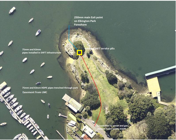
The Harbour Trust advised:
· The existing pits and connections on the headland could be moved further back to reduce the impact on the scenic headland.
· It would trench the pipes to a depth of 700mm in accordance with authority guidelines
· All areas disturbed would be remediated and made good to the satisfaction of Council
Council officers (Manager Parks and Assets, Leichhardt) advised the Harbour Trust that if Council agreed, the works would have to be planned to avoid disturbance of trees on the site.
The Harbour Trust advised that the precise location of the underground pipes would be agreed. Provided it was feasible for the Harbour Trust and its contractors, the Harbour Trust would agree to the route Council prefers through the park.
As the pipes will be underground, once the work is completed, there will be no material adverse effect on the park or the public. The easement is in favour of a public authority. It is recommended that Council grant the easement, subject to negotiation on the precise site and terms.
The Harbour Trust also mentioned that its works may be able to assist Council in any works it planned. Part of the proposed route shown on the plan, near White Street, is near where an accessible entry to Elkington Park is being investigated. It is recommended that Council look at having this pathway constructed following or as part of the Harbour Trust’s works, preferably at the Harbour Trust’s cost.
PUBLIC CONSULTATION
It is not considered necessary to consult about proposed underground pipes, although the timing or works will take public use into account. The accessible entry to the park is referred to in the existing Plan of Management which was prepared with community consultation.
CONCLUSION
The Local Government Act authorises councils to grant easements to allow pipes under the surface of community land to connect adjoining properties, as defined, to supplies of public authorities. It is recommended that Council resolve to grant the easement in favour of Sydney Harbour Federation Trust with authority delegated to the General Manager to negotiate and agree on the precise location, timing and conditions. It is also recommended that Council negotiate for the proposed accessible entry to Elkington Park to be done by the Harbour Trust as part of the works
|
|
Council Meeting 23 August 2016 |
Subject: Restaurant/Café at 107 Elliott Street, Balmain
File Ref: 16/4718/91844.16
Prepared By: Lyn Gerathy - Manager Property and Commercial Services, Leichhardt
Authorised By: Matt Phillips - Director, Corporate Services
|
SUMMARY The existing restaurant building is constructed mainly on land owned by Roads and Maritime Services and leased to Council, and partly on land owned by Council. The building is in a poor state, is not accessible and is non-compliant with BCA. Scopes of work were prepared by architects and costed by a quantity surveyor. It is not financially worth doing alterations and additions especially when rent has to be paid to RMS. It is recommended that the lease from RMS be terminated and the building be demolished. It is also recommended that Council continue to investigate (at minimal further cost) the feasibility of a new building to be constructed by or with financial contribution from a lessee prior to making a decision about the future of the site. |
|
RECOMMENDATION
THAT Council: 1. terminates its current lease from Roads and Maritime Services (“RMS”) of lot 26 DP850832 being part of the site known as 107 Elliott Street, Balmain; 2. prepares and lodges a development application for demolition of the current restaurant building and terrace; 3 seeks a new licence from RMS at its minimum licence fee of lot 26 DP850832 for public open space to connect Paringa Reserve and the proposed open space to be dedicated at 102 Elliott Street; 4. lodges an Application for PRE-DA advice for construction of a replacement café/restaurant on Council land only, with outdoor seating on RMS’ land, and use of the new structure as a licensed café/restaurant (noting that concept plans and supporting reports have already been obtained); and 5. then receives a further report.
|
BACKGROUND
There was a report to the closed session of the Ordinary Meeting of Leichhardt Council on 26 April 2016. Leichhardt Council resolved that the item be deferred pending a Councillor briefing.
LRAC
A report the same as this report except for this section was taken to the Local Representation Advisory Committee Leichhardt Meeting on 2 August 2016. That Committee resolved:
THAT LRAC note the following recommendations proposed to be put to Council;
1. That Council terminate its current lease from Roads and Maritime Services (“RMS”) of lot 26 DP850832 being part of the site known as 107 Elliott Street, Balmain.
2. That Council prepare and lodge a development application for demolition of the current restaurant building and terrace.
3. That Council seek a new licence from RMS at its minimum licence fee of lot 26 DP850832 for public open space to connect Paringa Reserve and the proposed open space to be dedicated at 102 Elliott Street.
4. That Council lodge an Application for PRE-DA advice for construction of a replacement café/restaurant on Council land only, with outdoor seating on RMS’ land, and use of the new structure as a licensed café/restaurant (noting that concept plans and supporting reports have already been obtained).
5. That Council then receive a further report.
These are the officer’s recommendations.
FINANCIAL IMPLICATIONS
Council is paying approximately $7,500 per year rent to Roads and Maritime Service under the head lease. It is recommended that Council give notice to end the lease which is on holdover.
There is $425,000 funding in the budget for this project. In addition to the investigations already undertaken, this will cover demolition of the current building and the preparation and lodgment of a Pre-DA application for which most of the information has already been obtained so there is minimal further cost.
Construction of any new building would require a substantial contribution from the lessee and it is proposed that this be considered further after Pre-DA advice is obtained.
OTHER STAFF COMMENTS
The current structure is a rendered building most of which is on RMS land being lot 26 DP850832 with a smaller part of the building including toilets and all the paved outdoor area on Council land. A small part of the building encroaches onto the road reserve.
The survey below shows:
· The main building outlined in red.
· The outdoor dining area outlined in dark green (with adjacent shrubbery planted by the former lessee in light green).
· RMS land (lot 26) outlined in blue.
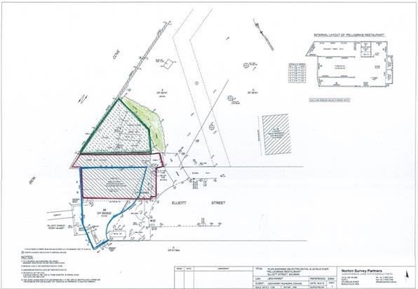
Council has a head lease from RMS of the RMS land. The original term has expired and the lease is now on holdover.
The long-term tenants vacated. At its Ordinary Meeting on 24 March 2015, Council resolved (C97/15), relevantly to this property:
1. In respect of the restaurant adjacent to the Elliot Street Wharf, Balmain, that Council:
a) continue negotiations with RMS for a new head lease, and report back to Council prior to any commitments being made;
b) apply for a Building Certificate for existing unauthorised work which is not to be demolished;
c) subject to agreement with RMS for a head lease, prepare a development application for any demolition, new and/or replacement building work; and
d) subject to agreement with RMS for a head lease, prepare a (draft) development application seeking consent for use as a licensed café / restaurant. Proposed seating numbers and hours will be considered in discussion with consultants (including parking and acoustics) and reported to Council for approval prior to the DA being finalised for lodgment.
5. b) That a business plan be provided to Council with the report on the discussions with consultants about proposed seating numbers and hours in respect of the restaurant adjacent to the Elliott Street Wharf.
c) These plans are to cover the expected costs to Council, the expected revenues, the time lines for these and the payback period and the rate of return on the funds invested in respect of each property.
Council commissioned various inspections and reports on the restaurant building at 107 Elliott Street including:
· Market Rental Assessment by Chaloner Valuations
· Retail Market Analysis and Feasibility Report by Brain and Poulter
· Building Report by Cantilever Engineers
· Preliminary Traffic and Parking Impact Assessment by McLaren Traffic Engineers (prior to construction starting at 100-102 Elliott Street and taking into account the expected traffic and parking demands from that development)
· Acoustic / noise impact report by Acoustic Logic.
The building work was done by the previous long-term lessee. Once the building was vacant and inspected, its deficiencies were more obvious.
Attached to this report as Attachment 1 is the building report by Cantilever Engineers.
In addition to the poor state of the building structure:
· It is not accessible, having no accessible toilet and with a narrow doorway and stairs to the outdoor terrace.
· The building is constructed on top of the seawall.
· Its layout with internal walls is problematic for efficient service and placement of tables.
· It is externally unattractive from many angles.
As discussed in more detail later in this report, architects prepared a Scope of Works [Attachment 2] to renovate the building based on the structural engineer’s report, accessibility requirements and other matters and this was costed by a quantity surveyor.
Before continuing this discussion, it is appropriate to look at the situation with the head lease from RMS to Council of the part of the RMS land on which most of the main building is located.
Lease from RMS to Council
Most of the current building is on land (lot 26) owned by RMS and leased to Council. The rest of the building including the toilets and much of the kitchen area, and the large outside terrace are on land (lots 1 and E and part of the road reserve) owned by Council. With Council having a head lease of the RMS’ land, Council was able to offer a sub-lease of the RMS’ land and a lease of the Council land to a restaurant operator. Council received rent from the restaurateur. Council must pay rent to RMS under the head lease. When Council’s lease to the long term tenants ended, Council was paying approximately 15% of the rent it received to RMS under the head lease. (At the last review, RMS had sought a much larger share but Council officers negotiated it down on the basis that Council was a head lessee not an agent for RMS which meant that Council had to pay rent under the head lease even if the sub-lessee failed to pay Council and Council had all the risks.)
In accordance with the March 2015 resolution, at the same time the reports were being obtained from external consultants, Council officers were talking to officers from Roads and Maritime Services about a new head lease of the relevant part of lot 26. It would be the same as before, with Council being the head-lessee from RMS of its part, and Council then granting a sub-lease of the RMS land and lease of the Council land to the operator.
RMS officers made it clear they were seeking a larger share of rent under any future new lease to reflect the area of the restaurant building on the RMS land. The initial discussions with RMS were that the renovated building would be put out to a competitive process for a new lessee operator for the whole restaurant building and terrace, and there would be agreed instructions to a valuer to determine how much of the rent Council would pay RMS under the head lease. The area of disagreement came with the treatment of capital costs to be incurred by Council in undertaking alterations and additions to the building. Council said this must be taken into account by the valuer in determining the share of the total rent to be paid to RMS under the head lease. RMS said that it would grant a longer lease (20 years instead of 10 years) to allow Council to recoup its investment but would not agree to the valuer taking the expenditure into account in determining the rent under the head lease. This is unacceptable in this case.
RMS officers inspected the site and saw the extent of work required and therefore the high costs that would be involved. They then understood better why costs by Council should be taken into account in the assessment of rent under the head lease.
Demolition was discussed. The RMS officers said that if the building were demolished, they wouldn’t bother to rebuild.
In response to the enquiry by the council officer, RMS advised that if Council surrendered the head lease, it would require Council within 6 months to demolish the building and pave the area to match the rest of the wharf entry area.
RMS said it is willing to continue discussions once Council has decided whether and how to proceed.
Council is still paying rent under the head lease to RMS. The lease is still on foot although on holdover. It was not appropriate to terminate while Council was undertaking its investigations, and the obtaining of a new lease on good terms was more likely if the current lease continued. For these reasons, a rent reduction to RMS’ minimum was not initially sought. Earlier in 2016, Council requested that the rent be reduced to RMS’ minimum whilst Council is not receiving any income (although, as stated above in this report, the rent under the head lease had been negotiated down because Council has to pay regardless of any sub-lessee paying.) RMS stated that it would consider this request for rent reduction after being advised how Council intends to proceed.
Scope of Works, Concept Plans and Estimated Costs
The formal valuation by Chaloner Valuations in June 2015 assessed rent on the basis of certain assumptions including the upgrade work being done by Council (but with the lessee to fitout the kitchen), lease length, number of chairs and operating hours. The food premises advisers considered the number of chairs required for the business to be viable and the likely rent. Part of the rent would have to be paid to RMS under the head lease of lot 26.
The architects prepared concept plans and a scope of work for the required upgrade to the current building to comply with accessibility and BCA requirements and structural repairs in accordance with the structural engineer’s report.
Two scopes were prepared, a renovation and a revision. Attached to this report as Attachment 2 is the Scope of Works and concept plans for the renovation upgrade and the revision upgrade of the current building.
The quantity surveyor, Wilde and Woollard Pty Ltd, assessed the required budget for the Refurbishment (renovate) and for the Refurbishment (revision). This is being kept confidential at this stage in case of later tenders.
The estimated costs are more than the current budget. One option is for Council to obtain development consent and then lease the building to a lessee who would undertake all the renovation work at its cost. Obviously, the rent would be lower and the lease term longer than it would be if Council did the base building work, but Council’s part could be done within the budget. This would require agreement by and a head lease from RMS and payment of rent to RMS throughout the new lease term. It would also require renewals of the lease from RMS in future.
Renovating an existing poor building is often labour intensive which increases the costs. It was considered appropriate to investigate demolition and rebuilding for comparison with renovating.
Demolition and Rebuilding
It was thought likely that it would be more cost effective to demolish and rebuild rather than try to upgrade the existing poor-quality building which would be an expensive exercise and result in a less than satisfactory building. There are other benefits in demolition and rebuilding rather than making alterations and additions to the current building which is mainly on RMS land.
· It would allow the new building to be moved back off the sea wall, reducing maintenance and repair costs of the seawall.
· It gives the opportunity to rebuild the permanent structure all on Council land rather than having a building over lands owned by two different owners (Council and RMS).
o This would overcome problems with trying to lodge a development application for a building on land with two separate owners. (The original building work was done by the former tenants with DA but no BA and then extended without development consent, so a DA would be required.)
o A head lease from RMS would not be required.
o Council would retain all the rent from the restaurateur lessee and not be required to pay any rent to RMS. This increases the financial return to Council.
o Council would not be held to ransom by RMS each time the lease was renewed in future.
· The encroachments by the current building onto the Elliott Street road reserve would be removed. This would allow a wider and safer pathway around the end of Elliott Street, benefitting the proposed connection of the pedestrian pathway from the new open space at 102 Elliott Street into Paringa Reserve.
· It would allow a better presentation to Elliott Street, to Paringa Reserve and to the new open space, and allow the new building and open spaces to complement and activate each other.
· It could be built so as to allow public use of the toilets by those visiting the parks on both sides and those walking the anticipated extended pedestrian walk around the harbour.
The architects were instructed to prepare rebuilding plans with the main building all on Council land and not any on RMS’ land, with the possibility of outdoor seating only being on RMS land.
If the outdoor seating (if any) was simply on a paved area on RMS land rather than on a lightweight deck or other structure, it would not be necessary to have a head lease. There could be a separate licence agreement to use the area which would be easier and involve a lesser payment to RMS.
“Garden Piazza”
The architects were instructed to prepare concept plans for a new building to be constructed entirely on the Council owned land, although with provision for a light-weight, easily detached structure for outdoor seating on the RMS land.
Two concepts plans for demolition and rebuilding on Council land were prepared. The two concepts are the “Garden Piazza” and the “In the Round” proposals. The architects’ site analysis and the two concepts are attached to this report as Attachment 3.
The same quantity surveyors, Wilde and Woollard Pty Ltd, who had assessed the budget for renovation of the current building, estimated the required budget for the “Garden Piazza” concept. Again, this is being kept confidential at this stage in case of future tenders.
The costs for demolition and rebuilding the “Garden Piazza” are less than for renovating the current building. One main reason is that renovation is fiddlier and more labour intensive than demolition and new construction.
Renovation of the current building provides more total seating that the Garden Piazza but fewer inside seats and more outside seats. Therefore it is fair to compare the costs. More outdoor seating may be possible on the RMS land for the Garden Piazza.
With both scenarios (renovation of the current building, and demolition and construction of the Garden Piazza) being over the budget, more work could be required to be done as part of the lessee’s fitout to be done by the lessee at its cost, rather than base building work to be done by Council which would reduce the cost to Council. This would also reduce the rent payable by the lessee to Council and likely require a longer lease term.
The cost could be reduced by reducing the extent and quality of the external works to the park and around Elliott Street outside the café, although this is not recommended. Part of this work could be done as part of s.94 open space works.
The costs of renovation and rebuilding are similar but being able to construct a new building all on Council land would mean Council retaining all the rent from the lessee and not being required to pay any to RMS for its land. There would be a greater financial return to Council from the new Garden Piazza than renovation of the current structure.
Regardless of how much of the work is done by Council at its cost and how much by the lessee at its cost, and whether or not Council proceeds with a café at the site, these plans and costings confirm that it is not worth renovating the current building which is partly on RMS land and partly on Council land.
It is recommended that the head lease from RMS be terminated, so that rent will no longer be payable, and a DA be lodged for demolition of the current building.
The DA for demolition will advise that following demolition, there will either be a new structure built for which a separate DA will be lodged or the land will be public open space. Further investigation to assist in this decision would be at minimal cost as most of the investigation and reports have already been done.
“In the Round”
The “In the Round” concept is larger than the Garden Piazza concept and is more expensive (as costed by Wilde and Woollard Pty Ltd).
One difference is that the “In the Round” concept puts the toilets on Paringa Reserve outside the current area occupied by the restaurant and terrace. They would be able to be used by park visitors, walkers and other members of the public as well as café/restaurant patrons. [Section 44 of the Local Government Act 1993 states that pending a Plan of Management, the “nature and use” of community land must not be changed. It is now public open space and this would not be altered by construction of toilets or a pathway. Any toilets would have to be adjacent to the café to comply with the BCA requirements for the cafe.] There would be a covered area between the cafe/restaurant and the toilets.
This concept also extends the area of the external works with a corresponding increase in costs.
Public Plaza- end of Elliott Street
There is an additional proposal, following from the wharf no longer being used for public ferries, the concept plans for demolition and rebuilding, and the anticipated dedication of the public open space at 102 Elliott Street and extension of its pathway to Paringa Reserve as per the February 2016 resolution.
If RMS would grant or licence to Council of all lot 26 for RMS’ minimum licence (now $530 a year) but not to build the replacement café building on it, then it could be converted to more of a public plaza or open space, thus increasing the total area of open space and better connecting the proposed new public reserve at 102 Elliott Street with Paringa Reserve. There could be an extra fee payable to RMS if there were outdoor café tables and chairs on lot 26 for which Council was receiving a fee.
As it was convenient to do so at the same time, the architects looked at improving the RMS wharf at the end of Elliott Street to be a public plaza. This is included in the concept plans in Attachment 3 but not included in the costs assessments. It is not part of this project or contemplated by the budget for this project but it is recommended that it be considered as part of the extension of the pedestrian walkway.
Other considerations
The estimated costs of the building work exceed the budget. Despite that, there are some matters to consider.
1 Lessee to Contribute to Capital Cost
The original idea was for Council to do the base building work and the lessee to do the fitout including the kitchen. Some items could be considered either base building work or fitout.
As stated above, Council could obtain DA consent to upgrade the current building and then invite tenders from lessees to do the work and then run the business. However, it is not considered financially worthwhile to upgrade this building which is partly on RMS land.
In light of the costs and the wide interest from potential lessees including a proposal for a café/restaurant to be constructed from containers by the lessee (see next section), it is now recommended that Council obtain PRE-DA advice for a new building and its use as a café/restaurant, and then invite expressions of interest for a lease involving the lessee constructing or contributing substantially to the capital costs of a new structure and/or more work (eg walls and ceilings) being included in the lessee’s fitout to be done at its cost.
As it is operational land, not community land, it is not necessary to invite tenders for the lease [s.55 (3)(e) of the Local Government Act, 1993.] This gives Council greater freedom to investigate potential lessees and negotiate, and to withdraw if it is not financially viable to continue.
This would be without significant further expenditure due to the plans and reports already done so there is little lost by the further investigation.
An increase in the budget is not sought for the café proposal (although see the comments below in the section headed “3 Community Benefit” and above in respect of the possible Public Plaza).
2 Wide Interest
Council has a distribution list of 19 people who contacted Council asking to lease the building to run a café or restaurant business and who want to be notified when expressions of interest are invited for a lessee operator. These have been cold calls to Council without any advertising to invite expressions of interest. This confirms that there would be competition for a lease of the site.
One interested person has said he has investors and is able and expects to do building / substantial fitout work. He and a number of the others have contacted Council several times seeking updates.
Another person referred Council to her recommended architects and fitout designers, and also contacted them to ring Council.
Most recently, Council was contacted by an experienced restaurateur with a number of outlets proposing that there be a new café on the site constructed from containers.
Council officers are aware of this trend to convert containers for cafes, which are faster and cheaper to install than a new building but are functional and attractive. This is considered suitable for this site. It would allow a new café structure and provide rent to Council for the land, without Council having to pay any part of the rent to RMS and without Council incurring costs other than the costs of demolition of the current building which it would have to pay even if there were no new café – although the balance of the current budget may be applied to new toilets to ensure they were available to the public. Although this proposal appears suitable, it is still considered appropriate to invite expressions of interest and then select the most promising for further negotiations. A business plan then has to be prepared before Council makes a final decision.
3 Community Benefit
When the report was prepared for the March 2015 Ordinary Council Meeting, this was almost exclusively a commercial project requiring a profit in a reasonable payback period.
It now has more of a community aspect to it as well.
The proposed dedication of public open space on the waterfront of the former Nutrimetics site immediately opposite this café/restaurant will assist in joining the two areas of open space and activating Paringa Reserve. If (following the resolution in February 2016) Council succeeds in obtaining a right of way over the NSW Housing land to connect the new open space and Paringa Reserve via the right of way and roads to Elkington Park, and with the improved walkways on the other site of the new open space to Iron Cove, any café/licensed café/restaurant at the end of Elliott Street would be a destination and stopping point for walkers from Elkington Park to the Bay Run.
Council’s Community and Cultural Plan has as an Action: “Investigate options for providing cafes or other gathering points for families and other people using local parks.”
It was because of the anticipated new open space and the extended pedestrian walkway that one of the concept plans for new work included the toilets for the café also being available to park visitors and walkers.
If there is funding, for example from the s.94 Plan for Open Space and Recreation subject to the new plan, Council may consider additional external works to the RMS land (if licensed for minimal rent) and into Paringa Reserve, around the café building.
4 Restaurant Advice
Advice was obtained from specialist food business consultants, Brain and Poulter, which is not set out here for commercial reasons.
Some matters require market testing which could be through an expression of interest process following Pre-DA advice which would be at minimal further expense.
Next steps
The recommended next steps are:
RMS land
· Regardless of whether or not any replacement café/restaurant is built, it is recommended that Council terminate the current lease from RMS and advise RMS that the building will be demolished and the leased area made good. Rent will not then have to be paid to RMS.
· It is proposed that a DA for demolition be lodged.
· Once the building is demolished, this will leave clear RMS’ lot 26 which has an area of approximately 135 m2. It is at the end of Elliott Street. It connects Paringa Reserve and the foreshore land which is to be dedicated to Council as a condition of the DA for 100-102 Elliott Street. Part of this wharf entry is now paved and is now open to the public. When the current RMS lease is terminated, the building demolished and the land made good, the rest will be paved and open to the public. However, there are some benefits (as well as costs) in Council controlling this land. Principally, through signage and design cues, it would enable the two areas of open space on either side of Elliott Street to be better connected. Whether or not a new café / restaurant is constructed, it gives Council more land and freedom to embellish it in a way which complements the two areas of open space.
It is recommended that Council seek a new licence from RMS of all lot 26 for the purposes of embellishment and use as a public plaza / public open space, at RMS’ minimum licence fee currently $530 per year.
If Council decides to proceed with a new café with outdoor seating on RMS’ land, the licence from RMS could provide that a certain amount (eg half the licence fee for the outdoor seating only) be paid to RMS. Otherwise, only the minimum annual fee would be payable.
Pre-DA
· Council would lodge an application for Pre-DA advice. The aim is to seek advice to assist in establishing the maximum size and area, numbers and operating hours. This gives the widest scope for potential lessees and negotiations.
It is proposed that the plan of the “In the Round” concept be used because it is larger than the “Garden Piazza” and puts the (shared) toilets on Paringa Reserve thus establishing the maximum area. One reduction will be the covering and structures on the RMS land. It will be shown only as uncovered outdoor seating on the paving similar to tables and chairs on footpaths. The proposed materials will be simple. The Pre-DA may refer to construction from converted containers.
Maximum hours will be sought in the Pre-DA. A lessee will not be obliged to operate the maximum hours but can trade for shorter hours. However, obtaining PRE-DA advice on the maximum hours likely to be approved by DA will assist negotiations. Similarly, the Pre-DA application will propose maximum seating numbers able to be accommodated within the concept plan, supported by the Traffic and Parking Impact Assessment and the Noise Impact Assessment and its recommendation for any amelioration of noise impacts. It may be that any future building will have fewer seats but this Pre-DA is to establish the maximum for future planning and negotiation, eg for converted containers.
As the plans and reports have already been obtained, there is minimal cost in applying for Pre-DA advice.
Expressions of Interest
· Following receipt of the Pre-DA advice, it is anticipated that a further report will be prepared recommending that Council invite expressions of interest from potential lessees for construction and operation of a new café/restaurant on the on Council land.
The new structure would have to be not inconsistent with the Pre-DA advice. Council would demolish or contribute the costs of demolition of the current building and making the site suitable for the new construction. Council would contribute the balance of its current budget for the project in particular for toilets which are to be available to park users and walkers.
Interested persons would be asked to propose a lease length and rent payable in their expression of interest. Negotiations will be undertaken with the preferred proposers. Updated costs assessments will be obtained.
Business Case
· The business case will then be finalised in line with Resolution C97/15.
PUBLIC CONSULTATION
In 2011, Amendment 18 to Leichhardt LEP 2000 reclassified the part of Paringa Reserve occupied by part of the restaurant to “operational land” and added a site specific provision to the LEP allowing the area occupied by the restaurant building and terrace to be used for a refreshment room with consent. The latter has been translated to Leichhardt LEP 2013 as a site specific provision allowing use as a café or restaurant with development consent.
The amendment to the LEP required community consultation and a public hearing prior to it being adopted and gazetted.
CONCLUSION
It is not financially worth doing the necessary upgrades to the current building. It is recommended that the lease from RMS, now on holdover, be terminated and a development application lodged for demolition.
It is proposed that a PRE-DA application be prepared and lodged seeking advice on construction of a new café / restaurant building entirely on Council’s land. The concept plans and supporting reports are held so there is minimal further expense. This will assist Council in deciding whether to pursue a new building or to leave the area as open space. A further report will be prepared on this.
|
1.⇩ |
Building Report dated 18 June 2015 by Cantilever Engineers |
|
2.⇩ |
Scope of Work for Alterations and Additions to the Current Building |
|
3.⇩ |
Concepts Plans (2) and Site Analysis by Urakawa Jenkins Architects |
|
Council Meeting 23 August 2016 |
Subject: Club Grants Allocations and Community Grants Program 2016
File Ref: 16/4718/90776.16
Prepared By: Mary Ciantar - Strategic Projects Officer Ageing, Marrickville
Authorised By: Simone Schwarz - Director, Service Delivery
|
SUMMARY This report outlines the process and allocations for ClubGRANTS 2016 and Community Services Grants 2016. A total of 55 applications were received for Club Grants requesting $536,173.98. Of these, 35 projects will receive funding from Petersham RSL and 9 projects will receive funding from Canterbury Hurlstone Park (CHP) RSL. Some projects will receive funding from both Clubs. A combined total of $164,579.98 has been allocated this year towards Category 1 applications. This support is critical for local community-based projects to address social justice through one-off or ongoing initiatives to assist disadvantaged and marginalised communities. Council is advised of applications received for the Community Grants program 2016. Council received 35 applications. The total amount requested was $142, 071.13 and 24 projects are recommended for funding to the total value of $62,710 which can be met from the Community Grants Program budget allocation of $ 62,850. |
|
RECOMMENDATION
THAT Council: 1. receives and notes the Allocations for Club Grants contained in Attachment 1 of this report for transparency; 2. approves the allocation of Community Grants, as contained in Attachment 3 of this report, under Section 356 of the Local Government Act 1993; 3. advises each organisation of Council’s decision for Community Grants; and 4. holds a small evening function during Anti-Poverty Week to award the Community Grants and celebrate the success of funding recipients.
|
BACKGROUND
ClubGRANTS
ClubGRANTS aims to improve the living standards of low income and disadvantaged people and is designed to ensure that larger registered clubs in NSW contribute to:
· the provision of front-line services to their local communities; and
· the welfare and broader social fabric of the local community.
The maximum amount available for individual projects is $25,000.
Under the Gaming Machine Tax Act 2001, a ClubGRANTS Local Committee must be established in every local government area where the Category 1 ClubGRANTS liability for all participating clubs exceeds $30,000. The role of ClubGRANTS Local Committees is to provide a broad consultative and advisory process in which qualifying clubs and key community service agencies may participate.
Further information about ClubGRANTS is available on:
http://www.clubsnsw.com.au/Community_Support/ClubGRANTS.aspx
Membership of the Local Committee complies with the guidelines and comprises:
a) a representative of Petersham RSL, the qualifying club;
b) a representative of CHPRSL, a contributing club;
c) a representative of the NSW Department of Family and Community Services;
d) a representative from Inner West Council, Petersham Service Centre; and
e) a representative of NCOSS (NSW Council of Social Services) representing local non-profit community organisations.
The Committee provides advice and recommends the applications for decision by the Club Board. Inner West Council staff contributes advice on current social needs and issues in the area and facilitate and administer the grants program.
Community Grants Program
The Community Grants Program commenced in 2004 and provides financial support to non-profit, community-based organisations for new projects that benefit residents. The Council’s grants programs opened on Wednesday at 9am 27 April, 2016 and closed at 5pm 1 June, 2016. Council staff met after the closing date to discuss any applications that were submitted to the incorrect funding program. These applications were transferred to the relevant program.
The Community Grants round opened prior to the Council amalgamations on May 12, 2016. Information for prospective applicants reflected the former Marrickville Council’s Community Strategic Plan, Our Place, Our Vision. Applicants were required to review this document and target the project to one or two of Council’s priority groups which are:
· Aboriginal people, particularly single parents and children living in South Marrickville;
· People in housing stress, particularly boarding house residents and lower income households that are being displaced because of high housing costs;
· People who are gay, lesbian, bisexual, transgender, intersex and queer or questioning (LGBTIQ);
· Young people, particularly existing or potentially at risk youth from culturally and linguistically diverse communities, Aboriginal, disadvantaged and LGBTIQ communities;
· Children and families, particularly where children are vulnerable or at risk;
· Culturally and linguistically diverse communities - particularly people with poor understanding of written and spoken English, new arrivals and refugees, and the frail or isolated elderly;
· People with a physical or intellectual disability;
· Seniors, particularly the frail aged and socially isolated; and
· position the project alongside an outcome statement and strategy from the former Marrickville Council’s Community Strategic Plan, particularly KRA 1 as below:
|
Our Place, Our Vision Former Marrickville Council’s Community Strategic Plan 2023 |
|
1.1 The community is active and healthy 1.2 The community has improved access to a range of local services for all ages and abilities 1.3 The community has increased opportunities for participation and engagement 1.4 The community feels safe, connected and has accessible infrastructure 1.5 Marrickville provides affordable housing options to meet the needs of the community 1.6 Marrickville is a diverse community that values and celebrates its many cultures 1.7 The community is engaged in lifelong learning opportunities |
The Council’s Community Services Grant Programmes were promoted together with:
· Arts and Cultural Grants, Independents Artists Grants and Recreation Grants
· ClubGrants (funding provided by qualifying Clubs with the Local Committee convened by Council)
· Groundwork Sustainability and Visy Community Grants.
The table below shows a history of funds requested, applications received and number of successful applications. The budget for the Community Grants Program is $62,850:
|
Year |
Funds Requested |
Number of Applications |
Number of Successful Applications |
|
2016 |
$142,017.13 |
35 |
24 |
|
2015 |
$120,256 |
28 |
23 |
|
2014 |
$98,397 |
25 |
19 |
|
2013 |
$117,414 |
30 |
19 |
|
2012 |
$113,870 |
28 |
22 |
|
2011 |
$93,956 |
28 |
18 |
|
2010 |
$134,712 |
33 |
21 |
|
2009 |
$79,117 |
25 |
19 |
|
2008 |
$139,441 |
32 |
23 |
|
2007 |
$120,225 |
33 |
25 |
|
2006 |
$132,588 |
33 |
22 |
|
2005 |
$257,926 |
56 |
28 plus 4 ** |
|
2004 |
$217,691 |
51 |
20 |
** Please note the additional 4 projects were funded from a carry-over of unexpended funds ($8,700) from the previous 2004/05 year.
DISCUSSION
ClubGRANTS
The ClubGRANTS round opened prior to the Council amalgamations on May 12, 2016. A call for applications was publicised for the 2016 ClubGRANTS program on 27 April 2016 and closed at 5pm on Wednesday 1 June 2016 alongside promotion of Council’s other grants programs. Council’s Community Development team provided individual advice to applicants regarding the guidelines, priorities and local needs in the lead up to the grants closing on 1 June 2016.
A total of 55 Category 1 applications were received this year requesting a total of $536, 173.98. Following an initial assessment by Council’s Community Development team, projects were ranked by the Committee to advise the two clubs of the most pressing priorities for funding.
The Local Committee met once this year and discussed the likely amounts available to ClubGRANTS, and identify priorities and assess the Category 1 applications in line with the identified priorities.
Priorities are identified by Council through the Former Marrickville Council’s Community Strategic Plan, incorporating the social needs of disadvantaged communities. Priorities noted by assessment panel representatives include: children and young people are protected from abuse and neglect; people with disability being supported to realise their potential; social housing assistance to break disadvantage; assistance to people to participate in social and economic life; people at risk of, and experiencing, domestic and family violence and Aboriginal people, families and communities and people from culturally and linguistically diverse backgrounds, especially refugees and asylum seekers and settlement services.
Petersham RSL funded 35 projects to the value of $114,579.98 and Canterbury Hurlstone Park RSL funded 9 projects to the value of $50,000. Five (5) projects received funds from both sources. Details of the projects and amounts can be seen at Attachment 1.
Each Club advises organisations of their success. Council advises the unsuccessful applicants on behalf of the Local Committee.
Community Grants Program
This year Council's Community Grants Program attracted a total of 35 applications requesting a total of $135,247.13 and competing for an available total of $62,850, (includes adjustment for Consumer Price Index). The maximum grant allocation available is $5,000 per project.
All Community Grants applications are assessed by a panel against the eligibility criteria and priorities outlined in the former Marrickville Council’s Community Grants Program Policy (Attachment 2). Some organisations submitted more than one application or submitted applications to multiple grant programs. This has been cross-referenced on the table of applications at Attachment 3.
Assessment priority levels are detailed below:
High Priority: Meets eligibility criteria. Project is consistent with the key priorities of the Our Place, Our Vision, the former Marrickville Council’s Community Strategic Plan, and is clearly targeted to at least one priority social justice group. The project meets assessment criteria and compares well with other applicants.
Medium Priority: Meets eligibility criteria. However, the project proposal may be too loose (inadequate detail or poorly targeted) or too costly (not value for money compared with other applicants).
In other cases, there may be other – more appropriate – sources of funding available. In some instances, the project spans several local government areas and a contribution is provided to support Marrickville residents. Feedback will be provided to the organisation and they will be encouraged to apply next year, if appropriate.
Low Priority: Not all aspects of the proposal meet the eligibility criteria. Feedback will be provided to the applicant/s on Council’s accountability requirements. An applicant is also deemed a lower priority and ineligible when it is known that they may receive funding from another source for the same or similar project, such as from ClubGrants.
Of the thirty five (35) applications received, twenty four (24) are recommended for funding. Although not all projects will receive all of the money requested it is considered the projects will still be viable with a lesser amount. Of the eleven (11) projects not recommended for funding:
· one applicant withdrew the application before the assessment meeting;
· one application was transferred to the Recreation Grants stream and applicant advised;
· one project was considered more suitable to be funded as part of the Active and Connected program for seniors in 2016/2017;
· two projects have been funded on two other occasions and projects have recurrent funding implications which does not align to the program guidelines. One of these applications was also considered for funding in the 2016 ClubGrants round for the same project and is being funded;
· two applicants did not meet the eligibility criteria;
· two applicants had dual applications in the Community grants stream and those applications were funded in favour of these; and
· two applicants were not funded in favour of a third application all submitted by the same organisation.
Further details regarding the recommendations are outlined in Attachment 3.
Funding recipients usually receive cheques at a presentation ceremony to be held during Anti-Poverty Week in October (held Sunday to Saturday and incorporates the United Nations Eradication of Poverty Day which is 17 October). In 2016 the event is scheduled for 17 October 2016.
FINANCIAL IMPLICATIONS
ClubGRANTS
Nil.
Community Grants Program
The recommended funding totals $62,710 which can be met from the budget allocated for the Community Grants Program in the 2016/17 financial year.
PUBLIC CONSULTATION
ClubGRANTS
Nil.
Community Grants Program
In addition to advertising Council’s Grants Programs in the local media and Marrickville Matters, Community Development officers also sent notification and reminders out to their email networks and talked about the grants programs at their interagency meetings. Access to information about all Council’s grants programs was also available Council's website: http://www.marrickville.nsw.gov.au/en/community/community-services/council-grants/
Social media was also used to refer individuals to the website.
When asked how they had heard about the grants program on the application form, applicants indicated that most were previous applicants, had seen it on Council’s website or were notified through an interagency email notification. Applicants are encouraged to call Council staff to discuss their application, especially if requesting more than $2,000.
CONCLUSION
Community Grants Program
All Community Grants applications are assessed against the eligibility criteria and priorities outlined in the former Marrickville Council’s Community Strategic Plan and in accordance with Council’s Community Grants Program Policy (Attachment 2). Some organisations submitted more than one application, submitted applications to multiple grant programs withdrew prior to assessment or applications transferred to another grant stream. This has been cross-referenced on the table of applications at Attachment 3.
|
1.⇩ |
ClubGrants Allocation Table 2016 |
|
2.⇩ |
CP3 Marrickville Community Grants Program Policy |
|
3.⇩ |
Community Grants 2016 - Recommendations for Funding |
|
Council Meeting 23 August 2016 |
Subject: Endorsement of Floodplain Risk Management Committee Charter
File Ref: 4387/67859.16
Prepared By: Ryan Hawken - Coordinator Asset Planning, Marrickville
Authorised By: Wal Petschler - Director, Major Projects and Engineering
|
SUMMARY Inner West Council staff have prepared a Floodplain Risk Management Advisory Committee Charter for consideration by Council which details the membership, and function of the Committee.
|
|
RECOMMENDATION
THAT: 1. Council adopts the Flood Management Advisory Committee Terms of Reference (Attachment 1); and 2. Council staff seek expressions of interest from residents to be community representatives on the Flood Management Advisory Committee.
|
BACKGROUND
As a result of the recent announcement by the Premier to create a new Inner West Council made up of the former Ashfield, Leichhardt and Marrickville Councils, all three Councils and their Committees, including the Floodplain Risk Management Advisory Committees of each Council have been dissolved and no longer have authority to meet or function in their prior capacity.
Inner West Council is currently undertaking five flood related studies, namely:
· Leichardt Flood Risk Management Plan;
· Marrickville Valley Flood Risk Management Plan;
· Hawthorne and Dobroyd Canal Flood Risk Management Plan;
· Alexandra Canal Flood Study; and
· Johnstons Creek Flood Study.
These studies require consideration and endorsement at various stages by the Floodplain Risk Management Advisory Committee to comply with NSW State Government Policy for floodplain management. It is anticipated that a meeting of the Floodplain Risk Management Advisory Committee will be required in late August or early September.
Inner West Council staff have prepared a Flood Management Advisory Committee Terms of Reference for consideration by Council which details the membership, and function of the Committee. Refer Attachment 1.
Along with staff and representatives from other agencies, it is proposed to have one community representative from each of the eight catchments in the Inner West LGA. Following the endorsement of the Charter it is proposed to seek expressions of interest for community representatives.
FINANCIAL IMPLICATIONS
Nil.
OTHER STAFF COMMENTS
Nil.
PUBLIC CONSULTATION
Nil
|
1.⇩ |
IWC Flood Management Advisory Committee Terms of Reference |
|
Council Meeting 23 August 2016 |
Subject: Elkington Park Cottage, Balmain - Possible Conversion to Cafe
File Ref: 16/4718/91839.16
Prepared By: Lyn Gerathy - Manager Property and Commercial Services, Leichhardt
Authorised By: Matt Phillips - Director, Corporate Services
|
SUMMARY Council has been investigating the feasibility of adaptive re-use of Elkington Park Cottage as a café, obtaining reports from a number of specialist consultants. There has been a first round of community consultation. The results of the investigation and consultation are outlined in the report. The next steps are awaiting the gazettal of the amendment of the LEP. In the meantime, it is being recommended that feedback be provided to those who took part in the consultation by notifying them of the outcomes of the consultation and other information to be on the website. |
|
RECOMMENDATION
THAT: 1. the report be received and noted; and 2. the results of the first round of community consultation be placed on the website, with the Parking and Traffic Impact Assessment and other supporting documents, and that Council advise this to all who completed a survey or made a submission.
|
BACKGROUND
The former Leichhardt Council had been undertaking a Review of all its real property to identify, amongst other matters:
· properties and buildings that could provide financial returns, or higher financial returns, to Council with possible and recommended uses,
· properties and buildings that could be used to satisfy, or to satisfy better, Council’s strategic aims and how,
· actions and requirements to implement the recommendations.
The 2004 Plan of Management for Elkington Park recommends investigation of adaptive re-use of the caretaker’s cottage and listed matters to be considered.
The (Leichhardt) Council’s Community and Cultural Plan Strategic Objective 2, Outcome 2.2, Strategy 2.2.1, Action 1 is: Investigate options for providing cafes or other gathering points for families and other people using local parks …
At its Ordinary Meeting on 24 March 2015, Leichhardt Council resolved:
1. In respect of Elkington Park Cottage, Balmain:
a) that the community be consulted about a proposal for a licensed café, with Dawn Fraser Museum, artist in residence and/or other uses; and
b) that investigations be continued into the feasibility of a licensed café with other uses at Elkington Park Cottage.
5. a) That a business plan be provided, in respect of each of the Elkington Park Cottage and …., with the reports to Council on public consultation.
c) These plans are to cover the expected costs to Council, the expected revenues, the time lines for these and the payback period and the rate of return on the funds invested in respect of each property.
LRAC
A report the same as this report except for this section was considered at the Leichhardt Local Representation Advisory Committee Meeting on 2 August 2016. The Committee resolved:
THAT LRAC note the following recommendations:
1. That the Report be received and noted.
2. That the results of the first round of community consultation be placed on the website, with the Parking and Traffic Impact Assessment and other supporting documents, and that Council advise this to all who completed a survey or made a submission.
3. That investigation of this project be pursued further by:
· exhibiting an amended Plan of Management for Elkington Park which more expressly allows the adaptive re-use and for the cottage to be leased for a café, once the LEP is amended – with the draft brought to LRAC prior to exhibition;
· preparing and lodging a Pre-DA application to establish acceptability of the proposed work and the chair numbers and hours of operation, with the Pre-DA supported by the concept plans, a Conservation Management Plan, Heritage Impact Statement, Accessibility Report, Traffic and Parking Impact Assessment and Noise Impact Assessments; and
· finalising the Business Plan.
4. That further information be brought to Council on the potentials of the café operating as a social enterprise providing employment pathways of the disadvantaged.
Officer’s Comments:
Paragraphs 1 and 2 are the same as the officer’s recommendations.
Paragraph 3 was added by LRAC. It is taken from the Conclusion in this Report. The proposals in the Conclusion are elevated to recommendations for a Council resolution to proceed in the way outlined. This recommended paragraph 3 is supported by the officer who prepared this report.
Paragraph 4 was also added by LRAC. It is noted that it only calls for “further information to be brought to Council on the potential” of the café operating as a social enterprise providing employment pathway for the disadvantaged, however the officer who prepared the report does not support the recommendation. There are a number of concerns.
· It is not entirely consistent with the rationale of the property review, nor with the earlier resolutions of Council to investigate the feasibility of the project and to prepare a Business Case, nor with the added paragraph 3 above calling for finalisation of the business plan, which imply that it is to a commercial or financially feasible project for Council.
· Many cafes fail. It is not in Council’s interest, the public interest or the lessees’ interest for the cottage to be leased to an inexperienced operator who is unable to fit out the kitchen and unable to make a success of the business. There will be a number of assessment criteria for selection of the lessee operator but the most important are the ability to run a successful café business and the provision of the service to park visitors and other local patrons. Providing employment opportunities for disadvantaged persons should be secondary for a business in a heritage building on community classified public land being a public park.
FINANCIAL IMPLICATIONS
There is $600,000 in the budget for the work to adapt the cottage for use as a cafe. Estimated costs as assessed by an external quantity surveyor are within the budget. There is also sufficient in the budget for the costs for the exhibition of the draft Amended Plan of Management and related matters.
Commercial rent would be received by Council if the cottage were adaptively re-used as a cafe.
OTHER STAFF COMMENTS
Investigations have been undertaken to determine the feasibility of a (licensed) café at Elkington Park Cottage.
The following are attached to this Report:
Attachment 1: Accessibility Report
Attachment 2: (Draft) Parking and Traffic Impact Assessment.
The hours covered by the draft Parking and Traffic Impact Assessment are longer and later than is likely to be sought in any DA or traded by an operator. This was to ensure the full possible range was covered. The hours can easily be reduced from those in the preliminary impact assessment but could not be extended without new counts and a new impact assessment. The most likely trading hours are daylight hours. The Report will be finalised once mid-year counts are finalised and there is greater certainty about patron numbers.
A Conservation Management Plan was obtained and given to the architects who prepared concept plans. A structural engineer’s report and a hydraulic services report were obtained and given to the architects and the quantity surveyors. Copies are not attached to this report but are available on request.
Council also commissioned a Market Analysis and Feasibility Report by retail food specialist consultants Brain and Poulter. They looked at location, features, likely demand, trading hours and options, possible revenue and rents. For commercial reasons related to possible future tenders for a lessee, this is being kept confidential at this stage.
Concept Plans and Estimated Costs
Architects were appointed to prepare concept plans having regard to the Conservation Management Plan, the Feasibility Report, the Accessibility Report and other matters.
The architects’ report on adaptive re-use for a café with concept plans is attached to this report as Attachment 3. The initially preferred concept is below:
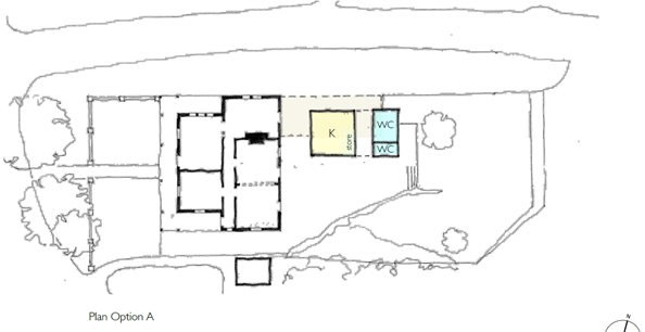
The features are:
· The current added-on domestic kitchen, bathroom and laundry section, which has asbestos, and the rear lean-to section are demolished. A new kitchen space and an accessible toilet and additional toilet are constructed. They are set back from the original cottage to allow an accessible path of travel from the cottage to the rear courtyard and WCs, and also to allow a side entry to the courtyard. These access ways are to be covered for protection from weather, as usually required by the accessibility consultant. The lessee would be required to fitout the kitchen.
· The heritage cottage is retained except for (1) the conversion of a rear bedroom window to a doorway to the rear courtyard; (2) the creation of a wall opening between two bedrooms to create a larger space, with this wall opening below the picture rail and with nibs on both sides in accordance with heritage advice so that the original layout is demonstrated; and (3) the doorway between what is now the lounge room and dining room may have to be widened for access.
· The entry through the gate, then to the verandah and then into the front door (where there are currently single steps at each point), and around the side of the cottage to the rear courtyard, will be made accessible.
· There will be some repairs and maintenance, BCA required works and cosmetic works.
The works have been assessed by an external quantity surveyor. The estimate is within the budget for the project, leaving funds for consultation and other matters, but is being kept confidential at this stage in view of possible future tenders for construction.
Accessible Toilets for Park Visitors
The report writer, Manager Property and Commercial Services Leichhardt, discussed the cottage with the Manager Parks and Assets Leichhardt and the Senior Recreation Planner Leichhardt.
The 2004 Plan of Management for Elkington Park calls for the upgrade of the current toilet block near the playground, or its demolition and rebuilding roughly in the same location. It has been suggested that the converted cottage could also provide an accessible toilet for all park users, enabling the existing park toilet block to be demolished and its site returned to open space. This was included in the brief to architects and is referred to in the architect’s report in Attachment 3 but it requires further investigation. It can be looked at during design development but the main issues in respect of the cottage are:
· Whether park visitors are to be allowed to use the toilets only when the café is not operating or also when the café is operating. If the latter, there may be some conflict and other issues.
· Café patrons may access the toilets through the cottage/café. Most park users would reach the WC from the side, from the service drive from Fitzroy Avenue. It is likely that accessible entry from the side driveway can be made compliant near the cottage but less likely that it will comply nearer the WC’s as the gradient at this section is too steep. This is one issue that may lead to a conflict referred to in the previous dot point. There would be another accessible route around the other side of the cottage to the rear courtyard but this also may cause conflict with café operators and patrons, raise security issues and may breach the Disability Discrimination Act by requiring park visitors in a wheelchair or with other mobility disabilities, who are not café patrons, to take a roundabout route. These proposals will be discussed further with the architect, engineers and accessibility adviser.
· The Building Code of Australia (BCA) mandates the number of toilets required depending on the number of patrons the café can seat and staff numbers. The concept plan has one unisex accessible WC (which counts as two under the BCA) and one unisex ambulant WC. Making the toilets available to park visitors may require additional toilets be constructed. One issue with this is whether there is sufficient area. Another issue is the cost not only for the additional toilet/s but of further excavation of the current garden area at a higher level. The additional cost could possibly come from the Open Space budget if there were support for this proposal.
It is recommended that this proposal remain as an option for further investigation during design development.
Access into Elkington Park for Persons with a Disability
The cottage was inspected by an accessibility consultant who advised that the cottage could be adapted for use as a café, noting it was heritage, subject to certain recommendations being followed.
The consultant asked about access to the cottage. The driveway from the Fitzroy Avenue car parking area is too steep. It was proposed that the pathway starting near the playground, on the White Street side of the park, going across the park to the cottage (“cross path”) would be the preferred access to the adapted cottage. It would be except that the cross path only starts (and ends) at the bins near the playground and doesn’t extend to the park entry.
This brought to light the limits on access into the park. There is no access into the park for unassisted wheelchair users. The pathway from the corner of Glassop and White Street, down to the rotunda, then around the rotunda to meet with the cross path, does not comply as it is too steep. The 2004 Plan of Management for Elkington Park has general objectives about accessibility and refers to extending the cross path to the toilets. The body of the Plan of Management does not specifically refer to access into the park but there is a reference in the Action Plan to a link with entry from opposite Tilba Avenue.
There needs to be access into the park itself and then to connect with the cross path. This is not only relevant for access to the cottage. It needs to be looked at even if use of the cottage does not alter. There should be access into the park, to connect with the existing path across the park, and to the playground and to accessible toilets.
The proposal is that a new path be constructed from White Street, approximately opposite Tilba Avenue, to connect to the existing cross path. This new park entry path may be a curved path following the contours of the land or a zig zag or a combination. The cross path could then be upgraded if necessary and extended to the playground and to the toilets (if they are rebuilt in the same location rather than at the cottage.) Perhaps there could be a disabled parking space in White Street near the new park entry.
![]()
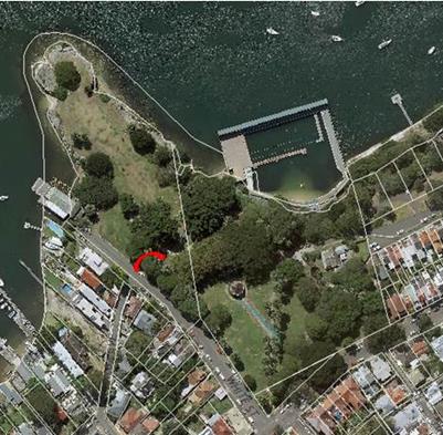
Regardless of what decisions are made about the cottage, it is proposed that unassisted access into Elkington Park for persons in a wheelchair or with other disabilities now be investigated.
Amendment of the Plan of Management
The 2004 Plan of Management for Elkington Park states:
The recommendation of this Plan is to continue the existing use and occupation of the cottage for the short to medium term and undertake a more detailed feasibility study on alternative uses for the cottage. Any change to the use must address significant issues such as:
• The impact on parking and vehicular access on the park and surrounding residents.
• The financial cost of the conversion and return to council from the operation of any facility.
• The provision of maximum benefit to a wide range of park users.
• The hours and scope of operation and any lease conditions.
• The retention of heritage significance and link to the pool.
That Plan was adopted in 2004, 12 years ago. The residential use has continued for more than the short to medium term (up to 4 years under the plan). Investigations have now been undertaken on adaptive re-use including the obtaining of a Conservation Management Plan, an accessibility report, a feasibility study for a café which looked at hours of operation, and a preliminary draft traffic and parking impact assessment.
It is thought that the current plan of management already allows adaptive re-use of the cottage for a café and/or other uses. However, it is considered better to amend the Plan of Management to make express provision. The changes make any proposals more transparent. Exhibition of the proposed changes to the Plan of Management would be another round of consultation.
Community land cannot be leased unless there is specific authorisation in the Plan of Management for a lease to be granted. The 2004 Plan of Management for Elkington Park states on page 66:
Any future leases and licences or renewal of existing licences for Elkington Park is authorised by this Plan of Management, provided the proposed use is consistent with … the objectives, zoning, and requirements in the Local Government Act, 1993 …
Use as a café satisfies the requirements in the Local Government Act, 1993 for the use of parts of community land – restaurants and refreshment kiosks being referred to expressly in s.46(5) – and the other matters in this section of the Plan of Management, but it is preferable and probably necessary to have a more specific authorisation in the Plan of Management to lease the cottage for a café and other compatible uses.
It is recommended that changes be made to the Plan of Management to authorise adaptive re-use of the cottage as a café or restaurant and/or other uses and to authorise expressly the cottage being leased for such purposes. Amending the Plan of Management as proposed would authorise the adaptive re- use and lease. It does not require it to happen.
If the Plan of Management is being amended for this purpose, it is thought appropriate to add something more about accessibility into and within the park and options for the location of the new toilets.
The Local Government Act states that a Plan of Management can only be amended by a Plan of Management adopted in accordance with the provisions in the Act.
Amendments have been prepared to the Plan of Management as outlined above. These cannot be placed on exhibition until the LEP is amended, as outlined in the following paragraph.
Leichhardt LEP 2000 contained a provision to the effect that, with consent, any development was permitted if authorised by a Plan of Management. This allowed cafes in parks if it was in the Plan of Management. That general provision was not allowed in Leichhardt LEP 2013, and so amendments are being made effectively to allow the same matters, with DA consent, as previously could be authorised by the Plan of Management for a park. Council resolved on 14 April 2015 (C127/15P) to seek a number of amendments to the LEP including to allow cafes and restaurants, with consent, in public recreation areas. These amendments passed through the Gateway determination, were adopted by Council on 10 November 2015 (C549/15P) and are with the Parliamentary Counsel’s office.
Once the LEP has been so amended, the draft Amended Plan of Management will be brought to LRAC for approval to be put on public exhibition as required by the Local Government Act, 1993.
Next steps
Because of the time since the original consultation was done during the summer period and the delay in gazettal of the amendment to the LEP, it is thought important to provide some feedback to the residents who took part in the consultation. It is proposed to put the outcomes of the consultation (as outlined below in this report) on the website, together with the Traffic and Parking Impact Assessment. All those who took part by completing a survey and/or making a submission would be directly notified. The information would include advice about the proposed amendment of the draft Amended Plan of Management and that they would be notified when it went on exhibition.
A Pre- DA application can be prepared proposing chair numbers and hours of operation informed by and supported by the Accessibility advice, Feasibility Report, Conservation Management Plan, Heritage Impact Statement, Traffic and Parking Impact Assessment and a Noise Impact Assessment, although subject to gazettal of the amendment to the LEP. This Pre-DA is to obtain another level of advice on the general acceptability of the proposals from the planning aspect. The additional costs are minimal as most of the work has already been done.
Updated market rent assessments and (if necessary) updated construction cost estimates will then be obtained. This will allow finalisation of the Business Plan.
PUBLIC CONSULTATION
There was community consultation about the possible adaptive re-use of the caretaker’s cottage in Elkington Park. The consultation was from 1 December 2015 to 31 January 2016. This period included the Christmas and New Year period and school holidays, but it was for 2 months and in this case, the initial consultation (like the parking and traffic study) was thought to be better done in the summer and including the school holiday period when there would likely be a larger attendance at the Baths.
Notification of the consultation included:
· being on Council’s web-site
· posters at Dawn Fraser Baths and various locations in Elkington Park as well as the Administration Centre, Balmain Library and various Council noticeboards in Balmain, Balmain East, Birchgrove and Rozelle
· advertisements in The Courier
· references in Council’s weekly e-News
· direct notification by email to the local Precinct and a representative of the Friends of Dawn Fraser Baths and
· individual addressed letters posted to owners and occupiers of properties in Fitzroy Avenue, Punch Street, Gow Street, Gow Lane, part of Birchgrove Road, Addison Street, part of Hampton Street, part of Glassop Street, White Street, Tilba Avenue, Carieville Street, Carieville Lane and Phoebe Street.
The notifications advised that there was information on Council’s web site with a link to a survey and that submissions were invited.
The on-line survey asked the following questions:
1 Do you support Elkington Park Caretaker’s Cottage being adapted for a use which allows public access to the cottage?
2 Do you support a café in Elkington Park Cottage?
3 Please explain why you do or do not support a café at Elkington Park or why you are unsure.
4 Do you support a Dawn Fraser Museum in Elkington Park Cottage?
5 Do you support one or more of the rooms in Elkington Park Cottage being made available to local artists for, say, 3 months at a time?
6 Do you have any suggestions for other uses for Elkington Park Cottage?
7 Please ask any questions or make any other comments or submissions you wish about the cottage, it use and its future.
There were 63 responses to the on-line surveys although not all responded to all questions. The results are set out below.
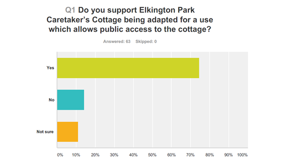
Of the 63 responders:
o 47 said yes, 7 said they were not sure and 9 said no.
o 74.60% said yes, 11.11% were not sure and 14.29% said no.
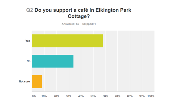
Of the 62 responders:
o 36 said yes, 5 were unsure and 21 said no.
o 58.06% said yes, 8.06% were not sure and 33.87% said no.
Note however that one person who answered no to this question 2 then made a comment under question 3 which did indicate support for a cafe.
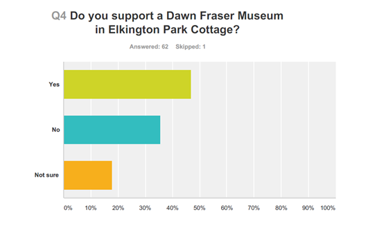
Of the 62 responders:
o 29 said yes, 11 were unsure and 22 said no.
o 46.77% said yes, 17.74% were not sure and 35.48% said no.
Of the 62 responders:
o 38 said yes, 6 were unsure and 18 said no.
o 61.29% said yes, 9. 68% were not sure and 29.03% said no.
Question 3 Please explain why you do or do not support a café at Elkington Park or why you are unsure.
Question 6 Do you have any suggestions for other uses for Elkington Park Cottage?
Question 7 Please ask any questions or make any other comments or submissions you wish about the cottage, it use and its future.
Attached to this report, as Attachment 4, is a full list of the responses to questions 3, 6 and 7 of the survey and the submissions received separately, in some cases with officer’s comments. As is usual with consultations and matters on exhibition, those opposed to a proposal were more likely to give an explanation or make a longer comment or submission than those who support the proposal. The comments are summarised below.
People in support of a café at Elkington Park Cottage said there wasn’t now a café, there was a lack of outdoor venues, this was a pleasant setting for a café, it is a better community use of the building, it’s popular and a café would be nice, it’s close to a good recreation area, it is a good socially positive redeployment of the asset, it is a beautiful setting and would be a lovely place to meet friends, a lovely meeting point and a good use of the building, there are Balmain cafes but not in a park setting, it would be beneficial for park users and for locals to stroll to, it would provide the large number of park visitors and dog walkers a meeting place to socialise and entertain and provide the council with a revenue asset, nice to have a cafe away from any busy roads and enjoy the lush surroundings, best way for the whole community to enjoy the building.
People who do not support a café raised the following issues.
· There was a lot of concern about the effect of a café on traffic and parking. This was also raised by several of those who answered “not sure” to the question.
Council commissioned a Parking and Traffic Impact Assessment. Parking counts were done in the school holidays and after the school holidays on selected hot days. It was thought that this is when there would be most visitors to Dawn Fraser Baths and so when there would be the greatest parking demand and traffic. A copy of the draft Parking and Traffic Impact Assessment is attached to this report, as Attachment 2. It covers longer hours than is proposed to ensure the full possible range is included. Hours can easily be reduced but if sought to be extended, new counts and a new impact assessment is required. If Council proceeds to a development application, this impact assessment will be finalised and used to inform the preparation of and support the DA.
· Several people thought there were already too many cafes in Balmain.
· There is a kiosk in the Baths.
· There was an objection to commercialisation of the park.
· Others thought a café was not suitable for the passive recreation and quiet nature of this particular park; that a café brought noise and rubbish.
· A cafe in this park will change the nature of what is currently a very well-used and much-appreciated public space for everybody (e.g. it will discourage picnic groups, ball games, dog-walking).
Any café would be in the cottage and its fenced yard which is currently tenanted and not available for use by the public. There would be no loss of public open space available for picnics, ball games and dog walking.
· Viability of a café business was questioned by some opposed and some who were unsure about a cafe. One said a café was not supported as it would require Council subsidy such as cheap rent and Council should promote a restaurant which would enable a viable business; the market should decide; and Council should look at other successful venues.
A café and a restaurant are both listed together in paragraph (a) of “food and drink premises” under Leichhardt LEP 2013 so there is no difference in planning terms. Subject to DA, the market would decide the nature of the business and what was offered at different times and different days. Council did obtain advice from external specialist consultants in the area of retail sale of food and beverages including restaurants and cafes. This advice was not exhibited during the consultation for commercial reasons.
· There is a large amount of support for the cottage remaining a residence for a council employee who would provide passive security and be available to respond to incidents in the Park and the Baths.
Whilst the benefits of passive security are noted and residential use of a cottage on community land is permitted by the Local Government Act, 1993 and supported on heritage grounds, this use does not allow public access to the heritage cottage. It is a subsidised private use of a public asset with the caretaker having no specific duties.
In response to question 6 about other uses:
· Some repeated their support for a café, artists in residence or caretaker’s residence.
· Others suggested that rooms be available for hire for various book clubs, mothers’ groups, community groups etc.
The Community Facilities Review (2011) stated that there are sufficient rooms and halls for hire (although Leichhardt suburb did not have a community or neighbourhood centre).
Noting the cottage floor plan and concept plans for a cafe, a café may provide a meeting place for some groups and the café operator may be willing to hire a room or reserve all tables in a room for groups of patrons.
Summary of Preliminary Consultation:
Of the respondents to the on-line survey:
· 74% support an adaptive re-use of the cottage which will allow public access
· 58% support a café and another 8% were unsure
· 46% support a Dawn Fraser Museum being included
· 61% support artists in residence being included
As three-quarters of respondents support an adaptive re-use which allows public access and more than half support a café, it is recommended that Council continue to look at this. The major issues raised were the impact on parking demand and traffic volume and the desire for a resident “caretaker.”
There is support for artists in residence. This may impact on the viability of the cottage for a café and there may be security issues with shared use. Areas in Dawn Fraser Baths are used annually in the winter months (when the pool is closed to the general public) for the artists in residence programme known as “Winter Dawn.” Whites Creek Cottage is considered better for artists in residence than Elkington Park Cottage. (Whites Creek Cottage was looked at as part the Property Review and will be reported separately.)
As less than half support a Dawn Fraser Museum, it is proposed not to pursue this for Elkington Park Cottage. Areas within the Baths themselves could be looked at in connection with this if there were demand for it. There are already archives held at the Baths.
CONCLUSION
The public consultation supported the heritage cottage being used in a way which allowed public access. A majority supported it being a café. In view of the time since, it is recommended that the outcomes of the first round of consultation be given to those who took part, by directly notifying them of the outcomes of the consultation and other information being put on the website.
It is proposed that investigation of this project be pursued further by:
· exhibiting an amended Plan of Management for Elkington Park which more expressly allows the adaptive re-use and for the cottage to be leased for a café, once the LEP is amended – with the draft brought to LRAC prior to exhibition;
· preparing and lodging a Pre-DA application to establish acceptability of the proposed work and the chair numbers and hours of operation, with the Pre-DA supported by the concept plans, a Conservation Management Plan, Heritage Impact Statement, Accessibility Report, Traffic and Parking Impact Assessment and Noise Impact Assessments; and
· finalising the Business Plan.
|
1.⇩ |
Accessibility Report - Elkington Park Cottage |
|
2.⇩ |
Elkington Park - Draft Parking and Traffic Impact Assessment |
|
3.⇩ |
Elkington Park - Concept Plans and Architect’s Report on Adaptive Re-Use |
|
4.⇩ |
Elkington Park - Comments and Submissions made during the Community Consultation |
|
Council Meeting 23 August 2016 |
Subject: Whites Creek Community Orchard Management Plan
File Ref: 16/4718/91587.16
Prepared By: Aaron Callaghan - Senior Parks and Open Space Planner, Leichhardt
Authorised By: Simone Schwarz - Director, Service Delivery
|
SUMMARY The Whites Creek Community Orchard was originally proposed in 1996 as part of the Whites Creek Valley Park Plan of Management. Designed and developed with community input in 2014, practical delivery of the community orchard was completed in early 2015.
The development of a formal plan of management for the community orchard was proposed by the community during its design stages. The aim of the plan of management is to assist in clarifying the roles and responsibilities of community volunteers, identifying partnership opportunities, key management tasks and activities associated with long term management and maintenance of the Community Orchard.
|
|
RECOMMENDATION
That Council adopt the draft plan of management which has been prepared for the Whites Creek Valley Park Community Orchard and provide funding support of $5,000 a year to support the growth and development of the Community Orchard.
|
BACKGROUND
In November 2015 Leichhardt Council resolved to provide a quick response grant of one thousand dollars to support the Friends of Whites Creek Valley Park with equipment and resource needs associated with the ongoing maintenance of the new Community Orchard. Access to a small shed off the existing stables at Whites Creek Valley Park has also been provided for storage needs and Community Orchard signage has also been developed and installed. A notice board to assist with community information pertaining to the Community Orchard and other park activities has also been installed.
The Whites Creek Valley Park Community Orchard has been a feature of Whites Creek Valley Park since its official opening by Council in early May 2015.
Following a successful opening two community workshops have been held at the Community Orchard to assist in fostering and encouraging community volunteer work in maintaining the orchard and assisting with both fruit tree and understory companion planting, weeding, fertilising, mulching and watering.
In partnership with Council, the Friends of Whites Creek Valley Park have held a number of community working bees at the Community Orchard and worked closely with Council officers in relation to the outcomes of these events including reporting back on volunteer numbers and management issues associated with ongoing use and enjoyment of the Community Orchard.
The development of a formal Plan of Management for the Community Orchard was proposed by the community during the design stages of the Community Orchard. The aim being to assist in clarifying the roles and responsibilities of community volunteers, identifying partnership opportunities and key management tasks and activities associated with long term management and maintenance of the Community Orchard.
During the development of the draft plan the Friends of Whites Creek Valley Park requested that Council consider allocating a sum of $5000.00 in the first three years to support education and training needs to support the ongoing management, development and maintenance of the Community orchard moving forward. This is considered a reasonable request given that the site is being maintained by volunteers and future planting works need to be undertaken by the community. This funding will be met from the existing parks budget for Whites Creek Valley Park and will be managed by the Parks and Assets Manager.
Council is requested to consider formal adoption of the Community Orchard Management Plan.
FINANCIAL IMPLICATIONS
Educational, planting and equipment funding of $5,000 a year is proposed to support volunteer maintenance of the community orchard. Funding will be used for equipment, plants as required and resource needs to sustain the Community Orchard. This will also include educational and technical instruction on fruit tree and understory maintenance and management. This funding will be met from the existing parks budget for Whites Creek Valley Park and will be managed by the Parks and Assets Manager.
This proposal is consistent with the recent s23A Guidelines issued by the OLG in relation to financial expenditure.
OTHER STAFF COMMENTS
Nil.
PUBLIC CONSULTATION
A Draft Plan of Management for the Whites Creek Community Orchard was presented to the Community, Cultural and Recreation Committee for their review in February 2016. The Plan of Management was recommended for exhibition and was subsequently exhibited for a period of 28 days from 23 March 2016 to the 22 April 2016. A copy of the draft plan of management is attached as Attachment 1.
During the exhibition period no submissions were received on the Draft Plan of Management. Support for the Draft Plan of Management has however been forthcoming from the Friends Of Whites Creek Valley Park, the executive members of which have worked closely with Council’s Senior Parks and Open Space Planner on reviewing the draft plan.
CONCLUSION
The development of a formal plan of management for the Whites Creek Valley park Community Orchard will assist the Friends of Whites Creek Valley Park, community volunteers and Council in clarifying roles and responsibilities and key management tasks associated with long term management and maintenance of the orchard. The plan of management has been developed in consultation with community orchard volunteers and highlights Council’s commitment to community partnerships as well as the active and positive role that the community can play in the ongoing use and enjoyment of the orchard as a community recreation and educational facility.
|
1.⇩ |
Community Orchard Management Plan |
|
Council Meeting 23 August 2016 |
Subject: Inner West Council Investments as at 31 July 2016
File Ref: 16/5386/90956.16
Prepared By: Caroline Bugg - Deputy Chief Financial Officer, Marrickville
Authorised By: Pav Kuzmanovski - Chief Financial Officer, Marrickville
|
SUMMARY In accordance with the requirements of clause 212 of the Local Government (General) Regulation 2005, Council is provided with a listing of all investments made pursuant to section 625 of the Local Government Act 1993 and held as at 31 July 2016.
|
|
RECOMMENDATION
THAT the report be received and noted.
|
BACKGROUND
Clause 212 of the Local Government (General) Regulation 2005 requires that a report be presented to Council each month listing all investments with a certification from the Responsible Accounting Officer (Chief Financial Officer, Marrickville). Attached to this report are further reports from Council’s Investment Advisors, Prudential Investment Services.
DISCUSSION
The Investment Holdings report (Attachment 1) for the period to 31 July 2016 reflects Council’s holding in various investment categories these are listed in the table below:
Holdings
Environmental Commitments
The former Leichhardt Council investment portfolio has 59% of its investments with non-fossil fuel ADIs and the former Marrickville Council investment portfolio has 47% of its investments with non-fossil fuel ADIs.
Attachments 1 and 2 to this report summarise all investments held by Council and interest returns as at 31 July 2016.
The portfolio for Inner West Council had a One-Month Portfolio Investment Return (3.35%) was above the UBSWA Bank Bill Index Benchmark (2.06%). Council has a well-diversified portfolio with 97% of the portfolio spread among the top three credit rating categories (A long term / A2 short term and higher).
The Current Market value is required to be accounted for by the accounting standards and are due to the nature of the investment, and are unlikely to impact on the eventual return of capital and interest to Council. The Current Market Value is a likely outcome if Council were to consider recalling the investment prior to its due date.
A Monthly Economic and Investment Portfolio Commentary from Prudential Investment Services, is at Attachment 3.
Certificate by Responsible Accounting Officer:
I, Pav Kuzmanovski, hereby certify in accordance with Clause 212 (1) (b) of the Local Government (General) Regulation 2005 that the investments listed in Attachment 1 have been made in accordance with section 625 of the Local Government Act 1993 for each of the Branches of the Inner West Council. There will be a review of the separate investment policies in the coming months with the view to develop a consolidated investment policy for the Inner West Council.
|
1.⇩ |
IWC Investments July 2016 |
|
2.⇩ |
IWC Monthly Interest July 2016 |
|
3.⇩ |
IWC Economic and Investment Portfolio Commentary July 2016 |
|
|
Council Meeting 23 August 2016 |
Subject: Proposed Airspace Lease Smidmore Street Marrickville
File Ref: 16/5851/91819.16
Prepared By: Brooke Martin - Manager Infrastructure Planning and Property, Marrickville
Authorised By: Wal Petschler - Director, Major Projects and Engineering
|
SUMMARY AMP Capital Investors Ltd (AMP) has Planning Approval from NSW Planning & Environment for the Marrickville Metro Shopping Centre Redevelopment. The redevelopment includes amendments to the existing Metro shopping centre and a new shopping centre built across Smidmore Street. AMP proposes to construct a pedestrian bridge linkage over the Council owned Smidmore Street to improve the quality of the public amenity. This report is to seek Council approval to negotiate and commit to a long term lease for airspace in accordance with the Roads Act 1993 Section 149 Leasing of land above or below public road. |
|
RECOMMENDATION
THAT:
1. Council moves into closed session to deal with this matter as the information contained in Confidential Attachments 1, 2 and 3 of this report are classified as confidential under the provisions of Section 10A (2) (c) of the Local Government Act 1993 for the following reasons:
a. information that would, if disclosed, confer a commercial advantage on a person with whom the council is conducting (or proposes to conduct) business;
And in accordance with Sections 10A (4) of the Local Government Act 1993, that the Chairperson allow members of the public to make representations as to whether this part of the meeting should be closed.
OR, WHERE THE MEETING IS NOT CLOSED:
THAT Council:
1. endorses the proposal for an Agreement to lease the airspace above Smidmore Street Marrickville; and
2. delegates authority to the General Manager to negotiate the terms and conditions of an Agreement to lease airspace above Smidmore Street Marrickville in accordance with Roads Act 1993 Section 149, and to sign for and on behalf of Council all documents required for the Agreement to lease.
|
BACKGROUND
AMP Capital Investors Ltd (AMP) has Planning Approval from NSW Planning & Environment for the Marrickville Metro Shopping Centre Redevelopment. The redevelopment includes amendments to the existing Metro shopping centre and a new shopping centre built across Smidmore Street. AMP proposes to construct a pedestrian bridge linkage over the Council owned Smidmore Street.
AMP and Council have both undertaken independent valuations as per Confidential Attachments 2 and 3 of this report. Confidential Attachment 1 includes the proposed terms of the lease.
It is proposed that Council authorise the General Manager to negotiate an Agreement to lease. As part of the agreement AMP will be carrying out all approvals with Department of Planning and registration of the airspace with LPI.
FINANCIAL IMPLICATIONS
Receipt of rent in future.
PUBLIC CONSULTATION
Nil.
|
Proposed Terms of Lease - Confidential |
|
|
Valuation of Proposed Lease - Council - Confidential |
|
|
Valuation of Proposed Lease - AMP Capital - Confidential |
|
|
Council Meeting 23 August 2016 |
Subject: SSROC Tender for the Provision of Tree Pruning Services
File Ref: 16/507/93054.16
Prepared By: Joe Cavagnino - Procurement & Contracts Coordinator, Leichhardt
Authorised By: Peter Gainsford - Director, Corporate Services
|
SUMMARY Inner West Council uses a mix of internal and external contractors for Tree Pruning Services across the Council area. The former Councils of Ashfield, Marrickville and Leichhardt have all agreed to participate in this tender, with a view to entering into a supply contract with a panel of preferred tenderers. After a thorough tender evaluation, SSROC have recommended a panel of contractors for the Inner West region for the above-mentioned services. The full tender report and findings is attached as Confidential Attachment 1.
|
|
RECOMMENDATION
THAT:
1. Council resolves that Confidential Attachment 1 to the report be treated as confidential in accordance with Section 10A (4) of the Local Government Act 1993, as they relate to a matter specified in Section 10A(2)(c) and 10A(2)D(i) of the Local Government Act 1993; 2. the report be received and noted; and 3. Council enter into a supply agreement with a panel of tree pruning providers for tree pruning services across the Inner West Council area for a period of 2 years with an option to extend for a further 3 x 1 years. The panel recommended for the Inner West Region is: · Asplundh Tree Expert (Australia) Pty Ltd · Australian Urban Tree Services Pty Ltd · TreeServe Pty Ltd · Sydney Arbor Trees Pty Ltd
|
BACKGROUND
The Inner West Council uses a mix of internal and external providers for tree pruning services across the Inner West Council area. All of the former Councils of Ashfield, Marrickville & Leichhardt have participated in this SSROC contract over the past and will use the panel of providers for operational needs.
FINANCIAL IMPLICATIONS
Council currently has an operational budget that allows for these services. A panel of pre-qualified contractors will enable the Council’s to seek quotes on individual higher value works, which will provide for a more competitive environment and in turn deliver value for money.
OTHER STAFF COMMENTS
Staff of the former Councils of Ashfield, Marrickville & Leichhardt have been consulted and have agreed to participate in the provision of Tree Pruning Services.
PUBLIC CONSULTATION
This is an operational tender, thus no public consultation was required.
CONCLUSION
That council enters into a supply contract with the above panel of providers for under the terms offered in the SSROC Preferred Master Supplier Agreement for a period of 2 years with an option to extend for a further 3 x 1 years.
|
Executive SSROC Tender Recommendation Report - Confidential |
|
|
Council Meeting 23 August 2016 |
Subject: Sale of Land for Unpaid Rates
File Ref: 16/4717/80442.16
Prepared By: Caroline Bugg - Deputy Chief Financial Officer, Marrickville
Authorised By: Peter Gainsford - Director, Corporate Services
|
SUMMARY Pursuant to Section 713 of the Local Government Act 1993, Council may sell any land (including vacant land) on which any rate or charge has remained unpaid for more than 5 (five) years from the date on which it became payable. Details of the property proposed for sale can be found at Confidential Attachment 1. |
|
RECOMMENDATION
THAT Council: 1. moves into closed session to deal with this matter as information contained in Confidential Attachment 1 of the report are classified as confidential under the provisions of Section 10A (2)(b) of the Local Government Act 1993 for the following reason: a. because it concerns matters relating to the personal hardship of a resident or ratepayer.
And in accordance with Section 10A (4) of the Local Government Act 1993, that the Chairperson allow members of the public to make any representations as to whether this part of the meeting should be closed.
OR, WHERE THE MEETING IS NOT CLOSED:
THAT Council: 1. resolves that Confidential Attachment 1 of the report be treated as confidential in accordance with section 11(3) of the Local Government Act 1993, as it relates to a matter specified in section 10A(2) of the Local Government Act 1993 and as such is to be treated as confidential; 2. endorses the proposed process as outlined in the body of this report in relation to the property owner listed in Confidential Attachment 1; 3. pursuant to Section 713 of the Local Government Act 1993, resolve to sell the property listed at Confidential Attachment 1 for unpaid rates and charges; and 4. delegates authority to the General Manager to appoint an auctioneer, to set the reserve price (in consultation with the appointed auctioneer) and to sell the property by private treaty if it fails to sell at auction.
|
BACKGROUND
Council levies rates and charges on properties in accordance with its Operational Plan. Rates and charges continue to be raised on the property and will accumulate as a charge against the land and with the current owner until the debt is paid or the property is sold. Interest is charged on any overdue amounts.
The former Marrickville Council’s procedures allow for the pursuit of the debt using Recoveries and Reconciliations Pty Ltd. The process undertaken when a debt is sent to our mercantile agent starts with a legal letter of demand and passes through the stages of summons, a statement of liquated claim to judgement. Throughout this process there are continued attempts to contact the debtor and reach an agreed repayment schedule to clear the debt with Council.
It is only after all collection processes are fully exhausted prior that the decision to seek resolution to sell the land for unpaid rates is recommended. The process followed once resolution is reached is pursuant to section 715 of the Local Government Act 1993
Over many years the former Marrickville Council has unsuccessfully attempted to identify the current owner concerning outstanding rates. After thoroughly investigating the history of the property listed in Confidential Attachment 1 it appears the owners have been deceased for a number of years. It is proposed that this property be sold for unpaid rates pursuant to section 713(2) of the Local Government Act 1993.
DISCUSSION
In accordance with section 713(2) of the Local Government Act 1993, a Council may sell any land (including vacant land) on which any rate or charge has remained unpaid for more than five years from the date on which it became payable.
Additionally, section 713(3) of the Local Government Act 1993 states that Council must not sell any such land unless the General Manager or the Public Officer certifies in writing:
· what rates and charges have been levied (including overdue rates and charges) are payable on the land;
· when each of those rates and charges was made and how it was levied; and
· when those rates and charges became payable.
The relevant certificates have been provided by Council’s Public Officer.
Section 716 of the Local Government Act 1993 requires Council to first attempt to sell the land by public auction. If the land fails to sell at public auction, Council may sell the land by private treaty. Before selling the land, Section 715 of the Local Government Act 1993 requires Council to give notice of the proposed sale by means of an advertisement published in the Gazette and in at least one newspaper, and take reasonable steps to notify any person with an interest in the land of Council’s intention to sell it.
Section 718 of the Local Government Act requires Council to apply any purchase money received by it on the sale of land firstly toward the expenses of Council incurred in connection with the sale and secondly to any rate or charge outstanding. If the monies are insufficient to cover the rates and charges outstanding, Section 719 of the Local Government Act 1993 provides that they are deemed to be fully satisfied. Any balance from the proceeds of sale must be held in trust for the persons having estates or interests in the land (Section 720 of the Local Government Act 1993).
FINANCIAL IMPLICATIONS
Council will reduce its rates debtors by approximately $31,200.
PUBLIC CONSULTATION
Council must consult directly (with those who may have an interest in the property) or indirectly to the wider community through the Gazette and another newspaper.
CONCLUSION
Council Officers have conducted thorough investigations on the property and have extensively utilised all practical means of attempting to identify the owners of the property listed in Confidential Attachment 1.
It is recommended that Council commence the process for sale of land for unpaid rates to recover the overdue debt payable to Council.
|
Property Details and Maps - Confidential |