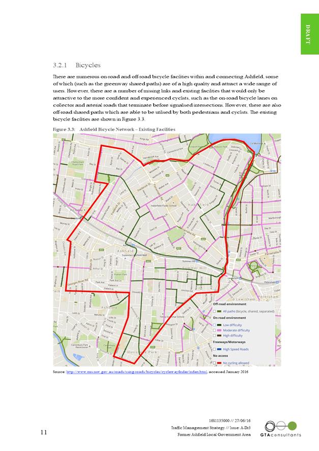
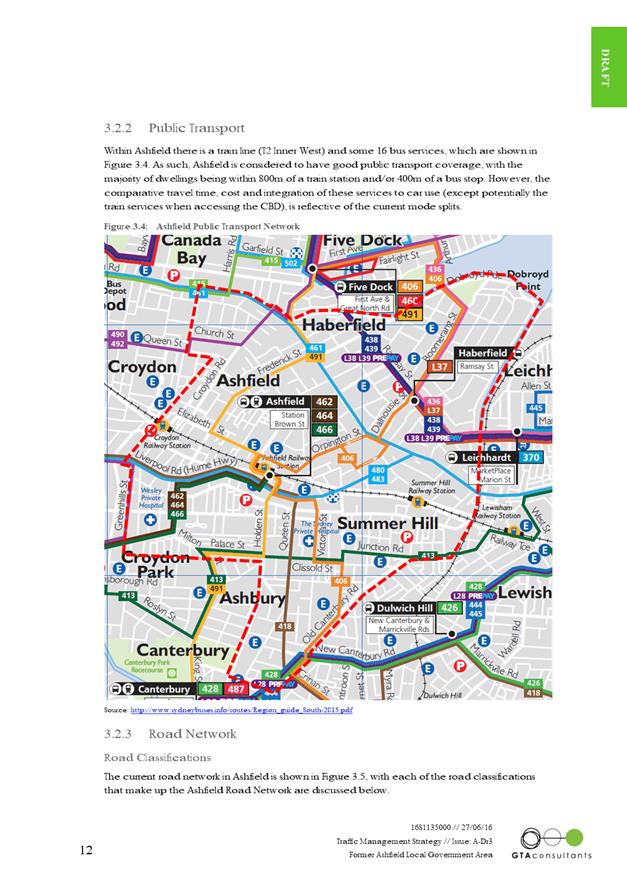
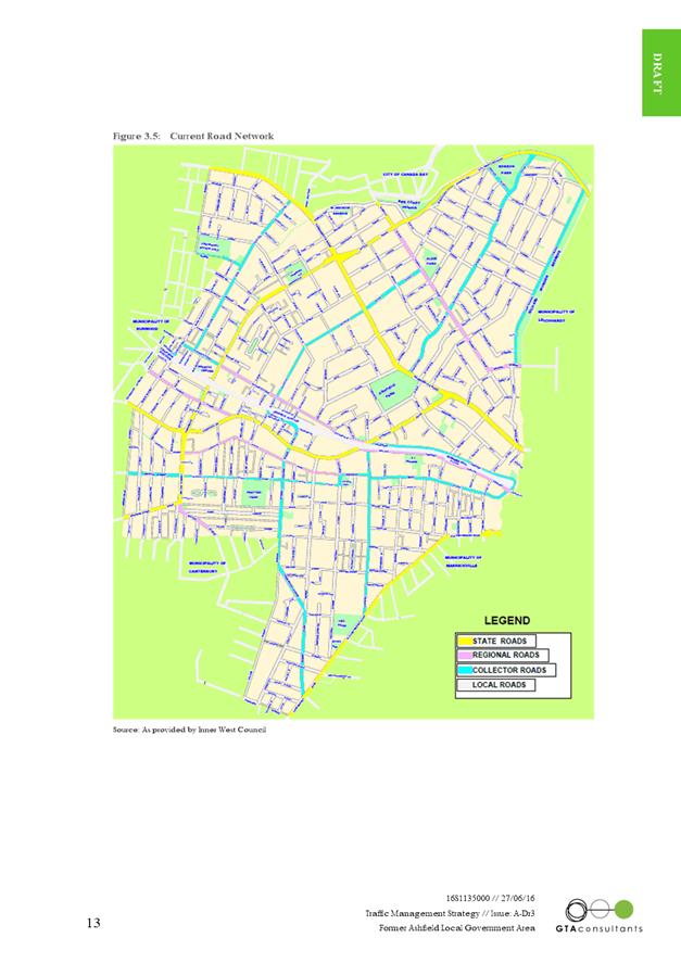
|
AGENDA R |

Local Traffic Committee Meeting
THURSDAY 4 AUGUST 2016
10:00am
Background
Roads and Maritime Services (RMS) is legislated as the Authority responsible for the control of traffic on all NSW Roads. The RMS has delegated certain aspects of the control of traffic on local roads to councils. To exercise this delegation, councils must establish a local traffic committee and obtain the advice of the RMS and Police. The Inner West Council Local Traffic Committee has been constituted by Council as a result of the delegation granted by the RMS pursuant to Section 50 of the Transport Administration Act 1988.
Role of the Committee
The Local Traffic Committee is primarily a technical review and advisory committee which considers the technical merits of proposals and ensures that current technical guidelines are considered. It provides recommendations to Council on traffic and parking control matters and on the provision of traffic control facilities and prescribed traffic control devices for which Council has delegated authority. These matters are dealt with under Part A of the agenda and require Council to consider exercising its delegation.
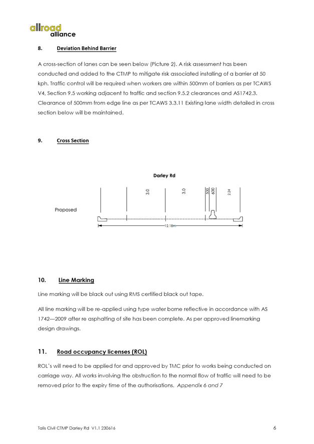
In addition to its formal role as the Local Traffic Committee, the Committee may also be requested to provide informal traffic engineering advice on traffic matters not requiring Council to exercise its delegated function at that point in time, for example, advice to Council’s Development Assessment Section on traffic generating developments. These matters are dealt with under Part C of the agenda and are for information or advice only and do not require Council to exercise its delegation.
Committee Delegations
The Local Traffic Committee has no decision-making powers. The Council must refer all traffic related matters to the Local Traffic Committee prior to exercising its delegated functions. Matters related to State Roads or functions that have not been delegated to Council must be referred directly to the RMS or relevant organisation.
The Committee provides recommendations to Council. Should Council wish to act contrary to the advice of the Committee or if that advice is not supported unanimously by the Committee members, then the Police or RMS have an opportunity to appeal to the Regional Traffic Committee.
Committee Membership & Voting
Formal voting membership comprises the following:
· one representative of Council as nominated by Council;
· one representative of the NSW Police from each Local Area Command (LAC) within the LGA, being Newtown, Marrickville, Leichhardt and Ashfield LAC’s.
· one representative from the RMS; and
· State Members of Parliament (MP) for the electorates of Summer Hill, Newtown, Heffron, Canterbury, Strathfield and Balmain or their nominees.
Where the Council area is represented by more than one MP or covered by more than one Police LAC, representatives are only permitted to vote on matters which effect their electorate or LAC.
Informal (non-voting) advisors from within Council or external authorities may also attend Committee meetings to provide expert advice.
Committee Chair
Council’s representative will chair the meetings.
Public Participation
Members of the public or other stakeholders may address the Committee on agenda items to be considered by the Committee. The format and number of presentations is at the discretion of the Chairperson and is generally limited to 3 minutes per speaker. Committee debate on agenda items is not open to the public.
|
|
Local Traffic Committee Meeting 4 August 2016 |
|
AGENDA |
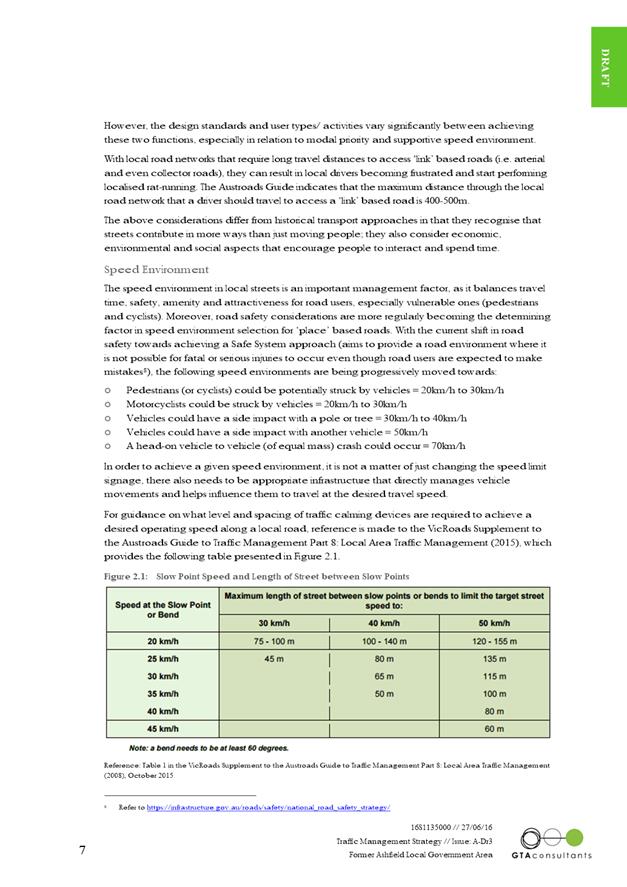
1 Apologies
2 Disclosures of Interest
3 Confirmation of Minutes
4 Matters Arising from Council’s Resolution of Minutes
5 Part A – Items Where Council May Exercise Its Delegated Functions
Traffic Matters Page
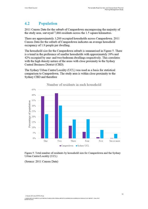
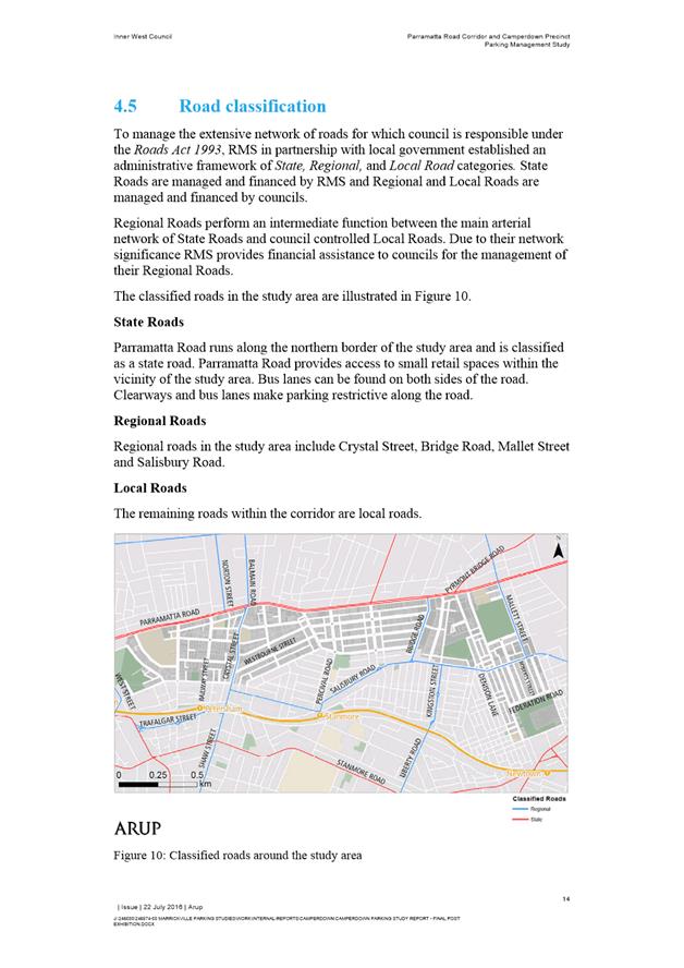
T0816 Item 1 New
Year's Eve 2016 - Traffic Management Plan for the 2016 New Year's Eve Event
(Leichhardt/Balmain) 5
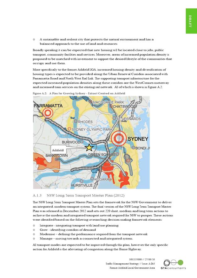
T0816 Item 2 Charles Street and Darley Road Leichhardt - Road Occupancy (Leichhardt/Balmain) 38
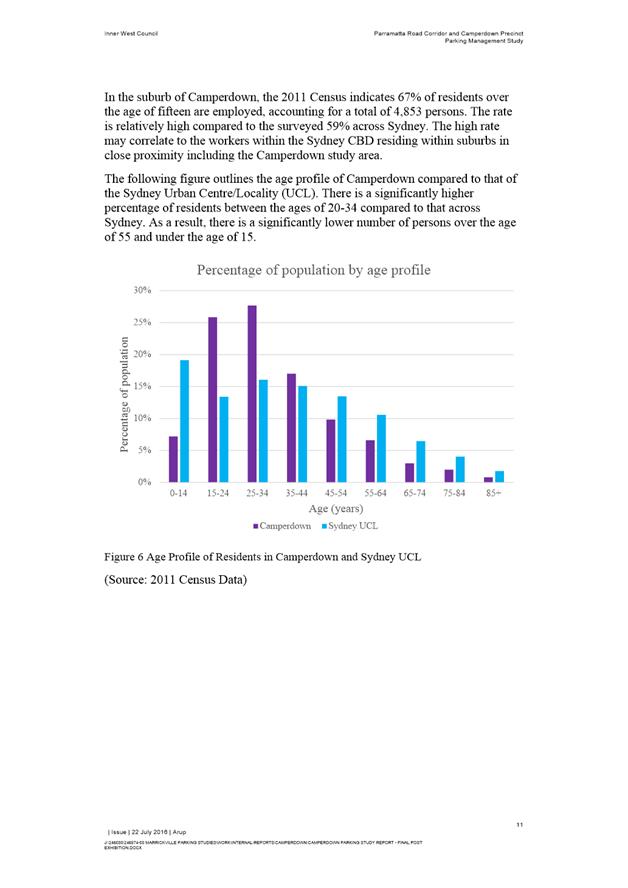
T0816 Item 3 Gehrig
Lane, Camperdown Road Occupancy - Off Broadway Precinct Launch
(Leichhardt/Balmain) 74
T0816 Item 4 Dalhousie Street, Haberfield - Extend Separation Lines at St. Joan of Arc Catholic Primary School (Leichhardt Ward) 77
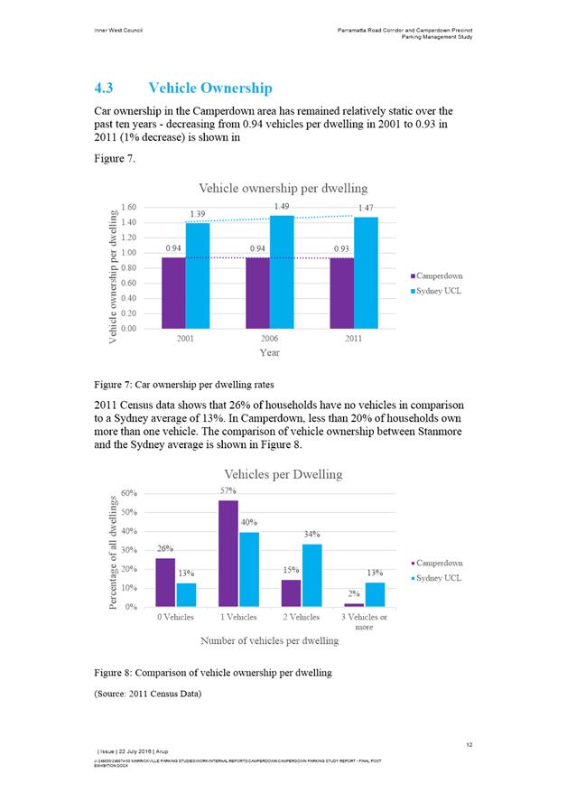
Parking Matters Page
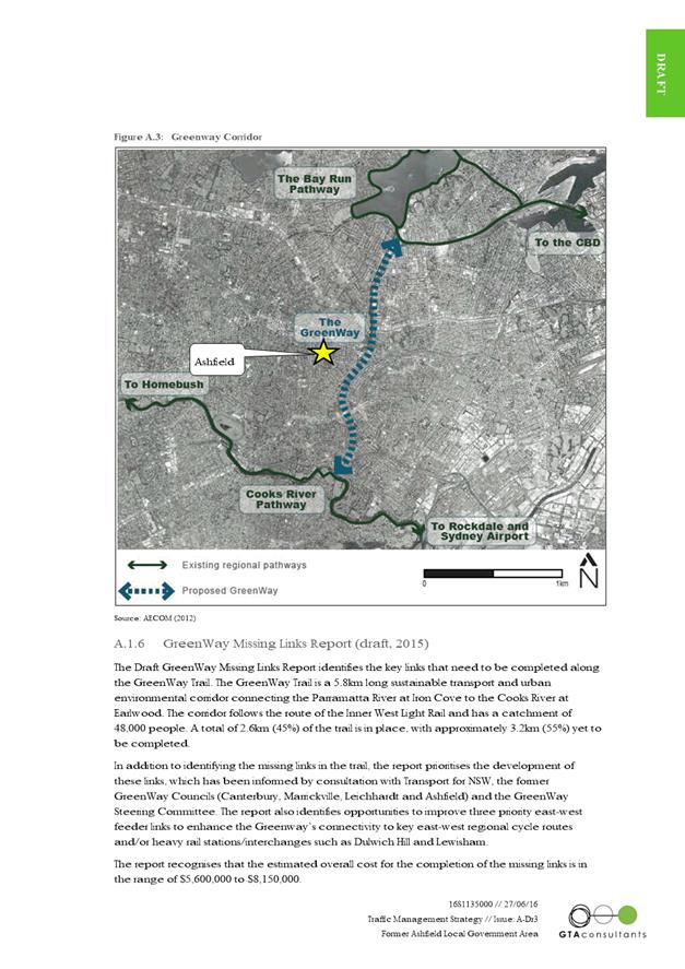
T0816 Item 5 Requests for Mobility Parking Spaces (Ashfield, Stanmore & Marrickville Wards/Summer Hill & Newtown) 80
T0816 Item 6 Requests
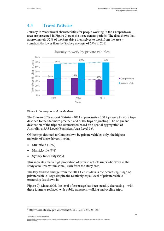
for ‘Works Zone’ adjacent to Construction Sites
(Ashfield, Stanmore Marrickville Wards/Summer Hill & Newtown) 87
T0816 Item 7 Macaulay
Lane, Stanmore - Request for 'No Parking' Restriction
(Stanmore Ward/Newtown) 96
T0816 Item 8 Parramatta Road Corridor and Camperdown Parking Study - Final Report 99
T0816 Item 9 Council
Street, St Peters - Proposal for Permit Parking Area M12
(Marrickville Ward/Heffron) 235
T0816 Item 10 Piper
Lane (South of Piper Street), Annandale - No Stopping and No Parking
Restrictions
(Leichhardt/Balmain) 238
T0816 Item 11 Piper
Lane (North of Rose Street), Annandale - No Stopping Restrictions
(Leichhardt/Balmain) 243
T0816 Item 12 Piper
Lane (South of Weynton Street), Annandale - No Stopping and No Parking
Restrictions
(Leichhardt/Balmain) 245
T0816 Item 13 Trafalgar
Lane, Annandale - No Parking Restrictions
(Leichhardt/Balmain) 248
T0816 Item 14 Minor Traffic Facilities (Leichhardt/Balmain) 250
T0816 Item 15 Norton
Street, Leichhardt - Temporary Installation of a Parklet
(Leichhardt Ward/Balmain/Glebe) 253
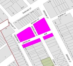
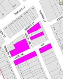
T0816 Item 16 Angelini
Avenue & Woodlark Street, Rozelle - Extension to Existing RPS Time &
Day Restrictions
(Balmain/Balmain) 255
Parking Matters (Cont’d) Page
T0816 Item 17 Fowler
Street, Hill Street & Mackenzie Street, Leichhardt - Resident (Permit)
Parking Scheme Restrictions
(Leichhardt/Balmain) 257
Late Items
Nil.
6 Part B – Items for Information Only Page
T0816 Item 18 Cohen
Park, Annandale - Parking and Traffic Study
(Balmain Ward/Balmain/Glebe) 265
7 Part C – Items for General Traffic Advice Page
T0816 Item 19 29
Station Street, Newtown - Proposed Childcare Centre
(Stanmore Ward/Newtown) 268
T0816 Item 20 308-314
Stanmore Road, Petersham - Proposed Mixed Use Development
(Stanmore Ward/Newtown) 278
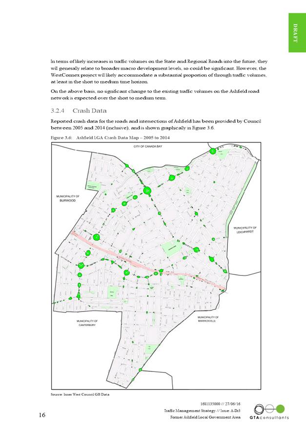
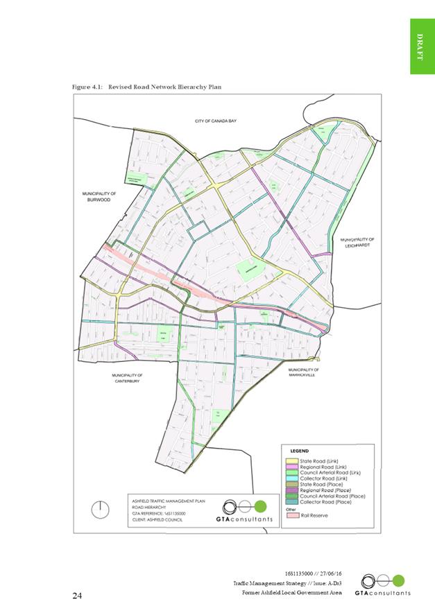
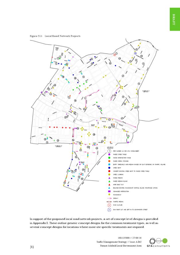
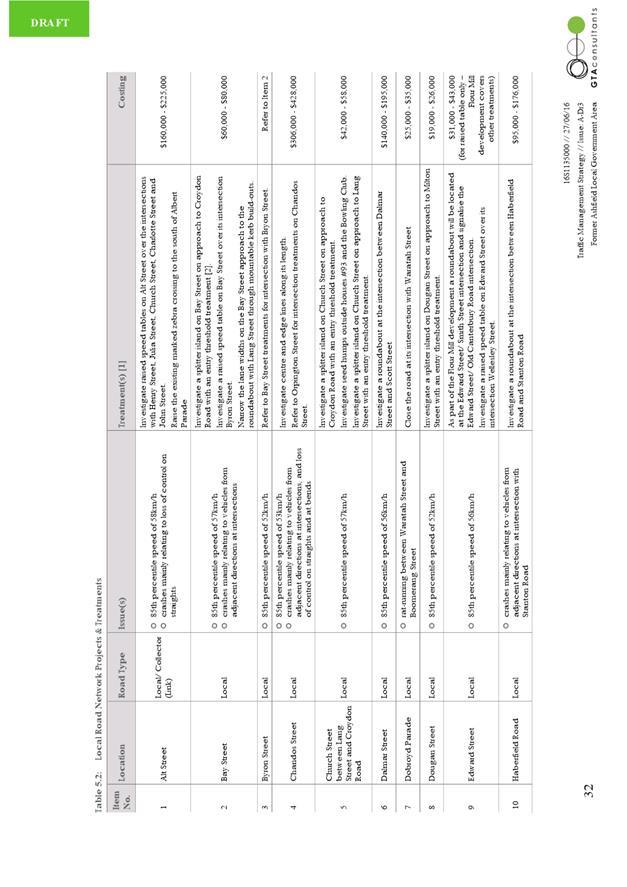
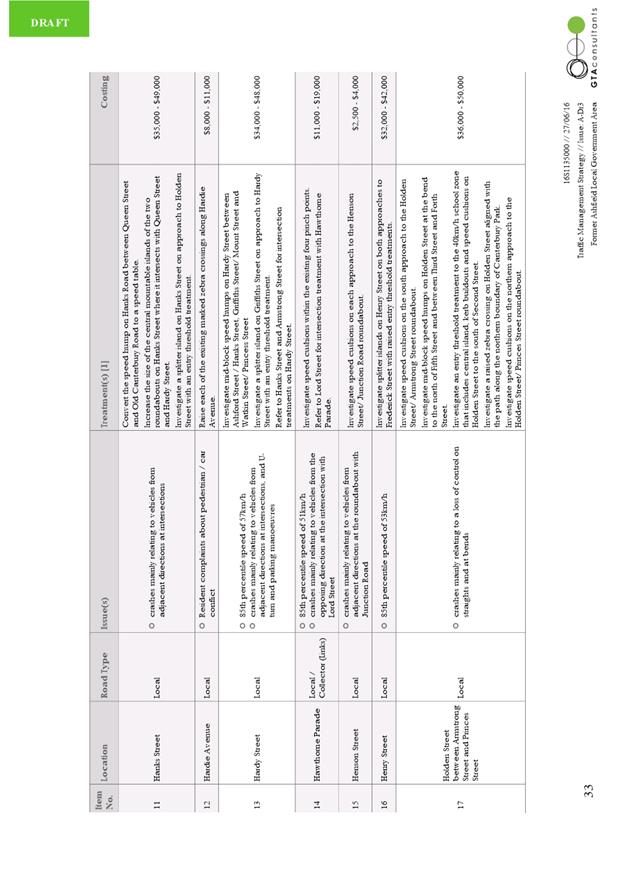
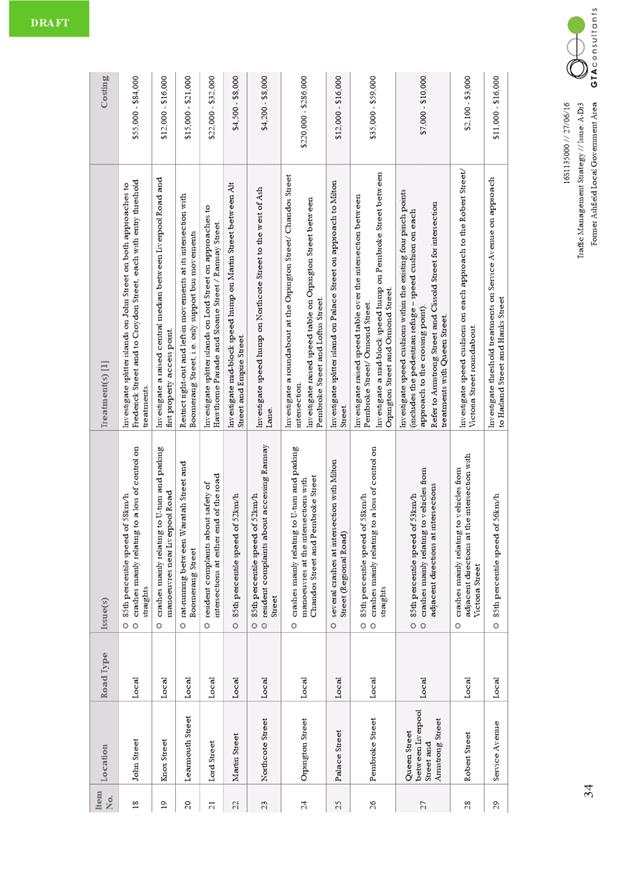
T0816 Item 21 (Former) Ashfield LGA Traffic Management Strategy (Ashfield/Liechhardt Ward) 284
8 General Business
9 Close of Meeting
|
|
Local Traffic Committee Meeting 4 August 2016 |
Subject: New Year's Eve 2016 - Traffic Management Plan
for the 2016 New Year's Eve Event
(Leichhardt/Balmain)
File Ref: 16/6022/85222.16
Prepared By: Manod Wickramasinghe - Traffic and Parking Engineer, Leichhardt
Authorised By: Peter Gainsford - Director, Major Projects and Engineering
|
SUMMARY As instructed by the Police, access to the Balmain peninsula is closed to vehicular traffic every New Year’s Eve. This report outlines the traffic management associated with the event. |
|
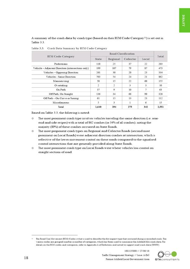
RECOMMENDATION
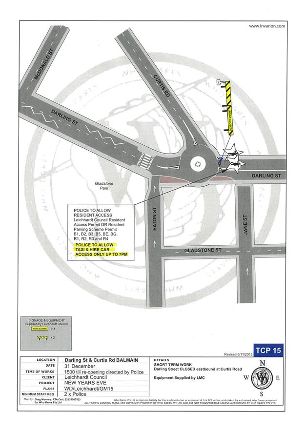
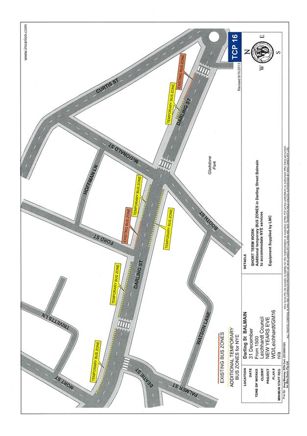
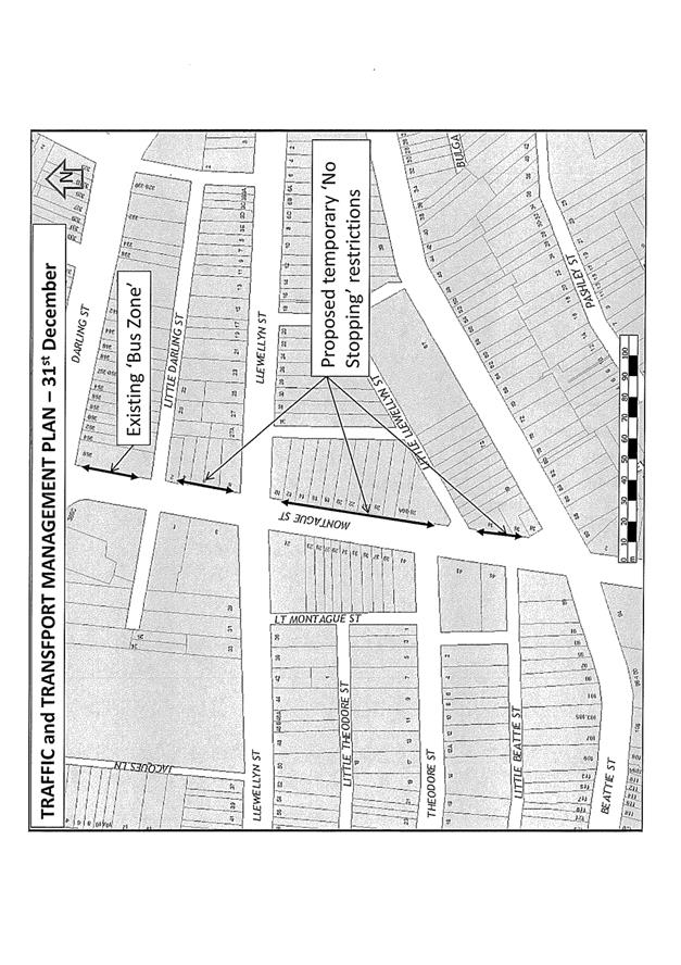
THAT: 1. the Traffic Management Plan (Attachment 1) detailing the traffic arrangements for the 2016 New Year’s Eve be supported; 2. the Traffic Management Plan (Attachment 1) be forwarded to Council’s Area Base Coordinator, Transport Management Centre and the Major Events & Incidents Group (NSW Police); 3. a temporary ‘No Stopping’ restriction be installed on the eastern side of Montague Street between Darling Street and Beattie Street, Balmain; 4. the following modifications to bus stops be approved: on the northern side of Darling Street: i. install temporary ‘Bus Zones’ between Mort Street and Ford Street; ii. extend the ‘Bus Zone’ between Ford Street and McDonald Street; iii. extend the ‘Bus Zone’ between McDonald Street and Curtis Road, outside Nos.217-223 Darling Street; iv. on the southern side of Darling Street: Install a temporary ‘Bus Zone’ between Booth Street and Beattie Street, outside No. 244-270 Darling Street; 5. the Police representative be requested to provide bike unit resources to improve traffic/crowd controls around the Darling Street/Curtis Road intersection (roundabout); 6. the Police be requested to liaise directly with the Roads and Maritime Services in regards to the installation of variable message signs (“Balmain Peninsula is closed” and “Alcohol Free Zone”) on the main access roads into Balmain Peninsula a few days in advance of the event; 7. confirmation be sought regarding the areas to be declared alcohol free and the Police and Sydney Buses representatives be advised; 8. the Sydney Buses representative be requested to place adequate notices on buses regarding the establishment of an alcohol free zone in the Balmain East area (details to be provided by Council); 9. the taxi/hire car access to the Peninsula be restricted from 7:00pm; 10. taxis/hire cars carrying mobility impaired or infirmed residents be permitted access at all hours into the Peninsula; and 11. the Taxi Council be advised of the Committee’s recommendation.
|
BACKGROUND
As instructed by the Police, access to the Balmain peninsula is closed to vehicular traffic every New Year’s Eve.
It should be noted that the alcohol ban areas were extended following the 2014 event. Also, a temporary ban on taxi access to the peninsula after 7pm on New Year’s Eve was introduced to minimise traffic congestion in the peninsula and improve pedestrian safety.
Traffic Management
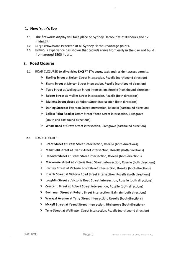
The following roads will be closed to all vehicular traffic between 3:00pm and 12:00am on Saturday, 31st December 2016 to cater for the New Year’s Eve celebrations:
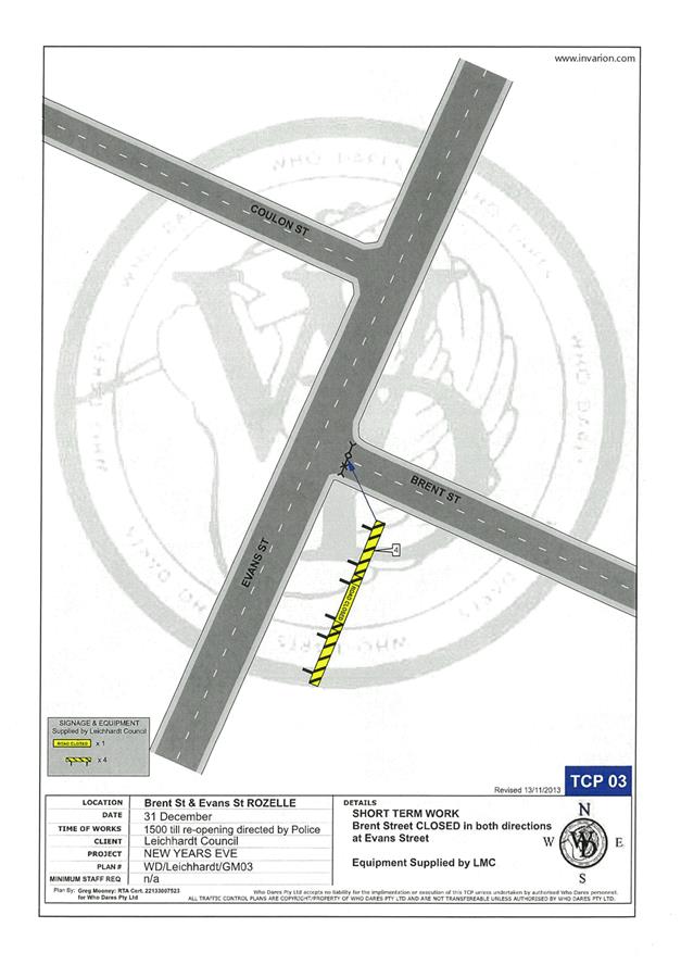
· Brent Street at Evans Street intersection, Rozelle (both directions)
· Mansfield Street at Evans Street intersection, Rozelle (both directions)
· Hanover Street at Evans Street intersection, Rozelle (both directions)
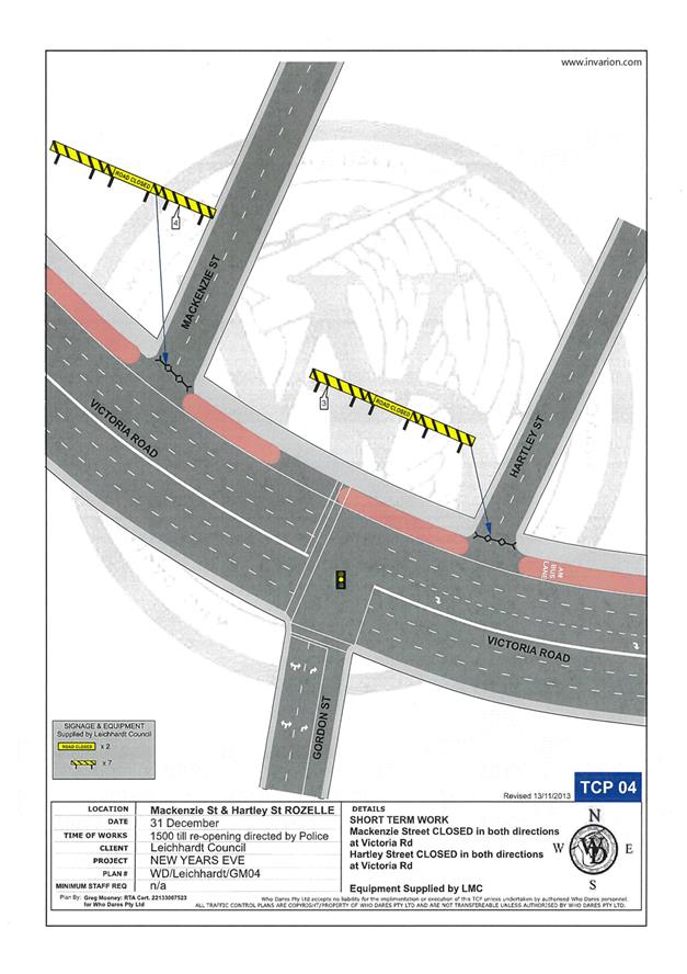
· Mackenzie Street at Victoria Road Street intersection, Rozelle (both directions)
· Hartley Street at Victoria Road Street intersection, Rozelle (both directions)
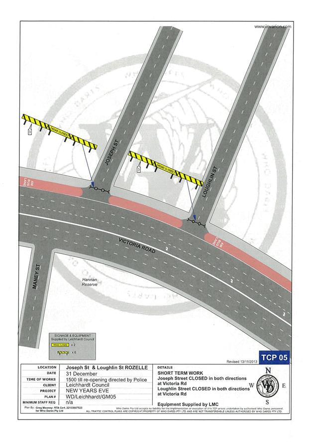
· Joseph Street at Victoria Road Street intersection, Rozelle (both directions)
· Loughlin Street at Victoria Road Street intersection, Rozelle (both directions)
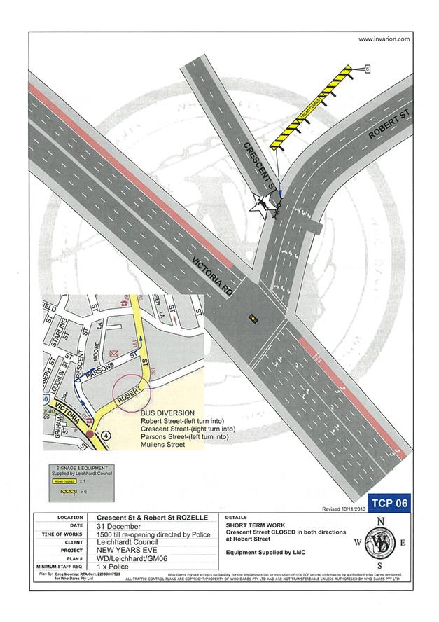
· Crescent Street at Robert Street intersection, Rozelle (both directions)
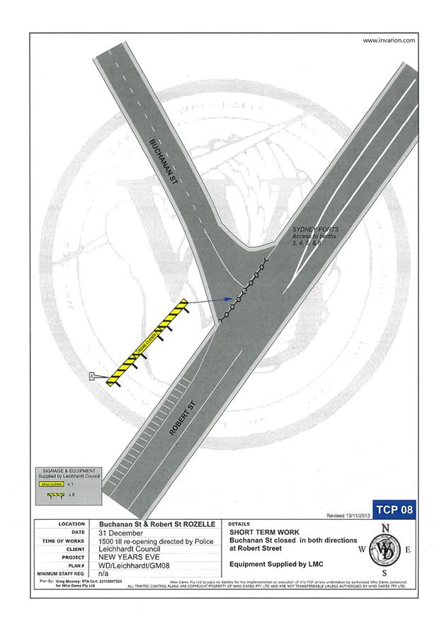
· Buchanan Street at Robert Street intersection, Balmain (both directions)
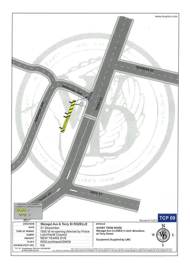
· Waragal Avenue at Terry Street intersection, Rozelle (both directions)
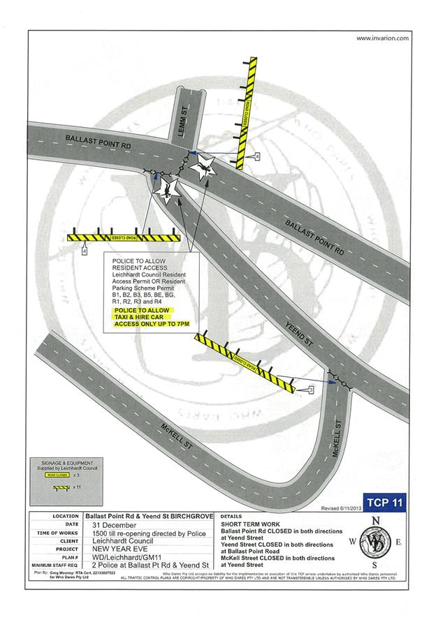
· McKell Street at Yeend Street intersection, Birchgrove (both directions)
In addition, the following roads will be closed to all vehicular traffic except STA buses, Taxis, Hire Cars and Balmain Access Permit holders and will be manned by NSW Police officers between 3:00pm and 12:00am:
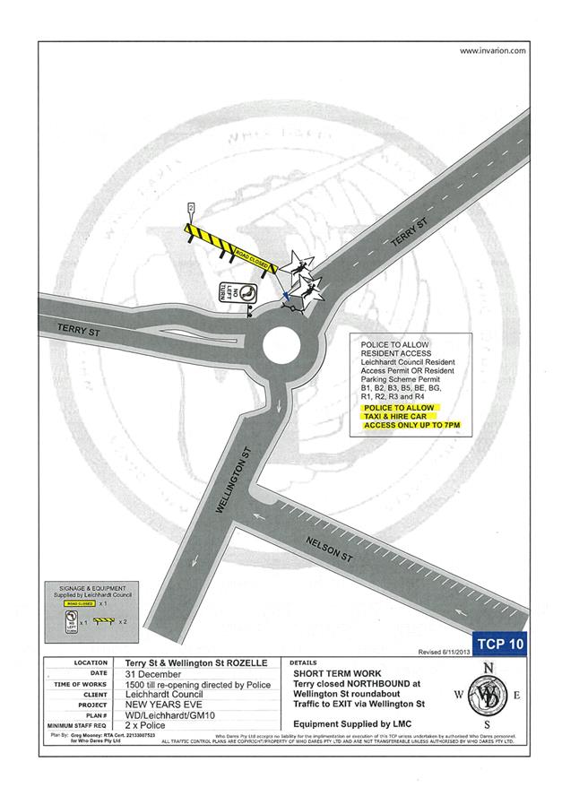
· Terry Street at Wellington Street intersection, Rozelle (northbound direction)
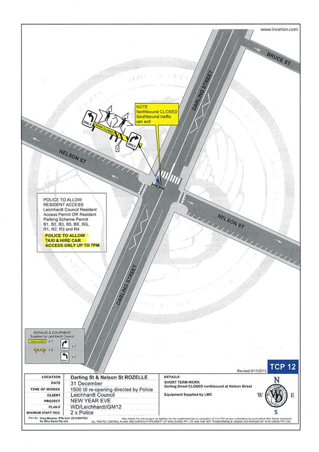
· Darling Street at Nelson Street intersection, Rozelle (northbound direction)
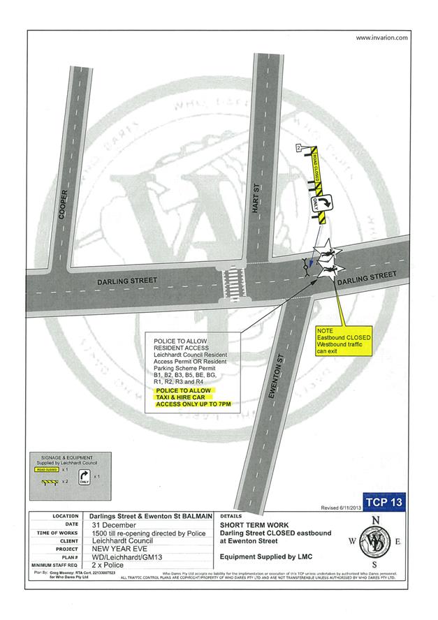
· Darling Street at Ewenton Street intersection, Balmain (eastbound direction)
· Evans Street at Merton Street intersection, Rozelle (northbound direction)
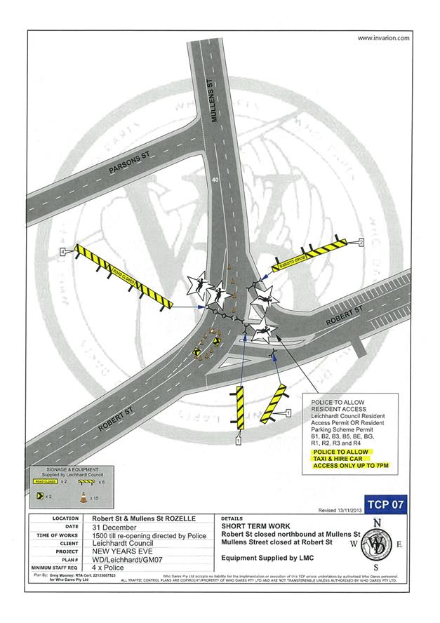
· Mullens Street at Robert Street intersection, Rozelle (both directions)
· Ballast Point Road at Lemm Street-Yeend Street intersection, Birchgrove (south and eastbound directions)
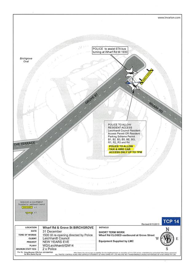
· Wharf Road at Grove Street intersection, Birchgrove (eastbound direction)
· Robert Street at Crescent Street, Rozelle
The following plan indicates the road closure points.
A Traffic Management Plan including Traffic Control Plans outlining the above road closures and the bus route changes is attached in Attachment 1.
Taxi Access
As previously recommended, the NSW Taxi Council again are requested to inform their members of the proposed taxi access restriction after 7pm and to use the following drop-off point locations:
· Taxis entering Terry Street - In the unrestricted parking on the eastern side of Terry Street or ‘Bus Zone’ and timed kerbside parking along Wellington Street
· Taxis entering Darling Street - In the ticket parking areas along Darling Street and Nelson Street
· Taxis entering Robert Street – In the restricted parking area and ‘Bus Zone’
Public Transport Access
Sydney Buses will be scheduling additional services into the Balmain peninsula to cater for the New Year’s Eve celebrations.
As such, temporary ‘Bus Zones’ will be installed in Darling Street and the existing ‘Bus Zones’ on Darling Street between Mort Street and Curtis Road, Balmain will be extended as shown on the following plan:
Based on discussions held in previous years regarding disruptions to bus services leaving Gladstone Park/Curtis Road roundabout due to the gathering of large crowds, the Glebe Local Area Command representative intends to introduce Police bike units to manage the crowds in the area.
In addition, to avoid delays that occurred at the Robert Street/Mullens Street intersection (which is a Police check point), buses entering Robert Street from Victoria Road are proposed to use Crescent Street and Parsons Street to access Mullens Street (see TCP 06/07 in Attachment 1).
Temporary ‘No Stopping’ Restrictions
Following a previous year’s event, the Sydney Buses representative advised that several vehicles parked on Montague Street out from the kerb thus narrowing the carriageway and preventing buses from passing each other. Therefore, it is proposed to install temporary ‘No Stopping’ restrictions on the eastern side of Montague Street between Darling Street and Beattie Street. The residents will be advised of this arrangement in advance of the event.
Resident Access and Public Notification
To ensure resident access is maintained, the following permits will be accepted for access to the Balmain / Rozelle peninsula:
· Inner West Council/Leichhardt Council Resident Access Permit.
· Inner West Council/Leichhardt Council current Resident Parking Scheme Permit for Areas; B1, B2, B3, B5, BE, BG, R1, R2, R3 & R4.
· Australian Disability Parking permit
Details of these traffic arrangements will be advertised in local newspapers, on Council’s website and via a mail out to all occupants in the Balmain peninsula.
The road closures and other event information will also be available on the Sydney New Year’s Eve Event website.
Similar to previous years, the RMS is requested to provide variable message signs: “Balmain Peninsula is closed” at the entry points from Victoria Road.
Alcohol Free Zones
At the August 2015 Council Ordinary meeting, Council will be considering re-establishment of the Alcohol Free Areas for the New Year’s Eve celebrations in 2015, 2016, 2017 & 2018 at the following locations:
· Illoura Reserve
· 2-8 Weston Street
· Thornton Park
· Lookes Avenue Reserve
· Simmons Point Reserve
· Yurulbin Park
· Birchgrove Park
· Miklouho-Maclay Park
· Mort Bay Park
· College Street playground
· Harris Reserve
· Brownlee Reserves
· Darling Street from Duke Street to Darling Street Wharf
· Darling Street Wharf, Balmain East;
· Lookes Avenue
· Weston Street
These alcohol restrictions are proposed to be in place from 12.00pm (noon) 31st December 2016 to 3.00am 1st January 2017, 2018 and 2019.
It should be noted that NSW Police introduced alcohol ban restrictions in 2014 at Ballast Point Park which is managed by the Sydney Harbour Foreshore Authority.
FINANCIAL IMPLICATIONS
Funding for costs associated with New Year’s Eve including labour, notifications and permits have been budgeted for in the 2016-17 operational plan.
|
1.⇩ |
Traffic Management Plan and Addendum |
|
Local Traffic Committee Meeting 4 August 2016 |
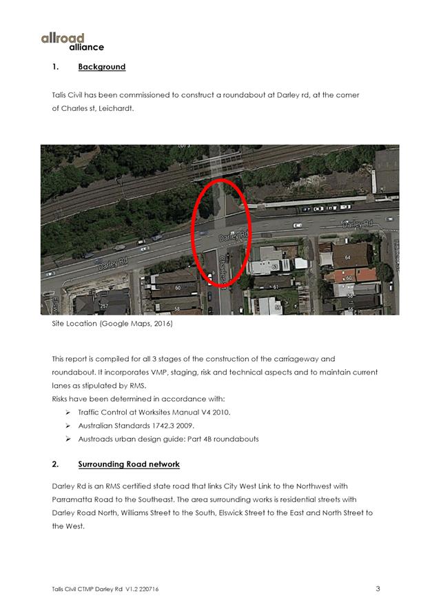
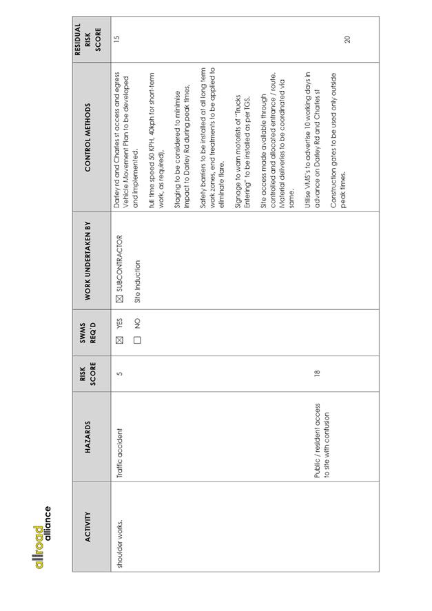
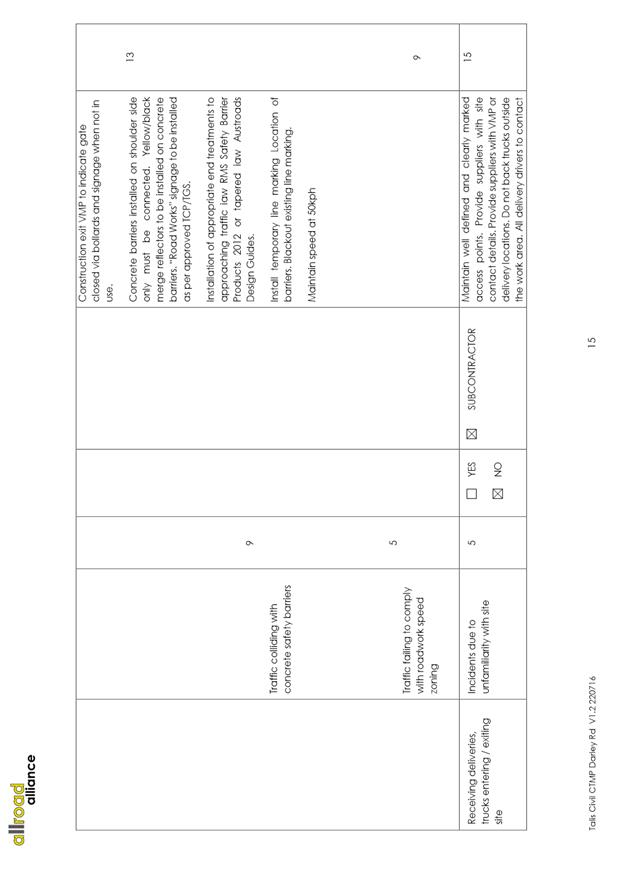
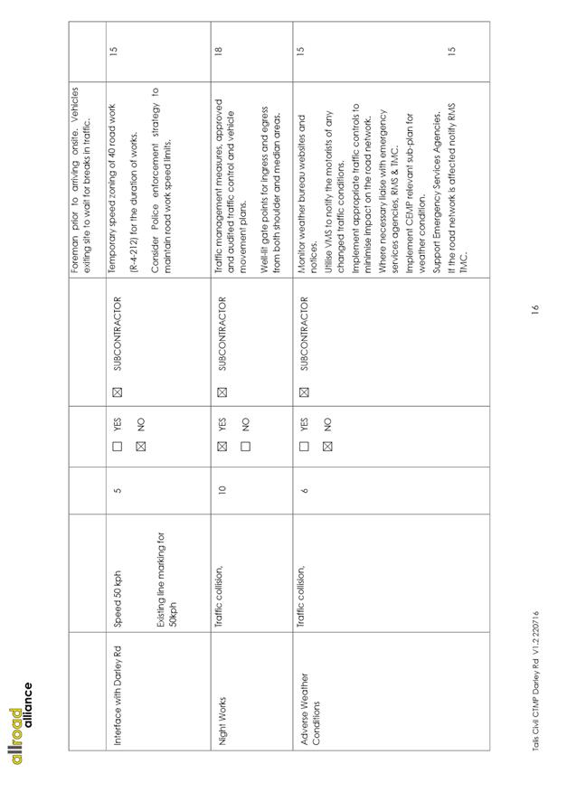
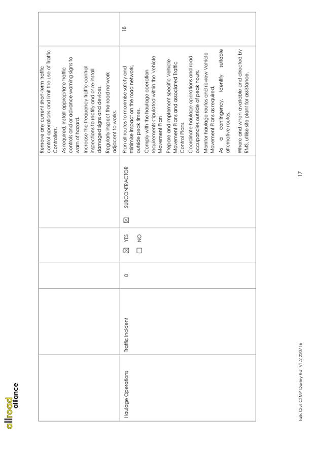
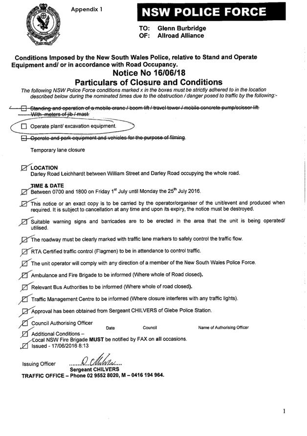
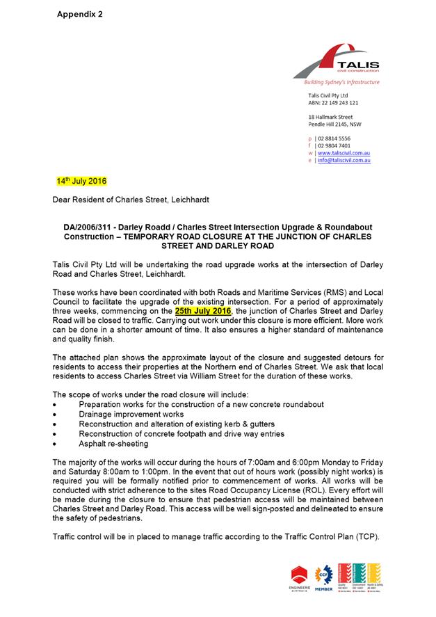
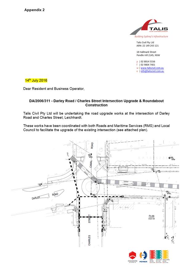
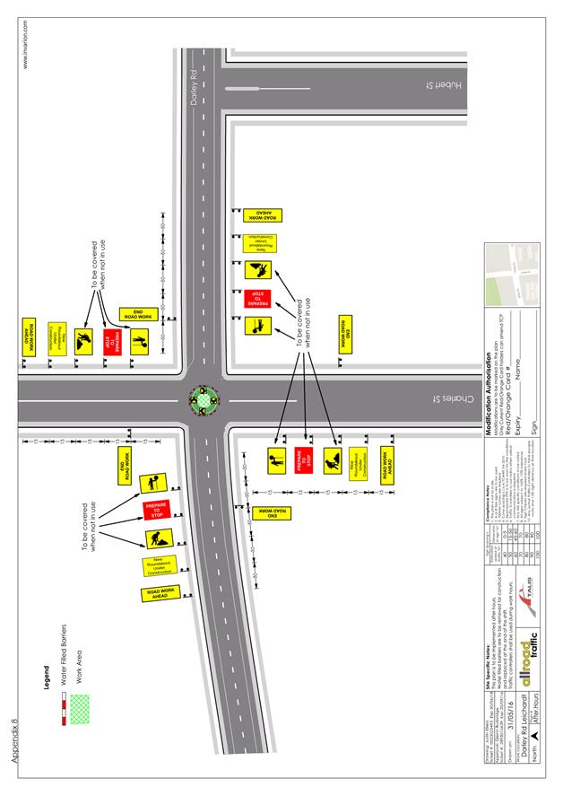
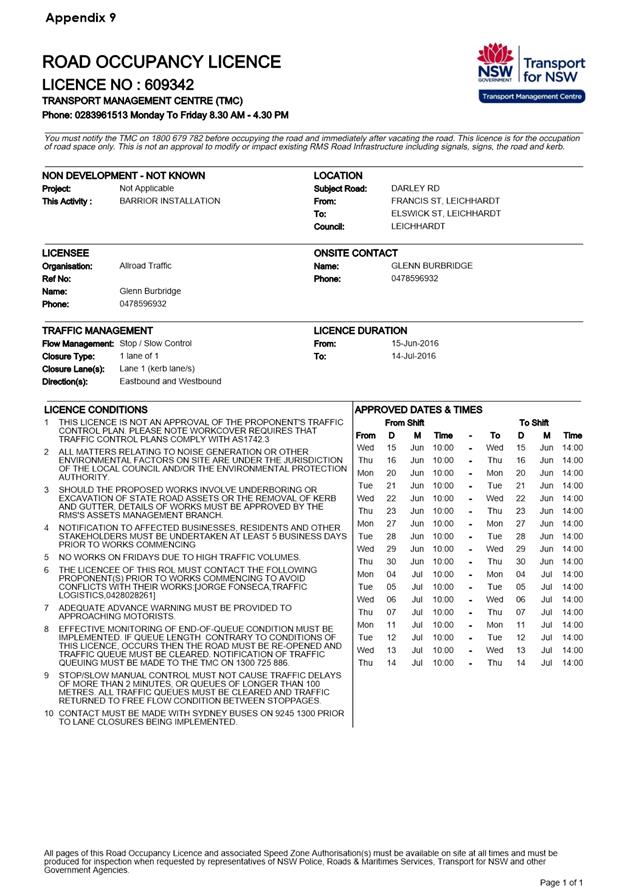
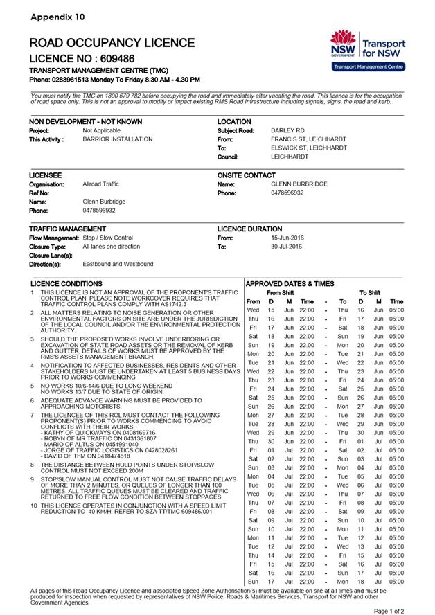
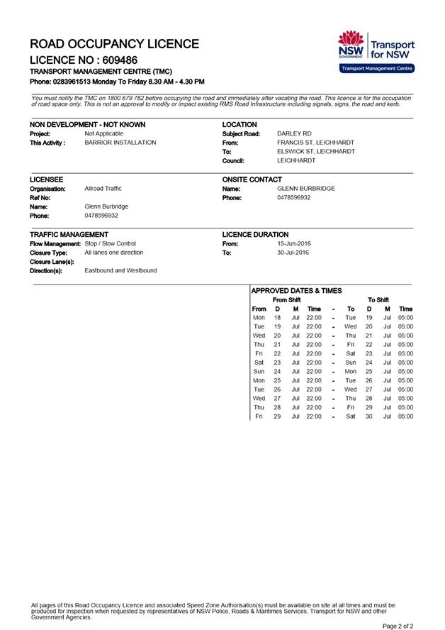
Subject: Charles Street and Darley Road Leichhardt - Road Occupancy (Leichhardt/Balmain)
File Ref: 16/6022/85234.16
Prepared By: Khanh Nguyen - Traffic and Parking Engineer, Leichhardt
Authorised By: Peter Gainsford - Director, Major Projects and Engineering
|
SUMMARY Council has received a request for approval of a temporary partial and full road closure at the intersection Darley Road and Charles Street for the construction of a roundabout relating to the development at No.7 Darley Road, Leichhardt. |
|
RECOMMENDATION
THAT:
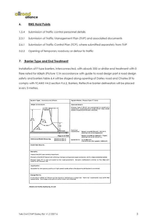
1. the application for the full road closure of Charles Street component (as detailed in the TMP and TCP) for up to 9 weeks (the start date to be confirmed by the applicant) subject to the following conditions: a) that the applicant be requested to obtain NSW Police approval for the road closure; b) That an unencumbered passage (minimum 3.0m) wide be available if possible for emergency vehicles through the closed section of Charles Street; c) the occupation of the road carriageway must not occur until the road has been physically closed; d) all traffic movements associated with the works must travel to and from the site via the State Road network; e) that the applicant notifies all affected businesses, residents and other occupants in Charles Street and Darley Road of the proposed partial and full road closures prior to the event. Any concerns or requirements in relation to the road closure raised by business proprietors, residents and other occupants must be resolved or accommodated. The notification shall involve at the minimum an information letterbox drop distributed one week prior to the commencement of the road closures. The proposed information must be submitted to Council’s Traffic section for approval. A separate detailed notification letter for Charles Street stakeholders regarding the full road closure and its timing must be submitted to Council prior to distribution; f) that the approved Traffic Control Plan (TCP) be implemented at the applicant’s expense including use of RMS accredited traffic controllers; g) that the Fire Brigade (Leichhardt) be notified of the intended closure; h) that the applicant provide and erect barricades and signs, in accordance with the current Australian Standard AS 1742.3: Traffic Control Devices for Works on Roads. As a minimum the following must be erected at both ends of the road closure area: i. Barrier Boards; ii. ‘Road Closed’ (T2-4) signs; i) that the areas to be used for the activities must be maintained in a clean and tidy condition to the satisfaction of Council’s Director Major Projects & Engineering, or else the applicant will be required to reimburse Council for any extraordinary cleaning costs; j) that the conduct of any activities or use of any equipment required in conjunction with the road occupancy and temporary road closures not result in any ‘offensive noise’ as defined by the Noise Control Act; k) that a copy of the Council approval be available on site for inspection by relevant authorities; l) that Council reserves the right to cancel the approval at any time; and
2. the applicant complies with any reasonable directive from Council and RMS Officers and NSW Police.
|
BACKGROUND
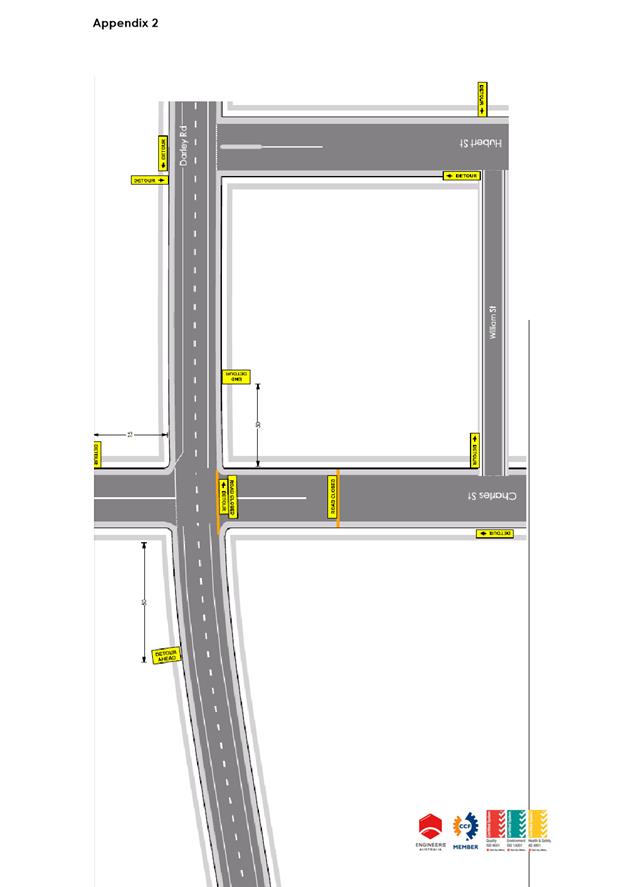
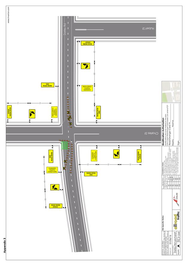
Council has received an application for a Road Occupancy required for the construction of a roundabout at the intersection of Darley Road and Charles Street as per development consent at No.7 Darley Road, Leichhardt (‘Dan Murphy’s’ - D/2006/311).
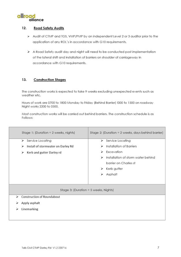
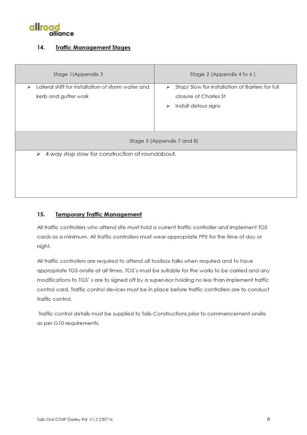
The construction of the roundabout will be carried out in 3 stages with each stage corresponding to different sets of traffic control plans alternating between partial to full road closures as construction progresses as outlined in the submitted Traffic Management Plan (TMP) and corresponding Traffic Control Plans (TCPs). The works were originally planned to take place on 28th June 2016 to 25th August 2016 for approximately 9 weeks. However, Traffic Committee support is required for the full road closure component in Charles Street despite the applicant obtaining approval from RMS for the works on Darley Road.
The details of the closure are as follows:
Dates: Staged construction works is expected to take up to 9 weeks, excluding unforeseen events such as weather, etc. Start date to be confirmed after approval.
Times: 7am to 6pm Monday to Friday (Behind Barriers); Midnight to 3pm on road and night works 10pm to 5am.
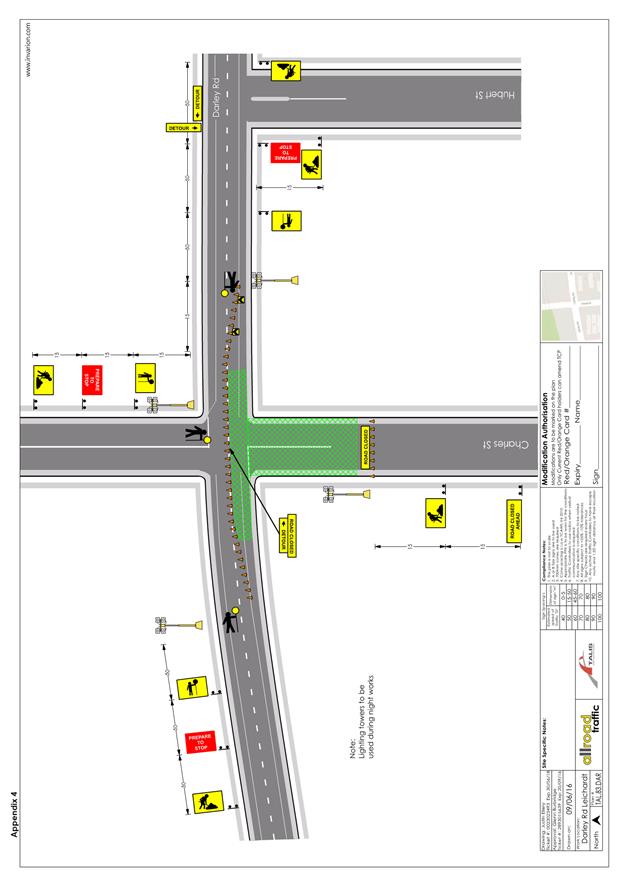
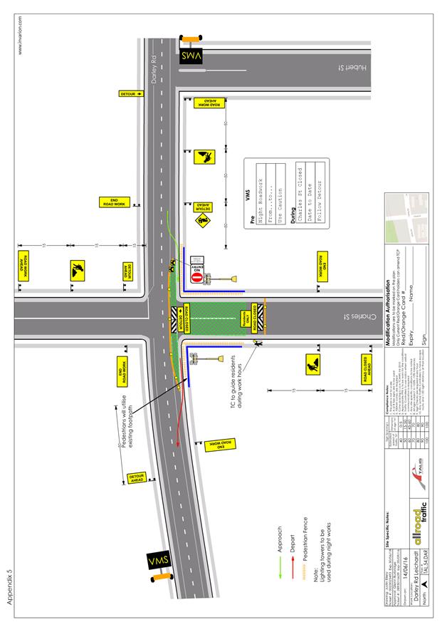
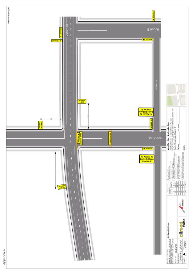
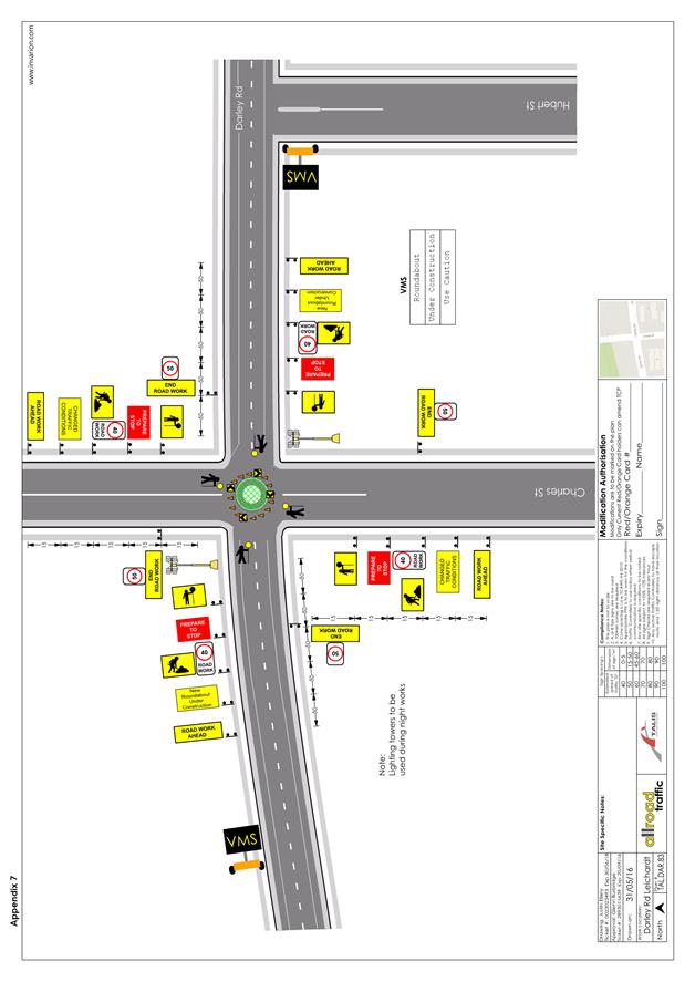
Closure section (Council’s jurisdiction): Charles Street (south of Darley Road), Stage 2 of construction (TCPs labelled Appendix 4 to 6) estimated duration 2 weeks.
Refer to Attachment 1 for Traffic Management Plan and Traffic Control Plans (labelled Appendix 1 to 8).
PUBLIC CONSULTATION
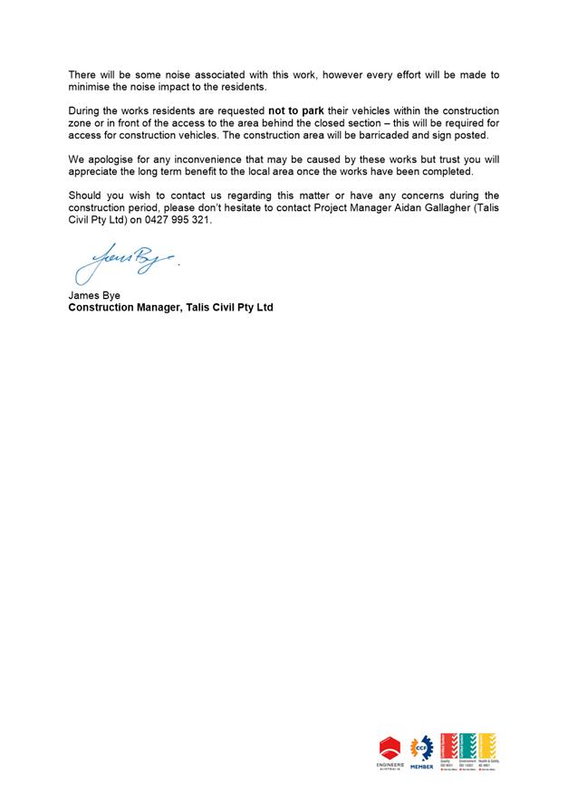
The applicant will notify all affected businesses, residents and other occupants in Charles Street, Hubert Street and Darley Road of the proposed part and full time road closures. Any concerns or requirements in relation to the road closure raised by business proprietors, residents and other occupants must be resolved or accommodated by the applicant. The notification shall involve at the minimum an information letterbox drop distributed one week prior to the commencement of the event. The proposed information must be submitted to Council’s Traffic section for approval.
CONCLUSION
That the proposed partial and full time road closures in Darley Road and Charles Street be approved with start date to be confirmed by the applicant after Council approval, subject to compliance of the recommended conditions.
|
1.⇩ |
Construction Traffic Management Plan including Traffic Control Plans |
|
Local Traffic Committee Meeting 4 August 2016 |
Subject: Gehrig Lane, Camperdown Road Occupancy - Off
Broadway Precinct Launch
(Leichhardt/Balmain)
File Ref: 16/6022/85931.16
Prepared By: Khanh Nguyen - Traffic and Parking Engineer, Leichhardt
Authorised By: Peter Gainsford - Director, Major Projects and Engineering
|
SUMMARY In partnership with the Inner West Council, the Sydney Fringe Festival is launching a new creative arts precinct along Parramatta Road, Annandale/Camperdown. The launch of this new precinct as part of the Sydney Fringe Festival will be on Sunday, 11th September 2016 in Gehrig Lane, Camperdown and requires road closure approval for the event.
|
|
RECOMMENDATION
THAT: 1. the temporary road closure of Gehrig Lane, west of Chester Street, Camperdown, on Sunday, 11th September 2016 between 2.00pm and 6.00pm be approved, subject to the following conditions: a. that a TMP/TCP be submitted to RMS for approval as the subject area is in proximity 40 metres to Pyrmont Bridge Road (State Road). b. that an unencumbered passage minimum 3.0m wide be available for emergency vehicles through the closed section of Gehrig Lane, Camperdown. c. the occupation of the road carriageway must not occur until the road has been physically closed. d. that the applicant notifies all affected businesses, residents and other occupants of the temporary road closure prior to the event. Any concerns or requirements in relation to the road closure raised by business proprietors, residents and other occupants must be resolved or accommodated. The notification shall involve at the minimum an information letterbox drop distributed one week prior to the commencement of the event. The proposed information, distribution area and period must be submitted to Council’s Traffic section for approval two weeks before the event. e. that the approved Traffic Control Plan (TCP) be implemented by Council, including RMS accredited traffic controllers. f. that the Fire Brigade (Glebe Fire Station) be notified of the intended closure. g. that the applicant provide and erect barricades and signs, in accordance with the current Australian Standard AS 1742.3: Traffic Control Devices for Works on Roads. As a minimum the following must be erected at the appropriate locations: i. Barrier Boards (Barricades) ii. ‘Road Closed’ (T2-4) signs iii. ‘Road Closed Ahead’ (T2-Q02A) iv. ‘On Side Road’ (TC-1325)
h. that the areas to be used for the activities must be maintained in a clean and tidy condition to the satisfaction of Council’s Director Major Projects & Engineering, or else the applicant will be required to reimburse Council for any extraordinary cleaning costs. i. that the conduct of any activities or use of any equipment required in conjunction with the road occupancy and temporary road closure not results in any ‘offensive noise’ as defined by the Noise Control Act. j. That a copy of the Council approval be available on site for inspection by relevant authorities. k. That Council reserves the right to cancel the approval at any time. l. That the applicant complies with any reasonable directive from Council Officers and NSW Police. 2. the applicant be advised of the Committee’ recommendation.
|
BACKGROUND
This year in partnership with the Inner West Council, the Sydney Fringe Festival is launching a new creative arts precinct along Parramatta Road Annandale/Camperdown. The Off Broadway Precinct will now be home to Sydney's Independent creatives, re-energising the strip with new creative businesses, galleries, studios and venues. Embracing the rich cultural history of live music and performance Parramatta Rd has known over past decades and bringing it into the future.
To celebrate the launch of this new precinct the Sydney Fringe Festival will be hosting an official public launch on Sunday the 11th September at Gehrig Lane, Camperdown. A free family friendly afternoon of live music, art and performance bringing the local community of businesses and residents together to celebrate this exciting project. The event co-ordinator is seeking permission for a full road closure of Gehrig Lane (dead end), west of Chester Street, Camperdown to facilitate the event.
The road closure is an extra measure to keep patrons safe, and make it a pleasurable experience that celebrates community, art and creativity.
Event Overview
Name: Off Broadway Precinct Launch
Location: Gehrig Lane, Annandale
Date: Sunday, 11th September 2016
Hours: 2pm to 6pm (Site clear by 8pm, 2 hour bump out)
Capacity: Approximately 100 people
Event Schedule
2.30pm: Stencil Art Prize Winners Announcement
3.15pm First Band
4.10pm Welcome to Country
4.15pm Speeches
5pm Second band
6pm Event Finish (Site clear by 8pm, 2 hour bump out)
Traffic Control Plan
This is event and its associated road closure in Gehrig Lane will have no significant impact on the road network or traffic as Gehrig Lane is a ‘dead end’ side road off a local road, Chester Street which cuts off at Douglass Grant Memorial Park.
According to the RMS ‘Guide to Traffic and Transport Management for Special Events’ (Version 3.4) a small street party is considered as a ‘Class 3’ event.
The RMS advises that features common to all Class 3 special events are that event:
· Does not impact local or major traffic and transport systems or classified roads
· Disrupts the non-event community in the immediate area only
· Requires Local Council and Police consent
· Is conducted on-street in a very low traffic area such as a dead-end or cul-de-sac
· Is never used for racing events.
CONCLUSION
It is recommended that the road closure be approved to facilitate the ‘Off Broadway Precinct Launch’ event as part of the Sydney Fringe Festival on Sunday, 11th September at Gehrig Lane, Camperdown.
The event is positive and is beneficial in bringing the local community of businesses and residents together to celebrate this new creative arts precinct which the Inner West Council is supporting.
|
|
Local Traffic Committee Meeting 4 August 2016 |
Subject: Dalhousie Street, Haberfield - Extend Separation Lines at St. Joan of Arc Catholic Primary School (Leichhardt Ward)
File Ref: 16/6022/85978.16
Prepared By: James Brocklebank - Traffic Officer, Ashfield
Authorised By: Davide Torresan - A/Senior Engineer, Ashfield
|
SUMMARY A request from a parent at St.Joan of Arc Catholic School on Dalhousie Street for the extension of the double separation lines in front of the school to assist in preventing U-Turns on the school frontage. The suggested measure is supported as observations reveal some parents do perform U-turns in front of the school and this creates dangers for oncoming traffic and students attempting to cross the road. |
|
RECOMMENDATION
THAT the existing double separation lines in front of the school be extended along the full frontage of the Joan of Arc Catholic Primary School in Dalhousie Street, Haberfield.
|
BACKGROUND
The St. Joan of Arc Catholic School has its main school drop off and pick up zone on the western side of Dalhousie Street. This zone is signposted No Parking. As is the case with most schools parking pressures are significant in the before and after school period and unsafe and undesirable parking practices such as double parking, overstaying time limits and performing U-turns to access vacant spaces are prevalent.
Council’s parking officers provide regular surveillance to parking restrictions in front of the school and the school does its best to educate parents. Unfortunately, despite long term patrols and education programs by the Roads and Maritime Services, schools, police and council, offences in school zones continue.
There are existing double separation lines in front of the school on approach to a pedestrian crossing sited at the northern end of the schools frontage. The separation lines terminate approximately 20m from the crossing.
FINANCIAL IMPLICATIONS
Estimated cost approx. $500 from the general signposting and line mark funding.
OFFICER COMMENTS
Council has recently written to the school asking them to assist in educating parents with regard to parking restrictions in No Parking zones, the dangers of double parking and requesting support in asking parents to cross at the marked pedestrian crossing with their children.
To assist in controlling U-turning in front of the school and to control overtaking in front of the school extension of the double separation lines along the length of the schools Dalhousie Street frontage is considered appropriate.
PUBLIC CONSULTATION
Not applicable. Notification will be made out to the school and residents in the area.
|
1.⇩ |
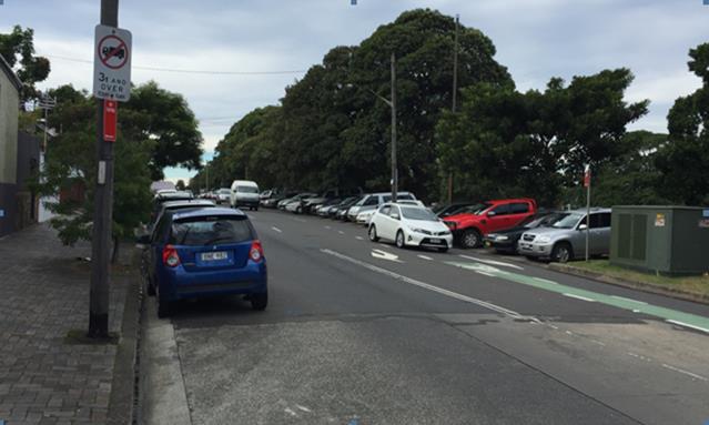
Proposed Extended Double Separation BB Centreline to the Joan of Arc Catholic Primary school Frontage in Dalhousie Street, Haberfield |
|
2.⇩ |
View of Dalhousie Street outside School Facing North |
|
Local Traffic Committee Meeting 4 August 2016 |
Subject: Requests for Mobility Parking Spaces (Ashfield, Stanmore & Marrickville Wards/Summer Hill & Newtown)
File Ref: 16/6022/82366.16
Prepared By: Maaran Mutharasa - Engineer Traffic Services, Marrickville
Authorised By: Wal Petschler - Manager Design and Investigation, Marrickville
|
SUMMARY Requests have been received from residents for the provision of a dedicated mobility parking space outside their residences. It is recommended that the following 'Mobility Parking' spaces be approved as the applicants’ current medical condition warrants the provision of the space and they have constrained or no off-street parking opportunities. |
|
RECOMMENDATION
THAT the following locations: 1. on the northern side of Llewellyn Street, Marrickville adjacent to property no. 310 Enmore Road; 2. on the western side of Simmons Street, Enmore in front of property no.37; and
be APPROVED as a ‘mobility parking’ space, subject to:
(i) the operation of the dedicated parking space be valid for twelve (12) months from the date of installation; (ii) the applicant advising Council of any changes in circumstances affecting the need for the special parking space; and (iii) the applicant is requested to furnish a medical certificate and current mobility permit justifying the need for the mobility parking space for its continuation after each 12 months period.
|
BACKGROUND
A copy of the RMS disability parking permit and a medical certificate in support of each of the applications was submitted to Council.
FINANCIAL IMPLICATIONS
The costs of the supply and installation of the signposting associated with the recommended mobility parking spaces is approximately $1,400.
It should be noted that Council normally signposts on-street mobility parking spaces and does not line mark these spaces. Should the applicant require the provision of kerb ramps, this can be provided at their cost.
OFFICER COMMENTS
|
Subject Location |
Classification of Road |
Road Description |
|
Enmore Road, Marrickville |
Regional road |
Two-way mixed-use street, 12.8m in width that runs north-south from Edgeware Road to Victoria Road. |
|
Llewellyn Street, Marrickville |
Regional road |
Two-way mixed-use street, 12.8m in width that runs east-west from Enmore Road to Edgeware Road. |
|
Simmons Street, Enmore |
Local road |
Two-way mixed-use street, 7.9m in width that runs north-south from Pemell Street to Sloane Street. |
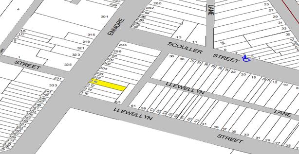
310 Enmore Road, Marrickville (proposed location to be in Llewellyn Street)
The applicant’s property is located on the eastern side of Enmore Road, Enmore approximately 20 metres north from its intersection with Llewellyn Street. The applicant’s property does not have an off-street parking facility (refer to the attached locality map and photographs).
At present, ‘No Parking 7am-9am Mon-Fri’ restrictions are located on the western side of Enmore Road and ‘No Parking 4pm-6pm Mon-Fri’ restrictions are located on the eastern side of the road adjacent to the applicants property. Llewellyn Street currently consists of unrestricted parking along both sides of the road. There are no existing mobility parking spaces in close proximity to the applicant. It has been observed during a site inspection undertaken in the morning period that the on-street parking spaces in Enmore Road were moderately utilised and in Llewellyn Street they were highly utilised.
Given that the ‘No Parking’ restrictions along Enmore Road are required for the morning and afternoon peak periods due to high traffic volumes and that there is currently no existing mobility parking space within close proximity to the applicant’s property, it would be suited to locate the mobility parking space to the nearest unrestricted parking space available. During a site investigation, the northern side of Llewellyn Street, immediately west to the intersection with Enmore Road was found to be suited.
A notification letter was sent out to the affected property adjacent to the proposed location of the mobility parking space in Llewellyn Street. Resident at 316 Enmore Road adjacent to the proposed location was consulted on the proposed location of the mobility parking space in Llewellyn Street. The resident informed the Council Officer that she had no objection with the proposed location of the mobility parking space in Llewellyn Street.
The applicant advised a Council Officer that her condition does not allow her to walk long distances due to her medical conditions. The applicant also stated that she does drive and has difficulty finding a parking space near her property.
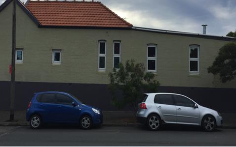
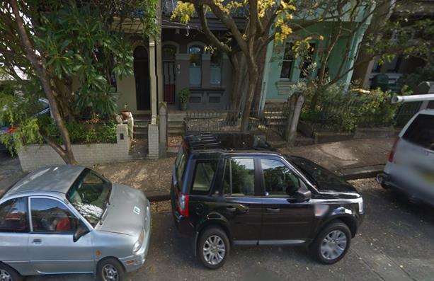
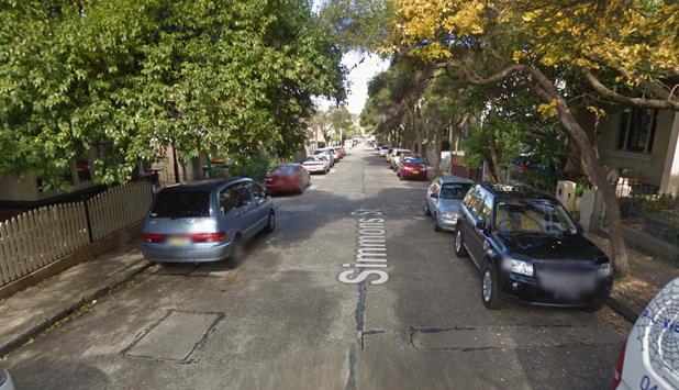
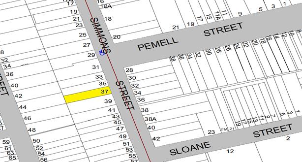
37 Simmons Street, Enmore
The applicant’s property is located on the western side of Simmons Street, Enmore and approximately 22m south from Pemell Street. The applicant’s property does not have an off-street parking facility refer to the attached locality map and photographs).
At present, parking is 1 hour restricted 6pm-10pm on the western and unrestricted on eastern side of Simmons Street. There is one existing mobility parking space located 25 metres north from the applicant’s property.
It has been observed during a site inspection undertaken in the morning period that the on-street parking spaces in Simmons Street were highly utilised.
The applicant advised a Council Officer that his children’s condition significantly affect their mobility and they require assistance due to their medical conditions.
Technical Standards
Australian Standard AS2890.5-1993 “On-Street Parking” states the following in regards to the provision of parking for people with a disability:
“Parallel parking spaces shall not be marked as disabled spaces, nor included in the count of spaces available for people with disabilities unless –
i. A 3.2m wide space can be provided, e.g. by indenting the space into the footpath area; and
ii. Kerb ramps as shown in Figure 4.2(a) are also provided”.
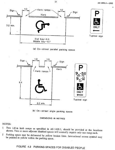
It should be noted that due to the limited width of streets around the Marrickville LGA, it is often difficult to comply with these requirements for the parking space dimensions. This may also result in the loss of some adjacent on-street parking spaces.
Mobility parking spaces are primarily intended for on-street and off-street parking at destinations, such as in commercial/retail areas and public car parks near hospitals, schools and public transport facilities where multiple usages can be expected. They were generally not intended for points of origin such as reserving on-street parking.
A mobility parking space is not intended for the sole use of one applicant, but rather a shared facility that can used by all authorised persons having an RMS mobility permit.
PUBLIC CONSULTATION
A notification letter has been sent to the applicants informing them of the application process and as part of the assessment they will be considered at this meeting.
CONCLUSION
It is recommended that the 'Mobility Parking' spaces be approved as the applicants’ condition warrants the provision of the space.
It should be noted that the proposed mobility parking spaces are not for the sole use of the applicant and may be used by other authorised persons.
Locality Map – 310 Enmore Road & Llewellyn Street, Marrickville

![]()
|
|
Photographs – 310 Enmore Road & Llewellyn Street, Marrickville
|
|
The frontage of the applicant's property in Enmore Road
|
|
On-street parking in Llewellyn Street at Enmore Road intersection
|
|
On-street parking along the northern side of Llewellyn Street near Enmore Road intersection
Locality Map – 37 Simmons Street, Enmore
N

![]()
|
|
||||
Photographs – 37 Simmons Street, Enmore
|
|
The frontage of the applicant's property in Simmons Street
Photographs – 37 Simmons Street, Enmore
|
|
On-street parking in Simmons Street, Enmore
|
|
Local Traffic Committee Meeting 4 August 2016 |
Subject: Requests for ‘Works Zone’ adjacent
to Construction Sites
(Ashfield, Stanmore Marrickville Wards/Summer Hill & Newtown)
File Ref: 16/6022/82546.16
Prepared By: Maaran Mutharasa - Engineer Traffic Services, Marrickville
Authorised By: Wal Petschler - Manager Design and Investigation, Marrickville
|
SUMMARY Requests have been received from several builders for the provision of 'Works Zone' restrictions to facilitate construction deliveries and permit the parking of construction vehicles during loading and unloading activities at various sites in the Local Government area.
It is recommended that the 'Works Zone' spaces be approved for the construction works subject to Council fees and charges applying.
|
|
RECOMMENDATION
THAT:
1. the installation of a ‘Works Zone 7AM-5.30PM Mon-Sat’ (total of 12 metres in length at two different locations adjacent to property 34 Victoria Road, Marrickville) on the southern side of Victoria Road outside Marrickville Metro Shopping Centre be APPROVED for a period of twelve (12) months, for the proposed construction works;
2. the installation of a ‘Works Zone 9AM-4.00PM Mon-Sat’ (total of 10 metres in length) on the northern side of Addison Street adjacent to property 31-33 Addison Street, Marrickville be APPROVED for a period of twelve (12) months, for the proposed construction works; and
3. the installation of a ‘Works Zone 7AM-5.30PM Mon-Sat’ (total of 10 metres in length at rear of property 380-382 Illawarra Road, Marrickville) on the eastern side of Woodley lane be APPROVED for a period of twelve (12) months, for the proposed construction works.
|
BACKGROUND
Written applications along with plans illustrating the proposed location of a ‘Works Zone’ were submitted to Council for consideration.
FINANCIAL IMPLICATIONS
The cost of the supply, installation and removal of the signs and ‘Works Zone’ fees are to be borne by each of the applicants in accordance with Council’s Fees and Charges.
OFFICER COMMENTS
|
Subject Location |
Classification of Road |
Road Description |
|
Victoria Road, Marrickville |
Local road |
Two-way street, 10.5m in width that runs east-west between Murray Street and to an end. |
|
Addison Road. Marrickville |
Regional road |
Two-way street, 10.5m in width that runs east-west between Enmore Road and Philpott Street. |
|
Wooley Lane, Marrickville |
Local road |
Two-way street, 5.5m in width that runs north-east and south-west between Greenbank Street and Church Street. |
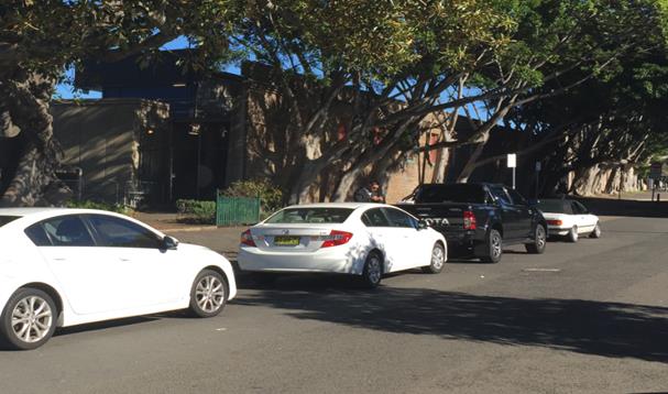
34 Victoria Road, Marrickville (outside Marrickville Metro Shopping Centre)
An application was for a ‘Works Zone’ considered at the July 2016 Local Traffic Committee meeting. At the meeting concerns were raised as to the need for so many ‘Works Zone’ in Victoria Road and whether they could locate elsewhere along the Metro frontage. The Committee recommended approval of one ‘Works Zone’ however deferred approval of the other two proposed “Works Zone” pending further information.
The subject property is located on the southern side of Victoria Road, Marrickville. The two additional proposed ‘Works Zone’ will be 6 metres each in length and located adjacent to the Marrickville Metro Shopping Centre.
The proposed ‘Works Zone’ will assist in Stage 1 delivery of the Marrickville Metro Shopping Centre which will include the upgrade of the façade and footpath outside the Victoria Road entrance to Marrickville Metro Shopping Central. It will be required for a period of approximately twelve (12) months, to be utilised by construction vehicles during deliveries and loading and unloading activities (refer to the below locality map and photographs).
The ‘Works Zone’ will also cover access gates to the work site and would need to be kept clear of non-construction vehicle in any case.
Locality Map – 34 Victoria Road, Marrickville (Marrickville Metro Shopping Centre)


|
|
Photographs – 34 Victoria Road, Marrickville (Marrickville Metro Shopping Centre)
|
6 metres |
The proposed location of the ‘Works Zone’ in Victoria Road Location 1
|
6 metres |
The proposed location of the ‘Works Zone’ in Victoria Road Location 2
On-street parking in Victoria Road outside of the construction site
At present, there is unrestricted parking on the northern side of Victoria Road and ‘2P 8.30am-6pm Mon-Fri, 8.30am-12.30pm Sat’ restrictions on the southern side of the road. The parking spaces in the subject section of Victoria Road are highly utilised by customers for the shopping centre and local residents. Therefore, the provision of a ‘Works Zone’ would provide a safe facility for loading and unloading activities at the subject site during the construction period.
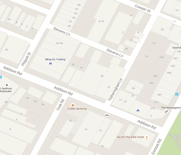
Addison Road (adjacent to 31-33 Addison Road, Marrickville
The subject property is located on northern side of Addison Road in front of 31-33 Addison Road, Marrickville. The proposed ‘Works Zone’ will be 10 metres in length and located on the northern side of Addison Road adjacent to the site. It will be required for a period of approximately twelve (12) months, to be utilised by construction vehicles during deliveries and loading and unloading activities (refer to the below locality map and photographs).
‘Works Zone’ cannot be located on the southern side of Stevens Lane (rear of the site) due to lane currently being 5.0 meters wide. A trafficable lane with a minimum width of 3 metres and vehicle parking width of 2.5 meters will be required if a “Works Zone” is to be approved on the southern side of Stevens Lane.
Locality Map – Addison Road (adjacent to 31-33 Addison Road, Marrickville)

![]()
![]()
|
Photograph – Addison Road (adjacent to 31-33 Addison Road, Marrickville)
|
10 metres |
The proposed location of the ‘Works Zone’ in Addison Road
|
|
On-street view outside of the construction site
At present, there is No Parking on the northern side of Addison Road from 7.00am – 9.00am and 4.00pm-6pm Mon-Fri. All other time unrestricted parking allowed. The provision of a ‘Works Zone’ proposed between 9.00am and 4.00 pm would provide a safe facility for loading and unloading activities at the subject site during the construction period.
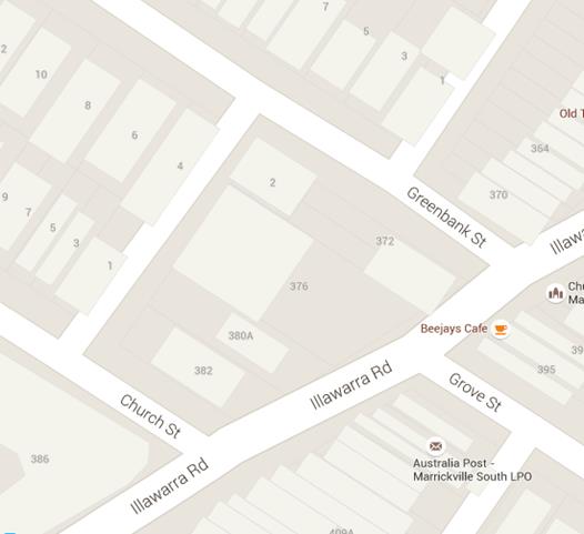
Woodley Lane (rear to 380-382 Illawarra Road, Marrickville
The subject property is located on northern side of Illawarra Road in front of 380-382 Illawarra Road, Marrickville. The proposed ‘Works Zone’ will be 10 metres in length and located on the southern side of Woodley Lane (rear of the site). It will be required for a period of approximately twelve (12) months, to be utilised by construction vehicles during deliveries and loading and unloading activities (refer to the below locality map and photographs).
Works Zone’ can be located on the southern side of Woodley Lane (rear of the site) due to lane currently being 5.5 meters wide. A trafficable lane with a minimum width of 3 metres and vehicle parking width of 2.5 meters is currently available at location for a “Works Zone” to be approved on the southern side of Woodley Lane.
Locality Map – Woodley Lane (rear to 380-382 Illawarra Road, Marrickville)

![]()
|
Photograph – Woodley Lane (adjacent to 380-382 Illawarra Road, Marrickville)
|
10 metres |
The proposed location of the ‘Works Zone’ in Woodley Lane, Marrickville
|
|
On-street view outside of the construction site
At present, unrestricted parking are located along the eastern side of Woodley Lane. The provision of a ‘Works Zone’ would provide a safe facility for loading and unloading activities at the subject site during the construction period.
PUBLIC CONSULTATION
A notification letter has been sent to the applicants informing them of the application process and as part of the assessment they will be considered at this meeting.
CONCLUSION
To better facilitate construction deliveries and allow the parking of construction vehicles during loading and unloading activities the installation of the 'Works Zone’ locations listed in the report is proposed.
|
|
Local Traffic Committee Meeting 4 August 2016 |
Subject: Macaulay Lane, Stanmore - Request for 'No
Parking' Restriction
(Stanmore Ward/Newtown)
File Ref: 16/6022/82650.16
Prepared By: Snezana Bakovic - Project Engineer Traffic, Marrickville
Authorised By: Wal Petschler - Manager Design and Investigation, Marrickville
|
SUMMARY A request has been received from a resident for the installation ‘No Parking’ restrictions in Macaulay Lane, Stanmore directly opposite to his off-street car parking space, as vehicular access is often blocked by vehicles being parked on the opposite side of the laneway. Residents have been notified of the proposal to install ‘No Parking’ restriction on this section of the Macaulay Lane. It is recommended that the proposal be approved. |
|
RECOMMENDATION
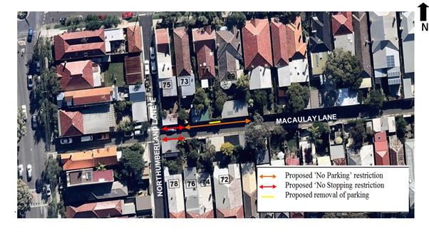
THAT: 1. the installation of full-time ‘No Parking’ restrictions be APPROVED for a distance of 26 metres on the northern side of Macaulay Lane, Stanmore between the rear of property 73 Corunna Road, Stanmore and the rear of property 69 Corunna Road; and 2. the installation of statutory ‘No Stopping’ restriction on the northern and southern side of Macaulay Lane, Stanmore, for a distance of 10 metres from its intersection with Northumberland Lane (East) Stanmore be APPROVED, in order to deter illegal parking and improve access to off street parking.
|
BACKGROUND
A request has been received from a resident of property 72 Macaulay Lane for the installation of ‘No Parking’ restrictions in Macaulay Lane, Stanmore directly opposite to his off-street car parking space, as his vehicular access is often blocked by parked vehicles on the opposite side of the laneway.
FINANCIAL IMPLICATIONS
The cost of $500 for the supply and installation of the signposting associated with the recommended ‘No Parking’ restrictions will be met from Council’s operating budget.
OFFICER COMMENTS
This section of Macaulay Lane is a two-way 4.6 metres wide laneway running east-west between Bridge Road / Northumberland Lane East (Macaulay Lane – east). It provides vehicular access to off-street parking facilities at the rear of residential properties fronting Corunna and Macaulay Roads.
A site inspection undertaken by a Council Officer revealed there are four (4) vehicular crossings located along the northern side of Macaulay Lane and five (5) vehicular crossings located along the southern side of this Macaulay Lane section. At present, there is no restriction to parking along both sides of Macaulay Lane within the subject section of the lane.
The subject location consists of several vehicular crossings with some short sections of kerb and gutter (less than a standard car length). There is one 6m length of kerb and gutter opposite property no 72 which can accommodate a vehicle. It was observed when a vehicle is parked at this section of the lane it does not leave sufficient space for a car to enter into or exit from the garage/off street parking space due to the narrow carriageway. This proposal will result in loss of one (1) parking space and provide unobstructed vehicular access to adjoining properties.
Locality Map – Macaulay Lane, Stanmore
TECHNICAL DISCUSSION
Council has recently adopted the Laneway Parking Guidelines which outline the priorities for using narrow laneways and the actions and processes that Council will use to manage access and parking. These guidelines have been developed to provide consistency for evaluating the need for parking controls and manage the use of narrow streets and laneways to maintain access and maximise parking. The need for parking controls is based on the width of the laneway shown below in Table 1.
|
Laneway Width (between property boundaries or kerbs/driveways)
|
Parking and Access Arrangements |
|
5.1 metres or more wide
|
· Parking allowed on at least one side of the laneway · Allows access for emergency, delivery and waste collection trucks at all times · Complies with Australian Standards and Road Rule 208(7)
|
|
Less than 5.1 metres
|
· Parking NOT permitted in the laneway · Allows vehicle access at all times and complies with Australian Standards and Road Rule 208(7)
|
Table 1: Laneway Parking Guideline La
For parking to be allowed in a narrow laneway, the Australian Standards require that parallel parking spaces be at least 2.1 metres wide and NSW Road Rules requires that at least 3 metres must be available between a parked car and the kerb or edge of the laneway to allow moving vehicles to pass safely. Therefore, laneway widths that are less than 5.1 metres wide are too narrow to allow parking as any parked vehicle would prevent traffic from using the laneway (see Figure 1 below)
Figure 1: Recommended minimum width of laneway for parking – 5.1 metres
When vehicles are parked in narrow laneways, near street intersections, sharp bends, across or opposite from driveways, there needs to be enough space for vehicles to travel along the laneway or turn at intersections or into properties. Laneways are an integral part of a sustainable transport system which provides vehicle access to properties and garages.
PUBLIC CONSULTATION
Public consultation with all potentially affected residents backing onto Macaulay Lane (east) has been undertaken. The consultation period closed on 4th July 2016 with residents given two weeks to consider the proposal. No submissions were received from the residents.
CONCLUSION
In order to provide unobstructed vehicular access to the residents’ off-street car parking spaces and deter illegal parking across vehicular crossings, it is recommended that full-time ‘No Parking’ restrictions be installed on the northern side of Macaulay Lane, Stanmore between the rear of property 73 Corunna Road, Stanmore and the rear of property 69 Corunna Road. It is also recommended to install statutory ‘No Stopping’ restrictions on northern and southern side of Macaulay Lane, Stanmore from its intersection with Northumberland Lane (East) in order to deter illegal parking and improve access to off street parking.
|
|
Local Traffic Committee Meeting 4 August 2016 |
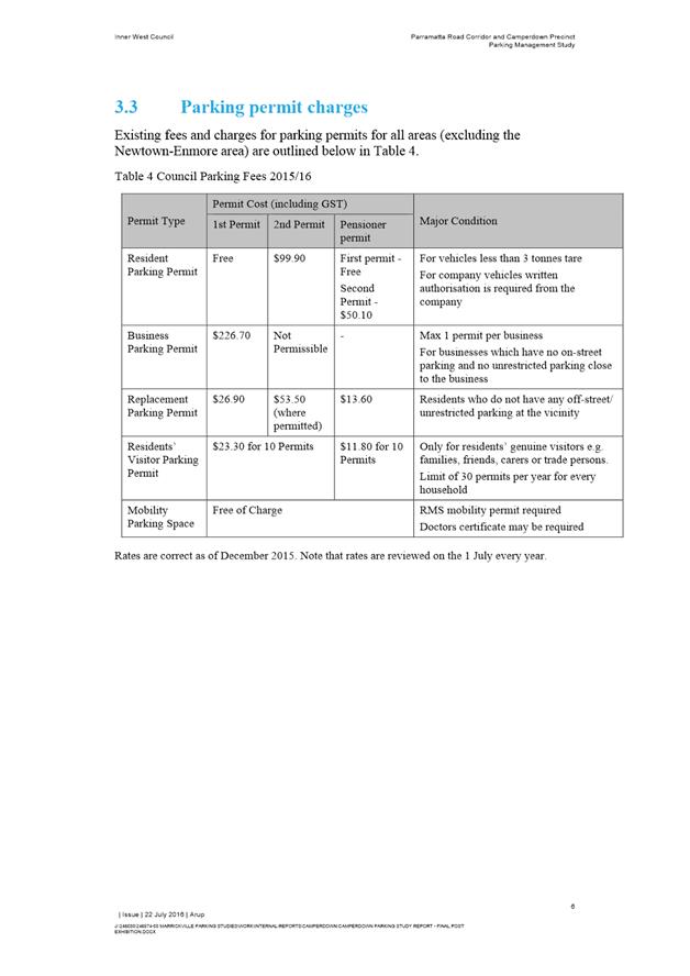
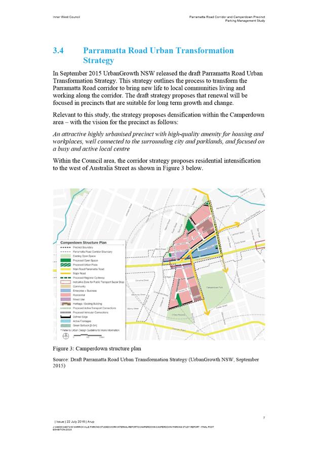
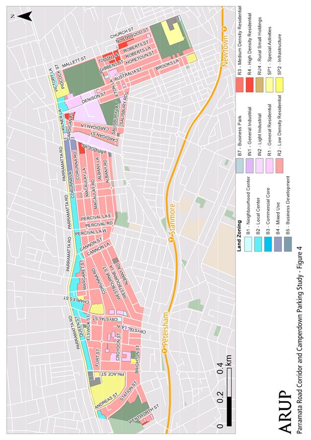
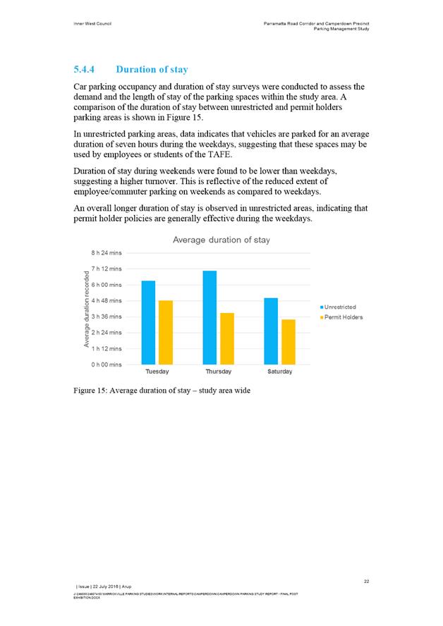
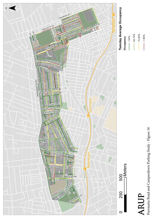
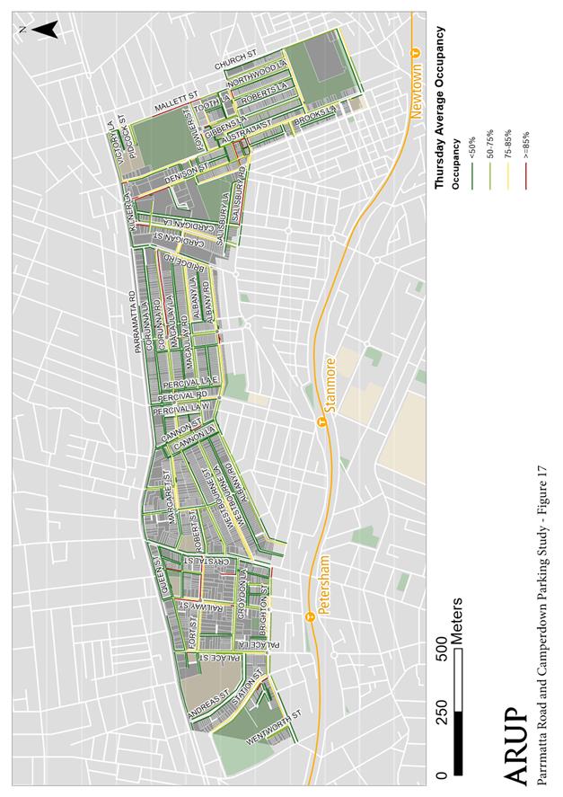
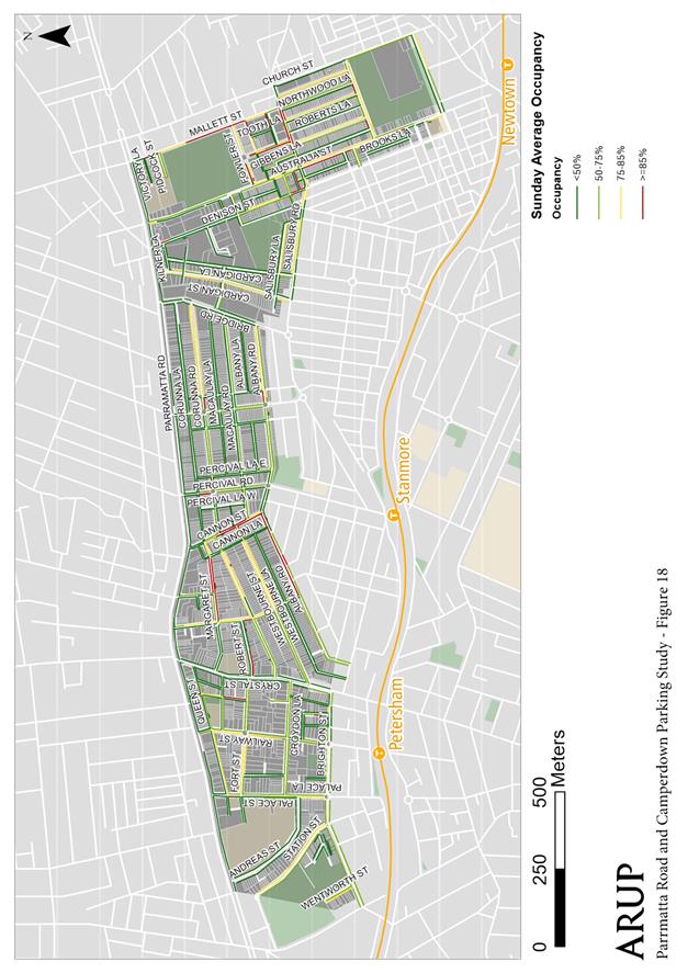
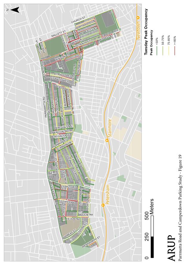
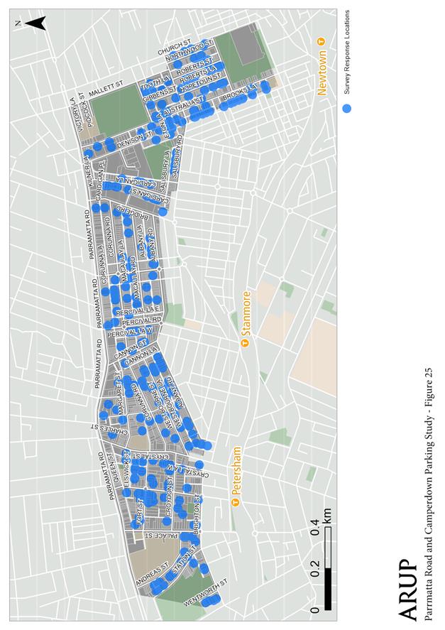
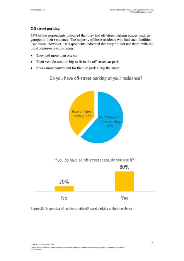
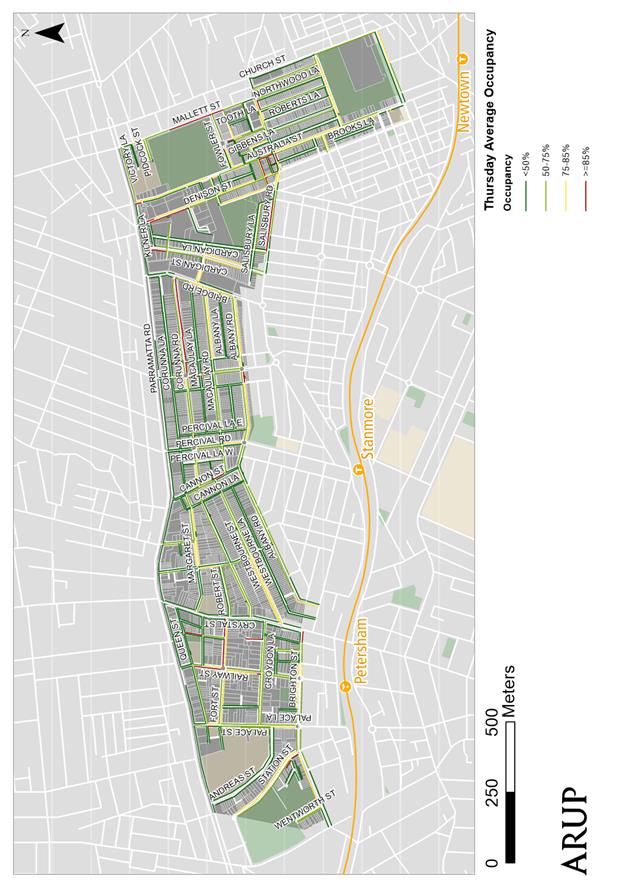
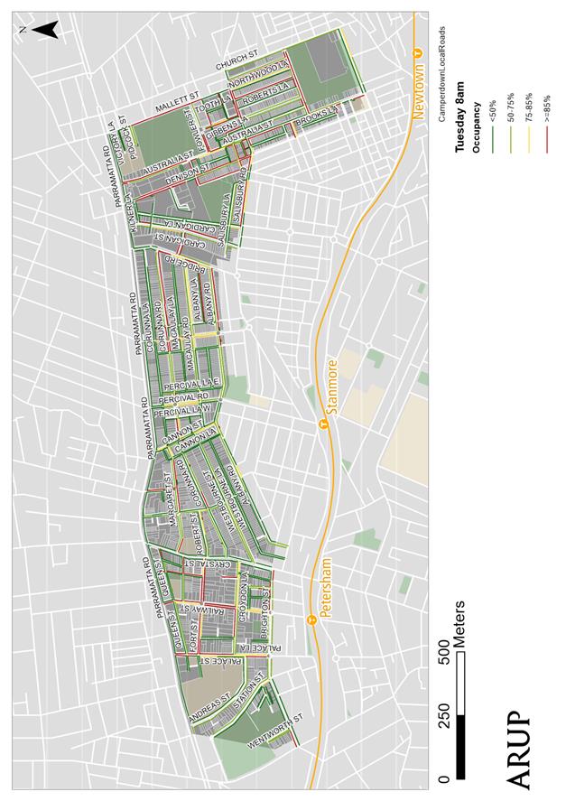
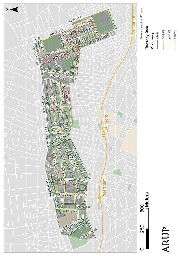
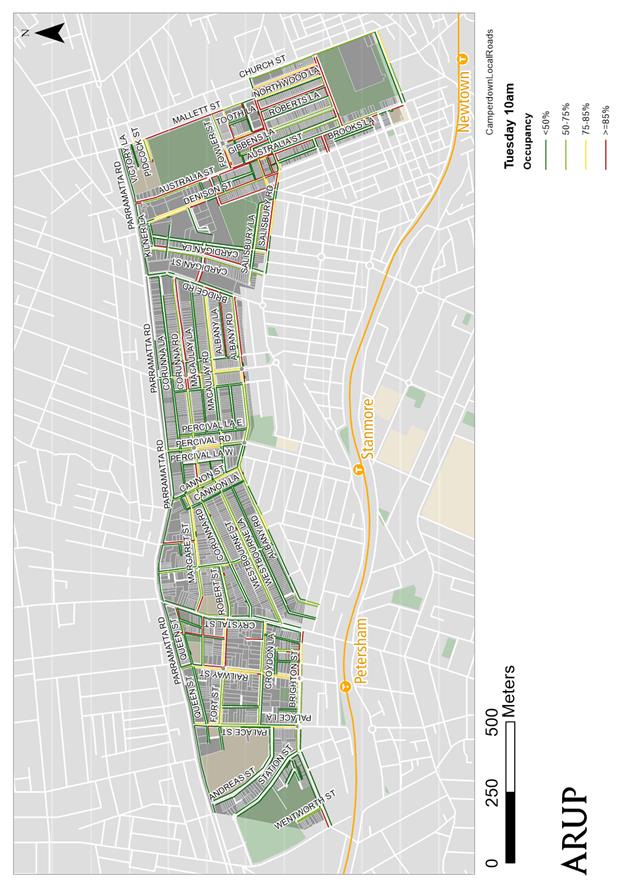
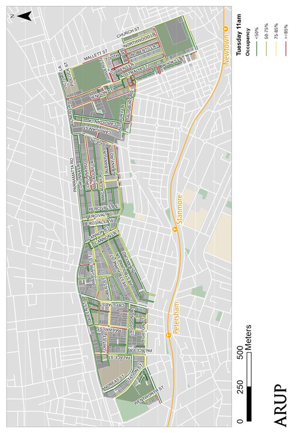
Subject: Parramatta Road Corridor and Camperdown Parking Study - Final Report
File Ref: 15/SF546/82726.16
Prepared By: Mary Bailey - Parking Planner, Marrickville
Authorised By: Peter Gainsford - Director, Major Projects and Engineering
|
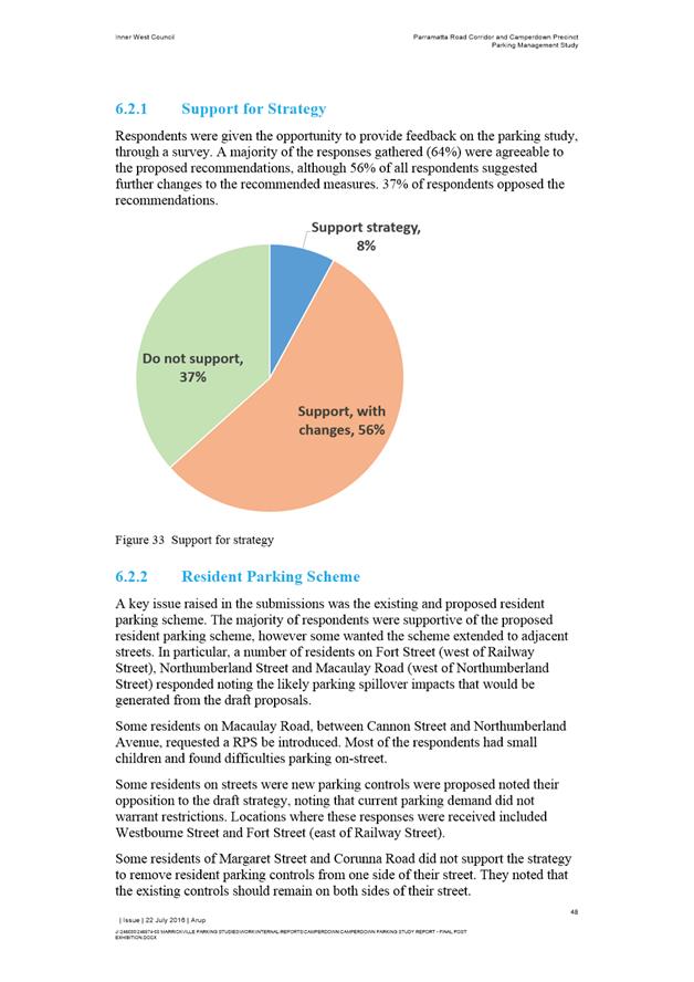
SUMMARY Council has completed the Parramatta Road Corridor/Camperdown Parking study. The community consultation and parking surveys were included in the draft report which was endorsed by Traffic committee, and subsequently went to public exhibition in June 2016. All comments received have been incorporated into a final report with recommendations for implementation of parking changes in the area. This report is to recommend the implementation of the changes listed in TABLE 1: Study Recommendations of this report. |
|
RECOMMENDATION
THAT Council adopt the recommendations of the Parramatta Road Corridor/Camperdown Parking Study – Final Report as listed in Table 1: Study Recommendations of this report. |
BACKGROUND
Inner West Council commissioned ARUP to carry out the Parramatta Road Corridor and Camperdown Parking Study to review the parking policy and management strategy within the precinct and provide a strategy for improved management of existing parking stock. The study identifies the extent and utilisation of parking in the precinct, establishes community opinion and concerns and proposes a strategy for parking in the area based on the collected data. The objectives of the study are to:
· Review the existing documentation, previous parking studies, strategies and survey data for the area.
· Identify the extent and nature of the existing on-street and off-street public car parking demand, utilisation and inventory.
· Undertake community consultations to identify existing issues and aspirations for parking in the Parramatta Road Corridor and Camperdown precinct.
· Develop a parking management strategy that will help optimise the amount of parking available for road users.
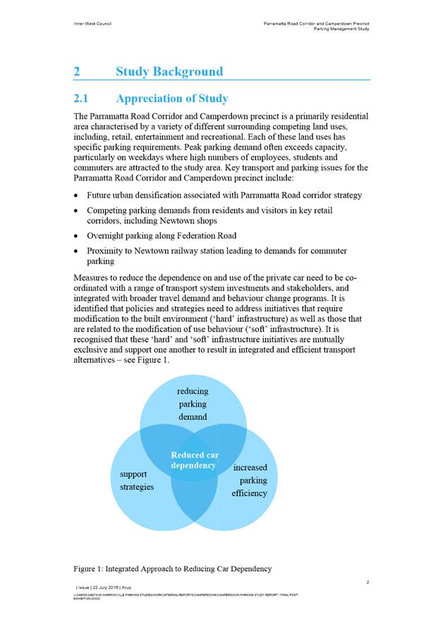
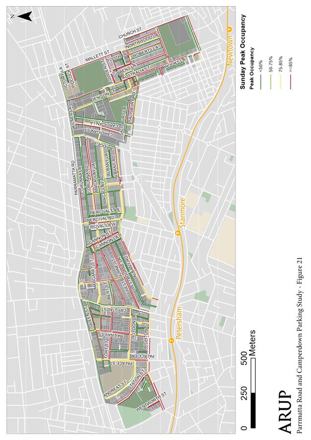
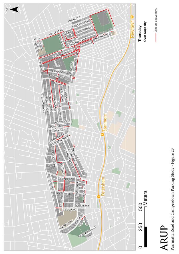
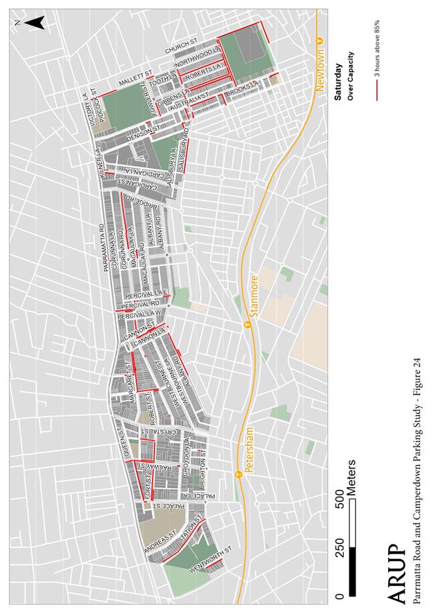
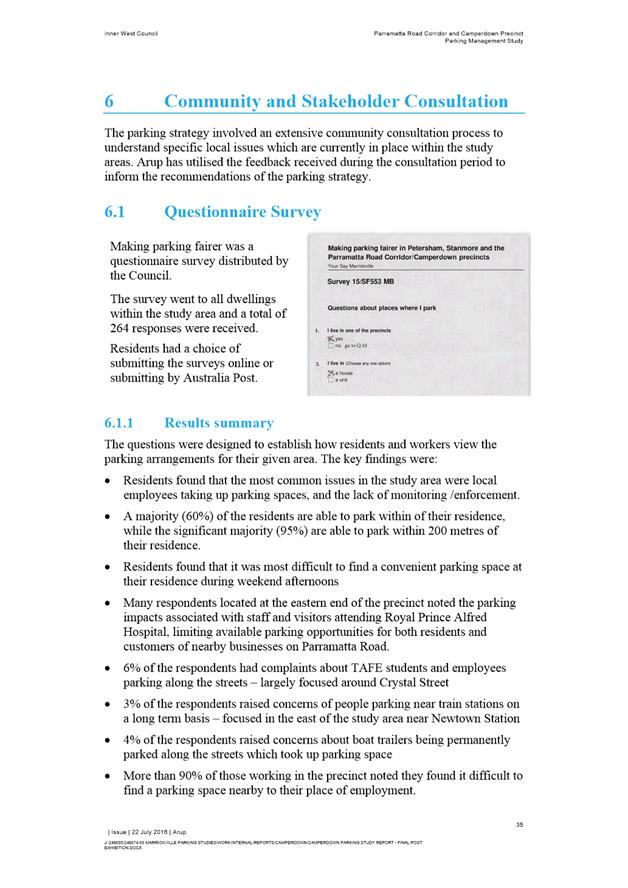
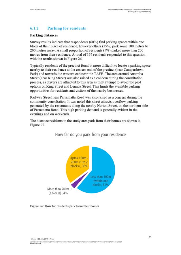
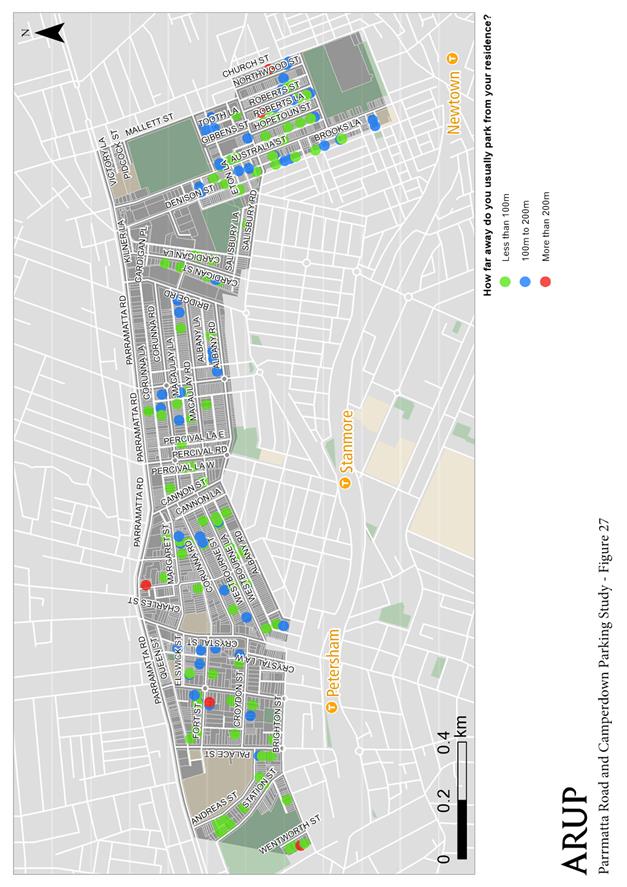
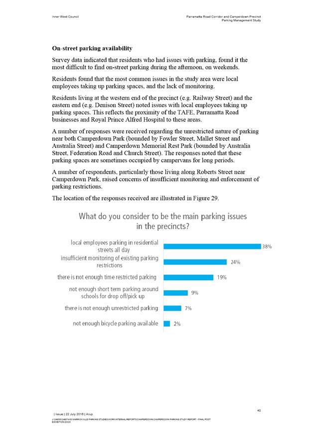
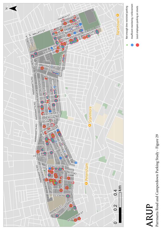
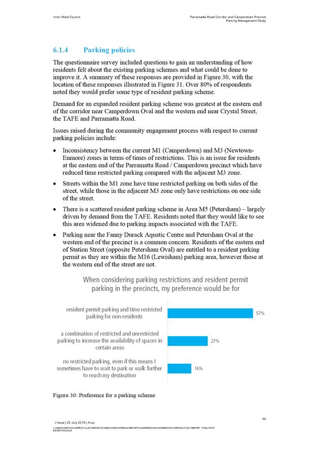
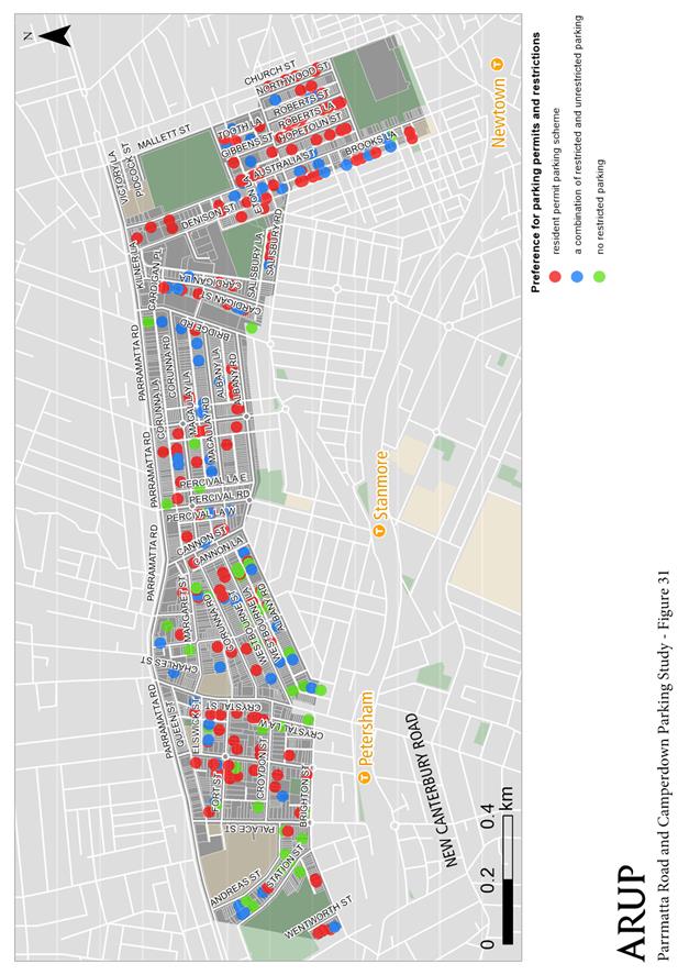
Community opinions were collected by a questionnaire survey to establish how residents and workers view the parking arrangements for their given area. Comments were geographically mapped to specific locations to enable groupings of issues throughout the study area. Typically residents of the precinct found it more difficult to locate a parking space nearby to their residence at the eastern end of the precinct (near Camperdown Park) and towards the western end near the TAFE.
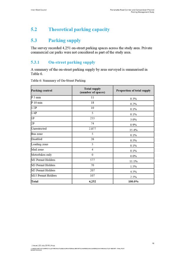
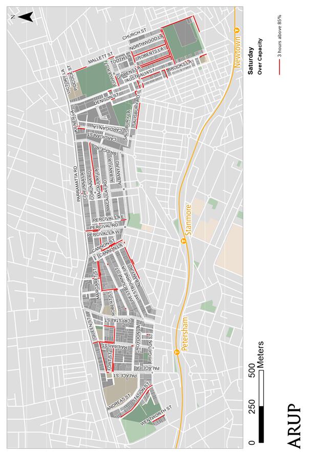
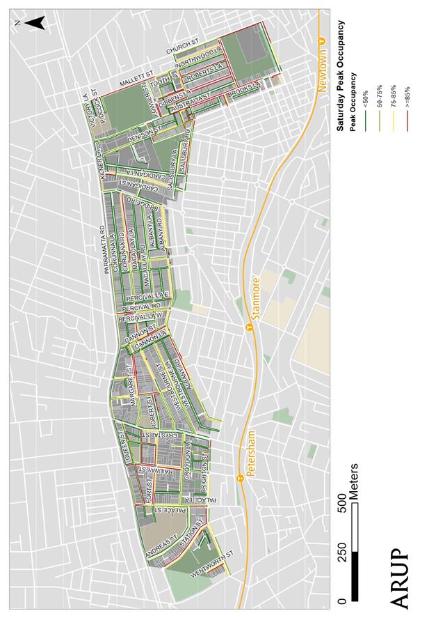
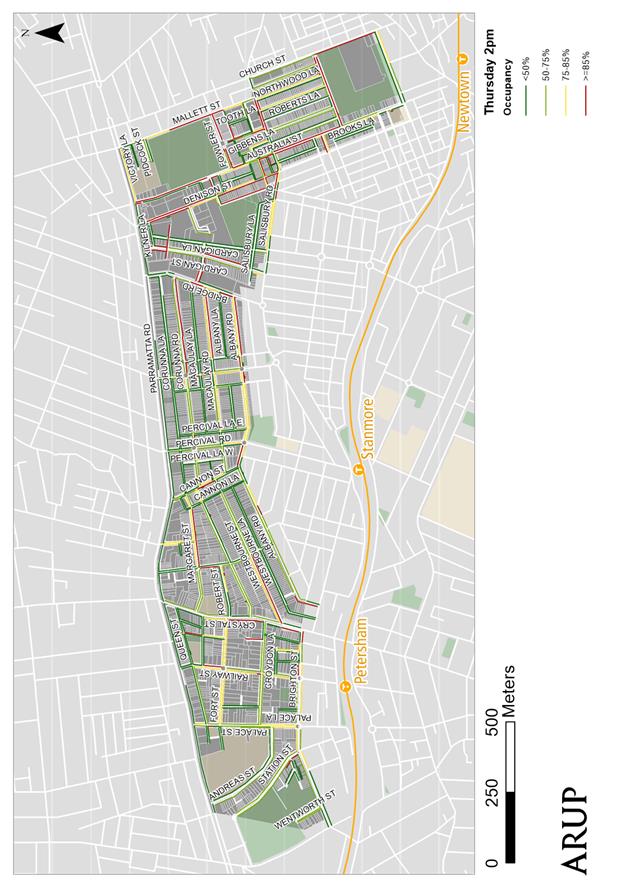
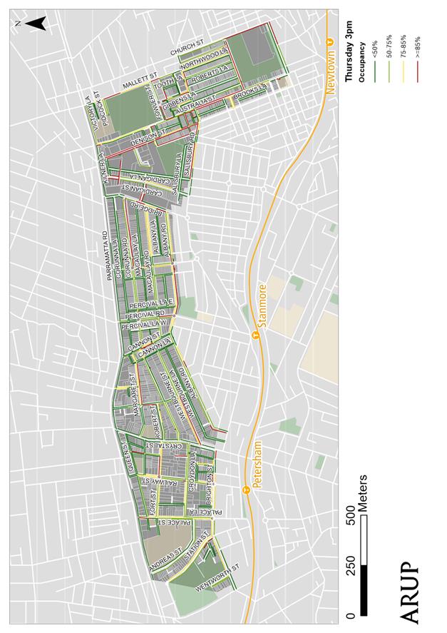
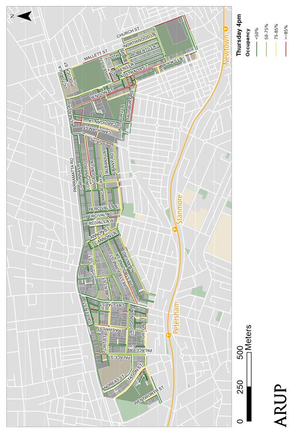
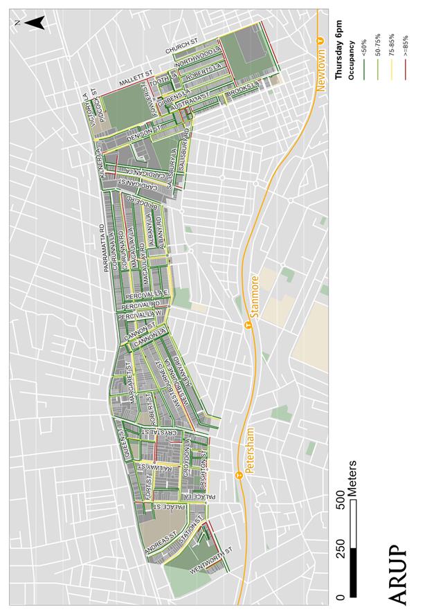
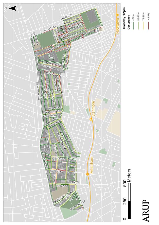
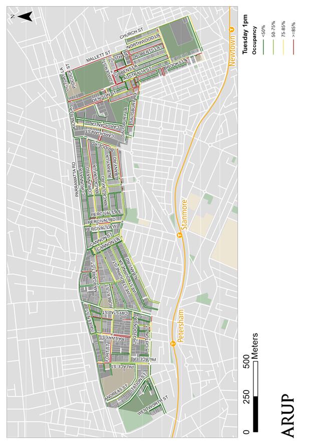
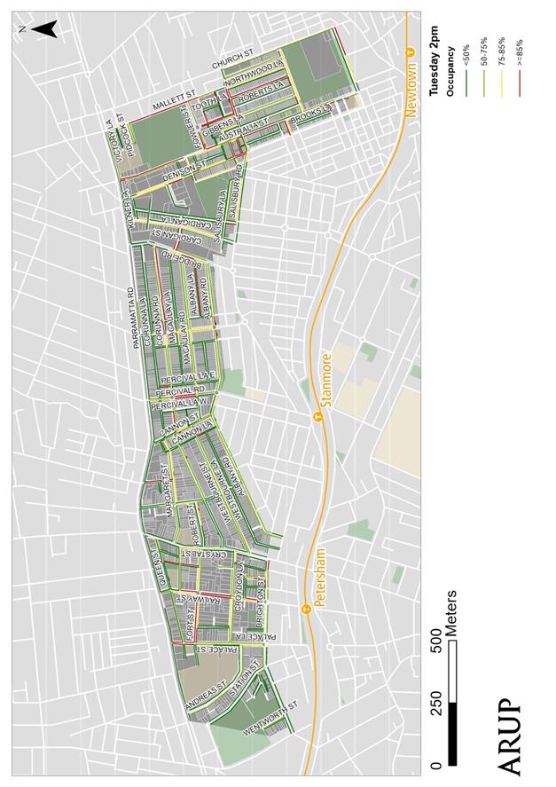
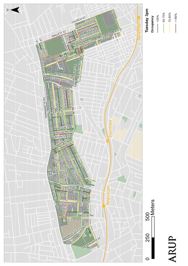
Parking surveys were undertaken to establish the number of available spaces and the demand for parking within the study area. The surveys recorded the number of potential parking spaces and their utilisation, with 4,251 on-street parking spaces surveyed across the study area. The surveys were conducted on an hourly basis during the week and during the weekend, and would provide an indication of the busiest streets during these periods to provide guidance towards implementing a fair and reasonable strategy.
The data collection results aligned areas of high community concern and areas with a high demand for parking. Notable areas where parking occupancy was high included at the eastern end of the precinct (north of Camperdown Park) and towards the western end of the precinct near Petersham TAFE and Parramatta Road retail strip.
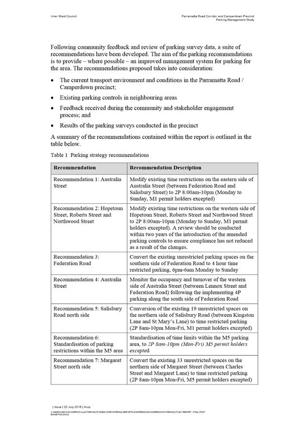
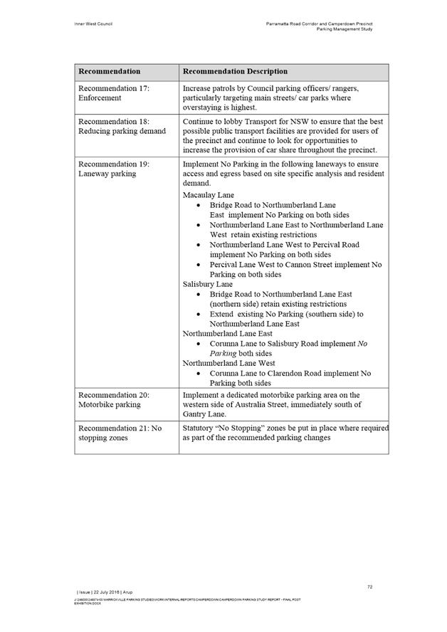
Table 1: Study recommendations
|
Recommendation |
Recommendation Description |
|
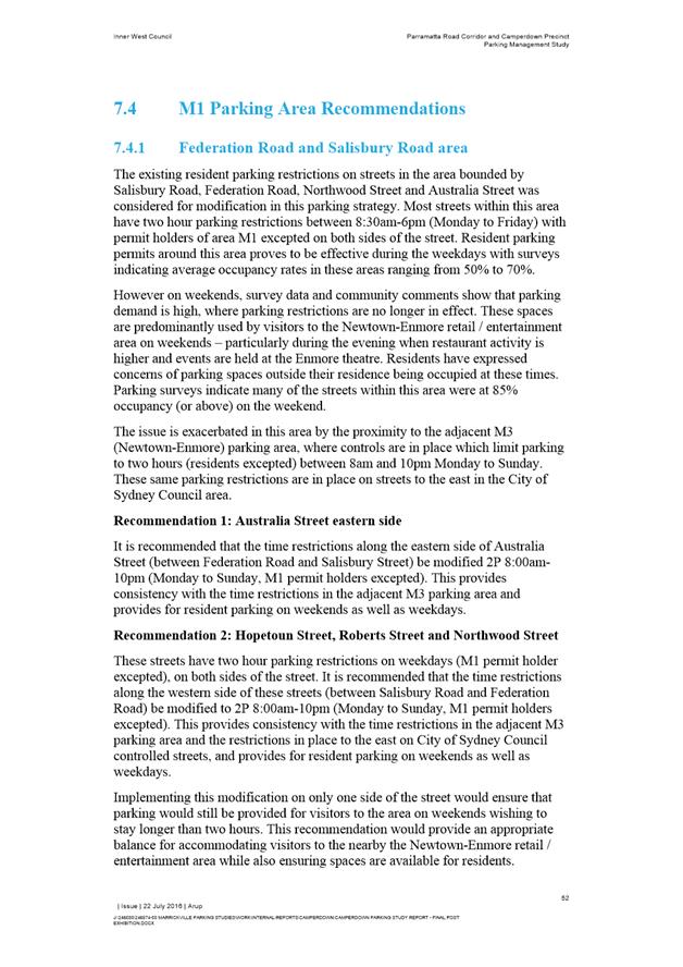
Recommendation 1: Australia Street |
Modify existing time restrictions on the eastern side of Australia Street (between Federation Road and Salisbury Street) to 2P 8:00am-10pm (Monday to Sunday, M1 permit holders excepted) |
|
Recommendation 2: Hopetoun Street, Roberts Street and Northwood Street |
Modify the existing time restrictions on the western side of Hopetoun Street, Roberts Street and Northwood Street to 2P 8:00am-10pm (Monday to Sunday, M1 permit holders excepted). A review should be conducted within two years of the introduction of the amended parking controls to ensure compliance has not reduced as a result of the changes. |
|
Recommendation 3: Federation Road |
Convert the existing unrestricted parking spaces on the southern side of Federation Road to 4 hour time restricted parking, 6pm-6am Monday to Sunday |
|
Recommendation 4: Australia Street |
Monitor the occupancy and turnover of the western side of Australia Street (between Lennox Street and Federation Road) following the implementing 4P parking along the south side of Federation Road |
|
Recommendation 5: Salisbury Road north side |
Conversion of the existing 19 unrestricted spaces on the northern side of Salisbury Road (between Kingston Lane and St Mary’s Lane) to time restricted parking (2P 8am-10pm Mon-Fri, M1 permit holders excepted) |
|
Recommendation 6: Standardisation of parking restrictions within the M5 area |
Standardisation of time limits within the M5 parking area, to 2P 8am-10pm (Mon-Fri) M5 permit holders excepted (as referred to in Figure 1 within this report) |
|
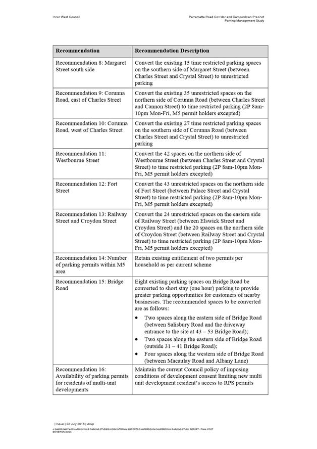
Recommendation 7: Margaret Street north side |
Convert the existing 33 unrestricted spaces on the northern side of Margaret Street (between Charles Street and Margaret Lane) to time restricted parking (2P 8am-10pm Mon-Fri, M5 permit holders excepted) |
|
Recommendation 8: Margaret Street south side |
Convert the existing 15 time restricted parking spaces on the southern side of Margaret Street (between Charles Street and Crystal Street) to unrestricted parking |
|
Recommendation 9: Corunna Road, east of Charles Street |
Convert the existing 35 unrestricted spaces on the northern side of Corunna Road (between Charles Street and Cannon Street) to time restricted parking (2P 8am-10pm Mon-Fri, M5 permit holders excepted) |
|
Recommendation 10: Corunna Road, west of Charles Street |
Convert the existing 27 time restricted parking spaces on the southern side of Corunna Road (between Charles Street and Crystal Street) to unrestricted parking |
|
Recommendation 11: Westbourne Street |
Convert the 42 spaces on the northern side of Westbourne Street (between Charles Street and Crystal Street) to time restricted parking (2P 8am-10pm Mon-Fri, M5 permit holders excepted) |
|
Recommendation 12: Fort Street |
Convert the 43 unrestricted spaces on the northern side of Fort Street (between Palace Street and Crystal Street) to time restricted parking (2P 8am-10pm Mon-Fri, M5 permit holders excepted) |
|
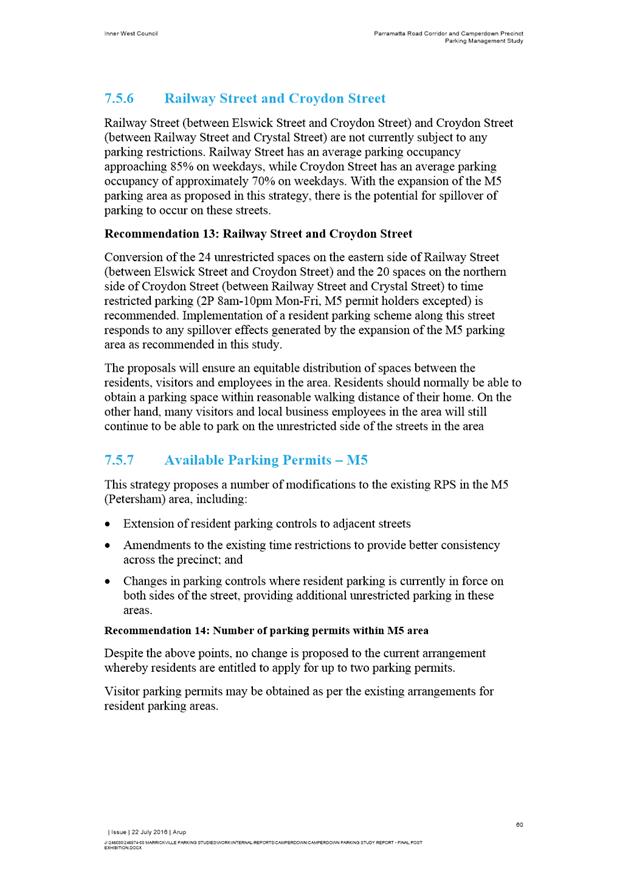
Recommendation 13: Railway Street and Croydon Street |
Convert the 24 unrestricted spaces on the eastern side of Railway Street (between Elswick Street and Croydon Street) and the 20 spaces on the northern side of Croydon Street (between Railway Street and Crystal Street) to time restricted parking (2P 8am-10pm Mon-Fri, M5 permit holders excepted) |
|
Recommendation 14: Number of parking permits within M5 area |
Retain existing entitlement of two permits per household as per current scheme |
|
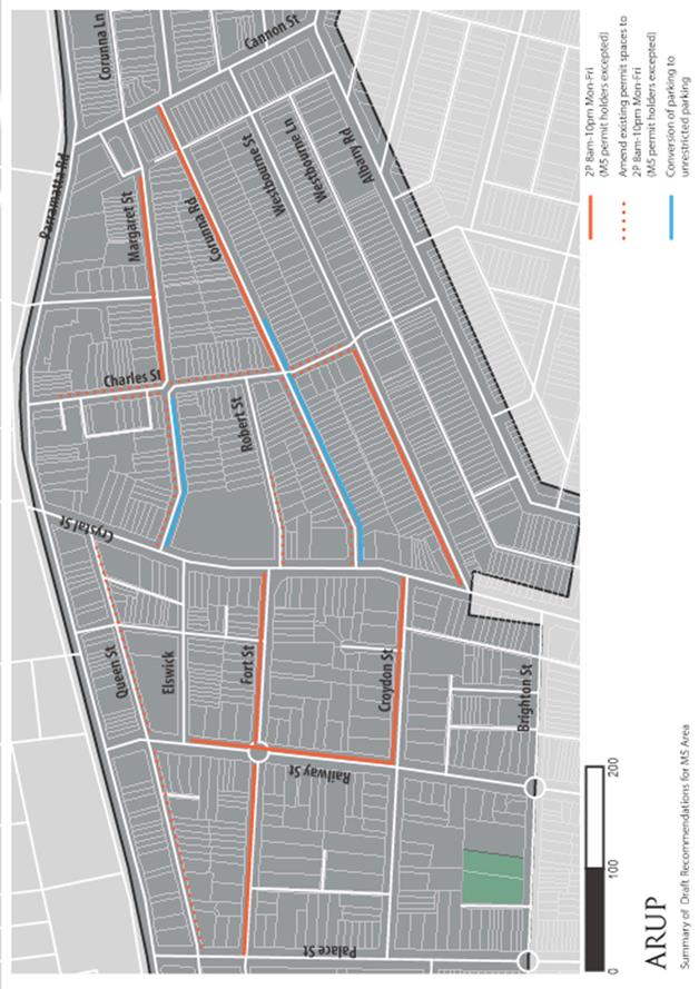
Recommendation 15: Bridge Road |
Eight existing parking spaces on Bridge Road be converted to short stay (one hour) parking to provide greater parking opportunities for customers of nearby businesses. The recommended spaces to be converted are as follows: · Two spaces along the eastern side of Bridge Road (between Salisbury Road and the driveway entrance to the site at 43 – 53 Bridge Road); · Two spaces along the eastern side of Bridge Road (outside 31 – 41 Bridge Road); · Four spaces along the western side of Bridge Road (between Macaulay Road and Albany Lane) |
|
Recommendation 16: Availability of parking permits for residents of multi-unit developments |
Maintain the current Council policy of imposing conditions of development consent limiting new multi unit development resident’s access to Resident Parking Scheme (RPS) permits |
|
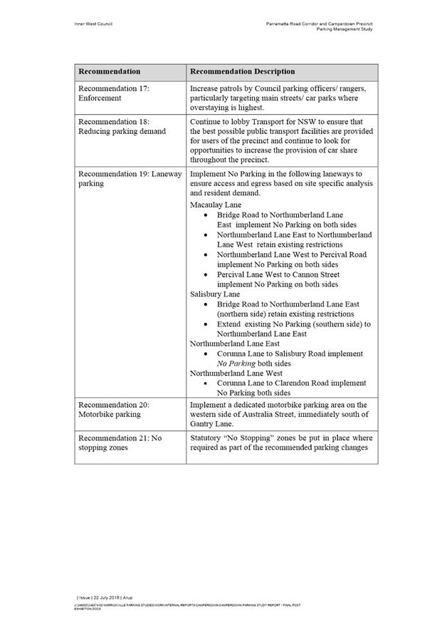
Recommendation 17: Enforcement |
Increase patrols by Council parking officers/ rangers, particularly targeting main streets/ car parks where overstaying is highest. |
|
Recommendation 18: Reducing parking demand |
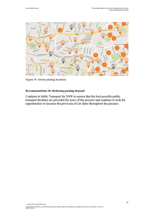
Continue to lobby Transport for NSW to ensure that the best possible public transport facilities are provided for users of the precinct and continue to look for opportunities to increase the provision of car share throughout the precinct. |
|
Recommendation 19: Laneway parking |
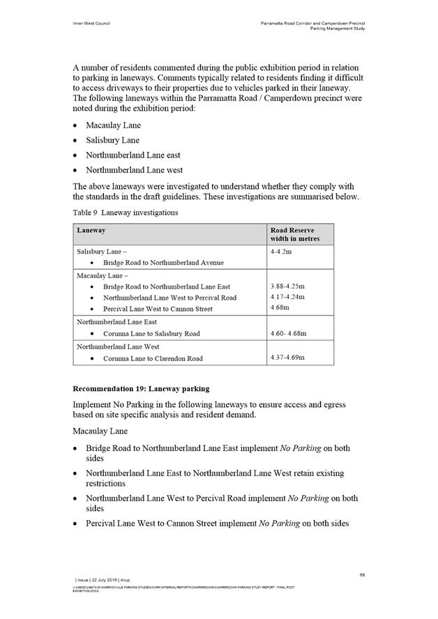
Macaulay Lane · Bridge Road to Northumberland Lane East implement No Parking on both sides · Northumberland Lane East to Northumberland Lane West retain existing restrictions · Northumberland Lane West to Percival Road implement No Parking on both sides · Percival Lane West to Cannon Street implement No Parking on both sides Salisbury Lane · Bridge Road to Northumberland Lane East (northern side) retain existing restrictions · Extend existing No Parking (southern side) to Northumberland Lane East Northumberland Lane East · Corunna Lane to Salisbury Road implement No Parking both sides Northumberland Lane West · Corunna Lane to Clarendon Road implement No Parking both sides |
|
Recommendation 20: Motorbike parking |
Implement a dedicated motorbike parking area on the western side of Australia Street, immediately south of Gantry Lane. |
|
Recommendation 21: No Stopping Zones |
Statutory “No Stopping” zones be put in place where required as part of the implementation of the recommended parking changes. |
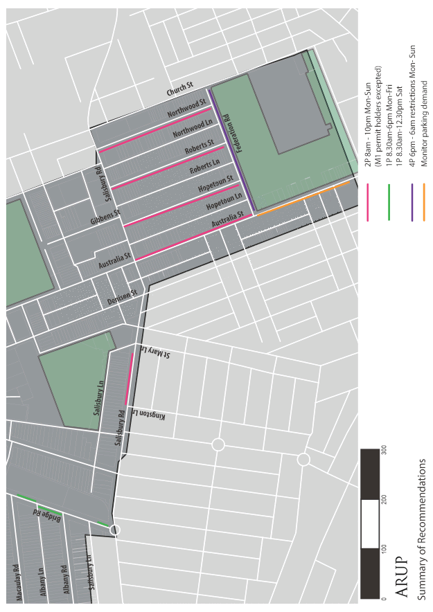
Figure 1: Existing M5 permit parking area
Summary of proposed restrictions
Figure 2: Map of Proposed restrictions
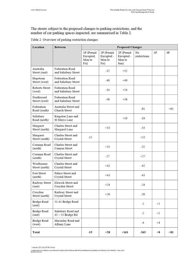
Table 2: Overview of parking restriction changes
|
Location |
Between |
Proposed Changes |
|||||
|
1P (Permit Excepted, Mon to Fri) |
2P (Permit Excepted - Mon to Fri) |
2P (Permit Excepted - Mon to Sun) |
No restrictions |
1P |
4P |
||
|
Australia Street (east) |
Federation Road and Salisbury Street |
-32 |
+32 |
|
|||
|
Hopetoun Street (west) |
Federation Road and Salisbury Street |
-40 |
+40 |
|
|||
|
Roberts Street (west) |
Federation Road and Salisbury Street |
-34 |
+34 |
|
|||
|
Northwood Street (west) |
Federation Road and Salisbury Street |
-36 |
+36 |
|
|||
|
Federation Road (south) |
Australia Street and Church Street |
-81 |
|
+81 |
|||
|
Salisbury Road (north) |
Kingston Lane and St Marys Lane |
|
|
+19 |
-19 |
|
|
|
Margaret Street (north) |
Charles Street and Margaret Lane |
+33 |
-33 |
|
|||
|
Margaret Street (south) |
Charles Street and Crystal Street |
-15 |
+15 |
|
|||
|
Corunna Road (north) |
Charles Street and Cannon Street |
+35 |
-35 |
|
|||
|
Corunna Road (south) |
Charles Street and Crystal Street |
-27 |
+27 |
|
|||
|
Westbourne Street (north) |
Charles Street and Crystal Street |
+42 |
-42 |
|
|||
|
Fort Street (north) |
Palace Street and Crystal Street |
+43 |
-43 |
|
|||
|
Railway Street (east) |
Elswick Street and Croydon Street |
+24 |
-24 |
|
|||
|
Croydon Street (north) |
Railway Street and Crystal Street |
+20 |
-20 |
|
|||
|
Bridge Road (east) |
31-41 Bridge Road |
|
|
|
-2 |
+2 |
|
|
Bridge Road (east) |
Salisbury Road and 43 – 53 Bridge Rd |
|
|
|
-2 |
+2 |
|
|
Bridge Road (west) |
Macaulay Road and Albany Lane |
|
|
|
-4 |
+4 |
|
|
Total |
-15 |
+28 |
+161 |
-263 |
+8 |
+81 |
|
FINANCIAL IMPLICATIONS
There is a budget for $110,000 for implementation of this study identified in the 2017/18 forward budget. A separate report to Council is being prepared to detail the financial implications of the complete Marrickville parking study and implementation program currently in progress.
OFFICER COMMENTS
The draft recommendations were developed through a comprehensive process of collection and analysis of data both from parking occupancy and length of stay surveys; and input from the community in the questionnaire surveys. Internal stakeholder meetings reviewed and endorsed each recommendation in light of the findings of the surveys. The final draft report was placed on public exhibition and received a high level of comment. The public exhibition comments were reviewed by an internal stakeholder group and the final recommendations are listed in detail.
PUBLIC CONSULTATION
The community consultation included a community questionnaire survey through Your Say Marrickville as well as historical input from the community collated into an issues register for consideration. 5,760 letters were mailed to residents and householders and about 800 responses were received. The key results community engagement report was posted to Your Say Marrickville in mid March 2016.
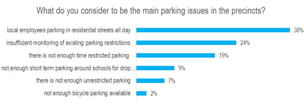
Figure 3: Main parking issues reported
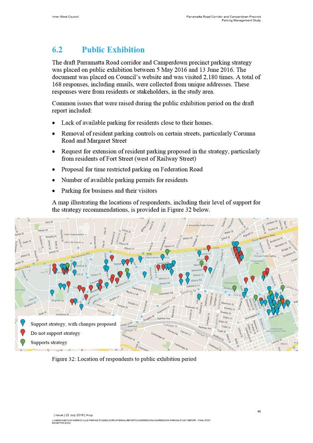
A public exhibition of the draft report with recommendations was carried out during May and June 2016 following endorsement from the Former Marrickville Council’s Pedestrian Cycling and Traffic Advisory Committee (11 April 2016).
A total of 168 responses, including emails, were collected from residents or stakeholders, in the study area.
Common issues raised during the public exhibition period on the draft report included:
· Lack of available parking for residents close to their homes.
· Removal of resident parking controls on certain streets, particularly Corunna Road and Margaret Street
· Request for extension of resident parking proposed in the strategy, particularly from residents of Fort Street (west of Railway Street)
· Proposal for time restricted parking on Federation Road
· Number of available parking permits for residents
· Parking for business and their visitors

Figure 4: Feedback during public exhibition period
Mostly the reasons for not supporting the recommendations was that they did not extend far enough, for instance respondents wanted resident parking on both sides of the road, resident parking in additional streets, restrictions to be extended to 10pm from 6pm; or wanted no restrictions at all. One multi unit development had multiple submissions seeking eligibility of residents for resident parking permits.
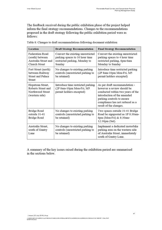
Table 3: Changes to recommendations from Public Exhibition Period
|
Location |
Draft Strategy Recommendation |
Final Strategy Recommendation |
|
Federation Road (south) between Australia Street and Church Street |
Convert the existing unrestricted parking spaces to 10 hour time restricted parking, Monday to Sunday |
Convert the existing unrestricted parking spaces to 4 hour time restricted parking, 6pm-6am Monday to Sunday |
|
Fort Street (north) between Railway Street and Palace Street |
No changes to existing parking controls (unrestricted parking to be retained) |
Introduce time restricted parking (2P 8am-10pm Mon-Fri, M5 permit holders excepted) |
|
Hopetoun Street, Roberts Street and Northwood Street (western side) |
Introduce time restricted parking (2P 8am-10pm Mon-Fri, M5 permit holders excepted) |
As per draft recommendation - however a review should be conducted within two years of the introduction of the amended parking controls to ensure compliance has not reduced as a result of the changes. |
|
Bridge Road outside 31-41 Bridge Road |
No changes to existing parking controls (unrestricted parking to be retained) |
Two spaces outside 31-41 Bridge Road be signposted as 1P 8:30am-6pm (Mon-Fri) & 8:30am-12:30pm (Sat). |
|
Australia Street, south of Gantry Lane |
No changes to existing parking controls (unrestricted parking to be retained) |
Implement a dedicated motorbike parking area on the western side of Australia Street, immediately south of Gantry Lane. |
CONCLUSION
Once endorsed the study recommendations will be implemented. An implementation review will be completed within 12-18 months of implementation. This will allow for a review and amendments considered based on changes in demand due to developments in the area including;
· the future of Petersham TAFE,
· development along Parramatta Road
· the efficacy of the restrictions in addressing resident’s concerns, and
· other likely issues to arise over time.
|
1.⇩ |
Parramatta Road Corridor Camperdown Parking Study Report - ARUP Final Report Revised 22 July |
|
Local Traffic Committee Meeting 4 August 2016 |
Subject: Council Street, St Peters - Proposal for
Permit Parking Area M12
(Marrickville Ward/Heffron)
File Ref: 16/6022/82990.16
Prepared By: Emilio Andari - Civil Engineer, Marrickville
Authorised By: Wal Petschler - Manager Design and Investigation, Marrickville
|
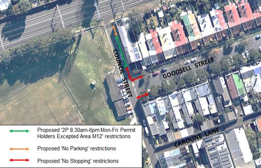
SUMMARY Following a resident request permit parking restrictions are proposed within a section of Council Street. Residents have been notified of the proposals to install:
a) a section of ‘2P 8.30am – 6pm Mon-Fri, Permit Holders Excepted – Area M12’ restrictions nearby their properties as part of the extension to the Area M12 permit parking precinct; b) a section of ‘No Parking’ restrictions on the eastern side of Council Street at the end of the street near the railway corridor; and c) three statutory ‘No Stopping’ signs on both sides of Goodsell Street at Council Street and on the eastern side of Council Street at Goodsell Street.
It is recommended that the proposals be approved. |
|
RECOMMENDATION
THAT:
1. the installation of ‘2P 8.30am – 6pm Mon-Fri, Permit Holders Excepted – Area M12’ restrictions (20 metres in length) adjacent to property no. 63 Goodsell Street, St Peters on the eastern side of Council Street, St Peters be APPROVED, in order to provide parking opportunities for local residents;
2. the installation of full-time ‘No Parking’ restrictions (6 metres in length) on the eastern side of Council Street, St Peters adjacent to property no. 63 Goodsell Street, St Peters (immediately south from the railway corridor) be APPROVED, in order to improve access for turning motorists and increase safety;
3. the installation of statutory ‘No Stopping’ restrictions on both the northern and southern sides of Goodsell Street, St Peters for a distance of 10 metres from its intersection with Council Street, St Peters be APPROVED, in order to deter illegal parking, improve access for turning motorists and increase safety; and
4. the installation of statutory ‘No Stopping’ restrictions on the eastern side of Council Street, St Peters (adjacent to property no. 63 Goodsell Street, St Peters) for a distance of 10 metres from its intersection with Goodsell Street, St Peters be APPROVED, in order to deter illegal parking, improve access for turning motorists and increase safety.
|
BACKGROUND
A small section of Council Street, St Peters (eastern side) north of Goodsell Street was not included in the original resident parking scheme proposal adopted by Council for the St Peters Parking Area M12 precinct.
FINANCIAL IMPLICATIONS
The costs of the supply and installation of the signposting associated with the recommended ‘No Parking’, ‘No Stopping’ & Permit Parking restrictions are approximately $1,000 and can be met from Council’s operating budget.
OFFICER COMMENTS
Site location & road network
|
Street Name |
Council Street |
Goodsell Street |
|
Subject Section |
Between May Street and to the closed end (i.e. railway corridor) |
Between Council Street and May Lane |
|
Carriageway Width (m) |
5.8 |
12.8 |
|
Carriageway Type |
Two-way road with one travel lane in each direction, in addition to a kerbside parking lane along the eastern side of the road. |
Two-way road with one travel lane in each direction, in addition to kerbside and angle parking lanes along both sides of the road. |
|
Classification |
Local |
Local |
|
85th Percentile Speed (km/h) |
33.1 |
36.7 |
|
Vehicles Per Day (vpd) |
333 |
563 |
|
Reported Crash History (2010-2014) |
No crashes recorded. |
No crashes recorded. |
|
Heavy Vehicle Volume (%) |
3.7 |
4.1 |
|
Parking Arrangements |
Unrestricted parking on the eastern side of the road. |
‘2P 8.30am-6pm Mon-Fri, Permit Holders Excepted Area M12’ restrictions on both sides of the road. |
Permit Parking
The proposal is to restrict parking to 2-hours between 8.30am-6pm Mon-Fri, Permit Holders Excepted Area M12, at the front of residential properties at the subject section of Council Street, St Peters.
At present, these permit parking restrictions apply to the surrounding streets such as Goodsell Street (on both sides of the road) and in Council Street (on the eastern side of the road between Goodsell Street and May Street).
Locality Map – Council Street, St Peters
![]()
Photograph – Eastern side of Council Street, St Peters (facing north-east)
|
|
PUBLIC CONSULTATION
A notification letter was sent to owners and occupiers of the affected properties that are adjacent to the subject section of Council Street and Goodsell Street regarding the proposed parking restrictions and No Stopping zones. The closing date for submissions ended on 29 July 2016.
At the end of the survey period provided for comments, no responses were received.
CONCLUSION
In order to provide parking opportunities for local residents, it is proposed to install ‘2P 8.30am – 6pm Mon-Fri, Permit Holders Excepted – Area M12’ restrictions on the eastern side of Council Street, St Peters (between Goodsell Street and to the end of the street near the railway corridor).
It is also proposed to install a section of ‘No Parking’ restrictions on the eastern side of Council Street immediately south from the railway corridor for a distance of 6 metres and three statutory ‘No Stopping’ restriction for a distance of 10 metres from the intersection on both sides of Goodsell Street at Council Street and on the eastern side of Council Street at Goodsell Street in order to deter illegal parking, improve access for turning motorists and increase safety.
|
|
Local Traffic Committee Meeting 4 August 2016 |
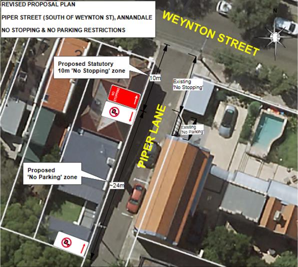
Subject: Piper Lane (South of Piper Street), Annandale
- No Stopping and No Parking Restrictions
(Leichhardt/Balmain)
File Ref: 16/6022/85196.16
Prepared By: Khanh Nguyen - Traffic and Parking Engineer, Leichhardt
Authorised By: Peter Gainsford - Director, Major Projects and Engineering
|
SUMMARY Council received a petition requesting the installation of parking restrictions in the Piper Lane, Annandale, on the side of No. 2A Piper Street to address driveway accessibility and safety concerns caused by parked vehicles in the lane. The statutory 10m ‘No Stopping’ restriction followed by ‘No Parking’ restrictions are being proposed to alleviate the problem. |
|
RECOMMENDATION
THAT:
1. a 10m ‘No Stopping’ zone be installed on the eastern side of Piper Lane, south of Piper Street; 2. a 10m ‘No Stopping’ zone be installed on the western side of Piper Lane, south of Piper Street; 3. ~33.4m ‘No Parking’ restrictions be installed on the western side of Piper Lane following south of the proposed 10m ‘No Stopping’ zone (opposite the rear of No. 184 Johnston Street inclusive); 4. ‘No Parking’ restrictions be extended on the western side of Piper Lane further south to include the rear boundary of No. 215 Annandale Street, subject to consultation with affected properties (that were not originally consulted) and no significant objections being received; and 5. statutory 10m ‘No Stopping’ restrictions be installed on Piper Street west of Piper Lane, and the affected properties be notified.
|
BACKGROUND
Council received a petition requesting the installation of parking restrictions in Piper Lane, Annandale, opposite the rear of Johnston Street properties, on the side of No. 2A Piper Street. The purpose is to address issues with vehicles frequently parking on the western side of Piper Lane, south of Piper Street, on the side of No. 2A Piper Street and obstructing rear access to properties No.186, No.190, No.192 and No.194 Johnston Street.
Council originally consulted a proposal to install statutory 10m ‘No Stopping’ zone on the western side of Piper Lane, south of Piper Street and ~24m ‘No Parking’ zone following it on the side of No. 2A Piper Street, see consulted proposal below.
The proposal will also address reported safety concerns exacerbated by parked vehicles in the narrow Piper Lane (also a no through road), that reduce the visibility to sight oncoming vehicles and pedestrians near the Piper Street intersection. Often vehicles parking in the lane are required to reverse in or out of the intersection due to the lack of turning space in Piper Lane and the proposal aims to address this safety issue as well.
CONSULTED PROPOSAL
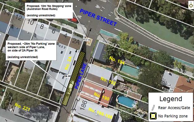
FINANCIAL IMPLICATIONS
Nil.
PUBLIC CONSULTATION
|
A letter outlining the above parking proposal was mailed out to the affected properties (9 properties) in Johnston Street, Annandale Street and Piper Lane as indicated on the following plan, requesting residents’ views regarding the proposal.
Four responses were received all supporting the proposal, with some requesting the restrictions be extended further south into the lane.
One of the responses included an additional petition (with 7 signatures) from properties with rear access further south (from No. 217 Annandale Street) in Piper Lane that were not included in the original consultation as the southernmost sections are mostly consecutive driveways which do not require ‘No Parking’ restrictions as it is illegal to park across driveways as per NSW Road Rules. |
|
|
The residents’ responses regarding the proposal are summarised as follows: |
|
|
Residents’ Response: |
Officer’s Comment: |
|
· Placing the ‘No Stopping’ restrictions along the side of No. 2A Piper street (western side) will only move the cars to the opposite side at the rear of our property at No. 194 Johnston Street. We suggest that this section also have ‘No Stopping’ restrictions from out rear lane access to Piper Street. |
Under the NSW Road Rules, it is illegal to park within 10 metres of an intersection without traffic lights, unless a parking control sign applies indicating that the driver is permitted to park. The statutory 10m ‘No Stopping’ zone will cover the rear boundary of property (No. 194 Johnston Street). The revised proposal plan will be considered and recommended at the Traffic Committee meeting. |
|
· Unfortunately we were unaware of the petition and would have also signed in support of it. Access to our double garage has been rendered impossible due to parked cars in the lane opposite our garage, causing us to park our two cars on Johnston Street instead. We therefore support the proposed parking restrictions on the western side of Piper Lane and request that it be extended to include the opposite of our garage rear of No. 184 Johnston Street. |
A revised proposal plan with the extended ‘No Parking’ restrictions to cover opposite the subject garage will be recommended for approval at the Traffic Committee meeting. |
|
· The proposal incorrectly shows our property as No. 221 which is in fact No. 219 due to a subdivision in the past, at present No. 221 Annandale Street does not have any rear access or boundary onto Piper Lane. · We fully support the proposal but wish Council to consider extending the ‘No Parking’ restrictions further south to include our boundary. Our driveway runs from Annandale Street to Piper Lane and separates us from No. 217A. There are usually at least two cars (sometimes three) parked frequently at the rear of our property creating difficulty accessing and egressing our garage via Piper Lane occasionally. If it is not possible to extend the parking restriction further south, would it be possible to restrict parking behind our property to two marked car spaces, this would prevent three cars trying to park. |
There has been submission from No. 184 Johnston Street who has also requested the ‘No parking’ restrictions be extended to include the opposite of their rear boundary. A revised proposal with an extension to the ‘No Parking’ restrictions will be recommended for approval at the Traffic Committee meeting considering all submission comments. This will restrict the parking at the rear No. 219 Annandale Street. |
|
· Seven other residences (signatures included) not included in the original petition also support the proposal and wish to additionally extend the parking restrictions further south in Piper Lane and construct a kerb garden is in front of No. 2A Piper Street to improve visibility turning out of Piper Lane. · Signatures from: Nos.174, 176, 180, 184, 190 Johnston Street and Nos. 219, 215 Annandale Street. |
Council can consider the extending the ‘No Parking’ restrictions further south in Piper Lane however Council is required to re-consult to include the properties with rear accesses in Piper lane that were not included in the current consultation (properties south of No. 178 Johnston St/No.217A Annandale St). A kerb island is not recommended to be installed in front of 2A Piper Street because there is a kerb ramp in front of the property and the treatment is not necessary. Instead the statutory 10m ‘No Stopping’ zone can be installed instead on Piper Street, west of Piper Lane. The properties further south in Piper Lane were originally not considered as it is mostly driveways in consecutive series, which do not require ‘No Parking’ restrictions as it is illegal to park across driveway as per NSW Road Rules. Notwithstanding an amended proposal will be recommended at the Traffic Committee meeting to include the extended ‘No Parking’ zone further south in Piper Lane and the statutory ‘No Stopping’ zone on Piper Street in front of No. 2A Piper Street, subject to consultation post Traffic Committee meeting and no significant objections being received. |
REVISED PROPOSAL
Based on the consultation feedback with many requesting for an extension to the proposed ‘No Parking’ restrictions and ‘No Stopping’ restrictions, a revised proposal plan has been prepared below:
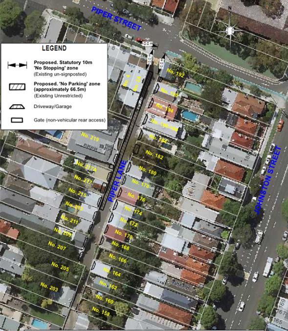
CONCLUSION
The proposed ‘No Stopping’ and ‘No Parking’ restrictions in Piper Lane at Piper Street, Annandale were well received. All properties that responded supported the proposal and actually requested that the parking restrictions be further extended to southern sections of Piper Lane and Piper Street.
The feedback has been considered and it recommended that the proposed ‘No Parking’ and ‘No Stopping’ restrictions shown in the revised proposal plan be approved, subject to consultation with affected properties including those that were not originally consulted with rear boundaries in Piper Lane.
|
|
Local Traffic Committee Meeting 4 August 2016 |
Subject: Piper Lane (North of Rose Street), Annandale -
No Stopping Restrictions
(Leichhardt/Balmain)
File Ref: 16/6022/85201.16
Prepared By: Khanh Nguyen - Traffic and Parking Engineer, Leichhardt
Authorised By: Peter Gainsford - Director, Major Projects and Engineering
|
SUMMARY Concerns have been raised with vehicles parking too close to the intersection of Piper Lane at Rose Street, Annandale. In order to alleviate this issue it is proposed to signpost the statutory 10m ‘No Stopping’ zones on both sides of Piper Lane, north of Rose Street. |
|
RECOMMENDATION
THAT: 1. a 10m ‘No Stopping’ zone be installed on the western side of Piper Lane, north of Rose Street; and 2. a 10m ‘No Stopping’ zone be installed on the eastern side of Piper Lane, north of Rose Street.
|
BACKGROUND
Concerns have been raised regarding vehicles obstructing manoeuvring space caused by vehicles parking too close to the intersection of Piper Lane, north of Rose Street, Annandale.
In order to alleviate this issue it is proposed to signpost the statutory 10m ‘No Stopping’ zones on both sides of the intersection.
CONSULTED PROPOSAL
PUBLIC CONSULTATION
A letter outlining the above parking proposal was mailed out to the affected properties (2 properties) in Weynton Street and Johnston Street as indicated on the following plan, requesting residents’ views regarding the proposal.
One response was received objecting to the proposal.
The objection is due to the perceived loss of on-street parking spaces used by local residents. However, it should be noted that under the NSW Road Rules, it is illegal to park within 10 metres of an intersection without traffic lights, unless permitted parking control signs state otherwise.
CONCLUSION
Despite the objection received from the consultation the proposed 10m ‘No Stopping’ restrictions on both sides of Piper Lane north of Rose Street, Annandale are statutory as per NSW Road Rules therefore it is recommended for installation.
|
|
Local Traffic Committee Meeting 4 August 2016 |
Subject: Piper Lane (South of Weynton Street),
Annandale - No Stopping and No Parking Restrictions
(Leichhardt/Balmain)
File Ref: 16/6022/85207.16
Prepared By: Khanh Nguyen - Traffic and Parking Engineer, Leichhardt
Authorised By: Peter Gainsford - Director, Major Projects and Engineering
|
SUMMARY Concerns have been raised with vehicles parking too close to the intersection of Piper Lane at Weynton Street, Annandale. In order to alleviate this issue it is proposed to signpost the statutory 10m ‘No Stopping’ zone on the western side of Piper Lane, south of Weynton Street. A further request to install ‘No Parking’ restrictions on the side boundary of the subject property is also being recommended as a revised proposal.
|
|
RECOMMENDATION
THAT:
1. a 10m ‘No Stopping’ zone be installed on the western side of Piper Lane, south of Weynton Street; and
2. a ‘No Parking’ zone be installed on the western side of Piper Lane following south of the proposed 10m ‘No Stopping’ zone to cover the side boundary of No. 1 Weynton Street (approximately 24m).
|
BACKGROUND
Concerns have been raised regarding vehicles obstructing manoeuvring space caused by vehicles parking too close to the intersection on the western side of Piper Lane, south of Weynton Street, Annandale.
In order to alleviate this issue it is proposed to signpost the statutory 10m ‘No Stopping’ zone at the intersection. There are existing ‘No Stopping’ and ‘No Parking’ zones on the eastern side of Piper Lane, south of Weynton Street.
Council originally consulted a proposal to install statutory 10m ‘No Stopping’ zone on the western side of Piper Lane, south of Weynton Street, as shown in the following consulted proposal plan.
The consulted proposal was supported and the resident of the subject property (No. 1 Weynton Street) has requested further ‘No Parking’ restrictions along the side boundary of the property due to parked vehicles in the Piper Lane obstructing garage access. A revised proposal plan considering this feedback is being recommended for approval by the Traffic Committee.
CONSULTED PROPOSAL
PUBLIC CONSULTATION
A letter outlining the above parking proposal was mailed out to the affected properties (4 properties) in Weynton Street and Johnston Street as indicated on the following plan, requesting residents’ views regarding the proposal.
Two responses were received supporting the proposal.
No. 1 Weynton Street requested that the signposting of the proposed ‘No Stopping’ zone not to be installed directly in front of the properties side window as 10m indicates. The respondent also requested ‘No Parking’ restrictions along the side of the property up to the side garage access due to accessibility issues.
The signposting location concern will be noted when installing the signage and a revised proposal recommending the installation of ‘No Parking’ restrictions following the statutory ‘No Stopping’ zone will be presented at the Traffic Committee Meeting.
|
REVISED PROPOSAL
Based on the consultation feedback with a request for ‘No Parking’ restrictions following the proposed statutory ‘No Stopping’ restrictions, a revised proposal plan has been prepared below:
|
CONCLUSION
The subject property has requested further ‘No Parking’ restrictions along its side boundary. It is noted that due to the narrow width of the lane, vehicles parked on the western side would obstruct through traffic.
The feedback has been considered and it recommended that a 24m ‘No Parking’ zone be included with the statutory ‘No Stopping’ restrictions as shown in the revised proposal plan to be approved by the Traffic Committee.
|
|
Local Traffic Committee Meeting 4 August 2016 |
Subject: Trafalgar Lane, Annandale - No Parking
Restrictions
(Leichhardt/Balmain)
File Ref: 16/6022/85211.16
Prepared By: Khanh Nguyen - Traffic and Parking Engineer, Leichhardt
Authorised By: Peter Gainsford - Director, Major Projects and Engineering
|
SUMMARY Concerns have been raised by two neighbouring residents that are frequently unable to access their rear garage in Trafalgar Lane due to obstructions from parked vehicles opposite the garages. ‘No Parking’ restrictions are being proposed to alleviate this problem. |
|
RECOMMENDATION
THAT a 12m ‘No Parking’ zone be installed in Trafalgar Lane, at the rear boundary of No. 165 Trafalgar Street, Annandale.
|
BACKGROUND
Trafalgar Lane is a narrow lane running parallel between Nelson Street and Trafalgar Street, Annandale. Trafalgar Lane provides rear access to Nelson Street and Trafalgar Street properties’ off-street parking spaces with only a few property frontages.
There have been concerns raised in the past with vehicles parking in Trafalgar Lane and obstructing access to properties rear garages. However, the issue was not addressed due to the lack of support from residents for full time ‘No Parking’ restrictions for consecutive properties.
Recently two neighbouring properties at No.192 and No.194 Nelson Street have written to Council both requesting and supporting the installation of ‘No Parking’ restrictions opposite their rear boundaries to prevent parked vehicles blocking access to their garages. Hence, the proposed 12m ‘No Parking’ zone at the rear of No.165 Trafalgar Street is being recommended for approval by the Traffic Committee.
FINANCIAL IMPLICATIONS
Nil.
OFFICER COMMENTS
Nil.
PUBLIC CONSULTATION
A letter outlining the above parking proposal was mailed out to the affected properties (5 properties) in Nelson Street, Trafalgar Street and Trafalgar Lane as indicated on the following plan, requesting residents’ views regarding the proposal.
No responses were received regarding the proposal.
CONCLUSION
The proposed ‘No Parking’ restriction at the rear of No.165 Trafalgar Street, Annandale will alleviate the problem with parked vehicles obstructing access to the rear garages of No.192 and No.194 Nelson Street as requested and supported by the neighbouring properties. The consultation received no objections (responses); therefore, it is recommended that the proposed ‘No Parking’ restrictions be approved by the Traffic Committee.
|
|
Local Traffic Committee Meeting 4 August 2016 |
Subject: Minor Traffic Facilities (Leichhardt/Balmain)
File Ref: 16/6022/85214.16
Prepared By: Manod Wickramasinghe - Traffic and Parking Engineer, Leichhardt
Authorised By: Peter Gainsford - Director, Major Projects and Engineering
|
SUMMARY This report deals with minor traffic facility applications received by Inner West Council, Leichhardt and includes ‘Disabled Parking’ and ‘Works Zones’.
|
|
RECOMMENDATION
THAT:
1. the ‘Disabled Parking’ space in College Street, on the side boundary of No.50 Curtis Road, Balmain be removed as it is no longer required;
2. the ‘Disabled Parking’ space outside No.24 Springside Street, Rozelle be removed as it is no longer required;
3. the ‘Disabled Parking’ space in front of No.48 Mort Street, Balmain be removed as it is no longer required;
4. the ‘Disabled Parking’ space in College Street, outside No.14 Cambridge be removed as it is no longer required;
5. the ‘Disabled Parking’ space in College Street, on the side boundary of No.50 Curtis Road, Balmain be removed as it is no longer required;
6. a 3.2m ‘Disabled Parking’ zone (45 degree angle parking) be installed outside No. 309 Annandale Street, Annandale;
7. a 9m 'Works Zone 7.00am - 5.00pm Mon-Fri, 7.00am - 1.00pm Sat' be installed in Little Darling Street, Balmain on the rear boundary of No.366C Darling Street for 4 weeks; and
8. a 9m 'Works Zone 7.00am - 5.00pm Mon-Fri, 7.00am - 1.00pm Sat' be installed across the frontage of No.25 Ennis Street, Balmain for 12 weeks.
|
BACKGROUND
This report deals with minor traffic facility applications received by Inner West Council, Leichhardt and includes ‘Disabled Parking’ and ‘Works Zones’.
FINANCIAL IMPLICATIONS
Nil.
OFFICER COMMENTS
1 Removal of ‘Disabled Parking’ Restriction – College Street, Balmain
Council Ref: DWS 3719857
Council has been informed that the applicant to the ‘Disabled Parking’ zone on the side boundary of No.50 Curtis Road, Balmain (in College Street) has moved and thus the ‘Disabled Parking’ zone is no longer required. The applicant has confirmed they have moved.
Officer’s recommendation
That the ‘Disabled Parking’ space in College Street, on the side boundary of No.50 Curtis Road, Balmain be removed as it is no longer required.
2 Removal of ‘Disabled Parking’ Restriction – Springside Street, Rozelle
Council has been informed by the family of the applicant to the ‘Disabled Parking’ zone outside No.24 Springside Street, Rozelle that the applicant has passed away and thus the ‘Disabled Parking’ zone is no longer required.
Officer’s recommendation
That the ‘Disabled Parking’ space outside No.24 Springside Street, Rozelle be removed as it is no longer required.
3 Removal of ‘Disabled Parking’ Restriction – 48 Mort Street, Balmain
Council Ref: DWS 3804090
Council has been informed that the applicant to the ‘Disabled Parking’ zone in front of No.48 Mort Street, Balmain has moved and thus the ‘Disabled Parking’ zone is no longer required.
Officer’s recommendation
That the ‘Disabled Parking’ space in front of No.48 Mort Street, Balmain be removed as it is no longer required.
4 Removal of ‘Disabled Parking’ Restriction – Cambridge Street, Rozelle
Council Ref: DWS 3721469
Council has been informed that the applicant to the ‘Disabled Parking’ zone outside No.14 Cambridge Street, Rozelle has passed away and thus the ‘Disabled Parking’ zone is no longer required.
Officer’s recommendation
That the ‘Disabled Parking’ space in Cambridge Street, outside No.14 Cambridge be removed as it is no longer required.
5 Removal of ‘Disabled Parking’ Restriction – Emma Street, Leichhardt
Council Ref: DWS 3775473
Council has been informed that the applicant to the ‘Disabled Parking’ zone outside No.1A Emma Street, Leichhardt has moved and thus the ‘Disabled Parking’ zone is no longer required.
Officer’s recommendation
That the ‘Disabled Parking’ space in Emma Street, outside No.1A Emma Street, Leichhardt be removed as it is no longer required.
6 Installation of Disabled Parking restriction – Annandale Street, Annandale
Council Ref: DWS 3788670, DPZ/2016/9
The resident of No.309 Annandale Street, Annandale has requested the installation of a ‘Disabled Parking’ zone in front of the resident’s property.
A site investigation has revealed that the property does have off-street parking. However, to access the off-street parking the resident has to travel approximately 40m and 17 steps to access the facility. Currently the off-street space is not used as it is too difficult.
The applicant does not require the use of a wheelchair.
Officer’s Recommendation:
That a 3.2m ‘Disabled Parking’ zone (45 degree angle parking) be installed outside No. 309 Annandale Street, Annandale.
7 Installation of Works Zone restriction – Little Darling Street, Balmain
Council Ref: DWS 3840093, WZ/2016/19
The applicant has requested the installation of a temporary 9m 'Works Zone 7.00am - 5.00pm Mon-Fri, 7.00am - 1.00pm Sat' in Little Darling Street, Balmain on the rear boundary of No.366C Darling Street for 4 weeks.
Officer’s recommendation
That a 9m 'Works Zone 7.00am - 5.00pm Mon-Fri, 7.00am - 1.00pm Sat' be installed in Little Darling Street, Balmain on the rear boundary of No.366C Darling Street for 4 weeks.
8 Installation of Works Zone restriction – Ennis Street, Balmain
Council Ref: DWS 3841028, WZ/2016/20
The applicant has requested the installation of a temporary 9m 'Works Zone 7.00am - 5.00pm Mon-Fri, 7.00am - 1.00pm across the frontage of No.25 Ennis Street, Balmain for 12 weeks.
Officer’s recommendation
That a 9m 'Works Zone 7.00am - 5.00pm Mon-Fri, 7.00am - 1.00pm Sat' be installed across the frontage of No.25 Ennis Street, Balmain for 12 weeks.
|
|
Local Traffic Committee Meeting 4 August 2016 |
Subject: Norton Street, Leichhardt - Temporary
Installation of a Parklet
(Leichhardt Ward/Balmain/Glebe)
File Ref: 16/6022/85904.16
Prepared By: Jason Scoufis - Team Leader Traffic, Leichhardt
Authorised By: Peter Gainsford - Director, Major Projects and Engineering
|
SUMMARY Council’s Economic Development Officer has requested that a parklet be installed in Norton Street for a period of 2 months. It is recommended that it be supported. |
|
RECOMMENDATION
THAT that the installation of a Parklet for a 2 month period on the eastern side of Norton Street in front of No. 39 Norton Street be supported.
|
BACKGROUND
Council’s Economic Development Officer has received funding to rent a parklet for a 12 month period to promote free Wi-Fi and Mainstreet revitalization and has requested that it be installed in Norton Street, Leichhardt for a period of 2 months as the first location within the Inner West Council.
A parklet, as detailed below is a removable structure made from recycled shipping containers which is installed on road in the kerbside parking thereby providing additional seating space for shoppers.
The picture below shows details of the parklet.
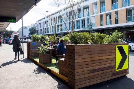
The proposed parklet was previously installed in Glebe Point Road, Glebe in 2015 after support was received from the City of Sydney’s September 2015 Local Pedestrian, Cycling and Traffic Calming Meeting.
The parklet has dimensions 6m long, 2.4 metres wide and 1.2 metres high.
The proposed kerbside location (see image below) is on the eastern side of Norton Street selected, has a length of 11.2 metres (two spaces). It is signposted ‘2P Ticket 8am-6pm Mon-Sat, 8am – 10pm Sunday, Permit Holders Excepted Area L3’ and is bounded on each end by an on-street tree planter bed. The parklet has been located away from driveways to minimise any concerns with sight lines. The regulatory signposted will be covered temporarily for the two month occupation period of the parklet.
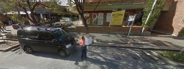
FINANCIAL IMPLICATIONS
The cost of the 12 month rental is $10,000 plus moving costs. Funding is available within the current Leichhardt Economic Development Budget.
PUBLIC CONSULTATIONConsultation with the local businesses regarding the proposal has been undertaken by Council’s Economic Development Officer with no objections raised.
CONCLUSION
It is recommended that the installation of a Parklet for a 2 month period on the eastern side of Norton Street in front of No.39 Norton Street be approved.
|
|
Local Traffic Committee Meeting 4 August 2016 |
Subject: Angelini Avenue & Woodlark Street, Rozelle
- Extension to Existing RPS Time & Day Restrictions
(Balmain/Balmain)
File Ref: 16/6022/85910.16
Prepared By: Khanh Nguyen - Traffic and Parking Engineer, Leichhardt
Authorised By: Peter Gainsford - Director, Major Projects and Engineering
|
SUMMARY A petition was received from residents of Angelini Avenue and Woodlark Street to extend the existing time and day restrictions on the existing 2P Resident Parking Scheme to 10pm and 7 days respectively. |
|
RECOMMENDATION
THAT the existing resident parking restrictions of ‘2P 8am-6pm Mon-Fri Permit Holders Excepted Area R1’ on both sides of Angelini Avenue (west of Woodlark Street) and both sides of Woodlark Street, Rozelle be converted to ‘2P 8am-10pm (7 Days) Permit Holders Excepted Area R1’.
|
BACKGROUND
Council received a petition requesting that the existing resident permit parking restrictions be extended to 10pm and 7 days a week over the existing 8am-6pm Mon-Fri restrictions to provide better parking opportunities for properties with no off-street parking in the high demand area.
The proposal was initially consulted in May 2016 and reported to the Traffic Committee on 2nd June 2016 with the recommendation that the proposal was not to proceed due to the lack of support required to warrant the proposed changes. Since the June Traffic Committee meeting, Council has received sufficient support (over 50%) from the affected properties to warrant the original proposal as requested.
PROPOS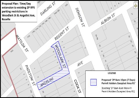 AL
AL

PUBLIC CONSULTATION
|
A letter outlining the above parking proposal was mailed out to the affected properties (15 properties) in Denison Street, Woodlark Street, Cook Street, Padstow Street and Foucart Street as indicated on the following plan, requesting residents’ views regarding the proposal.
Initially from the consultation sent out in May 2016, three responses were received, with two supporting the proposal and one objecting. Therefore, it did not have the over 50% support required to recommend the proposed time and day restriction to the existing RPS. |
|
|
RESULTS
Council has since received more support (in writing) from the affected consulted properties after the Traffic Committee’s recommendation was reported to the head petitioner.
There are now nine (9) affected properties in support, thus warranting the proposal as indicated on the following plan (highlighted properties are in support).
Note that no responses were received from the remaining affected six (6) properties and one property that originally objected to the proposal has since changed their decision and has confirmed their support. |
|
CONCLUSION
Following the additional responses and confirmation received by Council in support of the proposed extension to time and day restrictions (to 10pm and 7 Days respectively) which has raised the support rate to over 50%, meeting the requirement for change under Council’s RPS policy. Therefore, it is recommended that the existing RPS restrictions in Angelini Avenue and Woodlark Street be converted to ‘2P 8am-10pm (7 Days) Permit Holders Excepted Area R1’.
|
|
Local Traffic Committee Meeting 4 August 2016 |
Subject: Fowler Street, Hill Street & Mackenzie
Street, Leichhardt - Resident (Permit) Parking Scheme Restrictions
(Leichhardt/Balmain)
File Ref: 16/6022/85921.16
Prepared By: Khanh Nguyen - Traffic and Parking Engineer, Leichhardt
Authorised By: Peter Gainsford - Director, Major Projects and Engineering
|
SUMMARY Council has received numerous requests for a resident parking scheme (RPS) to be implemented in Hill Street and Mackenzie Street to deter long stay parking from non-residents following the recently installed RPS restrictions in the nearby Waratah Street, Leichhardt. |
|
RECOMMENDATION
THAT: 1. a ‘2P, 8am-6pm, Mon-Fri, Permit Holders Excepted, Area L1’ restrictions be installed on both sides of Fowler Street, Leichhardt; 2. A ‘2P, 8am-6pm, Mon-Fri, Permit Holders Excepted, Area L1’ restrictions be installed on northern side of Hill Street, Leichhardt between Balmain Road and Mackenzie Street; 3. A ‘2P, 8am-6pm, Mon-Fri, Permit Holders Excepted, Area L1’ restrictions be installed on southern side of Hill Street, Leichhardt between Balmain Road and Unnamed laneway (adjacent 36th Battalion Park); 4. A ‘2P, 8am-6pm, Mon-Fri, Permit Holders Excepted, Area L1’ restrictions be installed on western side of Mackenzie Street between Annesley Street and Hill Street; 5. A ‘2P, 8am-6pm, Mon-Fri, Permit Holders Excepted, Area L1’ restrictions be installed on eastern side of Mackenzie Street between Hill Street and Fowler Street; 6. Angled Parking on one side of Coleridge Street, Leichhardt between Fowler Street and Styles Street be investigated; and 7. Statutory 10m ‘No Stopping’ restrictions be installed on Balmain Road north of the intersection of Annesley Street, Leichhardt.
|
BACKGROUND
A number of residents in Hill Street and Mackenzie Street have requested the implementation of Resident Parking Scheme (RPS) restrictions in their street to deter long stay parking from non-residents and in some areas to deter boat and trailer parking. The demand for a RPS has increased due to the recently installed 2P RPS restrictions in Waratah Street in February.
There is a considerable parking demand generated from residents, commuters, employees and customers from the nearby College and businesses, etc. It is expected that surroundings streets would be affected by RPS restrictions and there would be demand from residents of nearby streets, if only one street or section was consulted. There have also been past investigations into RPS restrictions in surrounding streets such as Annesley Street and Coleridge Street which did not proceed due to either low parking occupancy levels (under 85%) or lack of support from residents. Therefore, Council is using this opportunity to consult on a holistic resident parking scheme engaging all surrounding streets to determine whether there would be enough support for a RPS within the subject area.
Consulted Proposal
Parking occupancy surveys undertaken in Hill Street and Mackenzie Street has indicated high parking occupancy levels.
Council officers undertook parking occupancy surveys in Hill Street, Mackenzie Street and also nearby streets and the results indicated that only some streets experience high occupancy levels. As the introduction of Resident Parking restrictions in one street could cause parking impacts in nearby streets, all residents within the area as shown were consulted in the proposal below, that have unrestricted parking, to assess their views on parking conditions in their streets. The subject streets included:
· Hill Street (Balmain Road – Catherine Street)
· Mackenzie Street (Leichhardt Street – Moore Street)
· Annesley Street
· Milton Street
· Fowler Street
· Coleridge Street
Some sections within the streets above are being left unrestricted to provide a balance between restricted and unrestricted parking and also due to the narrow road width.
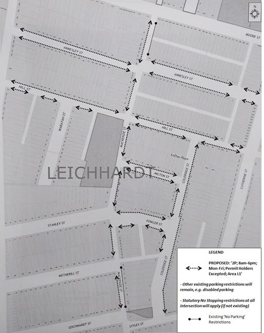
PUBLIC CONSULTATION
A RPS questionnaire was mailed out to the affected properties (311 properties) in Annesley Street, Balmain Road, Catherine Street, Coleridge Street, Fowler Street, Hill Street, Mackenzie Street, Milton Street and Moore Street as indicated on the following plan, requesting residents’ views on a proposed Resident Parking Scheme in their street.
|
The main concerns raised by some residents regarding the proposal are summarised as follows: |
|||||||||||||||||||||||||||||||||||||||||||||||||||||||||||||||||||||||||||||||||||||||||||||||||||||||||||||||||||||||||||||||||||||||||||||||||||||||||||||
|
Residents’ Response: |
Officer’s Comment: |
||||||||||||||||||||||||||||||||||||||||||||||||||||||||||||||||||||||||||||||||||||||||||||||||||||||||||||||||||||||||||||||||||||||||||||||||||||||||||||
|
· Could Council consider angle parking nose to kerb in the wider part of Coleridge? |
The wider section of Coleridge Street is between Fowler Street and Styles Street. Council can investigate the feasibility of angled parking on one side of Coleridge Street in this section subject to compliance with Council’s Angled Parking Policy which has minimum road width and traffic volume requirements to instigate consultation on a proposal. |
||||||||||||||||||||||||||||||||||||||||||||||||||||||||||||||||||||||||||||||||||||||||||||||||||||||||||||||||||||||||||||||||||||||||||||||||||||||||||||
|
· Coleridge Street is not affected by these parking complaints and I do not think this is the correct way of reducing cars parking in the inner west. Residents on Hill St were aware of the restrictions to the street parking when they purchased or leased their properties. Is this not just a way for council to get more revenue from their local areas? |
The objective of the Resident Parking Scheme is to manage the limited on-street parking amongst all road users and aid residential properties that do not have off-street parking spaces. There have also been requests for RPS in Coleridge Street in the past not just Hill Street in particular and Council is using this opportunity to consult/include surrounding streets to gauge their support due to the domino effect that RPS could have on surrounding streets. |
||||||||||||||||||||||||||||||||||||||||||||||||||||||||||||||||||||||||||||||||||||||||||||||||||||||||||||||||||||||||||||||||||||||||||||||||||||||||||||
|
· Nine similar responses: Daytime parking is not the issue. Night time parking is. Some houses have up to 3 vehicles and don't use their off-street parking. If all other streets vote in favour of RPS then by default we will be forced to have to follow as well, as cars will overflow into our street. |
The request for investigations into a RPS came from more than 3 residents which is the minimum requirement to instigate the investigations. Parking utilisation surveys shows that there are high parking rates in a few of the surrounding streets and instead of consulting just one street, it was an opportunity to engage surrounding streets on whether they would support RPS restrictions in their street. Under Council’s Parking Permit conditions in line with RMS’s guidelines, properties within the RPS restrictions are able to apply for a maximum of two resident parking permits minus one for each off-street parking space available to the property, plus one visitor parking permit. This will encourage residents to use their on-site parking facility. |
||||||||||||||||||||||||||||||||||||||||||||||||||||||||||||||||||||||||||||||||||||||||||||||||||||||||||||||||||||||||||||||||||||||||||||||||||||||||||||
|
· I also think there is a need for "No Standing" restrictions on the western side of Mackenzie Street between Stanley St and Hill Street, it's too narrow. |
Council will investigate this separately and will report back to the Traffic Committee if necessary. Currently both sides of Mackenzie Street between Stanley Street and Hill Street are unrestricted and despite being narrow, there have been no safety issues raised with Council about parking there. |
||||||||||||||||||||||||||||||||||||||||||||||||||||||||||||||||||||||||||||||||||||||||||||||||||||||||||||||||||||||||||||||||||||||||||||||||||||||||||||
|
· Five similar responses: I am concerned that implementation of the scheme will result in non-permit holders parking in adjacent non restricted areas, particularly the laneways between Mackenzie St and Coleridge St, and the laneway between Fowler St and Styles St. Our garage and that of many other residents of these streets opens into these lanes and I am concerned that access to the garage will be restricted by parked cars. |
There is a potential with the RPS restrictions vehicles will attempt to park in the narrow laneways at the rear of the subject streets. These laneways are very narrow with multiple driveways in them making it illegal to park, as it is an offence to park or obstruct driveways or park in a manner that does not retain at least a 3m gap for passing traffic. Residents can call Council to report any illegal parking activity in the laneways. Council can also investigate the matter separately if it is a reoccurring problem. |
||||||||||||||||||||||||||||||||||||||||||||||||||||||||||||||||||||||||||||||||||||||||||||||||||||||||||||||||||||||||||||||||||||||||||||||||||||||||||||
|
· I don't understand why there are some areas e.g. end of Coleridge Street near Hill Street, where the parking will not apply. Living on Fowler St near Coleridge St, I am concerned that the existing trucks, utes, trailers, wood chipping machines, personal vehicle etc will just continue to park there, despite the residence they belong to having 2 unused garages. So it feels like the plan is stacked to help that one resident who uses 8 car spaces on the road, but not use their garage. If you're going to be fair, then be fair and make the whole street the same. I strongly object if the whole of Coleridge St is not on restricted parking. |
This section of Coleridge Street was left unrestricted as either the side boundary of properties or the rear of properties. When RPS restrictions are introduced Council tends to look for areas that can be left unrestricted to cater for residents that may be compromised due to reduced permit eligibility of RPS. Notwithstanding, Council can reconsider the proposal upon request after seeing the impact of the RPS if approved. |
||||||||||||||||||||||||||||||||||||||||||||||||||||||||||||||||||||||||||||||||||||||||||||||||||||||||||||||||||||||||||||||||||||||||||||||||||||||||||||
|
· Three similar responses: I have a driveway and off-street parking that is only usable for small narrow vehicles i.e. too small to comply with current parking standards. Furthermore, there is the inequality of visitor parking permits: because I have 2 or more sub-standard size non-compliant off-street spaces. |
The off-street parking facility available at the property will need to be inspected and assessed by a Council officer and if deemed too small, it will be excluded if it as an off-street parking space and increase the resident parking permit eligibility by one, up to a maximum two permits only. |
||||||||||||||||||||||||||||||||||||||||||||||||||||||||||||||||||||||||||||||||||||||||||||||||||||||||||||||||||||||||||||||||||||||||||||||||||||||||||||
|
· I have suggested previously ‘No Stopping’ signs similar to those in Hill St as turning right or left out of Annesley St is somewhat fraught due to traffic approaching Balmain Road, one can be stuck across the road. |
There is an existing 10m ‘No Stopping’ zone on Balmain Road, south of Annesley Street. Council will notify affected properties for the installation of 10m ‘No Stopping’ zone on Balmain Road north of Annesley Street. |
||||||||||||||||||||||||||||||||||||||||||||||||||||||||||||||||||||||||||||||||||||||||||||||||||||||||||||||||||||||||||||||||||||||||||||||||||||||||||||
|
· If there are costs associated with obtaining a resident's permit, then we would want to reconsider our support for this initiative. Please could you clarify how the visitor's passes should be used? Our main problem is that the 4 townhouses next door to us in Milton Street mostly have 2 vehicles but don't use their garages. If this scheme goes ahead they would receive 1 RPS and 1 Visitor pass so I assume they would just use the Visitor pass for their second vehicle therefore not really solving the problem. |
Currently, resident and visitor parking permits do not incur fees for ex-Leichhardt areas of the amalgamated Inner West Council. Under Council’s parking permit eligibility, properties within a RPS can obtain a maximum of two resident parking permits minus one for each off-street parking space, plus one visitor parking permit. Currently, ex-Leichhardt visitor parking permit are transferable permits with the same expiry as resident parking permits, which could be unintendedly used as a permit for an additional car. This current feature of the visitor parking permit maybe reviewed long term as part of a new Inner West Council Parking Permit policy. Parking permits are not issued to subdivided properties (including townhouses) after January 2001. No.15 and No.11 Milton Street are townhouses were approved after January 2001, therefore if a RPS is approved residents from these properties would not be eligible for any parking permits. |
||||||||||||||||||||||||||||||||||||||||||||||||||||||||||||||||||||||||||||||||||||||||||||||||||||||||||||||||||||||||||||||||||||||||||||||||||||||||||||
|
· Two similar responses: There is limited parking in our area for residents, but our main concern is that we have neighbours deliberately using up street parking with dingies, boats and caravans. Restricting parking will not solve this problem. Boats and caravans constantly parked in the street without moving and taking up car spaces should be looked into. |
If the RPS is approved and implemented this will also cause boats and caravans to move as these vehicles are not eligible for parking permits under Council’s Permit conditions. However, if it does not proceed Council can investigate installing other parking restrictions. |
||||||||||||||||||||||||||||||||||||||||||||||||||||||||||||||||||||||||||||||||||||||||||||||||||||||||||||||||||||||||||||||||||||||||||||||||||||||||||||
|
· We bought this property in Coleridge Stret because it had off-street parking and a 10m frontage giving 4 vehicle spaces. We have 3 but under RPS we can only use our 2 x off-street parking spaces so we would be worst off. |
The amended proposal excludes Coleridge Street from the Resident Parking Scheme, therefore Coleridge Street will remain unrestricted and will not affect you. |
||||||||||||||||||||||||||||||||||||||||||||||||||||||||||||||||||||||||||||||||||||||||||||||||||||||||||||||||||||||||||||||||||||||||||||||||||||||||||||
|
· You could look at Hill Street and implement some areas where there should be no parking as it can be difficult to see around intersections and pass cars coming in the opposite direction. |
Council is aware of the narrowness of Hill Street and considerd that the proposed RPS restrictions if implemented may alleviate the problem with vehicles parking in pinch point areas. If it is still a reoccurring problem Council can investigate ‘No Parking’ restrictions in appropriate areas. |
||||||||||||||||||||||||||||||||||||||||||||||||||||||||||||||||||||||||||||||||||||||||||||||||||||||||||||||||||||||||||||||||||||||||||||||||||||||||||||
|
RESULT / ANALYSIS |
|||||||||||||||||||||||||||||||||||||||||||||||||||||||||||||||||||||||||||||||||||||||||||||||||||||||||||||||||||||||||||||||||||||||||||||||||||||||||||||
|
|||||||||||||||||||||||||||||||||||||||||||||||||||||||||||||||||||||||||||||||||||||||||||||||||||||||||||||||||||||||||||||||||||||||||||||||||||||||||||||
|
REVISED PROPOSAL
Based on the analysis and the feedback from consultation, the Resident Parking Restrictions have been revised as shown in the following revised proposal plan.
|
|||||||||||||||||||||||||||||||||||||||||||||||||||||||||||||||||||||||||||||||||||||||||||||||||||||||||||||||||||||||||||||||||||||||||||||||||||||||||||||
CONCLUSION
According to Council’s policy on Resident Parking, a minimum of 50% support from the properties in the subject section of the street is required for consideration to implement a RPS.
Based on the above results, Fowler Street, sections of Hill Street (west), and sections of Mackenzie Street indicated the minimum 50% support for a Resident Parking Scheme in those streets. Therefore, it is recommended that Resident Parking Scheme (RPS) restrictions as shown in the revised proposal plan be approved for implementation.
|
|
Local Traffic Committee Meeting 4 August 2016 |
Subject: Cohen Park, Annandale - Parking and Traffic
Study
(Balmain Ward/Balmain/Glebe)
File Ref: 16/6022/85255.16
Prepared By: Jason Scoufis - Team Leader Traffic, Leichhardt
Authorised By: Peter Gainsford - Director, Major Projects and Engineering
|
SUMMARY In response to residential concerns highlighted during community engagement, a parking and traffic study during the peak winter sporting season has been carried out to ascertain if any improvements in traffic management are needed to ensure children’s safety when accessing and exiting the park.
|
|
RECOMMENDATION
THAT the report be received and noted.
|
BACKGROUND
Leichhardt Council at its Ordinary Meeting held on 25th August 2015 considered a report which granted a licence permit for the provision for private tennis coaching for primary aged children at Cohen Park, Annandale.
In considering the report, Council recommended in part:
“In response to residential concerns highlighted during the community engagement process Council undertake a parking and traffic study during the peak winter sporting season to ascertain if any improvements in traffic management are needed to ensure children’s safety when accessing and exiting the park.”
Council staff undertook observations, park user engagement and parking occupancy surveys on the following three days in the study area shown below:
· Saturday, 25th June 2016
· Wednesday, 29th June 2016
· Sunday , 3rd July 2016
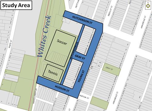
It should be noted that on the Saturday, no formal soccer games were played.
A number of parents and coaches were interviewed and site observations detailed the following issues:
· Minimal usage of the two on- street disabled parking spaces in Hudson Street adjacent to the tennis courts
· Soccer Balls being kicked onto Hutchinson Lane and children running onto road to get the ball
· Sight lines being restricted between right turning vehicles from Gray Street into Hutchinson Lane and southbound vehicles in Hutchinson Lane being severely restricted due to vehicles parking on western side of laneway near intersection and foliage at the intersection
· Illegal parking within the ‘No Parking’ Zone on the western side of Hutchinson Lane, north of Gray Street
· Garbage bins in laneway reduce the available width for vehicular traffic
· People walk in the middle of the laneway due to a lack of footpath
· Parking within statutory unsignposted ‘No Stopping’ zones
In regards to traffic speeds, no vehicles were observed to be speeding or undertaking unsafe movements.
The parking occupancy data is detailed below:
|
SATURDAY 25TH June 2016 |
WEDNESDAY 29TH JUNE 2016 |
SUNDAY 3RD JULY 2016 |
|||||||||
|
8am |
10am |
12 noon |
5PM |
6PM |
7PM |
8PM |
8am |
10am |
12 noon |
||
|
Study Area |
Occupied Spaces |
78 |
69 |
65 |
71 |
76 |
78 |
86 |
84 |
106 |
97 |
|
Occupancy (% age) |
66% |
58% |
55% |
60% |
64% |
66% |
72% |
71% |
89% |
82% |
|
|
Vacant Spaces |
41 |
50 |
54 |
48 |
43 |
41 |
33 |
35 |
13 |
22 |
|
The occupancy surveys indicate that a total of 119 spaces are available within close proximity to the park and that at peak parking occupancy, which occurs at 10am on a Sunday 13 spaces were available (89% occupancy). This is near capacity; however, it drops off to 82% occupancy where 19 spaces were available at 12 noon. The data indicates that during weekday night training there is still significant parking available with a maximum parking occupancy of 72%.
FINANCIAL IMPLICATIONS
Nil.
OFFICER COMMENTS
In order to prevent children from chasing the soccer ball onto Hutchinson Lane, Council’s Parks Coordinator, Leichhardt has been requested to investigate the installation of fencing behind the goal posts at the northern field which will prevent this from occurring in the future. It should be noted that similar fencing has recently been installed behind the goal posts at the southern field.
An instruction has been issued for an additional repeater sign ‘No Parking (l +r)’ in the area of Hutchinson Lane where illegal parking was observed during training and on game day i.e. within the 20 metre ‘No Parking Zone’ on the western side, north of Gray Street. Note that this does not impact on parking.
An instruction has been issued to Council’s Parks Technical Officer to arrange trimming of the foliage to improve sight lines on the north-eastern corner of Hutchinson Lane and Gray Street.
Whist the parking surveys indicate limited use of the disabled parking spaces, they are required to meet Australian Standard requirements.
PUBLIC CONSULTATION
On-site discussions have been held with soccer coaches, tennis coaches and parents during the parking occupancy surveys and observations.
|
|
Local Traffic Committee Meeting 4 August 2016 |
Subject: 29 Station Street, Newtown - Proposed
Childcare Centre
(Stanmore Ward/Newtown)
File Ref: 16/6022/82297.16
Prepared By: Emilio Andari - Civil Engineer, Marrickville
Authorised By: Wal Petschler - Manager Design and Investigation, Marrickville
|
SUMMARY A Development Application has been received to demolish the existing building and to construct a 3 storey building with basement parking and use the premises as a childcare centre for 80 children at 29 Station Street, Newtown.
Comments of the Local Traffic Committee will be referred to Council’s Development Assessment Section for consideration in determining the Development Application. |
|
RECOMMENDATION
THAT the report be received and noted.
|
BACKGROUND
This development application is required to be referred to the Local Traffic Committee for consideration under State Environmental Planning Policy (Infrastructure) 2007.
FINANCIAL IMPLICATIONS
Nil.
OFFICER COMMENTS
Site location & road network
|
Street Name |
Station Street |
Wilford Street |
Wilford Lane |
|
Subject Section |
Between Enmore Road and Wilford Street |
Between Gladstone Street and Station Street |
Between Station Street and Wilford Street |
|
Carriageway Width (m) |
10.3 |
11.3 |
3.0 |
|
Carriageway Type |
Two-way road with one travel lane in each direction, in addition to kerbside parking lane along both sides of the road. |
Two-way road with one travel lane in each direction, in addition to kerbside parking lane along both sides of the road. |
Two-way road with one travel lane in each direction, there are no kerbside parking lanes along both sides of the road. |
|
Classification |
Local |
Local |
Local |
|
85th Percentile Speed (km/h) |
– |
– |
– |
|
Vehicles Per Day (vpd) |
– |
– |
– |
|
Reported Crash History (2010-2014) |
No crashes recorded. |
No crashes recorded. |
No crashes recorded. |
|
Heavy Vehicle Volume (%) |
– |
– |
– |
|
Parking Arrangements |
Unrestricted parking on both sides of the road. |
Unrestricted parking on the northern side and ‘1P 6pm-10pm Permit Holders Excepted Area M3’ restrictions on the southern side |
‘No Parking’ restrictions on both sides of the road. |
The proposed development site is located on the south-western corner of Wilford Street and Station Street, Newtown. Surrounding land uses comprise a mixture of residential single-dwelling properties, industrial/business properties and mixed-use multi storey buildings that are all located within close proximity to the subject site. It should be noted that there are several mixed-use apartment buildings within close proximity to the subject site along Wilford Street and Gladstone Street as well as businesses along Enmore Road. The subject site is currently a two-storey commercial building with an existing driveway crossing located in Station Street (refer to the attached locality map and photographs).
Locality map – 29 Station Street, Newtown
N
![]()

|

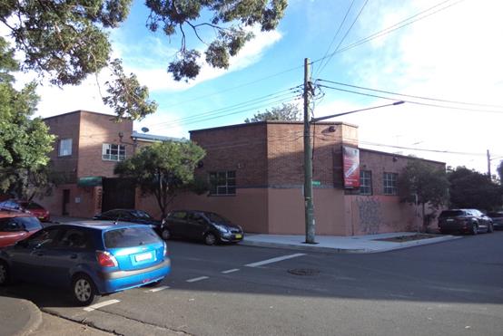
Station Street & Wilford Street at the subject site
Proposed development
The proposed development application is for the approval to construct a 3 storey building with a single level of basement parking and use the premises as a childcare centre for 80 children at 29 Station Street, Newtown. It is proposed that the existing driveway crossing currently located in Station Street will be removed and replaced with footpath, kerb and gutter. It is proposed that a new driveway crossing will be constructed in Wilford Street near the north-western corner of the building site with the provision of 10 on-site car parking spaces. The proposed hours of operation of the childcare centre are from 7.00am to 6.00pm on weekdays only (refer to the attached development plans).
Public transport
The subject site has access to public transport services with Newtown Railway Station being located approximately 300 metres east from the site, and bus routes (Route 355, 423, 426, 428 and M30) operating along Enmore Road located approximately 50 metres south from the site.
Parking provision
Council's DCP 2011 (incorporating Amendment No.1) requires provision of off-street parking as follows for Parking Area 1:
1 car parking space per 50m2 Gross Floor Area (GFA).
Therefore, the proposed development having a total GFA of 592m2 should provide a total of 12 off-street car parking spaces.
Council's DCP 2011 requires the provision of off-street bicycle parking for a child care centre as follows:
1 bicycle parking space per 20 staff for staff + 2 for customers.
Therefore, the proposed development having 13 staff members should provide a total of 3 off-street bicycle parking spaces as follows:
- 1 space for staff bicycle parking, and
- 2 spaces for parents and carers bicycle parking.
It is proposed that 4 on-site car parking spaces will be designated for the use of the childcare centre for staff parking and 6 on-site car parking spaces (1 mobility parking space inclusive) for drop-off and pick-up and visitor parking. This proposal leaves a shortfall of 2 off-street car parking spaces. The proposal does not consider the provision for any bicycle parking spaces. It should be noted that Council's DCP 2011 requires motorcycle parking to be provided at a rate of 5% of the car parking required for the development therefore, the provision of 1 motorcycle parking space for the child care centre is required. The proposal does not consider the provision for any motorcycle parking spaces.
The applicant proposes to make up for the short fall in parking by providing 10 minute parking restrictions between 7:00am-6:00pm on weekdays. The applicants proposal is for 4 on-street parking spaces (at the frontage to the site on Station Street) to be used for drop-off and pick-up.
With the addition of 4 on-street parking spaces, it meets the parking provision of the proposal according to Council’s DCP 2011 however site inspections were undertaken by a Council Officer during the afternoon period of a typical weekday and it was observed that on-street parking spaces in Station Street, Wilford Street and Gladstone Street were highly utilised.
Council's DCP 2011 states that assessing development applications for child care centres are a special case due to the high number of car trips generated for a short duration at drop off and pick up times, and the particular safety issues involved with young children around cars. It may be appropriate that the pickup/drop-off area be provided on the street however given that observations show that on-street parking is highly utilised and that the on-site parking arrangement will result in a short fall and will in turn mean a greater demand for on-street parking.
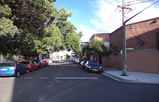
Existing on-street parking along Station Street
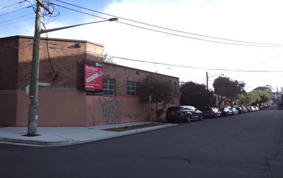
Existing on-street parking along Wilford Street
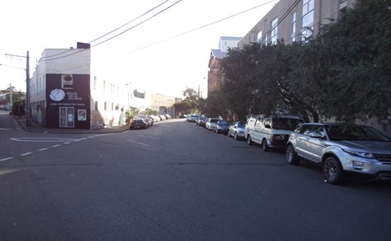
Existing on-street parking along Gladstone Street
Vehicular Access, waste management (collection) & internal traffic circulation
Proposed vehicular access to the off-street parking spaces will be from a proposed driveway via Wilford Street, Newtown. The proposed driveway is to be 5.5m wide, in addition to a 300mm wide kerb on either side of the ramp, which is adequate in accordance with Clause 2.5.2 of AS2890.1:2004. Waste collection for the proposed childcare centre will be combined with the existing council arrangements for servicing the adjacent residences of Wilford Street. The internal layout for manoeuvring allows for vehicles to enter and exit the site in a forward direction and is considered to be satisfactory however the internal parking layout arrangement was found unacceptable in its current form. A childcare centre has one of the highest parking turnover rates of any other land use and parking space width is wider than a longer stay parking space.
Table 1.1 of AS2890.1:2004 assigns a user class 3 for facilities with high parking turnover and therefore the car parking space size and parking aisle combination must be in accordance with Figure 2.2 of AS2890.1:2004. Figure 2.2 provides for user class 3 spaces for 90 degree angle parking with a car parking space width of 2.6m with an aisle width of 5.8m. The current aisle width is 6.0m with a proposed car parking space width of 2.6m for visitors and 2.4m for staff. It should also be noted that the proposed parking layout consists of 6 stacked car parking spaces (4 staff parking spaces and 2 visitor parking spaces). Stacked parking is problematic and it is uncertain how this will work effectively. More clarification is required on how this will work without resulting in vehicles being parked in.
Estimated traffic generation
The applicant's traffic consultant report stated that the total estimated traffic generation from the proposed child care centre would be would be 32 vehicle trips per hour (morning peak) and 28 vehicle trips per hour (early evening peak). These estimated traffic generation rates are considered to be acceptable and can be accommodated with the surrounding road network.
PUBLIC CONSULTATION
Consultation/notification regarding the proposal would normally be undertaken by Council's Development and Planning Services as part of the development application process.
CONCLUSION
It is proposed that the following traffic related comments be forwarded to Council’s Development Assessment section.
Based on the information presented in the applicant’s submission to Council with regards to the internal parking layout, it is acknowledged that these issues will result in a greater short fall in on-site parking which will in turn need to be accommodated on-street. It means the Development Application proposal has a shortfall of 17% in parking spaces and this directly impacts on-street parking which is highly utilised.
Due to the shortfall in on-site parking and internal parking layout the applicant needs to review the parking provision for on-site parking for the proposed childcare centre at 29 Station Street, Newtown to meet the requirements of Council’s DCP 2011 and to review the on-site parking layout to meet the requirements of AS2890.1:2004.


|
|
Local Traffic Committee Meeting 4 August 2016 |
Subject: 308-314 Stanmore Road, Petersham - Proposed
Mixed Use Development
(Stanmore Ward/Newtown)
File Ref: 16/6022/83558.16
Prepared By: Emilio Andari - Civil Engineer, Marrickville
Authorised By: Wal Petschler - Manager Design and Investigation, Marrickville
|
SUMMARY A Development Application has been received to demolish part of the existing premises and carry out alterations and additions to convert the existing residence into a 13 room hotel with a ground floor café and florist.
Comments of the Local Traffic Committee will be referred to Council’s Development Assessment Section for consideration in determining the Development Application. |
|
RECOMMENDATION
THAT the report be received and noted. |
BACKGROUND
This development application is required to be referred to the Local Traffic Committee for consideration under State Environmental Planning Policy (Infrastructure) 2007.
FINANCIAL IMPLICATIONS
Nil.
OFFICER COMMENTS
Site location & road network
|
Street Name |
Stanmore Road |
Albert Street |
|
Subject Section |
Between Crystal Street and Enmore Road |
Between Stanmore Road and Addison Road |
|
Carriageway Width (m) |
13.0 |
11.5 |
|
Carriageway Type |
Two-way road with one travel lane in each direction, in addition to kerbside parking lanes along sections of both sides of the road. |
Two-way road with one travel lane in each direction, in addition to kerbside parking lanes along both sides of the road. |
|
Classification |
State |
Local |
|
85th Percentile Speed (km/h) |
– |
50.4 |
|
Vehicles Per Day (vpd) |
– |
1225 |
|
Reported Crash History (July 2010 – June 2015) |
12 crashes recorded. Rum Codes: 11(3), 21(5), 32, 37, 13, 99. Crashes resulted in either injury or tow-away. |
No crashes recorded. |
|
Heavy Vehicle Volume (%) |
– |
3.4 |
|
Parking Arrangements |
‘Clearway 6am-10am Mon-Fri’ restrictions on the northern side and ‘Clearway 3pm-7pm Mon-Fri’ restrictions on the southern side. Sections of ‘No Parking’ restrictions along the southern side (adjacent to subject site).
|
Unrestricted parking on both sides of the road. |
The proposed development site is located on the south-eastern corner of Stanmore Road and Albert Street, Petersham and is adjacent to residential properties on Albert Street and a fruit market on Stanmore Road. Surrounding land uses comprise a mixture of residential single-dwelling properties, industrial/business properties, All Saints Anglican Church and Maundrell Park that are all located within close proximity to the subject site. The subject site is a residential building with two existing driveway crossings located on Stanmore Road and Albert Street. The site is listed as a heritage item under Marrickville Local Environment Plan (MLEP) 2011 (refer to the attached locality map and photographs).
Locality map – 308-314 Stanmore Road, Petersham
![]()
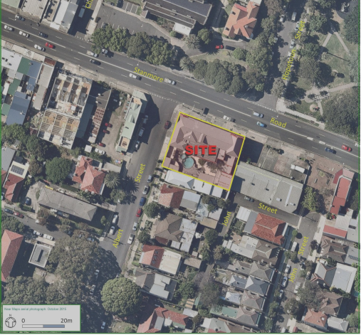
|

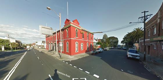
Stanmore Road & Albert Street at the subject site
Proposed development
The proposed development application is for the approval to demolish part of the existing premises and carry out alterations and additions to convert the existing residence into a 13 room hotel with a ground floor café and florist. It is proposed that the existing driveway crossing currently located in Albert Street will be removed and replaced with footpath, kerb and gutter. It is proposed that the other existing driveway crossing located in Stanmore Road will remain and be used as ‘drop-off and pick-up’ area given that the existing parking restrictions along the southern side of Stanmore Road are ‘Clearway 3pm-7pm Mon-Fri’ & ‘No Parking’ restrictions (refer to the attached development plans).
Public transport
The subject site has access to public transport services with Petersham Railway Station being located approximately 500 metres north-west from the site, and bus routes (Route 412, 428, 444 and 445) operating along Crystal Street and Addison Road located approximately 250 metres north-west and 400 metres south from the site, respectively.
Parking provision
Council's DCP 2011 (incorporating Amendment No.1) requires provision of off-street parking as follows for Parking Area 2:
1 car parking space per 4 staff for staff + 1 car parking space per 3 units for residents
The proposed hotel with a total of 13 rooms and 3 staff members should provide a total of 5 off-street car parking spaces.
1 car parking space per 80m2 GFA for customers & staff
The proposed retail businesses having a combined GFA of 150m2 for the Florist, Café & Functions Rooms should provide a total of 2 off-street car parking spaces.
Therefore, a total of 7 car parking spaces should be provided on-site.
Council's DCP 2011 requires the provision of off-street bicycle parking for the hotel and retail businesses as follows:
1 bicycle parking space per 20 units or rooms for staff & patrons
The proposed hotel with a total of 13 rooms should provide a total of 1 off-street bicycle parking space.
1 per 300 m2 GFA for staff + 1 per 500m2 GFA for customers if premises over 1000m2 GFA
The proposed retail businesses having 150m2 GFA should provide a total of 1 off-street bicycle parking space.
Therefore, a total of 2 bicycle parking spaces should be provided on-site.
Council's DCP 2011 requires the provision of off-street service vehicle (delivery) parking for the hotel and retail businesses as follows:
One service vehicle space per 50 bedrooms or bedroom suites up to 200 plus one space per 100 thereafter plus one space per 1,000m2 of public area set aside for bar, tavern, lounge and restaurant (50% of spaces adequate for trucks)
The proposed hotel with a total of 13 rooms and 86m2 GFA for the public area should provide a total of 1 service vehicle parking space.
One truck space per 400m2 GFA up to 2,000m2 GFA plus one truck space per 1,000m2 thereafter (all spaces adequate for trucks)
The proposed retail businesses with a total 78m2 GFA for the Florist and Café should provide a total of 1 service vehicle parking space.
In this case it would be reasonable to expect that one on-site loading zone space is provided for both uses.
It should be noted that Council's DCP 2011 requires motorcycle parking to be provided at a rate of 5% of the car parking required for the development therefore, given that there is a requirement of 7 car parking spaces, no provision for motorcycle parking spaces is required.
The proposal does not consider the provision for any car parking spaces nor any service vehicle spaces. This proposal leaves a shortfall of 7 off-street car parking spaces and a shortfall of 1 service vehicle spaces. The proposal does consider the provision for bicycle parking and provides 2 bicycle parking spaces in the courtyard.
The applicant proposes to make up for the short fall in service vehicle parking by requesting the provision of a ‘Loading Zone’ for the length of approximately 1 car parking space on the eastern side of Albert Street adjacent to the proposed site and immediately south of Stanmore Road. The applicant’s proposal is for 1 on-street parking space to be used as a ‘Loading Zone’.
A site inspection was undertaken by a Council Officer during the afternoon period of a typical weekday and it was observed that on-street parking spaces in Albert Street and Stanmore Road were highly utilised. It should be noted that there is limited on-street parking along Stanmore Road due to ‘No Parking’ restrictions within close proximity to a signalised intersection (Stanmore Road and Crystal Street) and ‘Clearway’ restrictions during the morning and afternoon peak periods.
The short fall of parking will increase parking pressures within the surrounding local streets, such as Albert Street. Recently, Council has undertaken a parking study within the precinct (Petersham Parking Study) and identified a number of local streets which currently experience a high demand for parking. Albert Street was identified as one of these streets. The parking utilisation survey results are listed with identified streets that consist of utilisation rates of more than 85% for periods longer than 3 hours of a typical day.
The Development Application proposal has a shortfall of 100% in off-street parking spaces and this directly impacts on-street parking which is highly utilised. Furthermore, on-street loading zones are typically provided for situations where a number of businesses can benefit from the zone rather than standalone situations. As part of any new development, it would be expected that the provision for loading and unloading is made on-site rather than on-street.
Estimated traffic generation
The applicant's traffic consultant report stated that the estimated traffic generation from the proposed hotel with 13 rooms would be 5 vehicle trips per peak hour and the estimated traffic generation from the proposed retail businesses with GFA of 150m2 would be 5 vehicle trips per peak hour. Therefore, the total estimated traffic generation from the proposed hotel and retail development would be 10 vehicle trips per peak hour. These estimated traffic generation rates are considered to be acceptable and can be accommodated with the surrounding road network.
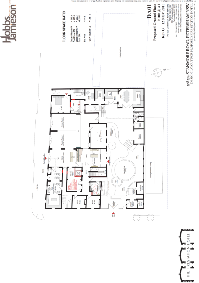
PUBLIC CONSULTATION
Consultation/notification regarding the proposal would normally be undertaken by Council's Development and Planning Services as part of the development application process.
CONCLUSION
It is proposed that the following traffic related comments be forwarded to Council’s Development Assessment section.
There is a shortfall in on-site parking when assessed against Council’s DCP. The applicant needs to review the on-site parking provision for the proposed hotel and retail development at 308-314 Stanmore Road, Petersham in order to meet the requirements of Council’s DCP 2011.
|
|
Local Traffic Committee Meeting 4 August 2016 |
Subject: (Former) Ashfield LGA Traffic Management Strategy (Ashfield/Liechhardt Ward)
File Ref: 16/6022/85151.16
Prepared By: James Brocklebank - Traffic Officer, Ashfield
Authorised By: Davide Torresan - A/Senior Engineer, Ashfield
|
SUMMARY Council has engaged consultants GTA Consulting to prepare a Traffic Management Strategy for the (former) Ashfield LGA. After public exhibition and stakeholder review the Traffic Management Strategy has now been finalised and is presented to the Traffic Committee for consideration. It is recommended that the strategy be adopted and the 10 year Action Plan noted. A copy of the completed Strategy has been circulated separately to voting members as a pdf. |
|
RECOMMENDATION
THAT: 1. the Traffic Management Strategy for the (former) Ashfield LGA be supported in Principle with items listed in the Action Plan to be the subject of detailed investigation and further reporting through the Traffic Committee, where necessary, prior to implementation; and 2. the 10 year Action Plan list be noted and updated annually or as required to allow new traffic management and road safety issues to be captured. The Action Plan to rank items utilising the scoring system identified in this report to prioritise measures for future implementation in line with available funding.
|
BACKGROUND
Consultants engaged by Council have prepared a draft Traffic Management Strategy for the (former) Ashfield LGA. The purpose of the Traffic Strategy Project is:
“to develop a strategic framework and action plan for the safe and convenient movement of
vehicular traffic across the (former) Ashfield Council Area. This framework and action plan will provide council with a systematic and comprehensive approach to manage all traffic related issues varying from controlling speeds to easing traffic congestion.”
The Ashfield Traffic Management Strategy (ATMS) is primarily focused on how vehicular traffic should be safely and efficiently managed on the local road network (i.e. roads under Council control). Earlier this year a PAMP Study was prepared which addresses pedestrian amenity and management issues while bicycle related works are addressed by Council’s Bike Plan which will be reviewed in the coming year. In this regard, the ATMS has provided the following key outputs:
· Outline of the current State and Council transport themes affecting the local road network in Ashfield, and current best practice approaches to proactively manage it
· Review and update of the road network hierarchy, and setting out the desired transport environments for each local road type.
· Identification of discontinuities between the current and desired operation of the local road network based on the updated road network hierarchy and desired transport environments
· An Action Plan setting out recommended treatments and broad costings for measures to be implemented over the next 10 years
· Concept level designs of the typical treatment types proposed
FINANCIAL IMPLICATIONS
The Traffic Strategy Action Plan details works to a value of $2.5M – $3.4M. This is a 10 year works program although this timeframe will vary depending upon funding levels allocated by Council and/or obtained from alternate funding sources such as RMS grants. Provision has been made in the operational plan for funding at a minimum of $40,000p.a for traffic management strategy actions. If additional funds are not obtained or allocated Council the 10 year target for implementation of the proposed measures will be stretched appreciably. As noted in the Traffic Strategy the project costs quoted in the Action Plan are only broad initial stage feasibility estimates and are not based upon detailed designs. Final estimated costs may vary significantly once the detailed design, consultation and estimation process has been completed.
OFFICER COMMENTS
A key part of the Strategy is the development of a plan of local road network projects for future implementation. The process/ inputs used to identify the potential projects were as follows:
· Review the provided traffic speed data to identify those that are not consistent with the revised road network hierarchy for their associated road type (daily traffic volumes and heavy vehicle proportions have already been considered in developing the updated road network hierarchy plan).
· Review of the crash data to identify locations with crash clusters/ trends that are considered able to be treated to improve the level of safety and reduce the potential of the identified crash types from occurring.
· Collate/ identify locations where significant congestion and queuing currently occurs and/or is expected to occur in the near future.
· Based on the implementation activities associated with the Ashfield Traffic Management Plan (2002), identify those projects that are still outstanding and consider against the updated road network hierarchy and desired transport environments.
· Consider Council meeting minutes and documentation prepared by the Ashfield Traffic Committee of known local road network issues.
It should be noted that the above process has been used to identify a list of local road network
projects and what key considerations need to be made to appropriately treat them.
Recommended treatments are presented in Section 5.3 of the strategy as a 10 year Action Plan
The projects listed in the Action Plan have been ranked in terms of crash data and speed by road type (see attached Prioritised Action Plan list). While this ranking is of some benefit further refinement of those rankings to take account of additional factors such as traffic volume changes, level of community concern, pedestrian and cycling usage and proximity to schools/hospitals will result in a more complete ranking of items.
It is proposed that the following ranking system be used to prioritise projects. The ranking system draws upon similar systems used by other LGA’s and captures all of the abovementioned factors but weights projects in terms of the relative importance of each factor. The highest weighting is given to accident data as crash history is the clearest indicator of a road safety issue. The lowest weighting has been given to “level of community concern”. While community concern about an issue is of great value in drawing attention to an issue it should not be the primary determining factor in the ranking process. Once the issue has been raised by the community, investigations will provide hard data on crash history, speed and volumes etc which are more useful measures by which to compare one location against others.
|
Category |
Extent of Activity |
Score |
Weight |
Max Total |
|
Accident rate over past 5 years |
High range (local >15) (collector/ arterial >30) |
4 |
12 |
48 |
|
Medium range (local 10-15) (collector/arterial 19-30) |
3 |
|||
|
low range (local 4-9) (collector/arterial 7-18) |
2 |
|||
|
Very low range (local 0-3) (collector/arterial 0-6) |
1 |
|||
|
Nil accidents |
0 |
|||
|
85Th percentile speeds above posted speed limit |
>12km/h |
3 |
4 |
12 |
|
8 to 12km/h |
2 |
|||
|
3 to 7km/h |
1 |
|||
|
<3km/h |
0 |
|||
|
Change in traffic volumes in past 5 years |
<+10% |
3 |
4 |
12 |
|
+5% to +10% |
2 |
|||
|
0 to +5% |
1 |
|||
|
<0 |
0 |
|||
|
Level of community concern |
High (high volume of written concerns over a number of years from a range of sources on precinct related issues) |
4 |
3 |
12 |
|
Medium (high number of residents on a localized issue) |
3 |
|||
|
Low (some residents) |
2 |
|||
|
Very low (one resident) |
1 |
|||
|
Pedestrian/ cycling usage |
High (adjacent to pedestrian/cycle generators eg shopping centres, cycleways) |
3 |
4 |
12 |
|
Medium |
2 |
|||
|
Low |
1 |
|||
|
Proximity to schools/hospitals |
Within 100m |
3 |
4 |
12 |
|
Within 200m |
2 |
|||
|
Within 400m |
1 |
|||
|
Beyond 400m |
0 |
|||
|
Total |
108* (adjust to percentage to given a score out of 100) |
|||
Cost of the work is not included as a factor in the ranking system. Clearly, if a project is of a high cost it may not be able to be completed if available funding is insufficient. Council will need to ensure that future funding levels are sufficient to enable completion of identified high priority works or must identify works which can achieve similar benefits at a lower cost.
In, addition, while the above ranking system can be used to prioritise projects, in practice, projects may not be completed in the order in which they are ranked for a number of reasons. For example, Council may be successful in obtaining RMS funding for a project which may mean it is completed earlier than otherwise planned, there may be community opposition to a project which may prevent it from being completed, detailed design might reveal that a project is infeasible or that alternative measures may need to be investigated.
This report with attachments will also be referred to the Local Representative Advisory Committee (LRAC) seeking its support in principle to the Traffic Management Strategy.
PUBLIC CONSULTATION
The Draft Traffic Management Strategy was placed on public exhibition for a period of 4 weeks. Key stakeholders were specifically invited to comment and the general public was invited to comment via the Have Your Say page on Council’s website. Submissions received were considered by the consultants however the only change made to the strategy following the Have Your Say process was to remove a proposed speed hump at No.93 Church Street, Croydon.
CONCLUSION
The Ashfield Traffic Management Strategy has been finalised and is submitted to the Committee with a recommendation that it be supported in principle and used as a basis for detailed design investigations and future funding applications in regard to the recommended Action Plan items.
The ranking system outlined in this report is proposed as a means of prioritizing individual projects in terms of their importance in addressing the identified road safety and traffic management issues highlighted through the Strategy process.
|
1.⇩ |
Prioritised Action Plan List with Separate Attached Draft (former Ashfield Council) Traffic Management Strategy |