|
AGENDA R |

Local Traffic Committee Meeting
THURSDAY 2 MARCH 2017
10:00am
Background
Roads and Maritime Services (RMS) is legislated as the Authority responsible for the control of traffic on all NSW Roads. The RMS has delegated certain aspects of the control of traffic on local roads to councils. To exercise this delegation, councils must establish a local traffic committee and obtain the advice of the RMS and Police. The Inner West Council Local Traffic Committee has been constituted by Council as a result of the delegation granted by the RMS pursuant to Section 50 of the Transport Administration Act 1988.
Role of the Committee
The Local Traffic Committee is primarily a technical review and advisory committee which considers the technical merits of proposals and ensures that current technical guidelines are considered. It provides recommendations to Council on traffic and parking control matters and on the provision of traffic control facilities and prescribed traffic control devices for which Council has delegated authority. These matters are dealt with under Part A of the agenda and require Council to consider exercising its delegation.
In addition to its formal role as the Local Traffic Committee, the Committee may also be requested to provide informal traffic engineering advice on traffic matters not requiring Council to exercise its delegated function at that point in time, for example, advice to Council’s Development Assessment Section on traffic generating developments. These matters are dealt with under Part C of the agenda and are for information or advice only and do not require Council to exercise its delegation.
Committee Delegations
The Local Traffic Committee has no decision-making powers. The Council must refer all traffic related matters to the Local Traffic Committee prior to exercising its delegated functions. Matters related to State Roads or functions that have not been delegated to Council must be referred directly to the RMS or relevant organisation.
The Committee provides recommendations to Council. Should Council wish to act contrary to the advice of the Committee or if that advice is not supported unanimously by the Committee members, then the Police or RMS have an opportunity to appeal to the Regional Traffic Committee.
Committee Membership & Voting
Formal voting membership comprises the following:
· one representative of Council as nominated by Council;
· one representative of the NSW Police from each Local Area Command (LAC) within the LGA, being Newtown, Marrickville, Leichhardt and Ashfield LAC’s.
· one representative from the RMS; and
· State Members of Parliament (MP) for the electorates of Summer Hill, Newtown, Heffron, Canterbury, Strathfield and Balmain or their nominees.
Where the Council area is represented by more than one MP or covered by more than one Police LAC, representatives are only permitted to vote on matters which effect their electorate or LAC.
Informal (non-voting) advisors from within Council or external authorities may also attend Committee meetings to provide expert advice.
Committee Chair
Council’s representative will chair the meetings.
Public Participation
Members of the public or other stakeholders may address the Committee on agenda items to be considered by the Committee. The format and number of presentations is at the discretion of the Chairperson and is generally limited to 3 minutes per speaker. Committee debate on agenda items is not open to the public.
|
|
Local Traffic Committee Meeting 2 March 2017 |
|
AGENDA |
1 Apologies
2 Disclosures of Interest
3 Confirmation of Minutes
4 Matters Arising from Council’s Resolution of Minutes
5 Part A – Items Where Council May Exercise Its Delegated Functions
Traffic Matters Page
T0317 Item 1 Simmons
Street, Newtown - Proposed Kerb Extension Design Plans
(Stanmore Ward/Newtown Electorate/Newtown LAC) 5
T0317 Item 2 Introduction
of Roundabout at Intersection of Smith, Edward and Chapman Streets and Median
Island in Smith Street, Summer Hill - Condition of Development Application -
Nos.2-32 Smith Street, Summer Hill - Former Allied (Flour) Mills Site
(Ashfield Ward/Summer Hill Electorate/Ashfield LAC) 11
T0317 Item 3 Rowntree
Street at Curtis Road, Balmain - Raised Pedestrian Crossing
(Balmain Ward/Balmain Electorate/Leichhardt LAC) 24
T0317 Item 4 Balmain
Road at Stanley Street, Leichhardt - Speed Cushions on approach to Pedestrian
(Zebra) Crossing
(Leichhardt Ward/Balmain Electorate/Leichhardt LAC) 27
T0317 Item 5 Whites
Creek Lane and Macquarie Street, Leichhardt - ‘Proposed 10km/h Shared
Zone’
(Leichhardt & Balmain Wards/Balmain Electorate/Leichhardt LAC) 30
T0317 Item 6 Darling
Street between Mort Street and Curtis Road, Balmain - Road Occupancy - Anzac
Day Dawn Service
(Leichhardt Ward/Balmain Electorate/Leichhardt LAC) 33
T0317 Item 7 Addendum to Lewisham LATM Traffic Committee Report 40
Parking Matters
T0317 Item 8 Minor
Traffic Facilities
(Leichhardt Ward/Balmain Electorate/Leichhardt LAC) 44
T0317 Item 9 Requests
for Mobility Parking Spaces
(Stanmore & Marrickville Wards/Heffron, Summer Hill & Newtown
Electorates/Marrickville & Newtown LACs) 46
T0317 Item 10 Proposed
‘No Stopping’ and 'No Parking' Restrictions to be Installed -
Various Locations
(Stanmore & Marrickville Wards/Newtown & Summer Hill Electorates/Newtown
& Marrickville LACs) 56
T0317 Item 11 Modification
of Short Term Parking Restriction - 67 Denison Street, Rozelle
(Leichhardt & Balmain Wards/Balmain Electorate/Leichhardt LAC) 60
T0317 Item 12 93
Smith Street, Summer Hill - Proposed "No Parking - Australia Post Vehicles
Excepted"
(Ashfield Ward/Summer Hill Electorate/Ashfield LAC) 62
T0317 Item 13 Changes to Parking in Beach Street and Kintore Street, Dulwich Hill 66
Parking Matters (Cont’d) Page
T0317 Item 14 Longport
Street, Lewisham - Proposed No Parking & No Stopping Restrictions
(Stanmore Ward/Summer Hill Electorate/Marrickville LAC) 68
T0317 Item 15 Improving
Cyclist and Pedestrian Access in Cardigan Lane, Camperdown
(Stanmore Ward/Newtown Electorate/Newtown LAC) 73
T0317 Item 16 Improving
Garbage Truck Access in Oxford Street, Newtown
(Stanmore Ward/Newtown Electorate/Newtown LAC) 75
Late Items
Nil at time of printing.
6 Part B – Items for Information Only
T0317 Item 17 Pedestrian
Infrastructure Safety around Schools Program - Project Funding Notification
From RMS
(Various Wards/Various Electorates/Various LACs) 77
7 Part C – Items for General Advice
T0317 Item 18 2/32-72
Alice Street, Newtown - Proposed Childcare Centre
(Stanmore Ward/Newtown Electorate/Newtown LAC) 85
T0317 Item 19 Railway
Parade, Marrickville - Proposed Temporary Road Closure for Two Special Events
on Friday 14 April 2017 and Saturday 15 April 2017
(Marrickville Ward/Summer Hill Electorate/Marrickville LAC) 94
T0317 Item 20 Christian
Brothers High School - Section 96 Amendment to Development Consent DA200300504
dated 3 June 2004 - 68-84 The Boulevarde, Lewisham
(Stanmore Ward/Summer Hill Electorate/Marrickville LAC) 104
8 General Business
9 Close of Meeting
|
|
Local Traffic Committee Meeting 2 March 2017 |
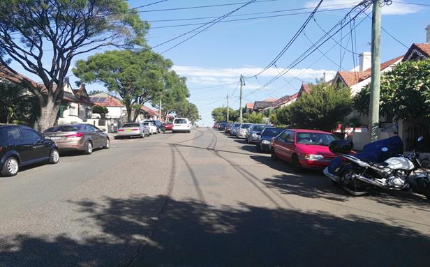
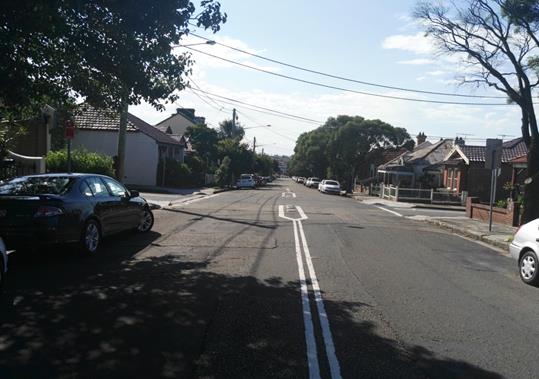
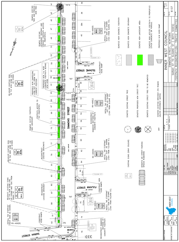
Subject: Simmons Street, Newtown - Proposed Kerb
Extension Design Plans
(Stanmore Ward/Newtown Electorate/Newtown LAC)
File Ref: 17/6022/18801.17
Prepared By: Emilio Andari - Civil Engineer
Authorised By: Joe Di Cesare - Manager Design and Investigation
|
SUMMARY A detailed design plan has been finalised for the proposed traffic calming improvements in Simmons Street, Newtown as part of Council’s Capital Works Program for Footpaths. The proposal for a kerb extension with a new kerb alignment and associated signs will improve pedestrian safety and traffic conditions at this location. |
|
RECOMMENDATION
THAT the detailed design plan of the kerb extension with a new kerb alignment and associated signs in Simons Street, Newtown between Sarah Street and property no. 41 Simmons Street (as per the attached design plan No. 6137) be APPROVED.
|
BACKGROUND
One of the key objectives from Council’s Community Strategic Planning document is to provide accessible and well connected footpaths, cycleways and associated facilities. The objective is to be achieved through reduced impact of traffic and improvement of pedestrian and cyclist safety, particularly around schools and urban centres.
Council is proposing to reconstruct the footpath along Simmons Street, Newtown and have integrated a kerb extension with a new kerb alignment and associated signs.
The detail design plan has been finalised for the proposed devices together with the consultation and are presented in this report for consideration.
FINANCIAL IMPLICATIONS
Funding of $120,000 has been allocated by Council for the entire scope of works for Simmons Street under the 2016/2017 Capital Works Program for Footpaths. These works include reconstructing the footpath in Simmons Street (including a new kerb alignment, new footpath trees with landscaped verges and new kerb ramps) between Sarah Street and Pemell Street.
OFFICER COMMENTS
Site location & road network
|
Street Name |
Simmons Street |
|
Section |
Between Enmore Road and Sarah Street |
|
Carriageway Width (m) |
9.2 |
|
Carriageway Type |
Two-way road with one travel lane in each direction, in addition to kerbside parking lanes. |
|
Classification |
Local |
|
85th Percentile Speed (km/h) |
40.3 |
|
Vehicles Per Day (vpd) |
806 |
|
Reported Crash History (July 2011 - June 2016) |
No crashes recorded. |
|
Heavy Vehicle Volume (%) |
2.6 |
|
Parking Arrangements |
Western side of the road consists of ‘1P 6pm-10pm Permit Holders Excepted Area M3’. Eastern side of the road consists of unrestricted parking. |
Design plans
The proposed scope of work includes the following:
· Reconstruct the footpath on both sides of Simmons Street, Newtown between Sarah Street and property no. 41 Simmons Street with a kerb extension on the western side of Simmons Street and provide five new kerb ramps with landscaped verges and two new footpath trees.
· Install five new ’No Stopping’ signs at the intersections of Simmons Street with Fulham Street, Sloane Street and Sarah Street to discourage illegal parking on the corners and to improve sight lines and turn paths for vehicles including waste collection trucks.
· Relocate the existing ‘No Stopping’ sign on the western side of Simmons Street out front of property no. 91 Simmons Street to be placed behind the proposed kerb extension to discourage vehicles parking within 10 metres of the intersection and to improve sight lines and turn paths for vehicles including waste collection trucks.
It should be noted that the original proposal consisted of a ‘No Parking’ zone out front of property no. 77 & 79 Simmons Street to allow for a passing bay for motorists when there are instances with oncoming vehicles. Following community consultation and reviewing the detail design plan with the traffic data for the street, it was found that the passing bay was not necessary as there are another two proposed passing bays within close proximity (approximately 40m away from one another) included in the proposal.
The proposed treatment will not result in the loss of legal on-street parking spaces in Simmons Street (refer to the attached design plan No. 6137). All current vehicular access to adjoining properties will be retained.
PUBLIC CONSULTATION
Consultation was conducted and letters were distributed mid December 2016. The consultation period closed early February 2017. A letter as well as a copy of the design plan was sent to the local residents in Simmons Street. Council’s ‘Have Your Say’ website link was included in the letter for electronic submissions during the consultation period. A total of 143 letters were distributed. There were eight (8) responses opposing the proposal and one (1) response supporting the proposal received and are detailed below.
|
Residents’ Comments opposing the proposal |
Officer’s Response |
|
A resident of the local community is opposed to the proposal due to the belief that there is a loss of parking. Concerns were raised regarding how difficult it is to find available on-street parking within the area.
|
The western side of Simmons Street consists of ‘1P 6pm-10pm Permit Holders Excepted Area M3’ which allows local residents to park their vehicles in this zone who hold a parking permit. The existing permit parking scheme should provide better parking opportunities for the local residents. The design plan illustrates the inclusion of statutory ‘No Stopping’ restrictions at the intersection of Simmons Street and Fulham Street, Simmons Street and Sloane Street, and Simmons Street and Sarah Street in order to deter illegal parking, improve access for turning motorists and increase safety. It should be noted that this will not result in the loss of legal on-street parking spaces in Simmons Street. The proposed ‘No Parking’ zone out front of property no. 77 & 79 Simmons Street has been amended in the final design plan to remain with its current parking conditions. |
|
A resident of the local community is concerned about the loss of parking and suggests that Council should propose angle parking in the adjacent street. |
The width of Simmons Street is not sufficient for the provision of angle parking whilst retaining parking on the opposite side of the roadway. A minimum road width of 12.8m is required. |
|
A resident of the street is opposed to the proposal due to the belief that there is a loss of parking particularly at the intersections. Concerns were raised regarding the ‘No Stopping’ within 10 metres of an intersection.
|
The design plan illustrates the inclusion of statutory ‘No Stopping’ restrictions at the intersection of Simmons Street and Fulham Street, Simmons Street and Sloane Street, and Simmons Street and Sarah Street in order to deter illegal parking, improve access for turning motorists and increase safety. These intersections will also act as passing areas for vehicles in the narrowed section if Simmons Street. It should be noted that this will not result in the loss of legal on-street parking spaces in Simmons Street. The proposed ‘No Parking’ zone out front of property no. 77 & 79 Simmons Street has been amended in the final design plan to remain with its current parking conditions. |
|
A resident of the street is opposed to the proposal due to the concern in traffic flow in Simmons Street and the belief that there is a loss of on-street parking. |
The design plan illustrates the inclusion of two passing bays in Simmons Street located approximately 40 metres apart from one another. Traffic volumes in Simmons are low and it unlikely that the narrowing will have any measurable affect the flow of traffic along Simmons Street. The passing bays designed into the proposal should cater for the odd occasion when two vehicles are in the same space at the same time. Narrowing the road width and widening the footpath in Simmons Street is considered as a traffic calming measure and will improve pedestrian safety. The design plan illustrates the inclusion of statutory ‘No Stopping’ restrictions at the intersection of Simmons Street and Fulham Street, Simmons Street and Sloane Street, and Simmons Street and Sarah Street in order to deter illegal parking, improve access for turning motorists and increase safety. It should be noted that this will not result in the loss of legal on-street parking spaces in Simmons Street. The proposed ‘No Parking’ zone out front of property no. 77 & 79 Simmons Street has been amended in the final design plan to remain with its current parking conditions. |
|
A resident of the street objects to the proposal with regards to the road width narrowing and to the parking restrictions at the intersections. The resident believes the traffic is high in volume and at times there is congestion particularly during evening hours when there is an event on at the Enmore Theatre. |
The design plan illustrates the inclusion of two passing bays in Simmons Street located approximately 40 metres apart from one another. Traffic volumes in Simmons are low and it unlikely that the narrowing will have any measurable affect the flow of traffic along Simmons Street. The passing bays designed into the proposal should cater for the odd occasion when two vehicles are in the same space at the same time. Narrowing the road width and widening the footpath in Simmons Street is considered as a traffic calming measure and will improve pedestrian safety. The design plan illustrates the inclusion of statutory ‘No Stopping’ restrictions at the intersection of Simmons Street and Fulham Street, Simmons Street and Sloane Street, and Simmons Street and Sarah Street in order to deter illegal parking, improve access for turning motorists and increase safety. It should be noted that this will not result in the loss of legal on-street parking spaces in Simmons Street. The proposed ‘No Parking’ zone out front of property no. 77 & 79 Simmons Street has been amended in the final design plan to remain with its current parking conditions. |
|
The resident of the street has raised concerns about the loss of parking within the street particularly with the proposed ‘No Parking’ zone out front of property no. 77 and 79. The resident also would like Council to consider that this parking space be a mobility parking space. |
The design plan illustrates the inclusion of statutory ‘No Stopping’ restrictions at the intersection of Simmons Street and Fulham Street, Simmons Street and Sloane Street, and Simmons Street and Sarah Street in order to deter illegal parking, improve access for turning motorists and increase safety. It should be noted that this will not result in the loss of legal on-street parking spaces in Simmons Street. The proposed ‘No Parking’ zone out front of property no. 77 & 79 Simmons Street has been amended in the final design plan to remain with its current parking conditions. The resident has been advised by Council officers the process for the request of a mobility parking space and that this matter will be assessed separately to this design proposal. |
|
A resident of the street objects to the narrowing of Simmons Street and the loss of parking. |
The western side of Simmons Street consists of ‘1P 6pm-10pm Permit Holders Excepted Area M3’ which allows local residents to park their vehicles in this zone who hold a parking permit. The existing permit parking scheme should provide better parking opportunities for the local residents. The design plan illustrates the inclusion of statutory ‘No Stopping’ restrictions at the intersection of Simmons Street and Fulham Street, Simmons Street and Sloane Street, and Simmons Street and Sarah Street in order to deter illegal parking, improve access for turning motorists and increase safety. It should be noted that this will not result in the loss of legal on-street parking spaces in Simmons Street. The proposed ‘No Parking’ zone out front of property no. 77 & 79 Simmons Street has been amended in the final design plan to remain with its current parking conditions. |
|
A resident of the local community is pleased with the footpath reconstruction works particularly with the landscaping landscaped verges and new footpath trees. The resident believes this will improve the streetscape amenities. |
The comments have been received and noted. |
CONCLUSION
It is recommended that the design of the proposed kerb extension and associated signs be approved, to improve pedestrian safety and traffic conditions.
|
|
Local Traffic Committee Meeting 2 March 2017 |
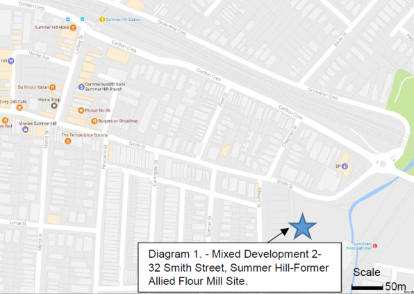
Subject: Introduction of Roundabout at Intersection of
Smith, Edward and Chapman Streets and Median Island in Smith Street, Summer
Hill - Condition of Development Application - Nos.2-32 Smith Street, Summer
Hill - Former Allied (Flour) Mills Site
(Ashfield Ward/Summer Hill Electorate/Ashfield LAC)
File Ref: 17/6022/18373.17
Prepared By: Boris Muha - Traffic and Projects Engineer
Authorised By: John Stephens - Traffic Manager
|
SUMMARY The Development Application (DA) for the former Allied Mills site, 2-32 Smith Street, Summer Hill, was approved by the Department of Planning & Infrastructure on 7 December 2012. This report seeks conditional support for the construction of a roundabout at the intersection of Smith Street/Edward Street/Chapman Street, Summer Hill and an associated median island treatment in Smith Street adjacent to the internal private road. These treatments were approved under concept. Local community consultation was carried out on the detailing of the treatments with residential issues being addressed in the report and the recommendation made below. |
|
RECOMMENDATION
THAT under the approved condition of Development Consent for the Former Allied (Flour) Mills Site 2-32 Smith Street, Summer Hill, the following traffic facilities be supported: 1. The construction of a roundabout at the intersection of Smith Street/Edward Street/Chapman Street, Summer Hill, in accordance with the attached amended plan C13.G, further to condition: a. That lighting of the roundabout is provided to Australian Standards AS/NZS 1158- “lighting for roads and public spaces”. b. That 3 resident parking spaces be allocated to the eastern side of Edward Street, south of Smith Street. 2. The construction of the median island in Smith Street at Nos.17-21 Smith Street, Summer Hill at the intersection of the new private internal road of the development, in accordance to the attached amended plan X1.C further to conditions: a. that the median island be painted with white reflective paint and 10m of double white centreline (BB) marking with associated rrpms be provided to the approaches to the median; and b. that Give-Way signs and (TB) marking and an ALL TRAFFIC LEFT sign be provided at the private road exit to Smith Street.
|
BACKGROUND
The Development Application (DA) for the former Allied Mills site, 2-32 Smith Street, Summer Hill, was approved by the Department of Planning & Infrastructure on 7 December 2012. This included the construction of a roundabout at the intersection of Smith Street/Edward Street/Chapman Street, Summer Hill, and other road works in the surrounding area.
The location of the roundabout in Smith Street/Edward Street/Chapman Street has been approved by the Department of Planning as part of the DA. Community Notification for this DA was exhibited by the Department of Planning & Infrastructure from 13 March to 30 April 2013 (48 days). Land owners were notified in writing and notification was also provided on the Department's website and Information Centre, Ashfield Council Civic Centre and at Ashfield Library.
The road and traffic calming works associated with the roundabout in Smith Edward/Chapman Streets are as follows:
· Upgrading and installing new kerb ramps at the intersection of Smith and Edward Streets, and Smith and Chapman Streets.
· Installing two new splitter islands in Edward Street and Smith Street with gaps for pedestrians.
· Re-sheeting the entire intersection with asphalt.
· Constructing a narrow median strip in Smith Street, east of Edward Street, across the new internal road into the Flour Mill development.
· Installing kerb ramps and a traffic island at the entrance of the new internal road.
· Painting associated line markings.
FINANCIAL IMPLICATIONS
All works per this report shall be constructed and funded by the developer.
OFFICER COMMENTS
The site, located at 2-32 Smith Street, Summer Hill, is for the re-development of mixed use purposes, including largely residential use and ancillary retail and commercial uses. The site is bound by Smith Street, Edward Street, Old Canterbury Road and the Light Rail Line to the east. Pedestrian access is also provided to the Lewisham West Light Rail Station.
The development is being constructed in four stages. (See diagram 2 next page)
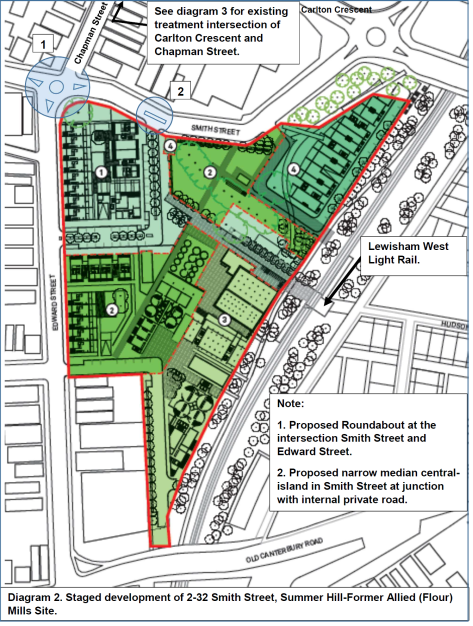
Stage 1, as located to the north-western side of the site is primarily residential development near to completion. The roundabout and associated works under DA condition of Consent are required to be constructed prior to the completion of Stage 1.
The purpose of the roundabout is to improve/enhance safety at the intersection to:
· Facilitate circulation of local traffic in the area, including that of the development.
· Traffic calm movement, and provide for pedestrian amenity/safety in the area.
· Regulate parking at the intersections of Edward /Smith Street and Chapman Street.
'No Stopping' restrictions will be introduced near the roundabout to provide visibility for motorists and pedestrians. This will result in the net loss of approximately five parking spaces, considered necessary to provide for the safe and proper operation of the roundabout, and safeguard pedestrian activity at the roundabout.
The purpose of the narrow median island in Smith Street is to restrict vehicular movements to left turn in and left turn out from the sites’ new private internal road opposite 17-19 Smith Street. The narrow central median strip at the entrance of the internal road will increase safety by reducing conflict between motorists when turning in and out of the development, and similarly reduce vehicular conflict and hazard with pedestrian activity at the intersection.
Adequate access is provided to properties on the opposite side of Smith Street.
Plan diagram 8 amended roundabout. Access for Chapman Street into roundabout. Chapman Street retained as two-way vehicular movement.
Plan Diagram No. 8A - location of legal parking spaces removed (6) and added (2).
Net loss being 4 spaces.
Plan diagram No. 9 - amended design plan of median – island in Smith Street.
PUBLIC CONSULTATION
Although the concept of the roundabout and associated works was approved by the Department of Planning, local area consultation was undertaken to gauge resident response on the detail of the design and to consider amending, if necessary, any aspects of the design of the works from any comments submitted.
An initial design proposal was put forward to construct a roundabout at the intersection of Smith Street and Edward Street, and have Chapman Street made one-way north. No entry into the roundabout would be allowed from Chapman Street.
A letter box drop was carried out to approximately 200 properties in the surrounding area, and similar information provided on Council's website. Letters were distributed around the 9 December 2016 with submissions closing on the 13 January 2017.
Eleven (11) submissions were received. From these submissions, it was identified that the majority of residents primarily objected or raised major concern to having Chapman Street made one-way and the loss of parking associated with the proposed roundabout. Concerns were also raised whether the roundabout would provide for pedestrian safety at the intersection. Pedestrian safety and property access was also questioned with the proposed median island in Smith Street.
Details of responses together with other issues are tabled, summarised and addressed below.
|
Resident submissions |
(street name) |
Oppose/concern Making Chapman Street one-way north |
Oppose/concern loss of parking due to the roundabout. |
Pedestrian safety |
Others (varied issues) |
|
1 |
Chapman |
1 |
|
|
|
|
2 |
Chapman |
1 |
1 |
|
|
|
3 |
Chapman |
1 |
1 |
|
|
|
4 |
Chapman |
1 |
1 |
|
|
|
5 |
Chapman |
1 |
1 |
1 |
1 |
|
6 |
Chapman |
1 |
|
|
|
|
7 |
Smith |
|
|
|
1 |
|
8 |
Smith |
|
|
|
1 |
|
9 |
Smith |
|
|
1 |
|
|
10 |
Spencer |
|
|
|
1 |
|
11 |
Not advised |
|
|
1 |
1 |
|
Total on issues raised |
6 |
4 |
3 |
5 |
|
Key points raised on each issue:
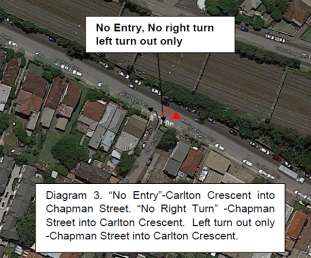
1. Oppose/concern to Chapman Street being made one way north
· Chapman Street is not one-way but two-way.
· Imposition of making Chapman Street one-way is very impractical and unacceptable.
· Residents would be forced and limited to only turn left at Carlton Crescent and re-route via Lackey Street (to the west) to access and return to Smith Street and streets to the east or south of Chapman Street, adding considerable distance to the travel and delays encountered with traffic signals and crossing along the way.
Officer’s comments:
Chapman Street is approximately 100 metres long and 7.5m wide (kerb to kerb) with parking to both sides of the street.. 2P resident parking exits on the west side and unrestricted parking on the east side. Traffic in the street is light and primarily services resident access.
A half road closure treatment in Chapman Street at the intersection of Carlton Crescent prohibits entry from Carlton Crescent and right turn movements from Chapman Street into Carlton Crescent. Left turn out movements from Chapman Street into Carlton Crescent are only permitted. This treatment has been in place and established for well over 15 years. The treatment was implemented to avoid traffic conflict and hazard at that intersection. Chapman Street has operated as a two-way street to allow residents to exit onto Smith Street.
The roundabout has been re-designed on the basis that Chapman Street is maintained as two-way traffic, and that vehicles would then be able to enter into the roundabout to access both Smith and Edward Streets. The amended plan of the roundabout is shown in Plan diagram No.8.
2. Oppose/concern to the loss of parking due to the roundabout.
· Parking in the area is of high demand.
· Developments and Floor Mill have/will increase the demand for parking.
· Loss of parking due to the roundabout is significant and not supported.
· Affects the amenity and convenience of residents to park in the area.
Officers Comments:
Approved developments are required to provide adequate off-street parking in accordance with Council and NSW Planning controls.
Council is aware and conscious of the need for parking and the amended plan has reduced the loss of parking from 5 legal parking spaces to 4 spaces and still provided for the safe and proper operation of the roundabout, and for the safe viewing and amenity for pedestrians to cross at the intersection.
This was achieved by reducing the 'No Stopping' zone on the eastern side of Chapman Street from 16 metres to 12 metres as measured from the corner (side kerbline) of Smith Street. This would then retain one legal parking space and still allow adequate give-way/bypass of vehicles between the corner of Smith Street and the driveway to No 10 Chapman Street.
This is shown superimposed on the amended roundabout plan diagram No.8A. Two (2) new spaces are created to the eastern side of Edward Street, just south of Smith Street, in a location previously occupied by a driveway serving the Floor Mill. Parking would also be freed up further along the eastern side of Edward Street once the roundabout and footpath works are complete in the area.
Council will monitor the parking post development.
3. Pedestrian Safety.
· Concern on the safety for pedestrians crossing at the intersection. Vehicles currently not yielding to pedestrians, request crossing or refuge.
· Cannot see the roundabout offering pedestrian safety. If pedestrian issue is of concern why not addressed this issue earlier in 2012.
· Can Council explain what a roundabout can do that a 40 km per hour speed limit through the area with other well placed safety measures can attain.
· Object to the proposal of the central median island in Smith Street. Concern is raised with the safety to pedestrians when crossing over the private road junction of the intersection. Suggest a raised threshold be provided across the private road junction to the intersection.
Officers Comments:
Apart from facilitating traffic circulation, traffic calming, and regulating parking, the roundabout splitter islands in Edward Street and Smith Street (east) are sufficiently widened to provide refuge to pedestrians in the middle of the road, particularly across the wide section of Edward Street. These two intersection legs will primarily assist pedestrian movement to and from Summer Hill and the Light Rail Station. Pram ramps are to be re-constructed/constructed at the Chapman Street and Smith Street (west) legs of the roundabout to facilitate crossing at these locations.
Pedestrian safety in line with the roundabout and other external road or infrastructure treatments (e.g. footpath/pram ramp improvements) is being resolved in the course of the current development as part of the DA conditions.
40 km/hr speed limit facilities are generally only provided in high pedestrian activity areas in Shopping Centres. These facilities are required with associated placement of traffic calming devices which may also entail loss of parking to accommodate these devices. The development and intersection in question is outside of the area of the Summer Hill Shopping Centre. The 40 km/hr speed limit would not extend up to the roundabout location. The roundabout provides for traffic calming and is considered to assist in line with other traffic calming devices along Smith Street.
The plan of the median island has been amended to show the removal of the triangular island and in place provide for a continuous footpath at the junction of the intersection for pedestrian safety and traffic calming. See plan diagram No.9.
4. Other issues
(Roundabout)
· Suggest minor detailed correction to roundabout- widen physical islands for improved deflection, minimise use of line marking (maintenance).
· Request for safety barrier and landscaping to the south-west corner of Edward Street and Smith Street as similar to that as existing to the corner of Nelson Street and Booth Street, Annandale. Concern is raised with westbound vehicles along Smith Street being deflected close to the south-west corner of the intersection.
· Request three resident parking spaces be re-allocated to the eastern side of Edward Street to compensate for the loss of three residential parking spaces on the western side of Edward Street.
· Request pram ramp construction and signage away from the Edward Street side door entrance to 34 Smith Street.
(Median Island)
· Request to relocate the power pole outside No 21 Smith Street at least half a metre to access the property with the proposed central median- island in Smith Street going in.
· The triangular island to the private road intersection is too small. It is considered ineffective, with no influence on speed and likely to be run over.
· The central median island in Smith Street will reduce access for vehicles from No.19 and No.17 Smith Street. It should also be approximately 5.0 metres longer –to stop vehicles turning around the end of it.
(Traffic funding)
· Who is funding the works?
· There is increased traffic in Spencer Street since commencement of construction. Traffic will worsen in the area due to the roundabout. Modelling and monitoring requested. Request No Right Turn in Spencer Street during peak hours to avoid rat-running due to vehicle queuing along Smith Street. Detour should be avoided in Spencer Street during construction. Speed limits should be lowered.
Officers Comments:
The plan of the roundabout has been amended to minimise line marking and widen/extend the physical islands where possible whilst maintaining vehicle swept path and avoid the mounting of the islands. The kerb island at the eastbound approach to the roundabout in Smith Street has been widened to provide improved deflection of vehicles coming into the roundabout.
The plan of the roundabout has been amended to provide guardrail to safe guard the south- west corner of Smith Street and Edward Street with approaching westbound traffic in Smith Street. The placement of pedestrian fencing as requested is not considered appropriate as a safety barrier in this location due to the width of the footpath. It can become hazardous if damaged into the footpath. Planting, although considered, has no bearing on safety and becomes a maintenance issue and hindrance/obstruction into the footpath. No planting is considered at the south-west corner of Edward Street and Smith Street.
The re-allocation of 3 resident parking spaces to the east side of Edward Street to compensate for the loss of 3 resident parking spaces on the west side is considered reasonable under this circumstance. The signposting will be re-allocated in line with the construction of the roundabout.
The plan of the roundabout has been amended or will be provided for in final plan to off-set the pram ramp and any signage away from the Edward Street side door entrance of No.34.
No driveway application was made for No 21 Smith Street. The resident would need to approach Ausgrid if wishing to relocate the power pole. The central median island has been designed and off-set from the northern side of Smith Street approximately 4.8 metres to allow adequate access into properties adjacent to the median.
The plan of the central median island has been amended to show the removal of the triangular island and in place provide for a continuous footpath at the junction of the intersection for pedestrian safety and traffic calming.-see plan diagram 9.
The plan of the central median has been amended to extend the device further west to prevent vehicles turning around at the end.
In further to the above, it is recommended that the central median island be painted and line marking in approach to and around the island. A Give-Way control and ALL TRAFFIC LEFT sign should also be provided at the private road entry to Smith Street.
All the above works are to be constructed and funded by the developer.
Traffic generation of the development would have been resolved under the approval of the DA. The roundabout lends to circulate and control traffic in the area and not re-distribute traffic. The matter of construction vehicles using side streets is taken up with Council’s regulatory enforcement section in discussion with the builder. Council will be assessing Construction Traffic Management Plan applications for construction vehicle haulage routes in the next coming Stage 3 and 4 of the development. A Recommendation will be made that the side streets are not to be used for construction vehicles.
Banning turning movements in particular streets is not favoured, as this would create undesirable redistribution of traffic into other streets. The matter can be re-visited once the development is complete and once traffic patterns settle down in the area. All local streets are generally restricted to a 50km/hr speed limit under the General Urban Speed Limit in NSW, without the need of signposting. If a lowering of the speed limit is considered in the future, it would need to be discussed with RMS and meet RMS approval. Should residents consider speeding an issue post development, traffic counts can be undertaken.
A second round of consultation has been carried out to seek resident comments on the amended roundabout (as per plan diagram 8), designed on the basis that Chapman Street is maintained as two-way traffic, and that vehicles would then be able to enter into the roundabout to access both Smith and Edward Streets.
Residents in the second letter of consultation have been advised that vehicles parking on the eastern side of Chapman Street must face southbound in the direction of traffic flow as per NSW Road Rules (currently all vehicles are facing north bound on both sides of the road, contrary to NSW Road Rules). This means motorists will need to turn around to park on the eastern side of the road. If this creates difficulties Council may need to investigate a turnaround section at the northern end of Chapman Street which may result in loss of parking.
Submissions to this second round of consultation closed on the 17 February 2017.
Again 200 letters were letter boxed in the vicinity of the proposed roundabout and information placed on the website.
Nine (9) submissions were received at the date of closure. From these submissions, it was identified that the majority of residents primarily raised concern to the loss of parking associated in the construction of the roundabout. Concerns were also raised for vehicles needing to park in the correct direction, and that a turnaround area might be required in Chapman Street to maintain two-way and hence result in further loss of parking. Requests were made that Council identify where parking is lost and that bay and or line marking either side of driveways (in Chapman Street) be placed to designate and control the parking in the area. One (1) resident expressed strong objection to the proposal of the roundabout on the basis of safety and loss of parking in the area.
Details of responses together with other issues are tabled, summarised and addressed below.
2nd Round of consultation. (31 January 2017 and 17 February 2017)
Comments on amended roundabout only
|
Resident submissions |
street |
Oppose/concern loss of parking due to the roundabout. |
Pedestrian safety |
Others (varied issues) |
|
1 |
Chapman |
1 |
|
1 |
|
2 |
Chapman |
1 |
|
1 |
|
3 |
Chapman |
1 |
|
1 |
|
4 |
Chapman |
1 |
1 |
|
|
5 |
Chapman |
1 |
|
1 |
|
6 |
Smith |
1 |
|
|
|
7 |
Not Advised |
1 |
|
1 |
|
8 |
Not Advised |
|
|
1 |
|
9 |
Smith |
|
1 |
|
|
Total on issues raised |
7 |
2 |
6 |
|
Key points raised on each issue:
1. Oppose/concern to the loss of parking due to the roundabout.
· Parking in the area is at premium.
· Either roundabout proposal, initially making Chapman Street one-way, and the amended proposal for Chapman Street being maintained as two-way, has a dramatic consequence in the loss of parking.
· Request to identify where parking is lost.
· Reconsider another solution to prevent loss of 5 parking spaces.
· Parking in Chapman Street east side (currently unrestricted) is taken up by workers from the development and light rail commuters. Residents are forced to park elsewhere.
Officers Comments:
Both the initial roundabout proposal making Chapman Street one-way and the amended proposal of maintaining Chapman Street as two-way accounts for the need for loss of parking around the intersection to provide for the safe and proper operation of the roundabout and for the safe viewing and amenity for pedestrians to cross at the intersection.
In the consultation letters to the residents it was advised that 5 parking spaces would be lost. This actually accounts for a net loss of 5 parking spaces which are legally located (in the removal and provision) around the intersection.
It is considered that the 'No Stopping' on the eastern side of Chapman Street could be reduced down from 16 metres to 12 metres as measured from the corner (side kerbline) of Smith Street. This would then retain one legal parking space and still allow adequate give-way/bypass of vehicles between the corner of Smith Street and the driveway to No.10 Chapman Street.
A revised net loss of 4 parking spaces is accounted for and is shown superimposed on the amended roundabout plan diagram No. 8A. Two (2) new spaces are to be created to the eastern side of Edward Street, just south Edward Street, in a location previously occupied by a driveway serving the Floor Mill. Parking would also be freed up further along the eastern side of Edward Street once the footpath and roundabout works are complete, in effort to relieve parking pressure upon residents.
Any further attempt to reduce the loss of parking around the intersection would jeopardise the proper and safe operation of the roundabout and the safe viewing and amenity for pedestrians to cross at the intersection.
2. Pedestrian Safety and Other Issues.
· Concern raised on the further loss of parking (up to 5 spaces) if a turnaround area is required in Chapman Street. Vehicles need to park in the correct direction of the street. Concerned that rangers will be fining transgressors in the near future.
· System works well with vehicles parking in the northbound direction. Why are residents penalised/inconvenienced to park and face in the southbound direction on the eastside of Chapman Street due to the roundabout and development?
· Request for bay and /or line marking to driveways in Chapman Street to identify and control parking in the street.
· The proposal is not on the basis of safety but rather to assist traffic flow from Edward Street into Smith Street once the Mills development is complete and traffic increases.
· No problem with traffic flow, do not need a roundabout. If you want to place a crossing, place it near the light rail.
· Has Council considered Chapman Street as one-way to keep the parking spaces?
· Suggest minor detailed correction to roundabout - widen physical islands for improved deflection, minimise use of line marking (maintenance). Why is the central island not round? This comment was raised in the first round of consultation and again in this second round of consultation.
Officers Comments:
Council will investigate (in separation to the roundabout and median island proposals) other possible solutions to avoid further removal, or minimise the loss of parking in Chapman Street to create a turnaround area to the north end of Chapman Street.
Irrespective of the development or any road treatment in the area, motorists are required to park in the direction of vehicle travel in accordance with the NSW Road Rules.
Bay marking and or line marking either side of the driveways further constricts parking in the area. Driveway line markings is not regulatory and cannot be enforced.
The purpose of the roundabout is to improve/enhance safety at the intersection to:
· Facilitate circulation of local traffic in the area, including that of the development.
· Traffic calm movement, and provide for pedestrian amenity/safety in the area.
The roundabout will assist pedestrian path movement to and from the Light Rail and Summer Hill Station. Council is investigating the upgrade of the existing roundabout at the intersection of Smith Street and Carlton Crescent/Longport Street to assist pedestrian movement to and from the Light Rail Station north of Smith Street.
Residents raised strong objections on the initial proposal of the roundabout having Chapman Street made one-way. Residents are also reliant on bi-directional movement to access driveways or else further parking may need to be removed if access is limited in the one direction. The RMS is required to approve one-way street changes and is not likely to approve changes based on the objections received by the residents in Chapman Street.
The plan of the roundabout has been amended to minimise line marking and widen/extend the physical islands where possible whilst maintaining vehicle swept path and avoid the mounting of the islands. The kerb island at the eastbound approach to the roundabout in Smith Street has been widened to provide improved deflection of vehicles coming into the roundabout. The shape of the central island has been designed to allow for cars to both enter and exit the roundabout from Chapman Street.
Any further supplementary information pertaining to this item will be tabled at the meeting.
CONCLUSION
In view of the above, it is recommended that the proposed roundabout at the intersection of Smith Street/ Edward Street/Chapman Street, Summer Hill, as required under DA condition for the redevelopment of the Allied (Floor) Mill site, be constructed to the amended plan detail C13.G (diagram No.8) as shown above. This will allow Chapman Street to remain two-way, and permit vehicles to exit Chapman Street into the roundabout to access Smith Street and Edward Street. Lighting of the roundabout will need to be provided to Australian Standards AS/NZS 1158- “lighting for roads and public spaces”.
It is recommended that the median island in Smith Street at Nos.17-21 Smith Street, Summer Hill, and at the intersection to the internal private road, be constructed to amended plan detail X1.C (diagram No.9) as shown above. This is required as associated works under the DA condition for the development of the Allied (Floor) Mill site. A continuous footpath will be constructed in lieu of an initial proposed triangular island at the junction of the internal road and Smith Street. It is further recommended that the central median island be painted in white reflective paint and line marked in approach to and around the island. A 'Give-Way' control and ALL TRAFFIC LEFT sign should also be provided at the private road entry to Smith Street.
Three (3) resident parking spaces will be allocated to the east side of Edward Street, south of Smith Street to compensate for the loss of these parking spaces on the west side of Edward Street.
|
|
Local Traffic Committee Meeting 2 March 2017 |
Subject: Rowntree Street at Curtis Road, Balmain -
Raised Pedestrian Crossing
(Balmain Ward/Balmain Electorate/Leichhardt LAC)
File Ref: 17/6022/18062.17
Prepared By: Manod Wickramasinghe - Traffic and Parking Engineer
Authorised By: John Stephens - Traffic Manager
|
SUMMARY As part of the 2016-17 traffic facilities program, it is proposed to upgrade the existing pedestrian (zebra) crossing facility in Rowntree Street immediately south of Curtis Road, Balmain to a raised pedestrian (zebra) crossing.
|
|
RECOMMENDATION
THAT: 1. Drawing No.A1-897 detailing the proposed upgrade of the existing pedestrian (zebra) crossing to a raised pedestrian (zebra) crossing in Rowntree Street on the southern approach to Curtis Road, Balmain be supported, as detailed in Attachment 1; and 2. the cost of upgrading the pedestrian (zebra) crossing in Rowntree Street be funded from Council's allocated LATM budget and RMS Active Transport funding.
|
BACKGROUND
Council has investigated pedestrian conditions at the existing pedestrian (zebra) crossing in Rowntree Street on the southern approach to Curtis Road, Balmain as a result of a number of concerns raised by residents.
The pedestrian crossing is heavily used due to its location adjacent to two bus stops and is approximately 200m from Birchgrove Public School. Rowntree Street also forms an important northern route into the suburb of Birchgrove from the signalised intersection of Montague Street / Darling Street.
PROPOSAL
In order to address concerns with pedestrian safety, it is proposed to upgrade the existing at-grade pedestrian crossing on Rowntree Street, immediately south of Curtis Road to a raised pedestrian crossing.
Drawing No.A1-897 details the proposal and is shown in Attachment 1.
This proposal will assist in reducing vehicular speeds along Rowntree Street on approach to the pedestrian crossing and support the existing 40km/h speed limit in the Balmain Peninsula, thus providing improved safety for both pedestrians and motorists.
Note the height of the raised pedestrian crossing will be 75mm as Rowntree Street forms part of a bus route (Route 441).
FINANCIAL IMPLICATIONS
The cost of upgrading the pedestrian (zebra) crossing in Rowntree Street be funded from Council's allocated LATM budget and RMS Active Transport funding.
|
PUBLIC CONSULTATION A letter outlining the above proposal was mailed out to the affected properties (23 properties) in Curtis Road and Rowntree Street.
No responses were received.
|
|
CONCLUSION
In order to improve pedestrian amenity across Rowntree Street, at Curtis Road, it is recommended that the proposed upgrade of the existing pedestrian (zebra) crossing to a raised pedestrian (zebra) crossing be supported as detailed in Attachment 1.
|
1.⇩ |
Rowntree Street at Curtis Road - Raised Pedestrian Crossing |
|
Local Traffic Committee Meeting 2 March 2017 |
Subject: Balmain Road at Stanley Street, Leichhardt -
Speed Cushions on approach to Pedestrian (Zebra) Crossing
(Leichhardt Ward/Balmain Electorate/Leichhardt LAC)
File Ref: 17/6022/18039.17
Prepared By: Manod Wickramasinghe - Traffic and Parking Engineer
Authorised By: John Stephens - Traffic Manager
|
SUMMARY As part of the 2016-17 traffic facilities program, it is proposed that rubber speed cushions be installed on approach to the existing pedestrian (zebra) crossing on Balmain Road, south of Stanley Street, Leichhardt in lieu of raising the crossing due to noise concerns raised by nearby residents. |
|
RECOMMENDATION
THAT: 1. the installation of speed cushions (narrow profile) on both approaches to the existing pedestrian (zebra) crossing on Balmain Road, south of Stanley Street, Leichhardt be supported, as detailed in Attachment 1; and 2. the cost of the above works be funded from Council's allocated LATM budget and RMS Active Transport funding.
|
BACKGROUND
At the Traffic Committee meeting held in November 2016, the Committee considered a report recommending the replacement of the existing at-grade pedestrian (zebra) crossing with a raised pedestrian (zebra) crossing in Balmain Road on the southern approach to Stanley Street, Leichhardt.
This facility was proposed in order to address concerns for pedestrian safety at the existing at-grade pedestrian (zebra) crossing.
During the meeting, residents raised concerns regarding the noise impact associated with the installation of a raised crossing facility. Subsequently, the matter was deferred for further investigation.
PROPOSAL
Council is now proposing the installation of speed cushions on both approaches to the existing pedestrian (zebra) crossing as an alternate treatment.
These speed cushions will have a narrow profile of 1.6m to allow buses (Route 370) and other heavy vehicles to straddle the device and therefore produce a reduced level of noise to a raised pedestrian (zebra) crossing. The height of the speed cushions will be 75mm as this forms a bus route.
Drawing No.A1-889 details the proposal and is shown in Attachment 1.
Although these devices will have a reduced noise impact, they still assist in reducing vehicle speeds along Balmain Road on approach to the pedestrian crossing, thus providing improved safety for both pedestrians and motorists.
FINANCIAL IMPLICATIONS
The cost of the proposed works will be funded from Council's allocated LATM budget and RMS Active Transport funding.
|
PUBLIC CONSULTATION A letter outlining the above proposal was mailed out to the affected properties (25 properties) in Balmain Road, Short Street and Stanley Street, Leichhardt Two responses were received. One response acknowledged the proposal and raised no objection. The second response was received from a property owner who objected to the proposal concerned with likely noise to be generated. |
|
|
Residents’ Response: |
Officer’s Comment: |
|
Main objection is to the proposed cushion in the northbound lane. This is directly in front of my building, facing the front door, downstairs bedroom, & my master bedroom upstairs. As the situation stands, the flow of street noise into my building is quite strong. |
The proposed speed cushions will be of a reduced width and height to minimise the noise impacts generated from buses and other heavy vehicles whilst still improving pedestrian safety by providing a physical traffic calming device on approach to the zebra crossing. |
|
Speed cushions are not necessary because there have already been significant works associated with the pedestrian crossing. This includes pedestrian crossing markings, zig-zag markings on approach, sufficient pedestrian signage on approach, chevron signage, overhead lighting and a landscaped island treatment to enhance pedestrian safety. |
Although those facilities have been provided, Council continues to receive concerns regarding vehicles failing to stop at the pedestrian crossing due to their approach speeds. The existing measures do not physically slow vehicles on approach to the pedestrian crossing, hence why speed cushions have been proposed. |
|
I appreciate the efforts of Council in considering resident concerns with the noise of a raised pedestrian crossing. Acknowledging Council concerns with safety and the compromise of speed cushions, I offer no further comment. |
Noted. |
CONCLUSION
In order to improve pedestrian safety crossing Balmain Road, Leichhardt at Stanley Street, it is recommended that speed cushions be installed on the approaches to the existing at grade pedestrian (zebra) crossing.
|
1.⇩ |
Balmain Rd at Stanley St, Leichhardt - Layout 1 |
|
Local Traffic Committee Meeting 2 March 2017 |
Subject: Whites Creek Lane and Macquarie Street,
Leichhardt - ‘Proposed 10km/h Shared Zone’
(Leichhardt & Balmain Wards/Balmain Electorate/Leichhardt LAC)
File Ref: 17/6022/17928.17
Prepared By: Nina Fard - A/Traffic Team Leader
Authorised By: John Stephens - Traffic Manager
|
SUMMARY Council is proposing to install a ‘10 km/h Shared Zone’ in Whites Creek Lane and part of Macquarie Street (near Albion Street) as part of the redevelopment of No.13 Hearn Street, Leichhardt, into a public park and playground. The new park has two frontages, Hearn Street and Whites Creek Lane and there is a pedestrian path running through the park which connects Hearn Street to Whites Creek Lane. During the consultation for the park a number of residents in the street requested implementation of a ‘Shared Zone’ to improve pedestrian safety in Whites Creek Lane adjacent to the new park. |
|
RECOMMENDATION
THAT: 1. a ‘10km/h Shared Zone’ be installed in Whites Creek Lane and adjacent section of Macquarie Street, Leichhardt with associated traffic calming devices, subject to RMS approval; and 2. the cost of the proposed traffic treatments be funded from Council's current budget allocation for 13 Hearn Street, Leichhardt.
|
BACKGROUND
Whites Creek Lane and Macquarie Street are local roads with 50km/hr speed limits. The two roads intersect close to the location of the Public Park and playground. Whites Creek Lane has low traffic volumes and speeds with an ADT of 242 vehicles/day and 85th%ile speed of 20 km/h. It provides access to residential properties and carries only local traffic to Macquarie Street and Albion Street, Leichhardt.
A raised footpath is available on the north side of Whites Creek Lane between Macquarie Street and Clarke Street over the stormwater channel. No footpath is available north of Clarke Street and parking in Whites Creek Lane is generally unavailable due to close proximity spacing of garages.
It is proposed to implement two marked parking spaces on the north side of Whites Creek Lane, immediately east of Macquarie Street and one marked parking space on the west side of Macquarie Street, Leichhardt (as shown on the attached plan).
PROPOSAL
The proposal is detailed on the attached plan and includes the following traffic treatments to clearly define the ‘Shared Zone’:
· Bollards (or bike racks) mounted on the stormwater channel cover to stop vehicles from driving onto the cover.
· Planter Boxes will be installed at the southern end of Macquarie Street, north of Albion Street, to narrow the northbound entry of the 'Shared Zone' and a Rain Garden will be installed on Whites Creek Lane to narrow the southbound entry of the 'Shared Zone'.
· A rubber speed hump will be installed midblock in the subject section of Whites Creek Lane near the entry to the park.
· ‘Shared Zone’ signposting as required in line with NSW speed zone guidelines.
· Parking area designated by linemarking a parking bay.
· The pavement surface to be changed to highlight the difference in the street environment from the surrounding road network.
A copy of the Plan has been forwarded to the RMS Network and Safety Sydney Division for its approval and Council is currently awaiting approval from RMS.
PUBLIC CONSULTATION
Area wide consultation was conducted as part of the proposed public park and playground at 13 Hearn Street, Leichhardt and a number of residents requested the implementation of a ‘Shared Zone’ to improve pedestrian safety adjacent to the new park and playground.
FINANCIAL IMPLICATION
The cost of the proposed traffic treatments will be funded from Council's current budget allocation for 13 Hearn Street, Leichhardt.
CONCLUSION
In order to provide improved pedestrian amenity, it is recommended that a ‘10km/h Shared Zone’ be installed in Whites Creek Lane and Macquarie Street, Leichhardt with associated traffic calming devices, subject to the RMS approval.
|
|
Local Traffic Committee Meeting 2 March 2017 |
Subject: Darling Street between Mort Street and Curtis
Road, Balmain - Road Occupancy - Anzac Day Dawn Service
(Leichhardt Ward/Balmain Electorate/Leichhardt LAC)
File Ref: 17/6022/17850.17
Prepared By: Nina Fard - A/Traffic Team Leader
Authorised By: John Stephens - Traffic Manager
|
SUMMARY In preparation to mark ANZAC Day DAWN SERVICE 2017 on Tuesday 25th April, Inner West Council is organising an event at the Loyalty Square War Memorial, Balmain. To facilitate the event, it is proposed to close Darling Street between Mort Street and Curtis Road between 2:30am and 9:30am. |
|
RECOMMENDATION
THAT the road closure application for the ‘ANZAC Day Dawn Service’ on Darling Street (Mort Street to Curtis Road), Balmain on Tuesday, 25th April 2017 between 2.30am and 9.30am be supported, subject to the following conditions: a) That the subject road closure occurs between 2.30am and 9.30am on Tuesday, 25th April 2017. b) That the TCP for the closure of Darling Street between Beattie Street and Curtis Road, Balmain be approved. c) That approval from the Transport Management Centre (TMC) of Transport for NSW to temporarily close Darling Street is obtained prior to the event. d) That a three (3) metre unencumbered passage be available for emergency vehicles though the closed section of Darling Street at all times. e) That approval to conduct a public assembly be obtained from the NSW Police prior to the event. (Local Area Command – Glebe Ph: 9552 8099). A copy of the NSW Police approval must be forwarded to Council’s Traffic Section prior to the event. f) That the occupation of the road carriageway must not occur until the road has been formally closed. g) That all advertising of the event must encourage the use of Public Transport. h) That STA buses terminate all services either at Grove Street or in Mullens Street. i) That three parking spaces on the northern side of Grove Street (even numbered side, No. 22, 24, 26A) near Deloitte Avenue be converted to a ‘Bus Zone’. j) That the affected residents in the vicinity of Grove Street bus turning area be notified of the above temporary parking changes. k) That NSW Police be requested to provide traffic control in Darling Street at Rowntree Street/Montague Street to restrict bus/truck access into Darling Street, east of Rowntree Street. l) That all affected businesses, residents and other occupants be notified of the road closures, activities and parking changes. Any concerns or requirements raised by business proprietors, residents and other occupants must be considered. The notification shall involve the following, at minimum an information letterbox drop distributed two weeks prior to the commencement of the event. The proposed information, distribution area and distribution period is to be submitted to Council’s Traffic Section for approval two weeks prior to distribution. m) That the road closures be advertised in the local relevant newspapers by Council. The advertisements shall be placed in the local newspapers 7 days before the event. n) That the approved Traffic Management Plan must be implemented at the applicant’s expense. o) Where applicable, that the applicant provides and erects barricades and signage in accordance with Australian Standard AS 1742.3-1996: Traffic Control Devices for Works on Roads. p) That all traffic controllers must hold RMS certification. q) That Council’s Manager Works and Waste Services must be notified of the clean-up arrangements. r) That the conduct of any activities or use of any equipment required in conjunction with the road closures must not result in any “offensive noise” as defined by the Noise Control Act. s) Those copies of approvals from Council, NSW Police, RMS and the approved Traffic Management Plan must be available on the site for inspection by NSW Police, WorkCover Inspectors, RMS Inspectors, or Council Officers. t) That free bicycle valet parking be provided within or in proximity to the event area. u) The Council and RMS are indemnified against all claims for damage or injury that may result from either the activities or from the occupation of part of the public way during the road closures. The applicant must produce evidence of public risk insurance cover (under which the Council and RMS are indemnified) with a minimum policy value of at least $10,000,000.
|
BACKGROUND
In preparation to mark the ANZAC Day Dawn Service 2017, Council is organising an event at the Loyalty Square memorial, Balmain.
The details of the event are as follows:
Day: Tuesday, 25th April 2017
Commemorative Service: 6.00am – 7.00am
Venue: Loyalty Square, Balmain (outside Woolworths)
Procession: There will be no march down Darling Street for 2017 (unlike last year’s)
Road Closures
To facilitate the event, it is proposed to close Darling Street between Mort Street/Beattie Street and Curtis Road (approximately 260m) between 2.30am and 9.30am. This road closure will prevent all traffic travelling through this closed section and also will prevent any additional on-street parking on both sides of the subject section of Darling Street.
It should be noted that although the land uses in this area are predominantly retail/commercial, there are a number of residential properties in this section of Darling Street.
The Traffic Management Plan prepared for the event is attached.
All businesses/residents in the affected area will be advised to avoid parking in the subject section of Darling Street.
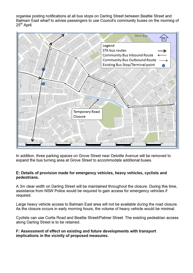
Based on the discussions held with the STA representative, buses would need to terminate at Darling Street/Rowntree Street/Montague Street intersection as Curtis Road is not suitable for bus movements. To maintain transport services between East Balmain and Balmain, Council will organise two shuttle bus services running between Balmain East and Darling Street/Rowntree Street/Montague Street. The shuttle bus service routes are shown on the following map.
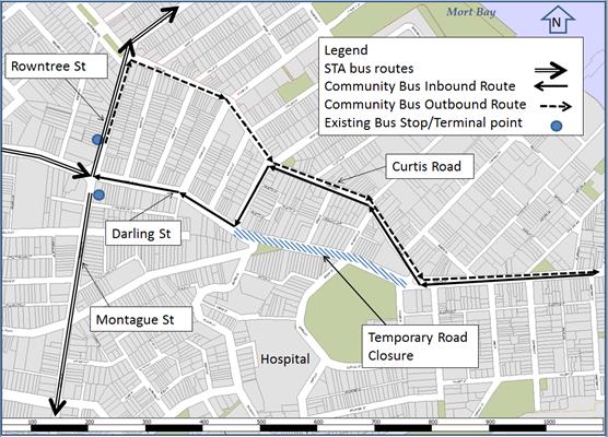
The STA representative will post notifications at all bus stops on Darling Street between Beattie Street and Balmain East wharf to advise passengers to use Council’s community buses on the morning of 25th April 2017. All other eastbound and westbound traffic will need to use Curtis Road or Palmer Street to access Balmain East.
The STA representative has also requested the temporary expansion of the bus turning area at Grove Street to accommodate additional buses. Therefore, it is proposed to temporarily remove three parking spaces on the northern side even numbered side (No. 22, 24, 26A) of Grove Street near Deloitte Avenue, Birchgrove. Affected residents will be notified.
Notification
Council’s Community Events Coordinator will organise a notification letter outlining the closure of Darling Street (Mort Street/ Beattie Street-Curtis Road) to all affected properties and the emergency services, including Balmain Hospital of the temporary road closure.
The road closures and alternate public transport options will be advertised on Council’s website and in local newspapers.
FINANCIAL IMPLICATIONS
The cost of the event will be funded from Council’s operational budget.
CONCLUSION
It is recommended that the proposed temporary closure of Darling Street (Mort Street and Curtis Road) between 2:30am and 9:30am be approved, in order to facilitate the ANZAC Day Dawn Service 2017 scheduled for Tuesday 25th April.
|
1.⇩ |
ANZAC Day Traffic Control Plan (TCP) 2017 |
|
2.⇩ |
Traffic Management Plan (TMP) Darling Street (Beattie Street - Curtis Road) ANZAC Day Dawn Service |
|
Local Traffic Committee Meeting 2 March 2017 |
Subject: Addendum to Lewisham LATM Traffic Committee Report
File Ref: 14/5142/18749.17
Prepared By: Felix Liu - Traffic Management Planner
Authorised By: George Tsaprounis - Coordinator Traffic Engineering Services
|
SUMMARY This is a recommendation to endorse the addendum to the final Lewisham LATM report.
|
|
RECOMMENDATION
THAT the following additional recommendation from the final Lewisham LATM report be endorsed for implementation as follows:
· Installation of kerb extension on The Boulevarde north of Hunter Street, Dulwich Hill. |
BACKGROUND
The Marrickville Community Strategic Plan (CSP) – Our Place Our Vision 2023 has key outcomes:
· Marrickville's roads are safer and less congested
· Marrickville's streets, lanes and public spaces are sustainable, welcoming, accessible and clean
· The community walks, ride bikes and use public transport.
One element of delivering the above outcomes is the development of Local Area Traffic Management (LATM) study and plan including recommendations.
The objective of local area traffic management planning is to investigate and review the performance of the existing Local Area Traffic Management (LATM) schemes and recommend proposed LATM works. The Lewisham LATM study was originally completed in 1995 and reviewed in 2004.
The table below is a finalised list of recommendations and associated costs and priority arising from the Lewisham LATM report.
|
ID. No. |
Recommended Measure |
Street |
Location |
Cost Estimation |
Priority |
|
1 |
Fixed radar speed display |
Denison Road |
Between Eltham Street and Toothill Street(and potentially other future temporary locations) |
$5,000 |
S |
|
2 |
Reconstruct and improve existing pedestrian crossings to raised facility with kerb extensions |
Toothill Street, |
south of Victoria Street |
$80,000 |
S |
|
3 |
West Street, |
south of The Boulevarde |
$80,000 |
S |
|
|
4 |
Left-in/ Left-out via pedestrian refuge and kerb extensions |
Summer Hill Street |
at Old Canterbury Road |
$35,000 |
S |
|
5 |
Kerb Extensions |
Fred Street |
at Victoria Street |
$20,000 |
M |
|
6 |
The Boulevarde, |
north of Eltham Street |
$20,000 |
M |
|
|
7 |
The Boulevarde, |
north of Hunter Street |
$20,000 |
M |
|
|
8 |
Pedestrian Refuge |
The Boulevarde, |
south of Toothill Street |
$15,000 |
M |
|
9 |
Victoria Street, |
south of Toothill Street |
$15,000 |
M |
|
|
10 |
Kerb extensions within No Stopping areas |
Hunter Street |
at Denison Road |
$20,000 |
M |
|
11 |
Victoria Street |
at Summer Hill Street |
$20,000 |
M |
|
|
12 |
Kerb extensions + AM peak period ‘No Right Turn’ restriction from Old Canterbury Road into Henry Street |
Henry Street |
at Old Canterbury Road |
$20,000 |
M |
|
13 |
Reconstruct existing flat top road humps to watts profile, preferably with kerb extensions |
Denison Road |
between Eltham Street and Toothill Street |
$40,000 |
M |
|
14 |
Reconstruct existing flat top road humps to watts profile, single-lane slow points |
Denison Road |
between Toothill Street and Hobbs Street |
$40,000 |
M |
|
15 |
Victoria Street |
between Henry Street and Jubilee Street |
$40,000 |
M |
|
|
16 |
Linemarking 2.1-metre-wide parking lanes |
Denison Road |
between Eltham Street and Hunter Street |
$4,000 |
L |
|
17 |
Toothill Street |
between Old Canterbury Road and New Canterbury Road |
$4,000 |
L |
|
|
18 |
On-road bicycle symbols |
Denison Road |
between Eltham Street and Hobbs Street along Local Route 02 in Council’s Bicycle Strategy |
$150 per symbol |
L |
|
19 |
On-road bicycle symbols and bicycle safety treatment |
Jubilee Street, Victoria Street, Hobbs Street, Denison Road, Hunter Street The Boulevarde and West Street |
Regional Route 07 in Council’s Bicycle Strategy |
$150 per symbol |
L |
The proposal for kerb extension on The Boulevarde north of Hunter Street, Dulwich Hill was not included in the report to the Traffic Committee in February, 2017. The financial impact has also been updated to reflect the corrected year for implementation.
FINANCIAL IMPLICATIONS
It should be noted that a sum of $200,000 has been initially proposed for the 2019/20 financial year to implement LATM proposals in stages, subject to the prioritization of items and budget allocation. This is an update to the previous report submitted to the Traffic Committee in February, 2017 which stated the 2017/18 financial year.
OFFICER COMMENTS
Based on the further Council’s internal discussion, the Lewisham LATM final report was amended as follows:
· Installation of kerb extension on The Boulevarde north of Hunter Street. The benefit of this treatment is rated in Medium priority.
· The financial Impact has been updated with the year for implementation now being 2019/20.
CONCLUSION
Following further Council’s internal discussion, amendments have been made and incorporated into the final Lewisham LATM report. It is recommended that the Final Report for Lewisham LATM be endorsed for implementation
|
No. |
Recommended Measure |
Street |
Location |
Cost Estimation |
|
1 |
Fixed radar speed display |
Denison Road |
Between Eltham Street and Toothill Street(and potentially other future temporary locations) |
$5,000 |
|
2 |
Reconstruct and improve existing pedestrian crossings to raised facility with kerb extensions |
Toothill Street, |
south of Victoria Street |
$80,000 |
|
3 |
West Street, |
south of The Boulevarde |
$80,000 |
|
|
4 |
Left-in/ Left-out via pedestrian refuge and kerb extensions |
Summer Hill Street |
at Old Canterbury Road |
$35,000 |
|
5 |
Kerb Extensions |
Fred Street |
at Victoria Street |
$20,000 |
|
6 |
The Boulevarde, |
north of Eltham Street |
$20,000 |
|
|
7 |
The Boulevarde, |
north of Hunter Street |
$20,000 |
|
|
8 |
Pedestrian Refuge |
The Boulevarde, |
south of Toothill Street |
$15,000 |
|
9 |
Victoria Street, |
south of Toothill Street |
$15,000 |
|
No. |
Recommended Measure |
Street |
Location |
Cost Estimation |
|
10 |
Kerb extensions within No Stopping areas |
Hunter Street |
at Denison Road |
$20,000 |
|
11 |
Victoria Street |
at Summer Hill Street |
$20,000 |
|
|
12 |
Kerb extensions + AM peak period ‘No Right Turn’ restriction from Old Canterbury Road into Henry Street |
Henry Street |
at Old Canterbury Road |
$20,000 |
|
13 |
Reconstruct existing flat top road humps to watts profile, preferably with kerb extensions |
Denison Road |
between Eltham Street and Toothill Street |
$40,000 |
|
14 |
Reconstruct existing flat top road humps to watts profile, single-lane slow points |
Denison Road |
between Toothill Street and Hobbs Street |
$40,000 |
|
15 |
Victoria Street |
between Henry Street and Jubilee Street |
$40,000 |
|
|
16 |
Linemarking 2.1-metre-wide parking lanes |
Denison Road |
between Eltham Street and Hunter Street |
$4,000 |
|
17 |
Toothill Street |
between Old Canterbury Road and New Canterbury Road |
$4,000 |
|
|
18 |
On-road bicycle symbols |
Denison Road |
between Eltham Street and Hobbs Street along Local Route 02 in Council’s Bicycle Strategy |
$150 per symbol |
|
19 |
On-road bicycle symbols and bicycle safety treatment |
Jubilee Street, Victoria Street, Hobbs Street, Denison Road, Hunter Street The Boulevarde and West Street |
Regional Route 07 in Council’s Bicycle Strategy |
$150 per symbol |
|
|
Local Traffic Committee Meeting 2 March 2017 |
Subject: Minor Traffic Facilities
(Leichhardt Ward/Balmain Electorate/Leichhardt LAC)
File Ref: 17/6022/18003.17
Prepared By: Manod Wickramasinghe - Traffic and Parking Engineer
Authorised By: John Stephens - Traffic Manager
|
SUMMARY This report considers minor traffic facility applications received by Inner West Council, Leichhardt. |
|
RECOMMENDATION
THAT: 1. a 6.5m ‘No Parking’ zone be trialled for 3 months on the western side of Buruwan Lane extending northwards from a point 1.5m south of the off-street parking facility of No.361 Annandale Street, Annandale; 2. the results of the trial be reported back to the next available Traffic Committee meeting; and 3. a 6m ‘Disabled Parking’ zone be installed in front of No.2 Springside Street, Rozelle.
|
BACKGROUND
This report considers minor traffic facility applications received by Inner West Council, Leichhardt.
FINANCIAL IMPLICATIONS
The installation of signage is funded from Council’s operating budget.
OFFICER COMMENTS
1 Modification to ‘No Parking’ Restriction – Buruwan Lane, Annandale
In the Traffic Committee meeting held in December 2016, the Committee considered an item regarding the installation of a ‘No Parking’ zone in Buruwan Lane opposite its intersection with Bayview Lane. The Committee subsequently recommended that an 11m ‘No Parking’ zone be installed on the western side of Buruwan Lane at Bayview Lane, extending south from the rear boundary of No.363 Annandale Street and No.14 Pritchard Street.
Following the meeting Council has continued to receive concerns regarding the loss of parking in the laneway and Council officers met with the resident on-site to discuss his concerns. It is recommended that a reduced ‘No Parking’ zone be installed on a trial basis in order to assess whether parking can be retained, whilst improving the ability for vehicles to manoeuvre out of Bayview Lane into Buruwan Lane.
Officer’s Recommendation
That:
a) a 6.5m ‘No Parking’ zone be trialled for 3 months on the western side of Buruwan Lane extending northwards from a point 1.5m south of the off-street parking facility of No.361 Annandale Street, Annandale; and
b) the results of the trial be reported back to the next available Traffic Committee meeting.
2 Installation of ‘Disabled Parking’ Restriction – Springside Street, Rozelle
Council Ref: DWS 4165045
The resident of No.2 Springside Street, Rozelle has requested the installation of a ‘Disabled Parking’ zone in front of the resident’s property.
A site investigation has revealed that the property does not have off-street parking.
The applicant does not require the use of a wheelchair.
Officer’s recommendation
That a 6m ‘Disabled Parking’ zone be installed in front of No.2 Springside Street, Rozelle.
|
|
Local Traffic Committee Meeting 2 March 2017 |
Subject: Requests for Mobility Parking Spaces
(Stanmore & Marrickville Wards/Heffron, Summer Hill & Newtown Electorates/Marrickville
& Newtown LACs)
File Ref: 17/6022/17270.17
Prepared By: Idris Hessam - Graduate Civil Engineer Traffic Services
Authorised By: Joe Di Cesare - Manager Design and Investigation
|
SUMMARY A number of requests have been received from residents for the provision of dedicated mobility parking space outside their residence. It is recommended that the following 'Mobility Parking' spaces be approved as the applicants current medical conditions warrants the provision of the space and they have constrained or no off-street parking opportunities. |
|
RECOMMENDATION
THAT the following locations:
1. western side of Audley Street, Petersham in front of property no. 12 Audley Street, Petersham; 2. southern side of Yelverton Street, Sydenham in front of property no. 26 Yelverton Street, Sydenham; and 3. northern side of Jersey Street, Marrickville in front of property no. 4 Jersey Street, Marrickville;
be APPROVED as a ‘mobility parking’ space, subject to: a) the operation of the dedicated parking space be valid for twelve (12) months from the date of installation; b) the applicant advising Council of any changes in circumstances affecting the need for the special parking space; and c) the applicant is requested to furnish a medical certificate and current mobility permit justifying the need for the mobility parking space for its continuation after each 12 months period.
|
BACKGROUND
A copy of the RMS disability parking permit and a medical certificate in support of the applications was submitted to Council.
FINANCIAL IMPLICATIONS
The costs of the supply and installation of the signposting associated with the recommended mobility parking space is approximately $1500.
It should be noted that Council normally signposts on-street mobility parking spaces and does not line mark these spaces. Should the applicant require the provision of kerb ramps, this can be provided at their cost.
OFFICER COMMENTS
|
Subject Location |
Classification of Road |
Road Description |
|
Audley Street, Petersham |
Local Road |
Two-way residential street, 9.9m in width that runs north-south from Addison Road to McRae Street. |
|
Yelverton Street, Sydenham |
Local Road |
Two-way residential street, 12.5m in width that runs north- south from Henry Street to Princess Highway. |
|
Jersey Street, Marrickville |
Local Road |
Two-way residential street, 12.9m in width that runs west- east from Livingstone Road to Moyes Street. |
12 Audley Street, Petersham
The applicant’s property is located on the western side of Audley Street, Petersham. The applicant’s property does not have an off-street parking facility.
At present, unrestricted parking is permitted on both sides of Audley Street. It has been observed during a site inspection undertaken in the afternoon period that on-street parking spaces in Audley Street were moderately utilized.
The applicant does not drive a vehicle however she is driven by another family member.
Currently there is no existing mobility parking space within close proximity to the applicant’s property. Due to her current medical condition, she requires parking availability close to her property.
26 Yelverton Street, Sydenham
The applicant’s property is located on the southern side of Yelverton Street, Sydenham. The applicant’s property does not have an off-street parking facility.
At present, unrestricted parking is permitted on both sides of Yelverton Street. It has been observed during a site inspection undertaken in the afternoon period that on-street parking spaces in Yelverton Street were moderately utilised.
There are no existing mobility parking spaces in close proximity to the applicant.
The applicant is suffering from a condition that severely restricts his mobility. Due to his current medical condition, he requires parking availability close to his property.
4 Jersey Street, Marrickville
The applicant’s property is located on the northern side of Jersey Street, Marrickville. The applicant’s property does not have an off-street parking facility.
At present, unrestricted parking is permitted on both sides of Jersey Street. It has been observed during a site inspection undertaken in the afternoon period that on-street parking spaces in Jersey Street were moderately utilised.
There are no existing mobility parking spaces in close proximity to the applicant.
The applicant has limited capacity for long distance walking. Due to his current medical condition, he requires parking availability close to his property.
Technical Standards
Australian Standard AS2890.5-1993 “On-Street Parking” states the following in regards to the provision of parking for people with a disability:
“Parallel parking spaces shall not be marked as disabled spaces, nor included in the count of spaces available for people with disabilities unless –
i. A 3.2m wide space can be provided, e.g. by indenting the space into the footpath area; and
ii. Kerb ramps as shown in Figure 4.2(a) are also provided”.
It should be noted that due to the limited width of streets around the Marrickville LGA, it is often difficult to comply with these requirements for the parking space dimensions. This may also result in the loss of some adjacent on-street parking spaces.
Mobility parking spaces are primarily intended for on-street and off-street parking at destinations, such as in commercial/retail areas and public car parks near hospitals, schools and public transport facilities where multiple usages can be expected. They were generally not intended for points of origin such as reserving on-street parking.
A mobility parking space is not intended for the sole use of one applicant, but rather a shared facility that can used by all authorised persons having an RMS mobility permit.
PUBLIC CONSULTATION
A notification letter has been sent to the applicants informing them of the application process and as part of the assessment they will be considered at this meeting.
CONCLUSION
It is recommended that ‘Mobility Parking' spaces be approved as the applicant’s properties do not have an off-street parking facility and/or the applicants condition warrants the provision of the space.
It should be noted that the proposed mobility parking spaces are not for the sole use of the applicant and may be used by other authorised persons.
Locality Map – 12 Audley Street, Petersham
![]()
![]()
![]()
Photographs – 12 Audley Street, Petersham
|
|
The frontage of the applicant's property in Audley Street, Petersham
|
|
On-street parking in Audley Street, Petersham
Locality Map – 26 Yelverton Street, Sydenham
|
|
![]()
Photographs – 26 Yelverton Street, Sydenham
|
|
The frontage of the applicant's property in Yelverton Street, Sydenham
|
|
On-street parking in Yelverton Street, Sydenham
|
|
On-street parking in Yelverton Street, Sydenham
Locality Map – 4 Jersey Street, Marrickville

![]()
![]()
Photographs – 4 Jersey Street, Marrickville
|
|
The frontage of the applicant's property in Jersey Street, Marrickville
|
|
On-street parking in Jersey Street, Marrickville
|
|
On-street parking in Jersey Street, Marrickville
|
|
Local Traffic Committee Meeting 2 March 2017 |
Subject: Proposed ‘No Stopping’ and 'No
Parking' Restrictions to be Installed - Various Locations
(Stanmore & Marrickville Wards/Newtown & Summer Hill
Electorates/Newtown & Marrickville LACs)
File Ref: 17/6022/18211.17
Prepared By: Snezana Bakovic - Project Engineer Traffic
Authorised By: George Tsaprounis - Coordinator Traffic Engineering Services
|
SUMMARY Requests have been received from residents for the provision of ‘No Stopping’ and ‘No Parking’ restriction to deter illegal parking and to improve access to resident off street parking at various locations within the LGA. Residents have advised that vehicles are regularly parked too close to the following intersections; Australia Street at Bishopgate Street, Harrow Road at Harrow Lane and Frede Lane at Esk Street. This restricts available sightlines to pedestrian crossing at this location and for turning motorists. A resident has also raised a concern with access to a property in Frede Lane near Esk Street. All requests have been investigated and summary of investigations and proposed parking restrictions at various locations are presented in these report to Committee for consideration. |
|
RECOMMENDATION
THAT: 1. Statutory ‘No Stopping’ restrictions be installed at the following locations: a. Western side of Australia Street, extending 10 metres on either side of its intersection with Bishopgate Street , Camperdown; b. Northern Side of Harrow Road , extending 10 metres on either side of its intersection with Harrow Lane, Stanmore; c. Frede Lane , extending 10 metres on either sides of the laneway from Esk Street, Marrickville; and 2. ‘No Parking’ restrictions be installed, for a length of 6 metres, on the southern side of Frede Lane, (opposite rear of properties 35-37 Grove Street) Marrickville.
|
BACKGROUND
Council has received a number of requests from residents for the installation of 'No Stopping' and ‘No Parking’ restriction to deter illegal parking, improve visibility for motorists and pedestrians and improve access to resident off street parking throughout the southern half of the LGA.
FINANCIAL IMPLICATIONS
The cost of installing the ‘No Parking’ sign is approximately $1000 for each site and can be met from Council’s operating budget.
OFFICER COMMENTS
|
Subject Location |
Road Classification |
Road Description |
|
Australia Street at Bishopgate Street , Camperdown |
Local road |
Australia Street is a two way local road in a residential area, 10.3m in width running north – south between Parramatta Road and Salisbury Road. (Refer to the attached locality map). |
|
Harrow Road at Harrow Lane, Stanmore |
Local road |
Harrow Road is a two way local road in a residential area, 9.5m in width running east-west between Liberty Street and Trafalgar Street, Stanmore. |
|
Frede Lane, Marrickville |
laneway |
This section of Frede Lane is a 4.6m wide laneway and running east-west between Ivanhoe Street and Esk Street, Marrickville. |
Australia Street at Bishopgate Street, Camperdown
Concern has been raised by a resident stating that vehicles are parking within 10 metres of the intersection on the western side of Australia Street at Bishopgate Street, Camperdown.
At present, there are no parking restrictions within 10 meters of the intersection on the western side of Australia Street at Bishopgate Street, Camperdown. Resident has advised that vehicles are regularly parked too close to the subject intersection on Australia Street. This causes a dangerous reduction in the sight lines for both drivers and pedestrians at the intersection (refer to Photos 1&2).
Locality map – Australia Street, Camperdown
Photos 1&2: Australia St / Bishopgate St Intersection –Illegal parked vehicle
Harrow Road at Harrow Lane, Stanmore
Concern has been raised by a resident of Harrow Road stating that vehicles are parking right to kerb of Harrow Lane and Harrow Road, which caused decrease of visibility when exiting the lane.
At present, there are no parking restrictions within 10 meters of the intersection on the northern side of Harrow Road at Harrow Lane, Stanmore.
It is proposed to implement statutory ‘No Stopping’ restriction in Harrow Road at its intersection with Harrow Lane, Stanmore. The signs will reinforce the statuary rule of no stopping within 10 metres of an intersection to deter illegal parking and improve visibility for both motorist and pedestrians.
The proposal would not result in removal any legal on street parking.
Locality map – Harrow Road, Stanmore
Frede Lane at Esk Street, Marrickville
A resident of 37 Grove Street, Marrickville advised that opposite of her garage in Frede Lane, there is unrestricted parking which is frequently used for parking. As Frede Lane is a narrow lane (4.8 meters) a vehicle parked at this location blocks access from the resident’s garage (refer to Photos 3&4).The resident has stated that this prevents her from leaving for work in the morning.
At present, there are no parking restrictions in place at this section of Frede Lane, Marrickville.
It is proposed to introduce a section of ‘No Stopping’ and ‘No Parking’ restrictions in Frede Lane, Marrickville, to improve residents’ access to off-street parking and garages.
The proposal involves provisions of statutory ‘No Stopping’ restrictions, on both sides of Frede Lane, Marrickville (at its intersection with Esk St) and ‘No Parking’ restrictions for a length of six (6) metres on the southern side of Frede Lane (opposite rear of properties 35-37 Grove Street) , Marrickville.
The proposal would result in removal of one on- street parking space on the southern side Frede Lane, (refer to map below
Locality map – Frede Lane, Marrickville
 |
Photos 3&4: Frede Lane –blocked access 37 Grove Street property garage
PUBLIC CONSULTATION
Public consultation with affected residents (of all subject locations) has been undertaken. No submissions were received from the residents of any subject locations
CONCLUSION
It is recommended that the statutory 'No Stopping' restrictions and No Parking Restriction be installed at the locations listed within this report in order to deter illegal parking, increase safety and improve visibility and access.
|
|
Local Traffic Committee Meeting 2 March 2017 |
Subject: Modification of Short Term Parking Restriction
- 67 Denison Street, Rozelle
(Leichhardt & Balmain Wards/Balmain Electorate/Leichhardt LAC)
File Ref: 17/6022/17898.17
Prepared By: Nina Fard - A/Traffic Team Leader
Authorised By: John Stephens - Traffic Manager
|
SUMMARY Council has received correspondence from the owner of the local grocery store at No.67 Denison Street, Rozelle, requesting an extension to the operating hours of the existing short term parking space outside the business, to assist customers. The business owner has raised concerns in regards to the low turnover in the subject spot after 6pm and the impact on their customers’ parking needs. |
|
RECOMMENDATION
THAT the hours of the existing ‘10-Minute’ parking space outside No.67 Denison Street, Rozelle be modified from ‘8am-6pm Mon-Fri, 8am-1pm Sat’ to ‘8am-8pm Mon-Fri, 8am-1pm Sat’.
|
BACKGROUND
Following concerns raised by the owner of the local grocery store, Council proposed to amend the existing ‘10-Minute 8am-6pm Mon-Fri, 8am-1pm Sat’ parking restrictions for one parking space outside No.67 Denison Street, Rozelle and install ‘10-Minute 8am-8pm Mon-Fri, 8am-1pm Sat’ signage (as shown on the attached plan).
Currently, majority of parking on Denison Road (South of Evans Street) is unrestricted with exception of the short-term parking spot outside No.67 Denison Street, Rozelle. There is also unrestricted parking available on the surrounding streets at Easton Street, Cheltenham Street, Burt Street and Alfred Street, Rozelle.
|
CONSULTATION In order to assess the views of the surrounding properties 12 notification letters outlining the parking proposal with a copy of the proposed parking plan were sent out to the affected property owners, occupiers as indicated on the attached plan.
No objections were received at the time of finalising this report.
|
|
FINANCIAL IMPLICATIONS
The cost of the signposting will be funded from Council’s operational budget.
CONCLUSION
It is recommended that the operating hours of the existing ‘10-Minute 8am-6pm Mon-Fri, 8am-1pm Sat’ parking space outside No.67 Denison Street, Rozelle be modification to ‘10-Minute 8am-8pm Mon-Fri, 8am-1pm Sat’ to more closely match the operating hours of the business and improve parking turnover.
|
|
Local Traffic Committee Meeting 2 March 2017 |
Subject: 93 Smith Street, Summer Hill - Proposed
"No Parking - Australia Post Vehicles Excepted"
(Ashfield Ward/Summer Hill Electorate/Ashfield LAC)
File Ref: 17/6022/18305.17
Prepared By: Helal (Henry) Uddin - Assistant Engineer
Authorised By: John Stephens - Traffic Manager
|
SUMMARY Council has received a request from Australia Post for the installation of a 'No Parking - Australia Post Vehicles Excepted' zone directly outside of 93 Smith Street, Summer Hill due to the relocation of the Post Office from 132a Smith Street, Summer Hill. The zone will provide a space for Australia Post vehicles to service the Post Office and collect the mail from the Post Box. |
|
RECOMMENDATION
THAT: 1. 6m of the existing '1P 8:30am – 6:00pm Mon-Fri; 8:30am-12:30pm Sat' parking zone be removed to the left of the 'No Stopping' zone and a 6m 'No Parking - Australia Post Vehicles Excepted' zone be installed directly outside of 93 Smith Street, Summer Hill; 2. the existing 'No Stopping - Aust Post Vehicles Excepted' zone be removed between the existing 'No Stopping zone and P5Min parking in Morris Street near Smith Street outside the previous Post office; and 3. nearby affected businesses be consulted on their views to the proposed '1P 8:30am – 6:00pm Mon-Fri; 8:30am-12:30pm Sat' zone to replace the existing 'No Stopping - Aust Post Vehicles Excepted' zone in Morris Street.
|
BACKGROUND
Australia Post has relocated to 93 Smith Street, Summer Hill from its previous location at 132a Smith Street, Summer Hill.
A request has been received for a 'No Parking - Australia Post Vehicles Excepted' zone to be installed directly outside of the Post Office in order for Australia Post vehicles to park in front of the Post Office to service the Post Office and collect mail from the Post Box.
FINANCIAL IMPLICATIONS
The proposal will be funded from Council's operating budget.
OFFICER COMMENTS
Although 1 parking spot will be lost due to the proposed parking restrictions, the 'No Parking – Australia Post Vehicles Excepted' is required for the safe operation of the Australia Post Office. There is no alternate spot nearby 93 Smith Street, Summer Hill or in the adjacent laneway, where the 'No Parking – Australia Post Vehicles Excepted' parking restrictions can be installed. The installation of a 6m 'No Parking - Australia Post Vehicles Excepted' zone directly outside Australia Post Office is considered appropriate.
Whilst there would be a direct loss of one parking space outside 93 Smith Street, there is an opportunity to remove the existing 6m 'No Stopping - Aust Post Vehicles Excepted' zone outside the previous Post Office in Morris Street on the corner of Smith Street and extend the existing P5min parking or install 1P parking in lieu of the 5 minute parking similar to the opposite side of Morris Street. The preferred parking restriction will be sought from the affected businesses and tabled at the meeting.
PUBLIC CONSULTATION
Consultation letters went distributed on 13/2/2017 to local residents and businesses regarding the installation of the 6m 'No Parking Australia Post Vehicles Excepted'. The closing date for the submissions is on the 24/2/2017. Council officers will present feedback on the proposal at the meeting.
|
1.⇩ |
93 Smith Street Summer Hill Australia Post Signage |
|
Local Traffic Committee Meeting 2 March 2017 |
Subject: Changes to Parking in Beach Street and Kintore Street, Dulwich Hill
File Ref: 15/5909/18133.17
Prepared By: Mary Bailey - Parking Planner
Authorised By: Joe Di Cesare - Manager Design and Investigation
|
SUMMARY Changing the existing 2P parking restrictions in Beach Street and Kintore Street between New Canterbury Road and Hercules Street will provide a more balanced parking solution for residents and businesses in the immediate area. Providing some 2P resident parking and unrestricted parking will allow for businesses, visitors and residents to maximise the use of the available parking spaces. |
|
RECOMMENDATION
THAT: 1. the existing 2P 8:30am-6pm Monday to Friday, 8:30am-12:30pm Saturday in Beach Street between New Canterbury Road and Hercules Street (western side) be converted to 2P Permit Holders Excepted 8:30am-6pm Monday to Friday, 8:30-12:30 Saturday; 2. the existing 2P 8:30am-6pm Monday to Friday, 8:30-12:30 Saturday in Beach Street between New Canterbury Road and Hercules Street (eastern side) be converted to Unrestricted; 3. the existing 2P 8:30am-6pm Monday to Friday, 8:30am-12:30pm Saturday in Kintore Street between New Canterbury Road and Hercules Street (western side) be converted to 2P Permit Holders Excepted 8:30am-6pm Monday to Friday, 8:30am-12:30pm Saturday; and 4. the existing 2P 8:30am-6pm Monday to Friday, 8:30am-12:30pm Saturday in Kintore Street between New Canterbury Road and Hercules Street (eastern side) be converted to Unrestricted.
|
BACKGROUND
The recently installed parking restrictions in Beach Street and Kintore Street have caused concern for residents of these streets, including residents of New Canterbury Road who are also subject to the parking restrictions along New Canterbury Road. Feedback from local residents indicates the recently installed 2P restrictions are having a negative impact.
FINANCIAL IMPLICATIONS
Funding is available through the Dulwich Hill parking implementation budget.
OFFICER COMMENTS
Council has investigated the concerns and is proposing changes to better meet the needs of residents. Converting the 2P parking to 2P Permit Holders Excepted will serve both the businesses/residents in New Canterbury Road and residents of this section of Beach Street.
While there are no residents in Kintore Street between New Canterbury Road and Hercules Street, designating resident parking in that section can serve eligible residents in New Canterbury Road and other residents in nearby streets. Allowing some Unrestricted parking in the area will serve residents, visitors and employees. The Unrestricted parking can be reviewed at a future date should the commercial area expand.
PUBLIC CONSULTATION
The proposals are based on feedback from affected residents in those streets since the recent implementation of the 2P restrictions.
CONCLUSION
The proposed changes will provide a better balance in relation to the mix of parking restrictions for both Beach Road and Kintore Street. Therefore, the changes are proposed within the report are supported.
|
|
Local Traffic Committee Meeting 2 March 2017 |
Subject: Longport Street, Lewisham - Proposed No
Parking & No Stopping Restrictions
(Stanmore Ward/Summer Hill Electorate/Marrickville LAC)
File Ref: 17/6022/18748.17
Prepared By: Emilio Andari - Civil Engineer
Authorised By: Joe Di Cesare - Manager Design and Investigation
|
SUMMARY Council has received requests from local residents for the installation of ‘No Parking’ restrictions along the northern side of Longport Street, Lewisham near its intersection with Old Canterbury Road, to improve traffic safety and facilitate an additional traffic lane. It is recommended that the proposals be approved. |
|
RECOMMENDATION
THAT:
1. ’No Stopping’ restrictions on the northern side of Longport Street, Lewisham, for a length of 20 metres west of its intersection with Old Canterbury Road be APPROVED, to improve traffic safety; and
2. ’No Parking’ restrictions on the northern side of Longport Street, Lewisham, for a length of 50 metres commencing 20 metres west of its intersection with Old Canterbury Road be APPROVED, to improve traffic safety and facilitate an additional traffic lane.
|
BACKGROUND
Council has received requests from local residents for the installation of ‘No Parking’ restrictions along the northern side of Longport Street, Lewisham near its intersection with Old Canterbury Road. It has been reported to Council officers that traffic congestion occurs quite frequently along Longport Street eastbound during the morning peak periods on weekdays due to vehicles parked along the northern side of the road along the railway corridor.
FINANCIAL IMPLICATIONS
The cost of the supply and installation of the signposting associated with the recommended ‘No Stopping’ and ‘No Parking’ restrictions is approximately $1,000 and can be met from Council’s operating budget.
OFFICER COMMENTS
Site location & road network
|
Street Name |
Longport Street |
|
Section |
Between Grosvenor Crescent and Old Canterbury Road |
|
Carriageway Width (m) |
12.8 |
|
Carriageway Type |
Two-way road with one travel lane in each direction, in addition to kerbside parking lanes. |
|
Classification |
Regional |
|
85th Percentile Speed (km/h) |
49.5 |
|
Vehicles Per Day (vpd) |
19,381 |
|
Reported Crash History (July 2011 - June 2016) |
1 crash (Rum Code: 21). Crash resulted in an injury. |
|
Heavy Vehicle Volume (%) |
4.6 |
|
Parking Arrangements |
Both the northern and southern sides of the road consist of sections of ‘No Stopping’ restrictions and sections of unrestricted parking. |
Site inspection
It has been observed during a site inspection undertaken in the afternoon period that on-street parking spaces in Longport Street were highly utilised and it was evident that vehicles do park along the northern side of the street. It was also observed that there is a significant amount of multi-storey residential development occurring within close proximity to Longport Street which is likely to be the cause of the additional on-street parking (refer to the attached photographs).
Proposal for a ’No Stopping’ & ‘No Parking’ zones along the northern side of Longport Street
It is proposed to alter the existing unrestricted parking along the northern side of Longport Street by installing a combination of ‘No Stopping’ restrictions 20 metres west from the intersection of Old Canterbury Road and installing ‘No Parking’ restrictions for a distance of 50 metres immediately left of the proposed ‘No Stopping’ zone (refer to the attached locality plan and signage plan).
These proposed changes will improve traffic safety and facilitate an additional traffic lane.
Locality Map – Longport Street, Lewisham

![]()
![]()
![]()
Signage Plan – Longport Street, Lewisham
Photographs – Longport Street, Lewisham
Longport Street near light rail bridge (facing east)
Intersection of Brown Street and Longport Street (facing north-east)
Intersection of Old Canterbury Road and Longport Street (facing north-west)
PUBLIC CONSULTATION
Nil.
CONCLUSION
It is recommended that the parking changes be undertaken on the northern side of Longport Street, Lewisham to improve traffic safety and facilitate an additional traffic lane.
|
|
Local Traffic Committee Meeting 2 March 2017 |
Subject: Improving Cyclist and Pedestrian Access in
Cardigan Lane, Camperdown
(Stanmore Ward/Newtown Electorate/Newtown LAC)
File Ref: 17/6022/17899.17
Prepared By: Snezana Bakovic - Project Engineer Traffic
Authorised By: Joe Di Cesare - Manager Design and Investigation
|
SUMMARY A request has been received from a resident for the provision of a ‘No Stopping’ zone to improve cyclist and pedestrian access in Cardigan Lane, Camperdown. The resident has advised Council that cyclists and pedestrians exit out of Cardigan Laneway into Salisbury Road is blocked most of the time by parked vehicles. It is recommended that installation of ‘No Stopping’ zones and green bicycle lane markings for a distance of three metres on both sides of Cardigan Lane adjacent to Salisbury Road be approved, to improve cyclist and pedestrian access. |
|
RECOMMENDATION
THAT the installation of ‘No Stopping’ zones and green bicycle lane markings for a distance of three metres on the both side of Cardigan Lane (commencing from side boundary of No. 100 and No. 104 Salisbury Road respectively) to improve access for cyclists and pedestrians be APPROVED.
|
BACKGROUND
Council has received a request from a resident for the installation of 'No Stopping' restrictions in Cardigan Lane to provide unobstructed pedestrian and cyclist access from Cardigan Lane to Salisbury Road and vice versa (refer to map locality map below).
Locality map – Cardigan Lane, Camperdown
FINANCIAL IMPLICATIONS
The cost of installing the ‘No Parking’ sign is approximately $1000 and can be met from Council’s operating budget.
OFFICER COMMENTS
Cardigan Lane is an old section of RR05 - Camperdown to Cook River Regional cycleway route (refer to map below). There is no vehicular access to Cardigan Lane from Salisbury Road. However, Cardigan Lane and Salisbury Road are connected via a two way pedestrian and cycleway access which provides continuity of the cycleway route.
 |
At the moment there are no parking restrictions in this section of Cardigan Lane and residents often park their vehicles too close to pedestrian/ cyclist access to/from Salisbury Road (refer to Photos below.)
Photos 1-3: - Cardigan Lane/Salisbury Road, blocked pedestrian and cyclist’s access
PUBLIC CONSULTATION
Public consultation with affected residents has been undertaken. No submissions were received from the residents of subject location.
CONCLUSION
The provision of ‘No Stopping’ zones in combination of green cycleway pavement markings will help deter motorist from parking too close to the accessway between Salisbury Road and the laneway.
|
|
Local Traffic Committee Meeting 2 March 2017 |
Subject: Improving Garbage Truck Access in Oxford
Street, Newtown
(Stanmore Ward/Newtown Electorate/Newtown LAC)
File Ref: 17/6022/18284.17
Prepared By: Snezana Bakovic - Project Engineer Traffic
Authorised By: George Tsaprounis - Coordinator Traffic Engineering Services
|
SUMMARY A request has been received from a resident for the provision of a 'No Parking' zone in Oxford Street near its intersection with Marys Street, Newtown to improve the width for a garbage truck to manoeuvre and lower risk of damaging parked vehicles, during garbage collection days. It is recommended that installation of a 'No Parking' zone Monday 5am-10am for a length of approximately 12 metres on the western side of Oxford Street (opposite of property 45 Oxford Street & Lands Lane) be approved, to allow sufficient room for garbage truck manoeuvring and lower risk of damaging parked vehicles. |
|
RECOMMENDATION
THAT the installation of a 'No Parking’ zone Monday 5am-10am for a distance of approximately 12 metres on the western side of Oxford Street, Newtown (opposite of property 45 Oxford Street and Lands Lane) be APPROVED in order to improve garbage truck manoeuvring space and reduce the potential damage to parked vehicles.
|
BACKGROUND
Council has received a request from a resident from the property of 45 Oxford Street for the provision of a 'No Parking' zone opposite its property at the western corner of Oxford Street, Newtown. The resident raised concern of constant garbage truck maneuvering issues. The resident advised that his vehicle has been hit by the Council's garbage truck on a couple occasions.
Locality map – Proposed No Parking ‘restriction in Oxford Street, Newtown
FINANCIAL IMPLICATIONS
The cost of installing the ‘No Parking’ sign is approximately $1000 and can be met from Council’s operating budget.
OFFICER COMMENTS
Oxford Street is a two way local road with a carriageway width of approximately 7 metres running between Marys Street and Albemarle Street, Newtown. The AADT Traffic is 524 veh/day, average 85 percentile speed is 40 km/h. Parking is generally permitted on both sides of the road with Mobility parking zone located on the eastern side of Oxford Street in front of property 45 Oxford Street, Newtown.
The subject section of Oxford Street is located between Lands Lane and Marys Street. At this location, Oxford Street bends left towards Marys Street which additionally narrows the roadway. The result is that the roadway is only wide enough to allow motor vehicles to pass comfortably. However it becomes a problem for the garbage truck to safely navigate the corner.
To improve garbage truck maneuvering at this location a proposal for the installation of a 'No Parking' zone Monday 5am-10am for a length of 6 metres on the southern side of Oxford Street, Newtown (opposite of property 45 Oxford Street) was originally devised. It should be noted that this was extended to 12 metres following the consultation phase with residents.
The aim of proposal is to enable the garbage truck to safely negotiate the corner and lower risk of damaging parked vehicles, during garbage collection days.
PUBLIC CONSULTATION
Public consultation with affected residents has been undertaken. A few submissions were received from residents requesting extension of the proposed ‘No Parking’ zone (refer to table below).
|
Resident comment |
Council’s Officer comments |
|
· We appreciate the suggestion for 'No Parking' Monday 5am-10am on the western side of Oxford Street, Newtown but we believe that restriction should be permanent, rather merely Monday morning.
· We strongly recommend a 'No Stopping' sign covering area from about 8 metres north of driveway of property 62 Oxford Street through the junction of Oxford Street and Marys Street (on the western side of the road). |
Due to high demand for parking in this area it is only proposed to limit the ‘No Parking’ restriction to garbage truck collection days and times at present.
Council would monitor this area and convert the part-time ‘No Parking’ restriction into a full time restriction if required. |
CONCLUSION
As an outcome of the community engagement and consultation with the Council’s Waste Collection Officer it is proposed to install ‘No Parking’ zone Monday 5am- 10am for a length 12 metres rather than 6 metres which was originally proposed during the consultation phase.
The proposal would result in removal of two on street parking space on every Monday between 5am-10am.For the rest of the time the section of the roadway will remain unrestricted.
|
|
Local Traffic Committee Meeting 2 March 2017 |
Subject: Pedestrian Infrastructure Safety
around Schools Program - Project Funding Notification From RMS
(Various Wards/Various Electorates/Various LACs)
File Ref: 17/6022/17223.17
Prepared By: Jennifer Adams - Traffic and Road Safety Officer
Authorised By: Joe Di Cesare - Manager Design and Investigation
|
SUMMARY Council has received notice from Roads and Maritime Services (RMS) that it has been successful in gaining funding through the NSW Government’s Pedestrian Infrastructure Safety Around Schools Program. Five applications for funding for pedestrian works around local schools have been successful and these works have been listed in the 5 year capital program for the year indicated. The program will be completed by the end of the 2017/18 financial year. Approval is sought in principle for the five local projects nominated for funding under the NSW Governments’ $5 million program for Pedestrian Infrastructure Around Schools. |
|
RECOMMENDATION
THAT this report be received and noted.
|
BACKGROUND
In February 2015, the NSW State Government announced a $5 million commitment to improve pedestrian infrastructure around schools. In December 2015 the Roads and Maritime Services (RMS) sought assistance from Councils to develop and deliver the program to schools. The new program commenced/ in early 2016 and is to be completed by June 2018.
The program focused on improving pedestrian safety through the provision of non-signalised pedestrian crossing facilities both within school zones and on main routes to schools.
The available treatments under this program were:
• Marked foot crossings (zebra crossings).
• Wombat crossings (raised zebra crossings).
• Kerb blisters.
• Pedestrian refuges.
• Pedestrian fencing.
• Improved signs line marking for crossing facilities or school drop off/pick up zones.
Funding was available for around 100 locations across the state over a 3 year period and each site was eligible to receive up to $50,000 for pedestrian infrastructure from the options listed above. For approval the proposed facilities needed to be located on local and regional roads that are under the care and control of Council.
In March 2016, Council identified a number of schools that met the funding criteria and submissions were sent into RMS. RMS proposed the following administration and approval process for this initiative:
• Council, in consultation with the nominated schools, is allowed to submit up to 10 locations within their LGA.
• To submit a nomination Council is required to develop a proposal and include appropriate documentation including a pedestrian risk model score.
• Ensure Local Traffic Committee and other relevant approvals are achieved. A full report will be submitted to LTC including a design and estimate for each proposal.
Once approval has been granted, Council will be responsible for delivering the project within the allocated funding year. Council will be responsible for the ongoing maintenance of the facility.
On 19 January 2017 Council was notified by RMS that it has been successful in gaining funding through the NSW Government’s Pedestrian Infrastructure Safety Around Schools Program for five local schools. Sites were selected using a school pedestrian risk model, to ensure treatments achieve the greatest road safety benefit and deliver a fair distribution across metropolitan and country areas.
The following projects have been endorsed for funding in Council’s area in the identified financial years:
FINANCIAL IMPLICATIONS
These works have been listed in the 5 year capital program for the year indicated. With the exception of the St Pius Primary School/Camdenville Public School project, which requires Council to contribute $37,000 the remaining projects are fully funded by the RMS. Funding for the St Pius Primary School/Camdenville Public School project will be sought from Council’s budget process for 2017/2018.
OFFICER COMMENTS
Treatments proposed at school sites where funding has been approved:
Project P.0021559 – St Patricks Catholic Primary School, Prospect Road, Summer Hill
Upgrade existing raised zebra crossing in Prospect Road, south of Drynan Street, Summer Hill to include kerb extensions for improved pedestrian access to the crossing, and provide for additional line marking to enhance the road safety and the visibility and presence of the crossing.
A report went to the Local Traffic Committee on 1 December 2016 along with a design plan – Drawing No. 2586-2-CON-001. Refer below for a locality plan and a copy of the plan. The estimated cost to upgrade the crossing was listed as $36,000. The RMS grant is for $35,800.
Project P.0021560 – Haberfield Public School, Denman Avenue, Haberfield
It is proposed to provide a raised platform pedestrian crossing adjacent to Haberfield Public School on Denman Avenue, Haberfield as the site meets RMS warrant requirements for a pedestrian crossing under reduced warrants for crossing sites predominantly used by children. Fencing is to be provided to direct the pedestrians to the crossing location.
![]()
A concept plan has been designed and is due to go out to consultation. The estimated cost to install the crossing was listed as $40,775. The RMS grant is for $40,800.
Project P.0021699 – Christian Brothers High School, Denison Road, Lewisham
Convert the existing zebra pedestrian crossing to a wombat crossing including a raised threshold to improve the safety of pedestrians at the crossing.
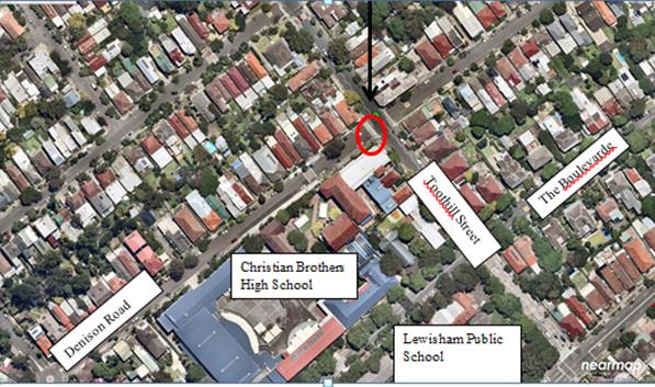
![]()
Installation of a raised crossing in place of the current at-grade crossing is estimated to be $50,000. The RMS grant is for $50,000.
Project P.0021700 – Wilkins Public School, Addsion Road, Marrickville
To improve the safety of pedestrians at the crossing and to slow vehicles to the approach of the crossing it is proposed to raise the existing pedestrian zebra crossing. The proposed scope of work includes the following:
· Install a raised (concrete) pedestrian crossing on Addison Road with four (4) landscaped kerb blisters;
· Provide pedestrian line marking, piano keys markings and BB line markings; and
· Install signage associated with the pedestrian crossing.
Installation of a raised crossing in place of the current at-grade crossing is estimated to be $47,000. The RMS grant is for $47,000.
Project P0021701 – St Pius Primary School, Camdenville Public School and Enmore TAFE
A Road Safety Audit undertaken in 2015 of the pedestrian crossing on Victoria Road at Edgeware Road, Marrickville recommended that the existing pedestrian crossing be relocated and realigned to 90 degrees to the alignment of Victoria Road. This would reduce the length from 20m to 11m. The relocated crossing also separates and reduces
(i) the southbound right-turn versus northbound through traffic conflict on Edgeware Road and
(ii) (ii) the vehicle-pedestrian conflict. It also reduces the risk of eastbound vehicles on Victoria Road queuing over the zebra crossing.
The audit suggested treatment is pictured below:
Figure 11 Improvement concept for Victoria Road crossing at Edgeware Road.
It is noted also that a report to 1 December 2016 Committee meeting detailed the recommendations of the final Marrickville East LATM Scheme review and the following recommendation was listed for the intersection of Victoria Road at Edgeware Road, Marrickville:
Recommendation -13:
Victoria Road at Edgeware Road, Marrickville
· Installation of kerb extension on Victoria Road
· Modification of existing median island
This recommendation goes to Council on 28 February 2017 for consideration and is pictured below.
Installation of a ‘marked crossing and pedestrian refuge’ in place of the current at-grade crossing is estimated to be $87,000. The RMS grant is for $50,000.
PUBLIC CONSULTATION
Schools were consulted as part of original submission process. Residents/stakeholders will be engaged during the detailed design phase and the construction phase of these projects.
CONCLUSION
Approval is sought in principle for the five local projects nominated for funding under the NSW Governments’ $5 million program for Pedestrian Infrastructure Around Schools.
It is recommended that this report be received and noted.
|
|
Local Traffic Committee Meeting 2 March 2017 |
Subject: 2/32-72 Alice Street, Newtown -
Proposed Childcare Centre
(Stanmore Ward/Newtown Electorate/Newtown LAC)
File Ref: 17/6022/18509.17
Prepared By: Emilio Andari - Civil Engineer
Authorised By: Joe Di Cesare - Manager Design and Investigation
|
SUMMARY A Development Application has been received to fit out and use the premises as a childcare centre for 32 children at 2/32-72 Alice Street, Newtown. It is recommended that the comments of the Local Traffic Committee be referred to Council’s Development Assessment Section for consideration in determining the Development Application. |
|
RECOMMENDATION
THAT the report be received and noted.
|
BACKGROUND
This development application is required to be referred to the Local Traffic Committee for consideration under State Environmental Planning Policy (Infrastructure) 2007.
FINANCIAL IMPLICATIONS
Nil.
OFFICER COMMENTS
Site location & road network
|
Street Name |
Alice Street |
Pearl Street |
Walenore Avenue |
Alice Lane |
|
Subject Section |
Between Pearl Street and Walenore Avenue |
Between Alice Street and Little Commodore Street |
Between Alice Street and Alice Lane |
Between Pearl Street and Walenore Avenue |
|
Carriageway Width (m) |
12.2 |
11.1 |
12.8 |
4.9 |
|
Carriageway Type |
Two-way road with one travel lane in each direction, in addition to kerbside parking lane along both sides of the road. |
Two-way road with one travel lane in each direction, in addition to kerbside parking lane along both sides of the road. |
Two-way road with one travel lane in each direction, in addition to kerbside parking lane along both sides of the road. |
Two-way road with one travel lane in each direction, in addition to kerbside parking lane along both sides of the road. |
|
Classification |
Regional |
Local |
Local |
Local |
|
85th Percentile Speed (km/h) |
49.0 |
42.1 |
32.8 |
33.1 |
|
Vehicles Per Day (vpd) |
10,168 |
559 |
814 |
302 |
|
Reported Crash History (July 2011 - June 2016) |
2 crashes (Rum Codes: 11 & 60). Both crashes resulted with no injury and only tow-away (intersection collision & collision into parked car). |
1 crash (Rum Code: 1). Crash resulted in injury (pedestrian emerging). |
1 crash (Rum Code: 42). Crash resulted with no injury and only tow-away (parked vehicle merged into traffic lane). |
No crashes recorded. |
|
Heavy Vehicle Volume (%) |
8.4 |
4.2 |
3.8 |
2.0 |
|
Parking Arrangements |
Unrestricted parking on the southern side and ‘2P 8am-10pm Permit Holders Excepted Area M14’ restrictions on the northern side. |
Unrestricted parking on the eastern side and ‘2P 8am-10pm Permit Holders Excepted Area M14’ restrictions on the western side. |
Unrestricted parking on the western side and ‘2P 8am-10pm Permit Holders Excepted Area M14’ restrictions on the eastern side. |
Unrestricted parking on both sides of the road. |
The proposed childcare centre is located near the north-eastern corner of the entire mixed-use development of 32-72 Alice Street, Newtown and the closest direct entrance to the commercial tenancy is from Alice Street. The subject site is a ground-floor commercial tenancy, Unit 2/32-72 Alice Street, Newtown that consists of up to 3 existing parking spaces in the existing basement carpark which is accessed through a driveway crossing located in Pearl Street. The surrounding land uses comprise of a mixture of residential single-dwelling properties and apartment buildings. The location of the proposed childcare centre is also approximately 150m west of the businesses on King Street, Newtown. It should be noted that there are several apartment buildings within close proximity to the subject site along Alice Street (refer to the attached locality map and photographs).
Locality map – Unit 2/32-72 Alice Street, Newtown

![]()
![]()
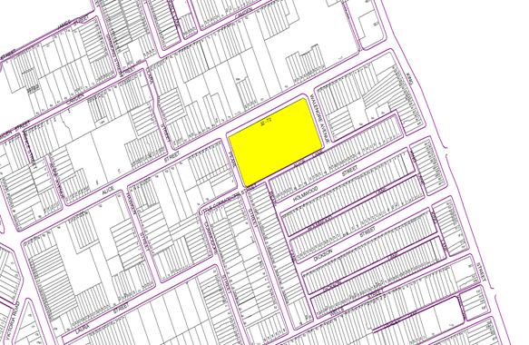


Alice Street, Newtown facing south-west to the proposed childcare centre at ground floor
Proposed development
The proposed development application is for the approval to fit out and use the commercial tenancy as a childcare centre at 2/32-72 Alice Street, Newtown. The proposed childcare centre is to accommodate up to 32 children aged 0-5 years old and 10 staff. It is proposed that the childcare centre will operate from 7am-6pm on weekdays. The proposal also includes the allocation of up to 3 existing parking spaces in the existing basement carpark which is accessed through a driveway crossing located in Pearl Street and up to 2 parking spaces provided on-street and to be used as a drop-off and pick-up facility for parents and carers (refer to the attached development plans).
Public transport
The subject site has access to public transport services with Newtown Railway Station being located approximately 800 metres north from the site, and bus routes (Route 308, 352, 370 and 422) operating along Alice Street out front of the proposed site and along King Street located approximately 150 metres east from the site.
Parking provision
Council's DCP 2011 (incorporating Amendment No.1) requires provision of off-street parking as follows for Parking Area 1:
1 car parking space per 50m2 Gross Floor Area (GFA).
Therefore, the proposed development having a total GFA of 260m2 should provide a total of 5 off-street car parking spaces.
Council's DCP 2011 (incorporating Amendment No.1) requires the provision of off-street bicycle parking for child care centre as follows:
1 bicycle parking space per 20 staff for staff + 2 for customers.
Therefore, the proposed development having 10 staff members should provide a total of 3 off-street bicycle parking spaces as follows:
- 1 space for staff bicycle parking, and
- 2 spaces for parents and carers bicycle parking.
It is proposed that 3 on-site car parking spaces will be designated for the use of the childcare centre for staff parking which is located in the basement carpark with driveway access through Pearl Street. Due to the position of the allocated spaces, it is proposed that this carpark would be used for staff parking only as it is not positioned close to a lift and not in close proximity to the proposed childcare centre. There is no proposal for any visitor parking spaces and mobility parking spaces allocated for this commercial tenancy within the basement carpark. With accordance to Council’s DCP 2011 (incorporating Amendment No.1), the proposal leaves a shortfall of 2 off-street car parking spaces.
It should be noted that Council's DCP 2011 (incorporating Amendment No.1) requires motorcycle parking to be provided at a rate of 5% of the car parking required for the development therefore, the provision of motorcycle parking spaces for the child care centre is not required. The proposal does not consider the provision for any bicycle parking spaces and motorcycle parking spaces however as part of the entire development site, the commercial tenancy is provided with bicycle and motorcycle spaces within the carpark but should it be noted that these spaces will also be suited for staff parking only due to the spaces not in close proximity to the proposed childcare centre.
The applicant proposes to make up for the short fall in parking by providing a drop-off and pick-up parking zone during peak periods on weekdays. The applicants proposal is for 2 on-street parking spaces (near the frontage to the site on the southern side of Alice Street) to be used for drop-off and pick-up.
With the addition of 2 on-street parking spaces, meets the parking provision of the proposal according to Council’s DCP 2011 (incorporating Amendment No.1) however site inspections were undertaken by a Council Officer during the afternoon period of a typical weekday on a few occasions and it was observed that on-street parking spaces in Alice Street, Pearl Street, Walenore Avenue and Alice Lane were all highly utilised. Each of these streets, excluding Alice Lane, consists of permit parking along one side of the street (out front of the existing single-dwelling residencies). This precinct was recently implemented (October 2016) and falls under the expansion of the Area M14 Permit Parking Precinct where parking restrictions apply to non-permit holders. These restrictions are ‘2P 8am-10pm Permit Holders Excepted Area M14’. It was observed during the site inspections that these time-restricted parking spaces were all moderate-to-highly utilised. The on-street parking spaces surrounding the development site consists of unrestricted parking in all four streets. It was observed during the site inspections that these unrestricted parking spaces were all highly utilised (refer to the photos below).
Council's DCP 2011(incorporating Amendment No.1) states that assessing development applications for child care centres are a special case due to the high number of car trips generated for a short duration at drop off and pick up times, and the particular safety issues involved with young children around cars. It may be appropriate that the pickup/drop-off area be provided on the street however given that observations show that on-street parking is highly utilised and that the on-site parking arrangement will result in a short fall and will in turn mean a greater demand for on-street parking.
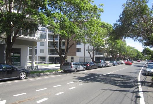
Existing on-street parking along Alice Street
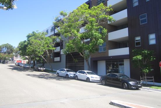
Existing on-street parking along Walenore Avenue
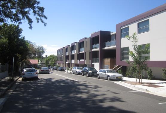
Existing on-street parking along Pearl Street
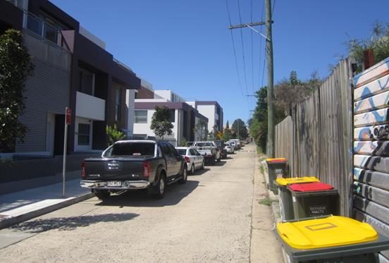
Existing on-street parking along Alice Lane
Vehicular Access, waste management (collection) & internal traffic circulation
The vehicular access to the off-street parking spaces will be from Pearl Street, where the existing access driveway is located, while the loading dock access will be from Walenore Avenue.
As part of the original development site proposal for 32-72 Alice Street, Newtown, the proposal consisted of a 3m road widening of Pearl Street (between Alice Street and Alice Lane). This was to facilitate vehicular access movements to and from the basement carpark. At the time of the development assessment for the development site, the traffic consultant provided the internal parking layout and the circulation provides for two-way movements and is considered to be adequate and allows for vehicles to enter and exit the site in a forward direction.
Estimated traffic generation
The applicant's traffic consultant report stated that the total estimated traffic generation from the proposed child care centre would be would be 26 vehicle trips per hour (morning peak) and 23 vehicle trips per hour (early evening peak). These estimated traffic generation rates are considered to be acceptable and can be accommodated with the surrounding road network.
PUBLIC CONSULTATION
Consultation/notification regarding the proposal would normally be undertaken by Council's Development and Planning Services as part of the development application process.
CONCLUSION
It is proposed that the following traffic related comments be forwarded to Council’s Development Assessment section.
Based on the information presented in the applicant’s submission to Council with regards to the distance of the proposed site and the access to the basement carpark and shortage of designated car parking spaces for the proposal, it is acknowledged that these issues will result in a greater short fall in on-site parking which will in turn need to be accommodated on-street. It means the Development Application proposal has a shortfall of 40% in parking spaces required and this directly impacts on-street parking which is highly utilised.
Due to the shortfall in on-site parking the applicant needs to review the parking provision for on-site parking for the proposed childcare centre at 2/32-72 Alice Street, Newtown to meet the requirements of Council's DCP 2011 (incorporating Amendment No.1).
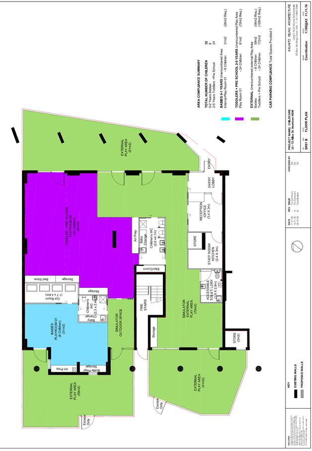
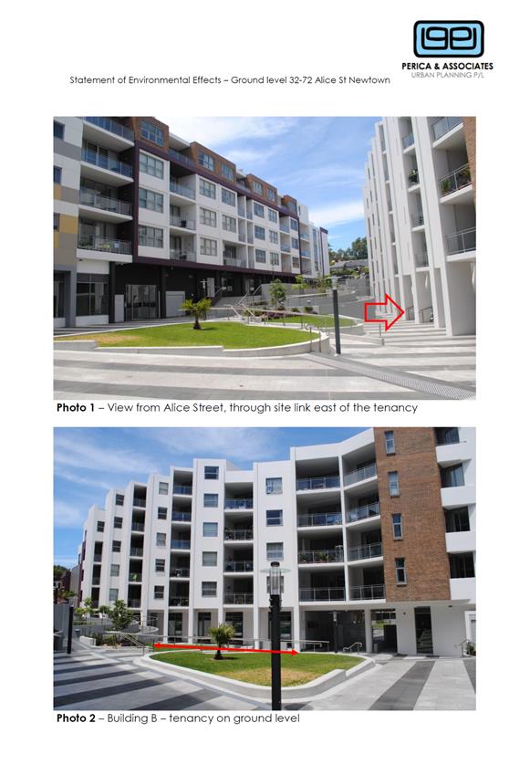
|
|
Local Traffic Committee Meeting 2 March 2017 |
Subject: Railway Parade, Marrickville -
Proposed Temporary Road Closure for Two Special Events on Friday 14 April 2017
and Saturday 15 April 2017
(Marrickville Ward/Summer Hill Electorate/Marrickville LAC)
File Ref: 17/6022/18527.17
Prepared By: Emilio Andari - Civil Engineer
Authorised By: George Tsaprounis - Coordinator Traffic Engineering Services
|
SUMMARY Council has received an application under Section 68 of the Local Government Act 1993 to use Railway Parade, Marrickville to hold 2 street party style events known as ‘Bad Friday’, an 18+ music event showcasing upcoming Australian Rock and Roll acts on Friday 14 April 2017 between the hours of 11.00am to 11.00pm, and ‘Throttle Roll’ event, a custom motorcycle show including a live music stage, display of motorcycles, food/retail stalls, art exhibitions and mechanical games on Saturday 15 April 2017 between the hours of 11.00am to 11.00pm. The erection of the stage, stalls and associated works will include a temporary full-road closure of Railway Parade, Marrickville between Sydenham Road and Buckley Lane from 7:00pm Thursday 13 April 2017 to 12:00am Monday 17 April 2017. It is recommended that Council agree to the temporary road closure of the subject section of Railway Parade from 7:00pm Thursday 13 April 2017 to 12:00am Monday 17 April 2017 subject to complying with the following conditions; apply to the RMS for consent to close the subject road, subject to the event being advertised, a Traffic Management Plan be submitted to the RMS for approval, a Road Occupancy License be obtained from the Transport Management Centre and advice of the proposed event being forwarded to the appropriate authorities including emergency services. |
|
RECOMMENDATION
THAT: 1. the proposed temporary road closure of Railway Parade, Marrickville between Sydenham Road and Buckley Lane from 7:00pm Thursday 13 April 2017 to 12:00am Monday 17 April 2016, for the holding of the ‘Bad Friday’ and ‘Throttle Roll’ events on Railway Parade, be APPROVED subject to the approval of the Development Application and the applicant complying with the following conditions: a. A fee of $1,499.40 for the temporary road closure is payable by the applicant in accordance with Council’s Fees and Charges; b. The temporary full road closure be advertised by the applicant in the local newspaper providing 28 days notice for submissions, in accordance with the Roads Act; c. A Traffic Management Plan (TMP) be submitted by the applicant to the Roads and Maritime Services for consideration and approval; d. A Traffic Control Plan (TCP) which has been prepared by a certified Traffic Controller, is to be submitted to Council for review with a copy of the Traffic Controller’s certification number attached to the plan, not less than 5 days prior to implementation of the closure; e. A Road Occupancy License application be obtained by the applicant from the Transport Management Centre; f. Notice of the proposed event is forwarded by the applicant to the NSW Police Local Area Commander, State Transit Authority, NSW Fire Brigades and NSW Ambulance Services; g. Advance notifications signs advising of the proposed road closure and traffic diversions to be strategically installed and maintained by the applicant at least two (2) weeks prior to the event; h. 'No Parking – Special Event' signs be affixed on both sides of Railway Parade, Marrickville between Marrickville Road and Sydenham Road on the afternoon of the day prior to the event date; i. A 4-metre wide emergency vehicle access must be maintained through the closed road areas during the course of the event; j. All affected residents and businesses shall be notified in writing by the applicant of the proposed temporary road closure at least two (2) weeks prior to the event, with the applicant making reasonable provision for residents and businesses; k. Adequate vehicular traffic control shall be provided for the protection and convenience of pedestrians and motorists including appropriate signage and flagging. Workers shall be specially designated for this role (and carry appropriate certificates), as necessary to comply with this condition. This is to be carried out in accordance with the Australian Standard AS 1742.3 – Traffic Control Devices for works on roads; and l. Water filled barriers be placed at the road closure points to protect against any possible errant vehicles. 2. The applicant be advised in terms of this report and that all costs for advertising the event and implementation of the road closure are to be borne by the applicant.
|
BACKGROUND
Council has received an application under Section 68 of the Local Government Act 1993 to use Railway Parade, Marrickville to hold 2 street party style events known as ‘Bad Friday’, an 18+ music event showcasing upcoming Australian Rock and Roll acts on Friday 14 April 2017 between the hours of 11.00am to 11.00pm, and ‘Throttle Roll’ event, a custom motorcycle show including a live music stage, display of motorcycles, food/retail stalls, art exhibitions and mechanical games on Saturday 15 April 2017 between the hours of 11.00am to 11.00pm.
The erection of the stage, stalls and associated works will include a temporary full-road closure of Railway Parade, Marrickville between Sydenham Road and Buckley Lane from 7:00pm Thursday 13 April 2017 to 12:00am Monday 17 April 2017.
The ‘Bad Friday’ is an 18+ music event which targets 18 – 35yrs old citizens of Sydney’s Inner West showcasing upcoming Australian Rock & Roll acts, alongside local cultural & culinary delights. This will be the 6th instalment of the event, but the first time based in Railway Parade, having outgrown its previous home of Vic on the Park which is located on the corner of Addison Road and Enmore Road, Marrickville.
The ‘Throttle Roll’ event is for the custom motorcycle community with a large proportion of the supporters residing in Sydney’s inner-west. The event was established in 2013 where it was also held at the Vic on the Park. Given the success over the years and the growing support received from the custom community, a new location has been identified to cater this expansion.
These 2 events will aim to attract approximately 5000 visitors to the area each day, with the events differing in focus & target demographics.
FINANCIAL IMPLICATIONS
Nil.
OFFICER COMMENTS
Site location & road network
|
Street Name |
Railway Parade |
|
Section |
Between Sydenham Road and Marrickville Road |
|
Carriageway Width (m) |
10.0 |
|
Carriageway Type |
Two-way road with one travel lane in each direction, in addition to kerbside parking lanes. |
|
Classification |
Local |
|
85th Percentile Speed (km/h) |
– |
|
Vehicles Per Day (vpd) |
– |
|
Reported Crash History (July 2011 - June 2016) |
1 crash (Rum Code: 49). Crash resulted in a tow-away. |
|
Heavy Vehicle Volume (%) |
– |
|
Parking Arrangements |
Northern side of the road consists of ‘2P 8.30am-6pm Mon Fri’ parallel-to-kerb parking. Southern side of the road consists of sections of ‘4P 8.30am-6pm Mon Fri’ 90 degree angle parking and unrestricted 90 angle parking. |
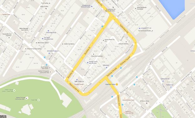
Site locality map
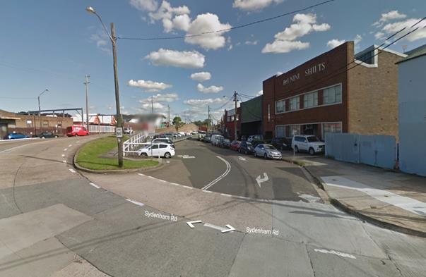
Railway Parade at its intersection with Sydenham Road
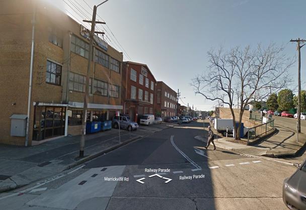
Railway Parade at its intersection with Sydenham Road
The temporary road closure of Railway Parade is required from 7:00pm Thursday 13 April 2017 to 12:00am Monday 17 April 2017 to undertake the set-up/pack-down of the stage, stalls and all other associated works prior and after the events, before the road can be reopened to traffic.
The applicant advised that traffic controllers and barricades will be located on Railway Parade at Buckley Lane and at Sydenham Road. In addition, traffic controllers will be assisting pedestrians at the intersection of Railway Parade and Gleeson Avenue near Sydenham Railway Station and at the intersection of Railway Parade and Sydenham Road near the entry to the event. Pedestrian access and egress to the event attendees will be via Sydenham Road and Railway Parade intersection (refer to the attached traffic control plans). Event attendees will not be able to enter Railway Parade from Marrickville Road or Buckley Lane, except for an emergency.
A 4-metre wide emergency vehicle access must be maintained through the closed road areas during the course of the event. The event has engaged the services of St Johns Ambulance who will be on-site for the duration of the event. Special Event advance notice signs will be strategically installed at least two (2) weeks prior to the event to alert motorists of the proposed closures. In addition, 'No Parking - Special Event' signs will be affixed over all existing parking signs within the area of the event on the afternoon of the day prior to the event date.
Impacts on Parking and Vehicular access
The proposed road closure will have an impact on approximately 90 on-street car parking spaces along both sides of Railway Road during the event. These lost parking spots cater for train commuters to Sydenham Railway Station. The parking spaces lost as a result of this event will need to be transferred to the parking spaces in nearby streets. Given that the available on-street parking impacted in Railway Parade is significant, there are concerns raised for commuters who wish to use the nearby main railway station for Easter Long Weekend activities within the Sydney CBD and Sydney Olympic Park. It is envisaged that parking utilisation along Railway Road will be high on public holiday long weekends, particularly during the Easter holidays.
All business properties on Railway Parade will be restricted to access parking during the event for that weekend. Access through the rear of these properties in Buckley Lane will still be retained during that weekend. All adjoining residential and commercial properties will need to be notified in writing of the proposed event and any impacts on parking and access to their properties by the applicant two weeks prior to the event. This includes the temporary removal of on-street parking spaces in Railway Parade during the event.
Impacts on traffic
The subject section of Railway Parade carries a low volume of traffic and therefore the diverted traffic will have no major impacts on surrounding road network. The events will be held on Friday and Saturday during the Easter Public Holiday Long Weekend when lower than weekday traffic volumes are expected.
Public Transport
The subject site has access to public transport services, with Sydenham Railway Station being located within a 100 metre radius from the site and bus routes (Route M30, 418, 425) operating along Marrickville Road, Railway Parade and Gleeson Avenue.
PUBLIC CONSULTATION
The proposed road closures of Railway Parade will need to be advertised in the newspaper for a period of 28 days by the applicant and a Traffic Management Plan is to be submitted to the RMS for consideration and approval.
The event organiser will need to notify all affected residents and businesses in writing of the proposed temporary road closure at least two weeks prior to the event and make reasonable provision for residents and businesses, where possible.
CONCLUSION
It is recommended that Council agree to the temporary road closure of the subject section of Railway Parade from 7:00pm Thursday 13 April 2017 to 12:00am Monday 17 April 2017 subject to complying with the following conditions; apply to the RMS for consent to close the subject road, subject to the event being advertised, a Traffic Management Plan be submitted to the RMS for approval, a Road Occupancy License be obtained from the Transport Management Centre and advice of the proposed event being forwarded to the appropriate authorities including emergency services.
Site Plans – Railway Parade, Marrickville
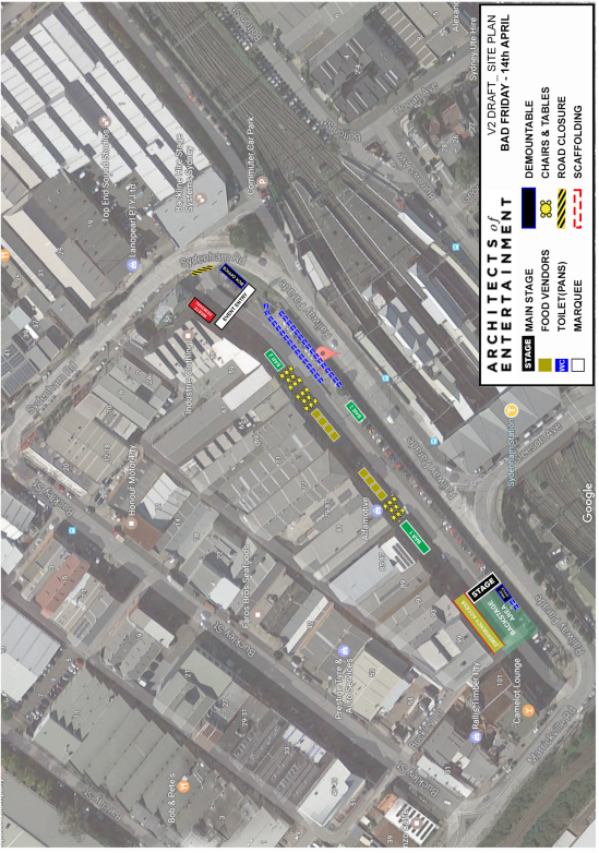
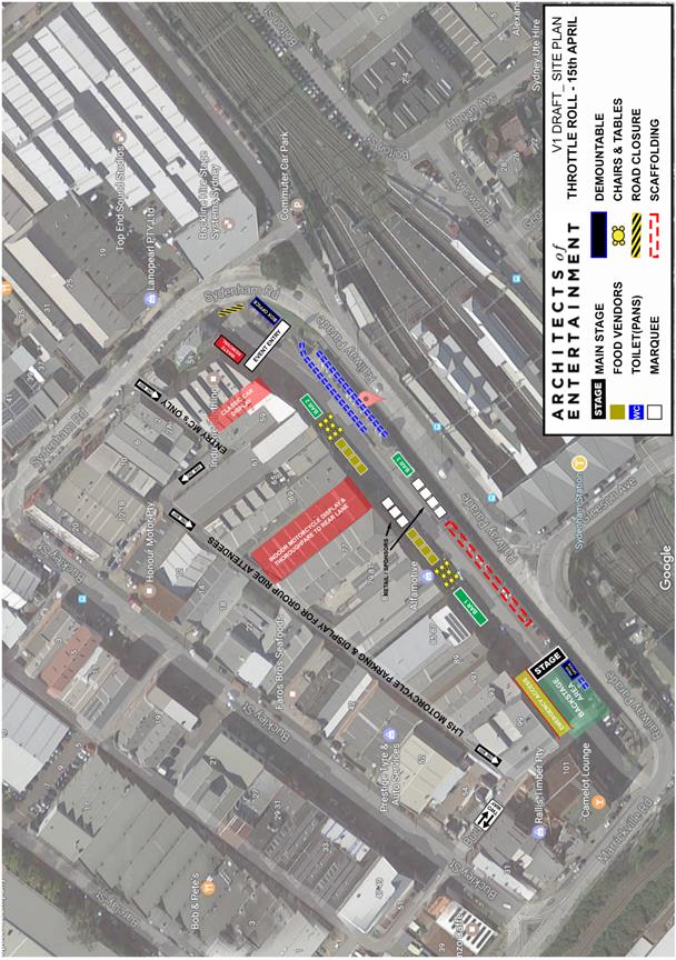
Pedestrian Management Plans & Traffic Control Plans

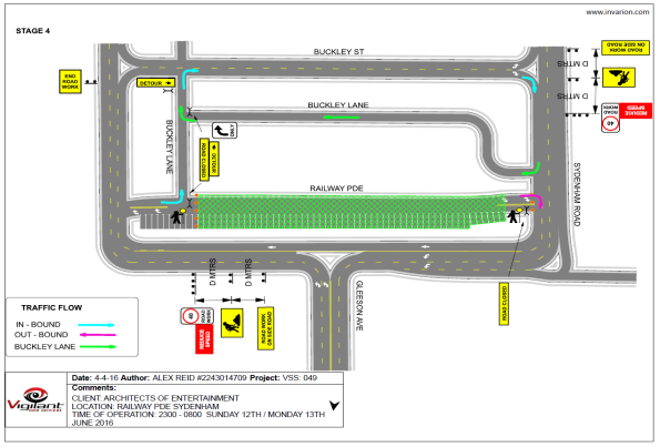
|
|
Local Traffic Committee Meeting 2 March 2017 |
Subject: Christian Brothers High School -
Section 96 Amendment to Development Consent DA200300504 dated 3 June 2004 -
68-84 The Boulevarde, Lewisham
(Stanmore Ward/Summer Hill Electorate/Marrickville LAC)
File Ref: 17/6022/17219.17
Prepared By: Jennifer Adams - Traffic and Road Safety Officer
Authorised By: Joe Di Cesare - Manager Design and Investigation
|
SUMMARY An application has been received under Section 96 of the Environmental Planning and Assessment Act to modify Determination No.200300504 dated 3 June 2004, specifically to modify condition 3 so as to increase the student numbers from 1200 to 1350 students Comments of the Local Traffic Committee will be referred to Council’s Development Assessment Section for consideration in determining the Section 96 Application. |
|
RECOMMENDATION
THAT the report be received and noted. |
BACKGROUND
An application has been received under Section 96 of the Environmental Planning and Assessment Act from Christian Brothers’ High School (Determination No.200300504 dated 3 June 2004) to modify condition 3 so as to increase the student numbers from 1200 to 1350 students.
The application is required to be referred to the Pedestrian, Cyclist & Traffic Calming Advisory Committee for consideration under State Environmental Planning Policy (Infrastructure) 2007.
In 2003 Council considered an application from Christian Brothers High School to demolish the print house, library and the dwellings of 82 and 84 The Boulevarde and carry out alterations and additions to a school including the construction of a multi-purpose facility and additional classrooms relating to property situated at 68 The Boulevarde, Lewisham.
The Development Application was determined on 3 June 2004 pursuant to Section 80(3) of the Act by the granting of a "Deferred Commencement" Consent. Once operative the consent was subject to the following conditions amongst others:
2. Not more than 1200 students being enrolled at the school without the prior approval of Council.
Reason: To ensure that the intensity of the use of the premises is not increased without a further review of the off-street car parking facilities, traffic, noise, and amenity impacts of the development.
3. Eighteen (18) off-street car parking spaces being provided, paved, linemarked and maintained at all times in accordance with the standards contained within Marrickville Development Control Plan No.19 -Parking Strategy.
Reason: To ensure practical off-street car parking is available for the use of the premises.
The existing development consent provides for a maximum of 1,200 students (Condition 3). The proposal now is to amend Condition 3 of the development consent to read:
“Not more than 1350 students being enrolled at the school without the prior approval of Council.”
The Applicant’s supporting letter states that the only expected impacts are ‘traffic and parking impact(s), demonstrably those associated with drop off and pick up times.’ It goes on to say that their Traffic and Parking Impact Assessment demonstrates that student and staff population is fully supportable in terms of its traffic and parking impacts, however it was identified that there was a need for a TMP to support improvements in the management of traffic and parking impacts and to promote modal shift. It says that the submitted TMP addresses that along with the extent to which traffic and parking impacts upon neighbours is inexorably linked to the conduct of parents and transport mode. They elaborate:
“In plain English the school recognises through the TMP their ongoing role in the consistent reinforcement of the TMP requirements to the school community. The school recognises the need to have a closer working relationship with parking officers and the NSW Police Service for peak events.”
The applicant seeks to modify the development consent under Section 96(2). Section 96 of the Environmental Planning and Assessment Act 1979 provides for modifications to development consents where the modification is substantially the same as the approved development. Specifically, Section 96(2) – Other modifications - would be applied to developments where there is an amendment which requires further assessment in terms of car parking, servicing, environmental impacts, appearance etc.
The Traffic and Parking Impact Assessment report states that the school currently operates above the 1,200 student approved maximum without Council’s consent. It says that the current student numbers are 1,361 (September 2016). Christian Brothers’ High School ‘Annual Report’ 2015 lists 1,369 students in 2015:
· Primary enrolments (Years 5 and 6) were 285 students
· Junior Secondary enrolments (Years 7-10) were 749 students
· Senior Secondary enrolments (Years 11 and 12) were 335 students.
The Traffic and Parking Impact Assessment report notes that “Currently, the school operates with 140 teachers. Under the 1,350 student proposal, the 140 teachers will remain. The teaching staff under the approved 1200 students is most likely 125 teachers, therefore, the increase in 150 students most likely requires an increase of 15 teachers above the current approval.” The report goes on to say that the “development involves a technical increase of 150 students above the current limit of 1,200 students” therefore can be considered under Clause 104 of the SEPP (Infrastructure) 2007 being an ‘Educational Establishment’ and that Council can determine the proposal accordingly and it requires formal referral to RMS.
The RMS commented on the proposal:
“Roads and Maritime has reviewed the submitted application and raises no objection to the proposal to increase student numbers from 1,200 to 1,350 students as the traffic generation impacts of the proposal on the state road network would likely be minimal.
Roads and Maritime notes that impacts on the local road network (such additional on-street parking demand) should be addressed to the satisfaction of Council. Any recommended traffic management measures on local roads would require approval of Council through the local traffic committee process.”
It is noted that for many years Council has received a stream of concerns and complaints, mainly from surrounding residents, regarding parking and traffic issues connected with Christian Brothers’ High School.
FINANCIAL IMPLICATIONS
Nil.
OFFICER COMMENTS
Site location and road network
Christian Brothers High School is a Catholic day school for boys and is situated in Lewisham, Inner West Sydney. The school has three road frontages – The Boulevarde to the south-east, Toothill Street to the north-east and Denison Road to the north-west. New Canterbury Road, a state road, lies approximately 100 metres to the south-east of the site. The school is surrounded by low density residential dwellings and Lewisham Public School is located opposite on The Boulevarde. (Refer to the attached locality map).
The section of The Boulevarde, between Eltham and Toothill Streets, Lewisham, serving both the Lewisham Public School and Christian Brothers High School is a designated "School Zone" with a 40km/h speed limit operating during "8.00AM-9.30AM, 2.30PM-4.00PM School Days". "No Standing 8.30AM-9.30AM, 2.30PM-3.30PM School Days" restrictions are installed
on both sides of the road to enable parents to drop-off/pick-up their children before and after school.
Lewisham Public School (Kindergarten to Year 6 – 150 pupils) is a small but growing school consisting of both local and non-local enrolments. By contrast Christian Brothers High School
is large and has many students attending the school, many of which come from out-of-area and arrive and depart by motor vehicle. The drop-off zones in front of the two schools on the The Boulevarde significantly adds to general localized traffic congestion at school start and finish times.
The Performing Arts Unit also operates out of Lewisham Public School grounds and regularly runs rehearsals 4.30 to 7pm on several weekdays, which extends the duration of parking issues in the locality from the afternoon to the early evening, as many children attending these rehearsals, come from all over Sydney. Further compounding parking and other issues
Locality Map – The Boulevarde, Lewisham
![]()
![]()
![]()

![]()


![]()
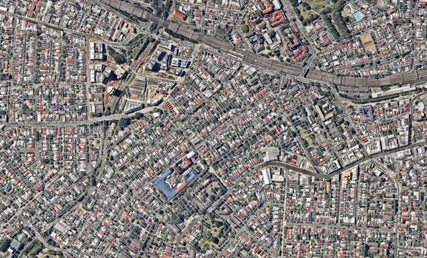
Christian Brothers High School The Boulevarde Lewisham Public School

![]()
![]()


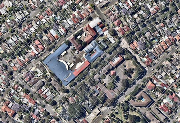
associated with the two schools the Art Units’ drop-off and pick-up coincides also with vehicular movements associated with the Jigsaw OOSH operating out of Lewisham Public School, which closes at 6pm and whom state that their patrons find parking near the facility difficult, especially collecting their children at 6pm because the Boulevarde is parked out by non-residents.
Several site inspections by Council Officers, over the last few years, revealed double parking and U-turns are prevalent in The Boulevarde during the peak school drop-off and pick-up periods. Because of the double parking, this section of The Boulevarde is narrowed to a single lane and vehicles have to overtake the illegally parked vehicles on the wrong side of the road. A large number of students from both schools also cross the Boulevarde, after having been dropped off or collected from the opposite side of the road from their school.
In 2014 Council investigated a request from Lewisham Public School P&C for a pedestrian crossing in the The Boulevarde, Lewisham between Lewisham Public School and Christian Brothers High School. Council subsequently endorsed the pedestrian crossing and it was installed in early 2016. New BB line markings were installed to try to stop illegal U-turns.
![]()
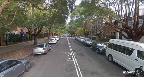
The Boulevarde – looking south-west from Toothill Street, Lewisham
It is noted that some of the traffic congestion and parking issues in the subject section of the Boulevarde were identified, also, in two recent studies. Council engaged a Consultant to review the Lewisham area in relation to parking. The study aim was to review parking in the whole area of Lewisham to address any parking issues and not those only in individual streets, as any change in one street may shift parking problems to adjacent streets. This study was also aligned with the LATM review of the Dulwich Hill North area (Area 16).
The Consultants carrying out the Lewisham Parking Study noted that, after revision of previous correspondence to Council from local residents in regards to parking within Lewisham, it was quite clear that ‘parking is a topic of high importance to the local community, sometimes dividing opinions and the community.’ The consultants noted that another issue of contention is the provision of resident parking schemes. ‘Many residents view this option as a way of safeguarding their streets from non-local traffic.’
In relation to school parking in the Lewisham area the Parking study noted that:
“‘The educational institutions located within the study area are important traffic generators and stakeholders. Staff, students and parents utilise parking in the surrounding streets, competing with other users of the network, especially along The Boulevarde, Hunter Street, Victoria Street, Thomas Street, West Street and Denison Road. The duration of parking will range from quick drop-off (parents), to long term parking (staff and some Year 12 students).”
The Study recommended, amongst other things, an extension of the existing resident parking permit scheme zone M7. The Study was subsequently adopted by Council.
The School
Christian Brothers High School caters for Years 5-12, with no infants / kindergarten school or child care on-site. The school operates between 8:15am and 3:30pm, Monday to Friday.
The school site provides on-site parking for 18 car parking spaces. The car park is accessed from Denison Road and is restricted to staff only. There are 15 school bus routes that service Christian Brothers High School during the morning drop-off period and/or afternoon pick-up period. A 150 metre long bus zone is located along the Denison Road frontage of the school
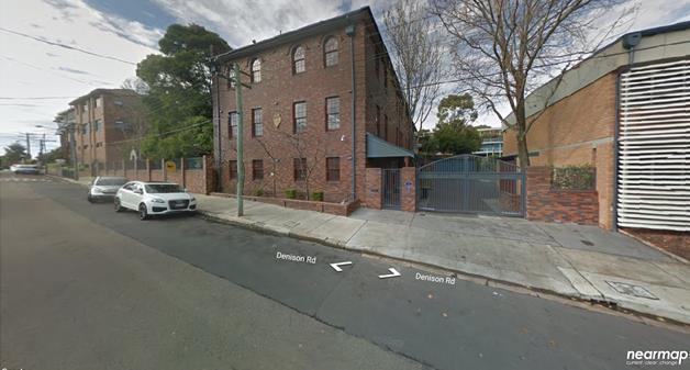
Denison Road frontage of Christian Brothers High School
Typically, according to the Traffic and Parking Impact Assessment report, there is 153 staff on-site during the day including 109 teaching staff, 33 administration personnel, 4 casuals, 2 volunteers and 5 cleaners. The report also, contradictorily states that ‘currently the school operates with 140 teachers’, going on to say that with 1,200 students teaching staff numbers would most likely be 125 indicating that an ‘increase in 150 students most likely requires an increase of 15 teachers above the current approval’.
It is noted that, regardless of the number of staff, the Traffic and Parking Impact Assessment report states “It is understood that 86% of staff drive to school.” which would require substantially more parking than currently provided on site (i.e. 18 car parking spaces)
Student numbers
The application seeks to increase the number of students at the school from the current maximum of 1,200 students to a new maximum of 1,350 students. This represents an increase of 12.5%.
Given concerns raised by the local community in relation to increased vehicle activity associated with parent/carers vehicles and the objections received in relation to the current application, it is clear that a number of local residents are opposed to further increases in student numbers at the school due to an associated increase in traffic and parking congestion in streets surrounding the school, particularly during peak hours.
![]()
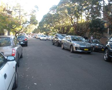
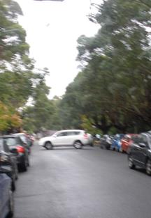
Vehicles double parked in the Boulevarde and a vehicle doing a U-turn
Adopting the TMP proposed is a step towards improving the situation however it will not eliminate the traffic congestion or poor driver behaviour which occurs in peak school periods, regardless of student numbers.
Parking
Council’s DCP 2011 (incorporating Amendment 1) requires the provision of off-street car parking for a ‘school’ as follows:
1 parking space per 2 staff for staff +
drop off and pickup facility for parents and carers
The Traffic and Parking Impact Assessment report evaluated parking requirements for their estimated ‘technical increase’ of 150 student and 15 teachers only and stated that ‘the increase of approximately 15 teachers requires the provision of 8 staff parking spaces’. The report further states that;
“The site currently provides parking for up to 18 staff car spaces. Under the increase there are no new car parking spaces proposed on-site.
Whilst there is evidently a shortfall of on-site parking, the surveys undertaken of the traffic and parking conditions around the school can be used to justify this shortfall, together with the following other matters:
a) The existing consent for the school permits a relaxation of requirements by some 71% (i.e. 1 – 18/63).
b) Provision of a workplace travel plan that encourages staff to car pool or to use other forms of non-private vehicle travel such as heavy and light rail, bus services, bicycle and walk modes. It should be noted that the previous relaxation of 71% staff parking would equate to 2 parking spaces.
c) An option to stack parking up to a further 2 staff cars in the school’s off-street car park can be further developed and operated under a Plan of Management.”
In order to ease the pressure of parking on existing streets, Council through the Lewisham Parking Study has proposed resident parking scheme be implemented on one side of the road to a number of streets surrounding the school. This aim was to address resident’s concerns regarding lack of parking whilst balancing this with the needs of other users. The study has gone some way to addressing concerns of residents.
Bicycle Parking
The Traffic and Parking Impact Assessment report proposing 150 students and 15 teachers estimates the proposal requires 16 bicycle parking spaces, 5 clothes lockers and 1 shower. They state:
“The school currently provides 10 bicycle spaces for staff and students, 7 staff showers and 2 student showers. The school provides students lockers totally 550 lockers.
Whilst the increase in student and staff population requires additional bicycle spaces, there is currently low usage of students cycling to/from the school (with the in-class surveys showing one (1) student). Staff members cycling to work is also low. There is space to provide additional bicycle spaces if the demand increases.”
Albeit, the student and staff survey show very little usage of the bicycle parking facilities, Council’s DCP does require that bicycle facilities be provided. Therefore, the provision of an additional 10 spaces (on top of the existing 10 spaces) for a student population of approximately 1350 would be a reasonable requirement and may end up encouraging more students to ride to school.
Motorcycle Parking
The Traffic and Parking Impact Assessment report estimates no motorcycle spaces required for the additional 15 staff members:
“Council’s DCP requires the provision of motorcycle parking at a rate of 5% of the car parking required. Based on the 15 additional staff members requiring 8 car spaces, 0.4 motorcycle spaces would be required. As Council’s DCP requires rounding up or down to the nearest whole number, zero (0) motorcycle spaces are required.”
Traffic
In-class survey results were used in the Traffic and Parking Impact Assessment report to estimate the traffic generation associated with ‘the increase sought for approval of 150 students and 15 teachers’. Figures for added traffic generation were given for students and teachers however no analysis was given for the overall traffic generated by the entire school. It is noted that the analysis stated 13 out of 15 teachers would be driving to and from the school.
Local residents have said the area has been plagued with traffic congestion and the poor behavior of parents/carers when picking up their children in congested traffic conditions. Nonetheless, it is also noted that the challenge of finding practical ways to improve road safety in school zones, particularly during peak drop-off and pick-up periods, is one with which every community is acutely familiar. Illegal parking and traffic congestion are problems common to all schools across NSW. Council staffs are aware of the traffic and parking congestion issues surrounding schools in the Inner West Local Government Area at peak school drop off and pick up periods, including Christian Brothers High School.
A number of traffic calming measures have been proposed in the surrounding streets as the result of an LATM review carried out by Council. This LATM although will not solve all the problems occurring immediately adjacent to the school will however provide an environment which encourages slower speeds in general for the surrounding area.
PUBLIC CONSULTATION
Nil.
CONCLUSION
The submitted S96 application has been reviewed and no objections are raised to the proposal subject to the school (applicant) addressing the following issues;
· The applicant will either need to provide an additional 8 parking spaces on-site to meet Council’s DCP requirement or demonstrate that these 8 spaces can be provided in the existing street environment without negatively impacting parking for residents in the surrounding streets.
· An additional 10 bicycle spaces being provided on site to address Council’s requirement for the provision of on-site bicycle parking facilities.
It is recommended that the above traffic related comments be forwarded to Council’s Development Assessment section.