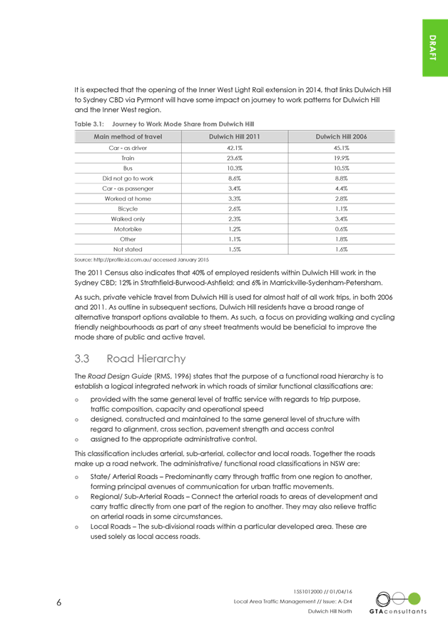
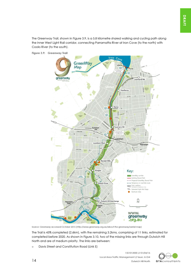
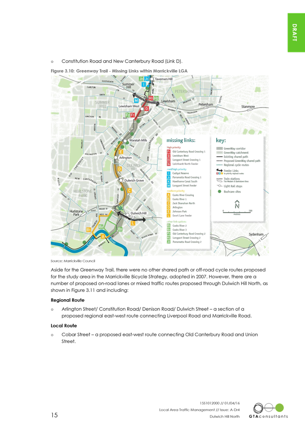
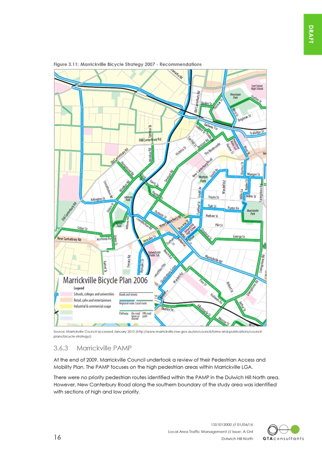
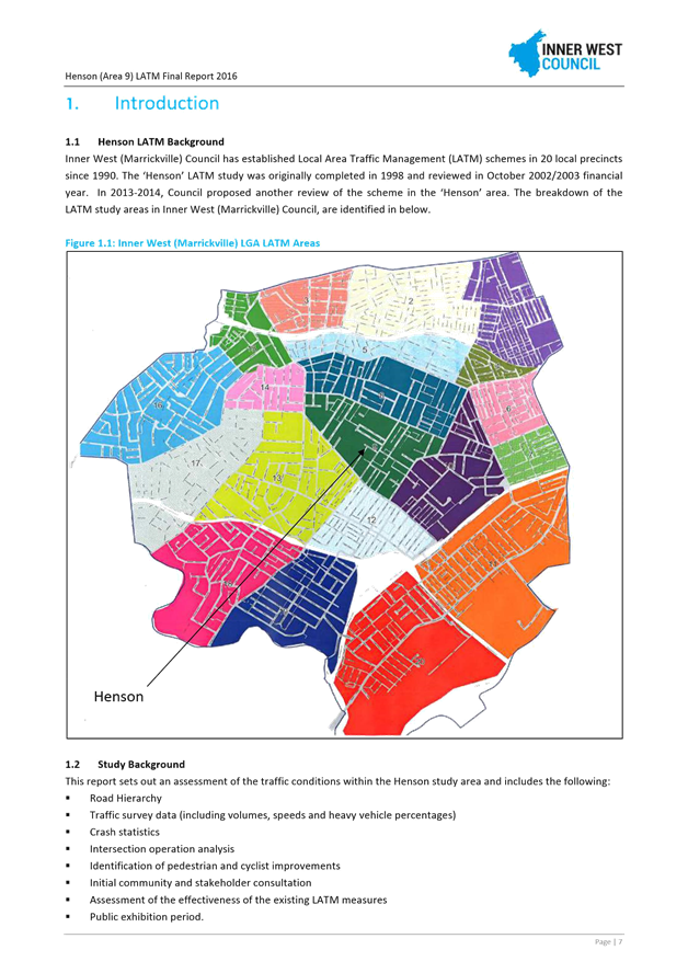
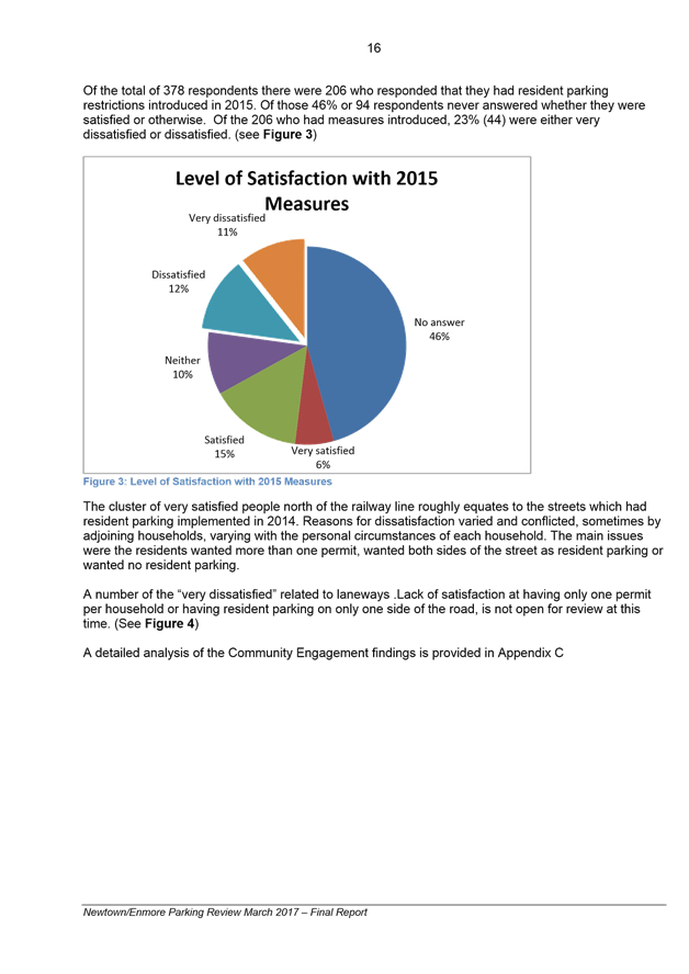
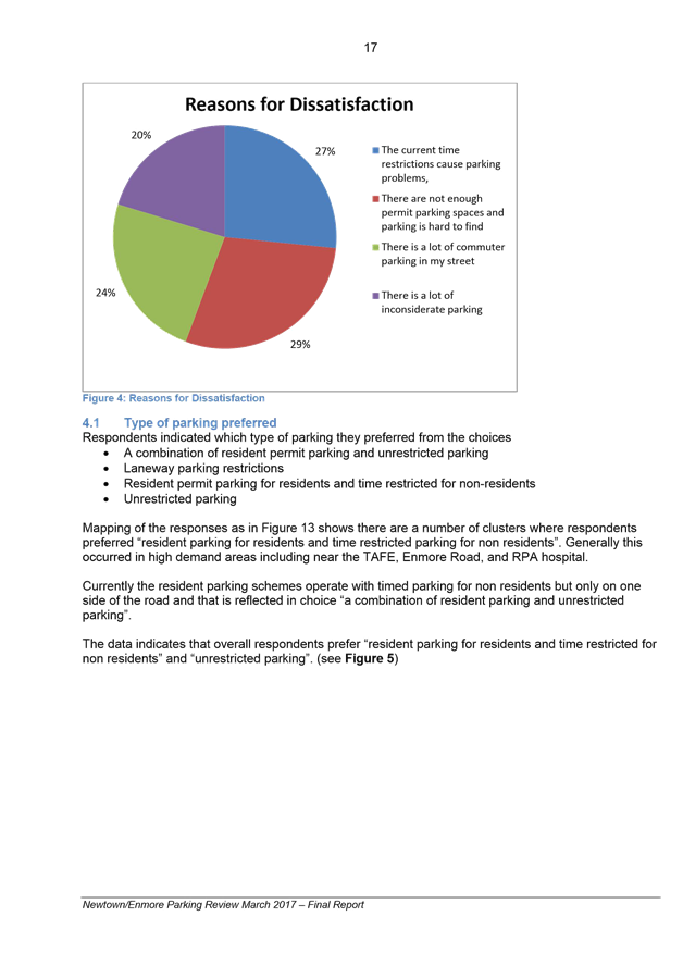
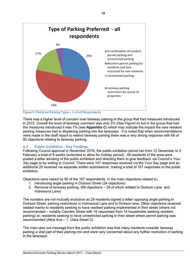
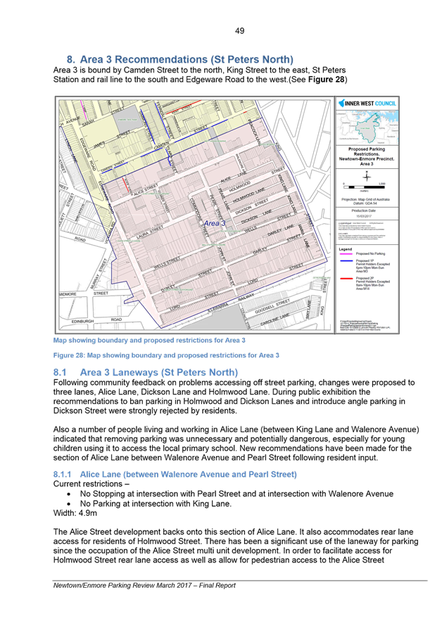
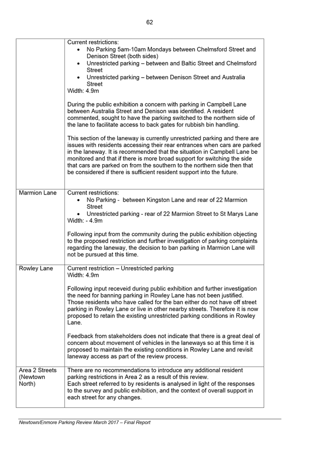
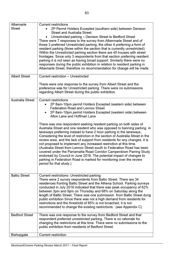
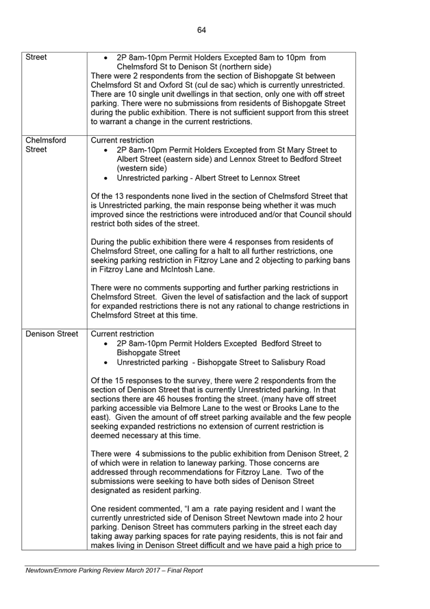
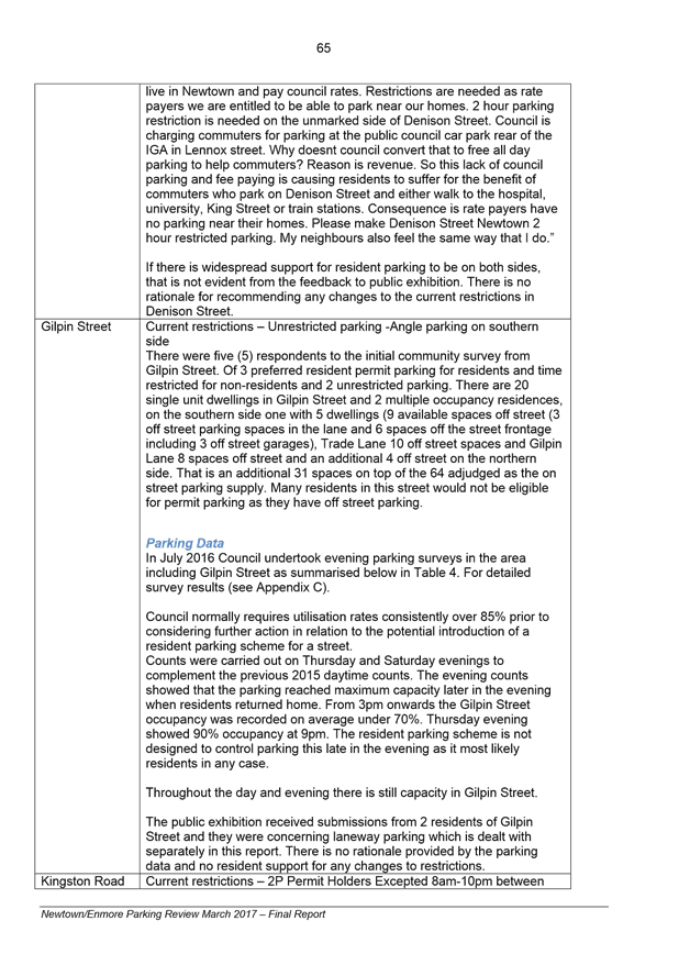
|
AGENDA R |

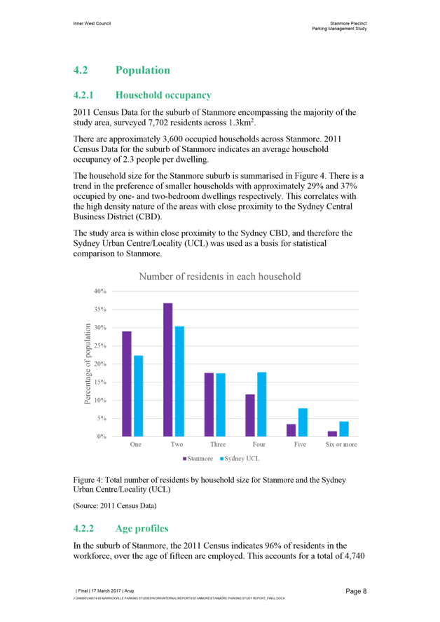
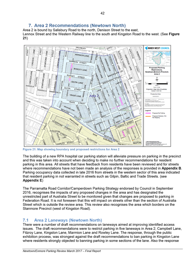
Local Traffic Committee Meeting
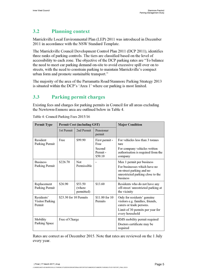
THURSDAY 6 APRIL 2017
10:00am
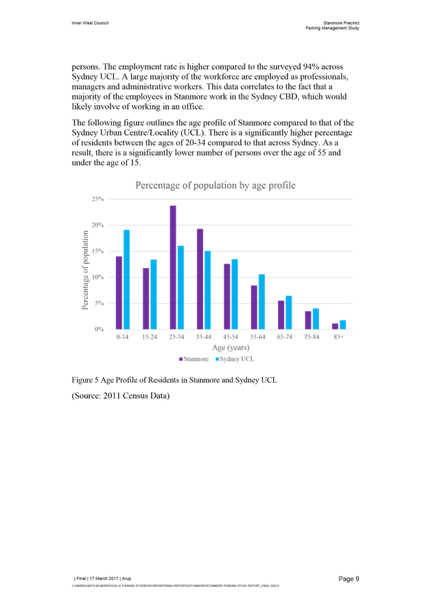
Function of the Local Traffic Committee
Background
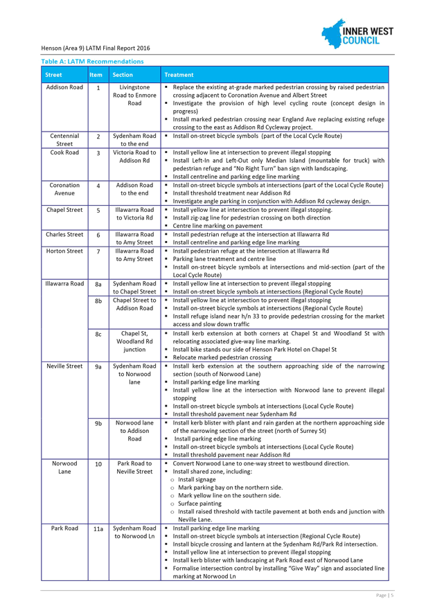
Roads and Maritime Services (RMS) is legislated as the Authority responsible for the control of traffic on all NSW Roads. The RMS has delegated certain aspects of the control of traffic on local roads to councils. To exercise this delegation, councils must establish a local traffic committee and obtain the advice of the RMS and Police. The Inner West Council Local Traffic Committee has been constituted by Council as a result of the delegation granted by the RMS pursuant to Section 50 of the Transport Administration Act 1988.
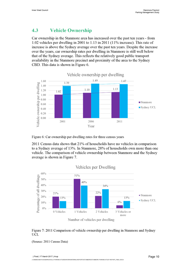
Role of the Committee
The Local Traffic Committee is primarily a technical review and advisory committee which considers the technical merits of proposals and ensures that current technical guidelines are considered. It provides recommendations to Council on traffic and parking control matters and on the provision of traffic control facilities and prescribed traffic control devices for which Council has delegated authority. These matters are dealt with under Part A of the agenda and require Council to consider exercising its delegation.
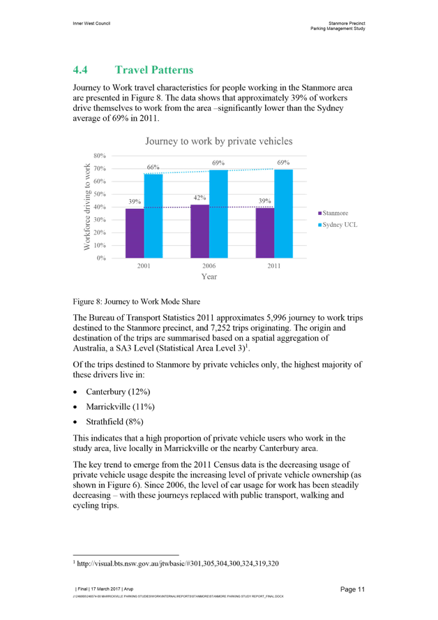
In addition to its formal role as the Local Traffic Committee, the Committee may also be requested to provide informal traffic engineering advice on traffic matters not requiring Council to exercise its delegated function at that point in time, for example, advice to Council’s Development Assessment Section on traffic generating developments. These matters are dealt with under Part C of the agenda and are for information or advice only and do not require Council to exercise its delegation.
Committee Delegations
The Local Traffic Committee has no decision-making powers. The Council must refer all traffic related matters to the Local Traffic Committee prior to exercising its delegated functions. Matters related to State Roads or functions that have not been delegated to Council must be referred directly to the RMS or relevant organisation.
The Committee provides recommendations to Council. Should Council wish to act contrary to the advice of the Committee or if that advice is not supported unanimously by the Committee members, then the Police or RMS have an opportunity to appeal to the Regional Traffic Committee.
Committee Membership & Voting
Formal voting membership comprises the following:
· one representative of Council as nominated by Council;
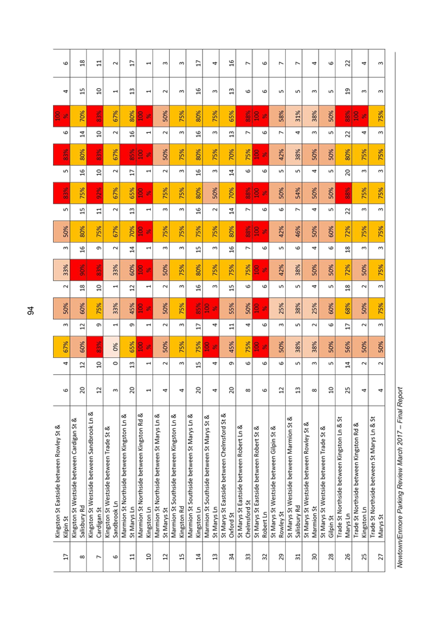
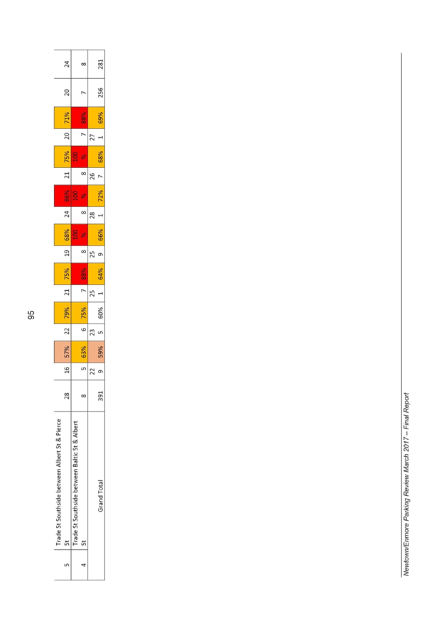
· one representative of the NSW Police from each Local Area Command (LAC) within the LGA, being Newtown, Marrickville, Leichhardt and Ashfield LAC’s.
· one representative from the RMS; and
· State Members of Parliament (MP) for the electorates of Summer Hill, Newtown, Heffron, Canterbury, Strathfield and Balmain or their nominees.
Where the Council area is represented by more than one MP or covered by more than one Police LAC, representatives are only permitted to vote on matters which effect their electorate or LAC.
Informal (non-voting) advisors from within Council or external authorities may also attend Committee meetings to provide expert advice.
Committee Chair
Council’s representative will chair the meetings.
Public Participation
Members of the public or other stakeholders may address the Committee on agenda items to be considered by the Committee. The format and number of presentations is at the discretion of the Chairperson and is generally limited to 3 minutes per speaker. Committee debate on agenda items is not open to the public.
|
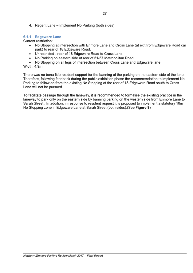
|
Local Traffic Committee Meeting 6 April 2017 |
1 Apologies
2 Disclosures of Interest
3 Confirmation of Minutes
4 Matters Arising from Council’s Resolution of Minutes
5 Part A – Items Where Council May Exercise Its Delegated Functions
Traffic Matters Page
T0417 Item 1 TEMPORARY
ROAD CLOSURE TO CARRY OUT CRANE LIFT ESCALATORS INTO METRO SHOPPING CENTRE
ACROSS MURRAY STREET, MARRICKVILLE
(MARRICKVILLE WARD /NEWTOWN ELECTORATE / MARRICKVILE LAC) 6
T0417 Item 2 REQUESTS
FOR MOBILITY PARKING SPACES
(ASHFIELD & MARRICKVILLE WARDS/HEFFRON, SUMMER HILL & NEWTOWN
ELECTORATES/MARRICKVILLE & NEWTOWN LACS) 9
T0417 Item 3 LINCOLN LANE, STANMORE – TEMPORARY FULL ROAD CLOSURE FOR SEWER WORKS TO A RESIDENTIAL DWELLING (STANMORE WARD/NEWTOWN ELECTORATE/NEWTOWN LAC) 29
T0417 Item 4 PREMIER
STREET, MARRICKVILE - EXTENSION OF EXISTING BB LINE MARKING AT PREMIER STREET,
MARRICKVILLE TO IMPROVE PEDESTRIAN SAFETY
(MARRICKVILLE WARD/ SUMMERHILL ELECTORATE / MARRICKVILLE LAC) 33
T0417 Item 5 LEICHHARDT
OVAL PERIMETER ROAD AT GLOVER STREET, LILYFIELD – TRAFFIC CALMING
(BALMAIN WARD/BALMAIN ELECTORATE/LEICHHARDT LAC) 37
T0417 Item 6 DOT LANE, LEICHHARDT - ROAD OCCUPANCY (LEICHHARDT WARD/ BALMAIN ELECORATE /LEICHHARDT LAC) 39
T0417 Item 7 DENMAN
AVENUE, HABERFIELD – PROPOSED NEW RAISED PEDESTRIAN CROSSING OUTSIDE
HABERFIELD PUBLIC PRIMARY SCHOOL.
(LEICHHARDT WARD/SUMMER HILL ELECTORATE/ASHFIELD LAC) 45
T0417 Item 8 DULWICH HILL NORTH LATM DRAFT CONCEPT
(MARRICKVILLE & ASHFIELD WARD/SUMMER HILL ELECTORATE/MARRICKVILLE LAC) 49
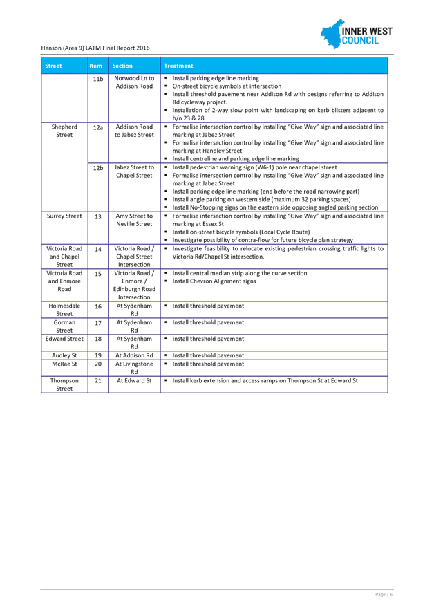
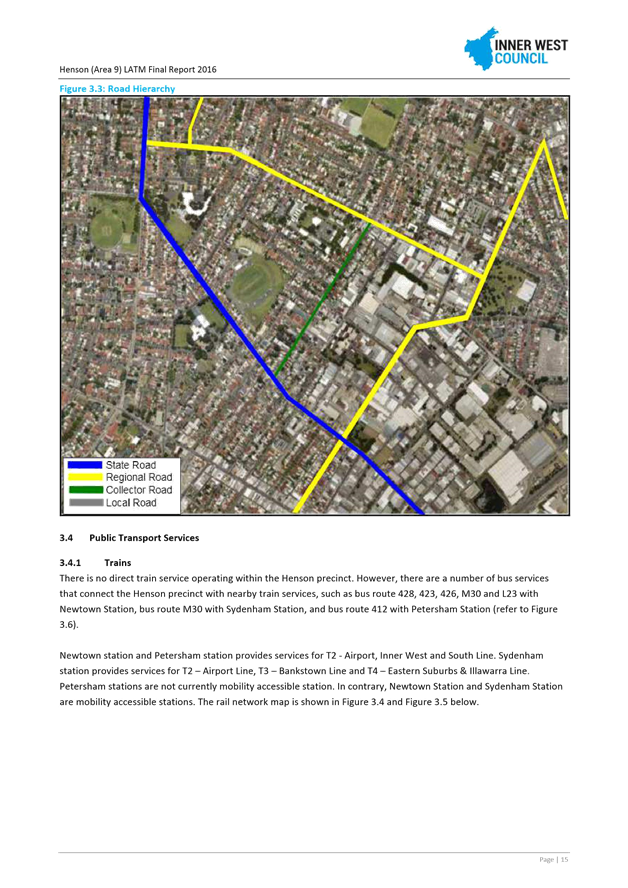
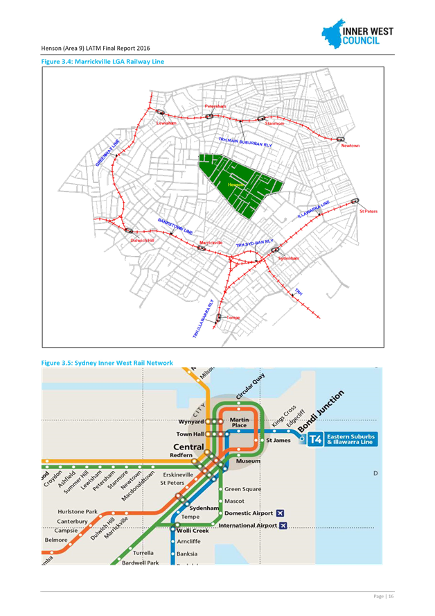
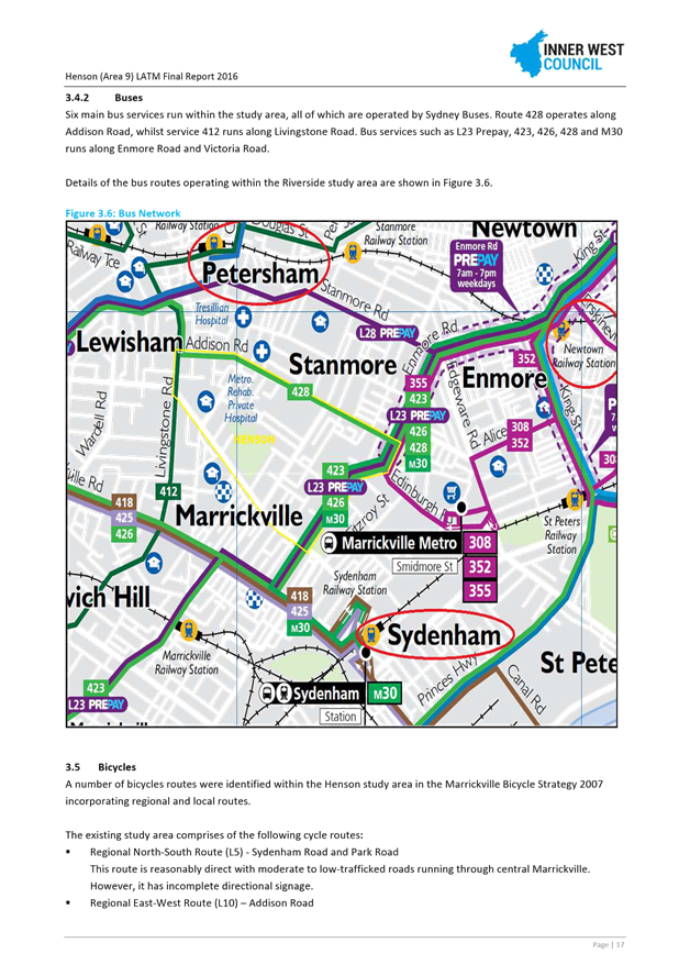
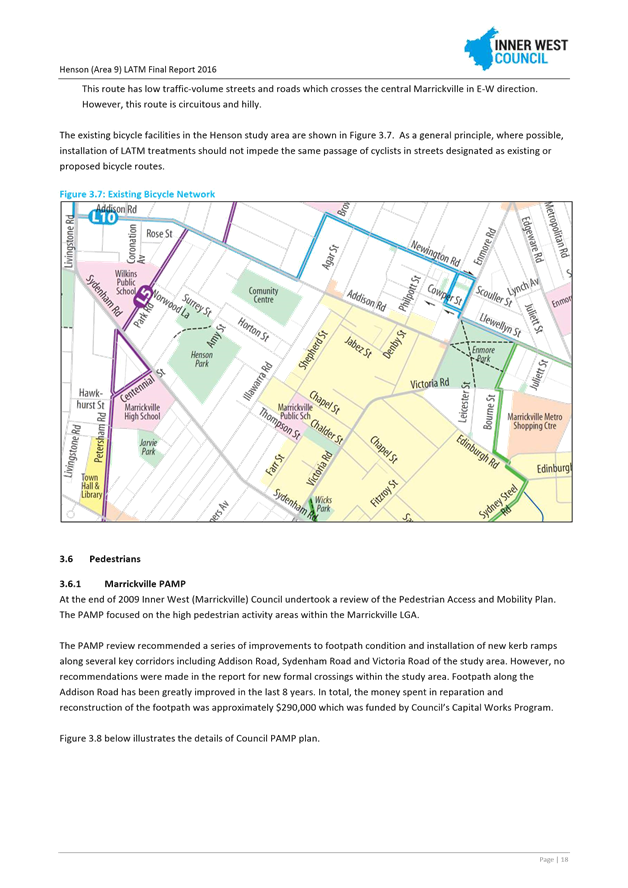
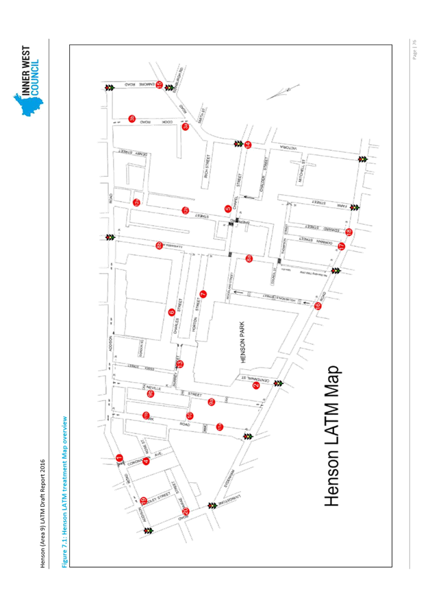
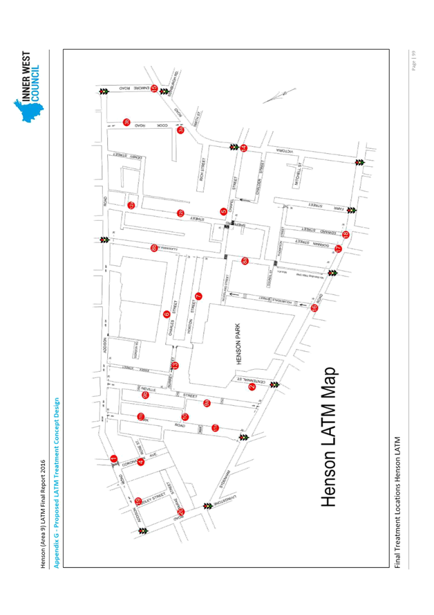
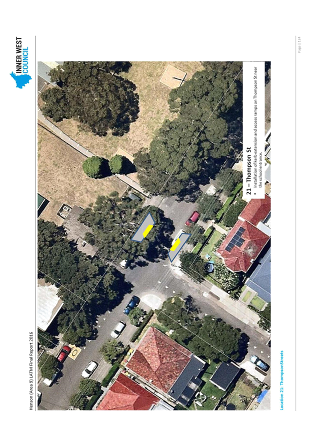
T0417 Item 9 HENSON LATM FINAL REPORT
(MARRICKVILLE & STANMORE WARD/SUMMER HILL ELECTORATE/MARRICKVILLE LAC) 182
Parking Matters
T0417 Item 10 68
MORT STREET, BALMAIN - MODIFICATION OF SHORT TERM PARKING RESTRICTION
(LEICHHARDT AND BALMAIN WARD/BALMAIN ELECTORATE/LEICHHARDT LAC) 317
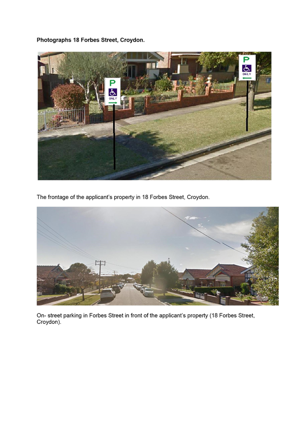
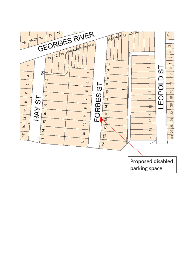
T0417 Item 11 18
FORBES STREET, CROYDON - REQUEST FOR MOBILITY PARKING SPACE
ASHFIELD WARD/SUMMER HILL ELECTORATE/ASHFIELD LAC 319
T0417 Item 12 LAWSON
STREET, BALMAIN - MODIFICATION OF ‘RESIDENT PARKING SCHEME’
(BALMAIN WARD/BALMAIN ELECTORATE/LEICHHARDT LAC) 323
T0417 Item 13 LITTLE
STEPHEN STREET, BALMAIN– RESIDENT PARKING SCHEME AND ‘NO
PARKING’ RESTRICTIONS
(LEICHHARDT/BALMAIN/LEICHHARDT LAC) 325
T0417 Item 14 TAYLOR STREET, ANNANDALE - NO PARKING ZONE
(LEICHHARDT WARD/BALMAIN ELECTORATE/LEICHHARDT LAC) 329
T0417 Item 15 THE
TERRACE, BIRCHGROVE - MOTOR BIKES ONLY
(LEICHHARDT AND BALMAIN WARD/BALMAIN ELECTORATE/LEICHHARDT LAC) 331
T0417 Item 16 NO
PARKING ZONE - WAITE AVENUE, BALMAIN
(BALMAIN WARD/BALMAIN ELECTORATE/LEICHHARDT LAC) 333
T0417 Item 17 UNNAMED
LANES BETWEEN NOWRANIE, CARRINGTON & SPENCER STREET, SUMMER HILL- PART TIME
NO PARKING RESTRICTIONS
(ASHFIELD WARD/SUMMER HILL ELECTRORATE/ASHFIELD LAC 336
T0417 Item 18 16
HENSON STREET, SUMMER HILL - REQUEST FOR MOBILITY PARKING SPACE
(ASHFIELD WARD/SUMMER HILL ELECTORATE/ASHFIELD LAC) 338
T0417 Item 19 171
RAMSAY STREET, HABERFIELD - INTRODUCTION 30 MINUTE PARKING NEARBY
(LEICHHARDT WARD/SUMMER HILL ELECTORATE/ASHFIELD LAC 342
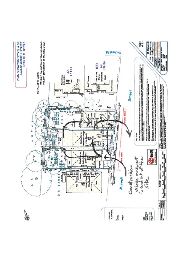
T0417 Item 20 8-12
MURRELL STREET, ASHFIELD - REQUEST FOR WORKS ZONE OUTSIDE
(ASHFIELD WARD/SUMMER HILL ELECTORATE/ASHFIELD LAC) 345
T0417 Item 21 REMOVAL OF MOBILITY PARKING SPACES
(MARRICKVILLE, ASHFIELD & STANMORE WARD/SUMMER HILL, NEWTOWN & HEFFRON ELECTORATE/MARRICKVILLE & NEWTOWN LAC) 349
T0417 Item 22 REQUESTS
FOR ‘WORKS ZONE’ ADJACENT TO CONSTRUCTION SITES
(STANMORE & ASHFIELD WARDS / NEWTOWN & SUMMER HILL ELECTORATES /
MARRICKVILLE LACS) 354
T0417 Item 23 RICHARDSONS CRESCENT, MARRICKVILLE - PROPOSED CHANGES TO PARKING RESTRICTIONS & LINEMARKING ADJUSTMENT
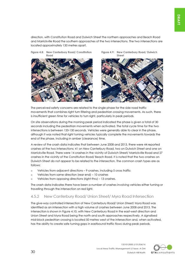
(MARRICKVILLE WARD/SUMMER HILL ELECTORATE/MARRICKVILLE LAC) 364
T0417 Item 24 UNWINS BRIDGE ROAD, ST PETERS – PROPOSED NO STOPPING & NO PARKING RESTRICTIONS
(MARRICKVILLE WARD/HEFFRON ELECTORATE/NEWTOWN LAC) 371
T0417 Item 25 MEEKS LANE, MARRICKVILLE – PROPOSED ‘NO PARKING’ RESTRICTIONS ON THE OUTER CORNERS OF THE LANEWAY
(MARRICKVILLE WARD/SUMMER HILL ELECTORATE/MARRICKVILLE LAC) 380
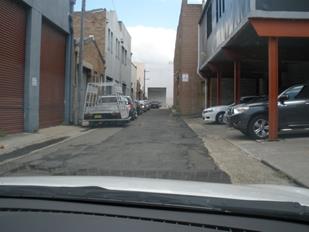
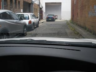
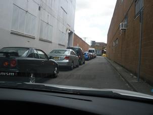
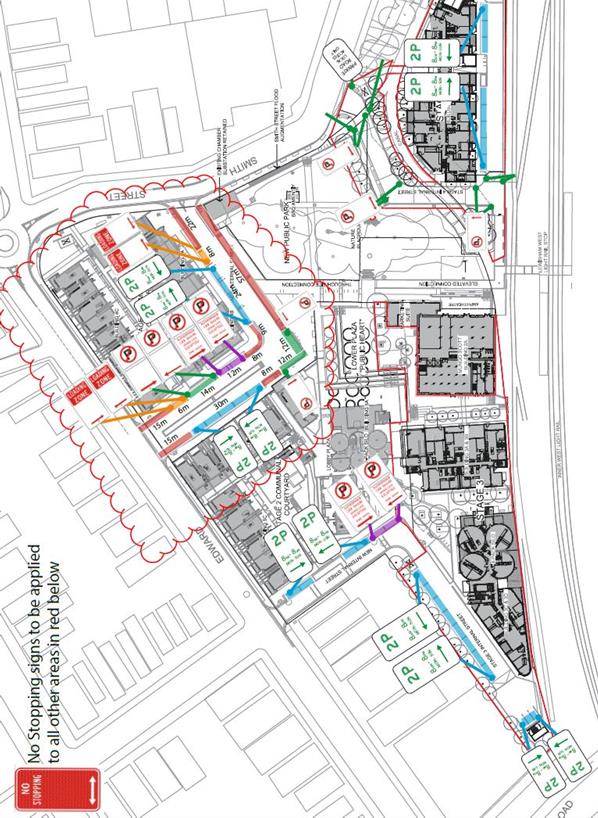
T0417 Item 26 2-32
SMITH STREET, SUMMER HILL – PARKING AND SIGNAGE PLAN FOR STAGED
DEVELOPMENT
(ASHFIELD WARD/SUMMER HILL ELECTORATE/ASHFIELD LAC 388
T0417 Item 27 HEARN
STREET, LEICHHARDT - MOTOR BIKES ONLY’ PARKING
(LEICHHARDT WARD/BALMAIN ELECTORATE/LEICHHARDT LAC) 390
T0417 Item 28 MINOR
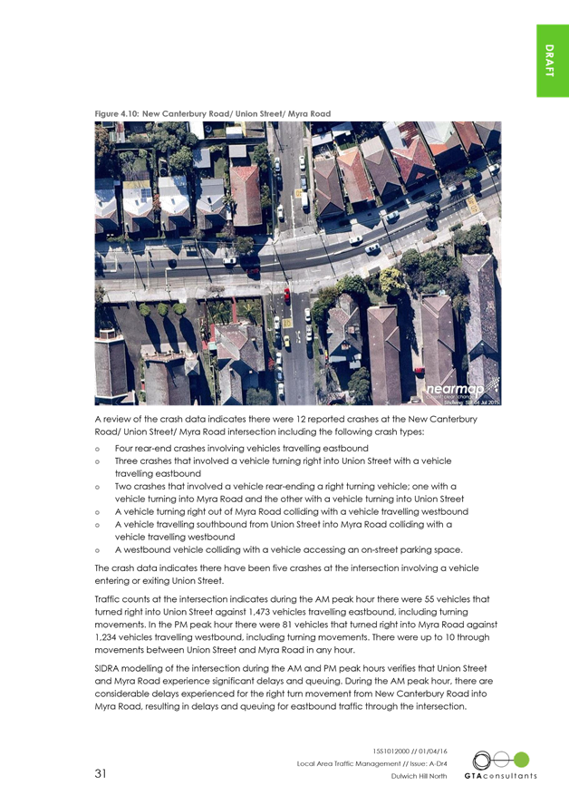
TRAFFIC FACILITIES
(LEICHHARDT & BALMAIN WARDS/BALMAIN/LEICHHARDT LAC) 392
T0417 Item 29 FLOOD
STREET, GEORGE STREET, TREADGOLD STREET NORTH AND TREADGOLD STREET SOUTH,
LEICHHARDT– RESIDENT PARKING SCHEME
(LEICHHARDT/BALMAIN/LEICHHARDT LAC) 394
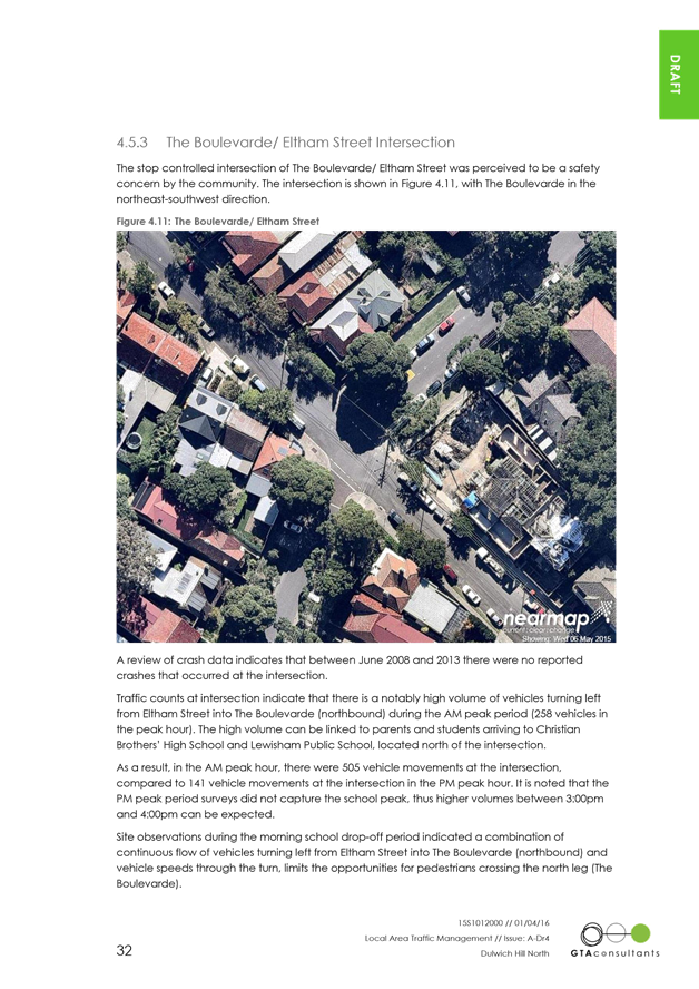
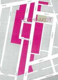
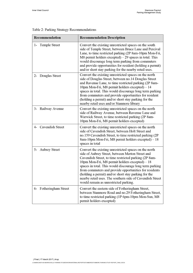
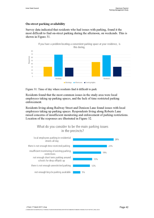
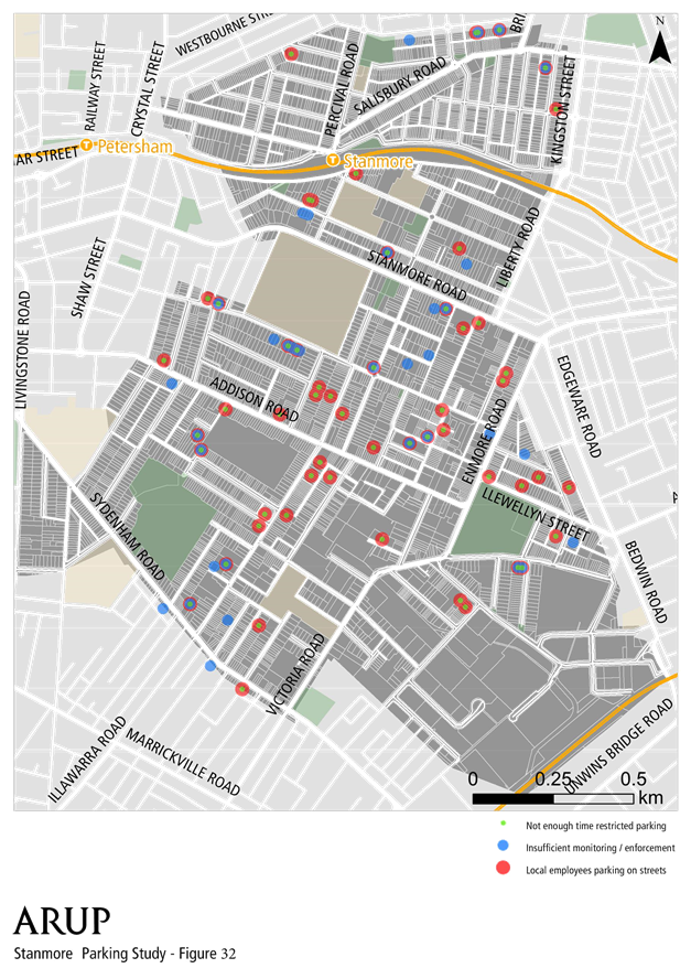
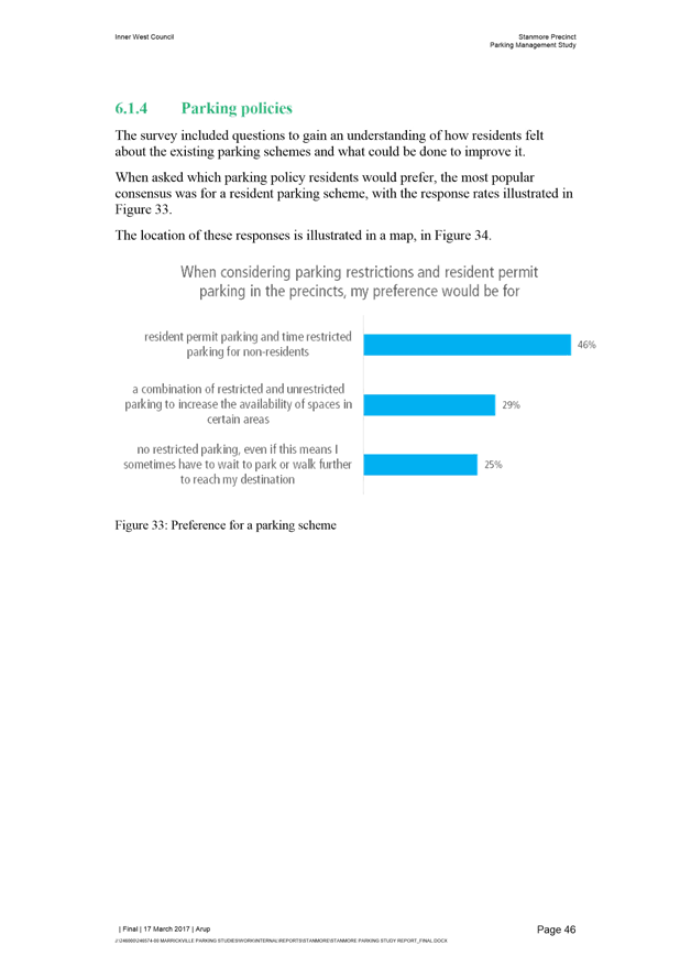
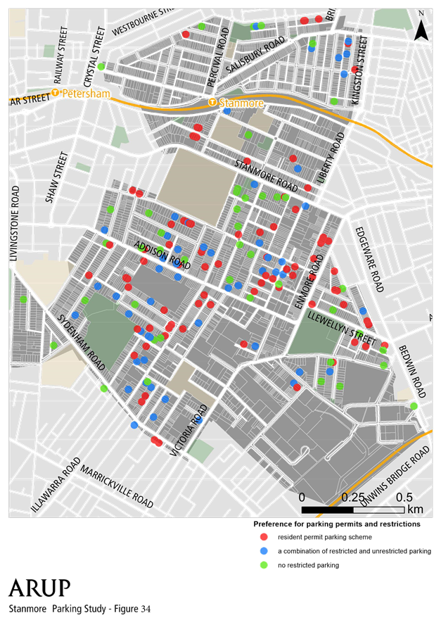
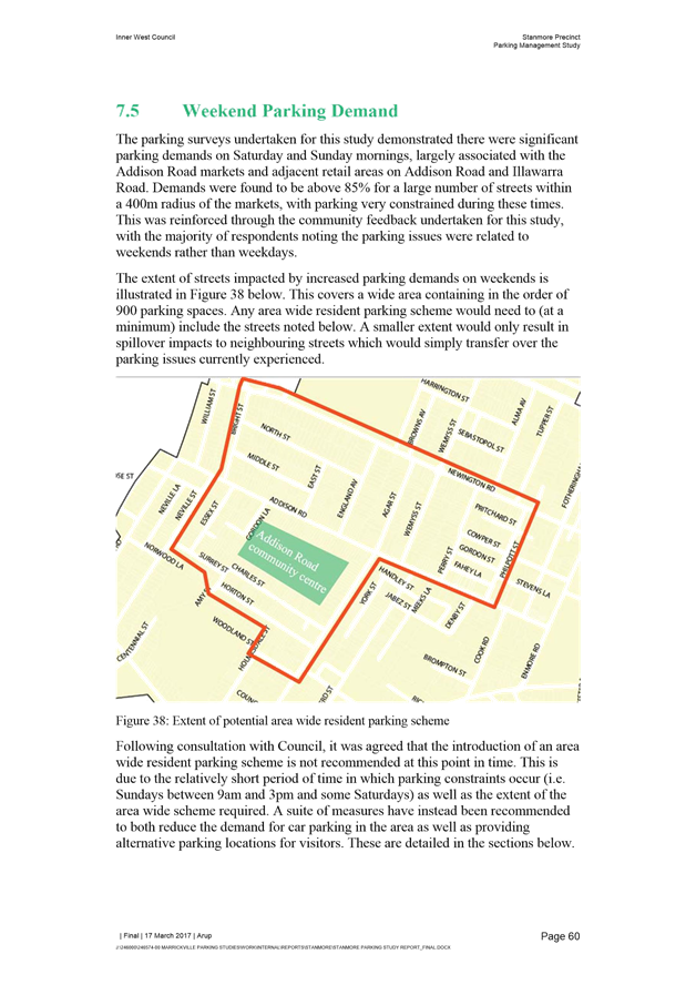
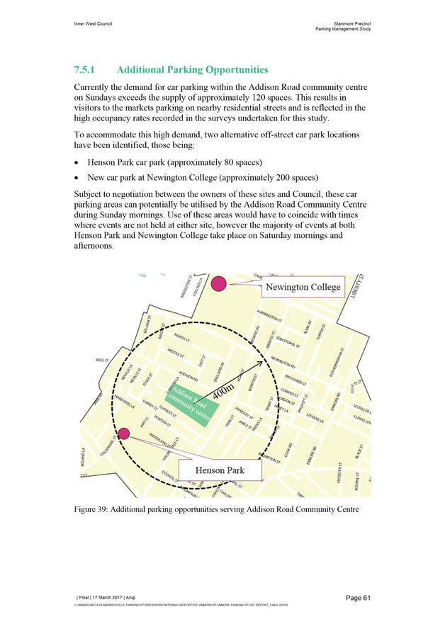
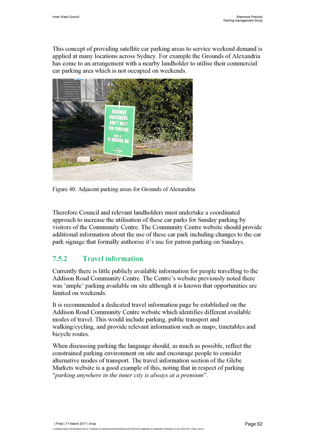
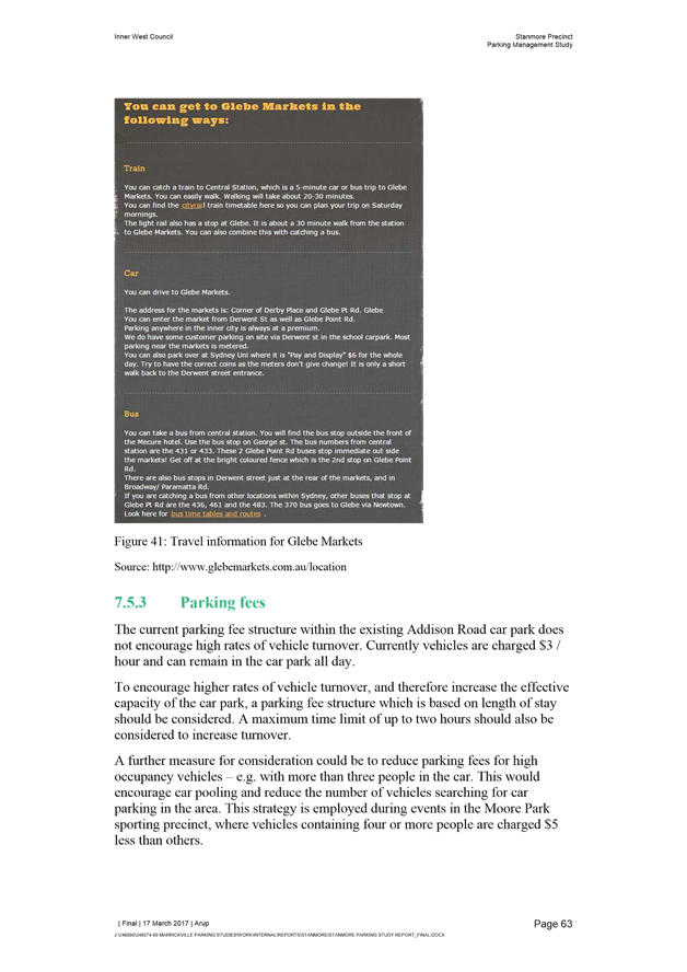
T0417 Item 30 STANMORE PARKING STRATEGY FINAL REPORT
(STANMORE AND MARRICKVILLE WARDS/SUMMER HILL ELECTORATE/ MARRICKVILLE LAC 399
T0417 Item 31 NEWTOWN/ENMORE PARKING IMPLEMENTATION REVIEW REPORT
(STANMORE & MARRICKVILLE WARD/NEWTOWN ELECTORATE/NEWTOWN MARRICKVILLE LAC 534
T0417 Item 32 SALISBURY ROAD BETWEEN DENISON STREET AND AUSTRALIA LANE, CAMPERDOWN – INSTALLATION OF 'NO PARKING' RESTRICTIONS ADJACENT TO MEDIAN STRIP (STANMORE WARD / NEWTOWN ELECTORATE / NEWTOWN LAC) 652
Late Items
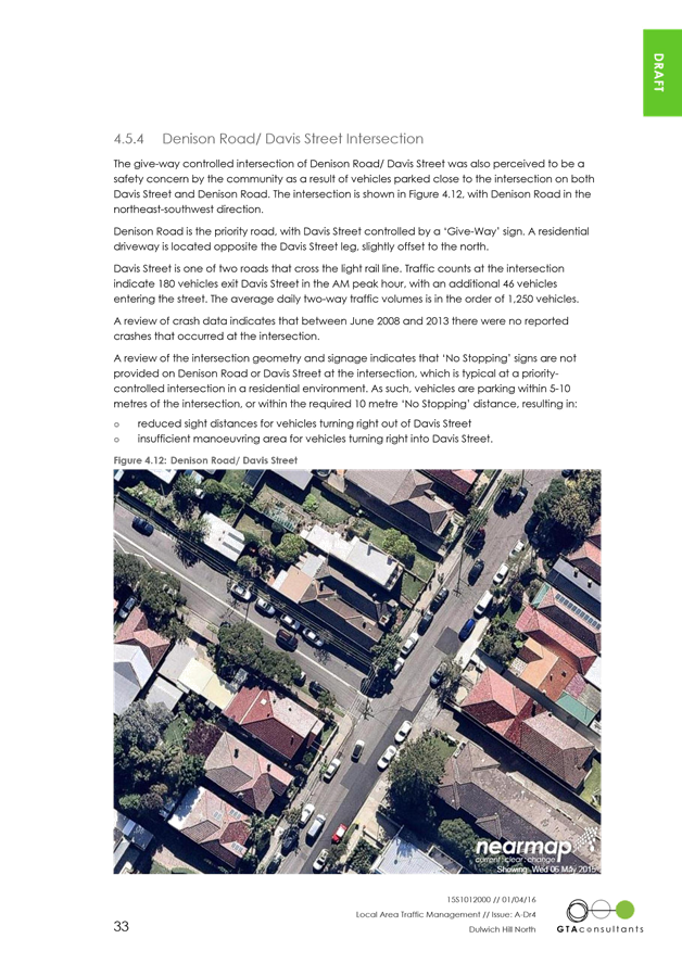
Nil at time of printing.
6 Part B – Items for Information Only
T0417 Item 33 LIVINGSTONE ROAD, MARRICKVILLE – TEMPORARY ROAD CLOSURES FOR THE ORTHODOX EASTER PROCESSIONS ON 14 & 15 APRIL 2017 (MARRICKVILLE WARD/SUMMER HILL ELECTORATE/MARRICKVILLE LAC) 655
T0417 Item 34 LIVINGSTONE ROAD, MARRICKVILLE – TEMPORARY ROAD CLOSURES FOR ‘GOOD FRIDAY’ PROCESSIONS ON 14 APRIL 2017 (MARRICKVILLE WARD/SUMMER HILL ELECTORATE/MARRICKVILLE LAC) 657
7 Part C – Items for General Advice
Nil at time of printing.
8 General Business
|
|
Local Traffic Committee Meeting 6 April 2017 |
Subject: TEMPORARY ROAD CLOSURE TO CARRY OUT CRANE LIFT
ESCALATORS INTO METRO SHOPPING CENTRE ACROSS MURRAY STREET, MARRICKVILLE
(MARRICKVILLE WARD /NEWTOWN ELECTORATE / MARRICKVILE LAC)
File Ref: 17/6022/17143.17
Prepared By: Idris Hessam - Graduate Civil Engineer Traffic Services
Authorised By: Joe Di Cesare - Manager Design and Investigation
|
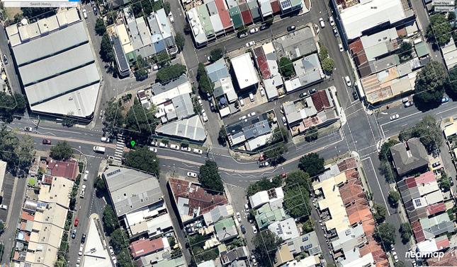
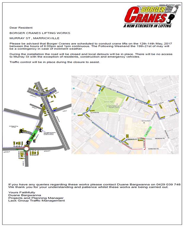
SUMMARY An application has been received from K&D Traffic Management Pty Ltd for the temporary full road closure of Murray Street (between Victoria Road and Smidmore Street) Marrickville for a period of 43 hours continuously from 6:00pm on 12th till 1:00pm on 14th of May 2017, in order to stand a mobile crane on Murray Street to crane lift Escalators across Murray Street into Metro Shopping Centre, Marrickville. It is recommended that the proposed temporary road closure be approved, subject to the conditions outlined in this report. |
|
RECOMMENDATION
THAT the proposed temporary full road closure of Murray Street (between Victoria Road and Smidmore Street) Marrickville for a period of 43 hours continuously from 6:00pm on 12th till 1:00pm on 14th of May 2017, in order to stand a mobile crane on Murray Street to crane lift Escalators across Murray Street into Metro shopping Centre, Marrickville, subject to the following conditions:
1. a fee of $1,354.60 for the temporary full road closure is payable by the applicant in accordance with Council’s Fees and Charges; 2. the temporary full road closure be advertised in the local newspaper providing 28 days’ notice for submissions, in accordance with the Roads Act; 3. a Traffic Management Plan (TMP) be submitted by the applicant to the Roads and Maritime Services for consideration and approval; 4. a Traffic Control Plan (TCP) which has been prepared by a certified Traffic Controller, is to be submitted to Council for review with a copy of the Traffic Controllers certification number attached to the plan, not less than 5 days prior to implementation of closure; 5. a Road Occupancy License be obtained by the applicant from the Roads and Maritime Services’ Transport Management Centre; 6. notice of the proposed closure be forwarded by the applicant to the NSW Police, the NSW Fire Brigades and the NSW Ambulance Services; 7. notification signs advising of the proposed road closures and new traffic arrangements to be strategically installed and maintained by the applicant at each end of the street at least 7 days prior to the closure; 8. all affected residents and businesses shall be notified in writing, by the applicant, of the proposed temporary road closure at least 7 days in advance of the closure with the applicant making reasonable provision for residents; 9. vehicular and pedestrian access for residents and businesses to their off-street car parking spaces be maintained where possible whilst site works are in progress;
10. adequate vehicular traffic control shall be provided for the protection and convenience of pedestrians and motorists including appropriate signage and flagging. Workers shall be specially designated for this role, as necessary to comply with this condition. This is to be carried out in accordance with the Australian Standard AS 1742.3 - Traffic Control Devices for works on roads; 11. the holder of this approval shall indemnify the Council against all claims, damages and costs incurred by, or charges made against, the Council in respect to death or injury to any person or damage in any way arising out of this approval. In this regard, a public liability insurance policy for an amount not less than $20,000,000 for any one occurrence is to be obtained and is to note the Council as an interested party. The holder of this approval shall inform its insurer of the terms of this condition and submit a copy of the insurance policy to the Council prior to commencement of the work the subject of this approval; 12. the operator of any unit exercising this approval shall have this approval with them and produce it if required along with any other relevant authority approvals granted in the connection with the work; 13. mobile cranes, cherry packers or concrete boom pumps shall not stand within the public way for extended periods when not in operation under this approval; 14. the operation of the mobile crane shall not give rise to an "offensive noise" as defined in the Protection of Environment Operations Act, 1997. Furthermore, vibrations and/or emission of gases that are created during its operations and which are a nuisance, or dangerous to public health are not permitted; 15. all work is to be carried out in accordance with Work Cover requirements; and 16. the costs to repair damages, as a result of these works, to Council's footway and roadway areas will be borne by the applicant.
|
BACKGROUND
An application has been received from K&D Traffic Management Pty Ltd for the temporary full road closure of Murray Street (between Victoria Road and Smidmore) Marrickville for a period of 43 hours continuously from 6:00pm on 12th till 1:00pm on 14th of May 2017, in order to stand a mobile crane on Murray Street to crane lift Escalators across Murray Street into Metro shopping Centre, Marrickville.
FINANCIAL IMPLICATIONS
Under Council’s Fees & Charges, the applicant is to pay a fee of $1,354.60 for the temporary full road closure. This fee includes advertising the proposal in accordance with the Roads Act 1993.
OFFICER COMMENTS
That the proposed temporary road closure be approved, subject to the conditions outlined in this report.
PUBLIC CONSULTATION
The applicant is to notify all affected residents and businesses in writing at least 7 days prior to the commencement of works. The proposed road closure is to be advertised in the local newspaper in accordance with the Roads Act 1993.
CONCLUSION
It is recommended that the proposed temporary road closures be approved, subject to the conditions outlined in this report.
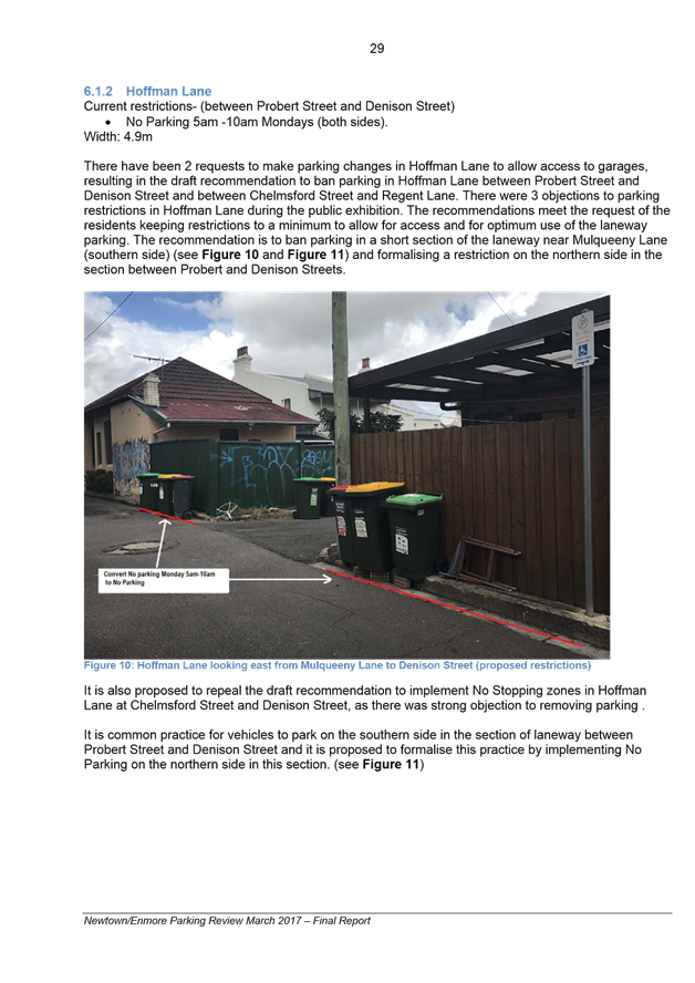
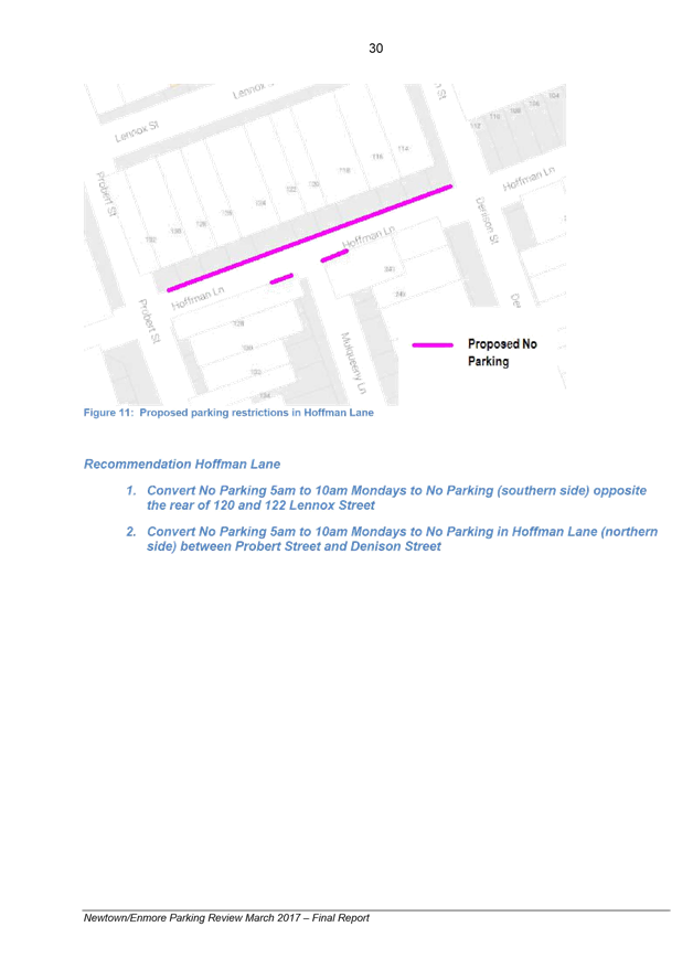
Traffic Control Plan submitted by the applicant – Murray Street, Marrickville
|
|
Local Traffic Committee Meeting 6 April 2017 |
Subject: REQUESTS FOR MOBILITY PARKING SPACES
(ASHFIELD & MARRICKVILLE WARDS/HEFFRON, SUMMER HILL & NEWTOWN
ELECTORATES/MARRICKVILLE & NEWTOWN LACS)
File Ref: 17/6022/27937.17
Prepared By: Idris Hessam - Graduate Civil Engineer Traffic Services
Authorised By: Joe Di Cesare - Manager Design and Investigation
|
SUMMARY A number of requests have been received from residents for the provision of dedicated mobility parking space outside their residence. It is recommended that the following 'Mobility Parking' spaces be approved as the applicants current medical conditions warrants the provision of the space and they have constrained or no off-street parking opportunities. |
|
RECOMMENDATION
THAT the following locations:
1. northern side of Westbourne Street, Petersham in front of property no. 84 Westbourne Street, Petersham; 2. southern side of Moncur Street, Marrickville in front of property no. 19 Moncur Street, Marrickville; 3. southern side of Greenbank Street, Marrickville in front of property no. 32 Greenbank Street, Marrickville; 4. western side of Canonbury Grove, Dulwich Hill in front of property no. 35 Canonbury Grove, Dulwich Hill; 5. northern side of Station Street, Tempe in front of property no. 73 Station Street, Tempe; and 6. eastern side of Livingstone Road, Marrickville in front of Property no. 344 Livingstone Road, Marrickville 7. eastern side of Victoria Street, Dulwich Hill in front of property no.153 Victoria Street, Dulwich Hill
be APPROVED as a ‘mobility parking’ space, subject to: a) the operation of the dedicated parking space be valid for twelve (12) months from the date of installation; b) the applicant advising Council of any changes in circumstances affecting the need for the special parking space; and c) the applicant is requested to furnish a medical certificate and current mobility permit justifying the need for the mobility parking space for its continuation after each 12 months period.
|
BACKGROUND
A copy of the RMS disability parking permit and a medical certificate in support of the applications was submitted to Council.
FINANCIAL IMPLICATIONS
The costs of the supply and installation of the signposting associated with the recommended mobility parking spaces is approximately $3000.
It should be noted that Council normally signposts on-street mobility parking spaces and does not line mark these spaces. Should the applicant require the provision of kerb ramps, this can be provided at their cost.
OFFICER COMMENTS
|
Subject Location |
Classification of Road |
Road Description |
|
Westbourne Street, Petersham |
Local Road |
Two-way residential street, 12.9m in width that runs west-east from Crystal Street to Charles Street. |
|
Moncur Street, Marrickville |
Local Road |
Two-way residential street, 12.9m in width that runs west-east from Livingstone Road to Moyes Street. |
|
Greenbank Street, Marrickville |
Local Road |
Two-way residential street, 12.9m in width that runs west-east from Moyes Street to Illawarra Road. |
|
Canonbury Grove, Dulwich Hill |
Local Road |
Two-way residential street, 12.9m in width that runs north-south from Beach Road to Margaret Street. |
|
Station Street, Tempe |
Local Road |
One way westbound street, 6.4m in width that runs from Princess Highway to Quarry Street. |
|
Livingstone Road, Marrickville |
Local Road |
Two-way residential street, 12.9m in width that runs north-south from Harnett Ave to Hill Street. |
|
Victoria Street, Dulwich Hill |
Local Road |
Two-way residential street, 10.9m in width that runs north-south from Eltham Street to Davis Street. |
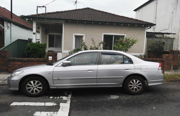
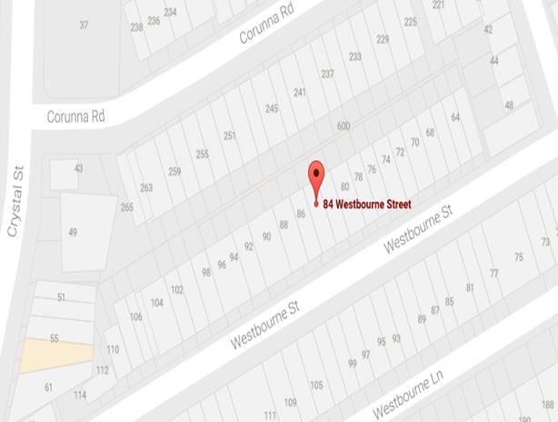
84 Westbourne Street, Petersham
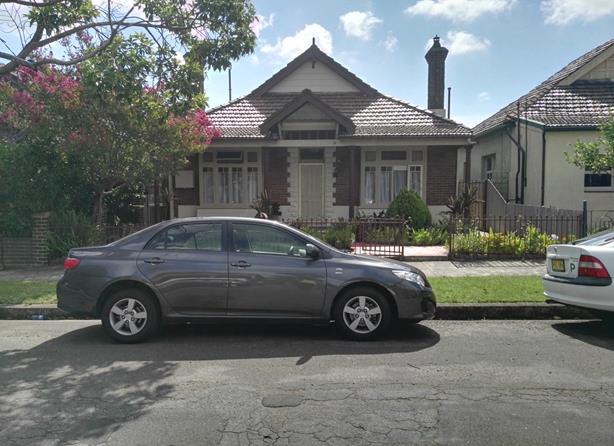
The applicant’s property is located on the northern side of Westbourne Street, Petersham. The applicant’s property has no off-street parking facility.
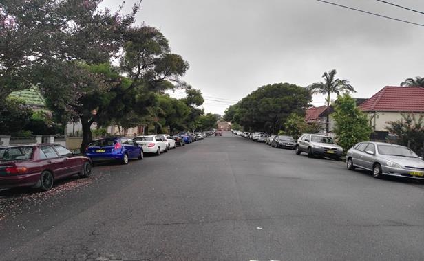
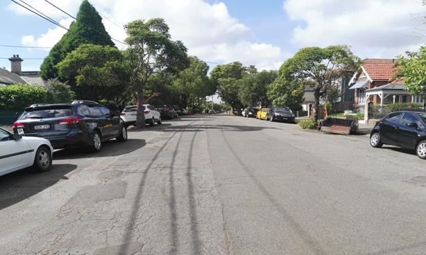
At present, unrestricted parking is permitted on both sides of Westbourne Street. It has been observed during a site inspection undertaken in the afternoon period that on-street parking spaces in Westbourne were moderately utilised.
The applicant does drive a vehicle and currently there is no existing mobility parking space within close proximity to the applicant’s property. Due to her current medical condition, she requires parking availability close to her property.
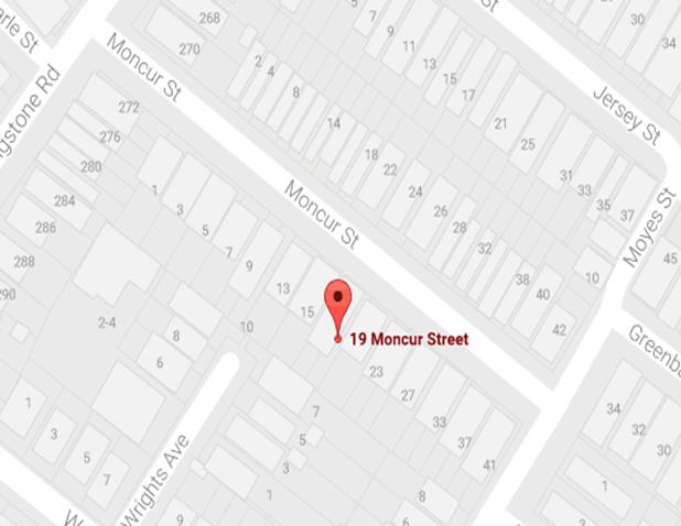
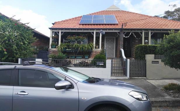
19 Moncur Street, Marrickville
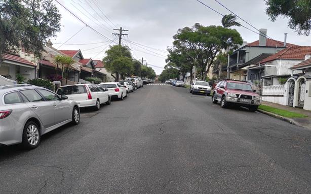
The applicant’s property is located on the southern side of Moncur Street, Marrickville. The applicant’s property has no off-street parking facility.
At present, unrestricted parking is permitted on both sides of Moncur Street. It has been observed during a site inspection undertaken in the afternoon period that on-street parking spaces in Moncur Street were moderately utilised.
The applicant does not drive a vehicle however she is driven by another family member.
Currently there is no existing mobility parking space within close proximity to the applicant’s property. Due to her current medical condition, she requires parking availability close to her property.
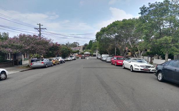
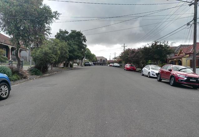
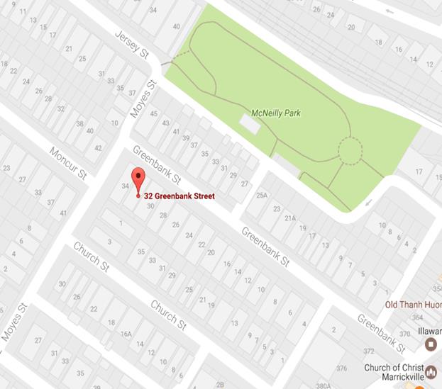
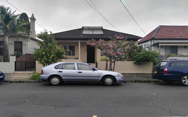
32 Greenbank Street, Marrickville
The applicant’s property is located on the southern side of Greenbank Street, Marrickville. The applicant’s property has no off-street parking facility.
At present, unrestricted parking is permitted on both sides of Greenbank Street. It has been observed during a site inspection undertaken in the afternoon period that on-street parking spaces in Greenbank Street were moderately utilised.
The applicant does drive a vehicle and currently there is no existing mobility parking space within close proximity to the applicant’s property. Due to his current medical condition, he requires parking availability close to his property.
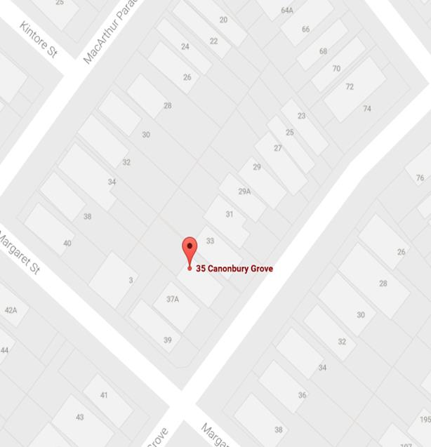
35 Canonbury Grove, Marrickville
The applicant’s property is located on the western side of Canonbury Grove, Marrickville. The applicant’s property has no off-street parking facility.
At present, unrestricted parking is permitted on both sides of Canonbury Grove. It has been observed during a site inspection undertaken in the afternoon period that on-street parking spaces in Canonbury Grove were moderately utilised.
The applicant does not drive a vehicle however she is driven by another family member.
Currently there is no existing mobility parking space within close proximity to the applicant’s property. Due to her current medical condition, she requires parking availability close to her property.
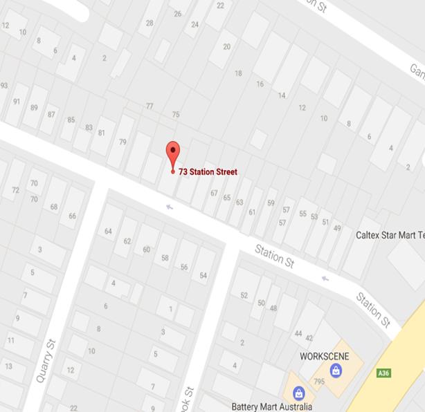
73 Station Street, Tempe
The applicant’s property is located on the northern side of Station Street, Tempe. The applicant’s property has no off-street parking facility.
At present, unrestricted parking is permitted on northern side of Station Street. It has been observed during a site inspection undertaken in the afternoon period that on-street parking spaces in Station Street were moderately utilised.
The applicant does not drive a vehicle however she is driven by another family member.
Currently there is no existing mobility parking space within close proximity to the applicant’s property. Due to her current medical condition, she requires parking availability close to her property.
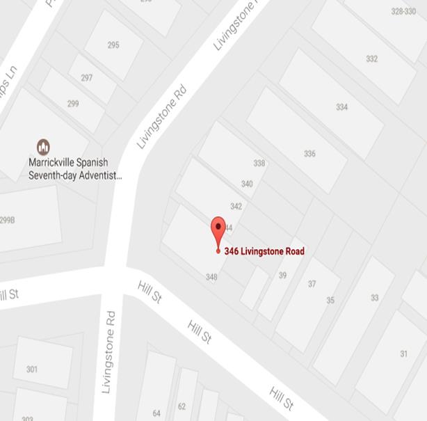
346 Livingstone Road, Marrickville
The applicant’s property is located on the eastern side of Livingstone Road, Marrickville. The applicant’s property has no off-street parking facility.
At present, unrestricted parking is permitted on both sides of Livingstone Road. It has been observed during a site inspection undertaken in the afternoon period that on-street parking spaces in Livingstone Road were moderately utilised.
The applicant does drive a vehicle and currently there is no existing mobility parking space within close proximity to the applicant’s property. Due to his current medical condition, he requires parking availability close to his property.
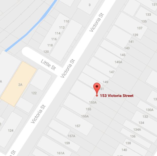
153 Victoria Street, Dulwich Hill
The applicant’s property is located on the eastern side of Victoria Street, Dulwich Hill. The applicant’s property has no off-street parking facility.
At present,
unrestricted parking is permitted on both sides of Livingstone Road. It has
been observed during a site inspection undertaken in the afternoon period that
on-street parking spaces in Victoria Street were moderately utilised.
The applicant does drive a vehicle and currently there is no existing mobility parking space within close proximity to the applicant’s property. Due to his current medical condition, he requires parking availability close to his property.
Technical Standards
Australian Standard AS2890.5-1993 “On-Street Parking” states the following in regards to the provision of parking for people with a disability:
“Parallel parking spaces shall not be marked as disabled spaces, nor included in the count of spaces available for people with disabilities unless –
i. A 3.2m wide space can be provided, e.g. by indenting the space into the footpath area; and
ii. Kerb ramps as shown in Figure 4.2(a) are also provided”.
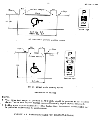
It should be noted that due to the limited width of streets around the Marrickville LGA, it is often difficult to comply with these requirements for the parking space dimensions. This may also result in the loss of some adjacent on-street parking spaces.
Mobility parking spaces are primarily intended for on-street and off-street parking at destinations, such as in commercial/retail areas and public car parks near hospitals, schools and public transport facilities where multiple usages can be expected. They were generally not intended for points of origin such as reserving on-street parking.
A mobility parking space is not intended for the sole use of one applicant, but rather a shared facility that can used by all authorised persons having an RMS mobility permit.
PUBLIC CONSULTATION
A notification letter has been sent to the applicants informing them of the application process and as part of the assessment they will be considered at this meeting.
CONCLUSION
It is recommended that ‘Mobility Parking' spaces be approved as the applicant’s properties do not have an off-street parking facility and/or the applicants condition warrants the provision of the space.
It should be noted that the proposed mobility parking spaces are not for the sole use of the applicant and may be used by other authorised persons.
Locality Map – 84 Westbourne Street, Petersham
![]()
![]()
![]()
Photographs – 84 Westbourne Street, Petersham
|
|
The frontage of the applicant's property in Westbourne Street, Petersham
|
|
On-street parking in Westbourne Street, Petersham
Locality Map – 19 Moncur Street, Marrickville
|
|
![]()
Photographs – 19 Moncur Street, Marrickville
|
|
The frontage of the applicant's property in Moncur Street, Marrickville
|
|
On-street parking in Moncur Street, Marrickville
|
|
On-street parking in Moncur Street, Marrickville
Locality Map – 32 Greenbank Street, Marrickville
|
|
![]()
Photographs – 32 Greenbank Street, Marrickville
|
|
The frontage of the applicant's property in Greenbank Street, Marrickville
|
|
On-street parking in Greenbank Street, Marrickville
|
|
On-street parking in Greenbank Street, Marrickville
Locality Map – 35 Canonbury Grove, Dulwich Hill

![]()
![]()
Photographs – 35 Canonbury Grove, Dulwich Hill
|
|
The frontage of the applicant's property in Canonbury Grove, Dulwich Hill
|
|
On-street parking in Canonbury Grove, Dulwich Hill
Locality Map – 73 Station Street, Tempe

![]()
![]()
Photographs – 73 Station Street, Tempe
|
|
The frontage of the applicant's property in Station Street, Tempe
|
|
On-street parking in Station Street, Tempe
Locality Map – 346 Livingstone Road, Marrickville

![]()
![]()
Photographs – 346 Livingstone Road, Marrickville
|
|
The frontage of the applicant's property in Livingstone Road, Marrickville
|
|
On-street parking in Livingstone Road, Marrickville
Locality Map – 153 Victoria Street, Dulwich Hill
![]()
![]()

Photographs – 153 Victoria Street, Marrickville
|
|
The frontage of the applicant's property in Victoria Street, Dulwich Hill
|
|
On-street parking in Victoria Street, Dulwich Hill
|
|
Local Traffic Committee Meeting 6 April 2017 |
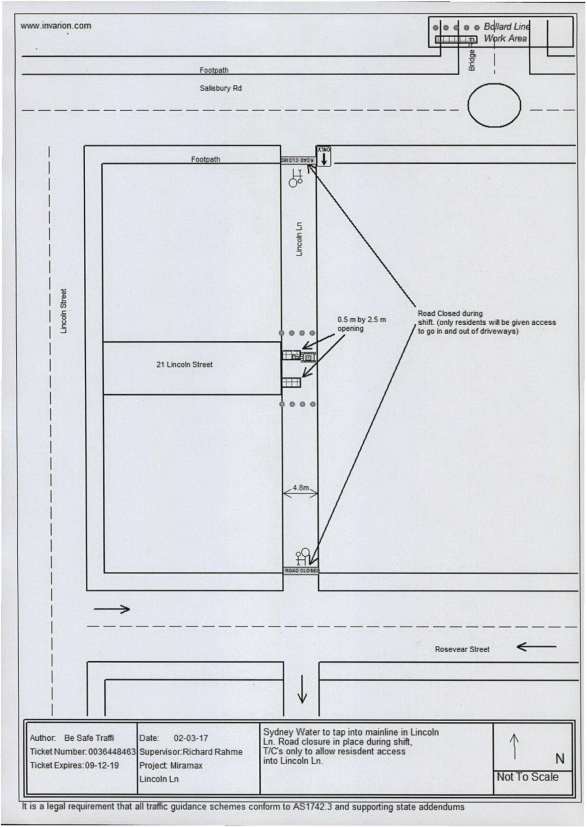
Subject: LINCOLN LANE, STANMORE – TEMPORARY FULL ROAD CLOSURE FOR SEWER WORKS TO A RESIDENTIAL DWELLING (STANMORE WARD/NEWTOWN ELECTORATE/NEWTOWN LAC)
File Ref: 17/6022/27354.17
Prepared By: Emilio Andari - Civil Engineer
Authorised By: Joe Di Cesare - Manager Design and Investigation
|
SUMMARY An application has been received from Miramax Projects Pty Ltd for the temporary full road closure of Lincoln Lane, Stanmore, between Salisbury Road and Rosevear Street, for a period of three days on the 1st May 2017 to the 3rd May 2017 (inclusive) between the hours of 7:00am and 5:30pm, in order to complete the construction works for a residential dwelling by connecting sewer and water lines within the adjacent property. It is recommended that the proposed temporary full road closure be approved, subject to the conditions outlined in this report. |
|
RECOMMENDATION
THAT the proposed temporary full road closure of Lincoln Lane, Stanmore, between Salisbury Road and Rosevear Street, be APPROVED, for a period of three (3) days on the 1st May 2017 to the 3rd May 2017 (inclusive) between the hours of 7:00am and 5:30pm, in order to complete the construction works for a residential dwelling by connecting sewer and water lines within the adjacent property, subject to the following conditions;
1. A fee of $1,354.60 for the temporary full road closure is payable by the applicant in accordance with Council's Fees and Charges;
2. The temporary full road closure be advertised in the local newspaper providing 28 days’ notice for submissions, in accordance with the Roads Act;
3. A Traffic Control Plan (TCP) which has been prepared by a certified Traffic Controller, is to be submitted to Council for review with a copy of the Traffic Controllers certification number attached to the plan, not less than 5 days prior to implementation of closure;
4. Notice of the proposed closure be forwarded by the applicant to the NSW Police, the NSW Fire Brigades and the NSW Ambulance Services;
5. Notification signs advising of the proposed temporary full road closures and new traffic arrangements to be strategically installed and maintained by the applicant at each end of the street at least 7 days prior to the closure;
6. All affected residents and businesses shall be notified in writing, by the applicant, of the proposed temporary full road closure at least 7 days in advance of the closure with the applicant making reasonable provision for residents;
7. Vehicular and pedestrian access for residents and businesses to their off-street car parking spaces be maintained where possible whilst site works are in progress;
8. Adequate vehicular traffic control shall be provided for the protection and convenience of pedestrians and motorists including appropriate signage and flagging. Workers shall be specially designated for this role, as necessary to comply with this condition. This is to be carried out in accordance with the Australian Standard AS 1742.3 - Traffic Control Devices for works on roads;
9. The holder of this approval shall indemnify the Council against all claims, damages and costs incurred by, or charges made against, the Council in respect to death or injury to any person or damage in any way arising out of this approval. In this regard, a public liability insurance policy for an amount not less than $20,000,000 for any one occurrence is to be obtained and is to note the Council as an interested party. The holder of this approval shall inform its insurer of the terms of this condition and submit a copy of the insurance policy to the Council prior to commencement of the work the subject of this approval;
10. The operator of any unit exercising this approval shall have this approval with them and produce it if required along with any other relevant authority approvals granted in the connection with the work;
11. Mobile cranes, cherry packers or concrete boom pumps shall not stand within the public way for extended periods when not in operation under this approval;
12. The operation of the mobile crane shall not give rise to an "offensive noise" as defined in the Protection of Environment Operations Act, 1997. Furthermore, vibrations and/or emission of gases that are created during its operations and which are a nuisance, or dangerous to public health are not permitted;
13. All work is to be carried out in accordance with Work Cover requirements; and
14. The costs to repair damages, as a result of these works, to Council's footway and roadway areas will be borne by the applicant.
|
BACKGROUND
An application has been received from Miramax Projects Pty Ltd for the temporary full road closure of Lincoln Lane, Stanmore, between Salisbury Road and Rosevear Street, for a period of three days on the 1st May 2017 to the 3rd May 2017 (inclusive) between the hours of 7:00am and 5:30pm, in order to complete the construction works for a residential dwelling by connecting sewer and water lines within the adjacent property.
FINANCIAL IMPLICATIONS
Under Council’s Fees & Charges, the applicant is to pay a fee of $1,354.60 for the temporary full road closure. This fee includes advertising the proposal in accordance with the Roads Act 1993.
OFFICER COMMENTS
Site location & road network
|
Street Name |
Lincoln Lane |
|
Section |
Between Salisbury Road and Rosevear Street |
|
Carriageway Width (m) |
4.8 |
|
Carriageway Type |
One-way southbound traffic flow with one travel lane, in addition to kerbside parking |
|
Classification |
Local |
|
85th Percentile Speed (km/h) |
– |
|
Vehicles Per Day (vpd) |
– |
|
Reported Crash History (July 2011 - June 2016) |
No crashes recorded |
|
Heavy Vehicle Volume (%) |
– |
|
Parking Arrangements |
Both sides of the road consist of unrestricted parking |
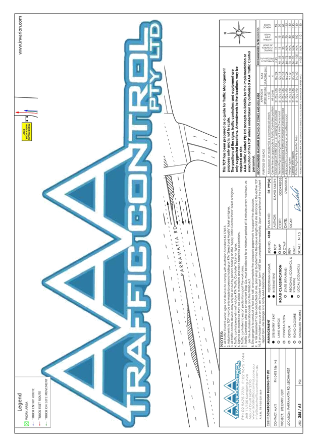
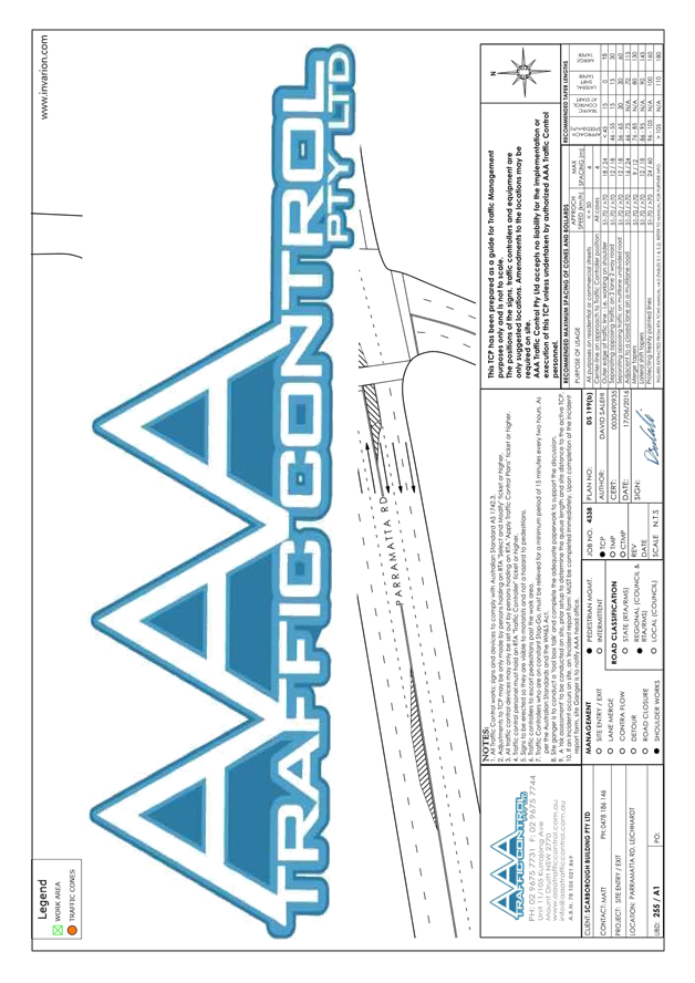
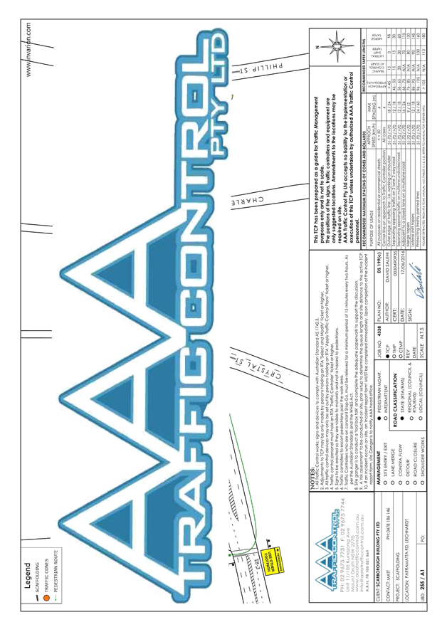
The applicant has applied for a permit to complete the construction works for a residential dwelling by connecting sewer and water lines within the adjacent property. Lincoln Lane has a narrow road width and the private contractors require to close the carriageway to conduct the works safely (refer to the attached Traffic Control Plan submitted by the applicant).
Vehicular access for local residents will be maintained during the closure, where possible. At the conclusion of each working day, the road will be re-opened and accessible for all traffic by restoring the road with steel plates. Authorised Traffic controllers will be on-site during all shifts and are to be positioned at the closure points when required to provide vehicular access to local residents and ensure the safety of motorists and pedestrians.
PUBLIC CONSULTATION
The applicant is to notify all affected residents and businesses in writing at least 7 days prior to the commencement of works. The proposed road closure is to be advertised in the local newspaper in accordance with the Roads Act 1993.
CONCLUSION
It is recommended that the proposed temporary full road closures be approved, subject to the conditions outlined in this report.
Traffic Control Plan submitted by the applicant – Lincoln Lane, Stanmore
|
|
Local Traffic Committee Meeting 6 April 2017 |
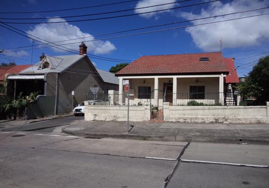
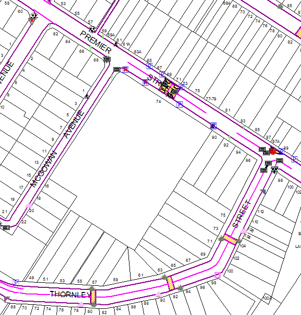
Subject: PREMIER STREET, MARRICKVILE - EXTENSION OF
EXISTING BB LINE MARKING AT PREMIER STREET, MARRICKVILLE TO IMPROVE PEDESTRIAN
SAFETY
(MARRICKVILLE WARD/ SUMMERHILL ELECTORATE / MARRICKVILLE LAC)
File Ref: 17/6022/29808.17
Prepared By: Idris Hessam - Graduate Civil Engineer Traffic Services
Authorised By: Joe Di Cesare - Manager Design and Investigation
|
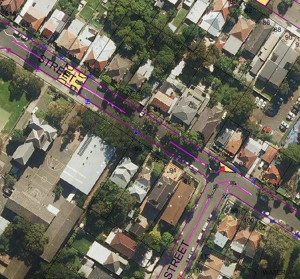
SUMMARY A concern has been raised from NSW Police regarding extension of unbroken dividing line from pedestrian crossing (outside Ferncourt Public School) to Thornley Street, Marrickville as motorists are conducting U-turns at a location where there are many vehicle movements and some pedestrian activity during school pick up and drop off times.
It is recommended that the existing “BB” (double unbroken) line marking be extended 30 metres eastward from the rear of property no. 74 Premier Street to the rear of the property no 92 Premier Street, Marrickville to prevent motorists from making U turns and to improve pedestrian safety. |
|
RECOMMENDATION
THAT: 1. a proposal to extend the existing “BB” line marking restrictions by 30 metres eastward from the rear of property No.74 Premier Street to the rear of property No.92 Premier Street, Marrickville be APPROVED to deter U turn movements and to improve pedestrian safety. |
BACKGROUND
NSW Police have requested the extension of unbroken dividing line from pedestrian crossing (outside Ferncourt Public School) to Thornley Street, Marrickville as motorists are conducting U-turns at a location where there are many vehicle movements and some pedestrian activity during school pick up and drop off times.
FINANCIAL IMPLICATIONS
The cost of extending the existing “BB” line marking restriction by 30 metres eastward is approximately $300 and can be met form Council’s signs and line markings budget.
OFFICER COMMENTS
Currently there is existing “BB” line marking in Premier Street extending westward by 20 metres from its intersection with Thornley Street and 60 metres eastward from its intersection with McGowan Avenue, Marrickville leaving a 30 metre length of unmarked “BB” line marking in the middle. Concerns have been raised the police and residents that motorists are often making U turns in the unmarked section of Premier (near the school boundary). The extension of “BB” line marking will connect the existing sections of “BB” line marking and deter the motorists from making a U turn at this location.
PUBLIC CONSULTATION
CONCLUSION
In order to deter U turns in a dangerous location and to improve pedestrian safety, it is recommended that the existing 'BB’ line marking restriction be extended by 30 metres eastward from the rear of property No.74 Premier Street to the rear of the property No.92 Premier Street, Marrickville.
Locality map – Premier Street, Marrickville
![]()


![]()
Photographs – Premier Street, Marrickville
![]()
![]()


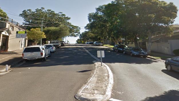
Looking Westward along Premier Street, Marrickville
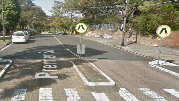
Looking Eastward along Premier Street, Marrickville
|
|
Local Traffic Committee Meeting 6 April 2017 |
Subject: LEICHHARDT OVAL PERIMETER ROAD AT GLOVER
STREET, LILYFIELD – TRAFFIC CALMING
(BALMAIN WARD/BALMAIN ELECTORATE/LEICHHARDT LAC)
File Ref: 17/6022/30889.17
Prepared By: Jason Scoufis - Team Leader Traffic, Leichhardt
Authorised By: John Stephens - Traffic Manager
|
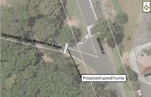
SUMMARY As a result of concerns raised in relation to road safety at the Leichhardt Oval Perimeter Road/Glover Street intersection, it is recommended that a speed hump be installed in the Leichhardt Oval Perimeter Road, west of Glover Street. |
|
RECOMMENDATION
THAT the installation of a speed hump in the Leichhardt Oval Perimeter Road, west of Glover Street, Lilyfield be supported.
|
BACKGROUND
Concerns have been raised regarding pedestrian and vehicular safety in the Leichhardt Oval Perimeter Road immediately west of Glover Street. The concerns relate to safety issues associated with conflict between vehicles travelling westbound from Glover Street into the Leichhardt Oval Perimeter Road at high speeds and pedestrians crossing the road at this location and also vehicles manoeuvring in/out of the informal parking spaces on the southern side of the Leichhardt Oval Perimeter Road near the intersection.
Traffic calming is currently provided in Glover Street north and south of the Leichhardt Oval Perimeter Road intersection.
PROPOSAL
In order to reduce speeds through the intersection, it is recommended that a speed hump be installed in the Leichhardt Oval Perimeter Road west of Glover Street. The location is detailed below.
FINANCIAL IMPLICATIONS
The cost of the proposed works will be listed in the draft 2017/2018 Budget.
PUBLIC CONSULTATION
No public consultation has been carried out as no residents are impacted by the proposal.
CONCLUSION
In order to improve pedestrian and vehicular safety, it is recommended that a speed hump be installed in the Leichhardt Oval Perimeter Road west of Glover Street.
|
|
Local Traffic Committee Meeting 6 April 2017 |
Subject: DOT LANE, LEICHHARDT - ROAD OCCUPANCY (LEICHHARDT WARD/ BALMAIN ELECORATE /LEICHHARDT LAC)
File Ref: 17/6022/31897.17
Prepared By: Manod Wickramasinghe - Traffic and Parking Engineer
Authorised By: John Stephens - Traffic Manager
|
SUMMARY Council has received a request for approval of partial and temporary full road closures of Dot Lane for the development at Nos.355-357 Parramatta Road, Leichhardt. |
|
RECOMMENDATION
THAT:
1) The application for the full and partial road closure of Dot Lane (as detailed in the TCP) for up to 12 weeks be supported subject to the following conditions: a) That the applicant be requested to obtain NSW Police approval for the road closure. b) That an unencumbered passage (minimum 3.0m) wide be available, if possible, for emergency vehicles through the closed section of Dot Lane. c) The occupation of the road carriageway must not occur until the road has been physically closed. d) That the applicant notifies all affected businesses, residents and other occupants in Parramatta Road, Dot Lane and Balmain Road of the proposed partial and full road closures prior to the event. Any concerns or requirements in relation to the road closure raised by business proprietors, residents and other occupants must be resolved or accommodated. The notification shall involve at the minimum an information letterbox drop distributed one week prior to the commencement of the road closures. The proposed information must be submitted to Council’s Traffic section for approval. e) That the approved Traffic Control Plan (TCP) be implemented at the applicant’s expense including use of RMS accredited traffic controllers. f) That the Fire Brigade (Leichhardt) be notified of the intended temporary closure. g) That the applicant provide and erect barricades and signs, in accordance with the current Australian Standard AS 1742.3: Traffic Control Devices for Works on Roads. As a minimum the following must be erected at both ends of the road closure area: i. Barrier Boards ii. ‘Road Closed’ (T2-4) signs h) That the areas to be used for the activities must be maintained in a clean and tidy condition to the satisfaction of Council’s Group Manager Footpaths, Roads, Traffic and Stormwater, or else the applicant will be required to reimburse Council for any extraordinary cleaning costs. i) That the conduct of any activities or use of any equipment required in conjunction with the road occupancy and temporary road closures not result in any ‘offensive noise’ as defined by the Noise Control Act. j) That a copy of the Council approval be available on site for inspection by relevant authorities. k) That Council reserves the right to cancel the approval at any time.
2) That the applicant complies with any reasonable directive from Council Officers and NSW Police. |
BACKGROUND
Council has received an application for Road Occupancy required for the construction of a new development at Nos.355-357 Parramatta Road, Leichhardt (D/2014/205).
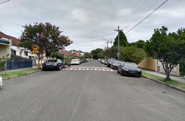
The property is accessible via Parramatta Road and Dot Lane. There is no parking available on the Parramatta Road frontage due to the proximity to the Parramatta Road/Crystal Street/Balmain Road intersection. Dot Lane is a 5m wide laneway with ‘No Parking’ and ‘No Stopping’ restrictions on the northern side and garages on the southern side.
Due to these limitations, Dot Lane may need to be closed periodically to allow the building works to be completed.
The applicant has been discussing the proposed closure of the lane with the directly affected properties.
The details of the proposed closures are as follows:
Dates: The anticipated closure dates are tabled below:
|
Pouring of concrete to basement footings (concrete truck) |
Partial Shutdown |
Monday, 20/03/2017
|
|
Corefilling to basement wall (concrete truck) |
Partial Shutdown |
Monday, 27/03/2017 |
|
Delivery of steel Reinforcement for ground Floor slab (crane lift). |
Full Shutdown |
Friday, 07/04/2017 |
|
Pouring of concrete to Ground floor slab (concrete Pump) |
Full Shutdown |
Friday, 14/04/2017 |
|
Delivery of blockwork for Ground floor walls & Formwork for 1st floor deck (crane lift) |
Full Shutdown |
Monday, 17/04/2017 |
|
Stormwater works to dot Lane inclusive excavation, Hydraulic works and bitumen Patching. |
Full Shutdown |
Saturday 29/04/2017 – Sunday 30/04/2017. |
|
Delivery of steel Reinforcement for 1st floor Slab (crane lift). |
Full Shutdown |
Friday 05/05/2017 |
|
Pouring of concrete to 1st Floor slab (concrete pump) |
Full Shutdown |
Friday 12/05/2017 |
|
Delivery of blockwork for 1st Floor walls & formwork for 2nd floor deck (crane lift) |
Full Shutdown |
Monday 15/05/2017 |
|
Delivery of steel Reinforcement for 2nd floor Slab (crane lift). |
Full Shutdown |
Friday, 02/06/2017 |
|
Pouring of concrete to 2nd Floor slab (concrete pump) |
Full Shutdown |
Friday, 09/06/2017 |
Times: The site activities will occur between the site hours of 7:00am to 5:30pm Monday-Friday and 7:00am to 1:00pm Saturday.
Refer to attachment for Traffic Control Plans.
FINANCIAL IMPLICATIONS
Nil
PUBLIC CONSULTATION
The applicant will notify all affected businesses, residents and other occupants in Parramatta Road, Dot Lane, Norton Street and Balmain Road of the proposed part and full time road closures in Dot Lane. Any concerns or requirements in relation to the road closure raised by business proprietors, residents and other occupants must be resolved or accommodated by the applicant. The notification shall involve at the minimum an information letterbox drop distributed one week prior to the commencement of the event. The proposed information must be submitted to Council’s Traffic section for approval.
CONCLUSION
That the proposed partial and full time road closures in Dot Lane be approved, subject to compliance of the recommended conditions.
|
1.⇩ |
Dot Lane Leichhardt Traffic Control Plan |
|
Local Traffic Committee Meeting 6 April 2017 |
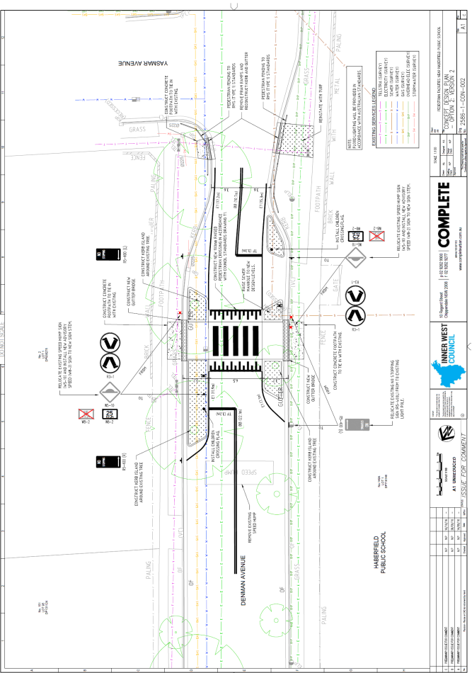
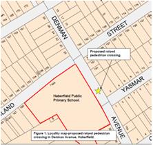
Subject: DENMAN AVENUE, HABERFIELD – PROPOSED NEW
RAISED PEDESTRIAN CROSSING OUTSIDE HABERFIELD PUBLIC PRIMARY
SCHOOL.
(LEICHHARDT WARD/SUMMER HILL ELECTORATE/ASHFIELD LAC)
File Ref: 17/6022/30902.17
Prepared By: Boris Muha - Traffic and Projects Engineer
Authorised By: John Stephens - Traffic Manager
|
SUMMARY Council proposes to construct a new raised pedestrian (zebra) crossing in Denman Avenue, Haberfield, between Bland Street and Yasmar Avenue, Haberfield, as part of the NSW Government's $5 Million funding Program for pedestrian infrastructure around schools.
|
|
RECOMMENDATION
That the construction of a new raised pedestrian (zebra) crossing in Denman Avenue, between Bland Street and Yasmar Avenue, Haberfield, as per the attached drawing No. 2586-1-CON-002 be supported. |
BACKGROUND
The Roads and Maritime Services (RMS) early in 2016 wrote to various Councils informing them of the State Government’s announcement in February 2015 of a $5 Million commitment to improve pedestrian infrastructure around schools over a three year grant program.
Councils were invited (through discussion and consultation with various schools) to apply for funding of projects under the grant, and provide the RMS with relevant information in support of their application for improved pedestrian infrastructure around schools.
A new raised pedestrian crossing in Denman Avenue will enhance pedestrian safety outside the Haberfield Public Primary School. The school/P&C Association (on-behalf of parents) and the local community have previously and continually request for a safe and proper road crossing in Denman Avenue outside the school.
A report was raised in the last Traffic Committee meeting advising of successful projects funded by the RMS under the grant. The above project was included amongst those approved under the grant.
FINANCIAL IMPLICATIONS
Funding of approximately $40,800 from the RMS is currently allocated for the proposed works as part of the Council’s 2017/2018 Capital Works Project. Additional costs will be incurred for street floodlighting. A budget adjustment would be done via a separate report to Council.
OFFICER COMMENTS
The crossing in Denman Avenue is proposed to be located to the left hand side of the school frontage and main gate access in Denman Avenue. The crossing will be predominately used by parent/carers and children attending the school.
The former Ashfield Council early in 2016 made a grant application to the RMS for a proposed new raised pedestrian crossing in Denman Avenue. The proposed works will enhance safety and access for pedestrians of the school community and general public.
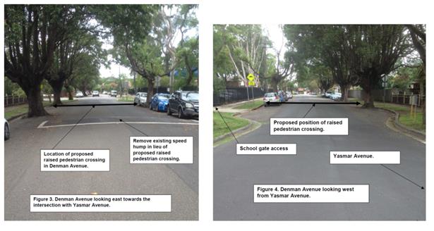
The proposed work includes:
· A raised pedestrian (zebra) crossing, with kerb islands, kerb ramps and ‘Children Crossing’ signage located to the left hand side of the gate entrance to the school, east of Yasmar Avenue
· Removal of kerb ramps on both side of Denman Avenue at the corner of Yasmar Avenue and installation of fencing to divert pedestrians to the crossing
· Floodlights for the crossing
· ‘No Stopping’ restrictions on both sides of the crossing
· Removal of a speed hump as this will be replaced by the raised pedestrian (zebra) crossing.
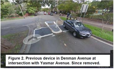
An unconventional crossing facility (with an at- grade road path between pram ramps and a speed hump to the side) originally existed at the corner of Denman Avenue and Yasmar Avenue–see figure 2. This was since removed to avoid confliction and confusion with the right of way between pedestrians and traffic at the intersection.
The new crossing is proposed approximately 20-25 metres west from the intersection of Yasmar Avenue, away from the conflict of the intersection, and in appropriate sight lines of traffic. The crossing is closer to Yasmar Avenue to cater for the main pedestrian desire line movements to and from Yasmar Avenue. The crossing is to the left of the school gate entrance also to serve pedestrian desire line movements to and from Bland Street.
An existing mid-block speed hump will be removed in Denman Avenue in lieu of the raised crossing in close proximity to the speed hump.
The kerb islands are elongated for additional (road narrowing) traffic calming and provides a feature in enhancing the presence of the crossing.
Four parking spaces (2 to the north side and 2 to the south side of Denman Avenue) would need to be removed to accommodate the physical crossing and ‘No Stopping’ clearances to the crossing. It is considered, through site observations, that there is still adequate on-street parking in the vicinity of the crossing.
Denman Avenue is not a bicycle route or bus route.
PUBLIC CONSULTATION
Resident consultation was carried out in the vicinity of the crossing, with around 50 letters distributed in the area. Three (3) separate responses were received from resident/parents in support of the proposal. A petition (249 signatures) from the Haberfield Public School P&C Association, and on-line change.org petition (128 signatures) were received, both in support of the crossing. Parents in particular commented for the need of a crossing in Denman Avenue for the safety of children attending the school. The current WestConnex activity in the area and detouring of traffic through the local streets has also raised the need and support of a crossing in Denman Avenue.
CONCLUSION
It is recommended that a new raised pedestrian (zebra) crossing be constructed in Denman Avenue, between Bland Street and Yasmar Avenue, Haberfield as per the attached plan drawing No. 2586-1-CON-002. The proposed works will enhance safety and access for pedestrians of the school community and general public.
|
1.⇩ |
LTC 06 April 2017 - Attachment to Denman Ave report - Proposed new raised pedestrian crossing in Denman Avenue, Haberfield, between Bland Street and Yasmar Avenue |
|
Local Traffic Committee Meeting 6 April 2017 |
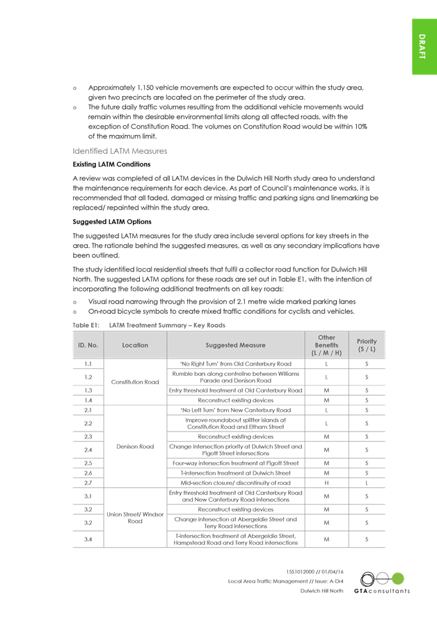
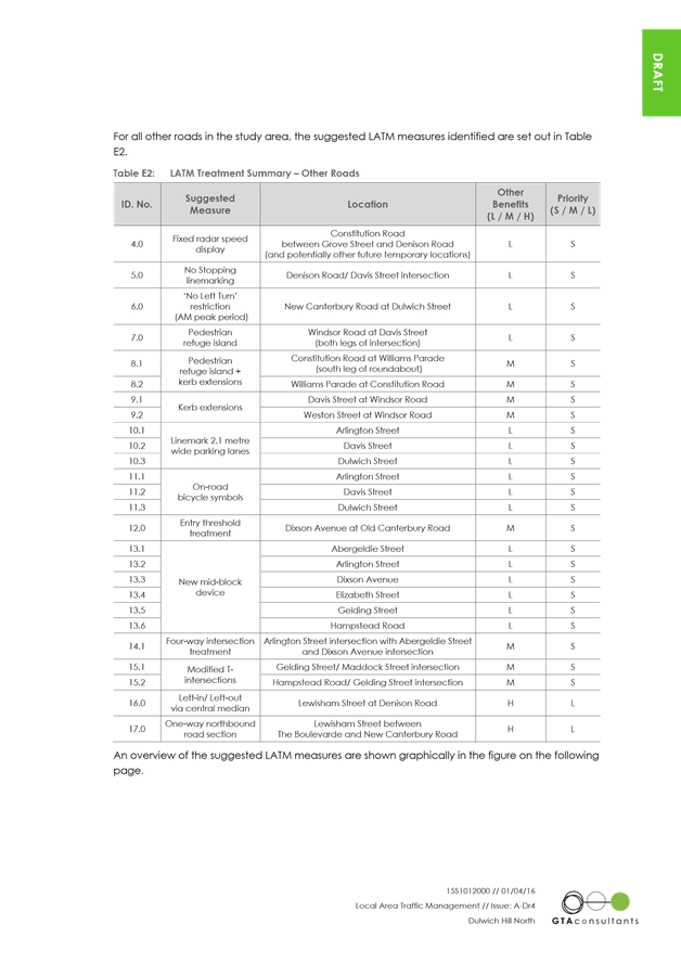
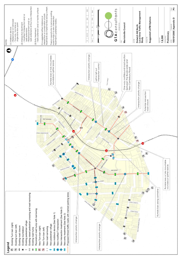
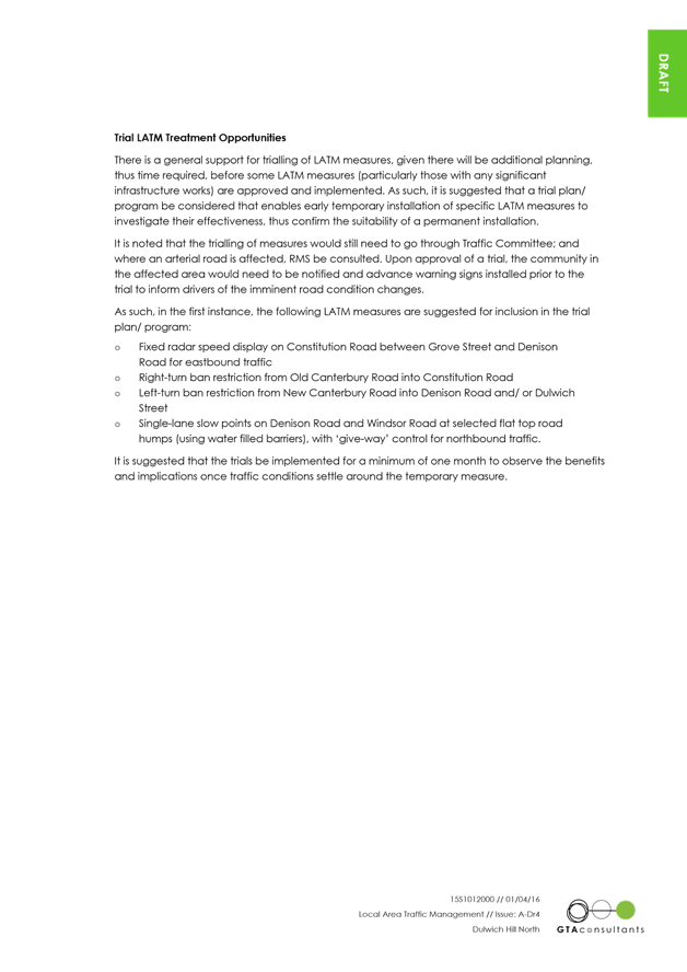
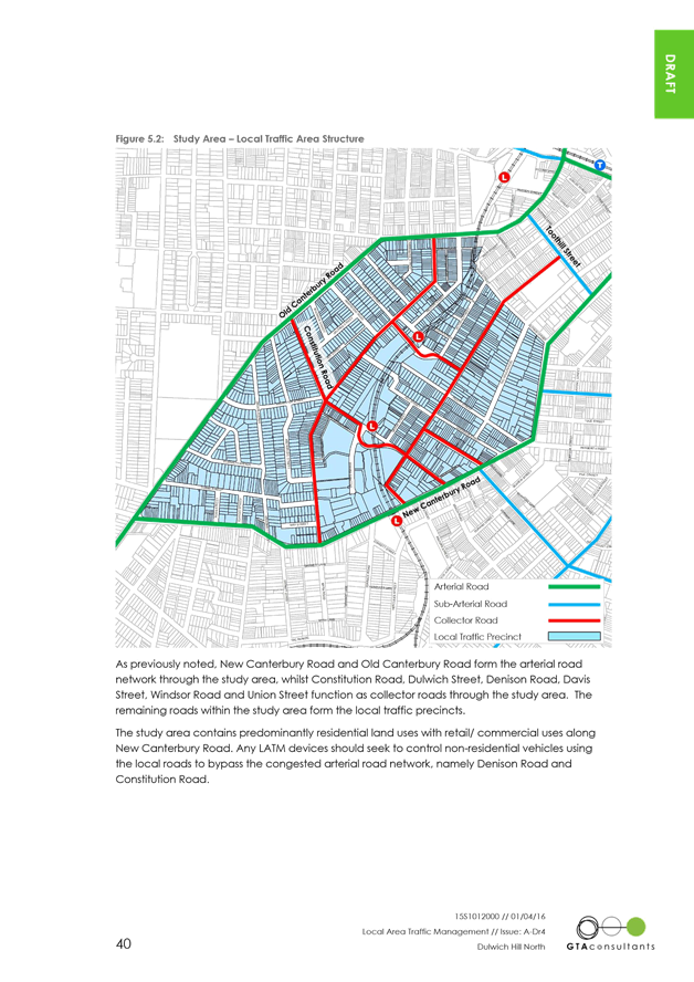
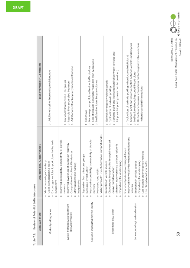
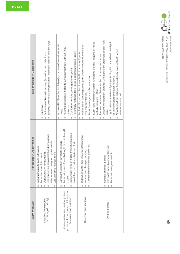
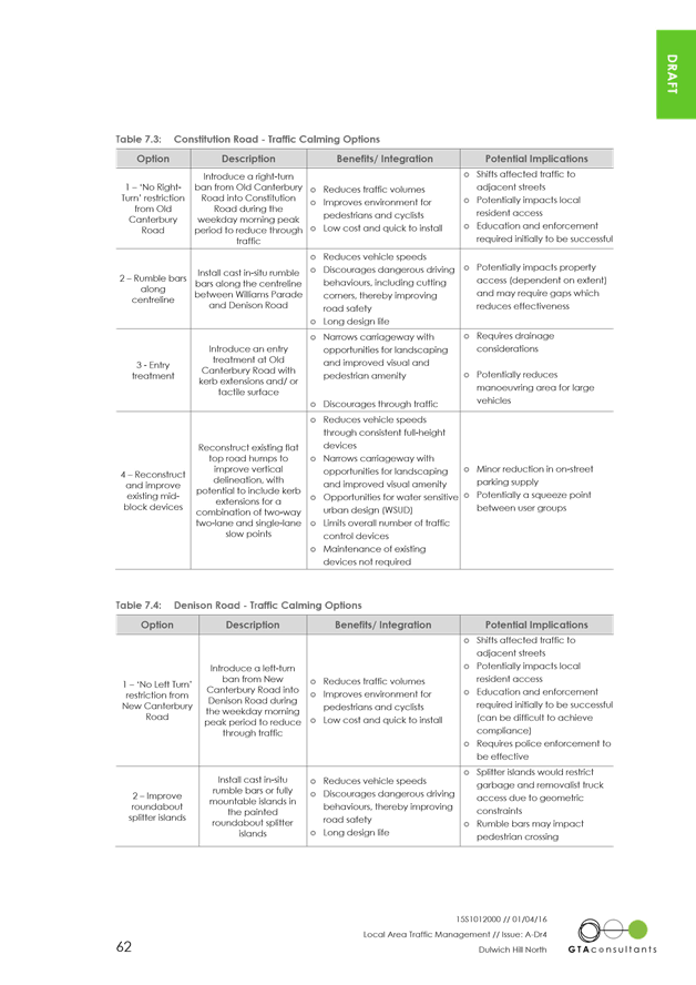
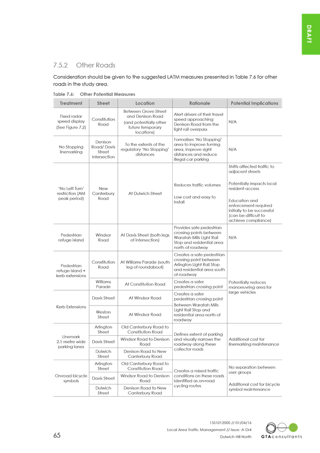
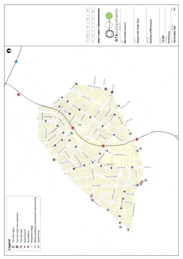
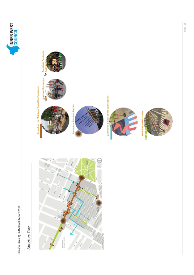
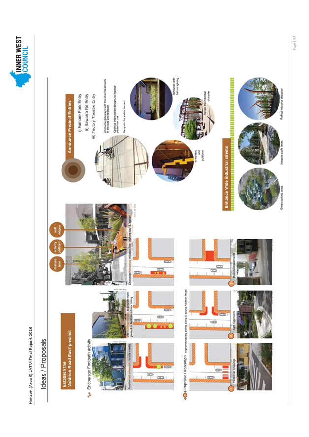
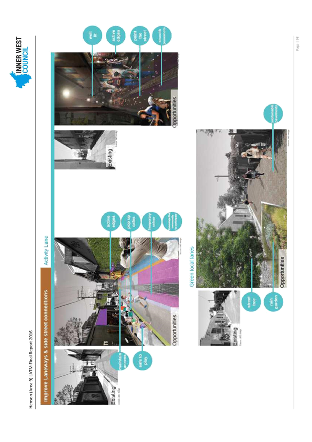
Subject: Dulwich Hill North LATM Draft Concept (MARRICKVILLE & ASHFIELD WARD/SUMMER HILL ELECTORATE/MARRICKVILLE LAC)
File Ref: 14/5141/26845.17
Prepared By: Felix Liu - Traffic Management Planner
|
SUMMARY For the Committee to consider the findings of the ‘Draft’ Dulwich Hill North Local Area Traffic Management (LATM) study and plan’s recommendations.
A copy of this report is provided separately (ATTACHMENTS).
|
|
RECOMMENDATION
THAT:
1. the draft Dulwich North LATM study and plan recommendations listed in Table A within this report be endorsed for community consultation; and
2. the draft report be placed on Public Exhibition, providing a minimum 28 days for submissions.
|
BACKGROUND
The Inner West (Marrickville) Community Strategic Plan (CSP) – Our Place Our Vision 2023 has key outcomes:
· Inner West’s roads are safer and less congested
· Inner West’s streets, lanes and public spaces are sustainable, welcoming, accessible and clean
· The community walks, ride bikes and use public transport.
Local Area Traffic Management (LATM) is one of the main ways Council works to achieve these outcomes. The objective of local area traffic management planning is to investigate and review the performance of the existing Local Area Traffic Management (LATM) and recommend proposed LATM works. The original Dulwich Hill North LATM was undertaken in 2002.
As part of the Tomorrow’s Dulwich Hill project to create a 10-year integrated plan, in 2014, Inner West Council engaged a consultant to review and undertake the LATM study and develop a plan for the Dulwich Hill North LATM area. The final plan’s works will be integrated with the actions in the Tomorrow’s Dulwich Hill 10-year plan currently in development.
DISCUSSION
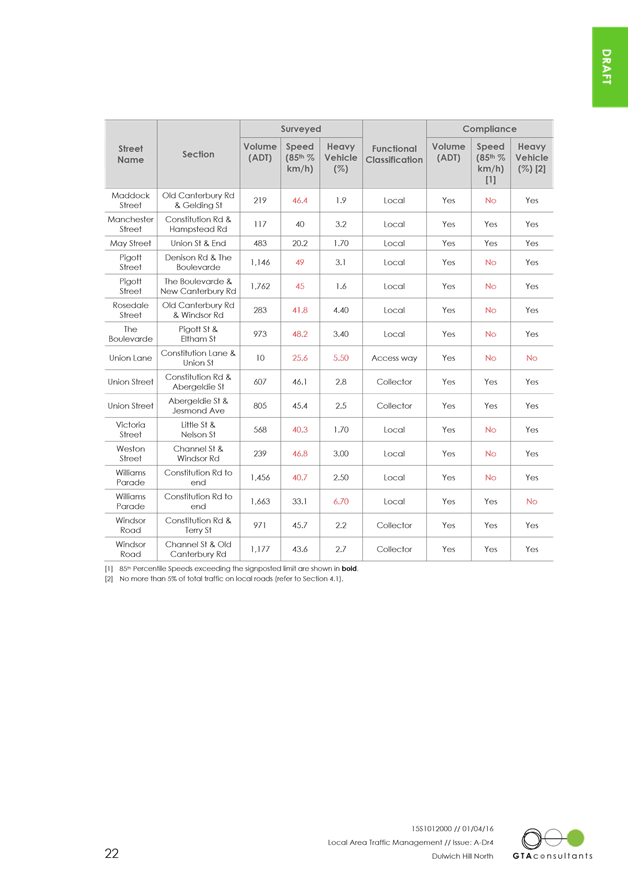
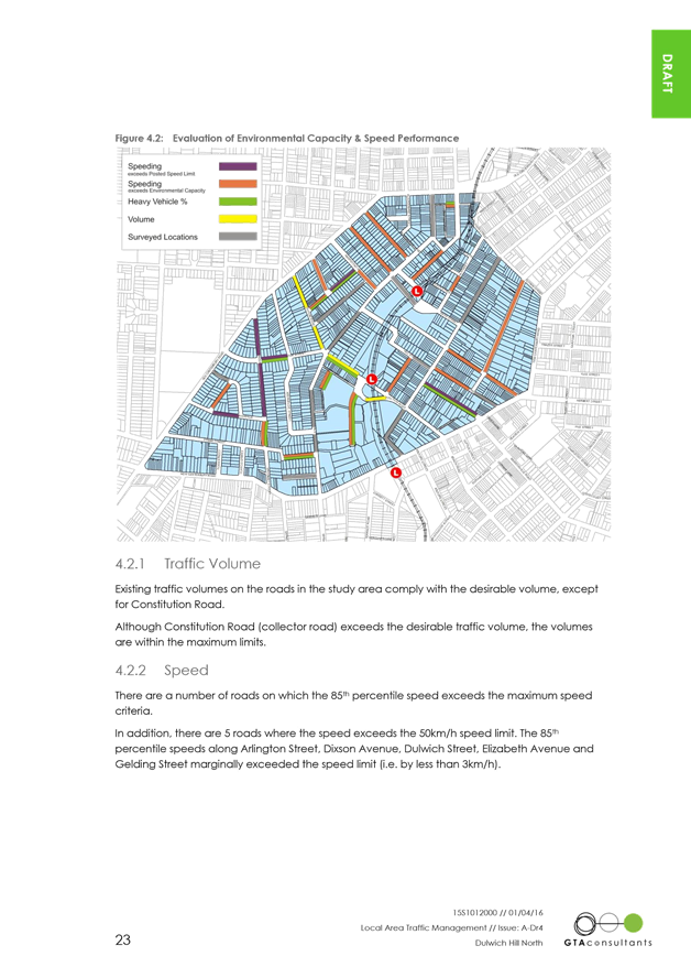
This report sets out an assessment of the traffic conditions within the Dulwich Hill North LATM area and includes the following:
· Assessment of the traffic volumes, heavy vehicle percentages and vehicle speeds based on the traffic survey results;
· Identification of the locations not satisfying Environmental
Performance criteria;
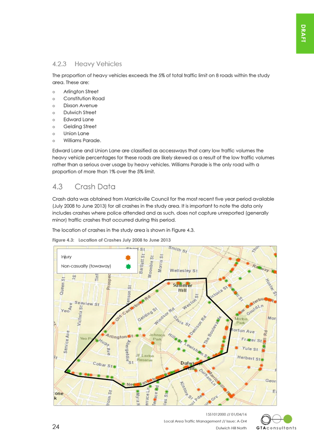
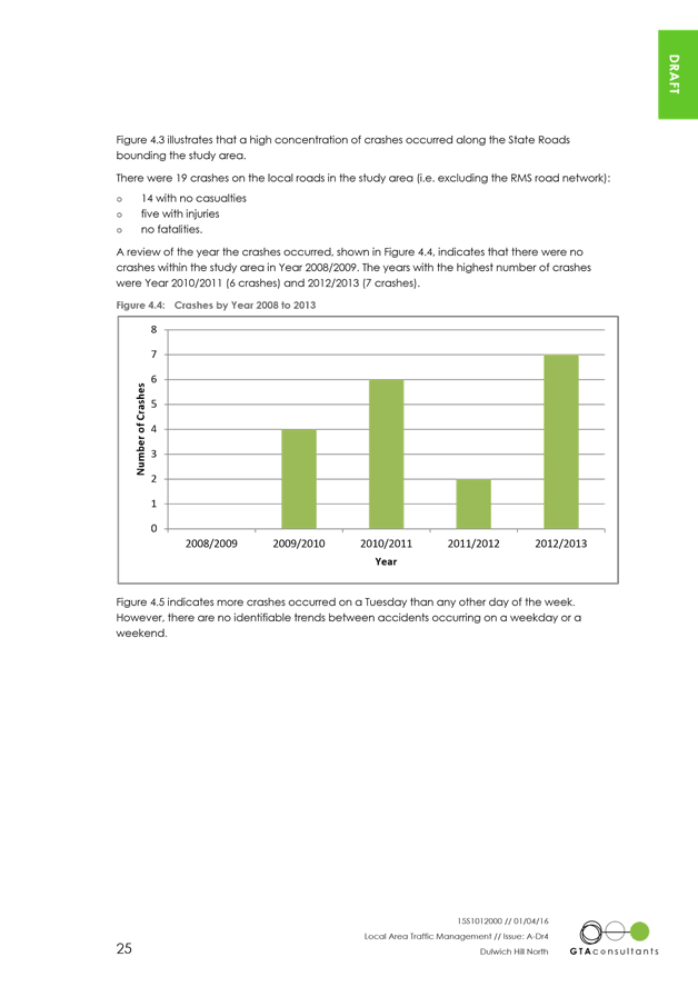
· Analysis of accident statistics for the 5 year period from January 2008 to December 2013;
· Review of the community’s complaints and concerns raised in the community questionnaire in relation to traffic and safety issues;
· Review of intersection performance for traffic management;
· Assessment of the effectiveness of the existing LATM measures and ensure their compliance to the current standard;
· Identification of further opportunities to reduce through traffic volumes and speed of traffic on local streets to address public amenity;
· Identification of pedestrian and cyclist improvements; and
· Development of conceptual LATM proposal options.
The recommendations provided in this LATM Plan align with the traffic management principles outlined in the Inner West (Marrickville) Integrated Transport Strategy (ITS), 2007.
Following the assessment of the Pedestrian, Cyclist and Traffic Calming Advisory Committee (PCTCAC), the draft report will be forwarded to Council for approval to undertake community consultation.
Tomorrow’s Dulwich Hill (TDH) is a new way of planning, designing and building Dulwich Hill’s streets and public places that put people and place at the centre. This LATM will be integrated as part of the TDH to create a 10-year plan for Dulwich Hill area.
COMMUNITY CONSULTATION
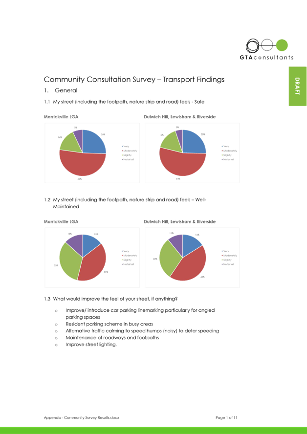
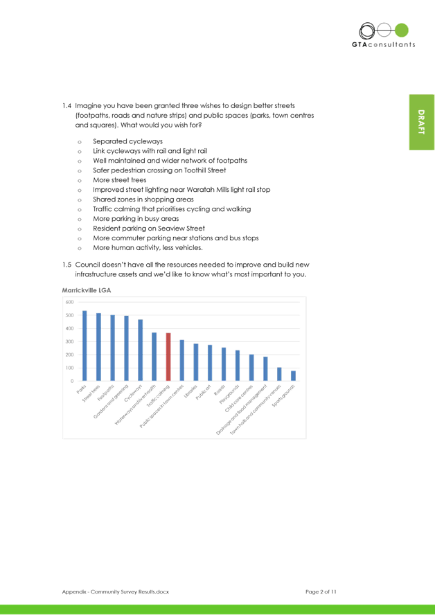
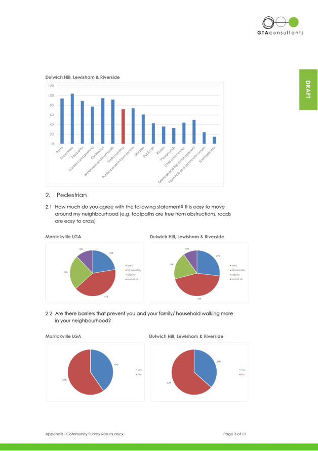
The suggested LATM treatment options were informed by engagement with internal and external stakeholders. The community engagement within Inner West (Marrickville) Local Government Area (LGA) included the Imagining Marrickville survey stakeholder workshops and community meetings.
· The survey was conducted during July and August 2014, receiving 159 responses from the Dulwich Hill Area.
· A traffic and parking issues plan was prepared for Tomorrow’s Dulwich Hill Stage 1 Learn and Share and posted on the “Your Say Inner West (Marrickville) website for residents and other stakeholders to discuss traffic issues in an open forum. The forum was open to the public from late March 2015 to early May 2015 and received 38 responses.
· A consultation session of Tomorrow’s Dulwich Hill with the Denison Road Group was held on 26 November 2015 to workshop parking options for Denison Road.
· An internal workshop was held on 23 November 2016 with Council’s staff to evaluate and prioritise the preferred LATM options.
OFFICER COMMENTS
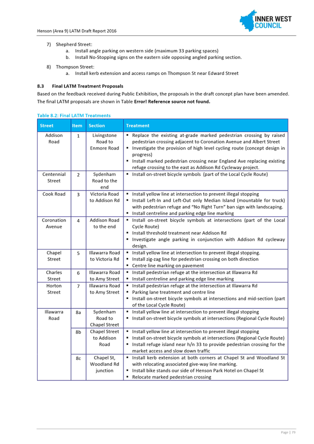
A summary of recommendations and concept plans are detailed in the ATTACHMENTS. The Dulwich Hill North LATM recommendations are summarised in the following table.
Table A: LATM Recommendations
|
Location |
Item |
Treatment Recommendation |
|
Constitution Road |
1.1 |
Fully mountable median islands at Denison Rd roundabout with pedestrian refuge at the northern leg. |
|
1.2 |
Pedestrian refuge at Williams Parade roundabout |
|
|
1.3 |
Rumble bars along centreline between Williams Pde and Denison Rd |
|
|
1.4 |
Fixed radar speed display |
|
|
1.5 |
On-road bicycle symbols |
|
|
Denison Road |
2.1 |
Two-way one-lane slow point at H/N 152 north Davis Street |
|
2.2 |
Fully mountable median islands at Eltham St |
|
|
2.3 |
Change of intersection priority to Dulwich Street |
|
|
2.4 |
Change of intersection priority to Pigott Street |
|
|
2.5 |
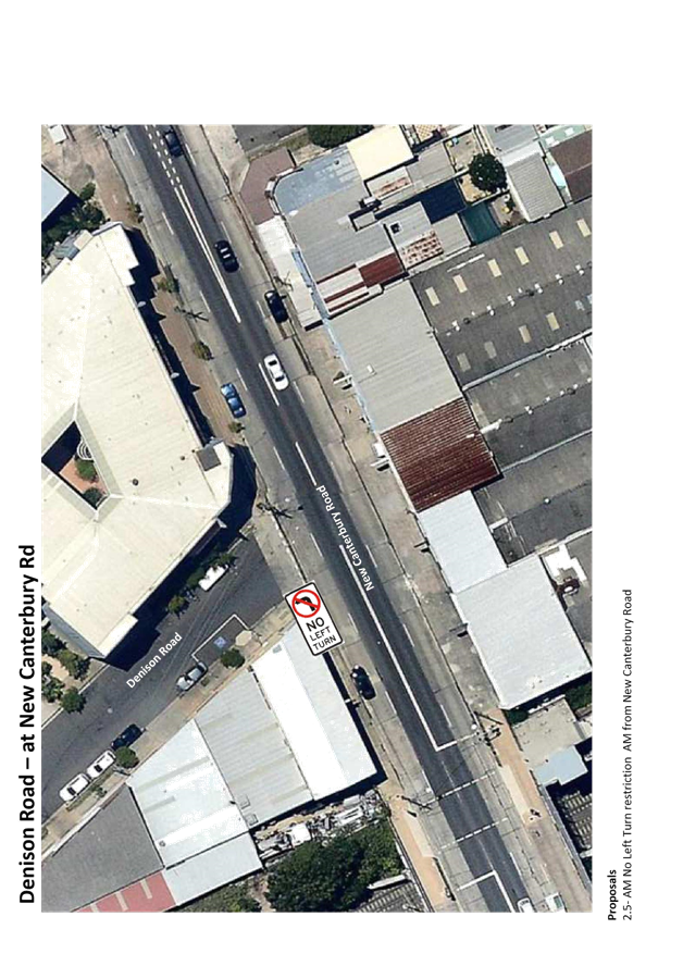
AM No Left Turn restriction from New Canterbury Road |
|
|
2.6 |
Parking lane marking |
|
|
2.7 |
On-road bicycle symbols |
|
|
Windsor Road |
3.1 |
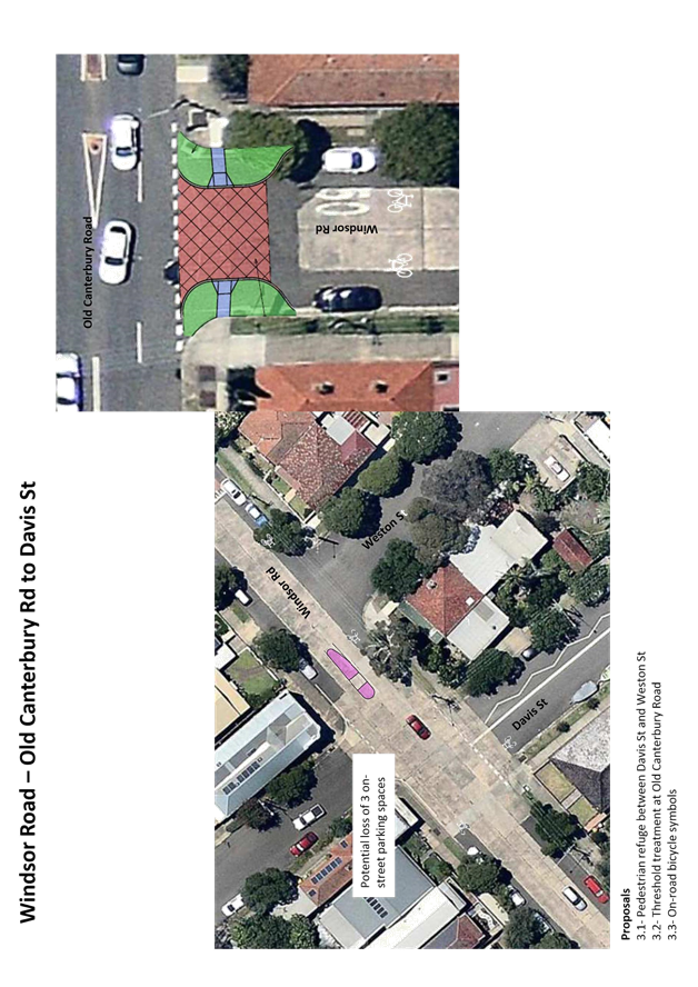
Pedestrian refuge between Davis St and Weston St |
|
3.2 |
Threshold treatment at Old Canterbury Road |
|
|
3.3 |
On-road bicycle symbols |
|
|
Union Street |
4.1 |
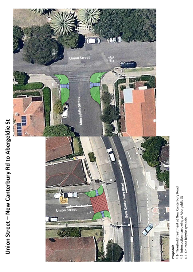
Threshold treatment at New Canterbury Road |
|
4.2 |
Intersection narrowing at Abergeldie St |
|
|
4.3 |
On-road bicycle symbols |
|
|
Arlington Street |
5.1 |
Intersection narrowing at Dixson Ave and Abergeldie St |
|
5.2 |
Change of intersection priority to Abergeldie St |
|
|
5.3 |
Parking lane marking |
|
|
5.4 |
On-road bicycle symbols |
|
|
Dixson Avenue |
6.1 |
Speed humps/cushions near H/N 8 and H/N26 |
|
6.2 |
Intersection narrowing and threshold treatment at Old Canterbury Rd |
|
|
Abergeldie Street |
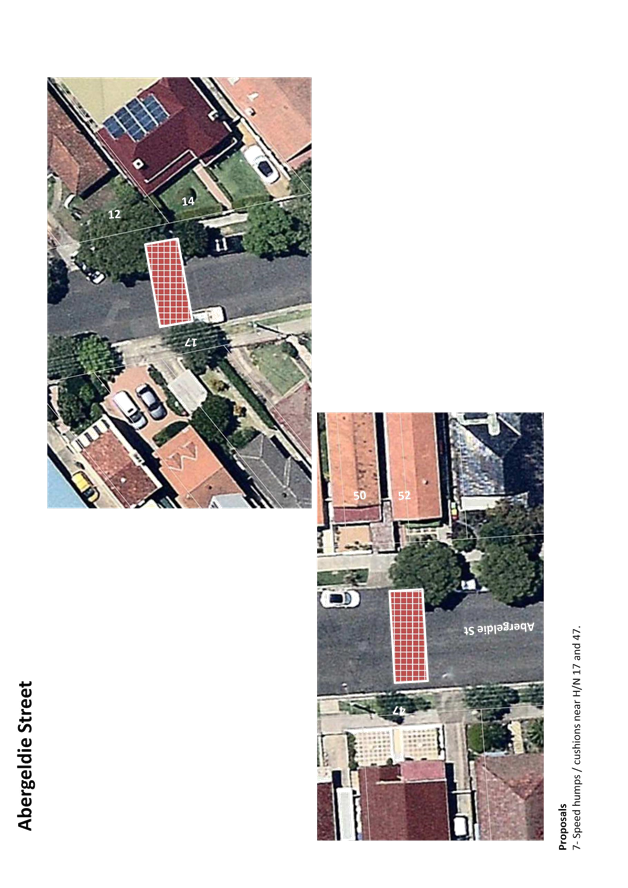
7 |
Speed humps/cushions near H/N 17 and H/N 47. |
|
Gelding Street |
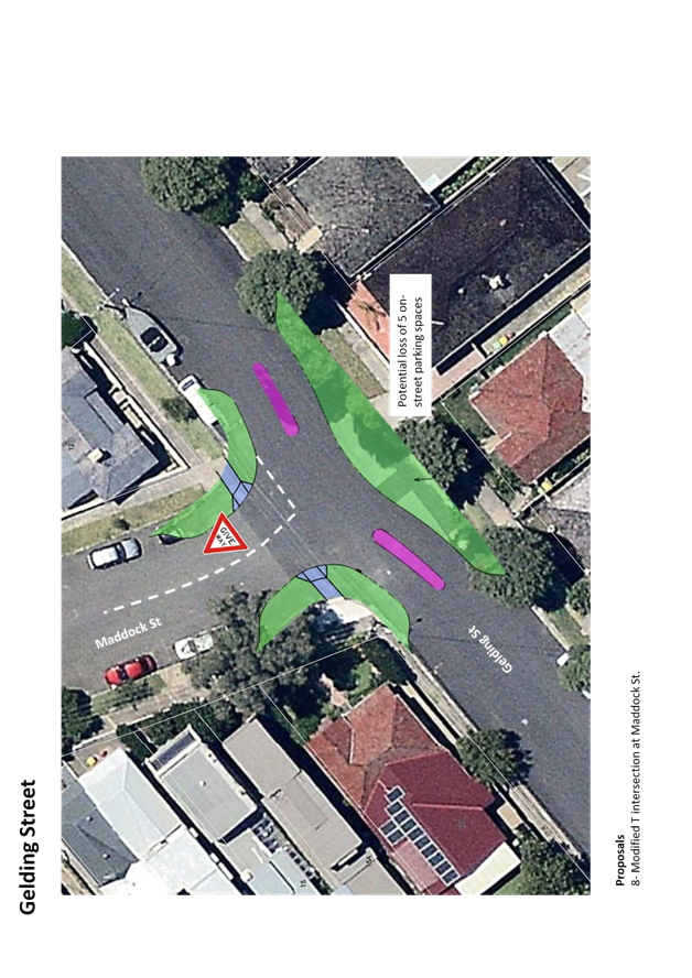
8 |
Modified T intersection at Maddock St |
|
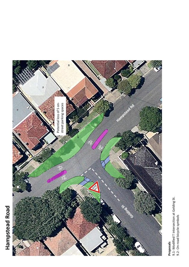
Hampstead Road |
9.1 |
Modified T intersection at Gelding St |
|
9.2 |
On-road bicycle symbols |
|
|
Lewisham Street |
10.1 |
One-way northbound direction between New Canterbury Rd and The Boulevarde |
|
10.2 |
Left-in-left-out at Denison Rd with central median |
|
|
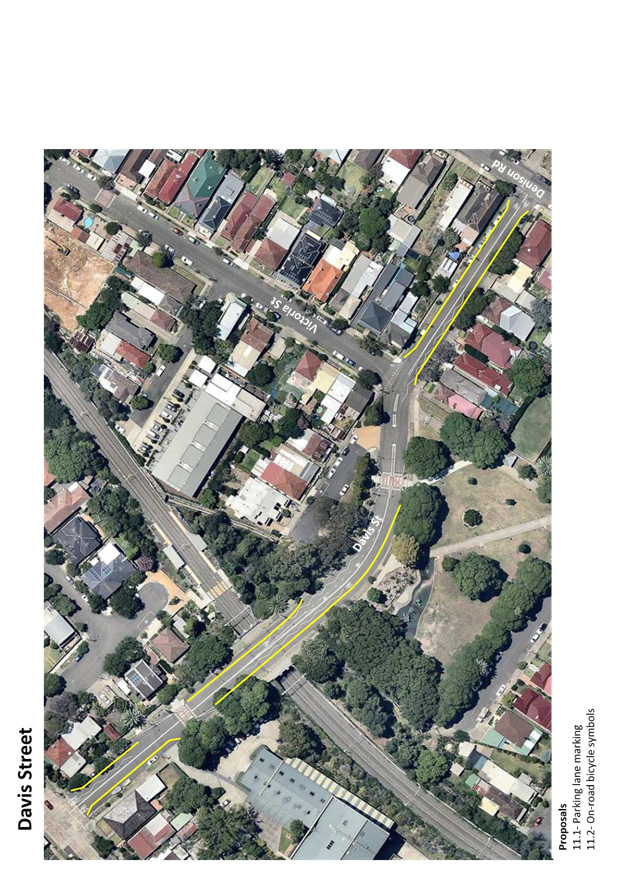
Davis Street |
11.1 |
Parking lane marking |
|
11.2 |
On-road bicycle symbols |
|
|
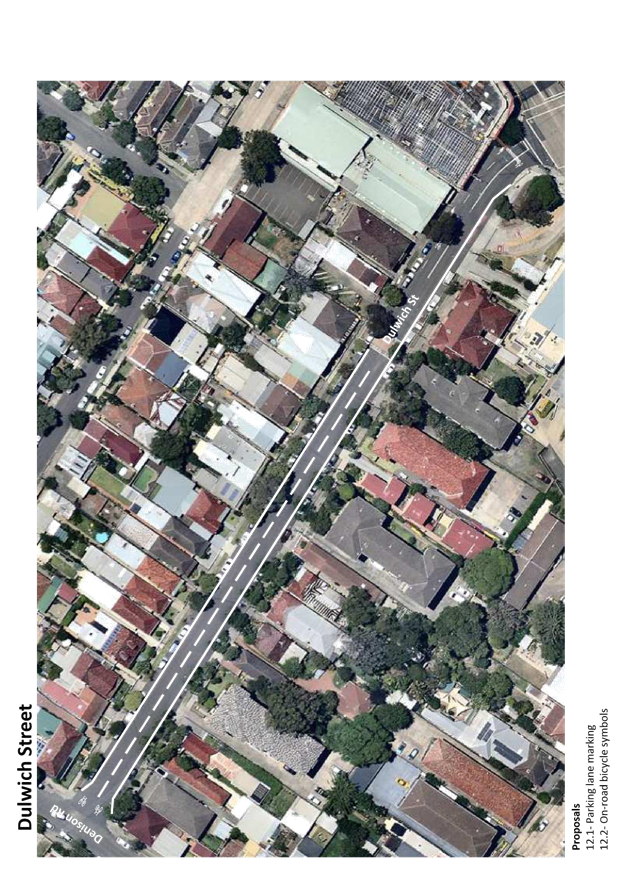
Dulwich Street |
12.1 |
Parking lane marking |
|
12.2 |
On-road bicycle symbols |
|
|
Williams Parade |
13.1 |
Pedestrian refuge at Constitution Road roundabout |
|
13.2 |
On-road bicycle symbols |
|
|
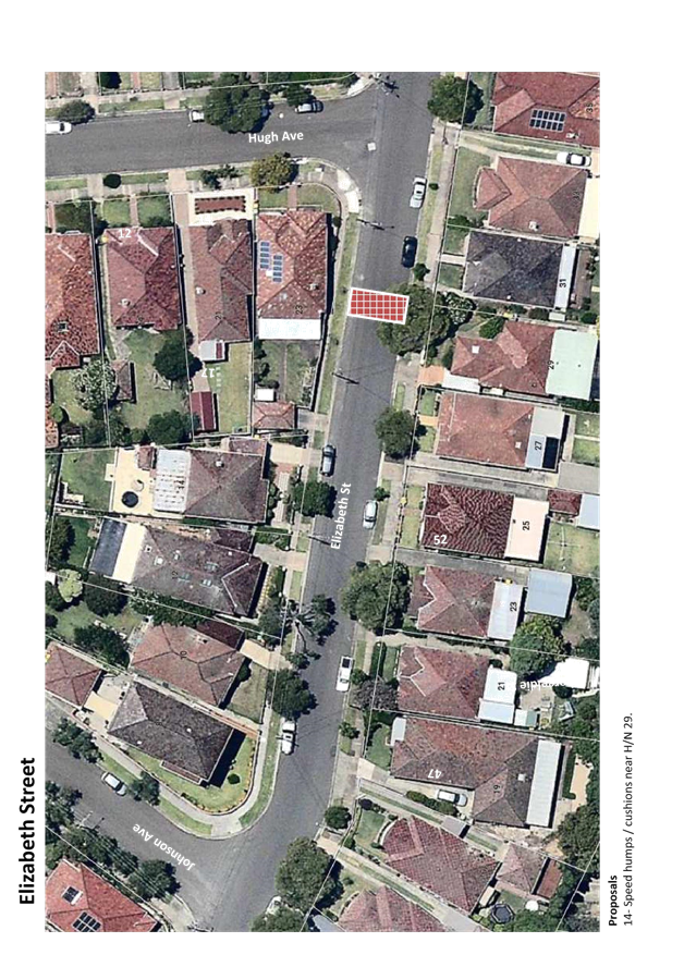
Elizabeth Street |
14 |
Speed humps/cushions near H/N 29 |
DULWICH HILL North LATM STUDY AREA
|
1.⇩ |
GTA-160401rep-15S1012000 Dulwich Hill North LATM Final Draft 2 |
|
2.⇩ |
Dulwich Hill North LATM option evaluation and prioritisation |
|
3.⇩ |
Dulwich Hill Nth LATM Draft Concept Plan-v2 |
|
Local Traffic Committee Meeting 6 April 2017 |
DATE: 23 November 2016
SUBJECT: Dulwich hill North LATM option evaluation and prioritisation
FILE REF: 14/5141
TRIM No.: 134987.16
1. Background
As part of the Tomorrow’s Dulwich Hill (TDH) project, Inner West (Marrickville) Council commissioned a traffic consultant to undertake the Local Area Traffic Management (LATM) study for the Dulwich Hill North LATM area. Once completed, this LATM concept will feed into the TDH initiative.
The draft Dulwich Hill North LATM study report was prepared in April 2016. A series of LATM treatment options were recommended. In order to provide an indication to the TDH project team to identify the preferred options to fit into the TDH project, a project priority meeting was held to discuss and evaluate the preferred LATM treatment options from the traffic management perspective.
This memo documents the process of evaluation and provides the prioritisation of the preferred LATM options in accordance with the treatments prioritisation recommended by the consultant and the outcome of the discussion during the project priority meeting.
2. Project priority meeting
The meeting was held on Monday 31 October 2016 with the attendees of:
· Felix Liu, Traffic Management Planner
· George Tsaprounis, Coordinator Traffic Engineering Services
· Joe Di Cesare, Manager Design and Investigation
· Ryan Hawken, Coordinator Asset Planning
The following items have been discussed during the meeting:
· The draft LATM proposals are currently identified as options rather than preferred treatments, which was what was requested for the TDH project.
· Currently multiple options may apply to one location addressing similar traffic issues and not all of these options should be implemented together.
· The LATM treatment options recommended in the draft report and the evaluation of the preferred options are from a traffic management perspective.
3. Option evaluation process
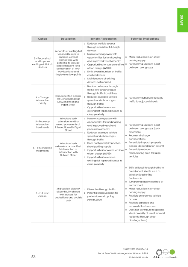
3.1. Denison Road
3.1.1. Traffic Issues
Main traffic issues raised in community consultation for Denison Road include:
· Traffic volume and speeds; and
· Lack of pedestrian facilities as a result of the high traffic volume.
3.1.2. LATM Options
The LATM treatment options recommended in the study report to address the above traffic issues include:
· AM No Left Turn restrictions from New Canterbury Road into Denison Road and Dulwich Street
· Rumble bars or fully mountable median islands at the roundabout of Denison Road and Eltham Street
· Reconstruction of existing flat top speed humps with street narrowing features, including kerb blisters or single lane narrowing.
· Intersection priority changed to Pigott Street and Dulwich Street intersections.
· Installation of kerb extension and/or raised intersection treatment at Pigott Street/Denison Road intersection
· Installation of kerb extension and/or modified T-intersection at Dulwich Street/Denison road intersection
· Mid-block road closure on the southern side of the Denison Road to the north of Constitution Road
· Conversion of Lewisham Street to One-way northbound direction only between The Boulevarde and New Canterbury Road with Left-in-left-out restriction at Denison Road.
· Linemark 2.1 metre wide parking lanes.
· Installation of on-road bicycle symbols as bike routes LR02 and RR09.
3.1.3. Traffic Conditions
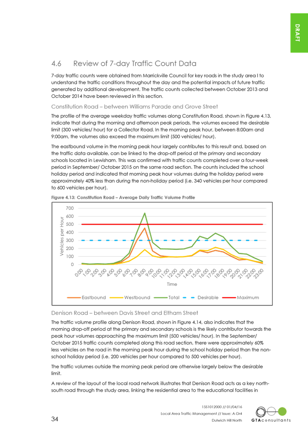
The traffic survey results indicated Denison Road carries approximately 2,500 vpd, which is below the desirable capacity of a Collector Road (3,000vph). However, during the AM peak hour (8:00am to 9:00am) the traffic volumes exceed the maximum peak hour limit of 500pvh.
Figure 1 - Denison Road Traffic Volume Profile
3.1.4. Recommendations and Discussion
· Full road closure is not recommended, as:
1. Traffic volumes are within the amenity level for a Collector road;
2. Turn-around movement cannot be accommodated as the narrow road width; and
3. Any road closure would push through traffic, avoiding the closure, onto other adjacent local streets, such as Grove Street.
· Consider two-way one-lane slow point at mid-block north of Davis Street to discourage through traffic by increasing travelling time.
· The raised intersection at Pigott St and Denison Rd intersection is unsuitable, due to the safety concern of pedestrians potentially using raised intersection devices as pedestrian crossing facilities.
· Reconstruction of speed hump with kerb blisters is not recommended, as:
1. This would provide marginal benefit to address speeding issues comparing to the existing flat top speed humps.
2. Significant impact on on-street parking provision, unless other benefits can be achieved, such as greening.
· Fully mountable median islands are preferred at the roundabout over the rumble bars, as fully mountable islands will last much longer time than the rumble bars.
· The modified T-intersection is unsuitable as the significant impact on on-street parking.
· Other options stay as recommended in the study report.
3.2. Constitution Road
3.2.1. Traffic Issues
Main traffic issues raised in community consultation for Constitution Road include:
· Lack of pedestrian facilities across Constitution Road near Arlington Light Rail Stop.
· Safety concerns about turning movements at the New Canterbury Road/Constitution Road intersection.
· Speeding issues.
3.2.2. LATM Options
The LATM treatment options recommended in the study report to address the above traffic issues include:
· Installation of Fixed radar speed display.
· No Right Turn restriction from Old Canterbury Road
· Rumble bars along centerline between Denison Road and Williams Parade
· Rumble bars or fully mountable median islands at the roundabout of Denison Road and Constitution Road with pedestrian refuge at northern leg.
· Installation of threshold treatment at Old Canterbury Road with kerb extensions and/or tactile surface.
· Reconstruction of existing flat top speed humps (near h/n 202 and 174) with kerb blisters.
· Installation of parking lane marking
· Installation of on-road bicycle symbols as bike routes RR09 and LR18.
3.2.3. Traffic Conditions
The traffic survey results indicated Constitution Road carries approximately between 3,000 and 4,300 vpd, with the peak period volume over 600 vph, which exceed the desirable capacity of a Collector Road (3,000vph) and maximum limit of 500 vehicles/hr. Vehicle speeds along Constitution Road varies between 35km/h and 46km/h, which is below the speed limit. A total of 3 car-car crashes were reported on Constitution Road.
Figure 2 - Constitution Road Traffic Volume Profile
3.2.4. Recommendations and Discussion
· Fully mountable median islands are preferred at the roundabout of Constitution Rd/Denison Rd over the rumble bars, as fully mountable islands will last much longer time than the rumble bars. Pedestrian refuge at north of Denison Road/Constitution Road roundabout may be considered integrated with the roundabout median island to improve pedestrian crossing safety.
· Rumble bars along the curved section between Denison Road and Williams Avenue is recommended.
· Pedestrian refuge at Williams Parade/Constitution Road roundabout is recommended.
· Right turn ban from Old Canterbury Road is not recommended, as:
1. The benefit of discourage through traffic is marginal;
2. It would push traffic into other local streets, which would have adverse impacts on local area.
· Other options stay as recommended in the study report.
3.3. Arlington Street
3.3.1. Traffic Issues
There was no significant traffic issue raised by the community
3.3.2. LATM Options
The LATM treatment options recommended in the study report include:
· Edge line marking
· Installation of on-road bicycle symbols as bike route RR09
· Mid-block Speed humps/cushions
· Four-way intersection treatments, including kerb extension and raised intersection.
3.3.3. Traffic Conditions
The traffic survey results indicated Arlington Street carries approximately 730vpd, which is below desirable volume for local road. Vehicle speeds along Arlington Street were recorded in 51.6km/h, which exceeds the speed limit. A total of 2 car-car crashes were reported on Arlington Street.
3.3.4. Recommendations and Discussion
· Intersection narrowing at Dixson Avenue and Abergeldie Street intersections is considered, as:
1. The current wide carriageway of Arlington Street encourages higher vehicle speeds.
2. Drainage needs to be considered.
· Change of intersection priority to Abergeldie Street, in order to reduce vehicle speeds.
3.4. Dixson Avenue (and Abergeldie Street)
3.4.1. Traffic Issues
There was no significant traffic issue raised by the community.
3.4.2. LATM Options
The LATM treatment options recommended in the study report include:
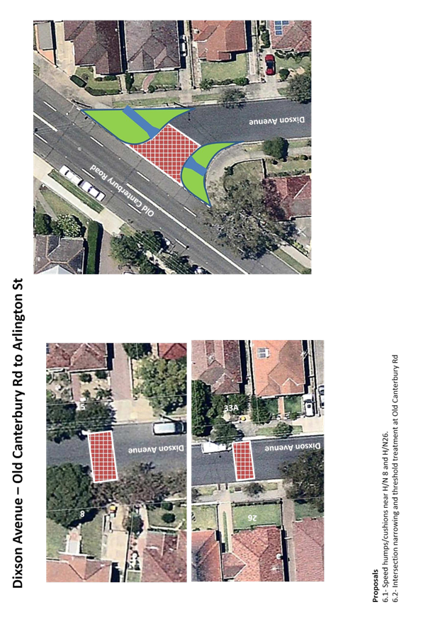
· Threshold treatment on Dixson Avenue at Old Canterbury Road
· Mid-block speed humps/cushions
· Four-way intersection treatments, including kerb extension and raised intersection
3.4.3. Traffic Conditions
The traffic survey results indicated Dixson Avenue carries low traffic volume between 600 vpd and 800 vpd. Vehicle speeds along Dixson Avenue were recorded in 52.9km/h, which exceeds the speed limit.
Traffic data was not available at Abergeldie Street. However, given the similar condition as Dixson Avenue, it is assumed that similar traffic issue may occur on Abergeldie Street.
There is no crash reported for both streets between 2008 and 2013.
3.4.4. Recommendations and Discussion
· Intersection narrowing at Dixson Avenue and Abergeldie Street intersections, as:
1. The current wide carriageway of Arlington Street encourages higher vehicle speeds.
2. Drainage needs to be considered.
· Speed humps/cushions are preferred in Dixson Avenue to reduce vehicle speed.
· Intersection narrowing and threshold treatment on Dixson Avenue at Old Canterbury Road is recommended to reduce entry speed and improve pedestrian priority.
· Speed humps/cushions may be required as the assumptions above.
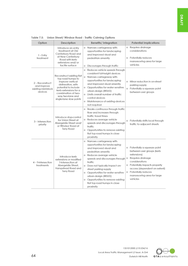
3.5. Union Street
3.5.1. Traffic Issues
There was no significant traffic issue raised by the community.
3.5.2. LATM Options
The LATM treatment options recommended in the study report include:
· Threshold treatment at New Canterbury Road
· Reconstruction of existing speed hump with road narrowing
· Modified-T intersection treatment at Abergeldie Street/Union Street intersection
· Installation of on-road bicycle symbols as bike route LR18
3.5.3. Traffic Conditions
The traffic survey results indicated Union Street carries low traffic volume between 600 vpd and 800 vpd. Vehicle speeds along Union Street were recorded in approximately 45km/h, which is below the speed limit.
3.5.4. Recommendations and Discussion
· Existing LATM treatments are considered efficient.
· Modified-T intersection treatment is not recommended due to marginal traffic benefit. Intersection narrowing can be considered unless other benefits can be achieved, such as greening.
· Intersection narrowing is preferred in Abergeldie Street to reduce vehicle speed.
3.6. Windsor Road
3.6.1. Traffic Issues
· Traffic congestion along Old Canterbury Road resulting in rat running along Gelding and Windsor Road.
3.6.2. LATM Options
The LATM treatment options recommended in the study report include:
· Threshold treatment at Old Canterbury Road
· Reconstruction of existing speed humps with road narrowing
· Installation of pedestrian refuges near Davis Street
· Change of intersection priority to Terry Road
· Modified-T intersection treatment at the intersections with Terry Street and Hampstead Street
· Installation of on-road bicycle symbols as bike route LR17
3.6.3. Traffic Conditions
The traffic survey results indicated Windsor Road carries approximately 1,000 vpd. Vehicle speeds along Windsor Road were recorded in approximately 45.7km/h, which is below the speed limit.
One car-car crash was report near Constitution Road roundabout.
3.6.4. Recommendations and Discussion
· Existing LATM treatments are considered efficient.
· Intersection priority treatments are not considered at Terry Road and Hampstead Road, due to the low vehicle speed and traffic volume.
· Only one pedestrian refuge is considered between Davis Street and Weston Street.
3.7. Gelding Street
3.7.1. Traffic Issues
· Traffic congestion along Old Canterbury Road resulting in rat running along Gelding and Windsor Road.
3.7.2. LATM Options
The LATM treatment options recommended in the study report include:
· Mid-block speed humps/cushions
· Modified-T intersection treatment at Hampstead Road and Maddock Street
3.7.3. Traffic Conditions
The traffic survey results indicated Gelding Street carries approximately 200 vpd. Vehicle speeds along Gelding Street were recorded in approximately 52.9km/h, which exceeds the speed limit.
3.7.4. Recommendations and Discussion
· Modified-T intersection treatment is preferred over the speed hump/cushions
3.8. Hampstead Road
3.8.1. Traffic Issues
· There was no significant issue raised by the community.
3.8.2. LATM Options
The LATM treatment options recommended in the study report include:
· Mid-block speed humps/cushions
· Modified-T intersection treatment at Gelding Road and Windsor Road
· Installation of on-road bicycle symbols as bike route LR17
3.8.3. Traffic Conditions
The traffic survey results indicated Gelding Street carries approximately 474 vpd. Vehicle speeds along Gelding Street were recorded in approximately 48.5km/h, which is below the speed limit.
3.8.4. Recommendations and Discussion
· Modified-T intersection treatment at Gelding Road is preferred over the speed hump/cushions
· Intersection priority treatments are not considered at Hampstead Road, due to the low vehicle speed and traffic volume.
4.
Final draft treatment options
|
Location |
ID |
Treatment Options |
|
Constitution Road |
1.1 |
Fully mountable median islands at Denison Rd roundabout with pedestrian refuge at the northern leg. |
|
1.2 |
Pedestrian refuge at Williams Parade roundabout |
|
|
1.3 |
Rumble bars along centreline between Williams Pde and Denison Rd |
|
|
1.4 |
Fixed radar speed display |
|
|
|
1.5 |
On-road bicycle symbols |
|
Denison Road |
2.1 |
Two-way one-lane slow point at H/N 152 north Davis Street |
|
2.2 |
Fully mountable median islands at Eltham St |
|
|
2.3 |
Change of intersection priority to Dulwich Street |
|
|
2.4 |
Change of intersection priority to Pigott Street |
|
|
2.5 |
AM No Left Turn restriction from New Canterbury Road |
|
|
2.6 |
Parking lane marking |
|
|
|
2.7 |
On-road bicycle symbols |
|
Windsor Road |
3.1 |
Pedestrian refuge between Davis St and Weston St |
|
3.2 |
Threshold treatment at Old Canterbury Road |
|
|
|
3.3 |
On-road bicycle symbols |
|
Union Street |
4.1 |
Threshold treatment at New Canterbury Road |
|
4.2 |
Intersection narrowing at Abergeldie St |
|
|
|
4.3 |
On-road bicycle symbols |
|
Arlington Street |
5.1 |
Intersection narrowing at Dixson Ave and Abergeldie St |
|
5.2 |
Change of intersection priority to Abergeldie St |
|
|
5.3 |
Parking lane marking |
|
|
5.4 |
On-road bicycle symbols |
|
|
Dixson Avenue |
6.1 |
Speed humps/cushions near H/N 8 and H/N26 |
|
6.2 |
Intersection narrowing and threshold treatment at Old Canterbury Rd |
|
|
Abergeldie Street |
7 |
Speed humps/cushions near H/N 17 and H/N 47. |
|
Gelding Street |
8 |
Modified T intersection at Maddock St |
|
Hampstead Road |
9.1 |
Modified T intersection at Gelding St |
|
9.2 |
On-road bicycle symbols |
|
|
Lewisham Street |
10.1 |
One-way northbound direction between New Canterbury Rd and The Boulevarde |
|
10.2 |
Left-in-left-out at Denison Rd with central median |
|
|
Davis Street |
11.1 |
Parking lane marking |
|
11.2 |
On-road bicycle symbols |
|
|
Dulwich Street |
12.1 |
Parking lane marking |
|
12.2 |
On-road bicycle symbols |
|
|
Williams Parade |
13.1 |
Pedestrian refuge at Constitution Road roundabout |
|
|
13.2 |
On-road bicycle symbols |
|
Elizabeth Street |
14 |
Speed humps/cushions near H/N 29 |
5.
LATM option prioritisation
The process of prioritising the LATM treatment options considered the benefit rating and priority rating suggested in the Section 8.1 of draft LATM report and the recommendations during the project priority meeting.
Each criteria in the Table 1 below has been described providing the following information:
Benefit Rating:
· L – Low benefits to other users and urban planning aspects (score 1)
· M – Medium benefits other users and urban planning aspects (score 2)
· H – High benefits other users and urban planning aspects (score 3)
Priority Rating
· S – Short term to address existing issues (score 1)
· L – Long term to address future issues associated with growth (score 2)
Recommendation Rating
· P – Possible to be implemented subject to other benefit can be achieved (score 2)
· R – Recommended to be implemented (score 5)
Final score – product of the scores for each criteria.
Ranking – the priority order in the basis of final score.
Table 1 – LATM option prioritisation
|
ID. |
Location |
Treatment options |
Benefit Rating |
Priority Rating |
Recommendation Rating |
Final Score |
Ranking |
|
1.1 |
Constitution Road |
Fully mountable median islands at Denison Rd roundabout with pedestrian refuge at the northern leg. |
3 |
2 |
5 |
30 |
1 |
|
1.3 |
Constitution Road |
Rumble bars along centreline between Williams Pde and Denison Rd |
3 |
1 |
5 |
15 |
2 |
|
2.2 |
Denison Road |
Fully mountable median islands at Eltham St |
3 |
1 |
5 |
15 |
3 |
|
2.5 |
Denison Road |
AM No Left Turn restriction from New Canterbury Road |
3 |
1 |
5 |
15 |
4 |
|
3.1 |
Windsor Road |
Pedestrian refuge between Davis St and Weston St |
3 |
1 |
5 |
15 |
5 |
|
6.1 |
Dixson Avenue |
Speed humps/cushions near H/N 8 and H/N26 |
3 |
1 |
5 |
15 |
6 |
|
14 |
Elizabeth Street |
Speed humps/cushions near H/N 29 |
3 |
1 |
5 |
15 |
7 |
|
1.2 |
Constitution Road |
Pedestrian refuge at Williams Parade roundabout |
2 |
1 |
5 |
10 |
8 |
|
2.1 |
Denison Road |
Two-way one-lane slow point at H/N 152 north Davis Street |
2 |
1 |
5 |
10 |
9 |
|
2.3 |
Denison Road |
Change of intersection priority to Dulwich Street |
2 |
1 |
5 |
10 |
10 |
|
2.4 |
Denison Road |
Change of intersection priority to Pigott Street |
2 |
1 |
5 |
10 |
11 |
|
5.1 |
Arlington Street |
Intersection narrowing at Dixson Ave and Abergeldie St |
2 |
1 |
5 |
10 |
12 |
|
5.2 |
Arlington Street |
Change of intersection priority to Abergeldie St |
2 |
1 |
5 |
10 |
13 |
|
6.2 |
Dixson Avenue |
Intersection narrowing and threshold treatment at Old Canterbury Rd |
2 |
1 |
5 |
10 |
14 |
|
13.1 |
Williams Parade |
Pedestrian refuge at Constitution Road roundabout |
2 |
1 |
5 |
10 |
15 |
|
7 |
Abergeldie Street |
Speed humps/cushions near H/N 17 and H/N 47. |
3 |
1 |
2 |
6 |
16 |
|
1.5 |
Constitution Road |
On-road bicycle symbols |
1 |
1 |
5 |
5 |
17 |
|
2.6 |
Denison Road |
Parking lane marking |
1 |
1 |
5 |
5 |
18 |
|
2.7 |
Denison Road |
On-road bicycle symbols |
1 |
1 |
5 |
5 |
19 |
|
3.3 |
Windsor Road |
On-road bicycle symbols |
1 |
1 |
5 |
5 |
20 |
|
4.3 |
Union Street |
On-road bicycle symbols |
1 |
1 |
5 |
5 |
21 |
|
5.3 |
Arlington Street |
Parking lane marking |
1 |
1 |
5 |
5 |
22 |
|
5.4 |
Arlington Street |
On-road bicycle symbols |
1 |
1 |
5 |
5 |
23 |
|
9.2 |
Hampstead Road |
On-road bicycle symbols |
1 |
1 |
5 |
5 |
24 |
|
11.1 |
Davis Street |
Parking lane marking |
1 |
1 |
5 |
5 |
25 |
|
11.2 |
Davis Street |
On-road bicycle symbols |
1 |
1 |
5 |
5 |
26 |
|
12.1 |
Dulwich Street |
Parking lane marking |
1 |
1 |
5 |
5 |
27 |
|
12.2 |
Dulwich Street |
On-road bicycle symbols |
1 |
1 |
5 |
5 |
28 |
|
13.2 |
Williams Parade |
On-road bicycle symbols |
1 |
1 |
5 |
5 |
29 |
|
1.4 |
Constitution Road |
Fixed radar speed display |
2 |
1 |
2 |
4 |
30 |
|
3.2 |
Windsor Road |
Threshold treatment at Old Canterbury Road |
2 |
1 |
2 |
4 |
31 |
|
4.1 |
Union Street |
Threshold treatment at New Canterbury Road |
2 |
1 |
2 |
4 |
32 |
|
4.2 |
Union Street |
Intersection narrowing at Abergeldie St |
2 |
1 |
2 |
4 |
33 |
|
8 |
Gelding Street |
Modified T intersection at Maddock St |
2 |
1 |
2 |
4 |
34 |
|
9.1 |
Hampstead Road |
Modified T intersection at Gelding St |
2 |
1 |
2 |
4 |
35 |
|
10.1 |
Lewisham Street |
One-way northbound direction between New Canterbury Rd and The Boulevarde |
1 |
2 |
2 |
4 |
36 |
|
10.2 |
Lewisham Street |
Left-in-left-out at Denison Rd with central median |
1 |
2 |
2 |
4 |
37 |
|
|
Local Traffic Committee Meeting 6 April 2017 |
|
Local Traffic Committee Meeting 6 April 2017 |
Subject: Henson LATM Final Report (MARRICKVILLE & STANMORE WARD/SUMMER HILL ELECTORATE/MARRICKVILLE LAC)
File Ref: 15/14909/28103.17
Prepared By: Felix Liu - Traffic Management Planner
|
SUMMARY This is a recommendation to endorse the final Henson Local Area Traffic Management (LATM) report. The proposals within the report are based on community input and analysis of feedback from the Public Exhibition period through 15 November and 14 December 2016. There were 75 submissions from individual households relating to specific streets or treatments. 91% of the submissions indicated support or support with changes to the proposals. Once this recommendation is endorsed by Traffic Committee and Council the projects will be incorporated into future design and construction programs. |
|
THAT the final Henson LATM report be adopted and the treatments listed in the table below be approved for implementation.
|
BACKGROUND
The Marrickville Community Strategic Plan (CSP) – Our Place Our Vision 2023 has key outcomes:
· Marrickville's roads are safer and less congested
· Marrickville's streets, lanes and public spaces are sustainable, welcoming, accessible and clean
· The community walks, ride bikes and use public transport.
One element of delivering the above outcomes is the development of Local Area Traffic Management (LATM) study and plan including recommendations.
The objective of local area traffic management planning is to investigate and review the performance of the existing Local Area Traffic Management (LATM) schemes and recommend proposed LATM works. The Henson LATM study was originally completed in 1998 and reviewed in 2004.
PUBLIC EXHIBITION
The draft Henson LATM report was placed in Public Exhibition from 15 November to 14 December 2016 via newspaper advertisement, Your Say Inner West website and a mail-out. Letters were sent to 2,200 residents and householders in the study area requesting feedback. A hard copy of the draft report was also provided at Council’s Administration Centre and Marrickville Library.
A survey form was provided online and at the display site where residents could indicate their support for the draft concept recommendations. Respondents could indicate their “support”, “support with changes” or “not support” the proposed draft concept plan. Respondents were also asked to comment on their reasons or concerns about the concept.
Council received a total of 75 submissions from individual households with most submissions relating to a specific street or treatment, including 68 respondents in support of the strategy (91%) and 7 respondents against the strategy (13%). Key findings of the community feedback are provided below:
Support:
· One-way direction (preferred Eastbound) on Norwood Lane to reduce vehicle circulation.
· Relocation of existing pedestrian crossing signals on Victoria St to Chapel St intersection.
· Threshold treatments and line marking to slow traffic down in local area.
· Raising pedestrian crossing on Addison Rd near Coronation Ave to improve safety for students and reduce traffic speed on Addison Rd.
· Need of speed control treatment on Cook Rd
Against:
· No need of traffic calming treatments on Horton St and Charles St, due to the low traffic volumes, environments, marginal speeding concerns and loss of on-street parking
· Make Illawarra Road one-way direction due to the narrowness.
· Traffic calming treatments reduce on-street parking capacity.
· Opposing cycleway on Addison Road.
· Opposing treatment on Park Rd due to loss of parking
Additional requests and concerns were also raised by the communities during the Public Exhibition. A summary of the requests and the associated comments by Council staff is listed below:
Location |
Request/Concern |
Council Comments |
|
Charles Street & Hoxton Street |
No need of traffic calming treatments |
· A total of 9 submissions raised the opposition of either speed humps or slow point treatment. · No crash was recorded between 2006 and 2015 · Low traffic volumes · Marginal speeding, less than 2km/h above speed limit. |
|
Illawarra Road |
Make Illawarra Road one-way direction due to the narrowness |
· The narrowness is a kind of self-enforcing measures to maintain low speed on Illawarra Rd. · The one-way on Illawarra Rd will encourage higher speed environment and result in speeding. |
|
Illawarra Road |
Dangerous intersection of Illawarra Rd/Chapel St/Woodland St, due to poor sightline from side streets and existing pedestrian crossing safety issue |
· The kerb extension addresses the sight line issues on both Chapel St and Woodland St and narrow Illawarra Rd in order to discourage through and heavy vehicle traffic and improve pedestrian crossing safety and amenities. · Potential for outdoor dining for Henson Park Hotel and the Café. · Bike stands are to promote active transport for local trips. |
|
Shepherd Street |
Angled parking on Shepherd St as speed control measure |
· Self-enforced traffic calming by street narrowing to reduce speed. · Additional parking spaces for the market on the weekend and Addison Rd cycleway project · Due to limited width of Shepherd St, the existing on-street parking (approx. 7 spaces) on the eastern side needs to be removed. The increased parking supply by angled parking will compensate the loss of parking spaces on the eastern side. |
|
Addison Road |
More pedestrian crossing facilities |
· 13 submissions raised the concerns of insufficient crossing facility on Addison Rd in front of the Community Centre, which is used by a Sunday market. The proposal of marked pedestrian crossing at this location will be incorporated and considered in the Addison Road Cycleway design. |
|
Thompson Street |
Pedestrian crossing close to the school entrance near Gorman St |
· Thompson Street is currently catering low traffic volume of AADT 442. · A review of traffic condition on Thompson St indicates that the pedestrian crossing does not meet the Warrant for marked pedestrian crossing. · Kerb extension is considered to reduce crossing distance and improve sightline for pedestrian crossing. |
|
Thompson Street and Farr Street |
Treatment to reduce heavy vehicle use of these streets |
· Due to the nature of the industrial area on Farr St, vehicles have no alternative route to access the business. · These streets carry high heavy vehicle proportion 7.9% on Thompson St and 8.6% on Farr St. Given to the low ADT of 442 on Thompson St and 611 on Farr St, the HV volumes are still low on this street in approx. 36 and 50 heavy vehicle per day. |
Proposal Amendment:
The following changes have been incorporated into the final LATM report.
1) Addison Road:
a. Investigate marked pedestrian crossing near England Ave to the east by replacing existing refuge crossing through the Addison Road cycleway project.
2) Cook Road:
a. Delete the conversion of existing parallel parking to angled parking.
3) Charles Street:
a. Delete both flat top speed hump option and angled slow point option
4) Horton Street:
a. Delete both flat top speed hump option and angled slow point option
5) Illawarra Road:
a. Install kerb extension at both corners at Chapel St and Woodland St with relocating associated Give-way line marking.
b. Install bike stands outside of Henson Park Hotel on Chapel St.
c. Relocate existing marked pedestrian crossing.
6) Park Road
a. Install two-way slow point with landscaping on kerb blister adjacent to H/N 23 & 28.
7) Shepherd Street:
a. Install angle parking on western side (maximum 33 parking spaces)
b. Install No-Stopping signs on the eastern side opposing angled parking section.
8) Thompson Street:
a. Install kerb extension and access ramps on Thompson St near Edward Street
OFFICER COMMENTS
Based on the feedback received during Public Exhibition, the proposals in the draft concept plan have been amended. The final LATM recommendations are shown in Table 1.
Table 1 Final LATM Recommendations
|
Street |
Item |
Section |
Treatment |
|
Addison Road |
1 |
Livingstone Road to Enmore Road |
§ Replace the existing at-grade marked pedestrian crossing by raised pedestrian crossing adjacent to Coronation Avenue and Albert Street § Investigate the provision of high level cycling route (concept design in progress) § Install marked pedestrian crossing near England Ave replacing existing refuge crossing to the east as Addison Rd Cycleway project. |
|
Centennial Street |
2 |
Sydenham Road to the end |
§ Install on-street bicycle symbols (part of the Local Cycle Route) |
|
Cook Road
|
3 |
Victoria Road to Addison Rd |
§ Install yellow line at intersection to prevent illegal stopping § Install Left-In and Left-Out only Median Island (mountable for truck) with pedestrian refuge and “No Right Turn” ban sign with landscaping. § Install centreline and parking edge line marking |
|
Coronation Avenue |
4 |
Addison Road to the end |
§ Install on-street bicycle symbols at intersections (part of the Local Cycle Route) § Install threshold treatment near Addison Rd § Investigate angle parking in conjunction with Addison Rd cycleway design. |
|
Chapel Street |
5 |
Illawarra Road to Victoria Rd |
§ Install yellow line at intersection to prevent illegal stopping. § Install zig-zag line for pedestrian crossing on both direction § Centre line marking on pavement |
|
Charles Street |
6 |
Illawarra Road to Amy Street |
§ Install pedestrian refuge at the intersection at Illawarra Rd § Install centreline and parking edge line marking |
|
Horton Street |
7 |
Illawarra Road to Amy Street |
§ Install pedestrian refuge at the intersection at Illawarra Rd § Parking lane treatment and centre line § Install on-street bicycle symbols at intersections and mid-section (part of the Local Cycle Route) |
|
Illawarra Road
|
8a |
Sydenham Road to Chapel Street |
§ Install yellow line at intersection to prevent illegal stopping § Install on-street bicycle symbols at intersections (Regional Cycle Route) |
|
8b
|
Chapel Street to Addison Road |
§ Install yellow line at intersection to prevent illegal stopping § Install on-street bicycle symbols at intersections (Regional Cycle Route) § Install refuge island near h/n 33 to provide pedestrian crossing for the market access and slow down traffic |
|
|
8c |
Chapel St, Woodland Rd junction |
§ Install kerb extension at both corners at Chapel St and Woodland St with relocating associated give-way line marking. § Install bike stands our side of Henson Park Hotel on Chapel St § Relocate marked pedestrian crossing |
|
|
Neville Street
|
9a |
Sydenham Road to Norwood lane |
§ Install kerb extension at the southern approaching side of the narrowing section (south of Norwood Lane) § Install parking edge line marking § Install yellow line at the intersection with Norwood lane to prevent illegal stopping § Install on-street bicycle symbols at intersections (Local Cycle Route) § Install threshold pavement near Sydenham Rd |
|
9b |
Norwood lane to Addison Road |
§ Install kerb blister with plant and rain garden at the northern approaching side of the narrowing section of the street (north of Surrey St) § Install parking edge line marking § Install on-street bicycle symbols at intersections (Local Cycle Route) § Install threshold pavement near Addison Rd |
|
|
Norwood Lane |
10 |
Park Road to Neville Street |
§ Convert Norwood Lane to one-way street to westbound direction. § Install shared zone, including: o Install signage o Mark parking bay on the northern side. o Mark yellow line on the southern side. o Surface painting o Install raised threshold with tactile pavement at both ends and junction with Neville Lane. |
|
Park Road
|
11a |
Sydenham Road to Norwood Ln |
§ Install parking edge line marking § Install on-street bicycle symbols at intersection (Regional Cycle Route) § Install bicycle crossing and lantern at the Sydenham Rd/Park Rd intersection. § Install yellow line at intersection to prevent illegal stopping § Install kerb blister with landscaping at Park Road east of Norwood Lane § Formalise intersection control by installing “Give Way” sign and associated line marking at Norwood Ln |
|
11b |
Norwood Ln to Addison Road |
§ Install parking edge line marking § On-street bicycle symbols at intersection § Install threshold pavement near Addison Rd with designs referring to Addison Rd cycleway project. § Installation of 2-way slow point with landscaping on kerb blisters adjacent to h/n 23 & 28. |
|
|
Shepherd Street
|
12a |
Addison Road to Jabez Street |
§ Formalise intersection control by installing “Give Way” sign and associated line marking at Jabez Street § Formalise intersection control by installing “Give Way” sign and associated line marking at Handley Street § Install centreline and parking edge line marking |
|
12b |
Jabez Street to Chapel Street |
§ Install pedestrian warning sign (W6-1) pole near chapel street § Formalise intersection control by installing “Give Way” sign and associated line marking at Jabez Street § Install parking edge line marking (end before the road narrowing part) § Install angle parking on western side (maximum 32 parking spaces) § Install No-Stopping signs on the eastern side opposing angled parking section |
|
|
Surrey Street |
13 |
Amy Street to Neville Street |
§ Formalise intersection control by installing “Give Way” sign and associated line marking at Essex St § Install on-street bicycle symbols (Local Cycle Route) § Investigate possibility of contra-flow for future bicycle plan strategy |
|
Victoria Road and Chapel Street |
14 |
Victoria Road / Chapel Street Intersection |
§ Investigate feasibility to relocate existing pedestrian crossing traffic lights to Victoria Rd/Chapel St intersection. |
|
Victoria Road and Enmore Road |
15 |
Victoria Road / Enmore / Edinburgh Road Intersection |
§ Install central median strip along the curve section § Install Chevron Alignment signs |
|
Holmesdale Street |
16 |
At Sydenham Rd |
§ Install threshold pavement |
|
Gorman Street |
17 |
At Sydenham Rd |
§ Install threshold pavement |
|
Edward Street |
18 |
At Sydenham Rd |
§ Install threshold pavement |
|
Audley St |
19 |
At Addison Rd |
§ Install threshold pavement |
|
McRae St |
20 |
At Livingstone Rd |
§ Install threshold pavement |
|
Thompson Street |
21 |
At Edward St |
§ Install kerb extension and access ramps on Thompson St at Edward St |
FINANCIAL IMPLICATIONS
A sum of $200,000 has been initially proposed for the 2017/18 financial year to implement LATM proposals in stages, subject to the prioritisation of items and budget allocation.
Initial cost estimation with prioritisation is indicated in Table 2.
Table 2 Prioritisation and Cost Estimation
|
Ranking |
Item |
Street |
Section |
Cost Estimation |
|
1 |
1 |
Addison Road |
Livingstone Road to Enmore Road |
$50,000 |
|
2 |
14 |
Victoria Road & Chapel Street |
Intersection |
Through RMS Blackspot program- |
|
3 |
21 |
Thompson Street |
Near Marrickville Public School entrance |
$20,000 |
|
4 |
12b |
Shepherd Street |
Jabez Street to Chapel Street |
$21,000 |
|
5 |
8c |
Illawarra Road |
at Chapel St |
$45,500 |
|
6 |
10 |
Norwood Lane |
Park Road to Neville Street |
$67,740 |
|
7 |
15 |
Victoria Road & Enmore Road |
Intersection |
$6,672 |
|
8 |
11a |
Park Road |
Sydenham Road to Norwood Lane |
$57,116 |
|
9 |
20 |
McRae Street |
At Livingstone Road |
$20,000 |
|
10 |
8a |
Illawarra Road |
Sydenham Road to Chapel Street |
$1,028 |
|
11 |
7 |
Horton Street |
Illawarra Road to Amy Street |
$13,610 |
|
12 |
4 |
Coronation Avenue |
Addison Road to the END |
$20,248 |
|
13 |
8b |
Illawarra Road |
Chapel Street to Addison Road |
$10,728 |
|
14 |
2 |
Centennial Street |
Sydenham Rd to the END |
$372 |
|
15 |
5 |
Chapel Street |
Illawarra Road to Victoria Road |
$1,540 |
|
16 |
11b |
Park Road |
Norwood Lane to Addison Road |
$31,876 |
|
17 |
9a |
Neville Street |
Sydenham Road to Norwood Lane |
$26,564 |
|
18 |
6 |
Charles Street |
Illawarra Road to Amy Street |
$13,120 |
|
19 |
3 |
Cook Road |
Victoria Road to Brompton Street |
$10,630 |
|
20 |
12a |
Shepherd Street |
Addison Road to Jabez Street |
$1,260 |
|
21 |
9b |
Neville Street |
Norwood Lane to Addison Road |
$26,210 |
|
22 |
17 |
Gorman Street |
At Sydenham Road |
$20,000 |
|
23 |
18 |
Edward Street |
At Sydenham Road |
$20,000 |
|
24 |
19 |
Audley Street |
At Addison Road |
$20,000 |
|
25 |
13 |
Surrey Street |
Amy Street to Neville Street |
$428 |
|
26 |
16 |
Holmesdale Street |
At Sydenham Road |
$20,000 |
CONCLUSION
The final Henson LATM proposals are based on community input and analysis of feedback. Following consultation of the concept plan, amendments have been incorporated into the final LATM report. It is recommended that the Final Report for Henson LATM be endorsed for implementation.
|
1.⇩ |
Henson LATM Final Report 2016 |
|
Local Traffic Committee Meeting 6 April 2017 |
Subject: 68 MORT STREET, BALMAIN - MODIFICATION
OF SHORT TERM PARKING RESTRICTION
(LEICHHARDT AND BALMAIN WARD/BALMAIN ELECTORATE/LEICHHARDT LAC)
File Ref: 17/6022/30714.17
Prepared By: Manod Wickramasinghe - Traffic and Parking Engineer
Authorised By: John Stephens - Traffic Manager
|
SUMMARY Council has received correspondence from the owner of the local grocery store at No.68 Mort Street, Balmain, requesting an extension to the operating hours of the existing short term parking space outside the business, to assist customers. The business owner has raised concerns in regards to the low turnover in the subject spot before 8am and after 6pm and the impact on their customers’ parking needs. |
|
RECOMMENDATION
THAT the hours of the existing ‘10-Minute’ parking space outside No.68 Mort Street, Balmain be modified from ‘8am-6pm Mon-Fri’ to ‘7am-7pm Mon-Sun’. |
BACKGROUND
Council has received correspondence from the owner of the local grocery store at No.68 Mort Street, Balmain, requesting an extension to the operating hours of the existing short term parking space outside the business, to assist customers. The business owner has raised concerns in regards to the low turnover in the subject spot before 8am and after 6pm and the impact on their customers’ parking needs.
Currently, the existing short term parking space outside of the business is signposted as ‘P10min 8am-6pm Mon-Fri’.
The other parking on the northern side of Mort Street, east of Cameron Street is unrestricted and there are Resident Parking Restrictions on the south side of Mort Street between Cameron Street and Trouton Street.
PROPOSAL
In order to address the concerns raised by the owner of the local grocery store, it is proposed to amend the existing P10 minute parking restrictions for the one parking space outside No.68 Mort Street, Balmain to ‘P10-Minute 7am-7pm Mon-Sun’ (as shown on the following plan).
CONSULTATION
|
A letter outlining the above proposal was mailed out to the affected properties (101 properties) in Cameron Street and Mort Street, Balmain.
One response was received supporting the proposal.
|
|
FINANCIAL IMPLICATIONS
The cost of the signposting will be funded from Council’s operational budget.
CONCLUSION
It is recommended that the operating hours of the existing ‘P10-Minute 8am-6pm Mon-Fri’ parking space outside No 68 Mort Street, Balmain, be modified to ‘P10-Minute 7am-7pm Mon-Sun’ to more closely match the operating hours of the business and to improve parking turnover.
|
|
Local Traffic Committee Meeting 6 April 2017 |
Subject: 18 FORBES STREET, CROYDON - REQUEST
FOR MOBILITY PARKING SPACE
ASHFIELD WARD/SUMMER HILL ELECTORATE/ASHFIELD LAC
File Ref: 17/6022/30812.17
Prepared By: Anca Eriksson - Traffic Officer
Authorised By: John Stephens - Traffic Manager
|
SUMMARY Council has received an application from 18 Forbes Street for the creation of a dedicated mobility parking space to the front of the property. It is recommended that a space be created in front of the property as there are two disabled permit holders, and there is a lack of or inability to park/access the property from off-street, and on-street parking in the vicinity of the home is difficult to find.
|
|
RECOMMENDATION
That a signposted mobility parking space in front of No. 18 Forbes Street, Croydon be supported.
|
BACKGROUND
The applicant has supplied Council with copies of her mobility parking permit, and a letter from her doctor supporting the need for a mobility parking space.
The applicant stated, although she has off-street parking, she is unable to access the house from the garage at the rear of the house with the walkers or wheelchair.
FINANCIAL IMPLICATIONS
The cost of the signposting will be funded from Council’s operational budget.
OFFICER COMMENTS
Parking observations indicate that the space to the front of the property is unrestricted and can accommodate vehicle parking.
Inspection on-site confirmed that the applicant’s property has access to a back lane with an off- street garage. From the entry to the garage there are steps to navigate and the paths are not wide enough for a walker or a wheelchair, and are not useful for mobility access, nor can be they be modified in order to do so.
At present, parking is unrestricted on the both sides of Forbes Street. There are no existing mobility parking spaces in close proximity to the applicant. It has been observed during a site inspection that the on-street parking in Forbes Street is highly utilised.
The applicant’s doctor has indicated that the illness or disability limits her walking to short distances and has indicated that the applicant needs to be able to park close to her home. The applicant has been informed that a disabled parking space, if provided will not be for her sole use and that any person holding a valid mobility parking permit is entitled to park in the space.
It will not be possible, owing to the narrow width of the street, for the parking space to be installed at the 3.2m width as proposed in the Australian Standard AS2890.5. Kerb ramps can be installed at the applicant’s cost if required.
An on-street mobility parking space outside the premises would therefore be recommended.
PUBLIC CONSULTATION
Council has written to residents of Forbes Street within the vicinity of the proposed mobility parking space inviting comments. No objections to the creation of the space have been received.
CONCLUSION
In view that there are two residents with mobility parking permits at 18 Forbes Street, and given that there is a lack of or inability to access off-street parking, and that parking on-street is difficult to obtain in close proximity, a mobility parking space outside No 18 Forbes Street is therefore recommended.
|
1.⇩ |
Traffic Committee 06 April 2017 - Attachment to report on18 Forbes Street |
|
Local Traffic Committee Meeting 6 April 2017 |
Subject: LAWSON STREET, BALMAIN - MODIFICATION
OF ‘RESIDENT PARKING SCHEME’
(BALMAIN WARD/BALMAIN ELECTORATE/LEICHHARDT LAC)
File Ref: 17/6022/30826.17
Prepared By: Manod Wickramasinghe - Traffic and Parking Engineer
Authorised By: John Stephens - Traffic Manager
|
SUMMARY Council has received a request to replace the single unrestricted parking space outside of No.22 Lawson Street, Balmain with ‘2P 8am-10pm Permit Holders Excepted Area B1’ in order to match the adjacent resident parking scheme restriction.
|
|
RECOMMENDATION
THAT a) The 6m unrestricted parking space in front of No.22 Lawson Street be converted into ‘2P 8am-10pm Permit Holders Excepted Area B1’ as per the adjacent restrictions.
b) That the permit eligibility of No.22 Lawson Street be modified so that the property can participate in the Resident Parking Scheme. |
BACKGROUND
Council has received a request to replace the single unrestricted parking space outside of No.22 Lawson Street, Balmain with a ‘2P 8am-10pm Permit Holders Excepted Area B1’ parking restriction
This space was previously left unrestricted when the Resident Parking Scheme was first introduced to accommodate a resident’s boat trailer which was historically parked at that location. Boats, caravans and box trailers are not entitled to receive permits and so would not have been permitted to park in a Resident Parking Scheme for longer than indicated on the signs.
It should be noted that as part of the compromise to not signpost restrictions in front of the property, No.22 Lawson Street was not eligible to participate in the Resident Parking Scheme.
It has now come to Councils attention that the previous resident no longer lives at the address and so the unrestricted parking space is no longer required for parking of the boat trailer. Therefore, it is proposed that the 6m unrestricted parking space in front of No.22 Lawson Street be converted into a ‘2P 8am-10pm Permit Holders Excepted Area B1’ parking space as per the adjacent restrictions.
CONSULTATION
|
A letter outlining the above proposal was mailed out to the affected properties (7 properties) in Lawson Street, Balmain.
One response was received from the owners of No.22 Lawson Street supporting the proposal. |
|
FINANCIAL IMPLICATIONS
The cost of the signposting will be funded from Council’s operational budget.
CONCLUSION
It is recommended that existing 6m unrestricted parking space outside No.22 Lawson Street be replaced by a ‘2P 8am-10pm Permit Holders Excepted Area B1’ parking space as per the adjacent restrictions and that No.22 Lawson Street be able to participate in the Resident Parking scheme.
|
|
Local Traffic Committee Meeting 6 April 2017 |
Subject: LITTLE STEPHEN STREET, BALMAIN– RESIDENT
PARKING SCHEME AND ‘NO PARKING’ RESTRICTIONS –
(LEICHHARDT/BALMAIN/LEICHHARDT LAC)
File Ref: 17/6022/30842.17
Prepared By: Nina Fard - A/Traffic Team Leader
Authorised By: John Stephens - Traffic Manager
|
SUMMARY Council has received correspondence from residents of Palmer Street with rear access to Little Stephen Street, Balmain raising concerns regarding increased parking demands generated by employees of Stacy House and commuters.
This report provides the result of a resident parking scheme investigation in Little Stephen Street, Balmain. |
|
RECOMMENDATION
THAT: 1) ‘2P 8am-10pm, Permit Holders Excepted, Area B2’ parking restrictions be installed at the following locations: · South side of Little Stephen Street, Balmain (side boundary of No. 54 Palmer Street) · West side of Little Stephen Street, Balmain (rear boundary of Nos. 54-58 Palmer Street) 2) ‘No Parking’ zones be installed at the following locations: · North Side of Little Stephen Street, Balmain (side boundary of No. 52 Palmer Street) · East side of Little Stephen Street, Balmain (along the boundary of Balmain Hospital) · West side of Little Stephen Street, Balmain (Rear boundary of 60 Palmer Street, to allow turning space at the end of the laneway) 3) ‘No Turnaround area for vehicles over 6m’ advisory signage be installed at the Palmer Street entry to Little Stephen Street, Balmain. |
BACKGROUND
A number of residents from Palmer Street, Balmain with rear access to Little Stephen Street, Balmain have requested the implementation of a resident parking scheme in Little Stephen Street to deter long term parking and maintain access to their gates.
Currently in Palmer Street near Little Stephen Street, there are ‘2P 8am-10pm, Permit Holders Excepted, Area B2’ restrictions to assist residents to park.
Parking occupancy surveys were undertaken in Little Stephen Street, Balmain and they indicated high parking occupancy levels (equal to or over 85%) in the street.
Balmain Hospital has recently restricted access to their land at the south end of Little Stephen Street, in response to safety concerns raised by the local residents.
This has complicated access to Little Stephen Street by removing the previously available turning space. The narrow width of the street (approximately 5.5m) can restrict turning for larger vehicles. As such, the following ‘No Parking’ zones are proposed to maintain access throughout Little Stephen Street and to provide turning space at the end of the street:
· North Side of Little Stephen Street, Balmain (side boundary of No. 52 Palmer Street)
· East side of Little Stephen Street, Balmain (along the boundary of Balmain Hospital)
· West side of Little Stephen Street, Balmain (Rear boundary of 60 Palmer Street, to allow turning space at the end of the laneway)
The above mentioned parking restrictions are shown on the following map:
It is also proposed to install ‘No Turnaround area for vehicles over 6m’ advisory signage at the Palmer Street entry to Little Stephen Street to complement the existing ‘No Through Road’ sign.
FINANCIAL IMPLICATIONS
The cost of the signposting will be funded from Council’s operational budget.
OFFICER COMMENTS
A Resident Parking proposal was prepared to extend ‘2P 8am-10pm, Permit Holders Excepted, Area B2’ restrictions to the south and west side of Little Stephen Street. The proposal also covered the above mentioned ‘No Parking’ restrictions.
PUBLIC CONSULTATION
|
Consultation A letter outlining the above parking proposal option was mailed out to 12 properties in Palmer Street, as indicated on the attached plan, requesting residents’ views regarding the proposal.
|
|
Five responses from the directly affected residents were received, supporting the proposal.
The table below shows some of the comments raised by the residents who responded to the proposal.
Comments from residents objecting to the proposal
|
Residents’ Comments |
Officer Comments |
|
The very end of Little Stephen St is far too narrow, awkward and uninviting for cars to actually use it to turn around. Locals won't turn there. Zoning this as the turning area risks cars crashing, possibly crashing into no. 60 or 62. Locals have said they will continue trying to turn around on the bend in the road. There needs to be No Parking on the very corner of the bend in Little Stephen St to allow turning there as it's the easiest place to turn. |
The Balmain Hospital’s land at the south end of Little Stephen Street is no longer available to provide a turning circle. Council acknowledges that this restricts manoeuvring space at the south end of the street due to the narrow width of the road. Although that is the case, a turning circle analysis has shown that a turn at this location is still possible. Council will not encourage 3-point turns at the bend in the road as there are safety concerns with performing this movement. There is currently a bollard in Little Stephen Street, at the bend in the road which prevents parking directly at the bend. |
|
The permitted parking zone could be extended to the very end downhill on the Southern side of Little Stephen St (Palmer St end) as cars currently park there now without causing anyone any problems. |
The proposed statutory 10 metre ‘No Stopping’ zone at the Palmer Street end of Little Stephen Street is in accordance with NSW Road Rules and in line with Council’s Resident Parking Scheme Policy |
Property Nos. 50-64 Palmer Street, Balmain are considered directly affected by the proposed changes, Council has received 5 supporting responses from the directly affected residents.
The Executive Team of Balmain Hospital has been informed of the proposed restrictions and provided with a copy of the community consultation letter. No response was received from Balmain Hospital at the time of finalising this report.
Based on the above results the proposed ‘2P 8am-10pm, Permit Holders Excepted, Area B2’ restrictions have received more than 50% resident support from the directly affected residents and as such, the requirements of Council’s Resident Parking Policy are satisfied.
CONCLUSION
Based on the above results, the RPS proposals in Little Stephen Street, Balmain received more than 50% support from the directly affected residents. As such, it is recommended that the proposed ‘2P 8am-10pm, Permit Holders Excepted, Area B2’ restrictions and the supplementing ‘No Parking’ restrictions be supported for implementation.
|
|
Local Traffic Committee Meeting 6 April 2017 |
Subject: TAYLOR STREET, ANNANDALE - NO PARKING ZONE (LEICHHARDT WARD/BALMAIN ELECTORATE/LEICHHARDT LAC)
File Ref: 17/6022/30855.17
Prepared By: Manod Wickramasinghe - Traffic and Parking Engineer
Authorised By: John Stephens - Traffic Manager
|
SUMMARY Council has received correspondence from the Strata and Community Manager of Nos.36-50 Taylor Street, Annandale requesting signage to prevent vehicles from blocking access to their off-street parking facility. |
|
RECOMMENDATION
THAT a 9m ‘No Parking’ zone be installed on the western side of Taylor Street, across the driveway access to Nos.36-50 Taylor Street, Annandale (approx. 20m from Booth Street). |
BACKGROUND
Council has received correspondence from the Strata and Community Manager of Nos.36-50 Taylor Street, Annandale requesting ‘No Stopping’ signage to prevent vehicles from illegally parking across their driveway and thus blocking access to their-off street parking facility. This illegal parking has been occurring on a regular basis, causing both parking and safety concerns for the residents and public.
The property is on the edge of the commercial precinct of Annandale and there are 34 units which use this driveway to access the basement car park. Based on the close proximity to the commercial precinct and high number of vehicles which utilise this access way, it is appropriate to signpost the statutory ‘No Parking’ zone across the driveway.

FINANCIAL IMPLICATIONS
The cost of the signposting will be funded from Council’s operational budget.
PUBLIC CONSULTATION
Consultation has not been undertaken as there is no impact to on-street parking and the Strata and Community Manager has been advised of the proposal.
CONCLUSION
It is recommended that ‘No Parking’ signage be installed across the driveway of Nos.36-50 Taylor Street, Annandale to assist in preventing illegal parking.
|
|
Local Traffic Committee Meeting 6 April 2017 |
Subject: THE
TERRACE, BIRCHGROVE - MOTOR BIKES ONLY
LEICHHARDT AND BALMAIN WARD/BALMAIN ELECTORATE/LEICHHARDT LAC)
File Ref: 17/6022/30951.17
Prepared By: Manod Wickramasinghe - Traffic and Parking Engineer
Authorised By: John Stephens - Traffic Manager
|
SUMMARY Council has received a request from the groundsman of Birchgrove Oval to investigate the removal of illegal parking on The Terrace, Birchgrove opposite the entrance to Birchgrove Oval as it impedes traffic flow. |
|
RECOMMENDATION
THAT a 5m ‘Motor Bike Only’ zone be installed on the south-eastern side of The Terrace, Birchgrove extending north from the point 33m from the kerb alignment of Rose Street. |
BACKGROUND
The Terrace is a one way street from Rose Street to Grove Street with an approved ‘10km/h Shared Zone’ in operation along its full length.
Concerns have been raised by the groundsman of Birchgrove Oval, regarding vehicles illegally parking on the southern side of The Terrace, Birchgrove opposite the main entrance to Birchgrove Oval. At this point the street curves and narrows and parking in this location impacts on manoeuvring space for vehicles. The area in question is not within a marked parking bay; hence parking is not permitted in the area.
PROPOSAL
In order to remove any obstruction to vehicle flow and to maximise use of this kerb space, it is proposed to signpost this area as ‘Motor Bike Only’ parking as shown on the following photo.
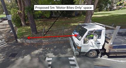
FINANCIAL IMPLICATIONS
The cost of the signposting will be funded from Council’s operational budget.
PUBLIC CONSULTATION
Consultation was not undertaken as this proposal is not adjacent to any residential properties and should improve parking for motorbikes in the area
|
|
Local Traffic Committee Meeting 6 April 2017 |
Subject: NO
PARKING ZONE - WAITE AVENUE, BALMAIN
(BALMAIN WARD/BALMAIN ELECTORATE/LEICHHARDT LAC)
File Ref: 17/6022/30955.17
Prepared By: Manod Wickramasinghe - Traffic and Parking Engineer
Authorised By: John Stephens - Traffic Manager
|
SUMMARY Council has received concerns from a resident regarding vehicles obstructing access to the off-street parking space of No.20 Waite Avenue by parking on the eastern side of Waite Avenue, Balmain opposite garage entrances. |
|
RECOMMENDATION
THAT the existing ‘No Parking’ zone currently in place on the eastern side of Waite Avenue on the frontage of No.2A Waite Avenue be extended southwards by 9.5m across the frontage of No.2 Waite Avenue.
|
BACKGROUND
Concerns have been raised regarding vehicles obstructing access to the off street parking of No.20 Waite Avenue by parking on the eastern side of of the street opposite garage entrances.
In 2002 a ‘No Parking’ zone was installed opposite the driveway acesses of Nos.18, 20 and 22 Stephen Street to allow vehicles to enter and exit the driveways.
However, when the ‘No Parking’ zone was installed it only extended enough to provide access to one of the two off-street parking spaces of No.22 Stephen Street. The resident has explained that the additional off-street parking space was not used in the past, hence they had not pursued an extension. The resident is now requesting an extension of the existing ‘No Parking’ zone across the frontage of No.2 Waite Avenue to allow for the second off-street parking space to be used.
PROPOSAL
The resident of No.2 Waite Avenue also raised the issue with vehicles parking across their pedestrian gate and across their driveway.
It was noted that the kerb space in between the pedestrian gate and the driveway is less than 4m and so a vehicle parked in this location would obstruct access to either the driveway or the pedestrian access. It should be noted that there is no footpath available in Waite Avenue so vehicles can block pedestrian access.
It is therefore proposed to extend the existing ‘No Parking’ zone by 12.5m on the eastern side of Waite Avenue, across the frontage of No.2 Waite Ave as shown on the following plan.
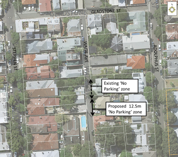
FINANCIAL IMPLICATIONS
The cost of the proposed works will be funded from Council's Operational Budget.
PUBLIC CONSULTATION
|
A letter outlining the above proposal was mailed out to the affected properties (11 properties) in Stephen Street, Waite Avenue and Adolphus Street, Balmain. Responses were received from two properties, one supporting the proposal and one which supported the proposal, subject to a minor modification.
|
|
|
Residents’ Response: |
Officer’s Comment: |
|
I would like to be able to park across my own driveway. This is extension would prevent this. Happy for the ‘No Parking’ in front of the house to be extended to our driveway. |
As per NSW Road Rules it is illegal to park across a driveway for any vehicle. However, Council will modify the proposal to signpost the ‘No Parking restrictions up to the driveway and thus allow the statutory ‘No Parking’ restrictions to operate across the driveway. |
CONCLUSION
Given the feedback from the directly affected resident, it is recommended that the existing ‘No Parking’ zone currently in place on the eastern side of Waite Avenue on the frontage of No.2A Waite Avenue be extended southwards by 9.5m across the frontage of No.2 Waite Avenue (not including the driveway).
|
|
Local Traffic Committee Meeting 6 April 2017 |
Subject: Unnamed lanes between Nowranie, Carrington
& Spencer Street, Summer Hill- Part time No parking restrictions
(ASHFIELD WARD/SUMMER HILL ELECTRORATE/ASHFIELD LAC
File Ref: 17/6022/30866.17
Prepared By: Anca Eriksson - Traffic Officer
Authorised By: John Stephens - Traffic Manager
|
SUMMARY A request has been made from Council’s Waste Services, Ashfield, to implement ‘No Parking, 6am-3pm Monday’ restrictions in the various laneways in Summer Hill. Vehicles parking in various un-named lanes are blocking waste collection services and driveway access to properties. As a result of this, waste collection is either hindered, or not carried out in the lanes.
The following recommendation is to primarily introduce No Parking restrictions on waste collection days to assist garbage trucks in accessing the lanes. Other issues such as driveway access and traffic obstruction through the lanes will be further monitored once the primary No Parking restrictions are introduced. |
|
RECOMMENDATION
THAT:
1. ‘No Parking 6am – 3pm Monday’ restrictions be introduced along sections both sides of the unnamed lanes, between Nowranie Street and Spencer Street south of Smith Street (identified as lane 1 and 2 on the attached Figure. 1).
2. ‘No Parking 6am – 3pm Monday’ restrictions be introduced along the full length of the eastern side of the unnamed lane running parallel between Nowranie Street and Carrington Street, north of Wellesley Street (identified as lane 3 on the attached Figure.1).
3. ‘No Parking 6am – 3pm Monday’ restrictions be introduced along the full length of the eastern and southern side of the unnamed lane running parallel between Carrington Street and Spencer Street north of Wellesley Street (identified as lane 4 on the attached Figure.1). |
BACKGROUND
Council has received numerous complaints from residents and Council’s Waste Collection Services regarding missed garbage collections in the laneways adjacent to Smith, Nowranie, Carrington and Spencer Streets due to vehicles parking in the lanes and blocking access for garbage trucks and resident access to garages and drive ways.
FINANCIAL IMPLICATIONS
The cost of the signposting will be funded from Council’s operational budget.
OFFICER COMMENTS
The main reason for proposing ‘No Parking, 6am-3pm Monday’ is to prevent vehicles from parking and obstructing access in the lanes on the waste collection day being that of a Monday. Access in certain locations can be obstructed when vehicles park on both sides of the lane.
Reference is made to the Laneway Parking Guidelines produced by the former-Marrickville Council, which advises that the width of a lane is the most important factor for determining whatever parking is feasible. Laneways which are used for garbage collection would need parking restrictions on collection days to both sides unless the distance between properties is greater than 5.5 m in width. This would account for the proper need and movement of garbage trucks through the lane, which can measure up to 2.8 meters wide (including side mirrors). The unnamed lanes south of Smith Street (identified as No 1 and 2 on Figure 1) are approximately 5.0 m wide and the unnamed lanes between Nowranie, Carrington and Spencer Streets (identified as No. 3 and No. 4 on Figure 1) are approximately 5.4 m wide. All these lanes serve as two-way access from Nowranie Street to Carrington Street and Spencer Street as well as providing rear property and service access to businesses and residents. Parking is currently occurring on both sides of the lanes obstructing access for the Council’s Waste Collection services trucks and blocking access to garages, drive ways and intersections - see Figure 2 and Figure 3.
‘No Parking, 6am-3pm Monday’ restrictions would be introduced as a primary measure on both sides along the full or sectional lengths of the unnamed lanes identified as No.1 and 2 on the map, the full length on the eastern side of the unnamed lane No 3, and the full length on the eastern and southern sides of the unnamed lane identified as No 4 on Figure 1.
Vehicle parking behaviour would be monitored outside of the ‘No Parking, 6am-3pm Monday’ restriction times to determine if further time limitations/restrictions are required for any other impeding driveway or laneway access.
PUBLIC CONSULTATION
A letter outlining the above parking proposal restrictions was mailed out to the affected properties in the area. Around 115 homes and business were letter boxed dropped within the proposed parking area as described above. Residents were invited to provide their views on a proposal to introduce ‘No Parking 6am – 3pm Monday’ restrictions in the lanes within the subject area.
The response to the survey revealed that 19 out of 22 respondents supported the introduction of a ‘No Parking 6am – 3pm Monday’ restrictions in the lanes as shown on Figure 1. Also 3 out of the 22 respondents requested that the restrictions be implemented on a full-time basis, 7 days a week. However, at this stage it is recommended that Council’s Traffic Engineers monitor the situation to determine if further changes are warranted.
CONCLUSION
In light of the above information, it is recommended that the proposed ‘No Parking 6am – 3pm Monday’ restrictions as detailed in Figure 1 on one and/or both sides of various unnamed laneways adjacent to Smith, Nowranie, Carrington and Spencer Streets, Summer Hill, be supported.
The time limits would apply between 6am and 3pm every Monday, for Waste Collection Services in the area. Existing unrestricted parking and ‘No Stopping’ restrictions at intersections will be maintained elsewhere in the lanes as detailed in Figure 1.
|
|
Local Traffic Committee Meeting 6 April 2017 |
Subject: 16 HENSON STREET, SUMMER HILL - REQUEST FOR MOBILITY PARKING SPACE
(ASHFIELD WARD/SUMMER HILL ELECTORATE/ASHFIELD LAC)
File Ref: 17/6022/30872.17
Prepared By: Anca Eriksson - Traffic Officer
Authorised By: John Stephens - Traffic Manager
|
SUMMARY Council has received an application from No. 6/16 Henson Street, Croydon for the creation of a dedicated mobility parking space to the front of the property. It is recommended that a space be created in front of the property as there is a lack of or inability to park/access the property off-street, and on-street parking in the vicinity of the home is difficult to find.
|
|
RECOMMENDATION
That a signposted mobility parking space in front of No. 16 Henson Street, Summer Hill, be supported. |
BACKGROUND
The applicant has supplied Council with copies of his mobility parking permit, and a letter from his doctor supporting the need for a mobility parking space.
The applicant stated, although he has off-street parking, he finds it difficult to access the house due to difficulty in driving in and out of the car park and accessing his residence from the carpark. The drive way is too steep and the walking paths from the garage to the entrance of the property are not useful for mobility access.
FINANCIAL IMPLICATIONS
The cost of the signposting will be funded from Council’s operational budget.
OFFICER COMMENTS
Inspection of site identifies that the driveway and carpark to the property does not properly cater for mobility impaired drivers due to the steepness of the driveway, and cannot be modified in order to do so.
Parking observations indicate that the resident has one off-street narrow width garage from the carpark to his residence. A 2P resident parking zone is present along the outside of the premises but is highly utilised. Parking is difficult to obtain within reasonable proximity of the home.
The applicant’s doctor has indicated that the illness or disability limits his walking to short distances and has indicated that the applicant needs to be able to park close to his home. The applicant has been informed that a disabled parking space, if provided will not be for his sole use and that any person holding a valid mobility parking permit may park in it.
It will not be possible, owing to the narrow width of the street, for parking space to be installed at the 3.2m width proposed in the Australian Standard AS2890.5. Kerb ramps are not proposed at this space due the building at 16 Henson Street provides public access for people with a disability (photo 1).
An on-street mobility parking space outside the premises would therefore be recommended.
PUBLIC CONSULTATION
Council has written to residents of Henson, Drynan and Regent Streets within the vicinity of the proposed mobility parking space inviting comment. No objections to the creation of the space have been received.
CONCLUSION
Given that there is a lack of or inability to access off-street parking and that parking on-street is difficult to obtain in close proximity, a mobility parking space outside No. 16 Henson Street, Summer Hill is therefore recommended.
|
1.⇩ |
LTC 06 April 2017 meeting - Attachment to 16 Henson Street report |
|
|
Local Traffic Committee Meeting 6 April 2017 |
The frontage of the applicant’s property in 16 Henson Street, Summer Hill
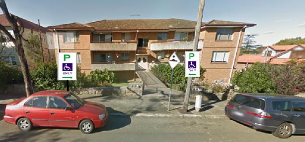
On- street parking in Henson Street in front of the applicant’s property (16 Henson Street, Summer Hill).
![]()
![]()
![]()
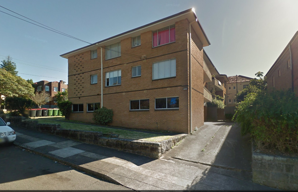 The
driveway at 16 Henson Street and the walking paths from the
garage to the entrance of the property (side view of the block of units
at 16 Henson Street).
The
driveway at 16 Henson Street and the walking paths from the
garage to the entrance of the property (side view of the block of units
at 16 Henson Street).
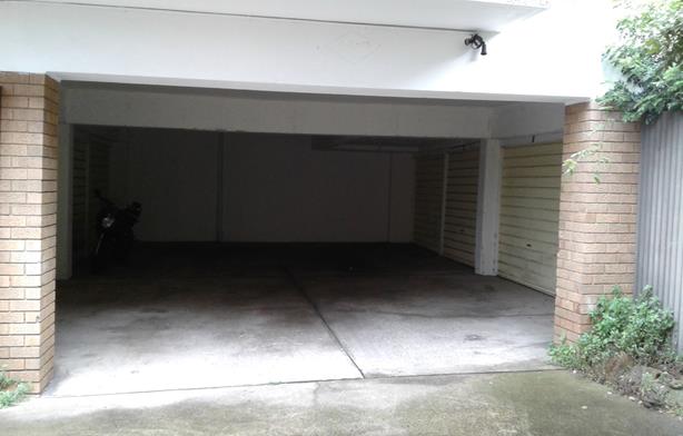
The entrance to car parking at 16 Henson Street.


![]()
|
Local Traffic Committee Meeting 6 April 2017 |
Subject: 171 RAMSAY STREET, HABERFIELD - INTRODUCTION
30 MINUTE PARKING NEARBY
(LEICHHARDT WARD/SUMMER HILL ELECTORATE/ASHFIELD LAC
File Ref: 17/6022/30937.17
Prepared By: Anca Eriksson - Traffic Officer
Authorised By: John Stephens - Traffic Manager
|
SUMMARY This report recommends the introduction of two parking spaces limited to 30 minutes parking in the vicinity of the new Haberfield Post Office, 171 Ramsay Street, Haberfield.
The restrictions are considered adequate for short term parking needs for both the Post Office and the surrounding businesses. The following proposal addresses the need to have an appropriate turnover of parking for customers to facilitate the existing businesses in the area.
|
|
RECOMMENDATION
That parking restrictions signposted “P 30minute, 8.30am-6.00pm Mon-Fri, 8.30am-12.30pm Sat” be installed on the eastern side of Ramsay Street, Haberfield, in the first two parking spaces south of Rawson Street. |
BACKGROUND
Council has received representations from the Haberfield Post Office initially requesting that Council give consideration for the installation of 15 minute parking restrictions in front of the new Post Office located at 171 Ramsay St. Haberfield.
FINANCIAL IMPLICATIONS
The cost of the signposting will be funded from Council’s operational budget.
OFFICER COMMENTS
The two parking spaces are outside neighbouring businesses as immediately in front of the Post Office is a kerb extension due to its close proximity to Rawson Street intersection. Currently, the subject location is signposted as ‘1P 8:30am-6:00pm, Mon-Fri, 8:30am-2:30pm Sat’. The request for 15 minute parking may have an impact for the parking needs of the shops in the surrounding area. A Consultation process was required to obtain comments from local businesses potentially affected by the proposal.
PUBLIC CONSULTATION
A consultation process was undertaken with the shop owners affected in the proposed area of the restricted parking. The businesses in the area were unanimously in opposition of the installation of 15 minute parking due to the potential effect on customers and the limited parking availability.
Following a review of the feedback, Council then considered 30 minute parking instead of the initially proposed 15 minute parking to benefit short term parking and turnover requirements of both the Post Office and the adjoining shops.
A second consultation process was undertaken with the local business potentially affected by the changes to propose 30 minute parking restriction in the subject area.
Eight (8) business premises in Ramsay Street Haberfield were invited to provide their views on the proposed 30 minute parking. The response to the survey up to the date of closure (23 March 2017) revealed that only three (3) submissions were received opposed to the introduction of 30 minute parking.
CONCLUSION
Introduction of 30 minute parking is considered as a compromise to adequately provide for short term parking and turn over requirements for customers to all businesses in the area.
Sufficient longer term and unrestricted parking is proposed elsewhere in Ramsay Street, the sides streets and the off- street car park located opposite on the corner of Gillies Avenue and Ramsay Street (which is limited to three hours).
It is recommended that the first two parking spaces on the eastern side of Ramsay Street, south of Rawson Street, Haberfield, be modified from ‘1P 8:30am-6:00pm, Mon-Fri, 8:30am-2:30pm Sat’ to ‘P30Min 8:30am-6:00pm, Mon-Fri, 8:30am-2:30pm Sat’ parking.
![]()
![]()
|
|
Local Traffic Committee Meeting 6 April 2017 |
Subject: 8-12 MURRELL STREET, ASHFIELD - REQUEST
FOR WORKS ZONE OUTSIDE
(ASHFIELD WARD/SUMMER HILL ELECTORATE/ASHFIELD LAC)
File Ref: 17/6022/30938.17
Prepared By: Boris Muha - Traffic and Projects Engineer
Authorised By: John Stephens - Traffic Manager
|
SUMMARY It is recommended that a Works Zone signposted between the DA operation times of 7am-6pm, 7am-1pm Sat be implemented to the full-frontage of the development Nos.8-12 Murrell Street, Ashfield. The Works Zone will generally assist in the access and manoeuvre of construction vehicles in and out of the property. |
|
RECOMMENDATION
THAT:
1. That a ‘Works Zone, 7am-6pm Mon-Fri, 7am-1pm Sat’ approximately 30 metres in length be temporarily installed for nine months outside 8-12 Murrell Street, Ashfield.
2. That the ‘2P, 8am-6pm Mo-Fri Permit Holders Excepted Area1’ zone outside the subject property be temporarily removed.
|
BACKGROUND
The builder for the re-development at Nos.8-12 Murrell Street, Ashfield, has requested the installation of a temporary Works Zone outside the site. The Works Zone is required to generally assist major construction vehicle access in and out of the site.
FINANCIAL IMPLICATIONS
The builder will incur the cost of the installation and removal of the Works Zone under Council’s current Fees and Charges.
OFFICER COMMENTS
Council approved a Construction Traffic Management Plan (CTMP) for the demolition of 3 lots of residential premises and the construction of a residential unit development at Nos.8-12 Murrell Street, Ashfield.
Under the CTMP, major construction vehicle activity (demolition, excavation, and particular stages of concrete pouring) will be carried out from off-street to minimise the impact on the street environment. The operations would be generally limited to outside of School Zone hours for reasons of safety with adjacent schools and child care centre located in Murrell Street.
Murrell Street connects to Orchard Crescent which is a no through road. The carriageway is approx. 9m wide with parking on both sides and is two-way. Residential parking exists on the western side of Murrell Street. A mixture of ‘No Parking’, disabled parking and ¼ P parking restrictions (between school/AM&PM peak times) exist to the eastern side of Murrell Street to serve the schools and child care centre. Construction vehicle movement and access to the site would be under traffic control.
To primarily assist in vehicle access and manoeuvre in and out of the site the full-frontage length of the site would be temporarily sign posted as a ‘Works Zone’ to DA times of operation. This will assist to clear on-street parking in the area when major construction vehicle activity is carried out. It is also the intention that vehicles turn in and out of the site closer to the kerb and not out wide to infringe into parking on the opposite side the street.
The zone would be approximately 29-30 metres in length and is requested for a period of 9 months.
Police and RMS raised no objection to the proposed installation of the Works Zone outside Nos.8-12 Murrell Street, Ashfield.
PUBLIC CONSULTATION
Not applicable. The zone is only to the frontage of the site and is temporary to assist in the re-development of Nos.8-12 Murrell Street, Ashfield.
CONCLUSION
It is recommended that a Works Zone signposted between DA operation times of operation (i.e. 7am-6pm, 7am-1pm Sat.) be implemented to the full-frontage of the development at Nos.8-12 Murrell Street, Ashfield. The zone will generally assist in the access and manoeuvre of construction vehicles in and out of the property.
|
1.⇩ |
LTC 06 April 2017 - Attachment: Proposed works zone - 8-12 Murrell street - photo and plan |
|
Local Traffic Committee Meeting 6 April 2017 |
Subject: REMOVAL OF MOBILITY PARKING SPACES
(MARRICKVILLE, ASHFIELD & STANMORE WARD/SUMMER HILL, NEWTOWN & HEFFRON ELECTORATE/MARRICKVILLE & NEWTOWN LAC)
File Ref: 17/6022/27205.17
Prepared By: Emilio Andari - Civil Engineer
Authorised By: Joe Di Cesare - Manager Design and Investigation
|
SUMMARY This report considers the removal of redundant mobility parking spaces as a result of requests received by residents in the Inner West Council Local Government Area. It is recommended that the parking changes be endorsed. |
|
RECOMMENDATION
THAT the removal of redundant mobility parking spaces and these spaces reverting back to their former condition, as shown in the table below, be ENDORSED to improve the use of on-street parking for the local community.
|
BACKGROUND
This report considers the requests for removal of the mobility parking spaces received by residents in the Inner West Council Local Government Area.
FINANCIAL IMPLICATIONS
The removal of the signage associated with the mobility parking spaces and replaced with other restricted parking signage has been funded through Council’s signs and linemarking budget.
OFFICER COMMENTS
Council Officers are typically advised by the new resident(s) of the property and/or a family member of the applicant who had requested the mobility parking space that the parking space is no longer required.
PUBLIC CONSULTATION
Following a letter received by either the new resident(s) of the property or a family member, a notification letter is sent to the resident(s) of the property who had requested the mobility parking space originally and they are advised of the proposed removal of the associated mobility parking signs. Residents are given a week to respond should they wish to retain the space after which the sign is removed.
CONCLUSION
It is recommended that the parking changes be approved, to provide the requests made by the applicants and to improve the use of on-street parking for the local community.
|
|
Local Traffic Committee Meeting 6 April 2017 |
Subject: REQUESTS FOR ‘WORKS ZONE’ ADJACENT
TO CONSTRUCTION SITES
(STANMORE & ASHFIELD WARDS / NEWTOWN & SUMMER HILL ELECTORATES /
MARRICKVILLE LACS)
File Ref: 17/6022/28390.17
Prepared By: Idris Hessam - Graduate Civil Engineer Traffic Services
Authorised By: Joe Di Cesare - Manager Design and Investigation
|
SUMMARY A number of requests have been received from several builders for the provision of 'Works Zone' to facilitate construction deliveries and permit the parking of construction vehicles during loading and unloading activities. It is recommended that the 'Works Zone' be approved for the construction works subject to Council fees and charges. |
|
RECOMMENDATION
THAT: 1. the installation of a ‘Works Zone 7AM-5.30PM Mon-Sat’ (total of 8 metres in length) on the northern side of Corunna Road adjacent to property no. 218 Corunna Road, Petersham be APPROVED for a period of six (6) months, for the proposed construction work; 2. the installation of a ‘Works Zone 7AM-5.30PM Mon-Sat’ (total of 9 metres in length) on the northern side of Corunna Road adjacent to property no. 190 Corunna Road, Petersham be APPROVED for a period of six (12) months, for the proposed construction work; 3. the installation of a ‘Works Zone 7AM-5.30PM Mon-Sat’ (total of 15 metres in length) on the southern side of Little Street adjacent to property no. 2-4A Little Street, Dulwich Hill be APPROVED for a period of eight (8) months, for the proposed construction work; 4. the cost of supply, installation and removal of the signs and ‘Works Zone’ fees in accordance with Council’s Fees and Charges are to be borne by the applicant.
|
BACKGROUND
Written applications along with the plans illustrating the proposed locations of ‘Works Zone’ were submitted to Council for consideration.
FINANCIAL IMPLICATIONS
The cost of supply, installation and removal of the signs and ‘Works Zone’ fees are to be borne by the applicant in accordance with the Council’s Fees and Charges.
OFFICER COMMENTS
|
Subject Location |
Classification of Road |
Road Description |
|
Corunna Road, Stanmore |
Local Road |
Two-way street, 12m in width that runs West -East between Crystal Street and Charles Street. |
|
Little Street, Dulwich Hill
|
Local Road |
Two-way street, 7.4m in width that runs West -East between Railway Land and Victoria Street. |
218 Corunna Road, Stanmore
The subject property is located on northern side of Corunna Road, Stanmore. The proposed ‘Works Zone’ will be 8 metres in length. It will be required for a period of approximately six (6) months (i.e. estimated duration of the works to be completed), to be utilised by construction vehicles during deliveries, loading and unloading activities (refer to the below locality map and photographs).
At present, there is restricted parking (2P) on both sides of Corunna Road .The parking spaces in the subject section of Corunna Road are highly utilised by local residents. Therefore, the provision of a ‘Works Zone’ would provide a safe facility for loading and unloading activities at the subject site during the construction period.
190 Corunna Road, Stanmore
The subject property is located on northern side of Corunna Road, Stanmore. The proposed ‘Works Zone’ will be 6 metres in length. It will be required for a period of approximately six (12) months (i.e. estimated duration of the works to be completed), to be utilised by construction vehicles during deliveries, loading and unloading activities (refer to the below locality map and photographs).
At present, there is restricted parking (2P) on both sides of Corunna Road .The parking spaces in the subject section of Corunna Road are highly utilised by local residents. Therefore, the provision of a ‘Works Zone’ would provide a safe facility for loading and unloading activities at the subject site during the construction period.
2-4A Little Street, Dulwich Hill
The subject property is located on the southern side of Little Street, Dulwich Hill. The proposed ‘Works Zone’ will be 15 metres in length. It will be required for a period of approximately eight (8) months (i.e. estimated duration of the works to be completed), to be utilised by construction vehicles during deliveries, loading and unloading activities (refer to the below locality map and photographs).
At present, there is unrestricted parking on both sides of Little Street .The parking spaces in the subject section of Little Street are highly utilised by local residents. Therefore, the provision of a ‘Works Zone’ would provide a safe facility for loading and unloading activities at the subject site during the construction period.
Locality Map – 218 Corunna Road, Stanmore (adjacent to 218 Corunna Road, Stanmore)
![]()
![]()
![]()

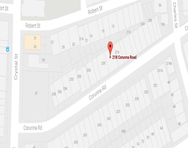
Photographs –Corunna Road, Stanmore (adjacent to 218 Corunna Road, Stanmore)
![]()
![]()
![]()

![]()

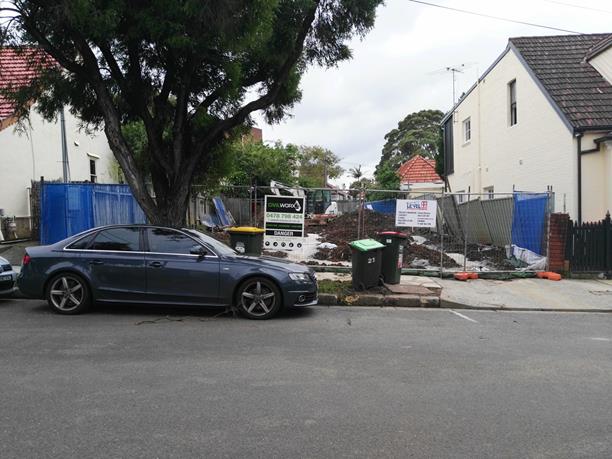
The proposed location of the ‘Works Zone’ in Corunna Road, Stanmore.
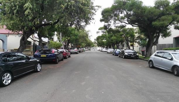
On-street parking in Corunna Road, outside construction site
Locality Map – 190 Corunna Road, Stanmore (adjacent to 190 Corunna Road, Stanmore)
![]()
![]()
![]()
![]()
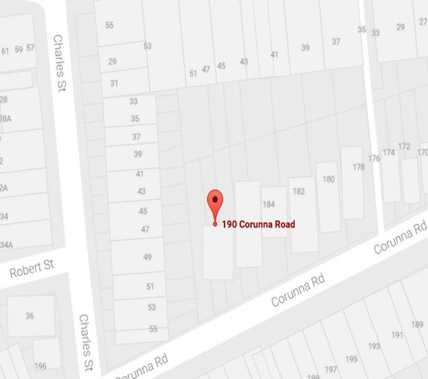
Photographs – Corunna Road, Stanmore (adjacent to 190 Corunna Road, Stanmore)
![]()
![]()
![]()
![]()
![]()

The proposed location of the ‘Works Zone’ in Corunna Road, Stanmore.
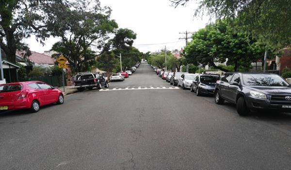
On-street parking in Corunna Road, outside construction site
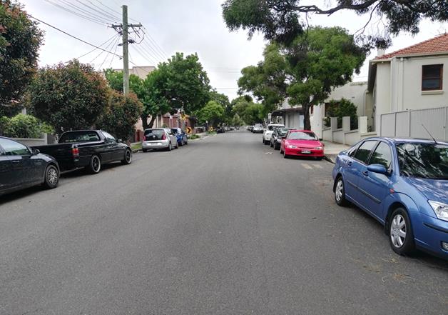
On-street parking in Corunna Road, outside construction site
Locality Map – Little Street, Dulwich Hill (adjacent to 2-4A Little Street, Dulwich Hill)
![]()

![]()
![]()
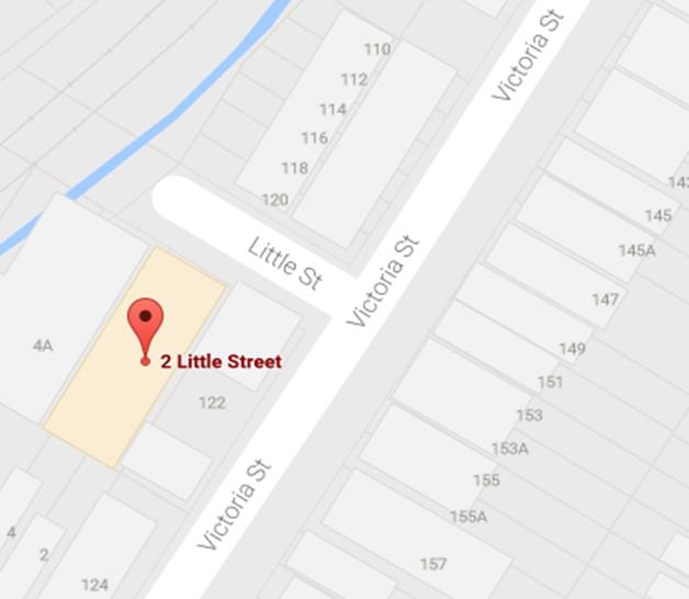
Photographs– Little Street, Dulwich Hill (adjacent to 2-4A Little Street, Dulwich Hill)
![]()
![]()
![]()

![]()
![]()
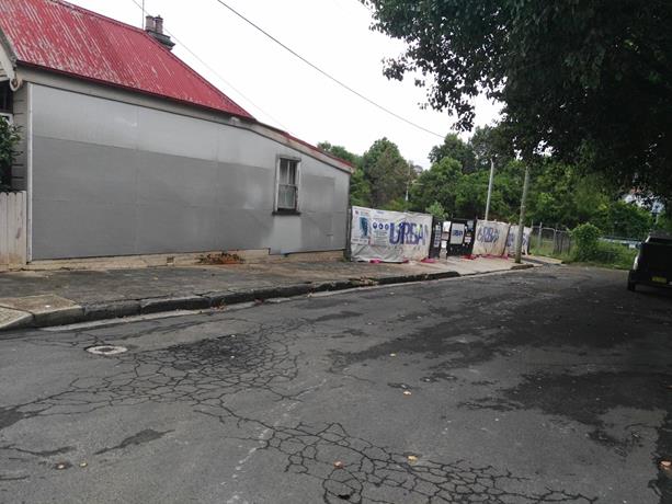
The proposed location of the ‘Works Zone’ Little Street, Dulwich Hill.
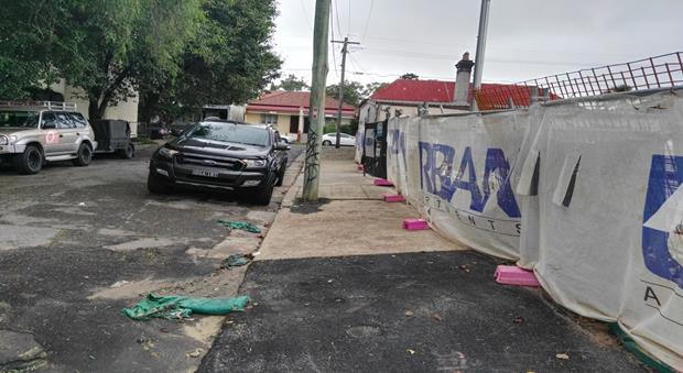
On-street parking in Little Street, Dulwich Hill outside construction site
PUBLIC CONSULTATION
A notification letter has been sent to the residents informing them of the application process and as part of the assessment they will be considered at this meeting.
CONCLUSION
It is proposed to install ‘Works Zone’ to better facilitate construction deliveries and allow the parking of construction vehicles during loading and unloading activities.
|
|
Local Traffic Committee Meeting 6 April 2017 |
Subject: RICHARDSONS CRESCENT, MARRICKVILLE - PROPOSED CHANGES TO PARKING RESTRICTIONS & LINEMARKING ADJUSTMENT
(MARRICKVILLE WARD/SUMMER HILL ELECTORATE/MARRICKVILLE LAC)
File Ref: 17/6022/29318.17
Prepared By: Emilio Andari - Civil Engineer
Authorised By: Joe Di Cesare - Manager Design and Investigation
|
SUMMARY Council has received requests to investigate the queuing and congestion issues along Richardsons Crescent between the Unwins bridge (i.e. The bridge over the Cooks River) and the roundabout located at the T- intersection on Richardsons Crescent (adjacent to Mackey Park) during weekday peak periods. It is recommended that the proposal for the changes to parking restrictions and the linemarking adjustment on Richardsons Crescent, Marrickville be approved, to improve traffic safety and to alleviate queuing of vehicles during the morning weekday peak periods and vehicles when merging lanes. |
|
RECOMMENDATION
THAT the proposed on-street parking changes and the associated linemarking adjustment on Richardsons Crescent, Marrickville as per the signage & linemarking plan attached to this report be APPROVED, to improve traffic safety and to alleviate queuing of vehicles during the morning weekday peak periods and vehicles when merging lanes.
|
BACKGROUND
Council has received requests to investigate the queuing and congestion issues along Richardsons Crescent between the Cooks River bridge and the roundabout located at the T- intersection on Richardsons Crescent (adjacent to Mackey Park) during weekday peak periods. It has also been reported to Council Officers that traffic congestion occurs quite frequently along Richardsons Crescent northbound during the morning peak periods on weekdays and the extent of the queuing extends into Bayview Avenue, Earlwood (other side of Cooks River in Canterbury-Bankstown Council LGA).
FINANCIAL IMPLICATIONS
The cost of the supply and installation of the signposting associated with the recommended ‘No Parking 7am-9am Mon-Fri’ restrictions and associated linemarking is approximately $3,000 and can be met from Council’s signs and linemarking budget.
OFFICER COMMENTS
Site location & road network
|
Street Name |
Richardsons Crescent |
|
Section |
Between Bayview Avenue and Unwins Bridge Road |
|
Carriageway Width (m) |
12.8 |
|
Carriageway Type |
Two-way road with one travel lane in each direction, in addition to kerbside parking lanes. |
|
Classification |
Regional |
|
85th Percentile Speed (km/h) |
54.2 |
|
Vehicles Per Day (vpd) |
12,895 |
|
Reported Crash History (July 2011 - June 2016) |
3 crashes recorded (Rum Code: 1, 20 & 48). 2 crashes resulted in an injury and 1 crash resulted in only tow-away. |
|
Heavy Vehicle Volume (%) |
3.4 |
|
Parking Arrangements |
Western side of the road consists of unrestricted parking and eastern side of the road consists of ‘1P 8.30am-4pm Mon-Fri, 8.30am-12.30pm Sat’ & ‘No Parking 4pm-6pm Mon-Fri’ restrictions. |
Site inspection
Council Officers have observed during site inspections undertaken in the morning period that traffic queuing occurs from Richardsons Crescent at its roundabout intersection near Mackey Park to Bayview Avenue over Unwins Bridge on the other side of the Cooks River (northbound traffic). It was also observed that the on-street parking spaces on the western side of Richardsons Crescent adjacent to Mackey Park were highly utilised in the morning and afternoon periods. It should be noted that the vehicles parked along Richardsons Crescent are identified as the same vehicles from both the morning and afternoon site inspections. Given that the subject section of Richardsons Crescent is in close proximity to Tempe Railway Station it is envisaged that this section of parking is utilised by commuters (refer to the attached photographs).
Tempe Railway Station carpark consists of a total of 147 unrestricted commuter car parking spaces which includes 5 mobility car parking spaces. The Cooks River Tempe carpark adjacent to the Concordia Club, Croquet Club and Mackey Park located west of Richardsons Crescent consists of approximately 48 car parking spaces which includes 2 mobility car parking spaces. In August 2016 ‘4P 8am-6pm’ restrictions were implemented within the Cooks River Tempe carpark to ensure a more equitable use of the carpark and provide for users of the Concordia Club, Croquet Club and Mackey Park along with short term commuter car parking for Tempe Railway Station.
Given that there is a sufficient number of car parking opportunities nearby, the proposal to restrict parking on morning weekday peak periods for a section along the western side of Richardsons Crescent adjacent to Mackey Park and near the roundabout intersection will alleviate queuing of vehicles (northbound traffic) on the approach to the roundabout and allow additional queuing space for vehicles turning right from both lanes at the roundabout intersection. It should also be noted that the northbound lane along Unwins Bridge Road consists of ‘No Parking 7am-9am Mon-Fri’ restrictions and therefore it is appropriate to apply the same time-restrictions for Richardsons Crescent.
Council officers have also observed during a site inspection undertaken in the afternoon period that traffic congestion occurs along southbound traffic along Richardsons Crescent, particularly at the signalised intersection adjacent to Tempe Railway Station carpark. It should be noted that the queuing of vehicles occurs at the signalised intersection and motorists tend to disobey the road pavement markings and queue in both lanes heading southbound. The left lane on the approach to the signalised intersection consists of ‘left arrow’ pavement markings which demonstrates left-only turn movements at the intersection however, motorists ignore the on-road markings and attempt to merge lanes to their right. It should be noted that immediately south from the signalised intersection on Richardsons Crescent, the departure lane is merged into one lane forcing motorists who disobey the left-turn lane movement to merge into the right lane causing a ‘bottle-neck’ scenario. In order to improve the amenity of the roadway within this subject section of Richardsons Crescent and to improve traffic and pedestrian safety at the signalised intersection, linemarking adjustments are required to coincide with the proposed parking changes along both sides of Richardsons Crescent. The linemarking adjustment will include a shift in the ‘L1’ linemarking to widen the traffic lane width from 3.0m to 3.4m. This shift of linemarking will result in a parking lane and left-turn lane width of 3.0m (refer to the attached signage & linemarking plan). As a result of the linemarking adjustments on Richardsons Crescent, additional on-street unrestricted parking will be provided for all users for a section along the eastern side of the road adjacent to the railway corridor.
Proposal for a ‘No Parking 7am-9am Mon-Fri’ zone along the western side of Richardsons Crescent, Marrickville
It is proposed to change the existing unrestricted parking along the western side of Richardsons Crescent by installing ‘No Parking 7am-9am Mon-Fri’ restrictions for a distance of 30 metres immediately south from the existing ‘No Stopping’ restrictions located 40 metres south from the roundabout intersection (refer to the attached locality map and signage & linemarking plan). These proposed changes will improve traffic safety and facilitate an additional traffic lane to alleviate queuing of vehicles during the morning weekday peak periods.
Proposal for an unrestricted parking zone and adjustments to the existing ‘No Parking’ & ‘No Stopping’ zones along the eastern side of Richardsons Crescent, Marrickville
It is proposed to change the existing parking restrictions along the eastern side of Richardsons Crescent by removing the ‘1P 8.30am-4pm Mon-Fri, 8.30am-12.30pm Sat’ & ‘No Parking 4pm-6pm Mon-Fri’ restrictions and reinstating this section with unrestricted parking for a distance of 36 metres starting at 56 metres north from the signalised pedestrian crossing at Tempe Railway Station carpark intersection (refer to the attached locality map and signage & linemarking plan). The existing ‘No Stopping’ restrictions located immediately north from the signalised pedestrian crossing and on the eastern side of Richardsons Crescent is proposed to be extended by 6 metres north to provide a total of 56 metres from the signalised intersection. It is also proposed to provide a length of 16 metres of ‘No Parking’ restrictions commencing 30 metres south from the roundabout intersection on the eastern side of Richardsons Crescent. These proposed changes will improve traffic safety and facilitate a parking lane to alleviate queuing of vehicles when merging lanes.
Proposal to install edge-line linemarking (E1) and other associated linemarking
It is proposed to install edge-line linemarking (E1) along the eastern side of Richardsons Crescent surrounding the section of the proposed unrestricted parking (approximately 70 metres in length) and also to remove existing broken lane-line linemarking and install new broken lane-line linemarking to provide a 3.4 metre wide traffic lane from the existing centre (BB) linemarking. It is also proposed to remove the existing ‘left-turn only’ symbols and reinstall these symbols appropriately given the change in width for the ‘left-turn only’ lane to be 3.0 metre wide (refer to the attached locality map and signage & linemarking plan). These proposed changes will improve traffic safety.
Locality Map – Richardsons Crescent, Marrickville

![]()

![]()
![]()
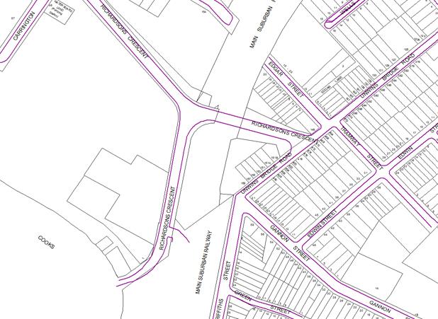
Signage & Linemarking Plan – Richardsons Crescent, Marrickville
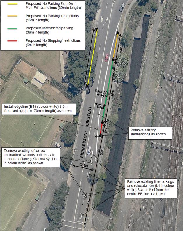
Photographs – Richardsons Crescent, Marrickville
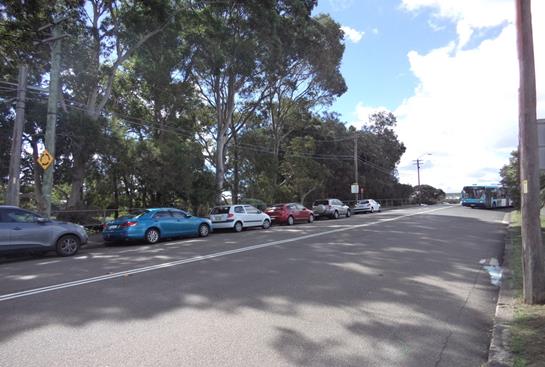
Richardsons Crescent parking along Mackey Park (facing north-west)
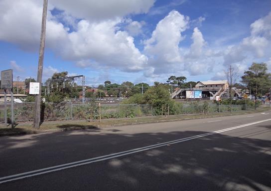
Richardsons Crescent parking along railway corridor (facing south-east)
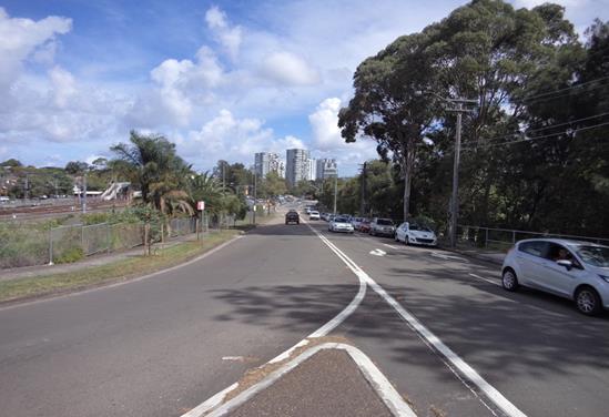
Richardsons Crescent at the roundabout intersection (facing south)
PUBLIC CONSULTATION
Nil.
CONCLUSION
It is recommended that the parking changes be undertaken on the western and eastern side of Richardsons Crescent, Marrickville as well as the associated linemarking to improve traffic safety and to alleviate queuing of vehicles during the morning weekday peak periods and vehicles when merging lanes.
|
|
Local Traffic Committee Meeting 6 April 2017 |
Subject: UNWINS BRIDGE ROAD, ST PETERS – PROPOSED NO STOPPING & NO PARKING RESTRICTIONS
(MARRICKVILLE WARD/HEFFRON ELECTORATE/NEWTOWN LAC)
File Ref: 17/6022/29983.17
Prepared By: Emilio Andari - Civil Engineer
Authorised By: Joe Di Cesare - Manager Design and Investigation
|
SUMMARY Requests have been received from local residents from adjacent streets to Unwins Bridge Road, St Peters for the extension of ‘No Stopping’ restrictions along Unwins Bridge Road at its intersections with Silver Street and Conway Place. Residents have advised Council officers that vehicles are parked too close to the intersection, restricting available sightlines for turning motorists.
It is recommended that statutory 'No Stopping' restrictions be installed for a distance of minimum 10m from the listed intersections in order to deter illegal parking, increase safety and improve visibility and access. It is also recommended that a section of ‘No Parking 7am-9am’ restrictions be installed in addition to the statutory ‘No Stopping’ restrictions on Unwins Bridge Road both south and north of Silver Street in order to increase safety near the crest on Unwins Bridge Road and improve visibility and access for turning motorists. |
|
RECOMMENDATION
THAT:
1. The existing ‘No Stopping’ zone on the eastern side of Unwins Bridge Road, St Peters and north of its intersection of Silver Street (adjacent to property no. 70 Unwins Bridge Road) be shifted 2 metres north and a section of 6 metres of ‘No Parking 7am-9am’ restrictions be installed immediately north of the 10m statutory ‘No Stopping’ zone at the intersection of and be APPROVED, in order to deter illegal parking, increase safety and improve visibility and access for turning motorists;
2. That a section of 6 metres of ‘No Parking 7am-9am’ restrictions be installed immediately south of the existing 10m statutory ‘No Stopping’ zone on the eastern side of Unwins Bridge Road, St Peters and south of its intersection of Silver Street (adjacent to property no. 74 Unwins Bridge Road) and be APPROVED, in order to increase safety near the crest on Unwins Bridge Road, improve visibility and access for turning motorists;
3. The existing ‘No Stopping’ zone on the eastern side of Unwins Bridge Road, St Peters and north of its intersection of Conway Place (adjacent to property no. 58 Unwins Bridge Road) be extended 3 metres north and be APPROVED, in order to deter illegal parking, increase safety, improve visibility and access for turning motorists; and
4. The existing ‘No Stopping’ zone on the eastern side of Unwins Bridge Road, St Peters and south of its intersection of Conway Place (adjacent to property no. 62 Unwins Bridge Road) be extended 5 metres south and be APPROVED, in order to deter illegal parking, increase safety, improve visibility and access for turning motorists.
|
BACKGROUND
Council has received a number of written requests from local residents from Silver Street, Florence Street, Brown Street and Conway Place, St Peters for the extension of ‘No Stopping’ restrictions along Unwins Bridge Road at its intersection with Silver Street and Conway Place. Residents have advised that vehicles are parked too close to the intersection, restricting available sightlines for turning motorists.
FINANCIAL IMPLICATIONS
The cost of the supply and installation of the signposting associated with the recommended ‘No Stopping’ & ‘No Parking 7am-9am’ restrictions are approximately $1,000 and can be met from Council’s operating budget.
OFFICER COMMENTS
Site location & road network
|
Street Name |
Unwins Bridge Road |
Silver Street |
Conway Place |
|
Subject Section |
Between Campbell Street and Gannon Street |
Between Unwins Bridge Road and Princes Highway |
Between Unwins Bridge Road and Brown Street |
|
Carriageway Width (m) |
12.8 |
7.3 |
4.2 |
|
Carriageway Type |
Two-way road with one travel lane in each direction, in addition to kerbside parking lanes along both sides of the road. |
Two-way road with one travel lane in each direction, in addition to kerbside parking lanes along both sides of the road. |
Two-way road with one travel lane in each direction, in addition to kerbside parking along one side of the road. |
|
Classification |
Regional |
Local |
Local |
|
85th Percentile Speed (km/h) |
53.3 |
43.4 |
- |
|
Vehicles Per Day (vpd) |
21,529 |
867 |
- |
|
Reported Crash History (July 2011 - June 2016) |
– |
2 crashes recorded at intersection with UBR (Rum Code: 21 & 32). Both crashes resulted in tow-away. |
1 crash recorded at intersection with UBR (Rum Code: 85). 1 crash resulted in tow-away. |
|
Heavy Vehicle Volume (%) |
5.4 |
2.6 |
- |
|
Parking Arrangements |
‘No Parking 7am-9am’ restrictions on the western side of the road and ‘No Parking 4pm-6pm’ restrictions on the eastern side of the road. |
Unrestricted parking on both sides of the road. |
‘No Parking’ restrictions on the northern side of the road and unrestricted parking on the southern side of the road. |
Site inspection
Council Officers have observed during site inspections undertaken in the morning and afternoon periods that the on-street parking spaces along Unwins Bridge Road were moderately utilised. It was also observed that high volumes of traffic travel along Unwins Bridge Road consistently throughout the day.
At present, ‘No Stopping’ restrictions are located on the eastern side of Unwins Bridge Road at its intersection with Silver Street. The existing ‘No Stopping’ zone north of Silver Street (outside property no. 70 Unwins Bridge Road) is measured to be approximately 8m away from the intersection. The existing ‘No Stopping’ zone south of Silver Street (outside property no. 72 Unwins Bridge Road) is measured to be approximately 10m away from the intersection.
In order to improve safety near the crest on Unwins Bridge Road and increase visibility and access for turning motorists at the intersection of Unwins Bridge Road and Silver Street, it is recommended that the existing ‘No Stopping’ zone outside property no. 70 Unwins Bridge Road be shifted 2 metres north and a section of 6 metres of ‘No Parking 7am-9am’ restrictions be installed immediately north and south of the 10m statutory ‘No Stopping’ zones at the intersection (refer to the attached sign plan).
At present, ‘No Stopping’ restrictions are located on the eastern side of Unwins Bridge Road at its intersection with Conway Place. The existing ‘No Stopping’ zone north of Conway Place (outside property no. 58 Unwins Bridge Road) is measured to be approximately 7m away from the intersection. The existing ‘No Stopping’ zone south of Conway Place (outside property no. 62 Unwins Bridge Road) is measured to be approximately 5m away from the intersection.
In order to improve safety and increase visibility and access for turning motorists at the intersection of Unwins Bridge Road and Conway Place, it is recommended that the existing ‘No Stopping’ zone outside property no. 58 Unwins Bridge Road be shifted 3 metres north and the existing ‘No Stopping’ zone outside property no. 62 Unwins Bridge Road be shifted 5 metres south.
Technical Issues
In accordance with the Australian Road Rules, a ‘No Stopping’ zone is mandatory for a distance of 10 metres from an intersecting road. Pursuant to the RMS’ Technical Directions, it is stated that signposting at an unsignalised intersection (without pedestrian crossing) “should only be required where there is a compliance problem or there is adjoining signposting”.
Locality Map – Unwins Bridge Road at Silver Street & Conway Place, St Peters
![]()
![]()
![]()
![]()
![]()
![]()
![]()
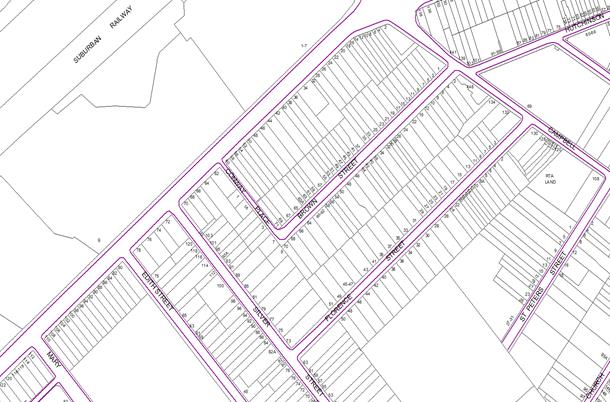
Sign Plan – Unwins Bridge Road at Silver Street, St Peters
![]()
Sign Plan – Unwins Bridge Road at Conway Place, St Peters
![]()
PUBLIC CONSULTATION
A notification letter was sent to owners and occupiers of the effected properties that are adjacent to the subject sections along Unwins Bridge Road near Silver Street regarding a combination of parking restrictions including the extension of the existing ‘No Stopping’ restrictions to meet the statutory requirement of 10m from its intersection and in addition, a length of ‘No Parking 7am-9am’ restriction immediately after the statutory ‘No Stopping’ zones. The closing date for submissions ended on 22 March 2017.
A total of six (6) letters were sent out to the effected residential properties. There were no responses received.
A notification letter was sent to owners and occupiers of the effected properties that are adjacent to the subject sections along Unwins Bridge Road near Conway Place regarding the extension of the existing ‘No Stopping’ restrictions to meet the statutory requirement of 10m from its intersection. The closing date for submissions ended on 22 March 2017.
A total of five (5) letters were sent out to the effected residential properties. There was one (1) response opposing to the proposed extension of the ‘No Stopping’ restrictions received and is detailed below.
|
Residents’ Comments |
Officer’s Response |
|
A resident of Unwins Bridge Road strongly opposes the extension of the ‘No Stopping’ zone. The resident advised Council officers that they have not witnessed an accident at this intersection and feels that this ‘shift’ in sign is not necessary. Concerns were raised in that there will be a loss in parking along Unwins Bridge Road which will cause conflict with neighbours. The resident will lose parking out front of their property and will be inconvenienced to do activities (e.g. wash/vacuum car) right outside their place. Concerns were raised by the resident regarding the parking situation in Conway Place and this road being too narrow. The resident made a suggestion that Conway Place be one-way eastbound so vehicles are to use Brown Street as an exit point.
|
No legal parking has been lost as a result of this proposal on Unwins Bridge Road at Conway Place. In accordance with the Australian Road Rules, a ‘No Stopping’ zone is mandatory for a distance of 10 metres from an intersecting road.
The RMS reported data for the crash history in the last 5 years at this intersection states that there was 1 incident which resulted in a tow-away.
Given the ongoing works and the possible impacts of Campbell Street construction works with WestConnex, restricting access out of Conway Place is not feasible. |
CONCLUSION
It is recommended that the statutory 'No Stopping' restrictions be installed on Unwins Bridge Road at the above listed intersections within this report for a distance of minimum 10 metres and in addition for the two sections (6 metres in length) of ‘No Parking 7am-9am’ restrictions be installed immediately north and south of the 10m statutory ‘No Stopping’ zones on Unwins Bridge Road at Silver Street in order to deter illegal parking, increase safety near the crest on Unwins Bridge Road and improve visibility and access for turning motorists.
Photographs – Unwins Bridge Road, St Peters
|
|
Northern side of intersection at Silver Street (facing east)
|
|
Southern side of intersection at Silver Street (facing east)
|
|
Northern side of intersection at Conway Place (facing east)
|
|
Southern side of intersection at Conway Place (facing east)
|
|
Local Traffic Committee Meeting 6 April 2017 |
Subject: MEEKS LANE, MARRICKVILLE – PROPOSED ‘NO PARKING’ RESTRICTIONS ON THE OUTER CORNERS OF THE LANEWAY
(MARRICKVILLE WARD/SUMMER HILL ELECTORATE/MARRICKVILLE LAC)
File Ref: 17/6022/29997.17
Prepared By: Jennifer Adams - Traffic and Road Safety Officer
Authorised By: Joe Di Cesare - Manager Design and Investigation
|
SUMMARY A citizen has raised concerns that motorists are having difficulty in manoeuvring around Meeks Lane, Marrickville due to vehicles being parked at the two 90° bends in the laneway. It is proposed to install ‘No Parking’ restrictions on the outer corners of the two bends in Meeks Lane, Marrickville to improve access in Meeks Lane, Marrickville.
It should be noted that “No Parking’ restrictions are already installed on the inside corners of the bends in the laneway and parking restrictions installed on the outer corners will more readily accommodate the swept paths of vehicles turning at the 90° bends in the laneway. Surrounding local businesses have been consulted on the proposal to install ‘No Parking’ restrictions on the outer corners of the bends, extending from the building line for a 15 metre length, in the laneway to improve access in the laneway.
It is recommended that this proposal be approved.
|
|
RECOMMENDATION
THAT:
1. the installation of full-time ‘No Parking’ restrictions on the outer corners of the two 90° bends in Meeks Lane, Marrickville, extending 15 metres from the building line, (in line with the existing ‘No Parking’ restrictions on the inner corners of the bends in Meeks Lane) be APPROVED, to improve vehicular access in the laneway; and 2. the applicant, Council Rangers and affected businesses be advised in terms of this report.
|
BACKGROUND
A citizen has raised concerns that motorists are having difficulty in manoeuvring around Meeks Lane, Marrickville due to vehicles being parked at the two 90° bends in the laneway. Council Officers have been advised that vehicles are often parked at the corners and/or over driveways which makes it very difficult for motorists to negotiate both the laneway and the bends in the laneway. (Refer to the attached locality map and photographs).
FINANCIAL IMPLICATIONS
The cost of the supply and installation of the signage associated with the recommended ‘No Parking’ restrictions is approximately $600 and can be met from Council’s operating budget.
OFFICER COMMENTS
Meeks Lane is a narrow laneway
running south-east off Meeks Road, approximately forty (40) metres north of
Marrickville Road. The laneway has two right angled (90°) bends. Meeks Lane is approximately 5 metres in width and provides rear
access to properties fronting Marrickville Road, Meeks Road, Vincent Street and
Sydney Street.
There are several driveways and off-street parking spaces located on both sides of the laneway. Refer to Locality Plan and photographs attached at the end of this report.
‘No Parking’ restrictions exist in the laneway along the northern side of Meeks Lane (southern leg) for a distance of 70 metres, east of Meeks Road; there is a short section of ‘No Parking’ opposite over the driveway of No.85-95 Marrickville Road; and ‘No Parking’ restrictions are installed on the inside corners of the bends in the laneway.
During several site inspections, it was noted that there is a high demand for parking in the laneway, with approximately 95% of on-street parking utilised. Although a car is able to manoeuvre reasonably passed the parked vehicles, a larger vehicle may have difficulty in negotiating the laneway, especially the corners. Consequently, parking restrictions installed on both sides of the laneway at the 90° bends can be appreciated. (See sketch attached.)
During the inspections of the laneway it was also found that vehicles were parked in front of driveways/garages. Under NSW Road Rules (198) motorists (even if you are the owner/occupier of the property) cannot park in a way that either partially or completely blocks a driveway/garage. It should be noted that laneways were generally built to provide service access for properties and access into off-street parking facilities. Limiting parking in the laneway will help achieve this goal.
Parking in laneways
Council’s Laneway Parking Guidelines outline the measures to consider when the use of the laneway prohibits access to off-street parking and access through the laneway. The effective use of narrow streets and laneways alleviates parking pressure. Effectively managed laneways allow for adequate access while providing the maximum amount of on-street parking.
NSW legislation includes various requirements to manage access and parking on roads. The Roads Act provides rights of access along roads and also for access to private property. The Road Rules includes requirements which affect parking at intersections, driveways and also parking along laneways.
For parking to be allowed in a narrow laneway, the Australian Standards require that parallel parking spaces be at least 2.1 metres wide and NSW Road Rules requires that at least 3 metres must be available between a parked car and the kerb or edge of the laneway to allow moving vehicles to pass safely. Therefore, laneway widths that are less than 5.1 metres wide are too narrow to allow parking as any parked vehicle would prevent traffic from using the laneway (see diagram below).
Council’s preference is for residents to negotiate with each other to avoid implementing parking bans. Where problems occur, parking restrictions can be considered for individual laneways on a case-by-case basis.
When vehicles are parked in narrow laneways near street intersections, sharp bends or driveways, there needs to be enough space for vehicles to turn. These guidelines allow for signs which ban parking to be considered next to driveways and at entries to laneways to ensure that vehicles are able to safely turn. This includes an assessment of the minimum amount of space needed for vehicles to turn in and out of a driveway. The figure below shows an example of where ‘No Parking’ signs would be considered to allow a car to do a three-point turn into a laneway with parking banned on one-side of a laneway less than 6 metres wide.
As a general principle, these guidelines would restrict parking across the driveway access and also on the opposite side of the laneway to maintain vehicle access to properties. Parked vehicles which encroach into the ‘No Parking’ area are likely to obstruct vehicle access into and out of properties. Laneway and driveway locations and dimensions must be checked onsite and vehicle turning paths assessed before new parking restrictions are considered.
Indicative sweep of vehicle turning out from access lane
A swept path diagram for an 8.8m truck appears below for the south bend in Meeks Lane, Marrickville.
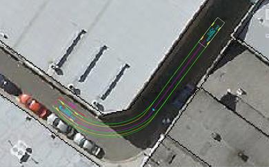
PUBLIC CONSULTATION
A notification letter was sent to 23 properties fronting Meeks Lane, Marrickville regarding the proposal to install full-time ‘No Parking’ restrictions on the outer corners of the bends in the laneway, to improve access in the laneway. The closing date for submissions ended on 10 March 2017.
Two responses were forthcoming with one supporting the proposal and the other objecting to the proposal.
|
Citizen Comment |
Officer Response |
|
Supports proposal and advised that when vehicles are parked at the corners you can’t drive a car around the corners |
The installation of ‘No Parking’ restrictions on the outer corners will more readily accommodate the swept paths of vehicles turning at the 90° bends in the laneway. |
|
Objects to the proposal as recent introduction of residential parking in Victoria Road has impacted parking availability in area and employees have nowhere to park close by legally. |
When vehicles are parked in narrow laneways near sharp bends there needs to be enough space for vehicles to turn. It should be noted that laneways were generally built to provide service access for properties and access into off-street parking facilities. Limiting parking in the laneway will help achieve this goal.
|
CONCLUSION
It is recommended that full-time ‘No Parking’ restrictions be installed on the outer corners of the two 90° bends in Meeks Lane, Marrickville in line with the existing ‘No Parking’ restrictions on the inner corners of the bends in Meeks Lane to improve vehicular access in the laneway
Locality Map – Meeks Lane, Marrickville

![]()
![]()

![]()
![]()
![]()
![]()
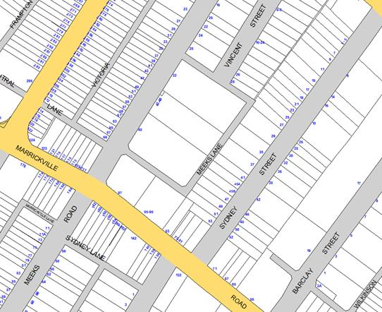
![]()
![]()
![]()
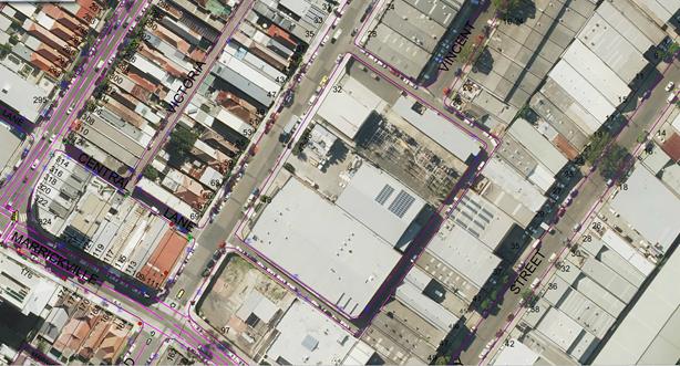
Existing ‘No Parking’ restrictions in the laneway.
![]()
![]()

![]()
![]()
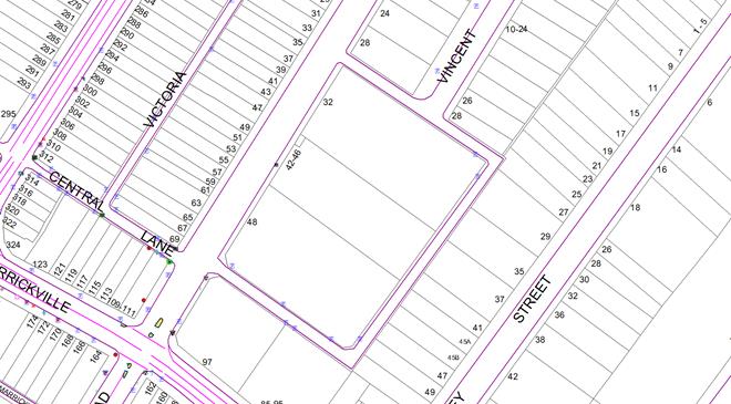
Proposed additional ‘No Parking’ restrictions in the laneway.
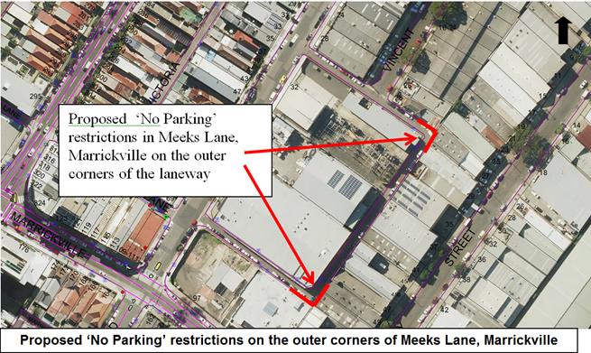
Photographs – Meeks Lane, Marrickville
|
Meeks Lane – entering on northern leg and traversing laneway clockwise direction |
|
|
Local Traffic Committee Meeting 6 April 2017 |
Subject: 2-32 Smith Street, Summer Hill – Parking
and Signage Plan for Staged Development
(ASHFIELD WARD/SUMMER HILL ELECTORATE/ASHFIELD LAC)
File Ref: 17/6022/31794.17
Prepared By: Davide Torresan - A/Senior Engineer
Authorised By: John Stephens - Traffic Manager
|
SUMMARY This is a recommendation to endorse the Parking and Signage Plan prepared for the staged development at 2-32 Smith Street, Summer Hill, former Allied Mills site. Once this recommendation is endorsed by the Traffic Committee and Council the implementation of the signage may commence. |
|
RECOMMENDATION
THAT the Parking and Signage Plan (L011) for the staged development at 2-32 Smith Street, Summer Hill, be supported for implementation. |
BACKGROUND
The Applicant for the development at 2-32 Smith Street, Summer Hill, is requesting the Parking and Signage Plan to be considered and supported by the Traffic Committee.
The Development Site at 2-32 Smith Street, Summer Hill, is in the course of being developed and subdivided in Stages in accordance with the Development Approvals. Future internal roads (private roads) will be created on subdivision of parts of the Development Site and at the completion of the approved development works in the relevant stages of the development. An Easement for Public Access will be registered over the Future Roads so that the Future Roads will be designated for use as a Road or a Road Related Area as defined in the Roads Act, Regulations and Rules.
The objective once the Parking and Signage Plan is implemented is for Council through its Authorised Officers to enforce parking restrictions in accordance with the prepared Parking and Signage Plan, the Roads Act, Regulations, Rules and any of Council’s policies or procedures.
FINANCIAL IMPLICATIONS
Nil
OFFICER COMMENTS
Parking Plan Comments:
· The proposed parking plan matches that proposed in the approved Stage 1 DA report which placed the two loading zones and two car share spaces as proposed (see extract attached), and the parking plan is generally in accordance with the concept approval and DA consents. The parking spaces have been strategically located for fair equitable access to the development’s amenities.
· 2P equates to short stay parking to limit commuter car parking for the light rail. The 2 Hour restriction balances the short term nature and restricts users from leaving cars there for any longer than necessary to enjoy the amenities of this precinct (retail, food, commercial, visitors, Light Rail, cycling etc.).
· Car share spaces are provided as per the DA requirements.
· Loading zones are required as the development has no off-street loading available and are strategically placed to be co-located near proposed retail shops (cafes etc.) and for easy access from/on Edward/Smith Streets. Loading zones are required to cater for any residential movement such as couriers, furniture movement, servicing and waste collection and recommended for 24 hour loading zone.
· No Parking provided for vehicle pickup and drop-off to light rail (kiss and ride).
· No Stopping provided to allow for two-way safe vehicle access and statutory requirements for appropriate safety and viewing at intersections.
· Private Road – Local Access Only signage is provided for the general public to distinguish between Council land and private land, as any maintenance and ongoing issues are the development owners’ responsibility. These signs will be provided at each roadway entrance to the development.
· No Through Road signs will be provided at the Stage 3 internal street and Stage 4 internal street that do not provide through traffic access.
Shared Zone Comments:
· The shared zone has been highlighted in the Parking and Signage Plan for information only as all speed zones and shared zone schemes must be approved by RMS.
· Traffic volumes are in the order of 39 peak hour trips or 400 daily trips which are below the thresholds.
· Arup (Traffic Consultancy) has assessed the proposed shared zone for the Stage 4 development application at Summer Hill Flour Mill against the relevant policies and confirms that it complies.
PUBLIC CONSULTATION
Public consultation is not required as the development at 2-32 Smith Street, Summer Hill, has not been occupied.
CONCLUSION
It is recommended that the Parking and Signage Plan for the staged development at 2-32 Smith Street, Summer Hill, be supported for implementation.
|
1.⇩ |
Parking and signage plan |
|
Local Traffic Committee Meeting 6 April 2017 |
Subject: HEARN STREET, LEICHHARDT - MOTOR BIKES
ONLY’ PARKING
(LEICHHARDT WARD/BALMAIN ELECTORATE/LEICHHARDT LAC)
File Ref: 17/6022/31910.17
Prepared By: Manod Wickramasinghe - Traffic and Parking Engineer
Authorised By: John Stephens - Traffic Manager
|
SUMMARY Council has received a request to prevent vehicles obstructing the driveway of No.15 Hearn Street, Leichhardt by parking multiple vehicles in the 9m kerb space between a ‘Disabled Parking’ zone and the resident’s driveway. |
|
RECOMMENDATION
THAT a 3m ‘Motor Bike Only’ zone be installed in front of No.15 Hearn Street, extending north from the existing ‘Disabled Parking’ zone outside No.13 Hearn Street, Leichhardt. |
BACKGROUND
As part of the redevelopment of No.13 Hearn Street, Leichhardt, into a public park and playground a ‘Disabled Parking’ zone was installed on the Hearn Street frontage of the park.
Concerns have since been raised by the resident at No.15 Hearn Street regarding vehicles obstructing the driveway of No.15 Hearn Street as a result of the ‘Disabled Parking’ zone.
The kerb space between the existing ‘Disabled Parking’ zone and the subject driveway is 9m. This distance cannot accommodate 2 standard vehicles without overhanging the ‘Disabled Parking’ zone or driveway.
PROPOSAL
In order to remove any obstruction to the driveway of No.15 Hearn Street and to maximise use of this kerb space, it is proposed to provide a 3m ‘Motor Bike Only’ parking space adjacent to the existing ‘Disabled Parking’ zone. This would leave a 6m area of parking adjacent to the existing driveway of No.15 Hearn Street, Leichhardt.
It should be noted that driveway clearance lines have been provided for the property although this has been ineffective. Council officers have observed motorbike parking in the street.
FINANCIAL IMPLICATIONS
The cost of the signposting will be funded from Council’s operational budget.
PUBLIC CONSULTATION
A notification letter has been sent to the nearby residents.
The directly affected resident at No.15 Hearn Street, Leichhardt supported the proposal.
CONCLUSION
In order to remove any obstruction to the driveway of No.15 Hearn Street and to maximise use of this kerb space, it is recommended that 3m ‘Motor Bike Only’ parking space be installed adjacent to the existing ‘Disabled Parking’ zone in a northerly direction.
|
|
Local Traffic Committee Meeting 6 April 2017 |
Subject: MINOR TRAFFIC FACILITIES
(LEICHHARDT & BALMAIN WARDS/BALMAIN/LEICHHARDT LAC)
File Ref: 17/6022/31906.17
Prepared By: Manod Wickramasinghe - Traffic and Parking Engineer
Authorised By: John Stephens - Traffic Manager
|
SUMMARY This report deals with minor traffic facility applications received by Inner West Council, Leichhardt and includes ‘Disabled Parking’. |
|
RECOMMENDATION
THAT:
1. That a 6m ‘Disabled Parking’ zone be installed in front of No. 79 Cary Street, Leichhardt replacing the existing RPS restrictions.
2. That the ‘Disabled Parking’ space in front of No.339 Annandale Street, Annandale be removed as the zone is no longer required.
3. That a 6m ‘Disabled Parking’ zone be not supported outside No.100 Flood Street, Leichhardt as the property has an off-street parking facility.
4. That a 6m ‘Disabled Parking’ zone be not supported outside No.19 Steward Street, Lilyfield. |
BACKGROUND
This report deals with minor traffic facility applications received by Inner West Council, Leichhardt and includes ‘Disabled Parking’.
FINANCIAL IMPLICATIONS
The installation of ‘Disabled Parking’ signage is funded from Council’s operating budget.
OFFICER COMMENTS
1 Installation of ‘Disabled Parking’ Restriction – Cary Street, Leichhardt
Council Ref: DWS 4172784
The resident of No.79 Cary Street, Leichhardt has requested the installation of a ‘Disabled Parking’ zone in front of the resident’s property.
A site investigation has revealed that the property does not have off-street parking.
The applicant does not require the use of a wheelchair.
Officer’s recommendation
That a 6m ‘Disabled Parking’ zone be installed in front of No. 79 Cary Street, Leichhardt replacing the existing RPS restrictions.
2 Removal of ‘Disabled Parking’ Restriction – Annandale Street, Annandale
Council Ref: DWS 4208558
A resident of Annandale Street has advised that the applicant to the ‘Disabled Parking’ zone in front of No.339 Annandale Street, Annandale has moved away and thus the ‘Disabled Parking’ zone is no longer required. Council has notified the resident of the subject property that the ‘Disabled Parking’ zone will be removed, no response was received.
Officer’s recommendation
That the ‘Disabled Parking’ space in front of No.339 Annandale Street, Annandale be removed as the zone is no longer required.
3 Installation of ‘Disabled Parking’ Restriction – Flood Street, Leichhardt
Council Ref: DWS 4211142
The resident of No.100 Flood Street, Leichhardt has requested the installation of a ‘Disabled Parking’ zone in front of the resident’s property.
An on-site investigation has revealed that the property does have off-street parking.
Officer’s recommendation
That a 6m ‘Disabled Parking’ zone be not supported outside No.100 Flood Street, Leichhardt as the property has an off-street parking facility.
4 Installation of ‘Disabled Parking’ Restriction – Steward Street, Lilyfield
Council Ref: DWS 4042066
The resident of No.19 Steward Street, Lilyfield has requested the installation of a ‘Disabled Parking’ zone in front of the resident’s property.
A site investigation has revealed that the property does have off-street parking and hence the application was not supported.
The applicant has now requested a review of the application, stating the following reasons:
· The space is too narrow and when she parks in the driveway the applicant finds it difficult to open the door
· Other vehicles parked in front of the property may overhang the driveway
· Other ‘Disabled Parking’ zones have been installed in the street and these have off-street parking.
It should be noted that there are three other ‘Disabled Parking’ zones available for use in Steward Street, Lilyfield.
Officer’s recommendation
That a 6m ‘Disabled Parking’ zone be not supported outside No.19 Steward Street, Lilyfield.
PUBLIC CONSULTATION
N/A
|
|
Local Traffic Committee Meeting 6 April 2017 |
Subject: FLOOD STREET, GEORGE STREET, TREADGOLD
STREET NORTH AND TREADGOLD STREET SOUTH, LEICHHARDT– RESIDENT PARKING
SCHEME (LEICHHARDT/BALMAIN/LEICHHARDT LAC)
File Ref: 17/6022/31916.17
Prepared By: Nina Fard - A/Traffic Team Leader
Authorised By: John Stephens - Traffic Manager
|
SUMMARY Council has received correspondence from residents of Flood Street and George Street, Leichhardt raising concerns regarding increased parking demands generated by residents, commuters, trades vehicles and the employees/patrons of businesses in Market Place to the north and Parramatta Road to the south.
This report provides the result of a resident parking scheme investigation in Flood Street, George Street, Treadgold Street North and Treadgold Street South, Leichhardt.
|
|
RECOMMENDATION
THAT Council install ‘2P 8am-6pm, Mon-Fri, Permit Holders Excepted, Area L1’ parking restrictions in the following streets: · Both sides of Flood Street, Leichardt between Lords Road and Albert Street. · Both sides of George Street, Leichhardt north of Treadgold Street South. · South side of Treadgold Street North, Leichhardt. · North side of Treadgold Street South, Leichhardt.
|
BACKGROUND
A number of residents from Flood Street and George Street, Leichhardt requested the implementation of a resident parking scheme in their streets in early 2017. As any changes to parking in Flood Street and George Street could impact the parking availability in the adjoining streets (Treadgold Street North and Treadgold Street South), it was decided to investigate a resident parking scheme option for all four streets.
Parking occupancy surveys were undertaken in the subject streets and they indicated high parking occupancy levels in some sections of the study area. The parking occupancy levels equal to or over 85% are shown in bold on the following map.
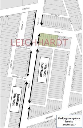
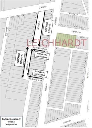
It should be noted that the southern end of Flood Street (towards Parramatta Road) predominantly fronts commercial properties and as such, Flood Street between Parramatta Road and Albert Street has not been included in this resident parking proposal. George Street, south of Treadgold Street South, has also been excluded from this RPS proposal. This section of George Street has ‘No Parking’ restrictions on the east side and ‘Works Zone’ restrictions on the west side adjoining Nos.14-22 George Street and Nos. 30-40 George Street Leichhardt.
The construction on these sites could take up to two years and as such, parking restrictions along this section of George Street will be investigated following the completion of the above mentioned sites to ascertain whether the RPS warrants extension at that time.
FINANCIAL IMPLICATIONS
The cost of the signposting will be funded from Council’s operational budget.
OFFICER COMMENTS
A Resident Parking proposal was prepared to implement ‘2P 8am-6pm, Mon-Fri, Permit Holders Excepted, Area L1’ restrictions along Flood Street, George Street, Treadgold Street North and Treadgold Street South, as shown on the following map.
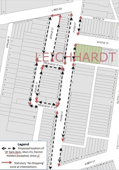
PUBLIC CONSULTATION
|
A letter outlining the above parking proposal option was mailed out to the affected properties (96 properties) in Flood Street, George Street, Treadgold Street North and Treadgold Street South as indicated on the attached plan, requesting residents’ views regarding the proposal.
|
|
The table below shows some of the comments raised by the residents who did not support the proposal and the officer’s comments.
Comments from residents objecting to the proposal
|
Residents’ Comments |
Officer Comments |
|
Disappointed in Council pushing the same agenda given they approved the construction of hundreds of units. Knowing full well that parking problems would result. These same parking problems have occurred in Myrtle and National streets, yet they haven't been approached regarding a resident parking scheme. |
Council’s Resident Parking Scheme requires a minimum of 3 or more inquiries from residents of different properties in the street to initiate a RPS investigation. This advice has been forwarded to a resident of National Street, Leichhardt. Council received more than 3 requests from the residents of Flood Street and George Street in late 2016 and as such, Council investigated parking occupancies in these streets and the short streets connecting the two. (Treadgold South and Treadgold North). In accordance with Council’s RPS Policy Dual occupancies, multi dwelling housing and residential flat buildings, subdivisions into two or more lots and the strata subdivision of residential flat buildings, approved after January 2001 are not allowed to participate in a RPS as off-street parking should be provided in accordance with Council’s DCP -Parking. |
|
Many businesses surround Flood Street and employees need free parking. I work in another suburb have a small child and need to drive. I don't know what I'd do if the parking was changed. There should be a minimum of free parking provided in the municipality. Installing free parking in neighbourhood has just made parking worse for Flood Street |
Flood Street between Parramatta Road and Albert Street has been excluded from the RPS proposal to provide long term parking opportunity for the businesses along Parramatta Road. Patrons of businesses can park in Flood Street, north of Albert Street for a maximum of two hours. |
|
I have friends & relatives visit, this parking restriction would impact me socially. |
Eligible properties will be issued one visitor parking permit Area L1 that can be used for friends or relatives that require parking for longer than 2 hours. |
|
I have to reject this proposal in order to look after my best interests. I don't want to get fined for parking outside my house just because I can't use my garage to park my car. |
Council staff can conduct a site inspection to determine whether a garage space is wide enough to accommodate a standard vehicle. Should the garage width be inadequate a second resident parking permit can be issued under exceptional circumstances |
Consultation survey results are summarised as follows:
Flood Street
Number of properties - 72 (including corner properties)
Number of properties responded - 46
Number of properties supported - 37
Response Rate - 63.8%
Support Rate - 51.4%
George Street
Number of properties - 24 (including corner properties)
Number of properties responded - 15
Number of properties supported - 12
Response Rate - 62.5%
Support Rate - 50%
Treadgold Street North
Number of properties - 5 (including corner properties)
Number of properties responded - 4
Number of properties supported - 4
Response Rate - 80%
Support Rate - 80%
Treadgold Street south
Number of properties - 5 (including corner properties)
Number of properties responded - 4
Number of properties supported - 4
Response Rate - 80%
Support Rate - 80%
Complete study area
Number of properties - 96 (including corner properties)
Number of properties responded - 61
Number of properties supported - 49
Response Rate - 63.5%
Support Rate - 51.0%
According to Council’s Resident Parking Policy, a minimum of 50% support based on all properties in the subject section of the street is required to consider the proposal favourably.
Based on the above results, Flood Street, George Street, Treadgold Street North and Treadgold Street South, Leichhardt have received more than 50% resident support.
CONCLUSION
Based on the above results, the RPS proposals in Flood Street, George Street, Treadgold Street North and Treadgold Street South, Leichhardt received more than 50% support from the residents. As such, it is recommended that the proposed ‘2P 8am-6pm, Mon-Fri, Permit Holders Excepted, Area L1’ restrictions be supported for implementation.
|
|
Local Traffic Committee Meeting 6 April 2017 |
Subject: STANMORE PARKING STRATEGY FINAL REPORT
(STANMORE AND MARRICKVILLE WARDS/SUMMER HILL ELECTORATE/ MARRICKVILLE LAC)
File Ref: 15/SF548/24254.17
Prepared By: Mary Bailey - Parking Planner
Authorised By: Joe Di Cesare - Manager Design and Investigation
|
SUMMARY The Stanmore Parking Study was commissioned by Inner West Council in order to review the parking policy and management strategy within the precinct. The study identifies the extent and utilisation of parking in the precinct, establishes community opinion and concerns and proposes a strategy for parking in the area based on the collected data. A series of recommendations have been made to address parking demand and resident concerns. The recommendations refer to short term parking, resident parking and laneway parking. |
|
RECOMMENDATION
THAT:
1. The final recommendations of the Stanmore Parking Strategy as listed in the Table below be approved
|
Table 1: Parking Strategy Recommendations
|
Recommendation |
Recommendation Description |
|
1. Temple Street
|
Convert the existing unrestricted spaces on the south side of Temple Street, between Bruce Lane and Percival Lane, to time restricted parking (2P 8am-10pm Mon-Fri, M8 permit holders excepted) – 29 spaces in total. This would discourage long term parking from commuters and provide opportunities for resident (holding a permit) and/or short stay parking for the nearby retail uses. |
|
2. Douglas Street |
Convert the existing unrestricted spaces on the north side of Douglas Street, between no.14 Douglas Street and Ravenue Lane, to time restricted parking (2P 8am-10pm Mon-Fri, M8 permit holders excepted) – 14 spaces in total. This would discourage long term parking from commuters and provide opportunities for resident (holding a permit) and/or short stay parking for the nearby retail uses and/or Stanmore library |
|
3. Railway Avenue
|
Convert the existing unrestricted spaces on the north side of Railway Avenue, between Ravenue Lane and Warwick Street, to time restricted parking (2P 8am-10pm Mon-Fri, M8 permit holders excepted) |
|
4. Cavendish Street |
Convert the existing unrestricted spaces on the north side of Cavendish Street, between Holt Street and no.159 Cavendish Street, to time restricted parking (2P 8am-10pm Mon-Fri, M8 permit holders excepted) – 18 spaces in total |
|
5. Aubrey Street |
Convert the existing unrestricted spaces on the north side of Aubrey Street, between Merton Street and Cavendish Street, to time restricted parking (2P 8am-10pm Mon-Fri, M8 permit holders excepted) – 18 spaces in total. This would discourage long term parking from commuters and provide opportunities for residents (holding a permit) and/or short stay parking for the nearby retail uses. The southern side of Cavendish Street would remain as unrestricted parking. |
|
6. Fotheringham Street |
Convert the eastern side of Fotheringham Street, between Stanmore Road and no.29 Fotheringham Street, to time restricted parking (1P 6pm-10pm Mon-Sun, M8 permit holders excepted) |
|
7. Short stay parking |
Covert the following sections of street to be signposted as 2P 8.30am-6pm (Mon-Fri) & 8:30am-12:30pm (Sat) · Cambridge Street (south) – east of zebra crossing to adjacent driveway · Cambridge Street (south) – west of zebra crossing to Holt Street 1P 8.30am-6pm (Mon-Fri), 8:30am-12pm (Sat) · Chalder Street, Four existing unrestricted parking spaces on the southern side, from the coffee shop to the driveway of 148 Chalder Street, |
|
8. Weekend Parking Demand |
Council work with the Addison Road Community Centre and relevant landholders to implement travel demand management measures as discussed in this report |
|
9. Availability of parking permits for residents of multi-unit developments |
Maintain Council’s current policy of imposing conditions of development consent limiting new multi unit development resident’s access to RPS permits |
|
10. Enforcement |
Increase patrols by Council parking officers/ rangers, particularly targeting main streets/ car parks where overstaying is highest. |
|
11. Laneway parking
|
Convert unrestricted parking to “No Parking” along the east-west leg of Harrow Lane to ensure access and egress based on site specific analysis and resident demand. · East-west leg, convert unrestricted parking to No Parking on both sides · North-south legs, retain current parking restrictions |
|
12. No stopping zones
|
Statutory “No Stopping” zones be put in place where required |
BACKGROUND
The Stanmore Parking Study was commissioned by Inner West Council in order to review the parking policy and management strategy within the precinct. The study identifies the extent and utilisation of parking in the precinct, establishes community opinion and concerns and proposes a strategy for parking in the area based on the collected data. The objective of the study is to:
· Review the existing documentation, previous parking studies, strategies and survey data for the area
· Identify the extent and nature of the existing on-street and off-street public car parking demand, utilisation and inventory
· Undertake community consultations to identify existing issues and aspirations in relation to parking in the Stanmore precinct
· Develop a parking management strategy that will help optimise the amount of parking available for road users.
FINANCIAL IMPLICATIONS
A budget allocation of $100,000 (one hundred thousand) has been made for implementation in the 2017-2018 financial year.
OFFICER COMMENTS
Community opinions were collected by a questionnaire survey to establish how residents view the parking arrangements for their given area. A process was established whereby comments could be mapped to specific locations which allowed issues to be grouped throughout the study area. Typically residents of the precinct found it difficult to locate a parking space either side of Addison Road near the Addison Road community centre, immediately north of Stanmore Road and near Stanmore railway station. This is reflective of the greater parking demands in these areas generated by visitors.
Parking surveys were undertaken to establish the number of available spaces and the demand for parking within the study area. The surveys recorded the number of potential parking spaces and their utilisation, with 7,757 on-street parking spaces surveyed across the study area. The surveys were conducted on an hourly basis during the week and during the weekend, and provide an indication of the busiest streets during these periods to provide guidance towards implementing a fair and reasonable strategy.
The data collection showed opinions throughout the study area aligned areas of high community concern and areas with a high demand for parking. Notable areas where parking occupancy was high was in the streets surrounding Stanmore Station.
Following community feedback and review of parking survey data, a suite of draft recommendations were developed. This formed the basis of the draft parking strategy which was placed on public exhibition between 13 December 2016 and 6 February 2017. The document was placed on Council’s website and was visited 1,540 times. A total of 210 responses, including emails, were collected from unique addresses. Six changes were made to the draft recommendations due to the feedback received during the public exhibition period.
Following the exhibition of the document final parking recommendations were developed which take into consideration:
· The current transport environment and conditions in the Stanmore precinct;
· Existing parking controls in neighbouring areas
· Feedback received during the community and stakeholder engagement process; and
· Results of the parking surveys conducted in the precinct
The aim of the parking recommendations is to provide, where possible, an improved management system for parking for the area. These recommendations are outlined in Table 1 and illustrated in map form in Figure 1 and Figure 2.
The streets subject to the proposed changes to parking restrictions, and the number of car parking spaces impacted, are summarised in Table 2.
Table 2 Overview of proposed parking restriction changes
|
Location |
Between |
Proposed Changes |
|||
|
2P |
2P (8am -10pm Permit Excepted - Mon to Fri) |
2P (8.30am -6pm Permit Excepted - Mon to Sun) |
No restrictions |
||
|
Railway Avenue (North) |
Ravenue Lane and Warwick Street |
|
+17 |
|
-17 |
|
Douglas Street (North) |
no.14 Douglas Street and Ravenue Lane |
|
+14 |
|
-14 |
|
Aubrey Street (North) |
Merton Street and Cavendish Street |
|
+18 |
|
-18 |
|
Temple Street (South) |
Bruce Lane and Percival Lane |
|
+29 |
|
-29 |
|
Chalder Street |
Coffee shop to driveway of 148 Chalder Street |
+4 |
|
|
-4 |
|
Cavendish Street (North) |
Holt Street and no.159 Cavendish Street |
|
+18 |
|
-18 |
|
Fotheringham Street (east) |
Stanmore Road and no.29 Fotheringham Street |
|
|
+20 |
-20 |
|
Cambridge Street (South) |
immediately east of the zebra crossing to the next driveway |
+4 |
|
|
-4 |
|
Total |
+8 |
+96 |
+20 |
-124 |
|
The recommended changes to parking controls are illustrated in the Figure 1 & 2 below.
Figure 1: Map of recommended changes north of Stanmore Road
Figure 2: Map of recommended changes south of Stanmore Road
PUBLIC CONSULTATION
Community opinions were collected by a questionnaire survey (mailed to every resident within the precinct) to establish how residents view the parking arrangements for their given area. A process was established whereby comments could be mapped to specific locations which allowed issues to be grouped throughout the study area. Typically residents of the precinct found it difficult to locate a parking space either side of Addison Road near the Addison Road community centre, immediately north of Stanmore Road and near Stanmore railway station. This is reflective of the greater parking demands in these areas generated by visitors.
Following the development of the draft report and approval by Council for public exhibition, a letter was again sent to each resident of the precinct advising of ways to make comments on the draft report. The draft recommendations and report were placed on public exhibition between 13 December 2016 and 6 February 2017. The document was placed on Council’s website and was visited 1,540 times. A total of 210 responses, including emails, were collected from unique addresses. Six changes were made to the draft recommendations due to the feedback received during the public exhibition period. Those changes are illustrated in Table 3 below.
|
Location |
Draft Strategy Recommendation |
Final Strategy Recommendation |
|
Aubrey Street, from Merton Street to Cavendish Street |
No changes to existing parking controls (unrestricted parking to be retained) |
Introduce time restricted parking (2P 8am-10pm Mon-Fri, permit holders excepted) |
|
Temple Street, from Bruce Lane to Percival Lane |
No changes to existing parking controls (unrestricted parking to be retained) |
Introduce time restricted parking (2P 8am-10pm Mon-Fri, permit holders excepted) |
|
Chalder Street, from coffee shop to driveway of 148 Chalder Street |
No changes to existing parking controls (unrestricted parking to be retained) |
Introduce time restricted parking on southern side (1P 8:30am-6pm Mon-Fri and 8:30am-12:30pm Sat) |
|
Clarendon Lane, both sides |
No parking restrictions along both sides of Clarendon Lane be implemented. |
Retain current parking controls along Clarendon Lane |
|
Stafford Lane, both sides |
No parking restrictions along both sides of Stafford Lane be implemented. |
Retain current parking controls along Stafford Lane |
|
Harrow Lane, east-west leg |
No changes to existing parking controls (unrestricted parking to be retained) |
Introduce no parking restrictions along both sides of the east-west leg of the laneway. Retain current parking controls along north-south legs |
Table 3: Changes made after public exhibition
CONCLUSION
Following extensive investigation and analysis via community engagement and parking surveys the recommendations reflect a considered response to parking concerns raised and experienced within the Stanmore Parking precinct. Given that parking is a changing landscape within the area it is foreseen that the recommendations contained in this report will be implemented in a timely fashion and the impact of those measures reviewed within a reasonable period of implementation, 12-18 months.
Future challenges include any further multi unit development, existing commercial and community ventures such as local entertainment venues and community hub activities such as at the Addison Road Community Centre. Where there are sustained and regular demands (such as railway stations) implementing restrictions can address residents’ concerns but intermittent and occasional uses are more of a challenge and cannot easily be addressed simply through parking restrictions. Further strategies are called for including travel demand management. This is in keeping with Council’s policy and all parking strategies must consider the reduction of demand for parking since there is limited impact that can be made through implementing time restrictions.
|
1.⇩ |
Stanmore Parking Study Report Final Post Exhibition ARUP 17 March 2017 (current) |
|
Local Traffic Committee Meeting 6 April 2017 |
Subject: NEWTOWN/ENMORE PARKING IMPLEMENTATION REVIEW REPORT
(STANMORE & MARRICKVILLE WARD/NEWTOWN ELECTORATE/NEWTOWN MARRICKVILLE LAC)
File Ref: 15/4545/26093.17
Prepared By: Mary Bailey - Parking Planner
Authorised By: Joe Di Cesare - Manager Design and Investigation
|
SUMMARY Council undertook a parking study originally in Newtown/Enmore in 2010. In 2013 Council had undertaken a review of the effectiveness of the original proposals as well as extending the study area. As a result Council implemented a series of resident and other parking restrictions in the precinct. In 2016 Council initiated a further review to determine the level of satisfaction with measures which had been implemented and to determine what further measures could be taken to improve parking management in the area. This current review makes recommendations to address concerns regarding laneway parking, short term parking, resident parking and the implementation of “No Stopping” zones as a safety measure in a number of cases. |
|
RECOMMENDATION
THAT:
The final recommendations of the Newtown/Enmore Parking Review (as listed in Table 1 of this report) be approved.
|
Table 1: Summary Table of All Recommendations
|
Location |
Recommendation |
|
Alice Avenue |
1. Convert Unrestricted parking to 2P 8am-10pm Permit Holders Excepted (western side) M14. |
|
Alice Lane |
2. Convert unrestricted parking to full time “No Parking between Walenore Avenue and Pearl Lane (southern side)” 3. Convert 6m Unrestricted parking to “No Parking” opposite the rear of 59 Holmwood Street (northern side). |
|
Belmore Lane – Newtown |
4. Convert “No Parking 5am to 10am Mondays” to full time “No Parking” restrictions (both sides) from Fitzroy Lane to the driveway at the rear of number 96 Probert Street. |
|
Camden Street |
5. Convert Unrestricted parking to 1P Permit Holders Excepted 6pm-10pm Monday to Sunday (southern side) outside 46-30, 58-98,110-142, 160 to Edgeware Road (Area M3). 6. Convert Unrestricted parking to 2P Permit Holders Excepted 8am-10pm Monday to Sunday (southern side) between number 2and 4 Camden Street inclusive (Area M14). |
|
Clara Street |
7. Convert Unrestricted parking to 2P 8am-10pm Permit Holders Excepted (western side) M14. |
|
Dickson Street |
8. Resident parking in Dickson Street to be brought into line with other M14 area streets by December 2018, with resident parking on one side of the street only and one (1) permit per household. (This is a Council adopted resolution from 4 March 2014). |
|
Edgeware Lane |
9. Convert Unrestricted parking to “No Parking” (western side). 10. Implement statutory “No Stopping” in Edgeware Lane (both sides) at Sarah Street. |
|
Edgeware Road |
11. Implement “No Stopping” for a length of 15 meters between 3:30pm and 5:30pm Monday to Friday (western side) opposite Cross Lane. |
|
Ferndale Street |
12. Convert Unrestricted parking to 1P Permit Holders Excepted 6pm-10pm Monday to Sunday (western side). |
|
Fitzroy Lane |
13. Convert “No Parking 5am-10am Mondays” to full time “No Parking” in Fitzroy Lane (southern side) 6 meters either side of Gibbs Lane measured from the kerb lines on the east and west side of Gibbs Lane. 14. Convert “No Parking 5am-10am Mondays” to full time “No Parking” in Fitzroy Lane (southern side) 6 meters either side of Belmore Lane measured from the kerb line on the east and west side of Belmore Lane. 15. Convert “No Parking 5am-10am Mondays” to full time “No Parking” in Fitzroy Lane (southern side) 6 meters either side of Brooks Lane measured from the kerb line on the east and west side of Brooks Lane. |
|
Goddard Street |
16. Convert Unrestricted parking (north side) to 6m Motorcycle parking at King Street. 17. Convert Unrestricted parking (north side) between proposed 6m Motorcycle parking zone and existing “No Stopping” at Bailey Street to 2P Permit Holders Excepted 8:00am-10pm Monday to Sunday (M 14). |
|
Hoffman Lane |
18. Convert “No Parking 5am to 10am Mondays” to full time “No Parking” (southern side) opposite the rear of 120 and 122 Lennox Street. 19. Convert “No Parking 5am to 10am Mondays” to full time “No Parking” in Hoffman Lane (northern side) between Probert Street and Denison Street. |
|
Kent Street |
20. Convert Unrestricted parking to 1P Permit Holders Excepted 6pm-10pm Monday to Sunday (northern side) |
|
Kingston Lane |
21. Convert Unrestricted parking to “No Parking” in Kingston Lane (western side) between Marmion Street and the rear of number 40 Kingston Road. 22. Implement statutory 10m” No Stopping” in Kingston Lane (eastern side) at Marmion Street. 23. Convert Unrestricted parking to “No Parking” in Kingston Lane (eastern side) between proposed 10m “No Stopping” at Marmion Street and Gilpin Lane 24. Implement statutory 10m “No Stopping” in Kingston Lane (both sides) at Rowley Street 25. Convert Unrestricted parking to “No Parking” (western side) between proposed 10m “No Stopping” at Rowley Street and the rear of number 54 Kingston Road. 26. Convert Unrestricted parking to “No Parking” (eastern side) between proposed “No Stopping” zone at Rowley Street and Gilpin Lane. |
|
Marian Lane |
27. Implement 10m statutory “No Stopping” in Marian Lane immediately south of Cross Lane (both sides). |
|
Melville Lane |
28. Implement 10m statutory “No Stopping” in Melville Lane at Probert Street (southern side). |
|
Oxford Street |
29. Implement “No Stopping” in Oxford at St Mary Street (southern side) 30. Convert Unrestricted parking from end of ”No Stopping” zone for 10m around corner (western side). |
|
Regent Lane |
31. Convert Unrestricted parking to “No Parking” in Regent Lane (both sides) |
|
Simmons Street |
32. Convert Unrestricted parking to 1P Permit Holders Excepted 6pm-10pm Monday to Sunday (eastern side) |
|
Statutory 10m “No Stopping” |
33. Statutory 10m “No Stopping” to be implemented with all recommendations as required at intersections |
FINANCIAL IMPLICATIONS
No allocation for implementation has been made in the 2017-2018 budget.
BACKGROUND
The Inner West Council is carrying out a review of the measures implemented as a result of the 2013 Newtown/Enmore Parking Study review (ARUP for Marrickville Council)
The Newtown/Enmore Parking Study review 2013 was commissioned by then-Marrickville Council in order to review the parking policy and management strategy within the precinct following a 2010 study. That study consisted of community consultation through surveys and workshops and collection of parking data.
OFFICER COMMENTS
The current review looks at the impact of the implementation and accounts for feedback received from the community, parking data gathered since the implementation and other potential impacts on parking in the area such as parking restriction changes in adjacent areas, residential development, and changes in activity along key arterial corridors from commuter and commercial related demand.
Initial Community consultation was undertaken by way of letters to each resident and householder in the area advising of the strategy review and informing them of the questionnaire on Your Say Marrickville. There were 378 responses to the questionnaire and a number of emails and phone calls from residents were collated into results regarding the circumstances and preferences for each street. Sixty seven (67) streets were represented through the survey responses. Questions included level of satisfaction with measures implemented, preferred type of parking, difficulty in finding parking, availability of off street parking and number of registered vehicles in respondents household.
Findings indicated that where people are dissatisfied, the main reason is that there is insufficient parking and that commuters are parking in their street. The impact of major attractors like the Enmore Theatre was also a matter for comment. Most respondents called for a, “combination of resident permit parking and unrestricted parking”, or, “resident permit parking for residents and time restricted for non-residents”. Laneway access being restricted by parked vehicles also featured with respondents noting that restrictions introduced in 2014 had resulted in increased parking in laneways. Respondents called for restrictions to laneway parking and increased enforcement of existing restrictions.
Enabling residents access to off street parking is a major concern raised by respondents, particularly since if they are adjudged by Council to have off street parking they are not eligible for a permit i.e. only one permit per household being permissible.
A number of laneways were identified as of particular concern and the draft report made recommendations to ban laneway parking in laneways identified as problematic. When the draft recommendations went to public exhibition there was a strong objection to banning parking in some laneways. Even though it had appeared from the comments on the initial survey that the laneway parking was largely due to commuters and long stay parkers, a different picture emerged during the public exhibition. Residents were very vocal about their desire to maintain parking in the laneways. Uses of that parking cited included; as a means of maintaining flexibility where they had insufficient permits, for visitor parking, trades, car washing and running businesses. The strong reaction against banning laneway parking was not foreseen as responses to the original survey were mainly people who had issues being obstructed from their laneway parking, the response to the public exhibition was from “everyone else”, the majority who do not want parking banned.
Each comment for each laneway was carefully examined and on many occasions, it was a case of one or 2 people being inconvenienced while others are satisfied with the laneway parking status quo. Council’s Laneway Guidelines (Dec 2015) state, “Council’s preference is for residents to negotiate with each other to avoid implementing parking bans. Where problems occur, parking restrictions can be considered for individual laneways on a case-by-case basis.”
Since the implementation of the review measures in 2014, there have been streets added to the M14 Resident Parking Zone as a result of the impact of the Alice Street Development. This has pre-empted the review and forms a significant part of parking restriction changes to the precinct and to Area 3.
In relation to streets where there are currently no parking restrictions, it was foreseen that there may be so called knock on effects from the implementation of parking restrictions in nearby streets. This has been borne out in the community survey and by parking data collection in relevant areas. To address this impact, the review recommends implementing resident parking restrictions in a number of additional streets namely Alice Avenue, Camden Street, Clara Street, Ferndale Street, Kent Street and Simmons Street (southern end).
There are a number of other studies and reviews taking place which impact the Newtown/Enmore area and these are being taken into account, Parramatta Road Corridor/Camperdown Parking Study, Stanmore Parking Study and changes implemented as a response to the Alice Street Development.
Streets and laneways where increased enforcement has been requested by residents have also been specified for action. The recommended changes are detailed in the Table 1. See Figure 1, 2 and 3 for maps illustrating the restrictions.
Figure 1: Map showing boundary and proposed restrictions for Area 1
Figure 2: Map showing boundary and proposed restrictions for Area 2
Figure 3 - Map showing boundary and proposed restrictions for Area3
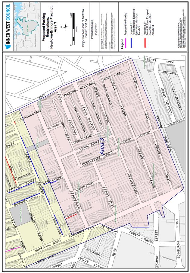
PUBLIC CONSULTATION
A letter was sent to all residents in February 2016 inviting comment via a questionnaire which was posted on Council’s Your Say website. Over 6,200 letters were sent out and 378 responses received.
Of the total of 378 respondents there were 206 who responded that they had resident parking restrictions introduced in 2015. Of those 46% or 94 respondents never answered whether they were satisfied or otherwise. Of the 206 who had measures introduced, 23% (44) were either very dissatisfied or dissatisfied. (see Figure 4)
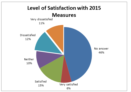
Figure 4: Level of Satisfaction with 2015 Measures
The cluster of very satisfied people north of the railway line roughly equates to the streets which had resident parking implemented in 2014. Reasons for dissatisfaction varied and conflicted, sometimes by adjoining households, varying with the personal circumstances of each household. The main issues were the residents wanted more than one permit, wanted both sides of the street as resident parking or wanted no resident parking.
A number of the “very dissatisfied” related to laneways .Lack of satisfaction at having only one permit per household or having resident parking on only one side of the road, is not open for review at this time. (See Figure 5)
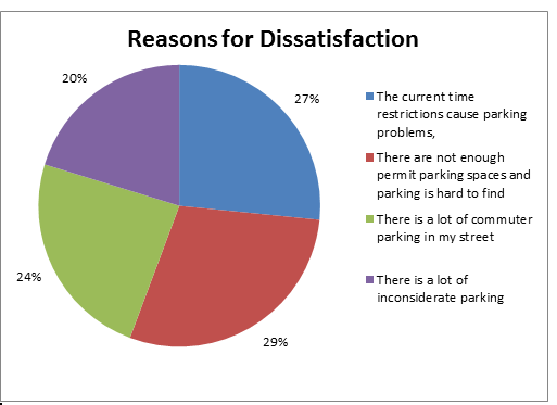
Figure 5: Reasons for Dissatisfaction
5.1 Type of parking preferred
There was a higher level of concern over laneway parking in the group that had measures introduced in 2015. Overall the level of laneway comment was only 3% (See Figure14) but in the group that had the measures introduced it was 7% (see Figure15)which may indicate the impact the new resident parking measures had in displacing parking into the laneways. It is noted that when recommendations were made in the draft report to restrict laneway parking there was a very strong response with 68 of 90 objections relating to laneway parking.
Following Council approval in November 2016, the public exhibition period ran from 12 December to 5 February a total of 9 weeks (extended to allow for holiday period). All residents of the area were posted a letter advising of the public exhibition and directing them to give feedback via Council’s Your Say page or by writing to Council. There were 147 responses received via the Your Say page and an additional 20 received via separate written submissions, making a total of 167 responses to the public exhibition.
Objections were raised by 90 of the 167 respondents. In the main objections related to;
1. Introducing angle parking in Dickson Street (34 objections)
2. Removal of laneway parking, (68 objections – 29 of which related to Dickson Lane and Holmwood Lane)
The numbers are not mutually exclusive as 29 residents signed a letter opposing angle parking in Dickson Street, and opposing parking restrictions in Holmwood Lane and in Dickson Lane. Other objections received related mainly to residents seeking to have resident parking implemented in their street (where not recommended – notably Camden Street with 16 responses from 14 households seeking resident parking) or; residents seeking to have unrestricted parking in their street where permit parking was recommended (Alice Ave – 1, Clara Street 3).
The main take out message from the public exhibition was that many residents consider laneway parking a vital part of their parking mix and were very concerned about any further restriction of parking in the laneways.
CONCLUSION
The main outcomes of this review are the refinement of laneway parking restrictions and the implementation of resident parking in a number of additional streets. Residents reported that since the implementation of resident parking following the 2013 study, there has been increasing pressure on laneway parking. While residents and visitors depend on laneways for parking, other residents require access to off street parking via the laneways. With the aim of maintaining as much laneway parking as practicable, the review has identified and addressed specific issues in a number of laneways where problems have been identified.
There are also increasing pressures on resident parking as a result of several changes which have occurred in relation to parking demand; notably the charges now being levied for the Enmore TAFE car park and the resulting displacement into residential streets; and, the impact of the Alice Street Development and the subsequent designation of resident parking in a number of adjacent streets. This review has responded to these changes by recommending the implementation of resident parking in these streets; Alice, Clara, Camden, Ferndale, Kent and Simons Streets.
|
1.⇩ |
Final report Newtown Enmore Parking review |
|
Local Traffic Committee Meeting 6 April 2017 |
Subject: SALISBURY ROAD BETWEEN DENISON STREET AND AUSTRALIA LANE, CAMPERDOWN – INSTALLATION OF 'NO PARKING' RESTRICTIONS ADJACENT TO MEDIAN STRIP (STANMORE WARD / NEWTOWN ELECTORATE / NEWTOWN LAC)
File Ref: 17/6022/29993.17
Prepared By: Jennifer Adams - Traffic and Road Safety Officer
Authorised By: Joe Di Cesare - Manager Design and Investigation
|
SUMMARY On 6 February 2017 a fatal crash occurred on the northern side of Salisbury Road at the bend between Denison Street and Australia Lane, Camperdown. A subsequent in-house road safety review of the location revealed that parking and/or associated activities with parking (doors opening) on the northern side of Salisbury Road between Denison Street and Australia Lane may have been a contributing factor to the crash. In order to improve traffic and road safety at this location it is recommended that the short length of clearway “No Parking 7.30am – 10.00am Monday-Friday’ restrictions be removed and replaced with full time ‘No Parking’ restrictions.
|
|
RECOMMENDATION
THAT:
1. the existing short length of “No Parking 7.30am – 10.00am Monday-Friday” restrictions installed on the northern side of Salisbury Road between Denison Street and Australia Lane, Camperdown be removed and replaced with full time ‘No Parking’ restrictions to improve traffic and road safety at this location; and 2. Surrounding residents and Council’s Rangers be notified in terms of this report. |
BACKGROUND
On 6 February 2017 a fatal crash occurred on the northern side of Salisbury Road at the bend between Denison Street and Australia Lane, Camperdown. A motorist travelling eastbound lost control of their vehicle at the left hand bend on Salisbury Road mounted the median strip and collided head-on into an oncoming vehicle. The passenger of the hit vehicle unfortunately passed away. The crash report stated that the driver of the eastbound vehicle ‘commenced to negotiate a left bend near the intersection of Denison Street and believed he was too close to a parked vehicle and swerved to the right’. His vehicle then mounted the raised concrete median strip and went into the westbound lane and collided head-on into the other vehicle.
At present parking is allowed on the northern side of the bend outside morning clearway times. Refer to Locality Plan.
FINANCIAL IMPLICATIONS
The cost of the supply and installation of the signage associated with the recommended installation of full time ‘No Parking’ restrictions is approximately $300 and can be met from Council’s operating budget.
OFFICER COMMENTS
In the road safety review conducted it was identified that parking on Salisbury Road, between Denison Street and Australia Lane, Camperdown may distract drivers negotiating the bend while driving in an eastbound direction and accordingly recommends that full time ‘No Parking’ restrictions be installed at this location.
The current clearway ‘No Parking’ restrictions are a safety concern, as the space(s) are located on the outer side of a bend and may be a potential hazard to eastbound traffic. It is envisioned that the removal of the spaces will improve road safety at this location and such restrictions will be more in line with the restrictions sought when the central median island was built.
PUBLIC CONSULTATION
Citizens in the area were notified of the proposal to install full time ‘No Parking’ restrictions at the section of Salisbury Road between Denison Street and Australia Lane, Stanmore as the location is considered a squeeze point for motorists.
CONCLUSION
It is recommended that the short length of “No Parking 7.30am – 10.00am Monday-Friday” restrictions be removed and replaced with full time ‘No Parking’ restrictions on the northern side of Salisbury Road between Denison Street and Australia Lane, Camperdown to improve traffic and road safety at this location.
Locality Map – Salisbury Road, between Denison Street & Australia Lane, Camperdown
![]()
|
|
|
|
Local Traffic Committee Meeting 6 April 2017 |
Subject: LIVINGSTONE ROAD, MARRICKVILLE – TEMPORARY ROAD CLOSURES FOR THE ORTHODOX EASTER PROCESSIONS ON 14 & 15 APRIL 2017 (MARRICKVILLE WARD/SUMMER HILL ELECTORATE/MARRICKVILLE LAC)
File Ref: 17/6022/26688.17
Prepared By: Emilio Andari - Civil Engineer
Authorised By: Joe Di Cesare - Manager Design and Investigation
|
SUMMARY Council has been advised by NSW Police that there will be a street procession taking place on Orthodox Easter Good Friday 14 April 2017, between 8.30pm and 10.00pm and Orthodox Easter Saturday 15 April 2017, between 10.00pm and 12.30am for St Nicholas Greek Orthodox Church in Marrickville. This procession will require some temporary road closures which will be undertaken by NSW Police. Council has been requested to provide barricades to assist the Police in implementing the proposed road closures.
It is recommended that this report be received and noted. It is also recommended that Council provide barricades at no cost to assist the Police in implementing the proposed temporary road closures as in previous years. |
|
RECOMMENDATION
THAT;
1. The report be received and noted; and
2. Council provide barricades at no cost to assist the Police implementing the proposed temporary road closures as in previous years.
|
BACKGROUND
Council has been advised that there will be a street procession taking place on Orthodox Easter Good Friday 14 April 2017, between 8.30pm and 10.00pm and Orthodox Easter Saturday 15 April 2017, between 10.00pm and 12.30am for St Nicholas Greek Orthodox Church in Marrickville.
This procession will require some temporary road closures which will be undertaken by NSW Police and Council has been requested to provide barricades to assist the Police in implementing the proposed road closures as in previous years.
FINANCIAL IMPLICATIONS
There will be a small cost to Council involving the delivery and pick up of the barricades and it is proposed to waive this cost as in previous years.
OFFICER COMMENTS
Greek Orthodox Parish of ‘Saint Nicholas’
This procession is organised by the Greek Orthodox community of Marrickville and has been an annual event since 1961. It attracts approximately between 1,500 and 2,000 people and incorporates the following streets, dates and times;
· Orthodox Good Friday - 14 April 2017 (7.00pm to 9.30pm) from St Nicholas Church located at 203 Livingstone Road, left onto Robert Street, left onto Dot Street, left onto South Street, left onto Pine Street, onto Hollands Avenue and left onto Livingstone Road, Marrickville and back to the church.
· Orthodox Easter Saturday - 15 April 2017 (9.30pm to 12.30am) from St Nicholas Church located at 203 Livingstone Road, involving the closure of a section of Livingstone Road in front of the church for congregation of people.
All road closures will be under the control of the NSW Police and the assistance of the SES. Last year Council provided barricades to assist the Police implementing the proposed road closures at Council’s cost.
Police/SES will direct traffic at the following intersections;
a) Livingstone Road and Francis Street (Police) 3 barricades
required.
b) Livingstone Road and Arthur Street/Robert Street (Police/SES) 3 barricades
required.
c) Robert Street and Robert Lane (SES)
d) Robert Street and David Street (SES)
e) Robert Street and Dot Street (Police)
f) Dot Street and South Street (Police)
g) South Street/Pine Street and Hollands Avenue (SES/barricades) 3 barricades
required.
h) Livingstone Road and Jersey Street (Police) 3 barricades required.
Include comments from other staff here.
PUBLIC CONSULTATION
Nil.
CONCLUSION
It is recommended that this report be received and noted. It is also recommended that Council provide barricades to assist the Police in implementing the proposed temporary road closures at no cost.
|
|
Local Traffic Committee Meeting 6 April 2017 |
Subject: LIVINGSTONE ROAD, MARRICKVILLE – TEMPORARY ROAD CLOSURES FOR ‘GOOD FRIDAY’ PROCESSIONS ON 14 APRIL 2017 (MARRICKVILLE WARD/SUMMER HILL ELECTORATE/MARRICKVILLE LAC)
File Ref: 17/6022/26692.17
Prepared By: Emilio Andari - Civil Engineer
Authorised By: Joe Di Cesare - Manager Design and Investigation
|
SUMMARY Council has been advised by NSW Police that there will be a street procession taking place on Easter Good Friday 14 April 2017, between 7.15pm and 8.30pm for St Brigid's Catholic Church in Marrickville. This procession will require some temporary road closures which will be undertaken by NSW Police. Council has been requested to provide barricades to assist the Police in implementing the proposed road closures.
It is recommended that this report be received and noted. It is also recommended that Council provide barricades at no cost to assist the Police in implementing the proposed temporary road closures as in previous years. |
|
RECOMMENDATION
THAT;
1. The report be received and noted; and
2. Council provide barricades at no cost to assist the Police implementing the proposed temporary road closures as in previous years. |
BACKGROUND
Council has been advised that there will be a street procession taking place on Easter Good Friday 14 April 2017, between 7.15pm and 8.30pm for St Brigid's Catholic Church in Marrickville.
This procession will require some temporary road closures which will be undertaken by NSW Police and Council has been requested to provide barricades to assist the Police in implementing the proposed road closures as in previous years.
FINANCIAL IMPLICATIONS
There will be a small cost to Council involving the delivery and pick up of the barricades and it is proposed to waive this cost as in previous years.
OFFICER COMMENTS
St Brigid's Parish
This procession is organised by the Italian Catholic community of Marrickville and has been an annual event since 1967. It attracts several thousand people and incorporates the following streets and times;
· Good Friday, 14 April 2017, the procession will exit the St Brigid's Monastery grounds at approximately 7.15pm onto Marrickville Road, turn right into Petersham Road, turn right into Francis Street, turn right into Livingstone Road and finally turn right into the church driveway on Livingstone Road.
All road closures will be under the control of NSW Police and the assistance of the SES. Last year Council provided barricades to assist the Police implementing the proposed road closures at Council’s cost.
Police/SES will direct traffic at the following intersections;
a) Marrickville Road and Livingstone Road, Marrickville (Police/SES) 12 barricades required.
b) Marrickville Road and Lilydale Street (SES)
c) Marrickville Road and Fletcher Street (SES)
d) Marrickville Road and Petersham Road (Police) 10 barricades required.
e) Petersham Road and Tuohy Lane (SES)
f) Petersham Road and Albion Street (SES)
g) Petersham Road and Francis Street (SES)
h) Petersham Road and Illawarra Road (Police)
i) Francis Street and Ann Street (SES)
j) Livingstone Road and Francis Street (Police)
PUBLIC CONSULTATION
Nil.
CONCLUSION
It is recommended that this report be received and noted. It is also recommended that Council provide barricades to assist the Police in implementing the proposed temporary road closures at no cost.