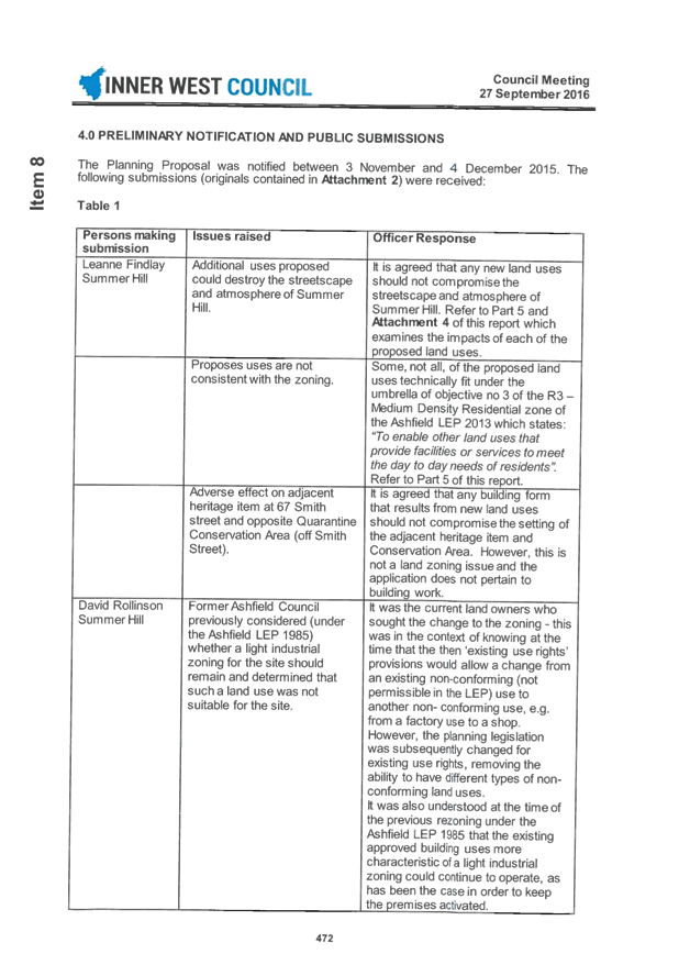
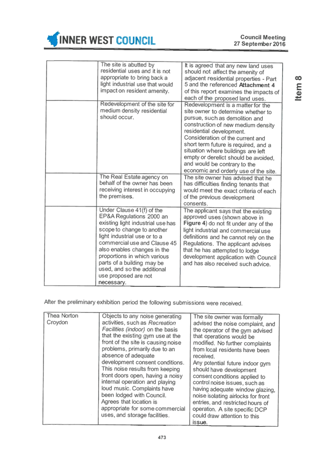
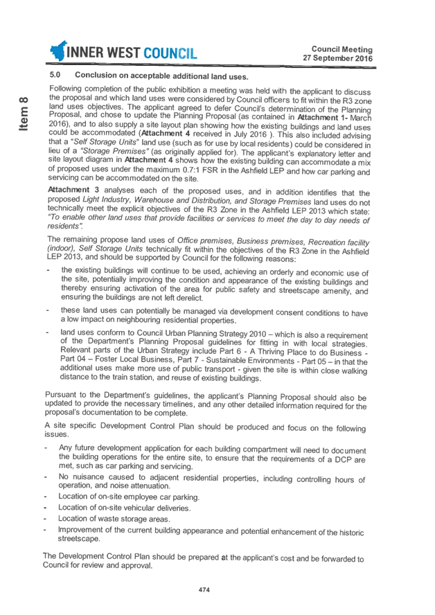
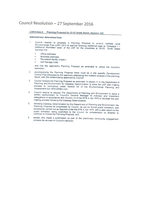
|
AGENDA R |
Council Meeting
TUESDAY 27 JUNE 2017
6:30pm
|
Council Meeting 27 June 2017 |
|
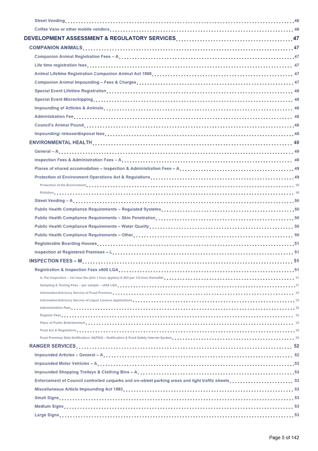
INDEX |
1 Acknowledgement of Country
2 Notice of Live Streaming of Council Meeting
3 Disclosures
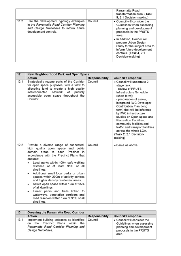
of Interest (Section 451 of the Local Government Act
and Council’s Code of Conduct)
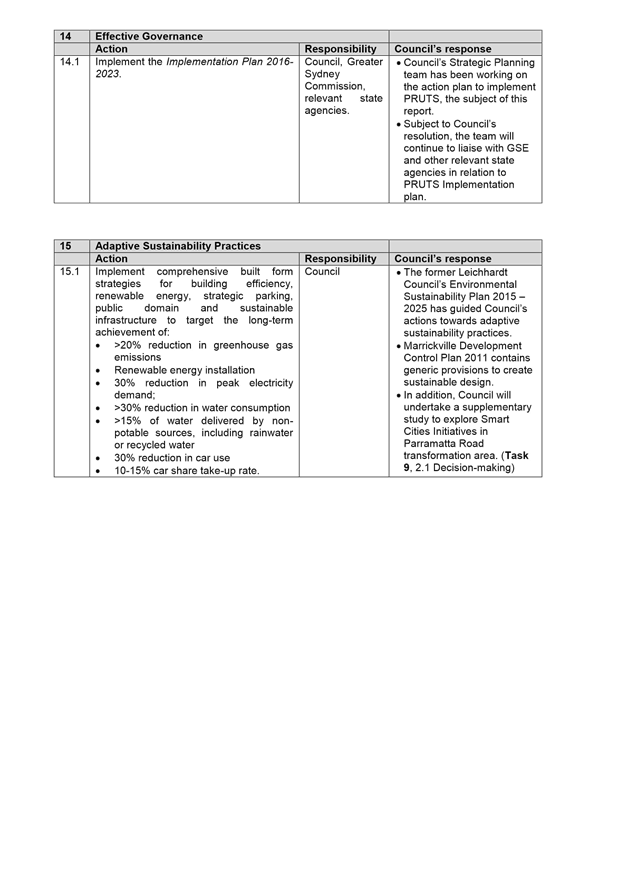
4 Confirmation of Minutes Page
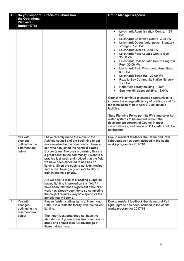
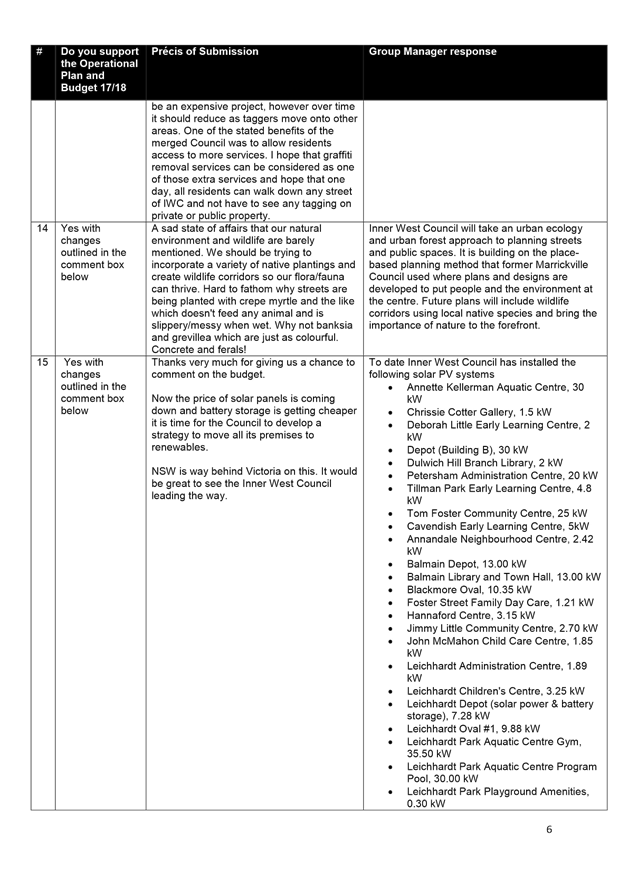
Minutes of 23 May 2017 Council Meeting 5
5 Administrator’s Minutes
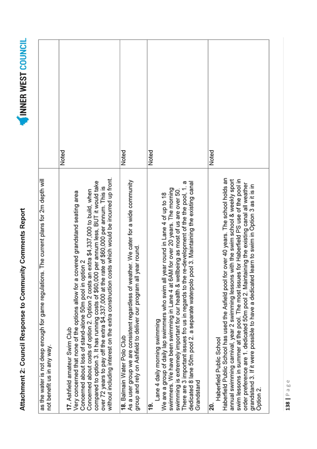
Nil at time of printing
6 Staff Reports
C0617 Item 1 Minutes of the Implmentation Advisory Group (IAG) Meeting held 8 June 2017 and Minutes of the Local Representation Advisory Committee (LRAC) Meeting held 13 June 2017 12
C0617 Item 2 WestConnex Update Report: Stage 3 Assessment; Local Area Traffic Improvement Strategy; and support for Community Advocacy 18
C0617 Item 3 Ashfield Aquatic Centre Refurbishment - Project Update and Community Engagement Outcomes 23
C0617 Item 4 Operational Plan and Budget 2017/18 187
C0617 Item 5 Victoria Road Precinct Planning Proposal 426
C0617 Item 6 Parramatta Road Urban Transformation Strategy - Council's Action Plan 533
C0617 Item 7 Changes to Planning Rules for Outdoor Advertising (Review of SEPP 64) 558
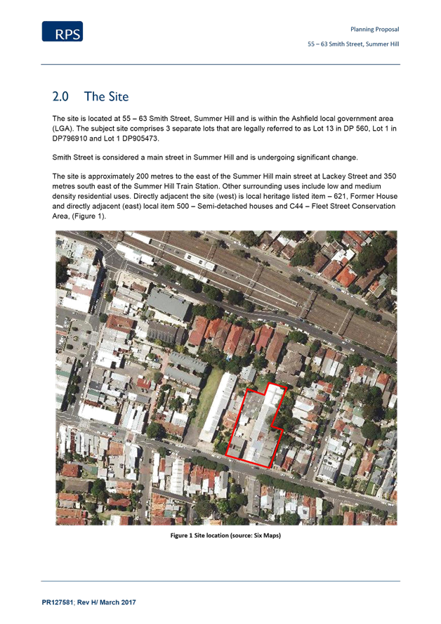
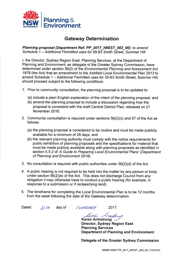
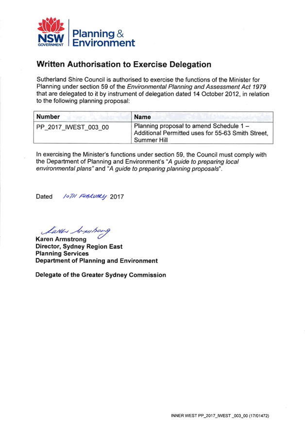
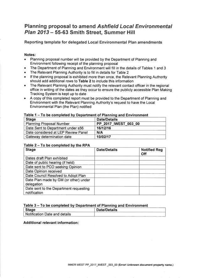
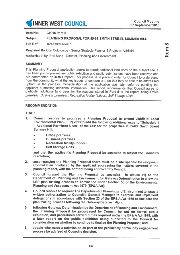
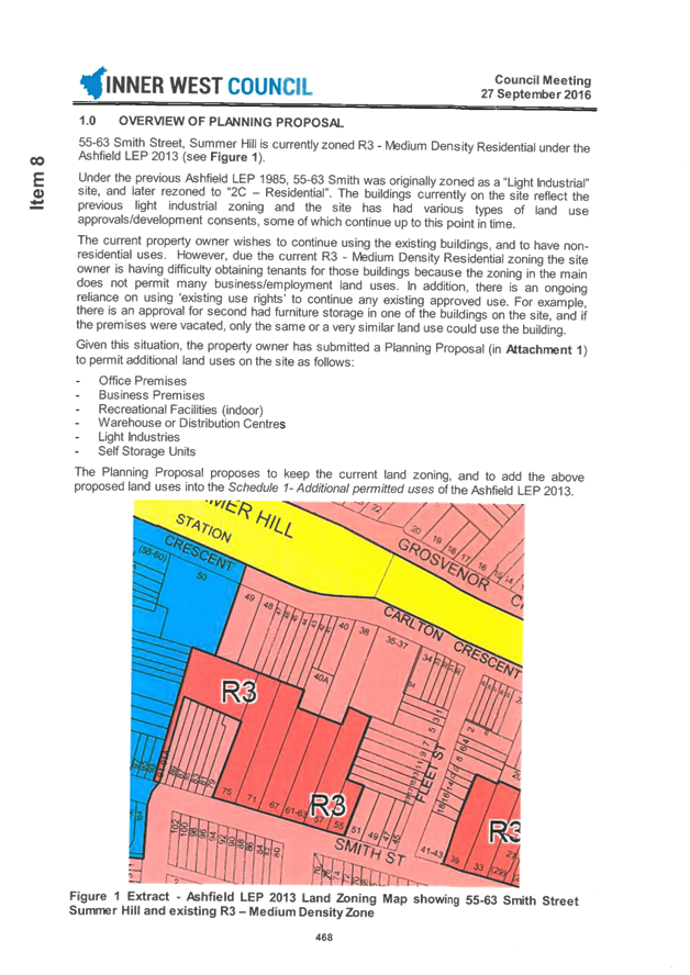
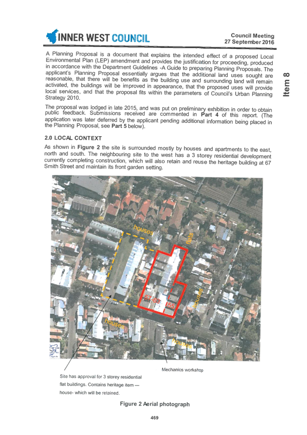
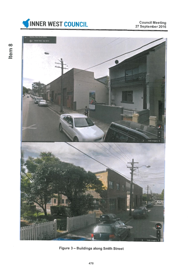
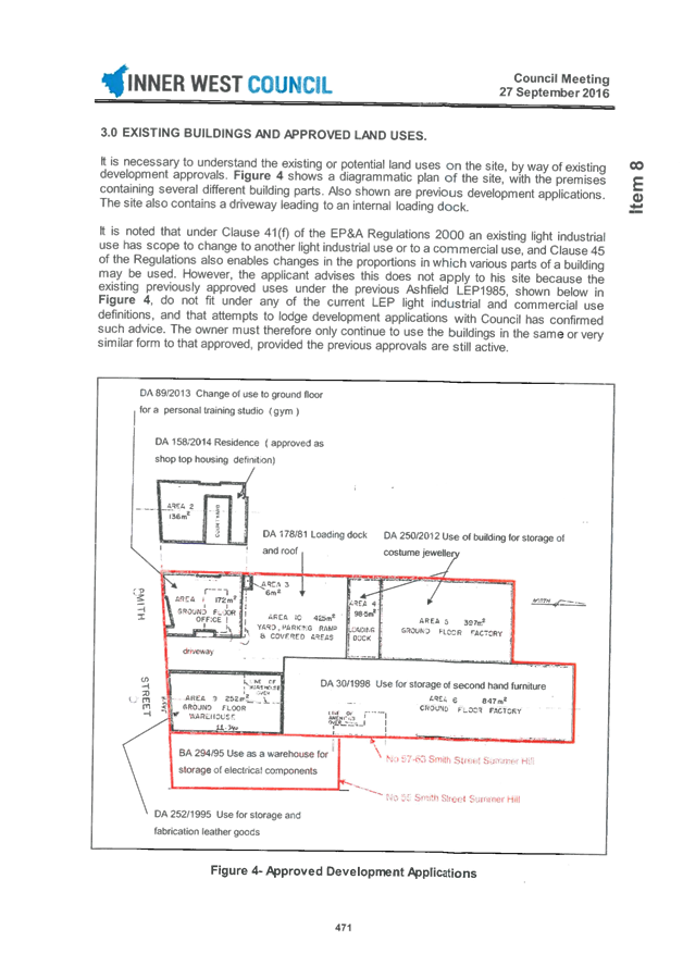
C0617 Item 8 Planning Proposal: 55-63 Smith Street Summer Hill 563
C0617 Item 9 Haberfield Heritage Conservation Area - Project for Listing on State Heritage Register 627
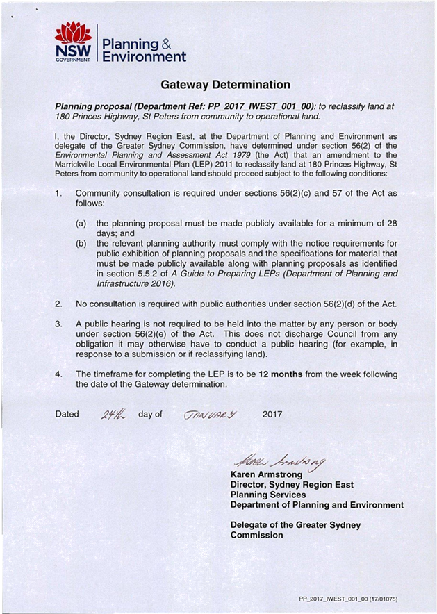
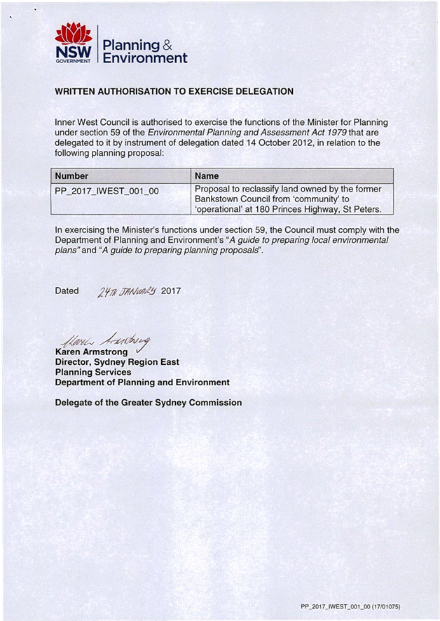
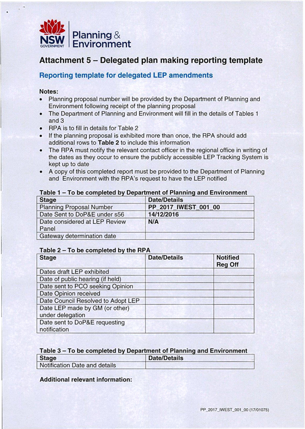
C0617 Item 10 Post Exhibition Report - Draft Marrickville Local Environmental Plan 2011 (Amendment No. 12) - 180 Princes Highway, St Peters 629
C0617 Item 11 3-7 & 13-17 Regent Street, 287-309 Trafalgar Street and 16-20 Fisher Street, Petersham 642
C0617 Item 12 Local Traffic Committee Meeting held on 1 June 2017 672
C0617 Item 13 Flood Management Advisory Committee meeting held 16 May 2017 706
C0617 Item 14 Mandatory Reporting of Fire Safety Reports Referred to Counci from Fire and Rescue NSW 716
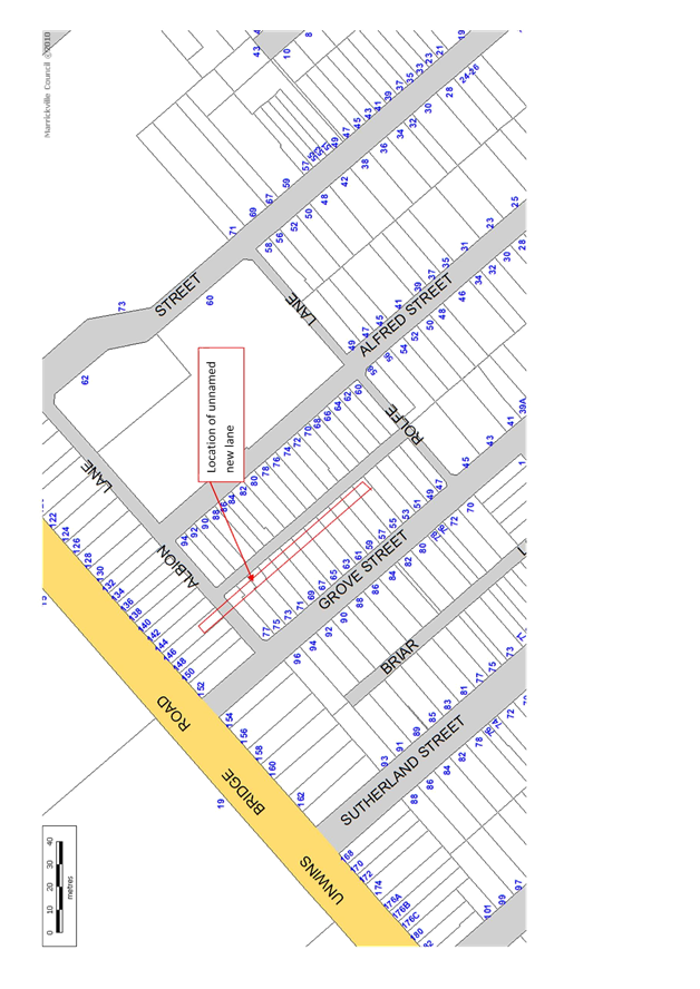
C0617 Item 15 Naming of New Lane Between Grove and Alfred Streets and Perpendicular to Albion and Rolfe Lanes, St Peters 735
C0617 Item 16 Review of the Trial Extension of the 2016/17 Swimming Season at Fanny Durack Aquatic Centre 738
C0617 Item 17 Draft Community Engagement Framework - Results of Public Exhibition 746
C0617 Item 18 Draft Mobile Food Vending Policy 782
C0617 Item 19 Internal Ombudsman 793
C0617 Item 20 Councillor Remuneration - 2017/18 Annual Fees for Councillors and the Mayor 796
C0617 Item 21 Draft Councillor Expenses and Facilities Policy 825
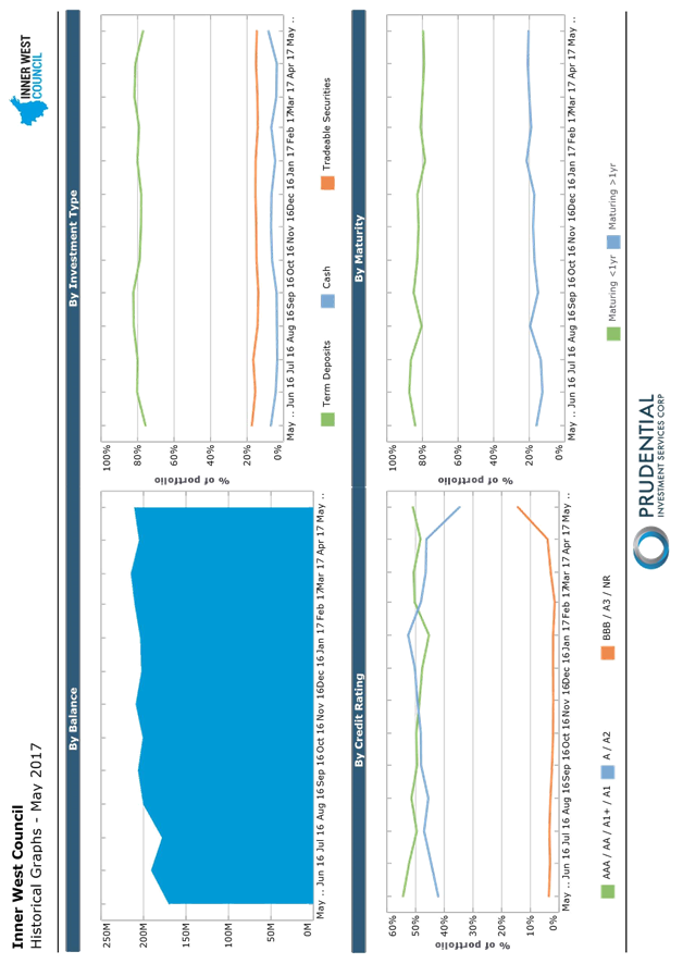
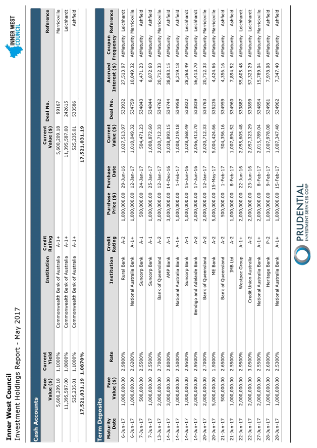
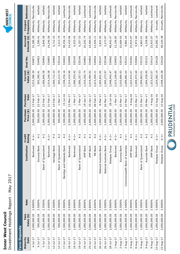
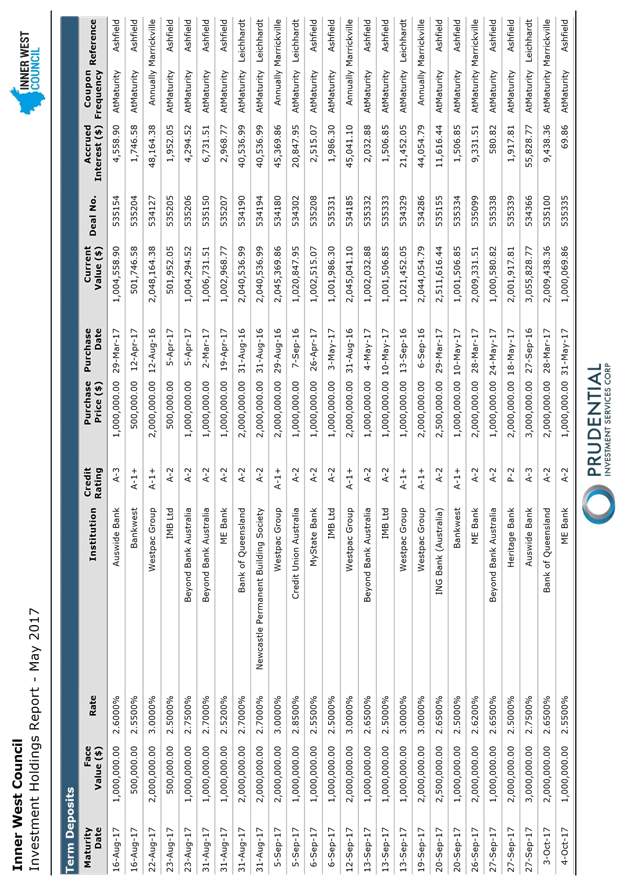
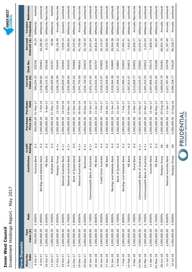
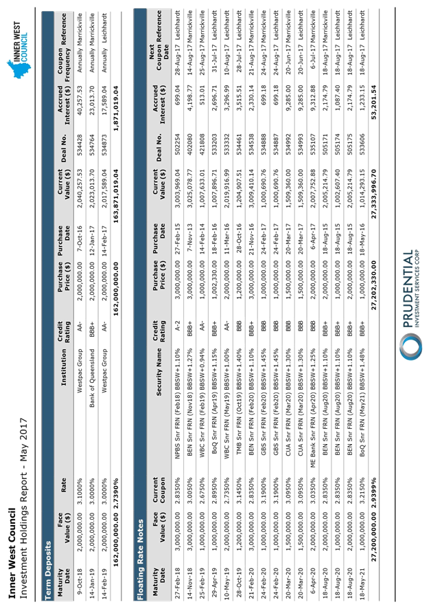
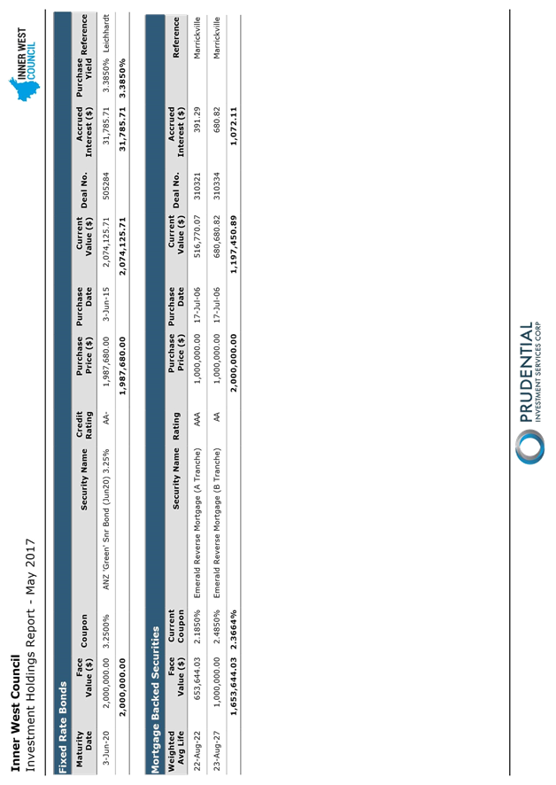
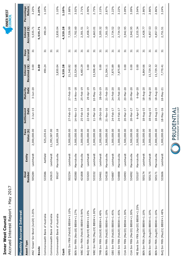
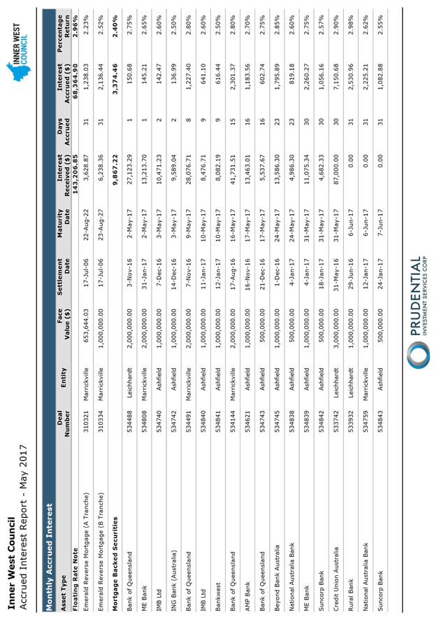
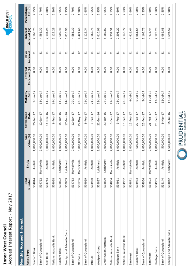
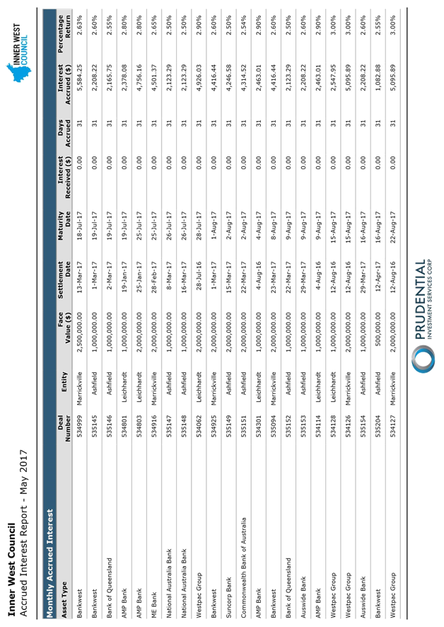
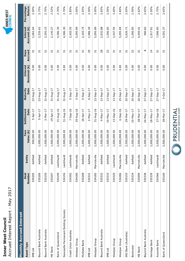
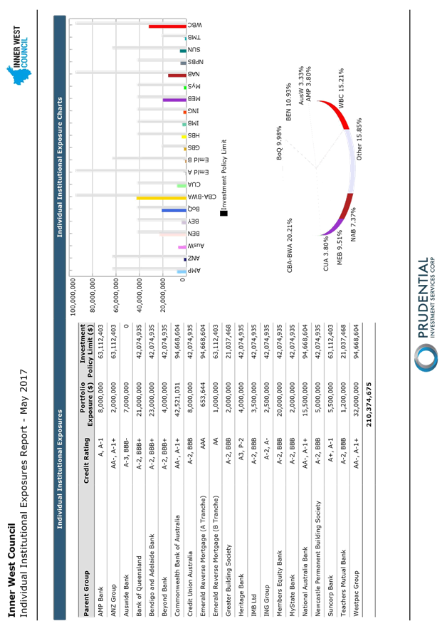
C0617 Item 22 Inner West Council Investments as at 31 May 2017 843
|
|
Council Meeting 27 June 2017 |
Minutes of Council Meeting held on Tuesday 23 May 2017
Meeting commenced at 6.30pm
|
Present: |
|
|
Richard Pearson |
Administrator |
|
Rik Hart |
Interim General Manager |
|
John Warburton |
Deputy General Manager Community and Engagement |
|
Michael Tzimoulas |
Deputy General Manager Chief Financial and Administration Officer |
|
Peter Gainsford |
Deputy General Manager Assets and Environment |
|
Tanya Whitmarsh |
Group Manager Governance |
|
Pav Kuzmanovski |
Group Manager Finance |
|
Simon Manoski |
Group Manager Strategic Planning |
|
Wal Petschler |
Group Manager Footpaths, Roads, Traffic and Stormwater |
|
Elizabeth Richardson |
Group Manager Development Assessment and Regulatory Services |
|
Kendall Banfield |
Manager WestConnex Unit |
|
Gill Dawson |
Manager Environment and Urban Planning |
|
Jennifer Anderson |
Minute Taker |
Public Speakers: see last page of these minutes.
1. Acknowledgement of Country by Chairperson
“I acknowledge the Gadigal and Wangal people of the Eora nation on whose country we are meeting today, and their elders past and present.”
2. Notice of Live Streaming of Council Meeting
The Administrator advised that the Council meeting was being streamed live on Council's website and members of the public must ensure their speech to the Council is respectful and use appropriate language.
3. Disclosures of Interest
The Administrator declared that he had no declarable interests in any matter listed on the business paper.
4. Confirmation of Minutes
|
That the Minutes of the Council Meeting held on Wednesday, 26 April 2017 be confirmed. |
|
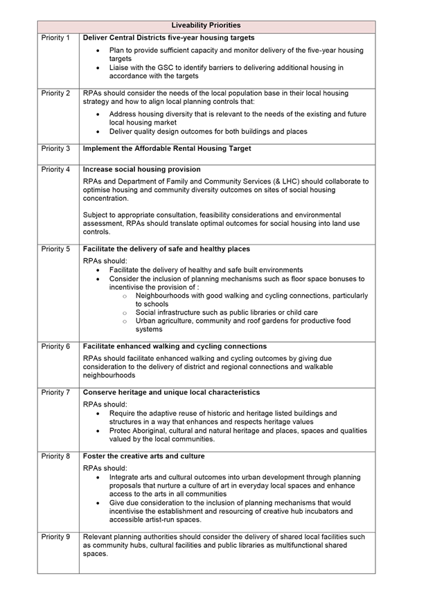
C0517 Item 10 ADOPTION OF DRAFT INCLUSION ACTION PLAN |
|
RESOLVED:
THAT Council: 1. adopts the draft IAP and incorporate its strategies and actions in the Council’s Delivery Program and operational plans; 2. submits the IAP to the State Government by 1 July 2017, as required by the NSW Disability Inclusion Act; 3. notes that $60,000 from allocated Service Unit budgets will be used to initiate actions in 2017/18 relating to accessibility audits of community facilities and communications; and 4. develops KPIs for the workforce component of the IAP.
|
|
C0517 Item 14 MINUTES OF THE IAG MEETING HELD 04 MAY 2017 AND MINUTES OF THE LRAC MEETING HELD 09 MAY 2017 |
|
RESOLVED:
THAT:
1. the Minutes of the IAG Meeting held on 04 May 2017 be noted; and 2. the Minutes of the LRAC Meeting held on 09 May 2017 be noted.
|
|
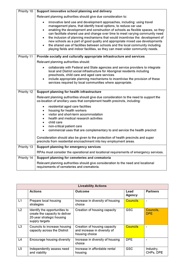
C0517 Item 1 WESTCONNEX UPDATE REPORT: EXHIBITION OF M4-M5 LINK CONCEPT DESIGN, FUNDING FOR WESTCONNEX COMMUNITY ORGANISER POSITION, FUNDING FOR ROZELLE AGAINST WESTCONNEX PUBLICATION AND M4 EAST TREE REPLACEMENT PROGRAM |
|
RESOLVED:
THAT Council: 1. receives and notes this report; 2. writes to the City of Sydney seeking a contribution of half of the funding of the Community Organiser position, i.e. $50,000; 3. endorses a one-off funding contribution of $3,300 to Rozelle Against WestConnex (RAW) for a WestConnex opposition tabloid publication for distribution to the community;
4. makes urgent representations to the Minister for WestConnex in relation to the M4-M5 Link (Stage 3) of WestConnex that
a) the Concept Design Plans issued on 12 May are causing significant concern in the Inner West community due to the general, vague and selective nature of the plans and that they should either be withdrawn or immediately augmented to address concerns identified by Council and in the Coalition Against WestConnex letter dated 22 May; b) a firm closing date for submissions on the Concept Design Plans be set of not less than 8 weeks from the date of new or amended plans being released;
c) there be no overlap of the exhibition of the Concept Design Plans with exhibition of the EIS in order that community comments on the Design Plans are appropriately factored into the EIS, ensuring there is a proper purpose to exhibition of the Concept Design Plans; d) the EIS be exhibited for a period of not less than 8 weeks and, given imminent Council elections, that closing date for submissions on the EIS concludes after Council elections on 9 September to enable the newly elected Council to finalise Council’s submission; and
5. further considers the need for expert consultant input into the Western Harbour Tunnel proposal and appropriate budget allocation.
|
|
C0517 Item 2 LOCAL TRAFFIC COMMITTEE MEETING HELD ON 4 MAY 2017 |
|
RESOLVED:
THAT the Minutes of the Local Traffic Committee Meeting held on 4 May 2017 be received and noted.
|
|
C0517 Item 3 PROPOSED AMENDMENT TO FLOOR SPACE RATIO CONTROLS IN LEICHHARDT LOCAL ENVIRONMENTAL PLAN 2013 |
|
RESOLVED:
THAT Council:
1. receive and note this report;
2. request that an amendment to Leichhardt Local Environmental Plan 2013 be drafted by Parliamentary Counsel which reflects the planning proposal consistent with Option 3 of the Floor Space Ratio Review; and
3. seek the Department of Planning and Environment to notify the amendment.
|
|
C0517 Item 4 DEVELOPMENT ADVISORY AND ASSESSMENT PROCESS IMPROVEMENT |
|
RESOLVED:
THAT:
1. Council adopt the Development Advisory and Assessment Policy shown as Attachment 1; and
2. the Policy be reviewed no later than 12 months from its commencement.
|
|
C0517 Item 5 POST EXHIBITION REPORT- DRAFT MARRICKVILLE LOCAL ENVIRONMENTAL PLAN 2011 AMENDMENT - TO DELETE SHOP TOP HOUSING AS A USE PERMITTED WITH CONSENT IN THE B7 BUSINESS PARK ZONE |
|
RESOLVED:
THAT:
1. the report be received and noted; and
2. Council forward the draft amendment to MLEP 2011 to the Department of Planning & Environment seeking final approval and gazettal. |
|
C0517 Item 6 CODE OF MEETING PRACTICE |
|
RESOLVED:
THAT: 1. the Draft Code of Meeting Practice, as shown attached to the report at ATTACHMENT 1, be placed on public exhibition in accordance with Section 362 of the Local Government Act, subject to the following changes
a) In clause 2.8(11) the time for submitting documents change from 2pm to 12pm; b) In Clause 2.15(1), the conclusion time of the meeting be 11pm, and discussion can continue to 11.10pm to finalise discussion on the matter; and
2. after the conclusion of the public exhibition period, Council receive a further report on submissions received during the public exhibition period.
|
|
C0517 Item 7 ATTENDANCE AT THE NATIONAL GENERAL ASSEMBLY 18-21 JUNE 2017 |
|
RESOLVED:
THAT Council endorse the registration of LRAC Member Frank Breen to attend the National General Assembly to be held in Canberra from 18-21 June 2017.
|
|
C0517 Item 8 NSW ABORIGINAL RUGBY LEAGUE KNOCKOUT CARNIVAL (KOORI KNOCKOUT) |
|
RESOLVED:
THAT Council: 1. partners with the Redfern All-Blacks Board to host the 2017 NSW Aboriginal Rugby League Knockout Carnival (Koori Knockout), and enter into a partnership agreement; and 2. determines to support the 2017 NSW Aboriginal Rugby League Knockout Carnival (Koori Knockout) considerate of any budget implications, including and up to a maximum total contribution of $111,000 (including in-kind support and fee waivers). |
|
C0517 Item 9 INNER WEST COUNCIL GRANT PROGRAM GUIDELINES |
|
RESOLVED:
THAT Council approves the attached Inner West Council Grant Program Guidelines.
|
|
C0517 Item 11 INNER WEST COUNCIL INVESTMENT POLICY |
|
RESOLVED:
THAT Council:
1. receive and notes the report; and
2. endorses the Inner West Council Investment Policy with a view of reviewing the policy as a part of the June 2018 Investment report.
|
|
C0517 Item 12 INNER WEST INVESTMENTS AS AT 30 APRIL 2017 |
|
RESOLVED:
THAT the report be received and noted.
|
|
C0517 Item 13 QUARTERLY BUDGET REVIEW STATEMENT FOR THE PERIOD ENDED 31 MARCH 2017 |
|
RESOLVED:
THAT:
1. the report be received and noted; and
2. Council approves the budget adjustments required.
|
Meeting closed at 9.19pm.
PUBLIC SPEAKERS
|
Item #
|
Speaker |
Suburb |
|
Item 1: |
John Stamolis |
LRAC Member |
|
|
Rochelle Porteous |
Balmain |
|
|
Peter Hehir |
Rozelle |
|
|
Chris Elenor |
Haberfield |
|
|
Paul Jeffery |
Leichhardt |
|
|
Catherine Gemmell |
Leichhardt |
|
|
Chris Woods |
LRAC Member |
|
|
Alice Kershaw |
Rozelle |
|
|
Mark Drury |
LRAC Member |
|
|
Lucille McKenna OAM |
LRAC Member |
|
|
Alex Lofts |
LRAC Member |
|
|
Lesley Treleaven |
Camperdown |
|
|
Jo Alley |
Ashfield |
|
|
Richard Dudley-Smith |
Annandale |
|
|
James Gilronan |
Dulwich Hill |
|
|
John Lozano |
Haberfield |
|
Item 3: |
Bruce Threlfo |
Marrickville |
|
|
Rochelle Porteous |
Balmain |
|
|
Craig Channels |
Rozelle |
|
|
John Stamolis |
LRAC Member |
|
|
John Jobling |
LRAC Member |
|
|
Frank Breen |
LRAC Member |
|
Item 4: |
Bruce Threlfo |
Marrickville |
|
|
Victor Macri |
LRAC Member |
|
|
John Stamolis |
LRAC Member |
|
Item 6 |
Rochelle Porteous |
Balmain |
|
|
Chris Woods |
LRAC Member |
|
|
Craig Channels |
Rozelle |
|
|
Caroline Stott |
LRAC Member |
|
|
Alex Lofts |
LRAC Member |
|
|
Lucille McKenna OAM |
LRAC Member |
|
|
Frank Breen |
LRAC Member |
|
|
Victor Macri |
LRAC Member |
|
|
John Stamolis |
LRAC Member |
|
|
James Gilronan |
LRAC Member |
|
|
John Jobling |
LRAC Member |
|
|
Morris Mansour |
LRAC Member |
|
Item 8 |
Shane Phillips |
Redfern |
|
|
Craig Channels |
Rozelle |
|
|
Kirsty Reaks |
Calwell ACT |
|
|
John Jobling |
LRAC Member |
|
Item #
|
Speaker |
Suburb |
|
Item 10 |
Jackson Ross |
Forest Lodge |
|
Item 11 |
Alex Lofts |
LRAC Member |
|
|
Frank Breen |
LRAC Member |
|
Item 13: |
Mark Drury |
LRAC Member |
|
|
James Gilronan |
Dulwich Hill |
|
|
Lucille McKenna OAM |
LRAC Member |
|
Item 14: |
John Stamolis |
LRAC Member |
|
|
Council Meeting 27 June 2017 |
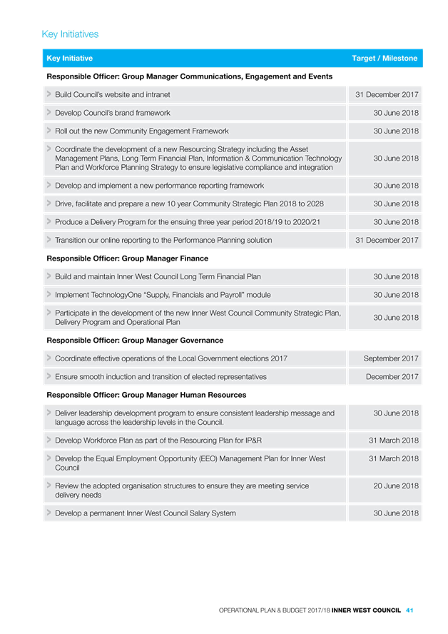
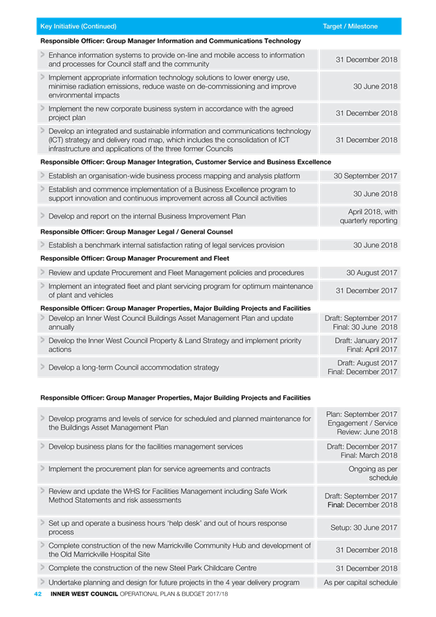
Subject: Minutes of the Implmentation Advisory Group (IAG) Meeting held 8 June 2017 and Minutes of the Local Representation Advisory Committee (LRAC) Meeting held 13 June 2017
File Ref: 17/4718/53845.17
Prepared By: Jennifer Anderson - Governance Officer
Authorised By: Tanya Whitmarsh - Group Manager Governance
|
SUMMARY To present the Minutes of the Implementation Advisory Group (IAG) Meeting held on 8 June 2017 and the Local Representation Advisory Committee (LRAC) Meeting held 13 June 2017.
|
|
RECOMMENDATION
THAT:
1. the Minutes of the IAG Meeting held on 08 June 2017 be noted; and 2. the Minutes of the LRAC Meeting held on 13 June 2017 be noted.
|
BACKGROUND
The Implementation Advisory Group Meeting was held on 08 June 2017. The minutes of the meeting are shown as (Attachment 1).
The Local Representation Advisory Committee Meeting was held on 13 June 2017. The minutes of the meeting are shown as (Attachment 2).
FINANCIAL IMPLICATIONS
N/a.
OTHER STAFF COMMENTS
N/a.
PUBLIC CONSULTATION
N/a.
|
1.⇩ |
Minutes of IAG Meeting held on 8 June 2017 |
|
2.⇩ |
Minutes of LRAC Meeting held on 13 June 2017 |
|
Council Meeting 27 June 2017 |
Subject: WestConnex Update Report: Stage 3 Assessment; Local Area Traffic Improvement Strategy; and support for Community Advocacy
File Ref: 16/6107/69443.17
Prepared By: Kendall Banfield - Manager WestConnex Unit
Authorised By: Simon Manoski - Group Manager Strategic Planning
|
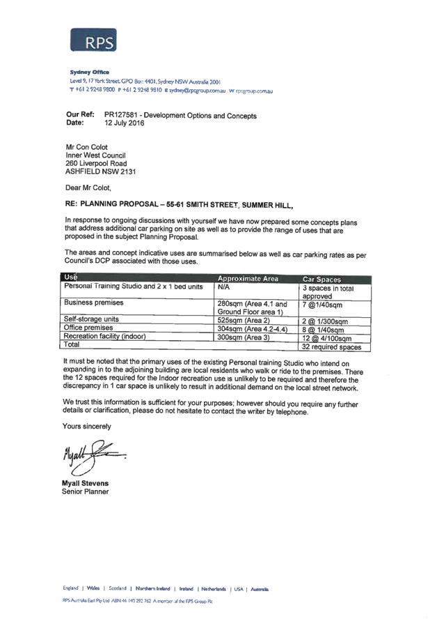
SUMMARY This report discusses three WestConnex items. The first is progress on Council’s assessment of the Stage 3 (M4-M5 Link) Concept Design, the second is progress of Council’s Local Area Traffic Improvement Strategy whilst the third is Council’s support for two local WestConnex advocacy groups to host events in June and July 2017. It is recommended in this report that Council makes a modest financial and in-kind contribution toward both events as part of its continued support for community WestConnex advocacy. . |
|
RECOMMENDATION
THAT Council: 1. receives and notes this report; 2. makes a financial and in-kind contribution to a total value of $750 toward curating costs to the organisers of the DisConnex: Reframing Resistance art exhibition; and 3. makes a financial and in-kind contribution to a total value of $300 to Newtown Residents Against WestConnex (NRAW) for a WestConnex protest event at Camperdown Park.
|
BACKGROUND
Item 1: Council’s assessment of the Stage 3 Concept Design
Progress on this item was included in the 13 June 2017 WestConnex Update Report to Council’s Local Representation Advisory Committee (LRAC). To assist the drafting of Council’s submission on the WestConnex Stage 3 (M4-M5 Link) Concept Design, Council’s WestConnex Unit undertook a competitive Request for Quote (RFQ) process and has selected mid-sized planning/engineering consultancy Beca to assist with the drafting of its submission.
Beca’s assessment of the Concept Design (now underway) will integrate comments from specialist Council staff, as well as any issues that are raised with Council by the community. A similar process will be undertaken to select a consultant and prepare Council’s submission when the EIS exhibition commences – expected at the end of August or early September 2017.
It is planned that an initial draft submission is reported to the 11 July 2017 LRAC meeting, a final draft submission reported to the 25 July 2017 Council meeting and the final submission lodged with Sydney Motorway Corporation (SMC) before the 4 August 2017 close date. Note that SMC had previously not set a close date, but has recently announced this 4 August close date.
A significant Stage 3 issue is the location of mid-tunnel construction dive sites and their impacts. For the dive-site in the Leichhardt/Lilyfield area, the Concept Design states that SMC is considering the 7 Darley Road site, but is also investigating the Rozelle Rail Yards (RRY) (western end) as an alternative. For some months, Council has been advocating the RRY site as a potential lower-impact alternative to Darley Road, and has written to SMC and the Minister for WestConnex several times on this matter. The Concept Design exhibition has not only raised content issues for Council, but also process issues. Council has written to the Minister for WestConnex about these issues.
Item 2: Council’s Local Area Traffic Improvement Strategy
Progress on this item was included in the 13 June 2017 WestConnex Update Report to LRAC. It was reported then that it has taken some time for Council staff to identify a consultant with a traffic modeling capability suitable for this project. It was determined that one consultant has that capability – Veitch Lister Consulting (VLC). Accordingly Council had resolved in April 2017 to allow the General Manager (in accordance with relevant provisions of the Local Government Act) to negotiate directly with VLC provide a quote for use of its Zenith model to determine the traffic impact of WestConnex on local roads, based on RMS modeling data for main roads. VLC has provided a quote, which Council has accepted, and the modelling work is now underway.
It was previously reported that that VLC is involved in a modeling project with a firm related to WestConnex. To avoid any potential conflict-of-interest, Council and VLC agreed that Council will commission a third-party traffic consultant to peer review VLC’s modeling results. The third-party consultant will also use the modeling results to shortlist local roads to be treated with Local Area Traffic Management (LATM) schemes. This consultant will also undertake the LATM scheme design work. Council staff issued a RFQ for the third-party consultant and have selected Beca as the preferred consultant. A meeting between VLC, Beca, Roads & Maritime Services (RMS) and Council staff was recently held to commence the project.
Consistent with Council’s brief, the VLC quote proposes to model the following scenarios:
· base case 2011;
· base case 2021;
· project case 2021 – WestConnex Stages 1 & 2;
· project case 2031 – WestConnex Stages 1 & 2; and
· project case 2031 – WestConnex Stages 1, 2 & 3.
Also consistent with Council’s brief, key outputs from the modeling would be volume capacity ratios for local roads, levels of service, average travel speeds and delay estimates. Further progress reports on this project will be provided to the July 2017 LRAC and Council meetings.
Item 3: Council support for community advocacy
This report relates to requests by two community advocates for a contribution toward WestConnex-related community events.
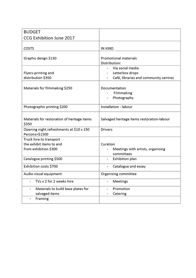
The first is a request is from a Haberfield resident and member of Council’s WestConnex Community Liaison Forum (WCLF) for a $500 contribution toward a multimedia art exhibition called DisConnex: Reframing Resistance which “.. seeks to explore the creative means being developed by artists resisting WestConnex destruction and to imagine a more equitable city and community.” The exhibition will be held in Council’s Chrissie Cotter Gallery (CCG) at Camperdown from 27 June to 9 July 2017. Further details of the exhibition and costs are in a funding request letter from the Haberfield resident to Council’s Administrator at ATTACHMENT 1 and in Council’s 9 June 2017 media release about this exhibition available on Council’s website.
Although in the letter $3,000 has been requested, Council staff have been recently advised by e-mail that the request has been revised and is now $500. The e-mail states: “We have revised our funding request to cover expenses for printing and transportation of exhibit items, including salvaged items, estimated to be a total of $500.” In addition to this financial contribution, it is recommended that an in-kind contribution also be made toward exhibition costs in the form of bottled wine leftover from a prior Council event, worth approximately $250.
The second is a request from a Newtown resident and member of Newtown Residents Against WestConnex (NRAW) for a Council contribution toward a barbeque at the conclusion of an anti-WestConnex lantern procession. Although an NRAW representative has made this request, the event is being organised by coalition of local WestConnex advocacy groups. It is planned the procession would follow the route of the Stage 3 tunnel beneath Newtown and Camperdown and would conclude in Camperdown Park between 6:30pm and 7:30pm pm on Saturday 22 July 2017. The NRAW representative made this request at the 1 June 2017 WCLF meeting and it has been noted as an action item in the meeting minutes.
Council does not have an events team to facilitate this type of function, but it does offer use of a Council barbeque as part of its street party support program, which can be booked through Council’s website. Council will deliver and collect the barbeque free of charge. Under normal circumstances, the community group would need to purchase the food and supply labour, but in this case it is recommended that Council makes a modest financial contribution of $300 toward food. All labour and any additional costs and other equipment (such as lighting) would need to be supplied by NRAW. NRAW would also need to obtain any necessary approvals from the Police for the lantern procession.
Council’s parks managers have advised although Camperdown Park hosts daytime weekend sporting activities, these will have concluded before the NRAW evening event. The space adjacent to the rotunda within the park is available, but it would need to be booked by NRAW. As this is a not-for-profit event, there would be no charge for use of the space.
Due to the timing of these events, it is not appropriate that these requests for financial and in-kind support be considered through Council’s Community Grants Program. It is recommended that that Council agree to these requests as part of its continued support for WestConnex-related community advocacy.
FINANCIAL IMPLICATIONS
The in-kind contributions totaling $1,050 will be funded by existing budgets.
OTHER STAFF COMMENTS
This report includes input from relevant Council staff – in particular, Council’s finance staff.
PUBLIC CONSULTATION
Nil. There is no need for separate consultation on this report.
|
1.⇩ |
Letter from Haberfield resident and WCLF member to Council's Administrator requesting Council assistance for WestConnex-related art exhibition |
|
Council Meeting 27 June 2017 |
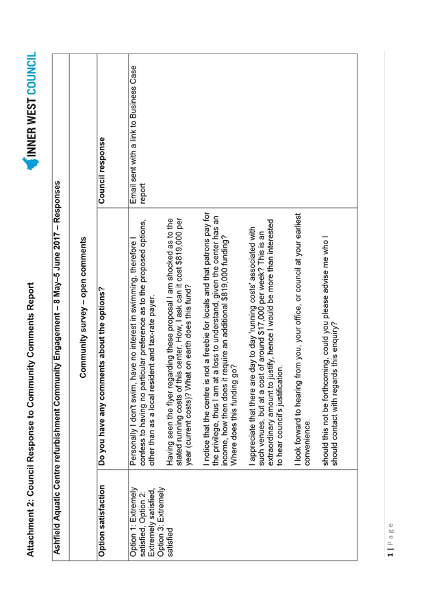
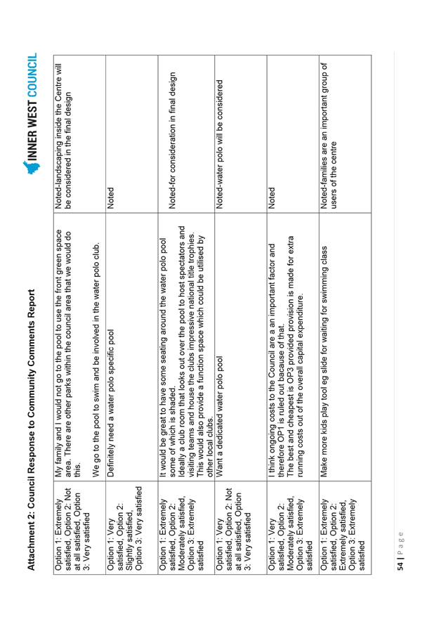
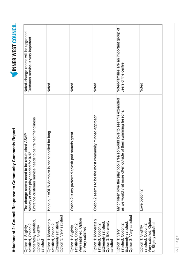
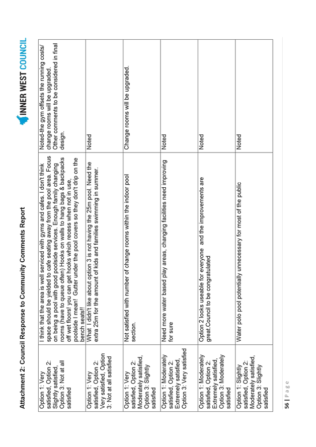
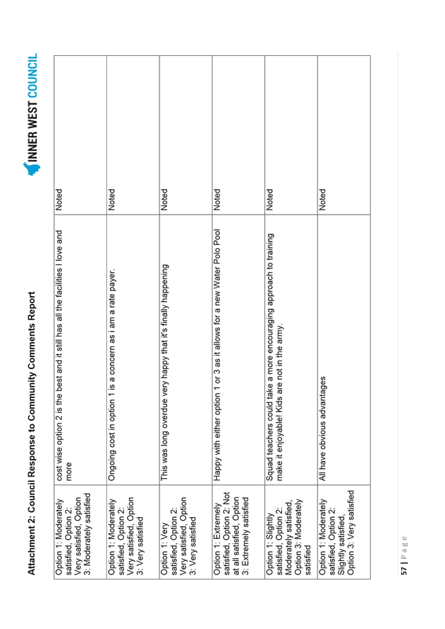
Subject: Ashfield Aquatic Centre Refurbishment - Project Update and Community Engagement Outcomes
File Ref: 16/6097/62100.17
Prepared By: Josephine Bennett - Group Manager Recreation and Aquatics
Authorised By: John Warburton - Deputy General Manager Community and Engagement
|
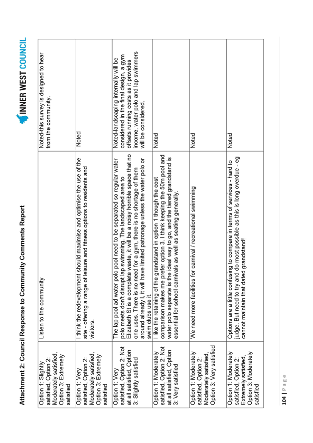
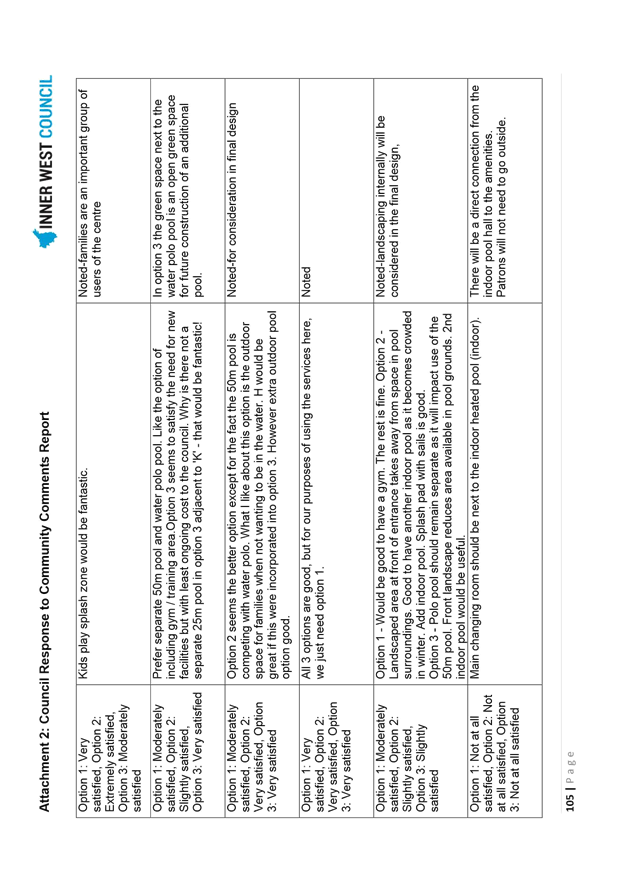
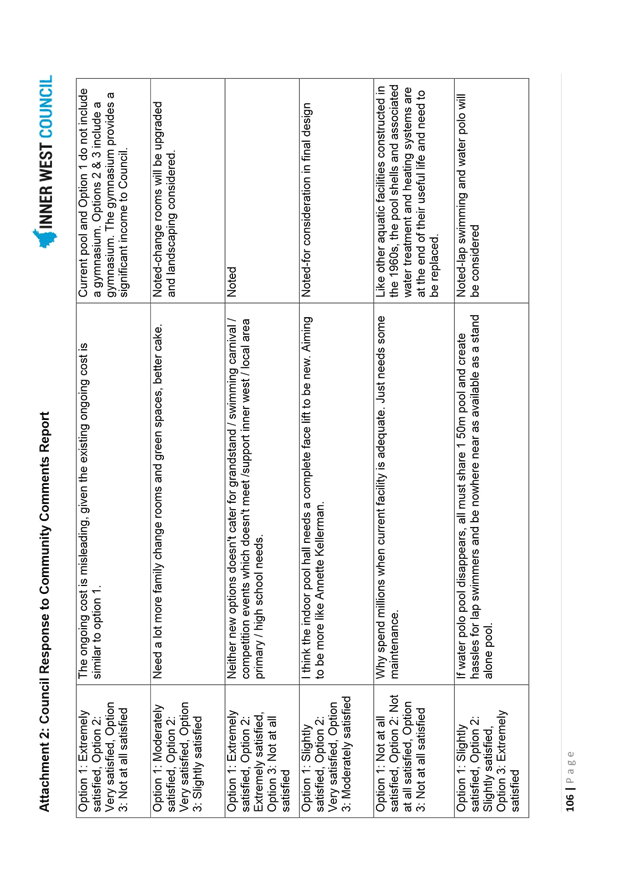
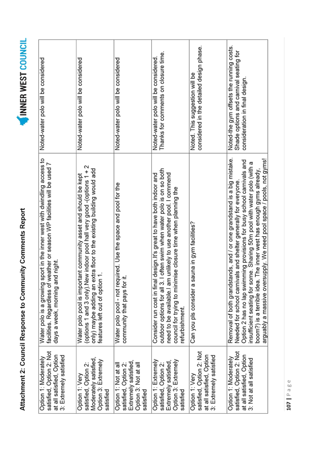
SUMMARY This report provides an update on the Ashfield Aquatic Centre refurbishment and presents the outcomes of community engagement conducted from 8 May to 5 June 2017. It considers the community benefit and needs as expressed in the feedback and recommends Council proceed with Concept Plan Option 3 with amendments, presented as the ‘Community Preferred Concept Design’ for detailed design development.
|
|
RECOMMENDATION
THAT:
1. Council endorse the Concept Plan Option 3 (Diagram 6) with the following amendments as detailed in the ‘Community Preferred Concept Design’ (Diagram 7): × inclusion of a combined splash-pad and shallow water pool suitable for young children; × inclusion of a 25 metre grandstand on the western side of the 50 metre pool; × inclusion of shade sails over the combined splash-pad and shallow water pool, grassed areas on the western side of the 50 metre pool and grassed area on the south-eastern corner of the site; × extension of the Bastable Street carpark, including demolition of the Bastable Street Hall and playground, single entry via Elizabeth Street and single exit onto Bastable Street; 2. all residents and stakeholders who made submissions during the community engagement be notified of Council’s decision; and 3. the project proceeds to detailed design based on ‘Community Preferred Concept Design’ (Diagram 7).
|
BACKGROUND
The Ashfield Aquatic Centre opened on 21 November 1962 and is one of the post 1954 Olympic Games collection of ‘municipal pools’ reaching the end of its asset life. In the 1990s, the grandstands were constructed on both sides of the 50m pool and the existing indoor 25m pool was constructed in 2002. No major works have been undertaken at the Centre since that project. Currently, the Centre has over 350,000 customers a year and hosts a highly successful swim school averaging 15,000 visits a month and is regularly used for school swimming carnivals and a range of water sports, in particular water polo.
1. Refurbishment Plans – former Ashfield Council
Council studies in 2007 identified the poor condition of the facility including the original pools and the Council considered a series of refurbishment options in 2009. In 2010, the Council received a detailed report from SGL Group titled Aquatic Centre Redevelopment Feasibility Study and resolved to take a staged approach to redeveloping the Centre based on two options that required community consultation (Diagram 1 and Diagram 2).
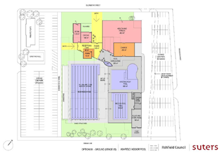
Diagram 1: Option 1 – including an 850m2 Health and Fitness Centre on ground level
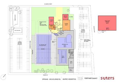
Diagram 2: Option 2 – including an 850m2 Health and Fitness Centre on Level 1
In July 2011, the project was deferred until the completion of the Ashfield Civic Centre redevelopment. In 2013, a further study was completed by Jeff Roorda and Associates, which found that the current Centre was at the end of its useful life and was a high priority for the local community. The report recommended a range of options for refurbishment. In November 2013, the Council resolved to progress work towards a Special Rate Variation (SRV) for infrastructure renewal including the redevelopment of the Ashfield Aquatic Centre. In August 2014, the Council undertook initial community consultation regarding the proposed SRV, including a range of options for refurbishing the Centre. The Council resolved at its meeting of 25 November 2014 to proceed with the SRV application for a $14 million partial upgrade of the Ashfield Aquatic Centre based on Option 3 (Diagram 3). The SRV application was lodged in February 2015 and approved in May 2015.
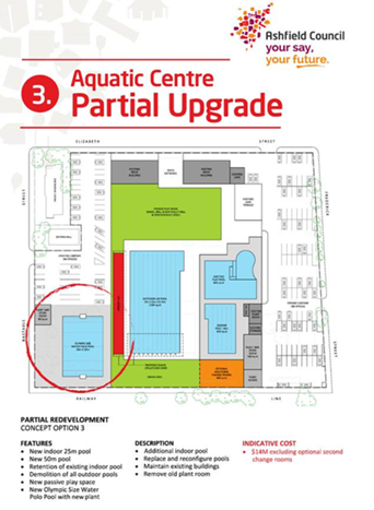
Diagram 3: Option 3 – Partial Upgrade of Ashfield Aquatic Centre
In April 2016, the project costs were estimated at $20 million and Council advertised for expressions of interest for the redevelopment. Four companies were invited to proceed to select tender.
2. Refurbishment Plans – Inner West Council
In May 2016 Inner West Council was formed through the amalgamation of Ashfield, Leichhardt and Marrickville councils. West Council sought select tenders for the refurbishment of the Centre in late 2016 but only received a single non-conforming tender which was $6 million over the estimated $20 million cost of the project. Consequently, the project was deferred and reviewed, specifically in regard to the concept design, budget, business modeling and project program, with view to best meeting the needs of the new Inner West community. An internal Inner West Council Ashfield Aquatic Centre Project Control Group (AAC PCG) was established for this purpose.
New concept designs, business case and project program were developed and discussed with the Local Representation Advisory Committee at its April 2017 meeting. The new project program comprises:
× Community engagement to seek feedback on the new proposed concept designs during May / June 2017;
× Confirmation of new design concept at the 27 June 2017 Council Meeting;
× Appointment of a new consultant team by July 2017;
× Detailed design development in September 2017;
× New development application or Section 96 prepared by September 2017;
× New tender documentation prepared by December 2017;
× New construction contract awarded by end March 2018;
× Construction commences in early May 2018;
× Construction completed by June 2019; and
× Refurbished Centre opens in October 2019.
As part of the project review, a number of maintenance items were identified and will be monitored until refurbishment including the following:
× pool hall mechanical system;
× service tunnel;
× heat exchanger ; and
× pool tiles.
The AAC PCG also reviewed the project vision and objectives, with the vision articulated as:
Ashfield Aquatic Centre will provide a beautiful, designed experience for the whole community to enjoy. By providing a contemporary mix of spaces and facilities, the Centre will be the go-to place for the local community. From families relaxing and kids playing to dedicated athletes and locals improving their health and fitness, the Ashfield Aquatic Centre will be a place for wellbeing, belonging and community.
The revised project objectives comprise the following:
× create a whole-of-community centre that supports a vibrant community life by providing spaces for social interaction, relaxation and health and fitness;
× support diverse health and wellbeing needs from infancy to older years;
× accessible / inclusive facility meeting the needs of locals with a range of abilities;
× high quality design providing a wonderful architectural and landscape experience, connecting indoors through to outdoors;
× well located amenities including family change rooms;
× enhanced public domain and improved entrance for ease and efficiency on arrival;
× integrated public art contributing to community pride and belonging;
× designed with safety in mind;
× innovative solutions promoting energy and water efficiency; and
× affordable for residents and financially sustainable for Council.
The project review has also included:
× Business case – C Leisure was engaged to prepare a business case to inform the review of the concept design and to better understand desired operational outcomes. Ashfield Aquatic Centre Redevelopment Options - Business Case considered industry trends, contemporary management and operational forecasts for a range of options. This was included as part of the community engagement materials and made available to the community on Your Say Inner West;
× Parking study – as required by the Development Consent for the tendered concept design, a new study was conducted by ARUP in February 2017 that found that there was sufficient parking capacity within the existing carparks and on-street parking to accommodate future parking demands generated by each of the new concept designs which included health and fitness facilities;
× Heating and energy review – the new consultant team will be required to investigate a range of heating and energy options to ensure the Centre can operate effectively and flexibly with changing markets and technologies. A similar system installed at the Fanny Durack Aquatic Centre is performing well;
× Geotechnical and contamination investigations - further works are underway and will be submitted as part of the future development application and tender documents;
× Acoustic impacts – the new consultant team will review the existing study in line with the selected concept design;
× Review of the existing pool hall structure to ensure compliance with Section J of the Building Code of Australia (BCA) – a structural integrity audit will be completed by the new consultant team for the future upgrade. This will enable the upgrade works when undertaken to be integrated in the redevelopment works. Some of the works such as opening the existing pool hall onto the new external apron and linking the hall to the new entrance and amenities will be undertaken as part of the refurbishment works. It should be noted that a new Development Consent or Construction Certificate may impose a condition on the redevelopment that the existing pool hall comply with current BCA standards. Contingency provisions will be made;
× Railway embankment investigation – a geotechnical engineer has completed additional studies and has advised the grass mound at the southern end of the site is made of fill sand, is not part of the railway embankment, and is unlikely to cause problems for the redevelopment works;
× Construction of a bridge over the storm water channel – officers will contact Sydney Water regarding necessary permissions;
× Bastable Street Hall –geotechnical, contamination and hazardous materials reports are to be completed to inform plans for demolition;
× Consolidation of lots – as required by the Development Consent, a surveyor will be engaged to commence the consolidation process;
× Procurement model – the AAC PCG sought advice from Council’s General Counsel and it was agreed that separate design and construction contracts were preferable in providing Council greater project management control; and
× Consideration of timing – staff considered the closure period of the AAC and impacts on the Leichhardt Park Aquatic Centre (LPAC) master planning process and community access to aquatic facilities. It was agreed that the timing of LPAC master planning process and ensuing works would be deferred to allow the Centre to remain open while the AAC was refurbished.
3. Development Consent
At its 16 March 2017 meeting, the Central Sydney Planning Panel issued a Development Consent for the tendered design concept (Diagram 4). Particular conditions placed on the project require specific works, including:
× conversion of the western picnic area to car parking;
× further study re reduction of storm water flows with no adverse effects off-site;
× incorporation of an on-site storm water detention system;
× report on water sensitive urban design measures;
× floor levels to be above 1 in 100 year flood level plus 500mm freeboard;
× storm water harvesting;
× 6 motorcycle parking spaces;
× increase accessible parking spaces from 5 to 7;
× public domain works;
× electrolysis impacts from railway resolved;
× waste management further developed;
× landscaping; and
× incorporation of public art.
These conditions will be incorporated in the specification of works for the new consultant team.
4. Concept Designs
The AAC PCG reviewed the Ashfield Aquatic Centre Redevelopment Options - Business Case and agreed that community feedback would be sought on three concept designs – the tendered option and two new concept designs.
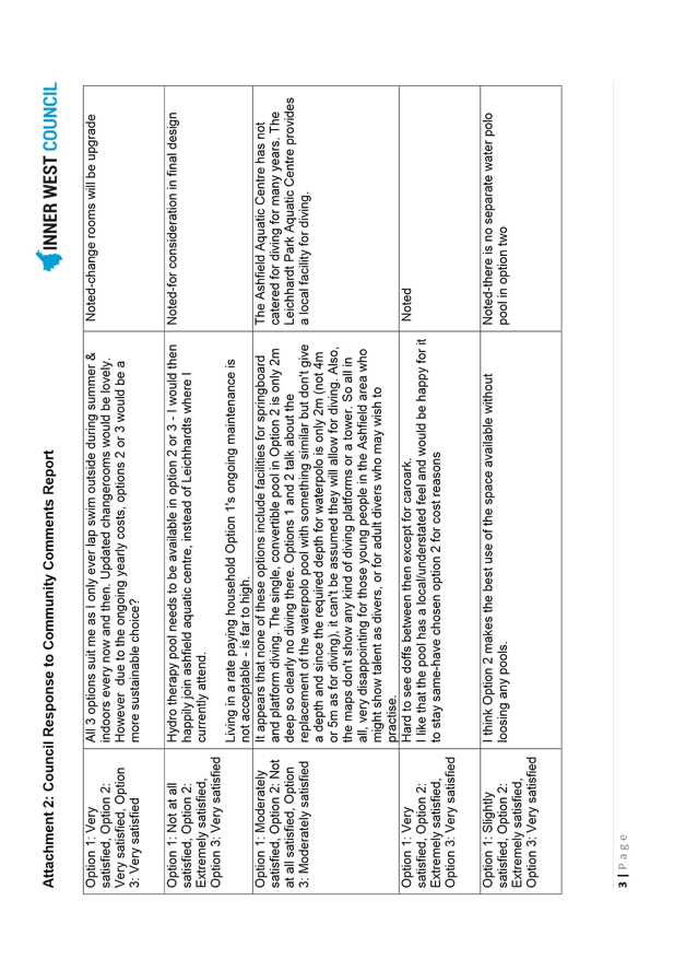
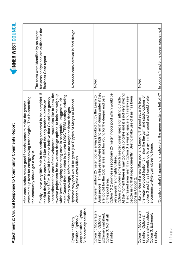
Concept Design Option 1 (image below) includes the following features:
× Refurbished entrance building;
× Refurbished café;
× Refurbished change rooms;
× New eight lane 50m pool replacing the existing 50m pool;
× New water polo pool replacing the existing water polo pool;
× New indoor 25m pool and pool hall, adjoining the existing pool hall;
× Existing grandstand and indoor pool hall maintained in current condition;
× Refurbished administration area;
× Additional car parking included; and
× Activities in existing community hall transferred to the new crèche and meeting room.
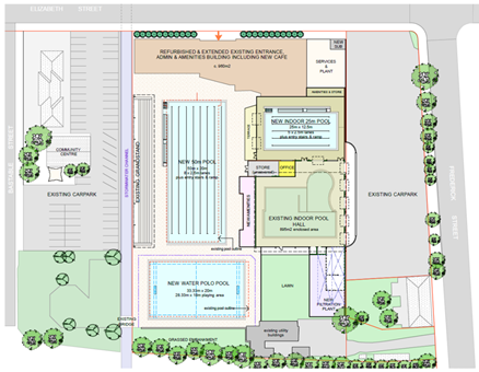
Diagram 4: Concept Design – Option 1 (Tender Scheme)
Concept Design Option 2 (image below) includes the following features:
× New entrance building setback from Elizabeth Street;
× New landscaped public area on Elizabeth Street;
× New café serving the Centre and new public area on Elizabeth Street;
× New crèche and meeting room;
× New amenities, including family change rooms;
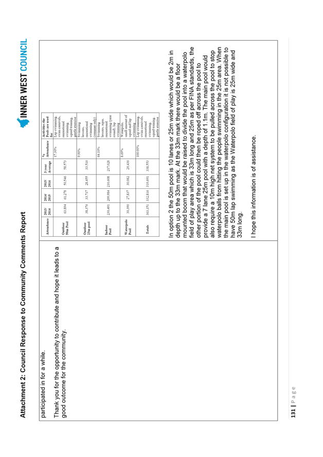
× Existing 50m and water polo pools replaced with a new 2m deep, 10 lane 50m pool with operable boom gate, suitable for water polo and swimming;
× New indoor 25m pool and pool hall, adjoining the existing pool hall;
× Existing indoor pool hall maintained in current condition;
× Level decks between pools for accessibility;
× New 1,000m2 health and fitness facility, including gym and studios, on level one of the new entrance building;
× New splash pad with shade sails;
× New outdoor green space with shade sails, BBQ area and seating;
× New administration area;
× New plant and equipment;
× Additional car parking; and
× Activities in existing community hall transferred to the new crèche and meeting room.
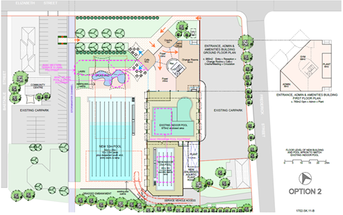
Diagram 5: Concept Design – Option 2
Concept Design Option 3 (image below) includes the following features:
× New entrance building setback from Elizabeth Street;
× New landscaped public area on Elizabeth Street;
× New café serving the Centre and new public area on Elizabeth Street;
× New crèche and meeting room;
× New amenities, including family change rooms;
× New 1,000m2 health and fitness facilities, including gym and studios, on level one of the new entrance building;
× New eight lane 50m pool replacing the existing 50m pool;
× New water polo pool replacing the existing water polo pool;
× Existing indoor pool hall maintained in current condition;
× New administration area;
× New plant and equipment;
× Additional car parking; and
× Activities in existing community hall transferred to the new crèche and meeting room.
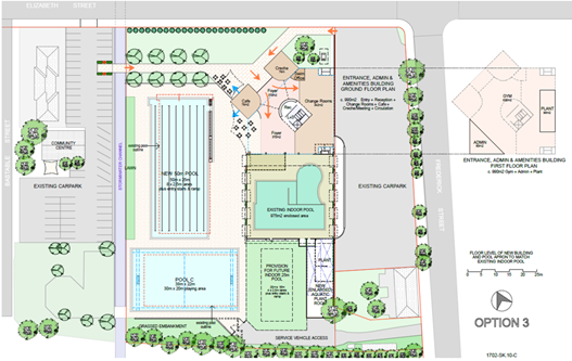
Diagram 6: Concept Design – Option 3
5. Community Preferred Concept Design
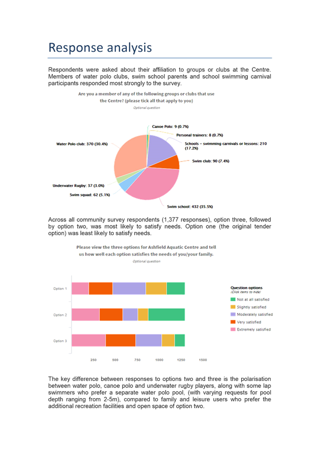
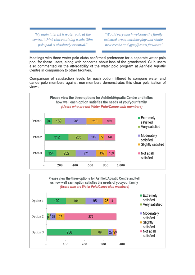
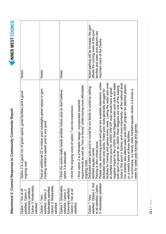
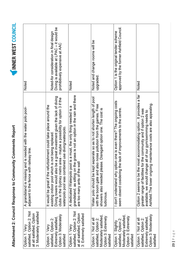
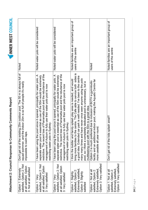
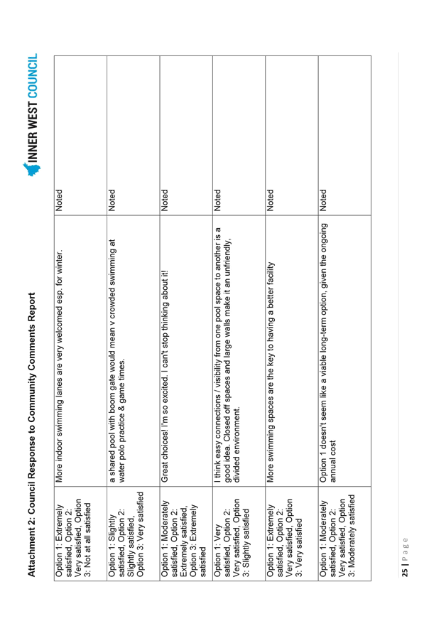
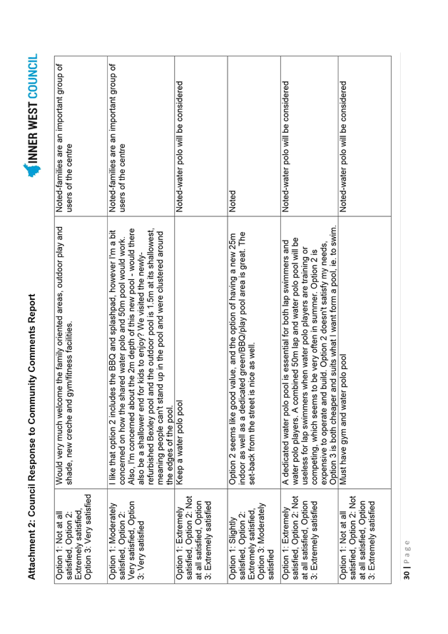
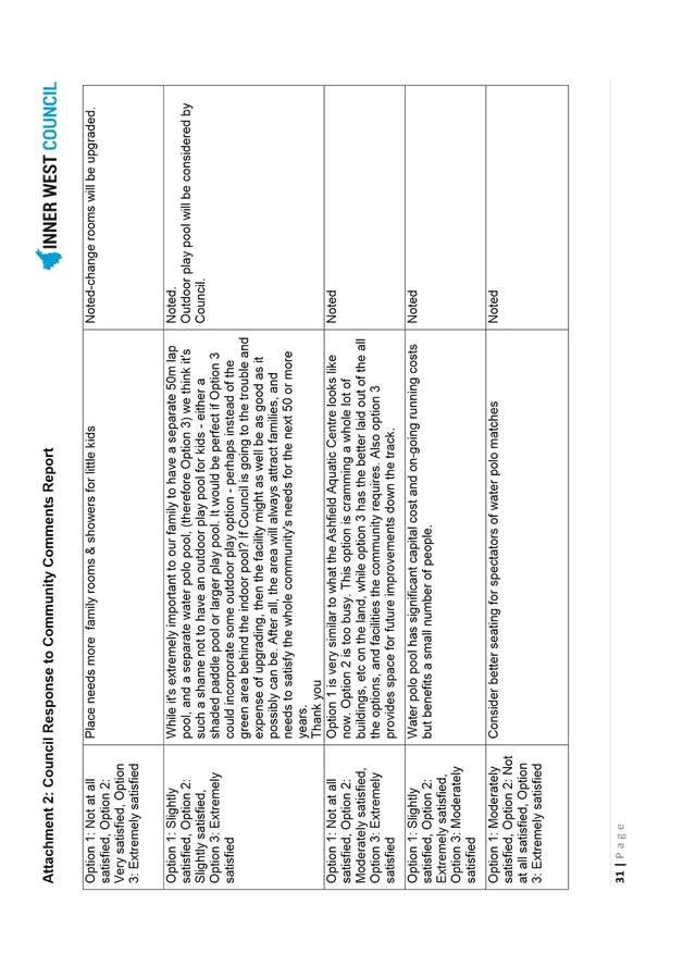
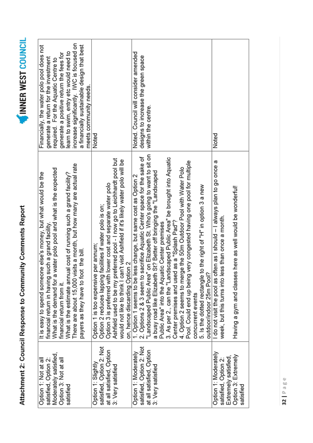
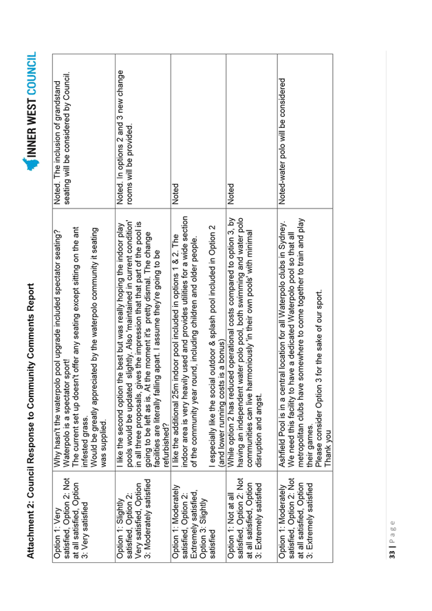
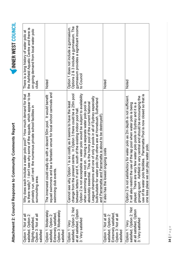
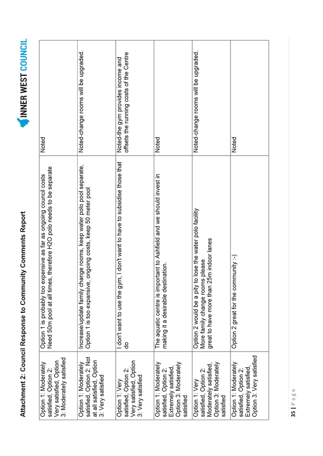
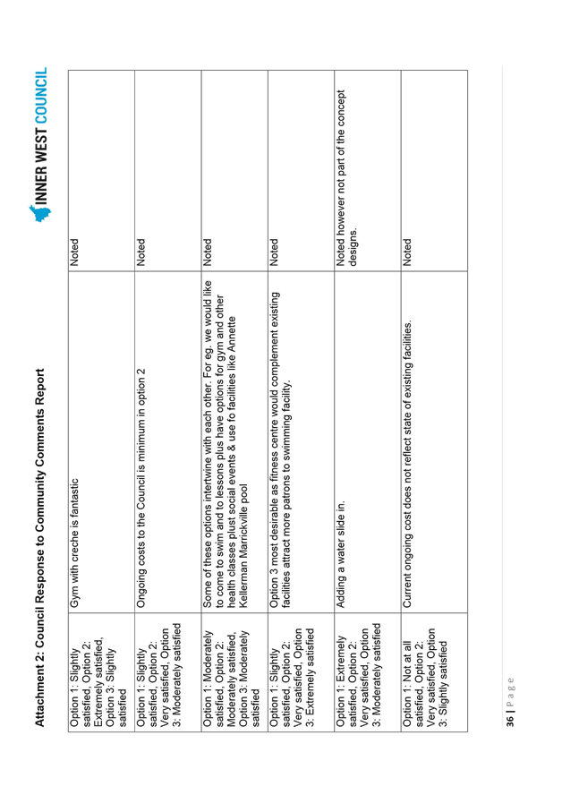
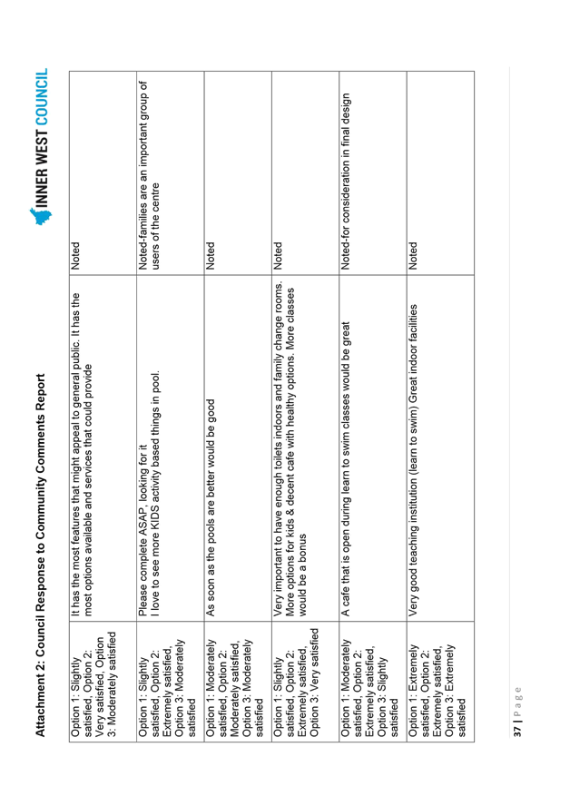
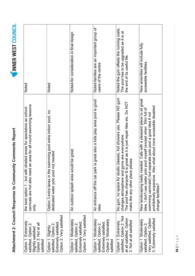
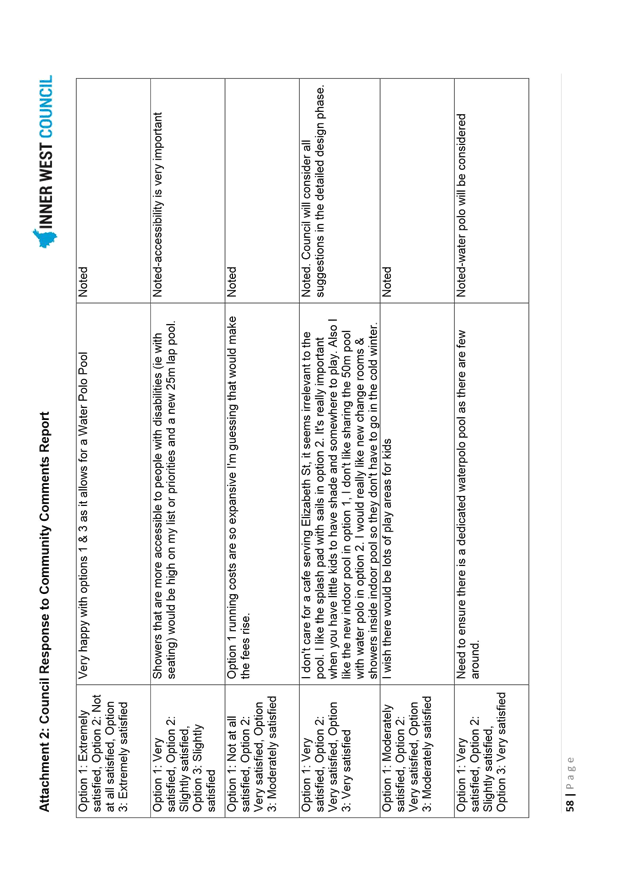
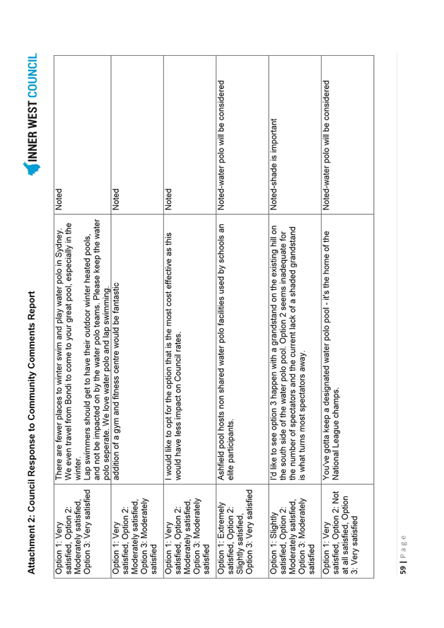
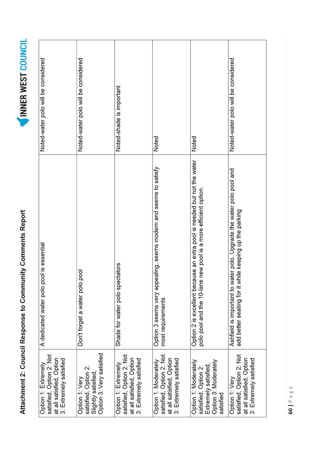
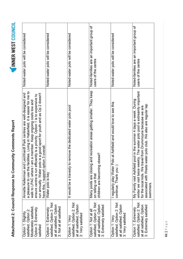
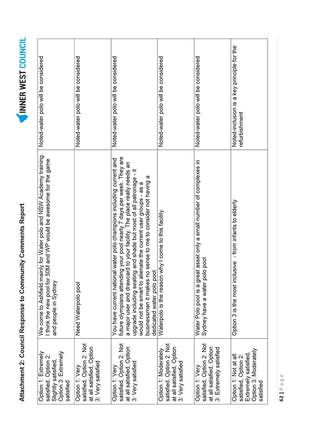
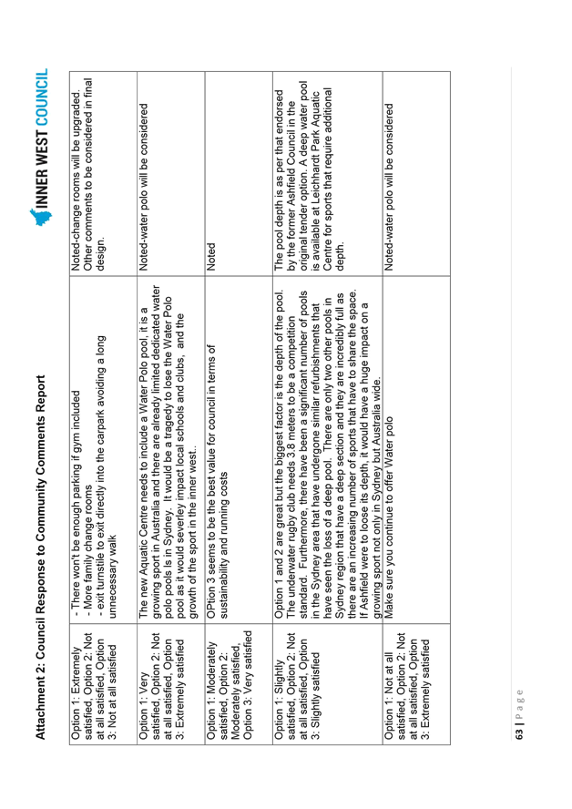
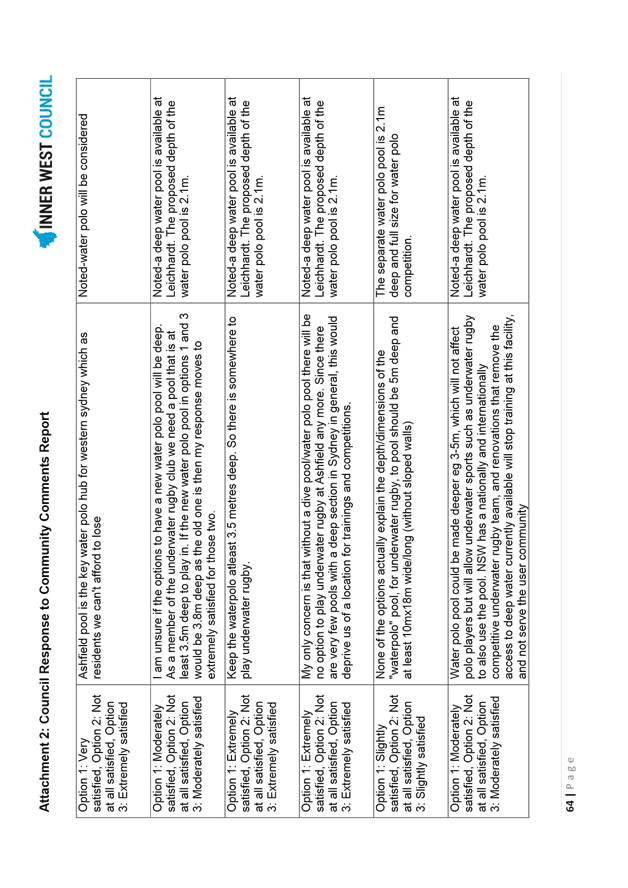
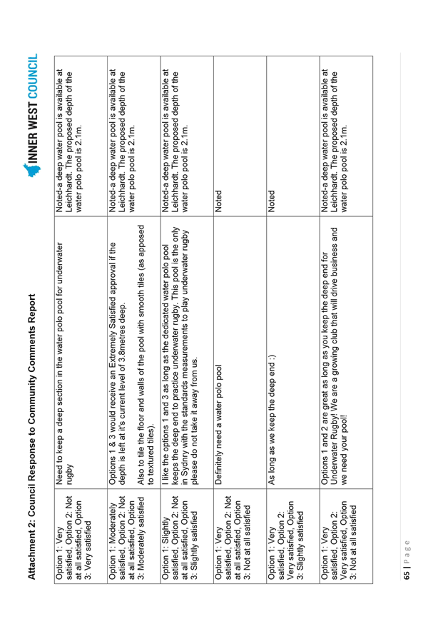
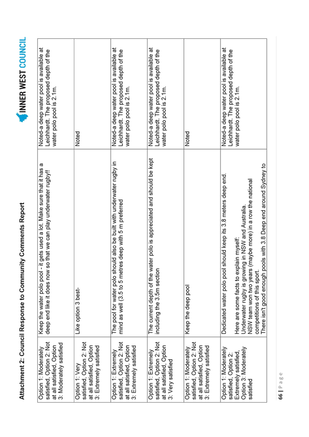
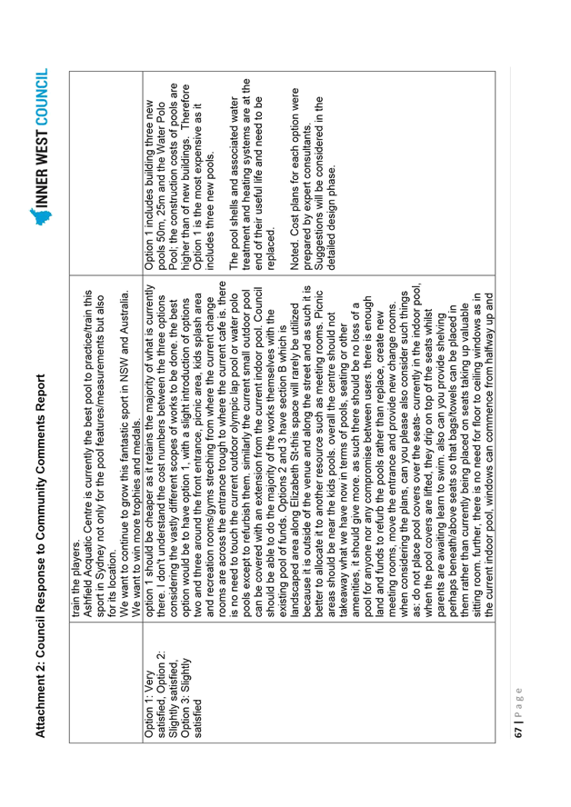
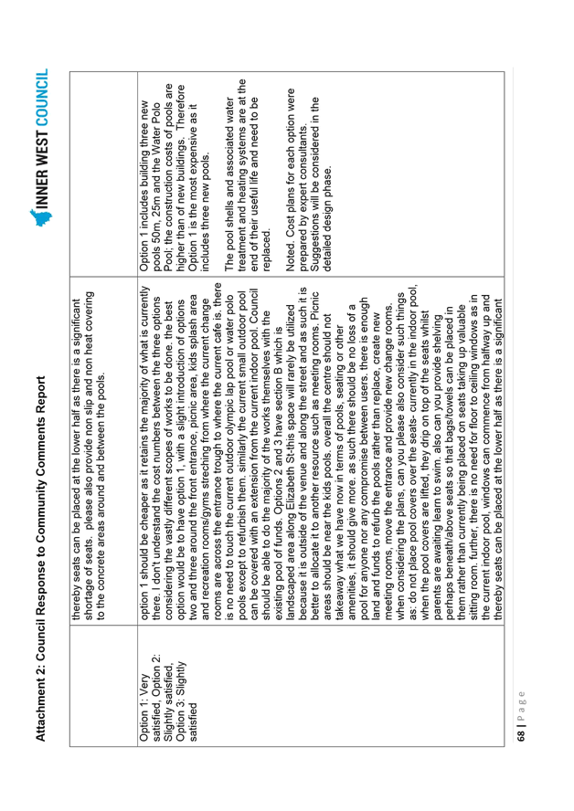
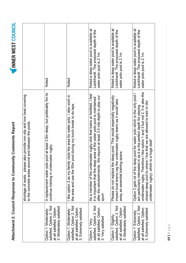
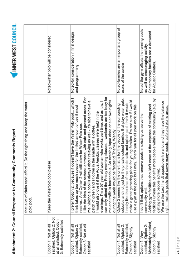
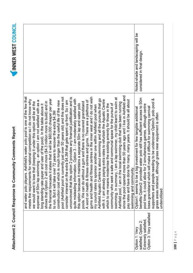
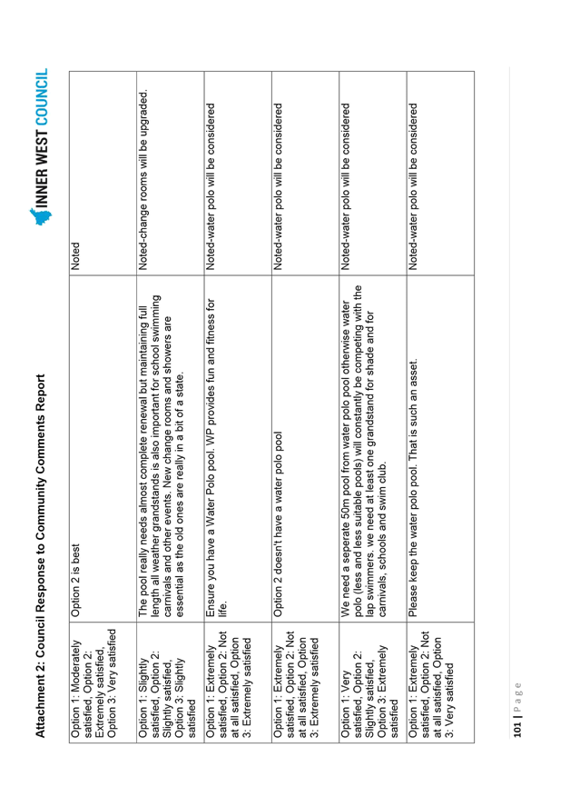
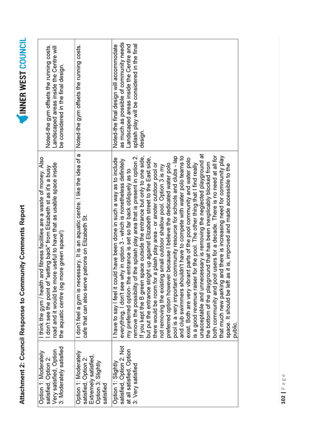
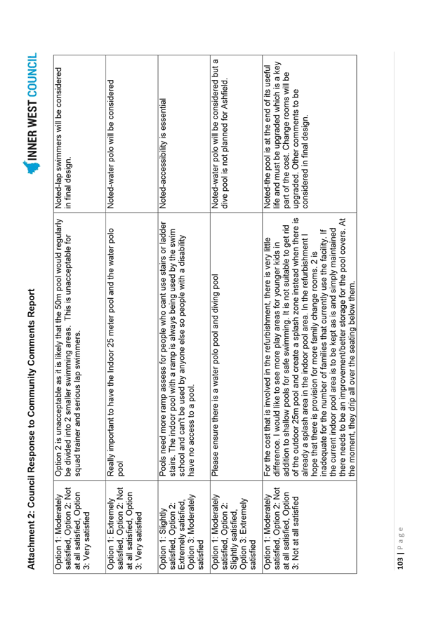
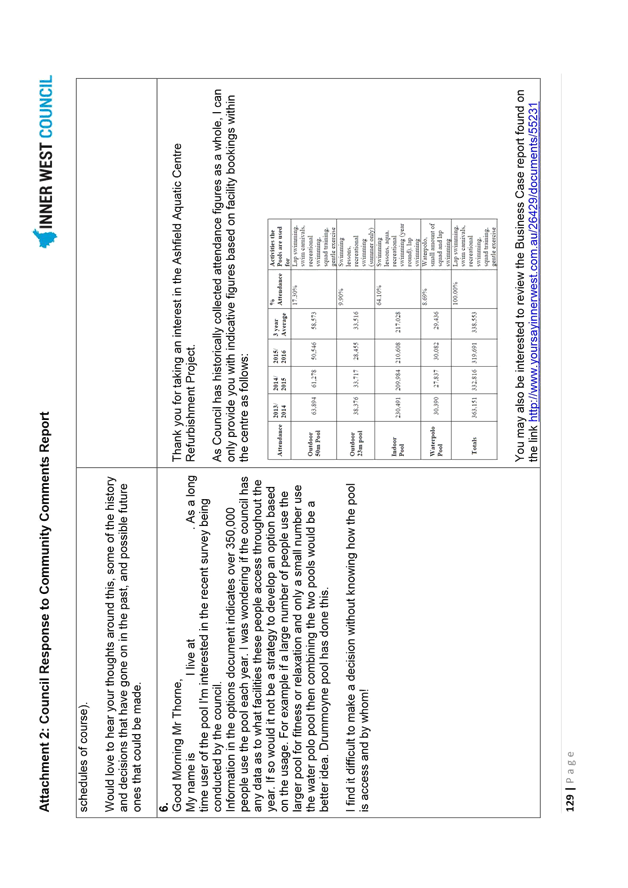
Community engagement on the three concept options is detailed in the Public Consultation section of this report, Ashfield Aquatic Centre Engagement Report (Attachment 1) and Ashfield Aquatic Centre Refurbishment – Council Response to Community Comments Report (Attachment 2). Analysis of community feedback revealed that Concept Design - Option 3 (Diagram 6), followed by Concept Design - Option 2 (Diagram 5), was most likely to satisfy needs. The original tender option, Concept Design – Option 1 (Diagram 4) was least likely to satisfy needs (Graph 1).
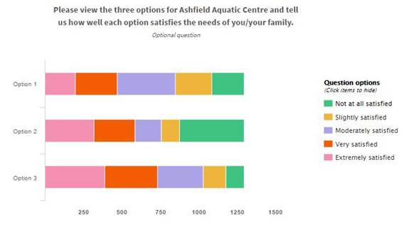
Graph 1: Community Satisfaction with Proposed Concept Designs
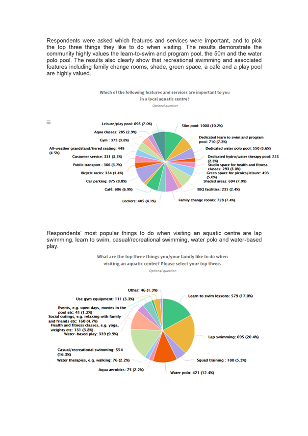
It was also evident in the results that there was some polarisation between the needs of the water sports Centre users who preferred as separate water polo pool and the family / leisure Centre users who prefer the additional recreation facilities, open space, shade and cafe. The results demonstrate the community highly values the learn-to-swim and program pool, the 50m and the water polo pool.
The results of the community engagement were reviewed by the AAC PCG on 7 June 2017 and it was agreed that an amended version of Option 3 was most likely to best meet the community’s needs now and into the future, while providing a providing a contemporary mix facilities that would enable a sustainable business model for Council.
The Community Preferred Concept Design is Option 3 with a number of amendments including:
× inclusion of a combined splash-pad and shallow water pool suitable for young children;
× inclusion of a 25 metre grandstand on the western side of the 50 metre pool;
× inclusion of shade sails over the combined splash-pad and shallow water pool, grassed areas on the western side of the 50 metre pool and grassed area on the south-eastern corner of the site; and
× extension of the Bastable Street carpark, including demolition of the Bastable Street Hall and playground, single entry via Elizabeth Street and single exit onto Bastable Street.
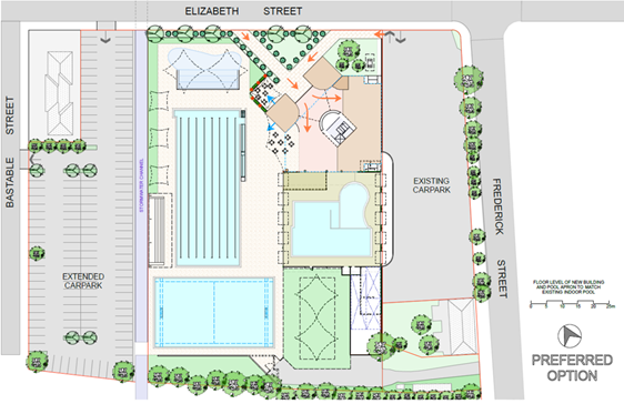
Diagram 7: Community Preferred Concept Design
FINANCIAL IMPLICATIONS
Group Manager Finance reports:
The total cost of capital works for the Ashfield Aquatic Centre refurbishment ($23.5 million) will be reflected in the 4 year capital budget. An adjustment is required to increase the existing budget allocation of $19.5 million by $4 million as an amendment to the 4 year capital works program tabled in the 2017/18 Operational Plan.
OTHER STAFF COMMENTS
The Group Manager Properties, Major Building Projects and Facilities; Group Manager Trees, Parks and Sports Fields, Executive Manager Major Projects; Ashfield Aquatic Centre Coordinator; and Communications and Engagement Coordinator were consulted in the development of this report.
PUBLIC CONSULTATION
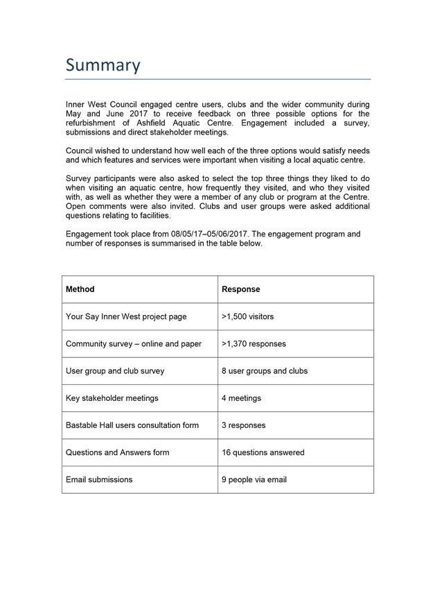
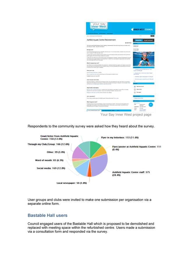
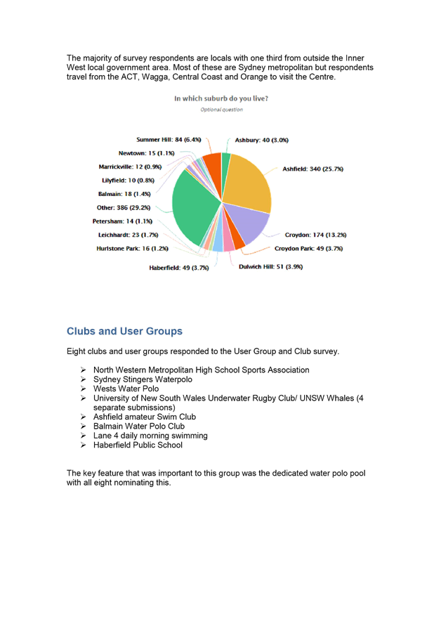
Community engagement was undertaken with Centre users and local community from 8 May to 5 June 2017 to receive feedback on the concept designs, how well each option would satisfy community needs and for Council to better understand which features and services are important. The engagement comprised the following:
× community survey, by face to face engagement in Centre and Your Say Inner West (1,377 responses);
× user group and club survey, by face to face engagement in Centre and Your Say Inner West (10 responses);
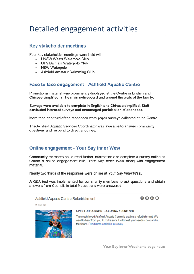
× key stakeholder meetings (4 meetings) – Balmain Water Polo Club, UNSW Wests Water Polo Club, Water Polo NSW and the Ashfield Amateur Swimming Club;
× Bastable Hall hirers consultation (3 conversations, written submissions and surveys);
× question and answers form (9 questions answered); and
× email submissions (9 emails).
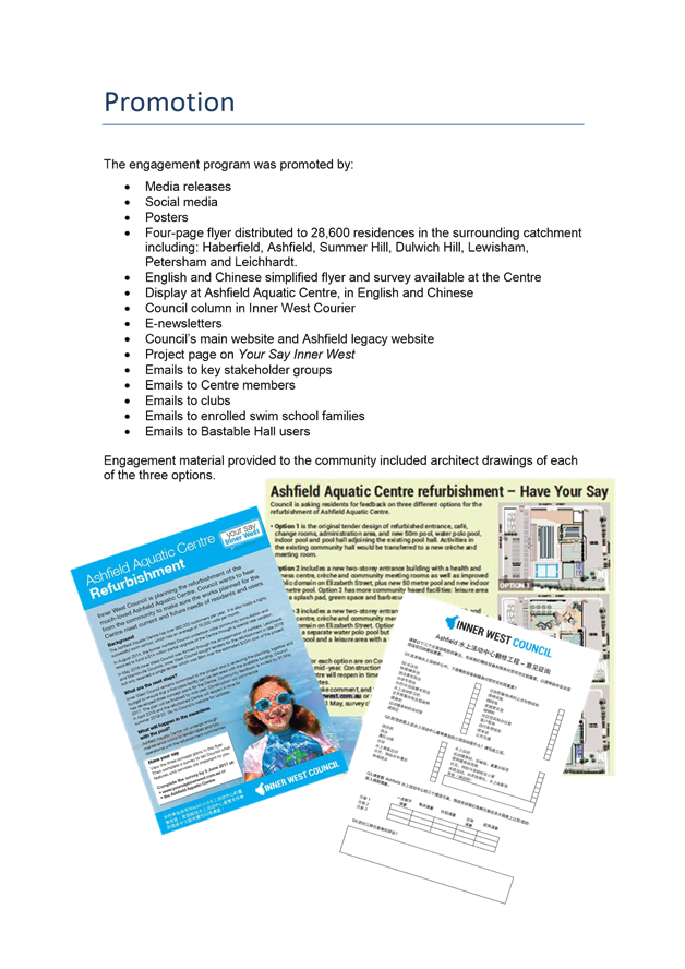
The community engagement period was promoted through the following means:
× media releases;
× social media;
× poster displays at the Centre and other key Council administration areas;
× flyer distribution to 28,600 residences in the surrounding catchment including: Haberfield, Ashfield, Summer Hill, Dulwich Hill, Lewisham, Petersham and Leichhardt;
× Council column in the Inner West Courier;
× e-newsletters;
× Council website;
× Your Say Inner West; and
× emails to all Centre members, key stakeholders, user groups, and hirers of the Bastable Street Hall.
Centre staff also directly engaged with Centre users throughout the engagement period to assist in the completion of surveys and raise awareness of the project.
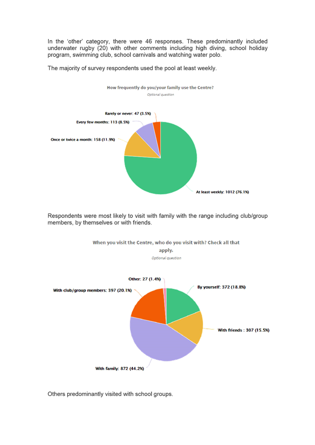
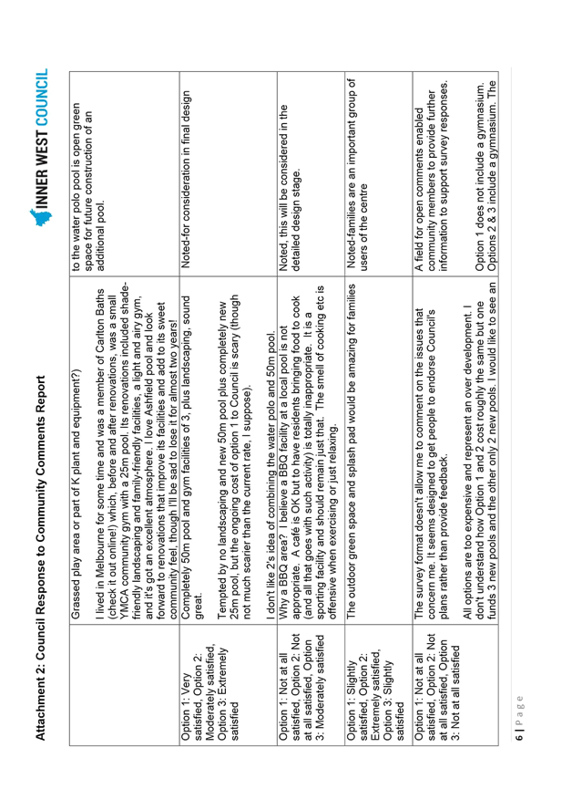
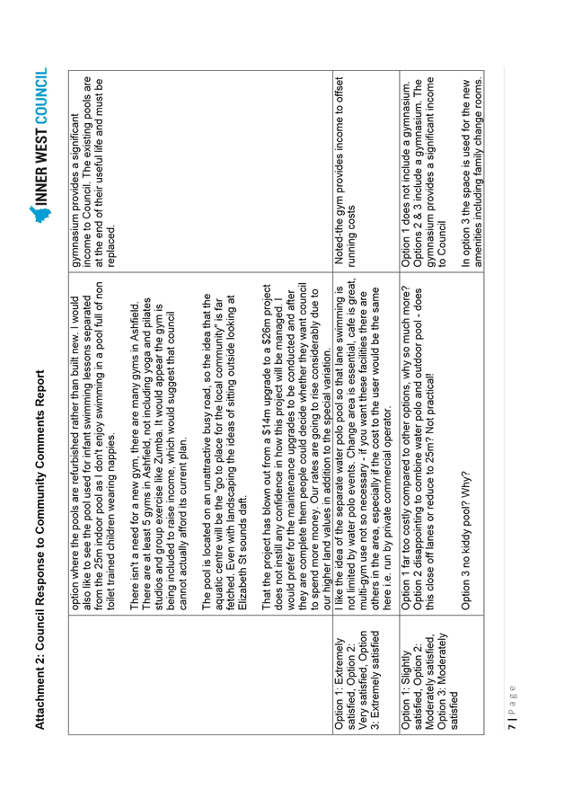
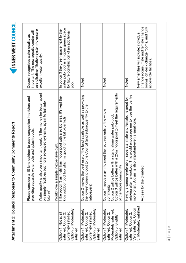
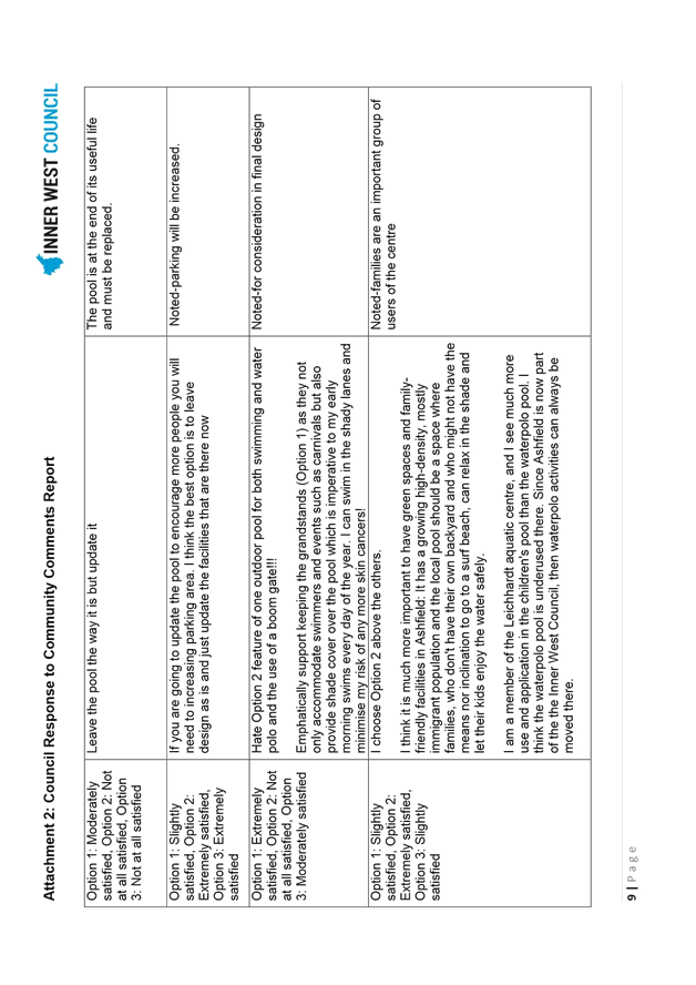
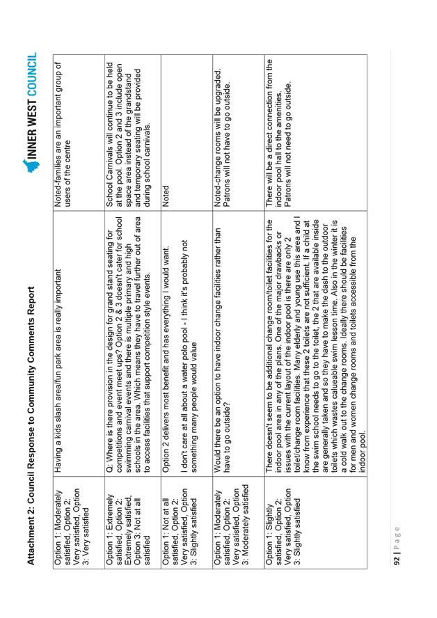
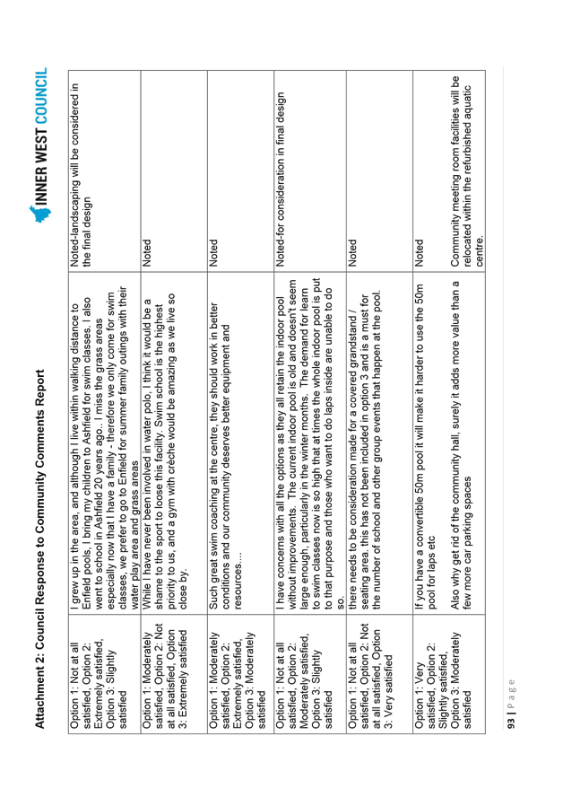
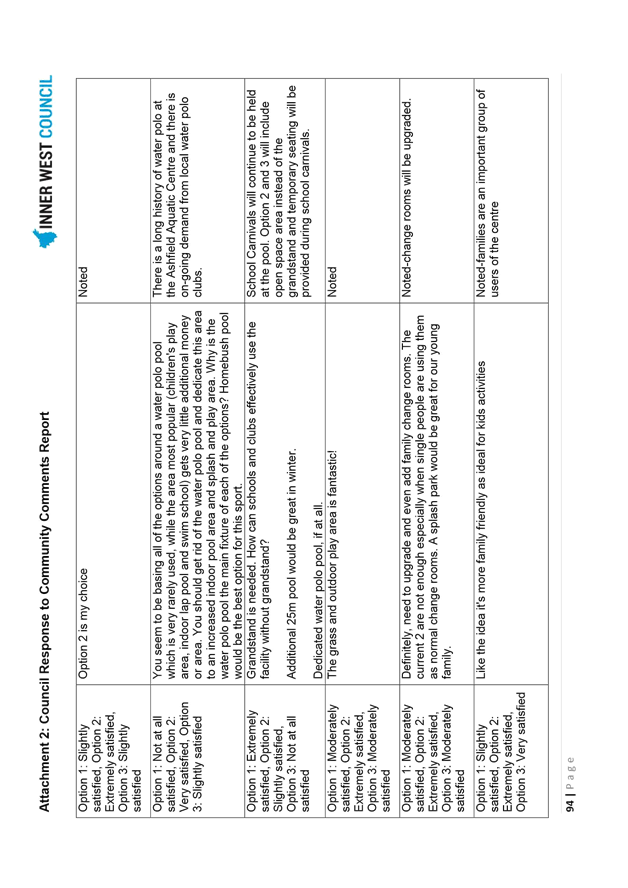
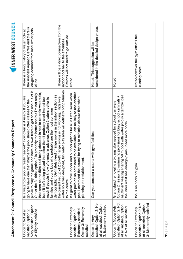
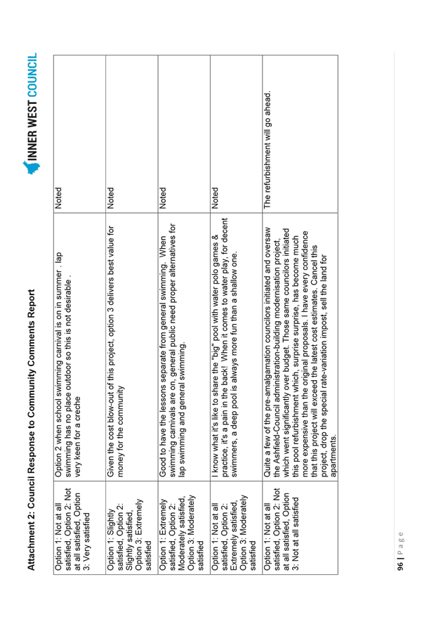
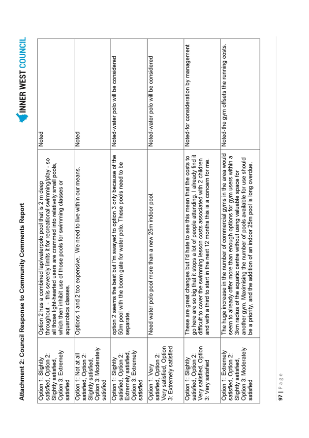
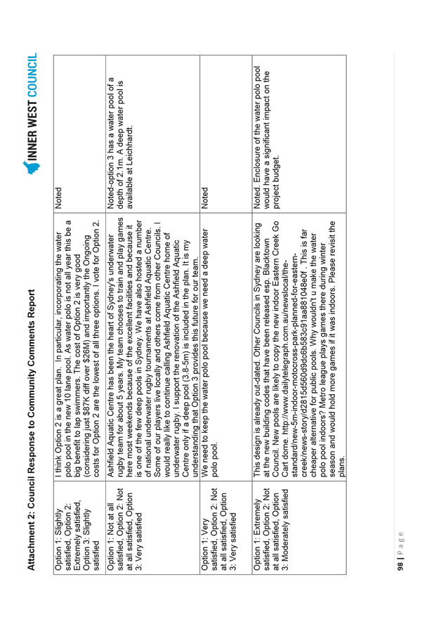
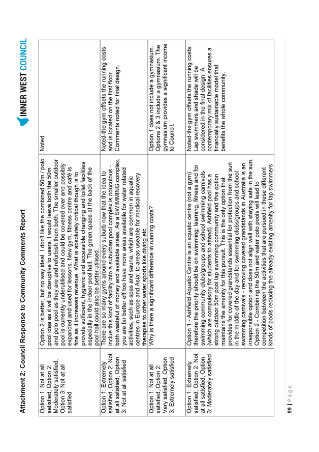
Members of water polo clubs, swim school parents and school swimming carnival participants responded most strongly to the survey. Analysis of community responses revealed that Design - Option 3 (Diagram 6), followed by Concept Design - Option 2 (Diagram 5), was most likely to satisfy needs. The original tender option, Concept Design – Option 1 (Diagram 4) was least likely to satisfy needs.
The key difference between responses to Concept Design – Option 2 and Concept Design – Option 3 is the polarisation between water polo, canoe polo and underwater rugby players, along with some lap swimmers who prefer a separate water polo pool (with varying requests for pool depth ranging from 2-5m), compared to family and leisure users who prefer the additional recreation facilities and open space of Concept Design – Option 2.
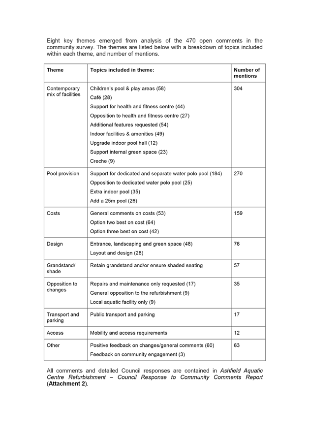
Eight key themes emerged from analysis of the 470 open comments in the community survey, as follows:
1. Contemporary mix of facilities (304 mentions)
2. Pool provision (270 mentions)
3. Costs (159 mentions)
4. Design (76 mentions)
5. Grandstand / shade (57 mentions)
6. Opposition to changes (35 mentions)
7. Transport and Parking (17 mentions)
8. Accessibility (12 mentions)
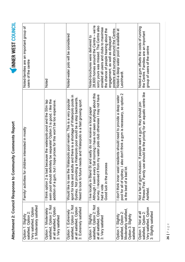
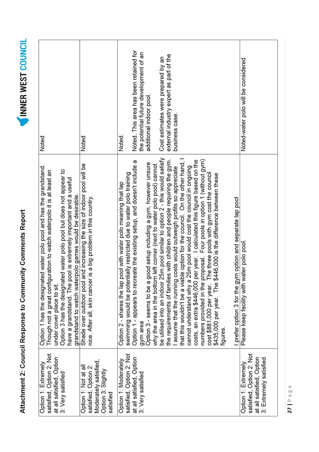
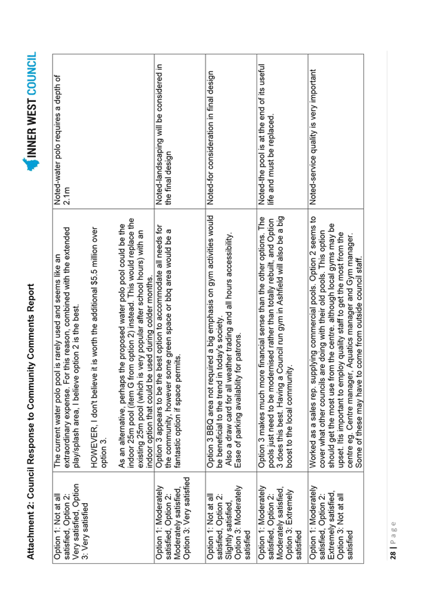
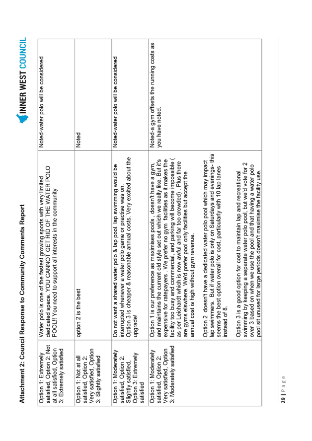
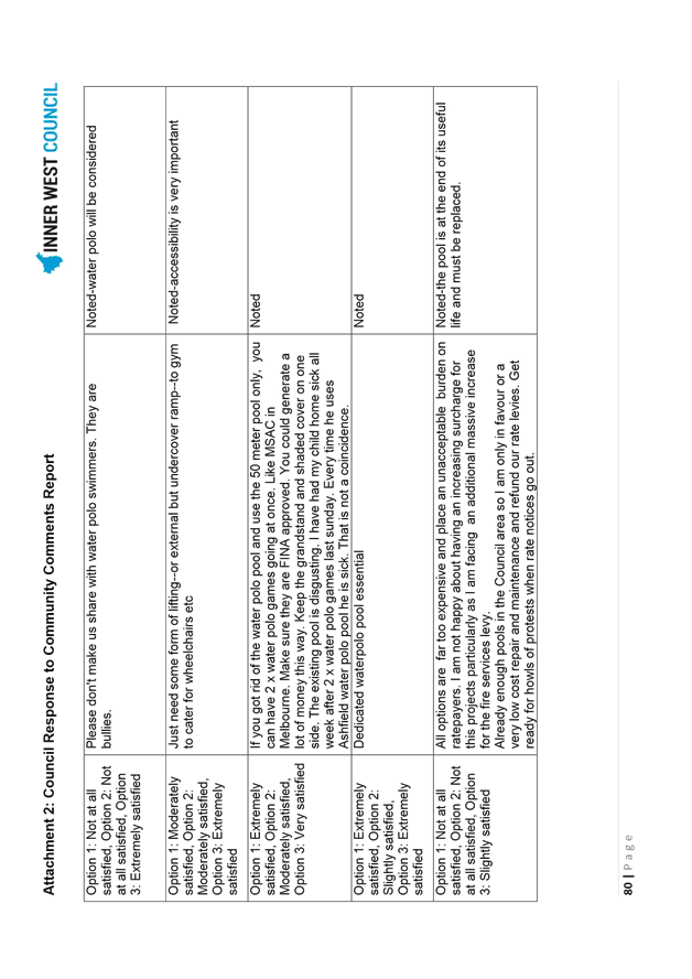
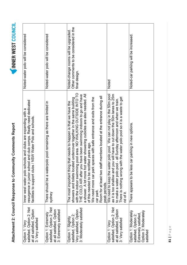
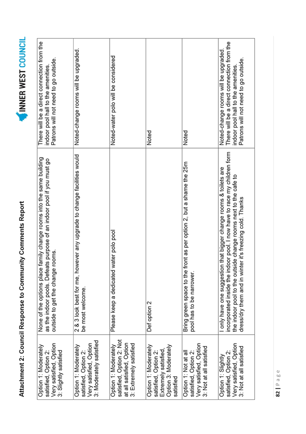
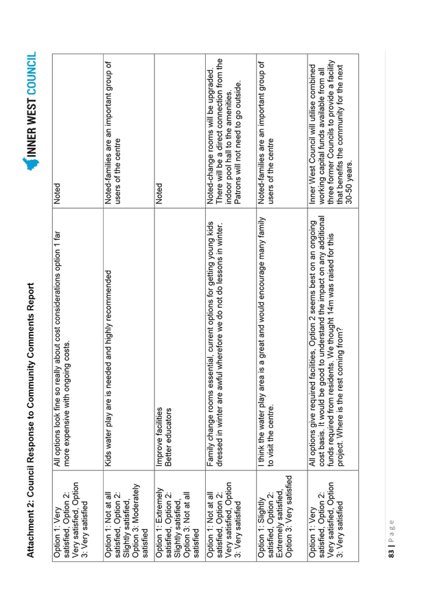
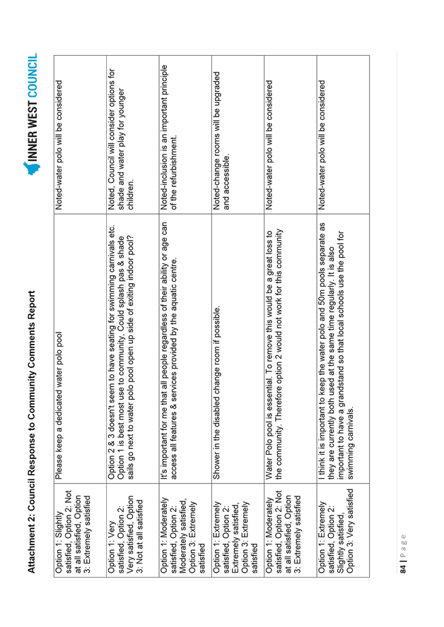
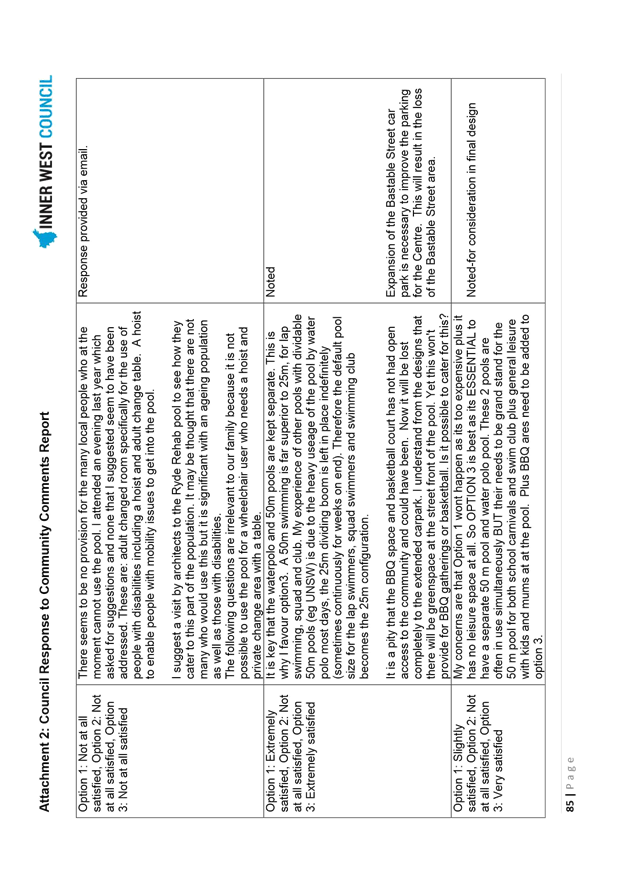
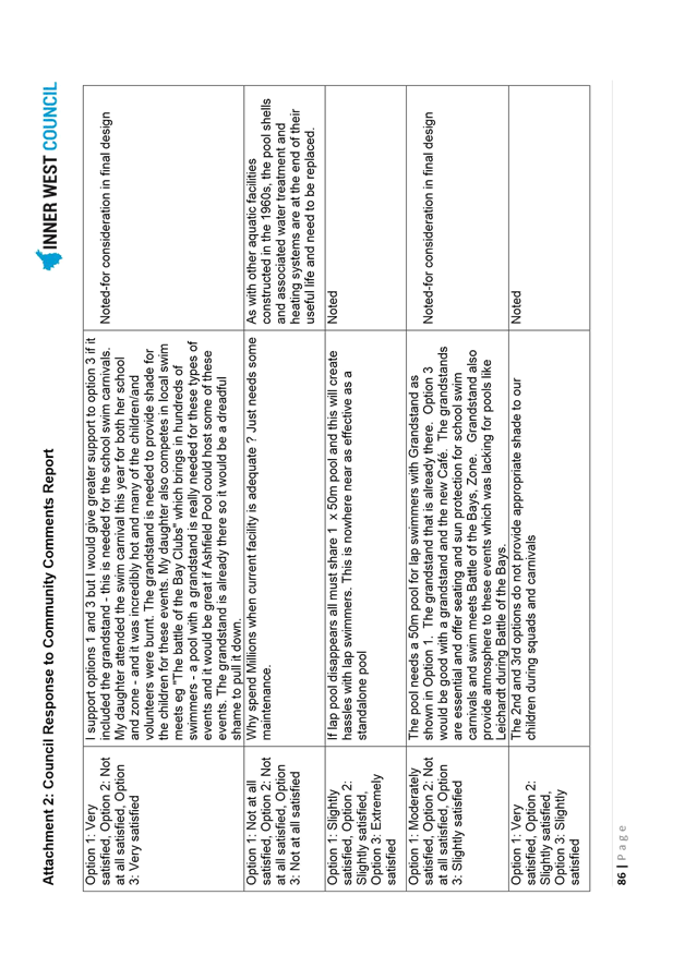
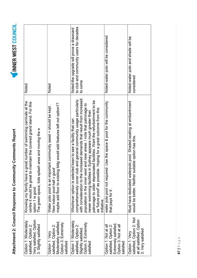
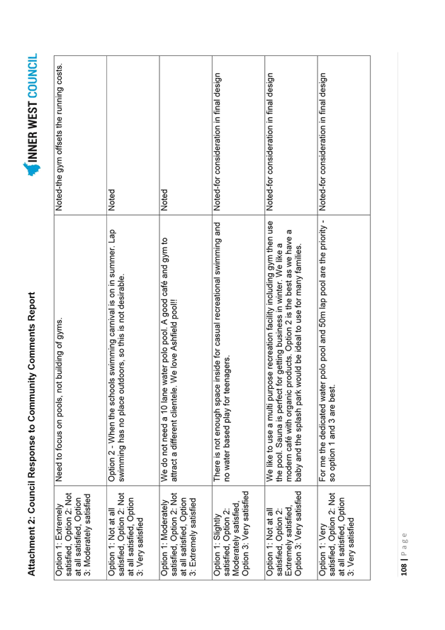
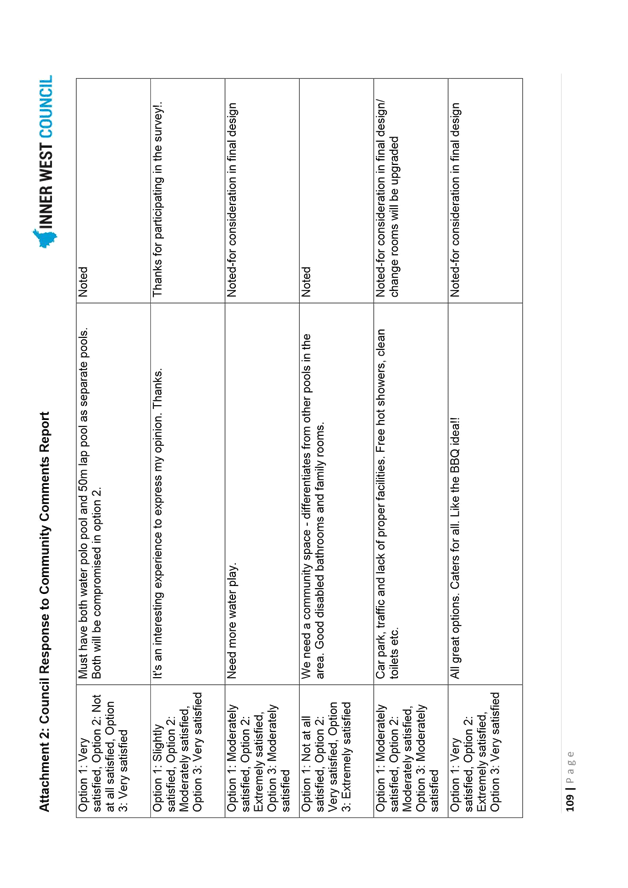
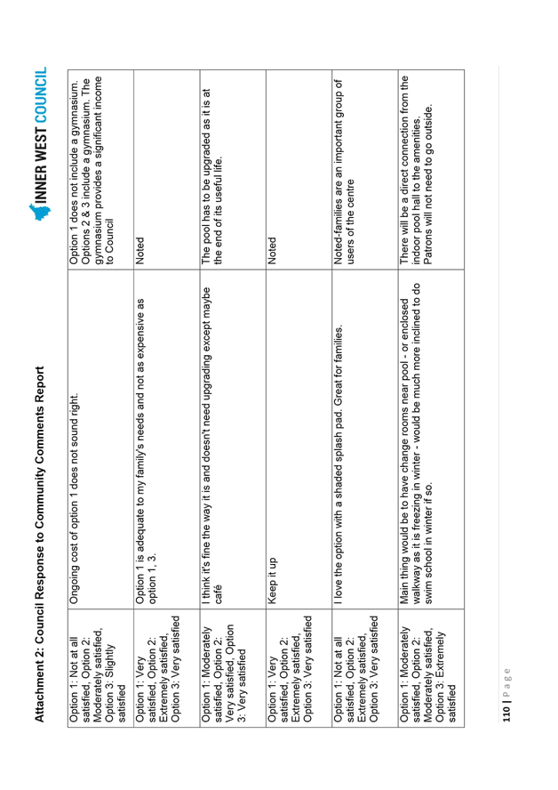
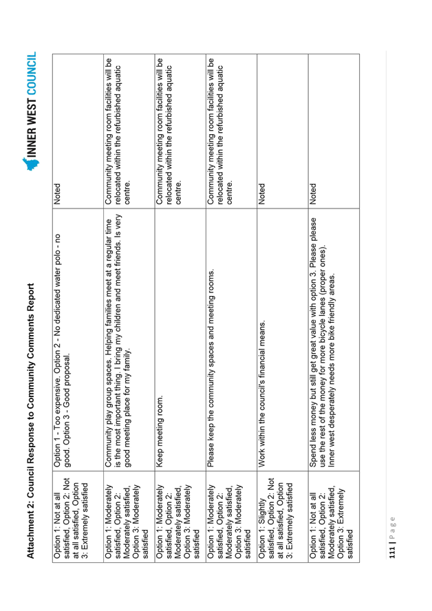
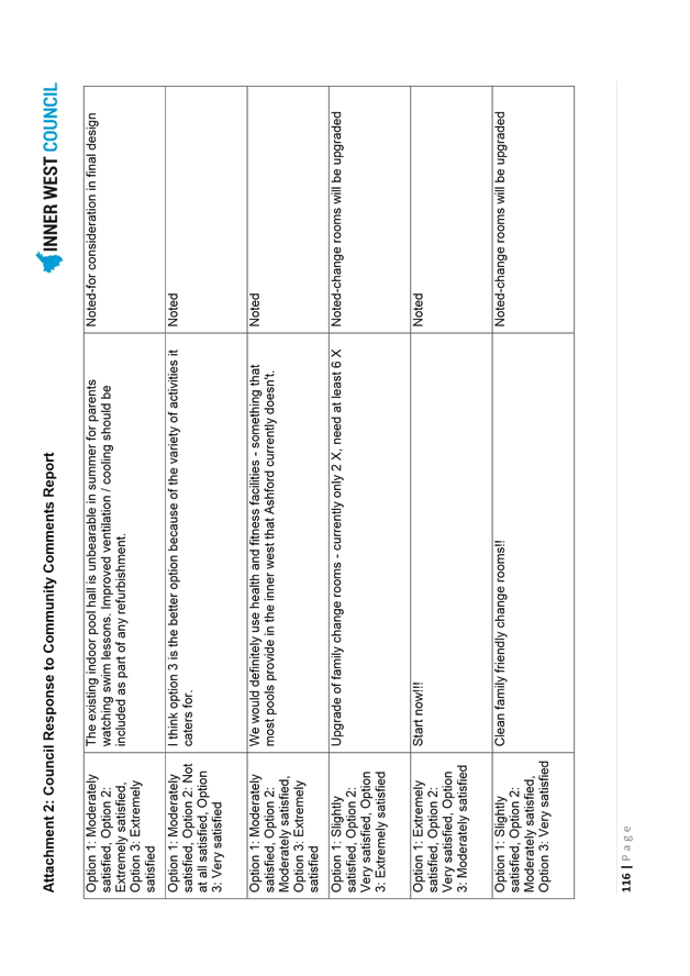
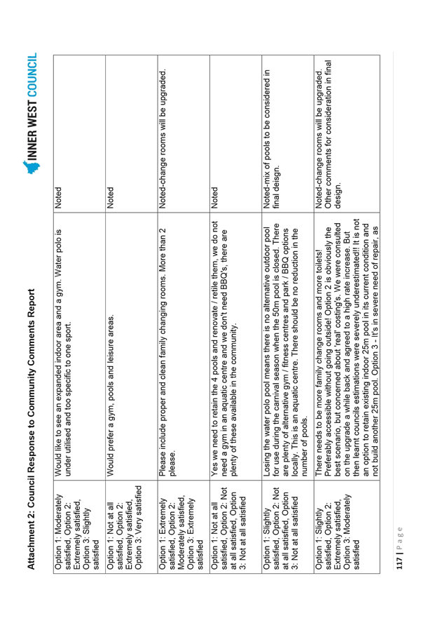
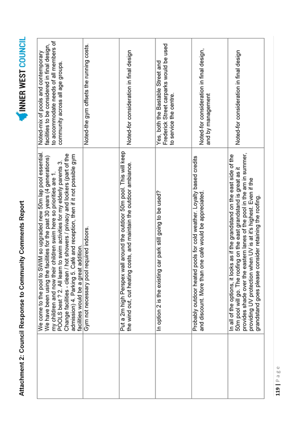
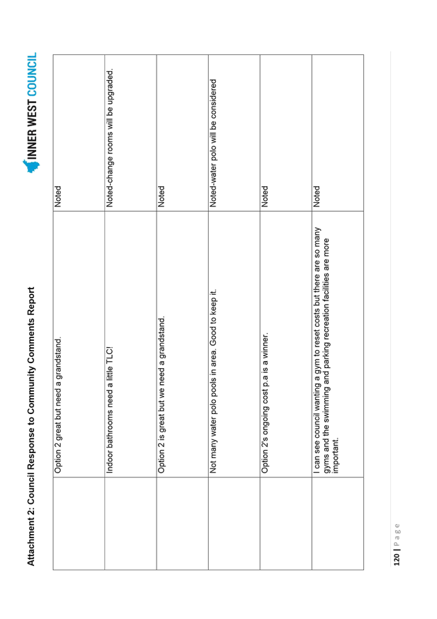
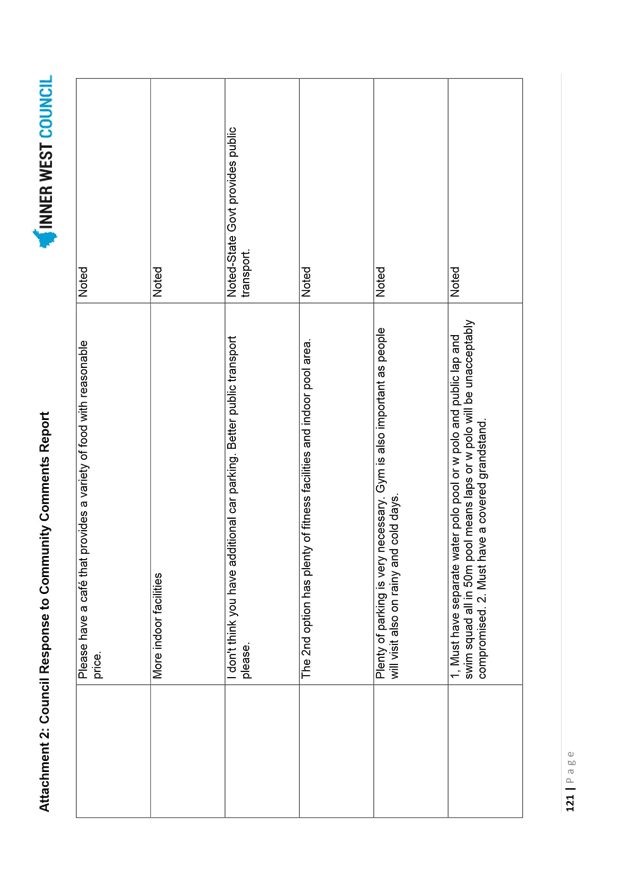
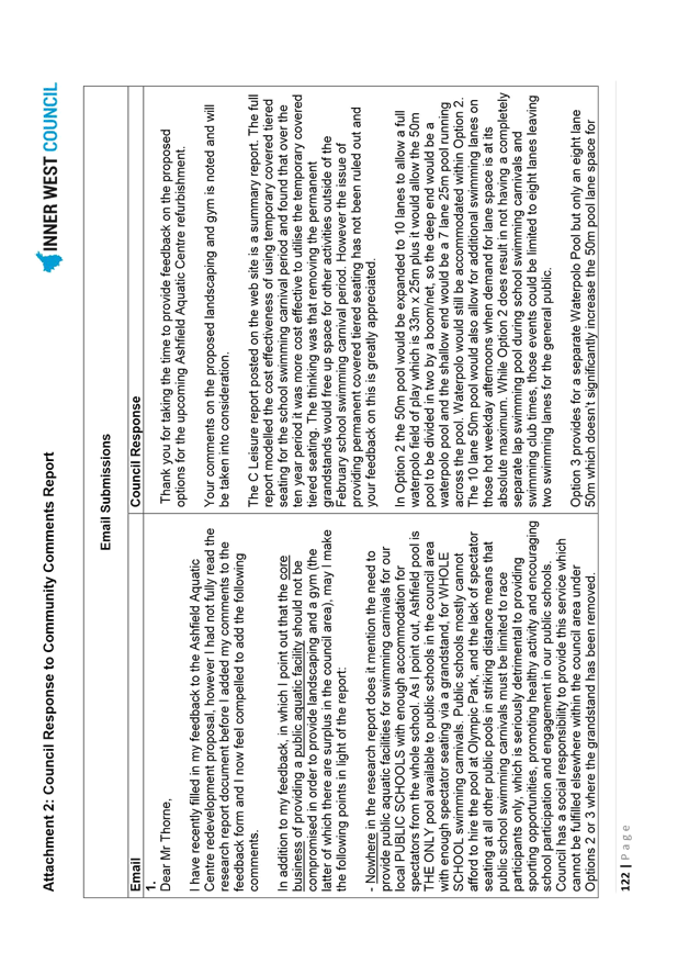
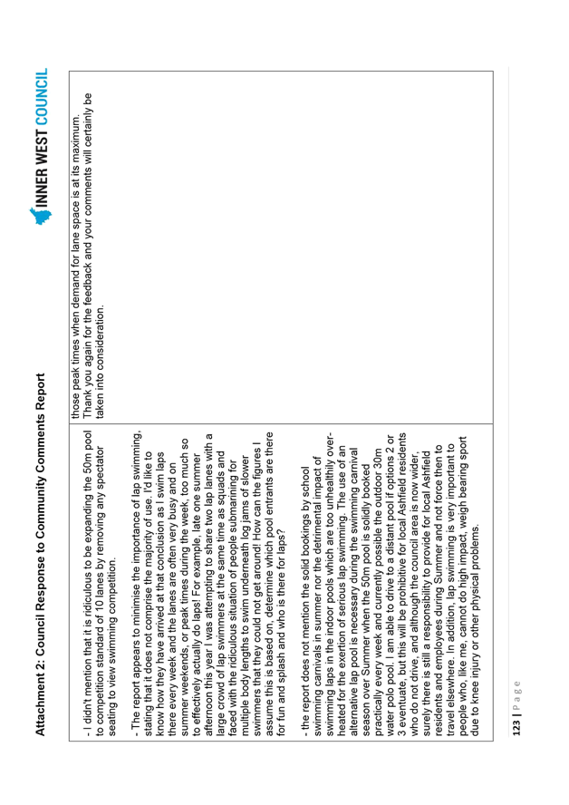
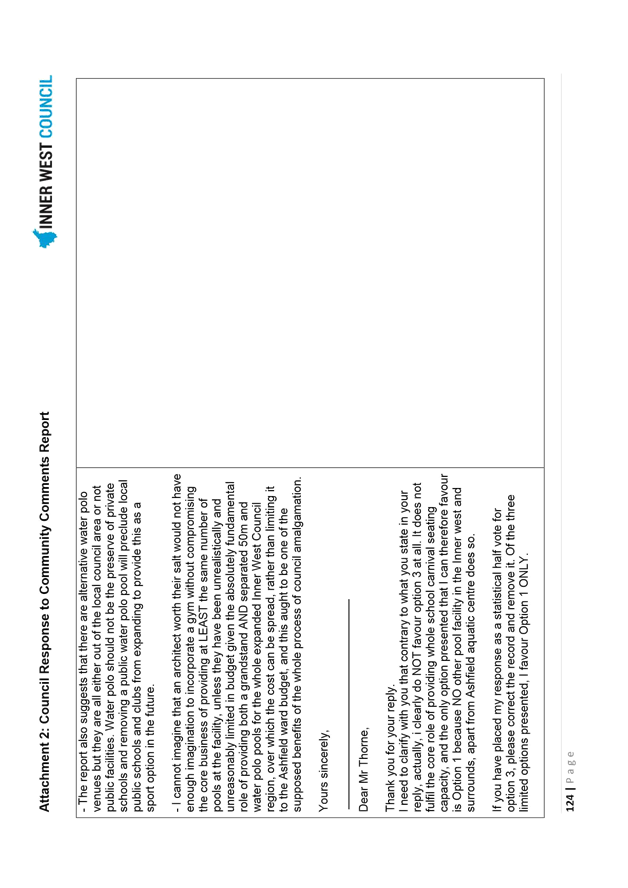
The Ashfield Aquatic Centre Refurbishment Engagement Report provides full details of the engagement process (Attachment 1) and the Ashfield Aquatic Centre Refurbishment – Council Response to Community Comments Report (Attachment 2) provides Council responses to the questions raised during engagement period.
CONCLUSION
Through the review of the Ashfield Aquatic Centre refurbishment project and re-engagement with Centre users and the local community, Council can be confident that the proposed design concept and project program will meet community needs and expectations. The ‘Community Preferred Concept Design’ for the refurbishment of Ashfield Aquatic Centre (Diagram 7) has been developed through a comprehensive engagement process and provides for a contemporary mix of facilities that will meet a range of community needs while enabling a sustainable business model for Council to manage the facility into the future.
|
1.⇩ |
Ashfield Aquatic Centre-Engagement Report-June 2017 |
|
2.⇩ |
Ashfield Aquatic Centre Refurbishment - Council Reponse to Community Comments Report |
|
Council Meeting 27 June 2017 |
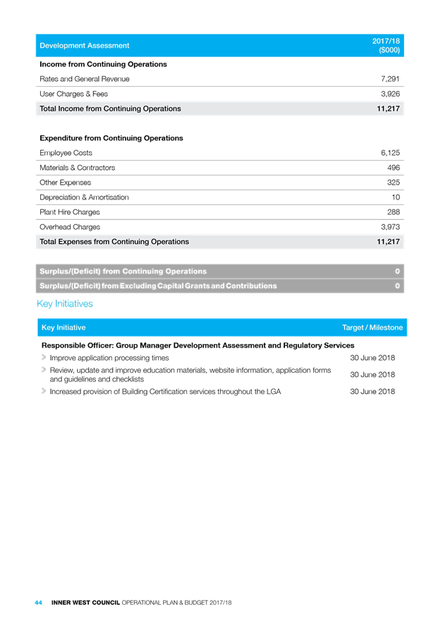
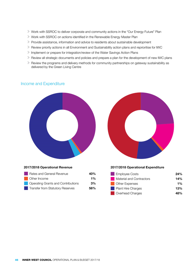
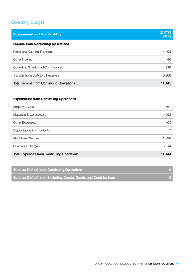
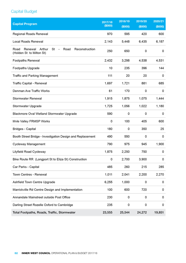
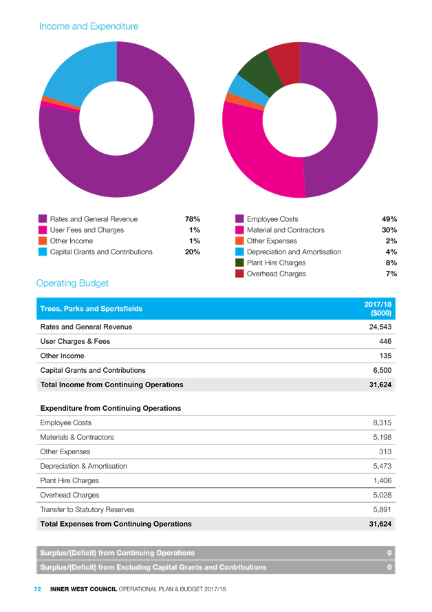
Subject: Operational Plan and Budget 2017/18
File Ref: 17/6069/54929.17
Prepared By: Kathryn Ridley - Corporate Strategy Planner
Authorised By: John Warburton - Deputy General Manager Community and Engagement
|
SUMMARY The Inner West Council (IWC) is required to adopt and implement an Operational Plan and Budget for 2017/18. The strategic imperatives guiding the Operational Plan this year include; the Statement of Vision and Priorities, results of recent Community Satisfaction Surveys, consolidation of the three constituent councils, and maintaining existing levels of service. The Operational Plan and Budget ensures continuation of the on-going activities and key initiatives identified in the Delivery Programs of the former councils.
Council must adopt an Operational Plan and Budget for 2017/18 prior to 30 June 2017. Public exhibition of the Draft was undertaken as required under the Local Government Act 1993 and Local Government (General) Regulation 2005.
The purpose of this report is to: 1. report on submissions received from the public during the exhibition period 2. report on revisions made to the budget, and fees and charges, during and post the exhibition period 3. recommend formal adoption of the Inner West Council Operational Plan and Budget 2017/18 and Schedule of Fees and Charges 2017/18
|
|
THAT the Administrator: 1. adopts the Operational Plan and Budget 2017/18 subject to the minor amendments detailed in this report; 2. makes and levy the Rates for 2017/18 as contained in accordance with section 405 of the Local Government Act 1993; 3. adopts the rate of 7.5% as the interest rate to apply on outstanding rates, in accordance with section 566(3) of the Local Government Act 1993; and 4. adopts the Schedule of Fees and Charges, annexed to the Operational Plan 2017/18 noting the changes to Fees and Charges made since on public exhibition. |
BACKGROUND
All Council’s in NSW are required to adopt an Operational Plan and Budget by 30 June 2017
in accordance with the requirements of the Local Government Act 1993 and Local Government (General) Regulation 2005.
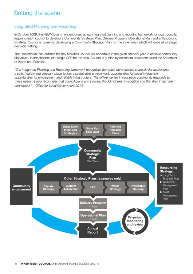
“The Integrated Planning
and Reporting framework recognises that most communities share similar
aspirations: a safe, healthy and pleasant place to live, a sustainable
environment, opportunities for social interaction, opportunities for employment
and reliable infrastructure. The difference lies in how each community responds
to these needs. It also recognises that council plans and policies should not
exist in isolation and that they in fact are connected.”
- Office for Local Government 2013
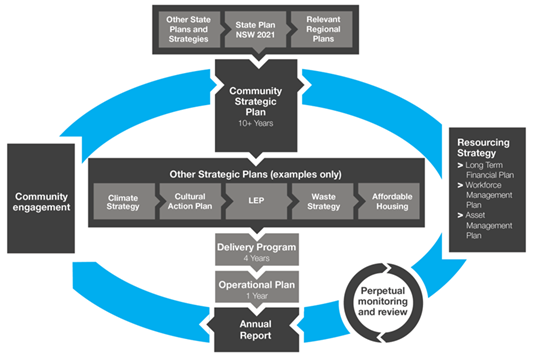
Usual circumstances would dictate that the Operational Plan and Budget reflect the relevant year of Council’s previously adopted four year Delivery Program (e.g. Year 4 of 4 ). The Inner West Council, as a newly amalgamated entity, is in the process of developing both a Community Strategic Plan (CSP) for the Inner West and a supporting Delivery Program. Both must be in place by 1st July 2018.
In the absence of both a single CSP and supporting Delivery Program, the development of IWC’s Operational Plan and Budget 2017/18 has been guided by a Statement of Vision of Priorities. The Statement takes into account the plans and strategic objectives of the former Councils of Ashfield, Leichhardt and Marrickville. To this end, the Operational Plan and Budget 2017/18 continues the work identified within the former Councils’ Delivery Programs.
The Statement of Vision and Priorities
The Department of Premier and Cabinet (DPC) required all newly amalgamated councils to prepare a Statement of Vision and Priorities. It is described as a succinct statement to “provide high level guidance for the early period of the new council, until the adoption of the first community strategic plan”.
The Priorities were identified following a three month period of community engagement and an eight week period of community review. Over 1,700 people participated in the development of the Statement of Vision and Priorities including via a telephone Community Satisfaction Survey undertaken by Micromex Research. The Priorities are:
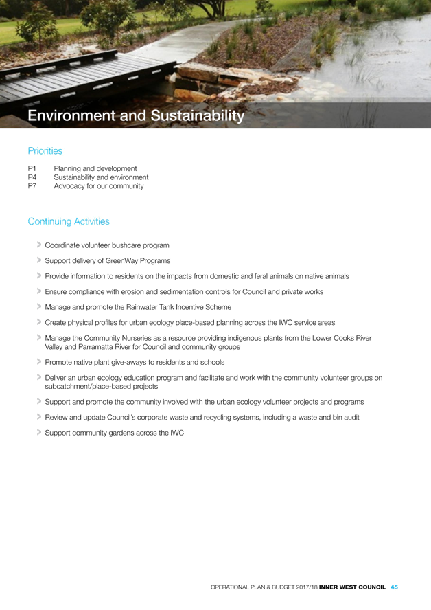
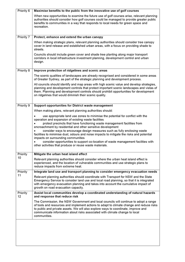
Priority 1 - Planning and Development
Priority 2 - Transport
Priority 3 - Social vitality, creativity and quality of life
Priority 4 - Sustainability and the environment
Priority 5 - One council
Priority 6 - Local industry and business
Priority 7 - Advocacy
Priority 8 - Local democracy.
Each of Council’s service areas, along with their ongoing activities and key initiatives, have been assigned to one or more of the above Priorities. Council will report back to the community throughout the year on how we are progressing in addressing the Priorities.
Operating context and highlights
The Inner West Council is committed to remaining financially sustainable, maintaining existing services and funding all currently scheduled major projects from the three former Councils. The 2017/18 financial year will be one of consolidation rather than growth, progressing all agreed activities while aiming to build capacity for any unknown risks and externalities that may impact service delivery and resources.
In addition to ongoing service delivery, Council is undertaking key integration work ensuring the consolidation and harmonisation of operations. The key strategic areas of work include organisational redesign, establishing a new framework for local democracy and community engagement, systems and services integration and supporting staff through change. An Integration and Transformation Program has been established to operationalise our ongoing integration work.
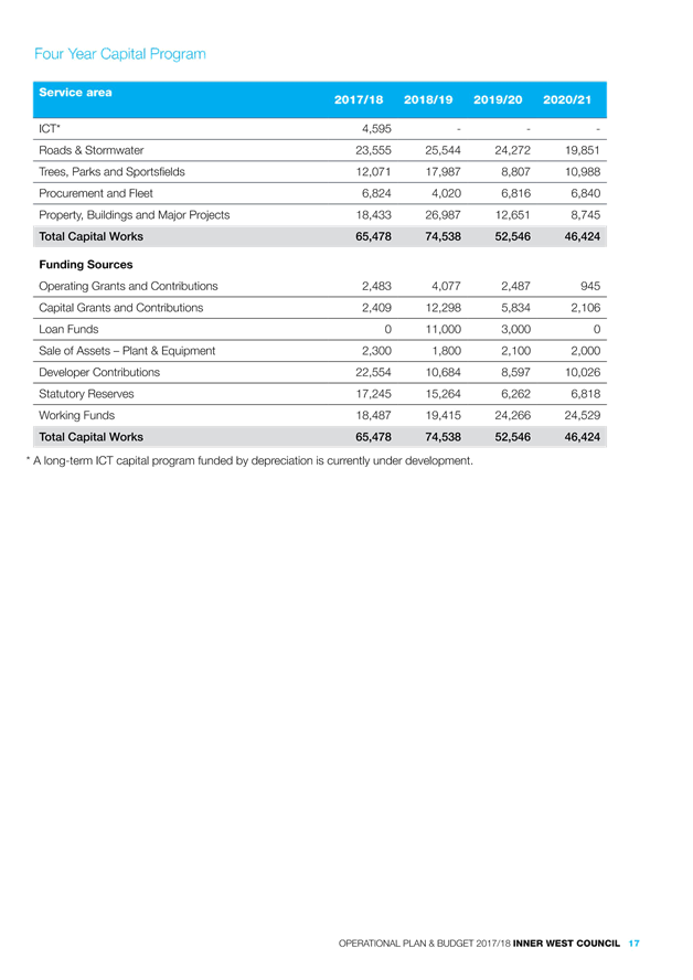
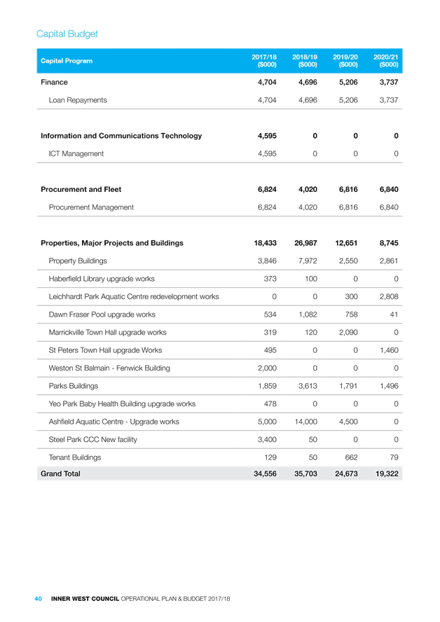
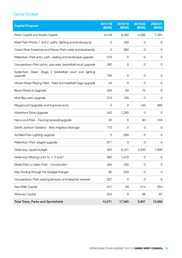
Council’s capital works program is a four year forward works program, reflecting the constituent Councils Asset Management Plans prioritized based on the condition ratings of assets and with a focus being on renewals to reduce the infrastructure backlog. The total spend for 2017/18 on capital works projects is estimated at $65 million. This includes “re-phased” works endorsed by Council as a part of the March Quarterly Budget Review Statement.
|
Service area |
2017/18 |
2018/19 |
2019/20 |
2020/21 |
|
ICT |
$4.6m |
- |
- |
- |
|
Roads & Stormwater |
$23.6m |
$25.5m |
$24.3m |
$19.9m |
|
Trees, Parks and Sportsfields |
$12.1m |
$18.0m |
$8.8m |
$11.0m |
|
Procurement and Fleet |
$6.8m |
$4.0m |
$6.8m |
$6.8m |
|
Property, Buildings and Major Projects |
$18.4m |
$27.0m |
$12.7m |
$8.8m |
|
Total Capital Works |
$65.5m |
$74.5m |
$52.6m |
$46.5m |
|
Funding Sources |
|
|
|
|
|
Operating Grants and Contributions |
$2.5m |
$4.1m |
$2.5m |
$1.0m |
|
Capital Grants and Contributions |
$2.4m |
$12.3m |
$5.8m |
$2.1m |
|
Loan Funds |
- |
$11.0m |
$3.0m |
- |
|
Sale of Assets |
$2.3m |
$1.8m |
$2.1m |
$2.0m |
|
Developer Contributions |
$22.6m |
$10.7m |
$8.6m |
$10.0m |
|
Statutory Reserves |
$17.2m |
$15.2m |
$6.3m |
$6.8m |
|
Working Funds |
$18.5m |
$19.4m |
$24.3m |
$24.6m |
|
Total Capital Works |
$65.5m |
$74.5m |
$52.6m |
$46.5m |
The 2017/18 and 2018/19 capital works schedules include a number of major projects and State Government Stronger Community Funds works anticipated to be completed by June 2019. The capital works program will then revert to core levels of expenditure and monitored on an ongoing basis within Council’s Long Term Financial Plan. .
Highlight capital projects include:
|
Project |
Budget |
Priority alignment |
|
Steel Park Child Care Facility |
$3.4m |
Priority 3 - Social vitality, creativity and quality of life |
|
The Greenway |
$0.9m |
Priority 2 – Transport; Priority 4 - Sustainability and the environment; |
|
Ashfield Aquatic Centre |
$5m |
Priority 3 - Social vitality, creativity and quality of life |
|
Ashfield Town Centre Upgrade |
$6.2m |
Priority 1 – Planning & Development; Priority 3 - Social vitality, creativity and quality of life |
|
Lilyfield Road Cycleway |
$1.9m |
Priority 2 - Transport |
|
Weston St Balmain - Fenwick Building |
$2.0m |
Priority 1 – Planning & Development; Priority 5 - Local industry and business; Priority 3 - Social vitality, creativity and quality of life |
|
Petersham Park staged upgrade |
$0.8m
|
Priority 3 - Social vitality, creativity and quality of life |
|
Sydenham Green Stage 2 basketball court and lighting upgrade |
$0.7m |
Priority 3 - Social vitality, creativity and quality of life |
|
Blackmore Oval Wetland Stormwater Upgrade |
$0.6m
|
Priority 3 - Social vitality, creativity and quality of life; Priority 4 - Sustainability and the environment |
|
St Peters Town Hall upgrade works |
$0.5m
|
Priority 3 - Social vitality, creativity and quality of life |
BUDGET SUMMARY
The 2017/18 budget sees the first integrated budget of the Inner West Council. The budget has been built on the premise that existing service levels will be maintained until a new Inner West Council Community Strategic Plan is adopted. The budget also includes a four year, achievable capital works program that sees a number of large scale projects commencing during 2017/18.
Key drivers of the budget include:
• 1.5% IPART approved rate peg with the exception of the former Ashfield LGA which has an IPART approved Special Rate Variation to increase rates by 8.9% (including the rate peg).
• 2.5% Domestic Waste Management Charge increase across each constituent Council
• Consolidation of statutory and similar Fees and Charges with a view to have complete consolidation for the 2018/19 financial year. A 2.5% has been applied to non-statutory Fee and Charges.
• Increase of Salaries and Wages by 2.5% as an anticipated award increase
• Service unit structures have been developed to allow transparent service unit reporting including full overhead allocation
• Implement a transparent, achievable 4 year capital works program focused on capacity to reduce Council’s backlog;
• Implementation of Technology One – One Council Solution, with a view to developing a long term ICT strategy
• Development of a working capital approach and work towards maintaining only legislative reserves (e.g. s94, Employee Entitlements, Waste etc.).
These drivers form the basis of a budget that has been balanced for the 2017/18 financial year from a working funds perspective.
Risks to Council
Council is inherently exposed to a number of external financial risks that continually challenges its long term financial sustainability. A number of financial strategies have been implemented to ensure that these financial risks are mitigated.
Interest rates remain at record lows and this has had an impact on Council’s interest revenue. It is forecast that interest rates will remain at record lows for the 2017/18 financial year which will stretch Council’s ability to fund its recurring operations during the financial year. This issue will be compounded when the investment portfolio is reduced due to funds being used to fund the 2017/18 capital program. We will continue to monitor this during the financial year.
Rate pegging continues to be a risk for Council as it has no control over its largest source of revenue. The rating increase determined by IPART for the 2017/18 financial year was 1.5%, being the lowest rate increase since 1993 and well below the anticipated award increase of 2.5% with employee costs being Council’s largest expenditure item.
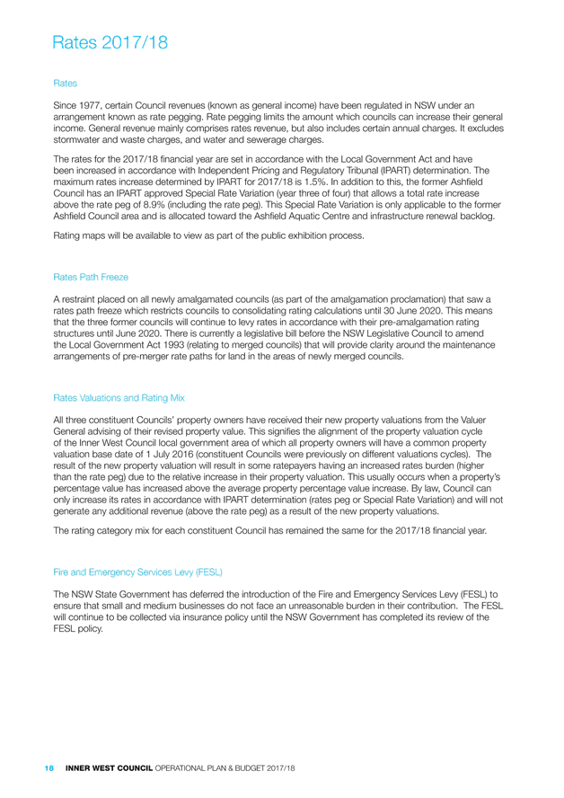
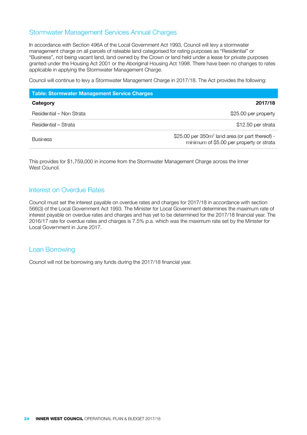
2017/18 Rates and Annual Charges
The rates for the 2017/18 financial year are set in accordance with the Local Government Act 1993 and have been increased in accordance with Independent Pricing and Regulatory Tribunal (IPART) determination. The maximum rates increase determined by IPART for 2017/18 is 1.5%. In addition to this, the former Ashfield Council has an IPART approved Special Rate Variation (year three of four) that allows a total rate increase above the rate peg of 8.9% (including the rate peg). This Special Rate Variation is only applicable to the former Ashfield Council area.
A restraint placed on all newly amalgamated Councils (as part of the amalgamation proclamation) saw a rates path freeze which restricts Councils to consolidating rating calculations until 30 June 2020. This means that the three constituent Councils will continue to levy rates in accordance with their pre amalgamation rating structures until that time.
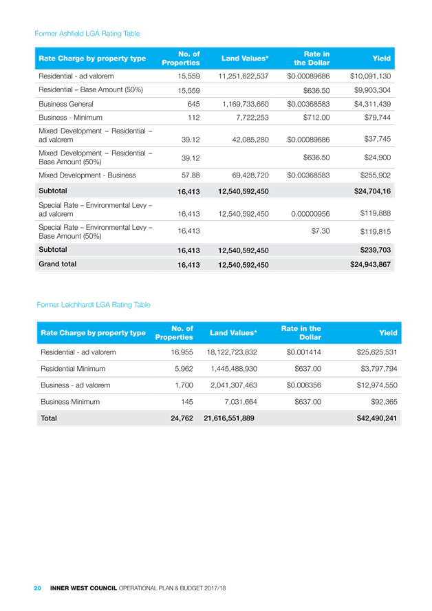
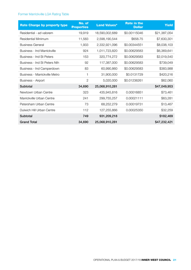
Rating Valuations
All three constituent Councils’ property owners have received their new property valuations from the Valuer General advising of their revised property value. This signifies the alignment of the property valuation cycle of the Inner West Council local government area of which all property owners will have a common property valuation base date of 1 July 2016 (constituent Councils were previously on different valuations cycles). The result of the new property valuation will result in some ratepayers having an increased rates burden (higher than the rate peg) due to the relative increase in their property valuation. This usually occurs when a property’s percentage value has increased above the average property percentage value increase. By law, Council can only increase its rates in accordance with IPART determination (rates peg or Special Rate Variation) and will not generate any additional revenue (above the rate peg) as a result of the new property valuations. The rating category mix for each constituent Council has remained the same for the 2017/18 financial year.
Rebates and Hardship
All pensioner rebates and discounts policies will remain the same for each former Council for the 2017/18 financial year. Council recognises that due to exceptional circumstances ratepayers may at times encounter difficulty in paying their annual rates and charges. Council has a Hardship Policy that provides a framework for providing relief to any ratepayers who are suffering genuine financial hardship.
Pricing Policy and Fees and Charges
The structure of the Inner West Council Fees and Charges schedule sees a consolidation of the three constituent schedules into one document. Statutory fees and similar fees have been consolidated, but a number of fees and charges have yet to be consolidated. The consolidation process will continue throughout the 2017/18 financial year with a view to having a more concise document for the 2018/19 financial year.
Fees and Charges have largely been increased by 2.5% for the 2017/18 financial year.
BUDGET UPDATE - POST PUBLIC EXHIBITION
Operating and Capital Budget
The 2017/18 operating budget was reviewed during the exhibition period. The re-distribution of depreciation and overheads has resulted in changes to some service unit profit and losses.
The following Council resolutions have also been included the 2017/18 operating budget as resolved during the public exhibition period:
- Inclusion Action Plan – Item 10 of the May 2017 Council meeting which requested $60,000 to be funded from existing budgets. This has no impact on Council working funds.
- Reduction in Capital Grants Budget – The capital grants budget has been reduced by approximately $6 million primarily due to the “re-phasing” of part of “The Greenway” capital works project ($2.5m) and reduction in forecast S94 Developer Contributions funds anticipated during the 2017/18 financial year ($3.5m). These two adjustments have no net impact on Council’s working funds and will be monitored on an ongoing basis.
- NSWRL League Carnival (Koori Knockout) – Item 8 of the May 2017 Council meeting which requested $111,000 to be funded from general funds.
- Budget changes that were not included in the public exhibition process that have now been incorporated in the budget are as follows:
o Biodiesel Fuel - $420,000
o Increase to Audit Fees - $50,000
o Increase in Statutory contribution to Fire and Emergency Services - $125,000
o Election Costs - $100,000
In total, Council’s working funds position will be reduced by approximately $800,000 as a result of the changes made during the exhibition period.
The capital budget was also reviewed in light of capital works being undertaken. The review is due to the fact that a number of project budgets have been re-phased from the 2016/17 financial year into the 2017/18 financial year (March Quarterly Budget Review Statement, May 2017 Council meeting).
Fees and Charges
The 2017/18 Fees and Charges schedule has been slightly modified to reflect changes brought about primarily due to statutory changes that were announced during the public exhibition period. A major announcement that occurred (although not directly a Fee and Charge) is the deferral of the collection of Fire and Emergency Services Levy (FESL) by Councils in NSW on behalf of the State Government. Although there is no impact on Council’s revenue streams, it will mean that the collection method of the FESL will be reverted back to insurers for the 2017/18 financial year.
The following table shows changes made to the Fees and Charges with an explanation against each change.
|
Charge |
Advertised Fee |
Revised Fee |
Reason for changing |
|
603 Certificates |
$75 |
$80 |
Statutory Fee determined by the Office of Local Government – Released in May 2017 |
|
Interest on Overdue rates |
8.5% |
7.5% |
Statutory Fee determined by the Office of Local Government – Released in May 2017 |
|
Credit Card Transaction Fees |
0.85% |
0.75% |
Negotiation of reduced credit card transaction fees and revised charge to ensure Credit Card transaction fee is ACCC compliant. |
|
Hire charge of Magic Yellow Bus for Festivals/events initial set up |
$430 |
$418.50 |
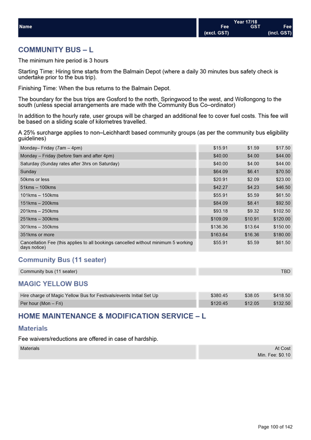
Indexation reviewed by Manager, Community Service. No indexation on this fee for the 2017/18 financial year. |
PUBLIC CONSULTATION AND SUBMISSIONS RECEIVED
The Draft Operational Plan and Budget 2017/18 and Draft Schedule of Fees and Charges were endorsed for the purpose of public exhibition in April 2017. In accordance with the Local Government Act, both documents were exhibited for a 28 day period.
The following methods were used to engage the community during the public exhibition period:
· Placement of copies of the documents, rating maps, supporting information and submission boxes at our three Service Centres
· Placement of the documents, rating maps and supporting information, with an electronic feedback form, on the ‘Your Say Inner West’ website
· Placement of information on Council’s website
· Advertising in the Inner West Courier
· Promotion in the Administrators Message in the Inner West Courier
· Preparation and distribution of a special e-newsletter
· Preparation and distribution of specific information to the Your Say Inner West registered community
· Promotion via social media
· Preparation and display of posters on Council’s community noticeboards
A Public Information Session was also held in Ashfield on Thursday 18 May at 6.30pm.
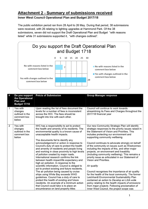
During the exhibition period, 368 people participated on the Your Say site with 198 visitors performing an action such as downloading a document. 38 participants made a submission. Of the 38 submissions, 31 supported the Operational Plan and Budget (“with changes outlined”) while seven did not support the Plan (“with reasons listed”).
26 submissions requested budget of approximately $30,000 - $40,000 to complete lighting work in Hammond Park. Due to this feedback, the Hammond Park light upgrade has been accommodated in the capital works program for 2017/18. Responses have been provided to each submission (Attachment 2).
The Community Strategic Plan (CSP) and supporting Delivery Program currently in development will, where relevant, take into consideration submissions received as part of this process. The CSP will establish our strategic direction and the Delivery Program will confirm specific projects and programs to be continued or commenced by the incoming Council.
FINANCIAL IMPLICATIONS
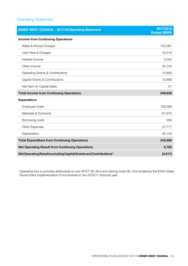
A considerable effort has been made to ensure the budget is funded in a sustainable manner. This process has resulted in a balanced working funds budget for the 2017/18 financial year. Council is forecasting an approximate operating loss of $3 million (excluding capital grants and contributions) for the 2017/18 financial year. This is primarily due to a number of one off operating expenses that will not continue into Council’s operations in future years.
CONCLUSION
This report is recommending that Council adopt the Operational Plan and Budget, and Schedule of Fees and Charges 2017/18 inclusive of adjustments outlined within this report.
The Inner West Council, as a newly amalgamated entity, is in the process of developing both a Community Strategic Plan (CSP) for the Inner West and a supporting Delivery Program. Both must be in place by 1st July 2018. The first year of the Delivery Program will form the basis of the Operational Plan for the 2018/19 financial year. The Delivery Program and Operational Plan will be integrated to reflect and support the strategic directions outlined in the CSP.
This report is recommending adoption of the Operational Plan and Budget 2017/18 noting that minor formatting to the final published document will be carried out prior to publication.
|
1.⇩ |
Attachment 1 - Schedule of Fees and Charges 2017/18 |
|
2.⇩ |
Attachment 2 - Summary of Submissions received_Operational Plan and Budget 201718 |
|
3.⇩ |
Attachment 3 - 201718 Operational Plan and Budget_Council meeting |
|
Council Meeting 27 June 2017 |
Subject: Victoria Road Precinct Planning Proposal
File Ref: 14/5378/54667.17
Prepared By: Jamie Erken - Team Leader Planning Services
Authorised By: Simon Manoski - Group Manager Strategic Planning
|
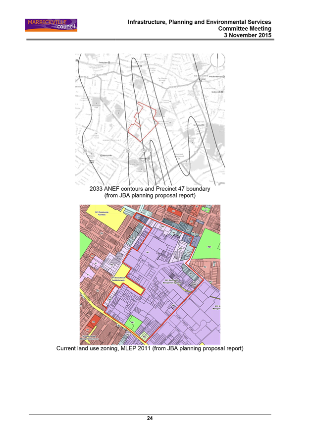
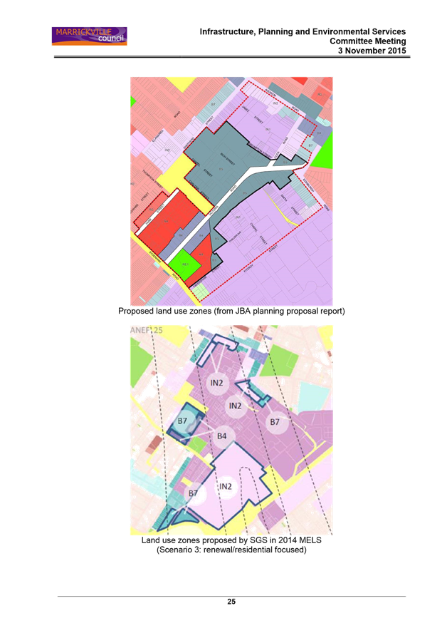
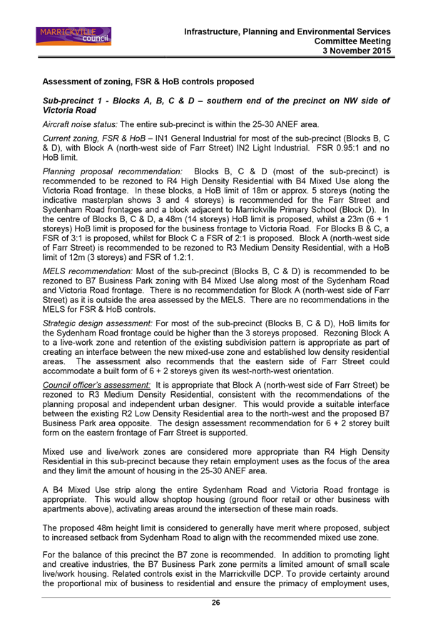
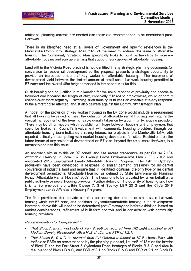
SUMMARY On 3 November 2015, the former Marrickville Council Infrastructure, Planning and Environmental Services Committee considered a planning proposal for the Victoria Road precinct. In that report, Council officers did not support the wholesale move away from the industrial zones to allow residential development and higher order employment uses. Council officers’ recommended a precautionary approach be taken with employment lands, with the majority of the land to be retained as industrial with a partial move to a business zone in some parts of the precinct.
Notwithstanding the officer recommendation, the former Marrickville Council resolved to submit the planning proposal in the form lodged by the proponent to the Department of Planning and Environment (the Department) for Gateway determination.
Since the planning proposal received Gateway determination, the draft Central District Plan (dCDP) has been released and the contents of that document have been considered in the assessment of this planning proposal. The dCDP encourages Council to take a ‘precautionary approach’ to the conversion of employment and urban services land. This recommendation is of particular importance to the Inner West area as a significant portion of industrial land having been rezoned and / or redeveloped for other uses.
There is no State or local level strategic plan or policy that identifies the Victoria Road precinct as land for high density housing or that encourages its wholesale move away from an industrial zone. This employment area continues to be considered a valuable employment area, is affected by aircraft noise and should be considered in light of other planning changes underway across the Inner West area.
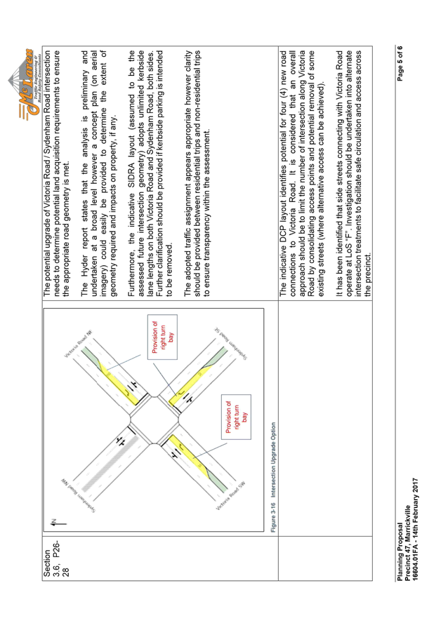
Post Gateway assessment of the planning proposal has identified a number of issues with the proposal, including but not limited to roadway implications (including the need to acquire private properties outside of the planning proposal area and sections of Wicks Park for road widening); a lack of affordable housing; excessive building heights; inadequate road connections to service the rezoning and stated vision for the Victoria Road corridor; unresolved heritage impacts; shadow and visual bulk impacts on Wicks Park and precinct wide drainage and flooding issues. The planning proposal also does not identify an adequate level of public open space that would support the new resident and worker population.
On 1 June 2017, the NSW Roads and Maritime Services (RMS) indicated that it does not support the planning proposal in its current form as the proponent has not modelled the cumulative transport impacts and/or incorporate an appropriate funding mechanism to carry out the required mitigation measures (that include property acquisitions). This remains as an unresolved objection to the planning proposal.
The planning proposal seeks to up zone land and this would bring forward necessary infrastructure to be planned and delivered including property acquisitions and loss of community classified land for road widening that is outside the scope of Marrickville Section 94/94A Contributions Plan. Given the constrained capacity of Section 94 contributions to provide the required level community infrastructure, the planning proposal should indicate a clear commitment towards the funding of relevant infrastructure to service the planning proposal via other mechanism.
The height, bulk, scale and form of the building envelopes sought are not supported in their current form given the surrounding context and would result in an unreasonable impact on areas of Wicks Park. The planning proposal has also not been revised to reflect the urban design recommendations provided by Council’s Architectural Excellence Panel (AEP) or independent views provided to Council within the Urban Design Study prepared by Rod Simpson.
There are a number of strategic and site specific issues identified in this assessment report. When considered cumulatively, the planning proposal in its current form would result in a significant change to this area with no strategic planning basis or justification. Although some level of renewal is encouraged and could be supported to promote renewal and investment, jobs and housing within this precinct, the planning proposal in its current form cannot for the reasons outlined above and detailed in this report.
In this regard, it is recommended that the Administrator request the Minister for Planning to determine that the planning proposal not proceed in its current form.
|
|
RECOMMENDATION THAT: A. pursuant to section 58(4) of the Environmental Planning and Assessment Act the Administrator request the Minister for Planning to determine that the matter not proceed for the following reasons:
1. the planning proposal remains subject to an unresolved objection from the Roads and Maritime Service primarily relating to a need for cumulative traffic impact analyses to be prepared and no cost, trigger or mechanism for the funding and delivery of necessary infrastructure to support the proposal; 2. the planning proposal in its current form has public and private landholding implications including the need to acquire private properties outside the planning proposal area and sections of Wicks Park (which is currently classified as community land) for road widening. The private property acquisitions and loss of community land / public open space is not considered to be in the public interest; 3. the planning proposal would result in the significant loss of industrial land. The draft Central District Plan encourages Council to take a ‘precautionary approach’ to the conversion of employment and urban services land and this recommendation is of particular importance to the Inner West area. There is no strategic planning or policy basis for the Victoria Road precinct to revert to a high density housing area or encourage a wholesale move away from industrial zonings; 4. the planning proposal demonstrates inconsistencies with A Plan for Growing Sydney; the draft Central District Plan; the Marrickville Employment Lands Strategy 2008 and Review 2014; the Inner West Council Statement of Vision and Priorities and relevant State Environmental Planning Policies as outlined in this report; 5. the planning proposal does not provide adequate affordable housing. The 5% of ‘accountable gross floor area’ (which excludes 0.95:1 of the GFA) proposed is inadequate and does not comply with the recommendations of the draft Central District Plan or the Inner West Council’s Affordable Housing Policy; 6. the height, bulk, scale and form of the building envelopes sought are excessive in areas, do not reflect the urban design recommendations provided by Rod Simpson or Council’s Architectural Excellence Panel and would result in an unreasonable impact on public open space (most notably Wicks Park); 7. the planning proposal does not include any substantial new areas of public open space to support the new resident and worker population (approximately 1,100 dwellings and 7,000 new workers) and will result in sections of Wicks Park (which is community land) being lost to road widening; 8. the planning proposal does not satisfactorily address infrastructure planning, funding and delivery needs associated with the proposal across a number of sites in differing ownership. The planning proposal should incorporate an appropriate mechanism to fund infrastructure provision in the area; 9. the planning proposal does not provide the road connections required to service the rezoning and stated vision for the Victoria Road corridor; 10. the planning proposal does not adequately respond to identified heritage impacts; 11. unresolved impacts remain regarding precinct wide drainage and flooding issues that will result in a need for Council to carry out significant capital works that are currently unfunded;
B. should the Minister for Planning not agree to Councils request to determine that the matter not proceed or should the proponent seek to lodge a new planning proposal, the Inner West Council recommend the following amendments to the current proposal:
1. resolution of matters the subject of an unresolved objection from the Roads and Maritime Service; 2. there is to be no change to the existing IN1 – General Industrial zoning on the south eastern side of Victoria Road. This land forms part of the core Sydenham / Marrickville Industrial Area and should be preserved in line with the recommendations of the Marrickville Employment Lands Study and subsequent Review. Council will review its position subject to the release of the Sydenham to Bankstown Urban Renewal Corridor Strategy; 3. with the exception of the properties on the north western side of Farr Street to be zoned R3 – Medium Density Residential, no properties in the precinct are to be zoned residential; the Danias Timbers Site / Timber Yards Sub-precinct to be zoned B4 – Mixed Use (along Victoria Road and Sydenham Road) and B7 – Business Park (for the remainder of the sub-precinct) with an appropriate mix of employment and residential uses to be provided via site specific provision. The remainder of the precinct north-west of Victoria Road and north of Chalder Street to be zoned B5 – Business Development; 4. any intersection upgrade works necessitated by the planning proposal cannot require the acquisition of parts of Wicks Park or properties outside the area covered by the planning proposal; 5. the planning proposal must adequately deal with infrastructure planning, funding and delivery (including any required property acquisitions) in consultation with Council; 6. the planning proposal must reflect the urban design and built form recommendations provided by Rod Simpson and Council’s Architectural Excellence Panel; 7. affordable housing being provided in accordance with the requirements of the Inner West Council Affordable Housing Strategy; 8. the planning proposal cannot result in the loss of any existing areas of public open space and adequate new additional areas of public open space must be provided to service the new resident and worker population (e.g. an expansion and embellishment of Wicks Park); 9. the planning proposal must provide suitable mechanisms to deliver the new laneways and road connections required to service the rezoning and stated vision for the Victoria Road corridor; and 10. the planning proposal must adequately deal with identified potential heritage.
|
1. BACKGROUND
On 1 May 2012, the former Marrickville Council resolved to advise the proponent that Council would consider revised planning controls for the precinct and invited the proponent to submit a planning proposal.
On 21 May 2014, the proponent submitted a preliminary planning proposal to the former Marrickville Council. On 2 September 2014, Council resolved to forward the preliminary planning proposal to the Department for Gateway Determination. In December 2014, the Department requested that the proposal be withdrawn in order to allow additional studies to be undertaken to inform a revised planning proposal.
On 3 February 2015, the former Marrickville Council resolved to reaffirm its support for the review of planning controls for the precinct and to convene a workshop involving staff from Council and the Department as well as the Victoria Road project team. That workshop was held on 2 March 2015.
On 7 August 2015, the proponent submitted a revised planning proposal to the former Marrickville Council. The key differences between the original (2014) preliminary planning proposal and the revised planning proposal were:
· a reduction in number of apartments proposed from approximately 3,100 to approximately 1,100;
· land use zones that permit residential uses were restricted to the area between 25-30 ANEF contour, which is in the southern part of the precinct only (previously, residential uses were proposed in areas above the 30 ANEF contour);
· minor amendments to street and block layouts;
· an employment strategy was included;
· acoustic studies and an aircraft noise strategy was included;
· an affordable housing contribution is proposed, which was 3% of ‘developable residential floor area’ and has since been amended to 5% of ‘accountable gross floor area’; and
· specific LEP provisions for which amendment is sought have been identified.
The former Marrickville Council considered the revised planning proposal at its 3 November 2015 meeting. Council officers did not support the majority of the changes sought and recommended a precautionary approach be taken with employment lands, with the majority of the land to be retained as industrial with a partial move to a business zone in some parts of the precinct. A copy of that assessment report is provided at ATTACHMENT 1.
The former Marrickville Council did not adopt the recommendation of Council officers and resolved to submit the planning proposal in the form lodged by the proponent to the Department for Gateway Determination.
On 14 March 2016, the Department issued a Gateway Determination for the planning proposal subject to a number of conditions. The conditions on the Gateway determination required the proponent to make a number of amendments to the planning proposal, and submit the updated planning proposal to the Department for review and approval prior to public exhibition.
The proponent submitted the updated planning proposal to the Department on 14 July 2016 and on 6 September 2016 the Department advised Council that it had “the Gateway conditions have been sufficiently satisfied and the proposal should proceed to public exhibition”.
The planning proposal was publicly exhibited from 23 September 2016 to 23 November 2016 and in accordance with the Gateway Determination was referred to Transport for NSW (TfNSW), Roads and Maritime Services (RMS), Sydney Airport Corporation (SACL), Department of Infrastructure and Regional Development, Department of Education and Training, Energy Australia, Telstra and Sydney Water.
2. THE VICTORIA ROAD PLANNING PRECINCT
This planning proposal applies to the Victoria Road Precinct, which lies within and forms part of Precinct 47 as defined under Marrickville Development Control Plan (MDCP) 2011.
Precinct 47 is an irregular shape and is generally bounded by:
· Addison Road
· Fitzroy Street
· Sydenham Road
· Shepherd and Farr Streets.
The Victoria Road Precinct planning proposal relates to approximately half the area of Precinct 47 and includes nearly 18 hectares of land that is generally concentrated on Victoria Road and the south-western edge of Precinct 47 (refer image 1 below).
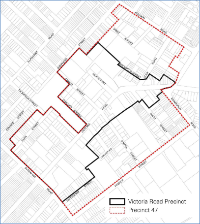
Image 1: Map indicating the area encompassed by the Victoria Road Precinct Planning Proposal (outlined in black) that forms part of Precinct 47 (identified in red dash) as defined under Marrickville Development Control Plan 2011.
As indicated in Image 2 below, the area is currently zoned IN1 General Industrial under Marrickville Local Environmental Plan (MLEP) 2011 with a small section of land on the western side of Farr Street zoned IN2 Light Industrial.
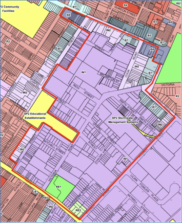
Image 2: Current zoning controls applying to the area under MLEP 2011
The area is generally made up of one and two storey factory and warehouse buildings. The land to the south and east of the precinct is zoned industrial, while the land to the north and west is zoned residential.
The proponent seeks to rezone the land from General / Light Industrial to a mix of:
· R3 Medium Density Residential – land on the western side of Farr Street;
· R4 High Density Residential – being the majority of the block bounded by Victoria Road, Sydenham Road, Farr Street and Marrickville Public School;
· B4 Mixed Use – land on the eastern and western sides of Victoria Road near the intersection with Sydenham Road; and
· B5 Business Development for all other land to which the planning proposal relates.
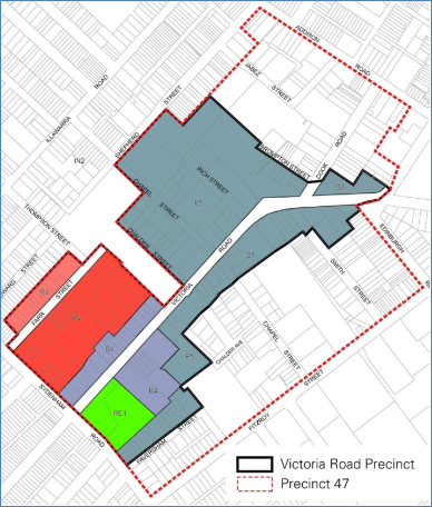
Image 3: Proposed zonings under the Victoria Road Precinct Planning Proposal
As part of the planning proposal the proponent also seeks to increase the floor space ratio (FSR) and provide a height limit on the properties affected by the planning proposal. The majority of the land in the precinct is currently zoned General Industrial, with a maximum FSR 0.95:1 and with no height development standard. As indicated in Images 4 and 5 below, the proposed FSR’s range from 1:1 to 3.5:1, while the proposed heights range from 11 metres (3 storeys) to approximately 46 metres (14 storeys). The applicant also seeks to exclude enclosed balconies and internal areas of communal open space from gross floor area (GFA) calculations.
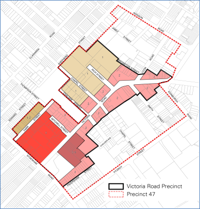
Image 4: Victoria Road Precinct Planning Proposal FSR Map
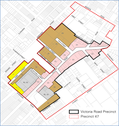
Image 5: Victoria Road Planning Proposal Height of Buildings Map
In addition to the provisions outlined above, it is also proposed that a portion of the Victoria Road Precinct that is to be zoned B4 Mixed Use, R3 Medium Density Residential and R4 High Density Residential be identified as a ‘Key Site’ in Schedule 1 of MLEP 2011 in order to provide site-specific controls for the provision of affordable housing and the implementation of design standards to ensure internal acoustic amenity.
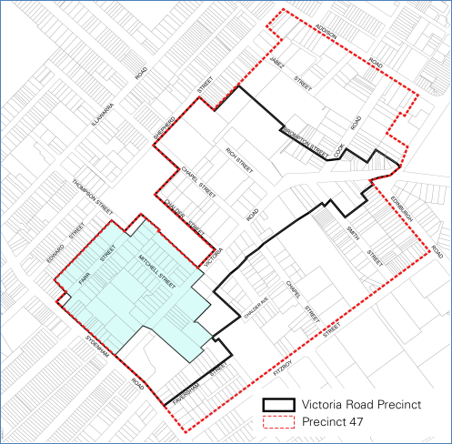
Image 6: Victoria Road Planning Proposal ‘Key Site’ Map
3. GATEWAY DETERMINATION
The planning proposal received Gateway determination from the Department of Planning on 16 March 2016 subject to a number of conditions, including a condition “to review the proposed R4 High Density Residential zoning around Wicks Park to retain the IN1 General Industrial Zone, or apply a business zone”.
The purpose of that condition was to ensure there was no residential development on the south eastern side of Victoria Road as is highlighted in the following extracts from the Gateway Assessment Report prepared by the Department:
“The planning proposal suggests a direct interface between the R4 High Density Residential and IN1 General Industrial at Faversham Street. The Department has significant concerns about the co-location of incompatible land uses at this location, particularly about the impact on business operations and resident amenity as well as the sterilisation of industrial land to the south of Faversham Street.
……The Department recognises that some residential development in the south-west corner may be appropriate. However, the R4 and IN2 interface at Faversham Street needs further consideration. The Department recommends retaining the IN1 General Industrial land or applying a business zone instead of the R4 High Density Residential proposed for the land around Wicks Park. This will reduce the quantum of land being lost to residential uses and support the proponent's objective to maintain or increase employment in the Precinct.
……In summary, the Department is concerned the proposed R4 High Density Residential adjacent to the IN1 General Industrial land at Faversham Street will sterilise industrial uses, reduce the industrial value of the land and contribute to the slow reduction of employment lands. Should that land be redeveloped for residential uses, new residents will have amenity impacts and adversely affected by noise, traffic, and odour, placing pressure on the operations of that business. However, this can be remedied by either retaining the IN1 General Industrial zone or applying an appropriate business zone.”
The Gateway Assessment Report as prepared by Department officers indicates that residential development was not supported on the south eastern side of Victoria Road given the direct interface with the core industrial lands and the likely land use conflict that would arise.
Notwithstanding the Gateway Assessment Report, the Gateway Determination allowed for the revised planning proposal to progress the rezoning and continue consideration of rezoning land directly to the north of Wicks Park B4 Mixed Use with a maximum building height of RL49 to allow a 14 storey shop top housing development to be erected on the site.
An assessment of the appropriateness of this approach is provided later in this report.
4. KEY PLANNING ISSUES
Following a review of the planning proposal, and the receipt of internal and external referrals, Council sent an issues letter (dated 14 February 2017) to the proponent identifying a number of matters that needed to be addressed in order to progress the planning proposal.
The issues raised and the proponent’s responses are outlined below:
(i) Road Network Upgrades and Pedestrian Connectivity
In accordance with the Gateway Determination, the planning proposal was referred to the Roads and Maritime Services (RMS). The RMS advised that they did not support the planning proposal and that it should not be gazetted until such time that the cumulative transport impacts and associated mitigation measures are identified and included in an appropriate funding mechanism.
The RMS found the Traffic and Transport Assessment Report (prepared by Hyder Consulting) submitted with the planning proposal to be preliminary in nature and that it did not adequately analyse the cumulative traffic and transport impacts associated with the planning proposal.
Council’s Infrastructure Planning and Property Section also advised that due to the significant traffic generation along Victoria Road, a network traffic modelling covering a broader area needed to be undertaken to assess the impact on the adjacent road network.
In assessing the planning proposal, Council also engaged an independent specialist (McLaren Traffic Engineering Pty Ltd) to undertake a preliminary review of the planning proposal. That review also highlighted deficiencies in the traffic and transport assessment provided as part of the planning proposal. A copy of that review is provided at ATTACHMENT 2.
The Traffic and Transport Assessment Report originally submitted with the planning proposal identified that the intersection of Victoria Road and Sydenham Road will likely require upgrades to mitigate the additional traffic generation resulting from the redevelopment associated with the planning proposal. The report (on page 28) identifies that this can be achieved through intersection upgrades including widening to provide right turn bays on the three approaches as indicated in the diagram below:
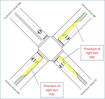
Image 7: The upgrades required at the intersection of Victoria Road and Sydenham Road (Source: Traffic and Transport Assessment by Hyder Consulting)
Given the above, it was important to determine if there were land acquisition requirements to ensure appropriate road geometry is met for the potential upgrade of the Victoria Road / Sydenham Road intersection. Accordingly Council requested plans that appropriately detailed these intersection upgrades and the impact they may have on nearby properties (i.e. acquisition) and / or the impact on kerbside car parking in the area.
Should property acquisitions be required, Council officers advised the proponent that the planning proposal would need to address the manner in which this would occur (including funding) noting that Wicks Park is not to be impacted given the lack of open space in the area.
Applicant’s response to this issue:
Following receipt of Council’s issues letter the proponent has carried out a more detailed traffic and transport assessment to support the planning proposal and submitted an addendum to the Traffic and Transport Assessment Report provided as part of the original planning proposal.
In response to the outcomes of this additional modelling, the following upgrades are proposed at Victoria Road / Sydenham Road intersection:
1. One additional right turn lane on Victoria Road northern approach (about 90m long);
2. One additional right turn lane on Sydenham Road eastern approach (about 90m long);
3. One signalised left turn slip lane on Sydenham Road western approach.
The intersection upgrades required as part of the planning proposal are illustrated below:
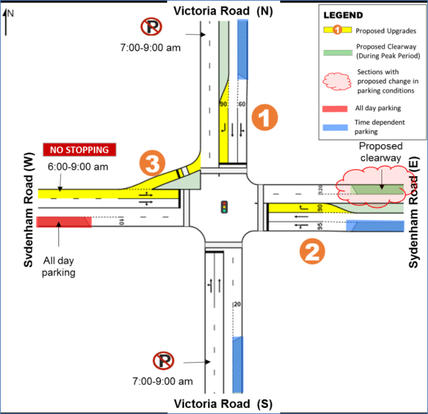
Image 8: Indicative Victoria Road / Sydenham Road intersection upgrades required as a result of the planning proposal
The intersection upgrades and the additional turning / slip lanes would require property acquisitions to ensure suitable road geometry and the proponent has provided the following concept design to illustrate these works:
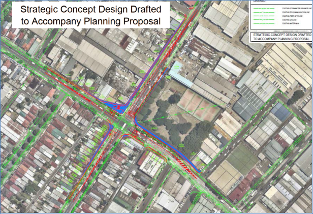
Image 9: Strategic Concept Design including land acquisition (coloured in blue) to allow for the Victoria Road / Sydenham Road intersection upgrades
Council officers concluding comments:
As illustrated in Image 9 above, the proposed upgrading of the Victoria Road / Sydenham Road intersection would require the acquisition of land (as identified in blue in the above image) including some properties that are outside the area encompassed by the planning proposal (e.g. properties on the western side of Victoria Road, south of Sydenham Road, and parts of the properties on the south eastern and south western corners of the intersection of Victoria Road and Sydenham Road). The proposed road works would also require sections of Wicks Park (currently classified Community land) to be acquired for road widening.
As part of the issues letter sent to the proponent, the proponent was instructed that Wicks Park was not to be impacted upon by any necessary road upgrade works. Based on the above plan prepared by the proponent’s traffic consultant approximately 250sqm to 300sqm of Wicks Park is assigned for acquisition and a strand of significant trees along the Sydenham Road frontage of Wicks Park would be removed to facilitate the required road widening works (refer image 10 below).
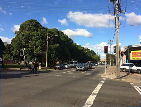
Image 10: Photo of the section of Wicks Park to be acquired for road widening and the strand of trees that require removal to facilitate such road works
Wicks Park is classified as “Community land” under the Local Government Act 1993 and would need to be reclassified if it was to be used for road widening purposes. At this stage the planning proposal does not include the reclassification of Wicks Park which would be subject to a public hearing process and would require endorsement from the Minister for Planning and approval from NSW Governor.
The intersection upgrades recommended in the Traffic and Transport Assessment Report also require the establishment of an AM clearway along Sydenham Road, east of Victoria Road. The creation of such a clearway would restrict car parking along this section of Sydenham Road during the morning peak and likely further impact local businesses along Sydenham Road.
The Roads and Maritime Services (RMS) has reviewed the addendum to the Traffic and Transport Assessment Report provided by the proponent and in a letter to Council dated 1 June 2017 reiterated their original advice that it cannot support the planning proposal in its current form primarily on the basis that:
· cumulative traffic and transport impacts on the surrounding local and regional road network has not been adequately addressed
· the proposal has not adequately addressed funding responsibilities, associated funding mechanisms and an Infrastructure staging plan which identifies the timing, cost and trigger points for the delivery of transport infrastructure upgrades.
The RMS reiterated that the above matters should be undertaken prior to gazettal and would not support the deferral of these matters to the development application stage.
A copy of the RMS letter is attached to this report at ATTACHMENT 3.
In a letter dated 5 June 2017, the proponent responded to the issues and concerns raised by the RMS and a copy of that letter is attached at ATTACHMENT 4. The proponent’s responses are summarised as follows:
· It is inappropriate to request additional modelling at this late stage of the assessment of the planning proposal;
· The additional modelling can be provided at DA stage;
· The modelling is not considered necessary as development in the precinct will occur over a 10-15 year period;
· The intersections have recently been modelled when Inner West Council was adopting (with RMS input) its Local Area Traffic Management Plans (LATM’s). Those LATM’s concluded “The results indicate that the majority of intersections operate with spare capacity during most times of the day”;
· The Sydenham Road/Farr Street intersection will only be impacted by the low scale residential development on Farr Street;
· The possible upgrade to the Sydenham Road/Victoria Road intersection was requested by the RMS and is based on the assumption that the precinct is developed to 100% of its potential;
· Any future road upgrades are likely to be delivered through a range of different planning mechanisms, including voluntary planning agreements, conditions of consent, existing works programs, and Section 94 contributions; and
· “The approach adopted in relation to contributions, and the timing of those contribution plans follows the clear instructions given to the proponent by the Council’s Legal Officer and the previous Council Planning Director and supported by the Department of Planning in that the Contribution Plans be resolved in the next stage of the process.”
The proponent’s responses to the concerns raised by the RMS are not supported for the following reasons:
· The inadequacy of the traffic analysis carried out by the proponent was identified by the RMS, Council officers and McLaren Traffic Engineering. Specifically, the Preliminary Review carried out by McLaren Traffic Engineering found that:
“Additional information is required for a comprehensive assessment:
• There is no analysis or discussion in regard to impacts upon public transport and likely requirements to increase services to facilitate the significant population increase in the area. The application should hold discussions, where they are preliminary or not, to establish the likely outcomes in the view of increasing services in the area.
• Isolated intersection analysis is not considered appropriate or adequate to determine the traffic impact of the proposal, particularly with the suggested additional intersection to Victoria Road. Future traffic modelling should take into consideration back-of-queues to nearby intersections, potential physical turn restrictions to / from side streets along Victoria Road and consolidation of access / streets along Victoria Road. A network model or linear linked simulation model is expected to be necessary taking into account residual queues on main roads plus details of any rat-run volumes that currently use back streets / local streets to avoid congested locations / routes.
• There is no analysis provided for potential retail land uses that could generate increased traffic volumes, compared to the assessed commercial office traffic generation rate that has been adopted. In this regard, consideration should be given to multiple development outcomes to be assessed.
• The intersection modelling should consider the junction of Enmore Road / Addison Road, Enmore Road / Llewelyn Street to the north of the precinct and Sydenham Road / Farr Street signalised intersection.”
· Those concerns (and a copy of the Preliminary Review carried out by McLaren Traffic Engineering) were raised with the proponent as part of Council’s issues letter dated 14 February 2017;
· Council’s Coordinator Traffic Engineering Services advises that the modelling associated with the LATM’s is not current and did not consider the traffic and transport impacts associated with the rezoning / uplift sought as part of this planning proposal.
· The traffic impacts resulting from rezoning and uplift sought as part of this planning proposal must be dealt with as part of the planning proposal to ensure that the mitigation measures required by the planning proposal are planned for and can be implemented. It is not appropriate to require the cumulative traffic modelling for the entire precinct to be carried out as part of individual development applications for redevelopments within the precinct. As highlighted above, the upgrades required to the Sydenham Road/Victoria Road intersection resulting from the rezoning / uplift sought under this planning proposal would require property acquisitions and the reclassification of community land. Such matters are ordinarily dealt with at the rezoning stage.
· The possible upgrades to the Sydenham Road/Victoria Road intersection was not requested by the RMS, but rather was identified in the Traffic and Transport Assessment Report(s) prepared by the proponent. As indicated in image 7 above, the Traffic and Transport Assessment Report submitted as part of the original planning proposal (i.e. prior to any referral to the RMS) identified that the intersection of Victoria Road and Sydenham Road will likely require upgrades to mitigate the additional traffic generation resulting from the redevelopment associated with the planning proposal.
· Council’s General Counsel refutes the claims of the proponent regarding the timing of infrastructure funding plans and advises that given the significant infrastructure works that are necessitated by the uplift / rezoning, the issue of infrastructure planning, funding and delivery must be resolved prior to the gazettal of the planning proposal.
(ii) Affordable Housing
The draft Central District Plan (dCDP) requires the relevant planning authority to include an Affordable Rental Housing Target as a form of inclusionary zoning and sets a target of 5-10% of new floor space at rezoning stage. Furthermore, Council’s Affordable Housing Policy sets an affordable housing target of 15%.
In light of these targets, the 3% affordable housing provision proposed as part of the original planning proposal was considered inadequate.
Applicant’s response:
“The affordable rental housing target is proposed to be increased to 5% of new floor space in accordance with the Draft District Plan. Whereas the Greater Sydney Commission has indicated that the Draft District Plan should be considered in Planning Proposals, Council's draft policy has been publically exhibited but has not been formally endorsed or adopted by Council for application to existing Planning Proposals. Given the uncertainty as to whether this target will be formally adopted by Council or permitted by the NSW Department of Planning and Environment (via an amendment to SEPP 70), it is not considered appropriate to apply Council's draft policy to this Planning Proposal.”
Council officers concluding comments:
While on face value it would appear that the proponent has increased the affordable rental housing rate from 3-5%, the amended clause seeks to change the definition of ‘accountable gross floor area’ to exclude a significant portion of the gross floor area for which the clause will apply.
When the proponent proposed a 3% affordable housing rate ‘accountable gross floor area’ was defined as:
Accountable gross floor area means the gross floor area of the residential component of the development to which the development application relates.
In amending the clause to provide 5% affordable housing the proponent has also changed the definition of ‘accountable gross floor area’ to read:
Accountable gross floor area means the gross floor area which exceeds a floor space ratio of 0.95:1 on the land on which development is proposed as part of an application for development consent.
By only applying the affordable housing rate to gross floor area that exceeds 0.95:1 in many instances the new definition will result in less affordable housing than what would have been provided under the original clause. Under the new definition, less affordable housing would be required on those sites where the maximum floor space ratio was set at 2.4:1 or less than that that would be required based under the originally proposed definition of “accountable gross floor area”.
Given that all land is currently zoned industrial and residential development is prohibited under the existing zoning provisions, the affordable housing component should be applied to all of the ‘new’ residential floor area, ie across all floor space to be delivered.
The 5% rate of affordable housing only represents the minimum rate recommended in the dCDP and is well below the 15% sought under the Inner West Council’s Affordable Housing Policy (which was adopted by Council on 28 March 2017). Moreover, the modelling carried out in developing the Inner West Council’s Affordable Housing Policy found that “the highest profits are associated with rezoning of industrial land, and a 15% levy is generally supportable across these areas”.
The proponent seeks to up zone the subject land to allow residential development up to 14 storeys in height. In view of the scale of the up zoning, the proponent’s proposed 5% affordable housing rate (with the actual rate being less when calculated under the proposed new definition of “accountable gross floor area”) is considered inadequate and therefore not supported.
(iii) Architectural Excellence Panel
The planning proposal was considered by Council’s Architectural Excellence Panel (AEP). The AEP did not support the planning proposal in its current form and made recommendations for an improved structure plan for the precinct.
The recommendations made by the AEP focused on the layout and built form outcomes that would result in an improved masterplan layout, particularly the creation of a network of streets and lanes that is not currently included in the planning proposal. The AEP also recommended reduced building heights in certain locations to ensure that the proposal better responded to the scale and character of the surrounding area and reasonable amenity is maintained in Wicks Park.
The AEP reinforced the design advice provided in the independent Urban Design Study prepared by Rod Simpson, particularly the need to provide rear lanes for servicing access and waste collection for the multi-level redevelopment proposed along Victoria Road.
The AEP also highlighted the lack of open space provided as part of the planning proposal, noting that the 2 pocket parks proposed are inadequate given the significant intensity of development proposed (this issue is further addressed below under the heading “Public Open Space”).
The AEP identified the need for public domain improvements, particularly on Victoria Road, that need to be provided as part of the rezoning. As highlighted below the issue of infrastructure planning, funding and provision has not been adequately addressed as part of the planning proposal.
Applicant’s response:
“In assessing the Planning Proposal in 2015, prior to the proposal receiving Gateway Determination, Marrickville Council referred the proposal to its Architectural Excellence Panel for assessment. An Urban Design Report was prepared by Mr Roderick Simpson. His findings were considered by both the Council and the Department during the Gateway Assessment. Further the proponent was required to address as part of the Gateway Conditions, some of the findings of the Design Report. This was done and the Department determined that the Gateway Conditions had been met. In light of this it is considered that the design issues had already been addressed for the most part, and that it is inappropriate to continually subject the proposal to further design reviews.”
The applicant’s submission rejects the recommendations made by the AEP for the following reasons:
· The Structure Plan recommended by the AEP is not supported “due to other design failings and site constraints”;
· The matters raised in Mr Rod Simpsons report were addressed as part of the Gateway Process;
· The introduction of new laneways and streets, together with the amalgamation of sites to create larger development parcels will greatly assist in improving the quality of the streetscapes within the precinct;
· Serviceability of new developments will be addressed as DA stage;
· New development in the precinct, particularly residential, will significantly increase the amount of landscaping and permeable ground conditions in the area;
· A quantitative approach to open space planning is outdated and simplistic and the focus should be on improving the overall public domain;
· The building forms were considered at Gateway Stage and determined to have strategic merit;
· The height of the proposed buildings around Wicks Park will help to activate the park and maximise the use of the amenity provided by the open space; and
· The FSR’s need to be sufficient to allow for the orderly and economic redevelopment of the land.
Council officers concluding comments:
The applicant’s assertion that urban form should not be considered post Gateway is not supported. Gateway determination includes a strategic and site specific merits test that identifies whether a proposal demonstrates strategic merit. It is by no means the end of the process, but rather is the start under which a detailed review of the planning proposal is carried out.
Furthermore, the proponent has not addressed fundamental concerns and recommendations contained in the Urban Design Report prepared by Rod Simpson or the Architectural Excellence Panel (AEP) advice. Most notably:
· The planning proposal does not provide new laneways and road connections required to service the rezoning and stated vision for the Victoria Road corridor. Both Rod Simpson’s Urban Design Study and the AEP report recognise the provision of rear lanes for servicing access and waste collection as crucial to avoid regular vehicular crossings into basements and unsightly waste collection areas impacting on pedestrian safety and amenity, as well as reducing the activation of frontages, on Victoria Road. The proponent suggests that the issue of site serviceability of new developments can be addressed at development application stage and that access may be provided from side streets. This approach is not supported. Should the planning proposal be approved as submitted, with the exception of corner lots, the majority of developments will require vehicular access (and waste collection) directly off Victoria Road. This will have a negative impact on the streetscape vision for Victoria Road and would affect pedestrian safety.
· Both Rod Simpson’s Urban Design Study and the AEP report recognise the need to provide new areas of public open space to support the new resident and worker population. This issue is further addressed below under the heading “Public Open Space” and as highlighted above, approximately 250sqm to 300sqm of Wicks Park is assigned for acquisition to facilitate the road widening works to Sydenham Road required as part of the planning proposal.
· At 14 storeys the maximum building heights proposed are excessive given the surrounding context and will result in unreasonable impacts on the amenity of Wicks Park. The AEP recommended reduced building heights with a maximum building height of 9 storeys on the Danias Timber’s site and a maximum height of 4 storeys for the site to the north of Wicks Park (Block X). Rod Simpson Urban Design Report also found the proponent’s rationale for the built form on Block X to be “unclear”. The proponent states that “the height of the proposed buildings around Wicks Park help to activate the park and maximise the use of the amenity provided by the open space”. The proponent’s rationale is not supported, as a 14 storey building is not required to “activate the park”. The proposed building heights on Block X will result in significant overshadowing of Wicks Park reducing the amenity of this important area of public open space. This issue if further addressed below under the heading “Public Open Space”.
Overall, the height, bulk, scale and form of a number of the building envelopes sought as part of the planning proposal are not supported particularly given the distance the precinct is located from the entrance to Sydenham Station (approximately 800 metres).
The Danias Timber site is proposed to have a Floor Space Ratio of 3:1 and a height of approximately 46 metres (14 storeys) which is significantly greater than any other site of this size covered by MLEP 2011. Under MLEP 2011 the sites with the greatest FSR’s and heights are located close to centres and rail transport hubs. The subject area is not within a local centre or in direct proximity to main public transport services and can therefore not be considered a Transit Oriented Development.
Similarly, Block X is proposed to have a FSR of 3.5:1 and a maximum height of approximately 47 metres to allow the erection of a 14 storey residential tower. The proposed envelope would result in overshadowing of Wicks Park.
The planning proposal does not provide any suitably sized new areas of public open space and the proposed building envelopes will result in overshadowing and visual bulk impacts for Wicks Park reducing the amenity of this important piece of public open space. Moreover, the planning proposal will also result in a loss of public open space as parts of Wicks Park have now been identified for acquisition to cater for the road widening required by the planning proposal.
(iv) Public Open Space
There is currently a lack of quality green open space in the former Marrickville Local Government Area and this deficiency was highlighted in the Recreation User Needs Research carried out in 2012.
While proposing a significant increase in residential and employment density in the area, the planning proposal only identifies 2 pocket parks proposed in the Timber Yards Sub-precinct. Given the substantial increase in resident, workers and likely visitors that would be introduced to the area under the planning proposal it is considered the additional level of open space offered is inadequate.
Based on the rate adopted under the Section 94 Plan of 1.39 hectares/1000 people, given the 1,100 dwellings and additional 4,000 jobs created by the planning proposal (and utilising the dwelling mix identified under MDCP 2011), the total open space required for the residential component of the planning proposal is 2.185ha, while the total open space required for the non-residential component (based on the commercial rate in the Section 94 Plan) is 1.12ha. Accordingly the total open space required to support the additional resident and worker population sought under the planning proposal would be 3.315 hectares.
Given the high land values in the Inner West Council Area and the $20k cap on Section 94 Contributions, it is not possible for Council to purchase land to support the open space requirements generated by the increased resident and worker population sought by this planning proposal.
Applicant’s response:
“We note the 'Recreation Needs Research - Strategic Directions for Marrickville' report which was adopted by Marrickville Council on 20 November 2012, which states that:
'The question of whether or not open space provision, including space for formal and informal sport is sufficient to meet demand has traditionally been answered via the use of quantity-based standards such as the 2.83 hectares/1000 people that has been traditionally used in NSW. It was often perceived that open space provision obligations were met when the standards were achieved. However, it is now well understood that generalised standards are unreliable and not necessarily valid for particular areas.
This is supported by the NSW Department of Planning's new recreation and open space planning guidelines which argue that the standards are ‘irrelevant to contemporary planning’. The guidelines point out that, while most inner urban LGA's fall well short of the traditional benchmark, 'the reality is that the residents of inner urban Sydney have access to a range of recreational and leisure opportunities that the existing open space assets including high quality urban public spaces and harbour and beach foreshores, manage to deliver (though there may be some pressure on outdoor sports areas)". (our emphasis)
In light at the above, it is clear that a quantitative approach in open space planning is outdated and simplistic, and is not a desirable approach for this Planning Proposal. Instead, the focus is on improving the overall public domain, providing high quality spaces, and increasing utilisation of neglected open space assets.
As noted by Council, local development contributions will be collected by Council for the purpose of improving local open space. This could include upgrades in Wicks Park, Henson Park and Enmore Park, each of which are in close proximity to the Victoria Road Precinct, in order to enhance the benefit and utility of these spaces to the community. Improving the quality of existing public open spaces, in conjunction with new spaces and public domain upgrades, will provide a significantly greater net benefit to the community by providing desirable, active spaces.
We also note the ‘Marrickville Recreation Policy and Strategy’, which was adopted by Marrickville Council on 2 July 2013. One at the actions of this policy states that “Council will negotiate with the Department of Education and Training and local School Principals regarding the use of school facilities and open space outside of school hours”. Council's recommendation of a new park adjacent to the existing Marrickville Public School playground would simply replicate an existing community facility that could instead be opened up through negotiation in accordance with Council's policy.
Notwithstanding the above, further design work for the Rich Street employment precinct has identified an opportunity for an additional publicly accessible open space area at approximately 1,200sqm which, in conjunction with new active employment uses proposed in this location, will create an additional high quality public open space in addition to the existing pocket parks proposed in the precinct master plan.
We have also identified that the proposed pocket parks could be expanded if necessary. The exact design and location will be determined at DA stage.
The provision of open space and permeability through the site under the Planning Proposal will set a new benchmark for the area. No comparable recent proposal, including the Marrickville Hospital site, has proposed as much open space.”
Council officers concluding comments:
The applicant’s submission does not resolve the fundamental issue that there is a lack of public open space to service the new resident and worker population.
It should also be noted that Council officers’ calculation on the amount of additional open space was based on the information contained in the original planning proposal of 1,100 new dwellings and 4,000 new jobs created by the planning proposal. The information contained in the Response to Submissions (RTS) report prepared by the proponent and submitted to Council on 15 March 2017 states that “overall it is expected that around 1,100 new dwellings…..and up to 7,000 new jobs could be provided for by 2036” (page 8 of the RTS report).
Based on the revised new jobs figure, the total open space required to support the additional resident and worker population sought under the revised planning proposal would be 4.131 hectares.
Notwithstanding the proposal not introducing an adequate level of additional open space to this area, the building envelope proposed on the site located to the north of Wicks Park (Block X), at 7 to 14 storeys with a minimal setback (2.5 to 3 metres), will result in overshadowing and visual bulk impacts for this park.
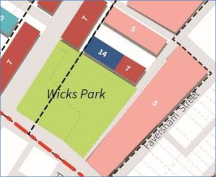
Image 11: Building envelopes to the north of Wicks Park indicating building heights of 7 to 14 storeys that will overshadow the most useable sections of Wicks Park (Figure 17 Building heights map in draft DCP)
Furthermore, as highlighted under heading 4(i) above, the road works necessitated by this planning proposal require sections of Wicks Park to be acquired for road widening purposes. Such land acquisition would reduce the size of the park (by around 250sqm to 300sqm) and necessitate the removal of a strand of significant trees within the park along its Sydenham Road frontage.
The applicant’s reference to the former Marrickville Hospital Site is unclear as this is not a planning proposal but rather a development application that is currently under assessment. However it is noted that a 1,250sqm area of public open space as well as 850sqm of publicly accessible landscaped pedestrian links (and a new library) are proposed as part of that proposal which is proposed to contain approximately 225 dwellings.
In terms of other recent developments that provided public open space for residents include the Luna development completed by Meriton at 78-90 Old Canterbury Road (which contains 298 dwellings) provided a 3,000sqm park that was dedicated to Council.
While the proponent suggests that a new 1,200sqm area of public open space can be provided in the proposed Rich Street employment precinct there are no material controls that will ensure its delivery. The proposed “new 1200sqm area of public open space” is not referred to in the desired future character objectives for the precinct and the public open space area is not shown on the Indicative Masterplan for the precinct. The only reference to this open space is a control in the draft DCP which states:
“Public accessible open space of a minimum area of 1,200sqm is to be provided within the Chapel Street sub-precinct…(between Rich Street and Brompton Street).”
The accompanying figure is illustrated below:
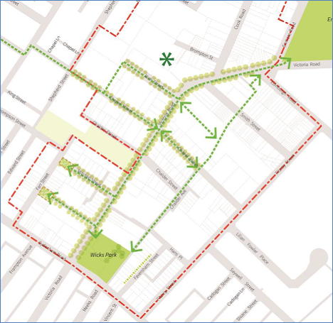
Image 12: Public open space network in the draft DCP
The green asterisk in the above diagram symbolizes this new open space. The controls suggested by the proponent are not descriptive or transparent and do not provide adequate certainty for the provision of public open space to service the new resident and worker populations envisioned under the planning proposal. It would be difficult for Council’s Development Assessment Unit to require the provision of this open space as part of any future development application in the Rich Street employment precinct.
The issue of public open space by way of quantum, dimension and implementation remains an unresolved matter and cannot be supported in its current form.
(v) Infrastructure Planning and Delivery
The infrastructure upgrades required to deliver the vision for the area are not appropriately reflected in the proposed controls nor is a dedicated funding mechanism proposed to fund the necessary infrastructure upgrades.
It is noted that the planning proposal states “In order to address some of these shortfalls and meet the needs of the future population of the study area, a contributions plan specific to Precinct 47 will be prepared in consultation with Council prior to the gazettal of the Planning Proposal” (p. 94 of the Planning Report prepared by JBA).
There is no draft Section 94 Plan prepared for the precinct and to date no discussions have been held with Council with regard to the development of such a plan. Furthermore, the real value of Section 94 contributions has decreased over the years due to the $20k per dwelling cap on contributions; inflation; and land price escalation coupled with increasing development costs. The contributions cap limits the contribution funds that may be received by Council and hinders the ability of Council to provide the level of public facilities and services required by this planning proposal.
The planning proposal seeks to significantly up zone the subject land and this necessitates infrastructure planning and delivery that is outside the scope of Marrickville Section 94/94A Contributions Plan. Given the inadequacy of Section 94 contributions to provide for required community infrastructure the planning proposal should incorporate an appropriate infrastructure delivery mechanism to fund its provision.
Applicant’s response:
“Council has previously stated that it is not appropriate to deal with changes to the Section 94 Plan as part of the Planning Proposal, and that Council would deal with this matter at a later stage.
The urban renewal of Precinct 47 will generate demand for community services and infrastructure within the local area. New development within the precinct would be required to contribute to local infrastructure in the form of Section 94 Development Contributions for recreational facilities, community facilities and traffic infrastructure or a VPA process with individual developers.
Precinct 47 is well located in relation to existing community and social infrastructure, including Enmore Park and the Annette Kellerman Aquatic Centre, Henson Park and the Addison Road Community Centre.
It is noted that a meeting was held with Mr Tim Moore, Mr Marcus Rowan and Joe Strati (legal counsel) on the 17th August 2015. The purpose of this meeting was to discuss process going forward and discuss the infrastructure contributions framework. During this meeting, we were advised by the Council officers, led by their legal adviser, that their preference was for the preparation and/or update of any contributions framework to be undertaken after gazettal of the LEP Amendment. The rationale used by Council officers at the time was that the quantum of development would be unknown until gazettal so there is no point in preparing the contributions framework until the demand for infrastructure is known. Accordingly, the assertion that no discussions have been held regarding this matter is incorrect.
It is acknowledged that there may need to be an update of the contributions framework to accommodate the development, however it is considered that such an update (if deemed necessary) can occur following gazettal of the LEP. Such an approach is common practice with rezoning's, with updates to contributions frameworks regularly occurring following LEP amendments.
We note that Council's incumbent Section 94 Plan will still be applicable should development occur between the LEP Amendment and the adoption of any changes to the contribution framework. Based on our analysis of the Indicative Masterplan the planning proposal will still generate in the order of $36,000,000 of contributions under the current Section 94 framework. Furthermore it is noted that redevelopment of the precinct will occur over a 15-20 year timeframe, as such there will be ample time to produce a well-considered infrastructure contributions programme after the LEP is gazetted (if necessary).
In light of the above, it is considered that an infrastructure planning framework is in place that will enable the collection of a significant amount of contributions in any event, and that any review and update of this framework can occur after the LEP Amendment, a common practice that is regularly adopted by Sydney Metropolitan Councils.
The proponent also reaffirms their willingness to assist Council with any review and update of the contributions framework as it applies to the precinct.”
Council officers concluding comments:
The planning proposal seeks to significantly up zone land and this necessitates infrastructure planning and delivery that is outside the scope of Marrickville Section 94/94A Contributions Plan.
Given the inadequacy of Section 94 contributions to provide for the complete array of essential community infrastructure items, the planning proposal should incorporate an appropriate mechanism to fund the provision of required infrastructure.
Council’s General Counsel refutes the claims of the proponent (that any planning agreements should be postponed to DA stage) and advises that given the significant infrastructure works that are necessitated by this proposal, the planning agreement must form part of the planning proposal. This preferred process was also outlined in the original assessment report considered by Council at its meeting on 3 November 2015 in which the recommendations of that report included:
“Council requires that, as a condition of proceeding with the planning proposal post Gateway determination, the proponent make arrangements to ensure that public infrastructure and benefits (generally identified in this report) will be delivered as part of the urban renewal contemplated by the planning proposal.”
Furthermore, some of the infrastructure planning and delivery issues, such as the need to acquire properties outside the area of the planning proposal as well as sections of Wicks Park for road widenings are considered insurmountable. The need to acquire private properties cannot be funded by Council (or the RMS) for the purpose of facilitating this private proposal.
The issue of infrastructure planning and provision of an appropriate mechanism to provide public certainty that funding will be realised from across the precinct and multiple owners remains unresolved.
(vi) Heritage
As part of the Gateway determination issued by the Department, a heritage investigation was required to “identify items that have potential heritage significance and should be preserved (this includes industrial heritage)”.
In responding to this condition Artefact Heritage were engaged by the proponent to undertake a heritage study of the area. Artefact Heritage identified two currently listed items, two potential items recommended for listing, four recommended for further study, and six discounted as not having heritage significance.
The Heritage Assessment Report has been reviewed by Council’s Heritage Advisor who provided the following comments:
“The report was prepared by Artefact Heritage. No information is provided about the company or the author’s identity or qualifications. The approach outlined in 1.3, relying on a site survey, thematic history and other information, is sound. An inspection of the area confirms that the items chosen for review are appropriate, though two additional houses are considered to warrant investigation.
However a major concern is that four items are simply identified as requiring further study, on the basis that the brief called for a “high-level review”. It is agreed that these items may need a good deal of additional historical research and comparative evaluation before they can be fully assessed. However, whether the brief or funding was inadequate or otherwise, the report leaves Council uninformed as to whether certain items need to be retained, and the recommended heritage management would appear to leave them insufficiently protected.
The Masterplan and proposed planning control maps do not take account of the potential items. But heritage items and their curtilage need to be established first, as their retention is a “given.”
The 4 potential items identified in the Heritage Assessment Report include:
· 64 Chapel Street, Marrickville;
· 23-33 Faversham Street, Marrickville (this property forms part of the sites known as 28 Faversham Street and 22-38 Fitzroy Street under Council records);
· 8-12 Rich Street, Marrickville; and
· The Air Raid Shelter, Wicks Park
The potential heritage items are identified in the image below:
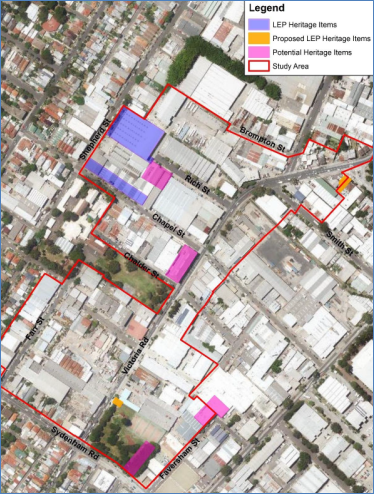
Image 13: Map illustrating existing heritage items, proposed items for listing and potential items requiring detailed heritage assessment – Source: Figure 80: Heritage Assessment (Annexure H of Planning Proposal Report)
As identified by Council’s Heritage Advisor, the Masterplan and proposed planning control maps do not take account of these potential items. The Masterplan requires almost complete demolition of the potential heritage item identified in the heritage report as 23-33 Faversham Street, Marrickville to provide vehicular access to Block X due to the proposed extension of Hans Place and Chalder Avenue as indicated in the image below (as item 6). It is further noted that this building is a relatively large industrial building that extends onto properties outside the area of the revised planning proposal:
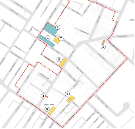
Image 14: Existing and potential heritage items map - Source: Figure 20 (p. 32 ) of Draft Development Control Plan (Precinct 47) – (Appendix E)
Council’s Heritage Advisor requires:
“The items nominated above should be thoroughly assessed in terms of the NSW Heritage Procedure, presumably by the proponent’s consultants, and these assessments should then be independently reviewed. The items found to be significant by the independent review should be listed as part of the planning proposal and incorporated into Schedule 5 of the LEP in due course.”
Applicant’s response:
“Council's Heritage Advisor also notes that they have a ‘major concern’ that four items are simply identified as requiring further study. They note that “the Masterplan and proposed planning control maps do not take account of the potential items. But heritage items and their curtilage need to be established first, as their retention is a "given”.
In response to this we note the following:
· Council has just recently conducted a thorough review of heritage within the former Marrickville LGA, which includes a public exhibition period and a consultation process with the affected landowners of newly nominated heritage items.
· The purpose of the study was to strengthen heritage protection within the former Marrickville LGA. The outcome of the study was a recommendation by Council officers to include 75 new heritage items, 2 new conservation areas and an expansion of 3 existing conservation areas.
· At its meeting on 28th February 2017 the Council supported the officer’s recommendation and approved the amended Heritage List.
· We note that in undertaking their comprehensive review, despite identifying 75 new heritage items, not one of these was located within the Victoria Road Precinct area. Accordingly, the review will not result in any changes to the heritage register as it applies to the precinct.
· In addition, Council's review did not identify any of the four suggested items identified in the Artefact Report as being of heritage significance (one of which is on Council owned land).
· As proposed the items are subject to further review, as appropriate and should be considered in the next round of review. In the interim their potential heritage values can be reviewed at the DA stage, should they be affected by a development proposal.”
Council officers concluding comments:
Council officer’s make the following concluding remarks:
· The heritage review recently undertaken by Council focused on the southern sections of the Marrickville Local Government Area (defined as areas south of the Illawarra/Bankstown railway line); and
· The heritage study for Precinct 47 was required as a condition of the Gateway determination. That study has identified a number of potential heritage items however the planning proposal continues to identify these sites for renewal including the almost complete demolition of a potential heritage item to allow the extension of Hans Place.
The issue of heritage remains unresolved.
(vii) Proposed New Roads and Connections
One of the fundamental concerns with the planning proposal is the shortage of new roads and vehicular connections. The low level of permeability impacts the ability to deliver the vision of the Masterplan, most notably to transform Victoria Road into a commercial spine. As discussed above, given the planning proposal seeks to rezone the existing industrial land to allow commercial and residential buildings there is a need to create a new block structure that adequately supports such development forms.
More specifically, the only ‘new road’ that can actually be delivered as part of the current planning proposal is the new cul-de-sac proposed to service Blocks B and C in the Timber Yards Sub-precinct.
The extension of Chalder Avenue as identified in the Masterplan cannot be implemented as it sits outside the area of the planning proposal, with the ‘new road extension’ primarily located on the property known as 22-38 Fitzroy Street (refer image 15 below). That site is not included in the planning proposal and according to the information contained in the planning proposal the owner of that property is not identified as a supportive land owner of the planning proposal (Figure 9 p. 28 of Planning Report prepared by JBA).

Image 15: Map indicating property known as 22-38 Fitzroy Street which does not form part of the planning proposal but which is required to allow extensions of Chalder Avenue and Hans Place as envisioned under the Masterplan
Furthermore, the extension of Hans Place requires the almost complete demolition of the potential heritage item identified in the heritage report as 23-33 Faversham Street, Marrickville. The extension of Hans Place as identified in the Masterplan is also problematic as this ‘new road extension’ is partially located on the property known as 22-38 Fitzroy Street.
The inability to create either of these connections means there would be no vehicular access to Block X (north of Wicks Park), other than from Victoria Road.
Similarly, as identified above, there is a need to provide rear lanes for servicing access and waste collection for the multi-level redevelopment proposed along Victoria Road.
Applicant’s response:
“The structure and layout of roads has not changed substantially since the Planning Proposal was endorsed by Marrickville Council.
In response to this it is noted that:
· Realisation of the vision for the Precinct is not dependent on the creation of new roads, with Victoria Road still able to function as a vibrant commercial spine even without a block structure that includes rear service lanes.
· Victoria Road is a RMS controlled road, and as such access into and out of sites for new development is likely to be monitored very closely. In many instances, new development will need to gain their access from side streets such as Chalder Street, Chapel Street, Mitchell Street, Rich Street etc.
· Development Parcels within the precinct are likely to comprise a number of amalgamated lots. New development proposals are therefore likely to have access to side streets in most instances.
· There will be instances where new development will need to gain access from Victoria Road, in these instances consultation will be carried out with the RMS as part of any DA process to obtain their sign-off prior to any approval being issued.
· The number of driveway crossovers and points of access onto Victoria Road is likely significantly reduce as a result of the areas future regeneration.
· The DCP includes a Movement Network Map that illustrates where future connections are envisaged to occur within the Precinct. These may not be the only connections created within the precinct as future redevelopment of sites may require additional connections to enable them to operate.
· The DCP illustrates the possible location of a future extension to Chalder Avenue, and has been drafted to cover the area of Precinct 47 as per the current structure of the Marrickville DCP 2011. Even though the owner of 22-38 Fitzroy Street is not identified as a 'supportive landowner of the planning proposal', we note that redevelopment of the precinct is intended to occur over a 20+ year timeframe. The potential extension of Chalder Avenue through to Chapel Street and Smith Street will inevitably take time as the precinct comprises multiple landowners. The alignment of the proposed connections has been planned to occur along common property boundaries, thus minimising the impact on any one landowner and increasing the likelihood of delivery in the future.
· Council regularly uses DCP provisions to encourage the provision of new roads as part of the future redevelopment of land - for example under the existing Section 9.6 of the Marrickville DCP 2011 in relation to Petersham South (Figure 6.2b). There is no evidence that Council elicited support from the land owners in that instance at the time of the DCP being made.
· Number 23-33 Faversham Street is currently not a heritage item. However its potential heritage values (its façade) have been considered in the design of Hans Place. It is more appropriate to assess any impacts at the DA stage, but the heritage values could be enhanced through the possible future adaptive reuse. Secondly the proposed extension of Hans Place does not impact on 22-38 Fitzroy Street.
· Irrespective, all efforts will be made to ensure that blocks gain access from side streets away from Victoria Road. There will however be instances where new development will need to gain access from Victoria Road, in these instances consultation will be carried out with the RMS as part of any DA process to obtain their sign-off prior to any approval being issued.
· It should be noted that Mitchell Street, Rich Street and Chalder Street are currently dead ends, and service vehicles and waste collections are operating without any major issues.”
Council officers concluding comments:
The applicant’s position does not respond to the importance of improving access and servicing arrangements for a new precinct that is proposed to undergo substantial change as:
· Realising the stated vision for the Victoria Road precinct is reliant on the creation of new road and laneways. Both Rod Simpson’s Urban Design Study and the AEP report recognise the provision of rear lanes for vehicular access, servicing and waste collection as crucial to avoid regular vehicular crossings into basements and unsightly waste collection areas impacting on pedestrian safety and amenity and reducing activation along Victoria Road.
· The existing large block structure which adequately serviced the historic industrial uses is not appropriate for the proposed rezoning and smaller street / block structures are required to service the shift to higher order and more intense employment activity in the precinct.
· The Movement Network Map contained in the draft DCP (refer image 16 below) does not deliver any significant change to the road network in the area. As pointed out above the extension of Hans Place and Chalder Avenue will not occur as it requires land outside the area encompassed by the planning proposal. As no uplift is proposed on that land (and the site known as 22-38 Fitzroy Street contains a large strata titled industrial building) there is no incentive for the redevelopment required to create these connections. Furthermore, given the strategic importance of retaining industrial land Council is unlikely to support any future rezonings in this area that would result in a further loss of industrial lands.
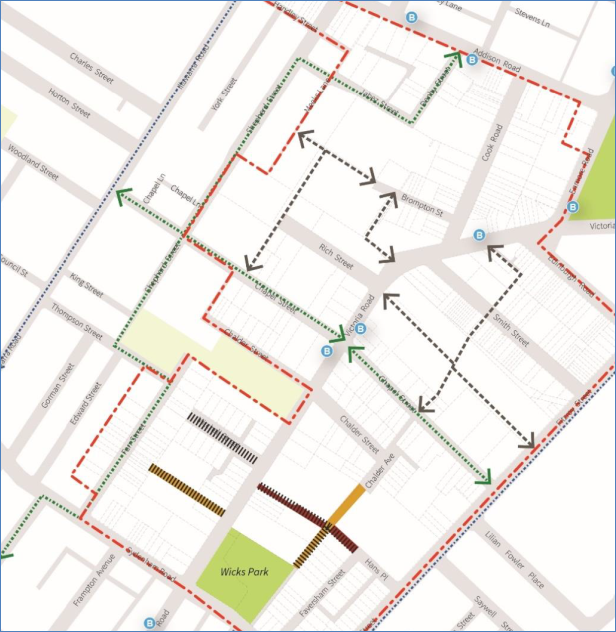
Image 16: Revised Movement Network Map (Figure 4 in Draft DCP submitted with the revised Victoria Road Precinct Planning Proposal)
· While RMS will be required to consider any new connections onto Victoria Road, RMS will only consider the traffic implications of any proposal and not the realisation of a positive urban design outcome for the precinct.
An adequate level of vehicular permeability including service laneways within this precinct will be integral to ensuring an optimal outcome is achieved from a design and operational perspective. This continues to remain as an unresolved matter.
Cycle Access
The planning proposal has objectives of encouraging cycling, providing a comfortable and attractive environment for cyclists and enhancing cyclist connections to surrounding commercial precincts including Addison Road and Marrickville Road. These objectives are important given the proposed residential densities and the need to encourage alternatives to car use. However there is little evidence of these objectives being incorporated into the proposed changes in the area encompassed by the planning proposal. While local streets in the study area can potentially accommodate cycling without dedicated infrastructure, the proposal does not consider how cycling can be encouraged and enhanced further as per the proposal objectives.
The planning proposal does not accurately portray Council’s cycle plans for routes in the area including:
· the proposed section along Farr Street is omitted;
· the proposed section along Chapel Street (east) is omitted;
· the report uses the incorrect map to show the local bike route network, thus omitting the Addison Road route entirely. The Traffic & Transport Assessment (Appendix J) also omits the proposed Addison Road route;
· an on-road cycle path is shown on Victoria Road but has not been identified in Council’s Bike Plan or Active Streets Network. Given traffic volumes a cycle path on Victoria Road should be separated from traffic lanes, however the planning proposal street sections do not show any provision for either a separated bike path or shared path.
Further consideration to road, walking, cycling and connectivity to Sydenham Station is required to allow the assessment of the planning proposal to progress particularly on its connectivity and quality of access to Sydenham Station which the proposal relies upon for access to heavy rail.
Applicant’s response:
· The Draft DCP identifies and nominates the cycle routes through Precinct 47, thus helping to reinforce the location of the cycle network through the LGA. It is noted that the Draft DCP is area specific and is therefore intended to work in tandem with the rest of the Council's planning framework, which should provide more generic LGA wide policies that guide and govern how cycle and end of trip facilities are to be incorporated into both residential and non-residential development.
· The DCP Movement Network Map has been updated to show the bicycle routes as set out in the Marrickville Bicycle strategy. The current Marrickville Cycling Map is included at Appendix G.
· Addison Road is outside the Planning Proposal area.
· In reviewing Marrickville Council's Bike Plan, we agree that it is inappropriate for cycle paths to be on Victoria Road, especially as there are easily accessible north and south cycle routes in nearby lIIawarra Road and Fitzroy Road. Further the proposal significantly improves the walking connections in and around the site.
· The planning proposal reflects the Marrickville Bicycle Strategy. Further work in this regard is therefore not required. Rather it is Council's responsibility to undertake a comprehensive review and update their Bicycle Strategy now that they are a merged entity.
· It is not appropriate for the proponent of the Planning Proposal to be responsible for the future design of Sydenham Street and the link to the Station. This area is outside of the Planning Proposal boundary and Precinct 47, and is not a matter for consideration for the LEP Amendment that is currently being considered.
Council officers concluding comments:
Councils Cycling Planner reviewed the proponent’s submission and made the following additional comments:
· It is noted that the draft DCP identifies Council’s planned bicycle routes through Precinct 47, however it remains unclear what measures will be taken on the relevant streets in the study area to be consistent with the planning proposal objectives of encouraging cycling, providing a comfortable and attractive environment for cyclists and enhancing cyclists connections to surrounding commercial precincts including Addison Road and Marrickville Road. It is expected that appropriate cycling infrastructure treatments and enhancements on the identified bicycle routes in the study area are identified in the planning proposal and draft DCP, consistent with Council’s Marrickville Bicycle Strategy and the NSW Bicycle Guidelines; and
· It is noted that Addison Road is outside the planning proposal area, however the planned route on Addison Road should be shown on the DCP Movement Network Map to show the wider bicycle network context, and connectivity of bicycle routes in the study area to destinations further afield, just as other planned bicycle routes outside the study area, e.g. on Illawarra Road, Fitzroy Street and Meeks Road are shown in the DCP Movement Network Map.
(viii) Flooding and Drainage
The planning proposal has been reviewed by Council’s Infrastructure Planning and Property Section who provided the following comments:
“The area in question is subject to significant flooding. Whilst the flood report identifies constraints to development based on flood hazard based on existing conditions, it does not consider the proposed block layout. The development needs to consider minor and major drainage and flooding in a more holistic manner.
The flood liability report (Appendix K) focuses on hazard in major flood events, but minor flood event may cause more frequent damage especially with the change in land use.
To provide an acceptable level of service channelized and piped drainage in the area will have to be upgraded to meet a 5 year ARI. It is likely this would entail a new trunk drainage system from Fitzroy Street near Smith Street, up Smith Street and up Cook Road and Brompton Street to Shepherd Street, or similar, to capture area flows. The Marrickville Valley FRMSP (to be completed early 2017) will identify options to reduce flood risk for this area and these should also be taken into consideration.
Significant drainage infrastructure runs between Shepherd Street and Meeks Lane. Based on the proposed block arrangement, this drainage would have to be diverted through the proposed link to Brompton Street. The proposed building in Block G and H also blocks the major overland flow path from Shepherd Street and needs to be designed to be permeable or provide an underfloor flow path.
Significant drainage infrastructure runs between Wicks Park and Faversham Street. This drainage would need to be diverted along the proposed path link and into Hans Place. The proposed building in Block Z also blocks an overland flow path from Wicks Park and needs to be designed to be permeable or provide an underfloor flow path.
There is a major natural flow path from the low point in Shepherd Street, generally in a south easterly direction. The natural flow of water is currently impeded by adjoining properties at 4 Jabez Street and 11 Rich Street. The proposed development is also proposing contiguous buildings across this flow path.
Given the magnitude of the flooding in the area, and the significant issues raised above, it is recommended that a flood study be undertaken at this stage to confirm block and building layouts can accommodate overland flows and to establish what drainage infrastructure needs to be diverted and upgraded to provide an adequate level of service for the area. There should be a stormwater management plan, describing existing capacity of stormwater drainage system including overland flow path and pipe system, and providing a stormwater drainage concept plan for the entire area.
The development should be encouraged to install OSD to reduce flow to greenfield levels, rather than maintain the status quo. Consideration should also be given to stormwater treatment, harvesting and reuse in proposed residential buildings.
Easements should be created over all Council stormwater infrastructures on private property.”
Applicant’s response:
The applicant’s response states (in part) that “the Flood Liability Report ensures that rezoning does not occur in locations that would give rise to an unacceptable increase in flooding risk” and “localised flooding impacts are dealt with via the establishment of appropriate flood planning levels and development controls which are able to be implemented at the DA stage”.
Council officers concluding comments:
The applicant’s response that flooding can be adequately addressed at development application stage was referred to Council’s Infrastructure Planning and Property Section who provided the following additional comments:
“The response regarding flooding does not adequately respond to any of the specific comments raised.
The response to deal with flooding issues at the DA stage is misguided. By DA stage it is too late to adjust the locations of blocks, open space, streets and overland flow paths. As the proponent says, this area will be developed over 20 years and will likely require multiple DA’s through this time. No DA will have scope to look at flooding, pits and pipes and overland flow paths in a strategic manner to encompass the requirements of the area and enable integration with other land uses. And no DA will be able to simply connect into the existing system as it is under capacity.
Based on recent work in the Marrickville Valley FRMSP the majority of pipe networks in the industrial area, including the planning proposal area, have a capacity less than the 2 year ARI event……Victoria Road and all areas east of this have water depths of 0.3m to 0.8m in the 100 year…and SES does not support ‘shelter in place’ as a flood risk management solution. As such it’s my concern that the proposal will increase flood risk in the LGA by increasing intensification with no commensurate reduction in flood levels.
To reduce flooding to acceptable levels for medium to high density residential, an integrated area wide scheme would need to be constructed included new and upgraded trunk drainage to the Sydenham Detention Basin in Saywell Street. Preliminary cost estimates for this work alone are over $2.5 million and will require works outside the planning proposal area. Subsequent to this, additional works will need to be constructed to address flooding in specific streets within the planning proposal area including Victoria Road, Faversham Street, Hans Place, Brompton Street, Cook Road, Smith Street, Chapel Street and Chalder Avenue. Although no estimate of these works has been prepared it is likely these would be of a similar or greater cost.”
The planning proposal does not adequately deal with drainage and flooding and as highlighted above, the rezoning would result in the need for upfront capital works to be delivered to serve the proposed level of development. This should not be left to incremental development applications to deliver broader core infrastructure items.
(ix) Waste Management
Council’s Waste Management Section raised concern with the lack of new roads and connections to facilitate waste collection. The street layout proposed as part of the planning proposal must allow sufficient access for waste collection (commercial and residential), with vehicles always moving in a forward direction (no reversing) and rear lanes are required to facilitate waste collection.
5. ASSESSMENT OF PROPOSED LOCAL ENVIRONMENTAL PLAN AMENDMENTS
(i) Definition of Gross Floor Area / Floor Space Ratio
As part of the planning proposal the proponent seeks to create a new definition for the gross floor area (GFA) of the residential development. That definition seeks to exclude 8sqm for each dwelling for the purpose of a noise affected balcony and an area up to 250sqm for each development to allow for an internal communal open space.
The new definition proposed by the proponent excludes areas that will add to the height, bulk, and scale of the development and which are areas that would otherwise be included as GFA.
The FSR’s, building heights and building envelopes sought for these sites are considered excessive and the new definition of GFA reduces the ‘actual FSR’ for comparative purposes.
There is no basis for excluding those areas and such a practice artificially reduces the ‘actual’ FSR of a development
The new definition is not supported and has not been implemented for the purposes of this assessment.
(ii) Building Heights
It is noted that some building heights are inconsistent with those submitted for Gateway determination as indicated in the table below:
|
Land |
Height as shown on Plans submitted with Planning Proposal |
Height now proposed |
|
Western side of Farr Street |
12m |
14m |
|
Eastern side of Farr Street |
18m |
20m |
|
Northern side of Mitchell Street |
18m |
20m |
|
Rich Street/Chapel Street/Chalder Street |
18m |
20m |
|
Sydenham Road east of Farr Street (R4 zone) |
12m |
11m |
This issue was raised with the proponent who advised:
“It is noted that the LEP height map was amended during the response to the initial Gateway conditions issued by the DP&E. It was identified that the Marrickville LEP does not have an 18m height limit, accordingly a 20m height control was proposed instead. The proposed 20m height control allows for the achievement of a six (6) storey built form outcome as set out in the Indicative Masterplan and the Draft DCP.”
The submission made by the proponent and the heights proposed are not supported for the following reasons:
· While the proponent suggests that the height increases were to ensure the building heights responded to the existing height limits set in MLEP 2011, the same approach has not been taken with the maximum heights set for the Danias Timbers site / Timber Yards Sub-precinct and Block X (north of Wicks Park). In these instances the proponent does not seek to provide a maximum height in metres (which is the metric in the current LEP) but rather seeks to set a maximum RL for these sites;
· The use of RL’s in lieu of metres is not supported as it is inconsistent with the height limitations provided for the other sites affected by the planning proposal and the method that height is reflected in the current LEP;
· The 20 metre height limit (i.e. 5 to 6 storeys) proposed in Rich Street, Chapel Street and Chalder Street is inappropriate as it does not correlate with the floor space ratio (FSR) proposed on these sites (which is 1:1). Council has had issues in the past where height and FSR controls do not correlate and this had led to FSR creep in many instances.
· The 20 metre height limit proposed on the northern side of Chalder Street has the potential to cause significant and unacceptable overshadowing of the playground in Marrickville Public School. This height limit is also excessive noting that the draft DCP only allows a 3 storey building at this location.
· The 20 metre height limit proposed on the northern side of Mitchell Street has the potential to cause significant and unacceptable visual bulk impacts for Marrickville Public School. This height limit is also excessive noting that the draft DCP only allows a 5 storey building at this location.
· The 20 metre height limit (increased from 18 metres) on the eastern side of Farr Street is not appropriate. It would be more appropriate to reduce the building height at this location to 17 metres (as this would accord with the current height limits provided in the LEP) and would facilitate a building height of 5 storeys at this location which is the height recommended by Council’s AEP.
6. ASSESSMENT OF PROPOSED DEVELOPMENT CONTROL PLAN
The following issues are raised with the proposed draft amendments to the Precinct 47 – Victoria Road Precinct of Marrickville Development Control Plan (MDCP) 2011.
· It is unclear why the draft DCP identifies and makes reference to the Chalder Avenue Sub-Precinct. While the indicative Masterplan suggests that this area is for “Special transitional industrial uses” and the wording in the draft DCP suggests that this area is a buffer zone that will contain “modern forms of light industrial uses”. This area is not to be rezoned as part of the planning proposal. That land is to retain its existing IN1 General Industrial zoning. There are also no controls in the planning proposal that seek to realise the stated vision as this sub-precinct sits outside the area encompassed by the planning proposal.
· The controls in Section 9.47.6 Movement network are inadequate to meet the stated objectives. As highlighted under heading 4(vii) above, the planning proposal does not facilitate the provision of an adequate network of streets and lanes (including pedestrian and bicycle) to enable the proposed change to the character of the area.
· Figure 13 indicates an extension to Hans Place East. As identified under heading 4(vi) above, this extension is restricted by a potential heritage item and the heritage significance of this item needs to be investigated and determined. Furthermore, should the property be heritage listed the part retention of a heritage façade that extends across a public road as identified in the Masterplan would not be supported by Council (refer image 18 below).
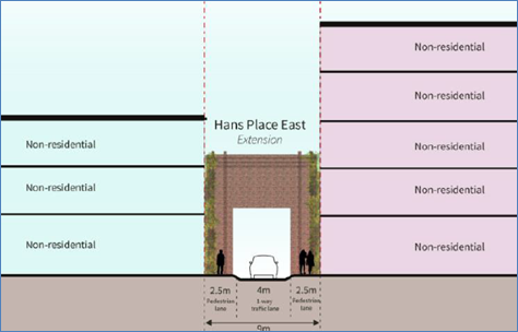
Image 18: Image in DCP recommending the retention of a heritage façade in a new public roadway which would not be supported by Council
· Figure 17 provides “Indicative building envelopes” for properties located in the Chalder Avenue Sub-Precinct. Those properties are outside the area of the planning proposal and as such should be excluded from the draft DCP.
· The proposed building heights in the Wicks Park Sub-Precinct (Block X in the Illustrative Masterplan prepared by Turner and Associates) are excessive and must be significantly reduced to maintain reasonable amenity in Wicks Park. While the draft DCP includes a control that aims to ensure that 50% of Wicks Park receives a minimum of 3 hours of solar access between 9am and 3pm in mid-winter, the redevelopment of Wicks Park Sub-Precinct would overshadow the areas of Wicks Park with the highest levels of amenity with the only sections of the park receiving sunlight in mid-winter being those areas adjacent to Victoria Road and Sydenham Road, which generally have less amenity due to traffic.
· As a general comment, the building envelopes for Wicks Park Sub-Precinct (Block X in the Illustrative Masterplan prepared by Turner and Associates) are unresolved and as highlighted in the Urban Design Review Report prepared by Rod Simpson the rationale for the built form on this block is “unclear”. As highlighted above, vehicular access cannot be obtained via either the extension of Hans Place or the extension of Chalder Avenue as currently depicted in the Masterplan. The heights are excessive (7 to 14 storeys) given the amenity impacts this will cause Wicks Park. Given the narrow width of the proposed extension of Hans Place there is a lack of building separation from the adjoining properties to the north east (Blocks W1 and W2 in the Illustrative Masterplan prepared by Turner and Associates). Furthermore, given the proposed zoning of the site, shop top housing development is a permissible form of development, although based on the Masterplan it is unclear how the rear buildings will support a non-residential use at ground level given the lack of setbacks / building separation.
· As highlighted under heading 4(iv) above, the controls that seek to create a 1,200sqm park in the Rich Street employment precinct. Although this is a positive contribution, it will be difficult to enforce and does not provide transparency to the community as to what will be delivered.
7. PUBLIC AUTHORITY REFERRALS
In accordance with the Gateway determination, the planning proposal was referred to Transport for NSW (TfNSW), Roads and Maritime Services (RMS), Sydney Airport Corporation (SACL), Department of Infrastructure and Regional Development, Department of Education and Training, Energy Australia, Telstra and Sydney Water.
The responses received from the public authorities are summarised below:
· RMS does not support the planning proposal and is of the view that given the size of the planning proposal, the LEP amendment should not be gazetted until the cumulative transport impacts are identified with associated management and mitigation measures are incorporated into an appropriate funding mechanism (refer ATTACHMENT 2).
· TfNSW support the views expressed by RMS and raised concern with the impact the proposal may have on bus operations given ingress/egress for the redevelopments is required from Victoria Road. TfNSW also identify that the nearest part of the precinct (corner of Fitzroy Street) is in excess of 650 metres from the entry to Sydenham Railway Station.
· On 17 January 2017 SACL advised Council that the concerns it had previously raised had now been “satisfactorily addressed”. Notwithstanding, SACL encouraged Council to include a noise disclosure notification clause in all Section 149 Planning Certificates issued in the precinct that reads:
“This property is situated in the vicinity of busy approach and take of flight paths for the main runway at Sydney Airport. As such, it is currently affected, and will continue to be affected in the future, by aircraft noise and the possibility of building vibration from overflying aircraft. The number of aircraft flying in the vicinity of this property is likely to increase in the future as a result of an increase in the number of aircraft using the airport. Further information about existing aircraft noise impacts is available on the Airservices Australia website (http://www.airservicesaustralia.com/). Further information about forecast changes in aircraft noise impacts can be found in Sydney airports master plan, which is available on the Sydney Airport Website: http://www.sydneyairport.com.au/.”
Council is not under any obligation to include such as statement on section 149 certificates.
· The Department of Infrastructure and Regional Development advised Council that they would not be making a submission.
· The Department of Education requested controls to be implemented to ensure minimal impacts on Marrickville Public School including adequate screen planting and building elements and internal layout of buildings that minimised any overlooking. The Department of Education also requested to be involved in any Special Infrastructure Contribution (or similar) discussions should they occur in the future.
· Ausgrid did not raise concern with the planning proposal subject to conditions relating to the supply of electricity and the possible need to on-site substations.
· Sydney Water did not object to the planning proposal but highlighted that the redevelopment may require amplification of water lines; a catchments plan and reticulation scheme plan is required for the development; and no buildings can be built over Sydney Water assets.
8. ASSESSMENT OF STRATEGIC MERIT
To rezone industrially zoned land, Council needs to ensure that adequate strategic justification is provided for the proposed changes to its planning controls. The following discussion provides an assessment of the proposal against the State Government’s and Council’s strategic planning directions for the Inner West area.
(i) A Plan for Growing Sydney (2014)
A Plan for Growing Sydney (the Plan) was released in late 2014 and sets the direction for planning in Sydney over the next 20 years. A Plan for Growing Sydney includes the following planning principles that will guide how Sydney Grows:
· Principle 1: Increasing housing choice around all centres through urban renewal in established areas;
· Principle 2: Stronger economic development in strategic centres and transport gateways; and
· Principle 3: Connecting centres with a networked transport system.
The proponent considers the planning proposal to be consistent with A Plan for Growing Sydney as it is a land use response which coincides with major infrastructure projects (WestConnex, a new airport at Badgery’s Creek; and Sydney Metro); responds to localised social and economic changes; and will create new employment opportunities and renew an underutilised area.
Council officers acknowledge the benefits arising from renewal within an otherwise ageing precinct. Despite this, the precinct offers a land use mix and product that continues to decline in areas within 10 kilometers of the central business district. Some level of renewal is supported within the precinct however wholesale loss of industrial land in the area must be considered within the context of other significant strategic planning changes underway within the Inner West area and broader Central District including renewal in traditional industrial areas, investment in road and rail infrastructure by the State, demand for industrial built forms and low cost employment lands with ready access to markets and employment amongst other matters.
In light of the above, although the planning proposal may present some strategic merit the scale of change, without a clear and dedicated strategic basis, cannot be supported given:
· The area to which the planning proposal relates is not located near a centre or a public transport hub. While the area is well serviced by buses, the area covered by the planning proposal is located some 800 metres from Sydenham Railway Station. Accordingly the proposal is not considered to be transport oriented development and is inconsistent with Planning Principle 1.
· The planning proposal is inconsistent with Planning Principle 2 as the change from industrial to residential uses will potentially impact on the current and future operation of the industrial land. Particular concern is raised with the B4 Mixed Use zoning proposed on the south eastern side of Victoria Road (to the north of Wicks Park). This site is within the main Sydenham / Marrickville industrial precinct and directly adjoins IN1 industrial areas, so residential development in this location has the potential to further fracture the industrial precinct and create land-use conflicts that will threaten the function of the broader IN1 area. It was for this reason the MELS did not support residential at this location. Furthermore, as acknowledged by the Department, there is a continued important role for industrial land in this area, given its size and connectivity to good transport links and proximity to the Transport Gateways.
Action 1.9.2: Support key industrial precincts with appropriate planning controls of the Plan states that the Industrial Lands Strategic Assessment Checklist will guide the assessment of proposed rezonings of industrial lands. This checklist poses questions about whether the site is near or within direct access to key economic infrastructure, how it contributes to a significant industry cluster, and how the proposed rezoning would impact on industrial land stocks and employment objectives in each subregion.
As this planning proposal request involves the rezoning of IN1 General Industrial land, an assessment against the checklist has been undertaken as follows:
- Is the proposed rezoning consistent with State and/or council strategies on the future role of industrial lands?
The proponent does not address this point as the comment in the Planning Proposal Report simply states “refer to Section 8.2”. The Planning Proposal Report submitted by the proponent does not have a Section 8.2.
The relevant State and Council strategies aim to protect industrial land from residential development. A Plan for Growing Sydney clearly aims to protect industrial land in and around the airport from being lost to residential development. The draft Central District Plan (dCDP) builds on this aim and encourages Council to take a ‘precautionary approach’ to the conversion of employment and urban services land and this recommendation is of particular importance to the Inner West Council with a significant portion of industrial land the subject of renewal or rezonings (such as Lords Road, Leichhardt and Carrington Road, Marrickville and operations within the Rozelle Rail Yards associated with WestConnex.).
There is no strategic planning basis supporting wholesale change within the Victoria Road precinct toward high density housing or that encourages its move away from industrial zonings. The gradual but continual loss of industrial land is also an important issue with the Inner West community and is included in Priority 1 – Planning and Development in the recently released Statement of Vision and Priorities.
The subject planning proposal demonstrates an inconsistency with the directions, priorities and actions contained in A Plan for Growing Sydney; the draft Central District Plan; and Section 117 Direction 1.1 Business and Industrial Zones. Furthermore, while the proponent contends that the planning proposal is consistent with the Sydenham to Bankstown Urban Renewal Corridor, only a small section of land around Wicks Park was included in that strategy and the draft strategy (that was publicly exhibited from 14 October 2015 to 7 February 2016) does not encourage residential development at that location, with the area proposed to be retained as industrial land. Council intends to await the release of final strategy and will review its position once the final strategy is released.
The draft Sydenham to Bankstown Urban Renewal Corridor Strategy proposes to rezone all of the existing industrially zoned land on Carrington Road (known as the Carrington Road Precinct) for medium to high rise residential development. Council has recently received a planning proposal that seeks to rezone 8 hectares of industrial land on the eastern side of Carrington Road for a mix of land uses including high density housing, retail and commercial premises to allow approximately 2,600 dwellings and 17,000sqm of retail and commercial floor space.
Given the ‘Carrington Road precinct’ has been identified for redevelopment into a mixed use precinct comprising high density residential development, there is a greater necessity to ensure that the core industrial lands in Marrickville / Sydenham are retained for industrial purposes.
- Is the site:
o near or within direct access to key economic infrastructure?
o contributing to a significant industry cluster?
The area affected by this planning proposal forms part of the Marrickville-Sydenham Industrial precinct which is the largest industrial precinct in the Inner West Council local government area. Furthermore, there is a continued important role for industrial land in this area, given its size and connectivity to good transport links and proximity to the Transport Gateways.
- How would the proposed rezoning impact the industrial land stocks in the subregion or region and the ability to meet future demand for industrial land activity?
The area has seen an upturn in newer and local industries such as breweries, coffee and food production as well as textile, music and independent design or ‘maker’ studio. The industrial zone, the mix of building types and the related pricing accommodates this. As it is highly unlikely that land would ever be reversed, a wholesale move away from an industrial zone at this stage should be made cautiously particularly in light of the other industrial sites likely to be lost in the Inner West area, including Carrington Road, Marrickville; Lords Road, Leichhardt; and sites within the Rozelle Rail yards as part of the WestConnex development.
Rezoning part of the land to residential will increase the pressure on adjoining lands for residential uses. There are also interface issues that will have the potential to impact on the operation of the core industrial lands (such as rezoning the land on the south eastern side of Victoria Road and north of Wicks Park to B4 - Mixed Use, namely Block X, and allowing a 14 storey shop top housing development on this site).
- How would the proposed rezoning impact on the achievement of the subregion/region and LGA employment capacity targets and employment objectives?
The loss of industrial land has been a significant strategic planning issue throughout the assessment of the planning proposal and Council officers and the proponent have differing views on this matter.
Most notably:
· The Marrickville Employment Lands Strategy (MELS) prepared in 2008 and reviewed in 2014 found that demand for traditional industrial land is declining, but Marrickville is well positioned to accommodate increasing demand from newer industries.
· Those activities can be mostly accommodated within existing industrial precincts under current planning controls. A key challenge for Council is to allow its employment locations to respond to industry trends and meet the ever-changing requirements of business operators. To achieve this, a fair degree of flexibility is needed – in the design of buildings and the planning policy framework. This is likely to involve increasing the flexibility of industrial zones by increasing the range of permissible uses in designated locations.
· The MELS identified some opportunity for residential development in the south-west corner of the Victoria Road precinct but only as part of live-work space rather than high rise apartments (i.e. the most appropriate zoning for the Danias Timbers site / Timber Yards Sub-precinct is B7 – Business Park).
· SGS who prepared the MELS state that any rezoning to land uses other than industrial in the north-western part of the precinct (excluding the land at the corner of Victoria and Sydenham Roads) should be supply-demand tested to determine the scope for rezoning. Rezoning would take up some large IN1 zoned lots, which would likely give rise to land use conflicts and may threaten the main industrial function in this area.
Since that time there have been additional policy layers added which support the need to preserve industrial / urban services land, including the draft Central District Plan (dCDP).
- Is there a compelling argument that the industrial land cannot be used for an industrial purpose now or in the foreseeable future and what opportunities may exist to redevelop the land to support new forms of industrial land uses such as high-tech or creative industries?
As highlighted above, in recent times the area has seen an upturn in newer and local industries locating within this precinct and this trend may continue with the continued decline in industrial land stocks in the southern employment lands, within City of Sydney, Mascot, Botany, Green Square and Alexandria.
At this stage there appears to be no compelling argument that the industrial land within the precinct cannot be used now or in the future for an industrial purpose however there is acknowledgement that some investment in a variety of development forms and uses would revitalise areas of the precinct. In this regard, introduction of B4 Mixed Use, B5 Business Development and B7 Business Park zones north west of Victoria Road will lead positive renewal within this precinct whilst retaining an appropriate balance of employment and other uses.
- Is the site critical to meeting the need for land for an alternative purpose identified in other NSW Government or endorsed council planning strategies?
Council is unaware of any Government strategic planning document that identifies the Victoria Road precinct as land for high density housing, nor that encourage its move away from industrial zonings.
(ii) Draft Central District Plan
Subregional planning strategies (District Plans), to support the aims of A Plan for Growing Sydney, have been prepared and are currently in draft form following a public consultation period that finished on 31 March 2017.
The draft Plans aim to facilitate well-coordinated, integrated and effective planning for land use, transport and infrastructure across the Greater Sydney Region over the next 20 years.
The Inner West Council is located within the Central District and the following assessment considers the planning proposal having regard to the relevant sections of the draft Plan:
3.3.2 Fostering Innovation and Creative Industries
The draft Central District Plan (dCDP) requires councils to investigate opportunities and support the growth and innovation of creative industries.
The proponent contends that:
“The Planning Proposal directly supports this aspect of the Draft District Plan, facilitating a transition in business activity within the Victoria Road Precinct to support additional knowledge-based and creative industry employment, which has begun to emerge in the area over recent years. By providing for a broader range of land uses, the Planning Proposal has the potential to capitalise on proximity to a highly educated local labour market, supporting local jobs.”
Although the planning proposal would facilitate a transition in business activity, the industrial precinct continues to operate effectively and demonstrates a low vacancy rate indicating ongoing market demand for these sites. As part of the Sydenham Creative Hub planning proposal, Council recognised that it was more appropriate to retain the industrial zoning and expand the range of permissible uses to facilitate these new creative industries acknowledging the importance of flexibility where appropriate.
Similarly the Marrickville Employment Lands (MELS) Review 2014 found that demand for traditional industrial land is declining, but Marrickville is well positioned to accommodate increasing demand from newer industries and those activities can be mostly accommodated within existing industrial precincts under current planning controls.
Based on the above approach and acknowledging that some level of renewal could be considered to the north west of Victoria Road, the proposal does offer an opportunity to deliver a balanced mixed use outcome within a B7 – Business Park zone (which would be a more appropriate zoning for the Danias Timbers Site / Timber Yards Sub-precinct). A B7 zoning at this location would facilitate an appropriate mix of employment and residential uses via site specific (or similar) provision (e.g. the two bottom floors be delivered for employment purposes with the remainder being for other uses including residential).
3.5.2 Protect and Manage Employment and Urban Services Land
The dCDP identifies the importance of protecting and managing employment and urban services land from the pressures of rezoning to retail and residential uses. Such rezonings have the potential to have longer term growth and productivity implications for Greater Sydney. In this regard, the dCDP recommends that planning authorities take a “precautionary approach” to rezoning employment and urban services land, unless there is a clear direction in the regional plan, the District Plan or an alternate strategy endorsed by a council.
This productivity priority in the dCDP is of particular importance to the Inner West Council with a significant portion of industrial land across the Inner West area which has been rezoned to date, is in the process of being rezoned or has been earmarked for rezoning.
The Sydenham to Bankstown Urban Renewal Corridor Strategy encourages residential redevelopment for all of the existing industrially zoned land on Carrington Road (known as the ‘Carrington Road Precinct’) as well as smaller pockets of industrial land on Gerald Street and Marrickville Road for medium to high rise residential development. As pointed out above, Council has recently received a planning proposal that seeks to rezone 8 hectares of industrial land on the eastern side of Carrington Road for a mix of land uses including high density housing, retail and commercial premises to allow approximately 2,600 dwellings and 17,000sqm of retail and commercial floor space.
Given residential redevelopment is encouraged in the ‘Carrington Road precinct’ under a State led planning strategy, there is a need to ensure that the industrial lands in Marrickville / Sydenham are retained for industrial purposes. The Carrington Road precinct also has a low vacancy rate and Council should seek to protect sufficient industrial land to allow industrial uses to remain in the area.
The proponent contends that:
“The Planning Proposal supports this precautionary approach by maintaining 95% of private land under an industrial or business zoning. Importantly, the Planning Proposal seeks to increase the capacity of the existing land to deliver employment-generating activities to meet the needs of the local community and businesses. Rezoning 5% of the precinct’s land area for residential uses allows for resolution of existing land use conflict issues, urban renewal and upgrades to public domain, new affordable housing for key workers and the co-location of housing and employment.
This Planning Proposal is supported by the Victoria Road Precinct Employment Strategy, which has been accepted by the Full Council of Marrickville Council as being an appropriate strategy for the precinct on a number of occasions, including on 3 November 2015 when Council endorsed the Planning Proposal for Gateway Determination.
Employment levels in the Precinct are projected to grow between 50% and 100% in the 10-20 year timeframe under the proposed business zonings through the creation of new and more diverse business opportunities.”
While the planning proposal is supported by the Victoria Road Precinct Employment Strategy, this strategy was prepared by the proponent in support of the planning proposal and accordingly is not considered an independent strategy.
Key aspects of the proposed changes, particularly as they relate to the introduction of residential land uses and a wholesale move away from the industrial zones contradict employment lands research commissioned by Council. This inconsistency is addressed at section 8(iii) below.
In contrast to the proponent’s assertion that the residential rezoning will resolve “existing land use conflict issues”, concern is raised that the introduction of large scale residential development adjoining established industrial operations will create land use conflicts and likely undermine existing uses. Particular concern is raised with the proposal to rezone the land to the north of Wicks Park (Block X) to B4 - Mixed Use and permit a 14 storey mixed use development containing up to 13 floors of residential development on this site.
3.6 Improving 30-minute access to jobs and services
The applicant contends that the Planning Proposal directly supports this priority in a number of ways including:
· Increasing employment intensity within the precinct, providing capacity for approximately 4,000 additional jobs close to existing homes.
· Integrating the delivery of new housing and employment lands to provide new options for workers to live close to their place of work and create a more amenable urban environment.
· Voluntarily providing an affordable housing component of all new residential development to ensure that low and moderate income workers can live close to their place of employment.
· Delivering new housing and employment in a location that is highly accessible by existing public transport services.
· Providing new housing within close proximity to existing employment centres – travelling from the timber yards, it is possible to reach Martin Place in less than 30 minutes during the AM peak period.
Whilst it is acknowledged that the planning proposal will increase housing and employment within this precinct and has ready access to buses and is located approximately 800 metres from Sydenham Station, it is the variety of uses and services that are currently offered that is key to its importance. The Marrickville / Sydenham industrial area provides a range of uses that although serve the local population, also presents a broader district level function.
4.3 Improving housing choice
The dCDP outlines housing targets for the Central District with 5-year and 20-year housing delivery targets.
The applicant contends that:
“The Planning Proposal will increase housing supply and choice within the locality by providing additional housing options and supply via the south-eastern residential precinct. The Draft District Plan identifies a short-term five year housing target for the Inner West Council, and a 20-year District target. The Planning Proposal represents a unique opportunity to deliver housing to meet these targets in a location that is well serviced by existing infrastructure, close to employment and has minimal adverse impact on surrounding residential areas.”
Although the proposal would introduce a significant number of new homes to the area, Council officers remain concerned regarding an influx of new residents in direct proximity to established industrial operations. Council officer’s position on this matter are outlined below:
· There is no current strategic planning basis that identifies the Victoria Road precinct for high density housing;
· Locating new residents in direct proximity to established industrial operations would likely result in land use conflict and impact the certainty of ongoing operations for industrial businesses notwithstanding their approved use.
· The proposal would require substantial upgrades to infrastructure including road capacity and drainage and would require acquisition of property without a confirmed funding mechanism in place across the precinct;
· There is a lack of public open space in the area;
· Urban renewal is already planned for in a number of major strategies within the Inner West area including the Parramatta Road Corridor Urban Transformation Strategy (PRUTS); the Sydenham to Bankstown Urban Renewal Corridor Strategy; and the Bays Precinct Urban Transformation Program.
· Council needs to plan for sustained growth in the area in accordance with established strategic plans that balance the needs for housing, employment, recreation and infrastructure provision amongst other matters. Although some level of renewal in this precinct could be considered and noting recent discussions with the proponent regarding possible development options within the Rich Street precinct, large scale renewal and delivery of associated infrastructure should be sequenced according to set strategies agreed to at Local and State Government level.
4.4.4 Deliver Affordable Housing
The dCDP requires the relevant planning authority to include an Affordable Rental Housing Target as a form of inclusionary zoning and sets a target of 5-10% of new floor space at rezoning stage. Furthermore, Council’s Affordable Housing Policy sets an affordable housing target of 15%.
As pointed out under heading 4(ii) above, the proponent proposes to provide 5% of ‘accountable floor area’ as affordable housing. Given that all land is currently zoned industrial and residential development is prohibited under the existing zoning provisions, the affordable housing component should be applied to all of the ‘new’ residential floor area.
Furthermore, the 5% rate of affordable housing only represents the minimum rate recommended in the draft Central District Plan and is well below the 15% sought under the Inner West Council’s Affordable Housing Policy.
4.4.6 Facilitate Integrated Infrastructure Planning
The proponent contends that:
“The Victoria Road Precinct facilitates new employment and residential development in a location which is well-serviced by existing infrastructure. Further, the State Government is investing in a major public transport upgrade at Sydenham Station as part of the Sydney Metro project, which will significantly increase local public transport capacity and frequency. Local development contributions will be levied on new development to fund required upgrades to local infrastructure, such as open space, roads and regional stormwater management.”
Council officers position on this matter is provided below:
· The precinct is not located within direct proximity to Sydenham Station with the sites proposed to contain the high density residential development located approximately 800 metres walking distance from the station.
· As detailed above infrastructure planning and delivery is yet to be adequately addressed having particular regard to the provision of public open space; the creation of new road connections; intersection upgrades; and flooding and drainage.
· While the proponent suggests that local development contributions will fund the required infrastructure, with the $20k cap in Section 94 contributions; the cost of land in the Inner West; and the level of infrastructure upgrades required Council will not have sufficient funds to carry out such works.
· Furthermore, some of the infrastructure planning and delivery issues, such as the need to acquire properties outside the area of the planning proposal as well as sections of Wicks Park (which is community land) for road widening are considered insurmountable. The need to acquire private properties and community land is not in the interest of the wider community and cannot be funded by Council.
4.6 Create Great Places
Under this intent, the dCDP encourages design led planning that produces good architecture and urban outcomes and requires growth to be managed to create healthy, well designed, safe and inclusive places that promote economic and social activity, vibrancy and community spirit.
In this regard the proponent contends that:
“The Planning Proposal is seeking to rezone a run-down and underutilised industrial precinct to facilitate new, more active employment uses which will catalyse urban renewal within Marrickville, as well as designating a small portion of the precinct for a new residential community. The exhibited master plan incorporates two new pocket parks, and an additional park is proposed to be created within the Rich Street business precinct.
The Planning Proposal is accompanied by a Draft Development Control Plan which has been developed by JBA and Turners to ensure that new development contributes positively to Marrickville’s urban fabric. The DCP includes provisions to guide the built form of new development, creating great streetscapes which improve the amenity of the locality and make the precinct a more desirable place to work and live.
In addition, local infrastructure contributions generated by new development within the precinct will contribute to the broader local amenity, including contributing toward local open spaces and community infrastructure.”
Although renewal will be encouraged over time across the precinct, Council officers position on this matter is outlined below:
· Notwithstanding recent discussions with the proponent regarding concept designs for the Rich Street precinct, which included approximately 1,200sqm of open space, the planning proposal does not offer an adequate response to providing open space to service a substantial increase in resident, worker and visitor population in an area that is currently underserviced by open space and a community that highly values public open space.
· As highlighted under heading 4(i) above, the road works necessitated by this planning proposal require sections of Wicks Park to be acquired for road widening purposes.
· At 14 storeys the building envelope proposed for Block X will result in overshadowing of Wicks Park reducing the amenity of this area of public open space;
· The planning proposal does not offer the new laneways and road connections required to service the rezoning and stated vision for the Victoria Road corridor;
· The recommendations provided by Rod Simpson and Council’s Architectural Excellence Panel have not been reflected in the final design of the planning proposal; and
· The planning proposal has yet to effectively deal with identified potential heritage in the precinct and how it would be managed.
5.3 Protecting the Districts Waterways
The applicant contends that:
“The Planning Proposal will facilitate the urban renewal of this precinct, with new development required to demonstrate appropriate measures for managing the quantity and quality of water runoff. It is also expected that new development within the precinct will increase the pervious surface area in comparison to existing run-down industrial buildings and hardstand areas. As such, future development in accordance with this Planning Proposal is in accordance with the Draft District Plan as it will significantly improve the quality of stormwater runoff and reduce the amount of runoff during storm events.”
It is agreed that urban renewal in the precinct has the potential to reduce the quantity and improve the quality of water runoff in the area. This is considered to be primarily a development application matter.
(iii) Marrickville Employment Lands Strategy (MELS) 2008 and Review 2014
To support the development of MLEP 2011, Council commissioned an independent specialist to prepare the initial 2008 MELS. In 2014, Council commissioned the same organisation to undertake a review of the 2008 MELS, funded by the Department through its Planning Reform Fund grants program.
The 2014 MELS explains that within the former Marrickville LGA, demand for traditional industrial land is declining, but Marrickville is well positioned to accommodate increasing demand from newer industries. These can be broadly classified as population-serving industry, urban manufacturers, CBD backroom operations and creative industries. With diminishing industrial stocks in the City of Sydney and City of Botany Bay, Marrickville’s industrial areas may also experience greater demand from industries that have been displaced from those areas.
Those activities can be mostly accommodated within existing industrial precincts under current planning controls. A key challenge for Council is to allow its employment locations to respond to industry trends and meet the requirements of business operators. To achieve this, flexibility is needed – in the design of buildings and the planning policy framework. This can be achieved by increasing the flexibility of industrial zones by increasing the range of permissible uses in designated locations. Wholesale change is not the only option available to Council.
Strategies and actions within the 2014 MELS relevant to the Victoria Road precinct include:
Strategy 1 – Protect subregionally significant industrial lands:
· Action 1.1 – designate the Marrickville-Sydenham industrial precinct as a subregionally significant industrial precinct and zone accordingly;
· Action 1.2 – Restrict further subdivision and/or strata titling of larger lots in the –Marrickville/Sydenham industrial precinct to prevent fragmentation;
· Action 1.3 – Prevent the spread of retailing and services into the Marrickville-Sydenham precinct;
· Action 1.4 - Lobby the NSW Government to consider the provision and protection of strategic industrial and employment lands at a subregional level; and
· Action 1.5 – Consolidate planning and urban design guidance in a Marrickville-Sydenham industrial precinct plan.
Strategy 2 – Ensure sufficient stocks of industrial land to meet requirements of the local population:
· Action 2.1 – Protect population-serving industrial land.
Strategy 3 – Explore economic development opportunities in some industrial precincts:
· Action 3.1 – consider rezoning of selected lots to B7 Business Park as live-work space; and
· Action 3.2 – continue to plan for a traditional & creative industries hub.
Strategy 4 – Consider residential conversion opportunities:
· Action 4.1 – Consider the Carrington Road precinct as an opportunity for urban renewal; and
· Action 4.3 – Consider rezoning of selected residential interface sites to B4 Mixed Use.
Employment forecasts in the 2014 MELS show that future demand is modest compared to existing supply, so some change from traditional industrial is warranted. However, this must be balanced against the strategic value of Marrickville’s industrial lands, particularly the Marrickville-Sydenham precinct. The report includes three future land use scenarios for Marrickville-Sydenham, Carrington Road and Lewisham precincts, which aim to strike this balance, consistent with the above strategies and actions.
For the purposes of the assessment of this planning proposal, the least restrictive scenario (Scenario 3) has been used. Scenario 3 adopts a less constrained approach to the retention of employment land to maximise renewal, where industrial land supply under medium-capacity scenarios is likely to meet demand, but there is some possibility of a shortfall. It allows some new residential use between 25 and 30 ANEF noise contours in B7 Business Park zones, using the St Peters triangle live-work precinct and similar areas as a precedent.
Image 19: Land use zones proposed by SGS in 2014 MELS
(Scenario 3: renewal/residential focused)
Scenario 3 in the MELS “is the most aggressive in seeking renewal opportunities in the industrial areas”. For the Victoria Road precinct, this scenario proposes the area between Sydenham Road, Victoria Road, Marrickville Primary School and Farr Street be rezoned to B7 Business Park and B4 Mixed Use; that both sides of Gerald Street be rezoned to B7 Business Park to expand the existing Meeks Road live-work zone; and that the western side of Fitzroy Street, between Smith Street and Edinburgh Road, be rezoned to B7 Business Park to expand the Edinburgh Road live-work zone.
Further changes for the Victoria Road precinct are not recommended on the basis that it would threaten the integrity of the larger Marrickville-Sydenham industrial precinct by isolating the larger industrial lots in the northern part of this precinct.
The planning proposal is inconsistent with even the least restrictive scenario contained in the MELS. In accordance with the MELS recommendations, there should be no change to the existing industrial zonings on the south eastern side of Victoria Road as this land forms part of the core Marrickville-Sydenham industrial precinct. Furthermore, while the MELS identified some opportunity for residential development in the south-west corner of the Victoria Road precinct, any such residential accommodation was recommended only as part of live-work space rather than high rise apartments.
(iv) The Inner West Council Interim Statement of Vision and Priorities
Council’s recently adopted Interim Statement of Vision and Priorities will guide Council until a single Community Strategic Plan is developed for the Inner West. The Interim Statement, which was adopted at a Council meeting on 28 March 2017, contains eight high level priorities:
· Planning and development
· Transport
· Social vitality, creativity and quality of life
· Sustainability and the environment
· One Council
· Local industry and business
· Advocacy
· Local democracy
The loss of industrial land is an important issue with the Inner West community and is included in Priority 1 – Planning and Development (“retain diversity of industrial lands and employment generating uses”) in the recently adopted Interim Statement of Vision and Priorities.
(v) State Environmental Planning Policies (SEPPs)
SEPPs are environmental planning instruments which address planning issues within the State. The following assessment considers the SEPPs that are relevant to the planning proposal:
State Environmental Planning Policy No. 55 – Remediation of Land (SEPP 55)
The proponent provided Environmental Site Assessments for three major sites within the precinct. These site assessments were considered by Council’s Environmental Services Section who advised:
“The three detailed site investigation reports identified a range of contamination issues throughout the precinct. If the area is to be rezoned as proposed, there will likely be a requirement for further investigations and remedial activities to render the sites suitable for any proposed redevelopments that would potentially expose sensitive users to the area.
Despite the contamination issues present, all reports conclude that the area can be made suitable subject to further investigations and remediation, which will be required prior to any development application to alter the use of sites.
It’s highly recommended due the possible complexity of site contamination and remediation, that Council require contamination investigations to be adequately completed, and if required, remedial action plans to be supplied prior to the submission of development applications. If proposed remediation strategies are complex or involve a ‘cap and contain’ approach, Council should request site audit statements as required.”
It is considered that sufficient information has been provided with this planning proposal to demonstrate that the proposal is consistent with the aims and objectives of the SEPP to ensure that land is made safe for its intended purpose. More detailed site investigations and remediation action plans will be required as part of any future development applications should the rezoning proceed.
State Environmental Planning Policy No. 65 – Design Quality of Residential Apartment Development (SEPP 65)
SEPP 65 and the Apartment Design Guide (ADG) apply to residential flat buildings, shop top housing and the residential component of mixed use developments where the building is greater than three storeys in height and contains four or more dwellings.
The building envelopes sought as part of the planning proposal do not appear to meet the objectives and guidelines contained in the ADG.
The following primary concerns are noted:
· The building envelopes identified in the proponents Development Control Plan (DCP) do not satisfy the building separation distances recommended under the ADG;
· The building envelopes identified for Block X (north of Wicks Park) do not satisfy the recommended setback requirements contained in the ADG and will result in overshadowing and visual bulk impacts for Wicks Park;
· The planning proposal does not adequately cater for the change in the precinct in seeking to move from residential to higher order employment uses. As detailed above, the precinct plan does not incorporate or deliver the new streets and infrastructure, through site links and public open spaces required to support the new population. The precinct plan also fails to deliver public domain improvements, integrate heritage into the final vision for the area, or resolve the significant environmental constraints affecting the area (most notably flooding);
· The FSR’s established on the sites are excessive and are based on building envelopes greater than those identified in the draft DCP;
· The proponent has not demonstrated that sites will provide any substantial areas of deep soil planting; and
· The building envelopes proposed have not been demonstrated achieve adequate levels of solar access, or that reasonable solar access will be maintained to areas of communal / public open space.
It is acknowledged that design layout and elements are subject to change during the plan finalisation process which can impact the draft DCP. In this regard, changes to the draft DCP can be considered in further detail as part its finalisation. At this stage it is integral to ensure that the proposal can demonstrate compliance with the objectives and provisions of the ADG.
(vi) Section 117 Directions
The following Section 117 Directions are relevant to this planning proposal request:
1.1 Business and Industrial Zones
The objectives of this Direction are to encourage employment growth in suitable locations; protect employment land in business and industrial zones; and support the viability of identified strategic centres.
The planning proposal seeks to rezone large parcels of land from IN1 General Industrial to R3 Medium Density Residential and R4 High Density Residential. The proponent also seeks to rezone large portions of land B4 – Mixed Use which will enable a greater quantum of residential development to be introduced into a predominantly industrial / mixed use area.
While the planning proposal seeks to increase the GFA/FSR for the sites to be zoned B5 – Business Development, this change has not been supply/demand tested as recommended by Council’s independent advisors. Furthermore, the area to be rezoned residential will reduce the land available for industrial and business uses and accordingly the planning proposal is inconsistent with this Direction.
The Department raised particular concern with the creation of residential development on the south eastern side of Victoria Road (north of Wicks Park). Unfortunately the Department supported a B4 – Mixed Use zoning on this site demonstrating an inconsistency with the Gateway Assessment report which found that that residential development was not appropriate at this location. Should high density residential development be allowed at this location it has the potential to impact on the viability of the surrounding industrial lands given the interface issues caused by the direct interface of residential and industrial uses.
While an employment strategy was submitted with the planning proposal, this strategy is not independent and the findings conflict with those of the MELS (refer to discussion under heading 8(iii) above).
2.3 Heritage Conservation
The objective of this Direction is to protect items of heritage significance.
The issue of heritage has been addressed under heading 4(vi) above. The Gateway Determination included a condition that required a heritage study to be carried out for Precinct 47. That study has identified a number of potential heritage items that should be retained or require further analysis. The issue of heritage conservation within the precinct remains unresolved.
3.1 Residential Zones
The objectives of this Direction are to encourage a variety of housing types, make efficient use of infrastructure, and minimise the impact of residential development on the environmental and resource lands.
The Direction requires a planning proposal to encourage housing that will broaden the choice of building types and locations available in the housing market; make more efficient use of existing infrastructure and services; reduce the consumption of land on the urban fringe; and be of good design.
While the planning proposal will encourage new housing, the quantum and scale of residential development that would be permitted by the planning proposal is not supported in its current form. Although Council is open to considering residential development (as part of a mixed use/live work scenario) albeit it at a lower scale in the south western quadrant, a number of other matters critical to the delivery of new residential development are yet to be resolved including open space provision, traffic, flooding and property acquisitions.
3.4 Integrating Land Use and Transport
The area to which the planning proposal relates is not located in direct proximity to a centre or a public transport hub. While the area is well serviced by buses, the area covered by the planning proposal is located approximately 800 metres from Sydenham Railway Station and cannot be considered transport oriented development.
3.5 Development Near Licensed Aerodromes
The objectives of this Direction are to ensure the safe and effective operation of aerodromes; ensure that aerodrome operations are not jeopardised by hazards or obstructions; and that residential development near aerodromes are safe for human occupation.
The planning proposal seeks to rezone land for residential purposes where the ANEF is between 25-30 and 30-35. Although residential development is primarily located within the ANEF 25-30 area and the proponent has submitted an aircraft noise strategy there is ongoing concern regarding the proposed density at this location which continues to be affected by high levels of aircraft noise. As has been provided, Council is open to considering residential development, albeit it at a lower scale, and as part of a mixed use / live work scenario in the south western quadrant of the precinct.
SACL identify that:
“The Victoria Road precinct is only two kilometres from the northern end of Sydney Airport’s main runway and is immediately beneath the busy flight path used by aircraft landing on or taking off from that runway. At this point, aircraft on the approach are only around 150 metres above ground level, with building heights in some parts of the precinct proposed to be only around 100 metres below that.”
As pointed out above, given the area is heavily affected by aircraft noise, SACL encourage Council to include a noise disclosure notification clause in Section 149 Planning Certificates issued for the precinct. Council is under no obligation to include a notification on properties within the precinct as identified by SACL.
4.1 Acid Sulfate Soils
The objective of this Direction is to avoid environmental impacts of development on acid sulfate soils. Acid sulfate assessments were provided for three of the key sites within the Precinct. While no acid sulfate soils were found, the report recommends that further investigations be carried out.
The planning proposal is considered to be consistent with this Direction noting that any future development application will require a more detailed site investigation in accordance with Clause 6.1 of MLEP 2011.
4.3 Flood Prone Land
The objectives of this Direction are to ensure development of flood prone land is consistent with the Floodplain Development Manuel 2005 and ensure that provisions of LEP’s are commensurate with potential flood impacts.
The Direction states that a planning proposal must not contain provisions that apply to the flood planning areas which:
· Permit development in floodway areas;
· Permit development that will result in significant flood impacts to other properties;
· Permit a significant increase in development of that land;
· Are likely to result in substantially increased requirement for government spending on flood mitigation measures, infrastructure or services.
This matter has been addressed at Section 4(viii).
6.3 Site Specific Provision
The objective of this Direction is to limit restrictive site specific provisions to enable particular development.
The planning proposal recommends a key sites map to enable specific development controls (namely the Aircraft Noise Strategy and the affordable housing provisions) to apply to the Precinct. This amendment could be accommodated should the rezoning proceed.
7.1 Implementation of A Plan for Growing Sydney
This Direction gives legal effect to A Plan for Growing Sydney. This matter has been addressed at Section 8(i) and (ii).
8. RECOMMENDED COURSE OF ACTION
For the reasons outlined in this report, the planning proposal cannot be supported in its current form and it is recommended that pursuant to section 58(4) of the Environmental Planning and Assessment Act 1979 the Administrator request the Minister for Planning to determine that the planning proposal not proceed.
Should the Minister not agree to Councils request to determine that the matter not proceed or should the proponent seek to lodge a new planning proposal, Council officers would recommend the following amendments to the current proposal:
1. Resolution of matters the subject of an unresolved objection from the Roads and Maritime Service;
2. There is to be no change to the existing IN1 – General Industrial zoning on the south eastern side of Victoria Road. This land forms part of the core Sydenham / Marrickville Industrial Area and should be preserved in line with the recommendations of the Marrickville Employment Lands Study and subsequent Review. Council will review its position subject to the release of the Sydenham to Bankstown Urban Renewal Corridor Strategy;
3. With the exception of the properties on the north western side of Farr Street to be zoned R3 – Medium Density Residential, no properties in the precinct are to be zoned residential with the Danias Timbers Site / Timber Yards Sub-precinct to be zoned B4 – Mixed Use (along Victoria Road and Sydenham Road) and B7 – Business Park (for the remainder of the sub-precinct) with an appropriate mix of employment and residential uses to be provided via site specific provision. The remainder of the precinct north-west of Victoria Road and north of Chalder Street to be zoned B5 – Business Development.
4. Any intersection upgrade works necessitated by the planning proposal cannot require the acquisition of parts of Wicks Park or properties outside the area covered by the planning proposal;
5. The planning proposal must adequately deal with infrastructure planning, funding and delivery (including any required property acquisitions) in consultation with Council;
6. The planning proposal must reflect the urban design and built form recommendations provided by Rod Simpson and Council’s Architectural Excellence Panel;
7. Affordable housing being provided in accordance with the requirements of the Inner West Council Affordable Housing Strategy;
8. The planning proposal cannot result in the loss of any existing areas of public open space and adequate new additional areas of public open space must be provided to service the new resident and worker population (e.g. an expansion and embellishment of Wicks Park);
9. The planning proposal must provide suitable mechanisms to deliver the new laneways and road connections required to service the rezoning and stated vision for the Victoria Road corridor; and
10. The planning proposal must adequately deal with identified potential heritage.
9 FINANCIAL IMPLICATIONS
Nil at present. However, should the planning proposal be supported, given the $20k on Section 94 contributions and no mechanism in place to adequately deal with infrastructure, planning, funding and delivery (that require property acquisitions), the proposal would have significant financial implications for the Inner West Council and community in the future.
Infrastructure upgrade and associated costs to service the planning proposal do not form part of the forward work program for Council and remain un-costed at this stage. Should the Minister for Planning determine to make the LEP amendment, it is recommended that Council be consulted and remain part of any negotiation regarding infrastructure contributions and funding arrangements/mechanism.
10. OTHER STAFF COMMENTS
In assessing this planning proposal internal referrals were received from various sections of Council, including Environmental Services; Community Development; Waste; Infrastructure Planning and Property; Economic Development; Culture and Recreation; and Traffic.
11. PUBLIC CONSULTATION
The planning proposal was publicly exhibited from 23 September 2016 to 23 November 2016. 549 individual submissions were logged by Council. Submissions were received via an online submission form on the Your Say Inner West website, by email and directly posted to Council. Petitions received were logged as individual submissions and signatory numbers were noted.
The table below gives a breakdown of the responses received:
|
Submission Category |
Number of submissions logged |
Percentage of total submissions logged |
|
Supportive without amendment |
320 |
58% |
|
Supportive with amendments |
42 |
8% |
|
Petition - Supportive |
4 (98 signatories in total) |
1% |
|
Not supportive |
172 |
31% |
|
Petition - Not supportive |
4 (43 signatories in total) |
1% |
|
Submission outside scope of Planning Proposal |
7 |
1% |
The Engagement Report which provides a summary of the supportive and non-supportive comments received during the public consultation period is attached at ATTACHMENT 5.
12. CONCLUSION
The draft Central District Plan encourages Council to take a ‘precautionary approach’ to the conversion of employment and urban services land. This recommendation is of particular importance to the Inner West area with a significant portion of industrial land the subject of rezonings / potential rezonings (such as Lords Road, Leichhardt; Carrington Road, Marrickville; and lands within the Rozelle Marshalling Yards to be removed to make way for WestConnex). The loss of employment land is also an important issue with the Inner West community and is included in Priority 1 – Planning and Development in the recently released Statement of Vision and Priorities.
There is currently no local or State Government strategic plan or policy that identifies the Victoria Road precinct as land for high density housing, or that encourage its move away from industrial zonings. However, it is acknowledged that some level of renewal within this precinct should be considered with a view to encouraging revitalisation. The report identifies that balancing employment with other uses including residential via site specific provision will be integral to the long term success of this precinct.
There are a number of merit based and delivery related concerns identified in this assessment report that remain unresolved. This includes an unresolved objection from the Roads and Maritime Services (RMS) which has identified that the planning proposal has yet to model the cumulative transport impacts and/or incorporate an appropriate funding mechanism to carry out the required mitigation measures (that include significant property acquisitions).
On the basis of the matters and concerns identified in this report it is considered that the planning proposal cannot be supported in its current form for the following reasons:
1. An unresolved objection from the Roads and Maritime Service that requires network level modelling to be undertaken to enable an adequate assessment of the impacts associated with the proposal.
2. The planning proposal demonstrates a significant reduction in employment lands outside of a strategic planning basis prepared by Council or State Government.
3. The planning proposal would require acquisition of public open space (Wicks Park) and removal of substantial vegetation along Sydenham Road.
4. Wicks Park is currently classified for Community purposes under the Local Government Act 1993 and any acquisition would require reclassification of this site.
5. The proponent’s traffic and transport study identifies acquisition of privately owned properties outside of the planning proposal area for traffic purposes.
6. The provision of open space proposed within the planning proposal is inadequate.
7. No infrastructure funding mechanism has been provided to council to certify the funding of open space, required acquisitions and delivery of infrastructure to support the planning proposal.
8. The planning proposal does not provide adequate affordable housing and does not comply with the recommendations of the draft Central District Plan or the Inner West Council’s Affordable Housing Policy.
9. The height, bulk, scale and form of the building envelopes sought are excessive in areas and would result in an unreasonable impact on public open space (most notably Wicks Park).
10. The planning proposal does not provide the road connections required to service the rezoning and stated vision for the Victoria Road corridor.
11. The planning proposal does not adequately deal with identified potential heritage.
12. There are unresolved precinct wide drainage and flooding issues that will result in a need for Council to carry out significant capital works that are currently unfunded.
In light of the above, it is recommended that the Administrator request the Minister for Planning to determine that the planning proposal not proceed.
|
1.⇩ |
Infrastructure, Planning and Environmental Services Committee Meeting - INDIVIDUAL REPORT IP1115 Item 2 Revised Planning Proposal for the Victoria Road Precinct - 3 November 2015 |
|
2.⇩ |
Preliminary Review of Planning Proposal - McLaren Traffic Engineering - Victoria Road Planning Proposal |
|
3.⇩ |
Letter from RMS re Victoria Road Precinct Planning Proposal |
|
4.⇩ |
Proponents response to RMS letter of issues and concerns |
|
5.⇩ |
Community Engagement Report - Victoria Road Precinct Planning Proposal - Jan 2017 |
|
Council Meeting 27 June 2017 |
Subject: Parramatta Road Urban Transformation Strategy - Council's Action Plan
File Ref: 17/6032/69455.17
Prepared By: Tatjana
Djuric-Simovic, Executive Strategic Planner and
Gill Dawson - Manager Environment and Urban Planning
Authorised By: Simon Manoski - Group Manager Strategic Planning
|
SUMMARY This report is a follow-up to the December 2016 report to Council on the Parramatta Road Urban Transformation Strategy (the PRUTS) adopted by the NSW State government in November 2016. An additional report with more detailed analyses of the impacts of the PRUTS was presented to the Local Representation Advisory Committee Meeting on 11 April 2017.
This report recommends a draft project plan which outlines additional strategic land use and growth infrastructure studies required to manage increased density within the Corridor and its surrounds as identified within the PRUTS.
|
|
RECOMMENDATION THAT:
1. Council resolves to receive and note the report; 2. works identified to implement the PRUTS have been estimated at $1.2 million; and 3. Council supports an application to State Government to seek funds to complete work identified in this report.
|
1. BACKGROUND
The Parramatta Road Urban Transformation Strategy (PRUTS) was released by the NSW State Government in November 2016. The area spans a distance of 20 kilometres from Granville in the west to Camperdown in the east and comprises eight Precincts that have been identified for further growth. Four of those Precincts are located in the Inner West Council area (see Figure 1 below).
The PRUTS provides the strategic planning basis for significant change to the urban landscape along Parramatta Road including substantial increase to housing and employment resulting in an increase in demand for local utilities and services.
The intent of this report is to use this information as a basis to commence discussions with the Greater Sydney Commission and other relevant government agencies for financial assistance to deliver the necessary work identified in the PRUTS and allocated to Council.

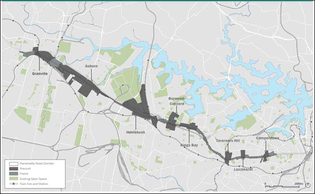
· Figure 1 PRUTS Area
These Precincts are:
1) Kings Bay (split between Burwood & Canada Bay with a small section in the Inner West Council area)
2) Taverners Hill
3) Leichhardt
4) Camperdown.
The PRUTS comprises the following main documents:
· Parramatta Road Urban Transformation Strategy
· Implementation Tool Kit:
Ø Implementation Plan 2016-2023
Ø Planning and Design Guidelines (the Guidelines)
Ø Infrastructure Schedule
Ø Urban Amenity Improvement Plan
· Section 117 Ministerial Direction 7.3 Parramatta Road Urban Transformation Strategy.
The PRUTS allows submission of planning proposals that rely on the Guidelines and other supporting documents. The Corridor governance framework gives the role of relevant planning authority to councils. Assessment of private planning proposals and decisions on whether Council should support planning proposals progressing to Gateway will be based on their consistency with the PRUTS and local planning strategies.
The Implementation Plan 2016-2023 recommends that councils amend their LEPs and DCPs to incorporate the Strategy’s provisions in the longer term with planning proposals able to be submitted in the initial release areas immediately.
It is expected that planning proposals will be lodged and LEP amendments made prior to finalisation of planning for enhanced public transport services along Parramatta Road by Transport for NSW (TfNSW), review of Council's developer contribution plans or introduction of the Inner West LEP.
1.1 Strategic Actions tasked to Council in PRUTS and Draft Central District Plan
PRUTS
The PRUTS sets out seven guiding principles for housing, employment, transport, community places, open spaces, sustainability and delivery that will need to be applied to the preparation and assessment of future proposals for land use change.
Each principle is supported by a suite of strategic actions of which 30 have been tasked to the Inner West Council and are listed in ATTACHMENT 1.
Draft Central District Plan
The draft Central District Plan was prepared by the Greater Sydney Commission and sets out priorities and actions for Greater Sydney’s Central District, which includes the local government areas of Bayside, Burwood, Canada Bay, Inner West, Randwick, Strathfield, the City of Sydney, Waverley and Woollahra. The draft Plan was on public exhibition until April 2017 and will be finalised towards the end of 2017.
The draft Plan identifies priorities and actions that should inform strategic planning at local government level. It lists specific actions, outcomes and leading and partner agencies that will complete these tasks. The draft Plan requires Council to increase housing and economic capacity by implementing the PRUTS and supporting Implementation Tool Kit.
Further details on specific tasks relevant to the Parramatta Road corridor, what is required to be delivered and by whom, are outlined in Attachment 2.
2. COUNCIL’S ACTION PLAN
The PRUTS and draft Central District Plan actions that have been assigned to Council require development of Council’s own strategic and action plan. Our pathway requires activities in the areas of:
· decision-making
· advocacy and partnership
· resource-planning
· budgeting
· performance-monitoring.
2.1 Decision-making
To enable Council to take an evidence based approach and deliver a robust planning and infrastructure delivery suite of strategies for managing growth along Parramatta Road, a range of studies and planning investigations need to be completed. On this basis it is proposed that Council adopts interim policies, prior to amendments to zoning, building height and floor space ratio in the current Ashfield, Leichhardt and Marrickville local environmental plans.
The key work items that need to be undertaken including broad recommendation of scope, resourcing requirements and cost estimates are presented in ATTACHMENT 3. It is proposed that work on all these studies be substantially completed prior to large scale amendments being considered along the Parramatta Road Corridor.
2.2 Lobbying & Partnership
Delivery of the PRUTS relies on collaboration and partnership between Council and relevant State Government agencies. The strategic actions listed in the PRUTS (See Attachment 1 for more details) as joint responsibilities of the Council and external entities are:
|
Action |
Council’s partnership with: |
|
Housing Diversity |
Department of Planning and Environment (DPE)
|
|
Planning for jobs |
Greater Sydney Commission (GSC)
|
|
Centres and clusters |
GSC,
|
|
Community Infrastructure |
DPE, GSC, Local Health District |
|
Effective governance |
GSC and relevant state agencies
|
In addition, it is considered that the following will also be key partners in terms of consultation:
· Sydney Local Health District (RPA);
· University of Sydney;
· Transport for NSW; and
· RMS.
Council will be working closely with the GSC on the Urban Amenity Improvement Program that will provide funding towards 12 public domain projects in Taverners Hill, Leichhardt and Camperdown (See 2.4 Budgeting for more details).
It is crucial that Council liaise with and lobby relevant State Agencies to share their expertise and provide resources for PRUTS delivery.
2.3 Resource-planning
Council’s Strategic Planning Group
Parramatta Road Corridor Urban Transformation will generate significant additional; workload for Council’s Strategic Planning Group and its teams.
The Strategy and Policy team within the Strategic Planning Group will have to manage and coordinate external consultancies and coordinate the adoption of various analyses/studies listed above in 2.1. The team will also be involved with advocacy and lobbying of external agencies in order to clearly communicate Council’s views on matters of public interest.
The Planning Operations team within Strategic Planning Group will be involved in the assessment of all pre-planning proposal for the PRUTS area; stakeholder engagement; consultation with government agencies, business, community, adjoining properties and other interest groups where relevant.
Infrastructure Planning and Coordination team within the Strategic Planning Group will work on new integrated Developer Contributions Plans under Sections 94/94A of the Environmental Planning and Assessment Act 1979, negotiate opportunities through development (voluntary planning agreements) and ensure the full range of contributions mechanisms are considered by the Council to fund infrastructure and other community assets.
The above teams (identified in the new Strategic Planning structure) will be formed/ recruited over the next few months.
2.3 Budgeting
Additional work created by the Government’s adoption of PRUTS cannot be covered from Council’s regular resources. The proposed sources of funding are:
Infrastructure
The Urban Amenity Improvement Program (UIAP) will provide $198 million to the Corridor. The Greater Sydney Commission has advised Stage 1 applications should be made by 31 July 2017 for the 12 projects identified in the Inner West Council area. Council officers have commenced reviewing the variety of projects with a view to provide a high level estimate and pathway to the Commission to consider as part of rolling out it UAIP funding.
At this stage, there is no indication how much funds will be made available as part of the first round grants from the UAIP.
PRUTS specifies the works (without cost estimates) for each precinct that may be funded by the UIAP. The UIAP projects within IWC are:
· Taverners Hill: prioritised walking and cycling link, greenway connection under Parramatta Road and Longport Street
· Leichhardt: public domain improvements to key north-south streets perpendicular to Parramatta Road including Rofe St, Renwick St, Norton St, Balmain Rd, Catherine St and Crystal St
· Leichhardt: new cycle connection along Dot Lane between Norton Street and Hay Street
· Camperdown: public domain improvements and cycle connection to Pyrmont Bridge Road between Parramatta Road and Mallett Street
· Camperdown: new north-south pedestrian and cycle connection along Johnston Creek from Booth Street to Parramatta Road.
Funds would continue to be collected through Sections 94 and/or 94A and potential voluntary planning agreements for monetary contributions and/or works in kind.
The PRUTS Implementation Plan 2016-2023 states that funding framework for the new and upgraded roads, community facilities and open space to be delivered by development is to be funded through Section 94 contributions, a State Infrastructure Contribution levy and/or works in kind. At this stage however, there is no indication as to whether a State Infrastructure Contribution will applied to fund the delivery of regional level services, facilities and infrastructure items.
IWC will need to integrate and amend its development contributions plans to account for the proposed population growth and local social/physical infrastructure along Parramatta Road and more broadly across the Inner West area to reflect growth associated with the Sydenham to Bankstown Corridor and other major planning proposals including Carrington Road Marrickville and George Street Leichhardt. In response, Council is required to prepare a new contributions and planning agreement framework to reflect the increase demand for utilities, services and other infrastructure across the area.
Policy and Strategy Preparation
The tasks identified in Table, 2.1 include works estimated at a total of $1.2 -1.3 million.
This cannot be funded through ordinary Council budget allocations or existing quantum of staff. These projects will need to be delivered by external specialist consultancies and project managed by Council strategic planning staff. The estimated cost above reflects this approach.
3. OUTCOME
The PRUTS provides the strategic planning basis for significant change to the urban landscape along Parramatta Road including substantial increase to housing and employment.
This change in land use and density will result in significant increase in demands for local utilities and services and therefore need to be appropriately planned for however, achieving this end requires substantial upfront investment to ensure a successful long term implementation as set out by the PRUTS.
The intent of this report is to use this information as a basis to commence discussions with the Greater Sydney Commission and other relevant government agencies for financial assistance to deliver the necessary work identified in the PRUTS and allocated to Council.
4. FINANCIAL IMPLICATIONS
Nil at this stage, a future report will outline a draft project plan and identify resource requirements.
5. OTHER STAFF COMMENTS
Nil at this stage.
6. PUBLIC CONSULTATION
Nil at this stage.
7. CONCLUSION
The PRUTS allocates a number of tasks to Council. It is crucial that Council liaise with and lobby relevant State Agencies to share their expertise and provide resources to deliver successful planning outcomes. Council also needs to resource its internal Strategic Planning team to project manage comprehensive LEP/DCP, Section 94 Developer Contribution Plans.
These new planning instruments will require a suite of substantial preparatory studies including:
· local housing strategy covering issues such as affordable rental housing, housing supply, diverse housing, aged care and design innovation;
· traffic and transport precinct modelling and plans;
· economic feasibility;
· heritage;
· environmental and biodiversity analysis;
· public domain and urban design; and
· recreation, social and cultural needs analysis.
These in turn will inform the preparation of an IWC PRUTS area structure plan that will be used in the development of a comprehensive Inner West Local Environmental Plan.
|
1.⇩ |
PRUTS Srategic Actions Tasked to Council |
|
2.⇩ |
Draft Central District Table of Priorities and Action |
|
3.⇩ |
Strategic Studies and Policies |
|
Council Meeting 27 June 2017 |
Subject: Changes to Planning Rules for Outdoor Advertising (Review of SEPP 64)
File Ref: 17/6091/46193.17
Prepared By: Cameron Gray - Student Town Planner
Authorised By: Simon Manoski - Group Manager Strategic Planning
|
SUMMARY This report discusses the proposed amendments to planning regulations for outdoor advertising and signage prepared by the Department of Planning & Environment. The proposed amendments to State Environmental Planning Policy No. 64 – Advertising and Signage (SEPP 64) and Environmental Planning and Assessment Regulation 2000 (Regulation) are on public exhibition until 30 June 2017. This report provides a summary of the draft amendments and a draft submission on the amendments is attached to this report for the Council’s consideration.
|
|
RECOMMENDATION
THAT: 1. Council receive and note this report including the draft submission at (Attachment 1); 2. the submission be sent to the Department of Planning and Environment.
|
BACKGROUND
In 2016, the Department of Planning and Environment (DPE) undertook community consultation on the Transport Corridor Outdoor Advertising and Signage Guidelines. The draft changes to the guidelines included requirements and assessment criteria for electronic signage aimed at reducing the distractions caused by signage for motorists.
As a result of the feedback received, amendments to State Environmental Planning Policy No.64 – Advertising and Signage (SEPP 64) and Environmental Planning and Assessment Regulation 2000 (Regulation) were released by the DPE on 5 May 2017. The proposed amendments attempt to:
· Minimise distractions to motorists caused by roadside advertising trailers;
· Update assessment processes for outdoor advertising in transport corridors; and
· Includes a number of “house-keeping” amendments to update the terms and definitions used in SEPP 64.
PROPOSED AMENDMENTS
The proposed amendments to SEPP 64 are as follows:
· Repeal clause 16(4)(b) to ensure advertising in transport corridors is permissible with consent;
· Insert a new clause to prohibit advertising on parked trailers on roads and road related areas;
· To require development consent to display advertising on trailers that are parked on private land, viewable from a road or road related area; and
· Update terms and definitions and rephrase clause 6.
The proposed consent requirements and prohibition of advertising on parked trailers will not apply to advertisements on trailers which are:
· Ancillary to the dominant purpose of the trailer, or
· Parked by or on behalf of a public authority in exercising their functions.
The proposed amendment to Environmental Planning Assessment Regulation 2000 (Regulation) will provide for a new penalty notice offence in Schedule 5. The amount payable under the penalty notice for advertisements on trailers which are parked on a road or road related area is $1,500 for individuals and $3,000 for corporations.
DISCUSSION ON PROPOSED AMENDMENTS
The proposed amendments to SEPP 64 and the Regulation are generally supported with the exception of the amendments to advertising in transport corridors. Transport corridors include major roads and railway corridors and land owned, occupied and managed by RMS or Sydney Trains/NSW Trainlink.
Transport corridors are typically zoned SP2 Infrastructure under Leichhardt LEP 2013, Ashfield LEP 2013 and Marrickville LEP 2011. Advertising structures are prohibited in the SP2 zone; however the RMS and RailCorp have been successful in gaining modification consents for advertising structures along Victoria Road, City West Link and Parramatta Road, on the basis of existing use rights. The existence of Clause 16(4)(b) of SEPP 64 otherwise prohibited new advertising signage along the transport corridors (minor advertising structures are permissible as exempt development under Schedule 2 of the above LEPs).
In August 2015, the former Leichhardt Council adopted a policy to undertake a merit assessment of development applications for outdoor advertising and structures along transport corridors. The policy opposed all development applications for new outdoor advertising and signage along transport corridors, and outlined the merits-based criteria for the assessment of modification applications for existing structures. If a modification to an existing advertising structure was supported by Council, the policy stated that monetary or in-kind contributions would be sought pursuant to the Public Benefit Works program.
The proposed repeal of Clause 16(4)(b) of SEPP 64 represents a significant departure from the former Leichhardt Council’s existing policy towards advertising and signage along the transport corridors and the current Leichhardt, Ashfield and Marrickville LEPs. The classified roads and rail corridors traverse through a numerous sensitive areas such as heritage conservation areas, residential neighbourhoods and recreational areas. Advertising and signage in those areas have the potential to detract from the heritage surroundings, reduce visual amenity in the public domain, introduce visual disruption and clutter, cause safety concerns, and be incompatible with the context and desired future character of the areas.
As such, it is requested that Clause 16(4)(b) of SEPP 64 be retained and the attached submission detailing this request be sent to the DPE.
FINANCIAL IMPLICATIONS
The repeal of Clause 16(4)(b) of SEPP 64 would impact on the application of the former Leichhardt Council’s policy toward outdoor advertising in transport corridor. The financial implications will be reviewed and reported to Council via the Quarterly Budget Review Statement if required.
OTHER STAFF COMMENTS
Nil.
PUBLIC CONSULTATION
Public consultation of the proposed amendments to State Environmental Planning Policy No.64 – Advertising and Signage (SEPP 64) and Environmental Planning and Assessment Regulation 2000 (Regulation) is being undertaken by the DPE, with the exhibition closing on 30 June 2017.
CONCLUSION
The proposed amendments to SEPP 64 and the Regulation are generally supported subject to the issues raised in this report and Council’s submission being addressed by the DPE.
|
1.⇩ |
Draft Submission on Proposed Changes to Planning Rules for Outdoor Advertising for Council Consideration. |
|
Council Meeting 27 June 2017 |
Subject: Planning Proposal: 55-63 Smith Street Summer Hill
File Ref: 17/6032/55869.17
Prepared By: Con Colot - Senior Strategic Planner & Projects
Authorised By: Simon Manoski - Group Manager Strategic Planning
|
SUMMARY Council has previously resolved to be the Relevant Planning Authority for a planning proposal that sought to amend Ashfield LEP 2013 to add additional land uses at 55 – 63 Smith Street Summer Hill.
This planning proposal has since been exhibited. This report covers the outcome of exhibition and outlines the remaining statutory processes. As Council has been provided the Minister’s delegation to finalise this amendment, it is recommended that Council undertake the necessary remaining procedural steps and seek the plan to be made.
|
|
RECOMMENDATION
THAT:
1. Council note the report and response to submissions; 2. Council authorises the General Manager to finalise the Planning Proposal as outlined in this report; 3. the Planning Proposal be referred pursuant to Section 59 of the Environmental Planning and Assessment Act 1979 (the Act) to the NSW Parliamentary Counsel Office to seek an Opinion that the Plan may be made; 4. upon receipt of a Parliamentary Counsel Opinion, Council request the Department of Planning and Environment to make the Plan; and 5. site specific Draft Development Control Plan contained in Attachment 5 be incorporated into the exhibition of future amendments to the “Inner West Comprehensive Development Control Plan 2016 Ashbury, Ashfield, Croydon, Croydon Park, Haberfield, Hurlstone Park and Summer Hill”.
|
1.0 BACKGROUND
The property at 55 -63 Smith Street Summer Hill (refer Figure 1 below) is currently zoned R3 –Medium Density Residential. The buildings currently on the site reflect the original light industrial zoning under the previous Ashfield LEP 1985, with the site operating under various development consents.
Figure 1: Subject site outlined in red
The Planning Proposal seeks to add the following additional uses to “Schedule 1 –Additional Permitted Uses” of the Ashfield LEP 2013 for the properties at 55-63 Smith Street Summer Hill :
§ Office premises
§ Business premises
§ Recreation facility (indoor)
§ Self Storage Units
The Planning Proposal was placed on preliminary public exhibition during 2016 and reported to Council in September 2016.
The planning proposal was submitted in the context that that the building owner had substantial difficulty attracting tenants by relying on existing use rights and that he had sought to retain the existing buildings.
The rationale for the Proposal was that it will add employment generating land uses close to public transport, keep the existing buildings viable and improve activation of the premises, consistent with the objectives of the Ashfield Urban Strategy 2010.
The Proposal was also considered to comply with the R3 Zone objective for providing “services to meet the day to day needs of residents”.
Council resolved to support the application in September 2016 (Attachment 3) and seek a Gateway Determination, subject to a site specific working Draft Development Control Plan being also concurrently exhibited.
In February 2017, the Department of Planning and Environment granted its Gateway Determination and issued Council delegation (Attachment 2) to act as the Relevant Planning Authority and administer the Planning Proposal.
2.0 Public Exhibition of Planning Proposal
Community Consultation was carried out between 4 April and 2 May 2017 for a minimum period of 28 days in accordance with the Gateway Determination.
There were no requirements for referrals to any public authorities.
3.0 Response to Public Exhibition
Pursuant to Section 57 of the Act, Council is required to consider any submissions made during exhibition period.
The proposal was advertised on Council’s “Have Your Say” webpage and local newspapers.
There were 61 visitations to Council’s web page, 67 document downloads, and one submission which has been addressed below.
|
Submission |
Officer Response |
|
The claim that "...The proposal will have no adverse impacts on the surrounding area..." are false. The increased traffic generation at the Smith Street frontage must be addressed. This is a site of pedestrian / vehicle conflict - with vehicles (all sorts) likely to be reversing and undertaking dangerous maneuvers. There will be a conflict / increased demand on the already affected street / lane parking in this area of Summer Hill - vide Council's recent residential parking scheme implementation. This proposal will likely increase the noise levels (often out of hours) at this location. Council has already had to deal with the shouting and unacceptable levels of noise coming from the gymnasium on the site. How will this be managed in the future if approved. There are many land uses suggested. However, the implications of these MANY land uses must be detailed and quantified for appropriate assessment. To give carte blanche approval to this proposal is unacceptable.
|
The applicant as part of the preliminary exhibition in 2016 submitted a site layout that showed how car parking and vehicular maneuvering could be wholly accommodated on site - refer to Attachment 5, which was reported to Council in September 2016.
A working draft DCP was subsequently produced (see part 5 of the report below) and concurrently put on exhibition which sought to address the type of matters raised by the objector. This includes that future development applications must demonstrate that they can use the internal existing driveway and loading area for servicing of the use and that no servicing shall occur in Smith Street.
Council Engineers have also reviewed the draft DCP and have advised that :
It is noted that there is a site specific draft DCP which will ensure that vehicle servicing and maneuvering will occur within the site and the on-site car parking will comply with Council’s current DCP 2016. No objection is raised to the planning proposal and traffic issues will be examined in detail with any future development application for the site.
|
Based on detail consideration of the submission to Council, the Planning Proposal should be progress to finalisation.
4.0 Next Statutory Steps
Pursuant to Section 23 of the Act, delegation has been given to Council to carry out the necessary statutory processes for making of the LEP amendment, noting that Council’s nominated delegate for the former Ashfield LGA (Ashfield LEP 2013) is the General Manager, and that this is also required to be ratified by Council. The remaining statutory steps are as follows:
4.1 Legal Drafting of LEP amendment by Parliamentary Counsel
Under Section 59 of the Act, Council officers will forward the Planning Proposal to the Parliamentary Counsel Office. Parliamentary Counsel will check that the statutory procedures to date and the content of the Planning Proposal in order to ensure there are no drafting errors. Parliamentary Counsel will then issue an opinion to Council that the plan can be legally made.
4.2 Council makes the Draft LEP
Once Council receives Parliamentary Counsel opinion that the plan may be legally made, Council will send an instruction (together with various ancillary documents) to the Department of Planning and Environment that the amendment to the Ashfield LEP 2013 be placed on the legislation website. The amended version of the Ashfield LEP 2013 will come into effect on the date of its publication on the website.
5.0 Draft Site specific DCP
A working draft - site specific Development Control Plan was produced primarily to respond to concerns raised by objectors during the preliminary exhibition in 2016 including issues concerning the potential impacts of future uses at the site.
Key provisions of the draft DCP are:
- any future development application for the site will need to document the building operations for the entire site to ensure that the requirements of a DCP are met, such as car parking and servicing.
- no nuisance caused to adjacent residential properties, including controlling hours of operation, and noise attenuation.
- locating employee car parking on site.
- locating vehicular deliveries on site.
- provision on site of waste storage areas.
- improvement of the current building appearance and enhancement of the historic streetscape.
This working draft version DCP should be included as part of future amendments to the Inner West DCP 2016 and the formal exhibition process required under the Act.
FINANCIAL IMPLICATIONS
The Planning Proposal does not raise any financial implications for Council. The Planning proposal is intended to increase the level of flexibility in land uses at the site and is unlikely to require any upgrade works to Council infrastructure. Detailed assessment of new uses will undertaken at the detail design stage associated with each new development application.
OTHER STAFF COMMENTS
Council’s Traffic Engineers have raised no objection.
CONCLUSION
The subject site is close to public transport and serviced by all relevant utilities. The Planning Proposal will broaden employment generating activities possible at the site and retain the ongoing viability of this site which provides employment important urban services to the local area.
The Planning Proposal was publicly exhibited concurrently with a draft site specific development control plan. Council Officers have considered in detail the submission in relation to the planning proposal and have advised that likely impacts associated with future uses of the site will be limited through provisions within the development control plan and further addressed managed and/or mitigated via the development application process.
It is recommended that Council continue with the Plan making process and seek for the plan to be made.
|
1.⇩ |
Planning Proposal |
|
2.⇩ |
Gateway Determination |
|
3.⇩ |
Report Sept 2016 Council Resolution |
|
4.⇩ |
Working Draft DCP |
|
5.⇩ |
Site Layout - Sept 16 |
|
Council Meeting 27 June 2017 |
Subject: Haberfield Heritage Conservation Area - Project for Listing on State Heritage Register
File Ref: 17/6032/69447.17
Prepared By: Con Colot - Senior Strategic Planner & Projects
Authorised By: Simon Manoski - Group Manager Strategic Planning
|
SUMMARY The former Ashfield Council had previously sought to commence the process for the listing of the Haberfield Conservation Area on the State Heritage Register. This report advises on recent meetings held with the Heritage Division and seeks Council’s endorsement to progress with the listings project.
|
|
RECOMMENDATION
THAT Council:
1. receive and note this report; 2. support the project to list the Haberfield Conservation Area on the NSW State Heritage Register; 3. agree to Council officers to work with the Heritage Office and commence preparatory work required for the Nomination of the Haberfield Conservation Area; and 4. note that a further report be brought to Council once a pathway for listing has been agreed and entered into.
|
Haberfield is one of Australia’s first garden suburbs, and is recognised as an important area of State and Federal heritage significance. It is an intact example of early town planning, which promoted the separation of land uses, exclusion of industry and hotels and the designation of land for community use. As one of the first “planned estates”, it has had a significant impact on housing trends and subsequent planning legislation in this country.
The potential listing of Haberfield on the State Heritage Register has been under consideration for a considerable length of time and was first pursued through discussions between the former Ashfield Council and State Government in the early 2000s.
More recently Council wrote to the Minister for Heritage on 31 October 2016 requesting a meeting to discuss listing of the Haberfield Conservation Area on the State Heritage Register. That meeting occurred in November 2016 between the Heritage Division (Office of Environment and Heritage) and Council representatives.
The listing of Haberfield on the State Heritage Register was discussed at the Planning and Heritage Strategic Reference Group on 27 April 2017. The Group indicated unanimous support for Council Officers to continue promotion of the State Heritage listing.
A further meeting was held on the 16 May 2017 between Council’s Group Manager Strategic Planning and representatives of the Heritage Division. This was a productive meeting, with in principle agreement that the Heritage Division was prepared to work with Council to determine how to undertake the upfront tasks that are required for a Nomination for a State Heritage Register listing and the key issues to be addressed.
Council officers are continuing to pursue this matter and are in correspondence with senior executive staff at the Heritage Division seeking their agreement to work with Council officers to formulate a Project Plan on how to commence the preparatory work required for a Nomination.
FINANCIAL IMPLICATIONS
Nil at this stage. Once clear direction from the Heritage Office is provided on the extent of analyses required for the nomination of the Haberfield Conservation Area, Council Officers will work to define the resourcing implication for Council.
PUBLIC CONSULTATION
N/a.
|
|
Council Meeting 27 June 2017 |
Subject: Post Exhibition Report - Draft Marrickville Local Environmental Plan 2011 (Amendment No. 12) - 180 Princes Highway, St Peters
File Ref: 15/4738/49218.17
Prepared By: Peter Wotton - Strategic Planning Projects Coordinator
Authorised By: Simon Manoski - Group Manager Strategic Planning
|
SUMMARY This report concerns the public exhibition of a planning proposal to amend Marrickville Local Environmental Plan 2011 (MLEP 2011) to reclassify a parcel of land known as 180 Princes Highway, St Peters, owned by the former Bankstown City Council, from Community Land to Operational Land. The subject land is currently used as a KFC store.
One submission was received in response to the exhibition of the planning proposal in support of the planning proposal.
The submission received did not raise any issues that would warrant not proceeding with the planning proposal.
A Public Hearing in relation to the reclassification of the land was held on 24 May 2017. The report from the Chair of the Public Hearing concluded (in part) that “The reclassification of the land as proposed from Community to Operational does nothing to displace the public interest at hand as the land is leased to private enterprise for a commercial sum to the Council and the public interest.”
It is recommended that Council resolve to forward the draft amendment to MLEP 2011 to the Department of Planning & Environment seeking final approval and gazettal.
|
|
RECOMMENDATION
THAT:
1. the report be received and noted; and 2. Council forwards the draft amendment to MLEP 2011 to the Department of Planning & Environment seeking final approval and gazettal.
|
BACKGROUND
At its meeting on 5 April 2016 the former Marrickville Council considered a report which recommended that Council resolve to prepare a draft planning proposal to make a number of amendments to Marrickville Local Environmental Plan 2011. The proposed amendments were referred to as Draft Marrickville Local Environmental Plan 2011 (Amendment No. 4).
One of those amendments recommended related to a request, from the former Bankstown City Council, to prepare a planning proposal to change the classification of a parcel of land they own at 180 Princes Highway, St Peters from Community Land to Operational Land.
An extract from the report considered by the former Marrickville Council in relation to the matter is reproduced below:
“SCHEDULE 4 Classification and reclassification of public land
180 Princes Highway, St Peters (land owned by Bankstown City Council)
A planning proposal has been received from the former Bankstown City Council seeking approval to change the classification of a parcel of land they own at 180 Princes Highway, St Peters from Community Land to Operational Land.
The subject land has a property description of Lot 4 DP 818380. The land is currently used as a KFC store. Bankstown City Council purchased the KFC site at 180 Princes Highway, St Peters in late 2003.
Bankstown City Council advised (in part) that:
“Council has owned the subject site since late 2003, and by default under the Local Government Act 1993, the land became classified as Community Land.
For Council to be able to appropriately manage the land into the future, the land is required to be reclassified to Operational Land, as was originally intended for this site.
Council obtained legal advice (from the Office of Local Government) that detailed that the reclassification process should be undertaken by Marrickville Council, as the subject site is within their local jurisdiction.”
Bankstown City Council considered a report on 180 Princes Highway, St Peters at its meeting on 28 July 2015 when it resolved (in part) that:
1. In accordance with the relevant provisions of the Local Government Act 1993, Council commences the reclassification process of its property at 180 Princes Highway, St Peters to Operational Land, as outlined in this report.
The subject land is public land within the meaning of the Local Government Act 1993, and is currently classified community for the purposes of Part 2 of Chapter 6 of that Act. Pursuant to Section 28 of the Local Government Act, the reclassification must be done by way of a local environmental plan (LEP). Pursuant to Section 54(1)(a) of the Environmental Planning and Assessment Act 1979, Marrickville Council is the relevant planning authority in respect of the LEP.
It should be noted that the subject land is zoned B6 Enterprise Corridor under MLEP 2011. The planning proposal from Bankstown City Council does not seek to rezone the subject land.
Bankstown City Council acquired the subject land after 1 July 1993. Under Clause 31(2) of the Local Government Act 1993 Bankstown City Council had 3 months after it acquired the land to resolve that the land be classified as community land or operational land. Bankstown City Council did not resolve to classify the land within that period, and consequently by virtue of Clause 31(2A) of the Local Government Act 1993 the subject land is "taken to have been classified under a local environmental plan as community land."
Recommendation L-Sch. 4-Part 1 (01):
That the following entry be added in Part 1 – Land classified, or reclassified, as operational land – no interests changed of Schedule 4 of MLEP 2011:
|
Column 1 |
Column 2 |
|
Locality |
Description |
|
180 Princes Highway, St Peters |
Lot 4 DP 81830 |
Note: The Department of Planning and Environment requested that the planning proposal be excised from the proposed amendments referred to as Draft Marrickville Local Environmental Plan 2011 (Amendment No. 4), and be progressed as a separate standalone planning proposal.
Gateway Determination
The planning proposal was forwarded to the Department of Planning and Environment on 13 December 2016 for gateway determination.
A Gateway determination for the proposal, giving conditional approval for the planning proposal to proceed to public exhibition, was issued by the Department on the 24 January 2017 (Department Ref: PP 2017 IWEST 001_00). A copy of the Gateway Determination is ATTACHMENT 1.
Public Exhibition
The planning proposal was publicly exhibited in accordance with the Gateway Determination from 7 February 2017 to 10 March 2017.
One submission was received in response to the public exhibition. That submission is discussed below.
DISCUSSION
Submission
One submission was received which stated “I support the planning proposal.”
Public Hearing
Under Section 29 (1) of the Local Government Act 1993 “A council must arrange a public hearing under section 57 of the Environmental Planning and Assessment Act 1979 in respect of a planning proposal under Part 3 of that Act to reclassify community land as operational land,…… .”
Canterbury Bankstown Council, being the council who owns the land, is the council responsible for arranging the required public hearing and then furnishing a report on that public hearing to the Inner West Council, being the relevant planning authority, as required under Section 57 (7) of the Environmental Planning and Assessment Act.
A Public Hearing was held on Wednesday 24 May 2017 at the Bankstown Civic Tower, 66 Rickard Road, Bankstown, pursuant to and in satisfaction of Section 57 of the Environmental Planning and Assessment Act.
The Public Hearing was chaired by Stan Kondilios. A copy of his report on the Public Hearing is ATTACHMENT 2.
FINANCIAL IMPLICATIONS
Nil.
PUBLIC CONSULTATION
The planning proposal was publicly exhibited, in accordance with the Gateway determination issued by the Department of Planning & Environment, between 7 February 2017 and 10 March 2017.
CONCLUSION
One submission was received in response to the public exhibition of the planning proposal. The submission did not raise any issues that would warrant not proceeding with the planning proposal, or require changes to be made to the planning proposal.
The report from the Chair of the Public Hearing concluded (in part) that “The reclassification of the land as proposed from Community to Operational does nothing to displace the public interest at hand as the land is leased to private enterprise for a commercial sum to the Council and the public interest.”
It is recommended that Council resolve to forward the draft amendments to MLEP 2011 to the Department of Planning & Environment seeking final approval and gazettal.
|
1.⇩ |
Gateway Determination - Department of Planning and Environment |
|
2.⇩ |
Public Hearing Report for reclassification of land at 180 Princes Highway, St Peters |
|
Council Meeting 27 June 2017 |
Subject: 3-7 & 13-17 Regent Street, 287-309 Trafalgar Street and 16-20 Fisher Street, Petersham
File Ref: DA201600286/69462.17
Prepared By: Jamie Erken - Team Leader Planning Services
Authorised By: Simon Manoski - Group Manager Strategic Planning
|
SUMMARY On 10 June 2016, Council received a planning proposal relating to three sites that include the properties known as 3-7 Regent Street (Site 1); 13-17 Regent Street (Site 2); and 287-309 Trafalgar Street & 16-20 Fisher Street (Site 3), Petersham.
The planning proposal seeks to amend Marrickville Local Environmental Plan (MLEP) 2011 to make a “registered club” a permissible use on the property known as 297-309 Trafalgar Street (this use is currently permissible on the properties known as 287 Trafalgar Street and 16-20 Fisher Street under Schedule 1 of MLEP 2011). This amendment will allow the existing club at 3-7 Regent Street to relocate to the opposite side of Regent Street as part of a mixed use development to be erected on the site known as 287-309 Trafalgar Street & 16-20 Fisher Street, Petersham. The planning proposal also seeks to increase the height and floor space ratio (FSR) development standards applying to the three sites to facilitate the developments identified below:
§ Site 1: increase the maximum building height development standard from 23 metres to 29 metres and maintain the existing FSR development standard of 2.8:1. § Site 2: increase the maximum building height development standard from 17 metres to 20 metres and increase the FSR development standard from 1.8:1 to 2.1:1. § Site 3: increase the maximum building height development standard from a current range of 20-26 metres to a new range of 20-35 metres and increase the FSR development standard from 2.3:1 to 3.4:1.
The proposed changes to the maximum FSR development standards will result in an increase in the gross floor area (GFA) yield of the development across the three sites by some 5,922sqm from 24,542sqm to 30,464sqm. The new Club will have a GFA of 3,600sqm.
The planning proposal was referred to Council’s Architectural Excellence Panel (AEP) and the Panel was generally supportive of the increased densities (given the proximity of the sites to Petersham Railway Station) subject to modifications to some of the proposed building envelopes. Referrals were also received from various sections of Council and following an assessment of the planning proposal an issues letter was forwarded to the proponent.
The proponent subsequently amended the planning proposal, and it is the amended planning proposal that is the subject of the assessment provided in this report.
The proponent has advised that they intend to enter into a Voluntary Planning Agreement (VPA) with Council which at this stage will comprise a monetary offer of $3,600,000. In light of the requirements outlined in Council’s Affordable Housing Policy, the proponent has advised that they are willing to negotiate with Council as to the public benefits to be provided as part of the final VPA. The value of the public benefits or otherwise of this offer will be the subject of evaluation and negotiation with the proponent. The final terms of the offer can be finalised after a Gateway determination and prior to the final determination of the planning proposal.
Overall, the planning proposal is considered suitable to progress to the Department of Planning & Environment for Gateway determination. |
|
RECOMMENDATION
THAT:
1. Council supports the planning proposal subject to: (i) The resident car parking on site to be capped at the rate contained in Part 2.10 of Marrickville Development Control Plan (MDCP) 2011; (ii) The proponent must engage an arborist to investigate the opportunities to retain the significant trees located on the corner of Regent Street and Fisher Street (Site 3) and adjust the building envelopes as may be required; 2. Council officers consider the Voluntary Planning Agreement (VPA) Offer in accordance with Council’s interim VPA Policy; 3. forward the planning proposal to the Minister for Planning for a Gateway determination in accordance with Section 56 of the Environmental Planning & Assessment Act 1979; 4. request that Council be delegated plan making functions in relation to the planning proposal; and 5. resolves to develop site specific planning controls to apply to the future development at 3-7 Regent Street (Site 1); 13-17 Regent Street (Site 2); and 287-309 Trafalgar Street & 16-20 Fisher Street (Site 3), Petersham for inclusion in Part 9.6 (Precinct 6) of MDCP 2011 and that these be publicly exhibited concurrently with the planning proposal.
|
1. BACKGROUND
The Petersham RSL Club has been in ongoing discussions with Council for a number of years concerning the fragmentation of its operation over the three sites that it currently occupies and its desire to redevelop and relocate all of its facilities (including car parking) to a single consolidated site on the western side of Regent Street.
The Petersham RSL currently own 3 main sites namely:
· 3-7 Regent Street;
· 13-17 Regent Street; and
· 287 Trafalgar Street & 16-20 Fisher Street, Petersham.
These three sites are all zoned R4 – High Density Residential under Marrickville Local Environmental Plan (MLEP) 2011. A “registered club” is a prohibited form of development in the R4 – High Density Residential zone, however Clause 14 in Schedule 1 – Additional Permitted Uses of MLEP 2011 allows a “registered club” to be permitted with consent on the sites known as 3-7 Regent Street, 287 Trafalgar Street and 16-20 Fisher Street, Petersham.
On 6 April 2016 Council received a Pre-DA submission that sought advice on a proposal to expand the range of permissible uses on the sites known as 297-309 Trafalgar Street to allow a registered club to be permissible on those sites and to amend the prescribed Floor Space Ratio (FSR) and Height of Building (HoB) development standards to allow the redevelopment of 3-7 Regent Street, 13-17 Regent Street and 287-307 Regent Street for the purpose of two residential flat buildings and a mixed use development containing a residential flat building and a registered club.
On 10 June 2016, Council received the subject planning proposal that seeks to amend the controls applying to the three sites to facilitate their redevelopment in the manner identified as part of the proposal.
2. THE SITES AND SURROUNDING DEVELOPMENT
The planning proposal relates to three separate sites that include the following properties:
|
Site |
Address |
Lot/DP |
Area |
Improvements |
|
Site 1 |
3-7 Regent Street |
Lot 1, DP629058 |
3,021sqm |
Existing Petersham RSL Club premises |
|
Site 2 |
13-17 Regent Street |
Lot 1, DP830175 |
1,960sqm |
RSL Club car park |
|
Site 3 |
287-309 Trafalgar Street |
Lot 1, DP1208130 Lot 10, DP1004198 |
4,793sqm |
RSL Club car park and 3 vacant factory buildings |
|
16-20 Fisher Street |
Lots A, B & C, DP440676 |
632sqm |
3 x 3 storey terraces |
The three sites identified have a consolidated site area of 10,406sqm.
Site 1 has frontage to Regent Street and Fisher Street and contains the existing 2 storey licensed club premises occupied by the Petersham RSL.
Site 2 has frontage to Regent Street, Fisher Street and New Canterbury Road and currently comprises an at-grade off-street car park used in connection with the Club.
Site 3 is directly opposite Petersham Railway Station and has frontage to Trafalgar Street, Regent Street, Fisher Street and Fozzard Lane and contains:
· A total of 81 car parking spaces used in connection with the Club provided at grade and in a 2 storey structure on 287 Trafalgar Street;
· Three vacant industrial buildings on 297-309 Trafalgar Street; and
· Three x 3 storey terraces on 16-20 Fisher Street.
The area surrounding the three sites consists of a mixture of building types including single dwelling houses; residential flat buildings; boarding houses; industrial buildings and an administration building containing the Petersham Service Centre of the Inner West Council. The subject sites are also located in close proximity of the Petersham Commercial Precinct which is centred on New Canterbury Road and Audley Street. The Petersham Commercial Precinct is a retail shopping strip with building heights ranging from 1 to 6 storeys.
The three sites for which the planning proposal relates are all zoned R4 – High Density Residential, while the surrounding area consists of a mix of zonings, including R1 – General Residential, B4 – Mixed Use; R2 – Low Density Residential; and B2 – Local Centre.
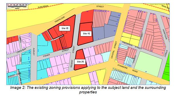
The land to which the planning proposal relates is conveniently located in close proximity to:
· Petersham Railway Station located opposite Site 3 in Trafalgar Street;
· New Canterbury Road, Audley Street, Trafalgar Street and Crystal Street accommodating major bus routes operated by Sydney Buses, including Routes 412, 444, 445 and L28, which connect the area to the Sydney CBD and intervening suburbs;
· Petersham town centre which is less than 200 metres away which comprises a variety of services and facilities.
3. DETAILS OF THE PLANNING PROPOSAL
The planning proposal seeks to amend Marrickville Local Environmental Plan (MLEP) 2011 by:
1. Amending Item 14 in Schedule 1 of the Plan:
(i) to include the properties at 297-309 Trafalgar Street so as to allow development for the purposes of a “registered club” to be permissible with Council’s consent on them;
(ii) To omit reference to the properties at 16-20 Fisher Street, so as to preclude development for the purposes of a “registered club” on them as a result of these properties no longer being needed for the relocation of the Club;
(iii) To exclude 150 off street car parking spaces associated with the Club from being considered to represent “gross floor area”.
2. Amending the Height of Buildings Map and Floor Space Ratio Map to apply development standards to the 3 development sites for which the planning proposal relates to allow redevelopments at the densities envisioned in the architectural plans and building envelope drawings submitted with the planning proposal.
The proponent has advised that they intend on entering into a Voluntary Planning Agreement (VPA) with Council which will comprise a monetary offer of $3,600,000.
The architectural plans for the respective sites as submitted with the original planning proposal are attached at ATTACHMENTS 1, 2 and 3.
Following the receipt of referrals from various sections of Council (including the Architectural Excellence Panel) and following an assessment of the planning proposal an issues letter was forwarded to the proponent. The proponent subsequently amended the development standards and building envelopes sought as part of the planning proposal. The amended planning proposal is the subject of the assessment provided in this report.
The specific amendments sought as part of the amended planning proposal are further discussed below:
(i) Use of 297-309 Trafalgar Street
Development for the purposes of a “registered club” is currently permissible with Council consent on Site 1 and part of Site 3 (i.e. excluding 297-309 Trafalgar Street, Petersham).
The planning proposal seeks to incorporate 297-309 Trafalgar Street into the site for the new club (Site 3), so that all land fronting Trafalgar Street between Regent Street and Fozzard Lane forms part of the potential redevelopment. The properties known as 16-20 Fisher Street are no longer required for the relocated Club.
As mentioned above, a “registered club” is currently permissible on part of Site 3 by virtue of Item 14 in Schedule 1 (Additional Permitted Uses) of MLEP 2011 and it is proposed to amend this clause to add 297-309 Trafalgar Street and remove 16-20 Fisher Street.
The proposed new clause will read as follows:
14 Use of certain land at 3–7 Regent Street and 287-309 Trafalgar Street, Petersham
(1) This clause applies to land at 3–7 Regent Street and 287-309 Trafalgar Street, Petersham, being Lot 1, DP 629058, Lot 10, DP 1004198 and Lot 1, DP 1208130.
(2) Development for the purpose of a registered club is permitted with consent.
(ii) Car Parking
Under the definition contained in MLEP 2011, only car parking required to meet Council requirements is excluded from “gross floor area” calculations.
Pursuant to the requirements contained in Marrickville Development Control Plan (MDCP) 2011, car parking for a registered club must be provided at a rate of 1 space / 6 staff for patrons and staff. In relation to the proposed club this requirement would equate to between 10 and 15 car parking spaces.
The Club has stipulated that 150 spaces is the minimum number of spaces required to accommodate its operations, noting that the existing club at 3-7 regent Street has access to 152 car parking spaces (across the three sites).
This additional car parking would normally be included in GFA calculations and accordingly the proponent seeks a new sub-clause be added to Item 14 in Schedule 1 of MLEP 2011 that reads as follows:
“(3) A car park accommodating up to 150 parking spaces associated with a registered club on this land is to be excluded from gross floor area.”
(iii) Height of Building (HOB)
The existing maximum HOB standards in MLEP 2011 and those proposed as part of the planning proposal are indicated in the table below:
|
Site |
Lot/DP |
Existing Height Standard |
Proposed Height Standard |
|
Site 1 |
Lot 1, DP629058 |
23.0m |
29.0m |
|
Site 2 |
Lot 1, DP830175 |
17.0m |
20.0m |
|
Site 3 |
Lot 1, DP68697 Lot 4, DP1105379 Lot 1, DP735751 Lot 1, DP62688 Lot 10, DP1004198 Lots A, B & C, DP440676 |
23.0m 23.0m 23.0m 23.0m 26.0m 20.0m |
35.0m 29.0m 20.0m |
The proposed standards are based on the Urban Design and SEPP 65 Assessment prepared by Annand Associates Urban Design Pty Ltd and the development concept plans that have been submitted as part of the planning proposal.
(iv) Floor Space Ratio (FSR)
The existing maximum FSR standards in MLEP 2011 and those proposed as part of the planning proposal are indicated in the table below:
|
Site |
Lot/DP |
Existing FSR Standard |
Proposed FSR Standard |
|
Site 1 |
Lot 1, DP629058 |
2.80:1 |
2.80:1 (unchanged) |
|
Site 2 |
Lot 1, DP830175 |
1.80:1 |
2.10:1 |
|
Site 3 |
Lot 1, DP68697 Lot 4, DP1105379 Lot 1, DP735751 Lot 1, DP62688 Lot 10, DP1004198 Lots A, B & C, DP440676 |
2.50:1 2.30:1 2.20:1 2.20:1 2.30:1 2.30:1 |
3.40:1
|
The proposed changes to the maximum FSR development standards will result in an increase in the gross floor area (GFA) yield of the development on the three sites by some 5,922sqm from 24,542sqm to 30,464sqm. The new Club will have a GFA of 3,600sqm.
(v) Voluntary Planning Agreement
The planning proposal as originally submitted on 10 June 2016 included a VPA which was valued by the proponent at $4.6 million and included:
· Transfer of 24 car parking spaces to be provided on the ground floor of the development to be completed on Site 1;
· Transfer of 2 x 1 bedroom affordable housing units; and
· Public domain improvements being the construction of a pedestrian shared zone in Regent Street, between Fisher Street and Trafalgar Street, including upgrading all associated footpath, kerb and gutter and road works (as necessary).
The original planning proposal sought changes that would have resulted in an increase in the gross floor area (GFA) yield of the development on the three sites by some 7,562sqm.
In responding to concerns raised by Council (including AEP advice) modifications have been made to the building envelopes sought on the three sites and these changes have resulted in the increase in gross floor area being reduced from 7,562sqm to 5,922sqm.
In a letter dated 30 May 2017, the proponent has advised that the value of the VPA they would offer in relation to the current revised planning proposal is $3.6 million reflecting the reduced yield. The proponent has also since agreed to continue to provide 24 car parking spaces to be provided on Site 1 (the site of the current RSL Club). These parking spaces would be made available for public use.
The proponent will finance the continued operation of the existing Club premises until the completion of the new Club and fund the construction of the new club premises, which is estimated to cost in the order of $20 million and will be designed to benefit not only Club members, but the community at large, and would not represent a saleable element of the proposed redevelopment.
As part of the development agreement with the RSL Club, the proponent has also committed to provide residential units to the value of $27 million to the RSL Club in perpetuity to ensure it will remain as a going concern into the long term.
The proponent also made the following comments in relation to the public benefits offered by the proposed redevelopment in considering the VPA offer:
“This voluntary planning agreement needs to be considered in the context of:
• the RSL Club’s role as a not-for-profit ex-servicemen’s organisation formed to satisfy the recreation, leisure, welfare and cultural needs of the local community; and
• the underlying tenet of the planning proposal, which is to secure the Club’s ongoing viability and economic future by facilitating its relocation to new modern premises befitting contemporary community standards and providing an income stream to enable the Club to continue the vital contribution it makes to local community life.
The new Club premises:
• will involve a building with a gross floor area of some 3,600sqm;
• will involve the integration of 150 car parking spaces into the new premises; and
• will be required to be built while keeping the existing Club operational to provide a continuity of service to the local community.
Over the last decade, the Club has made grants exceeding $2.1 million to a wide range of community, welfare and sporting organisations.
A review of grants made in the 2015-16 financial year, indicates grants of over $400,000.
Highlights of these grants include over:
• $180,000 to ShareCare Inc, an organisation which provides services to families who have a child or young person with a disability;
• $21,000 to the Petersham RSL Sub-Branch;
• $20,000 to the Newtown Rugby League Football Club;
• $12,000 to the Randwick Petersham Cricket Club; and
• $16,000 to the Sydney Eisteddfod.
Significant grants have also been made to organisations including, the Heart Research Institute, the Marrickville Youth Resource Centre, Rainbow Club Australia Inc, RPA Newborn Care, Macular Disease Foundation, Holy Trinity Anglican Church, The Shepherd Centre, Good Shepherd Australia & New Zealand, Child Abuse Prevention Service and Vision Australia.
The redevelopment itself will result in significant public benefits in terms of public domain improvements, including:
• the undergrounding of overhead utility services on the western side of Regent Street;
• the installation of kerb blisters, rain gardens and footpath planting in road reserves;
• the provision a publicly accessible urban space between buildings on Site 3 to establish a pedestrian link between Regent Street and Fozzard Lane; and
• adjustments to the traffic signals to allow for both right and left turn movements out of Regent Street into Trafalgar Street.
A planning agreement is to be agreed to with Council prior to the issue of a Gateway Determination and is to include a provision that Council will not be required to expend the Section 94 contributions it receives from the ensuing development on facilities in the immediate vicinity of the Club's land.”
4. PURPOSE OF THE PLANNING PROPOSAL
The proponent’s stated purpose of the planning proposal is:
· to facilitate the relocation of the RSL Club to a modern single level premises and enable it to satisfy recreation and leisure needs of the local community;
· to renew and revitalise this locality and realise Council’s vision for growing Petersham as a residential precinct and as a centre;
· to provide public benefits in terms of:
• significantly enhancing the public domain in this area; and
• contributing to the provision of affordable housing;
· to promote and co-ordinate the orderly and economic use and development of the land in this locality; and
· to facilitate development in a manner consistent with contemporary town planning practice and principles relating to the integration of transport and land use and transit-oriented development and the use of public transport as the principal means of access to shops, services, leisure and recreational facilities.
5. KEY PLANNING ISSUES
Following a review of the planning proposal, and the receipt of internal and external referrals, Council sent an issues letter (dated 27 March 2017) to the proponent identifying a number of matters that needed to be addressed in order to progress the planning proposal.
The proponent made amendments to the planning proposal and submitted updated documentation on 10 May and 30 May 2017.
The issues raised and the proponent’s responses are outlined below:
(i) Building Envelopes and Architectural Excellence Panel Recommendations
Site 1 – 3-7 Regent Street, Petersham
As part of the original planning proposal, the proponent sought to increase the HOB and FSR development standards applying to this site to 32 metres (currently 23 metres) and 3.4:1 (currently 2.8:1) respectively to facilitate the erection of a 9 storey building.
Council’s Architectural Excellence Panel (AEP) raised concern with the amenity of the nine storey concept design as originally submitted for this site, given the narrow (approximately eight metres wide) central courtyard. It was assessed that this original architectural scheme did not demonstrate that the HOB and FSR development standards proposed as part of the planning proposal were appropriate for the site.
The AEP recommended that part of the eastern side of the envelope be removed to create a more open ‘U’ shaped form to ensure adequate amenity for apartments and the central communal open space.
Given the 55 metre length of the Regent Street frontage, the AEP also suggested breaking the building into two distinct but united built forms with an entry lobby for each building and/or other design changes be explored to visually break-up the elevation, as well as providing a stronger base.
Applicant’s response:
The applicant submitted an amended building envelope for Site 1 that included the following changes to respond to the concerns raised by Council:
· The building envelope has been amended to provide a part 7 part 8 storey building;
· A 2 storey cut-out (i.e. a 5 storey element) is proposed on the eastern elevation to ensure adequate amenity for apartments and the central communal open space;
· No change is proposed to the existing maximum FSR development standard currently applying to the site (i.e. 2.8:1); and
· The HOB development standard sought for the site has been reduced from 32 metres (as originally proposed) to 29 metres.
With regard to the AEP’s comments about the need to visually break-up and provide a stronger base to the building, the proponent advised that “the modulation and articulation of the building’s Regent Street elevation is to be achieved by architectural detailing that is to be specified in the development application (DA) to be submitted following the processing of the planning proposal.”
The amended building envelopes proposed for Site 1 are illustrated below:
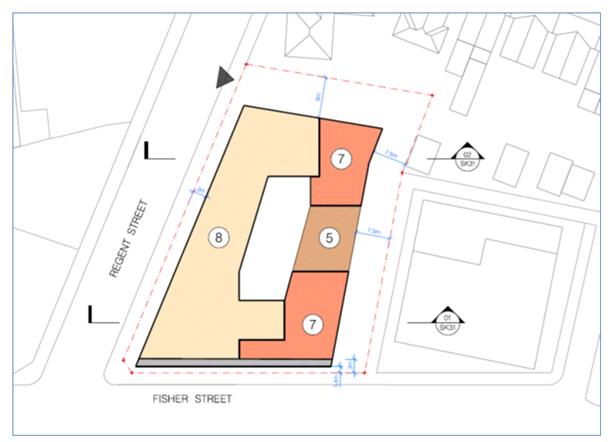
Image 3: Amended building envelope for Site 1 (3-7 Regent Street)
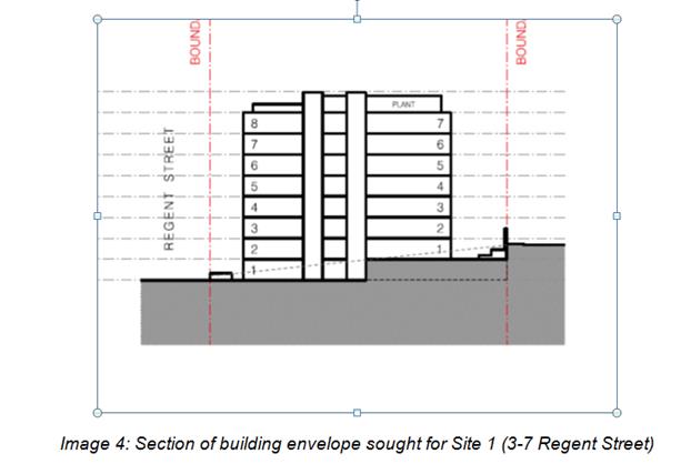
Assessing Officer’s concluding comments:
The amended building envelopes respond to the comments made by Council’s AEP and it is agreed that the need to break up the façade and provide a stronger base to the building can be addressed as part of any future development application for the site.
In amending the building envelope for Site 1, the proponent seeks to increase the maximum building height development standard from 23 metres to 29 metres and maintain the existing FSR development standard of 2.8:1.
The change sought to the HOB development standard on Site 1 is considered to have merit as it will allow for a residential development of improved amenity while retaining the existing maximum FSR development standard for the site.
Site 2 – 13-17 Regent Street, Petersham
As part of the original planning proposal the proponent sought to increase the HOB and FSR development standards applying to this site to 20 metres (currently 17 metres) and 1.9:1 (currently 1.8:1) respectively to facilitate the erection of a part 5 part 6 storey building.
The AEP was generally supportive of the submitted scheme for this site and even suggested there may be capacity to increase the height of this building (particularly on the lower portion of the site) to accommodate a part 6 part 7 storey building to compensate for the recommendation to reduce height, bulk and yield of the buildings fronting Fisher Street on Sites 1 and 3.
Council officers also raised concern with the proposed tree removals, particularly the loss of the trees adjacent to the southern (New Canterbury Road) boundary.
Applicant’s response:
The applicant submitted an amended building envelope for Site 2 that sought to increase the height of the building in line with the comments provided by Council’s AEP (i.e. a 6 part 7 storey envelope. The proponent also amended the building envelope to provide a minimum 3 metre setback (with a 1 metre articulation zone) from the New Canterbury Road frontage to provide improved residential amenity for the dwellings.
On Site 2 the proponent now seeks to increase the maximum building height development standard from 17 metres to 20 metres and increase the FSR development standard from 1.8:1 to 2.1:1.
With regard to Council’s comments concerning potential tree retention, the proponent made the following submission:
“The trees on Site 2 adjacent to New Canterbury Road are located up to 2.5m from the street boundary and up to 1.5m below the footpath level.
The retention of these trees is unwarranted and/or impractical in the context of:
· their location, the site’s topography and the extent of the setback that would be required for their retention, i.e. some 10m;
· the effect their retention would have on the economic use and development of the land;
· the site-specific planning controls depicted in Figure 6.1b of the master plan for this site, contained in Part 9.6.5.1 of MDCP 2011, that is based on their removal; and
· the extent of setback required to preserve the trees resulting in a streetscape presentation that would be inconsistent with the established setback of buildings between Regent and Crystal Streets and the desired future setback of development on this land contemplated by the master plan in MDCP 2011.”
The amended building envelopes proposed for Site 2 are illustrated below:
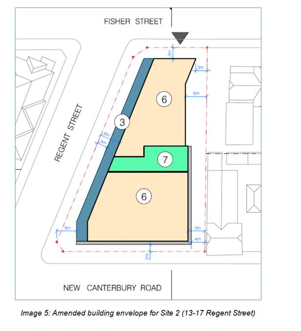
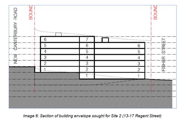
Assessing Officers concluding comments:
In amending the building envelope for Site 2, the proponent seeks to increase the maximum HOB development standard from 17 metres to 20 metres and increase the FSR development standard from 1.8:1 to 2.1:1.
The changes the proponent has made to the building envelope for Site 2 are in line with the recommendations made by Council’s AEP.
The applicant’s comments regarding the need to remove the trees adjacent to the southern (New Canterbury Road) boundary are supported and it is noted that the building envelope proposed for Site 2 will not result in any greater loss of vegetation than the existing building envelope identified in Part 9.6 of MDCP 2011.
In amending the building envelope for Site 2 the proponent now also proposes a minimum 3 metre setback from the New Canterbury Road frontage (no setback was previously proposed) and this setback will provide enhanced residential amenity and improved streetscape appearance with new perimeter planting to replace the vegetation to be removed.
The changes sought to the HOB and FSR development standards sought for Site 2 and the resultant building envelope are considered to have merit and are supported.
Site 3 – 287-309 Trafalgar Street and 16-20 Fisher Street, Petersham
As part of the original planning proposal the proponent sought to increase the maximum HOB development standard from a current range of 20 metres to 26 metres to a new range of 29 metres to 32 metres and increase the FSR development standard from 2.3:1 to 3.4:1.
The AEP was generally supportive of the mass proposed on this site and also stated that there may be capacity for an extra level on Building B (creating greater massing to the corner of Trafalgar Street and Regent Street) to compensate for the recommended loss of yield at other locations on the site.
The additional height and FSR was predicated on adequate solar amenity being provided to the “pocket park” (i.e. urban space provided between Buildings A and B) and the communal open space to be provided on site.
Other recommended design changes included:
· Given the building height, a greater setback was required for the upper levels of Building C on the southern side adjacent to the lane, to enable a minimum building separation of 18 metres (9 metres to centre of lane);
· Even with this separation, to achieve acceptable solar access for developments to the south on Fisher Street (and to improve the amenity of the communal open space provided on site) a greater drop down of the entire rear wing may be required;
· At 8 storeys, the height of Building A facing Fisher Street was excessive and did not fit with the scale of Fisher Street and it was recommended that Building A be reduced to a maximum of 6 storeys where it presents to Fisher Street;
· The legibility of apartment lobby address with the original scheme was poor, especially for Building C but also for Building B in Site 3 (requiring access from the urban space/pocket park off Regent Street). Council advised that direct street level lobby address should be provided for each building – from Trafalgar Street for Building C and from near the corner of Regent / Trafalgar Street (with direct access to a lift) for Building B; and
· The design of the Trafalgar Street ground floor edge of the Club (55 metres long) should provide a more activated and attractive edge (rather than the proposed screened edge of the smokers gaming lounge).
Applicant’s response:
“The development concept for Site 3 has been amended to:
· remove a section of the southern elevation of Building C, adjacent to the site’s southern common boundary with Fozzard Lane, effectively increasing the setback of the residential section of the building from 2.6m to 10.3m from the centreline of the lane and eliminating 7 apartments;
· provide a street level lobby address to Buildings B and C directly from Regent and Trafalgar Streets, respectively;
· increase the height of Building B by 1-storey to accentuate the site’s Trafalgar/Regent Street corner, in accordance with the opportunity identified by the Architectural Excellence Panel and contemporary urban design practice, and increase the number of apartments by 10;
· reduce the height of Building A adjacent to Fisher Street to 6-storeys and eliminate 4 apartments;
· provide pedestrian access to Building A from both Regent and Fisher Streets;
· activate the northern ground floor elevation of Building A fronting the publicly accessible urban space between Building A and B by the provision of 3 x SOHO’s to replace 2 apartments;
· increase solar penetration into the areas to the west and south-west of the site; and
· relocate the proposed electrical substation adjacent to the Fisher/Regent Street corner to optimise opportunities to retain the adjacent trees.
Plans indicating the amended development concept and the modulation in the number of storeys, which provide the basis for master plan building envelope plans that Council might incorporate into Part 9.6 of MDCP 2011, are to accompany the planning proposal.
The building height and floor space ratio standards proposed in the planning proposal are designed to facilitate the amended concept and building envelope plans.”
The amended building envelope proposed for Site 3 is illustrated below:
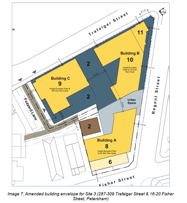
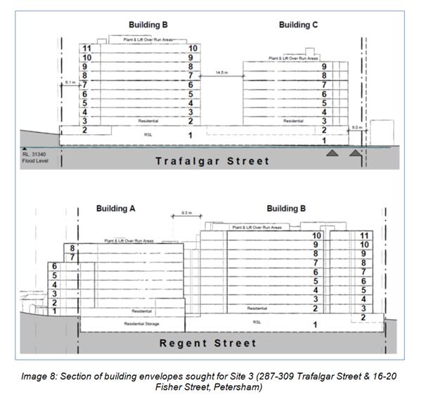
Assessing Officer’s concluding comments:
The amended building envelopes for Site 3 generally respond to the concerns raised by Council.
As pointed out by the proponent above, the amended scheme includes the following changes:
· The rear wing of Building C has been reduced in size to provide a greater setback from Fozzard Lane in accordance with Apartment Design Guide (ADG) requirements;
· To compensate for the reduced yield on Building C, the applicant proposes an additional level on Building B to accentuate the sites Trafalgar/Regent Street corner;
· Part of Building A (as it fronts Fisher Street) has been reduced to a maximum of 6 storeys;
· The amended building envelopes will result in reduced overshadowing for adjoining properties to the south and west;
· All three buildings have an improved street address and there is improved activation of the pocket park / urban space; and
· The building separation between Buildings B and C has been increased to 14.5 metres (previously 12 metres) and the rear wing of Building B has been amended to improve solar access to the urban plaza and communal open space.
As noted by the applicant above, the previously proposed electrical substation that was to be located adjacent to the Fisher/Regent Street corner has been removed “to optimise opportunities to retain the adjacent trees”. Notwithstanding, the proponent has failed to provide evidence (i.e. an arborist report) to demonstrate that the amended building envelope will allow the retention of the significant trees located on the corner of Regent Street and Fisher Street.
Accordingly it is a recommendation of this report is that should the planning proposal progress to Gateway determination that a condition of the Gateway require the proponent to engage an arborist to investigate the opportunities for the retention of the significant trees located on this corner and adjust the building envelopes as required. Such documentation should be provided to Council prior to the exhibition of the planning proposal.
The other issues raised by Council, such as the streetscape presentation of the Club are detailed design matters that can be addressed as part of any future development application.
(ii) Public Domain
Trees, Landscape and Street Improvements
The following public domain and tree/landscaping deficiencies were identified with the original planning proposal:
· The submitted Arboricultural Impact Assessment (AIA) was fundamentally deficient in method as it did not evaluate the retention value of trees; provide justification for the removal of trees; or assess the likely impact of the proposed development on the trees on and adjacent to the site. It was also assessed that there was inadequate provision of compensatory tree planting proposed.
· Council officers identified opportunities for the retention of high value trees around the perimeter of the sites (particularly in Site 3 near the intersection of Fisher Street and Regent Street and in Site 2 adjacent to the New Canterbury Road boundary) that had not been realised or pursued as part of the original proposal.
· The proposed concept landscape plan failed to provide adequate and appropriate compensatory tree planting for the trees proposed to be removed.
· The proponent was advised that the removal of the street trees (in the footpath) along Regent Street would be justified if it was to facilitate undergrounding of electricity wires and the establishment of new larger trees without power line clearance restrictions and would result in a net urban forest improvement, but this has also not been discussed in the AIA.
· Kerb blisters with rain gardens and associated planting are to be included at the intersection of Fisher and Regent Street and rain gardens are required along Trafalgar Street.
The proponent responded to the concerns raised by Council and advised:
· A more detailed AIA report would be submitted as part of the future development application(s);
· The electricity substation originally indicated on the corner of Fisher Street and Regent Street would be relocated “to optimise opportunities to retain existing trees”;
· The proponent will underground the existing overhead power lines on the western side of Regent Street and install kerb blisters, rain gardens and footpath planting (which is to include large scale trees). The proponent submitted the following sketch design prepared by Taylor Brammer Landscape Architects Pty Ltd to demonstrate the typical design of kerb blisters, rain gardens and footpath/road plantings:
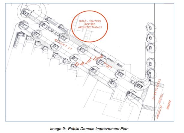
Assessing Officer’s concluding comments:
The proponent’s response to the trees, landscape and street improvement comments provided by Council are generally supported. The building envelopes proposed as part of the subject planning proposal will not result in any greater loss of vegetation than the existing building envelopes identified in Part 9.6 of MDCP 2011.
Notwithstanding, as pointed out above, the proponent has made amendments to the buildings and structures on Site 3 that should allow the retention of the significant trees located on the corner of Regent Street and Fisher Street. Notwithstanding, the proponent has failed to provide evidence (i.e. arborist report) to demonstrate that these trees will be retained. Accordingly, it is a recommendation of this report that should the planning proposal progress to Gateway determination that a condition of the Gateway require the proponent to engage an arborist to investigate the opportunities for the retention of the significant trees located on this corner and adjust the building envelopes as required and that this be provided to Council and made available as part of the public exhibition period.
Importantly the proponent also seeks to undertake significant public domain improvements in Regent Street including the undergrounding of power lines and the installation of kerb blisters, rain gardens and footpath/road planting with large scale trees.
Open Space
Council officers made the following observations / comments in regard to open space:
· The upper and lower area between Building A and Buildings B/C in Site 3, titled “Public Pocket Park” should be retitled “Publicly Accessible Urban Space”, as it primarily provides pedestrian connection to the laneway and small urban ‘sanctuary’ spaces; and
· Further design refinement of this space is required, such as making it appear more publicly accessible and visually connected, (e.g. with more open treatment of the entry edges by removing obstructing wall and cutting back the courtyard wall on southern side as per the northern side); ensuring it receives adequate winter sun; providing more passive recreation amenity (e.g. some attractive seating area and some larger tree planting); and providing a more activated edge (e.g. apartments in Buildings A and B providing windows and balconies oriented into the space, having direct ground floor residential entry and/or incorporating a small retail space on the ground floor of Building A fronting the urban space).
Applicant’s response:
“The area between Buildings A and B on Site 3, which provides access linking Regent Street to Fozzard Lane is:
· to be referred to as a publicly accessible urban space;
· to be activated by SOHO’s; and
· to enjoy a satisfactory and appropriate level of solar access in terms of its location and function.”
Assessing Officer’s concluding comments:
The applicant’s submission is supported as the above-described changes will increase activation of this space. Furthermore, as pointed out previously, the proponent has increased the building separation between Building B and C and modified the rear wing of Building B to improve solar access to the communal open space and urban plaza.
(iii) Affordable Housing
The draft Central District Plan requires the relevant planning authority to include an Affordable Rental Housing Target as a form of inclusionary zoning and sets a target of 5% to 10% of new floor space at rezoning stage. Furthermore, Council’s Affordable Housing Policy (AHP) sets affordable housing targets based on a value capture approach and should be used as a guide for this proposal. Affordable housing would ordinarily be transferred to Council via voluntary planning agreement however the proponent’s offer at this point does not include any offer for affordable housing.
This report recommends that the voluntary planning agreement offer as provided by the proponent be considered pursuant to Council’s interim VPA Policy.
Applicant’s response:
The proponent has advised that they intend on entering into a Voluntary Planning Agreement (VPA) with Council which at this stage will comprise a monetary offer of $3,600,000.
In light of the requirements outlined in Council’s Affordable Housing Policy, the proponent has advised that they are willing to negotiate with Council as to the public benefits to be provided as part of the final VPA with any negotiations needing to take into consideration the transfer of value to the Club associated with the development agreement between the RSL Club and proponent.
Assessing Officer’s concluding comments:
The value of the public benefits or otherwise of this offer is still the subject of evaluation and negotiation with the proponent. The final terms of the offer can be finalised after any Gateway determination and prior to the final determination of the planning proposal.
Any negotiations regarding the voluntary planning agreement offer from the proponent would be undertaken in accordance with Council VPA Policy.
(iv) Transport and Car Parking
The 150 car parking spaces provided to service the club is assessed as appropriate based on the justification submitted, and therefore Council officers support amending Item 14 in Schedule 1 Additional Permitted Uses of MLEP 2011 to exclude 150 car parking spaces associated with the Club from GFA calculations.
However, the residential car parking spaces provided for each of the three sites as identified in the submitted architectural drawings are in excess of the rates stipulated in MDCP 2011 and even the rates in RMS ‘Guide to Traffic Generating Development’, with little justification for such a deviation. This contradicts the central premise of the planning proposal that the additional height and FSR are warranted given the proximity to Petersham Railway Station (i.e. transport oriented development).
The over provision of resident car parking is not supported on transport sustainability and traffic grounds and it is recommended that residential car parking on the three sites be capped by the rate contained in Part 2.10 of Marrickville Development Control Plan (MDCP) 2011.
(v) Traffic and Vehicular Access
Council Traffic Engineers reviewed the original planning proposal and made the following comments:
· A two-way vehicular entry/exit off Regent Street is supported for Site 1 however this and the fire stairs on the corner of Fisher Street and the Lane/easement adjacent to the Council Administration Centre shall be designed so as to provide adequate sight distance to vehicles and pedestrians in accordance with AS2890.1:2004.
· For Site 2 the vehicular crossing on Fisher Street must be relocated to be a minimum of 6 metres from the splayed corner of Fisher and Regent Streets.
· From a vehicle traffic perspective Council’s Traffic Engineer recommend that vehicular access for Site 3 be split between Trafalgar Street and Regent Street, with all Club traffic entering and leaving the site via a widened Fozzard Lane (subject to RMS concurrence), with all residential traffic entering and leaving the site via a two-way vehicular access off Regent Street.
· In the assessment of the traffic generation, the Traffic and Parking Impact Assessment Report has used the RMS Sydney Average traffic generation rate for high density residential flat dwellings of 0.19 peak vtph per unit. The surveys used to derive this rate include surveys from St Leonards and Chatswood that have very different traffic generation rates than Inner West Sydney. The Traffic Impact Assessment Report should use a traffic generation rate of 0.3 peak vtph per unit which is derived from the RMS survey data excluding St Leonards and Chatswood.
Applicant’s response:
“Council’s comments regarding these issues in relation to Sites 1 and 2 are noted and will be addressed in the DA to be submitted for the project.
Barker Ryan Stewart, who are preparing the transport, traffic and parking impact assessment for the project, have had preliminary discussions with Roads & Maritime Services regarding the provision of all vehicular access to the development on Site 3 from Trafalgar Street.
This access is considered appropriate in terms of:
· traffic movements being restricted to left-in/left-out;
· the master plan contained in Figure 6.2b in Part 9.6 of MDCP 2011 indicating vehicular access to this site from Fozzard Lane and not from Regent Street; and
· vehicular access to the residential parking facilities in the development from Regent Street being impractical in the context of:
· such access precluding the relocation of the RSL Club to the western side of Regent Street as proposed;
· the site’s topography; and
· its adverse impact on the publicly accessible urban space between Buildings A and B and the proposed pedestrian connection linking Regent Street and Fozzard Lane.”
Assessing Officer’s concluding comments:
The applicant’s response to the concerns raised by Council regarding vehicular access to Site 3 are noted. Given Trafalgar Street is a classified road and under the jurisdiction of the Road and Maritime Services (RMS), Council officers recommend that this matter be resolved post Gateway determination at which time the planning proposal will be referred to RMS for review and comment.
6. ASSESSMENT OF STRATEGIC MERIT
(i) A Plan for Growing Sydney (2014)
A Plan for Growing Sydney was released in late 2014 and sets the direction for planning in Sydney over the next 20 years.
The proponent considers the planning proposal to be consistent with A Plan for Growing Sydney as it:
· will accelerate urban renewal and housing production;
· will remove barriers to increased housing production; and
· will put into place flexible planning controls which enable housing development that is feasible and appropriately located for increased residential densities.
A Plan for Growing Sydney contains a number of broad objectives relating to the supply of housing across the Sydney area. It notes that Sydney’s population growth will require an additional 664,000 dwellings by 2031. The document contains overarching principles on how to accommodate population growth and housing supply relevant to this planning proposal including:
- Principle 1: Increasing housing choice around all centres through urban renewal in established areas; and
- Direction 2.1: Accelerate housing supply across Sydney.
It is considered that the planning proposal is consistent with these directions and principles as it will provide additional residential accommodation in close proximity to existing services and public transport.
(ii) Towards Our Greater Sydney 2056
The Greater Sydney Commission has been tasked with reviewing A Plan for Growing Sydney as well as developing draft District Plans. As part of the review of A Plan for Growing Sydney, a new document entitled Towards Our Greater Sydney 2056, which is seen as the first part of the process of reviewing A Plan for Growing Sydney, has been developed and publicly exhibited. The need for this document has arisen out of a shift in the focus of strategic planning since the release of A Plan for Growing Sydney. The document seeks to redefine the community’s understanding of Greater Sydney as a metropolis of three cities, being Eastern City, Central City and Western City.
This document provides broad objectives in relation to the future operation of Greater Sydney, including A Productive Sydney, A Liveable Sydney and a Sustainable Sydney. It is considered that this planning proposal is generally consistent with the broad aims of this document as it seeks to provide additional residential accommodation within an existing centre with good access to services and public transport.
(iii) Draft Central District Plan
Subregional planning strategies (District Plans), to support the aims of A Plan for Growing Sydney, have been prepared and are currently in draft form following a public consultation period that finished on 31 March 2017.
The draft Plans aim to facilitate well-coordinated, integrated and effective planning for land use, transport and infrastructure across the Greater Sydney Region over the next 20 years.
The Inner West Council is located within the Central District and the following assessment considers the planning proposal having regard to the relevant sections of the draft Plan:
4.3 Improving housing choice
The dCDP establishes a housing target for the Inner West Council to provide an additional 5,900 dwellings by 2021. The dCDP requires Council to undertake a number of actions in relation to housing supply, including the following:
- monitor and support the delivery of Inner West’s five-year housing target of 5,900 dwellings
- investigate local opportunities to address demand and diversity in and around local centres and infill areas with a particular focus on transport corridors and other areas with high accessibility.
The additional densities sought as part of this planning proposal will assist Council in meeting its dwelling target, whilst increasing housing diversity in close proximity to a local centre and public transport (Petersham Station).
4.4.4 Deliver Affordable Housing
The dCDP requires the relevant planning authority to include an Affordable Rental Housing Target as a form of inclusionary zoning and sets a target of 5% to 10% of new floor space at rezoning stage.
The proponent has advised that they intend on entering into a Voluntary Planning Agreement (VPA) with Council which at this stage will comprise a monetary offer of $3,600,000.
In light of the requirements outlined in Council’s Affordable Housing Policy (and the dCDP), the proponent has advised that they are willing to negotiate with Council as to the public benefits to be provided as part of the final VPA.
The value of the public benefits or otherwise of this offer is still the subject of evaluation and negotiation with the proponent. The final terms of the offer can be finalised after any Gateway determination and prior to the final determination of the planning proposal.
4.6 Create Great Places
The dCDP encourages design led planning that produces good architecture and planning as elements of a people centred, sustainable, liveable environment. The dCDP requires growth to be managed to create healthy, well designed, safe and inclusive places that encourage economic and social activity, vibrancy and community spirit.
The proponent has provided architectural drawings as part of the planning proposal that demonstrate the built form vision of the planning proposal. The architectural plans have been reviewed by Council’s Architectural Excellence Panel (AEP) who are generally supportive of the proposed schemes. As part of the planning proposal the proponent has identified significant public domain improvements which coupled with high quality architecture will create a well-designed, healthy, safe and inclusive space.
(iv) Marrickville Urban Strategy (2007)
The Marrickville Urban Strategy (MUS) was adopted by Council in 2007. It establishes a vision and co-ordinated directions addressing a range of planning, community, and environmental issues, to guide short, medium and long term strategic planning policies for the Marrickville LGA. The MUS was developed in response to employment and housing targets established through the draft South Subregional Strategy (dSSS) and its overriding strategy, Sydney Metropolitan Strategy City of Cities, A Plan for Sydney’s Future (December 2005).
The MUS supports the aim of locating additional residential development in and around existing centres with good access to public transport and services. The MUS adopted six urban renewal approaches to inform policy options for future residential development within the LGA. These are:
1. Focus on residential density in and around centres;
2. Focus on commercial zoned land in centres;
3. Rezone select industrial sites;
4. Develop new centres;
5. Rezone select special use sites; and
6. Increase density in infill areas.
The planning proposal is consistent with the criteria established in the MUS, particularly items 1 and 6.
(v) Marrickville Community Strategic Plan 2023
Marrickville Council’s Community Strategic Plan (CSP) 2023 was adopted by Council in June 2013. The plan sets the desired future direction and priorities for Council over a 10 year period. The planning proposal is considered to be consistent with the following key result areas contained in the CSP:
· 1.5.4 Pursue planning controls that support existing and new supplies of affordable housing – The proponent has advised that they intend on entering into a Voluntary Planning Agreement (VPA) with Council which at this stage will comprise a monetary offer of $3,600,000. However, in light of the requirements outlined in Council’s Affordable Housing Policy, the proponent has advised that they are willing to negotiate with Council as to the public benefits to be provided as part of the final VPA.
· 3.3.2 Promote accessibility of railway stations and bus stops – The subject sites are located directly adjacent to and within close proximity of Petersham Railway Station. Accordingly the uplift proposed as part of this planning proposal is considered reasonable given it relates to Transport Oriented Development (TOD).
(vi) The Inner West Council Interim Statement of Vision and Priorities
Council’s recently adopted Interim Statement of Vision and Priorities will guide Council until a single Community Strategic Plan is developed for the Inner West. The Interim Statement, which was adopted at a Council meeting on 28 March 2017, contains eight high level priorities:
· Planning and development
· Transport
· Social vitality, creativity and quality of life
· Sustainability and the environment
· One Council
· Local industry and business
· Advocacy
· Local democracy
The planning proposal is considered to be consistent with these eight high level priorities.
(vii) State Environmental Planning Policies (SEPPs)
SEPPs are environmental planning instruments which address planning issues within the State. The following assessment considers the SEPPs that are relevant to the planning proposal:
State Environmental Planning Policy No. 55 – Remediation of Land (SEPP 55)
A Detailed Site Investigation (DSI) Report prepared by Environmental Investigations Australia Pty Ltd was submitted as part of the planning proposal. The DSI Report concluded that there was no widespread contamination across any of the sites and that subject to preparation and implementation of a RAP the sites would be suitable for the proposed redevelopments.
It is considered that sufficient information has been provided with this planning proposal to demonstrate that the proposal is consistent with the aims and objectives of the SEPP particularly given the planning proposal does not seek to rezone the subject properties (which are currently zoned R4 - High Density Residential), but rather seeks to expand the range of permissible uses to allow the new club to be erected on 297-309 Trafalgar Street and there is an uplift in the FSR and HOB development standards applying to the sites.
State Environmental Planning Policy No. 65 – Design Quality of Residential Apartment Development (SEPP 65)
SEPP 65 and the Apartment Design Guide (ADG) apply to residential flat buildings, shop top housing and the residential component of mixed use developments where the building is greater than three storeys in height and contains four or more dwellings.
An Urban Design and SEPP 65 Assessment Report prepared by Annand Associates Urban Design Pty Ltd was submitted as part of the planning proposal. The building envelopes sought as part of the planning proposal generally comply with the controls, standards and principles outlined in SEPP 65 and the ADG.
The planning proposal was considered by Councils AEP who were generally supportive of the schemes, and the proponent has modified the proposed building envelopes in accordance with the recommendations of this panel.
Accordingly the planning proposal is consistent with the requirements contained in the ADG and SEPP 65.
(viii) Section 117 Directions
The following Section 117 Directions are relevant to this planning proposal:
3.1 Residential Zones
The objectives of this Direction are to encourage a variety of housing types, make efficient use of infrastructure, and minimise the impact of residential development on the environmental and resource lands.
The Direction requires a planning proposal to encourage housing that will broaden the choice of building types and locations available in the housing market; make more efficient use of existing infrastructure and services; reduce the consumption of land on the urban fringe; and be of good design.
The planning proposal is assessed as being consistent with this direction as it provides increased densities adjacent to an existing centre with good access to public transport (transit oriented development) and would therefore reduce demand for land on the urban fringe.
3.4 Integrating Land Use and Transport
As highlighted above, the changes sought as part of this planning proposal seek to increase densities in a highly accessible location. Accordingly the planning proposal supports the efficient and viable operation of public transport systems and is consistent with this direction.
3.5 Development Near Licensed Aerodromes
The objectives of this Direction are to ensure the safe and effective operation of aerodromes; ensure that aerodrome operations are not jeopardised by hazards or obstructions; and that residential development near aerodromes are safe for human occupation.
The planning proposal seeks to increase the FSR and Height of Building development standards applying to the three sites. The planning proposal is however considered to be consistent with the direction given:
· The sites are within the ANEF 20-25 contour; and
· Sydney Airports Corporation Limited (SACL) and the Department of Transport and Regional Development will be consulted with should the planning proposal receive Gateway determination.
6.3 Site Specific Provision
The objective of this Direction is to limit restrictive site specific provisions to enable particular development.
The planning proposal includes site specific controls relating to car parking. While the planning proposal is inconsistent with this Direction, the inconsistency is minor and considered reasonable in the circumstances.
7.1 Implementation of A Plan for Growing Sydney
This Direction gives legal effect to A Plan for Growing Sydney. For the reasons outlined under heading 6 above, the planning proposal is considered to be consistent with both “A Plan for Growing Sydney” and the “draft Central District Plan”.
7. FINANCIAL IMPLICATIONS
The Planning Proposal does not result in any cost implications for Council. The proponent has provided a voluntary planning agreement offer as outlined in this report comprising $3.6 million and 24 car spaces for public use. This would be provided in addition to Section 94 contributions and significant public domain works including undergrounding of power lines along the western side of Regent Street.
Notwithstanding the offer made by the proponent to date, this offer would need to be considered by Council in accordance with its VPA Policy.
8. OTHER STAFF COMMENTS
In assessing this planning proposal internal referrals were received from various sections of Council, including Engineering, Environmental Services; Community Development; Waste; Infrastructure Planning and Property; Culture and Recreation; and Traffic.
9. PUBLIC CONSULTATION
Nil to date. Public consultation will occur in accordance with any Gateway determination.
10. CONCLUSION
The planning proposal is considered acceptable for submission to the Department of Planning and Environment (DP&E) for Gateway determination.
The proposal is considered to have strategic merit as it involves increasing residential densities in a highly accessible location. The proposed redevelopment has the potential to provide significant community benefit through public domain improvements; improved pedestrian linkages; enhanced traffic management; and a new RSL Club that will provide an ongoing contribution to the community. There will also be public benefits associated with the terms of the final VPA to be negotiated with Council.
It is recommended that Council resolve to forward the planning proposal in the manner recommended in this report to the Department of Planning and Environment for Gateway determination.
|
1.⇩ |
Attachment 1: architectural plans for the prospective sites |
|
2.⇩ |
Attachment 2: architectural plans for the prospective sites |
|
3.⇩ |
Attachment 3: architectural plans for the prospective sites |
|
|
Council Meeting 27 June 2017 |
C0617 Item 11
Attachment 1: architectural plans for the prospective sites
|
Council Meeting 27 June 2017 |
C0617 Item 11
Attachment 2: architectural plans for the prospective sites
|
Council Meeting 27 June 2017 |
C0617 Item 11
Attachment 3: architectural plans for the prospective sites
|
Council Meeting 27 June 2017 |
Subject: Local Traffic Committee Meeting held on 1 June 2017
File Ref: 17/6022/70354.17
Prepared By: Nina Fard - A/Traffic Team Leader
Authorised By: Wal Petschler - Group Manager Footpaths, Roads, Traffic and Stormwater
|
SUMMARY Start writing the summary here. |
|
RECOMMENDATION
THAT the Minutes of the Local Traffic Committee Meeting held on 1 June 2017 be received and the recommendations be adopted. |
BACKGROUND
A meeting of the Inner West Council Local Traffic Committee was held on 1 June 2017 at Leichhardt. The minutes of the meeting are shown at ATTACHMENT 1.
FINANCIAL IMPLICATIONS
Projects proposed for implementation in 2016/17 are funded within existing budget allocations.
OTHER STAFF COMMENTS
Nil.
PUBLIC CONSULTATION
Members of the public attended the meeting to address the committee on specific items.
|
1.⇩ |
Minutes of the Local Traffic Committee Meeting held on 1 June 2017 |
|
Council Meeting 27 June 2017 |
Subject: Flood Management Advisory Committee meeting held 16 May 2017
File Ref: 4387/59178.17
Prepared By: Ryan Hawken - Coordinator Asset Planning
Authorised By: Wal Petschler - Group Manager Footpaths, Roads, Traffic and Stormwater
|
SUMMARY The minutes of the Inner West Council Flood Management Advisory Committee meeting held on 16 May 2017 are presented for Council consideration.
|
|
RECOMMENDATION
THAT the minutes of the Inner West Council Flood Management Advisory Committee held on 16 May 2017 be received and the recommendations be adopted. |
BACKGROUND
A meeting of the Inner West Council Flood Management Advisory Committee was held on 16 May 2017 at Council’s Petersham Service Centre. The minutes of the meeting are included as (Attachment 1). The business paper for the meeting is included as (Attachment 2).
The Committee recommended that the Johnstons Creek and Alexandra Canal Flood Studies be adopted. These studies can be viewed electronically on the Inner West Council website.
The Committee also recommended that the Marrickville Valley Draft Flood Risk Management Study and Plan be endorsed for public exhibition. This study can be viewed electronically on the Inner West Council website.
FINANCIAL IMPLICATIONS
Nil
OTHER STAFF COMMENTS
Nil
PUBLIC CONSULTATION
Nil
|
1.⇩ |
Minutes of the IWC Flood Management Advisory Commitee 16 May 2017 |
|
2.⇩ |
IWC Flood Committee 16 May 2017 Business Paper |
|
Council Meeting 27 June 2017 |
Subject: Mandatory Reporting of Fire Safety Reports Referred to Counci from Fire and Rescue NSW
File Ref: 17/507/65317.17
Prepared By: Elizabeth Richardson - Group Manager Development Assessment and Regulatory Services
Authorised By: Peter Gainsford - Deputy General Manager Assets and Environment
|
SUMMARY This report provides mandatory notification to Council under s121ZD of the Environmental Planning and Assessment Act 1979 (EPAA) of correspondence regarding fire safety concerns received from Fire & Rescue NSW.
Following a review of the correspondence and a site inspection by Council’s Fire Safety Officer, this report seeks Council to note the exercise of powers under s121B EPAA to require upgrades of the buildings to the satisfaction of Council’s Fire Safety Officer in order to:
§ improve the provisions for fire safety at the premises; § improve the provision of fire safety awareness; § improve the adequacy of the premises to prevent fire; § improve the adequate of the premises to suppress fire or prevent the spread of fire; and § improve the safety of persons in the event of fire.
|
|
THAT Council:
1. note the correspondence provided by Fire and Rescue NSW for development on land at Sydney College of the Arts “- Callen Park Balmain Road Lilyfield; Balmain Lodge - 415 Darling St Balmain ; Balmain Backpackers – 673 to 677 Darling Street Rozelle, “The Fig”68 -82 Palmer St Balmain and Ashfield Mall – 260A Liverpool Road Ashfield (Attachments 1 - 5);
2. endorse the Councils Officers use of statutory powers (and discretion as appropriate) under s121B of the Environmental Planning and Assessment Act 1979 to require upgrades to buildings to the satisfaction of Council's Fire Safety Officer in order to:
· improve the provisions for fire safety at the premises; · improve the provision of fire safety awareness; · improve the adequacy of the premises to prevent fire; · improve the adequate of the premises to suppress fire or prevent the spread of fire, and · Improve the safety of persons in the event of fire.
|
BACKGROUND
In accordance with the provisions of the Environmental Planning and Assessment Act 1979 (EPAA), Fire and Rescue NSW (FRNSW) has referred letters to Council detailing a number of concerns with the fire safety measures and fire safety procedures for properties in the Inner West Council area.
Owners of buildings such as assembly buildings, commercial premises, residential flat buildings etc., have a legal obligation to ensure that all fire safety measures installed on the premises are, at all times, maintained and working to their relevant standard of performance for the safety of the buildings occupiers or users – whether the building is occupied or not. This is done through the installation of fire safety measures compliant with the National Construction Code (Building Code of Australia - BCA) or an alternative solution endorsed by a qualified Fire Engineer.
A fire safety measure is any aspect of construction, piece of equipment or strategy, that are required to enhance the safety of people within the building in the event of a fire. These fire safety measures can vary significantly depending on the age of the building, its design and its use. The determination of the appropriate fire safety measure is guided through the deemed to satisfy provisions / functional statements of the Building Code of Australia or through Alternative Solutions designed and developed by Fire Engineers and Accredited Certifiers (registered with the NSW Building Professionals Board).
FRNSW and Council’s Fire Safety Officers have undertaken inspections of all premises referred. As a result, Council’s Fire Safety Officer is currently reviewing relevant files and will undertake further inspections which may require upgrades in order to:
· improve the provisions for fire safety at the premises;
· improve the provision of fire safety awareness;
· improve the adequacy of the premises to prevent fire;
· improve the adequate of the premises to suppress fire or prevent the spread of fire; and
· improve the safety of persons in the event of fire.
As the premises are on private land, any required upgrades are able to be undertaken under through the issuing of orders under s121B EPAA, thereby allowing the works to be undertaken without the necessity for the lodgement of a Development Application. After all solutions are implemented and a Fire Safety Certificate is issued the building is listed on Fire Safety Register and Annual Fire Safety Inspections are required to be undertake in accordance with the Environmental Planning and Assessment Regulation 2000.
This annual inspection is to ensure that:
i. All fire safety measures are inspected by a properly qualified person to ensure they are maintained to the appropriate Standard of Performance
ii. Fire Safety Statements are maintained in the approved form and are displayed in a clearly visible position and available for Fire and Rescue NSW or Council Authorised Officer.
EXTERNAL WALLS & ALUMINUM COMPOSITE CLADDING
The recent fire in at the ‘Grenfell Tower’ in London, and the Lacrosse building fire in Docklands, Melbourne in 2015, has highlighted issues with external wall construction and the use of certain aluminum composite panels as part of an external walling to buildings.
The use of non-compliant cladding on multi-storey residential buildings has a potential for rapid vertical fire spread via the façade of the building and may present an increased risk to occupants, the public and firefighting personnel.
Increased awareness of this emerging issue has been undertaken through publications from the:
· Department of Planning and Environment;
· Australian Building Codes Board (ABCB); and
· Fire and Rescue NSW.
At the Building Ministers' Forum in February 2016, Ministers agreed to work to implement a range of measures to address safety issues associated with high risk building products. It was that the ABCB support measures to address the risks specifically associated with cladding used in high rise buildings and report back on proposed additional actions to address the wider issue of non-compliant use of building products.
In September 2016, a detailed Advisory Note was issued by the ABCB to provide guidance on the application of ‘Deemed-to-Satisfy’ Provisions of the National Constriction Code (NCC) relating to the fire performance of external walls. At the time of finalising this report, it is understood that the NSW Government is currently considering its response to the Grenfell Tower fire.
Council does not have any records or register of buildings that may be fitted with non-compliant cladding. Council officers are currently investigating options for a pro-active audit of certain high-risk premises and a further report will be brought back to a Council for consideration once the position of the NSW Government, and implications of any audit on staff resourcing, is known.
FINANCIAL IMPLICATIONS
Nil.
OTHER STAFF COMMENTS
Nil.
PUBLIC CONSULTATION
Nil.
CONCLUSION
The letters from Fire and Rescue NSW have identified a number of fire safety matters are required to be addressed. Following an inspection, Council’s Fire Safety Officers has determined that Notices of Proposed Orders and Orders requiring various audits and upgrade to the buildings is required to be undertaken. These requirements will promote adequate fire safety or fire safety awareness in the buildings. These works are able to be undertaken in accordance with State Planning provisions through the issuing of Orders under s121B EPAA without the need to obtain a Development Application.
|
1.⇩ |
Mandatory Reporting of Fire Safety Reports Referred to Council from Fire and Rescue NSW |
|
Council Meeting 27 June 2017 |
Subject: Naming of New Lane Between Grove and Alfred Streets and Perpendicular to Albion and Rolfe Lanes, St Peters
File Ref: 15/5916/40626.17
Prepared By: Ranji Nadarajah - Senior Civil Engineer Investigation and Design
Authorised By: Wal Petschler - Group Manager Footpaths, Roads, Traffic and Stormwater
|
SUMMARY As a result of a subdivision and development, a new lane was created between Grove and Alfred Streets, and perpendicular to Albion and Rolfe Lanes, St Peters. The lane provides garage access to properties fronting both Grove and Alfred Streets. The developer has requested that the lane be named “Lata Lane”. Following research and liaising with the Marrickville Aboriginal Consultative Committee representatives, the Aboriginal word “Dangura”, meaning “to dance”, has been recommended for public exhibition.
|
|
RECOMMENDATION
That Council:
1. selects “Dangura Lane” as the preferred option for naming the new lane running between Grove and Alfred Streets, and perpendicular to Albion and Rolfe Lanes for the purpose of public exhibition;
2. publicly exhibits its preferred name for a period of not less than 28 days; and
3. receive a further report on the outcome of the public exhibition period prior to determining the name.
|
BACKGROUND
As a result of the redevelopment of 63 Grove Street, St Peters and its subdivision into 34 properties, a new lane was created running between Rolfe Lane and Albion Lane as shown in (ATTACHMENT 1).
Representatives of the developer have made submissions to Council for the naming of the newly created lane as “Lata Lane” in memory of Zois Prillis, one of the developers of these properties, who passed away before the development work was completed. ”Lata” is a small village in Greece from which Zois family originated.
Council’s History Services advised that the naming of this lane as “Lata Lane” was appropriate from a historical perspective, particularly given the historical connection of the municipality with Greek migration
A report recommending naming this lane as “Lata Lane” was presented to the former Marrickville Council’s Infrastructure, Planning and Environmental Services Committee. Action was deferred pending completion of a review of Council’s Road Naming Policy.
DISCUSSION
Though the name “Lata Lane” was proposed, particularly given the historical connection of the municipality with Greek migration, the possibility of naming this lane with a suitable aboriginal name was investigated in line with the former Marrickville Council’s Road Naming Policy.
In accordance with the former Marrickville Council’s Aboriginal Naming/Co-naming policy, Council staff selected Aboriginal words from Jakelin Troy’s Sydney Language document and presented them to the Marrickville Aboriginal Consultative Committee (MACC). The selected words were chosen to reflect the history of the arts in the area. The MACC agreed with this theme and with the words which were nominated for unnamed streets/lanes in the St Peters/Tempe area. ‘Daburi’ – meaning “to paint” was adopted previously for an unnamed lane in St Peters. It is now recommended that ‘Dangura’ – meaning “to dance” be put forward for this new lane.
Council’s preferred option will be publicly exhibited and the results of any public submissions reported back to Council for consideration in finally determining the name for the new lane.
FINANCIAL IMPLICATIONS
The cost of public exhibition will be met from existing operational resources.
PUBLIC CONSULTATION
Public exhibition of Council’s preferred name will be undertaken during the next stage of the process and results of any submissions reported back to Council.
|
1.⇩ |
Location Site Plan |
|
Council Meeting 27 June 2017 |
Subject: Review of the Trial Extension of the 2016/17 Swimming Season at Fanny Durack Aquatic Centre
File Ref: 16/5564/43658.17
Prepared By: Peter Montague - Coordinator Recreation, Planning and Programs
Authorised By: John Warburton - Deputy General Manager Community and Engagement
|
SUMMARY This report details the outcomes of the trial extension of the FDAC opening season through April 2017. It considers the community benefit (reflected through attendance) and financial implications and uses this evidence to inform consideration of a longer term extension to FDAC seasonal operations.
|
|
RECOMMENDATION
THAT:
1. Council notes the outcomes from the trial extension of the 2016/17 swimming season at Fanny Durack Aquatic Centre; 2. Council continues to operate the Fanny Durack Aquatic Centre from October to March each year; 3. Council writes to the head petitioner informing them of the outcome of the trial and thanking them for their initiative; and 4. Council writes to Belgravia Leisure expressing appreciation for their cooperation in undertaking the operation of Fanny Durack Aquatic Centre during April 2017.
|
BACKGROUND
Following receipt of a petition with over 800 signatures on 16 February 2017 at a meeting with the head petitioner, negotiations were undertaken with Belgravia Leisure, Council’s service provider, regarding a trial extension of the 2016/17 swimming season at Fanny Durack Aquatic Centre (FDAC). Terms were agreed (including an increased level of operational subsidy as well as the recording of relevant statistics and the prevailing weather conditions) and a report was considered at the first available Council Meeting of 28 March 2017. The date of the Council meeting meant that there would be only 3 days’ notice of the commencement of the trial on 1 April 2017. Council officers worked closely with Belgravia Leisure to ensure operational resources (staffing and materials) were prepared should the trial proceed.
At the meeting of 28 March 2017, the Administrator determined that:
“Council endorse a trial extension of the operations of the Fanny Durack Aquatic Centre till the end of April 2017 and receive a report in June 2017 to summarise and review the trial extension.”
Following the Administrator’s decision, the extension of the season was promoted to all regular users of FDAC as well as through the Annette Kellerman Aquatic Centre also operated by Belgravia Leisure. On site notices were displayed and media releases issued in the local media. It should also be noted that:
§ FDAC is not designed for use after dark and the onset of daylight saving from 2 April 2017 resulted in the hours of use decreasing with the available daylight throughout the month; and
§ the service offered was informal swimming – there was no inclusion of scheduled programs such as aqua aerobics etc.
Attendance
Total attendance for the month of April was 1588 (see ATTACHMENT 1) with an average daily attendance of 53 people. Weekends tended to be the most popular days with attendance typically reduced on weekdays. The trial extension coincided with the school holidays (8 to 25 April 2017) and the Easter weekend (14 – 17 April 2017). The majority of attendees during the trial period were adults (55%), while primary aged children and babies accounted for 37% of attendance.
Weather has an evident influence on attendance at outdoor aquatic facilities. According to the statistics recorded by the Bureau of Meteorology at the closest recording sites (see ATTACHMENTS 2 and 3), there was a significant amount of rain from Sunday 2 April to Wednesday 5 April 2017 (total 49mm). Thereafter the month was reasonably dry with only two other days recording rain. The total monthly rainfall for April 2017 was 71mm against an average of 106mm. Temperatures ranged from 80C to 280C with the final weekend having noticeably lower temperatures than the remainder of the month. Average monthly temperatures for April 2017 were 23.80C against an average of 23.40C. Based on these statistics, it can be concluded that while slightly drier than the norm, the weather in April 2017 was typical of the time of year. It is therefore reasonable to conclude that attendance at FDAC was not unduly influenced by weather during the trial period.
Financial Implications
Council currently pays a flat monthly service fee to subsidise the operation of FDAC from October 2016 to March 2017.
The financial terms agreed with Belgravia Leisure to extend the operations at FDAC for the month of April 2017 included an increased service fee. It was also agreed that Council would budget for any operational gains or losses made as a result of the trial. This agreement was based on the exclusion of costs and overheads which were not considered relevant to the trial period from the service provider’s operational figures. Examples of these costs are staff training and recruitment, staff uniforms, program wages, school swim instructor, squad coach and aqua aerobics instructor.
Following the end of the trial, Belgravia Leisure has provided a copy of the accounts for the month of April 2017 which indicate that with the inclusion of Council’s subsidy, the operations were cost neutral. It can therefore be concluded that the increased level of subsidy is a reliable indicator of the cost to Council for the additional month of operations during April 2017.
The following table lists the subsidy provided by Council per attendee at FDAC throughout the swimming season including the trial period.
|
Month |
Council subsidy per attendee ($) |
|
Oct 2016 |
4.07 |
|
Nov 2016 |
4.02 |
|
Dec 2016 |
2.55 |
|
Jan 2017 |
2.11 |
|
Feb 2017 |
3.29 |
|
Mar 2017 |
11.69 |
|
Apr 2017 |
29.23 |
The noticeably increased subsidy per attendee in March 2017 is a result of comparatively low attendance due to the high rainfall during the month. It rained on 19 days during March and a total rainfall of 267mm was recorded against an average of 107mm. While not unduly affected by the weather, the further increase in subsidy per attendee in April 2017 reflects the reduced attendance levels combined with the increased service fee paid by Council.
Owing to the reduced daylight hours during April, the operating hours were necessarily reduced. To facilitate community access for the same opening hours as the rest of the season, Council would need to consider the provision of an appropriate standard of lighting and associated costs.
The budget has been amended to reflect the additional contribution paid to Belgravia for the 2016/17 financial year.
OTHER STAFF COMMENTS
Staff from Council’s Finance team were engaged in the preparation of this report with their comments noted in the financial implications section.
PUBLIC CONSULTATION
The head petitioner was notified of the Administrator’s decision to run the trial extension. The trial was promoted to all regular users of FDAC as well as through the Annette Kellerman Aquatic Centre also operated by Belgravia Leisure. On site notices were displayed and media releases were issued in the local press. Nonetheless it should be noted that there was a limited amount of time available for promotion between Council’s decision and the commencement of the trial.
CONCLUSION
In response to a petition from community members, Council conducted a trial extension of the operating season at FDAC through to the end of April 2017. The weather was typical of the time of year and the extension coincided with school holidays and Easter weekend.
Adequate promotion of the extended swimming season and the inclusion of some aquatic programs would likely result in a slight increase in attendance numbers and there is no doubt that the swimmers who did attend FDAC during April 2017 were appreciative of the opportunity. Accounting for these factors, the level of attendance was substantially lower during the trial compared to the rest of the season. Combined with the financial impact of an increased subsidy and potential cost of lighting, the long-term provision of an extended swimming season at FDAC is not considered to represent reasonable value to the majority of Inner West Council ratepayers.
|
1.⇩ |
Fanny Durack Aquatic Centre April 2017 trial extension stats |
|
2.⇩ |
BoM rainfall April 2017 |
|
3.⇩ |
BoM temperature April 2017 |
|
Council Meeting 27 June 2017 |
Subject: Draft Community Engagement Framework - Results of Public Exhibition
File Ref: 17/5382/67068.17
Prepared By: Prue Foreman - Coordinator Communication and Engagement
Authorised By: Kate Walsh - Group Manager Communications, Engagement and Events
|
SUMMARY Inner West Council’s Draft
Community Engagement Framework was publicly exhibited from
|
|
RECOMMENDATION
THAT:
1. Council receive and note the results of the Draft Community Engagement Framework public exhibition; 2. Council adopts the final Community Engagement Policy and Framework; and 3. Council endorses a comprehensive review of the Framework to take place within one year of adoption with Councillor, community and staff input.
|
BACKGROUND
Establishment of Inner West Council’s Community Engagement Framework was identified as a corporate priority project. A Draft Framework was developed in early 2017, informed by the three former Councils’ engagement frameworks, meetings with staff from service units, and feedback from the Leadership Team and the Local Representation Advisory Committee.
The Community Engagement Framework is aligned to the International Association for Public Participation (IAP2) Framework which is considered best practice nationally and internationally. The Inner West Community Engagement Framework is principles-based and ensures that the community has a strong voice in Council’s decision-making.
At its meeting on 26 April, Council resolved to publicly exhibit the Draft Community Engagement Framework for community feedback. The report outlines the results of the public exhibition.
The Draft Framework was exhibited from 28 April – 28 May 2017. The public exhibition was promoted through:
· Online engagement project page at Your Say Inner West
· Hard copies available at Council’s three service centres
· Media release
· Social media – Facebook and Twitter
· News feature in the Inner West Courier Council column
· Advertisement in Inner West Courier
· Website home pages of Council’s corporate website and three legacy sites
· Poster displayed at locations throughout the Inner West local government area
· Council’s e-news
· Your Say Inner West registered members e-news
· Memo to the Local Representation Advisory Committee
· Email to members of Council’s Interim Strategic Reference Groups via facilitators of groups
· Email to all staff
Responses to exhibition
During the exhibition period, there were 159 visitors to the Your Say Inner West project page, 85 of whom downloaded the document, and 15 who made submissions. One additional submission from a local school was mailed to Council. Community members were unanimous in their support of the Draft Community Engagement Framework. Members of Council’s Local Representation Advisory Committee received a presentation of the Draft Framework at their meeting in April and provided feedback.
The exhibition period was outside the meeting schedules of all but one of Council’s Interim Strategic Reference Groups (SRGs) however facilitators of the groups emailed a link to SRG members who were invited to comment as individuals. One submission was received from Council’s Economic Development SRG, which received a report on the Draft Framework at its meeting on 24 May 2017.
LRAC, SRG and community comments are detailed, along with Council staff responses in ATTACHMENT 1: Draft Community Engagement Framework Public Exhibition – community comments and Council staff responses.
Suggestions have been incorporated where possible and further comments will be used to inform the review to be undertaken within one year of adoption.
FINANCIAL IMPLICATIONS
Nil.
OTHER STAFF COMMENTS
Staff were involved in the development of the draft framework and had the opportunity to comment during the exhibition period. Eleven submissions were made by staff during the exhibition period. Ten of the eleven staff members who commented were ‘very supportive’ while one was ‘slightly supportive’. Suggestions have been incorporated where possible.
PUBLIC CONSULTATION
The Draft Framework was publicly exhibited following a resolution of Council, with outcomes listed in the above report.
CONCLUSION
The Framework will be implemented through a Staff Toolkit - procedures and operational guidelines - which will be progressively developed following adoption of the Draft Framework.
Implementation of the Community Engagement Framework that defines how staff plan, implement and evaluate community engagement will ensure that:
· there is a consistent principles-based approach to engagement embedded across the organisation
· there is a permanent and transparent public record of engagement processes and outcomes
· the roles and responsibilities of staff and consultants undertaking engagement activities on behalf of Council are clearly defined and understood
· a culture and capacity for quality engagement is supported across Council
· community needs and expectations are understood and reflected in the decisions and actions of Council
· the community’s trust in Council and satisfaction with Council’s performance is increased.
The Framework will be comprehensively reviewed within one year of adoption with Councillor, community and staff input. The results of the review will be publicly available.
|
1.⇩ |
Draft Community Engagement Framework Public Exhibition – community comments and Council staff responses. |
|
2.⇩ |
Community engagement Framework - June 2017 |
|
3.⇩ |
Community Engagement Policy - June 2017 |
|
Council Meeting 27 June 2017 |
Subject: Draft Mobile Food Vending Policy
File Ref: 17/6171/69466.17
Prepared By: Kieren Lawson - Student Town Planner
Authorised By: Simon Manoski - Group Manager Strategic Planning
|
SUMMARY This report relates to a draft Mobile Food Vending Policy developed by Council which aims to provide more accessible options for mobile food vending through food trucks and food vans across the Inner West area. The draft policy discusses the operation of mobile food vendors on private land, council-owned roads and public land. The intent of the policy is to encourage food trucks and vans into the inner west area whilst providing a practical regulatory approach that ensures public health standards are maintained; the existing business sector is not unduly affected; and residential amenity is protected.
“Mobile Food and Drink Outlets” can operate as exempt development under the provisions contained in Part 2, Division 1, Subdivision 27A of State Environmental Planning Policy (Exempt and Complying Development Codes) 2008. However in a public place / Council owned land such outlets require an activity approval under Section 68 of the Local Government Act. Council’s draft Mobile Food Vending Policy considers the most appropriate locations for food truck operations to ensure they positively contribute to the local community.
|
|
RECOMMENDATION
THAT:
1. Council adopt the draft Mobile Food Vending Policy as attached at (ATTACHMENT 1) of this report and that the policy be placed on public exhibition (including targeted stakeholder consultation) for a minimum of 28 days; and 2. a further report be prepared for Council’s consideration following the exhibition of the draft Mobile Food Vending Policy.
|
BACKGROUND
On 19 April 2016, the former Marrickville Council passed a motion for Council to implement a food truck policy to support the night-time economy. Council officers have since undertaken in depth research on mobile food vending by analysing a number of domestic and international food vending policies, land use and policy provisions for mobile food vending in NSW and suitability of mobile food vending in the Inner West LGA.
That research found that mobile food vendors have the ability to trade at times where there are no other affordable food options available late at night and / or in areas that may be underutilised and in need of activation. Mobile food trucks encourage a diverse mix of night time uses with broad community appeal, contributing to the vibrancy and vitality of the Inner West as a dining and entertainment destination.
The draft Mobile Food Vending Policy sets out the regulatory framework to supplement the provisions of existing legislation, particularly the Local Government Act 1993, Local Government (General) Regulation 2005, Food Act 2003, Food Regulation 2010, Environmental Planning & Assessment Act 1979 and the three Local Environmental Plans applying to the Inner West area.
“Mobile Food and Drink Outlets” can operate as exempt development under the provisions contained in Part 2, Division 1, Subdivision 27A of State Environmental Planning Policy (Exempt and Complying Development Codes) 2008. However in a public place / Council owned land such outlets require an activity approval under Section 68 of the Local Government Act. Furthermore, on private land mobile food and drink outlets may need development consent where they don’t meet the exempt provisions/standards contained in the SEPP.
The draft Mobile Food Vending Policy seeks to encourage and provide guidance/assistance for persons seeking to operate a Mobile Food Vending Vehicle within the Inner West area particularly on public lands and Council-owned roads.
DRAFT MOBILE FOOD VENDING POLICY
A Draft Mobile Food Vending Policy for the Inner West area has been prepared and is attached as (ATTACHMENT 1).
MFVVs seeking to operate on private land must satisfy the exempt provisions contained in Part 2, Division 1, Subdivision 27A of the Codes SEPP 2008 relating to mobile food and drink outlets. Where MFVVs don’t meet the exempt provisions/standards contained in the Codes SEPP a development application will need to be lodged with Council.
MFVVs seeking to operate on council-owned land require an activity approval under Section 68 of the Local Government Act 1993. Applications for MFVVs must address the NSW Food Authority Mobile Food Vendor Guidelines (2017) and Inner West Council Mobile Food Vending Vehicles Policy (2017).
The purpose of the Policy is to provide the framework for the operation of Mobile Food Vending Vehicles in the Inner West area. The policy sets out the aims and objectives, definitions, relevant legislative requirements, safe food handling and preparation practice and local vending parameters.
The draft policy addresses the operation of mobile food vendors on private land, council-owned roads, and public land.
The draft policy categorises mobile food vendors as either Food Vans or Food Trucks similar to the City of Sydney Mobile Food Vending Vehicles Local Approvals Policy. The draft policy includes Council’s standards relating to safety and accessibility, community amenity, hygiene and cleanliness and trading restrictions. These standards respond to the legal requirements for mobile food vendors under the following legislations:
· Environmental Planning and Assessment Act 1979;
· Food Act 2003;
· Food Regulation 2015;
· Local Government Act 1993;
· Local Government (General) Regulation 2005;
· Protection of the Environment Operations Act 1997;
· Roads Act 1993;
· Roads Regulation 2008;
· Road Transport (Vehicle Registration) Regulation 2007;
· State Environmental Planning Policy (Exempt and Complying Development Codes) 2008 (Codes SEPP); and
· State Environmental Planning Policy (Infrastructure) 2007.
As mentioned above, mobile food vendors seeking to operate on council-owned land require an activity approval under Section 68 of the Local Government Act. Those applications will be assessed as to whether:
· the activity proposed addresses the assessment criteria and matters of consideration under Local Government Act;
· the menu includes only low risk and not potentially hazardous food as defined by NSW Food Authority; and
· the application satisfies Council’s Mobile Food Vending Policy.
Where a Section 68 activity approval is granted, operators will be required to carry an approval permit in their vehicle at all times and operate in accordance with any approval conditions. Approvals will be time limited and will typically last 12 months. Failure to adhere to regulatory requirements or conditions of approval may result in modification, suspension or revocation of approval in addition to prosecution or the issue of fines under Local Government Act 1993 with maximum penalties up to $2,200.
The draft Mobile Food Vending Policy includes limitations relating to the location of food trucks and food vans across the Inner West Council area to ensure that the operation of food truck vehicles positively contribute to the vibrancy and diversity of the local government area and do not adversely impact on existing sensitive land uses (e.g. residential areas, retail centres, classified roads and takeaway food and drink premises). Geographical considerations and locational restrictions for mobile food vending vehicles contained within the draft Policy include:
· Vehicles must be located on the street in a lawful parking spot and trade onto the footpath, and may not park on the footpath or on driveways;
· Vendors may operate in industrial zones to provide for workers in areas without an operating food and drink premises, particularly in early morning and night-time settings,
· Must not operate within 100 metres of an existing food and drink premises to protect the viability of these retail uses;
· Must not be located within the Inner West established town centres;
· Must not be located on a classified road corridor;
· Must not be located within 100 metres of an operating food and drink premises ancillary to a recreational facility; and
· If approved within or adjacent to residential zones, operating hours are limited to between 7:00am and 7:00pm daily.
A list of prohibited classified roads and retail centers is included in the draft policy to guide vendors on the suitability of particular locations across the LGA.
FINANCIAL IMPLICATIONS
An administration fee has yet to be set and will need to consider the time taken to assess and determine applications and any fees associated with regulatory compliance associated with approvals. When a fee is determined, the fee will need to go through a public exhibition process and appropriate budget adjustment will be made through the Quarterly Budget Review Statement process (if required) when the fees are adopted.
OTHER STAFF COMMENTS
Internal consultation has occurred with a number of Departments of Council in developing the draft Mobile Food Vendors Policy including Economic Development and Monitoring Services.
PUBLIC CONSULTATION
Feedback was sought from Council’s Economic Development Strategic Reference Group on Wednesday 24 May 2017. The reference group reiterated support for mobile food vendors provided they do not compete unfairly with shop front businesses. The reference group also commented that the LGA already has a vibrant night time economy and any further development should focus more towards the ‘late night economy’ in the area.
Pending its adoption, it is envisaged that the IWC Draft Mobile Food Vending Policy would be placed on public exhibition for 28 days commencing in July 2017. Local Chambers of Commerce and other key stakeholders will be directly engaged as part of the exhibition process of the draft policy.
CONCLUSION
The framework provided by Draft Mobile Food Vending Policy encourages a new and vibrant economy that provides flexible, high quality, healthy and affordable food options. The provision of mobile food vendors into the Inner West area is likely to provide a diverse mix of night time activity with broad appeal, positively contributing to the Inner West late night economy.
|
1.⇩ |
Draft Mobile Food Vending Policy |
|
Council Meeting 27 June 2017 |
Subject: Internal Ombudsman
File Ref: 17/4718/70171.17
Prepared By: John Warburton - Deputy General Manager Community and Engagement and Melodie Whiting - Group Manager Human Resources
Authorised By: Rik Hart - Interim General Manager
|
SUMMARY The purpose of this report is to gain approval for the establishment of an Internal Ombudsman Service for Council. This may be delivered as a shared service in a contractual arrangement with other Councils.
|
|
RECOMMENDATION
THAT:
1. Council approve in principle the establishment of an Internal Ombudsman service for the Inner West Council; 2. the General Manager be authorised to establish the Internal Ombudsman service which is either a shared service with other partner Councils or as a role dedicated only to the Inner West Council; 3. the General Manager be authorised to sign agreements necessary to both appoint an Internal Ombudsman and commit to the commercial terms of a shared arrangement with partner Councils; and 4. the estimated costs of the Internal Ombudsman service be provided for in the 2017/2018 Budget.
|
BACKGROUND
Significant enterprise risks to the Inner West Council include fraud, corruption, misconduct and governance failure. Failure to manage these risks can lead to a significant loss of service to the community and catastrophically tarnish the reputation of the council.
The establishment of an Internal Ombudsman service provides an avenue through which impartial, professional factual investigations can be conducted to expose such conduct in its early stages before it becomes a danger to the organisation.
It will provide an Ombudsman’s service to the community, residents, councillors, staff and other parties to manage complaints about corruption, misconduct, maladministration and unethical behaviour. . Such a service ensures that all complaints about the behavior of staff and the conduct of council can be resolved impartially and fairly.
Establishment of the Internal Ombudsman will help council create a strongly ethical culture for the Inner West Council. It is important that an unambiguously ethical culture is established as early as possible especially as council deals with the numerous planning challenges for the inner west and their attendant corruption and misconduct risks.
DISCUSSION
The establishment of an Internal Ombudsman service provides an avenue through which impartial investigations into the administrative processes of Council can be conducted. It will provide residents, councillors, staff and other parties with an independent service to manage complaints about corruption, misconduct, maladministration and unethical behaviour by Council staff or Councillors.
Given the scope and level of development within Inner West over the coming years, it is an opportune time to establish the service and fundamental to good governance practice.
The service will ensure that Council processes have been performed fairly and in accordance with Council’s procedures, policies, and any Acts or Regulations that may apply. Complaints are accepted from both members of the community and form Council staff.
The Internal Ombudsman service:
· Provides an independent, open and free service to deal with complaints that cannot be resolved by the General Manager or delegate
· Ensures that Council’s dealings with the community are fair, transparent and accountable
· Ensures that complaints are effectively and efficiently managed
· Seeks to identify opportunities for systematic improvements to Council’s processes that improve accountability, transparency and fairness
· Provides education and training to Councillors and staff on how to prevent and react to corruption, maladministration and other unlawful behavior
The Internal Ombudsman reports to the General Manager
The Internal Ombudsman service does not:
· Review or change operational decisions made by Council or Council officers
· Represent complainants, act as a community advocate or defend Council
· Serve in any other organisational role
RESOURCING / FINANCIAL IMPLICATIONS
It is estimated that an Internal Ombudsman service would cost Inner West Council $200,00 per annum in the initial set-up phase, subject to a cost sharing arrangement agreed between partner councils.
The costs for the Internal Ombudsman service will be provided for in the Draft 2017/2018 Operational Plan/Budget.
Accomodation costs would be minimised through use of an existing identified Council facility.
OTHER STAFF COMMENTS
N/a
PUBLIC CONSULTATION
Nil.
Nil.
|
|
Council Meeting 27 June 2017 |
Subject: Councillor Remuneration - 2017/18 Annual Fees for Councillors and the Mayor
File Ref: 17/4014/51354.17
Prepared By: Rad Miladinovic - Coordinator Governance and Administration
Authorised By: Tanya Whitmarsh - Group Manager Governance
|
SUMMARY Council is required to fix the annual fees for Councillors and the Mayor for the 2017/18 financial year. This report provides the determination made by the Local Government Remuneration Tribunal on the minimum and maximum amount of fees to be paid to councillors and mayors for the forthcoming financial year and makes a recommendation to fix fees for the new Inner West Council.
|
|
THAT: 1. the report be received and noted; and 2. Council fixes the 2017/18 annual fee to be paid to Councillors under section 248 of the Local Government Act 1993 at the maximum annual rate of $24,550; and 3. Council fixes the 2917/18 annual fee to be paid to the Mayor under section 249 of the Local Government Act 1993 at the maximum annual rate of $65,230. |
BACKGROUND
In accordance with sections 239 and 241 of the Local Government Act 1993 (the Act), the Local Government Remuneration Tribunal determines on an annual basis, the minimum and maximum amount of fees to be paid to councillors and mayors for the following financial year. Fees are payable monthly in arrears for each month (or part of a month) for which councillors hold office.
DISCUSSION
On 12 April 2017, the Local Government Remuneration Tribunal (the Tribunal) released its Annual Report and Determination under sections 239 and 241 of the Local Government Act 1993 (ATTACHMENT 1).
Categories:
In accordance with section 239 of the Act, the Tribunal determines the categories of councils and mayoral offices and places each council and mayoral office into one of those categories. The amalgamation of a number of councils resulting in the formation of 20 new councils in NSW has prompted a review of the existing categories and the allocation of councils into the categories determined by the Tribunal having given regard to the following:
~ the size of the council areas
~ the physical terrain of council areas
~ the population of areas and the distribution of the population
~ the nature and volume of business dealt with by each council
~ the nature and extent of the development areas
~ the diversity of communities served
~ the regional, national and international significance of the council
~ such matters as the Remuneration Tribunal considers relevant to the provision of efficient an defective local government
~ such other matters as may be prescribed by the regulations
The attached report provides further information about the scope of the Tribunal’s review in relation to the categorisation of councils together with s summary of the feedback the Tribunal received from LGNSW and the 28 respondent councils.
The Tribunal determined the following categories of general purpose metropolitan councils: Principal CBD, Major CBD, Metropolitan Large, Metropolitan Medium and Metropolitan Small.
The Tribunal determined that Inner West Council falls into the ‘Metropolitan Medium’ category which is described by the Tribunal as follows:
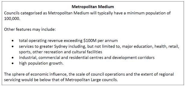
Fees:
The attached Annual Report and Determination of the Tribunal provides a detailed overview of the considerations taken into account when determining the minimum and maximum fees payable in each of the categories. The new categories have their remuneration ranges determined for the first time in this determination. The minimum and maximum fees for the new categories have been determined having regard to the relativities that exist between the existing groups.
Under Sections 248 and 249 of the Act, a council may fix the annual fee for councillors, and for the mayor, in accordance with the appropriate determination of the Remuneration Tribunal, and a council that does not fix the annual fee must pay the appropriate minimum fee determined by the Tribunal.
In accordance with section 241 of the Act, the annual fees to be paid in each of the categories to Councillors and Mayors effective from 1 July 2017 is as follows:
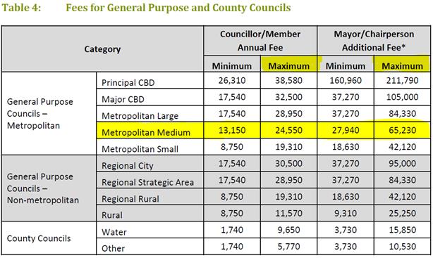
In accordance with section 249(2) of the Act, the annual Mayoral fee must be paid in addition to the fee paid to the Mayor as a Councillor. The determined range for the ‘metropolitan medium’ councils is $13,150 to $24,550 for Councillors and $27,940 to 65,230 for the Mayor.
It was the practice of the three legacy Councils (Ashfield, Leichhardt and Marrickville) to set Councillor and Mayoral fees at the maximum rate each year. It is also noted that the population of the Inner West Council sits closer to the ‘metropolitan large’ category having a population just 15K less than the range set for this category and a total operating revenue that sits within the next category. Other factors to be taken in to account when determining remuneration is the need to attract and retain people with the necessary skills and expertise; the increased responsibilities placed on Councillors with a new Council that has a significantly larger annual budget; and a larger population and geographical size. Taking these factors into account, the following payments are proposed for the 2017/18 year:
|
Elected Official |
Annual Fee |
Monthly Fee |
|
Councillor |
$24,550 |
$2,045 |
|
Mayor |
$65,230 |
$5,534 |
In accordance with section 249(5) of the Act, a council may pay the deputy mayor a fee determined by the council for such time as the deputy mayor acts in the office of the mayor. The amount of the fee so paid must be deducted from the mayor’s annual fee. This will be a decision for the new Inner West Council to determine.
FINANCIAL IMPLICATIONS
Provision has been made in the 2017/18 Budget for councillor/mayoral fees. Should Council adopt the maximum fees, a total of $433,480 will be required. Sufficient funds are allocated in the 2017/18 Budget to cover the maximum fees, should Council resolve that way.
PUBLIC CONSULTATION
Not applicable.
CONCLUSION
The Local Government Remuneration Tribunal has made its determination in relation to the minimum and maximum fees to be paid to councillors and mayors for the 2017/18 financial year. Inner West Council has been categorised as ‘metropolitan medium’. It is recommended that Council’s fees for the 2017/18 year be set at the maximum rate for ‘metropolitan medium’ councils.
|
1.⇩ |
2017/18 Annual Determination of the Local Government Remuneration Tribunal |
|
Council Meeting 27 June 2017 |
Subject: Draft Councillor Expenses and Facilities Policy
File Ref: 17/4014/51352.17
Prepared By: Rad Miladinovic - Coordinator Governance and Administration
Authorised By: Tanya Whitmarsh - Group Manager Governance
|
SUMMARY The Councillor Expenses and Facilities Policy has been developed using the template policy provided by the NSW Department of Premier and Cabinet. This report seeks Council’s endorsement for the public exhibition of the Draft Councillor Expenses and Facilities Policy for a period of 28 days from 28 June to 25 July 2017.
|
|
RECOMMENDATION
THAT:
1. in accordance with section 253(1) of the Local Government Act 1993, the DRAFT Councillor Expenses and Facilities Policy (ATTACHMENT 1) be placed on public exhibition for a period of 28 days from 28 June to 25 July 2017; 2. in the event that submissions are received in response to the public notice inviting submissions from members of the public, staff submit a further report to the next Council Meeting presenting the feedback received in the submissions and making a recommendation for Council’s consideration; 3. in the event that no submissions are received in response to the public notice, Council adopts the attached Councillor Expenses and Facilities Policy; and 4. Council staff advertise the Draft Policy widely to increase awareness of the proposal to adopt the policy and to encourage members of the public to provide feedback for Council’s consideration before a policy is adopted, in accordance with section 253(2) of the Local Government Act 1993.
|
BACKGROUND
The Councillor Expenses and Facilities Policy enables the reasonable and appropriate reimbursement of expenses and provision of facilities to Councillors to help them undertake their civic duties. It ensures accountability and transparency, and seeks to align Councillor expenses and facilities with community expectations. Councillors must not obtain private or political benefit from any expense or facility provided under this policy.
The policy has been prepared in accordance with the Local Government Act 1993 (the Act) and Local Government (General) Regulation 2005 (the Regulation), and complies with the Office of Local Government’s Guidelines for the payment of expenses and provision of facilities to Mayors and Councillors in NSW.
DISCUSSION
The Councillor Expenses and Facilities Policy (ATTACHMENT 1) has been prepared using the template policy provided by the NSW Department of Premier and Cabinet. The template has been reviewed and endorsed by the NSW Office of Local Government.
The Policy sets out the maximum amounts Council will pay for specific expenses and facilities. Expenses not explicitly addressed in this policy will not be paid or reimbursed. The main expenses and facilities are summarised in the table below. All monetary amounts are exclusive of GST.
|
Expense or facility |
Maximum amount |
Frequency |
|
General travel expenses |
$3,000 per Councillor |
Per year |
|
Interstate, overseas and long distance intrastate travel expenses |
$15,000 total for all Councillors |
Per year |
|
Accommodation and meals |
As per the NSW Crown Employees (Public Service Conditions of Employment) Reviewed Award 2009, adjusted annually |
Per meal/night |
|
Professional development |
$5,000 per Councillor |
Per year |
|
Conferences and seminars |
$15,000 total for all Councillors |
Per year |
|
ICT expenses |
$3,600 per Councillor $6,000 for the Mayor |
Per year |
|
Carer expenses |
$3,000 per Councillor |
Per year |
|
Home office expenses |
$600 per Councillor |
Per year |
|
Postage stamps |
Nil – to be posted by Council |
Per year |
|
Christmas or festive cards |
100 per Councillor 500 for the Mayor |
Per year |
|
Access to facilities in a Councillor common room [where applicable Clause 9.1] |
Provided to all Councillors |
Not relevant |
|
Council vehicle, toll tag and fuel card [where applicable Clause 10] |
Provided to the Mayor |
Not relevant |
|
Reserved parking space at Council office where Mayoral office is located |
Provided to the Mayor |
Not relevant |
|
Furnished office [where applicable Clause 10] |
Provided to the Mayor |
Not relevant |
|
Number of exclusive staff supporting Mayor and Councillors [where applicable Clause 10] |
Provided to the Mayor and councillors |
Not relevant |
FINANCIAL IMPLICATIONS
The 2017/18 Operating Budget supports the ongoing provision of services and facilities to councillors. The limits applied to specific items of expenditure will be monitored to enable control of expenditure to avoid exceeding budgetary limitations.
OTHER STAFF COMMENTS
N/a.
PUBLIC CONSULTATION
The policy has been prepared using the template policy provided by the NSW Department of Premier and Cabinet. The template has been reviewed and endorsed by the NSW Office of Local Government.
Members of the public are invited to make submissions during the 28 day public exhibition period. Submissions will be considered before the final policy is put to Council for adoption.
|
1.⇩ |
DRAFT Councillor Expenses and Facilities Polcy |
|
|
Council Meeting 27 June 2017 |
DRAFT
Councillor
Expenses and Facilities Policy
|
Type of Document: |
Council Policy |
|
Date of Issue: |
TBA |
|
Scope: |
This policy applies to the elected Council. |
|
ID Number: |
17/5443 / 69698.17 |
|
Custodian: |
Group Manager Governance |
|
Approval: |
Council |
|
Version Control: |
Policy created – June 2017, Version 1.0 |
|
|
Council Meeting 27 June 2017 |
Contents
Summary.................................................................................................................................................
Part A – Introduction................................................................................................................................
1. Introduction..........................................................................................................................................
2. Policy objectives .................................................................................................................................
3. Principles.............................................................................................................................................
4. Private or political benefit.....................................................................................................................
Part B – Expenses....................................................................................................................................
5. General expenses.................................................................................................................................
6. Specific expenses................................................................................................................................
7. Insurances...........................................................................................................................................
8. Legal assistance..................................................................................................................................
Part C – Facilities.....................................................................................................................................
9. General facilities for Councillors ...........................................................................................................
10. Additional facilities for the Mayor.........................................................................................................
Part D – Processes ..................................................................................................................................
11. Approval, payment and reimbursement arrangements...........................................................................
12. Disputes ............................................................................................................................................
13. Return or retention of facilities.............................................................................................................
14. Publication.........................................................................................................................................
15. Reporting ..........................................................................................................................................
16. Auditing..............................................................................................................................................
17. Breaches............................................................................................................................................
Part E – Appendix....................................................................................................................................
Appendix I – Related legislation, guidance and policies..............................................................................
Appendix II – Definitions...........................................................................................................................
Summary
This policy enables the reasonable and appropriate reimbursement of expenses and provision of facilities to Councillors to help them undertake their civic duties. It ensures accountability and transparency, and seeks to align Councillor expenses and facilities with community expectations. Councillors must not obtain private or political benefit from any expense or facility provided under this policy.
The policy has been prepared in accordance with the Local Government Act 1993 (the Act) and Local Government (General) Regulation 2005 (the Regulation), and complies with the Office of Local Government’s Guidelines for the payment of expenses and provision of facilities to Mayors and Councillors in NSW.
The policy sets out the maximum amounts Council will pay for specific expenses and facilities. Expenses not explicitly addressed in this policy will not be paid or reimbursed. The main expenses and facilities are summarised in the table below. All monetary amounts are exclusive of GST.
|
Expense or facility |
Maximum amount |
Frequency |
|
General travel expenses |
$3,000 per Councillor |
Per year |
|
Interstate, overseas and long distance intrastate travel expenses |
$15,000 total for all Councillors |
Per year |
|
Accommodation and meals |
As per the NSW Crown Employees (Public Service Conditions of Employment) Reviewed Award 2009, adjusted annually |
Per meal/night |
|
Professional development |
$5,000 per Councillor |
Per year |
|
Conferences and seminars |
$15,000 total for all Councillors |
Per year |
|
ICT expenses |
$3,600 per Councillor $6,000 for the Mayor |
Per year |
|
Carer expenses |
$3,000 per Councillor |
Per year |
|
Home office expenses |
$600 per Councillor |
Per year |
|
Postage stamps |
Nil – to be posted by Council |
Per year |
|
Christmas or festive cards |
100 per Councillor 500 for the Mayor |
Per year |
|
Access to facilities in a Councillor common room [where applicable Clause 9.1] |
Provided to all Councillors |
Not relevant |
|
Council vehicle, toll tag and fuel card [where applicable Clause 10] |
Provided to the Mayor |
Not relevant |
|
Reserved parking space at Council office where Mayoral office is located |
Provided to the Mayor |
Not relevant |
|
Furnished office [where applicable Clause 10] |
Provided to the Mayor |
Not relevant |
|
Number of exclusive staff supporting Mayor and Councillors [where applicable Clause 10] |
Provided to the Mayor and councillors |
Not relevant |
Additional costs incurred by a Councillor in excess of these limits are considered a personal expense that is the responsibility of the Councillor.
Councillors must provide claims for reimbursement within three months of an expense being incurred. Claims made after this time cannot be approved.
Detailed reports on the provision of expenses and facilities to Councillors will be publicly tabled at a Council meeting every six months and published in full on Council’s website. These reports will include expenditure summarised by individual Councillor and as a total for all Councillors.
This policy will commence on the declaration of the first election of councillors to the Inner West Council.
Part A – Introduction
1. Introduction
1.1. The provision of expenses and facilities enables Councillors to fulfil their civic duties as the elected representatives of Inner West Council.
1.2. The community is entitled to know the extent of expenses paid to Councillors, as well as the facilities provided.
1.3. The purpose of this policy is to clearly state the facilities and support that are available to Councillors to assist them in fulfilling their civic duties.
1.4. Council staff are empowered to question or refuse a request for payment from a Councillor when it does not accord with this policy.
1.5. Expenses and facilities provided by this policy are in addition to fees paid to Councillors. The minimum and maximum fees a council may pay each Councillor are set by the Local Government Remuneration Tribunal as per Section 241 of the Act and reviewed annually. Council must adopt its annual fees within this set range.
2. Policy objectives
2.1. The objectives of this policy are to:
Ÿ enable the reasonable and appropriate reimbursement of expenses incurred by Councillors while undertaking their civic duties
Ÿ enable facilities of a reasonable and appropriate standard to be provided to Councillors to support them in undertaking their civic duties
Ÿ ensure accountability and transparency in reimbursement of expenses and provision of facilities to Councillors
Ÿ ensure facilities and expenses provided to Councillors meet community expectations
Ÿ support a diversity of representation
Ÿ fulfil Council’s statutory responsibilities.
3. Principles
3.1. Council commits to the following principles:
Ÿ Proper conduct: Councillors and staff acting lawfully and honestly, exercising care and diligence in carrying out their functions
Ÿ Reasonable expenses: Providing for Councillors to be reimbursed for expenses reasonably incurred as part of their role as Councillor
Ÿ Participation and access: Enabling people from diverse backgrounds, underrepresented groups, those in carer roles and those with special needs to serve as a Councillor
Ÿ Equity: There must be equitable access to expenses and facilities for all Councillors
Ÿ Appropriate use of resources: Providing clear direction on the appropriate use of Council resources in accordance with legal requirements and community expectations
Ÿ Accountability and transparency: Clearly stating and reporting on the expenses and facilities provided to Councillors.
4. Private or political benefit
4.1. Councillors must not obtain private or political benefit from any expense or facility provided under this policy.
4.2. Private use of Council equipment and facilities by Councillors may occur from time to time. For example, telephoning home to advise that a Council meeting will run later than expected.
4.3. Such incidental private use does not require a compensatory payment back to Council.
4.4. Councillors should avoid obtaining any greater private benefit from Council than an incidental benefit. Where there are unavoidable circumstances and more substantial private use of Council facilities does occur, Councillors must reimburse Council.
4.5. Campaigns for re-election are considered to be a political benefit. The following are examples of what is considered to be a political interest during a re-election campaign:
Ÿ production of election material
Ÿ use of Council resources and equipment for campaigning
Ÿ use of official Council letterhead, publications, websites or services for political benefit
Ÿ fundraising activities of political parties or individuals, including political fundraising events.
Part B – Expenses
5. General expenses
5.1. All expenses provided under this policy will be for a purpose specific to the functions of holding civic office. Allowances for general expenses are not permitted under this policy.
5.2. Expenses not explicitly addressed in this policy will not be paid or reimbursed.
6. Specific expenses
General travel arrangements and expenses
6.1. All travel by Councillors should be undertaken using the most direct route and the most practicable and economical mode of transport.
6.2. Each Councillor may be reimbursed up to a total of $3,000 per year for travel expenses incurred while undertaking official business or professional development or attending approved conferences and seminars within NSW. This includes reimbursement:
Ÿ for public transport fares
Ÿ of mileage allowance for the use of a private vehicle per kilometre as provided for in the Local Government (State) Award
Ÿ for parking costs for Council and other meetings
Ÿ for tolls
Ÿ by Cabcharge card or equivalent
Ÿ hire car including documented car hire programs, such as GoGet, where invoices can be issued
Ÿ for documented ride-share programs, such as Uber, where tax invoices can be issued.
6.3. Allowances for the use of a private vehicle will be reimbursed by kilometre at the rate contained in the Local Government (State) Award.
6.4. Councillors seeking to be reimbursed for use of a private vehicle must keep a log book recording the date, distance and purpose of travel being claimed. Copies of the relevant log book contents must be provided with the claim.
Traffic or parking fines incurred while travelling in private or Council vehicles on Council business is the sole responsibility of the person driving the vehicle.
Interstate, overseas and long distance intrastate travel expenses
6.5. This section includes reference to long distance intrastate travel. At Inner West Council, long distance intrastate travel is travel that is estimated to take more than four hours from the Councillor’s residence.
6.6. In accordance with Section 4, Council will scrutinise the value and need for Councillors to undertake overseas travel. Councils should avoid interstate, overseas and long distance intrastate trips unless direct and tangible benefits can be established for the Council and the local community. This includes travel to sister and friendship cities.
6.7. Total interstate, overseas and long distance intrastate travel expenses for all Councillors will be capped at a maximum of $15,000 per year. This amount will be set aside in Council’s annual budget.
6.8. Councillors seeking approval for any interstate and long distance intrastate travel must submit a case to, and obtain the approval of, the General Manager prior to travel.
6.9. Councillors seeking approval for any overseas travel must submit a case to, and obtain the approval of, a full Council meeting prior to travel.
6.10. The case should include:
Ÿ objectives to be achieved in travel, including an explanation of how the travel aligns with current Council priorities and business, the community benefits which will accrue as a result, and its relevance to the exercise of the Councillor’s civic duties
Ÿ who is to take part in the travel
Ÿ duration and itinerary of travel
Ÿ a detailed budget including a statement of any amounts expected to be reimbursed by the participant/s.
6.11. For interstate and long distance intrastate journeys by air of less than three hours, the class of air travel is to be economy class.
6.12. For interstate journeys by air of more than three hours, the class of air travel may be premium economy.
6.13. For international travel, the class of air travel is to be premium economy if available. Otherwise, the class of travel is to be economy.
6.14. Bookings for approved air travel are to be made through the General Manager’s office.
6.15. For air travel that is reimbursed as Council business, Councillors will not accrue points from the airline’s frequent flyer program. This is considered a private benefit.
Travel expenses not paid by Council
6.16. Council will not pay any traffic or parking fines or administrative charges for road toll accounts or car share car hire programs.
Accommodation and meals
6.17. Council will reimburse costs for accommodation and meals while Councillors are undertaking prior approved travel or professional development outside metropolitan Sydney.
6.18. The daily limits for accommodation and meal expenses within Australia are to be consistent with those set out in Part B Monetary Rates of the NSW Crown Employees (Public Service Conditions of Employment) Reviewed Award 2009, as adjusted annually.
6.19. The daily limits for accommodation and meal expenses outside Australia are to be determined in advance by the General Manager, being mindful of Clause 6.19.
6.20. Councillors will not be reimbursed for alcoholic beverages.
Refreshments for Council related meetings
6.21. Appropriate refreshments will be available for Council meetings, Council Committee meetings, Councillor briefings, approved meetings and engagements, and official Council functions as approved by the General Manager.
6.22. As an indicative guide for the standard of refreshments to be provided at Council related meetings, the General Manager must be mindful of Part B Monetary Rates of the NSW Crown Employees (Public Service Conditions of Employment) Reviewed Award 2009, as adjusted annually.
Professional development
6.23. Council will set aside $5,000 per Councillor annually in its budget to facilitate professional development of Councillors through programs, training, education courses and membership of professional bodies.
6.24. In the first year of a new Council term, Council will provide a comprehensive induction program for all Councillors which considers any guidelines issued by the Office of Local Government (OLG). The cost of the induction program will be in addition to the ongoing professional development funding.
6.25. Annual membership of professional bodies will only be covered where the membership is relevant to the exercise of the Councillor’s civic duties, the Councillor actively participates in the body and the cost of membership is likely to be fully offset by savings from attending events as a member.
6.26. Approval for professional development activities is subject to a prior written request to the General Manager outlining the:
Ÿ details of the proposed professional development
Ÿ relevance to Council priorities and business
Ÿ relevance of the exercise of the Councillor’s civic duties.
6.27. In assessing a Councillor request for a professional development activity, the General Manager must consider the factors set out in Clause 6.27, as well as the cost of the professional development in relation to the Councillor’s remaining budget.
Conferences and seminars
6.28. Council is committed to ensuring its Councillors are up to date with contemporary issues facing council and the community, and local government in NSW.
6.29. Council will set aside a total amount of $15,000 annually in its budget to facilitate Councillor attendance at conferences and seminars, including the Local Government NSW Annual Conference. This allocation is for all Councillors. The General Manager will ensure that access to expenses relating to conferences and seminars is distributed equitably.
6.30. Approval to attend a conference or seminar is subject to a written request to the General Manager. In assessing a Councillor request, the General Manager must consider factors including the:
Ÿ relevance of the topics and presenters to current Council priorities and business and the exercise of the Councillor’s civic duties
Ÿ cost of the conference or seminar in relation to the total remaining budget.
6.31. Council will meet the reasonable cost of registration fees, transportation and accommodation associated with attendance at conferences approved by the General Manager. Council will also meet the reasonable cost of meals when they are not included in the conference fees. Reimbursement for accommodation and meals not included in the conference fees will be subject to Clauses 6.18-6.21.
Local Government NSW Annual Conference
6.32. Councillors will also be permitted to attend the Local Government NSW Annual Conference each year. Council will reimburse the cost of registration fees and where the conference is outside the metropolitan Sydney area, the cost of travel, accommodation and meals not covered by the conference registration, subject to Clauses 6.18-6.21.
6.33. For the Local Government NSW Annual Conference only, Council will meet the costs of the official conference dinner for an accompanying person of a Councillor.
ICT expenses
6.34. Council will provide or reimburse
Councillors for expenses associated with appropriate ICT services up to a limit
of $3,600 per annum for each Councillor. This may include services and data
costs relating to mobile phones, landlines, laptops or tablets and home
internet costs.
Council will reimburse the Mayor for expenses associated with appropriate ICT
services up to a limit of $6,000 per month.
Council will provide Councillors with a smartphone, choice of a laptop or
tablet and a multifunction desktop printer / scanner / copier / fax machine.
6.35. Reimbursements will be made only for communications devices and services used for Councillors to undertake their civic duties, such as:
Ÿ receiving and reading Council business papers
Ÿ relevant phone calls and correspondence
Ÿ diary and appointment management.
6.36. Councillors may seek reimbursement for applications on their mobile electronic communication device that are directly related to their duties as a Councillor, within the maximum limit.
Special requirement and carer expenses
6.37. Council encourages wide participation and interest in civic office. It will seek to ensure Council premises and associated facilities are accessible, including provision for sight or hearing impaired Councillors and those with other disabilities.
6.38. Transportation provisions outlined in this policy will also assist Councillors who may be unable to drive a vehicle.
6.39. In addition to the provisions above, the General Manager may authorise the provision of reasonable additional facilities and expenses in order to allow a Councillor with a disability to perform their civic duties.
6.40. Councillors who are the principal carer of a child or other elderly, disabled and/or sick immediate family member will be entitled to reimbursement of carer’s expenses up to a maximum of $3,000 per annum for attendance at official business, plus reasonable travel from the principal place of residence.
6.41. Child care expenses may be claimed for children up to and including the age of 16 years where the carer is not a relative.
6.42. In the event of caring for an adult person, Councillors will need to provide suitable evidence to the General Manager that reimbursement is applicable. This may take the form of advice from a medical practitioner.
Home office expenses
6.43. Each Councillor may be reimbursed up to $600 per year for costs associated with the maintenance of a home office, such as minor items of consumable stationery and printer ink cartridges.
7. Insurances
7.1. In accordance with Section 382 of the Local Government Act, Council is insured against public liability and professional indemnity claims. Councillors are included as a named insured on this Policy.
7.2. Councillors will be covered for personal injury whilst working on Council business, worldwide. Personal injury insurance provides cover for bodily injury caused by accidental, violent, external and visible means up to a sub-limit for death and capital limits of $350,000. Personal injury cover also provides coverage for permanent disability, temporary total disability and temporary partial disability. Due to the provisions set down in the Health Act, the cover does not include medical expenses.
7.3. Insurance protection is only provided if a claim arises out of or in connection with the Councillor’s performance of his or her civic duties, or exercise of his or her functions as a Councillor. All insurances are subject to any limitations or conditions set out in the policies of insurance.
7.4. Council shall pay the insurance policy excess in respect of any claim accepted by Council’s insurers, whether defended or not.
7.5. Appropriate travel insurances will be provided for any Councillors traveling on approved interstate and overseas travel on Council business.
8. Legal assistance
8.1. Council may, if requested, indemnify or reimburse the reasonable legal expenses of:
Ÿ a Councillor defending an action arising from the performance in good faith of a function under the Local Government Act
Ÿ a Councillor defending an action in defamation, provided the statements complained of were made in good faith in the course of exercising a function under the Act
Ÿ a Councillor for proceedings before an appropriate investigative or review body, provided the subject of the proceedings arises from the performance in good faith of a function under the Act and the matter has proceeded past any initial assessment phase to a formal investigation or review and the investigative or review body makes a finding substantially favourable to the Councillor.
8.2. In the case of a conduct complaint made against a Councillor, legal costs will only be made available where the matter has been referred by the General Manager to a conduct reviewer or conduct review panel to make formal enquiries into that matter in accordance with Council’s Code of Conduct.
8.3. Legal expenses incurred in relation to proceedings arising out of the performance by a Councillor of his or her functions under the Act are distinguished from expenses incurred in relation to proceedings arising merely from something that a Councillor has done during his or her term in office. For example, expenses arising from an investigation as to whether a Councillor acted corruptly would not be covered by this section.
8.4. Council will not meet the legal costs:
Ÿ of legal proceedings initiated by a Councillor under any circumstances
Ÿ of a Councillor seeking advice in respect of possible defamation, or in seeking a non-litigious remedy for possible defamation
Ÿ for legal proceedings that do not involve a Councillor performing their role as a Councillor.
8.5. Reimbursement of expenses for reasonable legal expenses must have Council approval by way of a resolution at a Council meeting prior to costs being incurred.
Part C – Facilities
9. General facilities for all Councillors
Facilities
9.1. Council will provide the following facilities to Councillors to assist them to effectively discharge their civic duties:
Ÿ a Councillor common room appropriately furnished to include telephone, photocopier, printer, desks, computer terminals, pigeon holes and appropriate refreshments (excluding alcohol)
Ÿ access to shared car parking spaces while attending Council offices on official business
Ÿ personal protective equipment for use during site visits
Ÿ a name badge which may be worn at official functions, indicating that the wearer holds the office of a Councillor and/or Mayor or Deputy Mayor.
9.2. Councillors may book meeting rooms for official business in a specified Council building at no cost. Rooms may be booked through a specified officer in the Mayor’s office or other specified staff member.
9.3. The provision of facilities will be of a standard deemed by the General Manager as appropriate for the purpose.
Stationery
9.4. Council will provide the following stationery to Councillors each year:
Ÿ letterhead, to be used only for correspondence associated with civic duties
Ÿ business cards
Ÿ up to 100 Christmas or festive cards per year for Councillors and 500 for the Mayor.
9.5. Councillor mail to be placed in the outgoing mail tray located in the Councillor common room. Councillor mail will be included as part of Council’s daily mail collection by Council’s postal provider.
Administrative support
9.6. Council will provide administrative support to Councillors to assist them with their civic duties only. Administrative support may be provided by staff in the Mayor’s office or by a member of Council’s administrative staff as arranged by the General Manager or their delegate.
9.7. As per Section 4, Council staff are expected to assist Councillors with civic duties only, and not assist with matters of personal or political interest, including campaigning.
10. Additional facilities for the Mayor
10.1. Council will provide to the Mayor a maintained vehicle to a similar standard of other Council vehicles, with a toll tag and a fuel card. The vehicle will be supplied for use on business, professional development and attendance at the Mayor's office.
10.2. The Mayor must keep a log book setting out the date, distance and purpose of all travel. This must include any travel for private benefit. The log book must be submitted to Council on a monthly basis.
10.3. The Mayoral Allowance will be reduced to cover the cost of any private travel recorded in the log book, calculated on a per kilometre basis by the rate set by the Local Government (State) Award.
10.4. A parking space at Council’s offices will be reserved for the Mayor’s Council-issued vehicle for use on official business, professional development and attendance at the Mayor’s office.
10.5. Council will provide the Mayor with a furnished office incorporating a computer configured to Council’s standard operating environment, telephone and meeting space.
10.6. In performing their civic duties, the Mayor and councillors will be assisted by a small number of staff providing administrative and secretarial support, as determined by the General Manager.
10.7. As per Section 4, staff in the Mayor’s office are expected to work on official business only, and not for matters of personal or political interest, including campaigning.
Traffic or parking fines incurred while travelling in private or Council vehicles on Council business is the sole responsibility of the person driving the vehicle.
Part D – Processes
11. Approval, payment and reimbursement arrangements
11.1. Expenses should only be incurred by Councillors in accordance with the provisions of this policy.
11.2. Approval for incurring expenses, or for the reimbursement of such expenses, should be obtained before the expense is incurred.
11.3. Up to the maximum limits specified in this policy, approval for the following may be sought after the expense is incurred:
Ÿ local travel relating to the conduct of official business
Ÿ carer costs
Ÿ ICT expenditure.
11.4. Final approval for payments made under this policy will be granted by the General Manager or their delegate.
Direct payment
11.5. Council may approve and directly pay expenses. Requests for direct payment must be submitted to the Manager Civic and Executive Support for assessment against this policy using the prescribed form, with sufficient information and time to allow for the claim to be assessed and processed.
Reimbursement
11.6. All claims for reimbursement of expenses incurred must be made on the prescribed form, supported by appropriate receipts and/or tax invoices and be submitted to the Manager Civic and Executive Support. In the case of carer’s expenses, Councillors may make a declaration of expenses incurred where they were unable to obtain a tax invoice or appropriate receipt.
Advance payment
11.7. Council may pay a cash advance for Councillors attending approved conferences, seminars or professional development.
11.8. The maximum value of a cash advance is $150 per day of the conference, seminar or professional development to a maximum of $500.
11.9. Requests for advance payment must be submitted to the Manager Civic and Executive Support for assessment against this policy using the prescribed form with sufficient information and time to allow for the claim to be assessed and processed.
11.10. Councillors must fully reconcile all expenses against the cost of the advance within one month of incurring the cost and/or returning home. This includes providing to Council:
Ÿ a full reconciliation of all expenses including appropriate receipts and/or tax invoices
Ÿ reimbursement of any amount of the advance payment not spent in attending to official business or professional development.
Notification
11.11. If a claim is approved, Council will make payment directly or reimburse the Councillor through accounts payable.
11.12. If a claim is refused, Council will inform the Councillor in writing that the claim has been refused and the reason for the refusal.
Reimbursement to Council
11.13. If Council has incurred an expense on behalf of a Councillor that exceeds a maximum limit, exceeds reasonable incidental private use or is not provided for in this policy:
Ÿ Council will invoice the Councillor for the expense
Ÿ the Councillor will reimburse Council for that expense within 14 days of the invoice date.
11.14. If the Councillor cannot reimburse Council within 14 days of the invoice date, they are to submit a written explanation to the General Manager. The General Manager may elect to deduct the amount from the Councillor’s allowance.
Timeframe for reimbursement
11.15. Unless otherwise specified in this policy, Councillors must provide all claims for reimbursement within three months of an expense being incurred. Claims made after this time cannot be approved.
12. Disputes
12.1. If a Councillor disputes a determination under this policy, the Councillor should discuss the matter with the General Manager.
12.2. If the Councillor and the General Manager cannot resolve the dispute, the Councillor may submit a notice of motion to a Council meeting seeking to have the dispute resolved.
13. Return or retention of facilities
13.1. All unexpended facilities or equipment supplied under this policy are to be relinquished immediately upon a Councillor or Mayor ceasing to hold office or at the cessation of their civic duties.
13.2. Should a Councillor desire to keep any equipment allocated by Council, then this policy enables the Councillor to make application to the General Manager to purchase any such equipment. The General Manager will determine an agreed fair market price or written down value for the item of equipment.
13.3. The prices for all equipment purchased by Councillors under Clause 13.2 will be recorded in Council’s Annual Report.
14. Publication
14.1. This policy will be published on Council’s website.
15. Reporting
15.1. Council will report on the provision of expenses and facilities to Councillors as required in the Act and Regulations.
15.2. Detailed reports on the provision of expenses and facilities to Councillors will be publicly tabled at a Council meeting every six months and published in full on Council’s website. These reports will include expenditure summarised by individual Councillor and as a total for all Councillors.
16. Auditing
16.1. The operation of this policy, including claims made under the policy, will be included in Council’s audit program and an audit undertaken at least every two years.
17. Breaches
17.1. Suspected breaches of this policy are to be reported to the General Manager.
17.2. Alleged
breaches of this policy shall be dealt with by following the processes outlined
for breaches of the Code of Conduct, as detailed in the Code and in the
Procedures for the Administration of the Code.
PART E – Appendices
Appendix I: Related legislation, guidance and policies
Relevant legislation and guidance:
Ÿ Local Government Act 1993, Sections 252 and 253
Ÿ Local Government (General) Regulation 2005, Clauses 217 and 403
Ÿ Guidelines for the payment of expenses and the provision of facilities for Mayors and Councillors in NSW, 2009
Ÿ Local Government Circular 09-36 Guidelines for Payment of Expenses and Facilities
Ÿ Local Government Circular 05-08 legal assistance for Councillors and Council Employees
Ÿ Office of Local Government Circular 17-08: 2017/18 Determination of the Local Government Remuneration Tribunal
Related Council policies:
Ÿ Code of Conduct
Ÿ Code of Meeting Practice
Appendix II: Definitions
The following definitions apply throughout this policy.
|
Term |
Definition |
|
accompanying person |
Means a spouse, partner or de facto or other person who has a close personal relationship with or provides carer support to a Councillor |
|
appropriate refreshments |
Means food and beverages, excluding alcohol, provided by Council to support Councillors undertaking official business |
|
Act |
Means the Local Government Act 1993 (NSW) |
|
Annual Conference |
Means Local Government NSW Annual Conference |
|
clause |
Unless stated otherwise, a reference to a clause is a reference to a clause of this policy |
|
Code of Conduct |
Means the Code of Conduct adopted by Council or the Model Code if none is adopted |
|
Councillor |
Means a person elected or appointed to civic office as a member of the governing body of Council who is not suspended, including the Mayor |
|
General Manager |
Means the General Manager of Council and includes their delegate or authorised representative |
|
ICT |
Means Telecommunications and Information Communications and Technology |
|
incidental personal use |
Means use that is infrequent and brief and use that does not breach this policy or the Code of Conduct |
|
long distance intrastate travel |
Means travel to other parts of NSW of more than three hours duration by private vehicle |
|
maximum limit |
Means the maximum limit for an expense or facility provided in the text and summarised in Appendix 1 |
|
NSW |
New South Wales |
|
official business |
Means functions that the Mayor or Councillors are required or invited to attend to fulfil their legislated role and responsibilities for Council or result in a direct benefit for Council and/or for the local government area, and includes: · meetings of Council and committees of the whole · meetings of committees facilitated by Council · civic receptions hosted or sponsored by Council · meetings, functions, workshops and other events to which attendance by a Councillor has been requested or approved by Council |
|
professional development |
Means a seminar, conference, training course or other development opportunity relevant to the role of a Councillor or the Mayor |
|
Regulation |
Means the Local Government (General) Regulation 2005 (NSW) |
|
year |
Means
the financial year, that is the 12 month period commencing on |
|
Council Meeting 27 June 2017 |
Subject: Inner West Council Investments as at 31 May 2017
File Ref: 16/5386/67031.17
Prepared By: Brian Chen - Team Leader Financial Accounting
Authorised By: Pav Kuzmanovski - Group Manager Finance
|
SUMMARY In accordance with the requirements of clause 212 of the Local Government (General) Regulation 2005, Council is provided with a listing of all investments made pursuant to section 625 of the Local Government Act 1993 and reported for periods ending 31 May 2017.
|
|
RECOMMENDATION
THAT the report be received and noted.
|
BACKGROUND
Clause 212 of the Local Government (General) Regulation 2005 requires that a report be presented to Council each month listing all investments with a certification from the Responsible Accounting Officer. Attached to this report are further reports from Council’s Investment Advisors, Prudential Investment Services.
FINANCIAL IMPLICATIONS
The Investment Holdings report (Attachment 1) for the period ending 31 May 2017 reflects Council’s holding in various investment categories these are listed in the table below. Council’s portfolio size has increased by $6 million to $210m of which 86% was rated A rated or above.
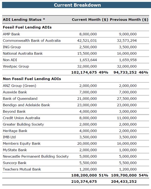
Environmental Commitments
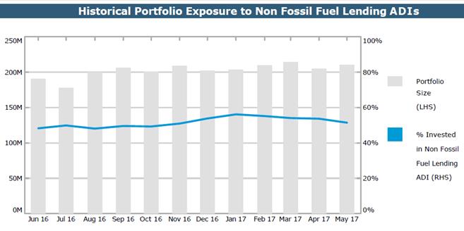
Council’s holdings in Non Fossil investments remained at approximately $110m with a relative total portfolio percentage decrease (52% in May 2017 as opposed to 54% in April 2017) in Non Fossil investments. This was due to an increase in the cash holdings in Council’s CBA general accounts as a result of a large number of rate payments being received at the end of May that tie into the fourth quarter rates instalment due date. These funds will be used to pay vendors during the month of June. .
The attachments to this report summarise all investments held by Council and interest returns for periods ending 31 May 2017.
The period ending 31 May 2017, the portfolio for Inner West Council had a One-Month Portfolio Investment Return (2.66%) was above the UBSWA Bank Bill Index Benchmark (1.72%). Council has a well-diversified portfolio with 86% of the portfolio spread among the top three credit rating categories (A long term / A2 short term and higher).
The Current Market value is required to be accounted for by the accounting standards and are due to the nature of the investment, and are unlikely to impact on the eventual return of capital and interest to Council. The Current Market Value is a likely outcome if Council were to consider recalling the investment prior to its due date.
Certificate by Responsible Accounting Officer:
I, Pav Kuzmanovski, hereby certify in accordance with Clause 212 (1) (b) of the Local Government (General) Regulation 2005 that the investments listed in the attachments have been made in accordance with section 625 of the Local Government Act 1993 for each of the Inner West Council in accordance with its adopted policy.
|
1.⇩ |
IWC Investment May 2017 |
|
2.⇩ |
IWC Monthly Interest May 2017 |
|
3.⇩ |
IWC Economic and Investment Portfolio Commentary May 2017 |