|
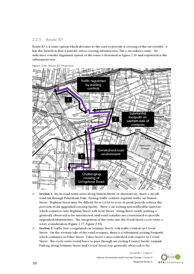
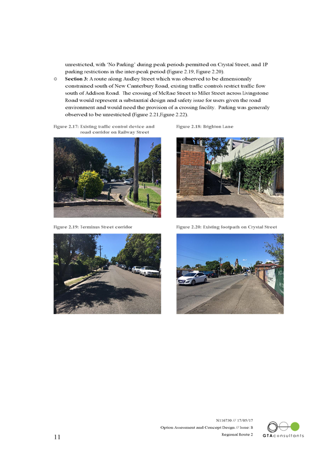
AGENDA R |

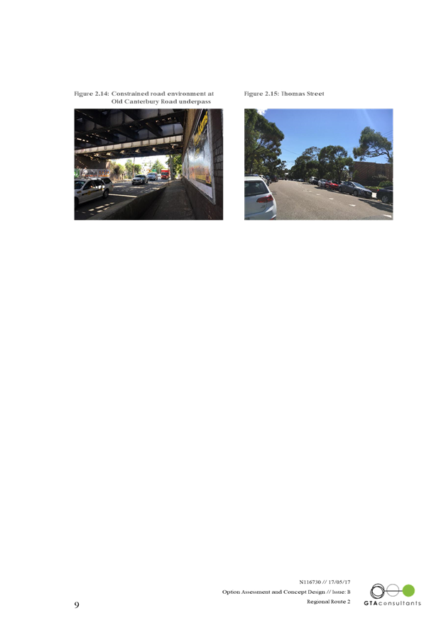
Local Traffic Committee Meeting
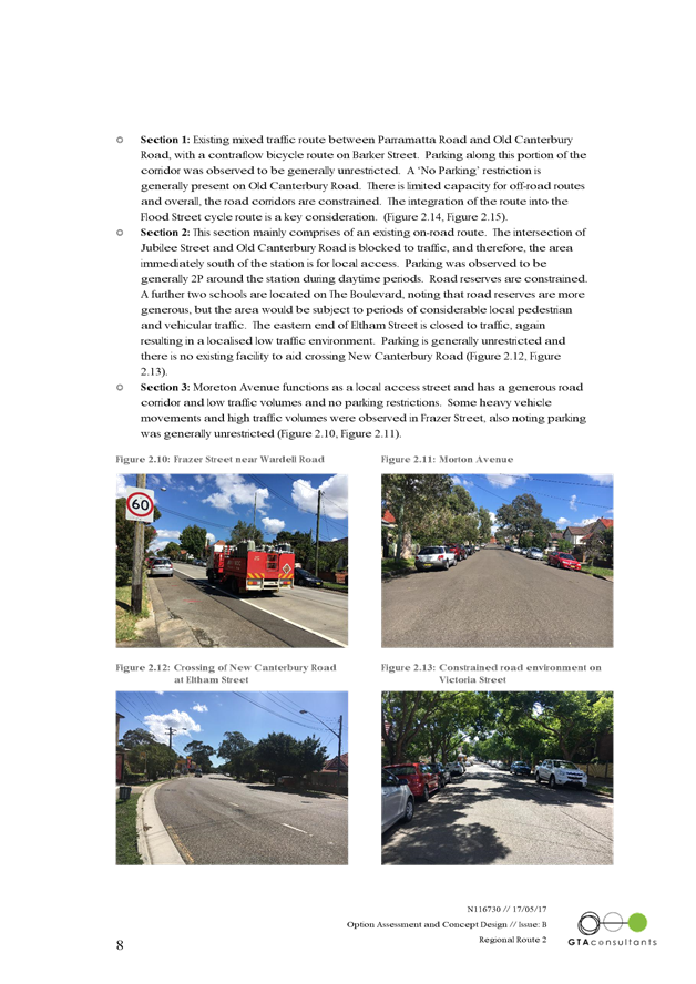
THURSDAY 1 JUNE 2017
10:00am
|
Local Traffic Committee Meeting 1 June 2017 |
Function of the Local Traffic Committee
Background
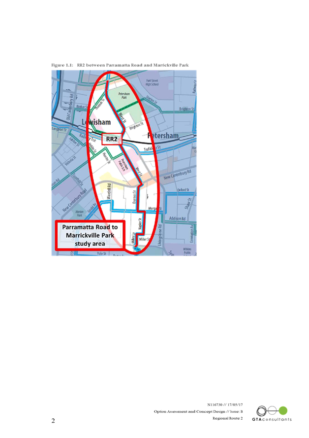
Roads and Maritime Services (RMS) is legislated as the Authority responsible for the control of traffic on all NSW Roads. The RMS has delegated certain aspects of the control of traffic on local roads to councils. To exercise this delegation, councils must establish a local traffic committee and obtain the advice of the RMS and Police. The Inner West Council Local Traffic Committee has been constituted by Council as a result of the delegation granted by the RMS pursuant to Section 50 of the Transport Administration Act 1988.
Role of the Committee
The Local Traffic Committee is primarily a technical review and advisory committee which considers the technical merits of proposals and ensures that current technical guidelines are considered. It provides recommendations to Council on traffic and parking control matters and on the provision of traffic control facilities and prescribed traffic control devices for which Council has delegated authority. These matters are dealt with under Part A of the agenda and require Council to consider exercising its delegation.
In addition to its formal role as the Local Traffic Committee, the Committee may also be requested to provide informal traffic engineering advice on traffic matters not requiring Council to exercise its delegated function at that point in time, for example, advice to Council’s Development Assessment Section on traffic generating developments. These matters are dealt with under Part C of the agenda and are for information or advice only and do not require Council to exercise its delegation.
Committee Delegations
The Local Traffic Committee has no decision-making powers. The Council must refer all traffic related matters to the Local Traffic Committee prior to exercising its delegated functions. Matters related to State Roads or functions that have not been delegated to Council must be referred directly to the RMS or relevant organisation.
The Committee provides recommendations to Council. Should Council wish to act contrary to the advice of the Committee or if that advice is not supported unanimously by the Committee members, then the Police or RMS have an opportunity to appeal to the Regional Traffic Committee.
Committee Membership & Voting
Formal voting membership comprises the following:
· one representative of Council as nominated by Council;
· one representative of the NSW Police from each Local Area Command (LAC) within the LGA, being Newtown, Marrickville, Leichhardt and Ashfield LAC’s.
· one representative from the RMS; and
· State Members of Parliament (MP) for the electorates of Summer Hill, Newtown, Heffron, Canterbury, Strathfield and Balmain or their nominees.
Where the Council area is represented by more than one MP or covered by more than one Police LAC, representatives are only permitted to vote on matters which effect their electorate or LAC.
Informal (non-voting) advisors from within Council or external authorities may also attend Committee meetings to provide expert advice.
Committee Chair
Council’s representative will chair the meetings.
Public Participation
Members of the public or other stakeholders may address the Committee on agenda items to be considered by the Committee. The format and number of presentations is at the discretion of the Chairperson and is generally limited to 3 minutes per speaker. Committee debate on agenda items is not open to the public.
1 Apologies
2 Disclosures of Interest
3 Confirmation of Minutes
4 Matters Arising from Council’s Resolution of Minutes
5 Part A – Items Where Council May Exercise Its Delegated Functions
Traffic Matters Page
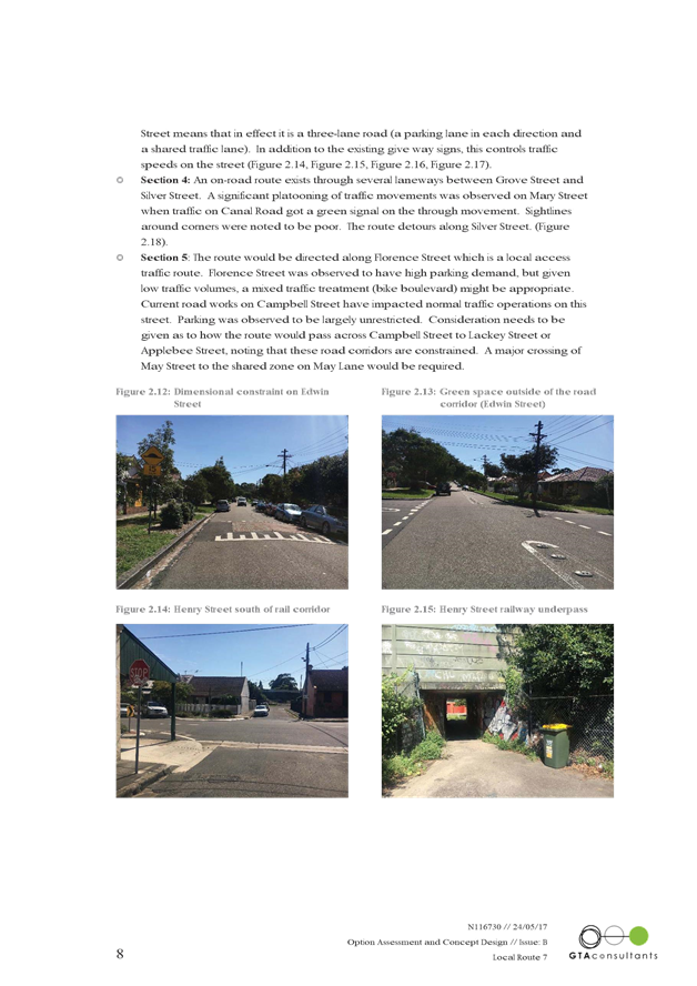
T0617 Item 1 TEMPORARY
ROAD CLOSURE TO CARRY OUT CRANE LIFT ESCALATORS INTO METRO SHOPPING CENTRE ACROSS
MURRAY STREET, MARRICKVILLE
(MARRICKVILLE WARD/NEWTOWN ELECTORATE/MARRICKVILLE LAC) 6
T0617 Item 2 CHARLES STREET, MARRICKVILLE – PROPOSED PEDESTRIAN REFUGE ISLAND DESIGN PLANS (MARRICKVILLE WARD/SUMMER HILL ELECTORATE/MARRICKVILLE LAC) 9
T0617 Item 3 HORTON STREET, MARRICKVILLE – PROPOSED PEDESTRIAN REFUGE ISLAND DESIGN PLANS (MARRICKVILLE WARD/SUMMER HILL ELECTORATE/MARRICKVILLE LAC) 14
T0617 Item 4 LINCOLN STREET, DULWICH HILL – PROPOSED ANGLE PARKING & KERB BLISTER ISLANDS DESIGN PLAN (MARRICKVILLE WARD/SUMMER HILL ELECTORATE/MARRICKVILLE LAC) 19
T0617 Item 5 HERCULES STREET, DULWICH HILL – PROPOSED RAISED PEDESTRIAN CROSSING & KERD BLISTER ISLANDS DESIGN PLAN (ASHFIELD WARD/SUMMER HILL ELECTORATE/MARRICKVILLE LAC) 24
T0617 Item 6
ROAD OCCUPANCY - LACKEY STREET AND SMITH STREET, SUMMER HILL TEMPORARY ROAD
CLOSURES FOR THE ANNUAL ‘SUMMER HILL NEIGHBOURHOOD FOOD FESTIVAL’
SUNDAY, 8 OCTOBER 2017.
(ASHFIELD WARD/SUMMER HILL ELECTORATE/ASHFIELD LAC) 29
T0617 Item 7
ROAD OCCUPANCY- DALHOUSIE STREET AND RAMSAY STREET, HABERFIELD –
TEMPORARY ROAD CLOSURES FOR THE ANNUAL ‘HABERFIELD FESTA FOOD
FESTIVAL’ SUNDAY, 26 NOVEMBER
2017.
(LEICHHARDT WARD/SUMMER HILL ELECTORATE/ASHFIELD LAC) 34
T0617 Item 8 CLARA STREET, NEWTOWN – SHARED ZONE PROPOSAL DESIGN PLAN (STANMORE WARD/NEWTOWN ELECTORATE/NEWTOWN LAC) 40
T0617 Item 9 TEMPORARY
ROAD CLOSURE OF CHELMSFORD AVENUE - DOBROYD POINT PUBLIC SCHOOL BI-ANNUAL
SCHOOL FETE EVENT - SATURDAY, 9 SEPTEMBER 2017.
(LEICHHARDT WARD/SUMMER HILL ELECTORATE/ASHFIELD LAC) 48
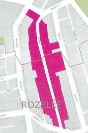
T0617 Item 10 TRAFFIC
CALMING – PARK STREET, ROZELLE
(BALMAIN WARD/BALMAIN ELECTORATE/LEICHHARDT LAC) 51
T0617 Item 11 CENTENNIAL STREET, MARRICKVILLE – TEMPORARY ROAD CLOSURE FOR SPECIAL EVENT ON SATURDAY 22 JULY 2017 (MARRICKVILLE WARD/SUMMER HILL ELECTORATE/MARRICKVILLE LAC) 55
Parking Matters
T0617 Item 12 PROPOSED EXTENSION OF PERMIT SCHEME - DENISON ROAD - DULWICH HILL (ASHFIELD WARD/SUMMER HILL ELECTORATE/MARRICKVILLE LAC) 62
T0617 Item 13 REQUESTS
FOR MOBILITY PARKING SPACES
(ASHFIELD & STANMORE WARDS/SUMMER HILL & NEWTOWN
ELECTORATES/MARRICKVILLE LAC) 65
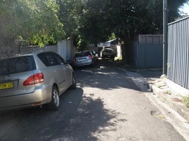
T0617 Item 14 DEPOT LANE, MARRICKVILLE – PROPOSED ‘NO PARKING’ RESTRICTIONS OPPOSITE INTERNAL BEND IN LANEWAY TO IMPROVE ACCESS (MARRICKVILLE WARD / SUMMER HILL ELECTORATE / MARRICKVILLE LAC) 72
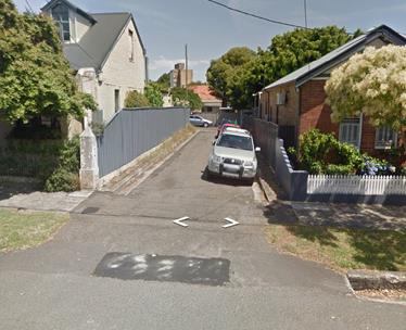
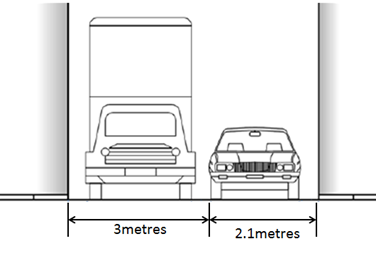
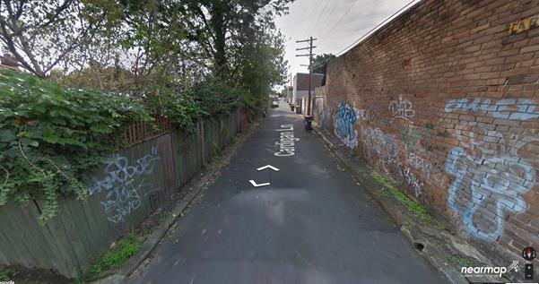
T0617 Item 15 CARDIGAN LANE, BETWEEN SALISBURY ROAD AND ROWLEY STREET, CAMPERDOWN – ‘NO PARKING’ RESTRICTIONS IN THE LANEWAY (STANMORE WARD / NEWTON ELECTORATE / NEWTOWN LAC) 79
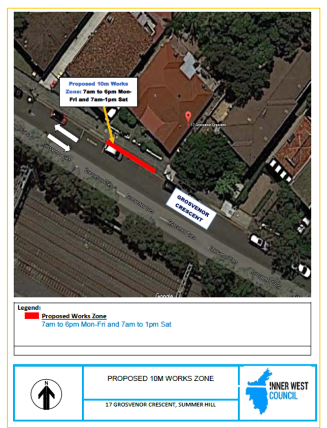
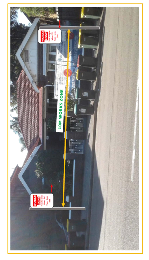
T0617 Item 16 REQUEST
FOR WORKS ZONE INSTALLATION OUTSIDE
17 GROSVENOR CRESCENT, SUMMER HILL
(ASHFIELD WARD/SUMMER HILL ELECTORATE/ASHFIELD LAC) 87
T0617 Item 17 MINOR
TRAFFIC FACILITIES
(LEICHHARDT & BALMAIN WARDS/ BALMAIN ELECTORATE/ LEICHHARDT LAC) 91
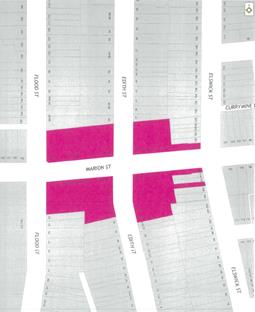
T0617 Item 18 PART TIME LOADING ZONE – MARION STREET, LEICHHARDT (LEICHHARDT WARD/BALMAIN ELECTORATE/LEICHHARDT LAC) 93
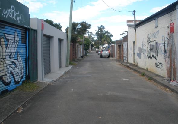
T0617 Item 19 ‘NO PARKING’ AND ‘NO STOPPING’ RESTRICTIONS – UNNAMED LANEWAY BETWEEN IVORY LANE AND NATIONAL STREET, LEICHHARDT (LEICHHARDT WARD/BALMAIN ELECTORATE/LEICHHARDT LAC) 95
T0617 Item 20 ROSSER
STREET, BALMAIN/ROZELLE – RESIDENT PARKING SCHEME
(LEICHHARDT/BALMAIN/LEICHHARDT LAC) 97
T0617 Item 21 LITTLE
STEPHEN STREET, BALMAIN – RESIDENT PARKING SCHEME AND ‘NO
PARKING’ RESTRICTIONS –
(LEICHHARDT/BALMAIN/LEICHHARDT LAC) 102
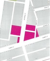
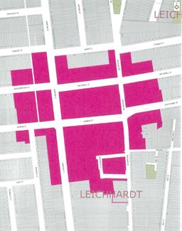
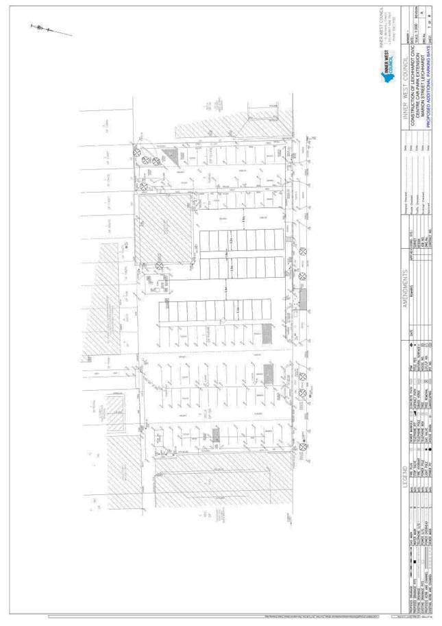
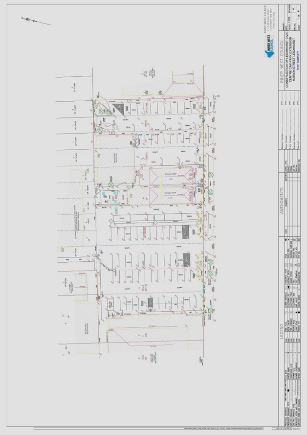
T0617 Item 22 MARION
STREET CAR PARK EXTENSION, LEICHHARDT
(LEICHHARDT WARD/BALMAIN ELECTORATE/LEICHHARDT LAC) 106
Late Items
Nil at time of printing.
6 Part B – Items for Information Only
T0617 Item 23 VARIOUS LOCATIONS OUTSIDE SCHOOLS IN INNER WEST LGA – RMS NOTICE OF WORK TO UPGRADE SCHOOL ZONE SIGNS (VARIOUS WARDS / ELECTORATES / LACS) 114
7 Part C – Items for General Advice
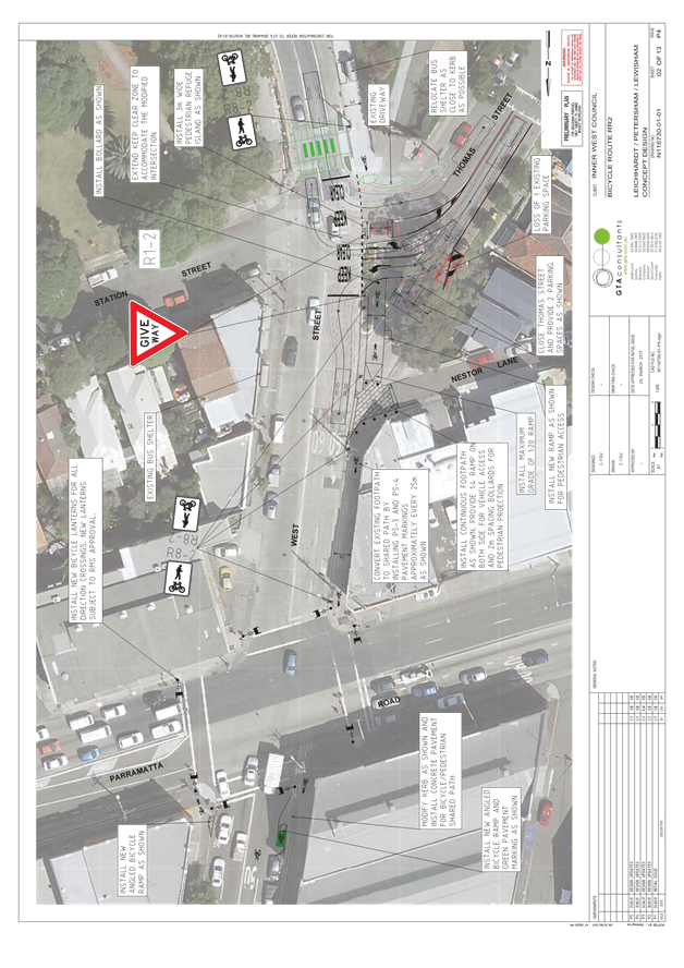
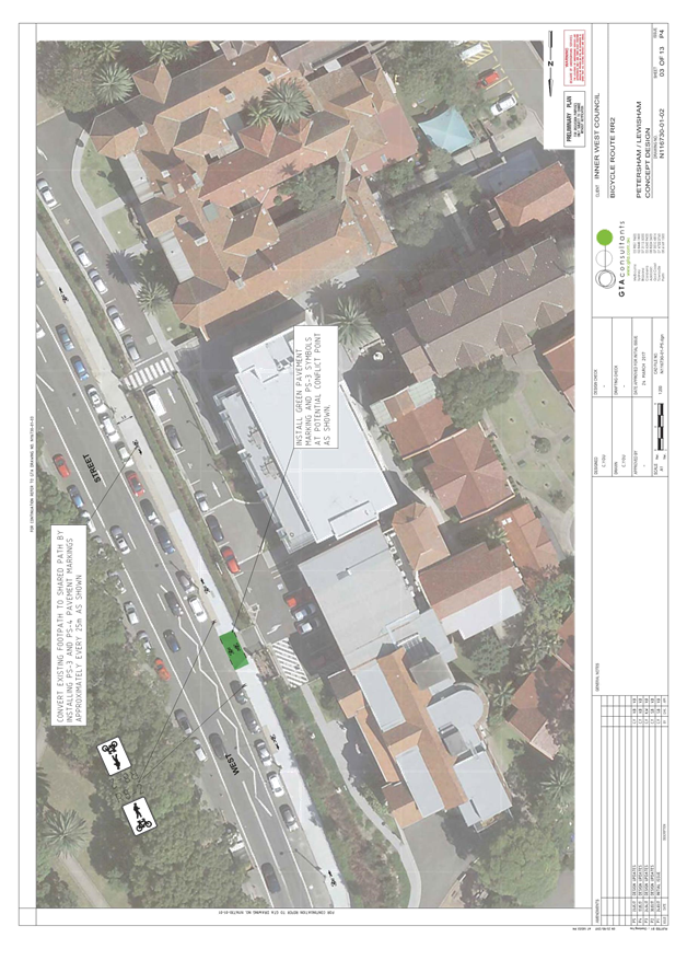
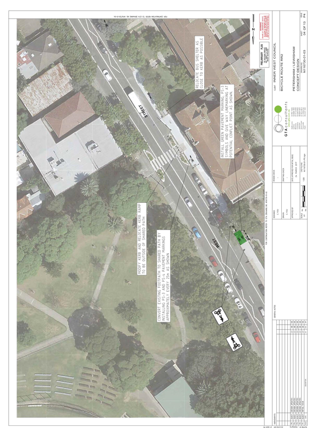
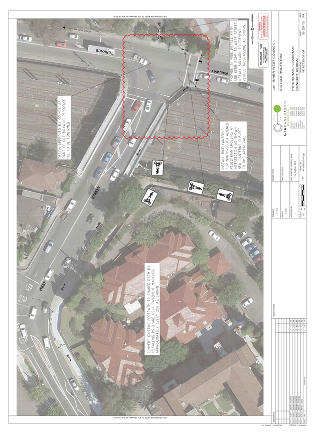
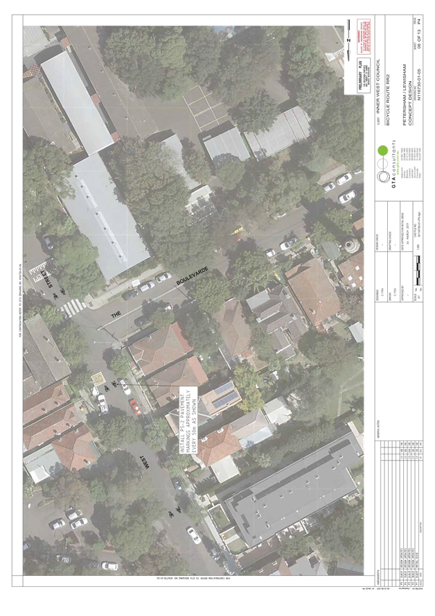
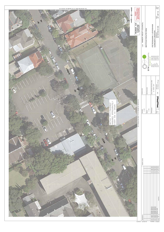
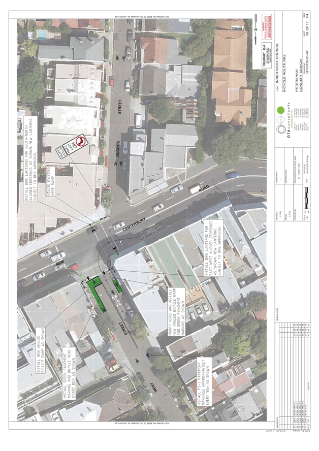
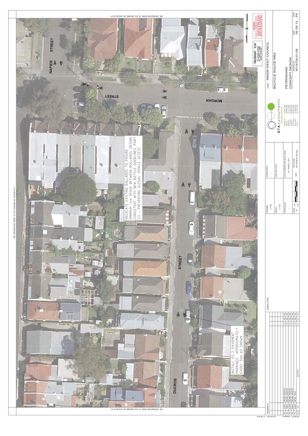
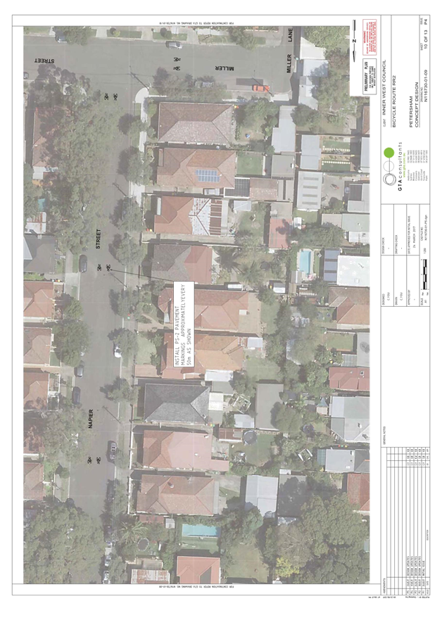
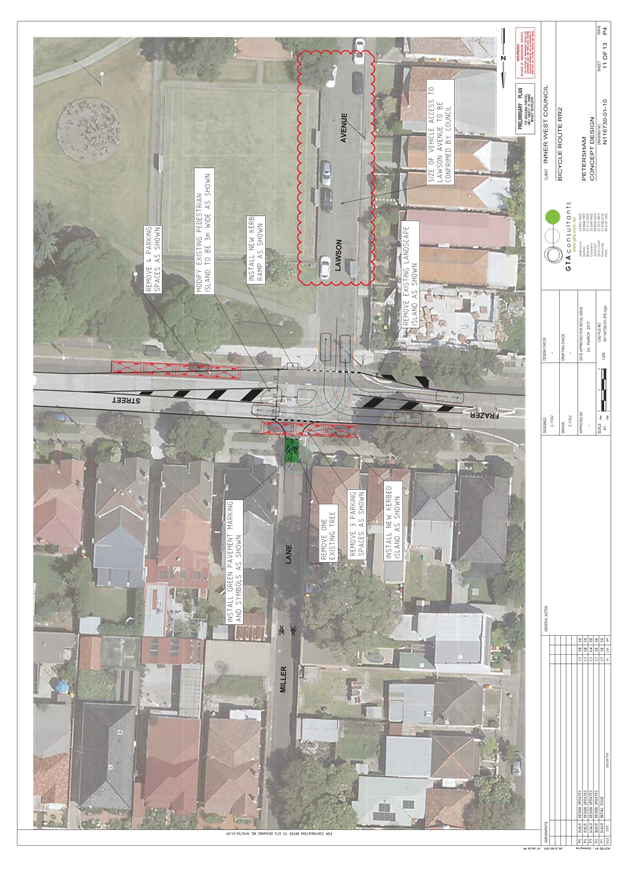
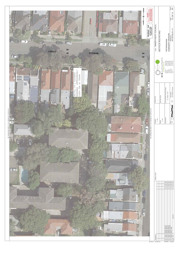
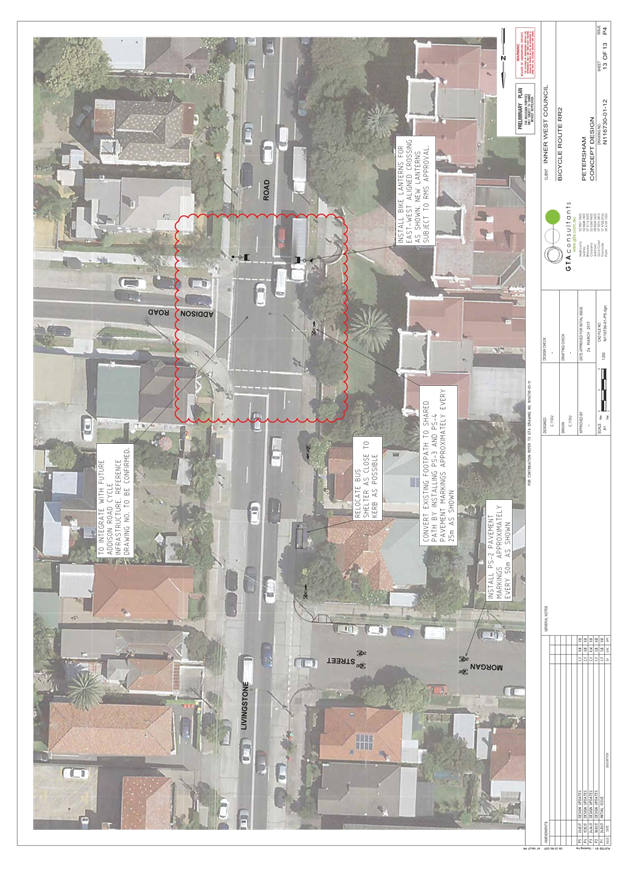
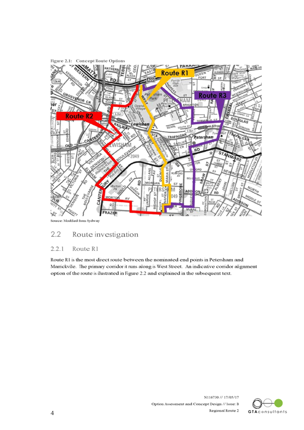
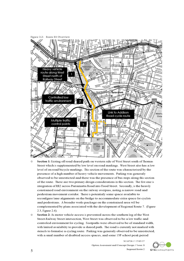
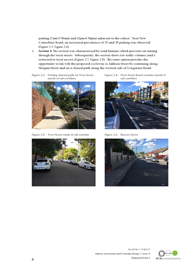
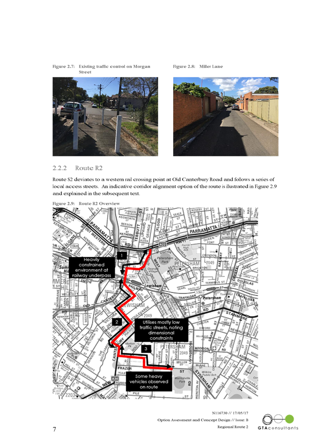
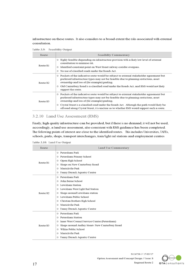
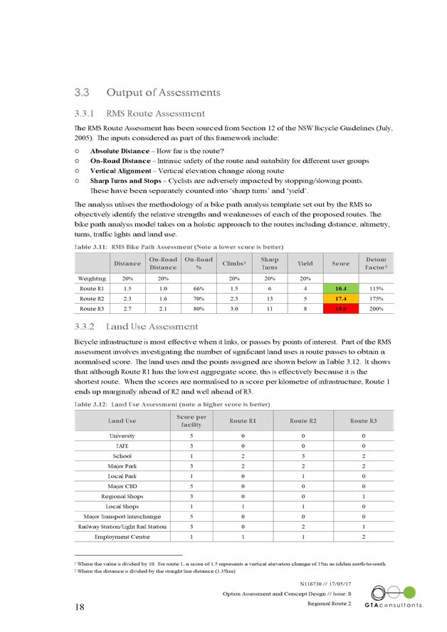
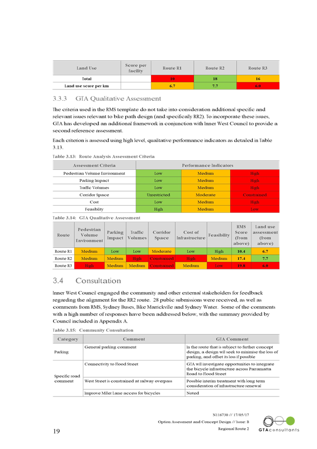
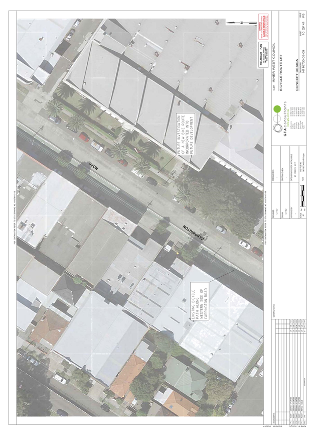
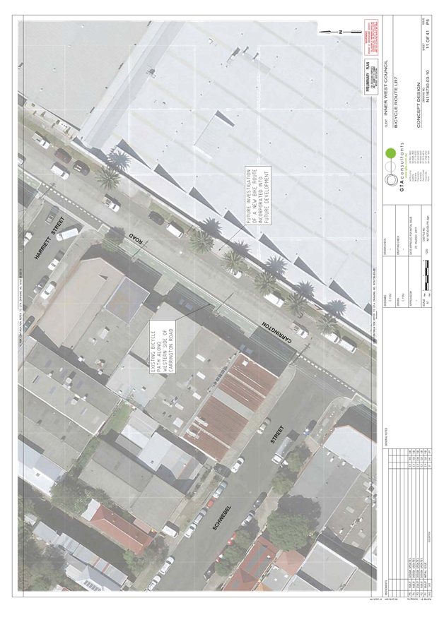
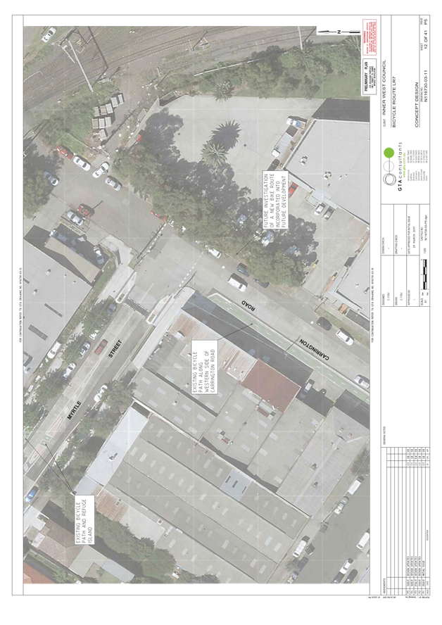
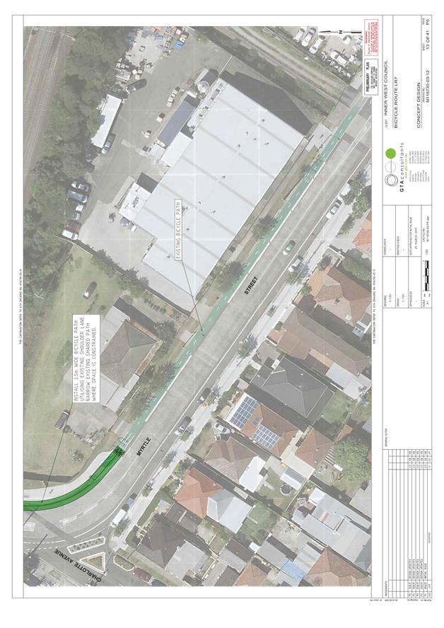
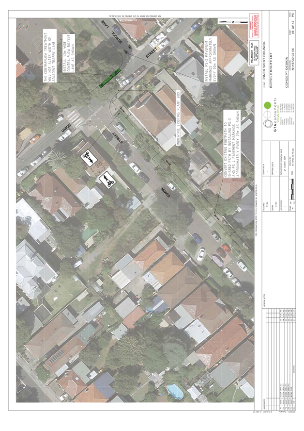
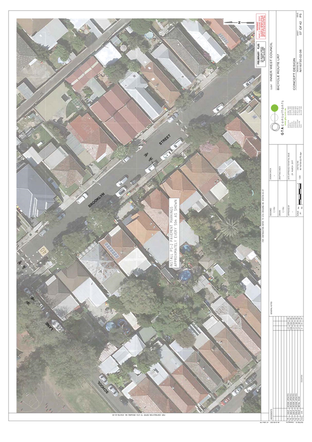
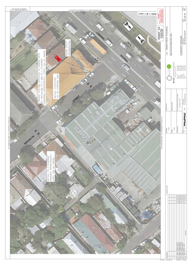
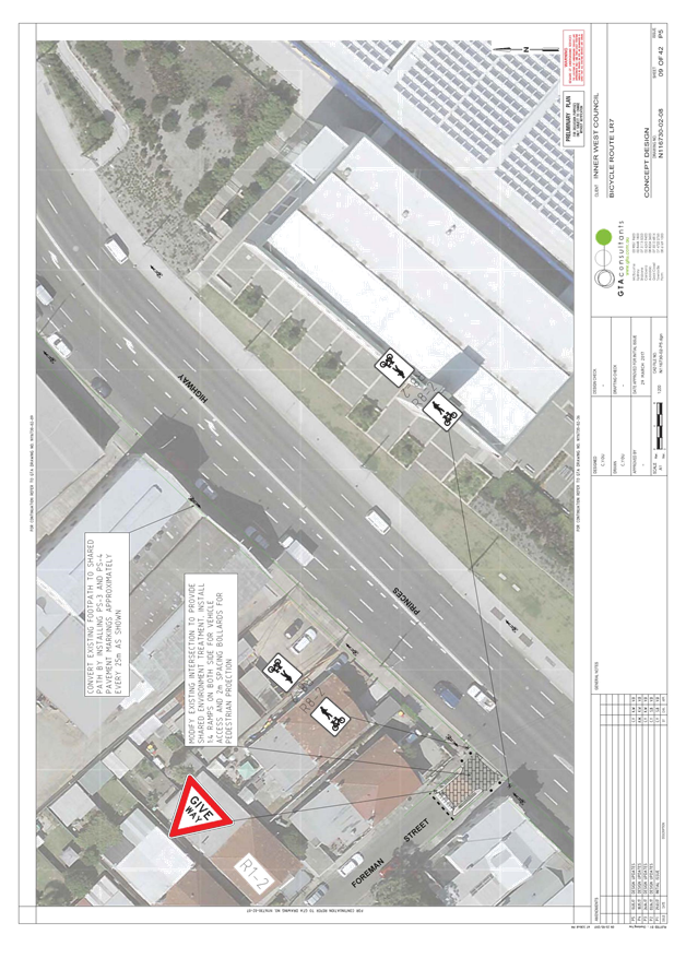
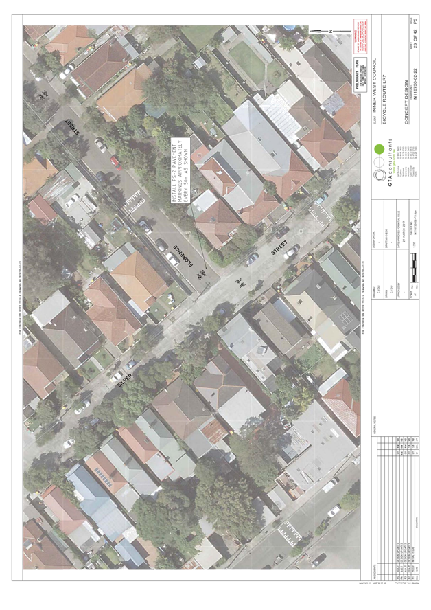
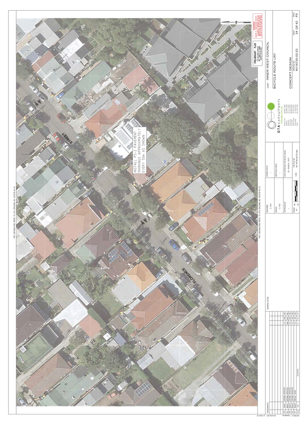
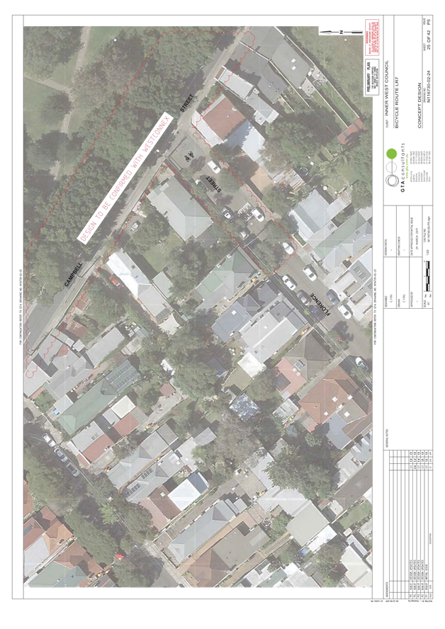
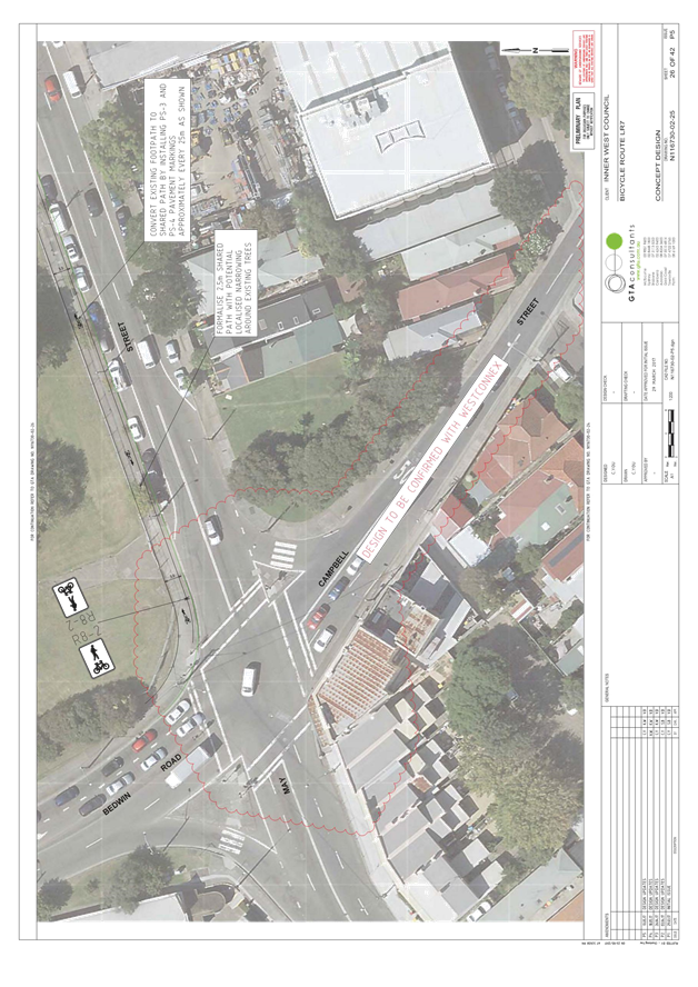
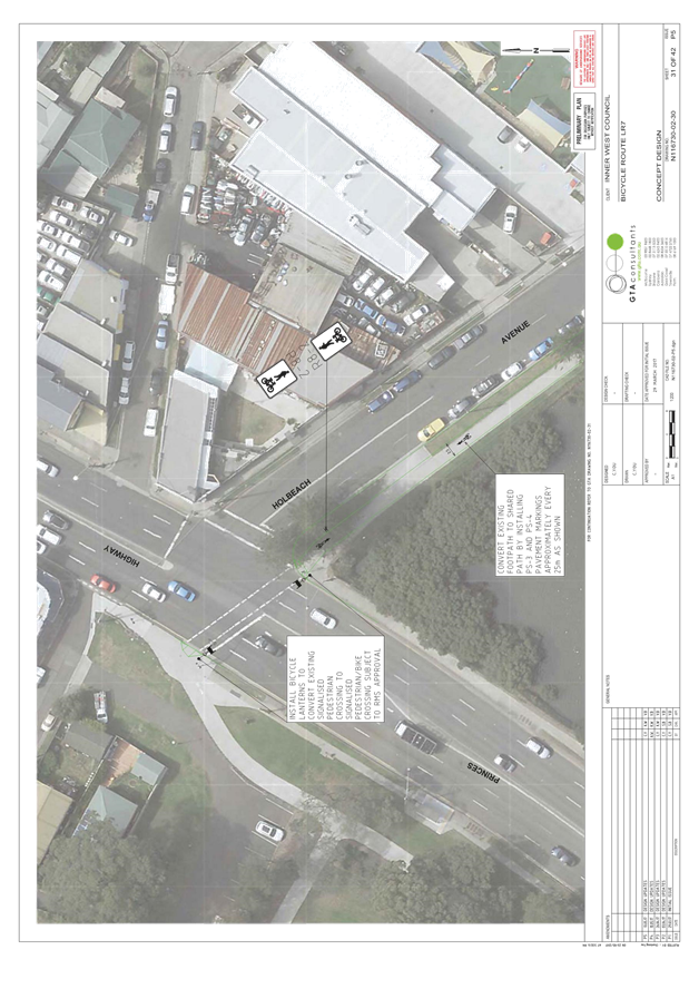
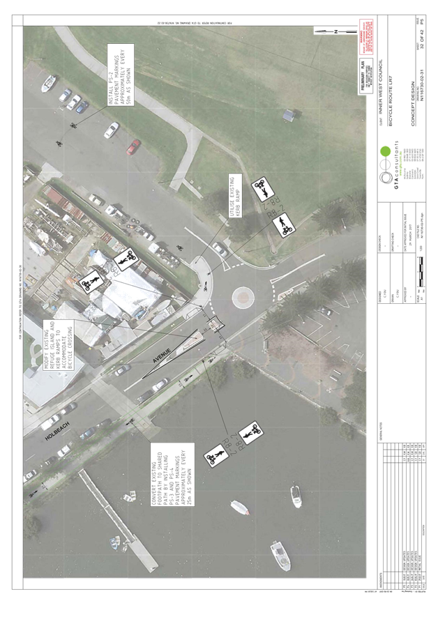
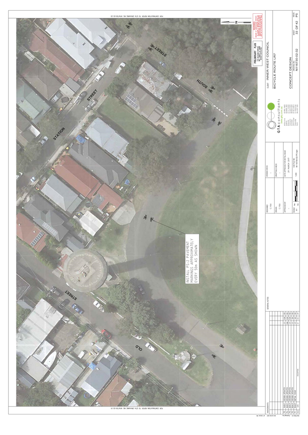
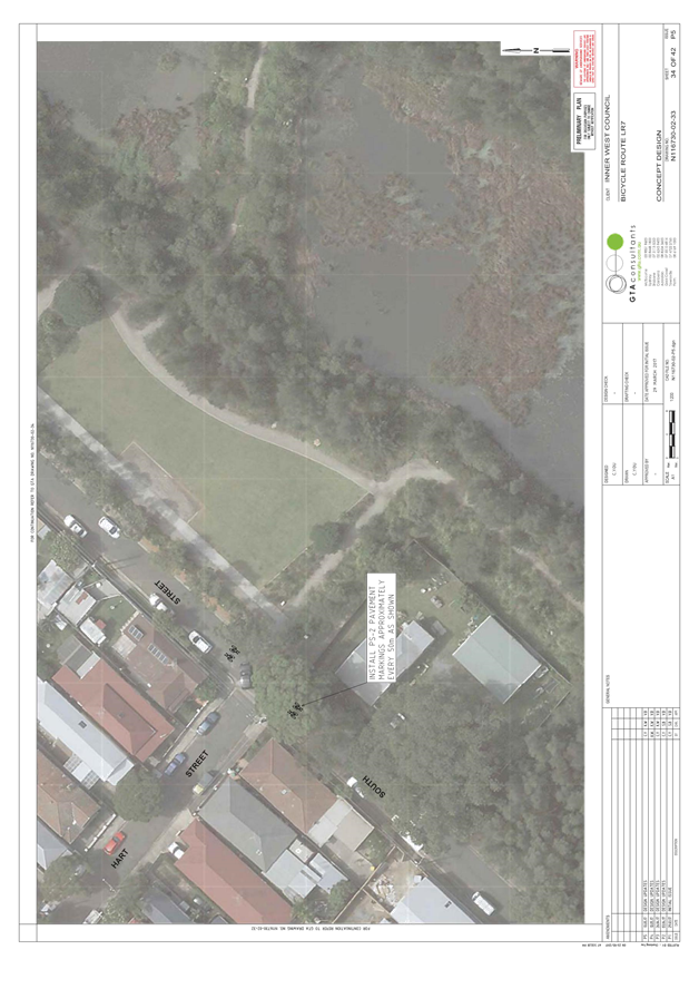
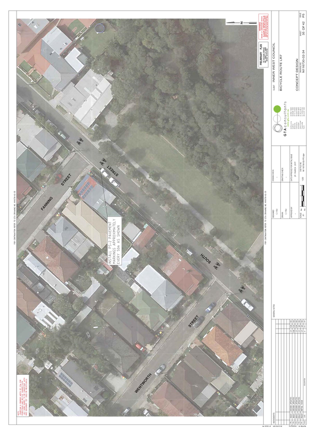
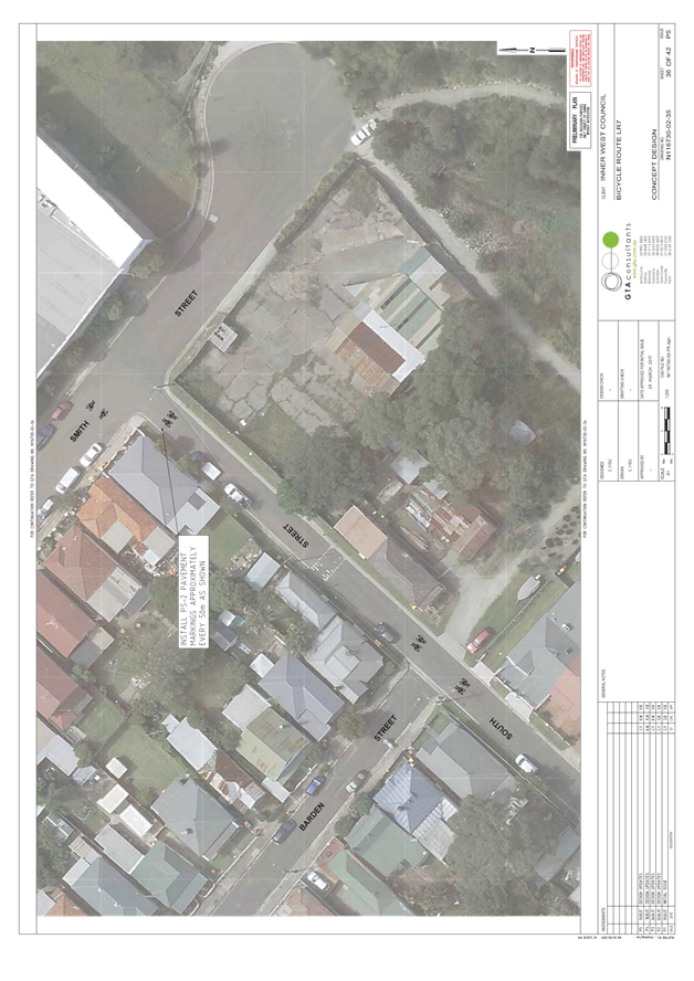
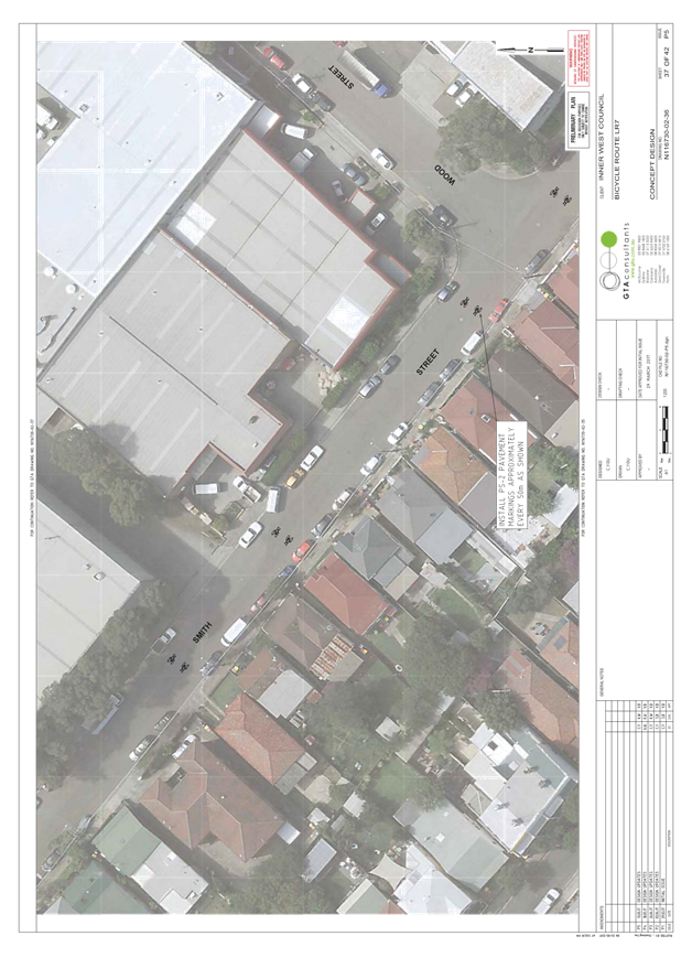
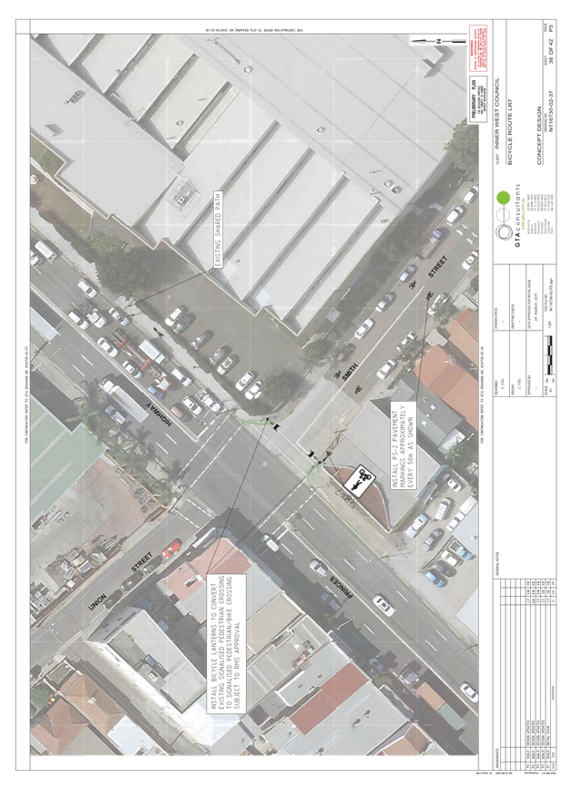
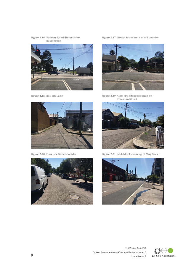
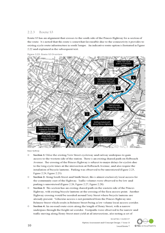
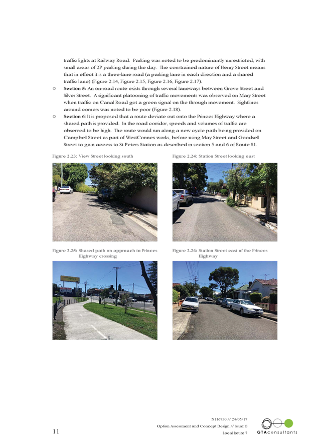
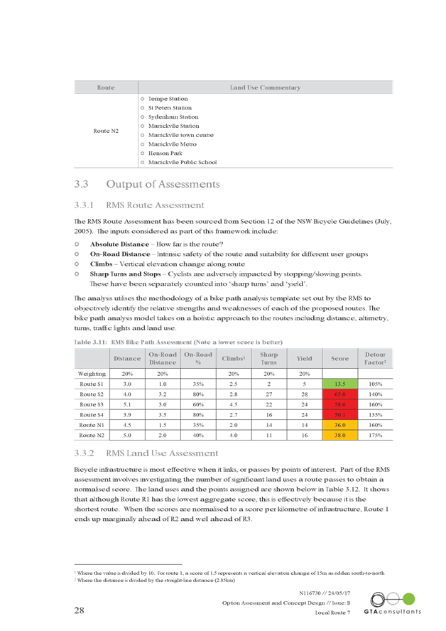
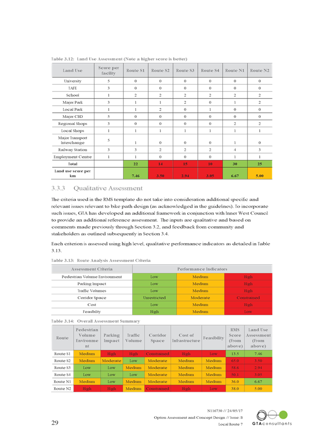
T0617 Item 24 REGIONAL ROUTE 2 (PARRAMATTA ROAD TO MARRICKVILLE PARK) - DRAFT CONCEPT PLAN FOR PUBLIC EXHIBITION 116
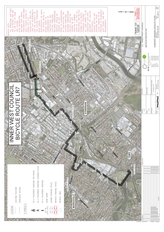
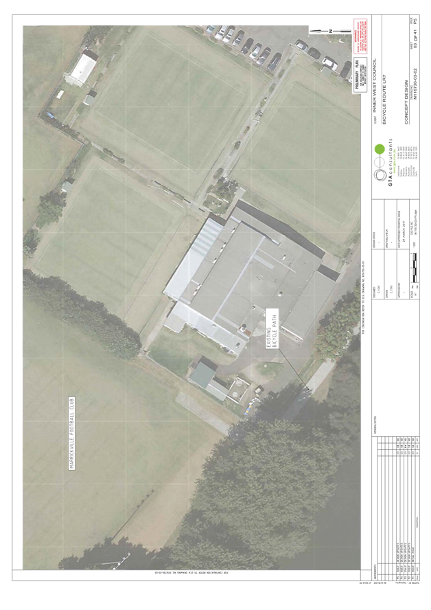
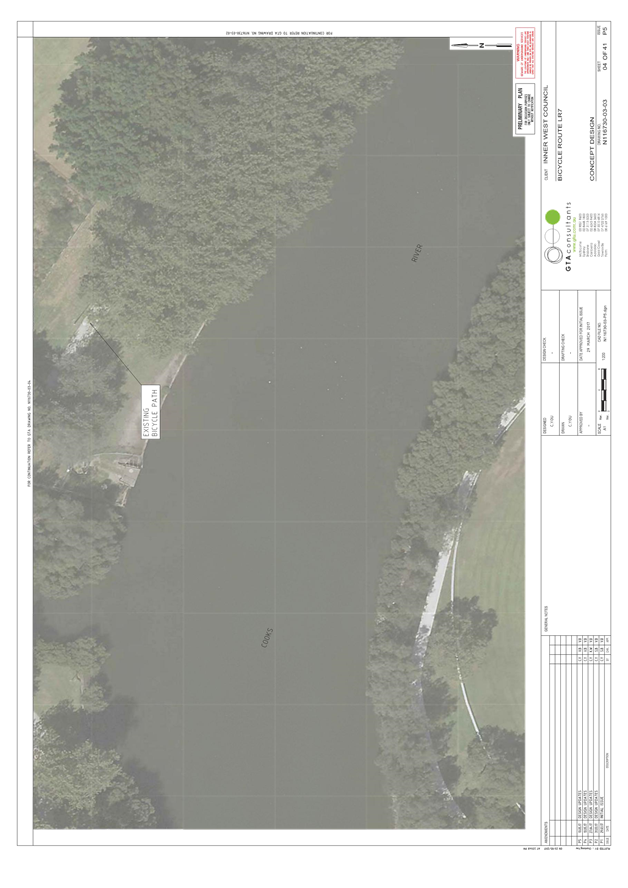
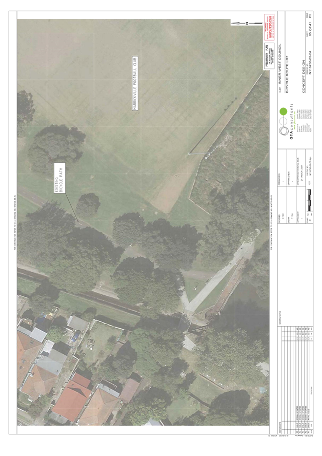
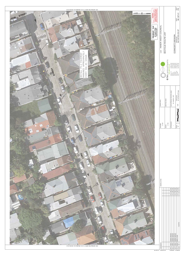
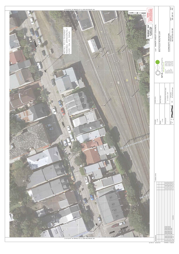
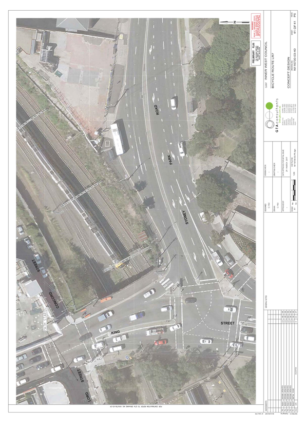
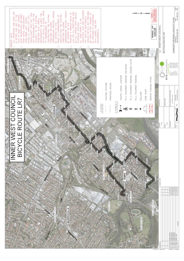
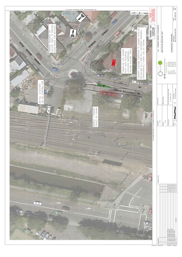
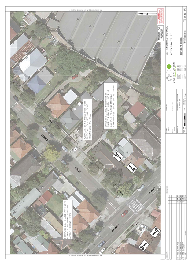
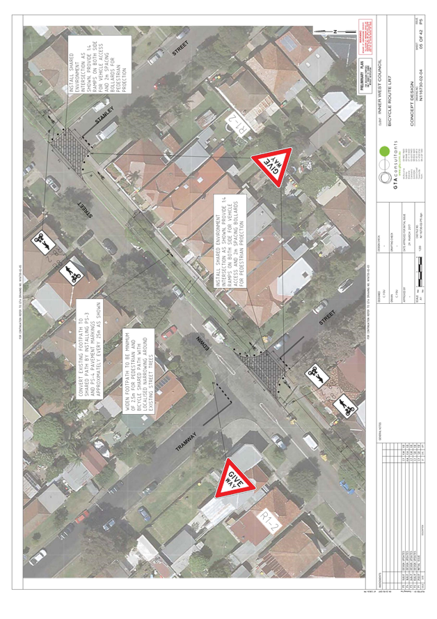
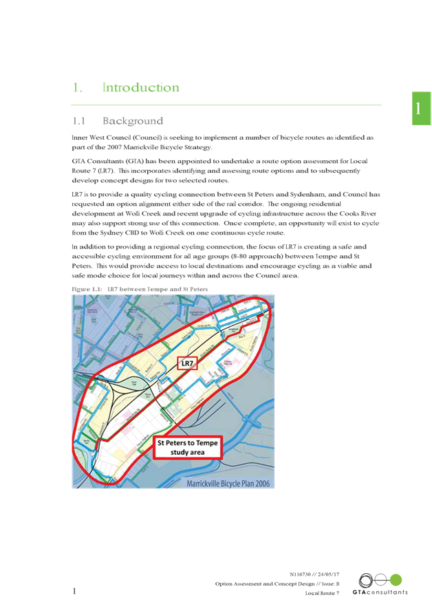
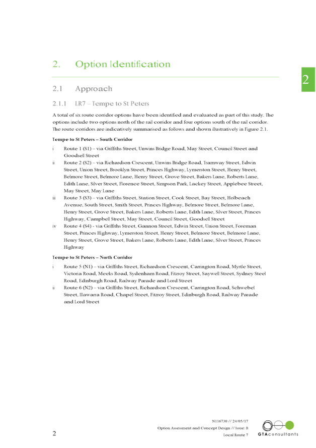
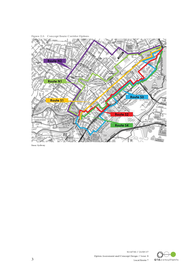
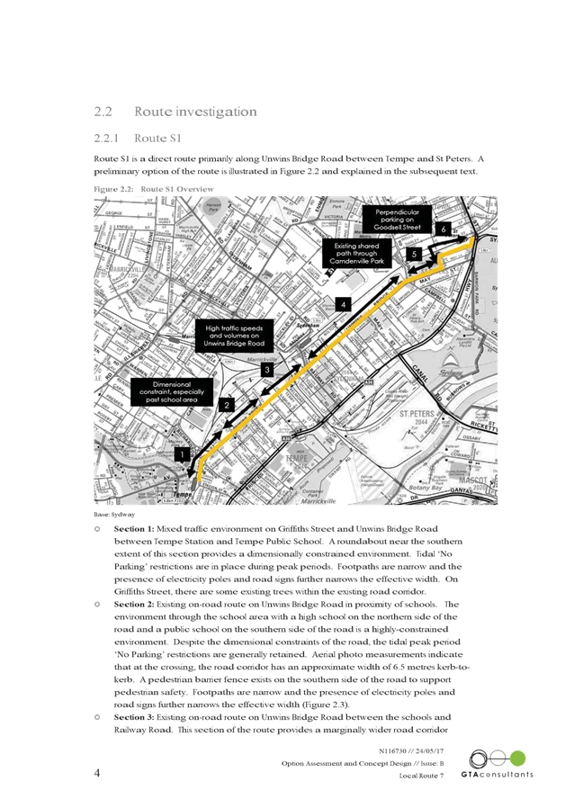
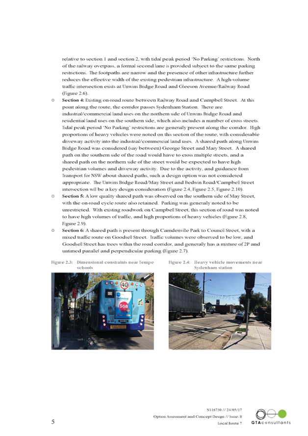
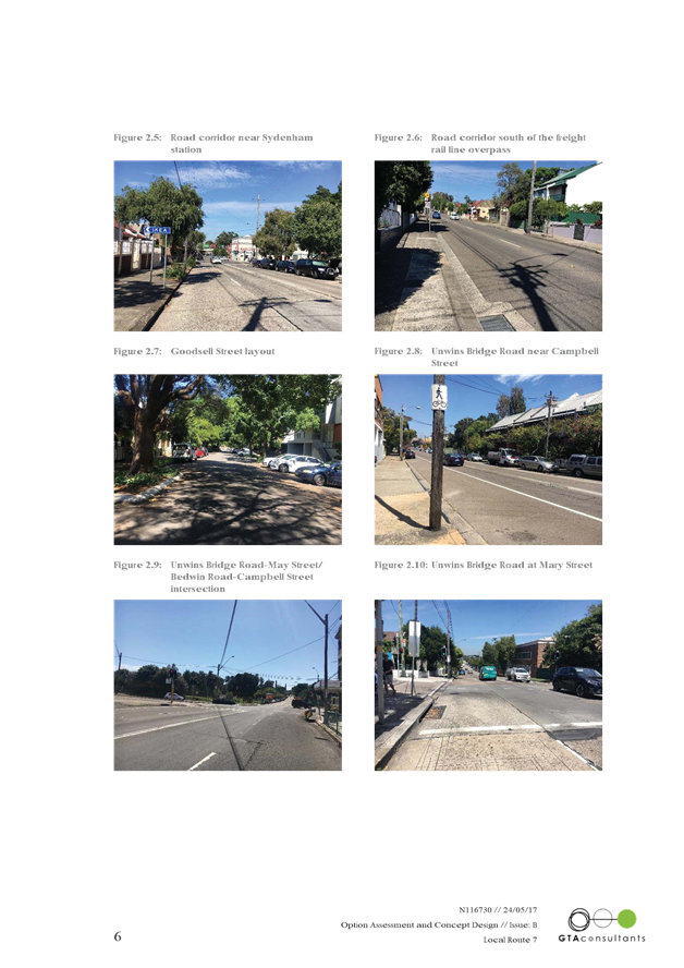
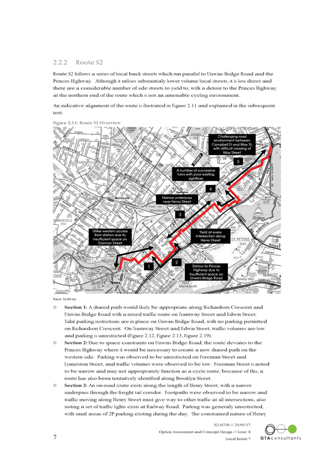
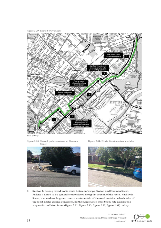
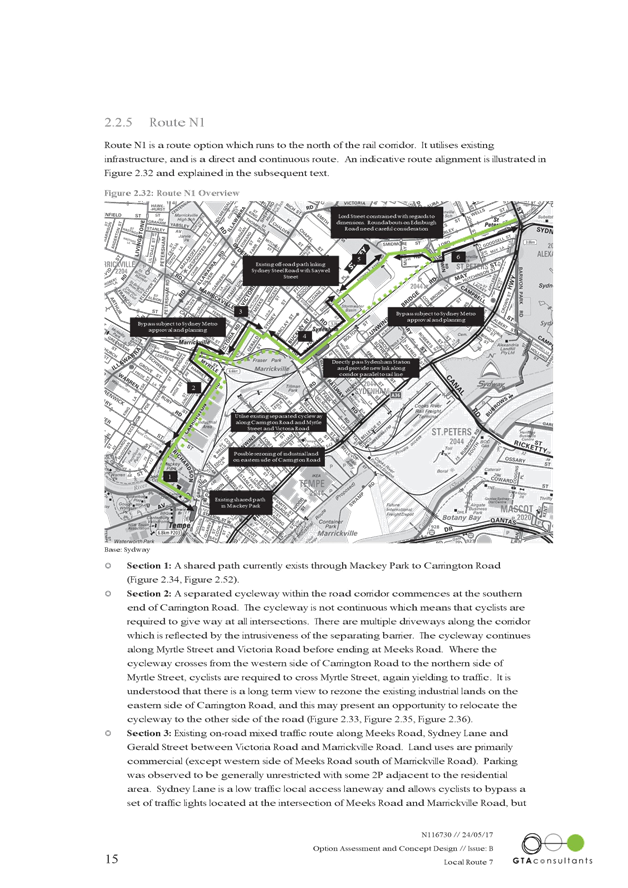
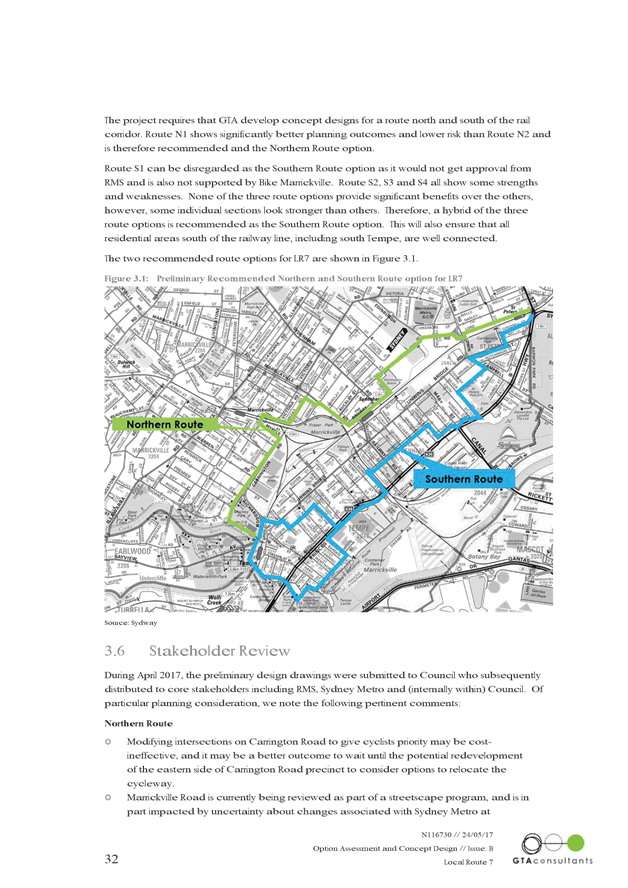
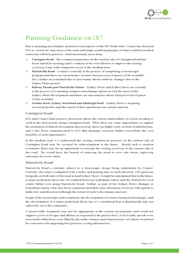
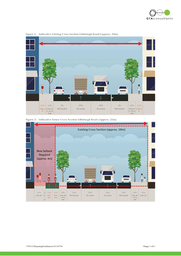
T0617 Item 25 LOCAL ROUTE 7 (ST PETERS TO TEMPE) - DRAFT CONCEPT PLAN FOR PUBLIC EXHIBITION 164
8 General Business
9 Close of Meeting
|
|
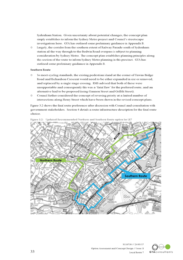
Local Traffic Committee Meeting 1 June 2017 |
Subject: TEMPORARY ROAD CLOSURE TO CARRY OUT CRANE
LIFT ESCALATORS INTO METRO SHOPPING CENTRE ACROSS MURRAY STREET, MARRICKVILLE
(MARRICKVILLE WARD/NEWTOWN ELECTORATE/MARRICKVILLE LAC)
File Ref: 17/6022/49380.17
Prepared By: Idris Hessam - Graduate Civil Engineer Traffic Services
Authorised By: George Tsaprounis – Acting Manager Design and Investigation
|
SUMMARY An application has been received from K&D Traffic Management Pty Ltd for the temporary full road closure of Murray Street (between Victoria Road and Smidmore Street) Marrickville for a period of 55 hours from 4:30pm to 11:30pm continuously from 30th June till 2nd of July 2017, in order to stand a mobile crane on Murray Street the crane will lift Escalators across Murray Street into Metro shopping Centre, Marrickville. It is recommended that the proposed temporary road closure be approved, subject to the conditions outlined in this report. |
|
RECOMMENDATION
THAT the proposed temporary full road closure of Murray Street (between Victoria Road and Smidmore Street) Marrickville for a period of 55 hours from 4:30pm to 11:30pm continuously from 30th June till 2nd of July 2017, in order to stand a mobile crane on Murray Street to lift Escalators across Murray Street into Metro shopping Centre, Marrickville, subject to the following conditions:
1. a fee of $1,354.60 for the temporary full road closure is payable by the applicant in accordance with Council’s Fees and Charges; 2. the temporary full road closure be advertised in the local newspaper providing 28 days’ notice for submissions, in accordance with the Roads Act; 3. a Traffic Management Plan (TMP) be submitted by the applicant to the Roads and Maritime Services for consideration and approval; 4. a Traffic Control Plan (TCP) which has been prepared by a certified Traffic Controller, is to be submitted to Council for review with a copy of the Traffic Controllers certification number attached to the plan, not less than 5 days prior to implementation of closure; 5. a Road Occupancy License be obtained by the applicant from the Roads and Maritime Services’ Transport Management Centre; 6. notice of the proposed closure be forwarded by the applicant to the NSW Police, the NSW Fire Brigades and the NSW Ambulance Services; 7. notification signs advising of the proposed road closures and new traffic arrangements to be strategically installed and maintained by the applicant at each end of the street at least 7 days prior to the closure; 8. all affected residents and businesses shall be notified in writing, by the applicant, of the proposed temporary road closure at least 7 days in advance of the closure with the applicant making reasonable provision for residents; 9. vehicular and pedestrian access for residents and businesses to their off-street car parking spaces be maintained where possible whilst site works are in progress;
10. adequate vehicular traffic control shall be provided for the protection and convenience of pedestrians and motorists including appropriate signage and flagging. Workers shall be specially designated for this role, as necessary to comply with this condition. This is to be carried out in accordance with the Australian Standard AS 1742.3 - Traffic Control Devices for works on roads; 11. the holder of this approval shall indemnify the Council against all claims, damages and costs incurred by, or charges made against, the Council in respect to death or injury to any person or damage in any way arising out of this approval. In this regard, a public liability insurance policy for an amount not less than $20,000,000 for any one occurrence is to be obtained and is to note the Council as an interested party. The holder of this approval shall inform its insurer of the terms of this condition and submit a copy of the insurance policy to the Council prior to commencement of the work the subject of this approval; 12. the operator of any unit exercising this approval shall have this approval with them and produce it if required along with any other relevant authority approvals granted in the connection with the work; 13. mobile cranes, cherry packers or concrete boom pumps shall not stand within the public way for extended periods when not in operation under this approval; 14. the operation of the mobile crane shall not give rise to an "offensive noise" as defined in the Protection of Environment Operations Act, 1997. Furthermore, vibrations and/or emission of gases that are created during its operations and which are a nuisance, or dangerous to public health are not permitted; 15. all work is to be carried out in accordance with Work Cover requirements; and the costs to repair damages, as a result of these works, to Council's footway and roadway areas will be borne by the applicant. |
BACKGROUND
An application has been received from K&D Traffic Management Pty Ltd for the temporary full road closure of Murray Street (between Victoria Road and Smidmore) Marrickville for a period of 55 hours from 4:30pm to 11:30pm continuously from 30th June till 2nd July of 2017, in order to stand a mobile crane on Murray Street to lift Escalators across Murray Street into Metro shopping Centre, Marrickville.
FINANCIAL IMPLICATIONS
Under Council’s Fees & Charges, the applicant is to pay a fee of $1,354.60 for the temporary full road closure. This fee includes advertising the proposal in accordance with the Roads Act 1993.
OFFICER COMMENTS
NIL
PUBLIC CONSULTATION
The proposed full-road closure of Murray Street (between Victoria Road and Smidmore) Marrickville is currently advertised in the newspaper for a period of 28 days. The advertising period commenced on 9 May 2017 and will conclude on 5 June 2017. A Traffic Management Plan is to be submitted to the RMS for consideration and approval. The applicant is to notify all affected residents and businesses in writing at least 7 days prior to the commencement of works.
CONCLUSION
It is recommended that the proposed temporary road closures be approved, subject to the conditions outlined in this report.
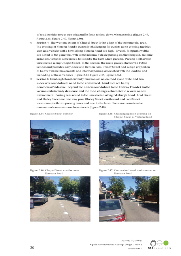
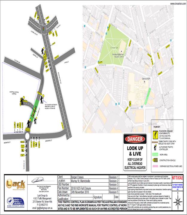
Traffic Control Plan submitted by the applicant – Murray Street, Marrickville
|
|
Local Traffic Committee Meeting 1 June 2017 |
Subject: CHARLES STREET, MARRICKVILLE – PROPOSED PEDESTRIAN REFUGE ISLAND DESIGN PLANS (MARRICKVILLE WARD/SUMMER HILL ELECTORATE/MARRICKVILLE LAC)
File Ref: 17/6022/51151.17
Prepared By: Emilio Andari - Civil Engineer
Authorised By: George Tsaprounis – Acting Manager Design and Investigation
|
SUMMARY Detailed design plans have been finalised for a proposed pedestrian refuge island & landscaped kerb blister island in Charles Street, Marrickville at its intersection with Illawarra Road, as part of the Henson LATM study implementation. The implementation of these traffic calming measures with associated signs and line markings will improve pedestrian safety and traffic conditions at the intersection. |
|
RECOMMENDATION
THAT the detailed design plans of the proposed pedestrian refuge island & landscaped kerb blister island in Charles Street, Marrickville at its intersection with Illawarra Road, including associated signs and line markings (as per the attached design plan No. 6164) be APPROVED.
|
BACKGROUND
Council is proposing to construct a pedestrian refuge island & landscaped kerb blister island in Charles Street, Marrickville at its intersection with Illawarra Road. This proposal will improve pedestrian safety and traffic conditions at the intersection.
This proposal is a design which was included in the recently approved Henson Local Area Traffic Management Plan (LATM) which was on public exhibition (for community comment) at the end of 2016. The LATM provides rationale and recommended actions to address local traffic issues and support sustainable transport. This involves encouraging the use of public transport, walking and cycling. The Henson LATM was endorsed and approved by Council at its meeting held on 26 April 2017.
FINANCIAL IMPLICATIONS
This design was expedited as an application for Active Transport funding and was submitted to the RMS, though Council has not been informed of the outcome of this application as yet.
The estimated cost for these works is $20,000 and is funded by Council from the Henson LATM Implementation 2017/2018.
OFFICER COMMENTS
Site location & road network
|
Street Name |
Charles Street |
Illawarra Road |
|
Section |
Between Illawarra Road and Amy Street |
Between Addison Road and Horton Street |
|
Carriageway Width (m) |
12.8 |
9.1 |
|
Carriageway Type |
Two-way road with one travel lane in each direction, in addition to kerbside parking lanes. |
Two-way road with one travel lane in each direction, in addition to kerbside parking lanes. |
|
Classification |
Local |
Local |
|
85th Percentile Speed (km/h) |
49.7 |
51.8 |
|
Vehicles Per Day (vpd) |
327 |
5,078 |
|
Reported Crash History (July 2011 – June 2016) |
No crashes recorded. |
No crashes recorded. |
|
Heavy Vehicle Volume (%) |
3.1 |
2.5 |
|
Parking Arrangements |
Unrestricted parking along both sides of the road. |
Unrestricted parking along both sides of the road. |
At present, the intersection of Charles Street and Illawarra Road is controlled by a ‘Give Way’ sign and line markings, with priority given to traffic along Illawarra Road.
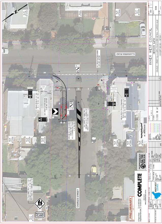
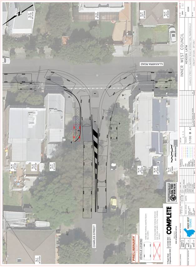
Design Plan – No. 6164
A detailed design plans for the provision of a pedestrian refuge island and landscaped kerb blister island in Charles Street, Marrickville at its intersection with Illawarra Road, including the proposed signs and line markings (ATTACHMENT - design plan No. 6164) are submitted for consideration.
The proposed scope of work includes the following:
· Construct a pedestrian refuge island in Charles Street, at its intersection with Illawarra Road.
· Construct a landscaped kerb blister island on the northern side of Charles Street adjacent to property no. 44 Illawarra Road.
· Install four new ‘No Stopping’ signs at the intersection of Charles Street and Illawarra Road as per design plan.
· Install new edge line markings and associated signage and line markings as per design plan.
The proposed treatment will result in the loss of one (1) legal on-street parking space in Charles Street as an outcome of the proposed ‘No Stopping’ restrictions in order to accommodate pedestrian safety (refer to the attached design plan No. 6164). All current vehicular access to adjoining properties will be retained. A swept path analysis was undertaken following the proposed design using a light rigid vehicle (8.8m long garbage truck) and was found to be satisfactory (refer to the attached design plan No. 6165).
PUBLIC CONSULTATION
A notification letter regarding the proposed design plan to implement a pedestrian refuge island with associated signs and line marking and landscaped kerb blister island as well as a copy of the detailed design plans was sent on 1 May 2017 to the owners and occupiers of the affected properties at the intersection of Charles Street and Illawarra Road, Marrickville. A total of 44 letters were distributed. The closing date for submissions ended on 15 May 2017.
There was one (1) response received and this response was neutral to the proposed detailed design plan and is detailed below.
|
Residents’ Comments (neutral to the proposal) |
Officer’s Response |
|
A resident of Illawarra Road was neutral to the proposal of the pedestrian refuge island and landscaped kerb blister island. The resident is concerned about the loss in parking and would hope to find the result of one on-street parking space lost as shown in the detailed design plans. The resident stated that available on-street parking is difficult to find and is often having to circulate the surrounding streets to find a parking space, particularly on days when the Addison Road weekend markets and/or Henson Park football games are on.
|
The proposed treatment will result in the loss of one (1) legal on-street parking space in Charles Street as an outcome of the proposed ‘No Stopping’ restrictions in order to accommodate pedestrian safety.
This is as a result of the Australian Standard requirement for ‘No Stopping’ zones surrounding pedestrian refuge islands. A proposed landscaped kerb blister island has been integrated as part of the design in Charles Street to reduce the ‘No Stopping’ zone requirement from 20m to 10m from the pedestrian line of path in order to minimise parking loss. |
CONCLUSION
It is recommended that the detailed design plan of the proposed treatment and associated signs and line markings be approved, to improve pedestrian safety and traffic conditions at the intersection.
|
|
Local Traffic Committee Meeting 1 June 2017 |
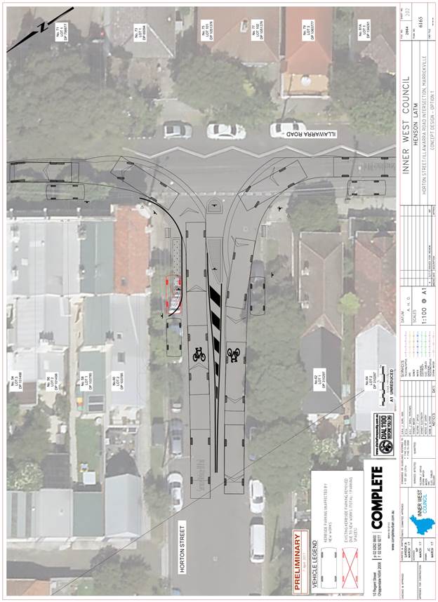
Subject: HORTON STREET, MARRICKVILLE – PROPOSED PEDESTRIAN REFUGE ISLAND DESIGN PLANS (MARRICKVILLE WARD/SUMMER HILL ELECTORATE/MARRICKVILLE LAC)
File Ref: 17/6022/51153.17
Prepared By: Emilio Andari - Civil Engineer
Authorised By: George Tsaprounis – Acting Manager Design and Investigation
|
SUMMARY Detailed design plans have been finalised for a proposed pedestrian refuge island & landscaped kerb blister island in Horton Street, Marrickville at its intersection with Illawarra Road, as part of the Henson LATM study implementation. The implementation of these traffic calming measures with associated signs and line markings will improve pedestrian safety and traffic conditions at the intersection. |
|
RECOMMENDATION
THAT the detailed design plans of the proposed pedestrian refuge island & landscaped kerb blister island in Horton Street, Marrickville at its intersection with Illawarra Road, including associated signs and line markings (as per the attached design plan No. 6165) be APPROVED.
|
BACKGROUND
Council is proposing to construct a pedestrian refuge island & landscaped kerb blister island in Horton Street, Marrickville at its intersection with Illawarra Road. This proposal will improve pedestrian safety and traffic conditions at the intersection.
This proposal is a design which was included in the recently approved Henson Local Area Traffic Management Plan (LATM) which was on public exhibition (for community comment) at the end of 2016. The LATM provides rationale and recommended actions to address local traffic issues and support sustainable transport. This involves encouraging the use of public transport, walking and cycling. The Henson LATM was endorsed and approved by Council at its meeting held on 26 April 2017.
FINANCIAL IMPLICATIONS
This design was expedited as an application for Active Transport funding and was submitted to the RMS, though Council has not been informed of the outcome of this application as yet.
The estimated cost for these works is $20,000 and is funded by Council from the Henson LATM Implementation 2017/2018.
OFFICER COMMENTS
Site location & road network
|
Street Name |
Horton Street |
Illawarra Road |
|
Section |
Between Illawarra Road and Amy Street |
Between Charles Street and Chapel Street |
|
Carriageway Width (m) |
12.8 |
9.1 |
|
Carriageway Type |
Two-way road with one travel lane in each direction, in addition to kerbside parking lanes. |
Two-way road with one travel lane in each direction, in addition to kerbside parking lanes. |
|
Classification |
Local |
Local |
|
85th Percentile Speed (km/h) |
49.0 |
51.8 |
|
Vehicles Per Day (vpd) |
405 |
5,078 |
|
Reported Crash History (July 2011 – June 2016) |
No crashes recorded. |
No crashes recorded. |
|
Heavy Vehicle Volume (%) |
1.8 |
2.5 |
|
Parking Arrangements |
Unrestricted parking along both sides of the road. |
Unrestricted parking along both sides of the road. |
At present, the intersection of Horton Street and Illawarra Road is controlled by a ‘Give Way’ sign and line markings, with priority given to traffic along Illawarra Road.
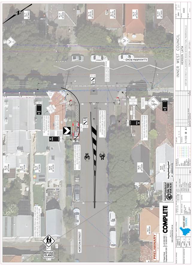
Design Plan – No. 6165
A detailed design plans for the provision of a pedestrian refuge island and landscaped kerb blister island in Horton Street, Marrickville at its intersection with Illawarra Road, including the proposed signs and line markings (ATTACHMENT - design plan No. 6165) are submitted for consideration.
The proposed scope of work includes the following:
· Construct a pedestrian refuge island in Horton Street, at its intersection with Illawarra Road.
· Construct a landscaped kerb blister island on the northern side of Horton Street adjacent to property no. 60 Illawarra Road.
· Install four new ‘No Stopping’ signs at the intersection of Horton Street and Illawarra Road as per design plan.
· Install new edge line markings, two bicycle on-road symbols and associated signage and line markings as per design plan.
The proposed treatment will result in the loss of one (1) legal on-street parking space in Horton Street as an outcome of the proposed ‘No Stopping’ restrictions in order to accommodate pedestrian safety (refer to the attached design plan No. 6165). All current vehicular access to adjoining properties will be retained. A swept path analysis was undertaken following the proposed design using a light rigid vehicle (8.8m long garbage truck) and was found to be satisfactory (refer to the attached design plan No. 6165).
PUBLIC CONSULTATION
A notification letter regarding the proposed design plan to implement a pedestrian refuge island with associated signs and line marking and landscaped kerb blister island as well as a copy of the detailed design plans was sent on 1 May 2017 to the owners and occupiers of the affected properties at the intersection of Horton Street and Illawarra Road, Marrickville. A total of 44 letters were distributed. The closing date for submissions ended on 15 May 2017.
There was one (1) response received and this response was neutral to the proposed detailed design plan and is detailed below.
|
Residents’ Comments (neutral to the proposal) |
Officer’s Response |
|
A resident of Illawarra Road was neutral to the proposal of the pedestrian refuge island and landscaped kerb blister island. The resident is concerned about the loss in parking and would hope to find the result of one on-street parking space lost as shown in the detailed design plans. The resident stated that available on-street parking is difficult to find and is often having to circulate the surrounding streets to find a parking space, particularly on days when the Addison Road weekend markets and/or Henson Park football games are on.
|
The proposed treatment will result in the loss of one (1) legal on-street parking space in Horton Street as an outcome of the proposed ‘No Stopping’ restrictions in order to accommodate pedestrian safety.
This is as a result of the Australian Standard requirement for ‘No Stopping’ zones surrounding pedestrian refuge islands. A proposed landscaped kerb blister island has been integrated as part of the design in Horton Street to reduce the ‘No Stopping’ zone requirement from 20m to 10m from the pedestrian line of path in order to minimise parking loss. |
CONCLUSION
It is recommended that the detailed design plan of the proposed treatment and associated signs and line markings be approved, to improve pedestrian safety and traffic conditions at the intersection.
|
|
Local Traffic Committee Meeting 1 June 2017 |
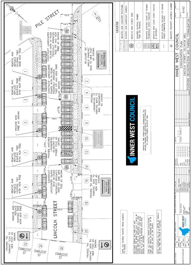
Subject: LINCOLN STREET, DULWICH HILL – PROPOSED ANGLE PARKING & KERB BLISTER ISLANDS DESIGN PLAN (MARRICKVILLE WARD/SUMMER HILL ELECTORATE/MARRICKVILLE LAC)
File Ref: 17/6022/52324.17
Prepared By: Emilio Andari - Civil Engineer
Authorised By: George Tsaprounis – Acting Manager Design and Investigation
|
SUMMARY A detailed design plan has been finalised for the proposed streetscape enhancements in Lincoln Street, Dulwich Hill as part of Council’s Capital Works Program for Footpaths. A part of the proposal is to replace the existing on-street 90 degree angle parking with on-street line marked 90 degree angle parking bays and landscaped kerb blister islands including associated signs and line markings to provide clear on-street parking opportunities and improve traffic conditions at this location.
Consultation was undertaken with owners and occupiers of properties adjacent to Lincoln Street, regarding the proposal. A summary of the consultation results are presented in this report for consideration. It is recommended that the proposed detailed design plan be approved. |
|
RECOMMENDATION
THAT the detailed design plan of the proposed line marked 90 degree angle parking bays & landscaped kerb blister islands in Lincoln Street, Dulwich Hill including associated signs and line markings (as per the attached design plan No. 6162) be APPROVED.
|
BACKGROUND
One of the key objectives from Council’s Community Strategic Planning document is to provide accessible and well connected footpaths, cycleways and associated facilities. The objective is to be achieved through reduced impact of traffic and improvement of pedestrian and cyclist safety.
Throughout the scope of the project for Lincoln Street, the streetscape was identified as being in poor condition and requiring additional greening opportunities. Also, the formalisation of existing angle parking by incorporating line markings and kerb blister islands was required.
Council is proposing to reconstruct the footpath along Lincoln Street, Dulwich Hill. The works will also involve integrating a section of on-street line marked 90 degree angle parking bays and construction of three landscaped kerb blister islands including associated signs and line markings.
The detail design plan has been finalised for the proposed devices together with the consultation and are presented in this report for consideration.
FINANCIAL IMPLICATIONS
Funding of $150,000 has been allocated by Council for the entire scope of works for Lincoln Street, Dulwich Hill under the 2017/2018 Capital Works Program for Footpaths.
These works include reconstructing the footpath in Lincoln Street as well as the installation of on-street line marked 90 degree angle parking bays and landscaped kerb blister islands including associated signs and line markings.
OFFICER COMMENTS
Site location & road network
|
Street Name |
Lincoln Street |
|
Section |
Between Pile Street and to an end |
|
Carriageway Width (m) |
12.8 |
|
Carriageway Type |
Two-way road with one travel lane in each direction, in addition to kerbside parking lanes and is a no through road. |
|
Classification |
Local |
|
85th Percentile Speed (km/h) |
- |
|
Vehicles Per Day (vpd) |
- |
|
Reported Crash History (July 2011 – June 2016) |
No crashes recorded. |
|
Heavy Vehicle Volume (%) |
- |
|
Parking Arrangements |
Unrestricted parallel-to-kerb parking along the western side of the road and unrestricted 90 degree angle parking along the eastern side of the road. |
Design Plan – No. 6162
A detailed design plan for the provision of on-street line marked 90 degree angle parking bays and landscaped kerb blister islands in Lincoln Street, Dulwich Hill, including associated signs and line markings (ATTACHMENT - design plan No. 6162) are submitted for consideration.
The proposed scope of work includes the following:
· Construct three new landscaped kerb blister islands on the eastern side of Lincoln Street, adjacent to properties no. 9 Pile Street, no. 4 and no. 6 Lincoln Street, and no. 14 Lincoln Street.
· Install 18 on-street line marked 90 degree angle parking bays on the eastern side of Lincoln Street between properties no. 9 Pile Street & no. 14 Lincoln Street.
· Install two ‘No Parking’ zones adjacent to properties no. 11 Lincoln Street and no. 20 Lincoln Street.
· Install all other associated signage and line markings as per design plan.
The proposed treatment will result in the loss of three (3) legal on-street parking space in Lincoln Street as an outcome of the proposed on-street tree kerb blister islands and hatched line marking section contained within the section of 90 degree angle parking in order to accommodate greening opportunities and consistency within the streetscape and improve parking conditions (refer to the attached design plan No. 6162). All current vehicular access to adjoining properties will be retained.
PUBLIC CONSULTATION
A notification letter as well as a copy of the detailed design plans was sent on 3 May 2017 to the owners and occupiers of the affected properties in Lincoln Street, Dulwich Hill regarding the proposed design plan to reconstruct the existing footpath and implement the provision of on-street line marked 90 degree angle parking bays and on-street tree kerb blister islands with associated signs and line markings. A total of 25 letters were distributed. The closing date for submissions ended on 17 May 2017.
There were a total of three (3) responses received with one (1) response supporting the proposal and two (2) responses opposing the proposal. These responses are detailed below.
|
Residents’ Comments (supporting the proposal) |
Officer’s Response |
|
A resident of the street was generally in support to the proposal of the streetscape enhancements in their street. The resident is concerned about unused parking space between the driveways of property no. 18 and no. 16 Lincoln Street. It is acknowledged that this space is not wide enough for a vehicle to be parked parallel-to-kerb however, the inclusion of a landscaped kerb blister or a line marked angle parking bay would be a suitable solution.
The resident had questioned whether the other parallel-to-kerb parking spaces will be line marked and whether the tree planting specifications for both on-road and footpaths have been considered. |
The kerb blister island adjacent to property no. 14 Lincoln Street marks the end of the angle parking zone in conjunction with the angle parking sign.
The angle parking zone cannot be extended beyond this point due to the existing 2 driveways of property no. 16 & no. 18 Lincoln Street and the existing access points to off-street parking located at the rear of properties which front to Charlecot Street. Furthermore, the kerbside parking space in between property no. 16 & no. 18 Lincoln Street is not suitable for an angle parking space as this will obstruct clear vehicular access to the adjoining properties.
Marking the on-street parallel-to-kerb parking spaces to the Australian Standard (AS 2890.5-1993) will result in fewer parking spaces than the current parking arrangement in Lincoln Street. Marking a standard length space of parallel-to-kerb parking in Lincoln Street varies between 5.4m-6.0m and will result in fewer parking spaces due to the length of kerb between the existing driveways.
The tree planting specifications has been referred to Council’s Tree Management section. |
|
Residents’ Comments (opposing the proposal) |
Officer’s Response |
|
A resident of Lincoln Street is supporting the proposal of the streetscape enhancement in their street, however is strongly opposing the new landscaped kerb blister island that will be located directly in front of their property. The resident is opposing this because it eliminates on-street parking directly outside their property.
|
The intent of the design plan is to maximise parking availability within Lincoln Street and to formalise the angled parking zone. The design plan propose to define the start and end of the angle parking zone on the eastern side of Lincoln Street by adding three kerb blister islands within the road either side and in the centre of this parking zone. These kerb blister islands include an on-street tree and landscaping to provide additional greening to the streetscape.
The proposed design plan has been amended by shifting the new kerb blister island with new on-street tree outside property no. 14 Lincoln Street 0.5metres south. This amendment will provide a wider angle parking space which will further encroach to the frontage of the resident’s property. It should be noted that the shift of the kerb blister island is limited due to the existing driveway of property no. 16 Lincoln Street. |
|
A resident of Lincoln Street is opposing the proposal of the streetscape enhancements in their street. Parking concerns have been raised by the resident. The resident stated that there are 16 households to the address of Lincoln Street and only 6 of these properties have off-street parking. The resident has concerns that there is limited on-street parking as a result of this proposal. The resident states that their neighbour (property no. 14 Lincoln Street) will not be able to park a vehicle directly out front of their property as a result of the proposed landscaped kerb blister island. It was also stated by the resident that other neighbouring properties don’t have off-street parking and it is a concern that on-street parking will be lost out front of their properties due to the proposed ‘No Parking’ zones and new landscaped kerb blister islands. |
The intent of the design plan is to maximise parking availability within Lincoln Street and to formalise the angled parking zone. The design plan propose to define the start and end of the angle parking zone on the eastern side of Lincoln Street by adding three kerb blister islands within the road either side and in the centre of this parking zone. These kerb blister islands include a street tree and landscaping to provide additional greening to the streetscape.
It should be noted that there are 16 properties situated in Lincoln Street and as a result of the proposal, a total of 31 on-street parking spaces have been allocated in Lincoln Street notwithstanding the unobstructed access to the off-street parking spaces identified within this street.
The proposed design plan has been amended by shifting the new kerb blister island with new on-street tree outside property no. 14 Lincoln Street 0.5metres south. This amendment will provide a wider angle parking space which will further encroach to the frontage of the resident’s property. It should be noted that the shift of the kerb blister island is limited due to the existing driveway of property no. 16 Lincoln Street.
The ‘No Parking’ zones have been proposed to prevent parking at the cul-de-sac end of Lincoln Street. The purpose of these zones is to provide manoeuvring space for cars to undertake a U-turn or a 3-point-turn at the end of Lincoln Street without being obstructed by parked vehicles. It should also be noted that there are a number of off-street parking facilities at the cul-de-sac end of Lincoln Street which are the rear access point for properties who front onto Charlecot Street. |
CONCLUSION
It is recommended that the detailed design plan of the proposed treatment and associated signs and line markings be approved, to provide clear on-street parking opportunities and improve traffic conditions at this location.
|
|
Local Traffic Committee Meeting 1 June 2017 |
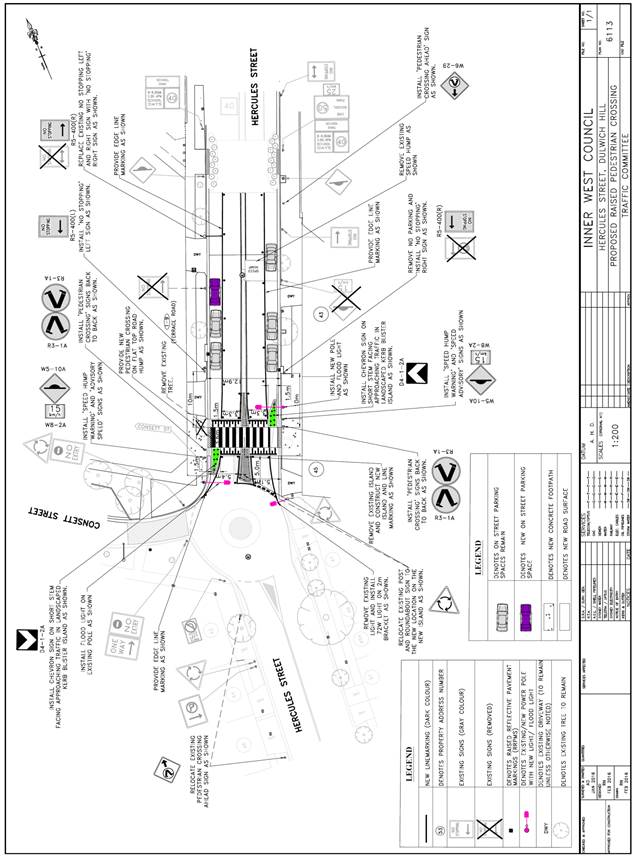
Subject: HERCULES STREET, DULWICH HILL – PROPOSED RAISED PEDESTRIAN CROSSING & KERD BLISTER ISLANDS DESIGN PLAN (ASHFIELD WARD/SUMMER HILL ELECTORATE/MARRICKVILLE LAC)
File Ref: 17/6022/52364.17
Prepared By: Emilio Andari - Civil Engineer
Authorised By: George Tsaprounis – Acting Manager Design and Investigation
|
SUMMARY A detailed design plan has been finalised for the proposed pedestrian crossing in Hercules Street, Dulwich Hill as part of Council’s Traffic Facility Capital Works Program. The proposal for a raised pedestrian crossing with kerb blisters and associated signs and line markings will improve pedestrian safety and traffic conditions at this location.
Consultation was undertaken with owners and occupiers of properties adjacent to Hercules Street, regarding the proposal. A summary of the consultation results are presented in this report for consideration. It is recommended that the proposed detailed design plan be approved. |
|
RECOMMENDATION
THAT the design of the raised pedestrian crossing with kerb blisters and associated signs and line markings in Hercules Street, Dulwich Hill, immediately north of its intersection with Consett Street (as per the attached design plan No. 6113) be APPROVED.
|
BACKGROUND
In November 2014, Council Officers and Transport for NSW (TfNSW) Officers met with Dulwich Hill Public School and P&C representatives to discuss issues in relation to the removal of the pedestrian crossing on the Hercules Street rail over-bridge installed by TfNSW as part of the Inner West Light Rail Extension Project.
During those discussions Dulwich Hill Public School and P&C the request for the provision of a pedestrian crossing in Hercules Street at Consett Street roundabout in order to improve the safety of school children crossing the road at this location.
On the 14th May 2015, a report was considered at the Pedestrian, Cyclist & Traffic Calming Advisory Committee meeting regarding the provision of a pedestrain crossing facility in Hercules Street immediately north of its roundabout intersection with Consett Street. Given that the volume of traffic and pedestrians meet RMS’s warrant for a marked foot crossing and given the need to address issues with students and others crossing Hercules Street, it was recommended that the Committee support the provision of a pedestrian crossing facility.
On the 2nd June 2015 at Council’s Infrastructure, Planning and Environmental Services Committee meeting the following recommendation was considered and adopted;
That a pedestrian crossing on Hercules Street north of the roundabout at Consett Street, Dulwich Hill, be approved in principal with the opportunity for it to be raised to be investigated in the design process.
One of the key objectives from Council’s Community Strategic Planning document is to ensure local roads are safer and less congested. The objective is to be achieved through reduced impact of traffic and improvement of pedestrian and cyclist safety, particularly around schools and urban centres.
Council is proposing to construct a raised pedestrian crossing with kerb blisters in Hercules Street, Dulwich Hill, north if its intersection with Consett Street.
The detail design plan has been finalised for the proposed devices together with the consultation and are presented in this report for consideration.
FINANCIAL IMPLICATIONS
Funding of $100,000 has been allocated by Council for the entire scope of works for Hercules Street, Dulwich Hill under the 2017/2018 Traffic Facility Capital Works Program. These works include demolishing the existing watts profile speed hump and reconstructing the existing splitter islands to construct a new raised pedestrian crossing with kerb blisters including associated signs and line markings in Hercules Street.
OFFICER COMMENTS
Site location & road network
|
Street Name |
Hercules Street |
|
Section |
Between Consett Street and Kintore Street |
|
Carriageway Width (m) |
12.8 |
|
Carriageway Type |
Two-way road with one travel lane in each direction, in addition to kerbside parking lanes. |
|
Classification |
Local |
|
85th Percentile Speed (km/h) |
45.4 |
|
Vehicles Per Day (vpd) |
2,079 |
|
Reported Crash History (July 2011 – June 2016) |
No crashes recorded. |
|
Heavy Vehicle Volume (%) |
1.1 |
|
Parking Arrangements |
Sections of unrestricted parking along both sides of the road. |
Design Plan – No. 6113
A detailed design plan for the provision of a raised pedestrian crossing with kerb blisters in Hercules Street, Dulwich Hill, immediately north of its intersection with Consett Street, including the proposed signs and line markings (ATTACHMENT - design plan No. 6113) are submitted for consideration.
The proposed scope of work includes the following:
· Reconstruct the existing splitter islands and construct a raised (concrete) pedestrian crossing with two landscaped kerb blisters.
· Remove one existing street light and provide two new flood lights on new power poles adjacent to the new raised pedestrian crossing.
· Install all other associated signage and line markings with the raised pedestrian crossing as per design plan.
· Footpath and kerb reconstruction works.
· Remove existing watts profile speed hump and associated signage and reinstate the road pavement.
The proposed treatment will result in a gain of one (1) legal on-street parking space in Hercules Street as an outcome of the proposed raised pedestrian crossing with kerb blisters (refer to the attached design plan No. 6113). All current vehicular access to adjoining properties will be retained.
PUBLIC CONSULTATION
A notification letter as well as a copy of the detailed design plans was sent on 18 April 2017 to the owners and occupiers of the affected properties in Hercules Street, Dulwich Hill regarding the proposed design plan to implement a raised pedestrian crossing with kerb blisters and associated signs and line markings. A total of 169 letters were distributed. The closing date for submissions ended on 10 May 2017.
There were a total of seven (7) responses received with five (5) responses supporting the proposal and two (2) responses opposing the proposal. These responses are detailed below.
|
Residents’ Comments (supporting the proposal) |
Officer’s Response |
|
A resident of Consett Street is in support of the proposed raised pedestrian crossing in Hercules Street. The resident is pleased about the proposal as local school children use this crossing point. |
Received and noted. |
|
A resident within the community is in support of the proposed raised pedestrian crossing in Hercules Street. The resident is pleased about the proposal as local school children use this crossing point and the resident stated that traffic conditions will be improved. |
Received and noted. |
|
A resident of Terrace Road is in full support of the proposed raised pedestrian crossing. |
Received and noted. |
|
Members of the Dulwich Hill Public School P&C Association are in full support of the proposal and state that the raised pedestrian crossing will improve the safety of the school children and community. |
Received and noted. |
|
A resident of Terrace Road is in support of the proposed raised pedestrian crossing in Hercules Street. The resident stated that this proposal will slow down traffic on the approach to the intersection and will improve pedestrian safety. |
Received and noted. |
|
Residents’ Comments (opposing the proposal) |
Officer’s Response |
|
A resident of Hercules Street is not in support of the proposed raised pedestrian crossing in Hercules Street. The resident feels that this proposal is ‘overkill’ and not required at this location. Also, concerns were raised to whether the proposed raised pedestrian crossing design will accommodate pedestrians with disabilities and will allow safe access.
|
The proposed raised pedestrian crossing will be raised to improve safety for pedestrians. The proposed device will provide a flat top on-road hump that is 3.6m wide and will include the associated pedestrian crossing line markings to guide pedestrians along the crossing pathway. The proposed raised device includes a gutter bridge on either end which is constructed to the kerb height of the footpaths to continue a flat surface footway for pedestrians. |
|
A resident of Terrace Road is not in support of the proposed raised pedestrian crossing in Hercules Street. The resident states that the reconstruction of the splitter islands will reduce the traffic lane widths for service vehicles (garbage trucks). It was also stated that the removal of the ‘No Stopping’ sign immediately south of the existing driveway to 1-9 Terrace Road will create congestion issues for garbage truck pick-up days as this small section along the footpath is currently used as an area to place the garbage bins form the adjacent residential flat building.
|
During the design of the proposed raised pedestrian crossing in Hercules Street it was identified that these existing ‘No Stopping’ signs were installed due to the previous raised pedestrian crossing that was located further north along Hercules Street (on the light rail bridge). Since then, the former raised pedestrian crossing on the light rail bridge on Hercules Street has been reconstructed as a raised threshold with landscaped kerb blisters and pedestrian fencing on either side to prevent pedestrians from crossing.
The proposal includes to shift the ‘No Stopping’ sign by installing the sign immediately north of the existing driveway to 1-9 Terrace Road adjacent to the existing pedestrian fence. The proposed treatment will result in a gain of one (1) legal on-street parking space in Hercules Street. |
CONCLUSION
It is recommended that the detailed design plan of the proposed treatment and associated signs and line markings be approved, to improve pedestrian safety and traffic conditions at this location.
|
|
Local Traffic Committee Meeting 1 June 2017 |
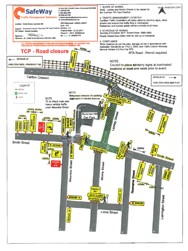
Subject: Road Occupancy - Lackey Street and
Smith Street, Summer Hill Temporary Road Closures for the annual ‘Summer
Hill Neighbourhood Food Festival’ Sunday, 8 October 2017.
(Ashfield Ward/Summer Hill Electorate/Ashfield LAC)
File Ref: 17/6022/52628.17
Prepared By: Boris Muha - Traffic and Projects Engineer
Authorised By: John Stephens - Traffic Manager
|
SUMMARY Council seeks the support of the Committee for the temporary closures of Lackey Street and Smith Street, Summer Hill for the annual Summer Hill (Neighbourhood) food festival on Sunday, 8 October 2017, as recommended below. |
|
RECOMMENDATION
THAT the road closure application for the ‘Summer Hill Neighbourhood Food Festival’ on Sunday, 8 October 2017 be supported, subject to the following conditions:
1. The road closure be restricted to occur from 6.00am and 6.00pm in Lackey Street (between Carlton Crescent and Smith Street), and Smith Street (between Moonbie Street and Nowranie Street).
2. Hardie Avenue, between Smith Street and Lackey Street be closed at Lackey Street, to allow access only to the Summer Hill carpark.
3. A Traffic Management Plan (TMP) be submitted to and approved by RMS and an application for a Road Occupancy Licence be forwarded to and approved by the Transport Management Centre.
4. Notice of the proposed Event is forwarded to the emergency services, i.e. NSW Police, Fire and Rescue NSW and NSW Ambulance Service.
5. A 4 metre wide emergency service access must be maintained through the closed road areas during the course of the event.
6. Council through its Community Service section notify/consult with all affected residents and/or businesses in the area, and conduct a letter-box/leaflet drop and local newspaper advertisement notifying the local community of the road closure event at least two (2) weeks prior to the event.
7. Advance notification signs for the event are strategically installed at least one (1) week prior to the event.
8. Adequate Vehicular traffic control shall be provided for the protection and convenience of pedestrians, cyclists and motorists, including appropriate signage and flagging. Workers shall be specifically designated for this role (and carry appropriate certificates), as necessary to comply with this condition. This is to be carried out in accordance with the Australian Standard AS 1742.3 - Traffic Control Devices for works on roads.
|
The Summer Hill (Neighbourhood) Food Festival is one of three scheduled annual food festival events to be conducted in the former Ashfield Council area during the periods of October and November 2017, in conjunction with the Sydney wide food festival program.
FINANCIAL IMPLICATIONS
The costs associated with the temporary road closures are to be borne by Council as part of its major events or operational budget.
OFFICER COMMENTS
Council Community Services organiser has identified that the event has gained popularity over the years and has requested the need to temporarily close Lackey Street (Carlton Crescent and Smith Street) and Smith Street (Moonbie Street and Nowranie Street), Summer Hill.
Hardie Avenue between Smith Street and Lackey Street will be closed at Lackey Street to through traffic and only access will be maintained to the Summer Hill carpark.
Lackey Street alone or in combination with the above section of Smith Street has been closed off in previous years for this Event with Traffic Committee support and Council, and RMS approval.
Although the Event occurs from 10am until 4pm, from an operational point of view and in order to affectively clear parking in the area and set-up and dismantle the event, the road closures will be affective from 6.00am until 6.00pm.
In accordance with the RMS 'Guide to Traffic and Transport Management for Special Events V3.4 August 2006', the event is classified either Special Event class 1 or 2. Relevant approval is required from RMS for the closure of the roads and a Road Occupancy Licence needs to be obtained from the Transport Management Centre (TMC).
Attached is a copy of the Traffic Management Plan (TMP) and Traffic Control Plan (TCP) relevant in obtaining the RMS approval and Licence from the TMC.
PUBLIC CONSULTATION
Notification of the event will be arranged by Council’s Community Services section via letterbox/leaflet drop and local newspaper advertisement.
CONCLUSION
It is recommended that support should be provided for Council to carry out the temporary road closures of Lackey Street (between Carlton Crescent and Smith Street) and Smith Street (between Moonbie Street and Nowranie Street), Summer Hill, in association with the annual Summer Hill food festival event on Sunday, 8 October 2017. Council will apply for the Road Occupancy Licence and will forward the Traffic Management Plan and associated Traffic Control Plan to the RMS for approval to close the subject roads.
|
1.⇩ |
Traffic Management Plan |
|
2.⇩ |
Traffic Control Plan |
|
Local Traffic Committee Meeting 1 June 2017 |
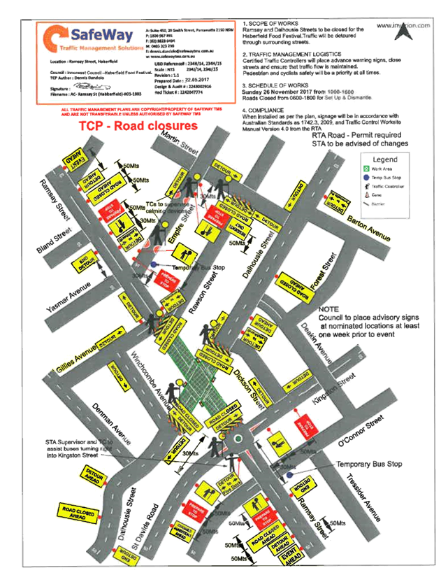
Subject: Road Occupancy- Dalhousie Street
and Ramsay Street, Haberfield – Temporary Road Closures for the annual ‘Haberfield
Festa Food Festival’ Sunday, 26 November
2017.
(Leichhardt Ward/Summer Hill Electorate/Ashfield LAC)
File Ref: 17/6022/52632.17
Prepared By: Boris Muha - Traffic and Projects Engineer
Authorised By: John Stephens - Traffic Manager
|
SUMMARY Council seeks the support of the Committee for the temporary closures of Dalhousie Street and Ramsay Street, Haberfield, for the annual Haberfield (Festa) food festival on Sunday, 26 November 2017, as recommended below. |
|
RECOMMENDATION
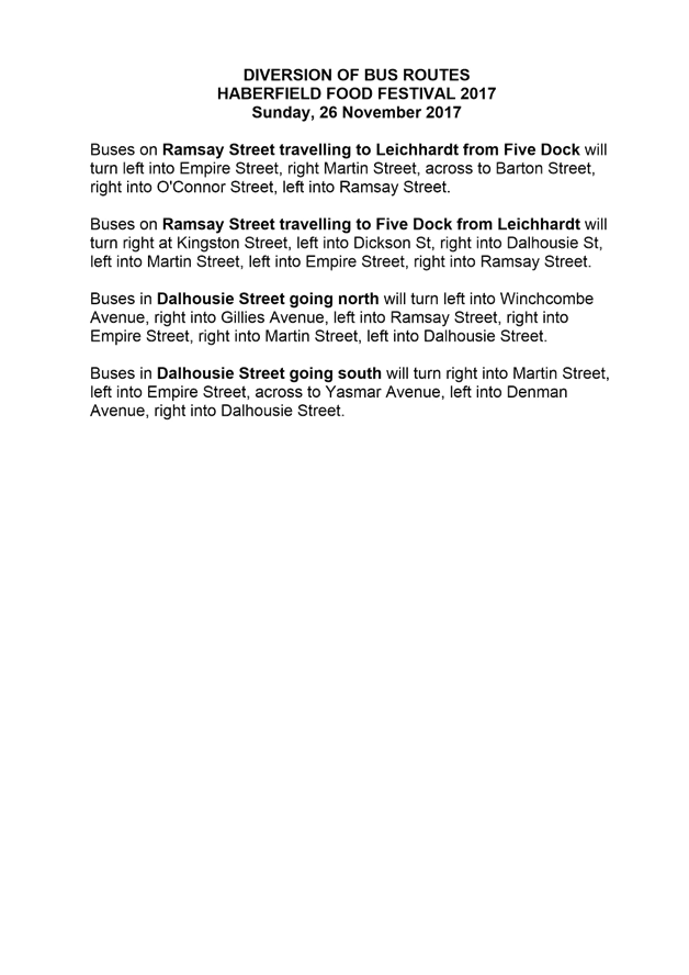
THAT the road closure application for the ‘ Haberfield Festa Food Festival’ on Sunday, 26 November 2017 be supported, subject to the following conditions: 1. The road closure be restricted to occur from 6.00am and 6.00pm in Ramsay Street (between Gillies Avenue and St. David’s Road/Kingston Street) and Dalhousie Street (between Dickson Street and Winchcombe Avenue).
2. A Traffic Management Plan (TMP) be submitted to and approved by RMS, and an application for a Road Occupancy Licence be forwarded to and approved by the Transport Management Centre.
3. Notice of the proposed Event is forwarded to the emergency services, i.e. NSW Police, Fire and Rescue NSW and NSW Ambulance Service.
4. A 4 metre wide emergency service access must be maintained through the closed road areas during the course of the event.
5. Council through its Community Service section notify/consult with all affected residents and/or businesses in the area, and conduct a letter-box/leaflet drop and local newspaper advertisement notifying the local community of the road closure event at least two (2) weeks prior to the event.
6. Advance notification signs for the event are strategically installed at least one (1) week prior to the event.
7. Adequate Vehicular traffic control shall be provided for the protection and convenience of pedestrians, cyclists and motorists, including appropriate signage and flagging. Workers shall be specifically designated for this role (and carry appropriate certificates), as necessary to comply with this condition. This is to be carried out in accordance with the Australian Standard AS 1742.3 - Traffic Control Devices for works on roads. |
The Haberfield (Festa) Food Festival is one of three scheduled annual food festival events to be conducted in the former Ashfield Council area during the periods of October and November 2017, in conjunction with the Sydney wide food festival program.
FINANCIAL IMPLICATIONS
The costs associated with the temporary road closures are to be borne by Council as part of its major events or operational budget.
OFFICER COMMENTS
Ramsay Street, between Gillies Avenue and St David’s Road/Kingston Street and Dalhousie Street, between Dickson Street and Winchcombe Avenue have been closed off in previous years for this Event with Traffic Committee support and Council, and RMS approval.
Although the Event occurs from 10am until 4pm, from an operational point of view and in order to affectively clear parking in the area and set-up and dismantle the event, the road closures will be affective from 6.00am until 6.00pm.
In accordance with the RMS 'Guide to Traffic and Transport Management for Special Events V3.4 August 2006', the event is classified either Special Event class 1 or 2. Relevant approval is required from RMS for the closure of the roads and a Road Occupancy Licence needs to be obtained from the Transport Management Centre (TMC).
Attached is a copy of the Traffic Management Plan (TMP) and Traffic Control Plan (TCP) relevant in obtaining the RMS approval and Licence from the TMC.
PUBLIC CONSULTATION
Notification of the event will be arranged by Council’s Community Services section via letterbox/leaflet drop and local newspaper advertisement.
CONCLUSION
It is recommended that support should be provided for Council to carry out the temporary road closures of Ramsay Street (between Gillies Avenue and St David’s Road/Kingston Street) and Dalhousie Street (between Dickson Street and Winchcombe Avenue), Haberfield, in association with the annual Haberfield (Festa) food festival event on Sunday, 26 November 2017. Council will apply for the Road Occupancy Licence and will forward the Traffic Management Plan and associated Traffic Control Plan to the RMS for approval to close the subject roads.
|
1.⇩ |
Traffic Management Plan |
|
2.⇩ |
Traffic Control Plan |
|
3.⇩ |
Diversion of Bus Routes |
|
Local Traffic Committee Meeting 1 June 2017 |
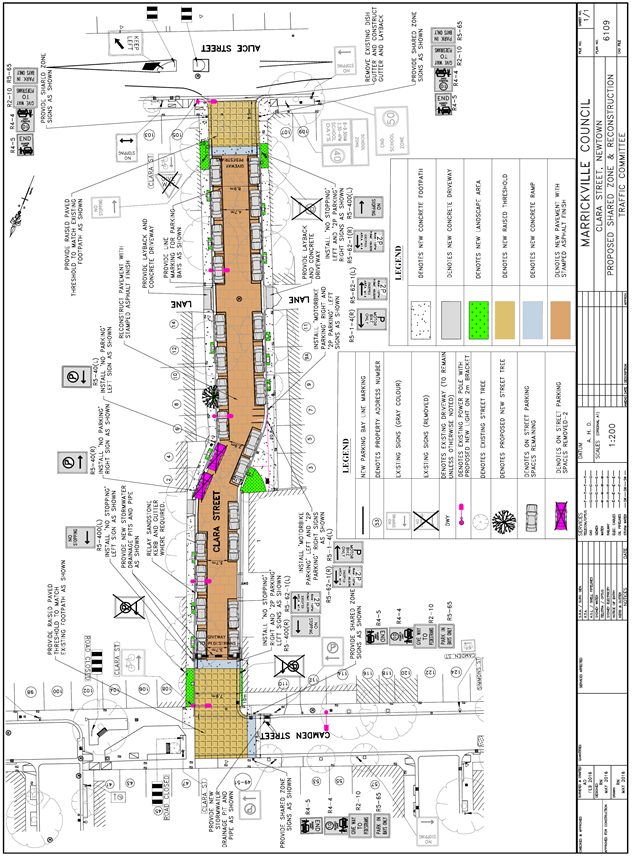
Subject: CLARA STREET, NEWTOWN – SHARED ZONE PROPOSAL DESIGN PLAN (STANMORE WARD/NEWTOWN ELECTORATE/NEWTOWN LAC)
File Ref: 17/6022/53177.17
Prepared By: Emilio Andari - Civil Engineer
Authorised By: George Tsaprounis – Acting Manager Design and Investigation
|
SUMMARY A detailed design plan has been finalised for the proposed ‘Shared Zone’ in Clara Street, Newtown as part of Council’s Capital Works Program for Roads, Drainage and Footpaths. The proposal for a ‘Shared Zone’ with threshold treatments and associated signs and line markings will improve safety and accessibility for pedestrians and traffic conditions at this location.
Consultation was undertaken with owners and occupiers of properties adjacent to Clara Street, regarding the proposal. A summary of the consultation results are presented in this report for consideration. The proposed ‘Shared Zone’ design plan was submitted to the Roads & Maritime Services (RMS) for consideration and approval. It is recommended that the proposed detailed design plan be approved subject to the concurrence of the RMS. |
|
RECOMMENDATION
THAT the proposed ‘Shared Zone’ design, threshold treatments and associated signs and line markings in Clara Street, Newtown (as per the attached design plan No. 6109) be APPROVED subject to the concurrence of the Roads & Maritime Services. |
BACKGROUND
One of the key objectives from Council’s Community Strategic Planning document is to ensure local roads are safer and less congested. The objective is to be achieved through reduced impact of traffic and improvement of pedestrian and cyclist safety, particularly around schools and urban centres.
Council is planning to improve safety and the streetscape in Clara Street, Newtown. It was identified that the footpaths in this street are difficult for people to use because they are narrow and access is further restricted by trees and power poles. This results in accessibility issues which causes pedestrians to avoid the footpaths and walk on the road.
To improve safety and accessibility for pedestrians and traffic conditions, Council is proposing to construct a ‘Shared Zone’ with threshold treatments and associated signs and line markings in Clara Street, Newtown between Camden Street and Alice Street.
A ‘Shared Zone’ application was submitted to the RMS for consideration and approval. On 14th September 2016, the RMS granted Council conditional approval for the proposal, which stated that;
Roads and Maritime is granting approval of the proposed shared zone conditional on the following:
• Council to confirm that a stage 2 and/or 3 and a stage 4 Road Safety Audit identifying issues pertaining to vehicle speeds and pedestrian safety (including mobility and vision impaired safety) has been undertaken on Clara Street and all deficiencies addressed.
• Council to ensure that the road surface is clearly distinguishable by colour, texture and/or materials for the length of the proposed 10 km/h shared zone on Clara Street. This will highlight the difference in street environment from the surrounding road network, as is required for a 10km/h shared zone.
• Council to confirm that all relevant Traffic Committee approvals have been completed.
• Council to confirm that all relevant Community Consultation have been completed.
• Council to advise Roads and Maritime when all proposed works on Clara Street are complete.
One of the requests from the RMS was for a stage 3 detailed design audit, which was completed. It should be noted that a stage 4 audit is required however this is to be undertaken after the completion of the construction works of the proposed ‘Shared Zone’ with threshold treatments and associated signs and line markings. The design plan was amended according to the stage 3 audit findings by incorporating two additional street lights on existing power poles on either end of the ‘Shared Zone’ area and also upgrading the existing street lighting in Clara Street. Furthermore, following the stage 3 audit findings, ‘Give Way to Pedestrians’ pavement markings was identified to be included in the design and have been incorporated in the amended plan showing these markings at both entry points to the ‘Shared Zone’.
The detail design plan has been finalised for the proposed treatments together with the consultation and are presented in this report for consideration.
FINANCIAL IMPLICATIONS
A total funding of $360,000 has been allocated by Council for the entire scope of works for Clara Street, Newtown under the 2017/2018 Capital Works Program. This total funding amount is a combination of Council’s Capital Works Program for Roads ($100,000), Drainage ($25,000) and Footpaths ($235,000) allocated for Clara Street.
OFFICER COMMENTS
Site location & road network
|
Street Name |
Clara Street |
|
Section |
Between Camden Street and Alice Street |
|
Carriageway Width (m) |
7.9-8.9 |
|
Carriageway Type |
Two-way road with one travel lane in each direction, in addition to kerbside parking lanes. |
|
Classification |
Local |
|
85th Percentile Speed (km/h) |
32.8 |
|
Vehicles Per Day (vpd) |
532 |
|
Reported Crash History (July 2011 – June 2016) |
1 crash recorded (Rum Code: 42). The crash resulted in only tow-away. |
|
Heavy Vehicle Volume (%) |
2.5 |
|
Parking Arrangements |
Unrestricted parking along both sides of the road. |
Design Plan – No. 6109
A detailed design plan for the provision of a ‘Shared Zone’ with threshold treatments in Clara Street, Newtown, between Camden Street and Alice Street, including the proposed signs and line markings (ATTACHMENT - design plan No. 6109) are submitted for consideration.
The proposed scope of work includes the following:
· Reconstruct damaged sections of footpath and provide landscaped areas and expand existing tree pits.
· Resurface the road and provide new coloured stamped asphalt treatment.
· Construct raised entry thresholds in Clara Street at Camden Street and Alice Street.
· Construct additional storm water pits and pipes.
· Install new line marked parking bays.
· Install ‘Shared Zone’ associated signage along with all other new signage and new line markings (as per design plan).
· Replace all existing streetlights with brighter streetlights and provide 2 new streetlights in front of property no. 112 Camden Street and property no. 105 Alice Street (as per design plan).
The proposed treatment will result in a loss of two (2) legal on-street parking spaces in Clara Street as an outcome of the proposed ‘Shared Zone’ with threshold treatments (refer to the attached design plan No. 6109). All current vehicular access to adjoining properties will be retained.
PUBLIC CONSULTATION
A notification letter as well as a copy of the detailed design plan was sent on 6 April 2017 to the owners and occupiers of the affected properties in Clara Street, Newtown regarding the proposed design plan to implement a ‘Shared Zone’ with threshold treatments and associated signs and line markings. A total of 102 letters were distributed. The closing date for submissions ended on 28 April 2017.
There were a total of eight (8) responses received with six (6) responses supporting the proposal and two (2) responses opposing the proposal. These responses are detailed below.
|
Residents’ Comments (supporting the proposal) |
Officer’s Response |
|
A resident of Clara Street is in support of the proposed ‘Shared Zone’ with threshold treatments in Clara Street. The resident also requests that the permit parking restrictions should apply to both sides of the street and not just on one side. |
The permit parking restrictions for Clara Street, Newtown have been integrated into the design as a result of the recent Newtown/Enmore Parking Study Review which was adopted by Council at its meeting on 26 April 2017. The recommendation for Clara Street is to install ‘2P 8am-10pm Permit Holders Excepted Area M14’ along the western side of the road.
One of the key objectives of the Newtown/Enmore Parking strategy is to balance the often competing needs of both residents and businesses in the precinct. As a result, the resident parking scheme, where implemented, has generally been placed on one side of street blocks. This approach aims to give eligible households in the scheme area, who take up a permit, a greater chance of finding parking closer to their property whilst still providing parking opportunities for other users such as businesses in the area, their patrons, and visitors to the area and residents who do not participate in the scheme. |
|
A resident of Clara Street is in support of the proposed ‘Shared Zone’ with threshold treatments in Clara Street. The resident is pleased with the proposal but would like to raise the concern that there is a loss of on-street parking as an outcome. The resident also raised a request to possibly introduce some motorcycle parking spaces, so that these motorcycles do not occupy the linemarked parking bays for cars since parking demands in the area are high. |
Received and noted.
As a result of the resident feedback and further detailed investigation, it was identified that motorcycles currently park in Clara Street. As a result, the design has been amended to provide an additional two linemarked parking bays for motorcycles in Clara Street. |
|
A resident of Clara Street is in support of the proposed ‘Shared Zone’ with threshold treatments in Clara Street. The resident also requests that the permit parking restrictions should apply to both sides of the street and not just on one side. |
The permit parking restrictions for Clara Street, Newtown have been integrated into the design as a result of the recent Newtown/Enmore Parking Study Review which was adopted by Council at its meeting on 26 April 2017. The recommendation for Clara Street is to install ‘2P 8am-10pm Permit Holders Excepted Area M14’ along the western side of the road.
One of the key objectives of the Newtown/Enmore Parking strategy is to balance the often competing needs of both residents and businesses in the precinct. As a result, the resident parking scheme, where implemented, has generally been placed on one side of street blocks. This approach aims to give eligible households in the scheme area, who take up a permit, a greater chance of finding parking closer to their property whilst still providing parking opportunities for other users such as businesses in the area, their patrons, and visitors to the area and residents who do not participate in the scheme. |
|
A resident of Clara Street is in support of the proposed ‘Shared Zone’ with threshold treatments in Clara Street. |
Received and noted. |
|
A resident of Camden Street is in support of the proposed ‘Shared Zone’ with threshold treatments in Clara Street. The resident raised concerns regarding the placement of a new street light outside their property. The resident suggests that an alternate location for the street light would be more appropriate (i.e. the paved footpath area where Camden Street is closed for vehicular access). The loss in parking as a result of the proposal is supported, particularly at the kink in roadway of Clara Street. Concerns have been raised by the resident regarding the noise impacts at the entry thresholds to Clara Street. |
Received and noted.
The requirement for additional lighting at property no. 112 Camden Street was identified during a road safety audit. The lighting on the paved footpath area on Camden Street (closed for vehicular access) will be investigated as a separate project.
Given that the proposal indicates advisory speed limit signs stating ‘10km/hr’ as well as ‘Shared Zone’ signs, it is envisaged that vehicles will not be travelling at high speeds to create such noise when passing through a raised entry threshold. |
|
A resident of Clara Street is in support of the proposed ‘Shared Zone’ with threshold treatments in Clara Street. Concerns have been raised by the resident regarding the loss of three on-street parking spaces as a result of the design and the fact that the proposal does not include linemarked parking bays in front of ‘unused’ driveways. The resident also raised a request to possibly introduce some motorcycle parking spaces, so that these motorcycles do not occupy the linemarked parking bays for cars since parking demands in the area are high. |
Received and noted.
As a result of the resident feedback and a further detailed investigation, it was identified that the proposed ‘No Parking’ zone adjacent to property no. 2 to no. 6 Clara Street could be shortened in length. The design has been amended to provide a proposed ‘No Parking’ zone adjacent to property no. 2 to no. 4 Clara Street which will have result in a loss of two (2) legal on-street parking spaces in Clara Street. It was identified that motorcycles currently park in Clara Street. As a result, the design has been amended to provide an additional two linemarked parking bays for motorcycles in Clara Street. |
|
Residents’ Comments (opposing the proposal) |
Officer’s Response |
|
A resident of Clara Street is not in support of the proposed ‘Shared Zone’ with threshold treatments in Clara Street. Concerns have been raised due to the fact that on-street parking is proposed to be permitted within the linemarked bays. The resident feels that there is a loss in parking due to the fact that the proposal does not include linemarked parking bays in front of ‘unused’ driveways. |
The intent of the proposed design is to provide on-street parking where possible and that’s in accordance to the Australian Standards and therefore a linemarked parking bay is not to be permitted adjacent to a vehicular crossing which provides access to off-street parking. |
|
A resident of Clara Street is not in support of the proposed ‘Shared Zone’ with threshold treatments in Clara Street. Concerns have been raised by the resident regarding the loss of three on-street parking spaces as a result of the design. The resident also raises concerns to the fact that the permit parking restrictions should apply to both sides of the street and not just on one side of the street.
|
As a result of the resident feedback and a further detailed investigation, it was identified that the proposed ‘No Parking’ zone adjacent to property no. 2 to no. 6 Clara Street could be shortened in length. The design has been amended to provide a proposed ‘No Parking’ zone adjacent to property no. 2 to no. 4 Clara Street which will have result in a loss of two (2) legal on-street parking spaces in Clara Street.
The permit parking restrictions for Clara Street, Newtown have been integrated into the design as a result of the recent Newtown/Enmore Parking Study Review which was adopted by Council at its meeting on 26 April 2017. The recommendation for Clara Street is to install ‘2P 8am-10pm Permit Holders Excepted Area M14’ along the western side of the road.
One of the key objectives of the Newtown/Enmore Parking strategy is to balance the often competing needs of both residents and businesses in the precinct. As a result, the resident parking scheme, where implemented, has generally been placed on one side of street blocks. This approach aims to give eligible households in the scheme area, who take up a permit, a greater chance of finding parking closer to their property whilst still providing parking opportunities for other users such as businesses in the area, their patrons, and visitors to the area and residents who do not participate in the scheme. |
CONCLUSION
It is recommended that the detailed design plan of the proposed treatment and associated signs and line markings be approved, to improve pedestrian safety and traffic conditions at this location.
|
|
Local Traffic Committee Meeting 1 June 2017 |
Subject: Temporary Road Closure of
Chelmsford Avenue - Dobroyd Point Public School bi-annual School Fete Event -
Saturday, 9 September 2017.
(Leichhardt Ward/Summer Hill Electorate/Ashfield LAC)
File Ref: 17/6022/53551.17
Prepared By: Boris Muha - Traffic and Projects Engineer
Authorised By: John Stephens - Traffic Manager
|
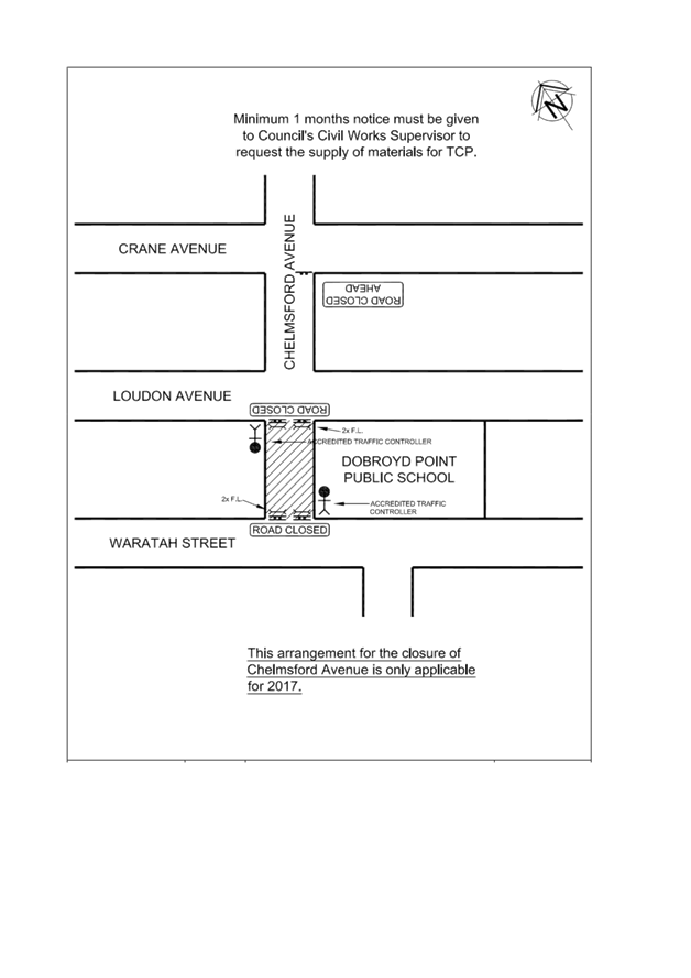
SUMMARY Council seeks the support of the Committee for a temporary full road closure of Chelmsford Avenue between Waratah Street and Loudon Avenue, Haberfield to conduct a bi-annual school fete on 9 September 2017 as recommended below. |
|
RECOMMENDATION:
THAT support be provided for the temporary closure of Chelmsford Avenue, Haberfield, between Waratah Street and Loudon Avenue on Saturday, 9 September 2017 from 10:00am to 4:00pm to conduct a bi-annual school fete, subject to the following conditions:
· The organiser is responsible to erect the signs and barricades in accordance of the Traffic Control Plan (TCP) attached, and arrange the management of the closure with RMS accredited traffic controllers.
· Council Rangers be requested to oversee the event to assure that the traffic control arrangements are correctly in place.
· The organiser is to provide Council with a risk assessment in the use of a public road and a copy of the school's current public liability insurance in the minimum amount of $20M.
· A clear passage of at least 4.0m must be provided for emergency vehicle access as required by Police.
· The organiser to arrange waste bins for litter control and make the area neat and tidy prior to the re-opening of the road.
· The organiser must arrange the dismantling of the temporary signs and barricades, and place the material in a designated area for Council to pick up after the completion of the event.
|
Mr Darren Mitchell, President of the P&C Committee of Dobroyd Point Public School has requested approval to temporarily close Chelmsford Avenue between Waratah Street and Loudon Avenue on Saturday, 9 September 2017 from 10:00am to 4:00pm to conduct a bi-annual school fete.
The road closure for this year’s school fete will be organised similarly to previous years comprising of stalls and rides. The school grounds are of limited area in the use and accommodation of all the fete activities.
This event is held bi-annually with Council granting approval in the past with the approval of RMS and Police to this closure.
The road closure is a category type "Class 3" under the RMS guideline for special events. Concurrence is only required from the Council and Police, and that RMS be only notified of the event.
FINANCIAL IMPLICATIONS
Council supply of material (signs and barricades) to the school event organiser is approximately $600.
OFFICER COMMENTS
The event is of similar arrangements to previous years and supported by the Traffic
Committee. Police and RMS have raised no objection in the past to the above special event road closure. The above section of Chelmsford Avenue is a local road with low volumes of traffic and traffic is able to be diverted into the surrounding streets.
For this type Class 3 minor event the main conditions of the road closure are:
· Council supplies material (signs and barricades) to the event organiser. The organiser is responsible to erect the signs and barricades in accordance of the Traffic Control Plan (TCP) below, and arrange the management of the closure with RMS accredited traffic controllers. Council Rangers would be requested to oversee the event to assure that the traffic control arrangements are correctly in place.
· The event entails the placement of stalls and rides on the public road. The organiser is to provide Council with a risk assessment in the use of a public road and carry public liability insurance in the minimum amount of $20M.
· A clear passage of at least 4.0m must be provided for emergency vehicle access as required by Police.
· The organiser is responsible to arrange waste bins for litter control, and make the area neat and tidy prior to the re-opening of the road.
· The organiser is responsible to dismantle the signs and barricades, and place the material in a designated area for Council to pick up after the completion of the event.
The Traffic Control Plan is attached below.
PUBLIC CONSULTATION
The organiser is responsible for notifying the residents, and the community (via local newspaper) in the area at least one week prior to the event.
CONCLUSION
That support be provided for the temporary closure of Chelmsford Avenue, Haberfield between Waratah Street and Loudon Avenue on Saturday, 9 September 2017 from 10:00am to 4:00pm to conduct a school fete. Relevant conditions imposed by Council, the RMS and Police are to be adhered to.
|
1.⇩ |
Traffic Control Plan |
|
Local Traffic Committee Meeting 1 June 2017 |
Subject: TRAFFIC CALMING – PARK
STREET, ROZELLE
(BALMAIN WARD/BALMAIN ELECTORATE/LEICHHARDT LAC)
File Ref: 17/6022/53619.17
Prepared By: Manod Wickramasinghe - Traffic and Parking Engineer
Authorised By: John Stephens - Traffic Manager
|
SUMMARY Council has investigated the installation of traffic calming facilities in Park Street, Rozelle to reduce vehicular speeds and improve safety. |
|
RECOMMENDATION
THAT:
1. The installation of an asphalt speed hump in Park Street near Darling Street on the side boundary of Nos. 747 and 753-755 Darling Street be supported.
2. That the midblock speed levels in Park Street be reviewed 6 months after the installation of the speed hump to ascertain if further action is required.
|
BACKGROUND
Council has received a number of concerns from residents in Park Street, Rozelle regarding speeding vehicles in the street.
Park Street is the first of four parallel streets which connect Darling Street with Moodie Street and subsequently Victoria Road. These routes can be used to access westbound lanes of Victoria Road and avoid the traffic lights at the intersections of Darling Street/Waterloo Street and Darling Street/Victoria Road.
It should be noted that Park Street is also the narrowest of these four streets with parking only permitted on the western side. The only existing speed calming treatment in the street is the raised threshold near Moodie Street. Similar treatments exist in the other three parallel streets and asphalt speed humps have been installed in Cambridge Street and Waterloo Street.
Traffic Counts undertaken in November 2016 in Park Street have shown 85th Percentile speeds of 42km/h and 45km/h in the northbound and southbound directions respectively. Although this is below the speed limit, these speed levels are considered to be relatively high due to the narrow width of Park Street.
PROPOSAL
In order to reduce speed levels in Park Street, Rozelle it was proposed to install two asphalt speed humps in Park Street at the following locations;
· Park Street near Darling Street – side boundary of Nos.747 and 753-755 Darling Street
· Park Street midblock – outside No.22 Park Street / rear boundary of No.20 Oxford Street
The following plan shows the location of the proposed speed humps and associated signage in Park Street.
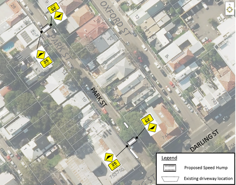
CONSULTATION
|
A letter outlining the above proposal was mailed out to the affected properties (64 properties) in Park Street, Oxford Street, Moodie Street and Darling Street, Rozelle. Responses were received from seven properties. Six properties supported the speed hump on Park Street near Darling and one objected to the proposal. Five properties supported the midblock speed hump on Park Street two objected to the proposal, including a resident who would be directly affected by the noise impact of the speed hump. |
|
|
Resident Comment |
Officer Comment |
|
A speed hump at this location would be directly outside my property and I would find this unacceptable. Speed humps cause too much noise due to people braking hard at the bump and then speeding up once over, I suggest that you have one at the top and the bottom of the street where no-one resides. |
Council has modified the proposal to only install a speed hump near Darling Street with the need for a midblock speed hump to be reviewed 6 months after installation of the initial speed hump. |
|
We have lived in Park Street since 1999 and have witnessed the increase in cars using this narrow street as a rat run for years which is dangerous due to the width of road, congestion of cars trying to manoeuvre to back out of the many garages that back onto Park Street and most importantly the excessive speed of which cars race down the street to get to Victoria Road. |
Noted. |
|
I support 25km/h signs, It has been too long coming. |
It should be noted that the ‘25km/h’ signs are advisory speed warning signs and recommend a speed over the raised device. The speed indicated is not enforceable. |
|
With the increase of traffic in this family friendly area we would like to encourage even more upgrades, like Park Street as a one way only etc. |
Council has previously (2012/2013) investigated the installation of ‘ONE WAY’ restrictions in Park Street from Darling Street to Moodie Street. This was not supported as it impacted accessibility to off street parking spaces for some residents. Council had then considered a half road closure at the intersection of Park Street and Moodie Street to ban left turn and right turn movements from Moodie Street into Park Street but retain the ‘TWO WAY’ traffic flow in the street. Again, this was not supported by some residents. |
|
I would also strongly recommend speed hump installation in Oxford St. The hill/slope creates blind spots for pedestrians and vehicles at both the top and bottom of the hill when traffic is speeding through. Many families and children live in the street and I have a young toddler. As a pedestrian with a stroller, I've had several near-misses due to unseen speeding traffic in Oxford St. |
Resident will be advised that Council requires another two written requests to trigger a formal investigation into speeding. |
|
Perhaps the council could also consider painted pedestrian crossings along Darling St in this area - particularly Denison, Park, Oxford and Cambridge. |
Previous traffic counts in these side streets have demonstrated that the vehicle volumes are not high enough to meet the RMS warrants for a marked pedestrian (zebra) crossing. |
MODIFIED PROPOSAL
Given the noise concerns raised by a directly affected resident, the proposal was modified to undertake the installation of speed calming devices in a staged approach.
Hence, it is recommended to install a speed cushion on Park Street near Darling Street on the side boundary of Nos.747 and 753-755 Darling Street. Speed levels will then be reassessed to ascertain whether speed/volume levels have decreased and whether further speed calming devices are required.
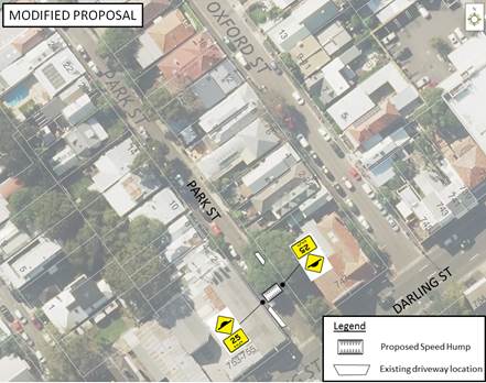
FINANCIAL IMPLICATIONS
The cost of the proposed works will be listed in the draft 2018/2019 Budget.
CONCLUSION
In order to improve pedestrian and vehicular safety in Park Street whilst taking into consideration noise concerns by residents, it is recommended that one asphalt speed hump be installed in Park Street, Rozelle near Darling Street and speed levels be reviewed following installation of this device.
|
|
Local Traffic Committee Meeting 1 June 2017 |
Subject: CENTENNIAL STREET, MARRICKVILLE – TEMPORARY ROAD CLOSURE FOR SPECIAL EVENT ON SATURDAY 22 JULY 2017 (MARRICKVILLE WARD/SUMMER HILL ELECTORATE/MARRICKVILLE LAC)
File Ref: 17/6022/53644.17
Prepared By: Emilio Andari - Civil Engineer
Authorised By: George Tsaprounis – Acting Manager Design and Investigation
|
SUMMARY A Development Application was received from the Music & Booze Company together with the Newtown Rugby League Football Club to hold the Beer, Footy & Food Festival 2017 on Saturday 22 July 2017 at Henson Park Oval and on Centennial Street, Marrickville between Sydenham Road and the entrance gate to Henson Park Oval.
It is recommended that Council agree to the temporary full-road closure of the subject section of Centennial Street, Marrickville on Saturday 22 July 2017 (weather permitted) or alternatively on Saturday 12 August 2017 subject to complying with the following conditions; apply to the RMS for consent to close the subject road, subject to the event being advertised, a Traffic Management Plan be submitted to the RMS for approval, a Road Occupancy License be obtained from the Transport Management Centre and advice of the proposed event being forwarded to the appropriate authorities including emergency services. |
|
RECOMMENDATION
THAT:
a. The proposed temporary full-road closure of Centennial Street, Marrickville between Sydenham Road and the entrance gate to Henson Park Oval on Saturday 22 July 2017 (weather permitted) or Saturday 12 August 2017 between 8:00am and 8:00pm, for the holding of the Beer, Footy & Food Festival 2017 at Henson Park Oval, be APPROVED, subject to the approval of the Development Application and the applicant complying with the following conditions:
1. A fee of $1,499.40 for the temporary road closure is payable by the applicant in accordance with Council’s Fees and Charges;
2. The temporary full road closure be advertised in the local newspaper providing 28 days notice for submissions, in accordance with the Roads Act;
3. A Traffic Management Plan (TMP) be submitted by the applicant to the Roads and Maritime Services for consideration and approval;
4. A Traffic Control Plan (TCP) which has been prepared by a certified Traffic Controller, is to be submitted to Council for review with a copy of the Traffic Controller’s certification number attached to the plan, not less than 5 days prior to implementation of the closure;
5. A Road Occupancy License application be obtained by the applicant from the Transport Management Centre;
6. Notice of the proposed event is forwarded by the applicant to the NSW Police Local Area Commander, State Transit Authority, NSW Fire Brigades and NSW Ambulance Services;
7. Advance notifications signs advising of the proposed road closure and traffic diversions to be strategically installed and maintained by the applicant at least two (2) weeks prior to the event;
8. A 4-metre wide emergency vehicle access must be maintained through the closed road areas during the course of the event;
9. All affected residents and businesses shall be notified in writing by the applicant of the proposed temporary road closure at least two (2) weeks prior to the event, with the applicant making reasonable provision for residents and businesses;
10. Adequate vehicular traffic control shall be provided for the protection and convenience of pedestrians and motorists including appropriate signage and flagging. Workers shall be specially designated for this role (and carry appropriate certificates), as necessary to comply with this condition. This is to be carried out in accordance with the Australian Standard AS 1742.3 – Traffic Control Devices for works on roads; and
11. Water filled barriers be placed at the road closure points to protect against any possible errant vehicles.
b. The applicant be advised in terms of this report and that all costs for advertising the event and implementation of the road closure are to be borne by the applicant.
|
BACKGROUND
A Development Application was received from the Music & Booze Company together with the Newtown Rugby League Football Club to hold the Beer, Footy & Food Festival 2017 on Saturday 22 July 2017 between the hours of 12:00pm and 7:00pm at Henson Park Oval and on Centennial Street, between Sydenham Road and entrance gate to the Henson Park grounds.
Given that the event date falls within the winter season and it is held outdoors, the applicant requests for an alternative date for the event if there is adverse weather. If weather is impacted, the alternate date will be on Saturday 12 August 2017. All conditions of notification will be similarly met for this alternate date.
Henson Park is Council owned land for which the Newtown Jets have a pre-existing arrangement for the use of the site. The event has received Land Owners Consent from Council.
The Newtown Jets FC has a long-standing relationship with the Sydney Inner West community and with Council. The Newtown Jets have built a reputation on delivering regular sporting matches at Henson Park Oval that are family friendly and all inclusive. The Beer, Footy & Food Festival is an extension of the Newtown Jets regular Saturday matches which local residents are familiar with. It is anticipated that the event will attract between 2,500 to 3,000 people.
FINANCIAL IMPLICATIONS
Nil.
OFFICER COMMENTS
Site location & road network
|
Street Name |
Centennial Street |
|
Section |
Between Sydenham Road and to an end |
|
Carriageway Width (m) |
12.8 |
|
Carriageway Type |
Two-way road with one travel lane in each direction, in addition to kerbside parking lanes. |
|
Classification |
Local |
|
85th Percentile Speed (km/h) |
42.5 |
|
Vehicles Per Day (vpd) |
367 |
|
Reported Crash History (July 2011 – June 2016) |
No crashes recorded. |
|
Heavy Vehicle Volume (%) |
2.2 |
|
Parking Arrangements |
Unrestricted parking along both sides of the road. |
The temporary full-road closure of Centennial Street is required from 8.00am to 8.00pm on the day of the event to undertake the setup prior to the event and cleaning after the event, before the road can be reopened to traffic.
The applicant advised that traffic controllers and barricades will be located on Centennial Street at Sydenham Road and along Sydenham Road. Centennial Street will be providing vehicular access to only local residents, event staff, football coaches and football players, and emergency services. Event attendees will ingress and egress via the laneway access point from Sydenham Road and the access point at Woodland Street with security staff and traffic controllers monitoring (refer to Site Plan of Henson Park Oval and Traffic Control Plan 1 & 2).
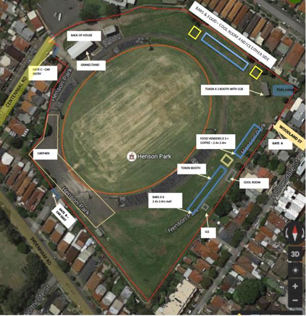 |
Site Plan of Henson Park Oval
A 4-metre wide emergency vehicle access must be maintained through the closed road areas during the course of the event. Special Event advance notice signs will be strategically installed at least two (2) weeks prior to the event to alert motorists of the proposed closures.
The subject section of Centennial Street carries a low volume of traffic and therefore will have no major impacts on surrounding road network. The event will be held on a Saturday when lower than weekday traffic volumes are expected.
The location of the event has access to public transport services, with Sydenham Railway Station located approximately 1km west along Sydenham Road and Marrickville Railway Station located approximately 1km south along Illawarra Road from the event location and bus routes (Route 412, 418, 426 & 428) operating along Livingstone Road, Marrickville Road and Addison Road.
PUBLIC CONSULTATION
The proposed full-road closure of Centennial Street, Marrickville between Sydenham Road and the entrance gate to Henson Park Oval is currently advertised in the newspaper for a period of 28 days. The advertising period commenced on 23 May 2017 and will conclude on 19 June 2017. A Traffic Management Plan is to be submitted to the RMS for consideration and approval.
The event organiser will need to notify all affected residents and businesses in writing of the proposed temporary full-road closure at least two weeks prior to the event and make reasonable provision for residents and businesses, where possible.
CONCLUSION
It is recommended that Council agree to the temporary full-road closure of the subject section of Centennial Street, Marrickville on Saturday 22 July 2017 (weather permitted) or alternatively on Saturday 12 August 2017 subject to complying with the following conditions; apply to the RMS for consent to close the subject road, subject to the event being advertised, a Traffic Management Plan be submitted to the RMS for approval, a Road Occupancy License be obtained from the Transport Management Centre and advice of the proposed event being forwarded to the appropriate authorities including emergency services.
Traffic Control Plan 1
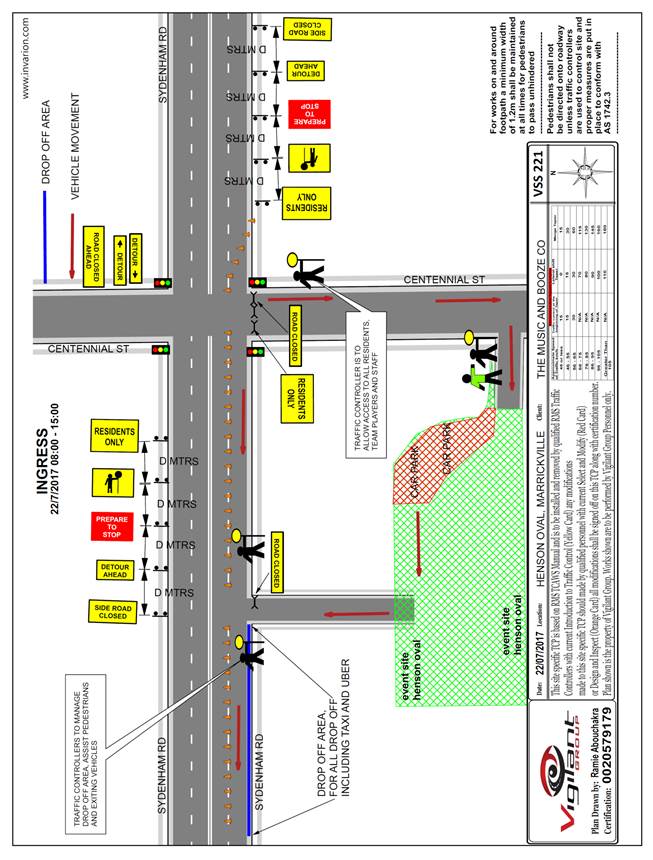
Traffic Control Plan 2
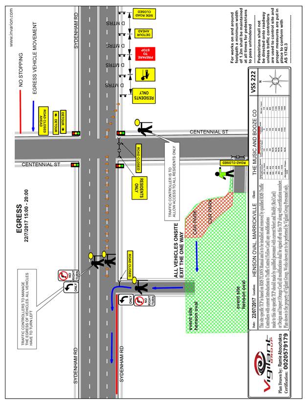
|
|
Local Traffic Committee Meeting 1 June 2017 |
Subject: PROPOSED EXTENSION OF PERMIT SCHEME - DENISON ROAD - DULWICH HILL (ASHFIELD WARD/SUMMER HILL ELECTORATE/MARRICKVILLE LAC)
File Ref: 15/5909/19801.17
Prepared By: Mary Bailey - Parking Planner
Authorised By: George Tsaprounis – Acting Manager Design and Investigation
|
SUMMARY Council officers are seeking to implement permit parking in Denison Road, Dulwich Hill (between property no. 213 Denison Road and property no. 221 Denison Road), which was originally proposed as part of the Dulwich Hill parking Strategy but not included in the recommendations for adoption at the time. The stakeholder engagement process approved of the inclusion of properties nos. 209 and 211 Denison Road, Dulwich Hill. However, those two properties were inadvertently omitted from the recommendations. This report seeks to gain approval for inclusion of those two (2) properties in the permit scheme following requests from the affected residents. |
|
RECOMMENDATION
THAT:
The installation of ‘2P 8.30am-6.00pm Mon-Fri Permit Holders Excepted Area M6’ restrictions on the southern side of Denison Road, Dulwich Hill (between property no. 209 Denison Road and property no. 211 Denison Road) be APPROVED, in order to provide parking opportunities for local residents.
|
BACKGROUND
The Dulwich Hill Parking Study was approved by Council in September 2016 and has since been implemented. The study recommendations included a section of Denison Road, Dulwich Hill (see Figure 1 for map showing recommended restrictions from Dulwich Hill Parking Study report). The recommendation developed through the community consultation and stakeholder engagement process was to have included up to properties 209 and 211 Denison Road but this was not reflected in the final recommendations. Following implementation of the Dulwich Hill signage feedback has been received from residents of both 209 and 211 Denison Road seeking to have the signage extended to cover both these properties.
The exclusion of properties no. 209 and no 211 Denison Road was an oversight proposal is to implement 2P 8.30am-6.00pm Mon-Fri Permit Holders Excepted Area M6’ restrictions on the southern side of Denison Road, Dulwich Hill between property no. 209 and 211. Both the subject properties are single unit residential dwellings with no off street parking. These properties are subject to the same impacts as those included in the scheme. Those impacts include a large multi unit residential complex and a child care centre in close proximity. The northern side of Denison Road between Constitution Road and opposite no 221 Denison Road has unrestricted parking.
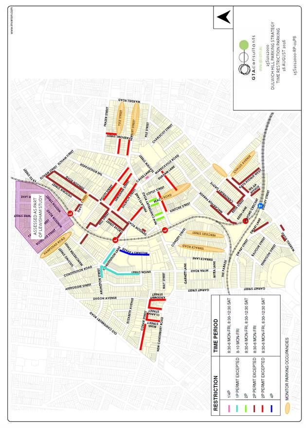
Figure 1 – Recommendations of Dulwich Hill Parking Study 2016
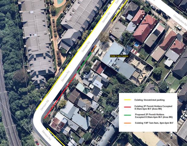
Figure 2: Existing and Proposed restrictions, Denison Road
FINANCIAL IMPLICATIONS
The costs of the supply and installation of the signposting associated with the recommended Permit Parking signage and is approximately $500 and can be covered from the signs and linemarking budget.
OFFICER COMMENTS
The proposed permit parking restrictions are supported by the affected residents. The current recommendation will include the subject properties in the resident parking scheme and addresses the outstanding proposal arising from the Dulwich Hill Parking Study that was approved by Council.
PUBLIC CONSULTATION
Both affected residents have agreed, by way of written response, to the extension of the restrictions outside their properties.
CONCLUSION
The inclusion of the two properties at no.209 and no 211 Denison Road, Dulwich Hill is in keeping with the existing restrictions from 213-221 Denison Road, Dulwich Hill and the affected residents are seeking an extension to 209 Denison Road, Dulwich Hill. This is a minor adjustment affecting only 2 properties who are in support of the proposed restrictions.
|
|
Local Traffic Committee Meeting 1 June 2017 |
Subject: REQUESTS FOR MOBILITY PARKING SPACES
(ASHFIELD & STANMORE WARDS/SUMMER HILL & NEWTOWN
ELECTORATES/MARRICKVILLE LAC)
File Ref: 17/6022/49764.17
Prepared By: Idris Hessam - Graduate Civil Engineer Traffic Services
Authorised By: George Tsaprounis – Acting Manager Design and Investigation
|
SUMMARY A number of requests have been received from residents for the provision of dedicated mobility parking space outside their residence. It is recommended that the following 'Mobility Parking' spaces be approved as the applicants current medical conditions warrants the provision of the space and they have constrained or no off-street parking opportunities. |
|
RECOMMENDATION
THAT the following locations:
1. southern side of May Street, Dulwich Hill in front of property no. 8 May Street, Dulwich Hill; 2. western side of Fotheringham Street, Enmore in front of property no. 48 Fotheringham Street, Enmore;
be APPROVED as a ‘mobility parking’ space, subject to: a) the operation of the dedicated parking space be valid for twelve (12) months from the date of installation; b) the applicant advising Council of any changes in circumstances affecting the need for the special parking space; and c) the applicant is requested to furnish a medical certificate and current mobility permit justifying the need for the mobility parking space for its continuation after each 12 months period.
|
BACKGROUND
A copy of the RMS disability parking permit and a medical certificate in support of the applications was submitted to Council
FINANCIAL IMPLICATIONS
The costs of the supply and installation of the signposting associated with the recommended mobility parking space is approximately $2000.
It should be noted that Council normally signposts on-street mobility parking spaces and does not line mark these spaces. Should the applicant require the provision of kerb ramps, this can be provided at their cost.
OFFICER COMMENTS
|
Subject Location |
Classification of Road |
Road Description |
|
May Street, Dulwich Hill |
Local Road |
Two-way residential street, 12.9m in width that runs west-east from Dead End to Union Street. |
|
Fotheringham Street, Enmore |
Local Road |
One-way residential street, 7.3m in width that runs north-south from Stanmore Road to Newington Road. |
8 May Street, Dulwich Hill
The applicant’s property is located on the southern side of May Street, Dulwich Hill. The applicant’s property has one off-street parking facility approximately 2.5m in width.
At present, unrestricted parking is permitted on both sides of May Street, Dulwich Hill. It has been observed during a site inspection undertaken in the afternoon period that on-street parking spaces in May Street were moderately utilized.
The applicant does not drive a vehicle however she is driven by her husband. It is noted based on medical certificate provided by the applicant that she will undergo lower back surgery in near future and will need the use of a wheel chair following the surgery.
Currently there is no existing mobility parking space within close proximity to the applicant’s property. Due to her current medical condition, she requires parking availability close to her property
48 Fotheringham Street, Enmore
The applicant’s property is located on the western side of Fotheringham Street, Enmore. The applicant’s property has one off-street parking facility approximately 2.5m in width.
At present, unrestricted parking is permitted on both sides of Fotheringham Street, Enmore. It has been observed during a site inspection undertaken in the afternoon period that on-street parking spaces in Fotheringham Street were moderately utilised.
The applicant does drive a vehicle and is suffering from serious ailments which greatly affects her mobility. Currently there is no existing mobility parking space within close proximity to the applicant’s property. Due to her current medical condition, she requires parking availability close to his property.
Technical Standards
Australian Standard AS2890.5-1993 “On-Street Parking” states the following in regards to the provision of parking for people with a disability:
“Parallel parking spaces shall not be marked as disabled spaces, nor included in the count of spaces available for people with disabilities unless –
i. A 3.2m wide space can be provided, e.g. by indenting the space into the footpath area; and
ii. Kerb ramps as shown in Figure 4.2(a) are also provided”.
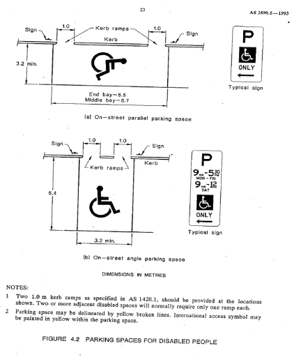
It should be noted that due to the limited width of streets around the Marrickville LGA, it is often difficult to comply with these requirements for the parking space dimensions. This may also result in the loss of some adjacent on-street parking spaces.
Mobility parking spaces are primarily intended for on-street and off-street parking at destinations, such as in commercial/retail areas and public car parks near hospitals, schools and public transport facilities where multiple usages can be expected. They were generally not intended for points of origin such as reserving on-street parking.
A mobility parking space is not intended for the sole use of one applicant, but rather a shared facility that can used by all authorised persons having an RMS mobility permit.
PUBLIC CONSULTATION
A notification letter has been sent to the applicants informing them of the application process and as part of the assessment they will be considered at this meeting.
CONCLUSION
It is recommended that ‘Mobility Parking' spaces be approved as the applicant’s properties do not have an off-street parking facility and/or the applicants condition warrants the provision of the space.
It should be noted that the proposed mobility parking spaces are not for the sole use of the applicant and may be used by other authorised persons.
Locality Map – 8 May Street, Dulwich Hill
![]()
![]()
![]()
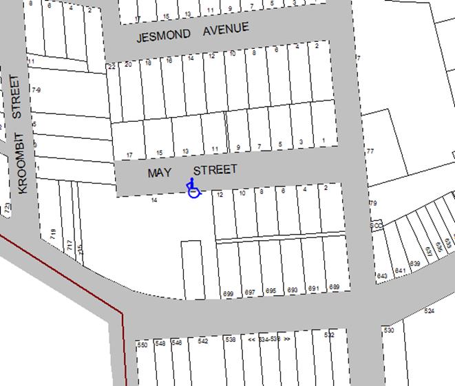
Photographs – 8 May Street, Dulwich Hill
|
|
The frontage of the applicant's property in May Street, Dulwich Hill
|
|
On-street parking in May Street, Dulwich Hill
Locality Map – 48 Fotheringham Street, Enmore
![]()
![]()
![]()
Photographs – 48 Fotheringham Street, Enmore
|
|
The frontage of the applicant's property in Fotheringham Street, Enmore
|
|
On-street parking in Fotheringham Street, Enmore
|
|
Local Traffic Committee Meeting 1 June 2017 |
Subject: DEPOT LANE, MARRICKVILLE – PROPOSED ‘NO PARKING’ RESTRICTIONS OPPOSITE INTERNAL BEND IN LANEWAY TO IMPROVE ACCESS (MARRICKVILLE WARD / SUMMER HILL ELECTORATE / MARRICKVILLE LAC)
File Ref: 17/6022/52576.17
Prepared By: Jennifer Adams - Traffic and Road Safety Officer
Authorised By: George Tsaprounis – Acting Manager Design and Investigation
|
SUMMARY A citizen has raised concerns that motorists are having difficulty in manoeuvring around Depot Lane, Marrickville due to vehicles being parked opposite the 90° bend in the laneway. It is proposed to extend the existing 8 metre length of ‘No Parking’ restrictions on the western side of the laneway 12 metres northward to improve vehicular access in the laneway. The extended parking restrictions will more readily help accommodate the swept paths of vehicles turning at the 90° bend in Depot Lane, Marrickville. Surrounding local residents have been consulted on the proposal. It is recommended that this proposal be approved. |
|
RECOMMENDATION
THAT:
1. the installation of a 12 metre extension to the existing 8 metre length of full-time ‘No Parking’ restrictions on the western side of Depot Lane, Marrickville opposite the rear of No.12 Cecilia Street to the north boundary line of No.16 Cecilia Street be APPROVED, to improve vehicular access in the laneway; and 2. the applicant, responding residents and Council Rangers be advised in terms of this report. |
BACKGROUND
Depot Lane is a local narrow laneway and has a history of residents requesting parking in the laneway be banned outright. In early 1996 a resident of a property that backed onto Depot Lane, Marrickville expressed difficulty in gaining access to the rear of their property due to vehicles parking in the narrow laneway and requested that the existing short section of ‘No Standing’ restrictions at the northern end of the laneway be extended for the full length (of the laneway).
A survey was undertaken to obtain the views of the residents on the eastern side of Cecilia and the western side of Malakoff Street, Marrickville whose properties back onto Depot Lane, regarding a proposal to install ‘No Standing/No Parking’ restrictions along the full length of the lane. At first due to the support of the majority for the proposal, the installation of ‘No Standing’ restrictions on the eastern side and ‘No Parking’ restrictions on the western side of Depot Lane along its full length north of Broadleys Lane was recommended to proceed (23 May 1996).
However the recommendation was overturned at a Committee meeting on 22 August 1996 and the present day restrictions in the laneway of a short section of ‘No Standing’ on the western side of Depot Lane directly opposite the rear of property No.91 Malakoff Street was endorsed.
Now a citizen has raised concerns that motorists are having difficulty in manoeuvring around Depot Lane, Marrickville due to vehicles being parked opposite the 90° bend in the laneway. It is proposed to extend the existing 8 metre length of ‘No Parking’ restrictions on the western side of the laneway 12 metres northward to improve access in the laneway. The extended parking restrictions will more readily help accommodate the swept paths of vehicles turning at the 90° bend in Depot Lane, Marrickville.
FINANCIAL IMPLICATIONS
The cost of the supply and installation of the signage associated with the recommended extension of existing ‘No Parking’ restrictions is approximately $600 and can be met from Council’s operating budget.
OFFICER COMMENTS
Depot Lane is a narrow laneway running north from Broadleys Lane for a distance of approximately 100 metres to a dead end. A short connecting section of lane runs east from Depot Lane to Malakoff Street forming the 90° bend. Refer to the locality map and photographs.
The lane provides rear access to properties fronting Cecilia Street and Malakoff Street. At present, ‘No Parking’ restrictions are installed on both sides of the lane for a distance of 6 metres north from Broadleys Lane and an 8 metre length of ‘No Parking’ restrictions at the rear of No.12 to14 Cecilia Street/rear of property No.92 Malakoff Street.
Several recent day-time inspections of the area revealed a number of vehicles parked in the laneway, up to eleven on the eastern side and one on the western side in the dead end area. It is noted also that some construction work was being carried out in the locality. Some vehicles were parked over driveways / garages and or directly opposite a driveway / garage.
Under NSW Road Rules (198) motorists (even if you are the owner/occupier of the property) cannot park in a way that either partially or completely blocks a driveway/garage. It should be noted that laneways were generally built to provide service access for properties and access into off-street parking facilities.
Parking in laneways
Council’s Laneway Parking Guidelines outline the measures to consider when the use of the laneway prohibits access to off-street parking and access through the laneway. The effective use of narrow streets and laneways alleviates parking pressure. Effectively managed laneways allow for adequate access while providing the maximum amount of on-street parking.
NSW legislation includes various requirements to manage access and parking on roads. The Roads Act provides rights of access along roads and also for access to private property. The Road Rules includes requirements which affect parking at intersections, driveways and also parking along laneways.
For parking to be allowed in a narrow laneway, the Australian Standards require that parallel parking spaces be at least 2.1 metres wide and NSW Road Rules requires that at least 3 metres must be available between a parked car and the kerb or edge of the laneway to allow moving vehicles to pass safely. Therefore, laneway widths that are less than 5.1 metres wide are too narrow to allow parking as any parked vehicle would prevent traffic from using the laneway (see ‘Figure 1’ below).
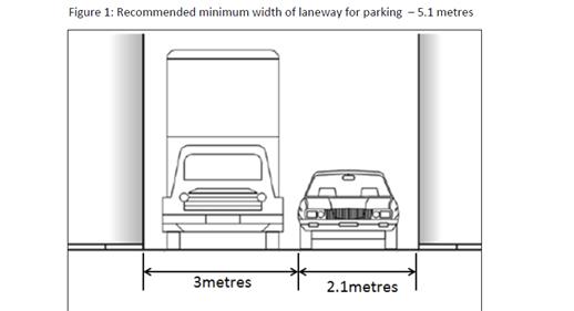
When vehicles are parked in narrow laneways near street intersections, sharp bends or driveways, there needs to be enough space for vehicles to turn. These guidelines allow for signs which ban parking to be considered next to driveways and at entries to laneways to ensure that vehicles are able to safely turn. This includes an assessment of the minimum amount of space needed for vehicles to turn in and out of a driveway. ‘Figure 4’ below shows an example of where ‘No Parking’ signs would be considered to allow a car to do a three-point turn into a laneway with parking banned on one-side of a laneway less than 6 metres wide.
As a general principle, these guidelines would restrict parking across the driveway access and also on the opposite side of the laneway to maintain vehicle access to properties. Parked vehicles which encroach into the ‘No Parking’ area are likely to obstruct vehicle access into and out of properties. Laneway and driveway locations and dimensions must be checked onsite and vehicle turning paths assessed before new parking restrictions are considered.
![]()
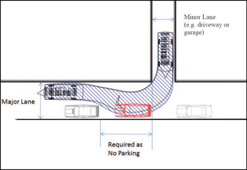
PUBLIC CONSULTATION
A notification letter was sent to 22 properties bordering Depot Lane, Marrickville regarding the proposal to improve access in the laneway. It is noted that ‘eastern’ was used in the text and it should have read ‘western’. The closing date for submissions ended on 26 May 2017.
To date of writing this report two responses are forthcoming with one supporting the proposal and the other objecting to the proposal.
|
Citizen Comment |
Officer Response |
|
Supports proposal and advised that when vehicles are parked opposite the 90° bend in Depot Lane it is difficult to drive a vehicle around the corner.
Also if vehicles are parked opposite garage resident cannot access their off street parking easily if at all. |
When vehicles are parked in narrow laneways near sharp bends there needs to be enough space for vehicles to turn. The extension of the existing ‘No Parking’ restrictions on the western side of Depot Lane northward by 12 metres will more readily accommodate the swept paths of vehicles turning at the 90° bend in the laneway.
It should be noted that laneways were generally built to provide service access for properties and access into off-street parking facilities.
|
|
Objects to the proposal as Depot Lane only option for them to park generally despite having M5 residential parking permits - ‘there is simply nowhere else to park’…..’most of spaces in Malakoff taken by transient parkers.’
|
It should be noted that laneways were generally built to provide service access for properties and access into off-street parking facilities.
|
CONCLUSION
In order to improve vehicular access in the laneway and to provide adequate space to accommodate the swept paths of vehicles turning at the 90° bend in Depot Lane, Marrickville it is recommended to extend the existing 8 metre length of ‘No Parking’ restrictions on the western side of the laneway 12 metres northward.
Locality Map – Depot Lane, Marrickville
 |
|||||||||||||
 |
|||||||||||||
 |
|||||||||||||
 |
|||||||||||||
 |
|||||||||||||

Proposed extension of the existing ‘No Parking’ restrictions in the laneway.

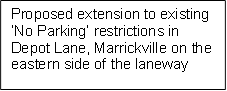
![]()
![]()
![]()
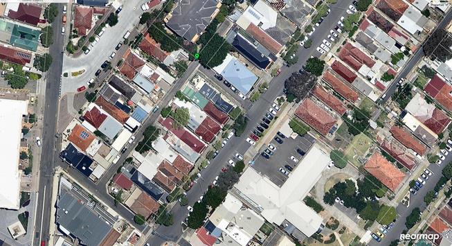
![]()
Photographs – Depot Lane, Marrickville
|
|
Concept diagram of 12m extension of existing 8m length of ‘No Parking’ restrictions in Depot Lane
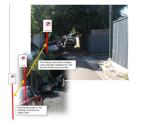
|
|
Local Traffic Committee Meeting 1 June 2017 |
Subject: CARDIGAN LANE, BETWEEN SALISBURY ROAD AND ROWLEY STREET, CAMPERDOWN – ‘NO PARKING’ RESTRICTIONS IN THE LANEWAY (STANMORE WARD / NEWTON ELECTORATE / NEWTOWN LAC)
File Ref: 17/6022/52584.17
Prepared By: Jennifer Adams - Traffic and Road Safety Officer
Authorised By: George Tsaprounis – Acting Manager Design and Investigation
|
SUMMARY Representations have been received from local residents for the installation of full time ‘No Parking’ restrictions in Cardigan Lane, between Salisbury Road and Rowley Street, Camperdown as vehicular access is often blocked by parked vehicles in the laneway and some residents cannot access their off-street parking space. Residents adjoining the subject section of laneway have been notified of the proposal to install ‘No Parking’ restrictions along the entire western length of the laneway along with statutory 10 metre ‘No Stopping’ signs at both ends of the laneway at its intersections with Salisbury Road and Rowley Street.
During the community engagement phase several objections were received and the recommendation differs from the original proposal. The final proposal is a reduced length of ‘No Parking’ rather than the entire laneway.
|
|
RECOMMENDATION
THAT:
1. an 8 metre length of ‘No Parking’ restrictions be installed on the western side of Cardigan Lane directly outside the rear of properties No.106 and No.104 Cardigan Street (excluding driveways) be APPROVED, in order to provide unobstructed vehicular access to off-street car parking spaces; 2. statutory ‘No Stopping’ restrictions be installed for a distance of 10 metres at the south end of Cardigan Lane at its intersection with Rowley Street, Camperdown be APPROVED, in order to deter illegal parking, improve access for turning motorists and increase safety; and 3. the applicant, respondents and Council Rangers be advised in terms of this report.
|
BACKGROUND
Council Officers have been advised that vehicular access to Cardigan Lane, between Salisbury Road and Rowley Street, Camperdown is often blocked by vehicles parked in the laneway with some residents unable to access their off-street parking when vehicles are parked opposite/over their driveway/garage.
FINANCIAL IMPLICATIONS
The costs of the supply and installation of the signposting associated with the recommended ‘No Parking’ & ‘No Stopping’ restrictions are approximately $800 and can be met from Council’s operating budget.
OFFICER COMMENTS
The subject section of Cardigan Lane, between Salisbury Road and Rowley Street, Camperdown is a narrow 4.9 metre one-way south thoroughfare and runs parallel to Kingston Road and Cardigan Street. The lane provides rear access to properties fronting Kingston Road and Cardigan Street, therefore there are driveways located on both sides of the laneway. At present the laneway has no parking restrictions and vehicles park on both sides, though generally vehicles are parked on the western side. Statutory 10 metre ‘No Stopping’ restrictions are already in place at the laneways’ intersection with Salisbury Road. (Refer to the attached locality map and photographs)
A site inspection undertaken by a Council Officer revealed that some vehicles parked in front of garages/off-street parking spaces in addition to any legal parking in the laneway. Under NSW Road Rules (198) motorists (even if they are the resident of the property) cannot park in a way that either partially or completely blocks a driveway/garage. It is also noted that some legal spaces are located opposite driveways and when a vehicle is parked in these spaces it does not leave sufficient space for residents to enter/exit from their garages/off-street parking spaces due to the narrow carriageway.
Parking in laneways
Council adopted the Laneway Parking Guidelines which outline the measures to consider when the use of the laneway prohibits access to off-street parking and access through the laneway. The effective use of narrow streets and laneways alleviates parking pressure. Effectively managed laneways allow for adequate access while providing the maximum amount of on-street parking. The Laneway Parking Guidelines outline the priorities for using narrow laneways and the actions and processes that Council will use to manage access and parking. These guidelines have been developed to provide consistency for evaluating the need for parking controls and manage the use of narrow streets and laneways to maintain access and maximise parking. The need for parking controls is based on the width of the laneway shown below in ‘Table 1’.
Table 1: Laneway Parking Guidelines Laneway Width
|
Laneway Width |
Parking and Access Arrangements |
|
5.1 metres or more wide |
· Parking allowed on at least one side of the laneway · Allows access for emergency, delivery and waste collection trucks at all times · Complies with Australian Standards and Road Rule 208(7) |
|
Less than 5.1 metres |
· Parking NOT permitted in the laneway · Allows vehicle access at all times and complies with Australian Standards and Road Rule 208(7) |
NSW legislation includes various requirements to manage access and parking on roads. The Roads Act provides rights of access along roads and also for access to private property. The Road Rules includes requirements which affect parking at intersections, driveways and also parking along laneways.
Parking in narrow laneways next to intersections and driveways can cause access and safety concerns for residents. NSW Road Rules address these issues as they prohibit parking across property driveways and within 10 metres of an intersection without traffic lights.
For parking to be allowed in a narrow laneway, the Australian Standards require that parallel parking spaces be at least 2.1 metres wide and NSW Road Rules requires that at least 3 metres must be available between a parked car and the kerb or edge of the laneway to allow moving vehicles to pass safely. Therefore, laneway widths that are less than 5.1 metres wide are too narrow to allow parking as any parked vehicle would prevent traffic from using the laneway (see figure below).
|
Figure 1: Recommended minimum width of laneway for parking – 5.1 metres
|
Council’s preference is for residents to negotiate with each other to avoid implementing parking bans. Where problems occur, parking restrictions can be considered for individual laneways on a case-by-case basis. The guidelines provide consistency for assessing the need for parking controls.
It should be noted that laneways were generally built to provide service for properties and access into off-street parking facilities therefore restricting parking in this laneway will help achieve this goal.
PUBLIC CONSULTATION
A notification letter was sent to all 42 properties adjoining the subject section of Cardigan Lane, between Salisbury Road and Rowley Street, Camperdown regarding the proposal to install full-time ‘No Parking’ restrictions along the entire western side of the laneway including statutory ‘No Stopping’ restrictions at either end of the subject section of laneway. The closing date for submissions ended on 26 May 2017.
Resident survey findings
A total of five (5) responses were received from residents. Of these submissions, one supported the proposal, 4 objected. All commented on the scarcity of parking in the area and that the adjoining M3 residential parking permit scheme restrictions is impacting them and is creating a demand for parking in the laneway.
Comments from residents
|
Comments from respondent
|
Council Officer’s comments |
|
Resident supports the proposal and says laneway access and resident’s garages are frequently blocked by vehicles parking over their driveway/garage and/or parked on the opposite side of the lane from their driveway/garage obstructing safe entry and exit to/from the property.
|
Received and noted. |
|
Resident does not agree with Council’s proposal to install ‘No Parking’ restrictions in Cardigan Lane because it is difficult to find parking in locality generally and the laneway is only used as last resort by locals, as some are not eligible for parking permits.
|
It should be noted that laneways were generally built to provide service access for properties and access into off-street parking facilities. |
|
Resident opposes proposal and correctly recognised that notification letter mistakenly had ‘eastern’ instead of ‘western’ side written for proposed ‘No Parking’ restrictions.
Resident submitted ‘that should Council be determined to institute parking restrictions in Cardigan Lane, it should be for BOTH SIDES’ of the laneway not just the western side - to prevent transfer of parked vehicles on eastern side and block access to Cardigan Street residents to their garages.
Resident commented that the local area adversely impacted with displaced vehicles parking in the locality due to introduction of nearby Residential Parking Schemes, noting that sometimes due to pressure parking in the laneway is their only option (they previously submitted a petition in relation to displaced parking during parking study).
It was noted that some people do not park vehicles in their garages instead use them for storage. |
Noted.
Council’s preference is for residents to negotiate with each other to avoid implementing parking bans. Where problems occur, parking restrictions can be considered for individual laneways on a case-by-case basis.
It is acknowledged that Residential Parking Schemes (RPS) do have a ‘knock on’ effect and motorists who do not have a permit will look at alternative locations to park. Introducing RPSs to one side of the street reduces the ‘knock on’ effect.
When any resident has made off street parking unavailable due to change of use (for example, using for storage) or by granting usage to a third party, the space/garage will still be counted as being ‘accessible’, therefore limiting the maximum number of any permits available to resident if eligible.
|
|
Resident commented that making the whole of the laneway ‘No Parking’ may create more issues than it solves, pushing vehicles from Cardigan Lane to Kingston Street which is already at capacity, causing significant frustration for residents. Suggested clearer demarcation of laneway parking/accessways may be a solution.
|
Council’s preference is for residents to negotiate with each other to avoid implementing parking bans. Where problems occur, parking restrictions can be considered for individual laneways on a case-by-case basis.
|
|
Resident living in Cardigan Street objects (via their lawyer) to the proposal as it would make it more difficult for them/residents to park in their own street, which is parked out by ‘parishioners’ and/or ‘health care workers’. Why not get church /hospital to provide more parking for their patrons.
Notes that ARR - Regulation 198 prohibits the obstruction of access to and from a public footpath and driveway providing Council sufficient power to ensure clear access to off street parking.
Notes also that Council should focus on campaign to educate the public about Australian Road Rules (ARR) and parking rules.
|
Effectively managed laneways allow for adequate access while providing the maximum amount of on-street parking. It should be noted that laneways were generally built to provide service access for properties and access into off-street parking facilities.
Sometimes the issue in a laneway is not a vehicle parked over a driveway but a vehicle parked opposite a driveway/garage, which hinders/blocks access.
Motorists holding NSW driving licences should be conversant with ARRs. Council’s Rangers can be requested to undertake enforcement to influence driver behaviour.
|
CONCLUSION
As the general opinion of responding residents has indicated they are not in favour of the installation of parking restrictions along the entire western length of Cardigan Lane between Salisbury Road and Rowley Street, Camperdown the proposal should not proceed. Rather, a short 8 metre length of ‘No Parking’ restrictions be installed on the western side of Cardigan Lane directly outside the rear of properties No.106 and No.104 Cardigan Street (excluding driveways) be APPROVED, in order to provide unobstructed vehicular access to off-street car parking spaces.
Locality Map – Cardigan Lane, between Salisbury Road & Rowley Street, Camperdown
![]()

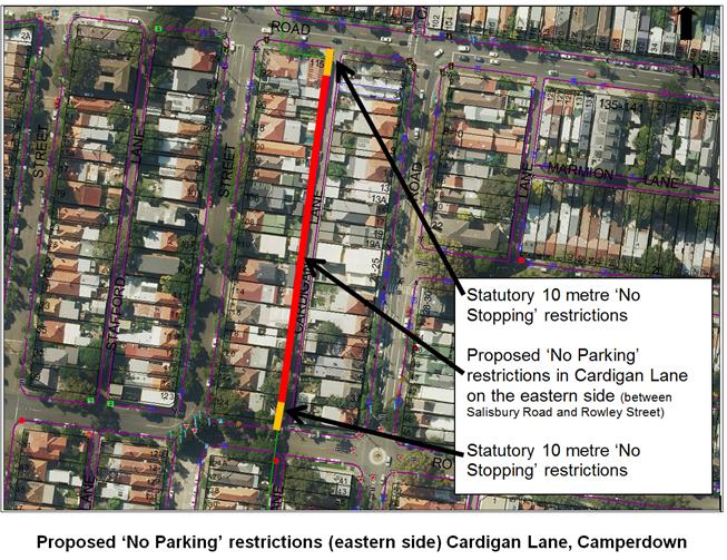
Photographs – Cardigan Lane, Camperdown
|
|
Looking southward along Cardigan Lane from Salisbury Road, Camperdown
|
|
Looking northward along Cardigan Lane from Rowley Street, Camperdown (near map)
Location of new signage – Cardigan Lane, Camperdown
![]()
![]()
![]()
![]()
![]()


![]()
![]()
![]()
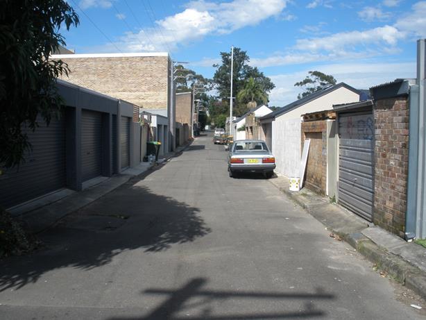
|
|
Local Traffic Committee Meeting 1 June 2017 |
Subject: REQUEST FOR WORKS ZONE INSTALLATION
OUTSIDE
17 GROSVENOR CRESCENT, SUMMER HILL
(ASHFIELD WARD/SUMMER HILL ELECTORATE/ASHFIELD LAC)
File Ref: 17/6022/52639.17
Prepared By: Helal (Henry) Uddin - Assistant Engineer
Authorised By: John Stephens - Traffic Manager
|
SUMMARY A request has been received from a developer to install a temporary 'Works Zone' between 7.00am to 6.00pm Mon – Fri and 7.00am to 1.00pm Sat within the frontage of 17 - 18 Grosvenor Crescent, Summer Hill. The Works Zone is required to assist construction vehicles in the loading and unloading of materials at the site. |
|
RECOMMENDATION
THAT:
1. A 10m 'Works Zone 7.00am to 6.00pm Mon-Fri and 7.00am to 1.00pm Sat' be temporary installed outside 17-18 Grosvenor Crescent, Summer Hill for 5 months.
2. The “2P, 8.00am to 6.00pm Permit Holder Excepted Area10” restricted parking permit zone outside 17-18 Grosvenor Crescent, Summer Hill be temporarily removed.
3. The cost of the supply, installation and removal of the Works Zone signs is to be met by the applicant, in accordance with Council’s current Fees and Charges.
|
BACKGROUND
As the property is being refurbished, the builder for the development at 17 Grosvenor Crescent, Summer Hill has requested Council arrange for the installation of a temporary Works Zone outside 17-18 Grosvenor Crescent, Summer Hill.
FINANCIAL IMPLICATIONS
The cost of supply, installation and removal of the signs and fees for Works Zone in accordance with Council’s fees and charges are to be borne by the applicant.
OFFICER COMMENTS
Grosvenor Crescent between Dover and Bogan Street is a two way street approximately 8.6m kerb to kerb. The northern side carriageway of the street for eastbound traffic has 2 lanes, one through traffic and one parking lane, whereas on the southern side, there is only one westbound through traffic lane. Currently, '2P, 8.00am to 6.00pm Mon – Fri Permit Holders Excepted Area 10' parking restrictions apply on the northern side of the road and alongside the subject location for the 'Works Zone'.
The proposed 'Works Zone' is 10m in length and is required for approximately five months. The parking space outside the property is highly utilised by the local residents and the public. Therefore, the provision of a 'Works Zone' would provide a safe facility for the loading and unloading of construction materials during the development period.
PUBLIC CONSULTATION
Not applicable. The 'Works Zone' would be shared within the frontage kerb lane of 18 Grosvenor Crescent. The neighbouring owner has provided agreement for the 'Works Zone' to span across his/her property frontage.
CONCLUSION:
The proposed temporary 'Works Zone' will generally assist parking of work vehicles for the loading and unloading of construction materials for the site. It is recommended that a Works Zone be placed outside 17-18 Grosvenor Crescent, Summer Hill.
|
1.⇩ |
Aerial view proposed works zone location |
|
2.⇩ |
Photo of Works zone location |
|
Local Traffic Committee Meeting 1 June 2017 |
Subject: MINOR TRAFFIC FACILITIES
(LEICHHARDT & BALMAIN WARDS/ BALMAIN ELECTORATE/ LEICHHARDT LAC)
File Ref: 17/6022/53567.17
Prepared By: Manod Wickramasinghe - Traffic and Parking Engineer
Authorised By: John Stephens - Traffic Manager
|
SUMMARY This report deals with minor traffic facility applications received by Inner West Council, Leichhardt and includes ‘Disabled Parking’ and ‘Works Zone’ applications. |
|
RECOMMENDATION
THAT:
1. the ‘Disabled Parking’ space in front of No.33 Springside Street, Rozelle be removed as the zone is no longer required.
2. a 9m 'Works Zone 7.00am - 5.00pm Mon-Fri, 7.00am - 1.00pm Sat' be installed in front of No.22 Charlotte Street, Rozelle for 12 weeks with the resident parking zone being temporarily removed.
3. a 9m 'Works Zone 7.00am - 5.00pm Mon-Fri, 7.00am - 1.00pm Sat' be installed in front of No.54 Nelson Street, Rozelle for 12 weeks with the resident parking zone being temporarily removed.
|
BACKGROUND
This report considers minor traffic facility applications received by Inner West Council, Leichhardt and includes ‘Disabled Parking’ and ‘Works Zone’ requests.
FINANCIAL IMPLICATIONS
The installation of ‘Disabled Parking’ signage is funded from Council’s operating budget and ‘Works Zones’ signage from fees and charges paid by the applicant.
OFFICER COMMENTS
1 Removal of ‘Disabled Parking’ Restriction – Springside Street, Rozelle
Council Ref: DWS 4310467
The resident of No.33 Springside Street, Rozelle has advised that the applicant to the ‘Disabled Parking’ zone in front of the property has passed away and thus the ‘Disabled Parking’ zone is no longer required.
Officer’s recommendation
That the ‘Disabled Parking’ space in front of No.33 Springside Street Rozelle be removed as the zone is no longer required.
2 Installation of ‘Works Zone’ Restriction – Charlotte Street, Rozelle
Council Ref: DWS 4339484
The applicant has requested the installation of a temporary 9m 'Works Zone 7.00am - 5.00pm Mon-Fri, 7.00am - 1.00pm Sat' in front of No.22 Charlotte Street, Rozelle for 12 weeks.
Officer’s recommendation
That a 9m 'Works Zone 7.00am - 5.00pm Mon-Fri, 7.00am - 1.00pm Sat' be installed in front of No.22 Charlotte Street, Rozelle for 12 weeks with the resident parking zone being temporarily removed.
3 Installation of ‘Works Zone’ Restriction – Nelson Street, Rozelle
Council Ref: DWS 4309801
The applicant has requested the installation of a temporary 9m 'Works Zone 7.00am - 5.00pm Mon-Fri, 7.00am - 1.00pm Sat' in front of No.54 Nelson Street, Rozelle for 12 weeks.
Officer’s recommendation
That a 9m 'Works Zone 7.00am - 5.00pm Mon-Fri, 7.00am - 1.00pm Sat' be installed in front of No.54 Nelson Street, Rozelle for 12 weeks with the resident parking zone being temporarily removed.
|
|
Local Traffic Committee Meeting 1 June 2017 |
Subject: PART TIME LOADING ZONE – MARION STREET, LEICHHARDT (LEICHHARDT WARD/BALMAIN ELECTORATE/LEICHHARDT LAC)
File Ref: 17/6022/53573.17
Prepared By: Manod Wickramasinghe - Traffic and Parking Engineer
Authorised By: John Stephens - Traffic Manager
|
SUMMARY Council has received a request for a ‘Loading Zone’ on Marion Street, Leichhardt (east of Edith Street) to facilitate deliveries for local businesses in the area. |
|
RECOMMENDATION
THAT a 6m ‘Loading Zone 8am-6pm Mon-Fri’ be installed on the southern side of Marion Street, Leichhardt outside of No.118 Marion Street (adjacent to the existing ‘No Stopping’ zone). |
BACKGROUND
Council has received a request from a business on Marion Street for a ‘Loading Zone’ facility to enable deliveries to be made for local businesses on Marion Street between Flood Street and Elswick Street, Leichhardt.
This section of Marion Street has a high demand for on-street parking and there is currently no provision for delivery vehicles or other short term parking restrictions. This can result in illegal and unsafe parking behaviour by delivery drivers.
PROPOSAL
In order to address these concerns, it is proposed that a 6m ‘Loading Zone 8am-6pm Mon-Fri’ (1 vehicle space) be installed on the southern side of Marion Street, east of Edith Street, Leichhardt as shown on the following plan:
CONSULTATION
|
A letter outlining the above proposal was mailed out to the affected properties (105 properties) in Marion Street, Edith Street and Elswick Street, Leichhardt. Responses were received from four properties and all of them supported the proposal.
|
|
|
Resident Comment |
Officer Comment |
|
Suppliers struggle to unload products to the local stores and have to stop either in the middle of the road or somewhere that is not practical for regular drivers passing by. |
Proposal will assist deliveries at this location. |
FINANCIAL IMPLICATIONS
The cost of the signposting will be funded from Council’s operational budget.
CONCLUSION
It is recommended that a 6m ‘Loading Zone 8am-6pm Mon-Fri’ to be installed on the southern side of Marion Street, Leichhardt.
|
|
Local Traffic Committee Meeting 1 June 2017 |
Subject: ‘NO PARKING’ AND ‘NO STOPPING’ RESTRICTIONS – UNNAMED LANEWAY BETWEEN IVORY LANE AND NATIONAL STREET, LEICHHARDT (LEICHHARDT WARD/BALMAIN ELECTORATE/LEICHHARDT LAC)
File Ref: 17/6022/53589.17
Prepared By: Manod Wickramasinghe - Traffic and Parking Engineer
Authorised By: John Stephens - Traffic Manager
|
SUMMARY Council has received concerns from residents of Albert Street, Leichhardt requesting signage to prevent vehicles from blocking access to their off-street parking facilities. |
|
RECOMMENDATION:
THAT a 30m ‘No Parking’ zone to be installed on the northern side of the unnamed laneway between Ivory Lane and National Street with statutory 10m ‘No Stopping’ zones on the northern side of the laneway at its intersections with Ivory Lane and National Street, Leichhardt.
|
BACKGROUND
Council has received a number of concerns from residents of Albert Street, Leichhardt regarding vehicles parking on the northern side of the unnamed laneway between Ivory Lane and National Street, Leichhardt and subsequently obstructing rear driveway access.
In order to look into short and long term solutions to these issues an on-site meeting was held in April between the affected residents, Traffic Engineers and Enforcement officers.
Council’s enforcement team have subsequently been patrolling the unnamed lane and issuing infringements; however, the issue is ongoing.
Residents have advised that the problem may be a result of parking generation from building works on George Street, Leichhardt.
PROPOSAL
The subject laneway is only wide enough to support parking on one side of the lane and therefore, it is proposed to signpost the northern side of the laneway as a ‘No Parking’ zone including installation of the statutory 10m ‘No Stopping’ zones on the northern side of the laneway at its intersections with Ivory Lane and National Street.
On-street parking will be retained on the southern side of the laneway.
This proposal is shown on the following plan.
CONSULTATION
|
A letter outlining the above proposal was mailed out to the affected properties (24 properties) in Albert Street and National Street, Leichhardt. No responses were received. |
|
FINANCIAL IMPLICATIONS
The cost of the signposting will be funded from Council’s operational budget.
CONCLUSION
It is recommended that ‘No Parking’ signage be installed on the northern side of the unnamed laneway between Ivory Lane and National Street with statutory 10m ‘No Stopping’ zones on the northern side of the laneway at its intersections with Ivory Lane and National Street.
|
|
Local Traffic Committee Meeting 1 June 2017 |
Subject: ROSSER STREET, BALMAIN/ROZELLE –
RESIDENT PARKING SCHEME
(LEICHHARDT/BALMAIN/LEICHHARDT LAC)
File Ref: 17/6022/53593.17
Prepared By: Nina Fard - A/Traffic Team Leader
Authorised By: John Stephens - Traffic Manager
|
SUMMARY Council in mid-2016 received correspondence from a number of residents of Rosser Street, raising concerns regarding increased parking demands generated by residents, commuters, trades vehicles and the employees/patrons of Balmain Hotel to the north and commercial buildings along Mansfield Street, Rozelle to the south.
This report provides the result of a resident parking scheme investigation in Rosser Street, Balmain/Rozelle.
|
|
RECOMMENDATION:
THAT Council install '2P 8am-10pm, (7 Days), Permit Holders Excepted, Area B1&R1’ parking restrictions in Rosser Street, Balmain/Rozelle between Mansfield Street, Rozelle and Reynolds Street, Balmain. |
BACKGROUND
A number of residents from Rosser Street, Balmain/Rozelle requested the implementation of a resident parking scheme in their street in mid-2016. Consequently, parking occupancy surveys were undertaken in Rosser Street, Balmain/Rozelle in accordance with Council’s Resident Parking Scheme Policy that indicated high parking occupancy levels (equal to or over 85%) in the street.
Currently in Mansfield Street, south of Rosser Street, there are ‘2P 8am-6pm Mon-Fri, Permit Holders Excepted, Area R1’ restrictions and in Reynolds Street, north of Rosser Street, there are ‘2P 8am-10pm, Permit Holders Excepted, Area B1’ restrictions to assist residents to park. It should also be noted that Rosser Street operates as a one-way street in the northbound direction between Mansfield Street, Rozelle and Reynold Street, Balmain.
Residents were consulted with the following two resident parking scheme options in October 2016 to gauge their support for the preferred scheme:
· Extension of ‘2P 8am-10pm (7 Days), Permit Holders Excepted, Area B1’ in Rosser Street, Balmain/Rozelle.
· Extension of ‘2P 8am-6pm Mon-Fri, Permit Holders Excepted, Area R1’ in Rosser Street, Balmain/Rozelle.
Community consultation showed the overall resident support rate for a resident parking scheme in Rosser Street, Balmain/Rozelle was 51%. Although that is the case, Council did not proceed with a resident parking scheme in Rosser Street at the time as Council was having ongoing discussions with Roads and Maritime Services in regards to approving a footway parking scheme, including a 10km/h Shared Zone on Rosser Street, Balmain/Rozelle.
This proposal would impact parking arrangements in the street and as such, the RPS proposal in the street was postponed pending the outcome of the footway parking and Shared Zone proposal.
Council has since received a formal response from Roads and Maritime Services and is currently working to address the issues raised by RMS in regards to the proposed footway parking including a 10km/h Shared Zone scheme. In the interim, further requests for the installation of a resident parking scheme have been made by residents of Rosser Street, Balmain/Rozelle. In order to alleviate the ongoing parking problems in Rosser Street, it is proposed to proceed with implementing the resident parking scheme proposal which received the highest support rate during the consultation period.
FINANCIAL IMPLICATIONS
The cost of the signposting will be funded from Council’s operational budget.
OFFICER COMMENTS
A Resident Parking proposal was prepared to extend one of the following two resident parking schemes in Rosser Street, Balmain/Rozelle.
· Extension of ‘2P 8am-10pm (7 Days), Permit Holders Excepted, Area B1’ in Rosser Street, Balmain/Rozelle.
· Extension of ‘2P 8am-6pm Mon-Fri, Permit Holders Excepted, Area R1’ in Rosser Street, Balmain/Rozelle.
As shown on the following map.
|
Consultation A letter outlining the above parking proposal options was mailed out to the affected properties (83 properties) in Rosser Street, Balmain/Rozelle as indicated on the attached plan, requesting residents’ views regarding the proposal.
|
|
The table below shows some of the comments raised by the residents who did not support the proposal and the officer’s comments.
Comments from residents objecting to the proposal
|
Residents’ Comments |
Officer Comments |
|
The high parking levels are between 5pm and 10pm (I have lived in the street for 18 years). I also object to "No Stopping" zones at the intersections of Rosser Street. The garage I have is too small to accommodate my car; therefore, I need to park my car on the street. |
Council has been notified of parking problems in Rosser Street at night and weekends. The option of implementing resident parking scheme that extends until 10pm has been included to measure residents support for an extended scheme. Should a resident parking scheme for Rosser Street, Balmain/Rozelle be approved, the statutory ‘No Stopping’ zones at intersections will be signposted as per the requirements of NSW Road Rules. |
|
The problem with Rosser St parking is that the people in the units 56-62 won’t use there underground parking. if they were to use it there would be no need for 2 hour parking. |
The parking occupancy levels, undertaken in accordance with Council’s Resident Parking Policy has shown parking occupancy levels higher than 85% during AM and PM peak periods. These hours are indicative of non-resident (commuter) parking. Notwithstanding the above, the maximum number of resident parking permits issued to a household can be one or two on the off-street parking available on-site. |
|
Permit scheme would only make it more difficult for trades etc that need to park all day for certain works to be completed. Again, if this was in operation 7 days per week, it would make it difficult for families and friends to visit for extended periods. |
Eligible properties will be issued with one visitor parking permit that can be used for friends or relatives or trades that require parking for longer than 2 hours. |
|
My residence does have a garage it is too small for my car and accordingly I would like to receive a permit. |
Council staff can conduct a site inspection to determine whether a garage space is wide enough to accommodate a standard vehicle. Should the garage width be inadequate a second resident parking permit can be issued under exceptional circumstances. |
|
Should the restrictions be put into place, the overflow of cars, on one end, will spill onto Reynolds St which has a parking restriction zone of B1. It is unreasonable to only allow the residents of Rosser St to have R1 permits. |
Council acknowledges that Rosser Street stretches across the suburb boundary between Balmain and Rozelle. The street has R1 restriction zone in Mansfield Street, Rozelle to the south and B1 restriction zone on Reynold Street, Balmain to the north. As such, the proposal has been amended to include both B1 and R1 zones to allow residents the use of their closest restricted area. |
Consultation survey results are summarised as follows:
Rosser Street, Balmain/Rozelle
Number of properties - 83 (including corner properties)
Number of properties responded - 66
Number of properties supported - 42
Overall Response Rate - 79.5%
Overall Support Rate - 51%
Residents supporting Option One ‘2P 8am-10pm (7 Days), Permit Holders Excepted, Area B1’
Number of respondents - 66 (including corner properties)
Number of properties supported - 31
Option One Support Rate - 47%
Residents supporting Option Two ‘2P 8am-6pm Mon-Fri, Permit Holders Excepted, Area R1
Number of respondents - 66 (including corner properties)
Number of properties supported - 11
Option Two Support Rate - 16%
According to Council’s Resident Parking Policy, a minimum of 50% support based on all properties in the subject section of the street is required to consider the proposal favourably.
Based on the above results and the comments provided as part of the consultation process, more than 50% of the residents of Rosser Street, Balmain/Rozelle support a resident parking scheme in their street. The majority of the supporting residents preferred option one (2P 8am-10pm (7 Days), Permit Holders Excepted, Area B1) but were concerned with being unable to park in area R1 should the proposal be approved. In response to residents’ comments the option one proposal is amended as follows:
· Extension of ‘2P 8am-10pm (7 Days), Permit Holders Excepted, Area B1 and R1’ in Rosser Street, Balmain/Rozelle.
CONCLUSION
Based on the above results, the RPS proposals in Rosser Street, Balmain/Rozelle received more than 50% support from the residents. As such, it is recommended that the proposed ‘2P 8am-10pm (7 Days), Permit Holders Excepted, Area B1 and R1’ restrictions be supported for implementation.
|
|
Local Traffic Committee Meeting 1 June 2017 |
Subject: LITTLE STEPHEN STREET, BALMAIN –
RESIDENT PARKING SCHEME AND ‘NO PARKING’ RESTRICTIONS –
(LEICHHARDT/BALMAIN/LEICHHARDT LAC)
File Ref: 17/6022/53610.17
Prepared By: Nina Fard - A/Traffic Team Leader
Authorised By: John Stephens - Traffic Manager
|
SUMMARY Council received correspondence from residents of Palmer Street with rear access to Little Stephen Street, Balmain raising concerns regarding increased parking demands generated by nurses of Stacy House and commuters.
Council consulted the affected residents regarding a Resident Parking Scheme in Little Stephen Street, Balmain in early 2017. A report was submitted to the April 2017 Traffic Committee and the proposal was deferred, for further investigations as some residents expressed concerns regarding the proposal.
This report provides the result of a revised resident parking scheme investigation in Little Stephen Street, Balmain.
|
|
RECOMMENDATION
THAT: 1) ‘2P 8am-10pm, Permit Holders Excepted, Area B2’ parking restrictions be installed at the following locations: · South side of Little Stephen Street, Balmain (side boundary of No. 54 Palmer Street). · West side of Little Stephen Street, Balmain (rear boundary of Nos. 54-60 Palmer Street).
2) ‘No Stopping’ zones be installed at the following locations: · Statutory 10m ‘No Stopping’ zones on Little Stephen Street at the intersection of Palmer Street, Balmain. · 5m of ‘No Stopping’ zone approaching the bend on the south side of Little Stephen Street, east-west direction. · 5m of ‘No Stopping’ zone approaching the bend on the west side of Little Stephen Street, north-south direction.
3) ‘No Parking’ zones be installed at the following locations: · North Side of Little Stephen Street, Balmain (side boundary of No. 52 Palmer Street) · East side of Little Stephen Street, Balmain (along the boundary of Balmain Hospital)
4) ‘No Turnaround area for Vehicles over 6m’ advisory signage be installed at the Palmer Street entry to Little Stephen Street, Balmain.
|
BACKGROUND
Council received correspondence from the residents of Palmer Street, Balmain with rear access to Little Stephen Street, Balmain in early 2017 requesting the implementation of a resident parking scheme in Little Stephen Street to deter long term parking and maintain access to their gates.
Currently in Palmer Street near Little Stephen Street, there are ‘2P 8am-10pm, Permit Holders Excepted, Area B2’ restrictions to assist residents to park.
Parking occupancy surveys were undertaken in Little Stephen Street, Balmain and they indicated high parking occupancy levels (equal to or over 85%) in the street. As such, a RPS proposal was prepared and submitted to April Traffic Committee to extend the ‘2P 8am-10pm, Permit Holders Excepted, Area B2’ at the following locations:
· South side of Little Stephen Street, Balmain (Side boundary of 54 Palmer Street).
· West side of Little Stephen Street, Balmain (Rear boundary of 54-58 Palmer Street).
In addition, ‘No parking’ zones were proposed at the following locations:
· North side of Little Stephen Street, Balmain (Side boundary of 52 Palmer Street).
· East side of Little Stephen Street, Balmain (along the boundary of Balmain Hospital).
· West side of Little Stephen Street, Balmain (Rear boundary of 60 Palmer Street, to allow turning space at the end of the laneway)
A number of directly affected residents attended the Traffic Committee meeting and requested consideration be given to permit turning at the bend in Little Stephen Street, adjacent to No.54 Palmer Street, which is the widest part of Little Stephen Street.
Balmain Hospital has restricted access to their land at the south end of Little Stephen Street, in response to safety concerns raised by the local residents. This has removed the previously available turning space. The south end of Little Stephen Street is too narrow to allow manoeuvring space without the risk of damaging vehicles and the adjoining properties.
The following revised resident parking proposal and combination of ‘No Stopping’ and ‘No Parking’ zones are proposed to maintain access throughout Little Stephen Street and to provide a turning space at the bend in the street:
Proposed ‘2P 8am-10pm, Permit Holders Excepted, Area B2’ parking restrictions:
· South side of Little Stephen Street, Balmain (side boundary of No. 54 Palmer Street).
· West side of Little Stephen Street, Balmain (rear boundary of Nos. 54-60 Palmer Street).
Proposed statutory and supplementary ‘No Stopping’ zones:
· Statutory 10m ‘No Stopping’ zones on Little Stephen Street at the intersection of Palmer Street, Balmain.
· 5m of ‘No Stopping’ zone approaching the bend on the south side of Little Stephen Street, east-west direction.
· 5m of ‘No Stopping’ zone approaching the bend on the west side of Little Stephen Street, north-south direction.
Proposed ‘No Parking’ zones:
· North Side of Little Stephen Street, Balmain (side boundary of No. 52 Palmer Street)
· East side of Little Stephen Street, Balmain (along the boundary of Balmain Hospital)
The above mentioned parking restrictions are shown on the following map:
It is also proposed to install ‘No Turnaround area for Vehicles over 6m’ advisory signage at the Palmer Street entry to Little Stephen Street to complement the existing ‘No Through Road’ sign.
FINANCIAL IMPLICATIONS
The cost of the signposting will be funded from Council’s operational budget.
OFFICER COMMENTS
A notification letter outlining the revised Resident Parking proposal including the above mentioned ‘No Parking’ and ‘No Stopping’ restrictions was prepared and mailed out to the directly affected residents (Nos. 50-64 Palmer Street, Balmain).
It should be noted that property Nos. 50-64 Palmer Street, Balmain have previously supported the proposed RPS restrictions. No further responses/objections were received at the time of finalising this report.
The Acting General Manager of Balmain Hospital in an email dated 28/03/2017 supported the proposed parking arrangements for Little Stephen Street, Balmain.
CONCLUSION
Based on the above results, the RPS proposals in Little Stephen Street, Balmain received more than 50% support from the directly affected residents. As such, it is recommended that the amended ‘2P 8am-10pm, Permit Holders Excepted, Area B2’ restrictions and the supplementing ‘No Parking’ and ‘No Stopping’ restrictions be supported for implementation.
|
|
Local Traffic Committee Meeting 1 June 2017 |
Subject: MARION STREET CAR PARK EXTENSION,
LEICHHARDT
(LEICHHARDT WARD/BALMAIN ELECTORATE/LEICHHARDT LAC)
File Ref: 17/6022/53629.17
Prepared By: Manod Wickramasinghe - Traffic and Parking Engineer
Authorised By: John Stephens - Traffic Manager
|
SUMMARY In order to provide additional parking capacity for the general public and Council operational vehicles, Council is proposing to expand its car park adjacent to Leichhardt Service Centre and Leichhardt Town Hall. |
|
RECOMMENDATION
THAT: 1. The car parking plan in Attachment 1 detailing the demolition of Nos.9 and 11 Marion Street and construction of additional car parking be supported.
2. The existing driveway layback on the northern side of Marion Street immediately west of No.11 Marion Street be closed following construction of the expanded car park and that the metered parking restrictions be extended across the new kerb space.
3. The unnamed east-west accessway (Council owned) located on the northern boundary of Leichhardt Town Hall be signposted as “No Entry; Council Authorised Vehicles Excepted”.
|
BACKGROUND
At the Council meeting held on Wednesday 26th April 2017, the Administrator determined that:
1. Council prepares a car parking plan on the site of 9 and 11 Marion Street Leichhardt which is to be reported to the Local Traffic Committee following a community engagement process;
2. should the car parking plan be approved by the Local Traffic Committee, Council proceeds with this work under the SEPP (Infrastructure) 2007; and
3. Council provides $300,000 funding in the draft 17/18 budget for the demolition of the former cottages at 9 and 11 Marion Street, Leichhardt and replacement with parking area.
The properties between No.1C and 11 Marion Street were purchased by Council in connection with administrative accommodation issues in the 1980s.
Since that time, some of these buildings were demolished for additional car parking and only the two former cottages at Nos.9 and 11 Marion Street and the demountable installed temporarily in about 1991 continued to be used as staff offices.
The cottages are now unoccupied and in disrepair with high estimated costs to maintain them. As the cottages are not fit for modern offices or other interim uses, it is recommended that Council demolish the cottages and use the space for additional parking.
It should be noted that under Leichhardt Council these cottages were also identified for demolition as part of a proposed Leichhardt Civic Precinct; however, a decision on the future of this precinct will now be a matter for the new Inner West Council. In the meantime, the demolition of the two cottages that are the end of their useful life and the creation of car parking is the next logical step in the future development of the site.
The current carpark capacity of the Marion Street site is made up of the following components (total of 86 spaces):
East of Town Hall
· 57 spaces (4 Disabled spaces; 2 Car Share spaces; 2 P15min spaces; 12 spaces closed to public & 37 Public spaces (Authorised Council Vehicles Excepted))
East of No.9 Marion Street
· 12 spaces closed to public for staff parking & 9 additional stacked spaces
East of the above car park (West of No.1A Marion Street)
· 17 public spaces 2 hour limit (Authorised Council Vehicles Excepted)
The main carpark east of the Town Hall operates as ‘2P 8am-8pm Mon-Fri Authorised Council Vehicles Excepted’, as does the carpark adjacent to No.1A Marion Street (Associazione Napoletana). The central carpark immediately east of No.9 Marion Street operates as a Council staff carpark 7.30am-5pm Mon-Fri (with stacked parking) and then reverts to a 2P public carpark 5pm-8pm Mon-Fri.
Parking studies in recent years identified that there was a shortfall of parking for the current
mix of businesses and there was limited capacity to increase off-street parking. The Marion
Street carpark operates with an efficient layout with plenty of access i.e. two lanes off Marion
Street and single access at the rear. However, efficiency could be improved by an additional
internal aisle (east-west) so vehicles wouldn't need to proceed back into Marion Street to
access the other north-south aisle and has been incorporated into the proposed car parking
layout.
Parking occupancy surveys also indicated high occupancy rates with good levels of parking
turnover during the 2P midweek period and operating hours of 8am-8pm Mon-Fri.
It should be noted, that there is shortly to be a relocation of Inner West Council staff members throughout the various Inner West administration buildings, including staff previously at Ashfield and Petersham moving to Leichhardt which is not on the train line. The additional parking capacity proposed should allow these operation vehicles to be accommodated without impacting on parking for adjacent residents and businesses.
In addition to the benefit of additional parking supply for Council employee vehicles, there would be an overall community benefit as identified in previous parking studies.
The current carpark provides free parking for the following land uses:
· Council Administration Centre
· Leichhardt Town Hall (LTH)
· External after school care provider in LTH
· Leichhardt Public School (for overflow parking demand before and after school drop
· Leichhardt child care centres (e.g. corner of Wetherill Street and Balmain Road) - parents and carers
· Leichhardt main street retail businesses - shoppers
· All Souls Anglican Church opposite Town Hall
· Anglicare retirement home nearby in Marion Street
PROPOSAL
In order to increase parking supply for the community and Council staff vehicles, it is proposed to demolish the two buildings at 9 and 11 Marion Street and replace them with a car parking area.
This expansion is expected to create 22 new parking spaces for the community and Council staff. This will consist of:
· 15 spaces “2P 8am-8pm Mon-Fri Authorised Council Vehicles Excepted”
· Six spaces “Area Closed to Public 7:30am-5pm Mon-Fri Authorised Council Permits Only; 2P Public Car Park 5pm-8pm”
· One space on-street in Marion Street “2P Ticket 8am-6pm Mon-Sat; 4P Ticket 6pm-10pm Mon-Sat, 8am-10pm Sun; Authorised Council Vehicles Excepted”
The following plan shows the existing Marion Street site and a detailed plan showing the proposal is shown in Attachment 1 (existing configuration shown in Attachment 2).
TOWN PLANNING COMMENTS
Council, as a public authority, may demolish the existing public administration buildings at 9 &
11 Marion Street Leichhardt, as this demolition would constitute works not requiring consent
under the SEPP (Infrastructure) 2007. Council may also create an open carpark without any
further requirement, as these works would constitute Exempt development under the SEPP.
CONSULTATION
|
PUBLIC CONSULTATION
A letter outlining the above proposal was mailed out to the affected properties (331 properties) and placed on Council’s Website (Your Say Inner West) for comment from the general public and those consulted. The consultation received 157 page visits, of which there were 25 individuals who participated in the survey. 16 respondents did not support the proposal whilst 6 respondents supported the proposal and an additional 3 supported it with changes. An additional letter of support was received from Uniting Church/Epworth House in Wetherill Street.
|
|
|
Public Comment |
Officer Response |
|
The cottages should be retained or sold and used for other community purposes.
|
Under Leichhardt Council these cottages were identified for demolition as part of a proposed Leichhardt Civic Precinct; however, a decision on the future use of this precinct will now be a matter for the new Inner West Council. In the meantime the demolition of the two cottages that are the end of their useful life and the creation of car parking is the next logical step in the future development of the site. |
|
I am in favour of the proposed demolition and the creation of much needed extra parking space especially as it creates an open area that can be used in the future by council for expanded facilities. |
|
|
We should not be encouraging more car parking but working on improving public transport.
Existing parking is sufficient |
An independent parking study identified a parking shortfall in Leichhardt. This proposal will assist in addressing this shortfall.
It should be noted that public transport falls under the State Government and Council supports improvements to the Public Transport network. Council has recently commissioned a study on public transport opportunities for Parramatta Road.
|
|
The car parking plan should be reconfigured to close the second crossing closest to the Fire Station (subject to an accident this morning as well). This would allow vehicles to exit only at the driveway closest to the Fire Station and Enter only via Wetherill Street and the driveway on Marion Street closest to the Town Hall. The closing of 2 crossings on Marion Street will make available additional on street parking spaces. |
The scope for this project included retention of the two eastern car parks as separate car park areas due to the unique permits applicable in both. Hence both existing driveway access points need to be maintained. |
|
The existing decorative fences along Marion Street (associated with the buildings to be demolished) be kept and used as a decorative feature with landscaping on the car park side. |
The design team is investigating the feasibility of retaining the fencing as a decorative feature. |
|
The murals on the existing cottages will be lost which will be a shame as they bring visitors to the area. |
Council’s Placemaking and Public Art Officer will look at opportunities to improve placemaking in the car park. |
|
Inner West Bicycle Coalition supports the pro-active stance the former Leichhardt Council has taken towards bicycle parking facilities provision through its Bike plan and DCP. To reinforce this stance and to set an example to the community generally we would recommend that Council devotes 2 car spaces (to comply with 10% modal split in DCP) to a protected bicycle parking enclosure in close proximity to adjacent land uses. |
Provision of additional bicycle parking is being investigated by the Design Team as part of the detailed design. |
|
There should also be the provision of bike racks for staff and public use.
|
|
|
This increases the amount of hard surfaces so increases run-off during heavy rain, increases heat on hot days. |
There will be provision for garden beds and planting of trees as part of this proposal which will be a decrease to the amount of hard surfaces in its present state. |
|
Norton Street businesses needs more parking. |
Noted, this proposal addresses those concerns. |
ADDITIONAL PROPOSAL
In addition to the expansion of the existing car park, Council is proposing to close the private (Council Owned) accessway running east-west on the northern boundary of Leichhardt Town Hall to the general public. This accessway connects the main car park adjacent to the Town Hall to Norton Street.
This additional proposal would involve the provision of ‘NO ENTRY COUNCIL AUTHORISED VEHICLES EXCEPTED” signage as shown on the plan below:
The accessway width varies between 3.2m and 3.7m and thus can only support traffic in one direction; however, it is a two-way lane. The accessway currently carries insignificant traffic volumes and is primarily used as a pedestrian thoroughfare.
The primary vehicular use of the accessway is to access the off-street parking space assigned to the Leichhardt Town Hall care taker. This access will be maintained.
FINANCIAL IMPLICATIONS
Costs of demolition of cottages and replacement with car parking are estimated at approximately $300,000 and will be funded in the 2017/2018 budget.
The cost of signposting the accessway closure to public vehicles will be funded from Council’s operational budget.
CONCLUSION
The former cottages at 9 and 11 Marion Street, Leichhardt are in disrepair and unsuitable for
any modern use. They have reached the end of their useful life and their retention is not
warranted. Demolition of the two former cottages at Nos.9 and 11 Marion Street is a
logical next step in the redevelopment of the Marion Street site. The area should be replaced
with car parking to support surrounding land uses as shown in the design plans.
|
1.⇩ |
Marion Street Car Park Extension - Proposal |
|
2.⇩ |
Marion St Car Park Extension - Site Survey |
|
Local Traffic Committee Meeting 1 June 2017 |
Subject: (B) VARIOUS LOCATIONS OUTSIDE SCHOOLS IN INNER WEST LGA – RMS NOTICE OF WORK TO UPGRADE SCHOOL ZONE SIGNS (VARIOUS WARDS / ELECTORATES / LACS)
File Ref: 17/6022/52566.17
Prepared By: Jennifer Adams - Traffic and Road Safety Officer
Authorised By: George Tsaprounis – Acting Manager Design and Investigation
|
SUMMARY Council has been notified by the Roads and Maritime Services (RMS) that they are upgrading school zone signs at 104 schools across the state. These upgrades include removing and replacing the existing static signs with school zone signs with flashing light signs to improve the safety for students. Work commences mid-May and the upgrade is due to finish before the end of June 2017.
|
|
RECOMMENDATION
THAT this report be received and noted. |
BACKGROUND
Council was notified on 18 May 2017 that the RMS is upgrading school zone signs at 104 schools across the state. This includes removing and replacing the existing static signs with school zone flashing lights signs to improve the safety for students. The upgrade works to these signs will be starting from 15th May and finish before the end of June 2017.
FINANCIAL IMPLICATIONS
Nil.
OFFICER COMMENTS
Roads and Maritime Services is upgrading school zone signs at 400 schools across the state. The new flashing lights signs are additional to existing flashing lights signs around the school. Currently the RMS manages over 5800 school zones flashing signs that keep school children safe across NSW. Installing flashing lights signage in school zones has led to improved driver awareness of driving at a lower speed to ensure the safety of children and people coming and going from the school area.
New flashing signs will be installed and tested at a time outside school zone operational hours. Once the new signs are working, the old static signs will be removed.
Locations are listed below:
|
School |
School Zone Road Name |
Cross Streets |
Suburb |
Electorate |
Work Start Date |
Work End Date 2017 |
|
Kegworth Public School |
Lords Road |
between Upward Street and Davies Street |
Leichhardt |
Balmain |
Thursday 1 June |
Thursday 22 June |
|
Orange Grove Public School |
Balmain Road |
between Helena Street and Eric Street |
Lilyfield |
Balmain |
Thursday 1 June |
Thursday 22 June |
|
St Brendan's Primary School and Annandale Public School |
Trafalgar Street |
between Albion Street and Booth Street |
Annandale |
Balmain |
Thursday 1 June |
Thursday 22 June |
|
St Paul of the Cross Catholic Primary School |
May Street |
at the intersection of Union Street |
Dulwich Hill |
Summer Hill |
Thursday 1 June |
Friday 30 June |
|
Marrickville West Public School |
Beauchamp Street
Henson Street |
between Livingstone Road and Ewart Street
Between Beauchamp Street and Phillips Lane |
Marrickville |
Marrickville |
Thursday 1 June |
Friday 30 June |
|
Tempe High School and Tempe Public School |
Union Street
Way Street |
between Princes Highway and Unwins Bridge Road
between Unwins Bridge Road and Toyer Street |
Tempe |
Heffron |
Thursday 1 June |
Friday 30 June |
PUBLIC CONSULTATION
The project is being managed by the RMS.
CONCLUSION
It is recommended that this report be received and noted.
|
|
Local Traffic Committee Meeting 1 June 2017 |
Subject: REGIONAL ROUTE 2 (PARRAMATTA ROAD TO MARRICKVILLE PARK) - DRAFT CONCEPT PLAN FOR PUBLIC EXHIBITION
File Ref: 16/6001/48892.17
Prepared By: Benny Horn - Cycling Planner
Authorised By: George Tsaprounis - Coordinator Traffic Engineering Services
|
SUMMARY In 2016, Council received a grant from NSW Roads and Maritime Services to develop a concept plan for bicycle route improvements between Parramatta Road and Marrickville Park, identified as part of Regional Route 2 in Council’s Marrickville Bicycle Strategy.
This report presents a draft concept plan for the route. Consistent with Council’s strategic priority to support bicycle riding in the local area, the draft concept plan proposes a combination of mixed traffic treatments, shared paths and intersection modifications to make bicycle riding safer, more comfortable and more convenient for people of all riding abilities. The concept plan incorporates preliminary input from the community and other stakeholders.
This report recommends that the draft concept plan be placed on public exhibition, with a further report to be prepared detailing outcomes of consultation and a final concept plan. |
|
RECOMMENDATION
THAT:
1. the draft concept plan for Regional Route 2 be placed on public exhibition for 28 days; and 2. following public exhibition, a further report be prepared detailing outcomes of consultation and a final concept plan.
|
BACKGROUND
In 2007, Council adopted the Marrickville Bicycle Strategy following consultation with stakeholders including the local community. Consistent with Council’s commitment to encourage bicycle riding, the Bicycle Strategy aims to make riding a bicycle easier, safer and more attractive, and proposes a network of bicycle routes. Regional Route 2 (RR2) is a route identified in the Bicycle Strategy to link Leichhardt and Earlwood via Marrickville Park.
In 2016, Council received a grant from NSW Roads and Maritime Services (RMS) to develop a concept plan for improvements to part of RR2 between Parramatta Road (at West Street) and Marrickville Park, consistent with the NSW Government’s objective of making bicycle riding a safe, convenient and enjoyable transport option for short trips. The project aims to support bicycle riding by enhancing connections for residents and visitors to:
· public transport (including Lewisham train station; major bus routes on Parramatta Road);
· local destinations such as schools (e.g. Petersham Public School), major parks (Marrickville Park and Petersham Park) and local shops; and
· other bicycle routes, including to the GreenWay, Marrickville town centre and Sydney CBD.
In early 2017, Council engaged GTA Consultants to develop the RR2 concept plan. A draft concept plan for public exhibition has now been developed and is presented in this report.
FINANCIAL IMPLICATIONS
Detailed design and construction of the route are dependent on future budgets and grants.
OFFICER COMMENTS
Evaluation of route options
Route options were evaluated in early 2017 with:
· preliminary consultation with the community to identify key concerns, opportunities and considerations for bicycle route improvements in the study area;
· input from other stakeholders including RMS and Sydney Buses; and
· assessment of three indicative route options (Figure 1) against a range of quantitative and qualitative factors including directness, local points of interest and destinations connected, traffic volumes, infrastructure cost and feasibility, and parking impacts:
o Option R1 via West Street, Ducros Street and Napier Street
o Option R2 via Thomas Street, Old Canterbury Road and Frazer Street
o Option R3 via Station Street, Crystal Street and Audley Street.
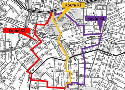
Figure 1: RR2 route options
Based on the assessment and preliminary comments, Option R1 ranked best against both quantitative and qualitative factors (Figure 2), and was subsequently chosen as the preferred route option and progressed to the concept plan phase.
|
Route |
Pedestrian volume environment |
Parking impact |
Traffic volumes |
Corridor space |
Cost of infra-structure |
Feasibility |
RMS Index (lower is better) |
Land use assess-ment (higher is better) |
|
R1 |
Medium |
Low |
Low |
Moderate |
Low |
High |
10.4 |
6.7 |
|
R2 |
Medium |
Medium |
High |
Constrained |
High |
Medium |
17.4 |
7.7 |
|
R3 |
High |
Medium |
Medium |
Constrained |
Medium |
Low |
19.8 |
6.0 |
Figure 2: Summary of the evaluation of RR2 route options
Draft concept plan
A draft concept plan for the preferred route option via West Street has now been developed for public exhibition (Attachment 1). The draft concept plan proposes a combination of mixed traffic treatments, shared paths and intersection modifications as appropriate. Key proposed changes are outlined below and in the consultant’s report (Attachment 2).
To inform development of the concept plan, the following data has also been considered:
· Swept paths at the following locations:
o Left turn movement for a 9.5m garbage truck from West Street into Thomas Street
o Left turn movement for a 9.5m garbage truck from Thomas Street into West Street
o Right turn movement for a 6.3m vehicle from Thomas Street into West Street
o Left turn for a 9.5m garbage truck from New Canterbury Road into West Street
o Left/right turn movements for a 6.3m vehicle between Lawson Ave and Frazer St.
· Traffic volumes and speeds along the route;
· Crash history along the route.
West Street (Parramatta Road to Railway Terrace)
The proposed scope of work includes the following:
· Provide bicycle lanterns at the intersection of Parramatta Road and West Street to enable bicycle riders to cross via the existing signalised pedestrian crossing;
· Convert the existing footpath on the western side of West Street, between Thomas Street and Parramatta Road, into a shared path;
· Provide a shared environment intersection (raised threshold) in Nestor Lane at the intersection of West Street;
· Relocate the left-turn slip lane at Thomas Street (near Nestor Lane) and provide a shared pedestrian/bicycle refuge at Thomas Street to improve pedestrian and bike rider safety;
· Convert the footpath on the western side of the West Street rail overbridge into a shared path. The path is narrow (approximately 1.8m wide), however the high cost and impacts of any changes (including to traffic and rail operations) preclude consideration of path widening by Council and are a matter for consideration by Transport for NSW. Appropriate signage and other measures to maintain low speed on the shared path will be considered.
West Street (Railway Terrace to New Canterbury Road)
The proposed scope of work includes the following:
· Provide a mixed traffic treatment (i.e. bicycle markings on the roadway to guide riders and remind other road users of the presence of bicycles) as traffic volumes are suitably low.
Intersection of New Canterbury Road and West Street
The proposed scope of work includes the following:
· Provide an expanded bicycle storage area on West Street at New Canterbury Road;
· Provide bicycle lanterns at the intersection of New Canterbury Road and West Street to enable northbound bicycle riders to cross via the existing signalised pedestrian crossing;
· Provide a short section of shared path on the footpath (approximately 8 metres long) to link Ducros Street and the existing signalised pedestrian crossing for northbound bicycle riders;
· Provide a no left turn restriction with bicycle exemption from New Canterbury Road into Ducros Street. Traffic volumes accessing Ducros Street from New Canterbury Road in the north are low (average 205 vehicles per day), and on-street parking on Ducros Street is permitted on the western side only (i.e. approached from the southern end of the street); thus the proposed no left turn restriction is expected to result in a minor increase in the number of vehicles accessing Ducros Street via Wardell Road, whilst removing southbound through traffic using Ducros Street to access Morgan Street.
Ducros Street to Frazer Street
The proposed scope of work includes the following:
· Provide a mixed traffic treatment on Ducros Street, Morgan Street, Napier Street, Miller Street and Miller Lane as traffic volumes are suitably low;
The following changes were approved by Council in September 2015 as part of its Marrickville West Local Area Traffic Management (LATM) Plan following community consultation, and have been incorporated into the bicycle route draft concept plan:
· Widen access way for bicycles and pedestrians to Miller Lane. This would require the removal of one street tree, to be replaced by two new street trees;
· Upgrade the existing pedestrian refuge on Frazer Street (near Miller Lane) to provide a wider and safer crossing refuge for pedestrians and bicycles to access Marrickville Park. This would require the removal of approximately seven on-street parking spaces on Frazer Street to accommodate the regulatory no-stopping requirements of the upgraded refuge.
Morgan Street to Livingstone Road
The proposed scope of work includes the following:
· Convert the footpath on the western side of Livingstone Road between Morgan Street and Addison Road into a shared path (approximately 65 metres in length);
· Provide bicycle lanterns at the intersection of Livingstone Road/Addison Road to enable bicycle riders to cross via the existing signalised pedestrian crossing.
Impacts to on-street parking
The proposed route improvements have been carefully considered to minimise/avoid parking impacts where possible, in response to community concerns raised in preliminary consultation. As outlined above, the proposed changes would result in:
· removal of 7 spaces to accommodate a pedestrian refuge upgrade on Frazer Street previously approved by Council in 2015 as part of the Marrickville West LATM Plan;
· relocation of 1 space on Thomas Street to accommodate the proposed slip lane changes.
PUBLIC CONSULTATION
Preliminary community consultation
Preliminary consultation with the community in the study area was undertaken in February 2017 to inform the evaluation of route options and identify key concerns, opportunities and considerations for the bicycle route improvements, as follows:
· Preliminary consultation was held from 3 February to 26 February;
· The consultation was advertised to the community in the Inner West Courier, and on Council’s Your Say Inner West website and social media channels;
· More than 1,000 letters were sent to residents, businesses and property owners in the project study area inviting comments;
· 28 submissions from the local community were received, in addition to comments from RMS, Sydney Buses, Petersham Public School and Bike Marrickville;
· The Your Say Inner West consultation page was visited 334 times.
The issues most frequently raised in submissions related to:
· Concerns about potential removal of on-street parking (18% of responses);
· Constraints on the West Street rail overbridge due to limited path width (14% of responses);
· Preference for separated bike paths where possible (11% of responses);
· Suggested improvements to the Miller Lane road closure (11% of responses).
Other stakeholders
Council has also consulted with key stakeholders including RMS and Sydney Buses. Preliminary comments to date include:
|
Stakeholder |
Comments |
|
RMS |
· Do not support continuous footpath at intersection of Ducros Street and New Canterbury Road. Consider alternatives to reduce risk of conflict between southbound motor vehicles turning into Ducros Street and northbound bicycle riders turning right from Ducros Street onto the shared path to access the signalised crossing on New Canterbury Road. · Proposed changes at signalised intersections will require RMS approval. |
|
Sydney Buses |
· Consider West Street bus movements at Railway Terrace |
Engagement Plan
Council engagement during public exhibition is proposed to include the following:
|
Issues and comments |
Key stakeholders |
|
Route treatments |
Local community; RMS; Sydney Buses |
|
Changes to on-street parking: · Frazer Street · Thomas Street |
Local community
|
|
Changes to signalised intersections |
RMS |
CONCLUSION
Council officers evaluated three route options for Regional Route 2 and carried out preliminary consultation with the community and other stakeholders. Based on this analysis, a preferred route via West Street, Ducros Street and Napier Street was selected, and a draft concept plan of the preferred route developed for public exhibition.
It is recommended that the RR2 draft concept plan be placed on public exhibition for 28 days, with a further report detailing outcomes of consultation and a final concept plan to follow.
|
1.⇩ |
RR2 Draft Concept plan for public exhibition |
|
2.⇩ |
RR2 Consultant concept plan |
|
Local Traffic Committee Meeting 1 June 2017 |
Subject: LOCAL ROUTE 7 (ST PETERS TO TEMPE) - DRAFT CONCEPT PLAN FOR PUBLIC EXHIBITION
File Ref: 16/6000/50849.17
Prepared By: Benny Horn - Cycling Planner
Authorised By: George Tsaprounis - Coordinator Traffic Engineering Services
|
SUMMARY In 2016, Council received a grant from NSW Roads and Maritime Services to develop a concept plan for bicycle route improvements between St Peters station and Tempe station, identified as Local Route 7 in Council’s Marrickville Bicycle Strategy.
This reports presents draft concept plans for two bicycle route options, a ‘Northern Route’ option via Sydney Steel Road and a ‘Southern Route’ option via Henry Street. Consistent with Council’s strategic priority to support bicycle riding in the local area, the draft concept plans propose various improvements to make bicycle riding safer, more comfortable and more convenient for people of all riding abilities. The concept plan incorporates preliminary input from the community and other stakeholders.
This report recommends that the Southern Route option be placed on public exhibition, with a further report to be prepared detailing outcomes of consultation and a final concept plan. This report also recommends that the Northern Route option be noted. |
|
RECOMMENDATION
THAT:
1. the draft Local Route 7 concept plan (Southern Route option via Henry Street) be placed on public exhibition for 28 days; 2. following public exhibition, a further report be prepared detailing outcomes of consultation and a final Local Route 7 concept plan; and 3. the draft Local Route 7 (Northern Route option via Sydney Steel Road) be noted.
|
BACKGROUND
In 2007, Council adopted the Marrickville Bicycle Strategy following consultation with stakeholders including the local community. Consistent with Council’s commitment to encourage bicycle riding, the Bicycle Strategy aims to make riding a bicycle easier, safer and more attractive, and proposes a network of bicycle routes. Local Route 7 (LR7) is a route identified in the Bicycle Strategy to link St Peters and Tempe via Unwins Bridge Road.
In 2016, Council received a grant from NSW Roads and Maritime Services (RMS) to develop a concept plan for improvements to LR7, consistent with the NSW Government’s objective of making bicycle riding a safe, convenient and enjoyable transport option for short trips. The project aims to support bicycle riding by enhancing connections for residents and visitors to:
· public transport (Tempe, Sydenham and St Peters train stations);
· local destinations such as schools, parks and local shops; and
· other bicycle routes, including to Newtown, Sydney Airport and Sydney CBD.
Prior to commencement of the project RMS indicated it would not support a cycleway on Unwins Bridge Road given insufficient road width, particularly at the southern section, and potential traffic flow impacts at busy intersections. In early 2017, Council subsequently engaged GTA Consultants to develop concept plans for two preferred route options. The draft concept plans for public exhibition have now been developed and are presented in this report.
FINANCIAL IMPLICATIONS
Detailed design and construction of the route are dependent on future budgets and grants.
OFFICER COMMENTS
Evaluation of route options
Route options were evaluated in early 2017 with:
· preliminary consultation with the community to identify key concerns, opportunities and considerations for bicycle route improvements in the study area;
· input from stakeholders including RMS, Sydney Metro and WestConnex; and
· assessment of six indicative route options (Figure 1) against a range of quantitative and qualitative factors including directness, local points of interest and destinations connected, traffic volumes, infrastructure cost and feasibility, and parking impacts:
o Option S1 via Unwins Bridge Road
o Option S2 via Henry Street and Richardson Crescent
o Option S3 via Henry Street and South Street
o Option S4 via Henry Street and Gannon Street
o Option N1 via Sydney Steel Road
o Option N2 via Marrickville town centre
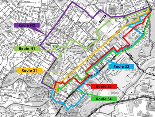
Figure 1: LR7 route options
The evaluation (Figure 2) identified Option N1 to be the strongest overall, with Option S1 disregarded based on RMS advice and Option N2 identified to be a poor option. Options S2, S3 and S4 all showed strengths and weaknesses on various sections.
|
Route |
Pedestrian volume environment |
Parking impact |
Traffic volumes |
Corridor space |
Cost of infra-structure |
Feasibility |
RMS Index (lower is better) |
Land use assess-ment (higher is better) |
|
S1 |
Medium |
High |
High |
Constrained |
High |
Low |
13.5 |
7.46 |
|
S2 |
Medium |
Moderate |
Low |
Moderate |
Medium |
Medium |
65.0 |
3.50 |
|
S3 |
Low |
Low |
Medium |
Moderate |
Medium |
Medium |
58.6 |
2.94 |
|
S4 |
Low |
Low |
Low |
Moderate |
Medium |
Medium |
50.1 |
3.05 |
|
N1 |
Medium |
Low |
Medium |
Moderate |
Medium |
Medium |
36.0 |
6.67 |
|
N2 |
High |
High |
Medium |
Constrained |
High |
Low |
38.0 |
5.00 |
Figure 2: Summary of the evaluation of LR7 route options
Option N1 (“Northern Route”) and a hybrid of Options S1, S2 and S3 (“Southern Route” via May Street, Henry Street, and Gannon Street/South Street) were subsequently chosen as the two preferred route options (Figure 3), and progressed to the concept plan phase.
The Northern Route would link parts of Newtown and Marrickville to train stations, Fraser Park and Mackey Park, Marrickville Metro, and other routes for destinations further away.
The Southern Route would link St Peters, Sydenham and Tempe to train stations, Sydenham Green, Camdenville Park and Tempe Reserve, local shops and other bicycle routes.
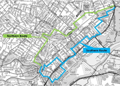
Figure 3: Preferred “Northern Route” and “Southern Route” options
Draft concept plans
Draft concept plans for the Northern Route option (Attachment 1) and the Southern Route option (Attachment 2) have now been developed for public exhibition. Key proposed changes are outlined below and in the consultant’s report (Attachment 3).
To inform development of the concept plans, the following data has also been considered:
· Swept paths at the following locations:
o Bus turning movements from Edgeware Road to Railway Parade via the Bedwin Road underpass;
o Turning movements for a 6.3m vehicle from Railway Parade to Edgeware Road via the Bedwin Road underpass;
o Turning movements for a 9.5m garbage truck from Roberts Lane to Mary Street;
o Left turn for a 9.5m garbage truck from Gannon Street into Griffiths Street.
· Traffic volumes and speeds along the routes;
· Crash history along the routes.
Northern Route option (via Sydney Steel Road)
Lord Street and Darley Street
The proposed scope of work includes the following:
· Provide a mixed traffic treatment (i.e. bicycle markings on the roadway to guide riders and remind other road users of the presence of bicycles) as traffic volumes are suitably low.
Edgeware Road to Bedwin Road underpass
The proposed scope of work includes the following:
· Provide a contraflow bike lane on Edgeware Road between Lord Street and Darley Street;
· Provide a separated bicycle path on Edgeware Road south of Lord Street;
· Provide a shared path on the southern side of the Bedwin Road underpass. Convert existing angled parking to parallel parking.
Bedwin Road underpass to Gleeson Avenue
This section is subject to Sydney Metro changes in relation to development on its adjacent dive site/stabling yards, and is thus clouded out in the draft concept plan pending future advice from Sydney Metro.
Gleeson Avenue to Meeks Road
This section is subject to Sydney Metro and Transport for NSW decision about modifications to roadway and traffic arrangements as part of the Sydney Metro project at Sydenham station, and is thus clouded out in the draft concept plan pending future advice from Sydney Metro.
Meeks Road to Victoria Road
The proposed scope of work includes the following:
· Provide a mixed traffic treatment, as traffic volumes are suitably low.
Victoria Road to Tempe station
Preliminary community feedback indicated support for improvements to intersections along the existing Carrington Road bicycle path. Treatment options supported by RMS are not feasible at this location due to higher traffic volumes (Renwick Street, Warren Road and Schwebel Street); space constraints and substantial drainage considerations at all of the side streets. Potential to incorporate bicycle route improvements into any future development on the eastern side of Carrington Road could also be considered by Council.
The proposed scope of work includes the following:
· Use existing separated bicycle path on Victoria Road, Myrtle Street and Carrington Road;
· Provide a separated bicycle path on the Victoria Road rail underpass;
· Use the existing Cooks River shared path from Mackey Park to Tempe station.
Impacts to on-street parking (Northern Route option)
Given uncertainty about Sydney Metro-related changes outlined above, parking impacts on these sections of the Northern Route option cannot yet be determined. For other sections, the proposed changes would require the removal of approximately 11 spaces, as follows:
· 1 space on Edgeware Road to accommodate the bicycle route;
· 10 spaces on the Bedwin Road underpass to accommodate a shared path. Council could also raise with Sydney Metro the potential for the parking loss to be offset by a new off-street parking facility on the adjacent Sydney Metro site.
Southern Route option (via May Street, Henry Street, and Gannon Street/South Street)
Princes Highway to Camdenville Park
The proposed scope of work includes the following:
· Convert the footpath on the western side of the Princes Highway, between Goodsell Street and Lord Street, into a shared path;
· Provide a mixed traffic treatment on Goodsell Street, as traffic volumes are suitably low;
· Use the existing shared path in Camdenville Park.
Camdenville Park to Florence Street
The proposed scope of work in the draft concept plan includes the following:
· Convert the footpath on the northern side of May Street, between the Camdenville Park path and Bedwin Road, into a shared path. Retain street trees and consider appropriate path signage and pavement markings to maintain pedestrian and bike rider safety.
The section between Bedwin Road and Florence Street forms part of bicycle route improvements proposed by WestConnex as part of its Campbell Street widening.
Florence Street to Railway Road
The proposed scope of work includes the following:
· Provide a mixed traffic treatment on Florence Street, Silver Street, Edith Lane, Edith Street, Roberts Street, Roberts Lane, Bakers Lane, Grove Street and Henry Street, as traffic volumes are suitable low;
· Provide a contraflow bike lane on the north-eastern side of Mary Street (approximately 10 metres in length) for riders travelling from Bakers Lane to Roberts Lane;
· Reverse priority on Henry Street at the intersections of Yelverton Street and George Street to reduce the frequency of stopping required (approximately every 70m) on Henry Street;
· Provide an expanded bicycle storage area on Henry Street at Railway Road.
Railway Road to Brooklyn Street
The proposed scope of work includes the following:
· Provide a mixed traffic treatment on Henry Street and Lymerston Street, as traffic volumes are suitable low;
· Reverse priority on Henry Street at the intersection of Terry Street;
· Convert the footpath on the western side of the Princes Highway, between Lymerston Street and Brooklyn Street, into a shared path. Consider appropriate signage and pavement markings to maintain pedestrian and bike rider safety across busy driveways;
· Provide a shared environment intersection (raised threshold) in Foreman Street at the intersection of the Princes Highway.
Brooklyn Street to Gannon Street
The proposed scope of work includes the following:
· Provide a mixed traffic treatment on Brooklyn Street and School Lane, as traffic volumes are suitably low;
· Provide a contraflow bike lane on Union Street (integrated into the newly constructed traffic lane threshold/squeeze point) for riders travelling from Edwin Street to School Lane;
· Widen and convert the footpath on the south-eastern side of Edwin Street into a shared path. Retain existing street trees;
· Install a shared environment intersection (raised threshold) in Stanley Street and Tramway Street at the intersections of Edwin Street.
Gannon Street to Griffiths Street
The proposed scope of work includes the following:
· Convert the footpath on the southern side of Gannon Street, between Edwin Street and Griffiths Street, into a shared path. Retain existing street trees and investigate trimming of tree at corner of Gannon Street and Griffiths Street to improve usable path width, sightlines and visibility. Consider appropriate signage, pavement markings and other measures to maintain low speeds on the shared path for pedestrian and bike rider safety;
· Provide a kerb ramp and bicycle right turn bay on Griffiths Street to enable bicycle riders to travel to/from the traffic lanes on Griffiths Street to the shared path on Gannon Street;
· Provide a mixed traffic treatment on Griffiths Street, as traffic volumes are suitably low.
Terry Street to Kendrick Park
The route is also proposed to branch out at Belmore Street to link to the existing bicycle route via the eastern shared path on the Princes Highway and South Street to the Cooks River path and the Alexandra Canal path.
The proposed scope of work includes the following:
· Provide new bicycle markings on Belmore Street and the Princes Highway shared path;
· Provide a mixed traffic treatment on Smith Street and South Street, as traffic volumes are suitably low;
· Provide bicycle lanterns at the intersection of Holbeach Avenue and the Princes Highway to enable bicycle riders to cross via the existing signalised pedestrian crossing.
Impacts to on-street parking (Southern option)
The Southern Route option would require the removal of 2 parking spaces as follows:
· 2 spaces on Griffiths Street to accommodate a bicycle right turn bay onto the shared path.
PUBLIC CONSULTATION
Preliminary community consultation
Preliminary consultation with the community in the study area was undertaken in February 2017 to inform the evaluation of route options and identify key concerns, opportunities and considerations for the bicycle route improvements, as follows:
· Preliminary consultation was held from 3 February to 26 February;
· The consultation was advertised to the community in the Inner West Courier, and on Council’s Your Say Inner West website and social media channels;
· More than 6,000 letters were sent to residents, businesses and property owners in the project study area inviting comments;
· 74 submissions from the local community and over 100 comments on Council’s online engagement map were received;
· The Your Say Inner West consultation page was visited 457 times.
The issues most frequently raised in submissions were:
· Support for a bicycle path along Unwins Bridge Road (27% of responses);
· Objection to a bicycle path along Unwins Bridge Road (16% of responses);
· Concern about suitability of the Henry Street route for a bicycle path (15% of responses);
· Preference for route improvements that improve bicycle rider safety (14% of responses);
· Concern about pedestrian safety on shared paths (12% of responses);
· Concern about parking impacts on Florence Street (9% of responses).
Community feedback also indicated interest in a bicycle route situated within the rail corridor to avoid on-road constraints. However, due to ongoing uncertainty around changes to, and future operational requirements within, the rail corridor near Sydenham station associated with the Sydney Metro project, this has not been investigated further at this stage.
Other stakeholders
Council has also consulted with other stakeholders including RMS, Sydney Metro, Sydney Water and Sydney Buses. Preliminary comments to date include:
|
Stakeholder |
Comments |
|
RMS |
· Do not support the development of a cycle route on Unwins Bridge Rd as there is insufficient road width available |
|
Sydney Metro |
· Sydney Metro is considering options for surrounding road network and land use form, and therefore cannot provide specific advice. |
|
Sydney Water |
· Sydney Metro changes may impact Sydney Water assets · Sydney Water may support access between Garden St and Railway Pde |
|
Sydney Buses |
· Transport for NSW is investigating a new bus interchange at Railway Pde · Buses use the underpass of Railway Parade under Bedwin Rd |
Sydney Metro input to date has indicated ongoing uncertainty about potentially substantial roadway, traffic and land use changes between Marrickville Road and Bedwin Road associated with the metro rail project. Given this uncertainty, bicycle route improvements on this section of the Northern Route option cannot be reliably developed at this stage, and are thus not shown in the concept plan.
Engagement Plan
The draft concept plans are initial options developed by Council to identify potential impacts of bicycle route improvements in the study area. Council proposes to place the LR7 (S1/2 option) draft concept plan on public exhibition so that the community and other stakeholders can provide input to inform further development of the concept plan for the route. Council engagement during public exhibition is proposed to include the following:
|
Issues and comments |
Key stakeholders |
|
Route treatments |
Local community; RMS; Sydney Buses; WestConnex |
|
Changes to on-street parking: · Mary Street · Griffiths Street |
Local community
|
|
Changes to signalised intersections |
RMS |
CONCLUSION
The LR7 Southern (via Henry Street) and Northern (via Sydney Steel Road) options propose changes to enhance bike rider safety, comfort and connectivity between St Peters and Tempe.
Sydney Metro has indicated ongoing uncertainty about potentially substantial roadway, traffic and land use changes between Marrickville Road and Bedwin Road associated with the Metro project. Feasible bicycle route improvements on this section of the Northern Route option can thus not be reliably developed at this stage, and have not been shown in the concept plan.
It is therefore recommended that:
· the LR7 ‘Southern Route’ option be placed on public exhibition, with a further report detailing outcomes of consultation and final concept plan to follow;
· the LR7 ‘Northern Route’ option be noted and deferred for further consideration once impacts of Sydney Metro changes around Sydenham station and its dive site are known.
|
1.⇩ |
LR7 - Northern Route option- Draft Concept Plan |
|
2.⇩ |
LR7 -Southern Route option - Draft Concept Plan |
|
3.⇩ |
LR7 - Draft Consultant's design report |