|
AGENDA R |
Council Meeting
TUESDAY 12 DECEMBER 2017
6.30pm
|
AGENDA R |
Council Meeting
TUESDAY 12 DECEMBER 2017
6.30pm
Live Streaming of Council Meeting
In the spirit of open, accessible and transparent government, this meeting of the Inner West Council is being streamed live on Council’s website. By speaking at a Council meeting, members of the public agree to being recorded and must ensure their speech to the Council is respectful and use appropriate language. A person who uses defamatory, discriminatory or offensive language may be exposed to liability for which Council takes no responsibility. Any part of this meeting that is held in closed session will not be recorded
Pre-Registration to Speak at Council Meetings
Members of the public must register by 2pm of the day of the Meeting to speak at Council Meetings. If you wish to register to speak please fill in a Register to Speak Form, available from the Inner West Council website, including:
· your name;
· contact details;
· item on the Agenda you wish to speak to; and
· whether you are for or against the recommendation in the agenda.
Are there any rules for speaking at a Council Meeting?
The following rules apply when addressing a Council meeting:
· keep your address to the point, the time allowed for each speaker is limited to three minutes. This time limit applies, no matter how many items are addressed by the speaker;
· when addressing the Meeting you must speak to the Chairperson;
· only 3 speakers for and against an Agenda Item are allowed.
What happens after I submit the form?
Your request will then be added to a list that is shown to the Chairperson on the night of the meeting.
Are there any rules for speaking at a Council Meeting?
The following rules apply when addressing a Council meeting:
· keep your address to the point, the time allowed for each speaker is limited to three minutes with one extension of not more than three minutes with the approval of the Council. This time limit applies, no matter how many items are addressed by the speaker;
· when addressing the Meeting you must speak to the Chairperson;
· the Chairperson may curtail public participation where the information being presented is considered repetitive or irrelevant.
Where Items are deferred, Council reserves the right to defer speakers until that Item is heard on the next occasion.
Accessibility
Inner West Council is committed to ensuring people with a disability have equal opportunity to take part in Council and Committee Meetings. At the Ashfield Council Chambers there is a hearing loop service available to assist persons with a hearing impairment. If you have any other access or disability related participation needs and wish to know more, call 9392 5657.
Persons in the public gallery are advised that under the Local Government Act 1993, a person may NOT tape record a Council meeting without the permission of Council.
Any persons found recording without authority will be expelled from the meeting.
“Record” includes the use of any form of audio, video and still camera equipment or mobile phone capable of recording speech.
An audio recording of this meeting will be taken for the purpose of verifying the accuracy of the minutes.
|
|
Council Meeting 12 December 2017 |
|
SUMMARY OF ITEMS |
The following provides a summary of the items to be considered at the meeting.
1 Acknowledgement of Country
2 Apologies
3 Notice of Webcasting
4 Disclosures
of Interest (Section 451 of the Local Government Act
and Council’s Code of Conduct)
5 Mayoral Minutes
Nil at the time of printing.
6 Staff Reports
ITEM PAGE
C1217 Item 1 Draft Greater Sydney Region Plan and Revised Draft Eastern City District Plan - Greater Sydney Commission 5
C1217 Item 2 Review of State Environmental Planning Policy No. 1 - Development Standards and State Environmental Planning Policy (Miscellaneous Consent Provisions) 2007 73
C1217 Item 3 Suppport for Make Renting Fair Campaign and Sydney Alliance's Affordable Rental Housing Campaign 91
C1217 Item 4 Permitting dogs in Pubs in the Inner West 110
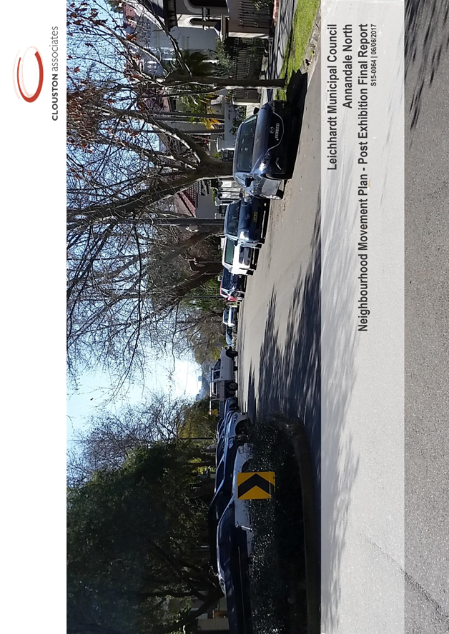
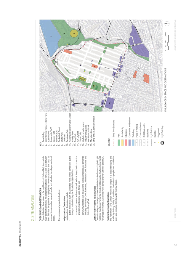
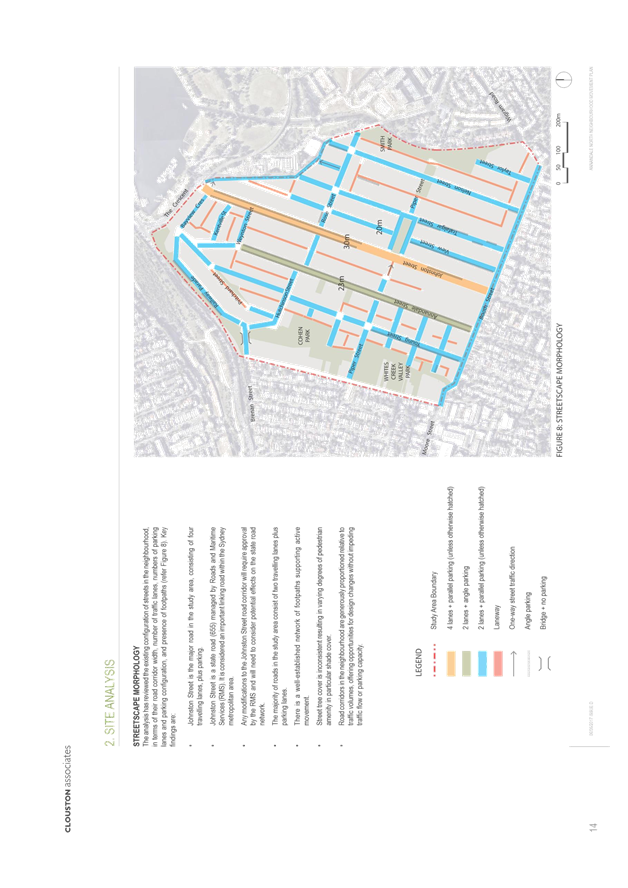
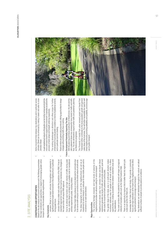
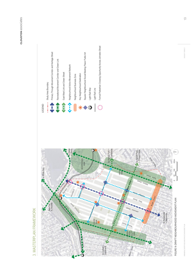
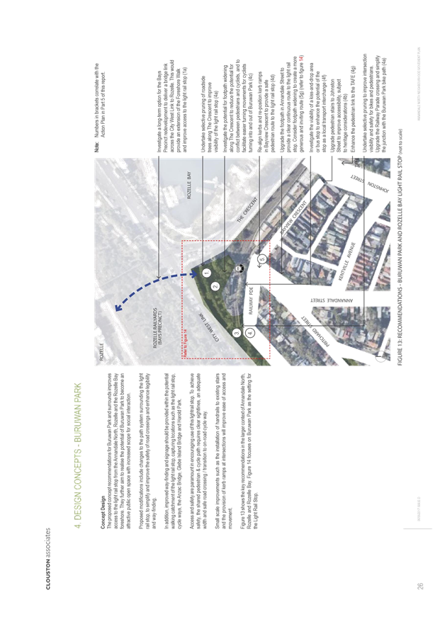
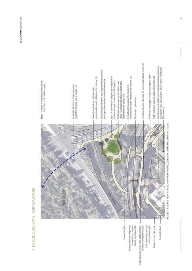
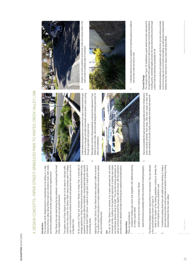
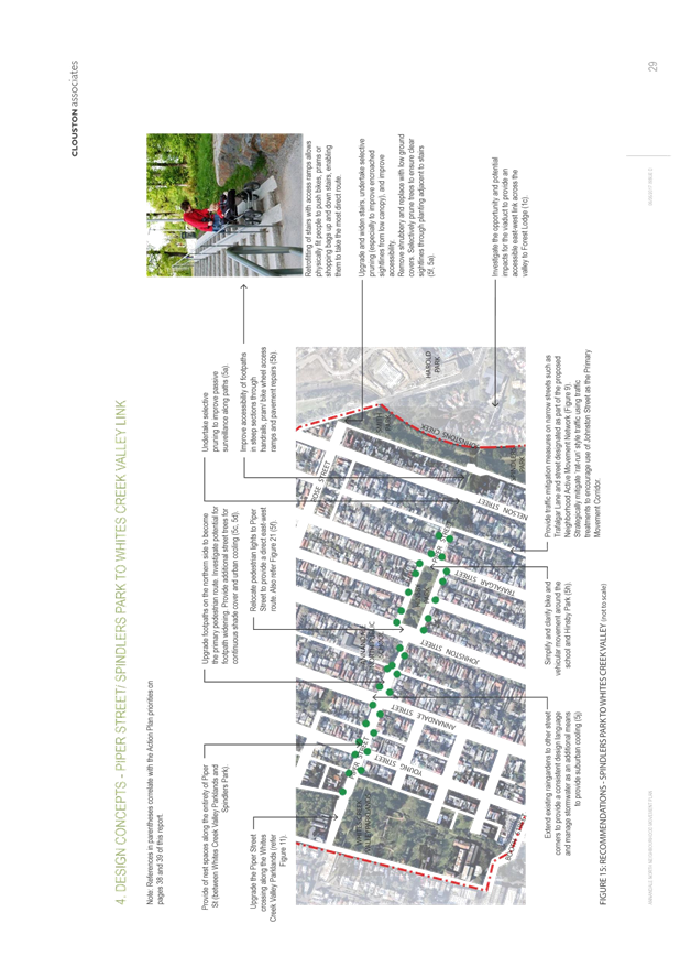
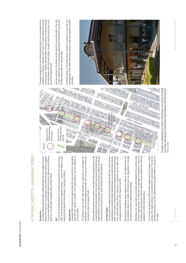
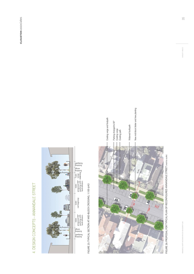
C1217 Item 5 Post exhibition outcomes - Annandale North Neighbourhood Movement Plan 121
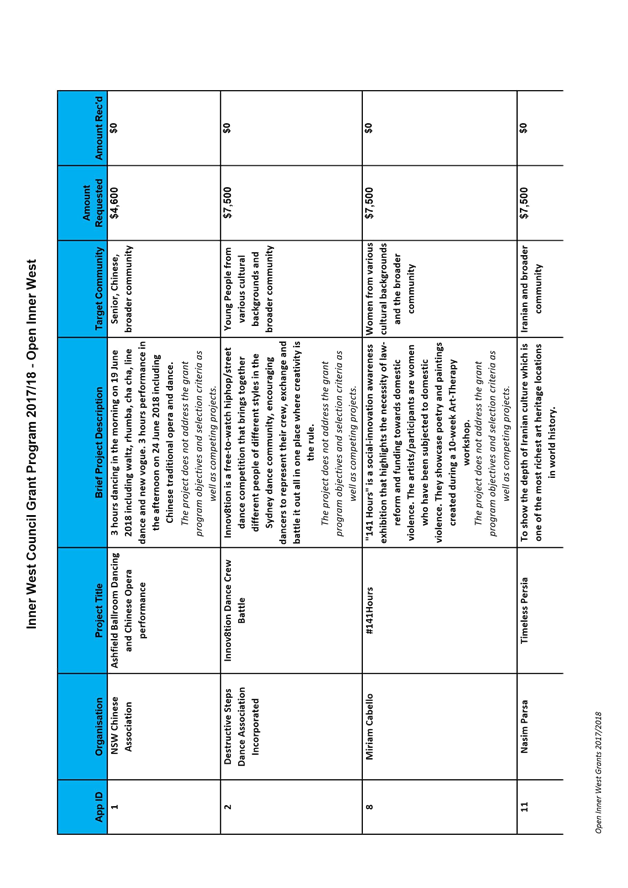
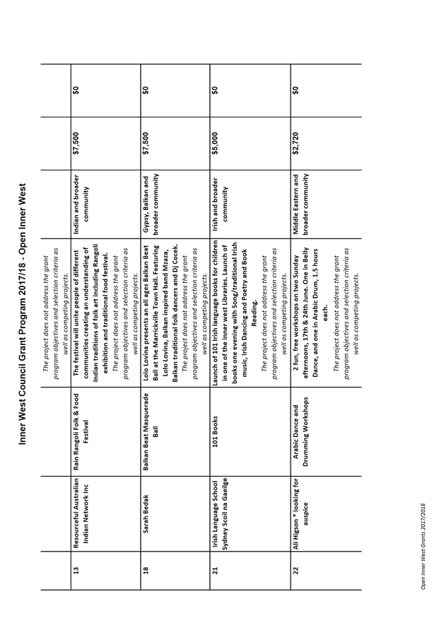
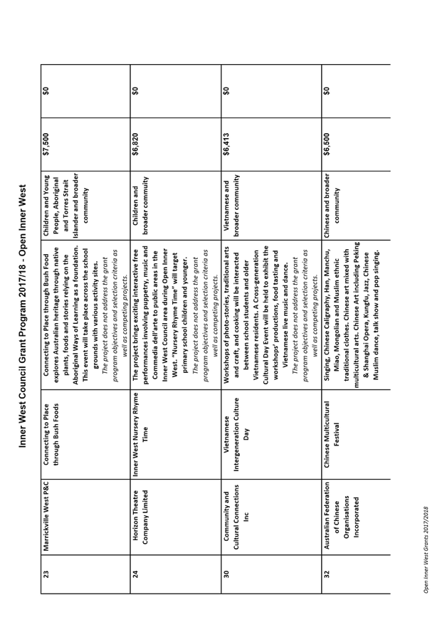
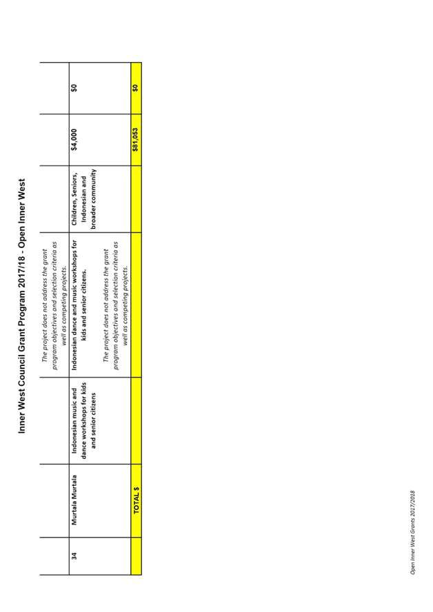
C1217 Item 6 Open Inner West 2017-18 Program for Endorsement 180
C1217 Item 7 Schedule of Ordinary Council Meetings for 2018 195
C1217 Item 8 Local Participatory Democracy at Inner West 197
C1217 Item 9 Quarterly Budget Review Statement at 30 September 2017 238
C1217 Item 10 Inner West Council Brand Development 249
C1217 Item 11 WestConnex Update Report 254
C1217 Item 12 Comparative Service Levels Pre and Post Merger 339
C1217 Item 13 Reporting of Code of Conduct Statistics 351
7 Notices of Motion
ITEM PAGE
C1217 Item 14 Notice of Motion: Tempe Station Access 352
C1217 Item 15 Notice of Motion: New Timetable 353
C1217 Item 16 Notice of Motion: Bikes Inner West Council 354
C1217 Item 17 Notice of Motion: Use of Infrastructure SEPP 355
C1217 Item 18 Notice of Motion: Investigating Feasibility of an Inner West Council Solar Farm 356
C1217 Item 19 Notice of Motion: Shade Sails 357
C1217 Item 20 Notice of Motion: Support for Balmain Para Rowing Group 359
C1217 Item 21 Notice of Motion: Arts and Music Inquiry 360
8 Questions From Councillors
ITEM PAGE
C1217 Item 22 Question on Notice: Recycling 361
9 Reports with Confidential Information
Reports appearing in this section of the Business Paper are confidential in their entirety or contain confidential information in attachments.
The confidential information has been circulated separately.
ITEM PAGE
C1217 Item 23 General Manager's Contract of Employment
C1217 Item 24 Lambert Oval Lease
C1217 Item 25 Request for Information on the Process for Initiating a Public Inquiry and Holding a Plebiscite 362
C1217 Item 26 Legal Advice on Challenges to Westconnex
|
|
Council Meeting 12 December 2017 |
Subject: Draft Greater Sydney Region Plan and Revised Draft Eastern City District Plan - Greater Sydney Commission
Prepared By: Tatjana Djuric-Simovic - Executive Strategic Planner
Authorised By: David Birds – Group Manager Strategic Planning
|
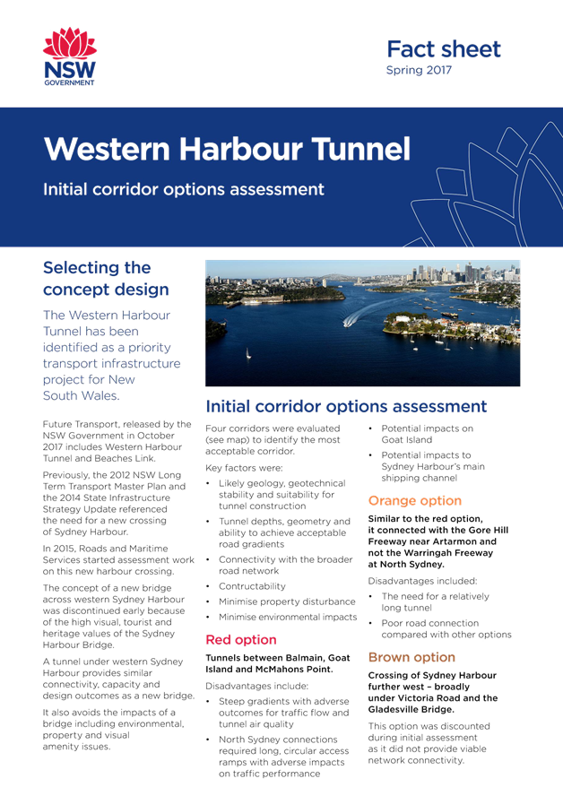
SUMMARY This report discusses the revised Draft Greater Sydney Region Plan and associated draft Eastern City District Plan released in October 2017 by the Greater Sydney Commission. The Inner West Council (IWC) is located within the Eastern City District. The Plans are on public exhibition until 15 December 2017.
Council’s officers have carried out a detailed assessment of the draft Plans and have identified a number of issues which are supported but also some points of disagreement. This report considers responses to the various issues within the draft Plans.
The following key objectives are supported: · collaborative approach in decision making processes between all three tiers of government; · promotion of a vibrant and safe night-time economy; · support for a diverse range of small businesses, including creative industries; · improved walking and cycling network and provision of open space of the Green Grid; · protection of industrial lands from conversion into residential or any other land uses that would hinder their role and function; · support for protection and improvement of environmental health of the District’s coast and waterways; and · support for increased urban tree canopy.
The Plan also contain a number of key elements that are opposed: · The spatial elements of the Plans largely overlook the Inner West Council with only the Sydenham to Bankstown centres identified, for example the Parramatta Road Corridor is overlooked; · Centres along the Sydenham to Bankstown Corridor are identified for high density residential housing with little consideration of their suitability due to issues such as aircraft noise and loss of industrial lands close to the CBD; · Continued city-wide strategic planning based on private car dependency, including the ongoing expansion of inner city motorways; · Ongoing planning of metropolitan centres without considering the local economic factors and local sustainability; and · Affordable housing being identified as an issue but with little commitment to addressing the issue through land use planning mechanisms.
Some of the key issues the final Plans should address are: · the need for Government support and investment in the delivery of affordable housing, public spaces, social infrastructure and services; · a value capture mechanism for major renewal projects to provide adequate funding for housing, physical and social infrastructure and services; · the integration of urban planning with digital technologies to create a smart city; · further details on targets for affordable housing; · consideration of how facilities in non-government schools could be made available for community use; · Parramatta Road corridor to be identified as a linear group of mixed use strategic centres supported by excellent public transport and community infrastructure; · Callan Park to be identified as an important public open space with natural and built heritage; · Council’s priorities for the Bays Precinct related to public and active transport, public access to the foreshore, public recreation facilities, affordable housing and the provision of low cost spaces for creative and start-up businesses and activities; · location of future public parks and recreational facilities to meet the needs of the existing and future population resulting from the proposed urban growth; and · new locations for waste recycling and management.
|
|
RECOMMENDATION
THAT Council:
1. Receive and note the Report;
2. Adopts the proposed responses in this Report; and
3. Prepare a submission to the Greater Sydney Commission based on the contents of this Report. |
BACKGROUND
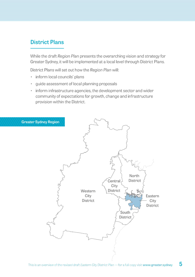
In January 2016, the Greater Sydney Commission Act 2015 came into effect. This new legislation required that Sydney be divided into districts and that draft Metropolitan and district plans be prepared.
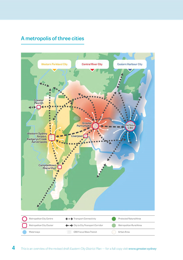
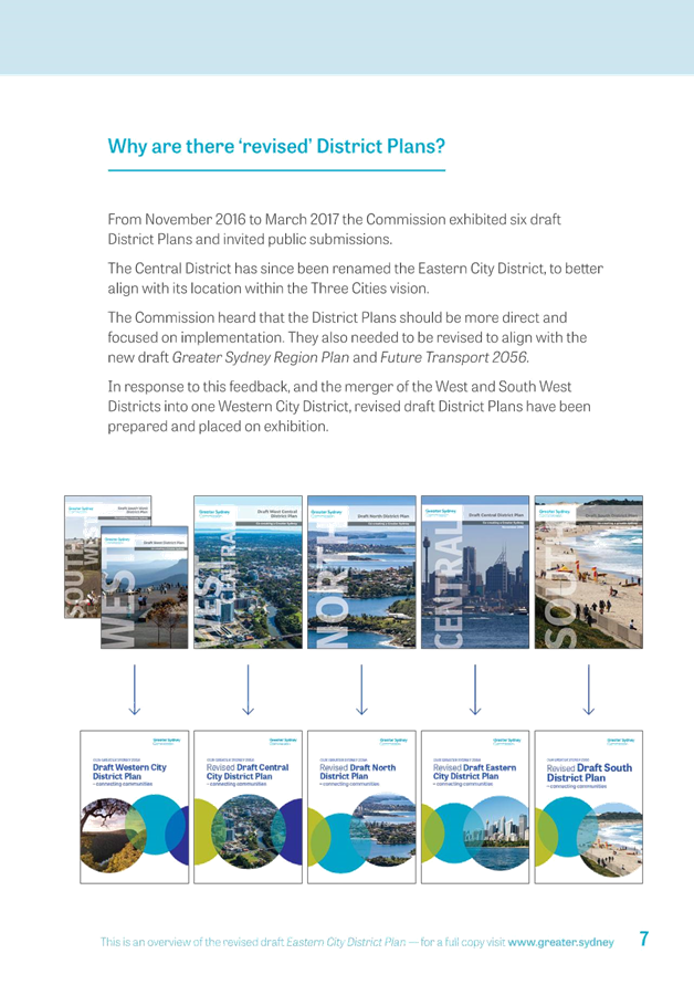
On 22 October 2017, the Greater Sydney Commission (GSC) released Our Greater Sydney 2056: A metropolis of three cities (also known as ‘the draft Greater Sydney Region Plan’) and 5 draft revised District plans. The draft Greater Sydney Region Plan (Region Plan) replaced A Plan for Growing Sydney that was previously exhibited in 2014 by the NSW Department of Planning and Environment (DPE).
Five revised draft District plans replace the first draft District plans prepared by the GSC, released for public consultation in November 2016. The Central District Plan that included Inner West Council local government area has been renamed draft Eastern City District Plan (District Plan).
The Regional Plan and five revised draft District Plans have been prepared and released for public comments concurrently with the Government’s Future Transport 2056 and State Infrastructure Strategy. These are documents prepared by the GSC for consultation and ultimately for the NSW Government’s consideration.
Councils are required to submit their updated LEPs to be consistent with the Regional and District Plan within three years of the finalisation of these plans.
This Report considers a number of responses to various issues concerning both the draft Region Plan and District Plan.
Draft Greater Sydney Region Plan
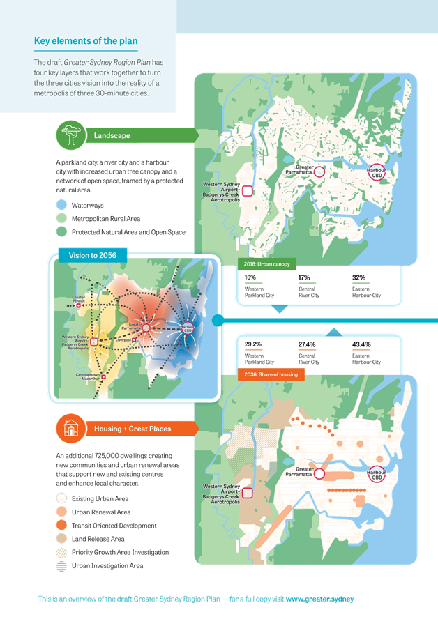
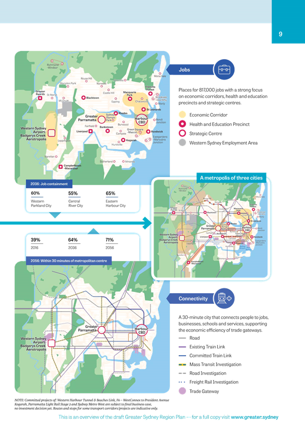
The overall purpose of the Region Plan is to integrate land use, transport and infrastructure planning across the Greater Sydney region up to 2056. It is estimated that by that time Greater Sydney will have:
· 8 million residents;
· an additional 725,000 dwellings; and
· an extra 817,000 jobs.
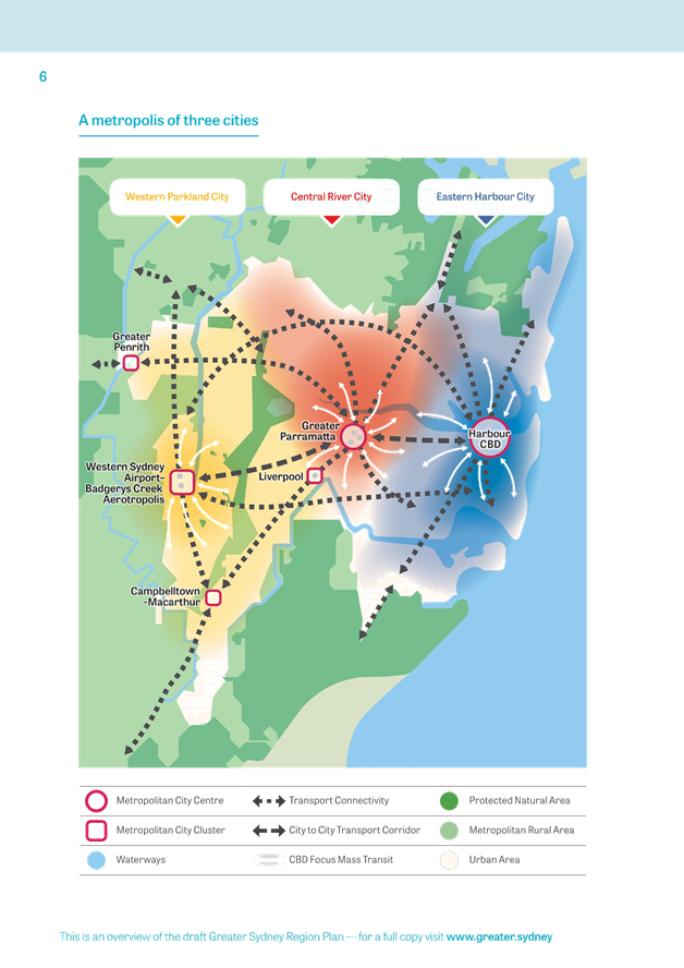
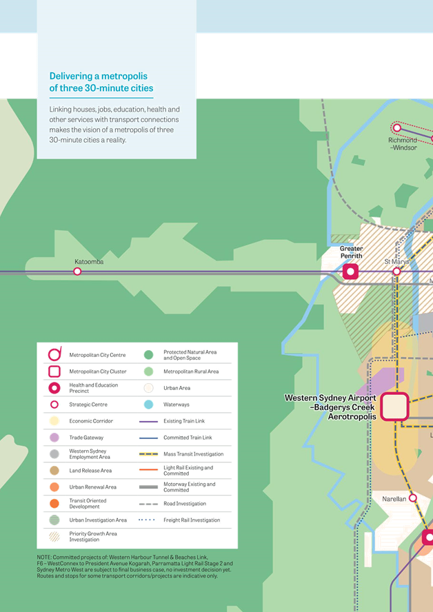
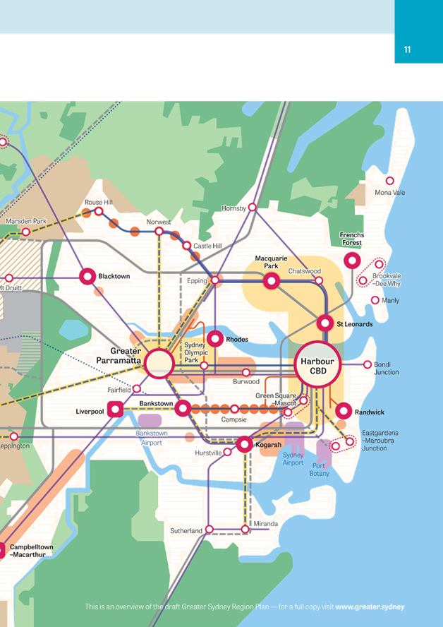
The vision of the Region Plan is to transform the Greater Sydney into a metropolis of 3 cities:
· the Western Parkland City;
· the Central River City; and
· the Eastern Harbour City. (within which the IWC is located)
An Executive Summary of the Region Plan can be found at ATTACHMENT 1. The complete document is available on the GSC’s web site at: https://www.greater.sydney/draft-greater-sydney-region-plan
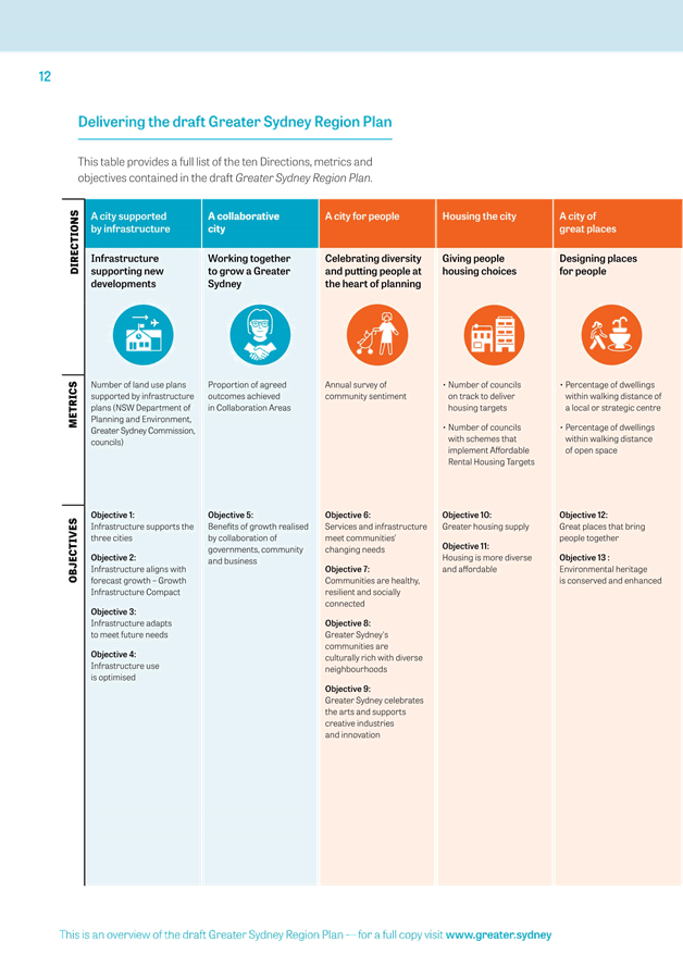
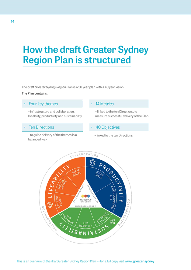
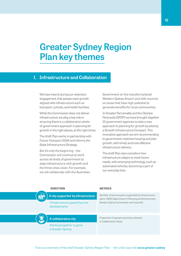
Region Plan has 10 Directions supported by 38 Objectives:
Direction 1: A city supported by infrastructure
ü Objective 1: Infrastructure supports the three cities
ü Objective 2: Infrastructure aligns with forecast growth – growth infrastructure compact
ü Objective 3: Infrastructure adapts to meet future needs
ü Objective 4: Infrastructure use is optimised
Direction 2: A collaborative city
ü Objective 5: Benefits of growth realised by collaboration of governments, community and business
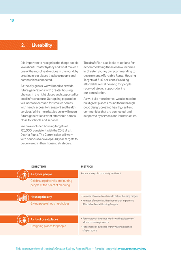
Direction 3: A city for people
ü Objective 6: Services and infrastructure meet communities’ changing needs.
ü Objective 7: Communities are healthy, resilient and socially connected/
ü Objective 8: Greater Sydney’s communities are culturally rich with diverse neighbourhoods
ü Objective 9: Greater Sydney celebrated the arts and supports creative industries and innovation.
Direction 4: Housing the city
ü Objective 10: Greater housing supply
ü Objective 11: Housing is more diverse and affordable
Direction 5: A city of great places
ü Objective 12: Great places that bring people together
ü Objective 13: Environmental heritage is conserved and enhanced
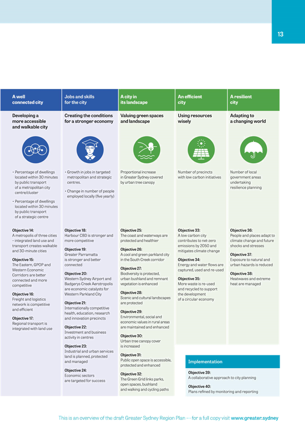
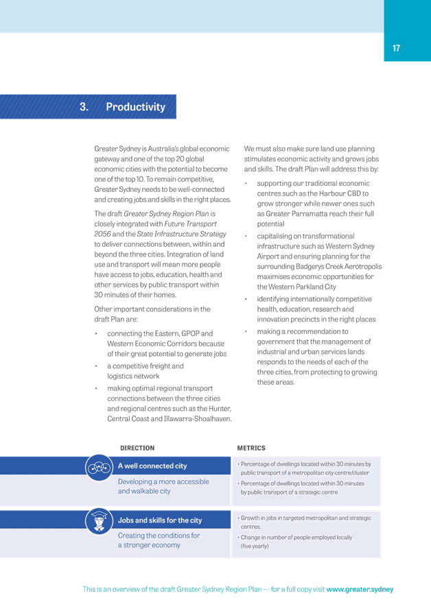
Direction 6: A well connected city
ü Objective 14: A metropolis of three cities – integrated land use and transport created walkable and 30-minute cities
ü Objective 15: The Eastern GPOP and Western Economic Corridors are better connected and more competitive
ü Objective 16: Freight and logistics network is competitive and efficient
ü Objective 17: Regional transport is integrated with land use
Direction 7: Jobs and skills for the city
ü Objective 18: Harbour CBD is stronger and more competitive
ü Objective 19: Greater Parramatta is stronger and better connected
ü Objective 20: Western Sydney Airport and Badgerys Creek Aerotropolis are economic catalysts for Western Parkland City
ü Objective 21: Internationally competitive health, education, research and innovation precincts
ü Objective 22: Investment and business activity in centres
ü Objective 23: Industrial and urban services land is planned, protected and managed
ü Objective 24: Economic sectors are targeted for success
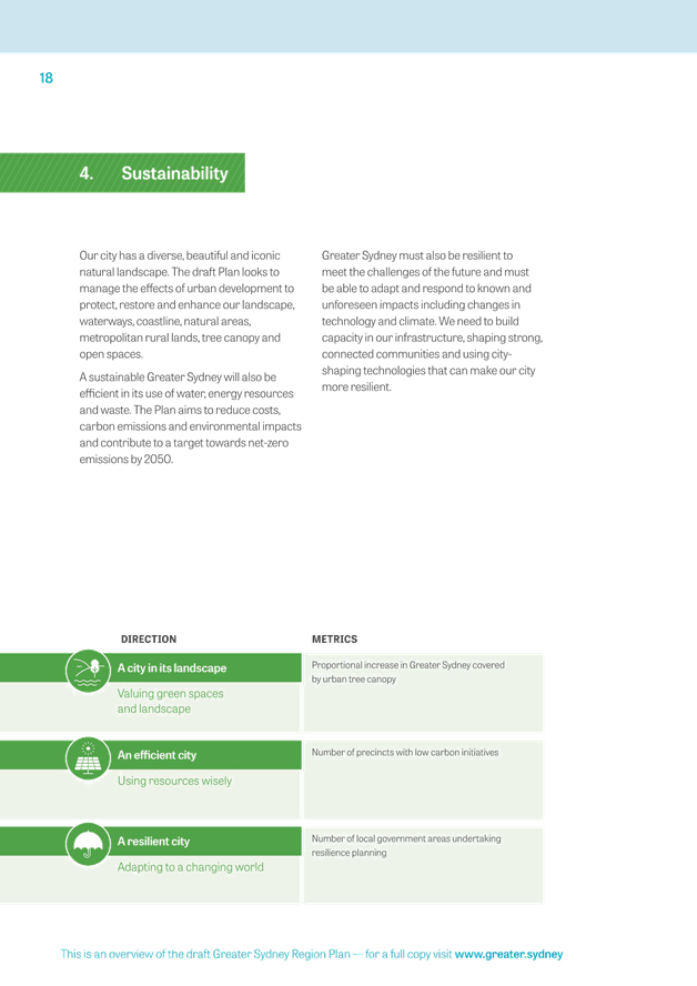
Direction 8: A city in its landscape
ü Objective 25: The coast and waterways are protected and healthier
ü Objective 26: A cool and green parkland city in the South Creek corridor
ü Objective 27: Biodiversity is protected, urban bushland and remnant vegetation is enhanced
ü Objective 28: Scenic and cultural landscapes are protected
ü Objective 29: Environmental, social and economic values in rural areas are maintained and enhanced
ü Objective 30: Urban tree canopy cover is increased
ü Objective 31: Public open space is accessible, protected and enhanced
ü Objective 32: The Green Grid links parks, open spaces, bushland and walking and cycling paths
Direction 9: An efficient city
ü Objective 33: A low-carbon city contributes to net-zero emissions by 2050 and mitigates climate change
ü Objective 34: Energy and water flows are captured, used and re-used
ü Objective 35: More waste is re-used and recycled to support the development of a circular economy
Direction 10: A resilient city
ü Objective 36: People and places adapt to climate change and future shocks and stresses.
ü Objective 37: Exposure to natural and urban hazards is reduced
ü Objective 38: Heatwaves and extreme heat are managed
An additional chapter on Implementation contains 2 more objectives:
ü Objective 39: A collaborative approach to city planning
ü Objective 40: Plans refined by monitoring and reporting
The area of Greater Sydney is divided into five districts. The Inner West Council area is located within the Eastern City District.
The Region Plan informs district and local environmental plans and the assessment of planning proposals. The 10 Directions, listed above for the Region Plan, are replicated as the same 10 Directions in a set of five subordinate, district plans.
Whilst it is recognised that the Draft Region Plan is a high level strategic document that considers all of Sydney, it is noteworthy that the Inner West is largely overlooked. Only the Sydenham to Bankstown Corridor is mentioned substantially. Other urban corridors and centres within the Inner West are not mentioned to a substantial degree, although these centres are subject to residential growth pressures.
Draft Eastern City District Plan
The District Plan is a 20-year plan to manage growth to achieve the 40-year vision for Greater Sydney set out in the Region Plan.
An executive summary of the District Plan can be found at ATTACHMENT 2. The complete document is available on the GSC’s web site at: https://www.greater.sydney/draft-eastern-city-district-plan
District Plans are the first step in the implementation of the Region Plan. A District Plan is delivered to inform local environmental plans and the assessment of planning proposals as well as Council’s strategic plans and policies (Figure 1). The transitional arrangements for planning proposals already lodged seeking a Gateway Determination or yet to be exhibited are outlined in the Information Note 6 published by the GSC on its web site. All planning proposals must be assessed for consistency with the revised draft District Plans at any stage of the assessment.
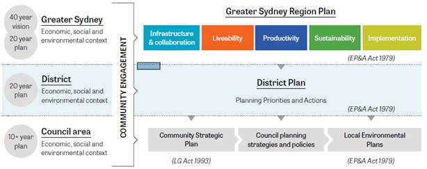
Figure 1: Relationships of regional, district and local plans
(Source: Revised Draft Eastern City District Plan, Oct 2017)
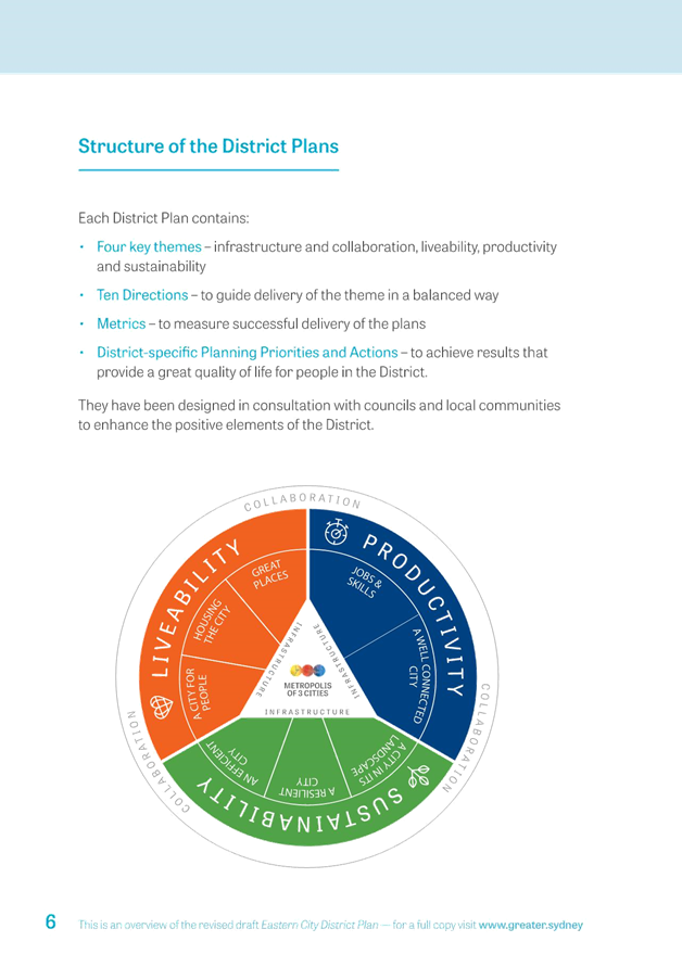
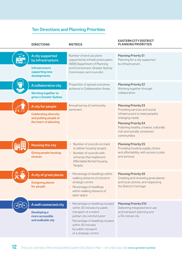
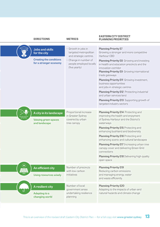
In response to the 10 Directions there are 20 Planning Priorities:
E1 A city supported by infrastructure
E2 Working through collaboration
E3 Providing services and social infrastructure to meet people’s changing needs
E4 Fostering healthy, creative, culturally rich and socially connected communities
E5 Providing housing supply, choice and affordability with access to jobs and services
E6 Creating and renewing great places and local centres, and respecting the District’s heritage
E7 Growing a stronger and more competitive Harbour CBD
E8 Growing and investing in health and education precincts and the Innovation Corridor
E9 Growing international trade gateways
E10 Delivering integrated land use and transport planning and a 30-minute city
E11 Growing investment, business opportunities and jobs in strategic centres
E12 Protecting industrial and urban services land
E13 Supporting growth of targeted industry sectors
E14 Protecting and improving the health and enjoyment of Sydney Harbour and the District’s waterways
E15 Protecting and enhancing bushland and biodiversity
E16 Protecting and enhancing scenic and cultural landscapes
E17 Increasing urban tree canopy cover and delivering Green Grid connections
E18 Delivering high quality open space
E19 Reducing carbon emissions and managing energy, water and waste efficiently
E20 Adapting to the impacts of urban and natural hazards and climate change
The Region and District Plans are well aligned with many paragraphs being replicated in both plans. For ease of reference the consideration section below follows the structure of the Eastern City District Plan, following the 20 planning priorities and providing comments under the relevant Chapters as follows:
· Infrastructure and collaboration - Chapter 2 (priorities E1-E2)
· Liveability - Chapter 3 (E3 – E6)
· Productivity - Chapter 4 (E7 – E13)
· Sustainability - Chapter 5 (E13-E20)
CONSIDERATION
General Strategic Planning Comments
The Region Plan advocates a future Sydney consisting of three cities, Eastern Harbour, Central and Western Parkland. The strategy discusses city centres around the Sydney CBD, Greater Parramatta – Olympic Park (GPOP) and the future Western Sydney Airport. It largely omits reference to the Inner West and the issues and opportunities afforded to greater Sydney from the IWC LGA.
The District Plan is more detailed and aligns with the Region Plan, it mentions the centres along the Sydenham to Bankstown Corridor and a brief mention of on-street transit along Parramatta Road.
The comments below provide 44 detailed responses to the 20 Planning Priorities identified in the Plans. However there are a number of over-arching high-level strategic land use planning issues that stand out:
1. The Parramatta Road corridor and its centres are not identified as areas for urban growth which is inconsistent with the position of the State and planning activities currently underway. This corridor and its centres should be included in the Plans (refer to response 15 below);
2. The centres along the Sydenham to Bankstown Corridor have been identified as areas for high density residential housing with little consideration of their suitability in relation to loss of industrial land and aircraft noise. This is a particular issue around Sydenham Station where the area is well-utilised industrial land with thousands of jobs and is highly affected by aircraft noise being 1km from the end of the main runway. The appropriate balance between development and maintenance of industrial land must be found (refer Planning Priorities 9 and 12, and response 32, below);
3. The Plans for future Sydney continue to misalign land use planning and transport. The continued growth of inner-urban motorways will only increase congestion in the long term and lead to reduced liveability. The Plans contain little commitment to improved public and active transport and where they are shown they do not necessarily align with travel patterns or land use. The Plans raise the concept of a 30-minute city, however it is unclear how that would be achieved (refer responses 28 and 29, below).
4. Innovative approaches are encouraged for providing affordable housing, new retail or business centres, open space or recreational facilities. However, there is a limit to how much innovation can make up for the lack of Government investment and delivery of affordable housing, public spaces, social and green infrastructure and services; and
5. The Plans discuss affordable housing as an issue but offer little commitment to implementation of measures that will address the issue. The Plans discuss increasing housing supply as an action however this will not address the issue of provision of affordable housing for the least well-off in the community.
As with the previous draft Plans, Council’s submission will recommend that the final Plans include more details, targets and clear metrics on all key elements related to justification for increased urban density, funding for public infrastructure and ecologically sustainable development (ESD).
Government initiatives for the increase of housing supply and increased density in established areas should consider benchmarking to evaluate the liveability performance of areas identified for increased residential and employment densities. There also needs to be an open source data platform that enables people to monitor compliance with the benchmarks to ensure full transparency and accountability is successfully achieved.
As a suggestion, a glossary in the Plan is needed to define key terms, e.g. green infrastructure, Blue and Green Grid, place-based approach.
Comments on the Planning Priorities in the Plans
Each chapter/section of the Plans is reviewed in the following section along with recommended responses to each planning priority.
Infrastructure and Collaboration
Planning Priority E1 promotes planning for the three cities supported by infrastructure. It suggests that ‘new public transport infrastructure, such as taxis and ride share will help connect residents to their nearest strategic or metropolitan city centre within 30 minutes’.
Taxis and rideshare (such as Uber) are distinct modes of public transport that cannot completely answer community needs for accessible and efficient mass transit. The Plans advocate for a 30 minute City however they continue to misalign land use planning and transport networks. Whilst the three cities concept is supported, travel between and within each needs to be carefully considered at both the regional and local levels. Further comments on the transport network are included under Planning Priority E10.
Planning Priority E2 is a call for consensus between all levels of government.
A fundamental feature of a good planning system is the movement towards cooperation and consensus and away from schemes that are only regulatory and impose ‘upper hand’ State controls. Although local governments do not necessarily agree with all State-level policies, it is important, where possible, to work together with the GSC and Department to achieve the best outcomes for the inner west.
1 RESPONSE: Council supports planning decisions reached through genuine collaboration, meaningful public consultation and reaching consensus between different tiers of government.
In addition to Priority Growth Areas and the Priority Precinct program, previously established by the State government, the Region and District plans introduce planning in ‘Collaboration Areas’ across metropolitan Sydney. As a non-statutory initiative, Collaboration Areas are intended to deal with the transformative urban growth delivery that is enabled by State Government Plans which are legally binding under Section 117 Ministerial Directions of the Environmental Planning and Assessment Act 1979.
The GSC has identified the following areas within the Inner West Council as Collaboration Areas for priority delivery or land where collaborative processes would be implemented:
· Camperdown-Ultimo Health and Education Precinct (led by the GSC)
· Sydenham to Bankstown Urban Renewal Corridor (led by the NSW Department of Planning and Environment); and
· Parramatta Road Corridor Urban Transformation Strategy (PRUTS) (initially developed by Urban Growth NSW, now will be a collaboration of Council’s implementing the Strategy, supported by the GSC).
GSC recommends that delivery of Collaboration Areas is supported by a Special Infrastructure Contribution or similar satisfactory arrangement.
Region or District Plans do not provide a value capture methodology as recommended by Infrastructure Australia (Australian Infrastructure Plan, Feb 2016) and supported by Council in its previous submission to the first draft District Plan in 2016. Infrastructure Australia identified that existing funding options for infrastructure are unable to provide sufficient funding to meet future infrastructure needs. In this regard, the previous version of the District Plan made reference to the potential for value capture to fund infrastructure demands.
2 RESPONSE: Council recommends that a value capture mechanism from the Australian Infrastructure Plan, Priorities and reforms for our nation’s future, (Feb 2016) be adopted and applied via the District Plan for the major renewal precincts and corridors to provide adequate funding for housing, environment, recreation, green and other infrastructure and public services in the District.
The Region Plan states that ‘the Commission recognises that development needs to support the funding of infrastructure at an appropriate level, but should not be unreasonably burdened to the extent that development becomes unviable’. The Commission’s Infrastructure Delivery Committee is developing a series of new policy initiatives to better align forecast growth with infrastructure. One of these projects is a ‘growth infrastructure compact’ which would assess the nature, level and timing of infrastructure required for an area in light of its forecast housing and employment growth, including analysis of growth scenarios.
Despite the fact that increased density and infill development in Council’s established neighbourhoods will increase the need for infrastructure and services, the Region Plan recommends that the Eastern City District should ‘operate within appropriate fiscal limits calls for getting the most out of existing infrastructure assets. Achieving better utilisation of existing assets increases infrastructure capacity to better support communities and has the potential to minimise or avoid the need to fund additional infrastructure’.
There is a limit to how much more can be serviced by the existing infrastructure assets, where any further growth without capital State/Commonwealth investment into the new infrastructure will not achieve Region and District Plan objectives to create great places and support growing communities. It is therefore essential that infrastructure requirements are considered and funding mechanisms agreed during the planning for urban growth.
3 RESPONSE: Final Region and District Plans should provide more operational details on proposed delivery mechanisms such as the ‘growth infrastructure compact’ and the role of local government on the sequencing of further growth, to ensure that growth is supported by necessary infrastructure.
Liveability
Council has worked as part of a broader Southern Sydney Regional Organisation of Councils (SSROC) initiative to develop livability benchmarks for central and southern Sydney with independent specialist input (SGS Economics & Planning). These benchmarks have been provided to the GSC as part of a separate SSROC submission to the previous version of the District Plan. These benchmarks include specific metrics for affordable housing, education, health, community services, open space and place making.
The proposed Metrics to measure the success of Planning Priorities E3 & E4 is an ‘annual survey of community sentiment’. It is not clear how this survey will inform progress towards planning delivery of these priorities.
Liveability should also acknowledge the need for green infrastructure to provide ecosystems services to support health and well-being, therefore Planning Priority E6 must include “respecting and enhancing the District’s natural, cultural and built heritage”
4 RESPONSE: Council recommends that the final District Plan includes benchmarking based on the SSROC study to evaluate the liveability performance of areas identified for increased residential and employment densities.
Council supports the District Plan promotion of ‘walkable neighbourhoods that would encourage people of all ages and abilities to walk or cycle for leisure, transport or exercise’. What is missing from these priorities is the provision of integrated, efficient and affordable mass public transport that would replace existing car-oriented, privately-owned and profit-driven development in Sydney Region. This is discussed further under priority E10, below.
5 RESPONSE: Region and District Plans should include a provision for mass public transport that is reliable, efficient, and integrated with land use plans as one of the Liveability Planning Priorities.
Planning Priority E3 will provide services and social infrastructure to meet people’s changing needs.
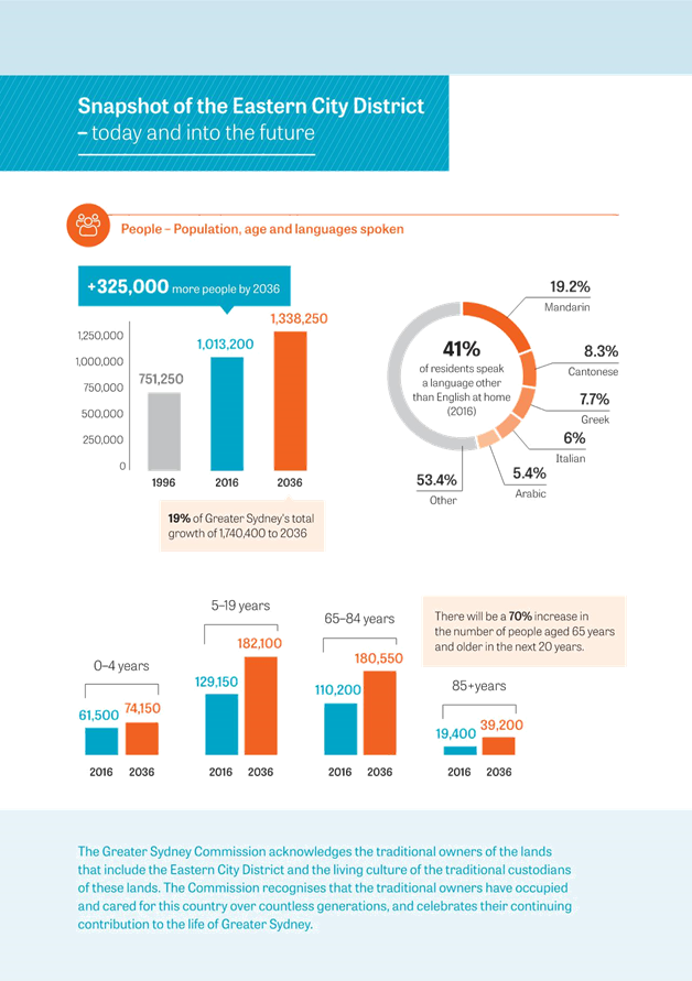
The District Plan notes that projections for 2036 indicate a 10% growth in children under 4 years by 2036 in IWC, and a 41% increase in school aged children across the District. Out of the 42,850 forecast growth in the District’s school students, 12-13% will be in the IWC area, with corresponding implications for the provision of early education and child care (including co-location with schools/ offices).
The District Plan states that School Infrastructure NSW, a new specialist unit within the NSW Department of Education, will work with state agencies and groups to develop schools as community hubs, however local government is not specifically referenced in this proposed work.
6 RESPONSE: Greater Sydney should take steps to become a Child Friendly City following the UNICEF guidelines, and Councils should be funded by State government to develop child friendly city strategies. Councils need to be cited as a major stakeholder in the proposal by School Infrastructure NSW to develop schools as community hubs.
The District Plan does not provide details of any future school infrastructure nor Government commitments to accommodate the growth in the number of students in the Inner West. The Plan rather advocates for ‘innovative approaches to the use of land and floor space, including co-location with compatible uses such as primary schools and office buildings’.
The District Plan confirms that ‘growth increases demand on existing services and infrastructure, particularly sport and recreation facilities that are, in some cases, at or nearing capacity’. GSC concludes that due to the high land values the authorities cannot provide any opportunities for additional open space and recreational facilities as ‘resources and funding are limited’. Instead it recommends an increase in shared use of public schools facilities, church halls or temporary closed streets.
Clarification is required regarding how community hubs will be provided in dense areas such as the Inner West where vacant land and open space is extremely limited. If existing open space in schools is compromised to build extra classrooms and childcare, this will further constrain the outdoor play opportunities of Inner West children.
The District Plan refers to ‘increased shared and more flexible use of underutilised facilities such as schools, sports facilities’ as a means of addressing future demands. However there is little evidence of underutilisation of Inner West facilities; the existence of resources that can meet community demand; or the preparedness of local schools to allow for shared use.
7 RESPONSE: School Infrastructure NSW should undertake an audit of all public and private school facilities in order to assess the feasibility of schools being developed as community hubs in the Inner West.
The NSW Government changes to the planning system and a recent adoption of the State Environmental Planning Policy (Educational Establishments and Child Care Facilities) 2017 prescribed non-government schools as public authorities to enable them to carry out development using the same assessment process as previously used by public schools. Following this new classification of schools, the facilities of non-government schools should also be considered for adapting and sharing for sports, arts, cultural or recreational community use when they are not otherwise required.
8 RESPONSE: The draft District Plan should be amended to consider the use of non-government schools to assist in the delivery of social infrastructure alongside public schools. Council to contact non-government schools in the area to explore opportunities for shared public use of their facilities.
The Plan notes a large proportional increase in older people in the Eastern City District by 2036. Inner West, Sydney and Bayside Councils have the largest projected volume of the 65-84 age group and 85 and over age group in District.
The Plan states that more compact housing, medium density and walkable neighbourhoods will assist this demographic stay in their own community. It notes that ageing in community/place and universal design will increase accessibility in homes and public places.
Some of the key considerations in planning for an ageing community, not referenced in the District Plan, include provision of safe, affordable, efficient and accessible transport; maintaining financial security and independence; challenging ageism; loneliness; and addressing the needs of people from diverse backgrounds. The NSW Ageing Strategy also highlights the importance of older people being active participants in planning the services designed to meet their needs.
9 RESPONSE: That the State government works with local Councils, the private sector and community organisations to make Greater Sydney an Age-Friendly City according to World Health Organisations Global Age-Friendly Cities Guide and associated checklist.
The District Plan acknowledges that level of accessibility and homes of universal design are of the highest priority for over 37,000 people with a disability in the Eastern City District.
The quoted figure of 37,000 people with a disability in the district appears to be underestimated when they are approximately 36,000 people with a disability in the Inner West Council area. It is likely the Plan’s stated figure relates only to ABS data on severe core activity restriction and would not appear to include the vast majority of people living with a disability whose situation is not captured by the survey tools. As a result important needs, particularly in relation to housing, will be severely underrepresented and therefore not addressed in the District Plan.
The National Dialogue on Universal Housing Design of 2009 set agreed progressive targets for government and industry to reach from 2010 to 2020. These included a target for 100% of newly constructed dwelling to be built to the ‘Liveable Housing’ standard. Despite the unprecedented level of construction and development in Sydney during this time, the target has been ignored.
Reliance on renewal through facilities reaching the end of their safe and practicable lifespan is an insufficient approach to address the backlog of access needs.
10 RESPONSE: The Plan should recognise the important need to plan for access to all forms of land use and development and give consideration to the adoption of universal housing design targets for all new housing.
Planning Priority E4 will foster healthy creative, culturally rich and socially connected communities.
The high incidence of adults who are overweight or obese in the Eastern City District (36%) is noted. The Plan recognises that connectivity and access to open space is essential to facilitate physical activity, however it does not reference the fact that areas such as the Inner West are already underrepresented in terms of open space provision. This lack of open space combined with increasing population density will see increasing demands being exerted on the limited open space already provided. The plan makes minimal reference to the lack of public open space in the District, particularly in the Inner West; the impact on liveability; and how the state government can assist to address this.
11 RESPONSE: The Plan should recognise the increasing demands on open space within the inner west and that mechanisms to provide for additional and improved open spaces are essential. The State government should commit funding to address the current state of neglect of Callan Park to ensure it is planned and managed to help meet increasing community demands and environmental needs.
The District Plan supports diverse population ‘from differing socioeconomic circumstances and a range of social, cultural, ethnic and linguistic background’. It recognises the Inner West Council declaration of a Refugee Welcome Zones. The Plan also supports Aboriginal self-determination, economic participation and contemporary cultural expression.
According to the 2016 Census data, the proportion of people from Italy, Greece, Nepal and Vietnam is greater in the Inner West than for the Greater Sydney area. Inner West Council has given expression to its celebration of diversity and social justice through the establishment of the Refugee Welcome Centre in Lilyfield. Likewise socioeconomic variations are pronounced within the Inner West, including very high socioeconomic areas such as Birchgrove located adjacent to social housing in Balmain.
Implementation of the Plan will require awareness and respect for the local Aboriginal communities; recognition of their specific needs; and a commitment to engage with appropriate Aboriginal representatives.
12 RESPONSE: Council commends the GSC for supporting the IWC Refugee Welcome zone and Aboriginal self-determination, economic participation and contemporary cultural expression. The District Plans should recognise that the District’s Aboriginal people comprises many Aboriginal communities.
GSC recommends actions to ‘facilitate opportunities for creative and artistic expression and participation, wherever feasible with a minimum regulatory burden’, including creative arts and appropriate development of the night-time economy.
Culture and creativity is one of the key strategic priorities for the Inner West community (Inner West Community Vision Statement 2016; Marrickville Council Community Strategy 2023, KRA 2; Cultural Action Plan 2016 – 2020) and it is seen as strongly linked to local liveability, vibrancy and economy. The Inner West's creative and cultural identity and liveability is forged through its proximity to authentic cultural production and creative spaces, including live music venues, cultural businesses and artist run initiatives. It is estimated Creative Producers contribute $8.3 billion for the NSW economy through culture and heritage visitation (Sydney Culture Network, 2017).
Council strongly supports its creative communities, and has identified a range of potential programs and commitments to be delivered in alignment with its Community Strategic Plan. These include:
· Supporting live music venues with funding and resources; and
· Exploring adaptive reuse options for cultural spaces.
During 2018 - 19 Council will be developing a range of actions related to promoting night-time economy, cultural spaces and live music in consultation with the local creative community.
The GSC’s reference to creative and cultural experiences and infrastructure is limited and general. High streets are ripe for repurposing with creative activity and spaces only where affordability and suitability allows. This can be evidenced by a number of new artist studios and local creative enterprises on Parramatta Road in Stanmore, Leichhardt, Annandale and Petersham (catalogued in Council's Off Broadway Report, 2016) making use of affordable conditions. Artists and makers in these shopfronts and warehouses will potentially be displaced through the Parramatta Road Urban Transformation Strategy.
It is important to note that councils are not always the drivers of planning proposals and developer need to be required to also consider community cultural needs within their developments. The State Government should play a key role in the provision of cultural spaces and enable private sector to contribute to the cultural infrastructure facilities such as the Carrington Road precinct (cultural production) and Victoria Road/Sydenham precinct (live music).
Council's community consultation reveals a growing stream of artists leaving Sydney due the lack of affordable housing as well as a lack of affordable artistic studios and spaces to work.
If Sydney is to retain its status as a thriving global city with a strong offering of cultural experiences, it must find means to retain and support its artists. This is a significant issue in the Inner West, with the largest population of artists and makers, who are being forced further out of the city, or leaving Sydney altogether. The costs of re-establishing studio spaces are significant and feedback from artists reveals that if these Inner City spaces are lost, they face a major struggle to find alternative spaces or studios to continue their artistic endeavours.
Action 13 should be expanded to also refer to the protection and nurturing of hubs of cultural production, such as Carrington Road. To foster the creative arts and culture there is a need for integrated and innovative actions, including provision of affordable housing for artists and creative practitioners who can be financially vulnerable. It is for this reason that Council is considering the possibility of allocating a portion of land value uplift, generated by the re-zoning of industrial land, to the creation of affordable artists’ studios and spaces.
13 RESPONSE: Council recommends the final plan includes mechanisms to fund public art and place making programs.
The revised draft Plan still omits a reference to the recreational, cultural, historic and environmental significance of Callan Park, despite Council highlighting this in its previous submission on the 2016 first draft District Plan.
At over 60 hectares, Callan Park is one of the largest and most significant open spaces with natural and built heritage in the Inner West LGA. The park should be identified as part of the District Cultural Infrastructure which facilitates some major cultural events and houses art and cultural facilities such as NSW Writers Centre and studio and exhibition space for the Sydney College of the Art. As our most significant parkland it supports the Iron Cove Greenway, Cooks River Open Space Corridor and the Bay Run, one of the most popular harbourside tracks in Sydney.
14 RESPONSE: Callan Park must be identified in the District Plan as an important public open space with cultural and natural heritage in its landscape and buildings.
The District Plan notes that the Office of Sport will be developing a participation strategy and facility plan for the district.
15 RESPONSE: The NSW Office of Sport should commit to a delivery timeframe for the Sport and Recreation Participation Strategy and Facility Plan to assist Councils to reference these in their local sport and recreation plans and strategies.
Planning Priority E5
The District Plan sets the housing target for the Eastern City District at 157,500 homes up to 2036. The District Plan identifies five housing market demand areas that influence the housing market in the Eastern City District. The Inner West Council LGA is split between Inner West – Marrickville and Inner West-Burwood (see Figure 2).
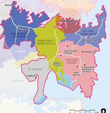
Figure 2: Eastern City District housing market areas
(Source: Revised Draft Eastern City District Plan, Oct 2017)
Five-year housing targets for the Eastern City District are the same as published in the draft Central District Plan in November 2016. The IWC housing target is 5,900 dwellings until 2021 and includes all types of housing – traditional detached and attached houses, apartments, seniors housing, granny flats and aged care. In the 5 year period from July 2012 – June 2017, the Inner West local government area delivered 3,575 additional dwellings, with a large proportion of these being multi-unit dwellings.
Housing targets for the five year period 2016-2021 and for the 20 year period are as follows:
|
District/LGA |
0-5 years housing supply target: 2016-2021 |
20 years strategic housing target: 2016-2036 |
|
Eastern City |
46,550 |
157,500 |
|
Inner West LGA |
5,900 |
TBD |
The methodology used for the housing targets in District Plans has not been provided. The housing growth of 5,900 additional dwellings is not chronologically aligned with the targets and capacity analysis prepared by the Urban Growth NSW and the DPE in the Parramatta Road Urban Transformation and Sydenham to Bankstown Urban Renewal Corridor strategies. Proposed growth projections in these two strategies are:
|
PRUTS |
Additional dwellings by 2023 |
Additional dwellings by 2050 |
|
Taverners Hill |
451 |
1350 |
|
Leichhardt |
880 |
1100 |
|
Camperdown |
389 |
700 |
|
|
Total: 1,720 |
Total: 3150 |
|
SYD to BANKS |
Additional dwellings by 2026 |
|
|
Sydenham |
500 |
|
|
Marrickville |
6000 |
|
|
Dulwich Hill |
2000 |
|
|
|
Total: 8,500 |
|
Whilst Council appreciates the need for specific targets on housing supply, the way in which the targets are presented by State agencies is confusing. The targets have been subject to multiple revisions between various overlapping metropolitan, regional and urban renewal precinct forecasts.
The areas of future housing supply are identified on the map below (Figure 3). However, the Parramatta Road corridor is not identified as an ‘urban renewal area’. It is not clear if the forecast dwelling completions of 5,900 in the IWC (2016 – 2021) includes the number of additional dwellings in Taverners Hill, Leichhardt, Camperdown and Kings Bay (smaller area within the IWC). Except in a passing mention, the District Plan does not reveal any further details on the revitalisation of Parramatta Road.
16 RESPONSE: Council requests that the draft District Plan is amended to:
a) include Parramatta Road urban renewal corridor on the map as a linear set of mixed use strategic centres;
b) ensure the Inner West housing targets include Parramatta urban renewal corridor; and
c) make transparent the method used for the housing targets
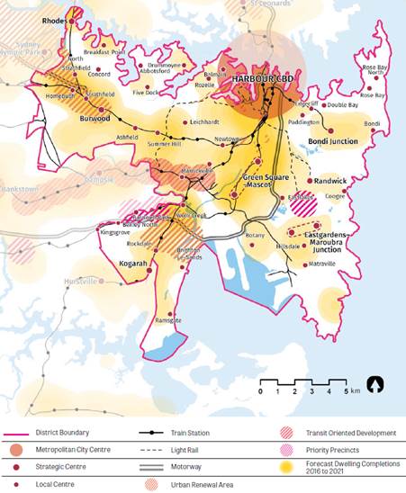
Figure 3: Eastern City District Future housing supply
(Source: Revised Draft Eastern City District Plan, Oct 2017)
The Commission will work with each council to develop 6-10 year housing targets. To deliver the 20-year housing target for the District, councils should, in local housing strategies, investigate and recognise opportunities for long-term housing supply associated with city-shaping transport projects identified in Future Transport 2056, State government strategy.
The District Plan requires councils to develop local housing strategies (LHS) which:
· make provision to meet the 5 and 10-year (when agreed) housing targets;
· identify capacity to contribute to a rolling program to deliver the 20-year district strategic supply;
· inform the Affordable Rental Housing target for development precincts; and
· co-ordinate the planning and delivery of local and State Infrastructure.
The Region Plan (Objective 10) requires Councils to prepare local or District housing strategies that respond to housing targets set by the Commission. The preparation of a LHS will support the new development standards in the consolidated Inner West LEP.
The GSC’s five year targets set out in Region and District Plans are generally consistent with known housing approvals and construction activity and they largely reflect delivery potential under current planning controls. In that case, there is no immediate urgency to deliver comprehensive Council’s housing policy that would potentially contradict Council’s main planning instruments such as new integrated LEP and DCP. The planning proposal process of site by site rezoning set up by the DPE is undermining long-term land use planning in Inner West Council. Delivery of a housing strategy in isolation from the integrated new LEP would further weaken the integrity of planning at local level but if it is aligned with the integrated LEP preparation process it will provide a strong strategic planning base for the assessment of future housing proposals.
17 RESPONSE: Council’s housing strategy will be prepared as part of the consolidated Inner West LEP and DCP project.
The GSC proposes locational criteria for urban renewal that is aligned with government investment in transport infrastructure such as Sydney Metro City or WestConnex. The GSC does not propose any new public school, open space or sporting facilities. The recommendation is for ‘enhancements to existing infrastructure and upgrade to existing facilities’.
18 RESPONSE: Any new urban growth in the IWC LGA is supported with properly planned physical, environmental and social infrastructure funded by the State Government including public schools, health centres, community centres, open space, parks, libraries, active transport networks and green infrastructure etc.
The GSC recommends that across Greater Sydney affordable rental housing targets should be in the range of 5-10% of new residential floor space. The Commission will work with the DPE to develop the mechanisms required for delivery of the proposed affordable rental housing target.
GSC identified that further opportunities to improve housing affordability are ‘compact housing’ (smaller apartments and smaller land lots) and new owner-developer apartment models known as ‘built to rent’.
One of the assertions made by the State government and mentioned in the Region and District Plans is that construction of new housing supply will substantially contribute to solving the affordable housing crisis. This strategy is linked to reliance upon the private sector to address the under-supply of affordable housing.
Whilst there has been a significant increase in housing completions in Sydney in recent years, it is clear that the market is not providing affordable housing for the vast majority of very low, low and moderate income households. The market is also failing to replace the existing stock of affordable housing that is lost through gentrification and redevelopment.
Focused interventions are needed to address existing affordability problems affecting low income households. This is corroborated by the Inner West Council’s research which strongly indicates that virtually no new housing constructed in the future will be affordable to any low income households without strong government intervention through the planning system including a policy to share land value uplift, particularly in larger brownfield and redevelopment sites as well as major State urban renewal projects.
The GSC’s proposed development feasibility testing, assumptions and exemptions should be shared with the public and incorporate business tested risk return margins that meet community expectations. Exemptions to targets should involve independent adjudication.
While the District Plan incorporates housing targets by LGA, there is no comparable plan relating to affordable housing targets. The Plan states that Greater Sydney requires an estimated 4,000–8,000 additional affordable dwellings per annum to meet the needs of lower income groups, however there is no attempt to break this estimated figure down by LGAs and to incorporate these figures in an overall plan.
A significant impediment to creating such a plan is the imprecision surrounding the measures proposed for increasing affordable housing supply e.g. State Environmental Planning Policy (Affordable Rental Housing) 2009, Affordable Rental Housing Targets for very low to low-income households, compact housing to support moderate-income households or new owner-developer apartment models.
The SEPP provides for floor space bonuses on top of the existing maximum for property developers of town houses, villas and apartment buildings. In exchange only a portion of affordable units will be secured for 10 years and managed by a registered Community Housing Provider. After 10 years the apartments will be returned to an open market rental or sale price.
This is contrary to the Council’s Policy on affordable housing, adopted in March 2017, which requires 15% of all total gross floor area to be transferred to Council as affordable rental housing units for any residential development that has 20 or more dwellings or with a gross floor area larger than 1,700m2. Council’s Policy also supports an affordable housing target of 30% of affordable units on State owned land. Affordable Rental Housing Targets in the Region and District Plan should not be limited to defined precincts but should apply to all land subject to re-zoning for residential or mixed use purposes across Greater Sydney.
19 RESPONSE: Council requests that higher targets be adopted for the Affordable Rental Housing Target with a 15% target on private land and up to 30% target on public land to help address the high levels of housing stress among very low to moderate income households in the Inner West Council LGA. These targets should apply to the whole of a development’s GFA (residential and commercial) not just the additional residential GFA. The provision of affordable rental housing on State and Commonwealth government owned land should be made mandatory for government agencies disposing of or developing surplus land for residential or mixed-use projects in order to complement affordable housing targets applying to private developments.
Having submitted evidence for the high need for affordable housing in the IWC LGA, the Department of Planning and Environment (DPE) informed Council in April 2017 that the analysis of affordable housing need in the LGA was considered comprehensive and sufficient to support an application for inclusion in State Environmental Planning Policy No 70 – Affordable Housing (Revised Schemes) – SEPP 70. At the end of April 2017, Council formally applied for inclusion in SEPP 70. Council is still waiting for a response to its application.
Inclusion in SEPP 70 would substantially enhance Council’s ability to implement its affordable housing target of 15% in major private developments. It would enable schemes that make affordable housing contributions requirements legally binding and not only an optional matter to be negotiated with developers through voluntary planning agreements.
This is particularly significant since the Sydenham to Bankstown Urban Renewal Corridor and Parramatta Road Urban Transformation Strategy include land which contains existing affordable rental housing. The redevelopment of these precincts will result in the loss of existing affordable rental housing and the replacement of that housing with more expensive units. It is important that council has suitable delivery mechanisms to enable affordable housing to be supplied to meet Council and GSC targets.
20 RESPONSE: Council requests that IWC’s application for inclusion in SEPP70 be agreed as a matter of urgency so that affordable housing can be delivered in the LGA to meet Council and GSC targets.
Planning Priority E6 will create and renew great places and local centres, and respect the District’s heritage.
The District Plan recommends that to create great public spaces and to increase opportunities to expand and connect these places with people, rooftops and podiums of high-rise buildings should be used in innovative ways.
While Council supports the use of multifunctional spaces and rooftops for private recreation wherever appropriate, these spaces cannot replace the need for town squares, civic spaces and other forms of public realm where people can gather, meet or celebrate.
21 RESPONSE: Council supports the appropriate use of rooftop spaces for private recreations, however notes it is challenging to provide large public spaces at ground level in the public realm in already developed centres.
The Plan recognises the significance of the street environment as part of the public realm, and the necessity to prioritise walking, safe cycling and social interaction.
The subsequent need to allocate space between footpaths, cycleways, public transport and vehicles needs to therefore be reflected in the major state infrastructure developments which affect the Inner West.
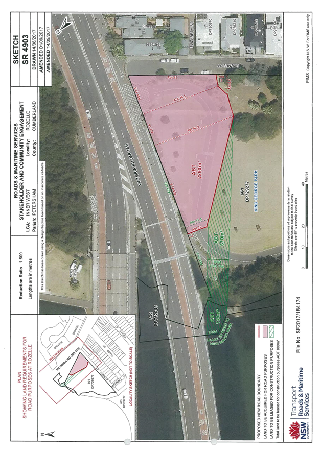
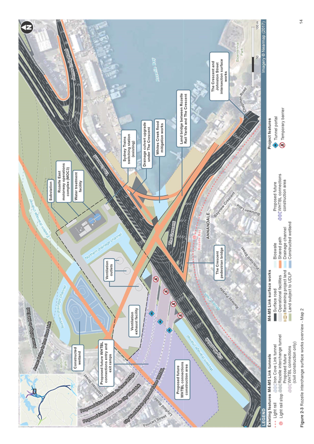
22 RESPONSE: Major state infrastructure projects such as the M4-M5 Link (Stage 3) should ensure the street environment in areas such as Victoria Road, Rozelle are redesigned to better accommodate pedestrians and cyclists (to coincide with the redirection of surface traffic into the M4-M5 Link tunnel).
The District Plan classifies centres into metropolitan city, strategic and local with 400m or 800m walking catchments (see Figure 4). It is unclear within the District Plan as to what the thresholds are and the methodology used to classify these centres.
Balmain, Rozelle, Leichhardt and Marrickville Metro are recognised as local centres with 400m walking catchment. Newtown, Summer Hill and Ashfield are local centres with 800m walking catchment.
There are no Strategic Centres in the IWC LGA identified on the map. At the District Level these are Rhodes, Burwood, Bondi Junction, Green Square-Mascot, Randwick, Eastgarden-Maroubra Junction and Kogarah.
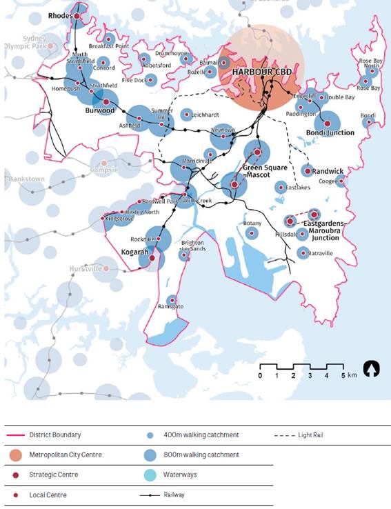
Figure 4: Eastern City District Centres
(Source: Revised Draft Eastern City District Plan, Oct 2017)
Marrickville, has the city's highest density and diversity of live music venues in the Eastern City District afforded by factory-style buildings, warehouses and community assets, such as Bowling Clubs, that exist in industrial areas.
The highest concentration of venues is in or around the Victoria Road precinct. These venues include the Factory Theatre, Red Rattler and Marrickville Bowling Club. This precinct is currently being rezoned by the NSW Department of Planning, with residential development proposed within close proximity of venues, which will significantly impact their ability to continue functioning as live music venues. The area's performing arts and creative producers are thus at risk of displacement, impacting local identity and economy.
In addition, increasing traffic congestion and lack of integrated mass transport solutions impact adversely on further growth of the night-time economy, jobs creation and vibrant night life. State policies and regulatory reforms relating to night time trading need to be harmonised across the State to achieve an agreed approach to late night trading that will support economic growth.
23 RESPONSE: Council supports the Plans promotion of a vibrant and safe night-time economy that will support a diverse range of small businesses, cultural and other public events that would meet social and economic needs of our communities.
Managing heritage conservation and accommodating development intensification in the Inner West council area is challenging. Councils are required to achieve a balance between protecting heritage spaces and buildings, whilst meeting State derived housing targets.
The District Plan does not recognise that important heritage elements of our local identity in areas such as the State-owned Callan Park are not being conserved and need urgent state government investment.
Industrial rezonings and a squeeze on affordable cultural spaces affect not only local liveability and economy, but also local heritage and identity. Made in Marrickville: Enterprise and cluster dynamics at the creative industries-manufacturing interface (Gibson et al, 2017) presents evidence for concern over the local and metropolitan impacts of displacing local industries.
Action 17 should be expanded to include the use of green infrastructure and urban ecology principles to plan and design great places. The outcome of such an approach will be Sydney’s worldwide reputation as best global city – liveable, resilient, productive, sustainable beautiful and idiosyncratic.
24 RESPONSE: That the significance of Aboriginal sites, natural landscapes and heritage buildings within Callan Park and other heritage-rich areas in the Inner West, such as along Iron Cove and Cooks River foreshores and the Cooks River to Iron Cove GreenWay, requires documentation, conservation, management and interpretation through a significant and ongoing financial commitment by the state government.
Productivity
The Region Plan proposes ongoing investment and further business growth of the Eastern City District to enable continued global growth of the Eastern Economic Corridor (from Macquarie Park to Sydney Airport, including Chatswood, St Leonards, Harbour CBD, North Sydney, Green Square and Port Botany). It also includes the important industrial areas of Artarmon, South Sydney and Marrickville.
In addition, agglomerating the assets on the western edge of the Harbour CBD such as the universities, tertiary teaching hospital, international innovation companies and fast-growing start-ups will support an Innovation Corridor. The Innovation Corridor extends from the Bays Precinct, to high – tech and start-up hubs in Pyrmont and Ultimo, to the health and education institutions of the University of Technology Sydney, Notre Dame University, the University of Sydney, the RPA Hospital and the Australian Technology Park (See Figure 5).
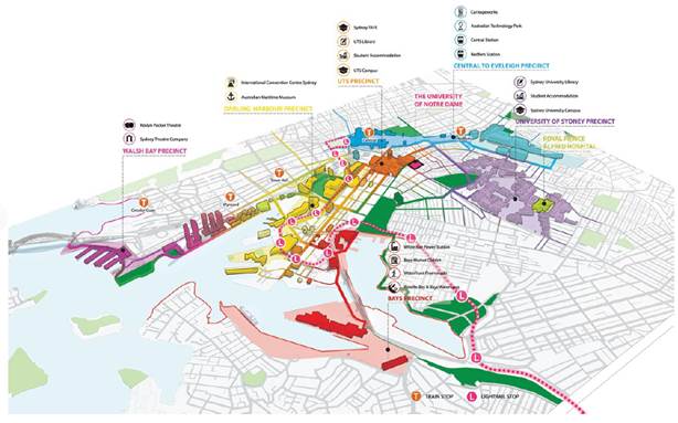
Figure 5: Innovation Corridor, Harbour CBD
(Source: Revised Draft Eastern City District Plan, Oct 2017)
The Eastern City District has the highest proportion of knowledge and professional services workers in Greater Sydney. The existing industrial, urban services land and employment land in the District is predicted to transition from manufacturing to professional, high-tech, scientific, creative industries and ancillary distribution and warehousing to further boost productivity.
Planning Priority E7 is to manage residential growth so it does not compromise the Eastern Economic Corridor.
The Draft District Plan identifies thriving night-time economies in Newtown, Marrickville and Balmain, whilst Camperdown - Ultimo is part of the innovation, health and education precinct. The Region and District Plans recognise the importance of creative industries and the night time economy to both productivity and liveability. These will foster healthy, creative culturally rich and socially connected communities, and grow targeted sectors including artistic and cultural activities and the night time economy, with a minimum regulatory burden.
25 RESPONSE: Council supports proposed policies and actions that would provide a wide range of cultural, entertainment, arts and leisure activities for a diverse and vibrant night-time economy.
It should be noted that the creative sector often requires lower rent and good access to public transport. As proposed, this coastal harbour corridor will be occupied by companies with a high cost of business which will limit the opportunity for small start-up creative businesses.
The Bays Precinct’s land use and infrastructure plan should be developed in consultation with the Council, who’s priorities for the precinct are:
· World class public transport access;
· Reopening of the Glebe Island Bridge to pedestrians and cyclists;
· Public access to foreshore;
· Up to 30% of all new housing to be not for profit; and
· New recreational facilities including an indoor sports centre and multiple sporting grounds.
The plan should also assess how the Precinct’s redevelopment and revival can be used to proactively lever economic benefits in Balmain, Rozelle and other industry precincts.
The Actions Table on page 65 of the District Plan does not include any action to deliver and implement a Place Strategy and Infrastructure Plan for the Glebe Island and White Bay Power Station Precinct. The Actions refer only to Camperdown-Ultimo and Randwick health and education precincts within the Innovation Corridor.
26 RESPONSE:
(a) The District Plan should note Council’s priorities for the Bays Precinct related to public and active transport, public access to the foreshore, public recreation facilities, affordable housing and the provision of low cost spaces for creative and start-up businesses and activities.
(b) The Actions Table on page 65 of the District Plan should include an additional action to ‘Deliver and implement a Place Strategy and Infrastructure Plan for the Glebe Island and White Bay Power Station part of the Innovation Corridor’
(c) The District Plan should include an additional action to evaluate and support the role of the Inner West Light Rail/GreenWay corridor in supporting Sydney’s knowledge-based and creative industries sector.
In examining the potential for additional growth of tourism and visitors economy in the Eastern City District, Council requests that the long term suitability of the White Bay Cruise Passenger Terminal be examined, particularly in relation to its impact on residents of Balmain and Pyrmont and the likelihood that increasing proportions of cruise ships will be too tall to obtain clear passage under the Harbour Bridge.
Presently, there are very limited public transport options for passengers on arriving ships. Connectivity between White Bay Cruise Terminal and the Balmain & Rozelle retail precincts and other key visitors zones and hubs should be improved to tap into the cruise ship economy.
27 RESPONSE: Council requests that the long-term suitability of the existing White Bay Cruise Passenger Terminal is examined considering adverse impact on nearby residential neighbourhoods and the natural environment.
Planning Priority E8 delivers on internationally competitive health, education, research and innovation precincts and their corresponding strategy.
The District Plan has identified Camperdown - Ultimo health and education precinct as an area that requires proximity to affordable and diverse housing options that can be multipurpose, and a range of cultural, entertainment and leisure activities with a strong night-time economy. The District Plan supports planning controls in the innovation corridor that would allow a sufficient supply of workspaces for knowledge-intensive jobs and provide flexibility for the needs of start-ups and enterprises with innovative business models.
The GSC has also initiated the concept of Collaboration Areas that focus particularly on centres of economic productivity. Collaboration areas are nominated places where the GSC will facilitate the establishment of governance arrangements and support the coordination of activities across agencies and governments to deliver future growth. The Region and District Plans identify Camperdown-Ultimo as one of the priority Collaboration Areas and only City of Sydney as a relevant local government.
The status of the Camperdown industrial lands within the former Leichhardt and Marrickville local government areas bordering Parramatta Road was not mapped as an integral part of Camperdown-Ultimo health and education precinct. Under the Parramatta Road Corridor Urban Transformation Strategy (PRUTS), Nov 2016 this land has been identified for future employment uses. It would be appropriate to amend the map in the District Plan with the one in the PRUTS. In order to assess planning proposals in a consistent and transparent way Council is obliged to refer to the PRUTS land use and density controls that prevail over current LEPs and DCPs provisions.
28 RESPONSE: Camperdown-Ultimo Collaboration Area mapped in the revised draft Eastern City District Plan should be amended to cover the same land identified as Camperdown Precinct in Parramatta Road Corridor Urban Transformation Strategy, (Urban Growth NSW, Nov 2016). Inner West Council should be included in the collaboration process, delivery and implementation of a Place Strategy for the Camperdown-Ultimo health and education precinct as one of the key stakeholders, alongside City of Sydney.
Planning Priority E9 objective is to protect and grow international trade gateways, Port Botany and Sydney Airport.
A key issue requiring consideration is the impact of aircraft noise in areas close to the airport runways. The Sydenham to Bankstown corridor promotes higher density residential development in precincts that are highly affected by aircraft noise. It is questionable whether these are appropriate areas for increased residential development as they will always be highly affected by noise and are not suitable residential areas. Furthermore, much of the industrial land in this precinct currently supports airport activities, and the loss of that industrial land will affect the ability of the airport to operate effectively into the future. Also see comments below under planning priority E12.
Planning Priority E10 aims to deliver a 30-minute city, the result of integrated land use and transport planning. The concept has been proposed in the Region Plan and Future Transport 2056. It means that ‘more people will have public transport access to their closest metropolitan or strategic centre within 30 minutes’. Initiatives to support integration in line with population and economic growth include:
· High-capacity mass transit links to better link people to centres and services;
· Capacity and journey-time improvements on existing transport corridors serving the Harbour CBD and surrounding centres;
· Improved transport links between strategic centres, and as feeders into mass transit;
· Improvements to strategic road network and key intersections to improve traffic flows through the District and access to strategic centres; and
· City-to-city links to the Central River City, in particular Greater Parramatta, and ultimately to the Western Parkland City, the Western Sydney Airport, Badgerys Creek Aerotropolis, Greater Penrith, Liverpool and Campbelltown-Macarthur.
The District Plan promotes cycling and walking. Transport for NSW is establishing the Principal Bicycle Network which will provide high quality, high priority cycling routes across Greater Sydney. This is in addition to coordinating the Sydney Regional Bike Network within a 10-kilometre radius of the Harbour CBD. The bike network will be integrated with the Greater Sydney Green Grid.
According to the District Plan, cycling improvements underway or being planned within the IWC LGA include:
· Inner Sydney Regional Bicycle Network;
· Inner West links; and
· Inner West missing links between Iron Cove Bridge and Cooks River.
The concept of 30-minute cities where people can live within a 30-minute commute time of their work is also strongly supported. These concepts support Council’s arguments against WestConnex which was justified by the State government as a necessary infrastructure that would connect Western Sydney to the jobs-rich Eastern City District. Instead of a car plan, Sydney needs planning for a fully integrated and comprehensive public mass transport system.
Council’s submission on Future Transport 2056 requests that the Inner Sydney Regional Bike Plan specifically be included in the 0-10 year timeframe.
Pleasant and safe environments for walking and cycling should include green infrastructure to support human thermal comfort, such as urban tree canopy with a vegetated understorey and permeable surfaces.
Council has consistently disagreed with the State’s continued pursuit of urban motorways in the inner west. Council will continue to support a limited number of location specific road improvements, but requests that these be supported by significant public transport improvements.
Further, council considers that it is essential to ensure that public transport and land use planning should be fully integrated. In support of this view council commissioned the Parramatta Road Public Transport Opportunities Study which identified a centre-running Guided Electric Transit system/GETs (an emerging transport technology) as a preferred solution to transport provision along the Parramatta Road Urban Transformation Corridor.
This transport solution has been proposed as a contemporary transport solution for point-to-point travel along the corridor which:
· releases kerbside space for parking;
· runs on sustainable power;
· is capable of capacity similar to light rail;
· may have its capacity incrementally increased in response to gradually increasing population densities;
· can be introduced, quicker, more economically and less disruptively to the local environment than light rail; and
· would be viewed by developers and new residents as a state-of-the-art transport mode, and as such would greatly assist in catalysing urban transformation.
Consideration should be given to the introduction of this technology, as an integrated response to land use planning.
29 RESPONSE: Region and District Plans should adopt principles for integrated land use and transport planning based on reduced private car dependency for all travel.
30 RESPONSE: Council oppose the expansion of Inner city motorways and supports State government investment into sustainable mass transit and improved walking and cycling network in the Inner West area of the Eastern City District.
Planning Priority E11 aims at growing investment, business opportunities and jobs in strategic centres. The draft District Plan sets out a hierarchy for centres:
· Metropolitan City centre: Harbour CBD
· Strategic centres: Bondi Junction, Burwood, Eastgarden-Maroubra Junction, Green Square-Mascot, Randwick and Rhodes; and
· Local centres.
In the IWC area all existing and future planned centres are classified as local. However, the District Plan recommends the focus of public transport investments that seek to deliver the 30-minute city objective for strategic centres only.
The revitalisation of Parramatta Road corridor is not recognised as a strategic linear centre (the high street) where improvements in public transport/mass transit are needed.
31 RESPONSE: The District Plan should identify Parramatta Road Corridor as a set of linear mixed use strategic centres in the Eastern City District where public transport investment will seek to support the 30-minute city objective.
Council supports jobs growth and community access to goods and services as a core objective for all centres. Delivery of housing should not constrain the ongoing operation of commercial and retail activities.
Planning Priority E11 should also include actions regarding attracting and supporting jobs in:
· the green economy - by supporting growth of the growing green infrastructure market and associated environmental sector (building resilience and mitigating urban heat island and supporting urban ecology); and
· supporting informal creative economies e.g. local/household food production, collaborative and sharing economies
32 RESPONSE: The District Plan should acknowledge and promote the jobs growth opportunity provided by the green economy.
Planning Priority E12 is to provide for planned, protected and managed industrial and urban services land.
The District Plan recognises that these lands serve local communities and businesses, but also support businesses in the Harbour CBD and Greater Sydney’s two existing international trade gateways of Port Botany and Sydney Airport. Demand for this land will increase commensurate with population growth.
Amongst the ten largest industrial and urban services precincts within the Eastern City District are Bays Precinct and Marrickville. The Bays Precinct has 68ha of developed land (out of 71ha total), providing for 964 jobs. Marrickville has 66ha of developed land (out of 67ha total) with 5,615 jobs.
Industrial and urban services land in the Eastern City District are highly constrained due to the development of residential dwellings and large-scale retail. Impetus for this rezoning includes recently published State strategies such as Sydenham to Bankstown Urban Renewal Corridor plan and Parramatta Road Urban Transformation Strategy, which have earmarked industrial tracts for rezoning.
Industrial zoned land is of considerable value to the Inner West, housing a concentration of highly specialised cultural producers, such as fine artists, crafts-people and cultural manufacturers, serving the creative needs of Greater Sydney. The Inner West area has the highest concentration for people working in the creative and cultural industries in NSW (9.4%, 2011 Census), with particular specialisations in the visual arts and music.
Despite their enormous value to local identity and economy, the Inner West Council area currently has significant industrial sites being considered for rezoning or recently approved by the State government. If rezonings that see a loss of industrial lands and cultural spaces in this area are to proceed, the last significant hubs of Inner City cultural production will be lost. As Made in Marrickville: Enterprise and cluster dynamics at the creative industries-manufacturing interface (Gibson et al, 2017) reveals that the cultural infrastructure provided by industrial lands in Carrington Road are critical for Sydney to remain a competitive and liveable global city (Made in Marrickville, p. 9). Cultural producers and key city events of Greater Sydney depend on services in the Inner City ring.
The current necessity to retain industrial lands is driven by:
· burgeoning demand of displaced cultural producers;
· several significant new developments and potential rezonings;
· a significant surge in Greater Sydney/ the Inner West's cultural manufacturing sector, led in part by local demand for locally produced, niche goods and services;
· recognition of the value of the local creative economy; and
· proximity to the CBD (client relationships, transport, delivery times).
Comparing to the previous drafts of Metropolitan and District Plans, GSC has strengthened its policy on the protection of industrial land, from a precautionary approach to now prohibition of any conversion of that land to residential or mixed land use.
33 RESPONSE: The Plans recommendation to protect industrial lands from encroachment of residential, mixed or any other land uses use that would hinder their role and function is firmly supported. Council recommends that the GSC strongly advocates this position to the Department of Planning to retain and protect the current stock of industrial, employment and urban services land in the Inner West, including the unique cultural production hubs, which play a significant role in nurturing and growing Sydney’s knowledge-based and creative industries economy.
Planning Priority E13 supports growth of targeted industry sectors. The Region Plan outlines strategies to support industry sectors such as industry skills, investment attraction, export growth, industry showcasing and opportunities through government procurement and partnerships.
The sectors of focus for the Eastern City District with most potential to be globally competitive and create jobs are:
· International education;
· Financial and professional services;
· Star-ups and digital innovation;
· Regional headquarters of multinationals;
· Tourism;
· Infrastructure and smart cities; and
· Creative industries.
As Australia’s prime international gateway, Greater Sydney welcomes 30 million visitors per annum. The Eastern City District contributed over $8.6 billion to the economy in 2015-16.
The District Plan recognises Marrickville and surrounding neighbourhoods as emerging areas and a focal point of creative industries, small-scale cultural and arts experiences. These assets have the potential to add a new and unique face to the tourist economy.
The Inner West is known for its cultural, entertainment, arts and leisure activities on offer. While Council’s provides support to cultural activities and the eclectic offerings of the local businesses, current regulations are prohibiting growth in this area. The final District Plan should recognise the need and support the alignment of regulations, policy and planning controls where appropriate to make it easier for business to support small-scale cultural spaces uses and activities.
34 RESPONSE: Council strongly supports the recommendation for further progress of innovative and creative industries, local artists and visitor economy. The final District Plan should identify the Inner West Light Rail/GreenWay corridor as a focal point of creative industries in the District.
Sustainability
Improving sustainability will involve: incorporating natural landscape features into the urban environment; protecting and managing natural systems; cooling the urban environment; innovative and efficient use and re-use of energy, water and waste resources; and building the resilience of communities to natural and urban hazards, shocks and stresses.
The District Plan identifies four connected elements of green infrastructure: waterways; urban bushland; urban tree canopy and green ground cover; parks and open spaces.
Regarding recommended metrics to assess progress of Planning Priorities to achieve Direction 8 (A city in its landscape), there should be metrics for:
1. increasing native vegetation (including mid-storey shrubs and ground cover / grasses);
2. improving waterway health; and
3. water conservation and waste (in precincts with low carbon initiatives).
Urban tree canopy alone cannot improve ecological health or meet the liveability and biodiversity objectives.
In general, the term ‘sustainability’ should be replaced with more specific term ‘ecologically sustainable development’ (ESD) as defined in the Protection of the Environment Administration Act 1991 and referred to in numerous other legislation, e.g. Environmental Planning and Assessment Act 1979, Coastal Management Act 2016, etc.
Planning Priority E14 delivers protected and healthier coast and waterways.
The Eastern Districts’ waterways play an integral role in creating a sense of place, providing recreational opportunities, supporting economic and cultural activities. They support threatened ecological communities and accommodate the disposal of stormwater and wastewater. Many of the District’s creeks have been channelised and hard-edged with concrete – such as Hawthorne and Dobroyd canals.
The delivery of the Green Grid is one of the projects that will enhance community access to the coast and waterways within the District. It should be noted that access to waterways is not necessarily appropriate in ecologically sensitive riparian and waterway environments and should be managed carefully and protected in those cases.
Action 57 of the Planning Priority E14 should be reworded to “Protect and enhance environmentally sensitive coastal areas, riparian zones and waterways”.
Action 58 of the Planning Priority E14 should be reviewed. Enhancing access to waterways will impact on waterways, for example formal access such as concrete pathways disturbs the limited vegetation in the riparian zone.
IWC is a member of the Parramatta River Catchment Group and the Cooks River Alliance, both of which seek to make these waterways swimmable again by 2025. These groups are an alliance of local and State Government agencies and the community. The approaches taken by these groups should be included in the relevant actions to deliver Planning Priority E14.
35 RESPONSE: Council strongly supports protection and improvement of environmental health of the District’s coast and waterways, especially the acknowledgment of the cumulative impact of development. Parramatta River Catchment Group, GreenWay Program and the Cooks River Alliance should be involved in the delivery of proposed actions.
Planning Priority E15 seeks to protect biodiversity, urban bushland and enhance remnant vegetation.
Bushland areas and remnant vegetation support the District’s significant biodiversity, provide habitat, help cool the environment and support cleaner waterways and air. The District Plan supports protecting biodiversity and investing in connected bushland corridors to give the District’s wildlife the greatest chance of survival. This approach complements the delivery of the Greater Sydney Green Grid.
It is recommended to include an additional item in Action 61 which is: ‘Ensure that opportunities to increase biodiversity are incorporated into the planning and design of neighbourhoods and urban renewal and transformation projects’.
36 RESPONSE: The District Plan to include as an action to protect and enhance bushland and biodiversity a provision for not only increasing the urban tree canopy but also a diversity of vegetation structures including ground cover.
Planning Priority E16 delivers on the protection of scenic and cultural landscapes which encourage an appreciation of the natural environment, protect heritage and culture and create economic opportunities, particularly for recreation and tourism. The District Plan identifies opportunities to enhance views of Sydney Harbour with renewal projects such as The Bays Precinct.
37 RESPONSE: Council supports the protection of views of scenic and cultural landscapes from the public realm but only where substantial vegetation is not removed.
Planning Priority E17 delivers on increasing urban canopy cover and delivering Green Grid connections.
Tree-lined streets, urban bushland and tree cover on private land form the urban tree canopy. The District Plan identifies Marrickville and Ashfield as suburbs that have low tree canopy cover. The Plan recommends that sustaining boulevards of trees along the District’s busiest roads including Marrickville, Parramatta and Canterbury Road is an important step towards improving amenity and air quality and cooling the Eastern City District.
The canopy cover over the Inner West local government area, based on 2014 figures, is 18.3 percent. Council’s officers consider that ideally, the urban forest canopy cover in an inner suburban area should be at least 30%.
The Marrickville Urban Forest Strategy (2011) and the Marrickville Community Strategic Plan aim to increase urban forest canopy although they do not set a canopy target. However, as a guide, the City of Sydney aims to achieve a LGA wide canopy target of 27% by 2050 (up from 15.5%) and City of Melbourne aims to achieve 40% by 2040 (up from 22%).
It is considered that higher density residential, retail and commercial planning proposals where nearly all the existing buildings and infrastructure will be removed to accommodate wide scale redevelopment must achieve a minimum of 30 percent urban forest canopy. Nevertheless Council’s policy to provide increased urban forest canopy for any major redevelopment is not currently a legally binding requirement when assessing development applications.
38 RESPONSE: The District Plan should give statutory weight to:
a) Council’s Urban Forest Strategy and request for a forest canopy of at least 30% of the LGA;
b) Strategy for a Water Sensitive Community 2012-2021 and decrease both the effective impervious area and water consumption on 2010 levels; and
c) Marrickville LEP 2011 Natural Resources – Biodiversity map that identifies a native wildlife corridor along the Cooks River and requests that any landscaping plans must be native vegetation local to the Sydney basin (minimum 90%).
The Greater Sydney Green Grid is a vision of network of high quality green spaces that connects communities to the natural landscape. State regional and district parklands and reserves form a principle element of the Greater Sydney Green Grid for both biodiversity and recreation purposes. It promotes a healthier urban environment, improve community access to recreation and exercise, encourages social interaction, supports walking and cycling connections and improves resilience.
The Grid will be delivered incrementally over decades as opportunities arise and detailed plans for connections are refined. The list of related Projects for the District includes:
1. Iron Cove Greenway and the Hawthorne Canal. Creating a sequence of connected open spaces that follow the Hawthorne Canal and the Light Rail Corridor from Leichhardt North to Dulwich Hill light rail stations; and
2. The Cooks River Open Space Corridor. Links to nearby centres including Strathfield, Sydney Olympic Park, Campsie, Canterbury, Dulwich Hill, Marrickville and Wolli Creek. This is a priority green grid project for both the Eastern City and South Districts.
The District Plan lists other important projects to deliver Sydney’s Green Grid in the Eastern City District including the Bankstown to Sydenham Open Space corridor. This project will transform surplus rail easement land and wide local streets that run parallel to the rail line into an active walking, cycling, open space and cultural corridor which will connect regionally significant open space areas, such as the Cooks River Foreshores, Wolli Creek Regional Park, the Cooks River to Iron Cove GreenWay and Salt Pan Creek open space corridor.
The Inner West Council is project managing the delivery of the GreenWay Missing Links Project which will “unlock” an additional 3Ha of new publicly accessible open space along the Inner West Light Rail/GreenWay Corridor. Specific mention should be made in the District Plan of the proposal by DPE to design and implement the proposed “GreenWay South-West”, to be routed along the Bankstown to Sydenham corridor.
Planning for the GreenWay South West needs to recognise that it should be designed and delivered as a multipurpose corridor, which provides a range of benefits, including improved active travel, urban greening/biodiversity, providing wildlife habitat, well designed open space, opportunities to enhance cultural and community connections etc.
Council encourages the GSC to facilitate a whole-of-government approach to the design and implementation of multi-purpose green corridors such as GreenWay South West and Cooks River to Iron Cove GreenWay. This should involve key stakeholders such as City of Canterbury Bankstown, Inner West Council, Government Architects NSW, GSC, TfNSW, Sydney Metro and other relevant agencies/groups.
The Metropolitan Greenspace Program, administered by the Greater Sydney Commission, provides funding of individual grants to councils. However, the draft District Plan recommends that local governments lead delivery of this regional infrastructure and adopt funding mechanisms such as development and land use controls, agreements for dual use of open space and recreational facilities, direct investment in open space, Section 94 Contributions and Voluntary Planning Agreements.
The State Government must commit to funding towards the key regional infrastructure, such as the Greater Sydney Green Grid, that Council will not be able to fund due to past caps on S94 contributions (combined with caps on rates). Council considers that any acquisitions should be compensated by the State Government, given this is required largely due to the rapid population growth initiated by Regional and District Plans. If a State Significant Contribution (SIC) is introduced for other infrastructure in urban renewal areas, concern is raised that the funding for state and regional infrastructure will be locked in first and Council will be limited in its ability to increase S94 contributions to adequately cover all the remaining local infrastructure.
39 RESPONSE: Council supports the GSC’s commitment to improve regional open space and deliver Greater Sydney’s Green Grid through the administration and management of the Metropolitan Greenspace Program and other funding sources. Council recommends that the Greater Sydney Green Grid, including the native vegetation of the GreenWay, is financially supported by the State Government and Special Infrastructure Contributions as it is regionally significant infrastructure.
Planning Priority E18 aims to deliver high quality open space.
The draft District Plan explains that there will be relatively few opportunities to increase the quantity of public open space, and therefore greater emphasis will be needed on improving the quality and distribution of open space, including sporting facilities. It is recommended that councils make better use of existing sportsgrounds, converting existing open space into sports fields, and partnering with schools to share spaces outside school hours. The Plan recommends rooftop gardens, shared use of open spaces currently inaccessible due to private use and small/pocket parks as opportunities to create greater recreational capacity across the District.
The Plan concludes that the future of some larger spaces used for activities, such as golf, may be uncertain due to declining membership and attendance figures. The Commission recommends that any land or facilities in public ownership should be retained as open space and transition to shared open space and facilities, including for organised sports.
The Plan concludes that active open space is in high demand across the District but that there are limited opportunities to provide additional capacity alongside growth.
Land for open space should be identified upfront and funding mechanisms identified in District Plans. In order to deliver the Green Grid there may be requirements for government to acquire land for open space, to incorporate large parkland areas rather than primarily linear parks. Linear parks promoted in the Sydenham to Bankstown Strategy on the rail transit surplus land along the metro line cannot replace the need for proper parks that are more than connectors. Linear parks along cycling and walking tracks are great community assets but the Inner West area also need larger open space for group sports or community outdoor functions.
Action 66 should also include the following: ‘Require large private urban development projects to incorporate open space areas such as rooftop gardens and indoor sport/recreation facilities within the development area where nearby public open space is limited’.
40 RESPONSE: The final Plans must ensure that adequate and appropriately located public parks and recreational facilities are provided to meet the needs of the existing population and natural environment the additional demand resulting from the proposed urban growth.
Planning Priority E19 deals with reduced carbon emissions and managing energy, water and waste efficiently.
The draft District Plan confirms that demand for energy and water and the generation of waste will increase with the significant growth planned for the Eastern City District. The Plan also recommends building on existing public transport connections with electric vehicle transport hubs, shared autonomous vehicles and other innovative transport technologies that will further reduce greenhouse emissions, and reduce levels of noise and air pollution.
It is acknowledged in the Plan that the Eastern City District is leading the way in sustainability and energy efficiency innovation by mainstreaming highly energy-efficient buildings, encouraging building renovations that ensure low-carbon and high efficiency performance, enabling green energy, water and waste infrastructure solutions, and replacing old and inefficient existing infrastructure and technologies.
It is considered that combining waste management with energy and water usage under one planning priority undermines the importance of waste and resource recovery. There are no details on future management of waste or resource recovery main concern which is transport of waste. The District Plan refers to the creation of a circular economy to improve efficiency and waste management but does not provide any mechanism or initiative on how to drive innovation, investment or opportunities in this area.
An increase of dwellings and people in the City Eastern District will lead to a huge increase in waste generation. The Region and District Plans should specify a mandatory best practice approach for Council-State agencies in relation to waste management in major urban development initiatives.
Additional waste management infrastructure will be required to meet the challenge, as per the Draft NSW Infrastructure Strategy 2017. For example, an expected 26% increase in waste generated in the Sydenham to Bankstown Urban Renewal Corridor will mean additional transport and collection costs, as well as additional truck movements with the associated environmental and social impacts.
Existing infrastructure is almost at capacity already, with landfills closing and new facilities such as Veolia’s Woodlawn waste processing facility opened in 2017 with 100% utilisation. An adequate network of waste transfer and treatment facilities must be developed if NSW is to achieve resource recovery targets and maximum diversion from landfill. A greater proportion of income from the NSW S88 Waste Levy (charged on each tonne of waste disposed in landfill) could be utilised on strategic planning for waste infrastructure at state level. This would be over and above what is diverted through the NSW Waste Less, Recycle More initiative in contestable and non-contestable grants.
IWC strongly supports alternatives to landfill for disposal, as well as reduction in waste generation rates, but these aims generate the need for alternatives for which Sydney already lacks options. Possibilities for consideration include precinct based reuse, recycling and waste-to-energy facilities (with adequate environmental controls such as those imposed on facilities in European and Japanese cities).
41 RESPONSE: The Regional and District Plans should include more details such as actions, targets and milestones for waste and resource recovery including land/zoning for local infrastructure, transport and waste facilities and transfer stations.
The District Plan should be amended to explicitly state targets set out in the NSW Waste and Resource Recovery Strategy 2014-21, NSW Environmental Planning Authority (EPA), Dec 2014. The Regional and District Plan should also refer to draft (or final version) NSW Waste and Resource Recovery Infrastructure Strategy 2017-2021 prepared by the EPA which is a gap analysis identifying lack of infrastructure for waste in NSW. This document confirms that current landfills are reaching capacity and the effect of the need to transport the waste outside the District.
42 RESPONSE: The final Plans should consider a separate planning priority for waste and resource recovery. The Plans should explicitly support targets set in the NSW Waste and Resource Recovery Strategy 2014-21.
The management of waste and resources must be integral to the planning and design of the sites. Best practice waste management happens at the source. Space needs to be allocated within urban renewal areas that will allow alignment with the NSW Waste Avoidance and Resource Recovery Strategy 2014-2021. That is space for a small facility within each precinct that would allow for reusing or processing items.
Higher priority needs to be given to driving innovation and best practice resource recovery, for example this could be for onsite composting (as is currently being demonstrated at Barangaroo) and/or where reusable items and materials can be sorted, repaired and reused through partnerships with social enterprises and reuse centres. Both opportunities would not only help to mitigate waste impacts on and outside of the precincts but create valuable local employment opportunities and community skills.
43 RESPONSE: The final Plans should identify new locations for waste recycling and management which is a State government responsibility and beyond Council’s controls.
Planning Priority E20 is to address adapting to the impacts of urban and natural hazards and climate change.
The District’s climate and natural landscape can create natural hazards such as heatwaves, flooding, storms and coastal inundation and erosion.
In relation to urban hazards, the draft District Plan also confirms that transport movements along major roads and rail corridors generate noise and are a source of air pollution. The Plan concludes that the design of new buildings and public open space can play a significant role in reducing exposure to noise and air pollution along busy road and rail corridors. There are no recommendations on the measures to reduce urban hazards such as air pollution and noise when new motorways are being built through mature neighbourhoods.
44 RESPONSE: The GSC should recommend measures to reduce noise, water, air and soil pollution caused by new Inner West motorways.
FINANCIAL IMPLICATIONS
Nil.
OTHER STAFF COMMENTS
Comments on the Regional and District Plans were received from all relevant staff/areas of Council including Strategic Planning, Economic Development, Community Services, Environmental Services, Parks and Reserves and Resource Recovery.
PUBLIC CONSULTATION
Public consultation on the draft Regional and District Plans is being undertaken by the Greater Sydney Commission with the exhibition closing on 15 December 2017.
CONCLUSION
This Report recommends that Council make a submission on the draft Regional and Eastern City District Plans seeking amendments that address key issues including funding for social and physical infrastructure to facilitate further urban growth, evident problems with Sydney housing supply and demand; and environmental outcomes.
|
1.⇩ |
Summary Draft Greater Sydney Region Plan |
|
2.⇩ |
Summary Revised Draft Estern City District Plan |
|
Council Meeting 12 December 2017 |
Subject: Review of State Environmental Planning Policy No. 1 - Development Standards and State Environmental Planning Policy (Miscellaneous Consent Provisions) 2007
Prepared By: Peter Wotton - Strategic Planning Projects Coordinator
Authorised By: David Birds - Group Manager Strategic Planning
|
SUMMARY The Department of Planning and Environment has released an Explanation of Intended Effect concerning a proposal to repeal State Environmental Planning Policy No. 1 – Development Standards and State Environmental Planning Policy (Miscellaneous Consent Provisions) 2007 and make a number of other consequential changes to the planning controls relating to land to which environmental planning instruments not made under the Standard Instrument LEP apply.
The repeal of two operational SEPPs package is on exhibition until 22 December 2017.
Council officers have prepared a submission for Council’s consideration. The submission raises a number of issues with the proposed amendments. That submission is ATTACHED as ATTACHMENT 1.
For the reasons detailed in the submission, particularly the key differences between the provisions of State Environmental Planning Policy No. 1 – Development Standards (SEPP 1) and the provisions of Clause 4.6 Exceptions to development standards of the Standard Instrument LEP, the submission recommends that SEPP 1 NOT be repealed.
SEPP 1 currently applies to the Balmain Leagues Club Precinct site. That land is identified as a “Deferred matter” under Leichhardt Local Environmental Plan 2013. As part of the consultation the Department invited Councils to nominate clauses in the LEPs applying to deferred areas that they do want to be capable of being varied.
Notwithstanding that the submission prepared by Council officers recommends that State Environmental Planning Policy No. 1 – Development Standards not be repealed, should the Department decide to do so, it is recommended that Council request that the maximum floor space ratio development standard of 3.9:1 in Clause (4) (a), and the maximum height development standards of “12.5 metres above the existing road level” specified in subclause (4)(f), the “reduced level of 52.0 metres” specified in subclause (4)(g), and the “reduced level of 82.0 metres” specified in subclause (4)(f), (4)(g) and (4)(h) respectively in Schedule 1 of LLEP 2000 relating to the Balmain Leagues Club Precinct site be listed as development standards not be capable of being varied.
Also as detailed in the submission, the repeal of State Environmental Planning Policy (Miscellaneous Consent Provisions) 2007 and the incorporation of Standard Instrument LEP provisions relating to Subdivision (Clause 2.6), Demolition (Clause 2.7), Temporary use of land (Clause 2.8) and Conversion of fire alarms (Clause 5.8) into SEPPs and local environmental planning instruments that contain land to which the provisions of the Standard Instrument LEP do not apply, would require an extensive number of LEPs as well as SEPPs to be amended and does little to simplify and modernize the planning system. Such extensive amendments are difficult to justify especially considering that the proposed changes are to address an issue which relates to approximately 0.2% of land in the State.
The submission recommends an alternate approach which is contended a better and simpler approach to ensure that those provisions of the Standard Instrument LEP apply uniformly within each local government area.
|
|
RECOMMENDATION
THAT:
1. The report be received and noted; and
2. Council endorse the draft submission in ATTACHMENT 1 to this report to be forwarded to the Department of Planning and Environment.
|
BACKGROUND
The Department of Planning and Environment is reviewing State Environmental Planning Policies (SEPPs) “to simplify and modernise the planning system by removing duplicated, redundant and outdated planning controls”.
The Department proposes to improve and simplify NSW development standards by repealing SEPP No. 1 - Development Standards and SEPP (Miscellaneous Consent Provisions) 2007 (MCP SEPP). The planning provisions contained in those two SEPPs are proposed to be incorporated into local planning controls.
The Department contends that the above SEPPs have limited application, only applying to lands which have been deferred from the Standard Instrument Local Environmental Plan and a small number of other State Environmental Planning Policies.
The Executive Summary in the Department’s Explanation of Intended Effect (October 2017) for the repeal of the two operational SEPPs states (in part) as follows:
“The proposed repeal of SEPP 1 and the MCP SEPP is possible because the Standard Instrument Local Environmental Plan (Standard Instrument LEP) contains equivalent provisions to those in SEPP 1 and the MCP SEPP which currently apply to more than 99.8 per cent of the lands of NSW.
It is proposed to amend the older LEPs (Attachment B) that continue to apply to the remaining 0.2 per cent of the State by inserting into them the equivalent Standard Instrument LEP’s clauses for:
· Exceptions to development standards (Clause 4.6)
· Subdivision (Clause 2.6)
· Demolition (Clause 2.7)
· Temporary use of land (Clause 2.8)
· Conversion of fire alarms (Clause 5.8)
It is also proposed to amend a small number of SEPPs (Attachments C and E) that were made before the introduction of the Standard Instrument LEP by inserting into them the five equivalent provisions. SEPP 1 and the MCP SEPP can then be repealed.
Highlights of the proposals in this document include:
· The elimination of the parallel operation of two development standards variation mechanisms in favour of a single mechanism, Clause 4.6 Exceptions to development standards from the Standard Instrument LEP. Clause 4.6 will then apply everywhere in NSW.
· Reducing the volume of State policy and providing uniformity in the relevant planning provisions applying across NSW.
· Completing the transfer of development consent requirements for demolition, subdivision, temporary use of land and fire alarm systems from State Instruments into local instruments and making these provisions uniform within each local government area.
The proposed repeal of SEPP 1 and the MCP SEPP will reduce the number of State Environmental Planning Policies by transferring the provisions to the most appropriate level in the planning system making them easier for use for all stakeholders. This is consistent with the Government’s objective for a clear, contemporary and transparent planning system.”
The repeal of two operational SEPPs package is on exhibition until 22 December 2017.
DISCUSSION
a. State Environmental Planning Policy No. 1 - Development Standards (SEPP 1)
SEPP 1 has been in place since 1980. It is aimed at providing flexibility in the application of certain planning controls by allowing councils to approve a development application that does not comply with a development standard where it can be shown that compliance is unreasonable or unnecessary.
Environmental planning instruments made under the Standard Instrument LEP include Clause 4.6 Exceptions to development standards. State Environmental Planning Policy No. 1 - Development Standards (SEPP 1) does not apply to land to which those instruments apply.
SEPP 1 only applies to small proportions of Local Government Areas where lands were deferred from the application of the Standard Instrument LEP and to eight older SEPPs.
The only land deferred from the application of the Standard Instrument LEP in the Inner West LGA is the land referred to as the “Balmain Leagues Club Precinct site”.
The land to which the Balmain Leagues Club Precinct site relates is identified as a “Deferred matter” on the Land Application Map of Leichhardt Local Environmental Plan 2013 (LLEP 2013). Clause 1.3 (1A) of LLEP 2013 states:
“(1A) Despite subclause (1), this Plan does not apply to the land identified as “Deferred matter” on the Land Application Map.”
The local environmental plan applying to land referred to as the “Balmain Leagues Club Precinct site” is Leichhardt Local Environmental Plan 2000 (LLEP 2000). That instrument is not an environmental planning instrument made under the Standard Instrument LEP.
The planning controls applying to land referred to as the “Balmain Leagues Club Precinct site” are contained in LLEP 2000. Schedule 1 Additional uses and controls for certain land of LLEP 2000 specifies the following controls for the site:
“Part 3 Amended controls on specific sites
Balmain Leagues Club Precinct site
(1) For the purposes of this Part:
building height (or height of building) means the vertical distance between ground level at any point to the highest point of the building, including plant and lift overruns, but excluding communication devices, antennae, satellite dishes, masts, flagpoles, chimneys, flues and the like.
mixed use development means a building or place comprising 2 or more different land uses that are permissible in the Business Zone.
the site means the site comprising all of the following land:
(a) 138–152 Victoria Road, Rozelle (being Lot 1, DP 528045),
(b) 154–156 Victoria Road, Rozelle (being Lot 1, DP 109047),
(c) 697 Darling Street, Rozelle (being Lot 104, DP 733658),
(d) 1–7 Waterloo Street, Rozelle (being Lots 101 and 102, DP 629133, Lots 37 and 38, DP 421 and Lot 36, DP 190866),
as shown edged heavy black and lettered “SSP” on the map marked “Leichhardt Local Environmental Plan 2000 (Amendment No 16)” deposited in the office of Leichhardt Municipal Council.
(2) Despite any other provision of this Plan (except clause 19 (6) and (7) or a provision of this Part), consent may be granted for mixed use development on the site, but only if, in the opinion of the Council, the following objectives are met:
(a) the development integrates suitable business, office, residential, retail and other uses so as to maximise public transport patronage and encourage walking and cycling,
(b) the development contributes to the vibrancy and prosperity of the Rozelle Commercial Centre with an active street life while maintaining residential amenity,
(c) the development is well designed with articulated height and massing providing a high quality transition to the existing streetscape,
(d) the traffic generated by the development does not have an unacceptable impact on pedestrian or motor vehicle traffic on Darling Street, Waterloo Street and Victoria Road, Rozelle,
(e) any residential development at street level has a frontage to Waterloo Street, Rozelle and, when viewed from the street, has the appearance of no more than three storeys.
(3) A consent under subclause (2) must not be granted if the application for the development does not apply to the whole of the site.
(4) A consent under subclause (2) must not be granted if the development will result in any of the following:
(a) the floor space ratio for the site exceeds 3.9:1,
(b) the floor space ratio for all shops on the site exceeds 1.3:1,
(c) the floor space ratio for all commercial premises on the site exceeds 0.2:1,
(d) the floor space ratio for all clubs on the site exceeds 0.5:1,
(e) the floor space ratio for all residential development on the site exceeds 1.9:1,
(f) in relation to a building on the site that is less than 10 metres from Waterloo Street, Rozelle—the building height exceeds 12.5 metres above the existing road level,
(g) in relation to a building on the site that is less than 36 metres from Darling Street, Rozelle—the building height exceeds a reduced level of 52.0 metres relative to the Australian Height Datum or exceeds two storeys,
(h) a building height on the site exceeds a reduced level of 82.0 metres relative to the Australian Height Datum or exceeds twelve storeys.”
The planning controls for the site came into effect on 29 August 2008 when Leichhardt Local Environmental Plan 2000 (Amendment No. 16) was gazetted.
The Department’s Explanation of Intended Effect (October 2017) states that Clause 4.6 (6) will be amended to suit the older LEPs that apply to deferred areas. The Explanation of Intended Effect also notes that “Clause 4.6 (8) creates an opportunity for local councils to list the clauses in their LEP that they do not want to be capable of being varied by Clause 4.6. Councils have been invited to nominate the clauses in the LEPs applying to deferred areas that they want excluded under subclause (8).”
The development standards that apply to development on the Balmain Leagues Club Precinct site are principally those contained within sub clause (4) of Schedule 1 of LLEP 2000 reproduced above. Council has an opportunity to request the Department list any development standards that the Council does not want to be capable of being varied under the Clause 4.6 Standard Instrument LEP equivalent clause proposed to be incorporated into their instrument.
Whilst there is a philosophical argument as to whether developments on “Deferred sites” should be afforded the same degree of flexibility in the application of certain development standards to particular development as developments on non deferred sites, on balance it is generally considered reasonable to do so subject to the circumstances in each case. It should also be noted that the preclusion of the ability to vary certain development standards on deferred sites may act as a catalyst for planning proposals being lodged for such land, which if supported, would result in that land no longer being a “deferred site”.
In relation to the Balmain Leagues Club Precinct site it is considered that the maximum floor space ratio permitted for development on the land of 3.9:1 under subclause 4(a) above should be made a development standard that is not able to be varied. That floor space ratio is well in excess of the next highest floor space ratio that applies to land under Leichhardt Local Environmental Plan 2013 of 2.15:1. It should also be noted that a FSR of 3.9:1 is also in excess of the maximum floor space ratio that currently applies to other land in the Inner West LGA of 3.0:1 and 3.7:1 respectively under Ashfield Local Environmental Plan 2013 and Marrickville Local Environmental Plan 2011.
Building height controls are important to ensure that developments respond to the desired future scale and character of the street and local area. The Balmain Leagues Club Precinct site has sensitive interfaces. In light of the above it is considered that Council should request that the maximum height development standard of “12.5 metres above the existing road level” specified in subclause (4)(f), the “reduced level of 52.0 metres” specified in subclause (4)(g), and the “reduced level of 82.0 metres” for the site specified in subclause (4)(h) be made non variable development standards.
It is considered unnecessary to request that the Department list the other development standards contained in subclause (4) as being not capable of being varied under the Clause 4.6 Standard Instrument LEP equivalent provision.
The submission prepared for Council’s consideration (ATTACHMENT 1) raises a number of issues with the approach detailed in the Department’s Explanation of Intended Effect for the repeal of the two operational SEPPs, and because of the key differences between the provisions of State Environmental Planning Policy No. 1 – Development Standards (SEPP 1) and the provisions of Clause 4.6 Exceptions to development standards of the Standard Instrument LEP, the submission strongly recommends that SEPP 1 NOT be repealed.
Notwithstanding that the submission recommends that State Environmental Planning Policy No. 1 – Development Standards not be repealed for the reasons outlined in this submission, should the Department decide to do so, it is recommended that Council request that the maximum floor space ratio development standard of 3.9:1 in Clause (4) (a), and the maximum height development standards of “12.5 metres above the existing road level” specified in subclause (4)(f), the “reduced level of 52.0 metres” specified in subclause (4)(g), and the “reduced level of 82.0 metres” specified in subclause (4)(h) respectively in Schedule 1 of LLEP 2000 relating to the Balmain Leagues Club Precinct site be listed as development standards not to be capable of being varied.
b. State Environmental Planning Policy (Miscellaneous Consent Provisions) 2007 (MCP SEPP)
The background information with the Department’s Explanation of Intended Effect states (in part) that:
“State Environmental Planning Policy (Miscellaneous Consent Provisions) 2007 (MCP SEPP) was made to ensure that the demolition of buildings, the subdivision of land and the conversion of fire alarm systems were matters that required development consent. The MCP SEPP makes those forms of development require consent across NSW.
The MCP SEPP also introduced State wide provisions to enable:
· the erection of temporary structures with development consent, and
· limited changes of use in certain business zones to occur without consent”
The Department’s Explanation of Intended Effect notes that “Like SEPP 1, the MCP SEPP now only applies:
· on lands that are not subject to a Standard Instrument LEP, that is deferred areas where an older LEP still applies, and
· in a smaller number of older SEPPs that do not have clauses addressing demolition, subdivision, temporary use of land and fire alarm systems.
It is proposed that the Standard Instrument LEP clauses 2.6 (Subdivision), 2.7 (Demolition) and 5.8 (Conversion of fire alarms) be inserted into all the older instruments applying to deferred areas so that there is uniformity across NSW.”
It is also proposed to include a Standard Instrument LEP clause 2.8 (Temporary use of land) in those instruments amended to match the temporary use provision in the respective LGA’s Standard Instrument LEP.
The submission prepared for Council’s consideration (ATTACHMENT 1) raises a number of issues with the approach detailed in the Department’s Explanation of Intended Effect for the
repeal of State Environmental Planning Policy (Miscellaneous Consent Provisions) 2007 and the incorporation of Standard Instrument LEP Clauses 2.6, 2.7, 2.8 and 5.8 into SEPPs and local environmental planning instruments that contain land to which the provisions of the Standard Instrument LEP do not apply, would require an extensive number of LEPs as well as SEPPs to be amended and does little to simplify and modernize the planning. Such extensive amendments are difficult to justify especially considering that the proposed changes are to address an issue which relates to approximately 0.2% of land in the State.
The submission recommends an alternate approach which is contended a better and simpler approach to ensure that provisions relating to Subdivision (Clause 2.6), Demolition (Clause 2.7), Temporary use of land (Clause 2.8) and Conversion of fire alarms (Clause 5.8) of the Standard Instrument LEP apply uniformly within each local government area.
As stated previously the only land deferred from the application of the Standard Instrument LEP in the Inner West LGA is the land referred to as the “Balmain Leagues Club Precinct site”.
It is one of the 43 LEPs listed in the Department’s Explanation of Intended Effect that contains land deferred from the application of the Standard Instrument LEP.
The proposed amendments in relation to the repeal of State Environmental Planning Policy (Miscellaneous Consent Provisions) 2007 would have minimal implications for the Balmain Leagues Club Precinct site apart from increasing the maximum period for a temporary use on the land from 26 days (under Clause 31 of LLEP 2000) to a maximum of 106 days, the maximum period permitted for a temporary use under Clause 2.8 of Leichardt Local Environmental Plan 2013.
FINANCIAL IMPLICATIONS
Nil
OTHER STAFF COMMENTS
Council’s Development Assessment and Regulatory Services Section were consulted in relation to the development standards applying to the Balmain Leagues Club Precinct site under Schedule 1 of Leichhardt Local Environmental Plan 2000 (LLEP 2000) and whether Council should request the Department to list any of those development standards as not being capable of being varied under the Clause 4.6 Standard Instrument LEP equivalent clause proposed to be incorporated into LLEP 2000.
It was decided that if SEPP 1 was to be repealed and a Clause 4.6 Standard Instrument LEP equivalent clause incorporated into LLEP 2000, that the maximum floor space ratio development standard of 3.9:1 for the site (in Clause (4) (a)) and the maximum height development standards of “12.5 metres above the existing road level” specified in subclause (4)(f), the “reduced level of 52.0 metres” specified in subclause (4)(g), and the “reduced level of 82.0 metres” specified in subclause (4)(h) respectively in Schedule 1 of LLEP 2000 relating to the Balmain Leagues Club Precinct site be listed as development standards not to be capable of being varied.
PUBLIC CONSULTATION
Nil
CONCLUSION
For the reasons detailed in the submission (ATTACHMENT 1), particularly the key differences between the provisions of State Environmental Planning Policy No. 1 – Development Standards and the provisions of Clause 4.6 Exceptions to development standards of the Standard Instrument LEP it is recommended that SEPP 1 NOT be repealed.
Also as detailed in ATTACHMENT 1, the repeal of State Environmental Planning Policy (Miscellaneous Consent Provisions) 2007 and the incorporation of Standard Instrument LEP Clauses 2.6, 2.7, 2.8 and 5.8 into SEPPs and local environmental planning instruments that contain land to which the provisions of the Standard Instrument LEP do not apply, would require an extensive number of LEPs, as well as SEPPs, to be amended and would do little to simplify and modernize the planning system. Such extensive amendments are difficult to justify especially considering that the proposed changes are to address an issue which relates to approximately 0.2% of land in the State.
The submission recommends an alternate approach which is considered a better and simpler approach to ensure that provisions relating to Subdivision (Clause 2.6), Demolition (Clause 2.7), Temporary use of land (Clause 2.8) and Conversion of fire alarms (Clause 5.8) of the Standard Instrument LEP apply uniformly within each local government area.
|
1.⇩ |
Draft Submission - Department's Explanation of Intended Effect repeal of two operational SEPPs |
|
|
Council Meeting 12 December 2017 |
File ref: 2663
13 December 2017
Director, Planning Frameworks
NSW Department of Planning & Environment
GPO Box 39
SYDNEY NSW 2001
Dear Sir,
EXPLANATION OF INTENDED EFFECTS –
REPEAL OF TWO OPERATIONAL SEPPS
SEPP 1 – DEVELOPMENT STANDARDS and
SEPP (MISCELLANEOUS CONSENT PROVISIONS) 2007
The Inner West Council appreciates the opportunity to comment on the Explanation of Intended Effects – Repeal of State Environmental Planning Policy No. 1 – Development Standards and State Environmental Planning Policy (Miscellaneous Consent Provisions) 2007.
The Council’s comments in relation to the Explanation of Intended Effects – Repeal of two operational SEPPs are attached to this letter.
For the reasons detailed in the submission the Council recommends that neither of the SEPPs be repealed.
The submission includes a number of suggested changes to address the issues identified, and to assist with the Government’s objective for a clear, contemporary and transparent planning system and to provide uniformity in the planning provisions applying across NSW.
Council trusts the submission assists the Department in its deliberations.
Should you have any enquiries please contact Peter Wotton, Council’s Strategic Planning Projects Coordinator, Marrickville on 9335 2260.
Yours Sincerely
David Birds
Group Manager, Strategic Planning
 Trim doc:


EXPLANATION OF INTENDED EFFECTS –
REPEAL OF TWO OPERATIONAL SEPPS
SEPP 1 – DEVELOPMENT STANDARDS and
SEPP (MISCELLANEOUS CONSENT PROVISIONS) 2007
The following are Council’s comments in relation to the Department’s Explanation of Intended Effects for the repeal of two operational SEPPs. The comments in relation to both State Environmental Planning Policy No. 1 – Development Standards and State Environmental Planning Policy (Miscellaneous Consent Provisions) 2007 have been broken down into general comments and comments relating specifically to the Inner West LGA.
The submission also includes a number of suggested changes to address the issues identified and to assist with the Government’s objective for a clear, contemporary and transparent planning system and to provide uniformity in the planning provisions applying across NSW.
Council’s comments are as follows:
a. State Environmental Planning Policy No. 1 - Development Standards (SEPP 1)
SEPP 1 has been in place since 1980. It is aimed at providing flexibility in the application of certain planning controls by allowing councils to approve a development application that does not comply with a development standard where it can be shown that compliance is unreasonable or unnecessary.
Environmental planning instruments made under the Standard Instrument LEP include Clause 4.6 Exceptions to development standards. State Environmental Planning Policy No. 1 - Development Standards (SEPP 1) does not apply to land to which those instruments apply.
SEPP 1 only applies to small proportions of Local Government Areas where lands were deferred from the application of the Standard Instrument LEP and to eight older SEPPs.
Part of the proposed amendments include incorporating a Clause 4.6 Standard Instrument LEP equivalent provision into the following State Environmental Planning Policies:
i. SEPP (Affordable Rental Housing) 2009;
ii. SEPP (Housing for Seniors or People with a Disability) 2004;
iii. SEPP (Kurnell Peninsula) 1989;
iv. SEPP (Penrith Lakes Scheme) 1989;
v. SEPP (State Significant Projects) 2005 (Schedule 3);
vi. SEPP (Three Ports) 2013;
vii. SEPP No. 16 — Walsh Bay; and
viii. SEPP No. 26 — City West
General Comments:
It is contended the incorporation of a Clause 4.6 Standard Instrument LEP equivalent provision into the above SEPPs would be clumsy, cumbersome and would unnecessarily complicate those SEPPs especially considering that for all land to which a local environmental planning instrument made under the Standard Instrument LEP applies, the provisions of SEPP 1 do not apply.
The reason why the provisions of SEPP 1 do not apply to the land referred to above are contained within provisions of the Standard Instrument. The relevant provisions are Clause 1.3, Clause 1.9 and Clause 4.6 (2) of the Standard Instrument. Those clauses read as follows:
“1.3 Land to which Plan applies
This Plan applies to the land identified on the Land Application Map.
1.9 Application of SEPPs
(1) This Plan is subject to the provisions of any State environmental planning policy that prevails over this Plan as provided by section 36 of the Act.
(2) The following State environmental planning policies (or provisions) do not apply to the land to which this Plan applies:
State Environmental Planning Policy No 1—Development Standards
4.6 Exceptions to development standards
[….]
(2) Development consent may, subject to this clause, be granted for development even though the development would contravene a development standard imposed by this or any other environmental planning instrument. However, this clause does not apply to a development standard that is expressly excluded from the operation of this clause.”
The State
Environmental Planning Policies, referred to previously, that are proposed to
be amended to include a Clause 4.6 Standard Instrument LEP equivalent provision
are all environmental planning instruments under the Environmental Planning and
Assessment Act. Any development standard contained within those State
Environmental Planning Policies would be “a development standard
imposed by this or any other environmental planning instrument”
and as such would be a development standard to which Clause 4.6 (2) of the
Standard Instrument LEP applies.
The land to which a local environmental planning instrument (The Plan), made under the Standard Instrument LEP, applies is the land identified on the Land Application Map for that area (Clause 1.3 of the Standard Instrument LEP).
State Environmental Planning Policy No. 1 — Development Standards does not apply to land to which The Plan applies (Clause 1.9 (2) of the Standard Instrument LEP).
Consequently the provisions of SEPP 1 do not apply to land to which the Standard Instrument LEP applies.
It should also be noted that there are some differences between SEPP 1 and Clause 4.6 Exceptions to development standards of the Standard Instrument LEP.
Under SEPP 1, the following criteria must be satisfied:
a. the objection must be in writing and be well founded in addressing whether compliance with the relevant development standard is unreasonable or unnecessary in the circumstances of the case;
b. the consent authority must be of the opinion that granting consent is consistent with the aims of SEPP 1; and
c. concurrence from the Department of Planning has been given (or can be assumed to have been given).
Under Clause 4.6 of the Standard Instrument LEP, the following criteria must be satisfied:
a. pursuant to Clause 4.6(4)(a)(i), a written objection must, to Council’s satisfaction, adequately address the following issues:
i. compliance with the standard is unreasonable or unnecessary in the circumstances of the case (Clause 4.6(3)(a)); and
ii. there are sufficient environmental planning grounds to justify contravening the development standard (Clause 4.6(3)(b)); and
b. pursuant to Clause 4.6(4)(a)(ii)), the Council must be satisfied that the development is consistent with the objectives of the relevant development standard and the objectives for development within the applicable zone in which the development is proposed to be carried out; and
c. pursuant to Clause 4.6(4)(b), concurrence from the Department has been given (or can be assumed to have been given).
As detailed above, whilst there are similarities between the instruments (particularly via the need to show compliance with a standard is unreasonable or unnecessary), there are some key differences, namely:
i. The requirement for sufficient environmental planning grounds to justify contravening the development standard; and
ii. The requirement that the development be consistent with the objectives of the applicable standard and the objectives for development within the zone in which the development is proposed to be carried out.
It is because of those key differences it is recommended that State Environmental Planning Policy No. 1 – Development Standards NOT be repealed.
Unlike the development standards contained within Standard Instrument LEPs, the development standards contained in older instruments generally do not contain objective(s) for that particular development standard. In such scenarios it would not be possible to determine that a Clause 4.6 objection was “consistent with the objectives of the particular standard.”
In addition where certain land was deferred from the application of the Standard Instrument LEP it was generally because of highly complex planning issues relating to that land. In some cases the land which was deferred from the application of the Standard Instrument LEP related to particular land where additional uses were permitted on the land under the environmental planning instrument that were not otherwise permissible under the Land Use Table for the zone that applied to the land under the instrument. In such scenarios it would be difficult to determine that a Clause 4.6 objection was “consistent with the objectives for development within the zone in which the development is proposed to be carried out.”
It should also be noted that on some land where land has been deferred from the application of the Standard Instrument LEP, the environmental planning instrument applying to the land sets objectives for development on that land, and where those objectives are inconsistent with the objectives for development within the zone under that instrument, the objectives for development on that land prevail to the extent of the inconsistency. The above scenario highlights issues with the Clause 4.6 (4) (ii) requirement that a proposed development is “consistent with the objectives …… for development within the zone”.
Whilst the repeal of SEPP 1 would “reduce the number of State Environmental Planning Policies” for the reasons detailed above, it is contended that the repeal of SEPP 1 and the incorporation of a Clause 4.6 Standard LEP equivalent provision into a number of older State Environmental Planning Policies in the manner suggested in the Department’s Explanation of Intended Effect (October 2017) would not make “them easier for use for all stakeholders.” It is also contended that such amendments would be contrary to “the Government’s objective for a clear, contemporary and transparent planning system.”
Although the provisions of State Environmental Planning Policy No. 1 – Development Standards apply to a small percentage of land in NSW, for the reasons detailed above it is considered essential that SEPP 1 not be repealed.
It is considered that rather than repealing SEPP 1, and the consequential need to make commensurate amendments to a number of State Environmental Planning Policies to incorporate a Clause 4.6 Standard LEP equivalent provision into those SEPPs, to make the planning system “easier for use for all stakeholders” it would be a lot simpler to amend State Environmental Planning Policy No.1 – Development Standards to clarify when the SEPP applies.
Clause 4 of State Environmental Planning Policy No. 1 – Development Standards currently reads as follows:
“4 Application of Policy
(1) This Policy applies to the State, except as provided by this clause.
(2) This Policy does not apply to the land shown edged heavy black and shaded on the map marked “State Environmental Planning Policy No 1—Development Standards (Amendment No 5)” deposited in the head office of the Department of Planning and copies of which are deposited in the office of Wollongong City Council.”
To add greater clarification when the policy applies it is suggested that an additional sub-clause be added to the above clause reading as follows:
“(3) This Policy does not apply to land to which an environmental planning instrument made under the Standard Instrument LEP applies.”
On a separate note, regardless whether SEPP 1 is repealed, the definition of “existing maximum floor space” ratio under State Environmental Planning Policy (Affordable Rental Housing) 2009 should be amended to delete the words “or State Environmental Planning Policy No 1 – Development Standards” from the definition of that term.
Comments relating specifically to the Inner West LGA
The only land deferred from the application of the Standard Instrument LEP in the Inner West LGA is the land referred to as the “Balmain Leagues Club Precinct site”.
The land to which the Balmain Leagues Club Precinct site relates is identified as a “Deferred matter” on the Land Application Map of Leichhardt Local Environmental Plan 2013 (LLEP 2013). Clause 1.3 (1A) of LLEP 2013 states:
“(1A) Despite subclause (1), this Plan does not apply to the land identified as “Deferred matter” on the Land Application Map.”
Of the eight State Environmental Planning Policies that are proposed to have a Clause 4.6 Standard Instrument LEP equivalent provision incorporated into them, only SEPP (Affordable Rental Housing) 2009, SEPP (Housing for Seniors or People with a Disability) 2004 and SEPP No. 26 – City West) apply to land in the Inner West LGA.
For the reasons discussed previously in the general comments section of this report that the provisions of SEPP 1 only apply to land to which an environmental planning instrument made under the Standard Instrument LEP does not apply, in the case of those State Environmental Planning Policies, the provisions of SEPP 1 would only apply to development proposed to carried out under the Affordable Rental Housing SEPP or the Senior Housing SEPP, but only on the land referred to as the Balmain Leagues Club Precinct site.
The local environmental plan applying to land referred to as the “Balmain Leagues Club Precinct site” is Leichhardt Local Environmental Plan 2000 (LLEP 2000). That instrument is not an environmental planning instrument made under the Standard Instrument LEP.
The planning controls applying to land referred to as the “Balmain Leagues Club Precinct site” are contained in LLEP 2000. Schedule 1 Additional uses and controls for certain land of LLEP 2000 specifies the following controls for the site:
“Part 3 Amended controls on specific sites
Balmain Leagues Club Precinct site
(1) For the purposes of this Part:
building height (or height of building) means the vertical distance between ground level at any point to the highest point of the building, including plant and lift overruns, but excluding communication devices, antennae, satellite dishes, masts, flagpoles, chimneys, flues and the like.
mixed use development means a building or place comprising 2 or more different land uses that are permissible in the Business Zone.
the site means the site comprising all of the following land:
(a) 138–152 Victoria Road, Rozelle (being Lot 1, DP 528045),
(b) 154–156 Victoria Road, Rozelle (being Lot 1, DP 109047),
(c) 697 Darling Street, Rozelle (being Lot 104, DP 733658),
(d) 1–7 Waterloo Street, Rozelle (being Lots 101 and 102, DP 629133, Lots 37 and 38, DP 421 and Lot 36, DP 190866),
as shown edged heavy black and lettered “SSP” on the map marked “Leichhardt Local Environmental Plan 2000 (Amendment No 16)” deposited in the office of Leichhardt Municipal Council.
(2) Despite any other provision of this Plan (except clause 19 (6) and (7) or a provision of this Part), consent may be granted for mixed use development on the site, but only if, in the opinion of the Council, the following objectives are met:
(a) the development integrates suitable business, office, residential, retail and other uses so as to maximise public transport patronage and encourage walking and cycling,
(b) the development contributes to the vibrancy and prosperity of the Rozelle Commercial Centre with an active street life while maintaining residential amenity,
(c) the development is well designed with articulated height and massing providing a high quality transition to the existing streetscape,
(d) the traffic generated by the development does not have an unacceptable impact on pedestrian or motor vehicle traffic on Darling Street, Waterloo Street and Victoria Road, Rozelle,
(e) any residential development at street level has a frontage to Waterloo Street, Rozelle and, when viewed from the street, has the appearance of no more than three storeys.
(3) A consent under subclause (2) must not be granted if the application for the development does not apply to the whole of the site.
(4) A consent under subclause (2) must not be granted if the development will result in any of the following:
(a) the floor space ratio for the site exceeds 3.9:1,
(b) the floor space ratio for all shops on the site exceeds 1.3:1,
(c) the floor space ratio for all commercial premises on the site exceeds 0.2:1,
(d) the floor space ratio for all clubs on the site exceeds 0.5:1,
(e) the floor space ratio for all residential development on the site exceeds 1.9:1,
(f) in relation to a building on the site that is less than 10 metres from Waterloo Street, Rozelle—the building height exceeds 12.5 metres above the existing road level,
(g) in relation to a building on the site that is less than 36 metres from Darling Street, Rozelle—the building height exceeds a reduced level of 52.0 metres relative to the Australian Height Datum or exceeds two storeys,
(h) a building height on the site exceeds a reduced level of 82.0 metres relative to the Australian Height Datum or exceeds twelve storeys.”
The planning controls for the site came into effect on 29 August 2008 when Leichhardt Local Environmental Plan 2000 (Amendment No. 16) was gazetted.
The Department’s Explanation of Intended Effect (October 2017) states that Clause 4.6 (6) will be amended to suit the older LEPs that apply to deferred areas. The Explanation of Intended Effect also notes that “Clause 4.6 (8) creates an opportunity for local councils to list the clauses in their LEP that they do not want to be capable of being varied by Clause 4.6. Councils have been invited to nominate the clauses in the LEPs applying to deferred areas that they want excluded under subclause (8).”
The development standards that apply to development on the Balmain Leagues Club Precinct site are principally those contained within sub clause (4) of Schedule 1 of LLEP 2000 reproduced above. Council has an opportunity to request the Department list any development standards that the Council does not want capable of being varied under the Clause 4.6 Standard Instrument LEP equivalent clause proposed to be incorporated into their instrument.
Whilst there is a philosophical argument as to whether developments on “Deferred sites” should be afforded the same degree of flexibility in the application of certain development standards to particular development as developments on non deferred sites, on balance it is considered reasonable to do so in this instance. It should also be noted that the preclusion of the ability to vary certain development standards on deferred sites may act as a catalyst for planning proposals being lodged for such land, which if supported, would result in that land no longer being a “deferred site”.
In relation to the Balmain Leagues Club Precinct site it is considered that the maximum floor space ratio permitted for development on the land of 3.9:1 under subclause 4(a) above should be made a development standard that is not able to be varied. That floor space ratio is well in excess of the next highest floor space ratio that applies to land under Leichhardt Local Environmental Plan 2013 of 2.15:1. It should also be noted that a FSR of 3.9:1 is also in excess of the maximum floor space ratio that currently applies to other land in the Inner West LGA of 3.0:1 and 3.7:1 respectively under Ashfield Local Environmental Plan 2013 and Marrickville Local Environmental Plan 2011.
Building height controls are important to ensure that developments respond to the desired future scale and character of the street and local area. The Balmain Leagues Club Precinct site has sensitive interfaces. In light of the above it is considered that Council should request that the maximum height development standard of “12.5 metres above the existing road level” specified in subclause (4)(f), the “reduced level of 52.0 metres” specified in subclause (4)(g), and the “reduced level of 82.0 metres” for the site specified in subclause (4)(h) be made non variable development standards.
It is considered unnecessary to request that the Department list the other development standards contained in subclause (4) as being not capable of being varied under the Clause 4.6 Standard Instrument LEP equivalent provision.
Notwithstanding that Council recommends that State Environmental Planning Policy No. 1 – Development Standards not be repealed for the reasons outlined in this submission, should the Department decide to do so, Council requests that the maximum floor space ratio development standard of 3.9:1 in Clause (4) (a), and the maximum height development standards of “12.5 metres above the existing road level” specified in subclause (4)(f), the “reduced level of 52.0 metres” specified in subclause (4)(g), and the “reduced level of 82.0 metres” specified in subclause (4)(f), (4)(g) and (4)(h) respectively in Schedule 1 of LLEP 2000 relating to the Balmain Leagues Club Precinct site be listed as development standards not be capable of being varied.
b. State Environmental Planning Policy (Miscellaneous Consent Provisions) 2007 (MCP SEPP)
The background information with the Department’s Explanation of Intended Effect states (in part) that:
“State Environmental Planning Policy (Miscellaneous Consent Provisions) 2007 (MCP SEPP) was made to ensure that the demolition of buildings, the subdivision of land and the conversion of fire alarm systems were matters that required development consent. The MCP SEPP makes those forms of development require consent across NSW.
The MCP SEPP also introduced State wide provisions to enable:
· the erection of temporary structures with development consent, and
· limited changes of use in certain business zones to occur without consent”
The Department’s Explanation of Intended Effect notes that “Like SEPP 1, the MCP SEPP now only applies:
· on lands that are not subject to a Standard Instrument LEP, that is deferred areas where an older LEP still applies, and
· in a smaller number of older SEPPs that do not have clauses addressing demolition, subdivision, temporary use of land and fire alarm systems.
It is proposed that the Standard Instrument LEP clauses 2.6 (Subdivision), 2.7 (Demolition) and 5.8 (Conversion of fire alarms) be inserted into all the older instruments applying to deferred areas so that there is uniformity across NSW.”
It is also proposed to include a Standard Instrument LEP clause 2.8 (Temporary use of land) in those instruments amended to match the temporary use provision in the respective LGA’s Standard Instrument LEP.
Initial comments:
Before commenting on the proposed amendments relating to the repeal of State Environmental Planning Policy (Miscellaneous Consent Provisions) 2007 (MCP SEPP) some comments need to be made in relation to the existing provisions of MCP SEPP.
Under Clause 4 of the MCP SEPP the Policy applies to the State. Part 3 of the SEPP contains provisions relating to “Subdivision, demolition, change of use and fire alarm communication links”.
Clause 13 of the SEPP specifies the land to which Part 3 of the SEPP applies. That clause reads as follows:
“13 Land to which Part applies
(1) This Part applies to land other than land to which a standard plan applies.
(2) In this clause, standard plan means a local environmental plan (whether made before or after the commencement of this clause) that has been made as provided by section 33A (2) of the Act.”
A “local environmental plan (or LEP)” and “State Environmental Planning Policy (or SEPP)” are separately defined terms under Clause 4 of the Environmental Planning and Assessment Act.
Consequently if a local environmental plan (or “standard plan”), as provided by Section 33A (2) of the Act, applied to the land, the provisions of Part 3 of the MCP SEPP, by virtue of Clause 13, do not apply to that land.
Whilst Part 3 of the SEPP would not apply to land to which a local environmental plan (or “standard plan”) applies, it would however apply to all land to which State Environmental Planning Instruments or Sydney Regional Environmental Plans apply provided that land is not “land to which a standard plan applies”. (Clause 13 (1))
Consequently if State Environmental Planning Policy (Miscellaneous Consent Provisions) 2007 is to be repealed it would be necessary to insert Standard Instrument LEP Clauses 2.6, 2.7, 2.8 and 5.8 into ALL State Environmental Planning Policies and Sydney Regional Environmental Plans where those environmental planning instruments relate to land that is not land to which a local environmental plan (or “standard plan”) applies.
General comments in relation to SEPPs:
The older SEPPs that the Standard Instrument LEP clauses are proposed to be inserted into are the same SEPPs listed previously in the discussion on State Environmental Planning Policy No. 1 – Development Standards.
Once again it should be noted that for all land to which a local environmental planning instrument made under the Standard Instrument LEP applies, it is considered unnecessary to amend those older SEPPs because development for the purposes of subdivision, demolition, conversion of fire alarms and the temporary use of land can be carried out on that land under the Standard Instrument LEP that applies to that land.
In other words whilst the respective older SEPPs do not contain provisions concerning those types of development, those developments are capable of being carried out on all land to which a local environmental planning instrument made under the Standard Instrument LEP applies under the provisions of that instrument.
For example all land within the former Marrickville LGA and Ashfield LGA is identified on the respective Land Application Maps under Marrickville Local Environmental Plan 2011 (MLEP 2011) and Ashfield Local Environmental Plan 2013 (ALEP 2013). State Environmental Planning Policy (Affordable Rental Housing) 2009 (Affordable Rental Housing SEPP) applies to the State (Clause 7). Both MLEP 2011 and ALEP 2013 are environmental planning instruments made under the Standard Instrument LEP and contain clauses 2.6 (Subdivision), 2.7 (Demolition), 2.8 (Temporary use of land) and 5.8 (Conversion of fire alarms) and consequently it would be unnecessary to insert those clauses into the Affordable Rental Housing SEPP to enable those types of development to be carried out on land to which MLEP 2011 or ALEP 2011 applies.
The proposed insertion of Standard Instrument LEP Clauses 2.6, 2.7, 2.8 and 5.8 into the older SEPPs in many cases is problematic because the terms used in many of those older SEPPs do not have the same meaning as those terms have in the Standard Instrument.
For example the definition of “demolition” under State Environmental Planning Policy (Kurnell Peninsula) 1989. Under that SEPP the term is defined as follows:
“demolition means the partial or total destruction, dismantling or moving of a building. It includes decontamination, rehabilitation or remediation of land on which a building has been partially or totally destroyed or dismantled, or from which a building has been removed.”
It is also noted that some of the older SEPPs adopt definitions from the Environmental Planning and Assessment Model Provisions 1980.
The inclusion of a Clause 2.8 Standard Instrument LEP equivalent provision into SEPPs that apply to the State is also somewhat problematic because of variations in the maximum period of days specified in Clause 2.8 (2) in local environmental planning instruments made under the Standard Instrument that have adopted the optional Clause 2.8 Temporary use of land.
It is also noted that one of the older SEPPs proposed to be amended (SEPP (Penrith Lakes Scheme) 2007) specifies a maximum period for a temporary use of 180 days which is well in excess of the maximum period of 52 days specified in the Standard Instrument – Principal Local Environmental Plan, and the maximum period of 28 days specified in Clause 2.8 (2) of Penrith Local Environmental Plan 2010.
It is also noted that the clause proposed to be inserted into the SEPPs in relation to subdivision is not the same as Clause 2.6 Subdivision – consent requirements under the Standard Instrument LEP in that it does not contain subclause (2).
General comments in relation to proposed amendments relating to land deferred from the Standard Instrument LEP:
The Department’s Explanation of Intended Effect notes that the land deferred from the operation of the Standard Instrument LEP represents approximately 0.2% of the lands of NSW.
The Explanation of Intended Effects lists a total of 43 LEPs that contain land deferred from the application of the Standard Instrument LEP. Such a high number of LEPs which contain land deferred from the application of the Standard Instrument LEP brings into question whether the approach recommended in the Explanation of Intended Effects of repealing the MCP SEPP and the insertion of Standard Instrument LEP Clauses 2.6, 2.7, 2.8 and 5.8 into each one of those 43 LEPs is the best approach to make the planning system “easier for use for all stakeholders….. consistent with the Government’s objective for a clear, contemporary and transparent planning system.”
And as stated in the previous section, not only would those 43 LEPs need to be amended, there would also be a need to amend all State Environmental Planning Policies and Sydney Regional Environmental Plans where those environmental planning instruments relate to land that is not land to which a local environmental plan (or “standard plan”) applies.
It is contended a far better approach would be to retain State Environmental Planning Policy (Miscellaneous Consent Provisions) 2007, with amendments to the effect that the Policy only applies to all land to which a local environmental planning instrument made under the Standard Instrument LEP applies, does not apply, and amendments to Part 3 of the Policy to incorporate Standard Instrument LEP Clauses 2.6, 2.7, 2.8 and 5.8 provisions.
The approach recommended in this report would achieve the Government’s objective of “making these provisions uniform within each local government area”.
Comments relating specifically to the Inner West LGA
As stated previously the only land deferred from the application of the Standard Instrument LEP in the Inner West LGA is the land referred to as the “Balmain Leagues Club Precinct site”.
The local environmental plan that applies to that land is Leichhardt Local Environmental Plan 2000 (LLEP 2000).
It is one of the 43 LEPs listed in the Department’s Explanation of Intended Effect that contains land deferred from the application of the Standard Instrument LEP.
The proposed amendments would have minimal implications for the Balmain Leagues Club Precinct apart from increasing the maximum period for a temporary use on the land from 26 days (under Clause 31 of LLEP 2000) to a maximum of 106 days, the maximum period permitted for a temporary use under Clause 2.8 of Leichardt Local Environmental Plan 2013.
For the reasons discussed in the previous section the alternate approach recommended is considered a better and simpler approach to ensure that provisions relating to Subdivision (Clause 2.6), Demolition (Clause 2.7), Temporary use of land (Clause 2.8) and Conversion of fire alarms (Clause 5.8) of the Standard Instrument LEP apply uniformly within each local government area.
CONCLUSION
For the reasons detailed in this submission, particularly the key differences between the provisions of State Environmental Planning Policy No. 1 – Development Standards and the provisions of Clause 4.6 Exceptions to development standards of the Standard Instrument LEP it is recommended that SEPP 1 NOT be repealed.
Should the Department decide to repeal SEPP 1, Council requests that the maximum floor space ratio development standard of 3.9:1 in Clause (4) (a), and the maximum height development standards of “12.5 metres above the existing road level” specified in subclause (4)(f), the “reduced level of 52.0 metres” specified in subclause (4)(g), and the “reduced level of 82.0 metres” specified in subclause (4)(f), (4)(g) and (4)(h) respectively in Schedule 1 of LLEP 2000 relating to the Balmain Leagues Club Precinct site be listed as development standards not be capable of being varied.
Also as detailed in this submission, the repeal of State Environmental Planning Policy (Miscellaneous Consent Provisions) 2007 and the incorporation of Standard Instrument LEP Clauses 2.6, 2.7, 2.8 and 5.8 into SEPPs and local environmental planning instruments that contain land to which the provisions of the Standard Instrument LEP do not apply, would require an extensive number of LEPs, as well as SEPPs, to be amended and would do little to simplify and modernise the planning system. Such extensive amendments are difficult to justify especially considering that the proposed changes are to address an issue which relates to approximately 0.2% of land in the State.
The alternate approach recommended in this submission is considered a better and simpler approach to ensure that provisions relating to Subdivision (Clause 2.6), Demolition (Clause 2.7), Temporary use of land (Clause 2.8) and Conversion of fire alarms (Clause 5.8) of the Standard Instrument LEP apply uniformly within each local government area.
|
Council Meeting 12 December 2017 |
Subject: Suppport for Make Renting Fair Campaign and Sydney Alliance's Affordable Rental Housing Campaign
Prepared By: Jon Atkins - Affordable Housing Officer
Authorised By: Erla Ronan - Group Manager Community Services and Culture
|
SUMMARY The purpose of this report is to outline the main objective of the NSW Make Renting Fair campaign, namely the removal of current provisions in tenancy legislation which permit 'no grounds' evictions. |
|
RECOMMENDATION
THAT Council:
1. Express its general support for:- (a) NSW Make Renting Fair campaign; and (b) Sydney Alliance’s affordable renting housing campaign.
2. Publicise its general support for these campaigns.
|
BACKGROUND
a) Make Renting Fair Campaign
NSW Make Renting Fair is a community campaign calling on the NSW Government to protect renters from unfair evictions. Endorsed by over 80 organisations, the campaign is calling for the Residential Tenancies Act 2010 (the Act) to be amended in order to restrict the eviction of tenants to prescribed grounds or reasons only.
Last year NSW Fair Trading’s 2016 statutory review of the Act identified short-term, insecure tenancy agreements as a major issue for renters in NSW. Unfortunately the review recommended no change be made to provisions in the Act that allow landlords to end tenancies without a good reason. This occurred despite detailed evidence from tenants and advocates of a significant imbalance in the legal protections and obligations of tenants and landlords.
The Make Renting Fair campaign was formed in 2017 as a response to this situation. The campaign’s working group includes the Tenants’ Union of NSW, Ethnic Communities Council of NSW, Homelessness NSW, Inner West Tenants’ Advice Service, Newtown Neighbourhood Centre, Shelter NSW, United Voice NSW, and the Uniting Social Justice Forum.
The statutory review of the Act did recommend some changes to NSW’s renting laws, and amending legislation is likely to be put to the NSW Parliament in the near future. It is appropriate that Council lends its support to the Make Renting Fair campaign now in order to persuade the State government to remove current provisions in tenancy legislation which permit 'no grounds' evictions.
Outline of the problem
Currently over 2 million people rent their homes in NSW. That is equivalent to one in every three households, and the number is growing.
This indicates that the pattern of renting is undergoing significant change. Renting is no longer a short-term phenomenon prior to households purchasing their own property. The escalation in housing prices now means that a wide range of people - young people, families and older people – are now renting for much longer periods. Renting permanently is now an expectation for many low to moderate income households.
A ‘no grounds’ termination notice issued by a landlord gives a tenant 30 days at the end of a fixed term, or 90 days during a periodic tenancy, to vacate the property. As indicated by the name, a landlord is not obliged to give a reason for an eviction in either case.
As the Make Renting Fair campaign emphasises, having only 90 days to pack up the family home and find somewhere new to live – preferably within the community that one has chosen for oneself and one’s family – is a disruptive, stressful and usually costly exercise.
Advocates for change argue that there is always a reason to end a tenancy. Resorting to a ‘no grounds’ termination notice overrides any objections tenants might raise against an unfair eviction. Checks and balances within the Act are ineffective, leaving tenants with little protection against being evicted unfairly.
Advocates for tenant rights contend that current laws do not offer renters the chance to argue against a ‘no grounds’ termination notice i.e. to test whether a landlord’s reason is fair or unfair. Removing ‘no-grounds’ evictions and adding prescribed grounds in the Act will go a long way to deterring landlords from making decisions that unreasonably disrupt renters’ lives, or keep them in a permanent state of uncertainty about the security of their tenure.
Extent of the problem
It is impossible to determine just how many people have received a ‘no-grounds’ termination notice since records are not kept of these evictions. However a recent survey by Choice, National Shelter and the National Association of Tenants Organisations indicates that out of the 2 million renters in NSW, about 140,000 will be evicted without a reason at least once in their lives (Unsettled: Life in Australia's private rental market, 2017). The survey also found that 83% of renters in Australia have no fixed-term lease or are on a lease less than 12 months long, and 62% feel that they are not in a position to ask for longer term rental security.
In addition the survey found that renters with more experience in the market were less likely to complain when something goes wrong. Ned Cutcher, National Association of Tenants' Organisations spokesperson, noted that this illustrates the entrenched culture of fear among renters and that this is all the more concerning given the rising number of long-term renters across Australia.
A solution
Current tenancy legislation entrenches a significant imbalance between the rights of tenants and landlords. This makes most tenants vulnerable to eviction at any time. Accordingly the two provisions in the NSW Residential Tenancies Act 2010 that permit evictions without a reason – sections 84 and 85 – should be amended.
Advocates for change argue that landlords should be given an expanded list of ‘reasonable grounds’ for ending a tenancy. Public consultation is recommended to ensure an appropriate balance is established. Such justifiable grounds may include a landlord requiring the property for their own use, or where substantial renovations or redevelopment is planned.
Amending tenancy legislation in this way would encourage landlords to be transparent about their reasons for terminating a tenancy. It would also go a long way in helping to protect tenants against unfair evictions.
Implications for landlords and tenants
In most circumstances a tenancy comes to an end when a termination notice is issued by the landlord or landlord’s agent and the tenant vacates the property. The changes proposed would require no change to this process, except that landlords would be obliged to state reasonable grounds for the termination of the residential tenancy lease. Where a tenant refuses to vacate the property as required by a termination notice, the landlord would still have access to the NSW Civil and Administrative Tribunal (NCAT) for an eviction order to be issued.
The legislative change recommended would give tenants greater certainty of tenure and provide them with the legal capacity to challenge an unfair eviction in NCAT which the current law prevents them from doing.
The case for change
Fair Trading’s 2016 statutory review of the Residential Tenancies Act 2010 included 27 recommendations, ranging from the broad to the specific. While these recommendations are intended to provide clarity and certainty with respect to the Act’s provisions, it needs to be emphasised that they do not reflect a shift away from the premises upon which the Act is based, namely that there is no imbalance of power between landlords and tenants, and that renting is a transitional tenure that people will move on from as they establish themselves in their lives.
As discussed above, these assumptions lack credibility. The research underpinning Council’s Affordable Housing Policy reveals significant change in housing affordability in the Inner West (both purchase and rental) and a significant increase in housing stress for low to moderate income households. Without security of tenure, vulnerable groups can find themselves facing homelessness.
As the Make Renting Fair campaign argues, the spectre of a ‘no grounds’ eviction hangs over every tenant. Addressing the fundamental imbalance between renters and landlords as recommended by the campaign will offer increased security for renters without creating uncertainty for landlords.
For more information, refer to the Make Renting Fair website.
b) The Sydney Alliance and the need for an effective affordable rental housing scheme
In correspondence to the Mayor, dated 21 November 2017, Magnus Linder, Chair of the Housing Action Team for the Sydney Alliance, has called on Council to show its support for the introduction of an effective affordable rental housing scheme following the release of the draft Greater Sydney Region Plan and revised draft District Plans.
The Sydney Alliance is a non-partisan coalition with 42 partners and is working with over 120 organisations across the greater metropolitan of Sydney. These include church and other faith based organisations, community groups and unions.
The Sydney Alliance has been urging both the State government and local councils to adopt meaningful and effective affordable rental housing targets in new developments. They state that there is simply not enough housing that is affordable for people on low to moderate incomes i.e. housing that is also stable, well-located (close to jobs, public transport, educational, health and other services), appropriate (for family size, disability, ageing, cultural and other needs), safe and enabling.
In its draft submission to Greater Sydney Commission’s (GSC) draft Greater Sydney Region Plan and District Plans, the Alliance welcomes the GSC’s support for measures that would improve tenants’ security of tenure and make renting fairer through improvements to the laws governing standard tenancy arrangements such as eliminating ‘no grounds’ evictions.
The Alliance also welcomes GSC’s support for an Affordable Rental Housing Target (ARHT) scheme as outlined in the draft Greater Sydney Region Plan. The Alliance notes, however, that the GSC has not proposed any overall numerical targets for the supply of affordable housing in each of the three cities (Greater Parramatta, Harbour CBD, Western Sydney) of the future metropolis and has not modified the plans for 5-10% affordable rental housing targets.
The Alliance’s draft submission sets out 10 recommendations relating to the Affordable Rental Housing Target (ARHT) scheme. The first of these recommendation calls for higher affordable housing targets to be incorporated in GSC’s proposed ARHT scheme with a 15% target on private land and a 30% target on public land to help meet the large unmet housing need for affordable rental housing across the Planning Districts. The Alliance’s recommended affordable housing targets match the targets in the Inner West Council’s Affordable Housing Policy.
The Alliance emphasises that its recommendations reflect the urgent housing need across the metropolitan area, the challenging task of providing a home for everybody struggling to rent in the most unaffordable city in Australia, and the need for enduring solutions that keep people well housed and out of homelessness.
For more information, refer to Sydney Alliance website.
OTHER STAFF COMMENTS
Nil.
PUBLIC CONSULTATION
At the Housing and Affordability Strategic Reference Group’s meeting on 26 June 2017, the following resolution was adopted:
“THAT the Housing and Affordability Strategic Reference Group recommends that Inner West Council supports the Make Renting Fair campaign, coordinated by the Tenants Union of NSW and with more than 30 signed up organisations, to advocate to the NSW State Government to take action to make renting fair and ensure renters in NSW are protected against unfair evictions”.
|
1.⇩ |
Correspondence to the Mayor from the Sydney Alliance, dated 21 November 2017. |
|
2.⇩ |
Sydney Alliance, Draft Submission on Greater Sydney Commission’s Draft Greater Sydney Region Plan and revised District Plans. (Note that the final version of the Sydney Alliance’s submission will be submitted to Greater Sydney Commission by the deadline |
|
Council Meeting 12 December 2017 |
Subject: Permitting dogs in Pubs in the Inner West
Prepared By: Ryan Cole - Environmental Health & Building Regulation Manager
Authorised By: Elizabeth Richardson - Group Manager Development Assessment and Regulatory Services
|
SUMMARY The purpose of this report is to respond to Council resolution C1017 dated 31 October 2017 which required a number of matters to be responded to. These matters include providing information on Council’s operational regulatory approach, consultation with pub operators and options for how to deal with complaints associated with ‘dogs in pubs’ across the Inner West Council Local Government Area. |
|
RECOMMENDATION
THAT Council:
1. Publicly exhibit a proposed amendment to the 2017/2018 Fees and Charges to provide for full fee waivers for Development Applications (and associated modifications), footpath use applications and any lease fees associated with establishment of new low-impact ‘Dog-Welcome Zones’ (only) in outdoor areas such as footpath dining, courtyards or beer gardens, where a premises does not currently have such an area; and
2. Provide a further report to Council outlining the outcomes of the application fee waiver public exhibition process at its completion. |
BACKGROUND
This report seeks to respond, in part, to Council resolution C1017 dated 31 October 2017 which stipulated the following:
“1. Produce a report which will investigate allowing access to dogs in pubs across the Inner West Council area. The report will address:
a) Explaining the reasons for and the process that resulted in the ban being implemented and hotels systematically being threatened with fines if they were found to have dogs on their premises;
b) Identifying the past mechanisms through which statutory food safety and WHS requirements have been upheld by Council officers without implementing a blanket ban; and
c) Exploring options for how complaints about dogs in pubs could be resolved through mitigation rather than litigation of punitive action from Council.
2. Consult with relevant hotel owners, licensees and managers about how the ban on dogs has affected their business and to identify practical measures that could maintain food safety standards without banning dogs from pubs. The results of this consultation are to be reported back to Council;
3. That the report includes further information on the Companion Animal Amendment (Dining Areas) Bill 2017 moved in NSW Parliament by Jamie Parker MP; and
4. That the Mayor write to all State MPs asking them to support legislation that
comes to parliament which will enable people to bring their dogs into pubs.”
Report
In response to Council resolution C1017 dated 31 October 2017 the following information is provided:
How is Council’s Food Safety Program implemented?
Under New South Wales legislation, which includes the Food Act 2003, the Food Regulation 2015 and the Australian / New Zealand Food Standards Code Council Authorised Officers undertake inspections of all registered food premises annually in addition to responding to community complaints. The inspection and compliance regime is designed to:
· Prevent food contamination
· Ensure that food is being handled and produced hygienically, is under effective temperature control, is not using products in a hazardous manner and will be safe to eat
· Minimizing the potential risk for food poisoning
· Ensuring that business operators and food handlers have appropriate skills and knowledge in food safety and food hygiene
· Assessing the condition and cleanliness of premises, equipment and appliances
In both proactive audits and responding to complaints, Council Officers check to ensure premises are compliant with legislative requirements. These requirements aim to ensure that safe and suitable food is provided to consumers and the risk of food-borne illness is reduced. Where non-compliances are detected Council will take appropriate regulatory action variable on the risk associated with the breach, this can range from education, re-inspections, improvement notices, trading prohibitions, fines or court prosecutions.
Is Council able to allow access to dogs in indoor areas of pubs across the Inner West Council area?
Food Safety laws in New South Wales which include the Food Act 2003, the Food Regulation 2015 and the Australian / New Zealand Food Standards Code prevent animals (except assistance dogs) from being located in indoor areas that food or beverages are handled / served. Animals are prevented in internal areas as they can carry pathogenic organisms that can contaminate food. Notwithstanding, under the Food Standards Code all food business operators are permitted to allow dogs in ‘outdoor dining areas’ such as foot path dining, courtyards or beer gardens.
This is not a Council policy issue, but a matter of state law that Council as an Enforcement Agency is required to ensure compliance with. The same rules apply to the entire state of NSW and are also applied to cafes and restaurants.
Why did Council Officers ban dogs in pubs and threatened pub operators with fines if they were found to have dogs on their premises
A review of Council records and discussions with Councils Authorised Officers has revealed that when dealing with ‘dogs in pubs’ an education approach has always been applied. This includes notifying the responsible business operator of the consequences of non-compliance. This is confirmed by the fact to date no fines have been issued for this type of matter.
Can Council direct the way that Authorised Officers deal with the issue of dogs in pubs?
Enforcement powers to deal with breaches of the Food Safety legislation is vested directly with the Authorised Officers of Council. Council is unable to direct the manner in which an Authorised Officers exercises their powers or how they apply discretion.
Does Council receive get a large volume of complaints?
A review of all former Leichhardt, Marrickville, Ashfield and current Inner West Council records since 2011 shows the following:
|
Year |
No. of Complaints |
Suburb |
|
2017 |
1 3 |
Rozelle Balmain |
|
2016 |
1 2 |
Rozelle Balmain |
|
2015 |
1 |
Balmain |
|
2014 |
2 |
Balmain |
|
2013 |
0 |
N/A |
|
2012 |
2 |
Balmain |
|
2011 |
1 |
Balmain East |
Has Council commenced consultation with pub operators?
Council’s Business Improvement & Education Officer is currently collating a list of all pubs within the IWC LGA and preparing a questionnaire to be distributed to pub operators. The outcomes will be reported to Council in ea2018.
Details associated Companion Animal Amendment (Dining Areas) Bill 2017
A copy of the Companion Animals Amendment (Dining Areas) Bill 2017 is attached detailing an explanatory note and an overview of the legislation.
The Bill proposes to amend the Companion Animals Act to extend provisions that allow dogs in outdoor dining areas, to include indoor areas also.
However, a review of the amendment of Companion Animals Act 1998 indicates that the current status of dogs not being permitted within areas of pubs where food and beverages is served will not be altered as the amendments do not affect or alter the requirements of the Australia New Zealand Food Standards Code or the Food Act 2003.
Correspondence from the Mayor to all State MPs asking them to support legislation that comes to parliament which will enable people to bring their dogs into pubs
Correspondence from the Mayor to State MPs has been issued.
What immediate options are available?
Increased Outdoor Dining
Areas
Given the current legislative framework, Council’s ability to permit
dogs to be present inside pubs is limited. Council can however reduce
barriers to allow for an increase in pubs with low-impact
‘dog-welcome’ outdoor areas.
As an inducement for premises without any outdoor drinking/dining areas it is suggested that Council may waive all application and any lease fees associated with establishment of low-impact ‘Dog Welcome Zones’ in outdoor areas including footpath dining, courtyards or beer gardens.
Development Applications for the outdoor drinking/dining areas will still need to be assessed on their merits. As many licensed premises within the LGA are situated in residential zones or at a residential interface, it is considered that the approach of waiving fees for outdoor areas be for those of low impact only. Appropriate parameters are considered to be:
· Outdoor areas within 50m of residential premises shall be limited to opening until 7pm in the evening. Other applications seeking to use an outdoor area beyond 7pm must be accompanied by an Acoustic Report prepared by a suitably qualified expert;
· Should accommodate no more than twenty (20) people;
· Outdoor areas should not be used for functions, and music (live or amplified) should not be audible outside the premises;
· The placement of tables and chairs on footpaths must accord with the relevant Development Control Plan and/or Local Approvals Policy.
Should be fee waiver be endorsed, officers will establish educational documents to notify pub operators of fee waivers for outdoor areas.
Further Representations for Legislative Change
In addition to making representations to State MPs in relation to the Companion Animals Amendment (Dining Areas) Bill 2017, Council can consider obtaining specialist advice from a relevant industry expert to undertake scientific risk analysis.
This analysis would seek to evaluate the health risks of allowing dogs in internal areas of pubs; whether it is in areas for beverages only, or food and beverages.
This analysis could provide an evidence-based scientific approach in order to lobby the NSW Food Authority or Members of the NSW Parliament. The cost of such analysis is currently unknown (estimated $10,000 - $20,000) and if Council seeks to proceed in obtaining this information quotations would need to be obtained, reported to Council in early 2018.
FINANCIAL IMPLICATIONS
The cost per premises to waive all fees is variable depending on which of the three (3) former LGAs the premises is located in. Generally, this is considered to be less than $1000 per premises. It is unclear how many new applications would be lodged. Irrespective, this can be funded with existing budgets.
Officers have not yet been able to get quotations for the scientific risk analysis outlined above, although it is estimated to be $10,000 - $20,000 and is currently unfunded.
PUBLIC CONSULTATION
The proposed amendment to the Fees and Charges will be the subject of public consultation, the outcomes of which will be reported to a further Council meeting post-exhibition.
Furthermore, Point 2 of Council resolution C1017 dated 31 October 2017, specified:
2. Consult with relevant hotel owners, licensees and managers about how the ban on dogs has affected their business and to identify practical measures that could maintain food safety standards without banning dogs from pubs. The results of this consultation are to be reported back to Council;
The outcomes of this consultation will be reported to Council it is completion in early 2018.
CONCLUSION
It is understood that there has been an ongoing custom and practice that some pub operators in the LGA permit dogs in internal area of pubs where food and drinks are being served. Under current legislation there is no scope for Council to enable this to lawfully occur.
Council is an Enforcement Agency for the purposes of food safety and is required to ensure food premises operators are aware of their obligation through various regulatory methods if breaches are detected.
Whilst consultation with pub operators is being undertaken it is considered there is some areas Council can assist to help aid in maintaining the cultural practice, specifically by undertaking a public exhibition process regarding a proposed fee waiver for Development Applications (associated modifications), footpath use applications and any lease fees associated with establishment of low-impact ‘Dog-Welcome Zones’ in outdoor areas such as footpath dining, courtyards or beer gardens.
|
1.⇩ |
Companion Animals Amendment (Dining Areas) Bill 2017 |
|
Council Meeting 12 December 2017 |
Subject: Post exhibition outcomes - Annandale North Neighbourhood Movement Plan
Prepared By: Gunika Singh - Strategic Planner and Ken Welsh - Transport Planner
Authorised By: David Birds - Group Manager Strategic Planning
|
SUMMARY This report provides Council with an overview of the submissions received during the community consultation phase of the draft Annandale North Neighbourhood Movement Plan, the adaptation of the draft Plan to accommodate these submissions, and seeks adoption of the final version of the Plan to inform future works within the neighbourhood.
|
|
RECOMMENDATION
THAT Council adopt the Annandale North Neighbourhood Movement Plan shown attached as Attachment 1 to this report. |
BACKGROUND
In February 2014, the former Leichhardt Council adopted its Integrated Transport Plan (ITP) including an action to identify precincts for the preparation of neighbourhood movement plans. The goal of Leichhardt's neighbourhood movement planning is to create safe, friendly, walkable (and ridable) neighbourhoods, through plans that inform future works programs to ensure a coordinated approach to active living, community development and infrastructure provision.
It is envisaged that detailed design elements/treatments referred to in the Neighbourhood Movement Plan will be subject to further community consultation as they progress.
Through a preliminary analysis of circumstances associated with various neighbourhoods in the former Leichhardt LGA, Annandale North was identified as a suitable area for Council’s first neighbourhood movement plan. Elements identified in Annandale North included:
· on-going resident concern over pedestrian safety issues in the vicinity of Rozelle Bay Light Rail Stop, most particularly in Pritchard Street and Railway Parade;
· concerns over potential road safety issues associated with the Johnston Street frontage of Annandale North Public School;
· the neighbourhood’s proximity to:
o Rozelle Railyards and its future development as part of the Bays Precinct;
o the potential impact of a possible WestConnex portal in Rozelle Railyards;
o Harold Park development;
· opportunities presented by existing green space in and around the neighbourhood;
· existing barriers created by Johnston Street and The Crescent.
In late 2014, Clouston Associates were appointed to assist the Strategic Planning Team in creating the neighbourhood movement plan. The guiding principles used in preparing the plan were based on the extensive strategic framework which the former Leichhardt Council established through its various strategies, including:
· Leichhardt 2025+;
· Community and Cultural Plan;
· Integrated Transport Plan;
· Environmental Sustainability Plan;
· Climate Change Strategy;
· Pedestrian Access and Mobility Plan;
· Development Control Plan / Local Environmental Plan.
At its meeting of 12 April 2016, in relation to the draft Annandale North Neighbourhood Movement Plan Council resolved (C166/16P):
1. The exhibition of the Draft Annandale North Neighbourhood Movement Plan be deferred pending a briefing by Council officers to clarify the priorities for the Whites Creek Valley Park,
Subsequent to the creation of Inner West Council, the Senior Management Team deemed it desirable to proceed with the community consultation phase of project, rather than lose the project’s momentum. Consequently, the draft plan was publicly exhibited between 1 February and 1 March 2017. To provide optimum opportunities for community input some additional stakeholder discussions were conducted subsequent to the closing date; including meeting with Annandale North Public School’s Parents & Citizens group.
The following section summarises the draft Annandale Neighbourhood Movement Plan and provides an overview of the submissions received.
SUMMARY OF THE EXHIBITED DRAFT NORTH ANNANDALE NEIGHBOURHOOD MOVEMENT PLAN
The aim of the draft Annandale North Neighbourhood Movement Plan is to provide recommendations to support and promote a safe, friendly, walkable (and ridable) neighbourhood. Additionally, it has been designed to provide linkages between key community points of interest by identifying opportunities for:
· movement related infrastructure;
· environmental and streetscape improvements;
· place making; and
· activation of key spaces within the neighbourhood.
The Study Area for the Plan is illustrated in Figure 1. ![]()
Key Features of the Plan
Based on the strategic framework referred to above, a number of concepts and principles have been developed in the Neighbourhood Movement Plan. The central features of the Plan are shown in Figure 2 and include:
· establishment of Piper Street as a central east-west green corridor facilitating local environmental improvements and increased opportunities for active transport;
· recognising of Johnston Street’s existing through function while maintaining the relevance of its heritage significance;
· facilitating safe informal crossing of Johnston Street, at appropriate locations, while maintaining peak hour traffic capacity and movement;
· providing active movement corridors parallel to Johnston Street;
· providing secondary east-west links including Rose Street;
· designing residential streets as low speed environments (ideally <30km/h);
· enhancing key intersections as community spaces;
· strengthening Whites Creek and Johnston’s Creek as environmental, recreational and movement corridors;
· assisting people to navigate the steep topography of the neighbourhood through small scale investments to maximise accessibility;
· enhancing existing, and creating new, connections to destinations adjacent to the neighbourhood;
· undertaking a series of public domain upgrades to create a more legible neighbourhood with a high level of environmental amenity;
· investigating the long-term opportunity for a ‘highline’ to approach to the existing Viaduct.
![]()
The Plan’s Key Sites
The Plan includes five key sites that illustrate its strategic principles and design directions in greater detail. The five sites are:
1. Whites Creek Valley Parklands;
2. Buruwan Park;
3. Piper Street (Spindler Park to Whites Creek Valley Park);
4. Johnston Street;
5. Annandale Street.
 |
FINAL ANNANDALE NORTH NEIGHBOURHOOD MOVEMENT PLAN
The final version of the Annandale North Neighbourhood Movement Plan now presented to Council is a result of the above community consultation process.
The Plan’s objectives and strategies remain unchanged, with the Plan continuing to have the goal of providing recommendations to support and promote a safe, friendly, walkable neighbourhood.
In response to community feedback the specific changes (referred to in Table 2) have been made to the final version of the Plan and are generally shown in Figure 4, below.
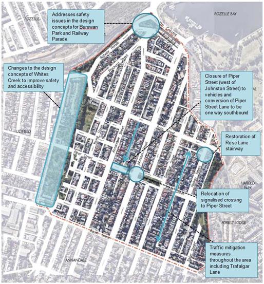
PUBLIC CONSULTATION
In accordance with the former Leichhardt Council's April 2016 resolution (C166/16P), the draft Annandale North Neighbourhood Movement Plan was exhibited for 28 days from 1 February 2017 to 1 March 2017 in accordance with Council’s Community Engagement Framework.
Consultation was undertaken in the following manner:
· a quarter-page advertisement was placed in the local Inner West Courier on 31 January 2017;
· letter box drop to approximately 2,000 residents in and around the study area was conducted;
· prominent advertising was provided on Council’s Your Say Inner West webpage, and Council’s homepage, throughout the consultation period;
· documents on the exhibition were made available via:
o Council’s Your Say Inner West webpage; and
o hard copies were placed at Council’s Customer Service Centre (Leichhardt), Annandale Town Hall and Leichhardt Library;
· a community meeting was held in the Annandale Community Centre on 22 February 2017;
· subsequent meetings were also held with Annandale North Public School and its P&C on 23 March 2017 and 5 April 2017, respectively.
Community Consultation Outcomes
Through Council’s Your Say Inner West website and by mail and email, Council received 19 written submissions on the draft North Annandale Neighbourhood Movement Plan.
Analysis of Your Say Inner West indicated that:
· the site received 396 visits;
· 163 people downloaded copies of the draft plan;
· 161 people visited multiple pages on the site;
· 14 people made on-line submissions through the site.
Additionally:
· 5 submissions were received through individual emails;
· 7 telephone calls were received by Council Officers;
· the Community Meeting was attended by approximately 40 residents; and
· the meeting with Annandale North Public School P&C was attended by approximately 20 members of the community.
In general, the comments obtained during the exhibition period were supportive of the plan and its proposed strategies, with:
· 63.2% (12) submissions supporting the overall plan and providing comments on specific issues;
· 36.8% (7) submissions did not indicate either support or objection to the plan; rather they highlighted specific issues for further consideration.
The written submissions received have been categorized into themes and summarised in Table 1, including their frequency of mention.
|
Theme |
Frequency of mention |
|
Traffic or pedestrian conflict |
11 |
|
Accessibility |
7 |
|
Parking |
7 |
|
Safety |
7 |
|
Signage |
6 |
|
Street planting |
6 |
|
Bike route or Cycle path |
5 |
|
Traffic management and congestion |
5 |
|
Community spaces or Neighbourhood squares |
3 |
|
Green link |
3 |
|
Local neighbourhood identity |
3 |
|
Stormwater/ flooding |
3 |
|
Street lighting |
2 |
|
Use of Viaduct |
2 |
From the above table it is clear that safety, amenity and accessibility rate high with the local community, with over 70% of written submissions including reference to these themes.
Summary of Issues Identified for Consideration During the Public Meeting (22 February 2017)
The community meeting, on 22 February 2017, was attended by approximately 40 members of the community. In general, attendees of this meeting supported the principles of the draft Plan and identified several additional issues for consideration, including:
· opportunities to improve safety for all users on Railway Parade near the light rail station should be considered;
· safety improvements for pedestrians on The Crescent should be explored;
· the stairs at the end of Rose Street should be upgraded as part of the green link between White’s Creek Valley Park and Spindler Park;
· proposed landscaping should reflect best-practice treatments already evident in other parts of the LGA;
· raingardens and other environmental elements should be incorporated into the proposed landscaping;
· once detailed plans are proposed for any specific locations, they should be the subject of additional community consultation;
· opportunities to explore improved parking around Booth Street should be examined;
· opportunities to improve safety for all users of Johnston Street should be examined;
· the impacts of WestConnex should be identified;
· parking for residents and their visitors should not be reduced;
· there is a need to provide “rest places” on the uphill section of Piper Street between Whites Creek Valley Park and Johnston Street;
· landscaping and traffic treatments should help integrate adjacent streets with Hinsby Park;
· the master plan map wrongly identified a path through existing residential properties between Annandale Street and Trafalgar Street;
· opportunities to incorporate local history and inclusive stories into key public spaces should be explored.
Discussions with Annandale North Public School and Parents and Citizen’s Association (P&C)
Council officers met with Samantha Nicol (Principal of Annandale North Public School) and the school’s P&C (23 March 2017 and 5 April 2017, respectively). At these meetings attendees were provided with an overview of the study and given an opportunity to provide input to be included as part of the community consultation process. Approximately 20 people attended the P&C meeting and generally supported the study. The attendees also requested that consideration be given to the following:
· closing Piper Street (west of Johnston Street) and providing some of the closure to the school as an extended playground area (noting the need to maintain active transport access through the closure). This would also reduce existing conflict between pedestrians and vehicles turning left from Piper Street onto Johnston Street.
· relocation of the existing signalised pedestrian crossing to a location more aligned with Piper Street. This relocation and the closure of Piper Street (west of Johnston Street) were generally supported as a measure to improve safety of children around the school;
· a preference was expressed that the signalisation (referred to above) include Piper Street on either side of Hinsby Park (to the east of Johnston Street);
· providing a formalised “Kiss and Ride” kerbside area at Rozelle Bay light rail stop;
· converting Piper Lane to one-way northbound (behind the school) and possibly establishing a school pick-up/set-down area at relevant times;
· addressing an existing “rat run” in Trafalgar Lane;
· review of parking restrictions near the intersections of Booth Lane with Trafalgar Lane and Nelson Street to improve sightlines;
· measures to calm traffic generally within the neighbourhood and to include landscaping and water sensitive urban design wherever possible;
· a preference for high quality landscaping treatments similar to those in Annandale South;
· a need to examine opportunities to improve the link from Whites Creek Valley Park to Buruwan Park;
· ensuring that trees planted under powerlines are of a type not likely to impact on the powerlines and consequently not likely to be cut down by electricity providers.
Summary of Specific Issues Raised During Community Consultation
The community consultation period indicated strong support for the principles contained in the Annandale North Neighborhood Movements Plan and highlighted a need for careful attention in the detailed design of each treatment.
In summary, the overall consultation process (written submissions and personal representations in meetings) indicated:
· support for:
o the overall principles and concept of the Annandale North Neighbourhood Movement Plan;
o pedestrian safety improvements in Johnston Street (particularly the proposed relocation of the signalised crossing at Annandale North Public School), with concern over any more intensive measures in Johnston Street;
o improved pedestrian and rider safety in the neighbourhood;
o the creation of safe, friendly walkable neighbourhoods;
o enhanced local amenity including landscaping and the provision of a green link between Whites Creek Valley Park and Spindler Park;
o relocation of the signalised pedestrian crossing at Annandale North Public School (to Piper Street);
o use of rain gardens and water sensitive urban design elements;
o place-making and amenity improvements;
o pedestrian and bike improvements near Rozelle Bay light rail station
· concern over what is practical and achievable in Johnston Street, given its classification as a State Road;
· a desire to retain parking for residents and their visitors;
· that any traffic management does not move a traffic problem form one street to another;
· detailed designs should be subject to additional community consultation;
· ensure safe pedestrian access across the Crescent, particularly to the Harold Park development site;
· WestConnex should not be permitted to create new or increase existing “rat runs”.
Revisions to Plan in Response to Community Feedback
The outcomes of community consultation were subsequently discussed with the Council’s consultants and the Plan revised in response to submissions received.
The key amendments made in the final Plan include:
· southerly relocation of the existing signalised crossing to include the Piper Street east-west link;
· closure of Piper Street (west of Johnston Street) to vehicles, potentially extending the school grounds into this closure and formalisation of a two-way active transport path through the closure;
· conversion of Piper Lane to one-way southbound to facilitate a safe school pick-up/set-down area;
· enhanced safety issues in the design concepts for Buruwan Park;
· changes to the design concepts for Spindler Park to Whites Creek Valley Park link to include upgrading of the Rose Street stairs;
· identifying traffic mitigation measures and way-finding as key strategic and design principles;
· a section in the Site Analysis section now includes reference to future development potentially impacting the neighbourhood, including WestConnex and Harold Park urban renewal project.
Table 2 provides a summary of specific considerations highlighted during the community consultation period and Council’s actions in response to each consideration.
Table – 2 Specific considerations highlighted during community consultation
|
INDIVIDUAL SUBMISSIONS |
|||||
|
Specific considerations raised |
Referred to in submissions through |
Total |
% |
Response |
|
|
YSIW |
Public Meeting |
||||
|
Johnston Street design concepts – support for the relocation of the existing pedestrian signals to Piper Street, but generally opposed to any other major changes. |
4 |
5 |
9 |
15 |
Final design concepts for Johnston Street include the relocation of the signalised crossing to the Piper Street east-west link. This will be the subject for discussions with RMS. |
|
Support for street tree planting and community-maintained nature strips/ rain gardens |
3 |
6 |
9 |
15 |
Implementation of street tree planting was identified as a key strategic principle in both the draft and final plans, and will be explored in more detail as specific sites are addressed as part of future works programs. |
|
Concerns about safety on Railway Parade at the corner of Bayview Crescent |
3 |
4 |
7 |
12 |
Design concepts for Buruwan Park amended to include selective pruning and removal of vegetation to improve sightlines, a formalised “Kiss and Ride” zone, and a raised crossing point for cyclists and pedestrians. |
|
Request for Resident Parking Scheme and implementation of restricted parking at Johnston Street between Booth and Piper Streets
|
2 |
5 |
7 |
12 |
Considerations of Resident Parking Schemes will be referred to Council’s Traffic Unit. |
|
The Crescent -crossing opportunities for pedestrians. |
3 |
3 |
6 |
10 |
Council will liaise with RMS to look for future opportunities to increase pedestrian safety on The Crescent. |
|
Whites Creek – initiatives to make this area safer and encourage people to use this space |
3 |
3 |
6 |
10 |
Changes to the design concepts to include an entry gateway to the park and rest area, improved way finding and sightlines, a formalised pedestrian path, and the integration of the path system with the potential renaturalisation of Whites Creek. |
|
Support for place making elements featuring local stories of residents and key buildings |
3 |
3 |
6 |
10 |
Place making was identified in the draft and final plans as an overarching project objective, and will be explored in more detail as specific sites are addressed as part of future works programs. |
|
Restoration of Rose Lane (east) stairway. |
1 |
4 |
5 |
9 |
Final plan proposes to upgrade and widen this stairway and undertake pruning to improve sightlines. |
|
Request for Resident Parking Scheme and on Railway Parade and parking restrictions on trailers enforced.
|
0 |
4 |
4 |
7 |
Similarly to the considerations raised for a Resident Parking Scheme on Johnston Street, these requests will be referred to Council’s Traffic Unit. |
|
TOTAL INDIVIDUAL SUBMISSIONS |
|
|
59 |
|
|
|
|
|||||
|
CONSIDERATIONS RAISED IN MEETINGS WITH ANNANDALE NORTH PUBLIC SCHOOL |
|||||
|
The possibility of closing Piper Street (west of Johnston Street) and perhaps providing some of the closure to the school as an extended playground area (noting the need to maintain active transport access through the closure. This would also reduce existing conflict between pedestrians and vehicles turning left from Piper Street. Preference was expressed to include both parts Piper Street, east Johnston Street and Hinsby Park.
|
Final design concept for Johnston Street includes the closure of Piper Street (west of Johnston Street) to vehicles, extended school grounds, a formalised two way cycle path and a shared zone where Piper Lane meets Piper Street. |
||||
|
Convert Piper Lane (behind the school) to one-way northbound. |
Design concepts propose Piper Lane be converted to one-way southbound, as this was deemed a safer option for children exiting the left hand side (passenger seat) of the car. |
||||
|
Provide a formalised “Kiss and Ride’ kerbside area at Rozelle Bay light rail stop.
|
Design concepts for Buruwan Park have been amended to include a formalised “Kiss and Ride” area. |
||||
|
Address the existing “rat run” in Trafalgar Lane.
|
Traffic mitigation in streets that are not primary movement corridors has been added as a key strategic principle, particularly addressing the need to provide traffic treatments in narrow lanes such as Trafalgar Lane. |
||||
|
Review parking restrictions near the intersections of Booth Lane with Trafalgar Lane and Nelson Street to improve sightlines.
|
Requests for review of parking restrictions will be referred to Council’s Traffic Unit for consideration. |
||||
|
Install treatments to calm traffic generally within the neighbourhood and to include landscaping and water sensitive urban design wherever possible.
|
Traffic mitigation has been added as a key strategic principle, highlighting the need to provide mitigation measures and treatments. |
||||
|
Ensuring that trees planted under powerlines are of a type not likely to impact on the powerlines and consequently not likely to be “savagely trimmed” or cut down completely, by electricity providers.
|
This will be given consideration in more detail as individual future works programs progress. |
||||
FINANCIAL IMPLICATIONS
No funds have been allocated to specific actions within this study. The study will inform future works programs.
OTHER STAFF COMMENTS
This Plan has been prepared to inform future works programs, with specific detailed design elements/treatments being subject to further community consultation as they progress.
PUBLIC CONSULTATION
Refer to earlier in this report.
CONCLUSION
The Annandale North Neighbourhood Movement Plan outlines a series of principles and steps, including associated studies, which will assist in creating a safe, sustainable and walkable neighbourhood. This report has provided an overview of the submissions received and addressed during the community consultation period. The outcomes of public consultation have been taken into account and the Plan has been revised in response to the submissions received. Consequently, this report now seeks adoption of the final version of this Plan to inform future works programs within the neighbourhood. Subsequent to adoption, the neighbourhood movement plan will be used to inform future works programs associated with the neighbourhood, as well as bids for project specific budget allocations.
|
1.⇩ |
Final Annandale North Neighbourhood Movement Plan |
|
Council Meeting 12 December 2017 |
Subject: Open Inner West 2017-18 Program for Endorsement
Prepared By: Raffaela Cavadini - Community Cultural Development Officer
Authorised By: Erla Ronan - Group Manager Community Services and Culture
|
SUMMARY Open Inner West (OIW) is an annual festival and grants program which celebrates cultural diversity, encourages the transfer of skills and traditions across generations and targets participants of all ages.
The 2017-18 festival will take place from 15 to 24 June 2018 and will comprise a range of events and activities for Council’s consideration and endorsement as included in this report. |
|
RECOMMENDATION
THAT:
1. The report be received and noted;
2. Council note the festival dates for 2017-18; and
3. Council endorse funding the 15 applications as outlined in Attachment 1. Successful Grant Recipients 2017-18, totalling $61,180 for the OIW 2017-18 grants Program. |
BACKGROUND
The OIW Program responds to key strategic objectives developed from the initial community engagement for the Draft Community Strategic Plan 2036, including supporting a diverse community that values and celebrates cultural diversity.
The central component of the OIW program is the OIW Grants Program, which aims to:
· encourage younger CALD (culturally and linguistically diverse) and Sister Cities generations to connect with and celebrate their individual cultures and share and promote these with the broader community;
· facilitate the transfer of knowledge, skills and traditions across generations, through a series of events and activities involving local schools, youth community groups, community based organisations and the wider community;
· reflect and promote aspects of the cultural life of the Inner West LGA;
· support events that are a significant part of the cultural landscape of the Inner West LGA;
· encourage participation by and engagement with local communities;
· promote a vibrant street life, support local business and encourage visitors to the LGA; and
· support the cultural diversity of the Inner West LGA.
The festival has been running as Open Marrickville since 2012 (with the first funding round available in 2011). Last year it was modified and renamed as OIW to successfully include and involve the three former Council areas. The festival is timed to coincide with Refugee Week and NAIDOC Week.
OIW 2016-17 took place from 16 to 25 June 2017. The festival was a great success and reached new Inner West Council communities and locations. Please see Attachment 3. 2016-17 Open Inner West Report for the report on the 2016-17 program.
FINANCIAL IMPLICATIONS
There are sufficient funds in the 2017/2018 Living Arts Operating Budget to implement the recommendations appearing in this business paper. Based on participant feedback over the years and an external Best Practice Review (conducted in 2016) the total grant amount available per group has been increased from $5,000 to $7,500 to assist groups pay for increasingly expensive venue hire. The overall funding amount has not increased which may mean fewer groups are funded.
OTHER STAFF COMMENTS
2017-18 PROGRAM
Council’s OIW Festival is in its seventh year and will take place from 15 June to 24 June 2018.
The OIW 2017-18 Grants program opened 5 October and closed 6 November 2017. Two public information sessions on the OIW Grants Program were held on 17 October. Attendees were advised of the grants procedures, selection criteria and given the opportunity to ask questions. The grants and information sessions were promoted through advertising in The Inner West Courier, Inner West Courier (City), The Cooks River Valley Times, Council’s website and social media accounts and the Living Arts Newsletter, Art Post. In addition to this, flyers were distributed to all Council library branches and to local hubs.
Local businesses, community organisations, community members and individual artists that had participated in previous OIW programs were also notified of the program via a direct e-mail campaign. Follow up emails and calls were made to key contacts, schools, event organisers, community associations and cultural groups across the extended LGA.
28 OIW grant applications were received, requesting a total of $178,572.50 and were assessed by an Assessment Panel, consisting of:
· Evgueni Singatouline, Settlement Services Officer, Metro Assist;
· Eleni Christou, Local Resident, Anthropologist and previous OIW grant recipient;
· Holly Stewart, Manager, Rozelle Neighbourhood Centre; and
· Ingrid de Meyer, Coordinator, Community Development, Inner West Council.
The Manager Living Arts, the Community Cultural Development Officer and the Strategic Community Project Officer - Aboriginal Inclusion also provided feedback. All members were asked to declare any conflicts of interest prior to the assessment taking place. Individuals with conflicts of interest removed themselves from the room during the discussion of concerned applications and did not make recommendations regarding the weighing of relevant applications.
Applications were assessed against the following selection criteria:
· how the project reflects and promotes aspects of the cultural life of the Inner West;
· how the project actively engages with Inner West diverse communities;
· how the project encourages community participation;
· how the project encourages the sharing of cultural knowledge;
· how the project encourages cross-generational participation;
· the level of creative merit and innovation against the merit of other applications;
· the individual / group’s demonstrated ability to deliver similar projects; and
· the amount of in-kind or financial support received from Council in the past.
Of the 28 applications assessed under the OIW Grants Program, 15 applications totalling $61,180 are recommended for funding (see Attachment 1. Successful Grant Recipients 2017-18). Not all projects are receiving the entire amount that was requested, however, the assessment panel believe the projects are still achievable at the reduced funds. The projects recommended represent a variety of different events from workshops to film to cultural events and exhibition. The applicants and proposed projects are located in a range of locations around the Inner West (including all former Council areas).
The recommended applications are of a high standard, meet the OIW Eligibility and Assessment Criteria and address the program objectives.
Once the recommended applications have been endorsed and recipients notified, a range of workshops will be held to provide assistance related to their events. These include event management, media and marketing, insurance and risk management and food safety. Council officers will also provide intensive support to groups and individuals on an as needs basis.
Council’s Living Arts Team alongside other Council teams may produce events. These events will target groups who did not apply or gaps within the programming. Council will be notified of the full programming once it is finalised.
13 applications are not recommended for funding (see Attachment 2. Unsuccessful Grant Recipients 2017-18). The main reasons being:
· the application was not strong or did not address the assessment criteria;
· the applicants had received recent funding or in-kind support from Council;
· suggested outcomes did not strongly benefit the local community;
· the project was still viable without Council funding;
· the project did not take place within the LGA; or
· the timing of the project was not within the criteria.
The Assessment Panel raised there were a number of high quality applications that were not able to be funded and that this was not a reflection on the submissions but more to do with working within the limitations of available funds.
PUBLIC CONSULTATION
The OIW Assessment Panel (made up of local community members, professionals from youth, creative, community and migrant services) provides invaluable input with the recommendations they make to Council for programming. It involves the local community in decision making and governance.
The OIW grants and festival program is promoted extensively in the local media (e.g. radio, social media, online and print media) and through networking contact lists across all Council areas. The local community is engaged through enquiries and information sessions for the OIW grant rounds.
The successful applicants are provided with intensive one on one support to ensure they are able to deliver their event or activity successfully. Larger scale formal support workshops are also held for applicants.
Applicants are asked to provide feedback through their acquittal form regarding their event and the overall program. This valuable feedback is then used to inform future programing.
Event attendees are asked to provide their feedback at all OIW events, this too is used to inform future programming.
CONCLUSION
The positive response and previous evaluation of the Program demonstrates the need for the grant program and festival for the community. The Program highlights the creativity and diversity of the Inner West communities and will assist in place making, community empowerment, building stronger community relationships and enhancing the already culturally rich demographic.
|
1.⇩ |
Attachment 1. Successful Grant Recipients 2017-18 |
|
2.⇩ |
Attachment 2. Unsuccessful Grant Recipients 2017-18 |
|
3.⇩ |
Attachment 3. 2016-17 Open Inner West Report |
|
Council Meeting 12 December 2017 |
Subject: Schedule of Ordinary Council Meetings for 2018
Prepared By: Ian Naylor - Manager Civic and Executive Support
Authorised By: Nellette Kettle – Group Manager Integration, Customer Service, Business Excellence and Civic and Executive Support
|
SUMMARY The purpose of this report is to set the date, time and place of Ordinary Council Meetings for 2018 in accordance with the requirement of Council’s Code of Meeting Practice. |
|
RECOMMENDATION
THAT Council hold Ordinary Council Meetings for 2018 at the Ashfield Service Centre commencing at 6.30pm on the dates shown in the Meeting Schedule in the report, and publish these dates on Council’s Website. |
BACKGROUND
At the Ordinary Council Meeting of 21 November, Council adopted an amended Code of Meeting Practice which stated in general, Ordinary Council Meetings will be held on 2nd and 4th Tuesdays of each month commencing at 6.30pm. However, it is a standard practice for NSW councils not to hold Council Meetings in January as Council is in recess and due to Christmas only hold one meeting in December.
Clause 1.1(2) of the Code of Meeting Practice requires Council to resolve the time, place and date that Ordinary Council Meetings are to be held.
Venue for Council Meetings
A briefing was held for Councillors on 7 November to discuss the venue for the holding of future Council Meetings. For the past 18 months Council Meetings have been held at the Ashfield Service Centre due to its capacity to hold up to 120 persons in the Council Chambers.
A review by staff of the three former Council Chambers and other Town Halls has been undertaken taking into consideration capacity to hold a public gallery of 100 persons, technology capability of each facility to undertake webcasting of meetings, contemporary fire safety standards and building code compliance. The only venue that can satisfy all these requirements is the Council Chambers at Ashfield Service Centre. The other venues have either restrictions in the public gallery capacity, do not meet contemporary fire safety standards or would need significant capital investment to improve the capability of existing technology. While the alternative Council venues aren’t suitable for the holding of large public meetings, staff will consider using these venues for public meetings of smaller size.
For these reasons, it is the recommendation of this report that Council Meetings continue to be held at the Ashfield Service Centre, commencing at 6.30pm on the dates shown in the below Meeting schedule:-
2018 Ordinary Council Meeting Schedule |
|
|
|
Tuesday 13 February 2018 |
|
Tuesday 27 February 2018 |
|
Tuesday 13 March 2018 |
|
Tuesday 27 March 2018 |
|
Tuesday 10 April 2018 |
|
Tuesday 24 April 2018 |
|
Tuesday 8 May 2018 |
|
Tuesday 22 May 2018 |
|
Tuesday 12 June 2018 |
|
Tuesday 26 June 2018 |
|
Tuesday 10 July 2018 |
|
Tuesday 24 July 2018 |
|
Tuesday 14 August 2018 |
|
Tuesday 28 August 2018 |
|
Tuesday 11 September 2018 (Election of Deputy Mayor) |
|
Tuesday 25 September 2018 |
|
Tuesday 9 October 2018 |
|
Tuesday 23 October 2018 |
|
Tuesday 13 November 2018 |
|
Tuesday 27 November 2018 |
|
Tuesday 11 December 2018 |
FINANCIAL IMPLICATIONS
Nil.
OTHER STAFF COMMENTS
Nil.
PUBLIC CONSULTATION
Nil.
CONCLUSION
Nil.
|
|
Council Meeting 12 December 2017 |
Subject: Local Participatory Democracy at Inner West
Prepared By: Prue Foreman - Coordinator Communication and Engagement
Authorised By: Lawrence Hennessy - Group Manager Communications, Engagement and Events
|
SUMMARY Local participatory democracy is highly valued by the inner west community. This report discusses Council’s adopted Community Engagement Framework, the results of the review of Interim Strategic Reference Groups and consideration of new Council committees. |
|
RECOMMENDATION
THAT COUNCIL:
1. Acknowledge the contribution of members of the interim Strategic Reference Groups (SRGs) and adopt the recommendations of the evaluation of the SRGs which are to: a. Discontinue the Economic
Development SRG and replace with the quarterly forum of Inner West Council
local business groups that was established this year; and business and
industry forums aimed at a broad audience; b. Continue the following seven SRGs: i. Aboriginal and Torres Strait Islander; ii. Environment; iii. Housing and Affordability; iv. Planning and Heritage; v. Social Inclusion ; vi. Transport; and vii. Young Leaders. c. Endorse the current
recruitment and membership structure of the above seven high-level advisory
SRGs; and endorse flexibility to establish other engagement formats such as
working parties, project-based forums and roundtables as required without the
formality of an advisory group; d. Focus the SRGs on
relevant strategic and policy work including the implementation of the
Community Strategic Plan (CSP) and Council’s four-year plan; and
endorse additional flexibility in the SRG terms of reference to include
project work, and reduced formality in processes, as determined by the Group
Managers and members; e. Investigate enhancements for the Aboriginal and Torres Strait Islander SRG with the objective of building community capacity, strengthening cultural appropriateness and increasing self-actualisation of the members; and
f. Review the SRGs by the end of 2018 and report to Council.
2. Endorse a campaign to embed and promote meaningful community engagement at Inner West including: a. Trial five ward-based engagement events ‘Councillor Roadshows/Inner West Forums’ in 2018;
b. Trial innovative deliberative engagement techniques including those which involve participants representative of the inner west community profile in 2018 for appropriate projects;
c. Support the establishment and promotion of community-led independently-operated resident groups; and endorse a small-grants program to cover printing and venue hire;
d. Establish a register of community groups for relevant engagements; and
e. Implement a marketing campaign to promote ways for the community to lodge service or information requests; and to promote ways for the community to get involved in engagement processes including through the Your Say Inner West website, taking into account diverse needs.
3. Update the Community Engagement Framework to: a. Include any resolutions resulting from this report;
b. Strengthen the section on SRGs to acknowledge the contribution SRGs make to ongoing advice to Council;
c. Include information
about the elected Council; and d. Extend the timeline for the review of the Community Engagement Framework by five months to November 2018 to include a further one-year review of the SRGs, and the impact of any resolutions resulting from this report.
4. Note that Council can establish standing committees of councillors to receive reports about specific matters to streamline Council meetings and improve access for community members who wish to speak to the report. |
BACKGROUND
Relevant resolutions
This report responds to a number of Council resolutions, including:
1. Notice of Motion: The Return of Local Democracy to the Inner West (C1017 Item 32)
(note: parts 2C, D and E only – other parts are subject to a separate report.)
2. A report be brought to the December Ordinary Council Meeting on how local democracy can be restored to the Inner West as soon as possible. This report to include the following:
c. Proposals for the urgent re-establishment of local and specialist committees and advisory groups;
d. Proposals which enable a localised (possibly ward-based rather than a one size fits all) approach to all council’s decision-making; and
e. Proposals which will ensure excellent and meaningful consultation with the community.
2. Notice of Motion: RESIDENT PRECINCT COMMITTEES C1017 Item 29
C1017 Item 29 - Foreshadowed Motion
That Council considers precinct committees as part of a broad review of community engagement to be reported to the December Ordinary Council meeting.
3. Notice of Motion: Investigation into New Council Committees (C1117 Item 2721)
THAT Council:
1. Consider options for broader community attendance at its committees;
2. Consider local sub-committees of Council Committees which would enable greater local engagement as well as greater accessibility to meetings; and
3. Consider establishing sub-committees as part of the new Committee framework to address specific community priorities (such as Climate Change, Bicycle Use, Heritage and Sports Participation).
4. Local Democracy Framework - Establishment of Strategic Reference Groups (L0916 Item 2)
LRAC received a report recommending the establishment of interim Strategic Reference Groups (SRGs) as part of Council’s framework for participatory local democracy/ community engagement. The Administrator subsequently established the SRGs. The report included a commitment to review the SRGs after the new Council was elected in September 2017.
Dissolution of committees
As a result of forced amalgamation, the committees of the former Ashfield, Leichhardt and Marrickville Councils were dissolved upon proclamation of the new Inner West Council in May 2016. An event marking the closure and acknowledging the contribution of the committees was held on 18 August 2016, attended by 120 former members.
Interim Strategic Reference Groups
As an interim measure, the Administrator established eight time-limited Strategic Reference Groups (SRGs) which first met in February 2017, and whose term comes to an end in December 2017.
Purpose
The purpose of the SRGs was to “provide feedback, guidance and recommendations to Council on specific issues, including strategic planning and policy and contribute local knowledge regarding community impacts, emerging trends, opportunities and service gaps.” The SRGs form part of a broader community engagement framework that was adopted by Council in June 2017. The SRGs are one form of engagement that ensures community input on higher-level strategic issues across the inner west.
Extensive recruitment process
Members were recruited through an EOI process in Sep/Oct 2016 promoted widely including by advertisements and the Council column in the Inner West Courier, on Council’s website, through social media, via LRAC members, interagency lists and networks from the former councils. The Aboriginal and Torres Strait Islander Reference Group was promoted separately following a process in which Council worked with the Aboriginal and Torres Strait Islander community to develop a culturally appropriate process for establishing the Strategic Reference Group.
There were a total of 185 applicants across the eight SRGs. Once the EOI closed, managers and staff from relevant teams were asked to rank the applicants and provide recommendations to the selection panel. The selection panel, comprising of three LRAC members (Caroline Stott, John Jobling and Chris Woods) and the Administrator, met on 4 November 2016. Appointments were confirmed in November 2016. Council facilitators were assigned and trained.
The first meetings were held in February 2017. Terms of Reference, meeting schedules and Chairs were established. A formal process was determined with reports, voting rights, quorum and recommendations to be documented in minutes then submitted to relevant Group Managers for a response.
Deep deliberative input
The Community Strategic Plan (CSP) was listed as a key project for SRG consideration. The CSP, the highest and strategically most important plan a council develops, is required under the Local Government Act and must be informed by broad community input. The timing was therefore suitable for deep deliberative input from the SRGs.
The eight SRGs established were:
· Aboriginal and Torres Strait Islander
· Economic Development
· Environment
· Housing and Affordability
· Planning and Heritage
· Social Inclusion
· Transport
· Young Leaders
The Administrator determined that the SRGs would be reviewed following the return of the elected Council. The results of the evaluation are outlined in the discussion section of the report.
Resident Precinct Committees
Resident Precinct Committees (RPCs) operated in Leichhardt Council for many years prior to amalgamation. The seven RPCs were:
· Annandale RPC
· Balmain RPC
· Birchgrove RPC
· Leichhardt RPC
· Rozelle/Lilyfield RPC
· Rozelle White Bay RPC
· Rozelle Iron Cove RPC
In 2015 Leichhardt Council considered options for governance models for the RPCs and resolved that Precinct Committees become official committees of Council under s355 of the Local Government Act (item C/587/15). The response to the transition was varied, ranging from one RPC which opposed the transition altogether and continued to meet independently of Council to those which met but could not achieve a quorum or did not meet due to resignation of the Chair. Consequently there were only two active RPCs at the time of amalgamation - Rozelle-Iron Cove and Birchgrove.
Consideration of precinct committees at Inner West Council is outlined in the discussion section of the report.
DISCUSSION
LOCAL PARTICIPATORY DEMOCRACY IN THE INNER WEST
Community Engagement Framework
Council adopted the Inner West Community Engagement Framework in June 2017 informed by the former Councils’ frameworks. The Framework is based on international best-practice and comprehensive community, staff and LRAC input.
Five core principles drive Council’s approach to engaging the community – these are our promise to the community.
• Authentic
• Planned
• Tailored
• Inclusive
• Transparent
A principles-based approach recognises that one size does not fit all and each engagement has a distinct purpose, with a unique set of stakeholders and specific circumstances.
The state of engagement in the inner west
Community engagement is alive and well at Inner West Council. It is well regarded in the community, and supported internally by a professional team of in-house engagement and research practitioners. The Micromex community satisfaction survey 2016 and 2017 rated satisfaction with community engagement ‘moderately high’, with 58% rating it as good to excellent. This establishes the benchmark for Inner West Council and will be monitored in future community satisfaction surveys.
Since May 2016, more than 130 projects have invited community input; the Your Say Inner West site has attracted over 100,000 visits and more than 8.400 active contributions have been logged – surveys, interactive maps, submissions etc. These figures do not include numbers for face-to-face engagements or paper-based methods, or attendance at events such as public meetings held for information and advocacy. Online engagement complements traditional face-to-face engagement and provides an opportunity for many more people to participate at a time that is convenient to them.
A promotional campaign for engagement including the Your Say Inner West site has not yet occurred although communication to promote specific engagements has guided people to the site. Potential exists to strongly promote opportunities aiming to build additional community capacity to engage on projects, and increase overall awareness of the range of Council’s engagement. Potential also exists to trial additional engagement mechanisms for appropriate projects such as innovative deliberative techniques, including those which are specifically designed to recruit members who are representative of the inner west community profile.
The Community Engagement Framework aims to guide effective, broad-based and diverse engagement so that all people in the community have opportunities to participate in decisions that affect them. Engagement is based on project-based decision-making however collectively, all engagements build trust and effective participatory local democracy. Reference groups and committees in the Community Engagement Framework are described as stakeholders that will be identified in the engagement plans of relevant projects. Hence it can be seen that the Community Engagement Framework focuses on one-off engagement processes. Acknowledging the ongoing contribution that groups such as SRGs make to local participatory democracy would strengthen the Framework.
This report makes recommendations for an update of the Community Engagement Framework.
SRG evaluation
The establishment of the SRGs included a commitment for their review following the return of the elected Council. Council’s engagement and research team carried out the review process, which was developed in collaboration with SRG facilitators, relevant Group Managers, Manager Civic and Executive Support and Deputy General Manager Community and Engagement. The evaluation took place in October/November 2017. The evaluation process involved:
· Participants – SRG members
· Governance service unit and SRG facilitators
· Relevant Group Managers/Deputy General Manager
· Corporate Strategy team
· Other staff whose work was not covered by the SRG process (eg. Arts and Culture, Library and History)
The evaluation process included:
· SRG group evaluation discussion as part of a formal meeting
· Anonymous individual survey for SRG members to complete outside of the meeting process
· Facilitator survey
· Group Manager and other staff involved in setting up the SRGs interview or questionnaire
· Other staff feedback via email
The evaluation considered the appropriateness, effectiveness, efficiency and process of the SRGs. Full results of the evaluation are contained in ATTACHMENT 1.
Results of the evaluation:
Value of the SRGS
The evaluation shows that the SRGs have made a significant contribution to the development of strategy and policy in the ten months that they have been operating, in particular to their work on the CSP. The development of the CSP continues so SRG members have not yet seen the fruits of their deliberations reflected in results. A brief report indicating the high value and effectiveness of the SRGs’ recommendations about the CSP is appended to the report ATTACHMENT 2.
The benefits of SRGs are that they are scheduled, reliable, often citizen experts in their field, bring local knowledge, can be conduits to their communities, and involve strategic and planned processes linked into policy and strategy development. The SRGs are resource-intensive, with an average of 17 hours administration per meeting, but because the focus is on high-level strategy, there is value in the investment both from the staff and members’ point of view. The vast majority of members and facilitators reported that it was worth their time to participate in the SRG.
Factors impacting strategic capacity
Participants and facilitators reported the process was worthwhile but made suggestions for reduced formality, in particular to long ‘Council-style’ background reports, unnecessary requirements for quorum and voting when the groups are advisory in nature, desire for more project work, fewer presentations and more active involvement (from some groups).
Feedback from participants and facilitators was strong that membership should be capped and ‘closed’ ie SRG meetings should not be open to the public generally. This is because past experience showed that larger meetings became unwieldy, there was a lack of continuity when attendance was inconsistent, and groups would lose their capacity to focus on strategy because attendees needed background information and deep knowledge built over multiple meetings. Staff strongly suggested that the way to include the broader community was through project-specific engagement as guided by the Community Engagement Framework. For example development of a strategy would comprise engagement with the SRG but also with the wider community through a planned program of engagement activities.
Alternative formats
Staff noted that SRGs did not cover all aspects of Council’s work. However the staff engagement found that the SRGs were best suited to those areas requiring high-level integrated strategic advice, and other areas would be best suited to alternative formats to formal advisory committees. For example, the arts and creative community was specifically targeted for a futuring workshop as part of the CSP engagement, and had involvement in the Live Music Taskforce. Roundtables, such as for the LGBTIQ and creative sector are highly recommended, effective formats for engagement, as are working groups, an example of which is the LGBTIQ working party, considered to be a vibrant and energised group focused on project work and not requiring the structure of a formal advisory group. Flexibility to implement informal sub-groups that could form to help organise one-off events or activities is also strongly recommended.
Future of the SRGs
This report recommends that all but one of the SRGs continue, with the following changes, for another time-limited term of 12 months, after which another review will take place.
· Economic Development SRG to discontinue and be replaced by quarterly meetings of local business chambers and associations with the Mayor and General Manager. Participants wanted larger, less formal gatherings, less frequently. A flexible model would allow business or industry-specific forums for a wide audience and project or strategy working groups to be established when required.
· Aboriginal and Torres Strait Islander SRG continue but Council staff to investigate enhancements and models of other councils including City of Sydney and Randwick, to determine if there are means to further build the capacity of members, strengthen cultural appropriateness and contribute to self-actualisation of Aboriginal and Torres Strait Islander members and peoples in the community. It was noted that engagement with the Aboriginal community was vital but the SRG “is only one mechanism for consultation and the Group often become the expert and only voice.”
· Environment SRG to continue – the group was strategically focused on developing content for the CSP and made a significant contribution. Comments included that it was good to have a group that was so knowledgeable and experienced in the area of environment and sustainability, but the group would benefit from more flexibility to convene around strategy development with the option to become involved in more project work.
· Housing and Affordability SRG to continue – the group was involved in a broad range of topics which add value to Council’s policy and strategy development. The group contributed to the final drafting of the Affordable Housing Policy, policy proposals eg SEPP 70 and continued to provide an advisory role on strategic matters, with the potential to further widen the scope of topics.
· Planning and Heritage SRG to continue as one integrated SRG to ensure high-level strategy and policy work. Flexibility in the model would enable the needs of members with varied interests to be met. This group will benefit from the commencement of strategy development that has yet to be initiated, although there are large-scale strategic projects relevant to the sector due to commence in 2018. As strategy work had not commenced, feedback was that there were too many presentations for noting rather than opportunities for input. There could be benefit from a wide scale engagement that would allow the broad community to be involved in a project around heritage, outside of the formal advisory group.
· Social inclusion to continue - a wholistic approach to social inclusion through a single SRG is the best way to ensure integration of advice and solutions with a community and cultural focus. This group would benefit from increased flexibility in formats not requiring the formality of an advisory group, for example a time-limited working group to assist organising Seniors’ Week or International Women’s Day could be established, without the need for formal Council endorsement
· Transport SRG to continue; members are enthusiastic about the upcoming strategic plans to be developed commencing with the Integrated Transport Strategy, and others including Bike Plan and Road Hierarchy. The group would benefit from extra recruitment to replace some members who dropped away, potentially leaving the group with over-representation of members with cycling interests.
· Young Leaders members were highly enthusiastic about their role. It is recommended to continue the group, noting the value derived this year from member capacity building activities. There would be benefit in strengthening of links to the engagement of the wider youth community. The group wanted less formal reports and more ability to focus on projects as well as strategic work.
SRG members raised the suggestion to find out what the other SRGs are doing and perhaps to come together in a strategic capacity for cross-collaboration. Staff and members will consider means to achieve this. Recruitment of members was considered to be a robust and successful process, with members reporting that the right skills and experience were brought to the meeting. The SRGs would benefit from additional recruitment to encourage representativeness and succession plans if membership drops off during the term.
It is proposed to strengthen the SRGs’ role and purpose in the Community Engagement Framework and promote the groups. Other formats and committees will also be outlined in the Framework and on Council’s website as required. For example, Council currently has other statutory committees including:
· The Local Traffic Committee advises Inner West Council on traffic and parking control matters for which Council has been delegated authority from NSW Roads and Maritime Services.
· The Inner West Flood Management Advisory Committee helps develop and implement of Flood Risk Management Plans for the Inner West local government area.
· The Local Emergency Management Committee carries out emergency management as the responsible authority for the Inner West local government area.
· The Inner West Council Aged Care Interagency is a forum established to bring together the various agencies working with older people in the Inner West Council area.
Councillors’ attendance at SRG meetings
Feedback about the presence of councillors varied. In the majority, participants valued the presence of councillors particularly when they wanted deep policy discussion with councillors who had experience in the field. Participants also generally wanted more involvement of councillors. A. Bolitho in a report cited in detail in the next section, notes that ‘Interviewees reported that a citizen committee was likely to have a greater influence on council if it had a Councillor as an active observer of its business, and that councillor had an interest in influencing understandings in the council chamber of the committee’s strategic intentions.’
However in the evaluation of the SRGs, participants also reported that the dynamic could change when councillors attended; that sometimes councillors influenced the agenda, and another occasion when the group felt uncomfortable about being outnumbered by the councillor presence.
Councillors will need to consider how best to meet the needs of the SRGs for councillor attendance, and to consider how their presence at meetings impacts the dynamics. The current model allows councillors to attend any SRG meeting in a listening capacity, and this report does not recommend changes to councillor attendance.
Resident Precinct Committees
In considering whether RPCs should be established in response to C1017 Item 29, the following documents were taken into account:
· Review of Council and Committee meetings, (resulting in a review of all committees including RPCs) undertaken by Leichhardt Council in 2014 (0714 Item 3.7)
· Research into citizen committees by the Australian Centre of Excellence in Local Government (Bolitho, A. 2013, The Role and Future of Citizen Committees in Australian Local Government, Australian Centre of Excellence for Local Government, University of Technology, Sydney)
· The statistically valid independently conducted Leichhardt Council community survey of 2015.
Leichhardt was the only one of the three former councils with a system of resident precinct committees. Bolitho quotes a North Sydney Council report of 2012, which describes RPCs as “voluntary committees of residents, run by residents living in defined geographic areas of an LGA. A core group meets regularly to discuss issues affecting their local area. They enable people to become involved in the areas where they live, and meetings involve the core group and anyone with an interest in a local issue. Precinct committees can ask for action from council. These requests can range from general ones to more complex requests requiring a motion agreed to by the committee. Precinct committees were more prevalent in the 1980s and 1990s, but today six NSW councils, largely in the Sydney metro area, support precinct committees as an effective way of involving the community in planning and decision-making.”
Members of citizen committees, notes Bolitho, valued committees “as a structure through which they could contribute to, and have a degree of ownership of, a place with which they had significant history.” Their strength, she reports is ‘Citizens keep in touch with development applications, traffic, landscape and service planning’ and their weakness is they are ‘Resource intensive with detailed responses on specific issues regularly required.’ This is backed up by Leichhardt Council’s review which noted that “It is clearly evident that the extent of agenda items council needs to determine at its Ordinary meeting has grown by over 25% over the last 7 years and has become unmanageable within the existing meeting structure. Council and committee meeting time demands imposed on Councillors are unsustainable.” The report noted that there was “significant potential to improve both staff and Councillor productivity”.
Leichhardt Council committee review and recommendations
As part of its review of committees, Leichhardt
Council held a workshop in June 2014 facilitated by Roberta Ryan, Associate
Professor and Director, Centre for Local Government and Stefanie Pillora,
Program Manager Research for the Australian Centre of Excellence for Local
Government, with Leichhardt councillors. The key aspects that emerged from the
workshop were:
· “Strong support for council’s Community Engagement Framework, to continuing good practice and the importance of community engagement (CE)
· Emphasis on the importance of CE being strongly linked to Council’s strategic priorities
· Importance of innovation and an appetite for further information and learning about what works well for others eg Waverley Council standing committees & Marrickville Council community panel (including good practice social media and web based approaches) *
· Developing an approach which has on-going structures, specific purpose committees, as well as one-off events.”
(*Note that subsequent to this report, Marrickville Council reviewed its Community Panel and as a result, transitioned the Community Panel to the Your Say membership).
The Summary Findings by ACELG:UTS (C07/14 Item 3.7) noted that:
“The committees do not provide the community with an efficient way of engaging with the Council in a valid representational system. They are less reliable as a means of sound participative democracy. If relied on as the means of engagement with the community, they leave the Council with unreliable and partisan information about community views strongly coloured by sectional interests, which in turn cast doubt on the quality of governance and community leadership. Staff can end up spending more time running committees than actually delivering the community’s desired outcomes under the CSP”.
The report recommended “Better Practice frameworks for Council and Committee practice” which included:
“The ideal objective of Council and Committee structures and practice should be:
· To ensure that Council has access to broad based and well informed community opinion and can understand both sectional interests and the broader interest
· To ensure that councillors are able to take decisions which on balance will advance the general interests of the community while accounting for legitimate minority interests
· To provide an efficient mechanism for decision making within the framework of priorities provided by the adopted Community Strategic Plan (assuming the Community Strategic Plan has itself been generated as the product of best practice community engagement)
· To minimise the risk of illegal, biased, unfair or ineffective governance and community leadership.”
Potential issues with RPCs
Resident groups can contribute local knowledge and solutions, connect community members, build leadership and enable people to work together for a common good. But as formal committees of Council, they are often hampered by a lack of representativeness, inconsistent attendance, a disconnect from strategy and can result in a plethora of resolutions which draw resources away from implementing Council’s strategic directions. There is also a risk that committees can be engaged as a substitute for providing broad opportunities for the wider community to participate in Council’s decision-making.
Representativeness is also an issue. Anecdotally precinct committees are not well-representative of the wider community demographic. Bolitho recommends, “Committees that make recommendations on behalf of particular communities need to be recruited on the basis of representativeness and inclusion. This is necessary to ensure that these committees bring a representative range of views to their deliberations and recommendations.”
Low community interest in joining an RPC
Another report adds further weight to the argument against establishing RPCs. In March/April 2015 Leichardt Council commissioned an independently
conducted, statistically valid community survey. Questions were asked about the
RPCs, resulting in the compelling statistics that although 71% of the community
was aware of resident committees, only 19% were interested in participating in
a precinct committee in the future (p25).
Alternatives to RPCS:
Support for independent resident groups
Legislation requires Council to aim for broad, representative engagement connected to the Integrated Planning and Reporting Framework, for the benefit of the whole community. In considering where to allocate resources for engagement, Council must decide whether implementing precinct committees is the best way to encourage participation in the inner west.
There are many benefits of residents gathering to stay informed about their local area, discussing local issues and devising local solutions. This report recommends that Council should support the development and promotion of resident groups or associations. However these groups should operate independently of Council. Council should not receive reports of resolutions from the groups because there is a danger, as was the case at Leichhardt that such resolutions can clog up the Council meetings, at times remain outstanding and are not able to be accommodated in the strategic planning processes of Council.
Effective processes exist by which resident groups’ requests can be met outside of a formal committee structure. Requests for Council service or information can be lodged in a variety of ways: directly to Customer Service, online on Council’s website, emailing Council or submitting a request via the app ‘Snap, Send, Solve’.
Resident groups can invite Councillors to attend meetings. Staff can provide information on request. The groups would be registered as stakeholders to be contacted in any planned engagement affecting the area. This format would enable residents to continue to participate in decisions about their local area without the high transaction costs of a formal resident precinct committee structure requiring resource intensive secretariat support. Council may wish to consider a small grants program to assist resident associations with defraying costs such as printing and room hire.
Informal resident groups
Council should also note that a variety of informal resident groups exist in the area, which operate effectively using diverse structures. For example online group Marrickville 2020 is a closed Facebook group, which is independent of Council, self-managed, connecting local residents in a supportive, informative way. The group, which has nearly 8,000 members, is monitored by Council’s communication staff who contribute information where relevant and help guide requests about Council to the appropriate area for response. This example demonstrates community strengthening and capacity building in action, with minimal Council intervention.
Ward-based engagement events
Bolitho’s report notes that Council should “Regularly review
committees, including terms of reference, representativeness and effectiveness,
including level of influence. For committees that do not meet council’s
criteria for success, consider different mechanisms by which council’s
goals can be fulfilled, such as a regular forum drawing on larger
networks.“ Bolitho suggests alternative mechanisms to citizen committees
such as “Where a council conducts a range of service and community
activities and interventions in one place, consider streamlining interactions
with community stakeholders by holding precinct-based mini-summits, or bring
multiple stakeholders into a single forum to negotiate and prioritise desired
services and Council input."
To complement existing one-off project-based engagement, it is proposed to trial five engagement events in the next calendar year. The ward-based Councillor Roadshows/Inner West Forums would enable the community to connect with local projects, programs and services outlined in the four-year Council Plan (Delivery Program) and annual Operational Plan. The objective would be to create an opportunity for a large and diverse group of local residents to participate in a fun, informal event to learn about what’s happening in their neighbourhoods, meet their Councillors, ask questions, contribute ideas, and hear from their peers.
The event would be supported by an online campaign through which people who were unable to attend could view the material and submit questions and suggestions. The benefits are that the format would allow a wide range of people to participate in local democracy, in an ongoing way, connected to Council’s strategic objectives. The forums would supplement the SRGs and the extensive program of project-based engagement that occurs throughout the year. Local resident associations and groups could be invited to participate in planning and delivery, and to have a presence at the event.
If Council were to support the trial of forums, and/or a small grants program for resident associations, a budget allocation would be required at the next quarterly budget review.
Ward based decision-making
Council resolved to consider proposals for a localised, possibly ward-based approach to all Council’s decision-making. The role of the elected Council is to make decisions for the whole of the Inner West local government area. Many projects will have ramifications across ward boundaries, indeed across regional boundaries. Section 232 (1d) of the NSW Local Government Act requires Councillors: ‘to represent the collective interests of residents, ratepayers and the local community’
Therefore the suggestion to devolve decision-making to a localised or ward-based approach is not supported. However Council could consider resolving itself into standing committees for the purpose of considering reports on particular matters (eg Strategic Land Use Planning), to enable streamlining meetings and more community clarity on what will be considered at meetings.
FINANCIAL IMPLICATIONS
A trial of forums, and/or a small grants program for resident associations would require a budget allocation at the next quarterly budget review. A small-scale promotional campaign could be undertaken within existing resources but a large-scale campaign would require a budget allocation.
OTHER STAFF COMMENTS
Staff were broadly involved in the SRG review, and the determination of recommendations.
PUBLIC CONSULTATION
A robust and extensive evaluation process took place to review the SRGs, as outlined in the discussion section of the report.
CONCLUSION
The recommendations of this report are informed by a robust SRG evaluation, relevant academic literature and Leichardt Council’s 2014 Committee review and 2015 community survey. The recommendations aim to strengthen local participatory democracy, create opportunities for broad and specialist community input, and build trust between Council and the community.
|
1.⇩ |
Interim Strategic Reference Group Evaluation Report |
|
2.⇩ |
SRGs’ contribution towards the development of the Community Strategic Plan |
|
|
Council Meeting 12 December 2017 |
Subject: QUARTERLY BUDGET REVIEW STATEMENT AT 30 SEPTEMBER 2017.
Prepared By: Daryl Jackson - Financial Partnering and Analytics Manager
Authorised By: Pav Kuzmanovski - Group Manager Finance
|
SUMMARY Clause 203 of the Local Government (General) Regulation 2005 requires that a quarterly budget review be considered by Council, which shows revised estimates for income and expenditure for the year, indicates whether Council’s financial position is satisfactory and makes recommendations for remedial action where needed.
The Quarterly Budget Review Statements (QBRS) are prepared in accordance with the requirements of the Code of Accounting Practice and Financial Reporting. This report provides a comprehensive high level overview of Council’s financial position as at 30 September 2017 in accordance with the Code, together with supplementary information. Any forecast results are projections as at 30 June 2018.
|
|
RECOMMENDATION
THAT:
1. The report be received and noted; and
2. Council approves the budget adjustments required.
|
DISCUSSION
This report provides an overview of Council’s quarterly financial position as at 30 September 2017. The QBRS report is prepared in accordance with the Code of Accounting Practice and Financial Reporting. It includes information on Council’s Operating, Capital and net budget position as at 30 September 2017.
Review of the Operating Budget and Capital Budget
Budget adjustments made during the quarter include both operating and capital budget adjustments. These are summarised in Table 2 with detailed explanations provided under Table 2.
Council’s projected operating budget result (Table 3 – Summary Profit and Loss Statement) remains at $6.8 million including capital revenue. Excluding capital revenue, the Council’s deficit remains projected at $4 million. Further adjustments will be made at the next quarterly budget review statement.
The capital budget will be reviewed during the remainder of this financial year on an ongoing basis with capital works managers. Cash flow forecasts of major projects will be monitored to ensure that expenditure is in line with budget. September year to date capital expenditure totals approximately $4.5 million.
Report by the Responsible Accounting Officer of Council
Section 203 (2) of the Local Government (General) Regulation 2005 requires a report by Council’s responsible accounting officer regarding Council’s financial position at the end of each quarter.
The responsible accounting officer is of the opinion that the Quarterly Budget Review Statement for the Inner West Council for the quarter ended 30 September 2017 indicates that Council’s projected financial position at 30 June 2018 will be satisfactory, having regard to the projected estimates of income and expenditure and the original budgeted income and expenditure.
FINANCIAL IMPLICATIONS
The proposed budget adjustments will see a net increase in Council working funds of $352k. Any projects that have requires a budget adjustments to represent works re-phased from the 2016/17 financial year into the 2017/18 budget will be completed during the year.
OTHER STAFF COMMENTS
All relevant staff have been consulted during the budget adjustment process.
PUBLIC CONSULTATION
Nil
1) Primary Financial Statement
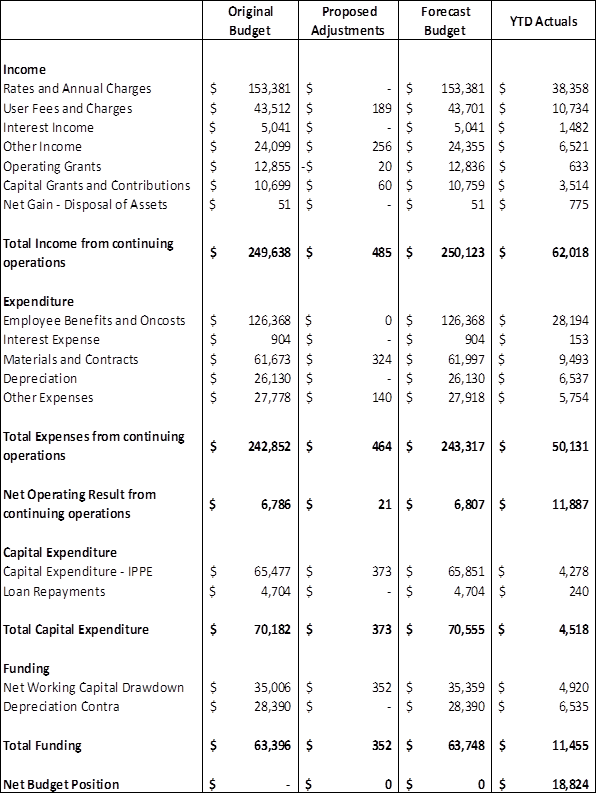
2) September 2017 QBRS Summary Budget Movements
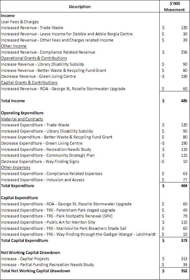
Income
User Fees & Charges
· Increase Leichhardt’s Trade Waste income to align with prior year income. This is offset by an increase in matching expenditure – Increase User Fee and Charges budget by $120k.
· Lease Income for Debbie & Borgia Café not included in the original budget– Increase User Fees and Charges income by $30k.
· New Pre-planning proposal income not included in the original budget - Increased by User Fees and Charges by $39k
Other Income
· Fines revenue re-forecast to correlate with revised structure. This is partially offset by an increase in matching expenditure – Increase Other Income by $256k.
Operational Grants & Contributions
· Library Disability Subsidy Grant not included in original budget. This is offset by an increase in matching expenditure - Increase Operational Grants and Contributions by $90k.
· Increase in Better Waste & Recycling Fund Grant to reflect the actual funds received. This is offset by an increase in matching expenditure - Increase Operational Grants and Contributions by $80k.
· Green Living Centre grant unsuccessful from City of Sydney. This is offset by a matching reduction in expenditure – Decrease Operational Grants and Contributions by $190k.
Capital Grants & Contributions
· Contribution received from the Department of Housing for the George Street, Rozelle Stormwater upgrade project. This is offset by a matching increase in capital expenditure – Increase Capital Grants and Contributions by $60k.
Expenditure
Material and Contracts
· Leichhardt’s Trade Waste expenditure increase to align with prior year income. This is offset by an increase in matching income – Increase Material and Contracts budget by $120k.
· Library Disability Subsidy Grant not included in original budget. This is offset by an increase in matching Income - Increase Materials and Contracts by $90k.
· Increase in Better Waste & Recycling Fund Grant to reflect the actual funds received. This is offset by an increase in matching income - Increase Materials and Contracts by $80k.
· Green Living Centre grant unsuccessful from City of Sydney. This is offset by a matching reduction in income – Decrease Materials and Contracts by $190k.
· Recreation Needs Study budget adjustment required to fund the project. The funds were unspent during the 2016/17 financial year. This is partially fund by an increase call on Net Working Capital - Increase Materials and Contracts by $119k.
· Forecast increased funds required to for the development of Council’s Community Strategic Plan – Increase Materials and Contracts by $115k.
· Way Finding through the Gadigal-Wangal – Leichhardt reclassified from operational to capital expenditure – Decrease Materials and Contracts by $10k.
Other Expenses
· Fines expenditure re-forecast to correlate with revised structure. This is offset by an increase in matching revenue – Increase Other Expenses by $63k.
· Community Grants budget of not included as a part of the original budget – Increase Other Expenses by $77k.
Capital Expenditure
· Contribution received from the Department of Housing for the George Street, Rozelle Stormwater upgrade project. This is offset by a matching increase in capital revenue – Increase Capital Expenditure by $60K
· Balance of unspent 2016/17 budget relating to Petersham Park Staged Upgrade project to be carried over into 2017/18 financial year. This is offset by a matching increase in Net Working Capital – Increase Capital Expenditure - $49k.
· Balance of unspent 2016/17 budget relating to Park Footpath Renewal program to be carried over into 2017/18 financial year. This is offset by a matching increase in Net Working Capital – Increase Capital Expenditure - $79k.
· Public Art for former Marrickville Hospital Site to reflect works to be completed during the 2017/18 financial year. This is offset by a matching increase in Net Working Capital – Increase Capital Expenditure - $115k.
· Marrickville Park Bleachers Shade Sail to be completed during the 2017/18 financial year. This is offset by a matching increase in Net Working Capital – Increase Capital Expenditure - $60k.
· Way Finding through the Gadigal-Wangal – Leichhardt reclassified from operational expenses – Increase Capital Expenditure by $10k.
Net Working Capital
· Capital Expenditure budget increases as listed:
o George St Stormwater Upgrade Project - $60K
o Petersham Park Staged Upgrade - $49K
o Park Foothpath Renewal Program - $79K
o Marrickville Hospital Site - $115K
Increase drawdown Net Working Capital - $313k.
· Recreation Needs Study budget adjustment required to fund the project. The funds were unspent during the 2016/17 financial year. This is offset by corresponding expenditure - Increase Net Working Capital by $39K.
3) Summary Profit and Loss Statement
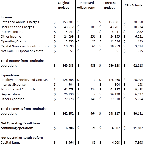
During the next two quarters and as a part of the 2018/19 budget process, Council will attempt to reduce the Net Operating Result before Capital Item. Further details will be provided at the December 2017 QBRS (if material).
4) Service Unit P&L Summary
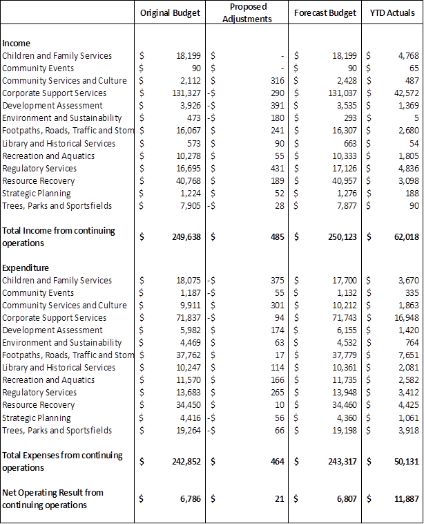
5) Capital Expenditure Statement
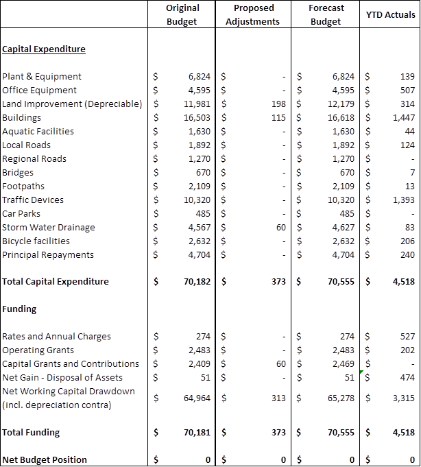
Capital projects are reviewed on a monthly basis with a view to aligning cash flow budgets with deliverables.
6) Cash & Investments – Restrictions Held
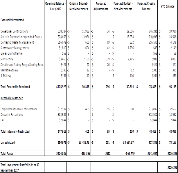
Council’s cash position sees an unrestricted balance of $73.1 million as at 30 September 2017. This is due to the first installment of rates (due 31 August 2017) that sees the highest volume of cash flow Council receives of each of rating installments. The unrestricted balance will diminish as Council expends it on operational expenses and capital projects during the financial year. The funds have been invested in accordance with Council’s investment portfolio which saw Council’s non fossil fuel investment at approximately $168m or 77% of its total portfolio.
7) Contract Listing
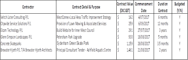
Above is a listing of contracts Council entered into during the period 1 July 2017 – 30 September 2017.
8) Consultancy & Legal Expenses
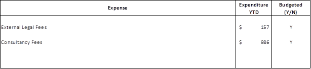
A consultant is a person or organisation engaged under contract on a temporary basis to provide recommendations or high level specialist or professional advice to assist decision making by management. Generally it is the advisory nature of the work that differentiates a consultant from other contractors.
Where any expenses for Consultancy or Legal fees (including Code of Conduct expenses) have not been budgeted for, an explanation is to be given. Report on external expenses only (not internal expenses).
|
|
Council Meeting 12 December 2017 |
Subject: Inner West Council Brand Development
Prepared By: Lawrence Hennessy - Manager Corporate Strategy and Communications
Authorised By: John Warburton - Deputy General Manager Community and Engagement
|
SUMMARY Brand does not equal a logo. A brand is an organisation’s DNA. It’s the expression of an organisation and the experience people, both internally and externally, have with an organisation. Put simply, ‘brand is the space the Council occupies in the hearts and minds of people’.
In an ideal world the development of a logo is the very last component of developing an organisational brand. The process to get to that point is to determine what the organisation’s brand DNA is. This then becomes the brief for the development of a visual identity which embodies the brand which in Council’s situation reflects the community it serves and the environment it operates within.
Currently Inner West Council has no articulated brand DNA and an interim ‘logo’ created out of necessity but adrift from meaning. Understanding that this could be a temporary measure, and to address the speed and urgency by which a visual identity was required, the strategy was to spend as little as possible and do nothing permanent. This included creating the logo in-house with a very basic style guide and keeping the utilisation of the interim logo and associated costs to a workable minimum across council assets, livery and stationery. Hence little has been spent on rolling it out with stickered over temporary solutions on vehicles, limited and in-house print runs, and no work done on permanent signage or assets. This would ensure that we did not invest so much that it would be costly to reverse, and support the elected council to be able to determine the brand direction.
Using a brand framework, work has already commenced internally and externally on articulating the brand, through the development of the organisational values, initial community engagement via the Creating our Innerwest 2036 survey and face to face engagement. With the return of the Council decisions will need to be made on the development of the brand, including visual identity, guidelines and roll out.
There are two options for how this would be done. Council can either continue with the interim logo and provide funds for further development of the visual identity, guidelines and rollout or drop the interim logo in favour of providing funds for the continued development of the brand including community engagement, and for a new visual identity, guidelines and roll out. Either way, for a project of this enormity and importance, it is recommended that the design work be conducted by proffessional design specialists.
|
|
RECOMMENDATION
THAT Council: 1. a) Agree to rebrand Inner West Council including the development of a new logo and visual identity suite, brand guidelines and rollout plan.
b) Agree to seek expressions of interest from design/brand agencies and provide funding to deliver stage 3 of the Brand Project pending report back to council on final costs.
c) Support the establishment of a panel of 9 people (membership to include nominated Councillors and the Mayor, Council officers and relevant community members identified collaboratively by those Councillors and Council officers) to determine selection criteria and briefing for the expressions of interest and final decision making criteria, and oversee the broad engagement strategy to involve the community in decision-making for the final visual identity.
Or
2. a) Agree to adopt the existing interim logo b) Agree to seek expressions of interest from design/brand agencies and provide funding to take the interim logo and develop a permanent visual identity suite, brand guidelines and rollout plan pending report back to council on final costs.
|
BACKGROUND
The Brand Framework
The framework is the unshifting foundation that underpins the organisation as it develops, changes and grows. It is the key reference for who you are, what you stand for, how you work, what you look like and what you deliver. This helps the community identify with and relate to its Council. For Councillors and staff it helps them understand and demonstrate the values-based culture that the brand embodies and act as brand ambassadors out in the community.
As the diagram below demonstrates, the brand framework is made up of the brand expression and brand experience. Identifying the brand experience is profoundly significant to an organisation as it is not always visible to the community. It is the foundation of the brand and is driven by organisational culture and values and the community’s values, personality and sense of place. The brand expression is what people see, feel and interact with. It builds a visual and verbal interpretation of the foundation – who we are, what we stand for etc.
Diagram 1 : Brand Framework (source: L Hennessy 2008) 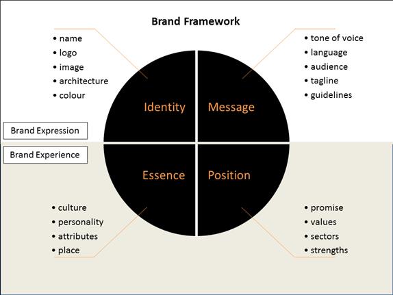
Undertaking a brand exploration uses community engagement and demographics research and staff participation to establish the brand experience. Once it has been established, then the development of the visual expression begins. This involves community and staff engagement. The final brand outcome would include a brand or mission statement.
Can the brand be developed while keeping the interim logo?
Advantages/disadvantages
There are possibly more disadvantages than advantages in keeping the existing logo.
Council created a simple interim look to get it through the short term only. There was, deliberately, minimal design process undertaken and while the outcome serves its original purpose and appears clean and corporate looking, the logo lacks the integrity that true brand development brings. No strategic exploration has been undertaken as to how this would extend and develop, such as the use and development of sub-branding or brand architecture, tone of voice etc.
There are many detractors in the community to the logo, as evident in social media, predominately because it is seen as representative of the state government’s council and not as the community’s council. It has been parodied in the community and likened to the WestConnex logo. Neither the community or staff were considered in the design and may not identify with it as being reflecting of what they believe their council should be.
It is possible to ‘retro-fit’ the brand but as there has been no work done developing a strategy for the logo and visual identity, or implementing a full rollout including all corporate templates, marketing material, website design, extensive brand guidelines etc., the amount of work required to develop the brand would be similar to starting again.
The advantage would be that the interim logo has been in use since amalgamation and has some recognition. As there is an existing logo, time and money would be saved when commissioning design.
Creating the Brand
Stage 1 – Developing Brand Experience
This is a consultation stage involving internal and external engagement, research and analysis, and establishing organisational culture that encompasses values and behaviours. This can be delivered in-house through Brand Strategy expertise
Stage 2 - creating the brand strategy
This stage builds a strategy, drawing on the findings of stage 1 that articulates how Council will present itself to its community. This forms the brief for stage 3. This can be delivered in-house.
Stage 3 - Developing the Brand Expression – creating the visual identity and message
This stage delivers the design, development and final artwork of the visual identity suite. This determines council’s image including logo, colour palette, language, imagery, architecture, templates and extensive guidelines. It is recommended that this is a specialist area of design and would require a design agency with the experience and the available resources to take on a large and complex design and implementation project.
FINANCIAL IMPLICATIONS
Stage 1 of Brand development work is a costly process as it involves Brand consultants performing internal and external engagement and research and analysis. This can cost over $150K not including fees for the design work. We have professional capacity internally to do this with only a modest budget needed for catering, workshop costs etc. and piggy-backing on the CSP budget for engagement. An investment of $25K would see this process completed. This would create savings of tens of thousands of dollars in brand consultancy fees.
Stage 2 would be completed using in-house professional capability at no further cost.
Stage 3 we have in-house capacity for strategic visual communication and design oversight, but developing the visual identity suite, designing templates and writing brand guidelines is a specialist area of graphic design and communication. Our in-house designer does not have the have internal capacity to deliver the level of design and visual communication work required on a project that needs constant attention for a period of time. It is recommended that budget be provided to commission external brand design specialists. The scope of the work would require an experienced agency with the appropriate resources to deliver a large volume of work in a short space of time.
Budgets allocated by other councils who have recently undertaking brand projects have ranged up to $400K. Given the ability to do most of the work in stages 1 and 2 in-house this project could require as little as $150-200k. it should be noted that a relatively small amount of this would be required for actual logo development.
Once a competitive EOI process has been completed according to the selection
criteria established by the Brand Panel and tender responses received, a report
to council will articulate preferred tenderer and final costs for adoption.
OTHER STAFF COMMENTS
Include comments from other staff here.
PUBLIC CONSULTATION
Initial public engagement has been completed with over 3000 people completing the brand related question on the Community Strategic Plan Survey. Face to Face interviewing was also conducted through the CSP engagement process.
It is anticipated that during stage 3 of the project the community will have opportunity to influence and make recommendations on a selection of designs shortlisted by the Brand Panel.
Local creatives will be encouraged to contribute through a competitive Expression of Interest process.
CONCLUSION
Brand does not equal a logo, meaning that Inner West Council currently does not have a fully thought out, strategically developed brand. It has an interim logo that may or may not be considered adequate to develop further to creative a permanent visual identity suite including brand architecture and sub-branding, extensive brand guidelines and roll out.
While the development of the brand will continue using in-house capability, a decision will need to be made to either introduce a new identity that is the visual interpretation of the community and the council or continue with the interim logo as a starting point to develop a permanent solution.
There is in-house strategic branding capability to fulfil stages 1 and 2 of the brand project but there is no in-house design expertise for specialist brand design, architecture and development. Nor are there the resources to manage the complexity of work involved in developing detailed brand guidelines and technical artwork to roll-out the identity across Council’s assets in a short space of time. Regardless of the decision to keep or change the logo, an external design agency will need to be engaged to deliver the bulk of stage 3 of the project.
Budgets will be determined once the expressions of interest and tenders have been received.
|
|
Council Meeting 12 December 2017 |
Subject: WestConnex Update Report
Prepared By: Kendall Banfield - Manager WestConnex Unit
Authorised By: David Birds - Group Manager Strategic Planning
|
SUMMARY This report discusses the following items related to WestConnex and the Western Harbour Tunnel and Beaches Link: 1. Stage 1 (M4 East) Urban Design & Landscape Plan (UDLP); 2. proposed acquisition for Stage 3 (M4-M5 Link) of part of Buruwan Park, King George Park and a small area of land at the intersection of The Crescent and Johnston Street; 3. request for expansion of Stage 2 (New M5) works area at Tempe Reserve netball courts; 4. noise complaints and noise mitigation for Stages 1 & 2 (M4 East & New M5); 5. progress of consultation on Stage 3 (M4-M5 Link) Environmental Impact Statement (EIS) issues & operational traffic issues; 6. early planning for Western Harbour Tunnel & Beaches Link; and 7. request for a funding contribution toward a WestConnex community protest along Victoria Road, Rozelle.
Recommendations are made in relation to Items 1, 2, 3, 6 and 7. Items 4 and 5 are for Council to ‘receive and note’. For Item 5, a report to Council on the Protecting Local Streets from WestConnex study (with recommendations) is planned for the March 2018 meeting.
|
|
RECOMMENDATION
THAT Council:
1. Receives and notes this report;
2. Writes to Sydney Motorway Corporation (SMC) in relation to M4 East residual lands and the Urban Design & Landscape Plan (UDLP) Updated Appendix F: Noise barrier location sub-plan seeking: (a) confirmation that residents of Walker Avenue, Haberfield and immediate surrounds prefer Roads & Maritime (RMS)-owned dwellings at 18 & 20 Walker Avenue be put to residential rather than community use; (b) a cash contribution for upgrading of Council community facilities in the Haberfield town centre in lieu of ownership or use of dwellings for community purposes, if it is confirmed that local residents prefer residential use of these dwellings; (c) a commitment to early provision of operational traffic noise barriers or other noise amelioration to properties on the eastern side of Wattle Street / Dobroyd Parade between Ramsay and Waratah Streets and to properties at 14 to 24 Wattle Street, Haberfield to protect residents against construction noise.
3. Writes to RMS to: (a) express opposition to any impact by WestConnex Stage 3 (M4-M5 Link) on any park or other publicly-accessible open space area; (b) refuse concurrence to proposed compulsory acquisition for WestConnex of parcels of land at: Buruwan Park, North Annandale; intersection of Johnston Street and The Crescent, North Annandale; and King George Park at intersection of Victoria Road and Byrnes Street, Rozelle; and (c) seek alternative design solutions that result in there being no impact on the abovementioned parks and open space areas.
4. Writes to RMS and SMC (New M5) stating it does not support occupation of a further two netball courts at Tempe Reserve (taking the number of courts occupied from three to five), acknowledging that RMS can use its powers under the Roads Act to take this action;
5. Writes to the Minister for Roads expressing its opposition to the Western Harbour Tunnel and Beaches Link project as part of its overall position of opposing inner-Sydney motorways and preference for public transport options.
6. Considers a reimbursement of $800 in funding for a community anti-WestConnex protest to be held along Victoria Road, Rozelle on the morning of 12 December 2017.
|
BACKGROUND
Item 1: Stage 1 (M4 East) Urban Design & Landscape Plan
In October 2017 the Sydney Motorway Corporation (SMC) Stage 1 project team forwarded the Urban Design & Landscape Plan (UDLP) Updated Appendix F: Noise barrier location sub-plan (at ATTACHMENT 1) to Council staff for comment. This sub-plan was prepared by SMC to satisfy Stage 1 Condition of Approval B46(f), which sets criteria for noise barrier designs, and requires that these designs be developed in consultation with the Urban Design Review Panel (UDRP) for the UDLP. The condition also requires that designs be presented to adjacent landowners for comment prior to the adoption of a final design.
Council staff forwarded comments to SMC on this sub-plan in October 2017, and these comments are summarised in this report. A number of relevant Council staff had input into the drafting of these comments. In the first instance, these comments confirm Council’s position of strong opposition to WestConnex, explaining that one of reasons for this opposition is that urban motorways have a substantial negative impact on the roadside environment. Despite the fact that Stage 1 residual lands will become public open space, this space will inevitably be degraded by traffic impacts. It will also be degraded by unsightly infrastructure (such as noise barriers) needed to manage these impacts. For Council, these negative impacts outweigh the benefits of the new open space.
Notwithstanding, Council is keen to ensure that residual lands are designed and implemented to a high standard to ensure they are as attractive and useful to the community as possible. Council seeks ownership of useful public space and facilities only - it does not want to own and maintain problematic spaces that are difficult to access and are blighted by motorway traffic. It is important that surrounding residents who have suffered the negative impacts of WestConnex derive as much benefit from these lands as possible.
Council expects all WestConnex residual lands to be delivered to Council to own at no cost, unburdened by contamination or any immediate need for maintenance. All landscaping, paths and facilities should be constructed by the proponent according to final designs. It is also expected that maintenance funding will be provided, and Council and the community would be closely involved in the development of plans of management. Construction and handover of these residual lands should occur at the earliest opportunity and not be delayed by construction of the M4-M5 Link (if approved).
Council staff have also given more detailed comments on designs within this sub-plan. It was noted that designs for the section Wattle Street / Dobroyd Parade between Ramsay & Waratah Streets were not included in the document. Council understands that this is the section that will have no noise barriers due to flooding/drainage considerations. If this is the case, then all dwellings in this section will require an alternative means of noise protection, such as at-property treatments including double glazing and air conditioning. Council is keen to ensure that all dwellings are protected in a way that is agreeable to all residents regardless of cost, and that this be provided as soon as possible to protect residents against construction impacts as well as operational impacts.
Council is aware that some residents located in the section between Ramsay and Waratah Streets are not satisfied with the at-property noise abatement measures that have been offered and seek some form of external noise barrier. Council also continues to seek resolution of operational noise mitigation issues for residents of five dwellings at 14 to 24 Wattle Street, Haberfield. These residents also seek protection by external noise barriers. It is apparent from the sub-plan that there have been differences of opinion between residents about noise barrier materials and locations, vegetation screens and adjacent drainage lines. Council supports a solution that is visually attractive and has the support of the greatest number of residents.
This report recommends that Council seeks a commitment from the M4 East proponent to early provision of operational traffic noise barriers or other noise amelioration to properties on the eastern side of Wattle Street / Dobroyd Parade between Ramsay and Waratah Streets, and to properties at 14 to 24 Wattle Street, Haberfield to protect residents against construction noise.
Council always seeks to maximise walk/cycle connectivity through all neighbourhoods, so supports the inclusion of the continuous walk/cycle path parallel to the noise barriers on the eastern side of Wattle Street / Dobroyd Parade. It is not possible to determine the width of the path proposed from the sub-plan - but in any event, Council seeks a minimum width of three metres and that there are no obstructions on any part of this pathway. For the sections of the pathway immediately adjacent to the traffic lanes, there will need to be a solid fence or other barrier to ensure the path is clearly separated and protected.
It is noted from these designs that the two RMS-owned dwellings at 18 & 20 Walker Avenue will retain their rear fences. This implies that these dwellings will return to residential use instead of community use as has been previously proposed. If this is the case, Council seeks some other form of community benefit in this area and would like to be assured that this course of action has the support of local residents. This matter was discussed at a meeting on 15 November 2017 between The Mayor, the M4 East Project Director and relevant Council and SMC staff. This report recommends that Council writes to SMC seeking a cash contribution for upgrading of Council community facilities within the Haberfield town centre in lieu of ownership or use dwellings at 18 & 20 Walker Avenue, Haberfield.
Council also seeks assurance that there will be a walk/cycle connection between Walker Avenue and the open space area adjacent to Wattle Street via former housing lots between the Parramatta Road vent facility and the house at 18 Walker Street. This connection is important to encourage walk/cycle traffic, which will increase surveillance and improve security of the open space area adjacent to Wattle Street. Council’s heritage advisor for Haberfield has requested that every effort be made to ensure that all works respond to the Heritage Conservation Area status of Haberfield and connect to the surrounding neighbourhood.
Item 2: Proposed acquisition of part of Buruwan Park & King George Park
In September and October 2017, Roads & Maritime Services (RMS) wrote to Council to begin discussions about compulsory acquisition of three parcels of land required for implementation of WestConnex Stage 3 (M4-M5 Link):
· two sections of Buruwan Park, located between The Crescent, Whites Creek and the Rozelle Bay Light Rail Stop – for details, refer to the RMS letter to Council at ATTACHMENT 1;
· a section of King George Park at the corner of Byrnes Street and Victoria Road, Rozelle - near the Iron Cove Bridge – for details, refer to the letter at ATTACHMENT 2;
· a small section of land at the intersection of Johnston Street and The Crescent, in the area beneath the light rail bridge – for details, refer to the letter at ATTACHMENT 3.
Since planning and implementation of WestConnex began, Council has objected to the project having any impact on any park or other publicly-accessible area of open space - regardless of the condition of the park, its ownership or whether additional parkland is to be created by WestConnex elsewhere. One of the many reasons Council is opposed to urban motorways like WestConnex is because expansion of road capacity inevitably results in loss of open space, and the Inner West has traditionally suffered from an open space shortfall. It follows that in its submission on the WestConnex Stage 3 Environmental Impact Statement (EIS), Council had expressed opposition to any impact on Buruwan Park and King George Park.
Relevant RMS and Council staff met to discuss this matter on 24 November 2017. At the meeting, Council staff explained Council’s position of opposition to the project having any impact on any park – hence its opposition to the three acquisitions proposed. It was acknowledged that that although the third small section of land at the intersection of Johnston Street and The Crescent was not technically a park, it was a nonetheless a vegetated area that warranted protecting.
RMS explained that loss of open space at all three locations would be more than offset by new open space created on the opposite side of The Crescent adjacent to the Rozelle Bay foreshore, and within the Rozelle Rail Yards recreation area. Council staff acknowledged this, but pointed out that Council and the community value these spaces and do not want them to be affected in any way. In the case of Buruwan and King George parks, the acquisitions would affect walk/cycle paths and other facilities that were constructed with Council funding, and diversion of these paths would have a negative impact on walk/cycle connectivity. The proposed naturalisation of Whites Creek at this location would also be affected.
Council is also concerned that the impact on all these land parcels would be permanent. Of greatest concern is Buruwan Park, where an attractive space that includes mature trees would be converted to a widened intersection that would provide vehicular access into WHT portals located within the Rozelle Rail Yards site on the opposite side of City West Link. It would also include the base of a walk/cycle ‘land bridge’ over City West Link – this is shown in Figure 2-3 from the Stage 3 EIS, at ATTACHMENT 4.
RMS seeks Council’s concurrence of Council in its capacity of Trustee all these properties to RMS’s acquisition by compulsory processes. This report recommends that Council writes to the Minister for Roads to express its opposition to any impact by WestConnex on any park or area of publicly accessible open space, refusing concurrence for use of the three areas of land described and seeking alternative designs that do not affect these land parcels. Council officers will report back to Council should alternate design solutions not be forthcoming from RMS.
Item 3: Expansion of works area at Tempe Reserve netball courts
Earlier in 2017, Council was informed by the New M5 project team (proponent) about their proposal for temporary use of part of the Tempe Reserve netball courts area and part of the adjacent vegetated area for a works compound. RMS has power under the Roads Act to allow use of the land for this purpose. Council staff lodged an appeal under the Roads Act to allow for necessary additional time for Council and project staff to negotiate with affected netball court user groups over these arrangements.
All parties met at a site meeting in May 2017, after which the parties agreed to an arrangement whereby the works compound could be established whilst still allowing eight of the 11 courts to be used - i.e. three courts occupied by the compound. The compound was established on 2 October 2017, occupying three netball courts as planned. At that stage, the compound was to operate for a three-month period, to be removed in January 2018.
This compound supports construction activities for the excavation of the New M5 tunnels under the Cooks River. In addition to occupying three netball courts, the works area also occupies part of an adjacent vegetated mound and results in the closure of the walk/cycle path which runs alongside the Cooks River. Occupation of the vegetated area has been in consultation with Council’s biodiversity staff, and Council’s recreation staff have provided advice on signage to redirect pedestrians and cyclists along an alternative route. Standard daytime construction hours apply to the compound.
The proponent has recently informed Council staff that an additional two netball courts are now needed for the compound – as shown in the ‘agenda briefing’ at ATTACHMENT 5. Appendix A within this attachment shows the three netball courts currently occupied by the compound layout that was agreed by the proponent, Council and court user groups. Appendix B shows the additional two courts required. Under the proposed arrangement, five of the 11 courts would be occupied. Council’s recreation staff have determined that one of the unaffected netball courts is not useable due to its poor surface – therefore, six of the 11 courts would not be useable.
Although Council staff and court user groups had previously (reluctantly) agreed to occupation of the three courts (Appendix A), Council staff have informed the proponent that occupation the additional two courts (Appendix B) would create an unreasonable impact on court users, and is not supported. A further impact would be created by the delay in these works occurring as a result of the two additional courts being needed.
Even if the proponent was to use its powers under the Roads Act, the full compound could not be established until mid-January 2018 and works would not be completed until mid-April 2018. This would create a clash with the netball season, which commences fully in February 2018. Court user groups have verified that this would create issues for the running of the 2018 netball season.
The proponent has requested that this matter be put to a Council meeting prior to any Roads Act powers being used. It is recommended in this report that Council upholds the current position of Council officers of not supporting the occupation of a further two netball courts for use as a WestConnex works compound, and the proponent be informed accordingly.
Item 4: WestConnex Stages 1 & 2 noise complaints
Since its formation in late 2016, Council’s WestConnex Unit has been involved in numerous complaints related to construction activities from WestConnex Stages 1 and 2. Most complaints relate to noise (particularly from night works), various impacts arising from construction trucks, pedestrian diversions, parking pressures, vibration from tunneling, odour from landfill leachate at the St Peters Interchange site, erection of roadway signage and inadequate notification and complaints handling procedures. As would be expected, most complaints are from residents around the main Stage 1 and 2 construction sites in the suburbs of Haberfield, Ashfield and St Peters.
Council does not have a formal compliance role, but the DP&E’s WestConnex compliance officer works part-time from Council’s WestConnex Unit. This has enabled WestConnex Unit staff to form a working relationship with DP&E compliance staff and learn about WestConnex complaints issues and procedures. The DP&E’s role is to monitor compliance with WestConnex conditions of approval, whereas the Environment Protection Authority has a role in monitoring compliance with environmental licensing conditions and utility works that fall outside the bounds of the project.
Compliance issues are also discussed at:
· regular (monthly) meetings of Council’s WestConnex Community Liaison Forum (WCLF), where DP&E and EPA representatives are in attendance to discuss compliance issues with Council staff and community representatives;
· regular meetings (held approximately every six weeks) of the NSW Government’s WestConnex Community Reference Group, where staff from DP&E, SMC and councils discuss compliance issues with community representatives;
· regular (monthly) Stage 1 and Stage 2 ‘interface’ meetings, where Council staff discuss compliance issues with staff from the project teams;
· regular (monthly) meetings of traffic and transport liaison groups for Stages 1 and 2, where Council, project and transport agency staff discuss WestConnex-related traffic matters;
· regular (monthly) meetings between staff from DP&E, EPA, NSW Health and other State agencies that have an interest in WestConnex compliance issues; and
· Council meetings and various other forums, meetings and site visits related to WestConnex.
At the November 2017 WCLF, the DP&E and EPA representatives stated that the number of complaints received across all WestConnex projects has fallen away in recent months. These representatives acknowledged that this would be attributable in-part to ‘complaint fatigue’, where residents stop making complaints because they feel it does not lead to a solution to their issue. Though DP&E and EPA compliance officers’ knowledge of potential compliance issues generally originates from complaints, these officers undertake regular patrols of WestConnex construction sites.
Staff from Council’s WestConnex Unit assist residents to resolve issues wherever they can, but as Council does not have a formal compliance role, the first course of action is to advise and assist residents to lodge their complaints formally with SMC, DP&E and/or EPA. Council, DP&E and EPA staff always advise residents to make complaints where warranted and ensure these are made formally, as all registered complaints are required to be investigated and will be recorded in complaints statistics. Even if it is determined there is no breach, this assists with project improvements that can reduce further impacts.
Residents continue to be advised that complaints should be made in the following manner:
· lodge a complaint verbally or in the heading of an email;
· phone or email WestConnex on 1 800 660 248 / info@westconnex.com.au to be directed to the relevant project stage;
· contact EPA if it relates to out-of-hours works, noise, dust, odour or any form of pollution - on 131 555, 24 hours a day, 7 days a week or email on info@environmental.nsw.gov.au;
· contact DP&E if it is related to construction, workers or traffic changes - by phoning the Compliance Officer on 0429 782 853 or 9274 6306, or emailing compliance@planning.nsw.gov.au Attn: WestConnex; and
· copy Council into any email by using the WestConnex Unit email address westconnex@innerwest.nsw.gov.au or phone the Unit on 9392 5329, noting that Council does not have a formal compliance role.
Up-to-date notices about WestConnex activities in affected suburbs and streets are available from the WestConnex Local Updates page. Council’s Weekly WestConnex Update Reports include summaries of information posted on the Local Updates pages and other information about Council’s activities in relation to WestConnex.
As an example of the WestConnex Unit’s role in complaints handling, Unit staff have recently been discussing construction noise abatement issues with St Peters residents. These residents are currently affected by construction noise and feel the noise abatement treatments being offered are not sufficient. As a result, Unit staff organised a meeting for 31 October 2017 between these residents and staff from Council, the DP&E and the New M5 project team.
St Peters construction noise issues were also outlined in the Notice of Motion to the 21 November 2017 Council meeting entitled WestConnex Noise Issues. In accordance with the Council resolution from this Notice, Council has written to the Premier, Minister for WestConnex and Minister for Planning to raise St Peters noise abatement issues.
WestConnex Unit staff have also been involved in discussions with Haberfield residents over similar construction noise abatement issues as those experienced by St Peters residents. For example, in September 2017 Council staff met with residents of a public housing complex on Dobroyd Parade, Haberfield to learn of their construction noise issues. These issues have since been discussed with the M4 East project team in an effort to ensure that operational noise amelioration is implemented as soon as possible to protect against construction noise. Council staff have also been advocating similar treatment for residents of 14 to 24 Wattle Street, Haberfield (as described in Item 1 above).
WestConnex Unit staff are also responding to a resolution from the 3 October 2017 Mayoral Minute to “Establish within Council of a log of complaints register and a process whereby residents within the Council area can log a copy of complaints made to SMC and state agencies in response to construction conditions, so that Council may make additional representation on behalf of residents to relevant state agencies and ministers. This should include dedicated contact numbers made available to residents to easily log complaints.” It is planned that progress on this matter be reported back to Council in the first quarter of 2018.
Note also that in its submission on the Stage 3 EIS, Council had raised a number of compliance issues based on its experience with Stages 1 and 2. In summary, these issues were:
· cumulative impacts from project works & service works;
· health problems from stress & sleep deprivation;
· poor construction practices;
· vague, unenforceable conditions of approval;
· poor responses to complaints;
· complex complaints procedures;
· inadequate compliance resources; and
· the proponent’s apparent lack of willingness to resolve issues.
Within the submission, Council had made the following demands as a response to these issues:
· an inquiry be immediately held into all stages of WestConnex;
· the inquiry to document all lessons learned from Stages 1 and 2 in order to improve practices for Stage 3;
· a health study to be undertaken for Stages 1 and 2;
· all construction details to be publicly exhibited with Preferred Infrastructure Report;
· Council and the community to be involved in development and approval of construction and management plans;
· strict conditions of approval and environmental licensing with adequate resources for enforcement;
· better management of cumulative impacts, particularly in relation to utility works that are not strictly part of the project;
· a night curfew on construction; and
· no heavy vehicles on local roads.
Item 5: Progress of consultation on Stage 3 (M4-M5 Link) EIS issues & operational traffic issues
Council held the first of five planned public meetings on Stage 3 (M4-M5 Link) EIS construction and operational traffic issues on the evening of 22 November 2017 at the Jimmy Little Centre in Lilyfield. The meeting focused on Stage 3 construction sites at Rozelle, Lilyfield and Annandale North.
The Mayor opened the meeting and explained Council’s position on WestConnex. Council staff gave a presentation which outlined Council’s concerns that were raised in the EIS submission, including air emissions impacts, construction traffic, construction noise, dust, vibration and operational traffic impacts. This was followed by a one-hour open-mic session where local residents raised issues and queries.
The second meeting was held on the evening of 28 November 2017 at the Sydney Secondary College at Leichhardt to discuss issues for Leichhardt residents about the mid-tunnel dive-site proposed for the Dan Murphy’s site at 7 Darley Road. This meeting followed a similar format as the first. Meetings for Camperdown/Annandale, St Peters and Haberfield/Ashfield will be held in February/March 2018.
For each of these meetings, residents in the vicinity of construction sites are being notified by letterbox drop, with notices also posted on Council’s website. Notes from all five of these meetings will be forwarded to the DP&E for information and will be posted on Council’s WestConnex web pages. Presentations given at the meeting will also be posted.
Council has also been inviting comments from residents on WestConnex operational traffic issues, known as Protecting Local Streets from WestConnex, via Your Say Inner West and at a drop-in session held in Lilyfield on the evening of 9 November 2017. As has been reported previously, Council had earlier in 2017 commissioned Veitch Lister Consulting to undertake independent traffic modelling to assist in identification of local streets that may be affected by WestConnex operational traffic. Council has also engaged engineering firm Beca Australia to assist with the analysis of modelling results and to prepare initial designs and costings for traffic calming of shortlisted streets. Council and Beca staff are currently assessing the results of the recent consultation and are refining the list of affected streets. This is being undertaken with reference to the draft traffic modelling report and traffic forecasts within the EISs for Stages 1 to 3.
An initial assessment of the results of the community consultation shows that the largest of the concerns expressed across all areas is Traffic Volume, followed by Safety and then Pedestrian/Cyclist issues. The highest number of responses was received by residents in the Leichhardt/Annandale area, Haberfield and then St Peters. At a street level, the highest number of comments related to Edgeware Road and Mary Street in St Peters, followed by Darley Road in Leichhardt.
Note that operational traffic issues are being discussed at the abovementioned five community meetings along with construction issues. Comments on operational traffic from these meetings will be noted and integrated into the final report on this project. It is planned that the traffic modelling report be finalised and reported to Council’s March 2018 meeting as part of reporting of the Protecting Local Streets from WestConnex project.
Item 6: Early planning for Western Harbour Tunnel & Beaches Link
RMS recently lodged State Significant Infrastructure (SSI) applications for the Western Harbour Tunnel (WHT) and Beaches Link projects. On 15 November 2017, Council staff and other stakeholders attended a DP&E planning focus meeting at North Sydney to discuss concept designs for these projects. At the meeting, DP&E outlined the planning process and RMS presented details of the projects to help with stakeholder input into the Secretary’s Environmental Assessment Requirements (SEARs) for EISs. Stakeholders were requested to submit their initial comments to DP&E by 24 November 2017. The DP&E is required to issue SEARs by 4 December 2017.
Accordingly, Council staff forwarded the following comments to DP&E on 24 November 2017:
· Council maintains a position of strong opposition to all inner-Sydney motorways, including WestConnex and the WHT / Beaches Link;
· Council has concerns about continuation of construction impacts and cumulative impacts in the Rozelle area because of the WHT;
· Council has concerns about further traffic increases on Johnston Street and The Crescent as a result of the WHT;
· Council has concerns about wider cumulative traffic impacts from WestConnex construction affecting Victoria Road, and WHT construction affecting the Warringah Freeway;
· there is a need for further public transport and active transport connectivity to the Bays Precinct development;
· there is a need for a detailed description on construction impacts for different tunnel construction methods;
· there is a need to consider the impact of the project on corridors for future public transport;
· there is a need for a stronger commitment to surface road improvements that result from reduced traffic;
· Council does not support any removal of spoil via surface roads – already-constructed WestConnex tunnels should be used;
· Council has concerns about air quality and visual impacts from ventilation facilities; and
· there will be other less-critical but nonetheless important local issues that will be raised by Council and the community as planning progresses.
Progress of planning for this project will continue to be reported through Council’s WestConnex Weekly Update Reports. Further information is also available on the RMS website and DP&E website. RMS fact sheets are at ATTACHMENT 8.
Item 7: Request for a funding contribution toward a WestConnex community protest along Victoria Road, Rozelle
A Rozelle resident has asked for a cash contribution from Council to assist with an anti-WestConnex protest event along Victoria Road, Rozelle. The event, entitled Kids Call to Action to Stop WestConnex 3, is planned to be held 7:30-8:30am on Tuesday 12 December 2017, would involve protesters (including families and children) standing on the footway along Victoria Road from the Iron Cove Bridge to City West Link wearing dust masks and holding signs with various anti-WestConnex messages. At around 8am, a vehicle would travel along Victoria Road to film the ‘silent vigil’, and this would be used for further anti-WestConnex advocacy via social media. Protesters would stand in a way that would ensure all participants are safe and the walk/cycle path along Victoria Road would not be blocked.
At ATTACHMENT 9 is a budget for the event and indicative slogans for the signs. As shown in the budget, the total cost of the event is estimated to be $809.42. It is a recommendation of this report that Council considers reimbursing an amount of $800 toward the cost of this event. Council’s support for this event is consistent with modest funding support given to other local WestConnex community groups earlier in 2017, and its position of opposing WestConnex.
FINANCIAL IMPLICATIONS
Yes. Item 7 recommends that Council considers a proposal at a financial cost of $800.
OTHER STAFF COMMENTS
Relevant staff have been involved in the drafting of this report.
PUBLIC CONSULTATION
Not applicable.
|
1.⇩ |
WestConnex Stage 1 (M4 East) Urban Design & Landscape Plan (UDLP) Updated Appendix F: Noise barrier location sub-plan |
|
2.⇩ |
Letter from Roads & Maritime Services (RMS) to Council re acquisition of land at Buruwan Park, North Annandale |
|
3.⇩ |
Letter from RMS to Council re acquisition of land at King George Park, Rozelle |
|
4.⇩ |
Letter from RMS to Council re acquisition of land at the intersection of Johnston Street and the Crescent, North Annandale |
|
5.⇩ |
Figure from WestConnex Stage 3 (M4-M5 Link) showing impact of Rozelle Interchange on Buruwan Park, North Annandale |
|
6.⇩ |
Figure from WestConnex Stage 3 EIS showing impact of Iron Cove construction site on King George Park, Rozelle |
|
7.⇩ |
Agenda briefing from New M5 principal contractor to Council requesting temporary occupation of a further two netball courts at Tempe Reserve for a works compound |
|
8.⇩ |
RMS Spring 2017 fact sheets for Western Harbour Tunnel & Beaches Link |
|
9.⇩ |
Budget and sign slogans for proposed 12 December 2017 community WestConnex protest event along Victoria Road, Rozelle |
|
Council Meeting 12 December 2017 |
Subject: Comparative Service Levels Pre and Post Merger
Prepared By: Andrea Tattam - Service Integration Manager
Authorised By: Nellette Kettle - Group Manager Integration Customer Service & Business Excellence
|
SUMMARY This report has been prepared at the request of Council following a report to the 12 October 2017 meeting outlining our progress with the merger implementation. It provides the elected Council with a brief snapshot of service level comparisons across the organisation pre and post-merger.
The services for comparison that were selected for this report were based on them being front line, highly visible services with the Community.
Overall, performance is steady with some services showing improvement post-merger, the majority showing consistency and a few where service may be considered to have marginally dropped.
While the introduction of the TechnologyOne One Council Enterprise System over the coming 12-18 months will enable extensive reporting and ‘Dashboard’ visual representation of performance, currently we are reporting out of the three former council legacy systems. This presents significant challenges in extracting and accurately comparing performance data for the Inner West Council as a whole and this should be taken into account in the appraisal of the data provided in this report.
|
|
RECOMMENDATION
THAT Council receive and note this report of comparative service levels pre and post merger. |
BACKGROUND
At its meeting of 12 October 2017 Council received and noted a report outlining merger implementation progress at Inner West Council. The ensuing resolution requested a further report that provided a level of comparison of our service delivery pre and post-merger.
Prior to the merger the three former Council’s operated three different ‘Enterprise Systems’ for service performance such as customer requests; namely Authority/TRIM (Ashfield), Dataworks (Leichhardt) and Merit (Marrickville).
While the development and transition to the TechnologyOne One Council solution takes place progressively over the next 12-18 months, these three legacy systems will continue to be used within Inner West Council in some capacity.
Challenges in extracting data for comparison
A number of challenges and constraints have been identified in selecting representative service areas and criteria for the purpose of this report. Extracting data and manually aligning it to the new IWC organisational structures to enable meaningful comparatives is difficult.
As indicated the three former Council’s not only had three disparate systems each had developed their own criteria and service standards along with their own unique monitoring and reporting frameworks. For example response times to action a customer request (CRM) varied between:
Ashfield 10 days
Leichhardt 20 days
Marrickville 5-35 days (depending on the nature of the Customer Request).
As a result, when we draw data from the three systems to create an IWC ‘average’ this is not a true indication of the current level of service and it will continue to be somewhat inaccurate until service levels are completely harmonised over time.
Similarly, the way in which some data was stored within the legacy systems contributes to the difficulty around extraction and comparison. In preparing this report the extraction of data has resulted in large volumes of data requiring post extraction manual manipulation to create a level of meaning for comparison, largely as a result of the restructuring of service units and responsibility for some customer requests and service actions having moved from legacy business units.
The implementation of the TechnologyOne One Council system will eliminate this difficulties in future and furthermore will enable live dashboard reporting to the community as well as the capability for residents to track the progress of their service requests on their phone or tablet at any time.
Notwithstanding the above, Council Officers have endeavored to select a range of service areas and service levels that are of high value and impact within the Community and where some level of data is available for analysis.
Service Areas/Levels for Comparison Pre and Post-Merger
A selection of front line customer service and service delivery areas from across a range of organisational Service Units have been selected for the purpose of this report:
· DA Processing
· Capital Expenditure by Asset Category
· Community and Cultural Facilities
· Park Mowing and Tree Maintenance
· Library Service patronage and usage
· Street sweeping and verge mowing
· Waste services including missed bins
· Customer Requests (CRMs)
While not exhaustive, the objective was to examine a broad range of services that would provide a useful insight into general performance pre and post-merger. Data was extracted for the three individual Council’s for the 2015/16 Financial Year, the data was then extracted from the three former Council systems for 2016/17 and consolidated as the Inner West Council comparative. Where available, data for Quarter 1 2017/18 was also extracted as a means of tracking and comparing performance thus far this financial year.
The results are provided in the tables below. It is important that a good narrative is provided to Council as some comparative years are skewed for reasons that would have been the case even if no amalgamation took place. These kinds of variations along with those outlined in the challenges in obtaining comparative data need to be taken into account.
Analysis of Results
(1) Development Application (DA) Processing
Stronger performance is evident post-merger in DA Processing and Capital Expenditure. Results show the backlog of outstanding DAs considerably reduced in 2016/17 (308 down from 418) and a downward trend in DA Processing Times particularly since the commencement of 2017/18 (84 days down from pre-merger combined 88 days). Largely this has been in response to greater flexibility of staff resource allocation as a larger Council, the introduction of new processes and a greater emphasis on pre-DA processes. The spike in processing times in 2016/17 is attributable to the efforts put into clearing out the backlog of old DAs, which impact poorly on average determination times.
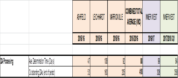
(2) Capital Works Program
Capital Expenditure is another area where the community has seen tangible benefits since the merger. It is a reflection of the works completed on the ground and a good indication of performance and service delivery. Pre-merger combined Capital Works totalled $47.2m in comparison to $68.868m in the first year as Inner West Council and is due to our enhanced organisational delivery capability, a focus on infrastructure renewal and a push to address the inherited infrastructure backlog.
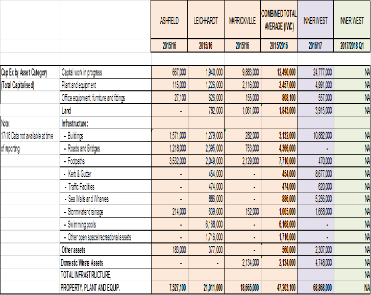
(3) Community Grants
In considering Community and Cultural services, the pre and post-merger grants programs were extracted for comparison. As outlined previously it is difficult to draw conclusion within this Service Area pre and post-merger as the measurements and administration of grants in the former Councils were different.
Note 1: 2016/17 figures represent a combined Leichhardt/Ashfield grant program which was promoted under the banner of an IWC Grant Program. The Marrickville grants for 2016/17 had already been advertised prior to amalgamation and therefore were processed as part of the Marrickville grants program.
Note 2: The 2016/17 and 2017/18 Community and Cultural Grants include Stronger Communities Grants (SCG), however these grants are not restricted to community, arts and culture projects ( eg environmental projects could be assisted under this scheme). Most SCGs are community and/or arts focused and therefore are incorporated into this summary of Community and Cultural Grants.
Despite some transitional timing challenges in the administration of the programs the inference that can be drawn is that Inner West Council provides a more simplified grants program which streamlines applications, assessments and acquittals, and enables reminders to be sent to applicants. The improved efficiencies provided by this system enable better tracking and monitoring of the grant program. With consistent opening and closing dates and guidelines across the IWC area it is particularly helpful for the many organisations that operate across the Inner West that would otherwise would need to submit three separate applications, at three different times, using three different application forms and associated guidelines.
Notably also, pre-merger some grants were only available in one former Council area e.g. Recreation Grants were only offered in Marrickville Council pre-amalgamation, whereas the IWC grants allowed sporting and recreational groups from former Ashfield and Leichhardt areas to apply for Recreation Grants for the first time.
Further, given the Stronger Communities Grants program as a direct result of the merger, the overall grant pool in the reporting periods has increased. This substantial new grant program offering up to $1 million in grants over a three year period has offered grants of up to $50,000 to more substantial projects than the previous grant programs permitted.
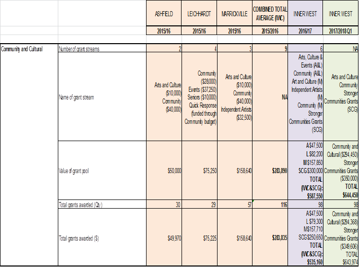
(4) Asset and Environment Works
Generally there are not statistically significant changes across the range of maintenance services selected as part of this report. Verge mowing and street sweeping are comparable pre and post-merger, as are park mowing cycles and street tree planting programs.
While Tree Pruning Applications and Tree DA Application performance remain stable it is worth noting that at a ‘local’ legacy Council level performance in Tree DA Processing has increased in Marrickville (up from 39% within target days to 75% within target days) in Leichhardt times have increased from 29 to 44 days on average for assessment showing a decreased service level. However, it is noted that much asset and environment work is seasonal and can vary significantly throughout the year and can impact service delivery considerably.
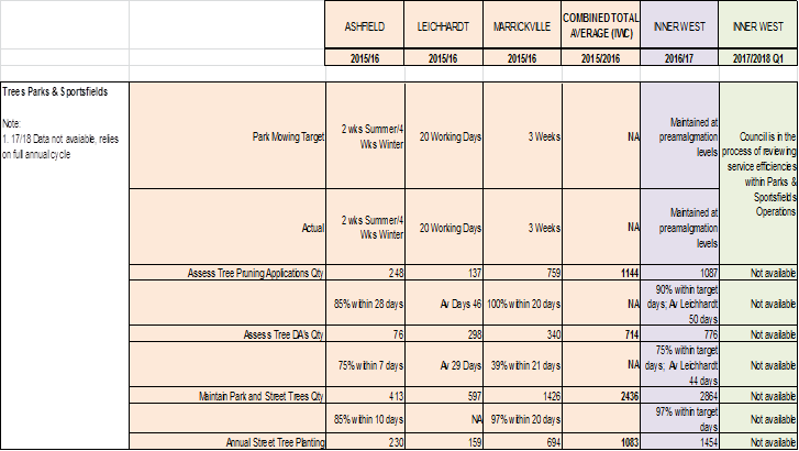
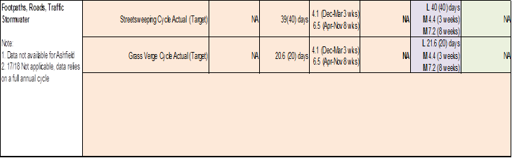
Note: Data for Q1 2017/18 is not available as reporting relies on annual data.
(5) Waste Services
In regard to the increase scale and the growth being experienced within the Inner West LGA, Council has increased the number of waste and recycling services. There has been a small increase in the number of missed bins recorded however the number of bin repairs and replacements remain steady.
Two possible underlying reasons for the small increased variation overall post-merger in missed bins may be:
(1) Due reporting of missed services on the day of collection prior to completion of the run
(2) Where bins have not been presented in time for the collection and then been reported a ‘missed service’ to have waste collection truck return to the premise.
Despite the small increase industry average for missed services is 0.5% and Inner West Council continues to deliver well below that percentage amount.
Generally the number of services and tonnages are comparable across pre and post-merger years. It can be noted that green waste generation is weather dependent which can account for variation not related to organisational factors as well as influences such as a move away from newspapers impacting recycling totals.
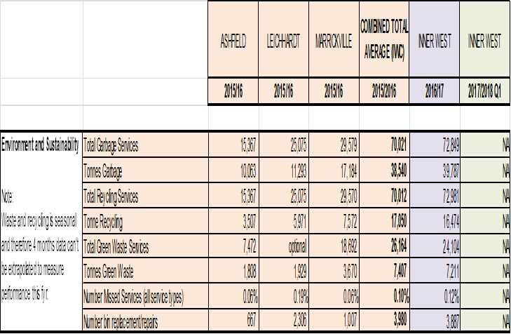
(6) Library and History Services
In the absence of customer satisfaction surveys, patronage (while not a true measure of performance) at consumable services such as aquatic centres and libraries has some potential to be used as an indicator of whether demand and use for the services have remained within comparable ranges pre and post-merger. The number library visits and memberships have shown growth, this may be interpreted as a representation that the Community continues to use and experience a similar level of satisfaction with the service post-merger, with growth potentially attributable to population or possibly a reflection of improved offer and therefore attraction to use the service.
Note: Library visit figures are estimates only due to varying methods of measuring attendance across branches in the former Council’s.
In reviewing the 2017 Micromex Community Satisfaction Survey results there has been a slight increase in customer satisfaction with Library Services from 2016 with a mean score increase from 3.93 to 3.97 whilst 74% of survey respondents indicated they were satisfied or very satisfied with the Library and History services provided.
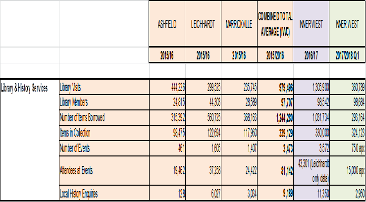
Community Perception Surveys
Pre-merger, the former three councils regularly commissioned independently-conducted community satisfaction surveys by professional research companies. Generally the survey provides an empirical measure and statistically representative benchmark of performance across a range of services provided by the organisations and results of the surveys pre and post-merger would indicate broadly consistent levels of satisfaction since the amalgamation.
Whilst all the former council’s used slightly different survey and measurement questions/frameworks, best fit analysis has been performed that enable the pre-merger community satisfaction results to be compared to the 2017 Inner West Council survey. Exact comparisons are not possible due to variations in the rating scale and questions, however comparative mean satisfaction scores can be determined which demonstrated that:
o There is no significant difference between Inner West and Leichhardt’s overall satisfaction scores, which are comparable with the Micromex Sydney metro councils’ benchmark.
o Marrickville Council’s overall satisfaction was significantly higher than the Micromex Sydney metro councils benchmark
o Ashfield Council’s mean was slightly lower than the Sydney metro benchmark (with the caveat that the question was not directly comparable).
The post-merger surveys in 2016 and 2017 examined overall satisfaction that showed increase with the development and maturity of the Inner West Council with mean scores to the overall satisfaction question increasing from 3.42 in 2016 to 3.49 in 2017. These IWC scores compare with 2015 pre-merger surveys in the former council’s where:
Council Year Mean Satisfaction Score
Ashfield 2015 3.34
Leichhardt 2015 3.58
Marrickville 2015 3.88
IWC 2016 3.42
IWC 2017 3.49
Note: The mean satisfaction is calculated by assigning a value to each of the points on the five-point scale, where 1 is ‘not at all satisfied’ and 5 is ‘very satisfied’. The mean establishes a benchmark for overall satisfaction with Council and enables comparison of satisfaction levels over time.
At a micro service level, when a comparison of community satisfaction results is made to other LGA benchmarks, eight (8) of the 26 comparable measures were rated above the benchmark. These are ‘maintaining local roads excluding major routes’, ‘maintenance and cleaning of town centres’, ‘flood management’, ‘household garbage collection’, ‘maintenance of local parks, playgrounds and sporting fields’, ‘safe public spaces’, ‘supporting local jobs and businesses’ and ‘stormwater management and flood mitigation’. This survey comparison would further reinforce a continued measured satisfaction level with performance and service delivery on key services.
Customer Requests (CRM)
As indicated previously with the introduction of the TechnologyOne One Council enterprise management system, Council will be able to provide extensive ‘dashboard’ reports to management, the elected Council, our Community and customers. Without doubt this will enable a range of ‘touch of a button’ real time performance data providing unprecedented transparency and accountability for service delivery.
Until such time, customer service reporting from the three legacy systems is a fairly resource intensive exercise that requires Council Officers to conduct extensive and complex data mining, analysis and manipulation to ensure the categorisation of customer requests (CRMs) align as best as possible to the new service unit organisational structure.
Customer Requests or CRMs are generated when a customer contacts Council for service or action and can be used to serve as an indicator trend of our overall service performance.
Marginally, a greater number of CRMs have been provided post-merger (89,135 up from 86,968) with requests finalised being maintained at a steady >99% rate. Some slippage in completion rates within service standards has been identified being 86% pre and 82% post-merger.
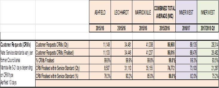
Note: CRM Finalised within Service Standard (%) in Q1 2017/18 includes CRMs that have not fallen due yet and therefore may not be a true indication of performance
The data analysis required to compile this report has provided an insight into the number of CRMs that remain ‘open’ or unresolved in the system which have increased, particularly in the first quarter of 2017/18. Follow up with Service Unit Group Managers internally is underway to address this issue. It is proposed that following the restructure and co-location of teams in mid 2017, Level 4 Managers that are now responsible for CRMs across the three former councils, do not have adequate access to ICT systems to enable their closure of CRMs across the former systems.
Ultimately it is the CRM module of TechOne that will fully address the challenge of managing CRMs within Inner West Council, however steps are underway to update the back-end of the legacy systems with the new organisational structure and this will provide some improvement in the interim. Furthermore, in response to the findings from this report, Council Officers have commenced work on the development of a Data Warehouse to sit on top of the three CRM systems that will enable automated and improved reporting on CRMs which will in turn enable managers to better manage customer requests. This is expected to be completed early in the new year.
Staff Turnover Metrics
In response to Council’s request for pre and post-merger comparison data on staff turnover statistics from the three former Councils and for comparison with Inner West Council, the following table is provided. This information affords input into employment trends and the impact of amalgamation on Council staff.
2015-2016
|
PRE-MERGER |
Head Count |
Turnover |
|
Ashfield |
189 |
10.58% |
|
Leichhardt |
384 |
10.68% |
|
Marrickville |
550 |
7.09% |
|
Average Total |
1123 |
8.90% |
|
2016-17 |
||
|
INNER WEST COUNCIL |
Head Count |
Turnover |
|
Fmr Ashfield |
1117 |
1.61% |
|
Fmr Leichhardt |
1117 |
4.66% |
|
Fmr Marrickville |
1117 |
3.13% |
|
Average Total |
1117 |
9.40% |
|
2017-18 projection based on current figures
|
||
|
INNER WEST COUNCIL |
Head Count |
Turnover |
|
Fmr Ashfield |
1117 |
2.15% |
|
Fmr Leichhardt |
1117 |
4.30% |
|
Fmr Marrickville |
1117 |
3.76% |
|
Total |
1117 |
10.21% |
|
Legend: |
|
Metrics have been based on 12 monthly figures from May - May to provide accurate benchmarking to align with the amalgamation in May 2016. 2017/2018 data is a projection only based on current figures.
|
Analysis of Turnover rates
All turnover rates are within the healthy range for the local government industry. The LG NSW HR Benchmarking Metrics Survey for 2015-2016 indicated an average turnover rate of 9.4% and median rate of 8.9% for NSW local government. Once amalgamation was proclaimed, typically some staff will choose not to stay with the new entity for various reasons dependent on their work/home/life cycles and capacity and interest in working in an environment of change and uncertainty. These figures include resignations and voluntary redundancies.
The projected figures for 2017-2018 are based on three months data, during a significant transition time filling the substantive organisation structure, and may be slightly inflated compared to the final period.
From a wider labour perspective, labour market turnover rates are increasing due in part to the sharp rise in recent years of social media and professional networking websites such as LinkedIn. Workers have ready access to information about new job opportunities, and that ease of access encourages greater movement in the labour market.
Contemporary survey indicators from both the Australian Human Resource Institute (AHRI) and Hayes Recruiting suggest that the turnover rate is on the increase. The latest AHRI 2017 survey calculates turnover at an average of 17.4% for organisations with 1000 employees or more and an average of 18.5% across all organisations.
FINANCIAL IMPLICATIONS
Nil.
PUBLIC CONSULTATION
Nil
CONCLUSION
Due to the complexities of the services provided across council and the differences in pre-merger approaches to service delivery, systems and reporting; it has been challenging to obtain true comparison points for pre and post-merger performance levels. It is conceded that obtaining performance data will be vastly improved and easier with the introduction of the TechnologyOne One Council system across the organisation. However even with better reporting as Inner West Council the challenge of comparing ‘like with like’ with the former councils will remain.
On the whole, performance data analysis across a selection of services provides indication that service standards and performance are relatively steady and comparable to pre-merger states. Across the range of services selected for comparison for the purpose of this report there exists some increases and improvement in performance (DA and Capital Program), some small pockets of decrease (CRMs) and a majority of services remain within the same scope of pre-merger levels.
These results may be reflective of the post-amalgamation decision not to vary or harmonise services until after the elected Council was returned. Generally the expectation would be that initial service performance may dip in response to significant organisational changes post-merger such as co-location, new ICT systems and restructuring. However expectation would similarly hold that on-ground service provision should recover as new systems and processes bed down, integration hits full momentum and as service reviews are undertaken resulting in efficiencies and other improvements.
|
|
Council Meeting 12 December 2017 |
Subject: Reporting of Code of Conduct Statistics
Prepared By: Charmian King - Policy and Risk Services Manager
Authorised By: Michael Tzimoulas - Deputy General Manager Chief Financial and Administration Officer
|
SUMMARY To report to Council on the Code of Conduct complaints received by Inner West Council during the 12 months prior to 1 September 2017. |
|
RECOMMENDATION
THAT Council receives and notes this report. |
BACKGROUND
Section 12.1 of the Procedures for the Administration of the Code of Conduct requires each Council to report annually on Code of Conduct Complaints within 3 months of the end of September.
In total 2 Code of Conduct complaints were received during the reporting period – neither were about Councillors or the Interim General Manager.
Code of Conduct Complaints can be finalised using alternative means by the Interim General Manager or Administrator/Mayor or referred to a Conduct Reviewer for preliminary assessment. The 2 complaints received were referred to a Conduct Reviewer for assessment. As at 31 August 2017, one complaint was still being investigated by a conduct reviewer (since completed) and the outcome of the other 1 complaint was that no breach of the Code of Conduct had occurred.
The total cost to Council for managing these complaints was $2,420. The Procedures for the Administration of the Code of Conduct require Council to submit data on the Code of Conduct complaints for Council by 31 December 2017. The relevant staff will submit these reports to the Office of Local Government in order to meet this legislative requirement.
FINANCIAL IMPLICATIONS
Nil
OTHER STAFF COMMENTS
Nil
PUBLIC CONSULTATION
Not Applicable
CONCLUSION
Nil
|
|
Council Meeting 12 December 2017 |
Subject: Notice of Motion: Tempe Station Access
From: Councillor Colin Hesse
|
Motion:
THAT Council writes to the NSW Minister for Transport and Infrastructure, Mr Andrew Constance, calling on the NSW Government and Sydney Trains to:
Immediately construct an at level footpath from number four platform at Tempe Railway Station to Griffiths Street Tempe so as to improve access to Tempe Railway Station.
|
Background
Tempe Railway Station in not currently accessible by people with mobility disabilities or for parents with children in prams. There are stairs to the concourse from both Richardsons Crescent on the Marrickville side of Tempe Station, and from Griffiths Street in Tempe. From the concourse access to the platforms is by stairs to platforms 3 and 4.
A pathway from Tempe Station's number 4 platform is both very low cost and can be effected immediately. The platform is pretty much level with the footpath in Griffiths Street, and by simply changing the fencing arrangement and paving between the platform and the path, access is made available to all with mobility access concerns, including parents with small children.
In years gone by, when trains to and from the East Hills line serviced Tempe Station, number 1 platform was accessible directly from the car park off Richardsons Crescent, through a turnstile.
With the inception of Opal card ticketing it is clear there is no good reason why passengers should be forced to walk up and over the footbridge when they can tap-off on the platform, as has been the practice until recently when the Opal card monitors were placed at the top of the stairs.
|
|
Council Meeting 12 December 2017 |
Subject: Notice of Motion: New Timetable
From: Councillor Colin Hesse
|
Motion:
THAT Council writes to the NSW Minister for Transport and Infrastructure, Mr Andrew Constance, calling on the NSW Government and Sydney Trains to: Immediately review the new T3 Bankstown Rail timetable to restore the long-standing rail link between Marrickville and St Peters during peak periods. |
Background
The new Sydney Trains timetable has changed the stopping pattern of trains between Marrickville and St Peters from the previous timetable where all seven services stopping at Marrickville between 7am and 8am, and 8am and 9am also stopping at St Peters, to the new timetable where only one service per hour during that period has the same stopping pattern.
In the evening peak between four and six in the evening there is similar though less extreme disconnect, with only 50% of trains leaving Central for the Bankstown Line during those hours stopping at both St Peters and Marrickville.
There has also been a reduction of one service per hour during between 7am and 9am from Marrickville to the City, and a reduction of one train per hour from 8am to 9am from St Peters to the City.
|
|
Council Meeting 12 December 2017 |
Subject: Notice of Motion: Bikes Inner West Council
From: Councillor Mark Drury
|
THAT in order to progress the expansion of the Inner West Bike Route Network Council:
1. Establish a Bicycle Working Group with councillors, local bicycle groups and interested community members;
2. Nominate a staff member to be a project manager for bike projects;
3. Work out a better way of balancing the competing needs of our road network;
4. Establish a budget for bike projects for the next three years; and
5. Appoint an Inner West Bicycle Coalition representative on the IWC Traffic Committee. |
Background
The Inner West has a long love affair with bikes. We have ridden them to work and school, we have ridden them for fun and sport, we have ridden them for health reasons and because we could not afford other forms of transport.
With the event of mass produced cars the space on our public roads has increasingly been used primarily for cars and car parking and the space for safe bike riding has been reduced.
All three former Inner West Councils had a commitment to facilitate bicycle use as a valuable component of active transport. There were several bike plans and cycling was included as part of these Councils social and infrastructure planning instruments and policies. Steps have been taken to address the issue of the need for infrastructure to make cycling safe and viable. Councils have had budgets to commence building retrofitted cycling networks.
We all recognise that retrofitting roads for cycling networks is not easy and there is need to ensure that we have residents support for extending the network. There is a need to balance the interests of cyclists and potential cyclists with the needs of residents for parking and workable routes for cars through our suburbs.
The Leichhardt Integrated Transport Plan 2013-2023 showed that currently 50% of all vehicle trips in the inner west are just under 5km. Shopping and recreation trips represent 43% of all trips and on average 60% of these are by car, travelling only around 4km. 41% of work trips are to the city and 18% of work trips are within our LGA. As population density increases, the best solution to increasing traffic and parking problems is to give the community different options. Providing quality cycling facilities means more families, commuters and shoppers may ride and help relieve traffic and parking problems.
At present it is estimated that we use bikes around 7% of the time when we want to get around. Safe and viable bike routes may give more options to safely cycle.
|
|
Council Meeting 12 December 2017 |
Subject: Notice of Motion: Use of Infrastructure SEPP
From: Councillor Rochelle Porteous
|
Motion:
THAT where council needs development approval for development on publically owned land it must not use the Infrastructure SEPP to achieve this. The Infrastructure SEPP does not allow for adequate public scrutiny and community consultation. Instead all of Council’s development proposals on publically owned land must be assessed through a full development application process.
|
Background
It recently came to light with the planned demolition of 9 and 11 Marion St Cottages and conversion of the land they stand on to a carpark, that staff had nominated to use the Infrastructure SEPP to have the project approved rather than put it out to public exhibition and community consultation through a full Development Approval (DA) process.
Inner West Council (IWC) is not a private corporation answerable only to shareholders. IWC represents all 185,000 of our residents as a democratically elected body and an important tier of government. Because of this, IWC must be seen as responsible to our residents through transparent, accountable measures. The infrastructure SEPP does not assist these goals. IF IWC uses a full Development Application (DA) process for all proposals involving publicly owned land, it will ensure there is proper scrutiny and meaningful community consultation of such proposals so that our residents can be confident in the decisions made by IWC. It is noted that Leichhardt Council chose this path and preferred the full DA process over the infrastructure SEPP for publicly owned land.
|
|
Council Meeting 12 December 2017 |
Subject: Notice of Motion: Investigating Feasibility of an Inner West Council Solar Farm
From: Councillor Anna York
|
Motion:
THAT the General Manager, investigate the requirements for a feasibility study into:
a) The business case for Inner West Council to invest in a solar farm to offset Council’s electricity consumption across facilities and operations; and
b) Options to share investment and return / savings with the community, including direct community investment and / or savings passed on through rates discounts.
|
Background
A mayoral roundtable was held recently with national and local environment groups. Discussion was focused on the implementation of Council’s resolution on solar and renewable energy, including options for Council to invest in solar and renewable innovation.
As recognised in Council’s recent resolution, there is an opportunity for Council to play a leading role in helping our community to access solar and renewable technologies, with the dual benefits of:
· Demonstrating the feasibility and benefits of community / local government investment in renewables (ie through a ‘flagship’ innovation project)
· Returning savings on electricity consumption and costs to our community, to help relieve the rising cost of living in the Inner West
Roundtable participants were interested to explore further the possibility for Council to invest in / build / operate a solar farm, to offset Council’s electricity consumption across facilities and operations.
Sunshine Coast Council has recently become the first Council in Australia to
offset is electricity consumption from renewable energy generated by a 15MW
solar farm, which complements 40,000 solar rooftops already in the LGA.
There are a range of models and partnerships Council could pursue to finance, locate, design, build and operate a solar farm of this scale. This resolution seeks initial advice through the Chief Financial Officer on how we can investigate the feasibility and requirements to progress this project forward.
|
|
Council Meeting 12 December 2017 |
Subject: Notice of Motion: Shade Sails
From: The Mayor, Councillor Darcy Byrne
|
THAT Council officers report on the suitability and rank the priority of the following playgrounds for installation of shade sails, to be considered in the preparation of the 2018/19 Budget:
|
Background
Prior to the amalgamation the Leichhardt LGA Developer Contributions Plan Open Space and Recreation was amended to allocate $720,000 for the installation of shade sails in all parks and playgrounds where they were required.
The list of parks and playgrounds and the costings for the works were developed by Council officers and endorsed by Leichhardt Council.
$200,000 this funding has been allocated in the 2017/18 budget and will deliver six shade sails, including new sails at Gladstone Park, Goodsir Street Reserve, Trevor Street Playground, William Stuart Playground (White’s Creek Valley Park) and 36th Battalion Park and a replacement sail at Mort Bay Park.
Two shade sails are also being installed in the former Marrickville LGA at Marrickville Park (over the bleachers) and Sydenham Green.
Given the long delay in the Inner West Council carrying out the installation program and I have consulted with parents and carers in the community to provide feedback to Council about locations where children are currently unable to use equipment on hot days or are being put at risk from sun exposure.
The locations listed in the resolution above were identified by parents.
|
|
Council Meeting 12 December 2017 |
Subject: Notice of Motion: Support for Balmain Para Rowing Group
From: The Mayor, Councillor Darcy Byrne
|
Motion:
THAT Council writes to the Office of Environment and Heritage seeking permission for the Balmain Para Rowing Group to use Palm Court Ward A as the site for their new rowing facility.
|
Background
The former Leichhardt Council was approached by the Balmain Para Rowing group requesting that Council support Palm Court Ward A, Callan Park as their preferred site for a new rowing facility.
The current program, which caters for para-rowers only, has been running successfully over the past six years from Balmain Rowing Club. Over this time, they have had 23 persons with disabilities participate in the program with a further 10 getting a taste of rowing through our Try Rowing Day. However, physical access at Balmain Rowing Club is unacceptable in terms of current requirements for disability access (no disabled access toilets, steep narrow steps down to the boat and water level) and discourages persons with disabilities from even considering rowing as their sport.
Council resolved to write to the Office of Environment and Heritage expressing support for a request from Balmain Para-Rowing concerning Palm Court Ward A Callan Park as the preferred site for their new rowing facility and seeking a response from OEH.
The Office of Environment and Heritage replied refusing to allow access for the rowers, primarily due to the fact that the State Government is still dragging the chain on committing to a Master Plan for Callan Park.
During the period of administration no attempt was made to follow up on the matter.
I have now received a request from the Group for Council to make further representation on their behalf.
|
|
Council Meeting 12 December 2017 |
Subject: Notice of Motion: Arts and Music Inquiry
From: The Mayor, Councillor Darcy Byrne
|
Motion:
THAT Council make a submission to the Inquiry into the Music and Arts Economy in New South Wales. |
Background
The NSW Legislative Council has announced an inquiry into and report on the music and arts economy in New South Wales.
The terms of reference include:
(a) Progress on the implementation of the Government response to the New South Wales Night-Time Economy Roundtable Action Plan,
(b) Policies that could support a diverse and vibrant music and arts culture across New South Wales,
(c) Policies that could support the establishment and sustainability of permanent and temporary venue spaces for music and for the arts,
(d) Policy and legislation in other jurisdictions, and options for New South Wales including red tape reduction and funding options, and
(e) Any other related matter.
Inner West Council has a vibrant and diverse artistic community, so this inquiry has potential to have a strong local impact.
Council should make a submission to the inquiry outlining our priorities for music and arts.
|
|
Council Meeting 12 December 2017 |
Subject: Question on Notice: Recycling
From: Councillor John Stamolis
Question
Residents often enquire about Councils recycling services and, in particular, what happens to the material they recycle.
Now that the merger is in progress it would be helpful if Councillors were provided with summary information, as follows (see the table below).
Additionally, if changes to recycling processes are being proposed, this should be included in the table.
Council officers should add any further relevant information which may be of value to Councillors such as the cost of the contract and the duration of the contract.
|
|
Service supplier |
Frequency |
What happens to the material? |
|
Example: |
JM Recycling Co. |
Fortnightly |
e.g The material is taken to AA Recyclers in Campbelltown and is reprocessed as XXX, YYY and ZZZ.
|
|
|
|
|
|
|
Glass/cans |
|
|
|
|
Ashfield |
|
|
|
|
Marrickville |
|
|
|
|
Leichhardt |
|
|
|
|
|
|
|
|
|
Paper |
|
|
|
|
Ashfield |
|
|
|
|
Marrickville |
|
|
|
|
Leichhardt |
|
|
|
|
|
|
|
|
|
Other |
|
|
|
|
Ashfield |
|
|
|
|
Marrickville |
|
|
|
|
Leichhardt |
|
|
|
A response to these questions will be published in the business paper for the next Ordinary Council Meeting on 13 February 2018.
|
|
Council Meeting 12 December 2017 |
Subject: Request for Information on the Process for Initiating a Public Inquiry and Holding a Plebiscite
Prepared By: Ian Naylor - Manager Civic and Executive Support
Authorised By: Nellette Kettle - Group Manager Integration Customer Service & Business Excellence
|
SUMMARY The purpose of this report is to respond to a Council resolution of 24 October 2017, requesting information on options for instigating a new public inquiry into de-amalgamation and the process, timing and costs for conducting a plebiscite. |
|
RECOMMENDATION
THAT Council:
1. Receive and note the report.
2. Moves into closed session to deal with this matter as the information contained in CONFIDENTIAL ATTACHMENT 1 of this report are classified as confidential under the provisions of Section 10A (2) (g) of the Local Government Act 1993 for the following reasons:
(g) advice concerning litigation, or advice that would otherwise be privileged from production in legal proceedings on the ground of legal professional privilege;
And in accordance with Sections 10A (4) of the Local Government Act 1993, that the Chairperson allow members of the public to make representations as to whether this part of the meeting should be closed.
|
BACKGROUND
At the Ordinary Council Meeting of 24 October, Council resolved:-
“THAT:
1. Council commits to the restoration of local democracy to the Inner West as a matter of urgency.
2. A report be brought to the December Ordinary Council Meeting on how local democracy can be restored to the Inner West as soon as possible. This report to include the following:
a. Legal advice on what options are available for council to instigate a new public inquiry into the de-amalgamation of the 3 councils;
b. The process, timing and costs for conducting a plebiscite for each of the 3 council areas – Leichhardt, Ashfield and Marrickville asking whether they want to remain amalgamated or choose to de-amalgamated;
c. Proposals for the urgent re-establishment of local and specialist committees and advisory groups;
d. Proposals which enable a localised (possibly ward-based rather than a one size fits all) approach to all council’s decision-making; and
e. Proposals which will ensure excellent and meaningful consultation with the community.
3. That Council record its unwillingness to fund and hold a plebiscite on de-amalgamation when it is not binding and the result holds no legal standing”.
This report deals with Points 2 a. and b. of the above resolution.
Legal Advice on Options Available to Council to Instigate a Public Inquiry
Council’s General Counsel has provided legal advice as to the legal avenues available to Council to instigate a public inquiry into the de-amalgamation of the 3 councils. The legal advice is confidential and has been provided separately to Councillors as part of a confidential agenda.
Process, Timing and Costs of a Plebiscite
For the purposes of this report, plebiscite is interpreted to mean Council Poll as per the terminology used in the Local Government Act.
Council staff have contacted the NSW Electoral Commission to request advice on the conduct and cost of a Council Poll. The costs have been based on the estimate provided by the NSW Electoral Commission to conduct the recent local government elections although a final cost has yet to be determined.
A Council Poll asks a simple yes or no question and is non-compulsory from a voting perspective and the result is non-binding on the Council. The NSW Electoral Commission would need three months to organise the Poll and the cost would be slightly cheaper than the recent local government election and is estimated at approximately $800,000 - $900,000. The NSW Electoral Commission would run the mechanics of the Poll but the process of determining the questions, creating the Yes/No case(s) and presenting them to the public would be the responsibility of Council and would add to the cost of the Poll. For the recent local government election, in addition to the cost estimate provided by the NSW Electoral Commission, Council spent approximately $200,000 on media advertising, banners, writing to each elector and holding candidate information sessions.
A non-binding Council Poll would be in conflict with Point 3 of the above Council resolution.
Council would require a resolution to conduct a Council Poll and it must be held on a Saturday.
The costs indicated above do not include provision for printed material to be handed out to voters prior to and on the day of the Poll or the cost of hiring people to hand out voting material. Such costs would depend on the scale of any such information campaign.
Related costs and impacts of a potential de-amalgamation
Aside from the direct costs of conducting a Poll, it would be prudent for Council to consider the potential costs and administrative complexities that could result. These include:
· The potential for a split result across the three areas
· The costs of de-amalgamating one or more of the councils
· How the de-amalgamation costs would be split across the councils and how they would be funded
· How the assets and liabilities of the IWC would be split across the remaining councils
· The financial viability of the remaining councils following de-amalgamation, including the impact on rates and service levels
· How the staff would be split across the remaining councils (note: much of the old organisational structures have now been dissolved and staff are in new IWC positions. It would not be a simple case of staff returning to their former councils as they may now be in different roles with different remuneration and conditions)
· The logistics and cost of separating information and communications technology platforms that have already been fully or partly integrated
· The cost of breaking or amending any IWC contracts
· The cost of electing one or more new councils
· The appetite of the Minister to proceed with a proposal for de-amalgamation
· The need for the State government to enact some form of legislation to enable the de-amalgamation to be implemented
In order to estimate the costs of various de-amalgamation scenarios, a due diligence process and complex financial modelling would be required. This exercise would require the engagement of independent specialists.
As an indicator, Council has obtained information on a recent Queensland experience of de-amalgamation. In 2013/14, Noosa Council (population approximately 30,000) was established following a de-amalgamation from the Sunshine Coast Regional Council (population approximately 151,000), which was created following the amalgamation of Caloundra City, Maroochy Shire and Noosa Shire Councils in 2008. Whilst direct comparisons are flawed, the Queensland Boundary Commission estimated the total cost of de-amalgamation to the rate-payers of the new Noosa Shire Council at $13,651,000. The potential impact on rates for each rateable property in year one was estimated to be an extra $260 on average, with the extra cost dropping to $142 in year two, and then increasing each year by inflation.
The Queensland Treasury Corporation identified one off costs relating to implementation and due diligence, such as community and staff engagement and ICT costs, as well as fixed asset costs relating to the purchase of new ICT equipment, and any plant and equipment required for the new Council to maintain service standards.
Moreover, in the Queensland case, successful proponent councils were required to pay their own de-amalgamation costs, as well as the de-amalgamation costs of the remaining council.
FINANCIAL IMPLICATIONS
If Council elects to conduct a Poll, estimates indicate that Council would need to provide funding of between $1,100,000 - $1,200,000 to cover the cost of the NSW Electoral Commission conducting the Poll and costs for advertising, writing to electors and handing out how to vote material prior to and on polling day.
OTHER STAFF COMMENTS
Joe Strati, General Counsel has contributed relevant information for this report.
PUBLIC CONSULTATION
Nil.
|
Legal Advice on Instigating a New Public Inquiry - Confidential |