|
AGENDA R |

Local Traffic Committee Meeting
THURSDAY 7 DECEMBER 2017
10.00am
Function of the Local Traffic Committee
Background
Roads and Maritime Services (RMS) is legislated as the Authority responsible for the control of traffic on all NSW Roads. The RMS has delegated certain aspects of the control of traffic on local roads to councils. To exercise this delegation, councils must establish a local traffic committee and obtain the advice of the RMS and Police. The Inner West Council Local Traffic Committee has been constituted by Council as a result of the delegation granted by the RMS pursuant to Section 50 of the Transport Administration Act 1988.
Role of the Committee
The Local Traffic Committee is primarily a technical review and advisory committee which considers the technical merits of proposals and ensures that current technical guidelines are considered. It provides recommendations to Council on traffic and parking control matters and on the provision of traffic control facilities and prescribed traffic control devices for which Council has delegated authority. These matters are dealt with under Part A of the agenda and require Council to consider exercising its delegation.
In addition to its formal role as the Local Traffic Committee, the Committee may also be requested to provide informal traffic engineering advice on traffic matters not requiring Council to exercise its delegated function at that point in time, for example, advice to Council’s Development Assessment Section on traffic generating developments. These matters are dealt with under Part C of the agenda and are for information or advice only and do not require Council to exercise its delegation.
Committee Delegations
The Local Traffic Committee has no decision-making powers. The Council must refer all traffic related matters to the Local Traffic Committee prior to exercising its delegated functions. Matters related to State Roads or functions that have not been delegated to Council must be referred directly to the RMS or relevant organisation.
The Committee provides recommendations to Council. Should Council wish to act contrary to the advice of the Committee or if that advice is not supported unanimously by the Committee members, then the Police or RMS have an opportunity to appeal to the Regional Traffic Committee.
Committee Membership & Voting
Formal voting membership comprises the following:
· one representative of Council as nominated by Council;
· one representative of the NSW Police from each Local Area Command (LAC) within the LGA, being Newtown, Marrickville, Leichhardt and Ashfield LAC’s.
· one representative from the RMS; and
· State Members of Parliament (MP) for the electorates of Summer Hill, Newtown, Heffron, Canterbury, Strathfield and Balmain or their nominees.
Where the Council area is represented by more than one MP or covered by more than one Police LAC, representatives are only permitted to vote on matters which effect their electorate or LAC.
Informal (non-voting) advisors from within Council or external authorities may also attend Committee meetings to provide expert advice.
Committee Chair
Council’s representative will chair the meetings.
Public Participation
Members of the public or other stakeholders may address the Committee on agenda items to be considered by the Committee. The format and number of presentations is at the discretion of the Chairperson and is generally limited to 3 minutes per speaker. Committee debate on agenda items is not open to the public.
|
|
Local Traffic Committee Meeting 7 December 2017 |
|
AGENDA |
1 Apologies
2 Disclosures of Interest
3 Confirmation of Minutes
4 Matters Arising from Council’s Resolution of Minutes
5 Part A – Items Where Council May Exercise Its Delegated Functions
Traffic Matters
ITEM PAGE
LTC1217 Item 1 Darling Street at Wise Street/Beattie Street, Rozelle - Raised Pedestrian Crossing (Balmain Ward/Balmain Electorate/Leichhardt LAC) 5
LTC1217 Item 2 Darling Street, Balmain - Road Occupancy (Balmain Ward/Balmain Elecorate/Leichhardt LAC) 8
LTC1217 Item 3 Lyall Street, Leichhardt - Road Occupancy - Street Party (Leichhardt Ward/Balmain Electorate/Leichhardt LAC) 10
LTC1217 Item 4 Gallimore Avenue, Balmain East - Temporary Road Closure (Balmain Ward/Balmain Electorate/Leichhardt LAC) 12
LTC1217 Item 5 Garden Street, Marrickville – Proposed Temporary Road Closure for a Special Event on 20 January 2018 (Marrickville Ward/Summer Hill Electorate/Marrickville LAC) 16
LTC1217 Item 6 Richardsons Crescent, Marrickville – Proposed Kerb Extension Design Plan (Marrickville Ward/Summer Hill Electorate/Marrickville LAC) 23
LTC1217 Item 7 Arthur Street, Ashfield – Proposed Speed Cushions, Kerb Blister Islands & Kerb Extension Design Plans (Ashfield Ward/Summer Hill Electorate/Ashfield LAC) 27
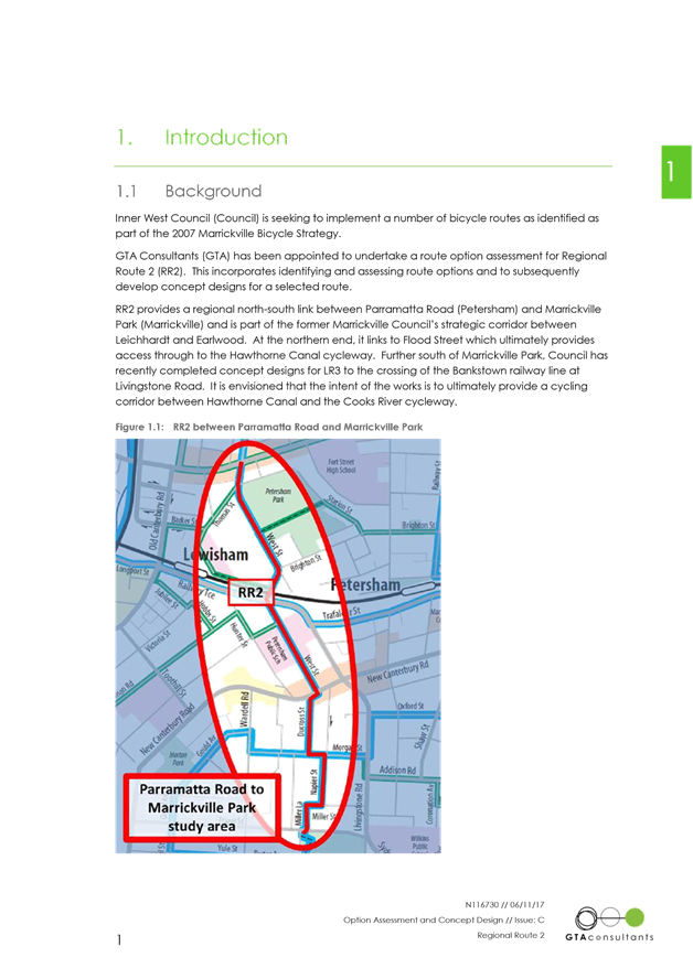
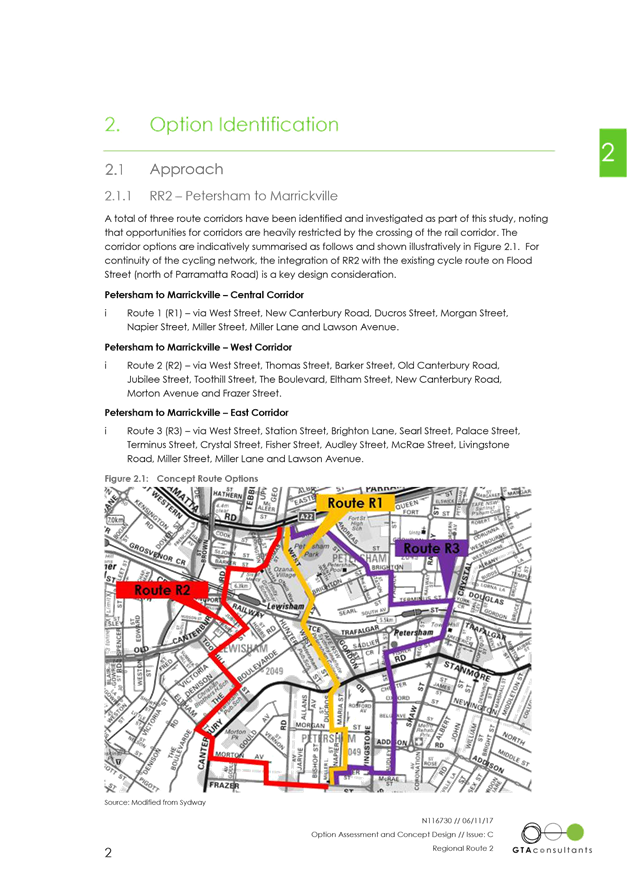
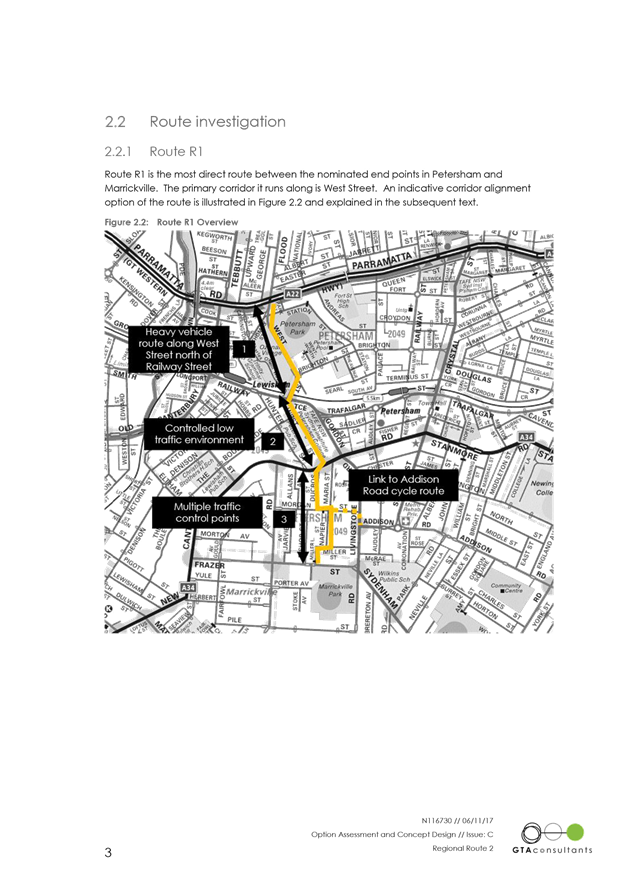
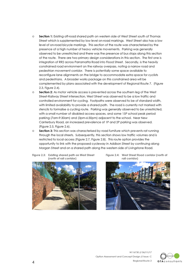
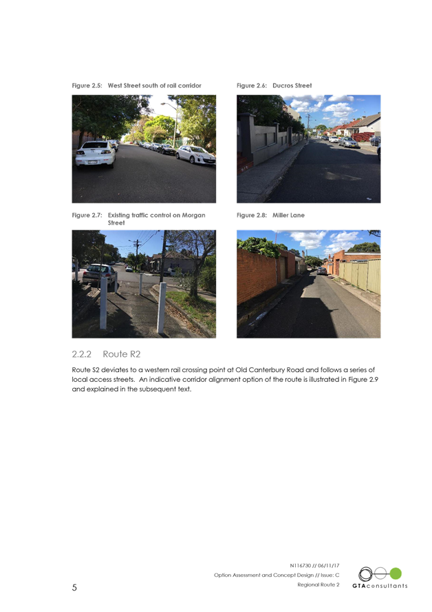
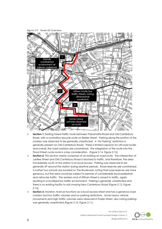
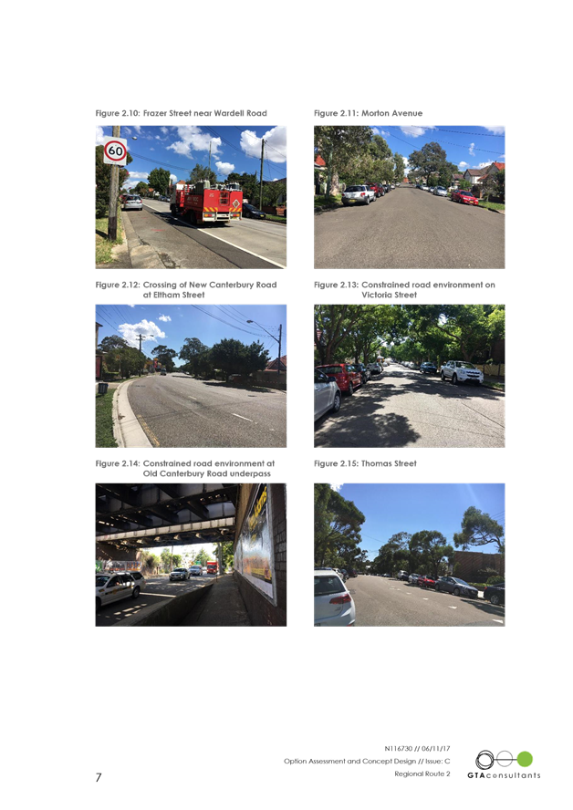
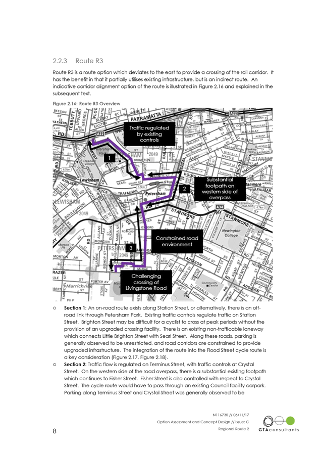
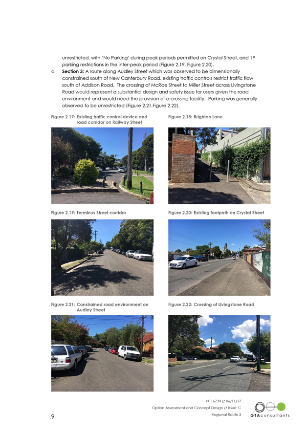
LTC1217 Item 8 Regional Route 2 (Parramatta Road To Marrickville Park) - Public Consultation Report And Revised Concept Plan 36
LTC1217 Item 9 Local Route 18-Dulwich Hill Station To Marrickville Station-Detail Design (Central&West Wards/Summer Hill) 113
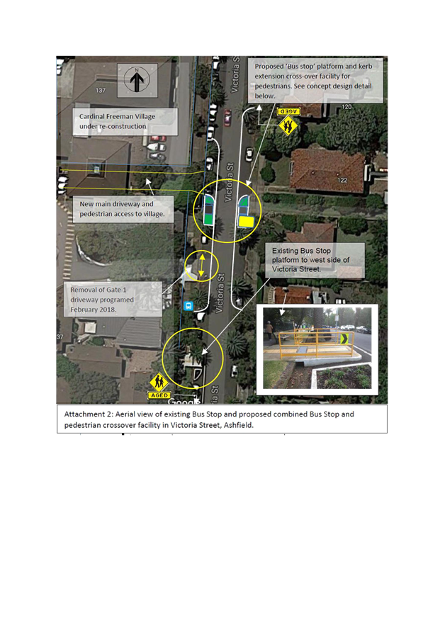
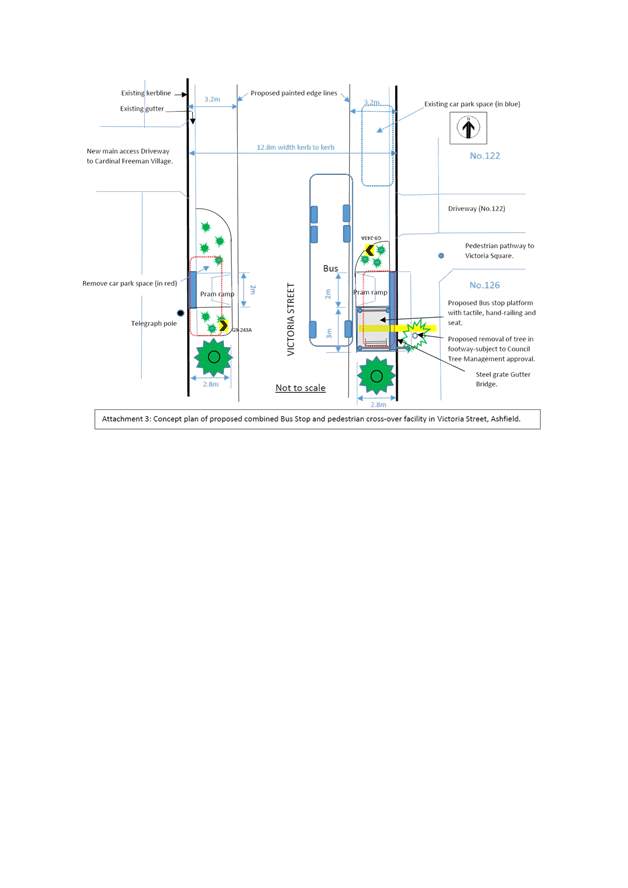
LTC1217 Item 10 Proposed
Bus Stop and kerb extended pedestrain crossover facility outside/near No.126
Victoria Street, Ashfield (opposite Cardinal Freeman Retirement Village).
(Ashfield Ward/Summer Hill Electorate/Ashfield LAC) 138
LTC1217 Item 11 Piper Street at Annandale Street, Annandale - Proposed 'No Stopping' restrictions (Leichhardt Ward/Balmain Electorate/
Leichhardt LAC) 147
Parking Matters
ITEM PAGE
LTC1217 Item 12 Minor Traffic Facilities (Leichhardt and Balmain Wards/Summer Hill and Balmain Electorates/Ashfield and Leichhardt LACs) 149
LTC1217 Item 13 Grove Street, Birchgrove - New Year's Eve Temporary Bus Zone (Balmain Ward/Balmain Electorate/Leichhardt LAC) 153
LTC1217 Item 14 Hoffman's Lane, Balmain - 'No Parking' restriction (Balmain Ward/Balmain Electorate/Leichhardt LAC) 155
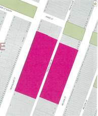
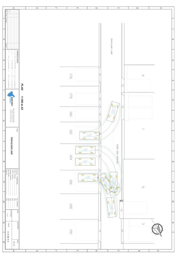
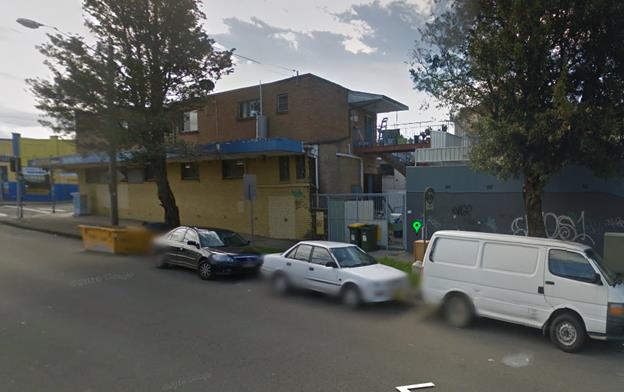
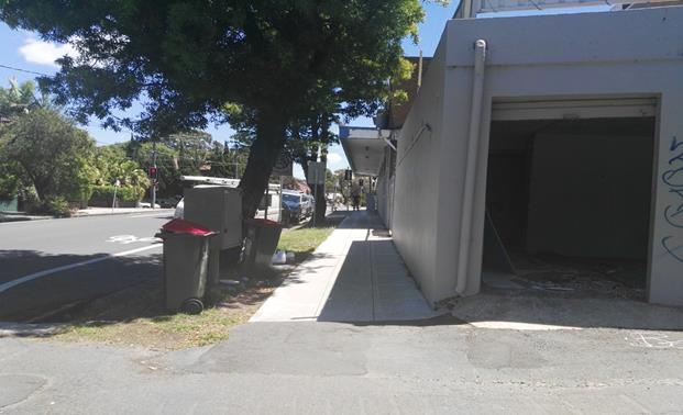
LTC1217 Item 15 Trafalgar Lane, Annandale - 'No Parking' restrictions (Balmain Ward/Balmain Electorate/Leichhardt LAC) 159
LTC1217 Item 16 Request For ‘Works Zone’ Adjacent To Construction Sites (Marrickville Ward/ Summer Hill Electorate / Marrickville LACS) 164
LTC1217 Item 17 Requests
For Mobility Parking Spaces
(Marrickville & Ashfield Wards/Summer Hill Electorate / Marrickville LAC) 172
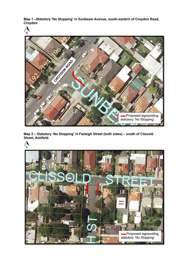
LTC1217 Item 18 Requests for Statutory ‘No Stopping’ Restriction (Stanmore Ward/Newtown Electorate /Marrickville LAC) 181
LTC1217 Item 19 Smidmore Street, Marrickville – Request by BreastScreen NSW to position a mobile x-ray unit outside Marrickville Metro (Marrickville Ward / Summer Hill Electorate / Marrickville LAC) 184
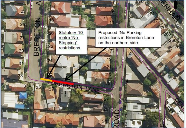
LTC1217 Item 20 Brereton Lane, Marrickville – ‘No Parking’ Restrictions in the Laneway (Marrickville Ward / Summer Hill Electorate / Marrickville LAC) 187
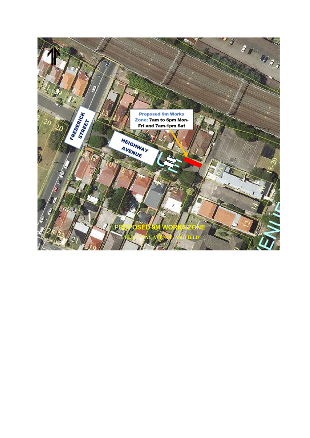
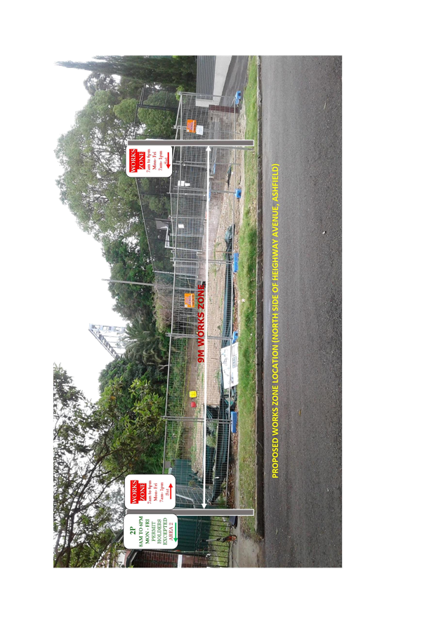
LTC1217 Item 21 Request
for a Works Zone outside No.1 Heighway Avenue, Ashfield.
(Ashfield Ward/Summer Hill Electorate/Ashfield LAC) 193
LTC1217 Item 22 Minor Traffic Facilities (No Stopping At Intersections) In Ashfield & Croydon, (Leichhardt Ward/Summer Hill Electorate/Ashfield LAC) 197
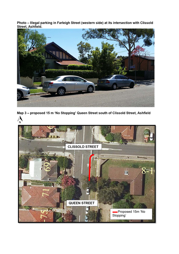
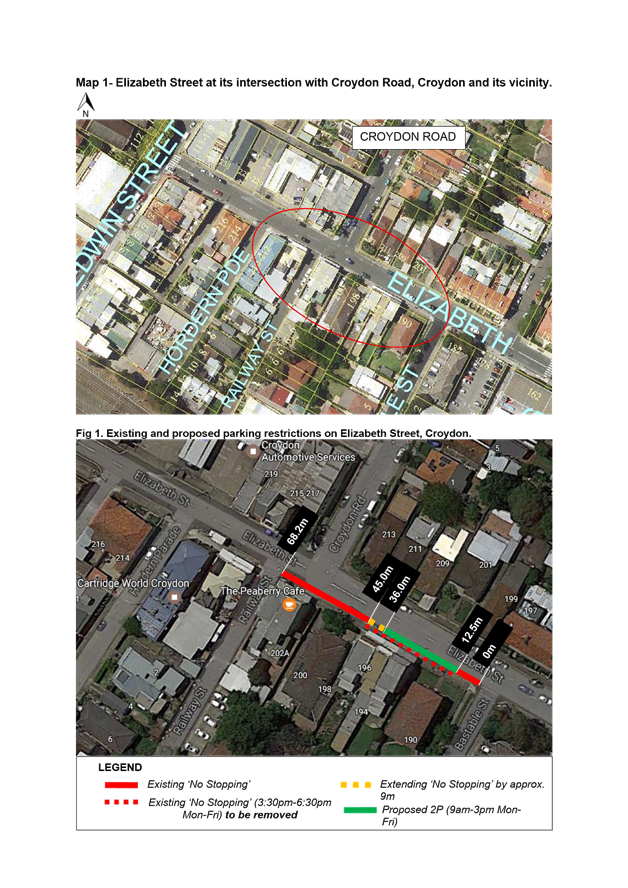
LTC1217 Item 23 Elizabeth Street, Between Railway Street and Bastable Street, Croydon - Removal of Pm Peak ‘No Stopping’ & Providing Short Term Parking 201
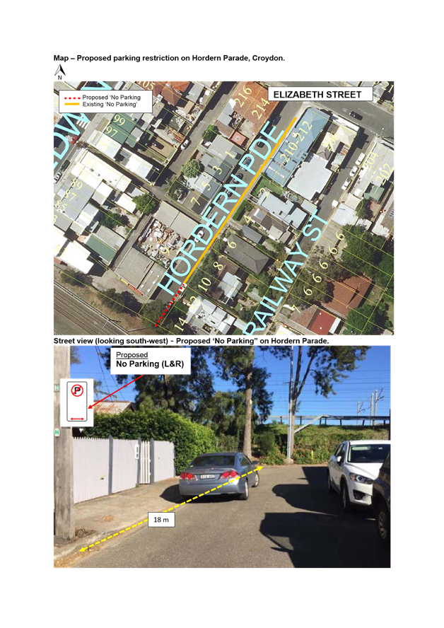
LTC1217 Item 24 Hordern Parade, Croydon - Extending 'No Parking' Restriction In Dead End (Leichhardt Ward/Summer Hill Electorate/Ashfield LAC) 205
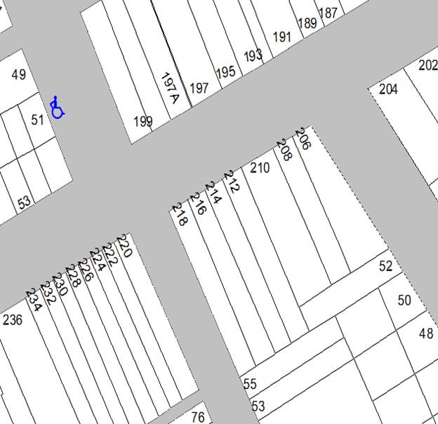
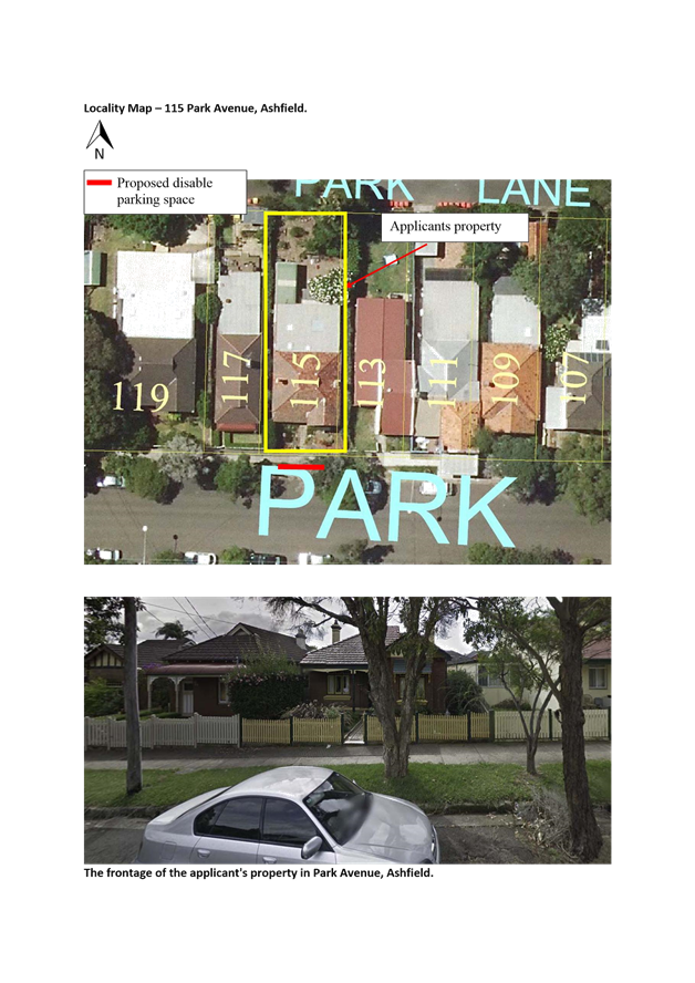
LTC1217 Item 25 Park Avenue, Ashfield - Request For Mobility Parking Space At No. 115 (Leichhardt Ward/Summer Hill Electorate/Ashfield LAC) 207
6 Part B – Items for Information Only
ITEM PAGE
LTC1217 Item 26 Hubert Street (Between Darley Road & William Street), Leichhardt - Angle Parking (Leichhardt Ward/Balmain Electorate/Leichhardt LAC) 209
LTC1217 Item 27 Perrett
Street, Rozelle – Resident Parking Scheme
(Leichhardt Ward/Balmain Electorate/Leichhardt LAC) 214
LTC1217 Item 28 Hornsey Street, Rozelle - Modification of Existing Resident Parking Scheme (RPS) Restrictions (Leichhardt Ward/Balmain Electorate/Leichhardt LAC) 217
LTC1217 Item 29 Denison Street, Newtown – Investigation on Pedestrian and Cyclist Safety at Intersection with Bedford Street (Stanmore Ward/Newtown Electorate/Newtown LAC) 220
Late Items
Nil at time of printing.
7 General Business
8 Close of Meeting
Subject: Darling Street at Wise Street/Beattie Street, Rozelle - Raised Pedestrian Crossing (Balmain Ward/Balmain Electorate/Leichhardt LAC)
Prepared By: Manod Wickramasinghe - Traffic and Parking Engineer
Authorised By: John Stephens - Traffic and Transport Services Manager
|
SUMMARY
As part of Council’s 2017-18 LATM program, it is proposed to upgrade the existing pedestrian (zebra) crossing on Darling Street, south of Wise Street/Beattie Street to a raised (zebra) pedestrian crossing. |
|
RECOMMENDATION
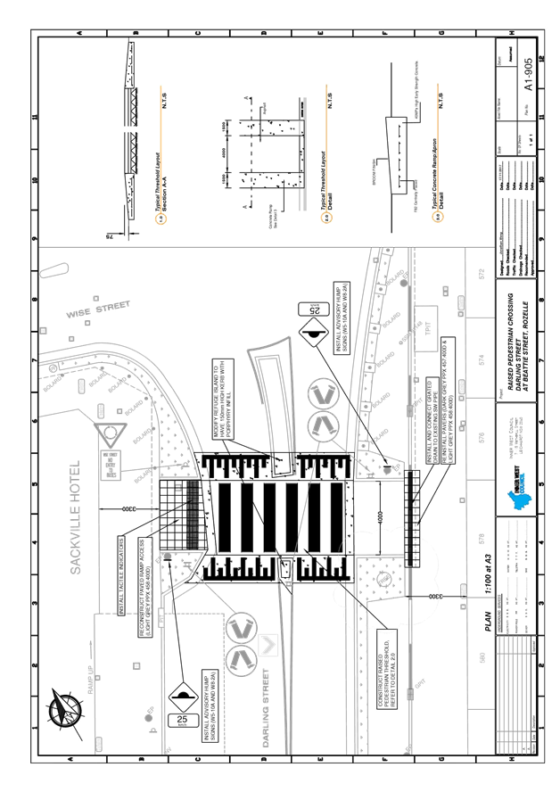
THAT Drawing No. A1-905 detailing the proposed upgrade of the existing pedestrian (zebra) crossing to a raised pedestrian (zebra) crossing on Darling Street, south of Wise Street/Beattie Street be supported as detailed in Attachment 1.
|
BACKGROUND
Council has investigated pedestrian conditions at the existing pedestrian (zebra) crossing near the intersection of Darling Street and Wise/Beattie Streets, Rozelle as a result of concerns received from residents.
Due to its central position along the Rozelle shopping mainstreet this facility is heavily used by pedestrians.
In order to further improve pedestrian amenity at this intersection, it is proposed to upgrade the existing at-grade pedestrian crossing to a raised pedestrian crossing.
A proposed plan showing the proposal is shown in Attachment 1.
This proposal will assist in reducing vehiclular speeds and support the 40km/h speed limit along Darling Street and through the subject intersection, thus providing improved safety for both pedestrians and vehicles.
FINANCIAL IMPLICATIONS
The cost of the civil works has been funded from the 2017-18 LATM program.
OTHER STAFF COMMENTS
Nil.
PUBLIC CONSULTATION
|
A letter outlining the above proposal was mailed out to the affected properties (100 properties) in Darling Street, Wise Street and Beattie Street.
No responses were received.
|
|
CONCLUSION
In order to improve pedestrian amenity across Darling Street south of Wise Street and Beattie Street, it is recommended that the proposed upgrade of the existing pedestrian (zebra) crossing to a raised pedestrian (zebra) crossing be supported as detailed in Attachment 1.
|
1.⇩ |
Raised Pedestrian Crossing - Darling Street, south of Wise/Beattie Street, Rozelle |
|
|
Local Traffic Committee Meeting 7 December 2017 |
Subject: Darling Street, Balmain - Road Occupancy (Balmain Ward/Balmain Elecorate/Leichhardt LAC)
Prepared By: Manod Wickramasinghe - Traffic and Parking Engineer
Authorised By: John Stephens - Traffic and Transport Services Manager
|
SUMMARY BreastScreen NSW have requested permission to occupy the parking lane outside of Balmain Library for 8 weeks in order to conduct free breast x-rays. |
|
RECOMMENDATION
THAT:
The road occupancy for a BreastScreen NSW mobile lab unit within the parking lane on the southern side of Darling Street, in front of Balmain Library (No. 370 Darling Street), for the duration of 8 weeks from Friday, 19th January to Friday, 16th March 2018 be supported, subject to the following conditions: a) That all affected businesses, residents and other occupants must be notified of the road occupancy and activities at least one week prior to the commencement of the event. Any concerns or requirements raised by business proprietors, residents and other occupants must be resolved or accommodated by the applicant; b) That the applicant contact Energy Australia/Ausgrid in relation to power access to the mobile laboratory; c) That the areas to be used for the activities must be maintained in a clean and tidy condition to the satisfaction of Council’s Group Manager Roads and Stormwater, or else the applicant will be required to reimburse Council for any extraordinary cleansing costs; d) That the Council and RMS must be indemnified against all claims for damage or injury that may result from either the activities or from the occupation of part of the public way during the activities. The applicant must therefore produce evidence of its public risk insurance cover (under which Council is indemnified) with a minimum policy value of at least $10,000,000; e) That a copy of the Council approval letter must be made available on the site for inspection by relevant officers; f) That the applicant must comply with any reasonable directive from Council’s Compliance Officers and NSW Police; and g) That Council reserves the right to cancel this approval at any time.
|
BACKGROUND
BreastScreen NSW has requested approval to locate a mobile lab unit on Darling Street, Balmain for 7 weeks from 19th January to 16th March 2018.
In the past, the BreastScreen mobile van has been located on the northern side of Darling Street, Balmain between the intersection of Ford Street and McDonald Street as well as on the southern side of Darling Street in front of the Police Station. The change in location has been undertaken to reduce the impact on businesses in the area.
The proposed location of the mobile van is within the existing on-street metered parking restrictions.
The BreastScreen mobile van is approximately 12.5m in length, 2.4m in width and 4m in height.
The mobile van will be towed on-site on Friday evening (19th January 2018) before the commencement and the service will operate for screening from 8.45am to 4pm Monday to Friday.
The applicant has been requested to provide a copy of their public risk insurance.
FINANCIAL IMPLICATIONS
Nil.
OTHER STAFF COMMENTS
Nil.
PUBLIC CONSULTATION
Nil.
CONCLUSION
Nil.
|
|
Local Traffic Committee Meeting 7 December 2017 |
Subject: Lyall Street, Leichhardt - Road Occupancy - Street Party (Leichhardt Ward/Balmain Electorate/Leichhardt LAC)
Prepared By: Manod Wickramasinghe - Traffic and Parking Engineer
Authorised By: John Stephens - Traffic and Transport Services Manager
|
SUMMARY Council has received an application from a resident of Lyall Street, Leichhardt to conduct a Christmas street party in Lyall Street between Flood Street and the closed end of Lyall Street. |
|
RECOMMENDATION
THAT:
1. The temporary road closure of Lyall Street between Flood Street and the closed end of Lyall Street, Leichhardt on Saturday, 23rd December 2017 between 3.00pm and 7.00pm be supported, subject to the following conditions:
a. That a TMP be submitted to RMS for approval; b. That an unencumbered passage minimum 4.0m wide be available for emergency vehicles through the closed section of Lyall Street, Leichhardt; c. The occupation of the road carriageway must not occur until the road has been physically closed; d. That the organiser be advised to arrange accredited traffic controllers to manage the road closure; e. That the applicant notifies all affected businesses, residents and other occupants of the temporary road closure prior to the event. Any concerns or requirements in relation to the road closure raised by business proprietors, residents and other occupants must be resolved or accommodated. The notification shall involve at the minimum an information letterbox drop distributed one week prior to the commencement of the event. The proposed information, distribution area and period must be submitted to Council’s Traffic section for approval two weeks before the event; f. That the supported Traffic Control Plan (TCP) be implemented at the applicant’s expense; g. That Fire and Rescue NSW (Leichhardt) be notified of the intended closure by the applicant; h. That the applicant provide and erect barricades and signs, in accordance with the current Australian Standard AS 1742.3: Traffic Control Devices for Works on Roads. As a minimum the following must be erected at both ends of the road closure area: i. Barrier Boards; ii. ‘Road Closed’ (T2-4) signs; and iii. ‘Detour’ (T5-1) signs. i. That the applicant be advised Council provides barricades and ‘Road Closed’ signs free or at minimum cost. The applicant is required to arrange delivery by Council at cost, or arrange pickup from and return to Council’s Depot at no cost. Any non-standard signs may be provided at cost. ; j. That the areas to be used for the activities must be maintained in a clean and tidy condition to the satisfaction of Council’s Group Manager Roads & Stormwater, or else the applicant will be required to reimburse Council for any extraordinary cleaning costs; k. That the conduct of any activities or use of any equipment required in conjunction with the road occupancy and temporary road closure not results in any ‘offensive noise’ as defined by the Protection of the Environment Operations Act 1997; l. That a copy of the Council approval be available on site for inspection by relevant authorities. m. That Council reserves the right to cancel the approval at any time; and n. That the applicant complies with any reasonable directive from Council Officers and NSW Police; and
2. That the applicant be advised of the Committee’s recommendation. |
BACKGROUND
Council has received an application from a resident of Lyall Street, Leichhardt to conduct a Christmas street party in Lyall Street between Flood Street and the closed end of Lyall Street.
The street party is proposed to be held on Saturday, 23rd December 2017 between 3.00pm and 7.00pm. The applicant is seeking permission for a temporary full road closure of Lyall Street, Leichhardt, between between Flood Street and the closed end of Lyall Street.
FINANCIAL IMPLICATIONS
Nil.
OTHER STAFF COMMENTS
The Traffic Control Plan for the closure is as follows:
PUBLIC CONSULTATION
The proposed temporary full-road closure is currently advertised in the local newspaper for a period of 28 days.
CONCLUSION
Nil.
|
|
Local Traffic Committee Meeting 7 December 2017 |
Subject: Gallimore Avenue, Balmain East - Temporary Road Closure (Balmain
Ward/Balmain Electorate/Leichhardt LAC)
Prepared By: Manod Wickramasinghe - Traffic and Parking Engineer
Authorised By: John Stephens - Traffic and Transport Services Manager
|
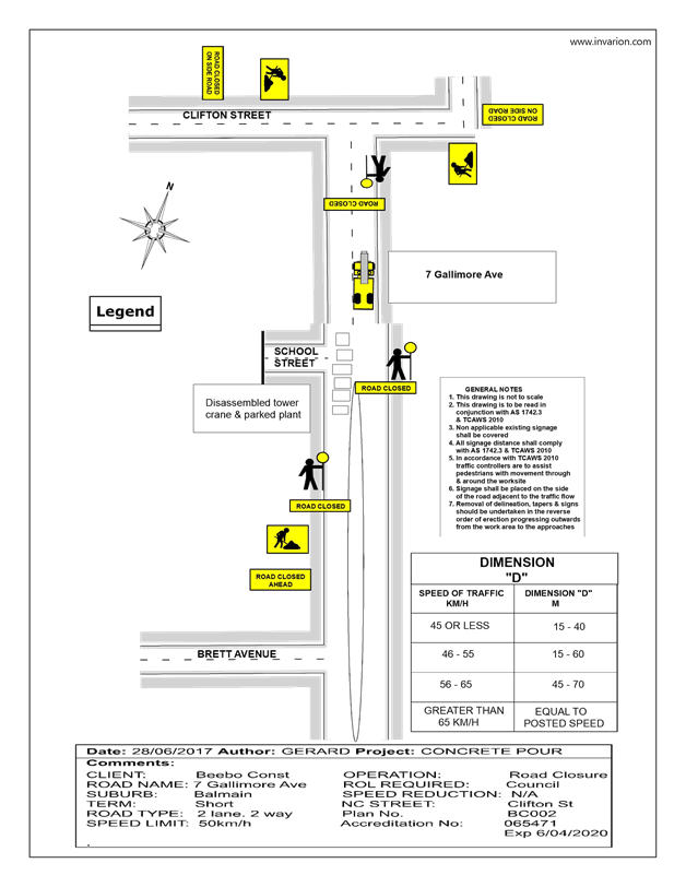
SUMMARY An application has been received from Beebo Constructions for the temporary full road closure of Gallimore Avenue (Between Nos.5-11 Gallimore Ave), Balmain East from 7:00am to 5:00pm on two days in the period from 29th January 2018 until 17th of February 2018, in order to stand a boom pump for a concrete pour and dismantle a crane. It is recommended that the proposed temporary road closure be approved, subject to the conditions outlined in this report. |
|
RECOMMENDATION
THAT:
The proposed temporary full road closure of Gallimore Avenue (Between Nos.5-11 Gallimore Ave), Balmain East from 7:00am to 5:00pm on two days in the period from 29th January 2018 until 17th of February 2018, in order to stand a boom pump for a concrete pour and dismantle a crane in Gallimore Avenue between Ns. 5-11 Gallimore Avenue be approved, subject to the following conditions:
1. A fee of $1,540 for the temporary full road closure is payable by the applicant in accordance with Council’s Fees and Charges;
2. The temporary full road closure be advertised in the local newspaper providing 28 days’ notice for submissions, in accordance with the Roads Act;
3. A Traffic Management Plan (TMP) be submitted to Roads and Maritime Services for consideration and approval;
4. A Traffic Control Plan (TCP) which has been prepared by a certified Traffic Controller, is to be submitted to Council for review with a copy of the Traffic Controllers certification number attached to the plan, not less than 5 days prior to implementation of the closure;
5. A Road Occupancy License be obtained by the applicant from the Transport Management Centre;
6. A notice of the proposed closure be forwarded by the applicant to the NSW Police, Fire and Rescue NSW and the NSW Ambulance Services;
7. Notification signs advising of the proposed road closures and new traffic arrangements to be strategically installed and maintained by the applicant at each end of the street at least 7 days prior to the closure;
8. All affected residents and businesses shall be notified in writing, by the applicant, of the proposed temporary road closure at least 7 days in advance of the closure with the applicant making reasonable provision for residents;
9. Vehicular and pedestrian access for residents and businesses to their off-street car parking spaces be maintained where possible whilst site works are in progress;
10. Adequate vehicular traffic control shall be provided for the protection and convenience of pedestrians and motorists including appropriate signage and flagging. Workers shall be specially designated for this role, as necessary to comply with this condition. This is to be carried out in accordance with the Australian Standard AS 1742.3 - Traffic Control Devices for works on roads;
11. The holder of this approval shall indemnify the Council against all claims, damages and costs incurred by, or charges made against, the Council in respect to death or injury to any person or damage in any way arising out of this approval. In this regard, a public liability insurance policy for an amount not less than $20,000,000 for any one occurrence is to be obtained and is to note the Council as an interested party. The holder of this approval shall inform its insurer of the terms of this condition and submit a copy of the insurance policy to the Council prior to commencement of the work the subject of this approval;
12. The operator of any unit exercising this approval shall have this approval with them and produce it if required along with any other relevant authority approvals granted in the connection with the work;
13. Mobile cranes, cherry pickers or concrete boom pumps shall not stand within the public way for extended periods when not in operation under this approval; 14. The operation of the heavy plant shall not give rise to an "offensive noise" as defined in the Protection of Environment Operations Act, 1997. Furthermore, vibrations and/or emission of gases that are created during its operations and which are a nuisance, or dangerous to public health are not permitted; all work is to be carried out in accordance with Work Cover requirements; and the costs to repair damages, as a result of these works, to Council's footway and roadway areas will be borne by the applicant.
|
BACKGROUND
An application has been received from Beebo Constructions for the temporary full road closure of Gallimore Avenue (Between Nos.5-11 Gallimore Ave), Balmain East from 7:00am to 5:00pm on two days in the period from 29th January 2018 until 17th of February 2018, in order to stand a boom pump for a concrete pour and dismantle a crane.
FINANCIAL IMPLICATIONS
Nil.
OTHER STAFF COMMENTS
A TCP outlining the proposed closure is attached.
PUBLIC CONSULTATION
The proposed full-road closure of Gallimore Avenue (Between Nos.5-11 Gallimore Ave), Balmain East is currently advertised in the local newspaper for a period of 28 days. The applicant is to notify all affected residents and businesses in writing at least 7 days prior to
the commencement of works and make reasonable provision for residents and businesses,
where possible.
CONCLUSION
It is recommended that the proposed temporary road closure be approved, subject to the
conditions outlined in this report.
|
1.⇩ |
TCP |
|
|
Local Traffic Committee Meeting 7 December 2017 |
Subject: Garden Street, Marrickville – Proposed Temporary Road Closure for a Special Event on 20 January 2018 (Marrickville Ward/Summer Hill Electorate/Marrickville LAC)
Prepared By: Emilio Andari - Civil Engineer
Authorised By: John Stephens - Traffic and Transport Services Manager
|
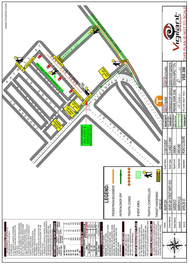
SUMMARY Council has received an application under Section 68 of the Local Government Act 1993 to use Garden Street, Marrickville to hold a street party style event for the community, known as ‘Heaps Gay Street Festival', on Saturday 20 January 2018 between the hours of 12.00pm to 11.00pm. The erection of the stage, stalls and associated works will include the temporary full-road closures of Garden Street, Marrickville between Shirlow Street and to the cul-de-sac, and Shirlow Street, Marrickville, between Sydenham Road and Saywell Street from 7:00pm Friday 19 January 2018 to 9:00am Sunday 21 January 2018.
It is recommended that Council endorse the temporary road closures of Garden Street and Shirlow Street, Marrickville from Friday 19 January 2018 to 9:00am Sunday 21 January 2018 subject to complying with the conditions within this report; applying to the RMS for consent to close the subject roads, subject to the event being advertised, a Traffic Management Plan being submitted to the RMS for approval, a Road Occupancy License being obtained from the Transport Management Centre and advice of the proposed event being forwarded to the appropriate authorities including emergency services. |
|
RECOMMENDATION
THAT:
1. The proposed temporary road closures of Garden Street, Marrickville between Shirlow Street and to the cul-de-sac, and Shirlow Street, Marrickville from between Sydenham Road and Saywell Street from 7:00pm Friday 19 January 2018 to 9:00am Sunday 21 January 2018, for the holding of the ‘Heaps Gay Street Festival' event on Garden Street, be endorsed subject to the approval of the Development Application and the applicant complying with the following conditions:
i. A fee of $1,540.00 for the temporary road closure is payable by the applicant in accordance with Council’s Fees and Charges;
ii. The temporary full road closure be advertised by the applicant in the local newspaper providing 28 days notice for submissions, in accordance with the Roads Act;
iii. A Traffic Management Plan (TMP) be submitted by the applicant to the Roads and Maritime Services for consideration and approval;
iv. A Traffic Control Plan (TCP) which has been prepared by a certified Traffic Controller, is to be submitted to Council for review with a copy of the Traffic Controller’s certification number attached to the plan, not less than 5 days prior to implementation of the closure;
v. A Road Occupancy License application be obtained by the applicant from the Transport Management Centre;
vi. Notice of the proposed event is forwarded by the applicant to the NSW Police Local Area Commander, State Transit Authority, NSW Fire Brigades and NSW Ambulance Services;
vii. Advance notifications signs advising of the proposed road closure and traffic diversions to be strategically installed and maintained by the applicant at least two (2) weeks prior to the event;
viii. 'No Parking – Special Event' signs be affixed on both sides of Garden Street, Marrickville between Shirlow Street and to an end on the evening of the day prior to the event date;
ix. A 4-metre wide emergency vehicle access must be maintained through the closed road areas during the course of the event;
x. All affected residents and businesses shall be notified in writing by the applicant of the proposed temporary road closures at least two (2) weeks prior to the event, with the applicant making reasonable provision for residents and businesses;
xi. Adequate vehicular traffic control shall be provided for the protection and convenience of pedestrians and motorists including appropriate signage and flagging. Workers shall be specially designated for this role (and carry appropriate certificates), as necessary to comply with this condition. This is to be carried out in accordance with the Australian Standard AS 1742.3 – Traffic Control Devices for works on roads; and
xii. Water filled barriers be placed at the road closure points to protect against any possible errant vehicles.
2. The applicant be advised in terms of this report and that all costs for advertising the event and implementation of the road closure are to be borne by the applicant.
|
BACKGROUND
Council has received an application under Section 68 of the Local Government Act 1993 to use Garden Street, Marrickville to hold a street party style event for the community, known as ‘Heaps Gay Street Festival', on Saturday 20 January 2018 between the hours of 12.00pm to 11.00pm.
The erection of the stage, stalls and associated works will include the temporary full-road closures of Garden Street, Marrickville between Shirlow Street and the cul-de-sac, and Shirlow Street, Marrickville between Sydenham Road and Saywell Street from 7:00pm Friday 19 January 2018 to 9:00am Sunday 21 January 2018.
The ‘Heaps Gay Street Festival’ is a community event in a New Orleans style street party with family friendly music and entertainment and a number of licenced food & beverage stalls. This will be the 2nd instalment of the event at Garden Street, Marrickville. The event will aim to attract approximately 3,000 attendees, staff and performers to the area on the day.
FINANCIAL IMPLICATIONS
Nil.
OTHER STAFF COMMENTS
Site location & road network
|
Street Name |
Garden Street |
Shirlow Street |
|
Section |
Shirlow Street and to an end |
Sydenham Road and Saywell Street |
|
Carriageway Width (m) |
12.2 |
5.5 |
|
Carriageway Type |
Two-way road with one travel lane in each direction, in addition to kerbside parking lanes. |
One-way road with one travel lane in an eastbound traffic flow, in addition to a kerbside parking lane. |
|
Classification |
Local |
Local |
|
85th Percentile Speed (km/h) |
31.7 |
33.1 |
|
Vehicles Per Day (vpd) |
363 |
492 |
|
Reported Crash History (July 2012 – June 2017) |
No crashes recorded. |
No crashes recorded. |
|
Heavy Vehicle Volume (%) |
8.6 |
13.8 |
|
Parking Arrangements |
Western side of the road consists of unrestricted parking. Eastern side of the road consists of unrestricted parking (90 degree angle parking). |
Northern side of the road consists of unrestricted parking. Southern side of the road consists of ‘No Parking’ restrictions. |
Site locality map
Garden Street at its intersection with Shirlow Street
The temporary road closures of Garden Street and Shirlow Street is required from 7:00pm Friday 19 January 2018 to 9:00am Sunday 21 January 2018 to undertake the set-up/pack-down of the stage, stalls and all other associated works prior and after the events, before the road can be reopened to traffic. Local residents will be able to access Shirlow Street.
The applicant advised that traffic controllers and barricades will be located on Shirlow Street at Sydenham Road and on Saywell Street at Sloane Lane. In addition, traffic controllers will be assisting pedestrians at the intersection of Sydenham Road and Railway Parade adjacent to Sydenham Railway Station near the entry to the event. Pedestrian access and egress to the event will be via Railway Parade (refer to the attached traffic control plan). Event attendees will not be able to enter Shirlow Street from Sydenham Road, Saywell Street or Sydenham Lane, except for an emergency.
A 4-metre wide emergency vehicle access must be maintained through the closed road areas during the course of the event. Special Event advance notice signs will be strategically installed at least two (2) weeks prior to the event to alert motorists of the proposed closures. In addition, 'No Parking - Special Event' signs will be affixed over all existing parking signs within the area of the event on the evening of the day prior to the event date.
Impacts on Parking and Vehicular access
The proposed road closure will have an impact on approximately 60 on-street car parking spaces along both sides of Garden Street and approximately 10 on-street car parking spaces along the northern side of Shirlow Street during the event; will need to be transferred to nearby streets. Given that Garden Street consists of commercial properties along one side of the street and Shirlow Street consists of a majority of commercial properties along both sides of the street, the on-street parking demand on the weekends is significantly lower than weekdays. It should be noted that there are three residential properties in Shirlow Street, and these properties will have access during the temporary road closure period. Access through the rear of these properties in Sloane Lane will still be retained during that weekend. All adjoining residential and commercial properties will need to be notified in writing of the proposed event and any impacts on parking and access to their properties by the applicant two weeks prior to the event. This includes the temporary removal of on-street parking spaces in Shirlow Street and Garden Street during the event.
Impacts on traffic
The subject sections of Shirlow Street and Garden Street carry low volume of traffic and therefore the diverted traffic will have no major impacts on surrounding road network. The event will be held on a Saturday when lower than weekday traffic volumes are expected.
Public Transport
The subject site has access to public transport services, with Sydenham Railway Station being located within a 200 metre radius from the site and bus routes (Route M30, 418, 425) operating along Marrickville Road, Railway Parade and Gleeson Avenue.
PUBLIC CONSULTATION
The proposed full-road closures of the event are currently advertised in the local papers for a period of 28 days. The advertising period commenced on 5 December 2017 and will conclude on 1 January 2018. A Traffic Management Plan is to be submitted to the RMS for consideration and approval.
The event organiser will need to notify all affected residents and businesses in writing of the proposed temporary road closures at least two weeks prior to the event and make reasonable provision for residents and businesses, where possible.
CONCLUSION
It is recommended that Council endorse the temporary road closures of Garden Street and Shirlow Street, Marrickville from Friday 19 January 2018 to 9:00am Sunday 21 January 2018 subject to complying with the conditions within this report; applying to the RMS for consent to close the subject roads, subject to the event being advertised, a Traffic Management Plan being submitted to the RMS for approval, a Road Occupancy License being obtained from the Transport Management Centre and advice of the proposed event being forwarded to the appropriate authorities including emergency services.
|
|
Local Traffic Committee Meeting 7 December 2017 |
Subject: Richardsons Crescent, Marrickville – Proposed Kerb Extension Design Plan (Marrickville Ward/Summer Hill Electorate/Marrickville LAC)
Prepared By: Emilio Andari - Civil Engineer
Authorised By: John Stephens - Traffic and Transport Services Manager
|
SUMMARY A detailed design plan has been finalised for the proposed traffic calming improvements in Richardsons Crescent, Marrickville, as part of Council’s Capital Works Program for Footpath Renewals. The proposal for a kerb extension with a new kerb and gutter alignment and associated signs and line markings will improve pedestrian and cyclist safety and traffic conditions at this location. It is recommended that the proposed detailed design plan be approved. |
|
RECOMMENDATION
THAT the detailed design plan of the kerb extension with a new kerb and gutter alignment and associated signs and line markings in Richardsons Crescent, Marrickville between the signalised entrance to Tempe Railway Station car park and Cooks River (as per the attached design plan No. 6152) be APPROVED.
|
BACKGROUND
One of the key objectives from Council’s Community Strategic Planning document is to provide accessible and well connected footpaths, cycleways and associated facilities. The objective is to be achieved through reduced impact of traffic and improvement of pedestrian and cyclist safety, particularly around schools and urban centres.
Council is proposing to reconstruct the footpath along Richardsons Crescent, Marrickville and have integrated a kerb extension with a new kerb and gutter alignment and associated signs and line markings. The detail design plan has been finalised for the proposed device in this report for consideration.
FINANCIAL IMPLICATIONS
Funding of $20,000 has been allocated by Council for the design of the signalised intersection of Richardsons Crescent and the entrance to Tempe Railway Station car park under the 2017/2018 Capital Works Program for Footpath Renewals. Funding of $150,000 has been allocated by Council for the entire scope of works for Richardsons Crescent under the 2018/2019 Capital Works Program for Footpath Renewals. These works include reconstructing the footpath in Richardsons Crescent (including a new kerb and gutter alignment, new footpath trees with landscaped verges and new kerb ramps) between the signalised entrance to Tempe Railway Station car park and Cooks River.
OTHER STAFF COMMENTS
Site location & road network
|
Street Name |
Richardsons Crescent |
|
Section |
Between Bayview Avenue and Unwins Bridge Road |
|
Carriageway Width (m) |
12.8 |
|
Carriageway Type |
Two-way road with one travel lane in each direction, in addition to kerbside parking lanes. |
|
Classification |
Regional |
|
85th Percentile Speed (km/h) |
54.2 |
|
Vehicles Per Day (vpd) |
12,895 |
|
Reported Crash History (July 2012 - June 2017) |
3 crashes recorded (Rum Code: 1, 20 & 48). 2 crashes resulted in an injury and 1 crash resulted in only tow-away. |
|
Heavy Vehicle Volume (%) |
3.4 |
|
Parking Arrangements |
Western side of the road consists of unrestricted parking and eastern side of the road consists of ‘1P 8.30am-4pm Mon-Fri, 8.30am-12.30pm Sat’ & ‘No Parking 4pm-6pm Mon-Fri’ restrictions. |
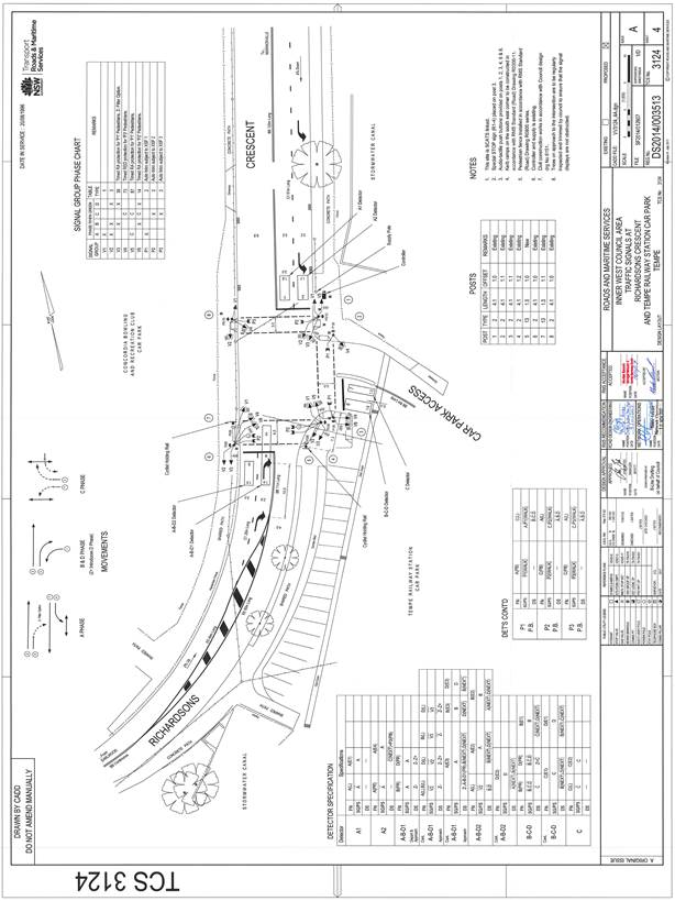
Design Plan No. 6152 & Traffic Signal Design Plan No. TCS 3124
A detailed design plan for the provision of a kerb extension with a new kerb and gutter alignment in Richardsons Crescent, Marrickville, between the signalised entrance to Tempe Railway Station car park and Cooks River, including the associated signs and line markings (ATTACHMENT - design plan No. 6152) are submitted for consideration.
The proposed scope of work includes the following:
· Reconstruct the footpath on the eastern side of Richardsons Crescent, Marrickville, between the signalised entrance to Tempe Railway Station car park and Cooks River with a kerb extension with a new kerb and gutter alignment and landscaped verges and two new footpath trees as per design plan.
· Reconstruct the concrete footpath along Richardsons Crescent to a 2.6m wide ‘Shared Path’ with associated pavement cyclist and pedestrian signs and markings as per design plan.
· Reconstruct the kerb ramps and sections of footpath with concrete at the signalised intersection as per design plan.
· Install all other associated signage and line markings as per design plan.
The proposed treatment will not result in the loss of legal on-street parking spaces in Richardsons Crescent (refer to the attached design plan No. 6152). All current vehicular access to adjoining properties will be retained.
The traffic signal design plan was referred to the Roads & Maritime Services for consideration and was approved on the 15 November 2017 (refer to attached traffic signal design plan No. TCS 3124).
PUBLIC CONSULTATION
Nil.
CONCLUSION
It is recommended that the design of the proposed kerb extension with a new kerb and gutter alignment and associated signs and line markings be approved, to improve pedestrian and cyclist safety and traffic conditions.
|
|
Local Traffic Committee Meeting 7 December 2017 |
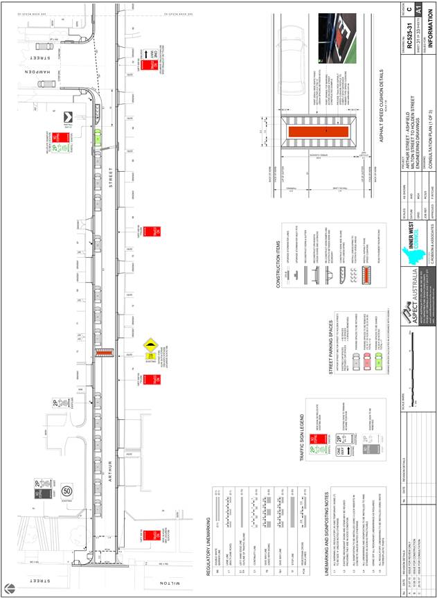
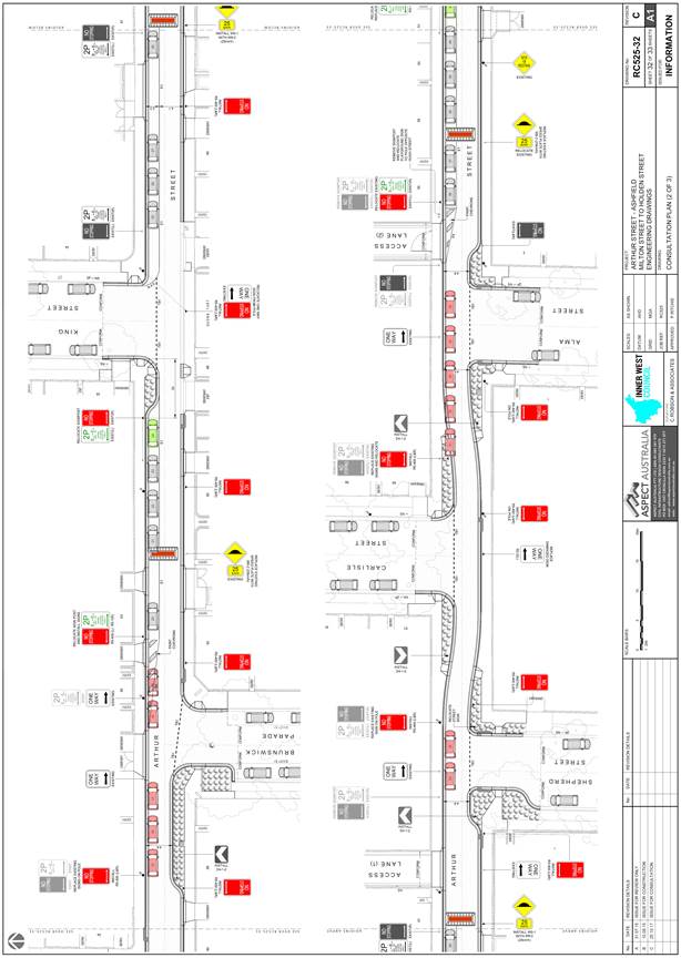
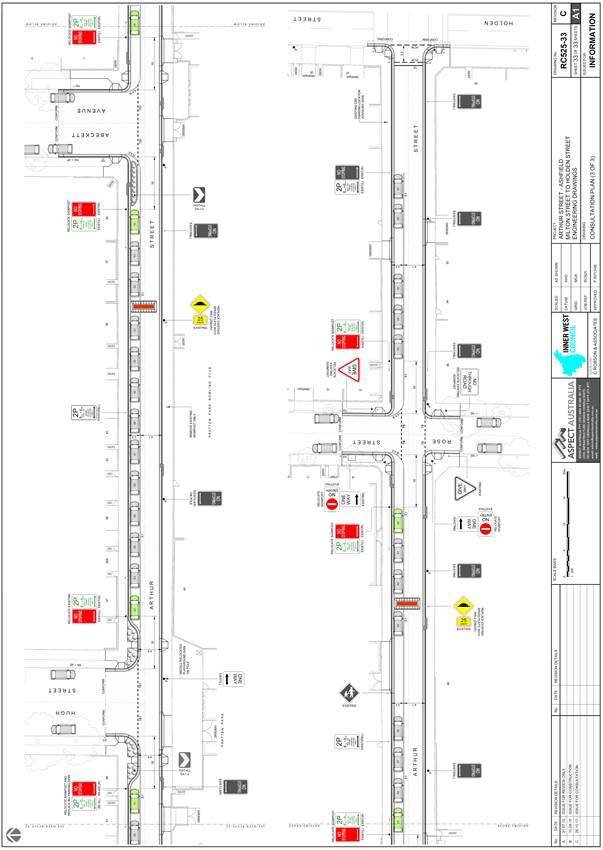
Subject: Arthur Street, Ashfield – Proposed Speed Cushions, Kerb Blister Islands & Kerb Extension Design Plans (Ashfield Ward/Summer Hill Electorate/Ashfield LAC)
Prepared By: Emilio Andari - Civil Engineer
Authorised By: John Stephens - Traffic and Transport Services Manager
|
SUMMARY Detailed design plans have been finalised for the proposed traffic calming improvements in Arthur Street, Ashfield as part of Council’s Capital Works Program for Traffic Facilities, Stormwater Renewals and Local Road Renewals. The proposal for speed cushions, kerb blister islands and kerb extension with a new kerb and gutter alignment and associated signs and line markings will improve pedestrian safety and traffic conditions at this location.
Consultation was undertaken with owners and occupiers of properties adjacent to Arthur Street, regarding the proposal. A summary of the consultation results are presented in this report for consideration. It is recommended that the proposed detailed design plans be approved. |
|
RECOMMENDATION
THAT the detailed design plan of the speed cushions, kerb blister islands and kerb extension with a new kerb and gutter alignment and associated signs and line markings in Arthur Street, Ashfield between Milton Street and Holden Street (as per the attached design plan Nos. RC525-31 Rev. C, RC525-32 Rev. C, RC525-33 Rev. C) be APPROVED.
|
BACKGROUND
Arthur Street, Ashfield, was identified in 2015 for full road reconstruction due to its poor asset condition rating. Council’s Traffic Management Strategy has also identified Arthur Street as requiring consideration for traffic management investigation. A consultant was engaged by Council in 2015 to design and prepare construction plans for the full road reconstruction of Arthur Street, Ashfield, between Milton Street and Holden Street.
In January 2016, Council had consulted with a notification letter and plans were sent to the owners and occupiers of the affected properties in Arthur Street, Ashfield and various cross-streets in the near vicinity. There were a total of two (2) responses supporting the proposal and there were a total of one (1) response opposing the proposal. The feedback received was used to further develop the detailed design plans.
Council is proposing to resurface the road pavement, reconstruct storm water inlet pits, install speed cushions, construct kerb blister islands and kerb extensions with a new kerb and gutter alignment with associated signs and line markings in Arthur Street, Ashfield, between Milton Street and Holden Street.
The detail design plans have been finalised for the proposed devices together with the consultation and are presented in this report for consideration.
FINANCIAL IMPLICATIONS
Funding of $1,190,000 has been allocated by Council for the entire scope of works for Arthur Street. From the total funding amount, $440,000 has been allocated by Council under the 2017/2018 Capital Works Program for Traffic Facilities, Stormwater Renewals and Local Road Renewals. For the following financial year, $750,000 has been allocated by Council under the 2018/2019 Capital Works Program for Traffic Facilities and Local Road Renewals.
OFFICER COMMENTS
Site location & road network
|
Street Name |
Arthur Street |
|
Section |
Between Milton Street and Holden Street |
|
Carriageway Width (m) |
6.4 |
|
Carriageway Type |
One-way road with one travel lane in an eastbound traffic flow, in addition to kerbside parking lanes. |
|
Classification |
Local |
|
85th Percentile Speed (km/h) |
38.0 |
|
Vehicles Per Day (vpd) |
5,135 |
|
Reported Crash History (July 2012 – June 2017) |
2 crashes (Rum Code: 74 & 10). Crashes resulted in tow away only. |
|
Heavy Vehicle Volume (%) |
1.4 |
|
Parking Arrangements |
Northern side of the road consists of ‘2P 8am-6pm Mon-Fri Permit Holders Excepted Area 1’. Southern side of the road consists of unrestricted parking. |
Design Plans
Detailed design plans for the provision of new speed cushions, kerb blister islands and kerb extensions with a new kerb and gutter alignment in Arthur Street, Ashfield, between Milton Street and Holden Street, including the associated signs and line markings (ATTACHMENT - design plan Nos. RC525-31 Rev. C, RC525-32 Rev. C, RC525-33 Rev. C) are submitted for consideration.
The proposed scope of work includes the following:
· Remove the existing seven kerb blister islands and construct two new landscaped kerb blister islands and landscaped kerb extensions with a new kerb and gutter alignment along Arthur Street as per design plan.
· Remove and construct six new speed cushions along Arthur Street as per design plan.
· Reconstruct kerb ramps and sections of footpath with concrete at various locations along Arthur Street as per design plan.
· Reseal the road pavement on Arthur Street and construct new storm water inlets at various locations along Arthur Street.
· Install all other associated signage and line markings as per design plan.
The proposed treatments will result in the loss of four (4) legal on-street car parking spaces in Arthur Street as an outcome of the proposed speed cushions, kerb blister islands and kerb extension works. A new kerb and gutter alignment with associated signs and line markings works are also proposed in order to improve pedestrian safety and traffic conditions (refer to the attached design plan Nos. RC525-31 Rev. C, RC525-32 Rev. C, RC525-33 Rev. C). All current vehicular access to adjoining properties will be retained.
Intersection of Brunswick Parade and Arthur Street:
The benefits of the proposed kerb extension at the location include:
· There is a design constraint due to the location of a large Telstra exchange pit within the footpath, directly in line with the current kerb. In order to provide a kerb and gutter in this section, the kerb line is required to be extended within the roadway. In order to improve accessibility the height difference between the existing footpath and new kerb and gutter will be transitioned with the new landscaping. The parking loss opposite this area is unavoidable in order to maintain the existing travel lane widths through the section.
· Streetscape amenity improvement through landscaping and ‘greening’ of new kerb extensions.
· Improved safety and traffic calming through the inclusion of a horizontal deflection device.
· Improve safety and visibility of vehicles entering Arthur Street at the intersection. In the past (10-15 years ago), there was a kerb blister on the southern side of Arthur Street, on the approach to Brunswick Parade which was removed following Utility works and was not reinstated. It would have been similar to the existing kerb blisters the intersections of Shepherd Street and Alma Street.
· The houses directly affected by the parking loss have access to off-street parking which will be maintained in this current design. No objections have been received from these properties.
Council considers the implications of the loss of parking to residents however based on the above benefits for the proposed design; Council recommends that the kerb extensions in the current design be retained.
Intersections of Shepherd Street, Alma Street and Carlisle Street with Arthur Street:
The benefits of the proposed kerb extensions at the location include:
· The existing kerb blisters at the location will be incorporated within the footpath to improve safety of pedestrians crossing the intersection following the reduction of the crossing distance and improving the street amenity with additional landscaping.
· Streetscape amenity improvement through landscaping and ‘greening’ of new kerb extensions.
· Improved safety and traffic calming through the inclusion of a horizontal deflection device.
· Improve safety and visibility of vehicles entering Arthur Street at each of the intersections.
· The existing situation with cars parking directly opposite the T-intersections at Shepherd Street and Alma Street, require cars to travel on the opposite side of the road within the side streets to avoid hitting the cars parked in this location.
Council considers the implications of the loss of parking to residents however based on the above benefits of the proposed design; Council recommends that the kerb extensions in the current design be retained.
PUBLIC CONSULTATION
A notification letter as well as a copy of the detailed design plan was sent on 31 October 2017 to the owners and occupiers of the affected properties in Arthur Street, Ashfield and various cross-streets in the near vicinity, regarding the proposed design plans to upgrade the streetscape by proposing new speed cushions, landscaped kerb blister islands and landscaped kerb extensions with a new kerb and gutter alignment with associated signs and line markings. A total of 170 letters were distributed. The closing date for submissions ended on 17 November 2017.
There were a total of two (2) responses supporting the proposal and there were a total of four (4) responses opposing the proposal. These responses are detailed below.
|
Residents’ Comments (supporting the proposal) |
Officer’s Response |
|
A resident of Arthur Street is in support of the proposal however, they requested that the existing speed hump outside their property be relocated due to noise issues. |
Received and noted.
Construction of a new asphalt speed cushion will replace the existing speed hump at the current location in Arthur Street. The proposed new asphalt speed cushions are designed to reduce noise issues from through traffic. The current location of the six existing speed humps along Arthur Street (between Milton Street and Holden Street) is strategically placed to achieve the best outcome for controlling the speed profile along Arthur Street. |
|
A resident of the community is in support of the proposal. The resident suggested that more street trees and native plants be considered. |
Received and noted.
Where possible, Council officers considered more greening opportunities to the entire streetscape design. It was found throughout the scope of Arthur Street, street trees were not desirable in any location due to various constraints. |
|
Residents’ Comments (opposing the proposal) |
Officer’s Response |
|
A resident of the community is not in support of the proposal. The resident states that speed humps and/or speed cushions are not an ideal traffic calming measure because they cause damage to vehicles. The resident suggested chicanes and pedestrian refuge islands be considered. |
Speed humps are designed to be traversed at the advisory sign posted speed to minimise damage to vehicles. However, if vehicles traverse them in a high speed then vehicle damage may be possible. The introduction of chicanes and/or pedestrian refuge islands would result in further significant loss of on-street parking. |
|
A resident of Arthur Street is not in support of the proposal. The resident is concerned in the overall loss in parking. |
The proposed kerb extensions at the intersections of Brunswick Parade and Arthur Street, Shepherd Street and Arthur Street, and Alma Street and Arthur Street will improve sight lines for turning motorists and provide unobstructed turning movements for vehicles at these locations. As a result of the proposed kerb extensions, parking cannot be accommodated on the northern side of Arthur Street due to the existing narrow width of the footpath and roadway in Arthur Street.
It should be noted that as part of the proposed streetscape design, Council officers considered opportunities to gain on-street parking along Arthur Street. In other locations along Arthur Street, the proposal gains seven on-street parking spaces to minimise the overall loss in parking. |
|
A resident of Hampden Street is not in support of the proposal. The resident is concerned in the overall loss in parking. |
The proposed kerb extensions at the intersections of Brunswick Parade and Arthur Street, Shepherd Street and Arthur Street, and Alma Street and Arthur Street will improve sight lines for turning motorists and provide unobstructed turning movements for vehicles at these locations. As a result of the proposed kerb extensions, parking cannot be accommodated on the northern side of Arthur Street due to the existing narrow width of the footpath and roadway in Arthur Street.
It should be noted that as part of the proposed streetscape design, Council officers considered opportunities to gain on-street parking along Arthur Street. In certain locations along Arthur Street, the proposal gains seven on-street parking spaces. |
|
A resident of Arthur Street is not in support of the proposal. The resident is concerned in the proposed new speed cushions and suggested that these traffic calming measures be permanently removed. The resident suggested that the street be converted to a 40km/hr speed limit controlled area with 3 single lane slow-points in Arthur Street between Milton Street and Holden Street. It was also suggested that a dedicated bicycle lane be incorporated into the design along the southern side of Arthur Street. The resident is not in support of the proposed kerb extensions and kerb blisters. The resident also stated that the existing permit parking restrictions should be removed and converted to unrestricted parking. |
Speed humps are a traffic calming measure which encourages motorists to reduce speed and improve safety. The introduction of single lane slow-points would result in further significant loss of on-street parking. The reduction of speed limit for a public road is under the jurisdiction of the Roads & Maritime Services. It is believed that this street would not warrant the provision of a speed reduction. It should be noted that the 85th percentile speed for Arthur Street is 38.0km/hr (recorded in June 2015) and satisfies the legal speed limit for a local road.
Arthur Street is not a designated bicycle route. However, as part of the proposed design, the new speed humps will be constructed to allow cyclists to ride around the speed hump.
With regards to the intersection of Brunswick Parade and Arthur Street, there is a design constraint due to the location of a large Telstra exchange pit within the footpath, directly in line with the current kerb. In order to provide a kerb and gutter in this section, the kerb line is required to be extended within the roadway. In order to improve accessibility the height difference between the existing footpath and new kerb and gutter will be transitioned with the new landscaping. The parking loss opposite this area is unavoidable in order to maintain the existing travel lane widths through the section. The proposal at these locations will improve sight lines for turning motorists and provide unobstructed turning movements for vehicles.
The existing permit parking restrictions were implemented as part of the final recommendations of the Ashfield Station (South) Parking Strategy. Comments will be forwarded onto appropriate Council officers to consider as part of the review of the parking strategy for this precinct. |
CONCLUSION
It is recommended that the detailed design plans of the proposed treatments and associated signs and line markings be approved, to improve pedestrian safety and traffic conditions at this location.
|
|
Local Traffic Committee Meeting 7 December 2017 |
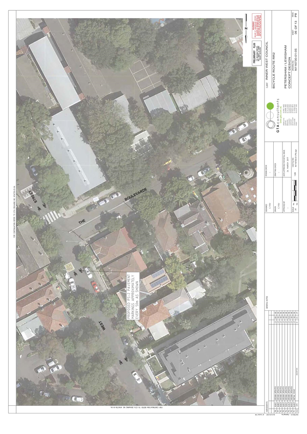
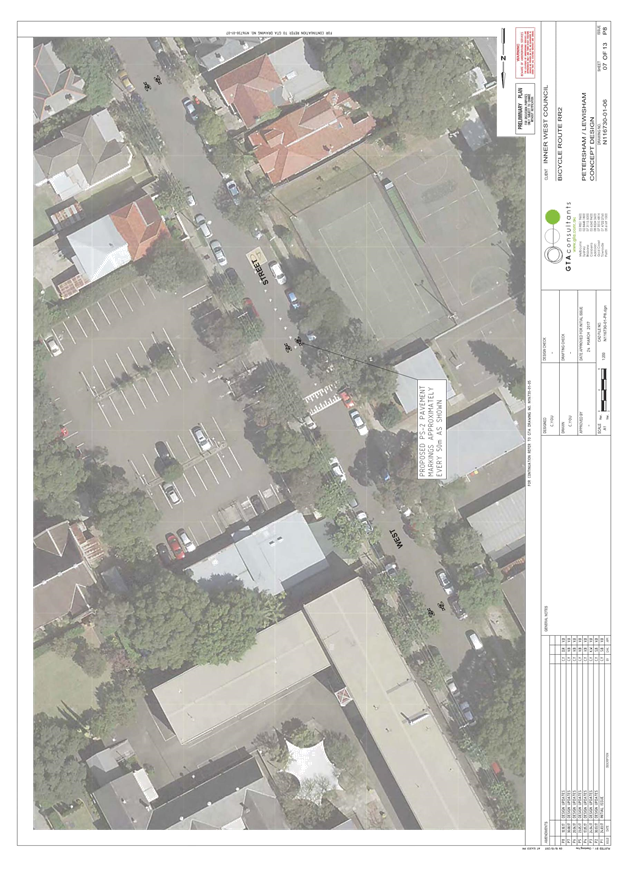
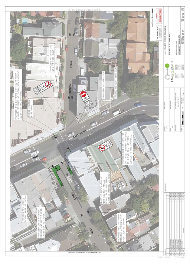
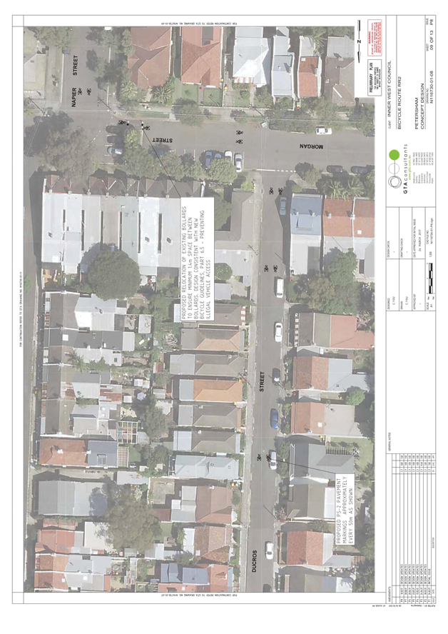
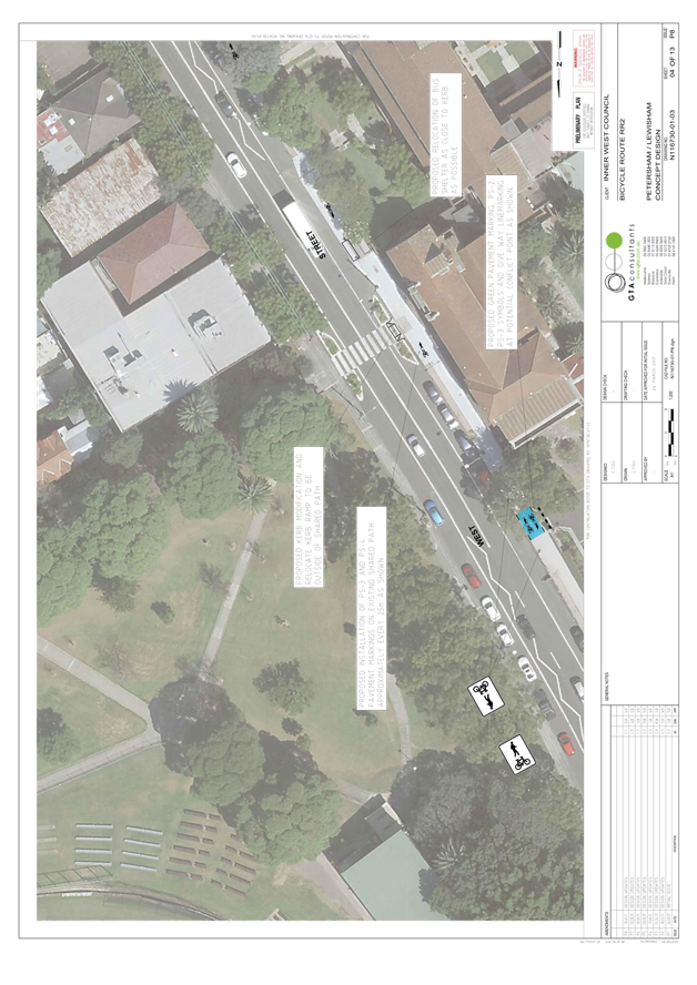
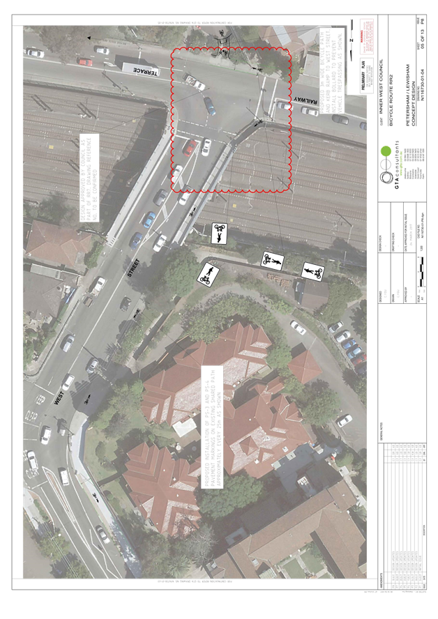
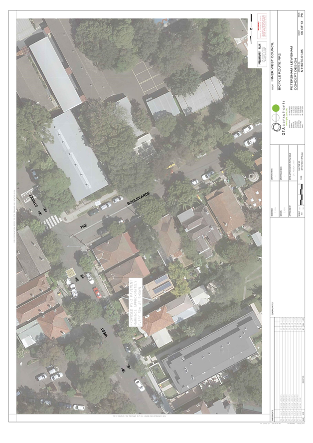
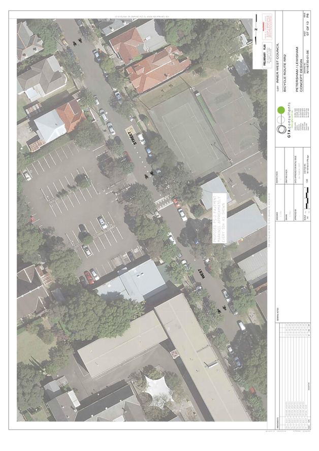
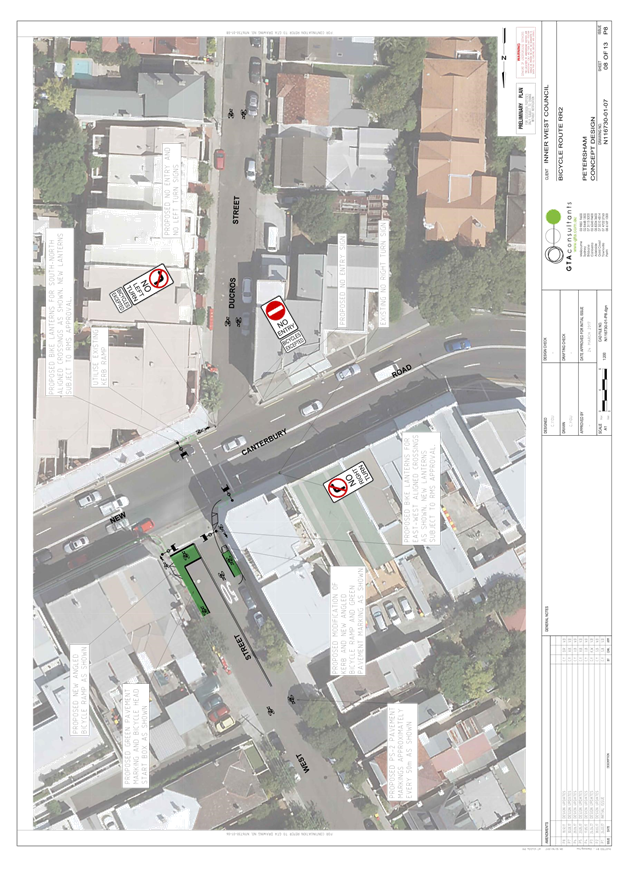
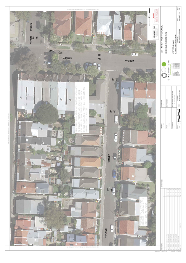
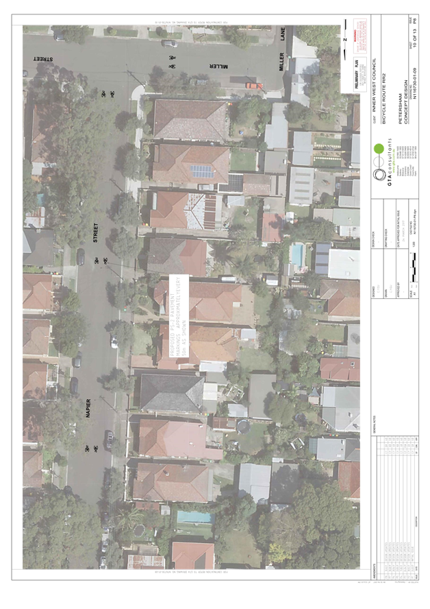
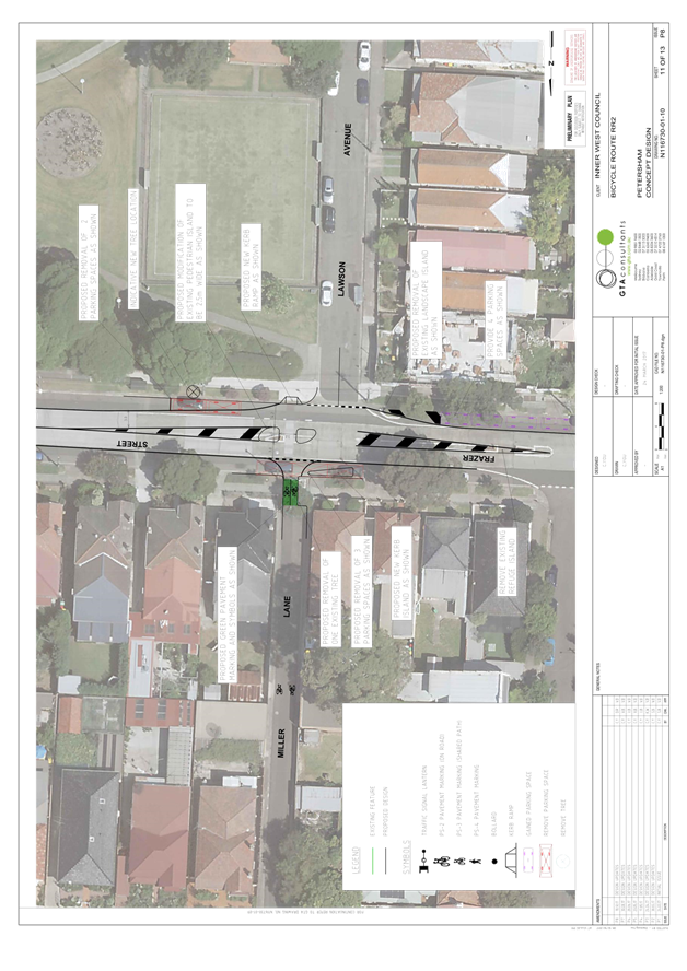
Subject: Regional Route 2 (Parramatta Road To Marrickville Park) - Public Consultation Report And Revised Concept Plan
Prepared By: Snezana Bakovic - Project Engineer Traffic
Authorised By: John Stephens - Traffic and Transport Services Manager
|
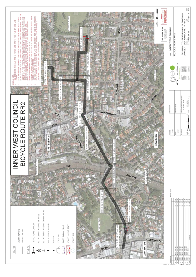
SUMMARY A revised concept plan for improvements to Regional Route 2 as identified in Council’s Marrickville Bicycle Strategy has been developed following public exhibition of the draft concept plan. This report presents a summary of feedback received during consultation with the local community and other stakeholders, and recommends that the revised concept plan be approved and detailed designs for the route be developed. |
|
RECOMMENDATION
THAT:
1. The revised concept plan for Regional Route 2 be approved; and
2. Detailed designs for the route be developed. |
BACKGROUND
Consistent with Council’s stated commitment to encourage bicycle riding and improve bicycle paths and networks, Council’s Marrickville Bicycle Strategy (adopted in 2007) aims to make riding a bicycle easier, safer and more attractive. Regional Route 2 is a route from Leichhardt and Earlwood via Marrickville Park identified in the Bicycle Strategy.
In 2016, Council received a grant from NSW Roads and Maritime Services (RMS) to develop a concept plan for improvements to part of RR2 between Parramatta Road (at West Street) and Marrickville Park. This is consistent with the NSW Government’s objective of making bicycle riding a safe, convenient and enjoyable option for short trips.
The project aims to support bicycle riding by enhancing connections by bicycle to:
· Public transport (including Lewisham train station; major bus routes on Parramatta Road);
· Local destinations such as schools (e.g. Petersham Public School), major parks (Marrickville Park and Petersham Park) and local shops; and
· Other bicycle routes, including to the GreenWay, Marrickville town centre and Sydney CBD.
Following preliminary engagement with the local community and other stakeholders in January/February 2017, a draft concept plan was developed and endorsed for public exhibition in June 2017. As one outcome of the public exhibition, draft concept plan has been revised for approval (Attachment 1) and a consultant’s report (Attachment 2) has also been prepared.
FINANCIAL IMPLICATIONS
Detailed design and construction of the route are dependent on future budgets and grants.
Preliminary cost estimate of the concept plan is $ 991,500.
OTHER STAFF COMMENTS
The draft concept plan was placed on public exhibition in July 2017. A summary of feedback received is presented in this section of the report, with a table of issues raised – and Council officer response provided as Attachment 3.
Following public exhibition, issues raised in submissions were considered, and where feasible informed modifications to the proposal. The local community and those that made submissions during public exhibition were then notified of the revised concept plan in October 2017, and further feedback from community members was received. Changes to the proposal following public exhibition, and the further feedback received by Council is addressed in the next section of this report.
Public exhibition of the draft concept plan (July/August 2017)
The draft concept plan was exhibited from 13 July to 13 August 2017. During this time:
· Public exhibition was advertised to the community in the Inner West Courier, on Council’s website and via Council’s social media channels;
· Approximately 1,100 letters were sent to residents, businesses and property owners in the vicinity of the proposed route, advising of the proposed changes and inviting comments;
· Information about the proposal was accessed from Council’s website 1,200 times.
Overview of community submissions during public exhibition
42 submissions from community members were received by Council during public exhibition:
· 86% of submissions indicated “support” (57%) or “support with changes” (29%) for the proposal;
· 14% of submissions indicated they did “not support” the proposal.

Overview of community submissions during public exhibition, by location
24% of submissions received during public exhibition were from community members along the route (Table 1). Of these, 60% indicated “support” (50%) or “support with changes” (10%) for the proposal, with 40% indicating they did “not support” the proposal.
|
Response, by location |
Total number of submissions |
Yes |
Yes, with changes |
No |
|
Vicinity of the route |
10 (24%) |
5 (50%) |
1 (10%) |
4 (40%) |
|
Rest of Inner West LGA |
23 (56%) |
13 (57%) |
8 (35%) |
2 (9%) |
|
Outside Inner West LGA |
4 (10%) |
1 (25%) |
3 (75%) |
0 |
|
Not specified |
5 (12%) |
5 (100%) |
0 |
0 |
|
Total |
42 |
24 (57%) |
10 (24%) |
6 (14%) |
Table 1: Community submissions received during public exhibition, response by location
Issues raised in community submissions during public exhibition
57% of submissions by community members during the public exhibition period indicated support for the draft concept plan as shown.
The issues most frequently raised in other submissions by community members were:
· More separated bicycle paths should be provided
· Object to the proposed removal of seven parking spaces on Frazer Street
· The proposed left turn restriction at Ducros Street will adversely impact residents who travel by car
· West Street north of the railway line could accommodate a separated bicycle path
A summary of issues raised – and Council officer response – is at Attachment 3.
RMS comments about the draft concept plan
RMS indicated no objection to the draft concept plan, subject to RMS review of proposed bicycle lanterns at signalised intersections, proposed shared environment intersections and the proposed left turn restriction at Ducros Street.
Following public exhibition and review of Council’s Traffic Management Plan for the proposed Ducros Street changes, RMS indicated no objection to the revised concept plan.
Sydney Buses comments about the draft concept plan
Sydney Buses indicated no objection to the draft concept plan.
Following public exhibition, Sydney Buses indicated no objection to the revised concept plan.
Sydney Trains comments about the draft concept plan
Sydney Metro indicated no objection to the draft concept plan, subject to formal approval for any changes to the West Street bridge being approved by RailCorp (as the asset owner).
Following public exhibition, Sydney Metro didn’t indicated objection to the revised concept plan.
Bike Marrickville comments about the draft concept plan
Bike Marrickville requested on-road treatments on West Street, between Parramatta Road and Railway Terrace, to improve route conditions for more confident riders that prefer to travel in the carriageway rather than on the existing shared path.
Bike Marrickville also requested improved wayfinding to guide riders through the local streets along the route.
Bike Leichhardt comments about the draft concept plan
Bike Leichhardt requested on-road treatments on Flood Street and West Street, between Parramatta Road and Railway Terrace, to improve route conditions for more confident riders that prefer to travel in the carriageway rather than on the existing shared path.
Bike Leichhardt also noted potential risks at driveway crossings on the existing West Street shared path, and expressed support for the proposed shared path between Thomas Street and Parramatta Road.
Bike Leichhardt also requested consideration of an alternative shared path option via Old Canterbury Road.
OFFICER COMMENTS
Following public exhibition, issues raised in submissions were considered, and where feasible informed modifications to the proposal and the development of a revised concept plan. The issues most frequently raised during public exhibition, and Council officer response, are set out in the table below, and changes made to the concept plan following public exhibition are discussed thereafter.
|
Issues most frequently raised in public exhibition feedback |
Council officer response |
|
More separated bicycle paths should be provided (24% of submissions) |
The proposed treatments along the route are consistent with national guidelines for appropriate separated of bicycles and motor vehicles, and seek to acknowledge community concerns about on-street parking by minimising impacts. This includes utilising low volume streets and shared paths where appropriate. |
|
Object to the proposed removal of seven parking spaces on Frazer Street (12% of submissions) |
The proposed removal of parking spaces is to accommodate a pedestrian/bicycle refuge on Frazer Street, previously approved by Council in 2015 as part of the Marrickville West LATM. To reduce the proposed parking impacts, the concept plan has been amended to reduce the width of the proposed refuge from 3.0m (desirable width) to 2.5m (consistent with the minimum technical standard), which allows two of the seven spaces to be retained. The concept plan has also been amended to remove the existing refuge located 30 metres to the west near Bishop Street, resulting in 4 additional parking spaces provided on Frazer Street to offset the removal of spaces nearby. Given the proposed refuge would be wider than the existing refuge, also cater for bicycles, and directly link with Marrickville Park, it is considered that it would provide a better crossing facility than the existing refuge. Net loss in parking spaces has been reduced from seven to one parking space. |
|
The proposed left turn restriction at Ducros Street will adversely impact residents who travel by car (10% of submissions) |
The proposed changes at Ducros Street address RMS concerns about the risk of collision between riders and vehicles turning from New Canterbury Road. The number of vehicles accessing Ducros Street from New Canterbury Road is considered low (200 vehicles per day); these vehicles would be required to travel an additional 550 metres via Wardell Road and Morgan Street. RMS has indicated it supports the proposed changes. |
|
West Street north of the railway line could accommodate a separated bicycle path (7% of submissions) |
Given traffic lane width requirements to accommodate buses, there is insufficient space for a separated bicycle path without removing a parking lane. Removal of a parking lane on this section of West Street would not be supported by Council. |
On-street parking on Frazer Street
As discussed in the table above, in response to local community submissions about the removal of seven on-street parking spaces on Frazer Street to accommodate a new pedestrian/bicycle refuge, the concept plan has been amended to reduce the width of the proposed refuge from 3.0m to 2.5m. This allows 2 of the seven parking spaces to be retained.
The concept plan has also been amended to remove the existing refuge located 30 metres to the west near Bishop Street, resulting in 4 additional parking spaces provided on Frazer Street to offset the removal of spaces nearby. Given the proposed refuge would be wider than the existing refuge, also cater for bicycles, and directly link with Marrickville Park, it is considered that it would provide a better crossing facility than the existing refuge.
These changes reduce the impact to on-street parking on Frazer Street from seven spaces removed to 1 spaces removed.
Muriel Lane
Council’s Tree Management Officer confirmed no objection to the removal of the street tree in Muriel Lane near Frazer Street to accommodate a wider path for riders and pedestrians into Muriel Lane, subject to a replacement street tree being provided nearby. The proposed location of the replacement tree is shown in the revised concept plan.
Morgan Street
Community submissions raised concerns that bicycle riders would face unsafe conditions while waiting to turn right from Morgan Street onto the proposed shared path on Livingstone Road. The concept plan has been amended to propose a protected right turn bay for riders. This change doesn’t require removal of any existing on-street parking spaces on Morgan Street near the intersection of Livingstone Road.
Shared environment intersections
RMS requested traffic counts for the proposed shared environment intersection treatment at Nestor Lane. Traffic counts were carried out and are summarised in the table below:
|
Location |
Ave. peak hour vehicles (V<30) |
Ave. peak ¼ hour vehicles (V<15) |
Comment |
|
Nestor Ln at West St |
11 (10-11am) |
3 |
Within RMS threshold |
RMS subsequently indicated it had no objection to the proposed shared environment intersections.
Summary of proposed parking impacts in the revised concept plan
Parking changes
There is an overall loss of one parking space in the revised plan:
· Frazer Street: four new spaces and remove five spaces.
· Thomas Street: one space would be relocated.
The exact impact on parking will be determined later during the detailed design phase of the project
Summary of changes made following public exhibition
In response to issues raised in public exhibition, the following changes have been made to the concept plan:
Muriel Lane
· Show proposed location for replacement street tree
Frazer Street
· Reduce width of proposed pedestrian/bicycle refuge from 3.0m to 2.5m
· Remove existing pedestrian refuge near Bishop Street
Morgan Street
· Propose bicycle protected right turn bay near the intersection of Livingstone Road
Notification of the revised concept plan and further feedback (October/November 2017)
Following development of the revised concept plan, in October 2017 Council wrote to approximately 1,100 residents along the route and those that made submissions during public exhibition to notify about the revised concept plan and advise of the next steps for the project.
Council subsequently received 1 further submission and two phone calls from community members requesting some clarification on the proposed changes.
New issues raised in the submissions have been included in the attached consultation summary, and are listed in the table below.
|
Issues raised in further submissions that were not previously raised during public exhibition |
Council officer response |
|
The proposed left turn restriction at Ducros Street will increased traffic (i.e. rat running) in Allans Avenue.
It is requested that residents of Allans Avenue be included in consultation about Regional Route 2 detail design.
|
The number of vehicles accessing Ducros Street from New Canterbury Road is considered low (200 vehicles per day). It is predicted that the through traffic will go via Wardell Road and Morgan Street rather than Allan street .Allan street is a narrow street and thus will be less convenience for trough traffic. If justified appropriated traffic management solution always could be applied.
Residents of Allans avenue would be included in detail design community consultation. |
|
|
|
CONCLUSION
Although 86% of community submissions during public exhibition indicated support for proposed route improvements between Parramatta Road and Marrickville Park, it is acknowledged that not all community members along the route were supportive of the proposal, primarily due to concerns about parking impacts on Frazer Street and the proposed left turn restriction at Ducros Street. Issues raised during public exhibition have informed subsequent modifications to the concept plan. It should also be stated that the only very small percentage of residents along the route actually commented during the public exhibition phase. Therefore support of or otherwise from affected residents is really not known at this stage.
The revised concept plan proposes bicycle route improvements that would encourage more trips by bicycle by providing a safer and more pleasant link to local destinations and connecting routes. The improvements also seek to acknowledge community concerns about on-street parking by minimising impacts along the route. This report recommends that the revised concept plan be approved and detailed designs for the route be prepared.
|
1.⇩ |
LR2 Revised Concept Plan |
|
2.⇩ |
LR2 Option Assessment and Concept Design Report |
|
3.⇩ |
Regional Route 2-Draft Concept Plan-Consultation Summary |
|
Local Traffic Committee Meeting 7 December 2017 |
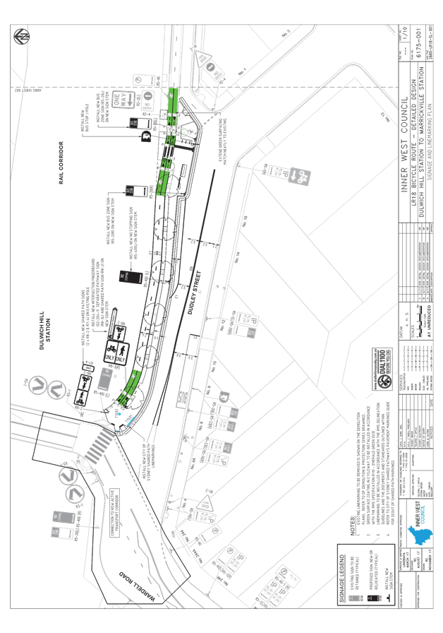
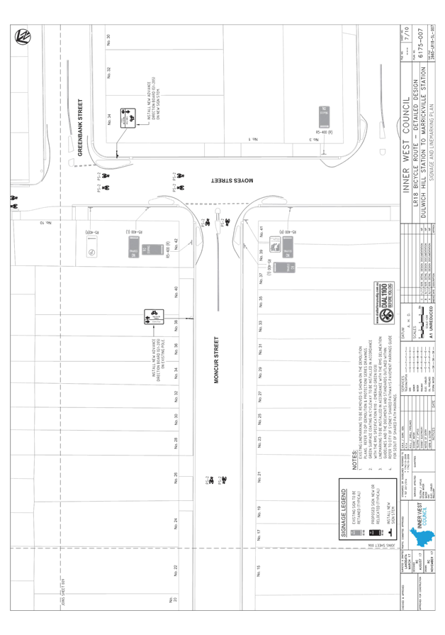
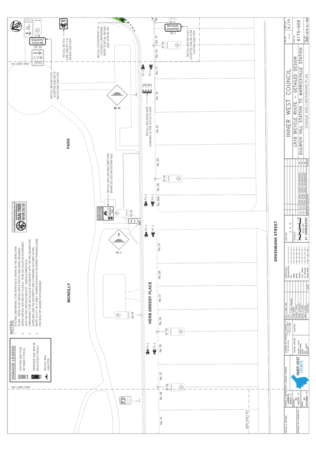
Subject: Local Route 18-Dulwich Hill Station To Marrickville Station-Detail Design (Central&West Wards/Summer Hill)
Prepared By: Snezana Bakovic - Project Engineer Traffic
Authorised By: John Stephens - Traffic and Transport Services Manager
|
SUMMARY On December 2016, Council approved a final concept plan for improvement to Local Route 18, bicycle route identified in Council Council’s Bicycle Plan. The Local Route 18 (LR18), connecting Dulwich Hill train station and Marrickville train station via Dudley Street. The aim of the proposal was to make LR18 bicycle route more safe, convenient and more enjoyable for people of all ages and ability to ride.
Based on the approved concept plan the draft design plans have been finalised and it is presented in this report for Committee consideration.
The proposed improvements will complete missing links in Council’s bicycle network and enhance bicycle access to public transport, local shops and other destinations.
It is recommended that the detail design of the LR18 to enhance bicycle access to public transport, local shops and other destination be APPROVED.
|
|
RECOMMENDATION
THAT the Local Route 18 – Dulwich Hill Station to Marrickville Station detail design plan (No 6175) be APPROVED. |
BACKGROUND
With support from the NSW Government, Council is proposing to improve LR18 to connect people to train stations and local destinations.
In 2016, Council asked the community and other stakeholders for feedback on riding a bike on this route. The feedback received, along with technical assessments of the study area, was used to develop a draft concept plan.
The draft concept plan was approved for Public Exhibition by Council on December 2016. Community members were then invited to give feedback on the draft concept plan in June and August 2016 and the comments received informed a final concept plan. The final plan was then considered and approved by Council at a meeting on 28 February 2017.
Based on the approved concept plan the design plans have been developed and it is presented in this report for Committee consideration. The plans incorporate imput from local community, RMS,State Transit Authority, Bike Marrickville and internal stakeholders.
FINANCIAL IMPLICATIONS
The construction of the route depends on further available budget and grant applications. The preliminary design estimated cost is $494,000.
OTHER STAFF COMMENTS
The proposed work includes:
· Creating a new kerb extension and off road, 2.4 m wide separated bi-directional bicycle path and 1.8 wide footpath with landscaping along the northern side of Dudley Street connecting to the existing two way bike path at School Parade.
· Planting six new trees and removing three existing trees on Dudley Street where the cycleway and wider footpath would be built;
· Building two sections of a shared path on Livingstone Road between Albermarle Street and Moncur Street;
· Replacing the gate at the western end of Herb Greedy Place with bollards to allow free movement for pedestrians and bikes;
· Painting bicycle symbols on the road to indicate mixed traffic lanes in Albermarle Street, Moncur Street, Jersey Street, Herb Greedy Place and Warburton Street; and
· Installing a new 1.4 wide contraflow bicycle lane at the eastern end of Herb Greedy Lane.
· Install new wayfinding cycleway signage.
The draft plan uses the following existing infrastructure to complete the route:
· The on road bicycle path in School Parade;
· The shared path between School Parade and Kays Avenue East;
· The off road shared path between Kays Avenue East and Albermarle Street; and
· Mixed traffic lanes on Albermarle Street.
Other proposed changes:
· Two bus stops would be relocated
o Dudley Street, Dulwich Hill - the bus stop at the northern side of Dudley Street would move approximately 50 metres towards School Parade.
o Livingstone Road, opposite Moncur Street – the bus stop on the western side of Livingstone Road would move eight metres north.
· Additional bicycle parking would be installed on Dudley Street, Warburton Street and at the entrance to McNeilly Park.
· Minor changes to existing pedestrian refuges at Livingstone Road / Moncure Street intersection.
· Relevant signs and road marking would be installed to increase safety for all road and path users.
Landscaping
The design proposes to have planting along the 1m separation strip between the bicycle and pedestrian paths. As a result of the bicycle path, the 3 existing trees will need to be removed and 5 new trees have been proposed as replacements. The trees will be 400L Angophora
Costata (Sydney Red Gum) with provision for vault-style structural soil installations as
requested by Council’s Tree Management Officer. Planted areas at the east end have been
positioned to encourage pedestrians to cross at the designated crossing only.
Widening of existing path between Keys Avenue East and Scholl Parade
The draft concept plan proposed widening the shared path between Kays Avenue East
and School Parade further into the rail corridor. This section of the route is impacted by
Sydney Metro planning timeframes and Sydney Metro has indicated that the proposed changes or further widening to provide a separated bike path and footpath could be considered in its metro conversion planning in the medium term. Council will continue to work with Sydney Metro to seek support for this improvement. This area is clouded on attached detail design plan.
Bicycle Parking
Additional bicycle parking is proposed at following location;
Dudley Street
· Two (2) bicycle racks have been proposed on the west end of Dudley Street between the separation strip providing bicycle parking near Dulwich Hill Station.
· Three (3) bicycle racks have been placed on the east end of Dudley Street providing bicycle parking near the proposed bus stop.
Herb Greedy Place
Three bicycle racks (3) have been proposed at the midpoint of McNeilly Park adjacent to the main entrance and amenities block.
Warburton Street
Bicycle parking is proposed in 2 locations. These are:
· Warburton Street entrance to McNeilly Park – Five (5) bicycle racks have been placed
close to an existing entrance to the park.
· Warburton Street at Illawarra Road – 3 bicycle racks have been located on a proposed island to provide parking close to Marrickville Station.
Single tubular bicycle racks were chosen over multi-rack products (such as the existing rack at the entrance to McNeilly Park) as they comply with AS2890.3-1993 in that they support the whole bicycle, frame and wheels and not just a small portion of the bicycle
Parking Impacts
The proposed route improvements have been carefully considered to minimize/avoid parking impacts where possible, in response to community concerns raised in preliminary consultation. As outlined above, the proposed changes would result in three (3) on -street parking spaces being removed on Dudley Street. All vehicle access to properties along the route will remainn.
PUBLIC CONSULTATION
Community Consultation
257 consultation letters were sent out on 26 October to all property owners and occupiers to potentially directly affected residents and stakeholders. The community survey closed on 23 November 2017.
Council received 85 submissions and two telephone calls were received requesting clarification on proposal.78 of the summations indicated support, 6 support with changes and 1 summation objecting proposal.
|
Total Number of summations |
Yes |
Yes with changes |
No |
|
85 |
78(92%) |
6(7%) |
1(1%) |
Some supportive comments received from residents;
Ø ‘How marvelous! Simply terrific idea and route. I look forward to riding it’
Ø ‘This is a good initiative to improve safety and road design for families who want to get to/from the train station and shop’.
Ø ‘By having more people riding we will have increased community health, less car use, less noise and air pollution and increased safety on the streets’.
Ø ‘More people out and about foster a more friendly community atmosphere and a more cohesive society’.
Ø ‘I love biking in Marrickville and any improvements to make it safer to ride a bike are supported by me and my family!’
Ø ‘Keep up the good work by making it easier (and safer) for everyone to ride a bicycle and making routes between DH and Marrickville better’.
Ø This protected bike route will encourage new people to cycle on a local basis to shops, schools and railway stations. It formalises and enhances existing routes. By having more people riding we will have increased community health, less car use, less noise and air pollution and increased safety on the streets .More people out and about fosters a more friendly community atmosphere and a more cohesive society.
Summary of suggestion received from residents:
|
Suggestions received through public consultation |
Council officer response |
|
Please make sure the path is wide enough and has enough clearance from obstructions, fences and walls. |
At the moment this is unlikely to be achieved as the fence is Sydney Metro property Council already explore this option but wasn't supported. Also the design team would reconsider all opportunity to provide more room for cyclist. |
|
Supportive but it needs to be separated throughout to encourage new cyclists.
|
Separated cycleway is only considered in a case of high traffic speed and high traffic volume. As it is a costly treatment which often requires parking removal therefore has to be justified. This is not a case along this sectin of Dudley Street. |
Other stakeholders
Council has also consulted with other stakeholders including RMS, Bike Marrickville West Conex, Sydney Busses and Sydney Metro.
|
Stakeholders |
Comments |
|
RMS |
RMS indicated no objection to the design plans. |
|
Bike Marrickville |
Concept design is initially discuss with Bike Marrickville and their comets was incorporate in design whenever was justified and feasible. Bike Marrickville indicated no objection to the draft design plans. |
|
Sydney Metro |
Sydney Metro indicated no objection to the design plans. |
|
Sydney Busses |
Sydney Buses indicated no objection to the design plans. |
CONCLUSION
The proposed improvements will complete missing links in Council’s bicycle network and enhance bicycle access to public transport, local shops and other destinations.
It is recommended that the detail design of the LR18 to enhance bicycle access to public transport, local shops and other destination as per Design Plans No 6175 be APPROVED.
|
1.⇩ |
LR18-DETAIL DESIGN-SIGNAGE AND LINEMARKINGS PLAN |
|
2.⇩ |
LR18-DETAIL DESIGN-GENERAL ARRANGEMENT PLAN |
|
Local Traffic Committee Meeting 7 December 2017 |
Subject: Proposed Bus Stop and kerb extended pedestrain crossover facility outside/near No.126 Victoria Street, Ashfield (opposite Cardinal Freeman Retirement Village). (Ashfield Ward/Summer Hill Electorate/Ashfield LAC)
Prepared By: Boris Muha - Traffic and Projects Engineer
Authorised By: John Stephens - Traffic and Transport Services Manager
|
SUMMARY Council proposes to install an ‘in lane’ Bus Stop and kerb extended crossover facility for pedestrians between an outside of No. 126 Victoria Street and the existing pedestrian path leading towards Victoria Square, Ashfield.
The bus stop facility, to be located opposite the Cardinal Freeman Village, will serve the elderly residents of the Village and similarly the general public in the area. A safe crossover treatment for pedestrians will be provided in combination with the Bus Stop as shown on the diagram and concept plan attachments 2 and 3 to this report.
|
|
RECOMMENDATION
THAT: 1. An ‘in lane’ Bus Stop and kerb extended pedestrian crossover facility (as shown on the concept plan attachment 3) be constructed between and outside No. 126 Victoria Street and the existing pedestrian path leading towards Victoria Square, Ashfield;
2. Edge lines approximately 20-25 metres in length be painted on both sides of Victoria Street on the approach and departure of the above ‘in lane’ Bus Stop and pedestrian crossover facility, with the added installation of raised reflective pavement marking (RRPM’s);
3. ‘Pedestrian’ (W6-1B) and ‘Aged’ (W8-18B) signage be placed in advance approach to the facility on both sides of Victoria Street; and
4. Chevron alignment marker (G9-243A) signage be placed to the front ends of the kerb extended islands.
|
BACKGROUND
An initial request was made (prior to 2014) by the Cardinal Freeman Retirement Village and Sydney Buses to provide public Bus Stop facilities on both sides of Victoria Street adjacent to the Village to serve the village residents and the general public in the area.
Currently, the Bus Route 406 operates via Victoria Street from Hurlstone Park to Five Dock. The presence of existing palm trees located and spaced in short distance along the sides of the road, prevents buses from pulling up close and safe to the kerb.
It was proposed and devised at the time, through bus tests and discussions with Sydney Buses, that a narrow length kerb extended platform or pad could be built on the western side of the road- see insert picture of device in attachment 2. This would allow buses to pull up safely ‘in lane’ to the platform for passengers to alight and dismount the bus using the front door only. Vehicles would be able to park either side of the platform. Conventional Bus Stops, allowing buses to pull up to the kerb, would require the further removal of parking.
It was also considered at the time that a conventional length bus stop could be provided to the eastern side of Victoria Street outside No.122 where the spacing between the palm trees was large enough to accommodate a conventional bus stop.
Affected residents/owners through consultation at the time were not in support of a conventional bus stop going outside No.122 due to the noise/pollution and loss of parking attributed to buses proposing to pull up outside of No.122.
The matter was later reported to the former Ashfield Council Local Traffic Committee meeting held on the 6 June 2014, and the following recommendation was made.
“ 1. That no objection be raised for a narrow length kerb extension or pad to be constructed on the western side of Victoria Street, Ashfield, opposite 130 Victoria Road, and approximately 25 metres south of the main (Gate No.1) entrance to the Cardinal Freeman Village to facilitate a new Bus Stop.
2. That the Bus Stop (kerb extension boarding pad) facility on the western side of Victoria Street, Ashfield-item 1 be monitored and trialed for a minimum period of six (6) months.
3. That following the trial period of the Bus Stop facility –item 2, a further report to Council (through its Local Traffic Committee) be provided to determine the success of the trial and whether a Bus Stop facility be implemented to the opposite side of Victoria Street.”
This above recommendation of the Traffic Committee was subsequently adopted by Council at its meeting on the 24 June 2014.
The Bus Stop on the western side was only implemented at the time–see insert attachment 1. Further investigation of a Bus Stop to the eastern side was delayed for more time to monitor the affect and operation of the Bus Stop on the western side of the street, and determine whether a similar type device could be placed to the eastern side in lieu of a conventional Bus Stop. The delay was further extended with the proposed and current redevelopment of the Cardinal Freeman Village to re-access the community needs for an additional transport facility in the area.
FINANCIAL IMPLICATIONS
That the estimated cost of $80,000 to construct the proposed works will be listed in the 2018/2019 draft traffic facilities budget.
OTHER STAFF COMMENTS
Council has since liaised with Sydney Buses and the Management of the Cardinal Freeman Village to consider the placement of a Bus Stop facility to the eastern side of Victoria Street, opposite the Cardinal Freeman Village.
The following points are made in discussions and lead up to the proposed Bus Stop facility on the eastern side of Victoria Street as recommended in the report.
· Sydney Buses has made Council aware that existing and adjacent Bus Stops along the 406 bus route (either direction of the Cardinal Freeman Village) are too far apart, and that additional Bus Stops in between and in the vicinity of the Cardinal Freeman Village would be required to service the community. The Bus Stop as shown in the insert diagram attachment 2 has been provided for on the western side of the street to reduce the distance between adjoining bus stops along the northern direction of the bus route.
· Victoria Street measures 12.8 metres wide (kerb to kerb) and carries low to moderate volumes of traffic around 3000 vehicles per day. Sydney Buses have raised no problem with the ‘in lane’ function and operation of the Bus Stop platform facility on the western side of the street outside the Village since it was installed 3 years ago. Police have raised no issues with traffic movement in the area with the ‘in lane’ Bus Stop on the western side of the street.
· The Management of the Cardinal Freeman Village advise that the redevelopment of the Village is mainly of self-serve accommodated apartments attracting a ‘younger’ clientele and increased senior residentancy aged 55+. Such residents would benefit and would be capable of using public transport.
· The village development is going through a last staging of work. Major Stage 3A work is anticipated for completion around September 2018, whilst a smaller Stage 3B work (currently commenced) is anticipated for completion around September 2019.
· The new main driveway and pedestrian access to the Village currently lies opposite No.122 Victoria Street.
· The construction of the bus stop platform will be built in compliance to Disability Standards for Accessible Public Transport, similar in type and operation to the current stop outside the Cardinal Freeman Village, south of the existing driveway (Gate 1) of the Village.-refer to insert diagram attachment 2.
· The proposed bus stop facility is to be located between and outside of No. 126 Victoria Street and the pedestrian path leading towards Victoria Square. The Village Management has requested if Council could consider the Stop at this location as it would be near to the main pedestrian access to the village. Sydney Buses, through discussion with Council, has raised support of the Bus stop facility in this location.
· A safe crossover treatment for pedestrians would be provided in combination with the Bus Stop to the eastern side of the street.
· The pedestrian crossover treatment will be constructed of landscaped kerb blisters/extensions with pram ramps in line with the Bus Stop to allow the safe and visual sighting of pedestrians crossing over to/from the Bus Stop.
· Edge line markings will be painted to delineate and guide and control traffic movement through the above facility.
· Chevron alignment marker signposting including ‘PEDESTRIAN’ and ‘AGED’ Warning signs in approach to the facility will be provided as shown on attachments 2 and 3.
· The proposed Bus Stop on the eastern side of the street will be staggered in distance away from the Bus stop on the western side. In the likelihood of buses approaching the stops either side of the street at the same time, traffic will have the choice to wait momentarily while the bus pulls up to the stop(s) or proceed with caution around the buses.
· In regard to minimising noise/pollution and loss of parking:
¨ The bus stop is constructed in combination with the pedestrian cross-over facility to minimise the loss of parking in the area. One car parking space would be lost on either side of the street (total 2 spaces). However the existing and old driveway to the village, opposite No.126, will be programed to be removed as from February 2018. This would provide for at least one (1) parking space to the western side of the street. There is a net proposed loss of one (1) car parking space in the area.
¨ Subject to funding, the facility would be programed for construction in the 2018/2019 financial year, once the development works on stage 3A on the village are complete. It is viewed that worker parking in the area might be reduced and more parking is freed up to residents.
¨ The 406 bus service is infrequent, half hour in the peak, and hourly in the off-peak and weekends. The service operates part time in the daytime and early evening between 6.30am-7.00pm M-F, 7.30am-6.15pm Sat, 8.00am-6.30pm Sun. The buses now operate on a cleaner and efficient fuel. Noise is considered reduced with buses pulling in and out ‘in lane’ and from a further distance out from the houses over that of a conventional (kerb side) bus stop. The Bus stop is closer to the corner and side boundary of No.126.
PUBLIC CONSULTATION
Affected residents in the area were letter boxed dropped seeking their comments on the proposal. 31 letters were distributed to occupant/residing owners including the Cardinal Freeman Management on behalf of its residents. A further 8 letters were mailed to no-residing owners to properties on the eastern side of the street.-see distribution map attachment No.1
One (1) resident response was received (verbally) with various concerns being raised with regard to placing the Bus Stop at the location as proposed. These concerns are listed and addressed as follows.
|
Resident Comments |
Council Officer response |
|
1. Why place a Bus Stop midblock? Can it not be placed at the corner of the intersection?
2. Why can’t the buses travel through the private road system of the Village rather than resorting to a Bus Stop on-street?
3. Why is the Bus Stop staggered away from the other bus stop opposite on the western side? Can it not be moved closer to the other opposite side Bus Stop?
4. It would appear that 2-3 parking spaces in net are lost given the placement of the new driveway to the Village opposite No.122 Victoria Street?
5. Can Victoria Street residents park in the village complex?
6. Can the bus stop be moved a further distance north outside of the pedestrian pathway leading to Victoria Square?
7. Can the tree on the footway, proposed to be removed, be retained?
8. How do you prevent vehicle from running over the kerb islands, when travelling through or accessing from driveways?
|
1. It is not uncommon to place bus stops in mid or internal block locations where they cannot be placed to corner intersections. Buses turning from the side streets, or turning into the side streets require to straighten up from a long distance before entering the kerb or platform. Furthermore, midblock or internal block bus stops are used to minimise the distance between adjoining bus stops. Bus Stops are typically placed as close as possible to main pedestrian attractors. In this case it is the new Village gate.
2. Public Buses cannot access private roads and detour away from their destined route. STA buses, due to their length, may not be able negotiate through the private roads of the Village. Mini buses may service the Village, but are only limited and destined to specific locations. The Public Bus service provides the flexibility and freedom for patrons to travel as, where and when they please.
3. Normally bus stops are made to be opposite each other. In this particular situation with ‘in lane’ bus stops, they are staggered apart should traffic, with due caution, wish to come around waiting buses. The Bus Stop in combination with the pedestrian crossover facility, as proposed on the eastern side, is well positioned to cater for general pedestrian desire path in the area.
4. This driveway is currently existing. There is a net loss of one (1) parking space as reported above. This accounts for the proposed removal and gain of parking from this point of time. The Bus Stop and pedestrian crossover facility is designed and positioned in location to minimise the loss of further parking. Furthermore, programed work will be held back till the 2018/2019 financial year, following the completion of the stage 3A works to the Village. Parking may be freed up in the street in anticipation of less worker parking in the area.
5. The private development is typically built for the village residents and its visitors. Local residents would be discouraged from using the Village carpark.
6. The combined Bus Stop and kerb extended pedestrian crossover treatment to the eastern side has been designed and conveniently located between the palm tree (outside No.126) and the driveway to No.122. The head of the bus stop will be approximately 1.0 metre back of the corner of the kerb extension. Any minor shift of the bus stop further north can be considered in the final design of the treatment.
7. The tree of this particular species is considered to interfere and is likely to up-root any slab and/or kerb construction to the bus stop through time. This matter will be discussed with the Council’s Tree Officer, and if need be, replant another and more appropriate tree species in the footpath.
8. The ends to the kerb islands are designed at appropriate distance from the driveways so as not to hinder in the driveway access of vehicles. Kerb faces are to be painted and chevron alignment markers placed within the islands to delineate and emphasis the presence of the islands to motorists.
|
CONCLUSION
In view of the above, it is proposed that an ‘in lane’ Bus Stop in combination with a kerb extended crossover facility for pedestrians, located between and outside of No. 126 Victoria Street and the existing pedestrian path leading towards Victoria Square, Ashfield, be constructed to improve accessibility to Public transport whilst maximising the retention of on-street parking. The bus stop facility, to be located opposite the Cardinal Freeman Village, will serve the elderly residents of the Village and similarly the general public in the area.
Associated line marking and sign posting will be provided to emphasis the presence of the facility, and control traffic movement through the facility.
|
1.⇩ |
Letter box distribution area for consultation |
|
2.⇩ |
Aerial view of existing Bus Stop and proposed combined Bus Stop and pedestrain crossover facility in Victoria Street, Ashfield |
|
3.⇩ |
Concept Plan of Proposed combined Bus Stop and pedestrian crossover facility in Victoria Street, Ashfield |
|
|
Local Traffic Committee Meeting 7 December 2017 |
Subject: Piper Street at Annandale Street, Annandale - Proposed 'No Stopping' restrictions (Leichhardt Ward/Balmain Electorate/Leichhardt LAC)
Prepared By: David Yu - Traffic Engineer
Authorised By: John Stephens - Traffic and Transport Services Manager
|
SUMMARY Council has received a request to signpost the statutory ‘No Stopping’ restrictions at the corners of the Piper Street and Annandale Street intersection (Annandale) in order to prevent illegal parking and improve sight visibility. |
|
RECOMMENDATION
THAT:
1. A 10m ‘No Stopping’ zone be installed on the northern and southern sides of Piper Street (east and west of Annandale Street); and
2. A 10m ‘No Stopping’ zone be installed on the western side of Annandale Street (north of Piper Street).
|
BACKGROUND
Concerns have been raised regarding vehicles parking too close to the intersection of Piper Street and Annandale Street intersection (Annandale).
This illegal parking behaviour obstructs sight visibility to vehicles and also to pedestrians that may be using the pedestrian crossing, located on Annandale Street, Annandale.
FINANCIAL IMPLICATIONS
The cost of signposting will be funded from Council’s operational budget.
OTHER STAFF COMMENTS
In order to allievate the sight visibility issues, it is proposed to signpost 10m ‘No Stopping’ zones at the following locations:
· The northern and southern sides of Piper Street (east and west of Annandale Street).
· The western side of Annandale Street (north of Piper Street) as shown on the following plan.
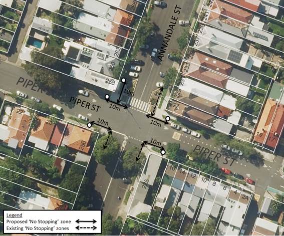
PUBLIC CONSULTATION
|
A letter outlining the above proposal was mailed out to the affected properties (32 properties) in Annandale Street, Piper Street, and Young Street Annandale. No responses were received.
|
|
CONCLUSION
In order to maintain sight visibility and remove illegal parking at the corners of the Piper Street and Annandale Street intersection, it is recommended that 10m ‘No Stopping’ zones be installed at the following locations:
· The northern and southern sides of Piper Street (east and west of Annandale Street).
· The western side of Annandale Street (north of Piper Street).
|
|
Local Traffic Committee Meeting 7 December 2017 |
Subject: Minor Traffic Facilities (Leichhardt and Balmain Wards/Summer Hill and Balmain Electorates/Ashfield and Leichhardt LACs)
Prepared By: Manod Wickramasinghe - Traffic and Parking Engineer
Authorised By: John Stephens - Traffic and Transport Services Manager
|
(SUMMARY This report deals with minor traffic facility applications received by Inner West Council and includes ‘Disabled Parking’ and ‘Works Zone’ applications. |
|
RECOMMENDATION
THAT:
1. The 6m ‘Disabled Parking’ space in front of No.75 Francis Street, Leichhardt be removed as it is no longer required noting that the 6m ‘Disabled Parking’ space in front of No.73 Francis Street will be retained;
2. The 6m ‘Disabled Parking’ space in front of No No.2 Springside Street, Rozelle be removed as it is no longer required;
3. The committee endorse the relocation of the 6m ‘Disabled Parking’ zone from in front of No.61 St David’s Road to in front of No.59 St David’s Road, Haberfield as it was no longer required;
4. A 6m ‘Disabled Parking’ zone be installed in front of No.23 National Street, Leichhardt;
5. A 6m ‘Disabled Parking’ zone be installed in front of No.122-126 Evans Street, Leichhardt (immediately south of the existing ‘No Stopping’ zone) replacing the existing 2P ticket parking restrictions;
6. A 6m ‘Disabled Parking’ zone be installed in front of No.23 Day Street, Leichhardt removing the 2P resident parking restrictions;
7. A 13m 'Works Zone 7.00am - 5.00pm Mon-Fri, 7.00am - 1.00pm Sat' be installed in front of No.32 Jarrett Street, Leichhardt for 12 weeks replacing the existing resident parking restrictions; and
8. A 17m 'Works Zone 7.00am - 5.00pm Mon-Fri, 7.00am - 1.00pm Sat' be installed in front of No.383-389 Darling Street, Balmain for 12 weeks, temporarily replacing the existing ‘Loading Zone’ and ticket parking restrictions.
|
BACKGROUND
This report deals with minor traffic facility applications received by Inner West Council and includes ‘Disabled Parking’ and ‘Works Zone’ applications.
FINANCIAL IMPLICATIONS
Nil.
OTHER STAFF COMMENTS
1 Removal of ‘Disabled Parking’ Restriction – Francis Street, Leichhardt
Council Ref: DWS 4550909
Council has been notified by a neighbour that the applicant to the ‘Disabled Parking’ space outside of No.75 Francis Street, Leichhardt has passed away and so the ‘Disabled Parking’ space is no longer required.
Council has contacted the resident of No.75 Francis Street and confirmed that this space is no longer required. It should be noted that there is also a 6m ‘Disabled Parking’ space in front of No.73 Francis Street which is still in use.
It is recommended that the 6m ‘Disabled Parking’ space in front of No.75 Francis Street, Leichhardt be removed as it is no longer required noting that the 6m ‘Disabled Parking’ space in front of No.73 Francis Street will be retained.
2 Removal of ‘Disabled Parking’ Restriction – Springside Street, Rozelle
Council Ref: DWS 4550909
Council has been notified by the new owner of No.2 Springside Street that the applicant to the ‘Disabled Parking’ space outside the property has sold and moved away and so the ‘Disabled Parking’ space is no longer required.
It is recommended that the 6m ‘Disabled Parking’ space in front of No No.2 Springside Street, Rozelle be removed as it is no longer required.
3 Removal of ‘Disabled Parking’ Restriction – St David’s Road, Haberfield
Council Ref: DWS n/a
Council has been notified that the ‘Disabled Parking’ space outside No.61 St David’s Road Haberfield is no longer required. During the consultation process for removal of this parking space, Council received an application for a ‘Disabled Parking’ space outside No.59 St David’s Road.
A site investigation has revealed that No.59 St David’s Road does not have off street parking. The applicant also does not require the use of a wheelchair.
Council subsequently obtained approval to remove the ‘Disabled Parking’ zone from the voting members of the Traffic Committee between formal meetings. The ‘Disabled Parking’ space was then relocated from in front of No.61 St David’s Road to in front of No.59 St David’s Road.
It is recommended that the Committee endorse the relocation of the 6m ‘Disabled Parking’ zone from in front of No.61 St David’s Road to in front of No.59 St David’s Road, Haberfield as it was no longer required by No.61 St David’s Road.
4 Installation of ‘Disabled Parking’ Restriction – National Street, Leichhardt
Council Ref: DWS 4564193
The resident of No.23 National Street, Leichhardt has requested the installation of a ‘Disabled Parking’ zone in front of the resident’s property.
A site investigation has revealed that the property does not have off street parking. The applicant does not require the use of a wheelchair.
It is recommended that a 6m ‘Disabled Parking’ zone be installed in front of No.23 National Street, Leichhardt.
5 Installation of ‘Disabled Parking’ Restriction – Evans Street, Rozelle
Council Ref: DWS 4584161
The resident of No.120 Evans Street, Leichhardt has requested the installation of a ‘Disabled Parking’ zone near the resident’s property.
A site investigation has revealed that the property does not have off street parking.
Council is proposing to install a 6m ‘Disabled Parking’ zone in Evans Street across the frontage 122-126 Evans Street. This is the closest space to the applicants’ property which is on a level surface. The affected properties have been consulted in regards to this application. One response was received supporting the proposal.
The applicant does not require the use of a wheelchair.
It is recommended that a 6m ‘Disabled Parking’ zone be installed in front of No.122-126 Evans Street, Leichhardt (immediately south of the existing ‘No Stopping’ zone) replacing the existing 2P ticket parking restrictions.
6 Installation of ‘Disabled Parking’ Restriction – Day Street, Leichhardt
Council Ref: DWS 4635511
The resident of No.23 Day Street, Leichhardt has requested the installation of a ‘Disabled Parking’ zone in front of the resident’s property.
A site investigation has revealed that the property does not have off street parking. The applicant does not require the use of a wheelchair.
It is recommended that a 6m ‘Disabled Parking’ zone be installed in front of No.23 Day Street, Leichhardt removing the 2P resident parking restrictions.
7 Installation of ‘Works Zone’ Restriction – Jarrett Street, Leichhardt
The applicant has requested the installation of a temporary 13m 'Works Zone 7.00am - 5.00pm Mon-Fri, 7.00am - 1.00pm Sat' in front of No.32 Jarrett Street, Leichhardt for 12 weeks.
It is recommended that a 13m 'Works Zone 7.00am - 5.00pm Mon-Fri, 7.00am - 1.00pm Sat' be installed in front of No.32 Jarrett Street, Leichhardt for 12 weeks replacing the existing resident parking restrictions.
8 Installation of ‘Works Zone’ Restriction – Darling Street, Balmain
The applicant has requested the installation of a temporary 17m 'Works Zone 7.00am - 5.00pm Mon-Fri, 7.00am - 1.00pm Sat' in front of No.383-389 Darling Street, Balmain (east of Balmain Fire Station) for 12 weeks.
It is recommended that a 17m 'Works Zone 7.00am - 5.00pm Mon-Fri, 7.00am - 1.00pm Sat' be installed in front of No.383-389 Darling Street, Balmain for 12 weeks, temporarily replacing the existing ‘Loading Zone’ and ticket parking restrictions.
PUBLIC CONSULTATION
Nil.
CONCLUSION
Nil.
|
|
Local Traffic Committee Meeting 7 December 2017 |
Subject: Grove Street, Birchgrove - New Year's Eve Temporary Bus Zone (Balmain Ward/Balmain Electorate/Leichhardt LAC)
Prepared By: Manod Wickramasinghe - Traffic and Parking Engineer
Authorised By: John Stephens - Traffic and Transport Services Manager
|
SUMMARY NSW Police and State Transit Authority (Sydney Buses) propose the installation of a temporary ‘Bus Zone 12 Noon 31st Dec to 3AM 1st Jan’ for New Year's Eve to store buses on the eastern side of Grove Street between Wharf Road and Bay Street, Birchgrove. |
|
RECOMMENDATION
THAT the proposed installation of a temporary ‘Bus Zone 12 Noon 31st Dec to 3AM 1st Jan’ for New Year's Eve to store buses on the eastern side of Grove Street between Wharf Road and Bay Street, Birchgrove be supported.
|
BACKGROUND
NSW Police and State Transit Authority (Sydney Buses) propose the installation of a
temporary ‘Bus Zone 12 Noon 31st Dec to 3AM 1st Jan’ for New Year's Eve to store buses on the eastern side of Grove Street between Wharf Road and Bay Street, Birchgrove. This is
required for the safe bump out of the general public as identified from a debrief from the 2015 New Year's Eve event conducted in the Balmain Peninsular, including a Risk
Assessment conducted by State Transit.
This restriction was in place for the 2016 New Year’s Eve event and was successful in safely bumping-out the public. No concerns were raised following the event.
The proposed ‘Bus Zone’ is shown on the following plan.
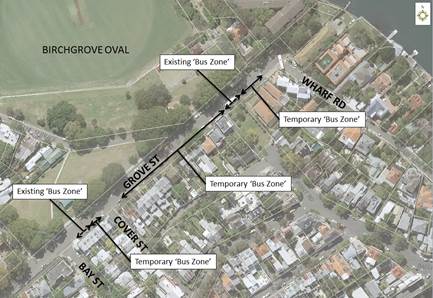
The signs defining the temporary restrictions will be in place prior to 12 Noon on the 31st of December 2017 and will be removed on the next available working day.
FINANCIAL IMPLICATIONS
Nil.
OTHER STAFF COMMENTS
Nil.
PUBLIC CONSULTATION
Public notification of this proposal was undertaken in 2016. No objections were received.
All affected residents of Grove Street, Birchgrove will be notified by Council of the proposed temporary Bus Zone for this year’s New Year's Eve event. The restrictions will be advertised by Council including on Council's website and associated social media.
CONCLUSION
Nil.
|
|
Local Traffic Committee Meeting 7 December 2017 |
Subject: Hoffman's Lane, Balmain - 'No Parking' restriction (Balmain Ward/Balmain Electorate/Leichhardt LAC)
Prepared By: Manod Wickramasinghe - Traffic and Parking Engineer
Authorised By: John Stephens - Traffic and Transport Services Manager
|
SUMMARY Concerns have been raised regarding obstructed pedestrian and vehicle access to No.3 Hoffman’s Lane, Balmain because of over-hanging vehicles. |
|
RECOMMENDATION
THAT the existing 8.5m ‘2P 8am-10pm Permit Holders Excepted Area B2’ parking restriction (3.5m parking space) currently signposted on the northern side of Hoffman’s Lane on the frontage of No.3 Hoffman’s Lane be converted into a ‘No Parking’ zone.
|
BACKGROUND
Concerns have been raised regarding obstructed pedestrian and vehicle access to No.3 Hoffman’s Lane, Balmain because of over-hanging vehicles.
There is only one section of parking in the lane which is outside No.3 Hoffman’s Lane with the rest of the laneway signposted as ‘No Parking’ or ‘No Stopping’.
The existing kerb space of 3.3m outside of No.3 Hoffman’s Lane is insufficient to accommodate a standard vehicle without impeding driveway/pedestrian access to No.3 or 5 Hoffman’s Lane. There is no footpath along Hoffman’s Lane and so pedestrians exiting the property must use the road.
Note the existing 2P signposting has been placed across the entire frontage No.3 Hoffman’s Lane (8.5m) however it only applies to the 3.5m space on the western side of the property.
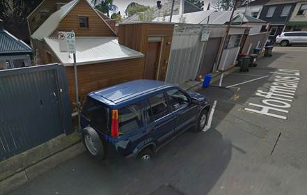
FINANCIAL IMPLICATIONS
Nil.
OTHER STAFF COMMENTS
In order to alleviate this issue, it is proposed to modify the existing two hour parking restriction on the northern side of Hoffman’s Lane on the frontage of No.3 Hoffman’s Lane into a ‘No Parking’ zone.
This proposal is shown on the following plan.
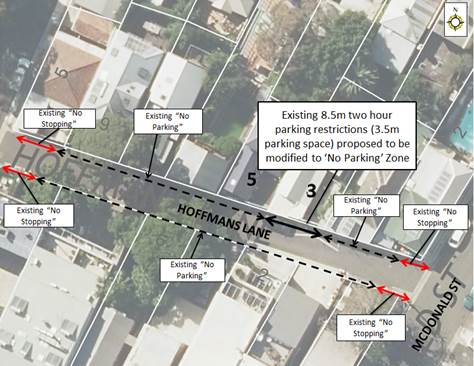
PUBLIC CONSULTATION
|
A letter outlining the above proposal was mailed out to the affected properties (17 properties) in Ford Street, Darling Street, McDonald Street and Hoffman’s Lane, Balmain. 12 responses were received from 5 properties, 3 properties were supporting the proposal and 3 were objecting to the proposal. |
|
|
Resident Comment |
Officer Response |
|
If removed additional residential parking is required in McDonald Street or Ford Street. |
Resident parking permits provided to Hoffman’s Lane residents allows parking in B5, B2 and B1 parking areas including McDonald Street, Ford Street and Curtis Road.
The spaces on the western side of McDonald Street between Darling Street and Hoffman’s Lane have been allocated to short-term customer parking including the provision of 1/4P Free parking tickets. Other sections of McDonald Street are avaiable to residents. |
|
Resident Parking permits should allow parking in the restricted spaces on McDonald Street near Darling Street |
|
|
There is already minimal parking for residents of this Lane and if anything, we should have more. |
|
|
This parking spot has been in the same exact position for over 80 years. The difference being firstly; we continue to be inundated with larger trucks along this thoroughfare. A size or weight restriction should be in place rather than removing parking.
|
The removal of parking is not being based on traffic movements, rather to ensure access is maintained to No.3 and 5 Hoffman’s Lane. |
|
Accessing ones frontage is a continuous problem for all residents as people park illegally for hours in the laneway regardless of signage going into commercial businesses on darling street (restaurants, bottle shop, cafes) so; how will taking away one spot in laneway change the behaviour of repeat offenders. |
Illegal parking in the laneway has been directed to Council’s Enforcement section |
|
No.3 Hoffman’s Lane already took parking spaces in the Lane to develop a 'driveway' which they actually use as a garden and never put their car there. It would be better if council could undo the unused 'false' driveway entrance at 3 Hoffman’s Ln, and give us parking spaces near our homes. |
Council cannot mandate use of an off-street parking facility but an approved off-street parking space does affect the number of parking permits available to a property within a Resident Parking Scheme which encourages use of a garage. |
|
I have often seen cars and trucks try to squeeze through, it also impedes the driveway opposite and both driveways on the east and western ends of the car space. |
Noted, the proposal seeks to address this. |
|
A car is permanently parked opposite the driveway at No.3 Hoffman’s Lane and causes difficulty every day getting in and out of the driveway which is located directly opposite. |
|
|
Any parking zone in front of residential entries without footpath and curb is a potential safety hazard. Furthermore, this parking zone is too small for a normal size car, as a result the residential entries of No. 3 and No. 5 Hoffman’s Lane are often blocked. |
CONCLUSION
It is recommended to modify the existing two hour parking restriction on the northern side of Hoffman’s Lane on the frontage of No.3 Hoffman’s Lane into a ‘No Parking’ zone.
|
|
Local Traffic Committee Meeting 7 December 2017 |
Subject: Trafalgar Lane, Annandale - 'No Parking' restrictions (Balmain Ward/Balmain Electorate/Leichhardt LAC)
Prepared By: Manod Wickramasinghe - Traffic and Parking Engineer
Authorised By: John Stephens - Traffic and Transport Services Manager
|
SUMMARY Concerns have been raised regarding vehicles in Trafalgar Lane and obstructing vehicular access to the off street parking spaces of a number of properties. Council has subsequently investigated ‘No Parking’ restrictions in Trafalgar Lane to resolve these concerns. |
|
RECOMMENDATION
THAT a ‘No Parking’ zone be installed on the western side of Trafalgar Lane, across the frontage of Nos.3-7 Trafalgar Lane and across the rear boundaries of Nos. 173–187A Trafalgar Street, Annandale.
|
BACKGROUND
Council has received representation from a number of residents, requesting installation of ‘No Parking’ restrictions on the western side of Trafalgar Lane, Annandale in order to prevent vehicles parking directly opposite of garage accesses and restricting movement throughout the laneway. Trafalgar Lane is approximately 5m wide and carries two-way traffic. It is primarily used as rear access to properties fronting Nelson Street and Trafalgar Street; however, there are a number of properties which front Trafalgar Lane directly.
FINANCIAL IMPLICATIONS
Nil.
OTHER STAFF COMMENTS
In order to address these issues raised by residents it was proposed to implement ‘No Parking’ zones on the western side of Trafalgar Lane, across the frontage of Nos.3-7 Trafalgar Lane and across the rear boundaries of Nos. 173–187A Trafalgar Street, Annandale.
This proposal is shown on the plan below.
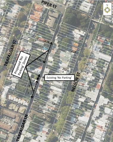
It was noted on-site that the parking spaces in front of Nos.3-7 Trafalgar Lane were frequently in use and so swept path analysis in this section was undertaken. This confirmed that parking in front of No.5-7 Trafalgar Lane does interfere with the garage access to Nos.182-186 Trafalgar Street, Annandale (refer to Attachment 1).
PUBLIC CONSULTATION
|
A letter outlining the above proposal was mailed out to the affected properties (67 properties) in Trafalgar Street, Trafalgar Lane and Nelson Street, Annandale. 21 responses were received, 15 supporting the proposal, 5 objecting and 1 property with a mixed response. |
|
|
Resident Comment |
Officer Response |
|
My garage is impacted by parking adjacent to Nos.5-7 Trafalgar Lane
Trafalgar Lane is primarily to allow property owners to access their garages. Council has noted in previous reports that laneways were generally built to provide service for properties and access into off- street parking facilities. The roads act provides for rights of access along roads and also for access to private property.
Parking opposite the garage obstructs safe entry and exit to my property. AS9280.1 states the average size car is 4.8m long. With cars parked opposite there is not sufficient transit to enter and exit. |
Noted, the proposal addresses these concerns. |
|
The lane is not suitable for parking it makes it difficult for council trucks to get passed and dangerous for drivers. |
|
|
I have not been able to use my rear lane parking in the garage for years now, because of parking in Trafalgar Lane. |
|
|
Review possible speed hump on both side of Trafalgar lane near Piper Street due to poor visibility and cars travelling at high speed. |
Traffic Counts undertaken in 2017 indicate that 85th Percentile speeds in Trafalgar Lane have been measured at 25km/h and is considered appropriate for the laneway. |
|
The lane will become more dangerous for pedestrians who share the lane. We know that when cars are parked outside our house cars slow down. This is very important in many ways including safety, and noise.
|
|
|
Creating a ‘No parking’ zone at 5-7 Trafalgar lane will increase traffic in what is already a rat run. A rat run that is getting worse with the construction of WestConnex. |
Traffic Counts undertaken in 2017 indicate average daily vehicle volumes of 220 vehicles per day. This is considered appropriate for the laneway and is not expected to increase as a result of this proposal. |
|
Parking on Nelson Street is becoming very difficult what solutions are being considered? |
Council has undertaken parking occupancy surveys in Nelson Street and is reviewing the results. Should the occupancy levels be above 85% in all survey periods then community consultation will commence in early 2018. |
|
The on-street parking (5-7) is not a problem as long as cars are parked legally.
|
Swept path analysis shows that parking in front of No.5-7 Trafalgar Lane does interfere with the garage access to Nos.182-186 Trafalgar Street, Annandale. |
|
There has never been an issue with parking opposite garages. They were installed and designed in full knowledge of on-street parking, these properties never suggested changing conditions of street parking). 182 Nelson Street garage is set back making access even easier
|
|
|
The No Parking needs to extend for garages at 193, 195 and 197 Trafalgar Street. |
This is outside the scope of the current investigation. These residents will have to submit formal requests to have this investigated. |
|
The parking area outside 7 Trafalgar lane is used by residents and visitors. This has always been parking and isn’t a problem for residents opposite. |
Council has received ongoing concerns from residents regarding obstructed access to off-street parking facilities accessed via Trafalgar Lane. |
|
5 Trafalgar Lane is a business premises and requires current parking arrangements outside the premises for business. |
It is noted that there will be a loss of on-street parking. There will be a small number of parking spaces left in Trafalgar Lane, alternate parking is available in Piper Street, Trafalgar Street and Nelson Street, Annandale. |
|
No. 5 Trafalgar has no off street parking. |
|
|
Parking will be reduced by 3 spots in area where parking is getting worse. |
|
|
Alternative parking is too far away to a business. |
|
|
We are one of few properties who are not permitted to build a garage and therefore we require all the parking we can get. If this restriction is overturned, I would be in favour of above. |
Applications for garages should be directed to Council’s planning department. |
|
The front of our property will become a garbage dump like the other “No parking/stopping zones” in the lane. |
Illegal dumping should be reported to the Inner West Council so that appropriate action can be taken. |
CONCLUSION
Based on the outcome of the consultation and swept path analysis, it is proposed to proceed with the installation of a ‘No Parking’ on the western side of Trafalgar Lane, across the frontage of Nos.3-7 Trafalgar Lane and across the rear boundaries of Nos. 173–187A Trafalgar Street, Annandale.
|
1.⇩ |
Swept Path - Trafalgar Lane, Annadale |
|
|
Local Traffic Committee Meeting 7 December 2017 |
Subject: Request
For ‘Works Zone’ Adjacent To Construction Sites (Marrickville Ward/
Summer Hill Electorate / Marrickville LACS)
Prepared By: Idris Hessam - Graduate Civil Engineer Traffic Services
Authorised By: John Stephens - Traffic and Transport Services Manager
|
SUMMARY A number of requests have been received from builders for the provision of 'Works Zone' to facilitate construction deliveries and permit the parking of construction vehicles during loading and unloading activities. It is recommended that the 'Works Zone' be approved for the construction works subject to Council fees and charges. |
|
RECOMMENDATION
THAT:
1. The installation of a ‘Works Zone 7AM-5.30PM Mon-Sat’ (total of 40 meters in length) on the eastern side of Livingstone Road adjacent to property no. 313-319 Marrickville Road, Marrickville be APPROVED for a period of twelve (12) months, for the proposed construction works; 2. The installation of a ‘Works Zone 7AM-5.30PM Mon-Sat’ (total of 12 metres in length) on the northern side of Ewart Street adjacent to property no. 260-264 Wardell Road, Marrickville be APPROVED for a period of twelve (12) months, for the proposed construction works; and 3. The costs of the supply, installation and removal of the signs and ‘Works Zone’ fees in accordance with Council’s Fees and Charges are to be borne by the applicants.
|
BACKGROUND
Written applications along with the plans illustrating the proposed locations of ‘Works Zone’ have been submitted to Council for consideration.
FINANCIAL IMPLICATIONS
The cost of the supply, installation and removal of the signs and ‘Works Zone’ fees are to be borne by the applicant in accordance with Council’s Fees and Charges.
OTHER STAFF COMMENTS
|
Subject Location |
Classification of Road |
Road Description |
|
Livingstone Road, Marrickville |
Local road |
Two-way street, 12.9m in width that runs north-South between Hastings Street and Marrickville Road. |
|
Ewart Street, Marrickville |
Local road |
Two-way street, 12.9m in width that runs west- east between Wardell Road and Bayley Street. |
313 -319 Marrickville Road, Marrickville (Livingstone Road Frontage)
The subject property is located on northern side of Marrickville Road, Marrickville. The proposed ‘Works Zone’ will be 40 metres in length and located on the eastern side of Livingstone Road adjacent to the site. It will be required for a period of approximately twelve (12) months, to be utilised by construction vehicles during deliveries and loading and unloading activities (refer to the below locality map and photographs).
At present, restricted parking [P-15min (M-F)] is permitted on western side of Livingstone Road Marrickville and unrestricted parking is permitted on eastern side. The parking spaces in the subject section of Livingstone Road are highly utilised by local residents. Therefore, the provision of a ‘Works Zone’ would provide a safe facility for loading and unloading activities at the subject site during the construction period.
260-264 Wardell Road, Marrickville (Ewart Street, Frontage)
The subject development site is located on the southern side of Wardell Road, Marrickville. The proposed ‘Works Zone’ will be 12 metres in length and located on the northern side of Ewart Street adjacent to property no. 260-264 Wardell Road, Marrickville. It will be required for a period of approximately twelve (12) months, to be utilised by construction vehicles during loading and unloading activities (refer to the attached locality map and photographs).
At present, unrestricted parking is permitted on both sides of Ewart Street, Marrickville.A night rider bus stop is currently located on northern side of Ewart Street, Marrickville adjacent to the site which operates approximately between 11:30pm to 5:30 am. The parking spaces in the subject section of Ewart Street are highly utilised by local residents. Therefore, the provision of a ‘Works Zone’ would provide a safe facility for loading and unloading activities at the subject site during the construction period.
Locality Map – 313-319 Marrickville Road, Marrickville (Livingstone Road Frontage)
![]()
![]()
![]()
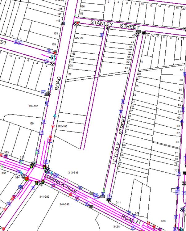
Photographs – Livingstone Road, Marrickville (adjacent to 313-319 Marrickville Road, Marrickville)
![]()


![]()

![]()
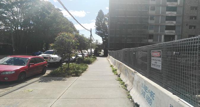
The proposed location of the ‘Works Zone’ in Livingstone Road, Marrickville.
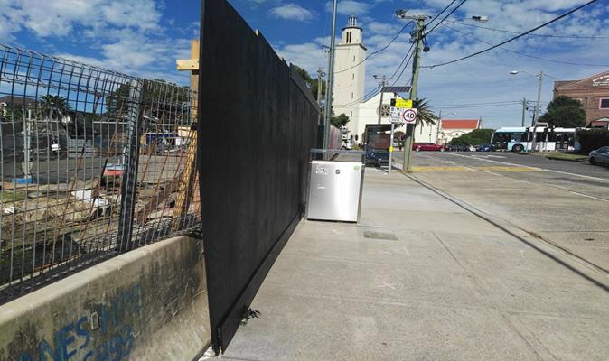
On-street parking in Livingstone Road outside of the construction site
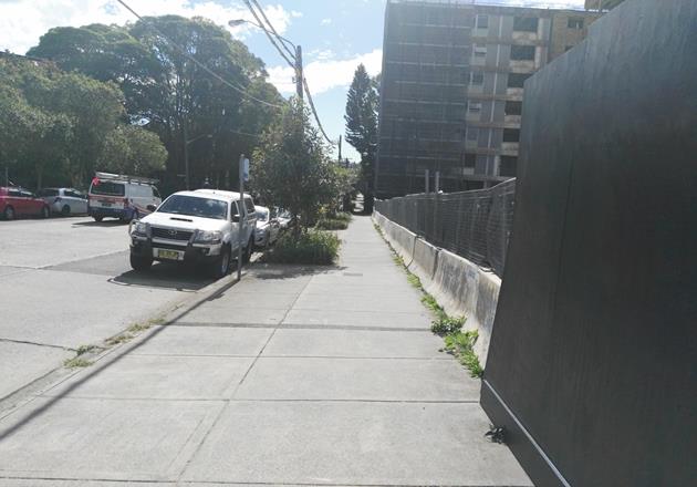
On-street parking in Livingstone Road outside of the construction site
Locality Map – 260-264 Wardell Road, Marrickville (Ewart Street Frontage)
![]()
![]()
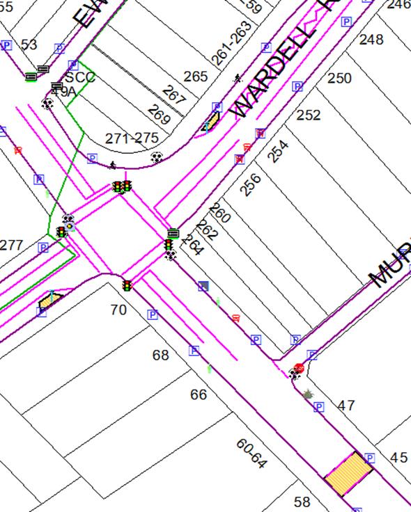
Photographs – Ewart Street, Marrickville (Adjacent to 260- 264 Wardell Road, Marrickville)
|
|
The proposed location of the ‘Works Zone’ in Ewart Street, Marrickville
|
|
On-street parking in Ewart Street outside of the construction site
PUBLIC CONSULTATION
A notification letter has been sent to the applicants informing them of the application process and as part of the assessment they will be considered at this meeting.
CONCLUSION
To better facilitate construction deliveries and allow the parking of construction vehicles during loading and unloading activities the installation of the 'Works Zone’ locations listed in this report is recommended for approval.
|
|
Local Traffic Committee Meeting 7 December 2017 |
Subject: Requests
For Mobility Parking Spaces
(Marrickville & Ashfield Wards/Summer Hill Electorate / Marrickville LAC)
Prepared By: Idris Hessam - Graduate Civil Engineer Traffic Services
Authorised By: John Stephens - Traffic and Transport Services Manager
|
SUMMARY A number of requests have been received from residents for the provision of dedicated mobility parking space outside their residence. It is recommended that the following 'Mobility Parking' spaces be approved as the applicant’s current medical conditions warrants the provision of the space and they have constrained or no off-street parking opportunities. |
|
RECOMMENDATION
THAT:
1. Southern side of Kays Avenue West, Dulwich Hill infront of property no. 18 Kays Avenue West, Dulwich Hill; 2. Southern side of Kintore Street, Dulwich Hill infront of property no. 32 Kintore Street, Dulwich Hill 3. Southern side of Livingstone Road, Marrickville infront of property no. 210 Livingstone Road, Marrickville; be APPROVED as a ‘mobility parking’ space, subject to: a) The operation of the dedicated parking space be valid for twelve (12) months from the date of installation; b) The applicant advising Council of any changes in circumstances affecting the need for the special parking space; and c) The applicant is requested to furnish a medical certificate and current mobility permit justifying the need for the mobility parking space for its continuation after each 12 months period.
|
BACKGROUND
A copy of the RMS disability parking permit and a medical certificate in support of the applications was submitted to Council.
FINANCIAL IMPLICATIONS
The costs of the supply and installation of the signposting associated with the recommended mobility parking space is approximately $1500.
It should be noted that Council normally signposts on-street mobility parking spaces and does not line mark these spaces. Should the applicant require the provision of kerb ramps, this can be provided at their cost.
OFFICER COMMENTS
|
Subject Location |
Classification of Road |
Road Description |
|
Kays Avenue West, Dulwich Hill |
Local Road |
Two-way residential street, 12.9m in width that runs west-east from Wardell Road to Albermarle Street. |
|
Kintore Street, Dulwich Hill |
Local Road |
Two-way residential street, 12.9m in width that runs west-east from Blackwood Avenue to MacArthur Road. |
|
Livingstone Road, Marrickville |
Local Road |
Two-way residential street, 9.9m in width that runs west-east from Arthur Street to Francis Street. |
18 Kays Avenue West, Dulwich Hill
The applicant’s property is located on the southern side of Kays Avenue West, Dulwich Hill. The applicant’s property has one off-street parking facility which is too narrow (2.3m in width) to be used as off street parking space.
At present,’2P 8.30am – 6 pm Mon – Fri; Permit Holders Excepted; Area M13’ restrictions provided on the northern side and unrestricted parking is permitted on the southern side of Kays Avenue West, Dulwich Hill. It has been observed during a site inspection undertaken in the afternoon period that on-street parking spaces in Kays Avenue West, Dulwich Hill were moderately utilised.
The applicant does not drive a vehicle however she is driven by another family member. Currently, there is one existing mobility parking space in close proximity to applicant’s property (Refer to locality map). Due to her current medical condition, she requires parking availability close to her property.
32 Kintore Street, Dulwich Hill
The applicant’s property is located on the southern side of Kintore Street, Dulwich Hill. The applicant’s property has no off-street parking facility.
At present, unrestricted parking is permitted on both sides of Kintore Street, Dulwich Hill. It has been observed during a site inspection undertaken in the afternoon period that on-street parking spaces in Kintore Street were moderately utilised.
The applicant does drive a vehicle and currently there is no existing mobility parking space within close proximity to his property. Due to his current medical condition, he requires parking availability close to his property.
210 Livingstone Road, Marrickville
The applicant’s property is located on the southern side of Livingstone Road, Marrickville. The applicant’s property has no off-street parking facility.
At present, unrestricted parking is permitted on both sides of Livingstone Road, Marrickville. It has been observed during a site inspection undertaken in the afternoon period that on-street parking spaces in Livingstone Road were moderately utilised.
The applicant does drive a vehicle however due to her current medical condition, she requires parking availability close to her property.
Technical Standards
Australian Standard AS2890.5-1993 “On-Street Parking” states the following in regards to the provision of parking for people with a disability:
“Parallel parking spaces shall not be marked as disabled spaces, nor included in the count of spaces available for people with disabilities unless –
i. A 3.2m wide space can be provided, e.g. by indenting the space into the footpath area; and
ii. Kerb ramps as shown in Figure 4.2(a) are also provided”.
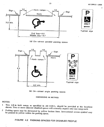
It should be noted that due to the limited width of streets around the Marrickville LGA, it is often difficult to comply with these requirements for the parking space dimensions. This may also result in the loss of some adjacent on-street parking spaces.
Mobility parking spaces are primarily intended for on-street and off-street parking at destinations, such as in commercial/retail areas and public car parks near hospitals, schools and public transport facilities where multiple usages can be expected. They were generally not intended for points of origin such as reserving on-street parking.
A mobility parking space is not intended for the sole use of one applicant, but rather a shared facility that can used by all authorised persons having an RMS mobility permit.
PUBLIC CONSULTATION
A notification letter has been sent to the applicants informing them of the application process and as part of the assessment they will be considered at this meeting.
CONCLUSION
It is recommended that ‘Mobility Parking' spaces be approved as the applicant’s properties do not have an off-street parking facility and/or the applicants condition warrants the provision of the space.
It should be noted that the proposed mobility parking spaces are not for the sole use of the applicant and may be used by other authorised persons.
Locality Map – 18 Kays Avenue West, Dulwich Hill
![]()
![]()
![]()
![]()
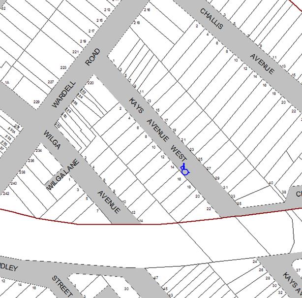
Photographs – 18 Kays Avenue West, Dulwich Hill
|
|
The frontage of the applicant's property in kays Avenue West, Dulwich Hill
|
|
On-street parking in Kays Avenue West, Dulwich Hill
Locality Map – 32 Kintore Street, Dulwich Hill
|
|
![]()
Photographs – 32 Kintore Street, Dulwich Hill
|
|
The frontage of the applicant's property in Kintore Street, Dulwich Hill
|
|
On-street parking in Kintore Street, Dulwich Hill
Locality Map – 210 Livingstone Road, Marrickville
|
|
Photographs – 210 Livingstone Road, Marrickville
|
|
The frontage of the applicant's property in Livingstone Road, Marrickville
|
|
On-street parking in Livingstone Road, Marrickville
|
|
Local Traffic Committee Meeting 7 December 2017 |
Subject: Requests for Statutory ‘No Stopping’ Restriction (Stanmore Ward/Newtown Electorate /Marrickville LAC)
Prepared By: Idris Hessam - Graduate Civil Engineer Traffic Services
Authorised By: John Stephens - Traffic and Transport Services Manager
|
SUMMARY A request has been received from a local resident for the provision of ‘No Stopping’ restrictions to deter illegal parking at the eastern side of Trafalgar Street adjacent to property no.1 Nelson Place, Petersham. The resident has advised that vehicles are regularly parked too close to the intersection, restricting sightlines for motorists turning into Trafalgar Street. It is recommended that statutory 'No Stopping' restrictions be installed on the eastern side of Trafalgar north its intersection with Nelson Street for a distance of 10m in order to deter illegal parking, increase safety and improve visibility and access. |
|
RECOMMENDATION
THAT:
1. The installation of a statutory ‘No Stopping’ restriction on the eastern side of Trafalgar Street, Petersham for a distance of 10m, east of its intersection with Nelson Place, Petersham (adjacent to property no. 1 Nelson Place, Petersham) be APPROVED, in order to deter illegal parking, increase safety and improve motorist visibility and access; and
2. The applicant, affected residents and Council Rangers be advised in terms of this report.
|
BACKGROUND
In accordance with the Australian Road Rules (ARR 170-3), vehicles are not permitted to park within 10m of an intersection unless otherwise signposted. Pursuant with the Roads and Maritime Services (RMS) Technical Directions, signposting at an unsignalised intersection (without pedestrian crossing) “should only be required where there is a compliance problem or there is adjoining signposting”. In this case, it is shown to be an adjoining signposting as well as compliance and safety problem, for motorists attempting to turn.
FINANCIAL IMPLICATIONS
The cost of installation of the ‘No Stopping’ restriction is approximately $500 and can be met from Council’s operating budget.
OFFICER COMMENTS
|
Subject Location |
Classification of Road |
Road Description |
|
Trafalgar St, Petersham |
Local road |
Trafalgar Street is a two way mixed-use local street in a residential area, 12.9m in width that runs east - west between Gordon Street and Audley Street, Petersham. |
|
Nelson Place, Petersham |
Local Road |
Nelson Place is a two way mixed-use local street in a residential area, 10.1m in width that runs north - south between Trafalgar Street and Sadlier Crescent, Petersham. |
A complaint has been raised by a local resident that motorist are parking within 10 metres of the intersection of Trafalgar Street, Petersham at its intersection with Nelson Place blocking the sightlines of motorist’s turning into Trafalgar Street from Nelson Place, Petersham. The resident has also raised a concern that disable people cannot use the pedestrian kerb ramps due to vehicles parking too close to the intersection. It has been observed during a site inspection that vehicles park on Trafalgar Street close to its intersection with Nelson Street, Petersham.
PUBLIC CONSULTATION
A reply letter will be sent to the residents who have raised the concerns informing them of the application process. Council typically does not undertake consultation in relation to the installation of ‘No Stropping’ restriction, as it is a matter of reinforcing the Road Rules. However, adjacent properties will be notified of the proposed changes prior to the installation of the statutory ‘No Stopping’ restriction.
CONCLUSION
It is recommended that the installation of a statutory ‘No Stopping’ restriction on the eastern side of Trafalgar Street, Petersham for a distance of 10m, least of its intersection with Nelson Place, Petersham (adjacent to property no. 1 Nelson Place, Petersham) be APPROVED, in order to deter illegal parking, increase safety and improve motorist visibility and access.
Locality map – Trafalgar Street, Petersham (adjacent to No. 1 Nelson Place, Petersham)
![]()
![]()
![]()

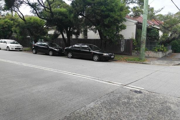
Photograph – Nelson Place, Petersham (at Trafalgar Street)
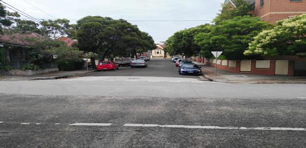
Intersection of Nelson Place at Trafalgar Street (facing south)
|
|
Local Traffic Committee Meeting 7 December 2017 |
Subject: Smidmore Street, Marrickville – Request by BreastScreen NSW to position a mobile x-ray unit outside Marrickville Metro (Marrickville Ward / Summer Hill Electorate / Marrickville LAC)
Prepared By: Jennifer Adams - Traffic and Road Safety Officer
Authorised By: John Stephens - Traffic and Transport Services Manager
|
SUMMARY A request has been received from ‘BreastScreen New South Wales’ to position a mobile x-ray van in Smidmore Street, Marrickville outside Marrickivlle Metro, for a period of seven (7) weeks from 29 March 2018, as in previous years. It is recommended that the request be approved, on the basis of this being an annual occurrence with no major problems being encountered previously.
|
|
RECOMMENDATION
THAT:
1. The positioning of a ‘BreastScreen NSW.’ mobile x-ray van on the northern side of Smidmore Street, Marrickville, approximately 55 metres east of Edinburgh Road, outside the Marrickville Metro Shopping Centre, be APPROVED, for a period of seven (7) weeks from Thursday 29 March to Friday 18 May 2018; and
2. The existing ‘No Parking’ restrictions (for the length of van) be temporarily removed for the proposed duration (i.e. 29 March to 18 May 2018).
|
BACKGROUND
The Marketing and Recruitment Officer for ‘BreastScreen NSW’ has submitted a letter to Council dated 15 November 2017, seeking permission to position a mobile x-ray van on the northern side of Smidmore Street in close proximity to the Marrickville Metro Shopping Centre, as in previous years (Refer to the attached copy of the letter and schematic diagram).
The van would be on site for a period of seven (7) weeks, from Thursday 29 March 2018 to Friday 18 May 2018. The positioning of this van at this location has been occurring annually. (Refer to locational diagram).
FINANCIAL IMPLICATIONS
There are no financial implications for Council from this proposal.
OFFICER COMMENTS
The site requested is on the northern side of Smidmore Street, approximately 55 metres east of Edinburgh Road. The location is within a section of 'No Parking' restrictions and has been used for several years for the same purpose without any problems. The location is away from the main entrance to the Marrickville Metro Shopping Centre, adjacent to the ‘Taxi Stand’ and ‘Bus Zone’ so it does not interfere with pedestrian or vehicular movements.
PUBLIC CONSULTATION
No public consultation is required. The Marketing and Recruitment Officer for ‘BreastScreen NSW’ has discussed the proposal with the Centre Management at Marrickville Metro Shopping Centre. Should the need arise for relocation of the mobile x-ray van the present parking restricted area on Murray Street just south of the pedestrian zebra crossing has been identified as a backup location.
CONCLUSION
It is recommended that the positioning of the mobile x-ray van at this location be approved, as in previous years.
![]()
![]()
![]()
![]()
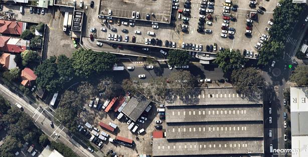
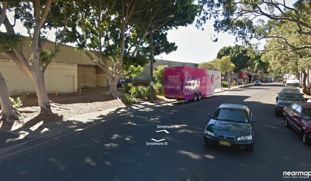
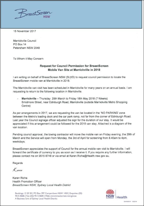
|
|
Local Traffic Committee Meeting 7 December 2017 |
Subject: Brereton Lane, Marrickville – ‘No Parking’ restrictions in the laneway (Marrickville Ward / Summer Hill Electorate / Marrickville LAC)
Prepared By: Jennifer Adams - Traffic and Road Safety Officer
Authorised By: John Stephens - Traffic and Transport Services Manager
|
SUMMARY A resident of Brereton Avenue, Marrickville raised concerns regarding vehicles being parked in Brereton Lane opposite their driveway and thereby restricting vehicular access into and out of their driveway. Residents have been notified of a proposal to install an 18 metre length of ‘No Parking’ restrictions in Brereton Lane, Marrickville on the northern side of the laneway from the statutory 10 metre ‘No Stopping’ section. The reason for this proposal is to provide clear vehicular access to resident’s off-street parking facilities. It is recommended that this proposal be approved.
|
|
RECOMMENDATION
THAT:
1. The installation of statutory ‘No Stopping’ restrictions on the northern side of Brereton Lane, Marrickville for a distance of 10 metres from its intersection with Brereton Avenue, Marrickville be APPROVED, in order to deter illegal parking, improve access for turning motorists and increase safety; 2. The installation of an 18 metre length full-time ‘No Parking’ restrictions in Brereton Lane, Marrickville on the northern side of the laneway from the statutory 10 metre ‘No Stopping’ section be APPROVED, in order to provide unobstructed vehicular access to the laneway and to off-street car parking facilities; and 3. The applicant, responders and Council Rangers be advised in terms of this report.
|
BACKGROUND
Concerns have been raised by a resident of Brereton Avenue, Marrickville that vehicles are often parked in Brereton Lane opposite their driveway thereby restricting vehicular access into and out of their driveway. This is compounded by the very narrow width of the laneway.
The applicant’s property is located on the southern side of Brereton Lane and has a driveway accessed from Brereton Lane, Marrickville. (Refer to the attached locality map and photographs).
FINANCIAL IMPLICATIONS
The costs of the supply and installation of the signposting associated with the recommended ‘No Parking’ & ‘No Stopping’ restrictions are approximately $800 and can be met from Council’s operating budget.
OTHER STAFF COMMENTS
Brereton Lane is approximately 3.5 metres in width and it runs for approximately 66 metres east-west between Brereton Avenue and Petersham Road, Marrickville providing access to properties fronting Brereton Lane and to off-street parking facilities for properties in Brereton Avenue and Petersham Road. At present, there are no parking restrictions along the laneway.
A site inspection undertaken by a Council Officer revealed there are several vehicular crossings in the laneway. It was observed during the site inspection off-street parking facilities were utilised. It was also noted that there is a moderate demand for parking in the locality (at the time of the site inspection) and vehicles in the locality were parked across driveways / kerb ramps and/or half on the verge/road. This proposal will provide more space for residents to turn in and out of their off-street parking facilities.
Parking in laneways
Council’s Laneway Parking Guidelines outline the measures to consider when the use of the laneway prohibits access to off-street parking and access through the laneway. The effective use of narrow streets and laneways alleviates parking pressure. Effectively managed laneways allow for adequate access while providing the maximum amount of on-street parking.
The Road Rules includes requirements which affect parking at intersections, driveways and also parking along laneways. Council’s preference is for residents to negotiate with each other to avoid implementing parking bans. Where problems occur, parking restrictions can be considered for individual laneways on a case-by-case basis. The guidelines provide consistency for assessing the need for parking controls.
The laneway access priorities below have been developed to help Council decide whether parking is permitted in a laneway and determine how much space is required for the most important uses. The priorities for the use of the available space in laneways are listed in the table below in order of priority.
|
Priority (Highest to Lowest) |
Description |
|
Emergency access |
Provide access according to Australian Standards |
|
Deliveries and waste collection services |
Maintain access for waste collection and delivery trucks where required |
|
Access to off-street parking |
Ensure adequate access to properties along the laneway to maximise use of existing off-street parking |
|
Accessible on-street parking |
Provide accessible parking spaces for people with a disability where appropriate and in accordance with the standards |
|
On-street parking |
Allow parking in laneways where appropriate access is maintained. Parking signs to be installed to manage access where needed. |
The laneway width is the most important factor for determining whether parking is feasible. For example, narrow laneways that provide the only access route for emergency vehicles or waste service trucks must have enough space to maintain access for these vehicles.
For parking to be allowed in a narrow laneway, the Australian Standards require that parallel parking spaces be at least 2.1 metres wide and NSW Road Rules requires that at least 3 metres must be available between a parked car and the kerb or edge of the laneway to allow moving vehicles to pass safely. Therefore, laneway widths that are less than 5.1 metres wide are too narrow to allow parking as any parked vehicle would prevent traffic from using the laneway.
When vehicles are parked in narrow laneways near street intersections, sharp bends or driveways, there needs to be enough space for vehicles to turn. The guidelines allow for signs which ban parking to be considered next to driveways and at entries to laneways to ensure that vehicles are able to safely turn. This includes an assessment of the minimum amount of space needed for vehicles to turn in and out of a driveway. The figure below shows an example of where ‘No Parking’ signs would be considered to allow a car to do a three-point turn into a laneway with parking banned on one-side of a laneway less than 6 metres wide.
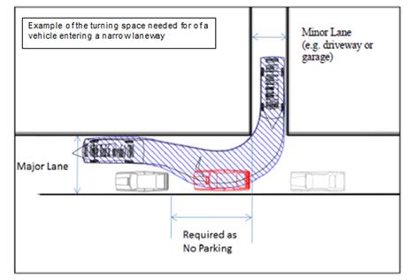
As a general principle, these guidelines would restrict parking across the driveway access and also on the opposite side of the laneway to maintain vehicle access to properties. Parked vehicles which encroach into the ‘No Parking’ area are likely to obstruct vehicle access into and out of properties.
It should be noted that laneways were generally built to provide service for properties and access into off-street parking facilities therefore restricting parking in this laneway will help achieve this goal.
PUBLIC CONSULTATION
A notification letter was hand delivered on 14 November 2017 to properties fronting Brereton Lane, Marrickville regarding the proposal to install an 18 metre length of ‘No Parking’ restrictions in Brereton Lane, Marrickville on the northern side of the laneway from the statutory 10 metre ‘No Stopping’ section, in order to provide clear vehicular access to resident’s off-street parking facilities.
The closing date for submissions ended on 28 November 2017.
Resident survey findings
A total of four (4) responses were received from residents. Of these, two submissions supported the proposal and two objected to the installation of the parking restrictions in the laneway. Of the objectors one said access issues ‘can be alleviated by slightly extending the 10m ‘No Stopping’ section only’ and the other said that the a lack of available parking in the area generally is the issue and requested possible angle parking in Brereton Avenue.
CONCLUSION
Brereton Lane is very narrow and technically there should be no parking allowed in the laneway. It is noted, however, that parking has been occurring in the lane, which is acceptable provided that access through the laneway for all vehicles, including emergency vehicles, is possible and residents’ have access to any off-street parking facilities.
Should a vehicle be parked close to or opposite a driveway, vehicle access can be impeded. ‘No Parking’ restrictions would assist residents with driveway access who may be experiencing access difficulties. Therefore, in order to provide clear vehicular access to residents’ off-street parking facilities, it is recommended that an 18 metre length of ‘No Parking’ restrictions in Brereton Lane, Marrickville on the northern side of the laneway from the statutory 10 metre ‘No Stopping’ section be approved and installed.
|
Proposed ‘No Parking’ restrictions (northern side) Brereton Lane, Marrickville
|
Locality Map – Brereton Lane, Marrickville
![]()
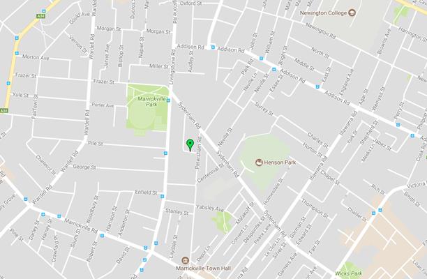
Photographs – Brereton Lane, Marrickville
![]()
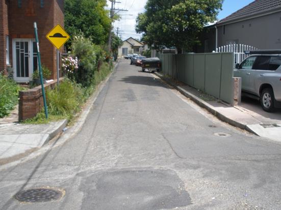
![]()
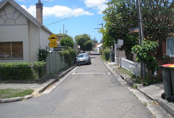
Location of new signage – Brereton Lane, Marrickville
 |
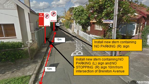
|
|
Local Traffic Committee Meeting 7 December 2017 |
Subject: Request for a Works Zone outside No.1 Heighway Avenue, Ashfield.
(Ashfield Ward/Summer Hill Electorate/Ashfield LAC)
Prepared By: Boris Muha - Traffic and Projects Engineer
Authorised By: John Stephens - Traffic and Transport Services Manager
|
SUMMARY A request has been received from a builder to install a temporary ‘Works Zone’ 7.00am to 6.00pm Mon – Fri and 7.00am to 1.00pm Sat within the frontage of No.1 Heighway Avenue, Ashfield. The Works Zone is approximately 9m in length and is generally provided to assist in the parking of construction vehicles for the loading and unloading of materials to the site. |
|
RECOMMENDATION
THAT:
1. A Works Zone 7.00am to 6.00pm Mon-Fri and 7.00am to 1.00pm Sat, 9m in length be temporary installed outside No.1 Heighway Avenue, Ashfield for a period of five (5) months;
2. The “2P, 8.00am to 6.00pm Permit Holders Excepted Area 2” parking restrictions outside No.1 Heighway Avenue be temporarily removed; and
3. The cost of supply, installation and removal of the signs for the Works Zone are to be borne by the applicant in accordance with Council’s fees and charges.
|
BACKGROUND
The builders for the development at No.1 Heighway Avenue, Ashfield has requested Council to install a temporary Works Zone outside the above property. The Works Zone is required to park construction vehicles for the loading and unloading of the materials to the site.
FINANCIAL IMPLICATIONS
The cost of supply, installation and removal of the signs for the Works Zone are to borne by the applicant in accordance with Council’s fees and charges.
OTHER STAFF COMMENTS
This section of Heighway Avenue between Frederick Street and the cul-de-sac is a two way dead end street measuring approximately 13m wide kerb to kerb and 83metres in length. Parking is provided on both sides of the street, and is restricted to “2P 8.00am to 6.00pm Mon – Fri Permit Holder Excepted Area 2” to both sides of the road.
The Works Zone outside No.1 Heighway Avenue, Summer Hill is on the north side of the street. The proposed Works Zone is 9m in length and is to be used for an approximate period of five (5) months. The parking space outside the property is currently signposted as “2P 8.00am-6.00pm Mon –Fri, Permit Holders Excepted Area 2”, and is mostly utilised by the local residents. The provision for a Works Zone would provide a safe facility for the loading and unloading of materials to the site during the construction period.
PUBLIC CONSULTATION
Not applicable. The Work zone will apply within the frontage of the site No. 1 Heighway Avenue.
CONCLUSION
The proposed temporary Works Zone will generally assist the parking of construction vehicles for the loading and unloading of materials to the site. It is recommended that a Works Zone be placed at the front of No.1 Heighway Avenue, Ashfield.
|
1.⇩ |
Proposed 9m Works Zone, 1 Heighway Avenue, Ashfield |
|
2.⇩ |
Proposed Works Zone location (northside of Heighway Avenue, Ashfield) |
|
|
Local Traffic Committee Meeting 7 December 2017 |
Subject: Minor Traffic Facilities (No Stopping At Intersections) In Ashfield & Croydon, (Leichhardt Ward/Summer Hill Electorate/Ashfield LAC)
Prepared By: Anca Eriksson - Traffic Officer
Authorised By: John Stephens - Traffic and Transport Services Manager
|
SUMMARY This report considers minor traffic facility applications received within the Ashfield and Croydon areas of Inner West Council. The requests have been received from residents for the provision of ‘No Stopping’ restrictions to deter illegal parking and to improve safety at a number of intersections.
|
|
RECOMMENDATION
THAT:
1. The installation of statutory ‘No Stopping’ signs on the north-west side of Sunbeam Avenue, 10m south of Croydon Road, Croydon, be approved;
2. The installation of statutory ’No Stopping’ signs (both sides) in Farleigh Street at its intersection with Clissold Street, Ashfield, be approved; and
3. The installation of 15m ‘No Stopping’ on the eastern side Queen Street, Ashfield south of Clissold Street, be approved.
|
BACKGROUND
Residents have advised that vehicles are regularly parked too close to the following intersections; Sunbeam Avenue at Croydon Road (Map 1). Farleigh Street south of Clissold Road (Map 2) and Queen Street, south of Clissold Road (Map 3). This reduces the sight lines of turning motorists at the intersections.
At present, there are no restrictions at the above mentioned intersections.
FINANCIAL IMPLICATIONS
The proposals will be funded from Council's signs & line marking budget.
OTHER STAFF COMMENTS
All requests have been investigated and a summary of these investigations and proposed parking restrictions at various locations are presented in this report.
PUBLIC CONSULTATION
Council typically does not undertake consultation in relation to installation of statutory ‘No Stopping’ restrictions at intersections as it’s a matter of improving safety by reinforcing the Road Rules. However, adjacent residents have been notified of the proposed installation of the ‘No Stopping’ signage. A letter outlining the above proposal was sent out to the affected properties in the above mentioned streets.
In response to council’s notification letter sent out on 31 Oct 2017, two (2) of the seven (7) households on Farleigh Street responded, commenting that there was no need to install the ‘No Stopping’ signage, as there is a quite high demand for on-street parking in this streets.
|
Subject Location |
Road Classification |
Residents comments |
|
Sunbeam Road at Croydon Road, Croydon |
Local Road |
None. |
|
Farleigh Street, at the intersection with Clissold Street, Ashfield |
Local Road
|
1. Resident opposes the implementation of ‘No Stopping’ restrictions as she usually parks close to the intersection when visiting her mother at 20 Clissold Street. 2. The family living at 5 Farleigh St Ashfield strongly objected to the proposed changes. The resident stated that the loss of parking spaces would have a negative impact on residents of the street. 3. There are two businesses that generate lots of on-street parking on this street: a. The nursing home on Clissold St b. The swimming school inside the nursing home |
|
Queen Street, Ashfield south of Clissold Street
|
Local Road |
None.
|
CONCLUSION
It is recommended that 'No Stopping' restrictions be installed at the locations listed within this report in order to deter illegal parking, improve visibility, access and safety.
|
1.⇩ |
No stopping various locations |
|
Local Traffic Committee Meeting 7 December 2017 |
Subject: Elizabeth Street, Between Railway Street and Bastable Street, Croydon - Removal of Pm Peak ‘No Stopping’ & Providing Short Term Parking
Prepared By: Anca Eriksson - Traffic Officer
Authorised By: John Stephens - Traffic and Transport Services Manager
Council has received concerns from residents/shopkeepers about a lack of short term parking for customers on Elizabeth Street between Edwin Street North and Bastable Street, Croydon. Queries have also been received with regard to the ongoing need for the PM peak “No Stopping” restriction on the southern side of Elizabeth Street.
|
RECOMMENDATION
THAT:
1. The current ‘No Stopping, 3.30pm-6pm Mon-Fri’ restrictions on the southern side of Elizabeth Street between Bastable Street and Railway Street be removed;
2. Extend the existing full-time ‘No Stopping’ restrictions on the southern side of Elizabeth Street, across the driveway of No. 198 Elizabeth Street by approx. 9m (commencing 36m and west of Bastable Street); and
3. Install new ‘2P 9am- 3pm Mon-Fri’ restrictions for a distance of 23 m commencing 12 m west of Bastable Street.
|
BACKGROUND
The area of concern is southern side of Elizabeth Street between Bastable Street and Railway Street, Croydon (see attached map 1). There are both business and residential properties in this area including; a books& records shop, a coffee shop and a conveyancer are all located on the eastern side of Railway Street as well as a furniture maker and a printing business located on Elizabeth Street western of Railway Street. As Croydon train station is located nearby the parking spaces at this location are often occupied by commuters during the day, thereby making it harder for visitors to the businesses or residents to access these spaces.
The current signposting & proposed parking restrictions in Elizabeth Street are presented in the attached diagram (Fig 1).
Concern was raised as to the reason to remove the PM peak ‘No Stopping’ restriction (i.e. from 3.00pm-6.00pm) located on the southern side of Elizabeth Street, between Bastable Street and Railway Street with unrestricted parking available at other times.
FINANCIAL IMPLICATIONS
The cost of the supply & installation of the signposting is approximatively $1000 and can be met from Councils signs & the line marking budget.
OTHER STAFF COMMENTS
Council’s officers have investigated the traffic conditions in Elizabeth Street near the intersection Croydon Road/Elizabeth Street. Turning movements and traffic flow were observed during a Friday afternoon peak period.
Both Elizabeth Street and Croydon Road are local roads and are used as a by pass for traffic avoiding the M4, Liverpool Road and Parramatta Road. In the peak afternoon period traffic flows in a single lane in the westerly direction (towards Edwin Street North) with many vehicles turning right into Croydon Road. The accident history in the area is low, and the patterns of accidents do not appear to have any bearing upon parking and traffic movement along the southern side of Elizabeth Street.
In order to further improve parking opportunities for residents and businesses as well as improve traffic flow in this section of Elzabeth Street, between Railway Street and Bastable Street it is proposed that the parking restrictions along the section of Elizabeth Street be amended as follows:
1. The current ‘No Stopping, 3.30pm-6pm Mon-Fri’ restrictions on the southern side of Elizabeth Street between Bastable Street and Railway Street be removed;
2. Extend the existing full-time ‘No Stopping’ restrictions on the southern side of Elizabeth Street, across the driveway of No. 198 Elizabeth Street by approx. 9m (commencing 36m and west of Bastable Street);
3. Install new ‘2P 9am- 3pm Mon-Fri’ restrictions for a distance of 23.5 m commencing 12.5 m west of Bastable Street.
PUBLIC CONSULTATION
In June 2017 Council wrote to residents and business in Elizabeth Street advising of the removal of the PM Peak ‘No Stopping’ on the southern side of Elizabeth Street between Railway Street and Bastable Street, Croydon. Additionally Council proposed; to extend the existing full-time ‘No stopping’ restriction by approx. 9 m on the southern side of Elizabeth Street across the drive way. Residents & shop owners wrote back to Council, recommending the introduction of 1 or 2 hours parking restriction on Elizabeth Street between Edwin Street North and Bastable Street (according to Fig 1) given the need for parking in this section of Elizabeth Street.
Below is a summary of the issues raised by four residents/businesses from the initial consultation undertaken in June 2017. This proposal was sent to 21 properties along Elizabeth Street.
|
Resident feedback
|
Officer Comments |
|
1. Three residents proposed 1-2 hours parking restrictions on Elizabeth Street between Railway Street and Bastable Street to prevent all day parking on this section of Elizabeth Street.
|
Loss of parking space (due to proposed relocation of the ‘No Stopping’ sign across the drive way) was not supported. |
|
2. A resident expressed her concerns about all day commuters parking and she is supporting the introduction of 2 hours parking restrictions in this section of the Elizabeth Street. |
Loss of one parking space (whilst Council proposed to relocate the ‘No Stopping’ sign across the drive way) not supported. |
|
3. Concerns about the commuters and local workers parking in this section of Elizabeth Street. Opposed Council’s proposal to leave the area unrestricted. |
Matter to be addressed in a review of the initial proposal. |
|
4. Concerns was raised regarding removal of the entire No Stopping PM peak section would not reduce congestion. |
Full time No Stopping zone to be extended to assist as a by-pass area for traffic travelling straight along Elizabeth Street |
Council then organised a second round of consultation in November 2017. A new consultation letter was sent outlining the above proposal to:
1. Remove the current ‘No Stopping, 3.30pm-6pm Mon-Fri’ on the southern side of Elizabeth Street between Railway Street and Bastable Street. Replace these with a 2P restriction 9am-3pm Mon-Fri. The proposal addresses the need to have an appropriate turnover of parking to facilitate the existing businesses in the area and to meet the various needs of local residents.
2. Extend the existing full-time ‘No Stopping’ restrictions by approx. 9m on the southern side of Elizabeth Street, across the driveway of No. 198 Elizabeth Street (between 36m and 45m west of Bastable Street) to allow for traffic to slip around vehicles waiting to turn right into Croydon Road and avoid traffic congestion.
|
Comments |
Officers response |
|
A resident raised concerns about the lack of parking spaces for residents only and suggested the introduction of resident parking scheme for those four (4) proposed 2 hours restricted parking spaces (area 6).
|
The restrictions are considered adequate for parking needs for the surrounding businesses. The following proposal addresses the need to have an appropriate turnover of parking for customers to facilitate the existing businesses in the area.
|
CONCLUSION
The provision of 2P parking restrictions on Elizabeth Street would be beneficial to both local residents and shop owners by preventing commuters from parking over long periods but at the same time providing parking for customers to the local businesses.
In order to provide more short term parking spaces, it is recommended that the proposed parking changes be supported.
|
1.⇩ |
Removal of PM Peak ‘No Stopping’ & Providing Short Term Parking on Elizabeth Street, Between Railway Street and Bastable Street, Croydon |
|
|
Local Traffic Committee Meeting 7 December 2017 |
Subject: Hordern Parade, Croydon - Extending 'No Parking' Restriction In Dead End (Leichhardt Ward/Summer Hill Electorate/Ashfield LAC)
Prepared By: Anca Eriksson - Traffic Officer
Authorised By: John Stephens - Traffic and Transport Services Manager
|
SUMMARY Following representation from a resident at 12 Hordern Parade, Croydon, Council is proposing to extend the existing ‘No Parking’ restrictions on Hordern Parade, Croydon along the south-eastern side to the dead end of the street.
|
|
RECOMMENDATION
THAT the existing ‘No Parking’ zone on the south-eastern side of Hordern Parade, Croydon be extended a further 18 m south of the existing ‘No Parking’ restriction to the dead end. |
BACKGROUND
Hordern Parade is a dead end street with a carriageway width of 6 m. Hordern Parade is perpendicular to Elizabeth Street, Croydon and runs south-west of Elizabeth Street.
Council officers have been advised that cars parked on the street are restricting the access for turning vehicles to commercial and private businesses on the street (refer to map).
FINANCIAL IMPLICATIONS
The cost of the supply and installation of the signposting associated with the recommended
‘No Parking’ restrictions can be met from Council’s signs & line marking budget.
OTHER STAFF COMMENTS
The proposed restrictions would optimize access for cars and trucks delivering to commercial and businesses on the street.
PUBLIC CONSULTATION
A notification letter was sent to owners and occupiers of the effected properties that are adjacent to the subject sections along Hordern Parade, Croydon regarding the extension of the existing ‘No Parking’. No objections were received.
CONCLUSION
It is recommended that existing ‘No parking’ parking restriction on Hordern Parade to be extended by a further 18m south to the dead end of the street.
|
1.⇩ |
Hordern Parade, Ashfield- proposal to extend exisiting No Parking |
|
|
Local Traffic Committee Meeting 7 December 2017 |
Subject: Park Avenue, Ashfield - Request For Mobility Parking Space At No. 115 (Leichhardt Ward/Summer Hill Electorate/Ashfield LAC)
Prepared By: Anca Eriksson - Traffic Officer
Authorised By: John Stephens - Traffic and Transport Services Manager
|
SUMMARY A request has been received from a resident of 115 Park Avenue, Ashfield for the provision of a dedicated mobility parking space outside his residence. It is recommended that the 'Mobility Parking' space be approved as the applicant’s current medical condition warrants the provision of the space and he has no off-street parking opportunities. |
|
RECOMMENDATION
THAT a signposted mobility parking space in front of No. 115 Park Avenue, Ashfield, be supported. |
BACKGROUND
The applicant has supplied Council with copies of his mobility parking permit, and a medical certificate completed by his doctor supporting the need for a mobility parking space.
FINANCIAL IMPLICATIONS
The cost of the signposting will be funded from Council’s signs & line marking budget.
OTHER STAFF COMMENTS
The applicant’s property is located on the northern side of Park Avenue, Ashfield and the applicant’s property has no off-street parking facility. At present, unrestricted parking is permitted on both sides of Park Avenue. It has been observed during a site inspection undertaken in the afternoon period that on-street parking spaces in Park Avenue were moderately utilised. The applicant does drive a vehicle and currently there is no existing mobility parking space within close proximity to the applicant’s property. Due to his medical condition, he requires parking availability close to his property.
PUBLIC CONSULTATION
Council has written to residents of Park Avenue within the vicinity of the proposed mobility parking space inviting comment. No objections to the creation of the space have been received.
CONCLUSION
It is recommended that a ‘Mobility Parking' space be approved as the applicants property does not have an off-street parking facility and the applicants condition warrants the provision of the space.
|
1.⇩ |
Disable parking space at 115 Park Avenue - Locality Map |
|
|
Local Traffic Committee Meeting 7 December 2017 |
Subject: Hubert Street (Between Darley Road & William Street), Leichhardt - Angle Parking (Leichhardt Ward/Balmain Electorate/Leichhardt LAC)
Prepared By: David Yu - Traffic Engineer
Authorised By: John Stephens - Traffic and Transport Services Manager
|
SUMMARY Council has received correspondence from a number of residents of Hubert Street, raising concerns regarding limited number of parking spaces available in Hubert Street, Leichhardt.
This report provides the results of the angle parking investigation in Hubert Street, Leichhardt. |
|
RECOMMENDATION
THAT the proposed angle parking in Hubert Street not be supported at the present time due to less than 50% support received from the consulted residents.
|
BACKGROUND
A number of residents of Hubert Street, Leichhardt requested the implementation of angle parking in their street. Parking occupancy surveys undertaken in Hubert Street have indicated high parking occupancy levels.
FINANCIAL IMPLICATIONS
Nil.
OTHER STAFF COMMENTS
Consultation was undertaken considering the street be signposted as ‘60⁰ angle parking rear to kerb vehicles under 6m only’ on the eastern side (odd numbered houses) as shown on the following map.
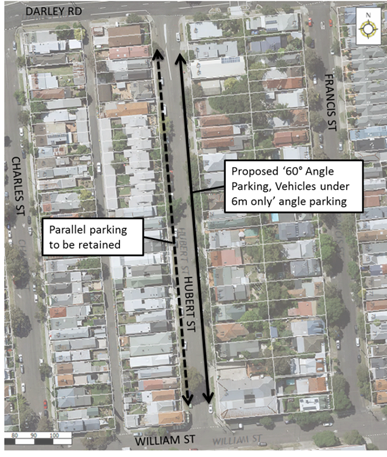
It should be noted that the road is not wide enough (13 metre carriageway) to allow angle parking on both sides of the road. The western side of Hubert street will not be signposted.
It should also be noted that currently in Hubert Street (between Darley Road and William Street) there is unrestricted parking.
This proposed angle parking provides a typical cross-section of:
· 2.1m Parallel Parking
· 5.8m Travel Lane
· 5.1m Angle Parking lane
In accordance with Council’s angle parking policy, a number of requirements must be met to modify parallel parking to angle parking. These requirements are outlined in the table below:
|
Requirement |
Response |
|
Permitted only on Local roads |
Hubert Street is a Local Road |
|
The volume of traffic (bi-directional) must not be greater than 1000 vehicles per day
|
Traffic Counts undertaken in December 2016 revealed an ADT of 517 vehicles per day (bi-directional) with an 85th %ile speed of 48 km/h northbound and 49 km/h southbound. |
|
The total width of travel lanes (two-way) to be minimum of 5.8m (manoeuvring space for angle parking range between 3.0m-5.8m) |
Hubert Street has a road carriageway width of 13m, thus allowing 60 degree angle parking on one side and parallel parking on the other side. There is insufficent width to allow for angle parking on both sides of the road. |
|
That the street not form a bus route. |
Hubert Street is not on a bus route. |
|
Accident data for last 5 years |
No recorded crashes in the most recent 5 years of RMS data. |
|
The use of the street by cyclists needs to be accommodated in any proposal. To improve delineation for cyclists the edge of the angle parking bays are to be line marked. |
Hubert Street is not a designated bicycle route. |
Based on the above analysis, the proposed 60 degree ‘Rear to Kerb’ Angle Parking for the eastern side of Hubert Street meets the Council’s policy requirements.
PUBLIC CONSULTATION
A letter outlining the above angle parking proposal was mailed out to the affected properties (65 properties) as indicated on the following plan, requesting residents’ views regarding the proposal.
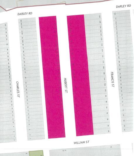
A total of 32 responses were received from Hubert Street (49% response rate) with a total of 16 supporting the angle parking proposal (25% support rate). Given the low support rate no further action is proposed regarding the implementation of an angle parking scheme at the present time.
|
RESIDENT COMMENT |
OFFICER RESPONSE |
|
If it is determined that this project should go ahead I would like it to be 45 degrees not 60 degrees as proposed to maintain the maximum spacing between passing traffic.
If it is determined that this project should go ahead I would like to see the angle parking start further away from the intersection. Traffic travelling west on Darley Rd then turning into Left into Hubert St often does so at high speed as a result of the topology of Darley Rd. The intersections need to be kept clear of parked vehicles keeping in mind the median strip and the angle of the double centre lines that "steer" traffic towards the parked vehicles. |
At this stage, it is proposed that angle parking in Hubert Street not be supported at the present time due to less than 50% support received from the consulted residents.
It should be noted that the angle of the parking spaces are based on the road widths specified in the AS 2890 and other factors such as kerb height and clearances.
Angled parking spaces are not proposed at sections adjacent to median strips and double barrier centre lines. |
|
Parking restrictions should also be required, as Light Rail (and Dan Murphy's) 'parking' causes parking issues for residents. |
The Council WestConnex Unit has engaged a consultancy to identify streets which may experience increased traffic from WestConnex. The study is part of Council's ongoing effort to protect residents from the impacts of the project.
The consultant will prepare a report that will inform the WestConnex development of a Local Area Improvement Strategy (LAIS) and cost estimates which Council will use to seek funding and design changes from WestConnex. Resident Parking Schemes have been identified as a potential option. |
|
I do not want angle parking at all in Hubert Street. I am 77 and find it very hard to park at an angle and i also do not want to encourage non-residents who use the light rail or workmen to park in the street. There is no need for angle parking. In particlar it should not be on our side (the odd side) of the street as everyone on the other side have garages and rear lane access and we do not. |
At this stage, it is proposed that the angle parking in Hubert Street not be supported at the present time due to less than 50% support received from the consulted residents.
If angle parking is reinvestigated in the future, the proposal could be considered for the western side of the street. |
|
We could also do with a speed bump at the bottom of the hill on William Street as cars often speed down there |
The Council WestConnex Unit has engaged a consultancy to identify streets which may experience increased traffic from WestConnex. The study is part of Council's ongoing effort to protect residents from the impacts of the project.
The consultant will prepare a report that will inform the WestConnex development of a Local Area Improvement Strategy (LAIS) and cost estimates which Council will use to seek funding and design changes from WestConnex. Speed calming measures could also be considered. |
|
I do not typically have problems finding parking but if required, please consider wide enough spots to take infants and young children in and out of the vehicle. Many families in this street have young children and spots that are too narrow will be very difficult for access. We would also like to request interspaced spots with garden beds and trees to break up the increased volume of vehicles. |
It should be noted that angle parking spaces are designed in accordance with AS 2890. The dimensions specified in the standards are expected to have been developed based on extensive studies considering different vehicle accessibilty scenarios.
If angle parking is reinvestigated in the future, planted garden beds or other measures can be considered. |
|
I do not support angle parking. We should wait until the M4-M5 link reference design and EIS are released to see what the impact of the dive site at 7 Darley Road will be. We may need Hubert Street to be closed off to prevent Westconnex and other heavy vehicles using our street. We may also need parking restrictions to prevent Westconnex and other workers associated with the project parking in our streets. Suggest after the reference design is released the traffic planners run a meeting for Francis, Hubert, Charles and Elswick Street residents to work out best way to keep Westconnex out of our streets. |
The Council WestConnex Unit has engaged a consultancy to identify streets which may experience increased traffic from WestConnex. The study is part of Council's ongoing effort to protect residents from the impacts of the project.
The consultant will prepare a report that will inform the WestConnex development of a Local Area Improvement Strategy (LAIS) and cost estimates which Council will use to seek funding and design changes from WestConnex. This study will consider feedback from residents. |
|
60 degree parking may increase parking however it does minimise visibility coming out of underground parking (1-5 Hubert St). The travel lanes will be narrower restricting space in both directions. With cars already parked parallel right up to the driveway it does prove hard to see left or right when exiting the underground car park. A car has to pull out passed the parallel parked car in order to see clearly before turning left or right. A further narrowing of the road will be very difficult due to the cars travelling closer to parked cars and cars in the other direction. A safety issue is a matter to be considered. |
At this stage, it is proposed that the angle parking in Hubert Street not be supported at the present time due to less than 50% support received from the consulted residents.
If angle parking is reinvestigated in the future, sight visibility for property accesses would be considered. |
CONCLUSION
Based on the above results, it is proposed angle parking in Hubert Street not be supported at the present time due to less than 50% support received from the consulted residents.
Council's WestConnex Unit has engaged a consultancy to identify streets which may experience increased traffic from WestConnex. The study is part of Council's ongoing effort to protect residents from the impacts of the project.
The consultant will prepare a report that will inform the WestConnex development of a Local Area Improvement Strategy (LAIS) and cost estimates which Council will use to seek funding and design changes from WestConnex. This study will consider feedback from residents.
|
|
Local Traffic Committee Meeting 7 December 2017 |
Subject: Perrett
Street, Rozelle – Resident Parking Scheme
(Leichhardt Ward/Balmain Electorate/Leichhardt LAC)
Prepared By: David Yu - Traffic Engineer
Authorised By: John Stephens - Traffic and Transport Services Manager
|
SUMMARY Council received correspondence from a number of residents of Perrett Street, raising concerns regarding increased parking demands generated by residents and commuters.
This report provides the results of a residential parking scheme investigation in Perrett Street, Rozelle. |
|
RECOMMENDATION
THAT the proposed Resident Parking Scheme in Perrett Street not be supported at the present time due to less than 50% support received from the consulted residents. |
BACKGROUND
A number of residents of Perrett Street, Rozelle requested the implementation of residential parking scheme in their street. Consequently, parking occupancy surveys were undertaken in Perrett Street, Rozelle in accordance with Council’s Resident Parking Scheme Policy. The survey results indicated high parking occupancy levels (equal to or over 85%) in the street.
It should also be noted that currently in the northern side of Mansfield Street (between Batty Street and Mullens Street) there is a ‘2P 8am-6pm, Mon-Fri, Permit Holders Excepted, Area R1’ restriction.
FINANCIAL IMPLICATIONS
Nil.
OTHER STAFF COMMENTS
A residential parking proposal was prepared for the installation of a resident parking scheme in Perrett Street, Rozelle. The proposal was for the following:
· Installation of 2P 8am-6pm, Mon-Fri, Permit Holders Excepted, Area R1’, on both sides of Perrett Street between Moore Street and Mullens Street.
As shown on the following map.
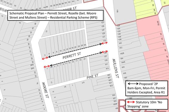
PUBLIC CONSULTATION
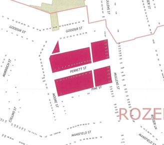 A letter
outlining the above parking proposal options was mailed out to the affected
properties (25 properties) in Perrett Street, Rozelle as indicated on the
attached plan, requesting residents’ views regarding the proposal.
A letter
outlining the above parking proposal options was mailed out to the affected
properties (25 properties) in Perrett Street, Rozelle as indicated on the
attached plan, requesting residents’ views regarding the proposal.
Comments from residents objecting to the proposal
|
Residents’ Comments |
Officer Comments |
|
I oppose RPS restrictions if limited to Perrett St, since it will just drag more parking onto Moore Street, Mullens Street and Goodsir Street. Either implement the restrictions for the entire neighbourhood or none at all. |
At this stage, it is proposed that the Resident Parking Scheme in Perrett Street not be supported at the present time due to less than 50% support received from the consulted residents.
If a Resident Parking Scheme is reinvestigated in the future, we will consider adjacent streets as part of the investigation. |
|
Loss of parking due to the No Stopping area out ways benefit. Loss of parking directly in front of my property (2 Perrett Street). Only being given one permit because we have parking for one small car off-street so we are penalised. |
Resident Parking permits are issued to eligible households based on the type of RPS proposed and off-street parking space available on-site. The maximum number of permits issued to a household can be one or two.
10m ‘No Stopping’ zones must be installed at all intersections (as per NSW Road Rules) with the installation of the proposed 2P restrictions. The ‘No Stopping’ zones provide improved safety for pedestrians and drivers. |
|
I strongly object to the proposed parking restrictions. The restrictions will deter friends and family from coming to visit and cause unnecessary increase in tension of local neighbourhood relations. The majority of residents in the street are currently unaffected by non-residents parking in the street given that these people are parking during the day/work hours when the residents are at work. There is a simple swap over/transition period when residents return from work to park and the non-residents return to their cars to leave so there is no real issue in my opinion. |
At this stage, it is proposed that the Resident Parking Scheme in Catherine Street not be supported at the present time due to less than 50% support received from the consulted residents.
|
|
Resident Parking Scheme for 7 days a week preferred. |
At this stage, it is proposed that the Resident Parking Scheme in Perrett Street not be supported at the present time due to less than 50% support received from the consulted residents.
If a Resident Parking Scheme is reinvestigated in the future, we will consider 7 days parking restriction as part of the investigation. |
Consultation survey results are summarised as follows:
Perrett Street, Rozelle
Number of properties - 25
Number of properties responded - 17
Number of properties supported - 8
Overall Response Rate - 68%
Overall Support Rate - 32%
According to Council’s Resident Parking Policy, a minimum of 50% support based on all properties in the subject section of the street is required to consider the proposal favourably.
Based on the above results and the comments provided as part of the consultation process, less than 50% of the residents of Perrett Street, Rozelle support a resident parking scheme in their street at the present time.
CONCLUSION
Based on the above results, the RPS proposal in Perrett Street, Rozelle not be supported at the present time due to less than 50% support received from the consulted residents.
|
|
Local Traffic Committee Meeting 7 December 2017 |
Subject: Hornsey Street, Rozelle - Modification of Existing Resident Parking Scheme (RPS) Restrictions (Leichhardt Ward/Balmain Electorate/Leichhardt LAC)
Prepared By: David Yu - Traffic Engineer
Authorised By: John Stephens - Traffic and Transport Services Manager
|
SUMMARY Council has received correspondence from a number of residents of Hornsey Street to change the existing ‘2P 8am-6pm Mon-Fri Permit Holders Excepted Area R1’ restrictions with extended time and day limits.
This report provides the results of a residential parking scheme investigation in Hornsey Street, Rozelle. |
|
RECOMMENDATION
THAT the proposed modification of the existing parking restrictions in Hornsey Street, Rozelle not be supported at the present time due to less than 50% support received from the consulted residents.
|
BACKGROUND
A number of residents of Hornsey Street (between Gordon Street and Victoria Road), Rozelle have requested a change to the existing ‘2P 8am-6pm Mon-Fri Permit Holders Excepted Area R1’ restrictions due to the difficultly for residents with parking permits to park outside of the existing parking restrictions.
FINANCIAL IMPLICATIONS
Nil.
OTHER STAFF COMMENTS
Due to the difficulty for residents with permits to park outside the existing parking restrictions, modification of the existing restrictions with extended time and day limits to ‘2P 8am-10pm (7 Days) Permit Holders Excepted Area R1’ was proposed.
The proposal is shown in the following map.
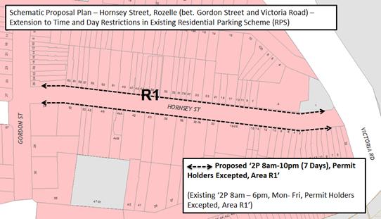
PUBLIC CONSULTATION
A letter outlining the above parking proposal options was mailed out to the affected properties (164 properties) in Hornsey Street, Rozelle as indicated on the attached plan below, requesting residents’ views regarding the proposal. There is medium density housing located in Hornsey Street that was strata subdivided prior to January 2001, making these properties eligible to apply for resident parking permits.
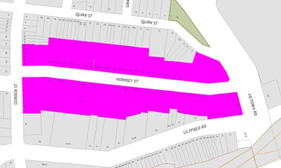
Comments from residents objecting to the proposal
|
Residents’ Comments |
Officer Comments |
|
Not needed. I have lived here for a long time and mostly Saturday and Sunday day time there is never a problem. The busy time is evenings but there never seems to be a problem when finding parking. If any change need to be made then I think we should wait until they start WestConnex in the area and see the impact of worker vehicles. |
The modification of the parking restriction and results of survey returns indicate that this is not supported at present. Should this scheme be reinvestigated in the future consideration will be given to WestConnex. |
|
As long as I can keep one resident and one visitor parking permit, happy to support it.
|
Residents are able to retain existing parking permits. Council does not re-issue permits as part of the modification of parking restrictions. |
|
My wife and I are happy with the current parking restrictions. An extension to the weekends would deter friends and family from visiting for any extended time due to the need to constantly be moving their car and the possible fines are expensive. |
The maximum number of visitor permits issued to a household is one.
Therefore, residents should carefully consider the impact of the proposal on visitors. |
|
I support this proposal only if we can be issued a Visitor's Parking Permit. Without the visitor's permit it will make it difficult for family/ labourers etc. to visit our house, especially on weekends. |
The Council Resident Parking Policy and parking permit eligibility criteria has been developed with careful consideration of various factors. Council also applies the RMS Permit Parking Guidelines. This allows for the permits to be fairly distributed to the residents, while considering the limited supply of on-street car parking spaces available.
The maximum number of visitor permits issued to a household is one. |
|
There is no need to increase this on weekends. A restriction until 10pm seems excessive. |
Comments noted. |
Consultation survey results are summarised as follows:
Hornsey Street, Rozelle
Number of properties - 164
Number of properties responded - 27
Number of properties supported - 12
Overall Response Rate - 16%
Overall Support Rate - 7%
Based on the above results and the comments provided as part of the consultation process, less than 50% of the residents of Hornsey Street, Rozelle support a modification to the existing parking restrictions at the present time.
CONCLUSION
Based on the above results, the modification of the parking restrictions in Hornsey Street, Rozelle not be supported at the present time due to less than 50% support received from the consulted residents.
|
|
Local Traffic Committee Meeting 7 December 2017 |
Subject: Denison Street, Newtown – Investigation on Pedestrian and Cyclist Safety at Intersection with Bedford Street (Stanmore Ward/Newtown Electorate/Newtown LAC)
Prepared By: Emilio Andari - Civil Engineer
Authorised By: John Stephens - Traffic and Transport Services Manager
|
SUMMARY Council officers have been requested to undertake an investigation and develop options to improve safety of cyclists and pedestrians at the intersection of Denison Street ad Bedford Street as an outcome of Council resolution from matter arising. A site investigation on the nature of the subject environment and a traffic volume and speed count was undertaken and the outcomes of this investigation, together with recommendations, are presented in this report. |
|
RECOMMENDATION
THAT the report be received and noted. |
BACKGROUND
At Council’s Infrastructure, Planning and Environmental Services (IPES) Committee meeting of 3 May 2016, a Matter Arising was moved as follows:
THAT officers investigate and develop options to improve the safety of cyclists and pedestrians at the intersection of Denison and Bedford Streets, Newtown and that a report on estimated costs be submitted for consideration by the PCTCAC.
The section of footpath (pedestrian/cyclist) in question is located within the pedestrian thoroughfare from Newtown Hub pedestrian footpath area, which links to the intersection of Denison Street and Bedford Street, immediately adjacent to the building wall of property 7-13 Bedford Street, Newtown (Newtown Hub). An investigation for the implementation of traffic calming on the approach to the intersection was considered, particularly, the southbound traffic on Denison Street at Bedford Street intersection.
FINANCIAL IMPLICATIONS
It is estimated that the cost to provide the implemented measures are as follows:-
· Construct two new kerb ramps in their new locations - $2,000
· Reinstate existing kerb ramps with concrete and new kerb and gutter - $4,000
· Demolish existing landscaped garden and plant new landscaped garden - $10,000
· Construct new paved footway to match existing surrounding paved area - $10,000
· Remove existing tree - $3,000
· Relocate existing bench seats to a suitable location - $1,000
It is estimated that the total cost to provide the above measures is approximately $30,000. There is no funding available for the scope of works in Council’s Capital Works budget for this financial year. Should the works need to be implemented this year, they will need to be funded from an appropriate Maintenance Budget and listed according to other priorities.
OTHER STAFF COMMENTS
Site location & road network
|
Street Name |
Denison Street |
|
Section |
Between Lennox Street and Bedford Street |
|
Carriageway Width (m) |
12.8 |
|
Carriageway Type |
Two-way road with one travel lane in each direction, in addition to kerbside parking lanes. |
|
Classification |
Regional |
|
85th Percentile Speed (km/h) |
33.8 |
|
Vehicles Per Day (vpd) |
924 |
|
Reported Crash History (July 2012 - June 2017) |
3 crashes recorded (Rum Code: 1, 20 & 48). 2 crashes resulted in an injury and 1 crash resulted in only tow-away. |
|
Heavy Vehicle Volume (%) |
1.4 |
|
Parking Arrangements |
Western side of the road consists of unrestricted parking and eastern side of the road consists of ‘1P 8.30am-4pm Mon-Fri, 8.30am-12.30pm Sat’ & ‘No Parking 4pm-6pm Mon-Fri’ restrictions. |
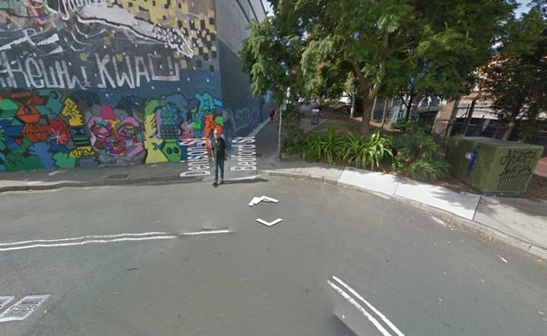
Bedford Street and Denison Street intersection
To attempt to quantify the extent of the concern, Council officers conducted a speed count in October 2017 of Denison Street between Alton Lane and Bedford Street. It was identified through this count that the 85th percentile speed for southbound traffic on Denison Street (traffic on the approach to the intersection with Bedford Street) was measured to be 22.3km/h. This measured speed is typical for vehicles on the approach to many traffic calming measures such as, speed cushions, raised thresholds, median islands and refuge islands and therefore, the implementation of any of these devices will have a marginal benefit.
It is acknowledged that there is high pedestrian activity within the vicinity of the intersection of Bedford Street and Denison Street. It was also identified that the existing kerb ramp on the eastern side of Denison Street is located immediately adjacent to the building wall of the Newtown Hub. As vehicles approaching the intersection, heading southbound on Denison Street, Council officers noted that the existing kerb ramp was not in a suitable location due to limited sight lines for pedestrians and cyclists.
PUBLIC CONSULTATION
Nil.
CONCLUSION
As it is evident that there is high pedestrian and cyclist activity within the vicinity of the thoroughfare between King Street and the intersection of Bedford Street and Denison Street, the relocation of the existing kerb ramps to a more desirable location should be considered. The existing landscaped garden and tree will need to be demolished, the existing bench seats will need to be relocated and the construction of a paved footway be relocated to allow connectivity for pedestrians and cyclists closer towards the railway corridor and away from the building wall of the Newtown Hub, to improve pedestrian and cyclist safety and traffic conditions.