|

|
Local Traffic
Committee Meeting
6 February 2018
|
Item No: LTC0218 Item 17
Subject: Route EW09 (Lilyfield Road, Lilyfield) - Separated Cycleway (Balmain
Ward/ Leichhardt LAC, Balmain Electorate)
Prepared
By: Manod Wickramasinghe -
Coordinator – Traffic and Parking Services
Authorised
By: John Stephens - Traffic and Transport
Services Manager
|
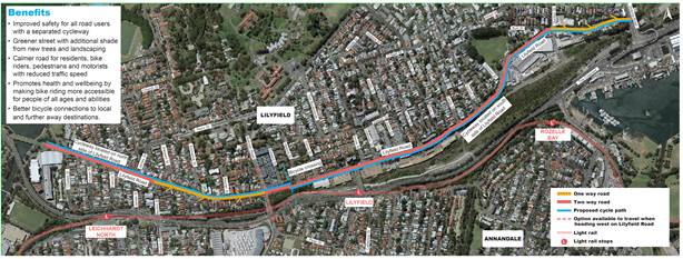
SUMMARY
This report details a revised
concept plan for the Lilyfield Road Separated Cycleway (Route EW09) that has
been developed following public exhibition of the draft concept plans.
|
|
RECOMMENDATION
THAT:
1. The revised concept plan (Attachment 1) for the
Lilyfield Road Separated Cycleway (Route EW09) be supported;
2. Detailed designs for Route EW09 be developed with
consideration of comments received during the public exhibition; and
3. The TMP (Attachment 2) outlining the proposed
one-way sections of Lilyfield Road be submitted to RMS for approval.
|
BACKGROUND
Consistent with
Council’s commitment to encourage bicycle riding and improve bicycle
paths and networks, Council’s adopted 2016 Leichardt Bike Plan aims to
make riding a bicycle easier, safer and more attractive.
Lilyfield Road
(Route EW09) was identified in the Inner Sydney Regional Bike Plan and
Leichhardt Council’s 2016 Bike Plan as a route that could be upgraded to
a separated, two-way cycleway.
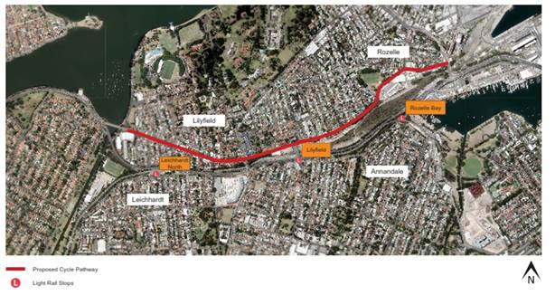
Route EW09 is a
2.7km regional route from Iron Cove to ANZAC Bridge via Lilyfield Road, the
route connects to a number of other regional and local bike routes. It
aims to improve connections to local destinations such as Cooks River, Bay Run,
the future Greenway, Victoria Road, ANZAC Bridge and more distant destinations
including Newtown and Sydney CBD.
In 2015, Council
received funding to prepare a detailed design for a separated cycleway along
Lilyfield Road through the NSW Government’s Active Transport Program, and
will facilitate meeting Goal 8 of the NSW State Plan 2021 to increase the
number of bicycle and walking trips in the Greater Sydney area.
There is an
existing on road bike path on Lilyfield Road; however, the focus on Route EW09
was to create a safe and accessible cycling environment for all age groups to
encourage new people to cycle, whilst improving safety for existing cyclists by
providing a separated facility.
Council
commissioned GHD in 2016 to undertake the design of the proposed separated
cycleway.
During the design process, Council has held a number of
meetings with Sydney Buses (STA), Roads and Maritime Services (RMS) and
Transport for NSW to further develop the current revised concept plan prior to
exhibiting to the public and other stakeholders. The project also
includes significant streetscape and drainage improvements by providing water
sensitive urban design.
FINANCIAL IMPLICATIONS
The design and
construction of this project has been fully funded by the NSW
Government’s Active Transport Program (Priority Cycleways).
OTHER STAFF COMMENTS
The current
revised concept plan for the Lilyfield Road separated cycleway (Route EW09) is
detailed in Attachment 1. Key features of the separated cycleway revised
concept plan are summarised in the following section. The cycleway would also
be constructed in stages commencing with Section 1.
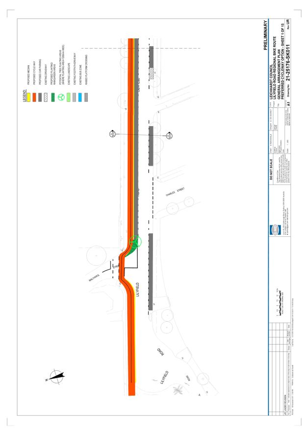
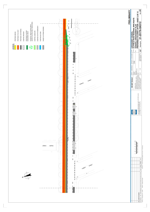
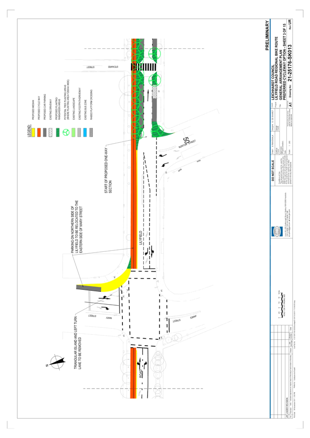
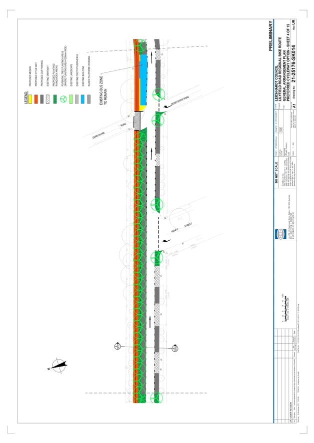
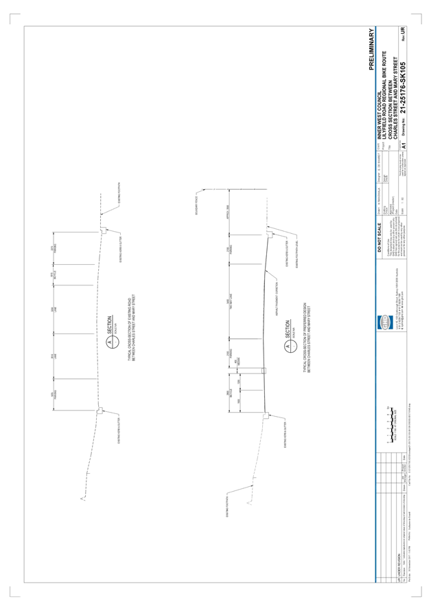
Section 1
– Lilyfield Road from Canal Road to Norton Street
Key features:
· Separated cycleway positioned adjacent to northern kerbline
· 2.8m bi-directional bike path proposed (1.6m uphill, 1.2m downhill)
· 5.4m two-way vehicle lane proposed
· Set back cycleway treatment across Maliyawul Street
· Bicycle phasing across the signalised Mary Street/James Street
intersection
· Closure of left turn slip lane from Mary Street into Lilyfield Road
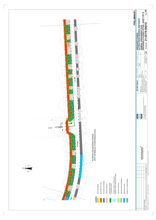
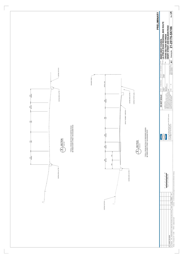
Section 2
– Lilyfield Road from Norton Street to Balmain Road
Key features:
· Separated cycleway positioned adjacent to northern kerbline
· 3.0m bi-directional bike path proposed (1.5m lanes in each
direction)
· Two-way traffic flow to be altered to one-way (eastbound) to allow for
parking to be retained (3.5m one-way lane)
· Set back cycleway treatment across Rayner Street
· Bicycle phasing across the signalised Balmain Road intersection
· Retain existing raised pedestrian (zebra) crossing at Steward Street
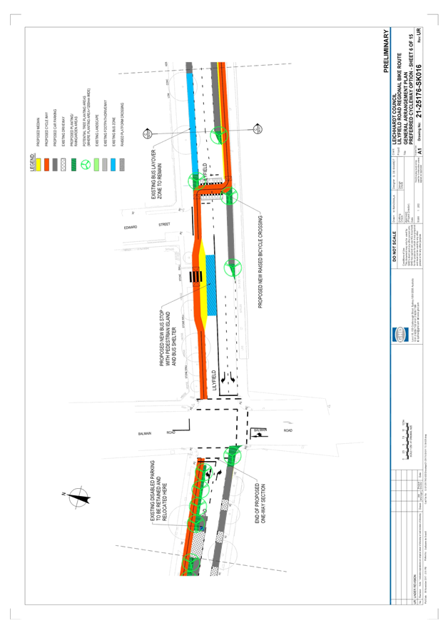
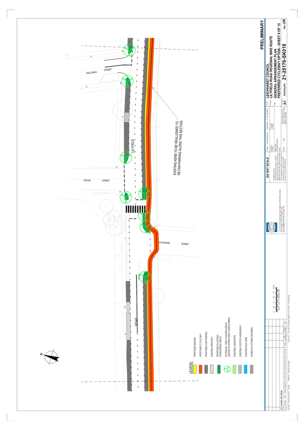
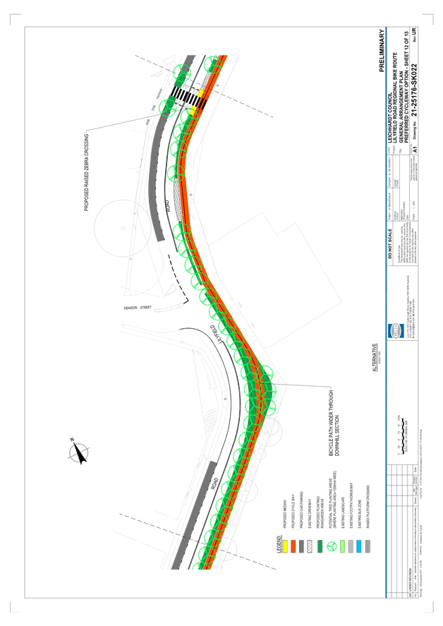
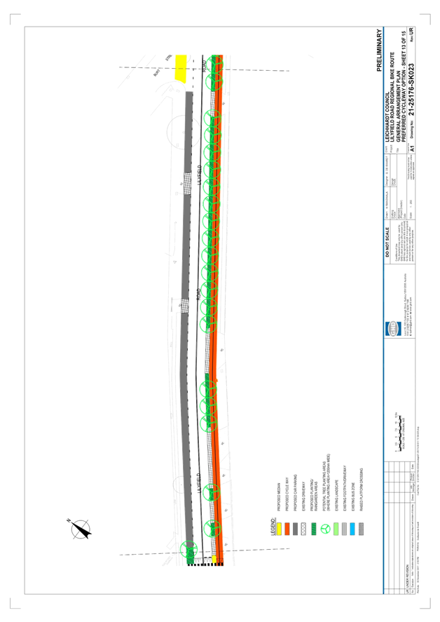
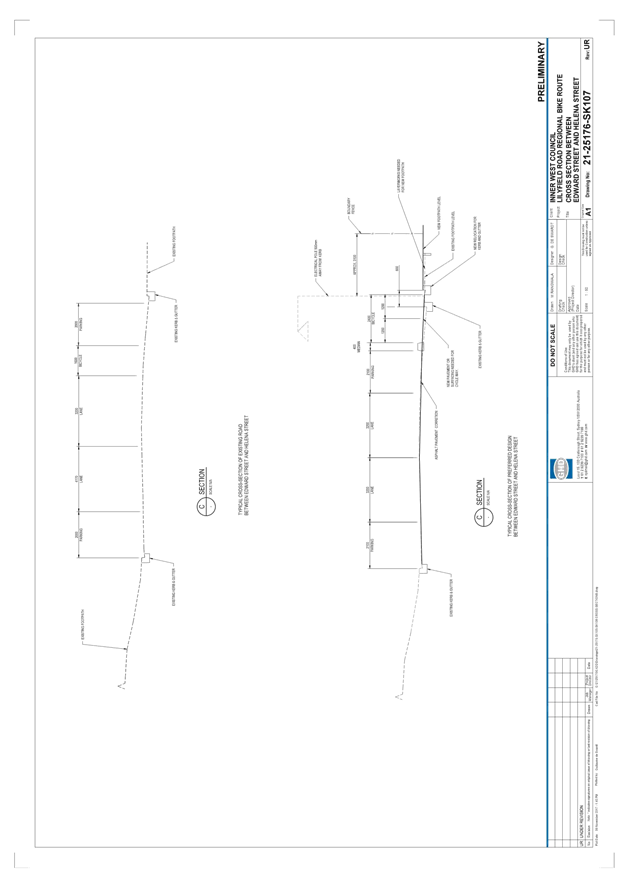
Section 3
– Lilyfield Road from Balmain Road to Gordon Street
Key features:
· Bicycle phasing across the signalised Balmain Road intersection
· Separated cycleway positioned adjacent to northern kerbline between
Balmain Road and Edward Street. A bicycle crossing point is proposed to be
placed immediately east of Edward Street and the separated cycleway will then
continue on the southern side of Lilyfield Road between Edward Street and
Gordon Street.
· 2.4m bi-directional bike path proposed (1.2m lanes in each direction)
· Bicycle crossing facility to provide priority for cyclists over
vehicles (subject to detailed design)
· Upgraded bus stop with pedestrian island and bus shelter
· Set back cycleway treatment across Catherine Street and raised
platform bicycle crossing across Gordon Street
· Approximately 115 parking spaces are lost, this parking is primarily
boat/trailer parking on the southern side of Lilyfield Road adjacent to the
Rozelle Rail Yards.
· New raised pedestrian (zebra) crossing east of Denison Street
· Retain existing raised pedestrian (zebra) crossing between Catherine
Street and Grove Street
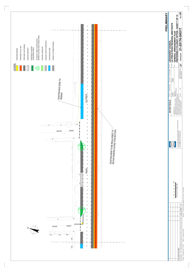
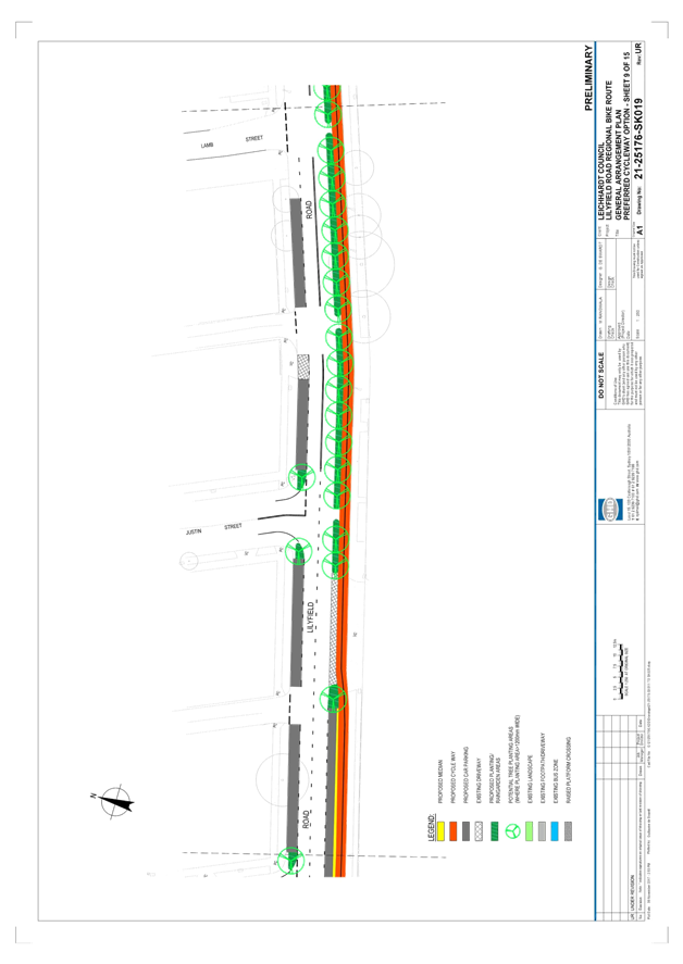
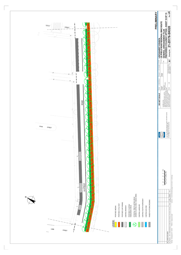
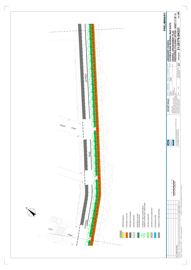
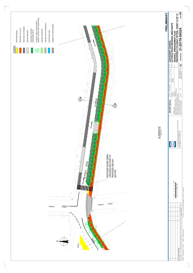
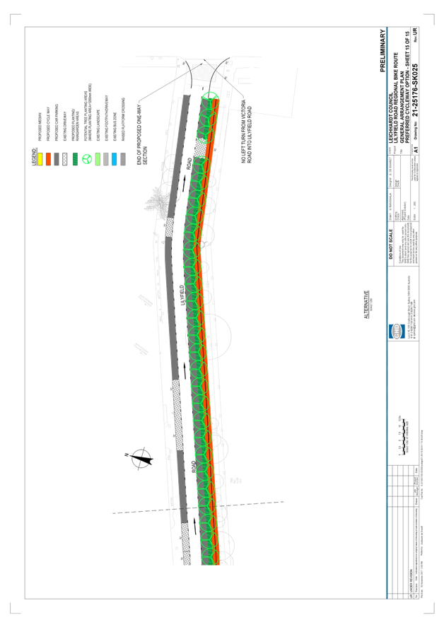
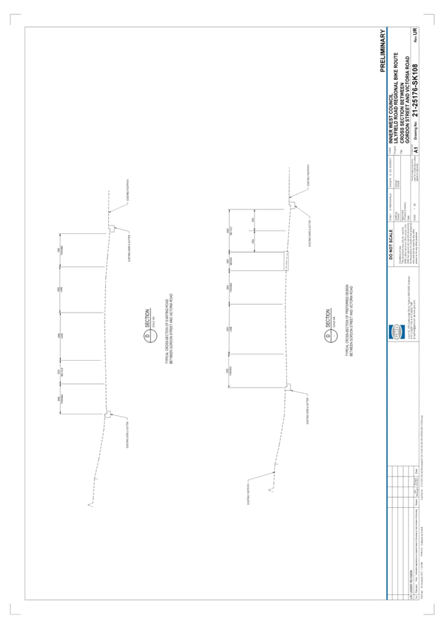
Section 4
– Lilyfield Road from Gordon Street to Victoria Road
Key features:
· Separated cycleway positioned adjacent to southern kerbline
· 3.0m bi-directional bike path proposed (1.5m lanes in each
direction)
· Two-way traffic flow to be altered to one-way (eastbound) to allow
for parking to be retained (3.5m one-way lane)
· Raised platform bicycle crossing across Gordon Street
· Upgrade raised threshold east of Gordon Street to a raised
pedestrian (zebra) crossing
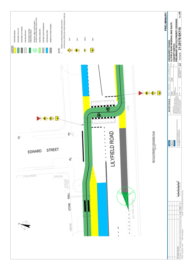
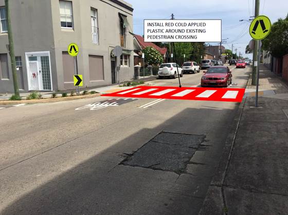
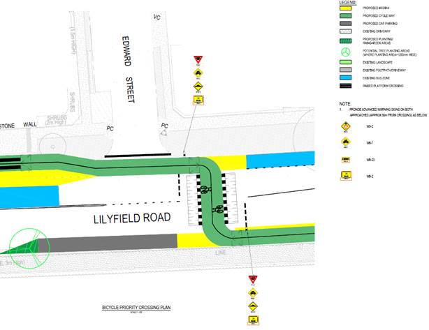
Bicycle Crossing
In order to minimise conflict with intersections, the
separated cycleway is proposed to cross from the northern to southern kerblines
of Lilyfield Road.
To maintain a continuous path for cyclists, it is proposed
that this crossing point provide priority for cyclists over vehicles travelling
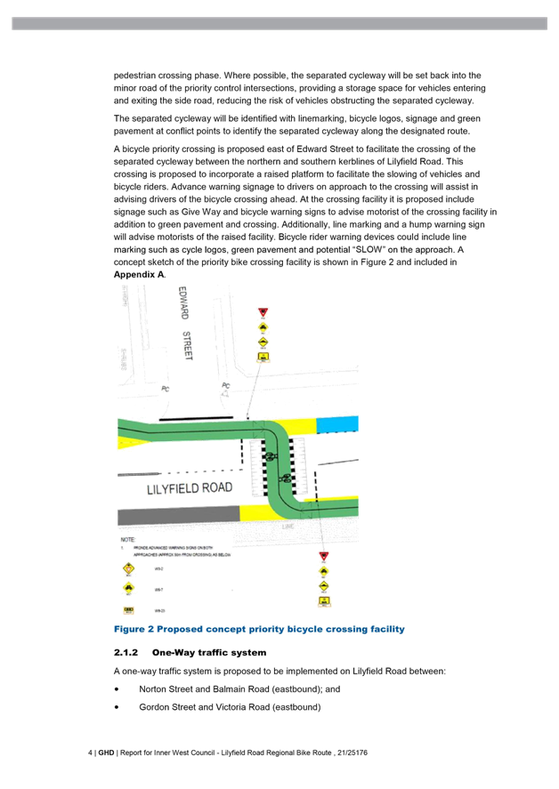
in Lilyfield Road. To achieve this, it is proposed that a bicycle priority
crossing is installed east of Edward Street with the following features:
· A raised platform to facilitate the slowing of
vehicles and bicycle riders.
· Advance warning signage to drivers on approach
to the crossing
· signage such as Give Way and bicycle warning
signs to advise motorist of the crossing facility
· line marking and a hump warning sign will advise
motorists of the raised facility.
· Bicycle rider warning devices could include line
marking such as cycle logos, green pavement and potential “SLOW” on
the approach.
A concept sketch of the priority bike crossing facility is
shown in the following figure.
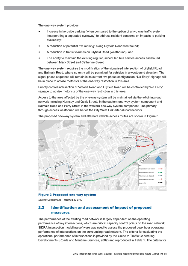
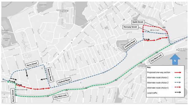
Proposed One-Way restrictions
A one-way traffic system is proposed to be implemented on
Lilyfield Road between:
· Norton Street and Balmain Road (eastbound); and
· Gordon Street and Victoria Road (eastbound)
The one-way system provides:
· Increase in kerbside parking (when compared to
the option of a two way traffic system incorporating a separated cycleway) to
address residents’ comments on impacts to parking availability;
· A reduction of potential “rat
running” along Lilyfield Road westbound;
· A reduction in traffic volumes on Lilyfield Road
(westbound); and
· The ability to maintain the existing regular,
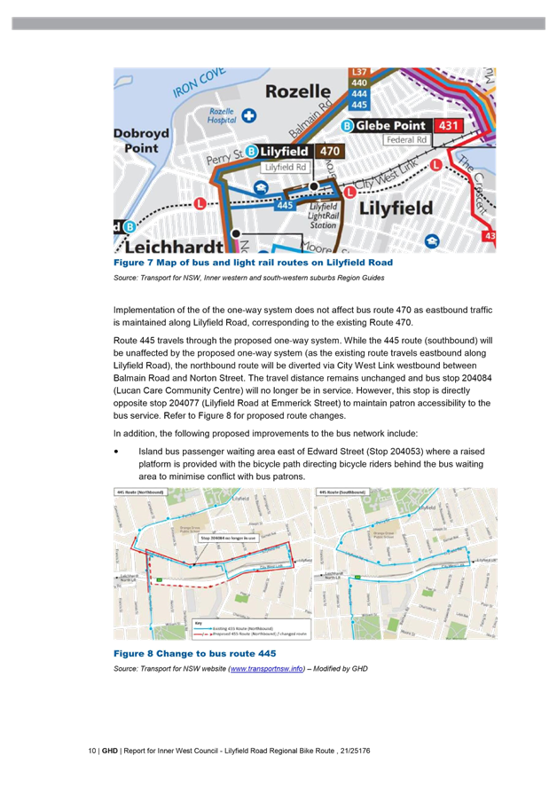
scheduled bus service access eastbound between Mary Street and Catherine
Street. Transport for NSW and Sydney Buses have been consulted on this change
and have agreed to amend bus routes to accommodate the one-way restriction.
Existing bus patrons will continue to have access to the affected services.
The one-way system requires the modification of the
signalised intersection of Lilyfield Road
and Balmain Road, where entry will not be permitted for
vehicles in a westbound direction. The priority control intersection of
Victoria Road and Lilyfield Road will be controlled by “No Entry”
signage to advise motorists of the one-way restriction in this area.
Access to the area affected by the one-way system will be
maintained via the adjoining road
network including Hornsey and Quirk Streets in the eastern
one-way system component and
Balmain Road and Perry Street in the western one-way system
component. The primary through access westbound will be via the City West Link
arterial road network.
The proposed one-way system and alternate vehicle access
routes are shown in the following figure.
As part of the proposal RMS required a Traffic Management
Plan (TMP) be prepared for the one-way traffic restrictions, this document is
located in Attachment 2. It should be noted that the attached TMP
is an extract and excludes Appendix B – SIDRA Analysis, a summary
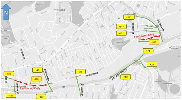
of the results are contained in the body of the report in Figure 5 and Figure 6
and reproduced in the following two plans.
In order to develop the TMP, additional traffic counts were
undertaken last year to enable traffic modelling to analyse the impact of the
redistributed traffic on the adjacent road network, including identified key
intersections both signalised and unsignalised as shown in Figures 3, 5 and 6
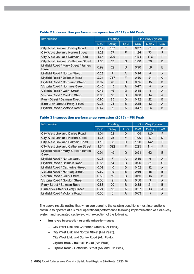
of the TMP. Although there was a decrease in performance at 7
intersections, there was an improved performance at 9 intersections in the
area. RMS modellers then reviewed Council’s analysis and then gave
“in principle support” on the analysis of the road network that
allowed Council to publicly exhibit the current revised concept design plans
from November last year.
The TMP does
not recommend the provision of mitigation measures for the proposed one-way
systems and separated cycleway. Due to the narrow and indirect nature of the
alternate local streets, it is expected that traffic redistribution will
generally be onto City West link and Victoria Road, which forms part of the
State road network to convey traffic through the area in lieu of vehicles using
the local road network.
It should be noted that as per the Roads Act 1993, the
proposed one-way restrictions along Lilyfield Road, Lilyfield have been
advertised in the local newspaper for a period of 28 days. The advertising
period closes on the 6th of February. Any received submissions will
be tabled at the meeting.
The AM Peak traffic redistribution:
The PM Peak traffic redistribution:
PUBLIC CONSULTATION
Council has
undertaken three phases of community consultation from May 2016 until February
2018 to inform the community about the project, and gather feedback on the
preliminary and draft concept designs. Following each phase of consultation,
revisions have been made to the concept plans to take on board comments from
the community.
There were three
phases of engagement to get feedback from the community, bicycle riders and
other stakeholders at each stage of the design. All of the feedback received
was considered and where possible, incorporated into the design stage.
There were three phases of engagement to
get feedback from the community, bicycle riders and other stakeholders at each
stage of the design. All of the feedback received was considered by the project
team and where possible, incorporated into the following design stages.
· Phase 1: May –
October 2016
o Objective: Determine preferred route
from two design options and gain feedback to inform the development of the
draft concept plan
o Design options:
§ Option 1 – A two-way, separated cycleway on the
northern side of Lilyfield Road between Victoria Road and the Hawthorne Canal.
§ Option 2 - A two-way, separated cycleway
on the southern side of Lilyfield Road between Victoria Road and Hawthorne
Canal.
o Promotion:
§ Flyer distributed to local residents and business and bicycle groups
§ Project page on www.yoursayinnerwest.com.au
o Engagement activities:
§ In person:
· Community workshop was held at Leichhardt Town Hall on 7 June 2016
· Intercept surveys on Lilyfield Road were held on two occasions.
§ Online: through the feedback form on www.yoursayinnerwest.com.au and an interactive map
§ Email, telephone and website to GHD.
o Outcomes
|
Consultation method
|
Number of participants / comments received
|
|
Community
Workshop
|
33
attendees
|
|
YourSay
Inner West
|
14
submissions
|
|
Social
Pinpoint
|
50
stakeholders engaged
Number
of comments:
— Option 1 – 129 comments
— Option 2 – 57 comments
— Option 2A (Hybrid option with indented parking which
was discussed at November 2016 meeting) – 67 comments (45 from street
intercepts)
It
is likely that the first option received the most comments as respondents
gave similar feedback across all three designs, so did not feel commenting on
all three was necessary.
|
|
Street
Intercept Surveys
|
91
respondents
|
|
1800-number
|
28
phone calls received
|
|
Community
Email
|
22
emails received
|
Summary
of feedback received:
· Concerns about potential parking loss
· Southern side of road preferred by majority of respondents
· Concerns about bike rider safety on bi-directional cycleway, especially
on hills
· Suggestion to reduce speed limit to 40 km/h to improve safety for
all
· Suggestion to consider different routes including the railway
corridor, City West Link
· Support for the project – more families taking up cycling,
safer for current bike riders and contribute to a better connected network.
· Phase 2: November
2016 – April 2017
o Objective: Gain feedback from the
community and other stakeholders on the draft concept plan
o Draft Concept Plan
Based
on feedback received in Phase 1, a preferred concept design was chosen. This
preferred plan was a hybrid of option 1 and 2, the cycleway was proposed on the
northern side of Lilyfield Road from Canal Road to just west of Balmain Road,
it would then cross Lilyfield Road and continue to Victoria Road on the
southern side of the street. Only the section between Gordon Street and
Victoria Road was proposed to be one way at this point. Kerb indentation was
provided on the southern side of Lilyfield Road between Balmain Road and Justin
street to retain commuter parking near the Light Rail; however, a similar
treatment wasn’t possible in the section between Norton Street and
Balmain Road due to heritage trees in the grass verge, existing parking in this
location would be lost due to road width constraints.
o Engagement activities:
§ In person: Community session was held at Leichhardt Town Hall on 29
November 2016
§ Email, telephone and website to GHD.
o Outcomes
|
Consultation method
|
Engagement level
|
|
Information
session
|
37
attendees
71 comments
on concept design map
|
|
1800-number
|
19
phone calls received
|
|
Community
Email
|
52
emails received
|
Summary
of feedback received:
· Concerns about potential parking loss:
o Draft
design doesn’t address this enough
o Potential
flow on affect to nearby streets
o Potential
impact to loading zones, customer parking, disabled spaces, access to
properties
· Concern about access to driveways
· Suggestion to re-route buses off Lilyfield Road or change Norton
Street to Balmain Road one way to allow for road widening to accommodate
cyclepath and on-street parking
· One way section between Gordon Street and Victoria Road will
increase travel time
· The community needs to be engaged more widely
· Support for the project – will be well used, facilitate more environmentally
friendly ways of commuting, increase safety for pedestrians and bus patrons at
Victoria Road intersection.
· Phase 3: November
2017 – February 2018
o Objective: Gain feedback from the
community and other stakeholders on the final draft concept plan
o Current revised draft concept plan:
Based
on the feedback from Phase 2, a revised concept plan was developed which
provides an additional eastbound one-way section in Lilyfield Road between
Norton Street and Balmain Road. This retained parking in this section which was
the primary concern during phase 2 of the consultation. In addition, the
bicycle crossing point was moved from west of Balmain Road to east of Balmain
Road.
o Promotion:
§ Flyer distributed to a local residents and business and bicycle
groups. Responding to the community’s feedback that more residents needed
to be engaged, the flyer was distributed to 3,500 properties.
§ Project page on www.yoursayinnerwest.com.au
§ Three editions of Council’s e-news
§ Two editions of Your Say Inner West e-news
§ Council’s page in the Inner West Courier
§ Council’s Facebook page
§ Press release
o Engagement activities:
§ In person:
· Two community sessions were held at Orange Grove Public School (9
and 12 December 2017)
§ Online: through the feedback form on www.yoursayinnerwest.com.au and an interactive map
§ Email, telephone and website to GHD.
o Outcomes (as of 30 January 2018)
The wider promotion of this phase of the
project led to greater numbers of respondents. This is reflected in the table
below and the summary of comments. The
overall community support rate for the project was 45% consisting of 10%
support and 35% support with comments with 55% of respondents not supporting
the proposal.
Please note that the
exhibition period closes on the 2nd February 2018 and additional
responses will be tabled at the meeting.
|
Consultation method
|
Engagement level (as of 30 January 2018)
|
|
Information
sessions
|
Approximately
65 attendees across two sessions
106
comments on concept design map
|
|
1800-number
|
7
phone calls received
|
|
Community
Email
|
29
emails received
|
|
Social
Pinpoint
|
269
responses received
|
|
Have
Your Say feedback
|
314
feedback forms received
|
The main issues raised by residents during the current
exhibition period is summarised below. A detailed summary of the comments
received during community consultation will be provided in the ‘Community
Engagement Outcomes Report’ which will be uploaded to Council’s Have Your Say website upon closure of the formal exhibition
period.
|
Main issues
|
Council’s response
|
|
One-way sections
|
The one-way sections were incorporated
into the design to reduce the amount of on-street parking lost on Lilyfield
Road.
Traffic modelling of the area shows that
there would be a small increase in traffic on Balmain Road and City West Link
and a small decrease on Norton Street. The biggest increase on residential
sections of Balmain Road would be an average of 10 additional cars every 10
minutes during the afternoon/ evening peak hour.
The TMP does
not recommend the provision of mitigation measures for the proposed one-way
system and separated cycleway. Due to the narrow and indirect nature of the
alternate local streets, it is expected that traffic redistribution will
generally be onto City West link and Victoria Road, which forms part of the
State road network to convey traffic through the area in lieu of vehicles
using the local road network.
Council will
monitor local roads after the construction of the bicycle facility to
determine if additional treatments are required.
The proposed
facilities provide an improved amenity for alternate active transport
options, while still providing access to residential properties and
minimising potential through traffic flow and “rat running” along
the local road network.
|
|
Loss of Parking
|
The cycleway has been designed
to reduce the amount of on-street parking lost as a result of the project.
There will be a loss of approximately 115 parking spaces between Balmain Road
and Gordon Street; however, this parking is primarily to boat/trailer parking
on the southern side of Lilyfield Road adjacent to the Rozelle Rail Yards.
Following construction, Council
may investigate resident parking restrictions in sections of Lilyfield Road.
|
|
Safety on the bicycle path
|
The cycleway has been designed to meet
existing safety standards. The detailed design will consider all RMS
standards and specifications. The standard 2.4m wide bi-directional cycleway
has been designed similar to City of Sydney Council’s cycleways.
However, where possible the cycleway will be widened. Overtaking is allowed
for faster riders and more experienced riders are still allowed to use the
road if desired.
The entire cycleway will remain
bi-directional as it is currently, although will incorporate many features
designed to improve the safety of users and to ensure people of all levels of
confidence can utilise it.
The bicycle crossing between Edward
Street and Helena Street may result in brief stoppage due to constraints.
Despite this the cycleway will be continuous with no stoppages for the most
part (pedestrian crossings over cycleway the exception). The current proposed
bicycle crossing will provide a raised platform, line marking treatment,
give-way control and advance warning signs to improve safety.
The bicycle crossing point will continue
to be examined to ensure the optimal crossing location and treatment is
provided.
Once the construction of the
cycle path is completed, Council intends to reduce the speed limit along
Lilyfield Road to 40 km/hr and monitor speeds. 40 km/hr speed limit proposal
will need to be approved by RMS.
|
|
Route location
|
Lilyfield Road
was identified in the Inner Sydney Regional Bike Plan and Leichhardt
Council’s 2016 Bike Plan as a route that could be upgraded to a
separated, two-way cycleway.
Lilyfield Road was chosen as
the route as it is a direct route to the City and provides the highest level
of connectivity between the CBD and Inner West. It has been a popular bicycle
route since the City West Link was built and this upgrade will make it safer
and more appropriate for all levels of bicycle riders.
There is a connectivity issue
with the alternate City West Link cycleway in the Rozelle railyards as there
was no access provided prior to the extention of the light rail and the cost
of construction would be prohibitive and require closure of the light rail
west of Lilyfield Light Rail Stop.
Note, Council is liaising with RMS and
Sydney Motorways Corporation to ensure possible future connection to a bicycle
path should this be constructed by WestConnex.
|
|
Removal of left turn slip lane
|
The removal of the left turn
slip lane from Mary Street into Lilyfield Road will be reconsidered in the
detailed design.
|
Council has also received a detailed submission from the
Inner West Bicycle Coalition. These comments primarily relate to design
elements and will be considered as part of the detailed design.
CONCLUSION
The revised
concept plan proposes bicycle route improvements that would encourage more
local and regional trips by bicycle by providing a safer and easier bike path
to local destinations such as Cooks River, Bay Run, the future Greenway,
Victoria Road, ANZAC Bridge and more distant destinations including Newtown and
Sydney CBD.
The revised plan
also seeks to address community concerns about on-street parking by minimising
impacts along the route. This report recommends that the revised concept
plan be supported and detailed designs for the route be prepared with
consideration of comments raised in the most recent exhibition period.
Once
constructed, the Lilyfield Road cycleway will be a flagship bicycle route for
the inner west, connecting both local and regional destinations. The project
seeks to reduce long term private car dependency and greatly improve
sustainable active transport alternatives for both the local and wider community.
ATTACHMENTS
|
1.⇩
|
Revised concept plan for the Lilyfield Road Separated
Cycleway (Route EW09)
|
|
2.⇩
|
Lilyfield Road Cycleway - Traffic Management Plan
|