|
AGENDA R |

Local Traffic Committee Meeting
TUESDAY 1 MAY 2018
10.00am
|
|
Local Traffic Committee Meeting 1 May 2018 |
Function of the Local Traffic Committee
Background
Roads and Maritime Services (RMS) is legislated as the Authority responsible for the control of traffic on all NSW Roads. The RMS has delegated certain aspects of the control of traffic on local roads to councils. To exercise this delegation, councils must establish a local traffic committee and obtain the advice of the RMS and Police. The Inner West Council Local Traffic Committee has been constituted by Council as a result of the delegation granted by the RMS pursuant to Section 50 of the Transport Administration Act 1988.
Role of the Committee
The Local Traffic Committee is primarily a technical review and advisory committee which considers the technical merits of proposals and ensures that current technical guidelines are considered. It provides recommendations to Council on traffic and parking control matters and on the provision of traffic control facilities and prescribed traffic control devices for which Council has delegated authority. These matters are dealt with under Part A of the agenda and require Council to consider exercising its delegation.
In addition to its formal role as the Local Traffic Committee, the Committee may also be requested to provide informal traffic engineering advice on traffic matters not requiring Council to exercise its delegated function at that point in time, for example, advice to Council’s Development Assessment Section on traffic generating developments. These matters are dealt with under Part C of the agenda and are for information or advice only and do not require Council to exercise its delegation.
Committee Delegations
The Local Traffic Committee has no decision-making powers. The Council must refer all traffic related matters to the Local Traffic Committee prior to exercising its delegated functions. Matters related to State Roads or functions that have not been delegated to Council must be referred directly to the RMS or relevant organisation.
The Committee provides recommendations to Council. Should Council wish to act contrary to the advice of the Committee or if that advice is not supported unanimously by the Committee members, then the Police or RMS have an opportunity to appeal to the Regional Traffic Committee.
Committee Membership & Voting
Formal voting membership comprises the following:
· one representative of Council as nominated by Council;
· one representative of the NSW Police from each Local Area Command (LAC) within the LGA, being Newtown, Marrickville, Leichhardt and Ashfield LAC’s.
· one representative from the RMS; and
· State Members of Parliament (MP) for the electorates of Summer Hill, Newtown, Heffron, Canterbury, Strathfield and Balmain or their nominees.
Where the Council area is represented by more than one MP or covered by more than one Police LAC, representatives are only permitted to vote on matters which effect their electorate or LAC.
Informal (non-voting) advisors from within Council or external authorities may also attend Committee meetings to provide expert advice.
Committee Chair
Council’s representative will chair the meetings.
Public Participation
Members of the public or other stakeholders may address the Committee on agenda items to be considered by the Committee. The format and number of presentations is at the discretion of the Chairperson and is generally limited to 3 minutes per speaker. Committee debate on agenda items is not open to the public.
|
|
Local Traffic Committee Meeting 1 May 2018 |
|
AGENDA |
1 Apologies
2 Disclosures of Interest
3 Confirmation of Minutes
Minutes of 10 April 2018 Local Traffic Committee Meeting 5
4 Matters Arising from Council’s Resolution of Minutes
5 Part A – Items Where Council May Exercise Its Delegated Functions
Traffic Matters
ITEM PAGE #
LTC0518 Item 1 Croydon Road, Croydon-Proposed Pedestrian and Road Safety Improvements (Leichhardt Ward/Strathfield Electorate/Ashfield LAC) 42
LTC0518 Item 2 Old Canterbury Road, Dulwich Hill - Proposed Traffic Signals Concept Design Plans (Ashfield Ward/Summer Hill Electorate/Ashfield & Inner West LAC) 63
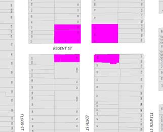
LTC0518 Item 3 Edith Street at Regent Street, Leichhardt - Proposed 'No Stopping' zones (Leichhardt Ward/Balmain Electorate/Leichhardt LAC) 99
LTC0518 Item 4 Denman Avenue, Haberfield – Proposed Traffic Calming Design Plans (Leichhardt Ward/Summer Hill Electorate/Ashfield LAC) 102
Parking Matters
ITEM PAGE #
LTC0518 Item 5 Minor Traffic Facilities (All Wards / All Electorates / All LACs) 108
LTC0518 Item 6 Nelson Lane (between Piper Street and Rose Street), Annandale - Extension of 'No Parking' zone (Balmain Ward/Balmain Electorate/Leichhardt LAC) 112
LTC0518 Item 7 Kingston Lane, Camperdown - Proposed 'No Parking' Restrictions (Stanmore Ward/Newtown Electorate/Inner West LAC) 114
LTC0518 Item 8 Melville Lane, Newtown - Proposed 'No Parking' Restrictions (Stanmore Ward/ Newtown Electorate/Inner West LAC) 117
LTC0518 Item 9 Louisa Street, Summer Hill – Resident Parking Scheme (Leichhardt Ward/Summer Hill Electorate/ Ashfield LAC) 119
LTC0518 Item 10 Brown Street, Ashfield- Proposed bay line marking for motorcyles in parking space. (Ashfield Ward/Summer Hill Electorate/Ashfield LAC) 123
LTC0518 Item 11 Esk Lane, Marrickville - Proposed Statutory 'No Stopping' Restrictions (Marrickville Ward/Summer Hill Electorate, Inner West LAC) 125
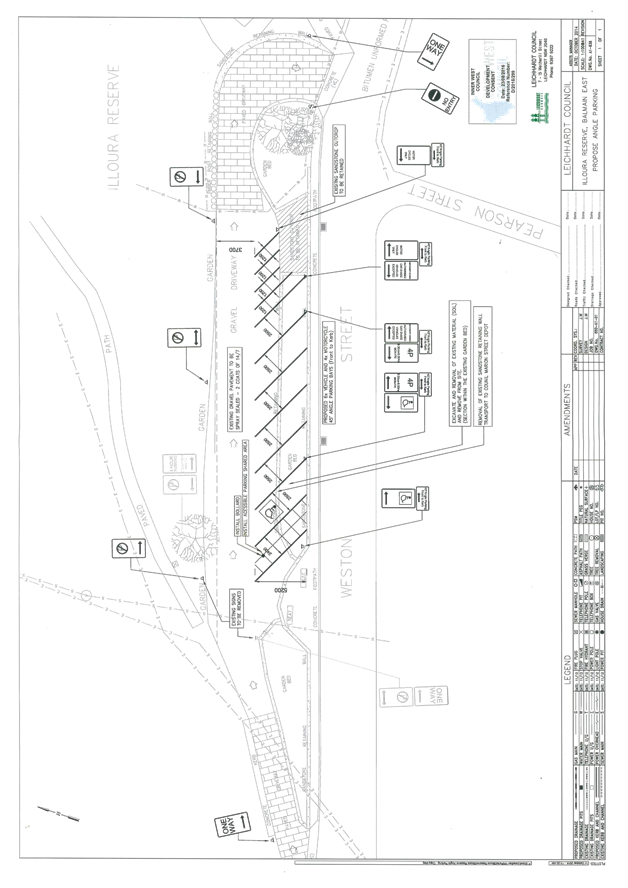
LTC0518 Item 12 Fenwick Building - Illoura Reserve, Balmain East - Car Park Conditions (Balmain Ward / Balmain Electorate / Leichhardt LAC) 127
6 Part B - Items for Information Only
Nil at the time of printing.
7 Part C - Items for General Advice
ITEM PAGE #
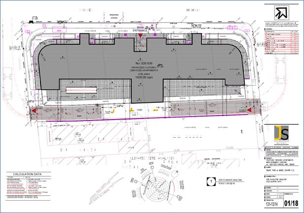
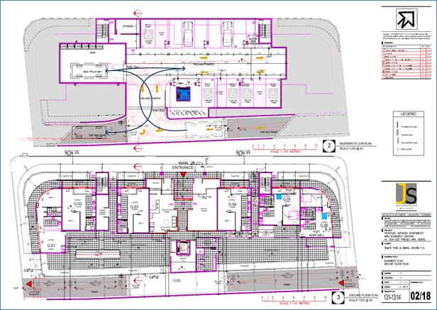
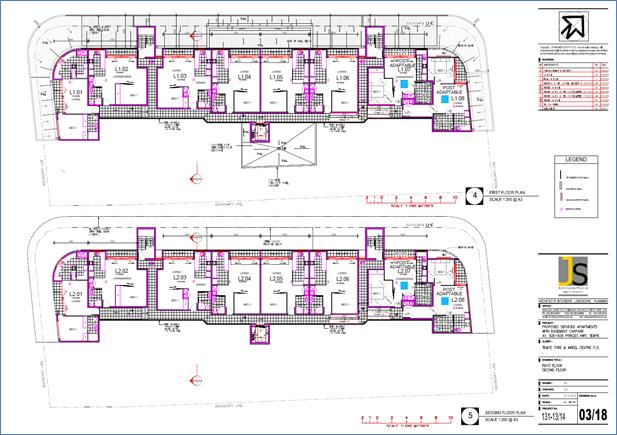
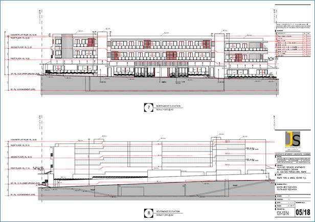
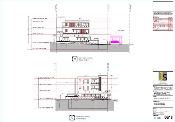
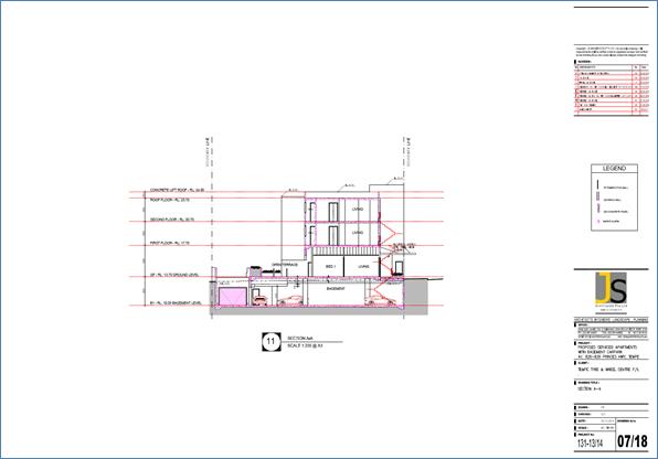
LTC0518 Item 13 Nos. 826-836 Princes Highway, Tempe - DA201700497 – Demolish Existing Improvements and Construct a 3 Storey Building Containing 22 Serviced Apartments with Basement Car Parking and Ground Floor Level Tenancy 130
Late Items
Nil at time of printing.
8 General Business
9 Close of Meeting
|
|
Local Traffic Committee Meeting 1 May 2018 |
Minutes of Local Traffic Committee Meeting
Held at Chamber Room, Petersham Service Centre on 10 April 2018
Meeting commenced at 10.00am
ACKNOWLEDGEMENT OF COUNTRY BY CHAIRPERSON
I acknowledge the Gadigal and Wangal people of the Eora nation on whose country we are meeting today, and their elders past and present.
COMMITTEE REPRESENTATIVES PRESENT
|
Clr Julie Passas |
Deputy Mayor – Ashfield Ward (Chair) |
|
Clr Marghanita Da Cruz |
Leichhardt Ward (Alternate Chair) |
|
Mr Bill Holliday |
Representative for Jamie Parker MP, Member for Balmain |
|
Mr Chris Woods |
Representative for Ron Hoenig MP, Member for Heffron |
|
Ms Sarina Foulstone |
Representative for Jo Haylen MP, Member for Summer Hill |
|
Sgt Dan Chilvers Sen Const Charles Buttrose |
NSW Police – Leichhardt NSW Police – Leichhardt |
|
Mr Kristian Calcagno |
Roads and Maritime Services |
|
|
|
|
OFFICERS IN ATTENDANCE |
|
|
|
|
|
|
|
|
Mr Colin Jones |
Inner West Bicycle Coalition |
|
Mr John Stephens |
IWC’s Traffic and Transport Services Manager |
|
Mr George Tsaprounis |
IWC’s Coordinator Traffic and Parking Services (South) |
|
Mr Emilio Andari |
IWC’s Engineer – Traffic and Parking Services |
|
Mr David Yu |
IWC’s Engineer – Traffic and Parking Services |
|
Ms Snezana Bakovic |
IWC’s Project Manager – Traffic and Transport |
|
Ms Christina Ip |
IWC’s Business Administration Officer |
|
|
|
|
VISITORS |
|
|
|
|
|
Mr Bill Woodhead |
Item 6 |
|
Mr Nathan Parish |
Item 6 |
|
Mr Peter Edwick |
Item 9 |
|
Mr Nick Seremetis |
Item 16 |
|
|
|
|
APOLOGIES: |
|
|
|
|
|
Sgt John Micallef
Sen Const Anthony Kenny |
NSW Police – Burwood and Campsie Police Area Commands NSW Police – Inner West Area Police Command |
|
Mr Peter Whitney |
State Transit Authority |
|
Mr Manod Wickramasinghe |
IWC’s Coordinator Traffic and Parking Services (North) |
DISCLOSURES OF INTERESTS:
Ms Sarina Foulstone declared a non-pecuniary interest in Items 6 as a member of BIKESydney’s management committee.
CONFIRMATION OF MINUTES
|
The Minutes of the Local Traffic Committee Meeting held on Tuesday, 6 March 2018 were confirmed. |
MATTERS ARISING FROM COUNCIL’S RESOLUTION OF MINUTES
The Local Traffic Committee recommendations of its meeting held on 6 March 2018 were adopted at Council’s meeting held on 27 March 2018. Council also resolved that:
With reference to Item 18 - Route EW09 (Lilyfield Road, Lilyfield) - Separated Cycleway (Balmain Ward/ Leichhardt LAC/ Balmain Electorate);
a) The public meeting on the Lilyfield cycleway project go ahead as
soon as
possible and is used to inform consultants GHD of
changes that should be
incorporated in the redesign; and
b) Council seek information about the possibility of using the Rozelle
goods
yards for the Lilyfield cycleway and report back to
council and residents.
|
LTC0418 Item 12 Minor Traffic Facilities (All Wards / All Electorates / All LACs) |
|
SUMMARY
This report considers minor traffic facility applications received by Inner West Council, and includes ‘Disabled Parking’ and ‘Works Zone’ requests.
Officer’s Recommendation
THAT:
1. A 6m ‘Disabled Parking’ zone be installed adjacent to the frontage of property No.45 Macaulay Street, Stanmore;
2. A 6m ‘Disabled Parking’ zone be installed adjacent to the frontage of property No.38 Wilford Street, Newtown;
3. A 6m ‘Disabled Parking’ zone be installed adjacent to the frontage of property No.30 Abergeldie Street, Dulwich Hill;
4. A 6m ‘Disabled Parking’ zone be installed adjacent to the frontage of property No.91 Westbourne Street, Petersham;
5. A 6m ‘Disabled Parking’ zone be installed adjacent to the frontage of property No.21 Edward Street, Marrickville;
6. A 6m ‘Disabled Parking’ zone be installed adjacent to the frontage of property No.51A Neville Street, Marrickville;
7. A 40m 'Works Zone 7.00am - 5.00pm Mon-Fri’ be installed in Australia Street, Camperdown in front of Camperdown Park for 12 weeks;
8. A 6m ‘Disabled Parking’ zone be installed adjacent to the Unit No.1/26 Fotheringham Street, Enmore;
9. A 6m ‘Disabled Parking’ zone be installed adjacent to the frontage of property No.5 Yule Street, Dulwich Hill;
10. A 6m ‘Disabled Parking’ zone be installed adjacent to the frontage of property No. No.8 Hugh Avenue, Dulwich Hill;
11. A 6m ‘Disabled Parking’ zone be installed adjacent to the frontage of property No.36 Edward Street, Marrickville;
12. A 6m 'Works Zone 7.00am - 5.00pm Mon-Fri, 7.00am - 1.00pm Sat' be installed in front of No.52 Darling Street, Balmain East for 12 weeks;
13. A 21m 'Works Zone 7.00am - 5.00pm Mon-Fri, 7.00am - 1.00pm Sat' be installed in North Street, Balmain on the frontage of No.2 North Street and partially along the side boundary of No.379 Darling Street, Balmain for 12 weeks; and
14. A 6m ‘Disabled Parking’ zone be installed in front of No.29 Cameron Street, Birchgrove.
DISCUSSION
The Committee members agreed with the Officer’s recommendation.
COMMITTEE RECOMMENDATION
THAT:
1. A 6m ‘Disabled Parking’ zone be installed adjacent to the frontage of property No.45 Macaulay Street, Stanmore;
2. A 6m ‘Disabled Parking’ zone be installed adjacent to the frontage of property No.38 Wilford Street, Newtown;
3. A 6m ‘Disabled Parking’ zone be installed adjacent to the frontage of property No.30 Abergeldie Street, Dulwich Hill;
4. A 6m ‘Disabled Parking’ zone be installed adjacent to the frontage of property No.91 Westbourne Street, Petersham;
5. A 6m ‘Disabled Parking’ zone be installed adjacent to the frontage of property No.21 Edward Street, Marrickville;
6. A 6m ‘Disabled Parking’ zone be installed adjacent to the frontage of property No.51A Neville Street, Marrickville;
7. A 40m 'Works Zone 7.00am - 5.00pm Mon-Fri’ be installed in Australia Street, Camperdown in front of Camperdown Park for 12 weeks;
8. A 6m ‘Disabled Parking’ zone be installed adjacent to the Unit No.1/26 Fotheringham Street, Enmore;
9. A 6m ‘Disabled Parking’ zone be installed adjacent to the frontage of property No.5 Yule Street, Dulwich Hill;
10. A 6m ‘Disabled Parking’ zone be installed adjacent to the frontage of property No. No.8 Hugh Avenue, Dulwich Hill;
11. A 6m ‘Disabled Parking’ zone be installed adjacent to the frontage of property No.36 Edward Street, Marrickville;
12. A 6m 'Works Zone 7.00am - 5.00pm Mon-Fri, 7.00am - 1.00pm Sat' be installed in front of No.52 Darling Street, Balmain East for 12 weeks;
13. A 21m 'Works Zone 7.00am - 5.00pm Mon-Fri, 7.00am - 1.00pm Sat' be installed in North Street, Balmain on the frontage of No.2 North Street and partially along the side boundary of No.379 Darling Street, Balmain for 12 weeks; and
14. A 6m ‘Disabled Parking’ zone be installed in front of No.29 Cameron Street, Birchgrove.
For motion: Unanimous
|
|
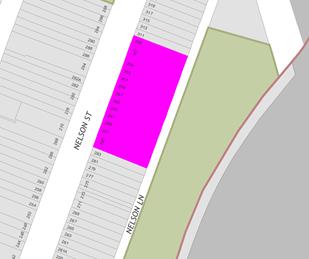
LTC0418 Item 13 Nelson Lane (at aquaduct), Annandale - Extension of 'No Parking' Zone (Balmain Ward/Balmain Electorate/Leichhardt LAC) |
|
Concerns have been raised by residents regarding vehicles partially parking on the grass verge on the western side of Nelson Lane (between the properties of 243 and 247 Nelson Street) obstructing vehicle access and maneuvering space.
Officer’s Recommendation
THAT a 37m ‘No Parking’ zone be installed on the western side of Nelson Lane, Annandale between Nos. 243 and 247 Nelson Street.
DISCUSSION
The Committee members agreed with the Officer’s recommendation.
COMMITTEE RECOMMENDATION
THAT a 37m ‘No Parking’ zone be installed on the western side of Nelson Lane, Annandale between Nos. 243 and 247 Nelson Street.
For motion: Unanimous
|
|
LTC0418 Item 14 Unnamed Laneway between Flood Street and National Street, Leichhardt - Proposed 'No Parking' restrictions Leichhardt Ward/Balmain Electorate/Leichhardt LAC) |
|
Council has received additional concerns regarding parking in the Unnamed Laneway between Flood Street and National Street, Leichhardt
Officer’s Recommendation
THAT:
1. A 10m ‘No Stopping’ zone followed by a 6.5m ‘No Parking’ zone be installed on the eastern side of the Unnamed Laneway between Flood Street and National Street, Leichhardt across the rear boundaries of Nos.40-42 National Street, Leichhardt; and
2. A 4.2m ‘No Parking’ zone be installed on the western side of the Unnamed Laneway between Flood Street and National Street, Leichhardt across the rear boundaries of Nos.5A-9 Flood Street, Leichhardt.
DISCUSSION
The Committee members agreed with the Officer’s recommendation.
COMMITTEE RECOMMENDATION
THAT:
1. A 10m ‘No Stopping’ zone followed by a 6.5m ‘No Parking’ zone be installed on the eastern side of the Unnamed Laneway between Flood Street and National Street, Leichhardt across the rear boundaries of Nos.40-42 National Street, Leichhardt; and
2. A 4.2m ‘No Parking’ zone be installed on the western side of the Unnamed Laneway between Flood Street and National Street, Leichhardt across the rear boundaries of Nos.5A-9 Flood Street, Leichhardt.
For motion: Unanimous
|
|
LTC0418 Item 15 Leichhardt Park car park, Lilyfield - Parking Conditions (Balmain Ward / Balmain Electorate / Leichhardt LAC) |
|
This report outlines the proposed changes to parking restrictions in the Leichhardt Park car park associated with the recent construction of the Leichhardt Park child care centre.
Officer’s Recommendation
THAT the installation of the following parking restrictions in the Leichhardt Park car park adjacent to the Leichhardt Park Child Care Centre (as detailed in Attachment 1) be supported:
a) Extension of the existing ‘Disabled Parking’ restriction from 9.0m to 12.0m (3 spaces);
b) Installation of 8.1m ‘P15min 7am-9am 4pm-6pm Mon-Fri’ (3 spaces); and
c) Installation of 1.8m ‘No Parking’ zone (child care centre access path).
DISCUSSION
The Committee members agreed with the Officer’s recommendation.
COMMITTEE RECOMMENDATION
THAT the installation of the following parking restrictions in the Leichhardt Park car park adjacent to the Leichhardt Park Child Care Centre (as detailed in Attachment 1) be supported:
a) Extension of the existing ‘Disabled Parking’ restriction from 9.0m to 12.0m (3 spaces);
b) Installation of 8.1m ‘P15min 7am-9am 4pm-6pm Mon-Fri’ (3 spaces); and
c) Installation of 1.8m ‘No Parking’ zone (child care centre access path).
For motion: Unanimous
|
|
LTC0418 Item 16 Illawarra Road, Marrickville – Removal of Redundant ‘No Parking’ Restrictions Outside Nos. 410 and 408 And Introduce New “1P 8.30AM – 6.00PM’ Parking Restrictions |
|
Council is proposing to remove the redundant AM & PM peak restrictions on a short length of restricted one (1) hour parking, located adjacent to Nos. 410 and 408 Illawarra Road, Marrickville. The 11 metre length of allowable parking will be converted to “‘1P 8.30AM – 6.00PM’, in line with other parking restrictions along Illawarra Road, Marrickville. Adjacent businesses have been notified of the proposed changes.
Officer’s Recommendation
THAT:
1. The existing ‘No Parking 6.30am – 9.30am 3.30pm – 6.30pm Mon – Fri’ restrictions be removed from outside Nos. 410 and 408 Illawarra Road, on the western side 20 metre north of Harnett Avenue, Marrickville; and 2. The 11 metre length of allowable parking, on the western side of Illawarra Road, 20 metres north of Harnett Avenue be converted to “‘1P 8.30AM – 6.00PM’, in line with other parking restrictions along Illawarra Road, Marrickville.
DISCUSSION
Public speaker: Mr Nick Seremetis, representing a business on Illawarra Road, attended at 10.24am.
Mr Seremetis stated that he supports the recommendation and made the following comments:
Mr Seremetis left at 10.32am.
Committee members were advised that the restrictions were originally installed years ago due to a number of accidents that had occurred at the intersection of Renwick Street and Illawarra Road and were designed to improve sightlines. Due to recent changes to the intersection, the restrictions have become redundant.
The Committee members agreed with the Officer’s recommendation.
COMMITTEE RECOMMENDATION
THAT:
1. The existing ‘No Parking 6.30am – 9.30am 3.30pm – 6.30pm Mon – Fri’ restrictions be removed from outside Nos. 410 and 408 Illawarra Road, on the western side 20 metre north of Harnett Avenue, Marrickville; and 2. The 11 metre length of allowable parking, on the western side of Illawarra Road, 20 metres north of Harnett Avenue be converted to “‘1P 8.30AM – 6.00PM’, in line with other parking restrictions along Illawarra Road, Marrickville.
For motion: Unanimous
|
|
LTC0418 Item 17 Metropolitan Road, Enmore – Amend Signage For Existing Mobility Parking Space |
|
A request has been received to amend signage to the mobility parking space in Metropolitan Road, Enmore. At present parking is restricted to '90° angle parking rear to kerb'. The request is to remove the 'rear to kerb' restriction for the mobility parking space to allow all accessible vans to be accommodated.
It is recommended that the existing 'rear to kerb' restriction be removed from the mobility parking space in Metropolitan Road, Enmore south of Enmore Road, in order to improve accessibility for people with a disability.
Officer’s Recommendation
THAT:
1. The existing 'rear to kerb' parking restriction for the angled mobility parking space in Metropolitan Road, approximately 30m south of Enmore Road, Enmore be removed in order to improve accessibility for people with a disability; and
2. The resident and Council’s Parking Services be advised in terms of this report.
DISCUSSION
Council Officers explained that the proposed change was to cater for vehicles which had mobility access ramps from the rear of the vehicle. Council’s Access and Inclusion Planning Leader requested that the provision of a kerb ramp in the kerb extension and connection to the footpath be investigated.
The Committee members agreed with the Officer’s recommendation.
COMMITTEE RECOMMENDATION
THAT:
1. The existing 'rear to kerb' parking restriction for the angled mobility parking space in Metropolitan Road, approximately 30m south of Enmore Road, Enmore be removed in order to improve accessibility for people with a disability; and
2. The construction of a kerb ramp in the kerb extension, including connection to the footpath be investigated.
3. The resident and Council’s Parking Services be advised in terms of this report.
For motion: Unanimous |
|
LTC0418 Item 18 Beauchamp Street, Marrickville – Proposed No Parking Restrictions (Marrickville Ward/Summer Hill Electorate/Inner West LAC) |
|
A request has been received from a local resident of Beauchamp Street, Marrickville for the installation of a short section of ‘No Parking’ restrictions directly outside the frontage of their property, as pedestrian access to the adjacent steps of the raised footpath is often blocked by parked vehicles along the kerbside.
Residents have been notified of the proposal to install a short section of ‘No Parking’ restrictions on the eastern side of Beauchamp Street, in order to provide unobstructed pedestrian access to the adjacent steps of the raised footpath. It is recommended that the proposal be approved.
Officer’s Recommendation
THAT the installation of full-time ‘No Parking’ restrictions (2 metres in length) on the eastern side of Beauchamp Street, Marrickville, adjacent to property no. 82 Beauchamp Street, Marrickville, be APPROVED, in order to provide unobstructed pedestrian access to the adjacent steps of the raised footpath.
DISCUSSION
The Committee members agreed with the Officer’s recommendation.
COMMITTEE RECOMMENDATION
THAT the installation of full-time ‘No Parking’ restrictions (2 metres in length) on the eastern side of Beauchamp Street, Marrickville, adjacent to property no. 82 Beauchamp Street, Marrickville, be APPROVED, in order to provide unobstructed pedestrian access to the adjacent steps of the raised footpath.
For motion: Unanimous |
|
LTC0418 Item 19 Chapel Street, Marrickville – Proposed Timed No Parking Restrictions (Marrickville Ward/Summer Hill Electorate/Inner West LAC) |
|
A request has been received from a business owner of Chapel Street, Marrickville, for the provision of a ‘No Parking’ zone directly opposite to their loading dock, as vehicular access is often blocked by parked vehicles on the opposite side of the of the road.
Surrounding business owners have been notified of the proposal to install a section of ‘No Parking 8am-5pm Mon-Fri’ restrictions on the southern side of Chapel Street, in order to facilitate clear access for delivery trucks to safely turn in/turn out of the adjacent loading dock. It is recommended that the proposal be approved.
Officer’s Recommendation
THAT the installation of full-time ‘No Parking 8am-5pm Mon-Fri’ restrictions (5 metres in length) on the southern side of Chapel Street, Marrickville, between the existing driveway of property no. 66 Chapel Street, Marrickville, and the existing driveway of property no. 76 Chapel Street, Marrickville, be APPROVED, in order to facilitate clear access for delivery trucks to safely turn in/turn out of the adjacent loading dock and to increase safety for motorists within the street.
DISCUSSION
The Committee members agreed with the Officer’s recommendation.
COMMITTEE RECOMMENDATION
THAT the installation of full-time ‘No Parking 8am-5pm Mon-Fri’ restrictions (5 metres in length) on the southern side of Chapel Street, Marrickville, between the existing driveway of property no. 66 Chapel Street, Marrickville, and the existing driveway of property no. 76 Chapel Street, Marrickville, be APPROVED, in order to facilitate clear access for delivery trucks to safely turn in/turn out of the adjacent loading dock and to increase safety for motorists within the street.
For motion: Unanimous |
|
LTC0418 Item 20 Boomerang
Street and Mortley Avenue, Haberfield |
|
Council has received a request from Sydney Buses to install regulatory “Bus Zone” signs at certain Bus Stops existing along Boomerang Street and Mortley Avenue, Haberfield, to reinforce the bus zone regulations. Bus zone signs are proposed to be erected within or around the statutory distances as required on the approach and departure of the Bus Stops in accordance to the Australian Road Rules.
Officer’s Recommendation
THAT “Bus Zone” signage be installed at the existing Bus Stops locations as follows:
1. Outside No 15 Boomerang Street, approximately 23.0 metres on the approach side and 13.0 metres on the departure side of the Bus Stop; 2. Outside No 28 Boomerang Street, approximately 19.0 metres on the approach side and 1.0 metre on the departure side of the Bus Stop; and 3. In Mortley Avenue (corner side frontage of 48 Boomerang Street) approximately 20 metres on the approach side and 7.0metres in the departure side of the Bus Stop.
DISCUSSION
The Committee members agreed with the Officer’s recommendation.
COMMITTEE RECOMMENDATION
THAT “Bus Zone” signage be installed at the existing Bus Stops locations as follows:
1. Outside No 15 Boomerang Street, approximately 23.0 metres on the approach side and 13.0 metres on the departure side of the Bus Stop; 2. Outside No 28 Boomerang Street, approximately 19.0 metres on the approach side and 1.0 metre on the departure side of the Bus Stop; and 3. In Mortley Avenue (corner side frontage of 48 Boomerang Street) approximately 20 metres on the approach side and 7.0metres in the departure side of the Bus Stop.
For motion: Unanimous |
|
LTC0418 Item 21 Frederick Street, Ashfield - Advertising Trailer Parking (Leichhardt Ward/Strathfield & Summer Hill Electorates/Ashfield LAC) |
|
This report is in response to a Notice of Motion raised at Council’s meeting on the 12 October 2017 as follows that : “Council investigates the removal of the advertising trailers on Frederick Street, Ashfield”. Council’s traffic officers have investigated various avenues in discussion with the RMS, Police and Council’s Planning/Regulatory officers in the removal and/or deterrence of advertising trailer parking in Frederick Street, Ashfield. The following recommendation is made for Council to note on the course of action that will be carried out in removing or limiting advertising trailer parking in Frederick Street and other streets within the Inner West Council area.
Officer’s Recommendation
THAT Council Note:
1. Advertising trailers parked on a road or road related area will be prohibited or limited under recent changes made to the “State Environmental Planning Policy No.64-Advertising and Signage (Amendment No.3) under the Environment And Planning Assessment Act 1979.”-see Schedule 1 [7] clause 27A. A copy of the amendment to policy is in attachment 3;
2. Council’s Planning and Compliance/Parking and Ranger Service officers will commence to enforce and monitor advertising trailer parking in Frederick Street and all other streets in the Inner West Council Area in compliance to the above amended policy item 1, as from 1 March 2018; and
3. Planning and Compliance/Parking and Ranger Services will be reporting back to Council in due course on the update and status of enforcing and monitoring of advertising trailer parking in Frederick Street and other streets in the Inner West Council Area.
DISCUSSION
The Committee members agreed with the Officer’s recommendation.
COMMITTEE RECOMMENDATION
THAT Council Note:
1. Advertising trailers parked on a road or road related area will be prohibited or limited under recent changes made to the “State Environmental Planning Policy No.64-Advertising and Signage (Amendment No.3) under the Environment And Planning Assessment Act 1979.”-see Schedule 1 [7] clause 27A. A copy of the amendment to policy is in attachment 3;
2. Council’s Planning and Compliance/Parking and Ranger Service officers will commence to enforce and monitor advertising trailer parking in Frederick Street and all other streets in the Inner West Council Area in compliance to the above amended policy item 1, as from 1 March 2018; and
3. Planning and Compliance/Parking and Ranger Services will be reporting back to Council in due course on the update and status of enforcing and monitoring of advertising trailer parking in Frederick Street and other streets in the Inner West Council Area. For motion: Unanimous
|
|
LTC0418 Item 22 2A Gladstone Street, Newtown - DA201700589 – For The Temporary Use of The Site For A Multi-use Creative Hub |
|
An application (DA201700589) has been received to use the existing buildings on site at 2A Gladstone Street, Newtown to create a “Proposed multi-use area which would include creative work spaces, market stalls, wholesale bakery and food truck.” The application type is for “Temporary building/structures.”
It is recommended that the comments of the Traffic Committee be referred to Council’s Development Assessment Section for consideration in determining the Development Application.
Officer’s Recommendation
THAT the findings of this report be received and noted.
DISCUSSION
The Committee members agreed with the Officer’s recommendation.
COMMITTEE RECOMMENDATION
THAT the findings of this report be received and noted.
For motion: Unanimous |
LATE ITEMS
|
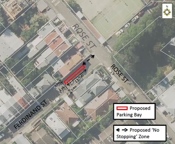
LTC0418 Item 23 Ferdinand Street, Birchgrove - Proposed Parking Bay (Balmain Ward/Balmain Electorate/Leichhardt LAC)
|
|
Prepared by: David Yu – Traffic Engineer
Authorised by: Manod Wickramasinghe – Coordinator – Traffic and Parking Services
SUMMARY Concerns have been raised by the resident of No. 24 Rose Street, regarding vehicles partially parking on the footpath on the western side of Ferdinand Street (adjacent to 24 Rose Street) obstructing pedestrian accessibility to the property.
Officer’s Recommendation
THAT:
1. A 10m ‘No Stopping’ zone be installed on the western side of Ferdinand Street from the corner of Rose Street. 2. A 12.7m closed parking bay be marked on the western side of Ferdinand Street (adjacent to 24 Rose Street).
BACKGROUND Concerns have been raised by the resident of 24 Rose Street regarding vehicles parking on the footpath at the western side of Ferdinand Street, which impedes pedestrian accessibility to the property. There is also a hydrant located in the footpath adjacent to the property that needs to be accessed by Sydney Water or Fire and Rescue NSW officers.
Ferdinand Street is two-way, 6.5m wide with parking on both sides of the street. The width of the footpath ranges from 1.5m to 1.8m. Vehicles partially park on the footpath due to the insufficient road width, which reduces the effective footpath width along the street.
FINANCIAL IMPLICATIONS Nil.
OTHER STAFF COMMENTS In order to alleviate the issue, it is proposed to mark a 12.7m closed parking bay within the road carriageway on the western side of Ferdinand Street, adjacent to 24 Rose Street (shown on the following plan) to designate where vehicles need to park on-street, maintain pedestrian access to the property and access to the hydrant.
PUBLIC CONSULTATION Nil.
CONCLUSION Nil.
DISCUSSION
The Committee members agreed with the Officer’s recommendation.
COMMITTEE RECOMMENDATION
THAT:
1. A 10m ‘No Stopping’ zone be installed on the western side of Ferdinand Street from the corner of Rose Street. 2. A 12.7m closed parking bay be marked on the western side of Ferdinand Street (adjacent to 24 Rose Street).
For motion: Unanimous
|
GENERAL BUSINESS
|
LTC0418 Item 24 Greek Orthodox Easter Events - Canterbury Road, Hurlstone Park
|
|
Clr Passas stated that she attended a Greek Orthodox Easter event on the night of Saturday, 7 April at the church on Canterbury Road, Hurlstone Park. She expressed safety concerns due to the large crowds that were not sufficiently managed and asked how these events could be managed more appropriately. The Police representatives advised Police can manage crowds by closing off streets for such events, provided that the church provide notice and the event is presented for Local Traffic Committee consideration.
|
|
LTC0418 Item 25 Request for relocation of pedestrian crossing in Alt Street, Ashfield
|
|
The representative for the Member for Summer Hill advised that their office received a letter from De La Salle College and Bethlehem College in Ashfield requesting for the Alt Street pedestrian crossing to be relocated further down the street. The schools stated in their request that the relocation of the crossing allows more space for two school buses to park safely and for school children to cross the road. The representative provided the letter to Council Officers for consideration.
|
|
LTC0418 Item 26 Frederick Street, Ashfield - Pedestrian crossing upgrade
|
|
Clr Da Cruz asked the RMS representative for an update on the Frederick Street pedestrian crossing upgrade. The RMS representative advised that construction is scheduled for May 2018 and will provide further details on the progress of notifying the community via email.
|
|
LTC0418 Item 27 Bicycle road markings in Sloane Street, Summer Hill
|
|
The representative for the Inner West Bicycle Coalition stated that bicycle road markings have not been reinstalled after the upgrade of Sloane Street, Summer Hill. Council Officers noted this and will arrange.
|
|
LTC0418 Item 28 Heavy vehicle compression brake use on Old Canterbury Road, Lewisham
|
|
Council Officers advised that a resident wrote to Clr Pauline Lockie requesting Council investigate the use of compression brakes by heavy vehicles on Old Canterbury Road, Lewisham, particularly between Barker Street and Great Western Highway. As Old Canterbury Road is a classified road under RMS jurisdiction, Council Officers have sent the request to RMS for investigation. The RMS representative requested that the email be sent to him to follow up.
|
Meeting closed at 11.45am.
ATTACHMENT 1
Regional Bicycle Route 7-Detail Design Plans - Additional community consultation
PUBLIC CONSULTATION
Following the conclusion of the consultation period for the proposed cycleway (route RR7) on 29 March 2018 Council received additional 13 submissions, 6 of the submissions indicating support, 5 submissions indicating support with comments/changes and 2 submissions objecting to the proposal.
Below are summary of the additional submissions for consideration by the Traffic Committee.
|
Respond by Location |
Total Number of submissions |
Yes |
Yes with changes |
No |
|
Trafalgar Street |
1 |
|
|
1 |
|
Jubilee Street |
1 |
|
|
1 |
|
Other streets outside the route |
11 |
6 |
5* |
|
|
Total |
13 |
6 |
5* |
1 |
The issues raised by community members objecting the proposal are listed in the table below.
|
Issues most frequently raised in community consultation feedback |
Council officer response |
|
Objection to parking loss on Trafalgar Street (1 summation) |
This project has been developed with a focus on minimal parking loss. Unfortunately in some locations such as Trafalgar Street (with high traffic and pedestrian volume) the parking is compromised to allow for provision of two way separate bike path treatment. The separated bike paths are proposed in order to improve bike rider safety and comfort on sections of the route where on–road /shared path alternatives are unsafe due to high traffic and pedestrian volumes and alternative road options are impractical. This is consistent with NSW Government policy of providing appropriate bike infrastructure that meets user needs. Generally the parking to be lost is adjacent to railway land as to minimise the direct loss in parking for residents. |
|
Don’t support 9 tree removals with only one replacement (1 summation) |
All 9 trees to be removed will be replaced along new kerb alignment |
*It should be noted that comments received in support of the proposal ‘with changes’ are comments /changes in relation to the design and will be considered and investigated as part of the further detail design phase and if are feasible, will be incorporated into the design.
Total number of all submissions received during the 4 weeks of community consultation is as tabled below:
|
Total Number of all submissions |
Yes |
Yes with changes |
No |
|
78 |
44 (56.5%) |
23 (29.5%)* |
11 (14%) |
|
|
Local Traffic Committee Meeting 1 May 2018 |
Subject: Croydon Road, Croydon-Proposed Pedestrian and Road Safety Improvements (Leichhardt Ward/Strathfield Electorate/Ashfield LAC)
Prepared By: Boris Muha - Engineer – Traffic and Parking Services
Authorised By: John Stephens - Traffic and Transport Services Manager
|
SUMMARY This report provides an update in response to Council's resolution dealing with Notice of Motion C1017 Item 14 – Pedestrian safety on Croydon Road, Croydon of its 12 October 2017 Council Meeting. An on-site meeting was conducted on 7 December 2017.
The report evaluates traffic survey data collected on speeding, vehicle volumes, pedestrian vs volume counts (for pedestrian crossing warrants), accidents, and examines, if required, measures to improve the safety of school children, pedestrians and motorists along Croydon Road.
The analysis of results apart from traffic volumes, show speeding and accidents (in the last five years) to be low along Croydon Road. Pedestrian numbers crossing at various locations along Croydon Road and side streets to Croydon Road are below that required to warrant a pedestrian crossing. It should also be noted that no pedestrian accidents have occurred along Croydon Road in the last five years. As an outcome of the data collection and analysis of the data, the results do not support additional traffic calming measures and major pedestrian facility works in the area at the present with the exception to only place a speed hump device, north of Church Street, which is under separate investigation as part of the design proposal for the intersection of Church Street and Croydon Road.
However, it is considered that providing pedestrian cross over points along Croydon Road would be beneficial to enhance pedestrian safety and provide a link to destinations either side of Croydon Road. With reference made to the Ashfield Pedestrian Access and Mobility Plan (PAMP) and the Former Ashfield Local Government Area Traffic Management Strategy (ATMS), the following conceptual (major) traffic facility works are recommended below. Support in principal is sought for these proposals, subject to detailed design investigation and resident consultation.
Minor traffic facility and maintenance works would be undertaken in the form of remarking of line marking, relocation/replacement of faded or missing signs, and the provision (if not existing) of new give-way line marking and signage to side streets. Pram ramps will be installed/upgraded on the side streets to Croydon Road. Existing speed hump markings would be adjusted where necessary along Croydon Road to prevent the perception of these devices as being crossings. Rather than physical barriers, (e.g. fencing) pedestrian prohibited type (Symbolic) markings could be placed at certain speed humps along Croydon Road to warn and deter pedestrians from using the speed humps to cross the road.
A report was submitted to the March, 2018 Traffic Committee (and adopted by Council at its meeting on the 27 March 2018) to place solid yellow lines governing ‘No Stopping’ around the corners of the intersection of Anthony Street and Croydon Road. |
|
THAT:
1. The report be received and noted; 2. That support in principal be granted for Council to pursue the following conceptual traffic facility proposals, subject to further detail design and resident consultation:
(a) Provide a speed cushion in Croydon Road on the approach to Elizabeth Street per figure 1; (b) Widen the north-west corner of Anthony Street and Croydon Road, provide a refuge facility in Croydon Road south of Anthony Street, and speed cushion in Croydon Road north of Anthony Street per figure 2 in this report; (c) Provide kerb-blisters in Edwin Street North at the intersection to Anthony Street per figure 3; (d) Remove the horizontal deflection device and replace it with a pedestrian refuge island facility in Croydon Road between Kenilworth Street and Gregory Avenue, and provide speed cushions in Croydon Road on both approaches to Kenilworth Street and Gregory Avenue per figure 4; (e) Provide a pedestrian refuge in Croydon Road between Ranger Road and John Street, and a central median-island with an at-grade entry threshold treatment in John Street at the intersection with Croydon Road per figure 5; (f) Provide a pedestrian refuge opening in the splitter island in Croydon Road, north of the roundabout intersection with Church Street, and provide a speed cushion in Croydon Road on the southern end approach to Queen Street per figure 6; (g) Provide short length painted double white centre lines in Bay Street at the approach to Croydon Road, and in Croydon Road south of Bay Street. Also provide an at-grade entry threshold treatment in Bay Street at the intersection of Croydon Road per figure 7; and (h) Provide a central median island in Dalmar Street at Croydon Road per figure 8.
3. Give-way signs and markings (if not existing) be provided to all side road intersections to Croydon Road, and that short length double white centrelines be painted in Croydon Road in approaches to both Dalmar Street and Bay Street;
4. An audit be undertaken on the existing conditions of line making and signposting, and that maintenance be undertaken to remark any line marking and relocate/replace faded or missing signage;
5. Existing pram ramps be investigated for upgrade where required, and ramps be included/upgraded where required in line with the above works (item 2) on side street intersections to Croydon Road; and
6. Piano key markings on speed humps be remarked where required and provide or remark pedestrian prohibited (symbolic) markings on certain (or wider platform) speed humps along Croydon Road. |
BACKGROUND
At the Council Meeting on the 12 October 2017, the following Notice of Motion was raised - C1017 Item 14 – Pedestrian safety on Croydon Road, Croydon:
THAT:
1. Council through the Traffic Committee urgently convenes an onsite meeting with the local community, a school representative, members of the Traffic Committee and Ward Councillors at a time that school children are walking to school to observe and hear from the community and Councillors on what the key safety issues are and hear from Traffic Committee members on ways they could be addressed; and
2. A report be brought to the Traffic Committee and then to Council as soon as possible outlining proposals to improve the safety for school children and pedestrians on Croydon Road, Croydon. These proposals to include investigation on the installation of a pedestrian crossing and traffic calming measures. The report should also provide a proposed timeline for works and proposed prioritisation of funding for the works.
An on-site meeting was conducted on 7 December 2017 with Councillors, PLC school Principal and residents at the intersection of Croydon Road and Anthony Street, and along Croydon Road, Croydon. It was advised that traffic and pedestrian counts would be carried out in February 2018 after the school holidays.
Croydon Road is classified as a collector road with traffic volumes ranging from 4800-9500 vehicle per day. Unrestricted parking exists to both sides of the road. The road measures approximately 10.1 metres in width kerb to kerb. Existing speed hump devices are currently positioned along Croydon Road at various distances apart from 60-200 metres. Roundabouts exist at the intersections of Anthony Street and Queen Street. All other side street are classified local roads with low to moderate traffic volumes ranging from 320-5300 vehicles per day, with unrestricted parking on both sides of the street, and Give-Way or STOP controls at the intersections to Croydon Road.
FINANCIAL IMPLICATIONS
The Pedestrian Access & Mobility Plan and the Ashfield Traffic Management Strategy developed by the former Ashfield Council identified and prioritised traffic facility and pedestrian works across the former Ashfield LGA. Both strategies recommended investigation of works in Croydon Rd for traffic calming and improved pedestrian access.
The current draft capital works program forecasts a budget of $225,000 in 2019/20 for traffic calming works in Croydon Rd. A budget of $105,000 has also been proposed for intersection improvements at the Croydon Rd/ Church Street intersection in 2018/19.
Works ultimately identified which are in excess of these forecast budgets will need to be prioritised within the forward capital programs against other competing priorities for traffic facility improvements.
OTHER STAFF COMMENTS
Traffic and speed counts.
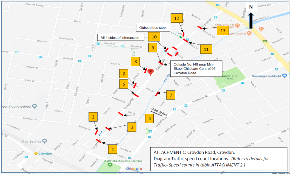
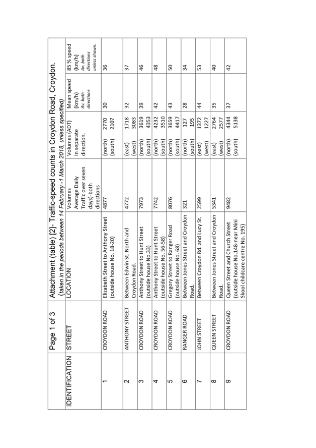
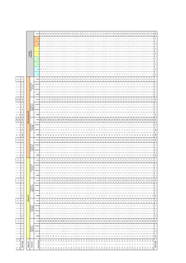
Traffic counters were placed along Croydon Road and certain side streets between 14 February and 1 March 2018. Counts at the intersection of Croydon Road and Church Street were conducted under a separate investigation in March 2017 and Sept 2017. These counts are considered representative to date. The location of traffic counts are shown in Attachment 1 and have been identified numbered 1-13. The results have been tabled in Attachment 2.
The counts along Croydon Road were placed between traffic devices measuring over 100m in length or in midblock street sections to obtain optimum speed counts. The results identify that the 85th percentile speeds along Croydon Road, are relatively low, typically between, 36-50km/h or within tolerance of the 50 km/h speed limit. The average (mean) speed ranged from 30-42 km/h. The speed of traffic does not justify the need for additional traffic calming devices to be placed along Croydon Road. The exception to this finding is to propose one speed hump in Croydon Road, north of Church Street under separate investigation which identified the need for additional traffic calming on approach to this intersection.
It is considered that factors such as parking to both sides of the road, continued centre line marking, and the volumes of 2-way traffic along Croydon Road all contribute in the control of speeding. The centre line marking in parts along the road has faded, and this line marking will be re-marked.
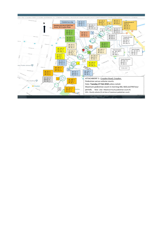
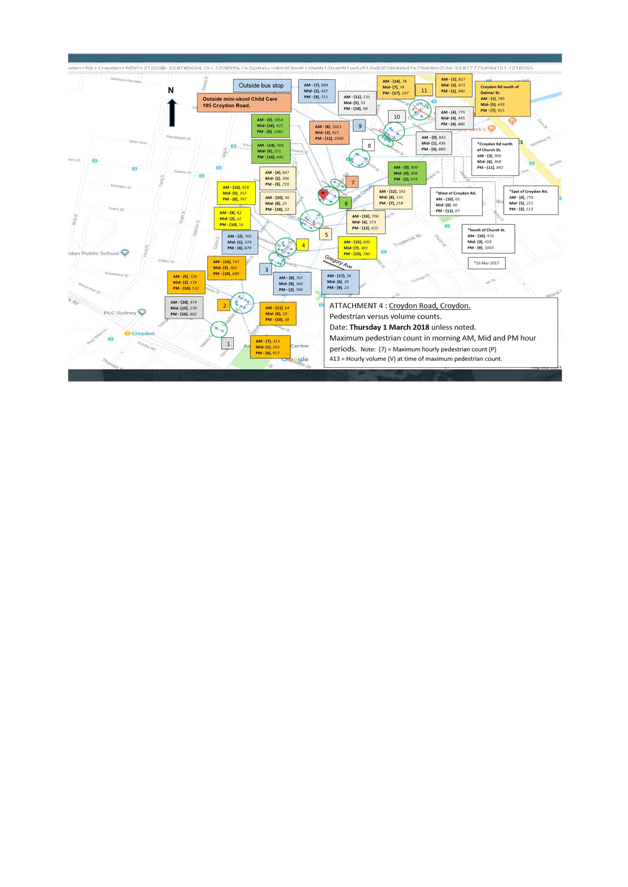
Pedestrian-Volume counts
Pedestrian volume counts were conducted at all legs of 9 intersections and across 2 particular locations along Croydon Road, that being the Childcare Centre at 195 Croydon Road and a Bus Stop just north of Australia Street. These locations were considered likely desire paths for pedestrians along Croydon Road. Pedestrians were also captured in a range length of 30 metres either side of the locations. These locations are shown and marked numbered 1-11 in the diagram Attachment 3 and 4.
The pedestrian movements for location 1-6, 8-11 were recorded within the AM time range of 7.30 am-9.30am., Mid-day range from 11.30am -1.30pm., and PM time range from 2.30pm-5.30pm in order to capture all forms of pedestrian activity, including that of school children. Location 7 being the Childcare Centre, the times were extended to capture early morning and late afternoon pick-up i.e. 7.00am-10.00am., 11.30am-1.30pm., and 3.00pm-6.00pm.
Surveys were conducted on two day sessions, that being of a Tuesday the 27th February (Attachment 3) and the Thursday 1st March 2018. (Attachment 4). Pedestrian survey counts for Croydon Road/Church Street intersection were undertaken on the 14 and 16 March 2017 under separate investigation of this intersection. The results are still considered comparative to date as no real changes in traffic conditions or development in the area has prompted changes in pedestrian movement.
Under the Guide to Traffic Management – Part 6 (Austroads,2013), the RMS practice for numerical warrants for Pedestrian (Zebra) Crossings area as follows:
i) Normal Warrant:
A pedestrian (Zebra) Crossing is warranted where:-
In each of three separate one hour periods in a typical day
(a) the pedestrian flow per hour (P) crossing the road is greater than or equal to 30 AND
(b) the vehicular flow per hour (V) through the site is greater than or equal to 500 AND
(c) the product PV is greater than or equal to 60,000
ii) Reduced Warrant for sites used predominantly by children and by aged or impaired pedestrians.
If the crossing is used predominantly by school children, and in two counts of one hour duration immediately before and after school hours:-
(a) P ≥ 30 AND (b) V ≥ 200
A pedestrian (Zebra) Crossing may be installed.
If at least 50% of pedestrians using the crossing are aged or impaired and for each three one hour periods in a typical day
(a) P ≥ 30 AND (b) V ≥ 200 AND (c) PV ≥ 60,000
A pedestrian (Zebra) Crossing may be installed
iii) Special Warrant:
In certain circumstances where:-
(a) PV ≥ 45,000 (but less than 60,000) AND (b) P ≥ 30 AND (c) V ≥ 500
In the analysis of the recent survey, maximum pedestrian movements in the one hour period (P) in the above AM, Mid, and PM ranges did not exceed around 18 in locations across Croydon Road, and no more than around 23 in the side streets. Croydon Road in all locations registered vehicle volumes (P) well over 200 vehicles per hour, more in the range of around 500-1000 vehicles per hour. The side streets registered in the range of around 15-500 vehicles per hour.
Where pedestrian counts were higher in one particular hour period of the day, they were lower on the other hour periods of the day.
Although it could be said that the volumes are high to justify the (V) value under certain warrants above, the pedestrian volumes fall under the (P) requirement of 30 or more pedestrians needing to cross the road at any of the concentrated locations to justify all warrants. In view of this, no warrant can be made to require the installation of a pedestrian marked (zebra) foot crossing either in Croydon Road or the side streets.
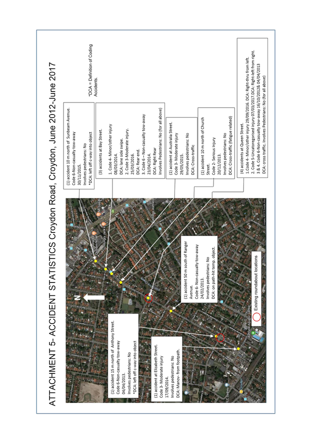
Accident Statistics
Available and recorded accidents in the area over the last 5 years from June 2012 to June 2017 revealed that 13 accidents had occurred along Croydon Road, between Parramatta Road and Elizabeth Street. This is shown on Attachment 5.
Police have advised that no major or minor accidents have been recorded from June 2017 to date.
· Of the 13 crashes:
o 3 occurred in wet conditions and 10 in dry conditions;
o 9 occurred during the day and 4 during the night / hours of darkness;
o The crash types / cause codes indicated 2 crashes involved vehicles veering left off road hitting an object, 1 was due to a vehicle hitting a temporary object on the road, 4 were cross traffic related, 1 lane side swipe, 1 Rear end, 1 manoeuvre from footpath, 3 right and or left movements from intersections.
o Accidents were mainly non-injury, minor or moderate. 1 accident was of serious injury and fatigue related.
o No fatal crashes were recorded.
o No Pedestrian accidents have occurred along Croydon Road or the side streets to the intersection of Croydon Road in the last five (5) years.
The accident history in the area is considered low, and is mainly based on motorists failing to give-way or not execute movements or travel on the correct side of the road.
Major Traffic Facility/infrastructure proposals.
Generally pedestrian movements along Croydon Road are wide spread with no real strong desire lines. Pedestrians tend to cross over Croydon Road with caution and at locations where traffic speeds are low or where traffic control devices are present (e.g. near roundabouts).
However, it is recognised that added pedestrian cross over points along Croydon Road would be beneficial to enhance pedestrian safety and provide a link to destinations either side of Croydon Road. With reference made to the Ashfield Pedestrian Access and Mobility Plan (PAMP) and the Former Ashfield Local Government Area Traffic Management Strategy (ATMS), the following conceptual (major) traffic facility works are recommended to enhance pedestrian safety and further initiate traffic calming to reduce speeding on the approach to various intersections.
Figure 1. Provision of a speed cushion in Croydon Road in approach to Elizabeth Street.
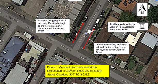
This treatment of a speed cushion in Croydon Road at the approach to Elizabeth Street is recommended under the ATMS to avoid crashes with vehicles from the adjacent direction of the intersection.
The provision or extension of ‘No Stopping’ restrictions at the corners of Croydon Road at Elizabeth Street, resolves a vehicular manoeuvre and hazard issue around the central median island in Croydon Road. This was raised at the community meeting and/or separately by residents.
Figure 2. Widen the north-west corner of Anthony Street and Croydon Road, and provide a refuge facility in Croydon Road, south of Anthony Street, and provide a speed cushion in Croydon Road on the northern end approach to Anthony Street.
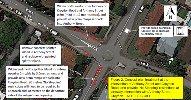
The proposal allows for pedestrians to safely and properly cross at the roundabout. The PAMP recommends improved pedestrian-pram ramp facilities at these locations.
A speed cushion is proposed in Croydon Road at the northern end approach to Anthony Street in line with the ATMS recommendation to avoid crashes with vehicles from the adjacent direction of the intersection. No speed cushion is proposed in Croydon Road south of Anthony Street, as a speed hump already exists in the near vicinity to slow vehicles down on the southern end approach to the roundabout.
‘No Stopping’ restrictions would be placed in Anthony Street 5.0 metres west and 7.0 metres east of the private lane off Anthony Street to improve sight visibility and access. The laneway is located on the southern side of Anthony Street, west of Croydon Road.
Figure 3. Provide kerb-blisters in Edwin Street North at the intersection to Anthony Street.
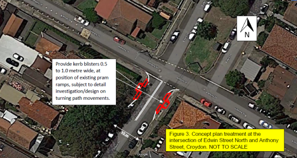
The PAMP identifies Edwin Street North as a high pedestrian desire line to and from the railway station, and similarly it is evident there is a desire for pedestrians to travel along Anthony Street to reach the various schools west of Edwin Street North. The proposal provides the opportunity for pedestrians to cross Edwin Street North at a narrower width of the intersection with Anthony Street.
Figure 4. Removal of the horizontal deflection device and replace with a pedestrian refuge island facility in Croydon Road between Kenilworth Street and Gregory Avenue, and provide speed cushions in Croydon Road on both approach ends to Kenilworth Street and Gregory Avenue.
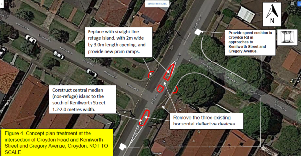
The PAMP identifies the need for a pedestrian- pram ramp facility at this location. Gregory Avenue is a dead end street, but a continued pedestrian access is maintained with a footbridge over the Iron Cove Creek, at the end of Gregory Avenue, to reach destinations east of Croydon Road.
Speed cushions are proposed in Croydon Road at the southern and northern approaches to Kenilworth Street and Gregory Avenue in line with the ATMS recommendation to avoid crashes with vehicles from the adjacent direction of the intersections.
The proposal at this location minimises the impact on parking in the area.
Figure 5. Provision of a pedestrian refuge in Croydon Road between Ranger Road and John Street, and a central median-island with an at-road grade entry threshold treatment in John Street at the intersection with Croydon Road.
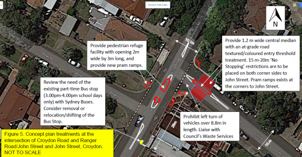
Although not identified under the PAMP, there is potential to consider a pedestrian refuge at this location in Croydon Road with minimum impact to parking. The ATMS recommends a central median island with an entry threshold treatment in John Street at the intersection of Croydon Road to control speeding on approach to the intersection.
However, consideration would need be made to either remove or relocate or adjust the position of a part-time (1 hour PM period) school special Bus Stop in Croydon Road, south of John Street. Council will need to liaise with Sydney Buses on this matter. Also consideration would need to be made to ban left turn movements from John Street into Croydon Road for vehicles over 8.8 metres in length in order for both treatments to effectively works at the intersection.
Figure 6. Provision of a pedestrian refuge opening in the splitter island in Croydon Road, at the Roundabout intersection with Queen Street, and provide a speed cushion on the southern end approach to Queen Street.
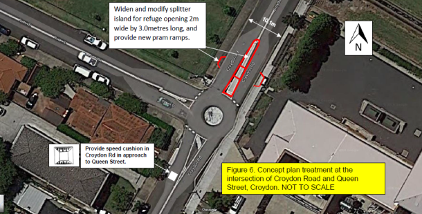
The PAMP identifies the need for a pedestrian- pram ramp facility at this location to reach various playground, sporting and community club services in the area.
A speed cushion is proposed in Croydon Road at the southern end approach to Queen Street in line with the ATMS recommendation to avoid crashes with vehicles from the adjacent direction of the intersection. No proposal is made to provide a speed cushion in Croydon Road on the northern end approach to the roundabout, as there is an existing speed hump in close proximity north of the intersection for speed control in approach to the roundabout.
Intersection of Croydon Road and Church Street, Croydon.
Pedestrian facilities across Croydon Road near/at this intersection of Church Street would be further investigated separately subject to Council’s decision on the treatment to this intersection in a report to its meeting on the 24 April 2018.
Figure 7- Provide short length double white centre lines in Bay Street at the approach to Croydon Road, and in Croydon Road, south of Bay Street. Also provide an at-grade entry threshold treatment in Bay Street at the intersection of Croydon Road.
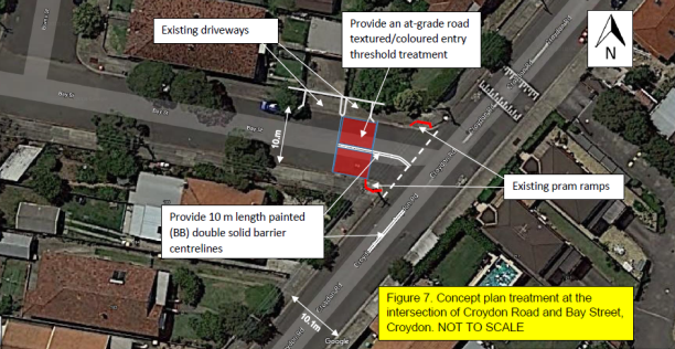
The ATMS recommends the placement of a central median island and entry threshold treatment in Bay Street for traffic control.
Under closer examination of the area, a central island would interfere with driveway access and the narrowness and acute angle of Bay Street would lead to the island being hit by vehicles turning left, or that large vehicles are likely to come out wide into the opposing traffic in Croydon Road when attempting to turn left. The provision of double white painted centrelines in Bay Street on approach to Croydon Road, together with an at-grade entry threshold treatment in this regard should be considered. Also provide a short length double white painted centreline in Croydon Road on the southern end approach to Bay Street.
Figure 8- Provide a central median island in Dalmar Street at Croydon Road.
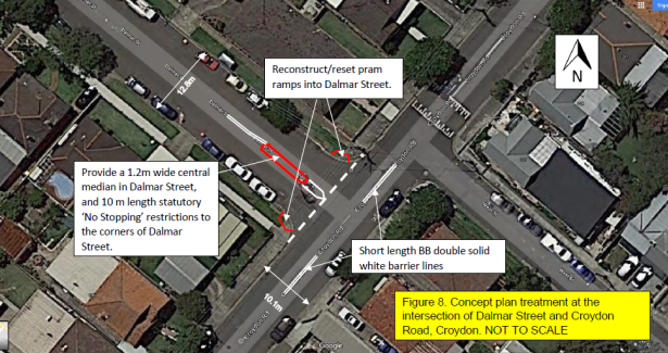
The ATMS recommends the placement of a central median island in Dalmar Street for traffic control. Also the placement of short length double white painted centrelines in Croydon Road at both approaches to Dalmar Street for added traffic control at the intersection, should be considered.
Minor Traffic Facility/infrastructure and maintenance works.
It is proposed to install short lengths of double white centreline marking (where not existing), to all intersection approaches along Croydon Road. Give-Way markings and signposting, if not existing, be provided at all side road intersections, and that short length double white centrelines be painted in both the Dalmar Street and Bay Street approaches to Croydon Road. These measures would assist to control and regulate traffic movement in the area. Line marking will be supplemented with reflective raised pavement markers.
There is a higher number of pedestrians with a desire to cross the side streets along Croydon Road and it is programed, under the general PAMP funding, to include/upgrade the pram ramps to side streets to improve the pedestrian amenity in the area.
Other Treatments
At the Traffic Committee meeting on the 6 March 2018, an item was presented proposing to install solid yellow line marking around all corners of the intersection of Anthony Street and Croydon Road. Residents have advised that vehicles are regularly parked too close to the intersection, which restricts available sightlines and turning paths for turning motorists, particularly for motorists which need to turn west into Anthony Street from Croydon Road.
This measure would also provide for improved sight view of pedestrians crossing at the intersection. The proposed marking distances are considered of statutory/regulatory length to allow for the safe and proper movement and sight view of vehicles turning at the intersection. The Traffic Committee at its meeting on the 6 March 2018 recommended approval of the proposal. The proposal was adopted by Council at its meeting on the 27 March 2018. Affected residents will be notified in due course on this matter prior to any action being undertaken.
Other concerns have been raised with pedestrians crossing at the speed humps along Croydon Road. The mandatory piano key markings on the speed humps may entice pedestrians to thinking that these devices are crossings. In this particular situation, the placement of barriers in the form of fencing or landscaping on the footpath is not recommended along Croydon Road, as these measures will impact on car door openings, driveway access to properties and access to waste collection. No pram ramp facility is made over these speed humps to encourage pedestrian use of the speed humps.
A few of the speed humps have been identified with the piano key markings being placed the wrong way and maintenance instructions have been issued to rectify this problem. It is further considered that pedestrian prohibited (symbolic) type markings be place on the speed humps to warn and discourage pedestrians from crossing over these devices. One or two of the devices have had these symbols marked, and it is viewed that these be remarked and further added to other speeds humps, particularly the wider platform types along Croydon Road.

Response to other issues raised at the community meeting.
(Meeting on site- 7 December 2017- Intersection Croydon Road and Anthony Street, Croydon)
This report focuses on providing treatments along Croydon Road and the side street intersections for pedestrian safety and traffic calming. However, the following main issues were also raised and a response is made as follows.
|
Issue |
Officer Response |
|
Pedestrian crossing request |
Pedestrian and volume counts were carried out, resulting in non-warrant of pedestrian crossings along Croydon Road. Alternate pedestrian refuge and kerb-extension treatments are proposed in Croydon Road and side streets for pedestrian safety. |
|
Narrow footpath. Pedestrian safety improvements at the intersection of Anthony Street/Croydon |
The north-west corner of Anthony Street and Croydon Road is proposed to be widened, and pedestrian refuge with setback kerb ramps proposed in Croydon Road, south of Anthony Street –see Figure 2. |
|
PLC activity in morning and afternoon, traffic, parking, and Principal request for one-way, and reintroduce right turn over railway line at Young Street. |
Council will list to investigate a Resident Parking Scheme (RPS) in the next financial year, subject to funding, to provide relief in parking for residents and short term parking for other users. Adjacent Burwood Council has an RPS in its streets. One-way in Anthony is not considered appropriate as this will impact on the traffic network in the area, and general community access. The right turn treatment over the railway line at Young Street is in the Burwood Council area, was removed on understanding due to hazard and conflict at the intersection. |
|
Exiting laneway onto Anthony Street. (no vision)
|
Proposal is to introduce No Stopping restrictions across the laneway off Anthony Street. See Figure 2. |
|
Parking on one side of the street- Anthony Street |
Removal of parking to one side of the street is not recommended. Vehicle parking provides friction and control of speeding. |
|
Time period parking-don’t pay for parking, No parking off-street |
Time period parking 1 or 2 hours would be considered under RPS investigation. No intention is made to provide meter parking in the area. |
|
No Island at Edwin Street North/Anthony Street to cross. |
Kerb blister extensions are proposed to assist pedestrians to cross at the intersection.-see figure 3. |
|
Traffic calming in John Street.
|
In reference to the ATMS, recommendation is made to place a central median and at-grade (road level surface) entry threshold treatment for control of traffic in approach to Croydon Road. |
|
Traffic Signal issues- right turn facility required from Croydon Road into Parramatta Road. Congestion at traffic lights at particular school hours. Traffic Signal request Croydon Road/Elizabeth Street. |
Signals come under the care and control of the RMS. RMS recently advised it does not support this request due to impacts caused on Parramatta Road. The ATMS does not identify placement of signals at the intersection of Elizabeth Street and Croydon Road. Low accident history at the intersection of Croydon Road/Elizabeth Street cannot justify signals. Sight view is adequate from Croydon Road. Give –Way lines will be remarked and ‘No Stopping’ restrictions added-extended to the Croydon Road side corners-see figure1. |
|
Roundabout in Croydon road/Queen Street-speeding |
Speed cushion is proposed in Croydon Road, south of Queen Street to provide further speed control at the roundabout. See Figure 6. |
|
Croydon Road/Elizabeth Street |
Croydon Road is a collector road linking traffic destination between Elizabeth Street and Parramatta Road. Congestion in the street is considered no worse than other locations, with vehicles steadily moving through. |
|
Consider optional proposals |
The recommended proposals are considered appropriate, and are subject to final design investigation on the feasibility of the proposals followed by resident consultation. Pending on resident feedback, alternate options might be considered. |
|
SLOW DOWN STICKERS |
Not required noting the speed figures are low. |
|
Website |
Advice and process of consultation will also be made on the website for residents to comment. |
|
Signposting No Stopping intersection of Croydon Road and Anthony Street. |
Yellow line marking will be placed to govern the ‘No Stopping’ restrictions. |
|
Meridan School bus parked in Croydon Road in Bus Stop, south of John Street. |
Council will liaise with Sydney Buses on the need of the Bus stop relative to proposal figure 5. If required, it will be signposted and regulated for buses not to park in the zone, but only set down and pick up. |
|
Signs obscured |
Sign audit will be carried out and maintenance to correct any signage. |
|
Frederick Street/Elizabeth Street. Queries in school hours AM and PM (congestion). |
Signals come under the care and control of the RMS. Matter will be referred to RMS for investigation to consider issues at the existing traffic lights.
|
PUBLIC CONSULTATION
Final investigation and design of the various conceptual major traffic facility proposals will need to be to be carried out to determine the practical feasibility of providing these proposals. Affected residents will be consulted on the finalised proposals.
CONCLUSION
In conclusion, it was found that Croydon Road, although busy does not have significant pedestrian or traffic safety issues. However, it is recognised that added pedestrian cross over points along Croydon Road would be beneficial to enhance pedestrian safety and provide a link to destinations either side of Croydon Road. With reference made to the Ashfield Pedestrian Access and Mobility Plan (PAMP) and the Former Ashfield Local Government Area Traffic Management Strategy (ATMS), various conceptual (major) traffic facility works are recommended in the report. Minor facility/infrastructure works such as maintenance to line marking and signposting, statutory/regulatory ‘No Stopping’ to laneway and street corners, and the provision/upgrade of pram ramps in the area, will also be undertaken.
|
1.⇩ |
Traffic and speed count locations in Croydon Road, Croydon. |
|
2.⇩ |
Tabled Results-Traffic and speed count locations in Croydon Rd, Croydon |
|
3.⇩ |
Pedestrian and volume counts in Croydon Road (27 Feb18) |
|
4.⇩ |
Pedestrian and volume counts in Croydon Road (1 Mar18) |
|
5.⇩ |
Accident statistics in Croydon Road-June 2012-June 2017 |
|
|
Local Traffic Committee Meeting 1 May 2018 |
Subject: Old Canterbury Road, Dulwich Hill - Proposed Traffic Signals Concept Design Plans (Ashfield Ward/Summer Hill Electorate/Ashfield & Inner West LAC)
Prepared By: Ryan Hawken - Project Manager Greenway Delivery
Authorised By: John Stephens - Traffic and Transport Services Manager
|
SUMMARY Concept design options have been prepared for the signalisation of Old Canterbury Road, Weston Street and Edward Street. Consultation was undertaken with owners and occupiers of properties regarding the options. A summary of the consultation results and traffic modelling results are presented in this report for consideration.
It is recommended that detail design of the traffic signals and intersection of Old Canterbury Road, Weston Street and Edward Street proceed based on a road closure to traffic at Weston Street, and consideration be given to improvements to traffic safety in Windsor Road, Edward Lane and Weston Street to be implemented in tandem with the proposed traffic signals. |
|
RECOMMENDATION
THAT:
1. The concept design of the traffic signals and intersection of Old Canterbury Road, Weston Street and Edward Street based on a full road closure to traffic at Weston Street as shown in Option 3, be APPROVED, and inform the detailed design;
2. Specific measures to improve traffic safety at the intersection of Old Canterbury Road and Windsor Road and in Edward Lane be considered in tandem with the detailed design and be presented to a future Local Traffic Committee for consideration with the detailed design plans for the signalised intersection; and
3. The detailed design plans be forwarded to the Roads & Maritime Services for consideration and approval.
|
BACKGROUND
As part of the development of the Summer Hill Flour Mills at 2-32 Smith Street, Summer Hill, the developer is required to install traffic signals at the intersection of Old Canterbury Road, Weston Street and Edward Street.
In July 2017 Council undertook preliminary engagement regarding the new signals and at the September 2017 Local Traffic Committee Meeting the committee endorsed the signals’ concept design.
Concurrent with planning for the new signals, Council is also developing the Greenway Master Plan. This includes a walking and cycling route along Weston Street. The development of the Master Plan provided Council with an opportunity to consider new options for the intersection (beyond that endorsed in 2017) which will best meet the needs of residents and are compatible with the Greenway.
Council undertook traffic counts and modelling in February, and developed three options for the signalisation of the intersection.
Five scenarios have been modelled in Sidra as follows:
· Existing without development: Priority controlled intersection (current configuration) with traffic numbers based on intersection counts undertaken in February 2018.
· Existing with development: Priority controlled intersection (current configuration) with additional traffic generated due the Flour Mill and McGill Street developments.
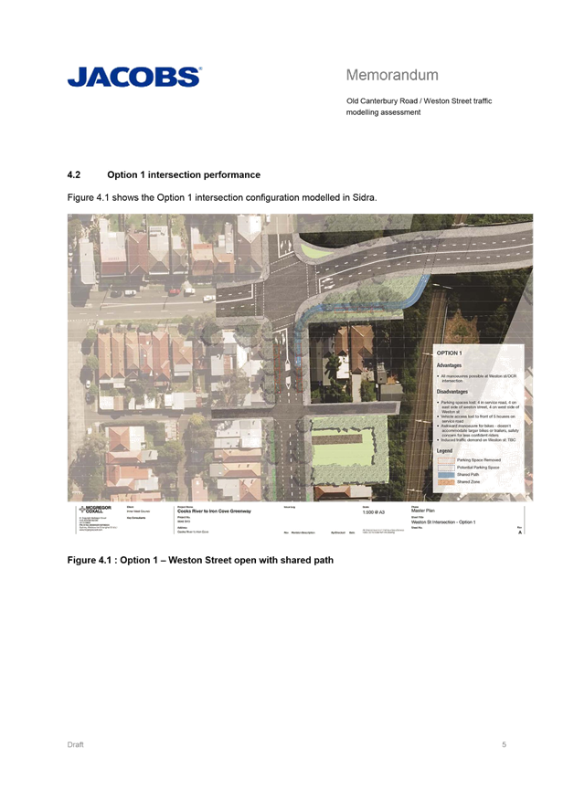
· Option 1 Full access at Weston Street: Signalised intersection with access in and out of Weston Street and provision of a bi-directional shared path on the eastern side of Weston Street and closure of the Old Canterbury Road service road.
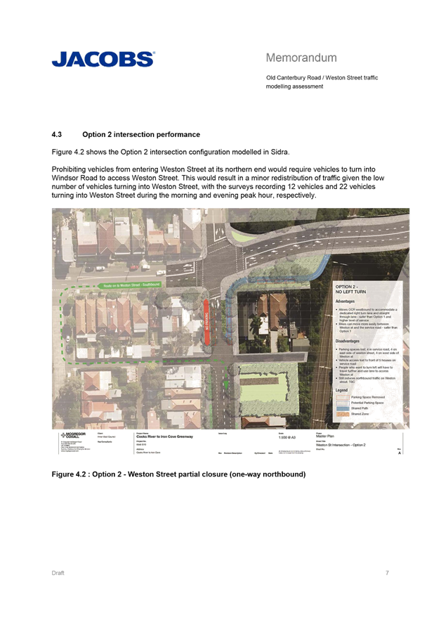
· Option 2 Out only at Weston Street: Signalised intersection with closure of Weston Street southbound at its interface with Old Canterbury Road, provision of a right turn lane on Old Canterbury Road in the westbound direction and closure of the Old Canterbury Road service road.
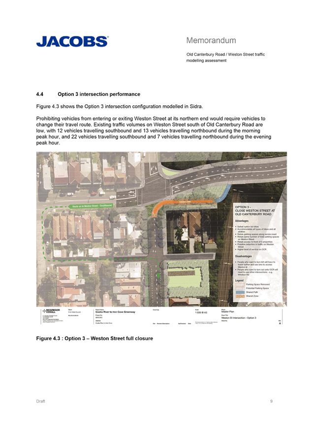
· Option 3 Full closure at Weston Street Signalised intersection with full closure of Weston Street at its interface with Old Canterbury Road, provision of a right turn lane on Old Canterbury Road in the westbound direction and implementation of a shared zone in the Old Canterbury Road service road.
These intersection concept plans are presented in Attachment 1. The traffic modelling memo is presented in Attachment 2.
Council is undertaking the concept design of the traffic signals and community engagement on behalf of the developer. It is anticipated that the recommendation of this repot will be given to the developer to facilitate detailed design and construction.
FINANCIAL IMPLICATIONS
The detailed design and construction of the intersection and traffic signals is to be undertaken and funded by developers in 2018/19. Works outside the intersection associated with the Greenway would be funded by the Greenway Capital Budget and implemented in coordination with the traffic signals in 2018/19.
OFFICER COMMENTS
Signalisation of Old Canterbury Road, Weston Street and Edward Street
The intersection of Old Canterbury Road, Weston Street and Edward Street currently operates as a priority controlled intersection with Old Canterbury Road functioning as a major east-west sub-arterial road, and Weston and Edward Streets as minor local roads.
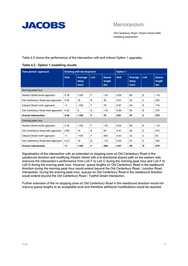
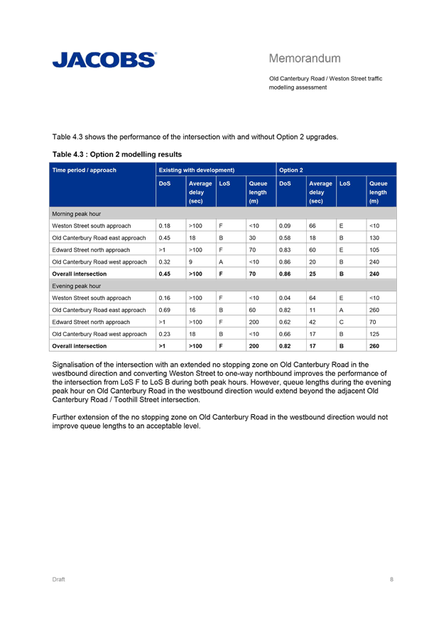
Council undertook traffic counts in February 2018, developed three options for the signalisation of the intersection and undertook on traffic modelling. A summary of the modelled performance of the intersection is shown in the table below.
Option 3 would deliver the most efficient intersection operation with the shortest queues and least delay to vehicles.
For all options an extended 'No Parking' zone on Old Canterbury Road in the westbound direction, east of Weston Street is required to reduce traffic queue lengths. It is recommended that this operate in the PM peak only.
|
Option |
Morning peak hour |
Evening peak hour |
Operational comments |
||
|
Level of Service |
Queue length (m) |
Level of Service |
Queue length (m) |
||
|
Option 1: Full access at Weston Street |
C |
275 |
D |
475 |
Acceptable operational performance, however unacceptably long queue lengths during the morning and evening peak periods. |
|
Option 2: Out only at Weston Street |
B |
240 |
B |
260 |
Good operational performance however long queue lengths during the evening peak period. |
|
Option 3: Full closure at Weston Street |
B |
150 |
A |
155 |
Good operational performance and queue lengths |
Each of the three options has different impacts on traffic, parking, access and safety. Specific advantages and disadvantages are summarised below.
|
|
Option 1: Full access at Weston Street |
Option 2: Out only at Weston Street |
Option 3: Full closure at Weston Street |
|
Performance of intersection |
Acceptable performance |
Good performance |
Good performance |
|
Queue lengths at intersection |
Long queue lengths |
Long queue lengths |
Acceptable queue lengths |
|
Turn movements onto Old Canterbury Road |
Signalised turn onto Old Canterbury Road at Weston Street |
Signalised turn onto Old Canterbury Road at Weston Street |
Maintains priority controlled turn onto Old Canterbury Road at Windsor Road |
|
Resident access to service road |
Closes service road to residents |
Closes service road to residents |
Maintains service road open to residents |
|
Resident access to Weston Street |
Maintains resident access to Weston Street from Old Canterbury Road |
Closes resident access to Weston Street from Old Canterbury Road. Up to 15 second delay. |
Closes resident access to Weston Street from Old Canterbury Road. Up to 15 second delay. |
|
Traffic volumes on Windsor and Weston |
Increases traffic volumes in Weston Street |
Increases traffic volumes in Weston Street |
Increases traffic volumes in Windsor Road |
|
Traffic volumes on Edward and Channel |
Increases traffic volumes in Edward Lane and Channel Street |
Increases traffic volumes in Edward Lane and Channel Street |
Increases traffic volumes in Edward Lane and Channel Street |
|
Resident parking |
Loss of 12 parking spaces |
Loss of 10 parking spaces |
No Loss of parking spaces |
|
Parking on Old Canterbury Road |
Loss of up to 18 parking spaces in afternoon peak |
Loss of up to 18 parking spaces in afternoon peak |
Loss of up to 18 parking spaces in afternoon peak |
|
Safety of pedestrians and cyclists |
Least safe for pedestrians and cyclists |
Somewhat safe for pedestrians and cyclists |
Safest for pedestrians and cyclists |
|
Compatibility with Greenway |
Less compatible with Greenway |
Less compatible with Greenway |
More compatible with Greenway |
With consideration of the above analysis and the outcomes of the community consultation below, it is recommended that Option 3 be approved to inform the detailed design. Option 3:
· provides the best operational performance for Old Canterbury Road
· is supported by over 50% of residents
· maintains access and parking for all residents
· is considered safest for pedestrians and cyclists
· is most compatible with preferred Greenway design in Weston Street
It is considered that other measures can be implemented to:
· provide a safer right turn out from Windsor Road, as raised by a number of residents during consultation
· minimise impacts on Edward Lane and Channel Street, as raised by a number of residents during consultation
Proposed Improvements to Windsor Road at Old Canterbury Road
Currently the intersection of Windsor Road and Old Canterbury Road is considered unsafe by the majority of residents. Refer to the results of the public consultation below.
The major disadvantage of Option 3 is that is does not provide a signalised environment to turn in/out Dulwich Hill along Old Canterbury Road.
The intersection of Old Canterbury Road, Windsor Road and Spencer Street operates as a priority controlled intersection with Old Canterbury Road functioning as a major east-west sub-arterial road, Windsor Road as a collector, and Spencer Street as a minor local road.
The Dulwich Hill North LATM (GTA 2016) recommended a threshold treatment on Windsor Road at Old Canterbury Road as a short term priority.
To improve the traffic safety of the Windsor Road and Old Canterbury Road intersection, it is recommended specific measures be investigated and implemented in tandem with the detailed design and be presented to a future Traffic Committee for consideration with the detailed design plans:
· Removal of the existing pedestrian refuge (which is anecdotally knocked over every few weeks and is currently perceived as unsafe by residents) to encourage residents to use the signals at Edward Street or Junction Street.
· Installation of 'No Stopping' signs on Old Canterbury Road at Windsor Road to provide adequate sight lines when turning out of Windsor Road. Consideration should also be given of extending the 'No Stopping' zones to 15m (i.e. beyond the statutory distance) in recognition of the crash numbers and difficulty experienced by drivers using this intersection.
· Installation of “No Right Turn” signage on Old Canterbury Road for west bound lanes at Spencer Street to encourage drivers to use the newly implemented signalised right turn at Edward Street and reduce the turning movements at the Old Canterbury, Windsor and Spencer Street intersection.
· Installation of 'Keep Clear' line marking in the east bound lanes on Old Canterbury Road at Windsor Road to ensure vehicles can exit safely from Windsor Road during the morning peak when modelled queue lengths are predicted to stretch past Windsor Road.
· Coordination of traffic signal controls at Edward/Weston Streets and Junction Street to maximise gaps in traffic for safe exit and entry from Windsor Road. The Edward Street traffic signal could be coordinated to trigger approximately 5 to 6 seconds after Junction Road to provide the biggest gap in traffic.
It should be noted that the proposed closure of Weston Street will not make the intersection of Windsor and Old Canterbury less safe, and, although not as safe as signalised intersection, when combined with the above measures, will improve the safety of the intersection of Windsor Road and Old Canterbury Road.
Proposed improvements to Edward Lane and Channel Street
Residents adjacent to Edward Lane and also a few residents in Channel Street are concerned that any of the Options will increase traffic volumes in Edward Lane and Channel Street. Refer to the results of the public consultation below. Anecdotal evidence suggests Edward Lane especially is used as a shortcut by pedestrians and there is no footpath in the lane to walk on.
The Dulwich Hill North LATM (GTA 2016) recommended kerb extensions at the intersections of Weston Street and Windsor Road, and Davis Street and Windsor Road to further calm traffic on Windsor Road. No other works were recommended at the intersection, nor in Weston Street, Edward Lane or Channel Street.
To improve the traffic safety of Edward Lane and Channel Street, it is recommended specific measures be investigated and implemented in tandem with the detailed design and be presented to a future Traffic Committee for consideration with the detailed design plans:
· Installation of continuous footpath treatments at the threshold of Edward Lane and Windsor Road, and potentially at Edward Street and Weston Street to slow traffic and give priority to pedestrians.
· Installation of 'No Right Turn' signage on Windsor Road for north bound lanes at Edward Lane to encourage drivers to use Channel Street and reduce the turning movements close to the Old Canterbury Road, Windsor Road and Spencer Street intersection.
· Installation of kerb extensions at Channel Street and Windsor Road to slow traffic and improve sight lines for vehicles turning in and out of Channel Street.
Other issues to be considered during detailed design of traffic signals
Extension of 'No Stopping' and/or 'No Parking' zone on Old Canterbury Road in the westbound direction, east of Weston Street is required to reduce traffic queue lengths to acceptable levels. Detailed design of the intersection should consider the extents and type of restrictions implemented. It is recommended that a 'No Parking' zone be introduced from the existing 'No Stopping' zone east of Weston Street over the crest of the bridge and that this operate in the PM peak only.
Traffic modelling shows that queue lengths on Old Canterbury Road will extend over the crest in the westbound direction, east of Weston Street, during the afternoon peak. Sight lines over the crest are limited. To reduce risk of rear end collisions into queued traffic consideration should be given to overhead lanterns on mast-arms and/or advanced warning (flashing) lights.
There is a need to provide bicycle lanterns and a wider crossing area to facilitate movements of bikes and pedestrians on the eastern pedestrian leg across Old Canterbury Road until a tunnel under Old Canterbury Road is constructed. Bicycle lanterns and a 4.5m wide marked foot crossing are suggested.
PUBLIC CONSULTATION
A notification letter and concept plans were sent to owners and occupiers of affected properties in Old Canterbury Road, Weston Street, Edward Street, Windsor Road and Channel Street on 15 March 2018. All properties within 100m of the intersection were notified. A total of 191 letters were distributed. The closing date for submissions was 8 April 2018.
There were a total of 134 responses received and the majority was submitted online with a number submitted via email. A summary of the preferences expressed by residents is outlined in the table below.
|
Option |
Responses in support |
Percentage in support |
|
Option 1: Full access at Weston Street |
59 |
44.0% |
|
Option 2: Out only at Weston Street |
2 |
1.5% |
|
Option 3: Full closure at Weston Street |
73 |
54.4% |
|
Total |
134 |
|
Option |
Responses in support from
|
|||
|
Weston St Residents |
Windsor St Residents |
Old Canterbury Rd Residents |
Other Residents |
|
|
Option 1: Full access at Weston Street |
1 |
47 |
5 |
6 |
|
Option 2: Out only at Weston Street |
0 |
1 |
0 |
1 |
|
Option 3: Full closure at Weston Street |
31 |
5 |
8 |
29 |
|
Total |
32 |
53 |
13 |
36 |
Issues raised in specific written responses are detailed below. Responses with similar issues have been collated in order to provide a concise overview of the primary issues.
It’s apparent from the community consultation that the community had a polar response, either favoring Option 1 or Option 3. However, common concerns were raised from supporters of both Option 1 and Option 3 including a safe turn in/out to Dulwich Hill along Old Canterbury Road and concerns about increased traffic on Edward Lane, Channel Street, Weston Street or Windsor Road depending on the preferred Option.
|
Residents comments |
Officers comments |
|
Twenty six (26) residents support Option 1 as it provides a safe turn in/out Dulwich Hill along Old Canterbury Road. Currently the intersection of Windsor Road, which is the local collector road, and Old Canterbury Road is considered unsafe by the majority of residents.
Three (3) residents support Option 3 but flag the need for improvements at the intersection of Windsor Road and Old Canterbury Road
|
Seven crashes were reported to RMS between July 2011 and June 2016 at the intersection of Old Canterbury Road, Windsor Road and Spencer Street. Note this is injury or tow away crashes only. Anecdotal evidence from numerous residents suggests that there are many more unreported crashes and that the holding rail at the pedestrian refuge on Old Canterbury Road at this location is flattened every few weeks.
The Dulwich Hill North LATM (GTA 2016) recommended a threshold treatment on Windsor Road at Old Canterbury Road as a short term priority.
For all options measures to improve the traffic safety of the Windsor Road and Old Canterbury Road intersection should be considered in tandem with the traffic signals as discussed above. |
|
Two (2) residents support Option 1 due to the inconvenience of not being able to turn left into Weston Street from Old Canterbury Road in Option 2 or 3. |
The furthest additional distance caused by the closure or part closure of Weston Street is around 160m. At 50km/h this is 12 seconds. This delay would only be experienced if coming from one direction out of three. i.e. from Old Canterbury west bound, not Old Canterbury east bound or Windsor Road. |
|
Eleven (11) residents support Option 1 due to potential increases in traffic volumes in Edward Lane in Option 2 or 3.
Three (3) residents support Option 3 but flag the need for improvements in Edward Lane |
Edward Lane currently averages 80 vehicles per day (2016).
It is considered that the relative increase in traffic on Edward Lane would be greatest in Option 2 then Option 1 and then Option 3. In Option 2 residents entering Weston Street may use the lane and the traffic signals may induce demand down the lane also. In Option 1 the traffic signals may induce demand down the lane. In Option 3 only local residents would utilize Edward Lane.
The Dulwich Hill North LATM (GTA 2016) made no recommended for Edward Lane.
For all options measures to minimise traffic volumes and improve the traffic safety in Edward Lane should be considered in tandem with the traffic signals as discussed above as discussed above. |
|
Twelve (12) residents support Option 1 due to potential for increased traffic volumes in Windsor Road
|
Windsor Road near Old Canterbury Road currently averages 1170 vehicles per day (2016). It is a collector road. Vehicles using Weston Street at present averages 280 vehicles per day (2018). The very low numbers tend to indicate that this is predominantly generated by residents of Weston Street. Some of this traffic would originate from Windsor Road.
Option 2 and 3 would result in increased numbers of vehicles on Windsor Road between Old Canterbury and Weston Street due to the restricted access at Weston Street. The increase may be in the order of 150 to 250 vehicles per day or an increase from 1170 to 1420 vehicles per day (20%).
The Guide to Traffic Generating Developments (RMS 2002) specifies environmental limits for each road class, and specifically 3000 vehicles per day for collector roads. The increased traffic on Windsor Road would therefore remain within desirable limits for a collector road. |
|
Twenty eight (28) residents support Option 3 as it is considered to be the safest and most desirable Option for cycling and walking including users of the Greenway.
|
A low traffic bike boulevard is preferred for the Greenway on Weston Street. Option 3 is most compatible with this.
Provision of a safe and convenient Greenway route reduce will enable residents to make short trips by walking or cycling potentially reducing traffic on local roads including Windsor Road and Weston Street. |
|
Thirteen (13) residents support Option 3 due to potential for increased traffic volumes in Weston Street.
|
Windsor Road near Old Canterbury Road currently averages 1170 vehicles per day (2016). Vehicles using Weston Street at present averages 280 vehicles per day (2018).
Options 1 and 2 are likely to induce traffic from Windsor Road onto Weston Street due to the safer turning environment provided.
The increase may be in the order of 250 to 350 vehicles per day or an increase from 280 to 630 vehicles per day (125%).
The Guide to Traffic Generating Developments (RMS 2002) specifies environmental limits for each road class, and specifically 2000 vehicles per day for local streets. The increased traffic on Weston Street Road would therefore remain within desirable limits for a local street. |
|
Twelve (12) residents support Option 3 due to loss of parking in Weston Street and/or access to properties in Option 2 or 3.
|
The Lewisham Parking review (IWC 2016) found parking in Weston Street was often constrained with occupancy rates generally 50-75% throughout the week with higher demand in some peak periods. Parking in Windsor Road was less constrained.
Anecdotal evidence from numerous residents suggests that parking has become increasingly difficult on both Weston Street and Windsor Road due to increasing development and associated construction as well as the light rail. |
CONCLUSION
With consideration of the above analysis and the outcomes of the community consultation, it is recommended that the Option 3 concept plan be used to inform the detailed design.
Along with the concept plan, detailed designs should give consideration to extension of 'No Stopping' and/or 'No Parking' zones on Old Canterbury Road; overhead lanterns on mast-arms and/or advanced warning (flashing) lights; and bicycle lanterns and a 4.5m wide marked foot crossing on the eastern pedestrian leg across Old Canterbury Road.
It is also recommended that specific measures be investigated and implemented in tandem with the detailed design to improve safety at the intersection of Old Canterbury Road, Windsor Road and Spencer Street as well as at Edward Lane and Channel Street.
|
1.⇩ |
Signalisation Options |
|
2.⇩ |
Traffic Modelling Report |
|
Local Traffic Committee Meeting 1 May 2018 |
Subject: Edith Street at Regent Street, Leichhardt - Proposed 'No Stopping' zones (Leichhardt Ward/Balmain Electorate/Leichhardt LAC)
Prepared By: David Yu - Traffic Engineer
Authorised By: John Stephens - Traffic and Transport Services Manager
|
SUMMARY Council has received a request to signpost the statutory ‘No Stopping’ restrictions at the corners of the Edith Street and Regent Street intersection (Leichhardt) in order to prevent illegal parking and improve sight lines. |
|
RECOMMENDATION
THAT:
1. 10m ‘No Stopping’ zones be installed on the northern side of Regent Street, east and west of Edith Street;
2. A 10m ‘No Stopping’ zone be installed on the eastern side of Edith Street, north of Regent Street; and
3. A 9m ‘No Stopping’ zone be installed on the western side of Edith Street, north of Regent Street. |
BACKGROUND
Concerns have been raised by residents regarding vehicles parking too close to the intersection of Edith Street and Regent Street, Leichhardt.
This illegal parking behaviour obstructs sight lines as well as access into and out of Edith Street by reducing the available carriageway width between the kerb and central median island in Edith Street north of Regent Street to less than 3m.
FINANCIAL IMPLICATIONS
Nil.
OTHER STAFF COMMENTS
In order to alleviate the sight visibility and manoeuvring space issues, it is proposed to signpost the statutory ‘No Stopping’ zones at the following locations:
· The northern side of Regent Street east and west of Edith Street (10m ‘No Stopping’ zones).
· The eastern side of Edith Street north of Regent Street (10m ‘No Stopping’ zone).
· The western side of Edith Street north of Regent Street (9m ‘No Stopping’ zone, noting statutory ‘No Parking’ restrictions across the adjacent driveway prevents vehicles parking within 11m of Regent Street).
The proposal is shown on the following plan:
PUBLIC CONSULTATION
|
A letter outlining the above proposal was mailed out to the affected properties (10 properties) in Edith Street and Regent Street, Leichhardt. One response was received, in objection to the proposal.
|
|
|
Residents’ Comments |
Officer Comments |
|
The proposed new signage will be placed outside our property. Whilst I must acknowledge that the law does state that one cannot park within 10 metres of an intersection with no traffic lights. It is clear that most, in the inner west at least, on occasion do.
In our immediate neighborhood there is parking stress. These problems will be much exacerbated by enforcement of the rule of law. I have to say also that I am at loss to see why half of this one intersection has been singled out.
|
It should be noted that under the NSW Road Rules, it is illegal to park within 10 metres of an intersection without traffic lights, unless a parking control sign applies indicating that the driver is permitted to park.
The ‘No Stopping’ zones provide improved safety for pedestrians and drivers.
The signs are proposed for the northern section of the intersection, as concerns were raised at that location. It was also identified that the travel lane widths were more constrained at this location.
Council requires a minimum of three residents from the street requesting Resident Parking scheme (RPS) before we will investigate the implementation of a scheme. The request will be considered as one out of the three requests for a Resident Parking Scheme in Edith Street (between Allen Street and Regent Street). |
CONCLUSION
Nil.
|
|
Local Traffic Committee Meeting 1 May 2018 |
Subject: Denman Avenue, Haberfield – Proposed Traffic Calming Design Plans (Leichhardt Ward/Summer Hill Electorate/Ashfield LAC)
Prepared By: Emilio Andari - Engineer – Traffic and Parking Services
Authorised By: John Stephens - Traffic and Transport Services Manager
|
SUMMARY Detailed design plans have been finalised for the proposed traffic calming improvements in Denman Avenue, Haberfield, as part of Council’s Capital Works Program for Traffic Facilities. The proposal for the kerb blister islands and entry treatment pavement markings with associated signs and line markings, and associated signs and line markings to existing speed humps will improve traffic conditions at these locations.
Consultation was undertaken with owners and occupiers of properties adjacent to Denman Avenue, regarding the proposals. A summary of the consultation results are presented in this report for consideration. It is recommended that the proposed detailed design plans be approved. |
|
RECOMMENDATION
THAT the detailed design plans of the kerb blister islands and entry treatment pavement markings with associated signs and line markings, and associated signs and line markings to existing speed humps in Denman Avenue, Haberfield, between Dalhousie Street and Alt Street (as per the attached design plan Nos. 10007, RC543A & RC543B) be APPROVED. |
BACKGROUND
Council is proposing to improve the traffic conditions in Denman Avenue, between Dalhousie Street and Alt Street, as part of the 2018/19 Capital Works Program for Traffic Facilities. The proposed kerb blister islands and entry treatment pavement markings with associated signs and line markings in Denman Avenue near its intersection with Rogers Avenue will improve traffic conditions at this location. Also, the proposed associated signs and line markings to existing speed humps in Denman Avenue will aim to improve the existing traffic calming devices in the street.
The proposals have been identified as part of the Stronger Communities fund which has been made available to Councils as part of the NSW Government’s Fit for the Future reform program.
The detail design plans have been finalised for the proposed devices together with the consultation and are presented in this report for consideration.
FINANCIAL IMPLICATIONS
Funding of $80,000 has been allocated by Council for the entire scope of works for Denman Avenue, Haberfield under the Stronger Communities fund which has been made available to Councils as part of the NSW Government’s Fit for the Future reform program. These works include constructing two new landscaped kerb blister islands and entry threshold pavement markings with associated signs and line markings in Denman Avenue, Haberfield.
OFFICER COMMENTS
Site location & road network
|
Street Name |
Denman Avenue |
|
Sections |
(1) Alt Street to Bland Street (2) Yasmar Avenue to Gillies Avenue (3) Gillies Avenue to Rodgers Avenue |
|
Carriageway Width (m) |
12.7-12.8 |
|
Carriageway Type |
Two-way road with one travel lane in each direction, in addition to kerbside parking lanes. |
|
Classification |
Local |
|
85th Percentile Speed (km/h) |
(1) – (2) 48.42 km/hr (3) 46.70 km/hr |
|
Vehicles Per Day (vpd) |
(1) – (2) 1,806 (3) 1,973 |
|
Reported Crash History (July 2012 – June 2017) |
(1) 3 accidents (Rum code: 00 – Pedestrian near side, Rum code: 10 – Cross traffic). 1 crash resulted in tow away, 2 crashes resulted in injury. (2) 1 accident (Rum Code: 00 – Pedestrian near side. Crash resulted in injury. (3) 1 accident (Rum Code: 42 – Leaving parking). Crash resulted in tow away only. |
|
Heavy Vehicle Volume (%) |
(1) – (2) 2.1 (3) 2.1 |
|
Parking Arrangements |
Unrestricted parking along both sides of the road. |
Design Plan No. 10007
A detailed design plan for the provision of new kerb blister islands and entry treatment pavement markings in Denman Avenue, Haberfield, near its intersection with Rogers Avenue, including the associated signs and line markings (ATTACHMENT - Design Plan No. 10007) is submitted for consideration.
The proposed scope of work includes the following:
· Construct two new landscaped kerb blister islands with new painted at-grade entry treatment threshold in Denman Avenue as per design plan.
· Construct two new kerb ramps in Rogers Avenue at its intersection with Denman Avenue.
· Install new ‘Give Way’ sign in Rogers Avenue at its intersection with Denman Avenue and provide new ‘Give Way’ line markings as per design plan.
· Install all other associated signage and line markings as per design plan.
The proposed treatments will not result in the loss of any legal on-street car parking spaces in Denman Avenue (refer to the attached Design Plan No. 10007). All current vehicular access to adjoining properties will be retained.
Design Plan Nos. RC543A & RC543B
Detailed design plans for the provision of double dividing ‘BB’ line markings for the two existing speed humps in Denman Avenue, Haberfield, between Gillies Avenue and Alt Street, including the associated signs and line markings (ATTACHMENT - Design Plan Nos. RC543A & RC543B) are submitted for consideration.
The proposed scope of work includes the following:
· Install new double dividing ‘BB’ line markings on the approach to the two existing speed humps in Denman Avenue as per design plan.
· Install two new bicycle symbol pavement markings either side of the existing speed hump in Denman Avenue, between Alt Street and Bland Street as per design plan.
· Install all other associated signage and line markings as per design plan.
The proposed treatments will not result in the loss of any legal on-street car parking spaces in Denman Avenue (refer to the attached Design Plan Nos. RC543A & RC543B). All current vehicular access to adjoining properties will be retained.
PUBLIC CONSULTATION
Design Plan No. 10007
A notification letter as well as a copy of the detailed design plan was sent on 6 April 2018 to the owners and occupiers of the affected properties in Denman Avenue, Haberfield, regarding the proposed design plan to implement two landscaped kerb blisters and entry treatment pavement markings with associated signs and line markings. A total of 9 letters were distributed. The closing date for submissions ended on 20 April 2018. There were no responses received to date. Comments received following completion of this report will be tabled at the committee meeting.
Design Plan Nos. RC543A & RC543B
Two sets of notification letters as well as a copy of the detailed design plan for each location were sent on 3 April 2018 to the owners and occupiers of the affected properties in Denman Avenue, Haberfield, regarding the proposed design plan for the provision of double dividing ‘BB’ line markings for the two existing speed humps with associated signs and line markings. A total of 7 letters were distributed for Design Plan No. RC543A and a total of 8 letters were distributed for Design Plan No. RC543B. The closing date for submissions for both letters ended on 17 April 2018.
There was a total of one (1) response supporting the proposal for Design Plan No. RC543A and one (1) response supporting the proposal for Design Plan No. RC543B. There were no responses opposing to the proposals. These responses are detailed below.
|
Residents’ Comments (supporting the proposals) |
Officer’s Response |
|
A resident of Denman Avenue commented on Design Plan No. RC543A and stated that the central island may impede movement turning out of the driveway. |
The design (Design Plan No. RC543A) has been amended with the removal of the proposed centre median island located on the existing speed hump. The current design will not impede movement of residents turning out of their driveway.
This amendment has also been made to Design Plan No. RC543B.
|
|
A resident of Denman Avenue commented on Design Plan RC543B and questioned whether parking is affected as a result of this proposal. Also, the resident raised concerns regarding through access for emergency vehicles. |
The design (Design Plan No. RC543B) has been amended with the removal of the proposed centre median island located on the existing speed hump. The existing traffic lane width is not affected.
|
CONCLUSION
It is recommended that the detailed design plans of the proposed treatments and associated signs and line markings be approved, to improve conditions at these locations.
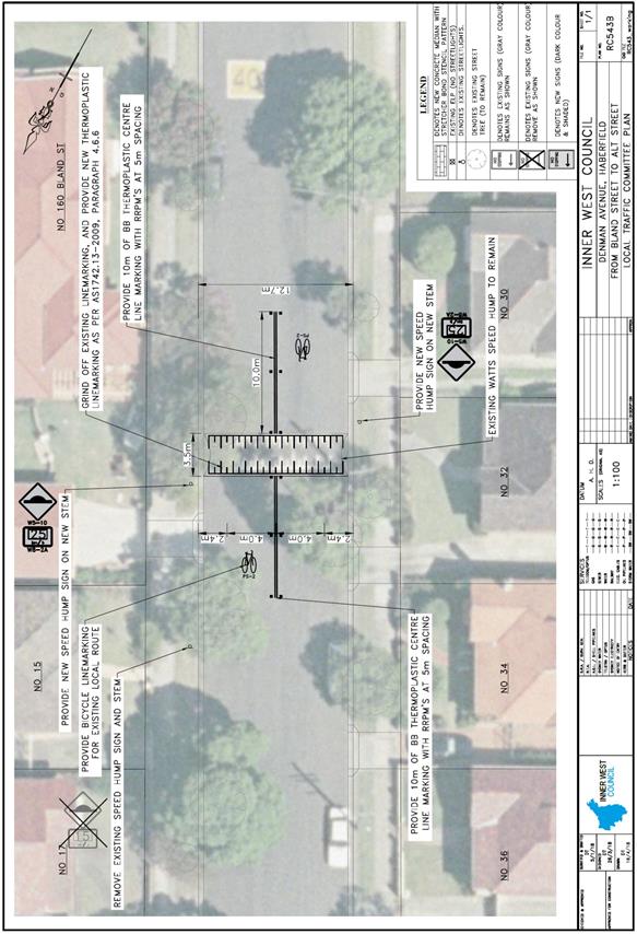
|
|
Local Traffic Committee Meeting 1 May 2018 |
Subject: Minor Traffic Facilities (All Wards / All Electorates / All LACs)
Prepared By: Manod Wickramasinghe - Coordinator – Traffic and Parking Services, Emilio Andari - Engineer – Traffic and Parking Services and Idris Hessam - Road Access Engineer, Design and Investigation
Authorised By: John Stephens - Traffic and Transport Services Manager
|
SUMMARY This report considers minor traffic facility applications received by Inner West Council, and includes ‘Disabled Parking’ and ‘Works Zone’ requests. |
|
RECOMMENDATION
THAT:
1. The 6m ‘Disabled Parking’ zone in front of No.29 Starling Street, Lilyfield be removed as it is no longer required;
2. A 6m ‘Disabled Parking’ zone be installed in front of No.18 Kays Avenue West, Dulwich Hill;
3. A 5.4m ‘Disabled Parking’ zone be installed in front of No.76 Sloane Street, Haberfield adjacent to the existing driveway;
4. A 6m ‘Disabled Parking’ zone be installed in front of No.33 Annesley Street, Leichhardt;
5. A 28m 'Works Zone 7.00am - 5.00pm Mon-Fri, 7.00am - 1.00pm Sat' be installed in front of No.17-19 Gower Street, Summer Hill (including the property's driveway) for 12 weeks;
6. A 10m 'Works Zone 7.00am - 5.00pm Mon-Fri, 7.00am - 1.00pm Sat' be installed in front of No.30 Morris Street, Summer Hill for 6 months;
7. An 18m 'Works Zone 7.00am - 5.00pm Mon-Fri, 7.00am - 1.00pm Sat' be installed on the western side of Catherine Street, Lilyfield adjacent to War Memorial Park for 6 weeks;
8. A 12m 'Works Zone 7.00am - 5.30pm Mon-Sat' be installed in Mary Street, St Peters, along the side boundary of No. 293 Princes Highway, St Peters for 6 months; and
9. A 12m 'Works Zone 7.00am - 5.30pm Mon-Sat' be installed in Warren Road, Marrickville, along the side boundary of No. 392-396 Illawarra Road, Marrickville for 6 months. |
BACKGROUND
This report considers minor traffic facility applications received by Inner West Council, and includes ‘Disabled Parking’ and ‘Works Zone’ requests.
FINANCIAL IMPLICATIONS
Nil.
OTHER STAFF COMMENTS
1 Removal of ‘Disabled Parking’ Restriction – Starling Street, Lilyfield
Council has been notified by a family member that the applicant to the ‘Disabled Parking’ zone outside of No.29 Starling Street, Lilyfield has passed away and so the ‘Disabled Parking’ zone is no longer required.
It is recommended that the 6m ‘Disabled Parking’ zone in front of No.29 Starling Street, Lilyfield be removed as it is no longer required.
2 Installation of ‘Disabled Parking’ Restriction – Kays Avenue West, Dulwich Hill
The resident of property No.18 Kays Avenue West, Dulwich Hill has requested the installation of a ‘Disabled Parking’ zone in Kays Avenue West at the front of the resident’s property.
A site investigation has revealed that the property does have a driveway however, the driveway is too narrow (approximately 2.4 metres wide) which makes it impractical for use.
The applicant’s condition does not necessitate the use of a wheelchair, however her doctor has advised that her condition makes it difficult to walk more than 20 metres.
It is recommended that a 6m ‘Disabled Parking’ zone be installed in front of No.18 Kays Avenue West, Dulwich Hill.
3 Installation of ‘Disabled Parking’ Restriction – Sloane Street, Haberfield
The resident of No. 76 Sloane Street, Haberfield has requested the installation of a ‘Disabled Parking’ zone in front of the resident’s property.
A site investigation has revealed that the property has off street parking; however, the applicant has advised that it is difficult to reverse his car from the garage out into the street due to the narrow width of the driveway and long distance of the garage to the street.
The driveway length has been measured at 27m long and the driveway width is 2.45m and is below standard.
Council has written to residents of Sloane Street within the vicinity of the proposed ‘Disabled Parking’ space inviting comment. No objections to the installation of the space have been received.
The applicant does not require the use of a wheelchair.
It is recommended that a 5.4m ‘Disabled Parking’ zone be installed in front of No.76 Sloane Street, Haberfield adjacent to the existing driveway.
4 Installation of ‘Disabled Parking’ Restriction – Annesley Street, Leichhardt
The resident of No.33 Annesley Street, Leichhardt has requested the installation of a ‘Disabled Parking’ zone in front of the resident’s property.
A site investigation has revealed that the property has off street parking; however, the applicant has provided a letter from an occupational therapist who has undertaken a review of their property and off-street parking space and has provided support to their request.
The main points raised were:
· Significant mobility issues affecting mobility and balance which require use of a walking stick and medical and physiotherapy treatments.
· The width of the car port is too narrow for the resident to alight their vehicle safely.
· Two steps are present from the carport to the backyard and an additional four steps from the backyard to the rear verandah. There are only two small steps in the front of the property, the verandah access and doorway entry.
· Resident requires use of a trolley to assist load and unload of their vehicle which is only possible from the front of the property due to steps.
The applicant does not require the use of a wheelchair.
It is recommended that a 6m ‘Disabled Parking’ zone be installed in front of No.33 Annesley Street, Leichhardt.
5 Installation of ‘Works Zone’ Restriction – Gower Street, Summer Hill
The applicant has requested the installation of a temporary 28m 'Works Zone 7.00am - 5.00pm Mon-Fri, 7.00am - 1.00pm Sat' in front of No.17-19 Gower Street, Summer Hill (including the property’s driveway) for 12 weeks.
It is recommended that a 28m 'Works Zone 7.00am - 5.00pm Mon-Fri, 7.00am - 1.00pm Sat' be installed in front of No.17-19 Gower Street, Summer Hill (including the property's driveway) for 12 weeks.
6 Installation of ‘Works Zone Restriction – Morris Street, Summer Hill
The applicant has requested the installation of a temporary 10m 'Works Zone 7.00am - 5.00pm Mon-Fri, 7.00am - 1.00pm Sat' in front of No.30 Morris Street, Summer Hill for 6 months.
It is recommended that a 10m 'Works Zone 7.00am - 5.00pm Mon-Fri, 7.00am - 1.00pm Sat' be installed in front of No.30 Morris Street, Summer Hill for 6 months.
7 Installation of ‘Works Zone’ Restriction – Catherine Street, Lilyfield
Council’s Senior Project Engineer has requested the installation of a temporary 18m 'Works Zone 7.00am - 5.00pm Mon-Fri, 7.00am - 1.00pm Sat' on the western side of Catherine Street, Lilyfield adjacent to War Memorial Park for 6 weeks to facilitate a toilet block upgrade.
It is recommended that an 18m 'Works Zone 7.00am - 5.00pm Mon-Fri, 7.00am - 1.00pm Sat' be installed on the western side of Catherine Street, Lilyfield adjacent to War Memorial Park for 6 weeks.
8 Installation of ‘Works Zone’ Restriction – Mary Street, St Peters
The subject location is located on southern side of Mary Street adjacent to property No. 293 Princes Highway, St Peters. Mary Street is a ‘one-way’ westbound street from Princes Highway to Unwins Bridge Road and is 6.4 metres in width. The proposed ‘Works Zone’ will be 12 metres in length and located on the southern side of Mary Street adjacent to the site. It will be required for a period of approximately six (6) months, to be utilised by construction vehicles during deliveries and loading and unloading activities.
At present, ‘No Parking’ restrictions are permitted on the southern side of the street and a section of ‘No Parking’ restrictions along with ‘2P 8.30am-6pm Mon-Fri, 8.30am-12.30pm Sat, Permit Holders Excepted Area M4’ restrictions are permitted on the northern side of the street. The parking spaces in Mary Street are highly utilised by local businesses and residents. Therefore, the provision of a ‘Works Zone’ would provide a safe facility for loading and unloading activities at the subject site during the construction period.
It is recommended that a 12m 'Works Zone 7.00am - 5.30pm Mon-Sat' be installed in Mary Street, St Peters, along the side boundary of No. 293 Princes Highway, St Peters for 6 months.
9 Installation of ‘Works Zone’ Restriction – Warren Road, Marrickville
The subject location is on the southern side of Warren Road adjacent to property No. 392-396 Illawarra Road, Marrickville. Warren Road is a ‘two-way’ street between Carrington Road and Livingstone Road and is 9.1 metres in width. The proposed ‘Works Zone’ will be 12 metres in length and located on the southern side of Warren Road adjacent to the site. It will be required for a period of approximately six (6) months, to be utilised by construction vehicles during deliveries and loading and unloading activities.
At present, unrestricted parking is permitted on both sides of the street. The parking spaces in Warren Road are highly utilised by local businesses and residents. Therefore, the provision of a ‘Works Zone’ would provide a safe facility for loading and unloading activities at the subject site during the construction period.
It is recommended that a 12m 'Works Zone 7.00am - 5.30pm Mon-Sat' be installed in Warren Road, Marrickville, along the side boundary of No. 392-396 Illawarra Road, Marrickville for 6 months.
PUBLIC CONSULTATION
Nil.
CONCLUSION
Nil.
|
|
Local Traffic Committee Meeting 1 May 2018 |
Subject: Nelson Lane (between Piper Street and Rose Street), Annandale - Extension of 'No Parking' zone (Balmain Ward/Balmain Electorate/Leichhardt LAC)
Prepared By: David Yu - Traffic Engineer
Authorised By: John Stephens - Traffic and Transport Services Manager
|
SUMMARY Council has received concerns regarding obstructed driveway access in Nelson Lane opposite Nos.295 and 297 Nelson Street, Annandale. |
|
RECOMMENDATION
THAT the existing ‘No Parking; 8am-6pm; Mon-Fri’ zone on the eastern side of Nelson Lane, Annandale be extended to include the 11m unrestricted parking area opposite the rear boundaries of Nos. 295 and 297 Nelson Street, Annandale. |
BACKGROUND
At the Traffic Committee meeting held in October 2015, the Committee considered a report proposing the option of implementing either full-time or timed ‘No Parking’ restrictions in Nelson Lane, Annandale. This was in response to requests made by affected Nelson Street residents with rear accesses (garages) in Nelson Lane, being blocked by parked vehicles (by nearby Mirvac Construction workers) opposite their garage.
As part of this investigation, some sections of Nelson Lane were retained as unrestricted parking where Council had not received support for the introduction of restrictions by the directly affected residents.
Council has now received concerns from the residents of Nos. 295 and 297 Nelson Street, Annandale regarding vehicles parking on the eastern side of Nelson Lane, Annandale and subsequently obstructing rear driveway access, this area was retained as unrestricted parking following the 2015 investigation.
There is an existing ‘No Parking; 8am-6pm; Mon-Fri’ zone on the eastern side of Nelson Lane that extends both north and south of the unrestricted parking directly opposite side of Nos. 295 to 297 Nelson Street.
FINANCIAL IMPLICATIONS
Nil.
OTHER STAFF COMMENTS
It is proposed to signpost the eastern side of Nelson Lane opposite Nos. 295 to 297 Nelson Street as a ‘No Parking; 8am-6pm; Mon-Fri’ zone. The proposal is shown on the following plan.
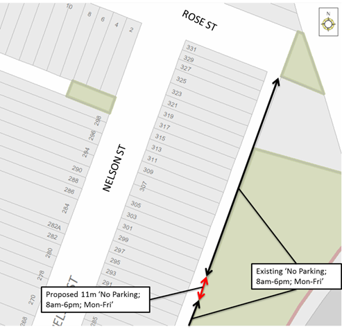
PUBLIC CONSULTATION
|
A letter outlining the above proposal was mailed out to the affected properties (13 properties) in Nelson Street, Annandale. Three (3) responses were received. One in support of the proposal, one not in support and one neutral. The table below shows the comment raised by the resident who did not support the proposal.
|
|
|
Residents’ Comments |
Officer Comments |
|
It is the only parking in this part of the back lane for trade workers and gardeners to park and work on the back of Nelson Street houses. |
Vehicles parked in these parking spaces obstruct the properties with rear driveway access opposite these spaces. |
CONCLUSION
|
|
Local Traffic Committee Meeting 1 May 2018 |
Subject: Kingston Lane, Camperdown - Proposed 'No Parking' Restrictions (Stanmore Ward/Newtown Electorate/Inner West LAC)
Prepared By: Mary Bailey - Project Officer
Authorised By: John Stephens - Traffic and Transport Services Manager
|
SUMMARY Following community representations and site investigations a proposal to extend an existing section of ‘No Parking’ restrictions in Kingston Lane, Camperdown. Given the support for the proposal, it is recommended to proceed with the ‘No Parking’ restrictions in order to allow for vehicular access to off-street car parking spaces within Gilpin Lane accessed via Kingston Lane. |
|
RECOMMENDATION
THAT the installation of full-time ‘No Parking’ restrictions (20 metres in length) on the western side of Kingston Lane, Camperdown, between the rear of property no. 54 Kingston Road, Camperdown, and the rear of property no. 62 Kingston Road, Camperdown, be APPROVED, in order to allow for vehicular access to off-street car parking spaces within Gilpin Lane accessed via Kingston Lane.
|
BACKGROUND
Following representation from the local community, Council is proposing to extend an existing section of ‘No Parking’ restrictions in Kingston Lane, Camperdown.
The subject section of laneway is currently unrestricted parking, and access to Gilpin Lane is obstructed due to parked vehicles obstructing the turning paths at its intersection with Kingston Lane. There are multiple off-street car parking spaces in Gilpin Lane which are accessed via Kingston Lane.
Given that there is a high demand for on-street parking in the area and only one permit per household, (reduced to zero if off-street parking is available), implementing ‘No Parking’ restrictions as per the proposal will improve vehicular access to off-street parking and increase convenience for residents.
The proposal is illustrated in Figure 1 below.
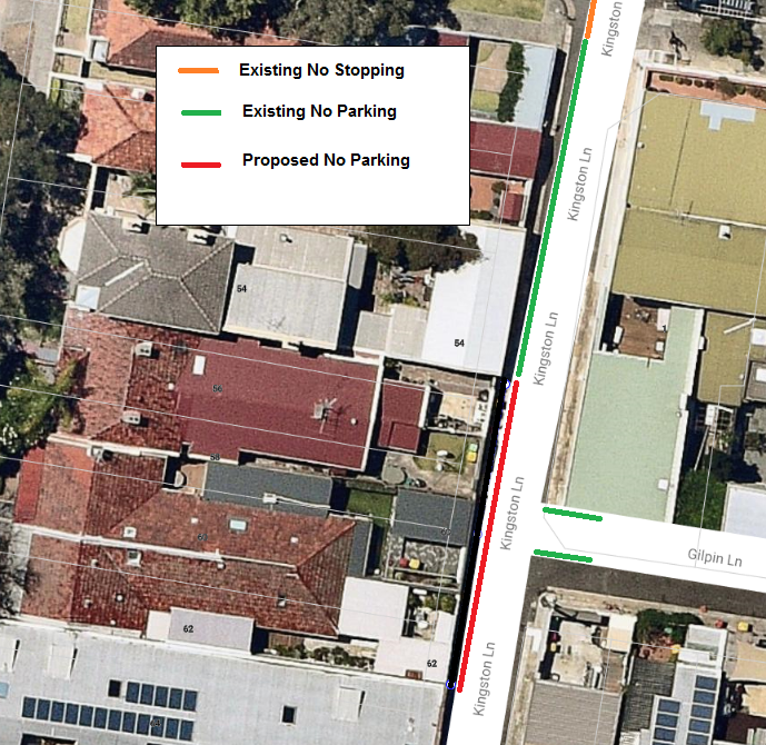
Figure 1: Map showing proposed extension of ‘No Parking’ restrictions in Kingston Lane at Gilpin Lane
FINANCIAL IMPLICATIONS
The costs of the supply and installation of the signposting associated with the recommended ‘No Parking’ restrictions are approximately $700 and can be met from Council’s operating budget.
PUBLIC CONSULTATION
Twenty seven (27) letters were sent to residents of affected properties on 15 March 2018 with a closing date for comments of 15 April 2018. There were two (2) responses in support of the proposal and no responses objecting to the proposal.
CONCLUSION
In order to provide unobstructed vehicular access to the residents’ off-street car parking spaces via the intersection of Kingston Lane and Gilpin Lane, it is recommended that full-time ‘No Parking’ restrictions be installed for a section along the western side of Kingston Lane, Camperdown, between the rear of property no. 54 Kingston Road, Camperdown, and the rear of property no. 62 Kingston Road, Camperdown.
|
|
Local Traffic Committee Meeting 1 May 2018 |
Subject: Melville Lane, Newtown - Proposed 'No Parking' Restrictions (Stanmore Ward/ Newtown Electorate/Inner West LAC)
Prepared By: Mary Bailey - Project Officer
Authorised By: John Stephens - Traffic and Transport Services Manager
|
SUMMARY Following community representations and site investigations a proposal to implement a section of ‘No Parking’ restrictions in Melville Lane, Newtown. Given the support for the proposal, it is recommended to proceed with the ‘No Parking’ restrictions in order to allow for vehicular access to off-street car parking spaces within Mulqueeny Lane accessed via Melville Lane. |
|
RECOMMENDATION
THAT the installation of full-time ‘No Parking’ restrictions (10 metres in length) on the southern side of Melville Lane, Newtown, between the rear of property no. 23 Bedford Street, Newtown, and the rear of property no. 29 Bedford Street, Newtown, be APPROVED, in order to allow for vehicular access to off-street car parking spaces within Mulqueeny Lane accessed via Melville Lane.
|
BACKGROUND
Following representation from the local community, Council is proposing to convert a section of unrestricted parking in Melville Lane with ‘No Parking’ restrictions.
The subject section of laneway is currently unrestricted parking, and access to Mulqueeny Lane is obstructed due to parked vehicles obstructing the turning paths at its intersection with Melville Lane. There are multiple off-street car parking spaces in Mulqueeny Lane which are accessed via Melville Lane.
Given that there is a high demand for on-street parking in the area and only one permit per household, (reduced to zero if off-street parking is available), implementing ‘No Parking’ restrictions as per the proposal will improve vehicular access to off-street parking and increase convenience for residents.
The proposal is illustrated in Figure 1 below.
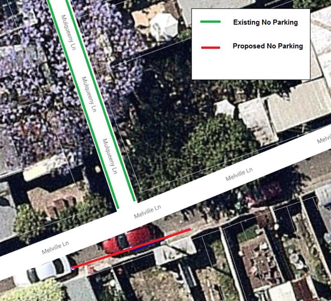
Figure 1: Map showing proposed conversion of unrestricted parking to ‘No Parking’ restrictions in Melville Lane at Mulqueeny Lane
FINANCIAL IMPLICATIONS
The costs of the supply and installation of the signposting associated with the recommended ‘No Parking’ restrictions are approximately $700 and can be met from Council’s operating budget.
PUBLIC CONSULTATION
Twenty seven (27) letters were sent to residents of affected properties on 15 March 2018 with a closing date for comments on 15 April 2018. There were two (2) responses in support of the proposal and no responses objecting to the proposal.
CONCLUSION
In order to provide unobstructed vehicular access to the residents’ off-street car parking spaces via the intersection of Melville Lane and Mulqueeny Lane, it is recommended that full-time ‘No Parking’ restrictions be installed for a section along the southern side of Melville Lane, Newtown, between the rear of property no. 23 Bedford Street, Newtown, and the rear of property no. 29 Bedford Street, Newtown.
|
|
Local Traffic Committee Meeting 1 May 2018 |
Subject: Louisa
Street, Summer Hill – Resident Parking Scheme (Leichhardt Ward/Summer
Hill Electorate/ Ashfield LAC)
Prepared By: Anca Eriksson - Traffic Engineer
Authorised By: Manod Wickramasinghe - Coordinator – Traffic and Parking Services
|
SUMMARY Council has received correspondence from a number of residents of Louisa Street, Summer Hill requesting the extension of Area 13 Residential Parking Scheme (RPS) restrictions into their street to deter commuter/long stay parking.
This report provides the results of the RPS investigation in Louisa Street, Summer Hill.
|
|
RECOMMENDATION
THAT the proposed Resident Parking Scheme in Louisa Street, Summer Hill not be supported at the present time due to less than 50% support received from the consulted residents. |
BACKGROUND
Council has received a signed petition from 11 properties in Louisa Street, Summer Hill requesting the implementation of Area 13 Resident Parking Scheme restrictions in their street. Subsequently, parking occupancy surveys were organised in Louisa Street in order to investigate the request.
Parking occupancy surveys were undertaken in Louisa Street on two typically weekdays (not school or public holidays) in the morning between 10am and 11am and in an afternoon between 2pm and 3pm. High parking occupancy levels were recorded with the average parking occupancy level being 79%.
Council has also identified the number of on-site parking spaces that are currently available on each property in Louisa Street. This survey revealed that 65% of properties in Louisa Street do not have off-street parking.
FINANCIAL IMPLICATIONS
Nil.
OTHER STAFF COMMENTS
Following the parking occupancy surveys, a Resident Parking Scheme proposal was prepared for the installation of ‘2P 8am-6pm, Mon-Fri, Permit Holders Excepted, Area 13’ restrictions on the western side of Louisa Street as shown on the following map.
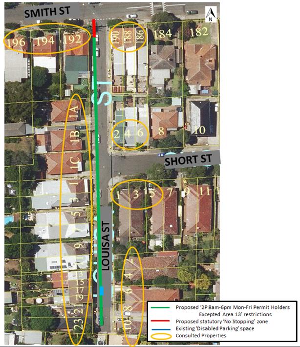
PUBLIC CONSULTATION
A letter outlining the RPS proposal was mailed out to the affected properties (32 properties) in Louisa Street, Smith and Short Street requesting residents’ views regarding the proposal.
Consultation survey results are summarised in the following table:
|
Number of letters sent out to residents |
32 |
|
|
Number of Properties in Louisa Street |
20 |
|
|
Responses back (Louisa Street properties) |
10 of 20 |
50% |
|
Supporting proposal (Louisa Street properties) |
6 of 20 |
30% |
|
Non supportive (Louisa Street properties) |
4 of 20 |
20% |
The table below shows the comments raised by the residents who did not support the proposal and the associated officer’s comments.
|
Residents’ Comments |
Officer Comments |
|
The proposal would significantly impact long-term residents in Nos.186 and 188 Smith St, who require car parking close to their home and the access to their backyards. Can Council: 1. Change the area of permit holders excepted in the proposal from area 13 only to areas 12 and 13 along the boundary of No. 192 Smith St on Louisa St, Summer Hill. 2. Don't change current proposal. However, need to change the resident parking scheme area for my address as well as 186 Smith St from Area 12 to Area 13. |
The properties on Smith Street are part of the Area 12 Summer Hill Resident Parking Scheme (as per Council resolution of 10/11/2015). Residents of Smith Street are therefore able to park within the RPS restrictions in Smith Street, Allman Avenue and Prospect Road which have Area 12 Restrictions. Alternatively, unrestricted parking is available on one side of the street in Area 13 regions. Should RPS be supported in Louisa Street, they would form part of the Area 13 Summer Hill Resident Parking Scheme (other streets in this scheme include Short Street and Lindsay Avenue).
|
|
1. There is no problem with parking during the day. Parking is only a challenge in the evening. 2. Parking space on-street is already very limited at nights, the residents cannot afford to lose any more spaces due to no stopping zones, in what is a quiet, one-way street. 3. Parking is only available on one side of the street. Also parking very limited in vicinity. Where can visitors park? |
1. Resident Parking Scheme restrictions are typically installed to address issues with long-stay or commuter parking. Parking in the evening is typically generated by resident demand and Council is not seeking to address this. 2. 10m ‘No Stopping’ zones must be installed at all intersections (as per NSW Road Rules) with the installation of the proposed RPS restrictions. 3. The proposed scheme would provide RPS restrictions for one side of the street, the other side would remain unrestricted to allow a balanced use of available parking spaces for residents, commuters and visitors.
|
|
Strongly oppose, this plan discriminates people having a single car. People living in a household with two parking are allowed (encouraged to have two cars). Louisa street is an area with a good access to public transport which should discourage people owning more than one car. A fairer system would be provide one permit for households without off-street parking. As someone with one off-street parking space I can accept that this is a fairer approach. But giving people the option of 2 permits when they have no off street parking sends a message contrary to our ambition to reduce our carbon footprint and progress towards sustainability. |
In accordance with Council's Resident Parking Policy each residence is eligible for a maximum of two permits with that number reducing by one for each off-street parking space available to the residence. The RPS policy is to provide equitable access to on street parking in residential areas for residents who have limited or no off-street parking.
|
|
There is an issue with commuters/ long-stay parking in front of their houses in Smith Street. The 2P proposal in Louisa Street will push even more commuters onto Smith Street, making it even more difficult to find parking. |
There is an existing Area 12 Resident Parking Scheme in Smith Street which has been installed to assist those residents secure parking. This proposal seeks to address issues with long-stay parking in Louisa Street which does not have existing RPS restrictions to assist residents. |
|
Unnecessary, there is generally parking available in the street and on the next cross street. |
Council commenced investigation into Resident Parking restrictions following a petition received from a number of residents of Louisa Street requesting RPS restriction to address concerns with long-stay parking. Council’s surveys have confirmed a high parking occupancy level in Louisa Street. |
|
I have access to a disabled parking space in front of my residence. I request keeping the space.
|
The disabled parking space will be retained should the proposed RPS be introduced. |
CONCLUSION
As per Council’s Resident Parking Scheme policy, at least 50% support from residents is required before Council will consider the introduction of RPS restrictions.
Based on the results from the consultation process, less than 50% of the residents of Louisa Street support a Resident Parking Scheme in their street. It is therefore recommended that the proposed ‘2P 8am-6pm, Mon-Fri, Permit Holders Excepted, Area 13’ restrictions in Louisa Street, Summer Hill not be supported for implementation.
|
|
Local Traffic Committee Meeting 1 May 2018 |
Subject: Brown Street, Ashfield- Proposed bay line marking for motorcyles in parking space. (Ashfield Ward/Summer Hill Electorate/Ashfield LAC)
Prepared By: Boris Muha - Engineer – Traffic and Parking Services
Authorised By: John Stephens - Traffic and Transport Services Manager
|
SUMMARY A Councillor request has been made to consider measures to emphasis and deter vehicles from parking in a dedicated (indented) motorcycle area outside the unit block at No.1 Brown Street, Ashfield, just north of a private laneway.
Motorcycle bay lines will be provided to emphasis the area to be used by motorcycles and correct any signposting for the visual awareness and enforcement of the area. |
|
RECOMMENDATION
THAT:
1. Motorcycle 90 degree angled bay lines measuring 1.2-1.3m x 2.5 metres be painted in the dedicated (indented) motorcycle parking area signposted “1P Motor Bikes only” outside No.1 Brown Street, Ashfield, just north of the private laneway; and
2. That the signposting be adjusted at the location to improve visual awareness and enforcement of restrictions. |
BACKGROUND
An item was raised at the Traffic Committee meeting held in October 2017 initially to clear one indented parking space to the corner of Brown Street, just north of the private laneway. A request was made by business owners that accessed the lane seeking the removal of parking in this space and to extend the ‘No Stopping’ restriction to improve the sight view of traffic from the lane.
It was recommended by the Traffic Committee that the space would be better utilised with motorcycle parking and still allow adequate sight view of traffic from the lane over the parked motorcycles. The businesses agreed to this modification.
FINANCIAL IMPLICATIONS
The works will be funded from the existing operating budget.
OTHER STAFF COMMENTS
Since the introduction of motorcycle parking restrictions, vehicles have been noted to park in the space unaware of the restrictions. The proposed introduction of 90 degree angle motorcycle parking bay lines will assist to regulate the parking of motorcycles, and make motorists aware and deter vehicles from parking in the area. The sign nearest to the corner of the lane is obscured by tree foliage and will be moved forward clear of the tree. See diagram below.
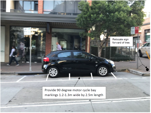
PUBLIC CONSULTATION
Not required. The proposed treatment will supplement the existing motorcycle parking restriction.
CONCLUSION
Motorcycle 90 degree angled bay lines measuring 1.2m x 2.5 metres will be painted in the dedicated (indented) motorcycle parking area signposted “1P Motor Bikes Only” outside No.1 Brown Street, just north of the private laneway. Signposting will also be adjusted at the location to improve visual awareness and enforcement of the restrictions.
|
|
Local Traffic Committee Meeting 1 May 2018 |
Subject: Esk Lane, Marrickville - Proposed Statutory 'No Stopping' Restrictions (Marrickville Ward/Summer Hill Electorate, Inner West LAC)
Prepared By: Mary Bailey - Project Officer
Authorised By: John Stephens - Traffic and Transport Services Manager
|
SUMMARY An amendment to the ‘No Parking’ restrictions in Esk Lane, Marrickville, at its intersection with Frede Lane, is proposed to ensure the restriction complies with statutory requirements. |
|
RECOMMENDATION
THAT an amendment to convert the ‘No Parking’ restrictions (10 metres in length) to ‘No Stopping’ restrictions (10 metres in length) on the western side of Esk Lane, Marrickville, at Frede Lane, be APPROVED.
|
BACKGROUND
Implementation of the ‘No Stopping’ restrictions in Esk Lane, Marrickville, at Frede Lane will ensure vehicles, including service vehicles can manoeuvre around the corners at the intersection. The proposal will ensure the restriction complies with current statutory requirements.
The proposal is illustrated in Figure 1 below.
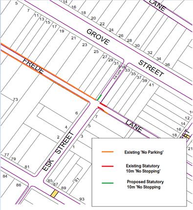
Figure 1: Existing and proposed restrictions in Frede Lane and Esk Lane
FINANCIAL IMPLICATIONS
The cost for the supply and installation of the signposting can be funded from Council's operational budget for signs and line marking.
PUBLIC CONSULTATION
A notification letter regarding the amended proposal to implement ‘No Stopping’ restrictions will be sent to all affected residents.
CONCLUSION
To ensure that the proposed restriction complies with current statutory requirements, the ‘No Parking’ restrictions in Esk Lane, Marrickville, at its intersection with Frede Lane be converted to ‘No Stopping’ restrictions.
|
|
Local Traffic Committee Meeting 1 May 2018 |
Subject: Fenwick Building - Illoura Reserve, Balmain East - Car Park Conditions (Balmain Ward / Balmain Electorate / Leichhardt LAC)
Prepared By: Manod Wickramasinghe - Coordinator – Traffic and Parking Services
Authorised By: John Stephens - Traffic and Transport Services Manager
|
SUMMARY Inner West Council will soon be undertaking construction of a café at Nos.2-8 Weston Street, Balmain. As part of the works, the Illoura Reserve car park, accessed via Weston Street, Balmain East will be upgraded. |
|
RECOMMENDATION
THAT the proposed parking restrictions and layout for the Illoura Reserve Car Park, Balmain East shown in Attachment 1 be supported. This will include:
· One 2.5m wide ‘Disabled Parking’ space and associated shared space (45 degree angle parking front to kerb) on the southern side of the car park; · Four 2.5m wide ‘4P; 8:30am-6pm Mon-Fri’ spaces (45 degree angle parking front to kerb) on the southern side of the car park; · One 2.5m wide ‘No Parking; Authorised Care Share Vehicles Excepted’ space (45 degree angle parking front to kerb) on the southern side of the car park; · Four 1.2m wide ‘Motor Cycle Only’ spaces (45 degree angle parking front to kerb) on the southern side of the car park; and · 33m ‘No Parking’ restriction on the northern side of the car park.
|
BACKGROUND
Inner West Council will soon be undertaking construction of a café at Nos.2-8 Weston Street, Balmain East. The proposed development is an adaptive reuse of the heritage listed Fenwick Stone Building as a licensed café with gallery space.
The required parking provision for the development is in the order of 3-4 car parking spaces. The proposed development itself does not propose any off-street car parking; however, Council intends to modify the existing informal public car park at Illoura Reserve approximately 50m to the south of the site, this car park is accessed via Weston Street. The modified car park layout will be formalised to provide a total of 6 car spaces (including 1 disabled and 1 car share vehicle).
FINANCIAL IMPLICATIONS
Nil.
OTHER STAFF COMMENTS
The proposed parking restrictions and layout for the Illoura Reserve Car Park, Balmain East is shown in Attachment 1. As per the plan, it is proposed to introduce 6 restricted car parking spaces and 4 motorcycle parking spaces. The plan also shows amendment to the signposting of the existing one-way restrictions through the car park.
On the northern side of the car park, this will include:
· 33m ‘No Parking’ restriction
On the southern side of the car park, this will include:
· One 2.5m ‘Disabled Parking’ space and associated shared space (45 degree angle parking front to kerb)
· Four 2.5m ‘4P; 8:30am-6pm Mon-Fri’ spaces (45 degree angle parking front to kerb)
· One 2.5m ‘No Parking; Authorised Care Share Vehicles Excepted’ space (45 degree angle parking front to kerb)
· Four 1.2m ‘Motor Cycle Only’ spaces (45 degree angle parking front to kerb)
PUBLIC CONSULTATION
Consultation was undertaken as part of the approved Development Application.
CONCLUSION
Nil.
|
1.⇩ |
Illoura Road Car Park Plan |
|
|
Local Traffic Committee Meeting 1 May 2018 |
Subject: Nos. 826-836 Princes Highway, Tempe - DA201700497 – Demolish Existing Improvements and Construct a 3 Storey Building Containing 22 Serviced Apartments with Basement Car Parking and Ground Floor Level Tenancy
Prepared By: Jennifer Adams - Engineer – Traffic and Parking Services
Authorised By: John Stephens - Traffic and Transport Services Manager
|
SUMMARY A development application (DA 201700497) has been received to demolish existing improvements and construct a 3 storey building containing 22 serviced apartments with basement car parking and ground floor level tenancy.
Comments of the Local Traffic Committee will be referred to Council’s Development Assessment Section for consideration in determining the Development Application. |
|
RECOMMENDATION
THAT the report be received and noted. |
BACKGROUND
An application has been received to demolish existing improvements and construct a 3 storey building containing 22 serviced apartments with basement car parking (11 spaces) and ground floor level tenancy.
The application is required to be referred to the Local Traffic Committee for consideration under State Environmental Planning Policy (Infrastructure) 2007.
It is noted that a similar development application was submitted to Council - DA201500482 - for the construction of a two (2) and three (3) storey building containing 24 serviced apartments, two (2) shops and basement car parking (9 spaces). The application sought consent to demolish existing improvements and construct a 3 storey building containing 24 serviced apartments with basement car parking. The proposal generally did not comply with the aims, objectives and design parameters contained in Marrickville Local Environmental Plan 2011 and Marrickville Development Control Plan 2011. It was considered that the development would result in significant impacts on the streetscape and represented an overdevelopment of the site. The application was subsequently considered unsupportable and refused.
Marrickville LEP defines serviced apartment as ‘a building (or part of a building) providing self-contained accommodation to tourists or visitors on a commercial basis and that is regularly serviced or cleaned by the owner or manager of the building or part of the building or the owner’s or manager’s agents. It is noted that ‘serviced apartments’ are a type of tourist and visitor accommodation and restrictions are generally placed on guest stays of around two (2) to three (3) months in any 12 month period.
FINANCIAL IMPLICATIONS
Nil.
OFFICER COMMENTS
Site location
![]()
![]()

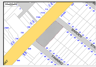
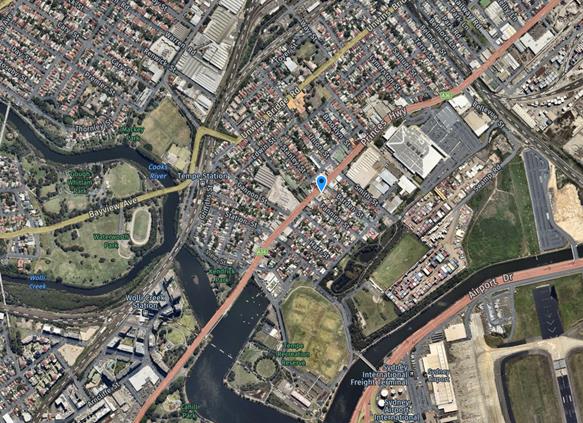
The site is located at 826-836 Princes Highway, Tempe on the eastern side of the Princes Highway, between Barden Street and Fanning Street, Tempe. The site is a consolidation of 6 lots occupying an area of some 1,420m2. The site has three street frontages namely Barden Street to the north east, the Princes Highway to the west and Fanning Street to the south.
The site frontages to Princes Highway, Barden and Fanning Streets are approximately 54 metres, 20 metres and 24 metres respectively. The principal frontage of the site is to the Princes Highway. The site presently is vacant and contains a large industrial building and yard.
![]()


![]()
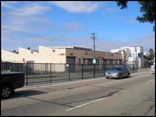
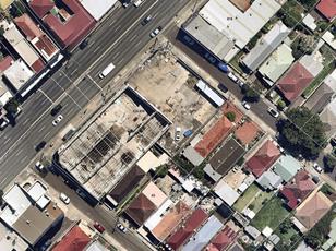
Locality and road network
The immediate surrounding area is industrial and commercial with low density residential uses located directly to the south. The commercial centre of Tempe is located directly to the north and north-west of the site. There is a signalised pedestrian crossing over the Princes Highway located directly opposite the Princes Highway frontage of the site.
Princes Highway is a State Road and arterial route being the principal north-south connection between Sydney and Wollongong. Annual Average Daily Traffic for Princes Highway at Cooks River is around 62,070vpd and for Princes Highway north of Railway Road around 52,800vpd. Princes Highway is approximately 19m in width facilitating three lanes in each direction and is sign posted 60km/h speed limit. It has a 6-10AM northbound clearway and 3-7PM southbound clearway within kerbside lanes. Generally unrestricted kerbside parking is permitted along both sides of the road outside of clearway times.
A central median island runs along Princes Highway across the Barden Street and Fanning Street intersections. Midblock there is a signalised pedestrian crossing. Pedestrian fencing is also present. A ‘Bus Zone’ is located between the signalised pedestrian crossing and Fanning Street. Traffic accessing Barden Street and Fanning Street is restricted to left-in / left-out only due to the median island on the Princes Highway.
Barden Street and Fanning Street are local access roads servicing low density residential properties between Princes Highway and South Street, Tempe. Both streets are narrow and have carriageway widths of approximately 6.0 metres. Vehicles often park mounting the kerb due to the narrowness of the roads. Parking is unrestricted in both streets apart from a 30 metre section of ‘No Parking’ at the north end of Barden Street on the south side.
Public Transport
The site is serviced by bus services running along Princes Highway and is located approximately 800 metres from Tempe railway station.
The Proposal
According to the applicants’ SEE report the Development Application seeks approval for:
demolition of the existing building and structures on site;
excavation for a level basement comprising 11 vehicular spaces and loading facilities;
construction of a three (3) storey development comprising 22 serviced apartments with a residential gross floor area (GFA) of 1327.08m2;
construction of a ground level retail tenancy with a retail GFA of 50.04m2;
construction of a reception and ancillary office at ground level with a GFA 50.56m2;
vehicular driveway ramp with dual access via Barden Road and Fanning Street;
associated landscape works; and
extension and augmentation of services and infrastructure as required.
It further states that the proposed development will be serviced by a “maximum of four (4) staff at any given time” and that the ongoing operation of the premises will consist of the following:
the reception and office component of the serviced apartment development will operate from 7am to 8pm under the supervision of staff;
a total of 8 staff, comprising 4 employees, a manager, receptionist and 2 cleaners will be employed during the day and night;
activities to be undertaken during operating hours are to consist of general cleaning;
small loading vehicles and vans will utilise the loading facilities provided by the development;
CCTV will be installed in the common areas, at the main entrance point adjacent to Princes Highway;
employees will operate the reception area from 9am to 5am; and
the manager will be responsible for the management of a complaints register.
The applicant’s SEE report states that the measures proposed above will ensure the orderly management of the proposed serviced apartment development and increase safety and security. Copies of the Architectural Drawings are attached at the end of this report.
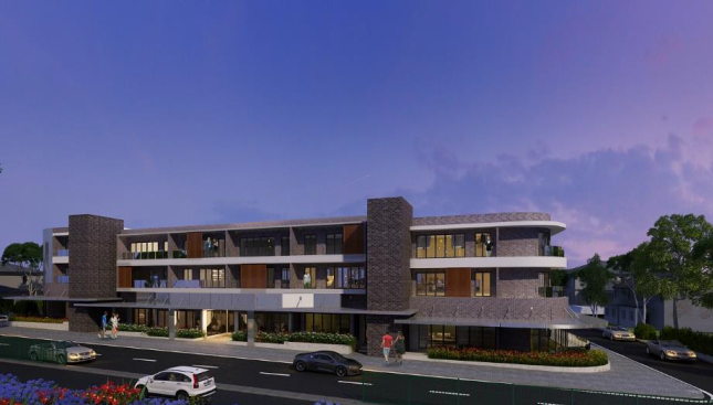
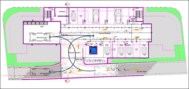
In summary the applicant’s SEE report states that there will be 22 serviced one (1) bedroom apartments, six (6) of which are ‘post adaptable’; a retail tenancy with a retail GFA of 50.04m2; a reception and ancillary office at ground level with a GFA 50.56m2; and 11 car parking spaces. They add that there will be a total of 8 staff, comprising 4 employees, a manager, receptionist and 2 cleaners will be employed during the day and night.
The applicant’s Traffic report states that “The serviced apartments will be staffed by no more than 4 people at any given time comprising a manager, a receptionist and 2 cleaners. It is anticipated that the cleaners will only be on-site between 8am and 2pm on a daily basis.
Interestingly the Architectural Drawings in their ‘Calculation Data’ table indicate that there will be 10 staff.
According to the applicants’ Traffic report, the development proposal involves the redevelopment of the existing industrial land into a commercial precinct. It notes that the development will be served by 11 off-street parking spaces comprising 9 resident spaces
(including 5 disabled resident spaces), 1 staff space for the serviced apartments and 1 retail
tenant space, 2 motorcycles and 8 bicycle spaces.
The Traffic report also states that vehicular access to the site is via a 4.2 metre wide entry driveway off Barden Street and a 4.2 metre wide exit driveway to Fanning Street and that both driveways are located adjacent the eastern site boundary and approximately 23 metres from Princes Highway. For servicing the report states that the development proposal will be served by an off-street loading/waste collection bay in the basement carpark that will be accessed by vehicles no larger than the Australian Standard 6.4 metre long Small Rigid Vehicle. The existing 12m wide access driveway on the Princes Highway will be closed and reconstructed with standard kerb and gutter to the RMS specifications.
At present the site is zoned B6 Enterprise Corridor and the proposed development is permissible with consent. However, it is noted that some ‘serviced apartment’ developments have been provided for eventual conversion to conventional own-your-own residential units if/when market conditions make such conversion attractive. On this basis, it may be considered apt to consider application of the same rates to serviced apartments as to conventional residential unit dwellings. Accordingly, both are detailed below.
Parking
The proposed development lies within Council’s Parking Area 2 and the parking provision required is estimated to be 15 spaces (7 mobility).
Serviced Apartments
1 space per 4 staff for staff + 1 space per 3 units for residents
8 staff and 16 non-adaptable units - 2 + 5.3 = 7 spaces
Adaptable units
1 mobility space per unit for residents + 0.25 visitor mobility spaces per unit
6 adaptable units – 6 + 1.5 = 7 mobility spaces
Retail – shops (up to 500m²)
1 space per 80m² GFA for customers & staff
50.04m² retail – 1 parking space
The applicant’s Traffic report states parking provision for the proposed development as ‘11 off-street parking spaces comprising 9 resident spaces (including 5 disabled resident spaces)’ which is deficient by 4 spaces.
Further, should the development in the future ever be converted to a ‘residential flat building’ it is noted required on-site parking would be 20 spaces.
Residential flat building and shop top housing with 7 + units – non-adaptable units
0.5 per 1 bedroom unit for residents + 0.1 per unit for visitors
16 non-adaptable units – 16 x .5 = 8 + 1.6 = 10 spaces
Residential flat building and shop top housing with 7 or more units – adaptable units
1 mobility space per 1 bedroom unit for residents + 0.25 visitor mobility spaces per unit
6 adaptable – 6 + 1.5 = 8 mobility spaces
Retail – shops (up to 500m²) - 1 space per 80m² GFA for customers & staff - 50.04m² – 1
Office premises - 1 space per 80m² for staff & visitors – 1 space
Moreover, in the immediate Tempe locality Barden Street and Fanning Street as well as Smith Street, Wentworth Street and Hart Street have many narrow frontage older style semi-detached dwellings with no on-site parking provision. As a consequence there is a very significant on-street parking demand along these narrow streets which is exacerbated by some of the commercial and industrial uses in the area which also do not have adequate on-site parking.
Residents in the Tempe area regularly oppose any proposed local development that has the potential to increase demands for on-street parking in the area. Any proposed new development needs to provide at least the minimum off-street parking requirements for the proposed use so as not to compound existing demand for on-street parking. Each development preferably needs to provide ample parking provision to fully absorb the potential parking demands of all its users (visitors, staff, residents, retail customers and clients).
In its present form the Traffic Section does not support the proposed serviced apartment development as it does not meet Council’s minimum required parking provision. Further, probable loss of on-street parking spaces to accommodate the swept paths of delivery vehicles to the proposed development will compound any deficiency and it would be reasonable to request any loss of on-street parking to be made up within the proposed development (further increasing the on-site parking requirement).
Bicycle and Motorcycle Parking
The DCP also requires bicycle and motor cycle parking provision for ‘serviced apartments’ as follows:
Bicycle Provision:
1 space per 20 units for staff & patrons + clothes lockers at rate of 1 per 3 staff spaces+ 1 shower. Plus Retail 1 per 300m²GFA for staff
22 units – 1 bicycle space
8 staff – 2 bicycle spaces + 1 shower
Retail premises – 1 bicycle space
Motor Cycle Provision - 5% of car spaces
15 spaces – 5% = 1 motorcycle space
The applicant proposes to provide 8 bicycle spaces and 2 motorcycle spaces.
Car park access and layout
The applicant’s Traffic report states that vehicular access to the site is via a 4.2 metre wide entry driveway off Barden Street and a 4.2 metre wide exit driveway to Fanning Street, Tempe. The car park access ramps are proposed to be one-way in a southwards direction and a two-way movements arrangement will operate in the parking area.
All ramps and car parking spaces must be in accordance with Australian Standard AS2890.1-2004 Parking Facilities and AS2890.6-2009 Off-street parking for people with disabilities.
It is noted that Council’s Development Engineering Section will evaluate the adequacy of the proposed development’s driveway, ramps, car parking spaces and circulation patterns.
Vehicle Service and Delivery Area
The applicant’s SEE report states that a singular loading area and adjacent waste storage facilities are proposed within the basement level. Servicing and waste vehicles will access these loading bays directly from Barden Street.
The applicant’s Traffic report states that for servicing 'the proposed development will be served by an off-street loading/waste collection bay in the basement carpark that will be accessed by vehicles no larger than the Australian Standard 6.4 metre long Small Rigid Vehicle.’ The applicant’s Traffic report includes swept path diagrams as shown below:
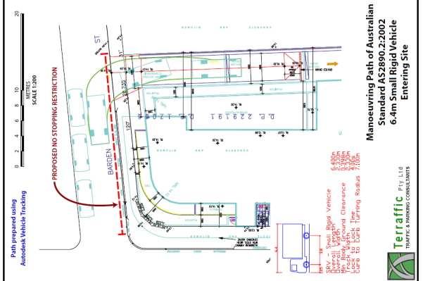
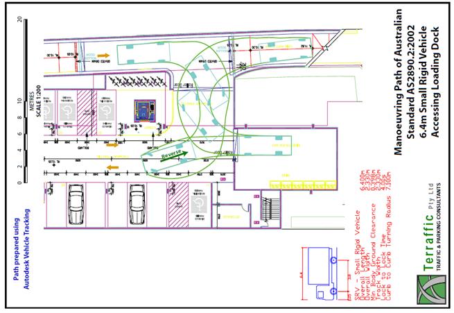
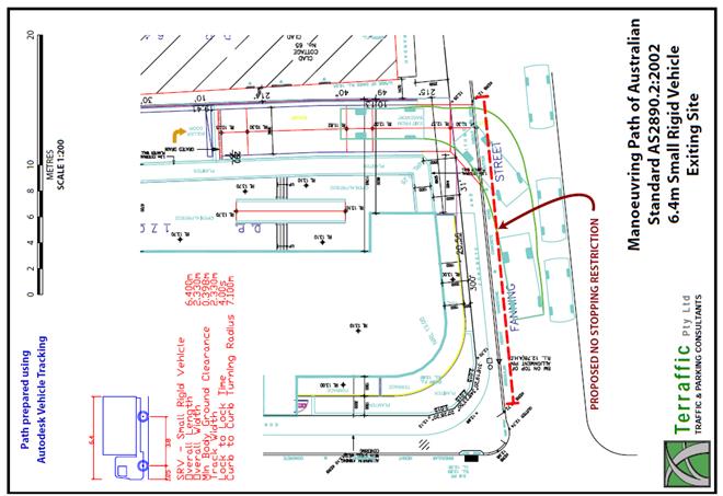
The applicant’s Traffic report further elaborates:
“the proposed development is served by a dedicated loading area in the basement carpark that can accommodate the Australian Standard AS2890.2:2002 6.4m long Small Rigid Vehicle (SRV). While it is anticipated that deliveries to the small retail shop and serviced apartments will be made by delivery vans (similar to the B99 vehicle), waste will be collected by a private contractor such as Veolia Environmental Services who operate vehicles similar to the SRV.
……the 6.14m long Veolia Rear lift 4x2 truck …..indicate that this vehicle has an overall height of 2.83m. The basement carpark has been designed to cater for this vehicle with a headroom clearance of 3.15m. A striker bar will be required at the site entry to ensure vehicles higher than the Veolia truck do not enter the basement.
…The entry and exit swept paths also show proposed NO STOPPING zones along the site
frontage in Barden Street and Fanning Street. This restriction will stop vehicles parking on
the footpath and facilitate access to the site by the SRV.
In the circumstances, it can be concluded that the proposed development has no unacceptable parking or servicing implications”.
Council DCP Part 2.10 says for ‘commercial premises’ minimum requirement for service and delivery vehicle areas is ‘One truck space per 4,000m²GFA up to 20,000m²GFA’. It is noted that for hotels and motels / residential components of mixed use developments ‘one service space per 50 bedrooms / 50 apartments’ is required.
The applicant has proposed a loading dock in the basement for a Small Rigid Vehicle to service the site. However, it is noted that given the size of the development, a loading dock is not required by Part 2.10.
Further, Part 2.10 lists several design principles that should be considered in the design of service vehicle areas, as detailed in RMS Guide to Traffic Generating Developments (2002):
· The layout of the service area must be designed to facilitate operations relevant to the development;
· Service areas must be a physically defined area which is not used for other purposes, such as storage of goods and equipment or parking areas;
· Separation of service vehicle and car movements must be a design objective;
· All vehicles must enter and leave the property in a forward direction; and
· Internal circulation roadways must be adequate for the largest vehicle anticipated to use the site.
The DCP also states that the minimum service vehicle length dimensions for a ‘Small rigid truck’ is 6.6 metres and 4.3 metres for height. C27 in Part 2.10 says that manoeuvring areas must be designed to ensure direct movement to parking bays and loading areas.
The applicant has proposed an internal basement service area when possibly it would make sense to accommodate the servicing requirements at ground floor level if at all feasible, for example Barden Street only. This would limit loading movements to one street only and any potential loss of on-street parking would be minimised.
The proposed ‘No Stopping’ restrictions on one side of both Barden Street and Fanning Street would remove existing on-street parking spaces (particularly in Fanning Street) in a locality that already experiences high parking utilisation rates for the existing on-street parking provision. Further, it is anticipated, to safely accommodate the swept paths of any truck, that timed ‘No Parking’ restrictions and/or ‘No Stopping’ restrictions would ultimately be required on both sides of both streets due to the narrowness of both streets. A possible 6 to 8 existing on-street spaces may be lost which would not be acceptable to the community. Refer to the diagram below. It should be noted that no loss of parking would occur outside residential properties
.
Traffic Generation
RMS’s Guide to Traffic Generating Developments gives the following rates for ‘Motels’ – daily vehicle trips of 3 per unit and peak hour vehicle trips of 0.4 / unit. Thus, 22 serviced apartments could be estimated to generate around 66 vehicle trips daily and 9 peak hour vehicle trips. Daily trip generation rates assume 100% occupancy of units. The Guide notes that when comparison is drawn between existing similar developments and unit occupancy where data is available, rates based on 85% occupancy on the peak day of the week may be appropriate.
The retail component of the proposed development may add one or more vehicle trip(s) in the peak hour which is minimal. Thus, the estimated 66 odd added vehicle trips in the peak hour will only add to the traffic congestion already experienced on Princes Highway, Tempe.
PUBLIC CONSULTATION
Consultation / notification regarding the proposal would normally be undertaken by Council’s Development and Planning Services as part of the development application process.
CONCLUSION
The proposed development is not supported in its current form because of the following issues:
· The proposed development does not comply with Council’s parking requirements.
· Staffing numbers for the proposed site need to be clarified.
· The vehicle servicing arrangements need revisiting as to their need and as proposed are not separated from car movements, which is one of Council’s design principles for service areas.
· There is some doubt whether the internal circulation roadways are adequate for the largest vehicle anticipated to use the site, and moreover for ingress and egress movements on-street.
· Existing on-street parking spaces will be lost.
In summary, the development application for the proposed serviced apartments at Nos.826 – 836 Princes Highway, Tempe is not supported in its present form as it does not meet Council’s minimum parking requirements. Further, any anticipated or otherwise, future change of use would not be supported due to lack of adequate on-site parking provision.
Also, it is anticipated that the proposed servicing arrangements will affect existing on-street parking and any loss of any on-street parking will add further pressure on the present demand for on-street parking, which is often fully utilised and this would be at the detriment of local residents.