|
AGENDA R |

Local Traffic Committee Meeting
TUESDAY 6 NOVEMBER 2018
10.00am
|
|
Local Traffic Committee Meeting 6 November 2018 |
Function of the Local Traffic Committee
Background
Roads and Maritime Services (RMS) is legislated as the Authority responsible for the control of traffic on all NSW Roads. The RMS has delegated certain aspects of the control of traffic on local roads to councils. To exercise this delegation, councils must establish a local traffic committee and obtain the advice of the RMS and Police. The Inner West Council Local Traffic Committee has been constituted by Council as a result of the delegation granted by the RMS pursuant to Section 50 of the Transport Administration Act 1988.
Role of the Committee
The Local Traffic Committee is primarily a technical review and advisory committee which considers the technical merits of proposals and ensures that current technical guidelines are considered. It provides recommendations to Council on traffic and parking control matters and on the provision of traffic control facilities and prescribed traffic control devices for which Council has delegated authority. These matters are dealt with under Part A of the agenda and require Council to consider exercising its delegation.
In addition to its formal role as the Local Traffic Committee, the Committee may also be requested to provide informal traffic engineering advice on traffic matters not requiring Council to exercise its delegated function at that point in time, for example, advice to Council’s Development Assessment Section on traffic generating developments. These matters are dealt with under Part C of the agenda and are for information or advice only and do not require Council to exercise its delegation.
Committee Delegations
The Local Traffic Committee has no decision-making powers. The Council must refer all traffic related matters to the Local Traffic Committee prior to exercising its delegated functions. Matters related to State Roads or functions that have not been delegated to Council must be referred directly to the RMS or relevant organisation.
The Committee provides recommendations to Council. Should Council wish to act contrary to the advice of the Committee or if that advice is not supported unanimously by the Committee members, then the Police or RMS have an opportunity to appeal to the Regional Traffic Committee.
Committee Membership & Voting
Formal voting membership comprises the following:
· one representative of Council as nominated by Council;
· one representative of the NSW Police from each Local Area Command (LAC) within the LGA, being Newtown, Marrickville, Leichhardt and Ashfield LAC’s.
· one representative from the RMS; and
· State Members of Parliament (MP) for the electorates of Summer Hill, Newtown, Heffron, Canterbury, Strathfield and Balmain or their nominees.
Where the Council area is represented by more than one MP or covered by more than one Police LAC, representatives are only permitted to vote on matters which effect their electorate or LAC.
Informal (non-voting) advisors from within Council or external authorities may also attend Committee meetings to provide expert advice.
Committee Chair
Council’s representative will chair the meetings.
Public Participation
Members of the public or other stakeholders may address the Committee on agenda items to be considered by the Committee. The format and number of presentations is at the discretion of the Chairperson and is generally limited to 3 minutes per speaker. Committee debate on agenda items is not open to the public.
|
|
Local Traffic Committee Meeting 6 November 2018 |
|
AGENDA |
1 Apologies
2 Disclosures of Interest
3 Confirmation of Minutes Page
Minutes of 2 October 2018 Local Traffic Committee Meeting 6
4 Matters Arising from Council’s Resolution of Minutes
5 Part A – Items Where Council May Exercise Its Delegated Functions
Traffic Matters
ITEM Page
LTC1118 Item 1 Short Street, Birchgrove Christmas Street Party - Road
Occupancy (Balmain Ward/ Balmain Electorate/ Leichhardt LAC) 39
LTC1118 Item 2 Unnamed Laneway (between May Street and The Boulevarde), Lilyfield Christmas Street Party - Road Occupancy (Balmain Ward/ Balmain Electorate/ Leichhardt LAC) 42
LTC1118 Item 3 Temporary Road Closure to Carryout Sewer Works on 5-7 White Street, Lilyfield (Balmain Ward/ Balmain Electorate/ Leichhardt LAC) 45
LTC1118 Item 4 Red Lion Street, Rozelle, Annual Road Occupancy (Street Party) (Balmain Ward/ Balmain Electorate/ Leichhardt LAC) 48
LTC1118 Item 5 Lyall Street, Leichhardt - Christmas Street Party - Road Occupancy (Leichhardt Ward/ Balmain Electorate/ Leichhardt LAC) 52
LTC1118 Item 6 Liberty Street and Bedford Street, Stanmore – Temporary Full Road Closure for Rail Overbridge Refurbishment Works (Stanmore Ward /Newtown Electorate/ Inner West LAC) 55
LTC1118 Item 7 Fisher Street, Petersham between Regent Street and Audley Street – Temporary Full Road Closure to carry out crane lift works at No. 22 (Stanmore Ward/Newtown Electorate/Inner West LAC) 65
LTC1118 Item 8 Phillip Street, PETERSHAM - Installation of 12 metre Length of ‘Loading Zone’ Restrictions (Stanmore Ward / Newtown Electorate / Inner West LAC) 69
LTC1118 Item 9 Bridge Road, STANMORE – Proposed 10 Minute Parking Restrictions 1-7 Albany Road (Stanmore Ward / Newtown Electorate / Inner West LAC) 72
LTC1118 Item 10 Keith Street, Dulwich Hill - Proposed Improvements to Streetscape – Amended Design Plans 6190_update 11-10-18 (Stanmore Ward /Newtown Electorate/ Inner West LAC) 78
LTC1118 Item 11 Percival Road and Albany Road roundabout, STANMORE - Proposed speed cushions and kerb blisters – Design Plan 10049 (Stanmore Ward /Newtown Electorate/ Inner West LAC) 85
LTC1118 Item 12 Garden Street, Marrickville - Temporary Long Term Full Road Closure (Marrickville Ward /Heffron Electorate/ Inner West LAC) 88
LTC1118 Item 13 Railway Parade, Marrickville - Temporary long term full road closure for construction works related to Sydenham Metro Upgrade – SSJ Group (Marrickville Ward /Heffron Electorate/ Inner WesT LAC) 93
LTC1118 Item 14 Armstrong Street / Queen Street / Hardy Street intersection, Ashbury – Revised intersection Design Plan – RC552 D - C17 (Ashfield Ward/Summer Hill Electorate/Inner West LAC) 98
LTC1118 Item 15 Summer Hill Street at Victoria Street, Lewisham – Proposed Kerb Extensions Design Plan – No.10043 (Stanmore Ward / Summer Hill Electorate / Inner West LAC) 107
Parking Matters
ITEM Page
LTC1118 Item 16 Minor Traffic Facilities (All Wards/ All Electorates/ All LACs) 111
LTC1118 Item 17 Flood Street and Allen Street, Leichhardt - Bus Stop Modifications (Leichhardt Ward / Balmain Electorate / Leichhardt LAC) 132
LTC1118 Item 18 Lilydale Street, Marrickville - Proposed Permit Parking (MarrickvilleWard/Summer Hill Electorate/Inner West LAC) 137
LTC1118 Item 19 Little Darling Street, Balmain - Proposed Extension of 'No Stopping' zone (Balmain Ward/ Balmain Electorate/ Leichhardt LAC) 141
LTC1118 Item 20 The Boulevarde at Balmain Road, Lilyfield - Proposed 'No Stopping' zones and '15 Minute' parking restrictions (Balmain Ward/ Balmain Electorate/ Leichhardt LAC) 144
LTC1118 Item 21 Brenan Street, Lilyfield - Proposal for Car Share Parking Space (Balmain Ward/ Balmain Electorate/ Leichhardt LAC) 148
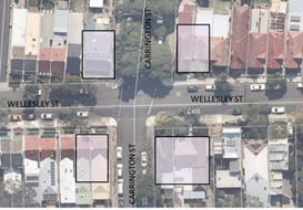
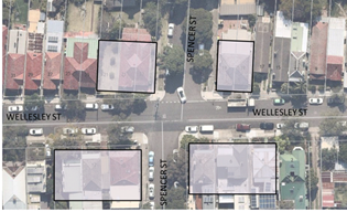
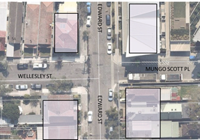
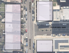
LTC1118 Item 22 'No Stopping' Restrictions - The Summer Hill Flour Mill Development and Surrounding Streets (Ashfield Ward / Summer Hill Electorate / Burwood PAC) 151
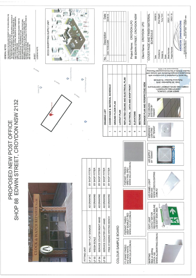
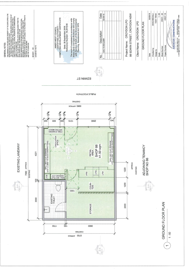
LTC1118 Item 23 Edwin Street North, Croydon- Request for 'Mail Zone' 163
Part B - Items for Information Only
ITEM Page
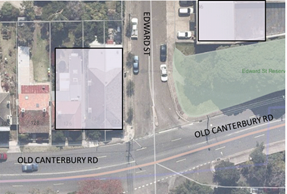
LTC1118 Item 24 Old Canterbury Road, Lewisham - Temporary Full Road Closure for Rail Overbridge Refurbishment Works (Stanmore Ward / Summer Hill Electorate / Inner West LAC) 169
LTC1118 Item 25 New Canterbury Road, Petersham – Proposed Signage Outside No.31-33 (Stanmore Ward / Newtown Electorate / Inner West LAC) 175
Part C - Items for General Advice
ITEM Page
LTC1118 Item 26 Local Traffic Committee Schedule for 2019 179
LTC1118 Item 27 63-65 Pyrmont Bridge Road, Annandale - Modication of Development Consent (Leichhardt Ward/ Balmain Electorate/Leichhardt LAC) 180
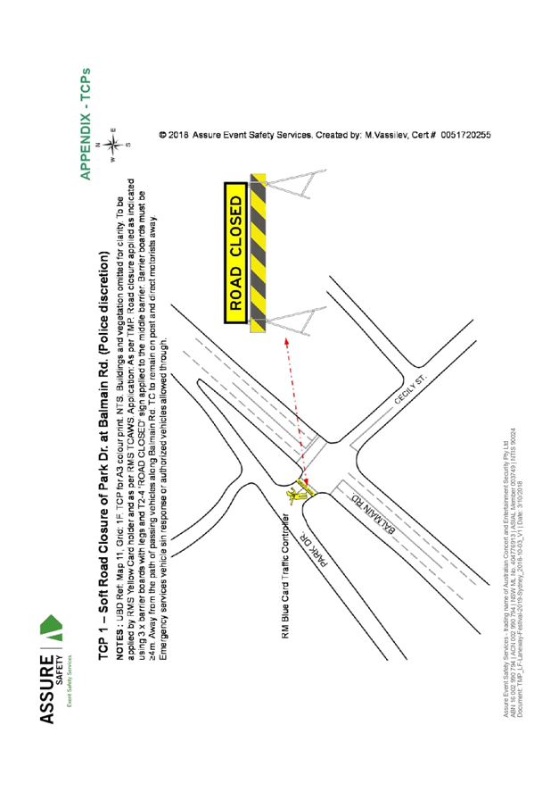
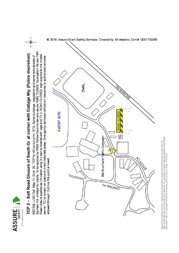
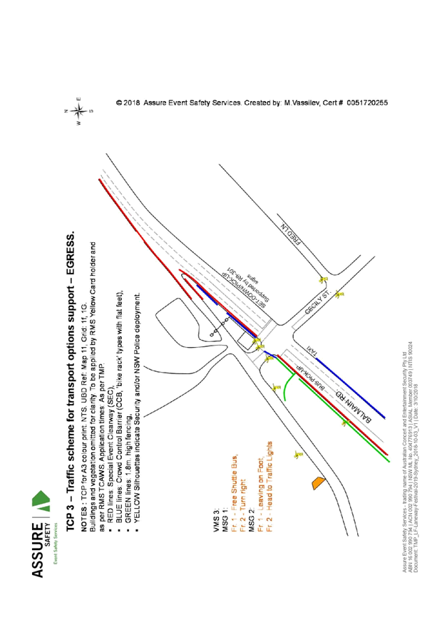
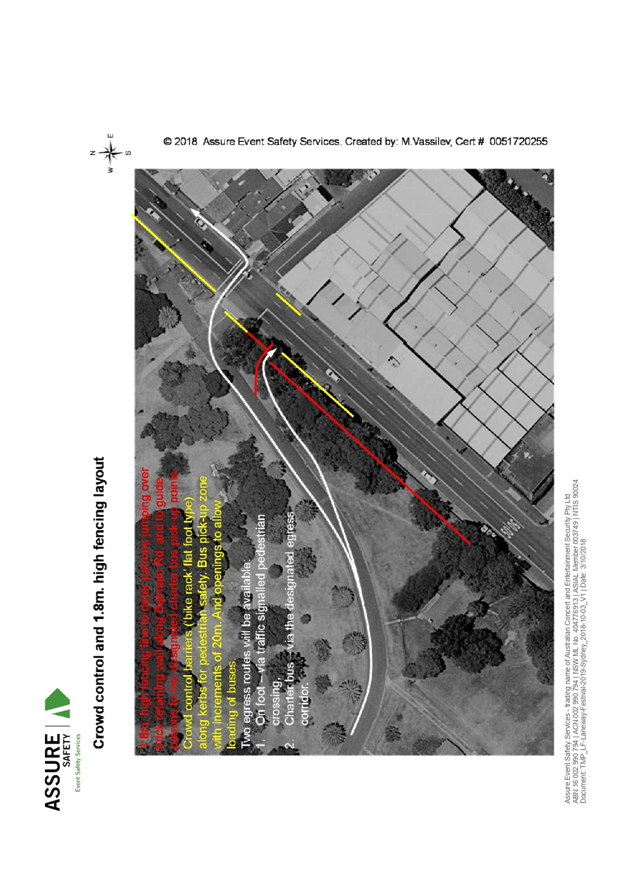
LTC1118 Item 28 2019 St Jerome's Laneway Festival - Traffic Management Plan (Balmain Ward/ Balmain Electorate/ Leichhardt LAC) 186
6 General Business
7 Close of Meeting
|
|
Local Traffic Committee Meeting 6 November 2018 |
Minutes of Local Traffic Committee Meeting
Held at Petersham Service Centre on 2 October 2018
Meeting commenced at 9.59am
ACKNOWLEDGEMENT OF COUNTRY BY CHAIRPERSON
I acknowledge the Gadigal and Wangal people of the Eora nation on whose country we are meeting today, and their elders past and present.
COMMITTEE REPRESENTATIVES PRESENT
|
Victor Macri |
Chair, Deputy Mayor – Marrickville Ward |
|
Bill Holliday |
Representative for Jamie Parker MP, Member for Balmain |
|
Chris Woods |
Representative for Ron Hoenig MP, Member for Heffron |
|
Sarina Foulstone |
Representative for Jo Haylen MP, Member for Summer Hill |
|
Cathy Peters |
Representative for Jenny Leong MP, Member for Newtown |
|
Charles Buttrose |
NSW Police – Leichhardt Police Area Command |
|
Paul Vlachos |
NSW Police – Inner West Police Area Command |
|
Ryan Horne |
Roads and Maritime Services |
|
|
|
|
OFFICERS AND OTHER IN ATTENDANCE |
|
|
|
|
|
Anthony Kenny |
NSW Police – Inner West Police Area Command |
|
Asith Nagodavithane |
Transit Systems – Inner West Bus Services |
|
Colin Jones |
Inner West Bicycle Coalition |
|
Marghanita da Cruz |
Councillor – Leichhardt Ward |
|
Wal Petschler |
IWC’s Group Manager, Roads, Traffic and Stormwater |
|
John Stephens |
IWC’s Traffic and Transport Services Manager |
|
Manod Wickramasinghe |
IWC’s Coordinator Traffic and Parking Services (North) |
|
George Tsaprounis |
IWC’s Coordinator Traffic and Parking Services (South) |
|
Jenny Adams |
IWC’s Engineer – Traffic and Parking Services |
|
Sunny Jo |
IWC’s Traffic and Parking Planner |
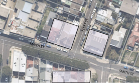
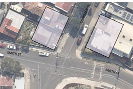
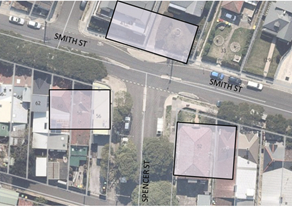
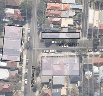
|
Mary Bailey |
IWC’s Parking Planner |
|
Joe Di Cesare |
IWC’s Coordinator, Design Services |
|
Predrag Gudelj |
IWC’s Project Manager |
|
Jonathan Weng |
IWC’s Graduate Engineer, Design Services |
|
Christina Ip |
IWC’s Business Administration Officer |
|
|
|
|
VISITORS |
|
|
|
|
|
Nil. |
|
|
|
|
|
APOLOGIES: |
|
|
|
|
|
John Micallef |
NSW Police – Burwood Police Area Command |
|
|
|
DISCLOSURES OF INTERESTS:
Ms Sarina Foulstone declared a non-pecuniary interest in Item 8 as she is a member of BIKESydney’s management committee.
CONFIRMATION OF MINUTES
|
The minutes of the Local Traffic Committee Meeting held on Tuesday, 4 September 2018 were confirmed. |
MATTERS ARISING FROM COUNCIL’S RESOLUTION OF MINUTES
The Local Traffic Committee recommendations of its meeting held on 4 September 2018 were adopted at Council’s meeting held on 25 September 2018, with the following change to LTC0918 Item 21:
|
LTC1018 Item 22 Australia Street, Eliza Street, Lennox Street & Mary Street, Newtown – Temporary Full Road Closures For Newtown Festival On Sunday 11 November 2018 (Stanmore Ward/Newtown Electorate/Newtown LAC) |
|
A Section 96 (2) application had been received from the Newtown Neighbourhood Centre in relation to modifying conditions in holding the annual 'Newtown Festival' for the remaining 2 years assented, Sunday 12 November 2017 and Sunday 11 November 2018. The applicant has requested the temporary full road closures, between the hours of 5.00am to 8.00pm, of Australia Street (between Lennox Street and Alton Lane), Eliza Street, Lennox Street (between Australia Street and the exit of Lennox Street car park) and Mary Street, Newtown.
It is recommended that Council support to the temporary road closures for the last of the assented years on Sunday 11 November 2018 between the hours of 5.00am to 8.00pm; apply to the RMS for consent to close the subject roads, subject to the event being advertised, a Traffic Management Plan be submitted to the RMS for approval and advice of the proposed event being forwarded to the appropriate authorities, including the Transport Management Centre.
Comments of the Local Traffic Committee will be referred to Council’s Development Assessment Section for consideration in determining the Section 96 Application.
Officer’s Recommendation
THAT: 1. The proposed temporary full road closures of Australia Street (between Lennox Street and Alton Lane), Eliza Street, Lennox Street (between Australia Street and the exit driveway of Lennox Street car park) and Mary Street, Newtown on Sunday 11 November 2018, between 5.00am to 8.00pm, for the holding of the 39th annual 'Newtown Festival' (Class 2 event under the RMS Special Events Guide), be APPROVED subject to the applicant complying with the following conditions: a) The temporary road closure be advertised in the local newspaper providing 28 days’ notice for submissions; b) A Traffic Management Plan be submitted to the Roads and Maritime Services for consideration and approval; and a Road Occupancy License application be submitted to the Transport Management Centre; c) Notice of the proposed event be forwarded to the N.S.W. Police, State Transit Authority, Newtown Local Area Commander, the NSW Fire Brigades and the NSW Ambulance Services; d) Advance notifications signs for the event be strategically installed at least two (2) weeks prior to the event; e) "No Stopping - Special Event" signs be affixed over all existing timed parking restriction signs within the sections of streets to be closed on the afternoon of the day prior to the event; f) A 4-metre wide emergency vehicle access must be maintained through the closed road areas during the course of the event; g) The applicant is to consult with all affected residents and/or businesses in the area in writing and to conduct a letter box drop of surrounding properties at least two weeks prior to event; h) Adequate vehicular traffic control shall be provided for the protection and convenience of pedestrians and motorists including appropriate signage and flagging. Workers shall be specially designated for this role (and carry appropriate certificates), as necessary to comply with this condition. This is to be carried out in accordance with the Australian Standard AS 1742.3 - Traffic Control Devices for works on roads; 2. The Festival Director, Newtown Neighbourhood Centre be advised in terms of this report and that all costs for advertising the event and implementation of the road closures are to be borne by the applicant; and 3. The applicant be advised that an annual application needs to be submitted to Council for the temporary road closures associated with the festival.
DISCUSSION
The Committee members agreed with the Officer’s recommendation.
COMMITTEE RECOMMENDATION
THAT: 1. The proposed temporary full road closures of Australia Street (between Lennox Street and Alton Lane), Eliza Street, Lennox Street (between Australia Street and the exit driveway of Lennox Street car park) and Mary Street, Newtown on Sunday 11 November 2018, between 5.00am to 8.00pm, for the holding of the 39th annual 'Newtown Festival' (Class 2 event under the RMS Special Events Guide), be APPROVED subject to the applicant complying with the following conditions: a) The temporary road closure be advertised in the local newspaper providing 28 days’ notice for submissions; b) A Traffic Management Plan be submitted to the Roads and Maritime Services for consideration and approval; and a Road Occupancy License application be submitted to the Transport Management Centre; c) Notice of the proposed event be forwarded to the N.S.W. Police, State Transit Authority, Newtown Local Area Commander, the NSW Fire Brigades and the NSW Ambulance Services; d) Advance notifications signs for the event be strategically installed at least two (2) weeks prior to the event; e) "No Stopping - Special Event" signs be affixed over all existing timed parking restriction signs within the sections of streets to be closed on the afternoon of the day prior to the event; f) A 4-metre wide emergency vehicle access must be maintained through the closed road areas during the course of the event; g) The applicant is to consult with all affected residents and/or businesses in the area in writing and to conduct a letter box drop of surrounding properties at least two weeks prior to event; h) Adequate vehicular traffic control shall be provided for the protection and convenience of pedestrians and motorists including appropriate signage and flagging. Workers shall be specially designated for this role (and carry appropriate certificates), as necessary to comply with this condition. This is to be carried out in accordance with the Australian Standard AS 1742.3 - Traffic Control Devices for works on roads; 2. The Festival Director, Newtown Neighbourhood Centre be advised in terms of this report and that all costs for advertising the event and implementation of the road closures are to be borne by the applicant; and 3. The applicant be advised that an annual application needs to be submitted to Council for the temporary road closures associated with the festival.
For motion: Unanimous
|
General Business
Meeting closed at 10.55am.
|
|
Local Traffic Committee Meeting 6 November 2018 |
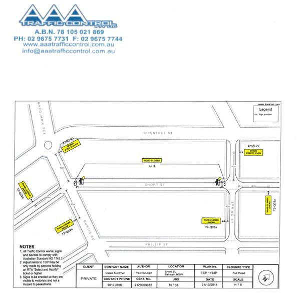
Subject: Short Street, Birchgrove Christmas Street Party - Road Occupancy (Balmain Ward/ Balmain Electorate/ Leichhardt LAC)
Prepared By: Felicia Lau - Engineer - Traffic and Parking Services
Authorised By: John Stephens - Traffic and Transport Services Manager
|
SUMMARY Council has received an application for approval of a Christmas Street Party in Short Street, Birchgrove between Curtis Road and Spring Street to be held on Saturday, 15 December 2018 between 6:00pm and 11:30pm. |
|
RECOMMENDATION
THAT:
1. The temporary road closure of Short Street, Birchgrove between Curtis Road and Spring Street on Saturday, 15 December 2018 between 6:00pm and 11:30pm be supported as per the submitted TCP;
2. All residents and businesses in and around the affected area, including NSW Fire & Rescue (Balmain) to be notified by the applicant in advance (7 days prior to the event) of the temporary road closure;
3. A minimum four (4) metre unencumbered passage be available for emergency vehicles through the closed section of Short Street, Birchgrove; and
4. The occupation of the road carriageway must not occur until the road has been physically closed.
|
BACKGROUND
Council has received an application for an approval to conduct an annual Christmas street party in Short Street, Birchgrove between Curtis Road and Spring Street.
The street party is proposed to be held on Saturday, 15 December 2018 between 6:00pm and 11:30pm. The applicant is seeking permission for a temporary full road closure of Short Street between Curtis Road and Spring Street.
The Traffic Control Plan for the temporary road closures is shown below.
FINANCIAL IMPLICATIONS
The street party coordinator will bear all costs associated with the road closure.
OTHER STAFF COMMENTS
This is an annual event and no significant issues have occurred in previous years.
According to the RMS ‘Guide to Traffic and Transport Management for Special Events’ (version 3.4) a small street party is considered as a ‘Class 3’ event.
Council encourages properly conducted neighbourhood street parties as a means of building community spirit and improving neighbourhood security. Fees for road occupancy are waived by Council for small community street parties.
Where the following apply, organisers are only required to obtain approval for a street party involving a temporary road closure:
· The party is to be held outdoors for fewer than 100 people.
· No temporary structures or jumping castles are to be erected.
· Participants are to bring their own food and drinks, and food and drinks are not for sale.
· There will be no performers or amplified music involved.
For approved street parties, Council will provide barricades and signs free or at minimum cost. Any non-standard signs may be provided at cost. The street party coordinator will need to arrange delivery by Council at cost, or pick up from and return to Council’s depot at no cost.
PUBLIC CONSULTATION
The proposed road closure of Short Street, Birchgrove between Curtis Road and Spring Street has been advertised in the local newspaper for a period of 28 days commencing Tuesday, 9 October 2018.
Any responses received will be tabled at the meeting.
CONCLUSION
It is recommended that the temporary closure of Short Street between Spring Street and Curtis Road, Balmain on Saturday, 15 December 2018 be supported subject to the conditions listed in the recommendation.
|
|
Local Traffic Committee Meeting 6 November 2018 |
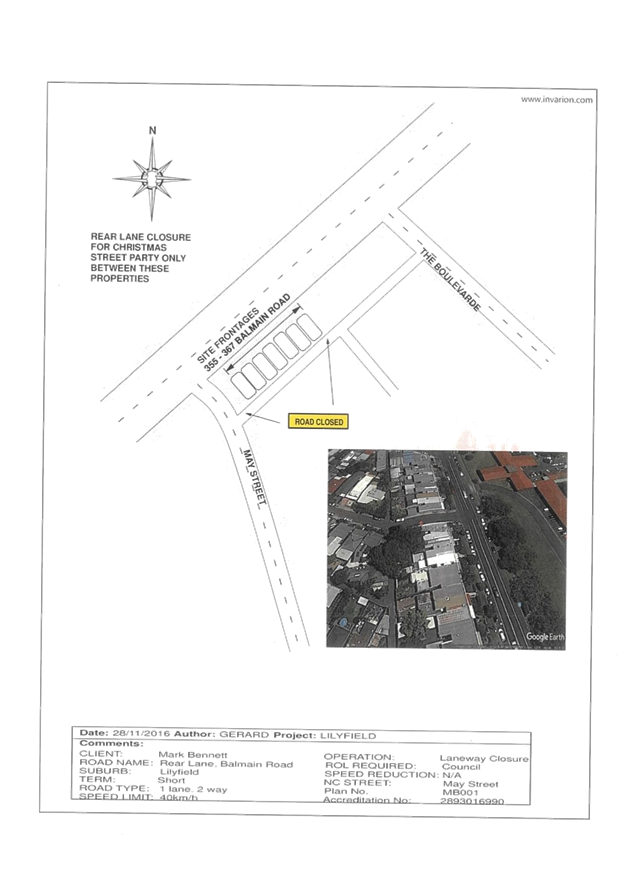
Subject: Unnamed Laneway (between May Street and The Boulevarde), Lilyfield Christmas Street Party - Road Occupancy (Balmain Ward/ Balmain Electorate/ Leichhardt LAC)
Prepared By: Felicia Lau - Engineer - Traffic and Parking Services
Authorised By: John Stephens - Traffic and Transport Services Manager
|
SUMMARY Council has received an application for approval of an annual Christmas Street Party in the Unnamed Laneway between May Street and The Boulevarde, Lilyfield to be held on Saturday, 22 December 2018 between 4:00pm and 10:00pm. |
|
RECOMMENDATION
THAT:
1. The temporary road closure of the Unnamed Laneway, Lilyfield between May Street and The Boulevarde (section at the rear of Nos. 355-367 Balmain Road) on Saturday, 22 December 2018 between 4:00pm and 10:00pm be supported as per the submitted TCP;
2. All residents and businesses in and around the affected area, including NSW Fire & Rescue (Leichhardt) to be notified by the applicant in advance (7 days prior to the event) of the temporary road closure;
3. A minimum three (3) metre unencumbered passage be available for emergency vehicles through the closed section of Unnamed Laneway Lilyfield; and
4. The occupation of the road carriageway must not occur until the road has been physically closed. |
BACKGROUND
Council has received an application for an approval to conduct an annual Christmas Street Party in the Unnamed Laneway, Lilyfield between May Street and The Boulevarde.
The street party is proposed to be held on Saturday, 22 December 2018 between 4:00pm and 10:00pm. The applicant is seeking permission for a temporary full road closure of Unnamed Laneway between May Street and The Boulevarde.
The Traffic Control Plan (TCP) for the temporary road closures is shown in Attachment 1.
FINANCIAL IMPLICATIONS
The street party coordinator will bear all costs associated with the road closure.
OTHER STAFF COMMENTS
This is an annual event and no significant issues have occurred in previous years.
According to the RMS ‘Guide to Traffic and Transport Management for Special Events’ (version 3.4) a small street party is considered as a ‘Class 3’ event.
Council encourages properly conducted neighbourhood street parties as a means of building community spirit and improving neighbourhood security. Fees for road occupancy are waived by Council for small community street parties.
Where the following apply, organisers are only required to obtain approval for a street party involving a temporary road closure:
· The party is to be held outdoors for fewer than 100 people.
· No temporary structures or jumping castles are to be erected.
· Participants are to bring their own food and drinks, and food and drinks are not for sale.
· There will be no performers or amplified music involved.
For approved street parties, Council will provide barricades and signs free or at minimum cost. Any non-standard signs may be provided at cost. The street party coordinator will need to arrange delivery by Council at cost, or pick up from and return to Council’s depot at no cost.
PUBLIC CONSULTATION
The proposed road closure of Unnamed Laneway, Lilyfield between May Street and The Boulevarde (section at the rear of Nos. 355-367 Balmain Road) has been advertised in the local newspaper for a period of 28 days commencing Tuesday, 9 October 2018.
Any responses received will be tabled at the meeting.
CONCLUSION
It is recommended that the temporary full road closure of the Unnamed Laneway between May Street and The Boulevarde, Lilyfield (section at the rear of Nos. 355-367 Balmain Road) on Saturday, 22 December 2018 be supported subject to the conditions listed in the recommendation.
|
1.⇩ |
Traffic Control Plan |
|
|
Local Traffic Committee Meeting 6 November 2018 |
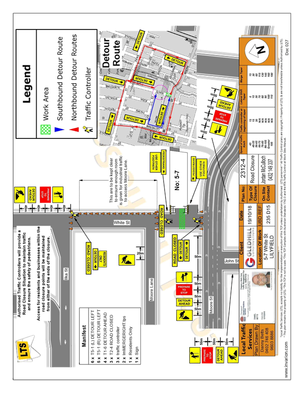
Subject: Temporary Road Closure to Carryout Sewer Works on 5-7 White Street, Lilyfield (Balmain Ward/ Balmain Electorate/ Leichhardt LAC)
Prepared By: Felicia Lau - Engineer - Traffic and Parking Services
Authorised By: John Stephens - Traffic and Transport Services Manager
|
SUMMARY An application has been received from Gledhill Constructions for the temporary full road closure of White Street, Lilyfield between Moore Street and Moore Lane (frontage of house No.5-7 White Street section) between Wednesday, 28 November 2018 and Wednesday, 12 December 2018, with a further 2 weeks contingency thereafter to carryout sewer works on White Street, Lilyfield. It is recommended that the proposed temporary road closure be approved, subject to the conditions outlined in this report. |
|
RECOMMENDATION
THAT:
1. The proposed temporary full road closure of White Street, between Moore Street and Moore Lane (frontage of house No.5-7), Lilyfield from 7am to 5pm, Wednesday 28 November 2018 to Wednesday, 12 December 2018, with a further 2 weeks contingency thereafter, in order to carryout sewer works in White Street, Lilyfield as per the submitted TCP;
2. A Road Occupancy License be obtained by the applicant from the Transport Management Centre;
3. All affected residents and businesses, including the NSW Police Local Area Commander, Fire & Rescue NSW and the NSW Ambulance Services be notified in writing, by the applicant, of the proposed temporary road closure at least 7 days in advance of the closure with the applicant making reasonable provision for stakeholders; and
4. The occupation of the road carriageway must not occur until the road has been physically closed.
|
BACKGROUND
An application has been received from Gledhill Construction for the temporary full road closure of White Street (between Moore Street and Moore Lane), Lilyfield between 7am-5pm, Wednesday, 28 November 2018 to Wednesday, 12 December 2018, with a further 2 weeks contingency, in order to carryout sewer works in White Street, Lilyfield.
FINANCIAL IMPLICATIONS
Under Council’s Fees & Charges, the applicant has paid the fee for the temporary full road closure. This fee includes advertising the proposal in accordance with the Roads Act 1993.
OTHER STAFF COMMENTS
The Traffic Control Plan submitted by the applicant is attached.
Vehicular access for local residents will be maintained during the closure, where possible. Authorised traffic controllers will be on-site during all shifts and are to be positioned at the closure points when required to provide vehicular access to local residents and ensure the safety of motorists and pedestrians.
PUBLIC CONSULTATION
The applicant is to notify all affected residents and businesses in writing at least 28 days prior to the commencement of works.
The proposed road closure has been advertised in the local newspaper in accordance with the Roads Act 1993 on Tuesday, 23 October 2018.
CONCLUSION
It is recommended that the proposed temporary road closures be approved, subject to the conditions outlined in this report.
|
1.⇩ |
Traffic Control Plan |
|
|
Local Traffic Committee Meeting 6 November 2018 |
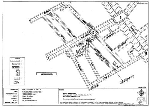
Subject: Red Lion Street, Rozelle, Annual Road Occupancy (Street Party) (Balmain Ward/ Balmain Electorate/ Leichhardt LAC)
Prepared By: Vinoth Srinivasan - Engineer - Traffic and Parking Services
Authorised By: John Stephens - Traffic and Transport Services Manager
|
SUMMARY This report seeks approval for the temporary road closure of Red Lion Street, Rozelle to facilitate the annual ‘Christmas Street Party’ event that has been successfully conducted since 2009. |
|
RECOMMENDATION
THAT:
1. The temporary road closure of Red Lion Street between Darling Street and Evans Street, Rozelle on Saturday, 15 December 2018 between 5:00pm – 12:00midnight be supported as per the submitted TCP;
2. All residents and businesses in and around the affected area, including NSW Fire & Rescue (Balmain/Leichhardt) to be notified by the applicant in advance (7 days prior to the event) of the temporary road closure;
3. A minimum four (4) metre unencumbered passage be available for emergency vehicles through the closed section of Red Lion Street, Rozelle; and
4. The occupation of the road carriageway must not occur until the road has been physically closed. |
BACKGROUND
Council has received an application for approval of a street party in Red Lion Street between Darling Street and Evans Street, from a resident of Red Lion Street, Rozelle.
The street party is proposed to be held on Saturday, 15 December 2018 between 5:00pm and 12:00midnight. The applicant is seeking permission for a temporary full road closure of Red Lion Street between Darling Street and Evans Street, Rozelle.
FINANCIAL IMPLICATIONS
The Street Party Coordinator will bear all costs associated with the road closure.
OTHER STAFF COMMENTS
The Traffic Control Plan for the closure is as follows:
This is an annual event and no significant issues have occurred in the past (first event was in 2009).
According to the RMS ‘Guide to Traffic and Transport Management for Special Events’ (Version 3.4) a small street party is considered as a ‘Class 3’ event.
Council encourages properly conducted neighbourhood street parties as a means of building community spirit and improving neighbourhood security. Fees for road occupancy are waived by Council for small community street parties.
Where the following conditions apply, organisers are only required to obtain approval for a street party involving a temporary road closure:
· The party is to be held outdoors for fewer than 100 people
· No temporary structures or jumping castles are to be erected,
· Participants are to bring their own food and drinks, and food and drink are not for sale
· There will be no performers or amplified music involved
For approved street parties, Council will provide barricades and ‘Road Closed’ signs free or at minimum cost. Any non-standard signs may be provided at cost. The Street Party Co-ordinator will need to arrange delivery by Council at cost, or arrange pickup from and return to Council’s Depot at no cost.
PUBLIC CONSULTATION
The proposed temporary full-road closure has been advertised in the local newspaper for a period of 28 days, no responses were received.
CONCLUSION
It is recommended that the temporary closure of Red Lion Street between Darling Street and Evans Street on Saturday, 15 December 2018 be supported subject to conditions listed in the recommendation.
|
1.⇩ |
Attachment 1: Red Lion Street - Road Occupancy |
|
Local Traffic Committee Meeting 6 November 2018 |
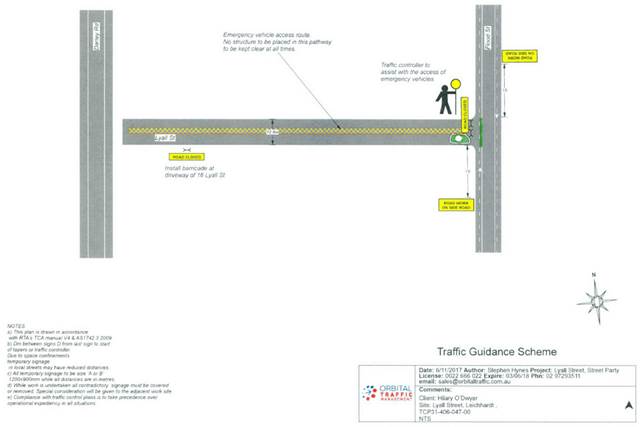
Subject: Lyall Street, Leichhardt - Christmas Street Party - Road Occupancy (Leichhardt Ward/ Balmain Electorate/ Leichhardt LAC)
Prepared By: Felicia Lau - Engineer - Traffic and Parking Services
Authorised By: John Stephens - Traffic and Transport Services Manager
|
SUMMARY Council has received an application from a resident of Lyall Street, Leichhardt to conduct a Christmas Street Party in Lyall Street, west of Flood Street between 2.00pm and 6.00pm on Saturday, 15 December 2018. This event was successfully conducted in 2017. |
|
RECOMMENDATION
THAT:
1. The temporary full road closure of Lyall Street, west of Flood Street, Leichhardt on Saturday, 15 December 2018 between 2:00pm and 6:00pm be supported as per the submitted TCP;
2. All residents and businesses in and around the affected area, including NSW Fire & Rescue (Leichhardt) to be notified by the applicant in advance (7 days prior to the event) of the temporary road closure;
3. A minimum four (4) metre unencumbered passage be available for emergency vehicles through the closed section of Lyall Street; and
4. The occupation of the road carriageway must not occur until the road has been physically closed. |
BACKGROUND
Council has received an application from a resident in Lyall Street, Leichhardt to conduct a temporary road closure for a Christmas Street Party in Lyall Street, west of Flood Street.
The street party is proposed to be held on Saturday, 15 December 2018, between 2:00pm and 6:00pm. The applicant is seeking permission for a temporary full road closure of Lyall Street, Leichhardt, and west of Flood Street.
FINANCIAL IMPLICATIONS
The Street Party Coordinator will bear all costs associated with the road closure.
OTHER STAFF COMMENTS
The Traffic Control Plan for the closure is as presented below.
This is an annual event and no significant issues occurred last year.
According to the RMS ‘Guide to Traffic and Transport Management for Special Events’ (Version 3.4) a small street party is considered as ‘Class 3’ event.
Council encourages properly conducted neighbourhood street parties as a means of building community spirit and improving neighbourhood security. Fees for road occupancy are waived by Council for small community street parties.
Where the following conditions apply, organisers are only required to obtain approval for a street party involving a temporary road closure:
· The party is to be held outdoors for fewer than 100 people.
· No temporary structures or jumping castles are to be erected.
· Participants are to bring their own food and drinks, and food and drinks are not for sale.
· There will be no performers or amplified music involved.
For approved street parties, Council will provide barricades and ‘Road Closed’ signs free or at minimum cost. Any non-standard signs may be provided at cost. The Street Party co-ordinator will need to arrange delivery by Council at cost, or arrange pickup from and return to Council’s Depot at no cost.
PUBLIC CONSULTATION
The proposed temporary full road closure is currently advertised in the local newspaper for a period of 28 days commencing Tuesday, 30 October 2018.
CONCLUSION
It is recommended that the temporary full road closure of Lyall Street, west of Flood Street on Saturday, 15 December 2018 be supported, subject to the conditions listed in the recommendation.
|
|
Local Traffic Committee Meeting 6 November 2018 |
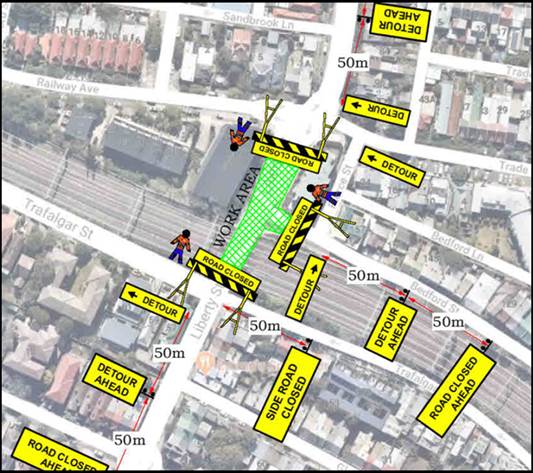
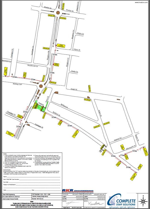
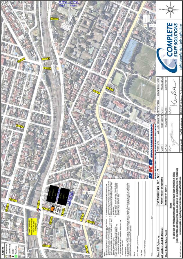
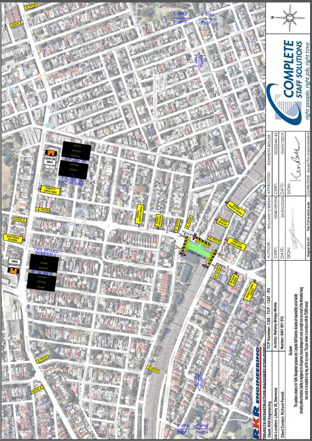
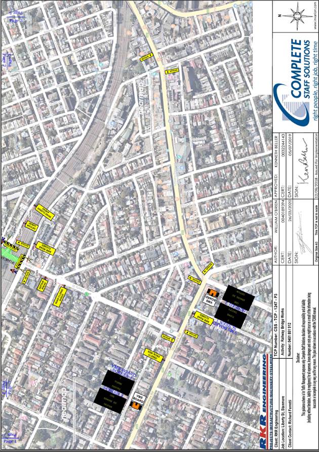
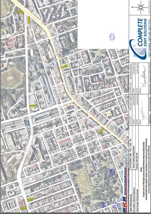
Subject: Liberty Street and Bedford Street, Stanmore – Temporary Full Road Closure for Rail Overbridge Refurbishment Works (STANMORE WARD /NEWTOWN ELECTORATE/ INNER WEST LAC)
Prepared By: Jennifer Adams - Engineer – Traffic and Parking Services
Authorised By: John Stephens - Traffic and Transport Services Manager
|
SUMMARY An application has been received from Sydney Trains TfNSW for the temporary full road closure of Liberty Road (between Railway Avenue and Trafalgar Street) and Bedford Street (between Liberty Street and Pierce Street), Stanmore on 3 separate occurrences being 8 to 11 March 2019, 5 to 8 April 2019 and 1 to 4 November 2019 in order to carry out refurbishment works on the Liberty Street Stanmore rail over bridge. The streets will be temporarily closed to all vehicular traffic, including emergency vehicles and local residents. It is recommended that the proposed temporary full road closures be approved, subject to the conditions outlined in this report. |
|
RECOMMENDATION
THAT the proposed temporary full road closure of Liberty Road (between Railway Avenue and Trafalgar Street) and Bedford Street (between Liberty Street and Pierce Street), Stanmore on 3 separate occurrences being 8 to 11 March 2019, 5 to 8 April 2019 and 1 to 4 November 2019 be approved, in order to carry out refurbishment works on the Liberty Street Stanmore rail over bridge subject to the following conditions:
1. A Road Occupancy License be obtained by the applicant from the Transport Management Centre;
2. All affected residents and businesses, including the NSW Police Local Area Commander, Fire & Rescue NSW and the NSW Ambulance Services be notified in writing, by the applicant, of the proposed temporary road closure at least 7 days in advance of the closure with the applicant making reasonable provision for stakeholders; and
3. The occupation of the road carriageway must not occur until the road has been physically closed. |
BACKGROUND
An application has been received from Sydney Trains TfNSW for the temporary full road closure of Liberty Road (between Railway Avenue and Trafalgar Street) and Bedford Street (between Liberty Street and Pierce Street), Stanmore on 3 separate occurrences being 18 to 21 January 2019, 5 to 8 April 2019 and 1 to 4 November 2019 in order to carry out refurbishment works on the Liberty Street Stanmore rail overbridge. The streets will be temporarily closed to all vehicular traffic, including emergency vehicles and local residents.
The proposed works are to be conducted over three separate weekends:
|
1st Weekend ROL |
8-11th March 2019 (WE36) |
|
2nd Weekend ROL |
5-8th April 2019 (WE40) |
|
3rd Weekend ROL |
1-4th November 2019 (WE18) |
The proposed road closure times for each street are detailed below:
Stage 1 – TCP-1248 – Bedford Street, Stanmore
|
8th March 2019 |
from Friday 1800 hours until 0500 Monday |
11th March 2019 |
|
5th April 2019 |
from Friday 1800 hours until 0500 Monday |
8th April 2019 |
|
1st November 2019 |
from Friday 1800 hours until 0500 Monday |
4th November 2019 |
Early closure of Bedford Street is proposed to commence mobilisation and site setup with minimal impact to traffic and residents.
The limited timeframe and number of weekends available to complete works necessitates the early road closure of Bedford Street to complete refurbishment scope.
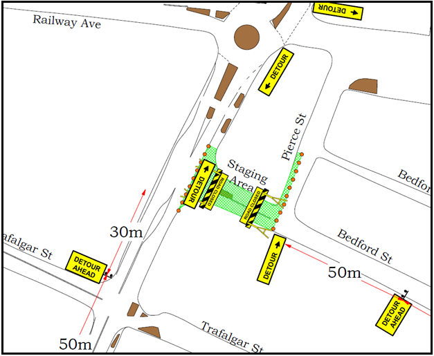
Stage 2 - TCP-1247 - Liberty St, Stanmore
|
8th March 2019 |
from Friday 2300 hours until 0500 Monday |
11th March 2019 |
|
5th April 2019 |
from Friday 2300 hours until 0500 Monday |
8th April 2019 |
|
1st November 2019 |
from Friday 2300 hours until 0500 Monday |
4th November 2019 |
Closure of Liberty Street is proposed to commence in line with RMS road closure approval (attached) and to be completed to scope within limited timeframe and available weekends.
FINANCIAL IMPLICATIONS
Under Council’s Fees & Charges, the applicant is to pay a fee of $1,540.00 for the temporary full road closure. This fee includes advertising the proposal in accordance with the Roads Act 1993.
OFFICER COMMENTS
Liberty Street is a regional road which carries around 24,000 vehicles per day. At the railway over bridge the width of the roadway is approximately 11 metres in width. It is noted that the full road closure will divert traffic to either Crystal Street or King Street, both of which are remote from Liberty Street.
The subject location Traffic Control Plans submitted by the applicant is shown below.
PUBLIC CONSULTATION
The applicant is to notify all affected residents and businesses in writing at least 7 days prior to the commencement of works.
The proposed road closure has been advertised in the local newspaper in accordance with the Roads Act 1993
CONCLUSION
It is recommended that the proposed temporary full road closures be approved, subject to but not limited to the conditions outlined in this report.
|
|
Local Traffic Committee Meeting 6 November 2018 |
Subject: Fisher Street, Petersham between Regent Street and Audley Street – Temporary Full Road Closure to carry out crane lift works at No. 22 (Stanmore Ward/Newtown Electorate/Inner West LAC)
Prepared By: Jennifer Adams - Engineer – Traffic and Parking Services
Authorised By: John Stephens - Traffic and Transport Services Manager
|
SUMMARY An application has been received from Boycebuild Pty Ltd for the temporary full road closure of Fisher Street, Petersham between Regent Street and Audley Street, for a period of 8 hours on 3rd December 2018 between the hours of 7:00am and 3pm, in order to stand a mobile crane to carry out crane lift works. It is recommended that the proposed temporary full road closure be approved, subject to the conditions outlined in this report.
|
BACKGROUND
An application has been received from Boycebuild Pty Ltd for the temporary full road closure of Fisher Street, Petersham between Regent Street and Audley Street, for a period of 8 hours on 3rd December 2018 between the hours of 7:00am and 3pm, in order to stand a mobile crane to carry out crane lift works.
FINANCIAL IMPLICATIONS
Under Council’s Fees & Charges, the applicant is to pay for the temporary full road closure. This fee includes advertising the proposal in accordance with Roads Act 1993.
OTHER STAFF COMMENTS
The Traffic Control Plan submitted by the applicant is shown below.
Vehicular access for local residents/businesses and emergency services will be maintained during the closure, where possible. Authorised Traffic controllers will be on-site during the time of the road closure and are to be positioned at the closure points when required to provide vehicular access to local residents/businesses and ensure the safety of motorists and pedestrians (refer to Traffic Control Plan for details).
PUBLIC CONSULTATION
The applicant is to notify all affected residents and businesses in writing at least 28 days prior to the commencement of works.
The proposed road closure has been advertised in the local newspaper in accordance with the Roads Act 1993.
CONCLUSION
It is recommended that the proposed temporary road closure be approved, subject to, but not limited to the conditions outlined in this report.
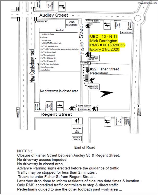
Traffic Control Plan submitted by the applicant – 22 Fisher Street, Petersham
|
|
Local Traffic Committee Meeting 6 November 2018 |
Subject: Phillip Street, PETERSHAM - Installation of 12 metre Length of ‘Loading Zone’ Restrictions (STANMORE WARD / NEWTOWN ELECTORATE / INNER WEST LAC)
Prepared By: Jennifer Adams - Engineer – Traffic and Parking Services
Authorised By: John Stephens - Traffic and Transport Services Manager
|
SUMMARY A request has been received for a ‘Loading Zone’ in Phillip Street, Petersham to help facilitate loading and unloading for local businesses along Parramatta Road and Phillip Street, Petersham.
It is recommended that a 12 metre length (existing 2 car parking spaces with ‘1P 8.30am-6.00pm Mon-Fri, 8.30am-12.30pm Sat’ restrictions) be replaced with “Loading Zone 8.30am – 4.30pm Monday – Friday’ restrictions on the western side of Phillip Street (adjacent to the Petersham Inn), commencing from the existing ‘No Stopping’ restrictions (closest to Parramatta Road) be approved, in order to provide loading / unloading facilities for local businesses along Parramatta Road and Phillip Street, Petersham.
|
|
RECOMMENDATION
THAT a 12 metre length (existing 2 car parking spaces with ‘1P 8.30am-6.00pm Mon-Fri, 8.30am-12.30pm Sat’ restrictions) be replaced with “Loading Zone 8.30am – 4.30pm Monday – Friday’ restrictions on the western side of Phillip Street (adjacent to the Petersham Inn), commencing from the existing ‘No Stopping’ restrictions (closest to Parramatta Road) be approved, in order to provide loading / unloading facilities for local businesses along Parramatta Road and Phillip Street, Petersham.
|
BACKGROUND
Phillip Street is a short part commercial/part residential street running north-south between Parramatta Road and Margaret Street. The site (Petersham Inn) is situated on the south-west corner of the intersection of Parramatta Road and Phillip Street which is controlled by traffic signals.
At present, “No Stopping” restrictions are installed on the western side of the street for a distance of 20 metres south of Parramatta Road. “One hour Parking 8.30AM-6.00PM Monday-Friday, 8.30AM-12.30PM Saturday” restrictions occupy the next 28 metres of kerb space (inclusive of driveways). This is followed by a six (6) metre section of “No Stopping” through to Hughes Street. (See attached sketch.)
The “Loading Zone” restrictions are proposed to replace the existing “One hour Parking” zone north of the driveway to 386-414 Parramatta Road (ie. on Phillip Street), Petersham.
FINANCIAL IMPLICATIONS
The costs of the supply and installation of the signposting associated with the recommended ‘Loading Zone’ restrictions is approximately $600 and can be met from Council’s existing signs and line marking budget.
CONSULTATION
Notification letters were hand delivered to adjoining businesses and no responses were received in relation to this proposal.
CONCLUSION
It is recommended that ‘Loading Zone’ restrictions be installed in order to facilitate with loading and unloading for local businesses along Parramatta Road and Phillip Street, Petersham.
Installation Diagram
|
|
Local Traffic Committee Meeting 6 November 2018 |
Subject: Bridge
Road, STANMORE – Proposed 10 Minute Parking Restrictions 1-7 Albany Road
(Stanmore Ward / Newtown Electorate / Inner West LAC)
Prepared By: Jennifer Adams - Engineer – Traffic and Parking Services
Authorised By: John Stephens - Traffic and Transport Services Manager
|
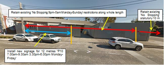
SUMMARY As part of the approved child care centre development at 1 – 7 Albany Road, Stanmore a condition of the Modified Land and Environment Court Order No. 250036 of 2016, dated 21 December 2016 was that the applicant was to apply to the Local Traffic Committee for 2 drop-off/pick-up car spaces on Bridge Road, Stanmore. The development results in two on-street spaces gained in Bridge Street due to redundant existing vehicular crossings being reconstructed as kerb and gutter. The applicant requests that new parking restrictions be considered and approved for these spaces as a drop-off/pick-up facility for the child care centre.
It is recommended that a 12 metre length (2 car parking spaces) of ‘P10 7:00am-9:30am 3:30pm-6:00pm, Monday-Friday’ restrictions be installed on the western side of Bridge Street adjacent to 1-7 Albany Road, Stanmore. Adjacent businesses/residences will be notified of the new restrictions when the signage is to be installed.
|
|
RECOMMENDATION
THAT:
1. Council approve the installation of two ‘P10 7:00am-9:30am 3:30pm-6:00pm, Monday-Friday’ parking spaces on the western side of Bridge Street (commencing from the kerb blister closest to Salisbury Lane), between Albany Road and Salisbury Lane, Stanmore in order to provide an additional on-street drop-off/pick-up facility;
2. The existing ‘No Stopping 9.00pm-5.00am Monday – Sunday’ restrictions on the western side of Bridge Street, between Albany Road and Salisbury Lane, Stanmore remain; and 3. The costs of the supply and installation of the parking signage are to be borne by the applicant.
|
BACKGROUND
In 2015 a Development Application (DA201500269) was received seeking approval to construct a child care centre for 135 children at 1-7 Albany Road, Stanmore with 24 staff members and 19 on-site car parking spaces. A report on a proposal to install two 10 minute car parking spaces for the child care centre was referred to the Pedestrian, Cyclist and Traffic Calming Advisory (PCTCAC) at its meeting on 13 August 2015 for consideration under State Environmental Planning Policy (Infrastructure) 2007. The Council Officer’s recommendation stated that;
“The proposed development is supported in its current form subject to implementation of a ‘P10minute 7:30am-9:30am, 2:30pm-5:30pm, Mon-Fri’ parking restriction for a distance of 12 metres (2 car parking spaces) along the western side of Bridge Road, Stanmore (adjacent to property 1-7 Albany Road, Stanmore) to meet the requirements of Council’s DCP 2011 for the provision of off-street car parking for the proposed development.”
On 1 September 2015, the Infrastructure Planning & Environmental Services Committee (IPESC) meeting considered the report on the ‘Proposed Childcare Centre’ for 1-7 Albany Road, Stanmore and adopted the following recommendation;
“THAT:
1. the recommendations of the Pedestrian, Cyclist and Traffic Calming Advisory Committee meeting held on 13 August 2015 be adopted with the exception of Item A1, 1-7 Albany Road, Stanmore, Proposed Child Care Centre; and
2. Item A1 be referred back to the Pedestrian, Cyclist and Traffic Calming Advisory Committee for reconsideration of its recommendation, with consideration being given to Council’s traffic and parking contentions that relate to the Land and Environment Court Class 1 Appeal concerning the proposed development.
A review on the traffic and parking contentions that related to the Land and Environment Court Class 1 Appeal concerning the proposed Development Application to construct a childcare centre for 135 children at 1-7 Albany Road, Stanmore was undertaken and the comments, together with the recommendation, were presented in a report that went to an extra-ordinary PCTCAC meeting on 16 September 2015.
The recommendation of that report was: “THAT the applicant be requested to review the proposed on-site parking layout to meet the requirements of AS2890.1:2004 and to review the parking provision for on-site parking for the proposed child care centre at 1-7 Albany Road, Stanmore to meet the requirements of Council’s DCP 2011.”
In 2016 a development application was received (DA201600306) to demolish the existing building and to construct a 4 storey building with ground-level car parking and use the premises as a childcare centre for 103 children at 1-7 Albany Road, Stanmore.
Approval was granted by Land and Environment Court Order No. 250036 of 2016, dated 21 December 2016, to demolish the existing improvements and construct a 3 part 4 storey long day care centre for 103 children aged from 0 to 5 years at 1-7 Albany Road. Development consent conditions imposed included Condition 98 relating to the drop-off/pick-up on Bridge Road, Stanmore:
98. An application to Council’s Traffic Committee shall be submitted for the installation of 2 drop off/pick up car spaces on Bridge Road. The spaces shall be shall be signposted “10 minutes parking, between 7:00am to 9:30am and 3:30pm to 6:00pm, Monday to Friday” so as to allow for drop off/pick up during the peak times of the childcare centre. The signage if approved shall be installed before the issue of the Occupation Certificate.
Reason: To provide for adequate drop off and pick up arrangements.
FINANCIAL IMPLICATIONS
The costs of the supply and installation of the parking signage are to be borne by the applicant.
OFFICER COMMENTS
The development site is located on the south-western corner of Albany Road and Bridge Road, Stanmore and is adjacent to residential properties. Surrounding land uses comprise a mixture of residential single-dwelling properties, industrial/business properties and mixed-use multi storey buildings that are all located within close proximity to the subject site.
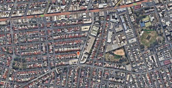
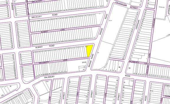
Albany Road runs east-west between Bridge Road to the East and Douglas Street to the West. Albany Road is a local street that provides one travel lane in each direction, in addition to kerbside parking lanes. Bridge Road is a regional road, which carries a traffic volume of approximately 11,600 vehicles per day. It provides one traffic lane in each direction, in addition to kerbside parking lanes (Refer to the attached locality map and photograph).
![]()
Proposed changes to kerbside parking restrictions in Bridge Road, Stanmore
The parking impacts of the proposed development have previously been assessed. The NSW LEC Determination Condition of Consent 98 required the applicant apply to Council’s Local Traffic Committee for the proposed parking restriction in order to provide adequate pick up and drop arrangements in addition to the parking provided on site.
At present ‘No Stopping 9pm-5am Monday-Sunday’ restrictions are in place on both sides of Bridge Road in the immediate area. Albany Road has ‘2P 8.30am-6pm Permit Holders Excepted Area M15’ restrictions on the northern side and unrestricted parking on the southern side.
Access to the new development will be via a new vehicular entry/exit driveway located towards the western end of the site frontage in Albany Road. The existing driveway to Bridge Road will become redundant and will be replaced with kerb and gutter, gaining two additional on-street kerbside parking spaces.
Existing Parking Restrictions :
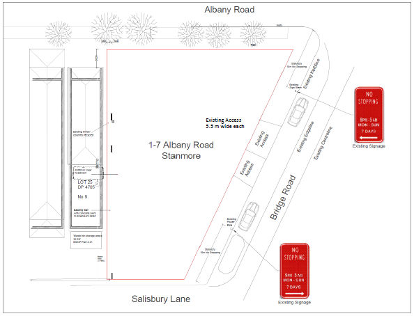
It is proposed that the two gained on-street parking spaces will become a drop-off/pick-up facility for the Centre in the morning and afternoon peak periods while retaining the existing two on-street spaces with ‘No Stopping 9:00pm to 5:00am Monday-Sunday’ restrictions. The two ‘P10’ spaces would also be signposted as ‘No Stopping 9:00pm to 5:00am Monday –Sunday’ restrictions.
Proposed Parking Restrictions:
![]()
![]()
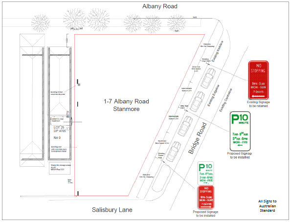
Statutory 10m ‘No Stopping’ distances are to be retained via the kerb blister on Bridge Road adjacent to Salisbury Lane and the existing “No Stopping’ sign with an arrow pointing to Albany Road, Stanmore.
![]()
PUBLIC CONSULTATION
Adjacent businesses/residences will be notified of the new restrictions when the signage is to be installed.
CONCLUSION
It is recommended that a 12 metre length (2 car parking spaces) of ‘P10 7:00am-9:30am 3:30pm-6:00pm, Monday-Friday’ restrictions be installed on the western side of Bridge Street adjacent to 1-7 Albany Road, Stanmore.
|
|
Local Traffic Committee Meeting 6 November 2018 |
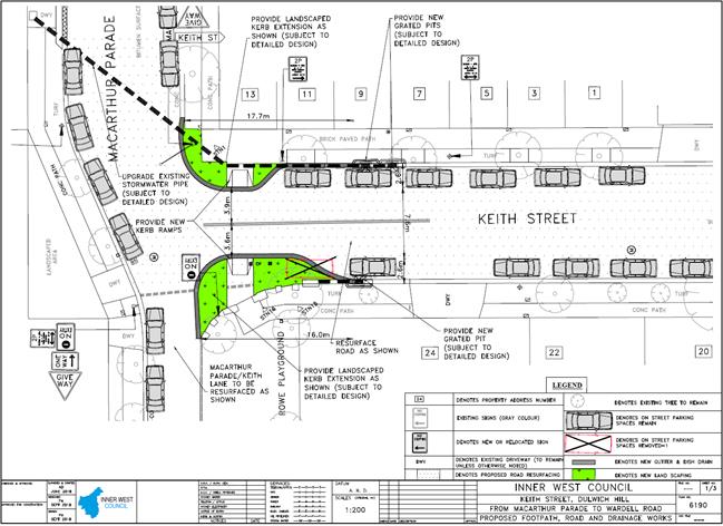
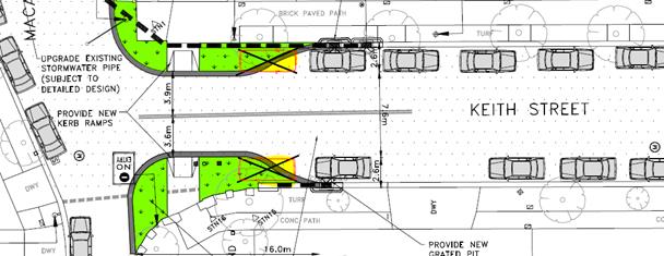
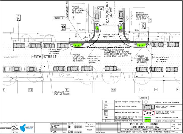
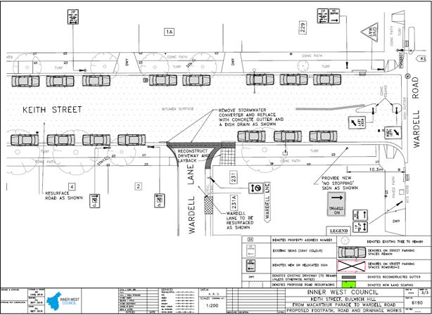
Subject: Keith Street, Dulwich Hill - Proposed Improvements to Streetscape – Amended Design Plans 6190_update 11-10-18 (STANMORE WARD /NEWTOWN ELECTORATE/ INNER WEST LAC)
Prepared By: Jennifer Adams - Engineer – Traffic and Parking Services
Authorised By: John Stephens - Traffic and Transport Services Manager
|
SUMMARY Detailed design plans have now been finalised for the proposed improvements to the streetscape in Keith Street, Dulwich Hill. The proposal will enhance the street with new footpath and road surfaces, as well as drainage improvements and increased landscaped areas.
Consultation was undertaken with 127 owners and occupiers of properties in the locality regarding the proposal. A summary of the consultation results are presented in this report for consideration.
It is noted that after consultation and following community objection to the loss of parking (2 on-street spaces), the original consultation plans have now been amended (6190_update 11-10-18) by shortening the northern kerb extension to within the statutory 10 metres from the intersection. This has now resulted in the gain of one of the proposed ‘lost’ parking spaces. The southern kerb extension must remain as originally proposed due to design constraints. Essentially, there is now a net loss of 1 parking space as a result of the proposal, not the original proposed two on-street spaces.
It is recommended that the proposed amended detailed design plans be approved.
|
|
RECOMMENDATION
THAT the detailed amended design plans (Design Plan No.6190_update 11-10-18 – 1,2,3) for the proposed improvements to the streetscape be APPROVED. |
BACKGROUND
Council is proposing to improve the streetscape in Keith Street, Dulwich Hill. The proposal will enhance the street with new footpath and road surfaces, as well as drainage improvements and increased landscaped areas.
The project was identified during asset inspections in 2013/14 as being in poor condition and was prioritized based on adopted Asset Planning criteria.
The street was identified as being in poor condition, in need of footpath and road reconstruction, as well as drainage improvements, greening opportunities and increased landscaped areas.
The design plans have now been finalised for the proposed works and public notification of the works went out for consultation in August 2018. The plan and the results of the consultation are presented in this report for consideration.
It is noted that after consultation and following community objection to the loss of parking (2 on-street spaces), the original consultation plans have now been amended (6190_update 11-10-18) by shortening the northern kerb extension to within the statutory 10 metres from the intersection. This has now resulted in the gain of one of the proposed ‘lost’ parking spaces. The southern kerb extension must remain as originally proposed due to design constraints. Essentially, there is now a net loss of 1 parking space as a result of the proposal, not the original proposed two on-street spaces.
FINANCIAL IMPLICATIONS
The estimated cost of the project is $320,000 and funding has been allocated in Council’s 2018/19 capital works program for the project.
OFFICER COMMENTS
Site location & road network
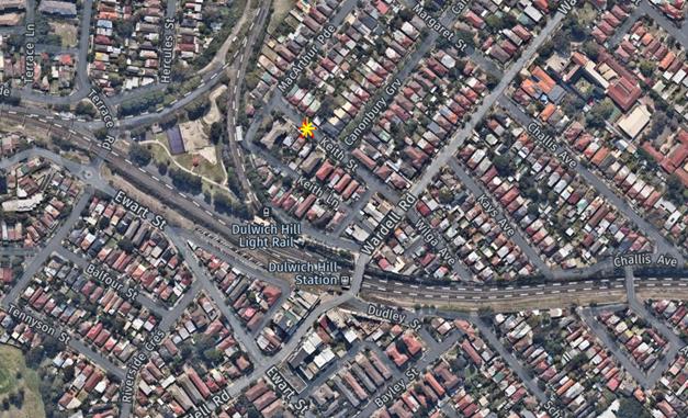
Keith Street is a local road that connects Wardell Road and MacArthur Street, Dulwich Hill and carries around 430 vehicles per day. (Refer to the attached locality map).
Design plan No. 6190_update 11-10-18
The proposed works include:
· Installing landscaped kerb extensions on the corner of Keith Street and Macarthur Parade;
· Installing new kerb blister islands at the corner of Keith Street and Canonbury Grove;
· Reconstructing damaged sections of footpath, kerb and gutter along Keith Street in concrete;
· Resealing Keith Street, as well as parts of Macarthur Parade, Canonbury Grove and Wardell Lane;
· Installing signage, replacing any damaged signs and painting new and faded road markings;
· Upgrading the drainage at the corner of Keith Street and Macarthur Parade; and
· Grass verges and trees will remain as existing
This proposal now results in the loss of one legal on-street parking space. Please refer to the attached plans below for more details.
Previously the design propossed would have resulted in the loss of two legal on-street parking spaces:
![]()
PUBLIC CONSULTATION
A consultation letter for the Keith Street project was sent out on 10/09/18 and closed on 28/09/18. A letter as well as a copy of the design plan was sent to the local residents in Keith Street, Dulwich Hill. A total of 127 letters were distributed.
There were five (5) responses generally supporting the proposed streetscape improvement works in Keith Street, Dulwich Hill however three objected to the loss of on-street parking. The results received are detailed below.
|
Residents’ Comments |
Officer’s Response |
|
A resident of the street was generally in support to the proposal of the streetscape enhancements in their street, however the resident objects to any loss of on-street parking. The resident stated that off street parking is in high demand, especially in light of the older apartment blocks /residences having no off-street parking facilities.
The resident had concerns about rubbish dumping and litter in the area generally and noted that having large kerb blisters would add to further dumping in the area. The resident suggested that more regular street cleaning would be advantageous along with removal of leaves from the storm water drain on the corner of Keith and Canonbury streets.
The resident also noted that the current road surface on the corner of Keith and Canonbury is directly linked and level with the walking paths, currently providing perfect accessibility for wheelchairs, bikes and prams.
|
Following resident concerns about loss of 2 on-street parking spaces, the consultation plans have now been amended by shortening the northern kerb extension to within the statutory 10m from the intersection. This has resulted in the gain of one of the parking spaces. The southern kerb extension must remain as proposed due to design constraints.
Noted. Dumping of rubbish needs to be reported to Council’s Monitoring Section and blocked drains need to be reported to Council’s Maintenance Section.
Improvement of the streetscape and pedestrian safety and accessibility were major considerations during the development of the design plans. The proposed works aim to provide a kerb barrier from traffic, which currently does not exist, whilst also providing improved accessibility and safety for pedestrians.
|
|
A resident of the street is pleased that Council is considering improving their street however strongly objects to the loss of the car space outside their property. The resident noted that 7 houses on the northern side of the street do not have off-street parking facilities and parking demand is high despite the residential parking permit scheme operating in their street. Being in close proximity to the light rail puts extra strain on available parking in the area.
|
Noted. Following resident concerns about loss of 2 on-street parking spaces, the consultation plans have now been amended by shortening the northern kerb extension to within the statutory 10m from the intersection. This has resulted in the gain of one of the parking spaces. The southern kerb extension must remain as proposed due to design constraints.
|
|
A resident from Keith Street generally approved of the proposed streetscape improvements suggesting also that smaller kerb blisters would reduce loss of any on-street parking spaces. |
Noted. Following resident concerns about loss of 2 on-street parking spaces, the consultation plans have now been amended by shortening the northern kerb extension to within the statutory 10m from the intersection. This has resulted in the gain of one of the parking spaces. The southern kerb extension must remain as proposed due to design constraints.
|
|
In regards to the kerb islands /extensions the resident queried whether it is possible to include substantial feature trees or shrubs within them rather than the typical low level vegetation and whether the brick paving would remain.
The resident noted concerns about whether the new gardens would be maintained by Council as there is a serious problem with junk mail and litter of the street already. ‘They may become accumulation traps for litter’.
|
Low level planting is carried out on all corner abutting kerb blisters to maintain adequate sightlines for both motorists and pedestrians. Turf will be grown as indicated on the design plan and bricked paved footpaths will remain.
Noted. Dumping of rubbish needs to be reported to Council’s Monitoring Section. |
|
A resident of Keith Street supported and appreciated the proposed streetscape improvement works generally and commented on extending the path and verge gardens into Rowe Playground.
In relation to the proposed loss of 2 parking spaces and general lack of parking in the locality the resident commented that ‘actually four spaces will be lost as three cars currently park each side of the section where the garden will be constructed.’ and suggested that the south side of Keith Street could be converted to angle parking along with one side of Macarthur Street. Adding that if safety is a concern then the speed limit could also be reduced to 40km/h.
|
Noted. Rowe Playground is programed for future works and suggested comment will be forwarded to the Parks Section of Council.
Following resident concerns about loss of 2 on-street parking spaces, the consultation plans have now been amended by shortening the northern kerb extension to within the statutory 10m from the intersection. This has resulted in the gain of one of the parking spaces. The southern kerb extension must remain as proposed due to design constraints.
Converting the south side of Keith Street into angle parking requires a number of considerations to be met under Australian Standards (as specified in AS 2890) such as the camber of the road, the number of driveways, the placement of trees and the width of the road, kerb height and clearances. Investigation of existing parking occupancy rates would also be required and this suggestion has been listed for review in any future parking study of the Dulwich Hill area to check whether viable.
Any speed reduction request has to meet criteria as set by RMS and at present Keith Street does not satisfy the requirements especially when there is no recorded history of injury crashes in the street in the last five years of RMS recorded crash data.
|
CONCLUSION
It is recommended that the design plans for the proposed improvements to the streetscape in Keith Street, Dulwich Hill enhancing the street with new footpath and road surfaces, as well as drainage improvements and increased landscaped areas be approved to improve pedestrian safety and traffic conditions in the street.
|
|
Local Traffic Committee Meeting 6 November 2018 |
Subject: Percival Road and Albany Road roundabout, STANMORE - Proposed speed cushions and kerb blisters – Design Plan 10049 (STANMORE WARD /NEWTOWN ELECTORATE/ INNER WEST LAC)
Prepared By: Jennifer Adams - Engineer – Traffic and Parking Services
Authorised By: John Stephens - Traffic and Transport Services Manager
|
SUMMARY Design plans have been prepared for proposed speed cushions and minor splitter island modifications to existing kerb blisters at Percival Road and Albany Road roundabout, Stanmore as part of Council’s Traffic Capital Works Program. The proposal for speed cushions, kerb blister modifications and associated signs and line marking will improve traffic conditions and road safety at this location. The proposal is funded from a successful application as part of the 2018/18 Federal and NSW Government’s Blackspot Programs.
Consultation was undertaken with owners and occupiers of properties in Percival Road and Albany Road regarding the proposal. A summary of the consultation results are presented in this report for consideration. It is recommended that the proposed detailed design plan be approved.
|
|
RECOMMENDATION
THAT the detailed design plan for the speed cushions, kerb blisters and associated signs and line markings at the roundabout of Percival Road and Albany Road, Stanmore (as per Design Plan No.10049) be APPROVED.
|
BACKGROUND
The roundabout at the junction of Percival Road and Albany Road, Stanmore was identified as a location that required traffic calming measures to address resident reported speeding concerns and a poor crash history.
A review of 5 years (June 2012 to June 2017) of Road and Maritime Services (RMS) reported crash data revealed that there had been four injury crashes at the roundabout and further analysis of the crash data revealed that speed was a main contributor in a number of the crashes. Subsequently a submission was made for Blackspot funding and Council was successful in receiving funding through the 2018/19 Australian Government’s Black Spot Program for the proposed traffic improvement works.
Council is proposing to install new speed cushions and kerb blisters at the roundabout of Percival Road and Albany Road, Stanmore to reduce approach speeds and improve road safety for pedestrians and motorists at the intersection.
Design plans have been prepared for proposed speed cushions and minor splitter island modifications to existing kerb blisters at Percival Road and Albany Road roundabout, Stanmore as part of Council’s Traffic Capital Works Program. The proposal for speed cushions, kerb blisters and associated signs and line marking will improve traffic conditions and road safety at this location.
FINANCIAL IMPLICATIONS
Funding of $45,500 had been allocated by Council for the scope of works at the roundabout of Percival Road and Albany Road, Stanmore under the 2018/019 Capital Works Program for Traffic facilities.
The proposal is funded from a successful application as part of the 2018/18 Federal and NSW Government’s Blackspot Programs.
OFFICER COMMENTS
Percival Road and Albany Road, Stanmore are both local roads carrying acceptable traffic volumes.
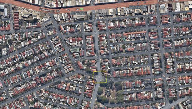
Percival Road at Albany Road, Stanmore
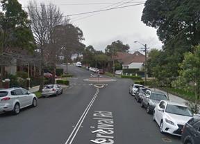
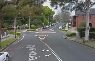
Looking northward on Percival Road Looking southward on Percival Road
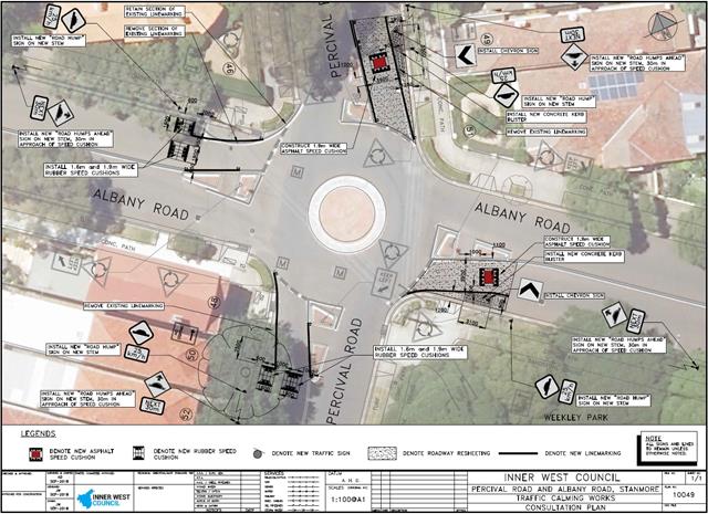
Design Plan
Design plans for the provision of new speed cushions and minor splitter island modifications, alongwith the asssociated signs and line markings, at the existing roundabout in Percival Road at Albany Road, Stanmore (Design Plan 10049) are submitted for consideration.
The proposed scope of work includes the following:
· Install four sets of speed cushions on all approaches to the existing roundabout at the intersection of Percival Road and Albany Road, Stanmore
· Extend the existing splitter islands in Percival Road
· Install associated signs and linemarking.
This proposal will not result in the loss of any on-street parking spaces.
PUBLIC CONSULTATION
Consultation was conducted between 21 September 2018 and 5 October 2018. A letter as well as a copy of the design plan was sent to the local residents in Percival Road and Albany Road, Stanmore. A total of 21 letters were distributed.
There was one (1) response supporting the proposed traffic improvement works at the roundabout of Percival Road and Albany Road, Stanmore. The resident supported the proposal noting that they had recently witnessed several incidents at the roundabout due to ‘excess speed on approaches’.
CONCLUSION
It is recommended that the detailed design plan of the proposed traffic treatment and associated signs and line markings be supported to improve traffic conditions at this location.
|
|
Local Traffic Committee Meeting 6 November 2018 |
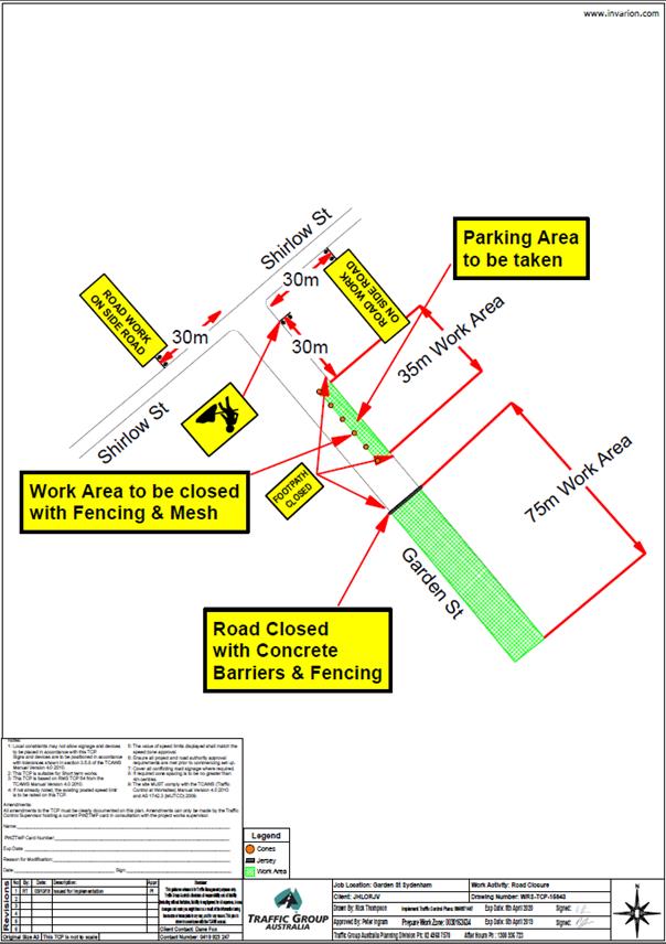
Subject: Garden Street, Marrickville - Temporary Long Term Full Road Closure (MARRICKVILLE WARD /HEFFRON ELECTORATE/ INNER WEST LAC)
Prepared By: Jennifer Adams - Engineer – Traffic and Parking Services
Authorised By: John Stephens - Traffic and Transport Services Manager
|
SUMMARY An application has been received from Sydney Metro SSJ Group – Sydenham Metro Upgrade project – for the temporary long term full road closure of Garden Street, Marrickville (between the rear of 1-11 Sydenham Road to Garden Street roads end) between 27 November 2018 and December 2021 in order to carry out construction activities for the upgrade of Sydenham Station being delivered as part of the Sydney Metro City & Southwest program of work. The subject street section will be temporarily closed to all vehicular traffic.
It is recommended that the proposed temporary full road closure be approved, subject to the conditions outlined in this report. |
|
RECOMMENDATION
THAT the proposed temporary long term full road closure of Garden Street (58 metres south of Shirlow Street to Garden Street roads end) 27 November 2018 and December 2021 be APPROVED in order to carry out construction activities for the upgrade of Sydenham Station being delivered as part of the Sydney Metro City & Southwest program of work subject to the following conditions:
1. A Road Occupancy License be obtained by the applicant from the Transport Management Centre;
2. All affected residents and businesses, including the NSW Police Local Area Commander, Fire & Rescue NSW and the NSW Ambulance Services be notified in writing, by the applicant, of the proposed temporary road closure at least 7 days in advance of the closure with the applicant making reasonable provision for stakeholders; and
3. The occupation of the road carriageway must not occur until the road has been physically closed. |
BACKGROUND
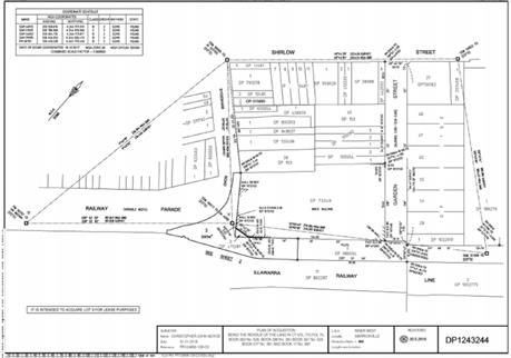
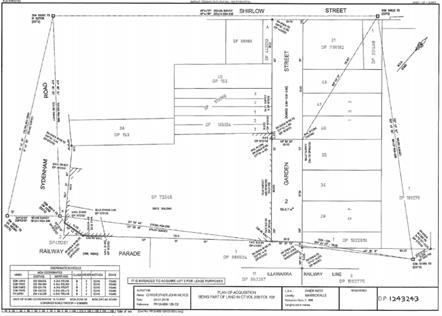
An application has been received from Sydney Metro SSJ Group – Sydenham Metro Upgrade project for the temporary long term full road closure of Garden Street, Marrickville (between the rear of 1-11 Sydenham Road to Garden Street roads end) from 27 November 2018 to December 2021 in order to carry out construction activities for the upgrade of Sydenham Station being delivered as part of the Sydney Metro City & Southwest program of work.
At this time this is not an application for a permanent road closure of this section of Garden Street. The land parcel identified in this application along Garden Street is subject to a construction lease between Inner West Council and Transport for New South Wales.
The station will be fully upgraded with new pedestrian plazas on Burrows Road and Railway Parade and a new aerial concourse with lifts and level access between the platforms and trains. Sydenham Station platforms 1 and 2 will be upgraded to Sydney Metro standards, including the installation of platform screen doors and new canopies. Existing platforms 3, 4, 5 and 6 will continue to be used by trains operating on the Sydney Trains network.
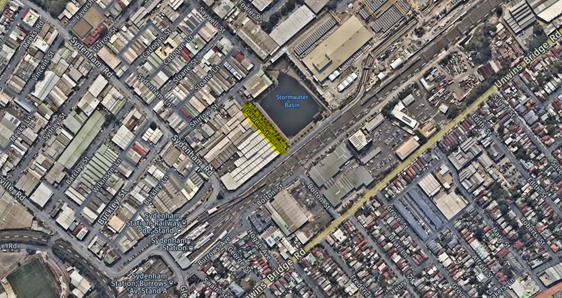
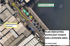
The new Sydney Metro line that will come out of the adjoining Marrickville tunnel dive site and head towards the upgraded Sydenham Station requires the existing Marrickville Valley stormwater channel and culverts between the Sydenham Pit and the railway line to be moved. The current stormwater channel will be decommissioned to make way for the new Sydney Metro line and a new 120m long aqueduct (an enclosed concrete box culvert on a bridge structure) will be built across the Sydenham Pit extending to 11 Sydenham Road with the new aqueduct connecting with existing underground channels adjacent to Railway Parade. The building currently located at 1-11 Sydenham Road will be demolished to make way for the new aqueduct. Additionally a new access ramp into the Sydenham pit will also be built from Garden Street to provide access to the pit floor for future maintenance requirements.
To establish a safe work zone on Garden Street during the construction of the aqueduct and demolition of 1-11 Sydenham Road the closure of a section of Garden Street is required (from rear of 1-11 Sydenham Road to the end of Garden Street) - refer to diagrams below:
![]()
![]()
FINANCIAL IMPLICATIONS
Under Council’s Fees & Charges, the applicant is to pay a fee of $1,540.00 for the temporary full road closure. This fee includes advertising the proposal in accordance with the Roads Act 1993.
OFFICER COMMENTS
Garden Street is a dead end local road servicing the neighboring industrial uses. It is noted that car parking in Garden Street, Marrickville will be lost due to the proposed road closure.
However, to establish a safe work zone on Garden Street during the construction of the aqueduct and demolition of 1-11 Sydenham Road the closure of a section of Garden Street is required (from rear of 1-11 Sydenham Road to the end of Garden Street).
The scope of works includes:
· Removal of on-street parking
· Installation of a hoarding
· Demolition of existing building at 1-11 Sydenham Road
· Vegetation and tree clearing – where required
· Utilities investigation
· Storm water channel and culvert relocation
· Retaining walls and station plaza work
· Pavement and earthwork
· Fencing and gates
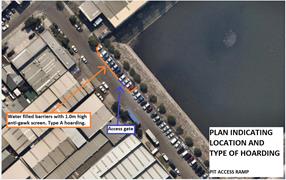
Barriers used to close the road (hoarding) will consist of water filled barriers with 1.2m anti-gawk screens including the standard approved Sydney Metro approved shade cloth.
The work is scheduled between 26 November 2018 to the end of construction activities in December 2021
PUBLIC CONSULTATION
The proposed road closure has been advertised in the local newspaper in accordance with the Roads Act 1993
The applicant is to notify all affected residents and businesses in writing at least 28 days prior to the commencement of works. The applicant has supplied the following information as to what notification they will be conducting:
“Advance community notification will be carried out to provide information to the public regarding set up of the work zones and changes to traffic and parking arrangements and includes:
· Written notifications to be distributed no less than 14 days prior to road closure
· Installation of variable messaging signs (VMS) board installed on Garden Street intersection with Shirlow Street
· Door knock local businesses including 6-14 Garden Street and 19-31 Sydenham Road”
CONCLUSION
It is recommended that the proposed temporary full road closures be approved, subject to the conditions outlined in this report. The Traffic Control Plan submitted by the applicant is shown below.
Lease area
|
|
Local Traffic Committee Meeting 6 November 2018 |
Subject: Railway Parade, Marrickville - Temporary long term full road closure for construction works related to Sydenham Metro Upgrade – SSJ Group (MARRICKVILLE WARD /HEFFRON ELECTORATE/ INNER WEST LAC)
Prepared By: Jennifer Adams - Engineer – Traffic and Parking Services
Authorised By: John Stephens - Traffic and Transport Services Manager
|
SUMMARY An application has been received from Sydney Metro SSJ Group – Sydenham Metro Upgrade project for the temporary long term full road closure of Railway Parade, Marrickville between Sydenham Road (adjacent to 1-11 Sydenham Road) and Railway Parade from 27 November 2018 to December 2021 in order to carry out construction activities for the upgrade of Sydenham Station being delivered as part of the Sydney Metro City & Southwest program of work. The subject street section will be temporarily closed to all vehicular traffic.
It is recommended that the proposed temporary full road closure be approved, subject to the conditions outlined in this report.
|
|
RECOMMENDATION
THAT the proposed temporary long term full road closure of Railway Parade, Marrickville between Sydenham Road (adjacent to 1-11 Sydenham Road) and Railway Parade from 27 November 2018 to December 2021 be APPROVED in order to carry out construction activities for the upgrade of Sydenham Station being delivered as part of the Sydney Metro City & Southwest program of work subject to the following conditions:
1. A Road Occupancy License be obtained by the applicant from the Transport Management Centre;
2. All affected residents and businesses, including the NSW Police Local Area Commander, Fire & Rescue NSW and the NSW Ambulance Services be notified in writing, by the applicant, of the proposed temporary road closure at least 7 days in advance of the closure with the applicant making reasonable provision for stakeholders; and
3. The occupation of the road carriageway must not occur until the road has been physically closed. |
BACKGROUND
An application has been received from Sydney Metro SSJ Group – Sydenham Metro Upgrade project for the temporary long term full road closure of Railway Parade, Marrickville between Sydenham Road (adjacent to 1-11 Sydenham Road) and Railway Parade from 27 November 2018 to December 2021 in order to carry out construction activities for the upgrade of Sydenham Station being delivered as part of the Sydney Metro City & Southwest program of work.
At this time this is not an application for a permanent road closure of this section of Railway Parade. The land parcel identified in this application along Railway Parade is subject to a construction lease between Inner West Council and Transport for New South Wales.
The station will be fully upgraded with new pedestrian plazas on Burrows Road and Railway Parade and a new aerial concourse with lifts and level access between the platforms and trains. Sydenham Station platforms 1 and 2 will be upgraded to Sydney Metro standards, including the installation of platform screen doors and new canopies. Existing platforms 3, 4, 5 and 6 will continue to be used by trains operating on the Sydney Trains network.
The new Sydney Metro line that will come out of the adjoining Marrickville tunnel dive site and head towards the upgraded Sydenham Station which requires the existing Marrickville Valley stormwater channel and culverts between the Sydenham Pit and the railway line to be moved. The current stormwater channel will be decommissioned to make way for the new Sydney Metro line and a new 120m long aqueduct (an enclosed concrete box culvert on a bridge structure) will be built across the Sydenham Pit extending to 11 Sydenham Road with the new aqueduct connecting with existing underground channels adjacent to Railway Parade. The building currently located at 1-11 Sydenham Road will be demolished to make way for the new aqueduct. Additionally a new access ramp into the Sydenham pit will also be built from Garden Street to provide access to the pit floor for future maintenance requirements.
To establish a safe work zone in Railway Parade during the construction of the aqueduct and station plaza and demolition of 1-11 Sydenham Road the closure of the identified section of Railway Parade is required to be closed - refer to diagrams below:
![]()
![]()
![]()
![]()
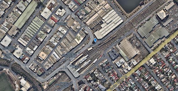
FINANCIAL IMPLICATIONS
Under Council’s Fees & Charges, the applicant is to pay a fee of $1,540.00 for the temporary full road closure. This fee includes advertising the proposal in accordance with the Roads Act 1993.
OFFICER COMMENTS
Railway Parade is a ‘split-level’ road running between the eastern-most sections of Sydenham and Marrickville Roads. The upper level, which operates ‘one-way’ in a southerly direction, is part of the main road system and provides access to/from the Gleeson Avenue Bridge over the Illawarra Railway Line. The lower level operates ‘two-way’ with factories/warehouses situated along its western side. The subject section of Railway Parade that will be closed is the triangular section on the eastern side of Sydenham Road. Access will be maintained initially for pedestrians.
The scope of works includes:
· Removal of parking
· Install hoarding
· Demolition f 1-11 Sydenham Road building
· Vegetation and tree clearing – where required
· Utilities investigation
· Storm water channel and culvert relocation
· Retaining walls and station plaza work
· Pavement and earthwork
· Fencing and gates
Barriers used to close the road (hoarding) will consist of water filled barriers with 1.2m anti-gawk screens including the standard approved Sydney Metro approved shade cloth.
The work is scheduled between 26 November 2018 to the end of construction activities in December 2021
The Traffic Control Plan submitted by the applicant is shown below.
PUBLIC CONSULTATION
The proposed road closure has been advertised in the local newspaper in accordance with the Roads Act 1993
The applicant is to notify all affected residents and businesses in writing at least 28 days prior to the commencement of works.
The applicant has also stated that they will carry out advance community notification so as to provide information to the public regarding set up of the work zones and changes to traffic and parking arrangements via written notification, variable messaging signs (VMS) boards and any required door knocking local businesses.
CONCLUSION
It is recommended that the proposed temporary full road closures be approved, subject to the conditions outlined in this report.
Lease areas
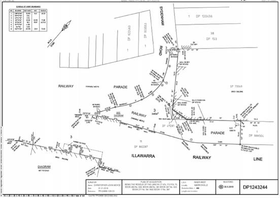
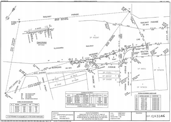
|
|
Local Traffic Committee Meeting 6 November 2018 |
Subject: Armstrong Street / Queen Street / Hardy Street intersection, Ashbury – Revised intersection Design Plan – RC552 D - C17 (Ashfield Ward/Summer Hill Electorate/Inner West LAC)
Prepared By: Jennifer Adams - Engineer – Traffic and Parking Services
Authorised By: John Stephens - Traffic and Transport Services Manager
|
SUMMARY Council has previously approved planned improvements at the intersection of Armstrong Street, Queen Street and Hardy Street, Ashbury to improve the safety for pedestrians and vehicles, following extensive engagement with the community in December 2015 and March 2016. Some amendments have been completed to the approved design plan.
A revised design plan has now been finalised for the proposed intersection improvements at Armstrong Street / Queen Street / Hardy Street intersection, Ashbury. The revised proposal with road reconstruction, construction of new pedestrian refuges, kerb blisters and extensions, upgraded street-lighting, footpath and storm water upgrades, line marking and signs will improve the safety for pedestrians and vehicles using this intersection.
Consultation was undertaken with owners and occupiers of properties in the locality regarding the revised proposal. It is recommended that the revised detailed design plan be approved. |
|
RECOMMENDATION
THAT;
(1) the design plan for the revised improvement works, including road reconstruction, construction of two new pedestrian refuges with kerb blisters and extensions, upgraded street-lighting, footpath and storm water upgrades, line marking and signs at the intersection of Armstrong Street, Queen Street and Hardy Street, Ashbury (as per the attached design plan No. RC552 D – C17 ) be APPROVED; and
(2) Reduce the ‘No Stopping’ distance on the western side of Queen Street (southern approach) from 23m to 20m for the refuge located in Queen Street South of Hardy Street to provide adequate space for one car parking space adjacent to the driveway.
|
BACKGROUND
A proposal for upgrading the intersection of Armstrong Street / Queen Street and Hardy Street
intersection, to a roundabout was discussed in the Ashfield Traffic Committee Meeting in December 2015. However, a recommendation was made to realign the intersection to a 4 way aligned intersection with Stop control at Queen Street (North) and Hardy Street. Council resolved to adopt the recommendations of the Traffic Committee and conducted community consultation for the new proposal before taking the matter back to the Traffic Committee and Council. At its meeting on 26 April 2016 the former Ashfield Council adopted the recommendation of the Local Traffic Committee to approve the proposal to realign the intersection Queen St, Hardy St and Armstrong St with Stop controls at Queen Street (North) and Hardy Street (Design Plan 151057 C05-3).
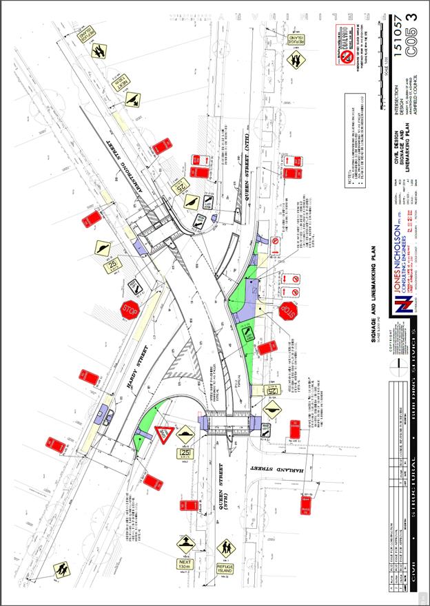
The adopted design (Design Plan 151057 C05-3) incorporated two raised thresholds with the pedestrian refuges in Armstrong Street and Queen Street North, which is not in accordance with the current Roads and Maritime Services (RMS) standards, and concern was raised by RMS that this could cause confusion with pedestrians and motorist as to who has priority. To remove this ambiguity, especially for pedestrians, an amended design was prepared (deleting the two raised thresholds and adding a speed cushion on the approach to the pedestrian refuges) – Design Plan RC552 – C17 D.
Council has now engaged with the community on this amendment to the final approved design and the results of the consultation are presented in this report.
It is noted that the proposal to realign the intersection was put forward to enhance road safety at the intersection and improve movement for road users, crossing facilities for pedestrians, and reducing speed while maintaining access to all properties. Accordingly due caution was taken to address the safety at the intersection, while taking care of the stakeholders that will be affected by introduction of devices at the intersection.
FINANCIAL IMPLICATIONS
The estimated cost of the project is approximately $300,000 and this has been budgeted for construction in 2018/19.
OFFICER COMMENTS
Armstrong Street is a local road carrying around 6,000 vehicles per day. Queen Street is a local road carrying around 4,500 vehicles per day north of the subject junction and 11,000 vehicles per day south of the subject junction. Hardy Street is a local street carrying around 1,000 vehicles per day.
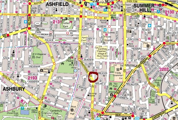
A review of the intersections’ crash history using the latest RMS data for the last five years (July 2012 to June 2017) reveals that there have been 7 reported crashes. Four were injury crashes while the remaining three were non-casualty (tow-away) crashes. Six of the crashes were intersection crossing movement crashes (RUM 10 and/or 21) while the remaindering crash was a same direction turning side swipe crash. The upgrading works will improve road safety at this intersection.
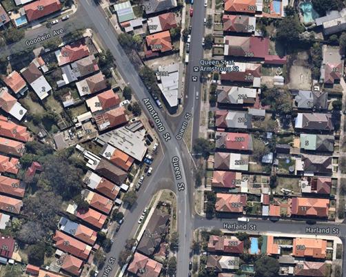
Aerial view of the intersection – Nearmap
Revised design plan – RC552 D – C17
Subsequent to the RMS requested amendments a revised final construction design plan has been developed with the following changes:
· The approved LTC design included raised thresholds with pedestrian refuges in Queen Street which were designed to be upgraded to (zebra) marked-foot crossings if the warrants were achieved further down the track.
· It has since been noted that although approved by the LTC, they do not comply with the RMS technical direction TCT 2001/04B (Oct 2014).
· The RMS representative has informally requested that the design be amended.
· Council have amended the design to remove the raised threshold, and replace them with two speed cushions on the main through road of Queen St South and Armstrong Street.
· The pedestrian refuges will be retained as per the current design and no other changes are being proposed to the design.
· The amended plan RC552D – C15 still captures the same design intent of the original proposal to improve pedestrian safety and monitor vehicular speeds in the area.
There are no additional parking changes to the amended design, other than the loss of 12 parking spaces around the intersection as part of the original approved design.
A copy of the final revised design plan is reproduced below.
PUBLIC ENGAGEMENT
The revised design plan (RC552 D-C17) was sent to Transit Systems, NSW Police and RMS separately for comment.
Transit Systems initially had concerns regarding the location of the speed cushion on Queen Street when bus services are turning right out of Harland Street onto Queen Street and requested that the speed cushion be relocated to ease any possible discomfort of passengers. They also requested turning path assessments for the right turn from Harland Street on Queen Street (South) and for the left turn from Queen Street (North) onto Queen Street (south). Any required adjustments were made and Transit Systems then indicated they are happy with the turning paths and locations of speed cushion (75mm maximum height) and supported the final plan.
NSW Police indicated that the concept plan now appears sound and supported it.
RMS supported the final design plan noting that the 85th percentile speed may reduce due to the new refuges and indicated no other safety-wise issues.
A consultation letter was sent out to affected residents for the final revised works proposed for the intersection of Armstrong Street, Queen Street and Hardy Street, Ashbury on 19 September 2018 and comments closed on Wednesday 24 October 2018. A total of 147 letters were distributed.
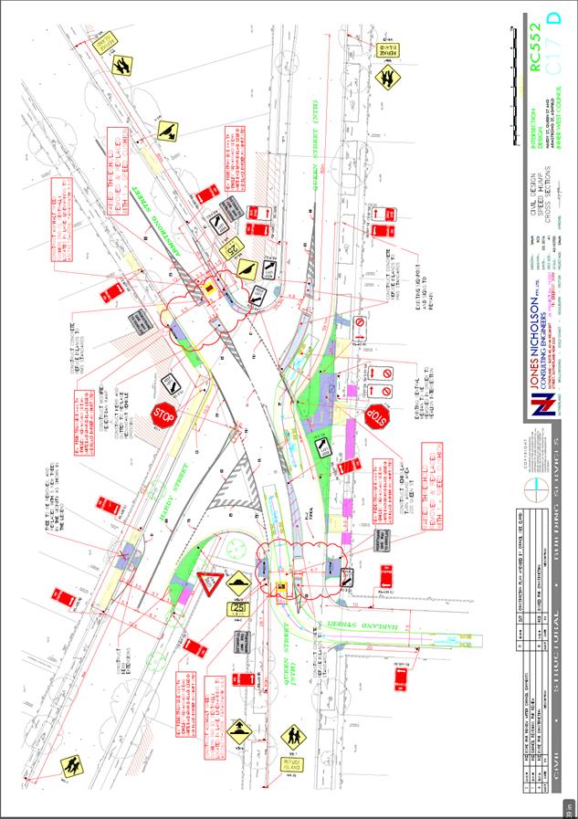
Six (6) responses were received regarding this final revised design plan and related comments to the design plan are summarised below. Generally residents supported the improvement works and residents that had unrelated general queries have been responded to separately.
|
Residents’ Comments |
Officer’s Response |
|
A resident of Queen Street asked whether a roundabout would be a safer option for the intersection due to the increased number of turning movements now provided for in the approved design.
The resident also had concerns about turning movements out of their driveway on Queen Street.
|
As stated in the report, a roundabout was initially considered but was not approved by Council due to the significant resident objection received to the loss of parking around the intersection, and a roundabout is not recommended at an intersection which would give priority to a low traffic volume local road over a high traffic volume local road due to the negative traffic flow impacts at the intersection.
At this stage there are no proposals to introduce turning bans at the intersection. The introduction of pedestrian refuges, speed cushions, and realigning the intersection will help to control vehicle speeds which will in turn help the turning maneuvers at the intersection.
The resident has been advised that they can turn right from their driveway onto Queen Street North over the painted islands. A car can turn over unbroken separation lines and painted islands as long as they are entering or leaving their driveway only. The parking restrictions along this side of the street will also give them and other road users good sight distance approaching the location
|
|
A resident of Queen Street noted that the design plan showed a pedestrian refuge in front of the driveway to 222 and wanted to be assured the refuge would not obstruct access to their driveway.
|
The resident has been informed that there is adequate road width (4.8 metres) between the driveway and the pedestrian refuge to accommodate the swept turning path for a standard car reversing out of the driveway. |
|
A resident from Armstrong Street supported the proposal with conditions. They requested a further amendment of the installation of 1(2) x speed cushion at Hardy Street entrance to the intersection and 1 x speed cushion at the Queen Street North entrance to the intersection to prevent vehicles driving through the existing and proposed stop signs at speed without stopping.
|
The proposed speed humps have been strategically placed to achieve the best outcome for controlling speed in the approaches to the intersection. Speed cushions are only placed when a speed issue is evident. It is noted that a ‘Stop’ control is in place for Hardy Street which aids in reducing approaching speeds of vehicles on that approach to the intersection. Motorists not stopping at the ‘Stop’ control are driving contrary to Australian Road Rules.
|
|
A resident of Queen Street is not in support of the full design. In their experience ‘the main cause of the accidents is cars coming out of Hardy street into Queen street and cars turning from Armstrong into Hardy street and cars not stopping at the Queen street ‘stop sign’. The resident states that additional measures should be considered such as:
- Remove the driveway turnaround bay in front of 218 Queen Street - Introduce “No right turn” bans from Queen Street (north) into Armstrong Street. - Close off Hardy Street at Queen Street and Armstrong Street.
|
The request to close off Hardy Street is outside the scope of the amendments to the approved plans and can be investigated by the traffic team should additional requests be received from residents in the area.
The driveway turnaround bay is required as the resident’s driveway access is changing from the minor road (Queen Street north) to the main road (Queen Street South & Armstrong Street). In addition there will be ‘No Parking’ signs installed in this section to prevent any cars from parking there and restricting viewing of approaching cars.
At this stage there are no proposals to introduce turning bans at the intersection. The introduction of pedestrian refuges, speed cushions, and realigning the intersection will help to control vehicle speeds which will in turn help the turning maneuvers at the intersection.
|
|
A resident of Queen Street was not in support of the full design. Their concerns included the following: - the significant loss of parking outside their residence as a result of the pedestrian refuge and kerb extension, and requested one parking space be made available at their front gate on Queen Street; - the lack of consultation with residents since 2016 on the design; - the proposed location of trees obscuring their view at the front of their property;
They also recommended that a speed hump and pedestrian crossing be installed on Queen Street south from Harland Street, in lieu of the full design proposal.
|
The ‘No Stopping’ distance and geometry of the kerb extension and intersection realignment are the same as endorsed by Council at the April 2016 Council meeting. The only change to the proposal is removing the raised threshold speed hump and providing one speed cushion, which will reduce the noise at this location.
The ‘No Stopping’ parking restrictions have been designed to the minimum requirements in accordance with RMS technical directions for pedestrian refuges, to maintain safe viewing of pedestrians at all times. It is recommended to reduce the ‘No Stopping’ distance on the approach to the refuge in Queen Street to 20m to provide adequate space for one car parking space adjacent to the driveway.
The Traffic Committee and Council considered all submissions received from residents as a result of the December 2015 and March 2016 community engagement. Full copies of the submissions were provided to the Traffic Committee at the time, and residents were also present at the Traffic Committee and Council. The Traffic Committee and Council recommended to proceed with the proposed design as stated in the Agenda report above.
Council staff will resolve the matter of the tree location directly with the resident.
It has been confirmed that a pedestrian crossing on Queen Street would not meet the warrants required by the Roads and Maritime Services, and would result in loss of parking on Queen Street. |
|
A resident of Queen Street was in support of the proposal but also requested that additional speed cushions be installed on Hardy Street and Queen Street North on the approach to the main road. They also requested that flashing ‘STOP’ signs be installed in Queen Street North. |
The proposed speed humps have been strategically placed to achieve the best outcome for controlling speed in the approaches to the intersection. Speed cushions are only placed when a speed issue is evident. It is noted that a ‘Stop’ control is in place for Hardy Street which aids in reducing approaching speeds of vehicles on that approach to the intersection. Motorists not stopping at the ‘Stop’ control are driving contrary to Australian Road Rules.
|
CONCLUSION
It is recommended that the revised final detailed design plan of the proposed intersection improvements at Armstrong Street / Queen Street / Hardy Street intersection, Ashbury be approved, to improve pedestrian safety and traffic conditions at this intersection.
|
|
Local Traffic Committee Meeting 6 November 2018 |
Subject: Summer Hill Street at Victoria Street, Lewisham – Proposed Kerb Extensions Design Plan – No.10043 (Stanmore Ward / Summer Hill Electorate / Inner West LAC)
Prepared By: Jennifer Adams - Engineer – Traffic and Parking Services
Authorised By: John Stephens - Traffic and Transport Services Manager
|
SUMMARY A design plan has been finalised for the proposed traffic calming improvement works in Summer Hill Street at Victoria Street, Lewisham to improve pedestrian safety and address illegal parking at the intersection. There are no changes to the existing parking restrictions in the street. The kerb extensions will be constructed within the statutory 10m ‘No Stopping’ distance at the intersection and there be no loss of legal on-street parking spaces.
Consultation was undertaken with owners and occupiers of properties adjacent to the intersection of Summer Hill Street and Victoria Street, Lewisham regarding the proposal. It is recommended that the detailed design plan be approved (Design Plan – 10043).
|
|
RECOMMENDATION
THAT the design plan for the proposed kerb extensions and associated signs and line markings in Summer Hill Street and Victoria Street, Lewisham (as per the attached design plan No. 10043) be APPROVED.
|
BACKGROUND
A design plan has been finalised for the proposed pedestrian facility works in Summer Hill Street at Victoria Street, Lewisham to improve pedestrian safety and address illegal parking at the intersection. There are no changes to the existing parking restrictions in the street. The kerb extensions will be constructed within the statutory 10m ‘No Stopping’ distance at the intersection and there be no loss of legal on-street parking spaces.
The proposal is based on the recommendations of the Lewisham Local Area Traffic Management (LATM) Plan which was endorsed by Council on 28 February 2017. The final Lewisham LATM proposals were based on community input and analysis of feedback following extensive engagement with the community in December 2015 and November 2016.
The proposed works at the intersection of Summer Hill Street and Victoria Street, Lewisham as recommended in the 2017 Lewisham LATM Study report is shown below.
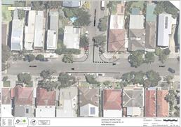
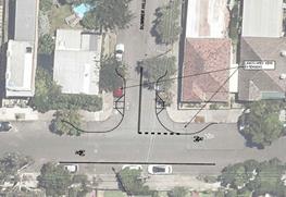
FINANCIAL IMPLICATIONS
Funding of $130,000 has been allocated by Council under the 2018/19 Capital Works Program for Traffic Facilities.
OFFICER COMMENTS
Site location & road network
Summer Hill Street and Victoria Street, Lewisham are both local roads that are two-way roads with one travel lane in each direction, in addition to kerb side parking lanes. Summer Hill Street, between Old Canterbury Road and Victoria Street, carries around 650 vehicles per day and has an 85th percentile speed of 39.6km/h. Victoria Street, between Summer Hill Street and Eltham Street, carries around 1,000 vehicles per day.
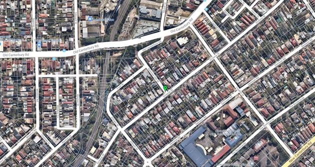
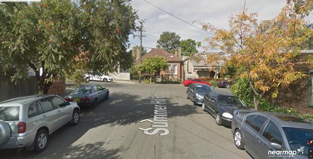
Design plan - 10043
The proposed work involves:
· providing new landscaped kerb extensions,
· providing new concrete footpath and pram ramps,
· providing new asphalt roadway,
· providing new signage as shown on the attached plan.
There are no changes to the existing parking restrictions in the street. The kerb extensions will be constructed within the statutory 10m ‘No Stopping’ distance at the intersection and there be no loss of legal on-street parking spaces.
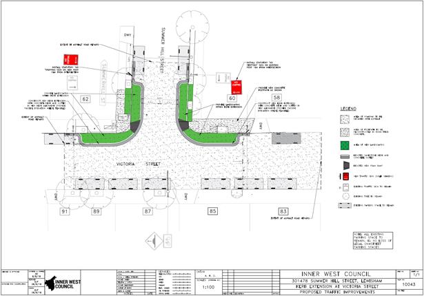
PUBLIC CONSULTATION
A consultation letter was hand delivered on 9 October 2018 to 14 adjoining properties regarding the proposed works at the intersection of Summer Hill and Victoria Street, Lewisham. The consultation period closed on 26 October 2018.
No responses were received regarding the proposed works.
CONCLUSION
It is recommended that the detailed design plan of the proposed kerb extensions and associated signs and line markings at the intersection of Summer Street and Victoria Street, Lewisham be approved, to improve pedestrian safety and traffic conditions at this locality.
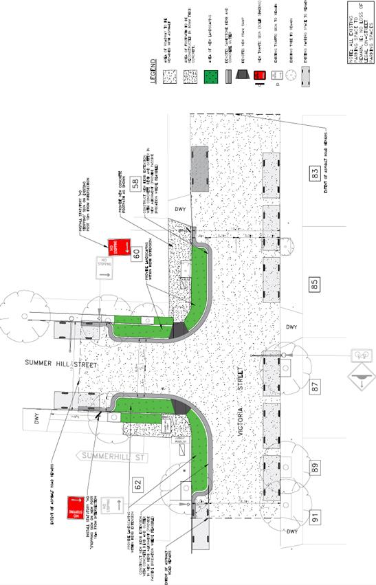
|
|
Local Traffic Committee Meeting 6 November 2018 |
Subject: Minor Traffic Facilities (All Wards/ All Electorates/ All LACs)
Prepared By: Vinoth Srinivasan - Engineer - Traffic and Parking Services and Scipio Tam - Engineer - Traffic and parking Services (South)
Authorised By: John Stephens - Traffic and Transport Services Manager
|
SUMMARY This report considers minor traffic facility applications received by Inner West Council, including ‘Disabled Parking’ and ‘Work Zone’ requests. |
|
RECOMMENDATION
THAT:
1. The requested 'Disabled Parking’ zone in front of No.44 Edith Street, Leichhardt not be supported as the property as an off-street parking space;
2. A 6m ‘Disabled Parking’ zone be installed in front of No.21 Red Lion Street, Rozelle;
3. A 5.5m ‘Disabled Parking’ zone be installed in front of No.34 Rawson Street, Haberfield;
4. A 5.5m ‘Disabled Parking’ zone be installed in front of No.15 Campbell Street, Balmain;
5. A 5.5m ‘Disabled Parking’ zone be installed in front of No.14 Reuss St, Birchgrove;
6. A 9m ‘Works Zone 7.00am – 5.00pm Mon-Fri and 8.00am – 1.00pm Sat’ be installed in front of No.25 Isabella Street, Balmain for 12 weeks, subject to written concurrence from the owner of No.25 Isabella Street, Balmain;
7. A 23m ‘Works Zone 7.00am – 6.00pm Mon-Fri and 8.00am – 1.00pm Sat’ be installed in front of No.2-4 Murrell Street, Ashfield for 12 weeks;
8. A 14m ‘Works Zone 7.00am – 5.00pm Mon-Fri and 7.00am -1pm Sat’ be installed in Phillip Street, Newtown along the side boundary of No.119 Enmore Road for 12 weeks;
9. A 30m ‘Works Zone 7.00am – 5.00pm Mon-Fri and 8.00am – 1.00pm Sat’ be installed in front of No.297-289 Trafalgar Street, Petersham for 26 weeks;
10. A 30m ‘Works Zone 7.00am – 5.00pm Mon-Fri and 8.00am-1.00pm Sat’ be installed on Regent Street along the side boundary of No.287-289 Trafalgar Street, Petersham for 26 weeks;
11. A 6m ‘Disability Parking’ zone be installed on the southern side of David Street, Marrickville, adjacent to property No.2/44 Robert Street, Marrickville; 12. A 6m ‘Disability Parking’ zone be installed on the northern side of Station Street, Tempe, in front of property No.85 Station Street, Tempe; 13. A 6m ‘Disability Parking’ zone be installed on the western side of High Street, Marrickville, in front of property No.47 High Street, Marrickville; 14. A 6m ‘Disability Parking’ zone be installed on the northern side of Hutchinson Street, in front of properties no. 67 & 69 Hutchinson Street, St Peters, subject to written concurrence being received from No.69 Hutchinson Street; 15. A 6m ‘Disability Parking’ zone be installed on the eastern side of Hopetoun Street, Camperdown, in front of property no. 38 Hopetoun Street, Camperdown; 16. A 6m ‘Disability Parking’ zone be installed on the eastern side of Bruce Street, Stanmore, in front of property no. 35 Bruce Street, Stanmore; 17. A 6m ‘Disability Parking’ zone be installed on the western side of Wemyss Street, in front of property no. 52 Wemyss Street, Marrickville; 18. A 6m ‘Disability Parking’ zone be installed on the northern side of Salisbury Road, in front of property no. 30a Salisbury Road, Stanmore; 19. A 5.5m ‘Disability Parking’ zone be installed in front of No.23 Beach Road, Dulwich Hill; and 20. A 25m ‘Works Zone 7.00am – 5.00pm Mon-Fri and 7.00am -1pm Sat’ be installed on Victoria Road, Marrickville in front of Wicks Park for 12 weeks.
|
BACKGROUND
This report considers minor traffic facility applications by Inner West Council, and includes ‘Disabled Parking’ and ‘Works Zone’ requests.
FINANCIAL IMPLICATIONS
Nil.
OFFICER COMMENTS
1. Installation of a ‘Disabled Parking’ restriction – Edith Street, Leichhardt
The business at No.44 Edith Street, Leichhardt has requested the installation of a ‘Disabled Parking’ zone in front of the businesses’ property.
A site investigation has revealed the property does have off street parking, but this is allocated to staff and customers must use on street parking. Due to the nature of the business catering for senior migrant residents, a significant number of mobility impaired customers attend the business.
A letter outlining the above parking proposal was mailed out to the affected properties and businesses (20 in total) in Edith Street and Marion Street, Leichhardt.
A total of two (2) responses were received, in objection to Council’s proposal to install a ‘Disabled Parking’ zone in front of No.44 Edith Street, Leichhardt, due to the loss of parking and high demand for parking in the area.
As this property has an existing off-street parking space, it is recommended that the business allocates this space to its senior clients during business hours.
No.44 Edith Street, Leichhardt
2. Installation of a ‘Disabled Parking’ restriction – Red Lion Street, Rozelle
The resident of No.21 Red Lion Street, Rozelle has requested the installation of a ‘Disabled Parking’ zone in front of the resident’s property.
A site investigation has revealed the property does not have off street parking.
The applicant does require the use of a wheelchair and there is a driveway approximately 13m away that could be used to access the footpath.
It is recommended that a 6m ‘Disabled Parking’ zone be installed in front of No.21 Red Lion Street, Rozelle, replacing the existing 1P ticket parking restrictions.
No.21 Red Lion Street, Rozelle
3. Installation of a ‘Disabled Parking’ restriction – Rawson Street, Haberfield
The resident of No.34 Rawson Street, Haberfield has requested the installation of a ‘Disabled Parking’ zone in front of the resident’s property.
A site investigation has revealed the property does not have off street parking.
The applicant does not require the use of a wheelchair.
It is recommended that a 5.5m ‘Disabled Parking’ zone be installed in front of No.34 Rawson Street, Haberfield.
No.34 Rawson Street, Haberfield
4. Installation of a ‘Disabled Parking’ restriction – Campbell Street, Balmain.
The resident of No.15 Campbell Street, Balmain has requested the installation of a ‘Disabled Parking’ zone in front of the resident’s property.
A site investigation has revealed the property does not have off street parking.
The applicant does not require the use of a wheelchair.
It is recommended that a 5.5m ‘Disabled Parking’ zone be installed in front of No.15 Campbell Street, Balmain.
No.15 Campbell Street, Balmain
5. Installation of a ‘Disabled Parking’ restriction – Reuss Street, Birchgrove
The resident of No.14 Reuss Street, Birchgrove has requested the installation of a ‘Disabled Parking’ zone in front of the resident’s property.
A site investigation has revealed the property does not have off street parking.
The applicant does not require the use of a wheelchair.
It is recommended that a 5.5m ‘Disabled Parking’ zone be installed in front of No.14 Reuss Street, Birchgrove.
No.14 Reuss Street, Birchgrove
6. Installation of ‘Works Zone’ restriction – Isabella Street, Balmain
The applicant has requested the installation of a temporary 9m ‘Works Zone 7.00am – 5.00pm Mon-Fri, 7.00am – 1.00pm Sat’ in front of No.25 Isabella Street, Balmain.
The subject development is located on No.27 Isabella Street, Balmain. Due to the property being situated directly in front of a cul-de-sac, the applicant requested the installation of a temporary work zone in front of No.25 Isabella Street, Balmain.
It is recommended that a 9m ‘Works Zone 7.00am – 5.00pm Mon – Fri, 7.00am – 1.00pm Sat’ be installed in front of No.25 Isabella Street, Balmain for 12 weeks, subject to the applicant receiving written concurrence from the residents at No.25 Isabella Street, Balmain.
No.25 Isabella Street, Balmain
7. Installation of ‘Works Zone’ restriction – Murrell Street, Ashfield
The applicant has requested the installation of a temporary 23m 'Works Zone 7.00am – 6.00pm Mon-Fri and 8.00am-1.00pm Sat' outside Nos.2-4 Murrell Street, Ashfield for 12 weeks.
It is recommended that a 23m 'Works Zone 7.00am – 6.00pm Mon-Fri and 8.00am -1.00pm Sat' be installed in front of Nos.2-4 Murrell Street, Ashfield for 12 weeks.
Nos.2-4 Murrell Street, Ashfield
8. Installation of ‘Works Zone’ restriction – Phillip Street, Newtown
The applicant has requested the installation of a temporary 14m 'Works Zone 7.00am – 5.00pm Mon-Fri and 7.00am-1.00pm Sat' along the side boundary of No.119 Enmore Road, Enmore for 12 weeks.
It is recommended that a 14m 'Works Zone 7.00am – 5.00pm Mon-Fri and 7.00am -1.00pm Sat' be installed along the side boundary of No.119 Enmore Road, Enmore on the western side of Phillip Street, Newtown for 12 weeks.
Phillip Street, Newtown on the side boundary No.119 Enmore Street, Enmore
9. Installation of ‘Works Zone’ Restriction – Trafalgar Street, Petersham
The applicant has requested the installation of a temporary 30m 'Works Zone 7.00am – 5.00pm Mon-Fri and 8.00am-1.00pm Sat. in front of Nos. 289-297 Trafalgar Street, Petersham, between Regent Street and Audley Street.
It is recommended that a 30m 'Works Zone 7.00am – 5.00pm Mon-Fri and 8.00am -1.00pm Sat' be installed in front of Nos. 297-289 Trafalgar Street, Petersham.
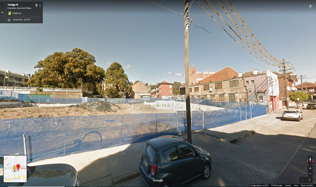
Nos.289 - 297 Trafalgar Street, Petersham
10. Installation of ‘Works Zone’ Restriction – Regent Street, Petersham
The applicant has requested the installation of a temporary 30m 'Works Zone 7.00am – 5.00pm Mon-Fri and 8.00am-1.00pm Sat’ along the side boundary of Nos.287-289 Trafalgar Street, Petersham. The Zone is proposed on Regent Street between Trafalgar Street and Fisher Street.
It is recommended that a 30m 'Works Zone 7.00am – 6.00pm Mon-Fri and 8.00am -1.00pm Sat' be installed on Regent Street along the side boundary of 287-289 Trafalgar Street, Petersham.
Regent Street, Petersham on the side boundary of Nos.287-289 Trafalgar Street
11. Installation of a ‘Disabled Parking’ Restriction – David Street, Marrickville
The resident of No. 2/44 Robert Street, Marrickville has requested the installation of a ‘Disabled Parking’ zone in David Street, along the rear boundary of the resident’s property.
A site investigation has revealed the property does not have off street parking.
The applicant does not require the use of a wheelchair.
It is recommended that a 6m ‘Disabled Parking’ zone be installed on David Street, along the rear boundary of 2/44 Robert Street, Marrickville.
 No. 2/44
Robert Road, Marrickville (viewed from David Street)
No. 2/44
Robert Road, Marrickville (viewed from David Street)
12. Installation of a ‘Disabled Parking’ Restriction - Station Street, Tempe
The resident of No.85 Station Street, Tempe has requested the installation of a ‘Disabled Parking’ zone in front of the resident’s property.
A site investigation has revealed the property does not have off street parking.
The applicant does not require the use of a wheelchair.
It is recommended that a 5.5m ‘Disabled Parking’ zone be installed in front of No.85 Station Street, Tempe.
No.85 Station Street, Tempe
13. Installation of a ‘Disabled Parking’ Restriction - High Street, Marrickville
The resident of No.47 High Street, Marrickville has requested the installation of a ‘Disabled Parking’ zone in front of the resident’s property.
A site investigation has revealed the property does not have off street parking.
The applicant does not require the use of a wheelchair.
It is recommended that a 5.5m ‘Disabled Parking’ zone be installed in front of No.47 High Street, Marrickville.
No.47 High Street, Marrickville
14. Installation of a ‘Disabled Parking’ Restriction - Hutchinson Street, St Peters
The resident of No.67 Hutchinson Street, St Peters has requested the installation of a ‘Disabled Parking’ zone in front of the resident’s property.
A site investigation has revealed the property does not have off street parking.
The applicant does not require the use of a wheelchair.
It is recommended that a 6m ‘Disabled Parking’ zone be installed in front of No.67 & 69 Hutchinson Street, subject to written concurrence being received from No.69 Hutchinson Street, St Peters.
No. 67 Hutchinson Street, St Peters
15. Installation of a ‘Disabled Parking’ Restriction - Hopetoun Street, Camperdown
The resident of No.38 Hopetoun Street, Camperdown has requested the installation of a ‘Disabled Parking’ zone in front of the resident’s property.
A site investigation has revealed that the property has a narrow off-street parking space (internal width of approximately 2.5m) which requires access through a confined doorway and multiple sets of steep stairs which makes it difficult for the applicant to access due to a chronic health condition and affecting mobility.
The applicant does not require the use of a wheelchair.
It is recommended that a 6m ‘Disabled Parking’ zone be installed in front of No.38 Hopetoun Street, Camperdown.
 No.38 Hopetoun
Street, Camperdown
No.38 Hopetoun
Street, Camperdown
16. Installation of a ‘Disabled Parking’ Restriction - Bruce Street, Stanmore
The resident of No.35 Bruce Street, Stanmore has requested the installation of a ‘Disabled Parking’ zone in front of the resident’s property.
A site investigation has revealed that the property has a narrow off-street parking space (internal width of approximately 2.5m) accessed through narrow and steep stairs which makes it difficult for the applicant to access due to a chronic health condition and required use of a seat walker.
The applicant does not require the use of a wheelchair.
It is recommended that a 6m ‘Disabled Parking’ zone be installed in front of No.35 Bruce Street, Stanmore.
 No.35 Bruce
Street, Stanmore
No.35 Bruce
Street, Stanmore
17. Installation of a ‘Disabled Parking’ Restriction - Wemyss Street, Marrickville
The resident of No.52 Wemyss Street, Marrickville has requested the installation of a ‘Disabled Parking’ zone in front of the resident’s property.
A site investigation has revealed that the property does not have an off-street parking space.
The applicant does not require the use of a wheelchair.
It is recommended that a 6m ‘Disabled Parking’ zone be installed in front of No.52 Wemyss Street, Marrickville.
 No.52 Wemyss
Street, Marrickville
No.52 Wemyss
Street, Marrickville
18. Installation of a ‘Disabled Parking’ Restriction - Salisbury Road, Stanmore
The resident of No.30A Salisbury Road, Stanmore has requested the installation of a ‘Disabled Parking’ zone in front of the resident’s property.
A site investigation has revealed that the property has a narrow off-street parking space with stairs upon entry to the property which makes it difficult for the applicant to access due to a chronic health condition and their use of a wheelchair.
The applicant does require the use of a wheelchair and there is a driveway adjacent to the property that can be used to access the footpath and subject property.
It is recommended that a 6m ‘Disabled Parking’ zone be installed in front of No.30A Salisbury Road, Stanmore.
 No.30A
Salisbury Road, Stanmore
No.30A
Salisbury Road, Stanmore
19. Installation of a ‘Disabled Parking’ restriction – Beach Road, Dulwich Hill
The resident of No.23 Beach Road, Dulwich Hill has requested the installation of a ‘Disabled Parking’ zone in front of the resident’s property.
A site investigation has revealed that the property does not have off-street parking.
The applicant does not require the use of a wheelchair.
It has been observed that on-street parking spaces in Beach Street, Dulwich Hill are highly utilised including the two other existing mobility parking spaces in the street.
It is recommended that a 5.5m ‘Disabled Parking’ zone be installed in front of No.23 Beach Road, Dulwich Hill.
 No. 23 Beach Road, Dulwich Hill
20. Installation of ‘Works Zone’ restriction – Victoria Road, Marrickville
The applicant has requested the installation of a temporary 25m ‘Works Zone 7.00am – 4.00pm Mon-Fri, 7.00am – 1.00pm Sat’ on Victoria Road, Marrickville in front of Wicks Park.
It should be noted that ‘No Parking 4pm-6pm Mon-Fri’ restrictions operate in this section of street.
It is recommended that a 25m “Works Zone 7.00am – 4.00pm Mon-Fri, 7.00am – 1.00pm Sat” be installed in front of Wicks Park on Victoria Road, Marrickville in front of Wicks Park for 12 weeks.
Wicks Park on Victoria Road, Marrickville
PUBLIC CONSULTATION
Nil.
CONCLUSION
Nil.
|
|
Local Traffic Committee Meeting 6 November 2018 |
Subject: Flood Street and Allen Street, Leichhardt - Bus Stop Modifications (Leichhardt Ward / Balmain Electorate / Leichhardt LAC)
Prepared By: Manod Wickramasinghe - Coordinator – Traffic and Parking Services
Authorised By: John Stephens - Traffic and Transport Services Manager
|
SUMMARY Transport for NSW has approved changes to the 445 Bus Route timetable which includes changes to service times and frequencies. In order to allow the buses to safely drop-off and pick-up passengers during the new operating hours, Transit Systems have requested the existing part time ‘Bus Zone’ restrictions be modified to match the new operating hours. |
|
RECOMMENDATION
THAT:
1. The existing part time bus zones in Allen Street and Flood Street, Leichhardt be modified to full time ‘Bus Zones’ to match the bus operating hours as determined by Transport for NSW; and
2. Objections received regarding the operational hours of the bus service be forwarded to Transport for NSW for review and comment. |
BACKGROUND
From 1st July 2018, Transit Systems took over from State Transit Authority for operation of bus services in the Inner West Council area (Region 6). Transit Systems operate from the existing bus depots at Leichhardt, Tempe, Burwood and Kingsgrove.
Transit Systems have now advised Council that Transport for NSW has approved changes to a number of bus routes/timetables within the Inner West as part of Transit Systems commitment to improving public transport use in the region, this includes changes to frequency, routes and operating times.
The 445 bus route will be subject to service time and frequency changes to be completed as part of the major timetable change due for release on Sunday, 2 December 2018, as approved by Transport for NSW.
This route will be a key cross regional bus route traveling from Balmain to Campsie via Leichhardt Marketplace and includes connections with light rail, heavy rail and ferry services.
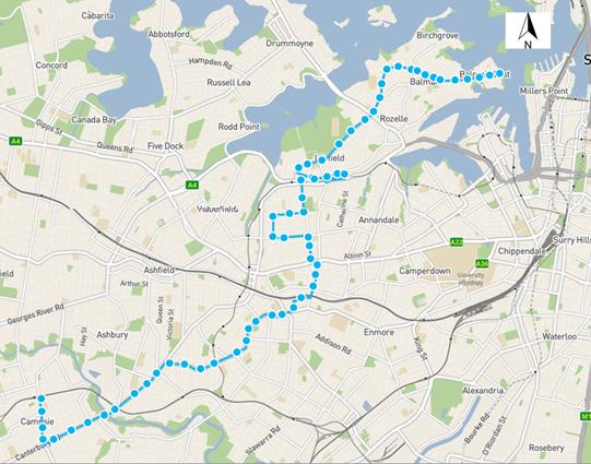
Figure 1 – 445 bus route (Balmain East to Campsie via Leichhardt Marketplace)
These changes are proposed to provide a more efficient bus network which will give residents an alternate transport option to driving. There are currently limited public transport alternatives west of Norton Street and north of Marion Street, bounded by the Light Rail line.
The current 445 bus route travels along Marion Street, Flood Street and Allen Street in Leichhardt between the services hours of Monday to Friday, 9:00am – 3:30pm, Saturday 7:45am – 5:45pm, Sunday & Public Holidays 9:00am - 4:45pm.
Along the majority of the route, the bus will utilise existing full time ‘Bus Zones’; however, there will be a need to convert existing part time 'Bus Zones' on Flood Street (between Marion Street and Allen Street) and Allen Street (between Flood Street and Norton Street) into full time Bus Zones. These Bus Zones are shown on the following figure.
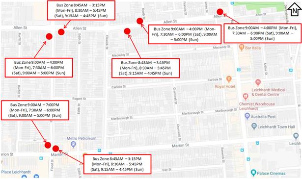
Figure 2 – Existing Bus Zone restrictions
The service frequency based off the 30 September 2018 timetable updates are:
|
Day |
Service operating times |
Frequency |
|
To Campsie |
||
|
Monday to Friday |
8:57am – 2:45pm |
Every 20 minutes |
|
Saturday |
8:45am – 5:24pm |
Every 20 minutes |
|
Sunday & Public Holiday |
9:23am – 4:30pm |
Every 30 minutes |
|
To Balmain East Wharf |
||
|
Monday to Friday |
9:18am – 3:36pm |
Every 20 minutes |
|
Saturday |
7:41am – 5:40pm |
Every 20 minutes |
|
Sunday & Public Holiday |
8:56am – 4:48pm |
Every 30 minutes |
The approximate proposed service frequency and operating times for December 2nd 2018 timetable update will be as follows:
|
Day |
Service operating times |
Frequency |
|
To Campsie |
||
|
Monday to Friday |
6:00am – 12:00am |
Between 15 – 30 minute |
|
Saturday |
6:30am – 12:00am |
Between 20 minutes – 30 minute |
|
Sunday & Public Holiday |
7:00am – 9:30pm |
Every 30 minutes |
|
To Balmain East Wharf |
||
|
Monday to Friday |
5:30am – 12:00am |
Between 15 – 30 minute |
|
Saturday |
6:00am – 12:00am |
Between 20 minutes – 30 minute |
|
Sunday & Public Holiday |
7:00am – 9:00pm |
Every 30 minutes |
FINANCIAL IMPLICATIONS
Nil.
OTHER STAFF COMMENTS
Nil.
PUBLIC CONSULTATION
|
Transit Systems undertook the consultation for the proposed Bus Zone changes and forwarded the responses to Council. Council also received separate submissions directly.
A letter outlining the changes was mailed out to the affected properties (57 properties) in Marion Street, Flood Street, Allen Street and Norton Street, Leichhardt (as indicated on the adjacent plan), requesting comments regarding the proposal.
29 responses were received from residents both within and outside of the consultation area.
3 in support and 26 in objection.
The key themes have been summarised below.
|
|
|
Resident Comment |
Officer Response |
|
Noise (24 similar comments)
The change in service times will increase noise in the early morning and late at night and is detrimental to residents’ sleep. The current restrictions operate over a more reasonable time period for a residential street.
|
Transit Systems Comment
Providing improved public transport options will reduce the reliance of private vehicles providing residents with an option to use public transport rather than purchase another vehicle.
The key to providing mode shift from private vehicles to public transport is to provide improved service hours and frequency for bus customers.
This bus route will not only cater to those on Flood, Allen and Marion Streets, but those within 400 metre walking distance of these stops.
Council Officer comment
Council can consider the introduction of Resident Parking Schemes in locations with high long-stay parking demand.
|
|
Parking (17 similar comments)
The change in service times will reduce parking availability by requiring the existing part-time bus zones being converted to full-time.
The existing on-street parking demand is high and many residents do not have access to off-street parking.
|
|
|
Usage of bus stops (4 similar comments)
These bus stops are not frequently used and the extended hours would not benefit the community.
|
|
|
Notification area (5 similar comments)
Transit Systems only notified the directly affected residents and not the entire street. There are additional residents who would be affected by this change. Other residents were only made aware by word of mouth.
|
Transit Systems Comment
Letter box drops were completed for residents within 3 properties of either side of the bus stop. This resident is 60m up the street across the other side. |
|
Support (3 similar comments)
Resident and family are pleased regarding the upcoming changes extending the times that the 445 bus operates. Many of these people are elderly and have mobility issues and this will allow, for example, residents to be able to go out and get home in the evening, go to medical appointments early in the morning, hospital clinic visits etc. Currently the only alternative is to take a taxi which is difficult when it is three times a week costly for an aged pensioner. |
Council Officer comment
Support is noted, especially to elderly residents and those with a mobility issue that would benefit from the proposed new timetable and bus service frequency. |
CONCLUSION
In order to allow the buses to safely drop-off and pick-up passengers during the new operating hours, Transit Systems have requested the existing part time ‘Bus Zone’ restrictions be modified to be full time ‘Bus Zones’ in order to simplify the signage and match the operational hours as determined by Transport for NSW. Noting that the majority of concerns relate to the increased service hours of the 445 bus service, it is also recommended that the concerns raised by residents be forwarded to Transport for NSW for its consideration and comment.
|
|
Local Traffic Committee Meeting 6 November 2018 |
Subject: Lilydale Street, Marrickville - Proposed Permit Parking (MarrickvilleWard/Summer Hill Electorate/Inner West LAC)
Prepared By: Mary Bailey - Parking Planner
Authorised By: John Stephens - Traffic and Transport Services Manager
|
SUMMARY Following representation, Council circulated to residents for comment a proposal to extend the existing M2 permit parking area into Lilydale Street, Marrickville. Residents have expressed concern about the impact on parking during and following construction at the Old Marrickville Hospital site) 313-319 Marrickville Road. The feedback from residents meets Council resident parking guidelines for support of the proposal and the parking occupancy surveys show that there is a very high parking demand. It is recommended that the proposal for permit parking in Lilydale Street, Marrickville be approved. |
|
RECOMMENDATION
THAT:
1. ‘2P Permit Holders Excepted 8:30am-6:00pm Monday to Friday; 8:30am-12:30pm Saturday (Area M2)’ signage be installed in Lilydale Street (eastern side) between No.1 and No. 29; and 2. Implement ‘2P Permit Holders Excepted 8:30am-6:00pm Monday to Friday 8:30am-12:30pm Saturday (Area M2)’ signage be installed in Lilydale Street (western side) between No.28 and the intersection with Stanley Street |
BACKGROUND
Lilydale Street is a narrow, one way street which runs between Marrickville Road and Stanley Street adjacent to the development site at Nos. 313-319 Marrickville Road (Old Marrickville hospital site). There is currently unrestricted parking on both sides of the street and residents of Lilydale Street have expressed concerns that the impact of parking by construction workers and visitors to the nearby commercial centre is reducing parking opportunities for residents in Lilydale Street.
Some of the residences in Lilydale Street have off street parking but due to the narrowness of the driveways and the narrowness of the street, while there is parking on both sides of the street, access to off street parking is constrained.
There is no condition in the Development Consent for Nos. 313-319 Marrickville Road relating to the parking of construction workers onsite and this has resulted in a disproportionate use of the available parking in Lilydale Street by construction related vehicles.
It should be noted that there is a specific condition of the Development Consent for the development at Nos. 313-319 Marrickville Road excluding the residents of the development from participating in any resident parking scheme. (DA 200200720).
Council is proposing to implement permit parking in Lilydale Street as illustrated in Figure 1 below.
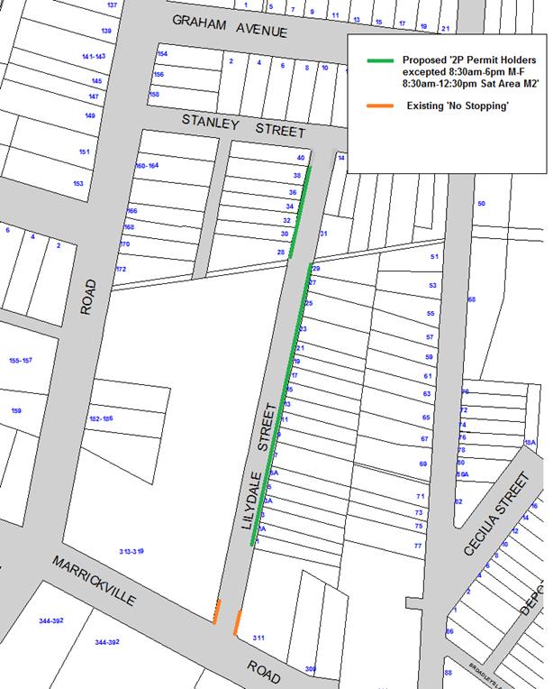
Figure 1: Proposed restrictions Lilydale Street, Marrickville
Parking Occupancy
Parking surveys undertaken on Tuesday, 16 October indicated that there was a high level of occupancy throughout the day (See Table 1). Council requires that a threshold of 85% occupancy during the proposed permit parking hours is to be consistently met and according to the parking survey this threshold has been met.
These finding are consistent with a number of site investigations which have been carried out. The site visits to Lilydale Street on a number of occasions indicate that there is a significant proportion of parking by trades vehicles likely associated with the major redevelopment of the Old Marrickville Hospital site (DA 200200720). It was estimated that about 30% of vehicles parked in Lilydale Street throughout the day were associated with the construction site.
Table 1: Results of Parking Occupancy Survey Tuesday 16 October
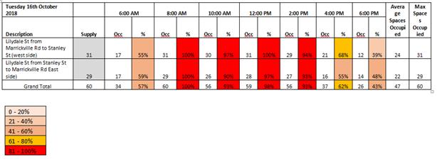
It is recommended to implement permit parking in Lilydale Street on the northern side in the eastern end of the street and on the southern side in the western end of the street (See Figure 1).
1. Implementation ‘2P Permit Holders Excepted 8:30am-6:00pm Monday to Friday 8:30am-12:30pm Saturday (Area M2)’ in Lilydale Street (eastern side) between property No. 1 and property No. 29
2. Implement ‘2P Permit Holders Excepted 8:30am-6:00pm Monday to Friday 8:30am-12:30pm Saturday (Area M2)’ in Lilydale Street (western side) between property No. 28 and the intersection with Stanley Street
Recommendation 1 relates to the side of the street where there are residences with the Old Hospital site being on the opposite side.
Recommendation 2 related to recommending permit parking on the opposite side of the street. This has been proposed due to the lack of frontage and the number of driveways present on the western side of the street towards the northern end.
‘No Stopping’ restrictions currently exist at the intersection of Marrickville Road and Lilydale Street where there have been numerous ongoing complaints about vehicles parking too close to the intersection. There have been no complaints about vehicles parking too close to the intersection with Stanley Street, so permit parking signage will be installed in accordance with NSW Road Rules.
Following the opening of the hospital site there may be a need to review the hours of operation of the 2P restrictions, as residents of the new units may also create parking pressures for existing residents.
FINANCIAL IMPLICATIONS
The cost for the supply and installation of the signposting can be funded from Council's operational budget for signs and line marking.
PUBLIC CONSULTATION
A letter was sent to all affected residents outlining the proposal and seeking responses to a Resident Parking Survey. Council’s guidelines stipulate that in order for the proposal to be considered, there should be a response rate of 30% of surveys sent out with 65% respondents supporting the proposal. There are 26 households in Lilydale Street and there were responses from eight (8) households, comprising 30% of responses thereby meeting the threshold set by the guidelines.
Of the 8 responses, all were in favour of the implementing permit parking although there were concerns expressed about the implementation of the 10m ‘No Stopping’ restrictions and also several residents called for both permits to be free of charge.
One respondent sought to have the permit parking on both sides and another sought the option to have a transferable sticker. See Table 2 below for details and Officer Response comments
Table 2: Consultation Outcome and Officer Response
|
Resident Comment |
Officer response |
|
Resident does not support proposed ‘No Stopping’ at Lilydale and Stanley Street |
Council will install any signage in accordance with the NSW Road Rules i.e. the 2P signs will be installed starting 10m from the intersection |
|
Resident seeks option to have transferable sticker |
Council may be able to consider this on a case-by-case basis in order to accommodate resident’s requirements |
|
Several respondents sought to have consideration for a second sticker free of charge |
This is a Council Policy decision, and is not within the scope of this report. Current Council Policy is that any residents deemed to have off street parking would not be eligible to apply for a second permit. |
|
Permit parking on both sides of street |
Council Policy is generally to implement permit parking on one side of the street only. This provides a balanced approach, accommodating a variety of users while also providing additional opportunities for residents to park. |
CONCLUSION
Given the support from residents for the proposed permit parking restrictions, meets Council’s criteria and the parking occupancy threshold is also met, the recommendation to implement permit parking in Lilydale Street should be supported.
|
|
Local Traffic Committee Meeting 6 November 2018 |
Subject: Little Darling Street, Balmain - Proposed Extension of 'No Stopping' zone (Balmain Ward/ Balmain Electorate/ Leichhardt LAC)
Prepared By: Vinoth Srinivasan - Engineer - Traffic and Parking Services
Authorised By: John Stephens - Traffic and Transport Services Manager
|
SUMMARY Council has received concerns regarding obstructed driveway access in Little Darling Street, Balmain opposite the garage of No.2 Little Darling Street, Balmain |
|
RECOMMENDATION
THAT:
1. The existing ‘No Stopping’ zone on the western side of Little Darling Street, Balmain opposite No.2 Little Darling Street be extended by 6m; and
2. The remaining 7.9m ‘2P’ parking zone be reduced to 5.5m and a 2.4m motorcycle bay be installed on the western side of Little Darling Street, Balmain.
|
BACKGROUND
Council has received concerns from a resident of Little Darling Street, Balmain regarding vehicles parking on the western side of Little Darling Street (opposite the garage of No. 2 Little Darling Street), south of the existing ‘No Stopping’ zone and subsequently obstructing driveway access to their property.
The existing ‘No Stopping’ zone on the western side of Little Darling Street extends 5.4m from northern boundary of No. 3A Llewellyn Street.
Little Darling Street is only 5.7m wide in this section and is therefore not wide enough to support parking opposite a driveway.
FINANCIAL IMPLICATIONS
Nil.
OTHER STAFF COMMENTS
It is proposed to extend the existing ‘No Stopping’ zone on the western side of Little Darling Street, Balmain by 6m to facilitate driveway access. This will reduce the existing ‘2P’ parking zone to 7.9m in length, which is too short to park two standard vehicles. Council is therefore proposing to signpost this kerb space as a 5.5m ‘2P’ parking zone and a 2.4m motorcycle bay. This will allow one standard vehicle and two motorcycles to park in this location.
The proposal is shown on the plan below.
![]()
PUBLIC CONSULTATION
A letter outlining the above parking proposal was mailed out to the affected properties (8 properties) in Little Darling Street and Llewellyn Street, Balmain, requesting residents’ views regarding the proposal (as indicated on the below plan).
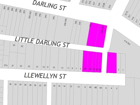
One (1) response was received, in objection to the Council’s proposal to extend the existing ‘No Stopping’ zone and install a 2.4m motorcycle bay on Little Darling Street, Balmain.
|
Residents’ Comments |
Officer Comments |
|
Motor bikes that already have a parking space in Little Darling St off Darling St, ride their bikes through the gap in cul de sac and ride the wrong way into Llewellyn St. Council’s proposal to install a motorcycle bay will only escalate the issue as it is currently dangerous for pedestrians.
It is already very difficult for residents to find parking on this street as parking spaces are often occupied by trades and business people. |
Extending the ‘No Stopping’ zone is required to provide unobstructed vehicle access to No.2 Little Darling Street.
This does result in the loss of 1 parking space; however, in order to maximise the use of the remaining kerb space it is proposed to signpost a 2.4m motorcycle bay that would allow parking for two motorbikes. |
CONCLUSION
Nil.
|
|
Local Traffic Committee Meeting 6 November 2018 |
Subject: The Boulevarde at Balmain Road, Lilyfield - Proposed 'No Stopping' zones and '15 Minute' parking restrictions (Balmain Ward/ Balmain Electorate/ Leichhardt LAC)
Prepared By: Vinoth Srinivasan - Engineer - Traffic and Parking Services
Authorised By: John Stephens - Traffic and Transport Services Manager
|
SUMMARY Council has received a request to signpost the statutory ‘No Stopping’ restrictions at the intersection of Balmain Road and The Boulevarde, Lilyfield in order to prevent illegal parking and improve sight lines. Council has also received a request for a Loading Zone facility in The Boulevarde, south of Balmain Road to facilitate deliveries required for business operations. |
|
RECOMMENDATION
THAT:
1. The existing ‘No Stopping’ zone on the southern side of Balmain Road, east of The Boulevarde be extended to 11m;
2. A 10m ‘No Stopping’ zone be installed on the eastern side of The Boulevarde, south of Balmain Road;
3. A 10m ‘No Stopping’ zone be installed on the western side of The Boulevarde, south of Balmain Road; and
4. A 5.4m ‘P15 Minute 7:00AM-5:30PM MON-FRI’ parking restriction be installed on the western side of The Boulevarde, south of Balmain Road and 'No Stopping' Zone. |
BACKGROUND
Concerns have been raised by residents regarding vehicles obstructing sight lines and manoeuvring space by parking too close to the intersection of Balmain Road and The Boulevarde, Lilyfield.
The illegal parking behavior obstructs sight lines as well as access into and out of The Boulevarde and Balmain Road, Lilyfield.
Council has also received a request from a business on Balmain Road for a ‘Loading Zone’ facility along its side boundary to facilitate deliveries required for business operations.
FINANCIAL IMPLICATIONS
Nil.
OTHER STAFF COMMENTS
Currently, this section of The Boulevarde has no provision for delivery vehicles or other short term parking restrictions. This can result in illegal and unsafe parking behaviour by delivery drivers.
In order to address these concerns, Council is proposing to install a ‘P15 Minute 7:00AM-5:30PM MON-FRI’ parking zone (5.4m) on the western side of The Boulevarde, south of Balmain Road and the proposed 10m 'No Stopping' zone.
The proposed 15 minute parking zone will cater for short term parking and deliveries, and will be restricted to business operational hours.
The proposal is shown in the plan below.
![]()
PUBLIC CONSULTATION
A letter outlining the above parking proposal was mailed out to the affected properties (13 properties) in Balmain Road and The Boulevarde, Lilyfield, requesting residents’ views regarding the proposal.
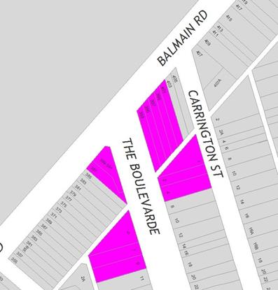
One (1) response was received, in objection to the proposal to install a ‘P15 Minute 7:00AM-5:30PM MON-FRI’ parking restriction on The Boulevarde.
|
Residents’ Comments |
Officer Comments |
|
The proposed 15min parking only benefits the business and puts the rest of the local residents at a disadvantage. Council’s proposal will reduce the number of parking spaces in a street that has a high demand for on-street parking. At no point during the working day has the local business received any deliveries.
The solution to this problem if to install 90 degree angle parking (rear to kerb) on the western side of The Boulevarde (on the same side of the proposed loading zone). This will benefit all parties, and would increase parking spaces in the proposed areas by two thirds. |
Council investigated provision of angle parking in The Boulevarde in 2014.
A consultation was conducted with the affected properties (74 properties). 78% of the residents responded with only 8% of those residents supporting Council’s proposal.
The support rate for the angle parking proposal was less than the minimum required rate of 50% as per Council’s policy and therefore was not supported by the Traffic Committee at its meeting held in August 2014.
The main reasons for the lack of support to install angled parking were because of the potential traffic noise increase, safety concerns for children who play on the grass verge and the decrease in street appeal of The Boulevarde. |
CONCLUSION
Nil.
|
|
Local Traffic Committee Meeting 6 November 2018 |
Subject: Brenan Street, Lilyfield - Proposal for Car Share Parking Space (Balmain Ward/ Balmain Electorate/ Leichhardt LAC)
Prepared By: Felicia Lau - Engineer - Traffic and Parking Services
Authorised By: John Stephens - Traffic and Transport Services Manager
|
SUMMARY Council has received a request for the installation of a ‘Car Share’ parking space in Brenan Street, Lilyfield for an existing floating car share vehicle in the precinct. |
|
RECOMMENDATION
THAT a 2.5m wide 'No Parking, Inner West Council Authorised Car Share Vehicle Excepted' (90o angle parking) zone be installed in the closed section of Brenan Street, south of City West Link and east of Catherine Street, replacing the existing unrestricted parking space. |
BACKGROUND
A number of Councils in the Sydney Metropolitan Area have implemented ‘Car Share’ schemes – including Inner West Council, as part of a holistic approach to encourage more sustainable travel habits for residents and businesses. In support of this scheme, Council allocates dedicated on-street and off-street parking spaces for authorised ‘Car Share’ vehicles for the resident and business use.
The current operator for the authorised ‘Car Share’ parking in the Inner West is ‘GoGet’.
GoGet member surveys have indicated that a considerable number of members (50%) have deferred purchasing a car since joining the scheme and that one car share space replaces the demand for approximately 10 private car spaces. Therefore, implementing a dedicated car share parking space will eventually reduce the need to own a private vehicle and may ease the parking stress on-street.
A number of floating car share vehicles has been allocated within the Inner West. Following this, GoGet has identified high utilisation areas that would benefit from a dedicated parking space where members had also expresses requests for a permanent parking space. Generally, car share schemes rely on having convenient dedicated on-street parking spaces. The designated space will be in operation 24 hours/7 days a week, during which, only specifically marked car share vehicles will be permitted to park in this space.
The existing floating car share vehicle near Brenan Street has been identified to require a permanent parking space.
FINANCIAL IMPLICATIONS
The cost associated to install the regulatory signage is borne by the car share provider in accordance with Council’s Fees and Charges. The car share provider is also charged an annual fee for each signposted parking space in operation.
OTHER STAFF COMMENTS
Council has been informed that the number of car share members living in the area has continued to increase and therefore there is a demand for a dedicated car share parking space at this location.
|
Total members within 250m |
48 |
|
Average trips per month |
20 |
|
Average hours per day |
5.6 |
Council’s officers have investigated the requested location and community engagement letters for the provision of a dedicated parking space for car share vehicles at the proposed location have been forwarded to residents in affected properties seeking feedback.
It is proposed to provide a dedicated parking space, signposted as 'No Parking Inner West Council Authorised Car Share Vehicles Excepted' in the closed section of Brenan Street as shown in the following plan.
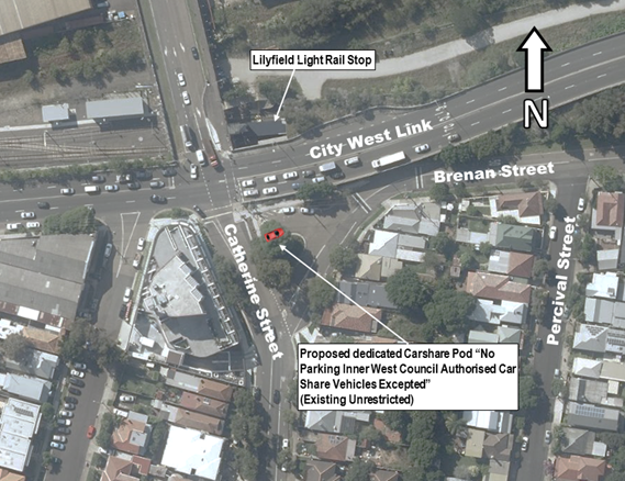
This is in accordance with Council’s Car Share Policy, to minimize the impact on visitor and resident parking, the following priority is followed when a car share parking space is allocated:
1. Council car park (off-street).
2. Unrestricted kerbside parking.
3. Timed kerbside parking within a resident parking scheme, consideration will also be given to installing a car share parking space outside a car share member’s property if the member offers no objection.
PUBLIC CONSULTATION
A consultation letter outlining the proposal was mailed out to the affected properties as shown in the plan below requesting residents’ and businesses’ views regarding the proposal.
There were no objections received for the proposal during the consultation period.
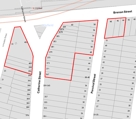
CONCLUSION
It is recommended that the installation of the proposed on-street dedicated car share parking space be approved in order to provide improved parking opportunities for local residents who participate in the car share scheme. The dedicated car share parking space will be signposted as 'No Parking Inner West Council Authorised Car Share Vehicles Excepted'.
|
|
Local Traffic Committee Meeting 6 November 2018 |
Subject: 'No Stopping' Restrictions - The Summer Hill Flour Mill Development and Surrounding Streets (Ashfield Ward / Summer Hill Electorate / Burwood PAC)
Prepared By: Vinoth Srinivasan - Engineer - Traffic and Parking Services
Authorised By: John Stephens - Traffic and Transport Services Manager
|
SUMMARY Council has received concerns regarding vehicles obstructing sight lines and manoeuvring space by parking too close to intersections within and surrounding the Flour Mill development in Summer Hill.
It has been proposed to signpost the ‘No Stopping’ restrictions at these intersections in order to improve road safety. |
|
RECOMMENDATION
THAT:
1. A 10m ‘No Stopping’ zone be installed on the western side of Nowranie Street, south of Smith Street;
2. A 10m ‘No Stopping’ zone be installed on the southern side of Smith Street, east of Nowranie Street;
3. A 10m ‘No Stopping’ zone be installed on the eastern side of Fleet Street, north of Smith;
4. A 10m ‘No Stopping’ zone be installed on the northern side of Smith Street, west of Fleet Street;
5. A 12m ‘No Stopping’ zone be installed on the eastern side of Chapman Street, north of Smith Street;
6. A 10m ‘No Stopping’ zone be installed on the northern side of Smith Street, west of Chapman Street;
7. A 10m ‘No Stopping’ zone be installed on the western side of Spencer Street, south of Smith Street;
8. A 10m ‘No Stopping’ zone be installed on the southern side of Wellesley Street, east of Nowranie Street;
9. A 10m ‘No Stopping’ zone be installed on the eastern side of Carrington Street, south of Wellesley Street;
10. A 10m ‘No Stopping’ zone be installed on the southern side of Wellesley Street, west and east of Spencer Street;
11. A 10m ‘No Stopping’ zone be installed on the western side of Spencer Street, north and south of Wellesley Street;
12. A 10m ‘No Stopping’ zone be installed on the eastern side of Spencer Street, south of Wellesley Street;
13. A 10m ‘No Stopping’ zone be installed on the southern side of Wellesley Street, west of Edward Street; and
14. A 10m ‘No Stopping’ zone be installed on the eastern side of Edward Street, north and south of Mungo Scott Place;
15. A 10m ‘No Stopping’ zone be installed on eastern side of Edward Street, north and south of Flour Mill Way;
16. A 20m ‘No Stopping’ zone be installed on eastern side of Edward Street, north of Old Canterbury Road;
17. A 10m ‘No Stopping’ zone be installed on the western side of Spencer Street, north of Old Canterbury Road;
18. A 10m ‘No Stopping’ zone be installed on the eastern side of Spencer Street, north of Old Canterbury Road;
19. A 10m ‘No Stopping’ zone be installed on the southern side of Old Canterbury Road, east of Windsor Road;
20. A 10m ‘No Stopping’ zone be installed on the eastern side of Carrington Street, north of Old Canterbury Road;
21. A 10m ‘No Stopping’ zone be installed on the western side of Carrington Street, north of Old Canterbury Road;
22. A 10m ‘No Stopping’ zone be installed on the southern side of Longport Street, east of Brown Street; and
23. A 20m ‘No Stopping’ zone be installed on the southern side of Longport Street, west of Old Canterbury Road.
|
BACKGROUND
Council has received concerns regarding vehicles obstructing sight lines and manoeuvring space by parking too close to intersections within and surrounding the Flour Mill development in Summer Hill.
These intersections are:
· Nowranie Street at Smith Street, Summer Hill (9.4m and 9.7m wide respectively)
· Fleet Street at Smith Street, Summer Hill (7m and 9m wide respectively)
· Chapman Street at Smith Street, Summer Hill (7.3m and 10m wide respectively)
· Spencer Street at Smith Street, Summer Hill (12m and 8.4 wide respectively)
· Wellesley Street at Nowranie Street, Summer Hill (9.7m and 9m wide respectively)
· Wellesley Street at Carrington Street, Summer Hill (9.5m and 9.4m wide respectively)
· Wellesley Street at Spencer Street, Summer Hill (10m and 12.6m wide respectively)
· Edward Street at Wellesley Street and Mungo Scott Place, Hill (9.5m, 9.4m and 6m wide respectively)
· Edward Street at Flour Mill Way, Summer Hill (9.3m and 13m wide respectively)
· Edward Street at Old Canterbury Road, Summer Hill (15m and 12.3m wide respectively)
· Old Canterbury Road at Spencer Street and Windsor Road, Summer Hill (12.7m, 10m and 12.5m wide respectively)
· Carrington Street at Old Canterbury Road, Summer Hill (10.3m and 12.6m wide respectively)
· Longport Street at Brown Street and Old Canterbury Road, Summer Hill (13.6m, 12.6m and 5.4m wide respectively)
In order to ensure that motorists park the appropriate distance back from the intersection, it is proposed to signpost ‘No Stopping’ restrictions at the identified intersections. This will improve sight lines for vehicles to the intersection and to pedestrians wishing to cross at this intersection. Also, parking further back will improve the manoeuvring space for vehicles.
It should be noted that under the NSW Road Rules, it is illegal to park within 10 metres of an intersection without traffic lights or 20 metres of an intersection with traffic lights, unless a parking control sign applies indicating that the driver is permitted to park.
FINANCIAL IMPLICATIONS
Nil.
OTHER STAFF COMMENTS
In order to alleviate this issue, it is proposed to signpost the following restrictions:
· 10m ‘No Stopping’ zone on the western side of Nowranie Street, south of Smith Street.
· 10m ‘No Stopping’ zone on the southern side of Smith Street, east of Nowranie Street.
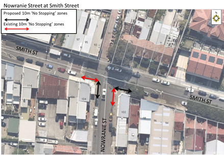
Figure 1
· 10m ‘No Stopping’ zone on the eastern side of Fleet Street, north of Smith Street.
· 10m ‘No Stopping’ zone on the northern side of Smith Street, west of Fleet Street.
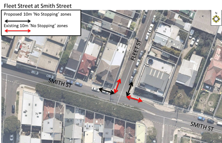
Figure 2
· 12m ‘No Stopping’ zone on the eastern side of Chapman Street, north of Smith Street.
· 10m ‘No Stopping’ zone on the northern side of Smith Street, west of Chapman Street. This will be subjected to further variation once the proposed roundabout will be installed at this intersection.
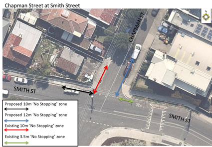
Figure 3
· 10m ‘No Stopping’ zone on the western side of Spencer Street, south of Smith Street.
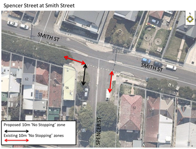
Figure 4
· 10m ‘No Stopping’ zone on the southern side of Wellesley Street, east of Nowranie Street.
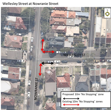
Figure 5
· 10m ‘No Stopping’ zone on the eastern side of Carrington Street, south of Wellesley Street.
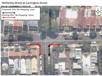
Figure 6
· 10m ‘No Stopping’ zone on the southern side of Wellesley Street, west and east of Spencer Street.
· 10m ‘No Stopping’ zone on the western side of Spencer Street, north and south of Wellesley Street.
· 10m ‘No Stopping’ zone on the eastern side of Spencer Street, south of Wellesley Street.
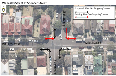
Figure 7
· 10m ‘No Stopping’ zone on the southern side of Wellesley Street, west of Edward Street.
· 10m ‘No Stopping’ zone on the eastern side of Edward Street, north and south of Mungo Scott Place.
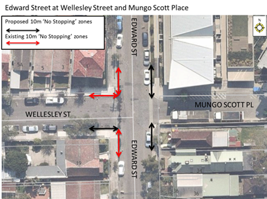
Figure 8
· 10m ‘No Stopping’ zone on the eastern side of Edward Street, north and south of Flour Mill Way.
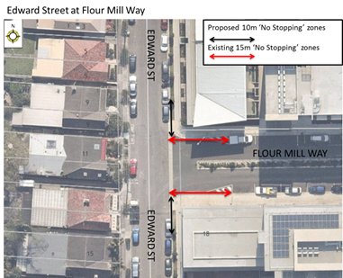
Figure 9
· 20m ‘No Stopping’ zone on the eastern side of Edward Street, north of Old Canterbury Road.
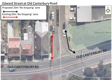
Figure 10
· 10m ‘No Stopping’ zone on the western side of Spencer Street, north of Old Canterbury Road.
· 10m ‘No Stopping’ zone on the eastern side of Spencer Street, north of Old Canterbury Road.
· 10m ‘No Stopping’ zone on the southern side of Old Canterbury Road, east of Windsor Road.
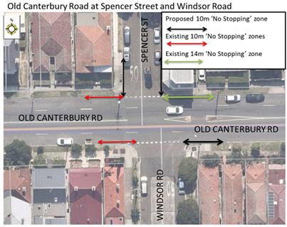
Figure 11
· 10m ‘No Stopping’ zone on the western side of Carrington Street, north of Old Canterbury Road.
· 10m ‘No Stopping’ zone on the eastern side of Carrington Street, north of Old Canterbury Road.
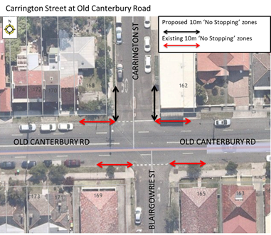
Figure 12
· 10m ‘No Stopping’ zone on the southern side of Longport Street, east of Brown Street.
· 20m ‘No Stopping’ zone on the southern side of Longport Street, west of Old Canterbury Road.
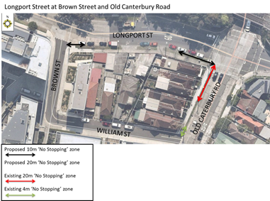
Figure 13
PUBLIC CONSULTATION
|
A letter outlining the above proposal was mailed out to the affected properties (10 properties) in Smith Street, Summer Hill on 9 October 2018. No responses were received to date.
|
|
|
A letter outlining the above proposal was mailed out to the affected properties (11 properties) in Smith Street, Summer Hill on 9 October 2018. No responses were received to date.
|
|
|
A letter outlining the above proposal was mailed out to the affected properties (4 properties) in Chapman Street, Summer Hill on 9 October 2018. No responses were received to date.
|
|
|
A letter outlining the above proposal was mailed out to the affected properties (8 properties) in Smith Street and Spencer Street, Summer Hill on 9 October 2018. No responses were received to date.
|
|
|
A letter outlining the above proposal was mailed out to the affected properties (7 properties) in Wellesley Street and Nowranie Street, Summer Hill on 9 October 2018. No responses were received to date.
|
|
|
A letter outlining the above proposal was mailed out to the affected properties (7 properties) in Wellesley Street, Summer Hill on 9 October 2018. No responses were received to date.
|
|
|
A letter outlining the above proposal was mailed out to the affected properties (11 properties) in Wellesley Street, Summer Hill on 9 October 2018. No responses were received to date.
|
|
|
A letter outlining the above proposal was mailed out to the affected properties (8 properties) in Wellesley Street and Edward Street, Summer Hill on 9 October 2018. No responses were received to date.
|
|
|
A letter outlining the above proposal was mailed out to the affected properties (12 properties) in Edward Street, Summer Hill on 9 October 2018. No responses were received to date.
|
|
|
A letter outlining the above proposal was mailed out to the affected properties (4 properties) in Edward Street and Old Canterbury Road, Summer Hill on 9 October 2018. No responses were received to date.
|
|
|
A letter outlining the above proposal was mailed out to the affected properties (12 properties) in Old Canterbury Road, Summer Hill on 9 October 2018. No responses were received to date.
|
|
|
A letter outlining the above proposal was mailed out to the affected properties (11 properties) in Old Canterbury Road, Summer Hill on 9 October 2018. No responses were received to date.
|
|
|
A letter outlining the above proposal was mailed out to the affected properties (8 properties) in Old Canterbury Road and William Street, Summer Hill on 9 October 2018. No responses were received to date.
|
|
CONCLUSION
In order to improve pedestrian safety within and around the Summer Hill Flour Mill development, it is proposed to signpost ‘No Stopping’ restrictions at a number of intersections as outlined in the report.
|
|
Local Traffic Committee Meeting 6 November 2018 |
Subject: Edwin Street North, Croydon- Request for 'Mail Zone'
Prepared By: Boris Muha - Engineer – Traffic and Parking Services
Authorised By: John Stephens - Traffic and Transport Services Manager
|
SUMMARY A request has been made by the Croydon Licensed Post Office to have a ‘Mail Zone’ established outside/near its new ‘Australia Post’ office to be built at the property No.88 Edwin Street (North) for the pick-up and delivery of mail. |
|
RECOMMENDATION
THAT a 7.0m length ‘Mail Zone 5.30am-7.00pm Mon-Fri; 6.00pm-7.00pm Sun’ be installed outside No.84 Edwin Street North, Croydon.
|
BACKGROUND
The Australia Post Office is currently located under lease at the intersection of Paisley Road and ‘The Strand’, Croydon, within the Burwood Council Local Government Area.
The lease is soon to expire and Australia Post has received from the Inner West Council approved Complying Development Consent (Certificate No. 16.2018.66) to refurbish an existing commercial premise at No.88 Edwin Street (North) to that of a Post Office.
FINANCIAL IMPLICATIONS
NIL
OTHER STAFF COMMENTS
Council has been advised that Australia Post will be relocating its postal office from the intersection of the ‘The Strand’ and Paisley Road to No.88 Edwin Street North, Croydon.
In order to facilitate postal deliveries and pick-up, Australia Post has requested a 7m length ‘Mail Zone’ to be placed outside No.88 Edwin Street North. The ‘Mail Zone’ would be limited, at this point of time, to operate between ‘5.30am-7.00pm Mon-Fri., 6.00pm-7.00pm Sun’ to coincide with essential mail deliveries and pick up.
The subject area is currently a 'Loading Zone' operating under nominal business hours Monday to Saturday and is proposed to be reduced in length by 1.0m and relocated south of its current location in order to accommodate the 'Mail Zone', with the aim to minimise loss of parking further south. Diagrams are shown below detailing the existing and proposed parking restrtictions, and the proposed location of the 'Mail Zone'.
The License Post Office manager has only requested a 'Mail Zone' and no other parking restrictions to cater for the office. The commercial premise is being internally re-furbished to house a small Post Office. See Attachment 1.
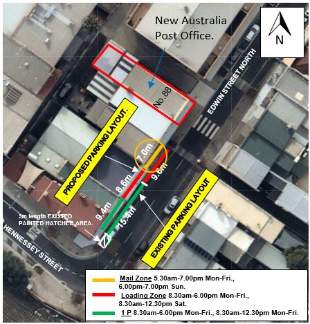
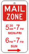
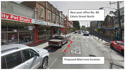
The space can only be provided outside No.84 near the proposed office, given that a pedestrian crossing facility with kerb-extension is located outside No.88.
A narrow width side access lane (next to No.88) cannot be used to park or stand a vehicle for reasons of vehicular access to properties, the intrusion/obstruction to an apartment/commercial building driveway carpark, and that of property side door access. The 'Mail Zone' is limited to times as needed through the week days and on a period on Sunday for delivery and/or pick up of mail.
PUBLIC CONSULTATION
Approximately 40 letters were distributed in the consultation area as shown below. Of these, four (4) written responses were received and one (1) verbal concern. One (1) resident responded in support but was concerned that vehicles might park in the lane. Three (3) responses were received from businesses in objection owing to the loss of parking and questioning the preferential treatment to the Post Office. One (1) resident verbally questioned if the Post Office obtained DA approval and that residents be consulted with the Post Office going in.
The responses and comments are shown below.
|
Resident/Business comments |
Officer Response |
|
(1) Resident in support with concern. Concern is that more people are likely to park in the laneway. The lane is used 24/7 for access both for residents and businesses |
The laneway is sign posted with regulatory ‘No Stopping’. A request has been made to Council Rangers to continually monitor the lane in their patrols of the area. |
|
(3) Businesses in objection.
To provide preferential treatment to one business in the street is unfair. No other business in the street has all day reserved parking.
Object to the proposed new parking layout because it is unfair and will be detrimental to my business and other businesses in the street by reducing the amount of parking available for customer/client use.
Can the Mail Zone be shared with the loading zone?
Can the kerb be re-constructed outside No.88-86 to place a Mail Zone?
Can the reserve be placed in the laneway?
Can a Postal Reserve located further north, opposite No.125/127 Edwin Street North be removed in lieu of providing the Mail Zone outside No.84. |
Australia Post is a Public Utility Authority eligible for preferential parking treatment for its vans to service and deliver and pick up mail to the new Post Office. The Mail Zone times are only limited to times needed for pick- up and delivery of mail. The kerb extension has been constructed to provide increased sight lines to pedestrians using the zebra crossing. The laneway as explained above is of narrow width, and clear unobstructed access is required at all times to properties, driveways and property doors. A request to possibly removing the Postal Reserve opposite No.127/129 Edwin Street North has been referred to Australia Post. |
|
(1) Verbal Concern Has the new Post Office been approved and are residents allowed to comment on the development? |
The new post office has been approved under a Compliant Development Certificate (CDC) to NSW Government Planning Legislative requirements. The existing premise is only being re-furbished. There is no extension or re-construction to the building. Residents and businesses are not required to be consulted on the development under a CDC. |
CONCLUSION
In view of the report above, it is recommended that a ‘Mail Zone’ operating between ‘5.30am-7.00pm Mon-Fri., 6.00pm-7.00pm Sun’ be installed outside No.84 Edwin Street North to service mail delivery and pick-up from the new Australia Post Office to be provided at property No.88 Edwin Street North.
|
1.⇩ |
Internal plan of new Australia Post Offce- 88 Edwin Street North, Croydon. |
|
|
Local Traffic Committee Meeting 6 November 2018 |
Subject: OLD CANTERBURY ROAD, LEWISHAM - Temporary Full Road Closure for Rail Overbridge Refurbishment Works (Stanmore Ward / Summer Hill Electorate / Inner West LAC)
Prepared By: Jennifer Adams - Engineer – Traffic and Parking Services
Authorised By: John Stephens - Traffic and Transport Services Manager
|
SUMMARY An application has been received from Sydney Trains TfNSW for the temporary partial and full road closure of Old Canterbury Road, between Barker Street and Trafalgar Street/Longport Street, Lewisham on various occasions throughout 2019 in order to carry out refurbishment works on their rail over bridge.
It is noted that Old Canterbury Road is a State Road therefore the road closures will be managed by the RMS
|
|
RECOMMENDATION
THAT this report be received and noted. |
BACKGROUND
An application has been received from Sydney Trains TfNSW for the temporary full road closure of Old Canterbury Road, between Barker Street and Trafalgar Street/Longport Street, Lewisham on various occasions throughout 2019 in order to carry out refurbishment works on their rail over bridge.
The proposed works will be conducted on various dates (larger version is reproduced at end of report):
The proposed road closure detour plan is shown below.
The proposed TCPs for Stages 1,2 & 3 are reproduced below.
FINANCIAL IMPLICATIONS
Nil. There are no financial implications for Council associated with this matter.
OFFICER COMMENTS
It is noted that Old Canterbury Road is a State Road therefore the road closures will be managed by the RMS
PUBLIC CONSULTATION
The project is being managed by the RMS.
CONCLUSION
It is recommended that this report be received and noted.
|
|
Local Traffic Committee Meeting 6 November 2018 |
Subject: New Canterbury Road, Petersham – Proposed Signage Outside No.31-33 (Stanmore Ward / Newtown Electorate / Inner West LAC)
Prepared By: Jennifer Adams - Engineer – Traffic and Parking Services
Authorised By: John Stephens - Traffic and Transport Services Manager
|
SUMMARY As part of the approved mix-used development proposal at 31-33 New Canterbury Road, Petersham a condition was imposed on the developer to provide a detailed regulatory signage and line marking plan prior to the issue of a Construction Certificate and commencement of any road works. The condition was imposed to satisfy the requirements of the RMS and the Local Traffic Committee.
The required plan has been finalised and is presented in this report for consideration. It is recommended that the signage associated with the supplied plan be supported by Council and submitted to the RMS for consideration and approval.
|
|
RECOMMENDATION
THAT the submitted plan for signs and line marking outside 31-33 New Canterbury Road, Petersham (as per the attached design plan No. 01391-241/5) be supported by Council and submitted to the RMS for consideration and approval. |
BACKGROUND
In 2014 a development application was received by Council seeking to demolish the existing building and excavate the site to construct a new building complex comprising of 280m2 of gross floor area retail space and 34 residential apartments over basement car parking with 29 car spaces. The application was approved and a condition was imposed on the developer to provide a detailed regulatory signage and line marking plan prior to the issue of a Construction Certificate and commencement of any road works. The condition was imposed to satisfy the requirements of the RMS and the Local Traffic Committee.
The required plan has been finalised and is presented in this report for consideration. It is recommended that the signage associated with the supplied plan be supported by Council and submitted to the RMS for consideration and approval.
FINANCIAL IMPLICATIONS
All costs associated with the installation of signage are to be borne by the applicant.
OFFICER COMMENTS
Existing Conditions
The proposed development site is located at 31-33 New Canterbury Road on the north-east corner of the New Canterbury Road / Audrey Street intersection Street (refer to the attached locality map). This intersection is controlled by traffic signals. The site was previously occupied by a service station and is surrounded by a mixture of residential, retail, commercial and restaurant developments.
The subject section of New Canterbury Road is a State Road and sub-arterial route which consists of two-way traffic flow and four traffic lanes, running east-west which provides a connection between the inner west suburbs and the city.
Audrey Street is a two-way local road running north-south between New Canterbury Road and Trafalgar Street.
At present, ‘Clearway 6am-10am Mon-Fri’ as well as ‘No Stopping 4pm-6pm Mon-Fri’ restricted parking is permitted on the northern side of New Canterbury Road and ‘Clearway 3pm-7pm Mon-Fri’ restricted parking is permitted on the southern side of New Canterbury Road. It is noted that the subject section of New Canterbury Road has statutory full-time ‘No Stopping’ restricted parking on both sides of the road, 20 metres from the intersection with Audley Street as it is a controlled by traffic signals.
Locality Map
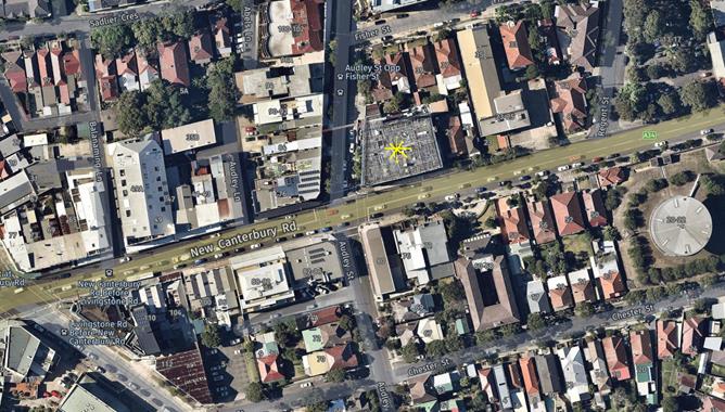
Line marking and signage Plan
As part of the approved mix-used development proposal at 31-33 New Canterbury Road, Petersham a condition was imposed on the developer to provide a detailed regulatory signage and line marking plan prior to the issue of a Construction Certificate and commencement of any road works. The condition was imposed to satisfy the requirements of the RMS and the Local Traffic Committee.
The required plan has been finalised and is presented below. A section of the supplied plan has been enlarged to show more clearly the proposed signage showing ‘clearway 6-10am’ restrictions, ‘No Stopping’ 4-6pm restrictions and ‘No Parking’ at other times.
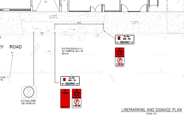
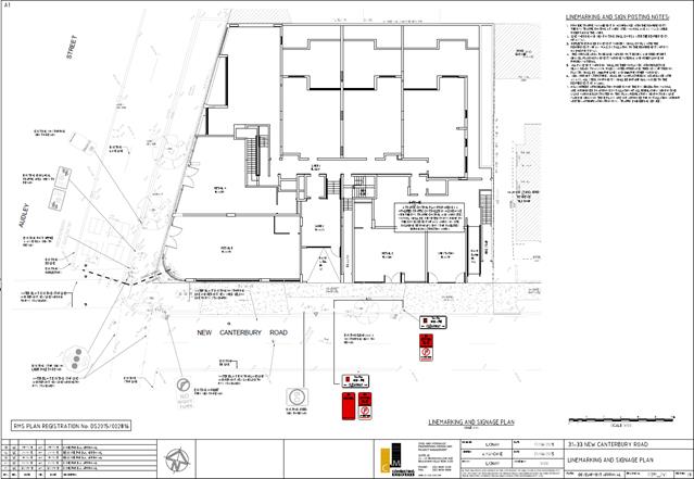
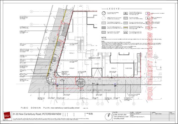
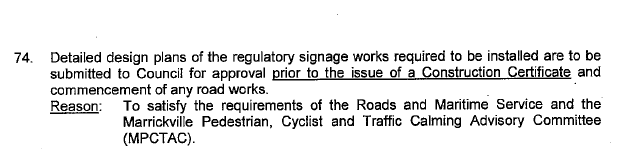
PUBLIC CONSULTATION
Nil.
CONCLUSION
The required plan has been finalised and is presented in this report for consideration. It is recommended that the signage associated with the supplied plan be supported by Council and submitted to the RMS for consideration and approval.
|
|
Local Traffic Committee Meeting 6 November 2018 |
Subject: Local Traffic Committee Schedule for 2019
Prepared By: Manod Wickramasinghe - Coordinator – Traffic and Parking Services
Authorised By: John Stephens - Traffic and Transport Services Manager
|
SUMMARY The proposed schedule of the Local Traffic Committee meetings has been prepared for the 2019 calendar year. It is recommended that the proposed meeting schedule be received and noted. |
|
RECOMMENDATION
THAT the proposed schedule of meetings of the Local Traffic Committee for the 2019 calendar year be received and noted. |
BACKGROUND
To assist Committee members with forward planning, the schedule of meetings of the Local Traffic Committee for 2019 is detailed below.
FINANCIAL IMPLICATIONS
Nil.
OTHER STAFF COMMENTS
All meetings will be held on the 1st Monday of each month, excluding January, and Monday, 7 October which is Labour Day, commencing at 10.00am. The proposed meeting dates for 2019 are as follows:
|
Date |
Time |
|
Monday, 4 February 2019 |
10.00am |
|
Monday, 4 March 2019 |
10.00am |
|
Monday, 1 April 2019 |
10.00am |
|
Monday, 6 May 2019 |
10.00am |
|
Monday, 3 June 2019 |
10.00am |
|
Monday, 1 July 2019 |
10.00am |
|
Monday, 5 August 2019 |
10.00am |
|
Monday, 2 September 2019 |
10.00am |
|
Tuesday, 8 October 2019 |
10.00am |
|
Monday, 4 November 2019 |
10.00am |
|
Monday, 2 December 2019 |
10.00am |
PUBLIC CONSULTATION
Nil.
CONCLUSION
It is recommended that the proposed meeting schedule for 2019 be received and noted.
|
|
Local Traffic Committee Meeting 6 November 2018 |
Subject: 63-65 Pyrmont Bridge Road, Annandale - Modication of Development Consent (Leichhardt Ward/ Balmain Electorate/Leichhardt LAC)
Prepared By: Felicia Lau - Engineer - Traffic and Parking Services
Authorised By: John Stephens - Traffic and Transport Services Manager
|
SUMMARY A Modification of Development Consent Application has been received to provide vehicular access to the development at No.63-65 Pyrmont Bridge Road, Annandale via Mallett Street. The development application is for an alteration to the existing building for use as a fitness centre (relocation of the Camperdown Fitness Facility at No.166-172 Parramatta Road).
Comments of the Local Traffic Committee will be referred to Council’s Development Assessment Section for consideration in determining the Modification Development Consent Application. |
|
RECOMMENDATION
THAT the report be received and noted. |
BACKGROUND
A modification of development consent application to DA2017/637 was recently received for alterations to the existing building at No. 63-65 Pyrmont Bridge Road, Annandale, for use as a fitness centre (being the relocation of the Camperdown Fitness Facility at No. 166-172 Parramatta Road to the subject premises) with hours of operation of 4:30am-10:00pm Monday to Friday, 5:30am-7:00pm Saturday, and 7:00am-1:00pm Sunday. The site locality is shown below.
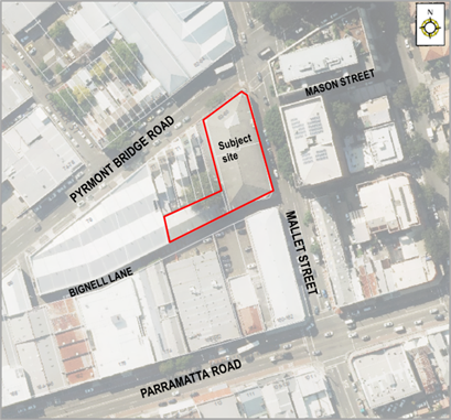
The original Development Application comprised of:
· Construction of an internal floor at Level 1.
· Construction of an internal mezzanine floor at Level 2.
· Retention of the existing lower ground car park comprising 11 car parking spaces.
· Construction of two additional car parking areas (ground floor car park) consisting of:
o 20 customer car parking spaces with access via Bignell Lane and egress via Mallett Street.
o 6 staff car parking spaces with access via Bignell Lane.
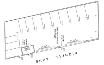
Lower Car Park
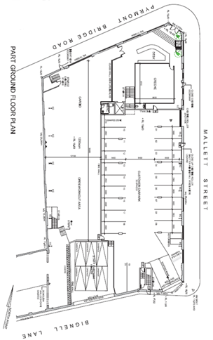
Ground Floor Car Park
Figures 1 & 2: Original DA Plans
The proposed access via Mallett Street was not supported for the following reasons.
· The proposed Mallett Street entrance does not provide sufficient sightlines to pedestrians
· The proposed will likely to create queuing within the northbound and southbound lanes of Mallett Street due to vehicles waiting to enter the site via the constrained opening.
A further revised design for the ground floor car park access arrangement was submitted and deferred commencement was satisfied on 20 July 2018 (as shown in the figure below) to comply with the following conditions:
· The Mallett Street entry must be deleted with all vehicle access/egress to be limited to Bignell Lane.
· The proposed Bignell Lane vehicle exit to the primary car park must be widened to a dual width ramp to accommodate both entry and exit of vehicles. The ramp and door opening to Bignell Lane must have a minimum width of 6000mm.
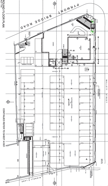
Figure 3: Revised Car Park Arrangement
Subsequently, a modification application was recently submitted to Council on 13 August 2018 and includes a change to the approved access arrangement (design plan presented in the following figure).
· Rearrange the vehicular access to provide an entry using an existing driveway crossing from Mallett Street (ingress only) and an exit to Bignell Lane (egress only).
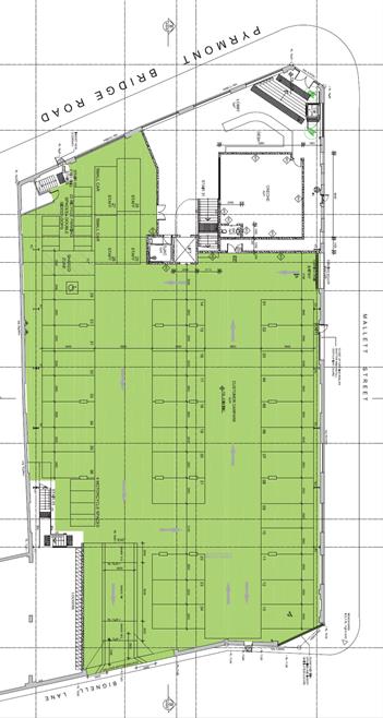
Figure 4: Plans from Current Modification Application
Comments of the Local Traffic Committee will be referred to Council’s Development Assessment Section for consideration in determining the Modification Application.
FINANCIAL IMPLICATIONS
Nil.
OTHER STAFF COMMENTS
Roads and Maritime Services (RMS) has reviewed the proposed access arrangement and the following comments were provided (letter dated 27 September 2018):
· Roads and Maritime does not support the installation of an isolated median on Mallett Street across the frontage of the driveway as it has the potential to be hazardous for motorists.
· Roads and Maritime supports the installation of a central median, 1.2m wide, from the stop line at the Traffic Control Signal (TCS) across the full frontage of the site access on Mallett Street to physically restrict all movements to left-in left-out only.
· The existing “No Stopping” restrictions on Mallett Street may need to be extended on the departure side (southbound) and on approach to the TCS intersection (northbound), advice will be provided following receipt of a detailed design plan showing the median.
· The TCS plan will need to be updated to reflect the above requirements and sent to Roads and Maritime for review and approval. The TCS plan shall be drawn by a suitably qualified person and endorsed by a suitably qualified practitioner.
On the basis of the RMS recommendation of an addition of a 1.2m central median, the proposed modification to access via Mallett Street results in the following concerns:
· Mallet Street is a Regional Road that consists of high heavy vehicles utilisation. The addition of central median will result in narrowing the existing northbound parking and travel lanes, and may increase the safety risk in the area e.g. side swipe of parked vehicles and dooring, and heavy vehicle manouevring.
· The narrowing of carriageway and extension of “No Stopping” zone may result in loss of on-street parking on Mallet Street. Any loss of on-street parking is not supported.
· Existing turning movements from Mason Street and to/from No.4 Mallet Street’s driveway will be restricted with the installation of a central median (Mason Street is also under City of Sydney’s jurisdiction). This would impact vehicle movements on the road network of an adjacent Council would require feedback from the Council and a traffic management plan to RMS to support the change in road network.
· The access via Mallett Street may also result in northbound queuing that subsequently may reduce the intersection performance at Mallett Street and Pyrmont Bridge Road signalised intersection.
It should be noted that the development can provide a viable alternative access arrangement on Bignell Lane which will result in minimal impact on the existing road network and the neighbouring Council (as approved on 20 July 2018). The proposed access arrangement in the modification to Development Consent does not provide any positive benefit compared to the approved design.
PUBLIC CONSULTATION
Nil.
CONCLUSION
It is proposed that the following traffic and parking related comments be forwarded to Council’s Development Assessment section.
The submitted modification development application for the proposal at No.63-65 Pyrmont Bridge Road, Annandale has been reviewed and cannot be supported due to the following concerns:
· Mallet Street is a Regional Road that consists of high heavy vehicles utilisation. The addition of central median will result in narrowing the existing northbound lanes and may increase the safety risk in the area e.g. side swipe of parked vehicles and dooring, and heavy vehicle manouevring.
· The narrowing of carriageway and extension of existing “No Stopping” zone may result in loss of on-street parking on Mallet Street.
· Existing turning movements from Mason Street and to/from No.4 Mallet Street’s driveway will be restricted with the installation of a central median (Mason Street is also under City of Sydney’s jurisdiction). This would impact vehicle movements on the road network of an adjacent Council would require feedback from the Council and a traffic management plan to RMS to support the change in road network
· The access via Mallett Street may also result in northbound queuing that subsequently may reduce the intersection performance at Mallett Street and Pyrmont Bridge Road signalised intersection.
· The Left-in only movements may result in additional vehicle circulation through the local road network as opposed to access via Bignell Lane.
· The development can provide a viable alternative access arrangement on Bignell Lane which will result in minimal impact on the existing road network and neighboring Council (as approved on 20 July 2018).
· The proposed access arrangement does not provide any positive benefit compared to the approved design.
|
|
Local Traffic Committee Meeting 6 November 2018 |
Subject: 2019 St Jerome's Laneway Festival - Traffic Management Plan (Balmain Ward/ Balmain Electorate/ Leichhardt LAC)
Prepared By: Felicia Lau - Engineer - Traffic and Parking Services
Authorised By: John Stephens - Traffic and Transport Services Manager
|
SUMMARY The proposed event, the St Jerome’s Laneway Festival 2019, is a music festival held annually at Sydney University College of Arts, Rozelle Campus, Callan Park.
Assure Event Safety Services has submitted a Development Application including a Traffic Management Plan for the upcoming “St Jerome’s Laneway Music Festival”, to be held in Callan Park on Sunday, 3 February 2019.
Comments of the Local Traffic Committee will be referred to Council's Development Assessment Section for consideration in determining the Development Application.
|
|
RECOMMENDATION
THAT the report be received and noted. |
BACKGROUND
A request for approval to conduct the St Jerome’s Laneway Music Festival 2019 on Sunday, 3 February 2019 between 11:00am and 11:00pm has been received from the organiser of the event, The Laneway Festival Pty Ltd and Assure Event Safety Services.
The event is to be held within Callan Park which is under the jurisdiction of the Office of Environmental and Heritage (OEH). This annual event has been held in the past with no significant traffic issues raised.
In accordance with the RMS ‘Guide to Traffic and Transport Management for Special Events V3.4 August 2006’, and based on information supplied by the organiser, the event is classified as a Special Event Class 2.
The annual event involves the temporary implementation of ‘Special Event Clearway’ restrictions on the northern side (Callan Park side) of Balmain Road and Darling Street (from 200m west of the main entrance to Callan Park at Cecily Street, to Victoria Road) from 2pm to Midnight. Temporary ‘No Parking’ (R5-40), ‘Pick up & Set down Area’ (R9-301) and Taxi zone (R5-21) signs are to be implemented as per the Traffic Control Plan enclosed. This section of Balmain Road and Darling Street are classified State Roads under the jurisdiction of RMS.
Event Details
The organiser has advised the following key details of the event:
Event Name: St Jerome’s Laneway Music Festival
Location: Sydney University College of Art – Rozelle Campus,
Callan Park and adjacent parkland
Event Date: Sunday, 3 February 2019
Start Time: 11:00am
Finish Time: 11:00pm
Event Setup Start: A week before event day
Event Pack down Finish: Four days following event day
Capacity: ≤ (up to) 12,500 patrons
Event Type: Off Street, advertised as car free/public transport event
Event Classification: Class 2, and subject to annual LTC assessment
Parking Summary
The laneway Festival will encourage bicycle and public transport use and notify patrons that free shuttle buses will be provided on exit. The event demographic is a crowd using public transport.
Public Transport
To facilitate safe and timely egress ‘The Laneway Festival’ will implement a free-of-charge shuttle bus system transporting patrons from Balmain Road to the City-Town Hall. Shuttle buses will operate between 9:00pm and 12:00am. The round trip from Callan Park to the city set-down is approximately 6.5km and is expected to take an average of 12 minutes.
The shuttle bus service will be advertised on all forms of marketing and will be strongly encouraged by the Laneway Festival organisers. Considering the frequency of service and the quantity of buses, Assure Event Safety Services proposes that the buses for this service utilise the existing public bus stop in eastbound direction on Balmain Road. To facilitate this operation the event organiser will utilise variable message sign (VMS) during egress.
FINANCIAL IMPLICATIONS
Nil.
OTHER STAFF COMMENTS
Nil.
PUBLIC CONSULTATION
Nil.
CONCLUSION
It is proposed that the following traffic and parking related comments be forwarded to Council's Development Assessment section.
The Traffic Management Plan (TMP) attached dated 3 October 2018 submitted by the event organiser for the St Jerome’s Laneway Festival 2019 at Callan Park to be held on Sunday, 3 February 2019 between 11am and 11pm be supported, subject to the following conditions and RMS approval:
1. The TMP be implemented at the applicant’s cost;
2. The maximum number of tickets sold to be 12,500, subject to NSW Police approval;
3. Operating the Event as ‘car free’ (no public parking is available at the venue);
4. The applicant must obtain approval from the Transport Management Centre for the ‘Special Event Clearway’ restrictions on the northern side (Callan Park side) of Balmain Road and Darling Street (from 200m west of the main entrance to Callan Park at Cecily Street, to Victoria Road) from 2pm to Midnight;
5. The applicant must use standard parking restriction signage: ‘No Parking’ (R5-40) and ‘Pick Up and Set Down Area’ (R9-301), Bus Zone (R5-20) and Taxi Zone (R5-21) at the locations identified in the TMP;
6. The applicant to liaise with Transport for NSW to ensure train and light rail services operate at full capacity (no rail close downs);
7. The applicant must arrange additional special event buses with bus provider (Transit Systems);
8. The applicant must notify the local Police and emergency services of the event details;
9. The applicant to arrange the vehicular access closure to Callan Park at the Balmain Road/Cecily Street intersection and at the Cottage Way/South Crescent intersection;
10. The applicant to arrange crowd control barriers along both sides of Balmain Road south of Cecily Street; and
11. The applicant must provide a current Public Liability Insurance Policy to Inner West Council.
|
1.⇩ |
Traffic Management Plan |