|
AGENDA R |

Local Traffic Committee Meeting
TUESDAY 4 DECEMBER 2018
10.00am
|
|
Local Traffic Committee Meeting 4 December 2018 |
Function of the Local Traffic Committee
Background
Roads and Maritime Services (RMS) is legislated as the Authority responsible for the control of traffic on all NSW Roads. The RMS has delegated certain aspects of the control of traffic on local roads to councils. To exercise this delegation, councils must establish a local traffic committee and obtain the advice of the RMS and Police. The Inner West Council Local Traffic Committee has been constituted by Council as a result of the delegation granted by the RMS pursuant to Section 50 of the Transport Administration Act 1988.
Role of the Committee
The Local Traffic Committee is primarily a technical review and advisory committee which considers the technical merits of proposals and ensures that current technical guidelines are considered. It provides recommendations to Council on traffic and parking control matters and on the provision of traffic control facilities and prescribed traffic control devices for which Council has delegated authority. These matters are dealt with under Part A of the agenda and require Council to consider exercising its delegation.
In addition to its formal role as the Local Traffic Committee, the Committee may also be requested to provide informal traffic engineering advice on traffic matters not requiring Council to exercise its delegated function at that point in time, for example, advice to Council’s Development Assessment Section on traffic generating developments. These matters are dealt with under Part C of the agenda and are for information or advice only and do not require Council to exercise its delegation.
Committee Delegations
The Local Traffic Committee has no decision-making powers. The Council must refer all traffic related matters to the Local Traffic Committee prior to exercising its delegated functions. Matters related to State Roads or functions that have not been delegated to Council must be referred directly to the RMS or relevant organisation.
The Committee provides recommendations to Council. Should Council wish to act contrary to the advice of the Committee or if that advice is not supported unanimously by the Committee members, then the Police or RMS have an opportunity to appeal to the Regional Traffic Committee.
Committee Membership & Voting
Formal voting membership comprises the following:
· one representative of Council as nominated by Council;
· one representative of the NSW Police from each Local Area Command (LAC) within the LGA, being Newtown, Marrickville, Leichhardt and Ashfield LAC’s.
· one representative from the RMS; and
· State Members of Parliament (MP) for the electorates of Summer Hill, Newtown, Heffron, Canterbury, Strathfield and Balmain or their nominees.
Where the Council area is represented by more than one MP or covered by more than one Police LAC, representatives are only permitted to vote on matters which effect their electorate or LAC.
Informal (non-voting) advisors from within Council or external authorities may also attend Committee meetings to provide expert advice.
Committee Chair
Council’s representative will chair the meetings.
Public Participation
Members of the public or other stakeholders may address the Committee on agenda items to be considered by the Committee. The format and number of presentations is at the discretion of the Chairperson and is generally limited to 3 minutes per speaker. Committee debate on agenda items is not open to the public.
|
|
Local Traffic Committee Meeting 4 December 2018 |
|
AGENDA |
1 Apologies
2 Disclosures of Interest
3 Confirmation of Minutes
Minutes of 6 November 2018 Local Traffic Committee Meeting 5
4 Matters Arising from Council’s Resolution of Minutes
5 Part A – Items Where Council May Exercise Its Delegated Functions
Traffic Matters
ITEM PAGE #
LTC1218 Item 1 Draft Newtown Local Area Traffic Management Strategy (Stanmore Ward/Newtown Electorate/Inner West PAC) 51
LTC1218 Item 2 Draft Newington Local Area Traffic Management Strategy (Stanmore Ward/Newtown Electorate/Inner West PAC) 69
LTC1218 Item 3 Darling Street at Denison Street, Rozelle - Intersection Improvements - Design Plan 10046 (Balmain Ward/ Balmain Electorate/ Leichhardt LAC) 88
LTC1218 Item 4 Warayama Place and Yara Avenue, Rozelle - Proposed 'No Stopping' Restrictions (Balmain Ward/ Balmain Electorate/ Leichhardt LAC) 92
LTC1218 Item 5 Ash Lane at Wolseley Street and Northcote Street, Haberfield - Proposed 'No Stopping' Restrictions (Leichhardt Ward/ Summer Hill Electorate/ Burwood PAC) 95
LTC1218 Item 6 Cheltenham Street at Foucart Street and Brockley Street at Denison Street, Rozelle - Proposed 'No Stopping' Restrictions (Balmain Ward/ Balmain Electorate/ Leichhardt LAC) 97
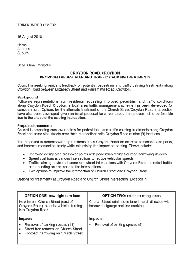
LTC1218 Item 7 Croydon Road, Croydon - Proposed Pedestrian and Traffic Calming treatments. (Leichhardt Ward/Strathfield Electorate/Burwood PAC) 100
LTC1218 Item 8 Croydon Road and Church Street, Croydon - Proposed improvements to intersection. (Leichhardt Ward/Strathfield Electorate/Burwood PAC) 141
LTC1218 Item 9 Lennox Street, Newtown – Proposed Redesign and Upgrade Works at Lennox Street Car Park - Amended Design Plan 6088_A (Stanmore Ward/ Newtown Electorate / Inner West PAC) 160
Parking Matters
ITEM PAGE #
LTC1218 Item 10 31 Fort Street, Petersham - Proposed 'No Parking' and P15 minute 7am-3pm restrictions (Stanmore Ward/Newtown Electorate/Inner West PAC) 168
LTC1218 Item 11 Unnamed Laneway (Rear of Nos.55A-57 Albert Street), Leichhardt - Proposed Extension of 'No Stopping' Zone (Leichhardt Ward/ Balmain Electorate/ Leichhardt LAC) 172
LTC1218 Item 12 James Lane, Balmain East - Proposed Extension of 'No Parking' Restriction (Balmain Ward/ Balmain Electorate/ Leichhardt LAC) 175
LTC1218 Item 13 Silver Street at Unwins Bridge Road, St Peters - Proposed installation of 'No Stopping' restrictions (Marrickville Ward/Heffron Electorate/Inner West LAC) 178
LTC1218 Item 14 Minor Traffic Facilities (All Wards/ All Electorates/ All LACs) 181
LTC1218 Item 15 Tramway Street, Tempe - Proposed 'No Parking' in the cul de sac (Marrickville Ward/Heffron Electorate/ Inner West PAC) 191
LTC1218 Item 16 Holden Street, Ashfield - Proposed relocation of Bus Zone to outside the Ashfield Baptist Church. (Ashfield Ward/Summer Hill Electorate/Burwood PAC) 195
LTC1218 Item 17 Forbes Street, Croydon Park – Introduction of short term parking restrictions (Ashfield Ward / Summer Hill Electorate / Burwood PAC) 198
LTC1218 Item 18 Wharf Road, Birchgrove - Extension of 'No Parking' restrictions (Balmain Ward/ Balmain Electorate/ Leichhardt LAC) 202
Late Items
Nil at time of printing.
Part B - Items for Information Only
Nil at the time of printing.
Part C - Items for General Advice
ITEM PAGE #
LTC1218 Item 19 168 Norton Street, Leichhardt (D/2018/490) - Development Application (Leichhardt Ward/ Balmain Electorate/ Leichhardt LAC) 204
6 General Business
7 Close of Meeting
|
|
Local Traffic Committee Meeting Minutes from 6 November 2018 |
Held at Petersham Service Centre on 6 November 2018
Meeting commenced at 10.05am
ACKNOWLEDGEMENT OF COUNTRY BY CHAIRPERSON
I acknowledge the Gadigal and Wangal people of the Eora nation on whose country we are meeting today, and their elders past and present.
COMMITTEE REPRESENTATIVES PRESENT
|
|
|
|
Clr Victor Macri |
Chair – Deputy Mayor – Marrickville Ward |
|
Bill Holliday |
Representative for Jamie Parker MP, Member for Balmain |
|
Sarina Foulstone |
Representative for Jo Haylen MP, Member for Summer Hill |
|
Sgt Paul Vlachos |
NSW Police – Inner West Police Area Command |
|
SC Sam Tohme |
NSW Police – Burwood Police Area Command |
|
Marina Nestoriadis |
NSW Police – Leichhardt Police Area Command |
|
Ryan Horne |
Roads and Maritime Services |
|
|
|
|
OFFICERS IN ATTENDANCE |
|
|
|
|
|
Peter Whitney |
Transit Systems – Inner West Bus Services |
|
Asith Nagodavithane |
Transit Systems – Inner West Bus Services |
|
Colin Jones |
Inner West Bicycle Coalition |
|
Clr Marghanita da Cruz |
Councillor – Leichhardt Ward |
|
Wal Petschler |
IWC’s Group Manager, Roads, Traffic and Stormwater |
|
John Stephens |
IWC’s Traffic and Transport Services Manager |
|
Manod Wickramasinghe |
IWC’s Coordinator Traffic and Parking Services (North) |
|
Jenny Adams |
IWC’s Engineer – Traffic and Parking Services |
|
Vinoth Srinivasan |
IWC’s Engineer – Traffic and Parking Services |
|
Felicia Lau |
IWC’s Engineer – Traffic and Parking Services |
|
Scipio Tam |
IWC’s Engineer – Traffic and Parking Services |
|
Boris Muha |
IWC’s Engineer – Traffic and Parking Services |
|
Davide Torresan |
IWC’s Civil Engineer |
|
Christina Ip |
IWC’s Business Administration Officer |
|
|
|
|
VISITORS |
|
|
|
|
|
Andrew Akratos |
Item 14 |
|
Tony Franken |
Item 15 |
|
Belinda Mason |
Item 17 |
|
Nicole Sun |
Item 17 |
|
Marion Rae |
Item 17 |
|
John Hart |
Item 17 |
|
Steven Carpenter |
Item 20 |
|
Phillipa Goodrick |
Item 29 |
|
Sara Arthur |
Item 29 |
|
Matina Mottee |
Item 29 |
|
Rene Holmes |
Item 29 |
|
Calum Hutcheson |
Item 31 |
|
Tony Metledge |
Item 31 |
|
|
|
|
APOLOGIES: |
|
|
|
|
|
George Tsaprounis |
IWC’s Coordinator Traffic and Parking Services (South) |
DISCLOSURES OF INTERESTS:
Nil.
CONFIRMATION OF MINUTES
|
The Minutes of the Local Traffic Committee Meeting held on Tuesday, 2 October 2018 were confirmed. |
MATTERS ARISING FROM COUNCIL’S RESOLUTION OF MINUTES
The Local Traffic Committee recommendations of its meeting held on 2 October 2018 were adopted at Council’s meeting held on 30 October 2018.
|
The proposed schedule of the Local Traffic Committee meetings has been prepared for the 2019 calendar year. It is recommended that the proposed meeting schedule be received and noted.
Officer’s Recommendation
THAT the proposed schedule of meetings of the Local Traffic Committee for the 2019 calendar year be received and noted.
DISCUSSION
Council Officers advised that agendas will continue to be released a week before the scheduled meeting.
The Committee members agreed with the Officer’s recommendation.
COMMITTEE RECOMMENDATION
THAT the proposed schedule of meetings of the Local Traffic Committee for the 2019 calendar year be received and noted.
For motion: Unanimous
|
|
LTC1118 Item 28 2019 St Jerome's Laneway Festival - Traffic Management Plan (Balmain Ward/ Balmain Electorate/ Leichhardt LAC) |
|
The proposed event, the St Jerome’s Laneway Festival 2019, is a music festival held annually at Sydney University College of Arts, Rozelle Campus, Callan Park.
Assure Event Safety Services has submitted a Development Application including a Traffic Management Plan for the upcoming “St Jerome’s Laneway Music Festival”, to be held in Callan Park on Sunday, 3 February 2019.
Comments of the Local Traffic Committee will be referred to Council's Development Assessment Section for consideration in determining the Development Application.
Officer’s Recommendation
THAT the report be received and noted.
DISCUSSION
The Committee members agreed with the Officer’s recommendation.
COMMITTEE RECOMMENDATION
THAT the report be received and noted.
For motion: Unanimous
|
|
LTC1118 Item 29 Croydon Road, Croydon - Proposed Pedestrian and Traffic Calming Treatments (Leichhardt Ward / Strathfield Electorate / Burwood PAC) |
|
Council’s at its meeting on the 28 May 2018 adopted the recommendation of the Local Traffic Committee meeting of 1 May 2018 to support in principle to pursue various conceptual traffic facility proposals, for pedestrian and road safety improvements along Croydon Road from Elizabeth Street to Parramatta Road, Croydon, subject to further detail design and resident consultation. The treatments are proposed at intersections in effort to minimise the impact on parking.
This report in turn provides consultation feedback from the community on the various traffic facilities proposed along Croydon Road.
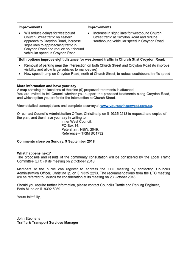
It further entails consultation feedback on two (2) alternate options, of final concept, to modify the existing STOP control to the intersection of Church Street and Croydon Road, in lieu (non-option) of a roundabout. Option 1 involves the inclusion of a right turn lane in Church Street (east), provide ‘No Stopping’ restrictions to the intersection corners and propose a speed hump in Croydon Road, north of Church Street, to improve the operation, visibility and speed control around the intersection. Option 2 involves to maintain the existing physical conditions of the intersection, provide ‘No Stopping’ restrictions to the intersection corners and propose a speed hump in Croydon Road, north of Church Street, to generally improve the visibility and speed control around the intersection. These two options were recommended for further consultation by the Local Traffic Committee at its meeting on the 7 September 2017 and was subsequently adopted by Council at its meeting on the 28 May 2018.
From approximately 2200 consultation letters sent out to the residents of the Croydon/Ashfield area bounded by Parramatta Road to the north, Frederick Street to the east, Elizabeth Street to the south and the Burwood/Inner West Council boundary, 75 submissions were received representing around a 3.5% response rate of overall area surveyed. The majority of residents supported the proposals developed by Council. Residents also indicated their support for option 1 over option 2 in relation to the Church Street and Croydon Road proposal.
It is recommended to proceed to detail design on the various treatments along Croydon Road, with further consultation to be undertaken with the affected residents at each location.
Officer’s Recommendation
THAT:
1. The report be received and noted; 2. The following proposed treatments as listed below be approved in principle subject to detailed design and further consultation with affected residents at each location:
(a) Provide a speed cushion in Croydon Road on the approach to Elizabeth Street (Figure 2-Location 1); (b) Widen the north-west corner of Anthony Street and Croydon Road, provide a refuge facility in Croydon Road south of Anthony Street, and speed cushion in Croydon Road north of Anthony Street (Figure 3-Location 2); (c) Provide kerb-blisters in Edwin Street North at the intersection to Anthony Street (Figure 4-Location 3); (d) Remove the horizontal deflection device and replace it with a pedestrian refuge island facility in Croydon Road between Kenilworth Street and Gregory Avenue, and provide speed cushions in Croydon Road on both approaches to Kenilworth Street and Gregory Avenue (Figure 5- Location 4); (e) Provide a pedestrian refuge in Croydon Road between Ranger Road and John Street, and a 10 metre length double white centreline in John Street at the approach to Croydon Road (Figure 6-Location 5); (f) Provide a pedestrian refuge opening in the splitter island in Croydon Road, north of the roundabout intersection with Church Street, and provide a speed cushion in Croydon Road on the southern end approach to Queen Street (Figure 7-Location 6); (g) Provide a right turn lane with associated ‘No Stopping’ restrictions to the intersection of Croydon Road and Church Street and speed hump/cushion in Croydon Road, north of Church Street (Figure 8A –Location7- Option 1); (h) Provide short length painted double white centre lines in Bay Street at the approach to Croydon Road, and in Croydon Road south of Bay Street (Figure 9-Location 8); (i) Provide a central median island in Dalmar Street at Croydon Road (Figure 10- Location 9); 3. That a pedestrian facility be investigated for Croydon Road near/at its intersection with Church Street separate to the proposed treatment in Item 2 (g) above; 4. The existing ‘No Stopping’ restriction on the western side of Elizabeth Street be extended by 2-3m from 10m to a distance of approx. 12-13m north of Croydon Road; 5. A ‘No Stopping’ restriction on the eastern side of Elizabeth Street be installed at a distance of approx. 12-13m north of Croydon Road; and 6. ‘No Stopping’ restrictions be installed in Anthony Street for a distance of 5 metres west and 7 metres east of the laneway, between Edwin Street and Croydon Road.
DISCUSSION
Public speakers: Phillipa Goodrick, Sara Arthur, Martina Mottee and Rene Holmes attended at 11am.
Ms Arthur stated that she supported the improvements to Croydon Road such as the proposed speed cushions and pedestrian refuges. Ms Arthur commented that:
Ms Holmes made the following comments:
Ms Goodrick, resident of Church Street, stated that the Croydon Road and Church Street intersection has always been dangerous and requested Council reconsider a roundabout at that intersection.
Ms Mottee, resident of Bay Street, stated that traffic in Church Street and Croydon Road is worsening and has become dangerous for pedestrians, especially pedestrians trying to catch buses. Ms Mottee requested Council give more consideration to the issue.
(Ms Goodrick, Ms Arthur, Ms Mottee and Ms Holmes left at 11.12am)
Clr da Cruz stated the following:
Council Officers advised that banning right turns from Church Street into Croydon Road would alter traffic flow and cause traffic diversions elsewhere.
Clr Macri asked if there was a way to maintain the footpath on Church Street and Croydon Road if a right turn lane on Church Street was installed. Council Officers advised that the footpaths need to be reduced to provide space for the right turning path, particularly for larger vehicles.
The representative for the Inner West Bicycle Coalition stated that the Ashfield bike map indicates that Croydon Road and Church Street are major bike routes. Council Officers will arrange for the symbols to be remarked under Council maintenance program.
COMMITTEE RECOMMENDATION
THAT the matter be deferred for reconsideration at next meeting.
For motion: Unanimous
|
|
LTC1118 Item 30 Gordon Lane, Petersham between Sadlier Crescent and Balanaming Lane – Temporary Full Road Closure (Stanmore Ward/Newtown Electorate/Inner West LAC) |
|
SUMMARY
An application has been received from Alert Traffic Control for the temporary full road closure of Gordon Lane, Petersham between Sadlier Crescent and Balanaming Lane, for a period of 10 hours on Thursday, 6 December 2018 between the hours of 7:00am and 5pm, in order to stand a mobile crane to carry out crane lift works. It is recommended that the proposed temporary full road closure be approved, subject to the conditions outlined in this report.
Officer’s Recommendation
THAT the proposed temporary full road closure of Gordon Lane, Petersham between Sadlier Crescent and Balanaming Lane, for a period of 10 hours on Thursday, 6 December 2018 between the hours of 7:00am and 5pm, be APPROVED in order to stand a mobile crane to carry out crane lift works at No.22 Fisher Street, subject to the following conditions:
a) A Road Occupancy License be obtained by the applicant from the Transport Management Centre;
b) All affected residents and businesses, including the NSW Police Local Area Commander, Fire & Rescue NSW and the NSW Ambulance Services be notified in writing, by the applicant, of the proposed temporary road closure at least 7 days in advance of the closure with the applicant making reasonable provision for stakeholders; and
c) The occupation of the road carriageway must not occur until the road has been physically closed.
DISCUSSION
The Committee members agreed with the Officer’s recommendation.
COMMITTEE RECOMMENDATION
THAT the proposed temporary full road closure of Gordon Lane, Petersham between Sadlier Crescent and Balanaming Lane, for a period of 10 hours on Thursday, 6 December 2018 between the hours of 7:00am and 5pm, be APPROVED in order to stand a mobile crane to carry out crane lift works at No.22 Fisher Street, subject to the following conditions:
a) A Road Occupancy License be obtained by the applicant from the Transport Management Centre;
b) All affected residents and businesses, including the NSW Police Local Area Commander, Fire & Rescue NSW and the NSW Ambulance Services be notified in writing, by the applicant, of the proposed temporary road closure at least 7 days in advance of the closure with the applicant making reasonable provision for stakeholders; and
c) The occupation of the road carriageway must not occur until the road has been physically closed.
For motion: Unanimous
|
General Business
ATTACHMENT 1
Garden Street, Marrickville – Long term full road closures
ATTACHMENT 2
Railway Parade, Marrickville – Long term full road closures
ATTACHMENT 3
|
Residents’ Comments |
Officer’s Response |
|
A resident of Queen Street was not in support of the full design. Their concerns included the following: - the loss of parking in front of the Café and the Mechanic; - the lack of consultation with residents since 2016 on the design; - that this was the first time seeing the proposal for realigning the intersection;
They proposed to convert Hardy Street to left turn exit only onto Armstrong Street, and to upgrade the speed humps along Armstrong Street.
They also requested for the parking spots on Armstrong Street to be bay marked.
|
The ‘No Stopping’ distance and geometry of the kerb extension and intersection realignment are the same as endorsed by Council at the April 2016 Council meeting. The only change to the proposal is removing the raised threshold speed hump and providing one speed cushion, which will reduce the noise at this location.
The ‘No Stopping’ parking restrictions have been designed to the minimum requirements in accordance with RMS technical directions for pedestrian refuges, to maintain safe viewing of pedestrians at all times.
During the period of consultation in 2016 all feedback was tabled at the Local Traffic Committee for consideration. The Local Traffic Committee of the former Ashfield Council recommended to proceed with the plan to align the intersection, which was subsequently adopted by Council.
The separate proposal to upgrade the speed humps on Armstrong Street will be forwarded to Council’s Infrastructure Planning team for future investigation for Council’s 4 year Capital Works program. |
ATTACHMENT 4
PUBLIC ENGAGEMENT
A consultation letter was hand delivered on 9 October 2018 to 14 adjoining properties regarding the proposed works at the intersection of Summer Hill and Victoria Street, Lewisham. The consultation period closed on 26 October 2018.
A total of three (3) responses were received; two (2) responses were received against the proposal and one (1) response with additional comments was received in support of the proposal.
|
Residents’ Comments |
Officer’s Response |
|
A resident in Victoria Street was not in support of the proposal for kerb extensions at the intersection.
Instead they have recommended that a ‘Give-Way’ or ‘STOP’ sign with additional linemarking be included in Summer Hill Street at Victoria Street. They have been at the intersection for 30 years and witness cars travelling in the centre of the lane of Summer Hill Street.
|
The resident’s comments have been noted.
The proposal has been endorsed by Council as part of the Lewisham LATM plan which was widely consulted with residents, and has been included as part of Council’s 4 year Capital Works Program for Traffic Facilities. Council supports improving the streetscape through providing additional landscaping and ‘greening’ opportunities, rather than just installing parking signage.
The kerb extensions will reduce the crossing distance for pedestrians instead of having to cross the full width of the roadway, which will improve pedestrian safety.
Due to the low traffic volume and nil-accident history at the intersection, is it currently not recommended to include any additional centerline or ‘Give-Way’ linemarking at the intersection.
|
|
A resident of Victoria Street was in support of the proposal for additional ‘No Stopping’ signs and the upgrade to roadway and footpath at the intersection.
However they were not in support of the landscaped kerb extensions as they will not be adequately maintained.
|
The resident’s comments have been noted. This landscaped facility will be included as part of Council’s rolling maintenance program. Any maintenance can be referred to Council via email or phone calls to be investigated and taken care of.
Additionally there are a number of landscaped footpath pits around the intersection that are being maintained by the residents as part of Council’s sustainable streets program. |
|
A resident in Victoria Street was not in support of the proposal however requested that resident parking restrictions be implemented in Victoria Street. They are concerned about the limited parking available near their house as a result of the increased development along Old Canterbury Road. |
The resident’s comments have been noted. However, a separate process is required and cannot be implemented as part of these traffic calming improvements.
A member of the traffic team will contact the resident to discuss their application for resident parking restrictions.
|
ATTACHMENT 5

|
|
Local Traffic Committee Meeting 4 December 2018 |
Subject: Draft Newtown Local Area Traffic Management Strategy (Stanmore Ward/Newtown Electorate/Inner West PAC)
Prepared By: Sunny Jo - Traffic and Parking Planner
Authorised By: John Stephens - Traffic and Transport Services Manager
|
SUMMARY The draft Newtown Local Area Traffic Management (LATM) study and recommendations are attached for the Committee’s consideration. |
|
RECOMMENDATION
THAT:
1. The Committee endorse the draft Newtown LATM study and the recommended treatments for community consultation; and
2. The draft report be placed on Public Exhibition, providing a minimum 28 days for submissions. |
BACKGROUND
The Inner West Community Strategic Plan (CSP) ‘Our Inner West 2036’ endorsed in June 2018 provides the following outcomes and strategies for the future of Inner West.
|
CSP Outcomes |
Strategies |
|
2.6 People are walking, cycling and moving around Inner West with ease |
1. Deliver integrated networks and infrastructure for transport and active travel 2. Pursue innovation in planning and providing new transport options 3. Ensure transport infrastructure is safe, connected and well maintained |
The Newtown Local Area Traffic Management (LATM) study and plan achieves these outcomes by reviewing existing traffic measures in place, including road safety, transport and traffic management.
The objective of the study is to investigate and review the performance of the existing LATM scheme and recommend proposed works. The Newtown LATM study was originally completed in 1986 and first reviewed in 2004.
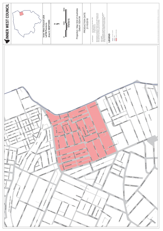
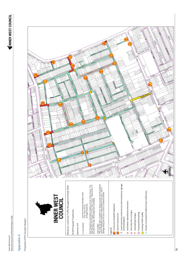
As shown in Attachment 1, the study area is bounded by Enmore Road, King Street, Alice Street and Edgeware Road.
Due to the size of the LATM report, only summary and recommendations are attached. The full report including all appendices can be accessed through Council’s website
https://yoursay.innerwest.nsw.gov.au/36644/documents/93454
![]() OTHER STAFF COMMENTS
OTHER STAFF COMMENTS
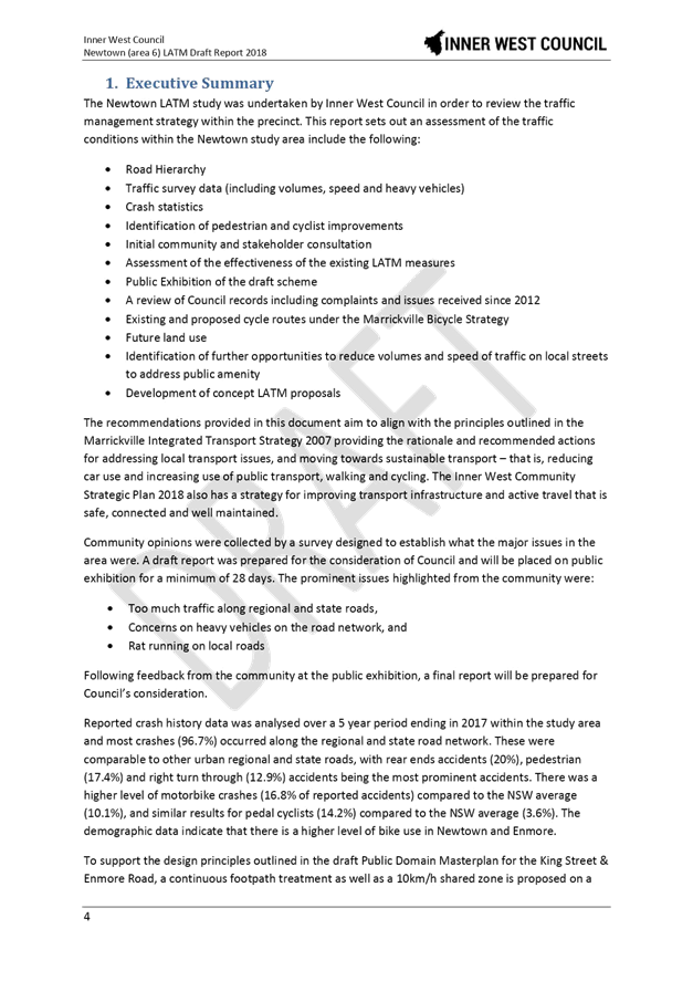
The Newtown LATM strategy was undertaken in order to review the traffic management strategy within the precinct. The LATM assessed the traffic conditions within the study area as follows:
· Assessment of the traffic volumes, heavy vehicle percentages and vehicle speeds based on the traffic survey results;
· Identification of the locations where not satisfying with Environmental Performance criteria;
· Analysis of the accident statistics for the 5 year period from July 2012 to June 2017;
· Review of the community’s complaints and concerns raised in the community questionnaire in relation to traffic and safety issues;
· Review of intersection performance;
· Assessment of the effectiveness of the existing LATM measures and ensure they are compliant to the up-to-date standard;
· Identification of further opportunities to reduce through traffic volumes and speed of traffic on local streets to address public amenity;
· Identification of pedestrian and cyclist improvements; and
· Development of conceptual LATM proposal options.
The recommendations aim to align with the Inner West CSP and the former Marrickville Integrated Transport Strategy (ITS) for an integrated planning and urban design using a holistic approach to infrastructure project planning. The ITS provides a framework which provides the rationale and recommended actions for addressing local transport issues and moving Inner West toward sustainable transport, reducing car use and increasing use of public transport, walking and cycling.
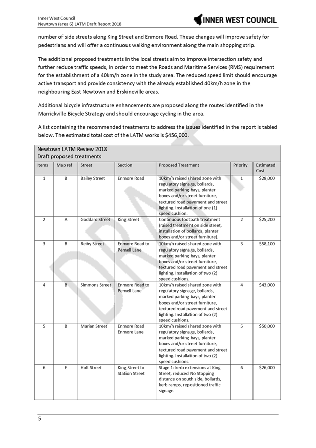
The study found that local streets in general had a low accident history and favourable traffic speeds. Some truck movements through local streets and rat running issues were identified and discussed in the report. The proposed treatments in the LATM report are put forward to address these issues.
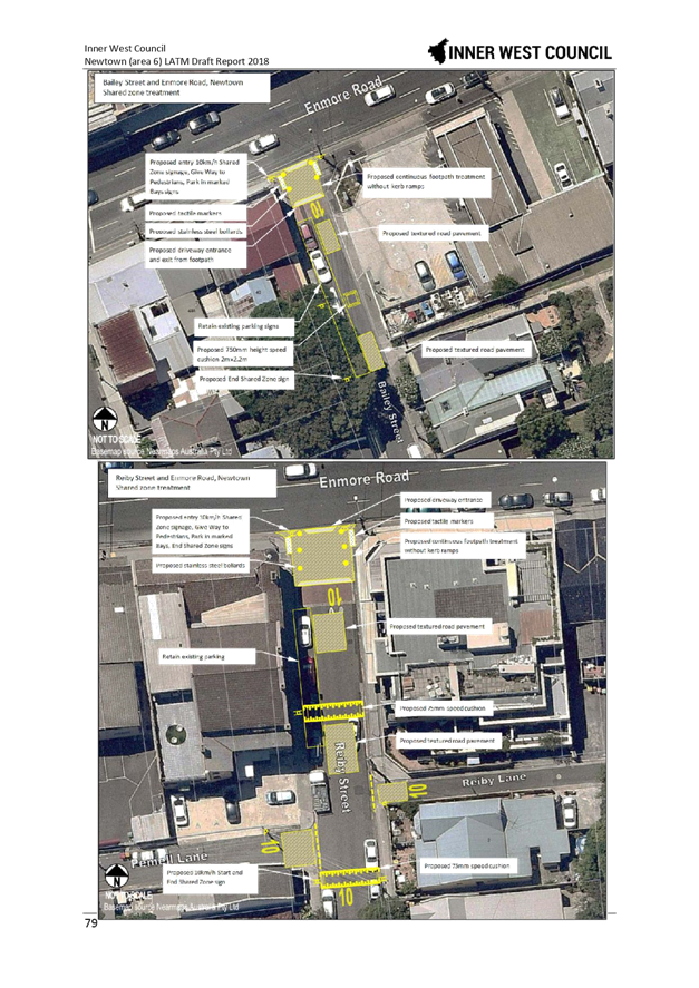
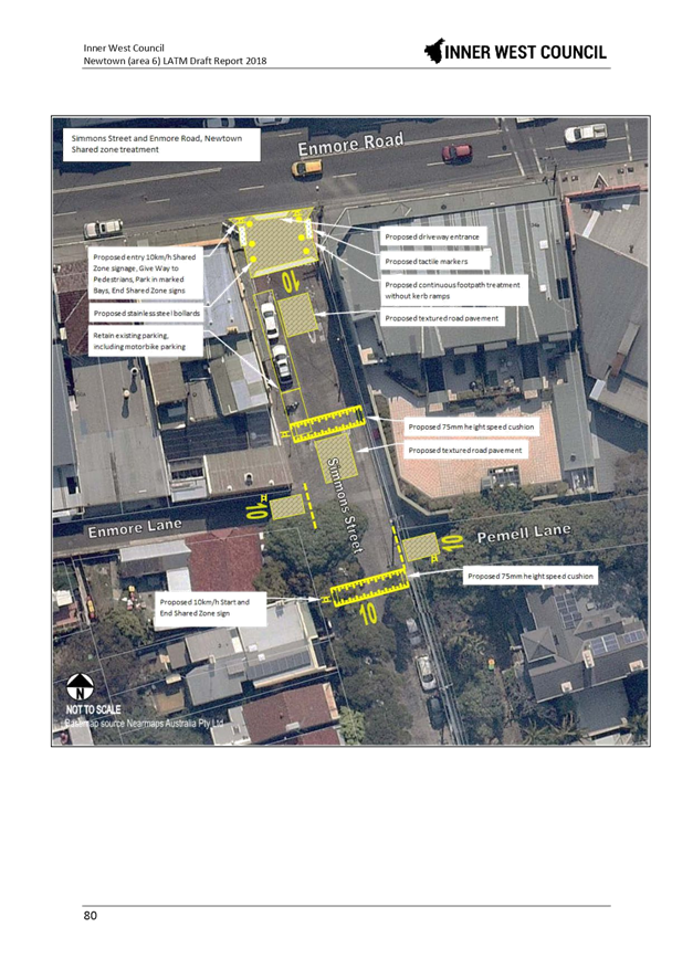
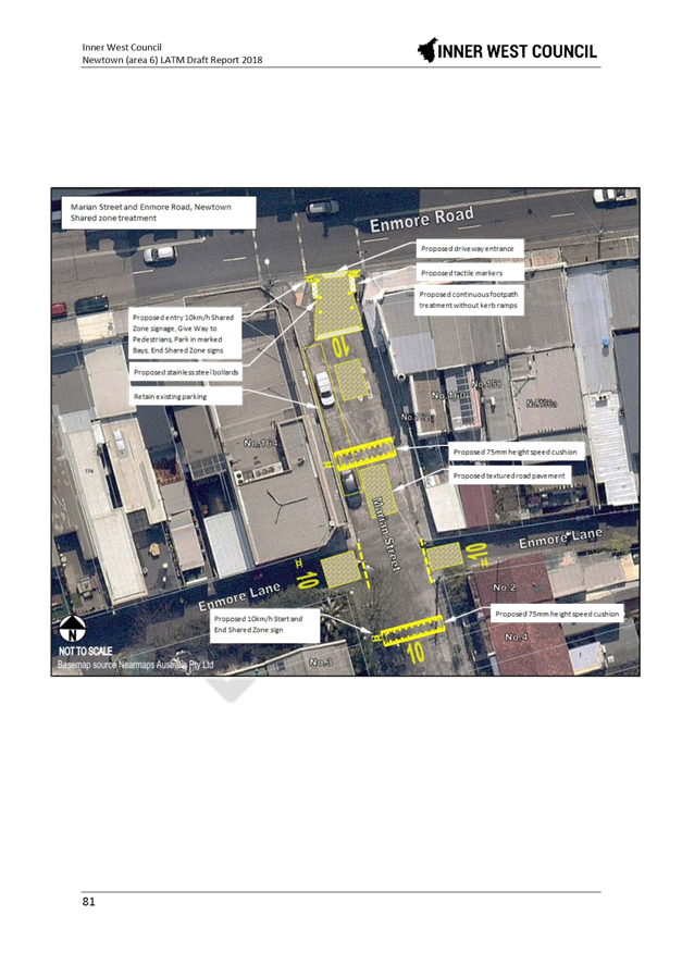
To support the design principles outlined in the draft Newtown Public Domain Masterplan, a continuous footpath treatment as well as a 10km/h Shared Zone is proposed on a number of side streets along King Street and Enmore Road. These changes will improve safety for pedestrians and will offer a continuous walking environment along the main shopping strip.
The additional proposed treatments in the local streets aim to improve intersection safety and further reduce traffic speeds in order to meet the Roads and Maritime Services (RMS) requirement for the establishment of a 40km/h zone in the study area. The reduced speed limit should encourage walking and cycling and provide consistency with the already established 40km/h zone in the neighbouring East Newtown and Erskineville areas.
Additional bicycle infrastructure enhancements are proposed along the routes identified in the Marrickville Bicycle Strategy and should strengthen cycling in the area.
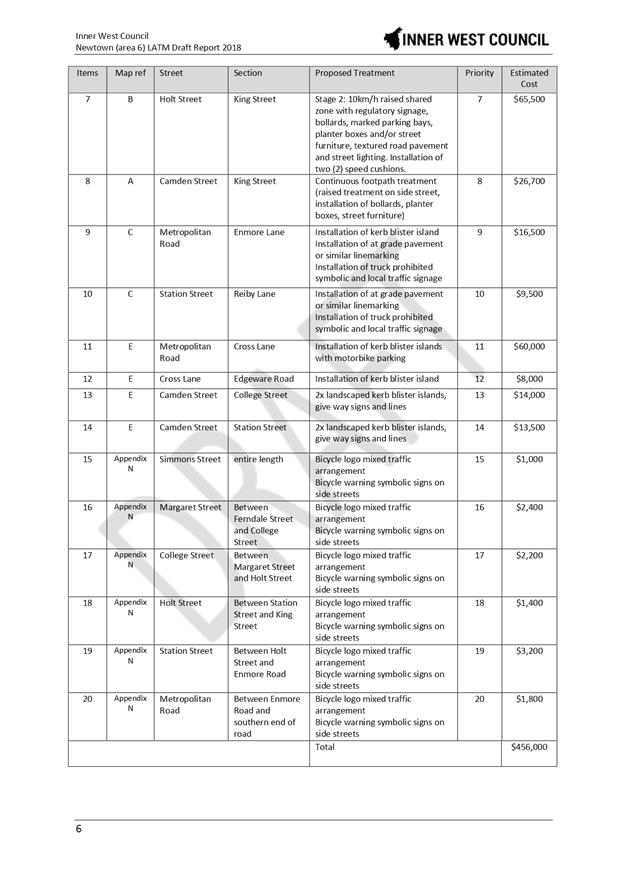
A list containing the recommended treatments to address the issues identified in the report is tabled below. The estimated total cost of the LATM works is $456,000 and if supported would be implemented in stages, subject to eligible funding and grant provisions.
PUBLIC ENGAGEMENT
Council undertook a survey through Council’s YourSay website in June and July 2018 with over 3,300 invitation letters posted out to stakeholders. Consultation ended with 243 surveys submitted to Council, and 485 visits to the study website.
Two internal workshops were held in July and September 2018 with staff from across Council.
FINANCIAL IMPLICATIONS
The total cost as listed in the draft proposed treatments is $456,000 with the shared zones component estimated to be $296,500. Once the LATM study is adopted, detailed design and construction would be undertaken in stages as prioritised commencing from 2019/2020 year.
CONCLUSION
The Newtown LATM strategy has embraced integration opportunities and multifunctional infrastructure. Concept plans from the report are provided in Attachment 3 and the Executive Summary and List of Proposed Treatments are provided in Attachment 2.
|
1.⇩ |
Newtown LATM Study Area Map |
|
2.⇩ |
Newtown LATM Study Executive Summary and List of Proposed Treatments |
|
3.⇩ |
Appendix G: Concept Plans |
|
Local Traffic Committee Meeting 4 December 2018 |
Subject: Draft Newington Local Area Traffic Management Strategy (Stanmore Ward/Newtown Electorate/Inner West PAC)
Prepared By: Sunny Jo - Traffic and Parking Planner
Authorised By: John Stephens - Traffic and Transport Services Manager
|
SUMMARY The draft Newington Local Area Traffic Management (LATM) study and recommendations are provided for the Committee’s consideration. Amongst the options listed in the report, it is recommended that Council progress with implementing treatments, mainly the raised thresholds for a 50km/h environment and a number of other treatments. |
|
RECOMMENDATION
THAT:
1. The Committee endorse the draft Newington LATM study and the following treatments for community consultation:
a. Raised threshold in Albert Street near Marr Playground;
b. Two raised thresholds in Bright Street near No.26 and No.6 Bright
Street; c. Change of priority at the intersection of Tupper Street and Newington Road, including removal of existing speed hump near No.36 Newington Road and No Parking 7am-7pm Mon-Fri opposite Tupper Street in Newington Street;
d. Pedestrian refuge island in Addison Road between Denby and
Philpott Streets; e. Implementation of mixed traffic bicycle facilities within the
study area; and f. Changes at signalised intersections at Enmore Road/Llewelyn Street, Enmore Road/Addison Road and Addison Road/Agar Street/Illawarra Road. 2. The draft report be placed on Public Exhibition, providing a minimum 28 days for submissions.
|
BACKGROUND
The Inner West Community Strategic Plan (CSP) ‘Our Inner West 2036’ endorsed in June 2018 provides the following outcomes and strategies for the future of Inner West.
|
CSP Outcomes |
Strategies |
|
2.6 People are walking, cycling and moving around Inner West with ease |
1. Deliver integrated networks and infrastructure for transport and active travel 2. Pursue innovation in planning and providing new transport options 3. Ensure transport infrastructure is safe, connected and well maintained |
The Newington Local Area Traffic Management (LATM) study and plan achieves these outcomes by reviewing existing traffic measures in place, including road safety, transport and traffic management.
The objective of the study is to investigate and review the performance of the existing LATM scheme and recommend proposed works. The Newington LATM study was originally completed in 1993 and first reviewed in 2004.
As shown in the attached map, the study area is bounded by Stanmore Road, Enmore Road, Addison Street and Livingstone Road.
Due to the size of the LATM report, only summary and recommendations are attached. The full report including all appendices can be accessed through Council’s website
https://yoursay.innerwest.nsw.gov.au/35472/documents/93453
OTHER STAFF COMMENTS
The Newington LATM strategy was undertaken in order to review the traffic management strategy within the precinct. The LATM assessed the traffic conditions within the study area as follows:
· Assessment of the traffic volumes, heavy vehicle percentages and vehicle speeds based on the traffic survey results;
· Identification of the locations where not satisfying with Environmental Performance criteria;
· Analysis of the accident statistics for the 5 year period from July 2012 to June 2017;
· Review of the community’s complaints and concerns raised in the community questionnaire in relation to traffic and safety issues;
· Review of intersection performance;
· Assessment of the effectiveness of the existing LATM measures and ensure them compliant to the up-to-date standard;
· Identification of further opportunities to reduce through traffic volumes and speed of traffic on local streets to address public amenity;
· Identification of pedestrian and cyclist improvements; and
· Development of conceptual LATM proposal options.
The recommendations aim to align with the Inner West CSP and the former Marrickville Integrated Transport Strategy (ITS) for an integrated streetscape and footpath program that takes a more holistic approach to infrastructure project planning. The ITS provides a framework which provides the rationale and recommended actions for addressing local transport issues and moving Inner West toward sustainable transport, reducing car use and increasing use of public transport, walking and cycling.
The report found that most local streets in the study area were considered acceptable for a 50km/h local speed environment, with raised thresholds being proposed at three locations. Furthermore an additional 40km/h treatment option was identified along the local streets in the study area including a change to the speed limit to 40km/h, subject to RMS approval. The 40km/h option will require a series of speed humps (14 in total) in seven (7) local streets to further lower prevailing speeds, in order to meet RMS requirements for a self-enforcing traffic environment. As there was no adverse community concern on traffic speeds on local streets shown during the initial survey and previous Council records, it was recommended to progress with the 50km/h treatment option only and the 40km/h treatments retained for consideration in the next LATM review in this precinct.
To address resident concerns raised at a resident group presentation, a change in road priority is proposed at the intersection of Tupper Street and Newington Road which should improve traffic flow through the intersection, in particular during the peak hours.
Kerb extensions are proposed at six (6) locations along Addison Road and one location in Enmore Road to improve pedestrian safety; however, it is noted that this option will create a pinch point for the existing on-road cycle route in Addison Road and this option should be further explored in conjunction with the public domain works planned for this area.
The study identified a need to provide a pedestrian crossing facility in Addison Road between Denby and Philpott Streets, and a pedestrian refuge island was proposed at this location.
Changes to traffic signal operations are proposed for Enmore Road/Llewelyn Street, Enmore Road/Addison Road and Addison Road/Agar Street/Illawarra Road intersections. At two sites it is proposed to change from an existing filter right turn to a protected right turn phase, and a recommendation to enforce illegal right turning movements. These intersections have been modelled using SIDRA and further details are found in the LATM report. As traffic signal operations are under the jurisdiction of Roads and Maritime Services (RMS), it is recommended that these proposals should be forwarded to RMS for its investigation and consideration for safety improvements in the future.
PUBLIC CONSULTATION
Council undertook community engagement through Council’s YourSay website in April and May 2018 with invitation letters mailed out to stakeholders and residents within the study area. Consultation ended with 112 responses and a total of 357 visits to the website, which reflect a 4-5% response rate. The results of the survey were analysed and presented in the draft report.
The study included a resident presentation and feedback session on 20 and 21 August 2018, which included an invitation letter to the community on the proposed 40km/h and speed humps proposal. Attendances on the two face to face sessions were very low with 4 different attendees on both events; however, attendees raised relevant local traffic issues helpful to the LATM study.
Three internal workshops were held in throughout the project with staff from across Council.
FINANCIAL IMPLICATIONS
The Newington LATM identified works totaling $64,645 for the 50km/h scheme work in Albert Street, Bright Street and Newington Road/Tupper Street intersection works. The implementation works are planned to be delivered in the 2021/2022 financial year, subject to approval of the final scheme and budget funding.
CONCLUSION
The Newington LATM Strategy will make transport and traffic improvements to the study area and will further support walking and cycling in the area. Attachment 2 contains a summary of recommendations and concept plans from the study.
|
1.⇩ |
Newington LATM Study Area Map |
|
2.⇩ |
Summary of Recommendations and Concept Plans |
|
3.⇩ |
Executive Summary Newington LATM Study |
|
Local Traffic Committee Meeting 4 December 2018 |
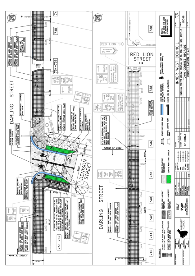
Subject: Darling Street at Denison Street, Rozelle - Intersection Improvements - Design Plan 10046 (Balmain Ward/ Balmain Electorate/ Leichhardt LAC)
Prepared By: Vinoth Srinivasan - Engineer - Traffic and Parking Services
Authorised By: John Stephens - Traffic and Transport Services Manager
|
SUMMARY Design plans have been prepared for the proposed footpath works on the southern side of Darling Street (between Red Lion Street and Denison Street) and for intersection improvements at the intersection of Darling Street and Denison Street, Rozelle. The works will improve road safety for pedestrians and motorists and is part of the Town Centre Upgrade Capital Works Program.
Consultation has been undertaken with owners and occupiers of affected properties in Darling Street, Rozelle regarding the proposal. It is recommended that the proposed detailed design plan be approved (Design Plan – 10046). |
|
RECOMMENDATION
THAT the detailed design plan for intersection improvements, including removing an existing concrete median in Denison Street and installing new line markings at the intersection of Darling Street and Denison Street, Rozelle (as per Design Plan No. 10046) be approved.
|
BACKGROUND
Design plans have been prepared for the proposed intersection improvements at the intersection of Darling Street and Denison Street and a new footpath on the southern side of Darling Street (between Red Lion Street and Denison Street). The proposed project is part of the Town Centre Upgrade Capital Works Program.
The design plan has been finalised for the proposed works and public notification of the works went out for consultation in October 2018. The design plan is presented in this report for consideration and approval.
FINANCIAL IMPLICATIONS
The reconstruction of new footpaths and intersection treatments will be implemented in this financial year, 2018/19 subject to final funding allocations. The estimated cost of the project is $211,000. The assigned budget is $214,000.
OTHER STAFF COMMENTS
Darling Street between Red Lion Street and Denison Street is a classified State Road. The carriageway is approximately 12.5 metres wide and it is a two-way road with one travel lane in each direction in addition to kerbside parking on either side of the road.
Denison Street is a 9.7 metre wide Local Road with kerbside parking lanes on either side of the street. The width of Denison Street narrows to 7.3 metres at the existing entry treatment close to the intersection of Darling Street.
This section of Denison Street carries approximately 2,000 vehicles per day and there has been only one (1) reported collision at the intersection in the current 5 year reported crash data.
Design Plan No. 10046
Detailed design plans for the the intersection improvements at the intersection of Darling Street and Denison Street and a new footpath on the southern side of Darling Street (between Red Lion Street and Denison Street) (ATTACHMENT – Design Plan No. 10046) are submitted for consideration.
The proposed scope of work includes the following:
· Remove existing footpath and construct new footpath of pavers, concrete and asphalt
· Reconstruct existing kerb ramps and remove redundant kerb ramp
· Construct new landscape gardens in the footpath at the intersection of Darling Street and Denison Street
· Re-lay new concrete kerb and gutter
· Reduce existing at grade paved entry treatment (from 5.9m to 5.0m in length), resurface the road surface and re-install road markings
· Remove existing concrete median on paved entry treatment in Denison Street
· Repair any damaged existing private stormwater lines leading from property (between the front boundary and gutter) within the area of work
This proposal will not result in the loss of any on-street parking spaces. Please refer to the attached plan for more details.
Note, the low warrant (up to 45 vehicles per hour) for a continuous footpath is not met for this intersection due to higher traffic volumes.
PUBLIC CONSULTATION
Consultation was conducted between 22 October 2018 and 5 November 2018. A letter as well as a copy of the design plan was sent to the businesses and local residents in Darling Street, Rozelle. A total of 57 letters were distributed (as indicated in the below plan).
No responses were submitted to Council.
CONCLUSION
It is recommended that the detailed design plan for intersection improvements, including removing an existing concrete median in Denison Street and installing new line markings at the intersection of Darling Street and Denison Street, Rozelle (as per Design Plan No. 10046) be approved.
|
1.⇩ |
Detailed design plan |
|
|
Local Traffic Committee Meeting 4 December 2018 |
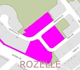
Subject: Warayama Place and Yara Avenue, Rozelle - Proposed 'No Stopping' Restrictions (Balmain Ward/ Balmain Electorate/ Leichhardt LAC)
Prepared By: David Yu - Engineer - Traffic and Parking Services
Authorised By: John Stephens - Traffic and Transport Services Manager
|
SUMMARY Council has received a request to signpost a ‘No Stopping’ restriction on the eastern side of Yara Avenue south of Warayama Place, Rozelle in order to prevent illegal parking and improve sight lines. |
|
RECOMMENDATION
THAT a 12m ‘No Stopping’ zone be installed on the eastern side of Yara Avenue, south of Warayama Place, Rozelle. |
BACKGROUND
Concerns have been raised by residents regarding vehicles parking on the eastern side of Yara Avenue too close to the intersection of Warayama Place, Rozelle.
This illegal parking behaviour obstructs sight lines as well as access out of Yara Avenue.
It should be noted that the parking on the western side of Yara Avenue is indented and Yara Avenue is one-way between Margaret Street and Warayama Place.
FINANCIAL IMPLICATIONS
Nil.
OTHER STAFF COMMENTS
In order to alleviate the sight visibility and manoeuvring space issues, it is proposed to signpost a 12m ‘No Stopping’ zone on the eastern side of Yara Avenue, south of Warayama Place, Rozelle.
The proposal is shown on the following plan:
PUBLIC CONSULTATION
|
A letter outlining the above proposal was mailed out to the affected properties (142 properties) in Warayama Place and Yara Avenue, Rozelle. Three (3) responses were received, all in support of the proposal.
|
|
|
Residents’ Comments |
Officer Comments |
|
As a resident of Warayama Place, I strongly support the proposed ‘No Stopping’ restriction at the intersection of Yara Avenue and Warayama Place.
|
It should be noted that Council is currently investigating the feasibility of parking restrictions in the area.
In regards to Resident Parking Schemes (RPS), it should be noted that multi-unit dwellings and the strata subdivision of residential flat buildings approved after January 2001 are not allowed to participate in a RPS as off-street parking should be provided in accordance with Council’s parking DCP. |
|
I am a resident of Warayama Place Rozelle and I agree with the proposed placement of a ‘No Stopping’ sign near the corner of Yara Avenue and Warayama Place, Rozelle. |
Noted. |
CONCLUSION
Nil.
|
|
Local Traffic Committee Meeting 4 December 2018 |
Subject: Ash Lane at Wolseley Street and Northcote Street, Haberfield - Proposed 'No Stopping' Restrictions (Leichhardt Ward/ Summer Hill Electorate/ Burwood PAC)
Prepared By: David Yu - Engineer - Traffic and Parking Services
Authorised By: John Stephens - Traffic and Transport Services Manager
|
SUMMARY Council has received a request to signpost the statutory ‘No Stopping’ restriction at the intersections of Ash Lane/Wolseley Street and Ash Lane/Northcote Street, Haberfield, in order to prevent illegal parking and improve sight lines. |
|
RECOMMENDATION
THAT:
1. A 10m ‘No Stopping’ zone be installed on the western side of Ash Lane, south of Wolseley Street, Haberfield;
2. A 10m ‘No Stopping’ zone be installed on the western side of Ash Lane, north of Northcote Street, Haberfield; and
3. A 10m ‘No Stopping’ zone be installed on the western side of Ash Lane, south of Northcote Street, Haberfield.
|
BACKGROUND
Concerns have been raised by residents regarding vehicles parking too close to the intersections of Ash Lane/Wolseley Street and Ash Lane/Northcote Street, Haberfield.
This illegal parking behaviour obstructs sight lines as well as access into and out of Ash Lane. It should be noted that there is unrestricted parking on both sides of Ash Lane.
FINANCIAL IMPLICATIONS
Nil.
OTHER STAFF COMMENTS
In order to alleviate the sight visibility and manoeuvring space issues, it is proposed to signpost the statutory ‘No Stopping’ zones at the following locations:
· The western side of Ash Lane, south of Wolseley Street (10m ‘No Stopping’ zones).
· The western side of Ash Lane, north of Northcote Street (10m ‘No Stopping’ zone).
· The western side of Ash Lane, south of Northcote Street (10m ‘No Stopping’ zone).
The proposal is shown on the following plan:
PUBLIC CONSULTATION
|
A letter outlining the above proposal was mailed out to the affected properties (22 properties) in Wolseley Street and Northcote Street, Haberfield. One response was received, in support of the proposal.
|
|
CONCLUSION
Nil.
|
|
Local Traffic Committee Meeting 4 December 2018 |
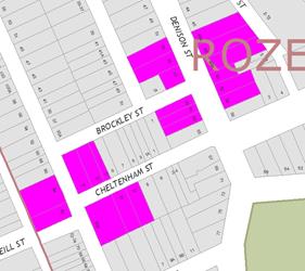
Subject: Cheltenham Street at Foucart Street and Brockley Street at Denison Street, Rozelle - Proposed 'No Stopping' Restrictions (Balmain Ward/ Balmain Electorate/ Leichhardt LAC)
Prepared By: David Yu - Engineer - Traffic and Parking Services
Authorised By: John Stephens - Traffic and Transport Services Manager
|
SUMMARY Council has received a request to signpost the statutory ‘No Stopping’ restrictions at the intersections of Cheltenham Street/Foucart Street and Denison Street/Brockley Street, Rozelle, in order to prevent illegal parking and improve sight lines. |
|
RECOMMENDATION
THAT:
1. A 10m ‘No Stopping’ zone be installed on the southern side of Cheltenham Street, east of Foucart Street, Rozelle; and
2. 10m ‘No Stopping’ zones be installed on the western side of Denison Street, north and south of Brockley Street, Rozelle;
|
BACKGROUND
Concerns have been raised by residents regarding vehicles parking too close to the intersections of Cheltenham Street/Foucart Street and Denison Street/Brockley Street, Rozelle.
This illegal parking behaviour obstructs sight lines as well as access into and out of Cheltenham Street and Brockley Street.
Brockley Street and Cheltenham Street are one way pairs, Cheltenham Street operates one-way westbound between Denison Street and Foucart Street whilst Brockley Street operates one-way eastbound between Foucart Street and Denison Street.
It should be noted that there is an existing ‘No Stopping’ zone on the northern side of Cheltenham Street, east of Foucart Street. There are also existing ‘No Stopping’ zones on the northern and southern sides of Brockley Street, west of Denison Street.
FINANCIAL IMPLICATIONS
Nil.
OTHER STAFF COMMENTS
In order to alleviate the sight visibility and manoeuvring space issues, it is proposed to signpost the statutory ‘No Stopping’ zones at the following locations:
· The southern side of Cheltenham Street, east of Foucart Street (10m ‘No Stopping’ zones).
· The western side of Denison Street, north of Brockley Street (10m ‘No Stopping’ zone).
· The western side of Denison Street, south of Brockley Street (10m ‘No Stopping’ zone).
The proposal is shown on the following plan:
Note, the section of Foucart Street between Easton Street and Brockley Street is too narrow for parking on both sides of the street. There is currently only parking on the western side and therefore ‘No Stopping’ zones are not required on the eastern side of Foucart Street, north and south of Cheltenham Street.
PUBLIC CONSULTATION
|
A letter outlining the above proposal was mailed out to the affected properties (29 properties) in Foucart Street, Denison Street, and Cheltenham Street. Five responses was received, four in support and one in objection to the proposal.
|
|
|
Residents’ Comments |
Officer Comments |
|
I support the proposal. However, I would request that it be extended to implement time restricted parking along Denison Street (south of Evans Street to Lilyfield Road). Currently, the unrestricted parking along the previously mentioned section of Denison Street presents significant difficulties in relation to resident parking availability. |
Council requires a minimum of three residents from the street requesting Resident Parking scheme (RPS) to trigger investigation of a scheme. The request will be considered as one out of the three requests for a Resident Parking Scheme in Denison Street (between Evans Street and Lilyfield Road). |
|
This is a well needed proposal. Pulling out of Brockley Street onto Denison Street can at the moment be very dangerous.
|
The proposed 'No Stopping' restrictions are intended to improve sight distance and manoeuvring at the subject intersection.
The intersection of Denison Street and Alfred Street can be investigated separately.
|
|
The ‘No Stopping’ zones in Denison at the Brockley Street intersection are vital as for sight lines. The north eastern side of Denison Street at Alfred Street is also a blind spot. |
|
|
Parking is difficult in Denison Street. Line-marking will achieve the aim of ensuring vehicles do not encroach on the intersection with council enforcement. ‘No Stopping’ signage is not required and 10 metres is excessive for line of sight. |
It is illegal to park within 10 metres of an intersection without traffic lights, unless a parking control sign applies indicating that the driver is permitted to park.
The ‘No Stopping’ zones provide improved safety for pedestrians and drivers. |
|
Despite the fact it removes another 2 car parking spaces from an already unbelievably congested car parking area, I agree with your proposal.
The current 20km/h sign in Denison Street does not slow down traffic. What can be done to help reduce traffic volumes/ speeding in Denison Street. |
The proposed 'No Stopping' restrictions are intended to improve sight distance and manoeuvring at the subject intersection.
Denison Street has a 50km/h restriction. There is an advisory speed (25km/h) sign at the speed hump in Denison Street. Previous traffic surveys of Denison Street have indicated speed levels were acceptable. |
CONCLUSION
Nil.
|
|
Local Traffic Committee Meeting 4 December 2018 |
Subject: Croydon Road, Croydon - Proposed Pedestrian and Traffic Calming treatments. (Leichhardt Ward/Strathfield Electorate/Burwood PAC)
Prepared By: Boris Muha - Engineer – Traffic and Parking Services
Authorised By: John Stephens - Traffic and Transport Services Manager
|
SUMMARY The Traffic Committee at its meeting held on 6 November 2018 deferred an item on the ‘Proposed pedestrian and traffic calming treatments’ along Croydon Road, Croydon (inclusive of proposed improvements to the intersection of Church Street and Croydon Road) for further investigation.
Council’s at its meeting on the 22 May 2018 adopted the recommendation of the Local Traffic Committee meeting of 1 May 2018 to support in principle to pursue various conceptual traffic facility proposals, for pedestrian and road safety improvements along Croydon Road from Elizabeth Street to Parramatta Road, Croydon, subject to further detail design and resident consultation. The treatments are proposed at intersections in effort to minimise the impact on parking.
This report provides consultation feedback from the community on the various traffic facilities proposed along Croydon Road, exclusive of the proposed improvement works at the intersection of Croydon Road and Church Street which is being reported separately to the Committee.
In relation to this report, from approximately 2200 consultation letters sent out to the residents of the Croydon/Ashfield area bounded by Parramatta Road to the north, Frederick Street to the east, Elizabeth Street to the south and the Burwood/Inner West Council boundary, 75 submissions were received representing around a 3.5% response rate of overall area surveyed. The majority of residents supported the proposals developed by Council under this report.
It is recommended to proceed to detail design on the various treatments along Croydon Road, with further consultation to be undertaken with the affected residents at each location.
|
|
RECOMMENDATION
THAT:
1. The report be received and noted;
2. The following proposed treatments as listed below be approved in principle subject to detailed design and further consultation with affected residents at each location:
a) Provide a speed cushion in Croydon Road on the approach to Elizabeth Street (Figure 2-Location 1);
b) Widen the north-west corner of Anthony Street and Croydon Road, provide a refuge facility in Croydon Road south of Anthony Street, and speed cushion in Croydon Road north of Anthony Street (Figure 3-Location 2);
c) Provide kerb-blisters in Edwin Street North at the intersection to Anthony Street (Figure 4-Location 3);
d) Remove the horizontal deflection device and replace it with a pedestrian refuge island facility in Croydon Road between Kenilworth Street and Gregory Avenue, and provide speed cushions in Croydon Road on both approaches to Kenilworth Street and Gregory Avenue (Figure 5- Location 4);
e) Provide a pedestrian refuge in Croydon Road between Ranger Road and John Street, and a 10 metre length double white centreline in John Street at the approach to Croydon Road (Figure 6-Location 5);
f) Provide a pedestrian refuge opening in the splitter island in Croydon Road, north of the roundabout intersection with Church Street, and provide a speed cushion in Croydon Road on the southern end approach to Queen Street (Figure 7-Location 6);
g) Provide short length painted double white centre lines in Bay Street at the approach to Croydon Road, and in Croydon Road south of Bay Street (Figure 8-Location 8); and
h) Provide a central median island in Dalmar Street at Croydon Road (Figure 9- Location 9);
3. The existing ‘No Stopping’ restriction on the western side of Elizabeth Street be extended by 2-3m from 10m to a distance of approx. 12-13m north of Croydon Road;
4. A ‘No Stopping’ restriction on the eastern side of Elizabeth Street be installed at a distance of approx. 12-13m north of Croydon Road; and
5. ‘No Stopping’ restrictions be installed in Anthony Street for a distance of 5 metres west and 7 metres east of the laneway, between Edwin Street and Croydon Road.
|
BACKGROUND
The Traffic Committee report of 1 May 2018 was provided in update to a response to a Council resolution dealing with a Notice of Motion C1017 Item 14 – Pedestrian safety on Croydon Road, Croydon at the Council meeting on 12 October 2017, and subsequent to an on-site meeting with residents conducted on 7 December 2017. This report can be viewed and downloaded from the council website link https://innerwest.infocouncil.biz/
The Traffic Committee report of 1 May 2018 (in summary) evaluated traffic survey data collected on speeding, vehicle volumes, pedestrian vs volume counts (for pedestrian crossing warrants), accidents, and examined, if required, measures to improve the safety of school children, pedestrians and motorists along Croydon Road.
The analysis of results apart from traffic volumes, showed speeding and accidents (in the last five years) to be low along Croydon Road. Pedestrian numbers crossing at various locations along Croydon Road and side streets to Croydon Road were below that required to warrant a pedestrian crossing. No pedestrian accidents have occurred along Croydon Road in the last five years. As an outcome of the data collection and analysis of the data, the results did not normally support additional traffic calming measures and major pedestrian facility works in the area, at the present moment, with the exception to only place a speed hump device in Croydon Road, north of Church Street.
However, it was considered that providing pedestrian cross over points along Croydon Road would be beneficial to enhance pedestrian safety and provide a link to destinations either side of Croydon Road. With reference made to the Ashfield Pedestrian Access and Mobility Plan (PAMP) and the Former Ashfield Local Government Area Traffic Management Strategy (ATMS), conceptual (major) traffic facility works (inclusive of pedestrian and traffic calming improvements) were recommended. Support in principal was sought for these proposals, subject to detailed design investigation and resident consultation.
Council at its meeting on the 22 May 2018 resolved to adopt the recommendation of the Local Traffic Committee on the 1 May 2018 as follows:
THAT:
1. The report be received and noted;
2. That support in principal be granted for Council to pursue the following conceptual traffic facility proposals, subject to further detail design and resident consultation:
(a) Provide a speed cushion in Croydon Road on the approach to Elizabeth Street;
(b) Widen the north-west corner of Anthony Street and Croydon Road, provide a refuge facility in Croydon Road south of Anthony Street, and speed cushion in Croydon Road north of Anthony Street;
(c) Provide kerb-blisters in Edwin Street North at the intersection to Anthony Street;
(d) Remove the horizontal deflection device and replace it with a pedestrian refuge island facility in Croydon Road between Kenilworth Street and Gregory Avenue, and provide speed cushions in Croydon Road on both approaches to Kenilworth Street and Gregory Avenue;
(e) Provide a pedestrian refuge in Croydon Road between Ranger Road and John Street, and a central median-island with an at-grade entry threshold treatment in John Street at the intersection with Croydon Road;
(f) Provide a pedestrian refuge opening in the splitter island in Croydon Road, north of the roundabout intersection with Church Street, and provide a speed cushion in Croydon Road on the southern end approach to Queen Street;
(g) Provide short length painted double white centre lines in Bay Street at the approach to Croydon Road, and in Croydon Road south of Bay Street. Also provide an at-grade entry threshold treatment in Bay Street at the intersection of Croydon Road; and
i) Provide a central median island in Dalmar Street at Croydon Road.
3. Give-way signs and markings (if not existing) be provided to all side road intersections to Croydon Road, and that short length double white centrelines be painted in Croydon Road in approaches to both Dalmar Street and Bay Street;
4. An audit be undertaken on the existing conditions of line making and signposting, and that maintenance be undertaken to remark any line marking and relocate/replace faded or missing signage;
5. Existing pram ramps be investigated for upgrade where required, and ramps be included/upgraded where required in line with the above works (item 2) on side street intersections to Croydon Road; and
6. Piano key markings on speed humps be remarked where required and provide or remark pedestrian prohibited (symbolic) markings on certain (or wider platform) speed humps along Croydon Road.
FINANCIAL IMPLICATIONS
The Pedestrian Access & Mobility Plan and the Ashfield Traffic Management Strategy developed by the former Ashfield Council identified and prioritised traffic facility and pedestrian works across the former Ashfield LGA. Both strategies recommended investigation of works in Croydon Road for traffic calming and improved pedestrian access.
The current draft capital works program forecasts a budget of $225,000 in 2019/20 for traffic calming works in Croydon Rd.
Works ultimately identified which are in excess of these forecast budgets will need to be prioritised within the forward capital programs against other competing priorities for traffic facility improvements.
OTHER STAFF COMMENTS
This report describes and evaluates consultation feedback from the community on the various traffic facility proposals along Croydon Road as recommended in part 2 of the Local Traffic Committee meeting held on 1 May 2018.
All other recommended points on the report by the Local Traffic Committee 1 May 2018 will be carried out either under a separate maintenance program or in line with the traffic facility proposals within this report.
Existing condition/description of Croydon Road.
Croydon Road is classified as a collector road with traffic volumes ranging from 4800-9500 vehicles per day. Unrestricted parking exists to both sides of the road. The road measures approximately 10.1 metres in width kerb to kerb. Existing speed hump devices are currently positioned along Croydon Road at various distances apart from 60-200 metres. Roundabouts exist at the intersections of Anthony Street and Queen Street. All other side street are classified local roads with low to moderate traffic volumes ranging from 320-5300 vehicles per day, with unrestricted parking on both sides of the street, and Give-Way or STOP controls at the intersections to Croydon Road.
Survey Investigations.
Survey information regarding traffic and speed counts, pedestrian-volume count and accident statistics along Croydon Road together with RMS warrant criteria for Pedestrian marked (zebra) foot-crossings were provided in the report to the Local Traffic Committee meeting dated 1 May 2018.
(Pedestrian-volume counts)
The RMS warrant criteria for pedestrian marked (zebra) foot-crossings are shown again below to assist in the following discussions.
Pedestrian surveys were thoroughly carried out at various locations along Croydon Road (including that of the Croydon and Church Street intersection) at representative week days to consider all forms of warrants. In reference to the warrant criteria, review of the results confer that although the traffic volumes are high to justify the (V) value under certain warrants above, the pedestrian volumes fall under the (P) requirement of 30 or more pedestrians in a given hour needing to cross the road at any of the concentrated locations to justify all warrants. In view of this, no warrant can be made to require the installation of a pedestrian marked (zebra) foot crossing either in Croydon Road or the side streets.
Further pedestrian counts were carried out under a Councillor request at the intersection of Queen Street and Croydon Road on differing dates pertaining to sporting activities i.e. on a Wednesday (8 August 2018) and a Saturday (11 August 2018) near to Centenary Park. Higher pedestrian counts were registered over 30 on an isolated morning, afternoon and midday hour occasion on the two separate days.
Subsequent inspection at the intersection of Queen Street and Croydon Road on the Wednesday and Saturday revealed that the high pedestrian numbers were either irregular on occasion of sporting or other activity, or that high school students were observed attending the Park and crossing the road on the Wednesday during midday. The high pedestrian numbers are not considered consistent through the day. Other hours of the day, the pedestrian volumes are considered low, or that the corresponding traffic volumes at these times are low not to justify normal or special warrant for a (zebra) marked foot-crossing at the intersection. A reduced warrant cannot be justified in this situation with insufficient number of school children registered in crossing the road in the hour before and after school.
(Speed Counts)
Traffic counts along Croydon Road were placed between traffic devices measuring over 100m in length or in midblock street sections to obtain optimum speed counts. The results identify that the 85th percentile speeds along Croydon Road, are relatively low, typically between, 36-50km/h or within tolerance of the 50 km/h speed limit. The average (mean) speed ranged from 30-42 km/h.
(Accident statistics)
Available and recorded accidents and Police information in update on the area over the last 6 years from June 2012 to date revealed that some 18 accidents had occurred along Croydon Road, between Parramatta Road and Elizabeth Street.
Of the 18 crashes:
o 3 occurred in wet conditions and 15 in dry conditions;
o 14 occurred during the day and 4 during the night / hours of darkness;
o The crash types / cause codes indicated 2 crashes involved vehicles veering left off road hitting an object, 1 was due to a vehicle hitting a temporary object on the road, 4 were cross traffic related, 1 lane side swipe, 5 Rear end, 1 manoeuvre from footpath, 4 right and or left movements from intersections.
o Accidents were mainly non-injury, minor or moderate. 1 accident was of serious injury and fatigue related.
o No fatal crashes were recorded.
o No Pedestrian accidents have occurred along Croydon Road or the side streets to the intersection of Croydon Road in the last six (6) years.
The accident history in the area is considered low, and is mainly based on motorists failing to give-way or not execute movements or travel on the correct side of the road.
Reason for proposed treatments
The analysis of results apart from traffic volumes, showed speeding and accidents (in the last 6 years) to be low along Croydon Road.
Pedestrian numbers crossing at various locations along Croydon Road and side streets to Croydon Road were below that required to warrant a pedestrian crossing. In the few occasions they appeared high, these were considered in insolation, irregular or non-consistent (and lower in other occasions) throughout the day and did not justify warrant of a pedestrian crossing. No pedestrian accidents have occurred along Croydon Road in the last 6 years in update to the information provided last at the Traffic Committee meeting of 1 May 2018.
Generally pedestrian movements along Croydon Road are wide spread with no real strong desire lines. Pedestrians tend to cross over Croydon Road with caution and at locations where traffic speeds are low or where traffic control devices are present (e.g. near roundabouts).
However, it is recognised that added pedestrian cross over points along Croydon Road would be beneficial to enhance pedestrian safety and provide a link to destinations either side of Croydon Road. With reference made to the Ashfield Pedestrian Access and Mobility Plan (PAMP) and the Former Ashfield Local Government Area Traffic Management Strategy (ATMS), various conceptual (major) traffic facility works along Croydon Road are recommended to enhance pedestrian safety and further provide for traffic calming near intersections.
Failing the warrant of pedestrian crossing, alternate facilities are proposed for pedestrian amenity in the form of pedestrian refuge islands or kerb extension/blister treatment. Pedestrian refuge facilities are raised islands with gaps or opening to allow pedestrians to stand within the island whilst crossing in two stages. Kerb extension/blister treatments allow pedestrians to cross at a narrower width of road. These are not pedestrian crossings, and pedestrians are required to give-way to traffic.
It is not to say that these facilities may encourage the concentration of pedestrians to cross the road at one point and consideration may latter be given to re-examine the warrants, and determine if the facilities can be upgraded to crossings based on the warrants and subject to other RMS/Austroad/Engineering practice criteria on the installation of crossings.
Speed cushions are proposed near intersections under the recommendation of the ATMS to avoid crashes with vehicles from the adjacent direction of the intersection.
Location and description of treatments.
The various conceptual traffic facility treatments along Croydon Road, together with the 2 optional draft detailed concept plan treatments for the intersection of Croydon Road and Church Street (to be discussed under separate report) are shown on the following location map (Figure 1) with a brief details of the works.
Figure 1- Locality plan showing proposed treatments to intersections along Croydon Road, Croydon, as provided for under the consultation letter shown as Attachment 1.
The following diagrams and plans provide the conceptual design treatments for the intersections along Croydon Road, in reference to the Locality Plan (Figure 1), commencing from Elizabeth Street and heading towards Parramatta Road.
Associated ‘No Stopping’ restrictions to corners or length of road as required for visibility, vehicle manouevre, and hazard prevention around various intersections are also shown on these diagrams and plans.
The subject proposed works are chosen at intersections to minimise the impact on parking. Consideration was given to utilising the statutory distance to corners, existing No Stopping zones, and/ or consider the general parking as practiced away from the corners in light of vehicle movement around the intersections. The safe view of pedestrians in the proposals of providing pedestrian refuges require ‘No Stopping’ restrictions at lengths associated in the implementation of pedestrian refuges under RMS technical directions.
A residential statistical feedback analysis (relative to each location) is provided here and any specific concerns are raised and addressed for each location.
General analysis and responses or other comments are tabled and addressed in the ‘Public Consultation’ section of this report. The extend on consultation with the issue of approximately 2200 letters is shown on the ‘Consultation Map Area’ (Figure 10) in the ‘Public Consultation’ section of the report. 75 household submissions were received identifying a 3.5 % response rate.
Note: Any proposals recommended to proceed to final design shall be subject to further investigation in confirming vehicle turning movements and the feasibility of providing such treatments to the intersections under detail survey.
Figure 2. Location 1- Provision of a speed cushion in Croydon Road in approach to Elizabeth Street.
This treatment of a speed cushion in Croydon Road at the approach to Elizabeth Street is recommended under the ATMS to avoid crashes with vehicles from the adjacent direction of the intersection.
The provision or extension of ‘No Stopping’ restrictions at the corners of Croydon Road at Elizabeth Street, resolves a vehicular manoeuvre and hazard issue around the central median island in Croydon Road. This was raised at the community meeting and/or separately by residents.
Overall from 75 households, 39 households (52%) provided support on the proposal, with 18 (24%) in non-support and 18 (24%) undecided/providing no answer/no specific comment on the proposal in question.
Community response.
In a 200m local radius of the intersection, (6) households (60%) provided support on the proposal, with 4 (40%) in non-support and 0 (0%) undecided/providing no answer/no specific comment on the proposal in question.
In a 100m radius, (1) household was in support. (4) households were in non-support with general concern to loss of parking and/or the concern to providing a speed cushion at the location. These comments are in turn addressed below.
The comments or key points in non-support, specific to the proposal, as raised from all submissions, are shown below with the Council officer response. All other general comments are addressed under ‘Public Consultation’.
|
Specific comments or key points in non-support for Location 1. |
Officer Response |
|
|
Loss of parking for residents and customers to shops and commercial premises.
Loss of parking is adjacent to Elizabeth Street and this is a business precinct which is growing. Due to this it will make it even harder for the residents to park on street.
|
In this particular situation, consideration will be made to lower the No Stopping distance down to 12-13 metres on both sides of the road to minimise parking loss whilst providing adequate distance from the intersection for the safe passage of traffic. |
|
|
Increasing ‘No Stopping’ will have impact on residents. Hard to get parking on the street as many houses do not have parking within the property.
Can residents be issued with permits? Parking is taken up by commuters denying residents the opportunity to park on-street.
No decreasing the size of Croydon Road should occur at all.
|
See above.
Council will be investigating as Resident Parking Scheme in the area.
No intention is to decrease the size of Croydon Road under this proposal. |
|
|
Agree to ‘No Stopping’ restrictions, but object or consider the speed cushion not to be necessary as vehicles slowdown in approach to the intersection, or that a speed hump/cushion already exists some close distance back in Croydon Road.
|
The speed cushion is recommended under the ATMS to avoid crashes with vehicles from the adjacent direction of the intersection. The existing speed hump is some 90 metres back, and the proposed speed cushion reinforces speed reduction at this major intersection. |
|
|
Do not support cushioning. Do not support extension of No Parking restrictions.
|
Noted as general non-support to proposal. Reasons for treatment are explained in the report above. |
|
Outcome: General local community support is provided on the proposal. It is recommended that the proposal proceed to final design and consult with the affected residents in the intersection area of the proposed works.
Figure 3. Location 2- Widen the north-west corner of Anthony Street and Croydon Road, and provide a refuge facility in Croydon Road, south of Anthony Street, and provide a speed cushion in Croydon Road on the northern end approach to Anthony Street.
The proposal allows for pedestrians to safely and properly cross at the roundabout. The PAMP recommends improved pedestrian-pram ramp facilities at these locations.
A speed cushion is proposed in Croydon Road at the northern end approach to Anthony Street in line with the ATMS recommendation to avoid crashes with vehicles from the adjacent direction of the intersection. No speed cushion is proposed in Croydon Road south of Anthony Street, as a speed hump already exists in the near vicinity to slow vehicles down on the southern end approach to the roundabout.
‘No Stopping’ restrictions, as part of this proposal, would be placed in Anthony Street 5.0 metres west and 7.0 metres east of the private laneway off Anthony Street to improve sight line and access. The laneway is located on the southern side of Anthony Street, west of Croydon Road. The request for ‘No Stopping’ was raised by residents at the on- site meeting held on the 7 December 2017.
Solid yellow line marking around all corners of the intersection of Anthony Street and Croydon Road will be placed independent and prior of any proposed physical traffic facility works. Residents have advised that vehicles regularly park too close to the intersection, which restricts available sightlines and turning paths for motorists, particularly for motorists which need to turn west into Anthony Street from Croydon Road.
This solid yellow line marking would also provide for improved sight view of pedestrians crossing at the intersection under the current conditions. The proposed marking distances are considered of statutory/regulatory length to allow for the safe and proper movement and sight view of vehicles turning at the intersection. The Traffic Committee at its meeting on the 6 March 2018 recommended approval of the proposal. The proposal was adopted by Council at its meeting on the 27 March 2018. Affected residents will be notified in due course on this matter prior to any action being undertaken.
Community response.
Overall from 75 households, 37 households (49%) provided support on the proposal, with 19 (26%) in non-support and 19 (25%) undecided/providing no answer/no specific comment on the proposal in question.
In a 200m local radius of the intersection, of 15 households (8) households (53%) provided support on the proposal, with 5 (34%) in non-support and 2 (13%) undecided/providing no answer/no specific comment on the proposal in question.
In a 100m radius, (1) household was in support. (1) household was in non- support of providing ‘No Stopping’ across the laneway off Anthony Street, and the proposed length of ‘No Stopping’ restriction in Anthony Street, west of Croydon Road. These comments are in turn addressed below.
The comments or key points of non-support, specific to the proposal, as raised from all submissions, are shown below with the Council officer response. All other general comments are addressed under ‘Public Consultation’.
|
Specific comments or key points of non-support raised for Location 2. |
Officer Response |
|
To take away and turn more of the road into no stopping areas is ridiculous. Too many commuters already use Croydon Road as a place to park their car so they can catch the train to work.
|
‘No Stopping’ restrictions are only proposed at the intersection on the basis of road (pedestrian and traffic) safety, and to minimise the impact to loss of parking.
A Resident Parking scheme will be investigated in the area. |
|
In the plan
for location 2, the "No Stopping" restrictions across the laneway
should be omitted. Option 3 [assumed location 3] is the better solution, but if option 2 is pursued [assumed location 2], the parking restriction on Anthony Street west of Croydon Road should not extend beyond the painted splitter island
|
The inclusion of ‘No Stopping’ across the laneway was raised at the request of residents at the on-site resident meeting held on the 7 December 2017. The ‘No Stopping’ distance as proposed on the western side of the Anthony Street is for the safe and proper movement of traffic, and to avoid conflict near the roundabout with parked vehicles and traffic. Anthony Street is narrower in width, west of Croydon Road. |
|
While I support these improvements, I think it still falls short of providing a safe way for people to cross Croydon road. Still not 1 pedestrian crossing.
|
A thorough pedestrian survey was carried out along Croydon Road with pedestrian numbers throughout the day falling short to justify the warrant of a marked (zebra) foot-crossing under RMS guidelines. Pedestrian refuges or kerb blister/extensions are proposed as alternate treatments to improve pedestrian access at this location and other locations along Croydon Road. |
|
Again, reject speed cushion due to existing speed management controls already in place within approximately 50 m.
|
The speed cushion proposed in Croydon Road, just north of Anthony Street is recommended under the ATMS to avoid crashes with vehicles from the adjacent direction of the intersection. The nearest existing speed hump in Croydon Road, north of Anthony Street, is some 120 metres back of the intersection. The proposed speed cushion ensures speed reduction at the intersection for vehicles approaching from the north along Croydon Road.
|
|
The main problem hasn't been addressed i.e. the lack of visibility for vehicles (A) travelling south-east into the roundabout and that vehicles (B) travelling north along Croydon Road do not slow down sufficiently for vehicles (A) to turn left safely. Vehicles at the other points of entry into the roundabout have clear visibility. Therefore the speed cushion is not required.
|
See above for reason to proposing a speed cushion in Croydon Road, north of Anthony Street.
The existing speed hump in Croydon Road to the south of the intersection is some 50-60 metres. It is viewed in this instance, that high speed is not attained by vehicles traveling in the northerly direction along Croydon Road at approach to the roundabout, due the close proximity of the speed hump south of the intersection. No accident of a left/right turn nature out of Anthony Street has been recorded under available RMS accident statistics in the last 5 years. |
|
Do support northwest footway widening. Do not support pedestrian refuge island. Do not support speed cushioning on northern approach to Anthony St. Do not support no stopping restrictions / markings on all corners of roundabout. Do not support no stopping restrictions across laneway off Anthony St west of Croydon Rd.
|
Noted as general non-support to proposal. Reasons for treatment are explained in the report above. |
|
Recommend that the footway in Anthony Street be widened all the way to Edwin Street, and adjust the central park land nature strip to the north of Anthony Street for footway pedestrian access. ‘No Stopping’ restriction be considered and extended on the north side of Anthony Street, east of Edwin Street to assist in 2-way vehicle movement.
|
This is outside of the scope of works and may bear undesirable loss of parking. The intention at this point of time and under this proposal is to only widen out the corner on the north-western side of the intersection of Anthony Street and Croydon Road. A footway of sufficient width would be formed to build a pram ramp back into Anthony Street and improve the opportunity to cross at this location.
|
|
Opposed to widening the footpath on the NW corner of Anthony Street. Footpath is already adequate for pedestrians -already encroach on an existing narrow intersection. Support putting in a pedestrian refuge.
|
The intention is to extend the footpath of a short width to sufficiently build a pram ramp back into Anthony Street, but examine under final design to still provide adequate traffic movement at the intersection. |
|
The proposal does not seem to
consider the already narrow roads and the implication on through traffic.
Signs at the intersection would not solve the problem which exists along the
length of the narrow street, not just at the corner. |
The proposal only provides ‘No Stopping’ to the corners of the intersection for road safety reasons to improve pedestrian visibility and traffic movement at the intersection of Croydon Road.
This proposal does not extend out to remove or modify parking within the streets or change traffic conditions for the purpose of traffic movement or diversion. |
|
The proposal sets "No Stopping" signs more than 10 metres from each intersection under consideration. Priority is being given to pedestrians without consideration of the implication to other users of Council's roads. No consideration has been given
to potentially reducing the distance below 10 metres where it is safe to do
so to accommodate the needs of the local residents, commuters, school parents
and small business customers. Is it possible that the minimum parking
distance could be less instead of more? |
Apart from the laneway off Anthony Street, ‘No Stopping’ is set at 10 metres or more at main street intersections, particularly at the roundabouts. This is based on road safety, taking into account improved pedestrian visibility, and the safe and proper movement of traffic around the intersections.
|
Outcome: General local community support is provided on the proposal. It is recommended to proceed the proposal to final design and consult with the affected residents in the intersection area of the proposed works.
Figure 4. Location 3-Provide kerb-blisters in Edwin Street North at the intersection to Anthony Street.
The PAMP identifies Edwin Street North as a high pedestrian desire line to and from the railway station, and similarly it is evident there is a desire for pedestrians to travel along Anthony Street to reach the various schools west of Edwin Street North. The proposal provides the opportunity for pedestrians to cross Edwin Street North at a narrower width of the intersection with Anthony Street.
The proposed treatment is to be designed within the existing ‘No Stopping’ restrictions on Edwin Street.
Community response.
Overall from 75 households, 40 households (53%) provided support on the proposal, with 15 (20%) in non-support and 20 (27%) undecided/providing no answer/no specific comment on the proposal in question.
In a 200m local radius of the intersection, of (9) households (56%) provided support on the proposal, with 3 (34%) in non-support and 2 (33%) undecided/providing no answer/no specific comment on the proposal in question.
In a 100m radius, (1) household was in support. (1) household was in non- support mainly due to the proposed length of ‘No Stopping’ to the intersections, and that the proposal did not consider the implication of through traffic within the narrow roads. These comments have been addressed under location 2.
The comments or key points of non-support, specific to the proposal, as raised from all submissions, are shown below with the Council officer response. All other general comments are addressed under ‘Public Consultation’.
|
Specific comments or key points of non-support raised for Location 3. |
Officer Response |
|
The installation of the blister islands on the western side of Edwin Street may restrict north bound traffic trying to enter Anthony Street down to a single lane. This may result in extended queues within Edwin Street in the afternoon peak when traffic around PLC extends along Anthony Street past Edwin Street.
|
Observation has identified that traffic generally turns left or right from the one single lane. |
|
Do not support kerb blister / road narrowing in Edwin St. Does support maintain existing no stopping restrictions on Edwin St corners of intersection.
|
Noted as general non-support to proposal. Reasons for treatment is explained in the report above |
|
A kerb blister would make an already narrow road to much harder to navigate for no benefit.
|
Kerb-blisters are proposed for pedestrians to cross over at a shorter distance. The kerb blister design will be subject to vehicle turning path investigation under final design. |
Outcome: General local community support is provided on the proposal. It is recommended to proceed the proposal to final design and consult with the affected residents in the intersection area of the proposed works.
Figure 5. Location 4- Removal of the horizontal deflection device and replace with a pedestrian refuge island facility in Croydon Road between Kenilworth Street and Gregory Avenue, and provide speed cushions in Croydon Road on both approach ends to Kenilworth Street and Gregory Avenue.
The PAMP identifies the need for a pedestrian- pram ramp facility at this location. Gregory Avenue is a dead end street, but a continued pedestrian access is maintained with a footbridge over the Iron Cove Creek, at the end of Gregory Avenue, to reach destinations east of Croydon Road.
Speed cushions are proposed in Croydon Road at the southern and northern approaches to Kenilworth Street and Gregory Avenue in line with the ATMS recommendation to avoid crashes with vehicles from the adjacent direction of the intersections.
Community response.
Overall from 75 households, 36 households (48%) provided support on the proposal, with 18 (24%) in non-support and 21 (28%) undecided/providing no answer/no specific comment on the proposal in question.
In a 200m local radius of the intersection, of (8) households, 5 (62%) provided support on the proposal, with 2 (25%) in non-support and 2 (13%) undecided/providing no answer/no specific comment on the proposal in question.
In a 100m radius, (3) household was in support. (1) household was undecided/providing no answer/no specific comment on the proposal in question.
The comments or key points of non-support specific to the proposal, as raised from all submissions, are shown below with the Council officer response. All other general comments are addressed under ‘Public Consultation’.
|
Specific comments or Key points of non-support raised for Location 4. |
Officer Response |
|
Do not support pedestrian refuge. Do not support speed cushions. Do support no stopping restrictions on all corners of intersection.
|
Noted as general non-support to proposal. Reasons for treatment are explained in the report above. |
|
Can't see the need for more than an upgrade to include pram ramps. Can't see the need for speed cushions as the refuge islands necessarily necessitate vehicles driving along Croydon Road to slow down in order to manoeuvre around them.
|
The pram ramps alone across Croydon Road are not recommended for safe pedestrian access without the support of a proposed refuge or kerb extension/blister.
Speed cushions are proposed in Croydon Road at the southern and northern approaches to Kenilworth Street and Gregory Avenue in line with the ATMS recommendation to avoid crashes with vehicles from the adjacent direction of the intersections.
|
|
There is already a pedestrian refuge at this location. There is no need for another new one. There is no need for speed cushions, as there is already kerb blisters to slow traffic down.
|
See above for the need of speed cushions.
The existing device is a horizontal deflection device for the purpose of traffic control at the intersection. The proposal is to replace the existing device with a straight line refuge device to provide pedestrian access and similarly provide for traffic control at the intersection. |
|
It is Burwood Council's experience that motorists take extreme measures to avoid speed cushions, including driving onto the wrong side of the road. Consideration may theretofore be given to installing a short length of median island to help prevent this practice.
|
Consideration will be made to move the speed cushion forward in line with the (non-refuge) median in Croydon Road, south of Kenilworth Street. The double white barrier centre line in Croydon Road, existing to the north of Gregory Avenue, will be extended at least another 15 metres north of the speed cushion (north of Gregory Avenue) to prevent vehicles from veering to the opposite side of the road. Raised pavement marking will be added to the centerline. This will be monitored and if necessary consideration may be made to install a short length of raised concrete median or extend speed cushion devices across the road. |
Outcome: General local community support is provided on the proposal. It is recommended to proceed the proposal to final design and consult with the affected residents in the intersection area of the proposed works.
Figure 6. Location 5- Provision of a pedestrian refuge in Croydon Road between Ranger Road and John Street, and a short length double white centerline marking with an at-road grade entry threshold treatment in John Street at the intersection with Croydon Road.
Although not identified under the PAMP, there is potential to consider a pedestrian refuge at this location in Croydon Road with minimum impact to parking. The ATMS recommends a central median island with an entry threshold treatment in John Street at the intersection of Croydon Road to control speeding on approach to the intersection.
This plan was amended since last reported to the Local Traffic Committee meeting of 1 May 2018 following discussions with the Sydney Buses and Council’s Waste Services on the retention of a bus stop, and waste vehicle movement at the intersection.
An existing part-time Bus stop (3.00pm-4.00pm School days only) serves for School Buses dropping school children at the location. Sydney Buses have indicated to retain the Bus stop in this location rather than remove or relocate it to another location. It is therefore proposed to shift the bus stop south of its current location approximately 4-5 metres to accommodate the proposed installation of a pedestrian refuge at the intersection.
Council’s Waste Collection Services have identified that garbage trucks do and are required to turn left from John Street into Croydon Road. The inclusion of a central median in John Street at Croydon Road as initially proposed and reported to the Traffic Committee meeting of 1 May 2018, would interfere with garbage truck manouevre around the intersection resulting in the vehicle running over the proposed refuge in Croydon Road. The median is hence replaced with a double white centerline marking to assist in vehicle control in John Street at Croydon Road. The proposal will not reduce the effectiveness of the refuge island.
Community response.
Overall from 75 households, 40 households (53%) provided support on the proposal, with 14 (19%) in non-support and 21 (28%) undecided/providing no answer/no specific comment on the proposal in question.
In a 200m local radius of the intersection, of (7) households, 5 (57%) provided support on the proposal, with 1 (14%) in non-support and 2 (29%) undecided/providing no answer/no specific comment on the proposal in question.
In a 100m radius, (1) household was in support.
The comments or key points of non-support, specific to the proposal, as raised from all submissions, are shown below with the Council officer response. All other general comments are addressed under ‘Public Consultation’.
|
Specific Comments or Key points of non-support raised for Location 5. |
Officer Response |
|
|
|
|
Suggest replacing either the location 5
or 6 pedestrian refuges with a zebra crossing. This will help school children
and families (often with bikes, dogs, scooters etc) crossing to access
centenary park, as well as parents with toddlers accessing the childcare
centre at 195 Croydon Rd. |
Pedestrian survey at these locations did not justify the warrant of a marked (zebra) foot-crossing under RMS guidelines. Pedestrian refuges are proposed at these locations to improve pedestrian access across the road. Future investigation may see to upgrade the device to a crossing, subject to warrant and other RMS/ Austroad /Engineering practice needed requirements.
(response also applicable for device Location 6) |
|
Due to the
number of primary and secondary schools on the west side of Croydon Road. I
believe AT LEAST one pedestrian crossing should be installed somewhere along
Croydon road (maybe near Kenilworth street and/or one near the dog park as
well.) During peak times the flow of traffic is constant which even with a
pedestrian island makes it more likely for children to take risks to cross
the road. |
See above.
(response also applicable for device location 6) |
|
Support pedestrian refuge at this location. No need for road level entry threshold. Stop sign controls traffic. Support double white lines. Support No Stopping to all corners to improve traffic flow.
|
A road level entry threshold is recommended under the ATMS. |
Outcome: General local community support is provided on the proposal. It is recommended to proceed the proposal to final design and consult with the affected residents in the intersection area of the proposed works.
Figure 7. Location 6- Provision of a pedestrian refuge opening in the splitter island in Croydon Road, at the Roundabout intersection with Queen Street, and provide a speed cushion on the southern end approach to Queen Street.
The PAMP identifies the need for a pedestrian- pram ramp facility at this location to reach various playground, sporting and community club services in the area.
A speed cushion is proposed in Croydon Road at the southern end approach to Queen Street in line with the ATMS recommendation to avoid crashes with vehicles from the adjacent direction of the intersection. No proposal is made to provide a speed cushion in Croydon Road on the northern end approach to the roundabout, as there is an existing speed hump in close proximity north of the intersection for speed control in approach to the roundabout.
Community response.
Overall from 75 households, 38 households (51%) provided support on the proposal, with 19 (25%) in non-support and 18 (24%) undecided/providing no answer/no specific comment on the proposal in question.
In a 200m local radius of the intersection, of (7) households, 6 (86%) provided support on the proposal, with 1 (14%) in non-support and 0 (0%) undecided/providing no answer/no specific comment on the proposal in question.
In a 100m radius, (1) household was in support.
The comments or key points of non-support, specific to the proposal, as raised from all submissions, are shown below with the Council officer response. All other general comments are addressed under ‘Public Consultation’.
|
Specific comments or Key points of non-support for Location 6. |
Officer Response |
|
An option may also include limited parking across Croydon Road near the dog park, which would encourage patrons to park at Wests Bowling Club
|
Period parking restrictions along the street is not considered under this proposal. It is viewed at this point of time that adequate ‘unrestricted parking’ is provided on-street. The Bowling club provides adequate off-street parking. Any re-development of the Club would still require it to provide for adequate parking for its patrons. |
|
Propose council investigate options to improve visibility of Northbound traffic on Croydon Rd when approaching the roundabout from Queen Street (Eastbound).
There should be a speed cushion
on Queen St (the west approach to the Croydon road roundabout) ensuring that
those drivers slow down due to visibility restrictions of the cars on Croydon
road as a result of a narrow side walk and the hedge/fence of the residence
on the corner.
|
The proposed speed cushion in Croydon Road, south of Queen Street will assist to reduce speed of vehicles in approach to the roundabout from the south in view of the vehicles giving way in Queen Street.
Vehicles are required and do slow-down on this T-side approach to the intersection in ‘give-way’ to the right. |
|
Do not support pedestrian refuge in
Croydon Rd north of Queen St. Do not support cushioning south of Queen St. Do
support no stopping restrictions on all corners of
|
Noted as general non-support to proposal. Reasons for treatment is explained in the report above. |
|
The Queen St/Croydon Rd roundabout has very poor sight coming from Queen St. cars heading east along Croydon Rd often travel at high speeds and therefore the speed cushion suggested is essential. Would it be possible also to have a 40kph sign so that vehicles should slow down?
|
The support of the speed cushion is noted.
40 km/h zones are only provided in areas of high pedestrian activity, such as shopping centres, or at school zones. RMS would not approve 40 km/h speed zones in this situation. |
|
There is already a pedestrian refuge at this location. No need for another one. No need for speed cushion on the south approach to intersection.
|
The facility in question may be the splitter island in conjunction with the roundabout, north side of Croydon Road. This will be modified with a cut opening and pram ramps installed for improved pedestrian access across the road.
The proposed speed cushion in Croydon Road, south of Queen Street will assist to reduce speed of vehicles in approach to the roundabout from the south in view of vehicles giving way in Queen Street.
|
|
Proposals do not show pedestrian crossing or refuge between John Street and Church Street- this would support school children heading to Burwood Girls High, Croydon Public, and Holy Innocents schools, help to get to Bus stops in Church Street or Centennial Park. A crossing near Mini-Skool could be an ideal location.
There should be a pedestrian island as near as possible to the Church St intersection also to make trips safer for school children and other pedestrians coming from the east side of Croydon Road.
Please do not impact car parking which is in short supply, or take out trees which provide shelter, shade and amenity to our suburbs.
Concern also raised trying to cross Croydon Road on foot, with pram and child-please provide pedestrian crossings in the vicinity of Church Street and John street so they align with where pedestrian approach Croydon Road.
|
Alternate pedestrian refuge devices are proposed for improved pedestrian access to these destinations, in lieu of marked foot-crossings which could not be justified under warrant of RMS guidelines. Future investigation may see to upgrade the device to a crossing, subject to warrant and other RMS/ Austroad /Engineering practice needed requirements.
The proposals are at the intersections to attract/take into account differing pedestrian desire path movements and to minimise the impact to parking e.g. use of statutory ‘No Stopping’ distances to corners.
The matter of an additional pedestrian facility near to Church Street is addressed under the intersection treatment of Location7.
The matter of removal of a tree(s) is proposed under treatment of location 7. |
Outcome: General local community support is provided on the proposal. It is recommended to proceed the proposal to final design and consult with the affected residents in the intersection area of the proposed works.
In relation to location 7, intersection treatment options 1 and 2 for Church Street and Croydon Road, Croydon is reported as a separate item to the Local Traffic Committee.
Figure 8. Location 8- Provide short length double white centre lines in Bay Street at the approach to Croydon Road, and in Croydon Road, south of Bay Street. Also provide an at-grade entry threshold treatment in Bay Street at the intersection of Croydon Road.
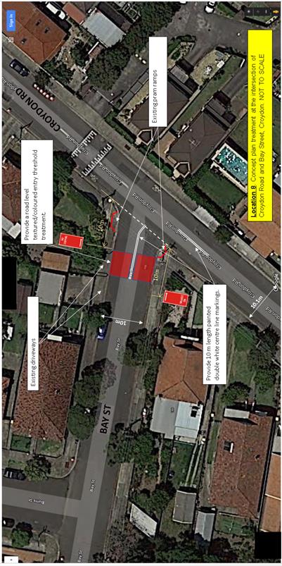
The ATMS recommends the placement of a central median island and entry threshold treatment in Bay Street for traffic control.
Under closer examination of the area, a central island would interfere with driveway access and the narrowness and acute angle of Bay Street would lead to the island being hit by vehicles turning left, or that large vehicles are likely to come out wide into the opposing traffic in Croydon Road when attempting to turn left. The provision of double white painted centrelines in Bay Street on approach to Croydon Road, together with an at-grade entry threshold treatment in this regard should be considered. Also provide a short length double white painted centreline in Croydon Road on the southern end approach to Bay Street.
Community response.
Overall from 75 households, 42 households (56%) provided support on the proposal, with 13 (17%) in non-support and 20 (27%) undecided/providing no answer/no specific comment on the proposal in question.
In a 200m local radius of the intersection, of (11) households, 7 (64%) provided support on the proposal, with 2 (18%) in non-support and 2 (18%) undecided/providing no answer/no specific comment on the proposal in question.
In a 100m radius, (2) household was in support.
The comments or key points of non-support, specific to the proposal, as raised from all submissions, are shown below with the Council officer response. All other general comments are addressed under ‘Public Consultation’.
|
Specific comments Key points of objection/concerns raised for Location 8. |
Officer Response |
|
The double white centreline markings on Bay St are unfeasible due to the angle of the turn required when turning left into Bay St from Croydon Rd.
|
The double white line marking will assist to control and separate general vehicle movement around the intersection. |
|
Bay St doesn't need any treatment applied neither does Dalmar St.
|
See above reasoning in report. |
|
Do support road level entry threshold treatment in Bay St. Do support no stopping restrictions on corners of Bay St.
|
Noted on support. |
|
No need for road level entry. There is already stop sign to control traffic. Support double white lines at this location.
|
Recommended under ATMS. See above reasoning in report. |
Outcome: General local community support is provided on the proposal. It is recommended to proceed the proposal to final design and consult with the affected residents in the intersection area of the proposed works.
Figure 9. Location 9- Provide a central median island in Dalmar Street at Croydon Road.
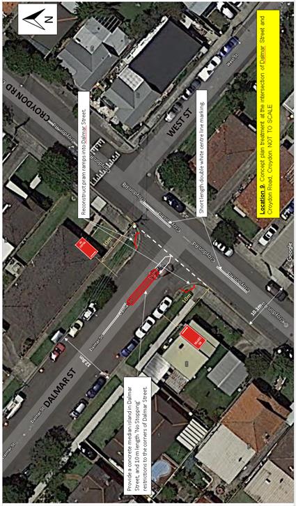
The ATMS recommends the placement of a central median island in Dalmar Street for traffic control. Also the placement of short length double white painted centrelines in Croydon Road at both approaches to Dalmar Street for added traffic control at the intersection, should be considered.
Community response.
Overall from 75 households, 44 households (59%) provided support on the proposal, with 12 (16%) in non-support and 19 (25%) undecided/providing no answer/no specific comment on the proposal in question.
In a 200m local radius of the intersection, of (8) households, 6 (75%) provided support on the proposal, with 0 (0%) in non-support and 2 (25%) undecided/providing no answer/no specific comment on the proposal in question.
In a 100m radius, (6) households were in support.
The comments or key points of non-support specific to the proposal, as raised from all submissions, are shown below with the Council officer response. All other general comments are addressed under ‘Public Consultation’.
|
Specific comments or Key points of non-support are raised for Location 9. |
Officer Response |
|
Bay St doesn't need any treatment applied neither does Dalmar St.
|
See above reasoning in report. |
|
Do support concrete island in Dalmar St. Do support no stopping restrictions to corners of Dalmar St.
|
Noted as support. |
|
No benefit placing an island at this location, however should be double white lines. Support ‘No Stopping’ to corners.
|
The road width allows the proposal of placing a median island in this regard for traffic manouevre/control around the intersection. |
|
Support the proposal, however can an allowance be made for a full car space between the side driveway of 200 Croydon Road and the ‘No Stopping’ so as not to infringe into the driveway. Also request that driveway lines be placed in.
|
This will be considered under final design. |
Outcome: General local community support is provided on the proposal. It is recommended to proceed the proposal to final design and consult with the affected residents in the intersection area of the proposed works.
PUBLIC CONSULTATION
Consultation was conducted in a broad area surrounding Croydon Road from Parramatta Road to the north, Frederick Street to the east, Elizabeth Street to the south and the boundary line between Burwood Council and Inner West Council to the west.
A letter with the attached locality map (Figure 1) was mailed out approximately to 2200 household owner/occupants in the regional area as shown on the following Consultation Area map.
Residents were invited and directed to submit answers in support or non-support of the proposed treatments along Croydon Road with comments on the ‘Have you Say’ survey portal line of Council’s website.
Approximately 75 household submissions were received through the website portal and via email/mail. This represents a response rate of around 3.5% of the total amount of household residents invited to comment.
A copy of the letter to the residents is shown in Attachment 1
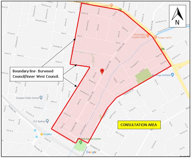 Figure 10. Locality plan showing area of consultation.
The combined survey statistical analysis on the support, non-support and undecided/no answer for all the proposals is tabled below.
Resident response -from Overall Consultation Area
|
Locations |
1 |
% |
2 |
% |
3 |
% |
4 |
% |
5 |
% |
6 |
% |
8 |
% |
9 |
% |
|
Support |
39 |
52 |
37 |
49 |
40 |
53 |
36 |
48 |
40 |
53 |
38 |
51 |
42 |
56 |
44 |
59 |
|
Non-support |
18 |
24 |
19 |
26 |
15 |
20 |
18 |
24 |
14 |
19 |
19 |
25 |
13 |
17 |
12 |
16 |
|
Undecided (no answer) |
18 |
24 |
19 |
25 |
20 |
27 |
21 |
28 |
21 |
28 |
18 |
24 |
20 |
27 |
19 |
25 |
|
TOTAL |
75 |
100 |
75 |
100 |
75 |
100 |
75 |
100 |
75 |
100 |
75 |
100 |
75 |
100 |
75 |
100 |
General or other comments not specific to the proposed treatments are shown below.
(specific comments are seperately shown with each figure 2-9 (locations 1-6, 8-9) ).
|
Residents’ Comments |
Officer Comments |
|
In general -It still falls short of providing pedestrian crossing, a safe way for people to cross Croydon Road.
Pedestrian refuge islands are not enough, we need actual pedestrian crossings to improve pedestrian safety. |
As mentioned and detailed in the report a thorough pedestrian survey was carried out along Croydon Road, with a low pedestrian counts resulting in the non-warrant of a marked (zebra) foot-crossing under RMS guidelines.
Alternate proposals are to be place in pedestrian refuges or kerb extension/blister treatments to improve pedestrian access across the road. |
|
Tell me what ‘traffic calming devices’ are |
Traffic calming (under the definition of Wikipedia) uses physical design and other measures to improve safety for motorists, pedestrians and cyclists. |
|
There also should be strong consideration for a change to traffic lights to add a right turn traffic light when turning right onto Parramatta Road from Croydon Road to head to the City. |
This matter has been raised with the RMS on previous occasions. The RMS has advised it would not agree to this measure, as it is an additional traffic phase movement which would impose on needed and priority traffic movement along Parramatta Road. |
|
Is there a reason for West Street in Croydon not included in this improvement? Any plans in future to upgrade this street?
West St used as thoroughfare both ways from/to BP, Parramatta Road. Enforce parking restrictions on West Street as parked vehicles reduce road width available for usage. Need a solution for volume of traffic and speed in which cars travel on this road. |
This does not fall under the proposed scope of works.
Appropriate restrictions are in place within the streets to assist traffic flow. No plans at this point of time are made for future upgrade of this street.
Traffic volumes and speeds in the street are considered low. There is no recorded accident history in the street to justify any form of traffic calming measures. |
|
I would also like to suggest that the stop sign on the corner of Parramatta Road and Croydon Road be extended. In the morning at peak hour there is a car parked just after the stop sign. The bus cannot make the turn cause of that car being parked there. As there are cars waiting at the lights on the other side. |
The matter will be investigated separately to consider to extend the ‘No Stopping’ on grounds of Traffic safety. |
|
Issue not mentioned here is the way parked cars blocking the sight line of traffic travelling north on Croydon Rd, for those cars turning right on to Croydon Rd from Hunt St |
At this particular intersection, ‘No parking’ and ‘No Stopping’ restrictions exist either side of the intersection from Hunt Street. Sight view is considered adequate. No accidents have been recorded at this intersection. |
|
The current No Stopping areas between Dalmar St and Parramatta Rd are also frequently insufficient for the traffic on Croydon Rd waiting to cross Parramatta Rd, especially if there is a bus stopped or approaching the bus stop.
Can the No Stopping times (Parramatta Road to Dalmar Street) be extended or made full-time? Can the bus stop be moved back away from Parramatta Road? Suggest ‘Do Not Queue across Intersection’ at the intersection of Dalmar Street and Croydon Road. |
These matters will be separately investigated. |
|
Please consider placing some calming device in Bay street just up the hill from Croydon road as cars come down the street towards Croydon Road very fast |
The matter will be examined in reference to the Ashfield Traffic Management Study (ATMS). If required, it will be listed for investigation under a future Local Area Traffic Management (LATM) for the area. |
|
Please also consider traffic calming and a pedestrian crossing/ refuge on Elizabeth St at Etonville Parade, as it is a long way to the pedestrian crossing at the top of the hill on Elizabeth St on Edwin St.
|
This is not part of the scope of works. Traffic volumes and speeding are observed to be low. Pedestrian numbers are considered low crossing Etonville Parade at Elizabeth Street. No pedestrian accidents are recorded at the intersection. No justification can be made to traffic calm or provide for crossing/refugee at the location. |
|
Speed humps are not a reliable method of slowing traffic & can result in a vehicle becoming a danger on the roads. They are noisy for occupants living next to them. The exhaust can be damaged, resulting in unfiltered toxic emissions being constantly released into the atmosphere. |
Speed cushions are generally proposed along Croydon Road. They are typically used on routes with trucks and buses to reduce noise/pollution from such vehicles. The proposed speed hump (if not speed cushions) in Croydon Road, north of Queen Street will be designed to appropriate standards to minimise noise and pollution. |
|
Is there enough space for a motorised scooter for elderly people on the splitter islands? |
The refuge opening width is 2.0 metres adequate for pedestrians with prams and motor scooters below 2.0 metres in full length (inclusive or baskets or other rear or front overhangs). |
|
These are good steps. As residents on Croydon Road, we'd also welcome Council partnering with the NSW Government Environmental Protection Agency to monitor noise pollution from vehicles travelling on Croydon Road ('hotted up' cars) - this is frequent every day.
|
The NSW Environment Protection Authority (EPA) accepts reports of pollution (noise and fume emission) incidences where the EPA has direct regulatory role. Residents can ring direct on 131 555 to report of any incidences. |
|
Consideration making Edwin St North between the laneway to the North of the FRANS office and the Anthony Street intersection One-Way (probably Northbound)- and add 45 and/or 90 Degree rear to curb parking along the length of the One-Way section of road as means to improve condition at the intersection locations 1,2 and 3. |
This is outside of the scope of the proposed works. ‘One-way’ traffic change is not recommended under this proposal. Traffic would be diverted to other streets and may affect resident access. The width of the road 10.1 metres kerb to kerb is considered narrow to provide for both angle parking and parallel parking opposite even with a one way system. There may not be a substantial and feasible net gain of parking. |
|
It’s impossible to respond to the proposals at Locations 1-9 with a simple Yes or No because there are aspects of each proposal that I agree with and aspects that I vehemently disagree with |
Noted. |
|
Neighbours and I are in favour of blocking Croydon Rd half way, through traffic or turning the road into a one-way street, so traffic from Parramatta Rd cannot rat run to Elizabeth Street. Council could kindly consider this option neighbours and I would be much appreciative. |
Croydon Road is a local –collector road of high volumes used to link traffic from Parramatta Road to Elizabeth Street. The intent of this report is not to change traffic conditions. Traffic network changes to allow diversion of traffic through side streets carrying lower volume of traffic is highly not recommended. |
|
Croydon Rd has been overwhelmed with traffic cutting through. Croydon Rd is currently being used by motorists to avoid the busy Frederick St Croydon/ Ashfield. This is a serious problem and should be addressed as a priority. |
See Above. |
|
More handicap and pram friendly curbs need to be created (such as on Anthony St and Edwin St). Please do not narrow Anthony St or any other street. It’s already a nightmare for us to try to navigate these streets, especially with all the PLC parents waiting around during school pickup/drop off. |
Pram ramps will be constructed with the proposed pedestrian cross-over facilities. Kerb blister/extension is proposed where refuge/islands cannot be reasonably accommodated for pedestrian access. |
|
Reduce traffic using Church Street generally by spreading traffic through the neighbourhood by means of introducing a no left turn sign onto Church Street off Croydon Rd for traffic driving south. |
The intention of any of these proposals is not to change traffic conditions and re-direct traffic elsewhere. |
|
The heavier reliance of the roundabout on Croydon Street and Queen Street should also be considered to relieve the right turn congestion on Church Street by forcing traffic to turn left at the western end of Church Street and then rely on the roundabout to head north towards Parramatta Road.
|
The intention of any of these proposals is not to change traffic conditions and re-direct traffic elsewhere. |
|
No more speed bumps or cushions in Croydon Road. There are too many already and, are very uncomfortable for passengers, especially those with bad backs, and other chronic painful injuries or conditions. The proposed passenger islands will narrow the road + slow traffic enough. |
The speed bumps or cushions are only limited in number in proposals to locations 1,2,4,6 and 7 to reduce speed in approach to these intersections. It is acknowledged there are other existing speeds humps which assist to control speeds along Croydon Road. |
|
On Church Street, drivers tend to speed down the hill from both sides not noticing the road bend at bottom of the hill near the creek at Church Street. There were three accidents we know of. |
Speed counts conducted in Church Street identified speeds within tolerance of the speed limit. Requests have been made for Police enforcement in the area. |
|
Support the efforts to protect pedestrians, and wish it went further. Reduce residential road speed limit to 40kmh. Install more traffic calming measures on Croydon Rd including bike-friendly speed humps. |
40 km/h zones are only provided in areas of high pedestrian activity, such as shopping centres, or at school zones. RMS would not approve such speed zone installation in this situation.
The proposals are considered sufficient enough for improved pedestrian and traffic calming purposes. Existing speed humps in the area assist to traffic calm along Croydon Road. Speed cushions are considered more bike friendly-can ride around or between cushions. |
|
Install traffic calming measures on residential streets to slow down and deter the rat runners roaring through our neighbourhoods |
The matter of the side streets off Croydon Road will be examined in reference to the Ashfield Traffic Management Study (ATMS). If required, it will be listed for investigation under a future Local Area Traffic Management scheme (LATM) for the area. |
|
Provide a solution to reduce the speed of traffic on Church Street at several points between Frederick Street and Croydon Street through the introduction of speed cushion or other alternative. |
See above. |
|
Provide proper separated bike infrastructure through Ashfield, Burwood, Croydon and Burwood Heights to make cycling safe |
This is not part of the scope of works, The streets and footpaths are too narrow in this area to consider separated cycling path movements. |
|
Traffic island refuges are too small for bikes / prams and multiple people crossing. They re-inforce the mentality that traffic has right of way. The new crossings on Church near Centenary Park even have a sign telling pedestrians to give way to traffic. As I am sure you are aware in NSW "You [the driver] must also give way to pedestrians if there is a danger of colliding with them, even if there is no marked pedestrian crossing". So I suspect the signs are at best misleading and possibly illegal? It will be an interesting court case following the inevitable accident. |
The proposed refuge widths are required min 2.0 metres to RMS guidelines. They are not marked foot-crossings and pedestrians in this instance are required to give-way. The said crossing in Church Street outside the park is a kerb extension facility supplemented with speed cushions. This allows pedestrian to cross over the road at a shorter distance. This is not a pedestrian crossing, and the signs as mentioned reinforce to warn pedestrians to give way in this instance. |
|
Cycling heat maps indicate that Croydon road is a major cycling route. In many cases traffic controls serve to push cyclists into traffic, creating a complication of having to constantly change lanes. Sydney is possibly the most dangerous city in the world for cyclists largely due to the aggressive nature of drivers, and cyclists need to be able to protect themselves from this aggression. |
It is identified under Council’s ‘Cycling Map and Guide’ that Croydon Road and Church Street are on-road cycle routes. Bike logos in the area will be remarked to make motorists aware. |
|
In our area the tendency is to place traffic controls on the major roads, but leave minor roads without controls. The effect is that fast moving traffic seeks out minor roads for a rapid high speed thoroughfare. |
The intention of any of these proposals is not to change traffic conditions and re-direct traffic elsewhere.
Side streets will be independently looked at with reference to the ATMS. If required, it will be listed under a future LATM scheme. |
|
There are two speed humps very close to
each other on Queen Street (between Lang St and Acton St). One of the speed
humps has no paint marking it as a speed hump at all. Due to the lack of
visibility, I find that people don't notice it until quite late, hitting it
at speed. Is there any reason for these two speed humps to be so close
together and for one to not be clearly marked? I suggest taking one of them
out, or if not, painting the one that is not currently marked. |
The speed humps in question are within the Burwood Council Area. A request has been made to Burwood Council to investigate the matter in regard to the resident concern. |
|
Traffic congestion on Frederick Street caused by the access road to Bunnings. This problem should be solved first, and not by encouraging diversions to Church Street. |
Access road at Bunnings and Frederick Street is signal control and traffic movement is regulated. The proposals (location 7) or any other proposals have no intention to encourage traffic diversions to Church Street. |
|
I prefer to reduce the flow of vehicles and improve pedestrian movability. Vehicles produce harmful emissions which are unhealthy to our families and children. Therefore I would like to vote for option 2 of the Croydon Rd and Church St intersection. It would be a great idea to plant more trees along Croydon Rd as well which will improve the quality of air around the area. |
Noted in support of option 2. It is viewed that sufficient amount of trees are planted in Croydon road without impairing on sight view and interference with traffic. |
|
A right hand turn from Elizabeth Street onto Fredrick St needs to be placed in. |
This matter has been raised with the RMS on previous occasions. The RMS has advised it would not agree to this measure, as it is an additional traffic phase movement which would impose on needed and priority traffic movement along Frederick Street. |
|
Edwin Street North and Hennessey Street. Provide means to control vehicle movement around the bend e.g. speed hump, double white lines. |
This will be investigated separately. |
|
1. Pedestrian survey results [as reported to the Local Traffic Committee 1 May 2018] showed no more than 18 crossing in locations across Croydon Road and 23 to side streets below the threshold of 30. Council should re-assess situation in quality rather than quantity -given the traffic volumes-use RMS formula as a guide. 2. Pedestrian refuge island facility in Croydon Road would add to the risk An alternative would be to have raised medians so that pedestrians crossing time is shorter rather than being stranded in the middle of Croydon Road on a refuge island. 3. Should the council consider Croydon Road as a main local road and it needs to cater for pedestrians as well as vehicles? 4. Have they considered increased numbers in the next 3 to 5 years? Why can’t council consider Croydon Road as a special circumstance. Has all types of pedestrians been considered, e.g. school children, elderly. 5. Although no recorded pedestrian accidents, increased volumes, deteriorated road can lend to accident in time. 6. Has Ashfield’s Pedestrian Access and Mobility Plan PAMP framework and plan considered identifying pedestrian routes/areas that are safe, convenient and connected and cross Croydon Road? What is PAMP’s pedestrian policy? In the Croydon Road assessment, did council recognise pedestrians as the most vulnerable road user? 7. Can the works recommended in the report [LTC meeting 1 May 2018] be broken down and prioritised e.g. remarking of line marking done under operational maintenance? Can certain works be done in 18/19 financial and works seen to be steadily done over the next 1-2 years? 8. John Street traffic counts [as reported to the Local Traffic Committee 1 May 2018] showed faster speeds than any speeds along Croydon Road. Should the speed limit of John St be reviewed and assessed? The John St speeds are faster than any speeds along Croydon Road and Croydon Road is a 50kph zone. |
· The proposed pedestrian refuges are considered an adequate treatment for pedestrian safety, as an alternative where pedestrian numbers are not sufficiently high to meet warrants for marked (zebra) foot crossing. They also enhance traffic calming in the area. They are widely used throughout the LGA on both major and minor roads. · Only the current data is used for analysis of the requirement to install pedestrian crossings. If circumstances change in future, an assessment will be undertaken at the time. · The survey did distinguish between age groups. However the numbers did not meet the warrants. · The proposed devices will enhance pedestrian safety and amenity along Croydon Road. Line marking upgrade is also to be undertaken. · The device locations are in line with the PAMP for cross-over points along Croydon Road near/at intersections, with crossover improvements to the intersection of Anthony Street and Croydon Road. A primary objective under the PAMP is to reduce pedestrian access severance and enhance safe and convenient crossing opportunities on major roads. · Remarking of line marking will be programmed and scheduled in sections or locations not affected or independent of the proposed works. · The current draft capital works program forecasts a budget of $225,000 in 2019/20 for traffic calming works in Croydon Road and a budget of $105,000 for intersection improvement at the intersection of Croydon Road and Church Street in 2018/2019. · The speed count in John Street was conducted outside of the area of proposed works along Croydon Road and its side street intersection. They conducted midway between Croydon Road and Lucy Street. The speed of vehicles at this location was not affected by traffic devices or approaches to intersections to slow down, as was the case with Croydon Road. The 85th percentile speed recorded of 53 km/h is based on the speed of the majority of vehicles taken over a time period of 24 hours and 7 days a week. This is considered within tolerance of the speed limit. RMS would not approve reduction of the speed limit in this street.
|
Additional community comments
|
Vehicles crossing Croydon St at John and Church St drive through the intersection. Should there be/are there stop/give way signs on the Cross Streets? |
John Street is controlled by Give-Way signs and linemarking and Church Street is controlled by Stop signs and linemarking. |
|
Need for no stopping signs in the laneway at intersection with Croydon Road between Elizabeth and Anthony Street and resident has observed that this laneway is also a popular pedestrian route. |
This will be separately investigated, and if required, reported to the Traffic Committee.
|
|
Pedestrians using speed humps as crossings. |
Reported to the Traffic Committee held on 1 May 2018 to provide ‘warning’ pedestrian prohibited (symbolic) markings on certain wide speed humps. |
|
Speeding along Croydon Road. |
Additional speed hump/cushions (under proposed treatment works) are proposed along Croydon Road to improve and further lower the speed profile along Croydon Road. |
CONCLUSION
In view of the findings and separate outcomes made to each proposal, it is identified there is general support with the local community on the proposed treatments along Croydon Road at intersection locations 1,2,3,4,5,6,8 and 9.
It is therefore recommended that all the proposals under this report for intersection treatments along Croydon Road, locations 1,2,3,4,5,6,8 and 9 proceed to final design with further consultation being made and limited to affected residents in the intersection areas of the proposed works.
|
1.⇩ |
Consultation letter-Croydon Road-Proposed Pedestrian and Traffic Calming treatments. |
|
Local Traffic Committee Meeting 4 December 2018 |
Subject: Croydon Road and Church Street, Croydon - Proposed improvements to intersection. (Leichhardt Ward/Strathfield Electorate/Burwood PAC)
Prepared By: Boris Muha - Engineer – Traffic and Parking Services
Authorised By: John Stephens - Traffic and Transport Services Manager
|
SUMMARY The Traffic Committee at its meeting held on the 6 November 2018 deferred an item on the ‘Proposed pedestrian and traffic calming treatments’ along Croydon Road, Croydon (inclusive of proposed improvements to the intersection of Church Street and Croydon Road) for further investigation.
This report provides consultation feedback on two (2) alternate options to modify the existing 'STOP' control at the intersection of Church Street and Croydon Road. These two options were recommended for further resident consultation by the Local Traffic Committee at its meeting held on the 7 September 2017 and was subsequently adopted by Council at its meeting on the 24 April 2018.
The consultation was undertaken in line with other proposed treatment works along Croydon Road. See Attachment 1 - Consultation letter with locality map (Location 7). The optional treatment works as proposed for the intersection of Croydon Road and Church Street with community consultation feedback are provided in this report. The proposed works to this intersection would be undertaken separate and independent of other treatment works along Croydon Road.
Option 1 (Figure 5) involves the inclusion of a right turn lane in Church Street (east), provide ‘No Stopping’ restrictions to the intersection corners and proposes a speed hump in Croydon Road, north of Church Street, to improve the operation, visibility and the speed control around the intersection. Option 2 (Figure 6) retains the existing physical conditions of the intersection, provides ‘No Stopping’ restrictions to the intersection corners and proposes a speed hump in Croydon Road, north of Church Street, to generally improve the visibility and speed control around the intersection.
From approximately 2200 consultation letters sent out to the residents of the Croydon/Ashfield area bounded by Parramatta Road to the north, Frederick Street to the east, Elizabeth Street to the south and the Burwood/Inner West Council boundary, 75 submissions were received representing around a 3.5% response rate of the overall area surveyed.
There was more support for Option 1 over Option 2.
Also, Council's consultant recommended Option 1 as it provided an improved operation of the intersection, coupled with improved visibility and speed control at the intersection in benefit of the local community.
It is recommended to proceed to detail design on this option, with further consultation to be undertaken with the affected residents at this location.
Also, it is intended to investigate the feasibility of providing a pedestrian facility in Croydon Road near/at the intersection of Church Street separate to the proposed intersection treatment.
|
|
RECOMMENDATION
THAT:
1. The proposed ‘right turn lane’ in Church Street (east) with associated ‘No Stopping’ restrictions at the intersection of Croydon Road and speed hump/cushion in Croydon Road, north of Church Street be approved in principle, subject to detailed design and further consultation with affected residents at this location; and
2. The feasibility of providing a pedestrian facility in Croydon Road near/at its intersection with Church Street be investigated, separate to the proposed treatment in Item 1 above.
|
BACKGROUND
A report was referred to Council at its meeting on 24 April 2018 (in reference to a Local Traffic Committee report of 7 September 2017) outlining the investigative procedures, review and the conclusive non-feasibility of providing a roundabout at the location. These reports with accompanying documental attachments can be viewed and downloaded from the council website link https://innerwest.infocouncil.biz/.
Due to the non-feasibility of a roundabout, it was recommended by the Local Traffic Committee of 7 September 2017 to upgrade /enhance the safety and operation of the intersection by either:
· Maintaining the 'STOP' control and providing a right turn lane to improve the level of operation and reduce the delay of traffic exiting Church Street (east). The footway on both sides of the road would be narrowed and the roadway widened on the Church Street (east) approach to the intersection to accommodate the right turn lane. ‘No Stopping’ restrictions would be provided at appropriate distances both in Croydon Road and Church Street for improved sight distance and vehicular movement around the intersection. A new speed hump (or cushions) would be provided in Croydon Road, north of Church Street, to reduce vehicular speed in approach to the intersection.
· Maintaining the 'STOP' control and retain the current intersection geometry of the intersection. ‘No Stopping’ restrictions would be provided at appropriate distances both in Croydon Road and Church Street for improved sight distance and vehicular movement around the intersection. A new speed hump (or cushions) would be provided in Croydon Road, north of Church Street, to reduce vehicular speed in approach to the intersection.
The above alternate (optional) treatments to the intersection would be subject to resident consultation. Council resolved to adopt the above at its meeting in April 2018.
FINANCIAL IMPLICATIONS
A budget of $105,000 has been proposed for intersection improvements at the Croydon Rd/ Church Street intersection for 2018/19.
OTHER STAFF COMMENTS
Existing condition/description of intersection of Croydon Road and Church Street.
Croydon Road is classified as a collector road with traffic volumes near the intersection around 9300-9500 vehicle per day. Church Street is classed as a local road with approximately 4500 vehicles per day (Church Street, east) and 1300 vehicles per day (Church Street, west).
Croydon Road and Church Street measure approximately 10.1 metres kerb to kerb in road width. Existing speed humps are located in Croydon Road, some 40 metres south of the intersection, and 170 metres north of the intersection.
There is a bus stop which operates in the morning period (7.45am-8.30am School Days Only) on the western side of Croydon Road, south of Church Street, while full-time bus stops (routes 490-492 Rockdale/Hurstville to/from Drummoyne) exist on both sides of Church Street, west of Croydon Road.
Existing 'STOP' controls are on both sides of Church Street at Croydon Road. Unrestricted parking exists to both sides of Croydon Road and Church Street.
Photos showing existing conditions to all approaches of the intersection for this particular item are shown in the following Figures1-4.
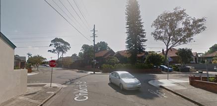
Figure 1- Church Street (east) viewing west towards the intersection.
Figure 2- Church Street (west) viewing east towards the intersection.
Figure 3- Croydon Road viewing north towards the intersection.
Figure 4- Croydon Road viewing south towards the intersection.
(Pedestrian-volume counts)
Pedestrian survey counts for Croydon Road/Church Street intersection were carried out on Tuesday, 14 and Thursday 16 March 2017.
In reference to the warrant criteria of a zebra marked foot-crossing, as shown below confer that although the traffic volumes are sufficiently high enough to justify the (V) value under certain warrants, the pedestrian volumes (18 at most) fall under the (P) requirement of 30 or more pedestrians in a given hour needing to cross to justify all warrants to install a zebra crossing.
The days the counts were undertaken are considered representative of general pedestrian activity in the area. At this particular intersection counts were undertaken through a 12 hour period 7.00am-7.00pm to derive the pedestrian numbers in the area.
Council Officers will be investigating the provision of a pedestrian facility on Croydon Road in the vicinity of the Church Street intersection separately to this report.
(Speed Counts)
Traffic counts were carried out in close proximity to the intersection in the period from 14 March 2017 to 27 March 2017.
The results identify that the 85th percentile speeds in Croydon Road on approach to Church Street, northbound is 40km/h and southbound is 44km/h. For Church Street, on approach to Croydon Road the 85th percentile speed is 37km/h eastbound and 47 km/h westbound (note that this count was take some 70m back from the intersection)
(Accident statistics)
Available and recorded accidents and Police information in update on the area over the last 6 years from June 2012 to date revealed that some 4 accidents had occurred in and around the intersection of Croydon Road and Church Street.
Of the 4 crashes:
o All occurred in dry conditions;
o 2 occurred during the day and 2 during the night / hours of darkness;
o The crash types / cause codes indicated 1 crash involved vehicles veering right off road hitting an object, 1 was right through (from opposite direction), 1 was a Rear end, and 1 cross traffic.
o Accidents were mainly non-injury, minor or moderate. 1 accident was of serious injury and fatigue related (2012).
o No fatal crashes were recorded.
o No Pedestrian accidents have occurred around the intersection in the last six (6) years.
The accident history indicates that this site is not a blackspot location with relatively low accident history over the past six years.
The following description of the proposed optional improvement works to the intersection as provided in the consultation letter to the community (copy shown in Attachment 1) was as follows:
Option 1- Provide new right turn lane in Church Street (east of Croydon Road) to assist vehicle turning into Croydon Road. See figure 5
Impacts
· Removal of 11 parking spaces
· Street tree removed on Church Street
· Footpath narrowing on Church Street
Improvements
· Will reduce delays for westbound Church Street traffic on the eastern approach to Croydon Road, increase sight lines to approaching traffic in Croydon Road and reduce southbound vehicular speed in Croydon Road.
Option 2- Church Street retains one lane in each direction with improved signage and line marking. See Figure 6
Impacts
· Removal of 9 parking spaces
Improvements
· Increase sight lines to approaching traffic in Croydon Road and reduce southbound vehicular speed in Croydon Road.
Both options improve sight distance for westbound traffic in Church Street at Croydon Road:
· Removal of parking near the intersection on both Church Street and Croydon Road (to improve visibility and allow large vehicles to manoeuvre.
· New speed hump on Croydon Road, north of Church Street, to reduce southbound traffic speeds.
Figure 5 - Location 7 - Option 1. Provide new right turn lane in Church Street (east of Croydon Road) and “No Stopping’ to all corners of the intersection, including provision of a speed hump/cushion device in Croydon Road, north of Church Street.
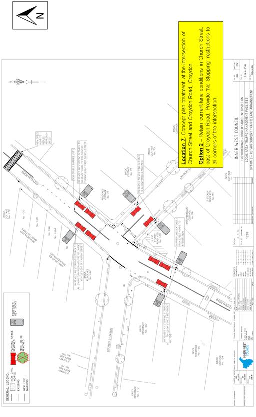
Figure 6 - Location 7 - Option 2. Retain current lane conditions in Church Street (east), and provide ‘No Stopping’ to all corners of the intersection, including the provision of a speed hump/cushion device in Croydon Road, north of Church Street.
PUBLIC CONSULTATION
Consultation was conducted in a broad area surrounding Croydon Road from Parramatta Road to the north, Frederick Street to the east, Elizabeth Street to the south and the boundary line between Burwood Council and Inner West Council to the west.
A letter with the attached locality map was mailed out approximately to 2200 household owner/occupants in the regional area as shown on the following Consultation Area map.
Residents were invited and directed to submit answers in support or non-support of the proposed treatments along Croydon Road with comments on the ‘Have you Say’ survey portal line of Council’s website.
Approximately 75 household submissions were received through the website portal and via email/mail. This represents a response rate of around 3.5% of the total amount of household residents invited to comment.
The consultation was done in line with other proposed treatment works along Croydon Road. A copy of the letter and locality map to the residents identifying this intersection as location 7 is shown in Attachment 1.
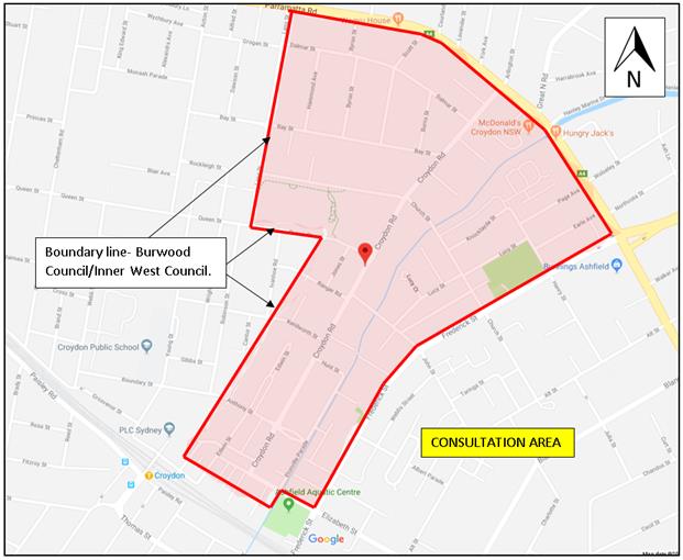 Figure 7 below shows the area of consultation carried out.
Figure 7. Locality plan showing area of consultation.
The combined survey statistical analysis on the support, non-support and undecided/no answer for all the proposals is tabled below.
Resident response - from overall Consultation Area for Option 1 or Option 2 at Location 7
|
Location 7 |
Option 1 |
Percentage% |
Option 2 |
Percentage% |
|
Support |
32 |
43% |
22 |
29% |
|
Non-support |
31 |
41% |
35 |
47% |
|
Undecided (no answer) |
12 |
16% |
18 |
24% |
|
TOTAL |
75 |
100% |
75 |
100% |
A further breakdown in the statistical analysis of the consultation area is shown as follows with specific comments provided for in the treatment of the intersection.
Overall from 75 households for Option 1, 32 households (43%) were in support, 31 (41%) were in non-support, and 12 (16%) undecided/providing no answer/no specific comment on the proposal in question.
Overall from 75 households for Option 2, 22 households (29%) were in support, 35 (47%) in non-support, and 18 (24%) undecided/providing no answer/no specific comment on the proposal in question.
In a 200m local radius of the intersection for Option 1, of 8 households, 3 (38%) provided support on the proposal, with 5 (63%) in non-support and 0 (0%) undecided/providing no answer/no specific comment on the proposal in question.
In a 200m local radius of the intersection for Option 2, of 8 households, 2(25%) provided support on the proposal, with 5 (63%) in non-support and 1 (12%) undecided/providing no answer/no specific comment on the proposal in question.
In a 100m radius, (1) household was in support of Option 1. (1) household was in non-support of Option 1 for reasons of loss of parking, and request that peak hour limitation apply only to the ‘No Stopping’, and that traffic volumes be reduced via way of prohibiting turn movements and change traffic conditions in the area.
This matter is addressed below with that of other comments.
Both households in the 100m radius were in non-support of Option 2.
The comments or key points of non-support, specific to the proposal, as raised from all submissions, are shown below with the Council officer response.
|
Specific comments or key points of non-support raised for Location 7 Option 1 or 2. |
Officer Response |
|
Can a roundabout be considered? Even if it is a small one. Neither of the proposed options will get traffic through to resolve the problem.
A right turn lane would be affective, ultimately a roundabout would work best.
A roundabout was approved in March 2002. Residents were advised that a roundabout would be implemented at the time. |
Both Inner West Council and the Traffic Committee resolved that a roundabout was not an option for this intersection, as the existing narrow road conditions, alignment and geometry of the intersection precluded the provision of a roundabout without expensive footway (utility adjustments) and land acquisition. (Refer to Council report 24 April 2018 for detailed information).
|
|
Burwood Council was convinced to build a roundabout at Bay/Lang Street. Why a (odd shape-asymmetrical/elliptical) roundabout can’t be built like the one in Lucas road and Queen Street, Croydon?
|
Bay and Lang Street (boundary line with former Ashfield Council and Burwood Council) was investigated by Burwood Council and found it was well aligned and wide enough to build a roundabout without extensive/expensive footway/utility adjustments and no land acquisition.
The Lucas Road/Queen Street roundabout predating prior to 1990 was built and aligned with land likely being acquired. |
|
The proposals at this intersection do not mention of pedestrians and how they will be assisted to cross Croydon Road.
Need a pedestrian crossing or pedestrian island here as the traffic is quite heavy during peak hours. Access is required for people in general, including elderly, parents with prams, school children to catch the bus, go to Centennial Park, schools, dog park, sports club etc. |
Although not under this proposal, it was reported at the Local Traffic Committee 1 May 2018 that Pedestrian facilities across Croydon Road near/at this intersection of Church Street would be further investigated separately, and if required, can be implemented independent of the treatment to the intersection in the proposed Option 1 or 2. |
|
This is an important pedestrian thoroughfare and council should count pedestrians and vehicles there. The times of day that council used for pedestrian counts do not reflect the times that pedestrians use the area. People access Centenary Park for sport or the children’s playground as well as walking their dogs to Croydon off-leash area on the weekends and after 5:30pm. These times were not included in the survey.
|
See above in the report advising that a pedestrian survey was undertaken at the location by Complete Urban Pty Ltd.
Observations by Council officers were carried out on the Saturday afternoon and verified that pedestrian numbers did not exceed that of weekday counts. |
|
Intersection
too tight for a right hand turn bay.
|
Option 1 has been designed to narrow the footways and widen the roadway in Church Street (East) at approach to the intersection to accommodate the installation of a right hand turn bay.
Option 1 (right hand turn lane) provides for better operation improvement to the intersection together with ‘No Stopping’ restrictions for visibility and speed hump installation for speed control. Option 2 provides for ‘No Stopping’ restrictions for visibility and speed hump installation for speed control. Motorists have more reaction time to turn out of the intersection as a result of the proposals.
The proposals do not offer to encourage rat-running, but only improve the operation of the intersection. |
|
Why should council make it easier for large vehicles to turn at the intersection? |
In this particular instance, the intersection is designed for garbage truck movement, leading in and out of Croydon Road and Church Street (east), and for a buses leading in and out of Croydon Road and Church Street (west). |
|
Cars already turn right from Church Street to Croydon Rd, with cars going up on the left to turn. A right hand turn lane won’t help as the car turning left will have no visual for oncoming traffic, especially at the speeds they go down Croydon.
|
The inclusion of a right hand turn lane would formalise this practice and provide wider lane area for vehicles to independently turn left and right. It is also envisaged that supporting measures including the speed hump and No Stopping zones will provide a lower speed environment with generally an improved vision for motorists to compensate the reduced vision of the left turning motorists.
|
|
Make Church Street to Croydon Road, Left turn only in both directions-proceed and use the Queen Street-Croydon Road Roundabout.
Provide one-way traffic in Church Street and John Street to distribute traffic- at peak times have a No right hand turn East from Croydon Road into Church Street. |
The intention of the proposals is not to prohibit turn movement or change traffic conditions which may have bearing on distributing traffic movements to other streets and impact on residential access. |
|
If traffic is reduced through WestConnex changes than the proposals are considered not required. If the traffic is likely to increase, the proposal would not be enough to accommodate higher volumes. |
The proposals are made to address a current movement and delay of traffic at the intersection. |
|
Need to prioritise for pedestrian and cycling crossing east and west. Removal of parking and placement of a speed hump to the north is a positive outcome for speed control and sight line. Option 1 will make it worse for pedestrians and cyclists-cars turn to quickly left and are obscured by sitting to turn right.
|
Council will separately investigate a pedestrian cross-over facility near/at the intersection. The proposals will lend to improve current cycling movements at the intersection with improved visibility and speed control. Bike logo marking will be re-marked in Croydon Road and Church Street for on-road cycle path use. |
|
Suggest to widen out the kerb area in Church Street-narrow down the street to slow vehicles down, improve the visibility for pedestrians, narrow the crossing distance and provide more footpath space. |
Not recommended as this may well impact on turning movements, and impose on further delay and parking. |
|
Agree there needs to be ‘No Stopping’ restrictions on both sides of Croydon Road near the intersection. |
‘No Stopping’ is provided to all corners of the intersection for purpose of visibility and vehicle man oeuvre around the intersection. |
|
Issues
around this intersection occur on week days- around one hour in the morning
and one hour at night. If there is to be’ No Stopping’
signs they should be like those at the intersection Queens Road and Arlington
Street Five Dock. That intersection is 10 times busier and the signs in place
now allow resident parking all weekend and ‘outside peak' on week days. |
Acknowledge in the concern in loss of parking, however full-time ‘No Stopping’ is provided to all corners of the intersection for the purpose of visibility and vehicle man oeuvre around the intersection at all times.
The ‘No Stopping’ peak hour conditions along Church Street at Arlington Street (Canada Bay Council) is required for added traffic capacity along the road by using the kerb lane during peak hours. This is of differing situation to the proposed ‘No Stopping’ at the intersection of Croydon Road and Church Street. |
|
The option to narrow the footpath will create dangerous situations for pedestrian with dogs and prams to pass safely. Narrow footway would encourage more cars and discourage pedestrians to walk to and from the park and bus stops. |
The footway on to the northern side of Church Street (East) will be reduced to 1.5 metres and on the south to 1.8metres only in short length at the intersection. These are acceptable footway widths under Standards, where pedestrian activity is not considered high. |
|
Concern made with the removal of trees. |
One tree is proposed to be removed per Option 1 to cater for the reduced width of the footway, and allow unobstructed traffic approach close to the kerb. |
|
Of the two options proposed, retaining the existing lanes and introducing improved signage and line marking would be preferable than the visual impacts of tree removal and critically, reduced local amenity of footpath narrowing. |
Noted.
See above for footway narrowing and removal of tree for Option 1. |
Committee discussions at the meeting held on 6 November 2018
Comments from the four residents that attended the meeting to speak on this matter and that of comments raised from the members at the meeting have been listed below and addressed by a Council Officer response.
|
Residents’ and member comments (Raised at Local Traffic Committee meeting on 6 November 2018.) |
Officer Comments |
|
Resident- · Supports the improvements to Croydon Road such as the proposed speed cushions and pedestrian refuges.
· Does not support the narrowing of the footpath - Option 1. It will make it difficult for people with prams or dogs walking to pass each other easily and safely. Sight lines on this footpath are poor because of the high fence at 100 Church Street.
· A pedestrian refuge should be installed on Croydon Road between Church Street and Queen Street. This will assist pedestrians crossing Croydon Road to access Centenary and Bede Spillane Parks.
· Supports the recommendation to consider pram ramps at intersections along Croydon Road because the intersections are difficult to cross, especially those that are poorly designed or have no pram ramps. She suggests consideration of the pram ramps happen sooner rather than later.
|
Noted.
The footway on the northern side of Church Street (East) will be reduced to 1.5 metres and on the southern side to 1.8 metres over a length of approximately 22 metres from the intersection. These are acceptable footway widths under Austroad Standards, where pedestrian activity is not considered high. ‘No Stopping’ will be provided to the corners to improve the visibility of pedestrians to traffic.
The feasibility of providing a pedestrian facility in Croydon Road at Church Street will be investigated.
Pram ramps not associated with the proposed intersection treatments will be considered as part of future infrastructure improvement works.
|
|
Resident- · Ashfield Council previously recommended installing a roundabout at the intersection of Croydon Road and Church Street 16 years ago which has not materialised. Council has taken a long time to identify that there are 9 safety issues along Croydon Road.
· Croydon Road traffic has worsened in over the years as motorists use Croydon Road to bypass Frederick Street. Traffic issues on Croydon Road has made it dangerous for pedestrians and cyclists.
· Vehicles have collided with the property on the corner of Croydon Road and Church Street in the last few years. Narrowing the footpath at this location will make it more dangerous.
· Has been advised that a roundabout at the intersection of Church Street and Croydon Road is not feasible. However, she believes a roundabout at that intersection does not need to be 2.5m wide. Beattie Street in Balmain has a smaller roundabout in a similar intersection.
· A right turn lane in Church Street will not resolve issues related to traffic coming from Frederick Street to Church Street into Croydon Road.
· It has been said that there have not been many accidents reported at the Croydon Road and Church Street intersection. This is likely because accidents causing damage of less than $2,500 are often not reported and Council should check with insurance companies for claims made involving that intersection. |
Both Inner West Council and the Traffic Committee resolved that a roundabout was not an option for this intersection, as the existing narrow road conditions, alignment and geometry of the intersection precluded the provision of a roundabout without expensive footway (utility adjustments) and land acquisition. (Refer to Council report 24 April 2018 for detailed information).
See separate report ‘Croydon Road, Croydon - Proposed Pedestrian and Traffic Calming Treatments’ to this meeting.
The ‘Croydon Road, Croydon - Proposed Pedestrian and Traffic Calming Treatments’ aim to enhance pedestrian safety and further reduce speeding at various locations for safety of road users such as cyclists.
It is not uncommon for narrow footways to be located at corners of intersections. Option 1 offers to improve the operation, traffic movement, visibility and speed control around the intersection.
The Beattie Street/Mullen Street roundabout has been explained in the feasibility report by Complete Urban Pty Ltd that the approaches are largely aligned with supporting (physical) traffic islands to the small roundabout to adequately deflect traffic and ensure appropriate approach speeds to the intersection.
The purpose of the proposed treatment Option 1 is to improve the operation of the intersection to relieve delay issues being experienced in Church Street (east).
With any investigative road treatment, Council uses available recorded RMS accident statistics in the last 5 years, and if required, Police information on reported accidents.
|
|
Resident- · The Croydon Road and Church Street intersection has always been dangerous and requested Council reconsider a roundabout at that intersection. |
See Above. |
|
Other comments
· Pedestrians cross Croydon Road to access bus stops between Church Street and Parramatta Road. However, there are no pedestrian refuges along that section of Croydon Road to facilitate crossing. There needs to be a pedestrian crossing south of Church Street and at least one between Church Street and Parramatta Road.
· The recommendation states that pedestrian refuges will be considered separately to the other treatments. She believes the refuges and the other treatments should be considered together.
· Prefers to have pedestrian refuges slow traffic instead of installing speed humps as proposed.
· The community has commented on the proposed right turn lane on Church Street highlighting that when two vehicles are stopped side by side at the intersection, the vehicle on the left lane is lower than the vehicle in the right lane. The left turning vehicle therefore cannot see traffic travelling from the right due to the vehicle in the right lane obstructing sightlines. Installing a right turn lane will exacerbate traffic flow in the intersection.
· Consideration should be given to prohibiting no right turns from Church Street into Croydon Road.
|
Pedestrian counts on Croydon Road north of Church Street are lower than other locations further south. There is no high or clear demand from the community (that had submitted comments) for crossing facilities further north of Church Street. Speeding will be further reduced with the inclusion of a speed hump between Church Street and Australia Street to enhance pedestrian movement across the road. At present no further crossing facilities are proposed.
Investigation of the feasibility of providing a pedestrian facility in Croydon Road near Church Street will be undertaken and reported back to the Committee. This report seeks approval for treating only traffic issues at the intersection.
Added speed hump/cushions treatments are considered to improve and lower the speed profile along Croydon Road with little or no loss of parking. Pedestrian refuges require a higher degree of loss of parking to accommodate the device and associated ‘No Stopping’ restrictions for clearance in traffic movement and pedestrian visibility in approach and departure sides of the device under RMS technical directions.
Vehicles already turn right from Church Street to Croydon Road, with cars going up on the left to turn. The inclusion of a right hand turn lane would formalise this practice and provide a wider lane area for vehicles to independently turn left and right. Also, the supporting measures, including the speed hump and 'No Stopping' zones will provide a lower speed environment with generally an improved vision for motorists.
Prohibiting turn movements is not considered favourable as this would result in a change of traffic conditions with undesirable diversion of traffic to other (quite) streets and would also affect residential access for residents in Church Street. Furthermore, current accident data doesn’t support such a ban. |
|
Chairperson- · Asked if there was a way to maintain the current footpath width in Church Street if a right turn lane in Church Street was installed. |
Council Officers (at the meeting) advised that the footpaths need to be reduced to provide space for the right turning path, particularly for larger vehicles.
Footways are proposed to be narrowed (particularly to the northern side of Church Street) to avoid the likelihood of conflict with turning vehicles from Croydon Road into Church (cutting the centreline) or overhanging the footpath during the turn manoeuvre into Church Street. |
|
Representative for the Inner West Bicycle Coalition - · Stated that although the Ashfield bike map indicates that Croydon Road and Church Street are major bike routes, there are no bike symbols marked at the intersection.
|
Council Officers (at the meeting) advised that there are bike symbols marked on those streets; however, they have faded. Council Officers will arrange for the symbols to be remarked under Council maintenance program.
|
CONCLUSION
Based on the wider local community, it is considered that the proposed intersection treatment Option 1 be recommended for the improved operation of the intersection coupled with improved visibility and speed control in benefit of the local community.
It is therefore recommended that the proposed intersection treatment Option 1 proceed to final design with further consultation being undertaken with affected residents.
|
1.⇩ |
Consultation letter with locality map-Croydon Road-Proposed Pedestrian and Traffic Calming treatments. |
|
|
Local Traffic Committee Meeting 4 December 2018 |
16 August 2018
Name
Address
Suburb
Dear <<mail merge>>
Croydon Road, Croydon
Proposed Pedestrian and TRAFFIC CALMING TREATMENTS
Council is seeking resident feedback on potential pedestrian and traffic calming treatments along Croydon Road between Elizabeth Street and Parramatta Road, Croydon.
Background
Following representations from residents requesting improved pedestrian and traffic conditions along Croydon Road, Croydon, a local area traffic management scheme has been developed for consideration. Options for the alternate treatment of the Church Street/Croydon Road intersection have also been developed given an initial proposal for a roundabout has proven not to be feasible due to the shape of the existing intersection.
Proposed treatments
Council is proposing crossover points for pedestrians, and traffic calming treatments along Croydon Road and some side streets near their intersections with Croydon Road at nine (9) locations.
The proposed treatments will help residents cross Croydon Road for example to schools and parks, and improve intersection safety while minimising the impact on parking. These include:
· Improved designated crossover points with pedestrian refuges or road narrowing devices
· Speed cushions at various intersections to reduce vehicular speeds
· Traffic calming devices at some side street intersections with Croydon Road to control traffic and speeding on approach to the intersections
· Two options to improve the intersection of Church Street and Croydon Road.
Options for treatments at Croydon Road and Church Street intersection (Location 7)
|
OPTION ONE: new right turn lane New lane in Church Street (east of Croydon Road) to assist vehicles turning into Croydon Road. |
OPTION TWO: retain existing lanes Church Street retains one lane in each direction with improved signage and line marking. |
|
Impacts · Removal of parking spaces (11) · Street tree removal on Church Street · Footpath narrowing on Church Street
|
Impacts · Removal of parking spaces (9)
|
|
Improvements · Will reduce delays for westbound Church Street traffic on eastern approach to Croydon Road, increase sight lines to approaching traffic in Croydon Road and reduce southbound vehicular speed in Croydon Road |
Improvements · Increase in sight lines for westbound Church Street traffic at Croydon Road and reduce southbound vehicular speed in Croydon Road |
|
Both options improve sight distance for westbound traffic in Church St at Croydon Road: · Removal of parking near the intersection on both Church Street and Croydon Road (to improve visibility and allow large vehicles to manoeuvre) · New speed hump on Croydon Road, north of Church Street, to reduce southbound traffic speed
|
|
More information and have your say
A map showing the locations of the nine (9) proposed treatments is attached.
You are invited to tell Council whether you support the proposed treatments along Croydon Road, and which option you prefer for the intersection at Church Street.
View detailed concept plans and complete a survey at www.yoursayinnerwest.com.au.
Or contact Council’s Administration Officer, Christina Ip on (9335 2213 to request hard copies of the plan, and then have your say in writing to:
Inner West Council,
PO Box 14,
Petersham, NSW, 2049.
Reference – TRIM SC1732
Comments close on Sunday, 9 September 2018
What happens next?
The proposals and results of the community consultation will be considered by the Local Traffic Committee (LTC) at its meeting on 2 October 2018.
Members of the public can register to address the LTC meeting by contacting Council's Administration Officer, Christina Ip, on (9335 2213. The recommendations from the LTC meeting will be referred to Council for consideration at its meeting on 23 October 2018.
Should you require further information, please contact Council's Traffic and Parking Engineer,
Boris Muha on (9392 5989.
Yours faithfully,
John Stephens
Traffic & Transport Services Manager
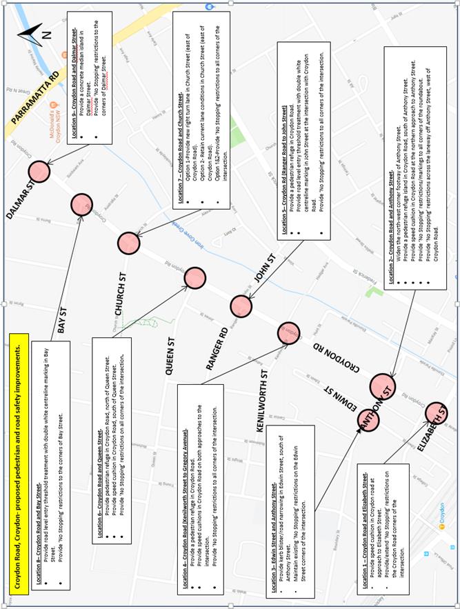
Subject: Lennox Street, Newtown – Proposed Redesign and Upgrade Works at Lennox Street Car Park - Amended Design Plan 6088_A (Stanmore Ward/ Newtown Electorate / Inner West PAC)
Prepared By: Jennifer Adams - Engineer – Traffic and Parking Services
Authorised By: John Stephens - Traffic and Transport Services Manager
|
SUMMARY Council is planning to redesign and upgrade Lennox Street Car Park to bring it up to current car parking space size and alignment standards. The works will improve safety for drivers and pedestrians and increase car park functionality. Detailed design plans have now been finalised for the proposed improvements to the car park. Consultation was undertaken with 25 owners and occupiers of properties in the locality regarding the proposal as well as being advertised on-site with 2 proposal notices and on Council’s website. Subsequent to feedback during the consultation process the original design plan (6088) has been slightly amended and is presented in this report – Design Plan 6088_A.
Overall, there is a net loss of 11 legal parking spaces as a result of the proposal to upgrade the existing layout to current Australian Standards. A summary of the consultation results are presented in this report for consideration. It is recommended that the amended detailed design plan be approved.
|
|
RECOMMENDATION
THAT the detailed amended design plan (Design Plan No.6088_A) for the proposed upgrade and improvements to the Lennox Street Car Park be APPROVED. |
BACKGROUND
Council is planning to redesign and upgrade Lennox Street Car Park to bring it up to current car parking space size and alignment standards. The works will improve safety for drivers and pedestrians and increase car park functionality.
The proposed original design includes:
· Rearranging car park spaces to comply with current standards
· Relocating the existing three (3) accessible parking spaces to comply with current standards
· Providing three (3) motor cycle parking spaces
· Providing racks for six (6) bicycles
· Total loss of eleven (11) car parking spaces due to the widening of angled parking spaces for improved accessibility for patrons.
· Removing current retaining wall
· Changing the entry/exit point on Church Street to be entry only. There would be no changes to the existing entry and exit points on Lennox Street
· Reconstructing the car park surface
· Marking new car park space lines
· Relocating pay stations
· Planting new trees and providing landscaped tree pits
· Improving carpark lighting
Subsequent to feedback during the consultation process the original design plan (6088) has been slightly amended and is presented in this report – Design Plan 6088_A.
FINANCIAL IMPLICATIONS
The estimated cost of the project is $490,000 and funding has been allocated in Council’s 2018/19 capital works program for the project.
OFFICER COMMENTS
Site location & road network
Lennox Street Car Park is located on the south side of Lennox Street adjacent to Church Street intersection, Newtown. (Refer to the attached locality map).
Lennox Street Car Park, in Newtown, comprises an area of approximately 1450 square metres with 55 car parking spaces, two of which are designated mobility parking spaces. It is situated adjacent to an IGA grocery store and is currently signposted as 2 hour parking between 8:00am - 6:00pm Monday-Sunday.
The utilisation rate at Lennox Street car park is high and in August 2009, as part of Council's 2009/10 Annual Management Plan, Council resolved to introduce paid parking in the Lennox Street car park. The aim was to encourage a higher turnover of available car parking spaces and relieve congestion in the Newtown area. To facilitate the paid parking scheme, two new 'Pay and Display' parking meters were installed in the Lennox Street car park.
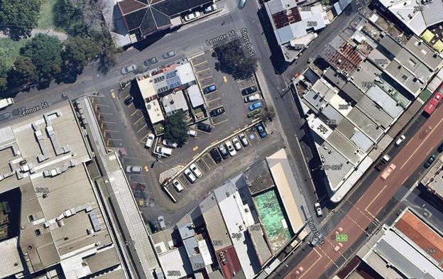
Design plan No.6088_A
Following community engagement, the original consultation plan (6088) was subsequently slightly amended (6088_A) for presentation to the Local Traffic Committee. The changes are as follows:
· Wheel stops were added to the parking spots adjacent to Church Street with a proposed overhang allowance of between 1-1.1m.
· Chevron markings and a ‘No Stopping’ sign were added adjacent to the pedestrian entry point from Church Street to emphasise the no parking zone.
· The motor bike parking signs were changed to 2P to prevent motorcycles parking for more than 2 hours
· A concrete slab has now replaced a garden bed where the side entry to property No.2 Lennox Street is located
· The trees adjacent to Church St have been moved in-line with the angled parking line marking to minimise the chances of vehicles colliding with them.
· The garden beds adjacent to private property have been separated by a kerb between the private wall and the garden.
· The wheel stop at the rear of Property No. 4 has been moved slightly to keep the rear access clear
· A ‘small vehicles only’ marking has been added to the angle parking space closest to Church Street
It is noted that the consultation plan issued to residents showed the number of parking spaces as per the Australian Standards.
Parking Impacts
There is a loss of 11 existing legal vehicle parking spots associated with the proposal.
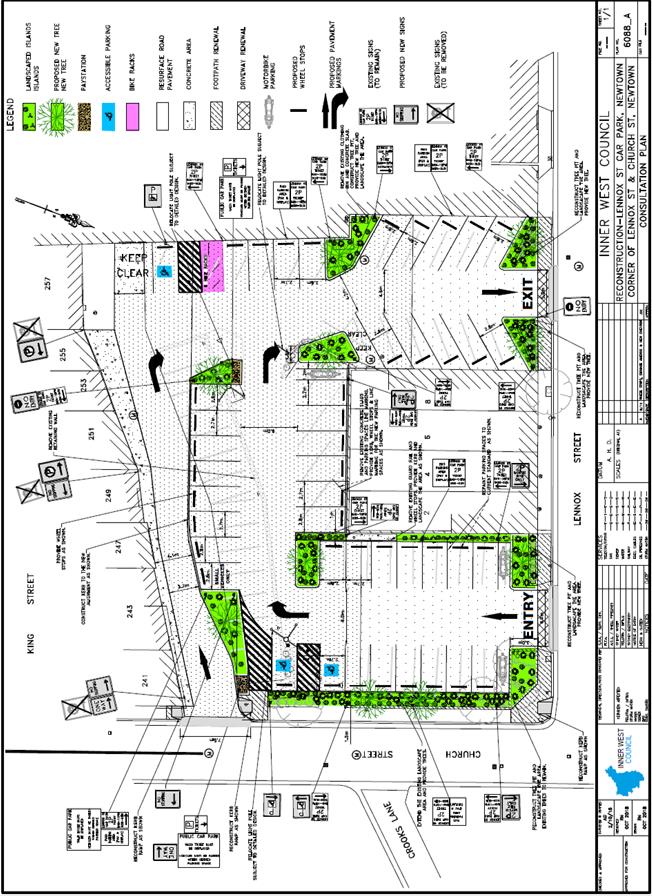
It is noted that it is a continuing process to review current parking demands and develop future strategies for the improved management of competing parking demands in any area recognising the balance of commercial, residential and visitor car parking needs and interests.
Various parking studies have been completed for the Newtown-Enmore precinct. The main focus of the studies is to identify means of addressing the current imbalances of parking supply and demand in the area. Competition for parking in the precinct is intense and Council has been involved in consultation with residents/businesses/stakeholder groups/key trip generators for some years now. As the ‘traditional’ approach of building new car parks is not desirable, a Travel Demand Management (TDM) approach (i.e. facilitation of non-car based access and improved management of existing parking resources) is appropriate for the Newtown-Enmore precinct, particularly as it is a walkable and cycleable precinct and is well served by public transport and taxis.
PUBLIC CONSULTATION
A consultation letter for the Lennox Street Car Park project was sent out on 12/10/18 and closed on 2/11/18. A letter as well as a copy of the design plan was sent to the local residents and shop owners in Lennox Street (Design Plan 6088 - Consultation Plan). A total of 25 letters were distributed. The proposal was uploaded to the Have Your Say website as well as 2 consultation signs installed on site within the carpark during the consultation period.
There were 13 responses generally supporting the proposed redesign works in the Lennox Street Car Park, Newtown; however, eight specifically objected to the loss of parking spaces and these are detailed below.
Five other responses did not relate to traffic matters and are noted here. Two requested that the street art be retained, one requested posts to tie up dogs be installed, one stated that the carpark should cater for accessible parking, motor bikes and bicycles only and the other solely related to concerns an adjoining residence had about protection of their property and whether adequate water proofing measures will be taken with the garden bed installations.
Council Officers have separately responded directly with the resident in regard to the latter response and their concerns in relation to protection and access to their property. Specifically,
a damp-proof membrane will be provided with a kerb to separate from property boundary. Wheel-stops will be provided with a minimum of 1-1.1m overhang allowance to prevent impact to the private property wall and a strip of concrete will be indicated in the detailed design plans instead of landscaping to maintain the rear access.
Further, it is noted that there are no plans to alter or remove any existing street art. No extra poles to tie dogs have been provided specifically as part of this proposal as these are generally considered a hazard; however, with the proposed tree planting no doubt shaded spots to tie up dogs will be available.
|
Residents’ Comments
|
Officer’s Response |
|
||
|
A local business operator noted they could not see the benefit of spending $$$ to fix a carpark which is perfectly fine. They noted that as well as a waste of $$$ at least 10 car parking spaces will be lost. They questioned why Council instead does not construct a two or multi- level car park which could more effectively service King Street local businesses. They requested Council to use this time and money to work for local businesses that pay their way noting that ‘if there is no parking the businesses won’t survive’.
It was suggested also that speed humps would need to be constructed if Entry is made from Church Street as vehicles speed into the car park now making it dangerous for anyone entering/exiting the back of the shops.
The business owner noted that any improvement to lighting and resurfacing is both necessary and good.
It was noted that a designated room for business skip bins is required.
|
The purpose of the redesign and upgrade is to bring Lennox Street Car Park up to current car parking space size and alignment standards in accordance with Australian Standards for ‘Off-street Parking’. Unfortunately, to make the car park compliant with Australian Standards there is a loss of 11 vehicle parking spaces. The works will, however, improve safety for drivers and pedestrians and increase carpark functionality. In the interest of making the parking spaces easier to utilise by patrons, it is proposed that 2.7m wide angle parking bays are appropriate in this proposal. Further, the proposed layout is more efficient and entry and exit movements more streamlined.
No off-street traffic calming is proposed with this design. Narrowing of the roadway and the slow environment of the car park itself will support low speeds. Further, this concern can be monitored post-construction.
Noted.
A strip of concrete has been proposed where all the skip bins can be stored. It is noted also that clothing bins are proposed to be removed as part of the proposal.
|
||
|
A local resident commented that the motorcycle parking spaces do not appear to have a time limit. Noting that without a time limit the limited number of spaces may be used for long term parking. They added that there should be a maximum of 24 hours or less for motorcycle parking.
The resident noted that it would be good if there were additional bicycle parking spots; however, noted that they understood how difficult it is to find somewhere to put them.
|
The plan has now been amended to show the same time limits on the motorcycle parking signs as the rest of the carpark.
Bicycle parking has been provided as part of the proposal. |
||
|
A local resident noted that it would be potentially helpful to have some (maybe free - 5 -15 min parking spots) for quick turnover especially for ‘when you just want to grab something really quick’ as the area is always very busy. They added that they have seen many people (including themselves) doing loops around the car park only to give up on busy nights and not bother (when you just want to grab a bottle of milk or something on your way home).
The resident also expressed disappointment that the car park would have less parking spaces adding that “everywhere in Newtown is so hectic to park, I would of thought one of the only "car parks" would be adding spots, not removing them”. |
The purpose of the redesign and upgrade is to bring Lennox Street Car Park up to current car parking space size and alignment standards in accordance with Australian Standards for ‘Off-street Parking’. The works will improve safety for drivers and pedestrians and increase carpark functionality. Council does not propose to introduce free and/or short term parking (5 -15 minute parking) within the carpark as there is already a reduced number of parking spaces as a part of the proposal.
Council has received feedback from the community that the previous narrower angle parking spaces across the LGA made it difficult to load and unload children and goods into vehicles, especially at shopping centre areas. Council has made a decision that in these short-term parking areas, a minimum width of 2.7m will be applied. Council has balanced the need for wider parking spaces, with the provision of landscaping, trees and the rearrangement of the carpark to make it safer to use.
|
|
||
|
A local resident noted that Newtown has so little off street parking already that reducing parking by 11 spaces is ridiculous. They add: ‘As the behemoth of WestConnex pushes its way into the Inner West and King Street has even more traffic there will be a need, I believe, for more off-street parking as King Street is overrun with cars. Is there any way to make the car park 2 storey I wonder?
The resident noted that taking the entrance off Church Street is a great idea and should reduce the traffic that uses the parking area as a shortcut to avoid no left turn restriction.
|
The purpose of the redesign and upgrade is to bring Lennox Street Car Park up to current car parking space size and alignment standards in accordance with Australian Standards for ‘Off-street Parking’. Unfortunately, to make the car park compliant with Australian Standards there is a loss of 11 vehicle parking spaces. The works will, however, improve safety for drivers and pedestrians and increase carpark functionality. At this time there are no plans to construct a 2 storey carpark.
Noted. The proposed layout is more efficient and entry and exit movements more streamlined.
|
||
|
An adjoining local business noted that they run the Newtown IGA supermarket business at 259 King Street, Newtown and that they had concerns over the proposal: “Naturally, we are concerned as are our shopkeeper neighbours when any removal/reduction in car spaces occurs, in an already tight parking area. If people can't park reasonably enough then inevitably we all lose patronage to the shopping centre competitors. This hurts your local businesses and the concept of the close, convenient, " just pop in" local business status.”
They noted that “The other items we'd like to bring to Councils attention, is that consider the fire escape exits from the building and not introduce parking for bikes or vehicles etc in any way that might interfere with such access.” . |
The purpose of the redesign and upgrade is to bring Lennox Street Car Park up to current car parking space size and alignment standards in accordance with Australian Standards for ‘Off-street Parking’. Unfortunately, to make the car park compliant with Australian Standards there is a loss of 11 vehicle parking spaces. The works will, however, improve safety for drivers and pedestrians and increase carpark functionality.
Noted. The access to the fire escape entry will be maintained. |
|
||
|
A local worker said that Newtown ‘needs more parking – so many people tell us at work that they would shop more often if parking wasn’t such an issue.’
|
Noted.
|
|
||
|
A local resident acknowledges that Lennox Street car park is a narrow car park and the outcomes the redesign hopes to achieve in making it more accessible, however they query why push ‘best practice’ and have 2.7 metre widths – citing that “this is Newtown, space is at an absolute premium! Parking is horrendous. The surrounding streets are extremely narrow. It is just one of those things that people come to accept, living or travelling in this area, you are lucky to even get a car park, let alone a wide one - if you take out 11 car bays you significantly reduce the capacity of this car park. What would be better is if the council considered constricting a multi-story car park on the site... “
|
The purpose of the redesign and upgrade is to bring Lennox Street Car Park up to current car parking space size and alignment standards in accordance with Australian Standards for ‘Off-street Parking’. The works will improve safety for drivers and pedestrians and increase carpark functionality. Council has received feedback from the community that the previous narrower angle parking spaces across the LGA made it difficult to load and unload children and goods into vehicles, especially at shopping centre areas. Council has made a decision that in these short-term parking areas, a minimum width of 2.7m will be applied. Council has balanced the need for wider parking spaces, with the provision of landscaping, trees and the rearrangement of the carpark to make it safer to use.
At this time there are no plans to construct a 2 storey carpark. |
|
||
|
A local resident generally agreed with the design however noted that “a car share space or 2. I get you’re probably reluctant to do that in context of loss of parking but you could trial usage. Inner west council doesn’t do enough to promote car share - the difference with city of sydney is noticeable.”
|
Noted. Further, it is noted that two additional designated car share parking spaces were recommended to be provided on the eastern side of Simmons Street in the most recent Newtown-Enmore precinct parking study. |
|
||
CONCLUSION
It is recommended that the design plan (Design Plan 6088_A) for the proposed redesign and upgrade of Lennox Street Car Park and associated signs and linemarking be approved, to improve safety for drivers and pedestrians, and increase the carpark functionality.
|
|
Local Traffic Committee Meeting 4 December 2018 |
Subject: 31 Fort Street, Petersham - Proposed 'No Parking' and P15 minute 7am-3pm restrictions (Stanmore Ward/Newtown Electorate/Inner West PAC)
Prepared By: Mary Bailey - Parking Planner
Authorised By: John Stephens - Traffic and Transport Services Manager
|
SUMMARY Following community representation, Council is proposing to implement ‘No Parking’ and short term parking restrictions in Fort Street, Petersham to improve access to parking for the boarding house at No.33 Fort Street which in a charitable capacity, provides free accommodation for people from the Pacific Islands to enable them to receive specialist medical treatment. The boarding house generates a constant turnover of people who are requiring assistance getting in and out of taxis and specialist transport, often with substantial luggage.
The provision of the proposed ‘No Parking’ zone will increase opportunities for taxis and shuttle buses to pick up and drop off patrons, and the proposed short term parking will enable taxis and other transport vehicles to park and collect people with mobility issues, thus improving the safety for drivers and patrons by reducing the friction with passing traffic. |
|
RECOMMENDATION
THAT the installation of:
1. A 10m ‘No Parking' restriction in Fort Street (southern side) at Kirkpatrick Lane (both sides of lane); and 2. A 8m ‘P15 minute 7am-3pm restriction in Fort Street (southern side from proposed ‘No Parking’ restriction) to property No.31 Fort Street, be approved. |
BACKGROUND
Fort Street is a 10m wide local road which has parking on both sides at the subject location.
Current restrictions
2P 8am-10pm Mon-Fri permit parking has been installed on the northern side of Fort Street and the southern side has unrestricted parking.
The northern side has mainly single unit dwellings and the southern side a number of multi-unit dwellings including the Beautemp Beaupre Pension; a boarding house, which in a charitable capacity, provides free accommodation for people from several Pacific Islands who travel to Sydney to receive specialist medical treatment. The boarding house generates a constant turnover of people who are requiring assistance getting in and out of taxis and specialist transport, often with substantial luggage.
The provision of the proposed ‘No Parking’ zones will increase opportunities for taxis, and shuttle buses to pick up and drop off patrons and the proposed short term parking will enable taxis and other transport vehicles to park and collect people with mobility issues, and improve the safety for drivers and patrons by reducing the friction with the passing traffic. The proposed ‘No Parking’ restrictions at the intersection are consistent with the objective of maintaining clear sight distances at the intersection. The infrequent nature of the drop off/pick up activity and the short duration of these activities will only marginally impact sight lines at this intersection.
Reports have been received that currently vehicles which are transporting patients to the boarding house are forced to double park and this is creating a dangerous and frustrating situation for all involved.
The proposal is detailed in Figure 1 below.
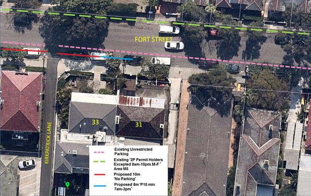
Figure 1: Proposal for Parking Restrictions in Fort Street at Kirkpatrick Lane, Petersham
FINANCIAL IMPLICATIONS
The cost of the supply and installation of the signage will be funded from Council’s signs and line markings budget.
PUBLIC CONSULTATION
On 31 October 2018, forty eight (48) letters detailing the proposal were sent to owners and occupiers of affected properties. The address area for distribution of the proposal is illustrated in Figure 2 below.
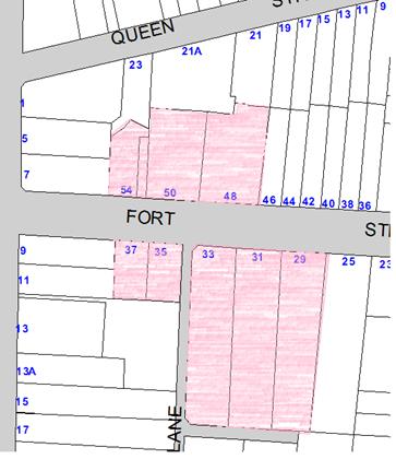
Figure 2: Mailing distribution area for proposal properties highlighted
Three submissions were received, one (1) in support and two (2) objecting. The people who objected stated that there was not sufficient unrestricted parking at present and that the proposal would result in the loss of 3-4 spaces. Feedback from the doctor’s surgery opposite the subject location was supporting of the proposed short term parking.
|
Submission |
Officer’s response |
|
Object There was objection from two (2) respondents based on the claim that 3-4 unrestricted parking spaces would be lost |
The proposed ‘No Parking’ restrictions do not remove any parking as it is within the 10m of the intersection with Kirkpatrick Lane and therefore are not considered viable/legal parking spaces. The proposed 8 metres of 15 minute parking equates to one (1) parking space which remains unrestricted outside the proposed hours of the restrictions (7am-3pm). |
|
Support There was support from the doctor's surgery opposite the subject location. Respondent reported current difficulty picking up and dropping off patients. |
The proposed short term parking provides opportunity for drop off pick up for the doctor's surgery patients. |
CONCLUSION
Given the nature of the activities associated with the properties in the subject section of Fort Street and the difficulties experienced in dropping off and picking patients, it is recommended that the proposal should be supported, which will allow improved opportunities for dropping off and picking up patients and visitors to the health related boarding house accommodation at No.33 Fort Street, as well as the doctor’s surgery opposite.
|
|
Local Traffic Committee Meeting 4 December 2018 |
Subject: Unnamed Laneway (Rear of Nos.55A-57 Albert Street), Leichhardt - Proposed Extension of 'No Stopping' Zone (Leichhardt Ward/ Balmain Electorate/ Leichhardt LAC)
Prepared By: Felicia Lau - Engineer - Traffic and Parking Services
Authorised By: John Stephens - Traffic and Transport Services Manager
|
SUMMARY Council has received concerns regarding parked vehicles obstructing driveway access to off-street parking at the rear of House Nos. 55A and 57 Albert Street in an unnamed Laneway, east of Flood Street, Leichhardt. |
|
RECOMMENDATION
THAT the existing ‘No Stopping’ restriction on the northern side of the unnamed laneway at the rear of Nos.55A and 57 Albert Street, at the intersection of Flood Street, Leichhardt be extended to 10 metres. |
BACKGROUND
Council has received concerns from a resident of Albert Street, Leichhardt regarding two vehicles parking on the northern side of the laneway, (east of Flood Street) and overhanging the existing ‘No Stopping’ zone and subsequently obstructing rear driveway access to their property.
The existing parking zone is approximately 7 metres in length and it is not wide enough for two small cars to be parked in the area without overhanging into the ‘No Stopping’ zone. In any occasion when two small cars are parked in the area, driveway access will be obstructed.
FINANCIAL IMPLICATIONS
Nil.
OTHER STAFF COMMENTS
It is proposed to extend the existing ‘No Stopping’ zone on the northern side of the laneway, east of Flood Street to the statutory 10 metre length. This proposal will retain a 5.8m parking space which will remove ambiguity and clearly indicate that only one standard car may park in this location. The proposal is shown in the following plan.
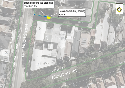
PUBLIC CONSULTATION
A letter outlining the above proposal was mailed out to the affected properties (9 properties) in Albert Street and Flood Street, Leichhardt.
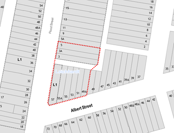
No objections have been received during the consultation period. One support email was received with the following suggestions.
|
Resident Feedback |
Traffic Engineer |
|
The parking space to be converted to “2P” parking limit. |
The existing resident parking scheme (RPS) is only available in Flood Street therefore it cannot be extended towards the laneway at this stage. Investigation to extend the existing RPS Area can be undertaken separately if Council receives two more requests to extend the existing RPS. |
|
“No Stopping” sign moved closer to the corner so more visible. |
Statutory 10m ‘No Stopping’ signs are only located at the start/ end of an area. The proposed position will be visible to motorists entering the laneway. |
CONCLUSION
Nil.
|
|
Local Traffic Committee Meeting 4 December 2018 |
Subject: James Lane, Balmain East - Proposed Extension of 'No Parking' Restriction (Balmain Ward/ Balmain Electorate/ Leichhardt LAC)
Prepared By: David Yu - Engineer - Traffic and Parking Services
Authorised By: John Stephens - Traffic and Transport Services Manager
|
SUMMARY Council has received concerns regarding pedestrian accessibility to No.1 James Lane, Balmain East due to vehicles that are parked on the northern side of James Lane directly in front of the property. |
|
RECOMMENDATION
THAT the existing ‘No Parking’ zone be extended to the west to include the 3.4m unrestricted parking area on the northern side of James Lane, Balmain East (in front of No.1 James Lane). |
BACKGROUND
Council has received concerns from a resident of James Lane, Balmain East regarding vehicles parking on the northern side of James Lane and subsequently obstructing pedestrian access to property No.1 James Lane.
There is no formal footpath in James Lane and all pedestrian access is via the road carriageway. Therefore, any vehicle parked across a pedestrian entrance obstructs access.
There is an existing ‘No Parking’ zone on the northern side of James Lane that extends 8m from the end of the lane to allow vehicular access to the garage and area for turning around to exit the lane; however, this ‘No Parking’ zone ends prior to the pedestrian access of No.1 James Lane as shown on the following figure.
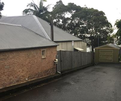
FINANCIAL IMPLICATIONS
Nil.
OTHER STAFF COMMENTS
It is proposed to extend the existing ‘No Parking’ zone to the west by 3.4m on the northern side of James Lane (in front of 1 James Lane) as shown on the following plan.
The proposal is expected to result in a loss of one (1) on-street car parking space.
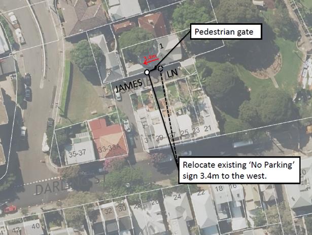
PUBLIC CONSULTATION
|
A letter outlining the above proposal was mailed out to the affected properties (10 properties) in Darling Street and James Lane, Balmain East. Three (3) responses were received. Two (2) in support and one (1) objecting to the proposal. The table below shows the comments raised by the residents.
|
|
|
Residents’ Comments |
Officer Comments |
|
There should be no parking on the northern side of James Lane as it restricts access to the rear driveways of 23 to 29 Darling Street, Balmain East (Resident of No. 27 Darling Street). |
The proposed extension of the ‘No Parking’ zone would provide improved vehicle accessibility to No. 27 Darling Street. Council has not received any other concerns from the other residents between No. 23 to 29 regarding vehicle accessibility to their properties. |
|
As I am directly affected by the current parking situation and hope that the matter is resolved quickly to allow safe access to my home. |
Proposal seeks to provide safe access to property. |
|
There is not enough parking for all the residents in James Lane. No.3 James Lane will have a renovation shortly additional parking will be needed. Numbers 1, 3 and 5 all rely on on-street parking. |
The existing parking impedes pedestrian access to No.1 James Lane. It is illegal to park in a manner which obstructs pedestrian access and the proposal seeks to provide safe access to the property. These three properties have been issued current resident parking permits to allow them to park nearby in the Area BE Resident Parking Scheme. |
CONCLUSION
Nil.
|
|
Local Traffic Committee Meeting 4 December 2018 |
Subject: Silver Street at Unwins Bridge Road, St Peters - Proposed installation of 'No Stopping' restrictions (Marrickville Ward/Heffron Electorate/Inner West LAC)
Prepared By: Mary Bailey - Parking Planner
Authorised By: John Stephens - Traffic and Transport Services Manager
|
SUMMARY Following community representation, it is proposed to signpost statutory ‘No Stopping’ restrictions in Silver Street, St Peters, at its intersection with Unwins Bridge Road, in order to prevent illegal parking and improve safety at the entry into Silver Street. |
|
RECOMMENDATION
THAT the installation of 10m ‘No Stopping’ restrictions on both sides of Silver Street at Unwins Bridge Road, St Peters be approved. |
BACKGROUND
Concerns have been raised by residents regarding vehicles parking in Silver Street too close to its intersection with Unwins Bridge Road.
This illegal parking behaviour obstructs sight lines as well as access in and out of Silver Street.
The proposal is illustrated in Figure 1 below.
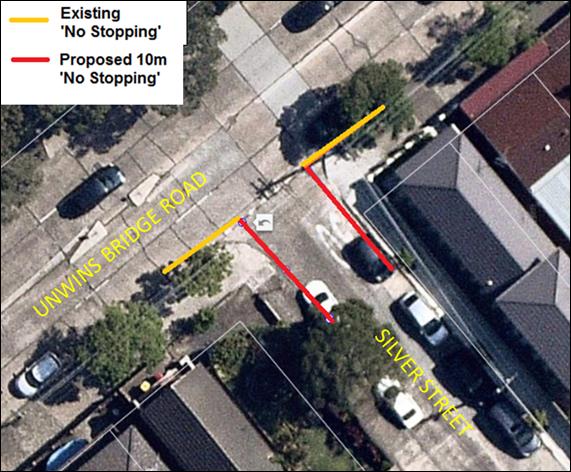
Figure1: Existing and Proposed ‘No Stopping’ at subject location
FINANCIAL IMPLICATIONS
The cost of the supply and installation of the signage will be funded from Council’s operational budget.
PUBLIC CONSULTATION
A notification letter was hand delivered on 14 November, 2018 to affected residents and businesses in the area advising that the proposal was being considered at the December meeting of the Local Traffic Committee.
One comment was received from a resident in support of the proposal.
The distribution area for the letters notifying residents of the proposal is illustrated in Figure 2 below.
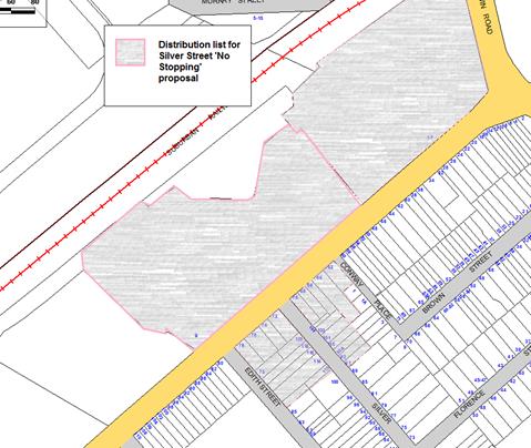
CONCLUSION
Signposting the statutory 10m ‘No Stopping’ restrictions in Silver Street at Unwins Bridge Road, St Peters will improve safety by improving sight lines as well as access into and out of Silver Street.
|
|
Local Traffic Committee Meeting 4 December 2018 |
Subject: Minor Traffic Facilities (All Wards/ All Electorates/ All LACs)
Prepared By: Vinoth Srinivasan - Engineer - Traffic and Parking Services
Authorised By: John Stephens - Traffic and Transport Services Manager
|
SUMMARY This report considers minor traffic facility applications received by Inner West Council, including ‘Disabled Parking’ and ‘Works Zone’ requests. |
|
RECOMMENDATION
THAT:
1. A 6m ‘Disabled Parking’ zone be removed in front of No.9 Foucart Street, Rozelle as it is no longer required;
2. A 5.5m ‘Disabled Parking’ zone be installed in front of No.50 Henry Street, Lilyfield;
3. A 6m ‘Disabled Parking’ zone be installed in front of No.16 Loughlin Street, Rozelle replacing the existing resident parking scheme restrictions;
4. A 10m ‘Works Zone 7.00am – 5.00pm Mon-Fri and 7.00am – 1.00pm Sat’ be installed in front of No.109 Birchgrove Road, Birchgrove for 12 weeks;
5. An 9m ‘Works Zone 7.00am – 5.00pm Mon – Fri and 7.00am – 1.00pm Sat’ be installed in front of No.406 and No.408 Darling Street, Balmain, subject to the applicant receiving written concurrence from the business owners at No.406 Darling Street, Balmain; 6. A 9m ‘Works Zone 7.00am – 5.00pm Mon-Fri and 7.00am – 1.00pm Sat’ be installed in front of Nos.219-221 Enmore Road, Enmore for 12 weeks;
7. A 13m ‘Works Zone 7.00am – 5.00pm Mon – Fri, 7.00am – 1.00pm Sat’ be installed in front of No.52 Florence Street, St Peters for 12 weeks;
8. A 20m ‘Works Zone 7.00am – 5.00pm Mon-Fri and 7.00am – 1.00pm Sat’ be installed on Applebee Street along the rear boundary of Nos.47-61 Princess Highway, St Peters for 12 weeks;
9. A 6m ‘Disabled Parking’ zone be installed in front of No.116 Darley Street, Newtown extending across the redundant crossing;
10. A 6m ‘Disabled Parking’ zone be installed in front of No.93 Silver Street, St Peters;
11. A 6m ‘No Parking 4pm-6pm Mon-Fri; Disabled Parking At Other Times’ zone be installed in front of No.46 Unwins Bridge Road, St Peters;
12. A 5.5m ‘Disabled Parking’ zone be installed in front of No.163 Old Canterbury Road, Dulwich Hill, subject to RMS approval as Old Canterbury Road is a classified State Road; and
13. A 5.5m ‘Disabled Parking’ zone be installed in front of No.81 Windsor Road, Dulwich Hill. |
BACKGROUND
This report considers minor traffic facility applications by Inner West Council, and includes ‘Disabled Parking’ and ‘Work Zone’ requests.
FINANCIAL IMPLICATIONS
Nil.
OTHER STAFF COMMENTS
1. Removal of ‘Disabled Parking’ Restriction – Foucart Street, Rozelle
A family member of the applicant of the ‘Disabled Parking’ zone in front of No.9 Foucart Street, Lilyfield has notified Council that the applicant has passed away and thus the ‘Disabled Parking’ zone is no longer required.
It is recommended that the 6m ‘Disabled Parking’ space in front of No.9 Foucart Street, Lilyfield be removed as the zone is no longer required.
2. Installation of a ‘Disabled Parking’ restriction – Henry Street, Lilyfield.
The resident of No.50 Henry Street, Lilyfield has requested the installation of a ‘Disabled Parking’ zone in front of the resident’s property.
A site investigation has revealed that the property does not have off street parking.
The applicant does require the use of a wheelchair and there is a driveway adjacent to the property to access the footpath and subject property's front gate.
It is recommended that a 5.5m ‘Disabled Parking’ zone be installed in front of No.50 Henry Street, Lilyfield.
No.50 Henry Street, Lilyfield
3. Installation of a ‘Disabled Parking’ restriction – Loughlin Street, Rozelle
The resident of No.16 Loughlin Street, Rozelle has requested the installation of a ‘Disabled Parking’ zone in front of the resident’s property.
A site investigation has revealed the property does not have off street parking.
The applicant does not require the use of a wheelchair.
It is recommended that a 6m ‘Disabled Parking’ zone be installed in front of No.16 Loughlin Street, Rozelle replacing the existing resident parking scheme restrictions.
No.16 Loughlin Street, Rozelle
4. Installation of ‘Works Zone’ restriction – Birchgrove Road, Birchgrove
The applicant has requested the installation of a temporary 10m ‘Works Zone 7.00am – 5.00pm Mon – Fri, 7.00am – 1.00pm Sat’ in front of No.109 Birchgrove Road, Birchgrove.
It is recommended that a 10m ‘Works Zone 7.00am – 5.00pm Mon – Fri, 7.00am – 1.00pm Sat’ be installed in front of No.109 Birchgrove Road, Birchgrove for 12 weeks.
No.109 Birchgrove Road, Birchgrove
5. Installation of ‘Works Zone’ restriction – Darling Street, Balmain
The applicant has requested the installation of a temporary 9m ‘Works Zone 7.00am – 5.00pm Mon-Fri, 7.00am – 1.00pm Sat’ in front of No.406 and No.408 Darling Street, Balmain, for works to No.408 Darling Street.
It is recommended that a 9m ‘Works Zone 7.00am – 5.00pm Mon – Fri, 7.00am – 1.00pm Sat’ be installed in front of No.406 and No.408 Darling Street, Balmain for 12 weeks, replacing the existing parking restrictions. This is subject to the applicant receiving written concurrence from the business owners at No.406 Darling Street, Balmain.
No.406 and No.408 Darling Street, Balmain
6. Installation of ‘Works Zone’ restriction – Enmore Road, Enmore
The applicant has requested the installation of a temporary 9m ‘Works Zone 7.00am – 5.00pm Mon – Fri, 7.00am – 1.00pm Sat’ in front of Nos.219-221 Enmore Road, Enmore.
It is recommended that a 9m ‘Works Zone 7.00am – 5.00pm Mon – Fri, 7.00am – 1.00pm Sat’ be installed in front of Nos.219-221 Enmore Road, Enmore for 12 weeks.
Nos.219-221 Enmore Road, Enmore
7. Installation of ‘Works Zone’ restriction – Florence Street, St Peters
The applicant has requested the installation of a temporary 13m ‘Works Zone 7.00am – 5.00pm Mon – Fri, 7.00am – 1.00pm Sat’ in front of No.52 Florence Street, St Peters for 12 weeks.
It is recommended that a 13m ‘Works Zone 7.00am – 5.00pm Mon – Fri, 7.00am – 1.00pm Sat’ be installed in front of No.52 Florence Street, St Peters for 12 weeks.
No.52 Florence Street, St Peters
8. Installation of ‘Works Zone’ restriction – Applebee Street, St Peters
The applicant has requested the installation of a temporary 20m ‘Works Zone 7.00am – 5.00pm Mon-Fri and 7.00am – 1.00pm Sat’ be installed on Applebee Street along the rear boundary of Nos.47-61 Princess Highway, St Peters.
It is recommended that a 20m ‘Works Zone 7.00am – 5.00pm Mon – Fri, 7.00am – 1.00pm Sat’ be installed on Applebee Street along the rear boundary of Nos.47-61 Princess Highway, St Peters for 12 weeks.
Nos.47-61 Princess Highway, St Peters, viewed from Applebee Street
9. Installation of a ‘Disabled Parking’ restriction – Darley Street, Newtown
The resident of No.116 Darley Street, Newtown has requested the installation of a ‘Disabled Parking’ zone in front of the resident’s property.
A site investigation has revealed the property does have a hard stand area in front of the building; however, this area has insufficient dimensions for a parking space and the vehicle crossing is considered redundant.
The applicant does not require the use of a wheelchair.
It is recommended that a 6m ‘Disabled Parking’ zone be installed in front of No.116 Darley Street, Newtown extending across the redundant crossing.
No.116 Darley Street, Newtown
10. Installation of a ‘Disabled Parking’ restriction – Silver Street, St Peters
The resident of No.93 Silver Street, St Peters has requested the installation of a ‘Disabled Parking’ zone in front of the resident’s property.
A site investigation has revealed the property does not have off street parking.
The applicant does not require the use of a wheelchair.
It is recommended that a 6m ‘Disabled Parking’ zone be installed in front of No.93 Silver Street, St Peters.
No.93 Silver Street, St Peters
11. Installation of a ‘Disabled Parking’ restriction – Unwins Bridge Road, St Peters
The resident of No.46 Unwins Bridge Road, St Peters has requested the installation of a ‘Disabled Parking’ zone in front of the resident’s property.
A site investigation has revealed the property does not have off street parking.
The applicant does not require the use of a wheelchair.
There are currently PM Peak ‘No Parking’ restrictions on the southern side of Unwins Bridge Road to allow 2 lanes of traffic to travel southbound (outbound from the City).
It is recommended that a 6m ‘No Parking 4pm-6pm Mon-Fri; Disabled Parking At Other Times’ zone be installed in front of No.46 Unwins Bridge Road, St Peters.
No.46 Unwins Bridge Road, St Peters
12. Installation of a ‘Disabled Parking’ restriction – Old Canterbury Road, Dulwich Hill
The resident of No.163 Old Canterbury Road, Dulwich Hill has requested the installation of a ‘Disabled Parking’ zone in front of the resident’s property.
A site investigation has revealed the property does have off street parking; however, the internal dimensions are insufficient to accommodate a car (2.4m long; 2.7m wide before the width reduces to approximately 2.2m).
The applicant does not require the use of a wheelchair.
It is recommended that a 5.5m ‘Disabled Parking’ zone be installed in front of No.163 Old Canterbury Road, Dulwich Hill, subject to RMS approval as Old Canterbury Road is a classified State Road.
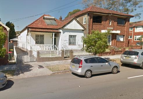
No.163 Old Canterbury Road, Dulwich Hill
13. Installation of a ‘Disabled Parking’ restriction – Windsor Road, Dulwich Hill
The resident of No.81 Windsor Road, Dulwich Hill has requested the installation of a ‘Disabled Parking’ zone in front of the resident’s property.
A site investigation has revealed the property does have off street parking; however, the internal clear width is insufficient to accommodate a car (2m).
The applicant does not require the use of a wheelchair.
It is recommended that a 5.5m ‘Disabled Parking’ zone be installed in front of No.81 Windsor Road, Dulwich Hill.
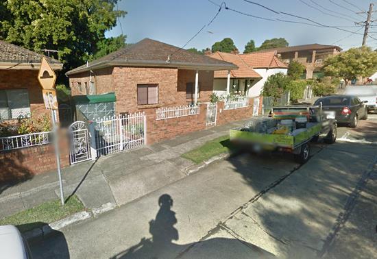
No.81 Windsor Road, Dulwich Hill
PUBLIC CONSULTATION
Nil.
CONCLUSION
Nil.
|
|
Local Traffic Committee Meeting 4 December 2018 |
Subject: Tramway Street, Tempe - Proposed 'No Parking' in the cul de sac (Marrickville Ward/Heffron Electorate/ Inner West PAC)
Prepared By: Mary Bailey - Parking Planner
Authorised By: John Stephens - Traffic and Transport Services Manager
|
SUMMARY Following community representation and investigation, Council is proposing to implement ‘No Parking’ restrictions in Tramway Street to improve vehicle access and manoeuvrability in the vicinity of the end of the cul de sac. Concerns were raised by residents at the parking impact of the drivers from the Tempe Bus Depot parking their private vehicles in the cul de sac section of Tramway Street. Following consultation with affected residents, there have been no objections received to the proposal. |
|
RECOMMENDATION
THAT the installation of a 10m ‘No Parking' restriction in Tramway Street (southern side) between the end of the street and opposite property No. 8 Tramway Street, Tempe be approved.
|
BACKGROUND
Council is proposing changes to parking restrictions in Tramway Street, Tempe. The proposal comes about as a result of a resident request to remove parking in the cul de sac to allow for vehicles to turn around and not have to reverse out of the street. The proposal is illustrated in Figure 1 below. The parking situation at the subject location is further detailed in Figure 2 and Figure 3 below.
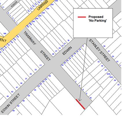
Figure 1: proposal for ‘No Parking’ in cul de sac of Tramway Street
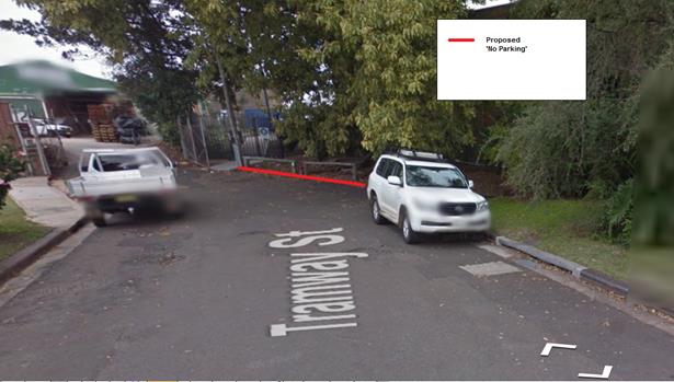
Figure 2: Illustration of location of proposed ‘No Parking’
In Figure 2, the area affected by the proposal is indicated by a red line. The area equates to a space in which 2 vehicles can be parked as illustrated below in Figure 3 below.
Figure 3 also shows the impact of vehicles being parked in the location where “No Parking’ is proposed. The result is that there is insufficient room for a vehicle to turn. It should be noted that the gates to the industrial site at the end of the cul de sac are closed after hours, necessitating the use of the turning circle and the driveway of property no. 10 Tramway Street
Figure 3: Vehicles parked in the location where “No Parking’ is proposed
FINANCIAL IMPLICATIONS
The cost of the supply and installation of the signage will be funded from Council’s signs and line markings budget.
OTHER STAFF COMMENTS
There is a history of issues related to parking in Tramway Street and other nearby streets by private vehicles associated with the Tempe Bus Depot. Reports have also been received that private vehicles associated with the nearby Betty Spears Child Care Centre are also parking in surrounding streets. Investigations and discussions are underway to clarify the conditions of the Development Consent of the Tempe Bus Depot and to determine the impacts of the parking of private vehicles from the bus depot and the child care centre. These issues will be managed through Council’s Compliance section.
PUBLIC CONSULTATION
On 31 October, 2018 a letter was sent to residents of properties directly affected by the proposal. (See Figure 4 below for the mailing list.)
Residents were advised that the matter would be discussed at the December 2018 Local Traffic Committee.
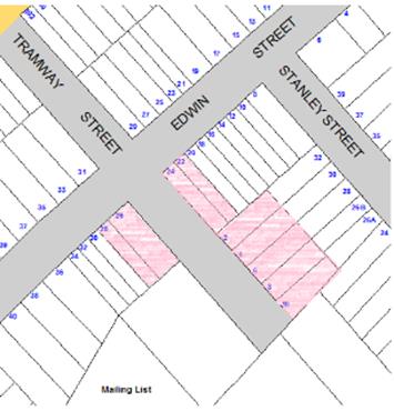
Figure 4: Distribution list for consultation letters
There were five (5) responses in total; three (3) from Tramway Street and two (2) from Edwin Street. Residents of Edwin Street reported impacts in Edwin Street from parking of private vehicles associated with the bus depot and the nearby child care centre. Residents of Tramway Street reported impacts from the parking of private vehicles by bus depot staff. The proponent sought the removal of parking in the cul de sac to improve safety and access.
|
Response |
Office Comment |
|
Object Several residents expressed concern at lack of parking in the street, specifically related to the use of the street by private vehicles associated with the Tempe Bus Depot. |
Site investigations indicate that there is likely parking by vehicles related to the bus depot. There is however evidence that parking is generally available nearby, in the northern end of Tramway Street and in Edwin Street. |
|
Support The proponent sought the installation of ‘No parking’ to allow for turning in the cul de sac , so it would not be necessary for vehicles to reverse out of Tramway Street |
Any parking in the location subject to the ‘No Parking’ proposal would reduce the ability of vehicles to turn in the cul de sac reducing the safety of vehicles existing the cul de sac.
The impact on parking supply is not significant and the safety gains are considered as a priority |
CONCLUSION
Considering the constraints in the cul de sac and the undesirability of having vehicles reversing to exit the street, the proposal to implement ‘No Parking’ in the cul de sac of Tramway Street is supported.
|
|
Local Traffic Committee Meeting 4 December 2018 |
Subject: Holden Street, Ashfield - Proposed relocation of Bus Zone to outside the Ashfield Baptist Church. (Ashfield Ward/Summer Hill Electorate/Burwood PAC)
Prepared By: Boris Muha - Engineer – Traffic and Parking Services
Authorised By: John Stephens - Traffic and Transport Services Manager
|
SUMMARY Concerns have been raised regarding vehicle congestion and movement out of the Ashfield Mall carpark onto Holden Street partially due to the location of an existing 'Bus Zone' on the western side of Holden Street, between the carpark exit and Liverpool Road.
It is proposed that the existing 'Bus Zone' be relocated south of the entry/exit driveway of Ashfield Mall carpark to outside the Ashfield Baptist Church in Holden Street (north of Norton Street). This will improve traffic flow out of the carpark and increase vehicle storage capacity in Holden Street approaching the traffic signals at Liverpool Road.
|
|
RECOMMENDATION
THAT:
1. The 'Bus Zone' on the western side of Holden Street, north of the Ashfield Mall carpark exit be relocated to a position outside the Ashfield Baptist Church, north of Norton Street, Ashfield, replacing a section of 'No Stopping' restriction; and
2. The kerb space in Holden Street, at the location of the existing 'Bus Zone', be replaced with full-time ‘No Stopping’ restrictions between the Ashfield Mall carpark exit and Liverpool Road.
|
BACKGROUND
The existing Bus Zone services the main bus route 491 (Hurstville to Five Dock) and a few school specials. Buses travel via Holden Street and Brown Street towards Ashfield Station. The bus stop mainly allows buses to drop off patrons prior to the terminus area in Brown Street opposite the Ashfield Station.
FINANCIAL IMPLICATIONS
Nil.
OTHER STAFF COMMENTS
The existing 'Bus Zone' is located outside the commercial premises of 208 Liverpool Road (side boundary in Holden Street). Transit Systems have advised that the bus stop is well utilised and raises no objection to having the stop relocated to outside the Ashfield Baptist Church (see diagrams1-3).
Apart from the ‘Bus Zone’, the kerb lane on the western side of Holden Street between Norton Street and Liverpool Road is signposted as ‘No Stopping’ to allow for the free flow of traffic from the carpark entry/exit off Holden Street. The proposed Bus Zone location would cause little or no hindrance to traffic flow. Trucks servicing the Mall (large rigid, 12-14 metre length), turn right wide from the signalised intersection of Norton Street into Holden Street. The probability that there is a bus in the proposed Bus Zone and larger vehicles turning right from Norton Street is considered low and the benefit of providing increased capacity in Holden Street from the carpark exit to Liverpool Road is greater.
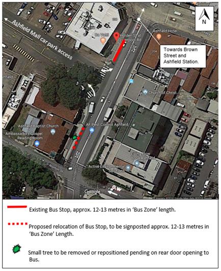
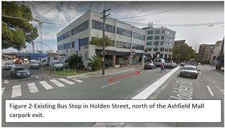
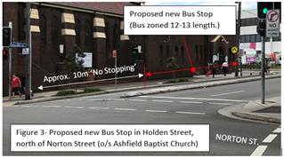
PUBLIC CONSULTATION
Approximately
70 consultation letters were letter boxed to various residential and commercial
premises within the consultation map area (Figure 4) including the Ashfield
Baptist Church and Ashfield Mall Management Centre. Comments on the proposal
were sought, with the closure of submissions being the 16 November 2018. 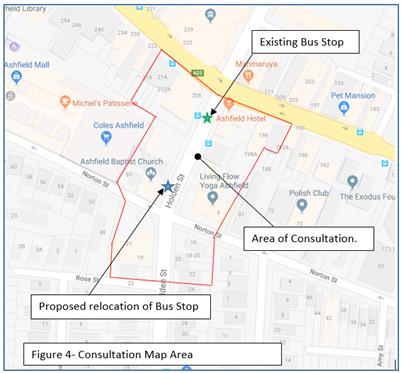
No submissions were received prior to finalising the report and any comments received will be tabled at the meeting, including from Ashfield Baptist Church as the Church had been contacted for its comments in the matter.
CONCLUSION
It is proposed that the existing Bus Zone on the western side of Holden Street, north of the entry/exit of the Ashfield Mall carpark should be relocated south of the carpark access to outside the Ashfield Baptist Church in Holden Street, north of Norton Street. This will improve traffic flow exiting the carpark and increase storage capacity in Holden Street approaching the traffic signals prior to Liverpool Road.
|
|
Local Traffic Committee Meeting 4 December 2018 |
Subject: Forbes Street, Croydon Park – Introduction of short term parking restrictions (Ashfield Ward / Summer Hill Electorate / Burwood PAC)
Prepared By: Jennifer Adams - Engineer – Traffic and Parking Services
Authorised By: John Stephens - Traffic and Transport Services Manager
|
SUMMARY A request for short term parking has been received from the proprietor of a business fronting Georges River Road adjacent to Forbes Street, Croydon Park. It is recommended that the existing 34 metre section of angle parking on Forbes Street at Georges River Road be converted from “unrestricted” to “Two Hour Parking” to provide parking opportunities for visitors / patrons attending the local businesses in the area.
|
|
RECOMMENDATION
THAT:
1. The installation of ‘2P 8:30am-6pm Monday to Friday, and 8:30am-12:30pm Saturday’ restrictions on the western side of Forbes Street, Croydon Park, for a distance of approximately 34 metres south of the existing statutory “No Stopping’ restriction at the junction with Georges River Road be APPROVED, in order to provide short term parking for visitors / patrons of local businesses; and 2. The applicant, responders and Council Rangers be advised in terms of this report. |
BACKGROUND
Concerns have been raised by a local business owner that the existing angle parking provision of 11 spaces (one a mobility parking space) on Forbes Street at the junction with Georges River Road, Croydon Park is now often filled with vehicles that are parked all day leaving limited opportunities for visitors / patrons to visit any of the local businesses in the area.
Previously, former Ashfield Council with the support of the Croydon Park Business Chamber provided 11 angle parking spaces on Forbes Street at the junction with Georges River Road, Croydon Park to service the local businesses.
FINANCIAL IMPLICATIONS
The costs of the supply and installation of the signposting associated with the recommended ‘Two Hour Parking’ restrictions are approximately $800 and can be met from Council’s operating budget.
OFFICER COMMENTS
Forbes Street is a local road and parking is unrestricted on the both sides of Forbes Street. Georges River Road is a State Road. (Refer to the attached locality map and photographs).
Locality Map – Forbes Street, Croydon Park
![]()
![]()
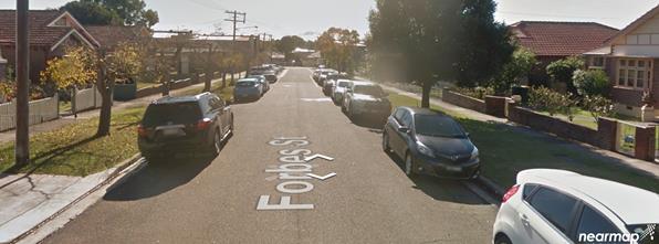
Council is proposing to introduce short term parking restrictions in Forbes Street at the existing angle on-street parking spaces adjacent to Georges River Road, Croydon Park in order to provide a balance of parking for local businesses and visitors.
The restrictions will apply to the 11 existing angle on-street parking spaces inclusive of the mobility parking space. Originally, it was proposed that the present ‘unrestricted’ parking spaces in Forbes Street would be converted to ‘1P 8:30am-6pm Monday to Friday, and 8:30am-12:30pm Saturday (as per the consultation diagram below).
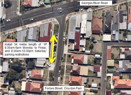
However, subsequent to the consultation period and review of the feedback it was considered prudent to change the short term parking period to two hours, from one hour, to facilitate a more sensible time period for customers of the businesses. A ‘two’ hour period effectively allows others to park in the spaces over night from 4pm onwards to 10.30am in the mornings.
PUBLIC CONSULTATION
Twenty four (24) letters were sent out on Wednesday 24 October 2018 to business owners and property owners/occupiers within the vicinity potentially affected by the proposed parking changes inviting comment. Community submissions closed on Friday 16 November 2018.
Council received one submission not supporting the proposal. It was stated that should this be approved Forbes Street will become “a parking lot for business owners and their workers, not the home owners, nor the customers, we will have the workers parking in front of our houses all day long. Customers can park in front of the shops between 10 and 3 and in the street, as they only park for a short term there is no abjection and there is never a shortage of parking either.” They added: “This proposal is unacceptable as we have 5 cars from our household trying to find parking. We have more rights to be able to park in front of our house than the workers who now have a delegated parking lot near the corner. There is no need for the short term parking as there is plenty of parking for the shoppers in the street and on the Georges River Road.”
CONCLUSION
It is recommended that the existing unrestricted angle parking on Forbes Street at Georges River Road be converted from “unrestricted” to “Two Hour Parking” (‘2P, 8.30am-6.00pm Monday- Friday 8.30am-12.30pm Saturday’) to provide parking opportunities for visitors / patrons attending the local businesses in the area.
Installation diagram
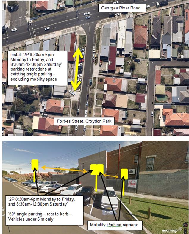
|
|
Local Traffic Committee Meeting 4 December 2018 |
Subject: Wharf Road, Birchgrove - Extension of 'No Parking' restrictions (Balmain Ward/ Balmain Electorate/ Leichhardt LAC)
Prepared By: Vinoth Srinivasan - Engineer - Traffic and Parking Services
Authorised By: John Stephens - Traffic and Transport Services Manager
|
SUMMARY Concerns have been raised regarding vehicles parking on the footpath and obstructing pedestrian and off-street parking access to No. 40 Wharf Road, Birchgrove. |
|
RECOMMENDATION
THAT the existing ‘No Parking’ zone on the southern side of Wharf Road outside No. 40 Wharf Road, Birchgrove be extended across the property’s driveway. |
BACKGROUND
Concerns have been raised regarding vehicles parking on the footpath in Wharf Road and obstructing pedestrian and off-street parking access to No.40 Wharf Road, Birchgrove.
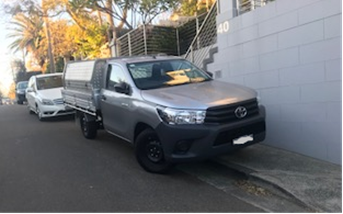
FINANCIAL IMPLICATIONS
Nil.
OTHER STAFF COMMENTS
In order to alleviate this issue, it is proposed that the existing ‘No Parking’ zone on the southern side of Wharf Road outside No.40 Wharf Road, Birchgrove be extended across the property’s driveway. The zone would then extend across the subject pedestrian access as well as the kerb space between the pedestrian access and driveway of No. 40 Wharf Street which would be too short to accommodate a standard vehicle. The restrictions are shown on the figure enclosed.
PUBLIC CONSULTATION
As the proposal does not impact on parking in Wharf Road, there was no need for resident consultation.
CONCLUSION
Nil.
|
|
Local Traffic Committee Meeting 4 December 2018 |
Subject: 168 Norton Street, Leichhardt (D/2018/490) - Development Application (Leichhardt Ward/ Balmain Electorate/ Leichhardt LAC)
Prepared By: Felicia Lau - Engineer - Traffic and Parking Services
Authorised By: John Stephens - Traffic and Transport Services Manager
|
SUMMARY A Development Application has been received for the construction of a five-storey building comprising of independent living units (ILUs) and retail space at 168 Norton Street, Leichhardt.
Comments of the Local Traffic Committee will be referred to Council’s Development Assessment Section for consideration in determining the Development Application. |
|
RECOMMENDATION
THAT the report be received and noted. |
BACKGROUND
A development application (D/2018/490) has been received for the construction of a five-storey building at 168 Norton Street, Leichhardt that comprises the following:
· 50 independent living units.
§ 13 units – one-bedroom.
§ 28 units – two-bedroom.
§ 9 units – three-bedroom.
· 159m2 retail space.
The proposed access point for the development is via the Unnamed Laneway rear of Norton Street between Carlisle Street and Macauley Street. This laneway is approximately 3m wide. Locality is shown in the figure below.
*Extract from the Traffic Impact Assessment (5 September 2018)
The development proposal includes the following parking provision.
· Total 54 parking spaces.
§ 50 standard resident parking spaces (6 visitor parking spaces).
§ 1 accessible resident parking space.
§ 2 standard retail parking spaces.
§ 1 accessible retail parking space.
· One car share bay.
· One service bay (B99 type vehicles)
· One car wash bay.
· Five secure bicycle parking spaces.
· Three motorcycle parking spaces.
The basement car park plan is shown below.
Ground Floor Plan
Basement Car Park Plan
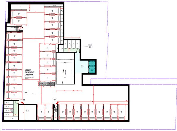
Lower Basement Car Park Plan
The Traffic Impact Assessment (TIA) report indicated that:
· The development generated peak hour traffic of approximately 28 vehicles.
· Intersection analysis using SIDRA 7.0 (network) shows that the road network would not be significantly impacted with the development, intersections assessed were:
§ Carlisle Street/ Laneway – priority controlled intersection.
§ Carlisle Street/ Norton Street/ Short Street – priority controlled intersection.
· The vehicular trip distribution is assumed 50% from/ to north of Norton Street and 50% from/ to south of Norton Street.
· The design review of the car parking facility has been undertaken with reference to AS2890.1:2004, AS2890.3:2015 and AS2890.6:2009 and claimed that the proposal to be generally in compliance with the standards with areas which will require minor amendments during the detailed design stage.
FINANCIAL IMPLICATIONS
Nil.
OTHER STAFF COMMENTS
A Pre-DA meeting was undertaken and comments regarding the concept design were provided by the traffic engineers. The current development application has been reviewed and results in the following concerns:
Waste Collection
The revised design proposed kerb side collection in Carlisle Street, where waste bins will be wheeled out by contractor for collection day. In accordance with the Council’s Development Control Plan (DCP), the proposed development is to provide an on-site waste collection area. As advised in the Pre-DA letter, waste collection must be undertaken from Carlisle Street frontage and on-site loading facilities to be provided.
Service Bay
A service bay has been proposed for a B99-type vehicle within the basement car park. However, as advised in the Pre-DA letter, a service bay must be provided on site to accommodate loading for a small rigid vehicle (minimum) and must be positioned to allow direct access to the retail/commercial premises to minimise conflict with cars in the car park.
Car Parking Provision
The development proposed a total of 45 resident parking spaces with 1 accessible parking space.
The State Environmental Planning Policy (SEPP) Housing for Seniors or People with a Disability 2004 stipulates a minimum of 10 accessible parking spaces are required. The SEPP legislation also stipulates that if car parking (not being car parking for employees) is provided:
· Car parking spaces must comply with the requirements for parking for persons with a disability set out in AS 2890.
· 5% of the total number of car parking spaces (or at least one space if there are fewer than 20 spaces) must be designed to enable the width of the spaces to be increased to 3.8m.
Any variation to the requirement is not supported as the proposal is for senior housing and it is essential that car parking provision is reflective of this.
Car Park and Access Requirement
A longitudinal section must be provided along each edge of the vehicular access and all internal ramps, demonstrating compliance with the ground clearance and headroom requirements.
Intersection
As per the Pre-DA advice, lane widening (see figure below) in the Laneway entry to Carlisle Street/ Laneway intersection is proposed to allow two vehicles to pass each other, it is proposed to extend the widening length to 10m (exclude tapering), in-line with a statutory 10m ‘No Stopping’. Double barrier line may be considered to allow drivers to stay in the lane. The widening would also result in the loss of one existing metered parking space in Carlisle Street.
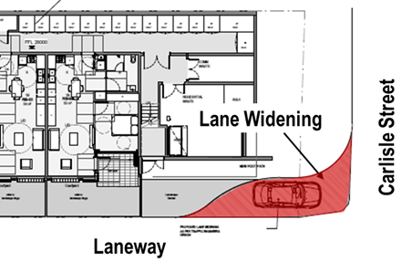
Lane Widening at the Intersection of Carlisle Street/ Laneway
Driveway Access
As per the Pre-DA advice, lane widening (see figure below) at the access driveway is proposed to allow vehicle exiting the car park to give way to vehicle in the laneway. It is proposed to extend the widening length to provide maneuverability for vehicle exiting the car park into the layover area from the point of clear sight lines of vehicles in the laneway.
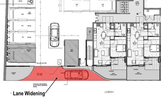
Lane Widening at the Access Driveway
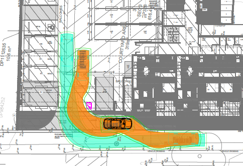
Car Park Access Swept Path (Green B99, Orange B85)
Swept Path
Swept path analysis was undertaken at corners within the car park to show the maneuverability of vehicles passing each other. The report shows that an 85th percentile type vehicle (4.91m length) is unable to pass a 99th percentile type vehicle (5.2m length) without encroaching into the swept path area (see figure below). Convex mirrors were proposed to mitigate areas where vehicles are unable to pass each other.
As the development is proposed for senior living, it is reasonable that the
design should be reflective of the aging drivers. Therefore, the design must
allow vehicles to be able to pass each other around corners and not rely on
convex mirrors.
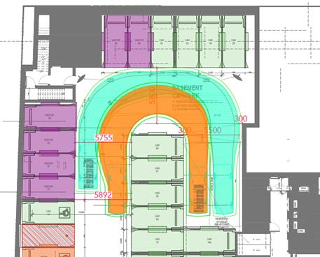
Basement Car Park Swept Path (Green B99, Orange B85)
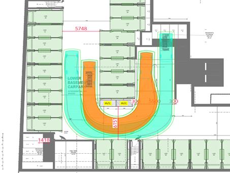
Lower Basement Swept Path (Green B99, Orange B85)
PUBLIC CONSULTATION
Nil.
CONCLUSION
It is proposed that the following traffic and parking related comments be forwarded to Council’s Development Assessment section.
The submitted development application for the proposal at 168 Norton Street, Leichhardt has been reviewed and the following concerns have been raised:
Waste Collection
In accordance with the Council’s Development Control Plan (DCP), the proposed development is to provide an on-site waste collection area. As advised in the Pre-DA letter that waste collection must be undertaken from Carlisle Street frontage and on-site loading facilities to be provided.
Service Bay
A service bay must be provided on site to accommodate loading for a small rigid vehicle (minimum) and must be positioned to allow direct access to the retail/commercial premises to minimise conflict with cars in the car park.
Car Parking Provision
The State Environmental Planning Policy (SEPP) Housing for Seniors or People with a Disability 2004 stipulates a minimum of 10 accessible parking spaces are required. The SEPP legislation also stipulates that if the car parking (not being car parking for employees) is provided:
· Car parking spaces must comply with the requirements for parking for persons with a disability set out in AS 2890.
· 5% of the total number of car parking spaces (or at least one space if there are fewer than 20 spaces) must be designed to enable the width of the spaces to be increased to 3.8m.
Any variation to the requirement is not supported as the proposal is for senior housing and it is essential that car parking provision is reflective of this.
Car Park and Access Requirement
A longitudinal section must be provided along each edge of the vehicular access and all internal ramps, demonstrating compliance with the ground clearance and headroom requirements.
Intersection
As per the Pre-DA advice, lane widening in the Laneway entry to Carlisle Street/ Laneway intersection is proposed to allow two vehicles to pass each other, it is proposed to extend the widening length to 10m (exclude tapering), in-line with a statutory 10m ‘No Stopping’. Double barrier line may be considered to allow drivers to stay in the lane. The widening would also result in the loss of one existing metered parking space in Carlisle Street.
Driveway Access
As per the Pre-DA advice, lane widening (see figure below) at the access driveway is proposed to allow vehicle exiting the car park to give way to vehicle in the laneway. It is proposed to extend the widening length to provide maneuverability for vehicle exiting the car park into the layover area from the point of clear sight lines of vehicles in the laneway.
Swept Path
As the development is proposed for senior living, it is reasonable that the design should be reflective of the aging drivers. Therefore, the design must allow vehicles to be able to pass each other around corners and not rely on convex mirrors.