|
AGENDA R |

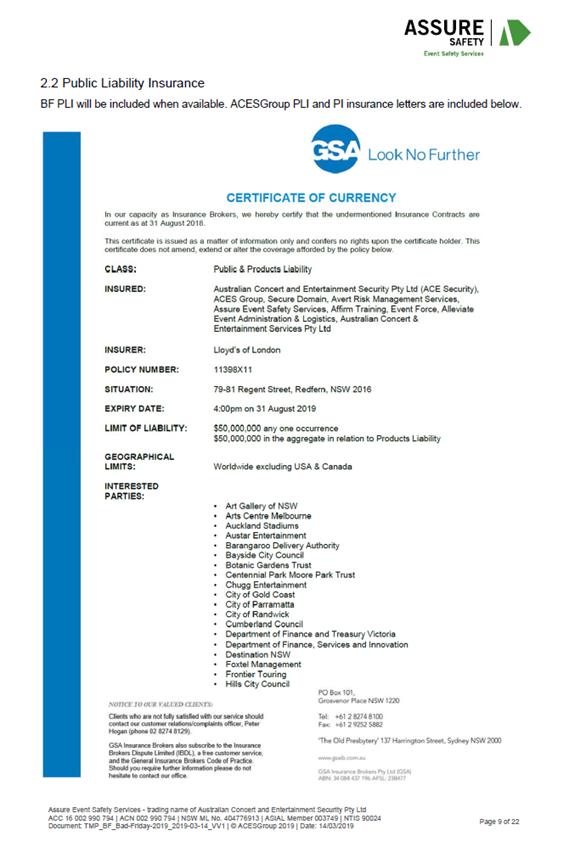
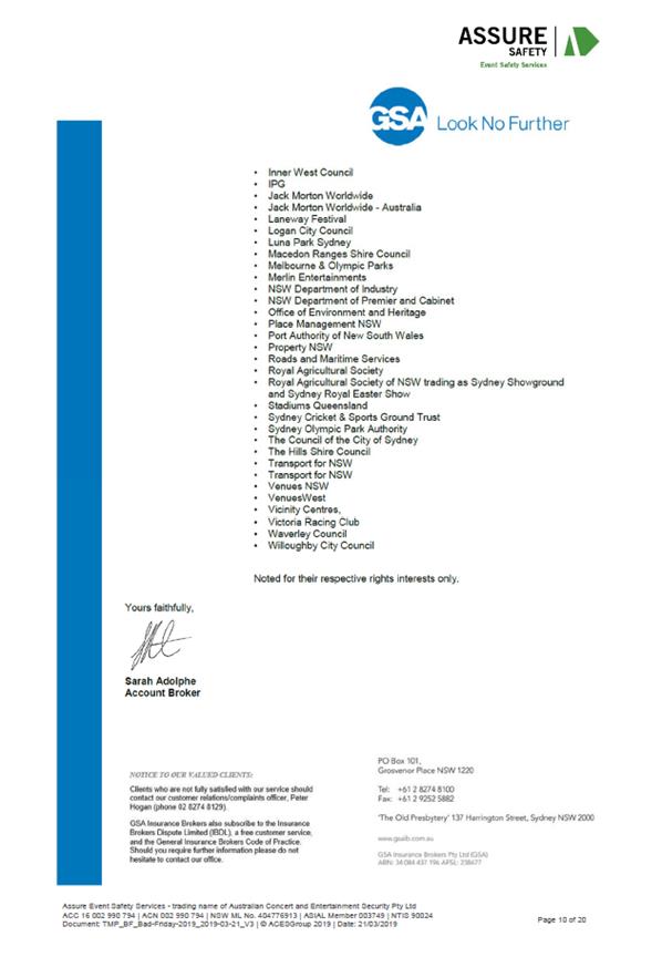
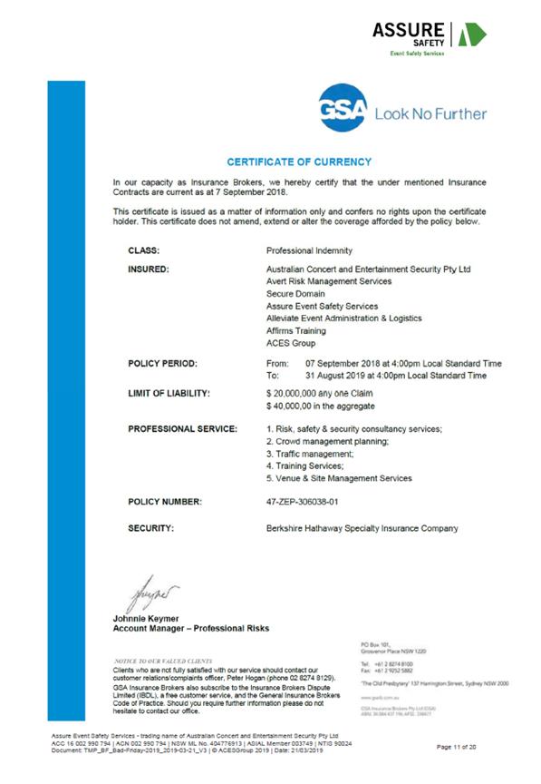
Local Traffic Committee Meeting
MONDAY 1 APRIL 2019
10.00am
|
|
Local Traffic Committee Meeting 1 April 2019 |
Function of the Local Traffic Committee
Background
Roads and Maritime Services (RMS) is legislated as the Authority responsible for the control of traffic on all NSW Roads. The RMS has delegated certain aspects of the control of traffic on local roads to councils. To exercise this delegation, councils must establish a local traffic committee and obtain the advice of the RMS and Police. The Inner West Council Local Traffic Committee has been constituted by Council as a result of the delegation granted by the RMS pursuant to Section 50 of the Transport Administration Act 1988.
Role of the Committee
The Local Traffic Committee is primarily a technical review and advisory committee which considers the technical merits of proposals and ensures that current technical guidelines are considered. It provides recommendations to Council on traffic and parking control matters and on the provision of traffic control facilities and prescribed traffic control devices for which Council has delegated authority. These matters are dealt with under Part A of the agenda and require Council to consider exercising its delegation.
In addition to its formal role as the Local Traffic Committee, the Committee may also be requested to provide informal traffic engineering advice on traffic matters not requiring Council to exercise its delegated function at that point in time, for example, advice to Council’s Development Assessment Section on traffic generating developments. These matters are dealt with under Part C of the agenda and are for information or advice only and do not require Council to exercise its delegation.
Committee Delegations
The Local Traffic Committee has no decision-making powers. The Council must refer all traffic related matters to the Local Traffic Committee prior to exercising its delegated functions. Matters related to State Roads or functions that have not been delegated to Council must be referred directly to the RMS or relevant organisation.
The Committee provides recommendations to Council. Should Council wish to act contrary to the advice of the Committee or if that advice is not supported unanimously by the Committee members, then the Police or RMS have an opportunity to appeal to the Regional Traffic Committee.
Committee Membership & Voting
Formal voting membership comprises the following:
· one representative of Council as nominated by Council;
· one representative of the NSW Police from each Local Area Command (LAC) within the LGA, being Newtown, Marrickville, Leichhardt and Ashfield LAC’s.
· one representative from the RMS; and
· State Members of Parliament (MP) for the electorates of Summer Hill, Newtown, Heffron, Canterbury, Strathfield and Balmain or their nominees.
Where the Council area is represented by more than one MP or covered by more than one Police LAC, representatives are only permitted to vote on matters which effect their electorate or LAC.
Informal (non-voting) advisors from within Council or external authorities may also attend Committee meetings to provide expert advice.
Committee Chair
Council’s representative will chair the meetings.
Public Participation
Members of the public or other stakeholders may address the Committee on agenda items to be considered by the Committee. The format and number of presentations is at the discretion of the Chairperson and is generally limited to 3 minutes per speaker. Committee debate on agenda items is not open to the public.
|
|
Local Traffic Committee Meeting 1 April 2019 |
|
AGENDA |
1 Apologies
2 Disclosures of Interest
3 Confirmation of Minutes
Minutes of 4 March 2019 Local Traffic Committee Meeting 5
4 Matters Arising from Council’s Resolution of Minutes
5 Part A – Items Where Council May Exercise Its Delegated Functions
Traffic Matters
ITEM PAGE #
LTC0419 Item 1 Minor Traffic Facilities (All Wards/All Electorates/All PACs) 28
LTC0419 Item 2 Elliott Street at Terry Street and Glassop Street, Balmain - Proposed Intersection treatments (Baludarri Ward/Balmain Electorate/Leichhardt PAC) 37
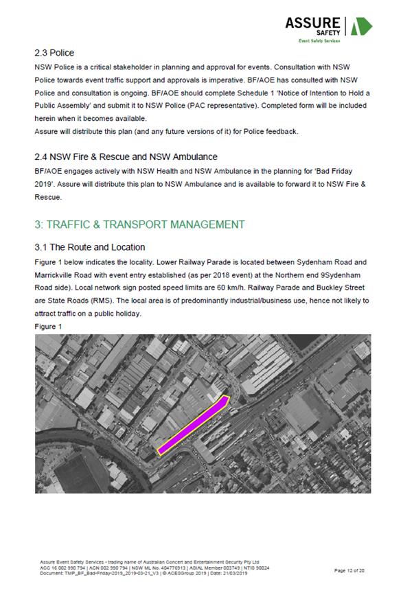
LTC0419 Item 3 Railway Parade, Marrickville (between Sydenham Road and Buckley Lane) – Temporary Full Road Closure for ‘Bad Friday 2019’ event (Midjuburi Ward/Summer Hill Electorate/Inner West PAC) 40
Parking Matters
ITEM PAGE #
LTC0419 Item 4 Beattie Street at High Street, Balmain - Proposed 'No Stopping' zones (Baludarri Ward/Balmain Electorate/Leichhardt PAC) 69
LTC0419 Item 5 Tilba Avenue and Phoebe Street, Balmain - Proposed 'No Stopping' zone (Baludarri Ward/Balmain Electorate/Leichhardt PAC) 71
LTC0419 Item 6 Gannon Lane, Tempe - Proposed Installation of 'No Stopping' signage, replacing current 'No Parking 5am-10am Fridays' restrictions (Midjuburi Ward/Heffron Electorate/Inner West PAC) 74
LTC0419 Item 7 Albion Street, Annandale - Proposed Extension of 'No Stopping' zone (Gulgadya Ward/Balmain Electorate/Leichhardt PAC) 79
LTC0419 Item 8 Wardell Road, Dulwich Hill - Request for extension to existing school drop off zone adjacent to St Maroun's College at Nos.149-206 Wardell Road (Djarrawunang Ward/Summer Hill Electorate/Inner West PAC) 81
Late Items
Nil at time of printing.
6 Part B - Items for Information Only
Nil at the time of printing.
7 Part C - Items for General Advice
Nil at the time of printing.
8 General Business
9 Close of Meeting
|
|
Local Traffic Committee Meeting 1 April 2019 Minutes of 4 March 2019 Meeting |
Minutes of Local Traffic Committee Meeting
Held at Petersham Service Centre on 4 March 2019
Meeting commenced at 10.03am
ACKNOWLEDGEMENT OF COUNTRY BY CHAIRPERSON
I acknowledge the Gadigal and Wangal people of the Eora nation on whose country we are meeting today, and their elders past and present.
COMMITTEE REPRESENTATIVES PRESENT
|
Clr Marghanita da Cruz |
Councillor – Gulgadya Ward (Chair) |
|
Mr Bill Holliday |
Representative for Jamie Parker MP, Member for Balmain |
|
Mr Ryan Horne |
Roads and Maritime Services |
|
Ms Cathy Peters |
Representative for Jenny Leong MP |
|
Marina Nestoriaros |
NSW Police – Leichhardt Police Area Command |
|
|
|
|
OFFICERS AND OTHERS IN ATTENDANCE |
|
|
|
|
|
John Stephens |
IWC’s Traffic and Transport Services Manager |
|
George Tsaprounis |
IWC’s Coordinator Traffic and Parking Services (South) |
|
Boris Muha |
IWC’s Engineer – Traffic and Parking Services |
|
Mary Bailey |
IWC’s Parking Planner |
|
Miia Hynninen |
IWC’s Business Administration Officer |
|
Jennifer Adams |
IWC’s Engineer – Traffic and Parking Services |
|
Felicia Lau |
IWC’s Engineer – Traffic and Parking Services |
|
Scipio Tam |
IWC’s Engineer – Traffic and Parking Services |
|
Davide Torresan |
IWC’s Civil Engineer – Capital Programs |
|
Anup Bairacharya |
IWC’s Civil Engineer – Capital Programs |
|
Joe Di Cesare |
IWC’S Acting Capital Programs Manager |
|
Asith Nagodavithane |
Transit Systems – Inner West Bus Services |
|
|
|
|
VISITORS |
|
|
|
|
|
Bruce Troelfo |
Item 5 – Resident |
|
Margaret Chung |
Item 10 – Resident |
|
Diane Gallagher |
Item 10 – Resident |
|
Alexander Kelly |
Item 14 – Resident |
|
Sean Wallace |
Item 14 – Resident |
|
|
|
|
APOLOGIES: |
|
|
|
|
|
Clr Victor Macri |
Councillor – Marrickville Ward |
|
Manod Wickramasinghe |
IWC’s Coordinator Traffic and Parking Services (North) |
|
Christina Ip |
IWC’s Business Administration Officer |
|
Sgt John Micallef |
NSW Police – Burwood Police Area Command |
|
Sc Anthony Kenny |
NSW Police – Inner West Police Area Command |
|
Wal Petschler |
IWC’s Group Manager Roads and Stormwater |
DISCLOSURES OF INTERESTS:
Nil.
CONFIRMATION OF MINUTES
|
The Minutes of the Local Traffic Committee Meeting held on Monday, 4 February 2019 were confirmed.
|
|
|
MATTERS ARISING FROM COUNCIL’S RESOLUTION OF MINUTES C0219(3) Item 8 Local Traffic Committee Meeting held on 4 December 2018 and 4 February 2019 Motion: (Lockie/Da Cruz)
THAT the Minutes of the Local Traffic Committee Meeting held on 4 December 2018 and 4 February 2019 be received and the recommendations be adopted, with the following amendment:
a) In regards to LTC1218 Item 9 (Lennox Street car park upgrade and improvements) of 4 December 2018, the proposed nominal width of non-disabled parking spaces is to be kept at 2.4m rather than increased in size in order to reduce the number of legal parking spaces lost; b) Correct typo in Item 7 point 1(f) of 4 December meeting to refer to roundabout at Queen Street (not Church Street); c) Amend Item 8 point 2 of 4 December meeting as follows “the provision of a pedestrian facility in Croydon Road at its intersection with Church Street to Centenary Park be investigated as a matter of urgency for implementation before or with the right hand turning lane in point 1’; and d) Amend Item 37 of 4 February meeting to make provision for two parking spaces for Metro Assist on the Ashfield Mall rooftop.
|
|
|
LTC0319 Item 1 White Street, Lilyfield - Proposed 10m 'No Stopping' restriction at intersection with Moore Lane (Baludarri Ward/Balmain Electorate/Leichhardt PAC) |
|
SUMMARY
Council has received a request to signpost the statutory 10m ‘No Stopping’ restriction at the intersection of White Street and Moore Lane, Lilyfield in order to prevent illegal parking and improve sight lines.
OFFICER RECOMMENDATION
THAT a 10m ‘No Stopping’ zones on the western side of White Street, north of Moore Lane
DISCUSSION
The Committee members agreed with the Officer’s recommendation.
COMMITTEE RECOMMENDATION
THAT a 10m ‘No Stopping’ zone be installed on the western side of White Street, north of Moore Lane
For motion: Unanimous
|
|
LTC0319 Item 2 Grove Street, Birchgrove - Proposed 10m 'No Stopping' restrictions at intersection with The Terrace (Baludarri Ward/Balmain Electorate/Leichhardt PAC) |
|
SUMMARY
Council has received a request to signpost the statutory 10m ‘No Stopping’ restriction at the intersection of Grove Street and The Terrace, Birchgrove in order to prevent illegal parking and improve sight lines.
OFFICER RECOMMENDATION
THAT 10m ‘No Stopping’ zones be installed on the western side of Grove Street, north and south of The Terrace, Birchgrove.
DISCUSSION
The Committee members agreed with the Officer’s recommendation.
COMMITTEE RECOMMENDATION
THAT 10m ‘No Stopping’ zones be installed on the western side of Grove Street, north and south of The Terrace, Birchgrove.
For motion: Unanimous
|
|
LTC0319 Item 3 Church Street, Ashfield - Proposed 10m 'No Stopping' restrictions at intersection with Unnamed Lane (Gulgadya Ward/Summer Hill Electorate/Inner West PAC) |
|
SUMMARY
Council has received a request to signpost the statutory 10m ‘No Stopping’ restriction at the intersection of Church Street and Unnamed Lane, Ashfield in order to prevent illegal parking and improve sight lines.
OFFICER RECOMMENDATION
THAT 10m ‘No Stopping’ zones be installed on the western side of Church Street, north and south of the Unnamed Lane, Ashfield.
DISCUSSION
The NSW Police representative for the PAC, in an email, indicated support for the installation of 10 metre ‘No Stopping’ signs.
The Committee members agreed with the Officer’s recommendation.
COMMITTEE RECOMMENDATION
THAT 10m ‘No Stopping’ zones be installed on the western side of Church Street, north and south of the Unnamed Lane, Ashfield.
For motion: Unanimous
|
|
LTC0319 Item 4 Victoria Road & Chapel Street, Marrickville - New Traffic Signals/ Intersection Upgrade for Improving Traffic Safety (Midjuburi Ward/ Summer Hill Electorate/ Inner West PAC) |
|
SUMMARY
Detailed design plans have been finalised for the proposed traffic signalised intersection of Victoria Road and Chapel Road, Marrickville. The purpose of the proposed works are to increase pedestrian and vehicular safety at the subject intersection as crash statistics indicate there have been 22 reported crashes between July 2010 and June 2015 at the time of submitting the Blackspot application.
The proposed works include decommissioning the existing signalised pedestrian crossing on Victoria Road, installation of traffic signals at Victoria Road & Chapel Street intersection, relocation of the existing ‘Bus Zone’ on the eastern side of Victoria Street and installation of signage and road markings. As a result of the proposal five on-street parking will be lost to cater for the turning movements of expected truck at the intersection.
The proposal will result in a net-loss of five (5) on-street parking spaces, removal of one (1) significant street tree and gain of four (4) trees in appropriate locations.
OFFICER RECOMMENDATION
THAT the detailed design plan for the proposed traffic signals at the intersection of Victoria Road and Chapel Street, Marrickville, including associated signposting and line marking (as per the attached plan No. 10039) be approved.
DISCUSSION
Following submissions received from the public to reduce the loss of parking in Chapel Street, it was agreed by Committee members that an additional parking space could be retained if a proposed street tree and kerb blister could be removed from the plan. The removal of this kerb blister will allow for 1 additional parking space to be provided in Chapel Street. The proposed tree will be relocated to be within the footpath. Accordingly, Councils Officer requested that the amended plan 10039A (tabled to the Committee members) be approved.
The Committee members agreed with the Officer’s amended plan.
COMMITTEE RECOMMENDATION
THAT the detailed design plan for the proposed traffic signals at the intersection of Victoria Road and Chapel Street, Marrickville, including associated signposting and line marking (as per the attached plan No. 10039A) be approved.
For motion: Unanimous
|
|
LTC0319 Item 5 Lawson Avenue, Marrickville - Raised Threshold (Midjuburi Ward/ Summer Hill Electorate/ Inner West PAC) |
|
SUMMARY
Detailed design plans have been finalised for the proposed raised threshold in Lawson Avenue, Marrickville.
The proposed work includes construction of a raised threshold, road re-sheeting, footpath rehabilitation, kerb & gutter reconstruction, drainage works and associated signage and line marking.
Consultation was undertaken with owners and occupiers of properties in Lawson Avenue regarding the proposal. A summary of the consultation result is presented in this report for consideration. It is recommended that the proposed detailed design plan be approved.
OFFICER RECOMMENDATION
THAT the detailed design plan (Design Plan No.6198) of the raised threshold at Lawson Avenue, Marrickville be APPROVED.
DISCUSSION
Public Speaker: Bruce Troelfo attended at 10.20am.
Mr Troelfo is in support of the Officer’s Recommendation and made the following comment:
Mr Troelfo left at 10.22am.
The Committee members agreed with the Officer’s recommendation.
COMMITTEE RECOMMENDATION
THAT the detailed design plan (Design Plan No.6198) of the raised threshold at Lawson Avenue, Marrickville be APPROVED.
For motion: Unanimous
|
|
LTC0319 Item 6 Temporary Full Road Closure - Church Street (between Carillon Avenue and Rochester Street), Newtown (Damun Ward/Newtown Electorate/Inner West PAC) |
|
SUMMARY
An application has been received from PBS Building for the temporary full road closure of Church Street (between Carillon Avenue and Rochester Street), Newtown. The closure is to be undertaken on Saturday, 6th April 2019, with one day contingency on Saturday, 13th April 2019. It is recommended that the proposed temporary full road closure be approved, subject to the conditions outlined in the report.
OFFICER RECOMMENDATION
THAT the proposed temporary
full road closure of Church Street (between Carillon Avenue and Rochester
Street, Newtown, on Saturday 6th April 2019, with one day contingency on
Saturday, 13th April 2019 in order to erect a tower crane using a mobile
crane be approved; subject to, although not limited to, the following
conditions: 1. A Road Occupancy License be obtained by the applicant from the Transport Management Centre; 2. All affected residents and businesses, including the NSW Police Local Area Commander, Fire & Rescue NSW and the NSW Ambulance Services be notified in writing, by the applicant, of the proposed temporary full road closure at least 7 days in advance of the closure with the applicant making reasonable provision for stakeholders; and 3. The occupation of the road carriageway must not occur until the road has been physically closed.
DISCUSSION
The Committee members agreed with the Officer’s recommendation.
COMMITTEE RECOMMENDATION
THAT the proposed temporary
full road closure of Church Street (between Carillon Avenue and Rochester
Street, Newtown, on Saturday 6th April 2019, with one day contingency on
Saturday, 13th April 2019 in order to erect a tower crane using a mobile
crane be approved; subject to, although not limited to, the following
conditions: 1. A Road Occupancy License be obtained by the applicant from the Transport Management Centre; 2. All affected residents and businesses, including the NSW Police Local Area Commander, Fire & Rescue NSW and the NSW Ambulance Services be notified in writing, by the applicant, of the proposed temporary full road closure at least 7 days in advance of the closure with the applicant making reasonable provision for stakeholders; and 3. The occupation of the road carriageway must not occur until the road has been physically closed.
For motion: Unanimous
|
|
LTC0319 Item 7 Miller Avenue at Liverpool Road and Cavill Avenue at Liverpool Road, Ashfield - Proposed Kerb Extensions (Djarrawunang Ward/Summer Hill Electorate/Burwood PAC) |
|
SUMMARY
In order to improve pedestrian safety and accessibility at the intersection of Miller Avenue and Liverpool Road, and the intersection of Cavill Avenue and Liverpool Road, it is proposed to install kerb extensions and new pedestrian access ramps.
The proposed works are part of the Western Gateway footway improvements to the Ashfield Town Centre.
The kerb extensions will be constructed within the statutory 10m “No Stopping” distance at the intersections and there will be no loss of legal on-street parking spaces.
OFFICER RECOMMENDATION
THAT the design plan for the proposed kerb extensions and associated signs and line markings in Miller Avenue at Liverpool Road and Cavill Avenue at Liverpool Road, Ashfield (as per design plan, Liverpool Road - Western Gateway Footpath and Crossing Upgrade-attachment 1) be APPROVED.
DISCUSSION
The RMS representative advised that Council is required to discuss with the development works team and go through the checklist. Committee supported installing ‘No Right Turn’ sign on Cavill Avenue exit to Liverpool Road.
Sgt Micallif from NSW Police is in support of the Officers Recommendation. He tabled comments advising that: It will reduce the speed of vehicles entering Cavil Avenue from Liverpool Road. It will also shorten the distance that pedestrians have to be on the road when crossing. Effectively this improvement will promote pedestrian safety in the area.
The Committee members agreed with the Officer’s recommendation.
COMMITTEE RECOMMENDATION
THAT the design plan for the proposed kerb extensions and associated signs and line markings in Miller Avenue at Liverpool Road and Cavill Avenue at Liverpool Road, Ashfield (as per design plan, Liverpool Road - Western Gateway Footpath and Crossing Upgrade-attachment 1) be APPROVED with addition of ‘No Right Turn’ sign on Cavill Avenue exit to Liverpool Road.
For motion: Unanimous
|
|
LTC0319 Item 8 McGill Street, Lewisham - Proposed Parking Restrictions (Damun Ward/Summer Hill Electorate/Inner West PAC) |
|
SUMMARY
Following representation from residents Council is proposing to implement ‘No Parking’ restrictions in McGill Street, Lewisham in order to improve access to off-street parking and allow for improved thoroughfare in the narrow street.
OFFICER RECOMMENDATION
THAT:
1. The installation of ‘No Parking’ restrictions on the western side of McGill Street between existing ‘No Stopping’ restrictions and the boundary of property Nos.12 and 14 McGill Street be approved;
2. The installation of ‘No Parking’ restrictions on the eastern side of McGill Street, immediately north of the driveway of property Nos.7-15 McGill Street to the existing ‘No Stopping’ signpost be approved; and
3. The removal of ‘No Parking 9am-5pm Mon-Fri’ signage on the eastern side of McGill Street, outside property No.5 McGill Street be approved.
DISCUSSION
The Committee members agreed with the Officer’s recommendation.
COMMITTEE RECOMMENDATION
THAT:
1. The installation of ‘No Parking’ restrictions on the western side of McGill Street between existing ‘No Stopping’ restrictions and the boundary of property Nos.12 and 14 McGill Street be approved;
2. The installation of ‘No Parking’ restrictions on the eastern side of McGill Street, immediately north of the driveway of property Nos.7-15 McGill Street to the existing ‘No Stopping’ signpost be approved; and
3. The removal of ‘No Parking 9am-5pm Mon-Fri’ signage on the eastern side of McGill Street, outside property No.5 McGill Street be approved.
For motion: Unanimous
|
|
LTC0319 Item 9 Cavey Street at Calvert Street, Marrickville - Proposed 10m 'No Stopping' restrictions (Midjuburi Ward/Summer Hill Electorate/Innerwest PAC) |
|
SUMMARY
Following representations from the community, Council is proposing to signpost ‘No Stopping’ restrictions in Cavey Street at Calvert Street, Marrickville to improve manoeuvrability and sight lines at this intersection.
OFFICER RECOMMENDATION
THAT the installation of 10m ‘No Stopping’ zones on both the western and eastern sides of Cavey Street, south of Calvert Street be approved.
DISCUSSION
The Committee members agreed with the Officer’s recommendation.
COMMITTEE RECOMMENDATION
THAT the installation of 10m ‘No Stopping’ zones on both the western and eastern sides of Cavey Street, south of Calvert Street be approved.
For motion: Unanimous
|
|
LTC0319 Item 10 Fitzroy Lane, Newtown - Proposed parking restrictions (Damun Ward/Newtown Electorate/Inner West PAC) |
|
SUMMARY
Following representations from the community Council has consulted with affected residents regarding implementation of parking restrictions in Fitzroy Lane, Newtown. The proposal for ‘No Parking’ and ‘No Stopping’ restrictions in the laneway between Australia Street and Brooks Lane will improve access to off-street parking and address resident concerns about damage to buildings.
OFFICER RECOMMENDATION
THAT: 1. Fitzroy Lane (southern side) – Alter the existing ‘No Parking 5am-10am Mondays’ to full time ‘No Parking’ restrictions between the existing ‘No Stopping’ zone at Australia Street and the existing ‘No Parking’ zone opposite Brooks Lane; and 2. Fitzroy Lane (northern side) – Install a 10m ‘No Stopping’ zone immediately east of Brooks Lane, be approved.
DISCUSSION
Public Speakers: Dianne Gallagher and Margaret Chung attended at 10.07am.
Ms Chung objected to the proposed ‘No Parking’ and ‘No Stopping’ zones and made the following comments:
Ms Chung and Ms Gallagher left at 10.18am.
Council officer advised that the proposal initially was to have ‘No Parking’ restrictions on the northern side and retain the parking on the opposite side. Following feedback received from residents expressing a concern and that it was preferred to have the ‘No Parking’ moved to the other side of the laneway as it was more beneficial and protected the privacy of property windows. The speaker properties are not directly affected by the revised proposed ‘No Parking’ zone. Amended proposal improves visibility for parking and allows easier access to laneway garages.
The Committee members agreed with the Officer’s recommendation.
COMMITTEE RECOMMENDATION
THAT: 1. Fitzroy Lane (southern side) – Alter the existing ‘No Parking 5am-10am Mondays’ to full time ‘No Parking’ restrictions between the existing ‘No Stopping’ zone at Australia Street and the existing ‘No Parking’ zone opposite Brooks Lane; and 2. Fitzroy Lane (northern side) – Install a 10m ‘No Stopping’ zone immediately east of Brooks Lane, be approved. For motion: Unanimous
|
|
LTC0319 Item 11 Pearl Lane, Newtown - Proposed 'No Parking' (Damun Ward/Newtown Electorate/Inner West PAC) |
|
SUMMARY
Council has received reports that motorists are having difficulty navigating through the laneway without damaging a fence at the rear of a residence. In order to reduce the risk of damage and improve access and manoeuvrability, Council is proposing to install ‘No Parking’ in Pearl Lane (both sides) between Holmwood Lane and Dickson Street, Newtown.
OFFICER RECOMMENDATION
THAT the installation of ‘No Parking’ restrictions in Pearl Lane (both sides) between existing ‘No Stopping’ zones at Holmwood Lane and Dickson Street be approved.
DISCUSSION
The Committee members agreed with the Officer’s recommendation.
COMMITTEE RECOMMENDATION
THAT the installation of ‘No Parking’ restrictions in Pearl Lane (both sides) between existing ‘No Stopping’ zones at Holmwood Lane and Dickson Street be approved.
For motion: Unanimous
|
|
LTC0319 Item 12 Cannon Lane, Stanmore - Proposed 'No Parking' (Damun Ward/Newtown Electorate/Inner West PAC) |
|
SUMMARY
Following representation from residents regarding difficulty gaining access to off-street parking due to vehicles parked in the laneway, Council is proposing to implement ‘No Parking’ restrictions on both sides of Cannon Lane (between Margaret Street and Corunna Road).
OFFICER RECOMMENDATION
THAT the installation of ‘No Parking’ restrictions in Cannon Lane, Stanmore (both sides) between Margaret Street and Corunna Road, Stanmore be approved.
DISCUSSION
The Committee members agreed with the Officer’s recommendation.
COMMITTEE RECOMMENDATION
THAT the installation of ‘No Parking’ restrictions in Cannon Lane, Stanmore (both sides) between Margaret Street and Corunna Road, Stanmore be approved.
For motion: Unanimous
|
|
LTC0319 Item 13 Piper Lane (rear of 319 Annandale Street), Annandale - Proposed 'No Parking' zone (Baludarri Ward/Balmain Electorate/Leichhardt PAC) |
|
SUMMARY
Council has received concerns regarding parked vehicles obstructing access to off-street parking in Piper Lane (rear of No.319 Annandale Street), Annandale.
OFFICER RECOMMENDATION
THAT a 3.3m ‘No Parking’ zone be installed on the eastern side of Piper Lane between two driveways and opposite rear boundary of No.319 Annandale Street, Annandale.
DISCUSSION
The Committee members agreed with the Officer’s recommendation.
COMMITTEE RECOMMENDATION
THAT a 3.3m ‘No Parking’ zone be installed on the eastern side of Piper Lane between two driveways and opposite rear boundary of No.319 Annandale Street, Annandale.
For motion: Unanimous
|
|
LTC0319 Item 14 Foucart Street at Easton Street, Rozelle - Proposed 'No Stopping' zone (Baludarri Ward/Balmain Electorate/Leichhardt PAC) |
|
SUMMARY
Council has received a request to signpost ‘No Stopping’ restrictions at the intersection of Foucart Street and Easton Street, Rozelle in order to prevent illegal parking and improve sight lines.
OFFICER RECOMMENDATION
THAT:
1. A 10m ‘No Stopping’ zone be installed on the northern side of Easton Street, east of Foucart Street, Rozelle;
2. A 10m ‘No Stopping’ zone be installed on the southern side of Easton Street, east of Foucart Street, Rozelle; and
3. A 10m ‘No Stopping’ zone be installed on the eastern side of Foucart Street, south of Easton Street, Rozelle
DISCUSSION
Public Speakers: Alexander Kelly and Sean Wallace attended at 10.24am.
Mr Wallace objected to the proposed ‘No Stopping’ zones along Easton and Foucart Street and made the following comments:
Ms Kelly commented that:
Council Officers advised that the ‘No Stopping’ zones were necessary due to raised concerns from local residents as a road safety issue. RMS representative advised that the statutory 10m ‘No Stopping’ zone and can be infringed without signage being implemented.
Ms Kelly and Mr Wallace left at 10.33am.
The Committee members agreed with the Officer’s recommendation.
COMMITTEE RECOMMENDATION
THAT:
1. A 10m ‘No Stopping’ zone be installed on the northern side of Easton Street, east of Foucart Street, Rozelle;
2. A 10m ‘No Stopping’ zone be installed on the southern side of Easton Street, east of Foucart Street, Rozelle; and
3. A 10m ‘No Stopping’ zone be installed on the eastern side of Foucart Street, south of Easton Street, Rozelle
For motion: Unanimous
|
|
LTC0319 Item 15 Church Street, Petersham - Proposed 'No Parking Authorised Council Records Vehicles Excepted' Restrictions (Damun Ward/Newtown Electorate/Inner West PAC) |
|
SUMMARY
Council’s Business Information Services section is requesting a permanent loading area in Church Street, Petersham to accommodate staff with the unloading and transportation of hardcopy documents to Council’s Records Repository.
It is recommended that 'No Parking 8.30am-6pm Mon-Fri Authorised Council Records Vehicles Excepted’ restrictions be installed in Church Street, Petersham to assist Council’s Business Information Services staff with unimpeded access and ability to work within WH&S protocols.
OFFICER RECOMMENDATION
THAT the installation of ‘No Parking 8.30am-6pm Mon-Fri Authorised Council Records Vehicles Excepted’ restrictions (length of 6 metres) on the western side of Church Street, Petersham, in front of the basement entry (large double doors) to the Petersham Town Hall (directly opposite side boundary of property No.8 Frederick Street, Petersham) be approved.
DISCUSSION
The Committee members agreed with the Officer’s recommendation.
COMMITTEE RECOMMENDATION
THAT the installation of ‘No Parking 8.30am-6pm Mon-Fri Authorised Council Records Vehicles Excepted’ restrictions (length of 6 metres) on the western side of Church Street, Petersham, in front of the basement entry (large double doors) to the Petersham Town Hall (directly opposite side boundary of property No.8 Frederick Street, Petersham) be approved.
For motion: Unanimous
|
|
LTC0319 Item 16 Henry Street, Ashfield - Proposed Installation of 10m 'No Stopping' zone (Galgadya Ward/Strathfield Electorate/Burwood PAC) |
|
SUMMARY
Council has received concerns of vehicles being parked too close to the intersections along Henry Street, Lucy Street, Earle Street and Page Avenue, Ashfield. These are intersections without ‘No Stopping’ restrictions being signposted.
This proposal is for 'No Stopping' zones to be installed at the specified intersection to address vehicle visibility and manoeuvrability issues.
OFFICER RECOMMENDATION
THAT the installation of 10m 'No Stopping' zones at the following locations be approved: 1. On the eastern side of Henry Street, south of Page Avenue and north of Earle Avenue, Ashfield; 2. On the western side of Henry Street, south of Lucy Street, Ashfield; and 3. On the northern side of Earle Avenue, east of Henry Street, Ashfield.
DISCUSSION
Sgt Micallef emailed his support of the Officer’s recommendation.
The Committee members agreed with the Officer’s recommendation.
COMMITTEE RECOMMENDATION
THAT the installation of 10m 'No Stopping' zones at the following locations be approved: 1. On the eastern side of Henry Street, south of Page Avenue and north of Earle Avenue, Ashfield; 2. On the western side of Henry Street, south of Lucy Street, Ashfield; and 3. On the northern side of Earle Avenue, east of Henry Street, Ashfield.
For motion: Unanimous
|
|
LTC0319 Item 17 Edwin Street & Stanley Street, Tempe - Proposed Installation of 10m Statutory 'No Stopping' Signage (Midjuburi Ward/Heffron Electorate/Inner West PAC) |
|
SUMMARY
A request has been received from a local resident for the provision of ‘No Stopping’ restrictions to deter illegal parking on the southern side of Edwin Street and the adjacent corner of Stanley Street, Tempe. The resident has advised that vehicles are regularly parked too close to the intersection, restricting sightlines for motorists turning into Edwin Street from Stanley Street.
It is recommended that Statutory 10m ‘No Stopping’ restrictions be installed on the southern side of Edwin Street and the adjacent corners on Stanley Street in order to deter illegal parking, increase safety and improve visibility and access for turning motorists.
OFFICER RECOMMENDATION
THAT:
1. Installation of 10m ‘No Stopping’ signage on the southern side of Edwin Street, Tempe, both east and west from its intersection with Stanley Street (in front of No.6 and No.8 Edwin Street, Tempe); and 2. Installation of 10m Statutory ‘No Stopping’ signage on both sides of Stanley Street, Tempe, at the intersection with Edwin Street, (adjacent to side boundary of No.6 and No.8 Edwin Street, Tempe), be approved.
DISCUSSION
The Committee members agreed with the Officer’s recommendation.
COMMITTEE RECOMMENDATION
THAT:
1. Installation of 10m ‘No Stopping’ signage on the southern side of Edwin Street, Tempe, both east and west from its intersection with Stanley Street (in front of No.6 and No.8 Edwin Street, Tempe); and 2. Installation of 10m Statutory ‘No Stopping’ signage on both sides of Stanley Street, Tempe, at the intersection with Edwin Street, (adjacent to side boundary of No.6 and No.8 Edwin Street, Tempe), be approved.
For motion: Unanimous
|
|
LTC0319 Item 18 Cannon Street, Stanmore - Proposed Installation of 10m Statutory 'No Stopping' Signage (Damun Ward/ Newtown Electorate/ Inner West PAC) |
|
SUMMARY
A request has been received from a local resident for the provision of ‘No Stopping’ restrictions to deter illegal parking on the western side of Cannon Street, Stanmore, at its intersection with Corunna Road. The resident has advised that vehicles are regularly parked too close to the intersection, restricting sightlines for motorists giving way to Cannon Street, before continuing along Corunna Road.
It is recommended that statutory 'No Stopping' restrictions be installed on all remaining un-signposted corners of Cannon Street and Corunna Road intersection, for a distance of 10 metres in order to deter illegal parking, increase safety and improve visibility and access for motorists.
OFFICER RECOMMENDATION
THAT the installation of 10m ‘No Stopping’ zones at the following locations be approved;
1. South-east corner of Cannon Street and Corunna Road, Stanmore, extending into both streets; 2. Western side of Cannon Street, Stanmore, extending north from its intersection with Corunna Road; and 3. Western side of Cannon Street, Stanmore, extending south from its intersection with Corunna Road.
DISCUSSION
The Committee members agreed with the Officer’s recommendation.
COMMITTEE RECOMMENDATION
THAT the installation of 10m ‘No Stopping’ zones at the following locations be approved;
1. South-east corner of Cannon Street and Corunna Road, Stanmore, extending into both streets; 2. Western side of Cannon Street, Stanmore, extending north from its intersection with Corunna Road; and 3. Western side of Cannon Street, Stanmore, extending south from its intersection with Corunna Road. For motion: Unanimous
|
|
LTC0319
Item 19 Susan Street, Annandale -
Motorbike Parking |
|
SUMMARY
Council has received concerns regarding blocked vehicular access to the driveway of No.27A and No.29 Susan Street, Annandale. In order to prevent vehicles impeding driveway access whilst making use of the short kerb space, it is proposed to convert the existing 4.0m ‘2P 8am-6pm’ resident parking space into a 4.0m 'Motor Bike Only’ parking between No.27A and No.29 Susan Street, Annandale.
OFFICER RECOMMENDATION
THAT the existing 4.0m parking space between No.27A and No.29 Susan Street, Annandale restricted as ‘2P 8am-6pm; Mon-Fri Permit Holders Excepted Area A1’ parking be signposted as a 4.0m ‘Motor Bike Only’ parking space.
DISCUSSION
The Committee members agreed with the Officer’s recommendation.
COMMITTEE RECOMMENDATION
THAT the existing 4.0m parking space between No.27A and No.29 Susan Street, Annandale restricted as ‘2P 8am-6pm; Mon-Fri Permit Holders Excepted Area A1’ parking be signposted as a 4.0m ‘Motor Bike Only’ parking space.
For motion: Unanimous
|
|
LTC0319 Item 20 Minor Traffic Facilities (All Wards/All Electorates/All PACs) |
|
SUMMARY
This report considers minor traffic facility applications received by Inner West Council, including ‘Disabled Parking’ and ‘Works Zone’ requests.
OFFICER RECOMMENDATION
THAT:
1. A 6m ‘Disabled Parking’ zone be removed in front of No.60 Catherine Street, Leichhardt;
2. A 6m ‘Disabled Parking’ zone be removed in front of No.5 Numa Street, Birchgrove;
3. A 6m ‘Disabled Parking’ zone be installed in front of No.32 Charlecot Street, Dulwich Hill;
4. A 6m ‘Disabled Parking’ zone be installed in front of properties No.29 and No.31 Spencer Street, Summer Hill;
5. A 6m ‘Disabled Parking’ zone be installed in front of No.47 Kays Avenue, Marrickville;
6. A 5.5m ‘Disabled Parking’ zone be installed in front of No.203 Sydenham Road, Marrickville;
7. A 16m ‘Works Zone 7.00am – 6.00pm Mon-Fri; 8.00am -1.00pm Sat' be installed in front of Nos.17-19 Wetherill Street, Croydon for 12 weeks;
8. A 11.5m ‘Works Zone 7.00am – 6.00pm Mon-Fri; 8.00am -1.00pm Sat' be installed in front of No.33 Smith Street, Summer Hill for 5 weeks;
9. A 10m ‘Works Zone 7.00am – 6.00pm Mon-Fri; 8.00am - 1.00pm Sat' be installed in front of No.44 Liverpool Road (Gower Street frontage) and No.35 Gower Street, Summer Hill for 12 weeks, subject to the applicant receiving the written concurrence from the owners of No.35 Gower Street; and
10. A 65m ‘Works Zone 7.00am – 5.30pm Mon - Sat' be installed in front of Nos.13-55 Edinburgh Road, Marrickville for 12 weeks.
DISCUSSION
RMS representative will support recommendation in Item 10; subject to the statutory 20m ‘No Stopping’ being retained.
The Committee members agreed with the Officer’s recommendation.
COMMITTEE RECOMMENDATION
THAT:
1. A 6m ‘Disabled Parking’ zone be removed in front of No.60 Catherine Street, Leichhardt;
2. A 6m ‘Disabled Parking’ zone be removed in front of No.5 Numa Street, Birchgrove;
3. A 6m ‘Disabled Parking’ zone be installed in front of No.32 Charlecot Street, Dulwich Hill;
4. A 6m ‘Disabled Parking’ zone be installed in front of properties No.29 and No.31 Spencer Street, Summer Hill;
5. A 6m ‘Disabled Parking’ zone be installed in front of No.47 Kays Avenue, Marrickville;
6. A 5.5m ‘Disabled Parking’ zone be installed in front of No.203 Sydenham Road, Marrickville;
7. A 16m ‘Works Zone 7.00am – 6.00pm Mon-Fri; 8.00am -1.00pm Sat' be installed in front of Nos.17-19 Wetherill Street, Croydon for 12 weeks;
8. A 11.5m ‘Works Zone 7.00am – 6.00pm Mon-Fri; 8.00am -1.00pm Sat' be installed in front of No.33 Smith Street, Summer Hill for 5 weeks;
9. A 10m ‘Works Zone 7.00am – 6.00pm Mon-Fri; 8.00am - 1.00pm Sat' be installed in front of No.44 Liverpool Road (Gower Street frontage) and No.35 Gower Street, Summer Hill for 12 weeks, subject to the applicant receiving the written concurrence from the owners of No.35 Gower Street; and
10. A 65m ‘Works Zone 7.00am – 5.30pm Mon - Sat' be installed in front of Nos.13-55 Edinburgh Road, Marrickville for 12 weeks, subject to 20m ‘No Stopping’ zone being retained at the signalised intersection at Smidmore Street.
For motion: Unanimous
|
|
LTC0319 Item 21 Australia Street, Stanmore - Proposed Time Restricted Parking (Damun Ward/Newtown Electorate/Inner West PAC) |
|
SUMMARY
Following representation from business owners on Australia Street, Council is proposing to implement timed parking restrictions along Australia Street, Camperdown; on the eastern side, from the Parramatta Road intersection to the frontage of No.8 Australia Street and on the western side, adjacent to No.1 Gantry Lane.
OFFICER RECOMMENDATION
THAT the following signage zones be approved:
1. Installation of a 10m ‘No Stopping’ zone on the eastern side of Australia Street from Parramatta Road to replace the existing ‘No Parking’ restriction at the intersection; 2. Installation of 14m ‘1/4P 8:30am-6pm’ zone on the eastern side of Australia Street, Camperdown immediately south of the proposed ‘No Stopping’ zone (i.e. 2 spaces between No.137 Parramatta Road and No.4 Australia Street); 3. Installation of 23m '2P 8:30am-6pm’ zone on the eastern side of Australia Street, Camperdown immediately south of the driveway of No.4 Australia Street (i.e. 3 spaces between No.4 Australia Street and No.8 Australia Street); and 4. Installation of a ‘2P 8:30am-6pm’ zone on the western side of Australia Street, Camperdown 10m south of Parramatta Road and adjacent to No.1 Gantry Lane. DISCUSSION
The Committee members agreed with the Officer’s recommendation.
COMMITTEE RECOMMENDATION
THAT the following signage zones be approved:
1. Installation of a 10m ‘No Stopping’ zone on the eastern side of Australia Street from Parramatta Road to replace the existing ‘No Parking’ restriction at the intersection; 2. Installation of 14m ‘1/4P 8:30am-6pm’ zone on the eastern side of Australia Street, Camperdown immediately south of the proposed ‘No Stopping’ zone (i.e. 2 spaces between No.137 Parramatta Road and No.4 Australia Street); 3. Installation of 23m '2P 8:30am-6pm’ zone on the eastern side of Australia Street, Camperdown immediately south of the driveway of No.4 Australia Street (i.e. 3 spaces between No.4 Australia Street and No.8 Australia Street); and 4. Installation of a ‘2P 8:30am-6pm’ zone on the western side of Australia Street, Camperdown 10m south of Parramatta Road and adjacent to No.1 Gantry Lane. For motion: Unanimous
|
|
LTC0319 Item 22 Birchgrove Road at Macquarie Terrace, Birchgrove - Proposed Linemarking and Signage Works (Baludarri Ward/Balmain Electorate/Leichhardt PAC) |
|
SUMMARY
Council has received concerns from Birchgrove Public School P&C regarding pedestrian safety near the existing raised pedestrian crossing in Birchgrove Road at the intersection of Macquarie Terrace, Birchgrove.
OFFICER RECOMMENDATION
THAT the design plan for pedestrian safety improvement works, which includes signposting and linemarking in Birchgrove Road at the intersection of Macquarie Terrace, Birchgrove (as per the attached plan) be approved.
DISCUSSION
The Committee members agreed with the Officer’s recommendation.
COMMITTEE RECOMMENDATION
THAT the design plan for pedestrian safety improvement works, which includes signposting and linemarking in Birchgrove Road at the intersection of Macquarie Terrace, Birchgrove (as per the attached plan) be approved.
For motion: Unanimous
|
|
LTC0319 Item 23 Flood Street, Leichhardt - Road Occupancy (Gulgadya Ward/Balmain Electorate/Leichhardt PAC) |
|
SUMMARY
This report considers a request received from BreastScreen NSW for the temporary placement of their mobile lab unit on the western side of Flood Street adjacent to Leichhardt Market Place within the existing ‘Taxi Zone’, for the duration of eight (8) weeks starting from Friday, 21st June to Friday, 16th August 2019.
OFFICER RECOMMENDATION
THAT the road occupancy for the BreastScreen NSW mobile lab unit on the western side of Flood Street, adjacent to Leichhardt Market Place within the existing ‘Taxi Zone’, for the duration of eight (8) weeks starting from Friday, 21st June to Friday, 16th August 2019 be supported, subject to the following conditions:
1. That all affected businesses, residents and other occupants must be notified of the road occupancy and activities at least one week prior to the commencement of the event. Any concerns or requirements raised by business proprietors, residents and other occupants must be resolved or accommodated by the applicant;
2. That the applicant contact Energy Australia/Ausgrid in relation to power access to the mobile laboratory;
3. That the areas to be used for the activities must be maintained in a clean and tidy condition to the satisfaction of Council’s Group Manager Roads, Traffic and Stormwater, or else the applicant will be required to reimburse Council for any extraordinary cleansing costs;
4. That the Council and RMS must be indemnified against all claims for damage or injury that may result from either the activities or from the occupation of part of the public way during the activities. The applicant must therefore produce evidence of its public risk insurance cover (under which Council is indemnified) with a minimum policy value of at least $10,000,000;
5. That a copy of the Council approval letter must be made available on the site for inspection by relevant officers;
6. That the applicant must comply with any reasonable directive from Council’s Compliance Officers; and
7. That Council reserves the right to cancel this approval at any time.
DISCUSSION
The Committee members agreed with the Officer’s recommendation. The Taxi Council is in support of the Officer’s recommendation.
COMMITTEE RECOMMENDATION
THAT the road occupancy for the BreastScreen NSW mobile lab unit on the western side of Flood Street, adjacent to Leichhardt Market Place within the existing ‘Taxi Zone’, for the duration of eight (8) weeks starting from Friday, 21st June to Friday, 16th August 2019 be supported, subject to the following conditions:
1. That all affected businesses, residents and other occupants must be notified of the road occupancy and activities at least one week prior to the commencement of the event. Any concerns or requirements raised by business proprietors, residents and other occupants must be resolved or accommodated by the applicant;
2. That the applicant contact Energy Australia/Ausgrid in relation to power access to the mobile laboratory;
3. That the areas to be used for the activities must be maintained in a clean and tidy condition to the satisfaction of Council’s Group Manager Roads, Traffic and Stormwater, or else the applicant will be required to reimburse Council for any extraordinary cleansing costs;
4. That the Council and RMS must be indemnified against all claims for damage or injury that may result from either the activities or from the occupation of part of the public way during the activities. The applicant must therefore produce evidence of its public risk insurance cover (under which Council is indemnified) with a minimum policy value of at least $10,000,000;
5. That a copy of the Council approval letter must be made available on the site for inspection by relevant officers;
6. That the applicant must comply with any reasonable directive from Council’s Compliance Officers; and
7. That Council reserves the right to cancel this approval at any time.
For motion: Unanimous
|
|
LTC0319 Item 24 2A Gladstone Street, Newtown - DA201700589 - For The Temporary Use Of The Site For A Multi-Use Creative Hub - Revised Traffic & Parking Impact Assessment (Damun Ward/Newtown Electorate/Inner West PAC) |
|
SUMMARY
Additional information has been received for a temporary application to use the existing buildings to create a multi-use creative hub containing creative work spaces (business and offices premise), market stalls, wholesale bakery and food truck with 24 portable/relocatable marquees for stall holders, 8 shipping containers four on the ground floor and 4 above, fold out stage to operate 7.00am to 7.00pm Mondays to Fridays, 6.00am to 6.00pm for the creative workspaces, 6.00am to 6.00pm Mondays to Sundays for the wholesale bakery, Saturdays 7.00am to 4.00pm and 6.00pm to 10.00pm for the market and 7.00am to 10.00pm for functions or creative performances
The application is required to be referred to the Pedestrian, Cyclist & Traffic Calming Advisory Committee for consideration under State Environmental Planning Policy (Infrastructure) 2007.
OFFICER RECOMMENDATION
THAT the findings of this report be received and noted.
DISCUSSION
The Committee members agreed with the Officer’s recommendation.
COMMITTEE RECOMMENDATION
THAT the findings of this report be received and noted.
For motion: Unanimous
General Business
LTC0319 Item 25 Gym on Mallet Street, Camperdown
The representative for the Member for Balmain asked about the status of Council’s decision on the amended proposal for access to the fitness centre from Mallet Street and Council’s officer advised this access location was not supported.
LTC0319 Item 26 City West Link Pedestrian Crossing
The representative for the Member for Balmain advised that the pedestrian crossing time along the City West Link at James Street is too short to cross before the lights change. The representative for the Member for Newtown advised of similar issue crossing Princes Highway at May Street.
RMS representative advised that they will investigate the crossing time and distance and noted that a countdown timer has been proven to negatively affect intersections similar to the City West Link.
LTC0319 Item 27 Pedestrian Crossing at Ashfield Station - Brown Street and Hercules Street, Ashfield
Councillor da Cruz raised concerns regarding waiting time for pedestrians at the pedestrian crossing outside of Ashfield railway station at intersection of Brown Street and Hercules Street.
RMS representative advised that traffic signals require pedestrians to activate the ‘green’ crossing time.
LTC0319 Item 28 Bus Stop on Parramatta Road at Mallet Street, Camperdown
The representative for the Member for Newtown raised an issue with the bus stop location and residents unsafely crossing the road as pedestrian crossings are inconsistently located. RMS representative advised if it is a result of WestConnex then the complaints need to be forwarded to them directly. The Transit Systems representative advised that the bus stop was relocated infront of Mallet Street due to WestConnex works.
LTC0319 Item 29 Northumberland Avenue, Stanmore Parking Permits
The representative for the Member for Newtown advised that resident was unable to obtain parking permit. Council Officer advised that issuance of parking permits to said apartment complex is not possible as per the condition of the DA consent. The authority of the property is required to notify tenants and residents of parking conditions on the DA consent.
LTC0319 Item 30 Intersection of Chandos Street and Parramatta Road, Ashfield
Councillor da Cruz raised concerns for a driveway located at the Chandos Street and Parramatta Road intersection that is not compliant with AS2890.1. Council Officers to investigate
Meeting closed at 11:27am.
|
This page has been left intentionally blank.
|
|
Local Traffic Committee Meeting 1 April 2019 |
Subject: Minor Traffic Facilities (All Wards/All Electorates/All PACs)
Prepared By: Davide Torresan - Coordinator - Road Access Services
Authorised By: John Stephens - Traffic and Transport Services Manager
|
THAT:
1. A 6m ‘Disabled Parking’ zone be removed and the 1P resident parking be reinstated in Red Lion Street, on the side boundary of No.207 Evans Street, Rozelle;
2. A 6m 'Disabled Parking’ zone be installed in front of No.5 Burfitt Street, Leichhardt;
3. A 6m 'Disabled Parking’ zone be installed in front of No.5 High Street, Balmain;
4. A 5.5m 'Disabled Parking’ zone be installed in front of No.12 Kroombit Street, Dulwich Hill;
5. A 6m 'Disabled Parking’ zone be installed in front of No.105 Trafalgar Street, Annandale;
6. A 6m 'Disabled Parking’ zone be installed in Piper Street on the side boundary of No.227 Annandale Street, Annandale;
7. A 5.5m 'Disabled Parking’ zone be installed in front of No.56 Renwick Street, Marrickville;
8. A 20m 'Works Zone 7:00am – 6:00pm Mon-Fri and 8.00am-1.00pm Sat' be installed in Barwon Park Road at the back of No.44-46 Princes Highway, St Peters for 12 weeks;
9. A 9m 'Works Zone 7:00am – 6:00pm Mon-Fri and 8.00am-1.00pm Sat' be installed in front of No.93 Louisa Road, Birchgrove for 12 weeks;
10. A 9m 'Works Zone 7:00am – 6:00pm Mon-Fri and 8.00am-1.00pm Sat' be installed in front of No.112 Edith Street, Leichhardt for 26 weeks;
11. A 9m 'Works Zone 7:00am – 6:00pm Mon-Fri and 8.00am-1.00pm Sat' be installed in front of No.132 Evans Street, Rozelle for 12 weeks;
12. A 10m 'Works Zone 7.00am – 6:00pm Mon-Fri and 8.00am-1.00pm Sat' be installed in front of No.109 Birchgrove Road, Birchgrove for 12 weeks; and
13. A 9m 'Works Zone 7:00am – 6:00pm Mon-Fri and 8.00am-1.00pm Sat' be installed in front of No. 9 Johnston Street, Balmain East for 12 weeks. |
BACKGROUND
This report considers minor traffic facility applications by Inner West Council, and includes
‘Disabled Parking’ and ‘Works Zone’ requests.
FINANCIAL IMPLICATIONS
Nil.
OTHER STAFF COMMENTS
1. Removal of ‘Disabled Parking’ restriction – Red Lion Street, Rozelle
A resident advised that the ‘Disabled Parking’ zone in Red Lion Street, on the side boundary of No.207 Evans Street, Rozelle, was not being utilised. Council staff contacted the original applicant and they have confirmed that the ‘Disabled Parking’ zone is no longer required.
It is recommended that the 6m ‘Disabled Parking’ zone in Red Lion Street, on the side boundary of No. 207 Evans Street, Rozelle, be removed and the 1P resident parking be reinstated.
2. Installation of ‘Disabled Parking’ restriction – Burfitt Street, Leichhardt
The resident of No.5 Burfitt Street, Leichhardt has requested the installation of a 'Disabled Parking’ zone in front of the resident’s property. A site investigation has revealed the property does not have off street parking. The applicant does not require the use of wheelchair.
It is recommended that a 6m 'Disabled Parking’ zone be installed in front of No.5 Burfitt Street, Leichhardt.
No.5 Burfitt Street, Leichhardt
3. Installation of ‘Disabled Parking’ restriction – High Street, Balmain
The resident of No.5 High Street, Balmain has requested the installation of a 'Disabled Parking’ zone in front of the resident’s property. A site investigation has revealed the property does not have off street parking. The applicant does not require the use of wheelchair.
It is recommended that a 6m 'Disabled Parking’ zone be installed in front of No.5 High Street, Balmain.
No.5 High Street, Balmain
4. Installation of ‘Disabled Parking’ restriction – Kroombit Street, Dulwich Hill
The resident of No.12 Kroombit Street, Dulwich Hill has requested the installation of a 'Disabled Parking’ zone in front of the resident’s property. A site investigation has revealed the property does not have off street parking. The applicant does not require the use of wheelchair.
It is recommended that a 5.5m 'Disabled Parking’ zone be installed in front of No.12 Kroombit Street, Dulwich Hill.
No.12 Kroombit Street, Dulwich Hill.
5. Installation of ‘Disabled Parking’ restriction – Trafalgar Street, Annandale
The resident of No.105 Trafalgar Street, Annandale has requested the installation of a 'Disabled Parking’ zone in front of the resident’s property. A site investigation has revealed the property does not have off street parking. The applicant does not require the use of wheelchair.
It is recommended that a 6m 'Disabled Parking’ zone be installed in front of No.105 Trafalgar Street, Annandale.
No.105 Trafalgar Street, Annandale
6. Installation of ‘Disabled Parking’ restriction – Piper Street, Annandale
The resident of No.227 Annandale Street, Annandale has requested the installation of a 'Disabled Parking’ zone in Piper Street adjacent to the resident’s property. A site investigation has revealed the property does not have off street parking. The applicant does not require the use of wheelchair.
It is recommended that a 6m 'Disabled Parking’ zone be installed in Piper Street on the side boundary of No.227 Annandale Street, Annandale.
Side Boundary of No.227 Annandale Street, Annandale (Piper Street)
7. Installation of ‘Disabled Parking’ restriction – Renwick Street, Marrickville
The resident of No.56 Renwick Street, Marrickville has requested the installation of a 'Disabled Parking’ zone in front of the resident’s property. A site investigation has revealed the property does not have off street parking. The applicant does not require the use of wheelchair.
It is recommended that a 5.5m 'Disabled Parking’ zone be installed in front of No.56 Renwick Street, Marrickville.
No.56 Renwick Street, Marrickville
8. Installation of ‘Works Zone’ restriction – Barwon Park Road, St Peters
The applicant (No.44-46 Princes Highway) has requested the installation of a temporary 20m 'Works Zone 7:00am – 6:00pm Mon-Fri and 8.00am-1.00pm Sat' along the rear boundary of No.44-46 Princes Highway, St Peters, in Barwon Park Road for 12 weeks.
It is recommended that a 20m 'Works Zone 7:00am – 6:00pm Mon-Fri and 8.00am-1.00pm Sat' be installed in Barwon Park Road along the rear boundary of No.44-46 Princes Highway, St Peters for 12 weeks.
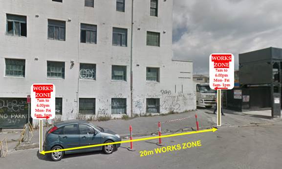
Rear of No.44-46 Princes Highway, St Peters, in Barwon Park Road.
9. Installation of ‘Works Zone’ restriction – Louisa Road, Birchgrove
The applicant (No.93 Louisa Road) has requested the installation of a temporary 9m 'Works Zone 7:00am – 6:00pm Mon-Fri and 8.00am-1.00pm Sat' in front of No.93 Louisa Road, Birchgrove for 12 weeks.
It is recommended that a 9m 'Works Zone 7:00am – 6:00pm Mon-Fri and 8.00am-1.00pm Sat' be installed in front of No.93 Louisa Road, Birchgrove for 12 weeks.
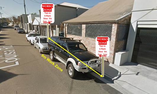
93 Louisa Road, Birchgrove
10. Installation of ‘Works Zone’ restriction – Edith Street, Leichhardt
The applicant (No.112 Edith Street) has requested the installation of a temporary 9m 'Works Zone 7:00am – 6:00pm Mon-Fri and 8.00am-1.00pm Sat' in front of No.112 Edith Street, Leichhardt for 40 weeks. The owners of the neighbouring property, 110 Edith Street, have provided concurrence for the proposed ‘Works Zone’ to extend along their frontage.
It is recommended that a 9m 'Works Zone 7:00am – 6:00pm Mon-Fri and 8.00am-1.00pm Sat' be installed in front of No. 112 Edith Street, Leichhardt for 26 weeks. Generally Works Zones are considered for up to 12 weeks at a time, with a maximum period of 26 weeks. Any extensions of time may be considered at the end of the Works Zone period.
No.112 Edith Street, Leichhardt
11. Installation of ‘Works Zone’ restriction – Evans Street, Rozelle
The applicant (No.136 Evans Street) has requested the installation of a temporary 9m 'Works Zone 7:00am – 6:00pm Mon-Fri and 8.00am-1.00pm Sat' in front of No.132 Evans Street, Rozelle for 12 weeks. The owners of the neighbouring properties No.132 Evans Street have provided a written concurrence for the proposed ‘Works Zone’ to extend along their frontage.
It is recommended that a 9m 'Works Zone 7:00am – 6:00pm Mon-Fri and 8.00am-1.00pm Sat' be installed in front of No.132 Evans Street, Rozelle for 12 weeks.
No.132 Evans Street, Rozelle
12. Installation of ‘Works Zone’ restriction – Birchgrove Road, Birchgrove
The applicant (No.109 Birchgrove Road) has requested the installation of a temporary 10m 'Works Zone 7:00am – 6:00pm Mon-Fri and 8.00am-1.00pm Sat' in front of No.109 Birchgrove Road, Birchgrove.
It is recommended that a 10m 'Works Zone 7.00am – 6:00pm Mon-Fri and 8.00am-1.00pm Sat' be installed in front of No.109 Birchgrove Road, Birchgrove for 12 weeks.
No.109 Birchgrove Road, Birchgrove.
13. Installation of ‘Works Zone’ Restriction – No. 9 Johnston Street, Balmain East
The applicant (No.7a Johnston Street) has requested the installation of a temporary 9m 'Works Zone 7:00am – 6:00pm Mon-Fri and 8.00am-1.00pm Sat' in front of 9 Johnston Street, Balmain East for 12 weeks. The owners of the neighbouring property, 9 Johnston Street, Balmain East, have provided concurrence for the proposed ‘Works Zone’ to be fully along their frontage.
It is recommended that a 9m 'Works Zone 7:00am – 6:00pm Mon-Fri and 8.00am-1.00pm Sat' be installed in front of No. 9 Johnston Street, Balmain East for 12 weeks.
9 Johnston Street, Balmain East
PUBLIC CONSULTATION
Nil.
|
|
Local Traffic Committee Meeting 1 April 2019 |
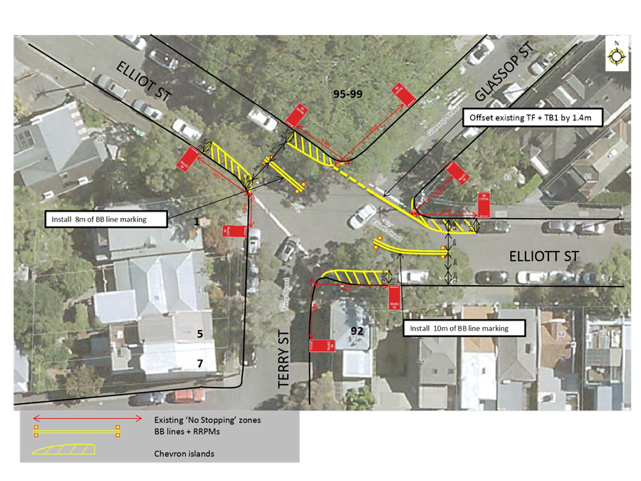
Subject: Elliott Street at Terry Street and Glassop Street, Balmain - Proposed Intersection treatments (Baludarri Ward/Balmain Electorate/Leichhardt PAC)
Prepared By: Brinthaban Baskaran - Student Traffic Engineer
Authorised By: John Stephens - Traffic and Transport Services Manager
|
RECOMMENDATION
THAT the intersection improvement works at the intersection of Elliott Street, Terry Street and Glassop Street, Balmain, which includes installation of barrier lines, chevron painted islands and relocation of 'STOP' holding line (as per Attachment 1) be approved. |
BACKGROUND
Concerns have been raised by a number of residents and motorists regarding safety at the intersection of Elliott Street/Terry Street/Glassop Street, Balmain.
The intersection is controlled by 'STOP' signs for northbound/southbound traffic on Terry Street and Glassop Street with eastbound/westbound traffic on Elliott Street having priority.

It should also be noted that a recently completed multi-unit development at the closed end of Elliott Street has resulted in increased traffic movements at the intersection following construction works.
A review of the 5 year RMS accident history has indicated no reported accidents have occurred at this location.
FINANCIAL IMPLICATIONS
Provision of linemarking treatments will be funded out of Council’s operational budget.
OTHER STAFF COMMENTS
A site investigation has revealed that all existing signs and 'STOP' holding lines are in good condition. However, additional linemarking improvement works can be considered to improve sight lines and narrow the carriageway on Elliott Street to assist in controlling speeds at the intersection. Therefore, it is proposed that the following improvement works be undertaken:
· Installation of double white (barrier) linemarking (BB line type) in Elliott Street;
· Offset of existing STOP holding line (TF type) in Glassop Street by 1.4m to improve sightlines for southbound vehicles in Glassop Street;
· Installation of chevron painted islands in Elliott Street.
The plan for the proposed works is shown in Attachment 1.
All existing vehicular access to adjoining properties will be retained.
This intersection will be listed for review as part of a future LATM study for the area which may consider physical treatments to further improve intersection safety.
PUBLIC CONSULTATION
Nil as there was no impact on parking.
CONCLUSION
Nil.
|
1.⇩ |
Elliott Street at Terry Street and Glassop Street, Balmain - Intersection Improvement Works Plan |
|
|
Local Traffic Committee Meeting 1 April 2019 |
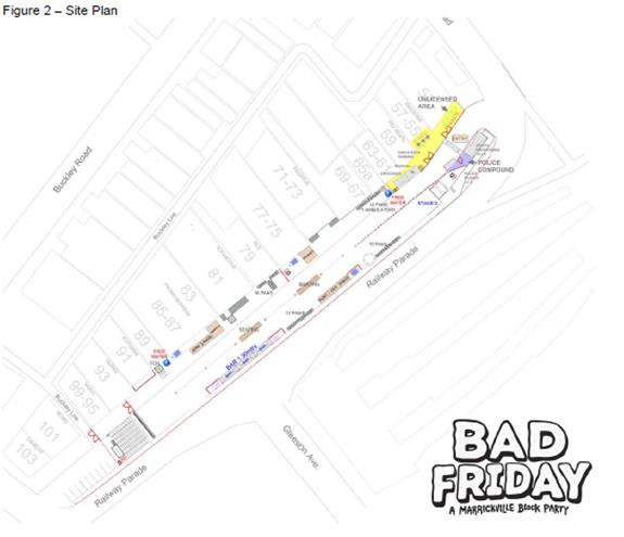
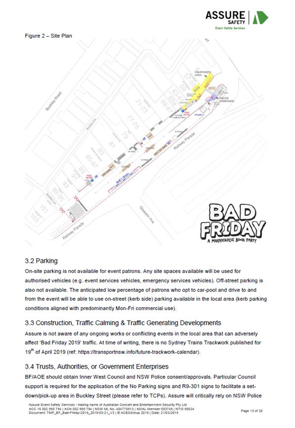
Subject: Railway Parade, Marrickville (between Sydenham Road and Buckley Lane) – Temporary Full Road Closure for ‘Bad Friday 2019’ event (Midjuburi Ward/Summer Hill Electorate/Inner West PAC)
Prepared By: Jennifer Adams - Engineer – Traffic and Parking Services
Authorised By: John Stephens - Traffic and Transport Services Manager
|
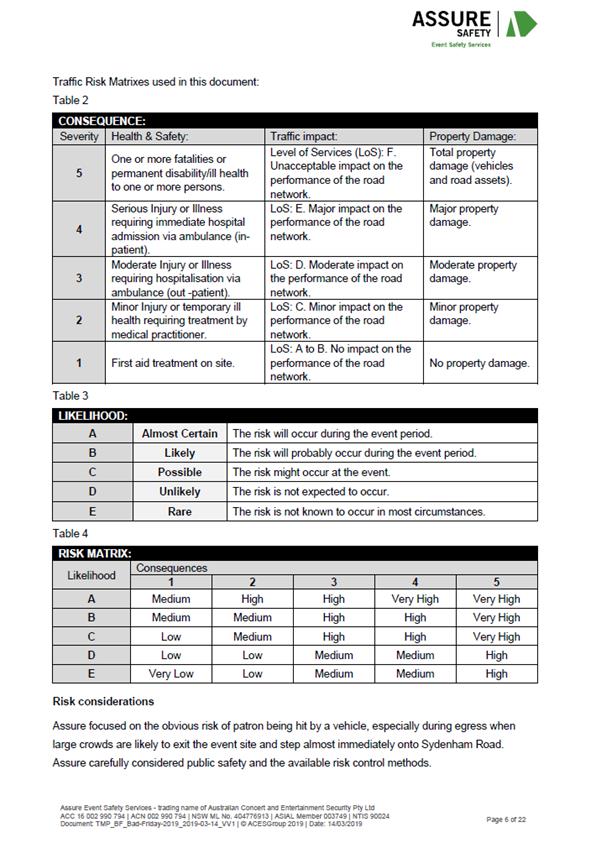
SUMMARY A S68 Application has been received to use lower Railway Parade, Marrickville and hold a commercial special event known as ‘Bad Friday’ on Friday, 19 April 2019. ‘Bad Friday 2019’ is a ticketed access event presenting live music acts that starts at 1.00pm and ends at 11.00pm. The erection of the stage, stalls and associated works will include a temporary full-road closure of Railway Parade, Marrickville between Sydenham Road and Buckley Lane from 3:00pm Thursday, 18 April to 6.00pm on Saturday, 20 April 2019.
It is recommended that the proposed temporary road closure of the subject section of Railway Parade should be supported, subject to the applicant complying with the following conditions: apply to the RMS for consent to close the subject road, subject to the event being advertised; a Traffic Management Plan be submitted to the RMS for approval; a Road Occupancy License be obtained from the Transport Management Centre and details of the proposed event being forwarded to the appropriate authorities, including the emergency services. |
|
RECOMMENDATION
THAT:
1. The proposed temporary road closure of Railway Parade, Marrickville between Sydenham Road and Buckley Lane from 3:00pm Thursday, 18 April to 3:00pm Saturday, 20 April 2019, for the holding of the ‘Bad Friday’ event on Railway Parade be supported, subject to the applicant seeking consent from RMS and forwarding a TMP;
2. A Road Occupancy License be obtained by the applicant from the Transport Management Centre;
3. All affected residents and businesses, including the NSW Police Local Area Commander, Fire & Rescue NSW and the NSW Ambulance Services be notified in writing, by the applicant, of the proposed temporary road closure at least 7 days in advance of the closure with the applicant making reasonable provision for stakeholders; and
4. The occupation of the road carriageway must not occur until the road has been physically closed.
5. Fees and charges in relation to roadway occupation and closure of the roadway be met by the applicant. |
BACKGROUND
The erection of the stage, stalls and associated works will include a temporary full-road closure of Railway Parade, Marrickville between Sydenham Road and Buckley Lane from 3:00pm Thursday, 18 April to 6.00pm on Saturday, 20 April 2019.
The event organiser has supplied the following details of the event:
‘Bad Friday 2019’ is a ticketed access event presenting live music acts. The event is expected to attract an audience demographic mainly from the local area, with a near equal ratio between male and female patrons and age range between 23 and 45 year old. Details provided below
Name of event: ‘Bad Friday 2019’
Location of event: Lower Railway Parade, Marrickville, NSW 2204
Event Date: Friday, 19th of April 2019 (Good Friday)
Event Start Time: 13:00 hrs
Event Finish Time: 23:00 hrs (Music Concludes at 22:30)
Event Bump-in Start: Thursday, 18th of April 2019, 15:00 hrs
Event Bump-out Finish: Saturday, 20th of April 2019 18:00 hrs
Event Class: 2 (subject to LTC classification)
Projected attendance: 4,000 pax, Maximum 5,000 pax. (tickets sold online and on-site)
‘Bad Friday 2019’ is an annual event that will celebrate its 10th anniversary in 2019. The event has grown in popularity and relocated to Railway Parade in 2017. ‘Bad Friday 2019’ is capped at 6,000 patrons, but expected to attract approximately 4,500 patrons.
It is noted that for any event a 4-metre wide emergency vehicle access must be maintained through the closed road areas during the course of the event.
FINANCIAL IMPLICATIONS
Under Council’s Fees & Charges, the applicant has to pay the fee for the temporary full road closure and occupation of the roadway. This fee includes the cost of an advertisement in accordance with the Roads Act 1993.
It is noted that a fee of $1,578.50 for the temporary road closure is payable by the applicant in accordance with Council’s Fees and Charges; and a fee of $5,125.00 for the occupation of the road reserve for the use of the event is payable by the applicant in accordance with Council’s Fees and Charges.
OFFICER COMMENTS
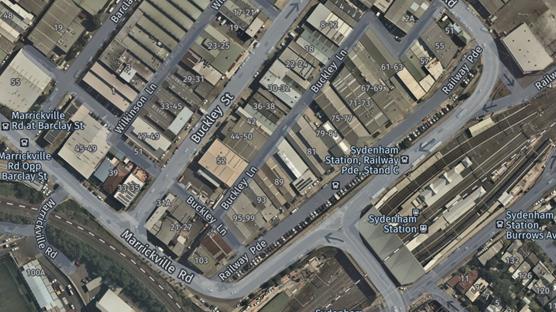
Site location & road network
Railway Parade is a two-level street running north-south between Sydenham and Marrickville Roads. The upper section, which operates ‘one-way’ in a southerly direction, is part of the main road system providing access to/from Gleeson Avenue (bridge over the Illawarra Railway line), Railway Road and Princes Highway. The lower section presently operates ‘two-way’ and provides front access to the commercial properties located along its western side. Almost the entire eastern side of this level is available for parking. (Refer to locality and aerial below.)
Railway Parade lower is 10m in width and is classed as a local road. Parking arrangements on the northern side of the road consists of ‘2P 8.30am-6pm Mon Fri’ parallel-to-kerb parking. Southern side of the road consists of sections of ‘4P 8.30am-6pm Mon Fri’ 90 degree angle parking and unrestricted 90 degree angle parking.
![]()
![]()
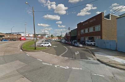
Railway Parade at its intersection with Sydenham Road
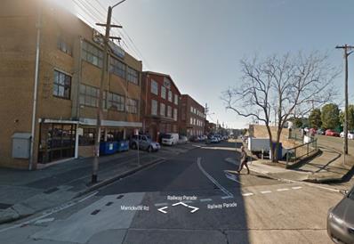
Railway Parade at its intersection with Marrickville Road
The Traffic Control Plan submitted by the applicant is reproduced at the end of this report.
The temporary road closure of Railway Parade is required from 3:00pm Thursday 18 April to 6:00pm Saturday 20 April 2019 to undertake the set-up/pack-down of the stage, stalls and all other associated works prior and after the event, before the road can be reopened to traffic.
The applicant advised that traffic controllers and barricades will be located on Railway Parade at Buckley Lane and at Sydenham Road. In addition, traffic controllers will be assisting pedestrians at the intersection of Railway Parade and Gleeson Avenue near Sydenham Railway Station and at the intersection of Railway Parade and Sydenham Road near the entry to the event. Pedestrian access and egress to the event attendees will be via Sydenham Road and Railway Parade intersection (refer to the attached traffic control plans). Event attendees will not be able to enter Railway Parade from Marrickville Road or Buckley Lane, except for an emergency.
A 4-metre wide emergency vehicle access must be maintained through the closed road areas during the course of the event. Special Event advance notice signs will be strategically installed at least two (2) weeks prior to the event to alert motorists of the proposed closures. In addition, 'No Parking - Special Event' signs will be affixed over all existing parking signs within the area of the event on the afternoon of the day prior to the event date.
Impacts on Parking and Vehicular access
The proposed road closure will have an impact on approximately 90 on-street car parking spaces along both sides of Railway Road during the event, where this parking demand will need to be transferred to the parking spaces in nearby streets. Given that the available on-street parking impacted in Railway Parade is significant, there are concerns raised for commuters who wish to use the nearby main railway station for Easter Long Weekend activities within the Sydney CBD and Sydney Olympic Park. It is envisaged that parking utilisation of this road is highly utilised on public holiday long weekends, particularly during the Easter holidays.
All business properties on Railway Parade will be restricted to access parking during the event for that weekend. Access through the rear of these properties in Buckley Lane will still be retained during that weekend. All adjoining residential and commercial properties will need to be notified in writing of the proposed event and any impacts on parking and access to their properties by the applicant two weeks prior to the event. This includes the temporary removal of on-street parking spaces in Railway Parade during the event.
Impacts on traffic
The subject section of Railway Parade carries a low volume of traffic and therefore the diverted traffic will have no major impacts on surrounding road network. The events will be held on Friday and Saturday during the Easter Public Holiday Long Weekend when lower than weekday traffic volumes are expected.
Public Transport
The subject site has access to public transport services, with Sydenham Railway Station being located within a 100 metre radius from the site and bus routes (Route M30, 418, 425) operating along Marrickville Road, Railway Parade and Gleeson Avenue.
PUBLIC CONSULTATION
The proposed road closure is currently advertised in the local paper published on 19 March 2019 in accordance with the Roads Act 1993.
A Traffic Management Plan is to be submitted to the RMS for consideration and approval and a Road Occupancy License application is to be submitted to the Transport Management Centre.
The event organiser will need to notify all affected residents and businesses in writing of the proposed temporary road closure at least two weeks prior to the event and make reasonable provision for residents and businesses, where possible.
CONCLUSION
It is recommended that the temporary road closure of the subject section of Railway Parade from 3:00pm Thursday, 18 April to 6:00pm Saturday, 20 April 2019 be supported, subject to the applicant complying with the following conditions:
· apply to the RMS for consent to close the subject road, subject to the event being advertised;
· submit a Traffic Management Plan to RMS for approval;
· obtain a Road Occupancy License from the Transport Management Centre and details of the proposed event be forwarded to the appropriate authorities, including emergency services.
Site
Site Plan – Railway Parade, Marrickville submitted by applicant
Traffic Control Plans & Pedestrian Management Plans submitted by applicant
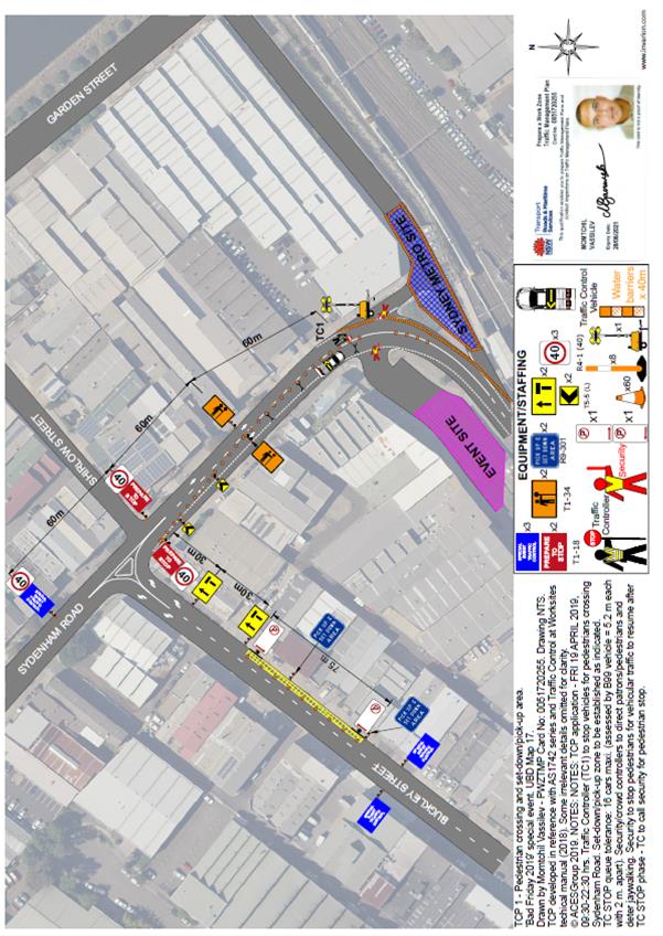
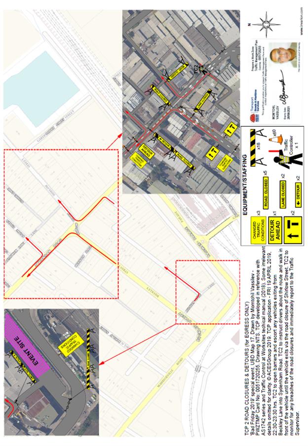
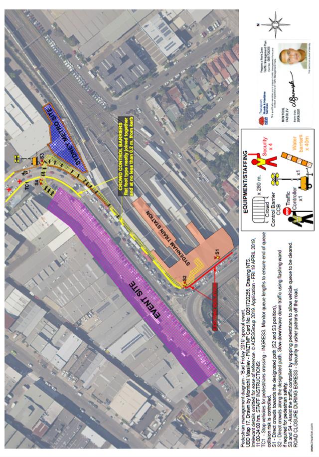
Traffic Management Plan submitted by the applicant
|
|
Local Traffic Committee Meeting 1 April 2019 |
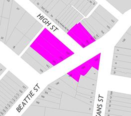
Subject: Beattie Street at High Street, Balmain - Proposed 'No Stopping' zones (Baludarri Ward/Balmain Electorate/Leichhardt PAC)
Prepared By: Vinoth Srinivasan - Engineer - Traffic and Parking Services
Authorised By: John Stephens - Traffic and Transport Services Manager
|
RECOMMENDATION
THAT:
1. A 10m ‘No Stopping’ zone be installed on the northern side of Beattie Street, east of High Street; and
2. A 10m ‘No Stopping’ zone be installed on the northern side of Beattie Street, west of High Street. |
BACKGROUND
Concerns have been raised by residents regarding vehicles parking too close to the intersection of High Street and Beattie Street, Balmain.
The illegal parking behavior obstructs sight lines as well as access into and out of Beattie Street and High Street, Balmain.
FINANCIAL IMPLICATIONS
Nil.
OTHER STAFF COMMENTS
In order to alleviate the sight visibility and manoeuvring space issues, it is proposed to signpost the statutory ‘No Stopping’ zones at the following locations:
· The northern side of Beattie Street and east of High Street (10m ‘No Stopping’ zone)
· The northern side of Beattie Street and west of High Street (10m ‘No Stopping’ zone)
The proposal is shown on the following plan.
![]()
PUBLIC CONSULTATION
|
A letter outlining the above proposal was mailed out to the affected 9 properties in Beattie Street, Balmain.
No objections were received.
|
|
CONCLUSION
Nil.
|
|
Local Traffic Committee Meeting 1 April 2019 |
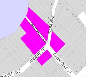
Subject: Tilba Avenue and Phoebe Street, Balmain - Proposed 'No Stopping' zone (Baludarri Ward/Balmain Electorate/Leichhardt PAC)
Prepared By: Vinoth Srinivasan - Engineer - Traffic and Parking Services
Authorised By: John Stephens - Traffic and Transport Services Manager
|
RECOMMENDATION
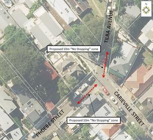
THAT A 10m ‘No Stopping’ zone be installed on the eastern side of Tilba Avenue, north of Carieville Street, Balmain. |
BACKGROUND
Concerns have been raised by residents regarding obstructed sight lines and manoeuvring space for vehicles turning from Carieville Street into Tilba Avenue, Balmain due to parked vehicles.
FINANCIAL IMPLICATIONS
Nil.
OTHER STAFF COMMENTS
In order to alleviate the sight visibility and manoeuvring space issues, it was initially proposed to signpost a 10m ‘No Stopping’ zone on the eastern side of Tilba Avenue, north of Carieville Street. Also, in order to provide consistency at the intersection, it was proposed to extend the existing 7.2m ‘No Stopping’ zone on the southern side of Phoebe Street, west of Carieville Street to 10m.
The proposal is shown on the following plan.
PUBLIC CONSULTATION
|
A letter outlining the above proposal was mailed to the affected 9 properties in Phoebe Street, Tilba Avenue and Carieville Street, Balmain, requesting residents’ views regarding the proposal (as indicated on the following plan). |
|
Three (3) responses were received regarding Council’s proposal to install 10m ‘No Stopping’ restrictions on Phoebe Street and Tilba Avenue, Balmain.
The following table below shows the comments raised by the residents.
|
Residents’ Comments |
Officer Comments |
|
I do not support Council’s proposal to install ‘No Stopping’ restrictions on Tilba Avenue and Phoebe Street. I believe that the sight lines are already blocked by No.7 Carieville Street and the manoeuvring space is adequate in relation to the surrounding system. If the 10m requirement was applied to every intersection in the Balmain peninsular there will be a loss of hundreds of parking spaces. Furthermore the proposed ‘No Stopping’ on Phoebe Street is already adequately covered by a sign which, if moved would impair the access to my front gate. This matter has already been considered in the May 2013 Local Traffic Committee Meeting and was referred to Council which previously deferred this item. Council officers were requested to investigate the possibility of making a Tilba Avenue a Shared Zone. It should also be noted that I have lived in this property for 45 years and have not witnessed one traffic incident. |
Council’s modified proposal seeks to retain the existing 7.2m ‘No Stopping’ restriction on Phoebe Street, at the intersection of Carieville Street.
The possibility of making Tilba Avenue a Shared Zone was previously investigated, including changes to parking that was not supported. However, the statutory 10m ‘No Stopping’ restriction is applicable with or without a Shared Zone and so it is still proposed to signpost the statutory 10m ‘No Stopping’ restriction in Tilba Avenue to improve sightlines and safety at this intersection. |
|
We support the ‘No Stopping’ zone proposed for Tilba Avenue but believe the restriction on Phoebe Street is less necessary. |
Council’s modified proposal seeks to retain the existing 7.2m ‘No Stopping’ restriction on Phoebe Street, at the intersection of Carieville Street. |
|
We support both ‘No Stopping’ zones as we are aware of the dangers of blind corners. Tilba Avenue is already very narrow with site lines also negatively impacted by the building very close to corners. There are also a range of pedestrians who walk down Tilba Avenue to the Dawn Fraser pool and there is no effective footpath which also increases the risk of a fatal incident. |
Noted. |
MODIFIED PROPOSAL
In order to address some concerns raised by residents, it is proposed to retain the existing 7.2m ‘No Stopping’ zone on the southern side of Phoebe Street, west of Carieville Street as extending the 7.2m ‘No Stopping’ zone to 10m will provide marginal benefits due to the presence of ‘No Parking’ restrictions to the west of the existing ‘No Stopping’ zone. A 10m ‘No Stopping’ zone will also result in the pole being placed in front of a pedestrian gate.
Vehicles parking too close to the intersection, on the eastern side of Tilba Avenue, north of Carieville Street still pose concerns to sightlines and so no changes have been made to this portion of the proposal.
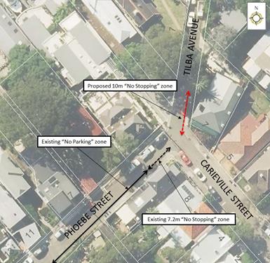
CONCLUSION
Nil.
|
|
Local Traffic Committee Meeting 1 April 2019 |
Subject: Gannon Lane, Tempe - Proposed Installation of 'No Stopping' signage, replacing current 'No Parking 5am-10am Fridays' restrictions (Midjuburi Ward/Heffron Electorate/Inner West PAC)
Prepared By: Scipio Tam - Engineer - Traffic and parking Services (South)
Authorised By: John Stephens - Traffic and Transport Services Manager
SUMMARY
A request has been received from a local resident for the provision of 10m ‘No Stopping’ restrictions to deter illegal parking on the eastern side of Gannon Lane, adjacent to the corner of Gannon Street, Tempe. The resident has advised that vehicles are regularly illegally parking within 10m of the corner, often blocking the rear driveway of No.767 Princes Highway restricting their ingress and egress movements from their off-street parking.
It is recommended that 10m ‘No Stopping’ restrictions be installed on the eastern side of Gannon Lane, on the existing signpost, replacing the current ‘No Parking 5am-10am Fridays’ restriction, adjacent to the corner of Gannon Street in order to deter illegal parking and provide unobstructed access to off-street parking for residents of Gannon Lane, Tempe.
|
RECOMMENDATION
THAT the installation of 10m ‘No Stopping’ signage on the eastern side of Gannon Lane, Tempe, between the rear access of property Nos.767 & 769 Princes Highway (replacing the current ‘No Parking 5am-10am Fridays’ signage) be APPROVED. |
BACKGROUND
Community engagement has been conducted recently, attempting to address the issue of vehicles to the area obstructing access for off-street parking within Gannon Lane. The proposal was for ‘No Parking’ restrictions for the entire length of the eastern side of Gannon Lane, Tempe. However, this proposal in conjunction with the existing ‘No Parking’ restrictions present on the western side of Gannon Lane, Tempe would remove all opportunities for parking in Gannon Lane. The majority of feedback from residents objected to the proposal, as many residents with off-street parking located in Gannon Lane park outside their own driveways. The current proposal only reinforces the current NSW Road Rules in an attempt to deter illegal parking and providing access to off-street parking for all residents of Gannon Lane, Tempe.
FINANCIAL IMPLICATIONS
The cost of the signposting will be funded from Council’s operational budget for signs and line marking.
OTHER STAFF COMMENTS
Site location & road network
|
Street Name |
Gannon Lane |
|
Section |
between Gannon Street and cul-de-sac |
|
Carriageway Width (m) |
5 |
|
Carriageway Type |
Two-way lane |
|
Classification |
Local |
|
Reported Crash History (July 2011 – June 2016) |
No crashes recorded. |
|
Parking Arrangements |
No parking permitted on western side of the lane. |
Site inspection
A Council Officer has observed during site inspections undertaken in the morning and afternoon periods that the on-street parking outside residents’ driveways along Gannon Lane were moderately utilised. At present, there are ‘No Parking’ restrictions on the western side of Gannon Lane and ‘No Parking 5am-10am Fridays’ restrictions on the eastern side of Gannon Lane, between the intersection of Gannon Street and the boundary line between properties Nos.767 & 769 Princes Highway.
On-street parking along Gannon Street is highly-utilised by the residents and workers within the area as reflected by Council Officer’s site inspection and the feedback received from community engagement. As a result of the recent higher demand for parking in the area, Council has received complaints regarding parked vehicles encroaching across driveways, obstructing access to residents' off-street parking spaces.
![]()
![]()
![]()
![]()
![]()
![]()
PUBLIC CONSULTATION
On 27th February 2019, 14 letters were delivered to affected properties in the area and the property owners. Residents and owners were asked to make submissions by 15th March 2019. At the time of writing, one (1) objection had been received. Any additional feedback received will be tabled at the meeting.
![]()
|
Residents’ Comments |
Officer Comments |
|
Resident finds it hard to understand the proposal of a safety issue driving the need to place ‘No Stopping’ signs on an existing parking space behind 765 Princes Highway, Tempe on Gannon Lane. Resident believes the proposal is a way to solve some gripe another resident has about their access to their driveway off Gannon Lane. Resident states the footpath along the southern side of Gannon Street is approximately 3 metres with, with a kerb blister on Gannon Street, west of Gannon Lane. Additionally, the resident stated that Gannon Lane is a short, dead-end lane used only by the few properties along it and if there was a proven safety concern, then surely there would be agreement from others impacted by the same issue. Resident challenges that there is no such evidence of mutual concern. Resident suggests the proposal for ‘No Stopping’ on Gannon Lane may be replaced with simple driveway line marking, indicating garage entry clearances. Resident continues this is a more responsible approach to private problem matter than to impose ‘No Stopping’ funded by rate payers. |
Council Officers who have inspected the intersection on several occasions have identified it as a potential problem due to cars parked within 10m of the intersection. In this case other than garbage pickup day the eastern side of the laneway is unrestricted which poses a problem with vehicles which encroach within 10m of the intersection.
In addition, Council has received images from a local resident, which subsequently was confirmed by Council Officers attending onsite, identifying the problem.
Vehicles parking in Gannon Lane, within 10 metres of the intersection with Gannon Street would be illegally parked under the NSW Road Rule 170. This situation is exacerbated as these vehicles are obstructing residents’ off-street parking access. Therefore, the method of ‘simple driveway line marking’ is not the appropriate solution in this situation because of the following reason. Width of corner property at No.765 Princes Highway is 4.6m wide (same length as a standard motor vehicle). The driveway for No.767 Princes Highway is located adjacent to the boundary of Nos.765 and 767 Princes Highway. A driveway line marking solution requires the line marking to be set back at least 1m from the wing of the driveway (increased to around 1.5m for narrow streets). In this case the use of driveway linemarking would result in a vehicle parking across Council's footpath area thereby causing an obstruction for pedestrians. |
CONCLUSION
The installation and enforcement of the statutory 10m ‘No Stopping’ signage on the intersection of Gannon Lane and Gannon Street will address concerns expressed by residents affected by illegal parked vehicles and is therefore recommended.
|
|
Local Traffic Committee Meeting 1 April 2019 |
Subject: Albion Street, Annandale - Proposed Extension of 'No Stopping' zone (Gulgadya Ward/Balmain Electorate/Leichhardt PAC)
Prepared By: Vinoth Srinivasan - Engineer - Traffic and Parking Services
Authorised By: John Stephens - Traffic and Transport Services Manager
|
THAT the existing 12m ‘No Stopping’ zone on the northern side of Albion Street be extended to 14.6m, west of Susan Street, Annandale. |
BACKGROUND
Concerns have been raised regarding blocked vehicular access to the driveway of No.1 and No.3 Albion Street, Annandale due to vehicles over-hanging the driveway.
The existing kerb space between the driveways of No.1 and No.3 Albion Street is 2.6m long and so is insufficient to accommodate a vehicle without impeding driveway access to both properties.
FINANCIAL IMPLICATIONS
Nil.
OTHER STAFF COMMENTS
It is illegal to park a vehicle in a way that obstructs access to a property. In order to alleviate this issue, it is proposed to extend the existing 12m ‘No Stopping’ zone in Albion Street, Annandale by 2.6m.
The proposal is shown on the following plan.
![]()
PUBLIC CONSULTATION
|
A letter outlining the above proposal was mailed out to the affected 9 properties in Albion Street and Susan Street, Annandale, requesting residents’ views regarding the proposal.
One (1) response was received in objection to the proposal. |
|
|
Residents’ Comments |
Officer Comments |
|
I object to Council’s proposal to extend the existing ‘No Stopping’ zone in Albion Street, Annandale. The parking space in question has existed for the last ten years and is utilized by local Albion Street residents. I am unsure as to why it’s suddenly become an issue now. Furthermore parking on Albion Street is at a premium and it will cause more difficulty for local residents to find parking if this spot is removed. |
This area is insufficient to allow a vehicle to park without obstructing driveway access.
|
CONCLUSION
Nil.
|
|
Local Traffic Committee Meeting 1 April 2019 |
Subject: Wardell Road, Dulwich Hill - Request for extension to existing school drop off zone adjacent to St Maroun's College at Nos.149-206 Wardell Road (Djarrawunang Ward/Summer Hill Electorate/Inner West PAC)
Prepared By: Jennifer Adams - Engineer – Traffic and Parking Services
Authorised By: John Stephens - Traffic and Transport Services Manager
SUMMARY
Representations have been received from the Principal of St Maroun’s College and parents of children attending the school for an extension to the existing school drop off / pick up zone on Wardell Road, Dulwich Hill. Originally the request was for the school drop off zone to be extended to the north eastern corner of Gilbert Barry Memorial Park incorporating the parks frontage; however, the request was subsequently restricted to the north-east school boundary line only and consultation was carried out on the latter proposal.
It is recommended that the existing 30 metre length of school drop off zone along the southern side of Wardell Road, Dulwich Hill (adjacent to St Maroun’s College) be extended by 10 metres (in line with the north-east school boundary line) to cater for the safe drop of and collection of children attending St Maroun’s College.
|
RECOMMENDATION
THAT:
1. The existing 'No Parking 8.00am-9.30am; 2.30pm-4.00pm School Days’ restrictions adjacent to St Maroun’s College on Wardell Road (southern side of roadway) be extended 10 metres eastward (to the school boundary line west of Gilbert Barry Reserve) to improve road safety outside St Maroun’s College; and
2. Council's Parking Officers be requested to regularly enforce the parking restrictions outside St Maroun's College in Wardell Road, Dulwich Hill during morning and afternoon school peak periods.
|
BACKGROUND
St Maroun’s College is located on the eastern side of Wardell Road, between Challis and Pine Streets, Dulwich Hill.
The current parking restrictions outside the school are as follows:
· 'No Parking 8.00am-9.30am; 2.30pm-4.30pm School Days' restrictions used by parents for the drop-off and pick-up of students (30 metres in length accommodating 5 car parking spaces).
· 'No Stopping' restrictions located directly outside the school's main entrance and extending to the south of marked foot crossing.
· 'Bus Zone 8.45am-9.15am and 2.45pm-3.15pm School Days' restrictions south of the crossing, between the 'No Stopping' restrictions and Challis Avenue (16 metres in length).
FINANCIAL IMPLICATIONS
The costs of relocating the existing signpost can be funded from Council’s signs and line marking budget.
OTHER STAFF COMMENTS
The request to extend the existing school drop off zone was considered to be reasonable only if the extension was limited to being adjacent to the school property boundary only. A notification letter was hand delivered to surrounding properties advising that Council is proposing to extend the existing 'No Parking 8.00am-9.30am and 2.30pm-4.00pm School Days’ restrictions along Wardell Road on the southern side by 10 metres eastward (to the school boundary west of Gilbert Barry Reserve) to improve road safety outside St Maroun’s College. (Refer to map below).
![]()
PUBLIC CONSULTATION
A notification letter was hand delivered to 50 properties in the immediate locality along Wardell Road, Dulwich Hill regarding the proposal to extend the existing 'No Parking 8.00am-9.30am and 2.30pm-4.00pm School Days’ restrictions in Wardell Road on the southern side by 10 metres eastward (to the school boundary west of Gilbert Barry Reserve) to improve road safety outside St Maroun’s College. The closing date for submissions ended on Monday 25 March 2019.
Resident survey findings - A total of three (3) responses were received from residents. All opposed to the proposal.
|
Residents’ Comments |
Officer’s Response |
|
Resident does not support proposal citing that over time the no parking zone has been extended but the traffic problems associated with St Maroun’s just gets worse. Notes that school should consider other strategies – encouraging students to catch public transport or walk to school.
They state that it is harder and harder for local residents to find unrestricted parking and residents should not be penalized by the removal of already scare parking.
|
It is acknowledged that the proposal will remove unrestricted parking for three vehicles on ‘school days’ only and for the restricted parking times of an hour and half in the morning and afternoon peak school periods only.
Council notes that congestion occurs outside all schools especially at the afternoon pick up school period and in response Council Parking Officers regularly patrol schools in the LGA. Unfortunately, a lot of motorists disobey the road rules in the process of dropping-off / picking-up their children. It is encouraged that parents and carers park safely even if it means walking further to the school gate.
Council carried out a parking study in Dulwich Hill and the report on the Dulwich Hill Parking Study was endorsed by Council in October 2016. Parking surveys and community consultation were undertaken as part of that study. The study did not recommend any permit parking restrictions in Wardell Road between Beach Street and Margaret Street as there was not sufficient support from residents and the parking surveys which were undertaken indicated that the parking occupancy was below the 85% threshold.
|
|
Resident opposes the proposal to eliminate 10 metres of parking spaces noting that there is limited parking spots in the school's vicinity making school drop off and pick up extremely difficult and does not believe that increasing the current ‘No Parking’ restrictions will increase children’s safety in any way.
They say that alternatively if parking was being reduced along Wardell Road to implement a drop off zone this would be beneficial.
By further minimizing car parking this means that children will have to walk further to get to their parents cars.
|
It is unclear whether the resident is actually supporting the proposal and/or opposing it.
The drop off/pick up zone will improve road safety by reducing the congestion caused from parents waiting to access the drop off zone.
|
|
The resident highlighted that the history of the site from when it was a Carmelite Convent to the present school noting that at no time have local residents been consulted regarding Development proposals for the school and nursing homes expansion over the years. Resident opposes the proposal to extend the existing ‘No Parking’ restrictions as proposed as removing three all day car parking spaces will further limit residents' parking options – some of whom do not have off-street parking facilities. They question why cannot the school provide a drop off and pick up area on their premises rather than on a busy road and/or parents park further away and walk to the school.
Resident would like to see residential parking permit scheme in operation on Wardell Road between Margaret Street and Beach Street, so residents have an option instead of St Maroun’s staff parking all day.
|
Comment noted.
It is acknowledged that the proposal will remove unrestricted parking for three vehicles on ‘school days’ only and for the restricted parking times of an hour and half in the morning and afternoon peak school periods only.
Council carried out a parking study in Dulwich Hill and the report on the Dulwich Hill Parking Study was endorsed by Council in October 2016. Parking surveys and community consultation were undertaken as part of that study. The study did not recommend any permit parking restrictions in Wardell Road between Beach Street and Margaret Street as there was not sufficient support from residents and the parking surveys which were undertaken indicated that the parking occupancy was below the 85% threshold.
|
CONCLUSION
It is considered that a 10 metre extension to the existing 'No Parking 8.00am-9.30am; 2.30pm-4.00pm School Days’ restrictions on Wardell Road on the southern side of the roadway (eastward to the school boundary line, west of Gilbert Barry Reserve) will assist parents and carers with the safe drop off and pick up of children attending St Maroun’s College and is recommended.