|
AGENDA R |

Local Traffic Committee Meeting
MONDAY 1 JULY 2019
10.00am
|
|
Local Traffic Committee Meeting 1 July 2019 |
Function of the Local Traffic Committee
Background
Roads and Maritime Services (RMS) is legislated as the Authority responsible for the control of traffic on all NSW Roads. The RMS has delegated certain aspects of the control of traffic on local roads to councils. To exercise this delegation, councils must establish a local traffic committee and obtain the advice of the RMS and Police. The Inner West Council Local Traffic Committee has been constituted by Council as a result of the delegation granted by the RMS pursuant to Section 50 of the Transport Administration Act 1988.
Role of the Committee
The Local Traffic Committee is primarily a technical review and advisory committee which considers the technical merits of proposals and ensures that current technical guidelines are considered. It provides recommendations to Council on traffic and parking control matters and on the provision of traffic control facilities and prescribed traffic control devices for which Council has delegated authority. These matters are dealt with under Part A of the agenda and require Council to consider exercising its delegation.
In addition to its formal role as the Local Traffic Committee, the Committee may also be requested to provide informal traffic engineering advice on traffic matters not requiring Council to exercise its delegated function at that point in time, for example, advice to Council’s Development Assessment Section on traffic generating developments. These matters are dealt with under Part C of the agenda and are for information or advice only and do not require Council to exercise its delegation.
Committee Delegations
The Local Traffic Committee has no decision-making powers. The Council must refer all traffic related matters to the Local Traffic Committee prior to exercising its delegated functions. Matters related to State Roads or functions that have not been delegated to Council must be referred directly to the RMS or relevant organisation.
The Committee provides recommendations to Council. Should Council wish to act contrary to the advice of the Committee or if that advice is not supported unanimously by the Committee members, then the Police or RMS have an opportunity to appeal to the Regional Traffic Committee.
Committee Membership & Voting
Formal voting membership comprises the following:
· one representative of Council as nominated by Council;
· one representative of the NSW Police from each Local Area Command (LAC) within the LGA, being Newtown, Marrickville, Leichhardt and Ashfield LAC’s.
· one representative from the RMS; and
· State Members of Parliament (MP) for the electorates of Summer Hill, Newtown, Heffron, Canterbury, Strathfield and Balmain or their nominees.
Where the Council area is represented by more than one MP or covered by more than one Police LAC, representatives are only permitted to vote on matters which effect their electorate or LAC.
Informal (non-voting) advisors from within Council or external authorities may also attend Committee meetings to provide expert advice.
Committee Chair
Council’s representative will chair the meetings.
Public Participation
Members of the public or other stakeholders may address the Committee on agenda items to be considered by the Committee. The format and number of presentations is at the discretion of the Chairperson and is generally limited to 3 minutes per speaker. Committee debate on agenda items is not open to the public.
|
|
Local Traffic Committee Meeting 1 July 2019 |
|
AGENDA |
1 Apologies
2 Disclosures of Interest
3 Confirmation of Minutes Page
Minutes of 3 June 2019 Local Traffic Committee Meeting 6
4 Matters Arising from Council’s Resolution of Minutes
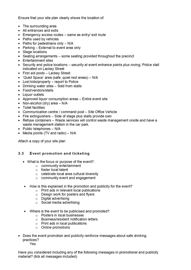
5 Part A – Items Where Council May Exercise Its Delegated Functions
Traffic Matters
ITEM Page
LTC0719 Item 1 Hartley Street At Victoria Road, Rozelle - Proposed 'STOP' Control (Baludarri-Balmain Ward/ Balmain Electorate/ Leichhardt LAC) 22
LTC0719 Item 2 Newington Local Area Traffic Management Strategy (Damun-Stanmore/Midjuburi-Marrickville Wards/ Newtown Electorate/ Inner West PAC) 25
LTC0719 Item 3 Minor Traffic Facilities (All Wards/All Electorates/All PACS) 47
LTC0719 Item 4 Henry Street, Between Railway Parade And George Street, And Railway Lane, Between Henry Street And Hilton Avenue, Sydenham - Temporary Road Closure For ‘Edge Sydenham’ Event On Saturday 10 August 2019 (Midjuburi-Marrickville Ward / Heffron Electorate / Inner West PAC) 54
LTC0719 Item 5 Fred Street, From Summer Hill Street To Eltham Street, Lewisham- Proposed Road And Footpath Renewal Civil Works And Garden Beds/Verge Plantings – Design Plan 10065 (Damun- Stanmore Ward / Summer Hill Electorate / Inner West PAC) 61
LTC0719 Item 6 Merton Street At Trafalgar Street, Petersham - Proposed Traffic Calming At The Intersection – Design Plan 10078 (Damun- Stanmore Ward / Newtown Electorate / Inner West PAC) 68
LTC0719 Item 7 Illawarra Road At Cary Street, Marrickville – Proposed Upgrading And Relocation Of Existing Pedestrian Zebra Crossing On Illawarra Road – Design Plan 10079 (Midjuburi - Marrickville Ward / Summer Hill Electorate / Inner West PAC) 73
LTC0719 Item 8 Marrickville Road And Seaview Street, Marrickville – Temporary Full Road Closures For Dulwich Hill Village Fair On Sunday 15 SEPTEMBER 2019 – S68201800008 - (Djarrawunang-Ashfield Ward / Summer Hill Electorate / Inner West PAC) 79
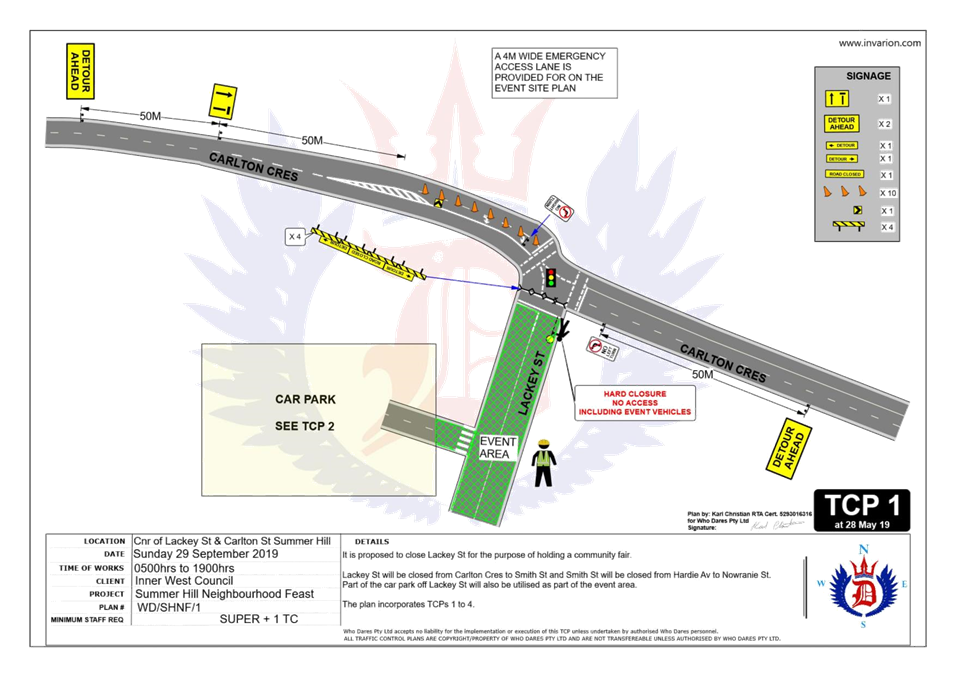
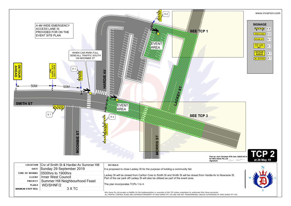
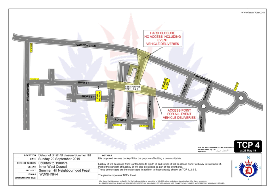
LTC0719 Item 9 Road Occupancy - Lackey Street And Smith Street, Summer Hill - Temporary Road Closures For The Annual 'Summer Hill Neighbourhood Feast' - Sunday 29 Septmber 2019 (Djarrawunang - Ashfield Ward/ Summer Hill Electorate/ Burwood PAC) 95
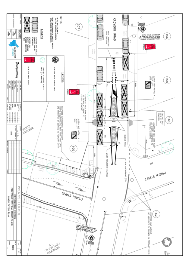
LTC0719 Item 10 Croydon Road At Church Street, Croydon – Proposed Traffic Calming At The Intersection Including A New Pedestrian Refuge On Croydon Road – Design Plan 10090 (Gulgadya – Leichhardt Ward / Strathfield Electorate / Burwood PAC) 126
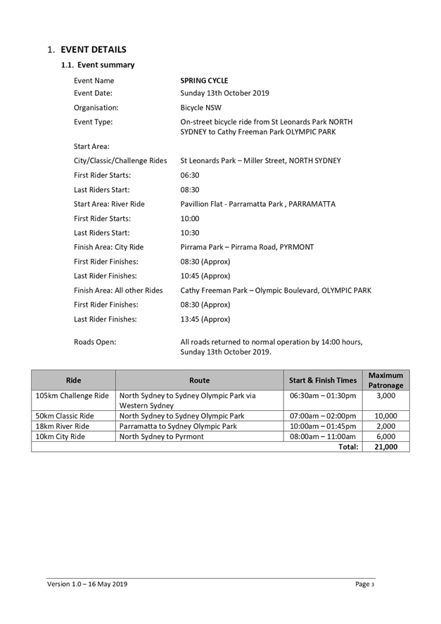
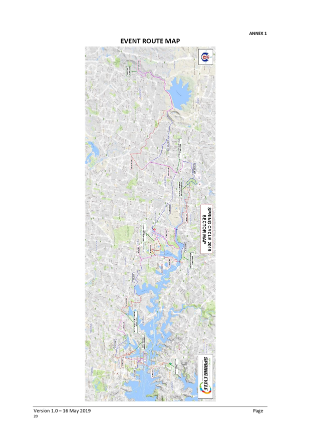
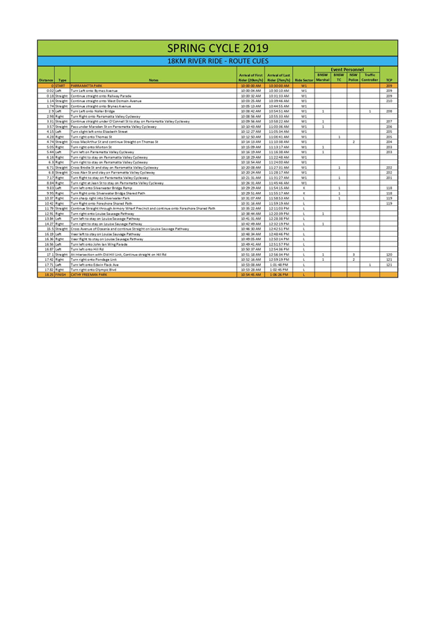
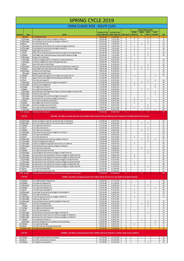
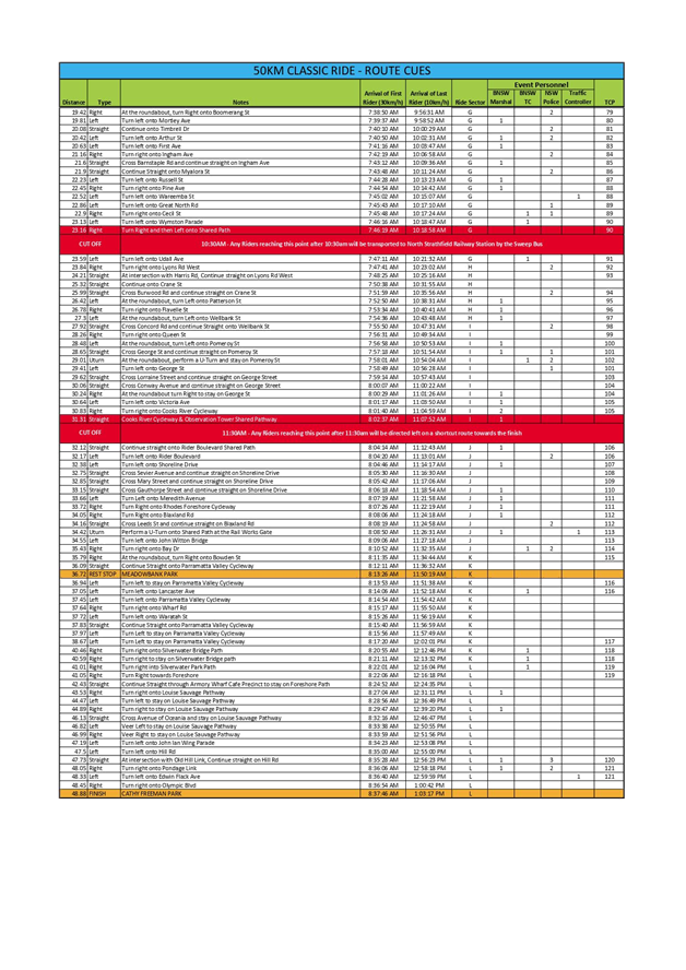
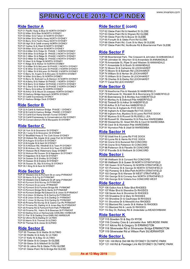
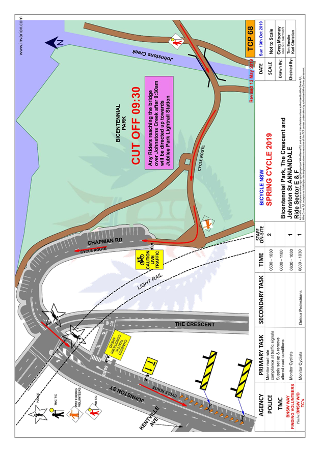
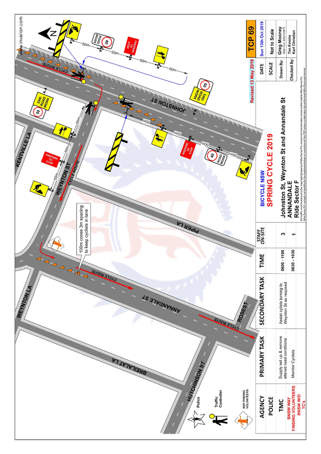
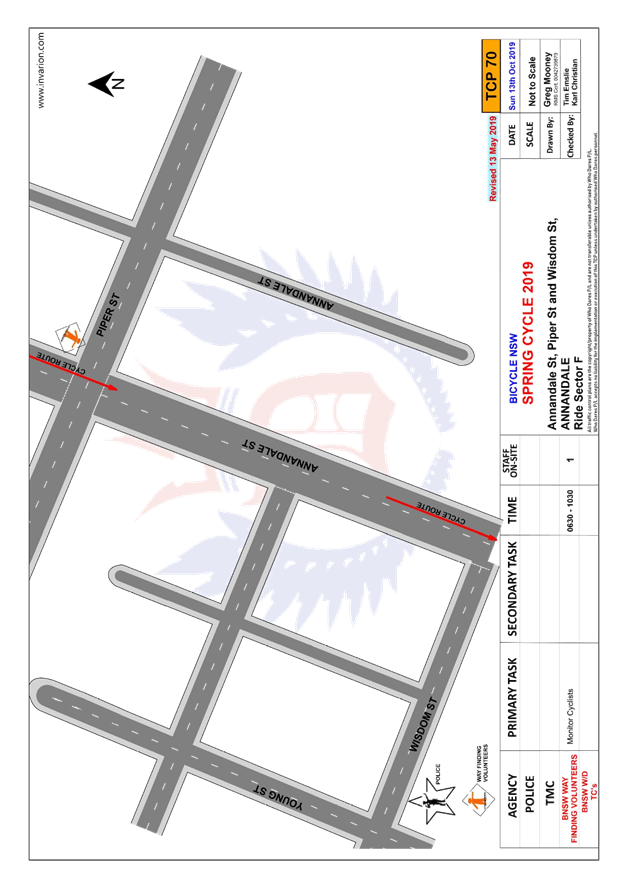
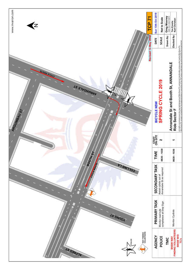
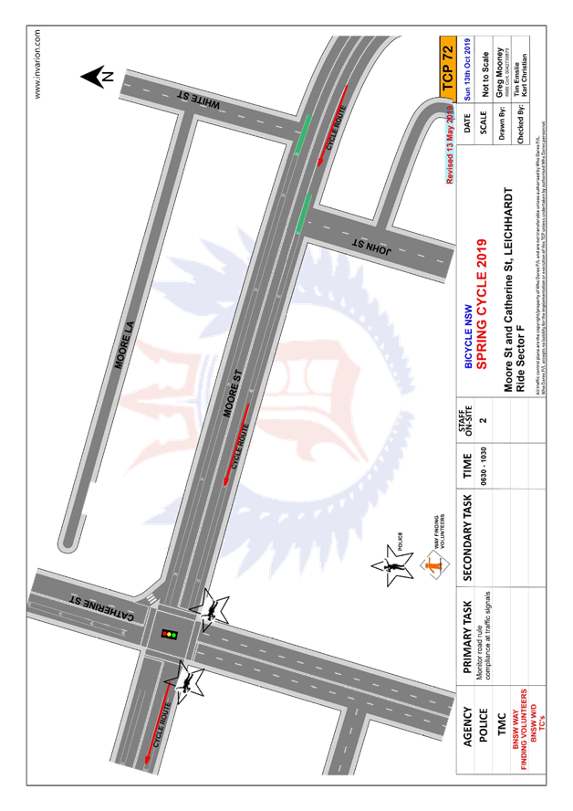
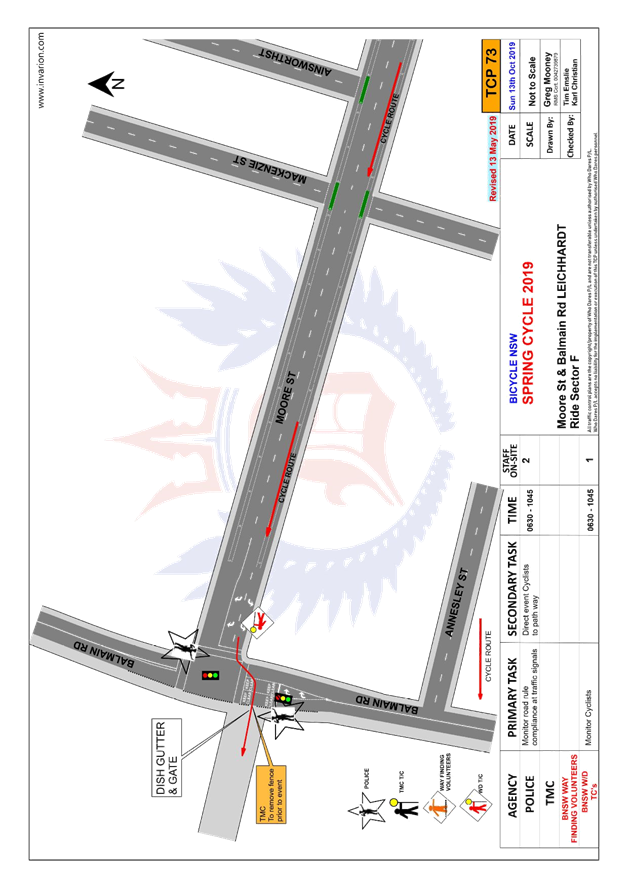
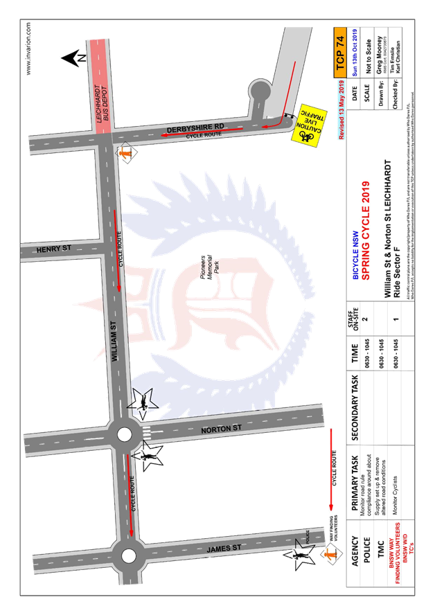
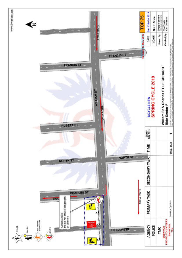
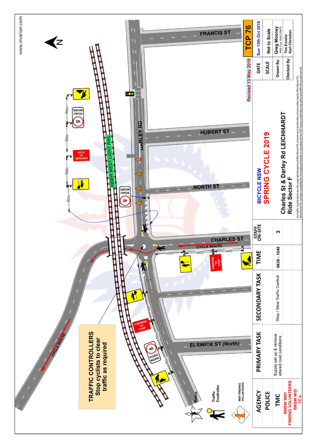
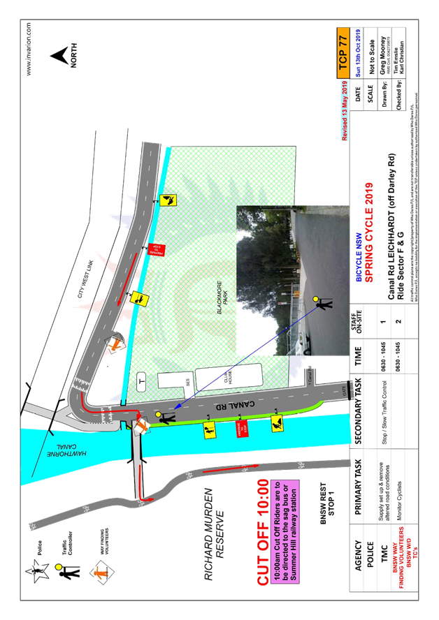
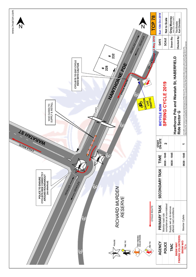
LTC0719 Item 11 2019 Spring Cycle Event (All Wards/ All Electorates/ All PACs) 135
Parking Matters
ITEM Page
LTC0719 Item 12 Gould Lane, Petersham - Proposed 'No Parking' (Damun-Stamnore Ward/Summer Hill Electorate/Inner West PAC) 204
LTC0719 Item 13 Unnamed Lane - off Lord Street, Newtown - Proposed 'No Parking' (Damun-Stanmore Ward/Newtown Electorate/Inner West PAC) 208
LTC0719 Item 14 Gordon Street, Rozelle - 'No Parking' zone removal (Baludarri-Balmain Ward/Balmain Electorate/Leichhardt PAC) 211
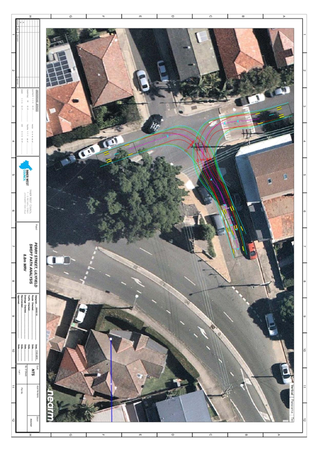
LTC0719 Item 15 Perry Street, Lilyfield - Proposed 'No Stopping' zone (Baludarri-Balmain Ward/ Balmain Electorate/ Leichhardt PAC) 214
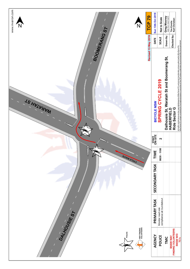
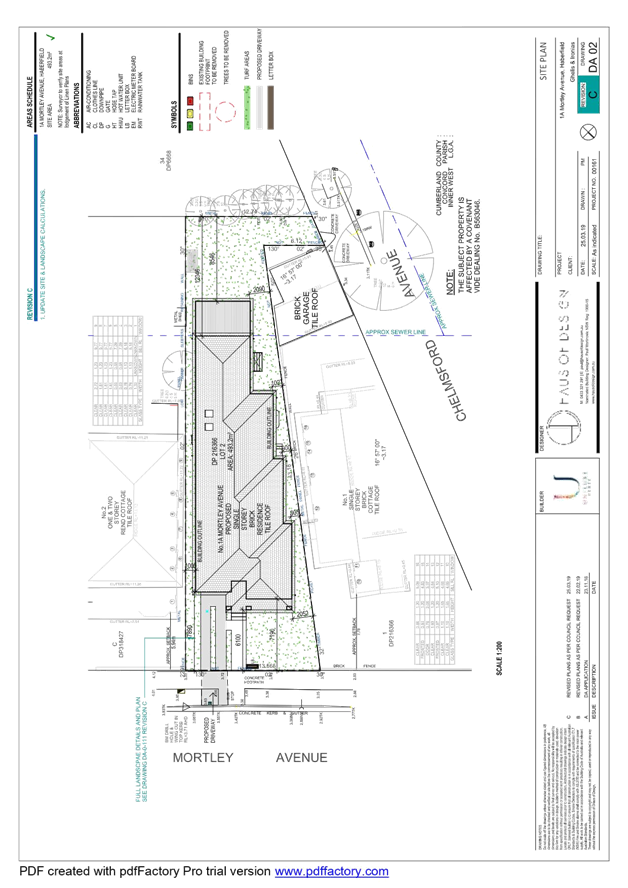
LTC0719 Item 16 Mortley Street, Haberfield - Proposed Extension of Existing 'Bus Zone' (Gulgadya-Leichhardt Ward/ Summer Hill Electorate/ Burwood PAC) 218
LTC0719 Item 17 Booth Street, Annandale - Proposed reduction of existing 'No Stopping' restriction (Gulgadya-Leichhardt Ward/ Balmain Electorate/ Leichhardt PAC) 221
LTC0719 Item 18 Edwin Street North, Croydon - Proposed installation of a Disabled (Mobility) Parking Zone (Gulgadya - Leichhardt Ward/ Strathfield Electorate/ Burwood PAC) 223
LTC0719 Item 19 Smith Street, Annandale - Proposed 'No Parking 7AM-7PM Motor Vehicles Under 4.5t GVM Excepted' (Baludarri-Balmain Ward/Balmain Electorate/Leichhardt PAC) 228
Late Items
Nil at time of printing.
6 Part B - Items for Information Only
ITEM Page
LTC0719 Item 20 Status Report - Leichhardt and Haberfield - Pedestrian Safety Measures (Gulgadya-Leichhardt Ward/ Summer Hill & Balmain Electorate/ Burwood & Leichhardt PAC) 232
LTC0719 Item 21 Car Parks adjacent to the Petersham Service Centre (Damun-Stanmore Ward/ Newtown Electorate/ Inner West PAC) 234
7 Part C - Items for General Advice
ITEM Page
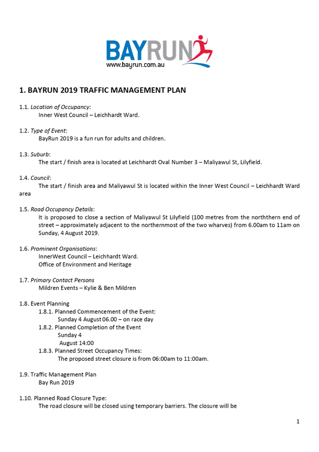
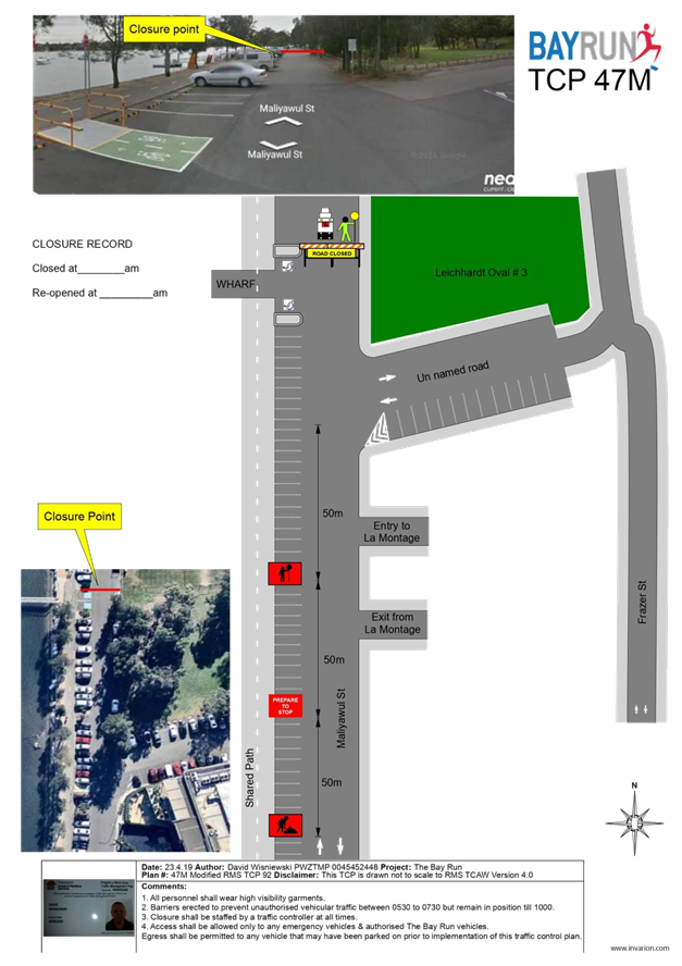
LTC0719 Item 22 Maliyawul Street - Proposed Temporary Road Closure to Hold Bay Run Event on Sunday, 4 August 2019 (Baludari Ward/Balmain Electorate/Leichhardt PAC) 238
8 General Business
9 Close of Meeting
|
|
Local Traffic Committee Meeting 1 July 2019 |
Minutes of Local Traffic Committee Meeting
Held at Petersham Service Centre on 3 June 2019
Meeting commenced at 10.02am
ACKNOWLEDGEMENT OF COUNTRY BY CHAIRPERSON
I acknowledge the Gadigal and Wangal people of the Eora nation on whose country we are meeting today, and their elders past and present.
COMMITTEE REPRESENTATIVES PRESENT
|
Clr Victor Macri |
Councillor – Midjuburi-Marrickville Ward (Chair) |
|
Bill Holliday |
Representative for Jamie Parker MP, Member for Balmain |
|
Chris Woods |
Representative for Ron Hoenig MP, Member for Heffron |
|
Cathy Peters |
Representative for Jenny Leong MP, Member for Newtown |
|
Sgt John Micallef |
NSW Police – Burwood Police Area Command |
|
LSC Marina Nestoriaros |
NSW Police – Leichhardt Police Area Command |
|
Ryan Horne |
Roads and Maritime Services |
|
|
|
|
OFFICERS IN ATTENDANCE |
|
|
|
|
|
Asith Nagodavithane |
Transit Systems – Inner West Bus Services |
|
Colin Jones |
Inner West Bicycle Coalition |
|
Clr Marghanita da Cruz |
Councillor – Gulgadya-Leichhardt Ward |
|
Wal Petschler |
IWC’s Group Manager Roads, Traffic and Stormwater |
|
John Stephens |
IWC’s Traffic and Transport Services Manager |
|
George Tsaprounis |
IWC’s Coordinator Traffic and Parking Services (South) |
|
Manod Wickramasinghe |
IWC’s Coordinator Traffic and Parking Services (North) |
|
Jenny Adams |
IWC’s Engineer – Traffic and Parking Services |
|
Boris Muha |
IWC’s Engineer – Traffic and Parking Services |
|
David Yu |
IWC’s Engineer – Traffic and Parking Services |
|
Mary Bailey |
IWC’s Parking Planner |
|
Mohammed Islam |
IWC’s Civil Engineer |
|
Christina Ip |
IWC’s Business Administration Officer |
|
|
|
|
VISITORS |
|
|
|
|
|
Janette Sullivan |
Item 1 – Resident |
|
Jantje Korringa |
Item 1 – Resident |
|
Peter Miller |
Item 1 – Resident |
|
Michael Garder |
Item 1 – Resident |
|
Diana Garder |
Item 1 – Resident |
|
Yvonne Frost |
Item 3 – Resident |
|
Tim Frost |
Item 3 – Resident |
|
|
|
|
APOLOGIES: |
|
|
|
|
|
Sgt Paul Vlachos |
NSW Police – Inner West Police Area Command |
|
SC Tony Kenny |
NSW Police – Inner West Police Area Command |
|
Jo Haylen MP |
Member for Summer Hill |
|
Sarina Foulstone |
Representative for the Member for Summer Hill |
DISCLOSURES OF INTERESTS
The representative for the Member for Newtown advised that she has a non-pecuniary interest in Item 24 as she is a resident.
CONFIRMATION OF MINUTES
|
The minutes of the Local Traffic Committee meeting held on Monday, 6 May 2019 were confirmed. |
MATTERS ARISING FROM COUNCIL’S RESOLUTION OF MINUTES
The Local Traffic Committee recommendations of its meeting held on 6 May 2019 were adopted at Council’s meeting held on 28 May 2019.
|
LTC0619 Item 1 Wharf Road, Birchgrove - 10km/h Shared Zone and Footpath Parking proposal (Baludarri-Balmain Ward/Balmain Electorate/Leichhardt PAC) |
|
SUMMARY
In response to concerns raised by residents regarding parking conditions in Wharf Road, Council is proposing to provide a 10km/h Shared Zone and Footpath Parking Scheme in Wharf Road between Lemm Street and Grove Street, Birchgrove. Wharf Road was previously listed in the former Leichhardt Council’s ‘narrow streets program’ and was identified as having a high demand for on-street parking.
Officer’s Recommendation
THAT a ‘10km/h Shared Zone’ and footpath parking scheme be installed in Wharf Road, Birchgrove between Grove Street and Lemm Street as per Attachment 1, subject to RMS approval.
DISCUSSION
Public speakers: Jantje Korringa and Peter Miller attended at 10.04am.
Ms Korringa supported the proposal as it improves safety in the street and noted that Council is reviewing the parking space in between No.20 and 22 Wharf Road which is obstructed by a powerpole.
Mr Miller supported the proposal as it addresses his concerns with safety in Wharf Road; however, requested the reintroduction of midblock speed calming treatments into the concept plan. Mr Miller stated that there should be no footpath parking around the bend of Wharf Road, in front of his property as suggested in the resident comments.
(Ms Korringa and Mr Miller left at 10.09am)
Public speakers: Janette Sullivan, D. Garder and M. Garder attended at 10.11 am
Ms Sullivan, Ms Garder and Mr Garder did not support the proposal as they believe the speed humps and signage will diminish the heritage characteristics of the street. They stated that Wharf Road is already self-enforcing and that there have not been accidents or issues with vehicle access in the street and so this proposal is unnecessary.
(Ms Sullivan, Ms Garder and Mr Garder left at 10.27am)
The RMS representative confirmed that the ‘10km/h Shared Zone’ and associated regulatory signage requires RMS approval and signage would be installed by RMS.
Council Officers clarified that there was an error on the concept plan and there are no speed humps proposed in Wharf Road.
COMMITTEE RECOMMENDATION
THAT:
For motion: Unanimous
|
|
LTC0619 Item 2 Mullens, Beattie and Montague Streets, Balmain - Proposed Intersection Treatments (Baludarri-Balmain Ward/Balmain Electorate/Leichhardt PAC) |
|
SUMMARY
The roundabout at the intersection of Mullens Street, Beattie Street and Montague Street, Balmain has been identified as a location that requires traffic calming measures to improve safety at the intersection.
Officer’s Recommendation
THAT the detailed design plan for the speed cushions and associated signs and line marking on approach to the roundabout at Mullens Street, Beattie Street and Montague Street, Balmain (as per Design Plan No.10075) be APPROVED.
DISCUSSION
Potential noise issues associated with the proposed speed cushions was noted. The RMS representative stated that because the roundabout is not effective at slowing down traffic due to its size and lack of deflection, the speed humps are an appropriate traffic calming treatment at the proposed location.
The Committee members agreed with the Officer’s recommendation.
COMMITTEE RECOMMENDATION
THAT the detailed design plan for the speed cushions and associated signs and line marking on approach to the roundabout at Mullens Street, Beattie Street and Montague Street, Balmain (as per Design Plan No.10075) be APPROVED.
For motion: Unanimous
|
|
LTC0619 Item 3 Crescent Street and Boomerang Street, Haberfield - Proposed Refuge Island and Speed Cushion (Gulgadya-Leichhardt Ward/ Summer Hill Electorate/ Burwood PAC) |
|
SUMMARY
As part of the 2019/20 Traffic Facilities (LATM) Capital Works Program, Council is proposing to construct a pedestrian refuge island in Crescent Street at Boomerang Street and install speed cushions in Boomerang Street, north of Crescent Street, Haberfield to improve safety and calm traffic in the street.
Officer’s Recommendation
THAT the detailed design plan for the kerb blister islands, speed cushions and associated signposting and linemarking in Crescent Street and Boomerang Street, Haberfield (as per the attached plan No. 10074) be approved.
DISCUSSION
Public speakers: Yvonne Frost and Tim Frost attended at 10.36am.
Ms and Mr Frost did not support the proposal due to the loss of two parking spaces and they believe pedestrian traffic is too low to justify the proposed refuge treatment in Crescent Street. Ms and Mr Frost also commented that:
(Ms and Mr Frost left at 10.48am)
Officers advised that the speed cushions address the speed of vehicles along Boomerang Street and the pedestrian refuge both assists pedestrian movements across Crescent Street and reduces the speed of vehicles entering Crescent Street from Boomerang Street.
In light of the issues raised, the Committee members agreed to defer the item for further investigation.
COMMITTEE RECOMMENDATION
THAT improvements to the intersection be deferred for further investigation of potential treatments in the Boomerang Street approach.
For motion: Unanimous
|
|
LTC0619 Item 4 Centennial Street, Marrickville – Temporary Road Closure For Special Event at Henson Park – Beer, Footy and Food Festival on Saturday 27 July 2019 (Midjuburi-Marrickville Ward/Summer Hill Electorate/Inner West PAC) |
|
SUMMARY
A S68 Application (201900002) has been received from the Music & Booze Company together with the Newtown Rugby League Football Club to hold the Beer, Footy and Food Festival 2019 on Saturday 27 July 2019 at Henson Park Oval and on Centennial Street, Marrickville between Sydenham Road and the entrance gate to Henson Park Oval.
Officer’s Recommendation
THAT the proposed temporary full road closure of Centennial Street, Marrickville between Sydenham Road and the entrance gate to Henson Park Oval on Saturday 27 July 2019 between 8.00am and 8.00pm (weather permitting) or Saturday 24 August 2019 between 8.00am and 8.00pm, for the holding of the Beer, Footy & Food Festival 2019 at Henson Park Oval, be APPROVED, subject to the approval of the S68 Application and the applicant complying with, but not limited to, the following conditions:
1. A Road Occupancy License application be obtained by the applicant from the Transport Management Centre;
2. All affected residents and businesses, including NSW Police Local Area Commander, Transit Systems, Fire and Rescue NSW and NSW Ambulance Services, shall be notified in writing by the applicant of the proposed temporary road closure at least 7 days prior to the event, with the applicant making reasonable provision for residents and businesses;
3. The occupation of the road carriageway must not occur until the road has been physically closed; and
4. The applicant be advised in terms of this report and that all costs for the event and implementation of the road closure are to be borne by the applicant.
DISCUSSION
The Committee members agreed with the Officer’s recommendation.
COMMITTEE RECOMMENDATION
THAT the proposed temporary full road closure of Centennial Street, Marrickville between Sydenham Road and the entrance gate to Henson Park Oval on Saturday 27 July 2019 between 8.00am and 8.00pm (weather permitting) or Saturday 24 August 2019 between 8.00am and 8.00pm, for the holding of the Beer, Footy & Food Festival 2019 at Henson Park Oval, be APPROVED, subject to the approval of the S68 Application and the applicant complying with, but not limited to, the following conditions:
1. A Road Occupancy License application be obtained by the applicant from the Transport Management Centre;
2. All affected residents and businesses, including NSW Police Local Area Commander, Transit Systems, Fire and Rescue NSW and NSW Ambulance Services, shall be notified in writing by the applicant of the proposed temporary road closure at least 7 days prior to the event, with the applicant making reasonable provision for residents and businesses;
3. The occupation of the road carriageway must not occur until the road has been physically closed.; and
4. The applicant be advised in terms of this report and that all costs for the event and implementation of the road closure are to be borne by the applicant.
For motion: Unanimous
|
|
LTC0619 Item 5 Burrows Avenue and Hogan Avenue, Sydenham – Sydney Metro Sydenham Station and Junction (SSJ) Works – Temporary traffic control arrangements (Midjuburi Ward / Heffron Electorate / Inner West PAC) |
|
SUMMARY
Sydney Metro have engaged John Holland Pty Ltd and Laing O’Rourke Australia Construction Pty Ltd (JHLORJV) to undertake the Sydenham Station and Junction works to facilitate the new Sydney Metro line and part of these works involve the construction of a new concourse and plaza. These works necessitate that pedestrians are (temporarily) crossed over from the Station side of Burrows Ave to take them away from construction activities for the new Southern Plaza.
Officer’s Recommendation
THAT the design of the temporary traffic control arrangements in Burrows Avenue and temporary pedestrian refuge and associated signs and line markings in Hogan Avenue, Sydenham (as per attached design plans prepared by Bitzios and dated 10 May 2019) be approved, subject to additional controls at the intersection of Hogan Avenue and Burrows Road being further investigated by JHLORJV and necessary treatments provided to satisfy the issues raised in the Road Safety Audit.
DISCUSSION
The representative for the Member for Heffron requested that a temporary pedestrian crossing on Burrows Avenue and Bolton Street be investigated due to the Sydney Metro construction. Council Officers indicated that this request will be raised with Sydney Metro.
Council Officers advised that the roundabout signs on the plans are an error and ‘Give Way’ signs should be denoted instead.
The Committee members agreed with the Officer’s recommendation with the addition of a recommendation to investigate temporary pedestrian crossings on Burrows Avenue and Bolton Street.
COMMITTEE RECOMMENDATION
THAT the design of the temporary traffic control arrangements in Burrows Avenue and the temporary pedestrian refuge in Hogan Avenue, Sydenham (as per design plans prepared by Bitzios dated 10 May 2019) be approved subject to:
For motion: Unanimous
|
|
LTC0619 Item 6 Toothill Street at Victoria Street, Lewisham – Concept plan for Raised Pedestrian crossing with kerb extensions on all approaches of intersection (Damum - Stanmore Ward/ Summer Hill Electorate/ Inner West PAC) |
|
SUMMARY
Residents have raised concerns about the safety of pedestrians using the pedestrian zebra crossing on Toothill Street adjacent to its intersection with Victoria Street, Lewisham. A concept plan showing potential improvements at the intersection was distributed locally to get feedback on a proposal to raise the existing pedestrian zebra crossing and construct kerb blister extensions on all approaches of the intersection in order to improve pedestrian safety, especially for school children at the location.
Officer’s Recommendation
THAT:
1. The concept proposal to raise the existing pedestrian zebra crossing on Toothill Street at its intersection with Victoria Street, Lewisham and construct kerb blister extensions on all approaches of the intersection in order to improve pedestrian safety, especially school children, at the location be supported in principle and listed within Council’s Forward Capital Works Program; and
2. Responding residents be advised in terms of this report.
DISCUSSION
The Committee members agreed with the Officer’s recommendation.
COMMITTEE RECOMMENDATION
THAT:
1. The concept proposal to raise the existing pedestrian zebra crossing on Toothill Street at its intersection with Victoria Street, Lewisham and construct kerb blister extensions on all approaches of the intersection in order to improve pedestrian safety, especially school children, at the location be supported in principle and listed within Council’s Forward Capital Works Program; and
2. Responding residents be advised in terms of this report.
For motion: Unanimous
|
|
LTC0619 Item 7 Minor Traffic Facilities (All Wards/All Electorates/All PACs) |
|
SUMMARY
This report considers minor traffic facility applications by Inner West Council, and includes ‘Disabled Parking’ and ‘Works Zone’ requests.
Officer’s Recommendation
THAT:
1. A 6m ‘Disabled Parking’ zone be removed in front of No.3 Merton Street, Stanmore; 2. A 6m ‘Disabled Parking’ zone be removed opposite No.16 Prospect Street, Leichhardt and the resident parking restrictions be reinstated; 3. A 6m ‘Disabled Parking’ zone be removed in front of No.92 Denison Road, Lewisham and the resident parking restrictions be reinstated; 4. A 6m 'Disabled Parking’ zone be installed in front of No.4 Queen Street, Marrickville; 5. A 6m 'Disabled Parking’ zone be installed in front of No.13 Reuss Street, Leichhardt.
DISCUSSION
The Committee members agreed with the Officer’s recommendation.
COMMITTEE RECOMMENDATION
THAT:
1. A 6m ‘Disabled Parking’ zone be removed in front of No.3 Merton Street, Stanmore; 2. A 6m ‘Disabled Parking’ zone be removed opposite No.16 Prospect Street, Leichhardt and the resident parking restrictions be reinstated; 3. A 6m ‘Disabled Parking’ zone be removed in front of No.92 Denison Road, Lewisham and the resident parking restrictions be reinstated; 4. A 6m 'Disabled Parking’ zone be installed in front of No.4 Queen Street, Marrickville; 5. A 6m 'Disabled Parking’ zone be installed in front of No.13 Reuss Street, Leichhardt.
For motion: Unanimous
|
|
LTC0619 Item 8 Bruce Street, Stanmore - Proposed Permit Parking Area M17 (Damun-Stanmore Ward/Newtown Electorate/Inner West PAC) |
|
SUMMARY
Following receipt of a petition from residents, Council carried out resident and parking surveys to determine whether permit parking should be considered for the section of Bruce Street, Stanmore, between Temple Street and Douglas Street in order to provide additional parking opportunities for residents.
Officer’s Recommendation
THAT:
· Implementation of ‘2P Permit Holders Excepted 8am-10pm Mon-Fri Area M17' restrictions in Bruce Street between Douglas Street and Temple Street (western side); · Implementation of 10m Statutory ‘No Stopping' restrictions in Bruce Street, north of Douglas Street (western side); and · Implementation of 10m Statutory ‘No Stopping’ restrictions in Bruce Street, south of Temple Street (western side); be approved.
DISCUSSION
It was noted that the recommendation for the 10m ‘No Stopping’ zone is intended to reinforce the existing road rule for ‘No Stopping’ at intersections.
The Committee members agreed with the Officer’s recommendation with an amendment to part 2 and 3 of the recommendation.
COMMITTEE RECOMMENDATION
THAT:
· Installation of ‘2P Permit Holders Excepted 8am-10pm Mon-Fri Area M17' restrictions in Bruce Street between Douglas Street and Temple Street (western side); · ‘No Stopping’ signage be installed in Bruce Street, north of Douglas Street (west side) and south of Temple Street (west side) to reinforce the statutory 10m ‘No Stopping’ distance at intersections. For motion: Unanimous
|
|
LTC0619 Item 9 Piper Lane, Annandale - Proposed 'No Stopping' and 'No Parking' zones (Baludarri-Balmain Ward/Balmain Electorate/Leichhardt PAC |
|
SUMMARY
Council has received concerns from residents of Annandale Street regarding vehicles parking on the eastern side of Piper Lane, Annandale and subsequently obstructing rear driveway access for properties Nos.301–305 Annandale Street.
Officer’s Recommendation
THAT a 10m statutory ‘No Stopping’ zone and subsequent 39.4m ‘No Parking’ zone be installed on the eastern side of Piper Lane, Annandale, north of Rose Street.
COMMITTEE RECOMMENDATION
THAT signage be installed on the eastern side of Piper Lane, Annadale, north of Rose Street to:
For motion: Unanimous
|
|
LTC0619 Item 10 Blackwood Lane, Dulwich Hill - Proposed section of 'No Parking' (Djarrawunang-Ashfield Ward/Summer Hill Electorate/Inner West PAC) |
|
SUMMARY
Following representations from a resident, Council is proposing to introduce a section of ‘No Parking’ in Blackwood Lane, Dulwich Hill, in order to improve access to off-street parking and the lane thoroughfare. Since Blackwood Lane has been made one-way, the resident reports it is now more difficult to enter and exit their garage as there are fewer options for manoeuvring.
Officer’s Recommendation
THAT implementation of ‘No Parking’ in Blackwood Lane, Dulwich Hill for a 5m section immediately south from the driveway of No.13 Blackwood Avenue (northern side); be approved.
DISCUSSION
Council Officers tabled a late submission from a resident who supported the recommendation.
The Committee members agreed with the Officer’s recommendation.
COMMITTEE RECOMMENDATION
THAT installation of a ‘No Parking’ zone in Blackwood Lane, Dulwich Hill for a 5m section immediately south from the driveway of No.13 Blackwood Avenue (northern side); be approved.
For motion: Unanimous
|
|
LTC0619 Item 11 Mitchell Lane, Marrickville - Proposed parking restrictions (Midjuburi- Marrickville Ward/Summer Hill Electorate/Inner West PAC) |
|
SUMMARY
Following representation from the community, Council is proposing parking restrictions in Mitchell Lane, Marrickville in order to address safety and access issues.
Officer’s Recommendation
THAT:
1. Implementation of 10m ‘No Stopping’ in Mitchell Lane (western side) at its intersection with Mitchell Street; 2. Implementation of ‘No Parking’ in Mitchell Lane (western side) from proposed 10m ‘No Stopping’ zone to driveway of loading dock at rear of No.2 Mitchell Street; 3. Implementation of ‘No Parking’ in Mitchell Lane (eastern side) from driveway rear of Property No. 157 Victoria Road to driveway rear of Nos.165-169 Victoria Road; be approved.
COMMITTEE RECOMMENDATION
THAT:
1. Signage be installed in Mitchell Lane (west side) to reinforce the statutory 10m ‘No Stopping’ zone at its intersection with Mitchell Street; 2. Installation of ‘No Parking’ signposting in Mitchell Lane (western side) from proposed 10m ‘No Stopping’ zone to driveway of loading dock at rear of No.2 Mitchell Street; 3. Installation of ‘No Parking’ signposting in Mitchell Lane (eastern side) from driveway rear of Property No. 157 Victoria Road to driveway rear of Nos.165-169 Victoria Road; be approved.
For motion: Unanimous
|
|
LTC0619 Item 12 Edgeware Road, Enmore - Proposed Permit Parking (Stanmore - Damun Ward/Newtown Electorate/Inner West PAC) |
|
SUMMARY
Following representation from the community, Council is proposing to install permit parking in a short section of Edgeware Road between Darley Street and Lord Street to provide opportunity for residents to park in an area where there is a high demand for parking due to workers from construction projects in the area, residents from nearby parking-restricted streets; and workers from nearby commercial and industrial premises. This proposal seeks to increase the amount of parking available for residents of Edgeware Road on the eastern side of the road.
Officer’s Recommendation
THAT implementation of ‘2P Permit Holders Excepted 8am-10pm Area M14’ – Edgeware Road between the existing ‘No Stopping’ zones at Darley Street and Lord Street; be approved.
DISCUSSION
The Committee members agreed with the Officer’s recommendation.
COMMITTEE RECOMMENDATION
THAT installation of ‘2P Permit Holders Excepted 8am-10pm Area M14’ signage – Edgeware Road between the existing ‘No Stopping’ zones at Darley Street and Lord Street; be approved.
For motion: Unanimous
|
|
LTC0619 Item 13 Goodsir Street, Rozelle - Proposed removal of existing 'No Parking, 8AM-6PM Mon-Fri' Zone (Baludarri-Balmain Ward/Balmain Electorate/Leichhardt PAC) |
|
SUMMARY
A number of residents in Goodsir Street, Rozelle have requested a review of the existing ‘No Parking, 8am-6pm Mon-Fri’ zone in Goodsir Street, outside Goodsir Street Reserve (opposite Moore Street).
Officer’s Recommendation
THAT the existing ‘No Parking, 8am-6pm Mon-Fri’ zone in Goodsir Street, outside Goodsir Street Reserve, Rozelle be removed.
DISCUSSION
The Committee members agreed with the Officer’s recommendation.
COMMITTEE RECOMMENDATION
THAT the existing ‘No Parking, 8am-6pm Mon-Fri’ zone in Goodsir Street, outside Goodsir Street Reserve, Rozelle be removed.
For motion: Unanimous
|
|
LTC0619 Item 14 Queen Street, Ashfield – Proposed ‘No Stopping’ in Queen Street at intersection with Harland Street (Djarrawunang – Ashfield Ward/ Summer Hill Electorate/ Burwood PAC) |
|
SUMMARY
A request has been received to install ‘No Stopping’ signage on the eastern corner of Queen Street, at Harland Street, Ashfield to improve both sight lines to and from the driveway access for No.228 Queen Street as well as improving traffic manoeuvrability at the intersection of Harland Street.
Officer’s Recommendation
THAT 12.7 metres of ‘No Stopping’ be placed on the eastern corner of Queen Street south of the intersection with Harland Street, Ashfield.
DISCUSSION
The Committee members agreed with the Officer’s recommendation.
COMMITTEE RECOMMENDATION
THAT 12.7 metres of ‘No Stopping’ signposting be placed on the eastern corner of Queen Street south of the intersection with Harland Street, Ashfield.
For motion: Unanimous
|
|
LTC0619
Item 15 Croydon Road, Croydon – Proposed removal of parking on
the eastern side between Parramatta Road and West Street |
|
SUMMARY
Council has received complaints from Transit Systems (operating government buses) and the general public regarding the difficultly of buses turning right from Parramatta Road into Croydon Road, Croydon and traffic passing parked vehicles on the eastern side of Croydon Road between Parramatta Road and West Street. Subsequently, Transit Systems have requested that the parking be removed along the eastern side of Croydon Road between Parramatta Road and West Street.
Officer’s Recommendation
THAT:
1. The existing ‘No Stopping’ restriction on the eastern side of Croydon Road be extended from 12m to 20m south of the Parramatta Road property boundary line; 2. A ‘No Parking’ restriction be installed on the eastern side of Croydon Road approximately from 20m to 40m south of Parramatta Road; and 3. The existing ‘Bus Zone’ on the eastern side of Croydon Road from 40m to 62m south of Parramatta Road be retained. DISCUSSION
The Committee members agreed with the Officer’s recommendation.
COMMITTEE RECOMMENDATION
THAT:
1. The existing ‘No Stopping’ signposting on the eastern side of Croydon Road be extended from 12m to 20m south of the Parramatta Road property boundary line; 2. A ‘No Parking’ zone be installed on the eastern side of Croydon Road approximately from 20m to 40m south of Parramatta Road; and 3. The existing ‘Bus Zone’ on the eastern side of Croydon Road from 40m to 62m south of Parramatta Road be retained. For motion: Unanimous
|
|
LTC0619 Item 16 Code of Conduct for Council Committee Members, Delegates of Council and Council Advisers (All Wards / All Electorates / All PACs) |
|
SUMMARY
Council‘s Civic Governance Manager has advised that in March 2019, Council adopted a Code of Conduct for Council Committee Members, Delegates of Council and Council Advisers. The Code of Conduct is applicable to all Councillors, staff and members of Council Committees (which are not advisory in nature).
Officer’s Recommendation
THAT this report be received and noted.
DISCUSSION
The Committee members agreed with the Officer’s recommendation.
COMMITTEE RECOMMENDATION
THAT this report be received and noted.
For motion: Unanimous
|
|
LTC0619 Item 17 Report back on Mainstreet meter switch off at 7pm in Balmain, Rozelle and Leichhardt (Baludarri-Balmain; Gulgadya-Leichhardt Wards/Balmain Electorate/Leichhardt PAC) |
|
SUMMARY
Following a previous Council resolution, the parking meters and regulatory signage in Leichhardt, Rozelle and Balmain were updated to cease parking meter operations on the mainstreets at 7pm instead of 10pm. This equates to a reduction in operating hours from 14 hours to 11 hours.
Officer’s Recommendation
THAT this report be received and noted.
DISCUSSION
The Committee members agreed with the Officer’s recommendation.
COMMITTEE RECOMMENDATION
THAT this report be received and noted.
For motion: Unanimous
|
|
LTC0619 Item 18 Sydenham Road, Sydenham - Permanent Pedestrian mid-block signalised pedestrian crossing (Temporary configuration) – Sydney Metro City & Southwest (Midjuburi- Marrickville Ward / Heffron Electorate / Inner West PAC) |
|
SUMMARY
Council has been notified by Sydney Metro SSJ of the temporary configuration for the Sydenham Road permanent crossing (mid-block signalised pedestrian crossing). The works are part of Sydney Metro City & Southwest and Sydenham Station and Junction works.
Officer’s Recommendation
THAT this report be received and noted.
DISCUSSION
The Committee members agreed with the Officer’s recommendation.
COMMITTEE RECOMMENDATION
THAT this report be received and noted.
For motion: Unanimous
|
General Business
|
LTC0619 Item 19 Request for a mobility parking space at Edwin Street, Croydon
|
|
Clr Macri tabled a request from a resident to investigate installing a mobility parking space in Edwin Street, Croydon, near the post office.
|
|
LTC0619 Item 20 Outstanding matters Local Traffic Committee
|
|
Clr Macri requested for a report on matters outstanding arising from Committee recommendations adopted by Council.
|
|
LTC0619 Item 21 Pedestrian refuge on Stanmore Road, Petersham
|
|
The representative for the Member for Newtown stated that residents have raised safety concerns with the pedestrian refuge on Stanmore Road near Maundrell Park where motorists have been observed crossing over the refuge islands. The RMS representative will investigate.
|
|
LTC0619 Item 22 Petition to review M3 Permit Parking Area
|
|
The representative for the Member for Newtown tabled a petition from residents requesting for a review of the current M3 resident parking zone, allocation of motorbike parking and statutory ‘No Stopping’ signage at intersections in the M3 zone. The representative was advised that Council Officers have received the petition and are investigating.
|
|
LTC0619 Item 23 Request for 'No Stopping' zone on Cambridge Street adjacent to Stanmore Public School carpark
|
|
The representative for the Member for Newtown tabled a request from Stanmore Public School P & C to investigate implementing a ‘No Stopping’ zone and blister islands on Cambridge Street to improve sight lines for vehicles exiting the school’s car park.
|
|
LTC0619 Item 24 Road safety at the intersection of Edgeware Road, Unwins Bridge Road and May Street, St Peters
|
|
The representative for the Member for Newtown stated that a resident has made a complaint about the traffic congestion and aggressive driving on Edgeware Road, Unwins Bridge Road and May Street caused by WestConnex, Sydney Metro and Marrickville Metro construction.
|
|
LTC0619 Item 25 Buses detouring in Booth Street, Annandale
|
|
Clr da Cruz raised an issue with buses detouring off of Booth Street, Annandale into the local roads. The Transit Systems representative advised that Transit Systems is aware of the issue and will follow up.
|
Meeting closed at 11.21am.
|
|
Local Traffic Committee Meeting 1 July 2019 |
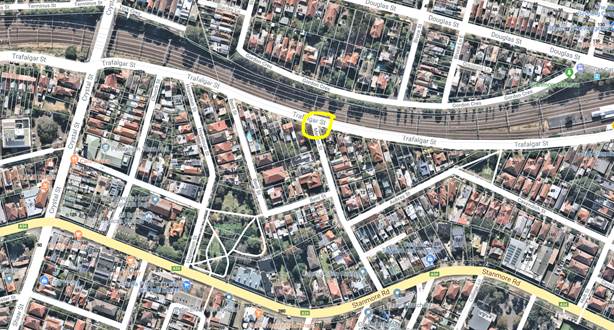
Subject: Hartley Street at Victoria Road, Rozelle - Proposed 'STOP' Control (Baludarri-Balmain Ward/ Balmain Electorate/ Leichhardt LAC)
Prepared By: David Yu - Engineer - Traffic and Parking Services
Authorised By: Manod Wickramasinghe – A/Traffic and Transport Services Manager
|
RECOMMENDATION
THAT the intersection of Hartley Street and Victoria Road, Rozelle be upgraded to ‘STOP’ control. |
BACKGROUND
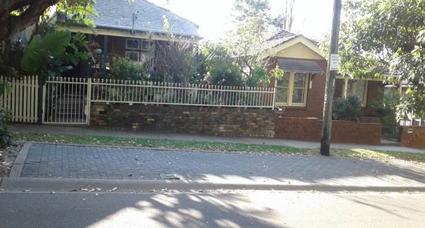
A number of residents have raised concerns regarding traffic conditions at the Hartley Street/Victoria Road T-intersection, which currently does not have signposted intersection control.
|
Hartley Street, Rozelle (at Intersection of Victoria Road) |
|
|
Traffic Volume |
- |
|
Recorded Accident History (5 year) |
Nil. |
|
Recorded 85% speed |
- |
|
Speed Limit |
40km/h (Hartley Street) 60km/h (Victoria Road) |
|
Carriageway width |
6.0m |
|
Road Classification (State, Regional, Local) |
Local (Hartley Street) State (Victoria Road) |
There are four eastbound travel lanes on Victoria Road (including a bus lane) diverting traffic onto both the ANZAC Bridge and City West Link to the east of Hartley Street.
FINANCIAL IMPLICATIONS
Nil.
OTHER STAFF COMMENTS
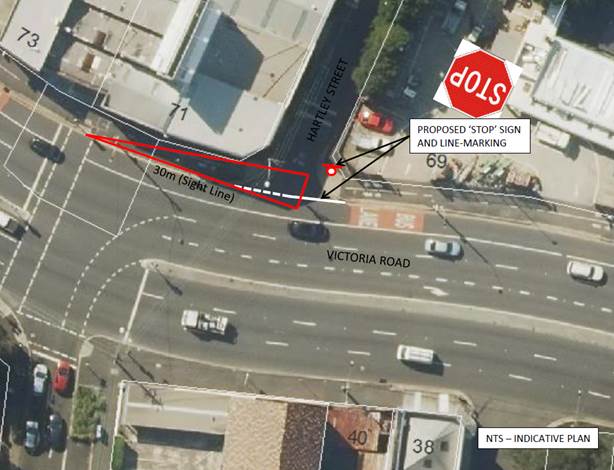
The sight distance measured for a vehicle exiting Hartley Street onto Victoria Road is approximately 30m, as shown on the following plan.
Sight distance is limited due to the horizontal curve in Victoria Road and the existing building alignment.
The Australian Standards (AS1742.2) requires ‘STOP’ control to be provided where the available sight distance on approach to the intersection is less than 40m for entry onto a road with a speed limit of 60km/h.
It is therefore proposed to upgrade the existing priority control of the Hartley Street/ Victoria Road intersection from unsignposted ‘Give Way’ to ‘STOP’ control.
PUBLIC CONSULTATION
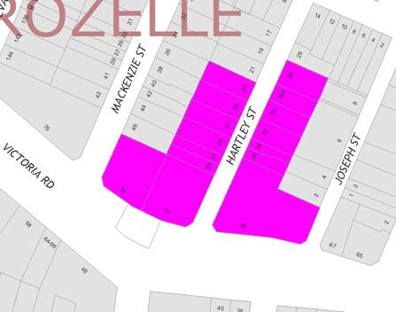
A letter outlining this proposal was mailed out to the affected properties (16 properties) in Hartley Street and Victoria Road, Rozelle, requesting residents’ views regarding the proposal (as indicated on the following plan).
One (1) response was received, in objection to the proposal.
|
Residents’ Comments |
Officer Comments |
|
The proposed stop sign has been setback behind the footpath on Victoria road but from this position, you are unable to see the buses that come down the hill at full speed due to the blind corner.
I also request some restricted parking for deliveries, such as a loading zone. |
The motorist is required to stop at the 'STOP' holding line which maximises the sight distance available. The sign position will be provided as close as practical to the ‘STOP’ holding line with consideration to pedestrians, cyclists, vehicle accessibility and ability of vehicles to sight the sign on approach to the intersection. The sign location shown on the plan is indicative only.
The request for a loading zone can be considered as part of a separate investigation.
|
|
|
Local Traffic Committee Meeting 1 July 2019 |
Subject: Newington Local Area Traffic Management Strategy (Damun-Stanmore/Midjuburi-Marrickville Wards/ Newtown Electorate/ Inner West PAC)
Prepared By: Sunny Jo - Traffic and Parking Planner
Authorised By: Manod Wickramasinghe – A/Traffic and Transport Services Manager
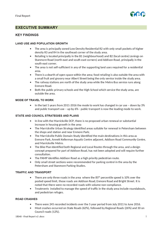
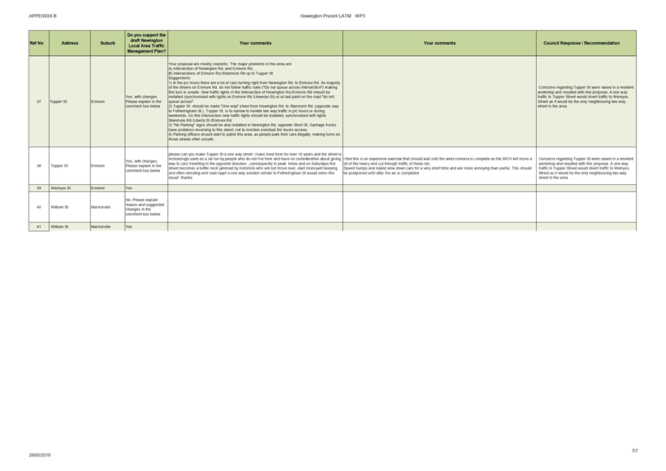
SUMMARY
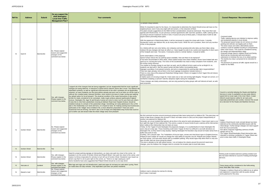
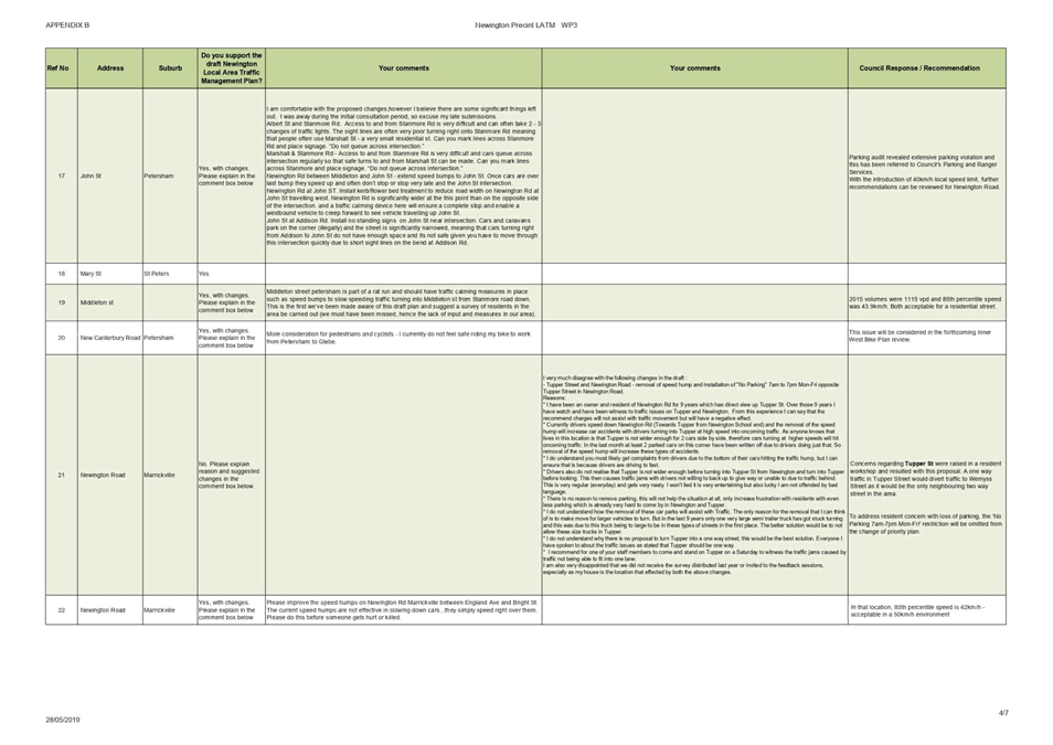
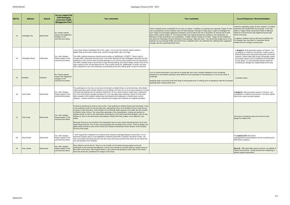
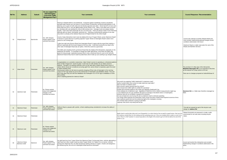
This is a recommendation to endorse the final Newington Local Area Traffic Management (LATM) report. The proposals within the report are based on community input and analysis of feedback from the Public Exhibition period in March and April 2019. There were 41 responses to the web survey undertaken by Council. The results indicate that there is general support for the proposed traffic management, with some changes suggested by 24 respondents. Once this recommendation is endorsed by Traffic Committee and Council, the projects will be incorporated into future design and construction programs.
|
RECOMMENDATION
THAT:
1. The final Newington LATM report be endorsed for implementation including the following final LATM treatments: a. Speed cushions in Albert Street near Marr Playground; b. Two raised thresholds in Bright Street near No.26 and No.6 Bright Street; c. Change of priority at the intersection of Tupper Street and Newington Road, including removal of existing speed hump near No.36 Newington Road but excluding ‘No Parking 7am-7pm Mon-Fri’ opposite Tupper Street in Newington Street; d. Installation of ‘STOP’ sign at the intersection of Newington Road and Enmore Road; e. Pedestrian refuge island in Addison Road between Denby and Philpott Streets; f. Implementation of mixed traffic bicycle facilities within the study area; and g. Changes at signalised intersections at Enmore Road/Llewellyn Street, Enmore Road/Addison Road and Addison Road/Agar Street/Illawarra Road be referred to the RMS for implementation;
|
BACKGROUND
The Inner West Community Strategic Plan (CSP) ‘Our Inner West 2036’ endorsed in June 2018 provides the following outcomes and strategies for the future of Inner West.
|
CSP Outcomes |
Strategies |
|
2.6 People are walking, cycling and moving around Inner West with ease |
1. Deliver integrated networks and infrastructure for transport and active travel 2. Pursue innovation in planning and providing new transport options 3. Ensure transport infrastructure is safe, connected and well maintained |
The Newington Local Area Traffic Management (LATM) study and plan achieves these outcomes by reviewing existing traffic measures in place, including road safety, transport and traffic management.
The objective of the study is to investigate and review the performance of the existing LATM scheme and recommend proposed works. The Newington LATM study was originally completed in 1993 and first reviewed in 2004.
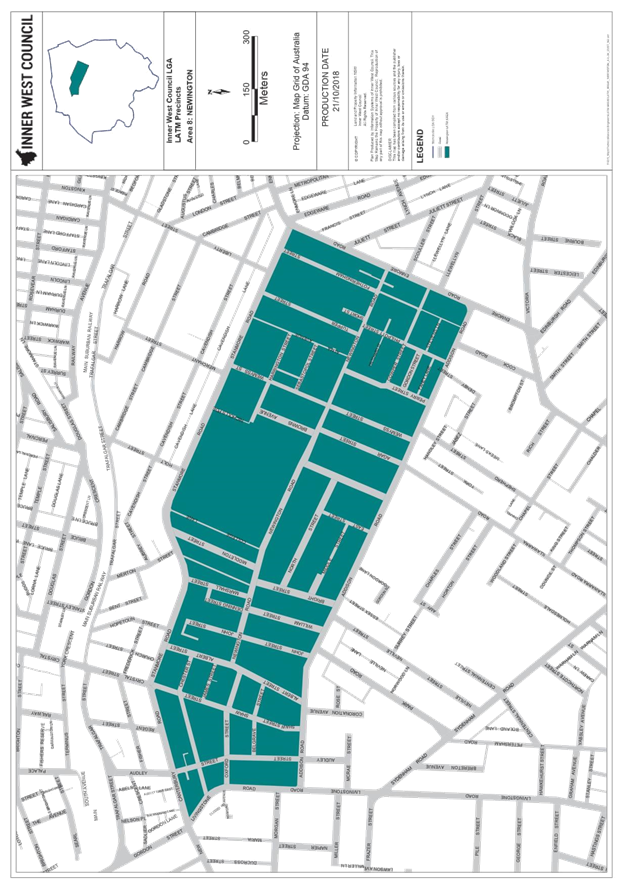
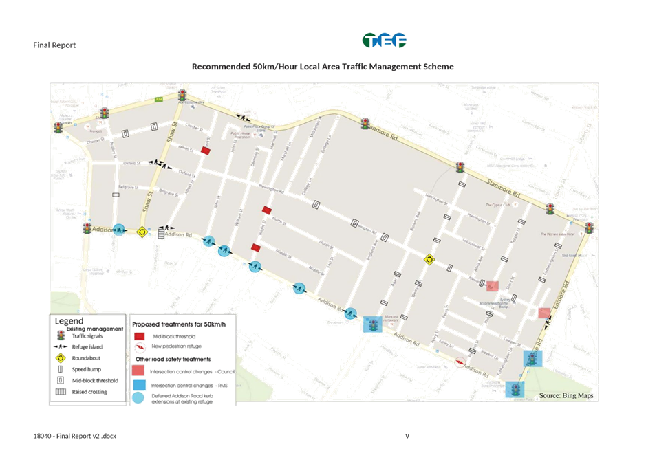
As shown in Attachment 1, the study area is bounded by Stanmore Road/New Canterbury Road, Enmore Road, Addison Road and Livingstone Road.
Due to the size of the LATM report, only summary and recommendations are attached. The full report including all maps and appendices can be accessed through Council’s website
https://yoursay.innerwest.nsw.gov.au/newington-improving-safety-and-traffic
OTHER STAFF COMMENTS
The study identified a number of treatment locations to improve safety and support walking and cycling in the area. The list of treatments proposed comprise of the following:
· Raised threshold in Albert Street near Marr Playground;
· Two raised thresholds in Bright Street near No.26 and No.6 Bright Street;
· Change of priority at the intersection of Tupper Street and Newington Road, including removal of existing speed hump near No.36 Newington Road and No Parking 7am-7pm Mon-Fri opposite Tupper Street in Newington Street;
· Installation of ‘STOP’ sign at the intersection of Newington Road and Enmore Road;
· Pedestrian refuge island in Addison Road between Denby and Philpott Streets;
· Implementation of mixed traffic bicycle facilities within the study area; and
· Changes at signalised intersections at Enmore Road/Llewellyn Street, Enmore Road/Addison Road and Addison Road/Agar Street/Illawarra Road to be referred to the RMS for implementation.
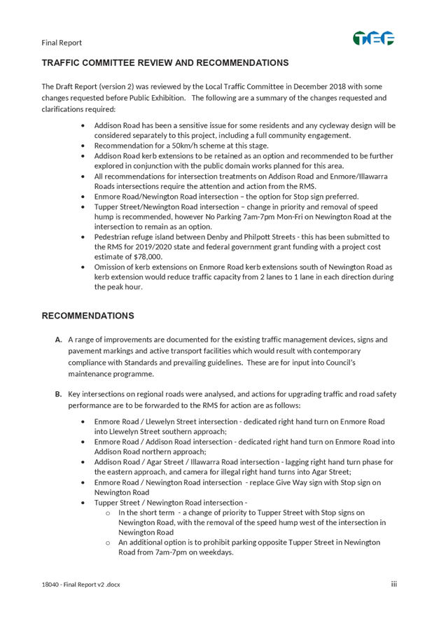
Based on the feedback received during the exhibition period, the recommendations have been refined and will undertake further measures following the endorsement of the final report:
· Tupper Street – the proposed traffic management measures will be monitored from a technical and community feedback perspective following implementation;
· Albert Street – traffic speed and volume counts are updated, given that the counts used in the study are 2013/2014 data;
· Albert Street near Marr Playground – raised thresholds replaced with speed cushions to reduce noise concerns from resident;
· Tupper Street/Newington Street (change in priority) – the ‘No Parking 7am-7pm Mon-Fri’ option has been omitted to address residents concern with reduced parking.
PUBLIC CONSULTATION
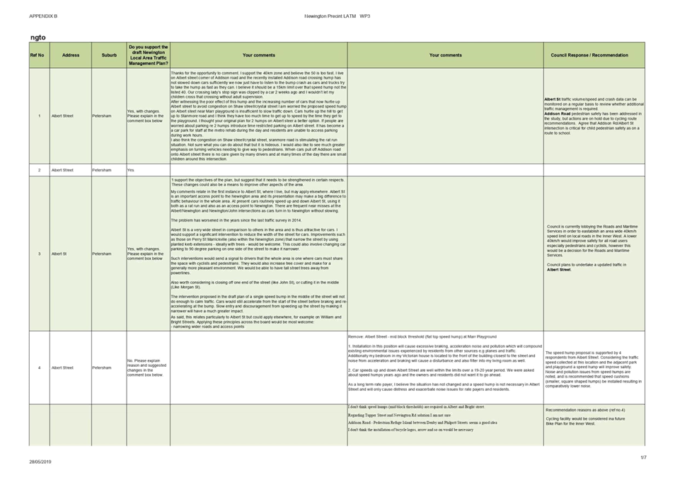
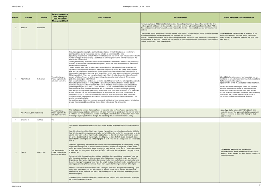
Public Exhibition was undertaken from 15 March to 15 April 2019 via Your Say Inner West website, including a letter mailout to 3,983 residents and businesses in the study area, and Council’s e-news sent to 6,000 recipients to view the draft report and complete the online survey. Additionally a hard copy of the draft report and feedback forms were provided at Council’s Petersham Customer Service Centre and Marrickville Library.
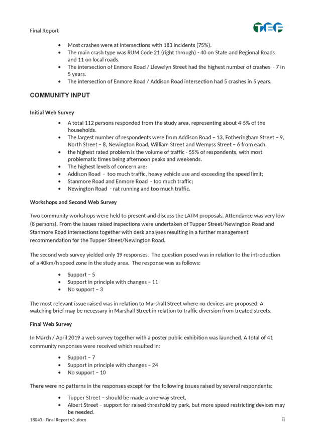
The survey form provided ability for residents to respond by selecting ‘support’, ‘support with changes’ or ‘not support’ the draft report and its list of proposals. Respondents were also asked to comment on their reasons or concerns about a particular proposal. At the close of the exhibition period, 41 responses were received, and summarised in Attachment 4. The results indicate that there is general support for the proposed traffic management, with some changes suggested by 24 respondents. The response level was low compared to the 112 respondents received at the commencement of the study in 2018.
FINANCIAL IMPLICATIONS
The Newington LATM identified works totaling $64,645 for the 50km/h scheme work in Albert Street, Bright Street and Newington Road/Tupper Street intersection works. The implementation works are planned to be delivered in the 2021/2022 financial year, subject to final budget allocation.
CONCLUSION
The Newington LATM Strategy will make transport and traffic improvements to the study area and will further support walking and cycling. Attachment 3 shows a map summary of recommendations proposed in the study.
Following a review of the submissions received during the public exhibition of the draft plan, it is recommended that the proposed treatments for the Newington LATM Strategy listed above be endorsed for implementation.
|
1.⇩ |
Newington LATM Study Area Map |
|
2.⇩ |
Executive Summary |
|
3.⇩ |
Proposed Treatments |
|
4.⇩ |
Public Exhibition Comments Summary |
|
Local Traffic Committee Meeting 1 July 2019 |
Subject: MINOR TRAFFIC FACILITIES (All Wards/All Electorates/All PACs)
Prepared By: Davide Torresan - Coordinator - Road Access Services
Authorised By: Manod Wickramasinghe – A/Traffic and Transport Services Manager
SUMMARY
This report considers minor traffic facility applications by Inner West Council, and includes
‘Disabled Parking’ and ‘Works ‘ zone requests.
|
RECOMMENDATION
THAT:
1. A 6m 'Disabled Parking’ zone be installed in front of No. 21 Charlotte Avenue, Marrickville;
2. A 6m 'Disabled Parking’ zone be installed on Myrtle Street along the rear boundary of No. 10 Salisbury Road, Stanmore;
3. A 5.5m ‘Disabled Parking’ zone be installed in front of No. 30 Francis Street, Marrickville;
4. A 5.5m 'Disabled Parking’ zone be installed in back of No. 30 Thornley Street, Leichhardt;
5. A 5.5m 'Disabled Parking’ zone be installed in front of No. 105 Victoria Street, Lewisham;
6. A 5.5m 'Disabled Parking’ zone be installed in front of No. 12 Oak Street, Ashfield;
7. A 9m 'Works Zone 7.00am – 6.00pm Mon-Fri and 8.00am -1.00pm Sat' be installed in front of No.107 May Street, St Peters for 12 weeks, subject to the applicant obtaining consent from the neighbouring property owner; and
8. A 9.4m 'Works Zone 7.00am – 6.00pm Mon-Fri and 8.00am -1.00pm Sat' be installed in front of No.44 Wentworth Street, Tempe for 4 weeks.
|
BACKGROUND
This report considers minor traffic facility applications by Inner West Council, and includes
‘Disabled Parking’ and ‘Works Zone’ requests.
FINANCIAL IMPLICATIONS
Nil
OTHER STAFF COMMENTS
1. Installation of ‘Disabled Parking’ Restriction – Charlotte Avenue, Marrickville
The resident of No. 21 Charlotte Avenue, Marrickville, has requested the installation of ‘Disabled Parking’ zone in front of the their property. A site investigation has revealed the property does not have off street parking. The applicant does not require the use of wheelchair.
It is recommended that a parking 6.0m ‘Disabled Parking’ zone be installed in front of No.21 Charlotte Avenue, Marrickville.
No. 21 Charlotte Avenue, Marrickville.
2. Installation of ‘Disabled Parking’ Restriction – Myrtle Street, Stanmore
The resident of No. 10 Salisbury Road, Stanmore, has requested the installation of ‘Disabled Parking’ zone along the rear boundary of the resident’s property in Myrtle Street. A site investigation has revealed the property does not have off street parking. The applicant does not require the use of wheelchair.
It is recommended that a 6.0m ‘Disabled Parking’ zone be installed on Myrtle Street along the rear boundary of No.10 Salisbury Road, Stanmore.
Myrtle Street, Stanmore (rear No. 10 Salisbury Road)
3. Installation of ‘Disabled Parking’ Restriction – Francis Street, Marrickville
The resident of No. 30 Francis Street, Marrickville, has requested the installation of ‘Disabled Parking’ zone in front of the resident’s property. A site investigation has revealed the property does have a hardstand area but it is insufficient to accommodate a standard vehicle. The applicant does not require the use of wheelchair.
It is recommended that a parking 5.5m ‘Disabled Parking’ zone be installed in front of Nos.28 and 30 Francis Street, Marrickville.
Consultation has been undertaken with No. 28 Francis Street, Marrickville, and they have supported the use their frontage for the ‘Disabled Parking’ zone.
No. 30 Francis Street, Marrickville.
4. Installation of ‘Disabled Parking’ Restriction – Thornley Street, Leichhardt
The resident of No. 30 Thornley Street, Leichhardt, has requested the installation of ‘Disabled Parking’ zone in front of the resident’s property. The applicant does not require the use of wheelchair. A site investigation has revealed the property does have off street parking; however, there are a significant number stairs between the house and the off street parking area which makes the off street parking inaccessible. Therefore the ‘Disabled Parking’ zone has been requested at the front of the property to avoid the stairs.
It is recommended that a parking 5.5m ‘Disabled Parking’ zone be installed in front of No.30 Thornley Street Leichhardt.
No. 30 Thornley Street Leichhardt.
5. Installation of ‘Disabled Parking’ Restriction – Victoria Street, Lewisham
The resident of No. 105 Victoria Street, Lewisham, has requested the installation of ‘Disabled Parking’ zone in front of the resident’s property. A site investigation has revealed the property does not have off street parking. The applicant does not require the use of wheelchair.
It is recommended that a parking 5.5m ‘Disabled Parking’ zone be installed in front of No.105 Victoria Street, Lewisham
No. 105 Victoria Street, Lewisham
6. Installation of ‘Disabled Parking’ Restriction – Oak Street, Ashfield
The resident of No. 12 Oak Street, Ashfield has requested the installation of ‘Disabled Parking’ zone in front of the resident’s property. A site investigation has revealed the property does not have off street parking. The applicant does not require the use of wheelchair.
It is recommended that a parking 5.5m ‘Disabled Parking’ zone be installed in front of 12 Oak Street Ashfield.
12 Oak Street, Ashfield
7. Installation of ‘Works Zone’ Restriction – May Street, St Peters
The applicant has requested the installation of a temporary 9m 'Works Zone 7.00am – 6.00pm Mon-Fri and 8.00am-1.00pm Sat' for 12 weeks in front of No.107 May Street, St Peters, for development works. As the length of the ‘Works Zone’ will encroach in front of a neighbouring property, a consent letter is required from the owner of the neighbouring property.
It is recommended that a 9m 'Works Zone 7.00am – 6.00pm Mon-Fri and 8.00am -1.00pm Sat' be installed in front of No.107 May Street, St Peters, for 12 weeks, subject to the applicant obtaining consent from the neighbouring property owner.
No.107 May St, St Peters
8. Installation of ‘Works Zone’ Restriction –Wentworth Street, Tempe
The applicant has requested the installation of a temporary 9.4m 'Works Zone 7.00am – 6.00pm Mon-Fri and 8.00am-1.00pm Sat' for 4 weeks in the front of No.44 Wentworth Street Tempe for the development works to No.44 Wentworth Street Tempe.
It is recommended that a 9.4m 'Works Zone 7.00am – 6.00pm Mon-Fri and 8.00am -1.00pm Sat' be installed in front of No.44 Wentworth Street Tempe for 4 weeks.
No.44 Wentworth Street, Tempe
PUBLIC CONSULTATION
Nil
|
|
Local Traffic Committee Meeting 1 July 2019 |
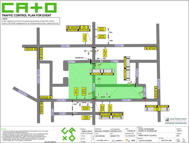
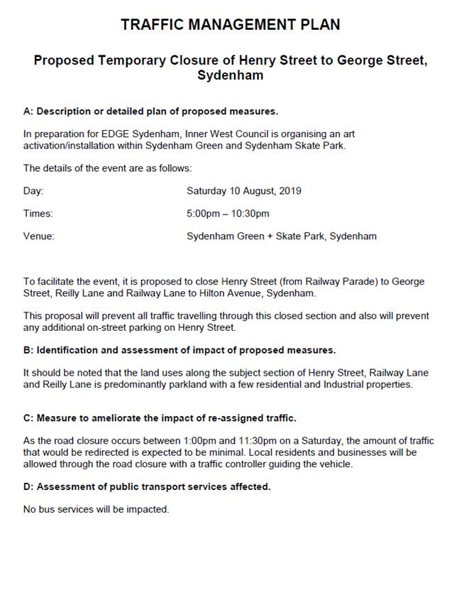
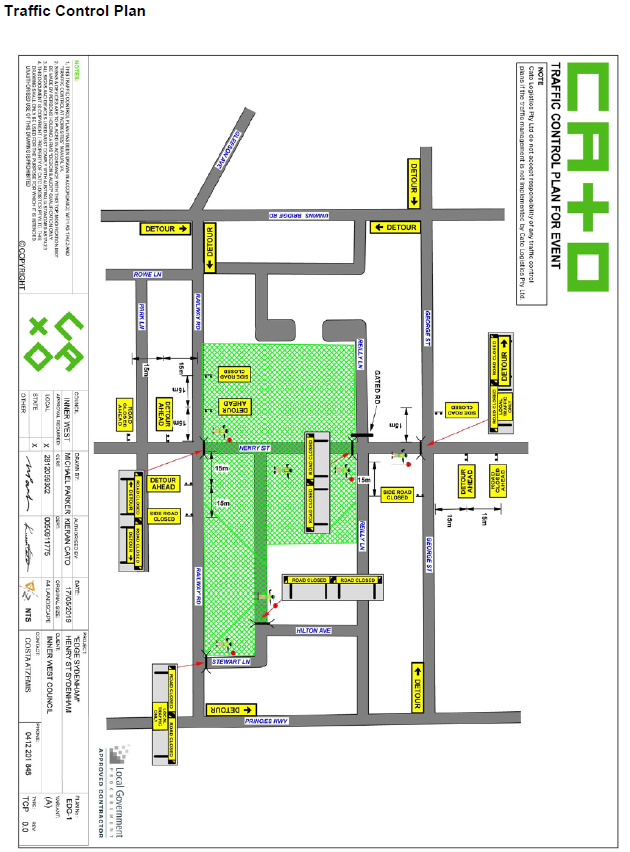
Subject: Henry Street, between Railway Parade and George Street, and Railway Lane, between Henry Street and Hilton Avenue, Sydenham - Temporary Road Closure for ‘Edge Sydenham’ event on Saturday 10 August 2019 (Midjuburi-Marrickville Ward / Heffron Electorate / Inner West PAC)
Prepared By: Jennifer Adams - Engineer – Traffic and Parking Services
Authorised By: Manod Wickramasinghe – A/Traffic and Transport Services Manager
Services
SUMMARY
Inner West Council is proposing to hold the ‘EDGE Sydenham’ event on Saturday, 10 August 2019 within Sydenham Green and Sydenham Skate Park and will require the closure of Henry Street, between Railway Parade and George Street, and Railway Lane, between Henry Street and Hilton Avenue, Sydenham to facilitate the event. It is recommended that Council agree to the temporary full road closures subject to complying with all conditions as set out in this report.
|
RECOMMENDATION
THAT:
1. The proposed temporary full road closure of Henry Street (between Railway Parade and George Street) and Railway Lane (between Henry Street and Hilton Avenue), Sydenham for the ‘EDGE Sydenham’ Event on Saturday, 10 August 2019 between 1:00pm and 11:30pm be approved as per the submitted TMP and TCP;
2. A Road Occupancy License application be obtained from the Transport Management Centre;
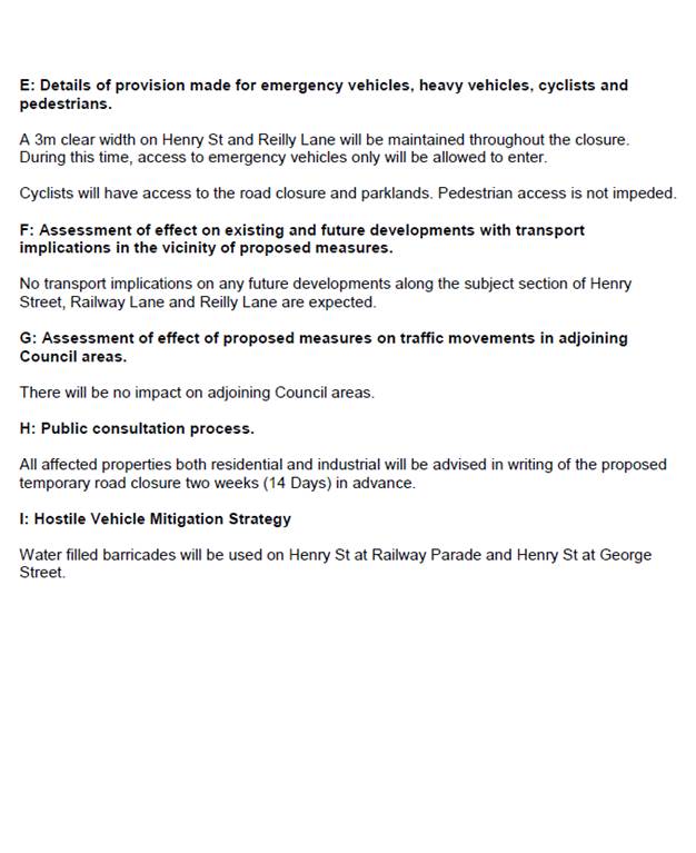
3. All residents and businesses in and around the affected area, including the NSW Police Local Area Commander, Fire & Rescue NSW, SES and the NSW Ambulance Services to be notified of the temporary road closure in writing by the applicant in advance (at least 7 days prior to the event) with the applicant making reasonable provision for stakeholders; 4. A minimum four (4) metre unencumbered passage be available for emergency vehicles through the closed section; and 5. The occupation of the road carriageway must not occur until the road has been physically closed.
|
BACKGROUND
EDGE is a Council arts and cultural program that celebrates local creatives and the vibrant local community.
EDGE is framed by 5 sites, each with a distinctive theme and timing.
•EDGE Greenway, April: Art and Environment (completed – LTC 4 February 2019)
•EDGE Sydenham, July: Art and Creative Engine
•EDGE Ashfield, September: Art and the Sacred
•EDGE Newtown, Mid November: Art and Activism
•EDGE Balmain, Late November: Art and Wellbeing
EDGE Sydenham will invite communities to experience a range of creative processes, discover creative spaces and get insights inside the creative mind. It will showcase transformed environments, internal spaces, installations and activations, performance trails, stories of place, projecting the inside of the factory or warehouse onto the outside streets, walls and lanes.
EDGE Sydenham includes a radiating program in the weeks before and/or after the main weekend from 1-4 August 2019. It includes events like, Open Studio Trail, Live Music showcases and street festivals, SK8 at Sydenham Skate park with UTS students mapping skater movements and local stories and other events hosted by creatives in this area.
The details of the ‘Edge Sydenham’ event are as follows:
Day: Saturday, 10 August 2019
Community event: 5pm-10.30pm
Venue: Sydenham Green + Skate Park, Sydenham
FINANCIAL IMPLICATIONS
Nil. Council’s Living Arts Section has allocated a budget of $100,000 for the event.
OFFICER COMMENTS
Site location & road network
|
Street Name |
Henry Street |
|
Section |
Between Railway Parade and George Street |
|
Carriageway Width (m) |
8.6 |
|
Carriageway Type |
Two-way road with one travel lane in each direction, in addition to kerbside parking lanes. |
|
Classification |
Local |
|
85th Percentile Speed (km/h) |
36 |
|
Vehicles Per Day (vpd) |
600 |
|
Reported Crash History (July 2013 – June 2018) |
One tow-away crash in April 2014 - RUM 30 (rear end) on Henry Street 10m north of Railway Lane – cars travelling southward |
|
Heavy Vehicle Volume (%) |
5 |
|
Parking Arrangements |
Unrestricted parking along both sides of the road. |
To facilitate the event, it is proposed to close Henry Street, between Railway Parade and George Street, and Railway Lane, between Henry Street and Hilton Avenue, Sydenham on Saturday, 10 August 2019 from 1:00pm to 11.30pm.
It should be noted that the land uses in this area are predominantly recreational/commercial. The local SES Headquarters is accessed via Railway Lane and they need to be consulted.
The Traffic Management Plan prepared for the event is reproduced at the end of this report and the supporting Traffic Control Plan is shown below.
PUBLIC CONSULTATION
The proposed temporary full-road closure has been advertised in the local newspaper for a period of 28 days, starting on Tuesday 4 June 2019 with the 28 day public submission period ending on Tuesday, 2 July 2019.
Council’s Living Arts Manager will organise a notification letter outlining the closure of Henry Street and between Railway Parade and George Street, and Railway Lane, between Henry Street and Hilton Avenue, Sydenham to all affected properties and the emergency services.
CONCLUSION
It is recommended that Council agree to the temporary full road closures of the subject streets on Saturday 10 August 2019 subject to complying with the recommendations stated in this report along with all standard conditions for temporary full road closures. The Traffic Management Plan is to be submitted to the RMS for approval and a Road Occupancy License be obtained from the Transport Management Centre by the Visual Arts Team.
|
|
Local Traffic Committee Meeting 1 July 2019 |
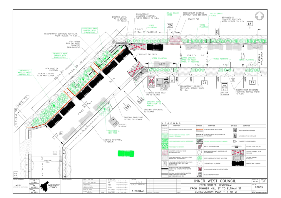
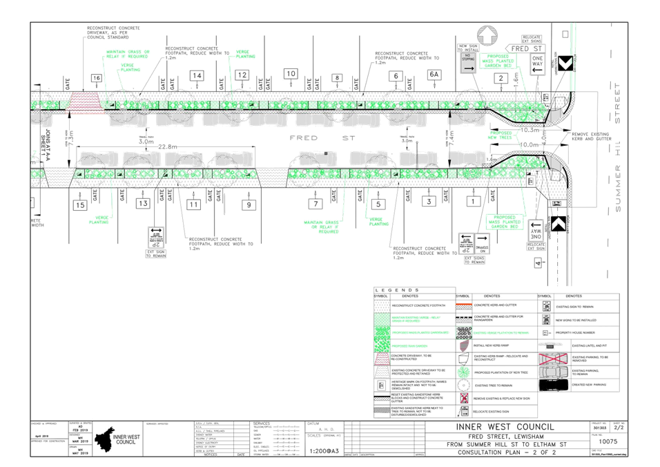
Subject: Fred Street, from Summer Hill Street to Eltham Street, Lewisham- Proposed road and footpath renewal civil works and garden beds/verge plantings – Design Plan 10065 (Damun- Stanmore Ward / Summer Hill Electorate / Inner West PAC)
Prepared By: Jennifer Adams - Engineer – Traffic and Parking Services
Authorised By: Manod Wickramasinghe - A/Traffic and Transport Services Manager
SUMMARY
As part of the Road and Footpath Renewals under Capital Works Program this combined Infrastructure Planning (Transport and Stormwater) project proposes to improve the streetscape in Fred Street, Lewisham. The works include reconstruction of footpaths, kerb and gutter, and road re-sheeting. Along with the civil works, Council is also proposing to build three (3) mass planted garden beds, verge plantings, and a rain-garden. Fred Street is one of many Greenway streets that have been identified as ‘biodiversity and wildlife habitat corridors’. The works will be constructed in this financial year, 2019/20 subject to final funding allocations.
|
RECOMMENDATION
THAT the detailed design plan for the three (3) kerb extensions, reduction of road width in two sections of the road and associated signs and line markings in Fred Street, Lewisham (as per Design Plan No.10065) be APPROVED.
|
BACKGROUND
This project was identified during asset inspections in 2013/14 by Council’s Infrastructure Planning section and was included in the Capital Works program under the Footpath Renewal program combined with the Local Road Maintenance program.
Fred Street is one of many Greenway streets that were identified as a biodiversity and wildlife habitat corridor and Council’s Infrastructure and Planning section advocated the opportunity to build a rain garden in the existing road carriageway which necessitates reducing the width of the roadway in either two locations, next to property No.20 Fred Street or opposite side of the property No.25 Fred Street and kerb extensions at the intersection of Summer Hill Street and Fred Street.
Financial Implications
Funding for the combined asset projects of $316,000 has been allocated in Council’s 2019/20 Local Road and Footpath Maintenance programs:
- budget allocation of $200,000.00 under project number 301303 - Local Road, and
- budget allocation of $105,000.00 under project number 301444 - Footpath Renewals
- budget allocation of $11,000.00 under project number 301523 – Stormwater Renewal
Officer Comments
Site location & road network
Fred Street is a short, ‘dogged-leg’ residential street running between Victoria and Summer Hill Streets. A ‘one-way’ restriction in a south-west direction presently applies in the street.
|
Street Name |
Fred Street |
|
Section |
Between Summer Hill Street and Eltham Street, Lewisham |
|
Carriageway Width (m) |
7.3 |
|
Carriageway Type |
One-way road with one travel lane in westward direction, in addition to kerbside parking on both sides. |
|
Classification |
Local |
|
Speed limit |
50.0 |
|
85th Percentile Speed (km/h) |
39.2 |
|
Vehicles Per Day (vpd) |
278 |
|
Reported Crash History (July 2013 – June 2018) |
No crashes |
|
Heavy Vehicle Volume (%) |
4.5 |
|
Parking Arrangements |
Southern side of Fred Street is restricted parking and the northern side of the street is unrestricted |
Design Plan
Design plans for the proposed works along with the asssociated signs and line markings, in Fred Street, from Summer Hill Street to Eltham Street, Lewisham (Design Plan 10065 – Attachment 1) are submitted for consideration.
The proposed scope of work includes the following:
· Reconstruction of footpath on both sides of the Fred Street;
· reconstruct and re-set of an existing heritage sandstone kerb and replace the existing gutter with new concrete gutter;
· install kerb extensions both sides of the street at the intersection of Summer Hill and Fred Streets and convert extended parts in to mass planted garden beds;
· reconstruct driveways where required due to the lifting of existing gutter, north side of the street only;
· remove two existing kerb ramps at the intersection of Summer Hill Street and Fred Street and re-install two new concrete kerb ramps up to the extended part of the kerb;
· protect and retain existing trees and plant three (3) new trees;
· install a new mass planted garden bed on the other side of the property at 25 Fred Street,
· install a new rain-garden bed adjacent to the property 20 Fred Street;
· reduce existing footpath width to 1.2m;
· construct a new tree pit around new street trees; and
· repair/replace any damaged existing private storm water lines leading from properties (between the front boundary and gutter) within the area of work.
This proposal will result in losses of two (2) on-street parking spaces. For more details please refer to Attachment 1.
PUBLIC CONSULTATION
Consultation was conducted between 28 May 2019 and 13 June 2019. A letter along with a copy of the design plan was sent to the local residents in Fred Street, Lewisham. A total of 36 letters were distributed.
There were two responses both principally supporting the proposed improvement works in Fred Street, Lewisham.
|
Residents’ Comments |
Officer Comments |
|
Thank you again for the excellent proposal. I look forward to its completion.
|
Support noted. |
|
One resident essentially supported the proposal however they had a number of queries about drainage and lighting.
The resident also queried whether local Heritage items would remain – eg. Fred Street signage inlayed in the footpath and existing sandstone kerb gutters. |
Support noted.
Council’s Design Engineer responded to the resident answering their queries and informing them that the footpath inlays and sandstone kerb guttering will be retained as appropriate where not damaged. |
CONCLUSION
It is recommended that the detailed design plan of the proposed traffic treatment and associated signs and line markings be supported to improve traffic conditions in Fred Street, Lewisham.
|
1.⇩ |
10065 - Design Plan |
|
Local Traffic Committee Meeting 1 July 2019 |
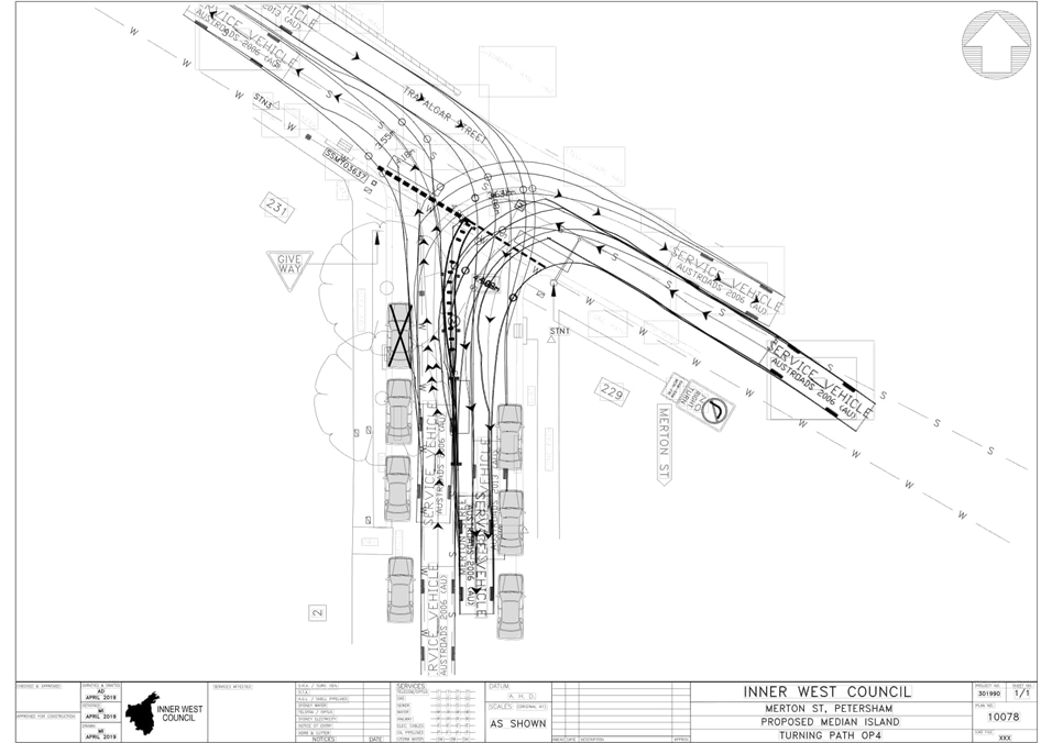
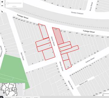
Subject: Merton Street at Trafalgar Street, Petersham - Proposed traffic calming at the intersection – Design Plan 10078 (Damun- Stanmore Ward / Newtown Electorate / Inner West PAC)
Prepared By: Jennifer Adams - Engineer – Traffic and Parking Services
Authorised By: Manod Wickramasinghe – A/Traffic and Transport Services Manager
SUMMARY
A detailed design plan has been finalised for the proposed speed calming treatment in Merton Street at Trafalgar Street, Petersham. The proposed works includes installation of a painted median with rumble bars and line marking to calm traffic and prevent motorists from making dangerous manoeuvres and/or ‘cutting the corner’ into Merton Street from Trafalgar Street, Petersham.
|
RECOMMENDATION
THAT the detailed design plan for the installation of a painted median with rumble bars and line marking to calm traffic and prevent motorists from making dangerous manoeuvres and/or ‘cutting the corner’ into Merton Street from Trafalgar Street, Petersham.(as per Design Plan No.10078) be APPROVED.
|
BACKGROUND
In late 2016 a number of requests for the installation of traffic calming measures in Merton Street at Trafalgar Street, Petersham were received from local residents in the area who reported that motorists regularly disobeyed the morning peak ‘No Right Turn’ ban on Trafalgar Street at Merton Street, Petersham and took the corner at high speed. The turn ban operates from 6am-9am, Monday-Friday. Subsequently, traffic calming measures, to slow vehicles down and stop them from making dangerous manoeuvres and/or ‘cutting the corner’ into Merton Street from Trafalgar Street, were recommended to be approved in principle in a report that was submitted to the Traffic Committee at its 1 December 2016 meeting. The works were approved and were listed for consideration in a future Traffic Capital Works Program.
As part of Council’s Traffic Capital Works Program Design Plans have been prepared for the installation of a painted median with rumble bars and line marking to calm traffic and prevent motorists from making dangerous manoeuvres and/or ‘cutting the corner’ into Merton Street from Trafalgar Street, Petersham .
FINANCIAL IMPLICATIONS
Funding of $30,000 has been allocated for the works under the 2019/2020 Capital Works Program for Traffic facilities.
OFFICER COMMENTS
Site Location & Road network
|
Street Name |
Merton Street |
Trafalgar Street |
|
Section |
Between Trafalgar Street and Bent Street |
Between Merton Street and Holt Street |
|
Carriageway Width (m) |
9.4 |
7.7 |
|
Carriageway Type |
Two-way road with one travel lane in each direction, in addition to kerbside parking on both sides. |
Two-way road with one travel lane in each direction, in addition to kerbside parking on south side only. |
|
Classification |
Local |
Local |
|
Speed limit |
50.0 |
50.0 |
|
85th Percentile Speed (km/h) |
49.3 |
48.6 |
|
Vehicles Per Day (vpd) |
900 |
4,600 |
|
Reported Crash History (July 2013 – June 2018) |
1 injury crash on Merton Street involving car and motorcycle travelling eastward – RUM 36 – right turn side swipe |
No crashes recorded at location on Trafalgar Street |
|
Heavy Vehicle Volume (%) |
3.6 |
3.2 |
|
Parking Arrangements |
unrestricted parking along both sides of the road. |
No parking on the northern side and unrestricted parking along the southern side of the road. |
Design Plan
Design plans for the proposed speed calming treatment, along with the associated signs and line markings, in Merton Street at Trafalgar Street, Petersham (Design Plan 10078 – Attachment 1) are submitted for consideration.
The proposed scope of work includes the following:
· Installation of 800mm wide 12m painted median with 11 concrete rumble bars, Retro–reflective raised pavement markers and white thermoplastic line marking.
· Installation of two “No stopping signs and associated line making
This proposal will result in the loss of one on-street parking spaces.
For more detail please refer to Attachment 1, a swept path diagram for a service vehicle is shown in Attachment 2.
PUBLIC CONSULTATION
Consultation was conducted between 16 May 2019 and 7 June 2019. A letter as well as a copy of the design plan was sent to the local residents in Merton Street, Petersham. A total of 11 letters were distributed. There were no responses received in relation to the proposal.
CONCLUSION
It is recommended that the design of the proposed works be approved to improve road safety at this location. The painted median with rumble bars and line marking aims to calm traffic and prevent motorists from making dangerous manoeuvres and/or ‘cutting the corner’ into Merton Street from Trafalgar Street, Petersham.
|
1.⇩ |
10078 - Design Plan. |
|
2.⇩ |
Swept Path |
|
|
Local Traffic Committee Meeting 1 July 2019 |
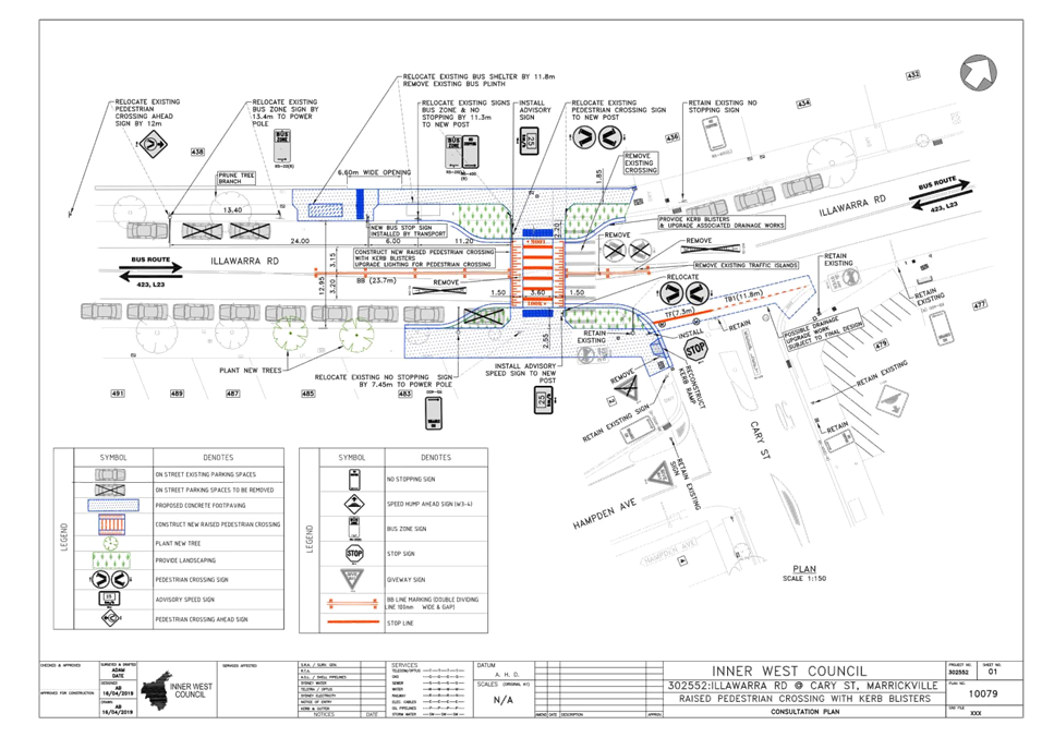
Subject: Illawarra Road at Cary Street, Marrickville – Proposed upgrading and relocation of existing pedestrian zebra crossing on Illawarra Road – Design Plan 10079 (Midjuburi - Marrickville Ward / Summer Hill Electorate / Inner West PAC)
Prepared By: Jennifer Adams - Engineer – Traffic and Parking Services
Authorised By: Manod Wickramasinghe - Coordinator – Traffic and Parking Services
SUMMARY
A detailed design plan has been finalised for the proposal to upgrade the existing pedestrian (zebra) crossing on Illawarra Road, Marrickville near its intersection with Cary Street. The proposal to upgrade and relocate the existing raised pedestrian crossing with kerb extensions and associated signs and line markings will improve pedestrian safety and traffic conditions at this location. It is noted that the works require relocation to the south of the existing bus stop on the western side of Illawarra Road.
Consultation was undertaken with owners and occupiers of properties adjacent to Illawarra Road and Cary Street, regarding the proposal. A summary of the consultation results are presented in this report for consideration. It is recommended that the proposed detailed design plan be approved.
|
RECOMMENDATION
THAT the design of the raised and relocated pedestrian (zebra) crossing with new kerb extensions and associated signs and line markings on Illawarra Road, Marrickville, at the intersection with Cary Street (as per the attached design plan No. 10079) be APPROVED.
|
BACKGROUND
Residents have raised concerns about the safety of the subject at grade pedestrian (zebra) crossing, citing excessive speed of vehicles approaching the crossing endangers pedestrians using the facility, especially school children and elderly. The rear end incidents on the crossing approaches highlights that there is an issue with the crossing, including its close proximity to the intersection of Cary Street and the existing bus stop.
To improve road safety at the subject location an application for funding under the 2019/20 Federal Black Spot Program was submitted in July 2018 to upgrade the existing at-grade pedestrian zebra crossing. The project was successful for funding under the 2019/20 Federal Black Spot Program.
The detailed design plan has now been finalised for the proposed upgrading and relocation of the crossing together with the consultation and are presented in this report for consideration.
FINANCIAL IMPLICATIONS
Funding of $150,000 has been allocated for the works under the 2019/20 Capital Works Program for Traffic facilities.
OFFICER COMMENTS
Site Location & Road network
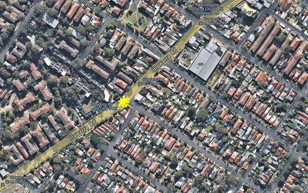
Illawarra Road, south of Marrickville Road is a Regional Road running north-south between Marrickville Road and the Cooks River to the south. Illawarra Road is used as a bus route.
|
Street Name |
Illawarra Road |
Cary Street |
|
Section |
Between Wharf Street and Cooks River |
Between Illawarra Road and Excelsior Parade |
|
Carriageway Width (m) |
13.1 |
12.8 |
|
Carriageway Type |
Two-way road with one travel lane in each direction, in addition to kerbside parking on both sides. |
Two-way road with one travel lane in each direction, in addition to kerbside parking on both sides. |
|
Classification |
Regional |
Local |
|
Speed limit |
50.0 |
50.0 |
|
85th Percentile Speed (km/h) |
52.2 |
45.0 |
|
Vehicles Per Day (vpd) |
14,500 |
1,650 |
|
Reported Crash History (July 2013 – June 2018) |
4 injury crashes on Illawarra Road at Cary Street intersection – all RUM 30 crashes (rear end) |
No crashes recorded on Cary Street |
|
Heavy Vehicle Volume (%) |
3.1 |
1.7 |
|
Parking Arrangements |
Unrestricted parking and Bus zone on northern side adjacent to crossing and unrestricted parking along the southern side of the road. |
Unrestricted parking along both sides of the road. |
![]()
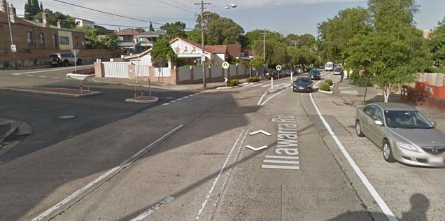
Design Plan
A detailed design plan has been finalised for the proposal to upgrade the existing pedestrian crossing on Illawarra Road, Marrickville near its intersection with Cary Street (Design Plan 10079 – Attachment 1) and is submitted for consideration.
The proposed scope of work includes the following:
· Upgrading the existing at grade marked pedestrian crossing to a raised pedestrian crossing with kerb blisters
· Relocating the existing bus shelter and bus zone on the western side further southward by approximately 13m
· Upgrading the control in Cary Street from a ‘Give Way’ to ‘Stop’ Control
· Reconstructing a new kerb ramp
· Installing associated pavement line marking and signage as required
· Reconstructing concrete footpath as required
· Upgrading associated drainage in the vicinity of the works
· Upgrading associated street lighting for pedestrian crossing
· Providing two new trees and landscaping in the vicinity of the works
This proposal will result in the loss of three (3) on-street parking spaces.
For more detail please refer to Attachment 1.
PUBLIC CONSULTATION
Consultation was conducted between 9 May 2019 and 30 May 2019. A letter as well as a copy of the design plan was sent to the local residents in Illawarra Road and Cary Street, Marrickville. A total of 181 letters were distributed.
There were two (2) responses supporting the proposed traffic and pedestrian improvement works at the intersection of Illawarra Road and Cary Street, Marrickville.
|
Residents’ Comments |
Officer Comments |
|
The resident is supportive of the proposed improvement works at Illawarra Road and Cary Street intersection. They had concerns about the safety of the crossing noting that cars often do not stop for pedestrians. “The proposed changes will make an impact to get cars to slow down while approaching the crossing and noticing pedestrians better.”
The resident had witnessed a pedestrian on the crossing being hit by a car “a couple of years ago.” |
Support and comments noted. |
|
A local couple is supportive of the proposed works for the raising and relocation of the pedestrian crossing and bus stop. Citing that they support all/any efforts that improve the safety and visibility of “this problematic intersection” and noted that speeding vehicles often do not stop at the crossing.
They cited other mitigation measures that could also be taken into account to improve safety in the area including the following: · trees and shrubs on the western side of Illawarra Road need significant pruning to improve visibility · the speed on Illawarra Road be lowered to 40km/h · additional traffic calming/entry treatments be introduced on Cary Street to slow and calm cars entering and leaving the street. |
Support and comments noted.
Instructions will be issued to check visibility and sightlines during construction of the proposed works and any obstructing tree / shrub foliage will be trimmed accordingly.
The proposed works at the intersection and introduction of the Stop control in Cary Street should calm traffic entering and leaving Cary Street. |
CONCLUSION
It is recommended that the detailed design plan of the proposed traffic and pedestrian upgrading works and associated signs and line markings be approved, to improve pedestrian safety and traffic conditions at this location.
|
1.⇩ |
10079 - Design Plan |
|
|
Local Traffic Committee Meeting 1 July 2019 |
Subject: Marrickville Road and Seaview Street, Marrickville – Temporary full Road Closures for Dulwich Hill Village Fair on Sunday 15 SEPTEMBER 2019 – S68201800008 - (Djarrawunang-Ashfield Ward / Summer Hill Electorate / Inner West PAC)
Prepared By: Jennifer Adams - Engineer – Traffic and Parking Services
Authorised By: Manod Wickramasinghe - A/Traffic and Transport Services Manager
SUMMARY
‘Dulwich Hill Village Fair' is an annual event and this year it will be held on Sunday 15 September 2019. As per previous years the event will necessitate the temporary full road closure of Marrickville Road between New Canterbury Road and Durham Street, part of Seaview Street between Marrickville Road and property No. 26 Seaview Street, Caves Lane, and the Seaview Street car park (car park adjacent to Caves Lane), Dulwich Hill.
|
RECOMMENDATION
THAT:
1. The proposed temporary full road closure of Marrickville Road (between New Canterbury Road and Durham Street), part of Seaview Street between Marrickville Road and property No. 26 Seaview Street, Caves Lane, and the Seaview Street car park (car park adjacent to Caves Lane), Dulwich Hill for the ‘Dulwich Hill Village Fair’ Event on Sunday 15 September 2019 between 3:00am and 8:00pm be approved as per the submitted TMP and TCP;
2. A Road Occupancy License application be obtained from the Transport Management Centre;
3. Notice of the proposed event be forwarded to the NSW Police Local Area Commander, Transit Systems, the NSW Fire Brigades and the NSW Ambulance Services;
4. All residents and businesses in and around the affected area are to be notified of the temporary road closure in writing by the applicant in advance (at least 7 days prior to the event) with the applicant making reasonable provision for stakeholders; 4. A minimum four (4) metre unencumbered passage be available for emergency vehicles through the closed section; and 5. The occupation of the road carriageway must not occur until the road has been physically closed.
|
BACKGROUND
Council's Events Coordinator has advised that this year's annual 'Dulwich Hill Village Fair' will be held on Sunday 15 September 2019. In this regard, the Coordinator has submitted a request for some temporary road closures between the hours of 3:00am and 8:00pm on the day of the event.
The ‘Dulwich Hill Village Fair’ is an annual event and this year will be held on Sunday 15 September 2019. As in previous years, it will be necessary to close Marrickville Road between New Canterbury Road and Durham Street, Seaview Street between Marrickville Road and property no. 24 Seaview Street, Caves Lane, the Seaview Street car park (car park adjacent to Caves Lane), Dulwich Hill.
This year’s Dulwich Hill Village Fair will run between 10:00am and 4:00pm on Sunday 15 September 2019, however, the temporary full road closures are required from 3:00am and 8:00pm on Sunday 15 September 2019 for bump in and bump out activities.
FINANCIAL IMPLICATIONS
Funding of $39,495 has been allocated by Council for organising the ‘Dulwich Hill Village Fair’ event under the 2019/2020 Major Community Events Program.
OFFICER COMMENTS
Temporary road closures are planned for the following locations (refer to the locality map below):
· Marrickville Road (between New Canterbury Road and Durham Street),
· Seaview Street (between Marrickville Road and property no. 24 Seaview Street),
· Caves Lane, and
· The Seaview Street car park (car park adjacent to Caves Lane).
This event is classified as a Class 2 event under the RMS’ Special Events Guide where it impacts local traffic and transport systems but does not impact major traffic and transport systems and it disrupts the non-event community in the area around the event but not over a wide area. The event requires the involvement of Police and Local Council and a detailed Transport Management Plan (TMP).
The temporary road closures are required to be advertised in the local newspaper providing 28 days’ notice for submissions.
Council barricades will be used to affect the closures and a 4-metre wide emergency vehicle access will need to be maintained through the area during the course of the street fair.
Appropriate advance notice signs will be strategically installed at least two weeks prior to the event to alert motorists of the proposed closures. In addition, 'No Parking - Special Event' signs will be affixed over all existing parking restriction signs within the closed roads on the afternoon of the day prior to the event - Saturday 14 September 2019.
Adequate vehicular traffic control shall be provided for the protection and convenience of pedestrians and motorists including appropriate signage and flagging. Workers shall be specially designated for this role (and carry appropriate certificates), as necessary to comply with this condition. This is to be carried out in accordance with the Australian Standard AS 1742.3 - Traffic Control Devices for works on roads.
Locality Map - Temporary road closures
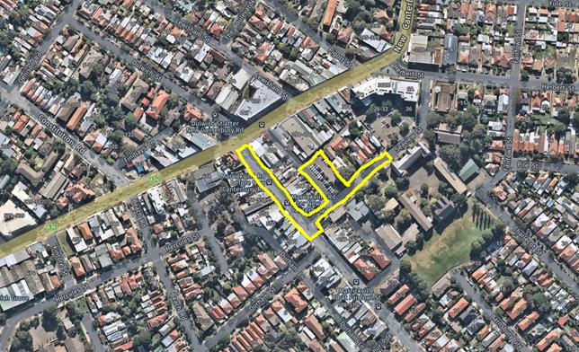
Site Map
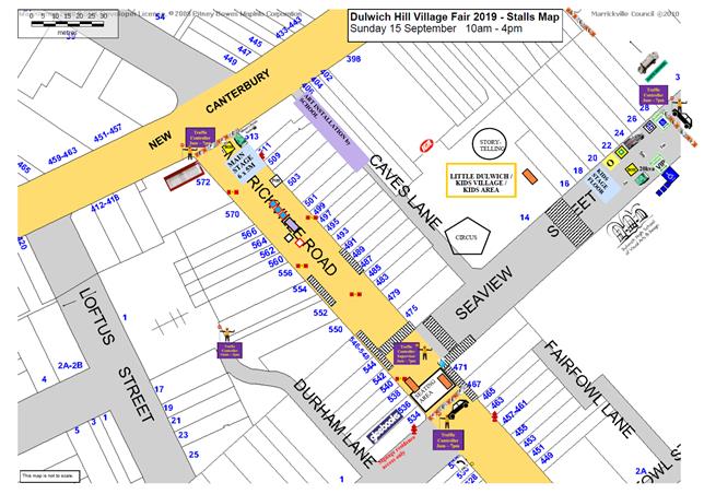
Impacts on traffic
Traffic will have to be directed to Beach Road and Durham Street during the closure. The traffic diverted from Marrickville Road and Seaview Street as a result of the proposed road closures, does not coincide with the peak traffic, as the Fair will be held on a Sunday when much lower than weekday traffic volumes are expected.
It is envisaged that the traffic generated as a result of the proposed festival will not have a major impact on the surrounding traffic network during the event. Furthermore the arrival and departure of attendees of the Fair is expected to be staggered as it is every year when this event takes place.
Impacts on buses
At present, bus services use Marrickville Road and cross New Canterbury Road then turn around in Dulwich Street. The temporary closure of Marrickville Road at its intersection with New Canterbury Road will require buses to use a different route during the closure. Consultation with Transit Systems regarding the alternative routes will be undertaken as in previous years.
No scheduled bus services operate in Seaview Street and the closure should have minimal impact on traffic movements in this street.
Traffic Management Plan and Traffic Control Plans
A Traffic Management Plan (TMP) has been supplied by Who Dares Pty Ltd, the scope of which includes the provision for the safe movement of vehicular traffic in and out of the event areas at the Dulwich Hill Village Fair on Sunday 15 September 2019. The TMP and Traffic Control Plans (TCP) are reproduced at the end of this report.
PUBLIC CONSULTATION
The proposed temporary full road closures for the event will be advertised in the local paper allowing for a period of 28 days for public submissions. The advertising period commenced on 4 June 2019 and will conclude 2 July 2019. The Traffic Management Plan is to be submitted to the RMS for consideration and approval and a Road Occupancy License application is to be submitted to the Transport Management Centre by Who Dares Pty Ltd.
CONCLUSION
It is recommended that Council agree to the temporary full road closures on Sunday 15 September 2019 subject to complying with the recommendations stated in this report along with all standard conditions for temporary full road closures as detailed in Condition 10 of the development consent for the event.
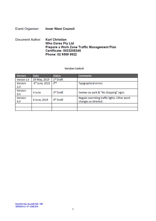
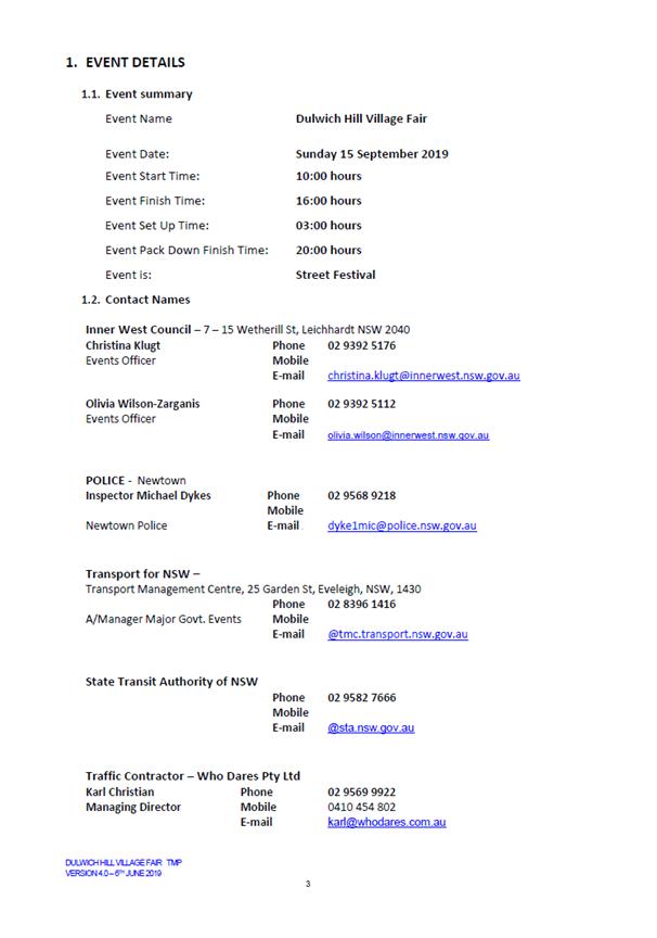
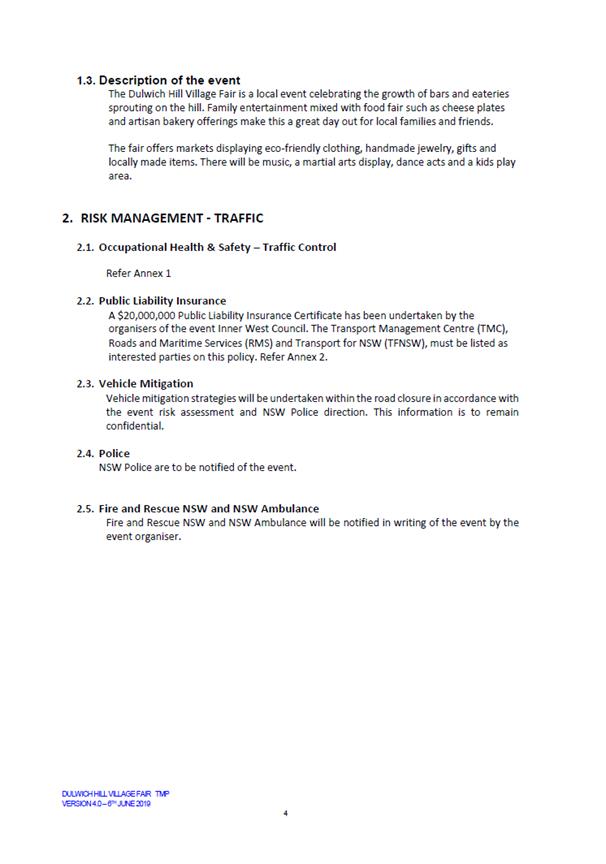
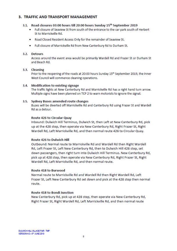
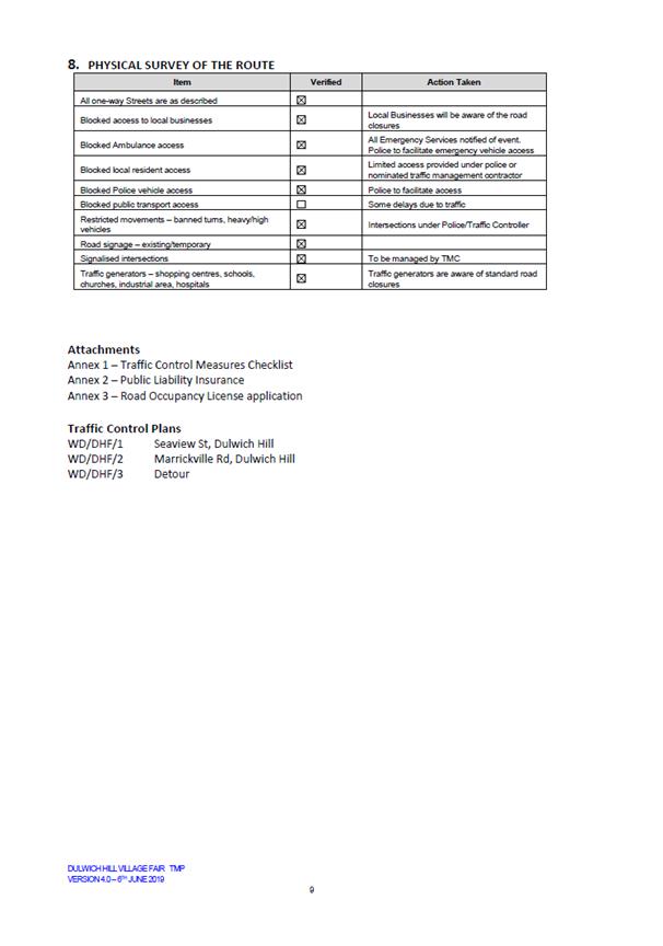
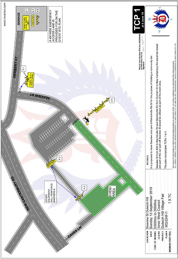
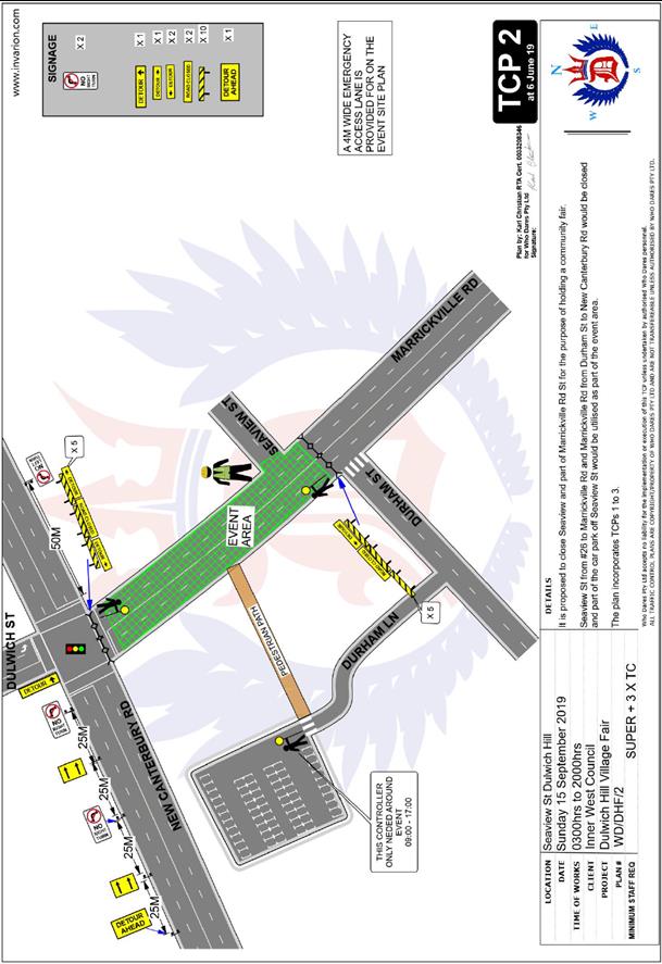
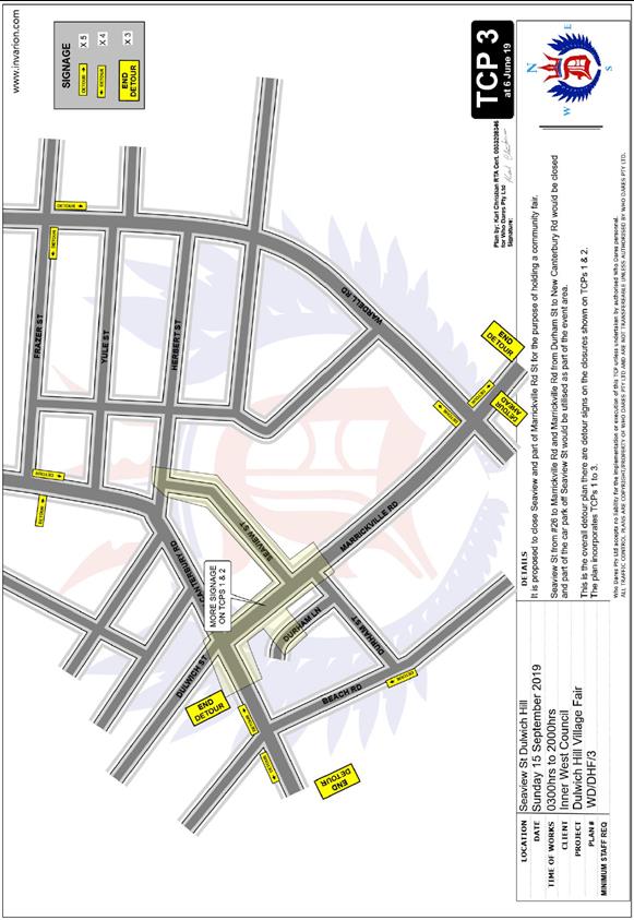
|
|
Local Traffic Committee Meeting 1 July 2019 |
Subject: Road Occupancy - Lackey Street and Smith Street, Summer Hill - Temporary Road Closures for the annual 'Summer Hill Neighbourhood Feast' - Sunday 29 Septmber 2019 (Djarrawunang - Ashfield Ward/ Summer Hill Electorate/ Burwood PAC)
Prepared By: Boris Muha - Engineer – Traffic and Parking Services
Authorised By: Manod Wickramasinghe - A/Traffic and Transport Services Manager
SUMMARY
In accordance to a Section S68 Development Application, Council seeks the support of the Committee for the temporary road closures of Lackey Street and Smith Street between Hardie Avenue and Nowraine Street, Summer Hill for the annual ‘Summer Hill Neighbourhood Feast’ festival on Sunday 29 September 2019.
|
RECOMMENDATION
THAT:
1. The proposed temporary road closure of Lackey Street and Smith Street (between Hardie Avenue and Nowraine Street) from 5.00am to 7.00pm Sunday, 29 September 2019, for the holding of the “Summer Hill Neighbourhood Feast’ event, be supported, subject to the applicant seeking consent from RMS and forwarding a TMP;
2. A Road Occupancy License be obtained by Council from the Transport Management Centre;
3. All affected residents and businesses, including the NSW Police Local Area Commander, Fire & Rescue NSW and the NSW Ambulance Services be notified in writing, by Council, of the proposed temporary road closure at least 7 days in advance of the closure with Council making reasonable provision for stakeholders;
4. The occupation of the road carriageway must not occur until the road has been physically closed, and
5. A 4 metre wide emergency service access must be maintained through the closed road areas during the course of the event;
|
BACKGROUND
The ‘Summer Hill Neighbourhood Festa’ is a scheduled annual food festival event to be conducted in the Council Area of Summer Hill in 2019, and in conjunction with other Sydney wide food festival program. See locality map below:
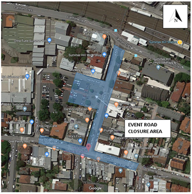
FINANCIAL IMPLICATIONS
The costs associated with the temporary road closures are to be borne by Council as part of its major events or operational budget.
OTHER STAFF COMMENTS
The annual event has gained popularity over the years. The Event’s Management coordinator of Council has requested that Lackey Street and Smith Street between Hardie Avenue and Nowraine Street be temporarily closed off to accommodate the event - see ‘Traffic Control Plan’ with Traffic Management Plan documentation Attachment 1.
Specific Event and road closure details are:
· Name of the Event: Summer Hill Neighbourhood Feast
· Date of the Event: Sunday 29 September 2019
· Address of Venue: Lackey Street, Summer Hill
· Nature/occupation of Venue: Residential street, pedestrian plaza, carpark
· Capacity of Venue: up to 3,000
· Time of event: Start 10.00am-Finish 4.00pm
· Required Set up Time (bump in) Start: Sunday 29 September 2019, 5.00am-10.00am
· Required Time to return road to original condition: By 7.00pm Sunday 29 September.
The event is organised by Council’s Event Management. No fees and charges are applicable for this full road closure event.
Hardie Avenue between Smith Street and Lackey Street, will be closed at Lackey Street to through traffic. Access will be maintained to the Summer Hill carpark from Smith Street.
Lackey Street and Smith Street has been closed off in previous years. The Local Traffic Committee and Roads and Maritime Services (RMS) has approved the event road closures in the past.
Although the event runs from 10am-4pm, from an operational point of view, in order to affectively clear parking in the area and set-up and dismantle for the event, the road closure will be affective from 5.00am-7.00pm.
In accordance with the RMS “Guide to Traffic and Transport Management for Special Events V3.4 August 2006, the event is classified either Special Event class 1 or 2. Relevant approval is required from the RMS for the closure of the roads and a road occupancy license needs to be obtained from the Transport Management Centre.
A Traffic Management Plan is also provided in Attachment 1. This together with the Traffic Control Plan will be submitted to attain RMS approval and Road Occupancy License from the Traffic Management Centre.
An Event Management Plan is shown in Attachment 2.
PUBLIC CONSULTATION
Advertisement of the road closure in the local newspaper for 28 days has been arranged. Further notification per item 3 of the recommendation will be arranged by the Council’s Event Management.
CONCLUSION
It is recommended that support be provided for Council to carry out the temporary road closures of Lackey Street and Smith Street between Hardie Avenue and Nowraine Street, Summer Hill, in association with the annual ‘Summer Hill Neighbourhood Feast’ food festival event on Sunday 29 September 2019. This will be on the provision that Council applies for Road Occupancy Licensing and provides Traffic Management Plans to the RMS for approval in closing the roads.
|
1.⇩ |
Traffic Management Plan ( TMP) and Traffic Control Plan (TCP) |
|
2.⇩ |
Event Management Plan |
|
Local Traffic Committee Meeting 1 July 2019 |
Subject: Croydon Road at Church Street, Croydon – Proposed traffic calming at the intersection including a new pedestrian refuge on Croydon Road – Design Plan 10090 (Gulgadya – Leichhardt Ward / Strathfield Electorate / Burwood PAC)
Prepared By: Jennifer Adams - Engineer – Traffic and Parking Services
Authorised By: Manod Wickramasinghe - A/Traffic and Transport Services Manager
SUMMARY
A detailed design plan has been finalised for the proposed pedestrian refuge in Croydon Road adjacent Church Street, Croydon. The proposed works aim to improve pedestrian and motorist safety and address residents’ concerns about speeding and driver behavior in Croydon Road. It is noted that these works are in addition to the intersection improvement works in Church Street (at Croydon Road) which was approved by Council on 26 February 2019. The proposed pedestrian refuge is subsequent to Council’s decision at its 26 February 2019 meeting to construct pedestrian safety measures in Croydon Road at its intersection with Church Street making an existing crossing point safer.
|
RECOMMENDATION
THAT the detailed design plan for the proposed pedestrian refuge islands, kerb blisters, line marking and signs at the intersection of Croydon Road and Church Street, Croydon (as per attached design plan No. 10090) be APPROVED.
|
BACKGROUND
The Traffic Committee at its meeting held on the 6 November 2018 deferred an item on the ‘Proposed pedestrian and traffic calming treatments’ along Croydon Road, Croydon (inclusive of proposed improvements to the intersection of Church Street and Croydon Road) for further investigation. A report went to December 2018 Local Traffic Committee meeting providing consultation feedback on two (2) alternate options to modify the existing 'STOP' control at the intersection of Church Street and Croydon Road. Option 1 was adopted by Council at its meeting 26 February 2019. However, the Traffic Committee’s recommendation: “The feasibility of providing a pedestrian facility in Croydon Road near/at its intersection with Church Street be investigated, separate to the proposed treatment in Item 1 above.” (LTC 4 December 2018 Item 8 recommendation point 2) was not adopted by Council.
Instead, at the Council meeting on 26 February 2019 the following motion was put forward and carried:
c) Amend item 8 point 2 of 4 December meeting as follows "the provision of a pedestrian facility in Croydon Road at its intersection with Church Street to support pedestrian desire line along the southern side of Church Street to Centenary Park be investigated as a matter of urgency for implementation before or with the right hand turning lane in point 1’;
This report details the design plan for a proposed pedestrian refuge in Croydon Road adjacent Church Street, Croydon as an outcome of the investigation into the feasibility of providing a pedestrian facility in Croydon Road near/at the intersection of Church Street separate to the proposed intersection treatment.
FINANCIAL IMPLICATIONS
Funding is available to be allocated for the works under the 2019/2020 Capital Works Program for traffic facilities.
OFFICER COMMENTS
Site Location & Road network
|
Street Name |
Croydon Street |
|
Section |
Between Church Street and Queen Street |
|
Carriageway Width (m) kerb to kerb |
10.1 |
|
Carriageway Type |
Two-way road with one travel lane in each direction, in addition to kerbside parking on both sides. |
|
Classification |
Collector |
|
Speed limit |
50 |
|
85th Percentile Speed (km/h) |
42.3 |
|
Vehicles Per Day (vpd) |
9,778 |
|
Reported Crash History (July 2013 – June 2018) |
Croydon Road – 2 injury crashes 10m north of Church Street – RUM 30 (rear end) and RUM 73 (right off road). Croydon Road at Church Street – 1 injury crash – RUM 21 (right through) and one tow-away crash Church Street at Croydon – RUM 10 (cross traffic) |
|
Heavy Vehicle Volume (%) |
2.4 |
|
Parking Arrangements |
Unrestricted parking along both sides of the road. |
Croydon Road looking south at Church Street intersection
Croydon Road looking north towards Church Streeet intersection
Outcome of Investigation
Council previously undertook both pedestrian and vehicle counts for the location in the vicinity of the proposed refuge. It was found that the vehicle volumes were very high (9,778 vehicles per day) and that pedestrian movements at this location were in the vicinity of 19 pedestrians per hour over the surveyed periods (southern leg). Furthermore, there is a bus stop on Church Street, west of Croydon Road which services both sides of Croydon Road north of Church Street. In this respect, a pedetrian refuge would be an appropriate device for this location.
Design Plan
A detailed design plan for the proposed pedestrian refuge, and associated signs and line markings in Croydon Road adjacent Church Street, Croydon (Design Plan 10090 – Attachment 1) is submitted for consideration.
The proposed scope of work includes the following:
· Construction of a pedestrian refuge in Croydon Road.
· Construction of new kerb ramps on both sides of the proposed pedestrian refuge island in Croydon Road
· Installation of new line marking and signage to improve traffic flow and pedestrian safety
This proposal will result in the loss of six (6) on-street parking spaces in Croydon Road.
For more detail please refer to Attachment 1.
PUBLIC CONSULTATION
Consultation was conducted between 3 June 2019 and 18 June 2019. A letter as well as a copy of the design plan was sent to the local residents in Croydon Road and Church Street, Croydon as indicated in the consultation plan below. Also, design details were placed on ‘Your Say’ on the Inner West website.
Thirteen (13) responses were received. Three (3) responses wholly supported the proposal and three (3) others generally supported the proposal. Seven (7) did not support the proposal citing concerns of increased traffic congestion and loss of on-street parking spaces as issues. Two responses queried the need for such a facility at all at the subject location. A summary of received comments follows.
|
Residents’ Comments (opposing the proposal) |
Officer Comments |
|
The resident agrees with the new right turn lane on Church street. However, says the construction of a pedestrian refuge on Croydon Road will cause more traffic and congestion, as it will not allow for overtaking of cars turning into Church Street from Croydon Road (heading towards Parramatta Road). Traffic at this intersection is bad enough at times, and restricting traffic flow is a step in the wrong direction. Adding a right turn lane at this intersection would be a better option.
|
Croydon Road is a busy road and the proposed pedestrian refuge island on Croydon Road will reduce vehicle speeds on Croydon Road and improve visibility of pedestrians while they are crossing Croydon Road increasing safety. The turning movements at this intersection are generally free flowing with sufficient gaps for vehicles to turn right with minimal delay to traffic along Croydon Road.
|
|
A resident from Croydon Road who does not have an off-street car parking space available says they routinely park on the street in Croydon Road and as on-street parking spaces are scarce now the proposal will add to the difficulty they experience in securing a parking space. “The available number of actual car parking space is scarce and if this project results in loss of 6 parking spaces, this is going to lead to more competition in car parking spaces in this area.”
|
Pedestrian safety, accessibility and minimum loss of on-street parking were major considerations during the development of the design plans. The proposed treatment will result in the loss of 6 legal on-street parking spaces as an outcome of the proposed ‘No Stopping’ restrictions in order to accommodate pedestrian safety. Moreover, RMS Technical Directions determine required ‘No Stopping’ zones around pedestrian refuges.
|
|
A local resident queried why put the refuge in at all “This is a ridiculous and ill-conceived plan. Having lived within 100m of the proposed works for 40-years …, I have never witnessed nor experienced difficulty in crossing the road and any point of departure. This will only slow traffic, create congestion, increase the concentration of pollution and loss of car parking space…”
|
Pedestrian safety, accessibility and minimum loss of on-street parking were major considerations during the development of the design plans. Croydon Road is a busy road and the proposed pedestrian refuge island on Croydon Road will reduce vehicle speeds on Croydon Road and improve visibility of pedestrians while they are crossing Croydon Road increasing safety.
|
|
A resident strongly disagrees with the proposal and raised concerns about the loss of parking and queried whether the pedestrian refuge is required as pedestrians can cross the road now satisfactorily. “The benefits of the refuge do not out-weigh the loss of 6 parks on Croydon Road. The road is obviously a busy road, with minimal parking as it is, and losing 6 spots will only cause a domino effect resulting in more parking congestion / home owners not being able to park in front of their own homes - just so pedestrians can cross the road at that exact part of the road. Pedestrians can walk a couple meters up the road to either the lights (with a safe light to cross), or the round-about that currently has pedestrian refuges in place. People can very easy cross the road as is, either waiting for traffic on both sides, OR walking a little further up the road to a quieter space (to not cross at an intersection).”
The resident added “Secondly in terms of motorist safety and residents' concern about speeding - we support the installation of speed bumps, as this will reduce driver speeds, however not impact the houses on the road with loss of very essential parking. |
Pedestrian safety along Croydon Road was a major consideration in recommending the potential improvements at the intersection. Croydon Road is a busy road and residents have previously commented about speeding vehicles in the locality and the proposed refuge would slow traffic in Croydon Road while improving pedestrian safety. Pedestrians will be able to safely cross the road along the southern side of Church Street to and from Centenary Park. It is noted that the traffic lights at Parramatta Road are over 400 metres north of the subject intersection and the roundabout at Queens Street 175 metres south.
Pedestrian safety, accessibility and minimum loss of on-street parking were major considerations during the development of the design plans. The proposed treatment will result in the loss of 6 legal on-street parking spaces as an outcome of the proposed ‘No Stopping’ restrictions in order to accommodate pedestrian safety. Moreover, RMS Technical Directions determine required ‘No Stopping’ zones around pedestrian refuges. |
|
One resident said that the loss of parking will have a strong negative impact on local residents and train commuters. “Many of the dwellings in this location do not have off-street parking, and it is also a popular parking area for train commuters.” |
Pedestrian safety, accessibility and minimum loss of on-street parking were major considerations during the development of the design plans. The proposed treatment will result in the loss of 6 legal on-street parking spaces as an outcome of the proposed ‘No Stopping’ restrictions in order to accommodate pedestrian safety. Moreover, RMS Technical Directions determine required ‘No Stopping’ zones around pedestrian refuges.
|
|
A resident thought the proposed plan is s not going to solve any of the existing traffic problems but instead create additional traffic in the south side of Croydon Road. “The proposal assumes that pedestrians only cross on the Southern side of the intersection. There has been multiple occasions that I have noticed pedestrians crossing dangerously through the traffic in both end of the Church Street. The safety of pedestrians coming from North side of the Croydon Road and then crossing the Church Street is not resolved in the proposal.”
They added “What is needed are the followings (1) a Roundabout at the Croydon Rd and Church St intersection. This will lead to a much smoother traffic flow in all the 4 roads meeting up at that intersection. Reduced traffic, along with a roundabout also increases predictability for a pedestrian to cross the road. (2) No stopping and no parking should instead be applied in front of House 96 and 100 Church street, especially during the peak hours. For example, look at the roundabout in the Croydon Road and Queen St intersection. Pedestrians crossing at that intersection do not have any problem despite heaving traffic. This is because there is orderly movement of cars. The same will happen in the Croydon Road and Church St If a Roundabout is put in place.”
|
Pedestrian safety was a major consideration in recommending the potential improvements at the intersection. Croydon Road is a busy road and residents have previously commented about speeding vehicles in the locality and the proposed refuge would slow traffic in Croydon Road while improving pedestrian safety. Pedestrians will be able to safely cross the road along the southern side of Church Street to and from Centenary Park, a known pedestrian desire line.
It is noted that any option for a roundabout at the intersection of Croydon Road and Church Street was concluded and the preferred workable Intersection Treatment (Right turn Lane in Church Street) detailed in a report that went to Local Traffic Committee in December 2018 and approved by Council at its 26 February 2019 meeting. |
|
A resident commented that “Where the eastern end of Church Street meets Croydon Road there needs to be a marked right turn lane as is shown on the Western Church Street intersection with Croydon Road. Also the proposed Croydon Road centre-line extending south to the Church Street intersection need to be shortened, otherwise people will wait to turn right into Croydon Road from the left-hand side and block the left-hand turners. This will cause chaos at busy times.”
|
A right turn lane on the western side of the Church Street intersection is not part of the scope of this project. Vehicle swept path diagrams have been undertaken for this design which has determined the positioning of the line marking shown in the design plans. |
|
Residents’ Comments (supporting the proposal) |
Officer Comments |
|
A local resident supports the proposal saying “Great! A very useful improvement. I live over in Bland Street, Ashfield and take my kids to Centenary Park to ride and run around. We sometimes ride our bikes there and it will make it much easier to cross Croydon Road. I'm in full support. Thanks! “
|
Support noted. |
|
Another local resident supports the proposal stating “I fully support the plan. The intersection is popular with pedestrians as Church Street is a common walking route between Ashfield and Croydon / Burwood. Croydon Road is dangerous to cross during peak times during the week and on the weekends for people going to sports fields. This will make it safer for pedestrians.”
|
Support noted |
|
One resident said “Good idea.” |
Support noted |
|
A local resident commented that “Pedestrian safety is desperately needed here. The new speed hump is positioned on a driveway making it extremely dangerous for those people to enter and exit their property. The centre cement median is far too long at 6m. It doesn't need to be that long. The median at the pedestrian refuge at 187 Ramsay St Haberfield, outside the Medical Centre is far smaller.”
|
Support noted.
It is noted that the ‘new’ speed hump is an existing speed hump that has been in place for some time and not been an issue to date.
The proposed pedestrian refuge island on Croydon Road will reduce vehicle speeds on Croydon Road and improve visibility of pedestrians while they are crossing Croydon Road increasing road safety. Moreover, RMS Technical Directions determines dimensions of pedestrian refuges and the ‘No Stopping’ zones around pedestrian refuges.
|
|
A resident queried whether the existing Bus Stop would be retained and requested pedestrian fencing at the intersection “It is not clear if the bus stop will be reinstated at a different location. Perhaps there should be a fence or similar to stop people crossing directly at the intersection and force them to use the pedestrian refuge instead.” |
Support noted.
The existing Bus Stop will be removed as there is another bus stop within 100m adjacent to the dog park just north of Queen Street.
It is not recommended that a pedestrian fence be constructed as it will decrease the width of footpath and restrict sight lines
|
|
A resident suggested that a pedestrian zebra crossing is a preferred option. “I would perhaps suggest a pedestrian crossing in place of the pedestrian refuge, as the proximity to the dog park would mean that there would often be both dogs and pedestrians trapped in the refuge space, which may be dangerous for dogs and owner with dogs who are uneasy around high traffic. The road is very difficult to cross at present. The changes to the road markings are good”
|
RMS warrants could not be met for a pedestrian zebra crossing at the subject location and a pedestrian refuge provides a safe space where pedestrians can cross the road in stages.
Croydon Road is busy road and the pedestrian refuge will improve crossing opportunities and safety for pedestrians crossing Croydon Road.
Constructing a pedestrian fence is not recommended as it would decrease the width of the footpath and restrict sight lines.
|
CONCLUSION
It is recommended that the detailed design plan of the proposed traffic treatment and associated signs and line markings be approved to improve pedestrian conditions at this location.
|
1.⇩ |
10090 - Design Plan |
|
|
Local Traffic Committee Meeting 1 July 2019 |
Subject: 2019 Spring Cycle Event (All Wards/ All Electorates/ All PACs)
Prepared By: Vinoth Srinivasan - Engineer - Traffic and Parking Services
Authorised By: Manod Wickramasinghe - A/Traffic and Transport Services Manager
SUMMARY
Bicycle NSW has requested approval from the Local Traffic Committee and Council to conduct the 2019 Bicycle NSW Spring Cycle Event (its 36th year) on Sunday, 13 October 2019.
|
RECOMMENDATION
THAT: 1. The 2019 Bicycle NSW Spring Cycle event to be held on Sunday, 13 October 2019 be supported, subject to:
(a) The Traffic Management Plan and Traffic Control Plans being approved by the Transport Management Centre; (b) The event organiser producing a current Public Liability Insurance Policy with Inner West Council being included as an Interested Party;
2. The organiser of the event be requested to advise the affected properties in Canal Road, Leichhardt regarding the event details to discourage traffic movements through the narrow section of Canal Road during the critical period of the event; and
3. The representative of Bicycle New South Wales be advised of the Committee’s recommendation.
|
BACKGROUND
The Spring Cycle supported by Transport for NSW, is Sydney’s largest recreational mass community bike riding event and provides a unique opportunity to travel through Sydney by bike, capturing the city’s iconic attractions, landscape and views. Every year, around 20,000 people join the Spring Cycle for a celebration of cycling that starts in North Sydney and continues across the Sydney Harbour Bridge main deck through Glebe, Annandale, Leichhardt and Haberfield and onto the festival-style atmosphere at the finish at Sydney Olympic Park, Homebush.
The Spring Cycle is organised by Bicycle NSW with the support of the NSW Government, Transport for NSW, Transport Management Centre, Roads & Maritime Services, NSW Police, New South Wales Ambulance Service, St John First Aid, City of Sydney, Sydney Olympic Park, Local Councils and more than 500 trained Bicycle NSW volunteers.
This is the 36th running of the NSW Spring Cycle event. The event in 2019 will offer four options:
Sydney City Ride – North Sydney to Pyrmont (10km)
Start: 8.00am-8.30am
Ideal for families and novice riders who want to experience the thrill of riding over the Harbour Bridge and past some of Sydney’s most iconic landmarks including the Sydney Opera House and historic Rocks area. Riders celebrate their Spring Cycle ride with a festival finish at Pirrama Park, Pyrmont.
Challenge Ride – North Sydney to Olympic Park (105km)
Start: 6.30am-6.45am
This ride is for those looking to challenge their cycling performance by riding the greater Sydney. Riders will clock up 50kms riding across the Harbour Bridge, past the Sydney Opera House and traversing the diverse Inner West before heading out to Western Sydney Parklands via picturesque Parramatta and Prospect Dam, then back to Sydney Olympic Park.
River Ride – Parramatta Park (18 Km)
Start: 10.00am-10.30am
This ride will be ideal for families out in the Western Suburbs of Sydney as it will explore the cycleway along the Parramatta River. The ride will start at Parramatta Park and conclude at the big finish festival site in Cathy Freeman Park, Sydney Olympic Park.
Classic Ride – North Sydney to Sydney Olympic Park (50km)
Start: 7:00am-7:30am
For those looking for an adventure, this route takes in the best of the 10km Sydney City Ride ‐ over the spectacular Harbour Bridge, past the Opera House and historic Rocks area, before exploring the diverse Inner West and venturing out to Sydney Olympic Park.
Bicycle Route through Inner West Council
The route via Inner West Council is summarised below:
· Arriving Annandale through Bicentennial Park (Glebe – City of Sydney)
· Turn into Johnston Street from Chapman Road (Annandale)
· Turn right onto Weynton Street (Annandale)
· Turn left onto Annandale Street (Annandale)
· Turn right onto Booth Street-Moore Street (Leichhardt)
· Cross Balmain Road at the Balmain Road/Moore Street intersection (Leichhardt) –
· BNSW to arrange opening of fence panels in Balmain Road opposite Moore Street as
per TCP 73, with RMS.
· Use off-road shared path adjacent to the Leichhardt Secondary School (Leichhardt)
· Turn right onto Derbyshire Road (Leichhardt)
· Turn left onto William Street (Leichhardt) at bus depot entry/exit.
· Turn right onto Charles Street (Leichhardt)
· Cross Darley Road at Charles Street (Leichhardt)
· Use Canal Road (Leichhardt)
· Use the bridge across Hawthorne Canal to Hawthorne Parade
· Turn right onto Waratah Street (Haberfield)
· Turn right onto Boomerang Street (Haberfield) at the roundabout.
· Turn left onto Mortley Avenue (Haberfield)
· Cross Dobroyd Parade at the Mortley Avenue/Timbrell Drive intersection (Haberfield) continue onto Timbrell Drive (Five Dock – Canada Bay Council)
All traffic signal intersections along the route will be supervised by Police.
The section of Canal Road which is part of the event route is relatively narrow and part of this section also has a ‘Shared Zone’. Currently parking is not permitted in the subject section of Canal Road.
FINANCIAL IMPLICATIONS
Nil, the supported Traffic Control Plan (TCP) be implemented at the applicant’s expense.
OTHER STAFF COMMENTS
Nil.
PUBLIC CONSULTATION
The Bicycle NSW organisers have advised that as in previous years, a detailed community consultation and event notification strategy will be delivered and executed to ensure minimum disruption is caused and all non-event stakeholders are well informed about the potential impact and alternate arrangements can be made.
CONCLUSION
It is recommended that 2019 Bicycle NSW Spring Cycle event scheduled for Sunday, 13 October 2019 be supported as per the submitted TMP and TCPs.
|
1.⇩ |
The Spring Cycle Event TMP |
|
2.⇩ |
The Spring Cycle Event TCP |
|
|
Local Traffic Committee Meeting 1 July 2019 |
Subject: Gould Lane, Petersham - Proposed 'No Parking' (Damun-Stamnore Ward/Summer Hill Electorate/Inner West PAC)
Prepared By: Mary Bailey - Parking Planner
Authorised By: Manod Wickramasinghe - A/Traffic and Transport Services Manager
SUMMARY
Council is proposing to implement parking restrictions in Gould Lane, Petersham to allow residents’ vehicles access to off-street parking and to allow for thoroughfare for emergency and service vehicles. The laneway does not meet Council’s guidelines for parking and there is support from residents for the proposal.
|
RECOMMENDATION
THAT the Installation of ‘No Parking’ in Gould Lane (both sides) between Gould Avenue and Gould Lane be approved
|
BACKGROUND
|
Street Name and Suburb |
Gould Lane, Petersham |
|
Section |
Between Gould Lane and Gould Avenue |
|
Carriageway Width (m) |
4.8m |
|
Carriageway Type |
Two-way lane |
|
Classification |
Local |
|
85th Percentile Speed (km/h) |
Not available |
|
Vehicles Per Day (vpd) |
Not Available |
|
Reported Crash History (July 2013 - June 2017) |
N/A |
|
Heavy Vehicle Volume (%) |
Not Available |
|
Parking Arrangements |
Unrestricted parking. |
According to Council’s Laneway Guidelines (December 2015) Laneways can be used for a variety of purposes which are listed below:
· Access for garbage collection trucks and deliveries where required
· Access to existing off-street parking within properties
· Access for emergency vehicles, pedestrians and cyclists
· Accessible parking for people with disabilities where appropriate
· Parking where space is available and access is maintained.
Gould Lane is approximately 4.8m wide. The Laneway Guidelines state that, “For parking to be allowed in a narrow laneway, the Australian Standards require that parallel parking spaces be at least 2.1 metres wide and NSW Road Rules requires that at least 3 metres must be available between a parked car and the kerb or edge of the laneway to allow moving vehicles to pass safely. Therefore, laneway widths that are less than 5.1 metres are too narrow to allow parking as any parked vehicle would prevent traffic from using the laneway.”
In this case, Council has received concerns that thoroughfare and access to off-street parking is being restricted because of parking in the laneway. Furthermore, the laneway is only is 4.8m wide. Therefore, according to Council’s Laneway Guidelines, Gould Lane is not wide enough to cater for parking.
Residents of New Canterbury Road and Gould Avenue use the subject section of Gould Lane to access off-street parking. Following reports of residents having difficulty with thoroughfare in the laneway, Council is proposing changes to parking restrictions in Gould Lane, Petersham.
The proposal is illustrated below in Figure 1.
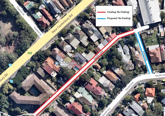
Figure 1: existing and proposed restrictions in Gould Lane, Petersham
FINANCIAL IMPLICATIONS
The cost of the sign posting can be covered by Council’s budget for signs and line marking.
PUBLIC CONSULTATION
Letters were sent to 87 affected households on 17 May 2019 seeking feedback by 14 June 2019. A map showing the canvassed properties in shown in Figure 2 below.
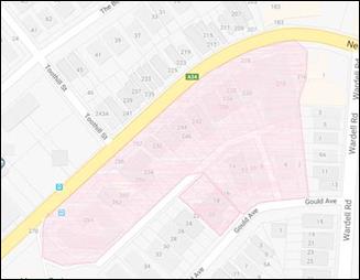
Figure 2: Properties canvassed on proposal (highlighted in pink)
There were eight (8) submissions regarding the proposal, all in support of the proposed restrictions. A summary of the comments is shown below in Table 1.
Table 1: Summary of Resident Feedback
|
Resident Comments |
Officer’s Comments |
|
Support I agree with the proposal to install No Parking restrictions on both sides of Gould Lane between Gould Ave and Gould Lane. I have experienced difficulty accessing my garage in Gould Lane due to trucks parked in this part of the Lane. |
Resident comments in supported of the proposal are noted. |
|
I give my full support to this proposal. I often see vehicles parked in the area outlined in the proposal and this makes driving through that section difficult. Larger vehicles such as the vehicles used for weekly garbage collection would have an even more difficult time with that section. |
|
|
Our driveway and garage is at the end of Gould Lane and we find it very difficult to navigate the car past cars, SUVs and trucks that park in the laneway constantly. I am not sure emergency vehicles or garbage trucks would be able to make it down there with vehicles parked on the laneway. |
|
|
I would like to support this proposal as we often see vehicles parked in the lane … generally not a problem unless a truck is parked. |
|
|
I live in the apartment block - 264 New Canterbury Road - which backs onto Gould Lane/ the park. See your aerial photograph. I wholeheartedly support this proposal. Frequently vehicles semi block the area illustrated in the proposal, making negotiating the lane both difficult and time consuming for residents, refuse collection, tradesmen, visitors. I fail to see why this wasn’t done when several years ago the rest of Gould Lane was converted to “no parking”. Now’s the time to correct this oversight. Would be much appreciated by all who use Gould Lane to access properties. |
|
|
Re: the proposal to install parking restrictions between Gould Avenue and Gould Lane - I use Gould lane for access to my property. I vote YES to install parking restrictions in the proposed area - there are always cars parked along this area making egress and ingress very difficult. |
|
|
I am
writing this email to offer my support in the proposal of the ‘No
Parking’ both sides between Gould Avenue & Gould Lane. I would like
to see the proposal of the No Parking signs to take effect immediately |
|
|
Local Traffic Committee Meeting 1 July 2019 |
Subject: Unnamed Lane - off Lord Street, Newtown - Proposed 'No Parking' (Damun-Stanmore Ward/Newtown Electorate/Inner West PAC)
Prepared By: Mary Bailey - Parking Planner
Authorised By: Manod Wickramasinghe - A/Traffic and Transport Services Manager
SUMMARY
Council is proposing to implement parking restrictions in the unnamed lane off Lord Street, Newtown to allow residents’ vehicles access to off-street parking and to allow for thoroughfare for emergency and service vehicles. The laneway does not meet Council’s guidelines for parking and no objections have been received to the proposal.
|
RECOMMENDATION
THAT the installation of ‘No Parking’ restrictions for a distance of 29 meters from the cul-de-sac on the west side of the unnamed lane off Lord Street, Newtown; be approved. |
BACKGROUND
|
Street Name and Suburb |
Unnamed lane, Newtown |
|
Section |
Between Lord Street and cul-de-sac |
|
Carriageway Width (m) |
4.8m |
|
Carriageway Type |
Two-way lane |
|
Classification |
Local |
|
85th Percentile Speed (km/h) |
Not available |
|
Vehicles Per Day (vpd) |
Not Available |
|
Reported Crash History (July 2013 - June 2017) |
N/A |
|
Heavy Vehicle Volume (%) |
Not Available |
|
Parking Arrangements |
Unrestricted parking. |
According to Council’s Laneway Guidelines (December 2015) Laneways can be used for a variety of purposes which are listed below:
· Access for garbage collection trucks and deliveries where required
· Access to existing off-street parking within properties
· Access for emergency vehicles, pedestrians and cyclists
· Accessible parking for people with disabilities where appropriate
· Parking where space is available and access is maintained.
The Unnamed Lane is approximately 4.8m wide. The Laneway Guidelines state that, “For parking to be allowed in a narrow laneway, the Australian Standards require that parallel parking spaces be at least 2.1 metres wide and NSW Road Rules requires that at least 3 metres must be available between a parked car and the kerb or edge of the laneway to allow moving vehicles to pass safely. Therefore, laneway widths that are less than 5.1 metres are too narrow to allow parking as any parked vehicle would prevent traffic from using the laneway.”
In this case, Council has received concerns that thoroughfare and access to off-street parking is being restricted because of parking in the laneway. Furthermore, the laneway is only is 4.8m wide. Therefore, according to Council’s Laneway Guidelines, The unnamed lane is not wide enough to cater for parking.
Council is proposing changes to parking restrictions in the unnamed lane off Lord Street, Newtown following reports of residents having difficulty with thoroughfare and access to off-street parking in the laneway. The proposal is outlined in Figure 1 below.
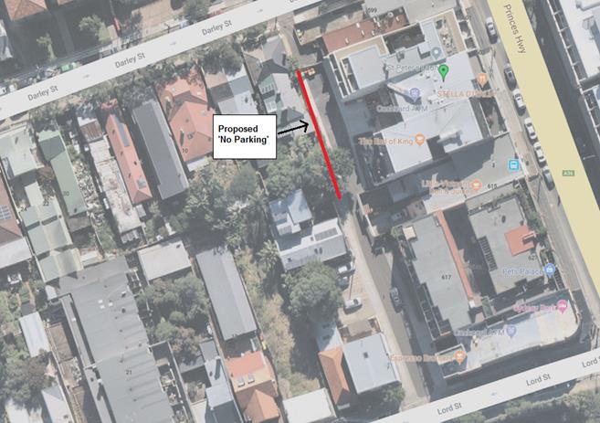
Figure 1: Proposed ‘No Parking’ in Unnamed Lane off Lord Street, Newtown
FINANCIAL IMPLICATIONS
The cost of signs can be covered from Council’s operations budget for signs and line marking.
PUBLIC CONSULTATION
Following a letter from a resident of the apartment complex at 605 Princes Highway, on 22 May 2019, Council sent letters outlining the proposal to owners and occupiers of 80 affected households with advice that submissions closed on Friday 14 June 2019.
The properties canvassed are highlighted in pink in the map in Figure 2 below.
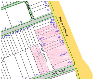
Figure 2: Properties canvassed on the proposal (highlighted in pink)
As of the closing date there were no submissions received.
CONCLUSION
Given the narrowness of the laneway and the need for vehicles of the apartment complex to enter and exit their off-street parking and the need for service vehicles to use the laneway; the proposal to restrict parking in the laneway is supported.
|
|
Local Traffic Committee Meeting 1 July 2019 |
Subject: Gordon Street, Rozelle - 'No Parking' zone removal (Baludarri-Balmain Ward/Balmain Electorate/Leichhardt PAC)
Prepared By: Felicia Lau - Engineer - Traffic and Parking Services
Authorised By: Manod Wickramasinghe - A/Traffic and Transport Services Manager
SUMMARY
Council has received requests to review the existing parking restrictions on the eastern side of Gordon Street, Rozelle outside of St. Joseph’s Catholic Church to maximise the parking arrangement in the area.
|
RECOMMENDATION
THAT the existing 18m ‘No Parking’ zone on the eastern side of Gordon Street, Rozelle outside of St. Joseph’s Catholic Church be removed. |
BACKGROUND
Council has received requests to review the existing 18m ‘No Parking’ zone on the eastern side of Gordon Street, Rozelle outside of St. Joseph’s Catholic Church. The typical existing on-street parking restrictions in Gordon Street are:
· ‘No Parking 7am-10am Mon-Fri’ and ‘2P 10am-6pm Mon-Fri Permit Holders Excepted Area R1’ on the western side of the street.
· Unrestricted parking on the eastern side of the street.
Site Location & Road Network
|
Street Name(s) |
Gordon Street |
|
Road Classification (State, Regional, Local) |
Regional |
|
Section |
Between Prince Street and Quirk Street |
|
Speed Limit |
50km/h |
|
Traffic Volume (ADT) |
2581 (63 southbound; 2518 northbound) |
|
Recorded 85th Percentile Speed |
46km/h |
|
Recorded Crash History (5 year) |
1 Fatal |
|
Carriageway Type |
Two way street with kerb side parking lanes on both sides of the street. |
|
Carriageway Width |
Approximately 10m |
FINANCIAL IMPLICATIONS
Nil.
OTHER STAFF COMMENTS
The existing kerb space south of the St. Joseph’s Catholic Church driveway is currently restricted as an 18m ‘No Parking’ zone. Assessment of the ‘No Parking’ restriction shows that this could be modified to allow parking whilst retaining an unobstructed southbound travel lane.
It is proposed to remove the 18m ‘No Parking’ zone and to reinstate unrestricted parking. This change would result in an additional three (3) parking spaces being provided in Gordon Street.
PUBLIC CONSULTATION
A letter outlining the above proposal was mailed out to the affected 15 properties in Gordon Street, Victoria Road and Quirk Street, Rozelle (as shown in the figure below) requesting residents’ views regarding the proposal.
No responses received during the consultation period.
St. Joseph’s Catholic Church has been separately contacted and has advised they are supportive of the change.
|
|
Local Traffic Committee Meeting 1 July 2019 |
Subject: Perry Street, Lilyfield - Proposed 'No Stopping' zone (Baludarri-Balmain Ward/ Balmain Electorate/ Leichhardt PAC)
Prepared By: David Yu - Engineer - Traffic and Parking Services
Authorised By: Manod Wickramasinghe - A/Traffic and Transport Services Manager
|
RECOMMENDATION
THAT a 5.5m ‘No Stopping’ zone be installed on the southern side of the Perry Street slip lane, east of Mary Street, Lilyfield;
|
BACKGROUND
Concerns have been raised regarding vehicles obstructing pedestrian access to a pram ramp by parking too close to the intersection of Perry Street at Mary Street, Lilyfield.
This illegal parking behaviour obstructs pedestrians crossing the slip lane to access the exsiting bus stop, which is located on Mary Street. It should be noted that there is unrestricted parking on the southern side of the Perry Street slip lane and special event ‘1P’ parking on the northern side of Perry Street.
The Perry Street slip lane, east of Mary Street is one-way eastbound.
|
Perry Street, Lilyfield (east of Mary Street) |
|
|
Traffic Volume |
Not available |
|
Recorded Accident History (5 year) |
1Minor/Other injury |
|
Recorded 85% speed |
Not available |
|
Speed Limit |
50km/h |
|
Carriageway width |
7.5m with parking on both sides of the road |
|
Road Classification (State, Regional, Local) |
Local |
|
Traffic Directions |
One-way |
FINANCIAL IMPLICATIONS
Nil.
OTHER STAFF COMMENTS
In order to alleviate the pedestrian acessibility issues, it is proposed to signpost a 5.5m ‘No Stopping’ zone on the southern side of the Perry Street slip lane, east of Mary Street, Lilyfield. The proposal is shown on the following plan.
A risk analysis as per TTD 2014/005 – ‘Statutory 10m No Stopping at unsignalised intersections ‘ has been undertaken to assess the impact on the installation of a 5.5m ‘No Stopping’ zone in lieu of a 10m ‘No Stopping’ on the southern side of Perry Street, east of Mary Street, Lilyfield.
The findings of the analysis are summarised below.
|
Criteria |
Impact |
|
Crossing Sight Distance |
Not Applicable. Proposal does not impact sight lines as it is a one-way street. |
|
ASD (Approach Sight Distance) |
Not Applicable. Proposal does not impact sight lines as it is a one-way street. |
|
SISD (Safe Intersection Sight Distance) |
Not Applicable. Proposal does not impact sight lines as it is a one-way street. |
|
Minimum Gap Sight Distance |
Not Applicable. Proposal does not impact sight lines as it is a one-way street. |
|
Turning Paths |
The proposal does not affect turning manoeuvres of a 8.8m MRV. Refer to attachment. |
|
Public Transport |
No public transport routes along this section of Perry Street |
|
Emergency Vehicle Access |
The proposal does not affect turning manoeuvres of a 8.8m MRV. Refer to attachment. |
|
Angle Parking Manoeuvres |
Not applicable. |
As indicated in the table, the reduced 5.5m ‘No Stopping’ zone on the southern side of Perry Street (slip lane), east of Mary Street, Lilyfield is not expected to cause significant impact on sightlines or vehicle manoeuvres.
PUBLIC CONSULTATION
A letter outlining the above proposal was mailed out to the affected properties (20 properties) in Perry Street and Mary Street, Lilyfield.
No responses were received.
|
1.⇩ |
Perry Street, Lilyfield - 8.8m MRV Swept Path Analysis |
|
|
Local Traffic Committee Meeting 1 July 2019 |
Subject: Mortley Street, Haberfield - Proposed Extension of Existing 'Bus Zone' (Gulgadya-Leichhardt Ward/ Summer Hill Electorate/ Burwood PAC)
Prepared By: David Yu - Engineer - Traffic and Parking Services
Authorised By: Manod Wickramasinghe - A/Traffic and Transport Services Manager
|
RECOMMENDATION
THAT the existing ‘Bus Zone’ on the western side of Mortley Avenue, Haberfield (in front of 1A Mortley Avenue) be extended by 1.8m to the north. |
BACKGROUND
A development application has been lodged for a driveway to be constructed at No.1A Mortley Avenue, Haberfield. The proposed location is within an existing ‘Bus Zone’ and conflicts with the existing concrete hardstand area, for pedestrian access onto buses.
To satisfy a condition of consent, the applicant is required to modify the bus stop and ‘Bus Zone’ in front of the subject site on Mortley Avenue to facilitate the construction of the driveway/crossover.
|
Mortley Avenue, Haberfield |
|
|
Traffic Volume |
5,734 |
|
Recorded Accident History (5 year) |
2 minor/other injury |
|
Recorded 85% speed |
43.6km/h |
|
Speed Limit |
50km/h |
|
Carriageway width |
Approx. 12.8m with two way traffic and kerb side parking lanes. |
|
Road Classification (State, Regional, Local) |
Local |
FINANCIAL IMPLICATIONS
The costs associated with the relocation of bus infrastructure will be borne by the applicant.
OTHER STAFF COMMENTS
Based on the DA Plans (Drawing No. DA 02, Revision C) submitted by the applicant, it is proposed that the existing ‘Bus Zone’ on the western side of Mortley Avenue, (in front of No.1A Mortley Avenue) be extended by 1.8m north, as shown on the following plan.
Due to the proposed location of the driveway conflicting with the existing concrete hardstand area. The existing bus stop and associated signage and infrastructure will have to be relocated.
It is proposed that the ‘Bus Zone’ be extended by 1.8m north, the Bus J Stem be then be located 2 metres from the start of the ‘Bus Zone’ and the driveway will be an additional 5 metres from the Bus J Stem allowing sufficient space for a new concrete hardstand area.
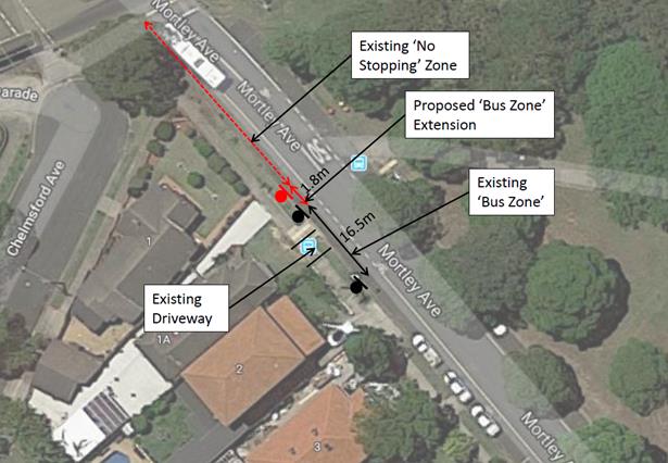
Council has consulted Transit Systems regarding the proposed relocation of the bus stop and they have advised they have no objections.
This extension will replace existing ‘No Stopping’ restrictions and so there is no loss of parking.
PUBLIC CONSULTATION
A notification letter will be sent to residents prior to the signage works.
|
1.⇩ |
1A Mortley Avenue, Haberfield - DA Plans |
|
|
Local Traffic Committee Meeting 1 July 2019 |
Subject: Booth Street, Annandale - Proposed reduction of existing 'No Stopping' restriction (Gulgadya-Leichhardt Ward/ Balmain Electorate/ Leichhardt PAC)
Prepared By: Vinoth Srinivasan - Engineer - Traffic and Parking Services
Authorised By: Manod Wickramasinghe - A/Traffic and Transport Services Manager
SUMMARY
Council is proposing to rationalise the existing ‘No Stopping’ zone on the southern side of Booth Street west of Annandale Street to accommodate one extra parking space.
|
RECOMMENDATION
THAT the existing ‘No Stopping’ zone on the southern side of Booth Street, Annandale west of Annandale Street be reduced by 2.0m to achieve a 10m ‘No Stopping’ zone from the pedestrian refuge crossing point. |
BACKGROUND
The Local Traffic Committee at its meeting held on 6 May 2019 requested, in discussion, that Council officers investigate whether the existing ‘No Stopping’ zone on the southern side of Booth Street west of Annandale Street could be reduced to accommodate one extra parking space while taking into account its proximity to the existing pedestrian refuge.
The existing kerb space between the driveway of No.88 Booth Street and the pedestrian refuge crossing point on the southern side of Booth Street west of Annandale Street consists of a 12m ‘No Stopping’ zone and 15m unrestricted parking.
Site location & road network
|
Street Name(s) |
Booth Street at Annandale Street, Annandale |
|
Section |
Intersection |
|
Traffic Volume |
- |
|
Recorded Crash History (5 year) |
Nil. |
|
Recorded 85% speed |
- |
|
Speed Limit |
Booth Street - 40km/h HPAA |
|
Carriageway Width |
Booth Street – approx. 12.8m |
|
Carriageway Type |
Booth Street - two way street with one travel lane in each direction, eastbound bicycle lanes and kerb side parking lanes. |
|
Road Classification (State, Regional, Local) |
Regional |
FINANCIAL IMPLICATIONS
Nil.
OTHER STAFF COMMENTS
As per the Roads and Maritime Services (RMS) technical directions, a minimum 10m ‘No Stopping’ restriction is required on the departure side of a pedestrian refuge. The existing ‘No Stopping’ restriction on the departure side is 12m and be rationalised to 10m. The resultant 17m of unrestricted parking will allow sufficient space for three standard vehicles to park; this is an increase of one.
The proposal is shown in the following aerial photo.
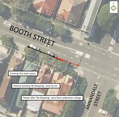
PUBLIC CONSULTATION
Nil as the proposal will not result in loss of on-street parking.
|
|
Local Traffic Committee Meeting 1 July 2019 |
Subject: Edwin Street North, Croydon - Proposed installation of a Disabled (Mobility) Parking Zone (Gulgadya - Leichhardt Ward/ Strathfield Electorate/ Burwood PAC)
Prepared By: Boris Muha - Engineer – Traffic and Parking Services
Authorised By: Manod Wickramasinghe - A/Traffic and Transport Services Manager
SUMMARY
Community representations have been received for the installation of a mobility parking space near the newly located Post Office in Edwin Street North, Croydon. The proposed position of the mobility parking space would be near midblock within the shopping strip between Hennessy Street and Elizabeth Street and would replace an existing part time 'Loading Zone'.
|
RECOMMENDATION
THAT a 8.5m 'Disabled Parking 8.30am-6.00pm Mon-Fri., 8.30am-12.30pm Sat' zone with rear pram ramp, replace the existing ‘Loading Zone 8.30am – 6pm Mon-Fri, 8.30am-12.30pm Sat’ outside No.103 Edwin Street North, Croydon, just north of the existing midblock pedestrian crossing.
|
BACKGROUND
Concerns have been raised that there are no allocated mobility parking spaces at Edwin Street North, Croydon, around the shopping precinct, especially near the new Post Office. Parking demand ishigh in this area including demand generated by the PLC School
It is noted that the 'Loading Zone 8.30am – 6pm Mon-Fri and 8.30am-12.30pm Sat’ outside No.103 Edwin Street North) is not effectively been utilised and that an existing ‘Loading Zone 8.30am – 6pm Mon-Fri, 8.30am-12.30pm Sat’ on the opposite side, south of the midblock crossing, can service the various businesses on both sides of the street via use and connection of the crossing.
Two options have been developed for provision of a 'Disabled Parking' zone, with the preferred Option 1 replacing the part time 'Loading Zone' outside No.103 Edwin Street North. An alternate Option 2 location for a 'Disabled Parking' zone is also considered on the opposite side of the street as shown in the following diagrams.
Site Location & Road Network
|
Street Name(s) |
Edwin Street North, Croydon. |
|
Section |
Between Elizabeth Street and Hennessey Street. |
|
Traffic Volumes (AADT- Average Annual Daily Traffic.) |
Approx. 9700 |
|
Recorded Accident History (5 Years) |
recorded midblock accidents |
|
Recorded 85% speed |
30 |
|
Speed Limit |
50 |
|
Carriageway width |
Approx. 9.9-10.1m |
|
Carriageway Type |
Two-way with one travel lane each way and period parking, Loading zones each side of the road. |
|
Road Classification (State, Regional, Local) |
Local (collector) |
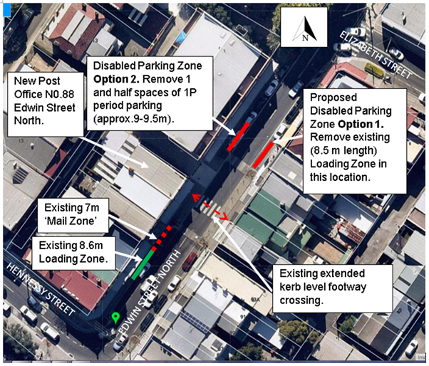
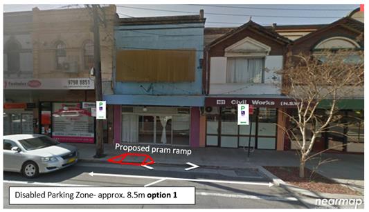
FINANCIAL IMPLICATIONS
Nil.
OTHER STAFF COMMENTS
The following comments are provided in support to the recommendation (Option 1).
· A proposed 'Disabled Parking' zone midblock in Edwin Street North (between Hennessey Street and Elizabeth Street) is considered of need and general benefit for customers having disability and attending the various shop/businesses in the area. It is proposed in a central location to all activities and near to a crossing that can facilitate pedestrian movement to both sides of the street.
· The zone is not recommended to the ends of the block for reasons of sight view or traffic conflict near intersections.
· The mobility parking space in this instance is proposed with a pram ramp to assist with access to and from the vehicle.
· The proposed mobility parking zone will only operate during business hours Mon-Sat, and converts to unrestricted parking outside of the hours.
· The remaining Loading Zone on the western side of the street would be considered adequate to service both sides of the street via use and connection of the crossing. Alternatively service vehicles can utilise the 1P parking zones adjacent to the loading zones and mail zone areas, or park ‘unrestricted’ outside of the zone time restrictions.
· Option 1 does not remove period parking in the area which is required for business customer parking.
· Option 2 removes approx. 1 and half spaces (9.0 to 9.5m) of period parking which is needed for business customer parking. The extra distance over that of option 1 is on account of the pram ramp needing to be built forward of the drainage pit.
PUBLIC CONSULTATION
Consultation letters have been issued out to some 60 residents & shop/business properties in the area shown on the distribution map. A consultation letter has also been issued to the Chamber of Commerce for them to comment on the matter.
Three (3) Submissions have been received, Two (2) submissions were received in support of option 1 with objection/concern to loss of parking with option 2. One (1) was received in dupport of option 2 and is is concerned with loss of loading zone provision in option 1.
The comments with officer’s comments are tabled below. Any further responses received will be tabled at the meeting.
|
Resident and shop/business comments |
Officer’s Comments |
|
Removing the loading zone (not used by vans/trucks and only by cars in our recent knowledge) and changing that to a disabled zone is the best option.
We don't believe putting the disabled spot out the front of active shops is best idea [western side of the street]. The small cafe/art gallery and others might struggle through losing the quick stop spot for selling coffees in the afternoons and on weekends. The parking opposite (near to Natalie Anne hair and other vacant/closed up shop fronts are typically parking for longer periods (illegally against the signposting) and do not visit/spend money at the shops opposite.
To avoid cutting in more pram ramps (there are nice pavers on both sides of the street at the two option locations) - the pedestrian cross is smooth/level to the road level for crossing over to the post office.
Another location suggestion. Closer to the rail corridor so disabled drivers/passengers can park and travel to Croydon Station a bit easier (as well as the post office)?
|
Noted in support of option 1 and non-support to option 2.
Disability access to the vehicle particularly with those in wheelchairs is safer from the footpath than near/off the roadway. The pram ramp coming off the footpath complies with Australian Standard design practice.
The location of the disabled parking zone is proposed away from the intersections for reasons of sight view and to minimise/avoid exposure conflict with traffic. The zone is not intended for disabled person commuter parking. |
|
I strongly object to option 2 in front of my shop as this is for general parking for my customers and there is a need for it to remain as it is. Parents need this spot to park to drop their children off to attend the Art School and the Tutoring School next door. Parking is already limited in front of my business and this will definitely impact on my business.
Option 1 is the preferred option as this is currently a Loading Zone and it is currently not being utilised properly and it makes better sense to use this as a disabled parking space.
|
Noted in support of option 1 and non-support to option 2.
|
|
As a construction company, we receive material deliveries frequently throughout the weekdays, and there are multiple loading and unloading of the constructions tools as well, so it will be more convenient and less hazardous, to adapt the option 2 as a disabled parking zone, and leave the parking space (option 1 ) as it is as a loading zone.
|
Acknowledged that the business is next to the affected Loading Zone and is more convenient in the handling of materials to the shop. However the loading zone on the opposite side via use of the crossing could still be used or that service vehicles. There may also be opportunities for delivery drivers to utilize the adjoining 1P zones. |
|
|
Local Traffic Committee Meeting 1 July 2019 |
Subject: Smith Street, Annandale - Proposed 'No Parking 7AM-7PM Motor Vehicles Under 4.5t GVM Excepted' (Baludarri-Balmain Ward/Balmain Electorate/Leichhardt PAC)
Prepared By: Felicia Lau - Engineer - Traffic and Parking Services
Authorised By: Manod Wickramasinghe - A/Traffic and Transport Services Manager
SUMMARY
Council has received a petition from residents in Young Street, Annandale requesting parking restrictions in Smith Street, Annandale to restrict long term boats and trailer parking.
|
RECOMMENDATION
THAT ‘No Parking 7am-7pm Motor Vehicles under 4.5t GVM Excepted’ restrictions be installed on the west side of Smith Street, Annandale (between Gillies Street and Piper Street), including signage to reinforce the statutory 10m ‘No Stopping’ zone.
|
BACKGROUND
Council has received a petition from residents in Young Street, Annandale requesting parking restrictions in Smith Street, Annandale to restrict long term boats and trailer parking in front of the White Creek Valley Park between Gillies Street and Piper Street.
The existing long term boats and trailer parked in the area may result in obstructed pedestrian access to the park and reduced sight distance for pedestrian crossing Smith Street to access Whites Creek Valley Park.
Site Location & Road Network
|
Street Name(s) |
Smith Street |
|
Road Classification (State, Regional, Local) |
Local |
|
Section |
Between Gillies and Piper Street |
|
Speed Limit |
50km/h |
|
Traffic Volumes |
Not available |
|
Recorded Crash History (5 Years) |
Nil |
|
Carriageway Type |
Two way street with a kerb side parking lane on the western side. |
|
Carriageway Width |
Approximately 7.5m |
FINANCIAL IMPLICATIONS
Nil.
OTHER STAFF COMMENTS
In order to restrict long term boats and trailer parking in Smith Street, it is proposed to install ‘No Parking 7am-7pm Motor Vehicles under 4.5t GVM Excepted’ on the west side of the street between Gillies Street and Piper Street.
PUBLIC CONSULTATION
A letter outlining the above proposal was mailed out to the affected 35 properties in Young Street and Piper Street, Annandale (as shown in the figure below) requesting residents’ views regarding the proposal.
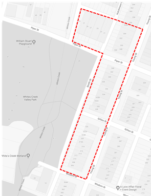
17 Responses received with the following breakdown:
· Eight (8) responses in support from nine (9) directly impacted properties rear to Smith Street.
· Two (2) responses in support from nearby consulted properties.
· Two (2) responses in objection from nearby consulted properties.
· One response and a petition (nine (9) signatures) in objection from other park users.
The table below presents the comments raised.
|
Residents’ Comments |
Officer Comments |
|
Smith Street is a quiet and low traffic street. Does not think that boats and trailer parked in Smith Street is a safety risk to pedestrian accessing the park and park users. Smith Street is a least inconvenient or concerning places for them to be parked. |
Boats on a trailer are generally larger than a private vehicle in residential streets and may impose reduced sight lines to pedestrian crossing Smith Street to/from the White Creek Valley Park.
Long term parking of boats also reduces parking availability for park users. |
|
By disallowing boat trailers and allowing motor vehicles under 4.5t, it is substituting one obstruction for another. |
|
|
The park is accessed via various pedestrian footpaths and sight is not reduced by vehicles. |
|
|
Resident parking availability is reduced due to long term parking of boats. |
Noted. |
|
Numerous occasions, crossing with young children after checking for cars is startled as a car emerges from the laneway, obscured from view by the trailers that are always parked there. |
|
|
Smith Street crossing, along Piper Street is used by school children every day walking to school and Whites Creek Playground. |
|
|
Local Traffic Committee Meeting 1 July 2019 |
Subject: Status Report - Leichhardt and Haberfield -
Pedestrian Safety Measures (Gulgadya-Leichhardt Ward/ Summer Hill & Balmain
Electorate/ Burwood & Leichhardt PAC)
Prepared By: David Yu - Engineer - Traffic and Parking Services
Authorised By: Manod Wickramasinghe - A/Traffic and Transport Services Manager
|
RECOMMENDATION
THAT this report be received and noted. |
BACKGROUND
Council officers have previously been requested to investigate pedestrian safety measures at several intersections in Haberfield and Leichhardt as an outcome of a Council resolution. This included the intersections along Marion Street, Leichardt; Flood Street, Leichhardt and Ramsay Street, Haberfield.
This resolution was then considered by Traffic Committee Meeting held 6 March 2018 and it was recommended that a further report be prepared detailing the investigation of 40km/h speed limits on Marion Street, Leichhardt and Ramsay Street, Haberfield.
FINANCIAL IMPLICATIONS
Nil.
OTHER STAFF COMMENTS
Marion Street, Leichhardt
Council has made submissions for a 40km/h High Pedestrian Activity Area (HPAA) in Marion Street, Leichhardt (between Foster Street and Edith Street) and Ramsay Street, Haberfield (between Kingston Street and Empire Street) as per the eligibility assessment set out by RMS.
RMS has since advised that they do not support the introduction of a 40km/h HPAA for Marion Street, Leichhardt at this time. This is due to the short commercial precinct (approx. 150m) and limited pedestrian volumes.
However, it should be noted that the signal phasing at the intersection of Marion Street with both Flood Street and Elswick Street has recently been upgraded under the RMS Green-on-Green Program, to provide a delay similar to the red hold arrow hold.
This allows pedestrians to fully enter the crossing and enter the driver’s field of view before the green light is displayed to the motorist turning over the crossing. Intersections under this program are being progressively being rolled out and upgraded.
Ramsay Street, Haberfield
RMS has agreed in-principal to further consider a HPAA in Ramsay Street through preparation of a design plan. RMS grant funding is being sought for design and if successful, Council will undertake detailed design of engineering treatments to support a HPAA application.
Furthermore, the signal phasing at the intersection of Ramsay Street and Dalhousie Street has been upgraded by RMS under the Green-on-Green Program to provide additional pedestrian protection.
Flood Street, Leichhardt
Council has listed the existing at-grade pedestrian (zebra) crossings at the intersection of Flood Street and Lords Road to be upgraded to raised pedestrian (zebra) crossings in the four year capital works program, subject to detailed design.
As noted previously, the signal phasing at the intersection of Flood Street and Marion Street has been upgraded by RMS under the Green-on-Green Program to provide additional pedestrian protection.
PUBLIC CONSULTATION
Nil.
|
|
Local Traffic Committee Meeting 1 July 2019 |
Subject: Car Parks adjacent to the Petersham Service Centre (Damun-Stanmore Ward/ Newtown Electorate/ Inner West PAC)
Prepared By: Felicia Lau - Engineer - Traffic and Parking Services
Authorised By: Manod Wickramasinge – A/Traffic and Transport Services Manager
SUMMARY
Council has recently reviewed the parking arrangement at Petersham Service Centre as a result of concerns raised that the nearby car parks are utilised by long stay commuter parking.
A proposed plan to provide improved parking opportunities for visitors to the service centre and the surrounding commercial precinct was presented to the staff in Petersham Service Centre for feedback. Since that time, Council has been advised that the Regent and Fisher Street car parks will no longer be available for public use due to discontinuation of the Free Parking Area Agreements previously established with the owner of the site. This report recommends changes to the remaining Crystal Street car park to provide improved parking capacity by discouraging long-stay commuter parking.
|
RECOMMENDATION
THAT the Crystal Street Car Park be modified to:
1. Convert 9 of the existing ‘9P 8am-6pm Mon-Fri’ spaces to ‘3P 8am-6pm Mon-Fri’ parking in the row adjacent to Petersham Service Centre; and
2. The remaining 50 ‘9P 8am-6pm Mon-Fri’ spaces be converted to ‘8P 8am-6pm Mon-Fri’ parking. |
BACKGROUND
A review of the parking arrangement at Petersham Service Centre was undertaken following concerns that the nearby car parks were utilised by long term commuter parking. Currently, parking is available in three car parks; Crystal Street car park, Fisher Street car park and Regent Street car park, the locations of these car parks is shown on the following plan. All three car parks are in close proximity to Petersham Station.
It should be noted that both Fisher Street and Regent Street car parks are owned by Petersham RSL Club and allow public parking based on a Free Parking Area Agreement with Council.
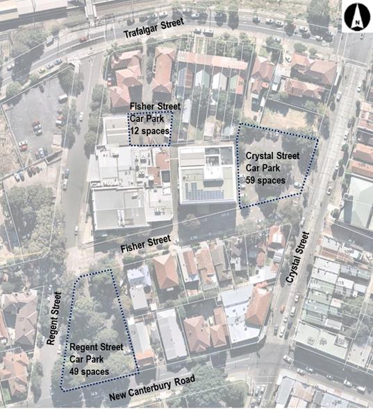
Existing parking arrangements
· Crystal Street car park - 59 spaces of ‘9P 8am-6pm Mon-Fri’ parking, one car share space, two mobility parking spaces and one trades vehicle space
· Fisher Street car park - 12 spaces of ‘9P 8am-6pm Mon-Fri’
· Regent Street car park - 49 spaces ‘9P 8am-6pm Mon-Fri’ and two Disabled Parking spaces
OTHER STAFF COMMENTS
Parking analysis
In order to determine the existing parking condition in the Crystal Street and Regent Street car parks, parking occupancy surveys were undertaken on a typical Tuesday and Wednesday in August 2018.
The average parking occupancy rates in both car parks are shown in the following graphs.
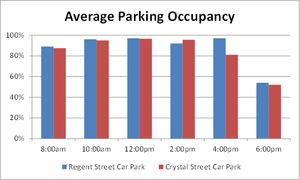
The following table further details the typical duration of stay of vehicles in these car parks. The table indicates significant long-stay parking in both of these car parks.
|
Parking Duration (Turnover) |
Crystal Street Car Park |
Regent Street Car Park |
|
0-2 hours |
32% |
24% |
|
2-4 hours |
15% |
16% |
|
4-6 hours |
11% |
5% |
|
6-8 hours |
14% |
14% |
|
8-10 hours |
14% |
22% |
|
10-12 hours |
14% |
19% |
The existing land type zoning around Petersham Service Centre is mainly residential with limited commercial/retail. Therefore, the proposed changes to the parking arrangement are aimed to provide off-street parking for the Petersham commercial precinct, Council operation vehicles as well as some short-term parking to visitors to the area while deterring long-term commuter parking.
Proposed parking arrangements
In order to discourage commuter parking from the car parks and provide improved parking opportunities to the local commercial precinct, including Peterhsam Service Centre and Petersham Town Hall, it was initially proposed to make the following changes:
1. Crystal Street car park:
a. Convert 9 of the ‘9P 8am-6pm Mon-Fri’ spaces to ‘3P 8am-6pm Mon-Fri’ parking in the row adjacent to Petersham Service Centre.
b. Convert remaining 50 spaces of ‘9P 8am-6pm Mon-Fri’ parking to ‘8P 8am-6pm Mon-Fri’ parking.
2. Fisher Street car park:
a. Convert all 12 of the ‘9P 8am-6pm Mon-Fri’ spaces to ‘8P 8am-6pm Mon-Fri’ parking.
3. Regent Street car park:
a. Convert all 49 of the ‘9P 8am-6pm Mon-Fri’ spaces to ‘8P 8am-6pm Mon-Fri’ parking.
Since this time, Council has received a notification from the Petersham RSL that the Free Parking Area Agreement for the Fisher Street and Regent Street car parks have expired. The Club has given notice that these areas will not be available to Council for continued use as public car parks from 6 July 2019 due to pending redevelopment of the site.
CONSULTATION
Consultation with staff at the Petersham Service Centre was undertaken between Friday, 12 April 2019 and Friday, 10 May 2019 requesting staff to express their views on the proposed parking restriction changes to Crystal Street, Fisher Street and Regent Street car park. The staff consultation as promoted through an email distributed to all staff.
20 responses to the consultation were received of which a majority of respondents (75%) objected to the reduction of operation hours from 9P to 8P in Petersham Service Centre. Key comments received during the consultation are:
· Staff members at Petersham Service Centre generally work more than 8 hours and the change from 9P to 8P would not be sufficient. Relocating a parked vehicle would reduce the productivity of staff.
· Parking restrictions in Petersham Service Centre are different to those in Ashfield and Leichhardt Service Centre where permit schemes are in operation for Council operational vehicles. A Permit scheme should be extended to Petersham Service Centre.
· Visitor parking restrictions should reduce to 1P rather than 3P as most visitors to the service centre are unlikely to require a 3P parking restriction.
CONCLUSION
In light of the discontinuation of the Free Parking Area Agreement for the Fisher Street and Regent Street car parks, the discouragement of long-stay commuter parking in the remaining Crystal Street car park is more significant. It has therefore recommended to modify the Crystal Street car park as follows:
· Convert 9 of the ‘9P 8am-6pm Mon-Fri’ spaces to ‘3P 8am-6pm Mon-Fri’ parking in the row adjacent to Petersham Service Centre.
· Convert the remain 50 spaces of ‘9P 8am-6pm Mon-Fri’ spaces to ‘8P 8am-6pm Mon-Fri’ parking
The restrictions will be reviewed six months following implementation.
|
|
Local Traffic Committee Meeting 1 July 2019 |
Subject: Maliyawul Street - Proposed Temporary Road Closure to Hold Bay Run Event on Sunday, 4 August 2019 (Baludari Ward/Balmain Electorate/Leichhardt PAC)
Prepared By: Vinoth Srinivasan - Engineer - Traffic and Parking Services
Authorised By: Manod Wickramasinge – A/Traffic and Transport Services Manager
SUMMARY
The Bay Run Committee has requested approval by the Local Traffic Committee and Council to conduct the annual Bay Run event (in its seventeenth year) on Sunday, 4 August 2019.
|
RECOMMENDATION
THAT the proposed temporary road closure of Maliyawul Street, Lilyfield, 100m from the northern, dead-end of the street on Sunday, 4 August 2019 between 6.00am to 11.00am be approved subject to the following conditions:
1. The TMP and TCP being approved by RMS;
2. The applicant be advised to contact the Office of Environment and Heritage (OEH) to seek approval for the proposed temporary closure of Waterfront Drive, between Central Avenue and Military Drive for the event (within Callan Park, Lilyfield);
3. All affected residents and businesses, including the NSW Police Local Area Commander, Fire & Rescue NSW, NSW Ambulance Services, Le Montage, Leichhardt Park and Aquatic Centre, Leichhardt Rowing Club and Balmain Soccer Club be notified in writing, by the applicant, of the proposed temporary road closure at least 7 days in advance of the closure with the applicant making reasonable provision for stakeholders; and
4. The occupation of the road carriageway must not occur until the road has been physically closed.
|
BACKGROUND
This is the seventeenth running of the BayRun Event. The current BayRun 2019 organising team have been involved in running the event for a number of years and is again requesting the closure of:
· Maliyawul Street, 100m from the northern, dead end of the street to arrange the finish line on the road in Maliyawul Street at Leichardt Oval No.3 and
· Waterfront Drive, between Central Avenue and Military Drive (within Callan Park) and under the control of OEH.
The BayRun follows the shore line of Iron Cove and is approximately 7km in length. The shared path on the Iron Cove Bridge will form part of the BayRun.
This event will be held between 6.00am to 11.00am on Sunday, 4 August 2019. The race participation includes approximately:
· 1600 runners
· 150 walkers
· 100 runners with dogs
· 600 children (2km)
Site location & Road Network
|
Street Name(s) |
Maliyawul Street, Lilyfield |
|
Section |
Between Lilyfield Road and dead-end |
|
Traffic Volume |
- |
|
Recorded Accident History (5 year) |
Nil. |
|
Recorded 85% speed |
- |
|
Speed Limit |
50km/h |
|
Carriageway width |
Approx. 13.3m |
|
Carriageway Type |
Two way street with 90 degree angle parking on one side of the street. |
|
Road Classification (State, Regional, Local) |
Road Related Area |
FINANCIAL IMPLICATIONS
Nil.
OTHER STAFF COMMENTS
The organiser has confirmed that security guards will be in attendance overnight to monitor the area. The participants are expected to arrive around 6am on the Sunday.
The proposed closure of Maliyawul Street is on Sunday, 4 August 2019, between 6.00am and 11.00am.
Since no matches would be permitted on Oval No.3 at the time of this event, the closure of this section of Maliyawul Street should cause no significant impacts on parking during the event closure time. This closure has occurred at previous year’s events and has caused no traffic issues.
The closure of Waterfront Drive is to prevent conflicts with vehicles.
Non-event cyclists would not be able to use the closed sections of Maliyawul Street and Waterfront Drive. However, as a number of detours are available for non-event cyclists, the impact on them is considered minimal.
The TMP and TCP submitted by the event organiser as shown in Attachment 1 will be forwarded to RMS for approval.
The applicant has advised that they have ongoing public liability insurance to the amount of $50 million. As part of obtaining the public liability insurance a risk management plan has also been prepared.
PUBLIC CONSULTATION
The BayRun organisers have advised that the event will be publicised via a range of public media in the lead up to the event including local banners, notifications on the BayRun course, letterbox drop to nearby residents, local media (print and radio) and via social media (Facebook). Inner West Council is a supporting partner of the event. Le Montage is aware of the event. Leichhardt Park Aquatic Centre, Leichhardt Rowing Club and Balmain District FC (Callan Park) will all be notified about the event in the lead up to the event.
The Office of Environment and Heritage (OEH) will be contacted by the applicant regarding closing the section of Waterfront Drive as outlined in the TMP.
The temporary full road closure of Maliyawul Street has been being advertised in a local newspaper for a period of 28 days from 4 June 2019 to 2 July 2019.
|
1.⇩ |
Bay Run 2019 - Traffic Management Plan |