|
AGENDA R |

Local Traffic Committee Meeting
MONDAY 2 SEPTEMBER 2019
10.00am
|
|
Local Traffic Committee Meeting 2 September 2019 |
Function of the Local Traffic Committee
Background
Roads and Maritime Services (RMS) is legislated as the Authority responsible for the control of traffic on all NSW Roads. The RMS has delegated certain aspects of the control of traffic on local roads to councils. To exercise this delegation, councils must establish a local traffic committee and obtain the advice of the RMS and Police. The Inner West Council Local Traffic Committee has been constituted by Council as a result of the delegation granted by the RMS pursuant to Section 50 of the Transport Administration Act 1988.
Role of the Committee
The Local Traffic Committee is primarily a technical review and advisory committee which considers the technical merits of proposals and ensures that current technical guidelines are considered. It provides recommendations to Council on traffic and parking control matters and on the provision of traffic control facilities and prescribed traffic control devices for which Council has delegated authority. These matters are dealt with under Part A of the agenda and require Council to consider exercising its delegation.
In addition to its formal role as the Local Traffic Committee, the Committee may also be requested to provide informal traffic engineering advice on traffic matters not requiring Council to exercise its delegated function at that point in time, for example, advice to Council’s Development Assessment Section on traffic generating developments. These matters are dealt with under Part C of the agenda and are for information or advice only and do not require Council to exercise its delegation.
Committee Delegations
The Local Traffic Committee has no decision-making powers. The Council must refer all traffic related matters to the Local Traffic Committee prior to exercising its delegated functions. Matters related to State Roads or functions that have not been delegated to Council must be referred directly to the RMS or relevant organisation.
The Committee provides recommendations to Council. Should Council wish to act contrary to the advice of the Committee or if that advice is not supported unanimously by the Committee members, then the Police or RMS have an opportunity to appeal to the Regional Traffic Committee.
Committee Membership & Voting
Formal voting membership comprises the following:
· one representative of Council as nominated by Council;
· one representative of the NSW Police from each Local Area Command (LAC) within the LGA, being Newtown, Marrickville, Leichhardt and Ashfield LAC’s.
· one representative from the RMS; and
· State Members of Parliament (MP) for the electorates of Summer Hill, Newtown, Heffron, Canterbury, Strathfield and Balmain or their nominees.
Where the Council area is represented by more than one MP or covered by more than one Police LAC, representatives are only permitted to vote on matters which effect their electorate or LAC.
Informal (non-voting) advisors from within Council or external authorities may also attend Committee meetings to provide expert advice.
Committee Chair
Council’s representative will chair the meetings.
Public Participation
Members of the public or other stakeholders may address the Committee on agenda items to be considered by the Committee. The format and number of presentations is at the discretion of the Chairperson and is generally limited to 3 minutes per speaker. Committee debate on agenda items is not open to the public.
|
|
Local Traffic Committee Meeting 2 September 2019 |
|
AGENDA |
1 Apologies
2 Disclosures of Interest
3 Confirmation of Minutes Page
Minutes of 5 August 2019 Local Traffic Committee Meeting 5
4 Matters Arising from Council’s Resolution of Minutes
5 Part A – Items Where Council May Exercise Its Delegated Functions
Traffic Matters
ITEM Page
LTC0919 Item 1 Richardsons Crescent & Carrington Road, Marrickville - Request for Pedestrian Crossing Facility (Midjuburi Marrickville Ward/ Summer Hill Electorate/ Inner West PAC) 29
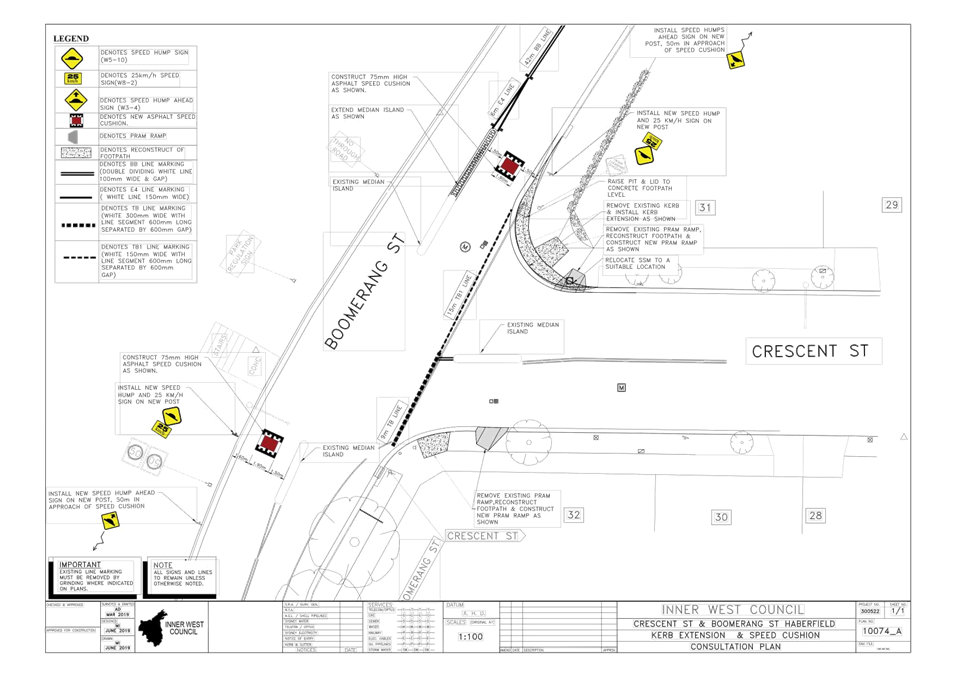
LTC0919 Item 2 Boomerang Street and Crescent Street, Haberfield - Proposed Intersection Treatment (Gulgadya-Leichhardt Ward/Summer Hill Electorate/Burwood PAC) 47
LTC0919 Item 3 Minor Traffic Facilities (All Wards/All Electorates/All PACs) 51
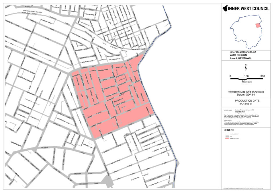
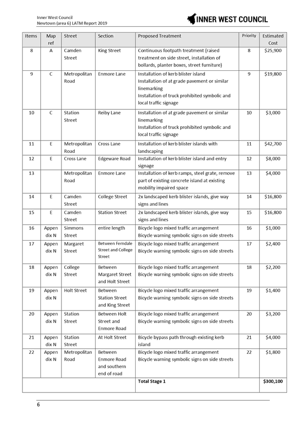
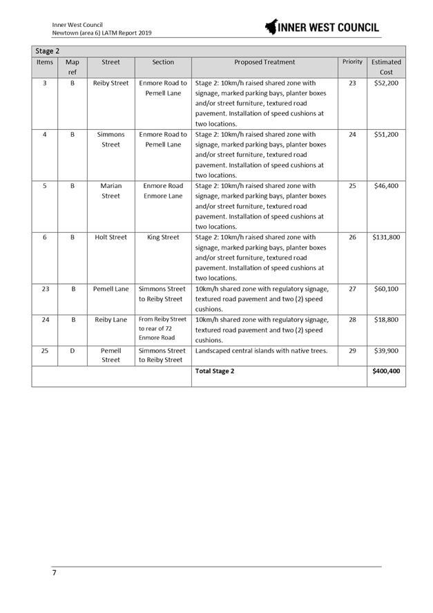
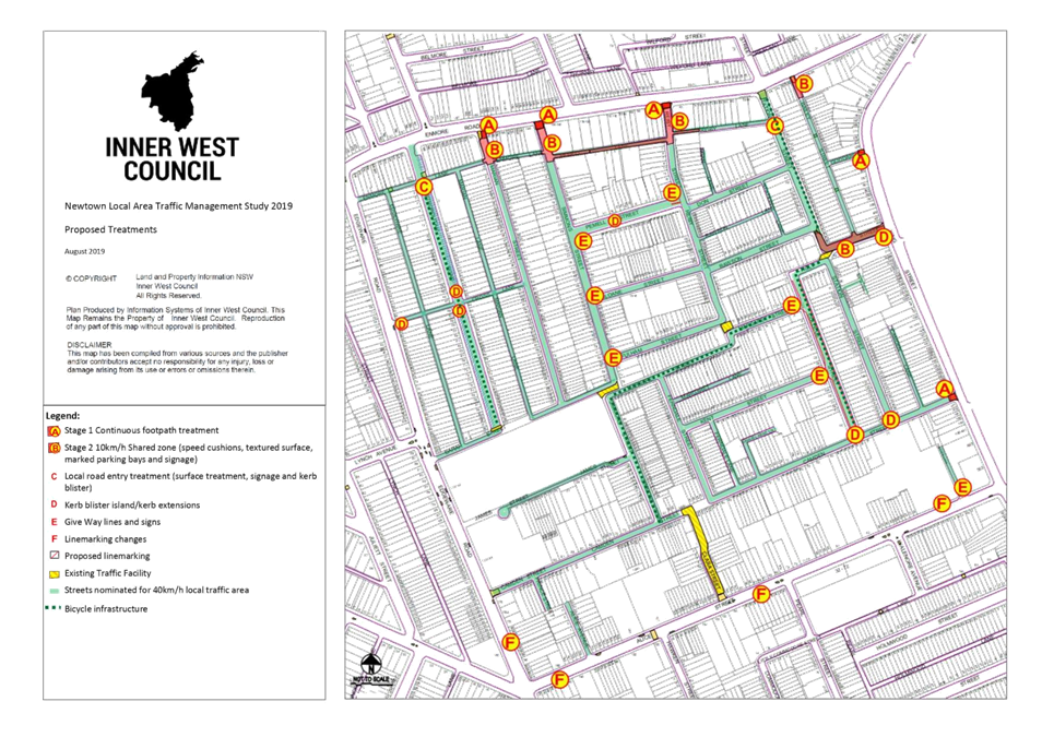
LTC0919 Item 4 Newtown Local Area Traffic Management Strategy (Damun-Stanmore Ward/Newtown Electorate/Inner West PAC) 58
LTC0919 Item 5 Church Street, between Carillon Avenue and Rochester Street, Newtown - Temporary Full Road Closure - to dismantle a tower crane at 142 Carillon Avenue (Damun-Stanmore Ward/Newtown Electorate/Inner West PAC) 68
LTC0919 Item 6 Fisher Street, Petersham between Regent Street and Audley Street – Temporary Full Road Closure to dismantle tower crane at No. 22 (Damum - Stanmore Ward / Newtown Electorate / Inner West PAC) 79
LTC0919 Item 7 Terrace Road / Ness Avenue, Dulwich Hill – Temporary Full Road Closure of Rail Underpass just north of the roundabout at Ewart Street – Sydney Metro (SSJ) early enabling works on T3 Line – notice of change of dates (Djarrawunang-Ashfield Ward / Summer Hill Electorate / Inner West PAC) 82
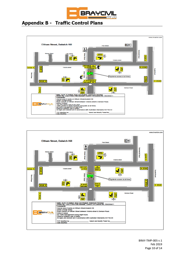
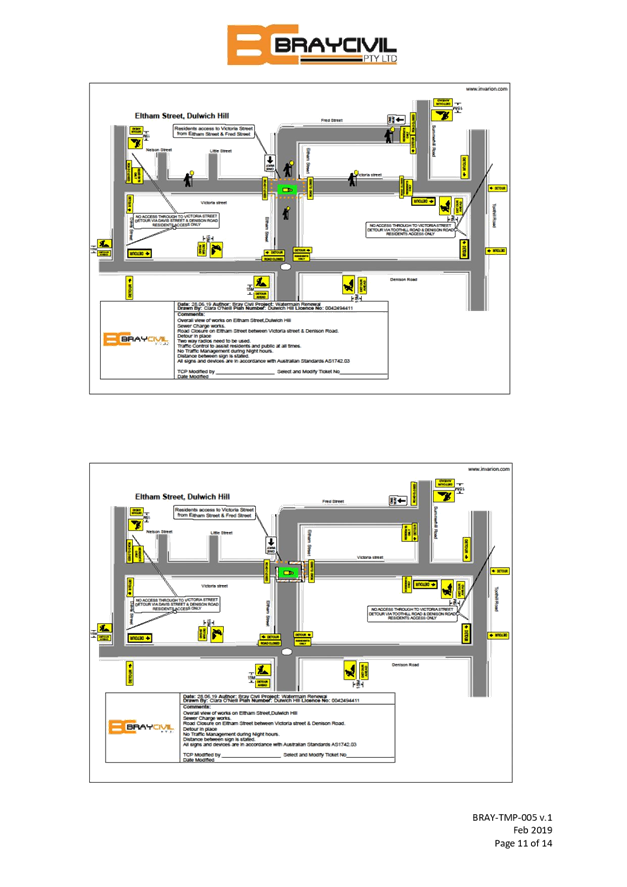
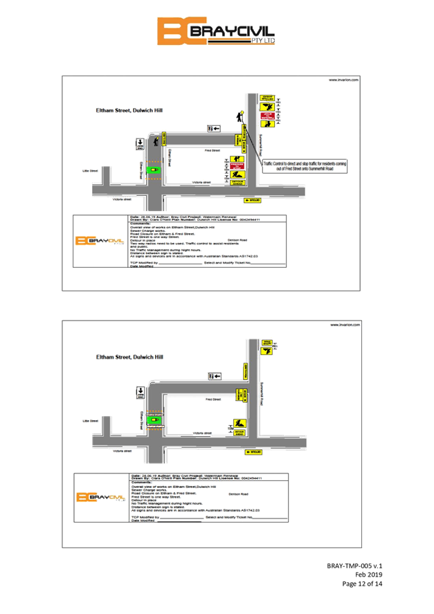
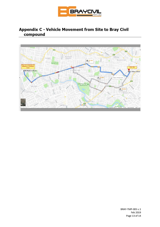
LTC0919 Item 8 Eltham Street, Lewisham – Temporary Full Road Closure to install new sewer main in the roadway on behalf of Sydney Water (Damum - Stanmore Ward / Newtown Electorate / Inner West PAC) 89
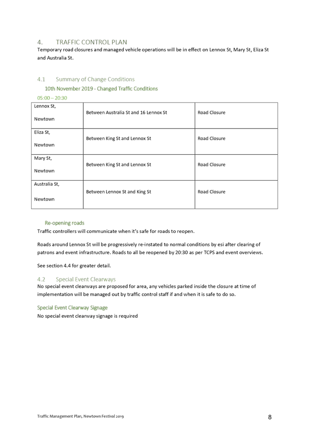
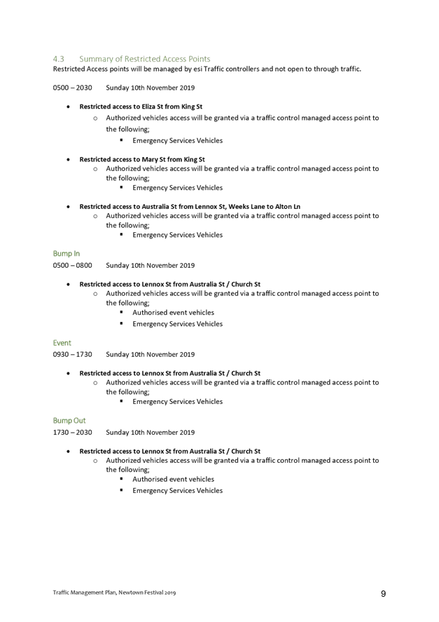
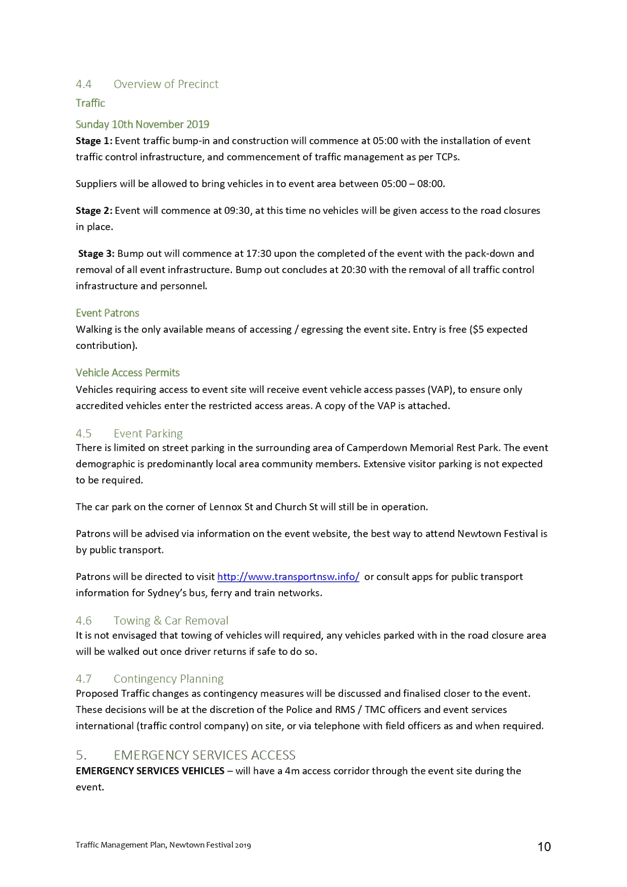
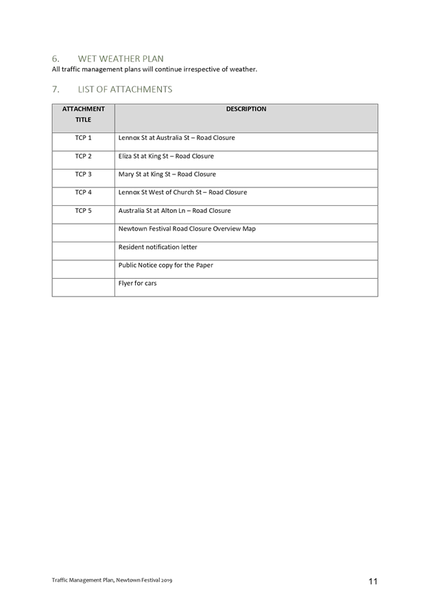
LTC0919 Item 9 Australia Street, Eliza Street, Lennox Street & Mary Street, Newtown – Temporary Full Road Closures for Newtown Festival on Sunday 10 November 2019 (Damum-Stanmore Ward / Newtown Electorate / Inner West PAC) 111
Parking Matters
ITEM Page
LTC0919 Item 10 Ashfield Street (Lane), Ashfield - Proposed 'No Parking' restrictions (Djarrawunang-Ashfield Ward/Summer Hill Electorate/Inner West PAC) 134
LTC0919 Item 11 Petersham Road, Marrickville - Proposed Installation of Statutory 'No Stopping' & 'No Parking' signage between Graham Avenue and Stanley Street (Midjuburi-Marrickville Ward/Summer Hill Electorate/Inner West PAC) 139
LTC0919 Item 12 Beattie Street and Palmer Street, Balmain - Proposed 'Motor Bike Only' and 'No Parking' Restrictions (Baludarri-Balmain Ward/Balmain Electorate/Leichhardt PAC) 143
LTC0919 Item 13 Upward Street, Leichhardt - Resident Parking Scheme (Gulgadya - Leichhardt Ward/Balmain Electorate/Leichhardt PAC) 146
Late Items
Nil at time of printing.
6 Part B - Items for Information Only
Nil at the time of printing.
7 Part C - Items for General Advice
ITEM Page
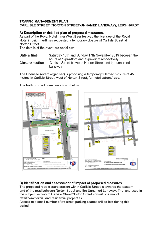
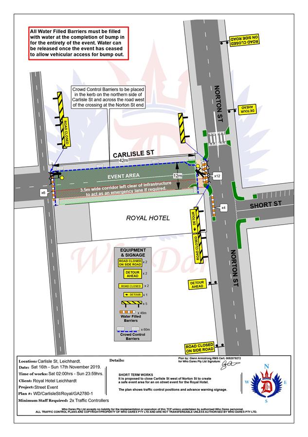
LTC0919 Item 14 Carlisle Street, Leichhardt - Temporary Road Closure for Royal Hotel Inner West Beer festival 151
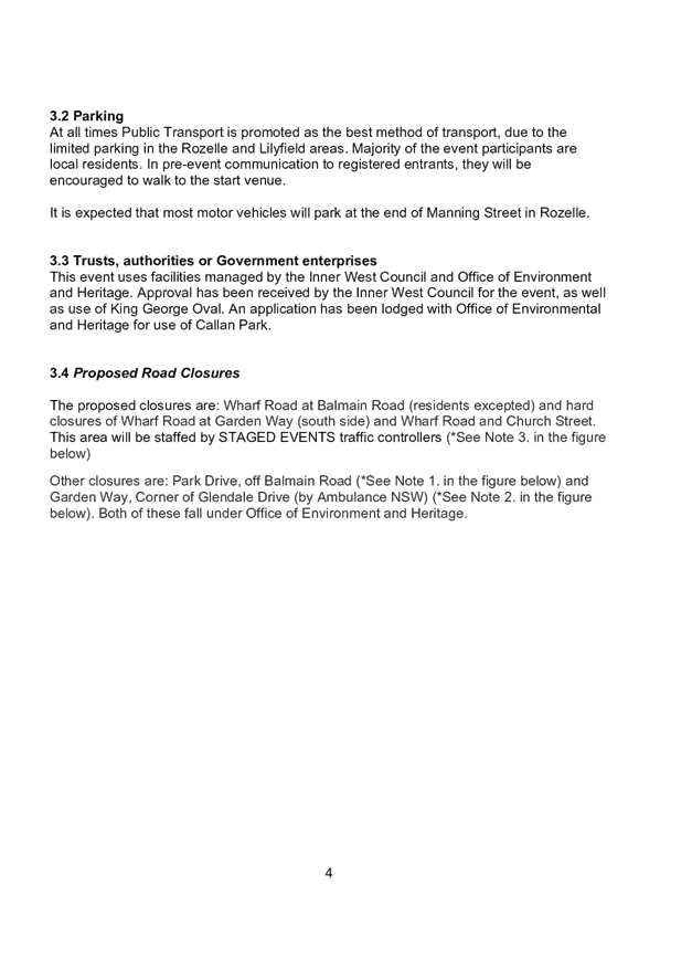
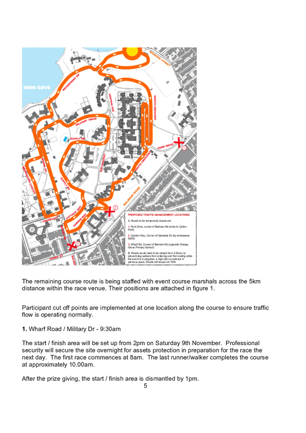
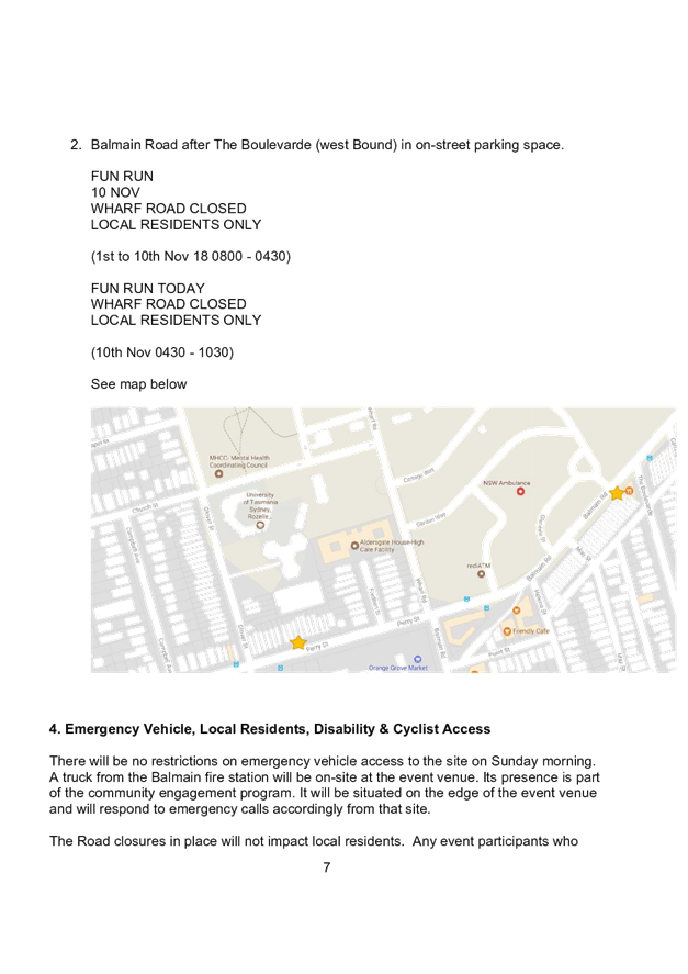
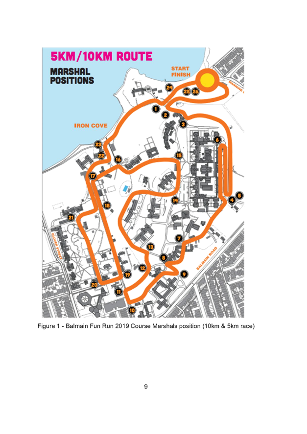
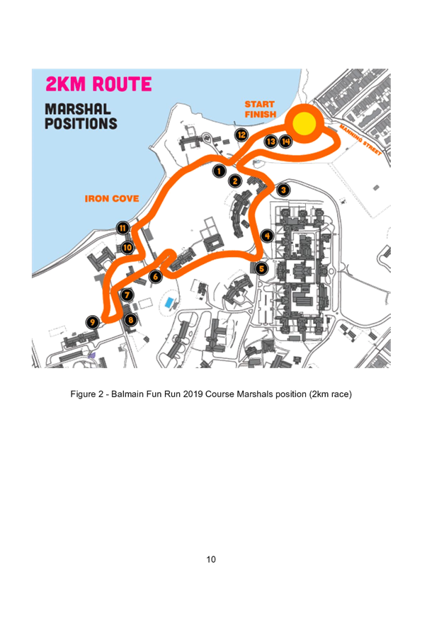
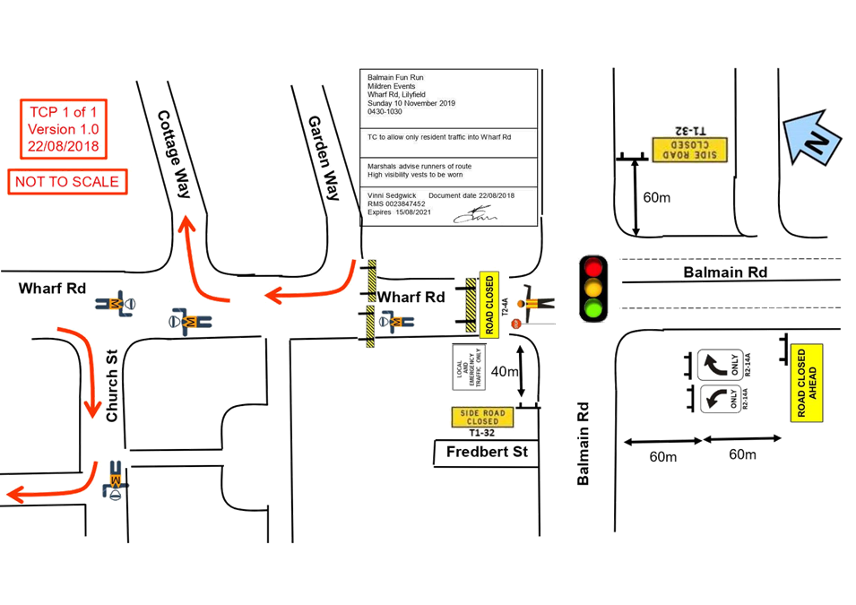
LTC0919 Item 15 Wharf Road, Lilyfield - Temporary Road Closure for Balmain Fun Run 2019 156
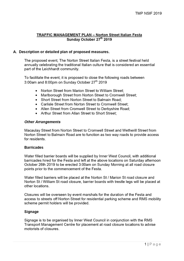
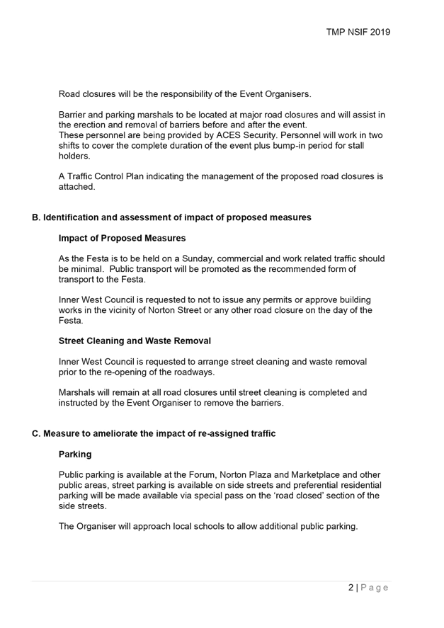
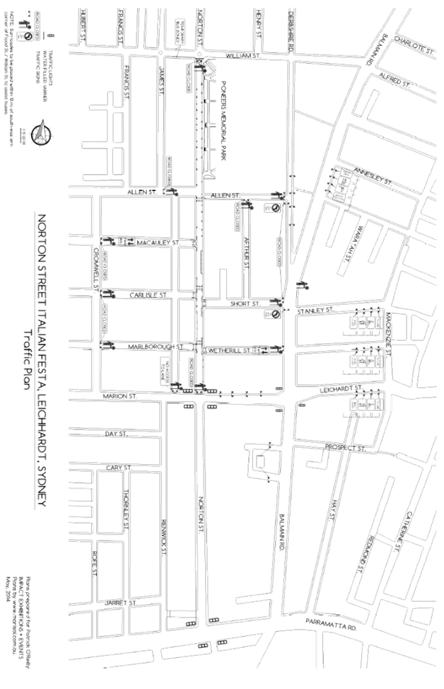
LTC0919 Item 16 Norton Street Italian Festa 2019 - Temporary Road Closures (Gulgadya-Leichhardt Ward/Balmain Electorate/Leichhardt PAC) 169
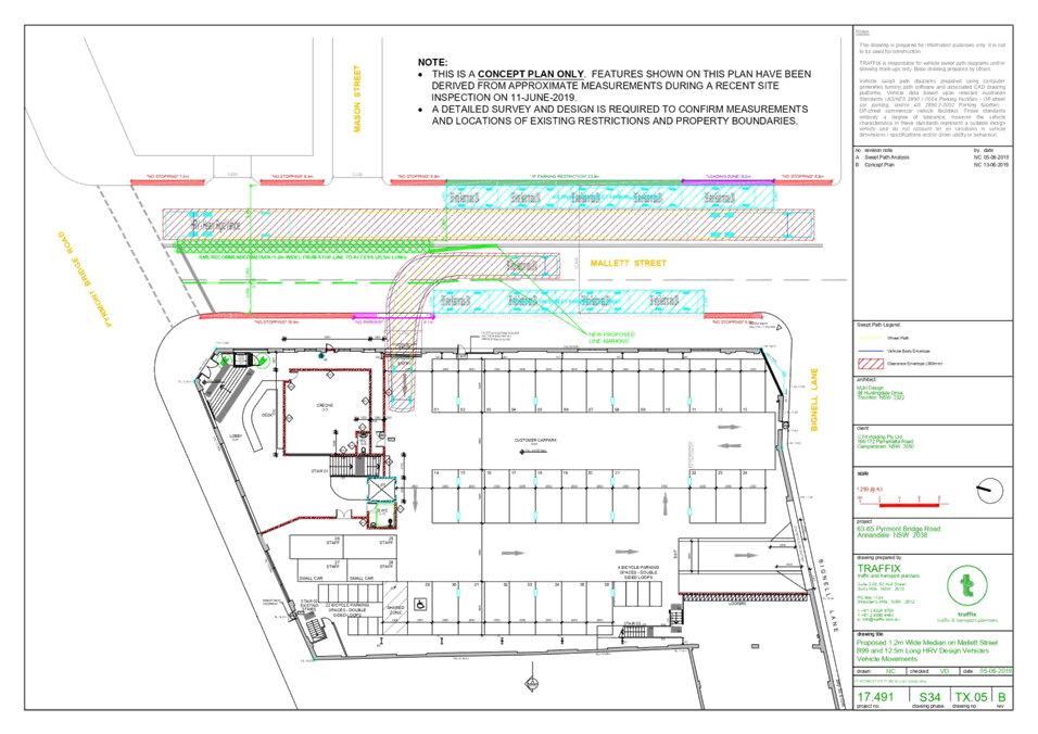
LTC0919 Item 17 63-65 Pyrmont Bridge Road, Annandale - Additional Information for Modification of Development Consent (Gulgadya-Leichhardt Ward/ Balmain Electorate/ Leichhardt PAC) 178
8 General Business
9 Close of Meeting
|
|
Local Traffic Committee Meeting 2 September 2019 Minutes from 5 August 2019 |
Minutes of Local Traffic Committee Meeting
Held at Petersham Service Centre on 5 August 2019
Meeting commenced at 10.00am
ACKNOWLEDGEMENT OF COUNTRY BY CHAIRPERSON
I acknowledge the Gadigal and Wangal people of the Eora nation on whose country we are meeting today, and their elders past and present.
COMMITTEE REPRESENTATIVES PRESENT
|
Clr Victor Macri |
Councillor – Midjuburi-Marrickville Ward (Chair) |
|
Bill Holliday |
Representative for Jamie Parker MP, Member for Balmain |
|
Chris Woods |
Representative for Ron Hoenig MP, Member for Heffron |
|
Zack Solomon |
Representative for Jo Haylen MP, Member for Summer Hill |
|
Sgt Paul Vlachos |
NSW Police – Inner West Police Area Command |
|
Ryan Horne |
Roads and Maritime Services |
|
|
|
|
OFFICERS IN ATTENDANCE |
|
|
|
|
|
SC Tony Kenny |
NSW Police – Inner West Police Area Command |
|
Ram Sritharan |
Roads and Maritime Services |
|
Asith Nagodavithane |
Transit Systems – Inner West Bus Services |
|
Colin Jones |
Inner West Bicycle Coalition |
|
Clr Marghanita da Cruz |
Councillor – Gulgadya-Leichhardt Ward |
|
Wal Petschler |
IWC’s Group Manager Roads, Traffic and Stormwater |
|
John Stephens |
IWC’s Traffic and Transport Services Manager |
|
Manod Wickramasinghe |
IWC’s Coordinator Traffic and Parking Services (North) |
|
George Tsaprounis |
IWC’s Coordinator Traffic and Parking Services (South) |
|
Pierre Ayoub |
IWC’s Acting Design Services Coordinator |
|
Sunny Jo |
IWC’s Traffic and Parking Planner |
|
David Milliken |
IWC’s Strategy Manager |
|
Albert Madrigal |
IWC’s Senior Strategic Planner |
|
Christina Ip |
IWC’s Business Administration Officer |
|
|
|
|
VISITORS |
|
|
|
|
|
Jason Bruer |
Item 1 – Resident |
|
Alex Dilworth |
Item 1 – Resident |
|
Kelsie Dadd |
Item 1 – Resident |
|
Bailan Devereaux |
Item 1 – Resident |
|
Chris Rapp |
Item 1 – Resident |
|
Sandra Siebert |
Item 7 – Resident |
|
Ron Siebert |
Item 7 – Resident |
|
Ian Zhang |
Item 7 – Resident |
|
Helen Yang |
Item 7 – Resident |
|
Brett Andrews |
Item 12 – Connect Inner West Community Transport |
|
Christopher Vanneste |
Item 16 – GoGet Car Share |
|
|
|
|
APOLOGIES: |
|
|
|
|
|
Nil. |
|
|
|
|
DISCLOSURES OF INTERESTS:
Nil.
CONFIRMATION OF MINUTES
|
Minutes of the Local Traffic Committee Meeting held on Monday, 1 July 2019 were confirmed. |
MATTERS ARISING FROM COUNCIL’S RESOLUTION OF MINUTES
The Local Traffic Committee recommendations of its meeting held on 1 July 2019 were adopted at Council’s meeting held on 23 July 2019.
|
LTC0819 Item 1 Warren Road Traffic Study (Midjuburi - Marrickville Ward/Summer Hill Electorate/Inner West PAC) |
|
SUMMARY
The Warren Road Traffic Study reviewed the one-way westbound proposal for Warren Road, Marrickville between Carrington and Illawarra Roads. The study considered three options to improve traffic flow and safety in Warren Road. Community engagement on the three options was undertaken in June 2019 and the results are presented within this report.
Officer’s Recommendation
THAT:
1. As a result of the level of support from the community, Council support in principle a westbound one-way traffic movement in Warren Road between Carrington Road and Illawarra Road;
2. A Traffic Management Plan for the one-way westbound traffic in Warren Road between Carrington Road and Illawarra Road be submitted to the Roads and Maritime Services (RMS) for approval;
3. Council submit amended traffic control signal design plans for the intersection of Warren Road and Illawarra Road to facilitate a one-way westbound traffic movement in Warren Road between Carrington Road and Illawarra Road to RMS for its approval;
4. Implementation of the one-way traffic change in Warren Road, including signposting and linemarking to facilitate a one-way westbound traffic movement in Warren Road between Carrington Road and Illawarra Road, be reported back to the Traffic Committee prior to implementation;
5. Renwick Street be marked with parking edge lines and centrelines as illustrated in Appendix C, and two temporary mid-block speed radar display signs between Excelsior Parade and Carrington Road be installed prior to the implementation of the one-way movement in Warren Road;
6. The 3 tonne load limit in Renwick Street be removed prior to the implementation of the one-way movement in Warren Road;
7. That Renwick Street be included in Council’s Slow Down in My Street program and Speed Radar program for implementation in the current year;
8. Woolworths Marrickville be requested to implement a more equitable spread of truck delivery times to the loading dock; and
9. That affected residents and businesses be advised of the traffic changes prior to implementation of the one-way movement in Warren Road.
DISCUSSION
Public speakers: Jason Bruer, Alex Dilworth and Kelsie Dadd attended at 10.01am
Mr Bruer and Mr Dilworth supported the recommendation as they believed it is the only option that will address the traffic and safety problems in Warren Road.
Ms Dadd supported the recommendation for the same reasons and suggested a further traffic management study be undertaken for the larger area surrounding Warren Road.
(Mr Bruer, Mr Dilworth and Ms Dadd left at 10.14am)
Public speakers: Bailan Devereaux and Chris Rapp attended at 10.14am
Ms Devereaux did not support the recommendation indicating that the proposed changes will divert heavy vehicles from Warren Road into Renwick Street and increase traffic speeds and total traffic volume in Renwick Street.
Mr Rapp did not support the recommendation as it does not address pedestrian safety which will be impacted by an increase in traffic volumes in Renwick Street.
(Ms Devereaux and Mr Rapp left at 10.24am)
The RMS representative supported the proposal in principle; however, indicated that the Traffic Management Plan (TMP) submitted to the RMS is still under review and may require further discussion with Council. RMS needs to review and consider how the increase in traffic turning right from Warren Road onto Illawarra Road to use Renwick Street will impact the operation of the Illawarra Road signalised intersection.
Council Officers will consider ‘No Entry, Bicycles Excepted’ signage at Warren Road or converting the bidirectional bicycle lane on Warren Road to a contraflow lane as part of the proposal, as requested by the Inner West Bicycle Coalition representative.
The Committee members agreed in principle to the Officer’s recommendation, subject to further discussions with RMS to resolve any outstanding traffic management issues.
COMMITTEE RECOMMENDATION
THAT:
1. A westbound one-way traffic movement in Warren Road between Carrington Road and Illawarra Road, be supported “in-principle”.
2. Council Officers continue to liaise with RMS and provide any further information requested to assist their review of the TMP.
3. A further report be provided to the Traffic Committee once RMS review of TMP is completed.
For motion: Unanimous |
|
LTC0819 Item 2 Terrace Road / Ness Avenue, Dulwich Hill – Temporary Full Road Closure of Rail Underpass just north of the roundabout at Ewart Street – Sydney Metro (SSJ) early enabling works on T3 Line (DJARRAWUNANG-ASHFIELD WARD / SUMMER HILL ELECTORATE / INNER WEST PAC) |
|
SUMMARY
An application has been received from Sydney Metro (SSJ) for the temporary full road closure of the rail underpass on Terrace Road / Ness Avenue just north of the roundabout at Ewart Street, Dulwich Hill for a two day period from 12am Saturday, 28 September until 11.50pm Sunday, 29 September 2019 in order to carry out early enabling works on the Rail bridge. The road will be temporarily closed to all vehicular traffic, including emergency vehicles and local residents. It is recommended that the proposed temporary full road closures be approved, subject to the conditions outlined in this report.
Officer’s Recommendation
THAT the proposed temporary full road closure of the rail underpass on Terrace Road / Ness Avenue just north of the roundabout at Ewart Street, Dulwich Hill for a two day period being 12am Saturday, 28 September until 11.50pm Sunday, 29 September 2019 be approved, in order to carry out early enabling works on the Rail bridge subject to, but not limited to, the following conditions:
a) The application and TMP be submitted to RMS for approval;
b) A Road Occupancy License be obtained by the applicant from the Transport Management Centre;
c) All affected residents and businesses, including the NSW Police Local Area Commander, Fire & Rescue NSW and the NSW Ambulance Services be notified in writing, by the applicant, of the proposed temporary road closure at least 7 days in advance of the closure with the applicant making reasonable provision for stakeholders; and
d) The occupation of the road carriageway must not occur until the road has been physically closed.
DISCUSSION
The Committee members agreed with the Officer’s recommendation.
COMMITTEE RECOMMENDATION
THAT the proposed temporary full road closure of the rail underpass on Terrace Road / Ness Avenue just north of the roundabout at Ewart Street, Dulwich Hill for a two day period being 12am Saturday, 28 September until 11.50pm Sunday, 29 September 2019 be approved, in order to carry out early enabling works on the Rail bridge subject to, but not limited to, the following conditions:
a) The application and TMP be submitted to RMS for approval;
b) A Road Occupancy License be obtained by the applicant from the Transport Management Centre;
c) All affected residents and businesses, including the NSW Police Local Area Commander, Fire & Rescue NSW and the NSW Ambulance Services be notified in writing, by the applicant, of the proposed temporary road closure at least 7 days in advance of the closure with the applicant making reasonable provision for stakeholders; and
d) The occupation of the road carriageway must not occur until the road has been physically closed.
For motion: Unanimous
|
|
LTC0819 Item 3 Burrows Avenue, Sydenham – Temporary Full Road Closures - Sydney Metro Sydenham Station and Junction (SSJ) Works (Midjuburi-Marrickville Ward / Heffron Electorate / Inner West PAC) |
|
SUMMARY
An application has been received from Sydney Metro Sydenham Station and Junction (SSJ) for the temporary full road closure of Burrows Avenue, between Hogan Avenue and Gleeson Avenue, Sydenham on 3 separate occasions from 9pm Friday, 30 August to 4.30am Monday, 2 September 2019; 9pm Friday, 25 October to 4.30am Monday, 28 October 2019 and 9pm Friday, 13 December to 4.30am Monday, 16 December 2019 in order to carry out upgrading works at Sydenham Station. The street will be temporarily closed to all vehicular traffic, including emergency vehicles and local residents. It is recommended that the proposed temporary full road closures be approved, subject to the conditions outlined in this report.
Officer’s Recommendation
THAT the proposed temporary full road closure of Burrows Avenue, between Hogan Avenue and Gleeson Avenue, Sydenham on 3 separate occasions from 9pm Friday, 30 August to 4.30am Monday, 2 September 2019; 9pm Friday, 25 October to 4.30am Monday, 28 October 2019 and 9pm Friday, 13 December to 4.30am Monday, 16 December 2019 be approved, in order to carry out upgrading works at Sydenham Station, subject to the following conditions:
a) The application and TMP be submitted to RMS for approval;
b) A Road Occupancy License be obtained by the applicant from the Transport Management Centre;
c) All affected residents and businesses, including the NSW Police Local Area Commander, Fire & Rescue NSW and the NSW Ambulance Services be notified in writing, by the applicant, of the proposed temporary road closure at least 7 days in advance of the closure with the applicant making reasonable provision for stakeholders; and
d) The occupation of the road carriageway must not occur until the road has been physically closed.
DISCUSSION
The representative for the Member for Heffron asked for an update on the investigation into the possible installation of marked pedestrian crossings at Burrows Avenue and Hogan Avenue. Council Officers advised that pedestrian vs. vehicle data provided by the applicant did not meet the RMS requirements for a marked pedestrian crossing. At present, the dates of construction for the proposed pedestrian refuge facilities are unknown; however, Council Officers will request further information and provide to the representative for the Member for Heffron.
The Committee members agreed with the Officer’s recommendation.
COMMITTEE RECOMMENDATION
THAT the proposed temporary full road closure of Burrows Avenue, between Hogan Avenue and Gleeson Avenue, Sydenham on 3 separate occasions from 9pm Friday, 30 August to 4.30am Monday, 2 September 2019; 9pm Friday, 25 October to 4.30am Monday, 28 October 2019 and 9pm Friday, 13 December to 4.30am Monday, 16 December 2019 be approved, in order to carry out upgrading works at Sydenham Station, subject to the following conditions:
a) The application and TMP be submitted to RMS for approval;
b) A Road Occupancy License be obtained by the applicant from the Transport Management Centre;
c) All affected residents and businesses, including the NSW Police Local Area Commander, Fire & Rescue NSW and the NSW Ambulance Services be notified in writing, by the applicant, of the proposed temporary road closure at least 7 days in advance of the closure with the applicant making reasonable provision for stakeholders; and
d) The occupation of the road carriageway must not occur until the road has been physically closed.
For motion: Unanimous
|
|
LTC0819 Item 4 Albermarle Street, Marrickville – Temporary Full Road Closure of Rail Overbridge south of Challis Street - Sydney Metro (SSJ) early enabling works on T3 Line (MIDJUBURI-MARRICKVILLE WARD / SUMMER HILL ELECTORATE / INNER WEST PAC) |
|
SUMMARY
An application has been received from Sydney Metro (SSJ) for the temporary full road closure of the rail over bridge on Albermarle Street just south of Challis Avenue, Marrickville for a ten day period scheduled from 12am Sunday, 2 September to 11.50pm Thursday, 12 September 2019 (contingency up to midnight Thursday, 19 September 2019) in order to carry out early enabling works on the Rail Overbridge. The road will be temporarily closed to all vehicular traffic, including emergency vehicles and local residents. It is recommended that the proposed temporary full road closures be approved, subject to the conditions outlined in this report.
Officer’s Recommendation
THAT the proposed temporary full road closure of Albermarle Street (between Challis Avenue and Kays Avenue East), Marrickville for a ten day period scheduled from 12am Sunday 2 September to 11.50pm Thursday 12 September 2019 (contingency up to 11.50pm Thursday, 19 September 2019) be approved, in order to carry out early enabling works on the Rail Overbridge subject to, but not limited to, the following conditions:
a) The application and TMP be submitted to RMS for approval;
b) A Road Occupancy License be obtained by the applicant from the Transport Management Centre;
c) All affected residents and businesses, including the NSW Police Local Area Commander, Fire & Rescue NSW and the NSW Ambulance Services be notified in writing, by the applicant, of the proposed temporary road closure at least 7 days in advance of the closure with the applicant making reasonable provision for stakeholders; and
d) The occupation of the road carriageway must not occur until the road has been physically closed.
DISCUSSION
The Committee members agreed with the Officer’s recommendation.
COMMITTEE RECOMMENDATION
THAT the proposed temporary full road closure of Albermarle Street (between Challis Avenue and Kays Avenue East), Marrickville for a ten day period scheduled from 12am Sunday 2 September to 11.50pm Thursday 12 September 2019 (contingency up to 11.50pm Thursday, 19 September 2019) be approved, in order to carry out early enabling works on the Rail Overbridge subject to, but not limited to, the following conditions:
a) The application and TMP be submitted to RMS for approval;
b) A Road Occupancy License be obtained by the applicant from the Transport Management Centre;
c) All affected residents and businesses, including the NSW Police Local Area Commander, Fire & Rescue NSW and the NSW Ambulance Services be notified in writing, by the applicant, of the proposed temporary road closure at least 7 days in advance of the closure with the applicant making reasonable provision for stakeholders; and
d) The occupation of the road carriageway must not occur until the road has been physically closed.
For motion: Unanimous
|
|
LTC0819 Item 5 Marrickville Road, Marrickville – Temporary full Road Closures for Marrickville Festival on Sunday 20 October 2019 – DA201700334 - (Midjuburi - Marrickville Ward / Summer Hill Electorate / Inner West PAC) |
|
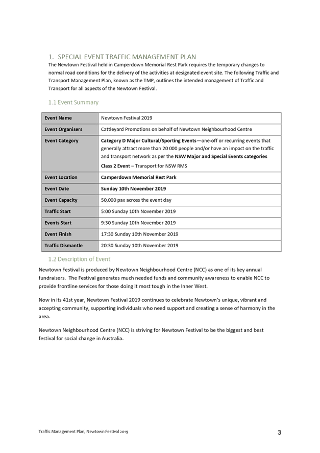
SUMMARY
The 'Marrickville Festival' is an annual event and this year will be held on Sunday, 20 October 2019. As in previous years, the event will necessitate the temporary full road closure of Marrickville Road (between Petersham Road and Victoria Road), Illawarra Road (between Sydenham Road and Petersham Road), Alex Travellion Plaza and the Calvert Street car park along with short sections of Malakoff Street, Despointes Street, Silver Street, Garners Avenue, Gladstone Street and Frampton Avenue where these streets intersect Marrickville Road, Marrickville.
Officer’s Recommendation
THAT:
1. The proposed temporary full road closure of Marrickville Road (between Petersham Road and Victoria Road), Illawarra Road (between Sydenham Road and Petersham Road), Alex Travellion Plaza and the Calvert Street car park along with short sections of Malakoff Street, Despointes Street, Silver Street, Garners Avenue, Gladstone Street and Frampton Avenue where these streets intersect with Marrickville Road, Marrickville for the ‘Marrickville Festival’ Event on Sunday, 20 October 2019 between 11pm Saturday, 19 October to Midnight Sunday, 20 October 2019 be approved as per the submitted TMP and TCPs;
2. A Road Occupancy License application be obtained from the Transport Management Centre;
3. Notice of the proposed event be forwarded to the NSW Police Local Area Commander, Transit Systems, the NSW Fire Brigades and the NSW Ambulance Services;
4. All residents and businesses in and around the affected area are to be notified of the temporary road closure in writing by the applicant in advance (at least 7 days prior to the event) with the applicant making reasonable provision for stakeholders; 4. A minimum four (4) metre unencumbered passage be available for emergency vehicles through the closed section; and 5. The occupation of the road carriageway must not occur until the road has been physically closed.
DISCUSSION
The Committee members agreed with the Officer’s recommendation.
COMMITTEE RECOMMENDATION
THAT:
1. The proposed temporary full road closure of Marrickville Road (between Petersham Road and Victoria Road), Illawarra Road (between Sydenham Road and Petersham Road), Alex Travellion Plaza and the Calvert Street car park along with short sections of Malakoff Street, Despointes Street, Silver Street, Garners Avenue, Gladstone Street and Frampton Avenue where these streets intersect with Marrickville Road, Marrickville for the ‘Marrickville Festival’ Event on Sunday, 20 October 2019 between 11pm Saturday, 19 October to Midnight Sunday, 20 October 2019 be approved as per the submitted TMP and TCPs;
2. A Road Occupancy License application be obtained from the Transport Management Centre;
3. Notice of the proposed event be forwarded to the NSW Police Local Area Commander, Transit Systems, the NSW Fire and Rescue, and the NSW Ambulance Services;
4. All residents and businesses in and around the affected area are to be notified of the temporary road closure in writing by the applicant in advance (at least 7 days prior to the event) with the applicant making reasonable provision for stakeholders; 4. A minimum four (4) metre unencumbered passage be available for emergency vehicles through the closed section; and 5. The occupation of the road carriageway must not occur until the road has been physically closed.
For motion: Unanimous
|
|
LTC0819 Item 6 Big Bike Day 2019 Special Event (Gulgadya-Leichhardt & Baludarri-Balmain Ward/ Balmain Electorate/ Leichhardt PAC) |
|
SUMMARY
For NSW Bike Week 2019, Council is running ‘Big Bike Day’, a celebration of cycling. Big Bike Day is to be held on Sunday, 22 September 2019.
Officer’s Recommendation
THAT:
1. The Big Bike Day 2019 event proposed to be held on Sunday, 22 September 2019 be supported; and
2. Council’s Environmental Officer seeks consent from the Office of Environment and Heritage (OEH) for the portion of the route through Callan Park.
DISCUSSION
The Committee members agreed with the Officer’s recommendation.
COMMITTEE RECOMMENDATION
THAT:
1. The Big Bike Day 2019 event proposed to be held on Sunday, 22 September 2019 be supported; and
2. Council’s Environmental Officer seeks consent from the Office of Environment and Heritage (OEH) for the portion of the route through Callan Park.
For motion: Unanimous
|
|
LTC0819
Item 7 Edwin Street, Croydon at Anthony Street - Proposed Kerb Blisters &
Croydon Road, Croydon at Anthony Street - Proposed Pedestrian Refuge and Kerb
Blisters (Design Plans 10088 & 10091) |
|
SUMMARY
Council is proposing a number of intersection improvements which will address issues of pedestrian safety and driver behaviour. The improvements are as follows; (1) Croydon Road and Anthony Street, Croydon – Proposed pedestrian refuge, speed cushion and kerb blisters; and (2) Anthony Street at Edwin Street, Croydon – Proposed line marked blisters.
Officer’s Recommendation
THAT the detailed design plans for the proposed intersection improvements along with associated signage and line marking at Croydon Road and Anthony Road, Croydon (Design Plan No.10088) and the proposed kerb blisters and associated signage and line marking on Edwin Street at Anthony Street, Croydon (Design Plan No.10091) be APPROVED.
DISCUSSION
Public speakers: Sandra Siebert and Ron Siebert attended at 10.38am
Ms and Mr Siebert supported the recommendation as it will improve road and pedestrian safety in the area. However, Ms and Mr Siebert were concerned with the proposed loss of parking in Croydon Road and asked why the street did not have a Resident Parking Scheme. Council Officers advised that a precinct parking study is currently being undertaken for the area surrounding Croydon Shopping Centre including Croydon Road. (Ms and Mr Siebert left at 10.40am)
Public speakers: Ian Zhang and Helen Yang attended at 10.40am
Mr Zhang and Ms Yang did not support the proposed new kerb and gutter at the southern side of Anthony Road as they are concerned it may reduce manoeuvrability space for vehicles reversing out of their driveway.
(Mr Zhang and Ms Yang left at 10.48am)
Council Officers will send the swept path analysis to the residents which indicated that the new kerb and gutter will not impact access to the residents’ driveway on Anthony Road.
The Committee members agreed with the Officer’s recommendation.
COMMITTEE RECOMMENDATION
THAT the detailed design plans for the proposed intersection improvements along with associated signage and line marking at Croydon Road and Anthony Road, Croydon (Design Plan No.10088) and the proposed kerb blisters and associated signage and line marking on Edwin Street at Anthony Street, Croydon (Design Plan No.10091) be APPROVED.
For motion: Unanimous
|
|
LTC0819 Item 8 Hubert Street and Unnamed Lane, Leichhardt - Temporary Full Road Closure for Road Opening (Gulgadya-Leichhardt Ward/ Balmain Electorate/ Leichhardt PAC) |
|
SUMMARY
An application has been received from Comdain Civil Constructions for the temporary full road closure of Hubert Street (between Darley Road and William Street) and Unnamed Laneway (between Darley Road and William Street, adjacent to Hubert Street and Charles Street) from 9 September 2019 to 18 November 2019 (10 weeks) with a further 4 week contingency for emergency relief structure to be built at the intersection of Darley Road and Hubert Street and for sewer main to be removed and upsized in the Unnamed Laneway, Leichhardt.
Officer’s Recommendation
THAT:
1. The proposed temporary road closure of Hubert Street, Leichhardt (between Darley Road and William Street) and Unnamed laneway (between Darley Road and William Street, adjacent to Hubert Street and Charles Street), Leichhardt on Monday, 9 September 2019 to 18 November 2019 (10 weeks) with an additional four week contingency thereafter from 7:00am to 6:00pm (Monday to Friday) and 8:00am to 1:00pm (Saturdays) for emergency relief structure to be built at the intersection of Darley Road and Hubert Street and for sewer main to be removed and upsized in the Unnamed Laneway, be supported;
2. A Road Occupancy License be obtained by Council from the Transport Management Centre;
3. All affected residents and businesses, including the NSW Police Local Area Commander, Fire & Rescue NSW and the NSW Ambulance Services be notified in writing, by the applicant, of the proposed temporary road closure at least 7 days in advance of the closure with the applicant making reasonable provision for stakeholders; and
4. The occupation of the road carriageway must not occur until the road has been physically closed.
DISCUSSION
The Committee members agreed with the Officer’s recommendation.
COMMITTEE RECOMMENDATION
THAT:
1. The proposed temporary road closure of Hubert Street, Leichhardt (between Darley Road and William Street) and Unnamed laneway (between Darley Road and William Street, adjacent to Hubert Street and Charles Street), Leichhardt on Monday, 9 September 2019 to 18 November 2019 (10 weeks) with an additional four week contingency thereafter from 7:00am to 6:00pm (Monday to Friday) and 8:00am to 1:00pm (Saturdays) for emergency relief structure to be built at the intersection of Darley Road and Hubert Street and for sewer main to be removed and upsized in the Unnamed Laneway, be supported;
2. A Road Occupancy License be obtained by Council from the Transport Management Centre;
3. All affected residents and businesses, including the NSW Police Local Area Commander, Fire & Rescue NSW and the NSW Ambulance Services be notified in writing, by the applicant, of the proposed temporary road closure at least 7 days in advance of the closure with the applicant making reasonable provision for stakeholders; and
4. The occupation of the road carriageway must not occur until the road has been physically closed.
For motion: Unanimous
|
|
LTC0819
Item 9 Croydon Road at Kenilworth Street & Gregory Avenue, Croydon -
Proposed Traffic Calming at the intersections including a new pedestrian
refuge island on Croydon Road - Design Plan 10070 |
|
SUMMARY
Council is proposing a number of intersection improvements along Croydon Road, which will address issues of pedestrian safety and driver behavior. A detailed design plan has been finalised for the proposed pedestrian refuge and splitter island on Croydon Road, Croydon, between the intersections with Kenilworth Street and Gregory Avenue. The proposed works aim to improve pedestrian and motorist safety and address concerns about speeding and driver behaviour along Croydon Road.
Officer’s Recommendation
THAT the detailed design plan for the proposed pedestrian refuge island, splitter island, speed cushions, associated line marking and signage and the removal of horizontal deflection islands on Croydon Road, Croydon, between the intersections of Kenilworth Street and Gregory Avenue (as per attached design plan No. 10070) be APPROVED.
DISCUSSION
The Committee members agreed with the Officer’s recommendation.
COMMITTEE RECOMMENDATION
THAT the detailed design plan for the proposed pedestrian refuge island, splitter island, speed cushions, associated line marking and signage and the removal of horizontal deflection islands on Croydon Road, Croydon, between the intersections of Kenilworth Street and Gregory Avenue (as per attached design plan No. 10070) be APPROVED.
For motion: Unanimous
|
|
LTC0819 Item 10 Croydon Road at Queen Street, Croydon - Proposed Traffic Calming at the intersection including a new pedestrian refuge on Croydon Road - Design Plan 10092 (Gulgadya Ward/ Strathfield Electorate/ Burwood PAC) |
|
SUMMARY
A detailed design plan has been finalised for the proposed pedestrian refuge and speed cushions on Croydon Road, Croydon, adjacent to Queen Street. The proposed works aim to improve pedestrian and motorist safety and address residents’ concerns about speeding and driver behaviour along Croydon Road.
Officer’s Recommendation
THAT the detailed design plan for the proposed pedestrian refuge island, speed cushions and the removal of existing traffic island along with the associated line marking and signage at the intersection of Croydon Road and Queen Street, Croydon (as per attached design plan No. 10092) be APPROVED.
DISCUSSION
The Committee members agreed with the Officer’s recommendation.
COMMITTEE RECOMMENDATION
THAT the detailed design plan for the proposed pedestrian refuge island, speed cushions and the removal of existing traffic island along with the associated line marking and signage at the intersection of Croydon Road and Queen Street, Croydon (as per attached design plan No. 10092) be APPROVED.
For motion: Unanimous
|
|
LTC0819 Item 11 Minor Traffic Facilities (All Wards/All Electorates/All PACs) |
|
SUMMARY
This report considers minor traffic facility applications by Inner West Council, and includes ‘Disabled Parking’ and ‘Works Zone’ requests.
Officer’s Recommendation
THAT:
1. A 6m 'Disabled Parking’ zone be installed in front of No.13 Francis Street, Marrickville;
2. A 6m 'Disabled Parking’ zone be installed in front of No.54 North Street, Marrickville;
3. A 16m 'Works Zone 7.00am – 6.00pm Mon-Fri and 8.00am-1.00pm Sat' be installed at the rear of No.366C Darling Street, in Little Darling Street, Balmain for 8 weeks;
4. A 9m 'Works Zone 7.00am – 6.00pm Mon-Fri and 8.00am-1.00pm Sat' be installed at the front of No.97 Edith Street, Leichhardt, for 12 weeks;
5. A 9m 'Works Zone 7.00am – 6.00pm Mon-Fri and 8.00am-1.00pm Sat' be installed at the front of No.57 Evans Street, Balmain, for 12 weeks;
6. A 15m 'Works Zone 7.00am – 6.00pm Mon-Fri and 8.00am-1.00pm Sat' be installed in the side street of Goodsell Street, for Nos.641-657 King Street, St Peters, for 12 weeks;
7. A 11m 'Works Zone 7.00am – 6.00pm Mon-Fri and 8.00am-1.00pm Sat' be installed in front of No.117 Cavendish Street, Stanmore, for 12 weeks;
8. A 25m 'Works Zone 7.00am – 6pm Mon-Sat and 8.00am-1.00pm Sat' be installed in front of Nos.6-8 Waterloo Street, Rozelle, for 12 weeks, subject to the applicant obtaining consent from the neighbouring property owner; and
9. An 8m 'Works Zone 7.00am – 6.00pm Mon-Fri and 8.00am-1.00pm Sat' be installed in front of No.13 Cromwell Street, Croydon, for 8 weeks.
DISCUSSION
The Committee members agreed with the Officer’s recommendation.
COMMITTEE RECOMMENDATION
THAT:
1. A 6m 'Disabled Parking’ zone be installed in front of No.13 Francis Street, Marrickville;
2. A 6m 'Disabled Parking’ zone be installed in front of No.54 North Street, Marrickville;
3. A 16m 'Works Zone 7.00am – 6.00pm Mon-Fri and 8.00am-1.00pm Sat' be installed at the rear of No.366C Darling Street, in Little Darling Street, Balmain for 8 weeks;
4. A 9m 'Works Zone 7.00am – 6.00pm Mon-Fri and 8.00am-1.00pm Sat' be installed at the front of No.97 Edith Street, Leichhardt, for 12 weeks;
5. A 9m 'Works Zone 7.00am – 6.00pm Mon-Fri and 8.00am-1.00pm Sat' be installed at the front of No.57 Evans Street, Balmain, for 12 weeks;
6. A 15m 'Works Zone 7.00am – 6.00pm Mon-Fri and 8.00am-1.00pm Sat' be installed in the side street of Goodsell Street, for Nos.641-657 King Street, St Peters, for 12 weeks;
7. A 11m 'Works Zone 7.00am – 6.00pm Mon-Fri and 8.00am-1.00pm Sat' be installed in front of No.117 Cavendish Street, Stanmore, for 12 weeks;
8. A 25m 'Works Zone 7.00am – 6pm Mon-Sat and 8.00am-1.00pm Sat' be installed in front of Nos.6-8 Waterloo Street, Rozelle, for 12 weeks, subject to the applicant obtaining consent from the neighbouring property owner; and
9. An 8m 'Works Zone 7.00am – 6.00pm Mon-Fri and 8.00am-1.00pm Sat' be installed in front of No.13 Cromwell Street, Croydon, for 8 weeks.
For motion: Unanimous
|
|
LTC0819 Item 12 Victoria Road, Marrickville - Proposed Change in Parking restriction to 'No Parking - Community Bus Excepted' (Midjuburri-Marrickville Ward/Newtown Electorate/Inner West PAC) |
|
SUMMARY
Following representations from Connect Inner West Community Transport, including written permission of Marrickville Metro Shopping Centre management; Council is proposing to install ‘No Parking – Community Bus Excepted’ parking restrictions across a disused driveway at 34 Victoria Road adjacent to Marrickville Metro Shopping Centre.
Officer’s Recommendation
THAT an existing 'No Parking’ restriction across the driveway at 34 Victoria Road, Marrickville, adjacent to Marrickville Metro Shopping Centre, be changed to ‘No Parking-Community Bus Excepted’ restriction.
DISCUSSION
Public speaker: Brett Andrews, Connect Inner West Community Transport, attended at 10.59am
Mr Andrews supported the recommendation as Connect Inner West Community Transport currently park in Victoria Road to offload clients and the proposal will formalise this arrangement until construction at the Marrickville Metro Shopping Centre is complete.
(Mr Andrews left at 11.01am)
The Committee members agreed with the Officer’s recommendation.
COMMITTEE RECOMMENDATION
THAT an existing 'No Parking’ restriction across the driveway at 34 Victoria Road, Marrickville, adjacent to Marrickville Metro Shopping Centre, be changed to ‘No Parking-Community Bus Excepted’ restriction.
For motion: Unanimous
|
|
LTC0819 Item 13 Chester Street and Guihen Street, Annandale - Proposed 'No Stopping' zone (Gulgadya - Leichhardt Ward/ Balmain Electorate/ Leichhardt PAC) |
|
SUMMARY
Concerns have been raised regarding vehicles parking too close to the intersection of Chester Street and Guihen Street, Annandale. This illegal parking behaviour obstructs sight lines as well as access into and out of Chester Street and Guihen Street.
Officer’s Recommendation
THAT ‘No Stopping’ signage be installed to reinforce the statutory 10m ‘No Stopping’ distance at intersections, at the following locations:
a) the eastern side of Chester Street, north of Guihen Street, Annandale; b) the eastern side of Chester Street, south of Guihen Street, Annandale; and c) the northern side of Guihen Street, east of Chester Street, Annandale.
DISCUSSION
The Committee members agreed with the Officer’s recommendation.
COMMITTEE RECOMMENDATION
THAT ‘No Stopping’ signage be installed to reinforce the statutory 10m ‘No Stopping’ distance at intersections, at the following locations:
a) the eastern side of Chester Street, north of Guihen Street, Annandale; b) the eastern side of Chester Street, south of Guihen Street, Annandale; and c) the northern side of Guihen Street, east of Chester Street, Annandale.
For motion: Unanimous
|
|
LTC0819 Item 14 Prospect Road, Summer Hill - Proposed Changes to Parking Restrictions outside Croatian Catholic Centre (Djarrawunang- Ashfield Ward/Summer Hill Electorate/Inner West PAC) |
|
SUMMARY
Following representation from the Croatian Catholic Centre, Council is proposing to extend the parking restrictions outside the Centre in Norton Street, Summer Hill from ‘Monday to Friday’ to ‘Monday to Saturday’ in order to assist the church to cater for the official vehicles associated with the weddings and funerals taking place on a Saturday. Council Officers have undertaken community engagement and this has indicated that there are no objections to the proposal.
Officer’s Recommendation
THAT parking restrictions outside the Croatian Catholic Centre in Norton Street, Summer Hill be changed from ‘No Parking 8:30am-2:30pm Monday to Friday; Wedding or Funeral Vehicles Excepted’ to ‘No Parking 8:30AM-2:30PM Monday to Saturday; Wedding or Funeral Vehicles Excepted’.
DISCUSSION
The Committee members agreed with the Officer’s recommendation.
COMMITTEE RECOMMENDATION
THAT parking restrictions outside the Croatian Catholic Centre in Norton Street, Summer Hill be changed from ‘No Parking 8:30am-2:30pm Monday to Friday; Wedding or Funeral Vehicles Excepted’ to ‘No Parking 8:30AM-2:30PM Monday to Saturday; Wedding or Funeral Vehicles Excepted’.
For motion: Unanimous
|
|
LTC0819 Item 15 Bay Street, Tempe - Proposed installation of statutory 'No Stopping' signage (Midjuburi-Marrickville Ward/Heffron Electorate/Inner West PAC) |
|
SUMMARY
Council is proposing to implement statutory 10 metre ‘No Stopping’ restrictions in Bay Street at the Princes Highway, Tempe following a request to deter illegal parking on both sides of Bay Street. An investigation has illustrated the difficulty to which parked vehicles, within 10m of the intersection have compromised the safety and manoeuvrability of vehicles attempting to access into and out of Bay Street due to the narrow width of the carriageway and the acute turning angle required for vehicles on Princes Highway negotiating the turn into Bay Street.
Officer’s Recommendation
THAT implementation of Statutory ‘No Stopping’ restrictions on both sides of Bay Street, Tempe, 10m from its intersection with Princes Highway be approved.
DISCUSSION
The Committee members agreed with the Officer’s recommendation.
COMMITTEE RECOMMENDATION
THAT implementation of Statutory ‘No Stopping’ restrictions on both sides of Bay Street, Tempe, 10m from its intersection with Princes Highway be approved.
For motion: Unanimous
|
|
LTC0819 Item 16 Inner West Car Share and Light Rail Integration Pilot Program |
|
SUMMARY
Council has reviewed the on-street parking areas near each Inner West Light Rail Stop for the provision of fixed car share spaces. The program integrates public and shared transport at a number of locations, providing more travel options and supporting shared and sustainable transport within the Inner West. Community engagement has been undertaken within the month of June 2019, with general support (60-77%) for the pilot program at 7 of the 10 light rail stops. It is recommended that Council implement 16 new car share spaces at these locations, with other locations not be supported due to the level of concern raised by the local community.
Officer’s Recommendation
THAT:
1. A 24 month trial be implemented with dedicated car share spaces signposted as ‘No Parking, Authorised Car Share Vehicles Excepted’ near light rail stops at Dulwich Hill Interchange, Dulwich Grove, Arlington, Marion, Lilyfield, Rozelle Bay, Hawthorne, Leichhardt North and Lewisham West, as listed in the attached summary table;
2. Council review the car share spaces at the end of the trial period, utilising data provided from car share operators and the community and be reported back to the Traffic Committee; and
3. The costs of the installation, maintenance and removal of signage, marked parking bays, linemarking and wayfinding be met by the car share operator.
DISCUSSION
Public speaker: Christopher Vanneste, GoGet, attended at 10.43am
Mr Vanneste supported the recommendation as it would integrate public transport with car sharing which would benefit GoGet members who rely on public transport.
(Mr Vanneste left at 10.51am)
Committee members discussed the desire to maintain existing ‘Kiss and Ride’ spaces near transport hubs and other forms of transport including Uber and taxi ranks.
The Committee members agreed with the Officer’s recommendation.
COMMITTEE RECOMMENDATION
THAT:
1. A 24 month trial be implemented with dedicated car share spaces signposted as ‘No Parking, Authorised Car Share Vehicles Excepted’ near light rail stops at Dulwich Hill Interchange, Dulwich Grove, Arlington, Marion, Lilyfield, Rozelle Bay, Hawthorne, Leichhardt North and Lewisham West, as listed in the attached summary table;
2. Council review the car share spaces at the end of the trial period, utilising data provided from car share operators and the community and be reported back to the Traffic Committee; and
3. The costs of the installation, maintenance and removal of signage, marked parking bays, linemarking and wayfinding be met by the car share operator.
For motion: Unanimous
|
|
LTC0819 Item 17 Integrated Transport Plan - Presentation (All Wards / All Electorates / All PACs) |
|
A presentation of the draft IWC Integrated Transport Strategy was made at the conclusion of the Local Traffic Committee meeting. |
|
LTC0819
Item 18 Holden Street, between Liverpool Road and Norton Street,
Ashfield – ‘No Stopping’ restrictions
supplemented with yellow line marking |
|
SUMMARY
Due to continual vandalism of signage opposite Ashfield Mall entry, Council is proposing to install yellow line marking to supplement existing ‘No Stopping’ restrictions in Holden Street, between Liverpool Road and Norton Street, Ashfield.
Officer’s Recommendation
THAT all existing 'No Stopping' signposting be supplemented with unbroken yellow lines to be installed on both sides of Holden Street, between Liverpool Road and Norton Street, Ashfield in order to deter illegal parking, increase safety and improve visibility and access.
DISCUSSION
The Committee members agreed with the Officer’s recommendation.
COMMITTEE RECOMMENDATION
THAT all existing 'No Stopping' signposting be supplemented with unbroken yellow lines to be installed on both sides of Holden Street, between Liverpool Road and Norton Street, Ashfield in order to deter illegal parking, increase safety and improve visibility and access.
For motion: Unanimous
|
|
LTC0819 Item 19 Holbeach Avenue, Tempe – Temporary Full Road Closures for MS Sydney to the Gong Bike Ride On Sunday 3 November 2019 – (Midjuburi-Marrickville Ward/Heffron Electorate/Inner West PAC) |
|
SUMMARY
Council has received an application under Section 68 of the Local Government Act 1993 to use Holbeach Avenue and Tempe Recreation Reserve to hold the annual 'MS Sydney to the Gong Bike Ride' supported by Multiple Sclerosis (MS) Australia on Sunday, 3 November 2019. This event will necessitate the temporary full road closure of Holbeach Avenue, Tempe and southbound lane closures on Princes Highway from the car park entrance of IKEA to Cooks River along with closures (Residents Excepted) of South Street, Hart Street, Bay Street and Old Street, Tempe between the hours of 4:00am to 9:30am on Sunday, 3 November 2019.
Officer’s Recommendation
THAT:
1. The proposed temporary full road closure of Holbeach Avenue, Tempe and southbound lane closures on Princes Highway from the car park entrance of IKEA to Cooks River along with closures (Residents Excepted) of South Street, Hart Street, Bay Street and Old Street, Tempe on Sunday, 3 November 2019 between the hours of 4:00am to 9:30am be supported as per the submitted TMP and TCPs;
2. All residents and businesses in and around the affected area are to be notified of the temporary road closure in writing by the applicant in advance (at least 7 days prior to the event) with the applicant making reasonable provision for stakeholders; and
3. The occupation of the road carriageway must not occur until the road has been physically closed.
DISCUSSION
The Committee members agreed with the Officer’s recommendation.
COMMITTEE RECOMMENDATION
THAT:
1. The proposed temporary full road closure of Holbeach Avenue, Tempe and southbound lane closures on Princes Highway from the car park entrance of IKEA to Cooks River along with closures (Residents Excepted) of South Street, Hart Street, Bay Street and Old Street, Tempe on Sunday, 3 November 2019 between the hours of 4:00am to 9:30am be supported as per the submitted TMP and TCPs;
2. All residents and businesses in and around the affected area are to be notified of the temporary road closure in writing by the applicant in advance (at least 7 days prior to the event) with the applicant making reasonable provision for stakeholders; and
3. The occupation of the road carriageway must not occur until the road has been physically closed.
For motion: Unanimous
|
|
LTC0819 Item 20 Seven Bridges Walk - Special Event (Gulgadga - Leichhardt & Baludarri - Balmain Ward/ Balmain Electorate/ Leichhardt PAC) |
|
SUMMARY
The Cancer Council NSW Seven Bridges Walk event will be held on Sunday, 27 October 2019 at various locations in Sydney, including areas within the Inner West Council. The Event is in its fourteenth year of operation and the applicant seeks approval again in 2019.
Officer’s Recommendation
THAT the Cancer Council NSW Seven Bridges Walk to be held on Sunday, 27 October 2019 be approved, subject to a current Public Liability Insurance Policy which includes the Inner West Council being an interested party being submitted by the event organiser prior to the event.
DISCUSSION
The Committee members agreed with the Officer’s recommendation.
COMMITTEE RECOMMENDATION
THAT the Cancer Council NSW Seven Bridges Walk to be held on Sunday, 27 October 2019 be approved, subject to a current Public Liability Insurance Policy which includes the Inner West Council being an interested party being submitted by the event organiser prior to the event.
For motion: Unanimous
|
|
LTC0819
Item 21 Traffic Management Plan for the 2019 New Year's Eve Event |
|
SUMMARY
As instructed by the Police, access to the Balmain peninsula is closed to vehicular traffic every New Year’s Eve. This report outlines the traffic management associated with the event.
Officer’s Recommendation
THAT:
1. The Traffic Management Plan (Attachment 1) detailing the traffic arrangements for the 2019 New Year’s Eve be supported;
2. The Traffic Management Plan (Attachment 1) be forwarded to Council’s Parks and Streetscapes Coordinator, Transport Management Centre and the Major Events & Incidents Group (NSW Police);
3. A temporary ‘No Stopping’ zone be installed on the eastern side of Montague Street between Darling Street and Beattie Street, Balmain;
4. That the following modifications to bus stops be approved: a. On the northern side of Darling Street: i. Install temporary ‘Bus Zones’ between Mort Street and Ford Street ii. Extend the ‘Bus Zone’ between Ford Street and McDonald Street iii. Extend the ‘Bus Zone’ between McDonald Street and Curtis Road, outside Nos.217-223 Darling Street b. On the southern side of Darling Street: i. Install a temporary ‘Bus Zone’ between Booth Street and Beattie Street, outside No. 244-270 Darling Street.
5. The Police representative be requested to provide bike unit resources to improve traffic/crowd controls around the Darling Street/Curtis Road intersection (roundabout);
6. The Police be requested to liaise directly with the Roads and Maritime Services in regards to the installation of variable message signs (“Balmain Peninsula is closed” and “Alcohol Free Zone”) on the main access roads into Balmain Peninsula a few days in advance of the event;
7. Confirmation be sought regarding the areas to be declared alcohol free and the Police and Transit Systems representatives be advised;
8. The Transit Systems representative be requested to place adequate notices on buses regarding the establishment of an alcohol free zone in the Balmain East area (details to be provided by Council);
9. The taxi/hire car access to the Peninsula be restricted from 7:00pm;
10. Taxis/hire cars carrying mobility impaired or infirmed residents be permitted access at all hours into the Peninsula; and
11. The NSW Taxi Council be advised of the Committee’s recommendation.
DISCUSSION
The representative for Transit Systems stated that Transport for NSW are responsible for placing notices on buses regarding alcohol free zones and requested that part 8 of the recommendation be amended to reflect this.
It was suggested that the end of the taxi/hire car access restriction be delayed to minimise conflict between vehicles and pedestrians. Council Officers advised that the proposed arrangements have been in place for previous years and no issues have been reported; however, they will raise this with the Police to determine whether delaying the end to the restriction is necessary.
The Committee members agreed with the Officer’s recommendation with an amendment to part 8.
COMMITTEE RECOMMENDATION
THAT:
1. The Traffic Management Plan (Attachment 1) detailing the traffic arrangements for the 2019 New Year’s Eve be supported;
2. The Traffic Management Plan (Attachment 1) be forwarded to Council’s Parks and Streetscapes Coordinator, Transport Management Centre and the Major Events & Incidents Group (NSW Police);
3. A temporary ‘No Stopping’ zone be installed on the eastern side of Montague Street between Darling Street and Beattie Street, Balmain;
4. That the following modifications to bus stops be approved: a. On the northern side of Darling Street: i. Install temporary ‘Bus Zones’ between Mort Street and Ford Street ii. Extend the ‘Bus Zone’ between Ford Street and McDonald Street iii. Extend the ‘Bus Zone’ between McDonald Street and Curtis Road, outside Nos.217-223 Darling Street b. On the southern side of Darling Street: i. Install a temporary ‘Bus Zone’ between Booth Street and Beattie Street, outside No. 244-270 Darling Street.
5. The Police representative be requested to provide bike unit resources to improve traffic/crowd controls around the Darling Street/Curtis Road intersection (roundabout);
6. The Police be requested to liaise directly with the Roads and Maritime Services in regards to the installation of variable message signs (“Balmain Peninsula is closed” and “Alcohol Free Zone”) on the main access roads into Balmain Peninsula a few days in advance of the event;
7. Confirmation be sought regarding the areas to be declared alcohol free and the Police and Transit Systems representatives be advised;
8. Transport for NSW be requested to place adequate notices on buses regarding the establishment of an alcohol free zone in the Balmain East area (details to be provided by Council);
9. The taxi/hire car access to the Peninsula be restricted from 7:00pm;
10. Taxis/hire cars carrying mobility impaired or infirmed residents be permitted access at all hours into the Peninsula; and
11. The NSW Taxi Council be advised of the Committee’s recommendation.
For motion: Unanimous
|
General Business
|
LTC0819 Item 22 Bicycle hazard on Railway Terrace, Lewisham
|
|
The Inner West Bicycle Coalition representative stated that a depressed stormwater drain grate on Railway Terrace near Old Canterbury Road is a potential hazard to cyclists. Being a State Road, the RMS representative noted the issue for maintenance works by RMS.
|
|
LTC0819 Item 23 Congestion near Ashfield Station
|
|
Council Officers tabled a response to resident concerns with congestion in Wood Street and at the intersection with Elizabeth Street, Ashfield. Council Officers did not observe any congestion when investigations were undertaken during peak morning, midday and afternoon times. It was noted that Sydney Water works were occurring at the time the concerns were raised which may have contributed to the congestion. No changes are recommended; however, Council Officers will continue to monitor the intersection.
|
Meeting closed at 11.12am.
This page has been left intentially blank.
|
|
Local Traffic Committee Meeting 2 September 2019 |
Subject: Richardsons Crescent & Carrington Road,
Marrickville - Request for Pedestrian Crossing Facility
(Midjuburi Marrickville Ward/ Summer Hill Electorate/ Inner West PAC)
Prepared By: Scipio Tam - Engineer - Traffic and parking Services (South)
Authorised By: John Stephens - Traffic and Transport Services Manager
SUMMARY
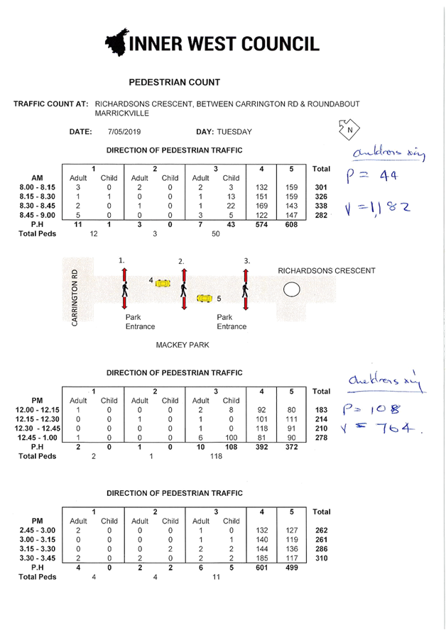
A request has been received for the provision of a marked pedestrian zebra crossing on Richardsons Crescent (adjacent to Mackey Park) and Carrington Road (near Renwick Street), Marrickville to provide safe crossing opportunities for pedestrians, particularly school children. Pedestrian counts have been conducted and the results are presented within this report for Committee’s consideration.
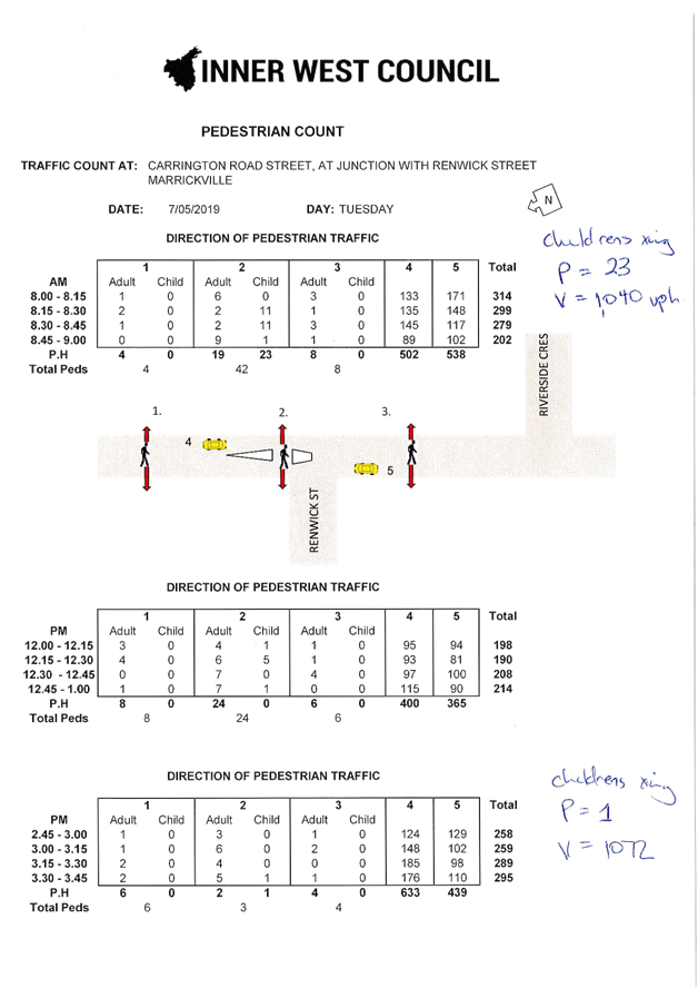
The volume of traffic and pedestrians counted at Richardsons Crescent, between Carrington Road and the roundabout have met the Roads and Maritime Service (RMS) warrants for a marked pedestrian zebra crossing. However RMS warrants for a marked pedestrian zebra crossing could not be met for Carrington Road, at its intersection with Renwick Street.
It is recommended that a marked pedestrian crossing be installed at the existing footpath widening on Richardsons Crescent which is located approximately 60 west of the roundabout including the provision of ‘No Stopping’ zones on approach to the proposed marked pedestrian crossing. Council Officers will undertake consultation in relation to extending the existing ‘No Stopping’ signage on approach to the existing pedestrian refuge facility on Carrington Road at Renwick Street to improve sight lines for pedestrians at this location.
|
RECOMMENDATION
THAT:
1. The proposal to implement a marked pedestrian zebra crossing at the footpath widening/ road narrowing in Richardsons Crescent, approximately 60 metres west of the roundabout be approved; 2. Implementation of 18 metres of ‘No Stopping’ on the southern side of Richardsons Crescent, south of the footpath widening on the western side of Richardsons Crescent be approved; 3. Extension of the existing ‘No Stopping’ on the northern side of Richardsons Crescent, immediately west of the existing footpath widening to a position immediately west of the adjacent driveway; 4. The Principals (of Ferncourt Public School, Tempe High School and Tempe Public School) and the P&C be advised in terms of the outcome of this report; and 5. Council incorporate these works into its priority program for Traffic Facilities Capital Works. |
BACKGROUND
A request has been received from the State Member for Summer Hill on behalf of local community members to investigate the provisions for two pedestrian zebra crossings; on Richardsons Crescent, between the roundabout and Carrington Road, and on Carrington Road, at its intersection with Renwick Street.
FINANCIAL IMPLICATIONS
It is estimated that the cost for implementing a marked pedestrian zebra crossing and supporting signage will be approximately $5,000. The works can be funded through the signs and line marking budget.
OTHER STAFF COMMENTS
1. Richardsons Crescent, Marrickville
Richardson Crescent has two separate sections along the frontage of Mackey Park; Southern Leg and Western Leg. The scope of this report concerns the western leg (refer to Figure 1).
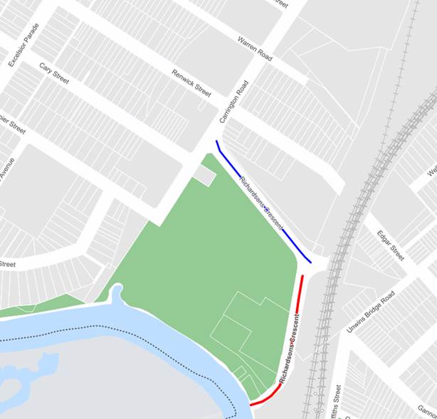
Figure 1 – Locality Plan
|
Street Name |
Richardsons Crescent |
|
Section |
Between roundabout and Carrington Road |
|
Carriageway Width (m) kerb to kerb |
12.8 |
|
Carriageway Type |
Two-way road with one travel lane in each direction, in addition to kerbside parking on both sides. |
|
Classification |
Local |
|
Speed limit |
50 |
|
85th Percentile Speed (km/h) |
56.2 |
|
Vehicles Per Day (vpd) |
13,606 |
|
Reported Crash History |
7 Recorded Crashes |
|
Heavy Vehicle Volume (%) |
3.5 |
|
Parking Arrangements |
Unrestricted parking along both sides of the road. |
In relation to the crash history as provided in the table above, it should be noted that all these crashes either occurred at the roundabout or at the intersection of Richardsons Crescent and Carrington Road with no midblock crashes being recorded.
The proposed marked pedestrian zebra crossing is to be located on the western leg of Richardsons Crescent between Carrington Road and the roundabout (at the blistered section along Richardsons Crescent). There is a moderate downhill gradient from the roundabout towards Carrington Road. There are 2 central concrete travel lanes with bitumen kerbside lanes. The speed limit is posted as a 50km/h speed zone.
There are sections of ‘No Stopping’ restrictions which apply on both sides of Richardson Crescent (adjacent to Mackey Park) from the roundabout to the footpath widening, approximately 60 metres west of the roundabout. There are also sections of unrestricted parking (approximately 18 metres of unrestricted parking on either side of the road) provided within this area.
There are also ‘No Parking’ restrictions along Richardsons Crescent which are placed on the northern side of the road in the vicinity of Carrington Road. The majority of parking along Richardsons Crescent is unrestricted.
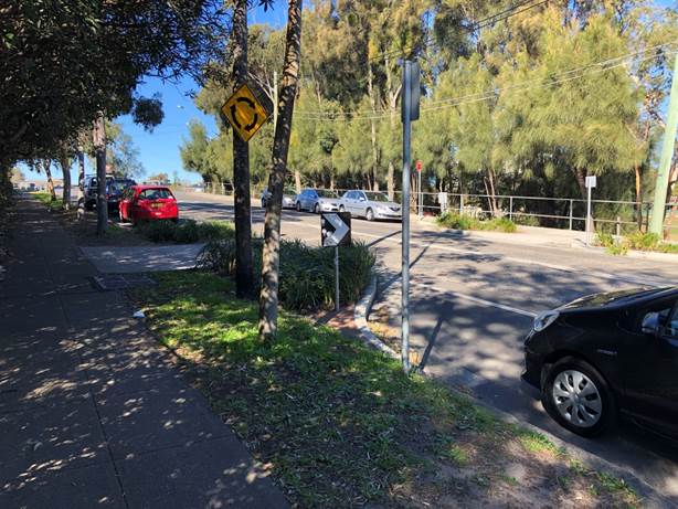
Figure 2 – Richardsons Crescent footpath widening crossing point
Footpath widening/ road narrowing in Richardson Crescent, between the roundabout and Carrington Road
At the Infrastructure, Planning and Environmental Services Committee meeting of 1 April 2014, Marrickville the following recommendation was adopted:
“THAT:
1. A footpath widening/ road narrowing proposal in Richardson Crescent be considered, between 50 and 75 metres west of the roundabout, to reduce the length of the crossing at the point where school students regularly cross and improve sight distance between pedestrians and motorists; and
2. Community and stakeholder consultation be undertaken on the supported option with the results being referred to the Pedestrian, Cyclist and Traffic Calming Advisory Committee for consideration along with the proposal.”
The matter of a pedestrian crossing on Richardson Crescent has previously been raised by the Tempe High School and Ferncourt Public School on a number of occasions. The Secretary of Marrickville Football Club has also previously requested consideration of a marked foot crossing adjacent to Mackey Park. However, at that time, the traffic and pedestrian volume counts did not meet the warrant for such a facility. Therefore, other possible pedestrian crossing facility options were considered. As footpath extensions were the only feasible option, they were recommended in the proposal.
Pedestrian traffic volume counts were undertaken on the 7th May 2019 (Tuesday) and 12th June 2019 (Wednesday) at times when pedestrian activity was highest. There are two main sources of pedestrian activity across Richardson Crescent:
· Students from Tempe High School attending sports at Mackey Park;
· Students from Tempe High School and Tempe Public School walking to and from Marrickville direction before and after school times.
Also, students from Ferncourt Primary School cross Richardson Crescent when walking between the school in Premier Street and the Col Jones Swimming School in Toyer Street.
Traffic and pedestrian counts were conducted at the subject section of Richardsons Crescent (at the footpath widening) during 3 significant time frames; in the morning (8.00am – 9.00am), midday (12.00pm – 1.00pm) and in the afternoon (2.45pm – 3.45pm). Refer to the attached copy of the results of these counts.
|
TUESDAY 07/05/2019 |
|||
|
Time Frame |
Total Pedestrians |
Children |
Vehicle Movements |
|
8.00 - 9.00am |
65 |
68% |
1182 |
|
12.00 - 1.00pm |
121 |
89% |
764 |
|
2.45 3.45pm |
19 |
37% |
1100 |
|
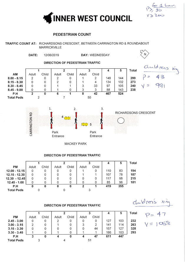
WEDNESDAY 12/06/2019 |
|||
|
Time Frame |
Total Pedestrians |
Children |
Vehicle Movements |
|
8.00 - 9.00am |
59 |
73% |
991 |
|
12.00 - 1.00pm |
3 |
33% |
774 |
|
2.45 - 3.45pm |
58 |
81% |
1058 |
Warrants for pedestrian crossings
As the location is predominantly used by school children and as the subject location is required by children and adults outside of school hours (after school hours and weekends), the warrant for Children’s Crossing is not suitable. The RMS’s Reduced Warrant for the installation of a crossing for school children is for P (Pedestrians) to be ≥ 30 and V (Vehicles) to be ≥ 200 in two separate one hour periods immediately before and after school hours on a typical school day.
The results of the counts indicate the warrants for the installation of a pedestrian crossing predominantly used by school children has been met.
|
RMS Warrant |
TUESDAY 07/05/2019 |
WEDNESDAY 12/06/2019 |
|||||
|
8.00-9.00am |
12.00-1.00pm |
2.45-3.45pm |
8.00-9.00am |
12.00-1.00pm |
2.45-3.45pm |
||
|
P |
30 |
65 |
121 |
19 |
59 |
3 |
58 |
|
V |
200 |
1182 |
764 |
1100 |
991 |
774 |
1058 |
It is recommended that a marked foot crossing be installed in Richardsons Crescent, adjacent to Mackay Park, at the footpath widening.
The proposal includes the implementation of ‘No Stopping’ restrictions along the western side of Richardsons Crescent, east of the footpath widening; removing three (3) legal car parking spaces. The loss of these spaces is to ensure vehicles approaching from the roundabout have an unobstructed view of the pedestrian crossing, especially since Richardsons Crescent has negative gradient from the roundabout. It is also proposed to relocate the existing ‘No Stopping’ sign located immediately west of the footpath widening (north side of Richardson Crescent) to a position immediately west of the adjoining driveway as the length of kerb provided between the footpath widening and driveway is less than a car space.
2. Carrington Road, Marrickville
|
Street Name |
Carrington Road |
|
Section |
Between Richardsons Crescent and Warren Road |
|
Carriageway Width (m) kerb to kerb |
12.8 |
|
Carriageway Type |
Two-way road with one travel lane in each direction, in addition to kerbside parking on eastern sides. On-road protected cycleway on western side |
|
Classification |
Local |
|
Speed limit |
50 |
|
85th Percentile Speed (km/h) |
41.5 |
|
Vehicles Per Day (vpd) |
14,563 |
|
Reported Crash History |
22 Recorded Crashes |
|
Heavy Vehicle Volume (%) |
5.4 |
|
Parking Arrangements |
Unrestricted parking along western side of the road. |
Concerns were expressed that there is no safe crossing point for pedestrians approaching from Tempe who need to negotiate Carrington Road to continue through Renwick Street. The installation of a pedestrian crossing on Carrington Road at Renwick Street intersection has been requested.
It is considered that a reasonable pedestrian desire line for students (confirmed by Council Officer during pedestrian counts) and others going to and from Tempe to Marrickville would travel along Carrington Road, crossing over Renwick Street. (Refer to Figure 3).
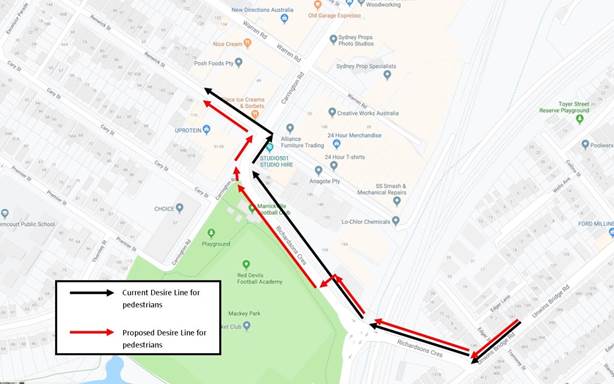
Figure 3 – Journey from Tempe to Marrickville
Currently, at the intersection of Carrington Road and Renwick Street, there are splitter islands, with gaps for pedestrians which facilitates safe crossing, on the north-west side (on Renwick Street) and north-east side (on Carrington Road). These splitter islands provide some protection for pedestrians. An on-road protected cycle way stretches along the western side of Carrington Road between Myrtle Street and Renwick Street (refer to Figure 4), which continues as a shared zone for pedestrians and cyclists beyond Renwick Street (refer to Figure 5).
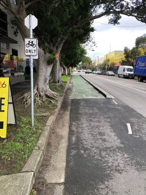
Figure 4 – Carrington Road Cycle Way
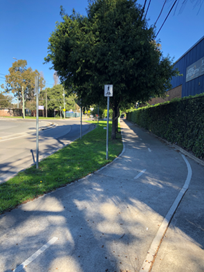
Figure 5 – Carrington Road Shared Zone
Currently, there are no formal pedestrian facilities over Carrington Road, between Richardsons Crescent and Warren Road for pedestrians approaching from and walking to Tempe. However, with the implementation of the proposed Richardsons Crescent marked pedestrian zebra crossing, pedestrians will have access to a safer desire path, allowing pedestrians walking to and from Tempe to cross at the recommended crossing adjacent to Mackay Park, continue along the footpath on the western side of Richardsons Crescent (refer to Figure 1 and Figure 6). At the intersection of Richardsons Crescent and Carrington Road, pedestrians will have an opportunity to cross at a refuge on Carrington Road and continue to Renwick Street along the shared path; away from vehicles (refer to Figure 5 & 7).
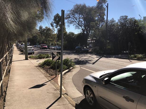
Figure 6 – Richardsons Crescent, western side at footpath widening
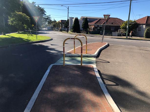
Figure 7 – Carrington Road refuge at Richardsons Crescent intersection
At present, Council Officers are unable to support a marked pedestrian zebra crossing over Carrington Road at Renwick Street due to the following main reasons:
· This location does not meet the warrant required for marked pedestrian crossing as specified by the RMS (Refer to Pedestrian and Vehicular Volume Counts);
· The road curvature at Richardson Crescent & Carrington Road restricts the placement of a possible pedestrian crossing to comply with minimum sight distances for motorists (refer to Figure 8);
· As observed on location that majority of traffic exiting Renwick Street, turning left onto Carrington Road, many drivers executing a left turn from the western leg of Renwick Street are frequently distracted by approaching vehicles from Richardsons Crescent and cyclists continuing across Carrington Road cycle-way failing to check whether the road is clear ahead of them before continuing. A pedestrian crossing at this conflict location may possibly pose a greater pedestrian safety risk than solution.
Pedestrian perception of safety can increase the potential for accidents. Many people, particularly children, regard pedestrian zebra crossings as safe zones, where they have right of way over vehicles. This perception creates a false sense of security in a pedestrian’s mind and leads to many pedestrians walking onto crossings without due care and watching that a motorists has actually seen them attempting the crossing. However, with the creation of a new desire line for pedestrians (via the proposed pedestrian zebra crossing on Richardsons Crescent, refer to Figure 2) may address this issue.
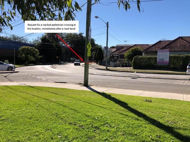
Figure 8 – Road curvature at the intersection of Carrington Road and Richardsons Crescent
Traffic and pedestrian counts were conducted at the subject section of Carrington Road (at the pedestrian refuge near Renwick Street) during 3 periods of the day; in the morning (8.00 – 9.00am), midday (12.00 – 1.00pm) and in the afternoon (2.45 – 3.45pm). (Refer to the attached copy of the results of these counts).
|
TUESDAY 07/05/2019 |
|||
|
Time Frame |
Total Pedestrians |
Children |
Vehicle Movements |
|
8.00-9.00am |
54 |
43% |
1040 |
|
12.00-1.00pm |
45 |
16% |
765 |
|
2.45-3.45pm |
29 |
3% |
1072 |
|
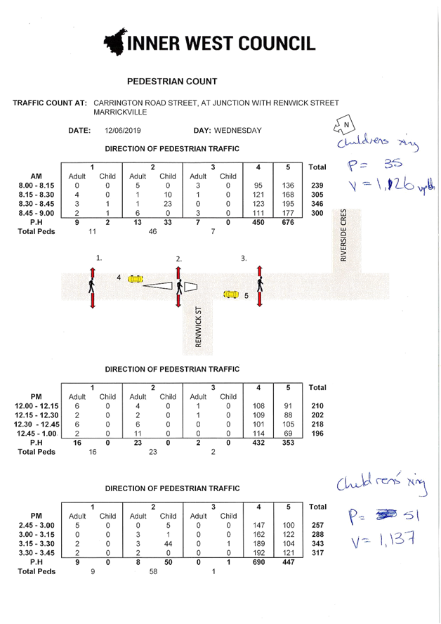
WEDNESDAY 12/06/2019 |
|||
|
Time Frame |
Total Pedestrians |
Children |
Vehicle Movements |
|
8.00-9.00am |
64 |
55% |
1126 |
|
12.00-1.00pm |
41 |
0% |
785 |
|
2.45-3.45pm |
68 |
75% |
1137 |
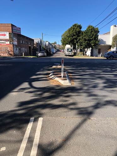
Figure 9 – Renwick Street Refuge Island, at intersection of Carrington Road
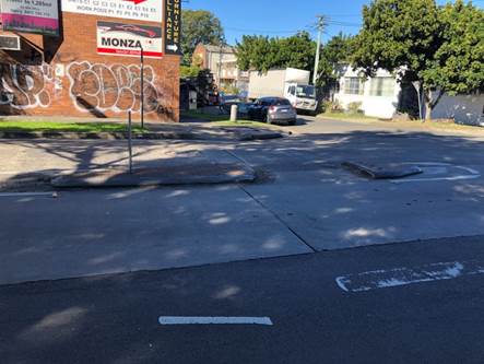
Figure 10 – Carrington Road Refuge Island, at intersection of Renwick Street
Warrants for pedestrian crossings
As the location does not have an obvious predominant use-group as indicated by the pedestrian traffic volume counts, the reduced warrant for a marked pedestrian zebra crossing cannot be used. The RMS’s Normal Warrant for the installation of a crossing for pedestrians is for P (Pedestrians) to be ≥ 30 and V (Vehicles) to be ≥ 200 and product PV ≥ 60,000 in three separate one hour periods in a typical day.
The results of the counts indicate the warrants for the installation of a pedestrian crossing predominantly used by school children has not been met.
|
RMS Warrant |
TUESDAY 07/05/2019 |
WEDNESDAY 12/06/2019 |
|||||
|
8.00-9.00am |
12.00-1.00pm |
2.45-3.45pm |
8.00-9.00am |
12.00-1.00pm |
2.45-3.45pm |
||
|
P |
30 |
65 |
121 |
19 |
59 |
3 |
58 |
|
V |
200 |
1182 |
764 |
1100 |
991 |
774 |
1058 |
|
PV |
60,000 |
56,160 |
34,425 |
31,088 |
72,064 |
32,185 |
77,316 |
Proposed Treatment
As a marked pedestrian zebra crossing is not warranted at this location, other options are currently being investigated including extending the current ‘No Stopping’ restriction on the eastern side of Carrington Road, north of the intersection with Renwick Street in order to increase the visibility for vehicles travelling southbound and for pedestrians crossing.
During an on-site community engagement with parents of Tempe High School students raised the issue of parked trucks and large along the eastern side of Carrington Road, adjacent to the intersection with Renwick Street obstructing views for pedestrians crossing and vehicles approaching southbound.
A separate report documenting the ‘No Stopping’ proposal along with the community engagement will be scheduled for discussion during the 8th October 2019 Local Traffic Committee Meeting.
PUBLIC CONSULTATION
A community engagement was conducted regarding the pedestrian crossing proposal on Richardsons Crescent between 1st August 2019 and 16th August 2019. Letters detailing the proposal including a concept plan were sent to:
· Local residents within the vicinity (see Figure 11); and
· Principal and P&C president of Tempe High School; and
· Principal and P&C president of Tempe Public School; and
· Principal and P&C president of Ferncourt Public School; and
· Parents who attended the on-site community engagement
The proposal was also advertised on A3 laminated signs at the proposed location of the pedestrian crossing to allow commuters traversing Richardsons Crescent and users of Mackey Park to provide feedback.
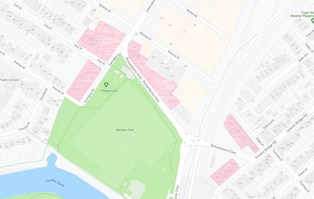
Figure 11: Map of engagement residents within the vicinity
Two (2) responses were received so far regarding this proposal to date and is summarised below:
|
Residents’/Parents’/ Commuters’ Comments |
Officer’s Comments |
|
The parent expressed their strong support for the proposed pedestrian crossing at Richardsons Crescent. The parent states at present, there are no safe alternative crossings given the topography and land uses in the area. Parent has 4 children who attend Tempe High School and Ferncourt Public School and have observed the growing numbers of pedestrians and vehicles along Richardsons Crescent |
Support is noted. |
|
Commuter expresses their support for the proposed pedestrian crossing. |
Support is noted |
CONCLUSION
An analysis of the feasibility of a marked pedestrian zebra crossing treatment was carried out which has resulted in a proposal for a marked pedestrian zebra crossing on Richardsons Crescent, adjacent to Mackay Park at the existing footpath widening being incorporated within this report for consideration.
However, the request for a pedestrian crossing on Carrington Road, at Renwick Street is not currently supported due to issues raised within this report. Instead Council Officers will undertake community engagement on a proposal to extend the existing ‘No Stopping’ zone at this location.
It is recommended that the Committee note and support the recommendations of this report.
|
1.⇩ |
Pedestrian and Traffic Volume Counts - Richardsons Crescent and Carrington Road |
|
Local Traffic Committee Meeting 2 September 2019 |
Subject: Boomerang Street and Crescent Street, Haberfield - Proposed Intersection Treatment (Gulgadya-Leichhardt Ward/Summer Hill Electorate/Burwood PAC)
Prepared By: David Yu - Engineer - Traffic and Parking Services
Authorised By: John Stephens - Traffic and Transport Services Manager
SUMMARY
A review of the detailed design plan has been finalised for the proposed intersection treatment at Boomerang Street and Crescent Street, Haberfield.
The proposal includes installing kerb extension in Crescent Street at Boomerang Street intersection and speed cushions in Boomerang Street to improve safety and reduce vehicular speeds in the street.
Consultation was undertaken with the owners and occupiers of properties adjacent to the intersection regarding the proposal. A summary of the consultation results are presented in this report for consideration.
|
RECOMMENDATION
THAT the detailed design plan for the kerb extension, speed cushions and associated signposting and line marking in Boomerang Street and Crescent Street, Haberfield (as per the attached plan No.10074_A) be approved.
|
BACKGROUND
As part of the 2019/20 Traffic Facilities (LATM) Capital Works Program, Council is proposing to construct a kerb extension in Crescent Street at Boomerang Street and install speed cushions in Boomerang Street, north and south of Crescent Street, Haberfield to improve safety and reduce vehicular speeds in the street.
At the June Traffic Committee meeting, a previous proposal for kerb blister islands, speed cushions, pedestrian refuge and associated signposting and linemarking in Crescent Street and Boomerang Street, Haberfield was deferred due to resident concerns regarding the loss of parking and placement of a pedestrian refuge in Crescent Street. Residents suggested relocating the pedestrian refuge into Boomerang Street as they had observed pedestrians crossing to and from Robson Park.
The Committee recommended that improvements to the intersection be deferred for further investigation of potential treatments in the Boomerang Street approach.
A review of the detailed design plan has been finalised for the proposed works together with community consultation and are presented in this report for consideration.
Site location & Road Network
|
Street Name(s) |
Crescent Street and Boomerang Street, Haberfield |
|
Section |
Intersection |
|
Traffic Volume |
- |
|
Recorded Accident History (5 year) |
Nil. |
|
Recorded 85% speed |
- |
|
Speed Limit |
50km/h |
|
Carriageway width |
Crescent Street - 12.6m Boomerang Street - 11.6m |
|
Carriageway Type |
Boomerang Street - Two way with kerb side parking on both sides of the street Crescent Street - Two way with kerb side parking on both sides of the street |
FINANCIAL IMPLICATIONS
Funding of $40,000 has been allocated to this project for construction in the 2019/20 capital works program.
OTHER STAFF COMMENTS
The updated detailed design plan shown in Attachment 1 outlines the proposed works at the Crescent Street and Boomerang Street intersection and includes the following treatments:
· Reconstruction of kerb ramps;
· Construction of a kerb extension on the north-east corner of the Crescent Street and Boomerang Street intersection;
· Installation of two asphalt speed cushions on Boomerang Street, north and south of Crescent Street; and
· Installation of associated signage and line-marking.
There will be no loss of parking spaces associated with the construction works.
A traffic and pedestrian movement count was completed at the Boomerang Street and Crescent Street intersection, on the following periods:
· 30th July 2019 (Tuesday): 8:00am to 10:00am and 2:00pm to 4:00pm
· 3rd August 2019 (Saturday): 9:00am to 11:00am and 2:00pm to 4:00pm
The surveys identified a maximum of 5 pedestrian movements across Boomerang Street and a maximum traffic volume of 360 vehicles during the peak hour. These volumes are considered to be low and do not warrant a pedestrian refuge island or other pedestrian facility in Boomerang Street.
It should be noted that there is a bus route along Crescent Street and Boomerang Street (Route 406), and the proposal can accommodate the bus movements as confirmed by a separate swept path analysis.
PUBLIC CONSULTATION
A letter outlining this proposal was mailed out to the affected properties (36 properties) in Crescent Street and Boomerang Street, Haberfield, requesting residents’ views regarding the proposal (as indicated on the following plan).
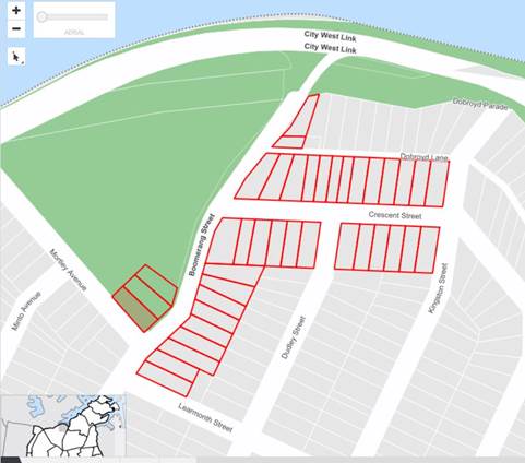
A total of two (2) responses were received, both in objection of the proposal.
|
Residents’ Comments |
Officer Comments |
|
The speed hump proposed (as indicated on attached plan prepared by Council) at the intersection of Crescent Street for traffic heading towards Learmonth Street, could inhibit speed in that section of Boomerang Street, however the speed hump proposed on the opposite side does not appear to have a logical intention as Boomerang Street has no entry into the City West Link road.
A more practical solution is installation of a pedestrian crossing in place of both proposed speed humps. A pedestrian crossing in that vicinity would provide a safe access for families and children to Robson Park steps in Boomerang Street immediately opposite Crescent Street. |
The proposed north bound speed cushion on Boomerang Street will reduce the speed of vehicles turning into Crescent Street from Boomerang Street.
Traffic and pedestrian count completed on 30th July and 3rd August 2019, identified that volumes were too low to warrant a pedestrian (zebra) crossing in Boomerang Street.
|
CONCLUSION
The updated proposal for the kerb extension, speed cushions and associated signposting and linemarking in Boomerang Street and Crescent Street, Haberfield (as per the attached plan No.10074_A) has been developed to address previous concerns raised at the Traffic Committee meeting.
|
1.⇩ |
Boomerang Street and Crescent Street, Haberfield - Updated Detailed Design Plan |
|
|
Local Traffic Committee Meeting 2 September 2019 |
Subject: Minor Traffic Facilities (All Wards/All Electorates/All PACs)
Prepared By: Davide Torresan - Coordinator - Road Access Services
Authorised By: John Stephens - Traffic and Transport Services Manager
SUMMARY
This report considers minor traffic facility applications received by Inner West Council, and includes ‘Disabled Parking’ and ‘Works Zone’ requests.
|
RECOMMENDATION
THAT:
1. A 6m 'Disabled Parking Zone’ be installed in front of No.14 Loughlin Street, Rozelle;
2. A 5.5m 'Disabled Parking Zone’ be installed in front of No.1 Ferdinand Street Birchgrove;
3. A 5.5m 'Disabled Parking Zone’ be installed in front of No.50 Hercules Street, Dulwich Hill;
4. A 9m 'Works Zone 7.00am – 6.00pm Mon-Fri and 8.00am -1.00pm Sat' be installed at the front of No.36 Fotheringham Street, Enmore, for 12 weeks;
5. A 9m 'Works Zone 7.00am – 3.30pm Mon-Fri and 8.00am -1.00pm Sat' and existing ‘No Parking 3.30pm – 6.30pm, Mon – Fri’ be installed at the front of No.351 Trafalgar Street, Petersham, for 12 weeks, subject to concurrence of the Roads & Maritime Services; and,
6. A 9m 'Works Zone 7.00am – 6.00pm Mon-Fri and 8.00am -1.00pm Sat' be installed at the front of No.426 Illawarra Road, Marrickville, for 12 weeks. |
BACKGROUND
Requests have been received from residents within the Local Government Area (LGA) for the provision of mobility parking spaces outside their residence. It is recommended that the following 'Mobility Parking' spaces be approved as the applicant’s current medical conditions warrant the provision of these spaces and they have constrained or no off-street parking opportunities. For the mobility parking space requests, a copy of the RMS disability parking permit and a medical certificate in support of the applications was submitted to Council.
FINANCIAL IMPLICATIONS
Nil
OTHER STAFF COMMENTS
1. Installation of ‘Disabled Parking’ Restriction – No.14 Loughlin Street, Rozelle
The resident of No.14 Loughlin Street, Rozelle has requested the installation of 'Disabled Parking Zone’ in front of the resident’s property. A site investigation has revealed the property does not have off street parking and does not require the use of wheelchair.
It is recommended that a 6m 'Disabled Parking Zone’ be installed in front of No.14 Loughlin Street, Rozelle.
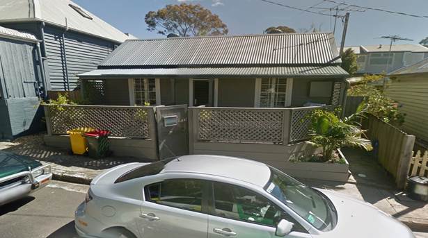
No.14 Loughlin Street, Rozelle
2. Installation of ‘Disabled Parking’ Restriction – No.1 Ferdinand Street, Birchgrove
The resident of No.1 Ferdinand Street, Birchgrove has requested the installation of a 'Disabled Parking Zone’ in front of the resident’s property. A site investigation has revealed the property does not have off street parking and does not require the use of wheelchair.
It is recommended that a 5.5m 'Disabled Parking Zone’ be installed in front of No.1 Ferdinand Street, Birchgrove.
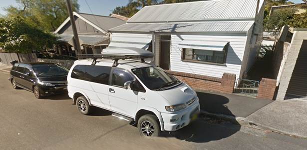
No.1 Ferdinand Street, Birchgrove
3. Installation of ‘Disabled Parking’ Restriction – No.50 Hercules Street, Dulwich Hill
The resident of No.50 Hercules Street, Dulwich Hill has requested the installation of a 'Disabled Parking Zone’ in front of the resident’s property. A site investigation has revealed the property does not have off street parking and does not require the use of wheelchair.
It is recommended that a 5.5m 'Disabled Parking Zone’ be installed in front of No.50 Hercules Street, Dulwich Hill.
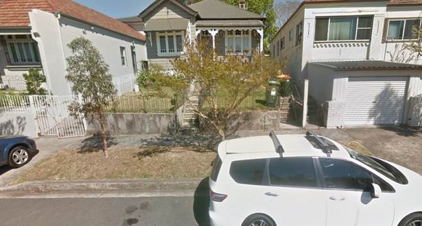
No.50 Hercules Street, Dulwich Hill
Technical Standards
Australian Standard AS2890.5-1993 “On-Street Parking” states the following in regards to the provision of parking for people with a disability:
“Parallel parking spaces shall not be marked as disabled spaces, nor included in the count of spaces available for people with disabilities unless –
i. A 3.2m wide space can be provided, e.g. by indenting the space into the footpath area; and
ii. Kerb ramps as shown in Figure 4.2(a) are also provided”.
It should be noted that due to the limited width of streets around the LGA, it is often difficult to comply with these requirements for the parking space dimensions. This may also result in the loss of some adjacent on-street parking spaces.
Mobility parking spaces are primarily intended for on-street and off-street parking at destinations, such as in commercial/retail areas and public car parks near hospitals, schools and public transport facilities where multiple usages can be expected. They were generally not intended for points of origin such as reserving on-street parking. As such, they are only proposed where required for wheelchair access at the cost of the applicants.
A mobility parking space is not intended for the sole use of one applicant, but rather a shared facility that can used by all authorised persons having a RMS mobility permit.
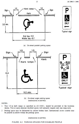
4. Installation of ‘Works Zone’ Restriction – Fotheringham Street, Enmore
The applicant has requested the installation of a temporary 9m 'Works Zone 7.00am – 6.00pm Mon-Sat and 8.00am-1.00pm Sat' (unless noted otherwise on the Development Consent) for 12 weeks at the front of No.36 Fotheringham Street, Enmore, for development works at the property. The applicant has also provided consent from the neighbouring property owner as the proposed 'Works Zone' would extend beyond the applicant’s property frontage.
It is recommended that a 9m 'Works Zone 7.00am – 6.00pm Mon-Fri and 8.00am -1.00pm Sat' be installed at the front of No.36 Fotheringham Street, Enmore, for 12 weeks.
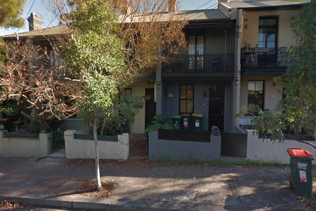
No. 36 Fotheringham Street, Enmore
5. Installation of ‘Works Zone’ Restriction – Trafalgar Street, Petersham
The applicant has requested the installation of a temporary 9m 'Works Zone 7.00am – 6.00pm Mon-Sat and 8.00am-1.00pm Sat' (unless noted otherwise on the Development Consent) for 12 weeks at the front of No.351 Trafalgar Street, Petersham, for development works at the property. The is an existing ‘No Parking 3.30pm – 6.30pm, Mon to Fri’ sign at the location and it is proposed to retain the parking restrictions and permit the ‘Works Zone’ from 7am to 3.30pm, subject to concurrence of the Roads & Maritime Services.
It is recommended that a 9m 'Works Zone 7.00am – 3.30pm Mon-Fri and 8.00am -1.00pm Sat' be installed with retention of existing ‘No Parking 3.30pm – 6.30pm, Mon – Fri’ restriction at the front of No.351 Trafalgar Street, Petersham, for 12 weeks, subject to concurrence of the Roads & Maritime Services.
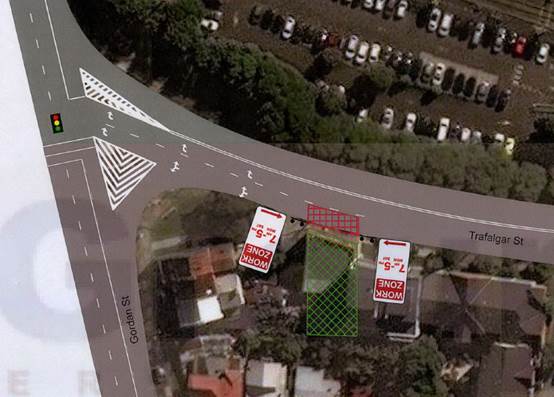
No.351 Trafalgar Street, Petersham
'Works Zone' location only, operational timing subject to RMS concurrence
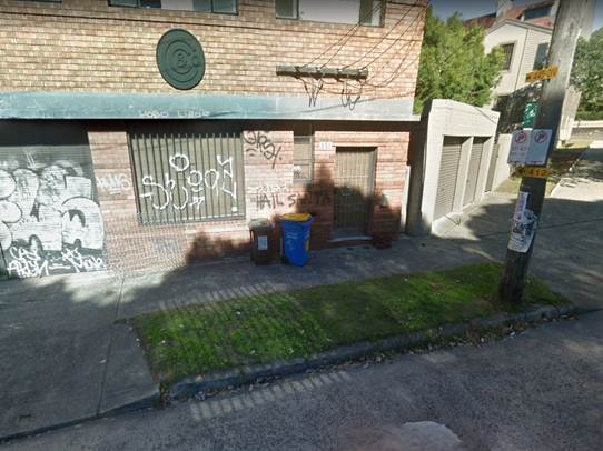
No.351 Trafalgar Street, Petersham
6. Installation of ‘Works Zone’ Restriction – Illawarra Road, Marrickville
The applicant has requested the installation of a temporary 9m 'Works Zone 7.00am – 6.00pm Mon-Sat and 8.00am-1.00pm Sat' (unless noted otherwise on the Development Consent) for 12 weeks at the front of No.426 Illawarra Road, Marrickville, for development works at the property. The applicant has also provided consent from the neighbouring property owner as the proposed 'Works Zone' extends beyond the applicant’s property frontage.
It is recommended that a 9m 'Works Zone 7.00am – 6.00pm Mon-Fri and 8.00am -1.00pm Sat' be installed at the front of No.426 Illawarra Road, Marrickville, for 12 weeks.
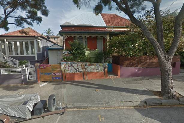
No.426 Illawarra Road, Marrickville
PUBLIC CONSULTATION
Nil
|
|
Local Traffic Committee Meeting 2 September 2019 |
Subject: Newtown Local Area Traffic Management Strategy (Damun-Stanmore Ward/Newtown Electorate/Inner West PAC)
Prepared By: Sunny Jo - Traffic and Parking Planner
Authorised By: John Stephens - Traffic and Transport Services Manager
SUMMARY
This is a recommendation to endorse the final Newtown Local Area Traffic Management (LATM) report. The proposals within the report are based on community input and analysis of feedback from the Public Exhibition period in April 2019. There were 72 responses to the web survey and an additional six responses were received. The results indicate that there is general support for the proposed scheme, with suggested changes considered during the review of the draft treatments. Once this recommendation is endorsed by the Traffic Committee and Council, the projects will be incorporated into future design and construction programs.
|
RECOMMENDATION
THAT:
1. The final Newtown LATM report be endorsed for implementation, including the following Stage 1 LATM treatments as listed in ATTACHMENT 2:
a. 40km/h local traffic area reduced speed limit on all local roads within the study area, subject to RMS review and approval; b. 10km/h raised Shared Zone in Bailey Street at Enmore Road with regulatory signage, marked parking bays, planter boxes and/or street furniture, textured road pavement. Installation of one (1) speed cushion, subject to RMS review and approval; c. Continuous footpath treatment in Goddard Street at King Street; d. Continuous footpath treatment in Reiby Street at Enmore Road; e. Continuous footpath treatment in Simmons Street at Enmore Road; f. Continuous footpath treatment in Marian Street at Enmore Road; g. Kerb extensions in Holt Street, reduced 'No Stopping' distance to 6m on south side at King Street; h. Continuous footpath treatment in Camden Street at King Street; i. Kerb blister island and at grade pavement linemarking, and ‘Local Traffic Only’, Truck prohibited signage in Metropolitan Road at Enmore Lane; j. At grade pavement linemarking and ‘Local Traffic Only’ and Truck prohibited signage in Station Street and Reiby Lane; k. Kerb blister islands with landscaping in Metropolitan Road at Cross Lane; l. Kerb blister island and entry signage in Cross Lane at Edgeware Road; m. Kerb ramps, steel grate and remove part of existing concrete island at existing mobility impaired space in Metropolitan Road at Enmore Lane; n. Landscaped kerb blister islands, 'Give Way' signs and lines in Camden Street at College Street; o. Landscaped kerb blister islands, 'Give Way' signs and lines in Camden Street at Station Street; and p. Bicycle logo mixed traffic arrangement, bicycle warning signs on side street, in Simmons Street, Margaret Street, College Street, Holt Street, Station Street, and Metropolitan Road.
2. The final Newtown LATM report be endorsed for implementation including the following Stage 2 LATM treatments as listed in ATTACHMENT 2: a. '10km/h Shared Zone' in Reiby Street from Enmore Road to Pemell Lane including and regulatory signage, marked parking bays, planter boxes and/or street furniture, textured road pavement, replacement of existing kerb with dish drain or mountable kerb, including speed cushions at two locations, subject to RMS review and approval; b. '10km/h Shared Zone' in Simmons Street from Enmore Road to Pemell Lane including and regulatory signage, marked parking bays, planter boxes and/or street furniture, textured road pavement, replacement of existing kerb with dish drain or mountable kerb, including speed cushions at two locations, subject to RMS review and approval; c. '10km/h Shared Zone' in Marian Street from Enmore Road to Enmore Lane including and regulatory signage, marked parking bays, planter boxes and/or street furniture, textured road pavement, replacement of existing kerb with dish drain or mountable kerb, including speed cushions at two locations, subject to RMS review and approval; d. '10km/h Shared Zone' in Pemell Lane from Simmons Street to Reiby Street, including regulatory signage, textured road pavement and two speed cushions, subject to RMS review and approval; e. '10km/h Shared Zone' in Reiby Lane from Reiby Street to rear of No.72 Enmore Road, including regulatory signage, textured road pavement and two speed cushions, subject to RMS review and approval; and f. Landscaped central islands with native trees in Pemell Street.
|
BACKGROUND
The Inner West Community Strategic Plan (CSP) ‘Our Inner West 2036’ endorsed in June 2018 provides the following outcomes and strategies for the future of Inner West.
|
CSP Outcomes |
Strategies |
|
2.6 People are walking, cycling and moving around Inner West with ease |
1. Deliver integrated networks and infrastructure for transport and active travel 2. Pursue innovation in planning and providing new transport options 3. Ensure transport infrastructure is safe, connected and well maintained |
The Newtown Local Area Traffic Management (LATM) study and plan achieves these outcomes by reviewing existing traffic measures in place, including road safety, transport and traffic management.
The objective of the study is to investigate and review the performance of the existing LATM scheme and recommend proposed works. The Newtown LATM study was originally completed in 1986 and first reviewed in 2005.
As shown in Attachment 1, the study area is bounded by Enmore Road, King Street, Alice Street and Edgeware Road.
Due to the size of the LATM report, only summary and recommendations are attached. The full report including all maps and appendices can be accessed through Council’s website:
https://yoursay.innerwest.nsw.gov.au/newtown-improving-safety-and-traffic
PUBLIC CONSULTATION
Public Exhibition was undertaken from 26 February to 3 May 2019 via Council's Your Say Inner West website providing access to the draft report, maps and concept plans of proposed treatments. Letters were posted to 1,709 residents and businesses in the study area inviting to view the report and plans online. Additionally, hard copies of the draft report and feedback forms were provided at Council’s Petersham Customer Service Centre and Marrickville Library.
The Your Say Inner West survey form provided opportunities to respond by selecting ‘support’, ‘support with changes’ or ‘not support’ the draft report and its list of proposals. Respondents were also asked to comment on their reasons or concerns about a particular proposal. At the close of the exhibition period, 72 responses were received and summarised in the Appendix H of the final report. The results indicate that there is general support for the proposed traffic management, with some changes discussed and considered during the review following the public exhibition. There was good support for the proposed lower 40km/h speed limit and the 10km/h Shared Zones in the area.
OTHER STAFF COMMENTS
The study identified a number of treatment locations to improve safety and support walking and cycling in the area. Based on feedback received during the exhibition period, the recommendations have been refined. Changes from the draft report comprise of the following:
· Reiby Street, Simmons Street and Marion Street treatments at Enmore Road - separated to two stages due to high cost of treatments. Stage 1 comprise of continuous footpath treatments, and Stage 2 generally consists of a 10km/h Shared Zone treatment with speed cushions, textured surface treatment, and removal of existing kerbs;
· Pemell Lane and section of Reiby Lane - included in the 10km/h Shared Zone (signage, speed cushions, textured surface) in Reiby Street and Simmons Street proposed in Stage 2 of the scheme;
· Metropolitan Road kerb blister islands at Cross Lane - concept design has been amended to include landscaping in place of motorbike parking;
· Metropolitan Road at Enmore Lane - addition of kerb ramps and grate to improve access to existing mobility impaired space;
· Pemell Road - treatment changed to include landscaped islands;
· Holt Street between King Street and Station Street - staged concept plan amended to include changes to kerb extensions to improve pedestrian safety when walking across Holt Street, inclusion of speed cushions in Stage 1 to discourage bypassing traffic and trucks breaking the load limit.
· Holt Street at Station Street and Rawson Street - added bicycle bypass lane through existing kerb blister to support existing cycling route.
The strategic cost estimate of the proposed scheme was separated into two stages and incorporated kerb and gutter works in 10km/h Shared Zone areas as required by the RMS for a category 1 shared zone. An executive summary, map containing treatment proposals and full list of treatments are attached.
FINANCIAL IMPLICATIONS
Stage 1 of the Newtown LATM works are estimated to total $300,100 and Stage 2 is estimated to cost $400,400. These works will be listed in the Forward Works program for funding consideration.
CONCLUSION
The Newtown LATM Strategy will make transport and traffic improvements to the study area and will further support walking and cycling. Attachment 3 shows a map summary of recommendations proposed in the study.
Following a review of the submissions received during the public exhibition of the draft plan, it is recommended that the proposed treatments for the Newtown LATM Strategy listed in the Attachment 2 be endorsed for implementation.
|
1.⇩ |
Newtown LATM Study Area |
|
2.⇩ |
Newtown LATM Study Executive Summary |
|
3.⇩ |
Newtown LATM Proposed Treatments Map |
|
|
Local Traffic Committee Meeting 2 September 2019 |
Subject: Church Street, between Carillon Avenue and Rochester Street, Newtown - Temporary Full Road Closure - to dismantle a tower crane at 142 Carillon Avenue (Damun-Stanmore Ward/Newtown Electorate/Inner West PAC)
Prepared By: Jennifer Adams - Engineer – Traffic and Parking Services
Authorised By: John Stephens - Traffic and Transport Services Manager
SUMMARY
An application has been received from PBS Building (NSW) Pty Ltd for the temporary full road closure of Church Street, between Carillon Avenue and Rochester Street, Newtown in order to dismantle a tower crane presently on site at 142 Carillon Avenue. The closure is to be undertaken on Saturday, 9 November 2019 for an eight hour period between the hours of 7.30am and 3.30pm, with a one day contingency on Saturday, 16 November 2019. It is recommended that the proposed temporary full road closure be approved, subject to the conditions outlined in the report.
|
THAT the proposed temporary full road closure of Church Street, between Carillon Avenue and Rochester Street, Newtown on Saturday, 9 November 2019 for an eight hour period between the hours of 7.30am and 3.30pm, with a one day contingency on Saturday, 16 November 2019 in order to dismantle a tower crane using a mobile crane be approved; subject to, but not limited to, the following conditions: 1. A Road Occupancy License be obtained by the applicant from the Transport Management Centre; 2. All affected residents and businesses, including the NSW Police Local Area Commander, Fire & Rescue NSW and the NSW Ambulance Services be notified in writing, by the applicant, of the proposed temporary full road closure at least 7 days in advance of the closure with the applicant making reasonable provision for stakeholders; and 3. The occupation of the road carriageway must not occur until the road has been physically closed. |
BACKGROUND
An application has been received from PBS Building (NSW) Pty Ltd for the temporary full road closure of Church Street, between Carillon Avenue and Rochester Street, Newtown, on Saturday, 9 November 2019 for an eight hour period between the hours of 7.30am and 3.30pm, with a one day contingency on Saturday, 16 November 2019, in order to dismantle a tower crane presently on site at 142 Carillon Avenue.
FINANCIAL IMPLICATIONS
Under Council’s Fees & Charges, the applicant is required to pay the fee for the temporary full road closure. This fee includes advertising the proposal in accordance with Roads Act 1993.
OTHER STAFF COMMENTS
Church Street, between Carillon Avenue and Rochester Street is restricted one-way southbound, with the only entry permitted from westbound traffic on Carillon Avenue. Therefore, the detouring is only required for westbound traffic entering from Carillon Avenue.
Traffic detour is proposed via:
1. Continue westbound on Carillon Avenue into Salisbury Road,
2. Turn left into Australia Street from Salisbury Road (southbound),
3. Turn left on Lennox Street from Australia Street (eastbound); and
4. Turn left on Church Street from Lennox Street (northbound).
Copies of the TCPs for the detours and for the temporary road closure are reproduced below.
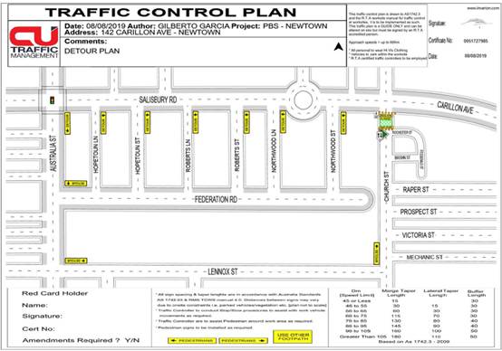
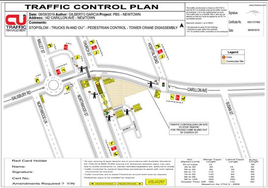
The Traffic Management Plan is attached at the end of this report.
Vehicular access for local residents will be maintained during the closure, where possible. Authorised traffic controllers will be on-site during all shifts and are to be positioned at the closure points to ensure the safety of motorists, cyclists and pedestrians.
PUBLIC CONSULTATION
The applicant is to notify all affected residents and businesses in writing at least 7 days prior to the commencement of works.
The proposed temporary full road closure has been advertised in the local paper in accordance with Roads Act 1993.
CONCLUSION
It is recommended that the proposed temporary full road closure be approved, subject to the conditions outlined in the report.
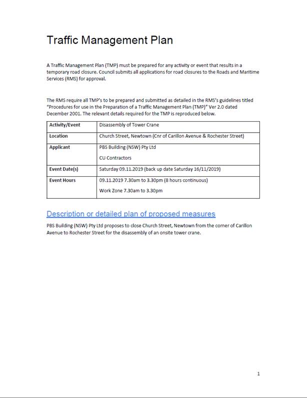
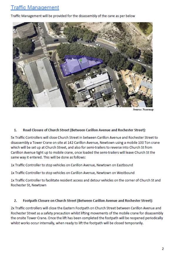
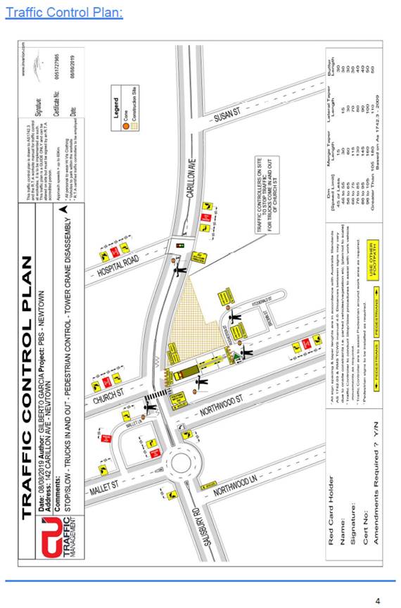
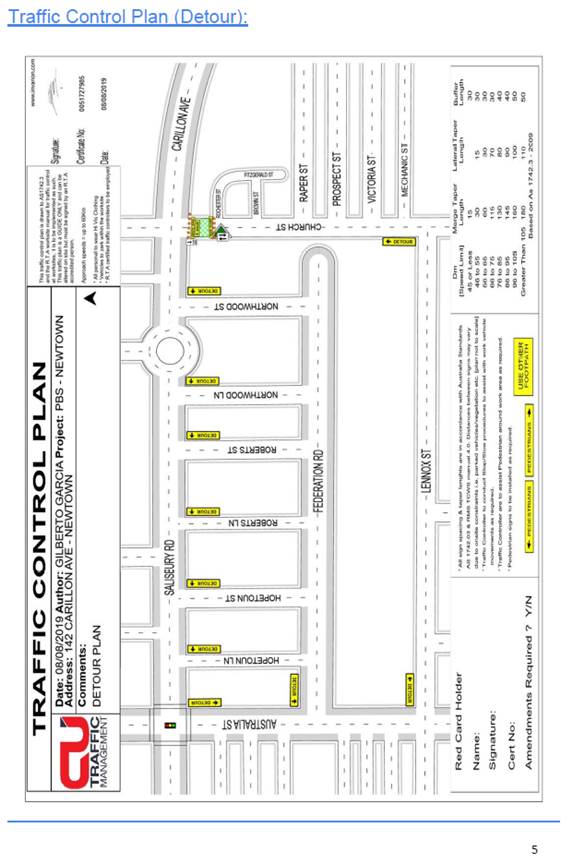
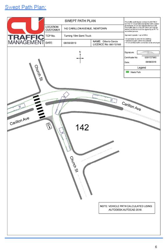
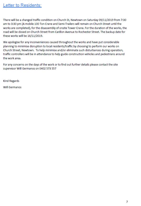
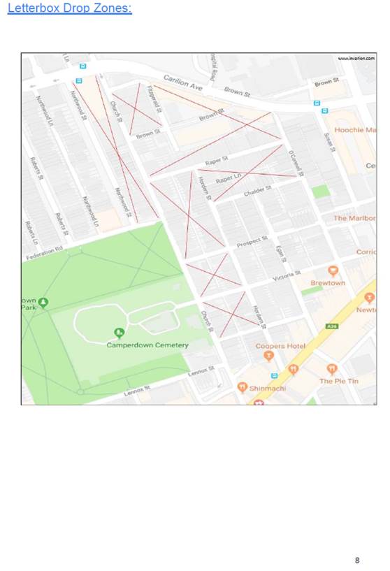
|
|
Local Traffic Committee Meeting 2 September 2019 |
Subject: Fisher Street, Petersham between Regent Street and Audley Street – Temporary Full Road Closure to dismantle tower crane at No. 22 (Damum - Stanmore Ward / Newtown Electorate / Inner West PAC)
Prepared By: Jennifer Adams - Engineer – Traffic and Parking Services
Authorised By: John Stephens - Traffic and Transport Services Manager
SUMMARY
An application has been received from Boycebuild Pty Ltd for the temporary full road closure of Fisher Street, Petersham between Regent Street and Audley Street, for a period of 8 hours on Wednesday 9 October 2019 (contingency dates - Thursday 10 October 2019 and Tuesday 15 October 2019) between the hours of 7:00am and 3pm, in order to stand a mobile crane to carry out crane lift works to dismantle a tower crane. It is recommended that the proposed temporary full road closure be approved, subject to the conditions outlined in this report.
|
THAT the proposed temporary full road closure of Fisher Street, Petersham between Regent Street and Audley Street, for a period of 8 hours on Wednesday 9 October 2019 (contingency dates - Thursday 10 October 2019 and Tuesday 15 October 2019) between the hours of 7:00am and 3:00pm, be APPROVED in order to stand a mobile crane to carry out crane lift works at No.22 Fisher Street, subject to, but not limited to, the following conditions:
1. The application and TMP be submitted by the applicant to RMS for approval;
2. A Road Occupancy License be obtained by the applicant from the Transport Management Centre;
3. All affected residents and businesses, including the NSW Police Local Area Commander, Fire & Rescue NSW and the NSW Ambulance Services be notified in writing, by the applicant, of the proposed temporary road closure at least 7 days in advance of the closure with the applicant making reasonable provision for stakeholders; and
4. The occupation of the road carriageway must not occur until the road has been physically closed.
|
BACKGROUND
An application has been received from Boycebuild Pty Ltd for the temporary full road closure of Fisher Street, Petersham between Regent Street and Audley Street, for a period of 8 hours on Wednesday 9 October 2019 (contingency dates - Thursday 10 October 2019 and Tuesday 15 October 2019) between the hours of 7:00am and 3:00pm, in order to stand a mobile crane to carry out crane lift works to dismantle a tower crane. It is recommended that the proposed temporary full road closure be approved, subject to the conditions outlined in this report.
FINANCIAL IMPLICATIONS
Under Council’s Fees & Charges, the applicant is to pay a fee for the temporary full road closure. This fee includes advertising the proposal in accordance with the Roads Act 1993.
OTHER STAFF COMMENTS
Fisher Street is a local, unclassified road which is primarily used to provide vehicular and pedestrian access to frontage properties. A mixture of time-restricted and all-day commuter parking is generally permitted along both sides of the road.
It is noted that vehicular access for local residents/businesses and emergency services will be maintained during the closure, where possible. Authorised traffic controllers will be on-site during the time of the road closure and are to be positioned at the closure points when required to provide vehicular access to local residents/businesses and ensure the safety of motorists and pedestrians (refer to Traffic Control Plan for details).
The Traffic Control Plan submitted by the applicant is shown below.
PUBLIC CONSULTATION
The applicant is to notify all affected residents and businesses in writing at least 7 days prior to the commencement of works.
The proposed road closure has been advertised in the local newspaper in accordance with the Roads Act 1993.
CONCLUSION
It is recommended that the proposed temporary road closures be approved, subject to the conditions outlined in this report.
In addition to the recommended conditions within this report other standard conditions include:
· Notification signs advising of the proposed road closures and new traffic arrangements to be strategically installed and maintained by the applicant at each end of the street at least 7 days prior to the closure;
· Vehicular and pedestrian access for residents and businesses to their off-street car parking spaces be maintained where possible whilst site works are in progress;
· Adequate vehicular traffic control shall be provided for the protection and convenience of pedestrians and motorists including appropriate signage and flagging. Workers shall be specially designated for this role, as necessary to comply with this condition. This is to be carried out in accordance with the Australian Standard AS 1742.3 - Traffic Control Devices for works on roads;
· The holder of this approval shall indemnify the Council against all claims, damages and costs incurred by, or charges made against, the Council in respect to death or injury to any person or damage in any way arising out of this approval. In this regard, a public liability insurance policy for an amount not less than $20,000,000 for any one occurrence is to be obtained and is to note the Council as an interested party. The holder of this approval shall inform its insurer of the terms of this condition and submit a copy of the insurance policy to the Council prior to commencement of the work the subject of this approval;
· The operator of any unit exercising this approval shall have this approval with them and produce it if required along with any other relevant authority approvals granted in the connection with the work;
· Mobile cranes, cherry pickers or concrete boom pumps shall not stand within the public way for extended periods when not in operation under this approval;
· The operation of the mobile crane shall not give rise to an "offensive noise" as defined in the Protection of Environment Operations Act, 1997. Furthermore, vibrations and/or emission of gases that are created during its operations and which are a nuisance, or dangerous to public health are not permitted;
· All work is to be carried out in accordance with Work Cover requirements; and
· The costs to repair damages, as a result of these works, to Council's footway and roadway areas will be borne by the applicant.
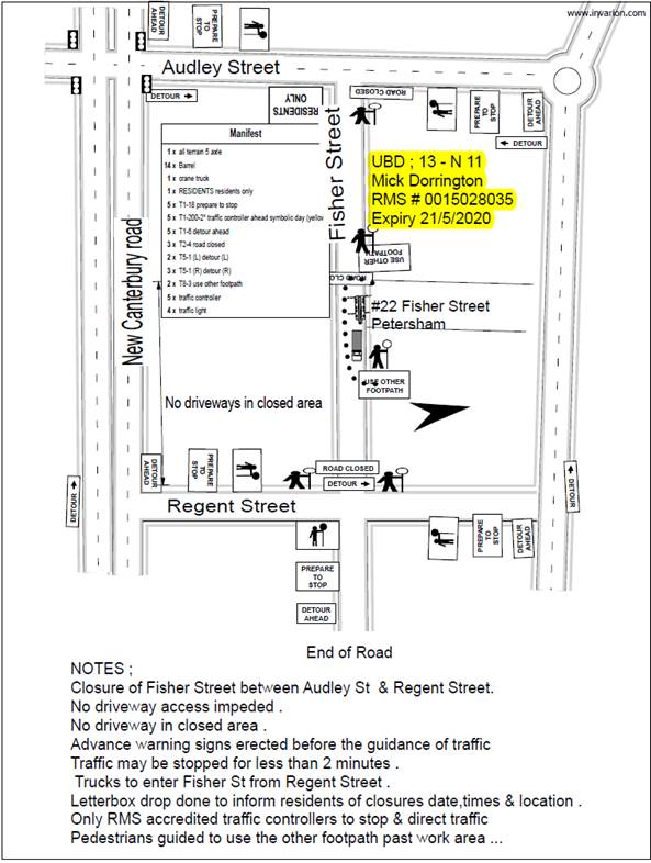
|
|
Local Traffic Committee Meeting 2 September 2019 |
Subject: Terrace Road / Ness Avenue, Dulwich Hill – Temporary Full Road Closure of Rail Underpass just north of the roundabout at Ewart Street – Sydney Metro (SSJ) early enabling works on T3 Line – notice of change of dates (DJARRAWUNANG-ASHFIELD WARD / SUMMER HILL ELECTORATE / INNER WEST PAC)
Prepared By: Jennifer Adams - Engineer – Traffic and Parking Services
Authorised By: John Stephens - Traffic and Transport Services Manager
SUMMARY
Notice of changes in dates for rail underpass works and pending road closures of Terrace Road / Ness Avenue just north of the roundabout at Ewart Street, Dulwich Hill in September 2019 have been received from Sydney Metro (SSJ). Due to new design work requirements additional closure dates have been proposed in addition to the approved full road closures between 1:00AM Saturday 28 September to 11:59PM Sunday 29 September 2019. The proposed additional dates requested are Monday 23 September to Friday 27 September 2019 between 7:00AM and 5:00PM each day (with the road reopening at night to allow traffic through). It is recommended that the proposed additional daytime temporary full road closures be approved, subject to the conditions outlined in this report.
|
RECOMMENDATION
THAT the proposed temporary full road closure of the rail underpass on Terrace Road / Ness Avenue just north of the roundabout at Ewart Street, Dulwich Hill between the hours 7:00AM and 5:00PM (allowing road to be open at night) in addition to the approved full closures for a two day period being on Saturday 28 September until midnight Sunday 29 September 2019 be approved, in order to carry out early enabling works on the Rail bridge subject to, but not limited to, the following conditions:
1. A Road Occupancy License be obtained by the applicant from the Transport Management Centre;
2. All affected residents and businesses, including the NSW Police Local Area Commander, Fire & Rescue NSW and the NSW Ambulance Services be notified in writing, by the applicant, of the proposed temporary road closure at least 7 days in advance of the closure with the applicant making reasonable provision for stakeholders; and
3. The occupation of the road carriageway must not occur until the road has been physically closed.
|
BACKGROUND
A report went to the 5 August 2019 Local Traffic Committee detailing the application by Sydney Metro (SSJ) for the temporary full road closure of the rail underpass on Terrace Road / Ness Avenue just north of the roundabout at Ewart Street, Dulwich Hill for a two day period on Saturday 28 September until midnight Sunday 29 September 2019 in order to carry out early enabling works on the Rail bridge.
Council was notified, by Sydney Metro (SSJ), that due to new design work requirements additional closure dates are required in addition to the now approved full road closure. The proposed additional dates requested are Monday 23 September to Friday 27 September 2019 between 7:00AM and 5:00PM each day (with the road reopening at night to allow traffic through).
A copy of the report that went to the 5 August 2019 Local Traffic Committee is reproduced at the end of this report for reference. The Traffic Control Plan submitted by the applicant is shown in the report.
FINANCIAL IMPLICATIONS
The applicant has previously paid for the temporary full road closure and an invoice has been issued for advertising the amendments.
OFFICER COMMENTS
Terrace Road, between The Parade and Consett Street, carries around 1,388 vehicles per day. At the railway overbridge the width of the road is approximately 9 metres. It is noted that the full road closure will divert traffic to either Garnet Street in the west or Wardell Road in the west. The extended closures will allow the underpass to be open at night.
PUBLIC CONSULTATION
The applicant is to notify all affected residents and businesses in writing at least 7 days prior to the commencement of works. The change of dates for the road closures has been advertised in the local newspaper in accordance with the Roads Act 1993.
CONCLUSION
It is recommended that the proposed temporary full road closures be approved, subject to the conditions outlined in this report.
|
1.⇩ |
Report from LTC0819 - Item 2 - Terrace Road / Ness Avenue, Dulwich Hill – Temporary Full Road Closure |
|
|
Local Traffic Committee Meeting 2 September 2019 |
Subject: Terrace Road / Ness Avenue, Dulwich Hill – Temporary Full Road Closure of Rail Underpass just north of the roundabout at Ewart Street – Sydney Metro (SSJ) early enabling works on T3 Line (DJARRAWUNANG-ASHFIELD WARD / SUMMER HILL ELECTORATE / INNER WEST PAC)
Prepared By: Jennifer Adams - Engineer – Traffic and Parking Services
Authorised By: John Stephens - Traffic and Transport Services Manager
An application has been received from Sydney Metro (SSJ) for the temporary full road closure of the rail underpass on Terrace Road / Ness Avenue just north of the roundabout at Ewart Street, Dulwich Hill for a two day period from 12am Saturday, 28 September until 11.50pm Sunday, 29 September 2019 in order to carry out early enabling works on the Rail bridge. The road will be temporarily closed to all vehicular traffic, including emergency vehicles and local residents. It is recommended that the proposed temporary full road closures be approved, subject to the conditions outlined in this report.
|
RECOMMENDATION
THAT the proposed temporary full road closure of the rail underpass on Terrace Road / Ness Avenue just north of the roundabout at Ewart Street, Dulwich Hill for a two day period being 12am Saturday, 28 September until 11.50pm Sunday, 29 September 2019 be approved, in order to carry out early enabling works on the Rail bridge subject to, but not limited to, the following conditions:
a) The application and TMP be submitted to RMS for approval;
b) A Road Occupancy License be obtained by the applicant from the Transport Management Centre;
c) All affected residents and businesses, including the NSW Police Local Area Commander, Fire & Rescue NSW and the NSW Ambulance Services be notified in writing, by the applicant, of the proposed temporary road closure at least 7 days in advance of the closure with the applicant making reasonable provision for stakeholders; and
d) The occupation of the road carriageway must not occur until the road has been physically closed.
|
BACKGROUND
Southwest Metro early works are now underway between Sydenham and Campsie to convert the existing rail to metro standards in preparation for the opening of Sydney Metro City & Southwest in 2024. The joint venture currently delivering the Sydney Metro upgrade to Sydenham Station (SSJ), John Holland Pty Ltd and Laing O’Rourke Australia Construction Pty Ltd, has been appointed to undertake early works along the T3 Bankstown Line like site geotechnical investigations, early design, and enabling works such as surveying and utilities investigations. Work also includes station and bridge investigations and the installation of cable routes, retaining walls and security fencing within the rail corridor.
As part of the Southern Corridor – Bankstown Line early investigation activities SSJ are about to undertake work to the Terrace Road / Ness Avenue rail overbridge which will require the use of an elevated work platform (EWP) and mobile crane, and this will require a full lane closure of both lanes at the Terrace Road / Ness Avenue, Dulwich Hill underpass.
Traffic movements will be managed in accordance with the submitted TCPs and Traffic controllers will be on duty to assist both pedestrians and vehicle movements. Pedestrian/cyclist access will be maintained.
It is noted that the works will be carried out to coincide with a Bankstown line possession weekend - (5am on the Saturday morning through to 2am on the Monday morning). For the temporary full road closure (28-29 September 2019) – SSJ will be working for the whole weekend.
Community notification by Sydney Metro (SSJ) will include:
· Residents within a 200m radius of the work area will have a targeted door knock completed 7 days prior to work commencing.
· A notification will be distributed via letterbox drop and email no later than 7 days prior to work commencing.
· A door knock of local businesses with the potential to be impacted will be carried out no later than 14 days before work commences.
FINANCIAL IMPLICATIONS
Under Council’s Fees & Charges, the applicant is to pay a fee for the temporary full road closure. This fee includes advertising the proposal in accordance with the Roads Act 1993.
OFFICER COMMENTS
Site location
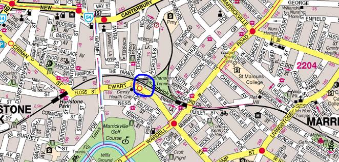
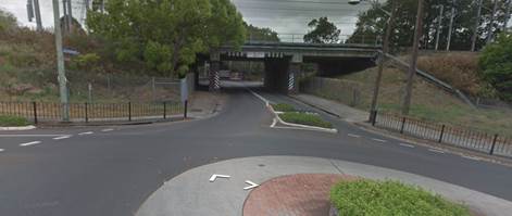
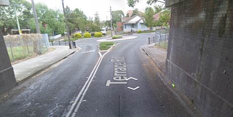
Terrace Road, between The Parade and Consett Street, carries around 1,388 vehicles per day. At the railway overbridge the width of the road is approximately 9 metres in width. It is noted that the full road closure will divert traffic to either Garnet Street to the west or Wardell Road to the east.
|
Street Name |
Terrace Road |
|
Section |
Between The Parade and Consett Street |
|
Carriageway Width (m) |
12.4 generally and 9.0 at underpass |
|
Carriageway Type |
Two-way road with one travel lane in each direction, in addition to kerbside parking on both sides. At underpass one travel lane in each direction. |
|
Classification |
Local |
|
Speed limit |
50.0 |
|
85th Percentile Speed (km/h) |
51.8 |
|
Vehicles Per Day (vpd) |
1,388 |
|
Reported Crash History (July 2013 – June 2018) |
3 injury crashes and one tow-away crash in locality of underpass/roundabout. The tow-away involved a car losing control at the underpass. Two of the 3 injury crashes involved motorcyclists going off the road and the other crash involved a cyclist being injured while making a U-turn. RUM codes – 81,70, 88 and 40. |
|
Heavy Vehicle Volume (%) |
2.9 |
|
Parking Arrangements |
No parking at underpass and unrestricted parking along each side of Terrace Road. |
The Traffic Control Plan submitted by the applicant is shown below.
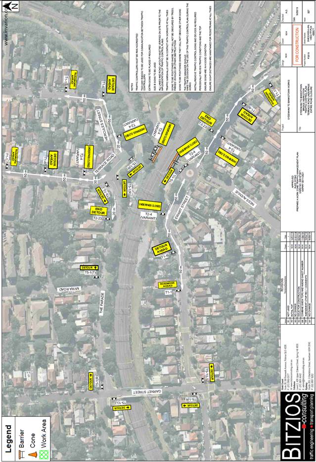
PUBLIC CONSULTATION
The applicant is to notify all affected residents and businesses in writing at least 7 days prior to the commencement of works.
The proposed road closure has been advertised in the local newspaper in accordance with the Roads Act 1993
CONCLUSION
It is recommended that the proposed temporary full road closure be approved, subject to but not limited to the conditions outlined in this report.
|
Local Traffic Committee Meeting 2 September 2019 |
Subject: Eltham Street, Lewisham – Temporary Full Road Closure to install new sewer main in the roadway on behalf of Sydney Water (Damum - Stanmore Ward / Newtown Electorate / Inner West PAC)
Prepared By: Jennifer Adams - Engineer – Traffic and Parking Services
Authorised By: John Stephens - Traffic and Transport Services Manager
SUMMARY
An application has been received from Comdain Civil Construction (on behalf of Sydney Water) for the temporary full road closure of Eltham Street, Lewisham extending between Fred Street and Denison Street, for a period of 4 weeks starting on Monday 9 September 2019 (to Monday 7 October 2019) with a contingency period of 5 weeks starting on Monday 23 September 2019 (to Monday 28 October 2019) in order to install a new sewer main in the roadway, including construction of new maintenance holes in the roadway. It is recommended that the proposed temporary full road closure be approved, subject to the conditions outlined in this report and satisfactory arrangements are in place to accommodate school buses.
|
THAT the proposed temporary full road closure of Eltham Street, Lewisham extending between Fred Street and Denison Street, for a period of 4 weeks starting on Monday 9 September 2019 (to Monday 7 October 2019) with contingency period of 5 weeks starting on Monday 23 September 2019 (to Monday 28 October 2019) be APPROVED in order to install a new sewer main in the roadway, including construction of new maintenance holes in the roadway subject to, but not limited to, the following conditions:
1. The application and TMP be submitted by the applicant to RMS for approval;
2. A Road Occupancy License be obtained by the applicant from the Transport Management Centre;
3. All affected residents and businesses, including the NSW Police Local Area Commander, Fire & Rescue NSW and the NSW Ambulance Services be notified in writing, by the applicant, of the proposed temporary road closure at least 7 days in advance of the closure with the applicant making reasonable provision for stakeholders; and
4. The occupation of the road carriageway must not occur until the road has been physically closed.
|
BACKGROUND
It is noted that these are planned works and not emergency works by Sydney Water:
Wet Weather Discharges Inside Houses - Project No: 20034581 - Eltham Street, Dulwich Hill.
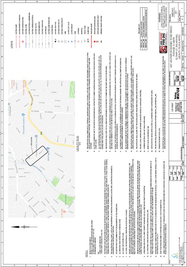
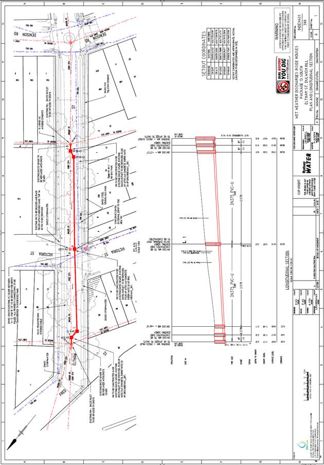
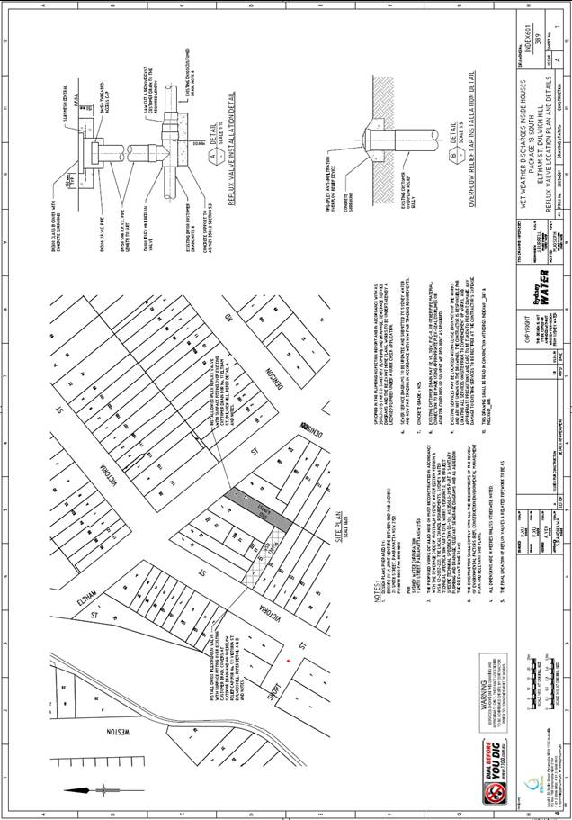
FINANCIAL IMPLICATIONS
Under Council’s Fees & Charges, the applicant is to pay a fee for the temporary full road closure. This fee includes advertising the proposal in accordance with the Roads Act 1993.
OTHER STAFF COMMENTS
Site location & road network
![]()
![]()

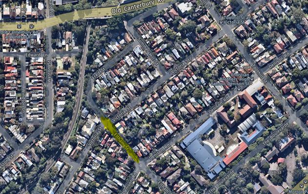
|
Street Name |
Eltham Street |
|
Section |
at Denison Road |
|
Carriageway Width (m) |
10.2 |
|
Carriageway Type |
Two-way road with one travel lane in each direction, in addition to kerbside parking lanes. |
|
Classification |
Local |
|
85th Percentile Speed (km/h) |
39.6 |
|
Vehicles Per Day (vpd) |
944 |
|
Reported Crash History (July 2012 – June 2017) |
No crashes recorded. |
|
Heavy Vehicle Volume (%) |
2.6 |
|
Parking Arrangements |
unrestricted parking along both sides of the road. |
Eltham Street is used as a school bus route for busses attending Christian Brothers High School and this must be managed accordingly by the applicant to the satisfaction of Council, the school and bus company(s). The original TMP was revised to accommodate Council’s concerns regarding the school buses. The revised TMP notes:
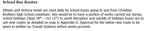
It is noted that half of the works will be carried out during school holidays to minimise disruption to any school buses. However, when works will be undertaken into the school term for a period of two weeks, the diversion into The Boulevarde may pose problems as this street is used for parent drop off and pick up. An alternative detoured route will be discussed with the applicant and bus operators prior to the proposed road closure.
The Traffic Management Plan submitted by the applicant is reproduced at the end of this report. It states that all activities and project works, including the arrival and departure of vehicles delivering or removing materials from or to the site, shall be carried out between the hours of: 7:00am to 6:00pm Monday to Friday and 8:00am to 1:00pm Saturdays.
The TMP details 6 TCPs two each for 3 different sections of Eltham Street, Dulwich Hill.
It is noted that vehicular access for local residents/businesses and emergency services will be maintained during the closure, where possible. Authorised traffic controllers will be on-site during the time of the road closure and will be positioned at the closure points when required to provide vehicular access to local residents/businesses and ensure the safety of motorists and pedestrians (refer to Traffic Management Plan and Traffic Control Plans for details).
PUBLIC CONSULTATION
The applicant is to notify all affected residents and businesses in writing at least 7 days prior to the commencement of works.
The proposed road closure has been advertised in the local newspaper in accordance with the Roads Act 1993.
CONCLUSION
It is recommended that the proposed temporary road closures be approved, subject to the conditions outlined in this report and satisfactory arrangements are in place to accommodate school buses, preferably detoured onto New Canterbury Road opposed to The Boulevarde.
In addition to the recommended conditions within this report other standards conditions include:
· Notification signs advising of the proposed road closures and new traffic arrangements to be strategically installed and maintained by the applicant at each end of the street at least 7 days prior to the closure;
· Vehicular and pedestrian access for residents and businesses to their off-street car parking spaces be maintained where possible whilst site works are in progress;
· Adequate vehicular traffic control shall be provided for the protection and convenience of pedestrians and motorists including appropriate signage and flagging. Workers shall be specially designated for this role, as necessary to comply with this condition. This is to be carried out in accordance with the Australian Standard AS 1742.3 - Traffic Control Devices for works on roads;
· The holder of this approval shall indemnify the Council against all claims, damages and costs incurred by, or charges made against, the Council in respect to death or injury to any person or damage in any way arising out of this approval. In this regard, a public liability insurance policy for an amount not less than $20,000,000 for any one occurrence is to be obtained and is to note the Council as an interested party. The holder of this approval shall inform its insurer of the terms of this condition and submit a copy of the insurance policy to the Council prior to commencement of the work the subject of this approval;
· The operator of any unit exercising this approval shall have this approval with them and produce it if required along with any other relevant authority approvals granted in the connection with the work;
· Mobile cranes, cherry pickers or concrete boom pumps shall not stand within the public way for extended periods when not in operation under this approval;
· The operation of the mobile crane shall not give rise to an "offensive noise" as defined in the Protection of Environment Operations Act, 1997. Furthermore, vibrations and/or emission of gases that are created during its operations and which are a nuisance, or dangerous to public health are not permitted;
· All work is to be carried out in accordance with Work Cover requirements; and
· The costs to repair damages, as a result of these works, to Council's footway and roadway areas will be borne by the applicant.
|
1.⇩ |
revised - TMP Eltham Street Dulwich Hill |
|
Local Traffic Committee Meeting 2 September 2019 |
Subject: Australia Street, Eliza Street, Lennox Street & Mary Street, Newtown – Temporary Full Road Closures for Newtown Festival on Sunday 10 November 2019 (Damum-Stanmore Ward / Newtown Electorate / Inner West PAC)
Prepared By: Jennifer Adams - Engineer – Traffic and Parking Services
Authorised By: John Stephens - Traffic and Transport Services Manager
SUMMARY
A Section 68 application had been received from the Newtown Neighbourhood Centre in relation to continuing conditions in holding the annual 'Newtown Festival' for the next 5 years (2019, 2020 2021 2022, 2023). This year’s event is planned for Sunday 10 November 2019 between 9.30am-6.00pm. The applicant has requested the temporary full road closures of Australia Street (between Lennox Street and King Street), Eliza Street (between King Street and Lennox Street), Lennox Street (between Australia Street and the exit of Lennox Street car park/16 Lennox Street) and Mary Street (between King Street and Lennox Street), Newtown between the hours of 5.00am to 8.30pm.
It is recommended that Council support the temporary road closures for the Category D Class 2 event proposed on Sunday 10 November 2019 subject to the applicant complying with the recommended and standard conditions pertaining to temporary full road closures.
Comments of the Local Traffic Committee will be referred to Council’s Development Assessment Section for consideration in determining the Section 68 Application.
|
RECOMMENDATION
THAT:
The proposed temporary full road closures of Australia Street (between Lennox Street and King Street), Eliza Street (between king Street and Lennox Street), Lennox Street (between Australia Street and the exit of Lennox Street car park/16 Lennox Street) and Mary Street (between King Street and Lennox Street), Newtown on Sunday 10 November 2019, between 5.00am to 8.30pm, for the holding of the 40th annual 'Newtown Festival' (Class 2 event under the RMS Special Events Guide), be APPROVED as per the submitted TMP and TCPs and subject to, but not limited to, the following conditions:
1. The application and TMP be submitted by the applicant to RMS for approval;
2. A Road Occupancy License be obtained by the applicant from the Transport Management Centre;
3. All affected residents and businesses, including the NSW Police Local Area Commander, Fire & Rescue NSW and the NSW Ambulance Services be notified in writing, by the applicant, of the proposed temporary road closure at least 7 days in advance of the closure with the applicant making reasonable provision for stakeholders; and
4. The occupation of the road carriageway must not occur until the road has been physically closed.
|
BACKGROUND
The ‘Newtown Festival’ is a free community event which has been held for the last 40 years and attracts thousands of attendees every year. In recent years, the Festival attracted around 90,000 people throughout the day with a maximum of 20,000 at any given time.
This annual event is held mainly in the grounds of the Camperdown Memorial Rest Park. In previous years, Lennox Street, Mary Street, Eliza Street and Federation Road, Newtown were temporarily closed to through traffic for the duration of the festival.
In 2015, a Development Application (DA 201500078) was submitted to Council by the Newtown Neighbourhood Centre to hold the annual 'Newtown Festival' for the next 4 years, on Sunday 8 November 2015, Sunday 13 November 2016, Sunday 12 November 2017 and Sunday 11 November 2018. The applicant requested the temporary road closure of Lennox Street, Mary Street, Eliza Street and Federation Road, Newtown.
A Local Traffic Committee report was prepared and submitted to the meeting on 9 April 2015. Council agreed to the temporary road closures on Sunday 8 November 2015, subject to conditions which were similar to those of previous years. An application was also received under Section 96 (2) of the Environmental Planning and Assessment Act to modify Determination No.201500078 dated 15 July 2015 to no longer use a portion of Federation Road. Thus, Federation Road will no longer be temporarily closed during the event, however; part of the application included the temporary road closure of Australia Street, between Lennox Street and Alton Lane, to provide additional pedestrian safety during the event. Newtown Police were advised of this proposal and supported the additional road closure. It should be noted that the emergency access from Australia Street to King Street will remain open at all times for the Newtown Police Station and Newtown Fire Station.
Recently a new Section 68 application has been submitted to Council (S68201900007) by Newtown Neighbourhood Centre relating to the continuation of conditions in holding the annual 'Newtown Festival' for the next 5 years (2019, 2020 2021 2022, 2023). This year’s event is planned for Sunday 10 November 2019 between 9.30am-6.00pm. The applicant has requested the temporary full road closures of Australia Street (between Lennox Street and King Street), Eliza Street (between King Street and Lennox Street), Lennox Street (between Australia Street and the exit of Lennox Street car park/16 Lennox Street) and Mary Street (between King Street and Lennox Street), Newtown between the hours of 5.00am to 8.30pm.
It is noted temporary full road closures are now requested between the hours of 5.00am to 8.30pm whereas previous closures were between the hours of 5.00am to 8.00pm
The application is required to be referred to the Local Traffic Committee for consideration under State Environmental Planning Policy (Infrastructure) 2007.
FINANCIAL IMPLICATIONS
Appropriate fees as per Council’s Fees and Charges are to apply to the application.
OTHER STAFF COMMENTS
This year's festival will be held on Sunday 10 November 2019 and the following streets will need to be temporarily closed between 5.00am and 8.30pm on the day of the event (Refer to the attached Traffic Management Plan at the end of this report):
· Lennox Street - between Australia Street and the exit driveway of Lennox Street car park
· Eliza Street - between King Street and Lennox Street
· Mary Street - between King Street and Lennox Street
· Australia Street - between Lennox Street and Elton Lane - King Street
Locality Map – Newtown
![]()
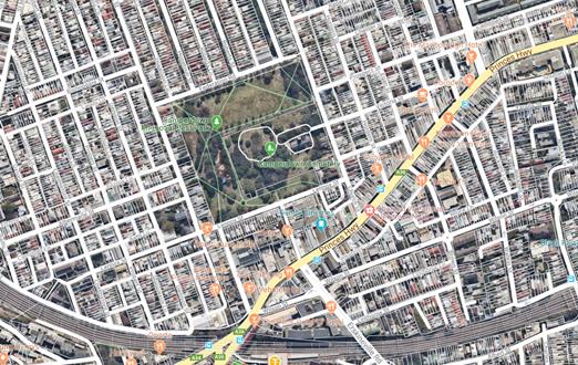
Appropriate advance warning signs will be strategically installed at least two (2) weeks prior to the event. Barricades will be used to affect the closures and a 4-metre wide emergency vehicle access will need to be maintained through the area during the course of the festival. Security personnel trained in traffic management will manage traffic into and around the festival to ensure safety and reduce congestion.
Locality Map – Overview of Temporary Road Closures – Newtown Festival 2019
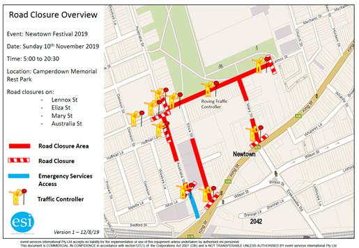
It is noted that the event location is situated near public transport facilities and has operated for numerous years in the past without significant traffic and parking issues, therefore the proposal is considered acceptable.
Section 96 (2) application and Section 68 application
In relation to the Section 96 (2) application, it is noted that the applicant requested the temporary closure of Australia Street, between Lennox Street and Alton Lane, to provide additional pedestrian safety during the event. Federation Road will no longer be temporarily closed during the event and there will be no activities undertaken within this section of the roadway. The event will be held entirely within Camperdown Memorial Park. It is noted that the Section 96 (2) submission states that ‘emergency access will remain open’.
The Section 68 application (S68201900007) now seeks continuation of conditions in holding the annual 'Newtown Festival' for the next 5 years (2019, 2020 2021 2022, 2023). It is noted temporary full road closures are now requested between the hours of 5.00am to 8.30pm whereas previous closures were between the hours of 5.00am to 8.00pm
Parking provision is not mentioned in any of the submitted documents. Closing the four local streets effectively takes away a significant number of on-street parking spaces so any increase demand for parking compounds the inherent lack of parking in the area during event activities. As Federation Road is to be kept open for this year’s Festival, the on-street parking will be available to the public, including the Lennox Street car park.
Site Plan – Newtown Festival 2019
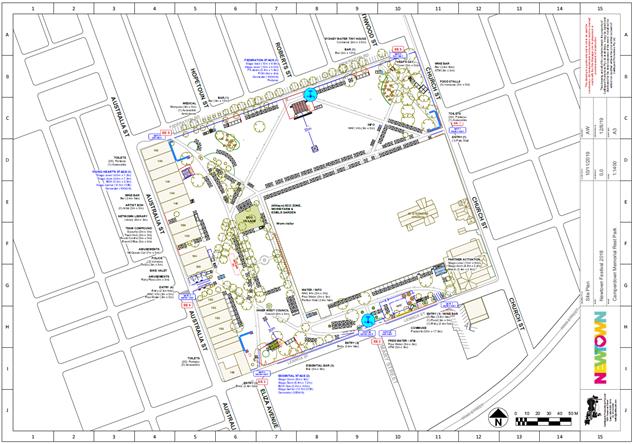
PUBLIC CONSULTATION
The proposed temporary full road closures for the event will be advertised in the local paper allowing for a period of 28 days for public submissions. The advertising period commenced on 20 August 2019 and will conclude 16 September 2019. The applicant will notify according to the recommendations in this report.
CONCLUSION
Comments of the Local Traffic Committee will be referred to Council’s Development Assessment Section for consideration in determining the Section 68 Application.
It is recommended that Council support the temporary road closures for the Category D Class 2 event proposed on Sunday 10 November 2019 subject to the applicant complying with the recommended and standard conditions pertaining to temporary full road closures.
In addition to the recommendations of this report other conditions pertaining to this S68 application may include:
a) The Festival Director, Newtown Neighbourhood Centre be advised in terms of this report and that all costs for the event and implementation of the road closures are to be borne by the applicant;
b) The applicant be advised that an annual application needs to be submitted to Council for the temporary road closures associated with the festival;
c) A minimum four (4) metre unencumbered passage be available for emergency vehicles through the closed sections;
d) "No Stopping - Special Event" signs be affixed over all existing timed parking restriction signs within the sections of streets to be closed on the afternoon of the day prior to the event;
e) Adequate vehicular traffic control shall be provided for the protection and convenience of pedestrians and motorists including appropriate signage and flagging. Workers shall be specially designated for this role (and carry appropriate certificates), as necessary to comply with this condition. This is to be carried out in accordance with the Australian Standard AS 1742.3 - Traffic Control Devices for works on roads.
Standard generic road closure conditions also apply.
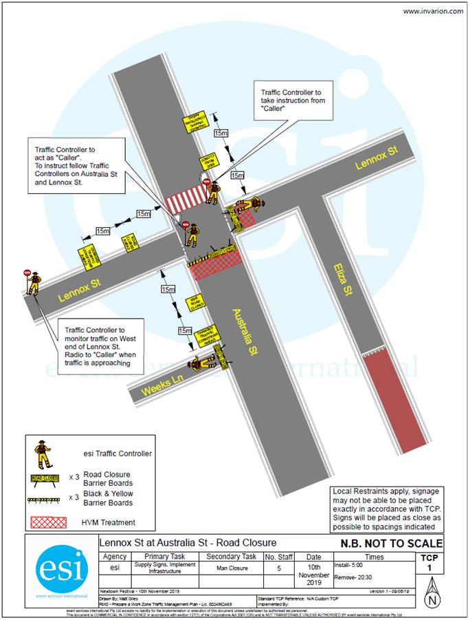
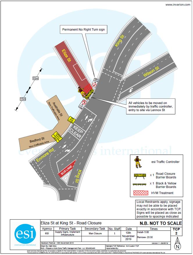
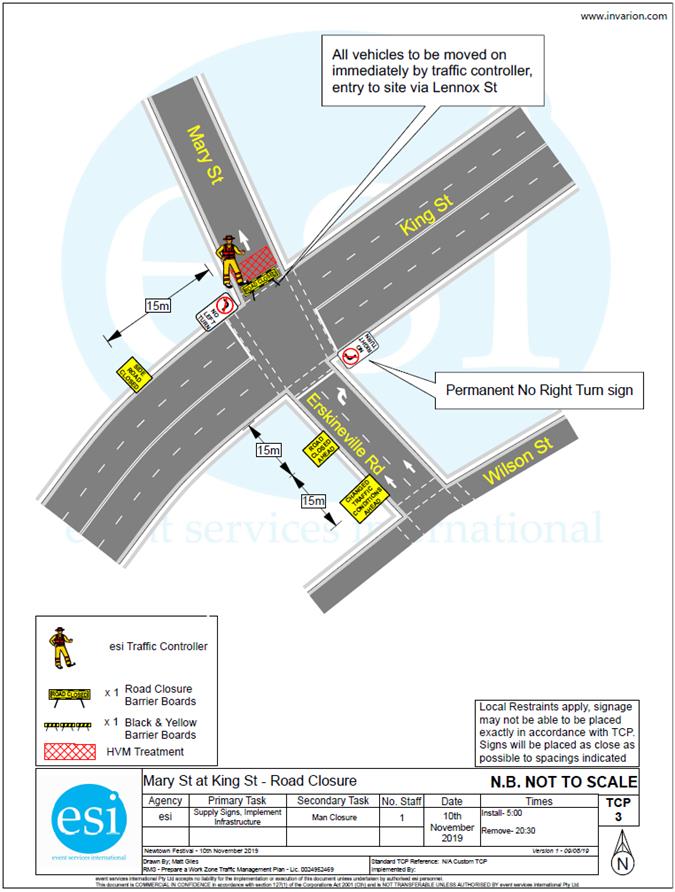
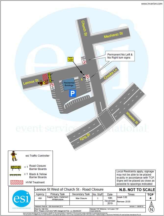
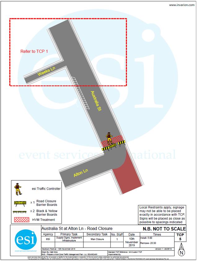
|
1.⇩ |
05 TMP Newtown Festival 2019_V1 |
|
|
Local Traffic Committee Meeting 2 September 2019 |
Subject: Ashfield Street (Lane), Ashfield - Proposed 'No Parking' restrictions (Djarrawunang-Ashfield Ward/Summer Hill Electorate/Inner West PAC)
Prepared By: Mary Bailey - Parking Planner
Authorised By: John Stephens - Traffic and Transport Services Manager
|
SUMMARY Following representation, Council is proposing to implement a section of ‘No Parking’ in the narrow section of Ashfield Street (Lane) to allow for thoroughfare and for access to off street parking. |
|
RECOMMENDATION
THAT a section of ‘No Parking’ 10 metres in length in Ashfield Street (Lane) at the rear of No.20 Alt Street be approved. |
BACKGROUND
|
Street Name and Suburb |
Ashfield Street (Lane), Ashfield |
|
Section |
In the cul de sac section |
|
Carriageway Width (m) |
5.1 metres approx. (in subject section) |
|
Carriageway Type |
Laneway (2 way undivided) |
|
Classification |
local |
|
85th Percentile Speed (km/h) |
Not available |
|
Vehicles Per Day (vpd) |
Not available |
|
Reported Crash History (July 2014 - June 2018) |
Not available |
|
Heavy Vehicle Volume (%) |
Not available |
|
Parking Arrangements |
Unrestricted parking. |
According to Council’s Laneway Guidelines (December 2015) Laneways can be used for a variety of purposes which are listed below:
· Access for garbage collection trucks and deliveries where required
· Access to existing off-street parking within properties
· Access for emergency vehicles, pedestrians and cyclists
· Accessible parking for people with disabilities where appropriate
· Parking where space is available and access is maintained.
The subject section of Ashfield Street (Lane) is approximately 5 metres wide. The Laneway Guidelines state that, “For parking to be allowed in a narrow laneway, the Australian Standards require that parallel parking spaces be at least 2.1 metres wide and NSW Road Rules requires that at least 3 metres must be available between a parked car and the kerb or edge of the laneway to allow moving vehicles to pass safely. Therefore, laneway widths that are less than 5.1 metres are too narrow to allow parking as any parked vehicle would prevent traffic from using the laneway.”
In this case, Council has received concerns that thoroughfare and access to off-street parking is being restricted because of parking in the laneway.
The proposal is illustrated below in Figure 1.
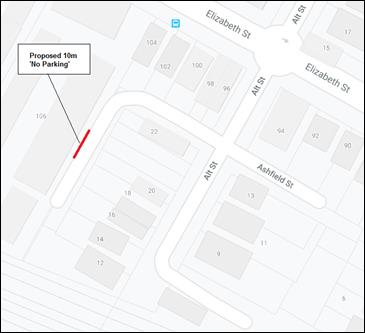
Figure 1: proposal for 10m ‘No Parking’ in Ashfield Street (Lane) Ashfield
The conditions in the laneway are illustrated in the photos below Figure 2 - Figure 6. The photos illustrate the difficulty experienced accessing off street parking by residents.
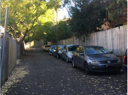
Figure 2: Parking conditions in Ashfield Street (Lane)
Figure 3: Parking conditions in Ashfield Street (Lane)
Figure 4: Parking conditions in Ashfield Street (Lane)
Figure 5: Parking conditions in Ashfield Street (Lane)
Figure 6: Parking conditions in Ashfield Street (Lane)
FINANCIAL IMPLICATIONS
The cost of signage associated with the proposal can be covered by Council’s operational budget for signs and lines.
PUBLIC CONSULTATION
Letters were sent to affected properties as illustrated by the area highlighted pink in Figure 7 below. No responses were received to the consultation letter.
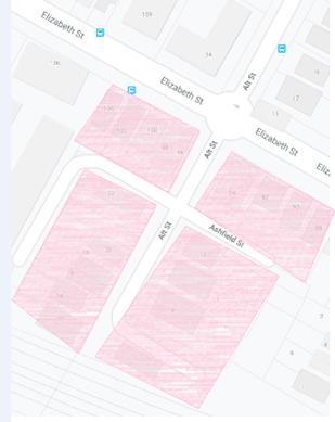
Figure 7: Mailing distribution area for proposal
CONCLUSION
Given the narrowness of the laneway, the difficulty reported by residents accessing off street parking, and the lack of objection; the proposal is supported.
|
|
Local Traffic Committee Meeting 2 September 2019 |
Subject: Petersham Road, Marrickville - Proposed Installation of Statutory 'No Stopping' & 'No Parking' signage between Graham Avenue and Stanley Street (Midjuburi-Marrickville Ward/Summer Hill Electorate/Inner West PAC)
Prepared By: Scipio Tam - Engineer - Traffic and parking Services (South)
Authorised By: John Stephens - Traffic and Transport Services Manager
SUMMARY
Following correspondence from the community regarding vehicles parking on the western side of Petersham Road, between Graham Avenue and Stanley Street, obstructing the thoroughfare, Council is proposing to introduce new signposted parking restrictions.
|
RECOMMENDATION
THAT:
1. A 10m 'No Stopping’ restriction be installed in Petersham Road (Western side), south from its intersection with Graham Avenue; 2. A 10m ‘No Stopping’ restriction be installed in Petersham Road (Western side), north from its intersection with Stanley Street; and 3. A ‘No Parking' restriction be installed in Petersham Road (Western side) between the above proposed 10m ‘No Stopping’ zones, adjacent to No.20 Graham Avenue, Marrickville. |
BACKGROUND
|
Street Name and Suburb |
Petersham Road, Marrickville |
|
Section |
Between Graham Avenue and Stanley Street |
|
Carriageway Width (m) |
7.3m |
|
Carriageway Type |
Two-way lane |
|
Classification |
Local |
|
85th Percentile Speed (km/h) |
50.8 (2013) |
|
Vehicles Per Day (vpd) |
2818 (2013) |
|
Reported Crash History (July 2013 - June 2017) |
3 x RUM10 1 x RUM16 |
|
Heavy Vehicle Volume (%) |
1.9 |
|
Parking Arrangements |
Unrestricted parking. |
FINANCIAL IMPLICATIONS
The cost of the signposting will be funded from Council’s operational budget for signs and line marking.
OTHER STAFF COMMENTS
Currently there are no parking restrictions in the subject section of Petersham Road. The site was inspected on several occasions and on all occasions, vehicles were observed parking on both sides of Petersham Road. An analysis of time-elapse aerial photography illustrates that motorists have self-governed by only parking on the eastern side. Only since the beginning of 2019 did the issues of vehicles parking on both sides of the road arise (see Figure 1).
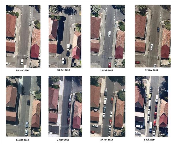
Figure 1: Time-elapse aerial study of Petersham Road, Marrickville
The proposal is illustrated in Figure 2 below.
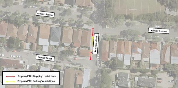
Figure 2: Petersham Road, Marrickville Proposal
PUBLIC CONSULTATION
On 23 July 2019, 16 properties were delivered letters regarding the proposal. At the time of writing, no submissions were received. A consultation map is attached below.
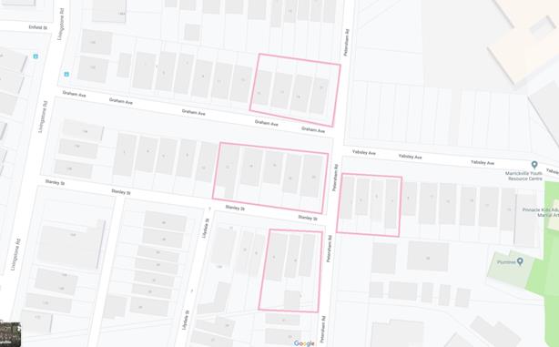
Figure 2: Consultation map
CONCLUSION
The implementation of statutory 10 metre ‘No Stopping’ and ‘No Parking’ restrictions in Petersham Road, Marrickville, between Graham Avenue and Stanley Street will address the concerns raised and will improve traffic thoroughfare along Petersham Road. Therefore, support for this proposal is recommended.
|
|
Local Traffic Committee Meeting 2 September 2019 |
Subject: Beattie Street and Palmer Street, Balmain - Proposed 'Motor Bike Only' and 'No Parking' Restrictions (Baludarri-Balmain Ward/Balmain Electorate/Leichhardt PAC)
Prepared By: David Yu - Engineer - Traffic and Parking Services
Authorised By: John Stephens - Traffic and Transport Services Manager
SUMMARY
Council has received concerns regarding inadequate motorbike parking in the Balmain shopping area in the vicinity of the intersection of Beattie Street and Palmer Street, Balmain.
This report provides the result of the motorbike parking investigation.
|
RECOMMENDATION
THAT:
1. 2.9m of ‘Motor Bike Only’ parking be installed on the eastern side of Palmer Street, north of Watson Lane, Balmain, replacing the existing ticket parking restrictions;
2. 4.8m of ‘Motor Bike Only’ parking be installed on the northern side of Beattie Street, east of the driveway to No. 292-294 Darling Street, replacing the existing unrestricted parking space; and
3. A 4.6m ‘No Parking’ zone be installed on the northern side of Beattie Street, west of Palmer Street, Balmain (across the driveway of No. 292-294 Darling Street).
|
BACKGROUND
Concerns have been raised regarding inadequate motor bike parking in the Balmain shopping area in the vicinity of the intersection of Beattie Street and Palmer Street.
The properties that surround this intersection are mainly small businesses.
It should be noted that parking on both sides of Beattie Street and Palmer Street, Balmain is currently restricted as 2P/4P ticket parking, with a small 4.8m section of unrestricted parking on the side boundary of Nos.292-294 Darling Street.
|
Street Name(s) |
Beattie Street and Palmer Street, Balmain |
|
Section |
Intersection |
|
Traffic Volume |
Not available |
|
Recorded Accident History (5 year) |
Nil. |
|
Recorded 85% speed |
Not available |
|
Speed Limit |
40km/h |
|
Carriageway width |
Beattie Street – 9.3m Palmer Street – 9.4m |
|
Carriageway Type |
Beattie Street - Two way with kerb side parking on both sides of the street Palmer Street - Two way with kerb side parking on both sides of the street |
FINANCIAL IMPLICATIONS
Nil.
OTHER STAFF COMMENTS
Two (2) locations were identified where motorbike parking could be provided without the loss of a standard car space:
1. The eastern side of Palmer Street, north of Watson Lane – this parking area is 8.3m in total, which is insufficient to accommodate two standard vehicles. Therefore, it is proposed to convert 2.9m of redundant kerb space into ‘Motor Bike Only’ parking.
2. The northern side of Beattie Street, west of Palmer Street – the existing 4.8m unrestricted parking space is insufficient to accommodate a standard vehicle. Therefore, it is proposed to convert the redundant kerb space into ‘Motor Bike Only’ parking. It is also proposed to formalise the adjacent 4.6m ‘No Parking’ zone across the driveway of No.292 Darling Street.
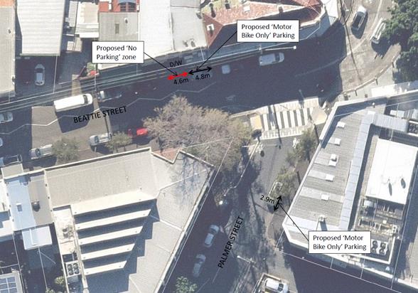
PUBLIC CONSULTATION
A letter outlining this proposal was mailed out to the affected properties (35 properties) in Beattie Street, Palmer Street and Darling Street, Balmain, requesting residents’ and businesses' views regarding the proposal (as indicated on the following plan). No responses were received.
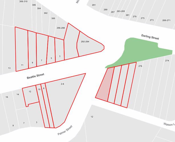
|
|
Local Traffic Committee Meeting 2 September 2019 |
Subject: Upward Street, Leichhardt - Resident Parking Scheme (Gulgadya - Leichhardt Ward/Balmain Electorate/Leichhardt PAC)
Prepared By: Felicia Lau - Engineer - Traffic and Parking Services and David Yu - Engineer - Traffic and Parking Services
Authorised By: John Stephens - Traffic and Transport Services Manager
SUMMARY
Council has received correspondence from a number of residents of Upward Street, Leichhardt requesting Resident Parking Scheme (RPS) restrictions in their street to deter long term parking by commuters.
This report provides the result of the resident parking scheme investigation in Upward Street, Leichhardt.
|
RECOMMENDATION
THAT a '2P 8am-10pm (7 days), Permit Holders Excepted; Area L1’ parking restriction be installed on the western side of Upward Street between Lords Road and No.59 Upward Street, Leichhardt. |
BACKGROUND
A number of residents from Upward Street, Leichhardt have requested the implementation of a resident parking scheme in part of their street between No.59 and Lords Road to deter long term commuter parking, business parking and reduce parking stress caused by recently constructed multi-unit dwellings in George Street.
|
Street Name |
Upward Street |
|
Road Classification |
Local Road |
|
Section |
Between Parramatta Road and Lords Road |
|
Traffic Volume |
407.5 |
|
Recorded Crash History (5-year) |
Nil |
|
Recorded 85% Speed |
31km/h |
|
Carriageway Width |
Approximately 6.7m |
|
Parking Restriction |
Two-way street with kerb side parking permitted on the western side and sign posted ‘No Parking’ on the eastern side. |
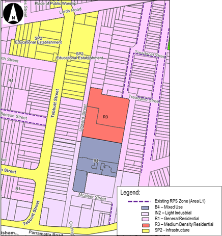
FINANCIAL IMPLICATIONS
Nil.
OTHER STAFF COMMENTS
Parking occupancy surveys were undertaken in Upward Street, Leichhardt and they indicated high parking occupancy levels (above 85%) in the street. Therefore, it warranted further investigation for a resident parking scheme.
There are 11 registered properties in Upward Street between No.59 and Lords Road which would be eligible to participate in a RPS proposal. It is proposed to install a ‘2P 8am-10pm (7 days), Permit Holders Excepted, Area L1’ parking restriction on the western side of Upward Street between Lords Road and No.59 Upward Street (figure enclosed).
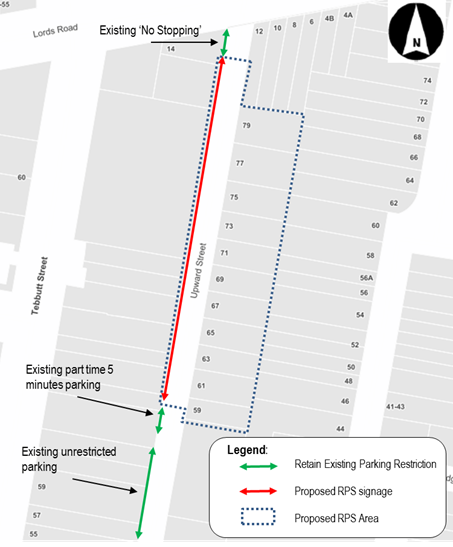
PUBLIC CONSULTATION
An initial proposal for ‘2P 8am-6pm (7 days)’ restrictions on the western side of Upward Street between Lords Road and No.59 Upward Street was originally mailed out to the directly affected properties (11 properties) in Upward Street and properties adjacent to Upward Street (Tebbutt Street, George Street and Lords Road) as shown in the figure below.
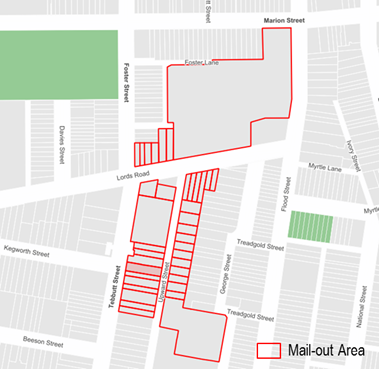
Initial feedback showed support for RPS restrictions; however, there were additional comments requesting an extension to the RPS operational hours. Hence a modified proposal was developed for ‘2P 8am-10pm (7 days)’ restrictions. Consultation results for the modified proposal are shown below.
Consultation survey results are summarised as follows:
Upward Street, Leichhardt
Number of properties - 11
Number of properties responded - 6
Number of properties supported - 6
Overall Response Rate - 55%
Overall Support Rate - 55%
According to Council’s Resident Parking Policy, a minimum of 50% support based on all properties in the subject section of the street is required to consider the proposal favourably.
Based on the above results and the comments provided as part of the consultation process, 50% of the residents of Upward Street, Leichhardt support a resident parking scheme in their street.
Three objections from properties outside the RPS area were also received. The table below summarises these comments raised by both the residents who support and those who did not support the proposal, and the corresponding officer’s comments.
Comments from residents objecting to the proposal
|
Residents’ Comments |
Officer Comments |
|
Residents not supporting |
|
|
Parking in Upward Street was available when I moved to this address. I have a small car, and was somewhat relieved that there was parking in this street. I am not entitled to a parking permit. I have a seriously ill adult daughter, who lives in Camperdown, and it is handy to be able to park nearby, so that I can reach her at short notice. |
The proposal has been developed in accordance with Council’s RPS Policy to deter long term commuter parking, business parking and reduce parking stress caused by recently constructed multi-unit dwellings in George Street.
Dual occupancies, multi-unit dwellings and the strata subdivision of residential flat buildings approved after January 2001 are not allowed to participate in a RPS as off-street parking should be provided in accordance with Council’s parking DCP.
Any existing unrestricted parking will be maintained adjacent to the multi-unit developments.
|
|
The extended times and inclusion of weekends seems excessive. This will cause further problems on other nearby streets for those looking for parking after work. Visitors on weekends will also be disadvantaged, not only for residents but also for local businesses. Furthermore, when I purchased my apartment, 1 bedroom with no parking, Upward Street availability was a part of our purchase decision. Changing this so drastically will reduce the selling price in the future especially as it sees we are unable to get a permit. |
|
|
Residents supporting |
|
|
As the scheme has indicated the number of parking permits eligible per household with no off-street parking. Will be eligible for two parking permits. However some of the residents in the proposed RPS area do not have cars and will not be requiring a parking permit. Therefore, would it be possible to acquire a third permit due to our daughter working nights and finishing her shift at 3am in the morning and having to find parking. |
The Council Resident Parking Policy and parking permit eligibility criteria has been developed with careful consideration of various factors. Council also applies the RMS Permit Parking Guidelines. This allows for the permits to be fairly distributed to the residents, while considering the limited supply of on-street car parking spaces available.
Resident Parking permits are issued to eligible households based on the type of RPS proposed and off-street parking space available on-site. The maximum number of permits issued to a household is two (when there are no off-street parking spaces and the residence has 2 or more vehicles).
Visitor permits will not be issued as part of this scheme as there is a limited number of parking spaces that are proposed to be restricted (only one side of the street) with 2P parking restrictions. The provision of additional (visitor) permits would result in an oversupply of permits compared to the restricted RPS kerbside supply. |
|
I believe it is reasonable to provide visitor parking permits to eligible residents. |
|
|
|
Local Traffic Committee Meeting 2 September 2019 |
Subject: Carlisle Street, Leichhardt - Temporary Road Closure for Royal Hotel Inner West Beer festival
Prepared By: Vinoth Srinivasan - Engineer - Traffic and Parking Services
Authorised By: John Stephens - Traffic and Transport Services Manager
SUMMARY
Council has received an application from the licensee of the Royal Hotel in Leichhardt for approval of a temporary full road closure in Carlisle Street between Norton Street and the Unnamed Laneway adjacent to No.2 Carlisle Street to be held on Saturday, 16 and Sunday, 17 November 2019 between the hours of 12pm-8pm and 12pm-6pm respectively.
The road closure has been requested to facilitate the Royal Hotel Inner West Beer festival.
|
RECOMMENDATION
THAT the temporary road closure of Carlisle Street, Leichhardt between Norton Street and the Unnamed Laneway adjacent to No.2 Carlisle Street to be held on Saturday, 16 and Sunday, 17 November 2019 between the hours of 12pm-8pm and 12pm-6pm respectively be supported, subject to the following conditions:
a. That an unencumbered passaged minimum of 4.0m wide be available for emergency vehicles through the closed section of Carlisle Street, Leichhardt; b. The occupation of the road carriageway must not occur until the road has been physically closed; c. All affected residents and businesses, including the NSW Police Local Area Commander, Fire & Rescue NSW and NSW Ambulance Services be notified in writing, by the applicant, of the proposed temporary road closure at least 2 weeks in advance of the closure with the applicant making reasonable provision for stakeholders.
|
BACKGROUND
A request for approval to conduct the annual Royal Hotel Inner West Beer festival on Saturday, 16 and Sunday 17 November 2019 between the hours of 12pm-8pm and 12pm-6pm respectively has been received from the organiser of the event, the Licensee of The Royal Hotel.
This event involves the temporary closure of Carlisle Street between Norton Street and the Unnamed Laneway adjacent to No.2 Carlisle Street.
In accordance with the RMS “Guide to Traffic and Transport Management for Special Events V3.4 August, 2006”, and based on information supplied by the organiser, the event is classified as a Special Event Class 2.
A Traffic Control Plan and Traffic Management Plan are attached in Attachment 1.
Detour Routes
All traffic is expected to detour via Cromwell Street and Marlborough Street as shown on the attached TCPs.
Site location & Road network
|
Street Name(s) |
Carlisle Street, Leichhardt |
|
Section |
Between Norton Street and Unnamed Laneway |
|
Traffic Volume |
- |
|
Recorded Accident History (5 year) |
Nil. |
|
Recorded 85% speed |
- |
|
Speed Limit |
50km/h |
|
Carriageway width |
Approx. 12.4m |
|
Carriageway Type |
Two way street with one travel lane in each direction and kerb side parking lanes. |
|
Road Classification (State, Regional, Local) |
Local |
FINANCIAL IMPLICATIONS
Nil, the supported Traffic Control Plan (TCP) be implemented at the applicant’s expense.
OTHER STAFF COMMENTS
Nil.
PUBLIC CONSULTATION
All affected businesses, residents and other occupants will be notified of the road closure, activities, parking changes and changes to public transport arrangements. The notification will be distributed at least two weeks prior to the commencement of the event. The proposed information, distribution area and distribution period will be reviewed and approved by Inner West Council’s Traffic Section one week prior to distribution.
The proposed temporary full-road closure is currently being advertised in the local newspaper for a period of 28 days from 13 August 2019 to 10 September 2019. No comments have yet been received.
|
1.⇩ |
Beer Festival 2019 - TMP |
|
2.⇩ |
Beer Festival 2019 - TCP |
|
Local Traffic Committee Meeting 2 September 2019 |
Subject: Wharf Road, Lilyfield - Temporary Road Closure for Balmain Fun Run 2019
Prepared By: Vinoth Srinivasan - Engineer - Traffic and Parking Services
Authorised By: John Stephens - Traffic and Transport Services Manager
SUMMARY
Council has received an application for approval of a temporary road closure in Wharf Road, Lilyfield north of Balmain Road on Sunday, 10 November 2019 between 6:30am and 10:30am.
The road closure has been requested to facilitate the Balmain Fun Run through Callan Park.
|
RECOMMENDATION
THAT the temporary road closure of Wharf Road, Lilyfield north of Balmain Road on Sunday, 10 November 2019 between 6.30am – 10.30am be supported, subject to the following conditions:
a. That an unencumbered passage minimum 4.0m wide be available for emergency vehicles through the closed section of Wharf Road, Lilyfield. b. The occupation of the road carriageway must not occur until the road has been physically closed; and c. All affected residents and businesses, including the NSW Police Local Area Commander, Fire & Rescue NSW and NSW Ambulance Services be notified in writing, by the applicant, of the proposed temporary road closure at least 2 weeks in advance of the closure with the applicant making reasonable provision for stakeholders.
|
BACKGROUND
A request for approval to conduct a temporary road closure for the Balmain Fun Run on Sunday, 10 November 2019 between 6:30am and 10:30am has been received from the organiser of the event, Balmain Public School P&C and Mildren Events.
Site Location & Road Network
|
Street Name(s) |
Wharf Road, Lilyfield |
|
Section |
Between Garden Way and Balmain Road |
|
Traffic Volume |
- |
|
Recorded Accident History (5 year) |
Nil. |
|
Recorded 85% speed |
- |
|
Speed Limit |
50km/h |
|
Carriageway width |
Approx. 6.6m |
|
Carriageway Type |
Two way street with ‘No Parking’ on either side of the Road |
|
Road Classification (State, Regional, Local) |
Local |
FINANCIAL IMPLICATIONS
The supported Traffic Control Plan (TCP) will be implemented at the applicant’s expense.
OTHER STAFF COMMENTS
This annual event involves the temporary closure of Wharf Road, north of Balmain Road. It should be noted that only the first 170m of Wharf Road, north of Balmain Road is public road. After this point Wharf Road forms part of Callan Park (under the jurisdiction of the Office of Environment and Heritage).
Balmain Fun Run attracted approximately 1,550 entrants in 2018. The runners start off at King George Oval and runs through Waterfront Drive, through North Crescent, through areas within the Sydney College of Arts, South Crescent, Garden Way, Cottage Way, Supply Road, Military Drive, Wharf Road, Broughton Circuit, past Callan Park through Waterfront Drive and back to King George Oval.
In accordance with the RMS “Guide to Traffic and Transport Management for Special Events”, and based on information supplied by the organiser, the event is classified as a Special Event Class 3.
A Traffic Control Plan and Traffic Management Plan are attached.
PUBLIC CONSULTATION
All affected businesses, residents and other occupants will be notified of the road closure. The notification will be distributed at least two weeks prior to the commencement of the event. The proposed information, distribution area and distribution period will be reviewed and approved by Inner West Council’s Traffic Section two weeks prior to distribution.
The proposed temporary full road closure has been advertised in the local newspaper for a period of 28 days from 13 August 2019 to 10 September 2019. No comments have been received to date.
|
1.⇩ |
Balmain Fun Run 2019 - TMP |
|
2.⇩ |
Balmain Fun Run 2019 - TCP |
|
|
Local Traffic Committee Meeting 2 September 2019 |
Subject: Norton Street Italian Festa 2019 - Temporary Road Closures (Gulgadya-Leichhardt Ward/Balmain Electorate/Leichhardt PAC)
Prepared By: Vinoth Srinivasan - Engineer - Traffic and Parking Services
Authorised By: John Stephens - Traffic and Transport Services Manager
SUMMARY
The proposed event, the Norton Street Italian Festa, is a street festival held annually celebrating the traditional Italian culture that is considered an essential part of the Leichhardt community.
To facilitate the event, it is proposed to close the following roads in the area between 3.00am and 8.00pm on Sunday, 27 October 2019:
· Norton Street from Marion Street to William Street;
· Marlborough Street from Norton Street to Cromwell Street;
· Short Street from Norton Street to Balmain Road;
· Carlisle Street from Norton Street to Cromwell Street;
· Allen Street from Cromwell Street to Derbyshire Road;
· Arthur Street from Allen Street to Short Street.
|
RECOMMENDATION
THAT:
1. The road closure application for the ‘Norton Street Italian Festa 2019’ on Sunday, 27 October 2019 be supported subject to the following conditions: a) The road closures be restricted to occur between 3:00am and 8:00pm on Sunday, 27 October 2019 at the following locations: i. Norton Street from Marion Street to William Street; ii. Marlborough Street from Norton Street to Cromwell Street; iii. Short Street from Norton Street to Balmain Road; iv. Carlisle Street from Norton Street to Cromwell Street; v. Allen Street from Cromwell Street to Derbyshire Road; and vi. Arthur Street from Allen Street to Short Street. b) Approval from RMS for the TMP and TCP and to install a ‘Special Event Clearway’ restriction in Norton Street be obtained prior to the event; c) Wetherill Street (Norton Street – Balmain Road) and Macauley Street (Cromwell Street – Norton Street) function as two way roads when Norton Street is closed to provide access for residents etc; d) Parking for the event be reserved in: · Short Street on both sides between Norton Street and the unnamed lane for Emergency Service vehicles; · William Street on the southern side between Norton Street and Derbyshire Road (Pioneers Memorial Park side). The angle parking in this area will be temporarily amended to allow parallel parking for Police horse floats etc; e) A three (3) metre unencumbered passage be available for emergency vehicles through the closed section of Norton Street at all times; f) Approval to conduct a public assembly be obtained from the NSW Police prior to the event. A copy of the NSW Police approval must be forwarded to Council’s Traffic Section prior to the event. g) The applicant be requested to provide free bicycle valet parking at a central location (i.e. Short Street or Allen Street) including adequate ‘way finding’ signage to the public and include the availability of this service in promoting the event; h) Additional signs indicating ‘Bicycles Expected’ and ‘cyclists dismount’ be included with the road closure signs provided at the road closure points; i) The occupation of the road carriageway must not occur until the road has been formally closed; j) That the set up and break down times occur at 3:30am and 7:00pm respectively and include additional waste staff at the break down to expedite the road openings; k) The entrance to the access way into Pioneers Memorial Park in Allen Street opposite Arthur Street be temporarily closed by barricades for security purposes during the event; l) All advertising of the event must encourage the use of Public Transport; m) All affected residents and businesses, including the NSW Police Local Area Commander, Fire & Rescue NSW, NSW Ambulance Services and the Leichhardt Bus Depot be notified in writing, by the applicant, of the proposed temporary road closure at least 2 weeks in advance of the closure with the applicant making reasonable provision for stakeholders. 2. The following measures be provided to accommodate buses: i. Install temporary ‘Bus Zones’ to accommodate two buses on both sides of William Street between Norton Street and James Street; ii. Place barricades within 10m at the south-eastern corner of the Flood Street/William Street intersection to assist buses; and iii. No trucks (Festa) to be parked in the Marion Street ‘Bus Zone’ at the Norton Street intersection, outside the Town Hall.
|
BACKGROUND
A request for approval to conduct the Norton Street Italian Festa 2019 on Sunday, 27 October 2019 between 10:00am and 5:00pm has been received from the organiser of the event, Impact Exhibitions.
This annual event involves the temporary closure of Norton Street between Marion Street and William Street, including associated side streets.
In accordance with the RMS “Guide to Traffic and Transport Management for Special Events V3.4 August 2006”, and based on information supplied by the organiser, the event is classified as a Special Event Class 2.
The organiser has submitted the Traffic Management Plan (TMP) and Traffic Control Plan (TCP) to RMS for approval (Attachment 1 and 2).
Site Location & Road Network
|
Street Name(s) |
Norton Street, Leichhardt |
|
Section |
Between Marion Street and William Street |
|
Traffic Volume |
- |
|
Recorded Accident History (5 year) |
Nil. |
|
Recorded 85% speed |
- |
|
Speed Limit |
40km/h |
|
Carriageway width |
Approx. 12.4m |
|
Carriageway Type |
Two way street with one travel lane in each direction and kerb side parking lanes. |
|
Road Classification (State, Regional, Local) |
Local |
Road Closures
To facilitate the event, it is proposed to close the following roads between
3:00am and 8:00pm on Sunday, 27 October 2019:
· Norton Street from Marion Street to William Street;
· Marlborough Street from Norton Street to Cromwell Street;
· Short Street from Norton Street to Balmain Road;
· Carlisle Street from Norton Street to Cromwell Street;
· Allen Street from Cromwell Street to Derbyshire Road;
· Arthur Street from Allen Street to Short Street.
Other Arrangements
Macaulay Street from Norton Street to Cromwell Street and Wetherill Street from Norton Street to Balmain Road are to function as temporary two way roads to provide access for residents.
Public Transport
For the duration of the road closures, bus services will be diverted down Flood Street and Balmain Road, similar to previous years. As previously requested by the STA/Transit Systems representative, barricades will need to be placed around the south-eastern corner of the Flood Street/William Street intersection to prevent vehicles parking in the 10m ‘No Stopping’ zones. This arrangement will facilitate the buses diverted via Flood Street.
In accordance with Council’s policy on bicycle users, the applicant has been advised to provide free bicycle valet parking to the public at the venue and include the availability of this service in promoting this event.
FINANCIAL IMPLICATIONS
Nil.
OTHER STAFF COMMENTS
Nil.
PUBLIC CONSULTATION
As in previous years, all affected businesses, residents and other occupants will be notified of the road closures, activities, parking changes and changes to public transport arrangements. The notification will be distributed at least two weeks prior to the commencement of the event. The proposed information, distribution area and distribution period will be reviewed and approved by Inner West Council’s Traffic Section one week prior to distribution.
The proposed temporary full road closures are currently advertised in the newspaper for a period of 28 days. The advertising period commenced on 13 August 2019 and will conclude on 10 September 2019. No comments have been received to date.
|
1.⇩ |
Norton Street Italian Festa 2019 - TMP |
|
2.⇩ |
Norton Street Italian Festa 2019 - TCP |
|
|
Local Traffic Committee Meeting 2 September 2019 |
Subject: 63-65 Pyrmont Bridge Road, Annandale - Additional Information for Modification of Development Consent (Gulgadya-Leichhardt Ward/ Balmain Electorate/ Leichhardt PAC)
Prepared By: Felicia Lau - Engineer - Traffic and Parking Services
Authorised By: John Stephens - Traffic and Transport Services Manager
SUMMARY
Additional information has been submitted as part of the Modification of Development Consent Application (DA/2017/637) to provide vehicular access to the development at No.63-65 Pyrmont Bridge Road, Annandale via Mallett Street. The development application is for an alteration to the existing building for use as a fitness centre (relocation of the Camperdown Fitness Facility at No. 166-172 Parramatta Road) which was presented to the Local Traffic Committee in November 2018.
Comments of the Local Traffic Committee will be referred to Council’s Development Assessment Section for consideration in determining the Modification of Development Consent Application.
|
RECOMMENDATION
THAT the report be received and noted. |
BACKGROUND
The Local Traffic Committee at its meeting held in November 2018 considered a report regarding the modification of development consent application (DA/2017/637) to provide vehicular access to the development at No.63-65 Pyrmont Bridge Road, Annandale via Mallett Street, Council subsequently did not support the modification for the following reasons:
· Mallet Street is a Regional Road that consists of high heavy vehicles utilisation. The addition of central median will result in narrowing the existing northbound lanes and may increase the safety risk in the area e.g. side swipe of parked vehicles and dooring, and heavy vehicle manoeuvring.
· The narrowing of carriageway and extension of existing “No Stopping” zone may result in loss of on-street parking on Mallet Street.
· Existing turning movements from Mason Street and to/from No.4 Mallet Street’s driveway will be restricted with the installation of a central median (Mason Street is also under City of Sydney’s jurisdiction). This would impact vehicle movements on the road network of an adjacent Council would require feedback from the Council and a traffic management plan to RMS to support the change in road network
· The access via Mallett Street may also result in northbound queuing that subsequently may reduce the intersection performance at Mallett Street and Pyrmont Bridge Road signalised intersection.
· The Left-in only movements may result in additional vehicle circulation through the local road network as opposed to access via Bignell Lane.
· The development can provide a viable alternative access arrangement on Bignell Lane which will result in minimal impact on the existing road network and neighbouring Council (as approved on 20 July 2018).
· The proposed access arrangement does not provide any positive benefit compared to the approved design.
In a further discussion, Council has advised that ingress via Mallet Street and egress via Bignell Lane may be considered subject to the applicant demonstrating the following:
· Completed design for the construction of central median in Mallet Street.
· RMS approval.
· No loss of on-street parking in Mallet Street.
· Written consent from City of Sydney that there is no objection to restricting turning movements from Mason Street to Mallet Street due to the proposed median; and
· Written consent from the owner of No.4 Mallet Street that there is no objection to restricting turning movements from the property to Mallet Street due to the proposed median.
Subsequently, the applicant has recently submitted a concept design of the proposed central median in Mallet Street on 14 August 2019 as shown below.
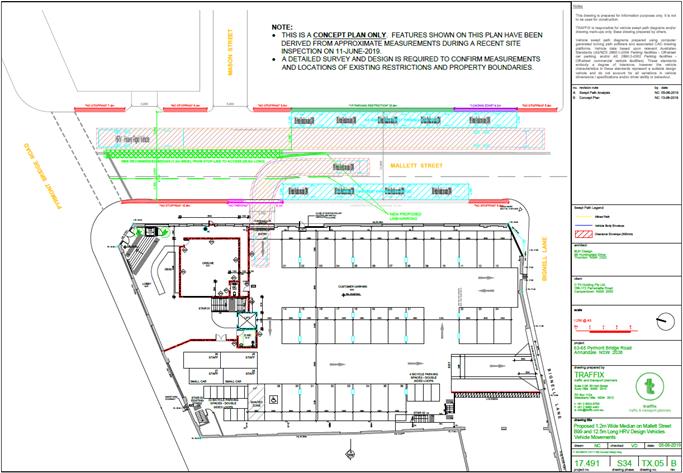
FINANCIAL IMPLICATIONS
Nil.
OTHER STAFF COMMENTS
The submitted proposed central median concept design plan for the modification application for the proposal at No. 63-65 Pyrmont Bridge Road, Annandale has been reviewed and the following concerns are raised:
· It is noted that measurements provided in the concept plans are approximate measurements where a detailed survey plan has not been provided.
· Heavy vehicle swept path was shown for Mallet Street southbound but did not demonstrate the heavy vehicle manoeuvring for Mallet Street northbound. As Mallet Street is a Regional Road that consists of high heavy vehicles utilisation. The addition of central median may result in narrowing the existing northbound lanes and may increase the safety risk in the area e.g. side swipe of parked vehicles and dooring, and heavy vehicle manoeuvring.
· The proposed central median ends in front of the car park driveway, this may lead to drivers attempting a u-turn at the end of the median to access the car park entrance. The proposed central median would need to be extended to discourage a u-turn at this point.
· The restricted left-in only movement may result in additional vehicle circulation through the local road network or increase u-turn manoeuvre at Bignell Lane intersection as opposed to unrestricted access via Bignell Lane.
· A written consent from the owner of No.4 Mallet Street and City of Sydney should be sought as turning movement from the property and Mason Street will be restricted with the proposal.
· The development can provide a viable alternative access arrangement on Bignell Lane which will result in minimal impact on the existing road network and neighbouring Council (as approved on 20 July 2018) which is consistent with Leichhardt DCP Part C (Place) Section C1.11 (C10) which states “vehicular access onto a State or Regional Road is prohibited when access can be provided from an alternative roadway”.
PUBLIC CONSULTATION
Nil.
CONCLUSION
It is proposed that the traffic and parking related comments provided in this report be forwarded to Council’s Development Assessment section.
|
1.⇩ |
Proposed Central Median Concept Design |