|
AGENDA R |

Local Traffic Committee Meeting
TUESDAY 8 OCTOBER 2019
10.00am
|
|
Local Traffic Committee Meeting 8 October 2019 |
Function of the Local Traffic Committee
Background
Roads and Maritime Services (RMS) is legislated as the Authority responsible for the control of traffic on all NSW Roads. The RMS has delegated certain aspects of the control of traffic on local roads to councils. To exercise this delegation, councils must establish a local traffic committee and obtain the advice of the RMS and Police. The Inner West Council Local Traffic Committee has been constituted by Council as a result of the delegation granted by the RMS pursuant to Section 50 of the Transport Administration Act 1988.
Role of the Committee
The Local Traffic Committee is primarily a technical review and advisory committee which considers the technical merits of proposals and ensures that current technical guidelines are considered. It provides recommendations to Council on traffic and parking control matters and on the provision of traffic control facilities and prescribed traffic control devices for which Council has delegated authority. These matters are dealt with under Part A of the agenda and require Council to consider exercising its delegation.
In addition to its formal role as the Local Traffic Committee, the Committee may also be requested to provide informal traffic engineering advice on traffic matters not requiring Council to exercise its delegated function at that point in time, for example, advice to Council’s Development Assessment Section on traffic generating developments. These matters are dealt with under Part C of the agenda and are for information or advice only and do not require Council to exercise its delegation.
Committee Delegations
The Local Traffic Committee has no decision-making powers. The Council must refer all traffic related matters to the Local Traffic Committee prior to exercising its delegated functions. Matters related to State Roads or functions that have not been delegated to Council must be referred directly to the RMS or relevant organisation.
The Committee provides recommendations to Council. Should Council wish to act contrary to the advice of the Committee or if that advice is not supported unanimously by the Committee members, then the Police or RMS have an opportunity to appeal to the Regional Traffic Committee.
Committee Membership & Voting
Formal voting membership comprises the following:
· one representative of Council as nominated by Council;
· one representative of the NSW Police from each Local Area Command (LAC) within the LGA, being Newtown, Marrickville, Leichhardt and Ashfield LAC’s.
· one representative from the RMS; and
· State Members of Parliament (MP) for the electorates of Summer Hill, Newtown, Heffron, Canterbury, Strathfield and Balmain or their nominees.
Where the Council area is represented by more than one MP or covered by more than one Police LAC, representatives are only permitted to vote on matters which effect their electorate or LAC.
Informal (non-voting) advisors from within Council or external authorities may also attend Committee meetings to provide expert advice.
Committee Chair
Council’s representative will chair the meetings.
Public Participation
Members of the public or other stakeholders may address the Committee on agenda items to be considered by the Committee. The format and number of presentations is at the discretion of the Chairperson and is generally limited to 3 minutes per speaker. Committee debate on agenda items is not open to the public.
|
|
Local Traffic Committee Meeting 8 October 2019 |
|
AGENDA |
1 Apologies
2 Disclosures of Interest
3 Confirmation of Minutes
Minutes of 2 September 2019 Local Traffic Committee Meeting 6
4 Matters Arising from Council’s Resolution of Minutes
5 Part A – Items Where Council May Exercise Its Delegated Functions
Traffic Matters
ITEM PAGE #
LTC1019 Item 1 Minor Traffic Facilities (All Wards/All Electorates/All PACS) 28
LTC1019 Item 2 Wells Street, Annandale - Christmas Street Party (Road Occupancy)(Gulgadya-Leichhardt Ward/ Balmain Electorate/ Leichhardt PAC) 35
LTC1019 Item 3 Burrows Avenue, Sydenham – Temporary Full Road Closures - Sydney Metro Sydenham Station and Junction (SSJ) Works – Amendment to approved road closure dates (Midjuburi-Marrickville Ward / Heffron Electorate / Inner West PAC) 37
LTC1019 Item 4 Evans Street and Roseberry Street, Balmain - Proposed Kerb Blister Islands and Garden Beds (Baludarri-Balmain Ward/Balmain Electorate/Leichhardt PAC) 44
LTC1019 Item 5 Garnet Street, Dulwich Hill – Temporary Full Road Closure of Rail Overbridge south of Hampden Street/The Parade and north of Floss Street/Ewart Street - Sydney Metro (SSJ) early enabling works on T3 Line (Djarrawunang-Ashfield Ward / Summer Hill Electorate / Inner West PAC) 50
LTC1019 Item 6 Queen
Street at Arthur Street & Norton Street, Croydon - Proposed Traffic Calming
at the intersections including Kerb Blisters (Design Plans 10095 & 10096)
(Djarrawunang - Ashfield Ward/ Summer Hill Electorate/ Burwood PAC) 55
LTC1019 Item 7 Heighway Avenue, Ashfield - Temporary Road Closure For Christmas Street Party - Djarrawunang-Ashfield Ward/Summer Hill Electorate/Burwood PAC 64
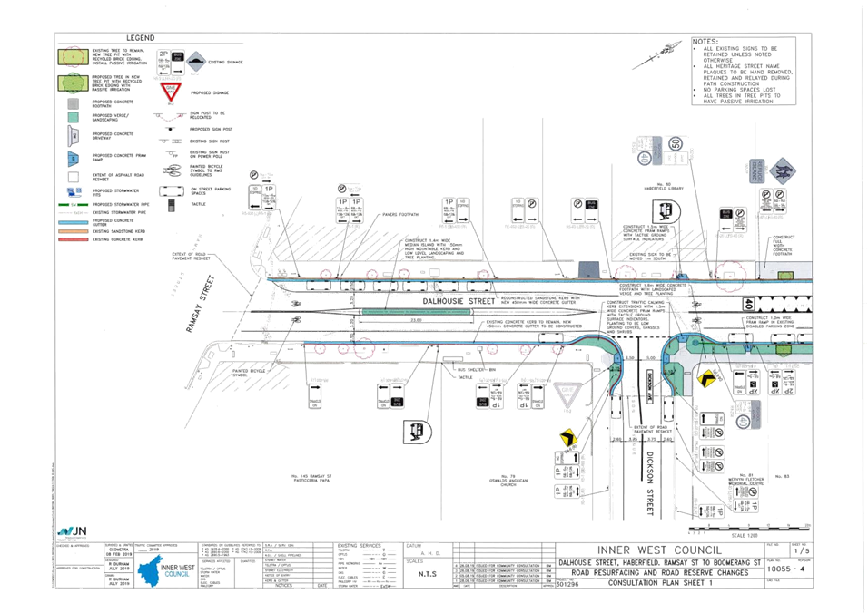
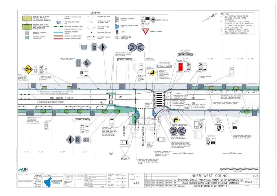
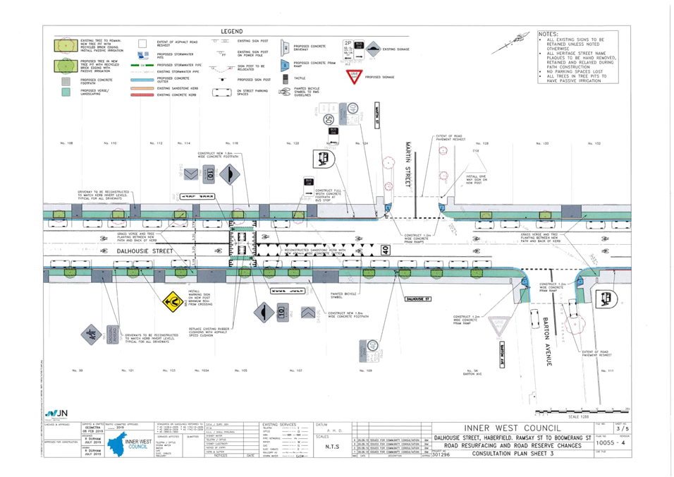
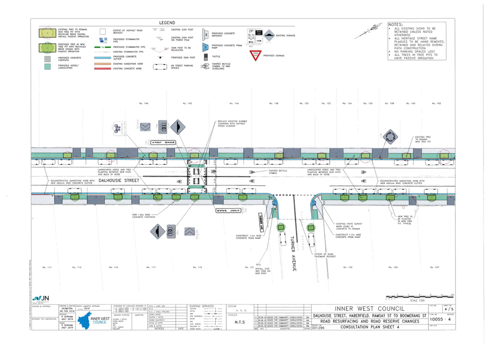
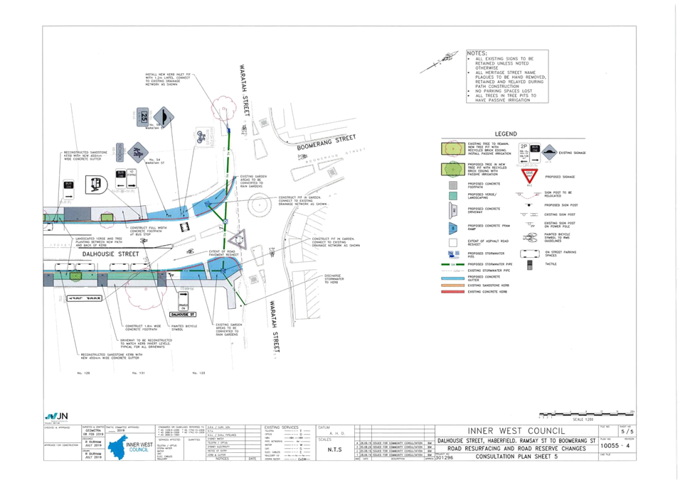
LTC1019 Item 8 Dalhousie Street, (Ramsay Street - Waratah Street), Haberfield – Local Road Project (Gulgadya - Leichhardt Ward / Summer Hill Electorate / Burwood PAC) 70
LTC1019 Item 9 Red Lion Street, Rozelle - Annual Road Occupancy (Street Party) (Baludarri - Balmain Ward/ Balmain Electorate/ Leichhardt PAC) 79
LTC1019 Item 10 George Street at Treadgold Street South, Leichhardt - Proposed 'Give-Way' control (Gulgadya - Leichhardt Ward / Balmain Electorate / Leichhardt PAC) 83
Parking Matters
ITEM PAGE #
LTC1019 Item 11 Draft Croydon Parking Study (Gulgadya-Leichhardt Ward/Summer Hill Electorate/Burwood PAC) 86
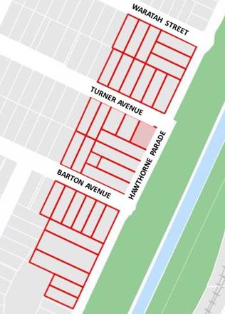
LTC1019 Item 12 Hawthorne Parade, Haberfield - Proposed '2 hour' Parking Zone (Gulgadya - Leichhardt Ward/ Balmain Electorate/ Leichhardt PAC) 130
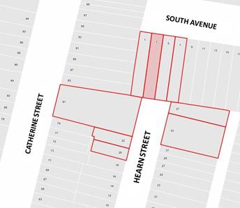
LTC1019 Item 13 Hearn Street, Leichhardt - Proposed 'No Parking' restriction (Gulgadya - Leichhardt Ward/ Balmain Electorate/ Leichhardt PAC) 134
LTC1019 Item 14 Smith
Street, Marrickville - Proposed Extension of Permit Parking Area M19
(Midjuburi- Marrickville Ward/ Summer Hill Electorate/ Inner West PAC) 136
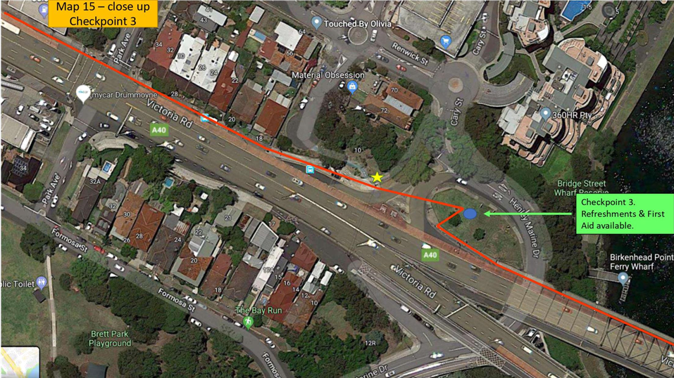
LTC1019 Item 15 Victoria
Road, Marrickville - Proposed 1P Restrictions
(Midjuburi- Marrickville Ward/ Summer Hill Electorate/ Inner West PAC) 143
LTC1019 Item 16 Wooley Lane, Marrickville – Proposed 6 metre Extension to Existing ‘NO PARKING’ Restriction (Midjuburi - Marrickville Ward / Newtown Electorate / Inner West PAC) 148
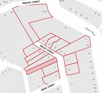
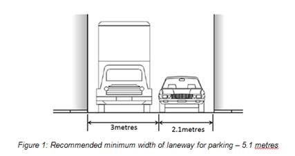
LTC1019 Item 17 Valley Street, Balmain - Proposed Marked Car Parking Bays (Baludarri - Balmain Ward/ Balmain Electorate/ Leichhardt PAC) 152
LTC1019 Item 18 Chester Street at Gehrig Lane, Annandale - Proposed 'No Stopping' zone extension (Gulgadya - Leichhardt Ward/ Balmain Electorate/ Leichhardt PAC) 154
LTC1019 Item 19 White Street, Lilyfield - Part Time 'No Parking' Restriction (Baludarri - Balmain Ward/ Balmain Electorate/ Leichhardt PAC) 156
LTC1019 Item 20 Westbourne Lane, Stanmore – Request for ‘No Parking’ Restrictions (Damun-Stanmore Ward/Newtown Electorate/Inner West PAC) 159
Late Items
Nil at time of printing.
6 Part B - Items for Information Only
ITEM PAGE #
LTC1019 Item 21 Burrows Avenue and Hogan Avenue, Sydenham – Sydney Metro SSJ Works – Temporary traffic control arrangements – Pedestrian safety issues (Midjuburi - Marrickville Ward / Heffron Electorate / Inner West PAC) 164
7 Part C - Items for General Advice
ITEM PAGE #
LTC1019 Item 22 Review into Simplification of Parking Signs (All Wards / All Electorates / All LACs) 168
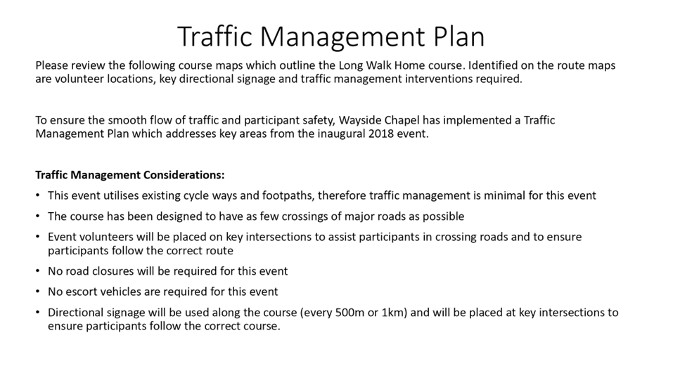
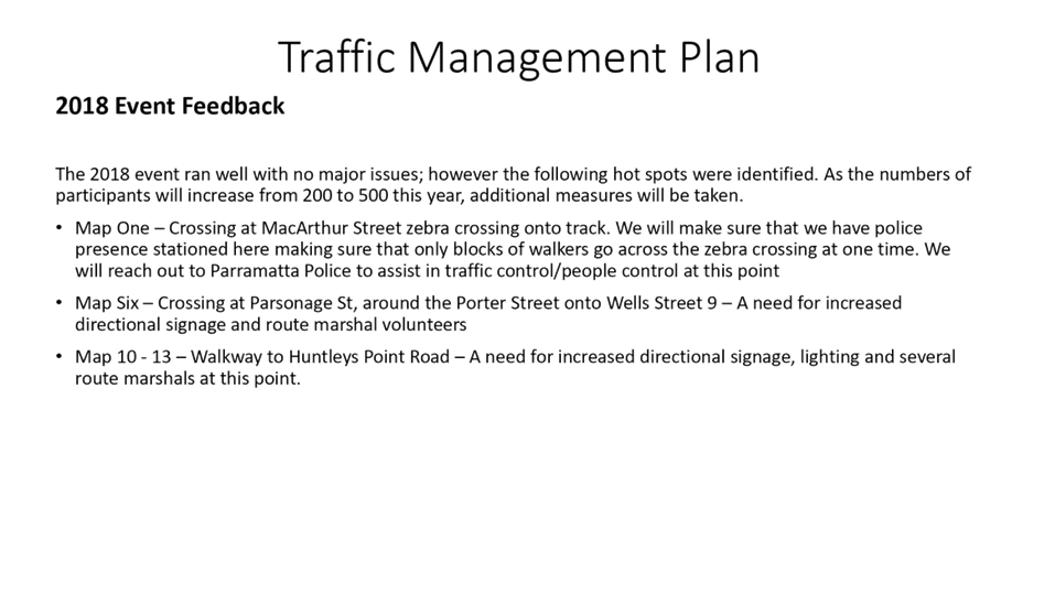
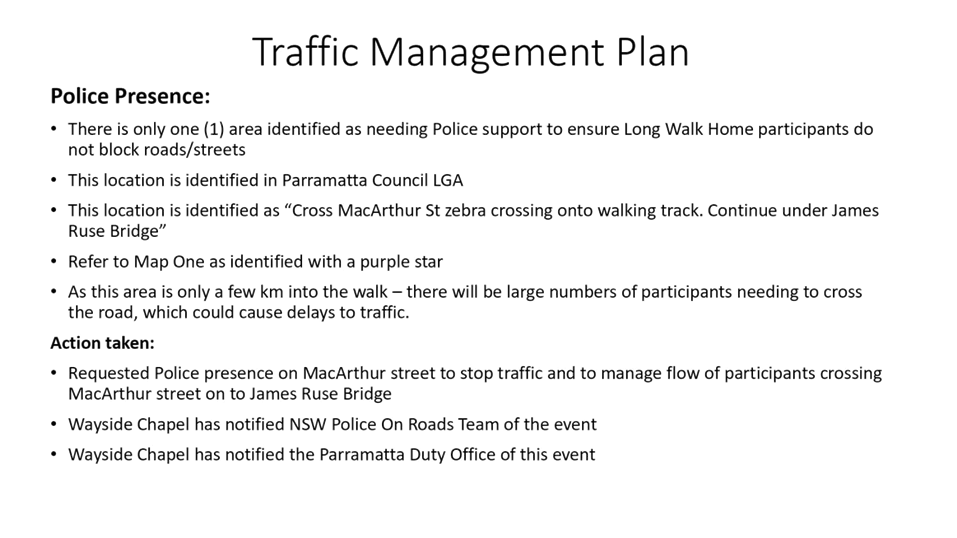
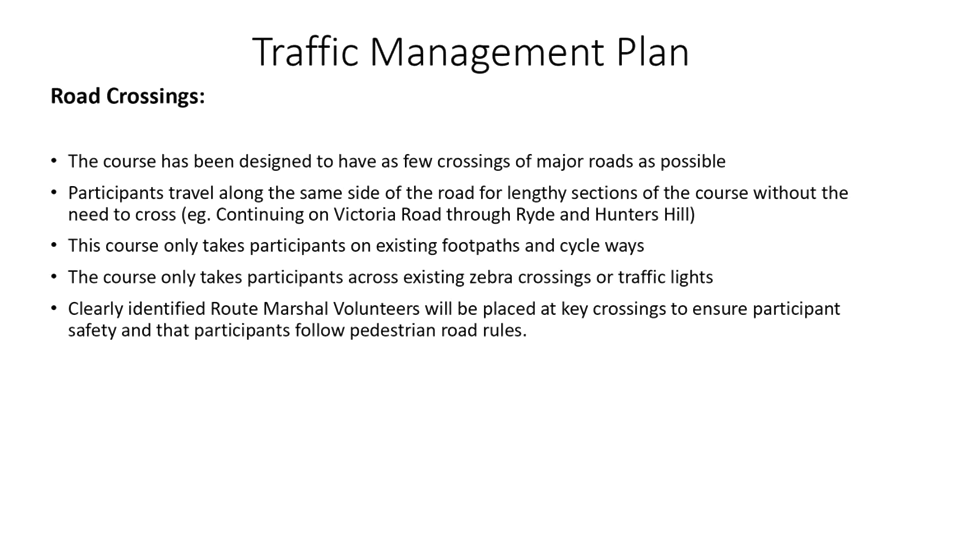
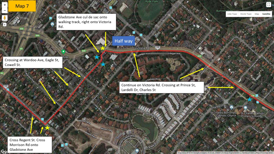
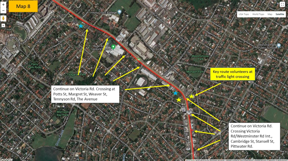
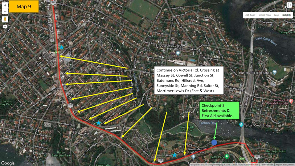
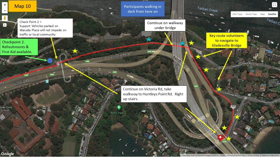
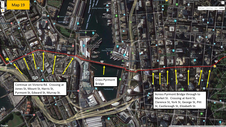
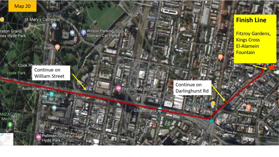
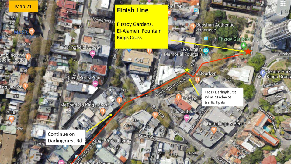
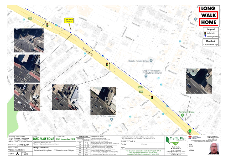
LTC1019 Item 23 Long Walk Home - Special Event (Baludarri-Balmain Ward / Balmain Electorate / Leichhardt PAC) 173
8 General Business
9 Close of Meeting
|
|
Local Traffic Committee Meeting 8 October 2019 Minutes from 2 September 2019 |
Minutes of Local Traffic Committee Meeting
Held at Petersham Service Centre on 2 September 2019
Meeting commenced at 9.59am
ACKNOWLEDGEMENT OF COUNTRY BY CHAIRPERSON
I acknowledge the Gadigal and Wangal people of the Eora nation on whose country we are meeting today, and their elders past and present.
COMMITTEE REPRESENTATIVES PRESENT
|
Clr Victor Macri |
Councillor – Midjuburi-Marrickville Ward (Chair) |
|
Mr Bill Holliday |
Representative for Jamie Parker MP, Member for Balmain |
|
Mr Chris Woods |
Representative for Ron Hoenig MP, Member for Heffron |
|
Zack Solomon |
Representative for Jo Haylen MP, Member for Summer Hill |
|
Mr Ryan Horne |
Roads and Maritime Services |
|
SC Sam Tohme |
NSW Police – Burwood Police Area Command |
|
SC Tony Kenny |
NSW Police Area Command |
|
Sgt Paul Vlachos |
NSW Police Area Command |
|
|
|
|
OFFICERS IN ATTENDANCE |
|
|
|
|
|
Colin Jones |
Inner West Bicycle Coalition |
|
Asith Nagodavithane |
Transit Systems – Inner West Bus Services |
|
Clr Marghanita da Cruz |
Councillor – Gulgadya-Leichhardt Ward |
|
John Stephens |
IWC’s Traffic and Transport Services Manager |
|
Sunny Jo |
IWC’s Traffic and Parking Planner |
|
Pierre Ayoub |
IWC’s Acting Design Services Coordinator |
|
Miia Hynninen |
IWC’s Business Administration Officer |
|
|
|
|
VISITORS |
|
|
Ted Cassidy |
Item 2 – Resident |
|
Vince Doan |
Item 17- Traffic Consultant |
|
Bruce Tuolfo |
Item 17- Architect |
|
Michael Wood |
Item 17 - Camperdown Fitness |
|
Paul Vella |
Item 17 – Camperdown Fitness |
|
|
|
|
APOLOGIES: |
|
|
Wal Petschler |
IWC’s Group Manager Roads, Traffic and Stormwater |
|
Cathy Peters |
Representative for Jenny Leong MP, Member for Newtown |
|
LSC Marina Nestoriaros |
NSW Police – Leichhardt Police Area Command |
DISCLOSURES OF INTERESTS:
Nil.
CONFIRMATION OF MINUTES
|
Minutes of the Local Traffic Committee Meeting held on Monday, 5 August 2019 were confirmed. |
|
LTC0919 Item 1 Richardsons
Crescent & Carrington Road, Marrickville - Request for Pedestrian
Crossing Facility |
|
SUMMARY A request has been received for the provision of a marked pedestrian zebra crossing on Richardson’s Crescent (adjacent to Mackey Park) and Carrington Road (near Renwick Street), Marrickville to provide safe crossing opportunities for pedestrians, particularly school children. Pedestrian counts have been conducted and the results are presented within this report for Committee’s consideration.
The volume of traffic and pedestrians counted at Richardsons Crescent, between Carrington Road and the roundabout have met the Roads and Maritime Service (RMS) warrants for a marked pedestrian zebra crossing. However RMS warrants for a marked pedestrian zebra crossing could not be met for Carrington Road, at its intersection with Renwick Street.
Officer’s Recommendation
THAT:
1. The proposal to implement a marked pedestrian zebra crossing at the footpath widening/ road narrowing in Richardsons Crescent, approximately 60 metres west of the roundabout be approved; 2. Implementation of 18 metres of ‘No Stopping’ zone on the southern side of Richardsons Crescent, south of the footpath widening on the western side of Richardsons Crescent be approved; 3. Extension of the existing ‘No Stopping’ on the northern side of Richardsons Crescent, immediately west of the existing footpath widening to a position immediately west of the adjacent driveway be approved; 4. The Principals (of Ferncourt Public School, Tempe High School and Tempe Public School) and the P&C be advised in terms of the outcome of this report; and 5. Council incorporate these works into its priority program for Traffic Facilities Capital Works.
DISCUSSION
Councillor Macri noted that residents were supportive of the Officer’s recommendation. The Committee members agreed with the Officer’s recommendation.
COMMITTEE RECOMMENDATION
THAT:
1. The proposal to implement a marked pedestrian zebra crossing at the footpath widening/ road narrowing in Richardsons Crescent, approximately 60 metres west of the roundabout be approved; 2. Implementation of 18 metres of ‘No Stopping’ on the southern side of Richardsons Crescent, south of the footpath widening on the western side of Richardsons Crescent be approved; 3. Extension of the existing ‘No Stopping’ on the northern side of Richardsons Crescent, immediately west of the existing footpath widening to a position immediately west of the adjacent driveway; 4. The Principals (of Ferncourt Public School, Tempe High School and Tempe Public School) and the P&C be advised in terms of the outcome of this report; and 5. Council incorporate these works into its priority program for Traffic Facilities Capital Works.
For motion: Unanimous |
|
LTC0919 Item 2 Boomerang Street and Crescent Street, Haberfield - Proposed Intersection Treatment (Gulgadya-Leichhardt Ward/Summer Hill Electorate/Burwood PAC) |
|
SUMMARY
A review of the detailed design plan has been finalised for the proposed intersection treatment at Boomerang Street and Crescent Street, Haberfield.
The proposal includes installing kerb extension in Crescent Street at Boomerang Street intersection and speed cushions in Boomerang Street to improve safety and reduce vehicular speeds in the street.
Consultation was undertaken with the owners and occupiers of properties adjacent to the intersection regarding the proposal. A summary of the consultation results are presented in this report for consideration.
Officer’s RECOMMENDATION
THAT the detailed design plan for the kerb extension, speed cushions and associated signposting and line marking in Boomerang Street and Crescent Street, Haberfield (as per the attached plan No.10074_A) be approved.
DISCUSSION
Public speaker: Mr. Ted Cassidy attended at 10.04am.
Mr Cassidy did not support the recommendation as he believed the speed of the traffic will increase the risk to pedestrian safety. He noted that there is no warrant for a pedestrian crossing as the local residents are already aware of speeding along Boomerang Street.
Mr Cassidy suggested that the kerb extension be relocated to Boomerang Street and the proposed pedestrian refuge be relocated to the southern side of Boomerang Street before the Crescent Street T junction.
Mr Cassidy tabled an amended plan.
(Mr Cassidy left at 10.09am)
Council Officer’s to confirm if locating a pedestrian refuge outside the bus stop on Boomerang Street will cause an impediment.
Transit Systems representative to confirm status of existing bus stop on Boomerang Street and whether it is redundant with the removal of the bus service.
The Bicycle Coalition representative suggested locating a pedestrian refuge further south of Boomerang Street near Mortley Avenue.
COMMITTEE RECOMMENDATION
THAT the installation of a pedestrian refuge in Boomerang Street, south of Crescent Street be investigated and a revised plan of the intersection be brought back to the Committee.
|
|
LTC0919 Item 3 Minor Traffic Facilities (All Wards/All Electorates/All PACs) |
|
SUMMARY This report considers minor traffic facility applications received by Inner West Council, and includes ‘Disabled Parking’ and ‘Works Zone’ requests.
Officer’s RECOMMENDATION
THAT:
1. A 6m 'Disabled Parking Zone’ be installed in front of No.14 Loughlin Street, Rozelle;
2. A 5.5m 'Disabled Parking Zone’ be installed in front of No.1 Ferdinand Street Birchgrove;
3. A 5.5m 'Disabled Parking Zone’ be installed in front of No.50 Hercules Street, Dulwich Hill;
4. A 9m 'Works Zone 7.00am – 6.00pm Mon-Fri and 8.00am -1.00pm Sat' be installed at the front of No.36 Fotheringham Street, Enmore, for 12 weeks;
5. A 9m 'Works Zone 7.00am – 3.30pm Mon-Fri and 8.00am -1.00pm Sat' and existing ‘No Parking 3.30pm – 6.30pm, Mon – Fri’ be installed at the front of No.351 Trafalgar Street, Petersham, for 12 weeks, subject to concurrence of the Roads & Maritime Services; and,
6. A 9m 'Works Zone 7.00am – 6.00pm Mon-Fri and 8.00am -1.00pm Sat' be installed at the front of No.426 Illawarra Road, Marrickville, for 12 weeks.
DISCUSSION
The Committee members agreed with the Officer’s recommendation.
COMMITTEE RECOMMENDATION
THAT:
1. A 6m 'Disabled Parking Zone’ be installed in front of No.14 Loughlin Street, Rozelle;
2. A 5.5m 'Disabled Parking Zone’ be installed in front of No.1 Ferdinand Street Birchgrove;
3. A 5.5m 'Disabled Parking Zone’ be installed in front of No.50 Hercules Street, Dulwich Hill;
4. A 9m 'Works Zone 7.00am – 6.00pm Mon-Fri and 8.00am -1.00pm Sat' be installed at the front of No.36 Fotheringham Street, Enmore, for 12 weeks;
5. A 9m 'Works Zone 7.00am – 3.30pm Mon-Fri and 8.00am -1.00pm Sat' and existing ‘No Parking 3.30pm – 6.30pm, Mon – Fri’ be installed at the front of No.351 Trafalgar Street, Petersham, for 12 weeks, subject to concurrence of the Roads & Maritime Services; and,
6. A 9m 'Works Zone 7.00am – 6.00pm Mon-Fri and 8.00am -1.00pm Sat' be installed at the front of No.426 Illawarra Road, Marrickville, for 12 weeks.
For motion: Unanimous |
|
LTC0919 Item 4 Newtown Local Area Traffic Management Strategy (Damun-Stanmore Ward/Newtown Electorate/Inner West PAC) |
|
SUMMARY This is a recommendation to endorse the final Newtown Local Area Traffic Management (LATM) report. The proposals within the report are based on community input and analysis of feedback from the Public Exhibition period in April 2019. There were 72 responses to the web survey and an additional six responses were received. The results indicate that there is general support for the proposed scheme, with suggested changes considered during the review of the draft treatments. Once this recommendation is endorsed by the Traffic Committee and Council, the projects will be incorporated into future design and construction programs.
Officer’s RECOMMENDATION
THAT:
1. The final Newtown LATM report be endorsed for implementation, including the following Stage 1 LATM treatments as listed in ATTACHMENT 2:
a. 40km/h local traffic area reduced speed limit on all local roads within the study area, subject to RMS review and approval; b. 10km/h raised Shared Zone in Bailey Street at Enmore Road with regulatory signage, marked parking bays, planter boxes and/or street furniture, textured road pavement. Installation of one (1) speed cushion, subject to RMS review and approval; c. Continuous footpath treatment in Goddard Street at King Street; d. Continuous footpath treatment in Reiby Street at Enmore Road; e. Continuous footpath treatment in Simmons Street at Enmore Road; f. Continuous footpath treatment in Marian Street at Enmore Road; g. Kerb extensions in Holt Street, reduced 'No Stopping' distance to 6m on south side at King Street; h. Continuous footpath treatment in Camden Street at King Street; i. Kerb blister island and at grade pavement linemarking, and ‘Local Traffic Only’, Truck prohibited signage in Metropolitan Road at Enmore Lane; j. At grade pavement linemarking and ‘Local Traffic Only’ and Truck prohibited signage in Station Street and Reiby Lane; k. Kerb blister islands with landscaping in Metropolitan Road at Cross Lane; l. Kerb blister island and entry signage in Cross Lane at Edgeware Road; m. Kerb ramps, steel grate and remove part of existing concrete island at existing mobility impaired space in Metropolitan Road at Enmore Lane; n. Landscaped kerb blister islands, 'Give Way' signs and lines in Camden Street at College Street; o. Landscaped kerb blister islands, 'Give Way' signs and lines in Camden Street at Station Street; and p. Bicycle logo mixed traffic arrangement, bicycle warning signs on side street, in Simmons Street, Margaret Street, College Street, Holt Street, Station Street, and Metropolitan Road.
2. The final Newtown LATM report be endorsed for implementation including the following Stage 2 LATM treatments as listed in ATTACHMENT 2: a. '10km/h Shared Zone' in Reiby Street from Enmore Road to Pemell Lane including and regulatory signage, marked parking bays, planter boxes and/or street furniture, textured road pavement, replacement of existing kerb with dish drain or mountable kerb, including speed cushions at two locations, subject to RMS review and approval; b. '10km/h Shared Zone' in Simmons Street from Enmore Road to Pemell Lane including and regulatory signage, marked parking bays, planter boxes and/or street furniture, textured road pavement, replacement of existing kerb with dish drain or mountable kerb, including speed cushions at two locations, subject to RMS review and approval; c. '10km/h Shared Zone' in Marian Street from Enmore Road to Enmore Lane including and regulatory signage, marked parking bays, planter boxes and/or street furniture, textured road pavement, replacement of existing kerb with dish drain or mountable kerb, including speed cushions at two locations, subject to RMS review and approval; d. '10km/h Shared Zone' in Pemell Lane from Simmons Street to Reiby Street, including regulatory signage, textured road pavement and two speed cushions, subject to RMS review and approval; e. '10km/h Shared Zone' in Reiby Lane from Reiby Street to rear of No.72 Enmore Road, including regulatory signage, textured road pavement and two speed cushions, subject to RMS review and approval; and f. Landscaped central islands with native trees in Pemell Street.
DISCUSSION
The Committee members agreed with the Officer’s recommendation.
COMMITTEE RECOMMENDATION
THAT:
1. The final Newtown LATM report be endorsed for implementation, including the following Stage 1 LATM treatments as listed in ATTACHMENT 2:
a. 40km/h local traffic area reduced speed limit on all local roads within the study area, subject to RMS review and approval; b. 10km/h raised Shared Zone in Bailey Street at Enmore Road with regulatory signage, marked parking bays, planter boxes and/or street furniture, textured road pavement. Installation of one (1) speed cushion, subject to RMS review and approval; c. Continuous footpath treatment in Goddard Street at King Street; d. Continuous footpath treatment in Reiby Street at Enmore Road; e. Continuous footpath treatment in Simmons Street at Enmore Road; f. Continuous footpath treatment in Marian Street at Enmore Road; g. Kerb extensions in Holt Street, reduced 'No Stopping' distance to 6m on south side at King Street; h. Continuous footpath treatment in Camden Street at King Street; i. Kerb blister island and at grade pavement linemarking, and ‘Local Traffic Only’, Truck prohibited signage in Metropolitan Road at Enmore Lane; j. At grade pavement linemarking and ‘Local Traffic Only’ and Truck prohibited signage in Station Street and Reiby Lane; k. Kerb blister islands with landscaping in Metropolitan Road at Cross Lane; l. Kerb blister island and entry signage in Cross Lane at Edgeware Road; m. Kerb ramps, steel grate and remove part of existing concrete island at existing mobility impaired space in Metropolitan Road at Enmore Lane; n. Landscaped kerb blister islands, 'Give Way' signs and lines in Camden Street at College Street; o. Landscaped kerb blister islands, 'Give Way' signs and lines in Camden Street at Station Street; and p. Bicycle logo mixed traffic arrangement, bicycle warning signs on side street, in Simmons Street, Margaret Street, College Street, Holt Street, Station Street, and Metropolitan Road.
2. The final Newtown LATM report be endorsed for implementation including the following Stage 2 LATM treatments as listed in ATTACHMENT 2: a. '10km/h Shared Zone' in Reiby Street from Enmore Road to Pemell Lane including and regulatory signage, marked parking bays, planter boxes and/or street furniture, textured road pavement, replacement of existing kerb with dish drain or mountable kerb, including speed cushions at two locations, subject to RMS review and approval; b. '10km/h Shared Zone' in Simmons Street from Enmore Road to Pemell Lane including and regulatory signage, marked parking bays, planter boxes and/or street furniture, textured road pavement, replacement of existing kerb with dish drain or mountable kerb, including speed cushions at two locations, subject to RMS review and approval; c. '10km/h Shared Zone' in Marian Street from Enmore Road to Enmore Lane including and regulatory signage, marked parking bays, planter boxes and/or street furniture, textured road pavement, replacement of existing kerb with dish drain or mountable kerb, including speed cushions at two locations, subject to RMS review and approval; d. '10km/h Shared Zone' in Pemell Lane from Simmons Street to Reiby Street, including regulatory signage, textured road pavement and two speed cushions, subject to RMS review and approval; e. '10km/h Shared Zone' in Reiby Lane from Reiby Street to rear of No.72 Enmore Road, including regulatory signage, textured road pavement and two speed cushions, subject to RMS review and approval; and f. Landscaped central islands with native trees in Pemell Street.
For motion: Unanimous |
|
LTC0919 Item 5 Church Street, between Carillon Avenue and Rochester Street, Newtown - Temporary Full Road Closure - to dismantle a tower crane at 142 Carillon Avenue (Damun-Stanmore Ward/Newtown Electorate/Inner West PAC) |
|
SUMMARY An application has been received from PBS Building (NSW) Pty Ltd for the temporary full road closure of Church Street, between Carillon Avenue and Rochester Street, Newtown in order to dismantle a tower crane presently on site at 142 Carillon Avenue. The closure is to be undertaken on Saturday, 9 November 2019 for an eight hour period between the hours of 7.30am and 3.30pm, with a one day contingency on Saturday, 16 November 2019. It is recommended that the proposed temporary full road closure be approved, subject to the conditions outlined in the report.
Officer’s RECOMMENDATION
THAT the proposed temporary full road closure of Church Street, between Carillon Avenue and Rochester Street, Newtown on Saturday, 9 November 2019 for an eight hour period between the hours of 7.30am and 3.30pm, with a one day contingency on Saturday, 16 November 2019 in order to dismantle a tower crane using a mobile crane be approved; subject to, but not limited to, the following conditions: 1. A Road Occupancy License be obtained by the applicant from the Transport Management Centre; 2. All affected residents and businesses, including the NSW Police Local Area Commander, Fire & Rescue NSW and the NSW Ambulance Services be notified in writing, by the applicant, of the proposed temporary full road closure at least 7 days in advance of the closure with the applicant making reasonable provision for stakeholders; and 3. The occupation of the road carriageway must not occur until the road has been physically closed.
DISCUSSION
The Committee members agreed with the Officer’s recommendation.
COMMITTEE RECOMMENDATION
THAT the proposed temporary full road closure of Church Street, between Carillon Avenue and Rochester Street, Newtown on Saturday, 9 November 2019 for an eight hour period between the hours of 7.30am and 3.30pm, with a one day contingency on Saturday, 16 November 2019 in order to dismantle a tower crane using a mobile crane be approved; subject to, but not limited to, the following conditions: 1. A Road Occupancy License be obtained by the applicant from the Transport Management Centre; 2. All affected residents and businesses, including the NSW Police Local Area Commander, Fire & Rescue NSW and the NSW Ambulance Services be notified in writing, by the applicant, of the proposed temporary full road closure at least 7 days in advance of the closure with the applicant making reasonable provision for stakeholders; and 3. The occupation of the road carriageway must not occur until the road has been physically closed.
For motion: Unanimous |
|
LTC0919 Item 6 Fisher Street, Petersham between Regent Street and Audley Street – Temporary Full Road Closure to dismantle tower crane at No. 22 (Damum - Stanmore Ward / Newtown Electorate / Inner West PAC) |
|
SUMMARY An application has been received from Boycebuild Pty Ltd for the temporary full road closure of Fisher Street, Petersham between Regent Street and Audley Street, for a period of 8 hours on Wednesday 9 October 2019 (contingency dates - Thursday 10 October 2019 and Tuesday 15 October 2019) between the hours of 7:00am and 3pm, in order to stand a mobile crane to carry out crane lift works to dismantle a tower crane. It is recommended that the proposed temporary full road closure be approved, subject to the conditions outlined in this report.
Officer’s RECOMMENDATION
THAT the proposed temporary full road closure of Fisher Street, Petersham between Regent Street and Audley Street, for a period of 8 hours on Wednesday 9 October 2019 (contingency dates - Thursday 10 October 2019 and Tuesday 15 October 2019) between the hours of 7:00am and 3:00pm, be APPROVED in order to stand a mobile crane to carry out crane lift works at No.22 Fisher Street, subject to, but not limited to, the following conditions:
1. The application and TMP be submitted by the applicant to RMS for approval;
2. A Road Occupancy License be obtained by the applicant from the Transport Management Centre;
3. All affected residents and businesses, including the NSW Police Local Area Commander, Fire & Rescue NSW and the NSW Ambulance Services be notified in writing, by the applicant, of the proposed temporary road closure at least 7 days in advance of the closure with the applicant making reasonable provision for stakeholders; and
4. The occupation of the road carriageway must not occur until the road has been physically closed.
DISCUSSION
The Committee members agreed with the Officer’s recommendation.
COMMITTEE RECOMMENDATION
THAT the proposed temporary full road closure of Fisher Street, Petersham between Regent Street and Audley Street, for a period of 8 hours on Wednesday 9 October 2019 (contingency dates - Thursday 10 October 2019 and Tuesday 15 October 2019) between the hours of 7:00am and 3:00pm, be APPROVED in order to stand a mobile crane to carry out crane lift works at No.22 Fisher Street, subject to, but not limited to, the following conditions:
1. The application and TMP be submitted by the applicant to RMS for approval;
2. A Road Occupancy License be obtained by the applicant from the Transport Management Centre;
3. All affected residents and businesses, including the NSW Police Local Area Commander, Fire & Rescue NSW and the NSW Ambulance Services be notified in writing, by the applicant, of the proposed temporary road closure at least 7 days in advance of the closure with the applicant making reasonable provision for stakeholders; and
4. The occupation of the road carriageway must not occur until the road has been physically closed.
For motion: Unanimous |
|
LTC0919 Item 7 Terrace Road / Ness Avenue, Dulwich Hill – Temporary Full Road Closure of Rail Underpass just north of the roundabout at Ewart Street – Sydney Metro (SSJ) early enabling works on T3 Line – notice of change of dates (DJARRAWUNANG-ASHFIELD WARD / SUMMER HILL ELECTORATE / INNER WEST PAC) |
|
SUMMARY Notice of changes in dates for rail underpass works and pending road closures of Terrace Road / Ness Avenue just north of the roundabout at Ewart Street, Dulwich Hill in September 2019 have been received from Sydney Metro (SSJ). Due to new design work requirements additional closure dates have been proposed in addition to the approved full road closures between 1:00AM Saturday 28 September to 11:59PM Sunday 29 September 2019. The proposed additional dates requested are Monday 23 September to Friday 27 September 2019 between 7:00AM and 5:00PM each day (with the road reopening at night to allow traffic through). It is recommended that the proposed additional daytime temporary full road closures be approved, subject to the conditions outlined in this report.
Officer’s RECOMMENDATION
THAT the proposed temporary full road closure of the rail underpass on Terrace Road / Ness Avenue just north of the roundabout at Ewart Street, Dulwich Hill between the hours 7:00AM and 5:00PM (allowing road to be open at night) in addition to the approved full closures for a two day period being on Saturday 28 September until midnight Sunday 29 September 2019 be approved, in order to carry out early enabling works on the Rail bridge subject to, but not limited to, the following conditions:
1. A Road Occupancy License be obtained by the applicant from the Transport Management Centre;
2. All affected residents and businesses, including the NSW Police Local Area Commander, Fire & Rescue NSW and the NSW Ambulance Services be notified in writing, by the applicant, of the proposed temporary road closure at least 7 days in advance of the closure with the applicant making reasonable provision for stakeholders; and
3. The occupation of the road carriageway must not occur until the road has been physically closed.
DISCUSSION
The Committee members agreed with the Officer’s recommendation.
COMMITTEE RECOMMENDATION
THAT the proposed temporary full road closure of the rail underpass on Terrace Road / Ness Avenue just north of the roundabout at Ewart Street, Dulwich Hill between the hours 7:00AM and 5:00PM (allowing road to be open at night) in addition to the approved full closures for a two day period being on Saturday 28 September until midnight Sunday 29 September 2019 be approved, in order to carry out early enabling works on the Rail bridge subject to, but not limited to, the following conditions:
1. A Road Occupancy License be obtained by the applicant from the Transport Management Centre;
2. All affected residents and businesses, including the NSW Police Local Area Commander, Fire & Rescue NSW and the NSW Ambulance Services be notified in writing, by the applicant, of the proposed temporary road closure at least 7 days in advance of the closure with the applicant making reasonable provision for stakeholders; and
3. The occupation of the road carriageway must not occur until the road has been physically closed.
For motion: Unanimous |
|
LTC0919 Item 8 Eltham Street, Lewisham – Temporary Full Road Closure to install new sewer main in the roadway on behalf of Sydney Water (Damum - Stanmore Ward / Newtown Electorate / Inner West PAC) |
|
SUMMARY An application has been received from Comdain Civil Construction (on behalf of Sydney Water) for the temporary full road closure of Eltham Street, Lewisham extending between Fred Street and Denison Street, for a period of 4 weeks starting on Monday 9 September 2019 (to Monday 7 October 2019) with a contingency period of 5 weeks starting on Monday 23 September 2019 (to Monday 28 October 2019) in order to install a new sewer main in the roadway, including construction of new maintenance holes in the roadway. It is recommended that the proposed temporary full road closure be approved, subject to the conditions outlined in this report and satisfactory arrangements are in place to accommodate school buses.
Officer’s RECOMMENDATION
THAT the proposed temporary full road closure of Eltham Street, Lewisham extending between Fred Street and Denison Street, for a period of 4 weeks starting on Monday 9 September 2019 (to Monday 7 October 2019) with contingency period of 5 weeks starting on Monday 23 September 2019 (to Monday 28 October 2019) be APPROVED in order to install a new sewer main in the roadway, including construction of new maintenance holes in the roadway subject to, but not limited to, the following conditions:
1. The application and TMP be submitted by the applicant to RMS for approval;
2. A Road Occupancy License be obtained by the applicant from the Transport Management Centre;
3. All affected residents and businesses, including the NSW Police Local Area Commander, Fire & Rescue NSW and the NSW Ambulance Services be notified in writing, by the applicant, of the proposed temporary road closure at least 7 days in advance of the closure with the applicant making reasonable provision for stakeholders; and
4. The occupation of the road carriageway must not occur until the road has been physically closed.
DISCUSSION
The Committee members agreed with the Officer’s recommendation.
COMMITTEE RECOMMENDATION
THAT the proposed temporary full road closure of Eltham Street, Lewisham extending between Fred Street and Denison Street, for a period of 4 weeks starting on Monday 9 September 2019 (to Monday 7 October 2019) with contingency period of 5 weeks starting on Monday 23 September 2019 (to Monday 28 October 2019) be APPROVED in order to install a new sewer main in the roadway, including construction of new maintenance holes in the roadway subject to, but not limited to, the following conditions:
1. The application and TMP be submitted by the applicant to RMS for approval;
2. A Road Occupancy License be obtained by the applicant from the Transport Management Centre;
3. All affected residents and businesses, including the NSW Police Local Area Commander, Fire & Rescue NSW and the NSW Ambulance Services be notified in writing, by the applicant, of the proposed temporary road closure at least 7 days in advance of the closure with the applicant making reasonable provision for stakeholders; and
4. The occupation of the road carriageway must not occur until the road has been physically closed.
For motion: Unanimous |
|
LTC0919 Item 9 Australia Street, Eliza Street, Lennox Street & Mary Street, Newtown – Temporary Full Road Closures for Newtown Festival on Sunday 10 November 2019 (Damum-Stanmore Ward / Newtown Electorate / Inner West PAC) |
|
SUMMARY A Section 68 application had been received from the Newtown Neighbourhood Centre in relation to continuing conditions in holding the annual 'Newtown Festival' for the next 5 years (2019, 2020 2021 2022, 2023). This year’s event is planned for Sunday 10 November 2019 between 9.30am-6.00pm. The applicant has requested the temporary full road closures of Australia Street (between Lennox Street and King Street), Eliza Street (between King Street and Lennox Street), Lennox Street (between Australia Street and the exit of Lennox Street car park/16 Lennox Street) and Mary Street (between King Street and Lennox Street), Newtown between the hours of 5.00am to 8.30pm.
It is recommended that Council support the temporary road closures for the Category D Class 2 event proposed on Sunday 10 November 2019 subject to the applicant complying with the recommended and standard conditions pertaining to temporary full road closures.
Comments of the Local Traffic Committee will be referred to Council’s Development Assessment Section for consideration in determining the Section 68 Application.
Officer’s RECOMMENDATION
THAT:
The proposed temporary full road closures of Australia Street (between Lennox Street and King Street), Eliza Street (between king Street and Lennox Street), Lennox Street (between Australia Street and the exit of Lennox Street car park/16 Lennox Street) and Mary Street (between King Street and Lennox Street), Newtown on Sunday 10 November 2019, between 5.00am to 8.30pm, for the holding of the 40th annual 'Newtown Festival' (Class 2 event under the RMS Special Events Guide), be APPROVED as per the submitted TMP and TCPs and subject to, but not limited to, the following conditions:
1. The application and TMP be submitted by the applicant to RMS for approval;
2. A Road Occupancy License be obtained by the applicant from the Transport Management Centre;
3. All affected residents and businesses, including the NSW Police Local Area Commander, Fire & Rescue NSW and the NSW Ambulance Services be notified in writing, by the applicant, of the proposed temporary road closure at least 7 days in advance of the closure with the applicant making reasonable provision for stakeholders; and
4. The occupation of the road carriageway must not occur until the road has been physically closed.
DISCUSSION
The Committee members agreed with the Officer’s recommendation.
COMMITTEE RECOMMENDATION
THAT:
The proposed temporary full road closures of Australia Street (between Lennox Street and King Street), Eliza Street (between king Street and Lennox Street), Lennox Street (between Australia Street and the exit of Lennox Street car park/16 Lennox Street) and Mary Street (between King Street and Lennox Street), Newtown on Sunday 10 November 2019, between 5.00am to 8.30pm, for the holding of the 40th annual 'Newtown Festival' (Class 2 event under the RMS Special Events Guide), be APPROVED as per the submitted TMP and TCPs and subject to, but not limited to, the following conditions:
1. The application and TMP be submitted by the applicant to RMS for approval;
2. A Road Occupancy License be obtained by the applicant from the Transport Management Centre;
3. All affected residents and businesses, including the NSW Police Local Area Commander, Fire & Rescue NSW and the NSW Ambulance Services be notified in writing, by the applicant, of the proposed temporary road closure at least 7 days in advance of the closure with the applicant making reasonable provision for stakeholders; and
4. The occupation of the road carriageway must not occur until the road has been physically closed.
For motion: Unanimous
|
|
LTC0919 Item 10 Ashfield Street (Lane), Ashfield - Proposed 'No Parking' restrictions (Gulgadya -Leichhardt Ward/Summer Hill Electorate/Inner West PAC) |
|
SUMMARY Following representation, Council is proposing to implement a section of ‘No Parking’ in the narrow section of Ashfield Street (Lane) to allow for thoroughfare and for access to off street parking.
Officer’s RECOMMENDATION
THAT a section of ‘No Parking’ 10 metres in length in Ashfield Street (Lane) at the rear of No.20 Alt Street be approved.
DISCUSSION
The Committee members agreed with the Officer’s recommendation.
COMMITTEE RECOMMENDATION
THAT a section of ‘No Parking’ 10 metres in length in Ashfield Street (Lane) at the rear of No.20 Alt Street be approved.
For motion: Unanimous |
|
LTC0919 Item 11 Petersham Road, Marrickville - Proposed Installation of Statutory 'No Stopping' & 'No Parking' signage between Graham Avenue and Stanley Street (Midjuburi-Marrickville Ward/Summer Hill Electorate/Inner West PAC) |
|
SUMMARY Following correspondence from the community regarding vehicles parking on the western side of Petersham Road, between Graham Avenue and Stanley Street, obstructing the thoroughfare, Council is proposing to introduce new signposted parking restrictions.
Officer’s RECOMMENDATION
THAT:
1. A 10m 'No Stopping’ restriction be installed in Petersham Road (Western side), south from its intersection with Graham Avenue; 2. A 10m ‘No Stopping’ restriction be installed in Petersham Road (Western side), north from its intersection with Stanley Street; and 3. A ‘No Parking' restriction be installed in Petersham Road (Western side) between the above proposed 10m ‘No Stopping’ zones, adjacent to No.20 Graham Avenue, Marrickville. DISCUSSION
The Committee members agreed with the Officer’s recommendation.
COMMITTEE RECOMMENDATION
THAT:
1. A 10m 'No Stopping’ restriction be installed in Petersham Road (Western side), south from its intersection with Graham Avenue; 2. A 10m ‘No Stopping’ restriction be installed in Petersham Road (Western side), north from its intersection with Stanley Street; and 3. A ‘No Parking' restriction be installed in Petersham Road (Western side) between the above proposed 10m ‘No Stopping’ zones, adjacent to No.20 Graham Avenue, Marrickville. For motion: Unanimous |
|
LTC0919 Item 12 Beattie Street and Palmer Street, Balmain - Proposed 'Motor Bike Only' and 'No Parking' Restrictions (Baludarri-Balmain Ward/Balmain Electorate/Leichhardt PAC) |
|
SUMMARY
Council has received concerns regarding inadequate motorbike parking in the Balmain shopping area in the vicinity of the intersection of Beattie Street and Palmer Street, Balmain.
This report provides the result of the motorbike parking investigation.
Officer’s RECOMMENDATION
THAT:
1. 2.9m of ‘Motor Bike Only’ parking be installed on the eastern side of Palmer Street, north of Watson Lane, Balmain, replacing the existing ticket parking restrictions;
2. 4.8m of ‘Motor Bike Only’ parking be installed on the northern side of Beattie Street, east of the driveway to No. 292-294 Darling Street, replacing the existing unrestricted parking space; and
3. A 4.6m ‘No Parking’ zone be installed on the northern side of Beattie Street, west of Palmer Street, Balmain (across the driveway of No. 292-294 Darling Street).
DISCUSSION
The Committee members agreed with the Officer’s recommendation.
COMMITTEE RECOMMENDATION
THAT:
1. 2.9m of ‘Motor Bike Only’ parking be installed on the eastern side of Palmer Street, north of Watson Lane, Balmain, replacing the existing ticket parking restrictions;
2. 4.8m of ‘Motor Bike Only’ parking be installed on the northern side of Beattie Street, east of the driveway to No. 292-294 Darling Street, replacing the existing unrestricted parking space; and
3. A 4.6m ‘No Parking’ zone be installed on the northern side of Beattie Street, west of Palmer Street, Balmain (across the driveway of No. 292-294 Darling Street).
For motion: Unanimous |
|
LTC0919 Item 13 Upward Street, Leichhardt - Resident Parking Scheme (Gulgadya - Leichhardt Ward/Balmain Electorate/Leichhardt PAC) |
|
SUMMARY Council has received correspondence from a number of residents of Upward Street, Leichhardt requesting Resident Parking Scheme (RPS) restrictions in their street to deter long term parking by commuters. This report provides the result of the resident parking scheme investigation in Upward Street, Leichhardt.
Officer’s RECOMMENDATION
THAT a '2P 8am-10pm (7 days), Permit Holders Excepted; Area L1’ parking restriction be installed on the western side of Upward Street between Lords Road and No.59 Upward Street, Leichhardt.
DISCUSSION
The Committee members agreed with the Officer’s recommendation.
COMMITTEE RECOMMENDATION
THAT a '2P 8am-10pm (7 days), Permit Holders Excepted; Area L1’ parking restriction be installed on the western side of Upward Street between Lords Road and No.59 Upward Street, Leichhardt.
For motion: Unanimous |
|
LTC0919 Item 14 Carlisle Street, Leichhardt - Temporary Road Closure for Royal Hotel Inner West Beer festival |
|
SUMMARY Council has received an application from the licensee of the Royal Hotel in Leichhardt for approval of a temporary full road closure in Carlisle Street between Norton Street and the Unnamed Laneway adjacent to No.2 Carlisle Street to be held on Saturday, 16 and Sunday, 17 November 2019 between the hours of 12pm-8pm and 12pm-6pm respectively.
The road closure has been requested to facilitate the Royal Hotel Inner West Beer festival.
Officer’s RECOMMENDATION
THAT the temporary road closure of Carlisle Street, Leichhardt between Norton Street and the Unnamed Laneway adjacent to No.2 Carlisle Street to be held on Saturday, 16 and Sunday, 17 November 2019 between the hours of 12pm-8pm and 12pm-6pm respectively be supported, subject to the following conditions:
a. That an unencumbered passage minimum of 4.0m wide be available for emergency vehicles through the closed section of Carlisle Street, Leichhardt; b. The occupation of the road carriageway must not occur until the road has been physically closed; c. All affected residents and businesses, including the NSW Police Local Area Commander, Fire & Rescue NSW and NSW Ambulance Services be notified in writing, by the applicant, of the proposed temporary road closure at least 2 weeks in advance of the closure with the applicant making reasonable provision for stakeholders.
DISCUSSION
The Committee members agreed with the Officer’s recommendation.
COMMITTEE RECOMMENDATION
THAT the temporary road closure of Carlisle Street, Leichhardt between Norton Street and the Unnamed Laneway adjacent to No.2 Carlisle Street to be held on Saturday, 16 and Sunday, 17 November 2019 between the hours of 12pm-8pm and 12pm-6pm respectively be supported, subject to the following conditions:
a. That an unencumbered passaged minimum of 4.0m wide be available for emergency vehicles through the closed section of Carlisle Street, Leichhardt; b. The occupation of the road carriageway must not occur until the road has been physically closed; c. All affected residents and businesses, including the NSW Police Local Area Commander, Fire & Rescue NSW and NSW Ambulance Services be notified in writing, by the applicant, of the proposed temporary road closure at least 2 weeks in advance of the closure with the applicant making reasonable provision for stakeholders.
For motion: Unanimous |
|
LTC0919 Item 15 Wharf Road, Lilyfield - Temporary Road Closure for Balmain Fun Run 2019 |
|
SUMMARY Council has received an application for approval of a temporary road closure in Wharf Road, Lilyfield north of Balmain Road on Sunday, 10 November 2019 between 6:30am and 10:30am.
The road closure has been requested to facilitate the Balmain Fun Run through Callan Park.
Officer’s RECOMMENDATION
THAT the temporary road closure of Wharf Road, Lilyfield north of Balmain Road on Sunday, 10 November 2019 between 6.30am – 10.30am be supported, subject to the following conditions:
a. That an unencumbered passage minimum 4.0m wide be available for emergency vehicles through the closed section of Wharf Road, Lilyfield. b. The occupation of the road carriageway must not occur until the road has been physically closed; and c. All affected residents and businesses, including the NSW Police Local Area Commander, Fire & Rescue NSW and NSW Ambulance Services be notified in writing, by the applicant, of the proposed temporary road closure at least 2 weeks in advance of the closure with the applicant making reasonable provision for stakeholders.
DISCUSSION
The Committee members agreed with the Officer’s recommendation.
COMMITTEE RECOMMENDATION
THAT the temporary road closure of Wharf Road, Lilyfield north of Balmain Road on Sunday, 10 November 2019 between 6.30am – 10.30am be supported, subject to the following conditions:
a. That an unencumbered passage minimum 4.0m wide be available for emergency vehicles through the closed section of Wharf Road, Lilyfield. b. The occupation of the road carriageway must not occur until the road has been physically closed; and c. All affected residents and businesses, including the NSW Police Local Area Commander, Fire & Rescue NSW and NSW Ambulance Services be notified in writing, by the applicant, of the proposed temporary road closure at least 2 weeks in advance of the closure with the applicant making reasonable provision for stakeholders.
For motion: Unanimous |
|
LTC0919 Item 16 Norton Street Italian Festa 2019 - Temporary Road Closures (Gulgadya-Leichhardt Ward/Balmain Electorate/Leichhardt PAC) |
|
SUMMARY The proposed event, the Norton Street Italian Festa, is a street festival held annually celebrating the traditional Italian culture that is considered an essential part of the Leichhardt community.
Officer’s RECOMMENDATION
THAT:
1. The road closure application for the ‘Norton Street Italian Festa 2019’ on Sunday, 27 October 2019 be supported subject to the following conditions: a) The road closures be restricted to occur between 3:00am and 8:00pm on Sunday, 27 October 2019 at the following locations: i. Norton Street from Marion Street to William Street; ii. Marlborough Street from Norton Street to Cromwell Street; iii. Short Street from Norton Street to Balmain Road; iv. Carlisle Street from Norton Street to Cromwell Street; v. Allen Street from Cromwell Street to Derbyshire Road; and vi. Arthur Street from Allen Street to Short Street. b) Approval from RMS for the TMP and TCP and to install a ‘Special Event Clearway’ restriction in Norton Street be obtained prior to the event; c) Wetherill Street (Norton Street – Balmain Road) and Macauley Street (Cromwell Street – Norton Street) function as two way roads when Norton Street is closed to provide access for residents etc; d) Parking for the event be reserved in: · Short Street on both sides between Norton Street and the unnamed lane for Emergency Service vehicles; · William Street on the southern side between Norton Street and Derbyshire Road (Pioneers Memorial Park side). The angle parking in this area will be temporarily amended to allow parallel parking for Police horse floats etc; e) A three (3) metre unencumbered passage be available for emergency vehicles through the closed section of Norton Street at all times; f) Approval to conduct a public assembly be obtained from the NSW Police prior to the event. A copy of the NSW Police approval must be forwarded to Council’s Traffic Section prior to the event. g) The applicant be requested to provide free bicycle valet parking at a central location (i.e. Short Street or Allen Street) including adequate ‘way finding’ signage to the public and include the availability of this service in promoting the event; h) Additional signs indicating ‘Bicycles Expected’ and ‘cyclists dismount’ be included with the road closure signs provided at the road closure points; i) The occupation of the road carriageway must not occur until the road has been formally closed; j) That the set up and break down times occur at 3:30am and 7:00pm respectively and include additional waste staff at the break down to expedite the road openings; k) The entrance to the access way into Pioneers Memorial Park in Allen Street opposite Arthur Street be temporarily closed by barricades for security purposes during the event; l) All advertising of the event must encourage the use of Public Transport; m) All affected residents and businesses, including the NSW Police Local Area Commander, Fire & Rescue NSW, NSW Ambulance Services and the Leichhardt Bus Depot be notified in writing, by the applicant, of the proposed temporary road closure at least 2 weeks in advance of the closure with the applicant making reasonable provision for stakeholders. 2. The following measures be provided to accommodate buses: i. Install temporary ‘Bus Zones’ to accommodate two buses on both sides of William Street between Norton Street and James Street; ii. Place barricades within 10m at the south-eastern corner of the Flood Street/William Street intersection to assist buses; and iii. No trucks (Festa) to be parked in the Marion Street ‘Bus Zone’ at the Norton Street intersection, outside the Town Hall. DISCUSSION
The Committee members agreed with the Officer’s recommendation.
COMMITTEE RECOMMENDATION
THAT:
1. The road closure application for the ‘Norton Street Italian Festa 2019’ on Sunday, 27 October 2019 be supported subject to the following conditions: a) The road closures be restricted to occur between 3:00am and 8:00pm on Sunday, 27 October 2019 at the following locations: i. Norton Street from Marion Street to William Street; ii. Marlborough Street from Norton Street to Cromwell Street; iii. Short Street from Norton Street to Balmain Road; iv. Carlisle Street from Norton Street to Cromwell Street; v. Allen Street from Cromwell Street to Derbyshire Road; and vi. Arthur Street from Allen Street to Short Street. b) Approval from RMS for the TMP and TCP and to install a ‘Special Event Clearway’ restriction in Norton Street be obtained prior to the event; c) Wetherill Street (Norton Street – Balmain Road) and Macauley Street (Cromwell Street – Norton Street) function as two way roads when Norton Street is closed to provide access for residents etc; d) Parking for the event be reserved in: · Short Street on both sides between Norton Street and the unnamed lane for Emergency Service vehicles; · William Street on the southern side between Norton Street and Derbyshire Road (Pioneers Memorial Park side). The angle parking in this area will be temporarily amended to allow parallel parking for Police horse floats etc; e) A three (3) metre unencumbered passage be available for emergency vehicles through the closed section of Norton Street at all times; f) Approval to conduct a public assembly be obtained from the NSW Police prior to the event. A copy of the NSW Police approval must be forwarded to Council’s Traffic Section prior to the event. g) The applicant be requested to provide free bicycle valet parking at a central location (i.e. Short Street or Allen Street) including adequate ‘way finding’ signage to the public and include the availability of this service in promoting the event; h) Additional signs indicating ‘Bicycles Excepted’ and ‘cyclists dismount’ be included with the road closure signs provided at the road closure points; i) The occupation of the road carriageway must not occur until the road has been formally closed; j) That the set up and break down times occur at 3:30am and 7:00pm respectively and include additional waste staff at the break down to expedite the road openings; k) The entrance to the access way into Pioneers Memorial Park in Allen Street opposite Arthur Street be temporarily closed by barricades for security purposes during the event; l) All advertising of the event must encourage the use of Public Transport; m) All affected residents and businesses, including the NSW Police Local Area Commander, Fire & Rescue NSW, NSW Ambulance Services and the Leichhardt Bus Depot be notified in writing, by the applicant, of the proposed temporary road closure at least 2 weeks in advance of the closure with the applicant making reasonable provision for stakeholders. 2. The following measures be provided to accommodate buses: i. Install temporary ‘Bus Zones’ to accommodate two buses on both sides of William Street between Norton Street and James Street; ii. Place barricades within 10m at the south-eastern corner of the Flood Street/William Street intersection to assist buses; and iii. No trucks (Festa) to be parked in the Marion Street ‘Bus Zone’ at the Norton Street intersection, outside the Town Hall.
For motion: Unanimous |
|
LTC0919 Item 17 63-65 Pyrmont Bridge Road, Annandale - Additional Information for Modification of Development Consent (Gulgadya-Leichhardt Ward/ Balmain Electorate/ Leichhardt PAC) |
|
SUMMARY Additional information has been submitted as part of the Modification of Development Consent Application (DA/2017/637) to provide vehicular access to the development at No.63-65 Pyrmont Bridge Road, Annandale via Mallett Street. The development application is for an alteration to the existing building for use as a fitness centre (relocation of the Camperdown Fitness Facility at No. 166-172 Parramatta Road) which was presented to the Local Traffic Committee in November 2018. Comments of the Local Traffic Committee will be referred to Council’s Development Assessment Section for consideration in determining the Modification of Development Consent Application.
Officer’s RECOMMENDATION
THAT the report be received and noted.
DISCUSSION
Public speakers: Vince Doan, Bruce Tuolfo, Michael Wood and Paul Vella attended at 10.11am.
Mr Doan noted that Bignell Lane does not provide a two way entry/exit, when multiple vehicles enter and exit simultaneously; one vehicle is required to reverse.
Mr Doan advised that the proposed vehicle access should be entry only via Mallett Street and exit only via Bignell Lane. Mr Doan considered that this will ensure safer vehicle access and one way flow removing conflict from Bignell Lane.
Mr Doan noted Council concerns that heavy vehicles can pass the proposed median in Mallett Street southbound but the concept plan does not demonstrate heavy vehicles manouvouring Mallett Street northbound. The southbound section is narrower than northbound when the median is in place. Heavy vehicles will easily be accommodated northbound.
Mr Doan stated that the amendment allows heavy vehicles in both directions with kerbside parking. Currently, Bignell Lane causes queuing on Mallett Street which is a safety concern. Camperdown Fitness has been required to use traffic controllers to control the current traffic flow hazard.
Mr Troulfo advised the matter was currently in a Section 34 conciliation conference in the Land and Environment Court. Council officers to receive and note recommendations.
(Vince Doan, Bruce Tuolfo, Michael Wood and Paul Vella left at 10.19am)
COMMITTEE RECOMMENDATION
THAT:
For motion: Unanimous |
General Business
|
LTC0919 Item 18 Ramsay Street, Haberfield – Review of Timed Parking
|
|
Request tabled from Ramsay Street Medical Centre to review timed parking in Gillies Avenue and Ramsay Street, Haberfield. The Businesses along this section of the shopping strip is predominantly medical. The timed parking is underutilised as 1 hour is inadequate for medical wait times.
Council Officers advised that they will consider a turnover occupancy survey.
|
|
LTC0919 Item 19 Renwick Street, Marrickville – Illegal Parking adjacent to Woolworths Carpark driveway
|
|
The ‘No Stopping’ signage outside the Woolworths carpark entrance (left turn) is being neglected. Vehicles are parking in the No stopping zone which raises concerns for risks and safety.
The Chair suggested providing a physical barrier to prevent illegal parking.
|
Meeting closed at 10.29am.
This page has been left intentionally blank.
|
|
Local Traffic Committee Meeting 8 October 2019 |
Subject: Minor Traffic Facilities (All Wards/All Electorates/All PACS)
Prepared By: Davide Torresan - Coordinator - Road Access Services
Authorised By: John Stephens - Traffic and Transport Services Manager
SUMMARY
This report considers minor traffic facility applications received by Inner West Council, and includes ‘Disabled Parking’ and ‘Works Zone’ requests.
|
RECOMMENDATION
THAT:
1. The 6m ‘Disabled Parking’ zone in front of No.50 Redmond Street, Leichhardt, be removed as the zone is no longer required;
2. The 6m ‘Disabled Parking’ zone in front of No.21 Red Lion Street, Rozelle, be removed as the zone is no longer required, and the previous Ticket parking restrictions be reinstated;
3. The 6m ‘Disabled Parking’ zone in front of No.8 Hugh Avenue, Dulwich Hill, be removed as the zone is no longer required;
4. A 6m 'Disabled Parking’ zone be installed in front of No.26 Robert Street, Marrickville;
5. A 6m 'Disabled Parking’ zone be installed in front of No.22 Bright Street, Marrickville;
6. A 6m 'Disabled Parking’ zone be installed in front of No.3/2 Ewenton Street, Balmain East;
7. A 6.0m 'Disabled Parking' zone be installed in front of No.11 Bruce Street, Stanmore;
8. A 9m 'Works Zone 7.00am – 6.00pm Mon-Fri and 8.00am -1.00pm Sat' be installed at the front of No.6 Woodland Street, Marrickville, for 12 weeks; and
9. A 26m 'Works Zone 7:00am – 6:00pm Mon-Fri and 8.00am-1.00pm Sat' be installed in Barwon Park Road at the rear of Nos.44-46 Princes Highway, St Peters for 12 weeks.
|
BACKGROUND
This report considers minor traffic facility applications received by Inner West Council, and includes ‘Disabled Parking’ and ‘Works Zone’ requests.Requests have been received from residents within the Local Government Area (LGA) for the provision of mobility parking spaces outside their residence. It is recommended that the following 'Mobility Parking' spaces be approved as the applicant’s current medical conditions warrant the provision of these spaces and they have constrained or no off-street parking opportunities. For the mobility parking space requests, a copy of the RMS disability parking permit and a medical certificate in support of the applications was submitted to Council.
FINANCIAL IMPLICATIONS
Nil
OTHER STAFF COMMENTS
1. Removal of ‘Disabled Parking’ restriction – No.50 Redmond Street, Leichhardt
A resident has advised that the ‘Disabled Parking’ zone in front of No.50 Redmond Street, Leichhardt, is no longer required. Council staff contacted the original applicant and they have confirmed that the ‘Disabled Parking’ zone is no longer required.
It is recommended that the 6m ‘Disabled Parking’ zone in front of No.50 Redmond Street, Leichhardt, be removed.
2. Removal of ‘Disabled Parking’ restriction – No.21 Red Lion Street, Rozelle
A resident has advised that the ‘Disabled Parking’ zone in front of No.21 Red Lion Street, Rozelle, is no longer required. Council staff contacted the original applicant and they have confirmed that the ‘Disabled Parking’ zone is no longer required.
It is recommended that the 6m ‘Disabled Parking’ zone in front of No.21 Red Lion Street, Rozelle be removed and the previous Ticket parking restrictions be reinstated.
3. Removal of ‘Disabled Parking’ restriction – No.8 Hugh Avenue, Dulwich Hill
A resident has advised that the ‘Disabled Parking’ zone in front of No.8 Hugh Avenue, Dulwich Hill, is no longer required. Council staff contacted the original applicant and they have confirmed that the ‘Disabled Parking’ zone is no longer required.
It is recommended that the 6m ‘Disabled Parking’ zone in front of No.8 Hugh Avenue, Dulwich Hill, be removed.
4. Installation of ‘Disabled Parking’ Restriction – No.26 Robert Street, Marrickville
The resident of No.26 Robert Street, Marrickville has requested the installation of a 'Disabled Parking' zone in front of the resident’s property. A site investigation has revealed that the property does not have off street parking. The applicant does not require the use of a wheelchair.
It is recommended that a 6.0m 'Disabled Parking' zone be installed in front of No.26 Robert Street, Marrickville.
No.26 Robert Street, Marrickville
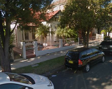
5. Installation of ‘Disabled Parking’ Restriction – No.22 Bright Street, Marrickville
The resident of No.22 Bright Street, Marrickville has requested the installation of a 'Disabled Parking' zone in front of the resident’s property. A site investigation has revealed that the property does not have off street parking. The applicant does not require the use of a wheelchair.
It is recommended that a 6.0m 'Disabled Parking' zone be installed in front of No.22 Bright Street.
No.22 Bright Street, Marrickville
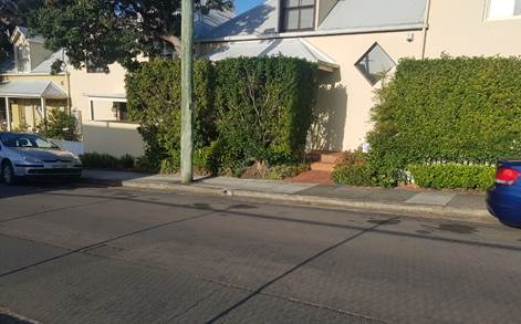
6. Installation of ‘Disabled Parking’ Restriction – 3/2 Ewenton Street, Balmain East
The resident of No.3/2 Ewenton Street, Balmain East has requested the installation of a 'Disabled Parking Zone’ in front of the resident’s property. A site investigation has revealed the property does have off street parking in the basement of the complex. There are two possible ways for the resident to walk between the house and the car space which are approximately 100m in distance via stairs and/or a steep driveway ramp. The applicant does not require the use of wheelchair. The resident has also provided consent from the neighbouring property and a letter from the Strata of the complex confirming there are no other parking arrangements available within the complex.
It is recommended that a 6.0m 'Disabled Parking' zone be installed in front of 3/2 Ewenton Street, Balmain East.
No.3/2 Ewenton Street, Balmain East
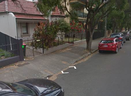
7. Installation of ‘Disabled Parking’ Restriction – No.11 Bruce Street, Stanmore
The resident of No.11 Bruce Street, Stanmore has requested the installation of a 'Disabled Parking' zone in front of the resident’s property. A site investigation has revealed the property does not have off street parking. The applicant does not require the use of wheelchair.
It is recommended that a 6.0m 'Disabled Parking' zone be installed in front of No.11 Bruce Street, Stanmore.
No.11 Bruce Street, Stanmore
Technical Standards
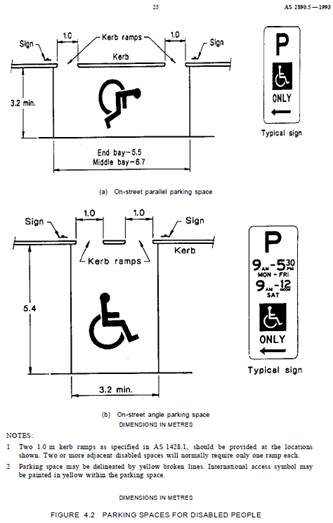
Australian Standard AS2890.5-1993 “On-Street Parking” states the following in regards to the provision of parking for people with a disability:
“Parallel parking spaces shall not be marked as disabled spaces, nor included in the count of spaces available for people with disabilities unless –
i. A 3.2m wide space can be provided, e.g. by indenting the space into the footpath area; and
ii. Kerb ramps as shown in Figure 4.2(a) are also provided”.
It should be noted that due to the limited width of streets around the LGA, it is often difficult to comply with these requirements for the parking space dimensions. This may also result in the loss of some adjacent on-street parking spaces.
Mobility parking spaces are primarily intended for on-street and off-street parking at destinations, such as in commercial/retail areas and public car parks near hospitals, schools and public transport facilities where multiple usages can be expected. They were generally not intended for points of origin such as reserving on-street parking. As such, they are only proposed where required for wheelchair access at the cost of the applicants.
A mobility parking space is not intended for the sole use of one applicant, but rather a shared facility that can used by all authorised persons having a RMS mobility permit.
8. Installation of ‘Works Zone’ Restriction – No.6 Woodland Street, Marrickville
The applicant has requested the installation of a temporary 9m 'Works Zone 7.00am – 6.00pm Mon-Sat and 8.00am - 1.00pm Sat' (unless noted otherwise on the Development Consent) for 12 weeks at the front of No.6 Woodland Street, Marrickville for development works at the property.
It is recommended that a 9m 'Works Zone 7.00am – 6.00pm Mon-Fri and 8.00am - 1.00pm Sat' be installed at the front of No.6 Woodland Street, Marrickville, for 12 weeks.
No.6 Woodland Street, Marrickville
9. Installation of ‘Works Zone’ restriction – Barwon Park Road, St Peters
The applicant (Nos.44-46 Princes Highway) has requested a 6m extension to the existing temporary 20m 'Works Zone 7:00am – 6:00pm Mon-Fri and 8.00am-1.00pm Sat' along the rear boundary of Nos.44-46 Princes Highway, St Peters, in Barwon Park Road for 12 weeks. The initial 'Works Zone' application was approved at the April 2019 Local Traffic Committee. The extension of the 'Works Zone' is still along the site frontage of the applicant’s property (Nos.44-46 Princes Highway).
It is recommended that a 26m 'Works Zone 7:00am – 6:00pm Mon-Fri and 8.00am-1.00pm Sat' be installed in Barwon Park Road along the rear boundary of Nos.44-46 Princes Highway, St Peters for 12 weeks.
Rear of Nos.44-46 Princes Highway, St Peters, in Barwon Park Road.
PUBLIC CONSULTATION
Nil.
|
|
Local Traffic Committee Meeting 8 October 2019 |
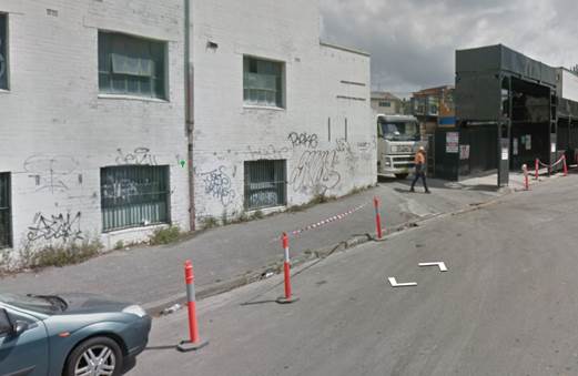
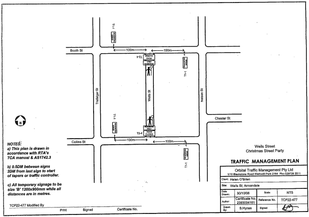
Subject: Wells Street, Annandale - Christmas Street Party (Road Occupancy)(Gulgadya-Leichhardt Ward/ Balmain Electorate/ Leichhardt PAC)
Prepared By: David Yu - Engineer - Traffic and Parking Services
Authorised By: John Stephens - Traffic and Transport Services Manager
SUMMARY
Council has received an application for approval of an annual Christmas street party in Wells Street between Booth Street and Collins Street, Annandale to be held on Sunday, 1 December 2019 between 4:00pm and 7:00pm.
|
RECOMMENDATION
THAT the temporary road closure of Wells Street, Annandale between Booth Street and Collins Street, to conduct an annual Christmas Street Party on Sunday, 1st December 2019, from 4:00pm - 7:00pm, be approved, subject to the conditions as set out as per the Street Party Application Form as well as the following additional conditions:
1. That an unencumbered passage minimum of 4.0m wide be available for emergency vehicles through Wells Street, Annandale between Booth Street and Collins Street;
2. The occupation of the road carriageway must not occur until the road has been physically closed; and
3. All affected residents and businesses, including the NSW Police Local Area Commander, Fire & Rescue NSW and NSW Ambulance Services be notified in writing, by the applicant, of the proposed temporary road closure at least 14 days in advance of the closure with the applicant making reasonable provision for stakeholders. |
BACKGROUND
Council has received an application for approval of an annual Christmas street party in Wells Street between Booth Street and Collins Street from a resident of Wells Street, Annandale.
The street party is proposed to be held on Sunday, 1st December 2019 between 4:00pm and 7:00pm. The applicant is seeking permission for a temporary full road closure of Wells Street between Booth Street and Collins Street, similar to previous years’ events.
The Traffic Control Plan for the Closure is enclosed.
FINANCIAL IMPLICATIONS
The street party coordinator will bear all costs associated with the road closure.
OTHER STAFF COMMENTS
This is an annual event and no significant issues have occurred in the past.
According to the RMS ‘Guide to Traffic and Transport Management for Special Events’ a small street party is considered as a ‘Class 3’ event.
Council encourages properly conducted neighbourhood street parties as a means of building community spirit and improving neighbourhood security. Fees for road occupancy are waived by Council for small community street parties.
Where the following conditions apply, organisers are only required to obtain approval for a street party involving a temporary road closure:
· The party is to be held outdoors for fewer than 100 people.
· No temporary structures or jumping castles are to be erected.
· Participants are to bring their own food and drinks, and food and drinks are not for sale.
· There will be no performers or amplified music involved.
For approved street parties and subject to availability Council will provide barricades and ‘Road Closed’ signs subject to the street party coordinator arranging collection from and return to Council’s Summer Hill depot.
PUBLIC CONSULTATION
The proposed closure of Wells Street, Annandale between Booth Street and Collins Street has been advertised in the local newspaper for a period of 28 days commencing Tuesday, 10th September 2019.
No responses were received.
Subject: Burrows Avenue, Sydenham – Temporary Full Road Closures - Sydney Metro Sydenham Station and Junction (SSJ) Works – Amendment to approved road closure dates (Midjuburi-Marrickville Ward / Heffron Electorate / Inner West PAC)
Prepared By: Jennifer Adams - Engineer – Traffic and Parking Services
Authorised By: John Stephens - Traffic and Transport Services Manager
SUMMARY
Notice of amendments for the temporary full road closure of Burrows Avenue, between Hogan Avenue and Gleeson Avenue, Sydenham have been received from Sydney Metro Sydenham Station and Junction (SSJ) Group. Due to project work requirements additional closure dates have been proposed in addition to the previously approved full road closures. The street will be temporarily closed to all vehicular traffic, including emergency vehicles and local residents. It is recommended that the proposed additional temporary full road closures be approved, subject to the conditions outlined in this report.
|
RECOMMENDATION
THAT the proposed temporary full road closure of Burrows Avenue, between Hogan Avenue and Gleeson Avenue, Sydenham on Friday, 18th October to Monday, 21st October 2019 (approved contingency date Friday, 25th October to Monday, 28th October 2019) and between Monday, 9th December to Friday, 27th December 2019 (approved contingency date Friday, 13th to Monday, 16th December 2019) be approved, in order to carry out upgrading works at Sydenham Station subject to, but not limited to, the following conditions:
1. The application and TMP be submitted to RMS for its approval;
2. A Road Occupancy License be obtained by the applicant from the Transport Management Centre;
3. All affected residents and businesses, including the NSW Police Local Area Commander, Fire & Rescue NSW and the NSW Ambulance Services be notified in writing, by the applicant, of the proposed temporary road closure at least 7 days in advance of the closure with the applicant making reasonable provision for stakeholders; and
4. The occupation of the road carriageway must not occur until the road has been physically closed.
|
BACKGROUND
A report went to the 5th August 2019 Local Traffic Committee detailing an application by Sydney Metro Sydenham Station and Junction (SSJ) Group for the temporary full road closure of Burrows Avenue, between Hogan Avenue and Gleeson Avenue, Sydenham on 3 separate occasions being 9pm Friday, 30th August to 4.30am Monday, 2nd September 2019, 9pm Friday, 25th October to 4.30am Monday, 28th October 2019 and 9pm Friday, 13th to 4.30am Monday, 16th December 2019 in order to carry out upgrading works at Sydenham Station.
On 10th September 2019, Council was notified that a variation to the permit was required and that the date for the road closure in October is 9pm Friday, 18th October to 4.30am Monday, 21st October 2019 and not as per the approved 9pm Friday, 25th October to 4.30am Monday, 28th October 2019. In addition, closures are required between 9th December and 27th December 2019.
A copy of the report that went to the 5 August 2019 Local Traffic Committee is reproduced at the end of this report for reference. The Traffic Control Plan (TCP) submitted by the applicant is shown in the report.
FINANCIAL IMPLICATIONS
The applicant has previously paid for the temporary full road closure and an invoice has been issued for advertising the amendments.
OFFICER COMMENTS
The site location is adjacent to Sydenham Railway Station. Burrows Avenue is a local road and carries approximately 7,000 vehicles per day.
PUBLIC CONSULTATION
The applicant is to notify all affected residents and businesses in writing at least 7 days prior to the commencement of works.
The change of dates for the road closures has been advertised in the local newspaper in accordance with the Roads Act 1993.
CONCLUSION
It is recommended that the proposed temporary full road closures be approved, subject to the conditions outlined in this report.
|
1.⇩ |
Burrows Avenue - 5 August 2019 LTC |
|
|
Local Traffic Committee Meeting 8 October 2019 |
Subject: Burrows Avenue, Sydenham – Temporary Full Road Closures - Sydney Metro Sydenham Station and Junction (SSJ) Works (Midjuburi-Marrickville Ward / Heffron Electorate / Inner West PAC)
Prepared By: Jennifer Adams - Engineer – Traffic and Parking Services
Authorised By: John Stephens - Traffic and Transport Services Manager
An application has been received from Sydney Metro Sydenham Station and Junction (SSJ) for the temporary full road closure of Burrows Avenue, between Hogan Avenue and Gleeson Avenue, Sydenham on 3 separate occasions from 9pm Friday, 30 August to 4.30am Monday, 2 September 2019; 9pm Friday, 25 October to 4.30am Monday, 28 October 2019 and 9pm Friday, 13 December to 4.30am Monday, 16 December 2019 in order to carry out upgrading works at Sydenham Station. The street will be temporarily closed to all vehicular traffic, including emergency vehicles and local residents. It is recommended that the proposed temporary full road closures be approved, subject to the conditions outlined in this report.
|
RECOMMENDATION
THAT the proposed temporary full road closure of Burrows Avenue, between Hogan Avenue and Gleeson Avenue, Sydenham on 3 separate occasions from 9pm Friday, 30 August to 4.30am Monday, 2 September 2019; 9pm Friday, 25 October to 4.30am Monday, 28 October 2019 and 9pm Friday, 13 December to 4.30am Monday, 16 December 2019 be approved, in order to carry out upgrading works at Sydenham Station, subject to the following conditions:
a) The application and TMP be submitted to RMS for approval;
b) A Road Occupancy License be obtained by the applicant from the Transport Management Centre;
c) All affected residents and businesses, including the NSW Police Local Area Commander, Fire & Rescue NSW and the NSW Ambulance Services be notified in writing, by the applicant, of the proposed temporary road closure at least 7 days in advance of the closure with the applicant making reasonable provision for stakeholders; and
d) The occupation of the road carriageway must not occur until the road has been physically closed.
|
BACKGROUND
John Holland Pty Ltd and Laing O’Rourke Australia Construction Pty Ltd are currently undertaking major railway work at Sydenham as part of Sydney Metro, including the upgrade of Sydenham Station. The station will be fully upgraded with a new aerial concourse over the existing platforms including lifts, stairs and level access between the platforms and trains.
The project is working within a live rail environment. For the safety of workers and customers a number of activities can only be carried out when trains are not operating. The project therefore relies on Sydney Trains rail shutdown weekends to deliver these activities.
The Sydenham Metro Upgrade will be working during a Sydney Trains rail shutdown weekend scheduled for Friday, 30 August to Monday, 2 September 2019. Work will commence on the roof canopy steel installation on Platforms 4 and 5. A crane will be used during this work to carry out related lifts and associated work activities.
To facilitate the crane placement, temporary full road closures are required on Burrows Avenue between Hogan Avenue and Gleeson Avenue, Sydenham. The first road closure is to commence from 9pm Friday, 30 August to 4.30am Monday, 2 September 2019.
Traffic movements will be managed in accordance with the attached TCP. Traffic controllers will be on duty to assist both pedestrians and vehicle movements. Access to private property will be maintained at all times. Access to and from Bolton Street will be available via Hogan Avenue.
Additional lane closures will also be required to complete the works. Initially, the steel will need to be delivered and assembled on site prior to the installation. To facilitate this, a lane closure is required along Burrows Avenue (rail side) between Hogan Avenue and George Street. Initially, lane closures will be required from 9pm Thursday, 29 August to 9pm Friday, 30 August 2019 to establish a laydown area and receive deliveries and from 4.30am Monday, 2 September to 4.30am Tuesday, 3 September 2019 to decommission the laydown area.
:
Additional dates, coinciding with a number of rail shutdown weekends, the temporary full road closure with associated lane closures will be required are:
· Friday, 25 October to Monday, 28 October 2019
· Friday, December 13 to Monday, 16 December 2019
FINANCIAL IMPLICATIONS
Under Council’s Fees & Charges, the applicant is to pay a fee for the temporary full road closure. This fee includes advertising the proposal in accordance with the Roads Act 1993.
OFFICER COMMENTS
Site location
The site location is adjacent Sydenham Railway Station. Burrows Avenue is a local road.
![]()
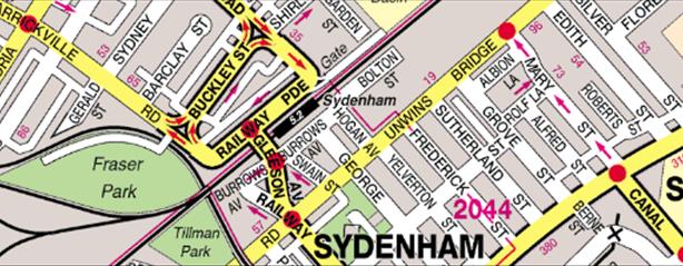
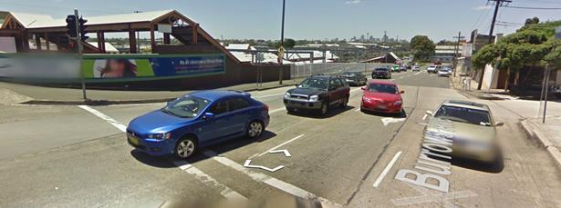
|
Street Name
|
Burrows Avenue |
|
Section |
Between Gleeson Avenue and George Street |
|
Carriageway Width (m) |
12.8 |
|
Carriageway Type |
Two-way road with one travel lane in each direction, in addition to kerbside parking lanes. |
|
Classification |
Local |
|
85th Percentile Speed (km/h) |
47.5 |
|
Vehicles Per Day (vpd) |
7,296 |
|
Reported Crash History (July 2011 - June 2016) |
No RMS recorded crashes. |
|
Heavy Vehicle Volume (%) |
5.1 |
|
Parking Arrangements |
Various on northern side of the road since Sydney Metro SSJ construction works being carried out. Southern side of the road consists of ‘No Parking’ restrictions with a section of ‘2P 8:30am-6pm Mon-Fri, 8:30am-12:30pm Sat’ restrictions. |
The Traffic Control Plan submitted by the applicant is reproduced below.
Vehicular access for local residents/businesses and emergency services will be maintained during the closure, where possible. Authorised Traffic Controllers will be on-site during the time of the road closure and are to be positioned at the closure points when required to provide vehicular access to local residents/businesses and ensure the safety of motorists and pedestrians.
Night work operations are necessary to get the required works completed during rail shutdown weekends. Residents within 100 metres of Sydenham Station will be notified prior to the road closure and a VMS board will be installed notifying road users of the road closure. In addition, Sydney Metro will be door knocking residents along Hogan Avenue/George Street/Swain Street including business owners along Hogan and Bolton Street.
Noise assessment will be carried out in accordance with the NSW Interim Construction Noise Guidelines and where required additional mitigation measures will be offered to identified sensitive receivers.
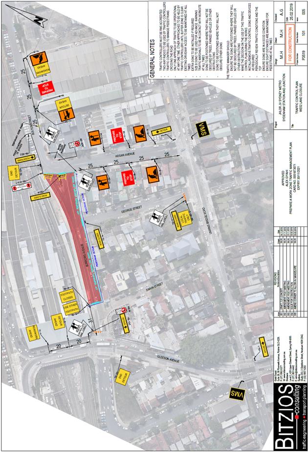
PUBLIC CONSULTATION
The applicant is to notify all affected residents and businesses in writing at least 7 days prior to the commencement of works.
The proposed road closure has been advertised in the local newspaper in accordance with the Roads Act 1993
CONCLUSION
It is recommended that the proposed temporary full road closures be approved, subject to but not limited to the conditions outlined in this report.
|
Local Traffic Committee Meeting 8 October 2019 |
Subject: Evans Street and Roseberry Street, Balmain - Proposed Kerb Blister Islands and Garden Beds (Baludarri-Balmain Ward/Balmain Electorate/Leichhardt PAC)
Prepared By: David Yu - Engineer - Traffic and Parking Services
Authorised By: John Stephens - Traffic and Transport Services Manager
SUMMARY
Detailed design plan has been finalised for the proposed intersection treatment at Evans Street and Roseberry Street, Balmain.
The proposal includes installing kerb blister islands and garden beds and associated signposting and line marking at the intersection of Evans Street and Roseberry Street to prevent trucks from colliding with an existing balcony that extends over the public footpath on the corner of Evans Street and Roseberry Street, Balmain.
Consultation was undertaken with the owners and occupiers of properties adjacent to the intersection regarding the proposal. A summary of the consultation results are presented in this report for consideration
|
RECOMMENDATION
THAT the detailed design plan for the kerb blister islands, garden beds and associated signposting and line marking at the intersection of Evans Street and Roseberry Street, Balmain (as per the attached plan No.10069_A) be approved. |
BACKGROUND
A detailed design plan has been finalised for the proposed intersection treatment at Evans Street and Roseberry Street, Balmain.
The proposal includes installing kerb blister islands and garden beds and associated signposting and line marking at the intersection of Evans Street and Roseberry Street as part of the 2019/20 Traffic Facilities (LATM) Capital Works Program to prevent trucks from colliding with an existing balcony and support posts that extends over the public footpath on the corner of Evans Street and Roseberry Street, Balmain.
The location is shown on the following photograph.
At this location, the building awning supports are located adjacent to the road carriageway and errant vehicles have caused previous structural damage to the awning supports whilst manoeuvring through the intersection.
This has raised concerns for both the structural integrity of the building and pedestrian safety (noting that the awning is located over the public footpath).
This building is heritage listed under Leichhardt Local Environmental Plan 2013 (Item No.I215) and the awnings to the building contributes to the heritage significance.
Site location & Road Network
|
Street Name(s) |
Evans Street and Roseberry Street, Balmain |
|
Section |
Intersection |
|
Traffic Volume |
- |
|
Recorded Accident History (5 year) |
Nil. |
|
Recorded 85% speed |
- |
|
Speed Limit |
40km/h |
|
Carriageway width |
Evans Street – 9.5m Roseberry Street - 12.9m |
|
Carriageway Type |
Evans Street - Two way with kerb side parking on both sides of the street Roseberry Street - Two way with kerb side parking on both sides of the street |
FINANCIAL IMPLICATIONS
Funding of $30,000 has been allocated to this project for construction in the 2019/20 Capital Works program.
OTHER STAFF COMMENTS
Initial Proposal
Council initially consulted residents on 23rd August 2019, regarding a proposal for kerb blister island and garden beds and a 3.3m ‘Motor Bike Only’ parking space on the eastern side of Evans Street. The proposal resulted in a loss of one (1) on-street car parking space.
The initial proposal is shown in the plan below (Plan no. 10069).
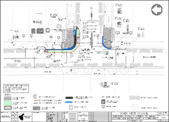
PUBLIC CONSULTATION
A letter outlining the initial proposal was mailed out to the affected properties (123 properties) in August 2019 in Evans Street and Roseberry Street, Balmain, requesting residents’ views regarding the proposal (as indicated on the following plan).
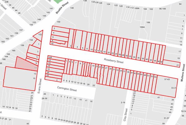
A total of 8 responses and a petition were received, three (3) responses in support, five (5) in objection of the proposal and a petition signed by 29 people (from 11 properties in consulted area) in objection.
|
Residents’ Comments |
Officer Comments |
|
We object to the application for the following reasons:
- The proposed blister islands are simply not required - Turning trucks are not a major concern at this intersection - The loss of car parking spaces is unacceptable in this location - The introduction of motorbike parking is unjustified - The proposed blister islands – as currently drawn - are too long |
The subject kerb blister islands have been proposed to prevent trucks from colliding with an existing balcony and supports that extends over the public footpath on the corner of Evans Street and Roseberry Street, Balmain. The proposal is also expected to improve safety for pedestrians crossing Roseberry Street.
The proposal has been updated so that there will be no loss of existing car parking spaces and ‘Motor Bike Only’ parking has been removed. |
|
Supportive
of the work being done as this is a dangerous intersection in relation to
cars coming from Beattie Street into Evans Street. |
Support noted.
Request to investigate concerns regarding speeding will be investigated as a separate matter. |
|
The further loss of parking is not acceptable. The town house development just down the road took up all the spare parking places when it was built as there are never enough parking spaces for residents let alone guests. Additionally, the café next door needs parking for patrons. |
As part of the updated proposal, there will be no loss of existing car parking spaces. |
Modified Proposal
Based on the responses, the plan was amended and re-consulted with the respondents in September 2019. The updated plan proposes to retain the existing car parking space by removing the proposed motor bike parking and by reducing the length of the kerb blister islands.
A review of the detailed design plan has been finalised for the proposed works together with community consultation and are presented in this report for consideration.
The updated detailed design plan shown in Attachment 1 outlines the proposed works at the Evans Street and Roseberry Street, Balmain intersection and includes the following treatments:
· Reconstruction of kerb ramps;
· Construction of a kerb blister island and garden bed on the north-eastern corner of the Roseberry Street and Evans Street intersection;
· Construction of sandstone kerb and concrete gutter; and
· Installation of associated signage and line-marking.
No responses were received when the updated proposal was consulted with respondents in September 2019.
CONCLUSION
It is recommended that the modified proposal for the kerb blister islands and garden beds and associated signposting and line-marking in Evans Street and Roseberry Street, Balmain (as per the attached plan No.10069_A) be approved.
|
1.⇩ |
Updated Proposed Kerb Blister Island and Garden Bed - Evans Street and Roseberry Street, Balmain |
|
|
Local Traffic Committee Meeting 8 October 2019 |
Subject: Garnet Street, Dulwich Hill – Temporary Full Road Closure of Rail Overbridge south of Hampden Street/The Parade and north of Floss Street/Ewart Street - Sydney Metro (SSJ) early enabling works on T3 Line (DJARRAWUNANG-ASHFIELD WARD / SUMMER HILL ELECTORATE / INNER WEST PAC)
Prepared By: Jennifer Adams - Engineer – Traffic and Parking Services
Authorised By: John Stephens - Traffic and Transport Services Manager
SUMMARY
An application has been received from Sydney Metro (SSJ) for the temporary full road closure of the rail over bridge on Garnet Street, just south of Hampden Street/The Parade and north of Floss Street/Ewart Street, Dulwich Hill for a 25 day period scheduled for Friday, 27 December 2019 to Friday, 24 January 2020 (contingency period of 7 days to Friday, 31 January 2020) in order to carry out early enabling works on the Rail Overbridge. The road will be temporarily closed to all vehicular traffic, including emergency vehicles and local residents. It is recommended that the proposed temporary full road closures be approved, subject to the conditions outlined in this report.
|
RECOMMENDATION
THAT the proposed temporary full road closure of the rail over bridge on Garnet Street, just south of Hampden Street/The Parade and north of Floss Street/Ewart Street, Dulwich Hill for a 25 day period scheduled for Friday, 27 December 2019 to Friday, 24 January 2020 (contingency period of 7 days to Friday, 31 January 2020) be approved, in order to carry out early enabling works on the rail over bridge subject to, but not limited to, the following conditions:
1. The application and TMP be submitted to RMS for its approval;
2. A Road Occupancy License be obtained by the applicant from the Transport Management Centre;
3. All affected residents and businesses, including the NSW Police Local Area Commander, Fire & Rescue NSW and the NSW Ambulance Services be notified in writing, by the applicant, of the proposed temporary road closure at least 7 days in advance of the closure with the applicant making reasonable provision for stakeholders; and
4. The occupation of the road carriageway must not occur until the road has been physically closed.
|
BACKGROUND
Southwest metro early works are now underway between Sydenham and Campsie to convert the existing rail to metro standards in preparation for the opening of Sydney Metro City & Southwest in 2024. The joint venture currently delivering the Sydney Metro upgrade to Sydenham Station (SSJ), John Holland Pty Ltd and Laing O’Rourke Australia Construction Pty Ltd, have been appointed to undertake early works along the T3 Bankstown Line like site geotechnical investigations, early design, and enabling works such as surveying and utilities investigations. Work also includes station and bridge investigations and the installation of cable routes, retaining walls and security fencing within the rail corridor.
As part of the Southern Corridor – Bankstown Line early investigation activities, the contractor is commencing installation of underground conduit crossing at Garnet Street, this will involve saw cutting asphalt/footpath/kerb & gutter, earthwork, concreting footpath, kerb & gutter and personnel. This will require a full road closure to Garnet Street to safely construct the works. Dulwich Hill Pre-school is situated in close proximity to the works. Early consultation has identified their Christmas shutdown period is Monday, 23 December 2019 to Monday, 6 January 2020. To minimise impact, works have been scheduled to start on 27 December 2019 during the school’s Christmas closure, additionally the project will cease work during the children’s rest period.
The work is scheduled for Friday, 27 December 2019 to Friday, 24 January 2020 and the full road closure will be in place for this whole duration. Traffic marshals will be on duty to assist both pedestrians and vehicle movements during working hours. Working Hours: Monday to Friday 0700 – 1800hrs, Saturday and Sunday 0800 – 1800hrs. The site will be secured with crowd control barriers and ATF fencing outside of working hours
Traffic movements will be managed in accordance with the attached TCP. Traffic controllers will be on duty to assist both pedestrians and vehicle movements.
Community notification by Sydney Metro (SSJ) will include:
· Residents in close proximity to work will be notified via notification. This notification will be emailed to them as well as a letterbox drop
· Notification will be distributed no later than 7 days prior to work commencing
· A door knock of local businesses and residents with the potential to be impacted will be carried out
FINANCIAL IMPLICATIONS
Under Council’s Fees & Charges, the applicant is to pay a fee for the temporary full road closure. This fee includes advertising the proposal in accordance with the Roads Act 1993.
OFFICER COMMENTS
Site location
Garnet Street lies on the boarder of Inner West Council and the City of Canterbury-Bankstown. It is noted that the full road closure will divert traffic to either Wardell Road in the west or Livingstone Road in the west.
![]()
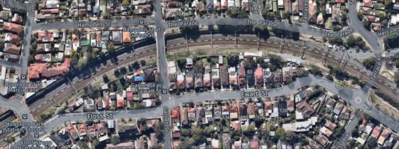
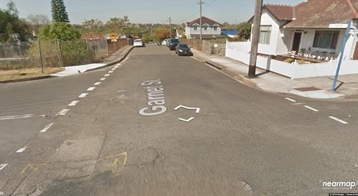
Garnet Street, Dulwich Hill looking south towards rail overbridge from Hampton Street/The Parade
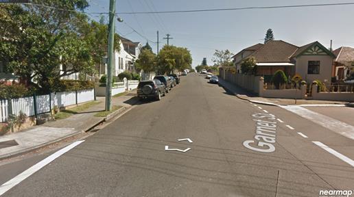
Garnet Street, Dulwich Hill looking north towards rail overbridge from Floss Street/Ewart Street
|
Street Name |
Garnet Street |
|
Section |
Between Hamden Street/The Parade and Floss Street/Ewart Street |
|
Carriageway Width (m) |
8.4 metres at overbridge |
|
Carriageway Type |
Two-way road with one travel lane in each direction at overbridge. |
|
Classification |
Local |
|
Speed limit |
50.0 |
|
85th Percentile Speed (km/h) |
43.6 |
|
Vehicles Per Day (vpd) |
741 |
|
Reported Crash History (July 2013 – June 2018) |
Nil. |
|
Heavy Vehicle Volume (%) |
3.1 |
|
Parking Arrangements |
unrestricted parking along each side of Garnet Street |
The Traffic Control Plan submitted by the applicant indicating detour routes is shown below.
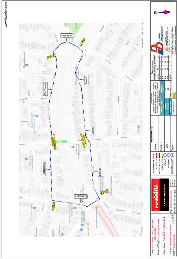
PUBLIC CONSULTATION
The applicant is to notify all affected residents and businesses in writing at least 7 days prior to the commencement of works.
The proposed road closure has been advertised in the local newspaper in accordance with the Roads Act 1993. The submission period begins on Tuesday, 1 October and ends on Tuesday, 29 October 2019.
CONCLUSION
It is recommended that the proposed temporary full road closure be approved, subject to but not limited to the conditions outlined in this report.
|
|
Local Traffic Committee Meeting 8 October 2019 |
Subject: Queen Street at Arthur Street & Norton
Street, Croydon - Proposed Traffic Calming at the intersections including Kerb
Blisters (Design Plans 10095 & 10096)
(Djarrawunang - Ashfield Ward/ Summer Hill Electorate/ Burwood PAC)
Prepared By: Scipio Tam - Engineer - Traffic and parking Services (South)
Authorised By: John Stephens - Traffic and Transport Services Manager
SUMMARY
Design plans have been prepared for proposed speed cushions and splitter islands on Queen Street, Arthur Street and Norton Street, Ashfield. The proposed works received funding from the RMS Blackspot Program and the works will improve traffic conditions and road safety at these locations.
Consultation was undertaken with nearby owners and occupiers of properties in Queen Street, Arthur Street and Norton Street regarding the proposal. It is recommended that the proposed detailed design plan be approved.
|
RECOMMENDATION
THAT the detailed design plans for the proposed intersection improvements along with associated signage and line marking at Queen Street and Arthur Street, Croydon (Design Plan No.10095) and Queen Street at Norton Street, Croydon (Design Plan No.10096) be APPROVED.
|
BACKGROUND
The roundabout at the junction of Queen Street and Norton Street and the roundabout at the junction of Queen Street and Arthur Street were identified as locations that required traffic calming measures to address concerns regarding unsafe driver behaviour and a crash history. In addition, Queen Street is cycle route with pavement marking.
A review of 5 years (June 2013 – June 2018) of Road and Maritime Services (RMS) reported crash data revealed that there had been four injury crashes at the junction of Queen Street and Norton Street and two crashes resulting in injury at the junction of Queen Street and Arthur Street. A further analysis of the crash data revealed that vehicles not slowing to give way was a main contributor in a number of the recorded crashes. Subsequently, a submission was made for Blackspot funding and Council was successful in receiving funding through the RMS’s Blackspot Program for the proposed traffic improvement works.
Council is proposing to install:
At Queen Street and Norton Street:
· Asphalt speed cushions on northern and southern Queen Street approaches to the Norton Street junction roundabout;
· Asphalt speed cushion on eastern Norton Street approach to the Queen Street junction roundabout;
· Kerb blisters adjacent to both proposed asphalt speed cushions on Queen Street; and
· Associated signage and line marking.
At Queen Street and Arthur Street:
· Asphalt speed cushions on northern and southern Queen Street approaches to the Arthur Street junction roundabout;
· Asphalt speed cushion on western Arthur Street approach to the Queen Street junction roundabout;
· Kerb blisters adjacent to both proposed asphalt speed cushions on Queen Street; and
· Raise outer part of the roundabout along with 50mm high mountable kerb; and
· Associated signage and line marking.
Design plans have been prepared for proposed speed cushions, kerb blisters, modifications to existing roundabout and associated signage and line marking for both Queen Street at Norton Street and Queen Street at Arthur Street intersections. The proposal will improve traffic conditions and road safety at this location.
FINANCIAL IMPLICATIONS
The projects have been fully funded in the 2019/2020 financial year under the RMS Blackspot Program.
OTHER STAFF COMMENTS
Site Location & Road Network
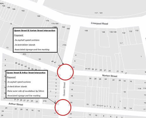
Figure 1 – Locality Map
A summary of the traffic data is provided in the tables below:
|
Street Name |
Queen Street |
|
Section |
Intersection with Norton Street |
|
Carriageway Width (m) kerb to kerb |
13.1m |
|
Carriageway Type |
Two-way road with one travel lane in each direction, in addition to kerbside parking on both sides. |
|
Classification |
Local (Norton Street is a Regional Road) |
|
Speed limit |
50 |
|
85th Percentile Speed (km/h) |
Unavailable |
|
Vehicles Per Day (vpd) |
Unavailable |
|
Reported Crash History |
Total Recorded Crashes: Four (4) -2x RUM Code 10 (Cross Traffic) -1x RUM Code 39 (Other Same Direction) -1x Rum Code 70 (Off Carriageway to left on Right bend) |
|
Heavy Vehicle Volume (%) |
Unavailable |
|
Parking Arrangements |
Unrestricted parking along western side and ‘2P 8am-6pm Mon-Fri Permit Holders Excepted Area 1’ on the eastern side of Queen Street, both north and south of junction with Norton Street. |
|
Street Name |
Queen Street |
|
Section |
Intersection with Arthur Street |
|
Carriageway Width (m) kerb to kerb |
13.1 |
|
Carriageway Type |
Two-way road with one travel lane in each direction, in addition to kerbside parking on both sides. |
|
Classification |
Local |
|
Speed limit |
50 |
|
85th Percentile Speed (km/h) |
Unavailable |
|
Vehicles Per Day (vpd) |
Unavailable |
|
Reported Crash History |
Total Recorded Crashes: Three (3) -3x RUM Code 10 (Cross Traffic) |
|
Heavy Vehicle Volume (%) |
Unavailable |
|
Parking Arrangements |
Unrestricted parking along western side and ‘2P 8am-6pm Mon-Fri Permit Holders Excepted Area 1’ on the eastern side of Queen Street, both north and south of junction with Arthur Street. |
Detailed design plans for the proposed intersection treatment and associated signage and line marking at Queen Street and Arthur Street (Design Plan 10095 – Attachment 1), and the proposed intersection treatment and associated signage and line marking at Queen Street and Norton Street (Design Plan 10096 – Attachment 2) are submitted for consideration.
The proposed scope of works at the intersection of Queen Street and Arthur Street includes the following:
1. Queen Street and Arthur Street, Ashfield – Plan No. 10095
· Construct 1.9m by 2m speed cushion in Queen Street on northern approach to Arthur Street;
· Construct 1.9m by 2m asphalt speed cushion in Queen Street on southern approach to Arthur Street;
· Construct 1.9m by 2m asphalt speed cushion in Arthur Street on western approach to Queen Street;
· Construct 6.7m by 1.8m kerb blister on Queen Street on northern approach to Arthur Street adjacent to proposed asphalt speed cushion;
· Construct 6.7m by 1.8m kerb blister on Queen Street on southern approach to Arthur Street adjacent to proposed asphalt speed cushion;
· Raise the outer part of the roundabout and construct 50mm high mountable kerb encircling the roundabout; and
· Install associated pavement line marking and signage as required.
2. Queen Street and Norton Street, Ashfield – Plan No. 10096
· Construct 1.9m by 2m speed cushion in Queen Street on northern approach to Norton Street;
· Construct 1.9m by 2m asphalt speed cushion in Queen Street on southern approach to Norton Street;
· Construct 1.9m by 2m asphalt speed cushion in Norton Street on eastern approach to Queen Street;
· Construct 5.5m by 1.2m kerb blister on Queen Street on northern approach to Norton Street adjacent to proposed asphalt speed cushion;
· Construct 6.8m by 1.8m kerb blister on Queen Street on southern approach to Norton Street adjacent to proposed asphalt speed cushion; and
· Install associated pavement line marking and signage as required.
Both proposals will result in no loss of legal parking spaces in Queen Street, Arthur Street and Norton Street.
As a cycle route is provided along Queen Street, the movement of bicycles through the proposed speed cushion devices has been considered as part of the detailed design process.
The size and placement of all kerb blisters and speed cushions have been designed in order to allow for a safe thoroughfare for cyclists approaching the roundabout and through the proposed devices.
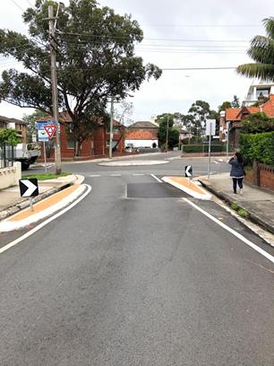
Figure 2: Norton Street, Ashfield –
Eastern approach to Queen Street roundabout
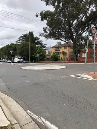
Figure 3: Queen Street and Norton Street intersection
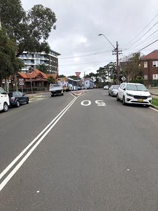
Figure 4: Queen Street, Ashfield –
Southern approach to Norton Street roundabout
PUBLIC CONSULTATION
Consultation was conducted between 8th August and 30th August 2019. A letter as well as copies of the design plans were sent to the local residents in Queen Street, Arthur Street and Norton Street, Ashfield as indicated in the consultation map below. No responses were received to date.
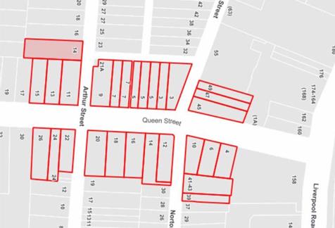
Figure 5: Map of consulted properties for the proposed design plans
CONCLUSION
It is recommended that the detailed design plans of the proposed intersection treatments on Queen Street at Arthur Street and at Norton Street and all associated signage and line marking be approved to improve safety at these intersections.
|
1.⇩ |
10095 - Design Plan - Queen Street at Arthur Street |
|
2.⇩ |
10096 - Design Plan - Queen Street at Norton Street |
|
|
Local Traffic Committee Meeting 8 October 2019 |
Subject: Heighway Avenue, Ashfield - Temporary Road Closure For Christmas Street Party - Djarrawunang-Ashfield Ward/Summer Hill Electorate/Burwood PAC
Prepared By: Boris Muha - Engineer – Traffic and Parking Services
Authorised By: John Stephens - Traffic and Transport Services Manager
SUMMARY
Council seeks the support of the committee for a temporary full road closure of Heighway Avenue Ashfield, between Walter Street and Frederick Street, to conduct an annual Christmas Street party on Saturday, 7 December 2019.
|
RECOMMENDATION
THAT the temporary full road closure of Heighway Avenue, Ashfield, between Walter Street and Frederick Street, to conduct an annual Christmas Street Party on Saturday 7th December 2019, from 5.00pm to 9.00pm be approved, subject to the conditions as detailed on the Street Party Application Form as well as the following additional conditions:
1. That an unencumbered passage (minimum 4.0m wide) be made available for emergency vehicles through the closed section of Heighway Avenue, Ashfield; 2. The occupation of the road carriageway must not occur until the road has been physically closed; and 3. All affected residents and businesses, including the NSW Police Local Area Commander, Fire & Rescue NSW and NSW Ambulance Services be notified in writing, by the applicant, of the proposed temporary road closure at least 14 days in advance of the closure with the applicant making reasonable provision for stakeholders. |
BACKGROUND
Correspondence has been received from a resident on behalf of the Heighway Avenue residents requesting the temporary full road closure of Heighway Avenue, between Walter Street and Frederick Street, to conduct an annual Christmas Street Party on Saturday, 7 December 2019.
This event is held annually with road closure arrangements being no different to past years. The road closure is a category type “Class 3” minor event under the RMS “Guide to Traffic and Transport Management for Special Events”. Concurrence is only required from the Council and Police with RMS only being notified of the event.
Heighway Avenue between Walter Street and Frederick Street is a narrow one-way Local Road, which carries low volumes of traffic in an easterly direction from Walter Street to Frederick Street.
|
Street Name(s) |
Heighway Avenue, Ashfield. |
|
Section |
Between Walter Street and Frederick Street. |
|
Traffic Volume (vehicles per day)-vpd |
850 |
|
Recorded Accident History (5 year) |
Nil |
|
Recorded 85% speed |
49km/h |
|
Speed Limit |
50km/h |
|
Carriageway width |
Approx. 7.5m |
|
Carriageway Type |
One –way street eastbound with one travel lane and kerb side parking both sides. |
|
Road Classification (State, Regional, Local) |
Local |
Detour Routes
Detouring can be made via the surrounding streets of Thomas Street and Frederick Street. Local traffic access can be maintained in the adjoining section of Heighway Avenue and Walter Street.
Resident access through the closed easterly one-way section of Heighway Avenue can be maintained from the Walter Street end.
A Traffic Control Plan and Traffic Management Plan are shown in Attachment 1 and 2.
FINANCIAL IMPLICATIONS
Council will supply signs and barricades to the event organiser on a first in first serve basis. Costs funded under Council's operational budget.
OTHER STAFF COMMENTS
This event is similar to those conducted in previous years and were supported by the Traffic Committee. Police and RMS have raised no objection in the past to the above special event road closure.
For this type Class 3 minor event the other conditions of the road closure are:
· Council supplies material (signs and barricades) for the event organiser to pick up or can alternatively hire. The organiser is responsible to erect the signs and barricades according to the Traffic Control Plan (TCP), and arrange the management of the closure with RMS accredited traffic controllers. Council Rangers would be requested to oversee the event to assure that the traffic control arrangements are in order;
· Council’s public liability insurance will cover such events provided all conditions of consent are complied with and the organiser submits a satisfactorily completed risk management assessment with the application. Should third party service providers be engaged for the event, the organisers must ensure public liability insurance of not less than $20 million is current for each provider and copies of such policies are submitted to Council;
· A clear passage of at least 4.0m is provided for emergency vehicle access. (Police condition);
· The organiser is responsible to arrange bins for litter control, and make the area neat and tidy following the re-opening of the road; and
· The organiser is responsible to dismantle the signs and barricades and be directed to deliver the material back to the Council Depot after the completion of the event.
PUBLIC CONSULTATION
The organiser is responsible for notifying the residents/businesses in the area and emergency services at least 2 week prior to the event. Council has arranged advertisement of the temporary full road closure of Heighway Avenue in the local newspaper for a period of at least 28 days prior to the event. The proposal was advertised in the local paper on Tuesday 24 September 2019 and no comments have been received to date.
CONCLUSION
It is recommended that support be provided for the temporary full road closure of Heighway Avenue, Ashfield, between Walter Street and Frederick Street, to conduct an annual Christmas Street Party on Saturday, 7 December 2019, from 5.00pm to 9.00pm. The closure will be subject to relevant conditions as imposed by Council together with any other conditions from the RMS and Police.
|
1.⇩ |
Traffic Management Plan TMP |
|
2.⇩ |
Traffic Control Plan TCP |
|
|
Local Traffic Committee Meeting 8 October 2019 |
CLOSURE OF HEIGHWAY AVENUE, ASHFIELD, BETWEEN WALTER STREET AND FREDERICK STREET, FOR CHRISTMAS
STREET PARTY
SATURDAY 7 DECEMBER 2019 FROM 5.00PM – 9.00PM
The use of the street would be for the residential community to conduct their annual Christmas Street party.
Note: This traffic management detail applies for this year’s event and may be subject to alteration in future events. The event is similar to as in previous years as approved by the Traffic Committee.
A Description or detailed plan of proposed measures
Is a detailed plan of the proposed measures necessary?
No, a detailed plan of the proposed measures is not necessary.
Heighway Avenue is a local road, which carries low volumes of traffic.
It is proposed to place portable Council barricades with “Road Closed” signs at Walter Street and at Frederick Street. Locations will be manned to allow resident access if required. “Road Closed Ahead” signs will be placed at Walter Street and Thomas Street to forewarn of road closure ahead and prevent traffic away from the area. Traffic can also be re-directed around at the manned road closure position of Heighway Avenue and Walter Street.
A TCP plan showing this is attached.
B Identification and assessment of impact of proposed measures
Is a detailed assessment required?
No, a detailed assessment is not required.
There will be little traffic in Heighway Avenue on the Saturday late afternoon/evening. Any traffic diversion can be made via Thomas Street Street and Frederick Street, and will not have any noticeable impact on these roads.
C Measures to ameliorate the impact of re-assigned traffic.
Is an assessment required?
No, an assessment is not required. See comments in B) above.
(2)
D Assessment of public transport services affected.
Is an assessment required?
No, an assessment is not required. Heighway Avenue is not a bus route.
E Details of provision made for emergency vehicles, heavy vehicles, cyclists and pedestrians.
Are these details required?
No, these details are not required.
The barricades will be portable and can easily be moved should emergency vehicles require access. Pedestrians will be able to walk normally on the footpath or between the barricades. Cyclists will be able to negotiate the barricades. Heavy vehicles, if any, can detour via Thomas Street or Frederick Street.
F Assessment of effect on existing and future developments with transport implications in the vicinity of the proposed measures.
Is an assessment required?
No, it is not applicable to this street closure for Christmas Street party.
G Assessment of effect of proposed measures on traffic movements in adjoining council areas.
Is an assessment required?
No, an assessment is not required.
The boundary with Burwood Council runs along Dickson Avenue some 200 metres to the west of the proposed closed section of Heighway Avenue between Walter Street and Frederick Street. No traffic will be directed into streets under the control of Burwood Council.
H Public Consultation Process
Is a public consultation process required?
No, a public consultation process is not required. The closure is for 4 hours on a Saturday afternoon/evening for a Christmas street party. The event co-ordinator is responsible to notify affected residents/businesses and emergency services prior to the street closure event.
|
|
Local Traffic Committee Meeting 8 October 2019 |
Subject: DALHOUSIE STREET, (RAMSAY STREET - WARATAH
STREET), HABERFIELD – LOCAL ROAD PROJECT (GULGADYA - LEICHHARDT WARD /
SUMMER HILL ELECTORATE / BURWOOD PAC)
Prepared By: Brinthaban Baskaran - Graduate Traffic Engineer
Authorised By: John Stephens - Traffic and Transport Services Manager
SUMMARY
A review of the detailed design plan has been finalised for the proposed road reconstruction of Dalhousie Street from Ramsay Street to Waratah Street.
The proposal includes resurfacing of road, reconstruction of footpath, kerb and gutter, kerb extensions and associated signposting and line marking.
Consultation was undertaken with the owners and occupiers of properties adjacent to the proposal. A summary of the consultation results are presented in this report for consideration.
|
RECOMMENDATION
That the detailed design plan for resurfacing of road, reconstruction of footpath, kerb and gutter, kerb extensions, and associated signposting and line marking in Dalhousie Street, Haberfield between the section of Ramsay Street to Waratah Street (as per attached plan No.10055) be approved. |
BACKGROUND
Council has received requests from the residents of Dalhousie Street, Haberfield for a number of years regarding visual conditions of damaged footpath, kerb and gutter, and asphalt road surface, etc. Residents in the street also reported flooding issues in the street. Council’s Infrastructure Planning team have assessed and prioritised this Local Road improvement project for construction in the 2021/22 financial year.
A review of the detailed design plan has been finalised for the proposed road reconstruction of Dalhousie Street from Ramsay Street to Waratah Street, Haberfield.
The proposal includes resurfacing of the road, reconstruction of the footpath, kerb and gutter, kerb extensions and associated signposting and line marking.
Consultation was undertaken with the owners and occupiers of properties adjacent to the proposal. A summary of the consultation results are presented in this report for consideration.
|
Street Name(s) |
Dalhousie Street, Haberfield |
|
Section |
Between Ramsay St and Waratah St/Boomerang St |
|
Traffic Volume |
4858 vehicles per day (2019 Traffic Count) (between Dickson St and Deakin Ave) |
|
Recorded Accident History (5 year) |
1 (2014 Serious injury) Dalhousie St at Deakin Ave 1 (2015 Moderate injury) Dalhousie St at Ramsay St 1 (2015 Non-casualty) Dalhousie St and Ramsay St 1 (2015 Minor injury) Dalhousie St at Waratah St 1 (2015 Serious injury) Dalhousie St at Waratah St 1 (2016 Moderate injury) Dalhousie St at Waratah St |
|
Recorded 85% speed |
33km/hr (2019 Traffic Count) (between Dickson St and Deakin Ave) |
|
Speed Limit |
50km/hr |
|
Carriageway width |
Approx. 12.5m |
|
Carriageway Type |
Two way street with kerb-side parking on both sides |
|
Road Classification (State, Regional, Local) |
Local |
FINANCIAL IMPLICATIONS
The project budget for the current 2019-20 financial year is for design only and is budgeted for $60,000. The project construction budget will be listed for consideration for the 2021-22 financial year.
OTHER STAFF COMMENTS
The updated detailed design plan shown in Attachment 1 outlines the proposed works at the section of Dalhousie Street, Haberfield between Ramsay Street to Waratah Street and includes the following treatments:
· Resurfacing the entire length of road;
· Reconstructing existing kerb and gutter (sandstone and concrete);
· Reconstructing concrete footpath on both sides of the road;
· Driveway reconstruction as required;
· Upgrading the existing pedestrian crossing to a raised pedestrian crossing at Dalhousie Street, near Deakin Avenue to improve pedestrian safety;
· Replacing existing rubber speed cushions with asphalt speed cushions;
· Providing landscaped kerb extensions at the intersections;
· Constructing a landscaped central median island on Dalhousie Street on the approach to Ramsay Street;
· Reconstructing kerb ramps;
· Providing a new grass verge and additional trees on both sides of the road;
· Providing passive irrigation for trees from kerb and gutter along the length of Dalhousie Street;
· Providing landscaping surrounding the trees and brick edging to delineate between the lawn and tree pit;
· Installing new drainage pits and pipes to upgrade drainage in the vicinity;
· Upgrading associated street lighting for pedestrian crossing;
· Providing a rain garden at the corner of Waratah Street (Boomerang St) and Dalhousie Street as shown in the plan, subject to detailed design;
· Installing associated pavement line marking and signage as required; and
· Providing new bicycle pavement symbols as shown in the plan.
PUBLIC CONSULTATION
A letter outlining the above proposal was mailed out to the affected 188 properties in Dalhousie Street, and adjacent street as indicated on the attached map below requesting residents’ views regarding the proposal.
Nine properties responded to the survey in support to the proposal, additional comments are summarised in the following table.
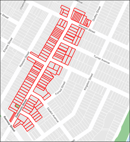
|
Residents’ Comments |
Officer Comments |
|
I commend Council's proposal to resurface the entire road. In addition, the corners of Martin & Bland St require realignment because of the steepness from road centre to existing gutters.
When reconstructing the existing kerb and gutter, Council should consider retaining the existing sandstone and not replacing it with concrete.
Council should implement slower speed zones e.g. 40kph at all time in conjunction with this construction in the side avenues.
The improvement of the raised crossing at Deakin intersection is essential. Council should consider moving the crossing from the intersection and moving it opposite the school where parents dropping kids on the other side of the school use it. It would also mean a crossing is put across Deakin and Dickson for added safety to the school & library.
|
The road camber will be realigned during the resurfacing of road.
Existing sandstone kerb will be retained as part of this project.
Council has recently written to Transport for NSW requesting RMS lower the speed limit to 40km/h in residential streets
The pedestrian crossing has been well established in its current location to best serve general pedestrian movement in the area.
Moving the crossing is not considered a feasible option as it will cause additional loss of parking spaces within midblock area. |
|
I request all new driveways to be constructed flush (horizontally flush) with the gutter. Council has many driveways with a lip 40mm high creating awkward access for pram-pushers and kids on bikes.
|
Council standard is to build a driveway with a minimum of 40mm bull nose for drainage purposes. |
|
Council should try to deter traffic from entering the Haberfield area via Five Dock. This can include improving the street facilities such as having a bicycle lane etc. |
Council will continue to review traffic management via its ongoing Local Area Traffic Management studies and Bicycle facilities will be considered through development of the Bike Plan.
|
|
Please ensure bike symbols are placed in the center of the traffic lanes, not sidelined in the gutter or under parked cars.
I also request that Council implement bicycle parking near the front door of the library as there are no bicycle racks directly out the front.
Please consider improving bicycle wayfinding signs where appropriate. Such as signs pointing down Barton St to the 'Green Way' or 'Hawthorne Canal’.
|
All the bicycle symbols will be installed as per the RMS guidelines.
Bicycle parking and wayfinding signs are out of this project scope and will be considered in future projects. |
|
The ‘No Parking’ between the ‘No Stopping’ area and the ‘Bus Zone’ (roughly opposite Dickson Avenue) should be a ‘No Stopping’ zone to make it more consistent. It is also a driveway so people shouldn't be parking there anyway and shouldn't be blocking it to stand.
At Turner and Martin Streets there should be ‘No Stopping’ signage for the 10m to the intersection. |
This matter is outside the scope of this project and will be considered as a separate issue. |
|
Is the proposed new median on the Ramsay Street end sufficiently long to prevent right hand turn access to the IGA carpark? As this would be good for pedestrian safety.
|
The median has not been extended across the IGA car park to retain access to and from the premises. |
|
I suggest Council consider connecting Dalhousie Street and Boomerang Street to the City West Link at the corner of Robson Park.
There is too much congestion in the mornings along Ramsay road, Marion street, Norton street and Parramatta road due to everybody heading for the city.
With the new M4 tunnel at Haberfield, traffic exiting the tunnel and heading for the city via Parramatta road, will require an alternative route to the city via the City West Link by using Dalhousie and Boomerang streets and connecting onto City West Link at Robson Park.
|
This treatment would induce additional traffic in local streets and is not supported.
The New M4 connects to the City West Link via an underground portal and connections through surface roads are not required. |
|
I support Council’s proposal to 'green' the street and in particular to increase water absorption and reduce stormwater run-off. During heavy rain periods, water pools around the bottom of the driveways or in the cracked footpaths making it difficult to walk through particularly for the elderly. |
Support noted. |
CONCLUSION
It is recommended that the proposal for the resurfacing of road, reconstruction of footpath, kerb and gutter, kerb extensions and road signs etc. in Dalhousie Street, Haberfield between Ramsay Street to Waratah Street (as per the attached plan No.10055) be approved.
|
1.⇩ |
Design Plan_Dalhousie Street, Haberfield |
|
Local Traffic Committee Meeting 8 October 2019 |
Subject: Red Lion Street, Rozelle - Annual Road Occupancy (Street Party) (Baludarri - Balmain Ward/ Balmain Electorate/ Leichhardt PAC)
Prepared By: Vinoth Srinivasan - Engineer - Traffic and Parking Services
Authorised By: John Stephens - Traffic and Transport Services Manager
SUMMARY
This report seeks approval for the temporary road closure of Red Lion Street, Rozelle to facilitate the annual ‘Christmas Street Party’ event that has been successfully conducted since 2009.
|
RECOMMENDATION
THAT The temporary road closure of Red Lion Street, Rozelle, between Darling Street and Evans Street, to conduct an annual Christmas Street Party on Saturday, 14th December 2019, from 5:00pm – 12:00 midnight, be approved, subject to the conditions as set out as per the Street Party Application Form as well as the following additional conditions:
a. That an unencumbered passage minimum of 4.0m wide be available for emergency vehicles through the closed section of Red Lion Street, Rozelle; b. The occupation of the road carriageway must not occur until the road has been physically closed; c. All affected residents and businesses, including the NSW Police Local Area Commander, Fire & Rescue NSW and NSW Ambulance Services be notified in writing, by the applicant, of the proposed temporary road closure at least 2 weeks in advance of the closure with the applicant making reasonable provision for stakeholders. |
BACKGROUND
Council has received an application for approval of a street party in Red Lion Street between Darling Street and Evans Street, from a resident of Red Lion Street, Rozelle.
The street party is proposed to be held on Saturday, 14th December 2019 between 5:00pm and 12:00 midnight. The applicant is seeking permission for a temporary full road closure of Red Lion Street between Darling Street and Evans Street, Rozelle.
This report seeks approval for the temporary road closure of Red Lion Street, Rozelle to facilitate the annual ‘Christmas Street Party’ event that has been successfully conducted since 2009.
Site location & Road network
|
Street Name(s) |
Red Lion Street, Rozelle |
|
Section |
Between Darling Street and Evans Street |
|
Traffic Volume |
559 (2010) |
|
Recorded Accident History (5 year) |
Nil. |
|
Recorded 85% speed |
37km/h (2010) |
|
Speed Limit |
50km/h |
|
Carriageway width |
Approx. 6.0m |
|
Carriageway Type |
One way street with kerb side parking on western side and ‘No Parking’ restrictions on eastern side. |
|
Road Classification (State, Regional, Local) |
Local |
FINANCIAL IMPLICATIONS
The Street Party Coordinator will bear all costs associated with the road closure.
OTHER STAFF COMMENTS
The Traffic Control Plan for the closure is as follows:
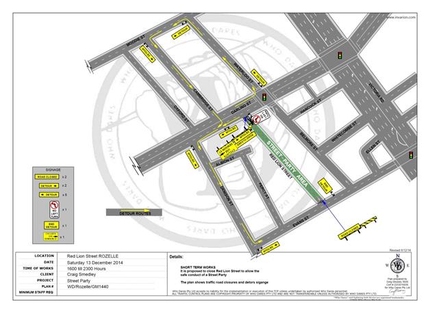
This is an annual event and no significant issues have occurred in the past (first event was in 2009).
According to the RMS ‘Guide to Traffic and Transport Management for Special Events’ a small street party is considered as a ‘Class 3’ event.
Council encourages properly conducted neighbourhood street parties as a means of building community spirit and improving neighbourhood security. Fees for road occupancy are waived by Council for small community street parties.
Where the following conditions apply, organisers are only required to obtain approval for a street party involving a temporary road closure:
· The party is to be held outdoors for fewer than 100 people
· No temporary structures or jumping castles are to be erected,
· Participants are to bring their own food and drinks, and food and drink are not for sale
· There will be no performers or amplified music involved
For approved street parties and subject to availability, Council will provide barricades and ‘Road Closed’ signs, subject to the Street Party Co-ordinator arranging pickup from and return to Council’s Summer Hill Depot.
PUBLIC CONSULTATION
The proposed temporary full-road closure is currently being advertised in the local newspaper for a period of 28 days from 10 September 2019 – 8 October 2019. No responses were received to date.
CONCLUSION
Nil.
|
1.⇩ |
Red Lion Street - Road Occupancy |
|
Local Traffic Committee Meeting 8 October 2019 |
Subject: George Street at Treadgold Street South, Leichhardt - Proposed 'Give-Way' control (Gulgadya - Leichhardt Ward / Balmain Electorate / Leichhardt PAC)
Prepared By: Brinthaban Baskaran - Graduate Traffic Engineer
Authorised By: John Stephens - Traffic and Transport Services Manager
SUMMARY
The T-intersection of George Street and Treadgold Street South, Leichhardt does not currently have signposted intersection control. This report recommends installing ‘Give-Way’ control at the intersection.
|
RECOMMENDATION
That ‘Give-Way’ control be signposted and line marked in George Street, Leichhardt immediately south of Treadgold Street South for northbound motorists. |
BACKGROUND
The T-intersection of George Street and Treadgold Street South, Leichhardt does not currently have signposted/linemarked intersection control. This report recommends installing ‘Give-Way’ control at the intersection.
A number of residents have raised concerns regarding traffic conditions at the George Street/Treadgold Street South intersection due to no intersection controls.
Concerns primarily relate to unclear intersection priority caused by the horizontal curve in George Street at its intersection with Treadgold Street South which creates an offset T-intersection of George Street and Treadgold Street South.
These conditions have resulted in conflict between northbound vehicles in George Street with southbound vehicles in George Street continuing past Treadgold Street South or with eastbound/westbound vehicles in Treadgold Street South.
These concerns have been exacerbated due to the intensification of vehicle trips following the recent construction of multi-unit dwellings in George Street.
|
Street Name(s) |
George Street, Leichhardt |
|
Section |
Intersection of Treadgold Street South |
|
Traffic Volume |
534 (2012 count) (Treadgold Street South between Flood Street and George Street) |
|
Recorded Accident History (5 year) |
N/A |
|
Recorded 85% speed |
20.5km/hr (2012)(Treadgold Street South between Flood Street and George Street) |
|
Speed Limit |
50km/hr |
|
Carriageway width |
Approx. 8.0m |
|
Carriageway Type |
Two way street with kerb-side parking on western side |
|
Road Classification (State, Regional, Local) |
Local |
FINANCIAL IMPLICATIONS
Nil.
OTHER STAFF COMMENTS
In order to alleviate this issue, it is proposed to signpost the ‘Give Way’ control at the Treadgold Street South/George Street intersection in a manner which requires northbound vehicles on George Street at Treadgold Street South to give way to all other movements. The proposal is not expected to result in a loss of on-street car parking spaces and is shown on the following plan.
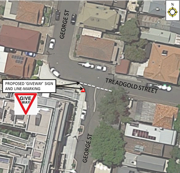
PUBLIC CONSULTATION
A letter outlining the above proposal was mailed out to the affected 176 properties in George Street and Flood Street as indicated on the attached map below requesting residents’ views regarding the proposal.
Four properties responded to the survey, three in support and one in objection of the proposal.
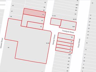
|
Residents’ Comments |
Officer Comments |
|
We request Council to install speed humps and a STOP sign on Flood Street near Treadgold Street North & South. |
There is currently no accident history which would warrant the need for STOP control at the intersection of Flood Street and Treadgold Street North and South and speed humps.
|
|
Treadgold Street is too narrow for two cars to safely pass as parking is permitted on one side of the street.
Vehicles enter at high speeds from Flood Street which is a blind spot, especially during night due to a lack of street lighting.
Treadgold Street needs to be changed to a one way street or the on-street parking needs to be removed. (3 similar
comments) |
There is sufficient space for existing parking to be maintained with an unobstructed 3 metre travel lane for motorists. ‘No Stopping’ zones and driveways are also present in the street which allow passing opportunities for two-way traffic.
|
|
|
Local Traffic Committee Meeting 8 October 2019 |
Subject: Draft Croydon Parking Study (Gulgadya-Leichhardt Ward/Summer Hill Electorate/Burwood PAC)
Prepared By: Sunny Jo - Traffic and Parking Planner
Authorised By: John Stephens - Traffic and Transport Services Manager
SUMMARY
The Croydon Parking Study reviewed the location, supply, demand and distribution of both short and long stay parking, residential, employee and commuter parking. The work consisted of examining existing conditions including parking data, community submissions, and examining on-street as well as private off-street parking. A community survey was also undertaken to gauge the parking issues faced by different users. With consideration for future developments and access to public transport, including Burwood Council’s own parking strategy, a parking management strategy was then developed for the Croydon area.
|
RECOMMENDATION
THAT:
1. The Committee endorse the Draft Croydon Parking Study including Stage 1 and 2 of the parking management strategy for community consultation; and
2. The draft report be placed on Public Exhibition, providing a minimum 28 days for submissions and the results be reported back to the Committee.
|
BACKGROUND
The Study was arranged in response to representations received from the community regarding parking in residential areas near the Croydon Railway Station. The study was established with an aim to understand the parking situation, reflect on the community’s parking needs and desires, and to develop an effective parking management strategy.
The Croydon parking study area shown in Attachment 1 is bounded by Frederick Street, Church Street, Lang Street, Queen Street and the common local government boundary between Inner West and Burwood Councils.
The current Resident Parking Scheme (RPS) operating in the study area includes Horden Parade, Railway Street, Milton Street, Thomas Street, and Wetherill Street.
OTHER STAFF COMMENTS
The Croydon Parking Study was undertaken to examine the reported parking issues for streets near the trip generators such as Croydon railway station, Ashfield Aquatic Centre, including schools and reserves.
The study was undertaken by GTA Consultants by examining the parking occupancy and duration data undertaken in December 2018, existing parking inventory, current supply and demand, and feedback received through Council’s Community Engagement Survey in March 2019. Further site observations were undertaken in February and March at different times to understand current conditions.
It should be noted that parts of Croydon and its commercial areas are situated within the adjoining Burwood Council area. As Burwood Council is also undertaking their own parking study, it is important that the strategies across the boundary are integrated and complimentary.
Stage 1 of the parking management strategy proposes to extend area 2 and area 6 RPS ‘2P 8am-6pm Mon-Fri, Permit Holders Excepted’ to the following streets:
· College Street (west side)
· Edwin Street between Elizabeth Street and Anthony Street (east side)
· Croydon Road between Elizabeth Street and Anthony Street (west side)
· Paisley Road east of The Strand (south side)
· Edwin Street between Paisley Road and Thomas Street (west side)
· Heighway Avenue between Edwin Street and Frederick Street (north side)
· Walter Street (west side)
Stage 2 of the strategy will extend the RPS areas and is planned to be implemented simultaneously with Stage 1 prior to the opening of the Ashfield Aquatic Centre in late 2020. Two additional parking surveys will be carried out after the implementation of the two stages to review the impact and verify the success of the extension of the permit scheme. The two surveys are recommended to be conducted once before the re-opening of the new Ashfield Aquatic Centre, and once 6-12 months after the re-opening of the Ashfield Aquatic Centre to better understand the impact of the Aquatic Centre has on the parking in the surrounding streets. Streets identified for Stage 2 include ‘2P 8am-6pm Mon-Fri, Permit Holders Excepted’ restrictions in:
· Edwin Street north of Anthony Street (property sides, Bridges Reserve frontage will remain unrestricted i.e. RPS does not apply)
· Croydon Road between Anthony Street and Hunt Street (east side)
· Anthony Street between Edwin Street and Etonville Parade (north side)
· Edwin Street between Thomas Street and Liverpool Road (east side)
· Highbury Street between Thomas Street and Liverpool Road (east side)
A map containing the proposed Stage 1 and 2 of the scheme is shown in Attachment 2.
PUBLIC CONSULTATION
Council undertook community engagement through Council’s YourSay website in March 2019 with 2,100 invitation letters mailed out to affected stakeholders and residents for the study area. Consultation ended with 256 surveys completed and submissions relating to the study. A summary of the main issues arising from the submissions have been tabled in the report.
FINANCIAL IMPLICATIONS
The cost to implement Stages 1 and 2 of the parking strategy will be funded from Council’s traffic facilities budget, subject to Local Traffic Committee support and adoption by Council. Subsequent reports during implementation of Stages 1 and 2 will provide estimates on signage and administrative costs to expand the resident parking permit scheme if required.
CONCLUSION
The study and the recommended strategy will make parking fairer within Croydon by extending the RPS to eligible residents for streets identified in the study. It is recommended that the draft report be placed on public exhibition for 28 days, with an opportunity discuss submissions received during this period, and this will be included in the final version of the report.
|
1.⇩ |
Croydon Parking Study Area and Land Zoning |
|
2.⇩ |
Croydon Parking Study Draft Stage 1 and 2 Recommendations |
|
3.⇩ |
Croydon Parking Study Draft Report (GTA) |
|
Local Traffic Committee Meeting 8 October 2019 |
Subject: Hawthorne Parade, Haberfield - Proposed '2 hour' Parking Zone (Gulgadya - Leichhardt Ward/ Balmain Electorate/ Leichhardt PAC)
Prepared By: Vinoth Srinivasan - Engineer - Traffic and Parking Services
Authorised By: John Stephens - Traffic and Transport Services Manager
SUMMARY
Council has received requests to implement time-restricted parking directly in front of the Children’s playground in Richard Murden Reserve to restrict long stay parking by non-resident vehicles that utilise the light rail.
|
RECOMMENDATION
THAT the existing fourteen indented (14) rear-to-kerb unrestricted parking bays on the eastern side of Hawthorne Parade between Turner Avenue and Barton Avenue, Haberfield be restricted as ‘2P 8am-10pm’. |
BACKGROUND
At Council’s Ordinary Meeting held on 13th August 2019, Council resolved to investigate the provision of 2 hour restricted parking in the parking spaces immediately in front of the children play area near the Haberfield Light Rail Stop.
Council also received a similar request from a resident who had concerns that the subject unrestricted parking bays were currently being used for long stay parking by light rail commuters.
The implementation of time-restricted parking directly in front of the children’s playground in Richard Murden Reserve, Haberfield has been investigated to restrict long stay parking and to provide parking turnover for users of the children's playground area.
Site Location & Road Network
|
Street Name(s) |
Hawthorne Parade, Haberfield |
|
Section |
Between Turner Avenue and Barton Avenue |
|
Traffic Volume |
3,700 |
|
Recorded Accident History (5 year) |
1 - Moderate Injury (2016) |
|
Recorded 85% speed |
46.9 km/h |
|
Speed Limit |
50km/h |
|
Carriageway width |
Approx. 8m |
|
Carriageway Type |
Two way street with kerb-side parking on western side and indented rear-to-kerb parking bays on eastern side. |
|
Road Classification (State, Regional, Local) |
Local |
FINANCIAL IMPLICATIONS
The cost of the signage and installation will be met from Council's operating budget.
OTHER STAFF COMMENTS
It was initially proposed to convert the existing fourteen (14) indented, unrestricted parking bays on the eastern side of Hawthorne Parade between Turner Avenue and Barton Avenue, Haberfield to ‘2P’ restricted parking bays.
However, to allow for residential vehicles to park overnight, the proposal has been modified to ‘2P 8am-10pm’ restrictions.
It should be noted that the existing ‘Disabled Parking’ bay will be retained.
The modified proposal is shown on the plan below.
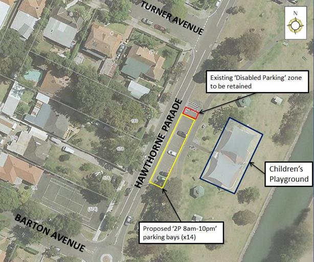
PUBLIC CONSULTATION
|
A letter outlining the initial proposal was mailed out to the affected 34 properties in Hawthorne Parade, Barton Avenue, Turner Avenue and Waratah Street, Haberfield requesting residents’ views regarding the proposal.
Two (2) responses were received in objection to the proposal. |
|
|
Residents’ Comments |
Officer Comments |
|
The children’s playground is not used much during the day and only becomes busy once school finishes and during the weekends. On weekdays, the subject parking bays are predominantly used by light rail commuters. Council’s proposal will displace 14 light rail commuters into residential areas. Therefore, we are in favour of no more than 2 of the 14 spaces being restricted to 2 hour parking on weekdays. We would also support a trial of a resident parking scheme in Hawthorne Parade, Turner Avenue and Barton Avenue, restricting non-resident weekday parking to 4 hours. (2 similar comments) |
The proposal will provide parking turnover to assist parking for users of the adjacent children's playground.
Resident Parking Scheme restrictions in nearby residential streets can be considered as part of a future Parking Precinct Study.
|
|
Commuters constantly park so close to the corner of Hawthorne Parade and Turner Avenue, restricting sightlines. We request cross hatching where parking is prohibited. |
Council’s Parking Services team will be advised so that they may enforce illegal parking behaviour. |
|
The park is often used by a whole range of people, including kids who want to use it for longer than 2 hours, especially when attending parties etc. It is unrealistic for Council to expect parents to move cars every 2 hours while trying to enjoy their time in the park. |
2 hour parking is considered to be an appropriate restriction for use of the park whilst discouraging long term parking in these spaces. |
CONCLUSION
Nil.
|
|
Local Traffic Committee Meeting 8 October 2019 |
Subject: Hearn Street, Leichhardt - Proposed 'No Parking' restriction (Gulgadya - Leichhardt Ward/ Balmain Electorate/ Leichhardt PAC)
Prepared By: Vinoth Srinivasan - Engineer - Traffic and Parking Services
Authorised By: John Stephens - Traffic and Transport Services Manager
Summary
Council has received concerns from a resident of South Avenue, Leichhardt regarding an ongoing problem with obstructed driveway access in the closed-end of Hearn Street due to parked vehicles.
|
RECOMMENDATION
THAT a 28.6m ‘No Parking’ restriction be installed along the northern closed end of Hearn Street, Leichhardt, between the rear driveway of No.81 Catherine Street and driveway of No.33 Hearn Street. |
BACKGROUND
Council has received concerns from a resident of South Avenue, Leichhardt regarding an ongoing problem with obstructed driveway access in the closed-end of Hearn Street due to parked vehicles.
Site Location & Road Network
|
Street Name(s) |
Hearn Street, Leichhardt |
|
Section |
Between Emily Street and closed-end |
|
Traffic Volume |
- |
|
Recorded Accident History (5 year) |
Nil. |
|
Recorded 85% speed |
- |
|
Speed Limit |
50km/h |
|
Carriageway width |
Approx. 8m |
|
Carriageway Type |
Two way street with kerb-side parking on both sides of the street |
|
Road Classification (State, Regional, Local) |
Local |
FINANCIAL IMPLICATIONS
Nil.
OTHER STAFF COMMENTS
Council is proposing to install a 28.6m ‘No Parking’ restriction along the closed-end of Hearn Street between the rear driveway of No.81 Catherine Street and driveway of No.33 Hearn Street to ensure unobstructed rear driveway access for properties No.3 and No.5 South Avenue as well as ensuring that adequate space is available for turning vehicles.
![]()
PUBLIC CONSULTATION
|
A letter outlining the above proposal was mailed out to the affected 10 properties in Hearn Street, Catherine Street and South Avenue, Leichhardt requesting residents’ views regarding the proposal.
No responses have been received.
|
|
|
|
Local Traffic Committee Meeting 8 October 2019 |
Subject: Smith Street, Marrickville - Proposed
Extension of Permit Parking Area M19
(Midjuburi- Marrickville Ward/ Summer Hill Electorate/ Inner West PAC)
Prepared By: Scipio Tam - Engineer - Traffic and parking Services (South)
Authorised By: John Stephens - Traffic and Transport Services Manager
SUMMARY
Following representations to Council, a proposal for an extension of the existing M19 permit parking restrictions was distributed to residents of Smith Street for comment. Given the feedback from residents, a revised proposal has been developed. The revised proposal addresses concerns raised by residents whilst offering a balanced approach to providing permit parking and unrestricted parking in the area.
|
RECOMMENDATION
THAT implementation of a 35m ‘2P 8.30am-6.30pm Monday to Friday Permit Holders Excepted Area M19’ parking restriction on Smith Street (southern side) between property No.2 and No.22 Smith Street, Marrickville be APPROVED. |
BACKGROUND
Council has received a request to extend the existing M19 permit parking area in Smith Street and Fitzroy Street, Marrickville and is proposing to extend the existing 2P permit parking restrictions on the southern side of Smith Street, Marrickville between No.2 and No.22 following representations from residents who are not eligible for a parking permit under the current scheme.
Smith Street and the adjoining streets provide on-street parking for combination of industrial and residential occupiers in the area and it is recognized that parking for the industrial users should also be considered.
Initially, a residential permit parking proposal was proposed and adopted by Council in February 2019, following a petition from Fitzroy Street residents. At that time, the investigation demonstrated no proven support for any extension of the proposed permit parking into Smith Street and the approach was taken to limit the extent of permit parking to that which was supported. Subsequent to the implementation of permit parking in Fitzroy Street, Council received a further petition from residents in Smith Street, requesting an extension of permit parking along Smith Street, near Fitzroy Street. Community engagement was undertaken and a proposal was developed and discussed at Council’s May 2019 Local Traffic Committee meeting. The proposal was later adopted by Council and implemented in July 2019 (proposal illustrated in Figure 1). At the time there was insufficient support from residents between No.2 and No.22 Smith Street to extend the RPS between these households which were situated towards Victoria Road end of Smith Street.
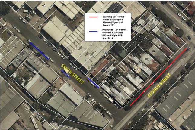
Figure 1: Initial Proposal for Smith Street – Residential Parking Scheme
The residents between properties No.2 and No.22 Smith Street were not eligible to participate in the RPS approved for Smith Street near Fitzroy Street. The main reasons for this decision were that the number of resident parking spaces that were created in Smith Street was limited and the scheme did not extend to cover the properties between No.2 and No.22 Smith Street.
However, following representations received from ineligible residents, Council Officers have conducted further community engagement on a proposal to now extend the current 2P residential parking permit arrangement to cover properties No.2 to No.22 Smith Street. (The proposal illustrated in Figure 2).
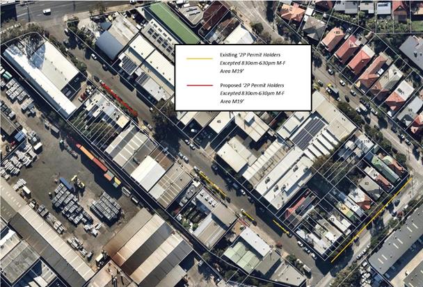
Figure 2: Current proposal for extending 2P Permit Parking in Smith Street, Marrickville
Parking survey results used during the initial investigation and proposal for Smith Street residential parking scheme are once again provided for consideration as land uses have not changed since that time. Parking surveys were undertaken on Wednesday, 25th and Thursday 26th July 2018, demonstrating that there were a high daytime occupancy in Smith Street. The parking occupancy generally ranged from 88% to 96%, with the lowest daytime occupancy being 69% occurring at 5pm on 25th Wednesday. It is considered that there is sufficient occupancy to warrant the proposal for resident permit parking.
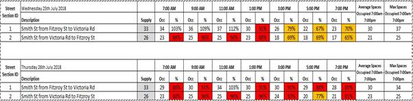
Table 1: Parking occupancy surveys
FINANCIAL IMPLICATIONS
The cost of the signposting will be funded from Council’s operating budget for signs and line marking.
OTHER STAFF COMMENTS
A summary of the traffic data is provided in the table below.
|
Street Name |
Smith Street |
|
Section |
Victoria Road to Fitzroy Street |
|
Carriageway Width (m) kerb to kerb |
12.2 |
|
Carriageway Type |
Two-way road with one travel lane in each direction, in addition to kerbside parking on both sides (‘2P Permit Holders Excepted 8.30am-6.30pm Mon-Fri Area M19’ restrictions outside frontages of residential properties, unrestricted parking along industrial kerb side). |
|
Classification |
Local |
|
Speed limit |
50 |
|
85th Percentile Speed (km/h) |
45 (2012) |
|
Vehicles Per Day (vpd) |
774 (2012) |
|
Reported Crash History |
No recorded crashes |
|
Heavy Vehicle Volume (%) |
11.5 (2012) |
|
Parking Arrangements |
A combination of unrestricted parking and ‘2P Permit Holders Excepted 8.30am-6.30pm Mon-Fri Area M19’ parking along both sides of the road. An aerial diagram of existing parking arrangements is shown in Figure 1. |
During all community engagement conducted, common requests received include:
· Extending the 2P permit parking throughout Smith Street, including the frontages of industrial businesses; and
· Extending the 2P permit parking into evening times to counter patrons of the Factory Theatre parking in Smith Street.
Although Council Officers understand the difficultly for residents to acquire on-street parking in high demand areas, Council is required to undertake a balanced approach to the introduction of parking restrictions which takes into account the needs of both resident and business owners. A typical approach in this case is to limit parking restrictions along the frontages of residential homes, to ensure parking opportunities are still available for ineligible individuals.
The intention of implementing permit parking in streets is to provide greater parking opportunities for residents during the day, when on-street parking may be occupied by visitors, businesses and commuters. As the area in question (including Smith Street) is a mix of industrial and residential, parking opportunities is expected to be greater in the evening, after business hours. Therefore, the time restriction from 8.30am to 6.30pm is seen to be sufficient.
Council Officers note that this proposal may not alleviate parking concerns raised by residents. Council’s Parking Policy for Marrickville Area M19, eligible residents are allowed a maximum of (2) two parking permits per property, with each off-street parking space deducting an allowable permit. As there is a high demand for parking in the area since:
· Most residential properties having no off-street parking available, therefore, eligible for the maximum of (2) two parking permits; and
· The presence of businesses and industrial properties within the area, requiring some degree of on-street parking mostly during the day.
PUBLIC CONSULTATION
Consultation was conducted between 20th August 2019 and 6th September 2019. A letter detailing the proposal was sent to the local residents and business occupiers in Smith Street, Marrickville as indicated in the consultation map below. (4) Four responses were received to date.
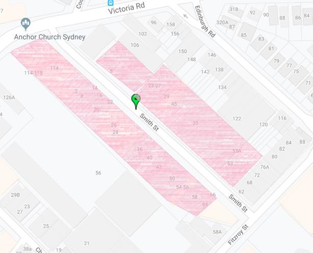
Figure 3 – Map of consulted properties
|
View on Proposal |
Resident’s Comment |
Officer’s Comment |
|
Support |
· Resident strongly supports the proposal; · Resident states residents of northern end of Smith Street are highly impacted by industrial/ business parking and visitors to the Factory Theatre; · Resident would like parking scheme to extend throughout the whole street with the restrictions extended till 10pm including weekends; · Resident would like council to consider angle parking. |
As the area consists of residential and commercial occupiers, Council is required to undertake a balanced approach for introducing parking restrictions. As visitors and business/ commercial occupiers require on-street parking as well, Council has introduced residential parking schemes along the frontages of residential properties to allow parking opportunities for all road users.
During evening hours and weekends, the business and commercial demands for parking are foreseen to be reduced, allowing further parking opportunities for residents. Additionally, Council’s intentions for residential parking schemes are to assist residents with parking opportunities during the day, when business and commercial parking demands are most active.
Council Officers have investigated the proposal for angle parking. However at present time, it is deemed to be unsuitable for Smith Street due to: · Smith Street being a through road, resulting in many vehicles passing through to adjoining roads; · The amount of driveways within Smith Street would prevent any significant gains in amount of on street parking as all parking spaces are required to be marked to Australian Standards. Additionally, parking bays are required to allow parking for larger heavy vehicles, which is not suitable in angle parking arrangements; · Smith Street has a significant amount of heavy and large vehicle thoroughfare and angle parking would require parked vehicles to reverse into the travel lane in order to exit a parking space; · The presence of industrial properties along Smith Street may require heavy vehicles to turn into and out of their property. The introduction of angle parking will significantly hinder heavy vehicle access.
|
|
Support |
Resident supports proposal
|
Support is noted |
|
Support |
Resident supports proposal
|
Support is noted |
|
Support |
· Resident requests to extend residential parking scheme throughout the street as parking from neighbouring businesses impacts resident’s parking opportunities; · Resident requests for the time restriction to be extended till 10pm, including Saturday. |
As the area consists of residential and commercial occupiers, Council is required to undertake a balanced approach for introducing parking restrictions. As visitors and business/ commercial occupiers require on-street parking as well, Council has introduced residential parking schemes along the frontages of residential properties to allow parking opportunities for all road users.
During evening hours and weekends, the business and commercial demands for parking are foreseen to be reduced, allowing further parking opportunities for residents. Additionally, Council’s intentions for residential parking schemes are to assist residents with parking opportunities during the day, when business and commercial parking demands are most active.
|
CONCLUSION
As parking occupancy surveys has shown high demands during the proposed permit parking hours and the strong support from residents, the proposal to introduce permit parking in Smith Street, Marrickville is supported.
|
|
Local Traffic Committee Meeting 8 October 2019 |
Subject: Victoria Road, Marrickville - Proposed 1P
Restrictions
(Midjuburi- Marrickville Ward/ Summer Hill Electorate/ Inner West PAC)
Prepared By: Scipio Tam - Engineer - Traffic and parking Services (South)
Authorised By: John Stephens - Traffic and Transport Services Manager
SUMMARY
Following representations from a small business owner in Victoria Road, Marrickville; Council is proposing to implement a 12 metre section of ‘1P 9am – 3.30pm Monday to Friday’ restrictions. The restrictions are proposed for the section of roadway directly outside 266 & 268 Victoria Road, Marrickville and in close proximity to a number of other small businesses in this section of Victoria Road. Small business owners have supported the proposal as a means to create parking turnover.
|
RECOMMENDATION
THAT a 12m ‘1P 9.00am – 3.30pm Monday to Friday’ parking restriction be installed outside Nos.266 & 268 Victoria Road, Marrickville (eastern side) in conjunction with the existing ‘No Parking 3.30pm – 7.00pm Monday to Friday’ restriction be approved. |
BACKGROUND
Council has received representation from a small business owner in Victoria Road that there is insufficient turnover of parking to facilitate the small businesses in the area. Previously, a number of small businesses owners in the area have sought consideration from Council for short term parking to allow for more vehicle turnover for their businesses. This matter was taken to the October 2018 Local Traffic Committee meeting for consideration and subsequently, a 12m section of ‘1P 9.00am-3.30pm Monday to Friday’ parking restriction outside properties No.284A and No.286 Victoria Road, Marrickville was endorsed by Council. This 12m section of time restricted parking is located 42m south of the currently proposed 1P restricted parking.
Council is proposing to implement 1P parking restrictions to a section of unrestricted parking along the eastern side of Victoria Road, Marrickville (See Figure 1 below for an illustration of the proposal and existing conditions in the subject section of Victoria Road).
The section of Victoria Road between Sydenham Road and Marrickville Road is a regional road which has peak period parking restrictions. Outside the ‘No Parking’ restrictions 7.00am-9.00am Monday to Friday’ (western side) and ‘No Parking 3:30pm-7.00pm Monday to Friday’ (eastern side) parking remains unrestricted on both sides (with the exception adjacent to business premises near Marrickville Road and outside Property No.284A Victoria Road, Marrickville which has 1P 9.00am-3.30pm; Mon-Fri restrictions signposted).
The proposal for ‘1P 9am-3:30pm’ will provide additional turnover for a number of small businesses in the middle section of Victoria Road. The proposal does not have any significant impact on residential parking in the area as it is located partially outside a business.
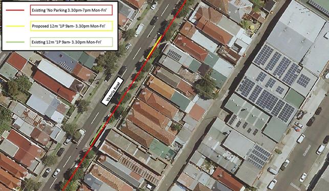
Figure 1 – Summary of Existing and Proposed Restrictions on Victoria Road, Marrickville
FINANCIAL IMPLICATIONS
The cost of the supply and installation of the signage can be funded from Council’s operational budget.
OTHER STAFF COMMENTS
A summary of the traffic data is provided in the table below.
|
Street Name |
Victoria Road |
|
Section |
Marrickville Road to Sydenham Road |
|
Carriageway Width (m) kerb to kerb |
12.8 |
|
Carriageway Type |
Two-way road with one travel lane in each direction, in addition to kerbside parking on both sides (‘No Parking 7am-9am’ on western side, ‘No parking 3pm-7pm’ on eastern side). |
|
Classification |
Regional |
|
Speed limit |
60 |
|
85th Percentile Speed (km/h) |
49.3 (2006) |
|
Vehicles Per Day (vpd) |
11,819 (2006) |
|
Reported Crash History |
Total Recorded Crashes: Nine (9) -1x (pedestrian – far side) -2x (intersection – right far) -2x (right through) -1x (leaving parking) -2x (entering parking) -1x (Parking vehicles only) |
|
Heavy Vehicle Volume (%) |
5.1 |
|
Parking Arrangements |
Mainly unrestricted parking along both sides with the exception of ‘No Parking 7am-9am’ on western side, ‘No parking 3pm-7pm’ on eastern side. ‘1P 9am-3.30pm Monday to Friday’ outside properties No. 284A and 286 |
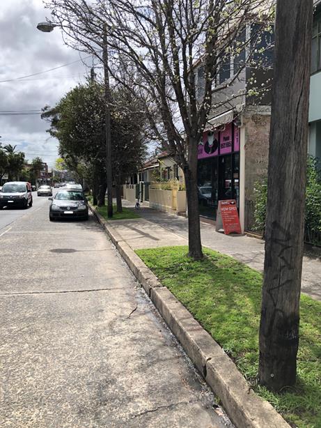
Figure 2: Location of proposed 1P parking restrictions –
Outside 266-268 Victoria Road, Marrickville
Figure 3: Location of existing 1P parking restrictions –
Outside 284A-286 Victoria Road, Marrickville
PUBLIC CONSULTATION
On 4 September 2019, (17) seventeen letters were delivered to nearby residents and owners, advising them of the proposal and to provide feedback. No responses were received.
A map of the consulted residents and owners is attached below.
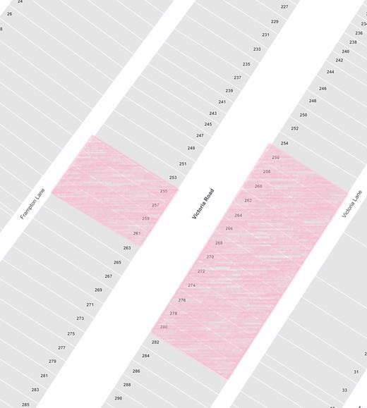
Figure 4: Map of consulted properties
CONCLUSION
The proposal for a 12m ‘1P 9.00am-3.30pm’ parking restriction will provide some turnover for a number of small businesses in the subject section of Victoria Road. The proposal does not have any significant impact on residential parking in the area as it is located directly outside a business and an adjacent residential property. The proposal will have a positive impact in the area and it is therefore recommended.
|
|
Local Traffic Committee Meeting 8 October 2019 |
Subject: Wooley Lane, Marrickville – Proposed 6 metre Extension to Existing ‘NO PARKING’ Restriction (Midjuburi - Marrickville Ward / Newtown Electorate / Inner West PAC)
Prepared By: Jennifer Adams - Engineer – Traffic and Parking Services
Authorised By: John Stephens - Traffic and Transport Services Manager
SUMMARY
A resident of Church Street, Marrickville has raised concerns with vehicles parked in Wooley Lane opposite their driveway/garage which has resulted in restricted vehicular access into and out of their off-street parking space. The resident has requested an extension of the full time ‘No Parking’ restrictions in the laneway to a position opposite to the resident's driveway.
Surrounding local residents have been notified of the proposal to extend the existing 12 metre length of ‘No Parking’ restriction in Wooley Lane, at the rear of property No.376 Illawarra Road (eastern side) by 6 metres south towards Church Street, Marrickville to improve vehicular access to resident's off-street parking. It is recommended that this proposal be approved.
|
RECOMMENDATION
THAT:
1. The installation of a 6 metre extension to the existing full-time ‘No Parking’ zone on the eastern side of Wooley Lane, southward of the existing restrictions to the driveway at the rear of property Nos.380-382 Illawarra Road, Marrickville be APPROVED, in order to provide unobstructed vehicular access to resident’s off-street car parking: and
2. The applicant, responders and Council’s Parking Officers be advised of Council's decision.
|
BACKGROUND
Council Officers have been advised that vehicular access from Wooley Lane to some residents’ off-street parking is on occasions blocked by vehicles parked in the laneway. Specifically, some residents cannot access their off-street parking when vehicles are parked opposite their driveway/garage.
FINANCIAL IMPLICATIONS
The cost of the supply and installation of the signage associated with the recommended ‘No Parking’ restrictions can be met from Council’s operating budget.
OFFICER COMMENTS
Wooley Lane is approximately 5.5 metres in width and runs north-south, between Greenbank and Church Streets, Marrickville. It provides rear access to properties fronting Greenbank and Church Streets. (Refer to the attached locality map and photographs.)
The applicant’s property has an off-street parking facility (i.e. garage) on the western side of Wooley Lane near its mid-point. At present, a 12 metre length of full-time ‘No Parking’ restriction is installed on the eastern side of Wooley Lane, at the rear of property No.376 Illawarra Road, Marrickville providing clear vehicular access to a Greenbank Street resident’s off-street car parking spaces. Also, ‘No Parking’ restrictions are in place along the western side.
It was observed at a site inspection that vehicles were parked on the eastern side of the laneway directly opposite the resident’s driveway, restricting vehicular access due to the narrow carriageway. It was noted that there was a high demand for parking in the area.
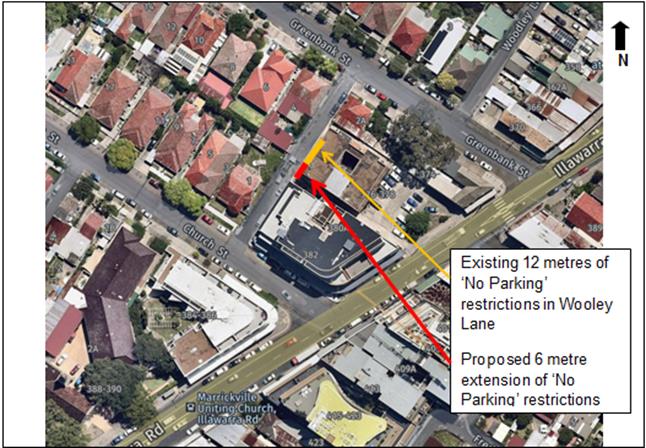
|
|
|
Parking in laneways
Council’s Laneway Parking Guidelines outline the measures to consider when the use of the laneway prohibits access to off-street parking and access through the laneway. The effective use of narrow streets and laneways alleviates parking pressure. Effectively managed laneways allow for adequate access while providing the maximum amount of on-street parking.
It should be noted that laneways were generally built to provide service for properties and access into off-street parking facilities therefore restricting parking in this laneway will help achieve this goal.
PUBLIC CONSULTATION
A notification letter was hand delivered to 45 properties fronting Wooley Lane, Marrickville regarding the proposal to extend the existing 12 metre length of full time ‘No Parking’ restriction, at the rear of property No.376 Illawarra Road, Marrickville on the eastern side by 6 metres south towards Church Street. The closing date for submissions ended on 20th September 2019.
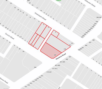
Resident survey findings – No responses were received.
CONCLUSION
In order to provide clear vehicular access to the resident’s off-street parking spaces, it is recommended that a 6 metre extension to the existing full-time ‘No Parking’ zone on the eastern side of Wooley Lane be installed, southward of the existing restrictions to the driveway at the rear of property No.380-382 Illawarra Road, Marrickville
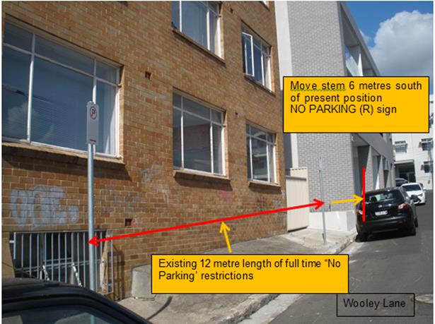
|
|
Local Traffic Committee Meeting 8 October 2019 |
Subject: Valley Street, Balmain - Proposed Marked Car Parking Bays (Baludarri - Balmain Ward/ Balmain Electorate/ Leichhardt PAC)
Prepared By: Vinoth Srinivasan - Engineer - Traffic and Parking Services
Authorised By: John Stephens - Traffic and Transport Services Manager
SUMMARY
Council has received safety concerns from a resident regarding restricted vehicular access for emergency vehicles near the closed-end of Valley Street, Balmain due to vehicles parking away from the kerb line and limiting the available travel lane width.
|
RECOMMENDATION
THAT a linemarked parking bay (11.9m x 1.8m) be installed in front of Nos.10 and 12 Valley Street, Balmain, between the existing ‘No Parking’ restrictions. |
BACKGROUND
Council has received safety concerns from a resident regarding restricted vehicular access for emergency vehicles near the closed-end of Valley Street, Balmain due to vehicles parking away from the kerb line and limiting the available travel lane width.
The street width near the closed-end of Valley Street is 4m with no footpath on the northern side of the street and a 1.1m wide footpath on the southern side of the street.
Site Location & Road Network
|
Street Name(s) |
Valley Street, Balmain |
|
Section |
Between Creek Street and Closed end |
|
Traffic Volume |
- |
|
Recorded Accident History (5 year) |
Nil. |
|
Recorded 85% speed |
- |
|
Speed Limit |
40km/h |
|
Carriageway width |
Approx. 4m |
|
Carriageway Type |
Two way street with kerb-side parking on one side and ‘No Parking’ on the other side |
|
Road Classification (State, Regional, Local) |
Local |
FINANCIAL IMPLICATIONS
Nil.
OTHER STAFF COMMENTS
In order to maximise the travel lane width available for emergency vehicles, it is proposed to install a marked 1.8m wide car parking bay between the existing ‘No Parking’ restrictions in front of No.10 and No.12 Valley Street, Balmain.
The proposal is shown on the plan below.
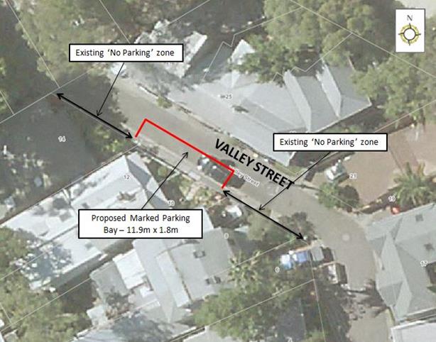
PUBLIC CONSULTATION
|
A letter outlining the above proposal was mailed out to the affected 15 properties in Valley Street and Pashley Street, Balmain requesting residents’ views regarding the proposal.
No responses were received.
|
|
|
|
Local Traffic Committee Meeting 8 October 2019 |
Subject: Chester Street at Gehrig Lane, Annandale - Proposed 'No Stopping' zone extension (Gulgadya - Leichhardt Ward/ Balmain Electorate/ Leichhardt PAC)
Prepared By: Vinoth Srinivasan - Engineer - Traffic and Parking Services
Authorised By: John Stephens - Traffic and Transport Services Manager
SUMMARY
Council has received a request from a resident to extend the existing ‘No Stopping’ zone in Chester Street, south of Gehrig Lane, Annandale to prevent vehicles from illegally parking across the driveway of No.72 Pyrmont Bridge Road, Annandale.
|
RECOMMENDATION
THAT the existing 6.8m ‘No Stopping’ zone be extended to 11.7m on the eastern side of Chester Street, north of Pyrmont Bridge Road, Annandale. |
BACKGROUND
Council has received a request from a resident to extend the existing ‘No Stopping’ zone in Chester Street, south of Gehrig Lane, Annandale to prevent vehicles from illegally parking across the driveway of No.72 Pyrmont Bridge Road, Annandale.
Property No.72 Pyrmont Bridge Road, Annandale is a corner block and the driveway is located in Chester Street, south of Gehrig Lane.
Site location & Road network
|
Street Name(s) |
Chester Street, Annandale |
|
Section |
Between Pyrmont Bridge Road and Gehrig Lane |
|
Traffic Volume |
- |
|
Recorded Accident History (5 year) |
Nil. |
|
Recorded 85% speed |
- |
|
Speed Limit |
50km/h |
|
Carriageway width |
Approx. 7.4m |
|
Carriageway Type |
Two way street with kerb side parking on either side |
|
Road Classification (State, Regional, Local) |
Local |
FINANCIAL IMPLICATIONS
Nil.
OTHER STAFF COMMENTS
In order to improve access to the driveway, it is proposed that the existing 6.8m ‘No Stopping’ zone on the eastern side of Chester Street, south of Gehrig Lane be extended to 11.7m. The proposed ‘No Stopping’ zone will extend across the property driveway of No.72 Pyrmont Bridge Road to clearly indicate that vehicles are not to obstruct driveway access.
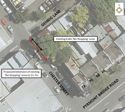
PUBLIC CONSULTATION
As the proposal does not impact on legal parking on Chester Street, no resident consultation was undertaken.
|
|
Local Traffic Committee Meeting 8 October 2019 |
Subject: White Street, Lilyfield - Part Time 'No Parking' Restriction (Baludarri - Balmain Ward/ Balmain Electorate/ Leichhardt PAC)
Prepared By: Felicia Lau - Engineer - Traffic and Parking Services
Authorised By: John Stephens - Traffic and Transport Services Manager
SUMMARY
Concern has been raised regarding vehicle parking in a location where a driveway was recently removed and new kerb and gutter was constructed. This has resulted in obstructed delivery access to the adjacent property. Council is proposing to introduce part time ‘No Parking’ restriction to alleviate the concern.
|
RECOMMENDATION
THAT:
1. An 8m ‘No Parking 7:30am–6:00pm Mon-Fri’ restriction be installed on the eastern side of White Street extending north from the southern boundary of No.1 and No.5 White Street, Lilyfield (in place of the driveway that was removed);
2. The existing part time ‘No Parking 8:30am-6:00pm Mon-Fri’ zone on the western side of White Street outside Nos.1-5 Moore Street be modified to a ‘No Parking 7:30am-6:00pm Mon-Fri’ restriction; and
3. A 12m ‘No Stopping’ restriction be installed on the eastern side of White Street, north of Moore Street. |
BACKGROUND
Council has received request to review the on-street parking area in front of No.5 White Street, Lilyfield where a driveway was recently removed and new kerb and gutter was constructed to allow unrestricted parking. The introduction of parking has result in obstructed delivery access for trucks reversing into the adjacent industrial property. Council is proposing to introduce a part time ‘No Parking’ restriction to alleviate the concern.
Site location & road network
|
Street Name |
White Street, Lilyfield |
|
Section |
Moore Street and Moore Lane |
|
Traffic Volume |
575 veh/day |
|
Recorded 85th percentile Speed |
39km/h |
|
Recorded Accident History (five-year) |
Nil |
|
Speed Limit |
50km/h |
|
Carriageway Width |
Approximately 6m |
|
Carriageway Type |
Two way with part time ‘No Parking’ on the western side and unrestricted parking on the eastern side. |
FINANCIAL IMPLICATIONS
Nil.
OTHER STAFF COMMENTS
In order to alleviate this issue, it is proposed to replace the former driveway area with a part time ‘No Parking 7:30am-6:00pm Mon-Fri’ restriction.
It is also proposed to convert the existing part time ‘No Parking 8:30am-6:00pm Mon-Fri’ restriction on the western side of White Street to a ‘No Parking 7:30am-6:00pm Mon-Fri’ restriction to be consistent with the proposed restriction on the eastern side of the street.
A 12m ‘No Stopping’ restriction is also proposed on the eastern side of White Street, north of Moore Street to prevent illegal parking near Moore Street and to improve access for long vehicles.
A plan showing the proposed changes is shown below.
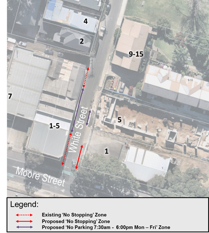
PUBLIC CONSULTATION
A letter outlining the above proposal was mailed out to the affected properties (16 properties) in White Street and Moore Street, Lilyfield requesting residents’ and businesses’ view regarding the proposal. The consultation closes on Monday, 30 September 2019. One objection was received and is tabled below. Any further comments received will be tabled at the meeting.
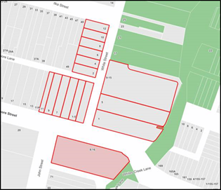
|
Residents’/Businesses’ Comment |
Officer’s Comment |
|
On-street parking availability is vital in maintaining the business in the area. |
The proposed part time ‘No Parking’ restriction provides an increase to available parking in comparison to the previous driveway which was effectively a full time ‘No Parking’ restriction.
In terms of the proposed ‘No Stopping’ restriction it is a statutory rule that ‘a driver must not stop on a road within 10 metres from the nearest point of an intersecting road at an intersection without traffic lights’. Hence, the proposed 12m ‘No Stopping’ on the eastern side of White Street, north of Moore Street again does not result in removal of any existing on-street parking space and improves access for long vehicles. |
|
|
Local Traffic Committee Meeting 8 October 2019 |
Subject: Westbourne Lane, Stanmore – Request for ‘No Parking’ Restrictions (Damun-Stanmore Ward/Newtown Electorate/Inner West PAC)
Prepared By: Jennifer Adams - Engineer – Traffic and Parking Services
Authorised By: John Stephens - Traffic and Transport Services Manager
SUMMARY
Representations have been received from a local resident for the installation of ‘No Parking’ restrictions in Westbourne Lane, Stanmore as vehicular access is often blocked by parked vehicles in the laneway and the resident cannot access their off-street parking facilities. Residents in the mid-section of the laneway, between Cannon Lane and Charles Street, were notified that Council is proposing to install a 6 metre length of ‘No Parking’ restrictions on the north side of Westbourne Lane, between the garage and gate behind No.47 Westbourne Street, to improve access to off-street parking for an adjacent resident. It is recommended that the proposal be approved and a minimum period of time being six months following installation elapse prior to the consideration of any future extension of the proposed zone.
|
RECOMMENDATION
THAT:
1. The installation of a 6 metre long full-time ‘No Parking’ restriction on the northern side of Westbourne Lane, between Cannon Lane and Charles Street, Stanmore (between the garage and gate behind No.47 Westbourne Street opposite the rear of No.156 Albany Road) be APPROVED, in order to provide unobstructed vehicular access to the off-street car parking spaces; 2. Any future extension(s) to the proposed restrictions not be investigated until at least a minimum of 6 months from the date of installation of the proposed 'No Parking' restriction; and
3. The applicant, responders and Council’s Parking Officers be advised of Council's decision.
|
BACKGROUND
A consultation letter was distributed to 25 residents in the mid-section of Westbourne Lane, between Cannon Lane and Charles Street, Stanmore informing them that Council was proposing to install a 6 metre length of ‘No Parking’ restriction on the north side of Westbourne Lane between Cannon Lane and Charles Street, between the garage and gate behind No.47 Westbourne Street, to improve access to off-street parking for an adjacent resident. (Refer to the Consultation Proposal plan below).
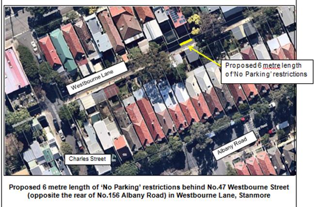
It should be noted that when vehicles are parked directly opposite a garage entrance in laneways, ingress/egress can be extremely difficult. Laneways were generally built to provide service access for properties and access into off-street parking facilities.
FINANCIAL IMPLICATIONS
The cost of the supply and installation of the signposting can be met from Council’s operating budget.
OFFICER COMMENTS
Westbourne Lane, between Cannon Lane and Charles Street, is a local laneway and in the subject location it is narrow having a carriageway width of 4.9 metres. At present parking is unrestricted on both sides of the laneway.
This proposal will provide unobstructed vehicular access to an adjoining property. It was observed during the site inspection that the off-street parking facilities were utilised. It should be noted that laneways were generally built to provide service access for properties and access into off-street parking facilities. Prohibiting parking in the subject location will help achieve this goal.
Parking in laneways
Former adopted ‘Laneway Parking Guidelines’ outline the priorities for using narrow laneways and the actions and processes that Council will use to manage access and parking. These guidelines were developed to provide consistency for evaluating the need for parking controls and manage the use of narrow streets and laneways to maintain access and maximise parking. The need for parking controls is based on the width of the laneway shown below in Table 1.
|
Table 1: Laneway Parking Guidelines Laneway Width
|
For parking to be allowed in a narrow laneway, the Australian Standards require that parallel parking spaces be at least 2.1 metres wide and NSW Road Rules requires that at least 3 metres must be available between a parked car and the kerb or edge of the laneway to allow moving vehicles to pass safely. Therefore, laneway widths that are less than 5.1 metres wide are too narrow to allow parking as any parked vehicle would prevent traffic from using the laneway (see Table 1 above and Figure 1 below).
|
|
Thus, in this situation, a narrow laneway and an option of totally banning all parking in the laneway, a balanced approach is warranted. Because Council has received concerns that thoroughfare and access to off-street parking is being restricted due to parking in the laneway, in the first instance, an ad hoc installation of parking restrictions is considered reasonable.
PUBLIC CONSULTATION
A notification letter was sent to 25 owners and occupiers of properties that are adjacent to the subject location in Westbourne Lane regarding the proposal to install a 6 metre length of ‘No Parking’ restriction on the north side of Westbourne Lane, between the garage and gate behind No.47 Westbourne Street, to improve access to off-street parking for an adjacent resident.
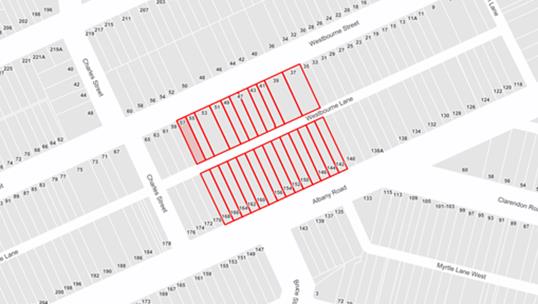
The closing date for submissions ended on 20th September 2019.
Resident survey findings
A total of three (3) responses were received from residents. One resident advised there was no reason to install any parking restrictions and two other residents asked for an extension to the parking restrictions so they could access their off-street car parking spaces.
|
Comments from respondent
|
Council Officer’s comments |
|
Resident rang and asked why put in the restrictions they have had no issue or heard of any issue in the laneway.
|
Received and noted.
|
|
Resident noted that they are “all for them but my only concern is that it may push people up further as we regularly get people parked opposite our garage and we cannot get out.”
They added: “I
would happily see more No Parking restrictions implemented as for those of us
who have garages that are used it makes it impossible to get in and out at
times and there is no parking spaces on Albany Road.” |
At present extension to the proposed parking restrictions is not considered warranted as the layout of the driveways/garages in the subject area means that vehicles would be parked over a driveway/garage which is an offence which is enforceable.
|
|
A resident rang and discussed the proposal and later sent in their request for an extension to the proposed parking restrictions in Westbourne Lane: “I request that Council consider extending the "No Parking" zone to the rear of the property at 37 Westbourne Street (opposite the rear of 146 Albany Road) in Westbourne Lane, Stanmore.”
Adding: “…I
frequently cannot either get into or out of my garage due to cars, utes or
other vehicles parked in Westbourne Lane making it impossible to manoeuvre
into my garage at the rear of my property.”
|
At present extension to the proposed parking restrictions is not considered warranted as the layout of the driveways/garages in the subject area means that vehicles would be parked over a driveway/garage which is an offence which is enforceable.
|
CONCLUSION
Westbourne Lane is narrow and should a vehicle be parked close to or opposite a driveway,
vehicle access can be impeded. The proposed 6 metre length of ‘No Parking’ restrictions will assist residents with rear garage areas who may be experiencing access difficulties and is recommended.
Due to responses received it is also recommended that Council monitor the laneway over a six month period prior to considering the extension of the proposed zone and re-consulting with residents in the affected area.
![]()
![]()
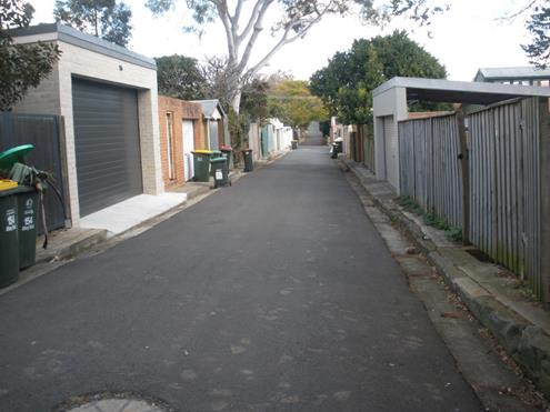
|
|
Local Traffic Committee Meeting 8 October 2019 |
Subject: Burrows Avenue and Hogan Avenue, Sydenham – Sydney Metro SSJ Works – Temporary traffic control arrangements – Pedestrian safety issues (Midjuburi - Marrickville Ward / Heffron Electorate / Inner West PAC)
Prepared By: Jennifer Adams - Engineer – Traffic and Parking Services
Authorised By: John Stephens - Traffic and Transport Services Manager
SUMMARY
Pedestrian safety concerns have been raised in relation to the temporary traffic control arrangements, by Sydney Metro SSJ’s Group Sydenham Station construction works, on Burrows Avenue and Hogan Avenue, Sydenham at Council’s Local Traffic Committee meeting on 3 June 2019 and at Council’s Ordinary Meeting on 27 August 2019. This report addresses the issues raised.
|
RECOMMENDATION
THAT this report be received and noted. |
BACKGROUND
A report was considered at 3rd June 2019 Local Traffic Committee (LTC) meeting which detailed the design plans for the temporary traffic control arrangements in Burrows Avenue and Hogan Avenue, Sydenham as part of the Sydney Metro Sydenham Station and Junction (SSJ) works.
It was recommended that the report be received and noted and that approval of the design plans for the temporary traffic control be determined by the Traffic Committee at its meeting.
At this LTC meeting the representative for the Member for Heffron requested that a temporary pedestrian crossing on Burrows Avenue and Hogan Avenue be investigated as a result of Sydney Metro construction works. The Committee members agreed with the Officer’s recommendation with the addition of a recommendation to investigate temporary pedestrian crossings on Burrows Avenue and Bolton Street.
The Committee’s recommendation was:
“THAT the design of the temporary traffic control arrangements in Burrows Avenue and the temporary pedestrian refuge in Hogan Avenue, Sydenham (as per design plans prepared by Bitzios dated 10 May 2019) be approved subject to:
· additional controls at the intersection of Hogan Avenue and Burrows Avenue being further investigated and necessary treatments provided to satisfy issues raised in the Road Safety Audit;
· consideration of the provision of a marked pedestrian crossing at the proposed and existing pedestrian refuge facilities;
· consideration of the provision of kerb blisters at the proposed pedestrian refuge on Burrows Avenue and at the intersection of Bolton Street.”
SSJ were notified of Council's decision and they later submitted pedestrian and vehicular count data to address this issue. The counts revealed that RMS warrants for pedestrian crossings could not be met and that pedestrian refuges would be installed as per the submitted design plans.
At Council’s Ordinary meeting on 27 August 2019 the Minutes of the LTC Meeting held on 5 August 2019 regarding an application for a temporary full road closure of Burrows Avenue were received and the recommendations adopted subject to the following changes:
1. That the recommendation for Item 3 Burrows Avenue, Sydenham – Temporary Full Road Closures - Sydney Metro Sydenham Station and Junction (SSJ) Works (Midjuburi-Marrickville Ward / Heffron Electorate / Inner West PAC) be amended as follows:
a. Due to concerns about pedestrian safety concerns related to Sydenham Station construction works, Council requests that Sydney Metro amend the design of the temporary crossings to be installed during the proposed road closure on Burroughs and Hogan Avenue to include marked pedestrian crossings instead of refuges.
This motion will also be addressed in this report.
FINANCIAL IMPLICATIONS
All costs of recommended temporary works will be borne by Sydney Metro Sydenham Station and Junction (SSJ).
DISCUSSION
Sydney Metro have engaged John Holland Pty Ltd and Laing O’Rourke Australia Construction Pty Ltd (JHLORJV) to undertake the Sydenham Station and Junction works to facilitate the new Sydney Metro line and part of these works involve the construction of a new concourse and plaza. These works necessitate that pedestrians are (temporarily) crossed over from the Station side of Burrows Avenue to take them away from construction activities for the new Southern Plaza.
The site location on Burrows Avenue is adjacent to Sydenham Railway Station. Burrows Avenue and Hogan Avenue form a minor collector route connecting between Unwins Bridge Road and Gleeson Avenue, Sydenham.
![]()
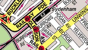
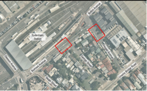
Proposed temporary pedestrian works
During construction of the Sydney Metro Sydenham Station and Junction (SSJ) works temporary changes to the existing pedestrian routes in the locality are required. Pedestrians will not be able to access the eastern end of the northern side of Burrows Avenue so they will be diverted around the works to an upgraded pedestrian refuge over Burrows Avenue adjacent to George Street and a new pedestrian refuge over Hogan Avenue just east of Burrows Avenue, Sydenham.
The road and footpath changes will remain in place for at least two years. The original sign and line marking diagrams supplied are reproduced below. It should be noted that kerb blisters have been incorporated into the upgraded refuge island on Burrows Avenue at George Street as an outcome of Council’s resolution.
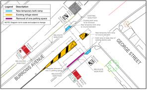
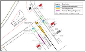
A Road Safety Audit of the two proposed temporary pedestrian refuges located adjacent to the Sydenham Station and Junction (SSJ) project site was undertaken. It identified possible conflict vehicle movements at the intersection of Burrows Avenue / Bolton Street / Hogan Avenue and as a remedy the priority control on Burrows Avenue entering Hogan Avenue was amended to a STOP control. Refer to the diagram below.
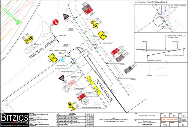
Request for pedestrian crossing
In the report detailing the design plans for the temporary traffic control arrangements in Burrows Avenue and Hogan Avenue, Sydenham as part of the Sydney Metro Sydenham Station and Junction (SSJ) works that were presented to the LTC meeting on 3 June 2019, a recommendation was made for “the consideration of a marked pedestrian crossing at the proposed and existing pedestrian refuge facilities”.
Similarly a request was made, in relation to the LTC Minutes of 5th August 2019 on Item 3 ‘Burrows Avenue, Sydenham – Temporary Full Road Closure’ at the 27th August 2019 Ordinary Council meeting: “ Due to concerns about pedestrian safety concerns related to Sydenham Station construction works, Council requests that Sydney Metro amend the design of the temporary crossings to be installed during the proposed road closure on Burrows and Hogan Avenue to include marked pedestrian crossings instead of refuges.”
Sydney Metro’s SSJ Group subsequently supplied Council with the results of the pedestrian and vehicular traffic counts necessary to see if the locations could be upgraded from the existing/proposed pedestrian refuge to a pedestrian zebra crossing facility. Unfortunately, the results showed that the warrants required for a pedestrian zebra crossing as specified by the Roads and Maritime Services (RMS) were not met.
The mandatory warrant for the provision of a new pedestrian zebra crossing is 500 vehicles (V) and 30 pedestrians (P) per hour measured over three one hour periods during the day.
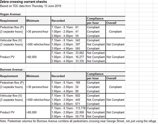
Under the circumstances, the existing/proposed refuges are the most appropriate facilities for the locations at present. The proposed refuge will aid pedestrians crossing the road in that the crossing can be done in stages if need be and the devices reduce the required distance for pedestrians crossing the road making it safer for all road users. Council will continue to monitor the traffic and pedestrian conditions in the area.
PUBLIC CONSULTATION
Sydney Metro Sydenham Station and Junction (SSJ) are responsible for any consultation requirements. At regular Sydney Metro SSJ update meetings, attended by Council’s Traffic Section, a report is given detailing what consultation has been carried out and any concerns that residents and/or businesses have raised are itemised.
CONCLUSION
It is recommended that the report be received and noted.
Subject: Review into Simplification of Parking Signs (All Wards / All Electorates / All LACs)
Prepared By: Manod Wickramasinghe - Coordinator – Traffic and Parking Services
Authorised By: John Stephens - Traffic and Transport Services Manager
|
SUMMARY Council has requested a report to review how Council can simplify parking signs throughout the municipality and be brought to the Traffic Committee for its consideration.
This report reviews two examples of complex signs and identifies the opportunities and constraints in simplifying those signs in line with RMS requirements.
To effectively simplify signage through the municipality, a decision must be made to reduce the types of parking zones in affect along any one section of kerb space. However, this would come at the cost of providing flexibility of parking spaces within the Inner West LGA. |
|
RECOMMENDATION
THAT this report be received and noted. |
BACKGROUND AND OTHER STAFF COMMENTS
There is a high demand for parking in the Inner West and parking restrictions are placed in order to provide the desired parking behaviour from motorists to best service the nearby landuses. This includes resident parking restrictions to deter commuter parking, timed or metered parking restrictions to encourage parking turnover for customers near commercial precincts and drop-off/pick-up restrictions for schools. These restrictions are often used in combinations which creates complexity in signage. Council has requested a report to review how Council can simplify parking signs throughout the municipality
Existing parking signs used within the Inner West LGA are installed as per Roads and Maritime Services (RMS) requirements and are consistent with signage used throughout NSW.
In order to practically review the existing signage in the area, two complex examples of signage have been chosen for review.
Marion Street, Leichhardt
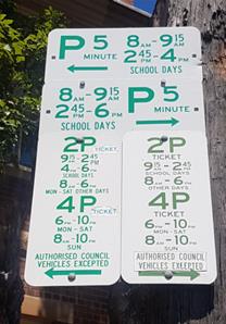
Figure 1 – Marion Street signs, Leichhardt
This sign post is located in Marion Street, Leichhardt outside Leichhardt Public School and shows separate restrictions to the left and right as viewed from the street which adds to the number of signs required.
To the left, the restrictions indicate:
· Drop-off/pick-up restrictions for Leichhardt Public School during school days
· 2P metered parking restrictions at other times during the school week
· 2P metered parking restrictions on Monday-Saturday, non-school days
· 4P parking restrictions in the night (6PM-10PM) from Monday to Saturday and throughout Sunday
To the right, the restrictions indicate:
· Drop-off/pick-up restrictions for Leichhardt Public School during school days
· Drop-off/pick-up restrictions for the Leichhardt after school care (OOSH) during school days
· 2P metered parking restrictions at other times during the school week
· 2P metered parking restrictions on other days
· 4P parking restrictions in the night (6PM-10PM) from Monday to Saturday and throughout Sunday
To simplify these signs, the zones must be simplified. An example of this simplification and resulting impact is described below:
· Remove Drop-off/pick-up restrictions for the Leichhardt after school care (OOSH) during school days (4 spaces) – parents would be required to secure parking in nearby streets or in the Marion Street car park (Leichhardt Service Centre) opposite the school
· Replace 2P metered parking restrictions with 4P metered parking restrictions – turnover would reduce during school days and Saturdays
This would result in much simpler signs as shown in the following diagram.
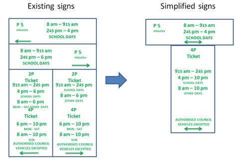
Figure 2 – Potential simplification of parking signs on Marion Street, Leichhardt
Eaton Street, Balmain
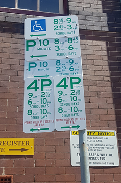
Figure 3 – Eaton Street signs
This signpost is located in Eaton Street, Balmain outside Balmain Public School and shows separate restrictions to the left and right as viewed from the street which adds to the number of signs required.
To the left, the restrictions indicate:
· Drop-off/pick-up restrictions for Balmain Public School during school days
· 15min Drop-off/pick-up restrictions for students with mobility issues
· 4P metered parking restrictions at other times
To the right, the restrictions indicate:
· Drop-off/pick-up restrictions for Balmain Public School during school days
· 4P parking restrictions at other times
To simplify these signs, the zones must be simplified. Example of this simplification and resulting impact is described below:
· Extend ‘Disabled Parking’ to a full time restriction – no other use of this one space would be permitted at all times.
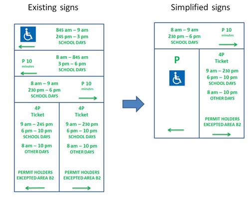
Figure 4 – Potential simplification of parking signs on Eaton Street, Balmain
Other signage schemes
· Grid style parking signs - ‘Grid style’ parking signs involve replicating the information of a conventional parking sign into a pictorial, colour coded parking sign. These parking signs are not approved for use by the RMS and are not enforceable in NSW. An example of a sign is shown in the image below. These signs require reduced font sizes which may make them difficult to read for a motorist.
· Electronic parking signs - Electronic parking signs would display the current restriction and thus remove any confusion as to what restriction is in effect. RMS has advised that these parking signs have not been developed and trialled as yet, and are likely to be a costly product to develop and implement on a large scale.
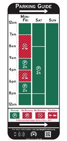
Figure 5 – Grid style parking signs
PUBLIC CONSULTATION
No consultation on changing the prior examples of complex parking signs has been undertaken. Should Council wish to pursue a simplification to parking signs then consultation with affected groups would need to be undertaken to ensure that essential parking zones are not removed. There would need to be an overall consensus from the various users prior to considering any changes to the subject parking restrictions.
CONCLUSION
In order to effectively simplify signage through the municipality, a decision must be made to reduce the types of parking zones in affect along any one section of kerb space. However, this would come at the cost of providing flexibility of parking spaces for the various user groups within the Inner West LGA.
|
|
Local Traffic Committee Meeting 8 October 2019 |
Subject: Long Walk Home - Special Event (Baludarri-Balmain Ward / Balmain Electorate / Leichhardt PAC)
Prepared By: Felicia Lau - Engineer - Traffic and Parking Services
Authorised By: John Stephens - Traffic and Transport Services Manager
SUMMARY
The Wayside Chapel has partnered with IAG to host a mass participation walking event, Long Walk Home, to be held on Friday, 29 November 2019 at various locations in Sydney, starting from Parramatta Park, Parramatta passing through Victoria Road, Rozelle and concluding at Fitzroy Garden, Kings Cross. The event is in its second year of operation and the applicant seeks approval for 2019.
|
RECOMMENDATION
THAT the Wayside Chapel Long Walk Home event to be held from 5:00pm Friday, 29 November 2019 be supported, subject to a current Public Liability Insurance Policy which includes Inner West Council being an interested party and submitted by the event organiser prior to the event. |
BACKGROUND
The Wayside Chapel Long Walk Home aims to gain a better understanding of challenges faced by people sleeping rough in Sydney and help raise money for the Wayside Chapel to provide essential support for people experiencing homelessness. The significance of the walk is that 28km is the average distance a homeless person walks each week to access services or find a place to sleep.
It should be noted that the proposed route uses existing pedestrian infrastructure and crossings, meaning participants are required to follow all regulatory measures that a non-event pedestrian would be required to abide by.
The event organiser is also seeking NSW Police On Roads Team approval under a Schedule 1 event.
FINANCIAL IMPLICATIONS
All costs associated with the Long Walk Home are funded by the event organiser.
OTHER STAFF COMMENTS
Event Details
The event will commence at 5:00pm and conclude at 1:00am (8 hours) and it is estimated to attract up to 500 participants. The walking route is approximately 28km in length, and utilises existing pedestrian infrastructure from Parramatta Park, Parramatta to Fitzroy Garden, Kings Cross, passing through Inner West Council area crossing the Iron Cove Bridge (from Drummoyne) to continue along Victoria Road to the ANZAC Bridge.
Event Overview
Event Name: Long Walk Home 2019
Event owner: Wayside Chapel
Date: Friday, 29th November 2019
Course Opens: 5:00pm at Parramatta Park, Parramatta
Course Closes: 1:00am at Fitzroy Garden, Kings Cross
Participation Target: Maximum capacity 500 participants
Course Route:
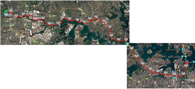
The event does not require closure of any roads in the Inner West LGA. As the participants will be using footpaths and crossing the street network in the same manner as a non-event pedestrian would, the event is not expected to result in a significant impact on the traffic and transport system.
The attached Event Management Plan and Traffic Control Plan (TCP), when approved by the relevant authorities, becomes the prime document detailing with the traffic and transport arrangement under which this event is to proceed.
The route for the proposed Long Walk Home, the TCP and Event Management Plan for Inner West Council LGA are all attached.
PUBLIC CONSULTATION
Nil.
|
1.⇩ |
Event Management Plan |
|
2.⇩ |
Traffic Control Plan |