|
AGENDA R |

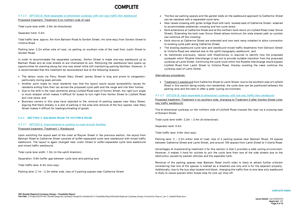
Local Traffic Committee Meeting
MONDAY 4 NOVEMBER 2019
10.00am
|
|
Local Traffic Committee Meeting 4 November 2019 |
Function of the Local Traffic Committee
Background
Roads and Maritime Services (RMS) is legislated as the Authority responsible for the control of traffic on all NSW Roads. The RMS has delegated certain aspects of the control of traffic on local roads to councils. To exercise this delegation, councils must establish a local traffic committee and obtain the advice of the RMS and Police. The Inner West Council Local Traffic Committee has been constituted by Council as a result of the delegation granted by the RMS pursuant to Section 50 of the Transport Administration Act 1988.
Role of the Committee
The Local Traffic Committee is primarily a technical review and advisory committee which considers the technical merits of proposals and ensures that current technical guidelines are considered. It provides recommendations to Council on traffic and parking control matters and on the provision of traffic control facilities and prescribed traffic control devices for which Council has delegated authority. These matters are dealt with under Part A of the agenda and require Council to consider exercising its delegation.
In addition to its formal role as the Local Traffic Committee, the Committee may also be requested to provide informal traffic engineering advice on traffic matters not requiring Council to exercise its delegated function at that point in time, for example, advice to Council’s Development Assessment Section on traffic generating developments. These matters are dealt with under Part C of the agenda and are for information or advice only and do not require Council to exercise its delegation.
Committee Delegations
The Local Traffic Committee has no decision-making powers. The Council must refer all traffic related matters to the Local Traffic Committee prior to exercising its delegated functions. Matters related to State Roads or functions that have not been delegated to Council must be referred directly to the RMS or relevant organisation.
The Committee provides recommendations to Council. Should Council wish to act contrary to the advice of the Committee or if that advice is not supported unanimously by the Committee members, then the Police or RMS have an opportunity to appeal to the Regional Traffic Committee.
Committee Membership & Voting
Formal voting membership comprises the following:
· one representative of Council as nominated by Council;
· one representative of the NSW Police from each Local Area Command (LAC) within the LGA, being Newtown, Marrickville, Leichhardt and Ashfield LAC’s.
· one representative from the RMS; and
· State Members of Parliament (MP) for the electorates of Summer Hill, Newtown, Heffron, Canterbury, Strathfield and Balmain or their nominees.
Where the Council area is represented by more than one MP or covered by more than one Police LAC, representatives are only permitted to vote on matters which effect their electorate or LAC.
Informal (non-voting) advisors from within Council or external authorities may also attend Committee meetings to provide expert advice.
Committee Chair
Council’s representative will chair the meetings.
Public Participation
Members of the public or other stakeholders may address the Committee on agenda items to be considered by the Committee. The format and number of presentations is at the discretion of the Chairperson and is generally limited to 3 minutes per speaker. Committee debate on agenda items is not open to the public.
|
|
Local Traffic Committee Meeting 4 November 2019 |
|
AGENDA |
1 Apologies
2 Disclosures of Interest
3 Confirmation of Minutes
Minutes of 8 October 2019 Local Traffic Committee Meeting 6
4 Matters Arising from Council’s Resolution of Minutes
5 Part A – Items Where Council May Exercise Its Delegated Functions
Traffic Matters
ITEM PAGE #
LTC1119 Item 1 Minor Traffic Facilities (All Wards/All Electorates/All PACS) 27
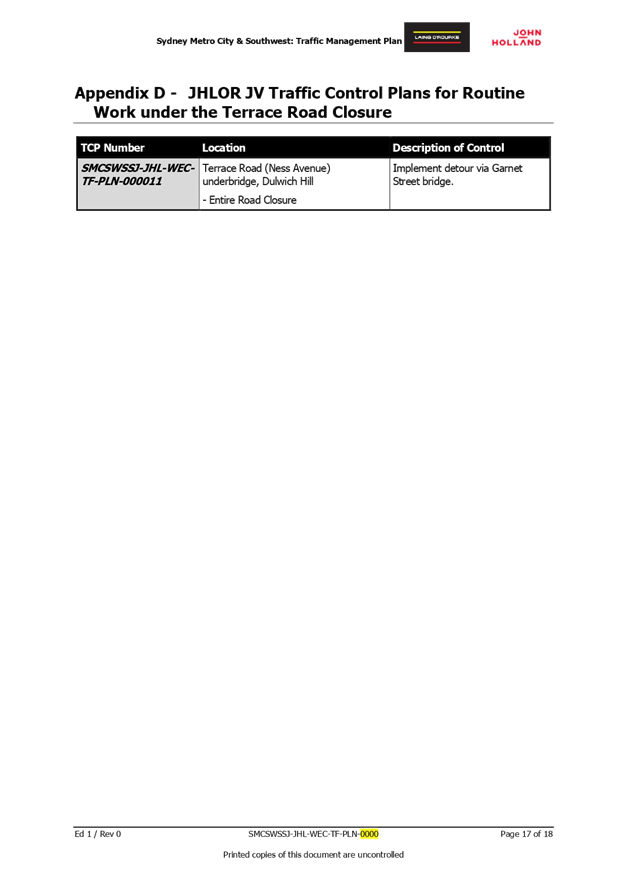
LTC1119 Item 2 Terrace Road / Ness Avenue, Dulwich Hill – Temporary full road closures of rail underpass just north of the roundabout at Ewart Street (Djarrawunang-Ashfield Ward / Summer Hill Electorate / Inner West PAC) 33
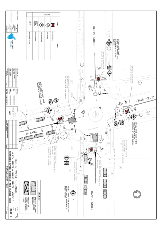
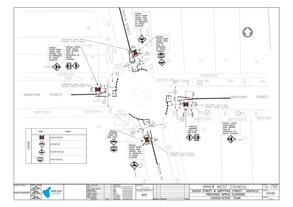
LTC1119 Item 3 Queen Street at Hanks Street & Queen Street at Griffiths Street, Ashfield - Proposed Improved Traffic Calming at the intersections including Speed cushions (Design Plans 10082_A & 10102) (Djarrawunang - Ashfield Ward / Summer Hill Electorate / Burwood PAC) 56
LTC1119 Item 4 St Davids Road/Kingston Street and Ramsay Street, Haberfield - Proposed Speed Cushions (Gulgadya-Leichhardt Ward/Summer Hill Electorate/Burwood PAC) 65
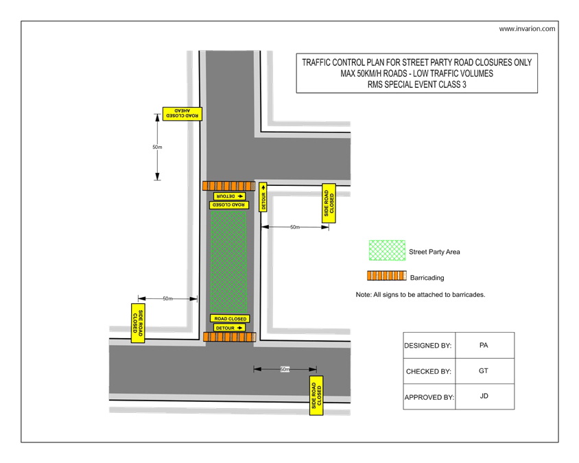
LTC1119 Item 5 Short Street, Birchgrove - Christmas Street Party (Road Occupancy) (Baludarri-Balmain/Balmain Electorate/Leichhardt PAC) 68
LTC1119 Item 6 Marrickville Lane at Silver Street, Marrickville - Proposed upgrading of Alex Trevallion Plaza including a new raised threshold design with associated signage and line marking (Midjuburi-Marrickville Ward / Summer Hill Electorate / Inner West PAC) 71
LTC1119 Item 7 Chelmsford Street, Newtown - Installation Of 8 Metre Length ‘Loading Zone’ With Day and Time Restrictions on The Eastern Side of the Street just South of Mcintosh Lane (Damum - Stanmore Ward / Newtown Electorate / Inner West PAC) 77
LTC1119 Item 8 John Street, Newtown between Lord Street and the Railway Line – Temporary Full Road Closure for Street Party on Sunday 8 December 2019 (Damum-Stanmore Ward / Newtown Electorate / Inner West PAC) 81
LTC1119 Item 9 Unnamed Laneway between May Street and The Boulevarde, Lilyfield - Christmas Street Party (Road Occupancy) (Baludarri-Balmain Ward/Balmain Electorate/Leichhardt PAC) 85
LTC1119 Item 10 Burrows Avenue, Sydenham – Temporary Full Road Closures 2020 - Sydney Metro Sydenham Station and Junction (SSJ) Works (Midjuburi-Marrickville Ward / Heffron Electorate / Inner West PAC) 88
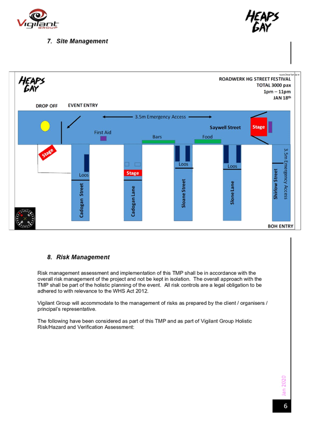
LTC1119 Item 11 Saywell
Street, Marrickville – Proposed Temporary Full Road Closure for Heaps Gay
Street Festival on Saturday 18 January 2020 and Community Beer Fest on Sunday
19 January 2020
(Midjuburi – Marrickville Ward / Summer Hill Electorate / Inner West PAC) 92
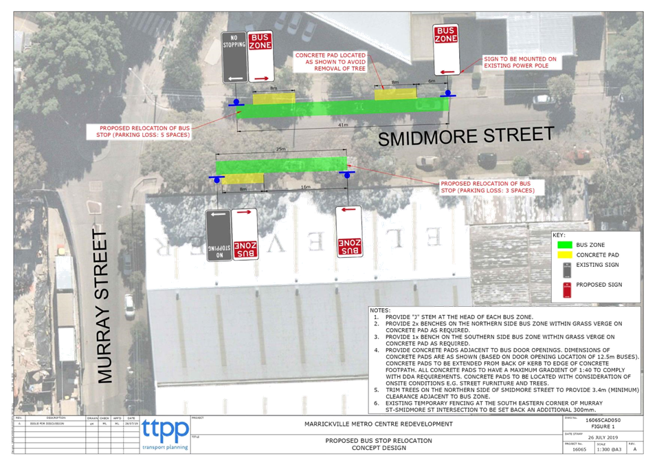
LTC1119 Item 12 Smidmore Street, Marrickville – Temporary relocation of Bus Zones during Marrickville Metro Expansion Works – (Midjuburi – Marrickville Ward / Heffron Electorate / Inner West PAC) 111
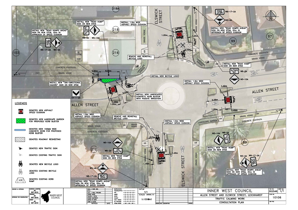
LTC1119 Item 13 Allen Street and Elswick Street, Leichhardt - Proposed Speed Cushions And Kerb Blister (Gulgadya - Leichhardt Ward / Balmain Electorate / Leichhardt PAC) 119
LTC1119 Item 14 Illawarra Road, Marrickville; Dudley Street, Dulwich Hill and (Lower) Railway Parade, Sydenham - Bus Replacements during major Rail Shutdown, Temporary Parking Changes during T3 Line Upgrade for Sydney Metro (Midjuburi-Marrickville Ward / Summer Hill Electorate / Inner West PAC) 123
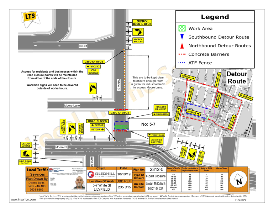
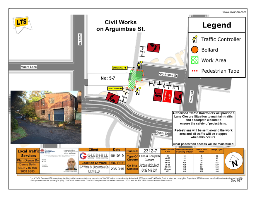
LTC1119 Item 15 Temporary Road Closure to Carryout Road Restoration on White Street, Lilyfield, Whites Creek Lane and Arguimbau Street, Annandale (Baludarri - Balmain Ward / Balmain Electorate / Leichhardt PAC) 132
LTC1119 Item 16 James Street, Leichhardt - Christmas Street Party (Gulgadya - Leichhardt Ward/ Balmain Electorate/ Leichhardt PAC) 136
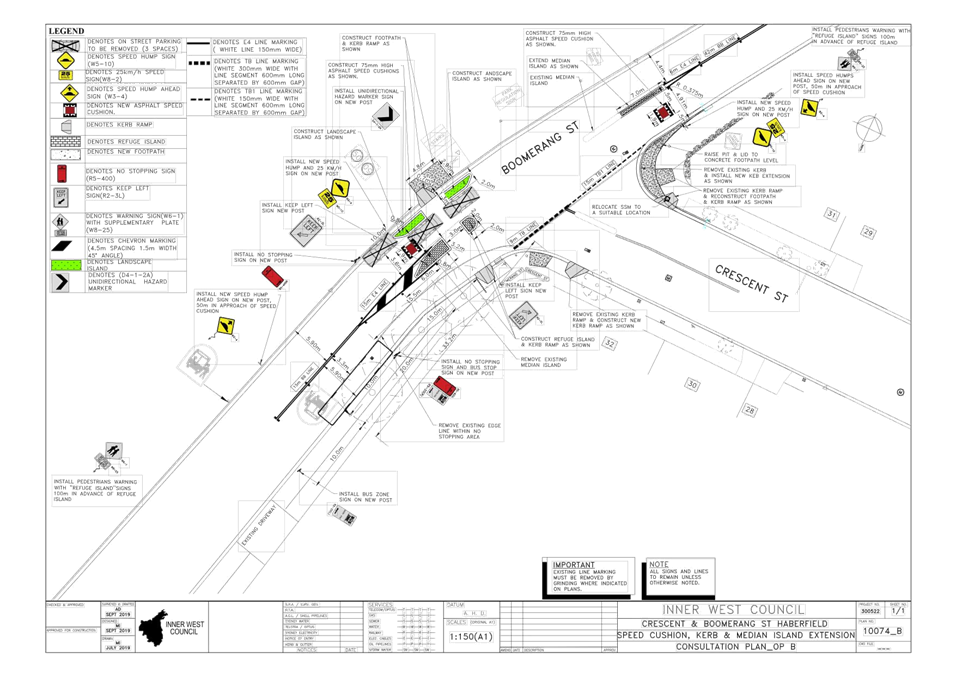
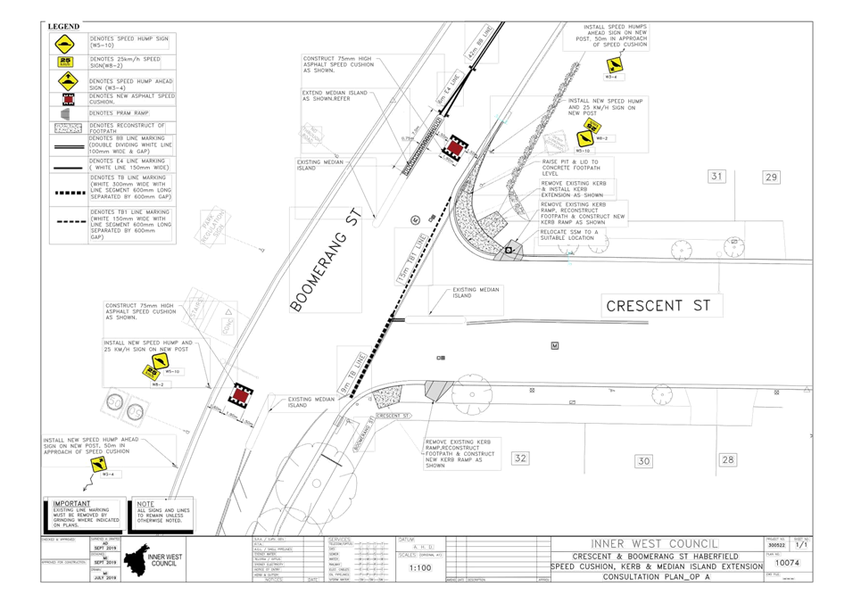
LTC1119 Item 17 Boomerang Street and Crescent Street, Haberfield - Proposed Intersection Treatment (Gulgadya-Leichhardt Ward/Summer Hill Electorate/Burwood PAC) 139
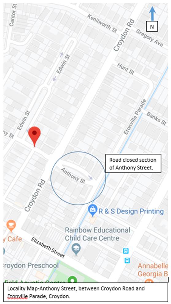
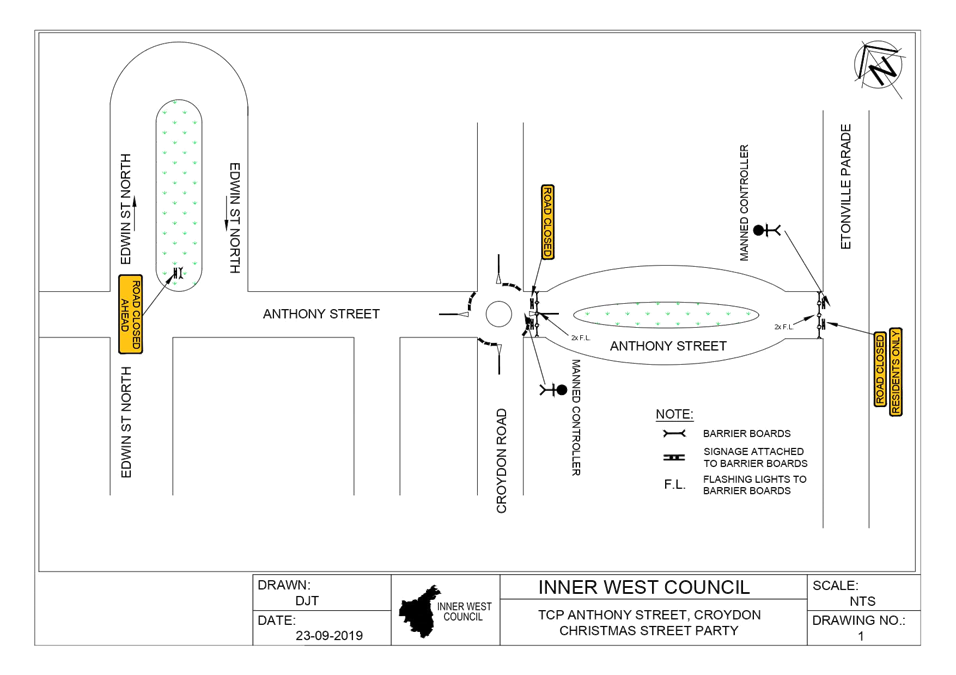
LTC1119 Item 18 Anthony Street, Croydon – Temporary Road Closure for Christmas Street Party (Gulgadya-Leichhardt Ward/Strathfield Electorate/Burwood PAC) 144
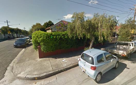
LTC1119 Item 19 Ewart Street, Dulwich Hill - Proposed Painted Chevron Island (Djarrawunang-Ashfield Ward/Summer Hill Electorate/Inner West PAC) 152
LTC1119 Item 20 D3 Iron Cove to Anzac Bridge – Regional Cycleway Design (Gulgadya-Leichhardt and Baludarri-Balmain Wards/Balmain Electorate/Leichhardt PAC) 155
Parking Matters
ITEM PAGE #
LTC1119 Item 21 Proposed Permit Parking Restrictions - Railway Terrace, Lewisham (Damun-Stanmore Ward/Summer Hill Electorate/Inner West PAC) 206
LTC1119 Item 22 McKell Street, Birchgrove - Proposed 'No Parking' and 'No Stopping' Restrictions (Baludarri-Balmain Ward/Balmain Electorate/Leichhardt PAC) 208
LTC1119 Item 23 Trafalgar Lane, Annandale - Proposed 'No Parking' Restriction (Baludarri-Balmain Ward/Balmain Electorate/Leichhardt PAC) 211
LTC1119 Item 24 Trafalgar Street, Annandale - Motorbike Parking (Gulgadya - Leichhardt Ward / Balmain Electorate / Leichhardt PAC) 214
Late Items
Nil at time of printing.
6 Part B - Items for Information Only
ITEM PAGE #
LTC1119 Item 25 Outstanding
Actions from July 2018 to date
(All Wards/All Electorates/All PACs) 217
7 Part C - Items for General Advice
Nil at the time of printing.
8 General Business
9 Close of Meeting
|
|
Local Traffic Committee Meeting Minutes from 8 October 2019 |
Minutes of Local Traffic Committee Meeting
Held at Petersham Service Centre on 8 October 2019
Meeting commenced at 10.05am
ACKNOWLEDGEMENT OF COUNTRY BY CHAIRPERSON
I acknowledge the Gadigal and Wangal people of the Eora nation on whose country we are meeting today, and their elders past and present.
COMMITTEE REPRESENTATIVES PRESENT
|
Clr Victor Macri |
Councillor – Midjuburi-Marrickville Ward (Chair) |
|
Bill Holliday |
Representative for Jamie Parker MP, Member for Balmain |
|
Chris Woods |
Representative for Ron Hoenig MP, Member for Heffron |
|
LSC Marina Nestoriaros |
NSW Police – Leichhardt Police Area Command |
|
Nazli Tzannes |
Roads and Maritime Services |
|
|
|
|
OFFICERS IN ATTENDANCE |
|
|
|
|
|
Asith Nagodavithane |
Transit Systems – Inner West Bus Services |
|
Colin Jones |
Inner West Bicycle Coalition |
|
Clr Marghanita da Cruz |
Councillor – Gulgadya-Leichhardt Ward |
|
John Stephens |
IWC’s Traffic and Transport Services Manager |
|
Manod Wickramasinghe |
IWC’s Coordinator Traffic and Parking Services (North) |
|
George Tsaprounis |
IWC’s Coordinator Traffic and Parking Services (South) |
|
Christina Ip |
IWC’s Business Administration Officer |
|
|
|
|
VISITORS |
|
|
|
|
|
Andrew Zhou |
Item 11 – Consultants |
|
Anthony Leung |
Item 11 – Consultants |
|
|
|
|
APOLOGIES: |
|
|
|
|
|
Cathy Edwards-Davis |
IWC Director Infrastructure |
DISCLOSURES OF INTERESTS:
Nil.
CONFIRMATION OF MINUTES
|
Minutes of the Local Traffic Committee Meeting held on Monday, 2 September 2019 were confirmed. |
MATTERS ARISING FROM COUNCIL’S RESOLUTION OF MINUTES
ADDENDUM:
The Minutes of the Local Traffic Committee Meeting held on Monday, 2 September 2019 were adopted by Council later on 8 October 2019.
|
LTC1019 Item 1 Minor Traffic Facilities (All Wards/All Electorates/All PACS) |
|
SUMMARY
This report considers minor traffic facility applications received by Inner West Council, and includes ‘Disabled Parking’ and ‘Works Zone’ requests.
Officer’s Recommendation
THAT:
1. The 6m ‘Disabled Parking’ zone in front of No.50 Redmond Street, Leichhardt, be removed as the zone is no longer required;
2. The 6m ‘Disabled Parking’ zone in front of No.21 Red Lion Street, Rozelle, be removed as the zone is no longer required, and the previous Ticket parking restrictions be reinstated;
3. The 6m ‘Disabled Parking’ zone in front of No.8 Hugh Avenue, Dulwich Hill, be removed as the zone is no longer required;
4. A 6m 'Disabled Parking’ zone be installed in front of No.26 Robert Street, Marrickville;
5. A 6m 'Disabled Parking’ zone be installed in front of No.22 Bright Street, Marrickville;
6. A 6m 'Disabled Parking’ zone be installed in front of No.3/2 Ewenton Street, Balmain East;
7. A 6.0m 'Disabled Parking' zone be installed in front of No.11 Bruce Street, Stanmore;
8. A 9m 'Works Zone 7.00am – 6.00pm Mon-Fri and 8.00am -1.00pm Sat' be installed at the front of No.6 Woodland Street, Marrickville, for 12 weeks; and
9. A 26m 'Works Zone 7:00am – 6:00pm Mon-Fri and 8.00am-1.00pm Sat' be installed in Barwon Park Road at the rear of Nos.44-46 Princes Highway, St Peters for 12 weeks.
DISCUSSION
The Committee members agreed with the Officer’s recommendation.
COMMITTEE RECOMMENDATION
THAT:
1. The 6m ‘Disabled Parking’ zone in front of No.50 Redmond Street, Leichhardt, be removed as the zone is no longer required;
2. The 6m ‘Disabled Parking’ zone in front of No.21 Red Lion Street, Rozelle, be removed as the zone is no longer required, and the previous Ticket parking restrictions be reinstated;
3. The 6m ‘Disabled Parking’ zone in front of No.8 Hugh Avenue, Dulwich Hill, be removed as the zone is no longer required;
4. A 6m 'Disabled Parking’ zone be installed in front of No.26 Robert Street, Marrickville;
5. A 6m 'Disabled Parking’ zone be installed in front of No.22 Bright Street, Marrickville;
6. A 6m 'Disabled Parking’ zone be installed in front of No.3/2 Ewenton Street, Balmain East;
7. A 6.0m 'Disabled Parking' zone be installed in front of No.11 Bruce Street, Stanmore;
8. A 9m 'Works Zone 7.00am – 6.00pm Mon-Fri and 8.00am -1.00pm Sat' be installed at the front of No.6 Woodland Street, Marrickville, for 12 weeks; and
9. A 26m 'Works Zone 7:00am – 6:00pm Mon-Fri and 8.00am-1.00pm Sat' be installed in Barwon Park Road at the rear of Nos.44-46 Princes Highway, St Peters for 12 weeks.
For motion: Unanimous
|
|
LTC1019 Item 2 Wells Street, Annandale - Christmas Street Party (Road Occupancy) (Gulgadya-Leichhardt Ward/ Balmain Electorate/ Leichhardt PAC) |
|
SUMMARY
Council has received an application for approval of an annual Christmas street party in Wells Street between Booth Street and Collins Street, Annandale to be held on Sunday, 1 December 2019 between 4:00pm and 7:00pm.
Officer’s Recommendation
THAT the temporary road closure of Wells Street, Annandale between Booth Street and Collins Street, to conduct an annual Christmas Street Party on Sunday, 1st December 2019, from 4:00pm - 7:00pm, be approved, subject to the conditions as set out as per the Street Party Application Form as well as the following additional conditions:
1. That an unencumbered passage minimum of 4.0m wide be available for emergency vehicles through Wells Street, Annandale between Booth Street and Collins Street;
2. The occupation of the road carriageway must not occur until the road has been physically closed; and
3. All affected residents and businesses, including the NSW Police Local Area Commander, Fire & Rescue NSW and NSW Ambulance Services be notified in writing, by the applicant, of the proposed temporary road closure at least 14 days in advance of the closure with the applicant making reasonable provision for stakeholders.
DISCUSSION
The Committee members agreed with the Officer’s recommendation.
COMMITTEE RECOMMENDATION
THAT the temporary road closure of Wells Street, Annandale between Booth Street and Collins Street, to conduct an annual Christmas Street Party on Sunday, 1st December 2019, from 4:00pm - 7:00pm, be approved, subject to the conditions as set out as per the Street Party Application Form as well as the following additional conditions:
1. That an unencumbered passage minimum of 4.0m wide be available for emergency vehicles through Wells Street, Annandale between Booth Street and Collins Street;
2. The occupation of the road carriageway must not occur until the road has been physically closed; and
3. All affected residents and businesses, including the NSW Police Local Area Commander, Fire & Rescue NSW and NSW Ambulance Services be notified in writing, by the applicant, of the proposed temporary road closure at least 14 days in advance of the closure with the applicant making reasonable provision for stakeholders.
For motion: Unanimous
|
|
LTC1019 Item 3 Burrows Avenue, Sydenham – Temporary Full Road Closures - Sydney Metro Sydenham Station and Junction (SSJ) Works – Amendment to approved road closure dates (Midjuburi-Marrickville Ward / Heffron Electorate / Inner West PAC) |
|
SUMMARY
Notice of amendments for the temporary full road closure of Burrows Avenue, between Hogan Avenue and Gleeson Avenue, Sydenham have been received from Sydney Metro Sydenham Station and Junction (SSJ) Group. Due to project work requirements additional closure dates have been proposed in addition to the previously approved full road closures. The street will be temporarily closed to all vehicular traffic, including emergency vehicles and local residents. It is recommended that the proposed additional temporary full road closures be approved, subject to the conditions outlined in this report.
Officer’s Recommendation
THAT the proposed temporary full road closure of Burrows Avenue, between Hogan Avenue and Gleeson Avenue, Sydenham on Friday, 18th October to Monday, 21st October 2019 (approved contingency date Friday, 25th October to Monday, 28th October 2019) and between Monday, 9th December to Friday, 27th December 2019 (approved contingency date Friday, 13th to Monday, 16th December 2019) be approved, in order to carry out upgrading works at Sydenham Station subject to, but not limited to, the following conditions:
1. The application and TMP be submitted to RMS for its approval;
2. A Road Occupancy License be obtained by the applicant from the Transport Management Centre;
3. All affected residents and businesses, including the NSW Police Local Area Commander, Fire & Rescue NSW and the NSW Ambulance Services be notified in writing, by the applicant, of the proposed temporary road closure at least 7 days in advance of the closure with the applicant making reasonable provision for stakeholders; and
4. The occupation of the road carriageway must not occur until the road has been physically closed.
DISCUSSION
The Committee noted that the Member for Heffron, Ron Hoenig MP wishes to express, once again, his concerns about the decision to manage pedestrian movements during the Sydney Metro construction work around Sydenham Station with pedestrian refuges, rather than marked zebra pedestrian crossings.
See Item 21 for more detail on this discussion.
The Committee members agreed with the Officer’s recommendation.
COMMITTEE RECOMMENDATION
THAT the proposed temporary full road closure of Burrows Avenue, between Hogan Avenue and Gleeson Avenue, Sydenham on Friday, 18th October to Monday, 21st October 2019 (approved contingency date Friday, 25th October to Monday, 28th October 2019) and between Monday, 9th December to Friday, 27th December 2019 (approved contingency date Friday, 13th to Monday, 16th December 2019) be approved, in order to carry out upgrading works at Sydenham Station subject to, but not limited to, the following conditions:
1. The application and TMP be submitted to RMS for its approval;
2. A Road Occupancy License be obtained by the applicant from the Transport Management Centre;
3. All affected residents and businesses, including the NSW Police Local Area Commander, Fire & Rescue NSW and the NSW Ambulance Services be notified in writing, by the applicant, of the proposed temporary road closure at least 7 days in advance of the closure with the applicant making reasonable provision for stakeholders; and
4. The occupation of the road carriageway must not occur until the road has been physically closed.
For motion: Unanimous
|
|
LTC1019 Item 4 Evans Street and Roseberry Street, Balmain - Proposed Kerb Blister Islands and Garden Beds (Baludarri-Balmain Ward/Balmain Electorate/Leichhardt PAC) |
|
SUMMARY
Detailed design plan has been finalised for the proposed intersection treatment at Evans Street and Roseberry Street, Balmain. The proposal includes installing kerb blister islands and garden beds and associated signposting and line marking at the intersection of Evans Street and Roseberry Street to prevent trucks from colliding with an existing balcony that extends over the public footpath on the corner of Evans Street and Roseberry Street, Balmain. Consultation was undertaken with the owners and occupiers of properties adjacent to the intersection regarding the proposal. A summary of the consultation results are presented in this report for consideration
Officer’s Recommendation
THAT the detailed design plan for the kerb blister islands, garden beds and associated signposting and line marking at the intersection of Evans Street and Roseberry Street, Balmain (as per the attached plan No.10069_A) be approved.
DISCUSSION
The Committee members agreed with the Officer’s recommendation.
COMMITTEE RECOMMENDATION
THAT the detailed design plan for the kerb blister islands, garden beds and associated signposting and line marking at the intersection of Evans Street and Roseberry Street, Balmain (as per the attached plan No.10069_A) be approved.
For motion: Unanimous
|
|
LTC1019 Item 5 Garnet Street, Dulwich Hill – Temporary Full Road Closure of Rail Overbridge south of Hampden Street/The Parade and north of Floss Street/Ewart Street - Sydney Metro (SSJ) early enabling works on T3 Line (Djarrawunang-Ashfield Ward / Summer Hill Electorate/ Inner West PAC) |
|
SUMMARY
An application has been received from Sydney Metro (SSJ) for the temporary full road closure of the rail over bridge on Garnet Street, just south of Hampden Street/The Parade and north of Floss Street/Ewart Street, Dulwich Hill for a 25 day period scheduled for Friday, 27 December 2019 to Friday, 24 January 2020 (contingency period of 7 days to Friday, 31 January 2020) in order to carry out early enabling works on the Rail Overbridge. The road will be temporarily closed to all vehicular traffic, including emergency vehicles and local residents. It is recommended that the proposed temporary full road closures be approved, subject to the conditions outlined in this report.
Officer’s Recommendation
THAT the proposed temporary full road closure of the rail over bridge on Garnet Street, just south of Hampden Street/The Parade and north of Floss Street/Ewart Street, Dulwich Hill for a 25 day period scheduled for Friday, 27 December 2019 to Friday, 24 January 2020 (contingency period of 7 days to Friday, 31 January 2020) be approved, in order to carry out early enabling works on the rail over bridge subject to, but not limited to, the following conditions:
1. The application and TMP be submitted to RMS for its approval;
2. A Road Occupancy License be obtained by the applicant from the Transport Management Centre;
3. All affected residents and businesses, including the NSW Police Local Area Commander, Fire & Rescue NSW and the NSW Ambulance Services be notified in writing, by the applicant, of the proposed temporary road closure at least 7 days in advance of the closure with the applicant making reasonable provision for stakeholders; and
4. The occupation of the road carriageway must not occur until the road has been physically closed.
DISCUSSION
The representative for Transit Systems requested 5 weeks notice of the road works and advised that a temporary bus stop must be provided close to Hurlstone Park Station. Council Officers will raise these requests with Sydney Metro.
The Committee members agreed with the Officer’s recommendation.
COMMITTEE RECOMMENDATION
THAT the proposed temporary full road closure of the rail over bridge on Garnet Street, just south of Hampden Street/The Parade and north of Floss Street/Ewart Street, Dulwich Hill for a 25 day period scheduled for Friday, 27 December 2019 to Friday, 24 January 2020 (contingency period of 7 days to Friday, 31 January 2020) be approved, in order to carry out early enabling works on the rail over bridge subject to, but not limited to, the following conditions:
1. The application and TMP be submitted to RMS for its approval;
2. A Road Occupancy License be obtained by the applicant from the Transport Management Centre;
3. All affected residents and businesses, including the NSW Police Local Area Commander, Fire & Rescue NSW and the NSW Ambulance Services be notified in writing, by the applicant, of the proposed temporary road closure at least 7 days in advance of the closure with the applicant making reasonable provision for stakeholders; and
4. The occupation of the road carriageway must not occur until the road has been physically closed.
For motion: Unanimous
|
|
LTC1019 Item 6 Queen Street at Arthur Street & Norton Street, Croydon - Proposed Traffic Calming at the intersections including Kerb Blisters (Design Plans 10095 & 10096) (Djarrawunang - Ashfield Ward/ Summer Hill Electorate/ Burwood PAC) |
|
SUMMARY
Design plans have been prepared for proposed speed cushions and splitter islands on Queen Street, Arthur Street and Norton Street, Ashfield. The proposed works received funding from the RMS Blackspot Program and the works will improve traffic conditions and road safety at these locations.
Consultation was undertaken with nearby owners and occupiers of properties in Queen Street, Arthur Street and Norton Street regarding the proposal. It is recommended that the proposed detailed design plan be approved.
Officer’s Recommendation
THAT the detailed design plans for the proposed intersection improvements along with associated signage and line marking at Queen Street and Arthur Street, Croydon (Design Plan No.10095) and Queen Street at Norton Street, Croydon (Design Plan No.10096) be APPROVED.
DISCUSSION
The Committee members agreed with the Officer’s recommendation.
COMMITTEE RECOMMENDATION
THAT the detailed design plans for the proposed intersection improvements along with associated signage and line marking at Queen Street and Arthur Street, Croydon (Design Plan No.10095) and Queen Street at Norton Street, Croydon (Design Plan No.10096) be APPROVED.
For motion: Unanimous
|
|
LTC1019 Item 7 Heighway Avenue, Ashfield - Temporary Road Closure For Christmas Street Party (Djarrawunang-Ashfield Ward/Summer Hill Electorate/Burwood PAC) |
|
SUMMARY
Council seeks the support of the committee for a temporary full road closure of Heighway Avenue Ashfield, between Walter Street and Frederick Street, to conduct an annual Christmas Street party on Saturday, 7 December 2019.
Officer’s Recommendation
THAT the temporary full road closure of Heighway Avenue, Ashfield, between Walter Street and Frederick Street, to conduct an annual Christmas Street Party on Saturday 7th December 2019, from 5.00pm to 9.00pm be approved, subject to the conditions as detailed on the Street Party Application Form as well as the following additional conditions:
1. That an unencumbered passage (minimum 4.0m wide) be made available for emergency vehicles through the closed section of Heighway Avenue, Ashfield; 2. The occupation of the road carriageway must not occur until the road has been physically closed; and 3. All affected residents and businesses, including the NSW Police Local Area Commander, Fire & Rescue NSW and NSW Ambulance Services be notified in writing, by the applicant, of the proposed temporary road closure at least 14 days in advance of the closure with the applicant making reasonable provision for stakeholders.
DISCUSSION
The Committee members agreed with the Officer’s recommendation.
COMMITTEE RECOMMENDATION
THAT the temporary full road closure of Heighway Avenue, Ashfield, between Walter Street and Frederick Street, to conduct an annual Christmas Street Party on Saturday 7th December 2019, from 5.00pm to 9.00pm be approved, subject to the conditions as detailed on the Street Party Application Form as well as the following additional conditions:
1. That an unencumbered passage (minimum 4.0m wide) be made available for emergency vehicles through the closed section of Heighway Avenue, Ashfield; 2. The occupation of the road carriageway must not occur until the road has been physically closed; and 3. All affected residents and businesses, including the NSW Police Local Area Commander, Fire & Rescue NSW and NSW Ambulance Services be notified in writing, by the applicant, of the proposed temporary road closure at least 14 days in advance of the closure with the applicant making reasonable provision for stakeholders.
For motion: Unanimous |
|
LTC1019 Item 8 Dalhousie Street, (Ramsay Street - Waratah Street), Haberfield – Local Road Project (Gulgadya - Leichhardt Ward / Summer Hill Electorate / Burwood PAC) |
|
SUMMARY
A review of the detailed design plan has been finalised for the proposed road reconstruction of Dalhousie Street from Ramsay Street to Waratah Street. The proposal includes resurfacing of road, reconstruction of footpath, kerb and gutter, kerb extensions and associated signposting and line marking. Consultation was undertaken with the owners and occupiers of properties adjacent to the proposal. A summary of the consultation results are presented in this report for consideration.
Officer’s Recommendation
That the detailed design plan for resurfacing of road, reconstruction of footpath, kerb and gutter, kerb extensions, and associated signposting and line marking in Dalhousie Street, Haberfield between the section of Ramsay Street to Waratah Street (as per attached plan No.10055) be approved.
DISCUSSION
The representative for Transit Systems requested that all bus stops be DDA compliant following works. In addition, Transit Systems requested that no additional trees be planted within the bus zones if it is between the footpath and kerb as it will be difficult for bus drivers to pull into the bus stop.
The Committee members agreed with the Officer’s recommendation.
COMMITTEE RECOMMENDATION
That the detailed design plan for resurfacing of road, reconstruction of footpath, kerb and gutter, kerb extensions, and associated signposting and line marking in Dalhousie Street, Haberfield between the section of Ramsay Street to Waratah Street (as per attached plan No.10055) be approved.
For motion: Unanimous
|
|
LTC1019 Item 9 Red Lion Street, Rozelle - Annual Road Occupancy (Street Party) (Baludarri - Balmain Ward/ Balmain Electorate/ Leichhardt PAC) |
|
SUMMARY
This report seeks approval for the temporary road closure of Red Lion Street, Rozelle to facilitate the annual ‘Christmas Street Party’ event that has been successfully conducted since 2009.
Officer’s Recommendation
THAT The temporary road closure of Red Lion Street, Rozelle, between Darling Street and Evans Street, to conduct an annual Christmas Street Party on Saturday, 14th December 2019, from 5:00pm – 12:00 midnight, be approved, subject to the conditions as set out as per the Street Party Application Form as well as the following additional conditions:
a. That an unencumbered passage minimum of 4.0m wide be available for emergency vehicles through the closed section of Red Lion Street, Rozelle; b. The occupation of the road carriageway must not occur until the road has been physically closed; c. All affected residents and businesses, including the NSW Police Local Area Commander, Fire & Rescue NSW and NSW Ambulance Services be notified in writing, by the applicant, of the proposed temporary road closure at least 2 weeks in advance of the closure with the applicant making reasonable provision for stakeholders.
DISCUSSION
The Committee members agreed with the Officer’s recommendation.
COMMITTEE RECOMMENDATION
THAT The temporary road closure of Red Lion Street, Rozelle, between Darling Street and Evans Street, to conduct an annual Christmas Street Party on Saturday, 14th December 2019, from 5:00pm – 12:00 midnight, be approved, subject to the conditions as set out as per the Street Party Application Form as well as the following additional conditions:
a. That an unencumbered passage minimum of 4.0m wide be available for emergency vehicles through the closed section of Red Lion Street, Rozelle; b. The occupation of the road carriageway must not occur until the road has been physically closed; c. All affected residents and businesses, including the NSW Police Local Area Commander, Fire & Rescue NSW and NSW Ambulance Services be notified in writing, by the applicant, of the proposed temporary road closure at least 2 weeks in advance of the closure with the applicant making reasonable provision for stakeholders.
For motion: Unanimous
|
|
LTC1019 Item 10 George Street at Treadgold Street South, Leichhardt - Proposed 'Give-Way' control (Gulgadya - Leichhardt Ward / Balmain Electorate / Leichhardt PAC) |
|
SUMMARY
The T-intersection of George Street and Treadgold Street South, Leichhardt does not currently have signposted intersection control. This report recommends installing ‘Give-Way’ control at the intersection.
Officer’s Recommendation
That ‘Give-Way’ control be signposted and line marked in George Street, Leichhardt immediately south of Treadgold Street South for northbound motorists.
DISCUSSION
The Committee members agreed with the Officer’s recommendation.
COMMITTEE RECOMMENDATION
That ‘Give-Way’ control be signposted and line marked in George Street, Leichhardt immediately south of Treadgold Street South for northbound motorists.
For motion: Unanimous
|
|
LTC1019 Item 11 Draft Croydon Parking Study (Gulgadya-Leichhardt Ward/Summer Hill Electorate/Burwood PAC) |
|
SUMMARY
The Croydon Parking Study reviewed the location, supply, demand and distribution of both short and long stay parking, residential, employee and commuter parking. The work consisted of examining existing conditions including parking data, community submissions, and examining on-street as well as private off-street parking. A community survey was also undertaken to gauge the parking issues faced by different users. With consideration for future developments and access to public transport, including Burwood Council’s own parking strategy, a parking management strategy was then developed for the Croydon area.
Officer’s Recommendation
THAT:
1. The Committee endorse the Draft Croydon Parking Study including Stage 1 and 2 of the parking management strategy for community consultation; and
2. The draft report be placed on Public Exhibition, providing a minimum 28 days for submissions and the results be reported back to the Committee.
DISCUSSION
Public speakers: Anthony Leong and Andrew Zhou, GTA Consultants, attended at 10.09am
Mr Leong and Mr Zhou outlined the key findings and recommendations following their study into parking in Croydon. The speakers stated that, after discussions with Council, it was decided that Stage 1 and 2 of the parking management strategy is proposed to be implemented simultaneously before the completion of the Ashfield Aquatic Centre. It was proposed that a review of the scheme will be undertaken after implementation to assess the scheme’s effectiveness and the impacts to parking after the opening of the aquatic centre.
(Mr Leong and Mr Zhou left at 10.17am)
The Committee members agreed with the Officer’s recommendation.
COMMITTEE RECOMMENDATION
THAT:
1. The Committee endorse the Draft Croydon Parking Study including Stage 1 and 2 of the parking management strategy for community consultation; and
2. The draft report be placed on Public Exhibition, providing a minimum 28 days for submissions and the results be reported back to the Committee.
For motion: Unanimous
|
|
LTC1019 Item 12 Hawthorne Parade, Haberfield - Proposed '2 hour' Parking Zone (Gulgadya - Leichhardt Ward/ Balmain Electorate/ Leichhardt PAC) |
|
SUMMARY
Council has received requests to implement time-restricted parking directly in front of the Children’s playground in Richard Murden Reserve to restrict long stay parking by non-resident vehicles that utilise the light rail.
Officer’s Recommendation
THAT the existing fourteen indented (14) rear-to-kerb unrestricted parking bays on the eastern side of Hawthorne Parade between Turner Avenue and Barton Avenue, Haberfield be restricted as ‘2P 8am-10pm’.
DISCUSSION
The Committee members agreed with the Officer’s recommendation.
COMMITTEE RECOMMENDATION
THAT the existing fourteen indented (14) rear-to-kerb unrestricted parking bays on the eastern side of Hawthorne Parade between Turner Avenue and Barton Avenue, Haberfield be restricted as ‘2P 8am-10pm’.
For motion: Unanimous
|
|
LTC1019 Item 13 Hearn Street, Leichhardt - Proposed 'No Parking' restriction (Gulgadya - Leichhardt Ward/ Balmain Electorate/ Leichhardt PAC) |
|
SUMMARY
Council has received concerns from a resident of South Avenue, Leichhardt regarding an ongoing problem with obstructed driveway access in the closed-end of Hearn Street due to parked vehicles.
Officer’s Recommendation
THAT a 28.6m ‘No Parking’ restriction be installed along the northern closed end of Hearn Street, Leichhardt, between the rear driveway of No.81 Catherine Street and driveway of No.33 Hearn Street.
DISCUSSION
The Committee members agreed with the Officer’s recommendation.
COMMITTEE RECOMMENDATION
THAT a 28.6m ‘No Parking’ restriction be installed along the northern closed end of Hearn Street, Leichhardt, between the rear driveway of No.81 Catherine Street and driveway of No.33 Hearn Street.
For motion: Unanimous
|
|
LTC1019 Item 14 Smith Street, Marrickville - Proposed Extension of Permit Parking Area M19 (Midjuburi- Marrickville Ward/ Summer Hill Electorate/ Inner West PAC) |
|
SUMMARY
Following representations to Council, a proposal for an extension of the existing M19 permit parking restrictions was distributed to residents of Smith Street for comment. Given the feedback from residents, a revised proposal has been developed. The revised proposal addresses concerns raised by residents whilst offering a balanced approach to providing permit parking and unrestricted parking in the area.
Officer’s Recommendation
THAT implementation of a 35m ‘2P 8.30am-6.30pm Monday to Friday Permit Holders Excepted Area M19’ parking restriction on Smith Street (southern side) between property No.2 and No.22 Smith Street, Marrickville be APPROVED.
DISCUSSION
The Committee members agreed with the Officer’s recommendation.
COMMITTEE RECOMMENDATION
THAT implementation of a 35m ‘2P 8.30am-6.30pm Monday to Friday Permit Holders Excepted Area M19’ parking restriction on Smith Street (southern side) between property No.2 and No.22 Smith Street, Marrickville be APPROVED.
For motion: Unanimous
|
|
LTC1019 Item 15 Victoria Road, Marrickville - Proposed 1P Restrictions (Midjuburi- Marrickville Ward/ Summer Hill Electorate/ Inner West PAC) |
|
SUMMARY
Following representations from a small business owner in Victoria Road, Marrickville; Council is proposing to implement a 12 metre section of ‘1P 9am – 3.30pm Monday to Friday’ restrictions. The restrictions are proposed for the section of roadway directly outside 266 & 268 Victoria Road, Marrickville and in close proximity to a number of other small businesses in this section of Victoria Road. Small business owners have supported the proposal as a means to create parking turnover.
Officer’s Recommendation
THAT a 12m ‘1P 9.00am – 3.30pm Monday to Friday’ parking restriction be installed outside Nos.266 & 268 Victoria Road, Marrickville (eastern side) in conjunction with the existing ‘No Parking 3.30pm – 7.00pm Monday to Friday’ restriction be approved.
DISCUSSION
The Committee members agreed with the Officer’s recommendation.
COMMITTEE RECOMMENDATION
THAT a 12m ‘1P 9.00am – 3.30pm Monday to Friday’ parking restriction be installed outside Nos.266 & 268 Victoria Road, Marrickville (eastern side) in conjunction with the existing ‘No Parking 3.30pm – 7.00pm Monday to Friday’ restriction be approved.
For motion: Unanimous
|
|
LTC1019 Item 16 Wooley Lane, Marrickville – Proposed 6 metre Extension to Existing ‘NO PARKING’ Restriction (Midjuburi - Marrickville Ward / Newtown Electorate / Inner West PAC) |
|
SUMMARY
A resident of Church Street, Marrickville has raised concerns with vehicles parked in Wooley Lane opposite their driveway/garage which has resulted in restricted vehicular access into and out of their off-street parking space. The resident has requested an extension of the full time ‘No Parking’ restrictions in the laneway to a position opposite to the resident's driveway. Surrounding local residents have been notified of the proposal to extend the existing 12 metre length of ‘No Parking’ restriction in Wooley Lane, at the rear of property No.376 Illawarra Road (eastern side) by 6 metres south towards Church Street, Marrickville to improve vehicular access to resident's off-street parking. It is recommended that this proposal be approved.
Officer’s Recommendation
THAT:
1. The installation of a 6 metre extension to the existing full-time ‘No Parking’ zone on the eastern side of Wooley Lane, southward of the existing restrictions to the driveway at the rear of property Nos.380-382 Illawarra Road, Marrickville be APPROVED, in order to provide unobstructed vehicular access to resident’s off-street car parking: and
2. The applicant, responders and Council’s Parking Officers be advised of Council's decision.
DISCUSSION
The Committee members agreed with the Officer’s recommendation.
COMMITTEE RECOMMENDATION
THAT:
1. The installation of a 6 metre extension to the existing full-time ‘No Parking’ zone on the eastern side of Wooley Lane, southward of the existing restrictions to the driveway at the rear of property Nos.380-382 Illawarra Road, Marrickville be APPROVED, in order to provide unobstructed vehicular access to resident’s off-street car parking: and
2. The applicant, responders and Council’s Parking Officers be advised of Council's decision.
For motion: Unanimous
|
|
LTC1019 Item 17 Valley Street, Balmain - Proposed Marked Car Parking Bays (Baludarri - Balmain Ward/ Balmain Electorate/ Leichhardt PAC) |
|
SUMMARY
Council has received safety concerns from a resident regarding restricted vehicular access for emergency vehicles near the closed-end of Valley Street, Balmain due to vehicles parking away from the kerb line and limiting the available travel lane width.
Officer’s Recommendation
THAT a linemarked parking bay (11.9m x 1.8m) be installed in front of Nos.10 and 12 Valley Street, Balmain, between the existing ‘No Parking’ restrictions.
DISCUSSION
The Committee members agreed with the Officer’s recommendation.
COMMITTEE RECOMMENDATION
THAT a linemarked parking bay (11.9m x 1.8m) be installed in front of Nos.10 and 12 Valley Street, Balmain, between the existing ‘No Parking’ restrictions.
For motion: Unanimous
|
|
LTC1019 Item 18 Chester Street at Gehrig Lane, Annandale - Proposed 'No Stopping' zone extension (Gulgadya - Leichhardt Ward/ Balmain Electorate/ Leichhardt PAC) |
|
SUMMARY
Council has received a request from a resident to extend the existing ‘No Stopping’ zone in Chester Street, south of Gehrig Lane, Annandale to prevent vehicles from illegally parking across the driveway of No.72 Pyrmont Bridge Road, Annandale.
Officer’s Recommendation
THAT the existing 6.8m ‘No Stopping’ zone be extended to 11.7m on the eastern side of Chester Street, north of Pyrmont Bridge Road, Annandale.
DISCUSSION
The Committee members agreed with the Officer’s recommendation.
COMMITTEE RECOMMENDATION
THAT the existing 6.8m ‘No Stopping’ zone be extended to 11.7m on the eastern side of Chester Street, north of Pyrmont Bridge Road, Annandale.
For motion: Unanimous
|
|
LTC1019 Item 19 White Street, Lilyfield - Part Time 'No Parking' Restriction (Baludarri - Balmain Ward/ Balmain Electorate/ Leichhardt PAC) |
|
SUMMARY
Concern has been raised regarding vehicle parking in a location where a driveway was recently removed and new kerb and gutter was constructed. This has resulted in obstructed delivery access to the adjacent property. Council is proposing to introduce part time ‘No Parking’ restriction to alleviate the concern.
Officer’s Recommendation
THAT:
1. An 8m ‘No Parking 7:30am–6:00pm Mon-Fri’ restriction be installed on the eastern side of White Street extending north from the southern boundary of No.1 and No.5 White Street, Lilyfield (in place of the driveway that was removed);
2. The existing part time ‘No Parking 8:30am-6:00pm Mon-Fri’ zone on the western side of White Street outside Nos.1-5 Moore Street be modified to a ‘No Parking 7:30am-6:00pm Mon-Fri’ restriction; and
3. A 12m ‘No Stopping’ restriction be installed on the eastern side of White Street, north of Moore Street.
DISCUSSION
The Committee members agreed with the Officer’s recommendation.
COMMITTEE RECOMMENDATION
THAT:
1. An 8m ‘No Parking 7:30am–6:00pm Mon-Fri’ restriction be installed on the eastern side of White Street extending north from the southern boundary of No.1 and No.5 White Street, Lilyfield (in place of the driveway that was removed);
2. The existing part time ‘No Parking 8:30am-6:00pm Mon-Fri’ zone on the western side of White Street outside Nos.1-5 Moore Street be modified to a ‘No Parking 7:30am-6:00pm Mon-Fri’ restriction; and
3. A 12m ‘No Stopping’ restriction be installed on the eastern side of White Street, north of Moore Street.
For motion: Unanimous
|
|
LTC1019 Item 20 Westbourne Lane, Stanmore – Request for ‘No Parking’ Restrictions (Damun-Stanmore Ward/Newtown Electorate/Inner West PAC) |
|
SUMMARY
Representations have been received from a local resident for the installation of ‘No Parking’ restrictions in Westbourne Lane, Stanmore as vehicular access is often blocked by parked vehicles in the laneway and the resident cannot access their off-street parking facilities. Residents in the mid-section of the laneway, between Cannon Lane and Charles Street, were notified that Council is proposing to install a 6 metre length of ‘No Parking’ restrictions on the north side of Westbourne Lane, between the garage and gate behind No.47 Westbourne Street, to improve access to off-street parking for an adjacent resident. It is recommended that the proposal be approved and a minimum period of time being six months following installation elapse prior to the consideration of any future extension of the proposed zone.
Officer’s Recommendation
THAT:
1. The installation of a 6 metre long full-time ‘No Parking’ restriction on the northern side of Westbourne Lane, between Cannon Lane and Charles Street, Stanmore (between the garage and gate behind No.47 Westbourne Street opposite the rear of No.156 Albany Road) be APPROVED, in order to provide unobstructed vehicular access to the off-street car parking spaces; 2. Any future extension(s) to the proposed restrictions not be investigated until at least a minimum of 6 months from the date of installation of the proposed 'No Parking' restriction; and 3. The applicant, responders and Council’s Parking Officers be advised of Council's decision.
DISCUSSION
The Committee members agreed with the Officer’s recommendation.
COMMITTEE RECOMMENDATION
THAT:
1. The installation of a 6 metre long full-time ‘No Parking’ restriction on the northern side of Westbourne Lane, between Cannon Lane and Charles Street, Stanmore (between the garage and gate behind No.47 Westbourne Street opposite the rear of No.156 Albany Road) be APPROVED, in order to provide unobstructed vehicular access to the off-street car parking spaces; 2. Any future extension(s) to the proposed restrictions not be investigated until at least a minimum of 6 months from the date of installation of the proposed 'No Parking' restriction; and
3. The applicant, responders and Council’s Parking Officers be advised of Council's decision.
For motion: Unanimous
|
|
LTC1019 Item 21 Burrows Avenue and Hogan Avenue, Sydenham – Sydney Metro SSJ Works – Temporary traffic control arrangements – Pedestrian safety issues (Midjuburi - Marrickville Ward / Heffron Electorate / Inner West PAC) |
|
SUMMARY
Pedestrian safety concerns have been raised in relation to the temporary traffic control arrangements, by Sydney Metro SSJ’s Group Sydenham Station construction works, on Burrows Avenue and Hogan Avenue, Sydenham at Council’s Local Traffic Committee meeting on 3 June 2019 and at Council’s Ordinary Meeting on 27 August 2019. This report addresses the issues raised.
Officer’s Recommendation
THAT this report be received and noted.
DISCUSSION
The Committee noted that the Member for Heffron, Ron Hoenig MP acknowledges that his requests for temporary marked zebra pedestrian crossings were rejected because vehicle and pedestrian numbers did not meet RMS warrants, but were close to meeting the warrants. It is Mr Hoenig’s view that the nature of the heavy construction work, the new pedestrian overpass and the possible increase in pedestrian movements during the construction period support the need for temporary zebra crossings on Burrows Avenue and Hogan Avenue. He also noted that a permanent crossing on Burrows Avenue is proposed on completion of the Sydney Metro station construction.
The RMS representative stated that RMS will obtain a full report from Sydney Metro to confirm whether a temporary marked pedestrian crossing would be warranted. The RMS representative advised that pedestrian refuges can be safer than marked crossings as pedestrians have a perception that they have right of way at a marked crossing and as a result, do not check traffic before crossing. Accidents are more frequent at marked pedestrian crossings than at pedestrian refuges for this reason.
COMMITTEE RECOMMENDATION
THAT:
For motion: Unanimous
|
|
LTC1019 Item 22 Review into Simplification of Parking Signs (All Wards / All Electorates / All LACs) |
|
SUMMARY
Council has requested a report to review how Council can simplify parking signs throughout the municipality and be brought to the Traffic Committee for its consideration. This report reviews two examples of complex signs and identifies the opportunities and constraints in simplifying those signs in line with RMS requirements. To effectively simplify signage through the municipality, a decision must be made to reduce the types of parking zones in affect along any one section of kerb space. However, this would come at the cost of providing flexibility of parking spaces within the Inner West LGA.
Officer’s Recommendation
THAT this report be received and noted.
DISCUSSION
The Committee members agreed with the Officer’s recommendation.
COMMITTEE RECOMMENDATION
THAT this report be received and noted.
For motion: Unanimous
|
|
LTC1019 Item 23 Long Walk Home - Special Event (Baludarri-Balmain Ward / Balmain Electorate / Leichhardt PAC) |
|
SUMMARY
The Wayside Chapel has partnered with IAG to host a mass participation walking event, Long Walk Home, to be held on Friday, 29 November 2019 at various locations in Sydney, starting from Parramatta Park, Parramatta passing through Victoria Road, Rozelle and concluding at Fitzroy Garden, Kings Cross. The event is in its second year of operation and the applicant seeks approval for 2019.
Officer’s Recommendation
THAT the Wayside Chapel Long Walk Home event to be held from 5:00pm Friday, 29 November 2019 be supported, subject to a current Public Liability Insurance Policy which includes Inner West Council being an interested party and submitted by the event organiser prior to the event.
DISCUSSION
The Committee members agreed with the Officer’s recommendation.
COMMITTEE RECOMMENDATION
THAT the Wayside Chapel Long Walk Home event to be held from 5:00pm Friday, 29 November 2019 be supported, subject to a current Public Liability Insurance Policy which includes Inner West Council being an interested party and submitted by the event organiser prior to the event.
For motion: Unanimous
|
General Business
|
LTC1019 Item 24 Request to make unnamed laneway in Leichhardt resident access only
|
|
The Police representative advised that residents raised concerns with construction noise and heavy vehicle activity from the redevelopment of the aged care facility (Harold Hawkins) at the laneway parallel to Norton Street between Marion Street and Allen Street. The concerned residents requested that the laneway permanently be accessible only to residents. Transit Systems advised that the ‘Works Zone’ for the aged care facility can be relocated to Norton Street as the bus stop on Norton Street can be temporarily decommissioned for the ‘Works Zone’. It was noted that an application to relocate the ‘Works Zone’ has not been submitted to Council yet.
|
|
LTC1019 Item 25 Signalised crossing at corner of Pyrmont Bridge Road and Parramatta Road, Camperdown
|
|
A resident has raised concerns regarding the signalised pedestrian crossing at the corner of Pyrmont Bridge Road and Parramatta Road, Camperdown. The resident reported that near misses at the crossing have occurred due to motorists either ignoring or not seeing the left turn holding signal from Parramatta Road and turning into Pyrmont Bridge Road when pedestrians are crossing. Council has forwarded the resident’s concerns to Police and RMS for enforcement action and investigation into the signal phasing at the intersection.
|
|
LTC1019 Item 26 Proposed changes to parking in Jubilee Place, Balmain
|
|
Clr Macri raised concerns residents are having with Police proposing to implement a ‘No Parking’ zone on the southern side of Jubilee Place, Balmain and converting some parking spaces into Police parking. The Committee was advised that Jubilee Place is Crown Land managed by Police and that Police need more road space to manoeuvre their vehicles and wide tow boats to the Marine Area Command facility. Council is currently undertaking community consultation and a report will be presented to the Committee to approve signage.
|
|
LTC1019 Item 27 Trailers parked on Darley Road, Leichhardt
|
|
The representative for the Member for Balmain advised that a number of trailers, including some burnt out trailers, are still parked on Darley Road, Leichhardt following the implementation of parking restrictions in the street. Council Officers advised that Council Rangers have made numerous attempts to contact the owners of the trailers and continue to do so. Council Rangers will be notified of the burnt out trailers.
|
|
LTC1019 Item 28 Committee thanks Ryan Horne
|
|
The Committee thanked Ryan Horne, former RMS representative to Inner West Council, for his assistance to Council and the Committee over the years and wished him well in his new position with Transport for NSW.
|
Meeting closed at 11.03am.
This page has been left intentionally blank.
|
|
Local Traffic Committee Meeting 4 November 2019 |
Subject: Minor Traffic Facilities (All Wards/All Electorates/All PACS)
Prepared By: Davide Torresan - Coordinator - Road Access Services
Authorised By: John Stephens - Traffic and Transport Services Manager
SUMMARY
This report considers minor traffic facility applications received by Inner West Council and includes ‘Disabled Parking’ and ‘Works Zone’ requests.
|
RECOMMENDATION
THAT:
1. The 6m ‘Disabled Parking’ zone in front of No.33 Annesley Street, Leichhardt, be removed as the zone is no longer required;
2. The 6m ‘Disabled Parking’ zone in front of No.15 Cook Street, Rozelle, be removed as the zone is no longer required;
3. The 6m ‘Disabled Parking’ zone in front of No.228 Trafalgar Street, Annandale, be removed as the zone is no longer required;
4. The 6m ‘Disabled Parking’ zone in front of No.117 Lilyfield Road, Lilyfield, be removed as the zone is no longer required;
5. The 6m ‘Disabled Parking’ zone in front of No.85 Trafalgar Street, Annandale, be removed as the zone is no longer required;
6. The 6m ‘Disabled Parking’ zone in front of No.41 Springside Street, Rozelle, be removed as the zone is no longer required;
7. The 6m ‘Disabled Parking’ zone in front of No.32 Pigott Street, Dulwich Hill, be removed as the zone is no longer required;
8. A 6m ‘Disabled Parking’ zone be installed in front of No.280 Sydenham Road, Marrickville, subject to RMS approval;
9. A 10m ‘No Stopping’ restriction be installed on the northern side of Silver Street, east of Florence Street followed by a 6m 'Disabled Parking Zone’ in front of No.63 Silver Street, St Peters; and
10. A 10m ‘No Stopping’ restriction be installed on the southern side of Lord Street, west of Hawthorne Parade followed by a 6m 'Disabled Parking Zone’ on the side boundary of No.78 Hawthorne Parade, Haberfield. |
BACKGROUND
Requests have been received from residents within the Local Government Area (LGA) for the provision of mobility parking spaces outside their residence. It is recommended that the following 'Mobility Parking' spaces be approved as the applicant’s current medical conditions warrant the provision of these spaces and they have constrained or no off-street parking opportunities. For the mobility parking space requests, a copy of the RMS disability parking permit and a medical certificate in support of the applications was submitted to Council.
The Disabled Parking Zones recommended for approval are installed under the following conditions:
1. The operation of the Disabled Parking Zone is valid for two (2) years from the date of installation.
2. The Disabled Parking Zone will be scheduled for review within two (2) years of the date of installation, then every twelve (12) months thereafter. The purpose of the reviews is to confirm that circumstances have not changed and as a result, the applicant may be requested to furnish a medical certificate and current Mobility Parking Scheme Permit to demonstrate the need for the continuation of the Mobility Parking Zone.
3. The Disabled Parking Zone is not exclusively reserved for the use of the applicant. It may also be used by any holder of a valid Mobility Parking Scheme Permit.
4. There is an obligation on the applicant to advise Council if circumstance change.
There are no applications for 'Works Zones' to be considered in this report.
FINANCIAL IMPLICATIONS
Nil.
OTHER STAFF COMMENTS
1. Removal of ‘Disabled Parking’ restriction – No.33 Annesley Street, Leichhardt
A resident has advised that the ‘Disabled Parking’ zone in front of No.33 Annesley Street, Leichhardt, is no longer required. Council staff contacted the original applicant and they have confirmed that the ‘Disabled Parking’ zone is no longer required.
It is recommended that the 6m ‘Disabled Parking’ zone in front of No.33 Annesley Street, Leichhardt, be removed.
2. Removal of ‘Disabled Parking’ restriction – No.15 Cook Street, Rozelle
A resident has advised that the ‘Disabled Parking’ zone in front of No.15 Cook Street, Rozelle, is no longer required. Council staff contacted the original applicant and they have confirmed that the ‘Disabled Parking’ zone is no longer required.
It is recommended that the 6m ‘Disabled Parking’ zone in front of No.15 Cook Street, Rozelle, be removed.
3. Removal of ‘Disabled Parking’ restriction – No.228 Trafalgar Street, Annandale
A resident has advised that the ‘Disabled Parking’ zone in front of No.228 Trafalgar Street, Annandale, is no longer required. Council staff contacted the original applicant and they have confirmed that the ‘Disabled Parking’ zone is no longer required.
It is recommended that the 6m ‘Disabled Parking’ zone in front of No.228 Trafalgar St, Annandale, be removed.
4. Removal of ‘Disabled Parking’ restriction – No.117 Lilyfield Road, Lilyfield
A resident has advised that the ‘Disabled Parking’ zone in front of No.117 Lilyfield Road, Lilyfield, is no longer required. Council staff contacted the original applicant and they have confirmed that the ‘Disabled Parking’ zone is no longer required.
It is recommended that the 6m ‘Disabled Parking’ zone in front of No.117 Lilyfield Road, Lilyfield, be removed.
5. Removal of ‘Disabled Parking’ restriction – No.85 Trafalgar Street, Annandale
A resident has advised that the ‘Disabled Parking’ zone in front of No.85 Trafalgar Street, Annandale, is no longer required. Council staff contacted the original applicant and they have confirmed that the ‘Disabled Parking’ zone is no longer required.
It is recommended that the 6m ‘Disabled Parking’ zone in front of No.85 Trafalgar Street, Annandale, be removed.
6. Removal of ‘Disabled Parking’ restriction – No.41 Springside Street, Rozelle
A resident has advised that the ‘Disabled Parking’ zone in front of No.41 Springside Street, Rozelle, is no longer required. Council staff contacted the original applicant and they have confirmed that the ‘Disabled Parking’ zone is no longer required.
It is recommended that the 6m ‘Disabled Parking’ zone in front of No.41 Springside Street, Rozelle, be removed.
7. Removal of ‘Disabled Parking’ restriction – No.32 Pigott Street, Dulwich Hill
A resident has advised that the ‘Disabled Parking’ zone in front of No.32 Pigott Street, Dulwich Hill, is no longer required. Council staff contacted the original applicant and they have confirmed that the ‘Disabled Parking’ zone is no longer required.
It is recommended that the 6m ‘Disabled Parking’ zone in front of No.32 Pigott Street, Dulwich Hill, be removed.
8. Installation of ‘Disabled Parking’ Restriction – No.280 Sydenham Road, Marrickville
The resident of No.280 Sydenham Road, Marrickville, has requested the installation of 'Disabled Parking Zone’ in front of the resident’s property. A site investigation has revealed the property does not have an off street parking facility. The applicant does not require the use of wheelchair.
It is recommended that a 6m 'Disabled Parking’ zone be installed in front of No.280 Sydenham Road, Marrickville, subject to RMS approval.
No.280 Sydenham Road, Marrickville
9. Installation of ‘Disabled Parking’ Restriction – No.63 Silver Street, St Peters
The resident of No.63 Silver Street, St Peters, has requested the installation of 'Disabled Parking Zone’ in front of the resident’s property. A site investigation has revealed the property does not have an off street parking facility. The applicant requires the use of wheelchair; however, they have advised Council that they do not need the installation of a kerb ramp adjacent to the ‘Disabled Parking’ zone. It is also noted there is a kerb ramp at the intersection near the proposed ‘Disabled Parking’ zone.
It is recommended that a ‘No Stopping (arrow left)’ sign be installed at a statutory distance of 10m and a 6m 'Disabled Parking’ zone be installed in front of No.63 Silver Street, St Peters, on the northern side of Silver Street, east of Florence Street.
No.63 Silver Street, St Peters
10. Installation of ‘Disabled Parking’ Restriction – No.78 Hawthorne Parade, Haberfield
The resident of No.78 Hawthorne Parade has requested the installation of a 'Disabled Parking Zone’ at the Lord Street frontage (2nd parking space from Hawthorne Parade) of the resident’s property. A site investigation has revealed the property does not have an off street parking facility. The applicant does not require the use of wheelchair.
It is recommended that a ‘No Stopping (arrow left)’ sign be installed at a statutory distance of 10m and a 6m 'Disabled Parking’ zone be installed on the side boundary of No.78 Hawthorne Parade, Haberfield on the southern side of Lord Street, west of Hawthorne Parade.
No.78 Hawthorne Parade, Haberfield
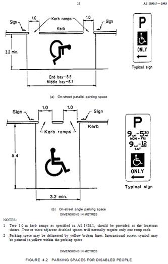
Technical Standards
Australian Standard AS2890.5-1993 “On-Street Parking” states the following in regards to the provision of parking for people with a disability:
“Parallel parking spaces shall not be marked as disabled spaces, nor included in the count of spaces available for people with disabilities unless –
i. A 3.2m wide space can be provided, e.g. by indenting the space into the footpath area; and
ii. Kerb ramps as shown in Figure 4.2(a) are also provided”.
It should be noted that due to the limited width of streets around the LGA, it is often difficult to comply with these requirements for the parking space dimensions. This may also result in the loss of some adjacent on-street parking spaces.
Mobility parking spaces are primarily intended for on-street and off-street parking at destinations, such as in commercial/retail areas and public car parks near hospitals, schools and public transport facilities where multiple usages can be expected. They were generally not intended for points of origin such as reserving on-street parking. As such, they are only proposed where required for wheelchair access at the cost of the applicants.
A mobility parking space is not intended for the sole use of one applicant, but rather a shared facility that can used by all authorised persons having a RMS mobility permit.
PUBLIC CONSULTATION
Nil.
|
|
Local Traffic Committee Meeting 4 November 2019 |
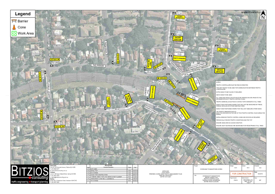
Subject: Terrace Road / Ness Avenue, Dulwich Hill –
Temporary full road closures of rail underpass just north of the roundabout at
Ewart Street.
(DJARRAWUNANG-ASHFIELD WARD / SUMMER HILL ELECTORATE / INNER WEST
PAC)
Prepared By: Jennifer Adams - Engineer – Traffic and Parking Services
Authorised By: John Stephens - Traffic and Transport Services Manager
SUMMARY
An application has been received from Sydney Metro (SSJ) for the temporary full road closures of the rail underpass on Terrace Road / Ness Avenue just north of the roundabout at Ewart Street, Dulwich Hill for a 24 hour period on Sunday 22 December 2019 (contingency day Monday 23 December 2019) and for two 48 hour periods on Saturday 4 January to Sunday 5 January 2020 (contingency day Monday 6 January 2020) and Saturday 7 March to Sunday 8 March 2020 (contingency day Monday 9 March 2020) in order to carry out further early enabling works on the Rail bridge. The road will be temporarily closed to all vehicular traffic, including emergency vehicles and local residents. It is recommended that the proposed temporary full road closures be approved, subject to the conditions outlined in this report.
|
RECOMMENDATION
THAT the proposed temporary full road closure of the rail underpass on Terrace Road / Ness Avenue just north of the roundabout at Ewart Street, Dulwich Hill for a 24 hour period on Sunday, 22 December 2019 (contingency day Monday, 23 December 2020) and for two 48 hour periods on Saturday, 4 January to Sunday, 5 January 2020 (contingency day Monday, 6 January 2020) and Saturday, 7 March to Sunday, 8 March 2020 (contingency day Monday, 9 March 2020) be approved, in order to carry out early enabling works on the rail bridge subject to, but not limited to, the following conditions:
a) A Road Occupancy License be obtained by the applicant from the Transport Management Centre;
b) All affected residents and businesses, including the NSW Police Local Area Commander, Fire & Rescue NSW and the NSW Ambulance Services be notified in writing, by the applicant, of the proposed temporary road closure at least 7 days in advance of the closure with the applicant making reasonable provision for stakeholders; and
c) The occupation of the road carriageway must not occur until the road has been physically closed.
|
BACKGROUND
Southwest metro early works are now underway between Sydenham and Campsie to convert the existing rail to metro standards in preparation for the opening of Sydney Metro City & Southwest in 2024. The joint venture currently delivering the Sydney Metro upgrade to Sydenham Station (SSJ), John Holland Pty Ltd and Laing O’Rourke Australia Construction Pty Ltd, has been appointed to undertake early works along the T3 Bankstown Line like site geotechnical investigations, early design, and enabling works such as surveying and utilities investigations. Work also includes station and bridge investigations and the installation of cable routes, retaining walls and security fencing within the rail corridor.
As part of the Southern Corridor – Bankstown Line early investigation activities, SSJ are about to undertake work to the Terrace Road / Ness Avenue rail overbridge which will require the use of an elevated work platform (EWP) and mobile crane and this will require a full lane closure of both lanes at the Terrace Road / Ness Avenue, Dulwich Hill underpass.
Traffic movements will be managed in accordance with the submitted TMP and TCP and Traffic controllers will be on duty to assist both pedestrians and vehicle movements. Pedestrian/cyclist access will be maintained.
It is noted that the works will be carried out to coincide with Bankstown line possession weekends and SSJ will be working for the whole weekend periods.
Community notification by Sydney Metro (SSJ) will include:
· Residents within a 200m radius of the work area will have a targeted door knock completed 7 days prior to work commencing.
· A notification will be distributed via letterbox drop and email no later than 7 days prior to work commencing.
· A door knock of local businesses with the potential to be impacted will be carried out no later than 14 days before work commences.
FINANCIAL IMPLICATIONS
Under Council’s Fees & Charges, the applicant is to pay a fee for the temporary full road closures. The fee includes advertising the proposal in accordance with the Roads Act 1993.
OFFICER COMMENTS
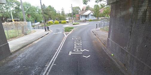
Site location
Terrace Road, between The Parade and Consett Street, carries around 1,388 vehicles per day. At the railway overbridge the width of the road is approximately 9 metres in width. It is noted that the full road closure will divert traffic to either Garnet Street in the west or Wardell Road in the west.
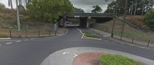
Looking north and looking south respectively at the underpass
|
Street Name |
Terrace Road |
|
Section |
Between The Parade and Consett Street |
|
Carriageway Width (m) |
12.4 generally and 9.0 at underpass |
|
Carriageway Type |
Two-way road with one travel lane in each direction, in addition to kerbside parking on both sides. At underpass one travel lane in each direction. |
|
Classification |
Local |
|
Speed limit |
50.0 |
|
85th Percentile Speed (km/h) |
51.8 |
|
Vehicles Per Day (vpd) |
1,388 |
|
Reported Crash History (July 2013 – June 2018) |
3 injury crashes and one tow-away crash in locality of underpass/roundabout. The tow-away involved a car losing control at the underpass. Two of the 3 injury crashes involved motorcyclists going off the road and the other crash involved a cyclist being injured while making a U-turn. RUM codes – 81, 70, 88 and 40. |
|
Heavy Vehicle Volume (%) |
2.9 |
|
Parking Arrangements |
No parking at underpass and unrestricted parking along each side of Terrace Road. |
Impact of the temporary full road closure is minimal:
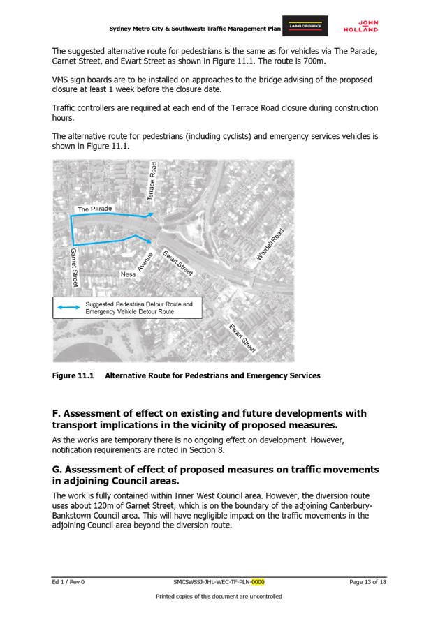
· The proposed detour route involves vehicles travelling via The Parade, Garnet Street, and Ewart Street. It is probable that Garnet Street would be the bottleneck for this trip, as it is a narrow street with kerbside parking in place on both sides of the road.
· Vehicles will be detoured via The Parade, Garnet Street, and Ewart Street shown in the TCP.
· No public transport routes use Terrace Road. Route 418 uses Garnet Street. There may be some minor delays due to the increase in traffic on Garnet Street.
· Emergency vehicles will be detoured via The Parade, Garnet Street, and Ewart Street shown in the TCP.
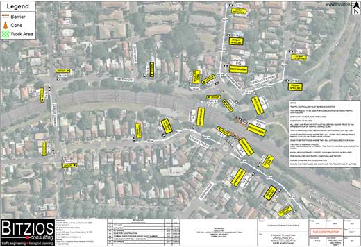
The Traffic Management Plan (TMP) is attached at the end of this report and the Traffic Control Plan (TCP) submitted by the applicant is shown below and also reproduced in the TMP attached.
PUBLIC CONSULTATION
The applicant is to notify all affected residents and businesses in writing at least 7 days prior to the commencement of works.
The proposed road closure has been advertised in the local newspaper in accordance with the Roads Act 1993.
CONCLUSION
It is recommended that the proposed temporary full road closure be approved, subject to but not limited to the conditions outlined in this report.
|
1.⇩ |
SMCSWSSJ-JHL-WEC-TF-PLN-000011_Ver1 |
|
2.⇩ |
P3519.001R Terrace Road Ness Full Road Closure TMP |
|
Local Traffic Committee Meeting 4 November 2019 |
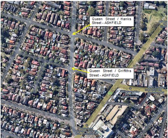
Subject: Queen Street at Hanks Street & Queen Street at Griffiths Street, Ashfield - Proposed Improved Traffic Calming at the intersections including Speed cushions (Design Plans 10082_A & 10102) (Djarrawunang - Ashfield Ward / Summer Hill Electorate / Burwood PAC)
Prepared By: Jennifer Adams - Engineer – Traffic and Parking Services
Authorised By: John Stephens - Traffic and Transport Services Manager
SUMMARY
Design plans have been prepared for proposed traffic calming and speed cushions along Queen Street at Hanks Street and Griffiths Street, Ashfield. The proposed works received funding from the RMS Blackspot Program and the works will improve pedestrian and motorists' safety and addresses residents' concerns about speeding, driver behaviour and pedestrian safety at these locations.
Consultation was undertaken with nearby owners and occupiers of properties in Queen Street, Hanks Street and Griffiths Street regarding the proposals. A revised plan was prepared for the roundabout at Queen Street/Hank Street after considering feedback from residents. It is recommended that the proposed detailed design plans be approved.
|
RECOMMENDATION
THAT the detailed design plans for the proposed intersection improvements along with associated signage and line marking at Queen Street and Hanks Street, Ashfield (Design Plan No.10082_A) and Queen Street at Griffiths Street, Ashfield (Design Plan No.10102) be APPROVED. |
BACKGROUND
The community has raised concerns in relation to the existing 4-leg roundabouts at the intersections of Queen Street with Hanks Street and Griffiths Street. Vehicles were reported to be speeding through the roundabouts and failing to give way. The proposed speed cushions will physically reduce vehicle speeds on approaches to the roundabouts and pedestrian crossing points of the intersections. The kerb blister islands and rumble bars will assist and direct vehicles over the speed cushions.
A Blackspot submission was made in 2018 for funding to upgrade the intersections and was successful. Design Plans were prepared and sent out to nearby residents. Following completion of the resident consultation process, Council Officers have considered community feedback and have incorporated amendments into the original consultation plan that was sent to residents on 13 September 2019 for the Queen Street at Hanks Street, Ashfield proposal.
Council Officers have made the following changes to the original design plan sent out:-
· The previously proposed pedestrian refuge islands have been removed and replaced with rumble bars; see the attached revised plan 10082_A.
· The previously proposed ‘No Stopping’ signs and chevron line markings have been removed.
As a result of this amended road safety proposal, there is no net loss in on-street parking.
FINANCIAL IMPLICATIONS
The estimated cost of the project is approximately $98,250 and the projects have been fully funded in the 2019/2020 financial year under the RMS Blackspot Program.
OFFICER COMMENTS
Site Location & Road Network
Both intersections are 4-leg roundabouts and are approximately 100 metres apart. The original concerns at the intersections were that the sight lines to the approaches were affected by building and property fence and tree line obstructions close to the corners. Motorists either failed to Give Way or ignored the Give Way control. The wide nature of the roundabouts suit large vehicles manoeuvring them; however, encourages cars to speed through them. There is a slight angle deviation and crest rise in the road to the south of Griffiths Street from the roundabout at Queen Street and there is a slight dip into the roundabout (Queen Street and Hanks Street) from both approaches in Queen Street which adds to downhill speeding to the
roundabout.
A summary of the traffic data is provided in the table below:
|
Street Name |
Queen Street |
Queen Street |
|
Section |
Intersection with Hanks Street |
Intersection with Griffiths Street |
|
Carriageway Width (m) kerb to kerb |
13.0 |
13.0 |
|
Carriageway Type |
Two-way road with one travel lane in each direction, in addition to kerbside parking on both sides. |
Two-way road with one travel lane in each direction, in addition to kerbside parking on both sides. |
|
Classification |
Local |
Local |
|
Speed limit |
50 |
50 |
|
85th Percentile Speed (km/h) |
- |
- |
|
Vehicles Per Day (vpd) |
- |
- |
|
Reported Crash
History |
3 injury crashes
2x RUM 10 (Cross Traffic) 1x RUM 3 (Other Pedestrian) |
2 injury crashes and 2 tow-away
3 x RUM 10 (cross traffic) 1 x RUM 30 (rear end) |
|
Heavy Vehicle Volume (%) |
- |
- |
|
Parking Arrangements |
Unrestricted parking along Queen Street, both north and south of junction with Hanks Street. |
Unrestricted parking along Queen Street, both north and south of junction with Griffiths Street.
|
Queen Street at Hanks Street, Ashfield
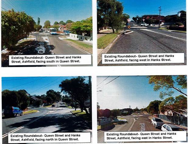
Queen Street at Griffiths Street, Ashfield
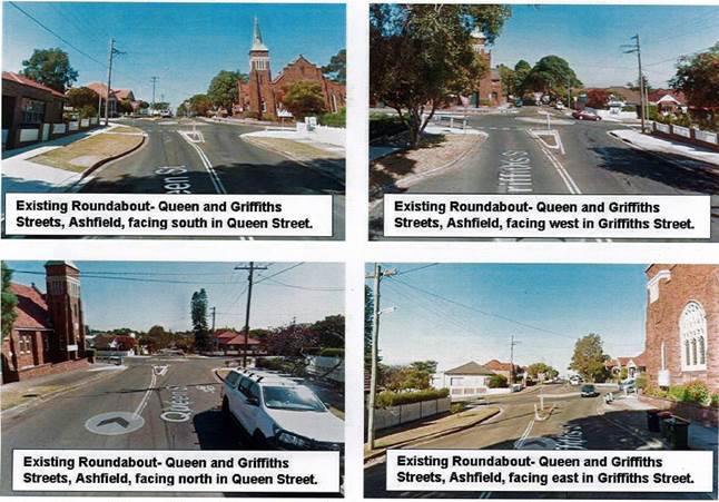
Design Plans 10082_A and 10102
-------------------------------------------
Council is planning improvements in Queen Street at Hanks Street intersection as well as in Queen Street at Griffiths Street intersection. Detailed design plans for the proposed intersection treatment and associated signage and line marking at Queen Street and Hanks Street (Design Plan 10082_A – Attachment 1), and the proposed intersection treatment and associated signage and line marking at Queen Street and Griffiths Street (Design Plan 10102 – Attachment 2) are submitted for consideration.
The following works are proposed and are illustrated on the attached plans:
1. Queen Street and Hanks Street, Ashfield - PLAN NO. 10082_A
- Install rumble bars in splitter island south side on Queen Street.
- Install rumble bars in splitter island east side on Hanks Street.
- Provide speed cushions on Hanks Street and Queen Street on approach to roundabout.
- Implement new linemarking and signage to facilitate better traffic flow and for pedestrian safety.
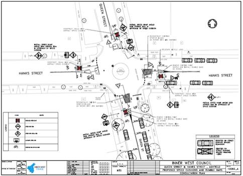
2. Queen Street and Griffiths Street, Ashfield – PLAN NO. 10102
- Provide speed cushions in Griffiths Street and Queen Street on approach to roundabout.
- Implement signage to facilitate better traffic flow and for pedestrian safety.
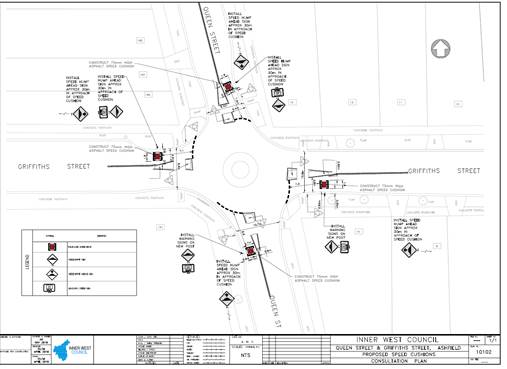
Both proposals will result in no loss of legal parking spaces in Queen Street, Hanks Street and/or Griffiths Street.
PUBLIC ENGAGEMENT
A consultation letter as well as a copy of the design plans (Plan 10082 and Plan 10102) for the traffic calming works at the intersections of Queen Street at Hanks Street and Queen Street at Griffiths Street was sent out on 13 September and the submission period was closed on 30 September. A total of 69 letters were distributed as per the consultation map shown below.
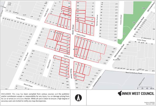
Sixteen (16) residents signed the petition against original plan number 10082. Four (4) car parking spaces on-street would have been removed. Following completion of the resident consultation process, Council Officers considered community feedback and incorporated amendments into the original consultation plan that was sent to residents on 13 September 2019 – Plan 10082_A.
|
Residents’ Comments |
Officer’s Response |
|
|
Petition - We the residents of Queen and Hank Street Ashfield oppose the proposed changes in our street. We believe that these new changes only adversely affect the Character of the street that some residents have grown up too or chosen to reside in. We believe reducing the width the streets only hampers the flow of traffic which is a problem in itself for residents exiting from their homes in the morning and afternoon travelling to and from work. Finally the No stopping signage in front of some homes is a major Concern as this will reduce the available parking that are of benefit for residents and the greater community which readily use it. Hurlstone Park Vietnamese Church located at 12 Griffith Street is an example which uses available parking in these streets hence limiting any available parking will become an inconvenience for everyone. We believe the negative repercussions of the proposed changes outweigh the very little benefit which has prompted us to take this stance. |
The previously proposed pedestrian refuge islands have been removed and replaced with rumble bars; see the attached revised plan 10082_A. The previously proposed ‘No Stopping’ signs and chevron line markings have been removed.
As a result of this amended road safety proposal, there is no net loss in on-street parking. |
|
|
The speeding mainly occurs with the cars coming down Queen street, towards Hanks Street from the Griffiths street intersection. The cars tend to not slow down when approaching the roundabout and go straight through without looking. Many times I’ve seen near miss accidents.
I’ve attached a marked up 10082 plan showing the relocation of the “No Stopping “signs on the other side of my driveway please. This will ensure no cars temporarily block my driveway.
|
Noted. Plan number 10082 has been amended. As a result of this amended road safety proposal, there is no net loss in on-street parking.
|
|
|
I strongly support the proposed change at these two locations. I recommend that the proposed speed cushions be of high quality strength, to minimise both the cost and disruption of long term maintenance. I would very much appreciate the addition of some landscape improvements, where possible |
Noted.
|
|
CONCLUSION
It is recommended that the detailed design plans of the proposed intersection treatments on Queen Street at Hanks Street and Queen Street at Griffiths Street and all associated signage and linemarking be approved to improve safety at these intersections.
|
1.⇩ |
Queen and Hanks Traffic calming improvements_10082_A |
|
2.⇩ |
Queen and Griffiths Traffic calming improvements_10102 |
|
|
Local Traffic Committee Meeting 4 November 2019 |
Subject: St Davids Road/Kingston Street and Ramsay Street, Haberfield - Proposed Speed Cushions (Gulgadya-Leichhardt Ward/Summer Hill Electorate/Burwood PAC)
Prepared By: David Yu - Engineer - Traffic and Parking Services
Authorised By: John Stephens - Traffic and Transport Services Manager
SUMMARY
A detailed design plan has been finalised for the proposed intersection treatment at St Davids Road/Kingston Street and Ramsay Street, Haberfield.
As part of the Traffic Capital Works Program, Council has prepared a design plan indicating speed cushions and a kerb blister for the roundabout at Ramsay Street and St Davids Road/ Kingston Street, Haberfield. The intention of the proposal is to slow traffic and improve road safety for pedestrians and motorists at the intersection.
Consultation was undertaken with owners and occupiers of properties in Ramsay Street, St Davids Road and Kingston Street regarding the proposal. A summary of the consultation result is presented in this report for consideration. It is recommended that the proposed detailed design plan be approved.
|
RECOMMENDATION
THAT the detailed design plan (Design Plan No.10107) for the installation of speed cushions, a kerb blister, and associated signs and line markings for the roundabout at Ramsay Street and St Davids Road/Kingston Street, Haberfield be approved. |
BACKGROUND
Residents have raised concerns regarding speeding at the roundabout and a review of 5 years (2014 to June 2018) of reported RMS crash data revealed that there have been four (4) collisions at this location. Council has subsequently received funding through the 2019/20 Australian Government’s Black Spot Program for the proposed traffic improvement works.
Site location & Road Network
|
Street Name(s) |
Ramsay Street, St Davids Road and Kingston Street, Haberfield |
|
Section |
Intersection |
|
Traffic Volume |
- |
|
Recorded Accident History (5 year) |
4 |
|
Recorded 85% speed |
- |
|
Speed Limit |
50km/h |
|
Carriageway width |
Ramsay Street – 12.8m St Davids Road – 12.8m Kingston Street - 12.3m |
|
Carriageway Type |
Ramsay Street – Two way with kerb side parking on both sides of the street St Davids Road - Two way with kerb side parking on both sides of the street Kingston Street - Two way with kerb side parking on both sides of the street |
FINANCIAL IMPLICATIONS
Council has received funding of $35,300 through the 2019/20 Australian Government’s Black Spot Program to construct the proposed works this financial year subject to final funding allocation.
OTHER STAFF COMMENTS
The updated detailed design plan shown in Attachment 1 outlines the proposed works at the intersection and includes the following treatments:
· Installation of four asphalt speed cushions on all approaches to the roundabout ;
· Construction of a landscaped kerb blister on Ramsay Street (on the eastern approach to the intersection);
· Installation of associated signs and line-marking
This proposal will not result in the loss of any on-street parking spaces.
PUBLIC CONSULTATION
A letter outlining the proposal was mailed out to the affected properties (41 properties) in Ramsay Street, St Davids Road and Kingston Street, Haberfield, requesting residents’ views regarding the proposal (as indicated on the following plan).
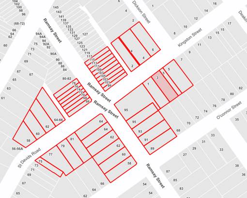
No responses were received regarding the proposal.
CONCLUSION
It is recommended that the detailed design plan (Design Plan No.10107) for the speed cushions, kerb blister, and associated signs and line markings at the roundabout be approved.
|
1.⇩ |
Detailed Design Traffic Calming Measures - Ramsay Street, St Davids Road and Kingston Street, Haberfield |
|
|
Local Traffic Committee Meeting 4 November 2019 |
Subject: Short Street, Birchgrove - Christmas Street Party (Road Occupancy) (Baludarri-Balmain/Balmain Electorate/Leichhardt PAC)
Prepared By: Vinoth Srinivasan - Engineer - Traffic and Parking Services
Authorised By: John Stephens - Traffic and Transport Services Manager
SUMMARY
Council has received an application for approval of an annual Christmas street party in Short Street between Curtis Road and Spring Street, Birchgrove to be held on Saturday, 14 December 2019 between 6:30pm and 11:30pm.
|
RECOMMENDATION
THAT the temporary road closure of Short Street, Birchgrove between Curtis Road and Spring Street, to conduct an annual Christmas Street Party on Saturday, 14 December 2019, from 6:30pm - 11:30pm, be approved, subject to the conditions as set out as per the Street Party Application Form as well as the following additional conditions:
a. That an unencumbered passage minimum of 4.0m wide be available for emergency vehicles through Short Street, Birchgrove between Curtis Road and Spring Street;
b. The occupation of the road carriageway must not occur until the road has been physically closed; and
c. All affected residents and businesses, including the NSW Police Local Area Commander, Fire & Rescue NSW and NSW Ambulance Services be notified in writing, by the applicant, of the proposed temporary road closure at least 14 days in advance of the closure with the applicant making reasonable provision for stakeholders. |
BACKGROUND
Council has received an application for approval of an annual Christmas street party in Short Street between Curtis Road and Spring Street from a resident of Short Street, Birchgrove.
The street party is proposed to be held on Saturday, 14 December 2019 between 6:30pm and 11:30pm. The applicant is seeking permission for a temporary full road closure of Short Street between Curtis Road and Spring Street, similar to previous years’ events.
Site Location & Road Network
|
Street Name(s) |
Short Street, Birchgrove |
|
Section |
Between Curtis Road and Spring Street |
|
Traffic Volume |
- |
|
Recorded Accident History (5 year) |
Nil. |
|
Recorded 85% speed |
- |
|
Speed Limit |
40km/h |
|
Carriageway width |
Approx. 6.7m |
|
Carriageway Type |
Two-way street with kerb-side parking on both sides |
|
Road Classification (State, Regional, Local) |
Local |
The Traffic Control Plan for the Closure is attached.
FINANCIAL IMPLICATIONS
Nil.
OTHER STAFF COMMENTS
This is an annual event and no significant issues have occurred in the past.
According to the RMS ‘Guide to Traffic and Transport Management for Special Events’ a small street party is considered as a ‘Class 3’ event.
Council encourages properly conducted neighbourhood street parties as a means of building community spirit and improving neighbourhood security. Fees for road occupancy are waived by Council for small community street parties.
Where the following conditions apply, organisers are only required to obtain approval for a street party involving a temporary road closure:
· The party is to be held outdoors for fewer than 100 people.
· No temporary structures or jumping castles are to be erected.
· Participants are to bring their own food and drinks, and food and drinks are not for sale.
· There will be no performers or amplified music involved.
For approved street parties and subject to availability Council will provide barricades and ‘Road Closed’ signs subject to the street party coordinator arranging collection from and return to Council’s Summer Hill depot.
PUBLIC CONSULTATION
The proposed closure of Short Street, Birchgrove between Curtis Road and Spring Street is currently being advertised in the local newspaper for a period of 28 days commencing Tuesday, 29th October 2019.
No responses were received to date.
|
1.⇩ |
Standard Street Party TCP |
|
|
Local Traffic Committee Meeting 4 November 2019 |
Subject: Marrickville Lane at Silver Street,
MARRICKVILLE - Proposed upgrading of Alex Trevallion Plaza including a
new raised threshold design with associated signage and line marking.
(MIDJUBURI-MARRICKVILLE WARD / SUMMER HILL ELECTORATE / INNER WEST
PAC)
Prepared By: Jennifer Adams - Engineer – Traffic and Parking Services
Authorised By: John Stephens - Traffic and Transport Services Manager
SUMMARY
Council is planning improvements to Alex Trevallion Plaza. The proposed works were informed by community feedback received during the engagement of the Marrickville Town Centre public domain master plan. As part of the upgrade Council is proposing to provide a raised threshold in Marrickville Lane at Silver Street to improve pedestrian safety. There will be no parking loss. It is recommended that the proposed upgrading of Alex Trevallion Plaza and associated signposting and line-marking in Marrickville Lane at Silver Street, Marrickville (as per the attached Plan No.10104) be approved.
|
RECOMMENDATION
THAT the detailed design plan for the proposed upgrading of Alex Trevallion Plaza and associated signposting and linemarking in Marrickville Lane at Silver Street, Marrickville (as per Design Plan No.10104) be APPROVED. |
BACKGROUND
In November 2016 Inner West Council completed community engagement about streetscape upgrades in the Marrickville Town Centre and Alex Trevallion Plaza was identified for future upgrading works.
The Marrickville Town Centre is focused around the intersection of Marrickville and Illawarra Roads and the surrounding laneways. It also includes the section of Petersham Road from Marrickville Town Hall to Illawarra Road.
Council is now planning improvements to Alex Trevallion Plaza. As part of the upgrade Council is also proposing to provide a raised threshold in Marrickville Lane at Silver Street, to improve pedestrian safety. There will be no parking loss.
These works are expected to be built in this financial year subject to final approval and budget allocations. Residents will be notified before any work starts in the street.
Financial Implications
Funding of $800,000 for the upgrade has been allocated in Council’s Town Centre Capital Works Program.
Officer Comments:
Site location & road network
Alex Trevallion Plaza is bounded by Marrickville Road to the north and Silver Street to the south, Marrickville. Marrickville Lane runs parallel with Marrickville Road south of the Plaza. Marrickville Lane provides rear access to many commercial properties fronting Marrickville Road. A recent inspection of the site revealed many delivery vehicles parked along the northern side of the lane, ranging in size from small delivery vans up to semi-trailer size, and all engaged in loading or unloading.
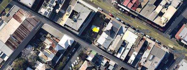
|
Street Name |
Marrickville Lane, Marrickville |
|
Section |
Between Gladstone Street and Silver Street |
|
Carriageway Width (m) |
4.5 |
|
Carriageway Type |
One-way road with one travel lane in westward direction |
|
Classification |
Local |
|
Speed limit |
50.0 |
|
85th Percentile Speed (km/h) |
34 |
|
Vehicles Per Day (vpd) |
198 |
|
Reported Crash History (July 2013 – June 2018) |
No crashes |
|
Heavy Vehicle Volume (%) |
4.2 |
|
Parking Arrangements |
‘No Parking’ restrictions along southern side and northern side has ‘No Parking restrictions / Mail Zone and some ‘loading’ zones on the north western section of laneway towards Illawarra Road |
Alex Trevallion Plaza Upgrade Proposal
Concept improvements Council is planning to Alex Trevallion Plaza are shown in the diagrams below:
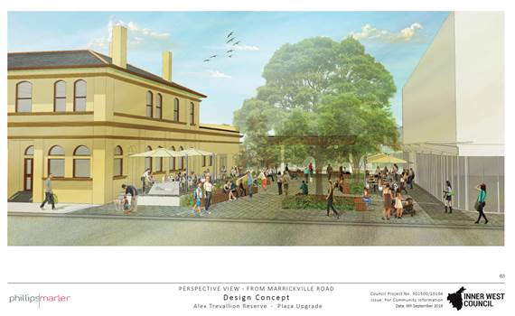
Artist impression of the upgraded Plaza
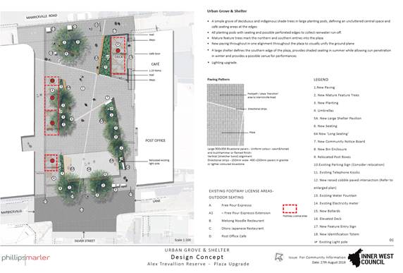
Concept design of Alex Trevallion Plaza
The proposed changes will create a more pleasant environment for pedestrians and improve the existing streetscape. The proposed improvements include:
· New paving
· Installing more seating
· Removing existing shelters and installing a new shelter
· Constructing ramp access to Post Café
· Removing existing raised garden beds and providing in-ground landscaped garden beds
· Replacing existing trees with indigenous shade trees within the garden beds
· Installing passive irrigation for trees and landscaping
· Upgrading the lighting
· Relocating amenities such as bins and electricity meters
· Relocating the drainage pits and pipes in Marrickville Lane
· New pavement line marking and signage in Marrickville Lane and Silver Street as required
Signage and Linemarking Plan – Raised threshold – Marrickville Lane at Silver Street
As noted, part of the upgrade Council is proposing includes a raised threshold in Marrickville Lane at Silver Street, levelling the surfaces to improve pedestrian safety. The associated signposting and line-marking in Marrickville Lane at Silver Street, Marrickville (Design Plan No.10104) is shown below and attached at a larger scale at the end of this report.
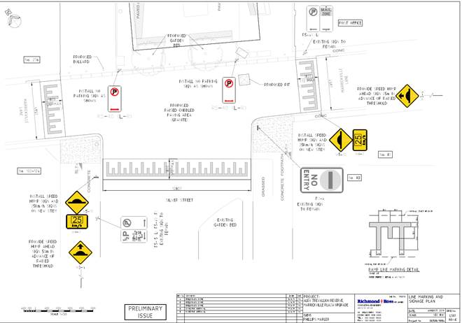
PUBLIC CONSULTATION
A consultation letter for the Alex Trevallion Plaza project was sent out on 9 September and closed on 18 October. A letter as well as a copy of the design plans were sent to the local residents in Silver Street, Marrickville Lane and adjacent to the Alex Trevallion Plaza (see consultation map below). A total of 100 letters were distributed. The Chamber of Commerce Marrickville and Australia Post were also sent the consultation material for comment. The consultation material was also put on the Your Say Inner West website.
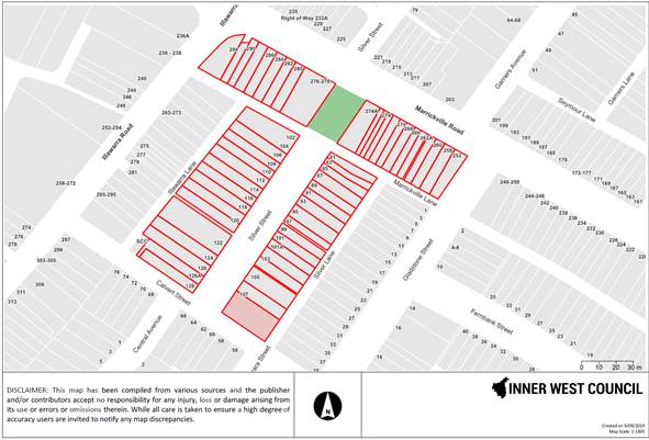
Ten (10) responses were received regarding this proposal to date. Generally, acceptance of the proposal is positive and comments are not ‘traffic’ related but are more general aesthetic related comments about the plaza proposal.
CONCLUSION
It is recommended that the detailed design plan (Plan No.10104) for the associated signposting and linemarking of the raised threshold in Marrickville Lane at Silver Street, Marrickville as part of the proposed upgrading of Alex Trevallion Plaza be approved.
|
1.⇩ |
Alex Trevallion Reserve and Marrickville Lane final Linemarking and Signage Plan 280819 |
|
|
Local Traffic Committee Meeting 4 November 2019 |
Subject: Chelmsford Street, Newtown - Installation Of 8 Metre Length ‘Loading Zone’ With Day and Time Restrictions on The Eastern Side of the Street just South of Mcintosh Lane (Damum - Stanmore Ward / Newtown Electorate / Inner West PAC)
Prepared By: Jennifer Adams - Engineer – Traffic and Parking Services
Authorised By: John Stephens - Traffic and Transport Services Manager
SUMMARY
A request has been received for a ‘Loading Zone’ in Chelmsford Street, Newtown to facilitate with loading and unloading at Nos.43-45 Bedford Street, Newtown. It is recommended that an 8 metre length (currently within statutory ‘No Stopping’ zone) be designated with 'Loading Zone 8.00am – 5.00pm Monday – Friday’ restrictions (unrestricted outside nominated days and times) on the eastern side of Chelmsford Street commencing 6 metres south from its intersection with McIntosh Lane be approved, in order to provide loading / unloading facilities for Nos.43-45 Bedford Street, Newtown and local businesses.
|
RECOMMENDATION
THAT:
1. The installation of an 8 metre 'Loading Zone 8.00am – 5.00pm Monday – Friday’ restriction (unrestricted outside nominated days and times) on the eastern side of Chelmsford Street commencing 6 metres south from its intersection with McIntosh Lane, Newtown be approved, in order to provide loading / unloading facilities for Nos.43-45 Bedford Street, Newtown and local businesses; and
2. ‘No Stopping’ restrictions be placed at either end of the ‘Loading Zone’. |
BACKGROUND
Council is proposing to introduce a time restricted section of ‘Loading Zone' in Chelmsford Street, Newtown to reduce traffic congestion and improve business deliveries with an on-street loading/unloading facility.
The proposal is for the provision of a ‘Loading Zone 8.00am-5.00pm Mon- Fri' eight (8) metres in length on the east side of Chelmsford Street commencing 6 metres south of McIntosh Lane, Newtown and outside the ‘Loading Zone’ hours the area reverts back to unrestricted parking. ‘No Stopping’ is proposed at either side of the loading zone (i.e. between the loading zone and adjacent intersections) in keeping with the Road Rules (Refer to the plan below).
At present, the Asylum Seekers Centre (ASC) is located at Nos.43-45 Bedford Street, Newtown and as McIntosh Lane is too narrow for loading / unloading activities there is no viable location other than that proposed to service the premises and/or other local businesses.
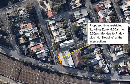
Improving access in Chelmsford Street, Newtown
The ASC’s hours of operation are 9.00am to 5.00pm, Monday to Friday. The centre does not open on Saturdays or Sundays. During the 2018/2019 financial year the centre served 1000 hot meals per month and provided more than 4000 bags of food and essentials per month to 2000 households. During the week ASC receives a myriad of donations and deliveries during their operational hours. The size of vehicles delivering goods vary greatly ranging from cars to refrigerated trucks and anything in between, and a dedicated loading area would ease present difficulties experienced by donors and distributors alike.
FINANCIAL IMPLICATIONS
The cost of the supply and installation of the signposting can be met from Council’s operational budget.
OFFICERS COMMENTS
Chelmsford Street is approximately 6.4 metres wide, with unrestricted parking permitted on the east side and ‘2P 8.00am-10.00pm Permit Holders Excepted – Area M3’ parking restrictions on the western side. Refer to photographs below.
|
Street Name |
Chelmsford Street |
|
Section |
Between McIntosh Lane and Bedford Street |
|
Carriageway Width (m) |
6.4 |
|
Carriageway Type |
Two-way narrow road with parking on both sides |
|
Classification |
Local |
|
85th Percentile Speed (km/h) |
31.3 |
|
Vehicles Per Day (vpd) |
260 |
|
Reported Crash History (July 2013 – June 2018) |
Nil |
|
Heavy Vehicle Volume (%) |
4.1 |
|
Parking Arrangements |
Unrestricted parking on east side and ‘2P 8.00am-10,00pm Permit Holders Excepted – Area M3’ on west side |
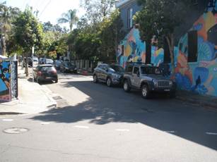
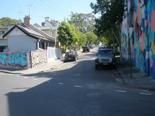
An inspection of the site has shown that there was a possibility of installing 'Loading Zone' restrictions in Chelmsford Street adjacent to Nos.43-45 Bedford Street, Newtown. The proposal for the provision of a ‘Loading Zone 8.00am-5.00pm Mon- Fri’ eight (8) metres in length on the east side of Chelmsford Street commencing 6 metres south of McIntosh Lane, Newtown is reasonable especially when the loading zone would revert to unrestricted parking outside those hours. ‘No Stopping’ is proposed to be installed at either end of the loading zone (i.e. between the loading zone and adjacent intersections) in keeping with the Road Rules.
General guidelines for parking in a ‘Loading Zone’ include that only drivers of vehicles principally constructed for carrying goods may park their vehicle in the loading zone. These vehicles may stop for up to 30 minutes if they are being loaded or unloaded. A station wagon or a three-wheeled goods vehicle may stop for up to 15 minutes. The driver of any other vehicle may only stop to pick up or set down passengers at the kerb. Hours of operation may apply to some signs. This means restrictions apply for those times only.
CONSULTATION
Notification letters were hand delivered to 44 owners/occupiers as detailed in the plan below. Submission period ended on 18 October 2019. No responses were received.
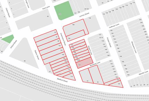
CONCLUSION
It is recommended that an 8m ‘Loading Zone 8am-6pm Mon-Fri’ to be installed on the eastern side of Chelmsford Street, Newtown and ‘No Stopping’ restrictions be placed at either end of the ‘Loading Zone’ (i.e. between the loading zone and adjacent intersections) in keeping with the Road Rules.
Installation Diagram
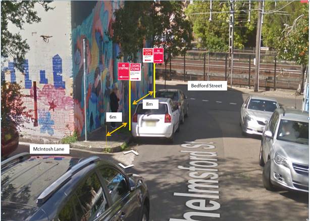
|
|
Local Traffic Committee Meeting 4 November 2019 |
Subject: John Street, Newtown between Lord Street and
the Railway Line – Temporary Full Road Closure for Street Party on Sunday
8 December 2019
(DAMUM-STANMORE WARD / NEWTOWN ELECTORATE / INNER WEST PAC)
Prepared By: Jennifer Adams - Engineer – Traffic and Parking Services
Authorised By: John Stephens - Traffic and Transport Services Manager
SUMMARY
An application has been received from a resident for the temporary full road closure of John Street, Newtown between Lord Street and the railway line for a period of two hours on Sunday, 8 December 2019 in order to hold a street party. It is recommended that the proposed temporary road closure be approved, subject to the conditions outlined in this report.
|
RECOMMENDATION
THAT the proposed temporary full road closure of John Street, Newtown between Lord Street and the railway line on Sunday, 8 December 2019 between 3:00pm and 5:00pm be APPROVED, in order to hold a street party, subject to the conditions of approval as set out in the Street Party Application Form and the following conditions:
a) All affected residents and businesses, including the NSW Police Local Area Commander, Fire & Rescue NSW and NSW Ambulance Services be notified in writing, by the applicant, of the proposed temporary road closure at least 14 days in advance of the closure with the applicant making reasonable provision for stakeholders;
b) The applicant is to set out the road closure as per the attached typical Traffic Control Plan (TCP);
c) A 4-metre wide emergency vehicle access be maintained through the closed road areas during the course of the event; and
d) The occupation of the road carriageway must not occur until the road has been physically closed.
|
BACKGROUND
Council encourages properly conducted neighbourhood street parties as a means of building community spirit and improving neighbourhood security. Fees for road occupancy are waived by Council for small community street parties. For approved street parties and subject to availability Council will provide barricades and ‘Road Closed’ signs subject to the street party coordinator arranging collection from and return to Council’s Summer Hill depot.
Council’s Neighbourhood Street Party Guidelines state, in relation to road closures, that:
“As a guide, to be eligible for a road closure to hold a neighbourhood street party your street:
· Must be a local residential street block, cul-de-sac or laneway,
· Must not carry significant traffic volumes,
· Must not be a major transport route or contain bus routes,
· Must not provide access to railway stations and associated parking,
· Must not block access to shopping centres, carparks or interfere with commercial or business operations.
Neighbourhood street parties are non-commercial events and the following activities are prohibited:
· The erection of temporary structures, jumping castles or other entertainment devices,
· The sale of food or drink or fundraising
· Live performers or amplified music
· Road closure and road occupation after dark.”
According to the RMS ‘Guide to Traffic and Transport Management for Special Events’ a small street party is considered as a ‘Class 3’ event.
FINANCIAL IMPLICATIONS
Nil. The street party coordinator will bear all costs associated with the road closure.
OFFICER COMMENTS
The section of John Street, Newtown between Lord Street and the railway line is a short cul-de-sac and carries negligible traffic. Some local parking occurs in the cul-de-sac and at present the parking is unrestricted (refer to the attached locality map).
Locality map – John Street, Newtown
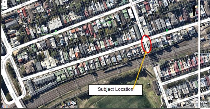
![]()
A typical ‘cul-de-sac’ Traffic Control Plan (TCP) for the Closure is reproduced below:
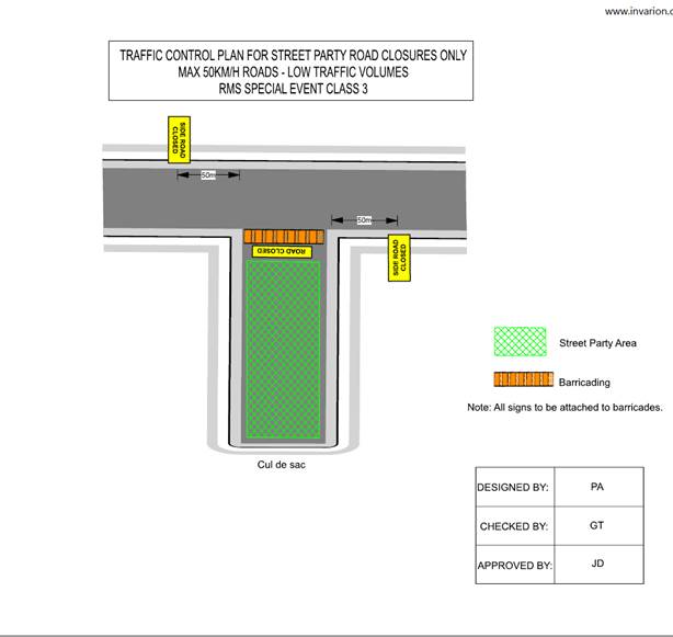
PUBLIC CONSULTATION
The proposed closure of John Street, Newtown between Lord Street and the railway line is being advertised in the local newspaper for a period of 28 days commencing Tuesday, 8 October 2019. To date no submissions have been received.
The applicant is responsible to notify all affected residents and/or businesses in writing at least 14 days prior to the commencement of the road closure.
CONCLUSION
It is recommended that the proposed temporary full road closure be approved, subject to the recommended conditions outlined in this report as well as all standard road closure conditions pertaining to street parties outlined on the application form.
A full list of the standard conditions of approval as detailed in the application form for road closures for street parties is reproduced below.
Standard Conditions of Approval – as per the Road Closure Application for Street Parties
|
Approval, if granted, will be subject to the following conditions: 1. The applicant is responsible for: a) implementing the approved road closure. b) ensuring the area utilised for the street party is fit for purpose, c) ensuring the event is managed and run in a safe manner, d) ensuring risk management mitigation measures are implemented. 2. The Street Party is to be limited to fewer than 100 people. 3. No temporary structures or jumping castles or other entertainment devices are to be erected. 4. Participants are to bring their own food and drinks. The sale of food and drink is prohibited. 5. Fundraising is prohibited 6. Live performers or amplified music is prohibited. 7. Road occupation and road closure must only occur during approved hours and must cease prior to sunset. 8. The road closure must be implemented and maintained by erecting signs and barriers in accordance with the approved Traffic Control Plan. 9. The applicant must complete the online Party Registration on the NSW Police website at least 72 hours prior to the event. 10. The applicant must comply within any conditions set down, or instructions given by, any authorised agency or its authorised officers including but not limited to Police, Transport for NSW and Council. 11. All affected properties within or directly affected by the road closure must be notified of the road closures and activities at least 14 days prior to commencement of the road closure. Any concerns or requirements raised by business proprietors, residents or other occupants must be reasonably resolved or accommodated. 12. The use of any equipment or activities to be conducted in conjunction with the road closures must not result in any “offensive noise” as defined by the Protection of the Environment Operations Act 1997 13. Public Liability Insurance: a) While Council has Public Liability Insurance to provide relevant cover for a neighbourhood street party on Council land, organisers of events should consider if they need to take out any further insurances for the event. Council cannot assist with this determination, and organisers are encouraged to discuss this with their insurance provider. b) Should the organiser hire third-party equipment or services for use during the proposed street party, the third-party’s Public Liability Insurance, for an amount not less than $20,000,000 for each supplier, must be provided to Council with this application. 14. The public areas to be used for the activities must be maintained in a clean & tidy condition. 15. The applicant may be required to reimburse Council for costs incurred by the Council as a result of a failure to comply with any condition of approval or damage to Council assets. 16. Any other conditions that may be imposed as part of the consent. |
|
|
Local Traffic Committee Meeting 4 November 2019 |
Subject: Unnamed Laneway between May Street and The Boulevarde, Lilyfield - Christmas Street Party (Road Occupancy) (Baludarri-Balmain Ward/Balmain Electorate/Leichhardt PAC)
Prepared By: Vinoth Srinivasan - Engineer - Traffic and Parking Services
Authorised By: John Stephens - Traffic and Transport Services Manager
SUMMARY
Council has received an application for approval of an annual Christmas street party in the Unnamed Laneway between May Street and The Boulevarde, Lilyfield to be held on Saturday, 21 December 2019 between 4:00pm and 10:00pm.
|
RECOMMENDATION
THAT the temporary road closure of the Unnamed Laneway, Lilyfield between May Street and The Boulevarde (section at the rear of Nos.355-367 Balmain Road), to conduct an annual Christmas Street Party on Saturday, 21 December 2019, from 4:00pm - 10:00pm, be approved, subject to the conditions as set out as per the Street Party Application Form as well as the following additional conditions:
a) That an unencumbered passage minimum of 3.0m wide be available for emergency vehicles through the Unnamed Laneway, Lilyfield between May Street and The Boulevarde;
b) The occupation of the road carriageway must not occur until the road has been physically closed; and
c) All affected residents and businesses, including the NSW Police Local Area Commander, Fire & Rescue NSW and NSW Ambulance Services be notified in writing, by the applicant, of the proposed temporary road closure at least 14 days in advance of the closure with the applicant making reasonable provision for stakeholders.
|
BACKGROUND
Council has received an application for approval of an annual Christmas street party in the Unnamed Laneway between May Street and The Boulevarde from a resident of Balmain Road, Lilyfield.
The street party is proposed to be held on Saturday, 21 December 2019 between 4:00pm and 10:00pm. The applicant is seeking permission for a temporary full road closure of the Unnamed Laneway between May Street and The Boulevarde, similar to previous years’ events.
Site Location & Road Network
|
Street Name(s) |
Unnamed Laneway, Lilyfield |
|
Section |
Between May Street and The Boulevarde |
|
Traffic Volume |
- |
|
Recorded Accident History (5 year) |
Nil. |
|
Recorded 85% speed |
- |
|
Speed Limit |
50km/h |
|
Carriageway width |
Approx. 3.0m |
|
Carriageway Type |
Laneway with ‘No Parking’ restrictions on both sides |
|
Road Classification (State, Regional, Local) |
Local |
The Traffic Control Plan (TCP) for the temporary road closures is shown in Attachment 1.
FINANCIAL IMPLICATIONS
Nil.
OTHER STAFF COMMENTS
This is an annual event and no significant issues have occurred in the past.
According to the RMS ‘Guide to Traffic and Transport Management for Special Events’ a small street party is considered as a ‘Class 3’ event.
Council encourages properly conducted neighbourhood street parties as a means of building community spirit and improving neighbourhood security. Fees for road occupancy are waived by Council for small community street parties.
Where the following conditions apply, organisers are only required to obtain approval for a street party involving a temporary road closure:
· The party is to be held outdoors for fewer than 100 people.
· No temporary structures or jumping castles are to be erected.
· Participants are to bring their own food and drinks, and food and drinks are not for sale.
· There will be no performers or amplified music involved.
For approved street parties and subject to availability Council will provide barricades and ‘Road Closed’ signs subject to the street party coordinator arranging collection from and return to Council’s Summer Hill depot.
PUBLIC CONSULTATION
The proposed closure of the Laneway, Lilyfield between May Street and The Boulevarde is currently being advertised in the local newspaper for a period of 28 days commencing Tuesday, 29th October 2019.
|
1.⇩ |
Standard Street Party TCP |
|
|
Local Traffic Committee Meeting 4 November 2019 |
Subject: Burrows Avenue, Sydenham – Temporary Full Road Closures 2020 - Sydney Metro Sydenham Station and Junction (SSJ) Works.(Midjuburi-Marrickville Ward / Heffron Electorate / Inner West PAC)
Prepared By: Jennifer Adams - Engineer – Traffic and Parking Services
Authorised By: John Stephens - Traffic and Transport Services Manager
SUMMARY
An application has been received from Sydney Metro Sydenham Station and Junction (SSJ) for the temporary full road closure of Burrows Avenue, between Hogan Avenue and Gleeson Avenue, Sydenham from Monday 10 February to Monday 17 February 2020 (contingency days 18 to 20 February 2020); Friday 21 February to Monday 24 February 2020 (contingency days 25 February to 2 March 2020); Monday 16 March to Monday 23 March 2020 (contingency days 24 to 31 March 2020); and Monday 6 April to Monday 13 April 2020 (contingency days 14 to 27 April 2020) in order to carry out upgrading works at Sydenham Station. The avenue will be temporarily closed to all vehicular traffic, including emergency vehicles and local residents. It is recommended that the proposed temporary full road closures be approved, subject to the conditions outlined in this report.
|
THAT the proposed temporary full road closure of Burrows Avenue, between Hogan Avenue and Gleeson Avenue, Sydenham from Monday 10 February to Monday 17 February 2020 (contingency days 18 to 20 February 2020); Friday 21 February to Monday 24 February 2020 (contingency days 25 February to 2 March 2020); Monday 16 March to Monday 23 March 2020 (contingency days 24 to 31 March 2020); and Monday 6 April to Monday 13 April 2020 (contingency days 14 to 27 April 2020) be approved, in order to carry out upgrading works at Sydenham Station subject to the following conditions:
a) A Road Occupancy License be obtained by the applicant from the Transport Management Centre;
b) All affected residents and businesses, including the NSW Police Local Area Commander, Fire & Rescue NSW and the NSW Ambulance Services be notified in writing, by the applicant, of the proposed temporary road closure at least 7 days in advance of the closure with the applicant making reasonable provision for stakeholders; and
c) The occupation of the road carriageway must not occur until the road has been physically closed. |
BACKGROUND
John Holland Pty Ltd and Laing O’Rourke Australia Construction Pty Ltd are currently undertaking major railway work at Sydenham as part of Sydney Metro, including the upgrade of Sydenham Station. The station will be fully upgraded with a new aerial concourse over the existing platforms including lifts, stairs and level access between the platforms and trains.
The project is working within a live rail environment. For the safety of workers and customers a number of activities can only be carried out when trains are not operating. The project therefore relies on Sydney Trains rail shutdown weekends to deliver these activities.
To facilitate the crane placements, temporary full road closures are required on Burrows Avenue between Hogan Avenue and Gleeson Avenue, Sydenham during the following periods in the New Year:
· Monday 10 February to Monday 17 February 2020 (contingency days 18 to 20 February 2020);
· Friday 21 February to Monday 24 February 2020 (contingency days 25 February to 2 March 2020);
· Monday 16 March to Monday 23 March 2020 (contingency days 24 to 31 March 2020); and
· Monday 6 April to Monday 13 April 2020 (contingency days 14 to 27 April 2020
Traffic movements will be managed in accordance with the attached TMP and TCP. Traffic controllers will be on duty to assist both pedestrians and vehicle movements. Access to private property will be maintained at all times. Access to and from Bolton Street will be available via Hogan Avenue.
FINANCIAL IMPLICATIONS
Under Council’s Fees & Charges, the applicant is to pay a fee for the temporary full road closure. This fee includes advertising the proposal in accordance with the Roads Act 1993.
OFFICER COMMENTS
The site location is on the south side of Sydenham Railway Station and Burrows Avenue is a local road.
![]()
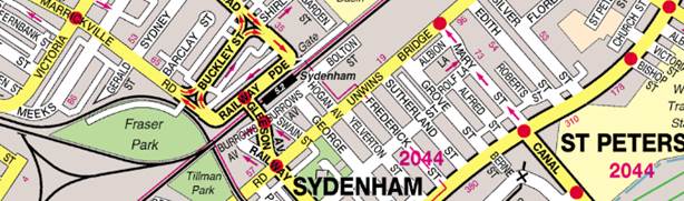
|
Street Name
|
Burrows Avenue |
|
Section |
Between Gleeson Avenue and George Street |
|
Carriageway Width (m) |
12.8 |
|
Carriageway Type |
Two-way road with one travel lane in each direction, in addition to kerbside parking lanes. |
|
Classification |
Local |
|
85th Percentile Speed (km/h) |
47.5 |
|
Vehicles Per Day (vpd) |
7,296 |
|
Reported Crash History (July 2011 - June 2016) |
No RMS recorded crashes. |
|
Heavy Vehicle Volume (%) |
5.1 |
|
Parking Arrangements |
Various on northern side of the road since Sydney Metro SSJ construction works being carried out. Southern side of the road consists of ‘No Parking’ restrictions with a section of ‘2P 8:30am-6pm Mon-Fri, 8:30am-12:30pm Sat’ restrictions. |
The Traffic Management Plan (TMP) will be tabled at the meeting and the Traffic Control Plan (TCP) is reproduced below.
Vehicular access for local residents/businesses and emergency services will be maintained during the closure, where possible. Authorised traffic controllers will be on-site during the time of the road closure and are to be positioned at the closure points when required to provide vehicular access to local residents/businesses and ensure the safety of motorists and pedestrians.
Night work operations are necessary to get the required works completed during rail shutdown weekends. Residents within 100 metres of Sydenham Station will be notified prior to the road closure and a VMS board will be installed notifying road users of the road closure. In addition, Sydney Metro will be door knocking residents along Hogan Avenue/George Street/Swain Street including business owners along Hogan Avenue and Bolton Street.
Noise assessment will be carried out in accordance with the NSW Interim Construction Noise Guidelines and where required additional mitigation measures will be offered to identified sensitive receivers.
PUBLIC CONSULTATION
The applicant is to notify all affected residents and businesses in writing at least 7 days prior to the commencement of works.
The proposed road closure has been advertised in the local newspaper in accordance with the Roads Act 1993.
CONCLUSION
It is recommended that the proposed temporary full road closures be approved, subject to but not limited to the conditions outlined in this report.
|
|
Local Traffic Committee Meeting 4 November 2019 |
Subject: Saywell Street, Marrickville – Proposed
Temporary Full Road Closure for Heaps Gay Street Festival on Saturday 18
January 2020 and Community Beer Fest on Sunday 19 January 2020
(Midjuburi – Marrickville Ward / Summer Hill Electorate / Inner West PAC)
Prepared By: Jennifer Adams - Engineer – Traffic and Parking Services
Authorised By: John Stephens - Traffic and Transport Services Manager
SUMMARY
Council has received an application under Section 68 of the Local Government Act 1993 to use Saywell Street, Marrickville to hold street party style events for the community, known as ‘Heaps Gay Street Festival', on Saturday, 18 January between the hours of 1.00pm to 11.00pm and a Community Beer Fest event on Sunday, 19 January 2020 between the hours of 1.00pm to 10.00pm. The erection of the stage, stalls and associated works will include the temporary full-road closures of Saywell Street, Marrickville between Cadogan Street and Shirlow Street from 7:00pm Friday, 17 January to 7:00am Monday, 20 January 2020.
It is recommended that Council endorse the temporary full road closures of Saywell Street, Marrickville from Friday 17 January to 7:00am Monday 20 January 2020, subject to the applicant complying with the conditions within this report; applying to the RMS for consent to close the subject road, a Road Occupancy License being obtained from the Transport Management Centre and advice of the proposed event being forwarded to the appropriate stakeholders and authorities including emergency services.
|
RECOMMENDATION
THAT the proposed temporary full road closure of Saywell Street between Cadogan Street and Shirlow Street, Marrickville from 7.00pm Friday 17 January to 7:00am Monday 20 January 2020, be APPROVED, subject to the approval of the S68 Application and the applicant complying with, but not limited to, the following conditions:
a) A Road Occupancy License application be obtained by the applicant from the Transport Management Centre;
b) All affected residents and businesses, including NSW Police Local Area Commander, Transit Systems, Fire and Rescue NSW and NSW Ambulance Services, shall be notified in writing by the applicant of the proposed temporary road closure at least 7 days prior to the event, with the applicant making reasonable provision for residents and businesses;
c) The occupation of the road carriageway must not occur until the road has been physically closed; and
d) The applicant be advised in terms of this report and that all costs for the event and implementation of the road closure are to be borne by the applicant.
|
BACKGROUND
Council has received an application under Section 68 of the Local Government Act 1993 to use Saywell Street, Marrickville to hold street party style events for the community, known as ‘Heaps Gay Street Festival', on Saturday 18 January 2020 between the hours of 1.00pm to 11.00pm and Community Beer Fest event on Sunday 19 January 2020 between the hours of 1.00pm to 10.00pm.
The erection of the stage, stalls and associated works will include the temporary full-road closures of Saywell Street, Marrickville between Cadogan Street and Shirlow Street from 7:00pm Friday 17 January 2020 to 7:00am Monday 20 January 2020.
The ‘Heaps Gay Street Festival’ is a community event in a New Orleans style street party with family friendly music and entertainment and a number of licenced food and beverage stalls. The event will aim to attract approximately 3,000 attendees, staff and performers to the area on the day.
FINANCIAL IMPLICATIONS
Under Council’s Fees & Charges, the applicant has to pay the fee for the temporary full road closure. This fee includes the cost of an advertisement in accordance with the Roads Act 1993.
It is noted that a fee of $1,625.90, in addition to the application fee of $155.00, for the temporary road closure is payable by the applicant in accordance with Council’s Fees and Charges.
OFFICER COMMENTS
Site location & road network
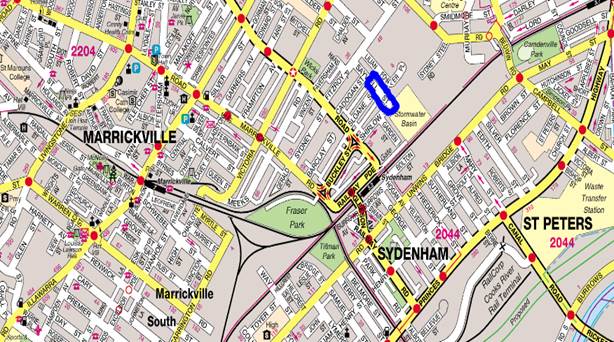
|
Street Name |
Saywell Street |
Shirlow Street |
|
Section |
Shirlow Street to Cadogan Street |
Saywell Street to Garden Street |
|
Carriageway Width (m) |
7.3 |
5.5 |
|
Carriageway Type |
Two-way road with one travel lane in each direction, in addition to kerbside parking lanes. |
One-way road with one travel lane with north-eastbound traffic flow. |
|
Classification |
Local |
Local |
|
85th Percentile Speed (km/h) |
- |
33.1 |
|
Vehicles Per Day (vpd) |
- |
492 |
|
Reported Crash History (July 2012 – June 2017) |
One tow-away out of control incident between 2 trucks and car just west of Sloane Street – RUM 87 |
No crashes recorded. |
|
Heavy Vehicle Volume (%) |
- |
13.8 |
|
Parking Arrangements |
Both sides of the road consist of unrestricted parking. |
North side of the road consists of unrestricted parking. South side of the road consists of ‘No Parking’ restrictions. |
Saywell Street looking south from Fitzroy Street, Marrickville
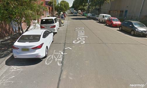
Saywell Street looking north from Shirlow Street
The Applicant has advised that Saywell Street will be closed to traffic thoroughfare so the event can successfully occur and has supplied a TCP (VG.19.141) showing extent of the full road closure and detours (reproduced below and attached in the TMP).
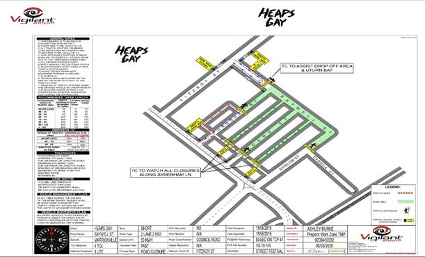
Saturday business hours closures:
1. Saturday closures have been reduced to allow free flowing access for businesses & residents within the affected area.
2. Saywell St closed from Shirlow st x Garden St to Cadogan St
3. A Drop off area will operate along Saywell st between Cadogan St to Fitzroy St.
4. Shirlow St x Garden St. (Access for VIPs, Artists, Event Staff & Emergency Vehicles)
5. Saywell St Closed at Garden st for BOH
Saturday outside of business hours closures:
1. Saywell St closed from Shirlow st x Garden St to Fitzroy St
2. A Drop off area will operate along Saywell st between Cadogan St to Fitzroy St.
3. Shirlow St x Garden St. (Access for VIPs, Artists, Event Staff & Emergency Vehicles)
4. Saywell St Closed at Garden st for BOH
6. No Access to the Event Area from Sydenham Ln, Shirlow st, Sloane Ln, Sloane St, Cadogan Ln & Cadogan St for Security measures & congestion control.
The proposed street closure is from 7pm on Friday 17 January 2020 which will be after close of business for all of the businesses on Saywell Street until 7am on Monday 20 January 2020.
The applicant will liaise closely with the businesses on Saywell Street to ensure they will not require access over the proposed weekend. However, if they do require access, the applicant can facilitate this between the hours of 6am and the midday via Saywell on any days required.
Site layout will be as shown in the diagram reproduced below:
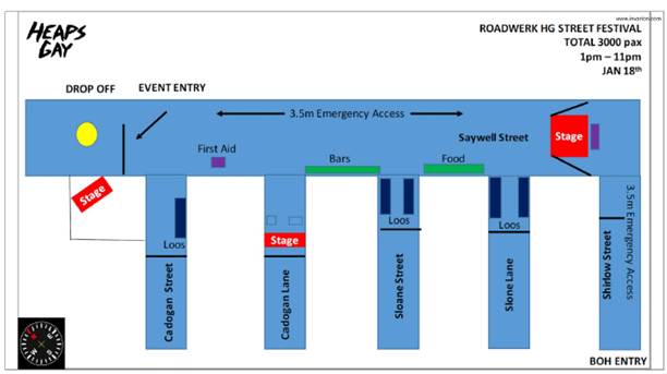
The main entrance to the event site for attendees will be from Fitzroy Street. Emergency access will be from both Saywell and Shirlow Streets. All emergency routes will be manned by security, regularly checked for obstructions and will be lit in periods of darkness.
Directional signage to the event will be provided in the surrounding streets and at Sydenham train station. The event site and all access pathways will be illuminated in periods of darkness for safety and security reasons. All contractors will be given a schedule for arrival and departure in order to prevent congestion on site and ensure the smooth running of the work program.
A 4-metre wide emergency vehicle access must be maintained through the closed road areas during the course of the event. Special Event advance notice signs will be strategically installed at least two (2) weeks prior to the event to alert motorists of the proposed closures. In addition, 'No Parking - Special Event' signs will be affixed over all existing parking signs within the area of the event on the evening of the day prior to the event date.
Impacts on Parking and Vehicular access
The proposed road closure will have an impact on approximately 60 plus on-street car parking spaces along both sides of Saywell Street during the event. Given that Saywell Street abuts mainly commercial properties the on-street parking demand on the weekends is significantly lower than weekdays. It should be noted that there are three residential properties in Shirlow Street, and these properties will have access during the temporary road closure period. Access through the rear of these properties in Sloane Lane will still be retained during that weekend. In September 2019 all adjoining residential and commercial properties have been notified by the applicant of the proposed event and regarding parking and access needs to their properties so they can be accommodated by the applicant.
Impacts on traffic
Saywell Street carries a low volume of traffic and therefore the diverted traffic will have no major impacts on surrounding road network. The event will be held on the weekend when lower than weekday traffic volumes are expected.
Public Transport
The subject site has access to public transport services, with Sydenham Railway Station being located within a 200 metre radius from the site and bus routes (Route M30, 418, 425) operating along Marrickville Road, Railway Parade and Gleeson Avenue.
PUBLIC CONSULTATION
As noted the Applicant has very early on notified all commercial properties and residents in the locality about the upcoming event to access their access needs over the weekend early in the New Year of 2020 and accommodate access as required.
The proposed temporary full road closure for the events was advertised in the local paper for a period of 28 days. The advertising period commenced on 24 September 2019 and concluded on 22 October 2019. No submissions were received.
A Traffic Management Plan is to be submitted to the RMS for consideration and approval.
CONCLUSION
It is recommended that Council endorse the temporary full road closure of Saywell Street, Marrickville from Friday 17 January to 7:00am Monday 20 January 2020 subject to complying with the conditions within this report; applying to the RMS for consent to close the subject road, a Road Occupancy License being obtained from the Transport Management Centre and advice of the proposed event being forwarded to the appropriate stakeholders and authorities including emergency services.
|
1.⇩ |
HEAPS GAY STREET PARTY 2019 TMP V1.2 |
|
Local Traffic Committee Meeting 4 November 2019 |
Subject: Smidmore Street, Marrickville – Temporary relocation of Bus Zones during Marrickville Metro Expansion Works – (Midjuburi – Marrickville Ward / Heffron Electorate / Inner West PAC)
Prepared By: Jennifer Adams - Engineer – Traffic and Parking Services
Authorised By: John Stephens - Traffic and Transport Services Manager
SUMMARY
Concept plans have been submitted to Council by TTPP for the temporary relocation of Bus Zones in Smidmore Street, Marrickville during Marrickville Metro Expansion works. The relocation will be temporary from 3 January 2020 for a 9 month period until the new permanent Bus Zone is built in Edinburgh Road, Marrickville. It is recommended that the proposed changes be approved in order to accommodate the temporary relocated ‘Bus Zones’ and that all works and costs associated with the relocated 'Bus Zones' and reinstatement of Council’s original parking restrictions is to be borne by the Applicant.
|
RECOMMENDATION
THAT the plan for the temporary relocation of ‘Bus Zones’ including associated signs and line markings (i.e. attached concept plan, no. 16065 dated 26 July 2019, prepared by TTPP) be approved subject to the following conditions:
a) The date of commencement of the temporary relocated 'Bus Zones' is from 3 January, 2020 for a nine month period;
b) All works and cost of the supply, installation and removal of the signage associated with the 'Bus Zone' relocations is to be borne by the applicant;
c) Council’s existing signage to be reinstated in Smidmore Street, Marrickville at the end of the relocation by the applicant at their cost and to Council’s Traffic Engineers satisfaction; and
d) Notification of surrounding properties be undertaken at least 4 weeks prior to installation of the temporary 'Bus Zone'. |
BACKGROUND
In relation to the proposed relocation of the existing bus stops at Smidmore Street (in front of the Marrickville Metro Shopping Centre), the Applicant notes that the approval for the expansion of the Marrickville Metro Shopping Centre (MP09_0191 granted in March 2012 as modified) requires the removal of the existing bus stop on Smidmore Street and the construction of a new bus terminal in Edinburgh Road to replace the existing one on Smidmore Street. A '10km/h Shared Zone' on Smidmore Street has also been conditioned in the approval together with making Smidmore Street (between the car park access and Murray Street) one way westbound.
External construction activities and/or road works to upgrade Smidmore Street will require it to be partially closed. Works in Smidmore Street will occur over three stages across a period of nine months from 3 January 2020. In all stages, eastbound traffic on Smidmore Street will be maintained with westbound traffic to be diverted. In each stage, the width of the remaining eastbound carriageway on Smidmore Street is not sufficient to accommodate a parked bus adjacent to the bus stop while still permitting traffic to pass it. As such, the existing bus stop and layover area on Smidmore Street will need to be temporary relocated elsewhere while the permanent bus stop on Edinburgh Road is being constructed.
It is proposed to temporarily relocate the bus stop to Smidmore Street just east of Murray Street. The proposed temporary bus stop locations are shown below.
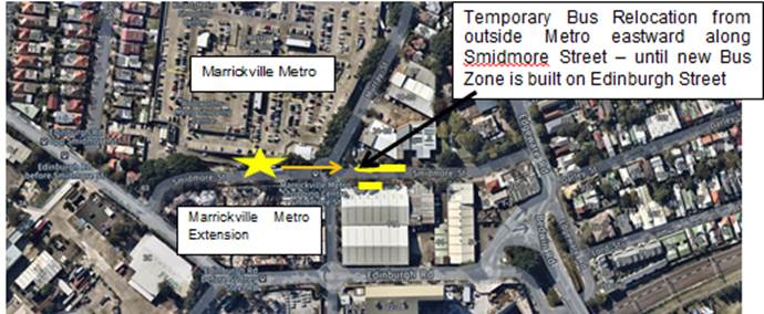
The temporary bus stop will result in the loss of nine kerbside parking spaces (five on the northern side and four on the southern side) on Smidmore Street, Marrickville.
The affected bus services will be temporary re-routed. TTPP has consulted the bus operators (STA and Transit System) and they have endorsed the proposed relocation.
FINANCIAL IMPLICATIONS
All works and costs associated with the recommended temporary 'Bus Zone' relocation will be borne by the applicant as will the reinstatement of Council’s existing regulatory signage at the end of the temporary relocation period.
DISCUSSION
The site location is Smidmore Street between Edgeware Road and Murray Street, Marrickville. See following diagram.
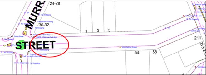
|
Street Name
|
Smidmore Street, Marrickville |
|
Section |
Between Edinburgh Street and Murray Street |
|
Carriageway Width (m) |
12.8 |
|
Carriageway Type |
Two-way road with one travel lane in each direction, in addition to kerbside parking lanes. |
|
Classification |
Local |
|
85th Percentile Speed (km/h) |
36 |
|
Vehicles Per Day (vpd) |
7,796 |
|
Reported Crash History (July 2013 - June 2018) |
6 RMS recorded crashes at roundabout at Murray Street / Smidmore Street. 4 injury and 2 tow-away. One pedestrian RUM 2 and other five involved turning movements at roundabout – Rum 10x2, Rum 21, RUM 31 and RUM 40 |
|
Heavy Vehicle Volume (%) |
3.9 |
|
Parking Arrangements |
Unrestricted parking on both sides of Smidmore Street between Murray Street and Edgeware Road with the exception of 24 metres (4 car spaces) of ’P1 8.00AM – 4.00PM Monday to Friday’ restrictions on the northern side of Smidmore Street, commencing from the existing 10 metre ‘No Stopping’ restriction west of Edgeware Road, Enmore. |
The proposed temporary works involve relocating existing Bus Zones on the northern side of Smidmore Street between Edinburgh Street and Murray Street to the east of the roundabout at Smidmore Street/Murray Street as shown in the diagram below and reproduced in the attachments.
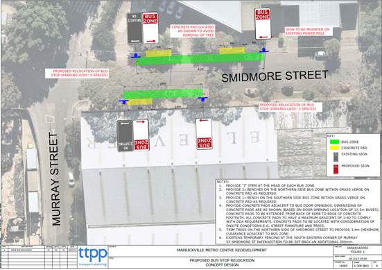
As noted the affected bus services will be temporary re-routed as shown in supplied documents by TTPP reproduced below.
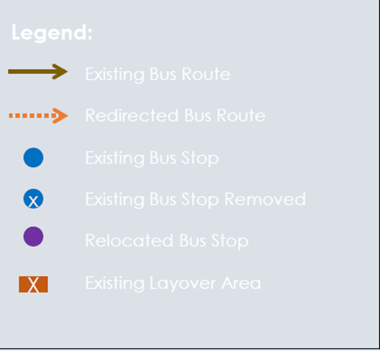
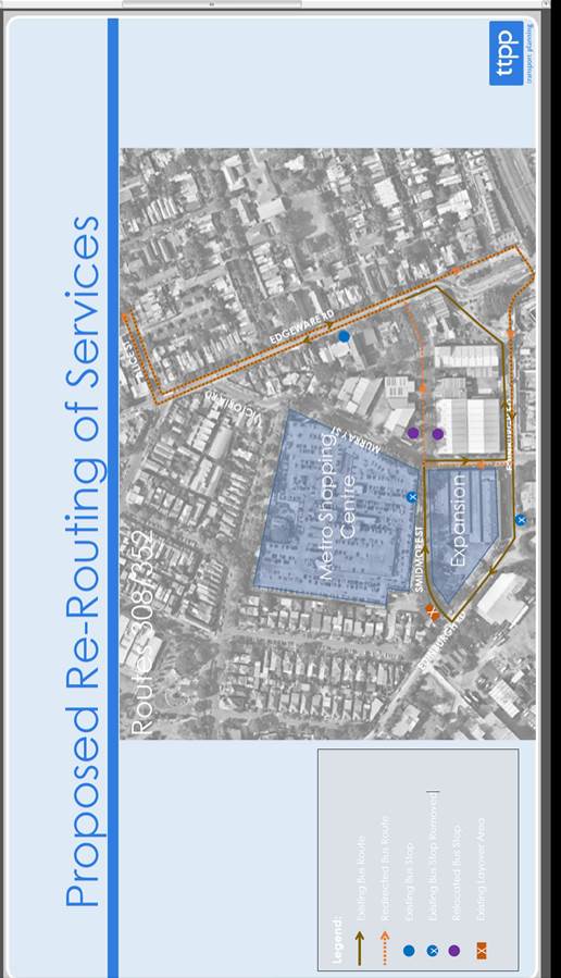
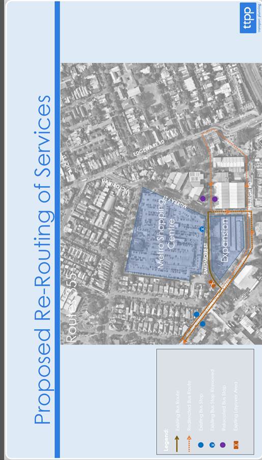
PUBLIC CONSULTATION
TTPP has consulted the bus operators (STA and Transit System) and they have endorsed the proposed relocation.
CONCLUSION
It is recommended that the proposed changes be approved in order to accommodate the temporary relocated ‘Bus Zones’ and that all works and costs associated with the relocated Bus Zones and reinstatement of Council’s original parking restrictions is to be borne by the Applicant.
|
1.⇩ |
16065CAD050-BUS STOPS-190726 |
|
|
Local Traffic Committee Meeting 4 November 2019 |
Subject: Allen Street and Elswick Street, Leichhardt - Proposed Speed Cushions And Kerb Blister (Gulgadya - Leichhardt Ward / Balmain Electorate / Leichhardt PAC)
Prepared By: Brinthaban Baskaran - Graduate Traffic Engineer
Authorised By: John Stephens - Traffic and Transport Services Manager
SUMMARY
As part of the Traffic Capital Works Program, Council has prepared a design plan (Attachment 1) to install speed cushions and a kerb blister on approach to the roundabout at Allen Street and Elswick Street, Leichhardt. The intention of the proposal is to slow traffic and improve road safety for pedestrians and motorists at the intersection.
Consultation was undertaken with owners and occupiers of properties in Allen Street and Elswick Street regarding the proposal. A summary of the consultation result is presented in this report for consideration.
|
RECOMMENDATION
That the detailed design plan of speed cushions, a kerb blister and associated signs and line markings on approach to the roundabout at Allen Street and Elswick Street, Leichhardt (as per attached plan No.10106) be approved. |
BACKGROUND
The roundabout at the intersection of Allen Street and Elswick Street, Leichhardt has been identified as a location that requires traffic calming measures to improve safety at the intersection.
A review of 5 years (July 2012 to June 2017) of Road and Maritime Services (RMS) reported crash data revealed that there have been (3) injury crashes at the roundabout.
Council is proposing to install new speed cushions, kerb blister and associated signs and line markings at the roundabout of Allen Street and Elswick Street, Leichhardt to slow traffic and improve road safety for pedestrians and motorists at the intersection.
The detailed design plans have been finalised for the proposed works together with community consultation and are presented in this report for consideration.
Site Location & Road Network
|
Street Name(s) |
Allen Street and Elswick Street |
|
Section |
Intersection |
|
Traffic Volume |
Allen Street (Elswick Street to North Street) – 3,219 vpd (2018 Traffic Count) Elswick Street – data not available |
|
Recorded Accident History (5 year) |
2 (2013 Moderate injury) Allen St at Elswick St 1 (2013 Non-casualty) Allen St at Elswick St 1 (2014 Moderate injury) Allen St at Elswick St |
|
Recorded 85% speed |
Allen Street (Elswick Street to North Street) – 52.2km/h (2018 Traffic Count) Elswick Street – data no available |
|
Speed Limit |
50km/h |
|
Carriageway width |
Allen Street – approx 12.5m Elswick Street – approx. 12.3m |
|
Carriageway Type |
Allen Street is two way with one travel lane and one bicycle lane in each direction and kerb side parking lanes Elswick Street is two way with one travel lane in each direction and kerb side parking lanes |
|
Road Classification (State, Regional, Local) |
Allen Street – Local road Elswick Street – Local road |
FINANCIAL IMPLICATIONS
Council has received funding of $35,300 through the 2019/20 Australian Government’s Black Spot Program to construct the proposed works this financial year.
OTHER STAFF COMMENTS
The detailed design plan shown in Attachment 1 outlines the proposed works on approach to the roundabout at Allen Street and Elswick Street, Leichhardt and includes the following treatments:
• Four asphalt speed cushions on all approaches to the roundabout
• Landscaped concrete kerb blister (eastern approach on Allen Street)
• Associated signs and line marking
These speed cushions will assist in reducing vehicular speeds approaching the roundabout noting that there is limited deflection achieved in the current roundabout layout.
This proposal will not result in the loss of any on-street parking spaces.
PUBLIC CONSULTATION
A letter outlining the above proposal was mailed out to the affected 53 properties in Allen Street and Elswick Street as indicated on the attached map below requesting residents’ views regarding the proposal.
One property responded to the survey in support to the proposal, comments are summarised in the following table.
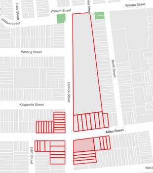
|
Residents’ Comments |
Officer Comments |
|
I would think the junction of Allen St and Flood St would take preference for an update. As this junction is very dangerous as the islands in the middle of the road are very small and it is a busy road.
I would also suggest as part of the works that the pavements and verges be upgraded with the digging up of the concrete verges and replaced with grass. A few trees would also go a long way to taking the heat out of the area. It is super-hot in summer with no shade. |
There is no accident history which would warrant the need for traffic calming measures at the intersection of Allen Street and Flood Street.
This matter is outside the scope of this project and would need to be considered as a separate issue. |
CONCLUSION
It is recommended that the proposal for the speed cushions, a kerb blister and associated signs and line markings on approach to the roundabout at Allen Street and Elswick Street, Leichhardt (as per the attached plan No.10106) be approved.
|
1.⇩ |
Consultation Plan 10106-Allen Street, Leichhardt |
|
|
Local Traffic Committee Meeting 4 November 2019 |
Subject: Illawarra Road, Marrickville; Dudley Street,
Dulwich Hill and (Lower) Railway Parade, Sydenham - Bus Replacements during
major Rail Shutdown, Temporary Parking Changes during T3 Line Upgrade
for Sydney Metro.
(Midjuburi-Marrickville Ward / Summer Hill Electorate / Inner West PAC)
Prepared By: Jennifer Adams - Engineer – Traffic and Parking Services
Authorised By: John Stephens - Traffic and Transport Services Manager
SUMMARY
Council has been notified by Transport for NSW (TfNSW) that Sydney Metro works at Sydenham Station will involve major rail shutdowns at the station over this coming Christmas – New Year period. This year buses will replace train services along the T3 line (closed between Campsie and Central Stations from 22 December 2019 to 5 January 2020) and along the T4 line (closed between Hurstville and Central Stations between 24 and 28 December 2019). To accommodate the increased bus movements and necessary holding areas some short term parking changes are required at a number of locations.
Specifically, TfNSW is requesting approval for the temporary conversion of multiple parking spaces at the following locations: Illawarra Road, Marrickville; Dudley Street, Dulwich Hill; and Railway Parade (lower section), Sydenham. It is recommended that no objections be raised, and Council approves the temporary short term parking changes at the identified locations during the rail shutdowns.
|
RECOMMENDATION
THAT this report be received and noted and the following temporary short term parking changes from Sunday 22 December, 2019 to Sunday 5 January 2020 be approved and implemented by TfNSW: a) The conversion of 15m (2 parking spaces) ‘1P 8:30am-6pm’ and 10m (1 parking space) ‘No Parking 8:30am-5pm Mon- Fri’ on the western side of Illawarra Road, Marrickville to a ‘Bus Zone 6am-10am’, located south of the existing statutory ‘Bus Zone’ near the intersection with Warburton Street (reverting back to existing restrictions after 10am) be APPROVED, in order to provide a short term second bus bay with adequate draw-in length; b) The conversion of 12.5m (2 parking spaces) ‘1P 8:30am-6pm Mon – Fri and 8.30am-12.30pm Sat’ on the southern side of Dudley Street, Dulwich Hill to a ‘Bus Zone’, located between Wardell Road and School Parade be APPROVED, in order to provide a short term second bus bay with adequate draw-in length; c) The conversion of 110m (39 parking spaces) ‘4P 8:30am – 6pm Mon – Fri’ on the southern side of (Lower) Railway Parade, Sydenham to a ‘Bus Zone’ be APPROVED, in order to provide a short term bus layover area; d) All existing regulatory parking signage to be reinstated to the satisfaction of Council's Traffic Engineer at the end of the shutdown period; and e) The applicant and Council Parking Services team be advised in terms of this report. |
BACKGROUND
The Sydney Metro City & Southwest Sydenham to Bankstown project will upgrade all 10 stations between Marrickville and Bankstown to meet metro standards before converting the T3 Bankstown Line to Metro operations.
During this possession, services on the T3 Bankstown Line and T4 (Illawarra) South Line will not operate for either part or the entirety of the line depending on the nature of construction works for the respective possession.
The first possession is scheduled from Sunday 22 December 2019 to Sunday 5 January 2020. During this period, replacement buses are required to maintain public transport connectivity for customers to impacted train stations.
During the railway conversion period, replacement bus services will cater for the transport needs of impacted customers on the T3 and T4 lines. These additional services will require temporary removal of parking spaces to facilitate the additional demand and increased frequency of buses within these precincts, including the creation of new bus stops, extension of existing bus stops, layover and standby facilities. The TfNSW project team has undertaken detailed analyses and planning to determine the preferred locations for temporary parking removal to cater for operational requirements.
Councils and State MPs have been notified. From mid-September TfNSW staff visited businesses immediately adjacent to the affected bus zones. Business and residents further away will receive letters. Marshalling/information staff will be located at all affected stations throughout the closures. Any additional changes will also be notified.
All changes to street signage will be made by TfNSW contractor from 10pm the night before the closures and will be reinstated at the completion of the planned shutdowns.
FINANCIAL IMPLICATIONS
Nil. There are no financial implications for Council associated with this matter.
OFFICER COMMENTS
Each of the 3 locations will be detailed separately.
1. Illawarra Road, Marrickville
Illawarra Road is a Regional Road carrying approximately 16,000 vehicles per day (between Byrnes Street and Arthur Street, Marrickville). It is a two way with one travel lane in each direction, in addition to kerbside parking on both sides.
The 'Bus Zone' on the western side of Illawarra Road (between Greenbank Street and Warburton Street) will be extended by about 4 parking spaces (combination of ‘IP’ and ‘No Parking’ restrictions). The existing 'Bus Zone' on the eastern side is adequate. (Refer to the attached locality map and images).
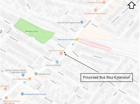
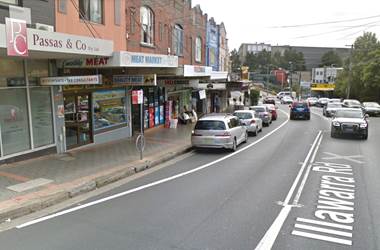
Illawarra Road, facing north
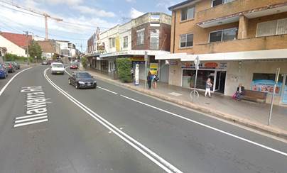
Illawarra Road, facing south
Installation Diagram
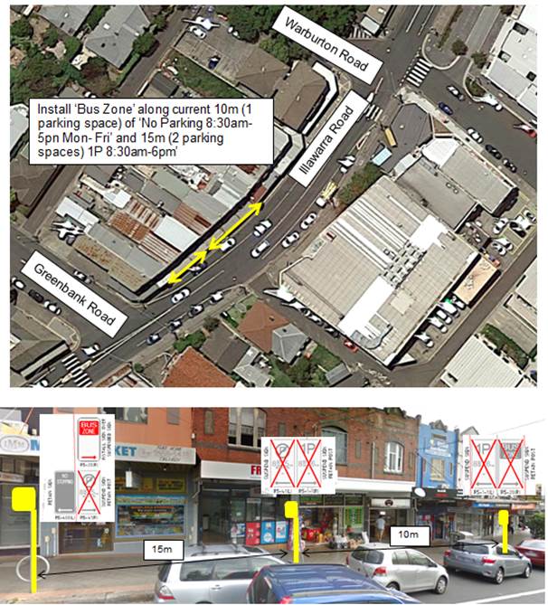
2. Dudley Street, Dulwich Hill
Dudley Street is a local street which carries around 1,600 vehicles per day. ‘Bus Zones’ are located on both sides of Dudley Street, east of Wardell Road and the Dulwich Hill Railway Station access.
The existing 'Bus Zone' on southern side of Dudley Street will be extended by 2 parking spaces (‘1P’ restrictions). This is adjacent to an existing temporary ‘Works Zone’ which will be removed. Dudley Street is a local road and parking is restricted on both sides between Wardell Road and School Parade. (Refer to the attached locality map and images).
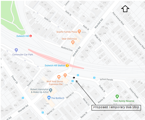
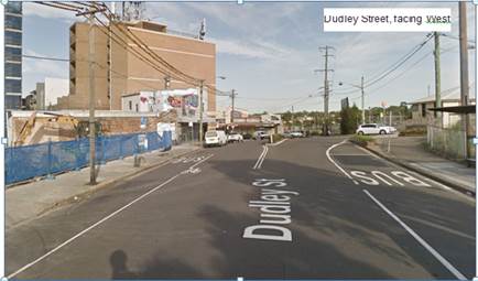
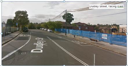
Installation Diagram
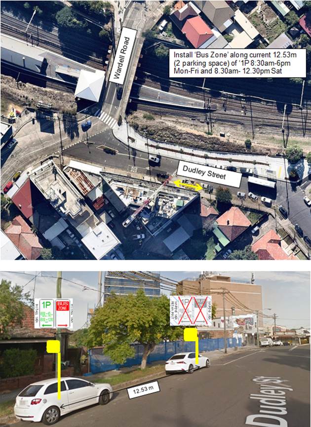
3. Railway Parade (lower), Sydenham
Railway Parade is a two-level street running north-south between Sydenham and Marrickville Roads. The upper section, which operates ‘one-way’ in a southerly direction, is part of the main road system providing access to/from Gleeson Avenue (bridge over the Illawarra Railway line), Railway Road and Princes Highway. The lower section presently operates ‘two-way’ and provides front access to the commercial properties located along its western side. Almost the entire eastern side of this level is available for parking. (Refer to locality and aerial below.)
Railway Parade (lower) is 15.5m in width and classed a local road. Parking arrangements on the northern side of the road consists of ‘2P 8.30am-6pm Mon-Fri’ parallel-to-kerb parking. Southern side of the road consists of sections of ‘4P 8.30am-6pm Mon Fri’ 90 degree angle parking and unrestricted 90 degree angle parking.
(Lower) Railway Parade will be used for bus layover (subject to swept path assessments). Lower Railway Parade is a local road and parking is restricted on both sides between Marrickville Road and Sydenham Road. (Refer to the attached locality map and images).
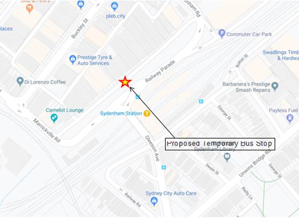
Looking westward along (Lower) Railway Parade
Looking east along (Lower) Railway Parade
Installation Diagram
PUBLIC CONSULTATION
Community consultation was completed by TfNSW for the Sydenham to Bankstown Metro TTP for the 2019/2020 Christmas/ New Year period.
They received no site specific feedback from the community about any of the proposals. There was one generic comment received for the Inner West that was opposed to the metro service and the conversion of the line.
Consultation on the proposed temporary parking changes was undertaken between 9 and 23 September 2019. The objective of the consultation was to raise awareness of the proposed temporary parking changes needed to operate additional buses for T3 Bankstown Line customers.
Local businesses and residents were asked to provide their local knowledge to help the project team refine bus operations in and around station precincts. The consultation program consisted of the following activities:
• Media release / announcement
• Online project webpage with brochure, communication notification and FAQ
• Interactive online maps for the nine station locations
• Letter box dropped approximately 450 notifications to businesses and residents within 200-300m of the nine station locations
• Door knocked approximately 70 businesses within 100-250m of the nine station locations targeting local businesses directly impacted by the temporary kerbside changes.
Feedback from the consultation process is summarised in the Consultation Report and is reproduced below: The consultation report is attached at the end of this report.
CONCLUSION
It is recommended that Council approves the temporary short term parking changes at the identified locations during the rail shutdown period.
|
|
Local Traffic Committee Meeting 4 November 2019 |
Subject: Temporary Road Closure to Carryout Road Restoration on White Street, Lilyfield, Whites Creek Lane and Arguimbau Street, Annandale (Baludarri - Balmain Ward / Balmain Electorate / Leichhardt PAC)
Prepared By: Brinthaban Baskaran - Graduate Traffic Engineer
Authorised By: John Stephens - Traffic and Transport Services Manager
SUMMARY
An application has been received from Gledhill Constructions for the temporary full road closure for the following streets; White Street, Lilyfield between Moore Street and Ilka Street (frontage of house No.5-7 White Street), a portion of Whites Creek Lane and Arguimbau Street, Annandale (rear of house No.5-7 White Street) to carryout road/footpath restoration works from Thursday, 23 January 2020 to Friday, 14 February 2020 (with a contingency period of 2 weeks thereafter).
|
THAT the temporary road closure of White Street, Lilyfield between Moore Street and Ilka Street, in front of 5-7 White Street, Lilyfield and portion of Whites Creek Lane and Arguimbau Street, Annandale at the rear of 5-7 White Street, Lilyfield to carryout road/footpath restoration works from Thursday, 23 January to Friday, 14 February 2020 (with a contingency period of 2 weeks thereafter), be approved, subject to the conditions as set out as per the Road Closure Application Form as well as the following additional conditions:
a) Applicant must obtain and hold a Road Opening Permit to undertake (any) work in the road closure section;
b) The occupation of the road carriageway must not occur until the road has been physically closed; and
c) All affected residents and businesses, including the NSW Police Local Area Commander, Fire & Rescue NSW and NSW Ambulance Services be notified in writing, by the applicant, of the proposed temporary road closure at least 14 days in advance of the closure with the applicant making reasonable provision for stakeholders. |
BACKGROUND
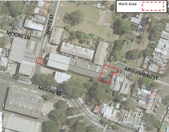
FINANCIAL IMPLICATIONS
Under Council’s Fees & Charges, the applicant has paid the fee for the temporary full road closure. This fee includes advertising the proposal in accordance with the Roads Act 1993.
OTHER STAFF COMMENTS
The Traffic Control Plans submitted by the applicant are attached.
Vehicular access for local residents/businesses will be maintained during the closure, where possible. Authorised traffic controllers will be on-site during all shifts and are to be positioned at the closure points when required to provide vehicular access to local residents and ensure the safety of motorists and pedestrians.
PUBLIC CONSULTATION
The proposed closure of White Street, Lilyfield between Moore Street and Ilka Street (frontage of house No.5-7 White Street section), Whites Creek Lane between Moore Street and Arguimbau Street and Arguimbau Street between Whites Creak and Young Street, Annandale (rear of house No.5-7 White Street section) has been advertised in the local newspaper for a period of 28 days commencing Tuesday, 22nd October 2019. Any objections will be reported to the Council meeting scheduled for Tuesday, 26th November 2019.
|
1.⇩ |
Road Closure - White Street TCP |
|
2.⇩ |
Road Closure - Whites Creek Lane and Arguimbau Street TCP |
|
|
Local Traffic Committee Meeting 4 November 2019 |
Subject: James Street, Leichhardt - Christmas Street Party (Gulgadya - Leichhardt Ward/ Balmain Electorate/ Leichhardt PAC)
Prepared By: David Yu - Engineer - Traffic and Parking Services
Authorised By: John Stephens - Traffic and Transport Services Manager
SUMMARY
Council has received an application for approval of an annual Christmas street party in James Street between William Street and Allen Street, Leichhardt to be held on Sunday, 15 December 2019 between 1:00pm and 8:00pm.
|
RECOMMENDATION
THAT the temporary road closure of James Street, Leichhardt between William Street and Allen Street, to conduct an annual Christmas Street Party on Sunday, 15 December 2019, from 1:00pm - 8:00pm, be approved, subject to the conditions as set out as per the Street Party Application Form as well as the following additional conditions:
a) That an unencumbered passage minimum of 4.0m wide be available for emergency vehicles through James Street, Leichhardt between William Street and Allen Street;
b) The occupation of the road carriageway must not occur until the road has been physically closed; and
c) All affected residents and businesses, including the NSW Police Local Area Commander, Fire & Rescue NSW and NSW Ambulance Services be notified in writing, by the applicant, of the proposed temporary road closure at least 14 days in advance of the closure with the applicant making reasonable provision for stakeholders. |
BACKGROUND
The street party is proposed to be held on Sunday, 15 December 2019 between 1:00pm and 8:00pm. The applicant is seeking permission for a temporary full road closure of James Street between William Street and Allen Street, similar to previous years’ events.
The Traffic Control Plan for the Closure is enclosed.
FINANCIAL IMPLICATIONS
The street party coordinator will bear all costs associated with the road closure.
OTHER STAFF COMMENTS
This is an annual event and no significant issues have occurred in the past.
According to the RMS ‘Guide to Traffic and Transport Management for Special Events’ a small street party is considered as a ‘Class 3’ event.
Council encourages properly conducted neighbourhood street parties as a means of building community spirit and improving neighbourhood security. Fees for road occupancy are waived by Council for small community street parties.
Where the following conditions apply, organisers are only required to obtain approval for a street party involving a temporary road closure:
· The party is to be held outdoors for fewer than 100 people.
· No temporary structures or jumping castles are to be erected.
· Participants are to bring their own food and drinks, and food and drinks are not for sale.
· There will be no performers or amplified music involved.
For approved street parties and subject to availability Council will provide barricades and ‘Road Closed’ signs subject to the street party coordinator arranging collection from and return to Council’s Summer Hill depot.
PUBLIC CONSULTATION
The proposed temporary road has been advertised in the local newspaper for a period of 28 days commencing Tuesday, 8th October 2019.
No responses were received at the time of finalising the report. Should any objections be received, they would be reported to Council's scheduled meeting on 26 November 2019.
|
1.⇩ |
Standard Street Party TCP (T-Intersection) |
|
|
Local Traffic Committee Meeting 4 November 2019 |
Subject: Boomerang Street and Crescent Street, Haberfield - Proposed Intersection Treatment (Gulgadya-Leichhardt Ward/Summer Hill Electorate/Burwood PAC)
Prepared By: David Yu - Engineer - Traffic and Parking Services
Authorised By: John Stephens - Traffic and Transport Services Manager
SUMMARY
A review of the detailed design plan has been finalised for the proposed intersection treatment at Boomerang Street and Crescent Street, Haberfield.
The proposal includes installing kerb extension, median island, pedestrian refuge island, kerb blister island and speed cushions in Boomerang Street to improve safety and reduce vehicular speeds in the street.
Consultation on two options was undertaken with the owners and occupiers of properties adjacent to the intersection regarding the proposal. A summary of the consultation results are presented in this report for consideration.
|
THAT:
1. Option B for the detailed design plan for the kerb extension, median island, pedestrian refuge island, kerb blister island, speed cushions and associated signposting and line marking in Boomerang Street and Crescent Street, Haberfield (as per the attached plan No.10074_B) be approved; and 2. The existing ‘Bus Zone’ on the eastern side of Boomerang Street, south of Crescent Street be modified to ‘Bus Zone Mon-Fri’. |
BACKGROUND
As part of the 2019/20 Traffic Facilities (LATM) Capital Works Program, Council is proposing to provide intersection treatments at the intersection of Boomerang Street and Crescent Street.
At the June 2019 Traffic Committee meeting, a previous proposal for kerb blister islands, speed cushions, pedestrian refuge (in Crescent Street) and associated signposting and linemarking at Crescent Street and Boomerang Street, Haberfield was deferred due to resident concerns regarding the loss of parking due to the placement of a pedestrian refuge in Crescent Street. Residents suggested relocating the pedestrian refuge into Boomerang Street as they had observed pedestrians crossing to and from Robson Park.
Subsequently, at the September 2019 Traffic Committee meeting, an updated proposal (Attachment 2) for kerb extension and speed cushions, and associated signposting and line-marking in Crescent Street and Boomerang Street, Haberfield was considered and deferred due to resident concerns regarding pedestrian safety crossing Boomerang Street.
The Committee recommended that the installation of a pedestrian refuge in Boomerang Street, south of Crescent Street be investigated and a revised plan of the intersection be brought back to the Committee.
An updated detailed design plan has been finalised for the proposed works together with community consultation and are presented in this report for consideration.
Site location & Road Network
|
Street Name(s) |
Crescent Street and Boomerang Street, Haberfield |
|
Section |
Intersection |
|
Traffic Volume |
- |
|
Recorded Accident History (5 year) |
Nil. |
|
Recorded 85% speed |
- |
|
Speed Limit |
50km/h |
|
Carriageway width |
Crescent Street - 12.6m Boomerang Street - 11.6m |
|
Carriageway Type |
Boomerang Street - Two way with kerb side parking on both sides of the street Crescent Street - Two way with kerb side parking on both sides of the street |
FINANCIAL IMPLICATIONS
Funding of $40,000 has been allocated to this project for construction in the 2019/20 capital works program.
OTHER STAFF COMMENTS
The updated detailed design plan shown in Attachment 1 outlines the proposed works at the Crescent Street and Boomerang Street intersection and includes the following treatments:
· Reconstruction of kerb ramps;
· Construction of a kerb extension on the north-east corner of the Crescent Street and Boomerang Street intersection;
· Extension of median island on northern side of Boomerang Street;
· Construction of pedestrian refuge Island and landscaped kerb blister Island on Boomerang Street;
· Installation of two asphalt speed cushions on both approaches of Boomerang Street at Crescent Street; and
· Installation of associated signage and line-marking.
There will be a loss of three (3) parking spaces on the western side of Boomerang Street (park side) associated with the proposal.
PUBLIC CONSULTATION
A letter outlining two (2) proposed options was mailed out to the affected properties (36 properties) in Crescent Street and Boomerang Street, Haberfield, requesting residents’ views regarding the proposal (as indicated on the following plan).
Option A (Attachment 2) was the proposal reported at the September 2019 Local Traffic Committee and Option B (Attachment 1) is the proposal recommended in this report.
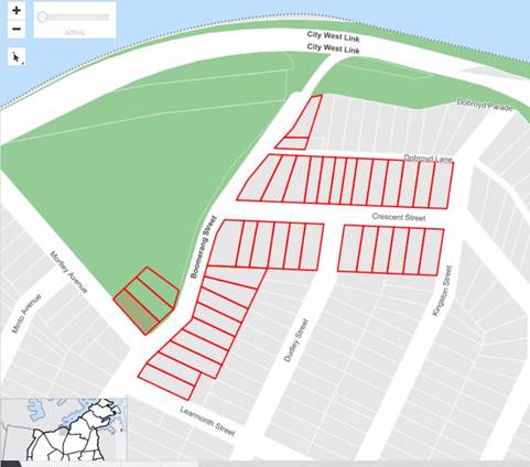
A total of two (2) responses were received, both in support of the proposal (Option B).
|
Residents’ Comments |
Officer Comments |
|
There are no longer any bus stop signs along Boomerang Street, near the corner of Crescent Street. The bus stop signs have been removed but the poles are still in place and should be removed. |
Transit Systems have advised that the bus stop on the eastern side will operate on Monday, Tuesday, Wednesday and Friday. To simplify the sign, it is proposed to modify the existing ‘Bus Zone’ to ‘Bus Zone Mon-Fri’. |
CONCLUSION
The updated proposal for the kerb extension, median island, pedestrian refuge island, kerb blister island, speed cushions and associated signposting and line marking in Boomerang Street and Crescent Street, Haberfield (as per the attached plan No.10074_B) has been developed to address previous comments raised by residents at the Traffic Committee meeting.
|
1.⇩ |
Boomerang Street and Crescent Street, Haberfield - Updated Detailed Design Plan (10074_B) |
|
2.⇩ |
Boomerang Street and Crescent Street, Haberfield - Updated Detailed Design Plan (10074_A) |
|
|
Local Traffic Committee Meeting 4 November 2019 |
Subject: Anthony Street, Croydon – Temporary Road
Closure for Christmas Street Party (Gulgadya-Leichhardt Ward/Strathfield
Electorate/Burwood PAC)
Prepared By: Boris Muha - Engineer – Traffic and Parking Services
Authorised By: John Stephens - Traffic and Transport Services Manager
SUMMARY
Council seeks the support of the Committee for a temporary full road closure of Anthony Street, Croydon, between Croydon Road and Etonville Parade, to conduct an annual Christmas Street party on Saturday, 21 December 2019.
|
RECOMMENDATION
THAT the temporary full road closure of Anthony Street, between Croydon Road and Etonville Parade, to conduct an annual Christmas Street Party on Saturday, 21 December 2019 from 3.00pm – 9.00pm, be approved, subject to the conditions as detailed on the Street Party Application Form as well as the following additional conditions:
a) That an unencumbered passage minimum 4.0m wide be available for emergency vehicles through the closed section of Anthony Street, Croydon;
b) The occupation of the road carriageway must not occur until the road has been physically closed; and
c) All affected residents and businesses, including the NSW Police Local Area Commander, Fire & Rescue NSW and NSW Ambulance Services be notified in writing, by the applicant, of the proposed temporary road closure at least 14 days in advance of the closure with the applicant making reasonable provision for stakeholders. |
BACKGROUND
Correspondence has been received from a resident on behalf of the Anthony Street residents requesting the temporary full road closure of Anthony Street, between Croydon Road and Etonville Parade to conduct an annual Christmas Street party on Saturday, 21 December 2019.
This event is held annually with road closure arrangements being no different to past years. The road closure is a category type “Class 3” minor event under the RMS “Guide to Traffic and Transport Management for Special Events”. Concurrence is only required from the Council and Police and that RMS be only notified of the event.
The above section of Anthony Street is a two way Local Road, divided in carriageway by a central landscape / parkland area and carries low volumes of traffic.
|
Street Name(s) |
Anthony Street, Croydon. |
|
Section |
Between Croydon Road and Etonville Parade. |
|
Traffic Volume (vehicles per day)-vpd |
Less than 500 |
|
Recorded Accident History (5 year) |
Nil |
|
Recorded 85% speed |
- |
|
Speed Limit |
50km/h |
|
Carriageway width |
Approx. 4.9m in each direction. |
|
Carriageway Type |
2 -way divided carriageway with wide landscape/parkland area in between. Kerb side parking both sides. |
|
Road Classification (State, Regional, Local) |
Local |
Detour Routes
Detouring of traffic can be made via the surrounding streets of Croydon Road / Elizabeth Street and Etonville Parade / Hunt Street.
Resident access will be allowed from the Etonville Parade end of the closure.
A Traffic Control Plan and Traffic Management Plan are shown in Attachment 2 and 3.
FINANCIAL IMPLICATIONS
Council will supply material (signs and barricades) to the event organiser with the organiser arranging collection and return to Council's Summer Hill depot.
OTHER STAFF COMMENTS
This event is of similar arrangements as in previous years and approved by the Traffic Committee. Police and RMS have raised no objection in the past to the above special event road closure.
For this type Class 3 minor event the other conditions of the road closure are:
· Council supplies material (signs and barricades) for the event organiser to pick up or alternatively hire. The organiser is responsible to erect the signs and barricades according to the Traffic Control Plan (TCP), and arrange the management of the closure with RMS accredited traffic controllers. Council Rangers would be requested to oversee the event to assure that the traffic control arrangements are in order;
· Council’s public liability insurance will cover such events provided all conditions of consent are complied with and the organiser submits a satisfactory completed risk management assessment with the application. Should third party service providers be engaged for the event, the organisers must ensure public liability insurance of not less than $20 million is current for each provider and copies of such policies are submitted to Council;
· A clear passage of at least 4.0m is provided for emergency vehicle access. (Police condition);
· The organiser is responsible to arrange bins for litter control, and make the area neat and tidy following the re-opening of the road; and
· The organiser is responsible to dismantle the signs and barricades and be directed to deliver the material back to the Council Depot after the completion of the event.
PUBLIC CONSULTATION
The organiser is responsible for notifying the residents/businesses in the area and emergency services at least 14 days prior to the event. Council has arranged advertisement of the temporary full road closure of Anthony Street in the local newspaper for a period of at least 28 days prior to the event. The proposal was advertised in the local paper on Tuesday 8 October 2019 and no comments have been received to date. Should any objections be received, they would be reported to Council's scheduled meeting on 26 November 2019.
CONCLUSION
It is recommended that support be provided for the temporary full road closure of Anthony Street, Croydon, between Croydon Road and Etonville Parade, to conduct an annual Christmas Street Party on Saturday, 21 December 2019, from 3.00pm - 9.00pm. The closure will be subject to relevant conditions as imposed by Council together with any other conditions from the RMS and Police.
|
1.⇩ |
Locality Map |
|
2.⇩ |
TMP |
|
3.⇩ |
TCP |
|
|
Local Traffic Committee Meeting 4 November 2019 |
CLOSURE OF ANTHONY STREET, CROYDON, BETWEEN CROYDON ROAD AND ETONVILLE PARADE, FOR CHRISTMAS
STREET PARTY
SATURDAY 21 DECEMBER 2019 FROM 3.00PM – 9.00PM
The use of the street would be for the residential community to conduct their annual Christmas Street party.
Note: This traffic management detail applies for this year’s event and may be subject to alteration in future events. The event is similar to as in previous years as approved by the Traffic Committee.
A Description or detailed plan of proposed measures
Is a detailed plan of the proposed measures necessary?
No, a detailed plan of the proposed measures is not necessary.
Anthony Street is a local road. The section between Croydon Road and Etonville Parade carries low volumes of traffic.
It is proposed to place portable Council barricades with “Road Closed” signs at Croydon Road and Etonville Parade. Locations will be manned to allow resident access if required. “Road Closed Ahead” signs will be placed in Anthony Street, west of Croydon Road to forewarn of road closure ahead and detour traffic away from the area. Traffic can also be re-directed around at the manned road closure position of Croydon Road and Etonville Parade.
A TCP plan showing this is attached.
B Identification and assessment of impact of proposed measures
Is a detailed assessment required?
No, a detailed assessment is not required.
There will be little traffic in the above section of Anthony Street on the Saturday late afternoon/evening. Any traffic diversion can be made via Croydon Road, Elizabeth Street, Etonville Parade and Hunt Street, and will not have any noticeable impact on these roads.
C Measures to ameliorate the impact of re-assigned traffic.
Is an assessment required?
No, an assessment is not required. See comments in B) above.
(2)
D Assessment of public transport services affected.
Is an assessment required?
No, an assessment is not required. Anthony Street is not a bus route.
E Details of provision made for emergency vehicles, heavy vehicles, cyclists and pedestrians.
Are these details required?
No, these details are not required.
The barricades will be portable and can easily be moved should emergency vehicles require access. Pedestrians will be able to walk normally on the footpath or between the barricades. Cyclists will be able to negotiate the barricades. Heavy vehicles, if any, can detour via Croydon Road, Elizabeth Street, Etonville Parade and Hunt Street.
F Assessment of effect on existing and future developments with transport implications in the vicinity of the proposed measures.
Is an assessment required?
No, it is not applicable to this street closure for a Christmas Street party.
G Assessment of effect of proposed measures on traffic movements in adjoining council areas.
Is an assessment required?
No, an assessment is not required.
The boundary with Burwood Council runs near Robinson Street (off Anthony Street) some 200 metres to the west of the proposed closed section of Anthony Street between Croydon Road and Etonville Parade. No traffic will be directed into streets under the control of Burwood Council.
H Public Consultation Process
Is a public consultation process required?
No, a public consultation process is not required. The closure is for 6 hours on a Saturday afternoon/evening for a Christmas street party. The event co-ordinator is responsible to notify affected residents/businesses and emergency services prior to the street closure.
|
|
Local Traffic Committee Meeting 4 November 2019 |
Subject: Ewart Street, Dulwich Hill - Proposed Painted Chevron Island (Djarrawunang-Ashfield Ward/Summer Hill Electorate/Inner West PAC)
Prepared By: Scipio Tam - Engineer - Traffic and parking Services (South)
Authorised By: John Stephens - Traffic and Transport Services Manager
SUMMARY
Council is proposing to install a painted chevron island on the northern side of Ewart Street, Dulwich Hill, immediately west of the entrance to Ewart Lane, to delineate the boundary between the pedestrian footpath and roadway.
|
RECOMMENDATION
THAT the proposed painted chevron island on the northern side of Ewart Street, Dulwich Hill, immediately west of the entrance to Ewart Lane, in order to delineate the boundary between pedestrian footpath and roadway, be APPROVED. |
BACKGROUND
Council has recently undertaken maintenance works along Ewart Street, removing the existing grass verge on the northern side of Ewart Street, immediately west of the entrance to Ewart Lane and replacing the verge with an asphalt footpath along the boundary line. As the subject section of Ewart Street does not have any kerb & gutter to delineate the roadway from the footpath, a delineation treatment was then investigated.
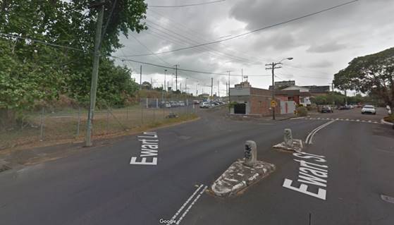
Figure 1: Ewart Street – Before maintenance work to rehabilitate footpath along boundary line
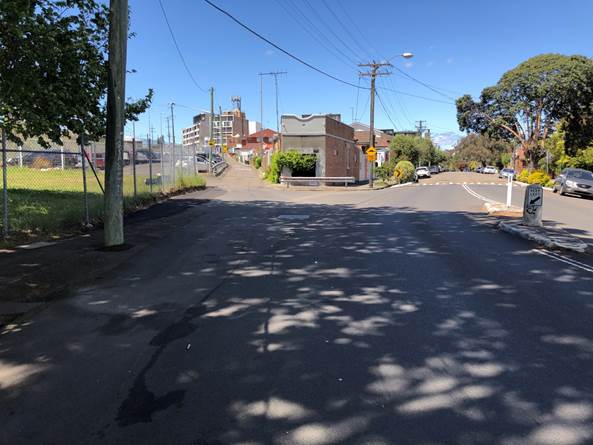
Figure 2: Ewart Street – After maintenance work to rehabilitate footpath along boundary line
FINANCIAL IMPLICATIONS
The cost of the painted chevron island will be funded from Council’s operating budget for signs and line marking.
OTHER STAFF COMMENTS
|
Street Name and Suburb |
Ewart Street, Dulwich Hill |
|
Section |
At Ewart Lane |
|
Carriageway Width (m) |
13.3m |
|
Carriageway Type |
Two-way street |
|
Classification |
Local |
|
85th Percentile Speed (km/h) |
39.2 (2006) |
|
Vehicles Per Day (vpd) |
7301 (2013) |
|
Reported Crash History (July 2013 - June 2018) |
1 x RUM 00 (Pedestrian Collision – near side [2017]) |
|
Heavy Vehicle Volume (%) |
2 |
|
Parking Arrangements |
Unrestricted parking. |
The concept plan below illustrates a proposed painted chevron island that would provide a separation between the footpath area and roadway as well as guiding vehicles away from pedestrian path and providing a traffic calming treatment at this location.
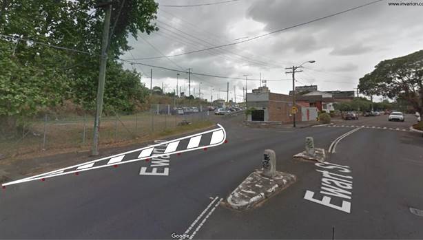
Figure 3: Ewart Street – Proposed painted chevron island – concept plan
With the grass verge removed along the boundary fence and replaced with asphalt, the footpath condition has been restored for pedestrian safety. It is proposed to provide a minimum footpath width of 1.5 metres alongside the chevron island.
It should be noted that the existing refuge island (adjacent to the proposed chevron island) is scheduled to be rehabilitated as part of the works.
PUBLIC CONSULTATION
Not applicable as public consultation was not required for linemarking at this location.
CONCLUSION
It is recommended that the Committee support the installation of a painted chevron island on the northern side of Ewart Street, Dulwich Hill, immediately west of the entrance to Ewart Lane, to provide separation between the pedestrian path and the roadway.
|
|
Local Traffic Committee Meeting 4 November 2019 |
Subject: D3 Iron Cove to Anzac Bridge – Regional Cycleway Design (Gulgadya-Leichhardt & BALUDARRI-BALMAIN WARDS/BALMAIN ELECTORATE/LEICHHARDT PAC)
Prepared By: Stephen Joannidis - Urban Amenity Improvement - Delivery Manager
Authorised By: John Stephens - Traffic and Transport Services Manager
SUMMARY
Council is proposing to upgrade cycle facilities in parts of Haberfield, Leichhardt, Lilyfield and Rozelle and along Lilyfield Road. Previous investigations and community engagements resulted in the concept option put forward by Council being largely rejected by the community. As a result, Council has re-engaged with the community to seek feedback on a number of alternatives so that Council can progress with an option that the community support.
In this instance, Council put forward two (2) options for consideration along Lilyfield Road, as follows:
A. Provision of an on road cycle facility, comprising cycle lanes on sections with an uphill gradient and a mixed traffic profile where cyclists share the traffic lane with vehicles on downhill sections; and
B. Provision of a bi-directional separated cycleway, comprising a number of one way sections of Lilyfield Road. This was the option previously consulted.
In addition, due to feedback about the steepness of Lilyfield Road at the western end, four supplementary routes were developed in collaboration with the local Bicycle User Groups and these were included in the engagement process to determine the community’s preference for an alternative route with more gentle gradients. The supplementary routes were as follows:
1. Hawthorne Canal to Balmain Road;
2. Waratah Street to Balmain Road;
3. Charles Street to Henry Street; and
4. Maliyawul Street to Balmain Road.
Community feedback for Lilyfield Road was consistent with the previous engagement process, with Option A favoured and the implementation of one way sections unanimously objected to.
Community feedback for the supplementary routes was mixed, with no option favoured in a majority and a significantly reduced number of respondents commenting when compared to Lilyfield Road. Whilst Route 4 was favoured in a small majority as part of the engagement process, Route 2 is favoured by the local Bicycle Users Groups and it is on this basis that both options are suggested for progression to the concept design stage and for further consultation following that.
|
RECOMMENDATION
THAT the Committee supports the progression of the project as follows:
· Lilyfield Road – develop a concept design for Option A and re-engage with the community following development; and · Supplementary Routes – develop concept designs for Routes 2 and 4 and re-engage with the community following development.
|
BACKGROUND
The proposed Regional Cycleway Route from Iron Cove to ANZAC Bridge, Rozelle along Lilyfield Road was identified in the Inner Sydney Regional Bike Plan and the former Leichhardt Council’s 2016 Bike Plan as a route to be upgraded to a separated two-way cycleway.
Inner West Council commenced investigations and concept design for a separated cycleway along Lilyfield Road in late 2015. The route included a bi-directional separated cycleway along Lilyfield Road from the western bank of the pedestrian / cycle bridge over Hawthorne Canal to the overhead pedestrian / cycle bridge on Victoria Road, a length of approximately 2.7km.
In response to the level of resident and Bike User Group concern expressed during the last phase of community and stakeholder engagement undertaken between November 2017 and March 2018, Council resolved to develop a revised plan for the cycleway following investigation of several options.
This report outlines the outcomes of that further engagement process.
Financial Implications
The project is fully funded by the NSW Government and aims to increase safety for bike riders, pedestrians and motorists.
Officer Comments:
Lilyfield Road Cycleway and Supplementary Route Options
Following the previous engagement process, a feasibility assessment was carried out along Lilyfield Road to identify and assess a range of options that improve the cycle facilities along the road, as well as improving the safety for cyclists, pedestrians and motorists. The assessment identified the following options:
A. Provision of an on road cycle facility, comprising cycle lanes on sections with an uphill gradient and a mixed traffic profile where cyclists share the traffic lane with vehicles on downhill sections; and
B. Provision of a bi-directional separated cycleway, comprising a number of one way sections of Lilyfield Road. This was the option previously consulted.
It is noted that Option A is essentially an upgrade of the existing provisions on site, with signage and line marking improvements, and switching the side of the road that the cycle lane is on in some sections to ensure that cyclists in the uphill direction benefit from such a facility. Option B is essentially the option that was included as part of the previous 2017 and 2018 engagement processes. Other options were considered, but were not put forward for a variety of reasons.
As part of the previous engagement, it was noted that the western section of Lilyfield Road was steep in an eastbound direction and that this may be an impediment to some cyclists. In collaboration with the local Bicycle User Groups, Council developed a number of supplementary routes that avoided the steep section of Lilyfield Road. Whilst these routes were often longer in terms of distance to be cycled, they offered an alternative to Lilyfield Road with gentler gradients.
The identified supplementary routes were as follows:
1. Hawthorne Canal to Balmain Road;
2. Waratah Street to Balmain Road;
3. Charles Street to Henry Street; and
4. Maliyawul
Street to Balmain Road. ![]()
PUBLIC CONSULTATION
The options as identified for Lilyfield Road and the supplementary routes were put forward as part of the community engagement process and comment sought on the community’s preference.
It was noted that a further engagement process would follow this one, whereby the concept designs resulting from the feedback received as part of this process, would be presented for further comment.
188 responses were received for this project. This included 162 responses via the Your Say Inner West project page and 26 responses via email directly to Council’s Project Manager.
Of the 188 responses, 21 common and general points were raised directly related to the proposals as follows:
|
Lilyfield Road |
|
1. Support Section 1 proposal; 2. Support Section 1 proposal with kerb separation; |
|
3. Prefers Section 2, Option A; |
|
4. Prefers Section 2, Option B; |
|
5. Prefers section 3, Option A; |
|
6. Prefers section 3, Option B; 7. Against all options with one way streets; 8. All plans unsuitable. Leave as is; and |
|
9. Route needs to integrate with WestConnex parkland/ Rozelle goods line.
Supplementary Routes |
|
10. Prefers supplementary route through light rail tunnel instead of options proposed; |
|
11. Supportive of supplementary routes; |
|
12. Supplementary routes are preferred to Lilyfield Road; |
|
13. For supplementary route 1; |
|
14. For supplementary route 2; |
|
15. For supplementary route 3; |
|
16. For supplementary route 4; |
|
17. Against supplementary route 1; |
|
18. Against supplementary route 2; |
|
19. Against supplementary route 3; |
|
20. Against supplementary route 4; and |
|
21. Against all supplementary routes. |
It is noted that respondents typically offered more than one comment in each submission.
For Lilyfield Road, the responses were generally in favour of the on road cycle lane and mixed traffic options, with the only general issue receiving greater comment being the 88 respondents objecting to any option that resulted in one way sections of Lilyfield Road.
A common comment also related to coordination with WestConnex should be undertaken to ensure a link through the proposed parkland and connection to ANZAC Bridge. In relation to this, it is noted that Council is in communication with Transport for New South Wales, but final plans for the WestConnex works in the vicinity are not developed currently.
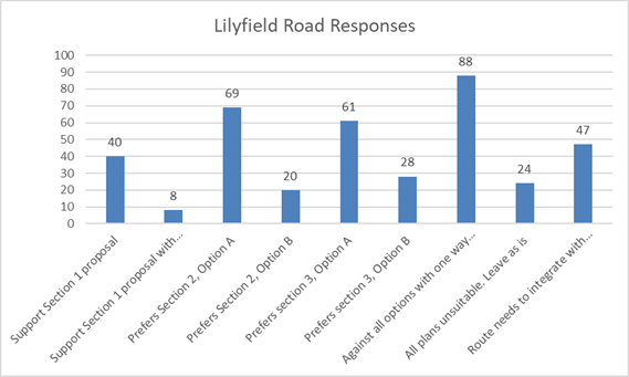
For the supplementary routes, response numbers were far less than those received related to Lilyfield Road. None of the four options was favoured in a majority, with the largest response being from respondents being against all the supplementary routes. In real terms, Route 4, connecting Maliyawul Street to Balmain Road, was the preferred supplementary option, with a minor majority.
It is noted that Route 2 is favoured by the local Bicycle User Groups.
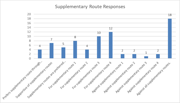
In consideration of the supplementary routes to progress to the concept design stage and to further community engagement, it is suggested that both Route 2 and Route 4 are put forward. It is considered that these two routes best serve the community in providing an alternative to the steep section of Lilyfield Road between Charles Street and Mary Street as they service different sections of the adjacent suburbs.
Route 4, favoured by the community as part of the engagement process, services those connecting to and from Iron Cove and the Bay Run, and provides a link from the western end of Lilyfield Road, bypassing the steep gradient and connecting to Lilyfield Road at the Balmain Road intersection.
Route 2, favoured by the Bicycle User Groups, provides a link to and from the south and the Greenway. It provides a link to and from the Greenway, bypassing the steep section and connecting to Lilyfield Road at the Balmain Road intersection.
CONCLUSION
It is recommended that the Committee supports the progression of the project as follows:
· Lilyfield Road – develop a concept design for Option A and re-engage with the community following development; and
· Supplementary Routes – develop concept designs for Routes 2 and 4 and re-engage with the community following development.
|
1.⇩ |
Community Engagement Outcomes Report |
|
2.⇩ |
Lilyfield_Road |
|
3.⇩ |
Supplementary_Routes |
|
|
Local Traffic Committee Meeting 4 November 2019 |
Subject: Proposed Permit Parking Restrictions - Railway Terrace, Lewisham (Damun-Stanmore Ward/Summer Hill Electorate/Inner West PAC)
Prepared By: Boris Muha - Engineer – Traffic and Parking Services
Authorised By: John Stephens - Traffic and Transport Services Manager
SUMMARY
Following representations, Council is proposing to implement permit parking restrictions in the section of Railway Terrace, Petersham between Hunter Street and West Street to provide additional parking opportunities for residents. Given that Railway Terrace is a classified State Road, the proposal is subject to RMS approval.
|
THAT implementation of ‘2P 8:30am - 6:00pm Monday to Friday Permit Holders Excepted Area M7’ restrictions in Railway Terrace, Lewisham (southern side) between West Street and Hunter Street be supported in principle and forwarded to RMS for consideration and approval. |
BACKGROUND
There are six residential dwellings in the subject section of Railway Terrace, Petersham adjacent to the existing M7 permit parking area. Given that there is an existing permit parking area, there is an opportunity for Council to extend the restrictions to provide the residents with additional parking opportunities. The location near Petersham railway station, parking being available on one side of the street only, and the permit parking restrictions in nearby streets indicates that parking in the area is constrained. Given the constraints, implementation of the permit parking as proposed is in keeping with Council and RMS permit parking guidelines. The proposal is illustrated in Figure 1 below.
|
Street Name and Suburb |
Railway Terrace, Petersham |
|
Section |
Between West Street and Hunter Street |
|
Carriageway Width (m) |
11 metres (approx.) |
|
Carriageway Type |
Two-way Street |
|
Classification |
State Road |
|
85th Percentile Speed (km/h) |
50km/h |
|
Vehicles Per Day (vpd) |
20,911 vpd |
|
Reported Crash History (July 2014 - June 2018) |
2016 - Minor injury; rear-ender-outside Property # 7 Railway Terrace |
|
Heavy Vehicle Volume (%) |
Class 1 vehicles 92.8% (% heavy vehicles not available) |
|
Parking Arrangements |
Unrestricted parking. |
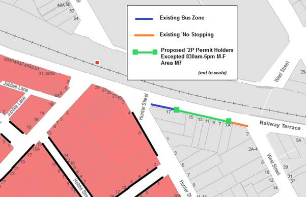
Figure 1: Permit Parking Proposal
FINANCIAL IMPLICATIONS
Cost of signage can be covered from Council’s operational budget for signs and lines.
PUBLIC CONSULTATION
Following receipt of a petition from four of the six affected households in Railway Terrace, letters were sent to affected residents seeking feedback on the proposal to install permit parking restrictions in Railway Terrace between Hunter Street and West Street. Two submissions were received, both supporting the proposal.
|
Feedback |
Officer’s Comment |
|
Strongly support proposal. I have to carry supplies from nearby streets when commuters take all the spots |
Both submissions support proposal which will result in increased opportunities for residents to park near their homes. |
|
Commuters park in front making it impossible to park for shopping, I have to carry shopping for a block |
CONCLUSION
Given that a petition has been received and that there are no objections, the proposal for an implementation of permit parking in Railway Terrace between West Street and Hunter Street, is supported in principle, subject to RMS consideration and approval.
|
|
Local Traffic Committee Meeting 4 November 2019 |
Subject: McKell Street, Birchgrove - Proposed 'No Parking' and 'No Stopping' Restrictions (Baludarri-Balmain Ward/Balmain Electorate/Leichhardt PAC)
Prepared By: Vinoth Srinivasan - Engineer - Traffic and Parking Services
Authorised By: John Stephens - Traffic and Transport Services Manager
SUMMARY
Council has received concerns from residents of McKell Street, Birchgrove regarding vehicle accessibility issues and sightline issues at the horizontal curve in McKell Street when vehicles park on both sides of the street.
|
THAT:
1. A 32.3m ‘No Parking’ restriction be installed along the northern side of McKell Street, Birchgrove, between No.29 and No.33 McKell Street; and
2. A 15.7m ‘No Stopping’ restriction be installed along the southern side of McKell Street, Birchgrove east of No.2 McKell Street. |
BACKGROUND
Council has received concerns from residents of McKell Street, Birchgrove regarding vehicle accessibility issues around the bend when vehicles park on both sides of the street.
Site Location & Road Network
|
Street Name(s) |
McKell Street, Birchgrove |
|
Section |
Between Church Street and Yeend Street |
|
Traffic Volume |
836 (2016) |
|
Recorded Accident History (5 year) |
Nil. |
|
Recorded 85% speed |
26km/h (2016) |
|
Speed Limit |
40km/h |
|
Carriageway width |
Approx. 7.8m |
|
Carriageway Type |
Two way street with kerb-side parking on both the northern and southern side |
|
Road Classification (State, Regional, Local) |
Local |
FINANCIAL IMPLICATIONS
Nil.
OTHER STAFF COMMENTS
It was initially proposed to install a 32.3m ‘No Parking’ restriction along the northern side of McKell Street, Birchgrove between No.29 and No.33 McKell Street as shown on the following plan.
![]()
PUBLIC CONSULTATION
|
A letter outlining the initial proposal was mailed out to the affected 160 properties in McKell Street, Birchgrove requesting residents’ views regarding the proposal.
Nine 9 responses were received with 3 in support and 6 in general support with request for changes.
|
|
|
Residents’ Comments |
Officer Comments |
|
Council should consider installing a similar ‘No Parking’ restriction on the southern side of McKell Street as parking under the large tree, especially in the vicinity of the road bend, obscures view of oncoming traffic. (5 similar comments) |
Council’s modified proposal seeks to install a 15.7m ‘No Stopping’ restriction along the southern side of McKell Street, Birchgrove. |
MODIFIED PROPOSAL
Council is proposing to modify the consulted proposal to address the additional concerns raised by the affected residents regarding parked vehicles on the southern side of the bend resulting in visibility issues and an inadequate travel lane width.
In order to alleviate this issue, it is proposed install a 32.3m ‘No Parking’ restriction along the northern side of McKell Street, Birchgrove between No.29 and No.33 McKell Street and a 15.7m ‘No Stopping’ restriction along the southern side of McKell Street, Birchgrove east of No.2 McKell Street.
The modified proposal is shown on the plan below.
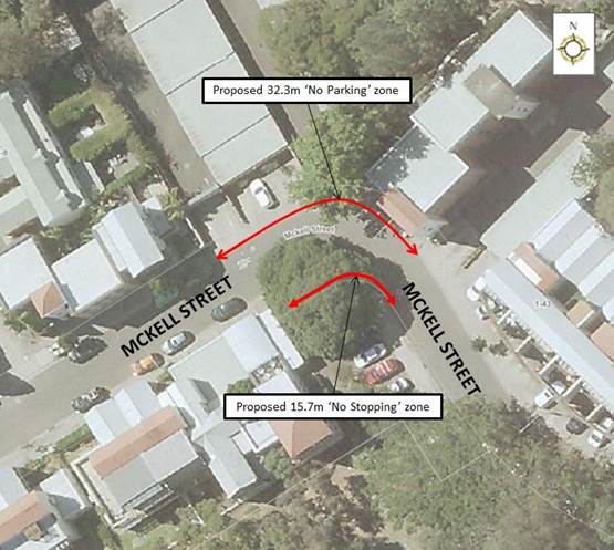
|
|
Local Traffic Committee Meeting 4 November 2019 |
Subject: Trafalgar Lane, Annandale - Proposed 'No Parking' Restriction (Baludarri-Balmain Ward/Balmain Electorate/Leichhardt PAC)
Prepared By: Vinoth Srinivasan - Engineer - Traffic and Parking Services
Authorised By: John Stephens - Traffic and Transport Services Manager
SUMMARY
Council has received concerns from residents of Nelson Street, Annandale regarding vehicles parking on the western side of Trafalgar Lane, Annandale and subsequently obstructing rear driveway access for properties No.154 – No.168 Nelson Street.
|
THAT the existing ‘No Parking’ restriction on the western side of Trafalgar Lane, Annandale, north of Booth Lane be extended by 46m to include the rear of boundaries of Nos.143-149 Trafalgar Street.
|
BACKGROUND
Site Location & Road Network
|
Street Name(s) |
Trafalgar Lane, Annandale |
|
Section |
Between Booth Lane and Piper Street |
|
Traffic Volume |
220 (2017) |
|
Recorded Accident History (5 year) |
Nil. |
|
Recorded 85% speed |
25.5km/h (2017) |
|
Speed Limit |
50km/h |
|
Carriageway width |
Approx. 5m |
|
Carriageway Type |
Two way street |
|
Road Classification (State, Regional, Local) |
Local |
FINANCIAL IMPLICATIONS
Nil.
OTHER STAFF COMMENTS
Council is proposing to extend the existing ‘No Parking’ zone on the western side of Trafalgar Lane, Annandale, north of Booth Lane by 46m to ensure unobstructed rear driveway access for properties No.154 – No.168 Nelson Street.
The proposal is shown on the following plan.
![]()
PUBLIC CONSULTATION
|
A letter outlining the above proposal was mailed out to the affected 17 properties in Nelson Street and Trafalgar Lane, Annandale, requesting residents’ views regarding the proposal.
4 responses were received with 2 in support, 1 in general support with request for changes and 1 in objection. |
|
|
Residents’ Comments |
Officer Comments |
|
The extension of the existing ‘No Parking’ zone will result in more cars illegally parking in the visitor parking spaces in our apartment complex. The cost of towing becomes the responsibility of the residents. |
This is a matter for the body corporate to enforce illegally parked vehicles on the private property.
|
|
Council should also install a ‘No Parking’ restriction on the eastern side of Trafalgar Lane. Vehicles constantly park so close to the corner of Trafalgar Lane and Booth Lane, restricting sightlines. As residents of Trafalgar Lane who have driveway access on the western side, we have the same restricted vehicular access issues due to parked vehicles on the opposite side. |
Council’s Parking Services team will be advised so that they can arrange appropriate enforcement of illegal parking behaviour at this location. The installation of a ‘No Stopping’ and ‘No Parking’ restrictions along the eastern side of Trafalgar Lane will be investigated as a separate matter as any potential loss of on-street parking will need to be consulted with affected residents. |
|
|
Local Traffic Committee Meeting 4 November 2019 |
Subject: Trafalgar Street, Annandale - Motorbike Parking (Gulgadya - Leichhardt Ward / Balmain Electorate / Leichhardt PAC)
Prepared By: Brinthaban Baskaran - Graduate Traffic Engineer
Authorised By: John Stephens - Traffic and Transport Services Manager
SUMMARY
Council has received concerns regarding blocked vehicular access and obstructed sightlines to the driveway of No.33-37 Trafalgar Street, Annandale. In order to prevent vehicles impeding driveway access and sightlines whilst making use of the short kerb space, it is proposed to convert the existing 2.2m unrestricted parking space into a 2.2m 'Motor Bike Only’ parking between No.33-37 Trafalgar Street, Annandale and the garden bed to the south.
|
THAT the existing 2.2m unrestricted kerb space between the driveway of No.33-37 Trafalgar Street, Annandale and the garden bed to the south be signposted as a 2.2m ‘Motor Bike Only’ parking space. |
BACKGROUND
The existing 2.2m kerb space between No.33-37 Trafalgar Street and the garden bed to the south is insufficient to accommodate a standard size vehicle without impeding driveway access ans sightlines to No.33-37 Trafalgar Street.
Site Location & Road Network
|
Street Name(s) |
Trafalgar Street |
|
Section |
Midblock |
|
Traffic Volume |
Not available |
|
Recorded Accident History (5 year) |
Nil |
|
Recorded 85% speed |
Not available |
|
Speed Limit |
50km/h |
|
Carriageway width |
Approx. 12.3m |
|
Carriageway Type |
Two way with one travel lane in each direction and kerb side parking lane |
|
Road Classification (State, Regional, Local) |
Local road |
FINANCIAL IMPLICATIONS
Nil.
OTHER STAFF COMMENTS
In order to prevent vehicles impeding driveway access and obstructing sightlines whilst making use of this redundant space, it is proposed to install a 2.2m ‘Motor Bike Only’ parking zone as detailed on the following plan.
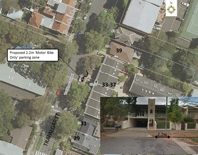
PUBLIC CONSULTATION
A letter outlining the above proposal was mailed out to the affected properties (33 properties) in Trafalgar Street, Annandale.
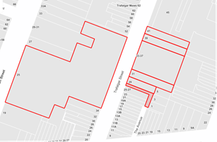
Four responses were received, two in support and two in objection of the proposal.
|
Residents’ Comments |
Officer Comments |
|
The parking spot takes small cars quite easily but not four-wheel drive. Maybe we could have lines painted on the road to stop over parking by large vehicles as a safety measure but no need to stop a small car parking. (2 similar comments)
No resident/parents who pick up their kids from school uses motorbike. Each house in No.33-37 has a double garage meaning we do not need the motor bike parking space. (2 similar comments) |
The existing 2.2m kerb space is insufficient to accommodate a standard size vehicle.
Installing a motorbike parking space will maximise use of this redundant 2.2m kerb space whilst providing parking for motorbikes and scooters. |
|
Completely support the proposal as it improves the visibility when exiting the carpark driveway onto Trafalgar St would help prevent serious accidents.
|
Noted. |
|
When we exit the driveway and turn right it is impossible to see oncoming traffic due to a car parked in the first car space to the right of the driveway.
Could this parking spot be changed into a ‘No Stopping’ zone or install a mirror so that drivers exiting this driveway have visibility
|
There is no proposal to remove parking to the right of the driveway.
The proposed treatment is preferred as it still retains on-street parking for another vehicle user group. Convex mirrors are not provided for private driveways. Also, they provide distorted vehicle distance and approach speed because of their convex nature. |
|
Council in recent months has put not one but two poles blocking access for a car to park in this space. The second one was completely unnecessary and makes it more difficult for a car to park. |
The bollards were installed to prevent illegal parking over the garden bed and overhanging into the driveway. |
|
|
Local Traffic Committee Meeting 4 November 2019 |
Subject: Outstanding Actions from July 2018 to date
(All Wards/All Electorates/All PACs)
Prepared By: Scipio Tam - Engineer - Traffic and parking Services (South)
Authorised By: John Stephens - Traffic and Transport Services Manager
SUMMARY
A review of Traffic Committee recommendations adopted by Council has been undertaken to provide a report on any outstanding actions for the Committee's consideration. The period of review was from July 2018 to date.
|
RECOMMENDATION
THAT this report be received and noted. |
BACKGROUND
The Committee's Chair, Councillor Macri had requested for a report on matters outstanding arising from Committee recommendations adopted by Council.
The review has revealed four outstanding actions to be completed and their status details are provided in the attached table.
FINANCIAL IMPLICATIONS
Nil.
OTHER STAFF COMMENTS
A table listing the Items is provided below, including staff comment.
|
Item No. |
LTC Meeting |
Council Meeting |
Location |
Description |
Action |
Comment |
|
LTC0319 Item 10 |
Monday, 4 March 2019 |
Tuesday, 26 March 2019 |
Fitzroy Lane, Newtown |
Fitzroy Lane, Newtown - Proposed parking restrictions (Damun Ward/Newtown Electorate/Inner West PAC) |
The Traffic Committee reviewing the decision in Item 10 in six months’ time; |
Resident issues within the laneway have appeared to have settled since initial changes to laneway. No concerns have been raised within the last 4-5 months. The matter will be reported to the December meeting. |
|
LTC0319 Item 30 |
Monday, 4 March 2019 |
Tuesday, 26 March 2019 |
Intersection of Chandos Street and Parramatta Road, Ashfield |
Councillor da Cruz raised concerns for a driveway located at the Chandos Street and Parramatta Road intersection that is not compliant with AS2890.1. Council Officers to investigate |
Matter has been referred to WestConnex to investigate and action. |
|
|
LTC0819 Item 1 |
Monday, 5 August 2019 |
Tuesday, 27 August 2019 |
Warren Road, Marrickville |
Warren Road Traffic Study (Midjuburi - Marrickville Ward/Summer Hill Electorate/ Inner West PAC |
A further report be provided to the Traffic Committee once RMS review of TMP is completed. (Requires RMS approval of TMP prior to any further action from Council) |
Awaiting RMS approval of TMP, including review of traffic modelling results, prior to any further action from Council. |
|
LTC0919 Item 18 |
Monday, 2 September 2019 |
Tuesday, 8 October 2019 |
Ramsay Street, Haberfield |
Ramsay Street, Haberfield – Review of Timed Parking |
Request tabled from Ramsay Street Medical Centre to review timed parking in Gillies Avenue and Ramsay Street, Haberfield. The Businesses along this section of the shopping strip are predominantly medical. The timed parking is underutilised as 1 hour is inadequate for medical wait times. Council Officers advised that they will consider a turnover occupancy survey. |
Scheduled for an investigation into this matter. |
PUBLIC CONSULTATION
Not applicable.
CONCLUSION
Report to be received and noted.