|
AGENDA R |

Local Traffic Committee Meeting
MONDAY 2 MARCH 2020
10.00am
|
|
Local Traffic Committee Meeting 2 March 2020 |
Function of the Local Traffic Committee
Background
Roads and Maritime Services (RMS) is legislated as the Authority responsible for the control of traffic on all NSW Roads. The RMS has delegated certain aspects of the control of traffic on local roads to councils. To exercise this delegation, councils must establish a local traffic committee and obtain the advice of the RMS and Police. The Inner West Council Local Traffic Committee has been constituted by Council as a result of the delegation granted by the RMS pursuant to Section 50 of the Transport Administration Act 1988.
Role of the Committee
The Local Traffic Committee is primarily a technical review and advisory committee which considers the technical merits of proposals and ensures that current technical guidelines are considered. It provides recommendations to Council on traffic and parking control matters and on the provision of traffic control facilities and prescribed traffic control devices for which Council has delegated authority. These matters are dealt with under Part A of the agenda and require Council to consider exercising its delegation.
In addition to its formal role as the Local Traffic Committee, the Committee may also be requested to provide informal traffic engineering advice on traffic matters not requiring Council to exercise its delegated function at that point in time, for example, advice to Council’s Development Assessment Section on traffic generating developments. These matters are dealt with under Part C of the agenda and are for information or advice only and do not require Council to exercise its delegation.
Committee Delegations
The Local Traffic Committee has no decision-making powers. The Council must refer all traffic related matters to the Local Traffic Committee prior to exercising its delegated functions. Matters related to State Roads or functions that have not been delegated to Council must be referred directly to the RMS or relevant organisation.
The Committee provides recommendations to Council. Should Council wish to act contrary to the advice of the Committee or if that advice is not supported unanimously by the Committee members, then the Police or RMS have an opportunity to appeal to the Regional Traffic Committee.
Committee Membership & Voting
Formal voting membership comprises the following:
· one representative of Council as nominated by Council;
· one representative of the NSW Police from each Local Area Command (LAC) within the LGA, being Newtown, Marrickville, Leichhardt and Ashfield LAC’s.
· one representative from the RMS; and
· State Members of Parliament (MP) for the electorates of Summer Hill, Newtown, Heffron, Canterbury, Strathfield and Balmain or their nominees.
Where the Council area is represented by more than one MP or covered by more than one Police LAC, representatives are only permitted to vote on matters which effect their electorate or LAC.
Informal (non-voting) advisors from within Council or external authorities may also attend Committee meetings to provide expert advice.
Committee Chair
Council’s representative will chair the meetings.
Public Participation
Members of the public or other stakeholders may address the Committee on agenda items to be considered by the Committee. The format and number of presentations is at the discretion of the Chairperson and is generally limited to 3 minutes per speaker. Committee debate on agenda items is not open to the public.
|
|
Local Traffic Committee Meeting 2 March 2020 |
|
AGENDA |
1 Apologies
2 Disclosures of Interest
3 Confirmation of Minutes Page
Minutes of 3 February 2020 Local Traffic Committee Meeting 5
4 Matters Arising from Council’s Resolution of Minutes
5 Part A – Items Where Council May Exercise Its Delegated Functions
Traffic Matters
ITEM Page
LTC0320 Item 1 Minor Traffic Facilities (All Wards/All Electorates/All LAC's) 30
LTC0320 Item 2 Premier Street, Marrickville – Request for ‘Mobility’ parking provision adjacent to Ferncourt Public School (Midjuburi - Marrickville Ward / Summer Hill Electrorate / Inner West PAC) 37
LTC0320 Item 3 Liberty Street and Bedford Street, Stanmore – Temporary full road closure to complete rail overbridge refurbishment works – 20 and 21 June 20220 (Damum-Stanmore Ward / Newtown Electorate / Inner West PAC) 40
Parking Matters
ITEM Page
LTC0320 Item 4 Haberfield Library Upgrade - Temporary Bus Relocation and Work Zone (Gulgadya-Leichhardt Ward/Summer Hill Electorate/Burwood PAC) 44
LTC0320 Item 5 Ravenue
Lane, Stanmore - Proposed 'No Parking 5am-10am Monday' to improve vehicular
access for Waste Collection Vehicles
(Damun - Stanmore Ward/ Summer Hill Electorate/ Burwood PAC) 47
LTC0320 Item 6 Myra Lane, Dulwich Hill - Proposed 'No Stopping' Restrictions (Djarrawunang- Ashfield Ward/ Summer Hill Electorate/ Inner West PAC) 51
LTC0320 Item 7 Pigott Street at The Boluevarde, Dulwich Hill - Proposed Statutory 10-metre 'No Stopping' restrictions (Djarrawunang -Ashfield Ward/ Summer Hill Electorate/ Inner West PAC) 54
LTC0320 Item 8 Charlotte Street, Ashfield- Request to convert 1P period parking to 1/2P period parking outside premises No's 18-20 Charlotte Street, Ashfield. (Diarrawunang-Ashfield Ward/Summer Hill Electorate/Burwood PAC) 57
LTC0320 Item 9 Railway Street, Petersham - Proposed installation of Loading Zone (Damun -Stanmore Ward/ Newtown Electorate/ Inner West PAC) 60
LTC0320 Item 10 Morris
Street, Summer Hill- Request to remove 1/2 P period parking restrictions
outside Nos. 24-28 Morris Street, Summer Hill.
(Diarrawunang- Ashfield Ward/Summer Hill Electrorate/Burwood PAC) 63
LTC0320 Item 11 Renwick Street, Marrickville - Proposed extension of short-term parking restrictions (Midjuburi - Marrickville Ward/ Summer Hill Electorate/ Inner West PAC) 66
LTC0320 Item 12 Hartley Street, Rozelle - Proposed 'No Stopping' restriction at intersection with Victoria Road (Baludarri-Balmain Ward/Balmain Electorate/Leichhardt PAC) 69
LTC0320 Item 13 Park Lane, Ashfield - Proposed 'No Parking' restrictions(Djarrawunang - Ashfield Ward/ Summer Hill Electorate/ Burwood PAC) 71
Late Items
Nil at time of printing.
6 Part B - Items for Information Only
Nil at the time of printing.
7 Part C - Items for General Advice
ITEM Page
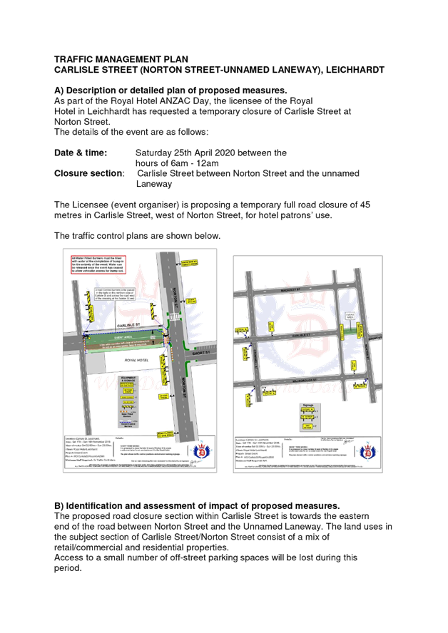
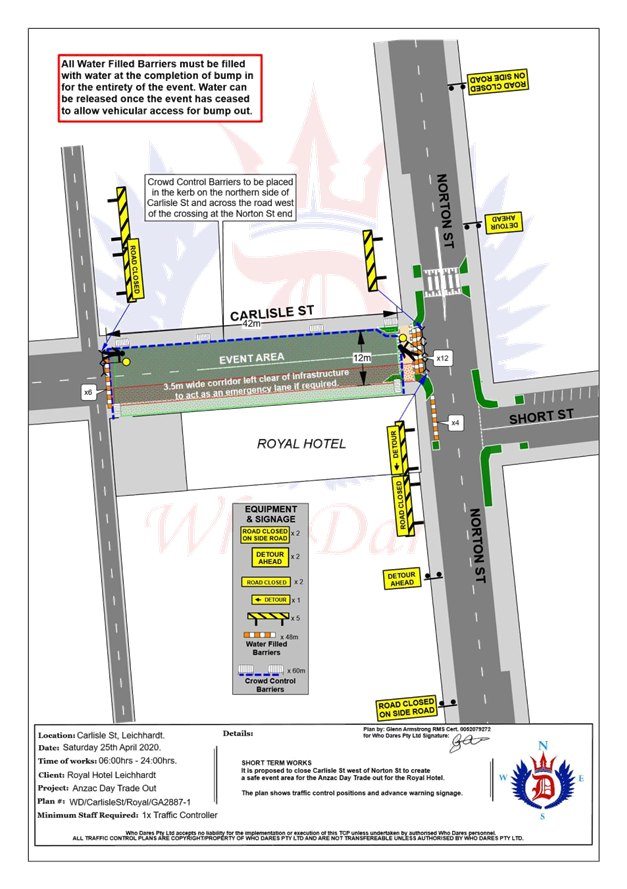
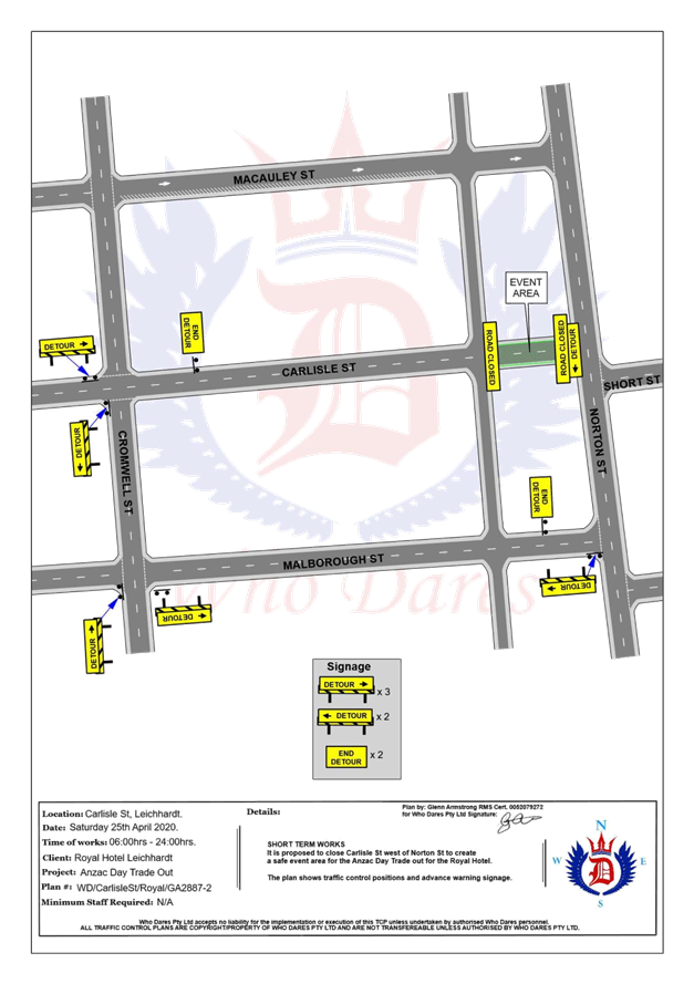
LTC0320 Item 14 Carlisle Street between Norton Street and Unnamed Laneway, Leichhardt - Road Occupancy - ANZAC Day Event (Gulgadya - Leichhardt Ward/Balmain Electorate/Leichhardt PAC) 74
8 General Business
9 Close of Meeting
|
|
Local Traffic Committee Meeting 2 March 2020 Minutes of 3 February 2020 |
Minutes of Local Traffic Committee Meeting
Held at Petersham Service Centre on 3 February 2020
Meeting commenced at 10.10am
ACKNOWLEDGEMENT OF COUNTRY BY CHAIRPERSON
I acknowledge the Gadigal and Wangal people of the Eora nation on whose country we are meeting today, and their elders past and present.
COMMITTEE REPRESENTATIVES PRESENT
|
|
|
|
Clr Victor Macri |
Councillor – Midjuburi-Marrickville Ward (Chair) |
|
Bill Holliday |
Representative for Jamie Parker MP, Member for Balmain |
|
Chris Woods |
Representative for Ron Hoenig MP, Member for Heffron |
|
Zack Solomon |
Representative for Jo Haylen MP, Member for Summer Hill |
|
Cathy Peters |
Representative for Jenny Leong MP, Member for Newtown |
|
Nazli Tzannes |
Transport for NSW (formerly Roads and Maritime Services) |
|
|
|
|
OFFICERS IN ATTENDANCE |
|
|
|
|
|
Tanmila Islam |
Transport for NSW (formerly Roads and Maritime Services) |
|
Asith Nagodavithane |
Transit Systems – Inner West Bus Services |
|
Adrian Pritchard |
Transit Systems – Inner West Bus Services |
|
Colin Jones |
Inner West Bicycle Coalition |
|
Clr Marghanita da Cruz |
Councillor – Gulgadya-Leichhardt Ward |
|
Sunny Jo |
IWC’s Acting Traffic and Transport Services Manager |
|
George Tsaprounis |
IWC’s Coordinator Traffic and Parking Services (South) |
|
Felicia Lau |
IWC’s Traffic Engineer |
|
Christina Ip |
IWC’s Business Administration Officer |
|
|
|
|
VISITORS |
|
|
|
|
|
Colleen Cook |
Item 9 – Resident |
|
Philip Carrick |
Item 9 – Resident |
|
Graeme Kerr |
Item 9 – Resident |
|
James Ding |
Item 12 – Resident |
|
David Tierney |
Item 18 – Consultant |
|
David Attwood |
Item 18 – Consultant |
|
Daniel Gonzalez |
Item 18 – Consultant |
|
James Starr |
Item 18 – Consultant |
|
Rhys Hazell |
Item 18 – Consultant |
|
|
|
|
APOLOGIES: |
|
|
|
|
|
Sgt Paul Vlachos |
NSW Police – Inner West Police Area Command |
|
SC Tony Kenny |
NSW Police – Inner West Police Area Command |
|
Manod Wickramasinghe |
IWC’s Traffic and Transport Services Manager |
DISCLOSURES OF INTERESTS:
Nil.
CONFIRMATION OF MINUTES
|
The Minutes of the Local Traffic Committee Meeting held on Monday, 2 December 2019 were confirmed. |
MATTERS ARISING FROM COUNCIL’S RESOLUTION OF MINUTES
The minutes of the Local Traffic Committee meeting held on Monday, 2 December 2019 are awaiting adoption.
|
LTC0220 Item 1 The Esplanade/Markham Place and Charlotte Street, Ashfield- Bicycle Contra-Flow in One-Way Streets (Djarrawunang-Ashfield Ward/Summer Hill Electorate/Burwood PAC) |
|
SUMMARY
The Ashfield Bicycle Users Group has requested that bicycle contra-flow arrangements be considered in the one-way streets of The Esplanade/Markham Place and Charlotte Street, Ashfield to allow for improved bicycle access to destinations within the Inner West Council.
Following investigations in line with the relevant standards and guidelines, together with the street environment and geometry, the following recommendations are therefore made.
Officer’s Recommendation
THAT:
1. No further action be undertaken in relation to providing a bicycle contra-flow treatment in Charlotte Street, between Elizabeth Street and Station Street, Ashfield;
2. ‘Bicycle Excepted’ signage be installed in the one-way section of the access lane at the rear of the Ashfield Catholic Club, between Station Street and Elizabeth Street; and
3. A bicycle contra-flow treatment in Markham Place/The Esplanade, Ashfield, between Markham Lane and Fox Lane/Brown Street, be approved in principle and listed on Council’s future Capital Works Program.
DISCUSSION
The Inner West Bicycle Coalition representative supported the proposed provision of a bicycle contra-flow in Markham Place/The Esplanade and requested that these works be prioritised.
The Committee members agreed with the Officer’s recommendation.
COMMITTEE RECOMMENDATION
THAT:
1. No further action be undertaken in relation to providing a bicycle contra-flow treatment in Charlotte Street, between Elizabeth Street and Station Street, Ashfield;
2. ‘Bicycle Excepted’ signage be installed in the one-way section of the access lane at the rear of the Ashfield Catholic Club, between Station Street and Elizabeth Street; and
3. A bicycle contra-flow treatment in Markham Place/The Esplanade, Ashfield, between Markham Lane and Fox Lane/Brown Street, be approved in principle and listed on Council’s future Capital Works Program.
For motion: Unanimous |
|
LTC0220 Item 2 Bay Run at UTS Rowing Club, Haberfield - Proposed signage and pavement marking upgrade (Gulgadya-Leichhardt Ward/Summer Hill Electorate/ Burwood PAC) |
|
SUMMARY
Council have received concerns from Bay Run users regarding safety on the shared path in front of the UTS Rowing Club, Haberfield. Council has scheduled an upgrade for this section of the Bay Run and the detailed design for the upgrade will commence mid-2020. In the interim, it is proposed that signage and pavement markings upgrade works be undertaken.
Officer’s Recommendation
THAT the proposed signage and pavement markings upgrade for the Bay Run around the UTS Haberfield Rowing Club building be approved.
DISCUSSION
Clr da Cruz suggested that cyclists and pedestrians be reminded to keep left on the shared path.
The Inner West Bicycle Coalition representative commented that the Rowing Club often parks a large vehicle in front of the building and suggested that if this is a legal parking space that it be linemarked so that it does not obstruct the shared path.
The Committee members agreed with the Officer’s recommendation.
COMMITTEE RECOMMENDATION
THAT the proposed signage and pavement markings upgrade for the Bay Run around the UTS Haberfield Rowing Club building be approved.
For motion: Unanimous |
|
LTC0220 Item 3 Murray Street, Marrickville – Road Occupancy – Request by Breastscreen NSW to Position a Mobile X-RAY Unit on Street Between Friday 10 April 2020 and Friday 5 June 2020 (Midjuburi - Marrickville Ward / Summer Hill Electorate / Marrickville PAC) |
|
SUMMARY
A request has been received from ‘BreastScreen New South Wales’ to position a mobile x-ray Unit within the existing ‘2P 8.30am – 6pm Mon – Fri 8.30am – 12.30pm Sat’ restrictions on the western side of Murray Street adjacent Marrickville Metro Shopping Centre, Marrickville, between Friday 10 April 2020 and Friday 5 June 2020 (a period of approximately eight (8) weeks). In previous years the van was annually located on Smidmore Street in the ‘No parking’ zone on the northern side of Smidmore Street adjacent Marrickville Metro Shopping Centre, Marrickville with no major problems being encountered. However, due to Marrickville Metro Expansion works this year a new location was required. It is recommended that the request be approved, on the basis of this being an annual occurrence with no major problems being encountered previously.
Officer’s Recommendation
THAT the road occupancy for the BreastScreen NSW mobile x-ray unit on the western side of Murray Street, Marrickville approximately 30 metres north of Smidmore Street, adjacent Marrickville Metro Shopping Centre, be supported for a period of approximately 8 weeks from Friday 10 April 2020 and Friday 5 June 2020, subject to the following conditions:
1. The existing ‘2P 8.30am – 6pm Mon – Fri 8.30am – 12.30pm Sat’ restrictions be temporarily removed for the proposed duration (i.e. between Friday 10 April 2020 and Friday 5 June 2020); 2. That all affected businesses, residents and other occupants must be notified of the road occupancy and activities at least one week prior to the commencement of the event. Any concerns or requirements raised by business proprietors, residents and other occupants must be resolved or accommodated by the applicant; 3. That the applicant contact Energy Australia/Ausgrid in relation to power access to the mobile laboratory; 4. That a copy of the Council approval letter must be made available on the site for inspection by relevant officers; 5. That the applicant must comply with any reasonable directive from Council’s Compliance Officers; and 6. That Council reserves the right to cancel this approval at any time.
DISCUSSION
The Committee members agreed with the Officer’s recommendation.
COMMITTEE RECOMMENDATION
THAT the road occupancy for the BreastScreen NSW mobile x-ray unit on the western side of Murray Street, Marrickville approximately 30 metres north of Smidmore Street, adjacent Marrickville Metro Shopping Centre, be supported for a period of approximately 8 weeks from Friday 10 April 2020 and Friday 5 June 2020, subject to the following conditions:
1. The existing ‘2P 8.30am – 6pm Mon – Fri 8.30am – 12.30pm Sat’ restrictions be temporarily removed for the proposed duration (i.e. between Friday 10 April 2020 and Friday 5 June 2020); 2. That all affected businesses, residents and other occupants must be notified of the road occupancy and activities at least one week prior to the commencement of the event. Any concerns or requirements raised by business proprietors, residents and other occupants must be resolved or accommodated by the applicant; 3. That the applicant contact Energy Australia/Ausgrid in relation to power access to the mobile laboratory; 4. That a copy of the Council approval letter must be made available on the site for inspection by relevant officers; 5. That the applicant must comply with any reasonable directive from Council’s Compliance Officers; and 6. That Council reserves the right to cancel this approval at any time. For motion: Unanimous
|
|
LTC0220 Item 4 Audley Street, Sadlier Crescent, Fisher Street, and parking lanes on New Canterbury Road Petersham – Temporary Full Road Closures For Special Event On Sunday 15 March 2020 – Bairro Portuguese Food and Wine Fair (Damum - Stanmore Ward / Newtown Electorate / Inner West PAC) |
|
SUMMARY
A Development Application (DA201700624) was approved in 2018 for the holding of the annual ‘Bairro Portuguese Food and Wine Fair’ for a five year period (i.e. 4 March 2018, 15 March 2019, 15 March 2020, 14 March 2021 and 13 March 2022).
This year’s event will be held on Sunday 15 March 2020 and will necessitate the temporary closure of Audley Street (between Trafalgar Street and New Canterbury Road), Sadlier Crescent (between Audley Street and Abels Lane) and Fisher Street (between Audley Street and Regent Street), as well as the parking lanes on New Canterbury Road (between Gordon Street and Audley Street), Petersham from 1.00am until 12.00 midnight as in previous years.
Officer’s Recommendation
THAT the proposed temporary road closure of Audley Street (between Trafalgar Street and New Canterbury Road), Sadlier Crescent (between Audley Street and Abels Lane) and Fisher Street (between Audley Street and Regent Street), as well as the parking lanes on New Canterbury Road (between Gordon street and Audley Street), Petersham, on Sunday, 15 March 2020, from 1.00am to 12.00 midnight, for the holding of the annual ‘Bairro Portuguese Food and Wine Fair’, be SUPPORTED subject to the applicant complying with but not limited to the following conditions;
1. A Traffic Management Plan (TMP) is submitted to and approved by Transport for NSW (formerly RMS); and an application for a Road Occupancy License and a temporary Speed Zone Authorisation is forwarded to and approved by the Transport Management Centre;
2. Notice of the proposed event is forwarded to all affected residents and businesses, including the NSW Police / Inner West Local Area Command, Fire and Rescue NSW, NSW Ambulance and Transit Systems;
3. Transit Systems – Inner West Bus Services be requested to implement a revised routing for scheduled bus services in Audley Street on the day of the event and install temporary bus stops as required;
4. A minimum four (4) metre unencumbered passage be available for emergency vehicles through the closed section; and
5. The occupation of the road carriageways must not occur until the roads have been physically closed.
DISCUSSION
The Committee members agreed with the Officer’s recommendation.
COMMITTEE RECOMMENDATION
THAT the proposed temporary road closure of Audley Street (between Trafalgar Street and New Canterbury Road), Sadlier Crescent (between Audley Street and Abels Lane) and Fisher Street (between Audley Street and Regent Street), as well as the parking lanes on New Canterbury Road (between Gordon street and Audley Street), Petersham, on Sunday, 15 March 2020, from 1.00am to 12.00 midnight, for the holding of the annual ‘Bairro Portuguese Food and Wine Fair’, be SUPPORTED subject to the applicant complying with but not limited to the following conditions;
1. A Traffic Management Plan (TMP) is submitted to and approved by Transport for NSW (formerly RMS); and an application for a Road Occupancy License and a temporary Speed Zone Authorisation is forwarded to and approved by the Transport Management Centre;
2. Notice of the proposed event is forwarded to all affected residents and businesses, including the NSW Police / Inner West Local Area Command, Fire and Rescue NSW, NSW Ambulance and Transit Systems;
3. Transit Systems – Inner West Bus Services be requested to implement a revised routing for scheduled bus services in Audley Street on the day of the event and install temporary bus stops as required;
4. A minimum four (4) metre unencumbered passage be available for emergency vehicles through the closed section; and
5. The occupation of the road carriageways must not occur until the roads have been physically closed.
For motion: Unanimous
|
|
LTC0220 Item 5 Continuous Footpath Treatment - Sorrie Street at the intersection of Booth Street, Balmain (Baludarri - Balmain Ward/Balmain Electorate/Leichhardt PAC) |
|
SUMMARY
As part of the Capital Works Program, Council has finalised a design plan for the proposed continuous footpath treatment on Sorrie Street at the intersection of Booth Street, Balmain. The intention of the proposal is to improve road safety for pedestrians and motorists.
Consultation was undertaken with owners and occupiers of properties in Booth Street, Sorrie Street and Palmer Street regarding the proposal. A summary of the consultation results are presented in this report for consideration. It is recommended that the proposed detailed design plan be approved.
Officer’s Recommendation
THAT the detailed design plan (Design Plan No.10114) for the installation of a proposed continuous footpath treatment on Sorrie Street at the intersection of Booth Street, Balmain be approved.
DISCUSSION
The Committee members agreed with the Officer’s recommendation.
COMMITTEE RECOMMENDATION
THAT the detailed design plan (Design Plan No.10114) for the installation of a proposed continuous footpath treatment on Sorrie Street at the intersection of Booth Street, Balmain be approved.
For motion: Unanimous
|
|
LTC0220 Item 6 Minor Traffic Facilities (All Wards/All Electorates/All PACS) |
|
SUMMARY
This report considers minor traffic facility applications received by Inner West Council and includes ‘Disabled Parking’ and ‘Works Zone’ requests.
Officer’s Recommendation
THAT:
1. The following ‘Disabled Parking’ zones be removed as they are no longer required; a. 6m ‘Disabled Parking’ zone in front of No. 136 Trafalgar St, Annandale, b. 6m ‘Disabled Parking’ zone in front of No. 32 High Street, Balmain, c. 6m ‘Disabled Parking’ zone in front of No. 76 Petersham Road, Marrickville, d. 6m ‘Disabled Parking’ zone in front of No. 136 Trafalgar Street, Annandale, and e. 6m ‘Disabled Parking’ zone in front of No. 54 Birchgrove Street, Balmain.
2. A 6.0m 'Disabled Parking’ zone be installed in front of No. 99 View Street, Annandale;
3. A 10m ‘No Stopping’ restriction be installed on the northern side of Mary Street, Rozelle, east of Alice Street followed by a 5.5m 'Disabled Parking Zone’ on the side boundary of No. 83 Denison Street, Rozelle;
4. A 6.0m 'Disabled Parking’ zone be installed adjacent to the existing ‘No Stopping zone’ on the south-eastern side of Wardell Road, on the side frontage of No. 70 Ewart Street, Dulwich Hill, south of Ewart Street;
5. A 10m 'Works Zone 7.00am – 6.00pm Mon-Fri and 8.00am - 1.00pm Sat' be installed at the front of No. 56 Young Street, Annandale, for 12 weeks;
6. A 9m 'Works Zone 7.00am – 6.00pm Mon-Fri and 8.00am - 1.00pm Sat' be installed at the front of No. 28 Waterloo Street, Rozelle, for 12 weeks;
7. A 9m 'Works Zone 7.00am – 6.00pm Mon-Fri and 8.00am - 1.00pm Sat' be installed in Charlotte Street at the rear of No. 172 Evans Street, Rozelle, for 12 weeks
8. A 10m ‘No Stopping’ restriction be installed on the eastern side of George Street, Balmain, south of Reynolds Street, followed by a 14m 'Works Zone 7.00am – 6.00pm Mon-Fri and 8.00am - 1.00pm Sat', on the side boundary of No. 11 Reynolds Street, Rozelle, for 12 weeks;
9. The following restrictions be installed in River Street, Birchgrove: a. A 9m 'Works Zone 7.00am – 6.00pm Mon-Fri and 8.00am - 1.00pm Sat'; ‘No Parking at other times’ restriction be installed on the western side of River Street in front of No. 14 River Street, Birchgrove, replacing the existing ‘No Parking’ restrictions for 12 weeks; and b. A ‘No Stopping’ zone be installed on the eastern side of River Street, north of Reuss Street at a statutory distance of 10m followed by a ‘No Parking 7.00am – 6.00pm Mon-Sat and 8.00am - 1.00pm Sat' restriction.
10. A 9m 'Works Zone 7.00am – 6.00pm Mon-Fri and 8.00am -1.00pm Sat' be installed in front of No. 12 Turner Avenue, Haberfield, for 12 weeks;
11. A 9m 'Works Zone 7.00am – 6.00pm Mon-Fri and 8.00am -1.00pm Sat' be installed in front of No. 2 Dickinson Avenue, Croydon, for 12 weeks;
12. A 18m 'Works Zone 7.00am – 6.00pm Mon-Fri and 8.00am -1.00pm Sat' be installed in front of No. 11a Moonbie Street, Summer Hill for 12 weeks; and
13. A 12m 'Works Zone 7.00am – 6.00pm Mon-Fri and 8.00am -1.00pm Sat' be installed in front of No. 5 George Street, Marrickville, for 12 weeks.
DISCUSSION
The Committee members agreed with the Officer’s recommendation.
COMMITTEE RECOMMENDATION
THAT:
1. The following ‘Disabled Parking’ zones be removed as they are no longer required; a. 6m ‘Disabled Parking’ zone in front of No. 136 Trafalgar St, Annandale, b. 6m ‘Disabled Parking’ zone in front of No. 32 High Street, Balmain, c. 6m ‘Disabled Parking’ zone in front of No. 76 Petersham Road, Marrickville, d. 6m ‘Disabled Parking’ zone in front of No. 136 Trafalgar Street, Annandale, and e. 6m ‘Disabled Parking’ zone in front of No. 54 Birchgrove Street, Balmain.
2. A 6.0m 'Disabled Parking’ zone be installed in front of No. 99 View Street, Annandale;
3. A 10m ‘No Stopping’ restriction be installed on the northern side of Mary Street, Rozelle, east of Alice Street followed by a 5.5m 'Disabled Parking Zone’ on the side boundary of No. 83 Denison Street, Rozelle;
4. A 6.0m 'Disabled Parking’ zone be installed adjacent to the existing ‘No Stopping zone’ on the south-eastern side of Wardell Road, on the side frontage of No. 70 Ewart Street, Dulwich Hill, south of Ewart Street;
5. A 10m 'Works Zone 7.00am – 6.00pm Mon-Fri and 8.00am - 1.00pm Sat' be installed at the front of No. 56 Young Street, Annandale, for 12 weeks;
6. A 9m 'Works Zone 7.00am – 6.00pm Mon-Fri and 8.00am - 1.00pm Sat' be installed at the front of No. 28 Waterloo Street, Rozelle, for 12 weeks;
7. A 9m 'Works Zone 7.00am – 6.00pm Mon-Fri and 8.00am - 1.00pm Sat' be installed in Charlotte Street at the rear of No. 172 Evans Street, Rozelle, for 12 weeks
8. A 10m ‘No Stopping’ restriction be installed on the eastern side of George Street, Balmain, south of Reynolds Street, followed by a 14m 'Works Zone 7.00am – 6.00pm Mon-Fri and 8.00am - 1.00pm Sat', on the side boundary of No. 11 Reynolds Street, Rozelle, for 12 weeks;
9. The following restrictions be installed in River Street, Birchgrove: a. A 9m 'Works Zone 7.00am – 6.00pm Mon-Fri and 8.00am - 1.00pm Sat'; ‘No Parking at other times’ restriction be installed on the western side of River Street in front of No. 14 River Street, Birchgrove, replacing the existing ‘No Parking’ restrictions for 12 weeks; and b. A ‘No Stopping’ zone be installed on the eastern side of River Street, north of Reuss Street at a statutory distance of 10m followed by a ‘No Parking 7.00am – 6.00pm Mon-Sat and 8.00am - 1.00pm Sat' restriction.
10. A 9m 'Works Zone 7.00am – 6.00pm Mon-Fri and 8.00am -1.00pm Sat' be installed in front of No. 12 Turner Avenue, Haberfield, for 12 weeks;
11. A 9m 'Works Zone 7.00am – 6.00pm Mon-Fri and 8.00am -1.00pm Sat' be installed in front of No. 2 Dickinson Avenue, Croydon, for 12 weeks;
12. A 18m 'Works Zone 7.00am – 6.00pm Mon-Fri and 8.00am -1.00pm Sat' be installed in front of No. 11a Moonbie Street, Summer Hill for 12 weeks; and
13. A 12m 'Works Zone 7.00am – 6.00pm Mon-Fri and 8.00am -1.00pm Sat' be installed in front of No. 5 George Street, Marrickville, for 12 weeks.
For motion: Unanimous |
|
LTC0220 Item 7 Pigott Lane, Marrickville – Request For ‘No Parking’ Restrictions (Midjuburi - Marrickville Ward / Summer Hill Electrorate / Inner West PAC) |
|
SUMMARY
Representations have been received from a local resident for the installation of full time ‘No Parking’ restrictions in Pigott Lane, Marrickville (eastern side of Pigott Lane, 40 metres south of the junction of Beauchamp Street and Pigott Lane) to improve access to off-street parking as vehicular access is often blocked by parked vehicles in the laneway. Residents have been notified of the proposal. It is recommended that the proposal be approved.
Officer’s Recommendation
THAT:
1. The installation of a 9 metre long full-time ‘No Parking’ zone on the eastern side of Pigott Lane, 40 metres southward of the junction of Beauchamp Street and Pigott Lane, adjacent to property No. 6 Beauchamp Street, Marrickville be APPROVED, in order to provide unobstructed vehicular access to the off-street car parking spaces; and
2. The applicant and Council’s Parking Officers be advised in terms of this report.
DISCUSSION
It was noted by a Committee member that there was an error in the installation diagram for the proposed left and right ‘No Parking’ signs and the signage will be corrected.
The Committee members agreed with the Officer’s recommendation.
COMMITTEE RECOMMENDATION
THAT:
1. The installation of a 9 metre long full-time ‘No Parking’ zone on the eastern side of Pigott Lane, 40 metres southward of the junction of Beauchamp Street and Pigott Lane, adjacent to property No. 6 Beauchamp Street, Marrickville be APPROVED, in order to provide unobstructed vehicular access to the off-street car parking spaces; and
2. The applicant and Council’s Parking Officers be advised in terms of this report.
For motion: Unanimous
|
|
LTC0220 Item 8 Lower Railway Parade, Sydenham - Proposed Installation of ‘No Stopping’ Signage (Midjuburi-Marrickville Ward / Heffron Electorate / Inner West PAC) |
|
SUMMARY
Council is proposing to install ‘No Stopping’ signage at 3 separate locations in Lower Railway Parade, Sydenham to reinforce NSW Road Rules relating to ‘No Stopping’ on a painted island.
Officer’s Recommendation
THAT the proposed ‘No Stopping’ signage be installed, at the location of each of the 3 painted islands, on the southern side of Lower Railway Parade, Sydenham, in order to reinforce NSW Road Rules relating to parking on painted islands.
DISCUSSION
Council Officers tabled a late submission from a business owner who did not support the proposal as they wished to retain a parking spot within the proposed ‘No Stopping’ zone.
The Committee members agreed with the Officer’s recommendation.
COMMITTEE RECOMMENDATION
THAT the proposed ‘No Stopping’ signage be installed, at the location of each of the 3 painted islands, on the southern side of Lower Railway Parade, Sydenham, in order to reinforce NSW Road Rules relating to parking on painted islands.
For motion: Unanimous |
|
LTC0220 Item 9 Clissold Street, Ashfield - Investigation of Proposed Works from the Ashfield Traffic Management Strategy (Djarrawunang-Ashfield Ward/Summer Hill Electrorate/Burwood PAC) |
|
SUMMARY
The Former Ashfield Local Government Area Traffic Management Strategy as adopted by Council in August 2018 recommended investigation of a number of actions in the vicinity of Clissold Street and Seaview Street Ashfield, including treatments at intersections and an investigation of a one-way pair route for buses in Clissold Street and Seaview Street. This report details the investigations and presents recommendations based on liaison with key stakeholders, investigations of crash data, traffic surveys and site investigations (including constraints).
Officer’s Recommendation
THAT:
1. The results of the investigation into the proposal of converting Clissold Street and Seaview Street as opposing directional one-way streets be noted, and that no further action be undertaken in relation to this matter;
2. The current parking arrangements in Clissold Street as previously adopted by the Former Ashfield Council in 2015 be retained, and that no further action be carried out to remove further parking in Clissold Street; and
3. The following works be adopted in principle and listed for consideration on the Capital Works Program:
a. Install kerb island build-outs on Prospect Road, north and south of Clissold Street, Ashfield and realignment of the north-western corner of the intersection;
b. Convert the existing at-grade pedestrian (zebra) crossing to a raised pedestrian (zebra) crossing in Clissold Street, west of Victoria Street;
c. Install kerb island build-outs on the east and west side of Victoria Street south of Clissold Street;
d. Install speed cushions, or speed humps in Queen Street on approaches to Clissold Street; and
e. Install kerb island build-outs on the east side of Victoria Street, north and south of Seaview Street and relocate the ‘STOP’ line out to align with the kerb islands.
DISCUSSION
Public speakers: Graeme Kerr, Colleen Cook and Philip Carrick attended at 11.13am
Mr Kerr requested that this matter be deferred for further community consultation and investigation of the pedestrian and vehicular safety issues and requested that further consideration be given to making Clissold and Seaview Street one-way.
Ms Cook and Mr Carrick agreed with Mr Kerr and commented that the environment and transport services in the area have changed and long-term traffic arrangements need to be reconsidered to keep up with the changes.
(Mr Kerr, Ms Cook and Mr Carrick left at 11.28am)
Council’s Officer advised that a Council representative met with residents last year to discuss issues raised by the speakers. Council’s Officer also stated that community consultation into converting Clissold Street and Seaview Street to one-way has not been undertaken as yet as the proposal at this stage was only being investigated for feasibility.
The Transit Systems representative stated that it would be difficult for buses to navigate from Holden Street to Seaview Street if Seaview Street were converted to one-way due to the constructions of kerbs. Furthermore, the narrow footpaths in Seaview Street make it unsuitable for bus stops.
The Transport for NSW representative requested for the design drawings of the kerb blisters and raised pedestrian crossing. Council Officers advised that the designs will be presented to the Committee for consideration following community consultation.
The Transit Systems representative requested for turning movement analysis be undertaken for the proposed kerb blisters to ensure that buses can safely navigate their way around the proposed devices. The representative also stated that as there are bus stops on both sides of the raised pedestrian crossing, the distance from the proposed crossing will need to comply with relevant Transport for NSW and bus design guidelines.
The Committee members agreed with the Officer’s recommendation.
COMMITTEE RECOMMENDATION
THAT:
1. The results of the investigation into the proposal of converting Clissold Street and Seaview Street as opposing directional one-way streets be noted, and that no further action be undertaken in relation to this matter;
2. The current parking arrangements in Clissold Street as previously adopted by the Former Ashfield Council in 2015 be retained, and that no further action be carried out to remove further parking in Clissold Street; and
3. The following works be adopted in principle and listed for consideration on the Capital Works Program:
a. Install kerb island build-outs on Prospect Road, north and south of Clissold Street, Ashfield and realignment of the north-western corner of the intersection;
b. Convert the existing at-grade pedestrian (zebra) crossing to a raised pedestrian (zebra) crossing in Clissold Street, west of Victoria Street;
c. Install kerb island build-outs on the east and west side of Victoria Street south of Clissold Street;
d. Install speed cushions, or speed humps in Queen Street on approaches to Clissold Street; and
e. Install kerb island build-outs on the east side of Victoria Street, north and south of Seaview Street and relocate the ‘STOP’ line out to align with the kerb islands.
For motion: Unanimous
|
|
LTC0220 Item 10 Lilyfield Road, Rozelle - Extension of Resident Parking Scheme (Baludarri-Balmain Ward/Balmain Electorate/Leichhardt PAC) |
|
SUMMARY
Council has received requests from residents of Lilyfield Road, Rozelle between Gordon Street and Easton Park for a Resident Parking Scheme (RPS) to address issues with long term parking by non-resident vehicles and the increase of WestConnex workers parking in the area.
Officer’s Recommendation
THAT a ‘2P 8am-10pm Mon-Fri, Permit Holders Excepted, Area R1’ parking restriction be installed on the northern side of Lilyfield Road west of Gordon Street, frontage of house Nos.59-65 Lilyfield Road, Rozelle.
DISCUSSION
The representative for the Member for Balmain asked when a proposed 350 space parking lot for WestConnex workers will be constructed. Council Officers advised that WestConnex have indicated the parking lot will be ready in February 2020.
The representative for the Member for Balmain commented that the WestConnex site also operates on Saturdays and as such, Area R1 parking restrictions should include Saturday. Council Officers advised that Council will be undertaking an area wide study in the coming months to address worker parking. Consultation to extend Area R1 parking restrictions to Saturdays can be included in this study.
The Committee members agreed with the Officer’s recommendation.
COMMITTEE RECOMMENDATION
THAT a ‘2P 8am-10pm Mon-Fri, Permit Holders Excepted, Area R1’ parking restriction be installed on the northern side of Lilyfield Road west of Gordon Street, frontage of house Nos.59-65 Lilyfield Road, Rozelle.
For motion: Unanimous
|
|
LTC0220 Item 11 Dalhousie Street, Haberfield - Removal of redundant bus stop facilities (Gulgadya-Leichhardt Ward/ Summer Hill Electorate/ Burwood PAC) |
|
SUMMARY
Council was notified by Transit Systems that two bus stops on Dalhousie Street, Haberfield (in front of House Nos. 29 and 34) have been made redundant and are no longer required. Removal of the bus zone will return unrestricted parking spaces to residents and visitors.
Officer’s Recommendation
THAT the existing Bus Zones and pavement tactiles be removed at the following locations:
a) 23m ‘Bus Zone’ on the western side of Dalhousie Street, Haberfield (frontage of house No.34); and b) 20m ‘Bus Zone’ on the eastern side of Dalhousie Street, Haberfield (frontage of house No.29).
DISCUSSION
The Committee members agreed with the Officer’s recommendation.
COMMITTEE RECOMMENDATION
THAT the existing Bus Zones and pavement tactiles be removed at the following locations:
a) 23m ‘Bus Zone’ on the western side of Dalhousie Street, Haberfield (frontage of house No.34); and b) 20m ‘Bus Zone’ on the eastern side of Dalhousie Street, Haberfield (frontage of house No.29).
For motion: Unanimous |
|
LTC0220 Item 12 Croydon Parking Study (Gulgadya-Leichhardt Ward/Summer Hill Electorate/Burwood PAC) |
|
SUMMARY
This is a recommendation to endorse the final Croydon Parking Study report. Council has recently undertaken Public Exhibition of the draft Croydon Parking Study through YourSay Inner West. The draft report proposed an expansion of the Resident Parking Scheme (RPS) on a number of streets in Croydon. The response results indicate that the community in general did not support the proposed strategy with a 73.6% non-support, as well as separate submissions and two petitions received during the public engagement. Several submissions requested a parking scheme with two free permits given to residents regardless of the number of off-street parking spaces. The views of the community on the proposed RPS areas indicate that whilst there is generally a desire to change the current parking management, concerns were raised with the proposed permit policy which has been used in other RPS areas in the Inner West.
In view of the high level of objections, it is recommended that the proposed Croydon Strategy not be supported at this time and further consideration for street specific RPS for the Croydon area cease for a period of 24 months until February 2022. Additionally, it is recommended that parking conditions be monitored on streets surrounding the Ashfield Aquatic Centre after its reopening in 2020. Any parking review is to be undertaken using data collected from the Croydon Parking Study.
Officer’s Recommendation
THAT:
1. The final Croydon Parking Study be noted;
2. In view of the results of the Public Exhibition, stage 1 and 2 of the Croydon Parking Strategy not be supported at this time;
3. Further consideration of street specific resident parking scheme for the Croydon area cease for 24 months until February 2022;
4. Parking conditions be monitored on streets surrounding the Ashfield Aquatic Centre after its reopening in 2020; and
5. Any future parking review for the Croydon area is to be undertaken using data collected from the Croydon Parking Study.
DISCUSSION
Public speaker: James Ding attended at 10.12am
Mr Ding, speaking on behalf of residents of property no. 70, 72, 74, 74a, 76 and 78 Thomas Street, requested the following:
(Mr Ding left at 10.21am)
Committee members noted that the first issue raised by Mr Ding was addressed in the report. Council Officers advised that issuing two parking permits to residents regardless of the number of parking spaces on properties would create a demand for on-street parking in excess of the available spaces on the street. Enforcement action will be requested from Council’s Regulatory Services to investigate the abandoned vehicles in Thomas Street.
The Committee members agreed with the Officer’s recommendation.
COMMITTEE RECOMMENDATION
THAT:
1. The final Croydon Parking Study be noted;
2. In view of the results of the Public Exhibition, stage 1 and 2 of the Croydon Parking Strategy not be supported at this time;
3. Further consideration of street specific resident parking scheme for the Croydon area cease for 24 months until February 2022;
4. Parking conditions be monitored on streets surrounding the Ashfield Aquatic Centre after its reopening in 2020; and
5. Any future parking review for the Croydon area is to be undertaken using data collected from the Croydon Parking Study.
For motion: Unanimous
|
|
LTC0220 Item 13 William Street, Leichhardt - Proposed 'No Stopping' Restrictions (Gulgadya-Leichhardt/Balmain Electorate/Leichhardt PAC) |
|
SUMMARY
Council has received concerns from parents of St Columba’s Catholic Primary School and residents regarding vehicle sight line issues when exiting Elswick Street and turning right into William Street at the intersection of Elswick Street and William Street, Leichhardt. This occurs when vehicles park too close to the intersection.
Officer’s Recommendation
THAT a ‘No Stopping’ restriction be installed on the southern side of William Street, east of Elswick Street, Leichhardt to reinforce the statutory 10m ‘No Stopping’ distance at the intersection.
DISCUSSION
The Committee members agreed with the Officer’s recommendation.
COMMITTEE RECOMMENDATION
THAT a ‘No Stopping’ restriction be installed on the southern side of William Street, east of Elswick Street, Leichhardt to reinforce the statutory 10m ‘No Stopping’ distance at the intersection.
For motion: Unanimous
|
|
LTC0220 Item 14 Trinity Grammar School Prospect Road, Summer Hill - Proposed Extension of 'No Stopping' Restrictions (Djarrawunang - Ashfield Ward / Summer Hill Electorate / Burwood PAC) |
|
SUMMARY
Council has received concerns regarding vehicles obstructing sight lines between pedestrians and vehicles on approach to the existing pedestrian zebra crossing outside Trinity Grammar School, Prospect Road, Summer Hill.
The existing ‘No Stopping’ zone on approach to the mid-block pedestrian zebra crossing is not to the current RMS requirements. Therefore, it is proposed to extend the existing ‘No Stopping’ zone by 10metres (to a total of 20 metres).
Officer’s Recommendation
That the existing ‘No Stopping’ zone be extended from 10m to 20 metres on the eastern side of Prospect Road, outside of 142-144 Prospect Road, Summer Hill (north of the pedestrian crossing).
DISCUSSION
The Committee members agreed with the Officer’s recommendation.
COMMITTEE RECOMMENDATION
That the existing ‘No Stopping’ zone be extended from 10m to 20 metres on the eastern side of Prospect Road, outside of 142-144 Prospect Road, Summer Hill (north of the pedestrian crossing).
For motion: Unanimous |
|
LTC0220
Item 15 Morgan Street, Petersham - Proposed Installation of Painted
Island to Reinforce NSW Road Rules
at Road Closure |
|
SUMMARY
THAT the proposed painted island on the eastern side of Morgan Street Road Closure, Petersham, at the point of entry for bicycles, in order to reinforce NSW Road Rules relating to parked vehicles obstructing cycleway, be APPROVED.
Officer’s Recommendation
THAT the proposed painted island on the eastern side of Morgan Street Road Closure, Petersham, at the point of entry for bicycles, in order to reinforce NSW Road Rules relating to parked vehicles obstructing cycleway, be APPROVED.
DISCUSSION
The Committee members agreed with the Officer’s recommendation.
COMMITTEE RECOMMENDATION
THAT the proposed painted island on the eastern side of Morgan Street Road Closure, Petersham, at the point of entry for bicycles, in order to reinforce NSW Road Rules relating to parked vehicles obstructing cycleway, be APPROVED.
For motion: Unanimous |
|
LTC0220 Item 16 Darling Street between Mort Street and Curtis Road, Balmain - Road Occupancy - ANZAC Day Dawn Service (Baludarri - Balmain Ward/Balmain Electorate/Leichhardt PAC) |
|
SUMMARY
In preparation to mark the ANZAC Day Dawn Service 2020 on Saturday, 25 April 2020, Inner West Council is organising the ANZAC Day dawn Service at the Loyalty Square War Memorial, Balmain. To facilitate the event, it is proposed to close Darling Street between Mort Street and Curtis Road between 2:30am and 9:30am.
Officer’s Recommendation
THAT the temporary road closure of Darling Street (Mort Street to Curtis Road), Balmain on Saturday, 25 April 2020 between 2.30am – 9.30am be supported, subject to the following conditions:
a. That an unencumbered passage minimum 3.0m wide be available for emergency vehicles through the closed section of Darling Street, Balmain;
b. The occupation of the road carriageway must not occur until the road has been physically closed; and
c. All affected residents and businesses, including the NSW Police Local Area Commander, Fire & Rescue NSW and NSW Ambulance Services be notified in writing, by the applicant, of the proposed temporary road closure at least 2 weeks in advance of the closure with the applicant making reasonable provision for stakeholders.
DISCUSSION
The Committee members agreed with the Officer’s recommendation.
COMMITTEE RECOMMENDATION
THAT the temporary road closure of Darling Street (Mort Street to Curtis Road), Balmain on Saturday, 25 April 2020 between 2.30am – 9.30am be supported, subject to the following conditions:
a. That an unencumbered passage minimum 3.0m wide be available for emergency vehicles through the closed section of Darling Street, Balmain;
b. The occupation of the road carriageway must not occur until the road has been physically closed; and
c. All affected residents and businesses, including the NSW Police Local Area Commander, Fire & Rescue NSW and NSW Ambulance Services be notified in writing, by the applicant, of the proposed temporary road closure at least 2 weeks in advance of the closure with the applicant making reasonable provision for stakeholders.
For motion: Unanimous
|
|
LTC0220 Item 17 Cary Street between Rofe Street and Elswick Street, Leichhardt - Road Occupancy - Street Party (Gulgadya - Leichhardt Ward/Balmain Electorate/Leichhardt PAC) |
|
SUMMARY
Council is initiating a Play Streets program in a small number of local streets and laneways throughout the Local Government Area (LGA). The long term aim of the program is for communities to be empowered to run self-managed play streets events in their neighbourhood with support and advice from Council. To facilitate the pilot event, it is proposed to close Cary Street, Leichhardt between Rofe Street and Elswick Street on Sunday, 15 March 2020 between 3.00pm and 5.00pm.
Officer’s Recommendation
THAT the temporary road closure of Cary Street, Leichhardt between Rofe Street and Elswick Street, to conduct a Play Streets event (Street Party) on Sunday, 15 March 2020, from 3.00pm-5.00pm, be approved, subject to the conditions as set out as per the Street Party Application Form as well as the following additional conditions:
a. That an unencumbered passage minimum of 3.0m wide be available for emergency vehicles through Cary Street, Leichhardt between Rofe Street and Elswick Street;
b. The occupation of the road carriageway must not occur until the road has been physically closed; and
c. All affected residents and businesses, including the NSW Police Local Area Commander, Fire & Rescue NSW and NSW Ambulance Services be notified in writing, by the applicant, of the proposed temporary road closure at least 14 days in advance of the closure with the applicant making reasonable provision for stakeholders.
DISCUSSION
The Committee members agreed with the Officer’s recommendation.
COMMITTEE RECOMMENDATION
THAT the temporary road closure of Cary Street, Leichhardt between Rofe Street and Elswick Street, to conduct a Play Streets event (Street Party) on Sunday, 15 March 2020, from 3.00pm-5.00pm, be approved, subject to the conditions as set out as per the Street Party Application Form as well as the following additional conditions:
a. That an unencumbered passage minimum of 3.0m wide be available for emergency vehicles through Cary Street, Leichhardt between Rofe Street and Elswick Street;
b. The occupation of the road carriageway must not occur until the road has been physically closed; and
c. All affected residents and businesses, including the NSW Police Local Area Commander, Fire & Rescue NSW and NSW Ambulance Services be notified in writing, by the applicant, of the proposed temporary road closure at least 14 days in advance of the closure with the applicant making reasonable provision for stakeholders.
For motion: Unanimous
|
|
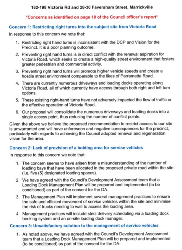
LTC0220 Item 18 182-198 Victoria Road and 28-30 Faversham Street, Marrickville – DA 201900096 – Mixed Residential Commercial Use Development (Midjuburi - Marrickville Ward / Summer Hill Electorate / Inner West PAC) |
|
SUMMARY
Council has received an application to demolish existing improvements and construct a mixed-use development ranging from 6 storeys to 12 storeys in height comprising 2,387sqm of ground floor retail floorspace, 272 residential apartments and two levels of associated basement car parking, including the provision of public domain and landscaping works.
The application is required to be referred to the Local Traffic Committee for consideration under State Environmental Planning Policy (Infrastructure) 2007.
Comments of the Local Traffic Committee will be referred to Council’s Development Assessment Section for consideration in determining the Development Application.
Officer’s Recommendation
THAT the report be received and noted.
DISCUSSION
Public speakers: David Tierney from TITFA Consultancy and David Attwood from Ethos Urban attended at 10.35am.
Mr Tierney and Mr Attwood addressed a number of concerns raised by Council’s Traffic Engineer in the report and tabled a written response to those concerns (Attachment 1).
(Mr Tierney and Mr Attwood left at 10.54am)
Clr da Cruz commented that active transport could be encouraged around the site through strategic placement of pedestrian crossings.
The Committee noted that the consultants had indicated that the consultants had indicated that they will address a number of issues highlighted within the Officer’s report. The Committee also noted the consultant’s case for removal of the ‘No Right Turn’ peak hour ban. However, Committee members agreed with the conclusion within the Officer’s report and agreed that it was a reasonable approach to address safety concerns at the proposed intersection.
The Committee members agreed with the Officer’s conclusions.
COMMITTEE RECOMMENDATION
THAT the report be received and noted.
For motion: Unanimous
|
General Business
|
LTC0220 Item 19 Warren Road, Marrickville proposal
|
|
Clr Macri asked for a progress update on the Warren Road improvement proposal. The Transport for NSW representative advised that work on the project is ongoing and Council has had discussions with them to review the traffic signals and upgrading the site.
|
|
LTC0220 Item 20 Resident parking in Hartley Street, Balmain
|
|
Clr Macri stated that residents of Hartley Street have been asking when resident parking will be implemented in the street. Council Officers will follow up with Clr Macri on this matter.
|
|
LTC0220 Item 21 Rat running in Elswick Street North, Leichhardt
|
|
The representative for the Member for Balmain stated that residents of Elswick Street North have complained of motorists using the street and the lanes on either side of Elswick Street North as a rat run to travel to the city from Darley Road. This occurs when traffic banks up on Darley Road at the City West Link intersection. The representative will liaise with Transport for NSW on this matter.
|
|
LTC0220 Item 22 Safety at the intersection of Edgeware Road, Alice Street and Llewellyn Street, Marrickville
|
|
The representative for the Member for Newtown tabled a letter from a resident concerning the intersection of Edgeware Road, Alice Street and Llewellyn Street. The resident was concerned with safety at this intersection following a recent hit and run incident when a cyclist was hit by a truck, and an incident where an SUV overturned onto the footpath after being hit by a bus. The resident requested that the intersection be improved by reducing the speed limit, installing red light cameras, installing a turning arrow from Llewellyn Street into Edgeware Road and improving signage. The representative for Transport for NSW advised that they can review the crash history of the intersection and investigate how the intersection could be improved. Transport for NSW will liaise with Council on this issue.
|
|
LTC0220 Item 23 WestConnex trucks on non-approved roads
|
|
The representative for the Member for Newtown stated that she was advised by WestConnex that their construction (truck and dog) vehicles can travel along non-approved roads if those vehicles are unloaded. The representative requested that this be confirmed.
|
Meeting closed at 12.07pm.
ATTACHMENT 1
|
|
Local Traffic Committee Meeting 2 March 2020 |
Subject: Minor Traffic Facilities (All Wards/All Electorates/All LAC's)
Prepared By: Davide Torresan - Coordinator - Road Access Services
Authorised By: Manod Wickramasinghe - Traffic and Transport Planning Manager
SUMMARY
This report considers minor traffic facility applications received by Inner West Council and includes ‘Disabled Parking’ and ‘Works Zone’ requests.
|
RECOMMENDATION
THAT:
1. The following ‘Disabled Parking’ zones be removed as they are no longer required; a. 6m ‘Disabled Parking’ zone in front of No. 3 O`Hara Street, Marrickville;
2. A 6.0m 'Disabled Parking’ zone be installed in front of No. 63 Pigott Street, Dulwich Hill;
3. A 6.0m 'Disabled Parking’ zone be installed in front of No. 2 Starling Street, Rozelle;
4. A 6.0m 'Disabled Parking’ zone be installed in front of No. 21 Pashley Street, Balmain;
5. A 30m 'Works Zone 7.00am – 6.00pm Mon-Fri and 8.00am - 1.00pm Sat' be installed on the north-western side of Dibble Avenue, on the side boundary of No. 56 Ewart Street, Marrickville, for 12 weeks;
6. A 9m 'Works Zone 7.00am – 6.00pm Mon-Fri and 8.00am - 1.00pm Sat' be installed in front of No 132. Evans Street, Rozelle, adjacent to the existing ‘No Stopping’ restriction, for development at No. 144 Evans Street, for 12 weeks, subject to resident consultation; and
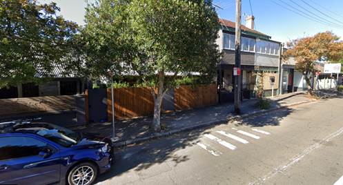
7. A 12m 'Works Zone 7.00am – 6.00pm Mon-Fri and 8.00am - 1.00pm Sat' be installed on the western side of Norton Street, in front of No. 46 Norton Street, Leichhardt, for 12 weeks, subject to resident notification;
|
BACKGROUND
Requests have been received from residents within the Local Government Area (LGA) for the provision of mobility parking spaces outside their residence.
It is recommended that the following 'Mobility Parking' spaces be approved as the applicant’s current medical conditions warrant the provision of these spaces and they have constrained or no off-street parking opportunities. For the mobility parking space requests, a copy of the RMS disability parking permit and a medical certificate in support of the applications was submitted to Council.
The Disabled Parking Zones recommended for approval are installed under the following conditions:
1. The operation of the Disabled Parking Zone is valid for two (2) years from the date of installation.
2. The Disabled Parking Zone will be scheduled for review within two (2) years of the date of installation, then every twelve (12) months thereafter. The purpose of the reviews is to confirm that circumstances have not changed and as a result, the applicant may be requested to furnish a medical certificate and current Mobility Parking Scheme Permit to demonstrate the need for the continuation of the Mobility Parking Zone.
3. The Disabled Parking Zone is not exclusively reserved for the use of the applicant. It may also be used by any holder of a valid Mobility Parking Scheme Permit.
4. There is an obligation on the applicant to advise Council if circumstance change.
Applications have also been received for ‘Work Zones’. The applications have been reviewed according to Council’s conditions of approval on the Work Zones application forms. It is also recommended that the following ‘Works Zones’ be approved.
FINANCIAL IMPLICATIONS
Nil.
OTHER STAFF COMMENTS
1. Removal of ‘Disabled Parking’ restrictions – Various
Residents have advised that the following ‘Disabled Parking’ zones are no longer required. Council staff have contacted the original applicants and they have confirmed that the ‘Disabled Parking’ zones are no longer required.
It is recommended that the following ‘Disabled Parking’ zone be removed:
a. 6m ‘Disabled Parking’ zone in front of No. 3 O`Hara Street, Marrickville,
2. Installation of ‘Disabled Parking’ Restriction – 63 Pigott Street, Dulwich Hill
The resident of No. 63 Pigott Street, Dulwich Hill, has requested the installation of 'Disabled Parking Zone’ in front of the resident’s property. A site investigation has revealed the property does not have an off-street parking facility. The applicant does not require the use of wheelchair.
It is recommended that a 6.0m 'Disabled Parking’ zone be installed in front of No. 63 Pigott Street, Dulwich Hill.
63 Pigott Street, Dulwich Hill
3. Installation of ‘Disabled Parking’ Restriction – 2 Starling Street, Rozelle
The resident of No. 2 Starling Street, Rozelle, has requested the installation of 'Disabled Parking Zone’ in front of the resident’s property. A site investigation has revealed the property does not have an off-street parking facility. The applicant does not require the use of wheelchair.
It is recommended that a 6.0m 'Disabled Parking’ zone be installed in front of No. 2 Starling Street, Rozelle.
2 Starling Street, Rozelle
4. Installation of ‘Disabled Parking’ Restriction – 21 Pashley Street, Balmain
The resident of No. 21 Pashley Street, Balmain, has requested the installation of 'Disabled Parking Zone’ in front of the resident’s property. A site investigation has revealed the property does not have an off-street parking facility. The applicant does not require the use of wheelchair.
It is recommended that a 6.0m 'Disabled Parking’ zone be installed in front of No. 21 Pashley Street, Balmain.
21 Pashley Street, Balmain
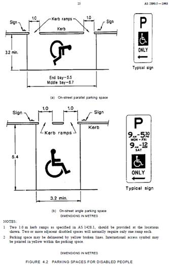
Technical Standards
Australian Standard AS2890.5-1993 “On-Street Parking” states the following in regard to the provision of parking for people with a disability:
“Parallel parking spaces shall not be marked as disabled spaces, nor included in the count of spaces available for people with disabilities unless –
i. A 3.2m wide space can be provided, e.g. by indenting the space into the footpath area; and
ii. Kerb ramps as shown in Figure 4.2(a) are also provided”.
It should be noted that due to the limited width of streets around the LGA, it is often difficult to comply with these requirements for the parking space dimensions. This may also result in the loss of some adjacent on-street parking spaces.
Mobility parking spaces are primarily intended for on-street and off-street parking at destinations, such as in commercial/retail areas and public car parks near hospitals, schools and public transport facilities where multiple usages can be expected. They were generally not intended for points of origin such as reserving on-street parking. As such, they are only proposed where required for wheelchair access at the cost of the applicants.
A mobility parking space is not intended for the sole use of one applicant, but rather a shared facility that can used by all authorised persons having a RMS mobility permit.
5. Installation of ‘Works Zone’ Restriction – 56 Ewart Street, Marrickville
The applicant has requested the installation of a temporary 30m 'Works Zone 7.00am – 6.00pm Mon-Sat and 8.00am - 1.00pm Sat' (unless noted otherwise on the Development Consent) for 12 weeks at No. 56 Ewart Street, Marrickville, for development works at the property.
It is recommended that a 30m 'Works Zone 7.00am – 6.00pm Mon-Fri and 8.00am - 1.00pm Sat' be installed on the north-western side of Dibble Avenue, on the side boundary of No. 56 Ewart Street, Marrickville, for 12 weeks.
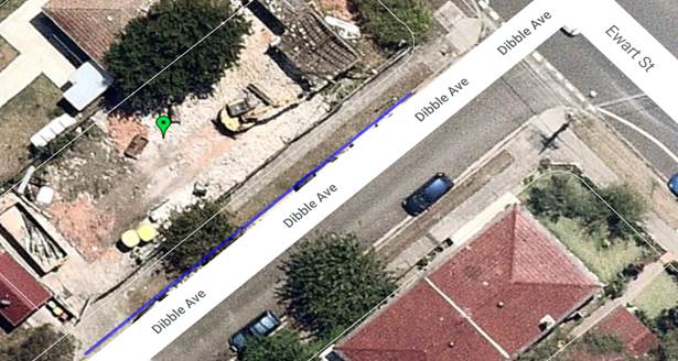
56 Ewart Street, Marrickville – proposed works zone location
6. Installation of ‘Works Zone’ Restriction – 144 Evans Street, Rozelle
The applicant at No 144 Evans Street, Rozelle, has requested the installation of a temporary 9m 'Works Zone 7.00am – 6.00pm Mon-Sat and 8.00am - 1.00pm Sat' (unless noted otherwise on the Development Consent) for 12 weeks at the front of No. 132 Evans Street, Rozelle, for development works at the property. The proposed works zone is in the closest parking space available following the existing ‘No Stopping restrictions’ associated with the traffic lights at the intersection of Evans Street and Victoria Road. The applicant will be required to the consult the adjacent buildings as the works zone will situated in front of the neighbouring property prior to installation of the works zone.
It is recommended that a 9m 'Works Zone 7.00am – 6.00pm Mon-Fri and 8.00am - 1.00pm Sat' be installed in front of No 132. Evans Street, Rozelle, adjacent to the existing No Stopping sign, for development at No. 144 Evans Street, Rozelle, for 12 weeks, subject to resident consultation;
144 Evans Street, Rozelle – proposed works zone location
7. Installation of ‘Works Zone’ Restriction – 46 Norton Street, Leichhardt
The applicant has requested the installation of a temporary 12m 'Works Zone 7.00am – 6.00pm Mon-Sat and 8.00am - 1.00pm Sat' (unless noted otherwise on the Development Consent) for 12 weeks at the front of No. 46 Norton Street, Leichhardt, for development works at the property. The applicant will be required to the notify the adjacent building as the works zone will extend in front of the neighbouring property.
It is recommended that a 12m 'Works Zone 7.00am – 6.00pm Mon-Fri and 8.00am - 1.00pm Sat' be installed at the front of No. 46 Norton Street, Leichhardt, for 12 weeks subject to resident notification.
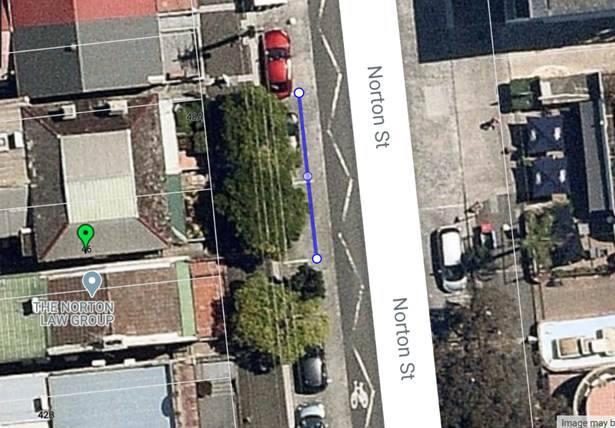
46 Norton Street, Leichhardt – proposed works zone location
PUBLIC CONSULTATION
Nil
|
|
Local Traffic Committee Meeting 2 March 2020 |
Subject: Premier Street, Marrickville – Request for ‘Mobility’ parking provision adjacent to Ferncourt Public School (MIDJUBURI - MARRICKVILLE WARD / SUMMER HILL ELECTRORATE / INNER WEST PAC)
Prepared By: Jennifer Adams - Engineer – Traffic and Parking Services
Authorised By: Manod Wickramasinghe - Traffic and Transport Planning Manager
SUMMARY
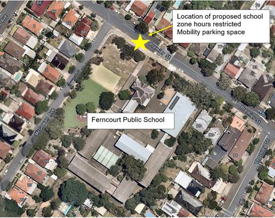
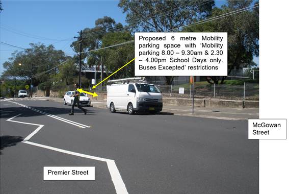
A request has been received from the Principal of Ferncourt Public School for the provision of a dedicated Mobility Parking space outside Ferncourt Public School, 74 Premier Street, Marrickville and within the existing drop-off zone in order to improve accessibility for students attending the school. The 'Mobility Parking' restrictions will be applicable from '8.00-9.30 am and 2.30-4.00 pm School Days’ only.
|
RECOMMENDATION
THAT a 6m ‘Mobility Parking; 8.00 - 9.30 am and 2.30 – 4.00 pm School Days, Buses Excepted ' space be installed on the southern side of Premier Street, Marrickville west of the western access gate adjacent to the Ferncourt Public School and within the existing drop-off zone. |
BACKGROUND
The Principal of Ferncourt Public School has submitted an application for the provision of a short stay accessibility parking bay (School days only) in Premier Street, Marrickville outside Ferncourt Public School. The Principal advised that a new student now attends the School and that the child has a condition which affects their ability to walk and it is very difficult for the parent of the child to obtain a parking space nearby the school.
FINANCIAL IMPLICATIONS
Nil.
OFFICER COMMENTS
Ferncourt Public School has an enrolment of over 350 children. School hours are from 9.00am to 3.25pm and Council's OOSH facilities on the same site operate from 7.00 - 9.00am, and 3.25 - 6.00pm.
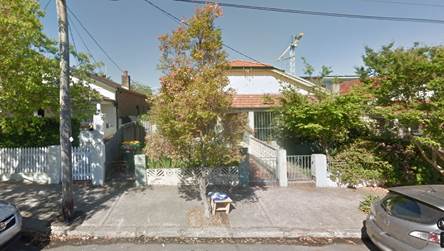
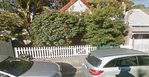
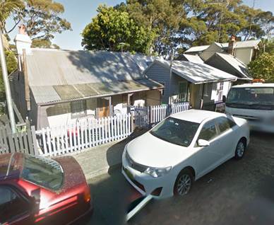
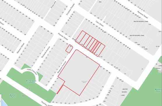
Ferncourt Public School is located on Premier Street and its western side fronts McGowan Avenue. Main access to the school is via Premier Street and students also use a side gate access on McGowan Avenue. The School does not have off-street parking spaces for parents and visitors. There is a high demand for on-street parking in the area (refer to the attached locality map and photographs).
At present, unrestricted parking is permitted on the north side of Premier Street with drop-off zones, 'No Parking 8.00am-9.30am and 2.30pm-4.00pm School Days’ and 'No Parking 8.00am-9.30am and 2.30pm-4.00pm School Days Buses Excepted' restrictions, located on the south side of Premier Street adjacent the school boundary both west and east (respectively) of the pedestrian crossing.
There are no mobility parking spaces in the vicinity of the school. The Principal of the school has confirmed that they support the provision of a Mobility Parking space in Premier Street for their mobility impaired student.
It is proposed that a Mobility Parking Space be provided on the southern side of Premier Street, directly west of the pedestrian crossing and near the gate to Ferncourt Public School, Marrickville as shown in the following diagram.
CONSULTATION
No responses have been submitted to Council.
|
|
Local Traffic Committee Meeting 2 March 2020 |
Subject: Liberty Street and Bedford Street, Stanmore – Temporary full road closure to complete rail overbridge refurbishment works – 20 and 21 June 20220 (DAMUM-STANMORE WARD / NEWTOWN ELECTORATE / INNER WEST PAC)
Prepared By: Jennifer Adams - Engineer – Traffic and Parking Services
Authorised By: Manod Wickramasinghe - Traffic and Transport Planning Manager
SUMMARY
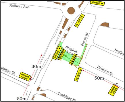
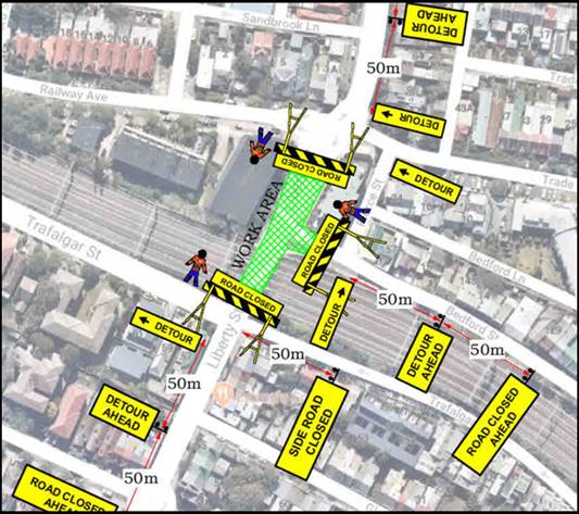
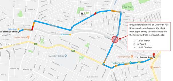
An application has been received from Sydney Trains (Transport for NSW - TfNSW) for the temporary full road closure of Liberty Road (between Railway Avenue and Trafalgar Street) and Bedford Street (between Liberty Street and Pierce Street), Stanmore from 4am Saturday, 20 June to 4pm Sunday, 21 June 2020 in order to finish refurbishment works on the Liberty Street Stanmore rail over bridge. The streets will be temporarily closed to all vehicular traffic, including emergency vehicles and local residents. It is recommended that the proposed temporary full road closures be approved, subject to the conditions outlined in this report.
|
RECOMMENDATION
THAT the proposed temporary full road closure of Liberty Road (between Railway Avenue and Trafalgar Street) and Bedford Street (between Liberty Street and Pierce Street), Stanmore from 4am Saturday, 20 June to 4pm Sunday, 21 June 2020 be approved, in order to finish refurbishment works on the Liberty Street Stanmore rail over bridge subject, but not limited to, the following conditions:
1. A Road Occupancy License be obtained by the applicant from the Transport Management Centre;
2. All affected residents and businesses, including the NSW Police Local Area Commander, Fire & Rescue NSW and the NSW Ambulance Services be notified in writing, by the applicant, of the proposed temporary road closure at least 7 days in advance of the closure with the applicant making reasonable provision for stakeholders; and
3. The occupation of the road carriageway must not occur until the road has been physically closed.
|
BACKGROUND
An application has been received from Sydney Trains (TfNSW) for the temporary full road closure of Liberty Road (between Railway Avenue and Trafalgar Street) and Bedford Street (between Liberty Street and Pierce Street), Stanmore from 4am Saturday, 20 June to 4pm Sunday, 21 June 2020 in order to finish refurbishment works on the Liberty Street, Stanmore rail overbridge. The streets will be temporarily closed to all vehicular traffic, including emergency vehicles and local residents.
The proposed works are to be conducted during a rail shut down weekend – WE51 – 20-21 June 2020.
Early closure of Bedford Street may occur to commence mobilisation and site setup with minimal impact to traffic and residents.
Closure of Liberty Street is proposed to commence in line with TfNSW road closure approval.
FINANCIAL IMPLICATIONS
Nil.
OFFICER COMMENTS
Liberty Street is a regional road which carries around 24,000 vehicles per day. At the railway over bridge the width of the roadway is approximately 11 metres in width. It is noted that the full road closure will divert traffic to either Crystal Street or King Street, both of which are remote from Liberty Street.
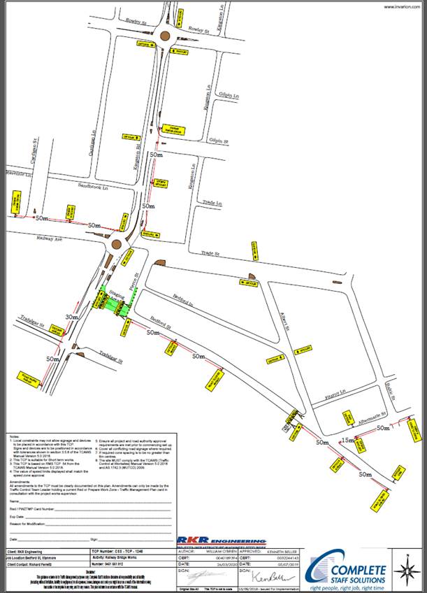
The Traffic Control Plans submitted previously by the applicant are shown below.
Noise impacts may be an issue for residents in the area. Council Officers recommend that the notification letters, to be sent by Sydney Trains, include advice on the impact of night time closures and include a contact number so residents can contact Sydney Trains directly if any issues arise.
CONCLUSION
It is recommended that the proposed temporary full road closure be approved, subject to, but not limited to, the conditions outlined in this report.
|
|
Local Traffic Committee Meeting 2 March 2020 |
Subject: Haberfield Library Upgrade - Temporary Bus Relocation and Work Zone (Gulgadya-Leichhardt Ward/Summer Hill Electorate/Burwood PAC)
Prepared By: Felicia Lau - Engineer - Traffic and Parking Services
Authorised By: Manod Wickramasinghe - Traffic and Transport Planning Manager
SUMMARY
Council Major Projects and Facilities has received an approval for a Development Application (DA) to upgrade the Haberfield Centre and Library. As part of the construction works, it is proposed that a temporary ‘Work Zone’ be established in front of the library at No. 78 Dalhousie Street. The existing bus stop will be re-located approximately 20m south for approximately 37 weeks.
|
RECOMMENDATION
THAT:
1. A 20m ‘Work Zone 7:00am -6:00pm Mon-Fri and 8:00am-1:00pm Sat be installed at the front of No.78 Dalhousie Street, Haberfield, for 37 weeks, temporarily replacing the existing bus stop; and
2. The existing bus stop in front of No. 78 Dalhousie Street, Haberfield be re-located 20m south, closer to the traffic lights at Ramsay Street.
|
BACKGROUND
Council Major Projects and Facilities has recently received an approval to upgrade the Haberfield Centre and Library located at No.78 Dalhousie Street, Haberfield. As part of the construction, it is proposed that a temporary ‘Work Zone’ be established in front of the library where there is currently an existing ‘Bus Zone.
Site Location & Road Network
|
Street Name(s) |
Dalhousie Street |
|
Section |
Ramsay Street and Dickson Street |
|
Traffic Volume |
4,858 vehicle per day |
|
Recorded Crash History (five-year) |
No recorded crashes |
|
Recorded 85th% Speed |
33km/h |
|
Speed Limit |
50km/h |
|
Carriageway Width |
12.5m (kerb to kerb) |
|
Carriageway Type |
Two-way street with restricted kerb side parking on both sides. |
|
Road Classification (State, Regional, Local) |
Local |
FINANCIAL IMPLICATIONS
The upgrade of the Haberfield Centre and Library is part funded by a grant from the Sydney Motorway Corporation and Council’s Capital Works Budget.
OTHER STAFF COMMENTS
To establish the temporary ‘Work Zone’ in front of No.78 Dalhousie Street, Haberfield. The existing ‘Bus Zone’ would be temporarily relocated 20m south as shown in the plan enclosed. As a result, there will be a temporary loss of four on-street parking spaces for a duration of 37 weeks. Council has received in-principle support for the proposal from Transit System.
The library is situated next to a Council car park, used by elderly members of the community who shop in Haberfield. The ‘Work Zone’ would facilitate site loading and unloading activities on the kerb-side during construction, minimizing the impact of construction traffic within the car park.

Proposed Temporary Bus Zone and Work Zone in Dalhousie Street, Haberfield
PUBLIC CONSULTATION
A letter outlining the above proposal was mailed out to the affected properties in Ramsay Street, Dalhousie Street and Dickson Street as indicated in the plan enclosed. Council did not receive any submissions in response to the public consultation.
|
|
Local Traffic Committee Meeting 2 March 2020 |
Subject: Ravenue Lane, Stanmore - Proposed 'No Parking
5am-10am Monday' to improve vehicular access for Waste Collection Vehicles
(Damun - Stanmore Ward/ Summer Hill Electorate/ Burwood PAC)
Prepared By: Scipio Tam - Engineer – Traffic and Parking Services
Authorised By: Manod Wickramasinghe - Traffic and Transport Planning Manager
SUMMARY
A proposal for the installation of ‘No Parking 5am-10am Monday’ restrictions in Ravenue Lane, between Lincoln Street and Stafford Street, Stanmore has been requested to address concerns from residents and Council’s Waste Collection Officers regarding regular instances of parked vehicles restricting access for waste collection vehicles. The proposal is limited to waste collection days only and will improve access for waste collection vehicles as well as reduce the chance of property damage.
The proposal includes statutory ‘No Stopping’ zones at its intersections with Lincoln Street and Stafford Street.
|
RECOMMENDATION
THAT:
1. ‘No Parking 5am – 10am Monday’ restrictions be installed along the northern side of Ravenue Lane, along the side boundary of Properties No. 75 Lincoln Street and No. 78 Stafford Street, Stanmore; 2. ‘No Parking 5am – 10am Monday’ restrictions be installed along the southern side of Ravenue Lane, along the rear of Properties No. 28 – 42 Railway Avenue, Stanmore; 3. 10m statutory ‘No Stopping’ restrictions be signposted on the northern and southern sides of Ravenue Lane west of Stafford Street, Stanmore; and 4. 10m statutory ‘No Stopping’ restrictions be signposted on the northern and southern sides of Ravenue Lane east of Lincoln Street, Stanmore.
|
BACKGROUND
A request has been received from a resident for the installation of ‘No Parking 5am – 10am Monday’ restrictions on waste collection days in Ravenue Lane, between Lincoln Street and Stafford Street, Stanmore to address the regular instances of parked vehicles restricting access for waste collection vehicles. The resident has advised that when vehicles are parked in the laneway, Waste Collection trucks have difficulty maneuvering through the lane and are forced to drive over the narrow footpath, increasing the chances of property damage.
Council Traffic Engineers have received confirmation from Council’s Waste Collection Officers that access is a present and frequent issue for waste collection vehicles.
FINANCIAL IMPLICATIONS
Nil.
OTHER STAFF COMMENTS
|
Street Name |
Ravenue Lane |
|
Section |
Between Lincoln Street and Stafford Street |
|
Carriageway Width (m) kerb to kerb |
5.2 |
|
Carriageway Type |
Two-way road with road width allowing one vehicle traveling at a time. No parking restrictions, however, vehicles observed commonly parking on northern side. |
|
Classification |
Local |
|
Speed limit |
50 |
|
85th Percentile Speed (km/h) |
N/A |
|
Vehicles Per Day (vpd) |
N/A |
|
Reported Crash History |
No Recorded crashes |
|
Heavy Vehicle Volume (%) |
N/A |
|
Parking Arrangements |
Unrestricted parking along both sides of the road. However, vehicles commonly park on northern side of laneway as the southern side has driveways. |
The subject section of Ravenue Lane runs east-west between Lincoln Street and Stafford Street and has a narrow carriageway of approximately 5.2 metres in width. At present, there are no signposted parking restrictions in the laneway.
It has been observed during site inspections that vehicles were parked on the northern side, which would make it difficult for Council’s waste collection trucks to service the properties in this area.
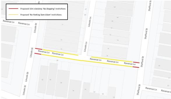
Figure 1 - Proposal
PUBLIC CONSULTATION
Consultation with Council’s Waste Collection Services confirmed the difficulties collection drivers face when accessing the subject section of Ravenue Lane and supported the proposed restrictions on waste collection days (i.e. Mondays).
Community engagement was conducted between 6 November and 22 November 2019. A letter of the proposal was sent to residential owners and occupiers in Railway Avenue, Lincoln Street and Stafford Street as indicated in the consultation map below. (1) One response was received to date.
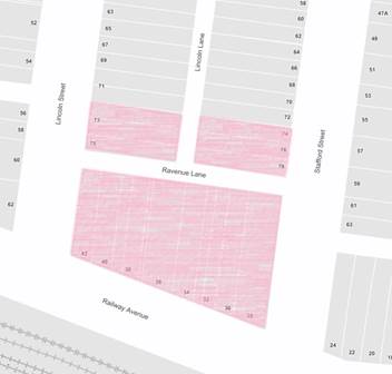
Figure 2 – map of consulted properties
|
View on Proposal |
Resident’s Comment |
Officer’s Comment |
|
Support |
Resident is in support of proposal. Resident would like regular enforcement patrol of the restricted period to ensure the laneway is unobstructed during the hours of 5am to 10am, Mondays. |
Support is noted. |
|
|
Local Traffic Committee Meeting 2 March 2020 |
Subject: Myra Lane, Dulwich Hill - Proposed 'No Stopping' Restrictions (Djarrawunang- Ashfield Ward/ Summer Hill Electorate/ Inner West PAC)
Prepared By: Scipio Tam - Engineer – Traffic and Parking Services
Authorised By: Manod Wickramasinghe - Traffic and Transport Planning Manager
SUMMARY
Following representations from the community regarding vehicles parking on the northern side of Myra Lane, between Garnet Lane and Myra Road, impeding off-street parking access, Council is proposing to introduce new ‘No Stopping’ restrictions along the northern side of the lane.
|
RECOMMENDATION
THAT 16m ‘No Stopping’ restrictions be installed in Myra Lane (Northern side), west of the Myra Road, Dulwich Hill. |
BACKGROUND
Concerns have been raised regarding vehicles parking on the northern side of Myra Lane, between Garnet Lane and Myra Road, impeding off-street parking access.
Currently there are no parking restrictions along the subject section of Myra Lane, Dulwich Hill. With the presence of multiple off-street parking access on the southern side of Myra Lane, vehicles typically park on the northern side. However, given the width of the laneway, properties with off-street parking access on Myra Lane have reported issues whilst attempting to ingress or egress from their driveways.
|
Street Name and Suburb |
Myra Lane, Dulwich Hill |
|
Section |
Between Garnet Lane and Myra Road |
|
Carriageway Width (m) |
4.6m |
|
Carriageway Type |
Two-way lane |
|
Classification |
Local |
|
85th Percentile Speed (km/h) |
N/A |
|
Vehicles Per Day (vpd) |
N/A |
|
Reported Crash History (July 2014 - June 2019) |
N/A |
|
Heavy Vehicle Volume (%) |
N/A |
|
Parking Arrangements |
Unrestricted parking. |
FINANCIAL IMPLICATIONS
The cost of the signposting will be funded from Council’s Operational Budget for signs and line marking.
OTHER STAFF COMMENTS
It should be noted that the initial community consultation called for a recommendation of a 14 metres ‘No Stopping’ restrictions in Myra Lane, west of its intersection with Myra Road, Dulwich Hill. However, due to feedback received as a result of community engagement the proposal has been amended to 16 metre length of ‘No Stopping’ restrictions (as shown in the following plan) to address further concerns of residents unable to access their off-street parking.
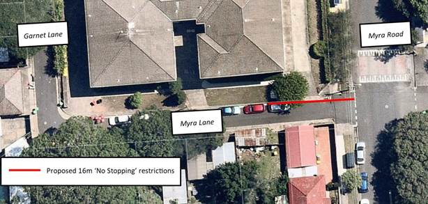
Council Officers are aware of the laneway being commonly used for on-street parking for nearby residents, however a laneways primary function is to provide access for emergency service, delivery and waste collection vehicles as well as providing off-street access to properties.
Given the laneway width and the presence of driveways along Myra Lane, Council Officers, at a later stage, may investigate extending parking restrictions to other sections of the laneway to address similar access issues.
PUBLIC CONSULTATION
Community engagement commenced on 5 February 2020 and closed on 17 February. The map below shows the properties consulted on the proposal. No submissions have been received to date.
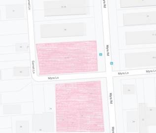
CONCLUSION
The implementation of 16 metres of ‘No Stopping’ restrictions in Myra Lane, Dulwich Hill between Garnet Lane and Myra Road will address the concerns raised regarding residents’ off-street parking access and therefore this proposal is recommended.
|
|
Local Traffic Committee Meeting 2 March 2020 |
Subject: Pigott Street at The Boluevarde, Dulwich Hill - Proposed Statutory 10-metre 'No Stopping' restrictions (Djarrawunang -Ashfield Ward/ Summer Hill Electorate/ Inner West PAC)
Prepared By: Scipio Tam - Engineer – Traffic and Parking Services
Authorised By: Manod Wickramasinghe - Traffic and Transport Planning Manager
SUMMARY
Council is proposing to implement statutory 10-metre ‘No Stopping’ restrictions in Pigott Street at The Boulevarde, Dulwich Hill following a request to deter illegal parking on the northern side of Pigott Street. Vehicles parked on Pigott Street, within 10 metres of the intersection with The Boulevarde, at times hinder the sight line for vehicles entering the intersection.
|
RECOMMENDATION
THAT:
1. Implementation of 10m statutory ‘No Stopping’ in Pigott Street (northern side), east of its intersection with The Boulevarde, Dulwich Hill; and
2. Implementation of 10m statutory ‘No Stopping’ in Pigott Street (northern side), west of its intersection with The Boulevarde, Dulwich Hill, be approved.
|
BACKGROUND
|
Street Name and Suburb |
Pigott Street, Dulwich Hill |
|
Section |
At the intersection with The Boulevarde |
|
Carriageway Width (m) |
10.3m |
|
Carriageway Type |
Two-way |
|
Classification |
Local |
|
85th Percentile Speed (km/h) |
49 (between Denison Road and The Boulevarde) |
|
Vehicles Per Day (vpd) |
1146 (2014 Data for between Denison Road and The Boulevarde) |
|
Reported Crash History (July 2014 - June 2019) |
N/A |
|
Heavy Vehicle Volume (%) |
3.1 (between Denison Road and The Boulevarde) |
|
Parking Arrangements |
Unrestricted parking on the
northern side of Pigott Street. |
Council has received a request from a local resident for the provision of ‘No Stopping’ restrictions to deter illegal parking on the northern side of Pigott Street, Dulwich Hill, at its intersection with The Boulevarde. The resident has advised that vehicles are parked too close to the intersection
FINANCIAL IMPLICATIONS
The cost of the signposting will be funded from Council’s Operational budget for signs and line marking.
OTHER STAFF COMMENTS
In order to improve motorist sight lines, it is proposed to signpost the statutory 10-metre ‘No Stopping’ zone on the northern side of Pigott Street, east and west of The Boulevarde, Dulwich Hill.
The proposal is shown in the following aerial map.
![]()
Figure 1: Proposal for ‘No Stopping’
PUBLIC CONSULTATION
A letter outlining the above proposal was distributed to the affected properties along Pigott Street and The Boulevarde, Dulwich Hill (as indicated in the following plan). No submissions have been received to date regarding this proposal. A consultation map is attached below.
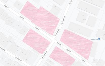
Figure 2: Map of consulted properties
CONCLUSION
It is recommended that a ‘No Stopping’ zone be installed on the northern side of Pigott Street, east and west of The Boulevarde, Dulwich Hill to reinforce the statutory 10-metre ‘No Stopping’ distance at the intersection.
|
|
Local Traffic Committee Meeting 2 March 2020 |
Subject: Charlotte Street, Ashfield- Request to convert
1P period parking to 1/2P period parking outside premises No's 18-20 Charlotte
Street, Ashfield.
(Diarrawunang-Ashfield Ward/Summer Hill Electorate/Burwood PAC)
Prepared By: Boris Muha - Engineer – Traffic and Parking Services
Authorised By: Manod Wickramasinghe - Traffic and Transport Planning Manager
SUMMARY
A request has been received by the newsagent proprietor premises No. 18 Charlotte Street, Ashfield to have a short section of 1-hour period parking zone outside the newsagent and convenience store Nos. 18-20 Charlotte Street, converted to ½ hour period parking.
This will allow a higher turnover for customer parking in the area particularly for the customers attending the above corner shops in Charlotte Street.
|
RECOMMENDATION
THAT the existing 8m length of ‘1P 8.30am-6.00pm Mon-Sun’ outside premises Nos. 18-20 Charlotte Street, Ashfield, be converted to ‘1/2 P 8.30am-6.00pm Mon-Sun’.
|
BACKGROUND
The section of Charlotte Street, between Elizabeth Street and Station Street, is a local main town centre, having various commercial and business activities. Service vehicle and 1hour period parking is provided for delivery needs and customer parking to shops/businesses/club.
Parking is a mixture of loading zone and 1hour period parking on the western side of the street, and 1hour period parking and ‘Bus Zone’ to facilitate the Ashfield Catholic Club mini-van in the evening on the eastern side.
Site location and Road Network.
|
Street Name(s) |
Charlotte Street |
|
Section |
Between Elizabeth Street and Station Street. |
|
Traffic Volume (vehicles per day)-vpd |
*1290 |
|
Recorded Accident History (5 year) |
At/near intersection- (1) Rear end- RUM 30 Elizabeth St, east of Charlotte St -non casualty(towaway)-2014. (1) opposing direction- RUM 29-at intersection-minor injury-2014. (1) Pedestrian- RUM 0-Elizabeth Street, west of Charlotte St-serious injury-2015. (1) Right Through-RUM 21- at intersection-non casualty (towaway). |
|
Recorded 85% speed |
26 km/h |
|
Speed Limit |
50km/h (north of the shared zone) |
|
Carriageway width |
Approx. 6.4m to 10.3m |
|
Carriageway Type |
One-way south with parking to both sides where wider than 6.4m. |
|
Road Classification (State, Regional, Local) |
Local |
|
Heavy vehicle percentage |
1% |
Note* maximum on one day (traffic count reading 15 November 2019)
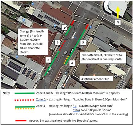
FINANCIAL IMPLICATIONS
Nil.
OTHER STAFF COMMENTS
The proposal under this report is only to convert a separate small section 8m length of 1P period parking to ½ P period parking outside the corner shops of No’s 18-20 Charlotte Street, located on the western side of the street, just south of Elizabeth Street.
All other 1P period parking is to remain to benefit longer stay parking for other shops and businesses (e.g. Hairdresser, restaurant, café, club and community services). Mini Van ‘Bus Zone’ and ‘Loading Zone’ facilities are not affected. The times of operations to parking restrictions remain the same ‘8.30am-6.00pm Mon-Sun’ in line with other (extended trading hour) period parking restrictions fronting shops within the Ashfield CBD area.
PUBLIC CONSULTATION
Letters were distributed to (14) properties under consultation within the above section of Charlotte Street. Two businesses have commented verbally, one of which were in support and one in objection. No formal (written) responses have been received. Any further responses will be tabled at the meeting.
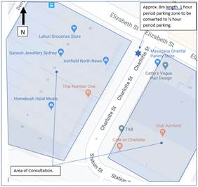
|
Resident/businesses comments |
Council Officer Response |
|
Verbal Comment: Business owner supports the proposal however seeks to ask that the remaining 1P zones be also made 1/2P.
Mobility Parking Scheme (MPS) permit holders are permitted to park unlimited time in parking zone areas of 1P and above, through concession under the Road Rules. Concern is raised that the MPS permit holders are overstaying the 1P far longer, and not fairly allowing other customer to use the 1P areas. By converting the zones to ½ P MPS permit holders are permitted to park only up to 2 hours under the Road Rules |
The proposal under this report is only to convert the 8m metre length zone outside No’s 18-20 Charlotte Street from 1P to 1/2P.
The existing 1P parking is to remain as it caters for the majority of business needs in the vicinity. |
|
Verbal comment: Business owner objects to the proposal, as it is seen as a possible precedent to extending 1/2P consistently right through the street, making inadequate time for the customers to park and attend the business. |
Noted. See above.
|
CONCLUSION
It is recommended that the 8m length 1P zone on the western side of Charlotte Street, south of Elizabeth Street, Ashfield outside premises No’s 18-20 Charlotte Street, be converted to 1/2P parking,
This would provide for a higher turnover in customer parking for shops/businesses where customers attend for shorter periods of time. Remaining period parking zones in Charlotte Street are to remain as 1P parking for longer stay customers.
|
|
Local Traffic Committee Meeting 2 March 2020 |
Subject: Railway Street, Petersham - Proposed installation of Loading Zone (Damun -Stanmore Ward/ Newtown Electorate/ Inner West PAC)
Prepared By: Scipio Tam - Engineer – Traffic and Parking Services
Authorised By: Manod Wickramasinghe - Traffic and Transport Planning Manager
SUMMARY
A request has been received for provision of a ‘Loading Zone’ in Railway Street, Petersham to facilitate with loading and unloading at Property No. 30 Terminus Street, Petersham.
|
RECOMMENDATION
THAT:
1. Implementation of a sixteen (16) metre ‘Loading Zone 8.00am – 3.00pm Wednesday’ on western side of Railway Street, between Carrington Lane and Terminus Street; and
2. Implementation 10m statutory ‘No Stopping’ on the western side of Railway Street at Terminus Street, Petersham; be approved.
|
BACKGROUND
|
Street Name |
Railway Street |
|
Section |
Between Terminus Street and Carrington Lane |
|
Carriageway Width (m) |
12.8 |
|
Carriageway Type |
Two-way road with parking on both sides |
|
Classification |
Local |
|
85th Percentile Speed (km/h) |
N/A |
|
Vehicles Per Day (vpd) |
N/A |
|
Reported Crash History (July 2014 – June 2019) |
No recorded crashes |
|
Heavy Vehicle Volume (%) |
N/A |
|
Parking Arrangements |
Unrestricted parking on western side and ‘2P 8.00am-10.00pm Permit Holders Excepted – Area M3’ on eastern side |
A request has been received for provision of a ‘Loading Zone’ in Railway Street, Petersham to facilitate with loading and unloading at Property No. 30 Terminus Street, Petersham.
An inspection of the site has shown that it is possible to install a ‘Loading Zone’ restriction in Railway Street, adjacent to the White Cockatoo Hotel. The proposed loading zone location is alongside the basement hatch for the establishment and will allow the shortest distance for brewery trucks to unload beer kegs into the premise.
FINANCIAL IMPLICATIONS
The cost of the signposting will be funded from Council’s operational budget for signs and line marking.
OTHER STAFF COMMENTS
It is proposed to introduce a 16m ‘Loading Zone 8.00am – 3.00pm Wednesday’ on the western side of Railway Street, commencing 10 metres north of Terminus Street, Petersham to assist the White Cockatoo Hotel loading and unloading of brewery trucks, especially beer kegs, given their bulky weight. Outside the ‘Loading Zone’ hours and days, the area reverts to unrestricted parking. ‘No Stopping’ is proposed south of the loading zone in keeping with the Road Rules. ‘No Stopping’ restrictions are currently signposted north of the proposed ‘Loading Zone’, i.e. south of Carrington Lane.
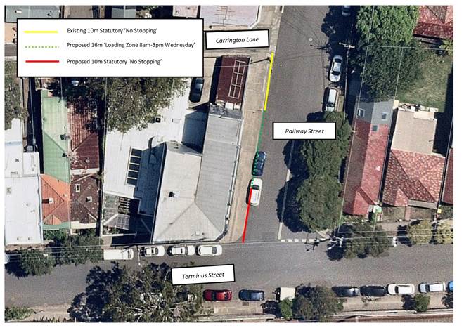 Figure
1: Loading Zone Proposal
Figure
1: Loading Zone Proposal
PUBLIC CONSULTATION
Notification letters were hand delivered to the owners and occupiers within the area (shown in the map below). No responses have been received to date.
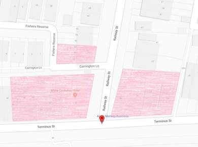
Figure 2: Map of consulted properties
CONCLUSION
It is recommended that a 16-metre ‘Loading Zone 8.00am-3.00pm Wednesday’ to be installed on the western side of Railway Street, Petersham between Carrington Lane and Terminus Street and ‘No Stopping’ restrictions be installed south of the ‘Loading Zone’ in keeping with the Road Rules.
|
|
Local Traffic Committee Meeting 2 March 2020 |
Subject: Morris Street, Summer Hill- Request to remove
1/2 P period parking restrictions outside Nos. 24-28 Morris Street, Summer
Hill.
(Diarrawunang- Ashfield Ward/Summer Hill Electrorate/Burwood PAC)
Prepared By: Boris Muha - Engineer – Traffic and Parking Services
Authorised By: Manod Wickramasinghe - Traffic and Transport Planning Manager
SUMMARY
Council has received a resident request to remove an existing ½ hour period parking zone (2 car space length) outside premise No’s. 24-26 Morris Street, Summer Hill as it is not required by current landuses.
|
RECOMMENDATION
THAT the existing ½ hour period parking zone of 2 spaces on the eastern side of Morris Street, Summer Hill, outside premise No’s 24-26 Morris Street, be removed.
|
BACKGROUND
Council has received a resident request to remove an existing ½ hour period parking zone (2 car space length) outside premise No’s. 24-26 Morris Street, Summer Hill.
The facility would mainly have catered for a laundromat previously operating at No.28 Morris Street. The Laundromat has not operated over the last 5 years and the premises No. 28 Morris Street is registered as commercial with flat above.
With the exception of the existing ½ hour parking zone, the eastern side of Morris Street has unrestricted parking. The western side has 2 hour period parking (resident permit holder exempted). The nearest side street being Lorne Street has unrestricted parking on the northern side and 2 hour period resident parking on the south side.
There are two other evident and advertised businesses in the vicinity, that being an architect and an art gallery. The businesses were included in the community engagement in relation to the proposal to remove the ½ hour parking.
Site location and Road Network.
|
Street Name(s) |
Morris Street |
|
Section |
Lorne Street and Smith Street |
|
Traffic Volume (Average Annual Daily Traffic)-AADT |
800-1000 |
|
Recorded Accident History (5 year) |
Nil |
|
Recorded 85% speed |
45-50 |
|
Speed Limit |
50km/h |
|
Carriageway width |
Approx. 10.2m |
|
Carriageway Type |
Two -way, one traffic lane each way with parking to both sides. |
|
Road Classification (State, Regional, Local) |
Local |
|
Heavy vehicle percentage |
2% |
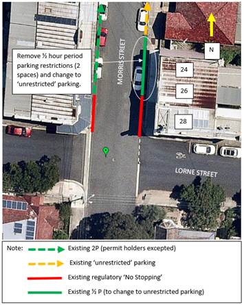
FINANCIAL IMPLICATIONS
Nil.
OTHER STAFF COMMENTS
It is considered that the zone be removed, and the area made unrestricted parking in line and consistent with the existing unrestricted parking on that side of the street. The area would then allow unlimited parking for the general public.
Short-term parking up to 2 hours is provided for any customers or residents/visitors ineligible of permits in Morris and Lorne Street.
PUBLIC CONSULTATION
Letters were distributed to (22) properties under consultation within the vicinity of the location. The closure of submission is Monday 24 February 2020.
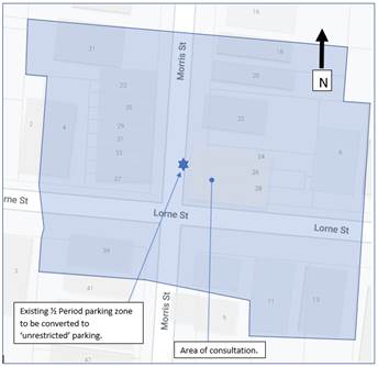
No formal responses have been received at the time of compiling this report. Any further responses will be tabled at the meeting.
CONCLUSION
It is recommended that the existing ½ hour period parking zone outside premise No’s 24-26 Morris Street, Summer Hill, be removed and made as ‘unrestricted’ parking in line and consistent with the existing unrestricted parking on that side of the street.
|
|
Local Traffic Committee Meeting 2 March 2020 |
Subject: Renwick Street, Marrickville - Proposed extension of short-term parking restrictions (Midjuburi - Marrickville Ward/ Summer Hill Electorate/ Inner West PAC)
Prepared By: Scipio Tam - Engineer – Traffic and Parking Services
Authorised By: Manod Wickramasinghe - Traffic and Transport Planning Manager
SUMMARY
Concerns were raised by a business owner in the southern section of Renwick Street, Marrickville that there was insufficient short stay parking in the locality that allows motorists to park and visit businesses in the area. Allocating two presently unrestricted on-street parking spaces on the northern side of Renwick Street, immediately west of the current ‘P30 7.30am – 3pm Monday – Friday’, near the intersection of Carrington Road, as additional short term restricted parking would allow visitors to the area greater opportunity to park for a short period of time.
|
RECOMMENDATION
THAT the extension of current ‘P30 min 7.30am – 3.00pm Monday - Friday’ parking restrictions by twelve (12) metres westward along the northern side of Renwick Street, Marrickville (between Carrington Road and Excelsior Parade) be approved. |
BACKGROUND
|
Street Name and Suburb |
Renwick Street, Marrickville |
|
Section |
Between Carrington Road and Excelsior Parade |
|
Carriageway Width (m) |
12.8m |
|
Carriageway Type |
Two-way road |
|
Classification |
Local |
|
85th Percentile Speed (km/h) |
56.3 (2018) |
|
Vehicles Per Day (vpd) |
4407 (2018) |
|
Reported Crash History (July 2014 - June 2019) |
4x RUM Code 10 (Cross Traffic) 1x RUM Code 13 (Right near) 1x RUM Code 14 (2 Right Turning) 1x RUM Code 30 (Rear end) |
|
Heavy Vehicle Volume (%) |
3.7 (2018) |
|
Parking Arrangements |
Unrestricted parking on both sides of the road aside from the current 12m short term parking on northern side of Renwick Street, immediately west of the intersection of Carrington Road. |
Council has received correspondence from a business owner in the southern section of Renwick Street, Marrickville, requesting the implementation of additional short-term parking along the section of unrestricted parking on the northern side of Renwick Street, near Carrington Road.
Renwick Street is a 12.8m wide, mainly residential street running east-west between Illawarra and Carrington Roads and forming an intersection with Excelsior Parade at its midpoint. At the July 2016 Local Traffic Committee meeting, a 12 metre length of short-term parking on the northern side of Renwick Street, commencing from the existing 10 metre ‘No Stopping’ restriction west of Carrington Road, Marrickville was approved. During several site investigations in the area, the section of short-term parking has been demonstrated effective by providing turn over and visitor parking in the area. As there is a demand to use the adjoining business premises, providing additional short stay on-street parking facilities would complement existing parking arrangements in the locality.
FINANCIAL IMPLICATIONS
The cost of the signposting will be funded from Council’s Operational Budget for signs and line marking.
OTHER STAFF COMMENTS
It is proposed that the existing ‘P30 min 7.30am – 3.00pm Monday - Friday’ parking restrictions on the northern side of Renwick Street between Carrington Road and Excelsior Parade be extended by 12m (2 car spaces) westwards to improve parking opportunities for surrounding businesses and visitors to the area.
![]()
Figure 1: Proposed extension of short-term parking
PUBLIC CONSULTATION
Community engagement was undertaken, and no submissions have been received to date. The highlighted properties shown in the map below were consulted on the proposal.
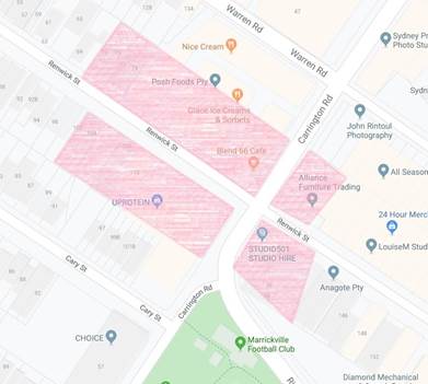
Figure 2: Map of consulted properties
CONCLUSION
In order to provide additional short stay parking opportunities in the industrial section of Renwick Street, Marrickville, it is recommended that an additional twelve (12) metre length (two parking spaces) of ‘P30 7.30am – 3pm Monday – Friday’ be provided on the northern side of Renwick Street, west of Carrington Road, Marrickville.
|
|
Local Traffic Committee Meeting 2 March 2020 |
Subject: Hartley Street, Rozelle - Proposed 'No Stopping' restriction at intersection with Victoria Road (Baludarri-Balmain Ward/Balmain Electorate/Leichhardt PAC)
Prepared By: Brinthaban Baskaran - Graduate Traffic Engineer
Authorised By: Manod Wickramasinghe - Traffic and Transport Planning Manager
SUMMARY
Concerns have been raised regarding illegal parking, restricting the ability of vehicles to turn around at the southern end of Hartley Street, Rozelle.
|
RECOMMENDATION
That a 25m ‘No Stopping’ zone be installed on the eastern side of Hartley Street, north of Victoria Road, Rozelle.
|
BACKGROUND
Hartley Street between Victoria Road and Brent Street is a two-way street with marked parking bays on both sides of the street, this includes footpath parking on the eastern side of the street. A ‘10km/h Shared Zone’ also operates along the length of the street block and a ‘No Left Turn 6:30am – 9:30pm Monday to Friday’ restriction operates from Hartley Street into Victoria Road.
At the Traffic Committee meeting held 2 December 2019, it was requested that a ‘No Stopping’ zone be investigated in Hartley Street to prevent illegal parking on the eastern side of Hartley Street, Rozelle, opposite No. 71 Victoria Road.
Vehicles parking in this location are illegally parking outside the marked parking bays. Due to the narrow width of Hartley Street, this prevents motorist from performing a three-point turn at the southern end of Hartley Street, near Victoria Road.
During operation of the ‘No Left Turn 6:30am – 9:30pm Monday to Friday’ restrictions onto Victoria Road, southbound motorists are unable to egress onto Victoria Road and may be unable to perform a three-point turn due to illegally parked vehicles. This results in motorists reversing down Hartley Street to egress the street via Brent Street.
Site Location & Road Network
|
Street Name(s) |
Hartley Street, Rozelle |
|
Section |
Intersection |
|
Traffic Volume |
196 vehicles per day (2016 Traffic Count) (between Brent Street and Victoria Road) |
|
Recorded Accident History (5 year) |
Nil. |
|
Recorded 85% speed |
17.7km/hr (2016 Traffic Count) (between Brent Street and Victoria Road) |
|
Speed Limit |
10km/h Shared Zone |
|
Carriageway width |
Approx. 5.5m |
|
Carriageway Type |
Two-way street with parking on both sides |
|
Road Classification (State, Regional, Local) |
Local |
FINANCIAL IMPLICATIONS
Nil.
OTHER STAFF COMMENTS
In order to alleviate this safety issue, it is proposed to install a 25m ‘No Stopping’ zone on the eastern side of Hartley Street, Rozelle north of Victoria Road as shown on the following plan. This will reinforce the existing ‘Park in Marked Bays’ restrictions in Hartley Street.
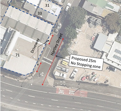
PUBLIC CONSULTATION
Nil - There is no impact on parking, Council is reinforcing the ‘Park in Bay’ restriction.
|
|
Local Traffic Committee Meeting 2 March 2020 |
Subject: Park Lane, Ashfield - Proposed 'No Parking' restrictions(Djarrawunang - Ashfield Ward/ Summer Hill Electorate/ Burwood PAC)
Prepared By: Scipio Tam - Engineer – Traffic and Parking Services
Authorised By: Manod Wickramasinghe - Traffic and Transport Planning Manager
SUMMARY
Representations have been received from a local resident for the provision of full time ‘No Parking’ restrictions in Park Lane, Ashfield to improve access to off-street parking as vehicular access is often blocked by parked vehicles in the laneway. Access issues for Waste Collection vehicles has also been observed on-site by Council Officers undertaking the investigation. Residents have been notified of the proposal.
|
RECOMMENDATION
THAT the implementation of full-time ‘No Parking’ restrictions along the northern side of Park Lane, Ashfield between Alma Street and west of the Park Lane road closure, be approved. |
BACKGROUND
|
Street Name and Suburb |
Park Lane, Ashfield |
|
Section |
Between Alma Street and west of Park Lane Road Closure |
|
Carriageway Width (m) |
4.8m |
|
Carriageway Type |
Two-way lane |
|
Classification |
Local |
|
85th Percentile Speed (km/h) |
N/A |
|
Vehicles Per Day (vpd) |
N/A |
|
Reported Crash History (July 2014 - June 2019) |
N/A |
|
Heavy Vehicle Volume (%) |
N/A |
|
Parking Arrangements |
Parking within the laneway is typically prohibited as it does not allow thoroughfare of vehicles |
Concerns have been received from a local resident for the provision of full time ‘No Parking’ restrictions in Park Lane, Ashfield to improve access to off-street parking as vehicular access is often blocked by parked vehicles in the laneway.
Park Lane is a narrow laneway with a carriageway width of approximately 4.8 metres wide. At present parking is unrestricted on both sides of the laneway. There is evidence that a ‘No Parking’ zone previously existed along the northern side of the laneway however no records could be found to verify this.
It was observed during the site inspection that off-street parking facilities were utilised and Waste Collection vehicles collect bins from Park Lane. In one instance observed by Council Officers, Waste Collection vehicles were unable to access the subject section of Park Lane due to parked vehicles.
FINANCIAL IMPLICATIONS
The cost of the supply and installation of the signposting associated with the recommended ‘No Parking’ restrictions can be met from Council’s operating budget for signs and line marking.
OTHER STAFF COMMENTS
![]()
It is proposed to install full-time ‘No Parking’ restrictions on the northern side of Park lane, Ashfield between Alma Street and west of Park Lane road closure, to improve access to off-street parking and general laneway access for waste collection and delivery vehicles.
It should be noted that laneways were generally built to provide service access for properties and access into off-street parking facilities. Prohibiting parking in the subject location will assist in achieving this goal.
Figure 1: Proposal for ‘No Parking’ along Park Lane
PUBLIC CONSULTATION
On 5 February 2020, highlighted properties shown in the following map were consulted on the proposal. No submission have been received to date and any late comments received will be tabulated at the meeting. A consultation map is attached below.
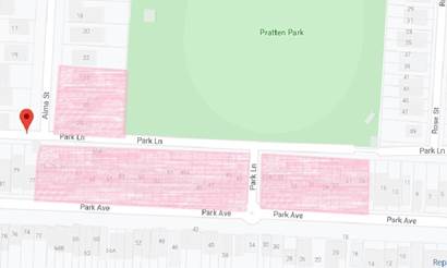
Figure 2: Map of consulted properties
CONCLUSION
Park Lane is narrow, and should a vehicle be parked close to or opposite a driveway, vehicle access can be impeded. No Parking’ restrictions would assist the residents with a rear lane access into their properties. Therefore, it is recommended that full-time ‘No Parking’ restrictions on the northern side of Park Lane, between Alma Street and west of Park Lane Road Closure be approved.
|
|
Local Traffic Committee Meeting 2 March 2020 |
Subject: Carlisle Street between Norton Street and Unnamed Laneway, Leichhardt - Road Occupancy - ANZAC Day Event (Gulgadya - Leichhardt Ward/Balmain Electorate/Leichhardt PAC)
Prepared By: Vinoth Srinivasan - Engineer - Traffic and Parking Services
Authorised By: Manod Wickramasinghe - Traffic and Transport Planning Manager
SUMMARY
Council has received an application from the licensee of The Royal Hotel in Leichhardt for approval of a temporary full road closure in Carlisle Street between Norton Street and the Unnamed Laneway adjacent to No.2 Carlisle Street to be held on Saturday, 25 April 2020 between the hours of 6am and 12 midnight.
The road closure has been requested to facilitate The Royal Hotel ANZAC Day Event.
|
RECOMMENDATION
THAT the temporary road closure of Carlisle Street, Leichhardt between Norton Street and the Unnamed Laneway adjacent to No.2 Carlisle Street to be held on Saturday, 25 April 2020 between the hours of 6am and 12 midnight be supported, subject to the following conditions:
a. That an unencumbered passaged minimum of 4.0m wide be available for emergency vehicles through the closed section of Carlisle Street, Leichhardt;
b. The occupation of the road carriageway must not occur until the road has been physically closed;
c. All affected residents and businesses, including the NSW Police Local Area Commander, Fire & Rescue NSW and NSW Ambulance Services be notified in writing, by the applicant, of the proposed temporary road closure at least 2 weeks in advance of the closure with the applicant making reasonable provision for stakeholders.
|
BACKGROUND
A request for approval to conduct The Royal Hotel ANZAC Day Event on Saturday, 25 April 2020 between the hours of 6am and 12 midnight has been received from the organiser of the event, the Licensee of The Royal Hotel.
This event involves the temporary closure of Carlisle Street between Norton Street and the Unnamed Laneway adjacent to No.2 Carlisle Street.
In accordance with the RMS “Guide to Traffic and Transport Management for Special Events V3.4 August, 2006”, and based on information supplied by the organiser, the event is classified as a Special Event Class 2.
A Traffic Control Plan and Traffic Management Plan are attached in Attachment 1.
Detour Routes
All traffic is expected to detour via Cromwell Street and Marlborough Street as shown on the attached TCPs.
Site location & Road network
|
Street Name(s) |
Carlisle Street, Leichhardt |
|
Section |
Between Norton Street and Unnamed Laneway |
|
Traffic Volume |
- |
|
Recorded Accident History (5 year) |
Nil. |
|
Recorded 85% speed |
- |
|
Speed Limit |
50km/h |
|
Carriageway width |
Approx. 12.4m |
|
Carriageway Type |
Two way street with one travel lane in each direction and kerb side parking lanes. |
|
Road Classification (State, Regional, Local) |
Local |
FINANCIAL IMPLICATIONS
Nil, the supported Traffic Control Plan (TCP) be implemented at the applicant’s expense.
OTHER STAFF COMMENTS
Nil.
PUBLIC CONSULTATION
All affected businesses, residents and other occupants will be notified of the road closure, activities, parking changes and changes to public transport arrangements. The notification will be distributed at least two weeks prior to the commencement of the event. The proposed information, distribution area and distribution period will be reviewed and approved by Inner West Council’s Traffic Section one week prior to distribution.
The proposed temporary full-road closure is currently being advertised in the local newspaper for a period of 28 days from 18 February 2020 to 17 March 2020. No responses were received at the time of finalising the report. Should any objections be received, they would be reported to Council’s scheduled meeting.
|
1.⇩ |
The Royal Hotel ANZAC Day Event - TMP |
|
2.⇩ |
The Royal Hotel ANZAC Day Event - TCP |