Local Traffic Committee
Meeting
MAY 2020
The May 2020 meeting of
the Inner West Local Traffic Committee will be held electronically with the
Agenda emailed to Members for review. All comments are requested to be returned
to Council by 5.00pm Tuesday 5 May 2020.
|

|
Local Traffic
Committee Meeting
4 May 2020
|
Function of the Local
Traffic Committee
Background
Roads and Maritime
Services (RMS) is legislated as the
Authority responsible for the control of traffic on all NSW Roads. The RMS has
delegated certain aspects of the control of traffic on local roads to councils.
To exercise this delegation, councils must establish a local traffic committee
and obtain the advice of the RMS and Police. The Inner West Council Local Traffic
Committee has been constituted by Council as a result of the delegation granted
by the RMS pursuant to Section 50 of the Transport Administration Act 1988.
Role of the Committee
The Local
Traffic Committee is primarily a
technical review and advisory committee which considers the technical merits of
proposals and ensures that current technical guidelines are considered. It
provides recommendations to Council on traffic and parking control matters and
on the provision of traffic control facilities and prescribed traffic control
devices for which Council has delegated authority. These matters are dealt with
under Part A of the agenda and require Council to consider exercising
its delegation.
In
addition to its formal role as the Local Traffic Committee, the Committee may
also be requested to provide informal traffic engineering advice on traffic
matters not requiring Council to exercise its delegated function at that point
in time, for example, advice to Council’s Development Assessment Section
on traffic generating developments. These matters are dealt with under Part
C of the agenda and are for information or advice only and do not require
Council to exercise its delegation.
Committee Delegations
The Local
Traffic Committee has no decision-making
powers. The Council must refer all traffic related matters to the Local Traffic
Committee prior to exercising its delegated functions. Matters related to State
Roads or functions that have not been delegated to Council must be referred
directly to the RMS or relevant organisation.
The
Committee provides recommendations to Council. Should Council wish to act
contrary to the advice of the Committee or if that advice is not supported
unanimously by the Committee members, then the Police or RMS have an
opportunity to appeal to the Regional Traffic Committee.
Committee Membership & Voting
Formal
voting membership comprises the following:
·
one representative of Council as
nominated by Council;
·
one representative of the NSW Police
from each Local Area Command (LAC) within the LGA, being Newtown, Marrickville,
Leichhardt and Ashfield LAC’s.
·
one representative from the RMS; and
·
State Members of Parliament (MP)
for the electorates of Summer Hill, Newtown, Heffron, Canterbury, Strathfield
and Balmain or their nominees.
Where the Council area is represented by more than one
MP or covered by more than one Police LAC, representatives are only permitted to vote on matters which effect
their electorate or LAC.
Informal
(non-voting) advisors from within Council or external authorities may also
attend Committee meetings to provide expert advice.
Committee Chair
Council’s
representative will chair the meetings.
|
|
Local Traffic
Committee Meeting
4 May 2020
|
1 Apologies
2 Disclosures
of Interest
3 Confirmation
of Minutes Page
Minutes of April 2020 Local Traffic
Committee Meeting 4
4 Matters
Arising from Council’s Resolution of Minutes
5 Part
A – Items Where Council May Exercise Its Delegated Functions
Traffic Matters
ITEM Page
LTC0520 Item 1 Warren
Road, Marrickville - Implementation of one-way traffic (Midjuburi -
Marrickville Ward/Summer Hill Electorate/Inner West PAC) 17
LTC0520 Item 2 Horton
Street, Marrickville between Amy Street and Illawarra Road - Temporary Full
Road Closure for Street Party - Saturday 31 October 2020 between 2.00 and
7.00pm (Midjuburi - Marrickville Ward / Summer Hill
Electorate / Inner West PAC) 26
LTC0520 Item 3 Smidmore
Street, Marrickville – Marrickville Metro Expansion Works - Proposed
Shared Zone and One-way traffic restrictions
-– (Midjuburi – Marrickville Ward / Newtown Electorate /
Inner West PAC) 28
LTC0520 Item 4 Francis
Street, Enmore - Implementation of One-way traffic (Stanmore-Damun Ward /
Newtown Electorate /
Inner West PAC) 134
Parking Matters
Nil at the time of printing.
Late Items
Nil at time of printing.
6 Part
B - Items for Information Only
Nil at the time of printing.
7 Part
C - Items for General Advice
Nil at the time of printing.
8 General
Business
9 Close
of Meeting
|
|
Local Traffic
Committee Meeting
4 May 2020
Minutes from April
2020
|
Minutes
of Local Traffic Committee Meeting
Held
electronically in April 2020
ACKNOWLEDGEMENT
OF COUNTRY BY CHAIRPERSON
I acknowledge
the Gadigal and Wangal people of the Eora nation on whose country we are
meeting today, and their elders past and present.
COMMITTEE REPRESENTATIVES PRESENT
|
Clr Victor Macri
|
Councillor – Midjuburi-Marrickville Ward (Chair)
|
|
Bill Holliday
|
Representative
for Jamie Parker MP, Member for Balmain
|
|
Sgt John Micallef
|
NSW Police – Burwood
Police Area Command
|
|
Sgt Paul
Vlachos
|
NSW Police
– Inner West Police Area Command
|
|
Tanmila Samin
Islam
|
Transport for
NSW (TfNSW)
|
|
|
|
|
OFFICERS
IN ATTENDANCE
|
|
|
|
|
Colin Jones
|
Inner West
Bicycle Coalition
|
|
Adrian
Prichard
|
Transit
Systems
|
|
Clr Maghanita da Cruz
|
Councillor – Gulgadya-Leichhardt Ward
|
|
Manod Wickramasinghe
|
IWC’s Traffic and Transport Services Manager
|
|
Christina
Ip
|
IWC’s Business
Administration Officer
|
|
|
|
|
VISITORS
|
|
|
|
|
|
Nil.
|
|
|
|
|
|
APOLOGIES:
|
|
|
|
|
|
Nil.
|
|
|
|
|
DISCLOSURES
OF INTERESTS:
Nil.
CONFIRMATION OF MINUTES
|
The minutes of the Local Traffic Committee Meeting held on Monday,
2 March 2020 were confirmed.
|
MATTERS
ARISING FROM COUNCIL’S RESOLUTION OF MINUTES
The minutes of
the Local Traffic Committee meeting held on Monday, 2 March 2020 are awaiting
adoption.
EMAIL
CONFIRMATION OF OFFICER’S RECOMMENDATION:
The representative for NSW Police – Inner West supported the
Officer’s recommendations for the items in their PAC.
The Transit
Systems representative supported all the Officer’s recommendations.
|
LTC0420
Item 1 Minor Traffic Facilities
|
|
SUMMARY
This report considers minor traffic facility applications
received by Inner West Council and includes ‘Disabled Parking’
and ‘Works Zone’ requests.
Officer’s
Recommendation
THAT:
1. The following disabled parking
zones be removed as they are no longer required:
a) 6m ‘Disabled Parking’ zone in front of
No. 47 Alfred Street, Rozelle;
b) 6m ‘Disabled Parking’ zone in front of
No. 24 and 26 Cannon Street, Stanmore;
c) 6m ‘Disabled Parking’ zone in front of
No. 15 Tamar Street Marrickville;
d) 6m ‘Disabled Parking’ zone in front of
No. 5 Isabella Street, Balmain; and
e) 6m ‘Disabled Parking’ zone in front of
No. 29 Phillip street Newtown.
2. The following ‘Disabled
Parking’ zones be approved and installed:
a) 6m 'Disabled Parking’ zone be installed in
front of No. 18 Carrington Street, Summer Hill;
b) 6.0m 'Disabled Parking’ zone and ‘No
Stopping (right)” zone at a statutory distance from Bruce Street be
installed in front of No. 143 Albany Road, Stanmore; and
c) 6.0m 'Disabled Parking’ zone be installed in
front of No. 38 Albert Street, Leichhardt.
3. The following ‘Works
Zone’ zones be approved and installed:
a) 30m 'Works Zone 7.00am – 6.00pm Mon-Fri and
8.00am - 1.00pm Sat' be installed on the southern side of Gladstone Street,
in front of No. 2-2A Gladstone Street, Newtown, for 12 weeks;
b) 9m 'Works Zone 7.00am – 6.00pm Mon-Fri and
8.00am - 1.00pm Sat' be installed on the eastern side of Elswick Street, in
front of No. 73 Elswick Street, Leichhardt, for 12 weeks;
c) 9m 'Works Zone 7.00am – 6.00pm Mon-Fri and
8.00am - 1.00pm Sat' be installed on the northern side of Piper Street, on
the side boundary of No. 2 Lonsdale Street, Lilyfield, for 12 weeks;
d) 10m 'Works Zone 7.00am – 6.00pm Mon-Fri and 8.00am
- 1.00pm Sat' be installed on the south-eastern side of Wardell Road, in
front of No. 166 Wardell Road, Marrickville, for 12 weeks;
e) 12.5m 'Works Zone 7.00am – 6.00pm Mon-Fri and
8.00am - 1.00pm Sat' be installed on the north-western side of High Street,
in front of No. 39 High Street, Marrickville, for 12 weeks; and
f) 12m 'Works Zone 7.00am – 6.00pm Mon-Fri
and 8.00am - 1.00pm Sat' be installed on the northern side of Meeks Road, in
front of No. 141 Meeks Road, Marrickville, for 12 weeks.
DISCUSSION
The Committee members agreed
with the Officer’s recommendation
COMMITTEE RECOMMENDATION
THAT:
1. The following disabled
parking zones be removed as they are no longer required:
a) 6m ‘Disabled Parking’ zone in front of
No. 47 Alfred Street, Rozelle;
b) 6m ‘Disabled Parking’ zone in front of
No. 24 and 26 Cannon Street, Stanmore;
c) 6m ‘Disabled Parking’ zone in front of
No. 15 Tamar Street Marrickville;
d) 6m ‘Disabled Parking’ zone in front of
No. 5 Isabella Street, Balmain; and
e) 6m ‘Disabled Parking’ zone in front of
No. 29 Phillip street Newtown.
2. The following
‘Disabled Parking’ zones be approved and installed:
a) 6m 'Disabled Parking’ zone be installed in
front of No. 18 Carrington Street, Summer Hill;
b) 6.0m 'Disabled Parking’ zone and ‘No
Stopping (right)” zone at a statutory distance from Bruce Street be
installed in front of No. 143 Albany Road, Stanmore; and
c) 6.0m 'Disabled Parking’ zone be installed in
front of No. 38 Albert Street, Leichhardt.
3. The following ‘Works
Zone’ zones be approved and installed:
a) 30m 'Works Zone 7.00am – 6.00pm
Mon-Fri and 8.00am - 1.00pm Sat' be installed on the southern side of
Gladstone Street, in front of No. 2-2A Gladstone Street, Newtown, for 12
weeks;
b) 9m 'Works Zone 7.00am – 6.00pm
Mon-Fri and 8.00am - 1.00pm Sat' be installed on the eastern side of Elswick
Street, in front of No. 73 Elswick Street, Leichhardt, for 12 weeks;
c) 9m 'Works Zone 7.00am – 6.00pm
Mon-Fri and 8.00am - 1.00pm Sat' be installed on the northern side of Piper
Street, on the side boundary of No. 2 Lonsdale Street, Lilyfield, for 12
weeks;
d) 10m 'Works Zone 7.00am – 6.00pm
Mon-Fri and 8.00am - 1.00pm Sat' be installed on the south-eastern side of
Wardell Road, in front of No. 166 Wardell Road, Marrickville, for 12 weeks;
e) 12.5m 'Works Zone 7.00am – 6.00pm
Mon-Fri and 8.00am - 1.00pm Sat' be installed on the north-western side of
High Street, in front of No. 39 High Street, Marrickville, for 12 weeks; and
f) 12m 'Works Zone 7.00am – 6.00pm
Mon-Fri and 8.00am - 1.00pm Sat' be installed on the northern side of Meeks
Road, in front of No. 141 Meeks Road, Marrickville, for 12 weeks.
For motion: Unanimous
|
|
LTC0420
Item 2 Dobroyd Parade to Hawthorne Parade
bicycle contraflow
|
|
SUMMARY
Detailed
design plans have been prepared for a contra-flow bicycle facility between
Dobroyd Parade and Hawthorne Parade, Haberfield. Consultation with affected
residents and owners was undertaken on the draft detailed design plans in
February and March 2020. It is recommended that the detail design plans are
approved for construction.
Officer’s
Recommendation
THAT:
1. The proposed
diversion plan for pedestrian and cyclists for future works along the Bay Run
be noted; and
2. The plan (Attachment 1) for a
contra-flow cycle facility in the one-way link road between Dobroyd Parade
and Hawthorne Parade, Haberfield be approved for construction and be
implemented in advance of the Bay Run works.
DISCUSSION
Clr da Cruz
asked whether detailed plans for the pedestrian crossing point on Boomerang
Street at Robson Park were available. Council Officers advised that detailed
design plans will be prepared and brought back to a future Local Traffic
Committee meeting. Detailed plans will also be prepared for other treatments
required to facilitate the proposed Bay Run diversions.
The Burwood PAC representative supported the recommendation and
stated that all roads that are currently being altered to facilitate these
temporary changes should be fully reinstated to vehicle traffic use. Council
Officers advised that the intention is to retain the contraflow arrangements
on a permanent basis. This will provide a better-connected cycle network and will
not affect existing vehicle flows. Noting the comments from Burwood PAC,
Council Officers will have the treatments reviewed following the Bay Run
works.
The
representative for the Inner West Bicycle Coalition raised concern about
safety for pedestrians and cyclists at the intersection of Timbrell
Drive/Mortley Avenue/City West Link due to the narrow footpaths, lack of pedestrian crossing facilities on the northern-eastern arm
of the intersection and absence of bike lanterns.
Concern was
also raised about the lack of safety barriers along City West Link, which
might protect users of the Bay Run from vehicles leaving the City West Link.
The representative for the Inner West Bicycle Coalition commented
that they support the contra-flow as a permanent facility. In addition, the
representative requested central line marking in Tillock Street to provide
traffic separation near its junction with Crescent Street.
The Committee members agreed
with the Officer’s recommendation
COMMITTEE RECOMMENDATION
THAT:
1. The
proposed diversion plan for pedestrian and cyclists for future works along
the Bay Run be noted; and
2. The plan (Attachment 1) for
a contra-flow cycle facility in the one-way link road between Dobroyd Parade
and Hawthorne Parade, Haberfield be approved for construction and be
implemented in advance of the Bay Run works.
For motion: Unanimous
|
|
LTC0420
Item 3 Greenway on-road cycle route
|
|
SUMMARY
Detailed
design plans have been prepared for Greenway On-Road works. The detailed
design plans are based on the Greenway Concept Designs endorsed by Council in
May 2019. Consultation was undertaken across the corridor during the Concept
Design phase. Specific consultation to affected residents and
owners was undertaken on the draft detailed design plans. It is
recommended that the detail design plans are approved for construction.
Officer’s
Recommendation
THAT the
detailed design plans (Attachment 1) for the Greenway on-road works be
approved for construction
DISCUSSION
The TfNSW representative stated
that ‘Give Way’ priorities must be set, with signage, at the
raised intersections of Windsor Lane/Weston Street and Channel Street/Weston
Street, Dulwich Hill. The Committee members agreed to add this requirement to
the recommendation
The representative for the
Member for Balmain asked whether the type of vegetation proposed for the
garden beds, had the potential to obscure motorists’ sightlines.
Council Officers advised that low vegetation such as grasses and prostrate
shrubs are proposed in garden beds on approach to pedestrian crossings. These
garden beds will be monitored and regularly maintained by Council.
The representative for the
Member for Balmain also asked if cyclists are obliged to dismount before
using the designated bicycle crossing lanes and if the proposed cyclist
crossing would be the same height as the pedestrian crossing.
The Transport
for NSW representative confirmed that this crossing treatment would provide
priority for pedestrians and mounted cyclists, at the same time, over
vehicles. Council Officers advised that the proposed bicycle crossing on
Ewart Street and Hercules Street will be at the same height as the adjacent
pedestrian crossing.
The representative for the
Member for Balmain also expressed concern that oncoming
vehicles will conflict with cyclists using the crossing unless the driver
sees signage that makes the crossing priority clear (e.g. ‘Give
Way’ signage) and noted that a State-wide public education campaign may
also be required.
COMMITTEE RECOMMENDATION
THAT:
- the
detailed design plans (Attachment 1) for the Greenway on-road works be
approved for construction; and
- the Give Way priority at
the intersection of Windsor Lane/Weston Street & Channel
Street/Weston Street, Dulwich Hill be signposted.
For motion: Unanimous
|
|
LTC0420
Item 4 Probert Street, Newtown – Proposal for
Car Share Parking Space
(Damum – Stanmore Ward / Newtown Electorate / Inner
West PAC)
|
|
SUMMARY
A request has been received
from a GoGet Car Share representative for the installation of an on-street
dedicated ‘Car Share’ parking space in the vicinity of the
intersection of Probert Street and Bishopgate Street, Newtown for an existing
floating car share vehicle in the area.
Officer’s
Recommendation
THAT a 6 metre
'No Parking Authorised Car Share Vehicles Excepted' restriction be installed
on the western side of Probert Street, adjacent to property No. 34 Bishopgate Street, Newtown.
DISCUSSION
The Committee members agreed
with the Officer’s recommendation
COMMITTEE RECOMMENDATION
THAT a 6 metre 'No Parking Authorised Car Share Vehicles Excepted'
restriction be installed on the western side of
Probert Street, adjacent to property No. 34
Bishopgate Street, Newtown.
For
motion: Unanimous
|
|
LTC0420
Item 5 Victoria Road, Marrickville – Temporary
relocation of Taxi Zone
during Marrickville Metro Expansion Works (Midjuburi
– Marrickville
Ward / Heffron Electorate / Inner West PAC)
|
|
SUMMARY
A request has been received
from MLA Transport Planning for the temporary relocation of the existing Taxi
Zone in Smidmore Street to Victoria Road, Marrickville outside the northern
entrance to Marrickville Metro during Marrickville Metro Expansion works. The
relocation will be temporary from early 2020 for a period of approximately 9
months, until the new permanent Taxi Zone is relocated on the south side of
Smidmore Street within the new one-way system proposed for Smidmore Street,
Marrickville.
Officer’s
Recommendation
THAT the temporary relocation of the ‘Taxi Zone’ and
associated signage from the northern side of Smidmore Street (outside
Marrickville Metro) to the southern side of Victoria Road, Marrickville,
replacing 25m of the existing ‘2P 8.30am–6pm Mon-Fri; 8.30am-12.30pm
Sat’ parking restrictions be approved.
DISCUSSION
The Committee members agreed
with the Officer’s recommendation
COMMITTEE RECOMMENDATION
THAT the temporary relocation of the ‘Taxi Zone’ and
associated signage from the northern side of Smidmore Street (outside
Marrickville Metro) to the southern side of Victoria Road, Marrickville,
replacing 25m of the existing ‘2P 8.30am–6pm Mon-Fri; 8.30am-12.30pm
Sat’ parking restrictions be approved.
For motion: Unanimous
|
|
LTC0420 Item 6 Richardsons
Crescent, Marrickville - Proposed Pedestrian (zebra) Crossing - Design Plan
10116 (Midjuburi - Marrickville Ward/ Summer Hill Electorate/ Inner West PAC)
|
|
SUMMARY
Council has
approved the provision of a pedestrian (zebra) crossing on Richardsons
Crescent, Marrickville (adjacent to Mackey Park) to provide a safer crossing
environment for pedestrians, particularly school children. A detailed design
plan has been finalised for the proposed pedestrian crossing on Richardsons
Crescent, at the existing kerb blisters.
Officer’s
Recommendation
THAT the detailed design plan
for the proposed pedestrian (zebra) crossing, associated line marking and
signage on Richardsons Crescent, Marrickville (western leg), at the existing
kerb blisters (as per attached Design Plan 10116) be APPROVED.
DISCUSSION
The TfNSW
representative commented that the width of the pedestrian crossing was not
provided in the design and stated that it must be 3.6m wide. Council Officers
confirmed that the pedestrian crossing width will be 3.6m.
The Committee members agreed with
the Officer’s recommendation
COMMITTEE RECOMMENDATION
THAT the detailed design
plan for the proposed pedestrian (zebra) crossing, associated line marking
and signage on Richardsons Crescent, Marrickville (western leg), at the
existing kerb blisters (as per attached Design Plan 10116) be APPROVED.
For motion: Unanimous
|
|
LTC0420
Item 7 Elizabeth Street, Ashfield-Proposed Upgrade of Existing
Pedestrian Crossing- DA Condition Under Re-Development of the Ashfield
Aquatic Centre (160-178 Elizabeth Street, Ashfield) (Gulgadya-Leichhardt
Ward/Summer Hill Electorate/Burwood PAC)
|
|
SUMMARY
Under
condition of Development Consent, the existing crossing outside the current
re-development of Ashfield Aquatic Centre, premises 160-178 Elizabeth Street,
is proposed to be upgraded to improve pedestrian safety in the area for
patrons attending the pool and the community in general.
Officer’s
Recommendation
THAT the detailed design plan
for the proposed upgrade of the existing at-grade pedestrian (zebra) crossing
in Elizabeth Street, Ashfield outside the Ashfield Aquatic Centre 160-178
Elizabeth Street, to a raised pedestrian (zebra) crossing (as per plan
387086-MMD-00-CC-DR-C-8015 Rev (D)), be approved.
DISCUSSION
The Committee members agreed
with the Officer’s recommendation
COMMITTEE RECOMMENDATION
THAT the detailed design
plan for the proposed upgrade of the existing at-grade pedestrian (zebra)
crossing in Elizabeth Street, Ashfield outside the Ashfield Aquatic Centre
160-178 Elizabeth Street, to a raised pedestrian (zebra) crossing (as per
plan 387086-MMD-00-CC-DR-C-8015 Rev (D)), be approved.
For motion: Unanimous
|
|
LTC0420
Item 8 James Street, Summer Hill - Temporary Full Road Closure for
substation electrical conduit connection (Djarrawunang-Ashfield Ward/Summer
Hill Electorate/Burwood PAC)
|
|
SUMMARY
An
application has been received for the temporary full road closure of James
Street, Summer Hill, between Henson Street and Old Canterbury Road from 15
May to 28 June 2020, between 7.00am-5.00pm Mon-Sat, to carry out major (high
voltage) HV underground electrical conduit connection to a new Zone
Substation being constructed on the corner of James Street and Old Canterbury
Road.
Officer’s
Recommendation
THAT the proposed temporary
full road closure of James Street (between Henson Street and Old Canterbury
Road), Summer Hill, for major electrical conduit works be approved from 15
May to 28 June 2020, between 7.00am-5.00pm Mon-Sat (with an additional 2 week
contingency period thereafter); subject to, but not limited to, the following
conditions:
1. A Road Occupancy License be obtained by the applicant from
the Transport Management Centre;
2. All affected residents and businesses, including the NSW
Police Area Commander, Fire & Rescue NSW and the NSW Ambulance Services
be notified in writing, by the applicant, of the proposed temporary full road
closure at least 14 days in advance of the closure with the applicant making
reasonable provision for stakeholders; and
3. The occupation of the road carriageway must not occur until
the road has been physically closed.
DISCUSSION
Clr da Cruz requested that footpaths be clear of obstructions and
trip hazards (e.g. detour signage and witches hats) and that
appropriate pedestrian detours be set up.
Council
Officers advised that they will work with the applicant to ensure pedestrian
detours are established (if required) and to ensure pedestrians are not
obstructed or exposed to trip hazards as part of the works.
The Committee members agreed
with the Officer’s recommendation.
COMMITTEE RECOMMENDATION
THAT the proposed temporary
full road closure of James Street (between Henson Street and Old Canterbury
Road), Summer Hill, for major electrical conduit works be approved from 15
May to 28 June 2020, between 7.00am-5.00pm Mon-Sat (with an additional 2 week
contingency period thereafter); subject to, but not limited to, the following
conditions:
1. A Road Occupancy License be obtained by the applicant
from the Transport Management Centre;
2. All affected residents and businesses, including the NSW
Police Area Commander, Fire & Rescue NSW and the NSW Ambulance Services
be notified in writing, by the applicant, of the proposed temporary full road
closure at least 14 days in advance of the closure with the applicant making
reasonable provision for stakeholders; and
3. The occupation of the road carriageway must not occur
until the road has been physically closed.
For motion: Unanimous
|
|
LTC0420
Item 9 Terry Street, Rozelle - Proposed extension of on-street bicycle
path (Baludarri-Balmain Ward/Balmain Electorate/Leichhardt PAC)
|
|
SUMMARY
Council has
finalised a design plan for the proposed extension of an on-street bicycle
path on Terry Street, between Victoria Road and Margaret Street, Rozelle to
improve road safety for road users.
Officer’s
Recommendation
THAT the detailed design plan
(Design Plan No.10123) for the proposed extension of the on-street cycle path
on Terry Street, between Victoria Road and Margaret Street, Rozelle be
approved.
DISCUSSION
The Inner West Bicycle
Coalition representative requested consideration of a widened up-hill cycle
lane (to 1.7m); further consideration into the transition of the uphill cycle
lane with the Terry Street roundabout; and review of the integration of the
down-hill cycle lane with the Victoria Road shared path.
Council officers will
separately review this request.
The Committee members agreed
with the Officer’s recommendation
COMMITTEE RECOMMENDATION
THAT the detailed design
plan (Design Plan No.10123) for the proposed extension of the on-street cycle
path on Terry Street, between Victoria Road and Margaret Street, Rozelle be
approved.
For motion: Unanimous
|
|
LTC0420
Item 10 Intersection of Cecil Street and Chandos Street, Ashfield - 'No
Stopping' restrictions to corners
(Djarrawunang-Ashfield Ward/Summer
Hill Electorate/Burwood PAC)
|
|
SUMMARY
Council
has investigated resident complaints regarding vehicles continuously parking
too close to the corners of the intersection of Chandos Street and Cecil
Street, Ashfield.
Officer’s
Recommendation
THAT:
1. 10 metres of ‘No Stopping’ restriction be
placed on the northern side of Cecil Street, east of Chandos Street,
Ashfield;
2. 8.5 metres of ‘No Stopping’ restriction
be placed on the southern side of Cecil Street, east of Chandos Street,
Ashfield (up to the existing street tree);
3. 8.0 metres of ‘No Stopping’ restriction
be placed on the eastern side of Chandos Street, north of Cecil Street (up to
the existing street tree), followed by ‘No Stopping Australia Post
Vehicles Excepted’ between 8.0m and 17.8m north of Cecil Street; and
4. 10.0 metres of ‘No Stopping’ restriction
be placed on the eastern side of Chandos Street, south of Cecil Street.
DISCUSSION
The Burwood PAC representative requested that all proposed
‘No Stopping’ restrictions be placed at the statutory 10m
distance from the corners. Council Officers advised that the signs were
recommended at 8.5m on the southern side of Cecil Street, east of Chandos
Street and at 8m on Chandos Street, north of Cecil Street to avoid placing
them behind the mature street trees. Council Officers advised that the
presence of the tree will still prevent parking within 10m of the
intersection (as per TfNSW standards) but the sign would be more conspicuous
to motorists if placed prior to the tree.
The Committee members agreed
with the Officer’s recommendation
COMMITTEE RECOMMENDATION
THAT:
1. 10 metres of ‘No Stopping’ restriction
be placed on the northern side of Cecil Street, east of Chandos Street,
Ashfield;
2. 8.5 metres of ‘No Stopping’
restriction be placed on the southern side of Cecil Street, east of Chandos
Street, Ashfield (up to the existing street tree);
3. 8.0 metres of ‘No Stopping’
restriction be placed on the eastern side of Chandos Street, north of Cecil
Street (up to the existing street tree), followed by ‘No Stopping
Australia Post Vehicles Excepted’ between 8.0m and 17.8m north of Cecil
Street; and
4. 10.0 metres of ‘No Stopping’
restriction be placed on the eastern side of Chandos Street, south of Cecil
Street.
For motion: Unanimous
|
|
LTC0420
Item 11 Hercules Street, Ashfield-Timed extension of disabled parking
zone (Djarrawunang-Ashfield Ward/Summer Hill Electorate/Burwood
PAC)
|
|
SUMMARY
Council has received requests
to have the existing (2 space) disabled parking zone on the eastern side of
Hercules Street, south of Brown Street, Ashfield extended in time to operate
from 10.00am-8.00pm Mon-Sun” instead of “10.00am-6.00pm
Mon-Sun”.
Officer’s
Recommendation
THAT the existing
‘Disabled Parking 10.00am-6.00pm Mon-Sun’ zone (2 spaces) on the
eastern side of Hercules Street, Ashfield, south of Brown Street, be modified
to ‘Disabled Parking 10.00am-8.00pm Mon-Sun’.
DISCUSSION
The Committee members agreed
with the Officer’s recommendation
COMMITTEE RECOMMENDATION
THAT the existing
‘Disabled Parking 10.00am-6.00pm Mon-Sun’ zone (2 spaces) on the
eastern side of Hercules Street, Ashfield, south of Brown Street, be modified
to ‘Disabled Parking 10.00am-8.00pm Mon-Sun’.
For motion: Unanimous
|
|
LTC0420
Item 12 Darling Street, Balmain - Proposed 'No Stopping' Restriction at
Intersection with Ann Street (Baludarri-Balmain Ward/ Balmain Electorate/Leichhardt
PAC)
|
|
SUMMARY
Concerns
have been raised regarding illegal parking within the statutory 10m ‘No
Stopping’ zone, restricting the visibility of vehicles turning onto
Darling Street from Ann Street, Balmain.
Officer’s
Recommendation
That the statutory 10m
‘No Stopping’ zone be signposted on the southern side of Darling
Street, east of Ann Street.
DISCUSSION
The Committee members agreed
with the Officer’s recommendation
COMMITTEE RECOMMENDATION
That the statutory 10m
‘No Stopping’ zone be signposted on the southern side of Darling Street,
east of Ann Street.
For
motion: Unanimous
|
|
LTC0420
Item 13 Balmain Road, Lilyfied (between Perry Street and Lilyfield
Road) - Proposed Bus
Zones (Baludarri - Balmain Ward / Balmain Electorate / Leichhardt PAC)
|
|
SUMMARY
Transit Systems, in consultation
with Transport for NSW, has advised Council that three new bus zones are
proposed to be installed on Balmain Road, Lilyfield (between Perry Street and
Lilyfield Road) to provide improved service coverage and improvements to the
reliability of bus services.
Officer’s
Recommendation
THAT the
following restrictions be installed:
1. 18m
‘Bus Zone’ on the western side of Balmain Road, Lilyfield (north
of Lilyfield Road – adjacent to the driveway of 115 Lilyfield Road);
2. 24m
‘Bus Zone’ on the western side of Balmain Road, Lilyfield (south
of Perry Street – opposite Point Street); and
3. 18m
‘Bus Zone’ on the eastern side of Balmain Road, Lilyfield (south
of Edward Street) followed by a 6m ‘Disabled Parking space immediately
to the south.
DISCUSSION
The Committee members agreed
with the Officer’s recommendation
COMMITTEE RECOMMENDATION
THAT the
following restrictions be installed:
1. 18m
‘Bus Zone’ on the western side of Balmain Road, Lilyfield (north
of Lilyfield Road – adjacent to the driveway of 115 Lilyfield Road);
2. 24m
‘Bus Zone’ on the western side of Balmain Road, Lilyfield (south
of Perry Street – opposite Point Street); and
3. 18m
‘Bus Zone’ on the eastern side of Balmain Road, Lilyfield (south
of Edward Street) followed by a 6m ‘Disabled Parking space immediately
to the south.
For motion: Unanimous
|
General Business
LTC0420 Item 14
Request for shared path on Parramatta Road, Leichhardt
The
representative for the Inner West Bicycle Coalition requested that, in response
to the death of a cyclist on Parramatta Road, Leichhardt, Transport for NSW be
asked to investigate a shared path on Parramatta Road between Crystal Street
and Railway Street as this is the narrowest section of Parramatta Road.
This concluded
the business of the meeting.
|

|
Local Traffic
Committee Meeting
4 May 2020
|
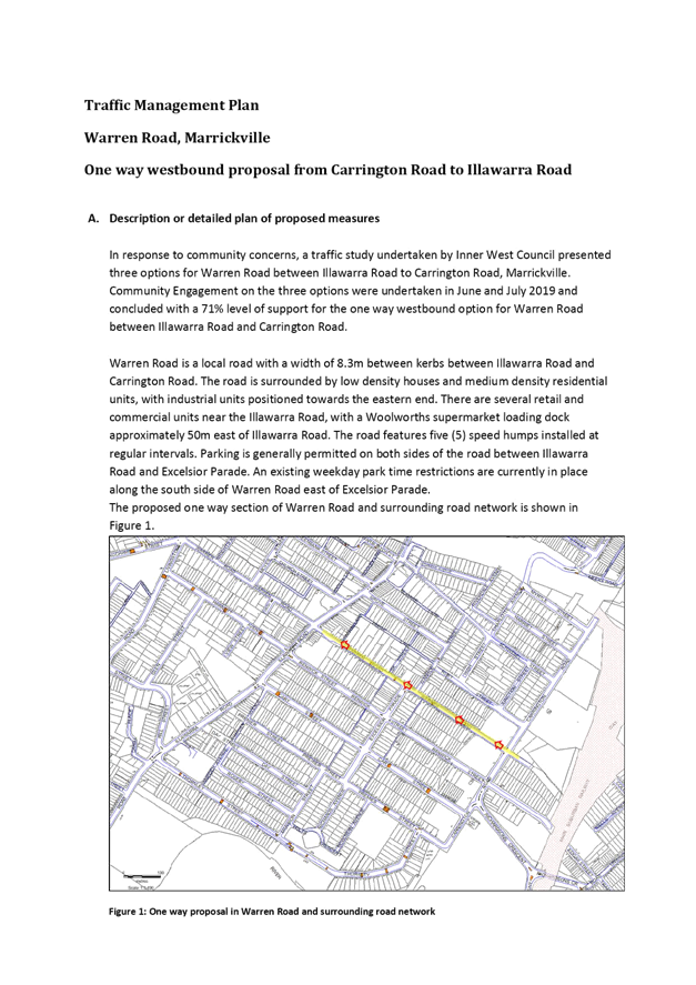
Item No: LTC0520
Item 1
Subject: Warren Road, Marrickville - Implementation of
one-way traffic (Midjuburi - Marrickville Ward/Summer Hill Electorate/Inner
West PAC)
Prepared By: Sunny
Jo - Traffic and Parking Planner
Authorised By: Manod
Wickramasinghe - Traffic and Transport Planning Manager
SUMMARY
Transport for NSW has given in principle support for the
Traffic Management Plan (TMP) for the one-way westbound traffic in Warren Road
between Carrington and Illawarra Roads. Additional changes at the traffic
signals are required at the Warren Road and Illawarra Road intersection in
addition to changes to signage and linemarking and it is recommended that this
work be listed in Council’s future Capital Works Program.
|
RECOMMENDATION
THAT:
1. It be noted that Transport
for NSW has given in principle support for the Traffic Management Plan (TMP)
of the one-way westbound traffic changes in Warren Road between Carrington
Road and Illawarra Road, Marrickville;
2. Traffic signal works at the
intersection of Warren Road and Illawarra Road and one-way westbound
conversion of Warren Road, be listed in Council’s future Capital Works
Program with an estimated project cost of $120,000;
3. The one-way westbound
traffic restrictions including associated signposting and linemarking
(Attachment 2 & 3) in Warren Road between Carrington Road and Illawarra
Road, Marrickville be approved and installed in conjunction with the planned
traffic signal works at the intersection of Warren Road and Illawarra Road;
4. It be noted that Renwick
Street has been included in Council’s Slow Down in My Street and
Speed Radar programs, including the installation of edge lines in
Renwick Street; and
5. The 3t Truck Load Limit be
removed in Renwick Street as part of the One-way implementation in Warren
Road.
|
BACKGROUND
The Traffic
Committee at its meeting held 5 August 2019 considered a report on the Warren
Road traffic study to improve traffic flow and safety in Warren Road, Marrickville
and recommended that:
1.
A westbound one-way traffic movement in Warren Road between Carrington Road and
Illawarra Road, be supported “in-principle”.
2.
Council Officers continue to liaise with RMS and provide any further information
requested to assist their review of the TMP.
3.
A further report be provided to the Traffic Committee once RMS review of TMP is
completed.
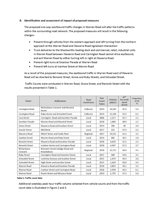
OTHER
STAFF COMMENTS
Following Council’s support
for the one-way proposal, a TMP was submitted to Transport for NSW (formerly
RMS) for consideration (Attachment 1). This included SIDRA intersection
modelling at Warren Road/Illawarra Road and Illawarra Road/Renwick Street
intersections. TfNSW has assessed the TMP and has raised no objections to the
one-way arrangement.
The changes required to implement
the one-way traffic changes include modification to the signalised intersection
of Warren Road and Illawarra Road and changes to linemarking and signage in
Warren Road.
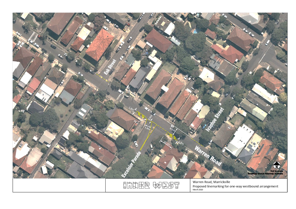
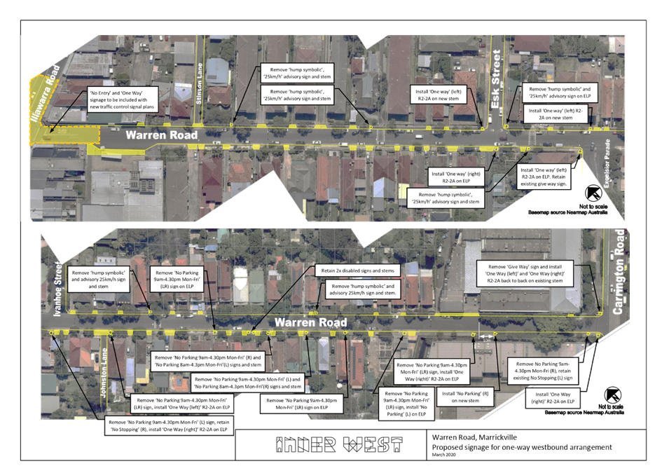
The proposed linemarking and
signage changes are shown in Attachments 2 and 3 and include:
· Removal of
‘No Parking 9am-4.30pm Mon-Fri’ restrictions on south side of
Warren Road, reinstating approximately 24 spaces of unrestricted parking;
· Full-time
‘No Parking’ zone opposite driveways to industrial property 47
Warren Road, to retain truck access;
· Installation of
one-way signs and removal of signs facing eastbound traffic in Warren Road;
· Linemarking to
discourage right turns from Excelsior Parade to Warren Road; and
· Removal of 3t GVM
Truck Load Limit in Renwick Street.
It should be noted that a site trial was organised for a
13.3m length Woolworths delivery truck in August 2019 under traffic control and
Police notification to observe the left turn movement from Warren Road to
Illawarra Road southbound, followed by the left turn to Renwick Street, and the
through movement past the existing roundabout at Excelsior Parade. No access
issues were identified during the trial and Woolworths Group has indicated
support for the one-way restrictions and changes to the truck route.
As previously reported to the LTC, road safety education
measures and linemarking are proposed in Renwick Street, including Slow Down
in My Street and Speed Radar programs. The existing 3t GVM Truck
Load Limit will need to be lifted in Renwick Street; however, until the one-way
proposal is implemented in Warren Road, it is proposed that the load limit
remain.
A recent review of the reported crashes in Warren Road
indicates no new crashes were reported between January 2018 and December 2019.
Local residents however reported a number of additional tow-away crashes and
incidents during these periods.
PUBLIC CONSULTATION
Consultation was undertaken in
June 2019 and provided three options to the community to improve traffic flow
and safety in Warren Road. The community supported the one-way westbound
traffic option with a 72.8% support rate.
FINANCIAL IMPLICATIONS
The project cost estimate for the
signage and linemarking, traffic signal improvements, and notification is
$120,000 and is proposed to be included in Council’s future works
program.
ATTACHMENTS
|
1.⇩
|
Warren Road - TMP
|
|
2.⇩
|
Warren Road - Linemarking Plan
|
|
3.⇩
|
Warren Road - signage plan
|
|

|
Local Traffic
Committee Meeting
4 May 2020
|
|
|
Local Traffic
Committee Meeting
4 May 2020
|
|

|
Local Traffic
Committee Meeting
4 May 2020
|
Item No: LTC0520
Item 2
Subject: Horton Street, Marrickville between Amy Street
and Illawarra Road - Temporary Full Road Closure for Street Party - Saturday 31
October 2020 between 2.00 and 7.00pm (Midjuburi - Marrickville Ward / Summer
Hill Electorate / Inner West PAC)
Prepared By: Jennifer
Adams - Engineer – Traffic and Parking Services
Authorised By: Manod
Wickramasinghe - Traffic and Transport Planning Manager
SUMMARY
An
application has been received from a resident for the temporary full road
closure of Horton Street, Marrickville between Amy Street and Illawarra Road for
a period of five hours on Saturday, 31 October 2020 in order to hold a street
party. It is recommended that the proposed temporary road closure be approved,
subject to the conditions outlined in this report.
|
RECOMMENDATION
THAT the proposed temporary
full road closure of Horton Street, Marrickville between Amy Street
and Illawarra Road for a period of five hours on Saturday, 31 October
2020 between 2.00 and 7.00pm be APPROVED, in order to hold a street
party, subject to the Conditions of Approval as set out in the Street
Party Application Form and the following conditions:
1. Latest government and health advice on
convid-19 is followed at the time of the event including gatherings and/or social
distancing restrictions;
2. All affected residents and businesses,
including the NSW Police Local Area Commander, Fire & Rescue NSW and NSW
Ambulance Services be notified in writing, by the applicant, of the proposed
temporary road closure at least 14 days in advance of the closure with the
applicant making reasonable provision for stakeholders;
3. The applicant is to set out the road closure as
per the attached typical Traffic Control Plan (TCP) and a 4-metre wide
emergency vehicle access be maintained through the closed road areas during
the course of the event; and
4. The occupation of the road carriageway must
not occur until the road has been physically closed.
|
BACKGROUND
Council
encourages properly conducted neighbourhood street parties as a means of
building community spirit and improving neighbourhood security. Fees for road
occupancy are waived by Council for small community street parties. For
approved street parties and subject to availability Council will provide
barricades and ‘Road Closed’ signs subject to the street party
coordinator arranging collection from and return to Council’s Summer Hill
depot.
Council’s
Neighbourhood Street Party Guidelines state, in relation to road closures,
that:
“As a
guide, to be eligible for a road closure to hold a neighbourhood street party
your street: must be a local residential street block, cul-de-sac
or laneway; must not carry significant traffic volume; must not be a major
transport route or contain bus routes; must not provide access to railway
stations and associated parking; must not block access to shopping centres,
carparks or interfere with commercial or business operations.
Neighbourhood
street parties are non-commercial events and the following activities are
prohibited: the erection of temporary structures, jumping castles
or other entertainment devices; the sale of food or drink or fundraising; Live
performers or amplified music; road closure and road occupation after
dark.”
FINANCIAL
IMPLICATIONS
Nil.
OFFICER
COMMENTS
Horton
Street is a local road carrying around 450 vehicles per day. It is a two-way
road with one travel lane in each direction, in addition to kerbside parking
lanes. Parking is unrestricted along both sides of the road and there have been
no RMS recorded crashes for last five years.
According to the RMS ‘Guide
to Traffic and Transport Management for Special Events’ a small street
party is considered as a ‘Class 3’ event. Impacts of the road
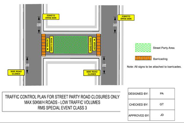
closure for the event are considered minimal. Vehicular access for
residents/businesses is to be maintained during the closure, where possible. A
typical ‘standard’ Traffic Control Plan (TCP) for the Closure is
reproduced below.
PUBLIC CONSULTATION
The proposed temporary full road
closure of Horton Street, Marrickville between Amy Street and Illawarra Road for
a period of five hours on Saturday 31 October 2020 has been advertised.
.
ATTACHMENTS
Nil.
|
|
Local Traffic
Committee Meeting
4 May 2020
|
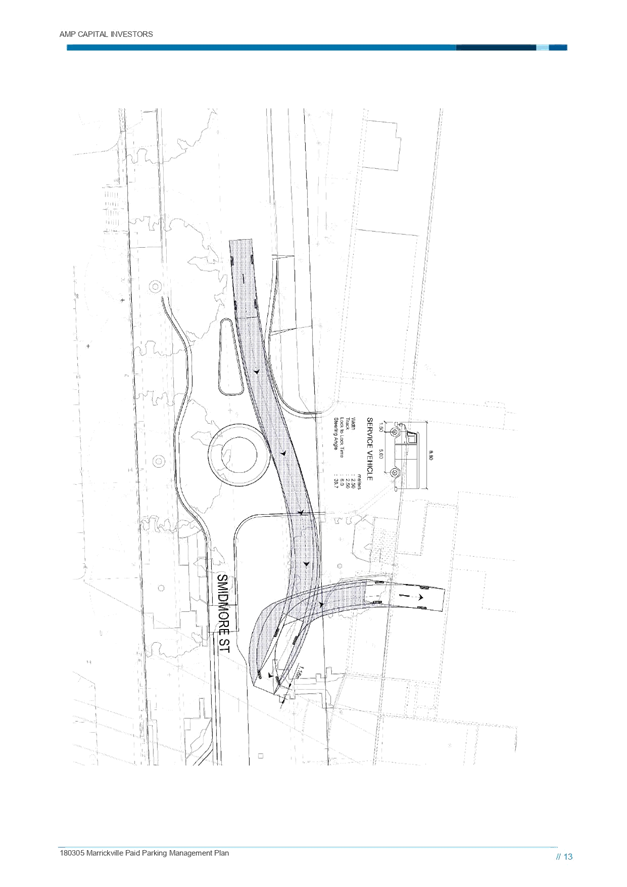
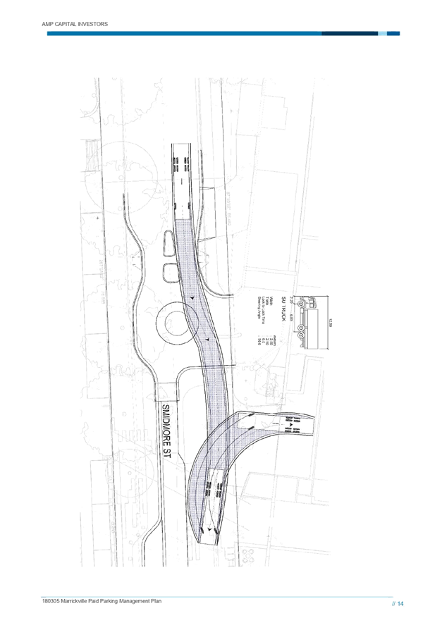
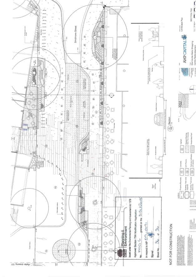
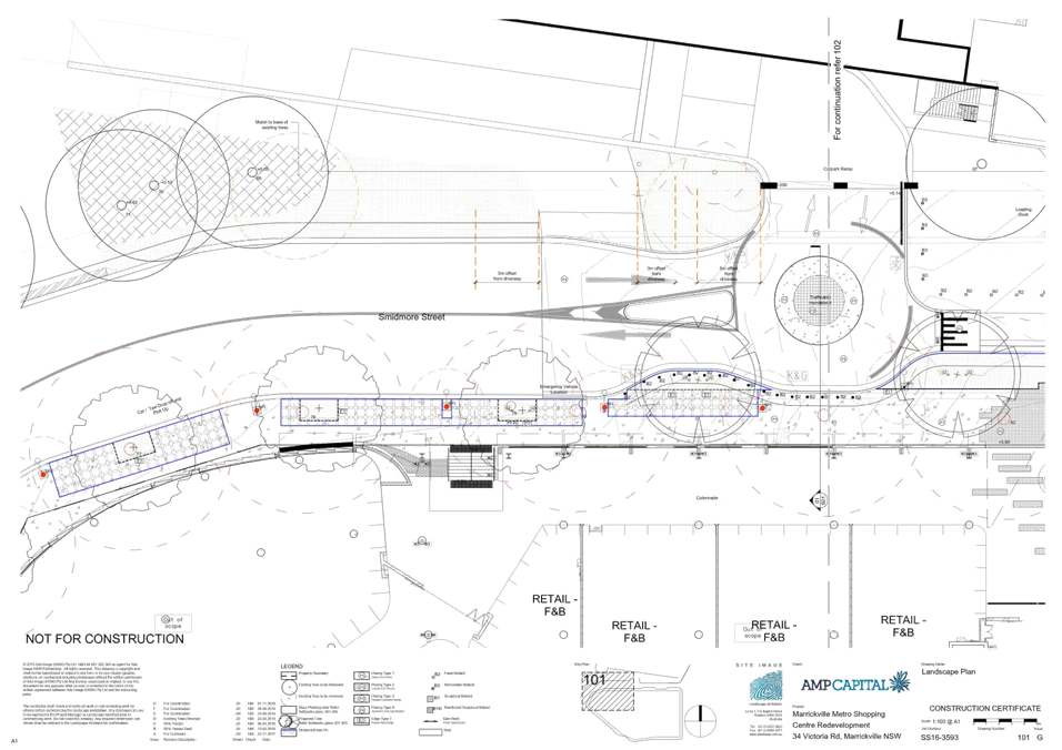
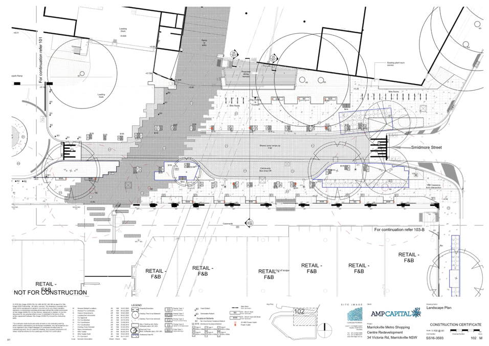
Item No: LTC0520
Item 3
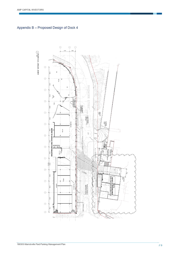
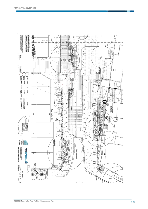
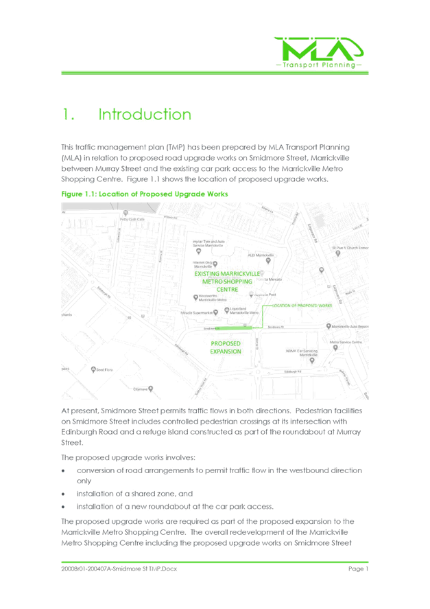
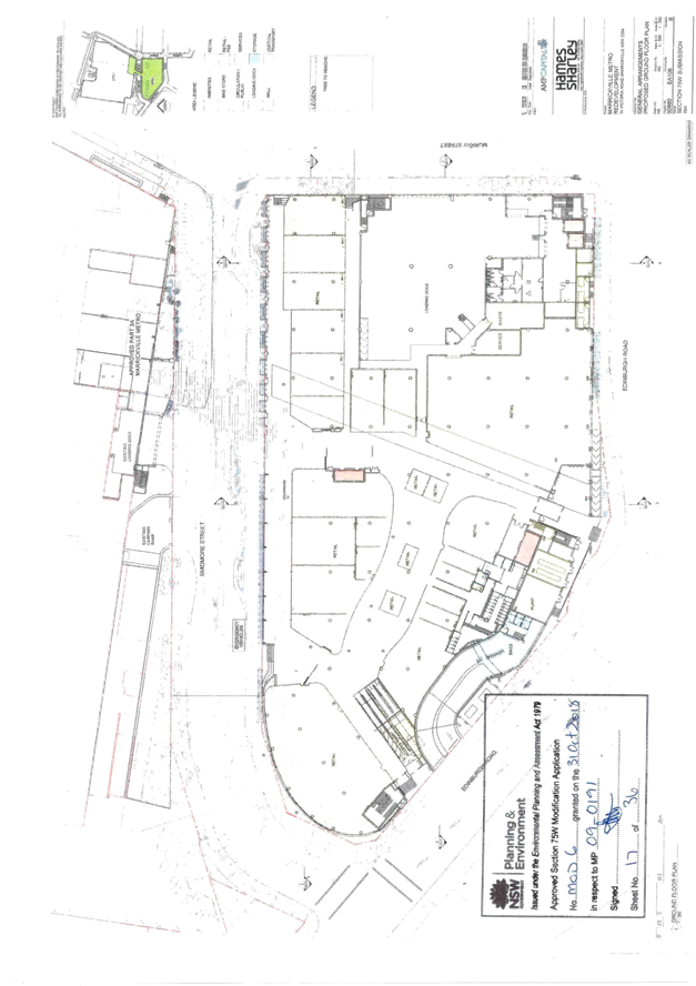
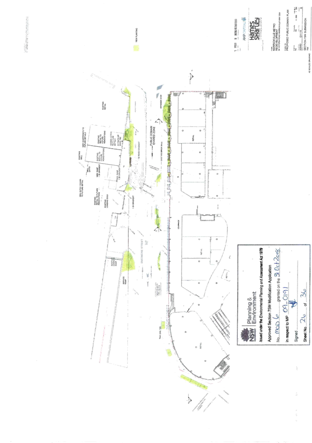
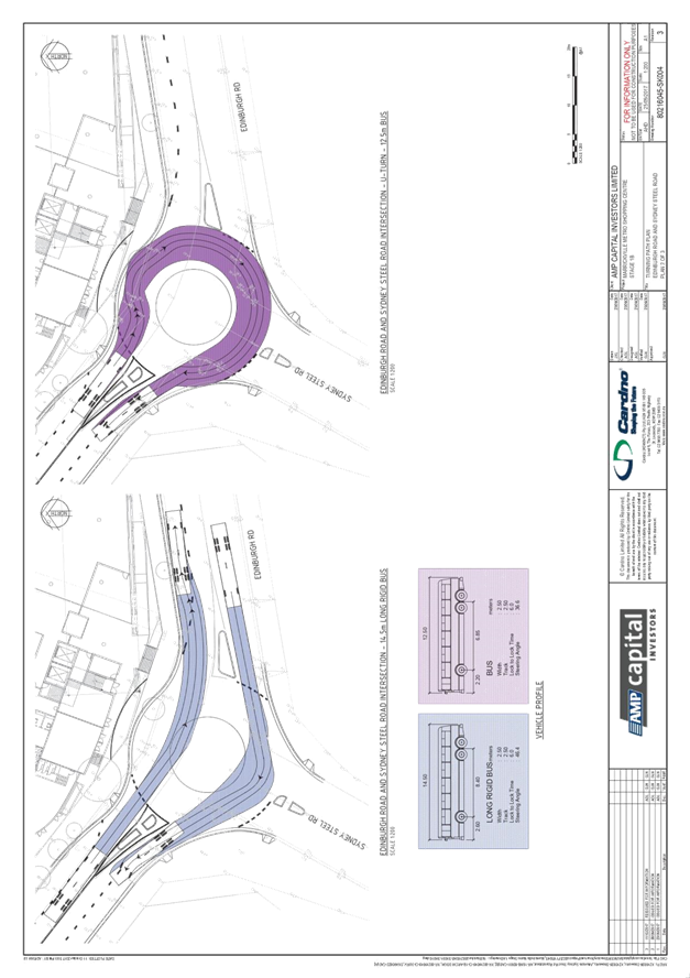
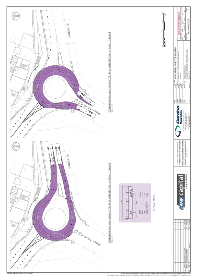
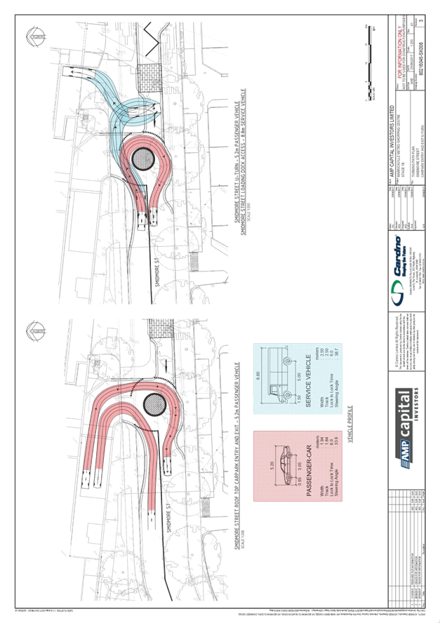
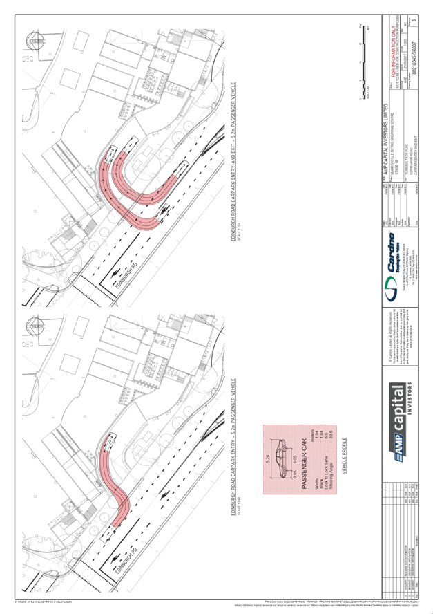
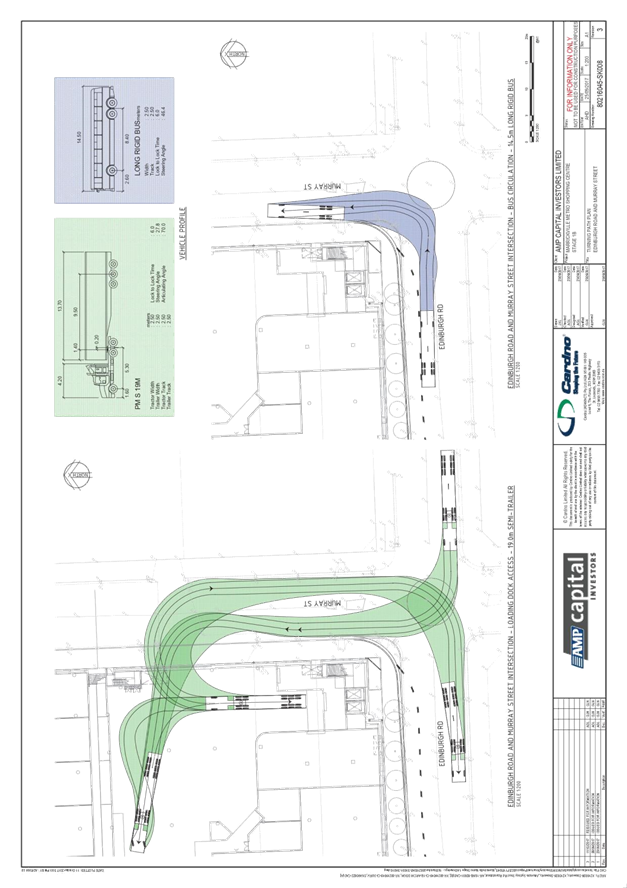
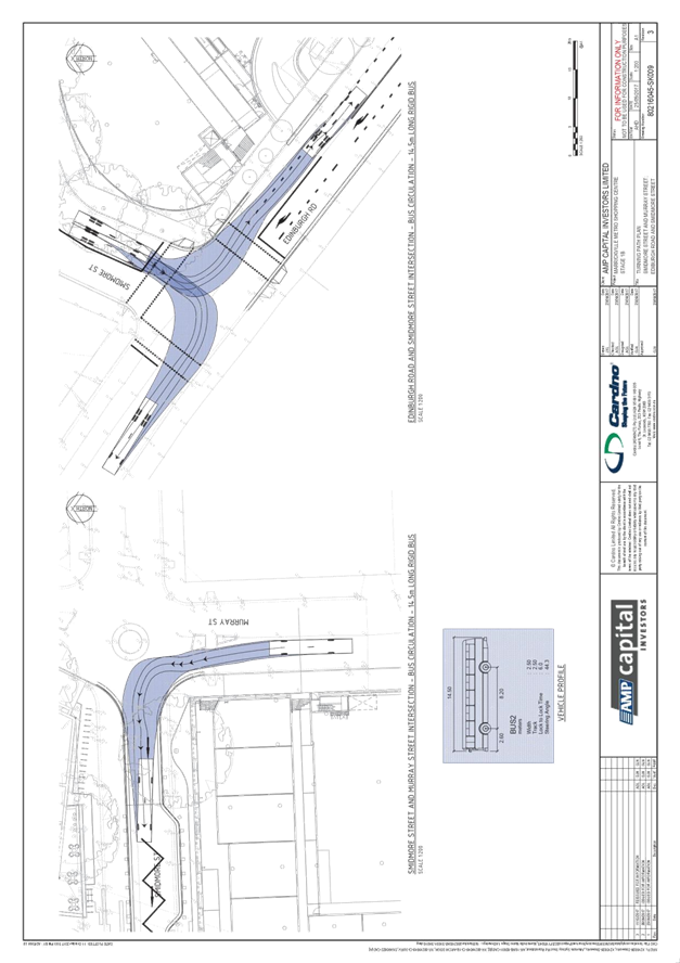
Subject: Smidmore Street, Marrickville –
Marrickville Metro Expansion Works - Proposed Shared Zone and One-way traffic
restrictions
-– (Midjuburi – Marrickville Ward / Newtown Electorate /
Inner West PAC)
Prepared By: Jennifer
Adams - Engineer – Traffic and Parking Services
Authorised By: Manod
Wickramasinghe - Traffic and Transport Planning Manager
SUMMARY
MLA
Transport Planning (MLATP) has submitted plans as part of the Marrickville
Metro Expansion works for the proposed ‘10km/h Shared Zone’;
one-way traffic arrangements; and parking changes in Smidmore Street,
Marrickville.
.
|
RECOMMENDATION
THAT
1.
The proposed changes to traffic and parking conditions in
Smidmore Street, Marrickville (between Murray Street and the site access) as
per plans submitted by MLATP (80216045-CV-1BPD-02-061-062-02-061 –
Revision 6) be approved including:
a. ‘10km/h Shared Zone’
incorporating a westbound one-way section in Smidmore Street, Marrickville
(between Murray Street and the site access), subject to separate approval of
the ‘10km/h Shared Zone’ and TMP from Transport for NSW
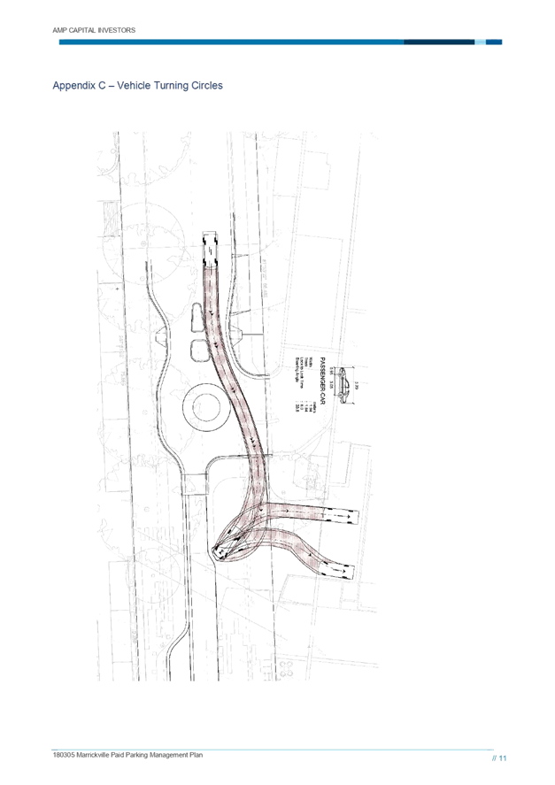
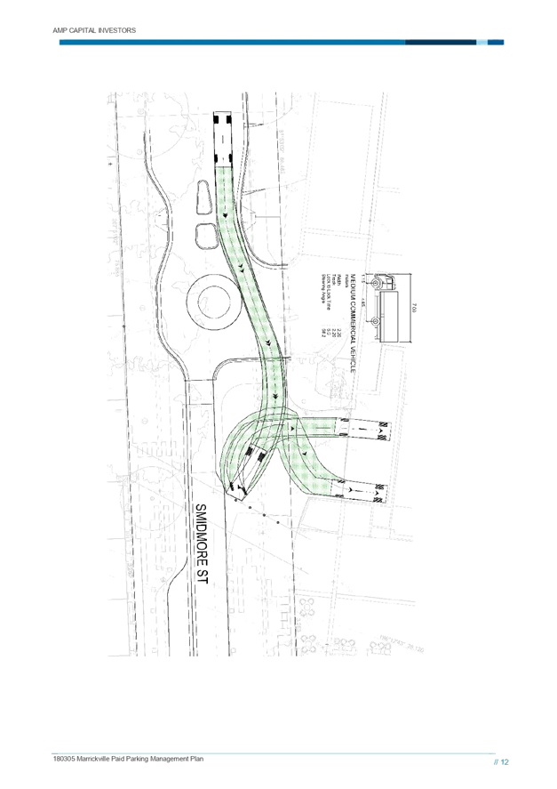
(including notification requirements);
b. Roundabout located midblock in Smidmore Street,
Marrickville between: the site access; one-way section of Smidmore Street;
and the two-way section of Smidmore Street;
c. associated changes to signage and line
marking in Smidmore Street be approved including ‘Bus Zones, ‘No
Stopping’ zones, ‘No Parking’ zones, ‘Taxi
Zones’ and ‘2P’ parking restrictions.
2.
The proposed Taxi Zone in Smidmore Street as shown on the
submitted plans (80216045-CV-1BPD-02-061-062-02-061
– Revision 6) be extended by 6m (one space) into the
adjacent proposed ‘2P’ zone on the southern side of Smidmore
Street.
|
BACKGROUND
& OTHER STAFF COMMENTS
The proposed expansion of Marrickville Metro Shopping
Centre was first granted planning approval in March 2012. Following this,
there were several subsequent approved modifications. In October 2017, a
Section 75W (S75W) application was submitted to the Department of Planning and
Environment (DPE) seeking approval to refine and enhance the approved
development. The S75W modification included the following proposals as
relevant to this Local Traffic Committee report:
· Smidmore
Street is to be converted to one-way between Murray Street and the site access
with the Smidmore Street access permitting left in traffic movements from
Smidmore Street and right out traffic movements to Smidmore Street.
· a
‘10km/h Shared Zone’ on Smidmore Street connecting the new pedestrian
entrance to the existing Centre.
· A
roundabout at the existing shopping centre vehicular entry/egress point is
proposed to facilitate U-turns for eastbound vehicles who do not wish to enter
the existing shopping centre carpark and to allow taxis to access the
designated parking
These
proposals seek to reduce vehicle volumes in Smidmore Street to facilitate a
reinvigorated public domain and pedestrian friendly environment.
It is noted
that a ‘10km/h Shared Zone’ is a Transport for NSW sanctioned speed
management device. As such, TfNSW require any
proposed ‘Shared Zones’ to comply with the criteria set out for a
shared zone. The applicants report on the Shared Zone is shown in Attachment
3.
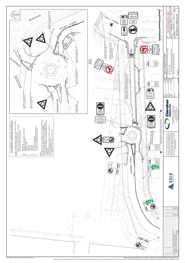
Additionally, the following
parking changes are proposed as per Attachment 1:
· relocation
of ‘Taxi Zone’ to the southern side of Smidmore Street west of the
site access;
· relocation
of the existing ‘Bus Zone’ to the southern side of Smidmore Street,
west of Murray Street;
· Provision
of ‘2P 8:30am-6pm Mon-Fri; 8:30am-12:30pm Sat’ restrictions on the
southern side of Smidmore Street, west of the proposed ‘Taxi Zone’.
The applicant
notes that:
· “Appropriate
pedestrian notification around the proposed shared zone is shown on the signage
and line marking plan” and
·
“These details are as per RMS standards for shared zones. This
includes signage delineating the start and end of the shared zone. Longitudinal
line marking is shown to additionally highlight the edge of the nominated
vehicle pathway. Other methods are also proposed such as changes in pavement,
removal of street kerbs and inclusion of bollards.”
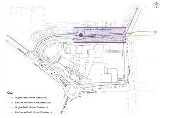
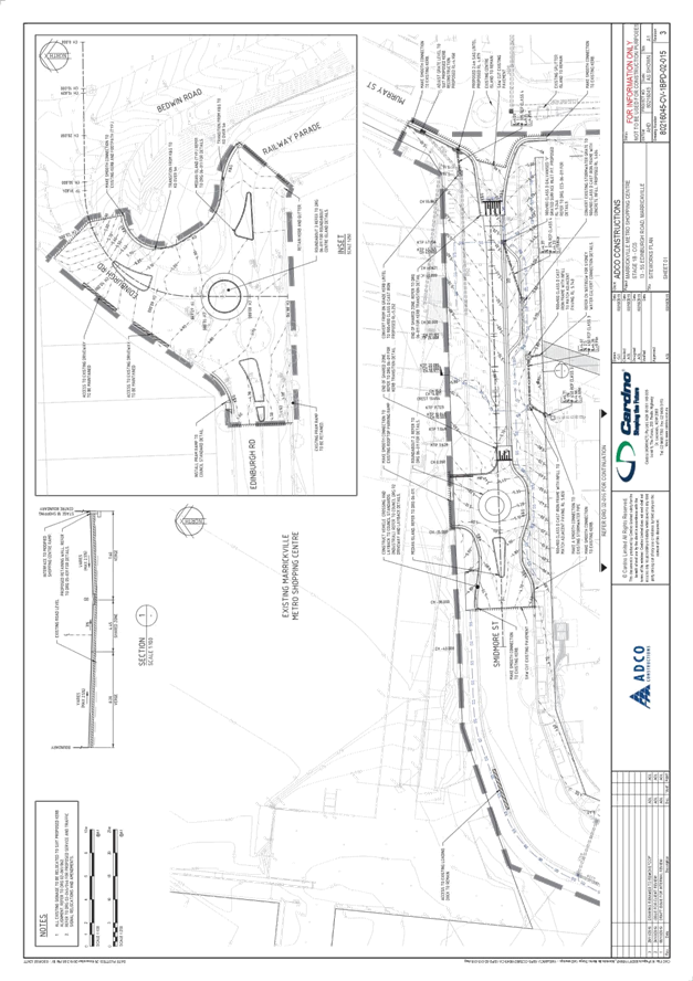
Traffic Management Plan
The Traffic management Plan
(TMP) is provided in Attachment 2. The proposed one-way arrangement on
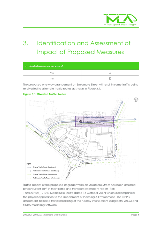
Smidmore Street will result in previous eastbound through traffic being re-distributed
via Edinburgh Road and Murray Street as shown by the following plan.
A separate report will be
provided to the Traffic Committee regarding proposed changes to Edinburgh Road
and Murray Street associated with the development.
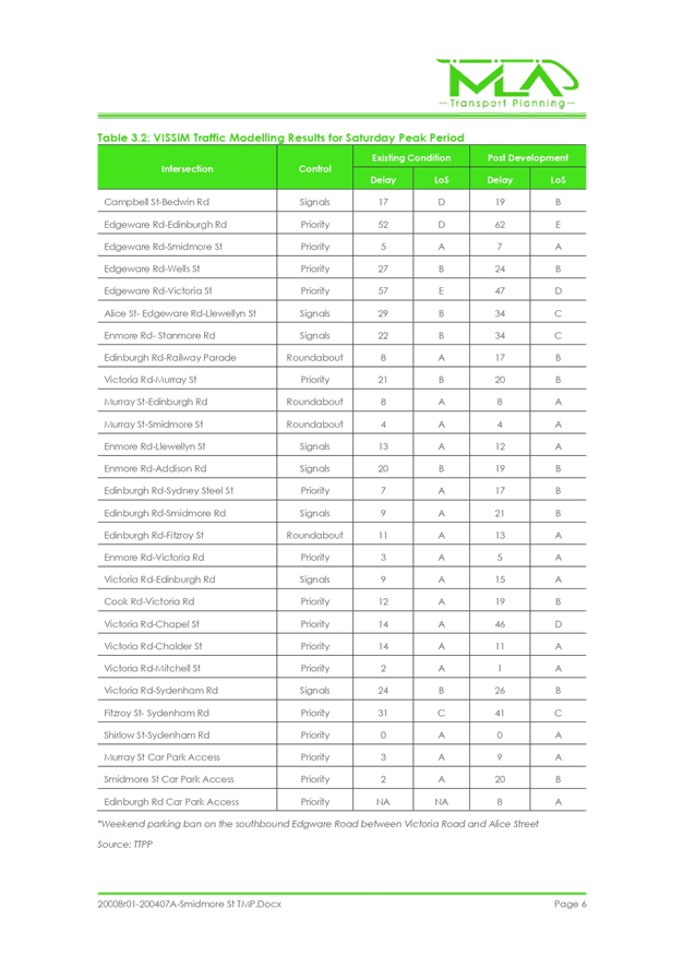
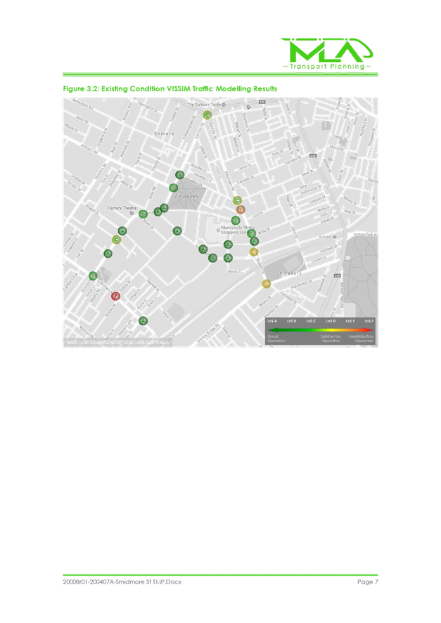
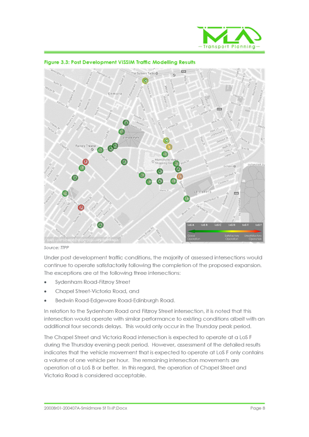
The TMP states that “The
modelling results indicate that the Smidmore Street intersections and the
intersections along the diverted route would continue to have satisfactory
operation
following the completion of the proposed development.”
FINANCIAL
IMPLICATIONS
All works and
costs of implementation works associated with the Shared Zone proposal will be
borne by the applicant.
CONSULTATION
The ‘Shared Zone’
proposal was part of the development assessment which was previously
advertised. Further notification with the immediate and wider community will be
undertaken prior to final TfNSW approval.
The Taxi Council has requested
that the proposed ‘Taxi Zone’ on the southern side of Smidmore
Street be extended to provide an additional parking space to cater for the
demand to be generated by the development.
CONCLUSION
It is recommended that the
proposed treatments including the implementation of
the ‘10km/h Shared Zone’ in Smidmore Street and one-way
restrictions be supported in principle and submitted to TfNSW (RMS) for
their concurrence.
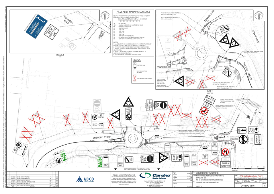
ATTACHMENTS
|
1.⇩
|
Signage and Linemarking Plan
|
|
2.⇩
|
Traffic Management plan
|
|
3.⇩
|
Shared Zone report
|
|
|
Local Traffic
Committee Meeting
4 May 2020
|
|
|
Local Traffic
Committee Meeting
4 May 2020
|


|

|
Local Traffic
Committee Meeting
4 May 2020
|
|

|
Local Traffic
Committee Meeting
4 May 2020
|
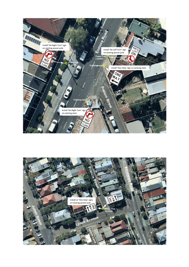
Item No: LTC0520
Item 4
Subject: Francis Street, Enmore - Implementation of
One-way traffic (Stanmore-Damun Ward / Newtown Electorate /
Inner West PAC)
Prepared By: Sunny
Jo - Traffic and Parking Planner
Authorised By: Manod Wickramasinghe
- Traffic and Transport Planning Manager
SUMMARY
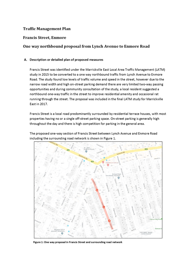
As per the approved Marrickville East Local Area Traffic Management
(LATM) Plan, it is proposed that the traffic
arrangement in Francis Street, Enmore be modified to one-way traffic between Lynch
Avenue and Enmore Road to improve traffic flow and safety.
|
RECOMMENDATION
THAT:
1. The northbound one-way traffic in Francis Street, Enmore from
Lynch Avenue to Enmore Road be approved as per the attached signage plan,
subject to Transport for NSW approval of the Traffic Management Plan; and
2. Council notify residents of Francis Street and nearby streets of
the changes and also through Variable Message Signs (VMS) prior to changes
being implemented.
|
BACKGROUND & OTHER STAFF COMMENTS
Council is proposing to change the traffic
arrangement in Francis Street, Enmore to one- way traffic between Lynch Avenue
and Enmore Road. The purpose of changing the existing two-way traffic into a
one-way northbound flow is to improve traffic flow and safety as there are very
limited opportunities for two-way passing in Francis Street due to its narrow
width and very high parking demand.
The proposal was part of the approved
Marrickville East Local Area Traffic Management (LATM) Plan, which was on
public exhibition for community comment in late 2016. The Marrickville East
LATM was endorsed and approved by Council at its meeting on 28 February 2017.
Francis Street is a local street with a
narrow road carriageway varying between 4.9m and 5.5m. The street is on a
straight alignment and 250m in length, predominantly surrounded by residential
terrace houses on both sides and provides vehicular access to the rear of
properties in Edgeware Road. On street parking levels are very high throughout
the day as a significant proportion of premises in this area do not have
off-street parking spaces.
|
Street Name
|
Francis Street
|
|
Section
|
Between Lynch
Avenue and Enmore Road
|
|
Carriageway
width (m) kerb to kerb
|
4.9-5-5m
|
|
Carriageway type
|
Two-way road,
single lane carriageway width with kerbside parking on west side
|
|
Classification
|
Local
|
|
Speed Limit
|
50km/h
|
|
85th
percentile speed (km/h)
|
32km/h
(bidirectional, 2012 data)
|
|
Vehicles per day
(AADT)
|
126
(bidirectional, 2012 data)
|
|
Reported crash
history
|
Nil for the 5
year data ending in June 2018.
|
|
Heavy vehicle
volume (%)
|
3
|
|
Parking
arrangements
|
Unrestricted
parking on west side, east side parking is prohibited by existing driveways.
|
Parking is permitted on the west side
however two-way passing is difficult as there are only three possible locations
with that can be used as a passing bay. Generally, the northern end provides
some passing opportunities, however the two other locations are narrow
driveways and impractical to use as a passing bay.
Francis Street was included in the
Marrickville East LATM study that was undertaken in 2015. Under the study
Francis Street was identified for a conversion to a northbound one- way traffic
to eliminate vehicle conflicts in opposing directions, as the street has very
few passing opportunities.
FINANCIAL IMPLICATIONS
Nil.
PUBLIC CONSULTATION
A letter outlining the above proposal was
mailed out to 311 recipients in Francis Street and neighbouring streets in
February and March 2020.
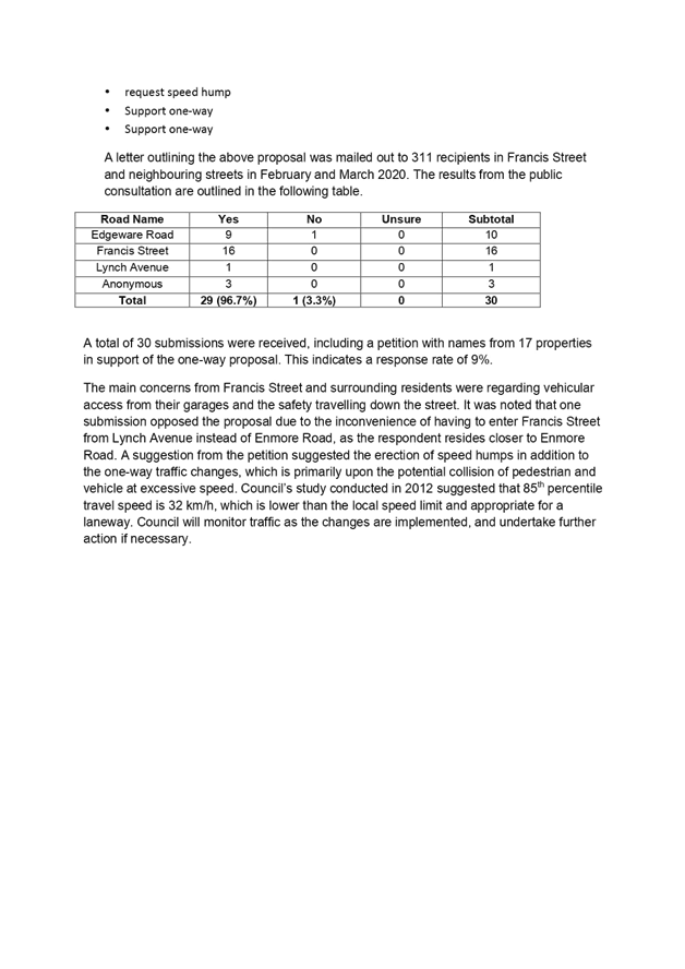
A total of 30 submissions were received,
including a petition with names from 17 properties in support of the one-way
proposal. A total of 29 of the responses supported the proposal and one
objected.
The main concerns from Francis Street and
surrounding residents were regarding vehicular access from their garages and
the safety travelling down the street. It was noted that one submission opposed
the proposal due to the inconvenience of having to enter Francis Street from
Lynch Avenue instead of Enmore Road, as the respondent resides closer to Enmore
Road. A suggestion from the petition suggested the erection of speed humps in
addition to the one-way traffic changes, which is primarily upon the potential
collision of pedestrian and vehicle at excessive speed. Council’s study
conducted in 2012 suggested that 85th percentile travel speed is 32
km/h, which is lower than the local speed limit and appropriate for a laneway.
Council will monitor traffic as the changes are implemented and undertake
further action if necessary.
ATTACHMENTS
|
1.⇩
|
Francis Street, Enmore - Signposting Plan
|
|
2.⇩
|
Traffic Management Plan
|
|

|
Local Traffic
Committee Meeting
4 May 2020
|
|

|
Local Traffic
Committee Meeting
4 May 2020
|