Local Traffic Committee
Meeting
JULY 2020
The July 2020
meeting of the Inner West Local Traffic Committee will be held electronically
with the Agenda emailed to Members for review. All comments are requested to be
returned to Council by 5.00pm Monday 6 July 2020.
|

|
Local Traffic
Committee Meeting
6 July 2020
|
Function of the Local
Traffic Committee
Background
Roads and Maritime
Services (RMS) is legislated as the
Authority responsible for the control of traffic on all NSW Roads. The RMS has
delegated certain aspects of the control of traffic on local roads to councils.
To exercise this delegation, councils must establish a local traffic committee
and obtain the advice of the RMS and Police. The Inner West Council Local Traffic
Committee has been constituted by Council as a result of the delegation granted
by the RMS pursuant to Section 50 of the Transport Administration Act 1988.
Role of the Committee
The Local
Traffic Committee is primarily a
technical review and advisory committee which considers the technical merits of
proposals and ensures that current technical guidelines are considered. It
provides recommendations to Council on traffic and parking control matters and
on the provision of traffic control facilities and prescribed traffic control
devices for which Council has delegated authority. These matters are dealt with
under Part A of the agenda and require Council to consider exercising
its delegation.
In
addition to its formal role as the Local Traffic Committee, the Committee may
also be requested to provide informal traffic engineering advice on traffic
matters not requiring Council to exercise its delegated function at that point
in time, for example, advice to Council’s Development Assessment Section
on traffic generating developments. These matters are dealt with under Part
C of the agenda and are for information or advice only and do not require
Council to exercise its delegation.
Committee Delegations
The Local
Traffic Committee has no decision-making
powers. The Council must refer all traffic related matters to the Local Traffic
Committee prior to exercising its delegated functions. Matters related to State
Roads or functions that have not been delegated to Council must be referred
directly to the RMS or relevant organisation.
The
Committee provides recommendations to Council. Should Council wish to act
contrary to the advice of the Committee or if that advice is not supported
unanimously by the Committee members, then the Police or RMS have an
opportunity to appeal to the Regional Traffic Committee.
Committee Membership & Voting
Formal
voting membership comprises the following:
·
one representative of Council as
nominated by Council;
·
one representative of the NSW
Police from each Local Area Command (LAC) within the LGA, being Newtown,
Marrickville, Leichhardt and Ashfield LAC’s.
·
one representative from the RMS; and
·
State Members of Parliament (MP)
for the electorates of Summer Hill, Newtown, Heffron, Canterbury, Strathfield
and Balmain or their nominees.
Where the Council area is represented by more than one
MP or covered by more than one Police LAC, representatives are only permitted to vote on matters which effect
their electorate or LAC.
Informal
(non-voting) advisors from within Council or external authorities may also
attend Committee meetings to provide expert advice.
Committee Chair
Council’s
representative will chair the meetings.
|
|
Local Traffic
Committee Meeting
6 July 2020
|
1 Apologies
2 Disclosures
of Interest
3 Confirmation
of Minutes Page
Minutes of 1 June 2020 Local Traffic
Committee Meeting 5
4 Matters
Arising from Council’s Resolution of Minutes
5 Part
A – Items Where Council May Exercise Its Delegated Functions
Traffic Matters
ITEM Page
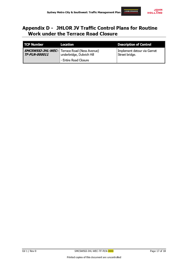
LTC0720 Item 1 Terrace
Road / Ness Avenue, Dulwich Hill – Temporary Full Road Closure of Rail
Underpass just north of the roundabout at Ewart Street – Sydney Metro
(SSJ) continuation of early enabling works on T3 Line (Djarrawunang-Ashfield
Ward / Summer Hill Electorate / Inner West PAC) 14
LTC0720 Item 2 Smith
Street, Summer Hill - Proposed Refuge Island east of Flour Mill Way –
Plan 10127 (Djarrawunang - Ashfield Ward / Summer Hill Electorate / Burwood
PAC) 35
LTC0720 Item 3 Edinburgh
Street, Murray Street and Railway Parade, Marrickville – Marrickville
Metro Expansion Works (Midjuburi – Marrickville Ward / Newtown
Electorate / Inner West PAC) 38
LTC0720 Item 4 Westconnex
M5 – St Peters Interchange Active Transport Works – Part 1
(Midjuburi – Marrickville Ward / Heffron Electorate / Inner West PAC) 81
LTC0720 Item 5 Urban
Amenity Improvement Program – Leichhardt And Camperdown Precincts
(Gulgadya - Leichhardt & Damun-Stanmore Wards/Balmain & Newtown
Electorates/Leichhardt & Inner West PACs) 91
LTC0720 Item 6 Goddard
Street, Newtown - Proposed continuous footpath treatment in Goddard Street at
King Street – Final Signage and Line Marking Plan 10134 (Damum - Stanmore
Ward / Newtown Electorate / Inner West PAC) 114
LTC0720 Item 7 Dulwich
Hill Station Precinct Public Domain Improvements (Djarrawunang-Ashfield Ward /
Summer Hill Electorate / Inner West PAC) 117
Parking Matters
Nil at the time of printing.
Late Items
Nil at time of printing.
6 Part
B - Items for Information Only
ITEM Page
LTC0720 Item 8 Flood
Street, Leichhardt - Road Occupancy (Gulgadya Ward/ Balmain Electorate/
Leichhardt PAC) 222
7 Part
C - Items for General Advice
ITEM Page
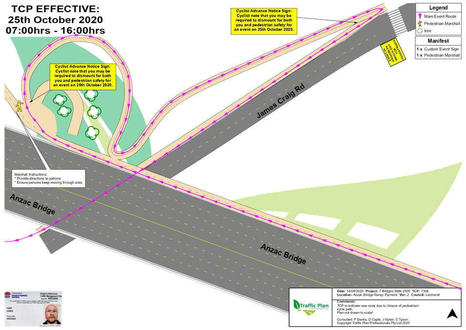
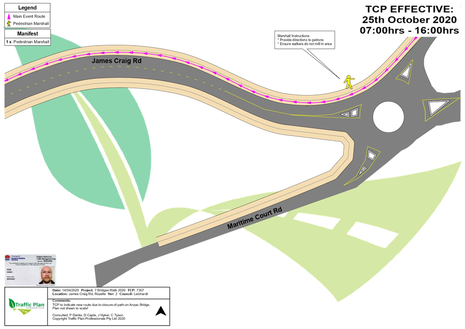
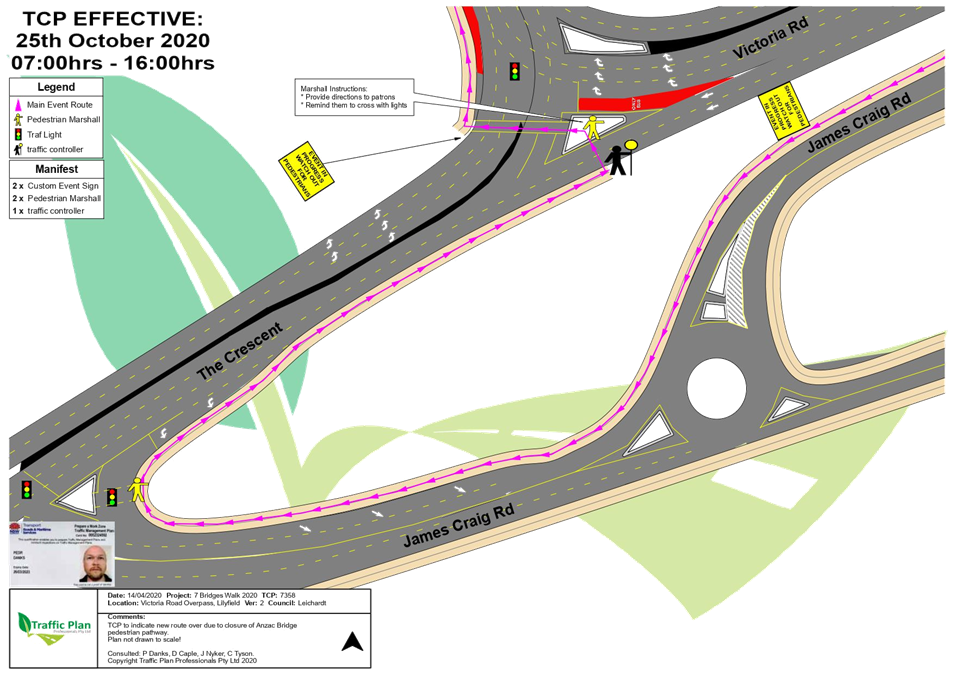
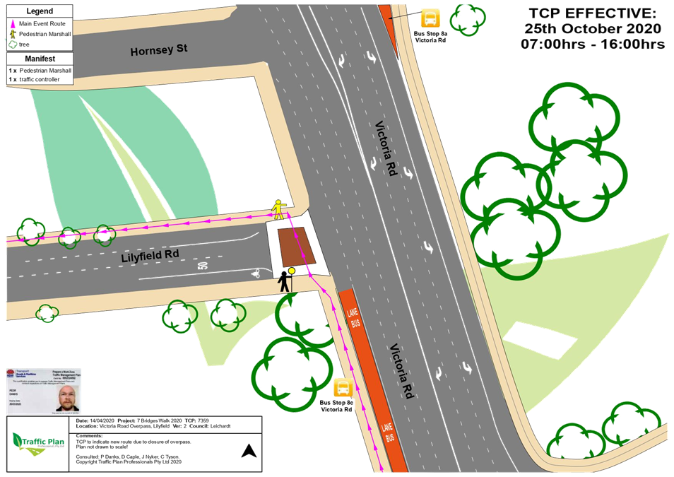
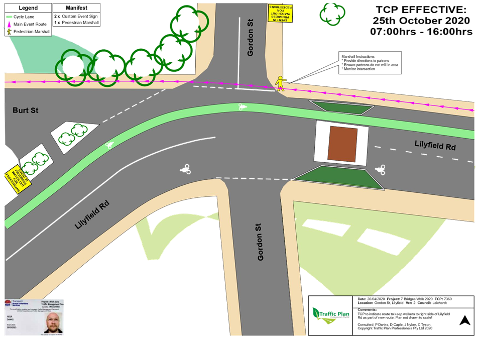
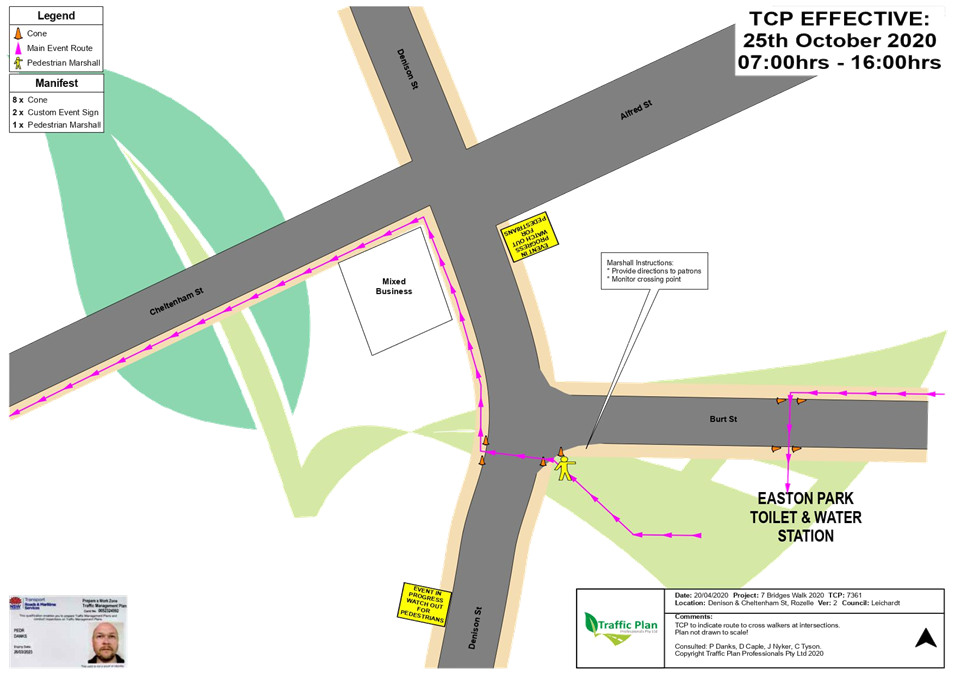
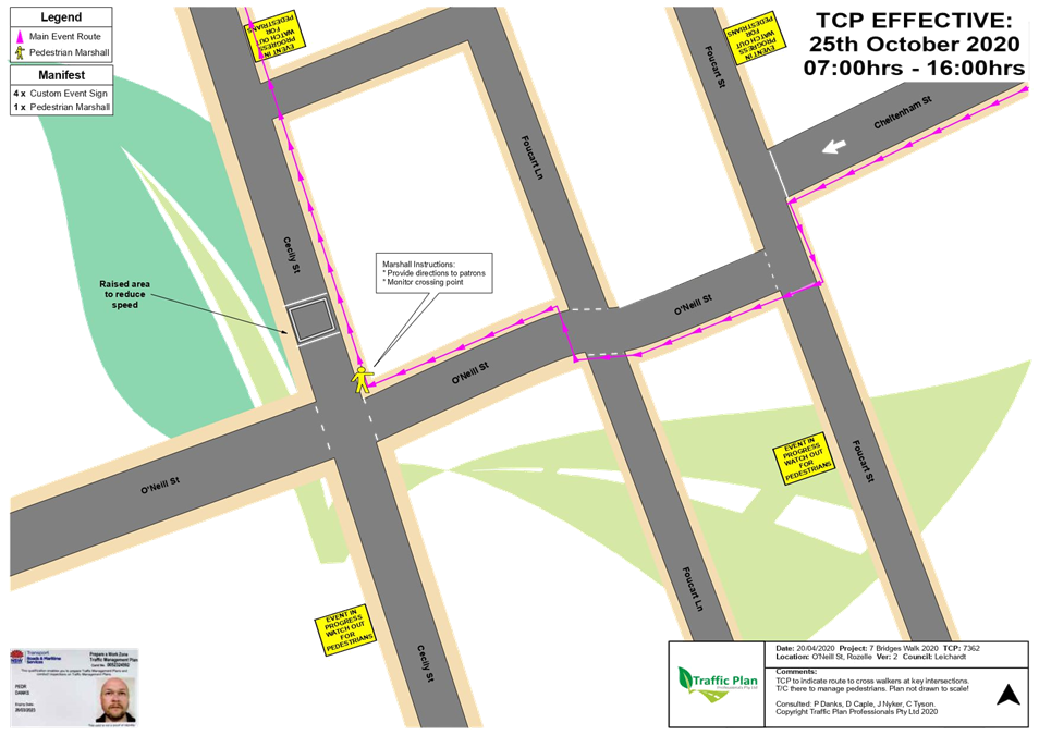
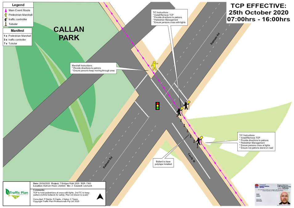
LTC0720 Item 9 Seven
Bridges Walk - Special Event (Gulgadga - Leichhardt & Baludarri - Balmain
Ward/ Balmain Electorate/ Leichhardt PAC) 224
8 General
Business
9 Close
of Meeting
|
|
Local Traffic
Committee Meeting
6 July 2020
|
Minutes
of Meeting of Local Traffic Committee Meeting
Held electronically in June 2020
ACKNOWLEDGEMENT
OF COUNTRY BY CHAIRPERSON
I acknowledge
the Gadigal and Wangal people of the Eora nation on whose country we are
meeting today, and their elders past and present.
COMMITTEE REPRESENTATIVES PRESENT
|
Clr Victor Macri
|
Councillor – Midjuburi-Marrickville Ward (Chair)
|
|
Bill Holliday
|
Representative
for Jamie Parker MP, Member for Balmain
|
|
Chris Woods
|
Representative
for Ron Hoenig MP, Member for Heffron
|
|
Cathy Peters
|
Representative for Jenny Leong MP, Member for Newtown
|
|
Maryanne Duggan
|
Representative for Jodi McKay MP, Member for Strathfield
|
|
SC Tony Kenny
|
NSW Police – Inner West Police Area Command
|
|
Sgt Trudy
Crowther
|
NSW Police – Burwood Police Area Command
|
|
Tanmila Samin Islam
|
Transport for
NSW (TfNSW)
|
|
|
|
|
NON
VOTING MEMBERS IN ATTENDANCE
|
|
|
|
|
Clr Marghanita da Cruz
|
Councillor – Gulgadya-Leichhardt Ward (Alternative
Chair)
|
|
Manod
Wickramasinghe
|
IWC’s
Traffic and Transport Planning Manager
|
|
Adrian Prichard
|
Transit Systems – Inner West Bus
Services
|
|
Colin Jones
|
Inner West Bicycle Coalition
|
|
Christina Ip
|
IWC’s Business Administration Officer
|
|
|
|
|
VISITORS
|
|
|
|
|
|
Nil.
|
|
|
|
|
|
APOLOGIES:
|
|
|
|
|
|
SC Stephen Flanagan
|
NSW Police – Leichhardt Police
Area Command
|
|
|
|
DISCLOSURES
OF INTERESTS:
Nil.
CONFIRMATION OF MINUTES
|
The minutes of the Local Traffic Committee Meeting held in May
2020 were confirmed.
|
MATTERS ARISING FROM COUNCIL’S
RESOLUTION OF MINUTES
The Local Traffic Committee recommendations
of its meeting held in May 2020 were adopted at Council’s meeting held on
26 May 2020.
EMAIL CONFIRMATION OF OFFICER’S RECOMMENDATION:
The representative for NSW Police – Inner
West supported the Officer’s recommendations for the items in their PAC.
The Transit Systems representative supported all the
Officer’s recommendations.
|
LTC0620 Item 1 Croydon
Road, Croydon - Bus priority infrastructure program Parramatta Road
intersection improvements
(Gulgadya-Leichhart Ward/ Strathfield Electorate/ Burwood PAC)
|
|
SUMMARY
Transport for NSW (TfNSW) proposes to undertake
improvements to the intersection of Parramatta Road, Arlington Street and
Croydon Road to help improve turning paths and reduce conflict and congestion
for buses and general traffic at this intersection. The proposal would also
improve intersection capacity and efficiency, particularly on Croydon Road on
the approach to the intersection, so vehicles can make better use of the
lanes at the intersection.
Under this program, Bus stops either side of Croydon
Road, just south of Parramatta Road, and Bus stops either side of Croydon
Road at Australia Street will be amalgamated from 4 down to 2 stops. Lane and
centreline marking will be extended in Croydon Road from Paramatta Road up to
West Street and existing part-time ‘No Stopping’ restriction
operational times will be extended.
Officer’s Recommendation
THAT support be given for the
following changes in Croydon Road, Croydon, in line with the RMS plan
2019/000987 as shown in Attachment 2.:
1. The Bus Stop (ID
213235) on the western side of Croydon Road, 30 metres south of Parramatta
Road, be removed and the area be replaced with ‘No Stopping’
restrictions;
2. The Bus Stop (ID
213234) on the western side of Croydon Road, opposite Australia Street, be
removed;
3. The Bus Stop (ID
213236) on the eastern side of Croydon Road, 65 metres south of Parramatta
Road, be removed and the area be reassigned with ‘No Parking’
restrictions;
4. The Bus Stop (ID
213237) on the eastern side of Croydon Road, just north of Australia Street,
be removed;
5. A 10 metre
‘No Stopping’ zone be installed on the eastern corner side of
Croydon Road, north of Australia Street;
6. That a new 24m
‘Bus zone’ and 10m statutory ‘No Stopping’ be
provided on the western side of Croydon Road, just south of Dalmar Street;
7. That a new 18.5m
‘Bus zone’ and 10m statutory ‘No Stopping’ zone be
provided on the eastern side of Croydon Road, just south of Sunbeam Avenue;
8. The pedestrian
(arm) crossing to the signals at the intersection of Croydon Road and
Parramatta Road be widened, re-surfaced and re-line marked;
9. The part-time
‘No Stopping’ on the western side of Croydon Road, between Dalmar
Street and Sophia Lane, be extended to operate in time from
‘6.30am-9.30am., 3.30pm-6.30pm M-F’ to ‘6.00am-6.00pm
M-F’; and
10. The existing lane marking
(L1) and (BB) centerlines in Croydon Road be extended from Parramatta Road
towards West Street.
DISCUSSION
The
representative for the Member for Strathfield and the
Burwood PAC representative requested that a right turn arrow, to assist
movements from Croydon Road into Parramatta Road (city bound), be
reconsidered by TfNSW to relieve congestion and prioritise city bound bus
movements. Officers will forward this request to the TfNSW project manager
for consideration.
Clr da Cruz
asked Officers to comment on a request from the community that was referred
to Council to consider line marking at Dalmer Street, Bay Street and Croydon
Road to help prevent blocking of these intersections. Council Officers stated
that “Do not queue across intersection” markings have typically
not been supported by TfNSW except where it is perceived as an emergency
access point (e.g. Fire Brigade, Police stations). It is noted that
congestion at this location on Croydon Road is normally contained between
Parramatta Road and Dalmar Street and this proposal seeks to reduce that
congestion and hence reduce the frequency of the intersection being
obstructed.
In response to a request from
the community, Clr da Cruz asked if more measures could be implemented to
encourage westbound drivers to stop behind the linemarking at traffic signals
on Parramatta Road. Council Officers advised that appropriate
linemarking setbacks and complementary traffic signal setbacks are generally
the most appropriate way to alter motorist behaviour; however, they will seek
advice from TfNSW regarding alternative strategies.
Clr da Cruz
requested that TfNSW fund a safe pedestrian crossing point (pedestrian refuge
or pedestrian (zebra) crossing) adjacent to the relocated bus stops, noting
the walking distance to the signalised crossing of Croydon Road at Paramatta
Road has increased to 150-200m due to this project. Council Officers will request the TfNSW project manager
investigate this matter.
The Committee members agreed with the Officer’s
recommendation.
COMMITTEE RECOMMENDATION
THAT support be given for
the following changes in Croydon Road, Croydon, in line with the RMS plan
2019/000987 as shown in Attachment 2.:
1. The Bus Stop
(ID 213235) on the western side of Croydon Road, 30 metres south of
Parramatta Road, be removed and the area be replaced with ‘No Stopping’
restrictions;
2. The Bus Stop
(ID 213234) on the western side of Croydon Road, opposite Australia Street,
be removed;
3. The Bus Stop
(ID 213236) on the eastern side of Croydon Road, 65 metres south of
Parramatta Road, be removed and the area be reassigned with ‘No
Parking’ restrictions;
4. The Bus Stop
(ID 213237) on the eastern side of Croydon Road, just north of Australia
Street, be removed;
5. A 10 metre
‘No Stopping’ zone be installed on the eastern corner side of
Croydon Road, north of Australia Street;
6. That a new
24m ‘Bus zone’ and 10m statutory ‘No Stopping’ be
provided on the western side of Croydon Road, just south of Dalmar Street;
7. That a new
18.5m ‘Bus zone’ and 10m statutory ‘No Stopping’ zone
be provided on the eastern side of Croydon Road, just south of Sunbeam
Avenue;
8. The
pedestrian (arm) crossing to the signals at the intersection of Croydon Road
and Parramatta Road be widened, re-surfaced and re-line marked;
9. The part-time
‘No Stopping’ on the western side of Croydon Road, between Dalmar
Street and Sophia Lane, be extended to operate in time from
‘6.30am-9.30am., 3.30pm-6.30pm M-F’ to ‘6.00am-6.00pm
M-F’; and
10. The existing lane
marking (L1) and (BB) centerlines in Croydon Road be extended from Parramatta
Road towards West Street.
For motion: Unanimous
|
|
LTC0620
Item 2 Smidmore Street, Marrickville – Marrickville Metro
Expansion Works – Temporary Full Road Closure for an 18 Hour Overnight
Period – To Install a Pedestrian Bridge (Midjuburi – Marrickville
Ward / Newtown Electorate / Inner West PAC)
|
|
SUMMARY
Council has received an application from MLA Transport
Planning (MLATP) for approval of a temporary full road closure of Smidmore
Street, between Edinburgh Road and Murray Street, Marrickville for a
period of 18 hours in order to install the pedestrian bridge connecting the
existing and new Centres at Marrickville Metro.
Officer’s
Recommendation
THAT the
proposed temporary full road closure of Smidmore Street , between Edinburgh Road and Murray Street, Marrickville for a
period of 18 hours from 3:00pm on Wednesday, 1 July 2020 to 9:00am Thursday,
2 July 2020 (contingency period 2 weeks start date from Sunday 5 July 2020
– to 19 July 2020) be approved for the purpose of installing the
pedestrian bridge connecting the existing and new Centres at Marrickville
Metro subject to, but not limited to, the following
conditions:
1. A Road Occupancy License be obtained
by the applicant from the Transport Management Centre;
2. All affected residents and
businesses, including the NSW Police Area Commander, Fire & Rescue NSW
and the NSW Ambulance Services be notified in writing, by the applicant, of
the proposed temporary full road closure at least 7 days in advance of the
closure with the applicant making reasonable provision for
stakeholders;
3. The occupation of the road
carriageway must not occur until the road has been physically closed; and
4. Written concurrence being provided
from Sydney Metro TSE Group to Council.
DISCUSSION
The Committee members agreed with the Officer’s
recommendation.
COMMITTEE RECOMMENDATION
THAT the proposed temporary full road closure of Smidmore Street , between Edinburgh Road and Murray Street, Marrickville for a
period of 18 hours from 3:00pm on Wednesday, 1 July 2020 to 9:00am Thursday,
2 July 2020 (contingency period 2 weeks start date from Sunday 5 July 2020
– to 19 July 2020) be approved for the purpose of installing the
pedestrian bridge connecting the existing and new Centres at Marrickville
Metro subject to, but not limited to, the
following conditions:
1. A Road Occupancy License
be obtained by the applicant from the Transport Management Centre;
2. All affected residents and
businesses, including the NSW Police Area Commander, Fire & Rescue NSW
and the NSW Ambulance Services be notified in writing, by the applicant, of
the proposed temporary full road closure at least 7 days in advance of the
closure with the applicant making reasonable provision for
stakeholders;
3. The occupation of the road
carriageway must not occur until the road has been physically closed; and
4. Written concurrence being
provided from Sydney Metro TSE Group to Council.
For motion: Unanimous
|
|
LTC0620
Item 3 Smidmore Street, Marrickville – Marrickville Metro
Expansion Works – Temporary Full Road Closure for a Two Week Period
– To Undertake Road Upgrade Works (Midjuburi – Marrickville Ward
/ Newtown Electorate / Inner West PAC)
|
|
SUMMARY
Council has received an application from MLA Transport
Planning (MLATP) for approval of a temporary full road closure of Smidmore
Street, between Murray Street and Marrickville Metro Dock 5 Access
Driveway for a period of two weeks for the purpose of road works.
Officer’s
Recommendation
THAT the
proposed temporary full road closure of Smidmore Street, between Murray Street and Marrickville Metro Dock 5 Access
Driveway for a period of two weeks starting from Sunday, 12 July to Sunday,
26 July 2020 (contingency period Monday 27 July to Monday 10 August 2020) be
approved for the purpose of road works subject to,
but not limited to, the following conditions:
1. A Road Occupancy License be obtained
by the applicant from the Transport Management Centre;
2. All affected residents and
businesses, including the NSW Police Area Commander, Fire & Rescue NSW
and the NSW Ambulance Services be notified in writing, by the applicant, of
the proposed temporary full road closure at least 7 days in advance of the closure
with the applicant making reasonable provision for stakeholders;
3. The occupation of the road
carriageway must not occur until the road has been physically closed; and
4. Written concurrence being provided
from Sydney Metro TSE Group to Council.
DISCUSSION
The Committee members agreed with the Officer’s
recommendation.
COMMITTEE RECOMMENDATION
THAT the proposed temporary full road closure of Smidmore Street, between Murray Street and Marrickville Metro Dock 5 Access
Driveway for a period of two weeks starting from Sunday, 12 July to Sunday,
26 July 2020 (contingency period Monday 27 July to Monday 10 August 2020) be
approved for the purpose of road works subject
to, but not limited to, the following conditions:
1. A Road Occupancy License
be obtained by the applicant from the Transport Management Centre;
2. All affected residents and
businesses, including the NSW Police Area Commander, Fire & Rescue NSW and
the NSW Ambulance Services be notified in writing, by the applicant, of the
proposed temporary full road closure at least 7 days in advance of the
closure with the applicant making reasonable provision for
stakeholders;
3. The occupation of the road
carriageway must not occur until the road has been physically closed; and
4. Written concurrence being
provided from Sydney Metro TSE Group to Council.
For motion: Unanimous
|
|
LTC0620
Item 4 Campbell Street, St Peters - (New M5 Local Roads) Proposed
Parking Restrictions in angle parking car park (Midjuburi - Marrickville
Ward/ Heffron Electorate/ Inner West PAC)
|
|
SUMMARY
With
the completion of the New M5 local roadworks in St Peters and the handover of
the landscaped verges and on-street and off-street carparking spaces along
Campbell Street, St Peters, Council has explored options to manage the new 26
space off-street angle parking in Campbell Street between Florence Street and
St Peters Street, to best benefit the community and potential users. Local
businesses and residents were consulted regarding what suitable timed-parking
restrictions ought to be in place.
Officer’s
Recommendation
THAT the following restrictions
be approved for the new 26 space off-street angle parking spaces adjacent to
Campbell Street between Florence Street and St Peters Street;
1. Installation of ‘4P 6.00am –
6.00pm’ zone along the 12 angle parking spaces from the western end;
2. Installation of ‘P30 8.00am – 9.30am,
2.30pm – 4.00pm school days’ & ‘4P 9.30am-2.30pm school
days, 6.00am – 6.00pm other days’ along the 12 angle parking
spaces from the eastern end, excluding the mobility parking spaces; and
3. Installation of ‘Mobility Parking Only’
along the 2 disabled angle parking spaces from the eastern end.
DISCUSSION
The representative for the Member for Heffron requested
that these restrictions be implemented as a matter of urgency to assist
return to school arrangements.
The Committee members agreed with the Officer’s
recommendation.
COMMITTEE RECOMMENDATION
THAT the following
restrictions be approved for the new 26 space off-street angle parking spaces
adjacent to Campbell Street between Florence Street and St Peters Street;
1. Installation of ‘4P 6.00am –
6.00pm’ zone along the 12 angle parking spaces from the western end;
2. Installation of ‘P30 8.00am – 9.30am,
2.30pm – 4.00pm school days’ & ‘4P 9.30am-2.30pm school
days, 6.00am – 6.00pm other days’ along the 12 angle parking
spaces from the eastern end, excluding the mobility parking spaces; and
3. Installation of ‘Mobility Parking
Only’ along the 2 disabled angle parking spaces from the eastern
end.
For motion: Unanimous
|
|
LTC0620
Item 5 Hartley Street, Rozelle - Proposed Resident Parking Scheme
(Baludarri-Balmain Ward/Balmain Electorate/Leichhardt PAC)
|
|
SUMMARY
Council has finalised an investigation into a Resident
Parking Scheme (RPS) to address issues with long term parking by non-resident
vehicles in Hartley Street, Rozelle between Brent Street and Victoria Road.
Officer’s Recommendation
THAT a ‘2P 8am-10pm
Mon-Fri, Permit Holders Excepted, Area R1’ parking restriction be
installed on both side of Hartley Street, on the frontage of residential
houses in Hartley Street between Brent Street and Victoria Road,
Rozelle.
DISCUSSION
The Committee noted that the
Officer’s recommendation incorrectly stated that the RPS will operate
between 8am and 10pm. The RPS proposal had been consulted to operate between
8am and 6pm to be consistent with adjacent streets. It was agreed that the
recommendation be amended accordingly.
Councillor da Cruz asked if
visitor permits are available to residents who do not own a car. Council
officers confirmed that all eligible properties will be entitled to visitor
permits.
COMMITTEE RECOMMENDATION
THAT a ‘2P 8am-6pm Mon-Fri, Permit
Holders Excepted, Area R1’ parking restriction be installed on both
sides of Hartley Street, on the frontage of residential houses in Hartley
Street between Brent Street and Victoria Road, Rozelle.
For motion: Unanimous
|
General Business
|
LTC0620 Item 6 Road safety around schools
in Tempe
|
|
The
representative for the Member for Heffron tabled a letter requesting for an
investigation into changes to improve student safety and access for school
buses around the schools in Tempe, in response to a bus colliding with the
retaining wall at Tempe Public School on 18 February 2020.
|
|
LTC0620 Item 7 Illuminated sign outside
Haberfield Rowers Club
|
|
The representative for the Member for Balmain asked for an
update to the enquiry made at the May 2020 meeting regarding the glare from
the Haberfield Rowers Club illuminated sign on the City West Link. Council
Officers advised that this matter had been referred to Council’s
Compliance team and results of their investigation will be provided when
available.
|
|
LTC0620 Item 8 Road safety at
intersection of Stevens Lane and Fotheringham Lane, Marrickville
|
|
The representative
for the Member for Newtown stated that a resident made representations to the
Office of Jenny Leong MP regarding safety at the intersection of Stevens Lane
and Fotheringham Lane, Marrickville. The resident stated that drivers
aggressively use the laneways as rat runs while residents walk or ride bikes
with children. The representative requested that Council investigate
providing extra measures to improve safety at this intersection. In addition,
Council was requested to review Council’s polices on laneways in the
LGA with a view to implementing speed restrictions and traffic calming
measures on all of them to improve safety for residents.
|
|
LTC0620 Item 9 Road safety around Corunna Road,
Westbourne Street and Cannon Streets, Stanmore
|
|
The representative
for the Member for Newtown asked for an update on the investigation into
concerns raised by a resident in 2019 regarding vehicles using the back streets
of Corunna Road, Westbourne Street and Cannon Streets to avoid Parramatta
Road and the lack of pedestrian crossings in these streets. At the time these
concerns were raised, Council Officers had indicated that the
resident’s concerns and request would be considered in the next Local
Area Traffic Management Scheme review for Stanmore North – Area 2.
|
|
LTC0620 Item 10 Safety at the intersection
of Edgeware Road, Alice Street and Llewellyn
Street, Marrickville
|
|
In
reference to concerns raised at the February 2020 meeting, the representative for the Member for Newtown asked for a progress
update on the investigation to improve safety at the intersection of Edgeware Road, Alice Street and Llewellyn Street,
Marrickville.
|
|
LTC0620 Item 11 Temporary extension
of pedestrian and cycling space
|
|
The representative
for the Member for Newtown has requested information on the areas in Inner
West that will be temporarily extended to provide more pedestrian and cycling
space as a result of the coronavirus emergency.
|
This concluded the business of the meeting.
|

|
Local Traffic
Committee Meeting
6 July 2020
|
Item No: LTC0720
Item 1
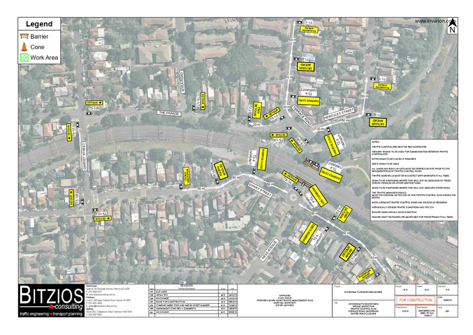
Subject: Terrace Road / Ness Avenue, Dulwich Hill –
Temporary Full Road Closure of Rail Underpass just north of the roundabout at
Ewart Street – Sydney Metro (SSJ) continuation of early enabling works on
T3 Line (DJARRAWUNANG-ASHFIELD WARD / SUMMER HILL ELECTORATE / INNER WEST
PAC)
Prepared By: Jennifer
Adams - Engineer – Traffic and Parking Services
Authorised By: Manod
Wickramasinghe - Traffic and Transport Planning Manager
SUMMARY
An application has been received from Sydney Metro (SSJ)
for the temporary full road closure of the rail underpass on Terrace Road /
Ness Avenue just north of the roundabout at Ewart Street, Dulwich Hill for a
two day period being 12.00am Saturday, 8 August 2020 until 12.00am Monday,
10 August 2020 in order to carry out the continuation of early
enabling works on the Rail bridge and the standing of an Elevated Work Platform
(EWP). The road will be temporarily closed to all vehicular traffic,
including emergency vehicles and local residents.
|
RECOMMENDATION
THAT the proposed temporary
full road closure of the rail underpass on Terrace Road / Ness Avenue just
north of the roundabout at Ewart Street, Dulwich Hill for a two day period
being 12.00am Saturday, 8 August 2020 until 12.00am Monday, 10 August
2020
be approved in order to
carry out the continuation of early enabling works on the Rail Bridge and the
standing of an Elevated Work Platform (EWP) subject to, but not
limited to, the following conditions:
1. A Road Occupancy License
be obtained by the applicant from the Transport Management Centre;
2. All affected residents and
businesses, including the NSW Police Area Commander, Fire & Rescue NSW
and the NSW Ambulance Services be notified in writing, by the applicant, of
the proposed temporary full road closure at least 7 days in advance of the
closure with the applicant making reasonable provision for stakeholders; and
3. The occupation of the road
carriageway must not occur until the road has been physically closed.
|
BACKGROUND
Sydney Metro Southwest early
works have been underway recently between Sydenham and Campsie to convert the
existing rail to metro standards in preparation for the opening of Sydney Metro
City and Southwest in 2024. Sydney Metro’s SSJ Group who had undertook
the previous works now require further works along the T3 Bankstown Line necessitating the temporary full
road closure of the Terrace Road /Ness Avenue rail overbridge. Proposed
works include the use of an elevated work platform (EWP) and mobile crane and
this will require a full lane closure of both lanes at the Terrace Road / Ness
Avenue, Dulwich Hill underpass.
Traffic movements will be managed
in accordance with the submitted TMP and TCP which are attached at the end of
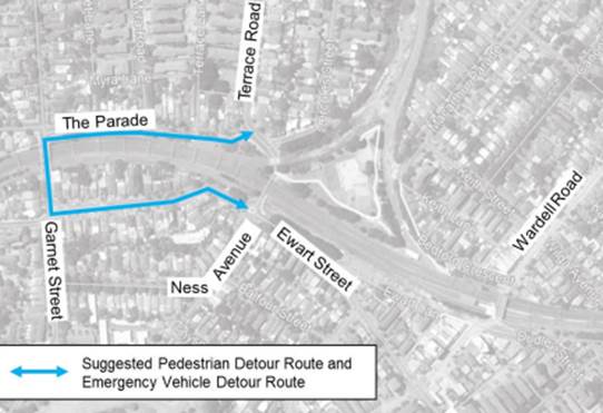
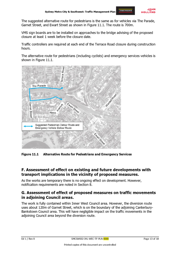
this report. The alternative route for pedestrians (including cyclists) and
emergency service vehicles is shown in the diagram below.
It is noted that the works will
be carried out to coincide with a Bankstown line possession weekend - (5am on
the Saturday morning through to 2am on the Monday morning). For the temporary
full road closure (8 – 9 August) –SSJ will be working for the whole
weekend.
FINANCIAL
IMPLICATIONS
Under Council’s Fees &
Charges, the applicant is to pay a fee for the temporary full road closure.
PUBLIC CONSULTATION
Community notification by Sydney
Metro (SSJ) will include:
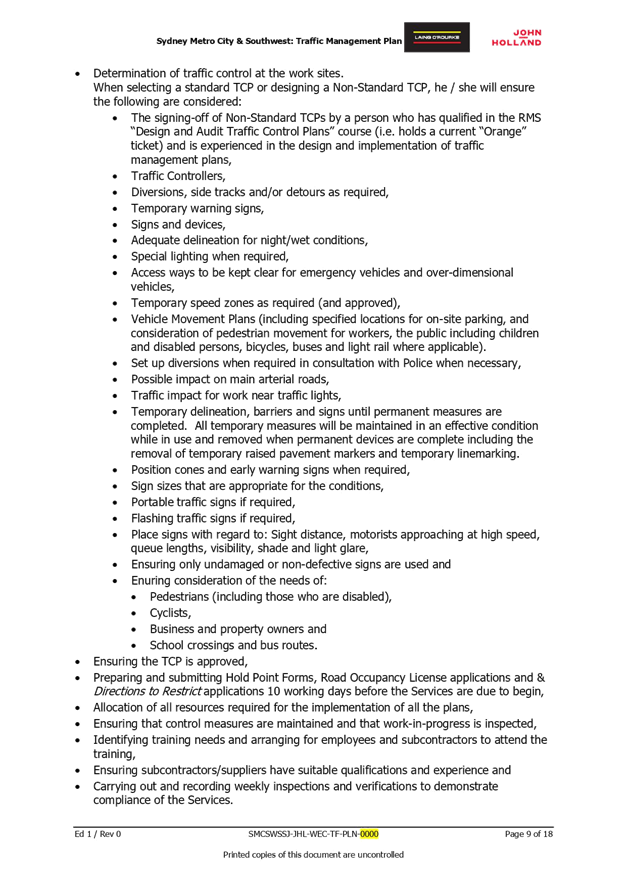
· Notifying
emergency services and relevant sections of the community and transport
industry of work which results in significant traffic disruption. Provide to
the RMS a draft of an appropriate advertisement 3 weeks before the proposed
placement of the advertisement. See RMS M1 Clause 4.3.2.
· Notifying
residents and businesses affected by disruption to property access or by night
works in built-up areas. A letter will: be “letter-box-dropped” at
least three Business Days before the proposed date and detail the dates and
times of the proposed access restrictions and contact details.
The proposed road closure has
been advertised on Council’s website in accordance with the Roads Act
1993.
ATTACHMENTS
|
1.⇩
|
Traffic Management Plan
|
|
2.⇩
|
Traffic Control Plan
|
|

|
Local Traffic
Committee Meeting
6 July 2020
|
|

|
Local Traffic
Committee Meeting
6 July 2020
|
|
|
Local Traffic
Committee Meeting
6 July 2020
|
Item No: LTC0720
Item 2
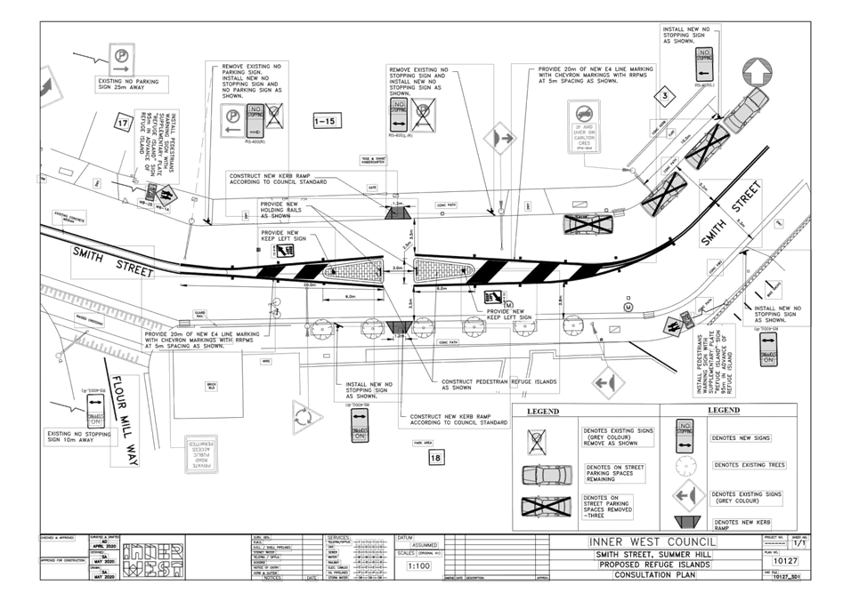
Subject: Smith Street, Summer Hill - Proposed Refuge
Island east of Flour Mill Way – Plan 10127 (Djarrawunang - Ashfield Ward
/ Summer Hill Electorate / Burwood PAC)
Prepared By: Jennifer
Adams - Engineer – Traffic and Parking Services
Authorised By: Manod
Wickramasinghe - Traffic and Transport Planning Manager
SUMMARY
Council has
finalised a design plan for pedestrian safety improvement works in Smith
Street, Summer Hill. The proposed works address concerns about pedestrian
safety and driver behaviour in the area.
|
RECOMMENDATION
THAT the detailed
design plan for the new pedestrian refuge island and new adjacent kerb
ramps and associated signs and line markings in Smith Street, Summer
Hill (as per Plan No.10127) be APPROVED.
|
BACKGROUND
& OTHER STAFF COMMENTS
Construction of a new pedestrian
refuge island in Smith Street adjacent to Floor Mill unit Development and Child
Care Centre was originally proposed as part of the Green-Way cycleway
project. However, recent concerns have been raised with regards to pedestrian
safety. Therefore, the proposal for a pedestrian refuge at this location has
been brought forward.
The detailed design plan for the proposed
pedestrian refuge works along with the asssociated signs and line markings, in
Smith Street, Summer Hill (Plan 10127 – Attachment 1) is now submitted
for consideration.
The proposed scope of works
includes the following:
· Construction of a new 2.5 metre wide
pedestrian refuge Island to allow for both cyclists and pedestrians;
· Construction of new kerb ramps on both sides of the proposed refuge
island;
· Installation of associated line marking and signage.
This
proposal will result in the loss of three on-street parking spaces.
FINANCIAL IMPLICATIONS
The project is listed on Council’s Traffic Facilities
Capital Works budget for 2020/21 and funding of $35,000 has been allocated to
this project.
PUBLIC CONSULTATION
Consultation was conducted
between 11 and 29 May 2020. A letter along with a copy of the design plan
was sent to the local residents in the immediate locality. A total of 221
letters were distributed.
There were five responses and one
phone call. Generally, the responses were supportive of the new pedestrian
refuge facility. Two residents requested that the facility be upgraded to a
pedestrian (zebra) crossing however, it is noted that the location, at this
time, does not meet Transport for New South Wales’ (TfNSW) warrants
necessary for the installation of a pedestrian (zebra) crossing.
Other issues raised were loss of three car parking spaces; requested
introduction of a 40km/h zone and placement of speed humps either side of the
pedestrian refuge.
ATTACHMENTS
|
1.⇩
|
Smith Street Summer Hill - Design Plan
|
|

|
Local Traffic
Committee Meeting
6 July 2020
|
|

|
Local Traffic
Committee Meeting
6 July 2020
|
Item No: LTC0720
Item 3
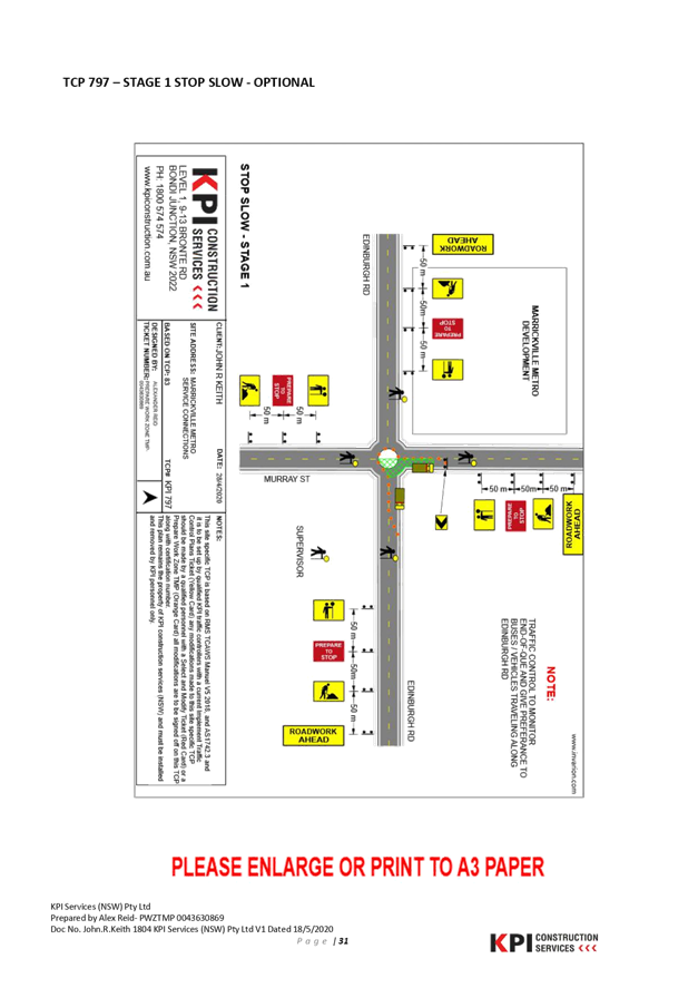
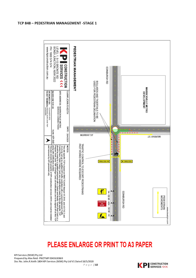
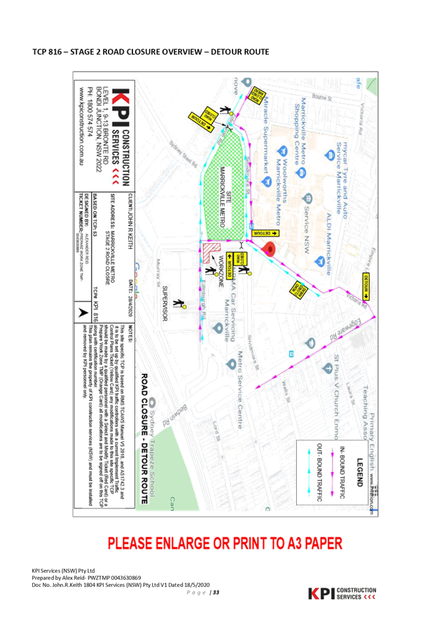
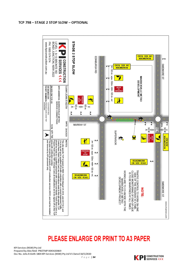
Subject: Edinburgh Street, Murray Street and Railway
Parade, MARRICKVILLE – MARRICKVILLE METRO EXPANSION WORKS
(MIDJUBURI – MARRICKVILLE WARD / NEWTOWN ELECTORATE / INNER WEST
PAC)
Prepared By: Jennifer
Adams - Engineer – Traffic and Parking Services
Authorised By: Manod
Wickramasinghe - Traffic and Transport Planning Manager
SUMMARY
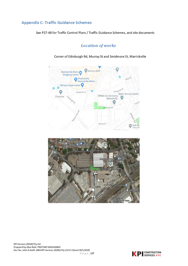
Council has
received an application from John R Keith P/L (contractor to Marrickville Metro
Shopping Centre expansion works) for approval of a temporary full road closure
of Edinburgh Street, Murray Street and Railway Parade, Marrickville for a 27
day period starting from Monday 6 July to Saturday 1 August 2020 (10 day
contingency period Saturday 1 August to Saturday 10 August 2020) for the
purpose of undertaking excavation works for a sewer connection to the main
line. The street would be temporary closed to all vehicular traffic, including
emergency vehicles. It is recommended that the proposed temporary full road
closure be approved, subject to the conditions outlined in this report.
|
RECOMMENDATION
THAT the proposed
temporary full road closure of Edinburgh Street, Murray Street and Railway
Parade, Marrickville for a 27 day period starting from Monday 6 July
to Saturday 1 August 2020 (10 day contingency period Saturday 1 August to
Saturday 10 August 2020) be approved for the purpose of sewer connection works
relating to Marrickville Metro Expansion works subject to, but not
limited to, the following conditions:
1. A Road Occupancy License be obtained by the
applicant from the Transport Management Centre;
2. All affected residents and businesses,
including the NSW Police Area Commander, Fire & Rescue NSW and the NSW
Ambulance Services be notified in writing, by the applicant, of the proposed
temporary full road closure at least 7 days in advance of the closure with
the applicant making reasonable provision for stakeholders;
3. The occupation of the road carriageway must
not occur until the road has been physically closed; and
4. Written concurrence from Sydney Metro TSE
Group is provided to Council.
|
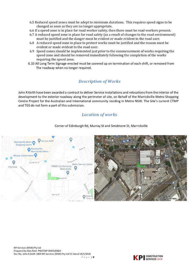
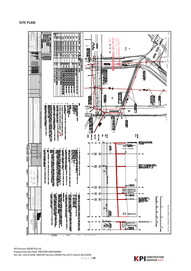
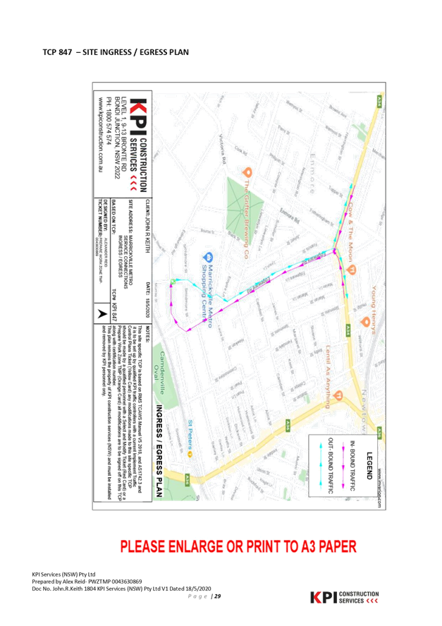
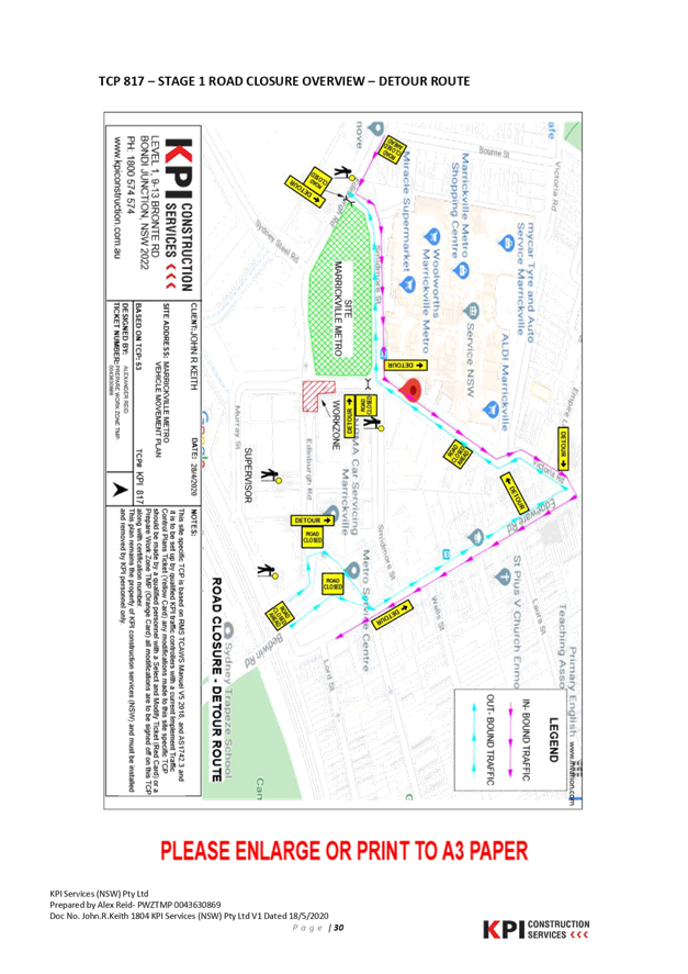
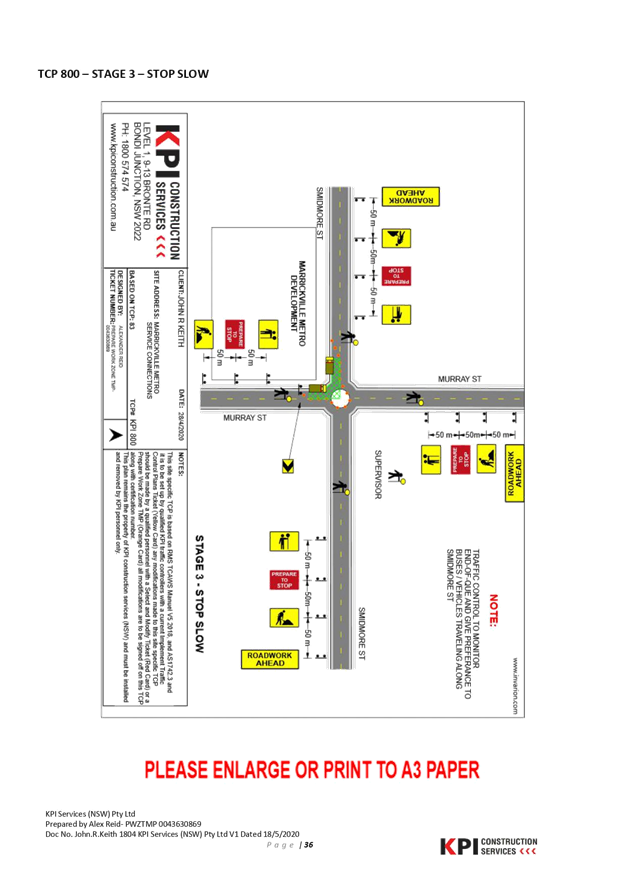
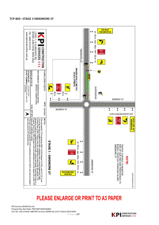
BACKGROUND
AND OTHER STAFF COMMENTS
John R
Keith have been nominated to deliver service installations and relocations from
the interior of the Marrickville Metro Shopping Centre expansion project to the
exterior roadway along the perimeter of site necessitating the full temporary
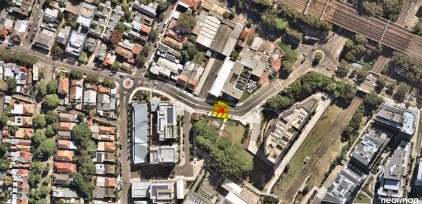
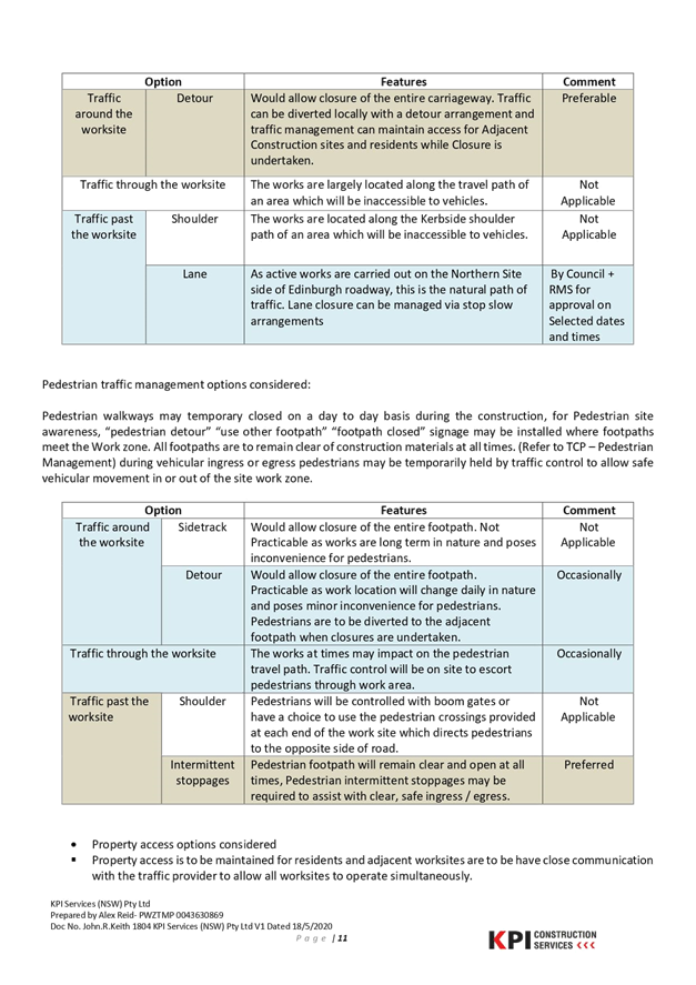
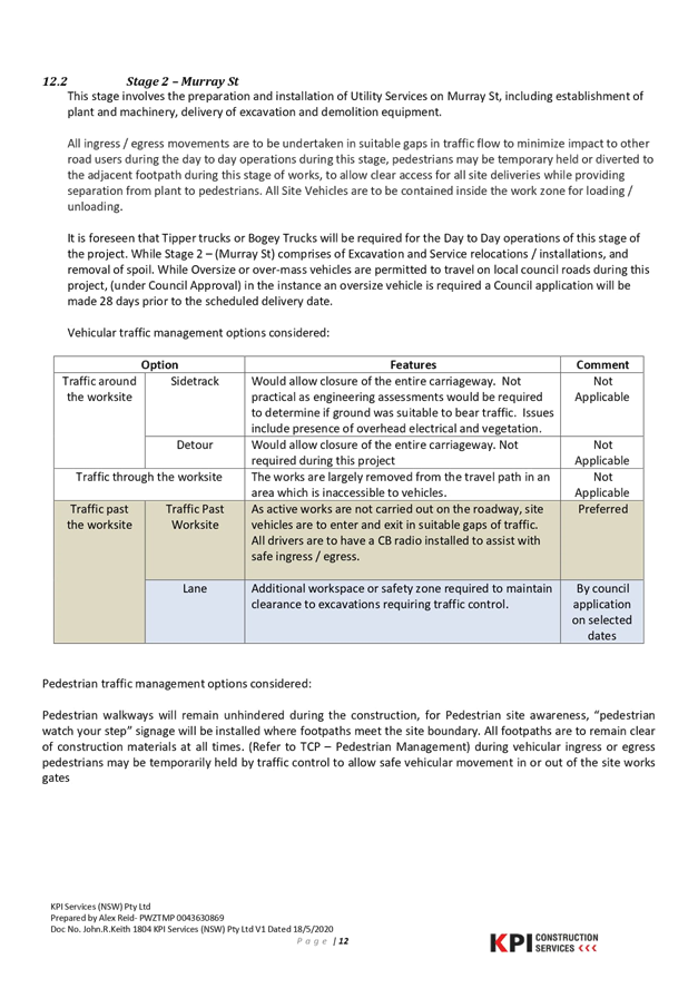
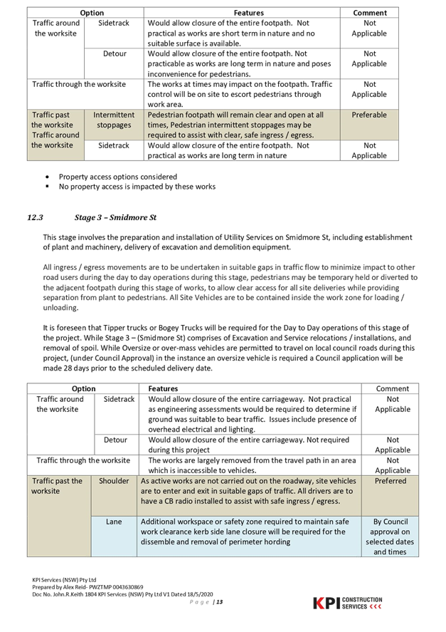
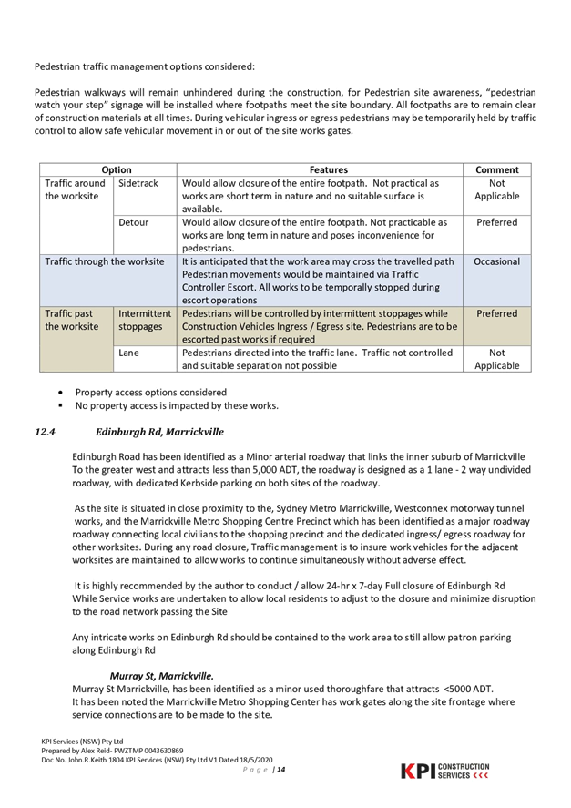
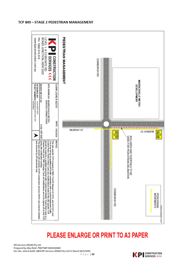
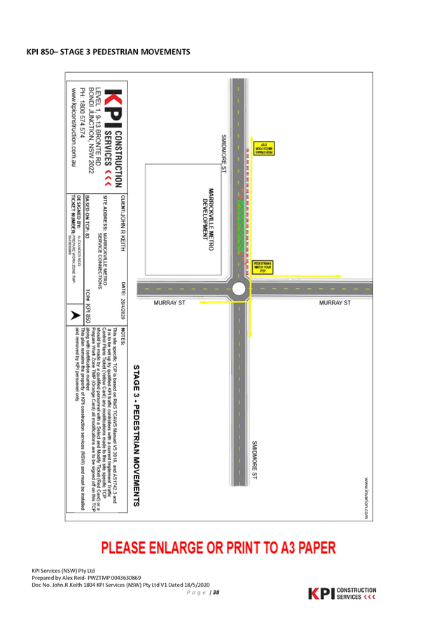
road of Edinburgh Road, Marrickville. The diagram below shows the location of
the proposed works at the corner of Edinburgh Road, Murray Street and Smidmore
Street, Marrickville.
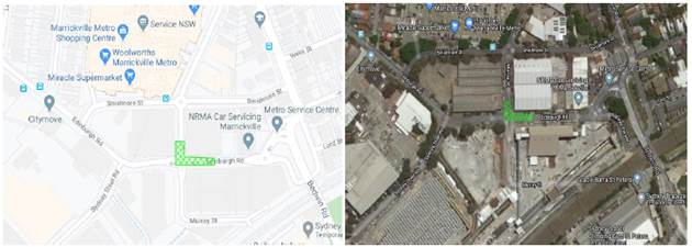
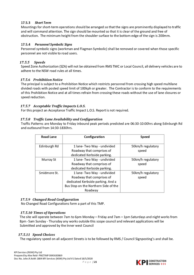
Edinburgh Road is a local road
and acts as a collector road between Victoria Road in the west and Edgeware
Road in the east. Between Murray Street and Edgeware Road, Edinburgh Road
carries an average 9151 vehicles per day. Along its length it is generally a
one lane two-way undivided roadway with kerbside parking on both sides of the
road.
As the site is situated in
close proximity to the Sydney Metro TSE Group works and the Marrickville Metro
Shopping Centre expansion works all involved parties must be in consensus with
any temporary full road closure and proposed designated detour
routes.
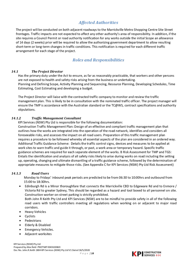
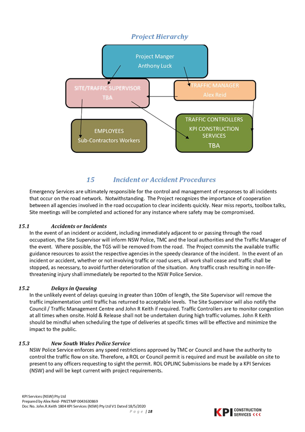
The Traffic
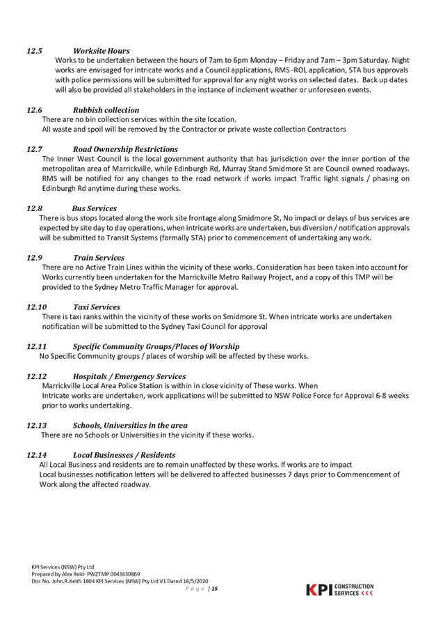
Management Plan (TMP) is attached. The TMP indicates that works will be
undertaken between the hours of 7am to 6pm Monday – Friday and 7am
– 3pm Saturday. Noting also that possible night works are envisaged for
intricate works. In 15.2 it notes that “In the unlikely event
of delays queuing in greater than 100m of length, the Site Supervisor will
remove the traffic implementation until traffic has returned to acceptable
levels. The Site Supervisor will also notify the Council / Traffic Management
Centre and John R Keith if required. Traffic Controllers are to monitor
congestion at all times when onsite. Hold & Release shall not be undertaken
during high traffic volumes. John R Keith should be mindful when scheduling the
type of deliveries at specific times will be effective and minimize the impact
to the public.”
FINANCIAL
IMPLICATIONS
Under Council’s Fees &
Charges, the applicant is to pay a fee for the temporary full road closure
along with any other required road occupancy and/or road opening permit fees.
PUBLIC CONSULTATION
The applicant is to notify all
affected residents and businesses in writing at least 7 days prior to the
commencement of works.
The proposed road closure has
been advertised on Council’s website in accordance with the Roads Act
1993.
ATTACHMENTS
|
1.⇩
|
JRK - Traffic Management Plan - Marrickville Metro
|
|
2.⇩
|
Traffic Control Plan
|
|

|
Local Traffic
Committee Meeting
6 July 2020
|
|

|
Local Traffic
Committee Meeting
6 July 2020
|
|

|
Local Traffic
Committee Meeting
6 July 2020
|
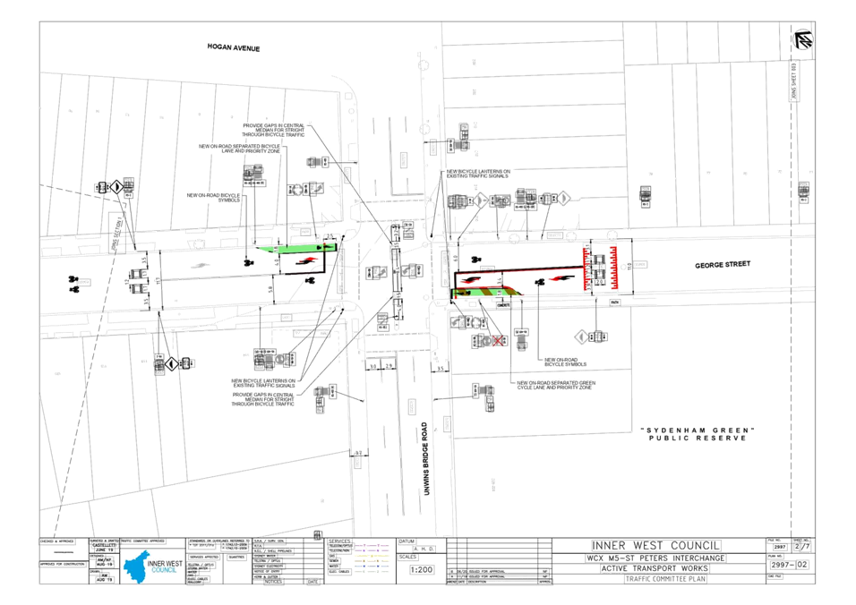
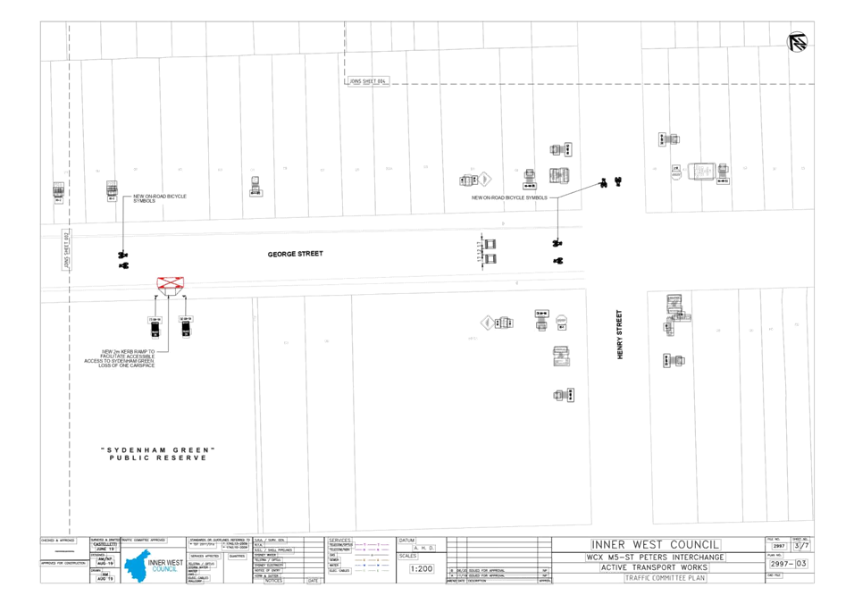
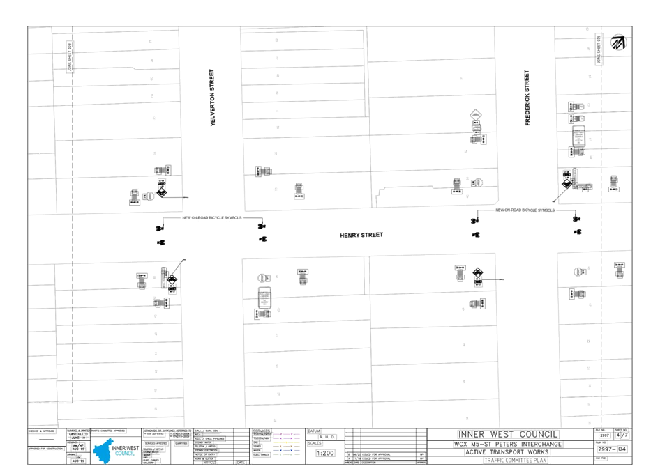
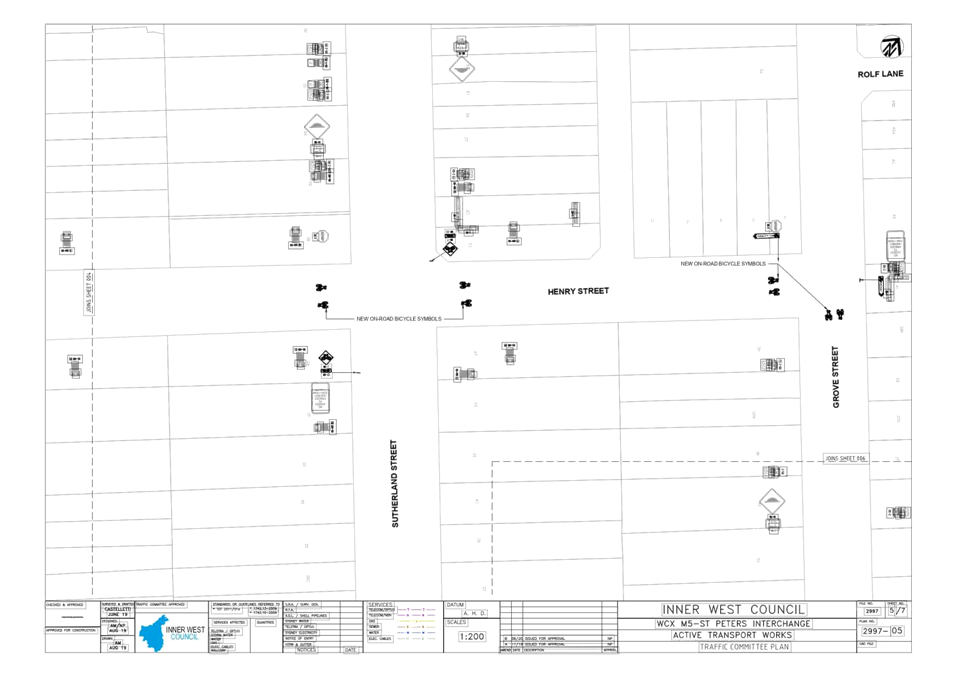
Item No: LTC0720
Item 4
Subject: Westconnex M5 – St Peters Interchange
Active Transport Works – Part 1 (Midjuburi – Marrickville Ward /
Heffron Electorate / Inner West PAC)
Prepared By: George
Tsaprounis - Coordinator – Traffic and Parking Services
Authorised By: Manod
Wickramasinghe - Traffic and Transport Planning Manager
SUMMARY
The St Peters Interchange project
results from a request by the TfNSW and WestConnex for Council to deliver two
(2) active transport projects around the M5 WestConnex Interchange at St
Peters. The provision of such walking and cycling facilities with 1km of
the St Peters Interchange is a condition of consent for the WestConnex M5
project.
The proposal presented reflects
the outcomes of a recent concept design stage, including community
consultation, and updates the status of the project in which the concept design
was presented to the Local Traffic Committee in November 2019. The proposals
includes a combination of a two way separated cycleway and
shared path on the southern side of Burrows Avenue, adjacent to Sydenham
Station and widening the shared path along Mary Street and upgrades to
the existing on road cycle route along the other streets including George Street, Henry Street, Grove Street,
Bakers Lane.
Following development of the
concept designs, two rounds of community engagement, Local Traffic Committee
endorsement in November 2019 to progress with the detailed design and
implementation and subsequent preparation of detailed design plans. It is
recommended that these detailed design plans be approved.
|
RECOMMENDATION
THAT:
1. The final design solution
for the M5 - St Peters Interchange Active Transport Works (plan no’s.
2997-01 to 2997-07) be approved to enable tender documentation to be prepared
and a construction contract advertised; and
2. The TCS designs resulting
from this project be forwarded to TfNSW for approval
|
BACKGROUND
The initial aims of the project
were to identify pedestrian and cycle facilities that were to be provided by
WestConnex as part of the State Significant Infrastructure for M5 interchange
works. The review identified, but was not be limited to:
· current and future land use and associated pedestrian and cycle
demand and needs;
· pedestrian and cycle impacts associated with the project;
· regional and local pedestrian and cycling strategies;
· pedestrian and cycle safety, accessibility and connectivity, including
to the public realm;
· intersection and signal phasing opportunities to reduce waiting and
crossing times for pedestrians and cyclists;
· provision of upgraded cycle and pedestrian facilities within 1,000
metres of the boundary of the St Peters lnterchange, apart from the areas
addressed in the development consent; and
· concept designs for pedestrian and cycleway infrastructure and
implementation timeframes.
The concept designs that were
prepared are consistent with the approved Pedestrian and Cycleway Network
Review and included:
· pedestrian and cycle engineering and safety standards;
· a safety audit of existing and proposed pedestrian and cycle
facilities to address the above standards;
· details of selected routes and connections to existing local and
regional routes;
· timing and staging of all works;
· infrastructure details, including lighting, safety, security, and
standards compliance;
· signage and wayfinding measures; and
· details of associated landscaping works.
Council engaged a design
consultant in June 2019 to develop the concept designs and to progress the
projects through the detailed design stages.
Financial Implications
The project is fully funded by Transport for NSW (TfNSW) and
WestConnex and aims to increase safety for bike riders, pedestrians and
motorists.
Officer Comments
The proposed design elements are
as follows:
· Burrows Avenue
o A
combination of a two-way separated cycleway and shared path on the southern
side of Burrows Avenue, adjacent to Sydenham Station.
· George Street, Henry Street, Grove Street, Bakers Lane and Mary
Street
o Widened
shared path along Mary Street as well as shared paths and improved pedestrian
crossings in Mary Street and the Princes Highway opposite the St Peters
Interchange. Upgrade to the existing on road cycle route along the other
streets highlighted above as well as traffic calming on Henry Street, Sydenham
and improved crossings at Unwin’s Bridge linking with the existing L8 and
L13 bike routes from the Marrickville Bicycle Strategy.
It is noted that
two options were presented for Burrows Avenue to the November 2019 Local
Traffic Committee, with the community split reasonably evenly in terms of
preference for each option. Following futher feedback from
stakeholders and Bicycle User Groups, an additional option was developed and
presented to the community in early 2020.
The additonal
option was seen as a compromise between those favouring retention of the five
(5) existing car parks on Burrows Avenue and those favouring a fully off road
cycle link on Burrows Avenue concerned with cyclist safety for the on road
option in the eastbound direction. The proposed option includes a fully
off road cycle link on Burrows Avenue, and includes a relocation of the car
parking to the west and a reduction in the number of spaces from five (5) to
three (3).
It is noted that
the Burrows Avenue option reduces the number of traffic lanes on approach to
signalised intersection with Gleeson Avenue, and traffic modelling and a TCS
plan has been prepared for this intersection for TfNSW approval.
Similarly,
traffic modelling and a TCS plan has been prepared for the intersection of
Unwins Bridge Road and George Street, to faciliate straight through access on
George Street for cyclists through the existing median at the location
that prevents such movements for vehicular traffic.
TfNSW are
currently upgrading Sydenham Station to cater for the Sydney Metro. This
includes an new entrance and forecourt on Burrows Avenue immediately east of
George Street. Council and their designers have been in consutlation with
TfNSW and their designers to ensure coordination between the two
projects.
Away from
Burrows Avenue, the majortiy of the cycle route is on road mixed traffic and
along quiter residential road and lanes. Parking is largely unaffected by
the proposals on these sections, although one (1) car parking space is proposed
for removal adjacent to Sydenham Green to improve access to the park.
Path widening is
proposed along Mary Street and the Princes Highway to accommodate a shared
path, with one (1) car parking space removed to cater for the safe transition
to and from the shared path adajcent to Bakers Lane. The signalised
crossing of the Prince Highway to Canal Road is proposed to be upgraded to
allow for shared use with cycle lanterns added as part of the interchange
works.
PUBLIC CONSULTATION
The concept design was presented
to the community as part of a community engagement process between Monday 21st
October 2019 and Sunday 17th November 2019. The outcomes of
this consultation process were presented to the November 2019 Local Traffic
Committee meeting.
A further community engagement
process was undertaken in May 2020, where the proposed design was presented to
the community outlining the amended design that incorporated the feedback
received as part of the late 2019 process.
Five (5) responses were received
as part of the May 2020 process, the majority related to the proposed layout
and parking on Burrows Avenue, with some seeking amendments and some seeking
clarifications. Through direct consultation with those respondents, minor
amendments have been incorporated in the detailed design documentation to
consider resident comments, for example some gaps shall be provided in the
proposed landscape strip to improve waste collection and bin placement.
CONCLUSION
It is recommended that Local Traffic Committee endorse the approval of the current design
proposals, to allow progression of the project to the tender documentation and
implementation stage.
ATTACHMENTS
|
1.⇩
|
M5 - St Peters Interchange Active Transport Works Plan
|
|

|
Local Traffic
Committee Meeting
6 July 2020
|
|

|
Local Traffic
Committee Meeting
6 July 2020
|
Item No: LTC0720
Item 5
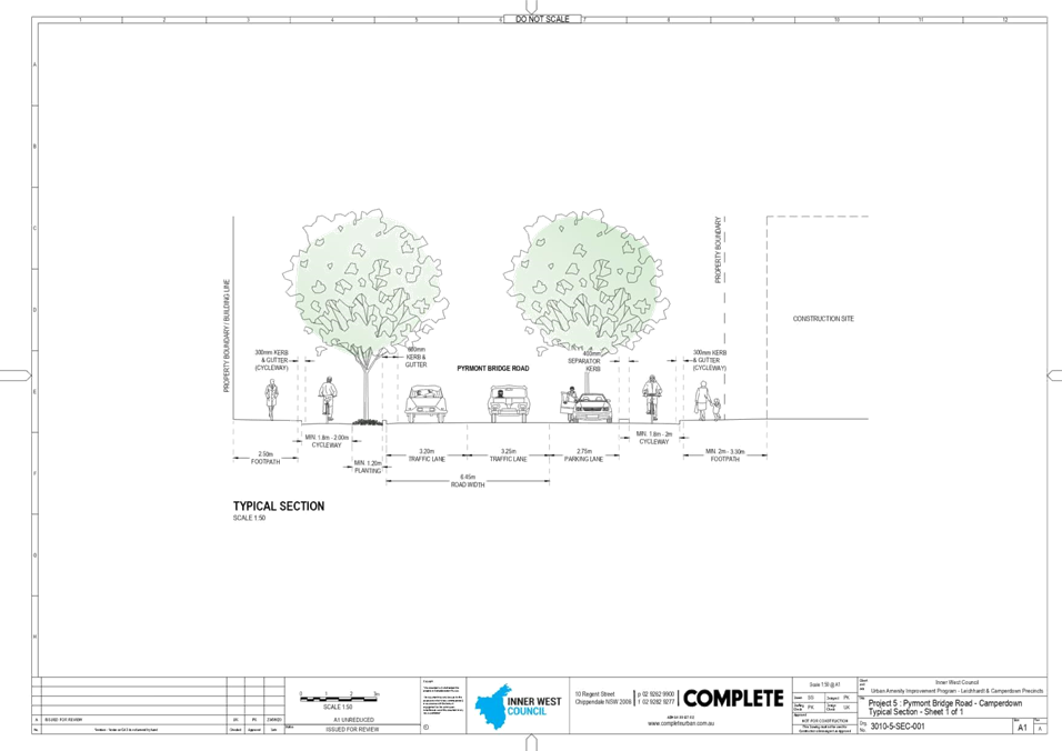
Subject: Urban Amenity Improvement Program –
Leichhardt And Camperdown Precincts (Gulgadya - Leichhardt & Damun-Stanmore
Wards/Balmain & Newtown Electorates/Leichhardt & Inner West PACs)
Prepared By: George
Tsaprounis - Coordinator – Traffic and Parking Services
Authorised By: Manod
Wickramasinghe - Traffic and Transport Planning Manager
SUMMARY
The Urban Amenity Improvement
Program (UAIP) aims to reverse the urban decay and lack of design cohesion
along Parramatta Road and is a NSW State Government initiative.
Within the Inner West Council
LGA, the program comprises 10 separate locations as follows: Rofe
Street – Parramatta Road to Jarrett Street, Renwick Street –
Parramatta Road to Jarrett Street, Norton Street – Parramatta Road to the
Italian Forum, Crystal Street – Parramatta Road to Elswick Street,
Balmain Road – Parramatta Road to end of Italian Forum, Catherine Street
– Parramatta Road to Albion Street, Dot Lane – Balmain Road to Hay
Street, Petersham Street – Parramatta Road to Queen Street, Johnstons
Creek, Wigram Road and Pyrmont Bridge Road – Parramatta Road to Booth Street
Following development and
approval of the UAIP, Council is now progressing with the detailed design and
aims to inform and seek approval of the Local Traffic Committee for the
measures proposed under the program.
|
RECOMMENDATION
THAT the design proposals as discussed in this report and as indicated
on the attached plans be approved at the following locations:
1. Rofe Street (plan no.
3010-1A-TCP-001) – public domain upgrades and conversion to a one way
road (subject to TfNSW approval of the TMP);
2. Renwick Street (plan no.
3010-1B-TCP-001) – public domain upgrades and provision of a 10km/hr
shared zone (subject to TfNSW approval of the speed limit reduction);
3. Norton Street (plan no.
3010-1C-TCP-001) – public domain upgrades;
4. Crystal Street (plan no.
3010-1D-TCP-001 sheets 1 and 2) – public domain upgrades;
5. Balmain Road (plan no.
3010-1E-TCP-001 sheets 1 and 2) – public domain upgrades and cycleway
connection;
6. Catherine Street (plan no.
3010-1F-TCP-001) – public domain upgrades and cycleway connection;
7. Dot Lane (plan no.
3010-2A-TCP-001) – new cycleway connection;
8. Petersham Street (plan no.
3010-3-TCP-001) – new pocket park (subject to TfNSW approval of the
TMP);
9. Johnstons Creek and Wigram
Road – new pedestrian and cycleway connection; and
10. Pyrmont Bridge Road (plan no.
3010-4A-TCP-001 sheets 1 to 3) – public domain upgrades and cycleway
connection (subject to TfNSW approval).
|
BACKGROUND
The UAIP is a NSW State
Government, $198 million initiative under the Parramatta Road Corridor Urban
Transformation Program. The Parramatta Road corridor and the UAIP extend from
Granville to Camperdown, and include projects in Granville, Auburn, Homebush,
Burwood, Kings Bay, Taverners Hill, Leichhardt and Camperdown. The vision for
the Corridor, developed by Urban Growth NSW, is for a high-quality multi-use
corridor with improved transport choices, better amenity and balanced growth of
housing and jobs.
Overall, the proposed UAIP
improvements can be categorised into three categories of projects:
· Streetscape upgrades including tree planting, multi-purpose
lighting, new pavements and north-south pedestrian and cycle crossings;
· Creation of new or improved open spaces, urban plazas and town
squares; and
· New walking and cycling links to key transport nodes and open spaces
which connect to strategic regional and local networks.
The draft UAIP was released for
Council and community consultation between September and December 2015.
Feedback received during this time was considered and the UAIP was further
refined and updated. In some cases, new works were identified and included in
the UAIP and others were removed. Conceptual designs and costings were
prepared for the projects. These were reassessed against the UAIP Selection
Criteria and a final scope of works prepared. The final works in the UAIP have
been discussed and agreed with each of the Councils along the corridor.
A traffic report was prepared as
part of the UAIP, titled ‘Traffic Assessment - Urban Amenity Improvement
Program: Leichhardt and Camperdown – Traffic Studies’ prepared by
Traffix Traffic and Transport Planners dated 12 April 2019. The report
determines that the parking loss is justifiable in consideration of the
significant amenity, safety and streetscape improvements that will result, and
that the traffic modelling undertaken supports the proposed measures.
Council engaged a design
consultant in August 2019 to develop the designs and to progress the projects
through the detailed design stages.
Financial Implications
The project is fully funded by the NSW Government and aims to
increase safety for bike riders, pedestrians and motorists.
Officer Comments:
The proposed measures at each of
the locations are outlined below and are indicated on the attached plans:
1. Rofe Street (refer to plan
no. 3010-1A-TCP-001)
The proposal
includes the following:
· Conversion of Rofe Street from two way to one way in a northbound
direction between Parramatta Road and Jarrett Street;
· Change of priority for stop control at the intersection of Rofe
Street and Jarrett Street to give priorty to Jarrett Street to improve cycleway
continuity;
· Kerb extensions to improve predestrian safety, increase amenity and
calm traffic; and
· Landscaping and public domain upgrades.
It should be noted that there will be no
loss of parking as a result of this proposal and no intersection performance
impacts are expected. Vehicle swept paths have been undertaken to ensure that
the proposed kerb extensions cater for all required traffic movements and
vehicle types.
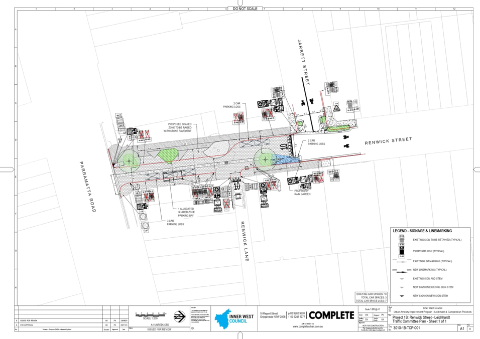
2. Renwick Street (refer to plan no.
3010-1B-TCP-001)
The proposal
includes the following:
· Conversion of Renwick Street between Parramatta Road and Jarrett
Street to a 10km/hr shared zone;
· Kerb extensions to improve predestrian safety, increase amenity and
calm traffic; and
· Landscaping and public domain upgrades.
It should be
noted that the proposal results in the loss of seven (7) car parking spaces. No
intersection performance impacts are expected as a result of the proposed measures
and vehicle swept paths have been undertaken to ensure that the proposed kerb
extensions cater for all required traffic movements and vehicle types.
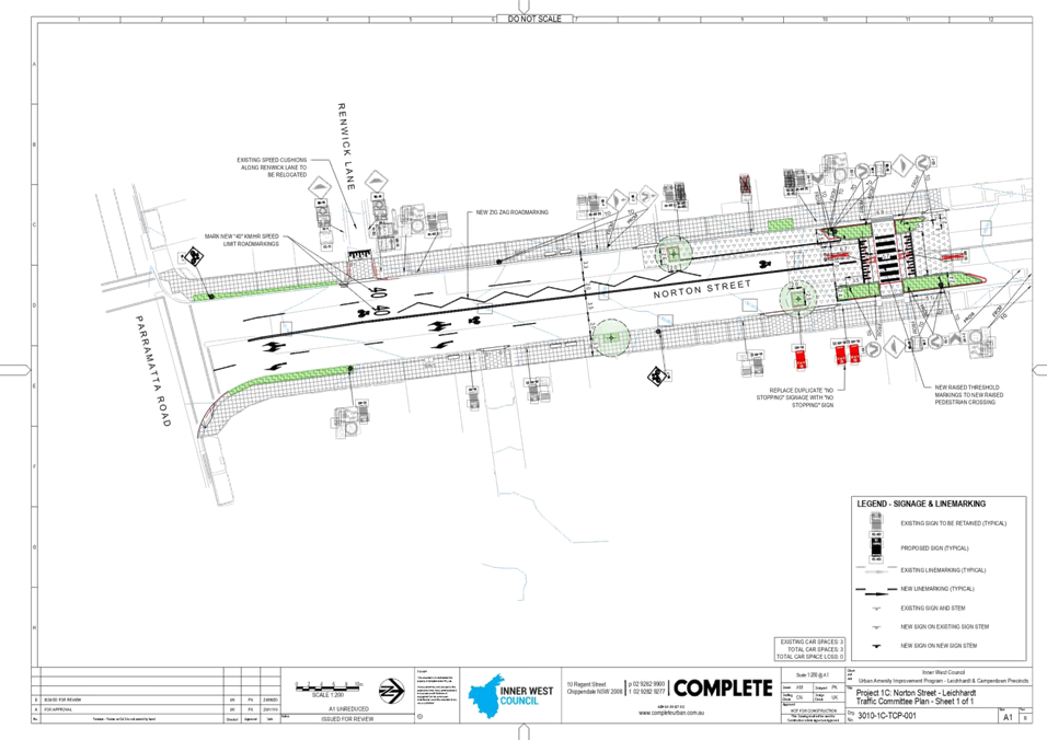
3. Norton Street (refer to plan
no. 3010-1C-TCP-001)
The proposal
includes the following:
· A continutous footpath treatment across Renwick Lane;
· Improvements to existing raised pedestrian (zebra) crossing; and
· Landscaping and public domain upgrades.
It should be
noted that the proposal results in no parking loss and no intersection
performance impacts are expected as a result of the proposed measures. Vehicle
swept paths have been undertaken to ensure that the proposed kerb extension
cater for all required traffic movements and vehicle types.
4. Crystal Street (refer to plan
no. 3010-1D-TCP-001 sheets 1 and 2)
The proposal
includes the following:
· Shared path and signalised cycle crossing connecting Margaret Street
and Elswick Street; and
· Landscaping and public domain upgrades.
It should be
noted that the proposal results in no parking
loss and no intersection performance impacts are expected as a result of the
proposed measures.
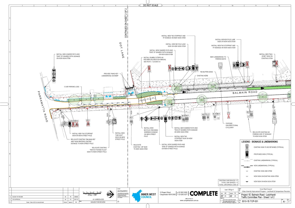
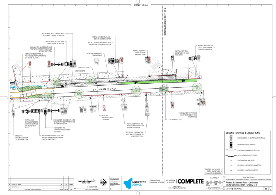
5. Balmain Road (refer to plan
no. 3010-1E-TCP-001 sheets 1 and 2)
The proposal
includes the following:
· Shared pathway between Parramatta Road and Dot Lane to improve cycle
connections;
· A continuous footpath treatment across Dot Lane;
· Reduction in the bus parking provisions adjacent to the Italian
Forum to cater for a single bus;
· Kerb extensions to improve predestrian safety, increase amenity,
calm traffic and to facilitate a safe cycleway crossing of Balmain Road at Dot
Lane; and
· Landscaping and public domain upgrades.
It should be
noted that the proposal results in the loss of six (6) car parking spaces and
no intersection performance impacts are expected as a result of the proposed
measures. Vehicle swept paths have been undertaken to ensure that the proposed
kerb extensions cater for all required traffic movements and vehicle types.
6. Catherine Street (refer to
plan no. 3010-1F-TCP-001)
The proposal
includes the following:
· Central median between Redmond Street and Albion Street to provide
protection for cyclists utilising the cycle link between these streets;
· Conversion of a short section of existing angle parking to parallel
parking;
· Kerb extensions to improve pedestrian safety, increase amenity and
calm traffic; and
· Landscaping and public domain upgrades.
It should be
noted that the proposal results in the loss of five (5) car parking spaces and
no intersection performance impacts are expected as a result of the proposed
measures. Vehicle swept paths have been undertaken to ensure that the proposed
kerb extensions cater for all required traffic movements and vehicle types.
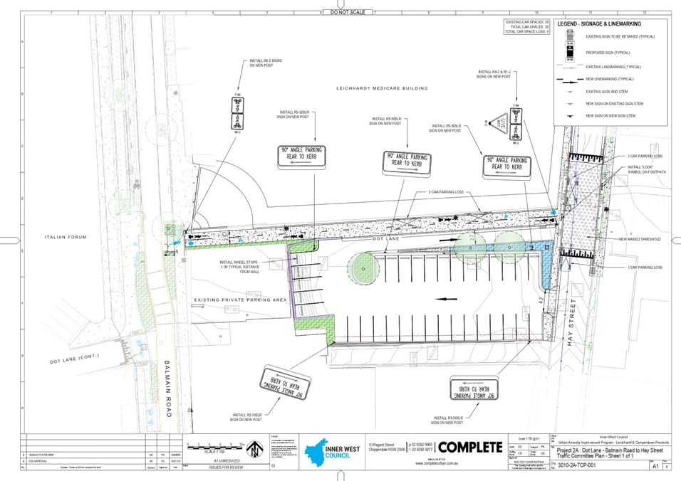
7. Dot Lane (refer to plan no.
3010-2A-TCP-001)
The proposal
includes the following:
· Conversion of a section of the existing public car park to a shared
pathway faciliting access along Dot Lane between Hay Street and Balmain Road;
and
· Reconfiguration and formalisation of the existing car parking
facility to minimise parking loss.
It should be
noted that the proposal results in the loss of four (4) car parking spaces.
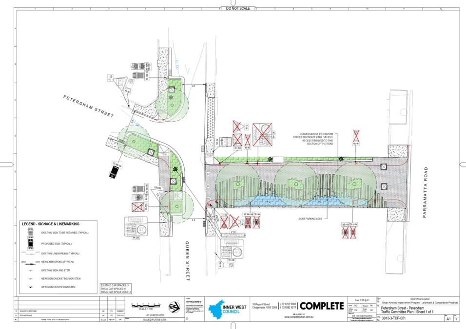
8. Petersham Street (refer to
plan no. 3010-3-TCP-001)
The proposal
includes the following:
· Conversion of Petersham Street between Parramatta Road and Queen
Street to a pocket park, removing vehicle access to this section of the
road.
· Kerb extensions on Queen Street to improve predestrian safety,
increase amenity and calm traffic; and
· Landscaping and public domain upgrades.
It should be
noted that the proposal results in the loss of three (3) car parking spaces.
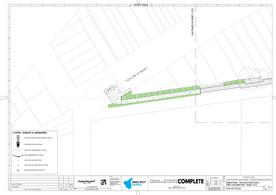
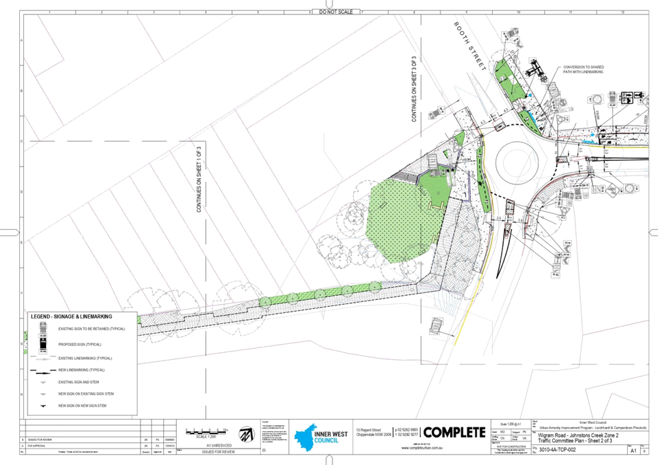
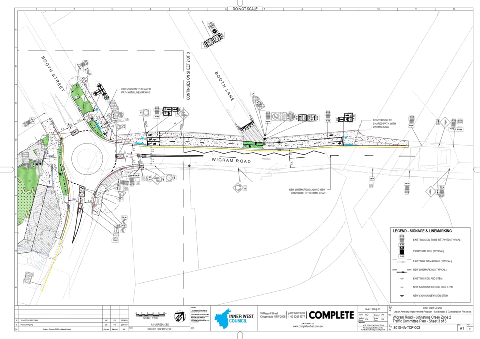
9. Johnstons Creek and Wigram
Road (refer to plan no. 3010-4A-TCP-001 sheets 1 to 3)
The proposal
includes the following:
· Provision of a shared pathway beside Johnston’s Creek between
Chester Street and Booth Street;
· Raising of the roundabout intersection of Booth Street and Wigram
Road;
· Provision of a widened footpath and shared pathway along Wigram Road
to link from Booth Street to the existing cycle facility from Bicentennial
Park, Glebe; and
· Landscaping and public domain upgrades.
It should be
noted that the proposal results in no parking loss and no intersection
performance impacts are expected as a result of the proposed measures. Vehicle
swept paths have been undertaken to ensure that the proposed kerb extensions
and roundabout works cater for all required traffic movements and vehilce
types.
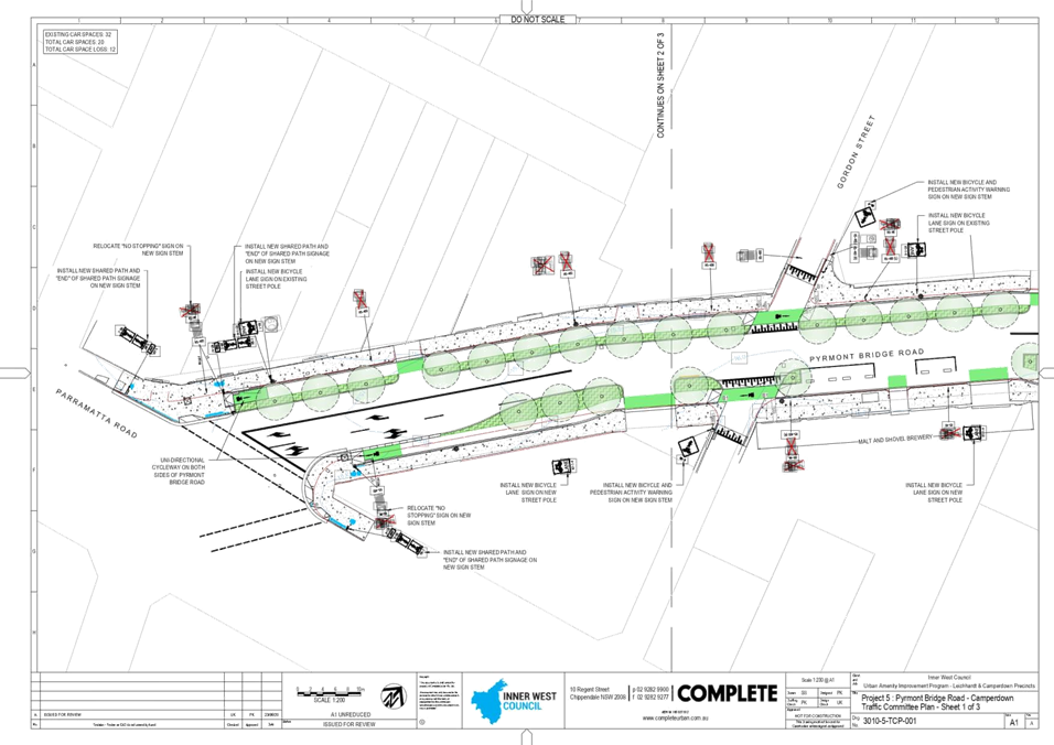
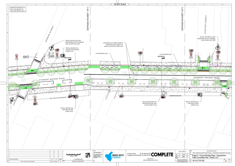
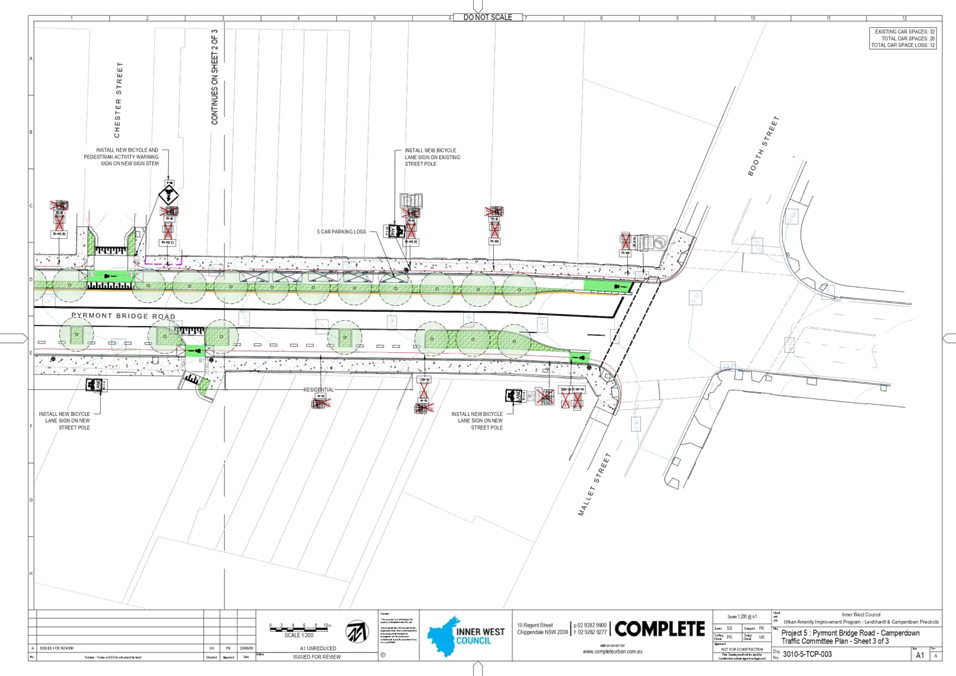
10. Pyrmont Bridge Road (refer to plan no.
3010-5-TCP-001 sheets 1 to 3)
The proposal
includes the following:
· Uni-directional cycleway on both sides of Pyrmont Bridge Road
· Conversion of Pyrmont Bridge Road from two lanes to a single lane in
each direction;
· Landscaping and public domain upgrades.
It should be
noted that the proposals both result in the loss of twelve (12) car parking
spaces. The Traffic Assessment Report indicates measures required to the
intersections to ensure that the impacts of the proposed measures are minimsed.
The proposal for changes to Pyrmont Bridge Road are to be further developed in
consultation with Transport for NSW, and re-submitted to Council’s Local
Traffic Committee in due course. Construction of the Pyrmont Bridge Road
component of the project will occur later than the other components due to the
operation of the Westconnex dive site adjacent.
PARKING NUMBERS
CONCLUSION
It is recommended that committee approve the design proposals as discussed in this report
and as indicated on the attached plans at the following locations:
1. Rofe Street – public domain
upgrades and conversion to a one way road;
2. Renwick Street – public domain
upgrades and provision of a 10km/hr shared zone;
3. Norton Street – public domain
upgrades;
4. Crystal Street – public domain
upgrades;
5. Balmain Road – public domain
upgrades and cycleway connection;
6. Catherine Street – public domain
upgrades and cycleway connection;
7. Dot Lane – new cycleway
connection;
8. Petersham Street – new pocket
park;
9. Johnstons Creek and Wigram Road
– new pedestrian and cycleway connection; and
10. Pyrmont Bridge Road – public domain
upgrades and cycleway connection.
ATTACHMENTS
|
1.⇩
|
Urban Amenities Improvement Program Plans
|
|
|
Local Traffic
Committee Meeting
6 July 2020
|


|
|
Local Traffic
Committee Meeting
6 July 2020
|
Item No: LTC0720
Item 6
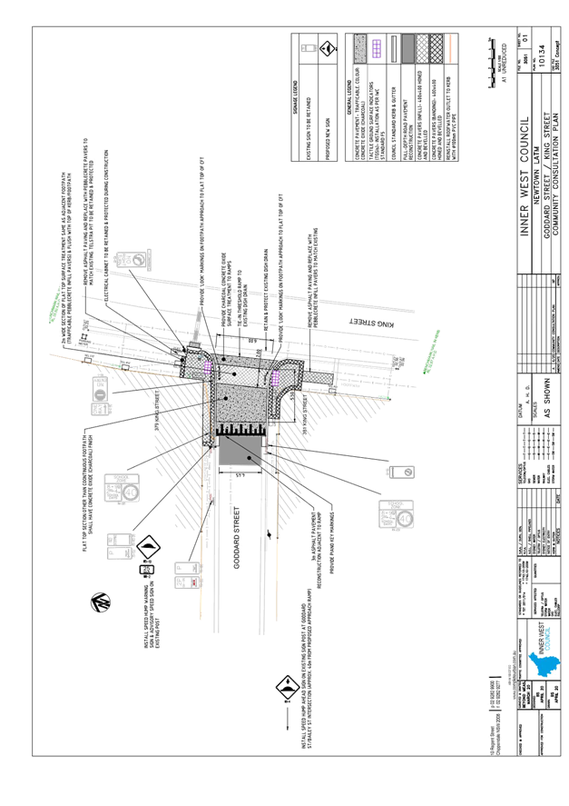
Subject: Goddard Street, Newtown - Proposed continuous
footpath treatment in Goddard Street at King Street – Final Signage and
Line Marking Plan 10134 (Damum - Stanmore Ward / Newtown Electorate / Inner
West PAC)
Prepared By: Jennifer
Adams - Engineer – Traffic and Parking Services
Authorised By: Manod
Wickramasinghe - Traffic and Transport Planning Manager
SUMMARY
Council has
finalised a design plan for a continuous footpath treatment in Goddard Street
at King Street, Newtown. It is envisaged that the proposed works will have a
positive impact on pedestrian and motorist safety and address concerns about
pedestrian safety and driver behaviour in the area.
|
RECOMMENDATION
THAT the detailed
design plan for the continuous footpath treatment and associated
signs and line markings in in Goddard Street at King Street, Newtown
(as per Design Plan No.10134) be approved.
|
BACKGROUND
Council is planning to construct a continuous footpath
treatment in Goddard Street at King Street, Newtown to increase safety for
pedestrians and motorists. At its meeting in September 2019, Council endorsed
the final Newtown Local Area Traffic Management (LATM) report which included
these works. The proposals within the report were based on community input and
analysis undertaken during the Public Exhibition period in April 2019. There will be no parking loss.
OTHER
STAFF COMMENTS
|
|
Proposed
continuous footpath treatment
|
The works (shown in Attachment 1) aim to improve
pedestrian safety and calm traffic in Goddard Street at King Street, Newtown. The
proposed works include:
· Removal of
existing kerb ramps and replacing with continuous paved footpath.
· Repairing paving
surrounding the works (The paving shown on the plans are indicative only and
will be finalised in the detailed design)
· Reconstructing
kerb and gutter in Goddard Street.
· Installing
associated signage.
As per RMS
Technical directions for continuous footpath treatments, no more than 45 vehicle
movements per hour were recorded in Goddard Street. A traffic count was
undertaken on a typical weekday in March and this indicated that the AM, MID
and PM peak traffic flows in Goddard Street were 28, 33 and 37 vehicle
movements per hour respectively. Pedestrian volumes were noted to be high with
275, 365 and 403 pedestrian movements along the King Street footpath, past
Goddard Street in the respective peak hours.
FINANCIAL IMPLICATIONS
The Newtown LATM Scheme
(Including Goddard Street at King Street) is scheduled for design completion in
2019/20 and for construction in 2021/22 as part of the Traffic Facilities
Capital Works Program. The estimate cost of the project is $66,000.
PUBLIC
CONSULTATION
Consultation was conducted
between 3 June 2020 and 19 June 2020. Letters were delivered to 5 adjacent
properties. There were no responses.
ATTACHMENTS
|
1.⇩
|
Newtown LATM Consultation- Goddard Street
|
|

|
Local Traffic
Committee Meeting
6 July 2020
|
|
|
Local Traffic
Committee Meeting
6 July 2020
|
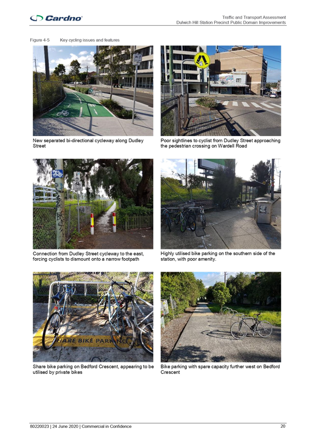
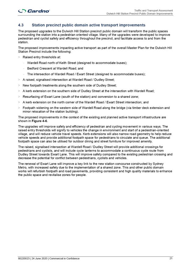
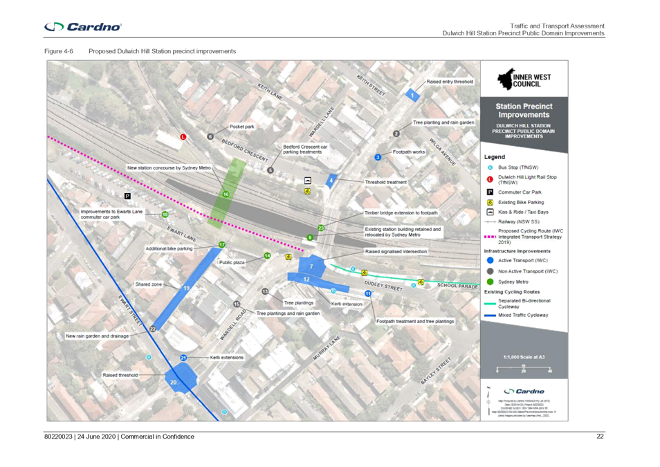
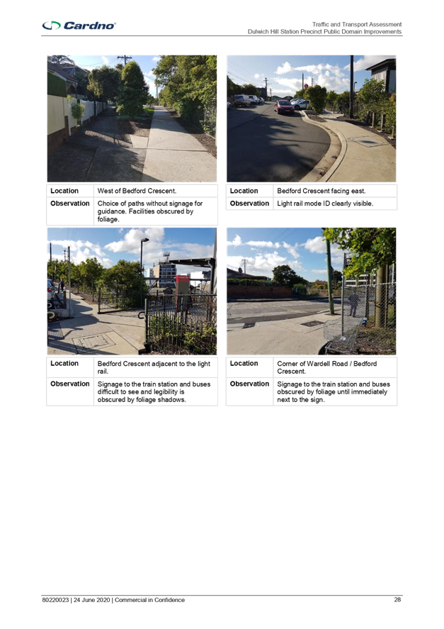
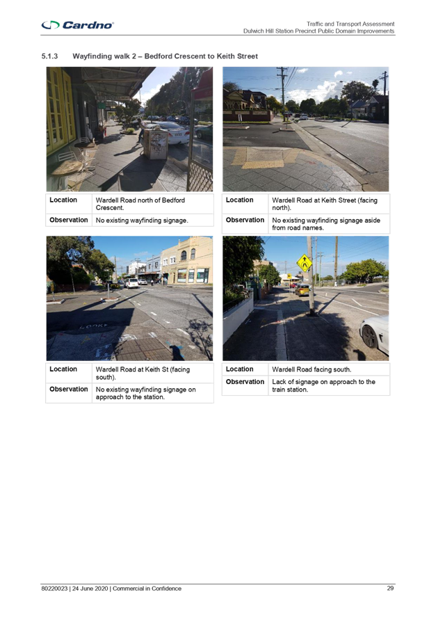
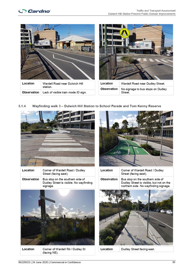
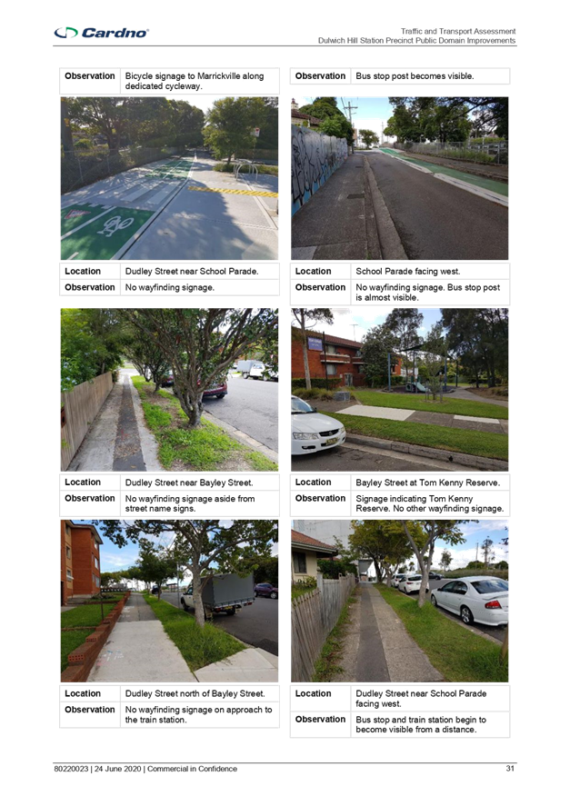
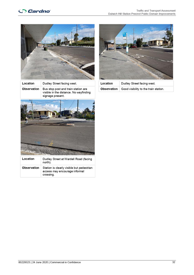
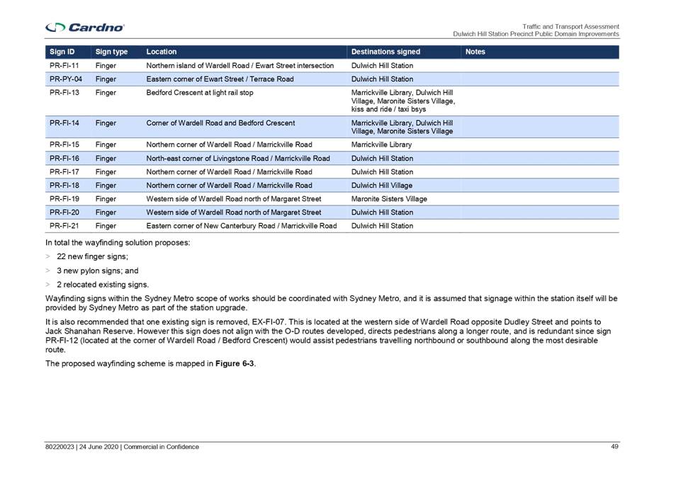
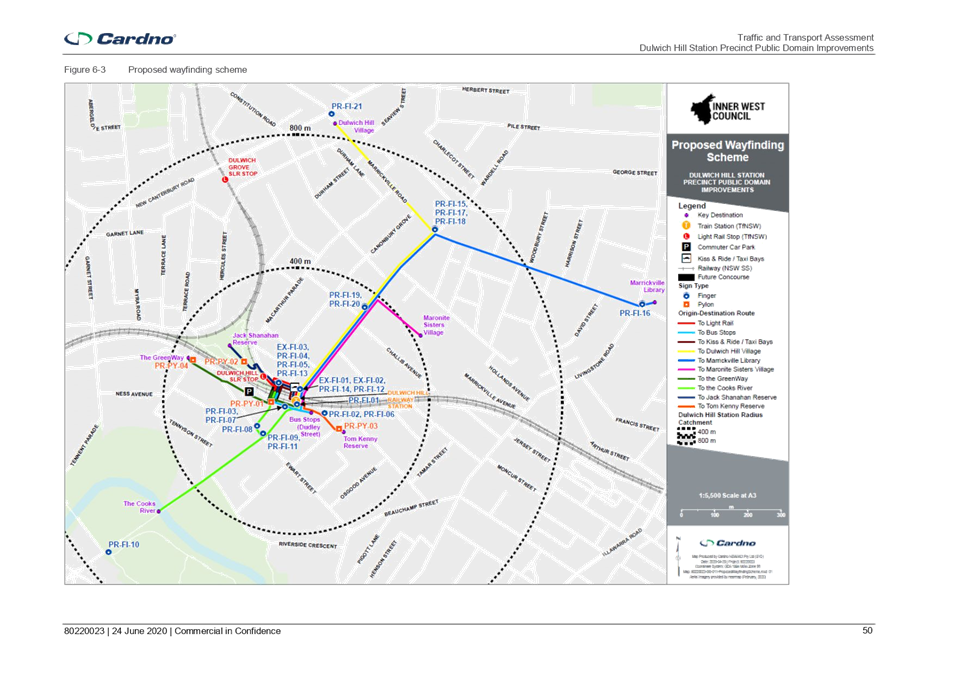
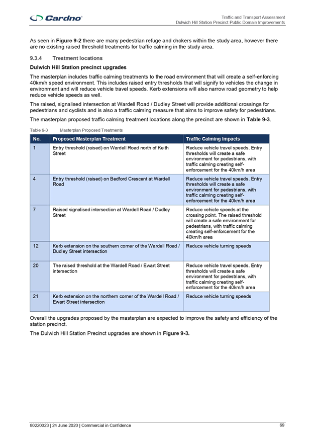
Item No: LTC0720
Item 7
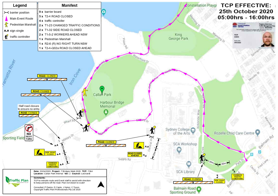
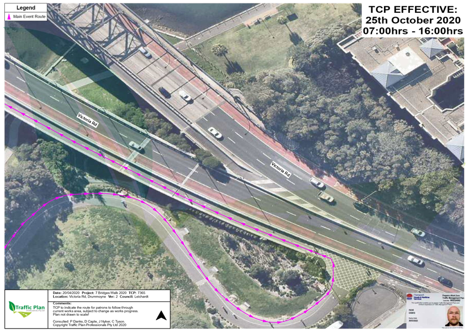
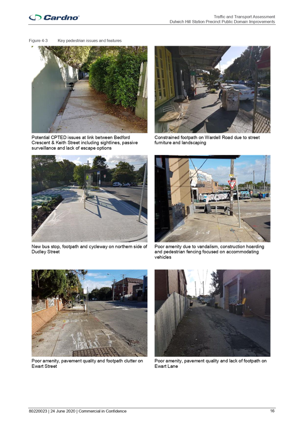
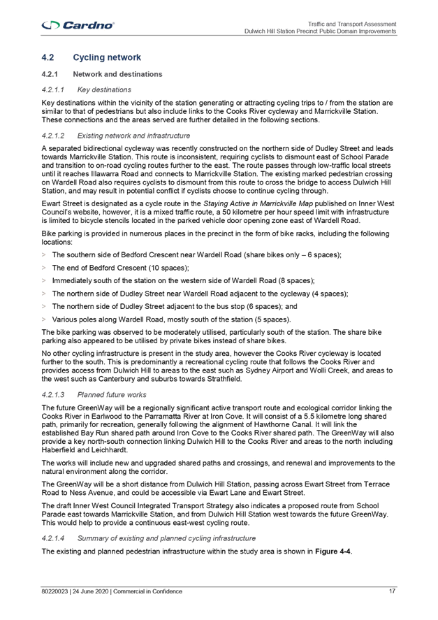
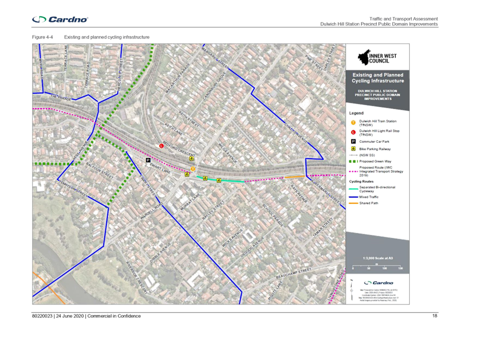
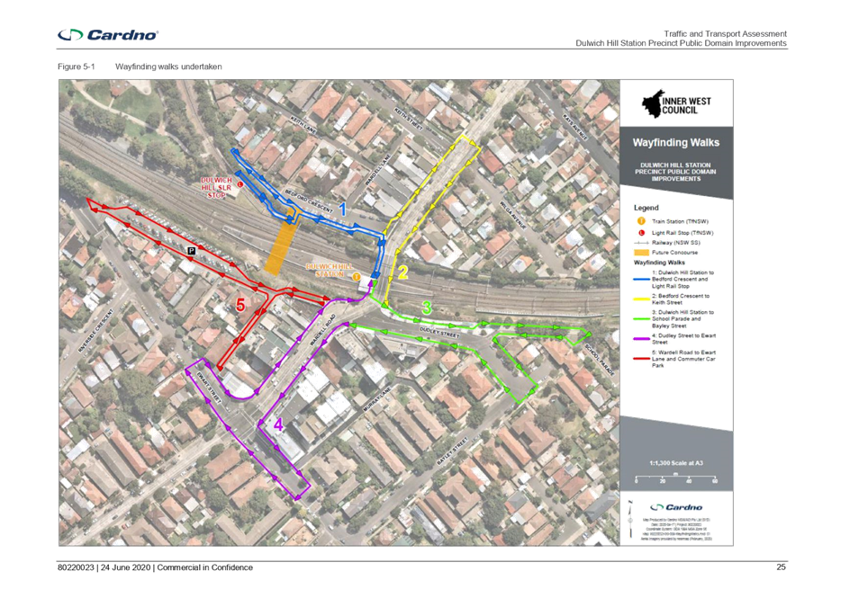
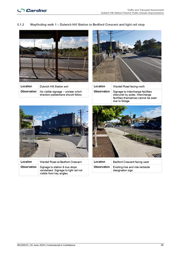
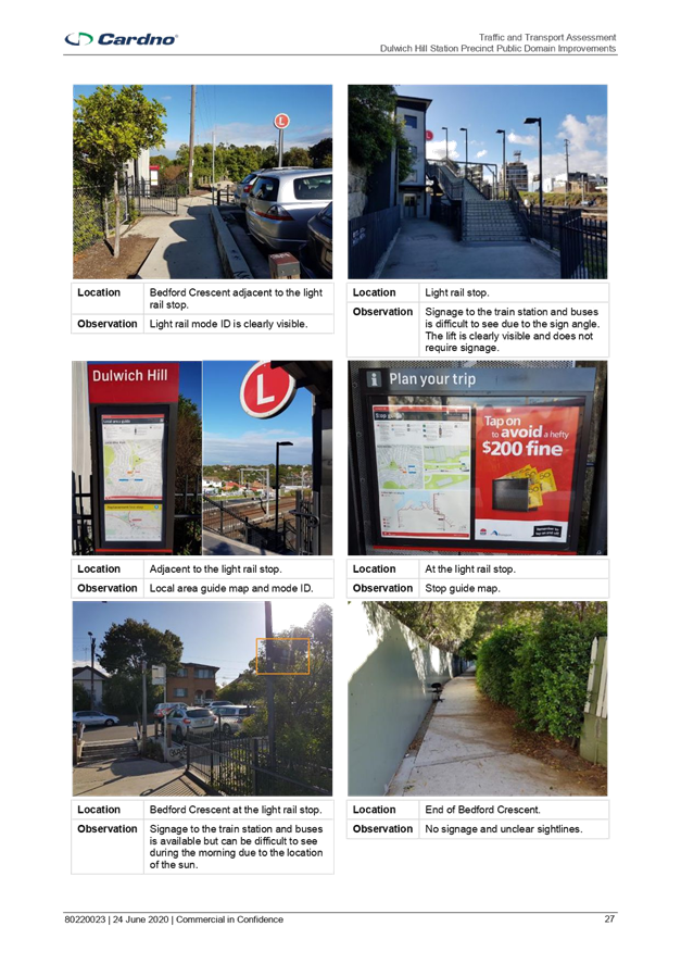
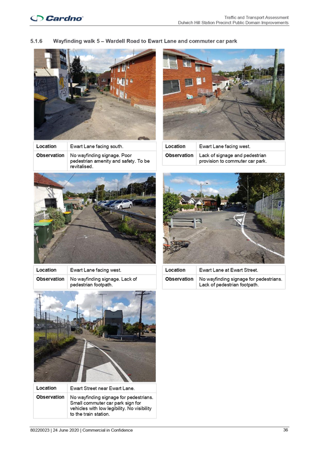
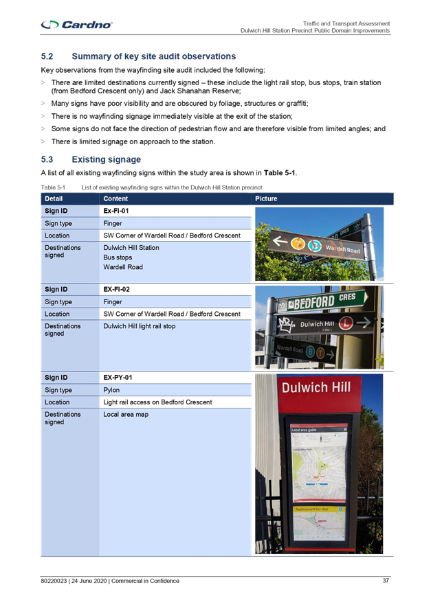
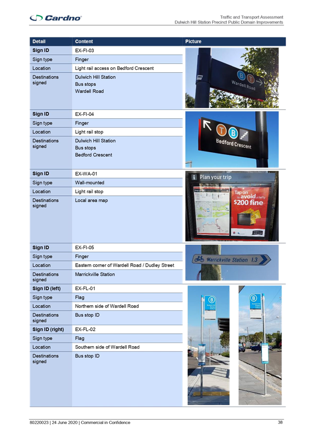
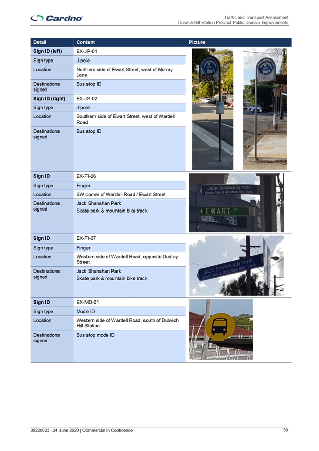
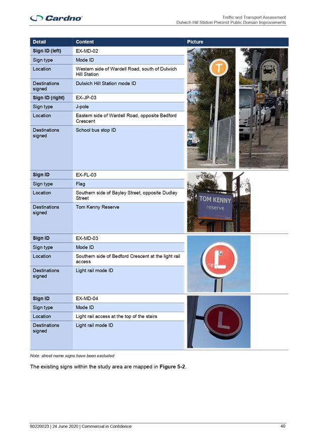
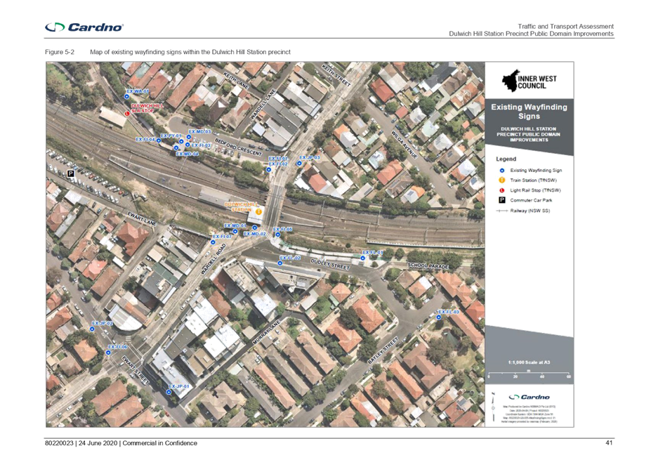
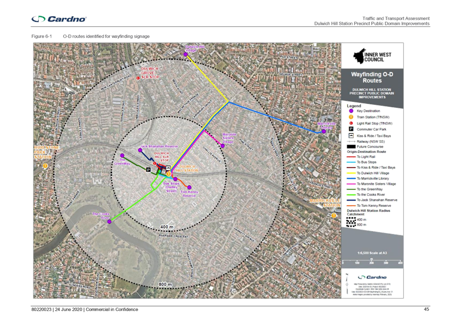
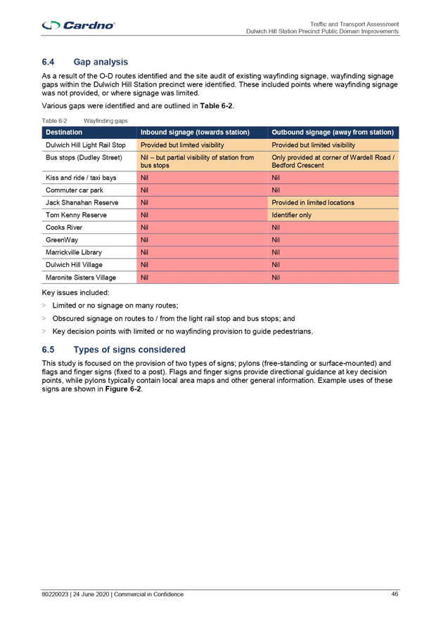
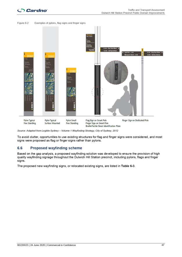
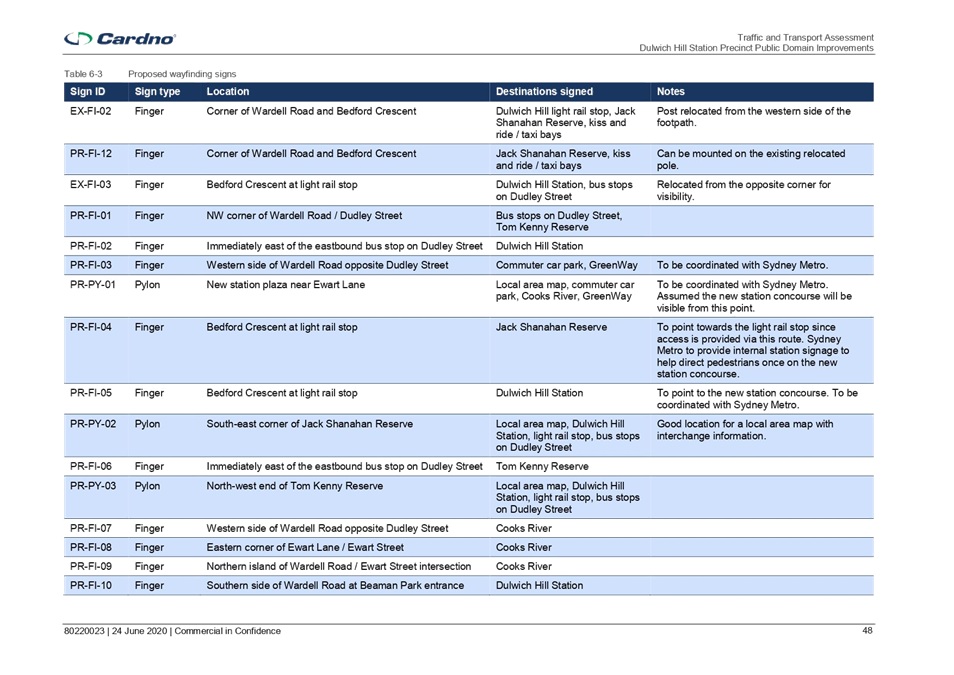
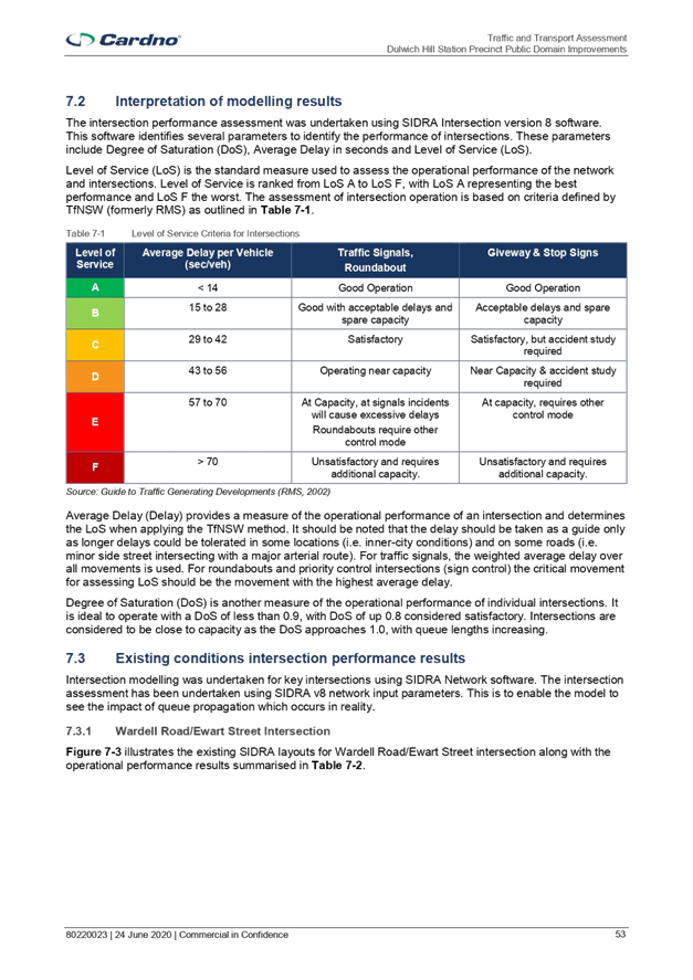
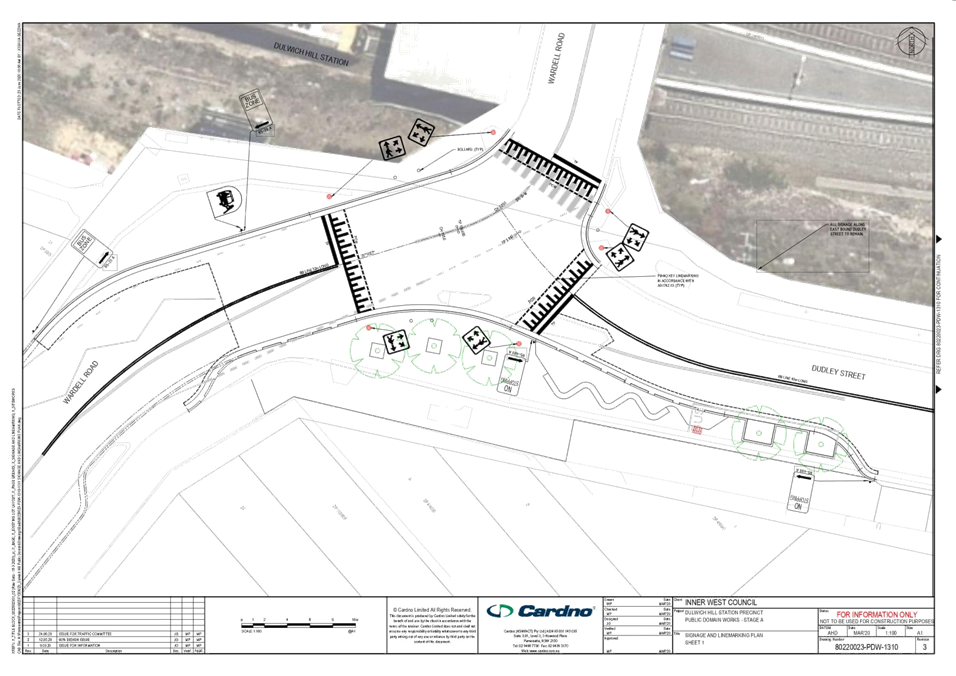
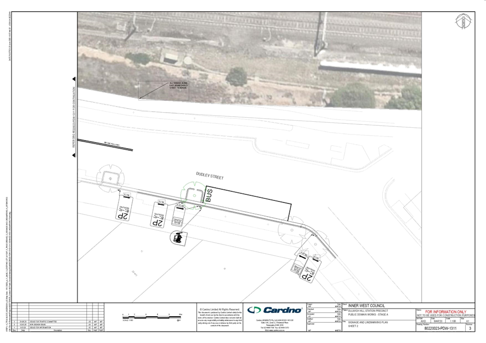
Subject: Dulwich Hill Station Precinct Public Domain
Improvements (Djarrawunang-Ashfield Ward / Summer Hill Electorate / Inner West
PAC)
Prepared By: George
Tsaprounis - Coordinator – Traffic and Parking Services
Authorised By: Manod
Wickramasinghe - Traffic and Transport Planning Manager
SUMMARY
A traffic and
transport assessment for the detailed design of the Dulwich Hill Station
Precinct Public Domain Improvements has now been undertaken.
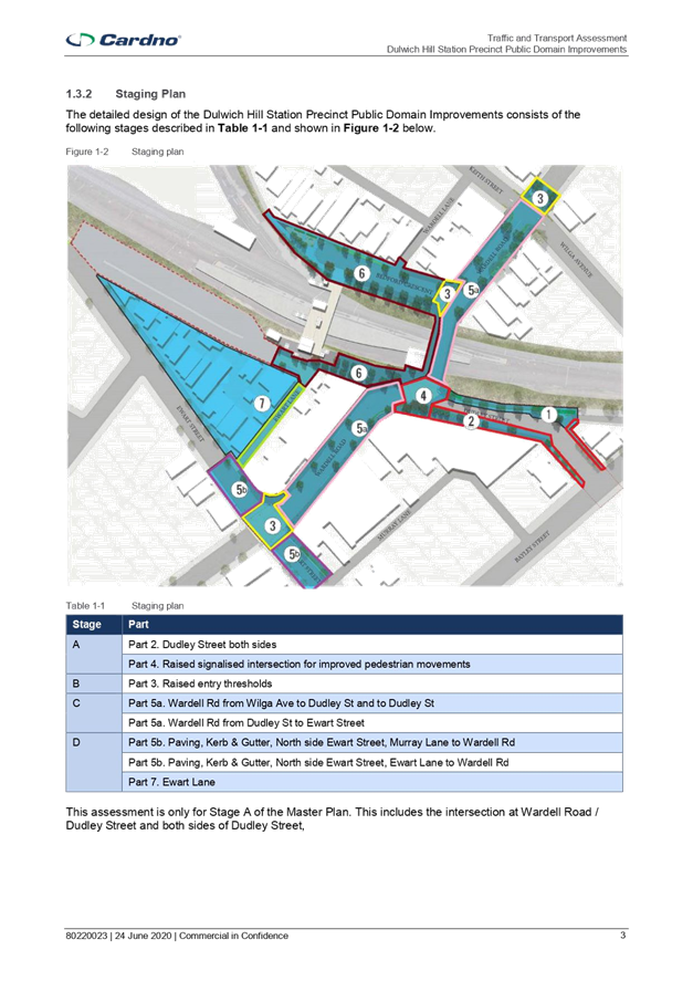
The works will
be delivered in 4 stages: Stage A, Stage B, Stage C and Stage D.
Stage A - Wardell
Road - Dudley Street Intersection works, Dudley Street footpath works.
Stage B - Raised
Entry Thresholds on Wardell Road, Bedford Cres and Wardell Road - Ewart Street
intersection.
Stage C - Road
works on Wardell Road from Wilga Ave to Ewart Street.
Stage D - Road
works on Ewart Street between Murray Lane and Ewart Lane.
This assessment
is only for Stage A of the Master Plan and the detailed design of Stage A has
now been progressed. The following works are proposed to be undertaken within
the Stage A:
· Raised signalised intersection at Wardell Road / Dudley Street for
improved safety and pedestrian movement;
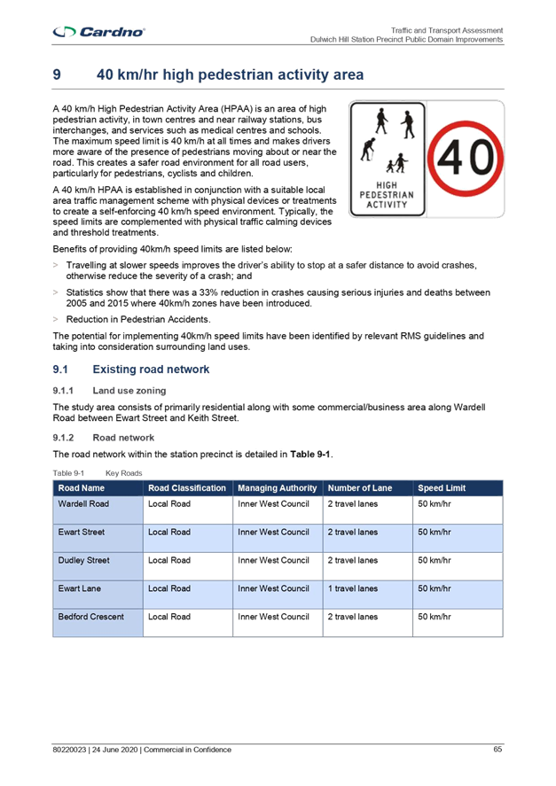
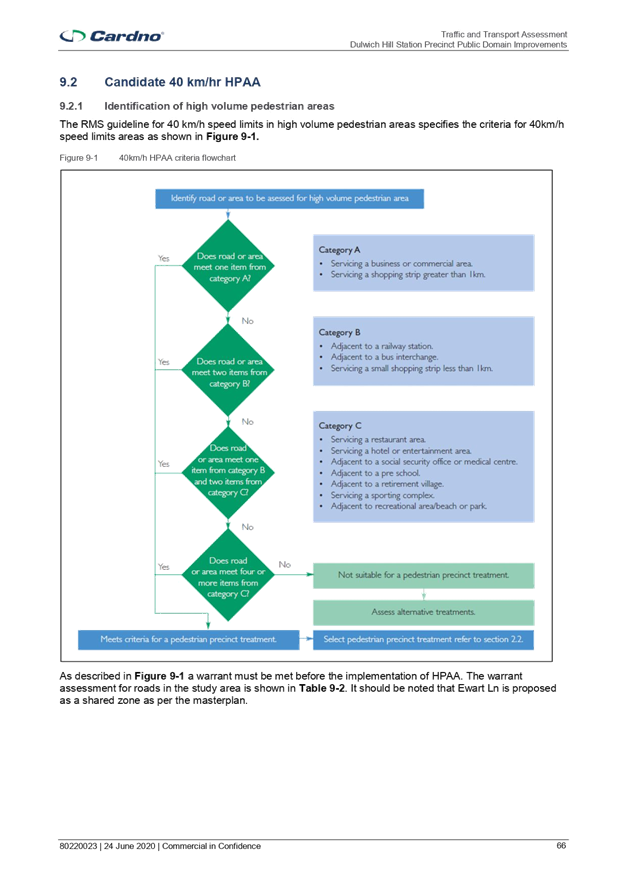
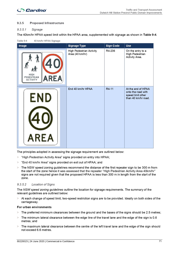
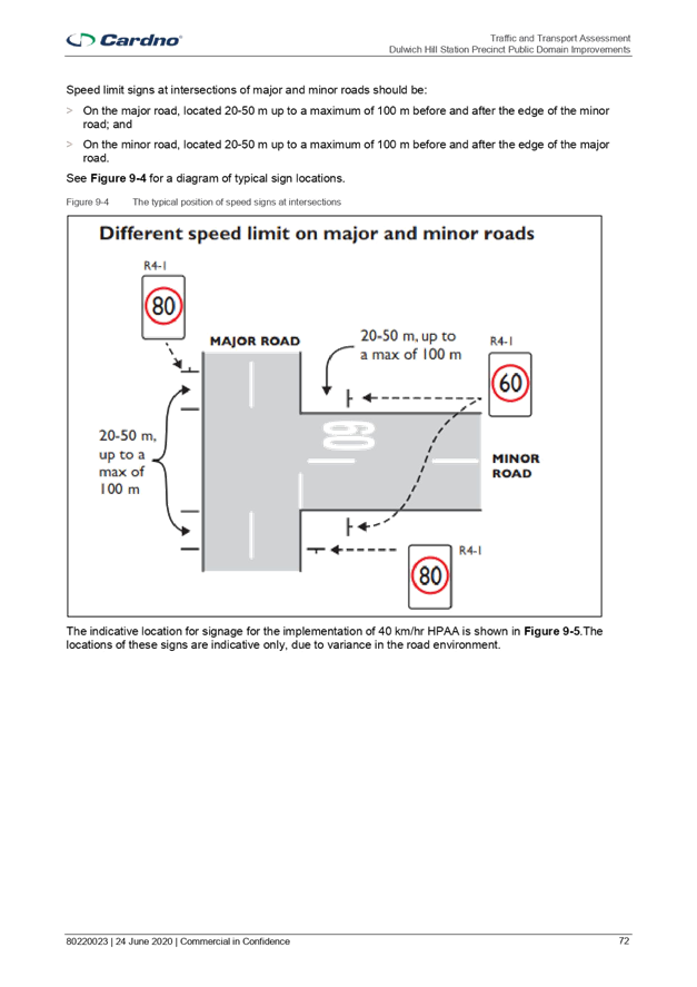
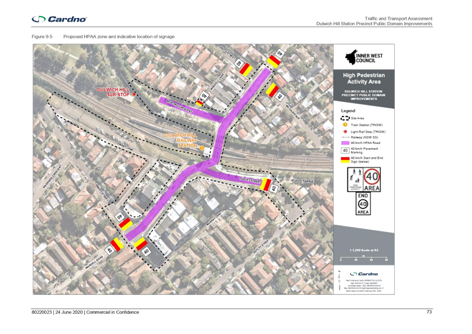
· A 40km/h High Pedestrian Activity Area proposed around the station
precinct with relevant signage to further improve the safety of pedestrians;
· New in road trees, raingarden and footpath treatments; and
· Extended footpath areas to allow space for pedestrians, footpath
dining, street gathering spaces, trees and planting;
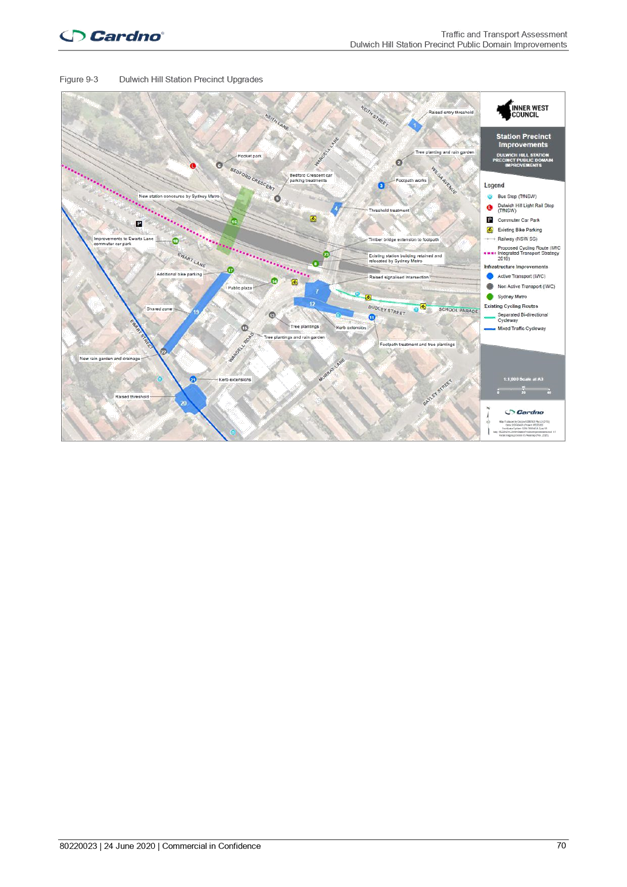
Overall the
upgrades for stage A aligns well with the existing and planned pedestrian and
cycling networks and are expected to improve the safety and efficiency of the
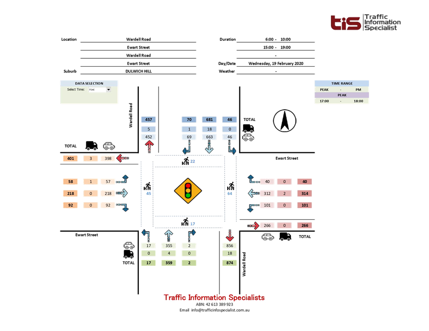
station precinct. In particular, the raised, signalised intersection at Wardell
Road / Dudley Street will help to address safety issues at the existing pedestrian
crossing where crashes have been recorded, particularly as pedestrian movement
increases with the implementation of the Sydney Metro upgrades. The
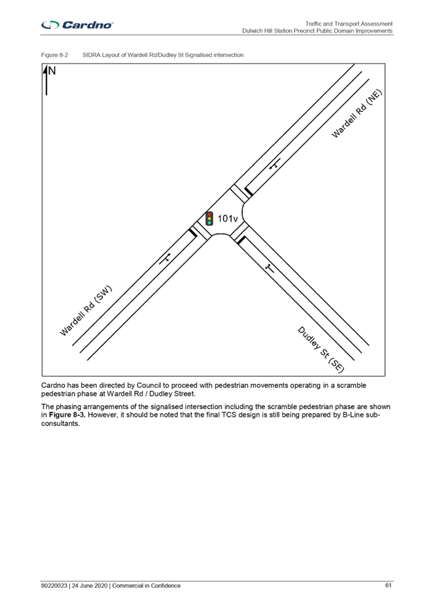
intersection is proposed to be a scramble crossing to maximise space for
pedestrian movement and allow pedestrians to cross in any direction at once.
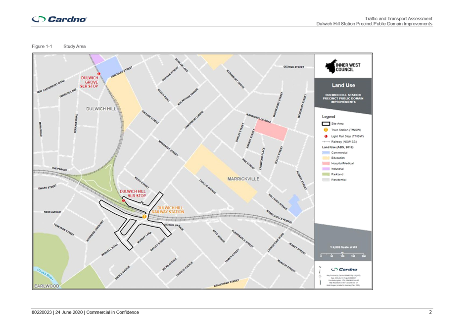
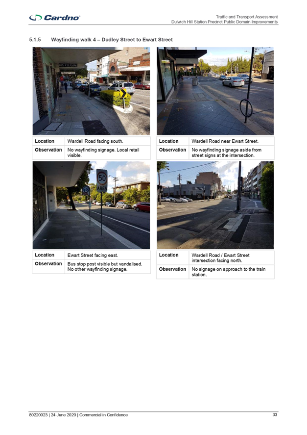
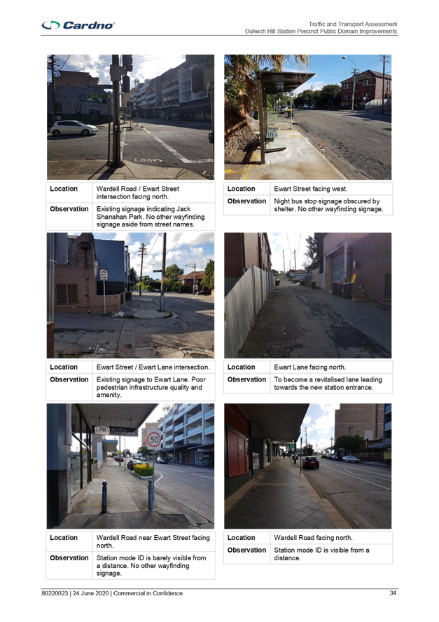
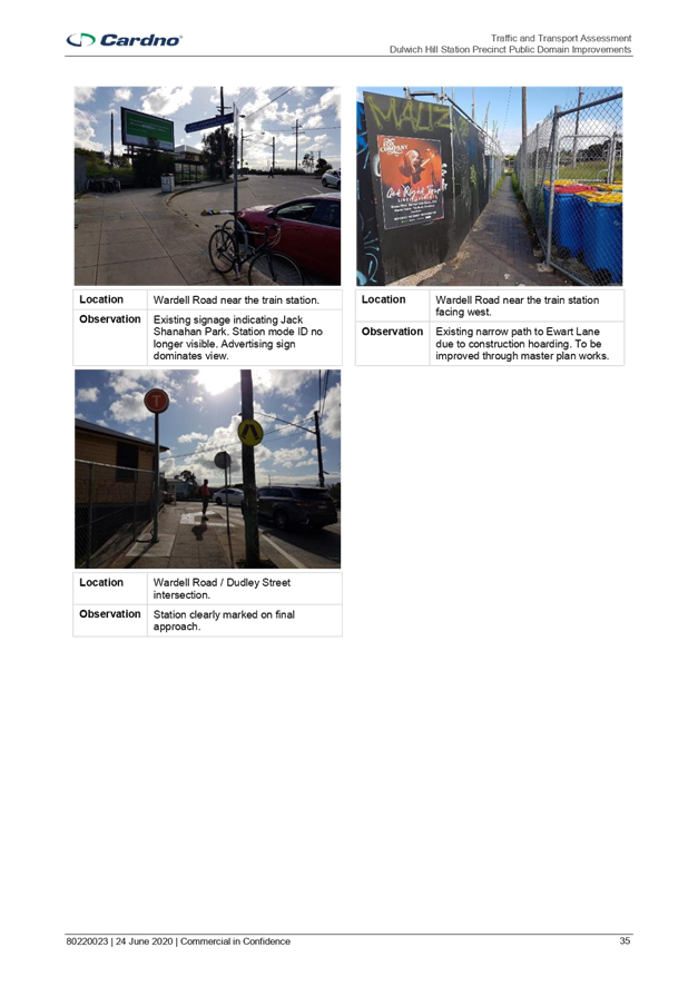
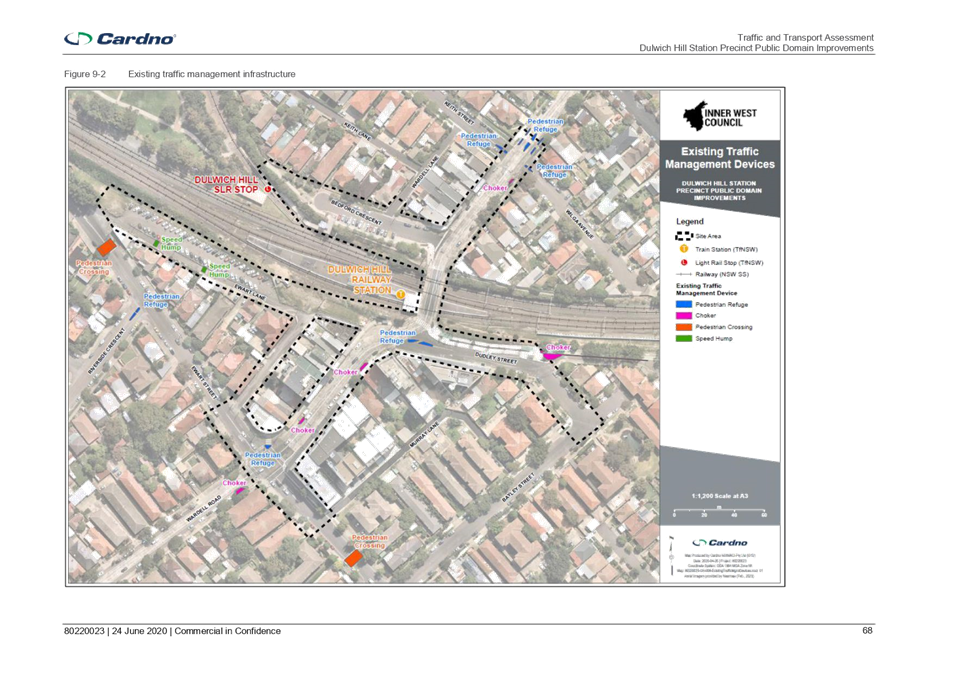
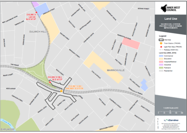
BACKGROUND
The Dulwich Hill
Station Precinct (DHSP) site area includes:
· Wardell Road from Ewart Street to the north side of the Keith Street
/ Wilga Avenue intersection;
· Dudley Street;
· Ewart Street between Ewart Lane and Murray Lane; and
· Bedford Crescent.
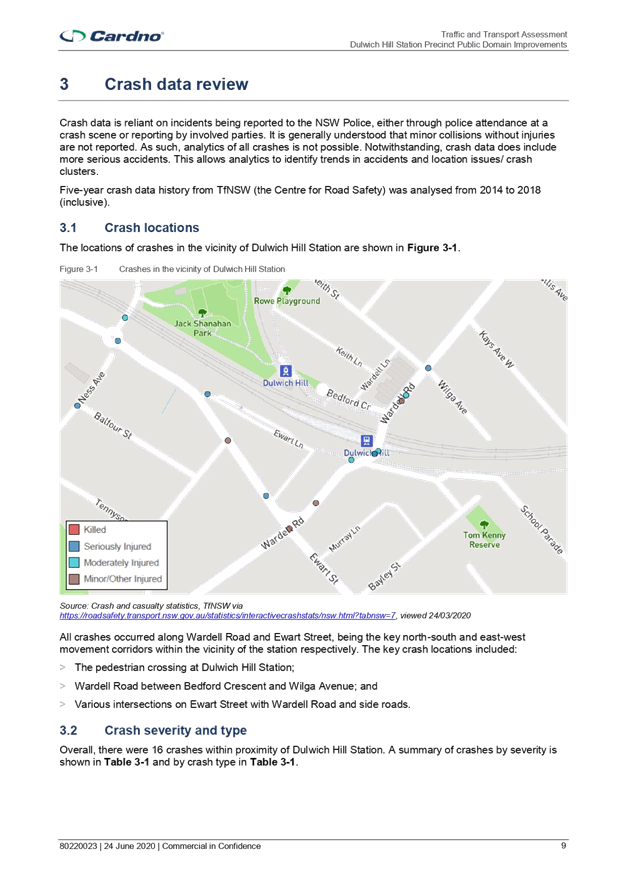
The figure below
illustrates the study area relative to the surrounding road network and
different land uses around the study area. The study area consists of primarily
residential along with some commercial/business area along Wardell Road between
Ewart Street and Keith Street.
Figure 1-1 Study
Area
OFFICER COMMENTS
In relation to
the traffic and transport assessment, only Stage A of the Master Plan is being
assessed (refer to Attachment 2). This includes the intersection at
Wardell Road / Dudley Street and both sides of Dudley Street.
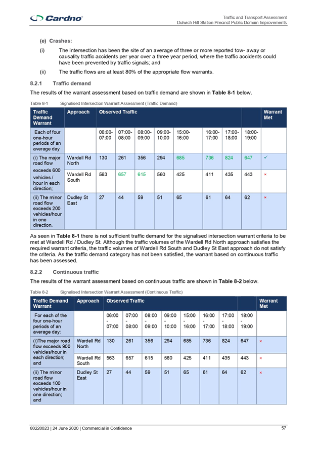
Many of the
other upgrades will improve the safety and efficiency of pedestrians and
cyclists throughout the precinct and facilitate access to and from the station.
The summary of traffic and transport impact due to the proposed upgrades is
listed below.
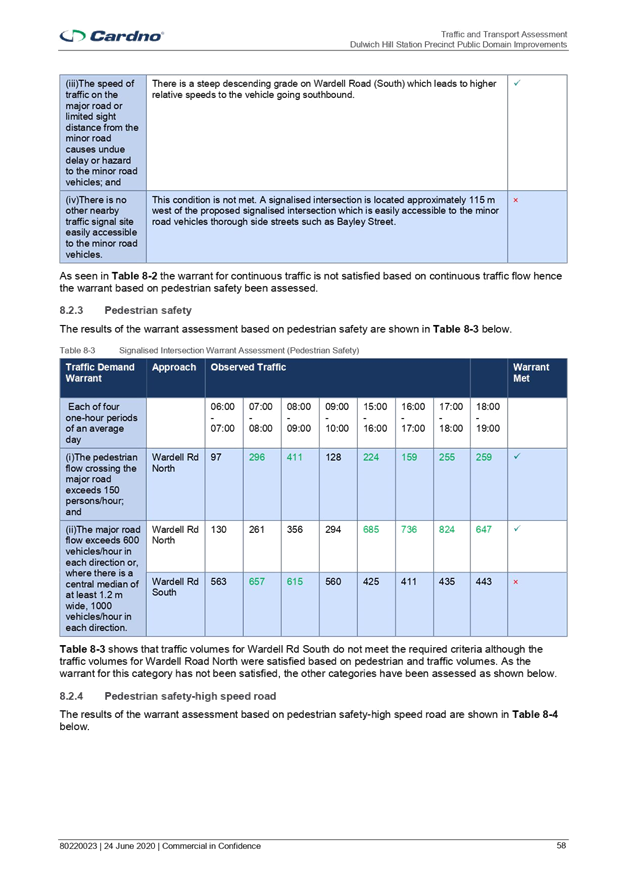
Table 1-1
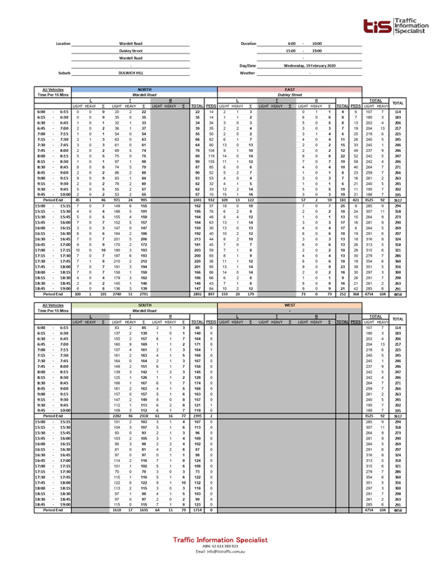
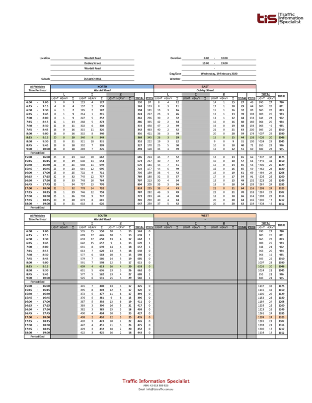
Transport impacts of proposed Stage A precinct works
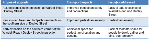
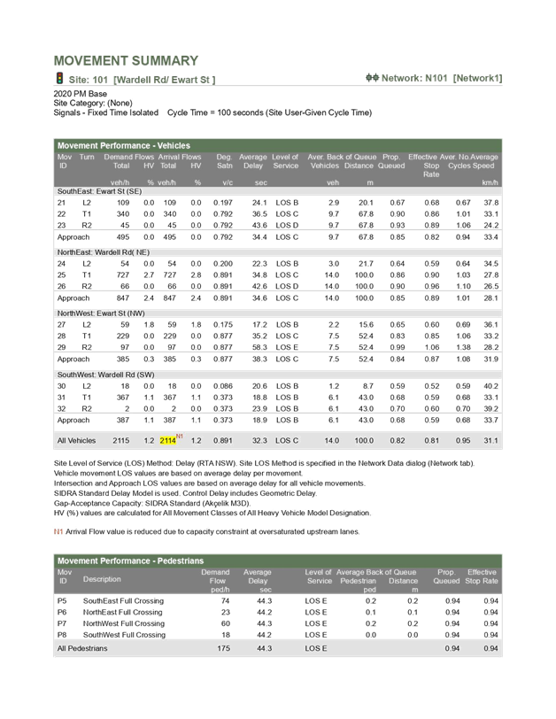
In particular,
the raised, signalised intersection at Wardell Road / Dudley Street will help
to address safety issues at the existing pedestrian crossing where crashes have
been recorded, particularly as pedestrian movement increases with the
implementation of the Sydney Metro upgrades. The intersection is proposed to be
a scramble crossing to maximise space for pedestrian movement and allow
pedestrians to cross in any direction at once (refer to Attachment 2).
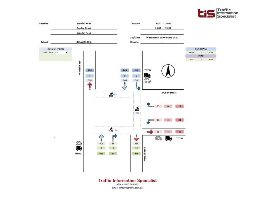
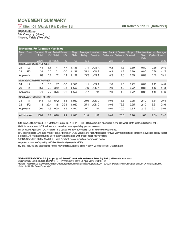
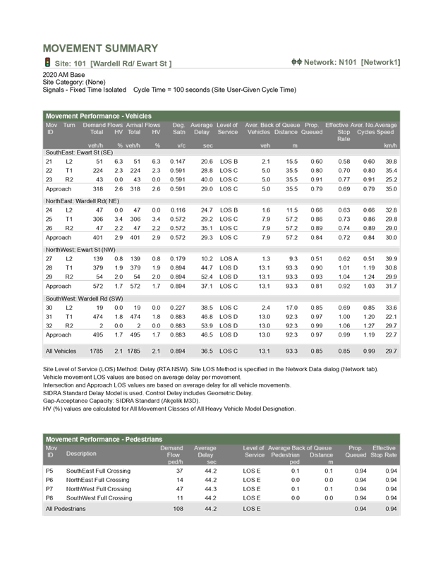
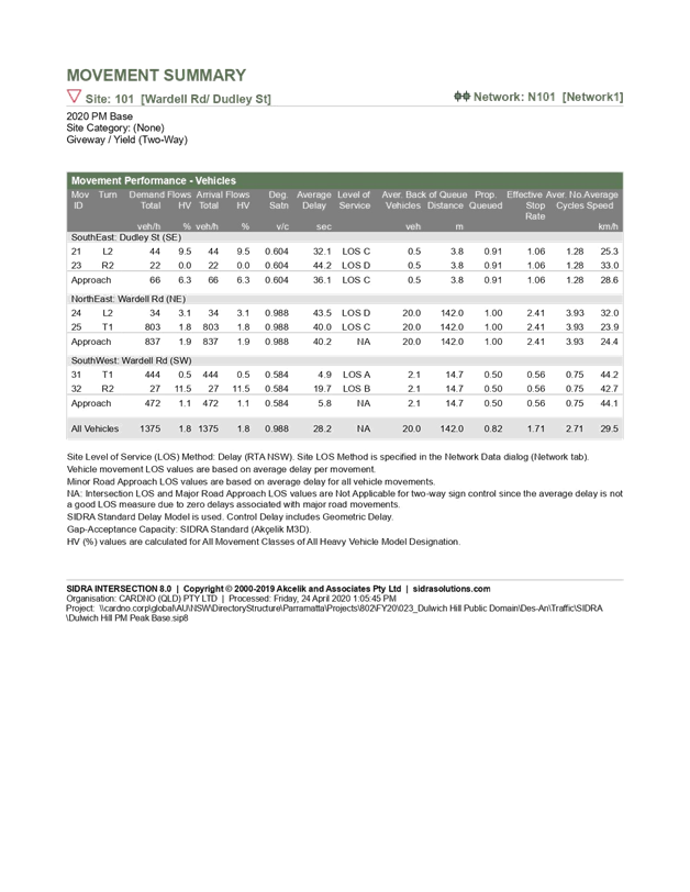
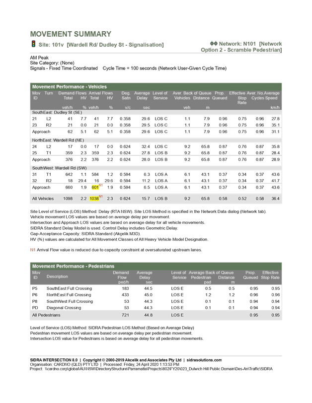
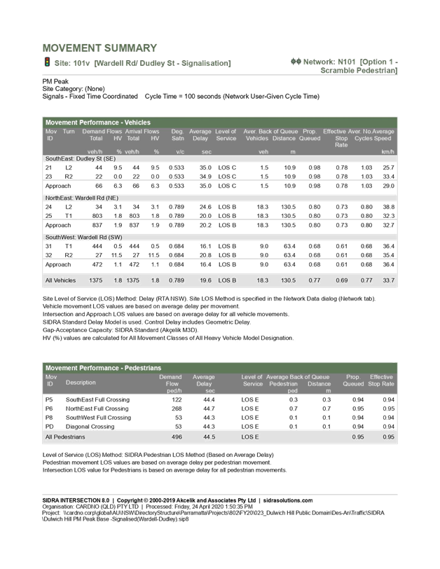
The traffic
modelling shows that the signalisation of Wardell Rd / Dudley St improves the
performance of the intersection. Under the existing geometry (priority
controlled), the performance of Wardell Rd/ Dudley St intersection is Level of
Service (LoS) C in the AM peak and LoS D in the PM peak. Intersection
performance at LoS D signifies that the intersection operates near capacity in
the PM peak. Under the proposed signalised intersection scenario with scramble
crossing, the intersection performs satisfactorily at LoS B in both AM and PM
peaks.
Overall the
upgrades align well with the existing and planned transport networks and are
expected to improve the safety and efficiency of the station precinct. This
proposed traffic management scheme also supports proposals by the Sydney Metro
and South-West project to integrate the upgraded metro station with connections
to Ewart Lane, Wardell Road and Bedford Crescent. Council will coordinate the
design and development of Sydney Metro's Precinct Plans to avoid duplicities
and ensure any work undertaken is consistent and builds upon Council's public
domain master plan.
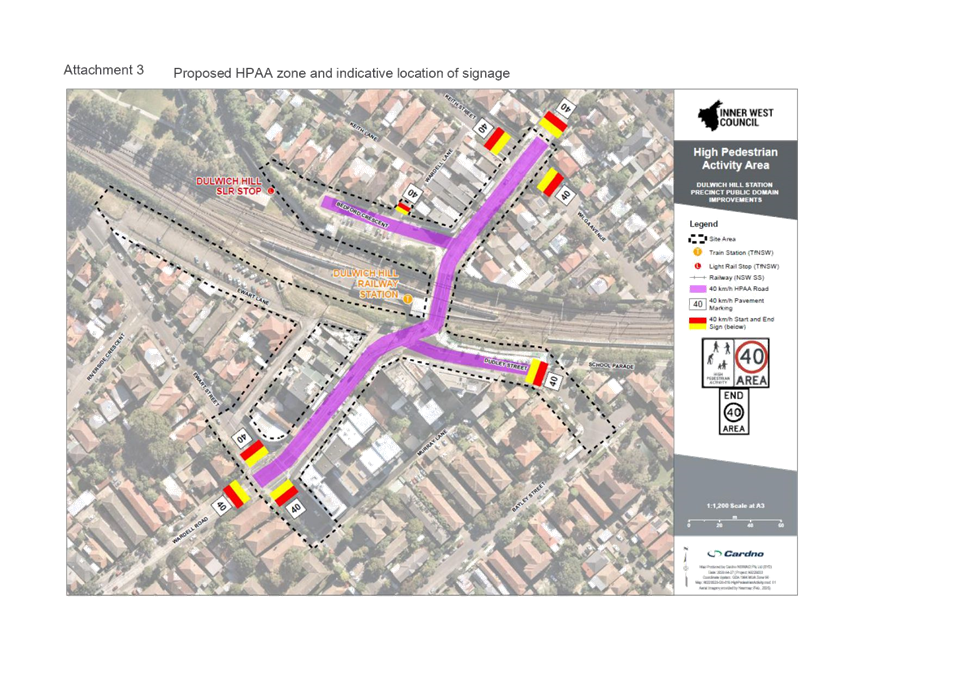
Furthermore, a
HPAA scheme is proposed around the station precinct along Wardell Road, Dudley
Street and Bedford Crescent with relevant signage to inform and remind drivers
of the 40 km/h to speed limit within the precinct. Traffic calming measures and
new pedestrian facilities proposed by the masterplan supplement the 40 km/h
signage to create a self-enforcing speed limit environment and to further
improve the safety of pedestrians (refer to Attachment 3).
FINANCIAL
IMPLICATIONS
The project has
been listed in Councils Capital Works Program and funding has been committed
for stage A in the 2020/21 financial year budget.
PUBLIC
CONSULTATION
At its meeting on 13 August 2019
Council considered community feedback and adopted the Master Plan for Dulwich
Hill Station Precinct. The Master plan provides high level design for the
future of the precinct. The current preliminary detailed design has been
displayed for information on Councils ‘Your Say’ webpage as a
project update.
ATTACHMENTS
|
1.⇩
|
Traffic and Transport Assessment
|
|
2.⇩
|
Signage Plan
|
|
3.⇩
|
Proposed HPAA zone and indicative location of signage
|
|

|
Local Traffic
Committee Meeting
6 July 2020
|
|

|
Local Traffic
Committee Meeting
6 July 2020
|
|

|
Local Traffic
Committee Meeting
6 July 2020
|
|
|
Local Traffic
Committee Meeting
6 July 2020
|
Item No: LTC0720
Item 8
Subject: Flood Street, Leichhardt - Road Occupancy
(Gulgadya Ward/ Balmain Electorate/ Leichhardt PAC)
Prepared By: Vinoth
Srinivasan - Engineer - Traffic and Parking Services
Authorised By: David Yu -
Acting Coordinator Traffic Engineer Services (North)
SUMMARY
This report considers a request received from BreastScreen
NSW for the temporary placement of their mobile lab unit on the western side of
Flood Street adjacent to Leichhardt Market Place within the existing
‘Taxi Zone’, for the duration of eight (8) weeks starting from Friday,
7 August to Saturday, 3 October 2020.
|
RECOMMENDATION
THAT the road occupancy for the BreastScreen NSW mobile lab unit on the
western side of Flood Street, adjacent to Leichhardt Market Place within the
existing ‘Taxi Zone’, for the duration of eight (8) weeks
starting from Friday, 7 August to Saturday, 3 October
2020 be supported.
|
BACKGROUND
& OTHER STAFF COMMENTS
BreastScreen NSW has requested
approval to locate a mobile lab unit on the western side of Flood Street,
adjacent to Leichhardt Market Place within the existing ‘Taxi Zone’
for the duration of eight (8) weeks from Friday, 7 August to Saturday, 3
October 2020. The mobile lab unit will operate for screening from 8.45am to 4.00pm
Monday to Friday. This location has been used in previous years with
concurrence from the NSW Taxi Council and would not affect any businesses, see
proposed location below:
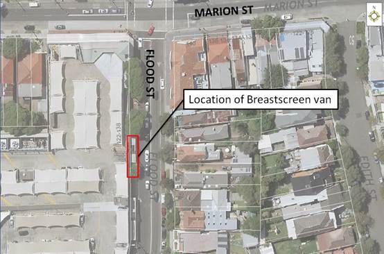
Note that the applicant has been
requested to provide a copy of their public risk insurance.
FINANCIAL IMPLICATIONS
Nil.
ATTACHMENTS
Nil.
|
|
Local Traffic
Committee Meeting
6 July 2020
|
Item No: LTC0720
Item 9
Subject: Seven Bridges Walk - Special Event (Gulgadga -
Leichhardt & Baludarri - Balmain Ward/ Balmain Electorate/ Leichhardt PAC)
Prepared By: Vinoth
Srinivasan - Engineer - Traffic and Parking Services
Authorised By: Manod
Wickramasinghe - Traffic and Transport Planning Manager
SUMMARY
The Cancer Council NSW Seven Bridges Walk event will be held
on Sunday, 25 October 2020 at various locations in Sydney, including areas
within the Inner West Council. The Event is in its fifteenth year of operation
and the applicant seeks approval again in 2020.
|
RECOMMENDATION
THAT the Cancer Council NSW Seven Bridges Walk to be held
on Sunday, 25 October
2020 be approved, subject to a current Public Liability Insurance
Policy which includes
the Inner West Council being an interested party being submitted
by the event organiser
prior to the event.
|
BACKGROUND
The Cancer Council NSW Seven Bridges Walk concept was created and
developed by the Pedestrian Council of Australia (PCA) who will remain the
owner of the event. The PCA has engaged Mothership Events to deliver the Event
Operations and manage the marketing of the Event on behalf of PCA. The Cancer
Council NSW Seven Bridges Walk can be regarded as an active opportunity to
further enhance the councils' and stakeholders' charter toward promoting
walking as a healthy activity and as an increasingly important means of active
transport. In addition, the event will provide a significant contribution to
the Cancer Council NSW (CCNSW).
FINANCIAL IMPLICATIONS
All costs
associated with the Seven Bridges Walk are funded by the event organisers.
OTHER STAFF COMMENTS
Event Details
The course of CCNSW Seven Bridges Walk will open
at 7:00am, and close at 4:30pm and it is estimated that it may attract up to
15,000 participants. The walking route is approximately 27km in length and is a
closed loop circuit that utilises pathways around the inner metropolitan region
of Sydney that skirts the Sydney Harbour and includes the crossing of seven
bridges. Special event buses will operate in both directions around the course
and will be provided free of charge to everyone holding an ‘event
passport’.
Event
Overview
Event Name:
Cancer Council NSW Seven Bridges Walk [www.7bridgeswalk.com.au]
Event Owner:
Pedestrian Council of Australia Ltd (PCA)
Date:
Sunday, 25 October 2020
Course
Opens: 7:00am via one of the 6 Villages located around the course
Course
Closes: 4:30pm
Participation Target: 12,000 people throughout the day (Maximum capacity
of 15,000 walkers)
Course
Description:
The walking route is approximately 27km in length and is a closed loop
circuit that utilises pathways around the inner metropolitan region of Sydney
that skirts the Sydney Harbour and includes the crossing of Seven Bridges.
The Seven
Bridges are:
1. Sydney
Harbour Bridge
2. Pyrmont
Bridge
3. ANZAC
Bridge
4. Iron Cove
Bridge
5.
Gladesville Bridge
6. Tarban
Creek Bridge
7. Fig Tree Bridge
Village Locations:
Event
‘Villages’ are located around the course and will be used as
check-in locations, First Aid points, drink stations, light catering and
entertainment.
The 6 villages
are:
1. Milsons Point Village (Burton Street at Alfred
Street, Milsons Point)
2. Pyrmont Village (at Pyrmont Bay Park, Pirrama Rd,
opposite The Star Casino)
3. Rozelle Village (at Waterfront Drive Sporting Ground
- Callan Park)
4. Hunters Hill Village (at Hunters Hill Scout Hall,
Durham St near the Church St overpass on Burns Bay Road, Hunters Hill)
5. Lane Cove Village (Blaxlands Corner – Central
Park, William Edward St and Kenneth St, Lane Cove)
6. Wollstonecraft Village (at Brennan Park, Hazelbank St
at King St, Wollstonecraft)
Impact on the
Inner West LGA
The route
through the Inner West LGA is via:
· ANZAC Bridge to Victoria Road
· Pedestrian bridge over Victoria Road
· Lilyfield Road
· Burt Street
· Denison Street
· Cheltenham Street
· O’Neill Street
· Cecily Street
· Through Callan Park to King George Park
· Byrnes Street to Victoria Road
Traffic and
Pedestrian Management Plan (TMP)
This event does not require closure of any roads in the
Inner West LGA. As the participants will be using footpaths and crossing the
street network with assistance of traffic controllers, the Event does
not cause significant impacts on traffic and transport systems. Therefore, the
Event can be considered as Class 3. Hence, Council’s approval for the
Traffic & Transport Management Plan is adequate.
The attached Pedestrian and Traffic Management Plan (TMP), when approved
by the relevant authorities, becomes the prime document detailing with the
traffic and transport arrangements under which this event is to proceed.
In case of emergencies, or for the management of incidents, the Police
are not subject to the conditions of the TMP but will make every effort to
inform the other agencies of the nature of the incident and the Police
response.
The route for the proposed Seven Bridges Walk and the Traffic Control
Plans (TCP) and Traffic Management Plan for Inner West Council LGA are
attached.
ATTACHMENTS
|
1.⇩
|
Traffic Management Plan - Seven Bridges Walk 2020
|
|
2.⇩
|
Traffic Control Plan - Seven Bridges Walk 2020
|
|
|
Local Traffic
Committee Meeting
6 July 2020
|
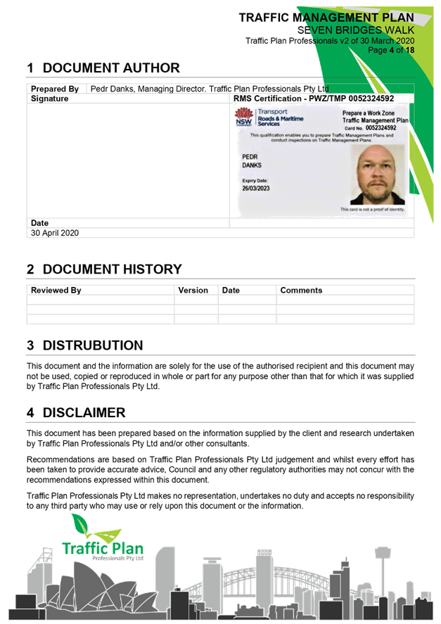
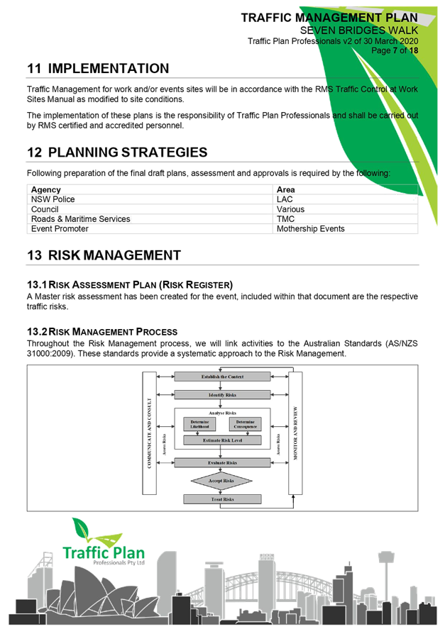
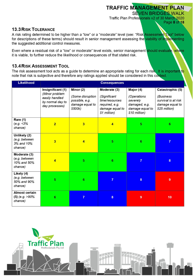
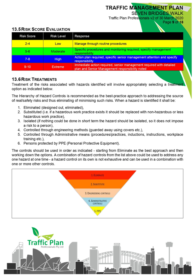
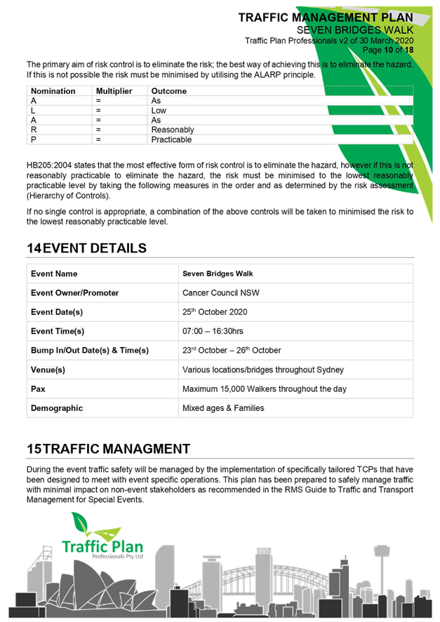
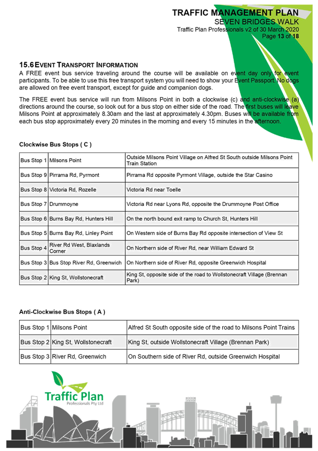
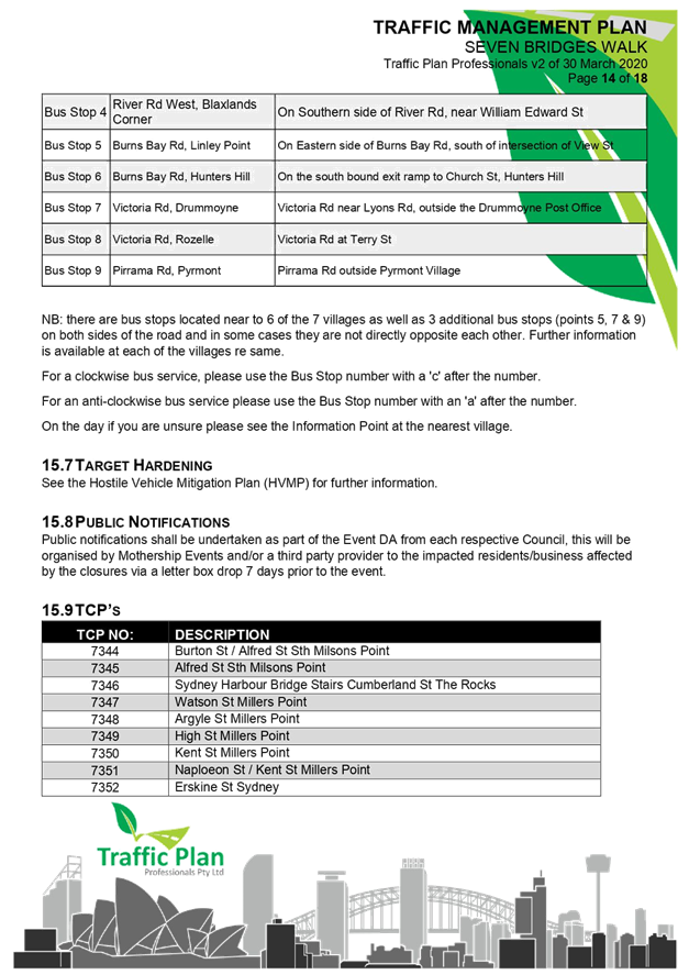
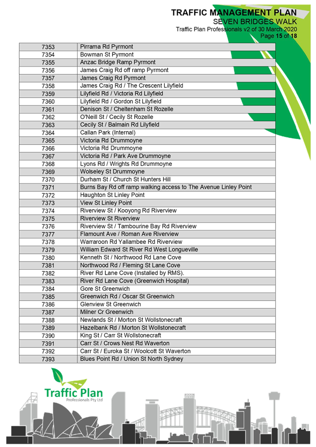
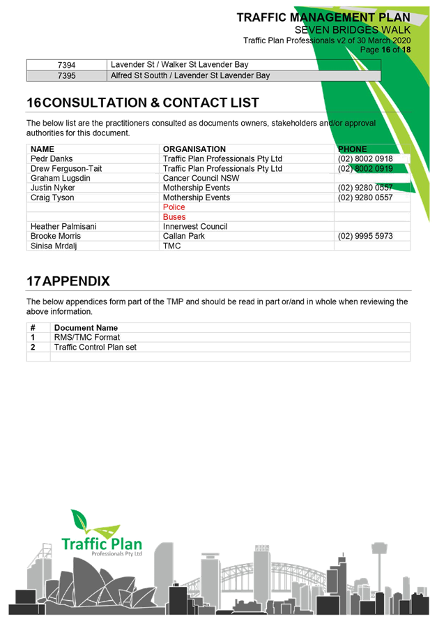
|

|
Local Traffic
Committee Meeting
6 July 2020
|