|
AGENDA R |

Local Traffic Committee Meeting
TUESDAY 6 FEBRUARY 2018
10.00am
|
|
Local Traffic Committee Meeting 6 February 2018 |
Function of the Local Traffic Committee
Background
Roads and Maritime Services (RMS) is legislated as the Authority responsible for the control of traffic on all NSW Roads. The RMS has delegated certain aspects of the control of traffic on local roads to councils. To exercise this delegation, councils must establish a local traffic committee and obtain the advice of the RMS and Police. The Inner West Council Local Traffic Committee has been constituted by Council as a result of the delegation granted by the RMS pursuant to Section 50 of the Transport Administration Act 1988.
Role of the Committee
The Local Traffic Committee is primarily a technical review and advisory committee which considers the technical merits of proposals and ensures that current technical guidelines are considered. It provides recommendations to Council on traffic and parking control matters and on the provision of traffic control facilities and prescribed traffic control devices for which Council has delegated authority. These matters are dealt with under Part A of the agenda and require Council to consider exercising its delegation.
In addition to its formal role as the Local Traffic Committee, the Committee may also be requested to provide informal traffic engineering advice on traffic matters not requiring Council to exercise its delegated function at that point in time, for example, advice to Council’s Development Assessment Section on traffic generating developments. These matters are dealt with under Part C of the agenda and are for information or advice only and do not require Council to exercise its delegation.
Committee Delegations
The Local Traffic Committee has no decision-making powers. The Council must refer all traffic related matters to the Local Traffic Committee prior to exercising its delegated functions. Matters related to State Roads or functions that have not been delegated to Council must be referred directly to the RMS or relevant organisation.
The Committee provides recommendations to Council. Should Council wish to act contrary to the advice of the Committee or if that advice is not supported unanimously by the Committee members, then the Police or RMS have an opportunity to appeal to the Regional Traffic Committee.
Committee Membership & Voting
Formal voting membership comprises the following:
· one representative of Council as nominated by Council;
· one representative of the NSW Police from each Local Area Command (LAC) within the LGA, being Newtown, Marrickville, Leichhardt and Ashfield LAC’s.
· one representative from the RMS; and
· State Members of Parliament (MP) for the electorates of Summer Hill, Newtown, Heffron, Canterbury, Strathfield and Balmain or their nominees.
Where the Council area is represented by more than one MP or covered by more than one Police LAC, representatives are only permitted to vote on matters which effect their electorate or LAC.
Informal (non-voting) advisors from within Council or external authorities may also attend Committee meetings to provide expert advice.
Committee Chair
Council’s representative will chair the meetings.
Public Participation
Members of the public or other stakeholders may address the Committee on agenda items to be considered by the Committee. The format and number of presentations is at the discretion of the Chairperson and is generally limited to 3 minutes per speaker. Committee debate on agenda items is not open to the public.
|
|
Local Traffic Committee Meeting 6 February 2018 |
|
AGENDA |
1 Apologies
2 Disclosures of Interest
3 Confirmation of Minutes
Minutes of 7 December 2017 Local Traffic Committee Meeting 5
4 Matters Arising from Council’s Resolution of Minutes
5 Part A – Items Where Council May Exercise Its Delegated Functions
Traffic Matters
ITEM PAGE #
LTC0218 Item 1 Learmonth Street, Haberfield – Proposed Speed Cushions (Leichhardt Ward/Summer Hill Electorate/Ashfield LAC) 48
LTC0218 Item 2 Boomerang Street, Haberfield – Proposed Speed Cushion (Leichhardt Ward/Summer Hill Electorate/Ashfield LAC) 54
LTC0218 Item 3 Audley Street, Petersham – Temporary Full Road Closure For Special Event On Sunday 4 March 2018 (Stanmore Ward/Newtown Electorate/Marrickville LAC) 58
LTC0218 Item 4 Route NS07 (Balmain Road, Leichhardt) – Extension of Shared Path (Leichhardt Ward / Leichhardt LAC / Balmain Electorate) 63
LTC0218 Item 5 Grosvenor
Crescent, Summer Hill – Temporary Road Closure (Between Dover Street and
Carlton Crescent).
(Ashfield Ward/Summer Hill Electorate/Ashfield LAC) 67
LTC0218 Item 6 Sloane Street, Haberfield – “Keep Clear” Road Markings And Removal Of Parking Space Near Intersection to Parramatta Road. (Leichhardt Ward/Summer Hill Electorate/Ashfield LAC) 73
Parking Matters
ITEM PAGE #
LTC0218 Item 7 Minor Traffic Facilities (All Wards/ All LACs/ All Electorates) 78
LTC0218 Item 8 Carlton Crescent, Summer Hill – Request for Two Hours Parking Restrictions (Leichhardt Ward/Summer Hill Electorate/ Ashfield LAC) 84
LTC0218 Item 9 Brenan Street, Lilyfield – Proposed 'No Parking 7am-7pm – Motor Vehicles Under 4.5t GVM Excepted' restriction (Balmain Ward/Balmain Electorate/Leichhardt LAC) 87
LTC0218 Item 10 Upward Street, Leichhardt – P5min Restrictions (Leichhardt Ward/ Leichhardt LAC / Balmain Electorate) 91
LTC0218 Item 11 Constitution Road, Dulwich Hill – Proposal To Remove '1P Parking' (Ashfield Ward/Summer Hill Electorate/Marrickville LAC) 93
LTC0218 Item 12 Flood Street, Leichhardt - Road Occupancy (Leichhardt Ward/Leichhardt LAC/ Balmain Electorate) 96
LTC0218 Item 13 Railway Street, Petersham – Proposed Statutory No Stopping Restrictions (Stanmore Ward/Newtown Electorate/Marrickville LAC) 98
LTC0218 Item 14 Comet Street, Ashfield – Request For a Mobility Parking
Space(Leichhardt Ward/Summer Hill Electorate/Ashfield LAC) 103
Late Items
Nil at time of printing.
6 Part B - Items for Information Only
ITEM PAGE #
LTC0218 Item 15 The ‘Gear Up Girl’ Bicycle Event (Marrickville Ward/Summer Hill & Heffron Electorate/Marrickville & Newtown LAC) 106
7 Part C - Items for General Advice
ITEM PAGE #
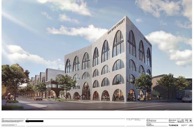
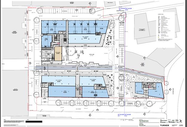
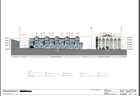
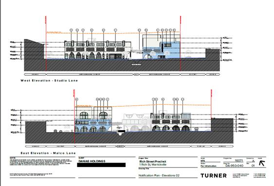
LTC0218 Item 16 Rich Street, Marrickville – DA201700558 – For The Redevelopment Of Existing Industrial Land Into A Commercial Precinct Adjacent To 1-9 Rich Street (Marrickville Ward / Summer Hill Electorate / Marrickville LAC) 113
8 General Business
9 Close of Meeting
|
|
Local Traffic Committee Meeting 6 February 2018 |
Minutes of Local Traffic Committee Meeting
Held at Leichhardt Town Hall, 107 Norton Street, Leichhardt on 7 December 2017.
Meeting commenced at 10.30am
ACKNOWLEDGEMENT OF COUNTRY BY CHAIRPERSON
I acknowledge the Gadigal and Wangal people of the Eora nation on whose country we are meeting today, and their elders past and present.
COMMITTEE REPRESENTATIVES PRESENT
|
Clr Julie Passas |
Deputy Mayor – Ashfield Ward (Chair) |
|
Mr Bill Holliday |
Representative for Jamie Parker MP, Member for Balmain |
|
Ms Sarina Foulstone |
Representative for Jo Haylen MP, Member for Summer Hill |
|
Mr Chris Woods |
Representative for Ron Hoenig MP, Member for Heffron |
|
Ms Cathy Peters |
Representative for Jenny Leong MP, Member for Newtown |
|
Mr Ryan Horne |
Roads and Maritime Services |
|
Sgt John Micallef |
NSW Police – Ashfield |
|
SC Stephen Flanagan |
NSW Police - Marrickville |
|
SC Anthony Kenny |
NSW Police – Newtown |
|
|
|
|
OFFICERS IN ATTENDANCE |
|
|
|
|
|
SC Germaine Grant |
NSW Police - Ashfield |
|
SC Sam Tohme |
NSW Police – Ashfield |
|
Mr Peter Whitney |
State Transit Authority |
|
Mr Wal Petschler |
IWC’s Group Manager, Roads, Traffic and Stormwater |
|
Mr John Stephens |
IWC’s Traffic & Transport Services Manager |
|
Mr Manod Wickramasinghe |
IWC’s Coordinator Traffic and Parking Services (North) |
|
Mr Joe Di Cesare |
IWC’s Coordinator Design Services |
|
Mr Boris Muha |
IWC’s Engineer - Traffic & Parking Services |
|
Ms Jenny Adams |
IWC’s Engineer - Traffic & Parking Services |
|
Mr David Yu |
IWC’s Engineer - Traffic & Parking Services |
|
Mr Davide Torresan |
IWC’s Civil Engineer - Investigation & Design |
|
Mr Sam Sritharan |
IWC’s Civil Engineer - Investigation & Design |
|
Ms Snezana Bakovic |
IWC’s Project Manager (Traffic & Transport Projects) |
|
Ms Christina Ip |
IWC’s Business Administration Officer |
|
|
|
|
VISITORS |
|
|
|
|
|
Ms Lynne Livery |
Item 15 |
|
Mr Jonathan Davis |
Item 15 |
|
Ms Helen Dougan |
Item 15 |
|
Ms Robyn Bernstein |
Item 15 |
|
Mr Shane Hall |
Item 15 |
|
Mr John Golinelli |
Item 26 |
|
Mr Ron Page |
Item 26 |
|
Ms Andrea Fernandes |
Item 30 |
|
Ms Kat Costigan |
Item 30 |
|
Mr Patrick William |
Item 30 |
|
Ms Taimi Lubek |
Item 32 |
|
APOLOGIES: |
|
|
|
|
|
Sgt Dan Chilvers |
NSW Police – Leichhardt (emailed support) |
|
Mr George Tsaprounis |
IWC’s Coordinator, Traffic and Parking Services (South) |
|
Mr Emilio Andari |
IWC’s Engineer, Traffic and Parking Services |
DISCLOSURES OF INTERESTS:
Ms Sarina Foulstone declared a non-pecuniary interest in Items 8, 9 and 30 as a member of BIKESydney’s management committee.
CONFIRMATION OF MINUTES
|
Minutes of the Local Traffic Committee Meeting held on Thursday, 2 November 2017 and Extra-Ordinary Local Traffic Committee Meeting held on Friday, 3 November 2017 are awaiting adoption.
|
MATTERS ARISING FROM COUNCIL’S RESOLUTION OF MINUTES
Nil.
|
LTC1217 Item 29 Denison Street, Newtown – Investigation on Pedestrian and Cyclist Safety at Intersection with Bedford Street (Stanmore Ward/Newtown Electorate/Newtown LAC) |
|
Council officers have been requested to undertake an investigation and develop options to improve safety of cyclists and pedestrians at the intersection of Denison Street and Bedford Street as an outcome of Council resolution from matter arising. A site investigation on the nature of the subject environment and a traffic volume and speed count was undertaken and the outcomes of this investigation, together with recommendations, are presented in this report.
Officer’s Recommendation:
THAT the report be received and noted.
DISCUSSION
The Committee members agreed with the Officer’s recommendation.
COMMITTEE RECOMMENDATION
THAT the report be received and noted.
For motion: Unanimous
|
|
LTC1217 Item 30 Local Route 7 (St Peters To Tempe) - Public Consultation Report And Revised Concept Plan |
|
A revised concept plan for improvements to Local Route 7, a bicycle route identified in Council’s Marrickville Bicycle Strategy, has been developed following public exhibition of the draft concept plan. This report presents a summary of feedback received during consultation with the local community and other stakeholders, and recommends that the revised concept plan be approved and detailed designs for the route be developed.
Officer’s Recommendation:
THAT:
DISCUSSION
Public speakers: Ms Andrea Fernandes, Ms Kat Costigan and Mr Patrick William, residents of Edwin Street, Tempe (attended at 10.33am)
Ms Fernandes stated that the proposed shared path in Edwin Street would be unsafe, anti-social and lacks purpose, and made the following comments:
· Edwin Street has many driveways and the potential for motorists colliding with cyclists as they exit their driveway is high due to poor visibility. A neighbour has previously collided with a child riding a scooter on the Edwin Street footpath. · It would be negligent for Council to promote Edwin Street as a route for inexperienced riders as there will be bollards at two intersections, a ‘dog-leg’ turn on a gradient in front of Tempe Public School and sharp turns at a busy roundabout on Gannon Street. · The proposed shared path would disturb the Edwin Street community life and create danger and conflict with train commuters and school children who use the footpath. The proposed footpath widening will not make a difference to congestion with other users. · There are no shared paths on existing residential streets in the local area. · Neither Transport for NSW or Bike Marrickville, an advocate for new cyclists, are in support of the proposed shared path. · The shared path is proposed to terminate at the eastern side of Tempe train station and does not connect to the Cooks River cycleway. · The majority of LR7 is mixed traffic routes. A mixed traffic option is preferred in Edwin Street and is supported by Bike Marrickville.
Ms Fernandes also tabled further comments to the Committee elaborating on the previous points and tabled feedback from her neighbour, Ms Maureen Ellis who comments on impacts the shared path will have on community safety, especially for young children and senior residents of Edwin Street.
Mr William stated that he does not support the proposed shared path in Edwin Street and made the following comments:
· There is a statistic in the report which states that 68% of submissions indicated support for the proposal. Of the 68%, over 50% indicated support for the proposal with changes which indicates these respondents do not completely support the current proposal. Taking this into account, the proportion of submissions against the current proposal is closer to 70%. · There are concerns that children may be clipped by cyclists when stepping out from driveways onto the proposed shared footpath. · Elderly and less mobile residents may find it difficult to navigate around the proposed bollards. · Extending the footpath width could reduce the ability to remove prams from cars in a safe manner. Garages on the street are small and are not useful for this purpose.
Mr William tabled a letter from his neighbour, Mr Luke Ellis objecting to the shared path on Edwin Street and commenting on the unsuitability of the shared path for inexperienced cyclists, the potential conflicts between cyclists and pedestrians and noted his preference for a mixed traffic treatment in the street.
Ms Costigan tabled her comments agreeing with the safety concerns raised by the previous speakers and noted the following:
· Clr Colin Hesse recently met residents of Edwin Street and observed the sense of community in the street and stated that Council should reflect that. · There is a culture of engagement with the residents in the street and a shared path would change this culture. · The proposed widening of the footpath would reduce the green space in the street and impact on children who play on the large verges.
(Ms Fernandes, Mr William and Ms Costigan left at 10.55am)
Council Officers tabled an email from Mr Daniel Gardiner who was not able to attend the meeting. Mr Gardiner commented that:
· He objected to RMS neglecting to provide infrastructure along Unwins Bridge Road. · The only way there will be an increase in the number of cyclists is if a vehicle lane is removed from Unwins Bridge Road. · The proposed route along Henry Street is too slow when commuting and will not be used by cyclists. He plans to organise slow rides in the morning peak to make a point.
The Committee also noted submissions from Tempe Public School P&C and Betty Spears Child Care Centre, both objecting to the shared path on Edwin Street due to concerns for the safety of children and families.
The RMS representative questioned the potential for a mixed traffic treatment in Edwin Street. Council Officers advised that a mixed traffic treatment is possible; however, a shared path was the preferred option as this could encourage more inexperienced cyclers to use the route which is the purpose of the project. It was also advised that the shared path treatment was chosen because RMS did not support converting the street from a 50km/h zone to a 40km/h zone. The RMS representative stated that changing the speed limit can be reconsidered.
Police representatives expressed their support for a mixed traffic treatment in Edwin Street.
The representative for the Member for Heffron stated that many residents have contacted the Office for Ron Hoenig with concerns regarding the safety of the proposed Edwin Street shared path, the route not linking to existing cycleways and other concerns with the route. Based on the feedback received, the representative presented a number of recommendations for the Committee’s consideration.
The Committee members agreed to amend the recommendation to include additional recommendations as proposed by the representative for the Member for Heffron.
COMMITTEE RECOMMENDATION
THAT:
a. The proposed LR7 be examined with respect to its connection to the Cooks River Cycleway; b. That the Edwin Street, Tempe section of LR7 be amended to an on-road, mixed traffic treatment shared cycleway, rather than the proposed shared path; c. Any decision concerning the route of the cycleway at Florence Street and Campbell Street be delayed until full consideration of the WestConnex-widened Campbell Street cycle path (including the potential Florence Street/Campbell Street crossing) is fully examined: d. That an examination of the route be given with regard to Daburi Lane; e. That consideration be given to the proposed pedestrian/cycle path along Sydenham Station as a consequence of the Sydney Metro; f. The effects of enforcement, as a consequence of LR7, of the 10m parking rule on street corners along Henry Street be well communicated to the local community; and
a. Potential treatment of School Lane behind Tempe Public School as a ‘Shared-Zone, given its nature as a narrow laneway with no footpaths; b. Examination of a contraflow bicycle lane on Union Street and Mary Street.
For motion: Unanimous
|
LATE ITEM
GENERAL BUSINESS
Meeting closed at 12.24pm.
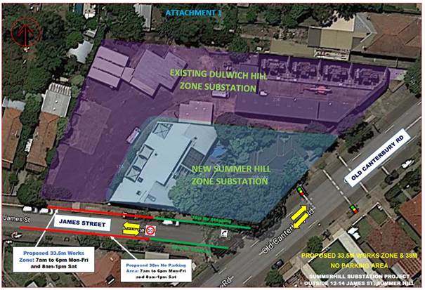
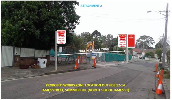
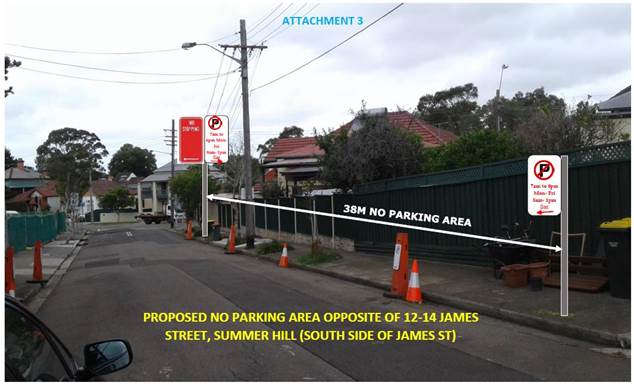
ATTACHMENT 1
|
|
Local Traffic Committee Meeting 6 February 2018 |
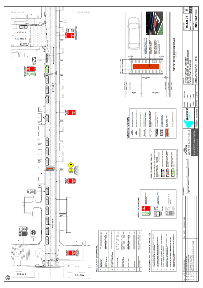
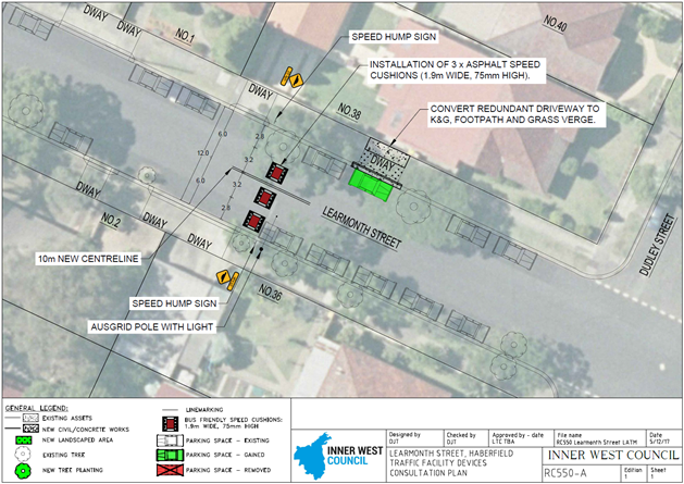
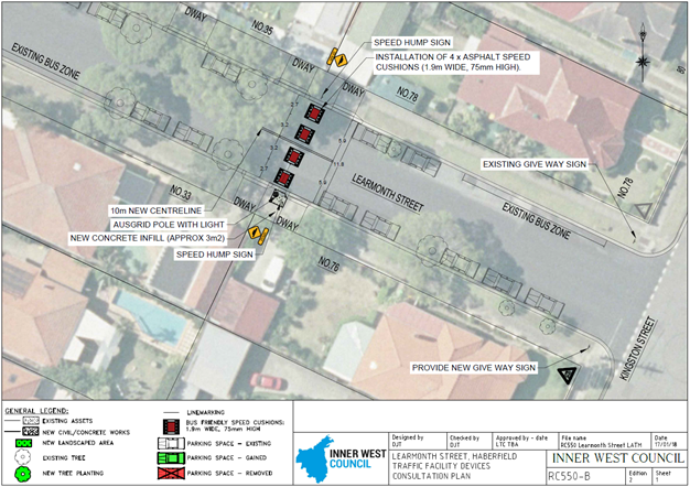
Subject: Learmonth Street, Haberfield – Proposed Speed Cushions (Leichhardt Ward/Summer Hill Electorate/Ashfield LAC)
Prepared By: Davide Torresan - A/Senior Engineer - Infrastructure Design & Traffic Services
Authorised By: John Stephens - Traffic and Transport Services Manager
|
SUMMARY Design plans have been prepared for proposed speed cushions as part of traffic calming improvements in Learmonth Street, Haberfield as part of Council’s Capital Works Program for Traffic Facilities. The proposal for speed cushions and associated signs and line markings will improve traffic conditions at this location.
Consultation was undertaken with owners and occupiers of properties adjacent to Learmonth Street, regarding the proposal. A summary of the consultation results are presented in this report for consideration. It is recommended that the proposed design plans be supported. |
|
RECOMMENDATION
THAT the design plan of the speed cushions and associated signs and line markings in Learmonth Street, Haberfield between Boomerang Street and Tillock Street (as per the attached design plan Nos. RC550-A Ed. 1, RC550-B Ed. 2, RC550-C Ed. 2) be SUPPORTED.
|
BACKGROUND
Learmonth Street, between Boomerang Street and Tillock Street, was identified as requiring traffic calming measures to address residents’ concerns about speeding in Learmonth Street which Council has investigated and confirmed is an issue. In 2015 Council received a petition from residents in the area to investigate traffic calming in the Haberfield North area. The Haberfield North LATM addresses traffic calming within the streets bordered by Boomerang Street, Waratah Street and Tillock Street in Haberfield.
The proposal for Learmonth Street is part of the continuation of the Haberfield North Local Area Traffic Management (LATM) measures recently completed in Waratah Street and Tillock Street, Haberfield. In 2016 various traffic calming devices, such as speed cushions, separated bicycle lanes, and horizontal deflection devices were installed in Waratah Street and Tillock Street. There has been a significant reduction in the average speeds in these streets following their implementation, and a similar result is anticipated for Learmonth Street. An example of this is in Tillock Street, where 85th percentile speed was recorded at 59 km/hr in May 2015 prior to the introduction of LATM measures and this has now been reduced to 47 km/hr in September 2017.
The design plans have been prepared for the proposed devices together with the consultation and are presented in this report for consideration.
FINANCIAL IMPLICATIONS
Funding of $50,000 has been allocated by Council for the scope of works in Learmonth Street under the 2018/2019 Capital Works Program for Traffic Facilities.
OFFICER COMMENTS
Site location & road network
|
Street Name |
Learmonth Street |
|
Section(s) |
Boomerang Street to Dudley Street (Section 1) Dudley Street to Kingston Street (Section 2) Kingston Street to Tillock Street (Section 3) |
|
Carriageway Width (m) |
12.0 |
|
Carriageway Type |
Two-way road with one travel lane and a parking lane in each traffic flow. |
|
Classification |
Local |
|
85th Percentile Speed (km/h) |
Section 1 = 53 Section 2 = 50 Section 3 = 47 |
|
Vehicles Per Day (vpd) |
Section 1 = 729 Section 2 = 592 Section 3 = 395 |
|
Reported Crash History (July 2012 – June 2017) |
Nil |
|
Heavy Vehicle Volume (%) |
1.8% |
|
Parking Arrangements |
Both sides of the road consists of unrestricted parking. |
Design Plans
Design plans for the provision of new speed cushions in Learmonth Street, including the associated signs and line markings (ATTACHMENT - design plan Nos. RC550-A Ed. 1, RC550-B Ed. 2, RC550-C Ed. 2) are submitted for consideration.
The proposed scope of work includes the following:
· introducing bus friendly cushions in Learmonth Street at the midpoint of the following blocks:
o Boomerang Street and Dudley Street;
o Dudley Street and Kingston Street; and
o Kingston Street and Tillock Street.
· Provide additional Give-Way signs on both sides of Learmonth Street on the approach to Kingston Street to reinforce the existing Give-Way treatment.
· Install all other associated signage and line markings as per design plan.
This proposal would replace a redundant driveway on the side of 38 Dudley Street with kerb and gutter which would result in one parking space being gained. There are no other changes to existing parking in the street.
The benefits of the proposed speed cushions in Learmonth Street include:
· The configuration of the speed humps along Learmonth Street at each midblock point will assist in reducing speeds within the street.
· A number of residents have advised of cars not slowing down at the Give Way lines in Learmonth Street at Kingston Street, and so additional signage is proposed to be installed to reinforce the “Give Way” priority. Lower speeds may also assist in dealing with this issue.
· Speed cushions may also assist in deterring unwanted type vehicles and misbehaviour in the street, which may also require some continued monitoring from Ashfield Police.
What are bus friendly speed cushions?
· These are designed to ensure minimal impact to local buses and emergency vehicles, whilst reducing the speed of vehicles and the risk of accidents. The speed cushions are narrow so bus wheels can straddle the device rather than over the top like standard vehicles. This avoids any sudden bumps which makes it safer and more comfortable for passengers on the bus, and results in less noise pollution than standard speed humps.
Review of Ashfield Traffic Management Strategy:
· The Ashfield Traffic Management Strategy was prepared by the former Ashfield Council and endorsed by the Inner West Council on 23 August 2016 following a period of community engagement.
· There was also a recommended treatment to “restrict right-out and left-in movements to Learmonth Street at its intersection with Boomerang Street (with the exception of buses). However on review traffic counts were found to be low and as there was no recent accident history at this intersection, therefore this proposal was not pursued.
PUBLIC CONSULTATION
A notification letter as well as a copy of the detailed design plan showing the proposed new speed cushions with associated signs and line markings was sent on 8 December 2017 to the owners and occupiers of the affected properties in Learmonth Street. A total of 13 letters were distributed. The closing date for submissions ended on 18 January 2018. A 6 week notification period was provided to account for the Christmas and New Year break.
There were a total of four (4) responses supporting the proposal and there was a total of one (1) response opposing the proposal. These responses are detailed below.
|
Residents’ Comments (supporting the proposal) |
Officer’s Response |
|
1. As a local resident, I am supportive of measures to calm traffic on local streets. The WestConnex will encourage more rat running and requests that Council investigate more one way streets and road closures in the future. |
Received and noted.
1. Council is funding a $250,000 traffic study to help us understand the impacts of WestConnex on Inner West streets and protect our residents from the impacts.
Further information available from: https://www.innerwest.nsw.gov.au/news---hot-topics/hot-topics/westconnex |
|
1. Can Council consider concreting the small area of the nature strip where the speed hump sign is to be installed between 76 Kingston St and 33 Dudley St. This grass is already difficult to mow because of the Ausgrid pole and the insertion of the sign will create more difficulties. 2. Can Council consider installing a roundabout at the Kingston St/Learmonth St intersection? Cars often ignore the give way sign and speed through the intersection. There is also a history of cars doing burnouts in the street. |
Received and noted.
1. The design plans have been amended to include concreting the small nature strip.
2. Ashfield Police has been made aware of the activity within the street. There is no accident history at the intersection to justify upgrading to a STOP sign treatment, nor a roundabout. The design plans have been amended to include additional Give Way signs on both approaches to the intersection. |
|
1. Whilst I support the proposal I would prefer that the speed humps run the full width of the street.
|
Received and noted.
1. The proposed asphalt speed cushions are designed to improve the noise issues from ‘through traffic’, over the full width speed humps. |
|
1. Whilst I support the proposal I believe the introduction of speed cushions and line-marking will have a negative effect on the aesthetic appeal and heritage ambience within the street. |
Received and noted.
1. The proposed asphalt speed cushions are designed to improve traffic safety and amenity within the street by discouraging the antisocial behavior. |
|
Residents’ Comments (opposing the proposal) |
Officer’s Response |
|
1. We would like for the speed hump between Kingston and Tillock St to be removed as part of the proposal. This speed hump will result in the hooligans performing burnouts once they have gone over the speed hump and go towards Kingston St. There is also a history of cars doing burnouts in the street.
2. Please consider STOP signs instead of GIVE WAY at the intersection of Learmonth and Kingston St to actually bring cars to a stop before they enter the intersection.
3. The Ashfield Traffic Management Strategy recommended a “no left turn” at Boomerang onto Learmonth and a “no right turn” onto Boomerang from Learmonth. This would stop both rat run and the vast majority of speeding cars without the need for speed humps. Please reconsider the turn bans. |
1. The speed humps throughout have been strategically placed to achieve the best outcome for controlling speed in the approach of the intersections. Speed cushions will also control vehicular speeds and may deter unwanted misbehaviour in the street. The speed hump on either side of Kingston Street will assist to slow vehicles down in the approach of the Give Way signs.
2. Ashfield Police have been made aware of the activity within the street. The design plans have been amended to include additional Give Way signs on both approaches to the intersection. It is envisaged that the speed cushions will assist in controlling speeds at the intersection.
3. Traffic counts indicate very low vehicle volumes in Learmonth Street. At this stage turning bans at Boomerang Street and Learmonth Street are not recommended to be pursued due because it would impact residents more than through traffic. Council would require a significant number of residents in the area to support the turn ban, for proposal to be reinvestigated. |
CONCLUSION
It is recommended that the detailed design plans of the proposed treatments and associated signs and line markings be supported, to improve traffic conditions at this location.
|
|
Local Traffic Committee Meeting 6 February 2018 |
Subject: Boomerang Street, Haberfield – Proposed Speed Cushion (Leichhardt Ward/Summer Hill Electorate/Ashfield LAC)
Prepared By: Davide Torresan - A/Senior Engineer - Infrastructure Design & Traffic Services
Authorised By: John Stephens - Traffic and Transport Services Manager
|
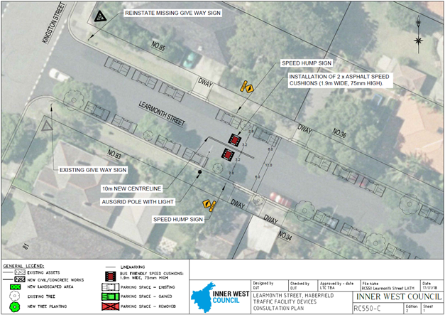
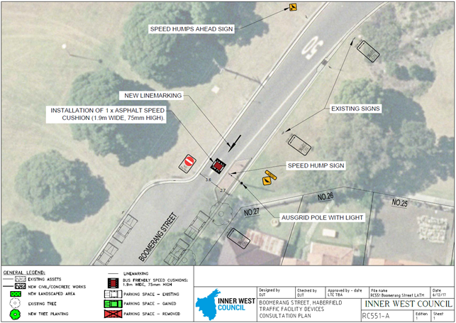
SUMMARY Design plans have been prepared for a proposed speed cushion as part of traffic calming improvements in Boomerang Street, Haberfield as part of Council’s Capital Works Program for Traffic Facilities. The proposal for speed cushions and associated signs and line markings will improve traffic conditions at this location.
Consultation was undertaken with owners and occupiers of properties adjacent to Boomerang Street and Crescent Street, regarding the proposal. A summary of the consultation results are presented in this report for consideration. It is recommended that the proposed design plans be supported. |
|
RECOMMENDATION
THAT the design plan of the speed cushions and associated signs and line markings in Boomerang Street, Haberfield, between the City West Link Road and Crescent Street (as per the attached design plan No. RC551-A Ed. 1) be SUPPORTED. |
BACKGROUND
Boomerang Street between the City West Link Road and Crescent Street was identified as requiring traffic calming measures to address residents’ concerns about speeding in Boomerang Street which Council has investigated and confirmed is an issue. The proposal is based on recommendations from the former Ashfield Council’s Traffic Management Strategy (ATMS) which was endorsed by the Inner West Council on 23 August 2016, following a period of community engagement.
In 2015 Council received a petition from residents in the area to investigate traffic calming in the Haberfield North area. The Haberfield North Local Area Traffic Management (LATM) addresses traffic & pedestrian safety and amenity issues within the streets bordered by Boomerang Street, Waratah Street and Tillock Street in Haberfield.
Council is proposing to install speed cushions with associated signs and line markings in Boomerang Street, south of the City West Link Road.
Through the ATMS it was also recommended that Council investigate speed cushions on Boomerang Street at the southern end of the one-way section and in each traffic direction to the north of Crescent Street. The speed cushions proposed on Boomerang Street in each traffic direction to the north of Crescent Street will be investigated later this year as part of a traffic facility design for the intersection of Boomerang Street and Crescent Street.
The proposal for Boomerang Street is part of the continuation of the Haberfield North LATM strategy which was recently implemented in Waratah Street and Tillock Street, Haberfield. In 2016 various traffic calming devices, such as speed cushions, separated bicycle lanes, and horizontal deflection devices were installed in Waratah Street and Tillock Street. Since then, there has been a significant reduction in the average speeds in these streets following their introduction, and a similar result is anticipated for Learmonth Street. An example of this is in Tillock Street, where the 85th percentile speed was recorded at 59 km/hr in May 2015 prior to the introduction of LATM measures and this has now been reduced to 47 km/hr in September 2017.
FINANCIAL IMPLICATIONS
Funding of $10,000 has been allocated by Council for the scope of works in Boomerang Street under the 2018/2019 Capital Works Program for Traffic Facilities.
OFFICER COMMENTS
Site location & road network
|
Street Name |
Boomerang Street |
|
Section(s) |
City West Link Road to Dobroyd Lane |
|
Carriageway Width (m) |
6.3 |
|
Carriageway Type |
One-way road with one travel lane in a south-west direction of travel. |
|
Classification |
Local |
|
85th Percentile Speed (km/h) |
58 |
|
Vehicles Per Day (vpd) |
1329 |
|
Reported Crash History (July 2012 – June 2017) |
Nil |
|
Heavy Vehicle Volume (%) |
2.5% |
|
Parking Arrangements |
'No Stopping' restrictions on both sides of the road |
Design Plans
Design plans for the provision of new speed cushions in Boomerang Street, including the associated signs and line markings (ATTACHMENT - design plan No. RC551-A Ed. 1) are submitted for consideration.
The proposed scope of work includes the following:
· introducing bus friendly speed cushions adjacent to No.27 Boomerang Street
· install associated signage and line markings as per the design plan.
There are no changes to existing parking in the street.
The benefits of the proposed speed cushions in Boomerang Street include:
· The speed hump in Boomerang Street will assist in reducing speeds within the street.
· Traffic counts in the area have shown the 85th percentile speed was recorded at 58 km/hr as vehicles travel from the City West Link Road onto Boomerang Street. This speed profile is expected to be reduced by the installation of the speed cushion.
What are bus friendly speed cushions?
· These are designed to ensure minimal impact to local buses and emergency vehicles, whilst reducing the speed of vehicles and the risk of accidents. The speed cushions are narrow width so bus wheels can straddle the device rather than travel over the top like standard vehicles. This avoids any sudden bumps which makes it safer and more comfortable for passengers on the bus, and results in less noise pollution than standard speed humps.
PUBLIC CONSULTATION
A notification letter as well as a copy of the detailed design plan was sent on 11 December 2017 to the owners and occupiers of the affected properties in Boomerang Street and Dobroyd Lane regarding the design plans proposing new speed cushions with associated signs and line markings. A total of 6 letters were distributed. The closing date for submissions ended on 18 January 2018. A 6 week notification period was provided to account for the Christmas and New Year holiday period.
There were a total of two (2) responses supporting the proposal and there were no opposing responses to the proposal. These responses are detailed below.
|
Residents’ Comments (supporting the proposal) |
Officer’s Response |
|
As a local resident, I am supportive of measures to calm traffic on local streets. The WestConnex will encourage more rat running and requests that Council investigate more one way streets and road closures in the future. |
Received and noted.
Council is funding a $250,000 traffic study to help understand the impacts of WestConnex on Inner West streets and protect Council's residents from the impacts.
Further information available from: https://www.innerwest.nsw.gov.au/news---hot-topics/hot-topics/westconnex |
|
Whilst I approve of the proposal, I would prefer that the speed humps run the full width of the street.
|
Received and noted.
The proposed new asphalt speed cushions are designed to reduce the noise issues from through traffic, instead of full width speed humps and are bus friendly. |
|
Residents’ Comments (opposing the proposal) |
Officer’s Response |
|
Nil
|
Nil |
CONCLUSION
It is recommended that the detailed design plan of the proposed treatment and associated signs and line markings be supported to improve traffic conditions at this location.
|
|
Local Traffic Committee Meeting 6 February 2018 |
Subject: Audley Street, Petersham – Temporary Full Road Closure For Special Event On Sunday 4 March 2018 (Stanmore Ward/Newtown Electorate/Marrickville LAC)
Prepared By: Emilio Andari - Engineer – Traffic and Parking Services
Authorised By: John Stephens - Traffic and Transport Services Manager
|
SUMMARY A Development Application was approved in 2018 for the holding of the annual ‘Bairro Portuguese Food and Wine Fair’ for a five year period (i.e. 4 March 2018, 17 March 2019, 15 March 2020, 14 March 2021 and 13 March 2022).
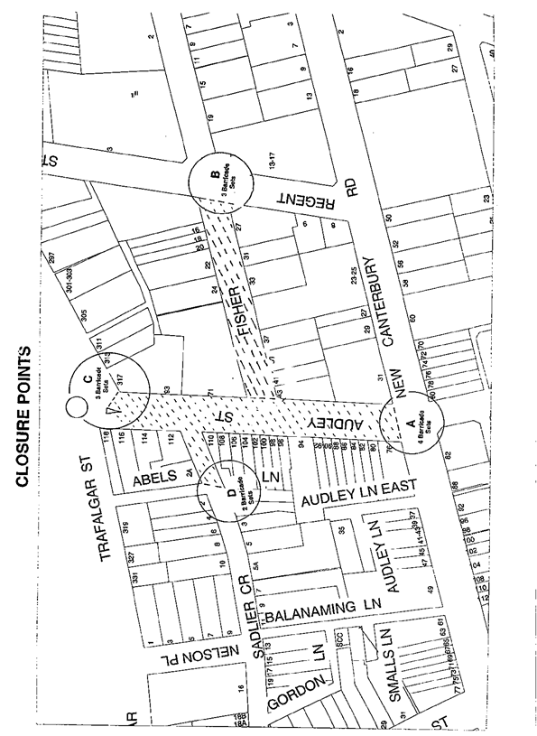
This year’s event will necessitate the temporary closure of Audley Street (between Trafalgar Street and New Canterbury Road), Sadlier Crescent (between Audley Street and Abels Lane) and Fisher Street (between Audley Street and Regent Street), as well as the parking lanes on New Canterbury Road (between Gordon Street and Audley Street), Petersham from 1.00am until 12.00 midnight as in previous years.
It is recommended that Council agree to the temporary road closures on Sunday 4 March 2018; apply to the RMS for consent to close the subject roads, subject to the event being advertised, a Traffic Management Plan be submitted to the RMS for approval and advice of the proposed event being forwarded to the appropriate authorities, including the Transport Management Centre. |
|
RECOMMENDATION
THAT the proposed temporary road closure of Audley Street (between Trafalgar Street and New Canterbury Road), Sadlier Crescent (between Audley Street and Abels Lane) and Fisher Street (between Audley Street and Regent Street), as well as the parking lanes on New Canterbury Road (between Gordon street and Audley Street), Petersham, on Sunday 4 March 2018, from 1.00am to 12.00 midnight, for the holding of the annual ‘Bairro Portuguese Food and Wine Fair’, be SUPPORTED subject to the applicant complying with the following conditions;
1. The temporary road closure is advertised in the local newspaper providing 28 days' notice for submissions;
2. A Traffic Management Plan (TMP) is submitted to and approved by the Roads and Maritime Services; and an application for a Road Occupancy Licence and a temporary Speed Zone Authorisation is forwarded to and approved by the Transport Management Centre;
3. Notice of the proposed event is forwarded to the N.S.W. Police, State Transit Authority, Marrickville Local Area Commander, the Fire & Rescue NSW and NSW Ambulance;
4. Advance notifications signs for the event are strategically installed at least two (2) weeks prior to the event;
5. "No Parking - Special Event" signs are affixed over all existing timed parking restriction signs within the sections of streets to be closed on the afternoon of the day prior to the event;
6. State Transit Authority (Leichhardt Depot) be requested to implement a revised routing for scheduled bus services in Audley Street on the day of the event and install temporary bus stops as required;
7. A 4-metre wide emergency vehicle access must be maintained through the closed road areas during the course of the event;
8. The applicant is to consult with all affected residents and/or businesses in the area in writing and to conduct a letter box drop of surrounding properties at least two weeks prior to event; and
9. Adequate vehicular traffic control shall be provided for the protection and convenience of pedestrians and motorists including appropriate signage and flagging. Workers shall be specially designated for this role (and carry appropriate certificates), as necessary to comply with this condition. This is to be carried out in accordance with the Australian Standard AS 1742.3 - Traffic Control Devices for works on roads. |
BACKGROUND
Temporary road closures were implemented in previous years to hold the annual ‘Bairro Portuguese Food and Wine Fair’. This annual Fair aims to showcase Petersham's businesses and services and attract people to the area and has a multicultural theme. On all previous occasions, the closures were successful and no major problems were experienced.
FINANCIAL IMPLICATIONS
Funding of $68,000 has been allocated by Council for organising the ‘Bairro Portuguese Food and Wine Fair’ event under the 2017/2018 Major Community Events Program.
OFFICERS COMMENTS
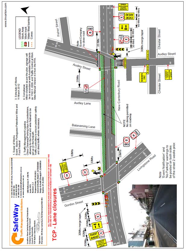
Council has applied for the temporary closure of Audley Street (between Trafalgar Street and New Canterbury Road), Sadlier Crescent (between Audley Street and Abels Lane) and Fisher Street (between Audley Street and Regent Street), as well as the parking lanes on New Canterbury Road (between Gordon street and Audley Street), Petersham, on Sunday 4 March 2018, between the hours of 1.00am and 12.00 midnight for the holding of the ‘Bairro Portuguese Food and Wine Fair’ (Refer to the attached locality map and Traffic Control Plan for proposed road closures). This is an extension of a Class 2 Event.
Lane closures of New Canterbury Road
As per the previous event held earlier this year, it is proposed to close the parking lanes on New Canterbury Road (between Gordon Street and Audley Street) as shown on the Traffic Control Plan (TCP) prepared by SafeWay Traffic Management Solutions (ATTACHED).
In previous years the event attracted approximately 15,000 attendees prompting the event coordinators to look at ways to ease congestion at the main site and make access easier from New Canterbury Road. The closure of the parking lanes on New Canterbury Road improves access to the area where the main event is to be conducted and improves the amenity of the footpath dining outside a number of the eateries along New Canterbury Road which are adjacent to the closure.
There is significant improvement in the access for people with disabilities as congestion will reduced and there will be no obstacles such as tables, chairs, planter boxes, light/sign poles and bins in the closed lanes. The solid barriers will separate the pedestrians from the moving traffic on the adjacent lane and will also help prevent young children who may be separated from their custodians escaping onto the main thoroughfare and possibly being hit by passing traffic.
The TCP indicates that a reduced temporary speed limit of 40km/h is required on New Canterbury Road (between Gordon Street and Audley Street) during the closure of the parking lanes for the subject event. An application for a Road Occupancy Licence will be forwarded to the RMS Transport Management Centre for approval.
The time-span for the road closure is necessary to allow stalls and stages to be set up before the event and dismantled after the event. The closure will be affected by the placement of barricades (to be manned by SES personnel) at the following locations:-
· Junction of Audley Street and New Canterbury Road;
· Junction of New Canterbury Road and Gordon Street;
· Junction of Audley Street and Trafalgar Street;
· Junction of Fisher Street and Regent Street; and
· Junction of Sadlier Crescent and Abels Lane.
Special advance notice signs will be strategically installed at least two weeks prior to the event to alert motorists of the proposed closures. These signs will be installed at the following locations:-
· Junction of Railway Terrace and Gordon Street;
· Junction of New Canterbury Road and Audley Lane;
· Junction of Trafalgar Street and Audley Street;
· Junction of Regent and Fisher Streets; and
· Junction of Nelson Place and Sadlier Crescent.
In addition, 'No Parking - Special Event' signs will be affixed over all existing timed parking restrictions signs in the area to be closed on the afternoon before the day of the event. Residents in Fisher Street will be allowed access into and out of their properties.
Audley Street is used by scheduled State Transit bus services and the Authority will need to implement the re-routing of services on the day as in previous years.
PUBLIC CONSULTATION
The proposed full-road closures of the event are currently advertised in the local papers for a period of 28 days. The advertising period commenced on 30 January 2018 and will conclude on 26 February 2018. A Traffic Management Plan is to be submitted to the RMS for consideration and approval and a Road Occupancy License application is to be submitted to the Transport Management Centre.
CONCLUSION
It is recommended that Council agree to the temporary road closures on Sunday 4 March 2018; apply to the RMS for consent to close the subject roads, subject to the event being advertised, a Traffic Management Plan be submitted to the RMS for approval and advice of the proposed event being forwarded to the appropriate authorities, including the Transport Management Centre.
Locality Map - Temporary road closures
|
|
Local Traffic Committee Meeting 6 February 2018 |
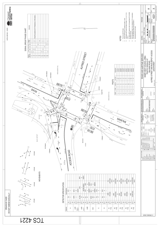
Subject: Route NS07 (Balmain Road, Leichhardt) - Extension of Shared Path (Leichhardt Ward / Leichhardt LAC / Balmain Electorate)
Prepared By: Manod Wickramasinghe - Coordinator – Traffic and Parking Services
Authorised By: John Stephens - Traffic and Transport Services Manager
|
SUMMARY This report seeks to complete the Shared Path component of the NS07 Bicycle Route along the western side of Balmain Road, Leichhardt, including the provision of bicycle lanterns at the intersection of Balmain Road/Alfred Street/Leichhardt Bus Depot Access Road. |
|
RECOMMENDATION
THAT:
1. The proposed ‘Shared Path’ on the western footpath of Balmain Road, Leichhardt between Moore Street and Alfred Street be supported, including installation of associated signage and
2. The proposed bicycle lanterns at the intersection of Balmain Road/Alfred Street/Leichhardt Bus Depot Access Road be supported as detailed in Attachment 1.
|
BACKGROUND
Consistent with Council’s commitment to encourage bicycle riding and improve bicycle paths and networks, Council’s adopted 2016 Leichhardt Bike Plan aims to make riding a bicycle easier, safer and more attractive.
Route NS07 is a strategic route from Parramatta Road to Perry Street/Balmain Road via Balmain Road and the route connects to a number of other regional and local bike routes. It aims to improve connections to local destinations such as Leichhardt Secondary College, Orange Grove Public School, Orange Grove Plaza, Memorial Park, Callan Park, Lilyfield Light Rail station and more distant destinations.
In 2016, Council received grant funding from Roads and Maritime Services (RMS) to provide bicycle lanterns on the western side of the signalised intersection of Balmain Road/Alfred Street/ Leichhardt Bus Depot Access Road along the shared path component of NS07.
There is an existing Shared Path north of this intersection on the western side of Balmain Road between Alfred Street and City West Link and an existing Shared Path from the Balmain Road/Moore Street intersection to Derbyshire Road along the path between Sydney Secondary College and their playing field; however, there is no formal Shared Path connecting these two paths. This missing component of the Shared Path on Balmain Road must be formalised in order to provide bicycle lanterns at the Balmain Road/Alfred Street/Leichhardt Bus Depot Access Road intersection.
The existing pedestrian path on the western side of Balmain Road between Moore Street and Alfred Street varies in width from 2.7 to 6.0m. The widest section of the footpath accommodates a bus shelter whilst providing a wide footpath at the rear of the shelter (approximately 3m).
PROPOSAL
It is proposed to convert the existing footpath on the western side of Balmain Road between Alfred Street and Moore Street into a Shared Path. This would serve as an alternate option to the existing on road mixed traffic cycling route for less experienced cyclists.
In addition to the Shared Path, it is proposed that bicycle lanterns are installed at the Balmain Road/Leichhardt Bus Depot Access Road/Alfred Street intersection as shown in the attached signal plan (Attachment 1) to link the existing Shared Path on the western side of Balmain Road between City West Link and Alfred Street with the proposed Shared Path. This completes the Shared Path from Sydney Secondary College to the City West Link.
As per the Cycling Aspects of Austroads, a Shared Path requires a minimum width of 2.5m. The existing width on the western footpath of Balmain Road between Alfred Street and Moore Street is therefore sufficient to provide a shared path facility.
The proposal, including regulatory signage is shown on the following plan.
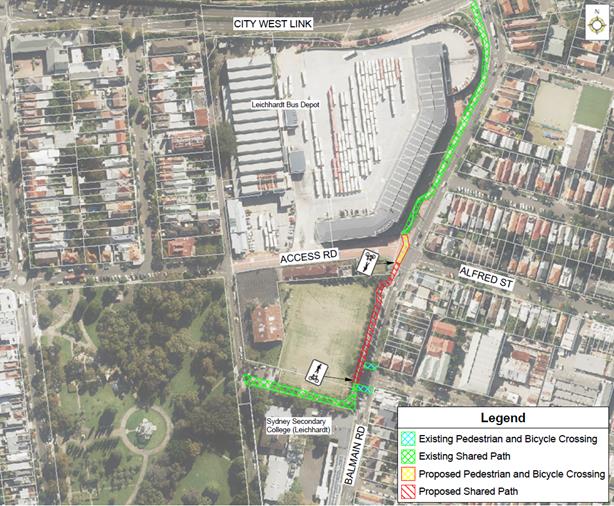
It should be noted that the existing mixed traffic bicycle route on Balmain Road from Parramatta Road to Perry Street is proposed to be retained for more experienced cyclists.
FINANCIAL IMPLICATIONS
Nil.
OTHER STAFF COMMENTS
Nil.
PUBLIC CONSULTATION
Nil.
CONCLUSION
Nil.
|
1.⇩ |
Balmain Road - Alfred Street - Leichhardt Bus Depot Access Road Signal Plan |
|
|
Local Traffic Committee Meeting 6 February 2018 |
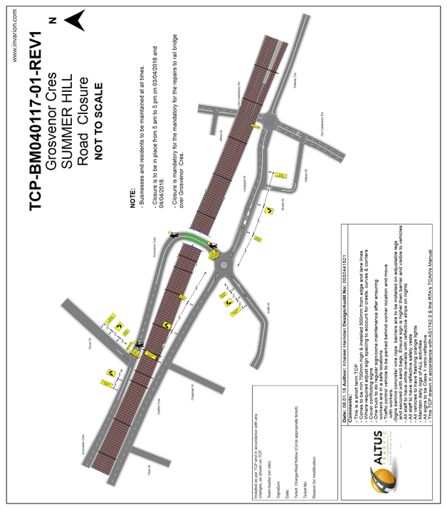
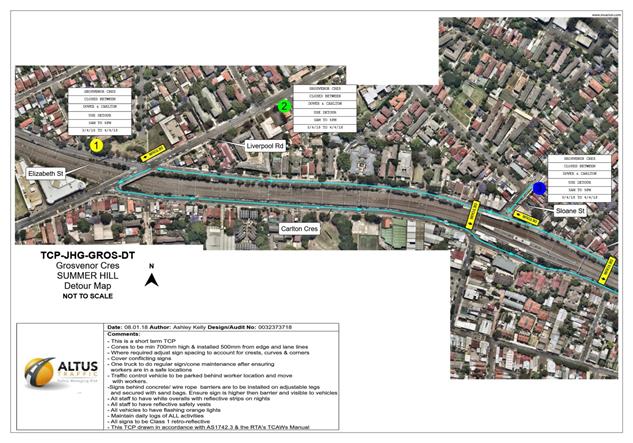
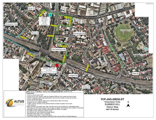
Subject: Grosvenor Crescent, Summer Hill – Temporary Road Closure (Between Dover Street and Carlton Crescent). (Ashfield Ward/Summer Hill Electorate/Ashfield LAC)
Prepared By: Boris Muha - Engineer – Traffic and Parking Services
Authorised By: John Stephens - Traffic and Transport Services Manager
|
SUMMARY An application has been received from Altus Traffic on behalf of Sydney Trains for the temporary full road closure of Grosvenor Crescent (between Dover Street and Carlton Crescent), Summer Hill. The closure is required from 5.00am-5.00pm on two consecutive day periods, 3 April to 4 April 2018, and 28 April to 29 April 2018 to carry out essential rail bridge maintenance in line with scheduled weekend closures of the inner west rail line.
The closure is required to stand mobile cranes and elevated works platforms (scissor lifts) in maintenance of the underside of the bridge together with rail corridor works on top of the bridge.
It is recommended that the proposed temporary road closure be approved, subject to the conditions outlined in this report. |
|
RECOMMENDATION
THAT the proposed temporary full road closure of Grosvenor Crescent (between Dover Street and Carlton Crescent), from 5:00am to 5:00pm on weekend periods, Saturday 3 April to Sunday 4 April 2018, and Saturday 28 April to Sunday 29 April 2018, in order to stand elevated works platforms and mobile cranes for rail bridge maintenance be approved, subject to the following conditions:
1. A fee of $1,540 for the temporary full road closure is payable by the applicant in accordance with Council’s Fees and Charges;
2. The temporary full road closure be advertised in the local newspaper providing 28 days’ notice for submissions, in accordance with the Roads Act;
3. A Traffic Management Plan (TMP) be submitted to Roads and Maritime Services for consideration and approval;
4. A Traffic Control Plan (TCP) which has been prepared by a certified Traffic Controller, is to be submitted to Council for review with a copy of the Traffic Controllers certification number attached to the plan, not less than 5 days prior to implementation of the closure;
5. A Road Occupancy License be obtained by the applicant from the Transport Management Centre;
6. A notice of the proposed closure be forwarded by the applicant to the NSW Police, Fire and Rescue NSW and the NSW Ambulance Services;
7. Notification signs advising of the proposed road closures and new traffic arrangements to be strategically installed and maintained by the applicant at each end of the street at least 7 days prior to the closure;
8. All affected residents and businesses shall be notified in writing, by the applicant, of the proposed temporary road closure at least 7 days in advance of the closure with the applicant making reasonable provision for residents;
9. Vehicular and pedestrian access for residents and businesses to their off-street car parking spaces be maintained where possible whilst site works are in progress;
10. Adequate vehicular traffic control shall be provided for the protection and convenience of pedestrians and motorists including appropriate signage and flagging. Workers shall be specially designated for this role, as necessary to comply with this condition. This is to be carried out in accordance with the Australian Standard AS 1742.3 - Traffic Control Devices for works on roads;
11. The holder of this approval shall indemnify the Council against all claims, damages and costs incurred by, or charges made against, the Council in respect to death or injury to any person or damage in any way arising out of this approval. In this regard, a public liability insurance policy for an amount not less than $20,000,000 for any one occurrence is to be obtained and is to note the Council as an interested party. The holder of this approval shall inform its insurer of the terms of this condition and submit a copy of the insurance policy to the Council prior to commencement of the work the subject of this approval;
12. The operator of any unit exercising this approval shall have this approval with them and produce it if required along with any other relevant authority approvals granted in the connection with the work;
13. Mobile cranes, scissor lifts or other plant shall not stand within the public way for extended periods when not in operation under this approval; and
14. The operation of the heavy plant shall not give rise to an "offensive noise" as defined in the Protection of Environment Operations Act, 1997. Furthermore, vibrations and/or emission of gases that are created during its operations and which are a nuisance, or dangerous to public health are not permitted; all work is to be carried out in accordance with Work Cover requirements; and the costs to repair damages, as a result of these works, to Council's footway and roadway areas will be borne by the applicant.
|
BACKGROUND
An application has been received from Altus Traffic on behalf of Sydney Trains for the temporary full road closure of Grosvenor Crescent (between Dover Street and Carlton Crescent), Summer Hill. The closure is required from 5.00am-5.00pm on two consecutive day periods, 3 April to 4 April 2018, and 28 April to 29 April 2018 to carry out essential rail bridge maintenance in line with scheduled weekend closures of the inner west rail line.
The closure is required to stand mobile cranes and elevated works platforms (scissor lifts) in maintenance of the underside of the bridge, with rail corridor works on top of the bridge carried out at the same time.
FINANCIAL IMPLICATIONS
Nil
OTHER STAFF COMMENTS
A Traffic Control Plan and detour maps outlining the proposed closure arrangements are shown as attachments.
The works are required to be completed during day time as the types of works that are being completed will have high noise levels and cannot be undertaken at night due to EPA Noise Levels.
Electronic variable message boards (VMS) will be placed well in advance in time to direct motorists to use detour or program alternative routes.
PUBLIC CONSULTATION
The proposed full-road closure of Grosvenor Crescent (between Dover Street and Carlton Crescent), Summer Hill is currently advertised in the local newspaper for a period of 28 days. The applicant is to notify all affected residents and businesses in writing at least 7 days prior to
the commencement of works and make reasonable provision for residents and businesses,
where possible.
CONCLUSION
It is recommended that the proposed temporary road closure be approved, subject to the
conditions outlined in this report.
|
1.⇩ |
Traffic Control Plan - Grosvenor Street Road Closure |
|
2.⇩ |
Detour Map and VMS board locations - Map Part 1 |
|
3.⇩ |
Detour Map and VMS board location - Map Part 2 |
|
Local Traffic Committee Meeting 6 February 2018 |
Subject: Sloane
Street, Haberfield - "Keep Clear" road markings and removal of
parking space near intersection to Parramatta Road.
(Leichhardt Ward/Summer Hill Electorate/Ashfield LAC)
Prepared By: Boris Muha - Engineer – Traffic and Parking Services
Authorised By: John Stephens - Traffic and Transport Services Manager
|
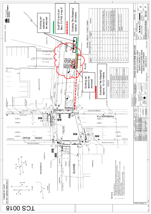
SUMMARY Health Infrastructure NSW is delivering a new Ambulance facility at 45 Parramatta Road, Summer Hill. Associated traffic works involve additional phasing to the signals at the intersection of Sloane Street and Parramatta Road, the addition of "KEEP CLEAR" road markings to the facility driveway on Sloane Street, and the removal of one on-street resident parking space in Sloane Street to assist in the emergency/priority access for ambulances.
It is recommended that the proposed works be supported.
|
|
RECOMMENDATION
THAT:
1. Proposed "KEEP CLEAR" road pavement markings in front of the new Ambulance Station driveway off Sloane Street be supported;
2. The removal of one resident parking space associated with the "KEEP CLEAR” markings opposite the driveway in Sloane Street be supported, subject to resident notification; and
3. The traffic signal phasing alterations to be carried out at the intersection of Parramatta Road and Sloane Street to assist emergency/priority access of ambulances from the new Ambulance Station at 45 Parramatta Road, off Sloane Street, Summer Hill, be noted.
|
BACKGROUND
GTA consultants are working with Kane Constructions and Health Infrastructure NSW to deliver a new Ambulance facility at 45 Parramatta Road, corner of Parramatta Road and Sloane Street, Summer Hill.
The site was previously an AAMI car repair exchange and is currently being re-developed to an ambulance facility for NSW Ambulance and Health Infrastructure NSW, and was approved under the State Planning legislation - Review of Environmental Factors (REF).
Additional phasing (emergency phase) will be provided at the traffic signalised intersection of Parramatta Road and Sloane Street for priority ambulance exit.
"KEEP CLEAR" pavement road markings will be provided outside the driveway on Sloane Street and extend to the eastern kerbside of the road for appropriate emergency vehicle exit out of the driveway.
This in turn will require the removal of one parking space outside of No.59 Sloane Street.
FINANCIAL IMPLICATIONS
Nil.
OTHER STAFF COMMENTS
It is acknowledged that signal phasing changes and "KEEP CLEAR" pavement markings at the driveway are required for emergency exit of ambulances from Sloane Street onto Parramatta Road.
Sloane Street measures approximately 12.8 metres wide kerb to kerb and allows for parking on either side of the street. The removal of a parking space on the eastern side of the street opposite the ambulance facility driveway to accommodate the "KEEP CLEAR" (see plan attachments 1 and 2, and photo attachment 3) was reviewed.
Site observation identified that the driveway is in close proximity, some 30 metres north of the signalised intersection. Apart from alleviating queuing, ambulances will require to manoeuvre unobstructed either onto the right turn lane, or the kerbside lane for left turn and through movement at the intersection. The removal of the one car space outside No.59 Sloane Street is therefore considered necessary for the appropriate emergency movement of ambulances towards the intersection.
Furthermore, the 'No Stopping' from the corner of the intersection is increased by approximately 10-12 metres and the left turn and through traffic movement along the kerb lane is therefore enhanced with the removal of the subject one parking space.
PUBLIC CONSULTATION
The applicant will notify/consult with the affected resident(s) on the proposed removal of the one resident parking space outside No.59 Sloane Street. If required, Council may further consult on the possibility of providing 1-2 resident parking spaces on the western side of Sloane Street, north of the ambulance driveway, in an area currently with unrestricted parking.
CONCLUSION
It is recommended that the proposed works, including alterations to the traffic signal phasing at the signalised intersection of Parramatta Road and Sloane Street to assist in ambulance emergency/priority access on Sloane Street towards the intersection; and the proposed placement of "KEEP CLEAR" pavement markings to the front of the ambulance station driveway on Sloane Street; and the removal of the one on-street resident parking space opposite the ambulance driveway (outside No. 59 Sloane Street) should be supported. The removal of the one resident parking space would be subject to notification of the affected resident(s).
|
1.⇩ |
Signalised plan with KEEP CLEAR marking and removal of parking space |
|
2.⇩ |
Aerial plan with KEEP CLEAR and removal of parking space |
|
3.⇩ |
Photo - Removal of parking space outside No. 59 Sloane Street, Haberfield. |
|
|
Local Traffic Committee Meeting 6 February 2018 |
Subject: Minor Traffic Facilities (All Wards/ All LACs/ All Electorates)
Prepared By: Manod Wickramasinghe - Coordinator – Traffic and Parking Services, David Yu - Traffic Engineer, Emilio Andari - Engineer – Traffic and Parking Services and Anca Eriksson - Traffic Engineer
Authorised By: John Stephens - Traffic and Transport Services Manager
|
SUMMARY This report considers minor traffic facility applications received by Inner West Council, and includes ‘Disabled Parking’ and ‘Works Zone’ requests. |
|
RECOMMENDATION
THAT:
1. The 6m ‘Disabled Parking’ zone in front of No.3 Garnet Avenue, Lilyfield be removed as it is no longer required;
2. The 6m ‘Disabled Parking’ zone in front of No.5 Trafalgar Street, Annandale be removed as it is no longer required;
3. A 3.2m ‘Disabled Parking’ zone (90 degree angle parking) be installed in front of No.99 Annandale Street, Annandale;
4. A 5.4m ‘Disabled Parking’ zone be installed in William Street, Balmain East on the side boundary of No.7 Edward Street (adjacent to the existing ‘No Stopping’ zone);
5. A 6m ‘Disabled Parking’ zone be installed in front of No. 257 Young Street, Annandale;
6. A 9m 'Works Zone 7.00am - 5.00pm Mon-Fri, 7.00am - 1.00pm Sat' be installed in Bay Street on the side boundary of No.2 Dock Road, Birchgrove;
7. A 9m 'Works Zone 7.00am - 5.00pm Mon-Fri, 7.00am - 1.00pm Sat' be installed in front of No.67 Darling Street, Balmain East for 12 weeks, temporarily replacing the existing resident parking restrictions;
8. A 25m 'Works Zone 7.00am - 5.00pm Mon-Fri, 7.00am - 1.00pm Sat' be installed in front of Nos.33-53 Nelson Street, Annandale for 12 weeks, temporarily replacing the existing resident parking restrictions, ‘Disabled Parking’, ‘Loading Zone’ and short term parking restrictions as required;
9. A 6m 'Works Zone 7.00am - 5.00pm Mon-Fri, 7.00am - 1.00pm Sat' be installed in front of No.6 Toelle Street, Rozelle for 12 weeks;
10. A 6m ‘Disabled Parking’ zone be installed in Stafford Street, Stanmore on the side boundary of property No.24 Railway Street;
11. A 6m ‘Disabled Parking’ zone be installed in Beach Road, Dulwich Hill adjacent to the frontage of property No.4 Beach Road;
12. A 6m ‘Disabled Parking’ zone be installed in Australia Street, Newtown adjacent to the frontage of property No.142 Australia Street;
13. A 10m 'Works Zone 7.00am - 5.30pm Mon-Sat' be installed in front of property No.121 Darley Street, Newtown for 6 months;
14. A 6m ‘Disabled Parking’ zone be installed in Junction Road, Summer Hill adjacent to the frontage of No.38 Junction Road;
15. The 6m ‘Disabled Parking’ zone in front of No.2 Dickinson Avenue, Croydon be removed as it is no longer required; and
16. A 6m ‘Disabled Parking’ zone be installed in Cecily Street, Lilyfield in front of the resident’s property No.118 Cecily Street. |
BACKGROUND
This report considers minor traffic facility applications received by Inner West Council, and includes ‘Disabled Parking’ and ‘Works Zone’ requests.
FINANCIAL IMPLICATIONS
Nil.
OTHER STAFF COMMENTS
1 Removal of ‘Disabled Parking’ Restriction – Garnet Avenue, Lilyfield
Council Ref: DWS 4633308
Council has been notified by a neighbour that the applicant to the ‘Disabled Parking’ zone outside of No.3 Garnet Avenue, Lilyfield has moved and so the ‘Disabled Parking’ zone is no longer required.
Council has confirmed that the applicant has moved from the property and hence the ‘Disabled Parking’ space is no longer required.
It is recommended that the 6m ‘Disabled Parking’ zone in front of No.3 Garnet Avenue, Lilyfield be removed as it is no longer required.
2 Removal of ‘Disabled Parking’ Restriction – Trafalgar Street, Annandale
Council Ref: DWS 4634497
Council has been notified by a neighbour that the applicant to the ‘Disabled Parking’ zone outside of No.5 Trafalgar Street, Annandale has passed away and so the ‘Disabled Parking’ zone is no longer required.
Council has contacted the family and confirmed that the ‘Disabled Parking’ space is no longer required.
It is recommended that the 6m ‘Disabled Parking’ zone in front of No.5 Trafalgar Street, Annandale be removed as it is no longer required.
3 Installation of ‘Disabled Parking’ Restriction – Annandale Street, Annandale
Council Ref: DWS 4668055
The resident of No.99 Annandale Street, Annandale has requested the installation of a ‘Disabled Parking’ zone in Annandale Street in front of the resident’s property.
A site investigation has revealed that the property does not have off street parking.
The applicant does require the use of a wheelchair and can access the footpath via a layback nearby.
It is recommended that a 3.2m ‘Disabled Parking’ zone (90 degree angle parking) be installed in front of No.99 Annandale Street, Annandale.
4 Installation of ‘Disabled Parking’ Restriction – William Street, Balmain East
Council Ref: DWS 4702557
The resident of No.7 Edward Street, Balmain East has requested the installation of a ‘Disabled Parking’ zone in William Street on the side boundary of the resident’s property.
A site investigation has revealed that the property does not have off street parking and this section of Edward Street is narrow and cannot accommodate an on-street parking provision.
The applicant does not require the use of a wheelchair.
It is recommended that a 5.4m ‘Disabled Parking’ zone be installed in William Street on the side boundary of No.7 Edward Street (adjacent to the existing ‘No Stopping’ zone).
5 Installation of ‘Disabled Parking’ Restriction – Young Street, Annandale
Council Ref: DWS 4396302
The resident of No. 257 Young Street, Annandale has requested the installation of a ‘Disabled Parking’ zone in front of the resident’s property.
A site investigation has revealed the property does have off street parking via the rear lane. However, there are a number of stairs to the off-street parking that the applicant is unable to access sue to their limited mobility.
The applicant does not require the use of a wheelchair.
It is recommended that a 6m ‘Disabled Parking’ zone be installed in front of No. 257 Young Street, Annandale.
6 Installation of ‘Works Zone’ Restriction – Bay Street, Birchgrove
Council Ref: DWS 4667833
The applicant has requested the installation of a temporary 9m 'Works Zone 7.00am - 5.00pm Mon-Fri, 7.00am - 1.00pm Sat' in Bay Street on the side boundary of No.2 Dock Road, Birchgrove.
It is recommended that a 9m 'Works Zone 7.00am - 5.00pm Mon-Fri, 7.00am - 1.00pm Sat' be installed in Bay Street on the side boundary of No.2 Dock Road, Birchgrove.
7 Installation of ‘Works Zone’ Restriction – Darling Street, Balmain East
Council Ref: DWS 4670409
The applicant has requested the installation of a temporary 9m 'Works Zone 7.00am - 5.00pm Mon-Fri, 7.00am - 1.00pm Sat' in front of No.67 Darling Street, Balmain East.
It is recommended that a 9m 'Works Zone 7.00am - 5.00pm Mon-Fri, 7.00am - 1.00pm Sat' be installed in front of No.67 Darling Street, Balmain East for 12 weeks, temporarily replacing the existing resident parking restrictions.
8 Installation of ‘Works Zone’ Restriction – Nelson Street, Annandale
Council Ref: 4689543
The applicant has requested the installation of a temporary 25m 'Works Zone 7.00am - 5.00pm Mon-Fri, 7.00am - 1.00pm Sat' in front of Nos.33-53 Nelson Street, Annandale.
It is recommended that a 25m 'Works Zone 7.00am - 5.00pm Mon-Fri, 7.00am - 1.00pm Sat' be installed in front of Nos.33-53 Nelson Street, Annandale for 12 weeks, temporarily replacing the existing resident parking restrictions, ‘Disabled Parking’, ‘Loading Zone’ and short term parking restrictions as required.
9 Installation of ‘Works Zone’ Restriction – Toelle Street, Rozelle
Council Ref: 4664354
The applicant has requested the installation of a temporary 6m 'Works Zone 7.00am - 5.00pm Mon-Fri, 7.00am - 1.00pm Sat' in front of Nos.6 Toelle Street, Rozelle. The applicant has advised that they are only expecting small delivery vehicles to utilize this zone. The property frontage is approximately 6.6m.
It is recommended that a 6m 'Works Zone 7.00am - 5.00pm Mon-Fri, 7.00am - 1.00pm Sat' be installed in front of No.6 Toelle Street, Rozelle for 12 weeks.
10 Installation of ‘Disabled Parking’ Restriction – Stafford Street, Stanmore
Council Ref: Merit 1422146
The resident of property No.24 Railway Street, Stanmore has requested the installation of a ‘Disabled Parking’ zone in Stanmore Street on the side boundary of the resident’s property.
A site investigation has revealed that the property does have a driveway at the rear of the property however does not have adequate space for off-street parking.
The applicant does not require the use of a wheelchair.
It is recommended that a 6m ‘Disabled Parking’ zone be installed in Stafford Street on the side boundary of property No.24 Railway Street, Stanmore.
11 Installation of ‘Disabled Parking’ Restriction – Beach Road, Dulwich Hill
Council Ref: Merit 1426891
The resident of property No.4 Beach Road, Dulwich Hill has requested the installation of a ‘Disabled Parking’ zone in Beach Road at the front of the resident’s property.
A site investigation has revealed that the property does not have off-street parking.
The applicant does not require the use of a wheelchair.
It is recommended that a 6m ‘Disabled Parking’ zone be installed in Beach Road adjacent to the frontage of property No.4 Beach Road, Dulwich Hill.
12 Installation of ‘Disabled Parking’ Restriction – Australia Street, Newtown
Council Ref: Merit 1428263
The resident of property No.142 Australia Street, Newtown has requested the installation of a ‘Disabled Parking’ zone in Australia Street at the front of the resident’s property.
A site investigation has revealed that the property does not have off-street parking.
Currently, the applicant does not require the use of a wheelchair however the use of a wheelchair will be required in the near future.
It is recommended that a 6m ‘Disabled Parking’ zone be installed in Australia Street adjacent to the frontage of property No.142 Australia Street, Newtown.
13 Installation of ‘Works Zone’ Restriction – Darley Street, Newtown
Council Ref: Merit 1429870
The subject location is located on northern side of Darley Street adjacent to property No.121 Darley Street, Newtown. Darley Street is a ‘one-way’ eastbound street from Edgeware Road to King Street and is 6.7 metres in width. The proposed ‘Works Zone’ will be 10 metres in length and located on the northern side of Darley Street adjacent to the site. It will be required for a period of approximately six (6) months, to be utilised by construction vehicles during deliveries and loading and unloading activities.
At present, unrestricted parking is permitted on the northern side of the street and ‘2P 8am-10pm Area M14 permit holders excepted’ restrictions are permitted on the southern side of the street. The parking spaces in Darley Street are highly utilised by local residents and commuters for the railway station and businesses on King Street. Therefore, the provision of a ‘Works Zone’ would provide a safe facility for loading and unloading activities at the subject site during the construction period.
It is recommended that a 10m 'Works Zone 7.00am - 5.30pm Mon-Sat' be installed in front of property No.121 Darley Street, Newtown for 6 months.
14 Installation of ‘Disabled Parking’ Restriction – Junction Road, Summer Hill
Council Ref: Trim 17/45893
A resident of No.38 Junction Road, Summer Hill has requested the installation of a ‘Disabled Parking’ zone in Junction Road at the front of the resident’s property.
A site investigation has revealed that the property does not have off-street parking.
Council has undertaken consultation with residents of Junction Road/ Teakle Street within the vicinity of the proposed mobility parking space inviting comments. Three submissions have been received, of which two supporting and one objecting the creation of the space.
It is recommended that a 6m ‘Disabled Parking’ zone be installed in Junction Road adjacent to the frontage of No.38 Junction Road, Summer Hill
15 Removal of ‘Disabled Parking’ Restriction – Dickinson Avenue, Croydon
Council Ref: Trim 17/54714
Council has been notified by a neighbour that the applicant to the ‘Disabled Parking’ zone outside of No.2 Dickinson Avenue, Croydon has moved away and so the ‘Disabled Parking’ zone is no longer required.
Council has written to residents of Dickinson Avenue within the vicinity of the proposed mobility parking space inviting comment. No objections to the removal of the space have been received.
It is recommended that the 6m ‘Disabled Parking’ zone in front of No.2 Dickinson Avenue, Croydon be removed as it is no longer required.
16 Installation of ‘Disabled Parking’ Restriction – Cecily Street, Lilyfield
Council Ref: DWS 4637596
The resident of No.118 Cecily Street, Lilyfield has requested the installation of a ‘Disabled Parking’ zone in Cecily Street in front of the resident’s property.
A site investigation has revealed that the property has off street parking; however, the applicant cannot use this facility as there are a number of stairs between the house and the off street parking space.
The applicant does require the use of a wheelchair and the installation of a pram ramp is being investigated.
It is recommended that a 6m ‘Disabled Parking’ zone be installed in Cecily Street in front of the resident’s property No.118 Cecily Street, Lilyfield.
PUBLIC CONSULTATION
Nil.
CONCLUSION
Nil.
|
|
Local Traffic Committee Meeting 6 February 2018 |
Subject: Carlton
Crescent, Summer Hill - Request for Two Hours Parking Restrictions (Leichhardt
Ward/Summer Hill Electorate/ Ashfield LAC)
Prepared By: Anca Eriksson - Traffic Engineer
Authorised By: John Stephens - Traffic and Transport Services Manager
|
SUMMARY Council is proposing to introduce a 2 hour parking limit on the southern side of Carlton Crescent, Summer Hill in the two existing parking spaces in front of the shops at Nos.121-123 Carlton Crescent as shown on the attached map.
The following proposal addresses the need to have an appropriate turnover of parking for customers to visit the existing businesses in this section of Carlton Crescent. |
|
RECOMMENDATION
THAT the first two existing parking spaces outside Nos.121-123 Carlton Crescent, Summer Hill signposted ‘2P, 8.00am-6.00pm Mon-Fri, Permit Holders Excepted, Area 12’ be changed to nominal business parking ‘2P, 8.00am-6.00pm Mon-Fri’.
|
BACKGROUND
Council has received correspondence from the shop owner on the corner of Prospect Road and Carlton Crescent (No.123 Carlton Crescent) requesting that the two spaces of resident parking to the side of his shop on the eastern side of Prospect Road be changed to nominal business parking to assist in his customer parking.
As it is claimed the zone is always occupied by residents denying parking for customers.
The introduction of nominal 2 hours parking restrictions are considered appropriate at the corner of Carlton Crescent and Prospect Road to provide for a turnover in parking for customers to all businesses, located at Nos.121-123 Carlton Crescent. The nominal 2P restrictions were chosen to increase the availability of parking spaces for customers visiting the shops and businesses located on Carlton Crescent at Nos.121, 122 and 123 during business operating hours (without residents occupying the spaces all day).
At present, parking is unrestricted on the north side of Carlton Crescent, whilst the south side of the street is signposted as ‘2P 8.00am-6.00pm Mon-Fri, Permit Holders Excepted, Area 12’ in accordance with the resident parking permit scheme implemented by Council in 2016. Also, following the introduction of the resident parking scheme, opportunities for parking have increased for residents, commuters and visitors etc.
FINANCIAL IMPLICATIONS
The cost of installing the parking signs can be met from Council’s operating budget.
OTHER STAFF COMMENTS
The two subject parking spaces are located adjacent to neighbouring businesses and are included in the residential parking permit scheme Area No.12. It appeared that these spaces were regularly occupied. However, through site inspections it was noted that the parking spaces located in Prospect Road, adjacent to No.123 Carlton Crescent, were not fully occupied during the morning and/or early afternoons.

![]()

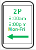

![]()
![]()
![]()
![]()
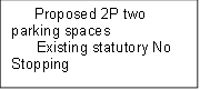
![]()
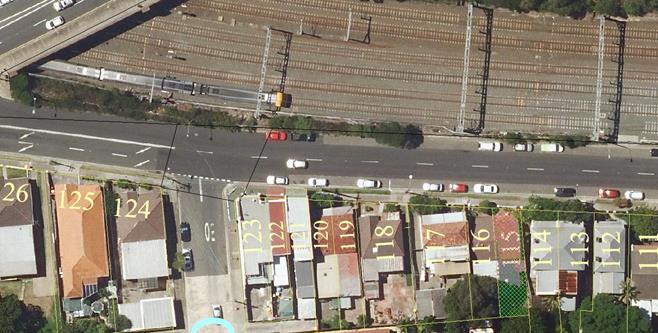
Street view - Carlton Crescent, Summer Hill (at Prospect Road)

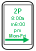

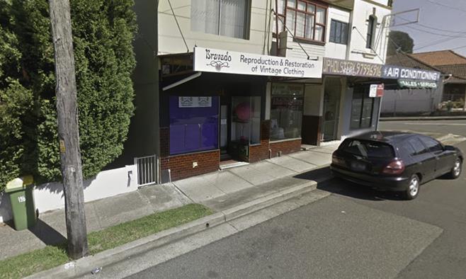
PUBLIC CONSULTATION
Consultation letters (15) were sent out on 13 November 2017 to business owners and property owners/occupiers within the vicinity, potentially affected by the proposed parking changes inviting comment. The survey closed on 4 December 2017.
Council received only one submission from the applicant seeking an amendment to the proposal. The shop owner is now requesting four nominal parking spaces instead of two as initially requested. In his submission he requested that Council return the 4 parking spaces back to what they were prior to the resident parking scheme implementation and he would seek compensation for loss of business and customers if not returned.
It is considered that the existing resident parking spaces elsewhere in Prospect Road or Carlton Crescent are adequate to also facilitate ‘short term’ parking for customers. On this basis, it is recommended that the consulted proposal for two nominal business parking spaces should be considered. Subject to the proposal being supported, the use of the parking spaces could be reviewed to establish any need to extend the 2P business spaces by two spaces in the future.
CONCLUSION
It is recommended that two parking spaces on the south side of Carlton Crescent at the front of No.123 be changed to nominal business parking: ‘2P, 8.00am-6.00pm Mon-Fri’ as these restrictions are considered adequate for the parking needs of the surrounding businesses.
|
|
Local Traffic Committee Meeting 6 February 2018 |
Subject: Brenan Street, Lilyfield - Proposed 'No Parking 7am-7pm - Motor Vehicles Under 4.5t GVM Excepted' restriction (Balmain Ward/Balmain Electorate/Leichhardt LAC)
Prepared By: David Yu - Traffic Engineer
Authorised By: John Stephens - Traffic and Transport Services Manager
|
SUMMARY Council has received correspondence from a number of residents in Brenan Street, Lilyfield requesting that parking restrictions be installed to deter boat trailer and caravans from parking in Brenan street, between Gladstone Street and White Street, Lilyfield. |
|
RECOMMENDATION
THAT a ‘No Parking 7am-7pm – Motor Vehicles Under 4.5t GVM Excepted' restriction be installed on the northern side of Brenan Street, from the 'No Stopping' restriction, east of Percival Street to Railway Parade and southern side of Brenan Street, between Starling Street and Railway Parade, Lilyfield. |
BACKGROUND
Concerns have been raised by residents regarding boat trailers and caravans parking on the northern side of Brenan Street, Lilyfield. This takes away parking and is essentially privatising public spaces for private use. Many of these boat owners do not reside in the LGA.
The NSW Government has recently passed Impounding Amendment (Unattended Boat Trailers) Act 2015 No 27, which makes provisions for impounding boat trailers left unattended on streets. However, Council enforcement staff has advised that the legislation requires extensive work to impound a vehicle and is unlikely to be effective.
In order to alleviate the issue in other streets Council has installed 'No Parking 7am-7pm; Motor Vehicles under 4.5t GVM Excepted' restrictions at the following locations:
· McKell Street, Birchgrove
· Church Street, Birchgrove (Cameron St-McKell St)
· Railway Parade, Annandale adjacent to existing 2P resident parking scheme
This would allow Council to enforce restrictions that would stop trailer owners leaving trailers and boats on the street, without disadvantaging residents from parking their vehicle.
The RMS advised Council in writing (letter dated 9th September 2016) that RMS has no objection to Council’s resolution to trial the abovementioned signage and has added this signage to its traffic signs database.
Council installed ‘No Parking 7am-7pm - Motor Vehicles under 4.5t GVM Excepted’ signposting for a 12 month trial in 2016. There were no significant concerns raised regarding the parking restrictions during this trial period. Hence, it is proposed to extend the restrictions from Railway Parade to Brenan Street.
FINANCIAL IMPLICATIONS
Nil.
OTHER STAFF COMMENTS
To prevent the parking of any trailers, caravans and trucks in Brenan Street, it is proposed that a ‘No Parking 7am-7pm – Motor Vehicles Under 4.5t GVM Excepted’ restriction be installed on the northern side of Brenan Street from the 'No Stopping' restriction, east of Percival Street to Railway Parade and on the southern side of Brenan Street, between Starling Street and Railway Parade as shown on the following plan. Parking is currently unrestricted along the proposed sections of Brenan Street.
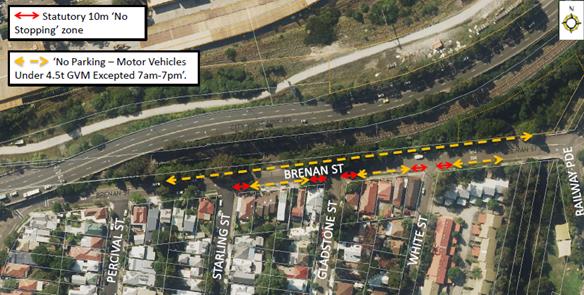
PUBLIC CONSULTATION
|
A letter outlining the above proposal was mailed out to the affected properties (108 properties) in Brenan Street, Catherine Street, Percival Street and White Street, Lilyfield. Responses were received from six (6) properties. Two (2) responses objected to the proposal and four (4) were in support. |
|
|
Residents’ Comments |
Officer Comments |
|
Trailers are registered by Service NSW and therefore, have a legal right to use and park on a public carriageway under NSW law.
The proposal is short-sighted as trailer owners will park in the immediate surrounding residential streets in front of residential houses that do not have restrictions. In which case, all streets in the Inner West Council area will need to be restricted. |
All vehicles, including trailers and caravans are legally allowed to park in a public roadway. However, it should be noted that Council can implement parking restrictions that can be enforced.
Due to concerns raised in regards to vehicle accessibility. It is proposed that 'No Parking 7am-7pm - Motor Vehicles under 4.5t GVM Excepted' be installed in Brenan Street. Council will monitor boat trailer and caravan parking in the area to ascertain if these vehicles have relocated into nearby streets.
10m ‘No Stopping’ zones must be installed at all intersections (as per NSW Road Rules) with the installation of the proposed parking restrictions. The ‘No Stopping’ zones provide improved safety for pedestrians and drivers.
|
|
I have a boat, currently just the trailer is on the other side of the street. I am against this proposal as it will affect me and other residents two fold. Almost no one parks or parked (in the past) on the light rail side of the road and I would lose the ability to park my boat there. Also, by introducing the Statutory 10m no stopping zone, you will reduce the amount of parking on the side of the street where our homes are located. |
|
|
How do these restrictions stop the following from parking here? 1. There are seven boats parked on the street and none of them weighs over 4.5 GVM. 2. Two Caravans are parked on the northern side of the street, neither has a motor so therefore the GVM for a motor vehicle is not applicable. 3. There is a catamaran, that does not weigh even close to 4.5t and it not a motor vehicle. 4. There is also a boat trailer, which has no motor and weighs less than 4.5t. 5. The only changes I see these proposed orders actually making at this point is removing the car spots available on the southern side of the street. |
The proposed ‘No Parking’ restrictions would apply to all vehicle types, except vehicles with motors under 4.5t Gross Vehicle Mass. All the vehicle types detailed in the resident’s comments are not considered to be motorised. Therefore, the ‘No Parking’ restrictions would apply to all these vehicles. This also includes motorised boats that are parked on a trailer.
Motor vehicles would be able to park in Brenan Street, if they are motorised and under 4.5t GVM. |
|
The boat and trailer parking causes a hazard to passing traffics as it narrows the road. It also feels like a Marina here than a residential area. |
The proposal is expected to remove the subject vehicles to provide sufficient travel lane widths for passing vehicles and cyclists. |
CONCLUSION
Nil.
|
|
Local Traffic Committee Meeting 6 February 2018 |
Subject: Upward Street, Leichhardt - P5min Restrictions (Leichhardt Ward/ Leichhardt LAC / Balmain Electorate)
Prepared By: Manod Wickramasinghe - Coordinator – Traffic and Parking Services
Authorised By: John Stephens - Traffic and Transport Services Manager
|
SUMMARY Council has received a request from the Principal of Kegworth Public School to modify the existing short term parking restrictions in Upward Street for Kegworth Public School Preschool. |
|
RECOMMENDATION
THAT the existing ‘No Parking 8:30am-9:30am; 2:30pm-3:30pm School Days Only’ restriction on the western side of Upward Street, outside Kegworth Public School Preschool be modified to ‘P5min 8:30am-9:30am; 2:30pm-3:30pm School Days Only’.
|
BACKGROUND
Council has received a request from the Principal of Kegworth Public School to modify the existing short term parking restrictions in front of its Preschool in Upward Street, Leichhardt.
There is currently 3 spaces (approx.17m) of ‘No Parking 8:30am-9:30am; 2:30pm-3:30pm School Days Only’ in front of the Preschool which allows parents to drop-off/pick-up children from the centre before and after school hours. However, due to the age of the children attending the Preschool, children are most often accompanied into the centre and so ‘No Parking’ restrictions are not considered appropriate as parents must legally remain within 3m of the vehicle and not be stopped for more than 2 minutes.
FINANCIAL IMPLICATIONS
Nil.
OTHER STAFF COMMENTS
It is proposed to modify the existing ‘No Parking 8:30am-9:30am; 2:30pm-3:30pm School Days Only’ restriction on the western side of Upward Street, Leichhardt outside the Kegworth Public School Preschool to 5 minute parking to cater for the parking needs of parents/carers attending the Preschool.
The location of the proposal is shown on the following plan.
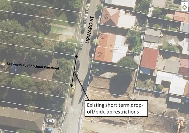
PUBLIC CONSULTATION
Public consultation is not required as the number of spaces is not proposed to be modified.
CONCLUSION
Nil.
|
|
Local Traffic Committee Meeting 6 February 2018 |
Subject: Constitution Road, Dulwich Hill - Proposal To Remove '1P Parking' (Ashfield Ward/Summer Hill Electorate/Marrickville LAC)
Prepared By: Mary Bailey - Project Officer
Authorised By: John Stephens - Traffic and Transport Services Manager
|
SUMMARY Following representation from the owner of a local child care centre, Council is proposing to convert a section of ‘1P’ parking in Constitution Road, Dulwich Hill to ‘unrestricted’ parking. The '1P’ restriction is historical and was associated with a Post Office which no longer exists. The recent introduction of permit parking nearby decreased the availability of ‘unrestricted’ parking. The proposal will reinstate five (5) ‘unrestricted’ parking spaces. |
|
RECOMMENDATION
THAT the conversion of ‘1P 9:30am – 4pm Mon-Fri, 8:30am-12:30pm Sat’ to ‘unrestricted’ parking from property No.151 Constitution Road (western side) to the existing ‘No Stopping’ zone at New Canterbury Road, Dulwich Hill be SUPPORTED.
|
BACKGROUND
Following representation from the owner of a local child care centre, Council is proposing to convert a section of ‘1P’ parking in Constitution Road, Dulwich Hill to ‘unrestricted’ parking.
The '1P’ restriction is historical and was associated with a Post Office which previously existed on the block of land on the north west corner of the intersection of New Canterbury Road and Constitution Road, Dulwich Hill.
The Dulwich Hill Parking Study, endorsed by Council in September 2016, recommended permit parking on the eastern side of Constitution Road between Denison Road and New Canterbury Road, Dulwich Hill.
In early 2017 the recommended restrictions were implemented and ‘2P 8:30am-6pm Mon-Fri; 8:30am-12:30pm Sat Permit Holders Excepted' was introduced in Constitution Road between Denison Road and New Canterbury Road on the eastern side.
Generally Council implements ‘permit’ parking on one side of the road, leaving the other side ‘unrestricted’ parking to allow for visitors, and those who are not eligible or who do not wish to participate in the scheme. Given that the ‘permit’ parking provides for short term parking it is not deemed necessary to retain the ‘1P’ parking on the western side of Constitution Road and removing the ‘1P’ will be in keeping with Council’s policy of retaining one side of the road as ‘unrestricted’ in an area where ‘permit’ parking has been implemented on the other side of the road. Consultation with the local businesses confirms that the proposed removal of the ‘1P’ spaces will not have a negative impact on availability of parking for their customers.
In order to provide a balanced approach and allow for optimum use of the available parking, it is proposed to convert the ‘1P’ parking to ‘unrestricted'. This will create an additional five (5) ‘unrestricted’ parking spaces. (See Figure 1 below for details of the proposal)
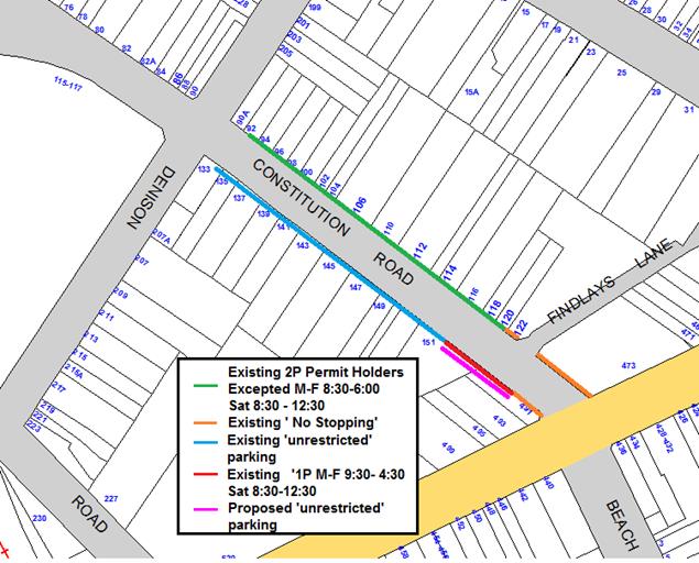
Figure 1. Proposed conversion of 1P parking to ‘unrestricted’ parking in Constitution Road, Dulwich Hill
FINANCIAL IMPLICATIONS
The cost for the supply and installation of the signposting can be funded from Council's operational budget.
OTHER STAFF COMMENTS
PUBLIC CONSULTATION
Thirty (30) letters outlining the proposal were sent to affected residents and householders. There were no objections to the proposed conversion of the ‘1P’ restriction to ‘unrestricted’ parking in the subject section of Constitution Road.
CONCLUSION
The existing '1P’ restriction was implemented in relation to a Post Office that is no longer at that site and there is no rationale for retaining the restriction. The removal of the restriction will reinstate ‘unrestricted’ parking in an area where the introduction of permit parking restrictions has reduced the availability of parking for the local businesses. The removal of the ‘1P’ restriction will also cater for attendees at the nearby church.
|
|
Local Traffic Committee Meeting 6 February 2018 |
Subject: Flood Street, Leichhardt - Road Occupancy (Leichhardt Ward/Leichhardt LAC/ Balmain Electorate)
Prepared By: Manod Wickramasinghe - Coordinator – Traffic and Parking Services
Authorised By: John Stephens - Traffic and Transport Services Manager
|
SUMMARY This report considers a request received from BreastScreen NSW for the temporary placement of their mobile lab unit on the western side of Flood Street adjacent to Leichhardt Market Place within the existing ‘Taxi Zone”, for the duration of 8 weeks starting from Friday, 3rd August to Friday 28th September 2018. |
|
RECOMMENDATION
THAT the road occupancy for the BreastScreen NSW mobile lab unit on the western side of Flood Street, adjacent to Leichhardt Market Place within the existing ‘Taxi Zone’, for the duration of 8 weeks starting from Friday, 3rd August to Friday 28th September 2018 be supported, subject to the following conditions:
a) That all affected businesses, residents and other occupants must be notified of the road occupancy and activities at least one week prior to the commencement of the event. Any concerns or requirements raised by business proprietors, residents and other occupants must be resolved or accommodated by the applicant;
b) That the applicant contact Energy Australia/Ausgrid in relation to power access to the mobile laboratory;
c) That the areas to be used for the activities must be maintained in a clean and tidy condition to the satisfaction of Council’s Group Manager Roads , Traffic and Stormwater, or else the applicant will be required to reimburse Council for any extraordinary cleansing costs;
d) That the Council and RMS must be indemnified against all claims for damage or injury that may result from either the activities or from the occupation of part of the public way during the activities. The applicant must therefore produce evidence of its public risk insurance cover (under which Council is indemnified) with a minimum policy value of at least $10,000,000;
e) That a copy of the Council approval letter must be made available on the site for inspection by relevant officers;
f) That the applicant must comply with any reasonable directive from Council’s Compliance Officers; and
g) That Council reserves the right to cancel this approval at any time.
|
BACKGROUND
BreastScreen NSW has requested approval to locate a mobile lab unit on the western side of Flood Street, adjacent to Leichhardt Market Place within the existing ‘Taxi Zone’ for the duration of 8 weeks from Friday, 3rd August to 28th September 2018. The mobile lab unit will operate for screening from 8.45am to 4pm Monday to Friday. This location has been used in previous years without any issues and would not affect any businesses, see proposed location below:
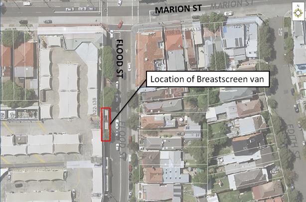
Note that the applicant has been requested to provide a copy of their public risk insurance.
FINANCIAL IMPLICATIONS
Nil.
OTHER STAFF COMMENTS
Nil.
PUBLIC CONSULTATION
Nil.
CONCLUSION
That the road occupancy for a Breast Screen NSW mobile lab unit on the western side of Flood Street, adjacent to Leichhardt Market Place be supported subject to the conditions listed in the officer’s recommendation.
|
|
Local Traffic Committee Meeting 6 February 2018 |
Subject: Railway Street, Petersham – Proposed Statutory No Stopping Restrictions (Stanmore Ward/Newtown Electorate/Marrickville LAC)
Prepared By: Emilio Andari - Engineer – Traffic and Parking Services
Authorised By: John Stephens - Traffic and Transport Services Manager
|
SUMMARY Requests have been received from local residents of Railway Street, Petersham for the introduction of ‘No Stopping’ restrictions on Railway Street at its intersection with Carrington Lane. Residents have advised Council officers that vehicles park too close to the intersection, restricting available sightlines for turning motorists.
It is recommended that statutory 'No Stopping' restrictions be installed for a distance of 10 metres in Railway Street at its intersection with Carrington Lane in order to deter illegal parking, increase safety, and improve visibility and access. |
|
RECOMMENDATION
THAT the installation of the statutory ‘No Stopping’ restrictions on the western side of Railway Street, Petersham for a distance of 10 metres north and south from its intersection with Carrington Lane be SUPPORTED in order to deter illegal parking, increase safety and improve visibility and access.
|
BACKGROUND
Council has received a number of written requests from local residents of Railway Street, Petersham for the introduction of ‘No Stopping’ restrictions on Railway Street at its intersection with Carrington Lane. Residents have advised Council officers that vehicles park too close to the intersection, restricting available sightlines for turning motorists.
FINANCIAL IMPLICATIONS
The cost of the supply and installation of the signposting can be met from Council’s operating budget.
OFFICER COMMENTS
Site location & road network
|
Street Name |
Railway Street |
Carrington Lane |
|
Subject Section |
Between Terminus Street and Brighton Street |
Between Unwins Bridge Road and Princes Highway |
|
Carriageway Width (m) |
12.8 |
4.9 |
|
Carriageway Type |
Two-way road with one travel lane in each direction, in addition to kerbside parking lanes along both sides of the road. |
Two-way road with one travel lane in each direction, no parking along both sides of the road. |
|
Classification |
Local |
Local |
|
85th Percentile Speed (km/h) |
51.0 |
– |
|
Vehicles Per Day (vpd) |
1,660 |
– |
|
Reported Crash History (July 2012 - June 2017) |
No crashes recorded. |
No crashes recorded. |
|
Heavy Vehicle Volume (%) |
2.5 |
– |
|
Parking Arrangements |
Permit parking restrictions on the eastern side of the road and unrestricted parking on the western side of the road. |
‘No Parking’ restrictions along both sides of the road. |
Site inspection
Council officers have observed during site inspections undertaken in the morning and afternoon periods that the on-street parking spaces along Railway Street were highly utilised particularly the western side of the road where unrestricted parking applies. It was also observed that traffic volumes were high in Railway Street as it links to the northern access gate to Petersham Railway Station on Terminus Street.
Residents have advised Council officers that vehicles park too close to the intersection, restricting available sightlines for turning motorists. During a number of site inspections, it was observed that vehicles and trailers have been parking too close to the intersection of Railway Street and Carrington Lane.
Technical Issues
In accordance with the Road Rules, a ‘No Stopping’ zone is mandatory for a distance of 10 metres from an intersecting road. Pursuant to the RMS Technical Directions, it is stated that signposting at an unsignalised intersection (without pedestrian crossing) “should only be required where there is a compliance problem or there is adjoining signposting”. In this case, it is shown to be a compliance problem which is causing problems for motorists wanting to turn at the intersection.
Locality Map – Railway Street at Carrington Lane, Petersham

![]()
![]()
![]()
![]()
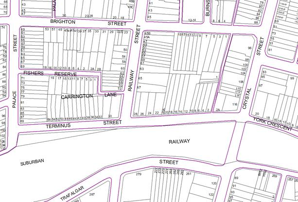
Sign Plan – Railway Street at Carrington Lane, Petersham
![]()
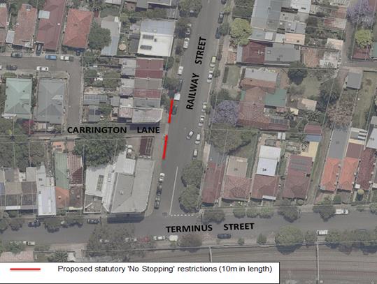
PUBLIC CONSULTATION
A notification letter was sent on 12 January 2018 to owners and occupiers of the effected properties that are adjacent to the subject section along Railway Street near Carrington Lane regarding the proposal to introduce signposted statutory ‘No Stopping’ restrictions in Railway Street for a distance of 10 metres from its intersection with Carrington Lane. The closing date for submissions ended on 25 January 2018.
A total of thirteen (13) letters were sent out to the effected residential properties. There was one (1) response received and this response was in support of the proposal and is detailed below.
|
Residents’ Comments |
Officer’s Response |
|
A resident of Railway Street is in support of the proposal. The resident suggested that hatched line markings be introduced in conjunction with the proposed ‘No Stopping’ signs to highlight that the subject location is a no parking area.
|
Received and noted.
It should be noted that hatched line markings at the intersection of Railway Street and Carrington Lane would not be in accordance of the Australian Standards and RMS Technical Direction for this intersection. Hatched line markings across the entire intersection only apply at signalised intersections and may cause confusion to motorists for this location. Following implementation of the signage, Council Rangers will monitor this location and if future issues continue to arise, linemarking may be considered. |
CONCLUSION
It is recommended that the statutory ‘No Stopping’ restrictions be installed on the western side of Railway Street, Petersham, for a distance of 10 metres north and south from its intersection with Carrington Lane in order to deter illegal parking, increase safety and improve visibility and access.
Photographs – Railway Street, Petersham
|
|
Western side of intersection at Carrington Lane (facing north-west)
|
|
Local Traffic Committee Meeting 6 February 2018 |
Subject: Comet Street, Ashfield – Request For a Mobility Parking Space (Leichhardt Ward/Summer Hill Electorate/Ashfield LAC)
Prepared By: Boris Muha - Engineer – Traffic and Parking Services
Authorised By: John Stephens - Traffic and Transport Services Manager
|
SUMMARY The resident of No.2 Comet Street, Ashfield has requested the installation of a ‘Disabled Parking’ zone in front of the resident’s property. A site investigation has revealed that the property has off street parking. |
|
RECOMMENDATION
THAT:
A signposted mobility parking space outside No. 2 Comet Street, Ashfield, be supported, subject to:
1. The mobility parking space not being used for the sole and exclusive use of the applicant and that any motorist displaying a Mobility Parking Scheme Permit within his/her vehicle is entitled to park in the space; and
2. The mobility parking space being reviewed at least every 12 months for its continued use and need, and removed when no longer required.
|
BACKGROUND
A copy of the RMS disability parking permit and a medical certificate in support of the application was submitted to Council. An on-site inspection has confirmed that the property has a double garage access from a side lane and unrestricted parking is present on the Comet Street frontage. These factors would normally mean that Council would not introduce a disabled parking space as the applicant should be able to find vacant space either within the off-street parking area or within reasonable proximity of her home.
FINANCIAL IMPLICATIONS
The cost of the signposting will be funded from Council’s operating budget.
OTHER STAFF COMMENTS
The applicant’s property is located on Comet Street, Ashfield. A two-way residential street (cul-de-sac), with unrestricted parking, 12.3m in width that is located south-east from Alt Street, Ashfield.
It has been observed during a site inspection undertaken in the afternoon period that on-street parking spaces in Comet Street, Ashfield were moderately utilised at the time.
At an on-site meeting with the applicant, it was revealed that the applicant doesn’t require a wheelchair and does not drive a vehicle. The applicant is driven by another family member. Currently, there is no existing mobility parking space in close proximity to applicant’s property.
However, it was claimed that the double garage to the rear of the property (with side lane access) is not readily made available/accessible with vehicles parking in the lane obstructing the access.
Council has attempted to install restricted parking signage under previous consultation and residents strongly objected on the imposition of signs going in the lane opposite the garage. No further action was undertaken in this regard.
It is considered that an on-street disabled parking space would assist in ease of access from the property and assist in unhindered provision of needed transportation.
The applicant would be made aware that the disabled parking space would not be for the sole exclusive use of the applicant and that any motorist displaying a Mobility Parking Permit in his/her vehicle is entitled to use that space.
Similarly, ‘Mobility Parking’ spaces are regularly reviewed (at least every 12 months) for their continued need and use and removed when no longer required.
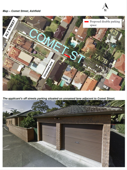
PUBLIC CONSULTATION
Consultation letters (18) were sent out on 19 December 2017 to property owners and occupants within the vicinity of the proposed mobility parking space inviting comment. The community survey closed on 10 January 2018.
Council received 3 submissions (two emails and one phone call), objecting to the proposal. Concerns have been raised regarding the available of off-street parking space and itit was suggested by the objectors that by Council designating a disabled parking space would be detrimental of other residents by removing a parking space on the street. References were made to the double garage owned by the applicant.
CONCLUSION
It is recommended that the application for a ‘Mobility Parking' space on Comet Street be supported under condition that the space is not allocated for the exclusive use of the applicant, and that any motorists displaying a mobility parking permit in the vehicle is entitled to use the space. Furthermore, it would be conditioned that the mobility parking space be reviewed at least every 12 months for its continued use and need.
|
|
Local Traffic Committee Meeting 6 February 2018 |
Subject: The ‘Gear Up Girl’ Bicycle Event (Marrickville Ward/Summer Hill & Heffron Electorate/Marrickville & Newtown LAC)
Prepared By: Emilio Andari - Engineer – Traffic and Parking Services
Authorised By: John Stephens - Traffic and Transport Services Manager
|
SUMMARY Advice has been received from Bicycle NSW regarding the 'Gear Up Girl' bicycle challenge to be held on Sunday 11 March 2018, which will involve cycling through the Inner West Local Government Area (LGA).
It is recommended that Council supports the proposed cycling event, subject to the event being advertised, a Traffic Management Plan be submitted to the RMS for approval and advice of the proposed event be forwarded to the appropriate authorities and affected properties by the applicant. |
|
RECOMMENDATION
THAT the 'Gear Up Girl' bicycle event held on Sunday 11 March 2018 be supported subject to the applicant complying with the following conditions:
1. The event being advertised in the local newspapers by the applicant in advance of the event;
2. A Traffic Management Plan being submitted by the applicant to the Roads and Maritime Services for consideration and approval;
3. Advice of the proposed event be forwarded by the applicant to the N.S.W. Police, the Transport Management Centre, State Transit Authority, Marrickville & Newtown Local Area Commanders, Fire & Rescue NSW and NSW Ambulance; and
4. Adequate traffic control shall be provided for the protection and convenience of pedestrians, cyclists and motorists including appropriate signage and flagging. Workers shall be specially designated for this role (and carry appropriate certificates), as necessary to comply with this condition. This is to be carried out in accordance with the Australian Standard AS 1742.3 - Traffic Control Devices for works on roads.
|
BACKGROUND
A submission has been received from Bicycle NSW advising that this year’s ‘Gear Up Girl' bicycle challenge will be held on Sunday 11 March 2018 and will involve cycling through the Inner West LGA. The applicant seeks Council's support for this year's event as in previous years.
FINANCIAL IMPLICATIONS
Nil.
OFFICERS COMMENTS
The applicant advised that the ‘Gear up Girl’ bicycle challenge has rides to cater for women of all ages and abilities, and is enjoyed year after year as a positive experience for all women who participate. Where possible the ride utilises routes on off-road cycle ways/shared pathways, or dedicated on-road cycle lanes.
The routes chosen showcase Inner West Council’s cycling infrastructure, particularly the Cooks River cycle way.
In 2018 Gear Up Girl offers 20km, 40km and 60km ride length options:
20km Beach Ride – Cooks cycleway, start at Wolli Creek to Cronulla.
Start – Riders are released in waves between 8.00am and 9.30am from Cahill Park (west), Wolli Creek and finish at Don Lucas Reserve, Cronulla.
Participants are restricted to 400.
40km Classic Ride – Sydney Olympic Park to Cronulla.
Start – 7.30am from Bicentennial Park, Sydney Olympic Park and finish at Cronulla.
Participants are restricted to 750.
60km Coast Ride – Sydney Olympic Park to Cronulla, including Kurnell.
Start – 7.00am from Bicentennial Park, Olympic Park and finish at Don Lucas Reserve, Cronulla. This ride is a loop ride out to Kurnell and return.
Participants are restricted to 750.
The applicant advised that the Road Occupancy Licence for the event is being negotiated with the Transport Management Centre (TMC). Both the TMC and NSW Police support the event. The proposed cycle route travels along the cycle way, from Illawarra Road, through Mackey Park and Kendrick Park and on the footpath on Princes Highway, Tempe, along the Cooks River (refer to the attached Traffic Control Plans submitted by the applicant).
Illawarra Road will be monitored by traffic controllers and traffic marshals with ‘Stop/Slow’ traffic control. Richardsons Crescent and Princes Highway will be monitored by traffic marshals at the signalised pedestrian crossing. It should be noted that there are no temporary road closures through the Inner West LGA.
Where required, NSW Police are contracted for event traffic management in the planning and delivery of the event. Police will be located at any intersections as stated on Traffic Control Plans. Bicycle Patrol Unit Police are also recruited to perform a ‘mobile’ Police presence ensuring participant and community safety along the cycle route.
PUBLIC CONSULTATION
Bicycle NSW advised that a letter will be distributed to all relevant residents and businesses containing advice about the event, and any changed traffic conditions, along with a map showing the changes. This communication will be confirmed in consultation with the local Council and the Transport Management Centre and will be distributed two weeks prior to the event.
Posters outlining basic details will be installed prior to the event at various locations along any shared pathways used in the event. Local newspaper notices will be allocated to relevant publications detailing any changed traffic conditions as another method of advising residents of the road closures. Newspaper notices will be placed one week prior to the event.
CONCLUSION
As this event was successfully implemented in previous years, it is recommended that the 'Gear Up Girl' bicycle event held on Sunday 11 March 2018 be supported subject to the applicant complying with the following conditions;
1. The event being advertised in the local newspapers by the applicant in advance of the event;
2. A Traffic Management Plan being submitted by the applicant to the Roads and Maritime Services for consideration and approval;
3. Advice of the proposed event be forwarded by the applicant to the N.S.W. Police, the Transport Management Centre, State Transit Authority, Marrickville & Newtown Local Area Commander, the NSW Fire Brigades and the NSW Ambulance Services; and
4. Adequate traffic control shall be provided for the protection and convenience of pedestrians, cyclists and motorists including appropriate signage and flagging. Workers shall be specially designated for this role (and carry appropriate certificates), as necessary to comply with this condition. This is to be carried out in accordance with
the Australian Standard AS 1742.3 - Traffic Control Devices for works on roads.
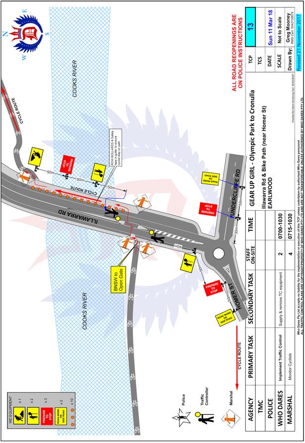
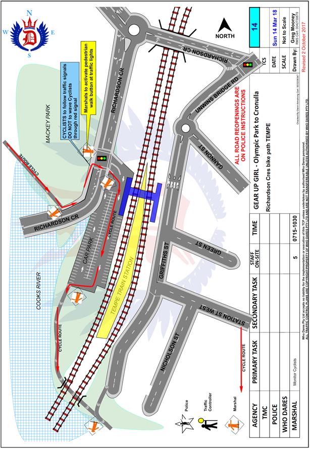
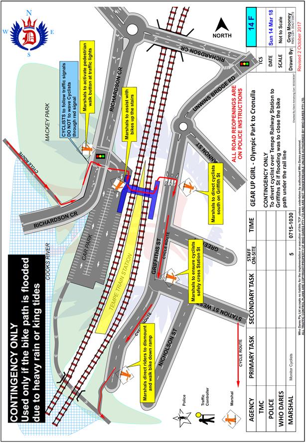 |
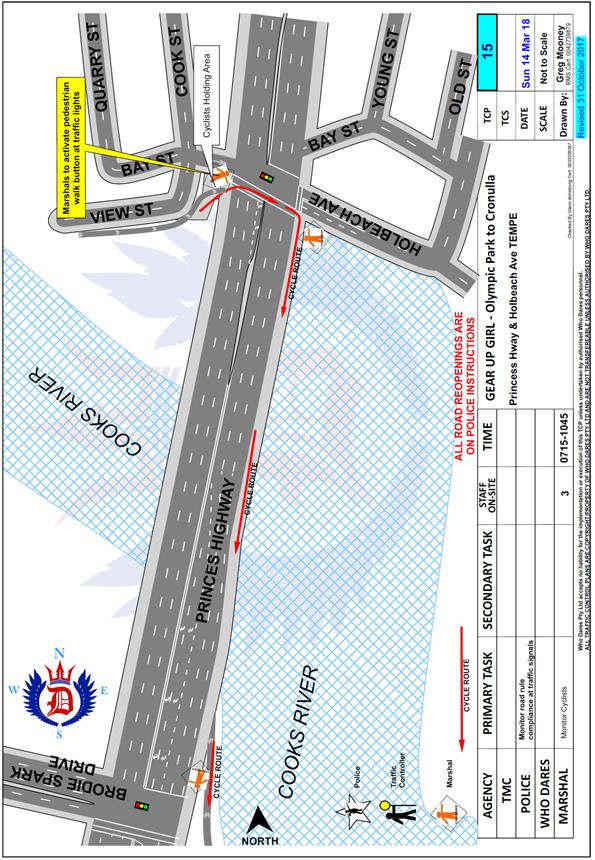 |
|
|
Local Traffic Committee Meeting 6 February 2018 |
Subject: Rich Street, Marrickville – DA201700558 – For The Redevelopment of Existing Industrial Land Into a Commercial Precinct Adjacent to 1-9 Rich Street (Marrickville Ward / Summer Hill Electorate / Marrickville LAC)
Prepared By: Jennifer Adams - Engineer – Traffic and Parking Services
Authorised By: John Stephens - Traffic and Transport Services Manager
|
SUMMARY An application (DA 201700558) has been received for the Rich Street Precinct and seeks consent for the redevelopment and use of the Rich Street Precinct for a range of creative light industries, offices and food and drink premises and including associated car parking, landscaping and site infrastructure works.
Comments of the Local Traffic Committee will be referred to Council’s Development Assessment Section for consideration in determining the Development Application.
|
|
RECOMMENDATION
THAT the report be received and noted. |
BACKGROUND
An application has been received to seek concept proposal for the site including building envelopes, future land uses, road network upgrades, transport connections, heritage protection, mitigation of environmental impacts on residential and neighbourhood amenity and mitigation of aircraft noise. In addition, detailed consent for Stage 1 of the proposed development comprising: site preparation works including demolition of existing structures and removal of vegetation; construction of 3 new buildings in 2 stages incorporating ground level tenancies and upper level offices and car parking being the 3 storey North Hub building, 4 storey South Hub building and 5 part 6 storey Marker Building; use of the new buildings for a range of creative light industries, office premises and food and drink premises; commercial operation of the proposed car park (excluding at-grade parking); site landscaping including creation of new publicly accessible parks, urban spaces and pedestrian and cycling connections, including the planting of over 50 new trees; public domain works including new internal roads, on-street parking and pedestrian footpaths within the site; associated site infrastructure upgrades; and subdivision of the two southern lots and creation of easements.
The application is required to be referred to the Local Traffic Committee for consideration under State Environmental Planning Policy (Infrastructure) 2007.
FINANCIAL IMPLICATIONS
Nil.
OTHER STAFF COMMENTS
Site location
The site is located at 1-9 Rich Street, Marrickville within the Inner West Local Government Area. The site is located within the north-western portion of the Sydenham-Marrickville
industrial precinct, and sits within a sub-precinct known as the Victoria Road precinct. Refer to the diagram below. The site has street frontages to Brompton Street to the north, Victoria Road to the east and Rich Street to the south. Vehicular access is available from Brompton Street and Rich Street.
The site is located within an established mixed industrial precinct (B5 Business Development zone) with some non-industrial business uses and residential dwellings also present in the area. Existing development on Rich Street is comprised of a mix of two-storey industrial buildings and offices used for a range of industrial / commercial activities.
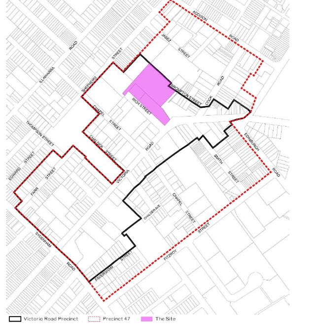
The site occupies Lot 5 in DP63446, Lot A in DP178259, and Lot 53 in DP868710 and has a site area of 12,591m2 and a frontage of 145m along Rich Street.
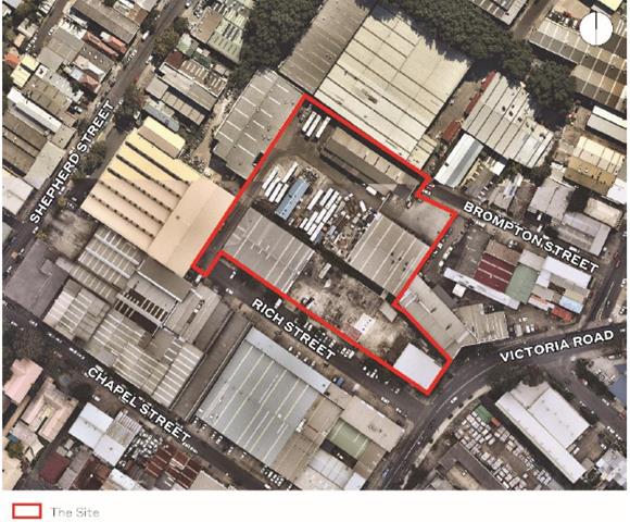
Locality and road network
The proposed development site is located in the suburb of Marrickville and is primarily serviced by Victoria Road (a Regional Road carrying approximately 17,000 vehicles per day). Victoria Road intersects with Sydenham Road (a State road) 450 metres south of Rich Street, Marrickville. The intersection of Sydenham Road and Victoria Road is busy and is generally congested throughout the day. Many of the side streets abutting Victoria Road also experience significant delays, nominally Victoria Road/Chapel Street and Victoria Road/Cook Road.
Victoria Road is a two-lane two way sealed road with kerb and gutter on both sides running northeast-southwest between Enmore and Marrickville, with a carriageway of approximately 11.5 metres. Parallel parking is generally permitted on both sides but includes certain time restrictions to allow clearway conditions (north 7-9am and south 4-6pm). The centreline and lane designations are marked and the posted speed limit on Victoria Road is 60 km/h.
Rich Street is a local cul-de sac and is approximately 11 metres in width. Approximately 670 vehicles per day use the street. At present, the northern side of Rich Street has 35 unrestricted 90º angle parking spaces. The southern side of the street consists of an off-street paved area. The speed limit is 50km/h.
Brompton Street is narrower (approximately 7 metre carriageway) with parallel parking on both sides.
It is noted that the nearby intersection of Victoria Road/Chapel Street had been identified as a Blackspot location and an application has been submitted for possible Blackspot funding for the intersection to be signalized, in association with the decommissioning of the mid-block signalized pedestrian crossing just south of the intersection.
![]()
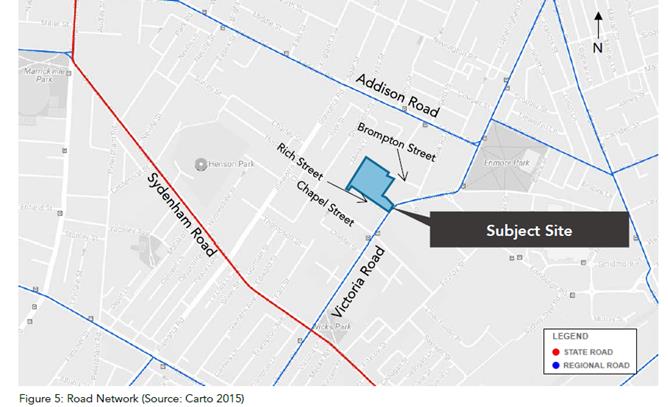
The Proposal
This Concept and Detailed Stage 1 Development Application seeks consent for the development and use of the Rich Street Precinct for a range of creative light industries, offices and food and drink premises and including associated car parking, landscaping and site infrastructure works. Specifically, according to the applicants’ SEE report, this application seeks consent for the following development:
· Concept proposal for building envelopes, future land uses, road network upgrades, transport connections, heritage protection, mitigation of environmental impacts on residential and neighbourhood amenity and mitigation of aircraft noise.
· Detailed consent for Stage 1 of the proposed development, comprising:
− Site preparation works including demolition of existing structures and removal of vegetation;
− Construction of three new buildings in two stages incorporating ground level tenancies and upper level offices and car parking;
− Use of the new buildings for a range of creative light industries, office premises and food and drink premises;
− Commercial operation of the proposed car park (excluding at-grade parking);
− Site landscaping including creation of new publicly accessible parks, urban spaces and pedestrian and cycling connections, including the planting of over 50 new trees;
− New internal roads, on-street parking and pedestrian footpaths within the site;
− Associated site infrastructure upgrades; and
− Subdivision of the two southern lots and creation of easements.
According to the applicants’ SEE report it is envisioned that 460 people will be employed on the site upon completion.
The report also notes that access to the site will be provided ‘via a new privately-maintained road network with connections to Rich Street and Brompton Street, providing access to on-street and internal building parking areas. Specifically, the transport connections are illustrated below and detailed as:
· Publicly accessible Studio Lane along the western and northern property boundaries, connecting Brompton Street and Rich Street in a two-way loop configuration and providing access (and future potential connections) to properties adjoining the site on these property boundaries;
· Publicly accessible Malco Lane connecting Brompton Street and Rich Street, with two-way vehicular access, pedestrian footpath along the eastern side and on-street shared bicycle path.’
![]()
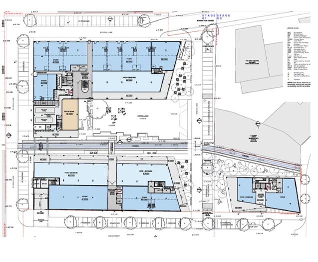
Also according to the applicants’ SEE report a total of 179 new car parking spaces are proposed as part of this development. They note that spaces will be distributed at ground along Malco and Studio Lanes, as well as at Level 1 of the North and South Hub Buildings. They add that two-thirds of the proposed spaces are to be provided as inside ‘secure parking that will be operated as a commercial public car park with ticketed/paid parking. The distribution of the proposed parking (179 spaces) across the site is as follows and shown in the above and below diagrams:
· Level 1, North/South Hub: 114 spaces.
− North Hub: 74 spaces including 2 accessible spaces; and
− South Hub: 40 spaces including 2 accessible spaces.
· Malco Lane: 24 spaces (including 2 accessible).
· Studio Lane: 41 spaces.
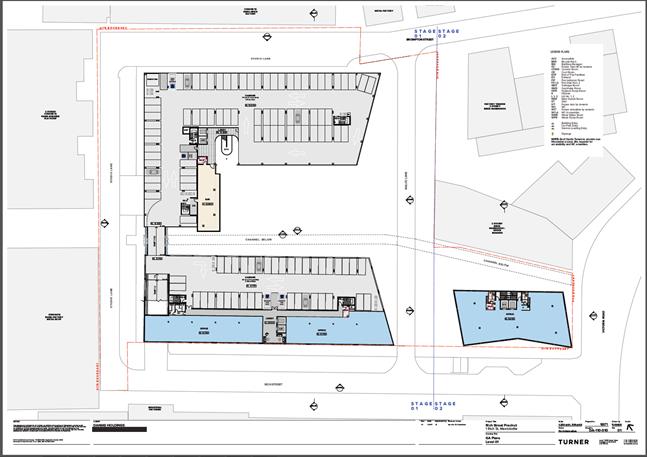
The SEE report also states that the ‘Parking along Malco Lane and Studio Lane is proposed to be provided for short-stay, accessible and tenant parking and time limits would be posted.’ and it adds “it is proposed that parking restrictions would be signposted for on-street parking spaces on Malco Lane and Studio Lane, with time restrictions and a small number of loading spaces. The landowner would seek to enter into an agreement with Council prior to completion of the development to permit Council rangers to enforce these parking restrictions.”
The SEE report continues stating that ‘In order to manage car parking demand, it is proposed that the Level 1 car park be commercially operated as a public car park with ticketed/ paid parking. Some tenant car parking may be allocated from the spaces subject to commercial leasing negotiations. Ticket machines and a boom gate would be installed at the base of the car park entrance ramp, with a roller shutter door providing further access control during night time hours.’ A total of 6 accessible parking spaces are proposed along with 90 bicycle spaces and 9 motorcycle spaces.
The SEE report also states a dual-space loading bay (1 x medium-rigid and 1 x heavy-rigid vehicle space) is proposed to be located on the North Hub ground floor to service the Precinct. Service vehicles will access the loading bay from Studio Lane via Rich Street. It adds that ‘25 on-street car parking spaces will be re-formed along Rich Street within the road reserve, with works proposed to improve the landscaping, pedestrian footpath, kerb and guttering and parking bays in this location.’
Overall, it is considered that a number of issues arise regarding the concept proposal as outlined above. First, it is not clear why a paid / ticketed parking station is proposed for this development. It would not be acceptable for the applicant to provide paid parking for employee or visitors to those premises during normal business hours. This type of proposal will encourage employees and visitors to look on-street for parking to avoid paying for parking.
The provision of off-street parking is meant for the benefit of employees and to reduce the impacts of on-street parking within the local area. Adequate on-site parking must be provided for all users as per Council requirements. The applicant also needs to indicate the total mix of visitor spaces / commercial and office spaces provided for the development.
However, it may be acceptable for a paid/ticketed parking station to be used to support surrounding night time entertainment activities outside of ‘normal business hours’. The applicant would need to provide a separate parking management plan for consideration by Council for the carpark during and after normal business hours if this was the case.
Furthermore, a commercial tenant will expect parking with their tenancies in general and as discussed above it is questionable whether tenants/workers/visitors will use ticketed parking willingly. With the estimated employment rate for the proposed development of around 460 staff and the location not conveniently located to all public transport adequate on-site parking is essential. People will visit the site, suppliers and workers will want to park their vehicles, most all day.
Unless the proposed roadways provide a public benefit such as improved transport accessibility through this area Council may not be willing to take on the responsibility for owning and maintaining any proposed roads for the development. Furthermore, Council Rangers do not enforce parking restrictions on private land. Any right of way / easements will have to be reviewed/ rewritten as part of any approval.
It is noted that no detail has been given in any of the supporting documents about the loss of 10 public and unrestricted parking spaces on Rich Street when Rich Street is ‘re-formed’ by the proposed development. At present the northern side of Rich Street has 35 unrestricted 90º angle parking spaces, should the development go ahead ’25 on-street car parking spaces will be reformed along Rich Street.”
Public Transport
Two bus stops are located on the Victoria Road and Chapel Street intersection, approximately 220m and 260m south of the site. Routes 423, 426 and the Metrobus M30 service these stops. The site is located approximately 1.4km north of Sydenham Station, 1.7km west of St Peters
Station, 1.7km south-west of Newtown Station and 1.8km north east of Marrickville Station. Ideally the maximum walking catchment distance to a railway station is one (1) kilometre.
Parking
According to the applicants’ Traffic report, the development proposal involves the redevelopment of the existing industrial land into a commercial precinct comprising:
· 13,834m2 GFA in total, comprised of;
× 9,238m2 (9,300m² in SEE report) GFA of office space, including a mix of larger floor plate and smaller innovation style suites
× 2,826m2 GFA of ground floor and mezzanine studio workshop and creative arts spaces (Business / light industrial ?)
× 1,770m2 GFA of ground floor food and beverage and pop-up retail spaces
· A landscaped central space;
· An internal car park as well as external car parking spaces (179 spaces); and
· Private roads and public domain improvements.
The proposed development lies within Council’s Parking Area 2 and the parking provision required is estimated to be 227 (‘Business’ down to 149 ‘Industrial’) spaces:
Office premises - 1 per 80m² GFA for staff & visitors
9238m² = 115.475 spaces - 116
Business premises; retail premises; shops - Over 1,000m2 - 20 + 1 per 30m2 GFA over 1,000m2 GFA for customers & staff
2826m² = 20 + 60.866 = 88.866 spaces - 89
Restaurant and takeaway food or drink premises - 1 per 80m2 GFA for customers & staff
1770m² = 22.125 spaces - 22
It is noted that the applicants’ Traffic report states that ‘studio’ space is considered to be classified as ‘office’ premises however note that the applicants’ Plan of Management report says that tenancies designated as either ‘studio’ or ‘tenancy’ are intended to be used either as ‘light industry (creative purpose), including possible retail and/or ‘business premises’ noting that there exists a potential for division of tenancies within each space. Therefore it is considered acceptable to use ‘Business premises’ and not ‘light industrial’.
The SEE report notes that ‘Parking Area 2 parking rates have been adopted for this project. Application of these rates results in a total car parking requirement for the development of 150 spaces.’ The applicants’ Traffic report calculates that 177 parking spaces are required for the proposed development and details that car parking provision in the propose development will be as follows:
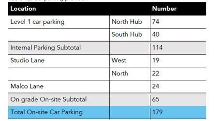
By contrast, using RMS’s Guide to Traffic Generating Developments and the applicants’ Traffic report ‘commercial purposes’ category the parking provision for 13,834m²GFA would be 346 parking spaces using the following given rate:
Office and commercial premises – 1 space per 40m²GFA (unrestrained situation, ie. parking provided on-site)
It is noted that the unrestrained situation assumes a peak mode split for cars of 0.62, car occupancy of 1.19 and a mean employee density of 4.75 employees per 100m²GFA.
The applicants’ SEE report states that 179 spaces are proposed to be provided with 114 of these provided as ‘secure parking’ (ie. ticketed and not publically available free of charge to either staff or visitors).
It is highly questionable whether the parking provision proposed by the applicant is adequate for the proposed use(s). On-site parking provision is to be ticketed and some patrons (staff and/or visitors) may be reluctant to use it and seek parking on-street further congesting any available parking that is free of charge.
Further, adjoining redevelopment at the ‘Factory’ should it go ahead will result in a loss of 20 parking spaces, further compounding pressure on any available on-street parking in the locality.
Providing one carshare space on Rich Street is not acceptable as any provision should be provided on-site accordingly. The drop-off space should also be considered on-site.
Accessible Parking
Council’s DCP 2.5 – Equity of Access and Mobility – requires 1 accessible parking space for every 10 parking spaces for commercial and industrial developments.
With an estimated car parking requirement of 227 (‘Business’) 27 accessible car parking spaces are required for the proposed development. Only 6 accessible spaces have been designated by the applicant for the development, four in the internal car park and 2 at grade along Malco Lane, which does not meet Council’s requirements.
Bicycle parking
Council requires 82 bicycle parking spaces estimated as folllows:
Office premises – 1 per 200m²GFA for staff + 1 per 750m²GFA for visitors for premises over 1000m²
9238m² = 46+12 = 58
Business premises – 1 per 300m² for staff + 1 per 500m² for customers if premises over 1000m²
4596m² = 15+9 =24
The applicants’ SEE report states that “a total of 90 bicycle spaces are proposed to be provided, which is generally consistent with the rate required under the DCP when in-tenancy bike parking for ground-floor business premises is also taken into consideration.”
The applicant’s Traffic report says bicycle parking requirements for the three buildings requires 98.6 bicycle spaces and the proposed development provides 100 bicycle spaces:
− 60 off adjacent the loading dock
− 20 off adjacent the Marker Building on Malco Lane
− 20 off adjacent the North Hub Building on Malco Lane.
The DCP also outlines a requirement of a clothes locker per 3 staff bicycle spaces. With a total of 81 staff spaces, this equates to a requirement of 27 lockers. 1 unisex shower is provided in the Marker Building(closest to Victoria Street), satisfying the minimum shower provision requirement of 1 shower in the DCP.
It is noted that it would seem highly unlikely that out of the 460 employees that 100 of them would ride to work in any case, however the requirement as detailed would satisfy Council requirements for bicycle parking.
Motorcycle parking
Provision for motorcycle parking is 5% of car parking requirements therefore the proposed development requires between 11 spaces.
The applicants’ Traffic report states that the development proposes 9 motorcycle parking spaces in the internal car park. It is noted that the spaces will be only accessible through the commercially operated internal car park as ‘ticketed/paid parking’, which may act as a deterrent to motorcyclists actually using the proposed provision.
It is noted that the provision of 11 spaces would need to be met and ideally these should be a mixture of on-street and off-street.
Car park access and layout
All ramps and car parking spaces must be in accordance with Australian Standard AS2890.1-2004 Parking Facilities and AS2890.6-2009 Off-street parking for people with disabilities.
It is noted that Council’s Development Engineering Section will evaluate the adequacy of the proposed development’s driveway, ramps, car parking and circulation patterns.
Servicing
The applicants’ Traffic report states that “Two loading bays have been provided on the ground level on the north-western end of the site to facilitate deliveries and waste collection. The smaller bay has dimensions of 9.0m x 2.5m and will accommodate vehicles up to a Medium Rigid Vehicle (MRV) in size. The larger bay has dimensions of 10m x 3.5m and will accommodate vehicle sizes up to a 10m waste collection vehicle.”
The SEE report states that the dual-space loading bay (1 x medium-rigid and 1 x heavy-rigid vehicle space) proposes are to be for shared use across the site with the capacity to accommodate vehicles up to 12.5m in length, yet the larger bay measures 10 metres in length according to the above given dimensions.
Respective swept path diagrams are given below. It is noted that the proposed loading docks are opposite the loading dock at 11 Meeks Lane and it is possible that the swept paths shown may be hindered with parking and loading/unloading activities associated with those occurring at 11 Meeks Lane, Marrickville.

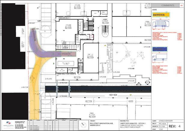
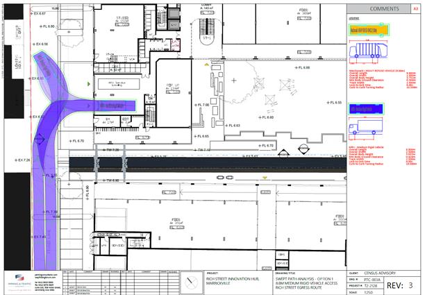
Traffic Generation
RMS’s Guide to Traffic Generating Developments for ‘commercial premises’ (office and commercial) gives the following rates – 10 daily vehicle trips per 100m²GFA and 2.0 peak hour vehicle trips per 100m². Thus, the proposed development – 13,834m² (9,238m² office; 2,826m² commercial; 1770m² retail) - could be expected to generate up to 1,380 vehicle trips per day and 277 vehicle trips per peak hour.
It is noted that this traffic generation rate seems reasonable in light of the anticipated 460 employees expected to be at the site in addition to visitors, clients/customers and deliveries.
The applicants’ Traffic report states that the proposed development will primarily be used for commercial purposes. “Ancillary uses such as cafes, restaurants, workshops, etc. are expected to predominantly serve the users of the offices and hence will not generate external trips as it is envisaged that it is unlikely for external users to travel to the development
location for these ancillary uses. As such, the gross floor area (9,238m2 GFA) of the office areas has been used to determine traffic generation.”
They give traffic generation rates for peak hour vehicle trips for ‘office buildings’ according to Technical Direction 2013/04 (TDT) of:
Morning peak hour vehicle trips: 1.6 per 100m2 gross floor area
Evening peak hour vehicle trips: 1.2 per 100m2 gross floor area
It is noted that to simply use the GFA of the listed ‘office’ space (9,238m²) is not a sufficiently comprehensive assessment to determine the traffic generation of the proposed development adequately. Surely the 4,596m²GFA not included in the traffic generation analysis must be accounted for in some manner. It is not satisfactory that they have chosen the proposed development to be assessed in this way as the site would attract external visitors/suppliers and the site does not have ready access to the rail network per sec.
An extra 1,400 odd vehicle trips per day and 300 odd peak hour vehicle trips generated by the proposed development will impact the operating capacity of the adjoining intersection of Rich Street and Victoria Road, Marrickville as well as impact on other intersections in the locality.
It is noted that intersections in the locality are already congested and operating at Level of Services of ‘C’, ‘D’ and ‘E’ and any added traffic generation in the locality (above that generated by existing uses) will make congestion worse.
Should the development ever go ahead it is recommended that further assessment be carried out to see whether existing road infrastructure changes are required, such as ‘Left in’ and ‘Left out’ at the intersection of Rich Street at Victoria Road, Marrickville. In addition, investigation is required into possible contribution forthcoming by the applicant into upgrading the nearby major intersection of Victoria Road at Sydenham Road, Marrickville.
PUBLIC CONSULTATION
Consultation/notification regarding the proposal would normally be undertaken by Council's Development and Planning Services as part of the development application process.
CONCLUSION
The proposed development is not supported in its current form because of the following issues:
· GFA uses/areas need to be identified and itemised more precisely. It is difficult to adequately determine parking provision requirements and/or traffic generation rates for the proposed development, especially when those uses have the potential to change in the future (as detailed in the applicants’ Operational plan of Management).
· Paid parking is not supported during the hours of normal business operating hours.
· The applicants’ Traffic report uses different criteria for traffic generation analysis and parking – analysis should be consistently based.
· Account for the loss of 10 unrestricted on-street parking spaces on Rich Street due to Rich Street being re-formed’ by the proposed development. At present the northern side of Rich Street has 35 unrestricted 90º angle parking spaces and the development proposes 25 spaces on Rich Street, Marrickville.
· The proposed development does not comply with Council’s parking requirements as it stands, nor with Council’s accessible parking requirements and motorcycle parking requirements.
· The traffic generation rates given for the proposed development by the applicant are not considered to be truly reflective of the possible increases in vehicular traffic that may be generated by the proposed development. ‘Office building’ use alone is not a sufficient basis to estimate expected traffic generation rates for the proposed use adequately – all uses on the site will generate vehicular traffic and need to be assessed accordingly.
The following issues would also need to be investigated and addressed:
· clarifying management details of the new private road infrastructure.
· further investigation is required into whether the proposed development should contribute to any public road infrastructure projects due to increases in the probable traffic impacts resulting from the proposed development, especially added traffic congestion at intersections in the locality (eg, Left-in and Left out only restrictions at the intersection of Rich Street and Victoria Road, Marrickville along with the future upgrade of Victoria Road with Sydenham Road, Marrickville).
· The provision of car share within the development site.
Principally, a number of issues arise regarding the concept proposal that should be revisited. As already outlined above, generally a commercial tenant will expect parking with their tenancies and it is questionable whether tenants/workers/visitors will use ticketed parking willingly. With an expected employment rate for the proposed development of around 460 staff and a location not really next-door to public transport adequate on-site parking is essential. People will visit the development, suppliers will service the development and workers will work in the development and many will want to park their vehicles, in a locality where any available parking provision is already highly ultised.
It is recommended that the above traffic related comments be forwarded to Council’s Development Assessment Section.