|
AGENDA R |

Local Traffic Committee Meeting
TUESDAY 10 APRIL 2018
10.00am
|
|
Local Traffic Committee Meeting 10 April 2018 |
Function of the Local Traffic Committee
Background
Roads and Maritime Services (RMS) is legislated as the Authority responsible for the control of traffic on all NSW Roads. The RMS has delegated certain aspects of the control of traffic on local roads to councils. To exercise this delegation, councils must establish a local traffic committee and obtain the advice of the RMS and Police. The Inner West Council Local Traffic Committee has been constituted by Council as a result of the delegation granted by the RMS pursuant to Section 50 of the Transport Administration Act 1988.
Role of the Committee
The Local Traffic Committee is primarily a technical review and advisory committee which considers the technical merits of proposals and ensures that current technical guidelines are considered. It provides recommendations to Council on traffic and parking control matters and on the provision of traffic control facilities and prescribed traffic control devices for which Council has delegated authority. These matters are dealt with under Part A of the agenda and require Council to consider exercising its delegation.
In addition to its formal role as the Local Traffic Committee, the Committee may also be requested to provide informal traffic engineering advice on traffic matters not requiring Council to exercise its delegated function at that point in time, for example, advice to Council’s Development Assessment Section on traffic generating developments. These matters are dealt with under Part C of the agenda and are for information or advice only and do not require Council to exercise its delegation.
Committee Delegations
The Local Traffic Committee has no decision-making powers. The Council must refer all traffic related matters to the Local Traffic Committee prior to exercising its delegated functions. Matters related to State Roads or functions that have not been delegated to Council must be referred directly to the RMS or relevant organisation.
The Committee provides recommendations to Council. Should Council wish to act contrary to the advice of the Committee or if that advice is not supported unanimously by the Committee members, then the Police or RMS have an opportunity to appeal to the Regional Traffic Committee.
Committee Membership & Voting
Formal voting membership comprises the following:
· one representative of Council as nominated by Council;
· one representative of the NSW Police from each Local Area Command (LAC) within the LGA, being Newtown, Marrickville, Leichhardt and Ashfield LAC’s.
· one representative from the RMS; and
· State Members of Parliament (MP) for the electorates of Summer Hill, Newtown, Heffron, Canterbury, Strathfield and Balmain or their nominees.
Where the Council area is represented by more than one MP or covered by more than one Police LAC, representatives are only permitted to vote on matters which effect their electorate or LAC.
Informal (non-voting) advisors from within Council or external authorities may also attend Committee meetings to provide expert advice.
Committee Chair
Council’s representative will chair the meetings.
Public Participation
Members of the public or other stakeholders may address the Committee on agenda items to be considered by the Committee. The format and number of presentations is at the discretion of the Chairperson and is generally limited to 3 minutes per speaker. Committee debate on agenda items is not open to the public.
|
|
Local Traffic Committee Meeting 10 April 2018 |
|
AGENDA |
1 Apologies
2 Disclosures of Interest
3 Confirmation of Minutes Page
Minutes of 6 March 2018 Local Traffic Committee Meeting 5
4 Matters Arising from Council’s Resolution of Minutes
5 Part A – Items Where Council May Exercise Its Delegated Functions
Traffic Matters
ITEM Page
LTC0418 Item 1 Temporary Full Road Closure of Derbyshire Road, Leichhardt (Leichhardt Ward / Balmain Electorate / Leichhardt LAC) 33
LTC0418 Item 2 Temporary Full Road Closure - Unnamed Laneway running parallel between Young Street and Annandale Street, Annandale (section between Gillies Street and Wisdom Street) (Balmain Ward / Balmain Electorate / Leichhardt LAC) 36
LTC0418 Item 3 Temporary Road Closure to Dismantle Tower Crane on Mcgill Street, Lewisham (Stanmore Ward/ Marrickville Electorate/Marrickville LAC) 39
LTC0418 Item 4 Change in parking meter operational hours - Norton Street, Leichhardt and Darling Street, Rozelle/Balmain (Balmain and Leichhardt Wards / Balmain Electorate / Leichhardt LAC) 42
LTC0418 Item 5 Various locations, Inner West - signposting of load limits/height clearances on a number of bridges over/under light rail network in Inner West Local Government Area 46
LTC0418 Item 6 Regional Bicycle Route 7- Detailed Design Plans (Central & North Wards/Summer Hill & Newtown) 60
LTC0418 Item 7 Temporary Road Closure to Carry Out Sewer Works on Applebee Street, St Peters (Marrickville Ward/ Heffron Electorate/Newtown LAC) 100
LTC0418 Item 8 Constitution Road, Dulwich Hill – Amendment To Proposed Pedestrian Refuge Island Upgrade Design Plan (Ashfield Ward/Summer Hill Electorate/Inner West LAC) 105
LTC0418 Item 9 Denison Road, Dulwich Hill – Proposed One Lane Slow Point With Line Markings & ‘No Left Turn’ Restriction Design Plans (Ashfield Ward/Summer Hill Electorate/Inner West LAC) 108
Parking Matters
ITEM Page
LTC0418 Item 10 Railway Street, Petersham - Proposed Introduction of '2P Permit Holders Only' Parking Restrcitions (Summer Hill Electorate/Stanmore Ward/Inner West LAC) 118
LTC0418 Item 11 Lewisham - Proposal to Implement Permit Parking in Additional Streets - M16 parking area (Summer Hill Electorate/Stanmore Ward/Inner West LAC) 121
LTC0418 Item 12 Minor Traffic Facilities (All Wards / All Electorates / All LACs) 130
LTC0418 Item 13 Nelson Lane (at aquaduct), Annandale - Extension of 'No Parking' Zone (Balmain Ward/Balmain Electorate/Leichhardt LAC) 135
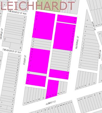
LTC0418 Item 14 Unnamed Laneway between Flood Street and National Street, Leichhardt - Proposed 'No Parking' restrictions Leichhardt Ward/Balmain Electorate/Leichhardt LAC) 137
LTC0418 Item 15 Leichhardt Park car park, Lilyfield - Parking Conditions (Balmain Ward / Balmain Electorate / Leichhardt LAC) 140
LTC0418 Item 16 Illawarra Road, Marrickville – Removal of Redundant ‘No Parking’ Restrictions Outside Nos. 410 and 408 And Introduce New “1P 8.30AM – 6.00PM’ Parking Restrictions 143
LTC0418 Item 17 Metropolitan Road, Enmore – Amend Signage For Existing Mobility Parking Space 146
LTC0418 Item 18 Beauchamp Street, Marrickville – Proposed No Parking Restrictions (Marrickville Ward/Summer Hill Electorate/Inner West LAC) 149
LTC0418 Item 19 Chapel Street, Marrickville – Proposed Timed No Parking Restrictions (Marrickville Ward/Summer Hill Electorate/Inner West LAC) 152
LTC0418 Item 20 Boomerang
Street and Mortley Avenue, Haberfield
-installation of "Bus Zone" signage to existing Bus Stops.
(Leichhardt Ward/Summer Hill Electorate/Ashfield LAC) 156
Late Items
Nil at time of printing.
6 Part B - Items for Information Only
ITEM Page
LTC0418 Item 21 Frederick Street, Ashfield - Advertising Trailer Parking (Leichhardt Ward/Strathfield & Summer Hill Electorates/Ashfield LAC) 159
7 Part C - Items for General Advice
ITEM Page
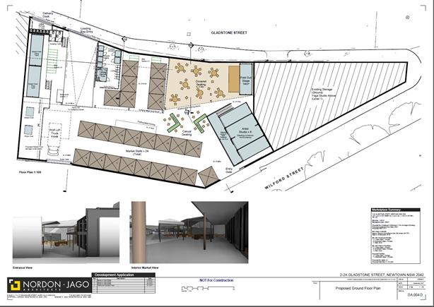
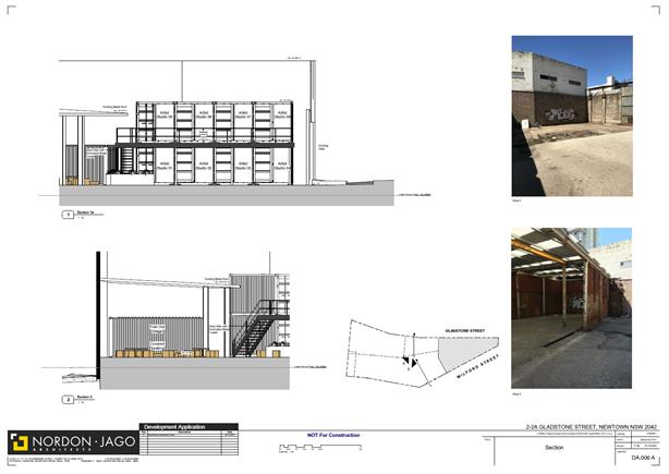
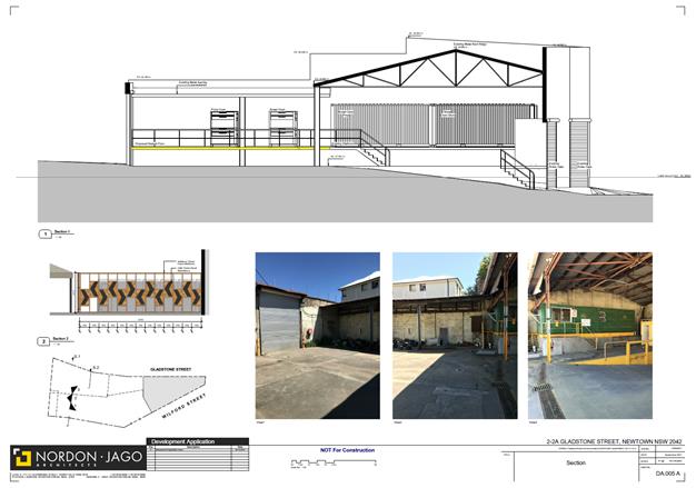
LTC0418 Item 22 2A Gladstone Street, Newtown - DA201700589 – For The Temporary Use of The Site For A Multi-use Creative Hub 168
8 General Business
9 Close of Meeting
|
|
Local Traffic Committee Meeting 10 April 2018 |
Minutes of Local Traffic Committee Meeting
Held at Chamber Room, Petersham Service Centre, on 6 March 2018
Meeting commenced at 10.11am
ACKNOWLEDGEMENT OF COUNTRY BY CHAIRPERSON
I acknowledge the Gadigal and Wangal people of the Eora nation on whose country we are meeting today, and their elders past and present.
COMMITTEE REPRESENTATIVES PRESENT
|
Clr Marghanita Da Cruz |
Leichhardt Ward (Chair) |
|
Mr Bill Holliday |
Representative for Jamie Parker MP, Member for Balmain |
|
Mr Chris Woods |
Representative for Ron Hoenig MP, Member for Heffron |
|
Ms Sarina Foulstone |
Representative for Jo Haylen MP, Member for Summer Hill |
|
Mr Ryan Horne |
Roads and Maritime Services |
|
SC Anthony Kenny |
NSW Police – Inner West Area Command |
|
|
|
|
OFFICERS IN ATTENDANCE |
|
|
|
|
|
Mr Peter Whitney |
State Transit Authority |
|
Mr Tony Michalis |
State Transit Authority |
|
Mr Colin Jones |
Inner West Bicycle Coalition |
|
Mr Wal Petschler |
IWC’s Group Manager, Roads, Traffic and Stormwater |
|
Mr John Stephens |
IWC’s Traffic and Transport Services Manager |
|
Mr George Tsaprounis |
IWC’s Coordinator Traffic and Parking Services (South) |
|
Mr Manod Wickramasinghe |
IWC’s Coordinator Traffic and Parking Services (North) |
|
Ms Mary Bailey |
IWC’s Parking Planner |
|
Mr David Yu |
IWC’s Engineer – Traffic and Parking Services |
|
Mr Boris Muha |
IWC’s Engineer – Traffic and Parking Services |
|
Mr Emilio Andari |
IWC’s Engineer – Traffic and Parking Services |
|
|
|
|
VISITORS |
|
|
|
|
|
Mr Steven Burns |
Item 10 |
|
Mr Mike Samms |
Item 10 |
|
Ms Ann-Therese King |
Item 18 |
|
Mr Denis Doyle |
Item 18 |
|
Ms Natalie Lovett |
Item 18 |
|
Mr Joseph Atallah |
Item 18 |
|
Ms Elizabeth Avent |
Item 18 |
|
Mr Neil Tonkin |
Item 18 |
|
Mr Bob Moore |
Item 18 |
|
Ms Leonie Derwent |
Item 18 |
|
Ms Roslyn Burge |
Item 18 |
|
Mr Peter Haramis |
Item 18 |
|
Resident of Hornsey Street, Lilyfield |
Item 18 |
|
|
|
|
APOLOGIES: |
|
|
|
|
|
Ms Jo Haylen MP |
Member for Summer Hill |
|
Mr Jamie Parker MP |
Member for Balmain |
|
Sgt John Micallef |
NSW Police – Burwood & Campsie (emailed support) |
|
Sgt Dan Chilvers |
NSW Police – Leichhardt (emailed support) |
|
Clr Julie Passas |
Deputy Mayor – Ashfield Ward |
DISCLOSURES OF INTERESTS: Nil.
CONFIRMATION OF MINUTES
|
The Minutes of the Local Traffic Committee Meeting held on Tuesday, 6 February 2018 were confirmed. |
MATTERS ARISING FROM COUNCIL’S RESOLUTION OF MINUTES
The Local Traffic Committee recommendations of its meeting held on 7 December 2017 and 6 February 2018 were adopted at Council’s meeting held on 27 February 2018.
Council at its meeting held on 27 February 2018 also resolved that:
Council as soon as possible organise a public meeting on the Lilyfield Road Cycleway proposal at which staff provide a full overview of the proposal and allow the community to ask questions in order to better understand what is being proposed. (Item 17 LTC0218)
|
LTC0318 Item 17 Livingstone Road, Marrickville – Temporary Road Closures For The Orthodox Easter Processions On 6 & 7 April 2018 (Marrickville Ward/Summer Hill Electorate/Inner West LAC) |
|
Council has been advised by the NSW Police that there will be a street procession taking place on Orthodox Easter Good Friday 6 April 2018, between 8.30pm and 10.00pm and Orthodox Easter Saturday 7 April 2018, between 10.00pm and 12.30am for St Nicholas Greek Orthodox Church in Marrickville. This procession will require some temporary road closures which will be undertaken by the NSW Police. Council has been requested to provide barricades to assist the Police in implementing the proposed road closures.
It is recommended that this report be received and noted. It is also recommended that Council provide barricades at no cost to assist the Police in implementing the proposed temporary road closures as in previous years.
Officer’s Recommendation
THAT:
1. The report be received and noted; and
2. Council provide barricades at no cost to assist the Police implementing the proposed temporary road closures as in previous years.
DISCUSSION
The Committee members agreed with the Officer’s recommendation.
COMMITTEE RECOMMENDATION
THAT:
1. The report be received and noted; and
2. Council provide barricades at no cost to assist the Police implementing the proposed temporary road closures as in previous years.
For motion: Unanimous
|
|
LTC0318 Item 18 Route EW09 (Lilyfield Road, Lilyfield) - Separated Cycleway (Balmain Ward/ Leichhardt LAC/ Balmain Electorate) |
|
This report details the revised concept plan, community engagement results and options for further investigation for the Lilyfield Road Separated Cycleway (Route EW09) that has been developed following public exhibition of the revised concept plans.
Officer’s Recommendation
THAT:
1. In recognition of the level of objection to the project in its current form, the project not proceed to detailed design at this time; 2. A revised concept plan be developed for the Lilyfield Road Separated Cycleway (Route EW09) following investigation into the following options: a. Investigation of an amendment to the proposed one-way restriction on Lilyfield Road between Gordon Street to Victoria Road from eastbound to westbound traffic. b. Investigation of further treatments to discourage ‘rat-running’. c. Investigation of opportunities to relocate bicycle crossing to the signalised crossing of Balmain Road and Lilyfield Road. d. Investigation of opportunities to increase parking supply. e. Investigation of opportunities to retain left turn slip lane from Mary Street into Lilyfield Road. f. Investigation of options to allow cyclists to enter mixed traffic treatment in the westbound direction from Mary Street to Canal Road whilst retaining the bidirectional bicycle treatment in this section. g. Investigation of increasing width of cyclepath where possible to 3.0m.
DISCUSSION
Public speakers: Ms Ann-Therese King, Mr Denis Doyle, Ms Natalie Lovett, Mr Joseph Atallah, Ms Elizabeth Avent, Mr Neil Tonkin, Mr Bob Moore, Ms Leonie Derwent, Ms Rosyln Burge, Mr Peter Haramis and a resident of Hornsey Street, Lilyfield attended at 10.33am.
Ms King made the following comments:
· The Mary Street slip lane is important as it relieves congestion at the Lilyfield Road intersection and removing it would worsen traffic flow. · Traffic at the intersection of Perry Street/Mary Street/Lilyfield Road often banks up to Orange Grove Public School and this congestion will increase with the removal of the Mary Street slip lane. · Construction for WestConnex will add further congestion to the intersection. · Buses use the slip lane and removing it would add to bus journey times.
The RMS representative advised that Council is aware that proposed changes to the intersection is subject to RMS approval and that RMS requires detailed analysis of the operation of the intersection due to issues concerning congestion.
A resident of Hornsey Street, Lilyfield stated the following:
· Grateful for the investigation into the westbound restriction, however the proposed one way section on Lilyfield Road between Gordon Street and Victoria Road will have impacts to Hornsey Street and Quirk Street whether the one way is eastbound or westbound. · Traffic calming treatments to reduce rat running in Hornsey Street and Quirk Street is likely to reduce amenity and parking in the street and increase noise. · Community consultation should be undertaken more effectively including email and letterbox drop,
Mr Doyle made the following comments:
· The establishment of the light rail depot at Catherine Street, Lilyfield will have impacts on the proposed Lilyfield Road cycleway and the local area and will mean an increase in traffic and parking demand to the precinct. · There will be an opportunity to create a cycleway in the Rozelle Rail Yards after the depot is established. · Installing a two way cycleway on the southern side of Lilyfield Road will create traffic chaos, however it could work on the northern side of Lilyfield Road. · Pedestrian safety at the Lilyfield Road/Catherine Street intersection needs to be reviewed and signage improved.
Ms Lovatt tabled a recent photo of traffic on Lilyfield Road between Norton Street and Balmain Road and made the following comments:
· She represents a group of residents whom are opposed to all aspects of the proposal. · She has a list of alternative routes that are safer and better for a cycleway. · She is particularly concerned with the one-way proposed between Norton Street and Balmain Road. The detour route via Perry Street/Mary Street/James Street is long and is prone to congestion, particularly at school times.
Mr Attala stated the following:
· There are four parking spaces which cater for the businesses on Lilyfield Road and allow for loading of goods. The proposed cycleway will create a barrier preventing businesses from stopping to load/unload. · Problems with parking already exist near his business.
Ms Avent stated that:
· She suffers from health issues and will have difficulty exiting her car across the proposed cycle path and across the verge into her home. · There are a number of older residents in the streets who would face similar problems. · There are also residents whose first language is not English and are intimidated by the process. · The value of homes in Lilyfield Road will decrease and residents cannot afford to move. Mr Tonkin, Inner West Bicycle Coalition, made the following comments: · The Inner West Bicycle Coalition supports the current recommendation for the project to not proceed to design phase and further investigations and consultation should take place to consider all issues, including route selection. · The western side of Lilyfield Road, from Hawthorne Canal to Mary Street has an average gradient of 8%. Austroads guidelines recommends that cycleway gradient should not exceed 3% with the exception of 5% for short sections. · Cycling down a steep hill on a confined bi-directional cycleway as proposed is likely to lead to head on crashes. · Improving the pedestrian and cyclist bridge over Victoria Road has not been included in the proposal. · Connection from the cycleway to or from the off-road cycleway adjacent to the bus depot on Balmain Road not addressed in the proposal. · The proposed bi-directional cycleway from Balmain Road to Victoria Road will offer some protection to cyclists and the Coalition supports the cycleway in this section. · The Coalition supports the introduction of a 40km/h speed limit. · The cycleway should be 3m wide throughout. · The project has attracted considerable criticism from residents, commuters and cyclists alike. The Coalition would like to work with the community to facilitate greater uptake of cycling for the benefit of everyone. · The WestConnex and the Western Harbour Tunnel projects will cause significant disruption to local roads over the construction life of these projects there is much uncertainty surrounding these projects. It would be prudent for this project to be put on hold pending the outcome of the WestConnex. · Funding from RMS will be wasted on this route as it will not attract new cyclists as people will not cycle up the hill on Lilyfield Road between May Street and Canal Road. Council should pursue other bicycle projects instead. Mr Moore, Vice President of Bike Leichhardt, also expressed his support for the recommendation that the project not proceed to design phase and stated that all the issues with the proposal should be considered, including consideration of whether a bidirectional facility is suitable for Lilyfield Road and exploring alternate cycle routes. Ms Derwent made the following comments: · The proposal will not encourage more people to take up cycling. The lack of ‘end of use’ facilities limits how many people take up cycling. · Traffic from Leichhardt Park Aquatic Centre travel through the bay area into the congested Lilyfield Road and Mary Street intersection. Diverting traffic from the Aquatic Centre to Glover Street could ease the congestion in Lilyfield Road. · Suggest limiting speeds in Lilyfield Road and surrounding streets to 40km/h. · Suggest installing a bicycle traffic signal at the intersection of Lilyfield Road and Mary Street.
(The speakers left at 11.25am) The representative for the Member for Balmain tabled a petition objecting to the proposal as it poses significant safety risks for cyclists and local residents and will increase traffic significantly in local streets. The petition is signed by the Member for Balmain and contains 98 signatories. The representative requested that: · The second recommendation be amended to state that further planning regarding the Lilyfield Road cycleway be deferred until the proposed WestConnex cycle path through the Rozelle Rail Yards is confirmed. · A third recommendation be included to state that a committee be formed of interested Councillors, the Member for Balmain and residents, to consider other possible routes for this cycleway and to negotiate with the State Government. The representative for the Inner West Bicycle Coalition made the following comments: · The existing Lilyfield Road cycle path is mainly used by experienced cyclists who would not benefit anymore from an upgrade. · The biggest problem is the proposed cycleway going on the Lilyfield Road hill which could deter up to 70% of potential new cyclists. · RMS, Council and WestConnex should work together to explore alternative solutions to this route.
Council Officers stated that:
· Council staff met with Sydney Motorways Corporation a number of times and have not been able to see any detail on their plans for WestConnex at Lilyfield Road. · In its submission to the Sydney Motorways Corporation regarding WestConnex work in Lilyfield Road, Council requested that any future design in the Rozelle Rail Yards includes connections to Lilyfield Road. · In relation to the steep hill on Lilyfield Road, the former Leichhardt Council made submissions to the State Government in regards to the extension of the light rail and advised that there was an opportunity for cycleway tunnels to be built before the light rail was extended. The State Government did not take this on board and proceeded with their plan to extend and operate the light rail. The RMS representative made the following comments: · RMS also do not know what WestConnex plans are near Lilyfield Road. · The 40km/h speed limit on Lilyfield Road is unlikely to happen as it does not meet the criteria for a high pedestrian activity area. · RMS disagrees with deferring the project until WestConnex plans are confirmed. · RMS has limited funding under the Active Transport Program and need to know whether or not Council is going to proceed to construction. If the project does not proceed, RMS would allocate the funding elsewhere. The Committee members agreed that the recommendation be amended to include investigation of alternative routes to address the issues raised during consultation and at this meeting. COMMITTEE RECOMMENDATION
THAT:
1. In recognition of the level of objection to the project in its current form, the project not proceed to detailed design at this time; 2. A revised concept plan be developed for the Lilyfield Road Separated Cycleway (Route EW09) following investigation into the following options: a. Investigation of an amendment to the proposed one-way restriction on Lilyfield Road between Gordon Street to Victoria Road from eastbound to westbound traffic. b. Investigation of further treatments to discourage ‘rat-running’. c. Investigation of opportunities to relocate bicycle crossing to the signalised crossing of Balmain Road and Lilyfield Road. d. Investigation of opportunities to increase parking supply. e. Investigation of opportunities to retain left turn slip lane from Mary Street into Lilyfield Road. f. Investigation of options to allow cyclists to enter mixed traffic treatment in the westbound direction from Mary Street to Canal Road whilst retaining the bidirectional bicycle treatment in this section. g. Investigation of increasing width of cyclepath where possible to 3.0m.
3. Alternative routes which address the issues raised during consultation be considered.
For motion: Unanimous
|
|
LTC0318 Item 19 Minor Traffic Facilities (Leichhardt Ward / Balmain Electorate / Leichhardt LAC) |
|
This report considers a late minor traffic facility application received by Inner West Council.
Officer’s Recommendation
THAT a 5.4m ‘Disabled Parking’ zone be installed in front of Nos. 45-47 Susan Street, Annandale.
DISCUSSION
Clr Da Cruz asked whether the mobility parking space can be placed across the applicant’s disused driveway so that the mobility space does not remove existing parking in the street. Council Officers advised that this can be investigated during installation of the mobility space.
The RMS representative did not support locating the mobility space across the applicant’s driveway due to road rules that prohibit parking across driveways. The representative advised that anyone with a mobility parking permit would be allowed to use the mobility space and the applicant may not like members of the community parking acorss their driveway.
The Committee members agreed with the Officer’s recommendation.
COMMITTEE RECOMMENDATION
THAT a 5.4m ‘Disabled Parking’ zone be installed in front of Nos. 45-47 Susan Street, Annandale.
For motion: Unanimous
|
LATE ITEMS
GENERAL BUSINESS
|
Item 23 Frederick Street, Ashfield - Pedestrian Crossing
|
|
The RMS representative advised that distribution of community notification letters for the construction of the Frederick Street pedestrian crossing was delayed due issues raised regarding noise impact. The representative advised that the notifications will be distributed when the noise issues are resolved. The representative also advised that the project is on track and the facility will be constructed by the end of the financial year. |
|
Item 24 Darley Road and Allen Street, Leichhardt - Pedestrian Crossing
|
|
The RMS representative advised that RMS are waiting to hear back on an application for funding submitted under the Active Transport Program for the construction of a pedestrian crossing at the intersection of Darley Road and Allen Street.
The Inner West Bicycle Coalition suggested that funding be obtained to construct a footpath between Darley Road and Allen Street intersection and the light rail station where the unpaved path is eroding.
|
|
Item 25 Lonsdale Street, Lilyfield - Maintenance of Bicycle Logos
|
|
The representative for the Inner West Bicycle Coalition advised that bicycle logos on Lonsdale Street, Lilyfield require maintenance. Council Officers advised that a maintenance request was received from a representative of the Bicycle Coalition regarding bicycle logos in Lonsdale Street and this request has been referred to the relevant area in Council for action. Council Officers stated that issues also raised by the Bicycle Coalition regarding the closure of Lonsdale Street will be addressed at a site meeting with the representative.
|
Meeting closed at 12.42pm.
|
|
Local Traffic Committee Meeting 10 April 2018 |
Subject: Temporary Full Road Closure of Derbyshire Road, Leichhardt (Leichhardt Ward / Balmain Electorate / Leichhardt LAC)
Prepared By: Manod Wickramasinghe - Coordinator – Traffic and Parking Services
Authorised By: John Stephens - Traffic and Transport Services Manager
|
SUMMARY An application has been received from The Traffic Marshal for the temporary full road closure of Derbyshire Road, Leichhardt at the rear of Nos.160-180 Balmain Road (Sydney Secondary College) to facilitate a crane lift for air conditioner maintenance from 7:00am to 5:00pm on Saturday 28th April 2018 (back up date of Saturday 5th May 2018). It is recommended that the proposed temporary road closure be approved, subject to the conditions outlined in this report. |
|
THAT the proposed temporary full road closure of Derbyshire Road, Leichhardt at the rear of Nos.160-180 Balmain Road (Sydney Secondary College) to facilitate a crane lift for air conditioner maintenance from 7:00am to 5:00pm on Saturday 28th April 2018 (back up date of Saturday 5th May 2018) be approved, subject to the following conditions:
1. A fee of $1,540 for the temporary full road closure is payable by the applicant in accordance with Council’s Fees and Charges;
2. The temporary full road closure be advertised in the local newspaper providing 28 days’ notice for submissions, in accordance with the Roads Act;
3. A Traffic Management Plan (TMP) be submitted to Roads and Maritime Services for consideration and approval;
4. A Traffic Control Plan (TCP) which has been prepared by a certified Traffic Controller, is to be submitted to Council for review with a copy of the Traffic Controllers certification number attached to the plan, not less than 5 days prior to implementation of the closure;
5. A Road Occupancy License be obtained by the applicant from the Transport Management Centre;
6. A notice of the proposed closure be forwarded by the applicant to the NSW Police, Fire and Rescue NSW and the NSW Ambulance Services;
7. Notification signs advising of the proposed road closures and new traffic arrangements to be strategically installed and maintained by the applicant at each end of the street at least 7 days prior to the closure;
8. All affected residents and businesses shall be notified in writing, by the applicant, of the proposed temporary road closure at least 7 days in advance of the closure with the applicant making reasonable provision for residents;
9. Vehicular and pedestrian access for residents and businesses to their off-street car parking spaces be maintained where possible whilst site works are in progress;
10. Adequate vehicular traffic control shall be provided for the protection and convenience of pedestrians and motorists including appropriate signage and flagging. Workers shall be specially designated for this role, as necessary to comply with this condition. This is to be carried out in accordance with the Australian Standard AS 1742.3 - Traffic Control Devices for works on roads;
11. The holder of this approval shall indemnify the Council against all claims, damages and costs incurred by, or charges made against, the Council in respect to death or injury to any person or damage in any way arising out of this approval. In this regard, a public liability insurance policy for an amount not less than $20,000,000 for any one occurrence is to be obtained and is to note the Council as an interested party. The holder of this approval shall inform its insurer of the terms of this condition and submit a copy of the insurance policy to the Council prior to commencement of the work the subject of this approval;
12. The operator of any unit exercising this approval shall have this approval with them and produce it if required along with any other relevant authority approvals granted in the connection with the work;
13. Mobile cranes, cherry pickers or concrete boom pumps shall not stand within the public way for extended periods when not in operation under this approval; and
14. The operation of the heavy plant shall not give rise to an "offensive noise" as defined in the Protection of Environment Operations Act, 1997. Furthermore, vibrations and/or emission of gases that are created during its operations and which are a nuisance, or dangerous to public health are not permitted; all work is to be carried out in accordance with Work Cover requirements; and the costs to repair damages, as a result of these works, to Council's footway and roadway areas will be borne by the applicant.
|
BACKGROUND
Council has received an application from The Traffic Marshal for the full road closure of Derbyshire Road, Leichhardt at the rear of Nos.160-180 Balmain Road (Sydney Secondary College) to facilitate a crane lift for air conditioner maintenance.
The road occupancy has been proposed for Saturday 28th April 2018 with back up date of Saturday 5th May 2018.
FINANCIAL IMPLICATIONS
Nil.
OTHER STAFF COMMENTS
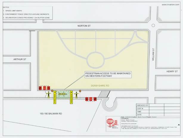
A TCP outlining the proposed closure is shown on the following plan.
PUBLIC CONSULTATION
The proposed closure of Derbyshire Road, Leichhardt at the rear of Nos.160-180 Balmain Road (Sydney Secondary College) is currently advertised in the local newspaper for a period of 28 days and closes on April 10th 2018.
The applicant is to notify all affected residents and businesses in writing at least 7 days prior to the commencement of works and make reasonable provision for residents and businesses, where possible.
CONCLUSION
It is recommended that the proposed temporary road closure be approved, subject to the conditions outlined in this report.
|
|
Local Traffic Committee Meeting 10 April 2018 |
Subject: Temporary Full Road Closure - Unnamed Laneway running parallel between Young Street and Annandale Street, Annandale (section between Gillies Street and Wisdom Street) (Balmain Ward / Balmain Electorate / Leichhardt LAC)
Prepared By: Manod Wickramasinghe - Coordinator – Traffic and Parking Services
Authorised By: John Stephens - Traffic and Transport Services Manager
|
SUMMARY An application has been received from The Traffic Marshal for the temporary full road closure of the Unnamed Laneway running parallel between Young Street and Annandale Street, Annandale (section between Gillies Street and Wisdom Street) to facilitate a crane lift from 7:00am to 4:00pm on Monday 30th April to Wednesday 2nd May 2018 (back up date of Monday 7th May to Wednesday 9th May 2018). It is recommended that the proposed temporary road closure be approved, subject to the conditions outlined in this report. |
|
THAT the proposed temporary full road closure of the Unnamed Laneway running parallel between Young Street and Annandale Street (section between Gillies Street and Wisdom Street), Annandale to facilitate a crane lift from 7:00am to 4:00pm on Monday 30th April to Wednesday 2nd May 2018 (back up date of Monday 7th May to Wednesday 9th May 2018)be approved, subject to the following conditions:
1. A fee of $1,540 for the temporary full road closure is payable by the applicant in accordance with Council’s Fees and Charges;
2. The temporary full road closure be advertised in the local newspaper providing 28 days’ notice for submissions, in accordance with the Roads Act;
3. A Traffic Management Plan (TMP) be submitted to Roads and Maritime Services for consideration and approval;
4. A Traffic Control Plan (TCP) which has been prepared by a certified Traffic Controller, is to be submitted to Council for review with a copy of the Traffic Controllers certification number attached to the plan, not less than 5 days prior to implementation of the closure;
5. A Road Occupancy License be obtained by the applicant from the Transport Management Centre;
6. A notice of the proposed closure be forwarded by the applicant to the NSW Police, Fire and Rescue NSW and the NSW Ambulance Services;
7. Notification signs advising of the proposed road closures and new traffic arrangements to be strategically installed and maintained by the applicant at each end of the street at least 7 days prior to the closure;
8. All affected residents and businesses shall be notified in writing, by the applicant, of the proposed temporary road closure at least 7 days in advance of the closure with the applicant making reasonable provision for residents;
9. Vehicular and pedestrian access for residents and businesses to their off-street car parking spaces be maintained where possible whilst site works are in progress;
10. Adequate vehicular traffic control shall be provided for the protection and convenience of pedestrians and motorists including appropriate signage and flagging. Workers shall be specially designated for this role, as necessary to comply with this condition. This is to be carried out in accordance with the Australian Standard AS 1742.3 - Traffic Control Devices for works on roads;
11. The holder of this approval shall indemnify the Council against all claims, damages and costs incurred by, or charges made against, the Council in respect to death or injury to any person or damage in any way arising out of this approval. In this regard, a public liability insurance policy for an amount not less than $20,000,000 for any one occurrence is to be obtained and is to note the Council as an interested party. The holder of this approval shall inform its insurer of the terms of this condition and submit a copy of the insurance policy to the Council prior to commencement of the work the subject of this approval;
12. The operator of any unit exercising this approval shall have this approval with them and produce it if required along with any other relevant authority approvals granted in the connection with the work;
13. Mobile cranes, cherry pickers or concrete boom pumps shall not stand within the public way for extended periods when not in operation under this approval; and
14. The operation of the heavy plant shall not give rise to an "offensive noise" as defined in the Protection of Environment Operations Act, 1997. Furthermore, vibrations and/or emission of gases that are created during its operations and which are a nuisance, or dangerous to public health are not permitted; all work is to be carried out in accordance with Work Cover requirements; and the costs to repair damages, as a result of these works, to Council's footway and roadway areas will be borne by the applicant. |
BACKGROUND
An application has been received from The Traffic Marshal for the temporary full road closure of the Unnamed Laneway running parallel between Young Street and Annandale Street, Annandale (section between Gillies Street and Wisdom Street) to facilitate a crane lift.
The road occupancy has been proposed from 7:00am to 4:00pm on Monday 30th April to Wednesday 2nd May 2018 (back up date of Monday 7th May to Wednesday 9th May 2018).
FINANCIAL IMPLICATIONS
Nil.
OTHER STAFF COMMENTS
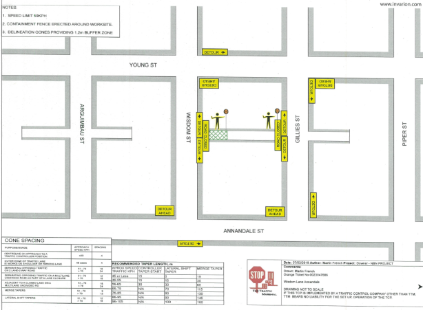
A TCP outlining the proposed closure is below.
PUBLIC CONSULTATION
The proposed closure of the Unnamed Laneway running parallel between Young Street and Annandale Street (section between Gillies Street and Wisdom Street), Annandale is currently advertised in the local newspaper for a period of 28 days and closed on the 17th April.
The applicant is to notify all affected residents and businesses in writing at least 7 days prior to the commencement of works and make reasonable provision for residents and businesses, where possible.
CONCLUSION
It is recommended that the proposed temporary road closure be approved, subject to the
conditions outlined in this report.
|
|
Local Traffic Committee Meeting 10 April 2018 |
Subject: Temporary
Road Closure to Dismantle Tower Crane on Mcgill Street, Lewisham (Stanmore
Ward/ Marrickville Electorate/Marrickville LAC)
Prepared By: Idris Hessam - Road Access Engineer, Design and Investigation
Authorised By: John Stephens - Traffic and Transport Services Manager
|
SUMMARY An application has been received from Level 33 for the temporary full road closure of McGill Street (between Old Canterbury Road and Hudson Street) Lewisham for a period of 1 day from 7:00am to 5:30pm on 28th April 2018 in order to dismantle a tower crane on McGill Street, Lewisham. It is recommended that the proposed temporary road closure be approved, subject to the conditions outlined in this report |
|
THAT the proposed temporary full road closure of McGill Street (between Old Canterbury Road and Hudson Street) Lewisham for a period of 1 day from 7:00am to 5:30pm on 28th April 2018 in order to dismantle a tower crane on McGill Street, Lewisham, subject to the following conditions:
1. A fee of $1,540.60 for the temporary full road closure is payable by the applicant in accordance with Council’s Fees and Charges; 2. The temporary full road closure be advertised in the local newspaper providing 28 days’ notice for submissions, in accordance with the Roads Act; 3. A Traffic Management Plan (TMP) be submitted by the applicant to the Roads and Maritime Services for consideration and approval; 4. A Traffic Control Plan (TCP) which has been prepared by a certified Traffic Controller, is to be submitted to Council for review with a copy of the Traffic Controllers certification number attached to the plan, not less than 5 days prior to implementation of closure; 5. A Road Occupancy License be obtained by the applicant from the Roads and Maritime Services’ Transport Management Centre; 6. Notice of the proposed closure be forwarded by the applicant to the NSW Police, the NSW Fire Brigades and the NSW Ambulance Services; 7. Notification signs advising of the proposed road closures and new traffic arrangements to be strategically installed and maintained by the applicant at each end of the street at least 7 days prior to the closure; 8. All affected residents and businesses shall be notified in writing, by the applicant, of the proposed temporary road closure at least 7 days in advance of the closure with the applicant making reasonable provision for residents; 9. vehicular and pedestrian access for residents and businesses to their off-street car parking spaces be maintained where possible whilst site works are in progress; 10. Adequate vehicular traffic control shall be provided for the protection and convenience of pedestrians and motorists including appropriate signage and flagging. Workers shall be specially designated for this role, as necessary to comply with this condition. This is to be carried out in accordance with the Australian Standard AS 1742.3 - Traffic Control Devices for works on roads; 11. The holder of this approval shall indemnify the Council against all claims, damages and costs incurred by, or charges made against, the Council in respect to death or injury to any person or damage in any way arising out of this approval. In this regard, a public liability insurance policy for an amount not less than $20,000,000 for any one occurrence is to be obtained and is to note the Council as an interested party. The holder of this approval shall inform its insurer of the terms of this condition and submit a copy of the insurance policy to the Council prior to commencement of the work the subject of this approval; 12. The operator of any unit exercising this approval shall have this approval with them and produce it if required along with any other relevant authority approvals granted in the connection with the work; 13. Mobile cranes, cherry packers or concrete boom pumps shall not stand within the public way for extended periods when not in operation under this approval; 14. The operation of the mobile crane shall not give rise to an "offensive noise" as defined in the Protection of Environment Operations Act, 1997. Furthermore, vibrations and/or emission of gases that are created during its operations and which are a nuisance, or dangerous to public health are not permitted; 15. All work is to be carried out in accordance with Work Cover requirements; and 16. The costs to
repair damages, as a result of these works, to Council's footway and |
BACKGROUND
An application has been received from Level 33 for the temporary full road closure of McGill Street (between Old Canterbury Road and Hudson Street) Lewisham for a period of 1 day from 7:00am to 5:30pm on 28th April 2018 in order to dismantle a tower crane on McGill Street, Lewisham.
FINANCIAL IMPLICATIONS
Under Council’s Fees & Charges, the applicant is to pay a fee of $1,540.00 for the temporary full road closure. This fee includes advertising the proposal in accordance with the Roads Act 1993.
OTHER STAFF COMMENTS
PUBLIC CONSULTATION
The applicant is to notify all affected residents and businesses in writing at least 7 days prior to the commencement of works. The proposed road closure is to be advertised in the local newspaper in accordance with the Roads Act 1993.
CONCLUSION
It is recommended that the proposed temporary road closures be approved, subject to the conditions outlined in this report.
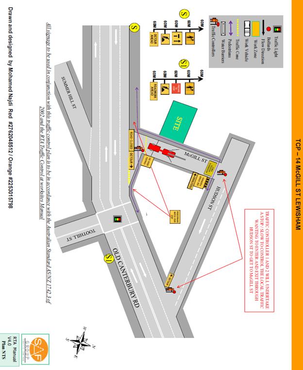
Traffic Control Plan submitted by the applicant – McGill Street, Lewisham
|
|
Local Traffic Committee Meeting 10 April 2018 |
Subject: Change in parking meter operational hours - Norton Street, Leichhardt and Darling Street, Rozelle/Balmain (Balmain and Leichhardt Wards / Balmain Electorate / Leichhardt LAC)
Prepared By: Manod Wickramasinghe - Coordinator – Traffic and Parking Services
Authorised By: John Stephens - Traffic and Transport Services Manager
|
SUMMARY Council at its meeting held 13th March 2018 considered a report regarding parking meter operations in Leichhardt, Rozelle and Balmain and subsequently resolved to turn off parking meters at 7pm on Norton Street, Leichhardt; Darling Street, Rozelle and Darling Street, Balmain.
|
|
THAT the following changes to regulatory signage be endorsed:
1. On Norton Street, Leichhardt between Parramatta Road and Allen Street:
a. The existing ‘2P ticket 8am - 6pm (Mon-Sat); 4P ticket 6pm - 10pm (Mon-Sat), 8am- 10pm (Sun)’ restrictions be modified to ‘2P ticket 8am - 7pm (Mon-Sat); 4P ticket 8am- 7pm (Sun)’; and
b. The existing ‘Loading Zone ticket 8am - 6pm (Mon - Fri); 2P ticket 8am - 6pm (Sat); 4P ticket 6pm - 10pm (Mon - Sat), 8am -10pm (Sun)’ restriction be modified to ‘Loading Zone ticket 8am - 7pm (Mon - Fri); 2P ticket 8am - 7pm (Sat);4P ticket 8am -7pm (Sun)’.
2. On Darling Street, Rozelle between Wise Street and Denison Street:
a. The existing ‘2P ticket 8am - 6pm; 4P 6pm - 10pm’ restrictions be modified to ‘2P ticket 8am - 7pm’;
b. The existing ‘1/2P ticket 8am - 6pm; 4P ticket 6pm - 10pm’ restrictions be modified to ‘1/2P ticket 8am - 7pm’;
c. The existing ‘No Stopping 6.30am - 9.30am & 3.30pm - 6.30pm (Mon-Fri); 2P ticket 9.30am - 3.30pm (Mon-Fri), 8am-6:30pm (Sat-Sun); 4P ticket 6.30pm - 10pm’ restrictions be modified to ‘No Stopping 6.30am - 9.30am & 3.30pm - 6.30pm (Mon-Fri); 2P ticket 9.30am - 3.30pm( Mon -Fri), 8am - 7pm (Sat-Sun)’;
d. The existing ‘No Stopping 3:30pm-6:30pm (Mon-Fri); 2P ticket 8am - 3:30pm (Mon Fri), 8am - 6:30pm (Sat-Sun); 4P ticket 6:30pm - 10pm’ restrictions be modified to ‘No Stopping 3:30pm-6:30pm (Mon-Fri) 2P ticket 8am - 3:30pm (Mon Fri), 8am -7pm (Sat-Sun)’;
e. The existing ‘Loading Zone ticket 8am - 12pm (Mon- Fri); 2P ticket 12pm - 6pm (Mon - Fri) and 8am - 6pm (Sat and Sun), 4P ticket 6pm - 10pm (7 days)’ restrictions be modified to ‘Loading Zone ticket 8am - 12pm (Mon- Fri); 2P ticket 12pm - 7pm (Mon – Fri) and 8am - 7pm (Sat and Sun)’; and
f. The existing ‘Loading Zone ticket 8am-12pm (Mon-Fri); Taxi Zone 10pm - 3am; 2P ticket 8am - 6pm; 4P ticket 6pm - 10pm’ restrictions be modified ‘Loading Zone ticket 8am-12pm (Mon-Fri); Taxi Zone 10pm - 3am; 2P ticket 8am - 7pm’.
3. On Darling Street, Balmain between King Street and Curtis Road:
a. The existing ‘2P ticket 8am - 6pm; 4P ticket 6pm - 10pm’ restrictions be modified to ‘2P ticket 8am - 7pm’;
b. The existing ‘1/2P ticket 8am - 6pm; 4P ticket 6pm - 10pm; Taxi Zone at other times’ restrictions be modified to ‘1/2P ticket 8am - 7pm; Taxi Zone at other times’;
c. The existing ‘Loading Zone ticket 8am-12pm (Mon-Fri); 2P ticket 12pm - 6pm (Mon - Fri) and 8am - 6pm (Sat and Sun); 4P ticket 6pm - 10pm’ restrictions be modified to ‘Loading Zone ticket 8am-12pm (Mon-Fri); 2P ticket 12pm - 7pm (Mon - Fri) and 8am - 7pm (Sat and Sun)’;
d. The existing ‘2P ticket 8am-6pm (Sun-Fri); 4P ticket 6pm-10pm; Loading Zone (no ticket) 9am-3:30pm (Sat); 1/4P (no ticket) 7am-9am and 3:30pm-6pm (Sat)’ restrictions be modified to ‘2P ticket 8am-7pm (Sun-Fri); Loading Zone (no ticket) 9am-3:30pm (Sat); 1/4P (no ticket) 7am-9am and 3:30pm-7pm (Sat)’; and
e. The existing ‘Loading Zone ticket 8am - 12pm Mon-Fri; 2P ticket 12pm - 6pm; 4P ticket 6pm - 10pm’ restrictions be modified to ‘Loading Zone ticket 8am - 12pm Mon-Fri; 2P ticket 12pm - 7pm’.
|
BACKGROUND
Council at its meeting held 13th March 2018 considered a report regarding parking meter operations in Leichhardt, Rozelle and Balmain and subsequently resolved to turn off parking meters at 7pm on Norton Street, Leichhardt; Darling Street, Rozelle and Darling Street, Balmain.
Existing parking meter restrictions in these streets typically operate from 8am to 10pm and so in order to fulfil the Council resolution the regulatory parking signage must be amended to match the shutdown of the parking meters at 7pm.
FINANCIAL IMPLICATIONS
As reported in the March Council report, the financial implication of these measure will result in a loss of approximately $1.1M made up of both parking meter and parking enforcement revenue losses.
OTHER STAFF COMMENTS
There are a number of different metered (ticket) parking restrictions in Norton Street, Leichhardt; Darling Street, Rozelle and Darling Street, Balmain.
In order to allow the parking meters to be switched off at 7pm, the parking restrictions have been modified as shown in the following table. The Police and RMS were notified of the changes to the parking signage and no objection was received, subsequently the signposted metered (ticket) parking restrictions were modified the week of the 26th of March 2018.
|
Current Parking Restriction |
Amended parking restriction |
|
Norton Street, Leichhardt between Parramatta Road and Allen Street
|
|
|
‘2P ticket 8am - 6pm(Mon-Sat); 4P ticket 6pm - 10pm(Mon-Sat), 8am- 10pm (Sun)’
|
‘2P ticket 8am - 7pm(Mon-Sat); 4P ticket 8am- 7pm (Sun)’ |
|
‘Loading Zone ticket 8am - 6pm (Mon - Fri), 2P ticket 8am - 6pm (Sat); 4P ticket 6pm - 10pm (Mon - Sat), 8am -10pm (Sun)’
|
Loading Zone ticket 8am - 7pm (Mon - Fri), 2P ticket 8am - 7pm (Sat); 4P ticket 8am -7pm (Sun)’ |
|
Darling Street, Rozelle between Wise Street and Denison Street
|
|
|
‘2P ticket 8am - 6pm; 4P 6pm - 10pm’
|
‘2P ticket 8am - 7pm’ |
|
‘1/2P ticket 8am - 6pm; 4P ticket 6pm - 10pm’
|
‘1/2P ticket 8am - 7pm’ |
|
‘No Stopping 6.30am - 9.30am & 3.30pm - 6.30pm (Mon-Fri); 2P ticket 9.30am - 3.30pm (Mon -Fri), 8am-6:30pm (Sat-Sun); 4P ticket 6.30pm - 10pm’
|
‘No Stopping 6.30am - 9.30am & 3.30pm - 6.30pm (Mon-Fri) 2P ticket 9.30am - 3.30pm (Mon -Fri), 8am-7pm (Sat-Sun)’
|
|
‘No Stopping 3:30pm-6:30pm (Mon-Fri); 2P ticket 8am - 3:30pm (Mon Fri), 8am -6:30pm (Sat-Sun); 4P ticket 6:30pm - 10pm’
|
‘No Stopping 3:30pm-6:30pm (Mon-Fri); 2P ticket 8am - 3:30pm (Mon Fri), 8am -7pm (Sat-Sun)’; |
|
The ‘Loading Zone ticket 8am - 12pm (Mon- Fri); 2P ticket 12pm - 6pm (Mon - Fri) and 8am - 6pm (Sat and Sun); 4P ticket 6pm - 10pm (7 days)’
|
‘Loading Zone ticket 8am - 12pm (Mon- Fri); 2P ticket 12pm - 7pm (Mon - Fri) and 8am - 7pm (Sat and Sun)’ |
|
‘Loading Zone ticket 8am-12pm (Mon-Fri); Taxi Zone 10pm - 3am; 2P ticket 8am - 6pm; 4P ticket 6pm - 10pm’
|
‘Loading Zone ticket 8am-12pm (Mon-Fri); Taxi Zone 10pm - 3am; 2P ticket 8am - 7pm’ |
|
Darling Street, Balmain between King Street and Curtis Road
|
|
|
All ‘2P ticket 8am - 6pm; 4P ticket 6pm - 10pm’
|
‘2P ticket 8am - 7pm’
|
|
‘1/2P ticket 8am - 6pm; 4P ticket 6pm - 10pm; Taxi Zone at other times’
|
‘1/2P ticket 8am - 7pm; Taxi Zone at other times’ |
|
‘Loading Zone ticket 8am-12pm (Mon-Fri); 2P ticket 12pm - 6pm (Mon - Fri) and 8am - 6pm (Sat and Sun); 4P ticket 6pm - 10pm’
|
‘Loading Zone ticket 8am-12pm (Mon-Fri); 2P ticket 12pm - 7pm (Mon - Fri) and 8am - 7pm (Sat and Sun)’ |
|
‘2P ticket 8am-6pm (Sun-Fri); 4P ticket 6pm-10pm; Loading Zone (no ticket) 9am-3:30pm (Sat); 1/4P (no ticket) 7am-9am and 3:30pm-6pm (Sat)’
|
‘2P ticket 8am-7pm (Sun-Fri); Loading Zone (no ticket) 9am-3:30pm (Sat); 1/4P (no ticket) 7am-9am and 3:30pm-7pm (Sat)’ |
|
‘Loading Zone ticket 8am - 12pm Mon-Fri; 2P ticket 12pm - 6pm; 4P ticket 6pm - 10pm’
|
‘Loading Zone ticket 8am - 12pm Mon-Fri; 2P ticket 12pm - 7pm’ |
PUBLIC CONSULTATION
Nil.
CONCLUSION
It is recommended that changed parking meter (ticket) restrictions in Leichhardt, Rozelle and Balmain be endorsed to reflect the change in parking meter (ticket) operational hours.
|
|
Local Traffic Committee Meeting 10 April 2018 |
Subject: Various locations, Inner West - signposting of load limits/height clearances on a number of bridges over/under light rail network in Inner West Local Government Area
Prepared By: Jennifer Adams - Engineer – Traffic and Parking Services
Authorised By: John Stephens - Traffic and Transport Services Manager
|
SUMMARY Transdev Sydney (TDS), operator of the Inner West Light Rail network (IWLR), have recently completed inspections and qualified outstanding load ratings of the over bridge assets that interface with the IWLR. TDS are now requesting confirmation of this advice and assurance from Council that these bridges are being used and traffic managed within safe operational limits as identified.
An audit of the itemized light rail bridge crossings in the Inner West was conducted and new load limit / height clearance signage has been identified as being required at a number of locations to ensure public safety and asset protection. This report details the signage required to be installed by Council. No existing on-street parking will be affected by the proposed improvement works. It is noted that three crossings involve State roads and therefore need to be referred to the RMS (Site locations 3, 5 and 8).
It is recommended that the proposed signage be approved and implemented subject to the approval of the TMP by the RMS. |
|
THAT:
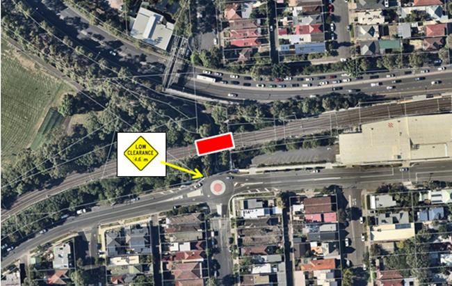
1. ‘LOW CLEARANCE 4.6m’ warning sign be installed on the north east corner of the intersection of Darley Road / Charles Street, Leichhardt as detailed in Site sketch 1;
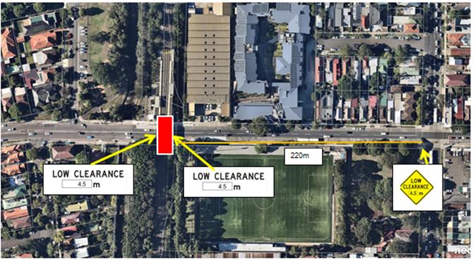
2. ‘LOW CLEARANCE 4.5m’ signs be installed on both sides of the bridge and a ‘LOW CLEARANCE 4.5m’ warning sign be installed 220 metres east of the underbridge on the lamp post on the south east corner of the intersection of Marion Street / Foster Street, Leichhardt as detailed in Site sketch 2;
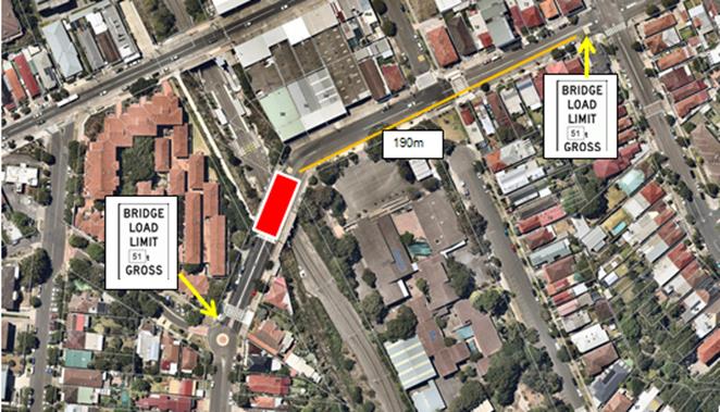
3. ‘BRIDGE LOAD LIMIT 51t GROSS’ signs be installed on Hercules Street on the lamp post on the north west corner of the roundabout with Consett Street and 190 metres east of the overbridge on the south west corner of Hercules Street / Beach Road, Dulwich Hill as detailed in Site sketch 4;
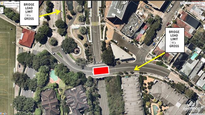
4. BRIDGE LOAD LIMIT 18t GROSS’ signs be installed on Constitution Road, Dulwich Hill in the same locations as the present ‘19t’ load limit signs are positioned on both approaches to the light rail bridge crossing as detailed in Site sketch 6;
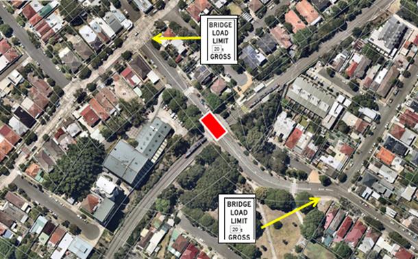
5. ‘BRIDGE LOAD LIMIT 20t GROSS’ signs be installed on both approaches to the over line bridge on Davis Street, Dulwich Hill 90 metres north on the south east corner of Davis Street / Windsor Road intersection and 90 metres south on the western side of Davis Street opposite Victoria Street as detailed in Site sketch 7;
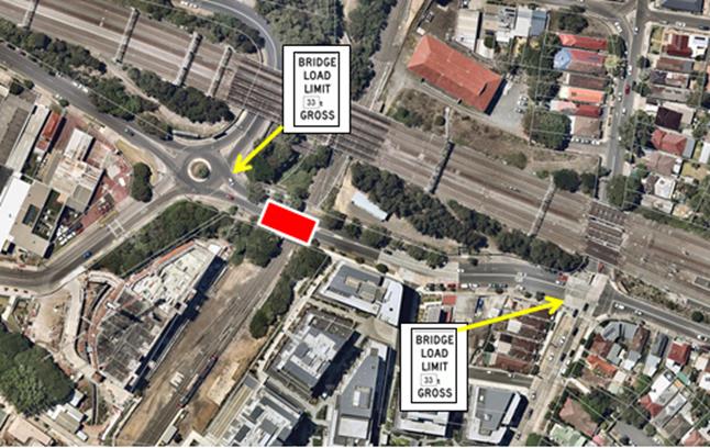
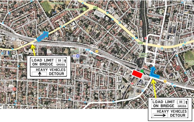
6. ‘BRIDGE LOAD LIMIT 33t GROSS’ signs be installed on both approaches to the over line bridge on Longport Street, Lewisham 40 metres west on the north east corner of the roundabout with Grosvenor Crescent/ Carlton Crescent /Smith Street and 130 metres east of the overbridge on south west corner of Longport Street /Old Canterbury Road intersection as detailed in Site sketch 9. Load limit on bridge detour signs needed at Carlton Crescent / Hume Highway and Longport Street / Old Canterbury Road;
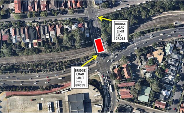
7. ‘BRIDGE LOAD LIMIT 40t GROSS’ signs be installed on Balmain Road, Leichhardt at the over bridge on the north west corner of Balmain Road / City-West Link Road intersection and 40 metres north of the over bridge on the south west corner of Balmain Road / Lilyfield Road intersection as detailed in Site sketch 10;
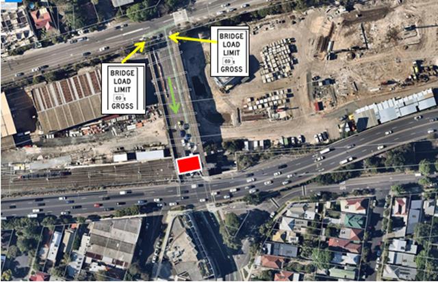
8. ‘BRIDGE LOAD LIMIT 69t GROSS’ signs be installed on both sides of Catherine Street, Lilyfield on the south side of the its intersection with Lilyfield Road 85 metres north of the over line bridge as detailed in Site sketch 11;
9. The RMS be notified that three (3) light rail network bridge crossings in the Inner West involve State roads and appropriate signage is requested accordingly; and
10. The operator Transdev Sydney be advised in terms of this report. |
BACKGROUND
In a letter to Council dated 31 January 2018 Transdev Sydney(TDS), operator of the Inner West Light Rail network (IWLR), stated that they have recently completed inspections and qualified outstanding load ratings of the over bridge assets that interface with the IWLR. TDS request confirmation of this advice and assurance from Council that these bridges are being used and traffic managed within safe operational limits as identified in the table below.
T44 Vehicular loads were considered for the assessment in accordance with AS5100.7 and based on the range of values outlined in the Masonry Structures code AS3700-2011. The bridges load limits shown, note condition ratings of maximum qualified loadings and limited loadings, highlighted in red, that are currently measured as having less than a 1.0 index rating, meaning that they are subject to restrictions on vehicular carrying capacity and require the installation of additional signage controls.
They also state that these identified bridges are managed under the Transdev Sydney asset management system using accredited contractors. Inspections scheduled and compliance assured is by a certified Authorised Engineering Organisation for bridges.
In addition to the bridges listed, Transdev Sydney request confirmation that any additional bridges across the IWLR that are the sole responsibility of IWC are safe, fit for purpose and being maintained to legislative requirements.
It is noted that the load limits shown in the table are for overbridge assets, where the bridge structures themselves are maintained by Transdev Sydney and the road surface and associated components have been identified as the responsibility of the Inner West Council. A copy of Transdev Sydney’s letter to Council is attached at the end of this report.
FINANCIAL IMPLICATIONS
Funds for traffic facilities are allocated each year in Council’s annual budget and funds under the 2018/19 Capital Works Program will be used to complete these works. The cost of the proposed signage is approximately $6,000.
OFFICER COMMENTS
Bridge load limits influence the maximum permissible load of traffic traversing the bridge. A bridge load limit is a restriction placed on the mass vehicles allowed to cross a given bridge. Bridge load limits are typically determined by a specialist structural engineer. Regulatory signs are placed at both approaches to a bridge with a load limit, and it is a NSW Police responsibility to ensure the signs are complied with.
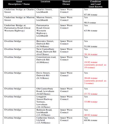
An audit of the itemized light rail bridge crossings in the Inner West identified by Transdev Sydney was conducted and new load limit / height clearance signage has been identified as being required at a number of locations to ensure public safety and asset protection. The following table shows the results of the audit and lists the additional signage required:
|
|
Name / Asset type |
Location |
Shared Owner |
Condition and Load Limit Known |
Audit – Signs present and type |
Signage Required |
|
1 |
Underline bridge - at Charles Street |
Charles Street, Leichhardt |
Inner West Council |
Yes - 87.88 Tonne |
Low Clearance 4.6m signs on both sides of bridge |
Low clearance 4.6m warning (W4-8) sign required on approach. No detour signage as unlikely to get high loads in area. |
|
2 |
Underline bridge - at Marion Street |
Marion Street, Leichhardt |
Inner West Council |
Yes - 98.8 Tonne |
Low clearance 4.5m warning sign on east approach only No signs on bridge |
Low clearance 4.5m signs (R6-11) required both sides of the bridge. Warning 4.5m (W4-8) sign required on east approach. No need for detour signs as no connection to any major roads. |
|
3 |
Underline bridge - at Parramatta Road (Great Western Highway) |
Parramatta Road (Great Western Highway), Leichhardt |
RMS Inner West Council |
Yes - 63.96 Tonne |
Low Clearance 4.9m signs on Bridge both sides. Warning sign east approach only |
Warning (W4-8) sign required on western approach - RMS |
|
4 |
Over line bridge - Hercules Street, Dulwich Hill |
Hercules Street, Dulwich Hill (8.544kms) |
Inner West Council |
Yes - 51.04 Tonne |
No Tonne Signs at all |
‘Bridge Load limit 51t Gross’ signs (R6-3) required both approaches. Back streets and unlikely to get large vehicles so no detour signs required. |
|
5 |
Over line bridge - New Canterbury Road, Dulwich Hill |
New Canterbury Road, Dulwich Hill (8.632kms) |
RMS Inner West Council |
Yes - 28.16 Tonne |
No Tonne Signs at all |
‘Bridge Load limit 28t Gross’ signs both approaches required - RMS |
|
6 |
Over line bridge - Constitution Road, Dulwich Hill |
Constitution Road, Dulwich Hill (8.886kms) |
Inner West Council |
Yes - 18.92 Tonne (currently posted 19) |
19 Tonne Signs present both directions |
‘Bridge Load limit 18t Gross’ signs required both approaches. No detour signage required as 3 tonne limit exists and no heavy industry in area. |
|
7 |
Over line bridge - Davis Street, Dulwich Hill |
Davis Street, Dulwich Hill (9.310kms) |
Inner West Council |
Yes - 20.68 Tonne - currently posted 3t |
3 Tonne warning sign on west approach to bridge only |
‘Bridge Load limit 20t Gross’ signs required both approaches. No detours signs required as 3 tonne limit – ‘light traffic through fare’ -exists in adjoining streets. |
|
8 |
Over line bridge - Old Canterbury Road, Lewisham |
Old Canterbury Road, Lewisham (9.8452kms) |
RMS Inner West Council |
Yes - 27.72 Tonne |
No Tonne Signs at all |
‘Bridge Load limit 27t Gross’ signs both approaches required - RMS |
|
9 |
Over line bridge - Longport Street/Railway Terrace, Lewisham |
Longport Street/Railway Terrace, Lewisham (10.165kms) |
Inner West Council |
Yes - 33.00 Tonne |
No Tonne Signs at all |
‘Bridge Load limit 33t Gross’ signs required both approaches. Load limit on bridge detour signs needed at Carlton Crescent / Hume Highway and Longport Street / Old Canterbury Road. |
|
10 |
Over line bridge - Balmain Road, Leichhardt |
Balmain Road, Leichhardt (13.193kms) |
Inner West Council |
Yes - 40.92 Tonne |
No Tonne Signs at all |
Bridge Load limit 40t Gross’ signs required both approaches. No detour signs necessary with 40t load limit – permit required. |
|
11 |
Over line bridge - Catherine Street, Lilyfield |
Catherine Street, Lilyfield (13.548kms) |
Inner West Council |
Yes - 69.96 Tonne |
No Tonne Signs at all |
Bridge Load limit 69t Gross’ signs required on both sides of approach road heading south. No detour signs necessary with 69t load limit – permit required. |
It is noted that in addition to the identified signage required further additional signage may be necessary at a location to indicate the detour route available should the heavy truck driver not be able to cross a particular bridge crossing due to exceeding the posted load limit. The TMP will address these issues accordingly in more detail.
Specifics of the immediate required signage are shown in the following series of sketches.
Site sketch 1 – Charles Street, Leichhardt
Site sketch 2 – Marion Street, Leichhardt
Site sketch 4 – Hercules Street, Dulwich Hill
Site sketch 6 – Constitution Road, Dulwich Hill
Site sketch 7 – Davis Street, Dulwich Hill
![]()
Site sketch 9 – Longport Street /Railway Terrace, Lewisham
Required Load limit on bridges detour signs:
Site sketch 10 – Balmain Road, Leichhardt
Site sketch 11 – Catherine Street, Lilyfield
Technical issues
All signage is to be installed in accordance to AS1742.2 Appendix D. This Appendix sets out requirements and guidance for the uniform installation and location of signs. It also provides guidance on the mounting angles required to ensure maximum effectiveness of signs.
From 1 August 2013, changes to the Road Transport (Vehicle Registration) Regulation came into effect which allows RMS to suspend heavy vehicle registration for up to three months where a dimension requirement offence has been committed. A dimension requirement offence is where a Clearance, Low Clearance, Load Limit or No Trucks sign on a NSW road, tunnel or bridge has been disobeyed.
If a heavy vehicle is detected committing a dimension requirement offence in NSW, RMS may suspend vehicle registration for up to three months under the Road Transport (Vehicle Registration) Regulation 2017. The changes were introduced to provide protection to assets and infrastructure, improve traffic flow along major road corridors and further improve road safety for all road users.
Road Rule 103 ‘Load limit signs’ states that “A driver must not drive past a bridge load limit (gross mass) sign or gross load limit sign if the total of the gross mass (in tonnes) of the driver’s vehicle, and any vehicle connected to it, is more than the gross mass indicated by the sign.” This is enforceable by NSW Police.
PUBLIC CONSULTATION
No public consultation is required to install the regulatory signage for the load limit / height clearance of the identified light rail bridge crossings. It is noted that the impact of the works is minimal to the general public and no existing on-street parking will be affected by the proposed improvement works.
CONCLUSION
The proposed works will satisfy the request by Transdev Sydney, operator of the Inner West Light Rail network that the identified bridge crossings in the Inner West LGA are being used and traffic managed within safe operational limits. It is recommended that the proposed signage be approved and implemented subject to the approval of the TMP by the RMS.
|
|
Local Traffic Committee Meeting 10 April 2018 |
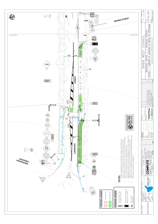
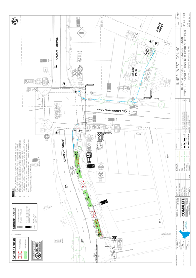
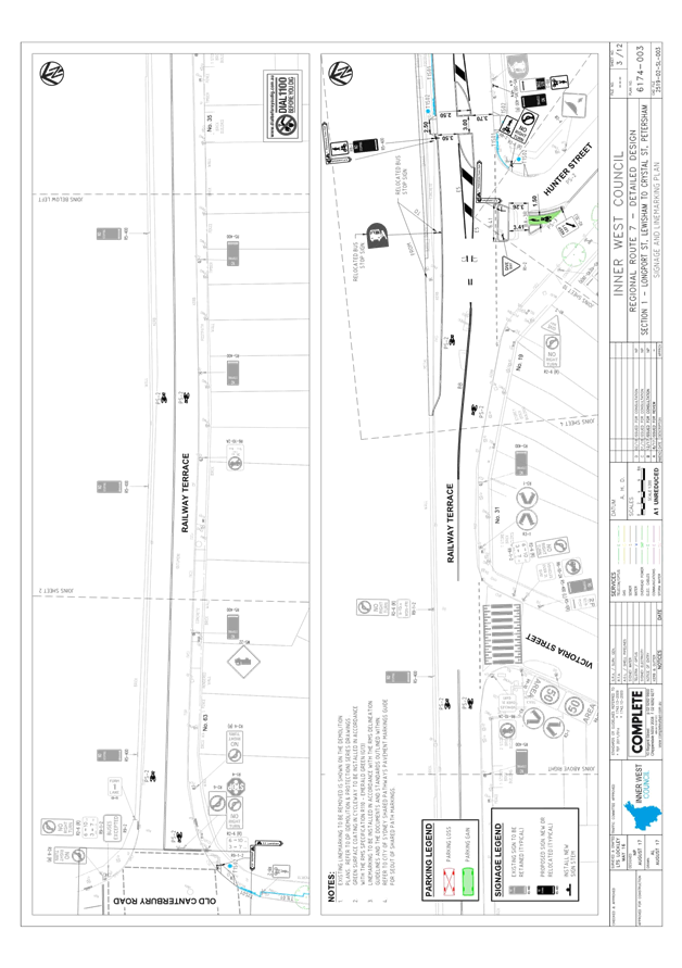
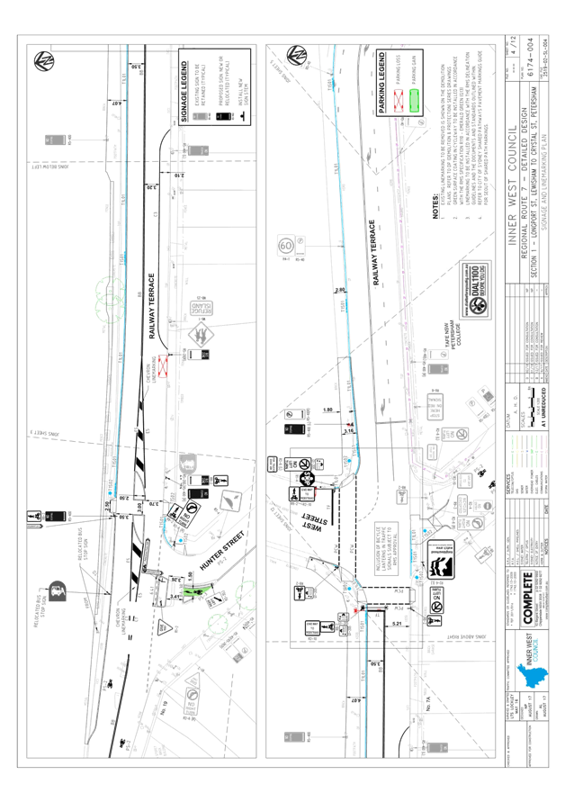
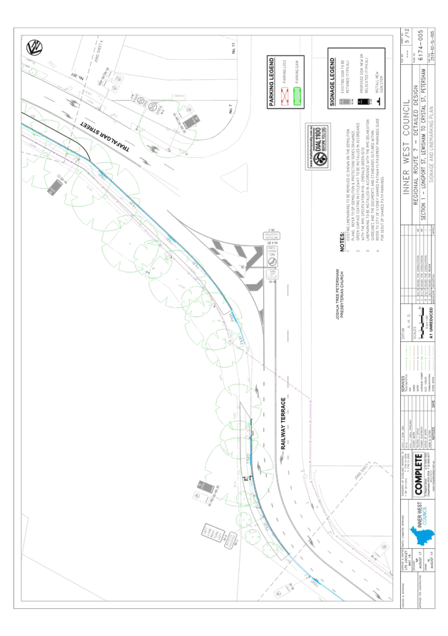
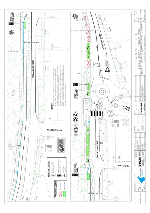
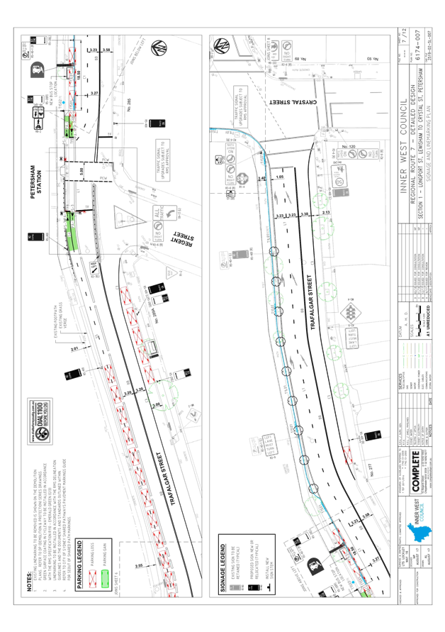
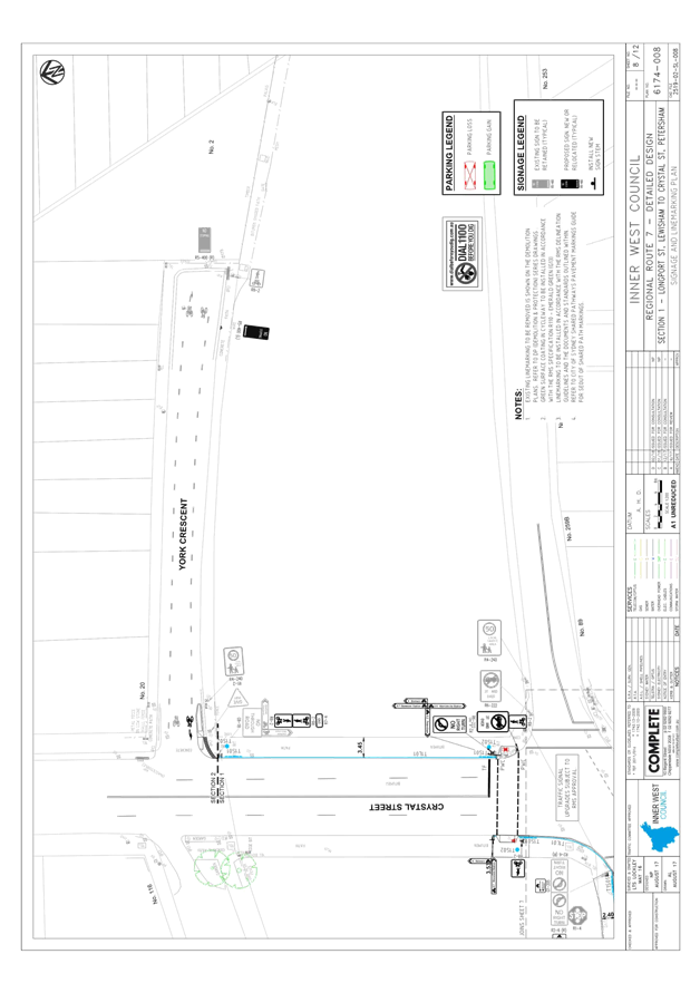
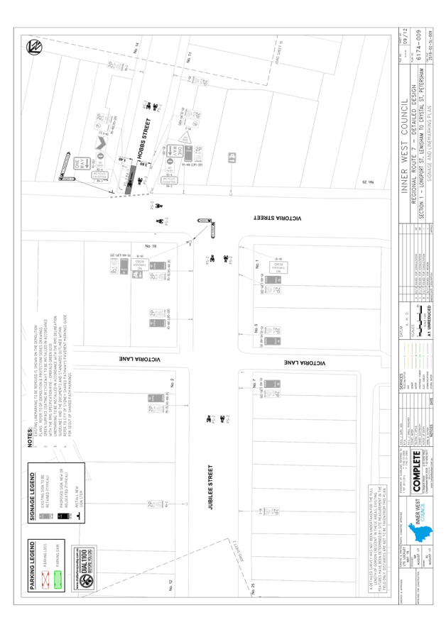
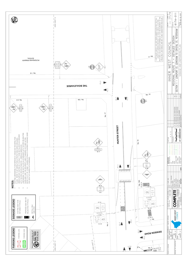
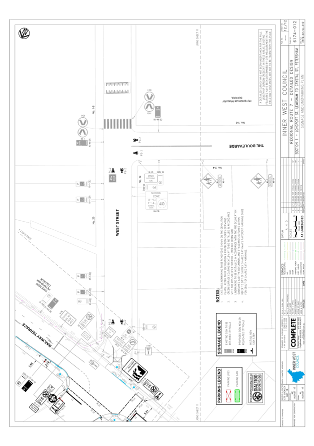
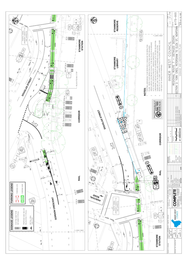
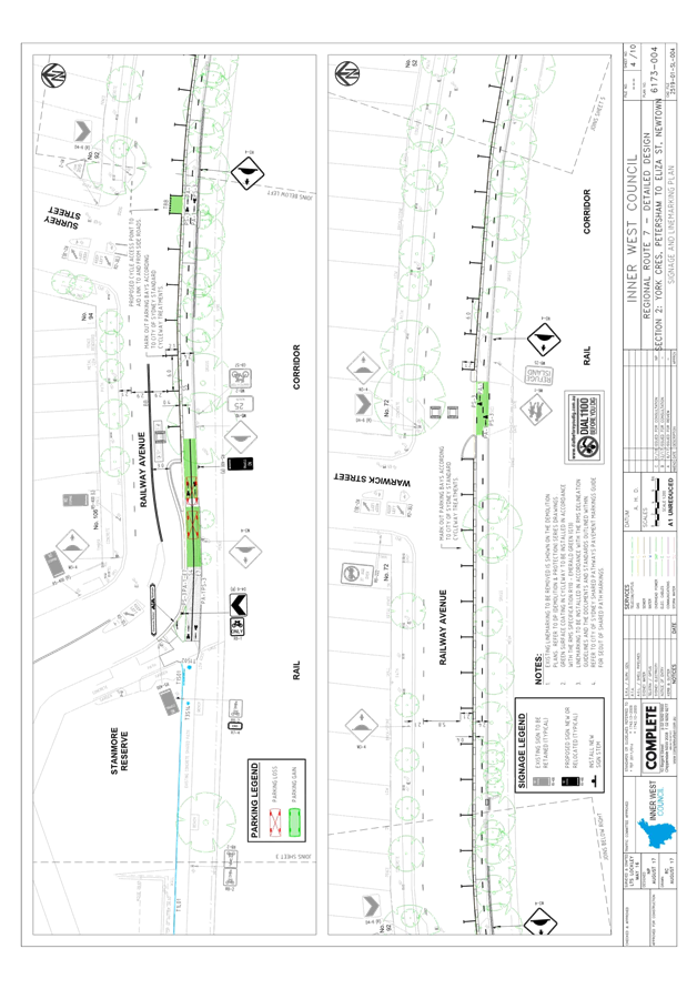
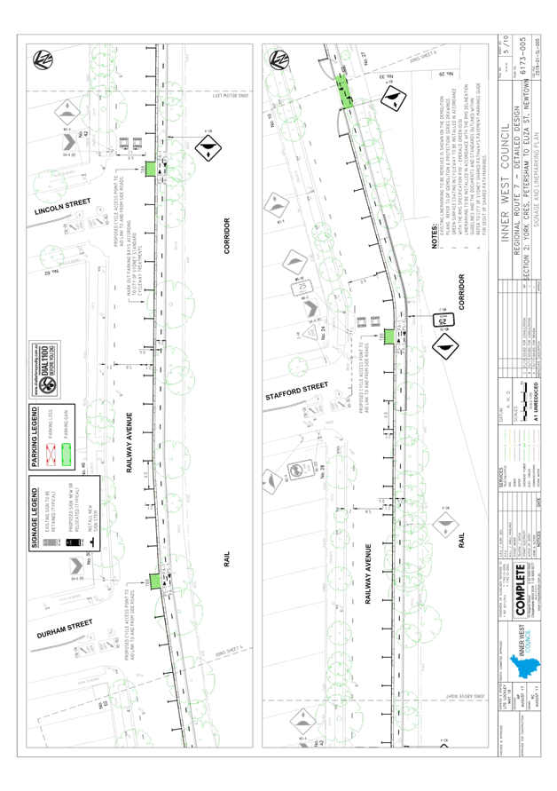
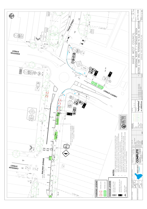
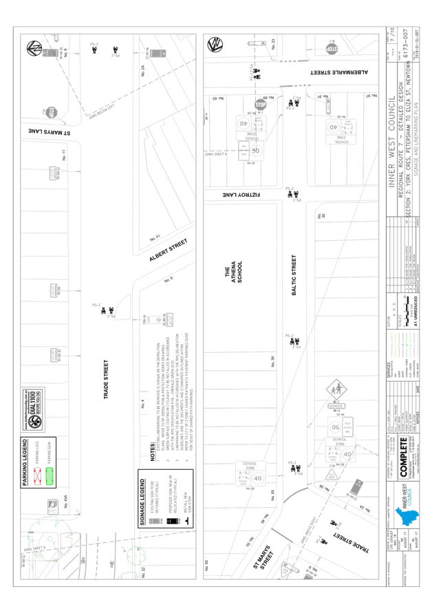
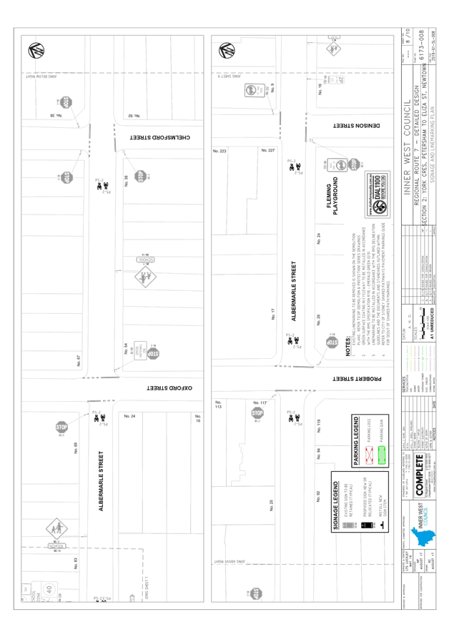
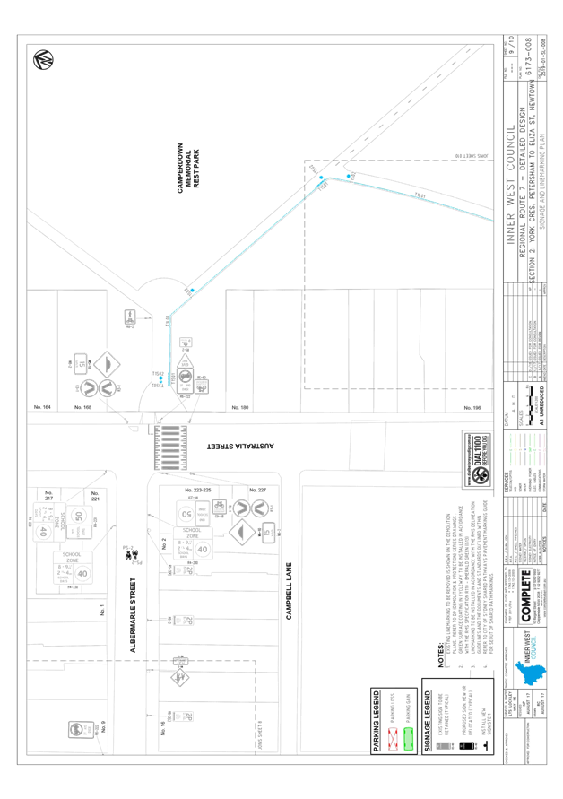
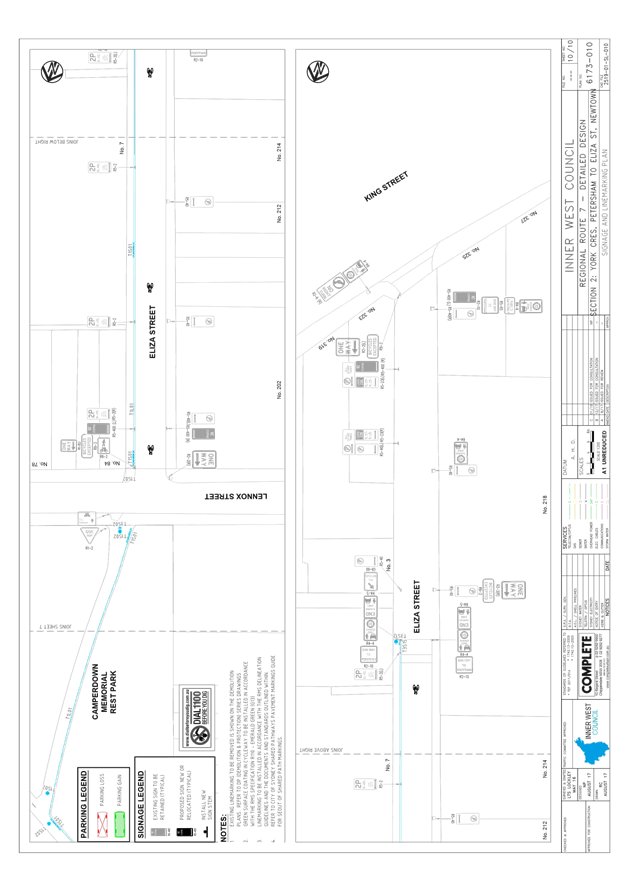
Subject: Regional Bicycle Route 7- Detailed Design Plans (Central & North Wards/Summer Hill & Newtown)
Prepared By: Snezana Bakovic - Project Engineer Traffic
Authorised By: John Stephens - Traffic and Transport Services Manager
|
SUMMARY On December 2016, Council approved a final concept plan for the improvement of Regional Bicycle Route7 which is an identified bicycle route in Council’s Bicycle Plan.
The Regional Route 7(RR7) is an important east-west route between Lewisham and Newtown which links the inner west to Sydney CBD.
The route is 3.8 kilometers long and consists of two sections:
· Section 1 – Longport Street, Lewisham, to Crystal Street, Petersham; and · Section 2 – York Crescent, Petersham, to Eliza Street, Newtown.
The NSW Government identified RR7 as a priority route and is funding the development of the upgrade plans. The aim of the proposal was to make RR7 bicycle route more safe, convenient and more enjoyable for people of all ages and ability to ride.
Based on the approved concept plan the draft design plans have been finalised and are presented in this report for Committee consideration.
It is recommended that the detail design of the RR7 to enhance bicycle connectivity to public transport, local shops and other destination be APPROVED, and Council submit five Traffic Signal Design plans to RMS for consideration and approval.
|
|
THAT:
1. The Regional Bicycle Route7 – Lewisham to Newtown detail design plan (No 6174) be APPROVED; and
2. Council submits related draft traffic Signal design plans to the RMS for consideration and approval. |
BACKGROUND
With support from the NSW Government, Council is proposing to improve RR7 to connect east-west cycleway route through Lewisham and Newtown with Sydney CBD.
In 2016, Council asked the community and other key stakeholders for feedback about this route. The feedback received and technical assessments of the study area were used to develop a draft concept plan. Community members were then invited to give feedback on the draft concept plan and the comments received informed a final concept plan. The final concept plan was considered and approved by Council in February 2017.
Based on the approved concept plan the draft design plans have been finalised (excluding five Traffic Signal Designs) and it is presented in this report for Committee consideration.
The RR7 design plans are presented in attachments;
· Section 1 – Longport Street, Lewisham, to Crystal Street, Petersham- Attachment 1;
· Section 2 – York Crescent, Petersham, to Eliza Street, Newtown - Attachment 2
Image 1 :RR7 –Overview of cycleway route
FINANCIAL IMPLICATIONS
The concept design and detail design of this project has been fully funded (100%) by the NSW Government’s Active Transport Program (Priority Cycleways). The construction of the route depends on further available budget and grant applications. The preliminary design estimated cost is $6,700,000.
OTHER STAFF COMMENTS
The proposed work includes:
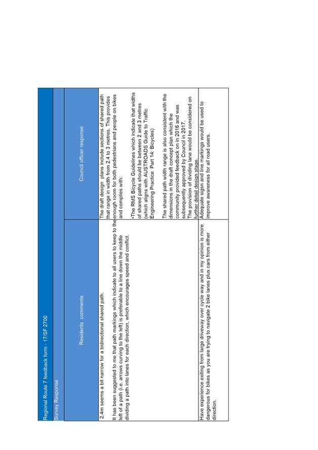
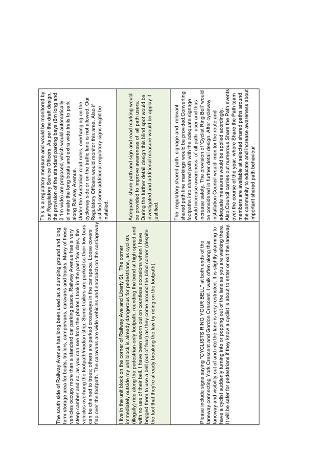
· Provision of 2.4m wide bi-directional separated cycleway along section of Longport Street, Trafalgar Street, Douglas Street and Railway Avenue;
· Widening of existing footpaths to create shared paths (along section of Longport Street, Railway Terrace, Trafalgar Street, Douglas Street) and new shared path crossings to improve pedestrian and bike rider safety;
· Provision of bicycle lanterns, at four existing signalised intersections (Old Canterbury Road / Longport Street Intersection, Railway Terrace / West Street Intersection, Trafalgar Street / Crystal Street Intersection, and Douglas Street / Percival Road Intersection) subject to RMS signal plans approvals.
· Reconstruction of existing pedestrian refuge crossings at Longport Street and Railway Terrace to improve pedestrian and cyclist safety.
· Provision of a shared environment at Brown Street with its intersection with Longport Street to improve safety and convenience for people walking and on bikes.
· Re-aligning of existing roundabout at Trafalgar Street and Audley Street intersection to accommodate the bi - direction separated cycleway.
· Provision of a contra flow cycleway in Hobbs Street Lewisham to provide cycleway connectivity between Victoria Street and Dennison Road.
Other proposed features:
· Street tree replacement and removal – Trees that are ailing or have been identified by Council for replacement would be removed as part of this proposal. New trees and additional landscaping would be investigated to balance the impact of any trees removed.
· Bus stops – The location of bus stops will be slightly repositioned and some would be removed as part of the STA’s bus stop rationalisation plan.
· Signs and road marking – Would be installed to improve motorists’ awareness of people on bikes and keep pedestrians and bike riders aware of each other on shared paths.
· Provision of cycleway way finding signage along the route and cycleway logos on the road to increase drivers’ awareness of the cyclists.
· Relevant signs and road marking would be installed to increase safety for all road and path users.
· Lighting –Lighting assessment would be organised in future stage of the detail design to improve safety. Directly affected resident would be asked to comets on new lighting proposal.
Parking Impacts
The proposed route improvements have been carefully considered to minimise/avoid parking impacts where possible, in response to community concerns raised in preliminary consultation.
The draft plans would create some new on-street parking and remove some existing parking spaces. This would result in an overall loss of 31 parking spaces. All vehicle access to properties along the route will remain.
|
Section1 - Longport Street, Lewisham, to Crystal Street, Petersham |
|
Longport Street - 5 parking spaces removed |
|
Trafalgar Street - 24 parking spaces removed and 1 new space created |
|
Railway Terrace – 1 parking space removed |
|
Section 2 – York Crescent, Petersham, to Eliza Street, Newtown |
|
Railway Avenue near Stanmore Reserve - 2 parking spaces removed |
|
Railway Avenue near Liberty Street - 2 parking spaces removed |
|
Liberty Street – 2 parking space created |
Bus Stop Impacts
There are six bus stops that will be affected by the proposed detailed design plans and are outlined in the tables below.
Section 1 - Longport Street, Lewisham, to Crystal St, Petersham
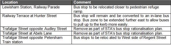
Section 2 -York Crescent, Petersham, to Eliza Street, Newtown

Pedestrian refuge Impacts
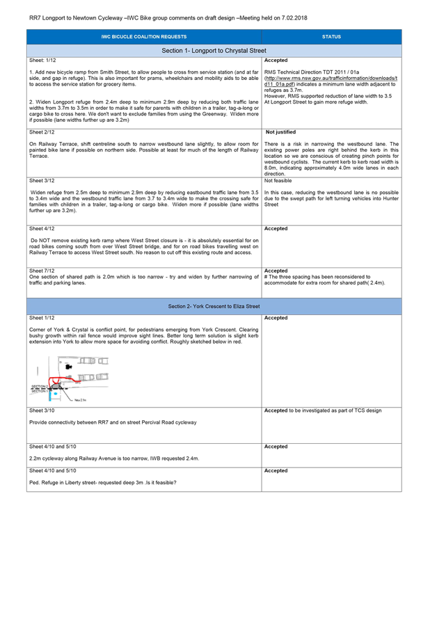
The Inner West Bike Coalition requested widening of pedestrian refuges at Longport Street, Railway Terrace/Hunter Street and Liberty Street to accommodate for cargo bike to cross at those locations.
RMS Technical Direction TDT 2011 / 01a indicates a minimum lane width adjacent to refuges as 3.7m. The RMS supported the reduction of the traffic lane from 3.7 to 3.5m to enable pedestrian refuge widening to gain more refuge width (2.9-3.0m) for cargo bike. The Longport
Street and Liberty Street pedestrian refuge island widths width have been amended. The Railway Terrace/Hunter Street pedestrian refuge island width remained 2.5m due to swept path for the large vehicles.
Shared environment Intersection
On the RR7 route, a shared environment intersection (SEI) is proposed at Brown Street, Lewisham. RMS requested traffic counts for the proposed shared environment intersection treatment .The traffic counts were collected in June 2017 (attached) and the summary is below:
|
Street |
Ave. vehicles in peak hour (V<30) (weekdays) |
Number of hours > 30vph |
Ave. vehicles in peak ¼ hour (V<15) (weekdays) |
Number of ¼ hours >15vph |
Comment |
|
Brown Street, Lewisham |
37 (7:45-8:45am) |
1 |
12 (8:00-8:15am) |
0 |
Slightly exceeds recommended 30vph threshold. |
RMS does not have any objection to this particular SEI, as the volumes only surpassed 30vph at one instance. As there was only one instance of this, RMS is satisfied that a trial is not required.
Traffic Signal Design
Five traffic signalised intersections have to be updated, to improve cyclist and pedestrian safety at these crossings, as part of the RR7 bike route improvement. During the concept design development RMS requested modelling of any changes to the intersections, along RR7 route, which potentially could affect traffic flows. Modelling of the proposed shared bicycle and pedestrian crossing has been carried out and indicates no substantial change to existing intersection operation. The RMS accepted the proposed signalized intersection changes in general subject to final RMS approval.
The following five intersections are proposed to be updated;
1. Old Canterbury Road / Railway Terrace / Longport Street
2. Railway Terrace / West Street
3. Trafalgar Street at Petersham Station
4. Trafalgar Street / Crystal Street
5. Douglas Street / Percival Road
The draft traffic signal designs for the intersections mentioned above would be submitted to RMS for review in April 2018. Once the all Traffic Signal designs have been approved an information report of Traffic Signal Designs would be submitted to the Local Traffic Committee.
Railway Avenue bi directional separate cycle way- rational of proposal
The main reason for proposing the separated cycleway along Railway Avenue is to meet the NSW Government strategic objectives for the route. Council received 100% funding for the route because it is identified as part of the NSW Government’s Principal Bicycle Network and a ‘priority cycleway’ in the Sydney’s Cycling Future strategic document. It is intended to be part of one of the main east-west regional routes connecting local centres between Sydney and Parramatta.
The RMS representatives in preliminary discussions with Council Officers requested high quality infrastructure, including separated bike paths where feasible on this route. Initially Council proposed share path along Railway Avenue but RMS were not satisfied with the proposed shared path and on-street sections on this route.
In line with RMS strategic directives, on Railway Ave, a separated bike path is appropriate for a high quality regional route because there is:
- sufficient carriageway width to accommodate the bike path without removing the parking lane
- spare on-street parking capacity on the southern side of the street so minor loss of parking may be absorbed.
- history of cars speeding/rat-running on this street (Note: Council has installed speed cushions as traffic calming measure) which reduces the safety, attractiveness and comfort for less confident and new riders to cycle in the traffic lanes.
- moderate traffic volumes including through traffic (e.g. some rat-running) .
For some comparison, Wilson Street, Darlington is a street with similar traffic volume and width to Railway Avenue, and is part of the same Sydney to Parramatta priority cycleway. City of Sydney are currently designing a separated bike path there to replace the existing mixed traffic treatment, for the same strategic reasons and with the same level of funding from the NSW Government.
On the other hand, along Gordon Crescent Council Officers didn’t propose a separated bike path because the traffic volumes are very low and the road is a local residential street with minimal through traffic, that is, it was felt a separated bike path was not required. There are also “in-street” trees there that would be affected.
PUBLIC CONSULTATION
1500 consultation letters were sent out on 26 February 2018 to all property owners and occupiers to potentially directly affected residents and stakeholders. A 4 weeks community consultation was concluded on 29 March 2018.
During the 4 weeks community consultation, the detail design plans were available for viewing by community members on Council website and Pethersham Service Centre.
Council received 65 submissions 38 of the summations indicated support, 18 supports with changes and 9 summations objecting proposal.
|
Total Number of summations |
Yes |
Yes with changes |
No |
|
65 |
38 (58%) |
18 (28%) |
9 (14%) |
|
Respond by Location |
Total Number of summations |
Yes |
Yes with changes |
No |
|
Railway Avenue |
5 |
|
4 |
1 |
|
Trafalgar Street |
4 |
|
|
4 |
|
Stanley Street |
1 |
|
|
1 |
|
Railway Terrace |
3 |
|
1 |
2 |
|
Albermarle Street |
1 |
|
1 |
|
|
Gordon Crescent |
2 |
|
2 |
|
|
Other commets |
49 |
38 |
10 |
1 |
|
Total |
65 |
38 |
18 |
9 |
The issues most frequently raised in other submissions by community members were:
|
Issues most frequently raised in community consultation feedback |
Council officer response |
|
Objection to parking loss on Trafalgar Street (4 summations) |
This project has been developed with a focus on minimal parking loss. Unfortunately in some locations such as Trafalgar Street (with high traffic and pedestrian volume) the parking is compromised to allow for provision of two way separate bike path treatment. The separated bike paths are proposed in order to improve bike rider safety and comfort on sections of the route where on–road /shared path alternatives are unsafe due to high traffic and pedestrian volumes and alternative road options are impractical. This is consistent with NSW Government policy of providing appropriate bike infrastructure that meets user needs. |
|
Objection to shared zone and request for “CYCLIST USE YOUR BELL“ signs (2 submissions)
|
Adequate Line Markings and Signs are proposed along shared path. The provision of ‘Cyclist Use Your Bell” sign would be considered in further detail development .Also, Council carries out numerous Share the Path events over the course of the year, where Share the Path team members are available at selected shared paths around the community to educate and increase awareness about important shared path behavior . |
|
Trailers ,boats and caravans parked along Railway Avenue would overhang on the road or cycleway and create a safety hazard for road users ( 2 submissions) |
This is a regulatory measure .As per the draft design the provision of the standard parking bays (6m long and 2.1m wide) are proposed, which would automatically eliminate the long boats and extra wide trails to park along Railway Avenue. Under the Australian road rules overhanging on the cycleway side or on the traffic lane are not allowed. Our Regulatory Officers would monitor this area. |
Some supportive comments received from residents;
Ø Great work team. Very Happy.
Ø Thank you for supporting healthy transport in the Inner west! I commute by bike from Lewisham to Newtown every day and there are some scary sections that definitely need improvement. For example the eastbound section of Railway Terrace between Old Canterbury and Hunter St towards Petersham is not safe for cycling, I'm really happy this has been included in the plan.
Ø A wonderful community investment, great work!
Ø Would love to see more cycling infrastructure made available. Thank you.
A summary of issues raised and Council officer response is presented in Attachment 3
Other stakeholders
Council has also consulted with other stakeholders including RMS, IWC bike, Sydney Trains, Sydney Busses and City of Sydney.
|
Stakeholders |
Comments |
|
RMS |
Detail Design is discussed with RMS prior the community consultation. RMS indicated no objection to the design plans. |
|
Inner West Bike Coalition |
Council have held meeting with the Inner West Bike Coalition representatives prior the community consultation. Inner West Bike Coalition requests were considered and incorporated in the design wherever feasible. A summary of discussion is attached in Appendix 4 Following community consultation, Inner West Bike Coalition did not indicate any further comments on the revised detail design. |
|
Sydney Trains |
Sydney Trains didn’t indicate objection to the detail design plans. |
|
Sydney Buses |
Sydney Buses indicated support to the detail design plans. |
|
City of Sydney |
City of Sydney indicated support to the detail design plans. |
CONCLUSION
The proposed improvements to Regional Route 7 will complete missing links in Council’s bicycle network and enhance bicycle connectivity to public transport, local shops and other destinations.
It is recommended that the detail design of the RR7 to enhance bicycle connectivity to public transport, local shops and other destination as per Design Plans No 6174 be APPROVED, and Council submit five Traffic Signal Design plans to RMS for consideration and approval.
|
1.⇩ |
Section 1 – Longport Street, Lewisham, to Crystal Street, Petersham |
|
2.⇩ |
Section 2 – York Crescent, Petersham, to Eliza Street, Newtown |
|
3.⇩ |
Summary of Community Consultation |
|
4.⇩ |
Summary of Inner West Bike Coalition comments |
|
|
Local Traffic Committee Meeting 10 April 2018 |
Subject: Temporary
Road Closure to Carry Out Sewer Works on Applebee Street, St Peters
(Marrickville Ward/ Heffron Electorate/Newtown LAC)
Prepared By: Idris Hessam - Road Access Engineer, Design and Investigation
Authorised By: John Stephens - Traffic and Transport Services Manager
|
SUMMARY An application has been received from GJ Building and Contracting for the temporary full road closure of Applebee Street (between Lackey Street and Hutchinson Street) St Peters for a period of two weeks from 30/4/2018 till 12/5/2018 with a further two weeks of contingency from 12/5/2018 till 26/5/2018 between the hours of 9:00pm to 5:00am in order to carryout sewer works on Applebee Street, St Peters. It is recommended that the proposed temporary road closure be approved, subject to the conditions outlined in this report. |
|
THAT the proposed temporary full road closure of Applebee Street (between Lackey Street and Hutchinson Street) St Peters for a period of two weeks from 30/4/2018 till 12/5/2018 with a further two weeks of contingency from 12/5/2018 till 26/5/2018 between the hours of 9:00pm to 5:00am, subject to the following conditions:
1. A fee of $1,540.60 for the temporary full road closure is payable by the applicant in accordance with Council’s Fees and Charges; 2. The temporary full road closure be advertised in the local newspaper providing 28 days’ notice for submissions, in accordance with the Roads Act; 3. A Traffic Management Plan (TMP) be submitted by the applicant to the Roads and Maritime Services for consideration and approval; 4. A Traffic Control Plan (TCP) which has been prepared by a certified Traffic Controller, is to be submitted to Council for review with a copy of the Traffic Controllers certification number attached to the plan, not less than 5 days prior to implementation of closure; 5. A Road Occupancy License be obtained by the applicant from the Roads and Maritime Services’ Transport Management Centre; 6. Notice of the proposed closure be forwarded by the applicant to the NSW Police, the NSW Fire Brigades and the NSW Ambulance Services; 7. Notification signs advising of the proposed road closures and new traffic arrangements to be strategically installed and maintained by the applicant at each end of the street at least 7 days prior to the closure; 8. All affected residents and businesses shall be notified in writing, by the applicant, of the proposed temporary road closure at least 7 days in advance of the closure with the applicant making reasonable provision for residents; 9. Vehicular and pedestrian access for residents and businesses to their off-street car parking spaces be maintained where possible whilst site works are in progress; 10. Adequate vehicular traffic control shall be provided for the protection and convenience of pedestrians and motorists including appropriate signage and flagging. Workers shall be specially designated for this role, as necessary to comply with this condition. This is to be carried out in accordance with the Australian Standard AS 1742.3 - Traffic Control Devices for works on roads; 11. The holder of this approval shall indemnify the Council against all claims, damages and costs incurred by, or charges made against, the Council in respect to death or injury to any person or damage in any way arising out of this approval. In this regard, a public liability insurance policy for an amount not less than $20,000,000 for any one occurrence is to be obtained and is to note the Council as an interested party. The holder of this approval shall inform its insurer of the terms of this condition and submit a copy of the insurance policy to the Council prior to commencement of the work the subject of this approval; 12. The operator of any unit exercising this approval shall have this approval with them and produce it if required along with any other relevant authority approvals granted in the connection with the work; 13. Mobile cranes, cherry packers or concrete boom pumps shall not stand within the public way for extended periods when not in operation under this approval; 14. The operation of the mobile crane shall not give rise to an "offensive noise" as defined in the Protection of Environment Operations Act, 1997. Furthermore, vibrations and/or emission of gases that are created during its operations and which are a nuisance, or dangerous to public health are not permitted; 15. All work is to be carried out in accordance with Work Cover requirements; and 16. The costs to repair damages, as a result of these works, to Council's footway and roadway areas will be borne by the applicant. |
BACKGROUND
An application has been received from GJ Building and Contracting for the temporary full road closure of Applebee Street (between Lackey Street and Hutchinson Street) St Peters for a period of two weeks from 30/4/2018 till 12/5/2018 with a further two weeks of contingency from 12/5/2018 till 26/5/2018 between the hours of 9:00pm to 5:00am in order to carryout sewer works on Applebee Street, St Peters.
FINANCIAL IMPLICATIONS
Under Council’s Fees & Charges, the applicant is to pay a fee of $1,540.00 for the temporary full road closure. This fee includes advertising the proposal in accordance with the Roads Act 1993.
OTHER STAFF COMMENTS
Nil.
PUBLIC CONSULTATION
The applicant is to notify all affected residents and businesses in writing at least 7 days prior to the commencement of works. The proposed road closure is to be advertised in the local newspaper in accordance with the Roads Act 1993.
CONCLUSION
It is recommended that the proposed temporary road closures be approved, subject to the conditions outlined in this report.
Traffic Control Plan submitted by the applicant – Applebee Street, St Peters
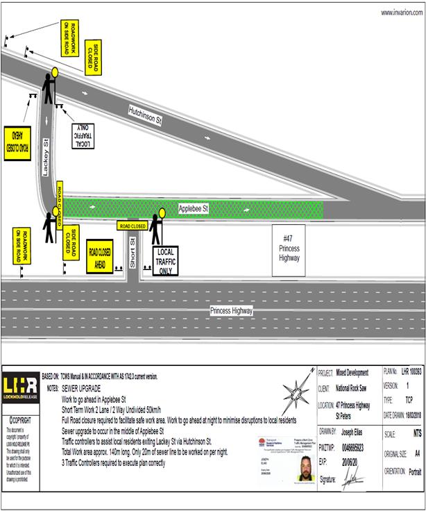
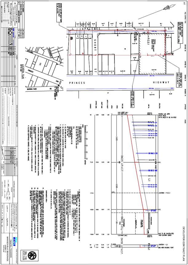
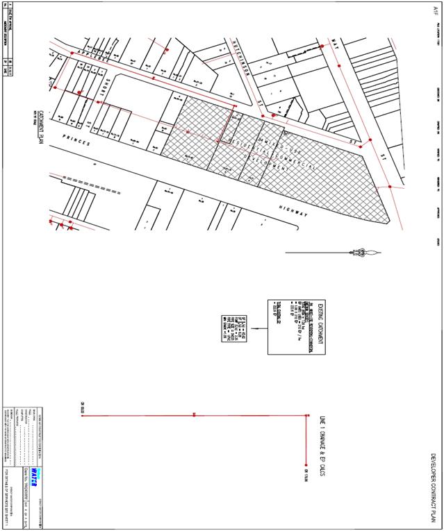
|
|
Local Traffic Committee Meeting 10 April 2018 |
Subject: Constitution Road, Dulwich Hill – Amendment To Proposed Pedestrian Refuge Island Upgrade Design Plan (Ashfield Ward/Summer Hill Electorate/Inner West LAC)
Prepared By: Emilio Andari - Engineer – Traffic and Parking Services
Authorised By: John Stephens - Traffic and Transport Services Manager
|
SUMMARY An amendment to the detailed design plan has been finalised for the proposed traffic calming improvements in Constitution Road, Dulwich Hill, at its intersection with Williams Parade, as part of the Dulwich Hill North LATM study implementation.
The amended proposal to upgrade the existing pedestrian refuge islands and associated signs will improve pedestrian and cyclist safety at this location. It is recommended that the proposed detailed design plan be approved. |
|
RECOMMENDATION
THAT the amended design of the upgrade to the existing pedestrian refuge islands with associated signs in Constitution Road, Dulwich Hill, at the intersection with Williams Parade (as per the attached design plan No. 6154_A) be APPROVED.
|
BACKGROUND
Council is proposing to reconstruct the existing pedestrian refuge islands with associated signs in Constitution Road, Dulwich Hill, at its intersection with Williams Parade.
This proposal is a design which was included in the recently approved Dulwich Hill North Local Area Traffic Management Plan (LATM) which was on public exhibition (for community comment) mid-2017. The LATM provides rationale and recommended actions to address local traffic issues and support sustainable transport. This involves encouraging the use of public transport, walking and cycling. The Dulwich Hill North LATM was endorsed and approved by Council at its meeting held on 12 October 2017.
The detail design plan was finalised for the proposed devices together with the consultation results and were presented in a report for consideration at the 2 November 2017 Local Traffic Committee meeting and endorsed by Council at its meeting held on 21 November 2017.
Since then, the Greenway project has been proposed to be routed on the western side of the light rail through Johnson Park, either with an on-grade crossing or a tunnel under Constitution Road. Therefore, the proposed design has been amended to better cater for cyclists who wish to use the pedestrian refuge islands on Constitution Road whilst still improving safety for pedestrians as well as traffic conditions at this intersection.
FINANCIAL IMPLICATIONS
Funding of $40,000 has been allocated by Council for the entire scope of works for Constitution Road at Williams Parade, Dulwich Hill under the Dulwich Hill North LATM Implementation 2017/2018. These works include reconstructing the three existing pedestrian refuge islands with associated signs in Constitution Road and Williams Parade, Dulwich Hill (including new landscaping within the upgraded pedestrian refuge islands and two new kerb ramps).
OFFICER COMMENTS
Site location & road network
|
Street Name |
Constitution Road |
Williams Parade |
|
Section |
Between Grove Street and Windsor Road |
Between Constitution Road and to an end |
|
Carriageway Width (m) |
10.3 |
12.8 |
|
Carriageway Type |
Two-way road with one travel lane in each direction, in addition to kerbside parking lanes. |
Two-way road with one travel lane in each direction, in addition to kerbside parking lanes. |
|
Classification |
Local |
Local |
|
85th Percentile Speed (km/h) |
46.4 |
40.7 |
|
Vehicles Per Day (vpd) |
4,365 |
1,456 |
|
Reported Crash History (July 2012 – June 2017) |
No crashes recorded. |
No crashes recorded. |
|
Heavy Vehicle Volume (%) |
3.3 |
2.5 |
|
Parking Arrangements |
Sections of permit parking restrictions along both sides of the road. |
‘4P’ parking restriction on the western side and unrestricted 90 degree angle rear-to-kerb parking on the eastern side of the road. |
At present, the intersection of Constitution Road and Williams Parade, Dulwich Hill is controlled by a roundabout.
Design Plan – No. 6154_A
An amendment to the previous detailed design plan for the provision of three upgraded pedestrian refuge islands with landscaping at Constitution Road and Williams Parade, Dulwich Hill, including the associated signs (ATTACHMENT - design plan No. 6154_A) are submitted for consideration.
The proposed scope of work includes the following:
· Reconstruct three existing pedestrian refuge islands with new landscaping and associated signs in Constitution Road and Williams Parade, Dulwich Hill as per design plan.
· Construct two new kerb ramps with the upgraded pedestrian refuge island on Constitution Road located immediately east to its intersection with Williams Parade.
· Upgrade the street lighting to comply with Australian Standards.
The proposed amendment includes the following:
· Reconstruct the two existing islands on Constitution Road, with a new wider pedestrian refuge island (increase from 2.0m to 2.5m) and with landscaping and associated signs as per design plan. The design standards for travel lanes are still within the Australian Standards as a result of this amendment.
The proposed treatment will not result in the loss of any legal on-street car parking spaces in Constitution Road and Williams Parade (refer to the attached design plan No. 6154_A). All current vehicular access to adjoining properties will be retained.
PUBLIC CONSULTATION
Consultation was undertaken with the original proposed design plan in April 2017. There were no responses received regarding the proposal at the time.
CONCLUSION
It is recommended that the amended detailed design plan of the proposed treatment and associated signs be approved, to improve pedestrian and cyclist safety at this location.
![]()
|
|
Local Traffic Committee Meeting 10 April 2018 |
Subject: Denison Road, Dulwich Hill – Proposed One Lane Slow Point With Line Markings & ‘No Left Turn’ Restriction Design Plans (Ashfield Ward/Summer Hill Electorate/Inner West LAC)
Prepared By: Emilio Andari - Engineer – Traffic and Parking Services
Authorised By: John Stephens - Traffic and Transport Services Manager
|
SUMMARY A detailed design plan has been finalised for the proposed traffic calming improvements in Denison Road, Dulwich Hill, between Eltham Street and New Canterbury Road, as part of the Dulwich Hill North LATM study implementation. The proposal for a one lane slow point with associated signs and line markings and a ‘No Left Turn’ restriction during weekday morning peak period from New Canterbury Road into Denison Road to improve safety and calm traffic.
Consultation was undertaken with owners and occupiers of properties adjacent to Denison Road, regarding the proposal. A summary of the consultation results are presented in this report for consideration. It is recommended that the proposed detailed design plans be approved. It is also recommended that a ‘No Left Turn 7am-9am Mon-Fri’ restriction from New Canterbury Road into Denison Road, Dulwich Hill be approved and implemented, subject to a Traffic Management Plan (TMP) being considered and approved by the Roads and Maritime Services (RMS). |
|
THAT:
1. The design of the one lane slow point with associated signs and line markings in Denison Road, Dulwich Hill (as per the attached design plan No. 6191 & design plan No. 6200) be APPROVED; and
2. The installation of a ‘No Left Turn 7am-9am Mon-Fri’ restriction from New Canterbury Road into Denison Road, Dulwich Hill be APPROVED and implemented, subject to a Traffic Management Plan being considered and approved by the Roads and Maritime Services. |
BACKGROUND
Council is proposing to construct a one lane slow point and associated signs and line markings in Denison Road, Dulwich Hill, between Eltham Street and New Canterbury Road. Also, Council is proposing to install a ‘No Left Turn 7am-9am Mon-Fri’ restriction from New Canterbury Road into Denison Road, Dulwich Hill.
These proposals are a design which was included in the recently approved Dulwich Hill North Local Area Traffic Management Plan (LATM) which was on public exhibition (for community comment) in mid-2017. The LATM provides rationale and recommended actions to address local traffic issues and support sustainable transport. This involves encouraging the use of public transport, walking and cycling. The Dulwich Hill North LATM was approved by Council at its meeting held on 12 October 2017.
As part of the Dulwich Hill North LATM, a consultation session was held with the Denison Road Group to workshop traffic and parking options for Denison Road, Dulwich Hill. The Denison Road Group are a group of residents that have been campaigning for improved traffic and parking conditions along Denison Road, which functions as collector road within the Dulwich Hill North LATM study area.
The session further reiterated that the key issue experienced along Denison Road is vehicle speed and volume during the morning peak period. When combined with the relatively narrow carriageways, the conditions make it difficult for the residents to reverse out of their properties, access their vehicles parked on-street, as well as cross the road safely. Members of the Denison Road Group related experiences with incidents and near-misses along the road (both themselves and neighbours).
The workshop was an opportunity for consultants and Council to inform the Denison Road Group of the LATM options that had been identified for the road and corresponding benefits and implications.
The workshop identified the following LATM measures as preferred options to reduce traffic volumes along Denison Road:
· Peak period ‘No Left Turn’ restrictions on New Canterbury Road at Denison Road;
· Line marking of parking lanes and on-road bicycle symbols;
· Intersection priority changes along Denison Road at Dulwich Street and Pigott Street;
· Improve effectiveness of existing road humps; and
· Single lane slow points.
The detail design plans have been finalised for the proposed devices together with the consultation and are presented in this report for consideration.
FINANCIAL IMPLICATIONS
Funding of $80,000 has been allocated by Council for the entire scope of works for Denison Road, Dulwich Hill under the Dulwich Hill North LATM Implementation 2017/2018. These works include constructing the one lane slow point (including new landscaping) with associated signs and line markings in Denison Road, Dulwich Hill, and the ‘Stop’ intersection priority change with associated signs and line markings at Denison Road with Dulwich Street and Pigott Street, and the installation of the ‘No Left Turn’ restriction during weekday peak periods at New Canterbury Road and Denison Street.
OFFICER COMMENTS
Site location & road network
|
Street Name |
Denison Road |
|
Section |
Between Eltham Street and New Canterbury Road |
|
Carriageway Width (m) |
10.3 |
|
Carriageway Type |
Two-way road with one travel lane in each direction, in addition to kerbside parking lanes. |
|
Classification |
Local |
|
85th Percentile Speed (km/h) |
45.7 |
|
Vehicles Per Day (vpd) |
2,480 |
|
Reported Crash History (July 2012 – June 2017) |
7 crashes (Rum Code: 00, 02, 71(x4) & 81). Crashes resulted in either injury or tow away. |
|
Heavy Vehicle Volume (%) |
2.3 |
|
Parking Arrangements |
Sections of permit parking restrictions along both sides of the road. |
At present, the intersection of Constitution Road and Denison Road, Dulwich Hill is controlled by a roundabout; full-time left turn movements from New Canterbury Road into Denison Road are permitted; and both intersections of Denison Road with Dulwich Street and Denison Road with Pigott Street have priority given to motorists travelling along Denison Road.
Design Plan – No. 6191 & No. 6200
Detailed design plans for the provision of a one lane slow point and associated signs and line markings in Denison Road, Dulwich Hill, between Eltham Street and New Canterbury Road, with the inclusion of a ‘No Left Turn 7am-9am Mon-Fri’ restriction from New Canterbury Road into Denison Road, Dulwich Hill (ATTACHMENT - design plans No. 6191 & No. 6200) are submitted for consideration.
The proposed scope of work includes the following:
· Demolish existing raised threshold and construct a one lane slow point raised threshold with new landscaping and associated signs and line markings in Denison Road, Dulwich Hill, as per design plan.
· Install ‘Stop’ signs and associated line markings at the intersection of Denison Road with Dulwich Street and Denison Road with Pigott Street as per design plan.
· Install edge line ‘E1’ line markings, separation line ‘S1’ line markings and bicycle symbols along both sides of Denison Road as per design plan.
· Install a ‘No Left Turn 7am-9am Mon-Fri’ restriction at the intersection of New Canterbury Road and Denison Road and as per design plan.
The proposed treatment will result in the loss of two (2) legal on-street car parking spaces in Denison Road (refer to the attached design plans No. 6191 & No. 6200). All current vehicular access to adjoining properties will be retained.
PUBLIC CONSULTATION
A notification letter as well as a copy of the detailed design plan was sent on 27 February 2018 to the owners and occupiers of the affected properties in Denison Road, Dulwich Hill, regarding the proposed design plan to implement a one lane slow point including associated signs and line markings, including the ‘Stop’ intersection priority change with associated signs and line markings at Denison Road with Dulwich Street and Pigott Street, and the installation of the ‘No Left Turn’ restriction during weekday peak periods at New Canterbury Road into Denison Road. A total of 552 letters were distributed. The closing date for submissions ended on 21 March 2018.
There were a total of twenty-one (21) responses received with nine (9) responses supporting the proposal, six (6) responses that were neutral, and six (6) responses opposing the proposal. These responses are detailed below.
|
Residents’ Comments (supporting the proposal) |
Officer’s Response |
|
Four residents of Denison Road are in strong support of the proposals along the street. The residents acknowledge the loss in parking as a result of the one lane slow point raised threshold; however, the improvement of safety and calming traffic is a greater outcome.
|
Received and noted.
The design and location of the proposed one lane slow point raised threshold retains vehicular access to adjoining properties and incorporates the minimum loss in on-street parking. |
|
Two residents of Pigott Street are in support of the proposals along the street. |
Received and noted.
|
|
A resident of Denison Road is in strong support of the proposals along the street. The resident is happy that the proposed measures will calm traffic and reduce traffic volume within the street. |
Received and noted.
|
|
A resident of Denison Road is in support of the proposals along the street. |
Received and noted.
|
|
A resident of Denison Road is in support of the proposals along the street. The resident stated that there is a number of boat trailers parked within the precinct and would like to see some enforcement or proposal to remove the trailers so there is additional parking opportunities. |
Received and noted.
Council officers will further investigate the boat trailer parking within the precinct and advise the resident. |
|
Residents’ Comments (opposing the proposal) |
Officer’s Response |
|
Three residents of Denison Road strongly oppose the proposal and are concerned with the loss of parking as a result of the proposed one lane slow point device. Concerns were also raised regarding access to adjacent driveways as a result of the proposed one lane slow point device. |
The design and location of the proposed one lane slow point raised threshold retains vehicular access to adjoining properties and incorporates the minimum loss in on-street parking. The purpose of the one lane slow point is to reduce traffic speeds and discourage motorists ‘rat-running’ through Denison Road. |
|
A resident of Denison Road opposes the proposal. The resident states the concern of the loss in parking, the consideration of additional turning movements restricted at the intersection of Denison Road and New Canterbury Road, and the consideration of introducing a 40km/hr zone for the street. |
The design and location of the proposed one lane slow point raised threshold retains vehicular access to adjoining properties and incorporates the minimum loss in on-street parking. The purpose of the one lane slow point is to reduce traffic speeds and discourage motorists ‘rat-running’ through Denison Road.
The proposed ‘No Left Turn’ restriction on weekday morning peak periods at New Canterbury Road into Denison Road was a recommendation from the Dulwich Hill North LATM study. It was identified during the study that high traffic volumes were undertaken at this intersection (left turn movements) particularly in the morning peak period. The purpose of this proposal ‘rat-running’ through Denison Road.
The local road speed limit is 50km/hr. It should be noted that the proposed traffic calming measures for Denison Road will further reduce the average traffic speed. |
|
A resident of Denison Road opposes to the ‘No Left Turn’ restriction on weekday morning peak periods proposal. The resident states the residents should be exempt and have full-time access from this intersection. |
The proposed ‘No Left Turn’ restriction on weekday morning peak periods at New Canterbury Road into Denison Road was a recommendation from the Dulwich Hill North LATM study. It was identified during the study that high traffic volumes were undertaken at this intersection (left turn movements) particularly in the morning peak period. The purpose of this proposal ‘rat-running’ through Denison Road. Unfortunately, exemption for residents into the street at this intersection is not feasible as it is difficult to monitor and enforce. |
|
A resident of Denison Road opposes to the change in priority for the ‘Stop’ intersection at Denison Road and Pigott Street. The resident is concerned with the safety of the priority change at the intersection given it is a ‘T’ intersection. |
The proposed change in priority for the ‘Stop’ intersection at Denison Road and Pigott Street is designed in accordance with the Australian Standards. The associated signs and line markings will guide motorists and advise them of the change in priority on approach to the intersection. The purpose of the intersection priority change is to ensure motorists ‘stop’ while travelling along Denison Road and discourage motorists from ‘rat-running’ as well to reduce traffic speed. |
The neutral responses received by residents of the precinct were neither supportive nor in opposition to the proposal, however, a range of various other issues and comments were noted. These comments will be addressed separately to this proposal and Council officers will investigate and respond to these residents in due course.
Given the strong level of response from the affected properties within Denison Road, Dulwich Hill, and adjacent streets with a good portion of the community supporting this proposal from it is therefore proposed to proceed with the plan to implement a one lane slow point including associated signs and line markings, including the ‘Stop’ intersection priority change with associated signs and line markings at Denison Road with Dulwich Street and Pigott Street, and the installation of the ‘No Left Turn’ restriction during weekday peak periods at New Canterbury Road into Denison Road. Council officers will submit a TMP to the RMS for the proposed ‘No Left Turn 7am-9am Mon-Fri’ restriction from New Canterbury Road into Denison Road, Dulwich Hill for approval prior to implementation.
CONCLUSION
It is recommended that the detailed design plans of the proposed treatments and associated signs and line markings be approved, will improve safety and calm traffic.
![]()
|
|
Local Traffic Committee Meeting 10 April 2018 |
Subject: Railway Street, Petersham - Proposed Introduction of '2P Permit Holders Only' Parking Restrcitions (Summer Hill Electorate/Stanmore Ward/Inner West LAC)
Prepared By: Mary Bailey - Project Officer
Authorised By: John Stephens - Traffic and Transport Services Manager
|
SUMMARY Council has received concerns in relation to the “knock on” effects from the implementation of recent permit parking restrictions in nearby streets. It is proposed to introduce 2P Permit Holders Only parking restrictions in a small section of Railway Street, Petersham (eastern side) between Croydon Street and Brighton Street. This will provide continuous and consistent 2P resident parking restrictions along the length of Railway Street. |
|
RECOMMENDATION
THAT a proposal to convert ‘unrestricted’ parking to ‘2P 8am-10pm, Monday to Friday, Permit Holders Excepted (Area M5) on the eastern side of Railway Street between Croydon Street and Brighton Street, Petersham be approved in order to improve parking availability for residents in this section of Railway Street.
|
BACKGROUND
In April and May 2017, a number of streets to the north of the subject section of Railway Street were converted to permit parking following approval of the recommendations from the Parramatta Road Corridor/Camperdown Parking Study by Council in August 2016.
In October 2017, Council received a petition signed by 13 petitioners all residents of the subject section of Railway Street. The petition noted the impact of the introduction of permit parking in nearby streets and sought the implementation of permit parking in Railway Street between Croydon Street and Brighton Street.
Following consultation with affected owners/occupiers in the subject section of Railway Street, Council is proposing to implement permit parking to improve opportunity for residents to find parking spaces within a reasonable distance of their homes. The proposed restrictions are in keeping with the restrictions in place in other streets in the M5 area.
The proposal is illustrated in Figure 1 below.
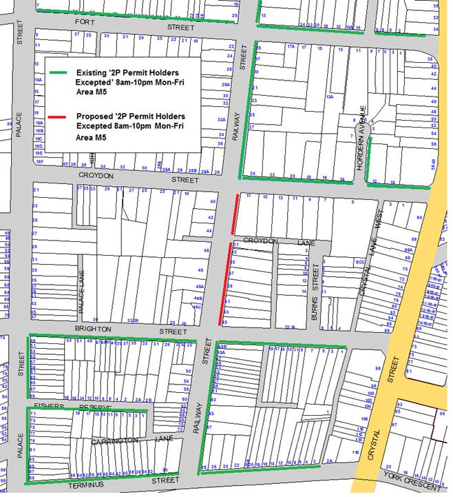
Figure 1: Existing and Proposed restrictions in Railway Street, Petersham and surrounds
FINANCIAL IMPLICATIONS
The cost of the signage will be covered under Council’s existing operational budget for signs and line marking
PUBLIC CONSULTATION
Residents of were canvassed by way of forty (40) questionnaires sent to owners/occupiers of affected properties. The questionnaires were sent with letters outlining the proposal and including information about Council’s permit parking scheme. Letters were sent on 20 February 2018 with a deadline for comments by 12 March 2018. Replies were received from nine (9) households and of those eight (8) supported the proposal and one (1) objected.
|
|
|
Comment |
|
Support |
Nine (9) respondents in support |
Respondents cited difficulty finding parking during daytime and nighttime hours 7 days a week |
|
Object |
One (1) respondent objected |
Lives in section of Croydon Street which has no restrictions |
CONCLUSION
Given the knock on effect from permit parking restrictions introduced in nearby streets, and support from residents by way of a petition and response to the questionnaire; the introduction of permit parking on the eastern side of railway Street between Croydon Street and railway Street is an appropriate response to provide additional parking opportunities for residents.
|
|
Local Traffic Committee Meeting 10 April 2018 |
Subject: Lewisham - Proposal to Implement Permit Parking in Additional Streets - M16 parking area (Summer Hill Electorate/Stanmore Ward/Inner West LAC)
Prepared By: Mary Bailey - Project Officer
Authorised By: John Stephens - Traffic and Transport Services Manager
|
SUMMARY Following representations from the community regarding the impact of increased residential development, Council is proposing to introduce permit parking restrictions in a number of streets in Lewisham from Cook Street to Barker Street. The proposals are based on the results of parking surveys and feedback from a questionnaire circulated to the affected properties. |
|
THAT the proposals as detailed in Table 1 below be approved to improve the availability of on-street parking for residents.
|
Table 1: Proposals for additional parking restrictions in Lewisham M16 Permit Parking Area
|
Street |
Proposed restrictions |
|
Barker Street |
1. ‘2P Permit Holders Excepted 8:30am-6pm Mon- Fri’ (Area M16) a. Northern side - From ‘No Stopping’ zone at Old Canterbury Road (adjacent to rear driveway of property no.38 Old Canterbury Road) to outside property no. 33 Barker Street b. Southern side – From Old Canterbury Road to Barker Lane |
|
Cook Street
|
2. ‘2P Permit Holders Excepted 8:30am-6pm Mon- Fri’ (Area M16) Southern side - From proposed ‘No Stopping’ location (outside property no. 27 Cook Street) to ‘No Stopping’ zone at intersection with Old Canterbury Road 3. ‘No Stopping’ Relocate existing ‘No Stopping’ 8m to the west from outside property no. 25 Cook Street to outside property no.27 Cook Street |
|
Old Canterbury Road |
4. ‘2P Permit Holders Excepted 8:30am-6pm Mon- Fri’ (Area M16) a. Western side - From outside property no. 10 Old Canterbury Road to outside property no. 34 Old Canterbury Road b. Eastern side - From driveway of property no. 1 Old Canterbury Road to ‘No Stopping’ Zone at Cook Street (added post consultation) 5. ‘No Stopping’ Relocate existing ‘No Stopping’ sign 10m to the north from outside property 15 Old Canterbury Road to outside property number 11-13 Old Canterbury Road |
|
St John Street |
6. ‘2P Permit Holders Excepted 8:30am-6pm Mon- Fri’ (Area M16) - Southern side between Old Canterbury Road and Brown Street |
|
7. ‘No Stopping’ zones will be implemented in association with permit parking as required to ensure manoeuvring and sight distance |
BACKGROUND
Council is proposing the introduction of permit parking in a number of streets in the Lewisham area. The proposals are illustrated in Figure 1.
The proposed restrictions have been developed in response to a petition to Council seeking permit parking in August 2017. Council undertook parking surveys in the general area to determine parking occupancy on weekdays and inform decisions as to the potential scope of the recommended restrictions.
A number of the streets included in the permit parking recommendations are designated as State Roads and as such are under the jurisdiction of the Roads and Maritime Services (RMS) Council Officers have liaised with representatives from the RMS throughout the development of the proposed restrictions and ‘approval in principle’ has been received for the proposed restrictions.
Following the ‘approval in principle’ Council had circulated the proposals to affected households and there was sufficient support received for the proposed restrictions. However, following this consultation, there was one additional recommendation developed to assist a number of households on Old Canterbury Road. (See Table 1 - Recommendation 4b) Notification letters have been sent to the affected properties advising of the recommendation and the process for making representation to the Local Traffic Committee.
The proposed restrictions are illustrated in Figure 1. Roads designated as RMS roads are indicated on the map. Figure 2 illustrates the distribution of the letters/questionnaires. It should be noted that while there are no restrictions recommended for those sections of Cook and St John Street, households were included in the consultation by way of notification that restrictions are being proposed for streets nearby.
It also should be noted that due to the narrowness of the road width a number of streets in the area are only suitable for parking on one side of the road. There are also a number of clearways in place, specifically in sections of Old Canterbury Road. The Clearway restrictions are on the eastern side of Old Canterbury Road in the subject section between morning and afternoon peaks, however the proposed restriction apply to areas currently unrestricted parking.
The results of the parking surveys are detailed below in Table 2 and Table 3.
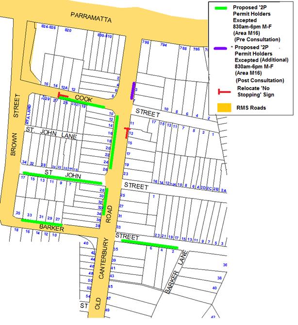
Figure 1: Proposed parking restrictions pre and post consultation
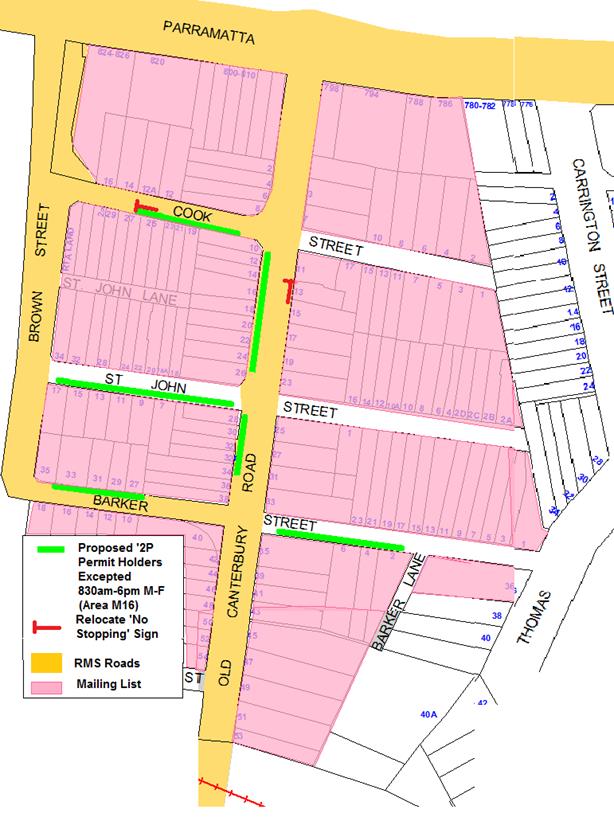
Figure 2: Illustration of mailing list for letter and questionnaire (showing recommendation as circulated)
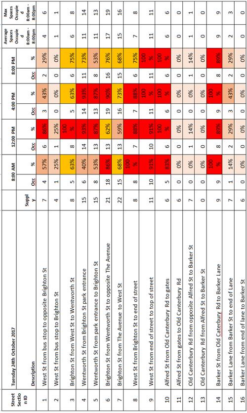
Table 2: Parking survey results Tuesday 24 October 2017
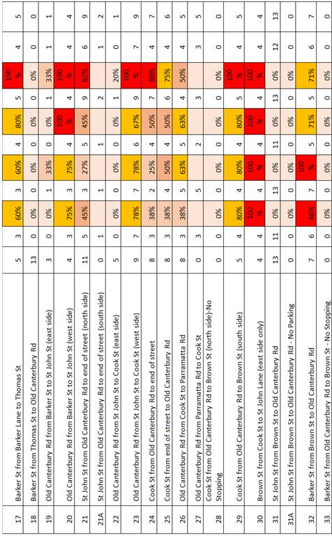
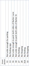
Table 2: Parking survey results Tuesday 24 October 2017 (cont’d)
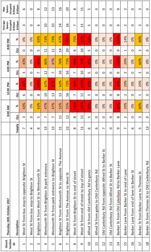
Table 3: Parking survey results Thursday 26 October 2017
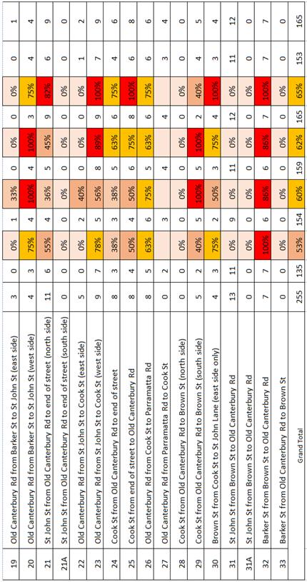
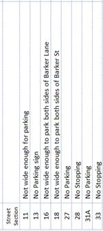
Table 3: Parking survey results Thursday 26 October 2017 (cont’d)
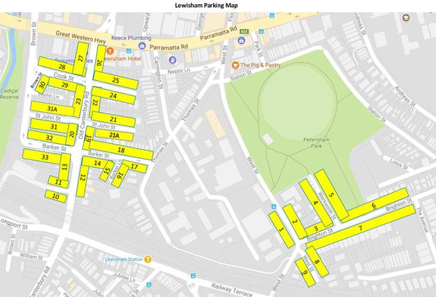
FINANCIAL IMPLICATIONS
The cost for the supply and installation of the signposting can be funded from Council's operational budget.
PUBLIC CONSULTATION
Letters were sent to one hundred and eighty seven (187) owners and occupiers in the affected area. There were twenty (24) responses, five (5) objecting to and eighteen (18) supporting and one (1) undecided. Three (3) of those objecting stated the reason that they were outside the area of the proposed restrictions, that is eastern sections of Cook Street and St John St. (see Figure 1). There were two (2) objections from Old Canterbury Road, one (1) from a multiple vehicle household and one (1) from a household which has been availing of the ‘existing ‘unrestricted’ parking in Barker Street which is proposed for restrictions. This resident asked to be considered for a permit if the proposal was adopted. The household will be eligible to apply for permits on a case-by-case basis.
CONCLUSION
In addition to the increased demand for parking as a result of recent residential development in the area; there is severe constraint on parking in the area given the narrowness of some streets, the existence of one way streets, and morning and afternoon peak clearways
Following community consultation, liaison with the RMS and analysis of parking surveys, it is concluded that the implementation of permit parking restrictions in the subject streets will improve parking opportunities for residents during the day.
|
|
Local Traffic Committee Meeting 10 April 2018 |
Subject: Minor Traffic Facilities (All Wards / All Electorates / All LACs)
Prepared By: Manod Wickramasinghe - Coordinator – Traffic and Parking Services, Emilio Andari - Engineer – Traffic and Parking Services and Idris Hessam - Road Access Engineer, Design and Investigation
Authorised By: John Stephens - Traffic and Transport Services Manager
|
SUMMARY This report considers minor traffic facility applications received by Inner West Council, and includes ‘Disabled Parking’ and ‘Works Zone’ requests. |
|
RECOMMENDATION
THAT:
1. A 6m ‘Disabled Parking’ zone be installed adjacent to the frontage of property No.45 Macaulay Street, Stanmore;
2. A 6m ‘Disabled Parking’ zone be installed adjacent to the frontage of property No.38 Wilford Street, Newtown;
3. A 6m ‘Disabled Parking’ zone be installed adjacent to the frontage of property No.30 Abergeldie Street, Dulwich Hill;
4. A 6m ‘Disabled Parking’ zone be installed adjacent to the frontage of property No.91 Westbourne Street, Petersham;
5. A 6m ‘Disabled Parking’ zone be installed adjacent to the frontage of property No.21 Edward Street, Marrickville;
6. A 6m ‘Disabled Parking’ zone be installed adjacent to the frontage of property No.51A Neville Street, Marrickville;
7. A 40m 'Works Zone 7.00am - 5.00pm Mon-Fri’ be installed in Australia Street, Camperdown in front of Camperdown Park for 12 weeks;
8. A 6m ‘Disabled Parking’ zone be installed adjacent to the Unit No.1/26 Fotheringham Street, Enmore;
9. A 6m ‘Disabled Parking’ zone be installed adjacent to the frontage of property No.5 Yule Street, Dulwich Hill;
10. A 6m ‘Disabled Parking’ zone be installed adjacent to the frontage of property No. No.8 Hugh Avenue, Dulwich Hill;
11. A 6m ‘Disabled Parking’ zone be installed adjacent to the frontage of property No.36 Edward Street, Marrickville;
12. A 6m 'Works Zone 7.00am - 5.00pm Mon-Fri, 7.00am - 1.00pm Sat' be installed in front of No.52 Darling Street, Balmain East for 12 weeks;
13. A 21m 'Works Zone 7.00am - 5.00pm Mon-Fri, 7.00am - 1.00pm Sat' be installed in North Street, Balmain on the frontage of No.2 North Street and partially along the side boundary of No.379 Darling Street, Balmain for 12 weeks; and
14. A 6m ‘Disabled Parking’ zone be installed in front of No.29 Cameron Street, Birchgrove. |
BACKGROUND
This report considers minor traffic facility applications received by Inner West Council, and includes ‘Disabled Parking’ and ‘Works Zone’ requests.
FINANCIAL IMPLICATIONS
Nil.
OTHER STAFF COMMENTS
1 Installation of ‘Disabled Parking’ Restriction – Macaulay Road, Stanmore
Council Ref: Merit 1428664
The resident of property No.45 Macaulay Road, Stanmore has requested the installation of a ‘Disabled Parking’ zone in Macaulay Road at the front of the resident’s property.
A site investigation has revealed that the property does not have off-street parking.
The applicant does not require the use of a wheelchair.
It is recommended that a 6m ‘Disabled Parking’ zone be installed adjacent to the frontage of property No.45 Macaulay Road, Stanmore.
2 Installation of ‘Disabled Parking’ Restriction – Wilford Street, Newtown
Council Ref: Merit 1432149
The resident of property No.38 Wilford Street, Newtown has requested the installation of a ‘Disabled Parking’ zone in Wilford Street at the front of the resident’s property.
A site investigation has revealed that the property does not have off-street parking.
The applicant does not require the use of a wheelchair.
It is recommended that a 6m ‘Disabled Parking’ zone be installed adjacent to the frontage of property No.38 Wilford Street, Newtown.
3 Installation of ‘Disabled Parking’ Restriction – Abergeldie Street, Dulwich Hill
Council Ref: Merit 1435852
The resident of property No.30 Abergeldie Street, Dulwich Hill has requested the installation of a ‘Disabled Parking’ zone in Abergeldie Street at the front of the resident’s property.
A site investigation has revealed that the property does not have off-street parking.
Currently, the applicant does not require the use of a wheelchair; however, the applicant’s condition does not allow them to walk with ease and requires the use of a walker.
It is recommended that a 6m ‘Disabled Parking’ zone be installed in Abergeldie Street adjacent to the frontage of property No.30 Abergeldie Street, Dulwich Hill.
4 Installation of ‘Disabled Parking’ Restriction – Westbourne Street, Petersham
Council Ref: Merit 1427989
The resident of property No.91 Westbourne Street, Petersham has requested the installation of a ‘Disabled Parking’ zone in Westbourne Street at the front of the resident’s property.
A site investigation has revealed that the property does not have off-street parking.
The applicant does not require the use of a wheelchair.
It is recommended that a 6m ‘Disabled Parking’ zone be installed adjacent to the frontage of property No.91 Westbourne Street, Petersham.
5 Installation of ‘Disabled Parking’ Restriction – Edward Street, Marrickville
Council Ref: Merit 1425243
The resident of property No.21 Edward Street, Marrickville has requested the installation of a ‘Disabled Parking’ zone in Edward Street at the front of the resident’s property.
A site investigation has revealed that the property does have a driveway at the rear of the property however does not have adequate space for off-street parking. It was also observed that the access to the rear of the house from the driveway is a long distance and contains a number of steps.
The applicant does not require the use of a wheelchair; however, the use of a walker is currently required.
It is recommended that a 6m ‘Disabled Parking’ zone be installed adjacent to the frontage of property No.21 Edward Street, Marrickville.
6 Installation of ‘Disabled Parking’ Restriction – Neville Street, Marrickville
Council Ref: Merit 1417025
The resident of property No.51A Neville Street, Marrickville has requested the installation of a ‘Disabled Parking’ zone in Neville Street at the front of the resident’s property.
A site investigation has revealed that the property does not have off-street parking.
The applicant does not require the use of a wheelchair.
It is recommended that a 6m ‘Disabled Parking’ zone be installed adjacent to the frontage of property No.51A Neville Street, Marrickville.
7 Installation of ‘Works Zone’ Restriction – Australia Street, Camperdown
The subject location is located on eastern side of Australia Street adjacent to Camperdown Park, Camperdown. Australia Street is a two-way street from Parramatta Road to Alton Lane and is 9.8 metres in width. The proposed ‘Works Zone’ will be 40 metres in length and located on the eastern side of Australia Street adjacent to the upgrade works at Camperdown Park. It will be required for a period of approximately twelve (12) weeks, to be utilised by construction vehicles for delivery and loading/unloading activities.
At present, unrestricted parking is permitted on both sides of the street. The parking spaces in Australia Street are highly utilised by local businesses and commuters. Therefore, the provision of a ‘Works Zone’ would provide a safe facility for loading and unloading activities at the subject site during the construction period.
It is recommended that a 40m 'Works Zone 7am-5pm Mon-Fri' be installed on the eastern side of Australia Street adjacent to Camperdown Park for 12 weeks.
8 Installation of ‘Disabled Parking’ Restriction – Fotheringham Street, Enmore
Council Ref: Merit 1415436
The resident of property No.1/26 Fotheringham Street, Enmore has requested the installation of a ‘Disabled Parking’ zone adjacent to the resident’s property on Fotheringham Street, Enmore.
A site investigation has revealed that the property does not have off-street parking.
The applicant does require the use of a wheelchair.
It is recommended that a 6m ‘Disabled Parking’ zone be installed adjacent to the property No.1/26 Fotheringham Street, Enmore.
9 Installation of ‘Disabled Parking’ Restriction – Yule Street, Dulwich Hill
Council Ref: Merit 1423192
The resident of property No.5 Yule Street, Dulwich Hill has requested the installation of a ‘Disabled Parking’ zone in Yule Street at the front of the resident’s property.
A site investigation has revealed that the property has a narrow and sloped off-street parking space which makes it difficult for him to access due to his chronic health conditions.
The applicant does not require the use of a wheelchair.
It is recommended that a 6m ‘Disabled Parking’ zone be installed in front of No.5 Yule Street, Dulwich Hill.
10 Installation of ‘Disabled Parking’ Restriction – Hugh Avenue, Dulwich Hill
Council Ref: Merit 1424289
The resident of property No.8 Hugh Avenue, Dulwich Hill has requested the installation of a ‘Disabled Parking’ zone in Hugh Avenue at the front of the resident’s property.
A site investigation has revealed that the property has a narrow off-street parking space which makes it difficult for her to access due to her chronic health condition.
The applicant does occasionally require the use of a wheelchair.
It is recommended that a 6m ‘Disabled Parking’ zone be installed in front of No.8 Hugh Avenue, Dulwich Hill.
11 Installation of ‘Disabled Parking’ Restriction – Edward Street, Marrickville
Council Ref: Merit 1441981
The resident of property No.36 Edward Street, Marrickville has requested the installation of a ‘Disabled Parking’ zone in Edward Street at the front of the resident’s property.
A site investigation has revealed that the property does not have off street parking.
The applicant does not require the use of a wheelchair.
It is recommended that a 6m ‘Disabled Parking’ zone be installed in front of No.36 Edward Street, Marrickville.
12 Installation of ‘Works Zone’ Restriction – Darling Street, Balmain
Council Ref: DWS 4707698
The applicant has requested the installation of a temporary 6m 'Works Zone 7.00am - 5.00pm Mon-Fri, 7.00am - 1.00pm Sat' in front of No.52 Darling Street, Balmain East.
It is recommended that a 6m 'Works Zone 7.00am - 5.00pm Mon-Fri, 7.00am - 1.00pm Sat' be installed in front of No.52 Darling Street, Balmain East for 12 weeks.
13 Installation of ‘Works Zone’ Restriction – Darling Street, Balmain East
Council Ref: DWS 4803743
Council previously approved the installation of a 17m 'Works Zone 7.00am - 5.00pm Mon-Fri, 7.00am - 1.00pm Sat' in front of No.383-389 Darling Street, Balmain. The applicant has advised Council that due to power lines over the approved ‘Works Zone’, additional works will have to completed to place powerlines underground prior to being able to utilise a ‘Works Zone’ on Darling Street.
In the interim the applicant has requested the installation of a temporary 21m 'Works Zone 7.00am - 5.00pm Mon-Fri, 7.00am - 1.00pm Sat' in North Street, Balmain on the frontage of No.2 North Street and partially along the side boundary of No.379 Darling Street, Balmain.
It is recommended that a 21m 'Works Zone 7.00am - 5.00pm Mon-Fri, 7.00am - 1.00pm Sat' be installed in North Street, Balmain on the frontage of No.2 North Street and partially along the side boundary of No.379 Darling Street, Balmain for 12 weeks.
14 Installation of ‘Disabled Parking’ Restriction – Cameron Street, Birchgrove
Council Ref: DWS 4746691
The resident of property No. 29 Cameron Street Birchgrove has requested the installation of a ‘Disabled Parking’ zone in Cameron Street at the front of the resident’s property.
A site investigation has revealed that the property does not have off-street parking.
The applicant does not require the use of a wheelchair.
It is recommended that a 6m ‘Disabled Parking’ zone be installed in front of No. 29 Cameron Street, Birchgrove.
PUBLIC CONSULTATION
Nil.
CONCLUSION
Nil.
|
|
Local Traffic Committee Meeting 10 April 2018 |
Subject: Nelson Lane (at aquaduct), Annandale - Extension of 'No Parking' Zone (Balmain Ward/Balmain Electorate/Leichhardt LAC)
Prepared By: David Yu - Traffic Engineer and Manod Wickramasinghe - Coordinator – Traffic and Parking Services
Authorised By: John Stephens - Traffic and Transport Services Manager
|
SUMMARY Concerns have been raised by residents regarding vehicles partially parking on the grass verge on the western side of Nelson Lane (between the properties of 243 and 247 Nelson Street) obstructing vehicle access and maneuvering space. |
|
RECOMMENDATION
THAT a 37m ‘No Parking’ zone be installed on the western side of Nelson Lane, Annandale between Nos. 243 and 247 Nelson Street. |
BACKGROUND
Concerns have been raised by residents regarding vehicles parking on the footpath at the western side of Nelson Lane (between the properties of Nos. 243 and 247 Nelson Street).
Nelson Lane is two-way, 5.5m wide and 540m long and runs parallel between Nelson Street and Taylor Street and primarily provides rear access to Nelson Street and Taylor Street properties as well as Spindler Park. On-street parking is located on the eastern side of the lane.
Residents have noted that vehicles have begun parking with wheels straddling the grass verge on the western side of Nelson Street adjacent to the aquaduct (between Nos. 243 and 247 Nelson Street). This section of the lane widens slightly from a typical 5.5m to 8.0m.
This parking behavior reduces opportunities for vehicles to pass each other and prevents northbound vehicles from utilising the wider part of the laneway to turn their vehicles around and secure on-street parking on the eastern side of the street, south of the aquaduct.
FINANCIAL IMPLICATIONS
Nil.
OTHER STAFF COMMENTS
In order to alleviate the issue, it is proposed to install a 37m ‘No Parking’ zone (approx.) on the western side of Nelson Lane along the grassed area between the properties of 243 and 247 Nelson Street, Annandale (shown on the following plan).
Parking on the eastern side of Nelson Lane will be maintained.
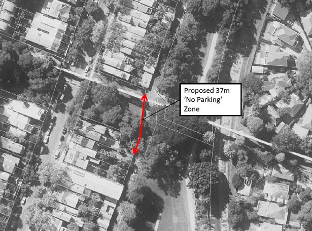
PUBLIC CONSULTATION
|
A letter outlining the above proposal was mailed out to the affected properties (11 properties) in Nelson Street, Annandale. No responses were received. |
|
CONCLUSION
Nil.
|
|
Local Traffic Committee Meeting 10 April 2018 |
Subject: Unnamed Laneway between Flood Street and National Street, Leichhardt - Proposed 'No Parking' restrictions Leichhardt Ward/Balmain Electorate/Leichhardt LAC)
Prepared By: David Yu - Traffic Engineer and Manod Wickramasinghe - Coordinator – Traffic and Parking Services
Authorised By: John Stephens - Traffic and Transport Services Manager
|
SUMMARY Council has received additional concerns regarding parking in the Unnamed Laneway between Flood Street and National Street, Leichhardt |
|
THAT:
1. A 10m ‘No Stopping’ zone followed by a 6.5m ‘No Parking’ zone be installed on the eastern side of the Unnamed Laneway between Flood Street and National Street, Leichhardt across the rear boundaries of Nos.40-42 National Street, Leichhardt; and
2. A 4.2m ‘No Parking’ zone be installed on the western side of the Unnamed Laneway between Flood Street and National Street, Leichhardt across the rear boundaries of Nos.5A-9 Flood Street, Leichhardt. |
BACKGROUND
Council previously investigated ‘No Parking’ zones throughout the laneway system between Flood Street and National Street. This proposal was modified following consultation and only parts of the unnamed laneway adjacent to Wangal Nura Park and the laneway running at the rear of Albert Street properties were approved as ‘No Parking’ zones.
Council has subsequently received concerns from residents of Flood Street and National Street, Leichhardt regarding vehicles parking on the following sections of the unnamed laneway:
· Eastern side of the unnamed laneway between Flood Street and National Street, Leichhardt and subsequently obstructing rear driveway access for property No. 37 Flood Street.
· Western side of the unnamed laneway between Flood Street and National Street, Leichhardt and subsequently obstructing vehicle movements at the intersection and rear driveway access for property No. 2 National Street.
FINANCIAL IMPLICATIONS
Nil.
OTHER STAFF COMMENTS
It is proposed to signpost the subject sections of the laneway as a ‘No Parking’ zone including installation of the statutory 10m ‘No Stopping’ zone on the eastern side of the laneway opposite No. 37 Flood Street. The proposals are shown on the following two (2) plans.
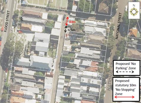
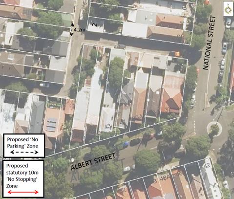
PUBLIC CONSULTATION
|
A letter outlining the above proposal was mailed out to the affected properties (38 properties) in Albert Street, Flood Street and National Street, Leichhardt. No responses were received. |
|
CONCLUSION
Nil.
|
|
Local Traffic Committee Meeting 10 April 2018 |
Subject: Leichhardt Park car park, Lilyfield - Parking Conditions (Balmain Ward / Balmain Electorate / Leichhardt LAC)
Prepared By: Manod Wickramasinghe - Coordinator – Traffic and Parking Services
Authorised By: John Stephens - Traffic and Transport Services Manager
|
SUMMARY This report outlines the proposed changes to parking restrictions in the Leichhardt Park car park associated with the recent construction of the Leichhardt Park child care centre. |
|
RECOMMENDATION
THAT the installation of the following parking restrictions in the Leichhardt Park car park adjacent to the Leichhardt Park Child Care Centre (as detailed in Attachment 1) be supported:
a) Extension of the existing ‘Disabled Parking’ restriction from 9.0m to 12.0m (3 spaces);
b) Installation of 8.1m ‘P15min 7am-9am 4pm-6pm Mon-Fri’ (3 spaces); and
c) Installation of 1.8m ‘No Parking’ zone (child care centre access path).
|
BACKGROUND
Council has recently completed construction of the Leichhardt Park Child Care Centre, immediately south of the Leichhardt Park car park (adjacent to the northern extension of Mary Street, Lilyfield).
As part of the development, it is proposed to impose parking restrictions on a number of parking spaces directly in front of the child care centre, within the southernmost aisle of the Leichhardt Park car park to assist parents during peak drop off and pick up times.
It should be noted that the existing car park is shared amongst the various land-uses in Leichhardt Park, including Leichhardt Oval and Leichhardt Park Aquatic Centre.
FINANCIAL IMPLICATIONS
Nil.
OTHER STAFF COMMENTS
The following changes to parking conditions are proposed in the Leichhardt Park car park adjacent to the Child Care Centre:
· Introduction of three 15 minute parking restrictions in place during the periods 7:00am-9:00am and 4:00pm-6:00pm Monday to Friday.
· Introduction of a 1.8m ‘No Parking’ zone to allow unobstructed access to the Child Care Centre
· Extension of existing ‘Disabled Parking’ restriction from 9m to 12m. This would consist of 3 x 2.4m ‘Disabled Parking’ spaces and 2 x 2.4m shared area. The existing zone consists of 3 ‘Disabled Parking’ spaces; however, this does not include any shared area.
The proposed changes are detailed in Attachment 1.
PUBLIC CONSULTATION
Consultation for the proposed ‘Disabled Parking’ spaces and parent drop-off parking spaces was undertaken as part of the approved Child Care Centre Development Application.
CONCLUSION
Nil.
|
1.⇩ |
Leichhardt Park Child Care Centre proposed parking |
|
|
Local Traffic Committee Meeting 10 April 2018 |
Subject: Illawarra Road, Marrickville – Removal of Redundant ‘No Parking’ Restrictions Outside Nos. 410 and 408 And Introduce New “1P 8.30AM – 6.00PM’ Parking Restrictions
Prepared By: Jennifer Adams - Engineer – Traffic and Parking Services
Authorised By: John Stephens - Traffic and Transport Services Manager
|
SUMMARY Council is proposing to remove the redundant AM & PM peak restrictions on a short length of restricted one (1) hour parking, located adjacent to Nos. 410 and 408 Illawarra Road, Marrickville. The 11 metre length of allowable parking will be converted to “‘1P 8.30AM – 6.00PM’, in line with other parking restrictions along Illawarra Road, Marrickville. Adjacent businesses have been notified of the proposed changes.
|
|
THAT:
1. The existing ‘No Parking 6.30am – 9.30am 3.30pm – 6.30pm Mon – Fri’ restrictions be removed from outside Nos. 410 and 408 Illawarra Road, on the western side 20 metre north of Harnett Avenue, Marrickville; and 2. The 11 metre length of allowable parking, on the western side of Illawarra Road, 20 metres north of Harnett Avenue be converted to “‘1P 8.30AM – 6.00PM’, in line with other parking restrictions along Illawarra Road, Marrickville.
|
BACKGROUND
The current existing peak ‘No Parking 6.30am – 9.30am 3.30pm – 6.30pm Mon – Fri’ restrictions have been in place on the western side of Illawarra Road north of Harnett Avenue, Marrickville for many years. However after the recent construction of the modified pedestrian refuge island on Illawarra Road at its intersection with Renwick Street / Harnett Avenue and slight realignment of the centreline it is considered that the current peak ‘No Parking’ restrictions are now obsolete and it would be practicable that the peak ‘No Parking’ restrictions be removed.
FINANCIAL IMPLICATIONS
The cost of removal and the supply and installation of the signposting is to be funded from Council’s signs and line marking budget.
OTHER STAFF COMMENTS
Illawarra Road runs north-south between Addison Road and the Cooks River to the south. The section of Illawarra Road south of Marrickville Road is a Regional Road, which is used as a bus route and caries a traffic volume of approximately 16,000 vehicles per day. It provides one traffic lane in each direction, in addition to kerbside parking lanes.
PUBLIC CONSULTATION
A notification letter notifying residents/businesses of the proposed changes was hand delivered on 19 March 2018.
CONCLUSION
It is recommended that the now defunct AM & PM peak ‘No Parking’ restrictions on the short length of restricted one (1) hour parking adjacent to Nos. 410 and 408 Illawarra Road, Marrickville be removed and the 11 metre length of allowable parking, on the western side of Illawarra Road, 20 metres north of Harnett Avenue be converted to “‘1P 8.30AM – 6.00PM’, in line with other parking restrictions in force along Illawarra Road, Marrickville.
Locality Map – Illawarra Road, Marrickville
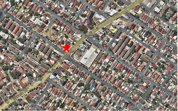
Photo of current signage
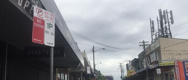
![]() Proposed
changes detailed
Proposed
changes detailed
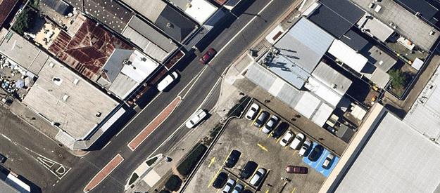
Location of proposed removal of redundant AM & PM ‘No Parking’ restrictions and introduction of new ‘1P 8.30AM – 6.00PM’ restrictions on Illawarra Road north of Harnett Avenue, Marrickville (west side)
![]()
![]()
![]()
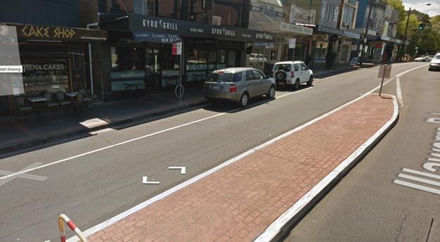
|
|
Local Traffic Committee Meeting 10 April 2018 |
Subject: Metropolitan Road, Enmore – Amend Signage For Existing Mobility Parking Space
Prepared By: Jennifer Adams - Engineer – Traffic and Parking Services
Authorised By: John Stephens - Traffic and Transport Services Manager
|
SUMMARY A request has been received to amend signage to the mobility parking space in Metropolitan Road, Enmore. At present parking is restricted to '90° angle parking rear to kerb'. The request is to remove the 'rear to kerb' restriction for the mobility parking space to allow all accessible vans to be accommodated.
It is recommended that the existing 'rear to kerb' restriction be removed from the mobility parking space in Metropolitan Road, Enmore south of Enmore Road, in order to improve accessibility for people with a disability.
|
|
THAT:
1. The existing 'rear to kerb' parking restriction for the angled mobility parking space in Metropolitan Road, approximately 30m south of Enmore Road, Enmore be removed in order to improve accessibility for people with a disability; and
2. The resident and Council’s Parking Services be advised in terms of this report.
|
BACKGROUND
Council has received a request to amend the signage to the mobility parking space in Metropolitan Road, approximately 30 metres south of Enmore Road, Enmore. At present parking is restricted to '90° angle parking rear to kerb'. It is recommended that the existing 'rear to kerb' restriction be removed from the mobility parking space in Metropolitan Road, Enmore south of Enmore Road, in order to improve accessibility for people with a disability (ie. move the ‘rear to kerb’ restriction by one space northward).
FINANCIAL IMPLICATIONS
The cost of altering the existing signage is to be funded from Council’s signs and line marking budget.
OFFICERS COMMENTS
At present parking is restricted to '90° angle parking ‘rear to kerb'. The request is to remove the 'rear to kerb' restriction for only the mobility parking space (i.e. the 'rear to kerb' restriction would remain for the remainder of the parking spaces). Refer to the attached locality map and photograph.
Council Officers were advised that a resident received an infringement notice for parking front to kerb. The resident advised that she exits her van from the ramp at the rear of the vehicle and was not able to comply with the signage as the kerb impedes the proper lowering of the ramp.
CONCLUSION
The removal of the ‘rear to kerb’ signage for the mobility parking space will allow the space to legally accommodate a range of vehicles carrying people with a disability and thereby make the space more flexible.
Locality map – Metropolitan Street, Enmore
![]()
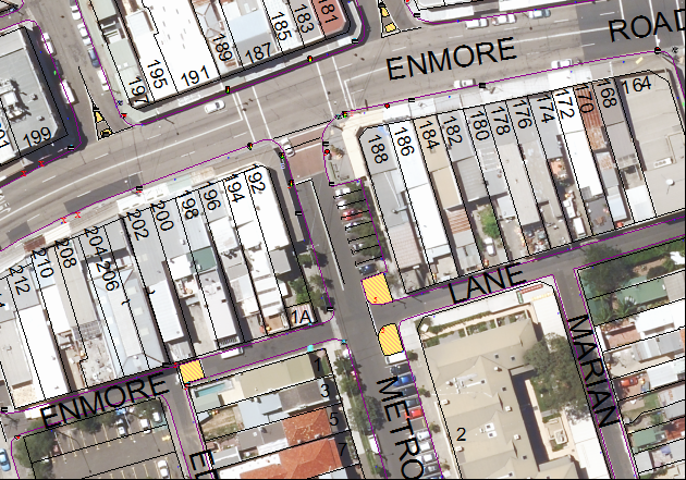
![]()
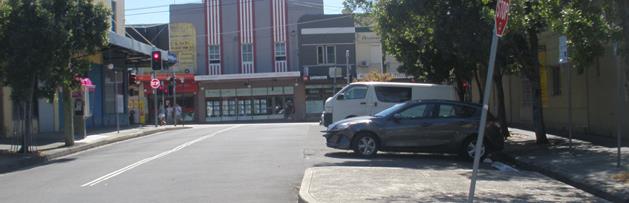
![]()
![]()
![]()
![]()
![]()
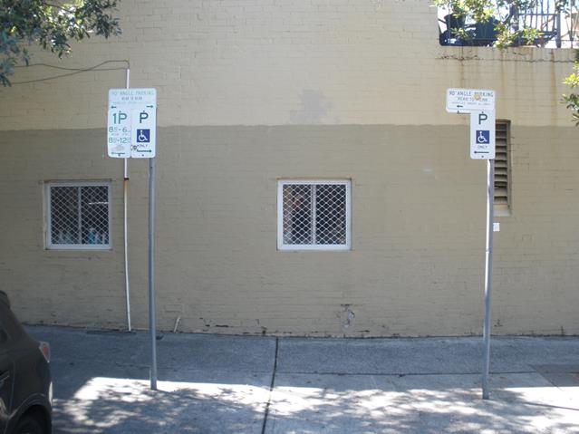
|
|
Local Traffic Committee Meeting 10 April 2018 |
Subject: Beauchamp Street, Marrickville – Proposed No Parking Restrictions (Marrickville Ward/Summer Hill Electorate/Inner West LAC)
Prepared By: Emilio Andari - Engineer – Traffic and Parking Services
Authorised By: John Stephens - Traffic and Transport Services Manager
|
SUMMARY A request has been received from a local resident of Beauchamp Street, Marrickville for the installation of a short section of ‘No Parking’ restrictions directly outside the frontage of their property, as pedestrian access to the adjacent steps of the raised footpath is often blocked by parked vehicles along the kerbside.
Residents have been notified of the proposal to install a short section of ‘No Parking’ restrictions on the eastern side of Beauchamp Street, in order to provide unobstructed pedestrian access to the adjacent steps of the raised footpath. It is recommended that the proposal be approved. |
|
THAT the installation of full-time ‘No Parking’ restrictions (2 metres in length) on the eastern side of Beauchamp Street, Marrickville, adjacent to property no. 82 Beauchamp Street, Marrickville, be APPROVED, in order to provide unobstructed pedestrian access to the adjacent steps of the raised footpath.
|
BACKGROUND
Concerns have been raised by a local resident of Beauchamp Street, Marrickville, in relation to pedestrians not having clear access from their parked vehicles to the adjacent steps which connect the raised footpath and the roadway below. The main concern raised by the resident is the difference in height level between the roadway and footpath in this section of Beauchamp Street and it was reported that local residents depend on the existing steps and hand-rail to access the footpath from their vehicles.
FINANCIAL IMPLICATIONS
The costs of the supply and installation of the signposting associated with the recommended ‘No Parking’ restrictions are approximately $700 and can be met from Council’s operating budget.
OFFICER COMMENTS
Site location & road network
|
Street Name |
Beauchamp Street |
|
Section |
Between Bruce Street and Wharf Street |
|
Carriageway Width (m) |
10.8 |
|
Carriageway Type |
Two-way road with one travel lane in each direction, in addition to kerbside parking lanes. |
|
Classification |
Local |
|
85th Percentile Speed (km/h) |
44.3 |
|
Vehicles Per Day (vpd) |
634 |
|
Reported Crash History (July 2011 – June 2016) |
No crashes recorded. |
|
Heavy Vehicle Volume (%) |
2.1 |
|
Parking Arrangements |
Unrestricted parking on both sides of the road. |
Site inspection
A site inspection undertaken by Council officers revealed that on-street parking spaces in Beauchamp Street were moderately utilised. It was observed that there is a significant difference in height level between the height of the roadway and the adjacent footpath along the subject section of Beauchamp Street. Currently, there is an existing set of steps with a hand-rail adjacent to the kerbside of the road located at the frontage of property no. 82 Beauchamp Street. The width of the set of steps is approximately 1.0m.
Following the site inspection, it is proposed that a 2.0m section of ‘No Parking’ restrictions is appropriate to allow clear pedestrian access to the steps and hand-rail of the raised footpath.
It should be noted that the proposed ‘No Parking’ restrictions would prohibit motorists from parking within the specified zone; however, they can legally stop to load/unload passengers and/or goods.
Locality Map – Beauchamp Street, Marrickville
![]()
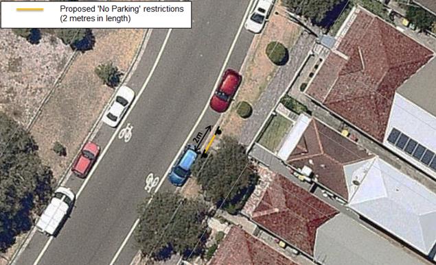
PUBLIC CONSULTATION
A notification letter was sent on 15 March 2018 to owners and occupiers of the effected properties that are adjacent to the subject section along Beauchamp Street, Marrickville regarding a section of ‘No Parking’ restrictions to address concerns regarding pedestrians not having clear access from their parked vehicles to the adjacent steps of the raised footpath. The closing date for comments ended on 29 March 2018.
A total of two (2) letters were sent out to the effected residential properties. There were no responses received.
CONCLUSION
In order to provide unobstructed pedestrian access to the adjacent steps of the raised footpath, it is recommended that full-time ‘No Parking’ restrictions are installed for a section on the eastern side of Beauchamp Street, Marrickville, adjacent to property no. 82 Beauchamp Street, Marrickville.
|
|
Local Traffic Committee Meeting 10 April 2018 |
Subject: Chapel Street, Marrickville – Proposed Timed No Parking Restrictions (Marrickville Ward/Summer Hill Electorate/Inner West LAC)
Prepared By: Emilio Andari - Engineer – Traffic and Parking Services
Authorised By: John Stephens - Traffic and Transport Services Manager
|
SUMMARY A request has been received from a business owner of Chapel Street, Marrickville, for the provision of a ‘No Parking’ zone directly opposite to their loading dock, as vehicular access is often blocked by parked vehicles on the opposite side of the of the road.
Surrounding business owners have been notified of the proposal to install a section of ‘No Parking 8am-5pm Mon-Fri’ restrictions on the southern side of Chapel Street, in order to facilitate clear access for delivery trucks to safely turn in/turn out of the adjacent loading dock. It is recommended that the proposal be approved. |
|
THAT the installation of full-time ‘No Parking 8am-5pm Mon-Fri’ restrictions (5 metres in length) on the southern side of Chapel Street, Marrickville, between the existing driveway of property no. 66 Chapel Street, Marrickville, and the existing driveway of property no. 76 Chapel Street, Marrickville, be APPROVED, in order to facilitate clear access for delivery trucks to safely turn in/turn out of the adjacent loading dock and to increase safety for motorists within the street.
|
BACKGROUND
A business owner of Chapel Street, Marrickville, has raised concerns regarding obstructed vehicular access to their loading dock due to vehicles parked directly opposite to their driveway. The main concern was the safety of motorists to turn into the loading dock located on the northern side of Chapel Street. The business owner also advised that they have several deliveries during weekdays due to the increase in the number of their customers.
FINANCIAL IMPLICATIONS
The costs of the supply and installation of the signposting associated with the recommended ‘No Parking 8am-5pm Mon-Fri’ restrictions are approximately $700 and can be met from Council’s operating budget.
OFFICER COMMENTS
Site location & road network
|
Street Name |
Chapel Street |
|
Section |
Between Victoria Road and Chalder Lane |
|
Carriageway Width (m) |
9.1 |
|
Carriageway Type |
Two-way road with one travel lane in each direction, in addition to kerbside parking lanes. |
|
Classification |
Local |
|
85th Percentile Speed (km/h) |
40.7 |
|
Vehicles Per Day (vpd) |
1,852 |
|
Reported Crash History (July 2011 – June 2016) |
No crashes recorded. |
|
Heavy Vehicle Volume (%) |
4.5 |
|
Parking Arrangements |
Unrestricted parking on both sides of the road. |
Site inspection
It has been observed by Council officers on a number of occasions that on-street parking in Chapel Street were highly utilised throughout the morning and afternoon business hours. It was also observed in some instances that illegal parking occurs in the street (vehicles parked adjacent to driveways) and delivery trucks double-park when unloading. Chapel Street is a narrow road and it was observed, at times, oncoming cars have to pull-over to allow trucks to pass through. It should be noted that there is a significant number of driveways on either side of Chapel Street.
The applicant’s site includes a loading dock access point from both Chapel Street and Rich Street. The applicant advised Council officers that various types of delivery trucks attend their warehouse and that the safest truck movements to their premises is to enter via the loading dock in Chapel Street from Victoria Road and exit out of the loading dock in Rich Street and then turn back onto Victoria Road. The business owner also advised that they operate during weekdays only and typically during normal business hours. Council officers agree to this manoeuvre as trucks travel in a forward motion into and out of the site.
Following the site inspections, it is proposed that a 5.0m section of ‘No Parking 8am-5pm Mon-Fri’ restrictions is appropriate to facilitate clear access for delivery trucks to safely turn in/turn out of the adjacent loading dock and to increase safety for motorists within the street.
It should be noted that ‘No Parking’ restrictions prohibit motorists from parking within the specified zone; however, they can legally stop to load/unload passengers and/or goods.
Locality Map – Chapel Street, Marrickville
![]()
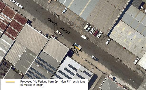
Photographs – Chapel Street, Marrickville
![]()
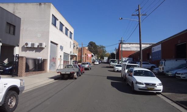
On-street parking in Chapel Street (facing west)
![]()
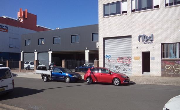
On-street parking directly opposite to loading dock access in Chapel Street (facing south)
PUBLIC CONSULTATION
A notification letter was sent on 16 March 2018 to owners and occupiers of the surrounding businesses that are adjacent to the subject section in Chapel Street, Marrickville regarding a section of ‘No Parking 8am-5pm Mon-Fri’ restrictions to address concerns regarding obstructed vehicular access to their loading dock due to vehicles parked directly opposite to their driveway. The closing date for comments ended on 29 March 2018.
A total of six (6) letters were sent out to the affected business properties. There were no responses received to date. Comments received following completion of this report will be tabled at the committee meeting.
CONCLUSION
In an effort to assist a business with loading/unloading activities, it is recommended that ‘No Parking 8am-5pm Mon-Fri’ restrictions are installed on the southern side of Chapel Street, Marrickville, between the existing driveway of property no. 66 Chapel Street, Marrickville, and the existing driveway of property no. 76 Chapel Street, Marrickville.
|
|
Local Traffic Committee Meeting 10 April 2018 |
Subject: Boomerang
Street and Mortley Avenue, Haberfield
-installation of "Bus Zone" signage to existing Bus Stops.
(Leichhardt Ward/Summer Hill Electorate/Ashfield LAC)
Prepared By: Boris Muha - Engineer – Traffic and Parking Services
Authorised By: John Stephens - Traffic and Transport Services Manager
|
SUMMARY Council has received a request from Sydney Buses to install regulatory “Bus Zone” signs at certain Bus Stops existing along Boomerang Street and Mortley Avenue, Haberfield, to reinforce the bus zone regulations. Bus zone signs are proposed to be erected within or around the statutory distances as required on the approach and departure of the Bus Stops in accordance to the Australian Road Rules.
|
|
THAT “Bus Zone” signage be installed at the existing Bus Stops locations as follows:
1. Outside No 15 Boomerang Street, approximately 23.0 metres on the approach side and 13.0 metres on the departure side of the Bus Stop;
2. Outside No 28 Boomerang Street, approximately 19.0 metres on the approach side and 1.0 metre on the departure side of the Bus Stop; and
3. In Mortley Avenue (corner side frontage of 48 Boomerang Street) approximately 20 metres on the approach side and 7.0metres in the departure side of the Bus Stop.
|
BACKGROUND
Sydney Buses have requested that Council install “Bus Zone” signs to existing bus stops outside the above locations. Bus operators are experiencing problems in accessing the Bus Stops due to cars parking too close and that the elderly are having problems in boarding the buses.
FINANCIAL IMPLICATIONS
The cost of the supply and installation of the signposting is approximately $1200 and can be met from Council’s signs and line marking budget.
OTHER STAFF COMMENTS
Council will be erecting “Bus Zone” signs in accordance with the Australian Road Rules (i.e. 20m on the approach and 10 metres on the departure sides of a Bus Stop.) The signs will outline the bus zone area where vehicles are not permitted to park or stop.
These measures are considered necessary to make motorists aware and ensure buses can safely pull up to the kerb side Bus Stops in Boomerang Street and Mortley Avenue to set down and pick up passengers. The works will not result in the loss of any legal on-street car parking spaces. See the attached diagrams for more details of the works.
The Bus zone distances to be applied as measured from the existing Bus Stop signs are as follows:
1. Bus Stop 204541, 15 Boomerang Street, Haberfield-
Approximately 23.0 metres in approach and 13.0 metres in departure. As the regulatory distances fall within driveways, the distances are extended just past the driveways in this particular case. (refer to Figure 1)
2. Bus Stop 204527, 28 Boomerang Street, Haberfield-
Approximately 19.0 metres in approach and 1.0 metre in departure near the corner of Crane Avenue. As the Stop is near a corner of a street, no Bus Zone lead out is required in this particular case. (refer to Figure 2)
3. Bus Stop 204528, in Mortley Avenue, side boundary of No.48 Boomerang Street, Haberfield-
20.0 metres in approach and approximately 7.0 metres in departure. The departure length in this particular case is considered adequate for a bus to pull out from the kerb. (refer to Figure 3)
![]()
Figure 1: “Bus Zone” signage to existing Bus Stop outside No. 15 Boomerang Street, Haberfield.
![]()
Figure 2: “Bus Zone” signage to existing Bus Stop outside No. 28 Boomerang Street and near corner to Crane Avenue, Haberfield.
![]()
Figure 3: “Bus Zone” signage to existing Bus Stop in Mortley Avenue, near corner to Boomerang Street, Haberfield.
![]() PUBLIC CONSULTATION
PUBLIC CONSULTATION
Notification letters have been sent out to residents in the vicinity of the Bus Stops as shown in the distribution map. The notification letters advised of Council’s proposal to reinforce the existing Bus Stops locations with bus zone signage.
CONCLUSION
The bus zone signs are required to prevent parking close to the Bus Stops and allow buses to safely and properly pull up to the kerb to set down and pick up passengers. The signs will be placed within and around the statutory distance under the Australian Road Rules on approach and departure of the Bus Stops
|
|
Local Traffic Committee Meeting 10 April 2018 |
Subject: Frederick
Street, Ashfield - Advertising Trailer Parking (Leichhardt Ward/Strathfield
& Summer Hill Electorates/Ashfield
LAC)
Prepared By: Boris Muha - Engineer – Traffic and Parking Services
Authorised By: John Stephens - Traffic and Transport Services Manager
|
SUMMARY This report is in response to a Notice of Motion raised at Council’s meeting on the 12 October 2017 as follows that : “Council investigates the removal of the advertising trailers on Frederick Street, Ashfield”. Council’s traffic officers have investigated various avenues in discussion with the RMS, Police and Council’s Planning/Regulatory officers in the removal and/or deterrence of advertising trailer parking in Frederick Street, Ashfield. The following recommendation is made for Council to note on the course of action that will be carried out in removing or limiting advertising trailer parking in Frederick Street and other streets within the Inner West Council area. |
|
THAT Council Note:
1. Advertising trailers parked on a road or road related area will be prohibited or limited under recent changes made to the “State Environmental Planning Policy No.64-Advertising and Signage (Amendment No.3) under the Environment And Planning Assessment Act 1979.”-see Schedule 1 [7] clause 27A. A copy of the amendment to policy is in attachment 3;
2. Council’s Planning and Compliance/Parking and Ranger Service officers will commence to enforce and monitor advertising trailer parking in Frederick Street and all other streets in the Inner West Council Area in compliance to the above amended policy item 1, as from 1 March 2018; and
3. Planning and Compliance/Parking and Ranger Services will be reporting back to Council in due course on the update and status of enforcing and monitoring of advertising trailer parking in Frederick Street and other streets in the Inner West Council Area. |
BACKGROUND
Advertising trailers have appeared over the last 3-5 years along Frederick Street, and have since parked and congregated outside Hammond Park in Frederick Street, Ashfield. – See photos of advertising trailers are shown in attachments 1 and 2.
Frederick Street is a State Road under the care and control of the RMS. The former Ashfield Council initially approached the RMS a few years back to determine whether advertising trailer parking in Frederick Street could be removed under the Roads Act or Road Rules.
FINANCIAL IMPLICATIONS
Nil.
OTHER STAFF COMMENTS
It was viewed at the time though discussions with the RMS and Police (and up to the present moment) that the trailers have and are parked in a legal manner outside Hammond Park. The trailers are parked in a section of Frederick Street which avoids or minimise any physical obstruction/hazard to traffic/pedestrian movement and driveway access. They are parked outside a Park and not outside of residential premises to impede or impact on the general amenity to residents. The Police have also indicated that the trailers are registered and are roadworthy. Provided they are legally parked, Police cannot remove the trailers under the current Roads Act or Road Rules.
The installation of parking restrictions along the Hammond Park frontage of Frederick Street was also considered but was dismissed on the basis that the trailers would proceed to move on and park in undesirable locations outside of residential properties or locations of road that can be deemed hazardous under road safety grounds.
On the overhand, investigation under Planning legislation has revealed that recent changes had been made to the “State Environmental Planning Policy No.64-Advertising and Signage (Amendment No.3) under the Environment And Planning Assessment Act 1979.”
Under Schedule 1 [7] clause 27A of the Policy, advertising on trailers parked on a road or road related area would be prohibited or limited. –A copy of the amendment to Policy signed by the Minister of Planning is shown in Attachment 3.
A further copy of a Public Notice forwarded to Council from the NSW Department of Planning and Environment outlining the changes to the planning rules for advertising and signage is also shown in Attachment 4. It is quoted under the Public Notice that:
“The changes to planning rules for outdoor advertising and signage will improve road safety and reduce driver distractions. During consultation, safety and amenity concerns (visual impacts and use of the road) were raised about roadside advertising trailers blocking motorists’ vision and distracting drivers. By reducing the types of roadside trailer advertising currently on our roads we’ll minimise risks to drivers.”
It is further noted that the change to ban trailers advertising will come into effect on 1 March 2018. This will insure that the community, Councils and industry are ready for these changes, allowing the removal of trailer signage.
PUBLIC CONSULTATION
Public consultation was carried out by The NSW Department of Planning and Environment in amendment of State Environmental Planning Policy No. 64 – Advertising and Signage
CONCLUSION
Despite the inability to enforce and generally remove advertising trailer parking under the Roads Act and Road Rules, investigation has led to Council being able to enforce and monitor advertising trailer parking not just in Frederick Street, but in general throughout the Inner West Council area in compliance to the State Environmental Planning Policy No.64-Advertising and Signage (Amendment No.3) under the Environment And Planning Assessment Act 1979.”
Enforcement will be effective as from the 1st March 2018. Council’s Planning and Compliance/Parking and Ranger Services will be reporting back to Council in due course on the update and status of enforcing and monitoring of advertising trailer parking in Frederick Street and other streets in the Inner West Council Area.
Photo attachments of advertising Trailer parking in Frederick Street, Ashfield
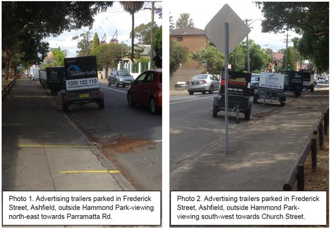
Copy of amendment to Policy- State Environmental Planning Policy No.64- Advertising and Signage (Amendment No.3) under the Environment And Planning Assessment Act 1979.”
Copy of Public notice on amendment to Policy.
|
|
Local Traffic Committee Meeting 10 April 2018 |
Subject: 2A Gladstone Street, Newtown - DA201700589 – For The Temporary Use of The Site For A Multi-use Creative Hub
Prepared By: Jennifer Adams - Engineer – Traffic and Parking Services
Authorised By: John Stephens - Traffic and Transport Services Manager
|
SUMMARY An application (DA201700589) has been received to use the existing buildings on site at 2A Gladstone Street, Newtown to create a “Proposed multi-use area which would include creative work spaces, market stalls, wholesale bakery and food truck.” The application type is for “Temporary building/structures.”
It is recommended that the comments of the Pedestrian, Cyclist and Traffic Calming Advisory Committee be referred to Council’s Development Assessment Section for consideration in determining the Development Application.
|
|
THAT the findings of this report be received and noted. |
BACKGROUND
An application has been received to use the existing buildings to create a multi-use creative hub containing creative work spaces (business and offices premise), market stalls, wholesale bakery and food truck with 24 portable/ re-locatable marquees for stall holders, 8 shipping containers four on the ground floor and 4 above, fold out stage to operate 7.00am to 7.00pm Mondays to Fridays, 6.00am to 6.00pm for the creative workspaces, 6.00am to 6.00pm Mondays to Sundays for the wholesale bakery, Saturdays 7.00am to 4.00pm and 6.00pm to 10.00pm for the market and 7.00am to 10.00pm for functions or creative performances.
The application is required to be referred to the Pedestrian, Cyclist & Traffic Calming Advisory Committee for consideration under State Environmental Planning Policy (Infrastructure) 2007.
It is noted that previously the site has been occupied by an open yard area used as a metal recycling operation. Determination No. 14352, dated 4 June 1992, approved an application for the use of the property for the collection, dismantling, storage and wholesale of scrap metals, subject to conditions. Determination No. 201200505, dated 13 March 2013, approved an application under Section 96 to modify Determination No. 14352 dated 4 June 1992 to construct an awning, amend condition 4 relating to machinery to include an excavator and amend condition 9 to permit the storage of batteries.
At present DA No. 201600060 for 2 and 2A Gladstone Street, Newtown was approved on 23 January 2017 to demolish existing improvements and construct a 4 storey mixed use development with creative commercial uses on the ground floor, first and second floors 18 dwellings (including 3 live work dwellings) on the upper floors with basement car parking and strata subdivision.
DISCUSSION
Site Location
The subject site is located in the suburb of Newtown and situated on the southern side of Gladstone Street at the intersection with Wilford Street, Newtown and has a secondary frontage to Wilford Street as illustrated in the location and site maps below.
![]()
![]()
![]()
![]()
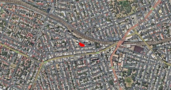
The site is irregular in shape and has a site area is area of 996m². The site currently comprises a hardstand area and associated metal sheds/awnings surrounded by a 4m high masonry wall. The site is fully developed and does not contain any trees or natural features. The topography is generally level with a hardstand area extending across the site.
The locality is characterised by a mix of residential densities, small businesses and remnant industrial Buildings. The Enmore Road retail strip is approximately 75m from the site. The site has been used for metal recycling operations since 1917.
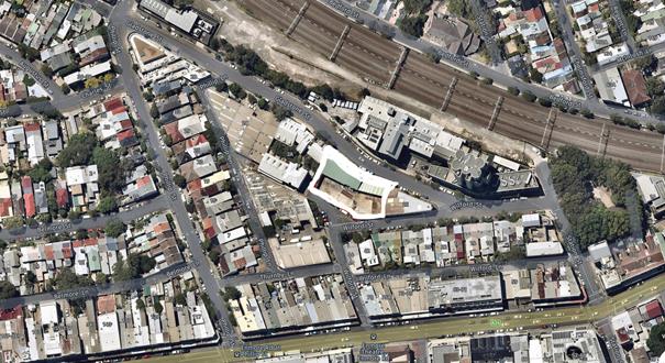
Locality and Road Network
The site is bound by Gladstone Street to the north, Gladstone Lane to the west and Wilford Street to the south. These are local roads with default speed limits of 50km/h. Both Wilford Street and Gladstone Lane are single-lane roads with on-street parking on one side. Wilford Street has carriageway width of approximately 6.5 metres and has unrestricted kerbside parking on the southern side only. Gladstone Street is a two-lane, two-way road and has a carriageway width of approximately 10 metres and it has with a mix of time-restricted and unrestricted kerbside parking.
Gladstone Street connects Station Street to the east and Liberty Street to the west. It carries around 1,600 vehicles per day and 85th percentile speed is 45.4km/h between Phillip Street and Wilford Street. Phillip Street and Station Street are local roads providing primary connection between the local residential access movements and Enmore Road. Trafalgar Street and Wilford Street predominantly serve local residential access movements.
Traffic conditions in the vicinity are generally moderate with predominant traffic movements being those of residents and commuters. The King Street / Enmore Road signalised intersection experiences traffic delays during the peak morning and afternoon periods. Parking in the locality is at a premium and the M3 permit parking area was expanded in 2015 to protect resident parking in the immediate area.
Public Transport
The area is located close to Enmore Road, which has several bus routes along it and approximately 450 metres from Newtown railway station.
The proposal
According to the applicant’s SEE report the Development consent is being sought for a multi-use development of creative work spaces, market stalls, wholesale bakery and food truck, referred to as the Sydney Artist Workshop / Gladstone Street Creative Hub:
The proposed adaptive reuse of the former scrap metal yard site includes the following improvements / facilities:
• 24 portable / relocatable marquees for stall holders;
• Stack of 8 shipping containers (4 on ground level with 4 stacked above) with metal stairs and access walkway;
• Fold out shipping container stage;
• 5 portable toilets, including 1 disabled toilet (2 existing plumbed toilets will be retained for use);
• 2 portable showers and lockers;
• Timber screening of the toilet area;
• Dedicated area for 1 x food truck;
• 13 bicycle spaces;
• 1 motorbike space;
• 1 x shipping container for bakery preparation and retention of 1 existing shipping container for bakery storage; and
• Raised platform for bread oven and pizza oven.
A waste storage area is proposed in the north-western corner of the site.
|
|
|
|
|
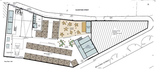
The Creative Work Space and Markets features include:
• Short-term studio spaces
• Affordable short-term artist residential spaces for visiting artists Market Yard for weekend
artisan and produce markets
• Café / Bakery
• Dedicated workshop and teaching facilities Performance rehearsal studios Performance
space
• Art gallery turning over 12-24 exhibitions per year
• Tool and equipment library for members and studio residents.
Hours of Operation are listed to be:
•The creative work spaces would be open from Monday to Friday (7am to 7pm).
•The wholesale bakery will operate Monday to Sunday from (6am to 6pm).
•The market will operate on Saturdays from (7am to 4pm) and then a night market from (6pm to 10pm).
•The facility would also be available for functions or creative performances on Sundays (7am to 10pm).
Staff and Patron Numbers are stated to be:
It is anticipated that the combined uses on site will generate employment for approximately 25-30 people. Based on a ratio of 1 person per 3m², the creative space and markets has spatial capacity for up to 362people (stall operators and patrons).
With regards to vehicular facilities the applicant’s Traffic report states that 1 motorcycle parking space and 13 bicycle spaces with end of trip facilities consisting of 2 x showers and 6 x lockers are to be provided on-site. They say the vehicular access and loading area is capable of accommodating SRV-type vehicles for deliveries and providing access for food trucks.
Thus, the proposal is to retain the existing building and install a multi-use development area in the open courtyard area. This would include 24 market stalls, 1 pop-up food-truck kiosk, 8 artist studios, and a stage with seating. The site area is stated as being 1,445m2 with 1,084m2 for market use and it’s estimated that the site will accommodate 25-30 staff at peak times and a maximum of 362 patrons. No on-site vehicle parking is to be provided as part of this proposal with the exception of the motor cycle parking..
Parking Provision
The property is located in Parking Area 1 under Part 2.10 of MDCP 2011. The creative space activities fall under the land use definition of business premises and office premises.
There were no actual GFAs for individual uses itemised which made the parking provision analysis challenging however the RMS’s Guide to Traffic Generating Developments was used in lieu of the missing itemised uses as well as provisions for market stalls in Council’s DCP.
|
Component |
Control |
Required |
Proposed |
Complies
|
|
Car Parking |
||||
|
Restaurant and takeaway food or drink premises |
1 per 100m² GFA for customers & staff |
230m² GFA = 2.3 spaces |
None |
No |
|
Business premises / office premises |
1 per 100m² GFA for staff & customers / visitors |
132m² GFA = 1.3 spaces |
None |
No |
|
Markets |
Use RMS Guide to Traffic Generating developments – 2 spaces per stall (desirable 2.5 spaces per stall) |
634m²/1084m² ? or 24 stalls = 48 spaces (or desirably 60) |
None |
No |
|
Motorcycle parking |
||||
|
|
5% of the total car parking requirement |
51 car parking spaces required = 2.55 spaces |
1 |
No |
Note that RMS’s Guide to Traffic Generating Developments state a minimum parking provision of 2 spaces per stall or a desirable rate of 2.5 spaces per stall, excluding stall holders. 24 stalls would therefore, alone, require a minimum of 48 spaces for visitors and a desirable rate of 60 spaces. These rates are based on a mode split for cars of 0.80 and a reasonable availability and convenience of alternative markets in the area.
It is estimated conservatively that, for the markets generally, that at least 40 (visitor) and 15 (stall holders) car parking spaces should be provided – ie. 55. In addition, the 8 studios will generate staff, visitor and service parking requirements as will the bakery. In total, conservatively, possibly up to around 60 additional parking spaces are required to be found on the streets surrounding 2A Gladstone Street, which is not acceptable as parking in the locality is at a premium. A residential parking permit scheme – M3 - is already in place due to high parking demand in the locality. Residents already compete now with business and commuter parking demands in the surrounding streets.
Principally, the proposal needs to provide parking on-site and/or propose alternative off-street parking arrangements for the duration of the temporary multi-use creative hub use and in addition include a stall holder parking TMP. Residents’ in the surrounding streets will be impacted by the generated parking demand of the proposal / markets regardless of whether there are 10 or 24 stalls. If the markets become increasingly popular this will only exacerbate the situation. This situation has been experienced in other locations around the LGA as markets become more popular. Residents, business operators and patrons, stall holders and market visitors will all be competing for very limited on-street parking.
Other parking issues which have not been considered in the submission include provision of mobility parking and car share.
Servicing
The existing concrete courtyard is serviced by four vehicular crossings / roller door driveways, with two located on Gladstone Street north of the site, 1 located on Gladstone Lane to the southwest and 1 located on Wilford Street to the south.
The proposed development includes vehicular access, loading and service areas to the western side of the site with direct access from the Gladstone Street frontage which is considered appropriate having regard to existing vehicular access to the site.
The applicant’s Traffic report includes food truck access and egress swept path diagrams as shown below:
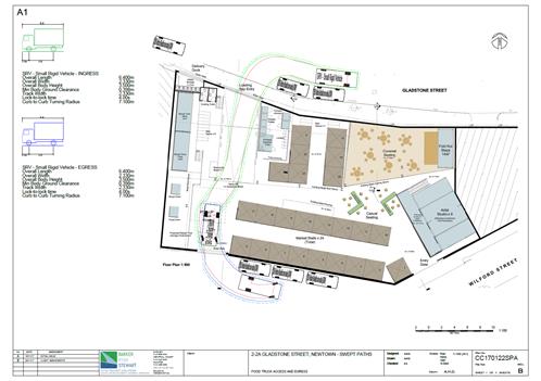
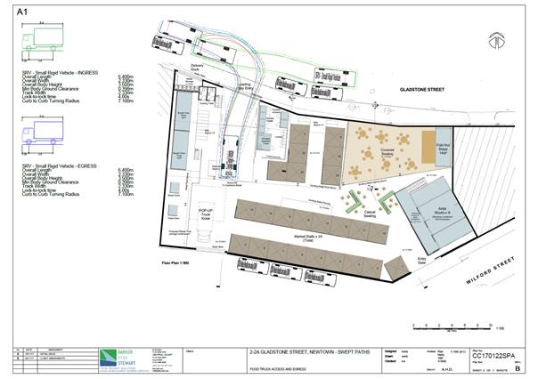
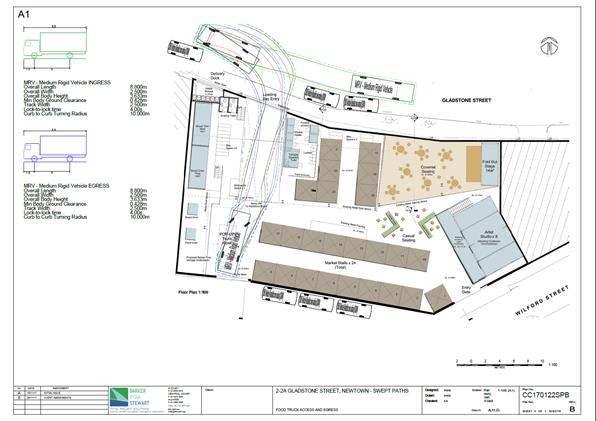
Traffic Generation
RMS’s Guide to Traffic Generating Developments gives the following rates for markets - 18 trips per stall between 8.00am – 3.00pm (open for 7 hours) and peak hour vehicle trips of 4 trips per stall. 24 stalls thus would generate approximately 432 vehicle trips daily and 96 peak hour vehicle trips. Daily trip generation rates depend on hours of operation and the Guide states a market open for 12 hours a day would be expected to have a higher daily generation rate than that suggested.
The estimated 96 added vehicle trips (just generated by the market operation alone) in the peak hour will add to the traffic congestion already experienced in Enmore Road and Liberty Street, Newtown.
PUBLIC CONSULTATION
Consultation / notification regarding the proposal would normally be undertaken by Council’s Development and Planning Services as part of the development application process.
CONCLUSION
The proposed development is not supported in its current form because of the following issues:
· GFA uses/areas need to be identified more precisely. It is difficult to adequately determine parking provision and/or traffic generation rates for the proposed development. There is no mention of a ‘Residential’ component yet it is cited in the applicant’s SEE report as a ‘use’.
· The applicant’s Traffic report uses different criteria for parking and traffic generation analysis; ideally these should be consistently based.
· The proposed development does not comply with Council’s parking requirements. The proposition that no on-site parking provision (or alternative off-street parking arrangement) is required is not acceptable. The ‘25-30 employed people/staff’ need parking spaces as will a fair portion of the ‘362 people operating and attending the markets’ will require parking.
In summary, the development application for the proposed temporary multi-use creative hub at 2A Gladstone Street, Newtown is not supported in its present form because it does not meet Council’s minimum parking requirements. Taking into consideration all explanations given in the applicant’s Traffic report for the/any reduction from the standard Council DCP minimum required parking provision for the proposal providing no parking spaces whatsoever is not considered practical due to the significant additional pressure on ‘on-street’ that will occur as a result of the proposed use.
Clearly, there is insufficient parking on-street to contain the proposed activity and consequently, on any market day, neighbouring streets will be parked out at the detriment of local residents.