|
AGENDA R |

Local Traffic Committee Meeting
MONDAY 4 MARCH 2019
10.00am
|
|
Local Traffic Committee Meeting 4 March 2019 |
Function of the Local Traffic Committee
Background
Roads and Maritime Services (RMS) is legislated as the Authority responsible for the control of traffic on all NSW Roads. The RMS has delegated certain aspects of the control of traffic on local roads to councils. To exercise this delegation, councils must establish a local traffic committee and obtain the advice of the RMS and Police. The Inner West Council Local Traffic Committee has been constituted by Council as a result of the delegation granted by the RMS pursuant to Section 50 of the Transport Administration Act 1988.
Role of the Committee
The Local Traffic Committee is primarily a technical review and advisory committee which considers the technical merits of proposals and ensures that current technical guidelines are considered. It provides recommendations to Council on traffic and parking control matters and on the provision of traffic control facilities and prescribed traffic control devices for which Council has delegated authority. These matters are dealt with under Part A of the agenda and require Council to consider exercising its delegation.
In addition to its formal role as the Local Traffic Committee, the Committee may also be requested to provide informal traffic engineering advice on traffic matters not requiring Council to exercise its delegated function at that point in time, for example, advice to Council’s Development Assessment Section on traffic generating developments. These matters are dealt with under Part C of the agenda and are for information or advice only and do not require Council to exercise its delegation.
Committee Delegations
The Local Traffic Committee has no decision-making powers. The Council must refer all traffic related matters to the Local Traffic Committee prior to exercising its delegated functions. Matters related to State Roads or functions that have not been delegated to Council must be referred directly to the RMS or relevant organisation.
The Committee provides recommendations to Council. Should Council wish to act contrary to the advice of the Committee or if that advice is not supported unanimously by the Committee members, then the Police or RMS have an opportunity to appeal to the Regional Traffic Committee.
Committee Membership & Voting
Formal voting membership comprises the following:
· one representative of Council as nominated by Council;
· one representative of the NSW Police from each Local Area Command (LAC) within the LGA, being Newtown, Marrickville, Leichhardt and Ashfield LAC’s.
· one representative from the RMS; and
· State Members of Parliament (MP) for the electorates of Summer Hill, Newtown, Heffron, Canterbury, Strathfield and Balmain or their nominees.
Where the Council area is represented by more than one MP or covered by more than one Police LAC, representatives are only permitted to vote on matters which effect their electorate or LAC.
Informal (non-voting) advisors from within Council or external authorities may also attend Committee meetings to provide expert advice.
Committee Chair
Council’s representative will chair the meetings.
Public Participation
Members of the public or other stakeholders may address the Committee on agenda items to be considered by the Committee. The format and number of presentations is at the discretion of the Chairperson and is generally limited to 3 minutes per speaker. Committee debate on agenda items is not open to the public.
|
|
Local Traffic Committee Meeting 4 March 2019 |
|
AGENDA |
1 Apologies
2 Disclosures of Interest
3 Confirmation of Minutes Page
Minutes of 4 February 2019 Local Traffic Committee Meeting 6
4 Matters Arising from Council’s Resolution of Minutes
5 Part A – Items Where Council May Exercise Its Delegated Functions
Traffic Matters
ITEM Page
LTC0319 Item 1 White Street, Lilyfield - Proposed 10m 'No Stopping' restriction at intersection with Moore Lane (Baludarri Ward/Balmain Electorate/Leichhardt PAC) 38
LTC0319 Item 2 Grove Street, Birchgrove - Proposed 10m 'No Stopping' restrictions at intersection with The Terrace (Baludarri Ward/Balmain Electorate/Leichhardt PAC) 40
LTC0319 Item 3 Church Street, Ashfield - Proposed 10m 'No Stopping' restrictions at intersection with Unnamed Lane (Djarrawunang Ward/Summer Hill Electorate/Inner West PAC) 42
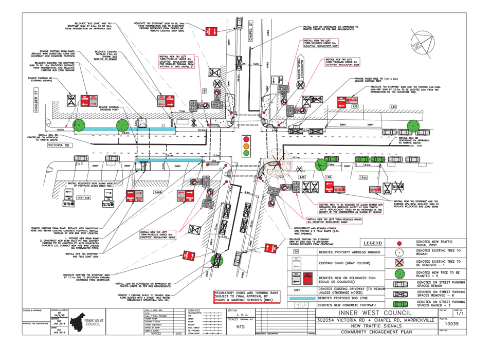
LTC0319 Item 4 Victoria Road & Chapel Street, Marrickville - New Traffic Signals/ Intersection Upgrade for Improving Traffic Safety (Midjuburi Ward/ Summer Hill Electorate/ Inner West PAC) 44
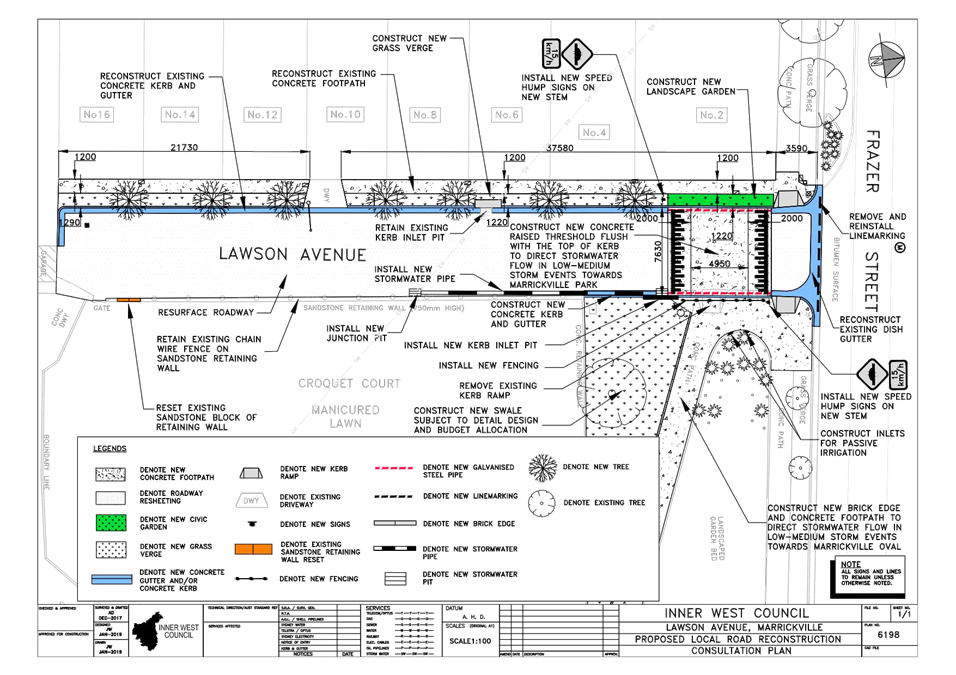
LTC0319 Item 5 Lawson Avenue, Marrickville - Raised Threshold (Midjuburi Ward/ Summer Hill Electorate/ Inner West PAC) 49
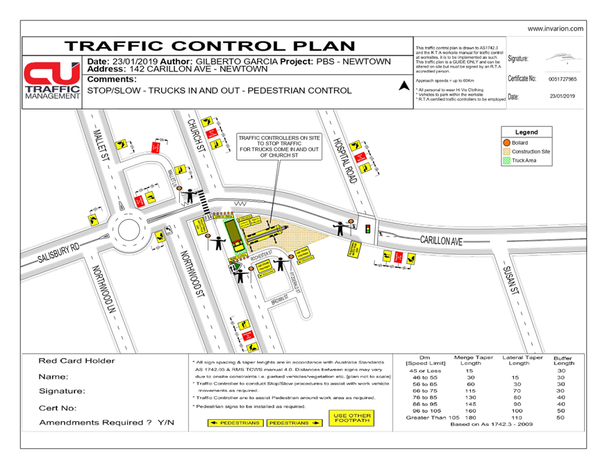
LTC0319 Item 6 Temporary Full Road Closure - Church Street (between Carillon Avenue and Rochester Street), Newtown (Damun Ward/Newtown Electorate/Inner West PAC) 54
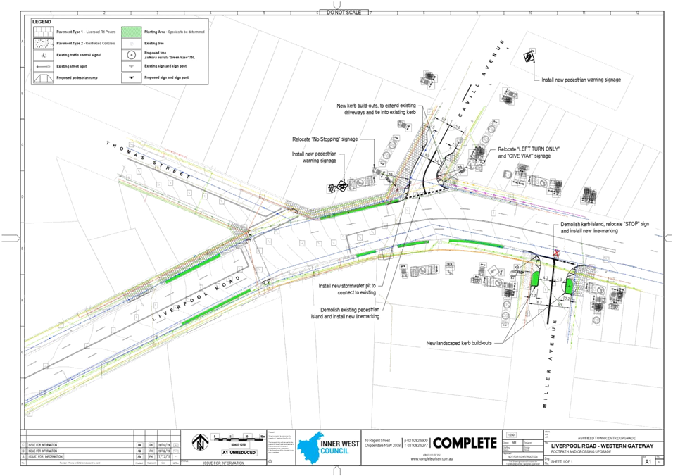
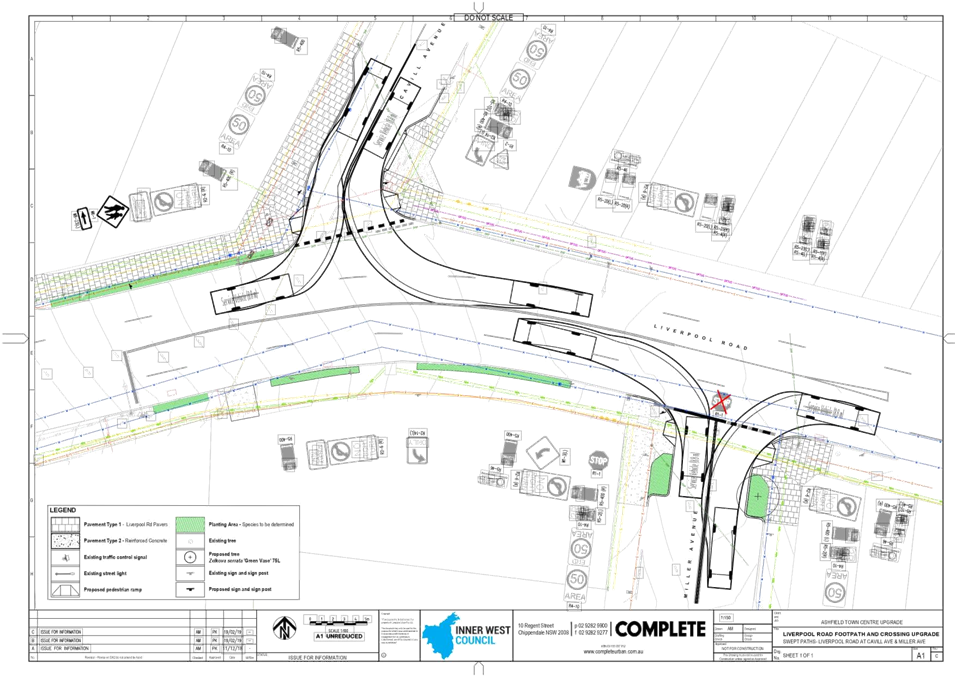
LTC0319 Item 7 Miller Avenue at Liverpool Road and Cavill Avenue at Liverpool Road, Ashfield - Proposed Kerb Extensions (Djarrawunang Ward/Summer Hill Electorate/Burwood PAC) 57
Parking Matters
ITEM Page
LTC0319 Item 8 McGill Street, Lewisham - Proposed Parking Restrictions (Damun Ward/Summer Hill Electorate/Inner West PAC) 62
LTC0319 Item 9 Cavey Street at Calvert Street, Marrickville - Proposed 10m 'No Stopping' restrictions (Midjuburi Ward/Summer Hill Electorate/Innerwest PAC) 70
LTC0319 Item 10 Fitzroy Lane, Newtown - Proposed parking restrictions (Damun Ward/Newtown Electorate/Inner West PAC) 72
LTC0319 Item 11 Pearl Lane, Newtown - Proposed 'No Parking' (Damun Ward/Newtown Electorate/Inner West PAC) 81
LTC0319 Item 12 Cannon Lane, Stanmore - Proposed 'No Parking' (Damun Ward/Newtown Electorate/Inner West PAC) 85
LTC0319 Item 13 Piper Lane (rear of 319 Annandale Street), Annandale - Proposed 'No Parking' zone (Baludarri Ward/Balmain Electorate/Leichhardt PAC) 87
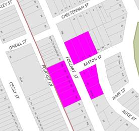
LTC0319 Item 14 Foucart Street at Easton Street, Rozelle - Proposed 'No Stopping' zone (Baludarri Ward/Balmain Electorate/Leichhardt PAC) 90
LTC0319 Item 15 Church Street, Petersham - Proposed 'No Parking Authorised Council Records Vehicles Excepted' Restrictions (Damun Ward/Newtown Electorate/Inner West PAC) 93
LTC0319 Item 16 Henry Street, Ashfield - Proposed Installation of 10m 'No Stopping' zone (Djarrawunang Ward/Strathfield Electorate/Burwood PAC) 95
LTC0319 Item 17 Edwin Street & Stanley Street, Tempe - Proposed Installation of 10m Statutory 'No Stopping' Signage (Midjuburi Ward/Heffron Electorate/Inner West PAC) 98
LTC0319 Item 18 Cannon Street, Stanmore - Proposed Installation of 10m Statutory 'No Stopping' Signage (Damun Ward/ Newtown Electorate/ Inner West PAC) 102
LTC0319 Item 19 Susan
Street, Annandale - Motorbike Parking
(Gulgadya Ward/Balmain Electorate/Leichhardt PAC) 106
LTC0319 Item 20 Minor Traffic Facilities (All Wards/All Electorates/All PACs) 109
LTC0319 Item 21 Australia Street, Stanmore - Proposed Time Restricted Parking (Damun Ward/Newtown Electorate/Inner West PAC) 117
Late Items
Nil at time of printing.
6 Part B - Items for Information Only
ITEM Page
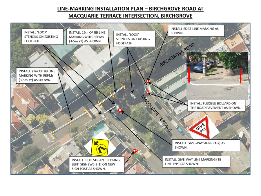
LTC0319 Item 22 Birchgrove Road at Macquarie Terrace, Birchgrove - Proposed Linemarking and Signage Works (Baludarri Ward/Balmain Electorate/Leichhardt PAC) 120
7 Part C - Items for General Advice
ITEM Page
LTC0319 Item 23 Flood Street, Leichhardt - Road Occupancy (Gulgadya Ward/Balmain Electorate/Leichhardt PAC) 123
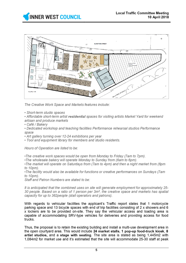
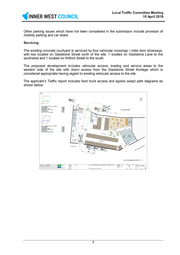
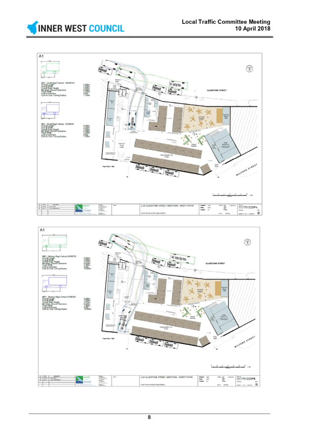
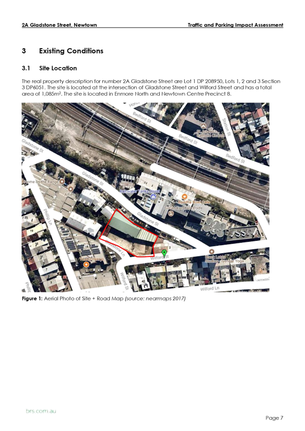
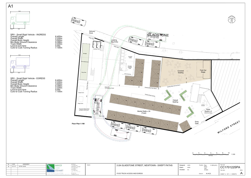
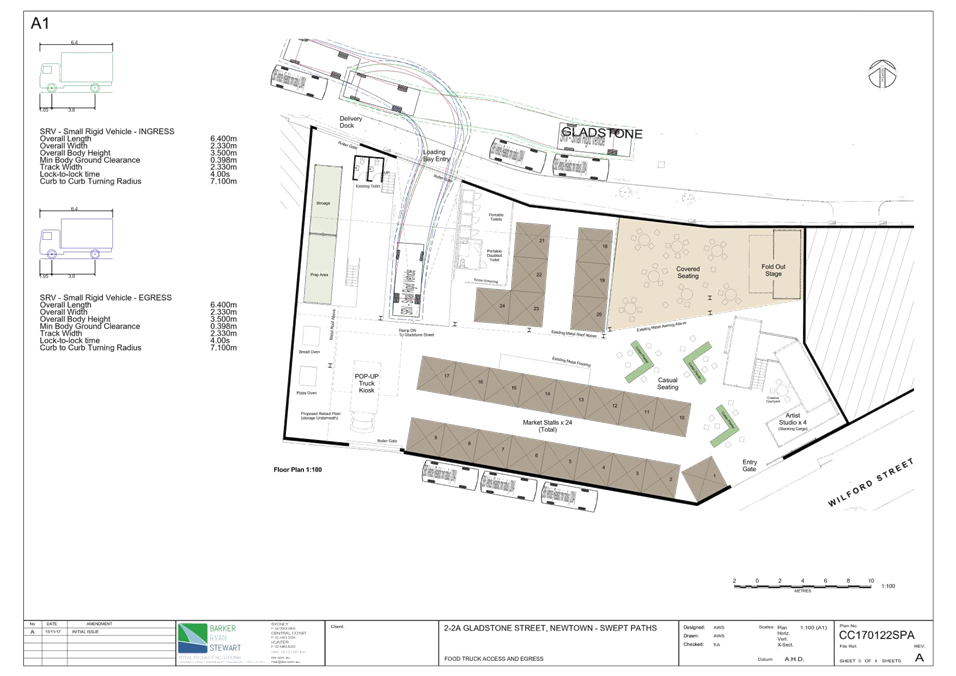
LTC0319 Item 24 2A Gladstone Street, Newtown - DA201700589 - For The Temporary Use Of The Site For A Multi-Use Creative Hub - Revised Traffic & Parking Impact Assessment (Damun Ward/Newtown Electorate/Inner West PAC) 125
8 General Business
9 Close of Meeting
|
|
Local Traffic Committee Meeting 4 March 2019 Minutes of 4 February 2019 |
Minutes of Local Traffic Committee Meeting
Held at Petersham Service Centre on 4 February 2019
Meeting commenced at 10.04am
ACKNOWLEDGEMENT OF COUNTRY BY CHAIRPERSON
I acknowledge the Gadigal and Wangal people of the Eora nation on whose country we are meeting today, and their elders past and present.
COMMITTEE REPRESENTATIVES PRESENT
|
Clr Vic Macri |
Chair – Councillor – Marrickville Ward |
|
Bill Holliday |
Representative for Jamie Parker MP, Member for Balmain |
|
Chris Woods |
Representative for Ron Hoenig MP, Member for Heffron |
|
Sarina Foulstone |
Representative for Jo Haylen MP, Member for Summer Hill |
|
SC Tony Kenny |
NSW Police – Inner West Police Area Command |
|
Marina Nestoriadis |
NSW Police – Leichhardt Police Area Command |
|
Ryan Horne |
Roads and Maritime Services |
|
|
|
|
OFFICERS AND OTHERS IN ATTENDANCE |
|
|
|
|
|
Asith Nagodavithane |
Transit Systems – Inner West Bus Services |
|
Colin Jones |
Inner West Bicycle Coalition |
|
Clr Marghanita da Cruz |
Councillor – Leichhardt Ward |
|
Wal Petschler |
IWC’s Group Manager, Roads, Traffic and Stormwater |
|
John Stephens |
IWC’s Traffic and Transport Services Manager |
|
Manod Wickramasinghe |
IWC’s Coordinator Traffic and Parking Services (North) |
|
George Tsaprounis |
IWC’s Coordinator Traffic and Parking Services (South) |
|
David Yu |
IWC’s Engineer – Traffic and Parking Services |
|
Boris Muha |
IWC’s Engineer – Traffic and Parking Services |
|
Vinoth Srinivasan |
IWC’s Engineer – Traffic and Parking Services |
|
Mary Bailey |
IWC’s Parking Planner |
|
Miia Hynninen |
IWC’s Business Administration Officer |
|
Christina Ip |
IWC’s Business Administration Officer |
|
|
|
|
VISITORS |
|
|
|
|
|
Beverley Prunster |
Item 19 – Resident |
|
Greg Prunster |
Item 19 – Resident |
|
Jason Gooden |
Item 19 – Resident |
|
|
|
|
APOLOGIES: |
|
|
|
|
|
Sgt John Micallef |
NSW Police – Burwood Police Area Command |
|
SC Sam Tohme |
NSW Police – Burwood Police Area Command |
DISCLOSURES OF INTERESTS:
Ms Sarina Foulstone declared a non-pecuniary interest in Item 31 as she is a member of BIKESydney’s management committee.
CONFIRMATION OF MINUTES
|
The Minutes of the Local Traffic Committee Meeting held on Tuesday, 4 December 2018 were confirmed. |
MATTERS ARISING FROM COUNCIL’S RESOLUTION OF MINUTES
The Minutes of the Local Traffic Committee Meeting held on Tuesday, 4 December 2018 are awaiting adoption.
|
LTC0219 Item 1 Mullens Street, near Beattie Street, Balmain - Raised Pedestrian (Zebra) Crossing (Balmain Ward/Balmain Electorate/Leichhardt PAC) |
|
SUMMARY
Detailed design plans have been finalised for the proposed raised pedestrian (zebra) crossing in Mullens Street, Balmain.
The proposed works includes the construction of a raised pedestrian (zebra) crossing, relocation of existing ‘Bus Zone’, installation of signage and road markings, provision of motorcycle parking and upgrade of street-lighting.
Officer’s Recommendation
THAT the detailed design plan for the raised pedestrian (zebra) crossing with associated signposting and line marking in Mullens Street, Balmain (as per the attached plan No. 10052) be approved.
DISCUSSION
Clr Da Cruz requested for the pedestrian crossing signs on the northbound approach to the crossing be installed on the same pole as the speed hump sign to better demarcate the crossing for approaching motorists. Council Officers stated that the design plan will be amended to correct the placement of the signage.
The Committee members agreed with the Officer’s recommendation.
COMMITTEE RECOMMENDATION
THAT the detailed design plan for the raised pedestrian (zebra) crossing with associated signposting and line marking in Mullens Street, Balmain (as per the attached plan No. 10052) be approved, subject to reviewing the location of the pedestrian crossing sign on the design plan.
For motion: Unanimous
|
|
LTC0219 Item 2 Smidmore Street, Marrickville – Road Occupancy - Request by BreastScreen NSW to position a Mobile X-ray Unit on Street between 11 March 2019 and 9 May 2019 (Marrickville Ward / Summer Hill Electorate / Inner West PAC) |
|
SUMMARY
A request has been received from ‘BreastScreen New South Wales’ to position a mobile x –ray Unit within the existing ‘No parking’ zone on the northern side of Smidmore Street adjacent Marrickville Metro Shopping Centre, Marrickville, between 11 March 2019 and 9 May 2019 (a period of approximately eight (8) weeks) as in previous years. It is recommended that the request be approved, on the basis of this being an annual occurrence with no major problems being encountered previously.
Officer’s Recommendation
THAT the road occupancy for the BreastScreen NSW mobile x-ray unit on the northern side of Smidmore Street, Marrickville, approximately 55 metres east of Edinburgh Road, outside the Marrickville Metro Shopping Centre be supported for a period of nine (9) weeks from Monday, 11 March 2019 to Thursday, 9 May 2019, subject to the following conditions:
1. The existing ‘No Parking’ restrictions (for the length of unit) be temporarily removed for the proposed duration (i.e. 11 March to 9 May 2019); 2. That all affected businesses, residents and other occupants must be notified of the road occupancy and activities at least one week prior to the commencement of the event. Any concerns or requirements raised by business proprietors, residents and other occupants must be resolved or accommodated by the applicant; 3. That the applicant contact Energy Australia/Ausgrid in relation to power access to the mobile laboratory; 4. That the areas to be used for the activities must be maintained in a clean and tidy condition to the satisfaction of Council’s Group Manager Roads and Stormwater, or else the applicant will be required to reimburse Council for any extraordinary cleansing costs; 5. That the Council and RMS must be indemnified against all claims for damage or injury that may result from either the activities or from the occupation of part of the public way during the activities. The applicant must therefore produce evidence of its public risk insurance cover (under which Council is indemnified) with a minimum policy value of at least $10,000,000; 6. That a copy of the Council approval letter must be made available on the site for inspection by relevant officers: 7. That the applicant must comply with any reasonable directive from Council’s Compliance Officers; and 8. That Council reserves the right to cancel this approval at any time.
DISCUSSION
The Committee members agreed with the Officer’s recommendation.
COMMITTEE RECOMMENDATION
THAT the road occupancy for the BreastScreen NSW mobile x-ray unit on the northern side of Smidmore Street, Marrickville, approximately 55 metres east of Edinburgh Road, outside the Marrickville Metro Shopping Centre be supported for a period of nine (9) weeks from Monday, 11 March 2019 to Thursday, 9 May 2019, subject to the following conditions:
1. The existing ‘No Parking’ restrictions (for the length of unit) be temporarily removed for the proposed duration (i.e. 11 March to 9 May 2019); 2. That all affected businesses, residents and other occupants must be notified of the road occupancy and activities at least one week prior to the commencement of the event. Any concerns or requirements raised by business proprietors, residents and other occupants must be resolved or accommodated by the applicant; 3. That the applicant contact Energy Australia/Ausgrid in relation to power access to the mobile laboratory; 4. That the areas to be used for the activities must be maintained in a clean and tidy condition to the satisfaction of Council’s Group Manager Roads and Stormwater, or else the applicant will be required to reimburse Council for any extraordinary cleansing costs; 5. That the Council and RMS must be indemnified against all claims for damage or injury that may result from either the activities or from the occupation of part of the public way during the activities. The applicant must therefore produce evidence of its public risk insurance cover (under which Council is indemnified) with a minimum policy value of at least $10,000,000; 6. That a copy of the Council approval letter must be made available on the site for inspection by relevant officers: 7. That the applicant must comply with any reasonable directive from Council’s Compliance Officers; and 8. That Council reserves the right to cancel this approval at any time.
For motion: Unanimous
|
|
LTC0219 Item 3 Darling Street between Mort Street and Curtis Road, Balmain - Road Occupancy - ANZAC Day Dawn Service (Balmain Ward/Balmain Electorate/Leichhardt PAC) |
|
SUMMARY
In preparation to mark the ANZAC Day Dawn Service 2019 on Thursday, 25 April 2019, Inner West Council is organising an event at the Loyalty Square War Memorial, Balmain. To facilitate the event, it is proposed to close Darling Street between Mort Street and Curtis Road between 2:30am and 9:30am
Officer’s Recommendation
THAT:
1. The road closure application for the ‘ANZAC Day Dawn Service’ on Darling Street (Mort Street to Curtis Road), Balmain on Thursday, 25 April 2019 between 2.30am and 9.30am be supported as per the submitted TCP;
2. All residents and businesses in and around the affected area, including NSW Fire & Rescue (Balmain) to be notified by the applicant in advance (7 days prior to the event) of the temporary road closure;
3. A minimum four (4) metre unencumbered passage be available for emergency vehicles through the closed section of Darling Street, Balmain;
4. The occupation of the road carriageway must not occur until the road has been physically closed;
5. That Transit Systems be requested to terminate all bus services either at Grove Street or in Mullens Street;
6. That three parking spaces on the northern side of Grove Street (even numbered side, No. 22, 24, 26A) near Deloitte Avenue be temporarily converted to a ‘Bus Zone’ and affected residents notified;
7. That NSW Police be requested to provide traffic control in Darling Street at Rowntree Street/Montague Street to restrict bus/truck access into Darling Street, east of Rowntree Street, Balmain.
DISCUSSION
The Committee members agreed with the Officer’s recommendation.
COMMITTEE RECOMMENDATION
THAT:
1. The road closure application for the ‘ANZAC Day Dawn Service’ on Darling Street (Mort Street to Curtis Road), Balmain on Thursday, 25 April 2019 between 2.30am and 9.30am be supported as per the submitted TCP;
2. All residents and businesses in and around the affected area, including NSW Fire & Rescue (Balmain) to be notified by the applicant in advance (7 days prior to the event) of the temporary road closure;
3. A minimum four (4) metre unencumbered passage be available for emergency vehicles through the closed section of Darling Street, Balmain;
4. The occupation of the road carriageway must not occur until the road has been physically closed;
5. That Transit Systems be requested to terminate all bus services either at Grove Street or in Mullens Street;
6. That three parking spaces on the northern side of Grove Street (even numbered side, No. 22, 24, 26A) near Deloitte Avenue be temporarily converted to a ‘Bus Zone’ and affected residents notified;
7. That NSW Police be requested to provide traffic control in Darling Street at Rowntree Street/Montague Street to restrict bus/truck access into Darling Street, east of Rowntree Street, Balmain.
For motion: Unanimous |
|
LTC0219 Item 4 Audley Street, Sadlier Crescent, Fisher Street, and parking lanes on New Canterbury Road Petersham – Temporary Full Road Closures For Special Event On Sunday 10 March 2019 – Bairro Portuguese Food and Wine Fair (Stanmore Ward/Newtown Electorate/Marrickville PAC) |
|
SUMMARY
A Development Application (DA201700624) was approved in 2018 for the holding of the annual ‘Bairro Portuguese Food and Wine Fair’ for a five year period (i.e. 4 March 2018, 17 March 2019, 15 March 2020, 14 March 2021 and 13 March 2022).
This year’s event will be held on Sunday 10 March 2019 (not 17 March 2019) and will necessitate the temporary closure of Audley Street (between Trafalgar Street and New Canterbury Road), Sadlier Crescent (between Audley Street and Abels Lane) and Fisher Street (between Audley Street and Regent Street), as well as the parking lanes on New Canterbury Road (between Gordon Street and Audley Street), Petersham from 1.00am until 12.00 midnight as in previous years.
It is recommended that Council agree to the temporary road closures on Sunday 10 March 2019; apply to the RMS for consent to close the subject roads, subject to the event being advertised, a Traffic Management Plan be submitted to the RMS for approval and advice of the proposed event being forwarded to the appropriate authorities, including the Transport Management Centre.
Officer’s Recommendation
THAT the proposed temporary road closure of Audley Street (between Trafalgar Street and New Canterbury Road), Sadlier Crescent (between Audley Street and Abels Lane) and Fisher Street (between Audley Street and Regent Street), as well as the parking lanes on New Canterbury Road (between Gordon street and Audley Street), Petersham, on Sunday 10 March 2019, from 1.00am to 12.00 midnight, for the holding of the annual ‘Bairro Portuguese Food and Wine Fair’, be SUPPORTED subject to the applicant complying with but not limited to the following conditions;
1. A Traffic Management Plan (TMP) is submitted to and approved by the Roads and Maritime Services; and an application for a Road Occupancy Licence and a temporary Speed Zone Authorisation is forwarded to and approved by the Transport Management Centre;
2. Notice of the proposed event is forwarded to all affected residnets and businesses, including the N.S.W. Police, Transit Systems Marrickville Local Area Commander, the Fire & Rescue NSW and NSW Ambulance;
3. Transit Systems – Inner West Bus Services be requested to implement a revised routing for scheduled bus services in Audley Street on the day of the event and install temporary bus stops as required; and
4. The occupation of the road carriageways must not occur until the roads have been physically closed.
DISCUSSION
The Committee members agreed with the Officer’s recommendation.
COMMITTEE RECOMMENDATION
THAT the proposed temporary road closure of Audley Street (between Trafalgar Street and New Canterbury Road), Sadlier Crescent (between Audley Street and Abels Lane) and Fisher Street (between Audley Street and Regent Street), as well as the parking lanes on New Canterbury Road (between Gordon street and Audley Street), Petersham, on Sunday 10 March 2019, from 1.00am to 12.00 midnight, for the holding of the annual ‘Bairro Portuguese Food and Wine Fair’, be SUPPORTED subject to the applicant complying with but not limited to the following conditions;
1. A Traffic Management Plan (TMP) is submitted to and approved by the Roads and Maritime Services; and an application for a Road Occupancy License and a temporary Speed Zone Authorisation is forwarded to and approved by the Transport Management Centre;
2. Notice of the proposed event is forwarded to all affected residents and businesses, including the N.S.W. Police, Transit Systems Marrickville Local Area Commander, the Fire & Rescue NSW and NSW Ambulance;
3. Transit Systems – Inner West Bus Services be requested to implement a revised routing for scheduled bus services in Audley Street on the day of the event and install temporary bus stops as required; and
4. The occupation of the road carriageways must not occur until the roads have been physically closed.
For motion: Unanimous
|
|
LTC0219 Item 5 Temporary Road Closure - Cook Street (between Angelini Street and Brockley Street), Rozelle (Balmain Ward/Balmain Electorate/ Leichhardt PAC) |
|
SUMMARY
An application has been received from Charles Lake Architect for the temporary full road closure of Cook Street (between Angelini Street and Brockley Street - 220m), Rozelle and partial road closure of Denison Street, Rozelle in the southbound parking and traffic lanes in front of Nos.18-20 Denison Street. The closure is to be undertaken on Monday, 11 March 2019, with a further one week contingency thereafter to carryout sewer works between 7am and 3pm. It is recommended that the proposed temporary full and partial road closure be approved, subject to the conditions outlined in the report.
Officer’s Recommendation
THAT:
1. The proposed temporary full road closure of Cook Street, between Angelini Street and Brockley Street, Rozelle and partial road closure of Denison Street in the southbound parking and traffic lanes in front of Nos.18-20 Denison Street, Rozelle from 7am to 3pm, Monday 11 March 2019, with a further one week contingency thereafter, be approved in order to carryout sewer works as per the submitted TCP. 2. A Road Occupancy License be obtained by the applicant from the Transport Management Centre (where applicable). 3. All affected residents and businesses, including the NSW Police Local Area Commander, Fire & Rescue NSW and the NSW Ambulance Services be notified in writing, by the applicant, of the proposed temporary road closure at least 7 days in advance of the closure with the applicant making reasonable provision for stakeholders. 4. The occupation of the road carriageway must not occur until the road has been physically closed.
DISCUSSION
The Committee members agreed with the Officer’s recommendation.
COMMITTEE RECOMMENDATION
THAT:
1. The proposed temporary full road closure of Cook Street, between Angelini Street and Brockley Street, Rozelle and partial road closure of Denison Street in the southbound parking and traffic lanes in front of Nos.18-20 Denison Street, Rozelle from 7am to 3pm, Monday 11 March 2019, with a further one week contingency thereafter, be approved in order to carryout sewer works as per the submitted TCP. 2. A Road Occupancy License be obtained by the applicant from the Transport Management Centre (where applicable). 3. All affected residents and businesses, including the NSW Police Local Area Commander, Fire & Rescue NSW and the NSW Ambulance Services be notified in writing, by the applicant, of the proposed temporary road closure at least 7 days in advance of the closure with the applicant making reasonable provision for stakeholders. 4. The occupation of the road carriageway must not occur until the road has been physically closed.
For motion: Unanimous
|
|
LTC0219 Item 6 Canal Road and Lilyfield Road, Lilyfield - Temporary Road Closure for EDGE Greenway event (Leichhardt Ward / Balmain Electorate / Leichhardt PAC) |
|
SUMMARY
Inner West Council is proposing to hold the ‘EDGE Greenway’ event on Saturday, 30 March 2019 along the Greenway, Lilyfield Road Bridge, Peace Grove and Blackmore Oval and will require the closure of Lilyfield Road and Canal Road, Lilyfield to facilitate the event.
Officer’s Recommendation
THAT:
1. The proposed temporary full road closure of Lilyfield Road (between Maliyawul Street and Canal Road) and Canal Road (between Lilyfield Road and dead-end) for the ‘EDGE Greenway’ Event on Saturday, 30 March 2019 between 2:00pm and 10:00pm be approved as per the submitted TMP and TCP;
2. All residents and businesses in and around the affected area, including the NSW Police Local Area Commander, Fire & Rescue NSW (Leichhardt) and the NSW Ambulance Services to be notified of the temporary road closure in writing by the applicant in advance (at least 7 days prior to the event) with the applicant making reasonable provision for stakeholders;
3. A minimum four (4) metre unencumbered passage be available for emergency vehicles through the closed section; and
4. The occupation of the road carriageway must not occur until the road has been physically closed.
DISCUSSION
The Committee members agreed with the Officer’s recommendation.
COMMITTEE RECOMMENDATION
THAT:
1. The proposed temporary full road closure of Lilyfield Road (between Maliyawul Street and Canal Road) and Canal Road (between Lilyfield Road and dead-end) for the ‘EDGE Greenway’ Event on Saturday, 30 March 2019 between 2:00pm and 10:00pm be approved as per the submitted TMP and TCP;
2. All residents and businesses in and around the affected area, including the NSW Police Local Area Commander, Fire & Rescue NSW (Leichhardt) and the NSW Ambulance Services to be notified of the temporary road closure in writing by the applicant in advance (at least 7 days prior to the event) with the applicant making reasonable provision for stakeholders;
3. A minimum four (4) metre unencumbered passage be available for emergency vehicles through the closed section; and
4. The occupation of the road carriageway must not occur until the road has been physically closed.
For motion: Unanimous
|
|
LTC0219 Item 7 Council Street, St Peters - Proposed Parking Restrictions (Marrickville Ward/ Heffron Electorate/Inner West PAC) |
|
SUMMARY
A request has been received from a resident to improve access due to the current parking situation on Council Street, St Peters. It has been reported that on numerous occasions, vehicles parked on both sides of Council Street, St Peters between Goodsell Street and the cul-de-sac have obstructed access for Transport for NSW utility vehicles along Council Street.
The northern end of Council Street at the cul-de-sac serves as a corridor for Transport for NSW utility vehicles to access the railway land. On several occasions, a resident had witnessed utility vehicles unable to successfully manoeuvre along Council Street, resulting in damage to parked vehicles.
Additionally, parking is presently unrestricted on the western side of Council Street, between May Street and Goodsell Street. It is recommended that the ‘No Parking’ restrictions be extended along the western side of Council Street to prevent vehicles from parking along this kerb given the width constraints and permissible parking on the eastern side of Council Street between May Street and Goodsell Street.
It is recommended that the installation of ‘No Parking’ restrictions be approved, in order to ensure safe thoroughfare of all vehicles along Council Street as the road width does not support parking on both sides of the street.
Officer’s Recommendation
That the installation of ‘No Parking’ restrictions in Council Street, St Peters along the western side between May Street and the cul-de-sac (excluding the 90 degree angled parking spaces at the rear to the amenities building for Camdenville Oval) be APPROVED, in order to ensure safe thoroughfare of all vehicles along Council Street as the road width does not support parking on both sides of the street.
DISCUSSION
The representative for the Member for Heffron commented that some residents were originally concerned that there would be a loss of parking, however; they noted that the width of the street does not support parking on both sides of the street. The representative stated that the Member for Heffron supports the proposal.
The Committee members agreed with the Officer’s recommendation.
COMMITTEE RECOMMENDATION
That the installation of ‘No Parking’ restrictions in Council Street, St Peters along the western side between May Street and the cul-de-sac (excluding the 90 degree angled parking spaces at the rear to the amenities building for Camdenville Oval) be APPROVED, in order to ensure safe thoroughfare of all vehicles along Council Street as the road width does not support parking on both sides of the street.
For motion: Unanimous
|
|
LTC0219 Item 8 Gannon Lane, Tempe - Proposed Parking Restrictions (Marrickville Ward/Heffron Electorate/Inner West PAC) |
|
SUMMARY
A concern has been raised by a resident from Gannon Lane regarding obstructed off -street parking access for residents and occupiers due to visitor vehicles parking over driveway crossings along Gannon Lane, Tempe.
Officer’s Recommendation
That a proposal for ‘No Parking’ restrictions on the eastern side of Gannon Lane, Tempe NOT be supported at the present time due to insufficient support at present.
DISCUSSION
The Committee members agreed with the Officer’s recommendation.
COMMITTEE RECOMMENDATION
That a proposal for ‘No Parking’ restrictions on the eastern side of Gannon Lane, Tempe NOT be supported at the present time due to insufficient support at present.
For motion: Unanimous
|
|
LTC0219 Item 9 Lord Street, Newtown - Proposed kerb blister islands (Stanmore Ward, Newtown Electorate, Inner West PAC) |
|
SUMMARY
Design plans have been developed for a proposed kerb blister island in Lord Street, Newtown, outside Nos.17-21 Lord Street, Newtown. It is recommended that the installation of kerb blister islands with associated signs and line markings be APPROVED as it will improve residents’ vehicular access.
Officer’s Recommendation
That the proposed kerb blister islands in Lord Street, Newtown outside property Nos.17-21 Lord Street, Newtown, including associated signs and line markings, be APPROVED.
DISCUSSION
The Committee members agreed with the Officer’s recommendation.
COMMITTEE RECOMMENDATION
That the proposed kerb blister islands in Lord Street, Newtown outside property Nos.17-21 Lord Street, Newtown, including associated signs and line markings, be APPROVED.
For motion: Unanimous
|
|
LTC0219 Item 10 Unnamed Lane - rear of No.39 Warren Road, Marrickville - Proposed 'No Parking' restriction (Marrickville Ward/Summer Hill Electorate/Inner West PAC) |
|
SUMMARY
Following representations from the community, Council is proposing to implement a section of ‘No Parking’ in the Unnamed Lane at the rear of No.39 Warren Road, Marrickville in order to facilitate access to off-street parking spaces for residents.
Officer’s Recommendation
That the installation of ‘No Parking’ restrictions on the southern side of the Unnamed Laneway, across the rear boundary of No.39 Warren Road, Marrickville (between Warren Road and Church Street) be approved.
DISCUSSION
The Committee members agreed with the Officer’s recommendation.
COMMITTEE RECOMMENDATION
That the installation of ‘No Parking’ restrictions on the southern side of the Unnamed Laneway, across the rear boundary of No.39 Warren Road, Marrickville (between Warren Road and Church Street) be approved.
For motion: Unanimous
|
|
LTC0219 Item 11 Rosieville Lane, Balmain - Proposed 'No Parking' Restriction (Balmain Ward/Balmain Electorate/Leichhardt PAC) |
|
SUMMARY
Council has received concerns regarding obstructed access to off-street parking in Rosieville Lane (opposite the rear of No.82 Glassop Street), Balmain.
Officer’s Recommendation
THAT a 5.5m ‘No Parking’ zone be installed on the south eastern side of Rosieville Lane, along the rear boundary of No.467 Darling Street, Balmain.
DISCUSSION
The Committee members agreed with the Officer’s recommendation.
COMMITTEE RECOMMENDATION
THAT a 5.5m ‘No Parking’ zone be installed on the south eastern side of Rosieville Lane, along the rear boundary of No.467 Darling Street, Balmain.
For motion: Unanimous
|
|
LTC0219 Item 12 Longport Street, Lewisham - Proposed extension of Peak Hour Parking Restrictions (Ashfield Ward/Summer Hill Electorate/Inner West PAC) |
|
SUMMARY
Following representation for the community, Council is proposing to extend the existing “No parking” restriction in Longport Street, Lewisham; in order to facilitate the flow of traffic through the intersection at Longport Street and Old Canterbury Road.
Officer’s Recommendation
That the existing ‘No Parking Mon-Fri 6:30am-9:30am; 3:30pm-6:30pm restrictions in Longport Street (opposite its intersection with Brown Street) be extended by a further 25m west.
DISCUSSION
Committee agreed to suggestion to extend the existing ‘No Parking Mon-Fri 6:30am-9:30am; 3:30pm-6:30pm’ in Longport Street to cover the length of road between the existing ‘No Stopping’ zone, west of Old Canterbury Road, and the ‘No Stopping’ zone associated with the pedestrian refuge on Longport Street immediately to the east of Grosvenor Crescent. This would remove up to three unrestricted parking spaces but would improve safety for cyclists and motorists by allowing cyclists to stay in the cycle lane as they approach Old Canterbury Road.
Council Officers to notify residents of the proposed prior to implementation.
COMMITTEE RECOMMENDATION
That the existing ‘No Parking Mon-Fri 6:30am-9:30am; 3:30pm-6:30pm restrictions in Longport Street (northern side) be extended so that they cover the length of road between the existing ‘No Stopping’ zone on Longport Street west of Old Canterbury Road and the ‘No Stopping’ zone associated with the pedestrian refuge on Longport Street immediately to the east of Grosvenor Crescent.
For motion: Unanimous |
|
LTC0219 Item 13 Cavey Street, Marrickville - Proposed 'No Parking' in cul de sac (Marrickville Ward/Summer Hill Electorate/Inner west PAC) |
|
SUMMARY
Following representation from the community, Council is proposing to implement a section of ‘No Parking’ in the cul-de-sac of Cavey Street, Marrickville in order to improve the manoeuvring for vehicles within the cul-de-sac without having to utilise private driveways or motorists having to reverse along Cavey Street in an attempt to exit the street.
Officer’s Recommendation
That 'No Parking’ restrictions be installed in Cavey Street, Marrickville as follows;
DISCUSSION
Council Officers advised that a resident of Cavey Street made a late submission requesting t the parking space adjacent to 20A Cavey Street to be retained. An investigation on-site indicated that a vehicle parked adjacent to 20A Cavey Street will not impact turning manoeuvres at the end of the cul de sac. As such, Council Officers suggested installing the ‘No Parking’ restrictions 5.5m south of No.20A to retain a parking space (Attachment 1).
The Committee members agreed with the revised proposal for the ‘No Parking’ restrictions.
COMMITTEE RECOMMENDATION
That 'No Parking’ restrictions be installed in Cavey Street, Marrickville as follows;
For motion: Unanimous |
|
LTC0219 Item 14 Roach Street, Marrickville - 'Proposed No Parking' in cul de sac (Marrickville Ward/Summer Hill Electorate/Inner West PAC) |
|
SUMMARY
Following representations from the community Council is proposing to install ‘No Parking’ signage in the cul-de-sac of Roach Street, Marrickville to facilitate access to driveways and offstreet parking for a number of residences which have reported their access being obstructed leading to Enforcement Officers attending the location on a number of occasions.
Officer’s Recommendation
THAT the installation of full time ‘No Parking’ restrictions in the cul-de-sac commencing immediately south of the existing ‘Mobility Parking’ zone outside property No.2 Roach Street to a position one (1) metre to the north of the driveway of property No.3 Roach Street be approved.
DISCUSSION
The Committee members agreed with the Officer’s recommendation.
COMMITTEE RECOMMENDATION
THAT the installation of full time ‘No Parking’ restrictions in the cul-de-sac commencing immediately south of the existing ‘Mobility Parking’ zone outside property No.2 Roach Street to a position one (1) metre to the north of the driveway of property No.3 Roach Street be approved.
For motion: Unanimous
|
|
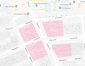
LTC0219 Item 15 Cannon Lane, Stanmore - Proposed 'No Stopping' and 'No Parking' restrictions (Stanmore Ward/Newtown Electorate/Inner West PAC) |
|
SUMMARY
Following representations from the community, Council is proposing to restrict parking in Cannon Lane between Corunna Road and Westbourne Street, Stanmore; in order to allow for access to off-street parking spaces for residents and to facilitate the passage of service vehicles, including Council garbage trucks.
Officer’s Recommendation
THAT: 1. Installation of statutory 10 meters ‘No Stopping’ in Cannon Lane (both sides) at Corunna Road 2. Installation of statutory 10 meters ‘No Stopping’ in Cannon Lane (both sides) at Westbourne Street 3. Installation of ‘No Parking’ in Cannon Lane (both sides) from proposed ‘No Stopping’ zones between Corunna Road and Westbourne Street; be approved.
DISCUSSION
The Committee members agreed with the Officer’s recommendation.
COMMITTEE RECOMMENDATION
THAT: 1. Installation of statutory 10 meters ‘No Stopping’ in Cannon Lane (both sides) at Corunna Road 2. Installation of statutory 10 meters ‘No Stopping’ in Cannon Lane (both sides) at Westbourne Street 3. Installation of ‘No Parking’ in Cannon Lane (both sides) from proposed ‘No Stopping’ zones between Corunna Road and Westbourne Street; be approved. For motion: Unanimous |
|
LTC0219 Item 16 Silver Street, St Peters - Proposed 10m No Stopping at intersection with Edith Lane (Marrickville Ward/Heffron Electorate/Inner West PAC) |
|
SUMMARY
Following representations from residents regarding the visibility of pedestrians (including school children) at the intersection of Silver Street at Edith Street, St Peters; Council is proposing to install a 10m ‘No Stopping’ zone on the western side of Silver Street north of its intersection with Edith Lane. This proposal is designed to address pedestrian and vehicle visibility and manoeuvrability issues at this intersection.
Officer’s Recommendation
THAT the installation of a Statutory 10m ‘No Stopping’ zone in Silver Street, St Peters, (western side) - at its intersection with Edith Lane (adjacent to property No. 2 Silver Street) be approved.
DISCUSSION
The Committee members agreed with the Officer’s recommendation.
COMMITTEE RECOMMENDATION
THAT the installation of a Statutory 10m ‘No Stopping’ zone in Silver Street, St Peters, (western side) - at its intersection with Edith Lane (adjacent to property No. 2 Silver Street) be approved.
For motion: Unanimous |
|
LTC0219 Item 17 Brighton Street, Petersham Intersection with Unnamed Lane - Proposed Parking Restrictions (Stanmore Ward/Newtown Electorate/Inner West PAC) |
|
SUMMARY
Following community representation, it is proposed to signpost statutory ‘No Stopping’ restrictions in Brighton Street, Petersham, at its intersection with an Unnamed Lane (located 30m east of Railway Street), in order to prevent illegal parking and improve safety at the entry into Brighton Street. Community feedback supporting implementation of parking restrictions and a revision to the proposal was sought. The revision is to implement ‘No Parking’ instead of ‘No Stopping’ on the western side of the laneway in Brighton Street due to the existence of a driveway in part of the proposed location. The proposal for ‘No Stopping’ restriction in Brighton Street east of the laneway was supported.
Officer’s Recommendation
THAT: 1. The installation of 10m ‘No Stopping’ restriction in Brighton Street, Petersham east of Unnamed Lane (located 30m east of Railway Street) , and 2. The installation of 10m ‘No Parking’ restriction in Brighton Street, Petersham west of Unnamed Lane (located 30m east of Railway Street); be approved.
DISCUSSION
The Committee members agreed with the Officer’s recommendation.
COMMITTEE RECOMMENDATION
THAT: 1. The installation of 10m ‘No Stopping’ restriction in Brighton Street, Petersham east of Unnamed Lane (located 30m east of Railway Street) , and 2. The installation of 10m ‘No Parking’ restriction in Brighton Street, Petersham west of Unnamed Lane (located 30m east of Railway Street); be approved.
For motion: Unanimous
|
|
LTC0219 Item 18 Grove Street, Dulwich Hill - Extension of Existing Resident Permit Scheme Hours (Ashfield Ward/Summer Hill Electorate/Inner West PAC) |
|
SUMMARY
Following community representations, Council proposed an extension to the permit parking hours in Grove Street, Dulwich Hill. Consultation with owners and occupiers in Grove Street indicated that there was insufficient support to carry out any extension of the permit parking hours at the present time.
Officer’s Recommendation
THAT the proposal to extend the existing ‘2P Permit Holders Excepted 8:30am-6:00pm Mon-Fri’ Area M6 restrictions on the southern side of Grove Street, Dulwich Hill to ‘2P Permit Holders Excepted 8:30am-10:00pm Mon-Fri Area M6’ not be supported due to insufficient resident support at the present time.
DISCUSSION
Council Officers advised that two late submissions supporting the extension of the existing permit parking restrictions were received. With the additional submissions, there is a sufficient level of community support for the proposal and Council Officers recommend supporting the extension of the permit parking restrictions.
The Committee was advised that the head proponent had expressed a desire to attend the Local Traffic Committee meeting but was unable to do so.
The Committee members supported a recommendation to extend the permit parking hours in Grove Street, Dulwich Hill. Residents will be notified of decision.
COMMITTEE RECOMMENDATION
THAT the proposal to extend the existing ‘2P Permit Holders Excepted 8:30am-6:00pm Mon-Fri’ Area M6 restrictions on the southern side of Grove Street, Dulwich Hill to ‘2P Permit Holders Excepted 8:30am-10:00pm Mon-Fri Area M6’ be supported.
For motion: Unanimous
|
|
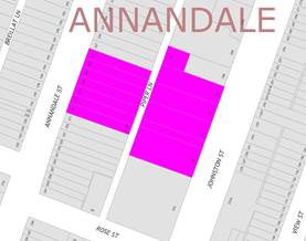
LTC0219 Item 19 Chapman Lane (rear of Nos.129 - 133 Annandale Street), Annandale - Proposed Extension of 'No Parking' zone (Leichhardt Ward/Balmain Electorate/Leichhardt PAC) |
|
SUMMARY
Council has received concerns regarding parked vehicles obstructing access to off-street parking in Chapman Lane (rear of Nos.129 - 133 Annandale Street), Annandale. This matter was previously considered by the Committee last year and deferred for further consideration.
Officer’s Recommendation
THAT a 10.8m ‘No Parking’ zone be installed on the eastern side of Chapman Lane (opposite the rear of Nos.129 - 133 Annandale Street), Annandale.
DISCUSSION Public speakers: Ms Beverley Prunster and Mr Greg Prunster attended at 10.08am. Ms Prunster objected to the proposed ‘No Parking’ zone and made the following comments:
Mr Prunster commented that:
Ms and Mr Prunster left 10.15am. Public speaker: Mr Jason Gooden attended at 10.18am. Mr Gooden commented that:
Mr Gooden left at 10.23am. Council Officers advised that resident parking was considered in Johnston Street at the former Leichhardt Council; however, Johnston Street is a State Road and RMS did not support a resident parking scheme at that time. The RMS representative advised that resident parking is generally not implemented on State Roads. Clr Da Cruz asked whether a mobility parking space can be provided in Chapman Lane for Ms Prunster’s mother. Council Officers advised that Ms and Mr Prunster’s property would not be eligible for a mobility parking space as their property has sufficient off-street parking. It was also advised that there is insufficient space for a disabled parking space at this location. The Committee members agreed with the Officer’s recommendation. COMMITTEE RECOMMENDATION
THAT a 10.8m ‘No Parking’ zone be installed on the eastern side of Chapman Lane (opposite the rear of Nos.129 - 133 Annandale Street), Annandale.
For motion: Unanimous |
|
LTC0219 Item 20 Short Street, Dulwich Hill- Proposed Permit Parking restrictions (Ashfield Ward/Summer Hill Electorate/LAC) |
|
SUMMARY
Following representations to Council from the community, Council is proposing to implement permit parking restrictions in Short Street, Dulwich Hill; consistent with permit parking restrictions in nearby streets.
Officer’s Recommendation
THAT:
DISCUSSION
The RMS representative advised that a risk assessment for a proposed reduction in the statutory 10m ‘No Stopping’ restriction should be submitted to RMS for review.
The Committee members agreed with part 1 of the Officer’s recommendation and recommended that the installation of the 6m ‘No Stopping’ zone be approved, subject to RMS approval of Council’s risk assessment.
COMMITTEE RECOMMENDATION
THAT:
For motion: Unanimous
|
|
LTC0219 Item 21 Little Theodore Street, Balmain - Proposed Extension of 'No Parking' zone (Balmain Ward/Balmain Electorate/Leichhardt PAC) |
|
SUMMARY
Council has received concerns regarding obstructed driveway and pedestrian access in Little Theodore Street at the rear of No.46A Llewellyn Street, Balmain.
Officer’s Recommendation
THAT the existing 8.7m ‘2P 8am-10pm Permit Holders Excepted Area B1’ parking zone on the northern side of Little Theodore Street rear to No.44 Llewellyn Street, Balmain be reduced by 2.7m by extending the existing ‘No Parking’ zones on both the eastern and western sides of the parking space by 1.35m each.
DISCUSSION
The Committee members agreed with the Officer’s recommendation.
COMMITTEE RECOMMENDATION
THAT the existing 8.7m ‘2P 8am-10pm Permit Holders Excepted Area B1’ parking zone on the northern side of Little Theodore Street rear to No.44 Llewellyn Street, Balmain be reduced by 2.7m by extending the existing ‘No Parking’ zones on both the eastern and western sides of the parking space by 1.35m each.
For motion: Unanimous
|
|
LTC0219 Item 22 Frampton Lane, Marrickville - Request for ‘No Parking’ Restrictions (Marrickville Ward / Summer Hill Electorate / Inner West PAC) |
|
SUMMARY
Representations have been received from a local resident for the installation of full time ‘No Parking’ restrictions in Frampton Lane, Marrickville on the western side of Frampton Lane, northward of the junction of Seymour Lane and Central Lane, to improve access to off-street parking as vehicular access is often blocked by parked vehicles in the laneway. Residents have been notified of the proposal. It is recommended that the proposal be approved.
Officer’s Recommendation
THAT:
1. The installation of a 15 metre ‘No Parking’ zone on the western side of Frampton Lane, northward of the junction of Seymour Lane and Central Lane, adjacent to property No.289 Victoria Road, Marrickville be APPROVED, in order to provide unobstructed vehicular access to the off-street car parking spaces and
2. The applicant and Council’s Parking Officers be advised in terms of this report.
DISCUSSION
The Committee members agreed with the Officer’s recommendation.
COMMITTEE RECOMMENDATION
THAT:
1. The installation of a 15 metre ‘No Parking’ zone on the western side of Frampton Lane, northward of the junction of Seymour Lane and Central Lane, adjacent to property No.289 Victoria Road, Marrickville be APPROVED, in order to provide unobstructed vehicular access to the off-street car parking spaces and · 2. The applicant and Council’s Parking Officers be advised in terms of this report.
For motion: Unanimous
|
|
LTC0219 Item 23 Minor Traffic Facilities (All Wards/All Electorates/All LAC's) |
|
SUMMARY
This report considers minor traffic facility applications received by Inner West Council, including ‘Disabled Parking’ and ‘Works Zone’ requests.
Officer’s Recommendation
THAT:
1. The 6m ‘1 hour Parking’ space in lieu of a Disabled Parking zone in front of No.32 Lamb Street, Lilyfield be removed as the zone is no longer required;
2. A 5.5m ‘Disabled Parking’ zone be installed in front of No.2-4 Lookes Avenue, Balmain East;
3. A 5.5m ‘Disabled Parking’ zone be installed in front of No.2/18 and No.3/18 George Street, Balmain;
4. A 5.5m ‘Disabled Parking’ zone be installed in front of No.24 John Street, Ashfield;
5. A 6m ‘Disabled Parking’ zone be installed in front of No.36 Tupper Street, Enmore;
6. A 5.5m ‘Disabled Parking’ zone be installed front of No.39 Shaw Street Petersham;
7. A 3.5m (45-degree angle parking) ‘Disabled Parking’ zone be installed in front of No.158 Trafalgar Street, Annandale;
8. A 6m ‘Disabled Parking’ zone be installed in front of No.18 Foreman Street, Tempe;
9. A 9m ‘Works Zone 7.00am – 5.00pm Mon-Fri and 8.00am – 1.00pm Sat’ be installed in front of No.23 Darling Street, Balmain for 12 weeks, temporarily replacing the resident parking restrictions;
10. A 12m ‘Works Zone 7.00am – 5.00pm Mon-Fri and 8.00am – 1.00pm Sat’ be installed in front of No.67 and No.69 Audley Street, Petersham for 12 weeks, temporarily replacing the resident parking restrictions;
11. A 9m ‘Works Zone 7.00am – 5.00pm Mon-Fri and 8.00am – 1.00pm Sat’ be installed in front of No.32 George Street, Marrickville for 10 weeks;
12. An 11m ‘Works Zone 7.00am – 5.00pm Mon-Fri and 8.00am – 1.00pm Sat’ be installed in front of No.19 Margaret Street, Stanmore for 8 weeks.
13. A 14m 'Works Zone 7:00am – 5:00pm Mon-Fri and 8.00am-1.00pm Sat' be installed in Eton Street, along the side boundary of No. 101 Australia Street, Camperdown for 12 weeks.
DISCUSSION
The Committee members agreed with the Officer’s recommendation.
COMMITTEE RECOMMENDATION
THAT:
1. The 6m ‘1 hour Parking’ space in lieu of a Disabled Parking zone in front of No.32 Lamb Street, Lilyfield be removed as the zone is no longer required;
2. A 5.5m ‘Disabled Parking’ zone be installed in front of No.2-4 Lookes Avenue, Balmain East;
3. A 5.5m ‘Disabled Parking’ zone be installed in front of No.2/18 and No.3/18 George Street, Balmain;
4. A 5.5m ‘Disabled Parking’ zone be installed in front of No.24 John Street, Ashfield;
5. A 6m ‘Disabled Parking’ zone be installed in front of No.36 Tupper Street, Enmore;
6. A 5.5m ‘Disabled Parking’ zone be installed front of No.39 Shaw Street Petersham;
7. A 3.5m (45-degree angle parking) ‘Disabled Parking’ zone be installed in front of No.158 Trafalgar Street, Annandale;
8. A 6m ‘Disabled Parking’ zone be installed in front of No.18 Foreman Street, Tempe;
9. A 9m ‘Works Zone 7.00am – 5.00pm Mon-Fri and 8.00am – 1.00pm Sat’ be installed in front of No.23 Darling Street, Balmain for 12 weeks, temporarily replacing the resident parking restrictions;
10. A 12m ‘Works Zone 7.00am – 5.00pm Mon-Fri and 8.00am – 1.00pm Sat’ be installed in front of No.67 and No.69 Audley Street, Petersham for 12 weeks, temporarily replacing the resident parking restrictions;
11. A 9m ‘Works Zone 7.00am – 5.00pm Mon-Fri and 8.00am – 1.00pm Sat’ be installed in front of No.32 George Street, Marrickville for 10 weeks;
12. An 11m ‘Works Zone 7.00am – 5.00pm Mon-Fri and 8.00am – 1.00pm Sat’ be installed in front of No.19 Margaret Street, Stanmore for 8 weeks.
13. A 14m 'Works Zone 7:00am – 5:00pm Mon-Fri and 8.00am-1.00pm Sat' be installed in Eton Street, along the side boundary of No. 101 Australia Street, Camperdown for 12 weeks.
For motion: Unanimous
|
|
LTC0219 Item 24 Susan Lane, Annandale - Extension of Existing Resident Parking Scheme (Leichhardt Ward/Balmain Electorate/Leichhardt PAC) |
|
SUMMARY
Council has received correspondence from a number of residents of Susan Lane, Annandale requesting an extension to the existing Resident Parking Scheme (RPS) in Susan Lane northwards towards the closed section (frontage of No.30 Susan Lane) to address issues with long stay parking by non-resident vehicles.
This report provides the result of the RPS investigation in Susan Lane, Annandale.
Officer’s Recommendation
THAT the existing ‘2P, 8am-6pm Mon-Fri, Permit Holders Excepted, Area A1’ restrictions in Susan Lane, Annandale be extended northwards to the closed section (along the frontage of No.30 Susan Lane).
DISCUSSION
The Committee members agreed with the Officer’s recommendation.
COMMITTEE RECOMMENDATION
THAT the existing ‘2P, 8am-6pm Mon-Fri, Permit Holders Excepted, Area A1’ restrictions in Susan Lane, Annandale be extended northwards to the closed section (along the frontage of No.30 Susan Lane).
For motion: Unanimous
|
|
LTC0219 Item 25 King Lane, Balmain - 'No Parking' zone (Balmain Ward/Balmain Electorate/Leichhardt PAC) |
|
SUMMARY
Council has received a request to convert an existing ‘2P 8am-10pm Permit Holders Excepted Area B1’ zone to a ‘No Parking’ zone in King Lane, Balmain on the side boundary of Nos.24 - 26 King Street to allow access to a newly constructed garage at the rear of No.35 Birchgrove Road.
Officer’s Recommendation
THAT the existing 12.5m ‘2P 8am-10pm Permit Holders Excepted Area B1’ resident parking zone in King Lane on the side boundary of Nos.24-26 King Street be converted to a ‘No Parking’ zone.
DISCUSSION
The Committee members agreed with the Officer’s recommendation.
COMMITTEE RECOMMENDATION
THAT the existing 12.5m ‘2P 8am-10pm Permit Holders Excepted Area B1’ resident parking zone in King Lane on the side boundary of Nos.24-26 King Street be converted to a ‘No Parking’ zone.
For motion: Unanimous
|
|
LTC0219 Item 26 Rawson Street, Haberfield - Proposed '15 Minute' Parking Zone (Leichhardt Ward/Summer Hill Electorate/Burwood PAC) |
|
SUMMARY
Council has received a request to install short term parking in Rawson Street, close to the intersection of Ramsay Street to improve accessibility for patrons of Haberfield Post Office with mobility issues.
Officer’s Recommendation
THAT:
1. The existing 9 metre ‘1P 8.30am – 6.00pm Mon-Fri, 8.30am – 12.30pm Sat’ and ‘No Parking – Australia Post Vehicles Excepted’ zones on the eastern side of Rawson Street, north of Ramsay Street be reduced to 6 metre zones.
2. An additional 6m ‘P15 minute 8.30am-6.00pm Mon-Fri, 8.30am-12.30pm Sat’ zone be installed immediately north of the 6m ‘No Parking – Australia Post Vehicles Excepted’ zone.
DISCUSSION
The Committee members agreed with the Officer’s recommendation and noted the tabled email support from Burwood PAC.
COMMITTEE RECOMMENDATION
THAT:
1. The existing 9 metre ‘1P 8.30am – 6.00pm Mon-Fri, 8.30am – 12.30pm Sat’ and ‘No Parking – Australia Post Vehicles Excepted’ zones on the eastern side of Rawson Street, north of Ramsay Street be reduced to 6 metre zones.
2. An additional 6m ‘P15 minute 8.30am-6.00pm Mon-Fri, 8.30am-12.30pm Sat’ zone be installed immediately north of the 6m ‘No Parking – Australia Post Vehicles Excepted’ zone.
For motion: Unanimous |
|
LTC0219 Item 27 Parramatta Road, Leichhardt - Proposed '1 hour' Parking Zone (Leichhardt Ward/Balmain Electorate/Leichhardt PAC) |
|
SUMMARY
Council has received a request from a local business to convert the existing ‘1/2P’ parking restriction to a ‘1P’ restriction on the northern side of Parramatta Road, between Rofe Street and Renwick Street, Leichhardt to ensure customers have sufficient time to visit the nearby businesses.
Officer’s Recommendation
THAT the existing ‘1/2P 10am-3pm Mon-Fri, 8:30am-12:30pm Sat’ parking restrictions on the northern side of Parramatta Road between Rofe Street and Renwick Street, Leichhardt be converted to ‘1P 10am-3pm Mon-Fri, 8:30am-12:30pm Sat’ restrictions, subject to RMS approval.
DISCUSSION
The RMS representative advised that as Parramatta Road is a State Road, the matter should be referred directly to RMS for consideration instead of the Local Traffic Committee.
COMMITTEE RECOMMENDATION
THAT the item be referred to RMS for its consideration for approval.
For motion: Unanimous
|
|
LTC0219 Item 28 Young Street at Collins Street, Annandale - Proposed modification to existing 'No Stopping' zone (Leichhardt Ward/Balmain Electorate/Leichhardt PAC) |
|
SUMMARY
Concerns have been raised from a resident that the existing ‘No Stopping’ zone in Young Street at the intersection of Collins Street, Annandale restricts temporary drop-off and pick-up across the driveway of No.52 Collins Street, Annandale.
Officer’s Recommendation
THAT the existing 18.4m ‘No Stopping’ zone be reduced to 13.4m on the eastern side of Young Street, south of Collins Street, Annandale.
DISCUSSION
The Committee members agreed with the Officer’s recommendation.
COMMITTEE RECOMMENDATION
THAT the existing 18.4m ‘No Stopping’ zone be reduced to 13.4m on the eastern side of Young Street, south of Collins Street, Annandale.
For motion: Unanimous
|
|
LTC0219 Item
29 Old Canterbury Road, Dulwich Hill- Proposed 'No Stopping' restrictions
between Constitution Road and No.275 Old Canterbury Road,
Dulwich Hill. |
|
SUMMARY
Council has received complaints regarding congestion and delay/banking up of traffic along Old Canterbury Road between Constitution Road and Abergeldie Street as a result of vehicles turning right into Henson Street from Old Canterbury Road, and with vehicles parking adjacent to the kerb side lane.
It is proposed to remove or limit parking with full-time and part-time ‘No Stopping’ restrictions on the southern side of Old Canterbury Road from Constitution Road to the west side of driveway of No. 275 Old Canterbury Road.
This would allow adequate length of clearance along the kerb side lane for traffic to generally travel and manoeuvre around waiting vehicles turning right into Henson Street.
Support is therefore sought on the following recommendation.
Officer’s Recommendation
THAT:
1. the kerb space on the southern side of Old Canterbury Road between Constitution Road and 10 metres west of an existing pedestrian refuge be signposted full-time “No Stopping”. 2. the kerb space thereafter on the southern side of Old Canterbury Road to the west side of the driveway of No. 275 Old Canterbury Road be signposted as “No Stopping 8.00am-9.30am; 2.30pm-4.00pm Mon-Fri School Days Only”.
DISCUSSION
The RMS representative advised that as Old Canterbury Road is a State Road, the matter should be referred directly to RMS for consideration instead of the Local Traffic Committee. The representative also requested that community consultation not be undertaken until RMS investigates the matter.
COMMITTEE RECOMMENDATION
THAT the item be referred to RMS for consideration.
For motion: Unanimous
|
|
LTC0219 Item 30 Liberty Street and Bedford Street, Stanmore – Temporary full road closure for rail overbridge refurbishment works – notice of change of date of works in March 2019 (STANMORE WARD /NEWTOWN ELECTORATE/ INNER WEST PAC) |
|
SUMMARY
Notice of changes in dates for rail overbridge works and pending road closures of Liberty Street and Bedford Street, Stanmore in March 2019 November have been received from Sydney Trains. Due to special events two closedowns have been rescheduled for the road closures. Temporary full road closures that were scheduled for Liberty Road (between Railway Avenue and Trafalgar Street) and Bedford Street (between Liberty Street and Pierce Street), Stanmore on Friday 8 to Monday 11 March 2019 are now scheduled for Friday 15 March to Monday 18 March 2019 and those scheduled for Friday 1 to 4 November 2019 are now scheduled for Friday 11 October to Monday 14 October 2019.
The streets will be temporarily closed to all vehicular traffic, including emergency vehicles and local residents. It is recommended that the proposed change of date for the temporary full road closures be approved, subject to the conditions outlined in this report.
Officer’s Recommendation
THAT the proposed temporary full road closure of Liberty Road (between Railway Avenue and Trafalgar Street) and Bedford Street (between Liberty Street and Pierce Street), Stanmore on 15 to 18 March 2019 and 11 to 14 October 2019 be approved, in order to carry out refurbishment works on the Liberty Street Stanmore rail over bridge subject but not limited to the following conditions:
1. A Road Occupancy License be obtained by the applicant from the Transport Management Centre;
2. All affected residents and businesses, including the NSW Police Local Area Commander, Fire & Rescue NSW and the NSW Ambulance Services be notified in writing, by the applicant, of the proposed temporary road closure at least 7 days in advance of the closure with the applicant making reasonable provision for stakeholders; and
3. The occupation of the road carriageway must not occur until the road has been physically closed.
DISCUSSION
The Committee members agreed with the Officer’s recommendation.
COMMITTEE RECOMMENDATION
THAT the proposed temporary full road closure of Liberty Road (between Railway Avenue and Trafalgar Street) and Bedford Street (between Liberty Street and Pierce Street), Stanmore on 15 to 18 March 2019 and 11 to 14 October 2019 be approved, in order to carry out refurbishment works on the Liberty Street Stanmore rail over bridge subject but not limited to the following conditions:
1. A Road Occupancy License be obtained by the applicant from the Transport Management Centre;
2. All affected residents and businesses, including the NSW Police Local Area Commander, Fire & Rescue NSW and the NSW Ambulance Services be notified in writing, by the applicant, of the proposed temporary road closure at least 7 days in advance of the closure with the applicant making reasonable provision for stakeholders; and
3. The occupation of the road carriageway must not occur until the road has been physically closed.
For motion: Unanimous
|
|
LTC0219
Item 31 The ‘Gear Up Girl’ Bicycle Event (Marrickville
Ward/Summer Hill & |
|
SUMMARY
Advice has been received from Bicycle NSW regarding the 'Gear Up Girl' bicycle challenge to be held on Sunday, 10 March 2019, which will involve cycling through the Inner West Local Government Area (LGA).
It is recommended that Council supports the proposed cycling event, subject to the event being advertised, a Traffic Management Plan be submitted to the RMS for approval and advice of the proposed event be forwarded to the appropriate authorities and affected properties by the applicant.
Officer’s Recommendation
THAT the ‘Gear Up Girl’ bicycle event to be held on Sunday 10 March 2019 be supported subject to the applicant complying with the following conditions:
1. The event being advertised in the local newspapers by the applicant in advance of the event; 2. A Traffic Management Plan being submitted by the applicant to the Roads and Maritime Services for consideration and approval; 3. Details of the proposed event be forwarded by the applicant to the Transport Management Centre, Transit Systems, Inner West PAC, Fire & Rescue NSW and NSW Ambulance Service; and 4. Adequate traffic control shall be provided for the protection and convenience of pedestrians, cyclists and motorists including appropriate signage and flagging. Workers shall be specially designated for this role (and carry appropriate certificates), as necessary to comply with this condition. This is to be carried out in accordance with the Australian Standard AS 1742.3 – Traffic Control Devices for works on roads.
DISCUSSION
The representative for the Member for Summer Hill questioned the contingency route where cyclists would have to take their bike up stairs to the Tempe train station bridge. Council Officers advised that this route was agreed upon a number of years ago as it was considered a safer route. Richardson Crescent was considered for the contingency route but was not agreed on due to traffic conditions and the narrowness of the footpath at the overbridge.
The Committee members agreed with the Officer’s recommendation.
COMMITTEE RECOMMENDATION
THAT the ‘Gear Up Girl’ bicycle event to be held on Sunday 10 March 2019 be supported subject to the applicant complying with the following conditions:
1. The event being advertised in the local newspapers by the applicant in advance of the event; 2. A Traffic Management Plan being submitted by the applicant to the Roads and Maritime Services for consideration and approval; 3. Details of the proposed event be forwarded by the applicant to the Transport Management Centre, Transit Systems, Inner West PAC, Fire & Rescue NSW and NSW Ambulance Service; and 4. Adequate traffic control shall be provided for the protection and convenience of pedestrians, cyclists and motorists including appropriate signage and flagging. Workers shall be specially designated for this role (and carry appropriate certificates), as necessary to comply with this condition. This is to be carried out in accordance with the Australian Standard AS 1742.3 – Traffic Control Devices for works on roads. For motion: Unanimous
|
|
LTC0219 Item 32 WestConnex New M5 Operational Parking & Access Strategy Consultation (Marrickville Ward/Heffron Electorate/Inner West PAC) |
|
SUMMARY
Council has been invited to provide feedback on the WestConnex New M5 Operational Parking & Access Strategy. The document outlines the temporary and permanent changes to on-street parking supply in St Peters and Alexandria. Council officers have reviewed the document and provided feedback based on the issues received from the community.
Officer’s Recommendation
THAT this report be received and noted.
DISCUSSION
The Committee members agreed with the Officer’s recommendation.
COMMITTEE RECOMMENDATION
THAT this report be received and noted.
For motion: Unanimous
|
|
LTC0219 Item 33 3-7 & 13-17 Regent Street, 287-309 Trafalgar Street & 16-20 Fisher Street, Petersham - DA201800173 – Residential and Mixed Use Development and RSL Relocation over 3 Sites (Stanmore Ward / Newtown Electorate / Inner West PAC) |
|
SUMMARY
Council has received a development application for 3-7 & 13-17 Regent Street, 287-309 Trafalgar Street & 16-20 Fisher Street, Petersham to demolish existing improvements for the staged construction of 357 apartments over 3 sites with associated basement parking. 3-7 Regent Street is to be comprised of a residential flat building ranging from 5 to 8 storeys containing 108 apartments with basement parking. 13-17 Regent Street is to be comprised of 3 residential buildings ranging from 6 to 7 storeys with 50 apartments and basement parking. 287-309 Trafalgar Street and 16-20 Fisher Street is to be comprised of a mixed use building ranging from 2 to 11 storeys in height containing a new registered club premises for the Petersham RSL Club fronting Trafalgar Street, café and 3 residential flat buildings containing 196 apartments and 3 x 2 storey Soho apartments fronting Fozzard lane with associated basement parking and public domain works linking Regent Street to Fozzard Lane. Approval is also sought for the subdivision of land to accommodate widening of Fozzard Lane as well as the stratum subdivision of lots in the development.
The application is required to be referred to the Local Traffic Committee for consideration under State Environmental Planning Policy (Infrastructure) 2007.
Comments of the Local Traffic Committee will be referred to Council’s Development Assessment Section for consideration in determining the Development Application.
Officer’s Recommendation
THAT the report be received and noted.
DISCUSSION
The Committee members agreed with the Officer’s recommendation.
COMMITTEE RECOMMENDATION
THAT the report be received and noted.
For motion: Unanimous |
General Business
LTC0219 Item 34 Bus Stop outside Camperdown WestConnex site
The representative for the Member for Balmain stated that a complaint was received regarding the bus stop outside the Westconnex site in Camperdown. The bus stop has been reduced, has no shelter and, due to the narrowness of the footpath, pedestrians find it difficult to pass the bus stop. The RMS representative advised that RMS have raised this issue with WestConnex.
LTC0219 Item 35 Proposed Development at 63-65 Pyrmont Bridge Road, Annandale
The representative for the Member for Balmain asked why Council did not support vehicular access to the proposed development at 63-65 Pyrmont Bridge Road, Annandale from the corner of Mallet Street and Bignell Lane. Council Officers advised that a report on this development was presented to the Local Traffic Committee in 2018 and Officers will send a copy of this report to the representative.
LTC0219 Item 36 Traffic at the intersection of Martin Street and Ramsay Street, Haberfield
The representative for the Member for Summer Hill stated that a resident of Martin Street, Haberfield expressed concern with entry and egress to Martin Street into Ramsay Street. The resident reported that the removal of ‘Keep Intersection Clear’ road markings from Ramsay Street has resulted in queuing across the entry of Martin Street. The resident also reported that the queuing of traffic has made it difficult for Martin Street residents to exit onto Ramsay Street and there have been a number of accidents and near misses since the road markings were removed. The representative for the Member for Summer Hill requested that traffic in the area be reviewed and tabled the resident’s email to Council Officers for consideration.
Addendum: Council forwarded resident’s concern to RMS late last year and will follow up with RMS.
LTC0219 Item 37 Parking for Metro Assist staff in Ashfield
The representative for the Member for Summer Hill stated that Metro Assist in Ashfield are seeking support for a parking solution for their staff, such as dedicated parking spaces for Metro Assist or a parking permit. Due to the nature of their work, staff at Metro Assist cannot leave clients to check on their vehicles parked in Ashfield Mall which has a 3 hour limit. As a result, the staff have been receiving parking fines.
Council Officers advised that the City of Sydney manages a Support Worker Parking permit system that extends to the Inner West where recognised organisations can obtain a parking permit for carers
LTC0219 Item 38 Pedestrian crossing in front of Dulwich Hill Public School
The representative for the Member for Summer Hill stated that the Member wrote to Council on behalf of a resident regarding the pedestrian crossing in front of Dulwich Hill Public School. Council Officers advised that Council’s Road Safety Officer has made contact with that resident and will be having a site meeting to discuss the crossing on 8 February 2019.
LTC0219 Item 39 Heavy vehicle use on Campbell Street, St Peters
The representative for the Member for Heffron asked whether there are any new restrictions on heavy vehicle use on Campbell Street, St Peters. The RMS representative stated that RMS has requested this information from WestConnex and will advise Council when the information becomes available.
LTC0219 Item 40 Closed footpath on Parramatta Road, Ashfield
The Inner West Bicycle Coalition representative stated that the footpath on the south side of Parramatta Road, between Bland Street and Orpington Street, Ashfield, has been closed. The representative asked if the footpath could be reopened. The RMS representative advised that this can be investigated; however, RMS is not aware of WestConnex plans at that location.
Meeting closed at 11am.
ATTACHMENT 1
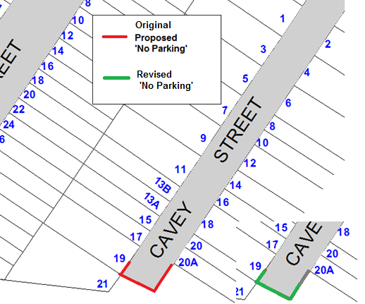
Proposed ‘No Parking’ restrictions in Cavey Street, Marrickville
This page has been left blank intentionally.
|
|
Local Traffic Committee Meeting 4 March 2019 |
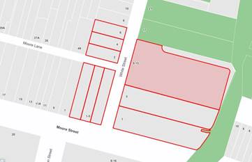
Subject: White Street, Lilyfield - Proposed 10m 'No Stopping' restriction at intersection with Moore Lane (Baludarri Ward/Balmain Electorate/Leichhardt PAC)
Prepared By: Brinthaban Baskaran - Student Traffic Engineer
Authorised By: John Stephens - Traffic and Transport Services Manager
|
SUMMARY Council has received a request to signpost the statutory 10m ‘No Stopping’ restriction at the intersection of White Street and Moore Lane, Lilyfield in order to prevent illegal parking and improve sight lines. |
|
RECOMMENDATION
THAT a 10m ‘No Stopping’ zones on the western side of White Street, north of Moore Lane
|
BACKGROUND
Council has received concern regarding vehicles obstructing sight lines by parking too close to the intersection of White Street at Moore Lane, Lilyfield.
FINANCIAL IMPLICATIONS
Nil.
OTHER STAFF COMMENTS
In order to alleviate this issue, it is proposed to signpost a 10m ‘No Stopping’ zone on the western side of White Street, immediately north of Moore Lane as shown on the following plan.
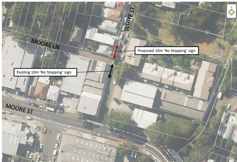
PUBLIC CONSULTATION
A letter outlining the above proposal was mailed out to the affected properties (7 properties) in White Street, Lilyfield and Moore Street, Leichhardt.
No responses were received.
CONCLUSION
Nil.
|
|
Local Traffic Committee Meeting 4 March 2019 |
Subject: Grove Street, Birchgrove - Proposed 10m 'No Stopping' restrictions at intersection with The Terrace (Baludarri Ward/Balmain Electorate/Leichhardt PAC)
Prepared By: Brinthaban Baskaran - Student Traffic Engineer
Authorised By: John Stephens - Traffic and Transport Services Manager
|
SUMMARY Council has received a request to signpost the statutory 10m ‘No Stopping’ restriction at the intersection of Grove Street and The Terrace, Birchgrove in order to prevent illegal parking and improve sight lines. |
|
RECOMMENDATION
THAT 10m ‘No Stopping’ zones be installed on the western side of Grove Street, north and south of The Terrace, Birchgrove. |
BACKGROUND
Council has received concerns regarding vehicles obstructing sight lines by parking too close to the intersection of Grove Street at The Terrace, Birchgrove.
FINANCIAL IMPLICATIONS
Nil.
OTHER STAFF COMMENTS
In order to alleviate this issue, it is proposed to signpost 10m ‘No Stopping’ zones on the western side of Grove Street, north and south of The Terrace as shown on the following plan.
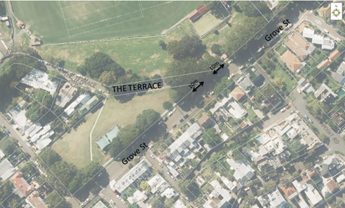
PUBLIC CONSULTATION
A letter outlining the above proposal was mailed out to the affected properties (8 properties) in Grove Street, Birchgrove.
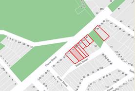
Two responses were received, one in support and one in objection of the proposal.
|
Resident’s comments |
Officer Comment |
|
Given it is already illegal to park within 10 metres of the two areas; the proposed signage is not necessary and adds to the visual excess of notices. |
The proposal is deemed necessary to formalise the statutory requirement and to improve sightlines at the intersection. |
CONCLUSION
Nil.
|
|
Local Traffic Committee Meeting 4 March 2019 |
Subject: Church Street, Ashfield - Proposed 10m 'No Stopping' restrictions at intersection with Unnamed Lane (Djarrawunang Ward/Summer Hill Electorate/Inner West PAC)
Prepared By: Brinthaban Baskaran - Student Traffic Engineer
Authorised By: John Stephens - Traffic and Transport Services Manager
|
SUMMARY Council has received a request to signpost the statutory 10m ‘No Stopping’ restriction at the intersection of Church Street and Unnamed Lane, Ashfield in order to prevent illegal parking and improve sight lines. |
|
RECOMMENDATION
THAT 10m ‘No Stopping’ zones be installed on the western side of Church Street, north and south of the Unnamed Lane, Ashfield.
|
BACKGROUND
Council has received concerns from a resident regarding vehicles obstructing sight lines and manoeuvring space by parking too close to the intersection of Church Street at the Unnamed Lane, Ashfield.
FINANCIAL IMPLICATIONS
Nil.
OTHER STAFF COMMENTS
In order to alleviate this issue, it is proposed to signpost 10m ‘No Stopping’ zones on the western side of Church Street, north and south of the Unnamed Lane as shown on the following plan.
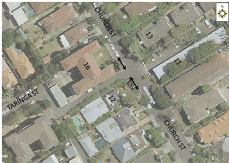
PUBLIC CONSULTATION
A letter outlining the above proposal was mailed out to the affected properties (13 properties) in Church Street, Ashfield.
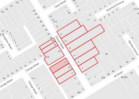
Five responses were received, two in support; two in objection and one suggesting Motorcycle Parking in lieu of the proposal.
|
Residents’ Comments |
Officer Comments |
|
I support Council’s proposal as I am aware of the risks of collisions that motorists face trying to exit the laneway onto Church Street. |
Noted. |
|
I object to Council’s proposal as I have lived on this street for 20 years and have been unaware of any collisions occurring. Parking is premium at this location and I see no purpose of restricting parking unless it is a genuine black spot. |
It should be noted that under the NSW Road Rules, it is illegal to park within 10 metres of an intersection without traffic lights, unless a parking control sign applies indicating that the driver is permitted to park.
|
|
I would consider this unnamed laneway a driveway which will disregard NSW Road Rules as it will not apply to driveways. I propose to make the proposed ‘No Stopping’ zone into a designated ‘Motorcycle Parking’ spot as motorcycles will not restrict sight or cause a hazard in this area. |
The unnamed laneway is a public road for local resident access and as such the road rules still apply. ‘Motorcycle’ parking cannot be installed within the statutory 10m distance as it will conflict with manoeuvring of traffic in and out of the laneway and would not comply with the Road Rule. |
|
I support Council’s proposal as it is currently very difficult to enter Church Street without my view being obstructed by parked vehicles.
Can Council consider installing a traffic calming device along Church Street to reduce excessive speeding which occurs between Frederick Street and Alt Street?
|
Council will investigate the speeding concerns on Church Street as a separate matter. |
CONCLUSION
Nil.
|
|
Local Traffic Committee Meeting 4 March 2019 |
Subject: Victoria Road & Chapel Street, Marrickville - New Traffic Signals/ Intersection Upgrade for Improving Traffic Safety (Midjuburi Ward/ Summer Hill Electorate/ Inner West PAC)
Prepared By: Scipio Tam - Engineer - Traffic and parking Services (South)
Authorised By: John Stephens - Traffic and Transport Services Manager
|
SUMMARY Detailed design plans have been finalised for the proposed traffic signalised intersection of Victoria Road and Chapel Road, Marrickville. The purpose of the proposed works are to increase pedestrian and vehicular safety at the subject intersection as crash statistics indicate there have been 22 reported crashes between July 2010 and June 2015 at the time of submitting the Blackspot application.
The proposed works include decommissioning the existing signalised pedestrian crossing on Victoria Road, installation of traffic signals at Victoria Road & Chapel Street intersection, relocation of the existing ‘Bus Zone’ on the eastern side of Victoria Street and installation of signage and road markings. As a result of the proposal five on-street parking will be lost to cater for the turning movements of expected truck at the intersection.
The proposal will result in a net-loss of five (5) on-street parking spaces, removal of one (1) significant street tree and gain of four (4) trees in appropriate locations. |
|
RECOMMENDATION
THAT the detailed design plan for the proposed traffic signals at the intersection of Victoria Road and Chapel Street, Marrickville, including associated signposting and line marking (as per the attached plan No. 10039) be approved.
|
BACKGROUND
In 2016 Council had a blackspot assessment report undertaken for the intersection due to ongoing safety concerns at the intersection. In 2017 Council submitted an application for a blackspot grant to the RMS as the subject intersection had 22 reported crashes between July 2010 and June 2015, including one fatality. An updated 5 year crash history between July 2013 and June 2017 revealed 16 reported crashes during this period. As there was a high number of recorded accidents at the intersection, as well as satisfying the RMS’s signal warrant guidelines, Council’s grant application for traffic signals was approved.
A detailed design for the proposed traffic signals at the intersection has now been completed and this design (refer to attached design) has Roads and Maritime Services (RMS) approval. Construction of the proposed traffic signals is programmed for the current financial year.
FINANCIAL IMPLICATIONS
Funding of $325,000 has been allocated by Council under the 2018/19 Capital Works Program for Traffic Facilities as part of the Australian Government’s 2018/19 Black Spot Program Funding.
OTHER STAFF COMMENTS
Victoria Road is a regional road, running north to south, connecting Enmore and Marrickville. There are two (2) lanes in each direction with kerbside parking on both sides outside of ‘No Parking’ restrictions during peak hours;
· Northbound – ‘No Parking 7am-9am Mon-Fri’,
· Southbound – ‘No Parking 4pm-6pm Mon-Fri’.
Chapel Street is a local street, running east to west between Illawarra Road and Fitzroy Street. There are kerbside parking present.
The current intersection configuration of Victoria Road & Chapel Street is a Give Way /Stop control, with vehicles on Chapel Street approaching:
· From the west, requiring to Stop and yield to vehicles travelling on Victoria Road,
· From the east, requiring to Give Way to vehicles travelling on Victoria Road.
There is a mid-block signalized pedestrian crossing on Victoria Road, approximately 30m south of the intersection, primarily servicing school children of Marrickville Public School.
Recommendations addressing the identified safety issues present have been included in the final proposed design plans in the attempt to improve safety at the location. These recommendations have been included in the design plans for the intersection.
The proposed work includes:
· New traffic signals at the intersection and removing the mid-block traffic signals on Victoria Road,
· Four (4) new pram ramps at the intersection, combined with footpath rehabilitation,
· Relocating existing bus zone on the northern side of Victoria Road by eight (8) west to improve sightline visibility for vehicles on Chapel Street, travelling north-west,
· Removing one (1) large existing street tree at the intersection to improve sightlines. The designer has investigated various design options to retain the existing tree on the eastern corner of Victoria Road and Chapel Street. However in order to improve safety for pedestrians and motorists the tree is required to be removed. Council has identified locations for five (5) new street trees (in lieu of the removal of this tree) at more appropriate locations (as shown on the attached plan)
· Installation of new signage and line marking associated with traffic signals as per RMS Technical Guidelines.
An RMS requirement for the installation of traffic signals is that BB Centrelines are marked on all approaches to the traffic signals. This will result in the net-loss of five (5) parking spaces within the vicinity of the proposed traffic signals. This is because of the narrowness of Chapel Street. The location of the parking space loss/gain is as follows:
· Five (5) on-street parking spaces lost on Chapel Street, south of Victoria Road,
· One (1) on-street parking space lost on western side of Chapel Street, north of Victoria Road,
· Two (2) on-street parking spaces lost on the northern side of Victoria Road, east of Chapel Street,
· Three (3) on-street parking spaces gained on the southern side of Victoria Road, east of Chapel Street.
As required by the RMS to ensure traffic flows are as efficient and safe as possible, the following turning movements will not be permitted at the new signals:
· Vehicles over 6m in length will not be permitted to turn left into Chapel Street from Victoria Road, travelling in the north-east direction,
· Vehicles over 9m in length will not be permitted to turn left into Chapel Street from Victoria Road travelling in the south-west direction, or to turn left into Victoria Road from Chapel Street travelling in either direction.
PUBLIC CONSULTATION
Engagement letters were sent to residents and businesses on 29 January 2019 to 138 properties, as well as being exhibited on Council’s ‘Have Your Say’ engagement website. The consultation period closed on the 20th February 2019. The engagement letter and plan was also sent to the Marrickville Public School community for comment.
A total of thirty six (36) responses were received; one (1) response was received against the proposal and thirty-five (35) responses were received in support of the proposal. The breakdown of the responses received is listed below:
|
Do you support the changes |
Residents within the area |
Residents outside the area |
|
Yes |
25 |
3 |
|
Yes, with changes |
4 |
3 |
|
No |
0 |
1 |
|
Residents’ Comments |
Officer’s Response |
|
28 residents supported the proposal with no additional comments.
|
The residents’ support has been noted.
The proposal has been endorsed by Council as part of the Henson Local Area Traffic Management (LATM) plan which was widely consulted with residents, and has been included as part of Council’s 4 year Capital Works Program for Traffic Facilities.
|
|
7 residents supported the proposal with additional comments such as: 1. The ‘No Stopping’ sign in front of 135 Victoria Rd should be moved to 133 Victoria Rd as vehicles should not be parking across the driveway. 2. The tree in front of the school zone sign, travelling up Chapel St towards Illawarra Rd and Marrickville Public School, is obscuring the sign and should be removed. 3. The tree on the corner of Victoria Rd and Chapel St should not be removed or be replanted elsewhere. 4. That Council ensures cars are not parking along the pavement and using the pavement between driveways as turning circles on the southern side of Victoria Rd. 5. The bus stop on the northwestern side of Victoria Rd should be on the departure side of the intersection to improve efficiency of the bus services. 6. That the kerb blister with tree planting in Chapel Street be removed to retain an additional parking space, particularly due to the loss of parking in the area, as well as the limited movements to turn into the businesses driveway due to the turning restrictions at the intersection. Ie: once the proposed "No Right Turn for large vehicles" from Chapel St into Victoria RD" is implemented, there will be only one option available for Vehicles leaving the property i.e. to turn Right from the property(without restriction) into Chapel St. 7. Parking is a premium in the area and the loss of parking will affect the businesses in the area. Please protect the parking spaces and reduce any loss of parking.
|
1. The residents’ comments have been noted. The driveway in question is currently signposted as “No Parking 7am – 9am, Mon - Fri”. Driveways are “No Parking” zones, and it is recommended to change the signage to “No Parking (full-time)” across the driveway and relocate the “No Parking 7am – 9am, Mon - Fri” sign to in front of 133 Victoria Rd, as per the attached plan. 2. This issue will be referred to Council’s Traffic and Trees section for investigation and action. 3. Unfortunately the tree cannot be retained and Council have allowed for 5 replacement trees as part of the design. (Refer to main report for additional details on the tree removal). The tree is unable to be replanted elsewhere. 4. This issue will be referred to Council’s Enforcement Team for monitoring. 5. Transit Systems have requested the bus stop on the northern side to be on the approach side of the intersection. If this bus stop was relocated further north, the spacing would not meet the 400 metre spacing requirements from TfNSW between bus stops. 6. The residents’ comments have been noted. In order to off-set the removal of the large tree on the corner, Council has included this additional tree. The inclusion of the tree and kerb blister (with a smaller footprint than a standard car) does not impact on turning movements of the adjacent driveways, although there is a loss of an on-street car parking space to accommodate this proposed new street tree. 7. The residents’ comments have been noted. |
|
1 resident did not support the proposal, and in their opinion was a waste of money. |
The resident’s comment has been noted. Due to the number of accidents at the intersection, this project has received Blackspot funding to increase safety.
|
CONCLUSION
It is recommended that the detailed design plan (Victoria Road & Chapel Street, Marrickville - New Traffic Signal Design Plan No. 10039) of the proposed traffic signals and associated works, signs and line markings be approved, to improve safety conditions at the intersection of Victoria Road & Chapel Street, Marrickville.
|
1.⇩ |
Victoria Road & Chapel Street, Marrickville - New Traffic Signal Design Plan No. 10039 |
|
|
Local Traffic Committee Meeting 4 March 2019 |
Subject: Lawson Avenue, Marrickville - Raised Threshold (Midjuburi Ward/ Summer Hill Electorate/ Inner West PAC)
Prepared By: Scipio Tam - Engineer - Traffic and parking Services (South)
Authorised By: John Stephens - Traffic and Transport Services Manager
|
SUMMARY Detailed design plans have been finalised for the proposed raised threshold in Lawson Avenue, Marrickville.
The proposed work includes construction of a raised threshold, road re-sheeting, footpath rehabilitation, kerb & gutter reconstruction, drainage works and associated signage and line marking.
Consultation was undertaken with owners and occupiers of properties in Lawson Avenue regarding the proposal. A summary of the consultation result is presented in this report for consideration. It is recommended that the proposed detailed design plan be approved. |
|
RECOMMENDATION
THAT the detailed design plan (Design Plan No.6198) of the raised threshold at Lawson Avenue, Marrickville be APPROVED. |
BACKGROUND
As part of the local roads renewal capital works program, Council has prepared a detailed design plan to improve the streetscape of Lawson Avenue, Marrickville due to the poor condition of the asphalt road and concrete footpath. Additionally, Council has taken the opportunity to improve the pedestrian safety by including a raised threshold in Lawson Avenue as part of the proposed works. As there is a public school to the east of Marrickville Park and an aged care centre to the west, high pedestrian activity is expected along Frazer Street, walking past Lawson Avenue. With the raised threshold, motorists are encouraged to travel at slower speeds while turning into and out of Lawson Avenue, thereby increasing pedestrian safety.
Additionally, the proposed raised threshold has been found to be beneficial for mitigating flooding issues along Lawson Avenue. This is achieved by the threshold redirecting stormwater away from the intersection of Lawson Avenue and Frazer Street towards the Marrickville Playground and into Marrickville Oval.
FINANCIAL IMPLICATIONS
Funding of $180,000 has been allocated in Council’s 2018/19 capital works program for the project.
OTHER STAFF COMMENTS
Site Location
Lawson Avenue, Marrickville is one of five streets surrounding Marrickville Park. As Marrickville Park hosts Marrickville Croquet Club, Marrickville Lawn Tennis Club and various sporting activity on Marrickville Oval, pedestrian activity along Frazer Street, crossing Lawson Avenue is relatively high.
Lawson Street is approximately 62m long and 6.1m wide, with Frazer Street on the northern end and a cul-de-sac on the southern end. It serves as an access road and on-street parking for 10 residential properties and short-term parking for Marrickville Park visitors.
The detailed design plan (Design Plan 6198) shown in Attachment 1 outlines the proposed works on the whole length of Lawson Avenue, Marrickville. There is no loss in on-street parking in the proposed works and all current vehicular access to adjoining properties will be retained.
Comments Provided by Design Engineer
The proposed works include the following:
· Reconstruction of concrete footpath and new grass verge on the western side of Lawson Avenue,
· Reconstruction of concrete footpath and provide new swale in Marrickville Park (subject to detail design and budget allocation)
· Reconstruction of concrete kerb and/or gutter,
· Construction of new concrete raised threshold,
· Installing associated traffic signs and line marking
· Installing new stormwater pipes and pits,
· Resurfacing asphalt roadway,
· Reconstruction of two (2) kerb ramps,
· Planting of seven (7) new trees.
PUBLIC CONSULTATION
Community engagement was conducted between 22 January 2019 and 5 February 2018. A letter and a copy of the design plan were sent to the local residents in Lawson Avenue, Marrickville. A total of 10 letters were distributed.
There were three (3) responses supporting the local road improvements at Lawson Avenue, Marrickville. However, the residents raised concerns in regards to the functionality of proposed flood mitigation measures. Therefore, the Design Engineer’s response has been included in the table below:
|
Resident’s Comments |
Design Engineer’s Response |
|
The resident of Lawson Avenue is supportive of streetscape improvements at Lawson Avenue. The resident also provided comments in regards to flood mitigation measures.
1. We are delighted with the proposed plans 2. Our only concern is whether the flood mitigation works will be sufficient to deal with the serious flooding issues we have previously raised about our street.
|
The aim of the proposed raised threshold is to divert stormwater away from the intersection of Lawson Avenue and Frazer Street onto the re-levelled concrete footpaths in the park. The proposal also includes re-levelling sections of existing concrete footpaths and grass areas around Marrickville Croquet Club to ensure that the stormwater has a clear overland flow path towards the Playground, through sport practice cage and into Marrickville Oval, which acts as a detention basin.
It should be noted that the measures can not completely mitigate flooding of the street in a large storm event.
|
|
The resident of Lawson Avenue is supportive of streetscape improvements at Lawson Avenue. The resident also provided comments in regards to proposed flood mitigation measures.
3. I welcome the plans to resurface the road, reconstruct the footpath, and add a grass verge, trees and small garden to the footpath side of the street 4. Is the proposed measure enough to prevent the street flooding?
|
The aim of the proposed raised threshold is to divert stormwater away from the intersection of Lawson Avenue and Frazer Street onto the re-levelled concrete footpaths in the park. The proposal also includes re-levelling sections of existing concrete footpaths and grass areas around Marrickville Croquet Club to ensure that the stormwater has a clear overland flow path towards the Playground, through sport practice cage and into Marrickville Oval, which acts as a detention basin.
It should be noted that the measures can not completely mitigate flooding of the street in a large storm event.
|
|
The resident of Lawson Avenue is supportive of streetscape improvements at Lawson Avenue. The resident also provided comments in regards to proposed flood mitigation measures.
5. I am supportive of the proposed street improvements to Lawson Avenue 6. The diversion of the water from Lawson Avenue by the threshold does not have a clear overland flow path directly to the oval. In heavy rain, the water travelling down the eastern side of the Croquet Club collects at the stormwater pit located in front of property 18 Lawson Avenue at the park can be more than 200mm.
|
The aim of the proposed raised threshold is to divert stormwater away from the intersection of Lawson Avenue and Frazer Street onto the re-levelled concrete footpaths in the park. The proposal also includes re-levelling sections of existing concrete footpaths and grass areas around Marrickville Croquet Club to ensure that the stormwater is mostly diverted towards the sport practice cage and into Marrickville Oval, rather than along the eastern side of the croquet club to the stormwater pit located in front of property 18 Lawson Avenue.
It should be noted that the measures can not completely mitigate flooding of the street in a large storm event.
|
CONCLUSION
It is recommended that the detailed design plan (Design Plan No. 6198) of the proposed raised threshold be APPROVED to improve traffic conditions at this location, along with mitigating current flooding issues.
|
1.⇩ |
Lawson Avenue, Marrickville - Design Plan 6198 |
|
|
Local Traffic Committee Meeting 4 March 2019 |
Subject: Temporary Full Road Closure - Church Street (between Carillon Avenue and Rochester Street), Newtown (Damun Ward/Newtown Electorate/Inner West PAC)
Prepared By: Scipio Tam - Engineer - Traffic and parking Services (South)
Authorised By: John Stephens - Traffic and Transport Services Manager
|
SUMMARY An application has been received from PBS Building for the temporary full road closure of Church Street (between Carillon Avenue and Rochester Street), Newtown. The closure is to be undertaken on Saturday, 6th April 2019, with one day contingency on Saturday, 13th April 2019. It is recommended that the proposed temporary full road closure be approved, subject to the conditions outlined in the report. |
|
RECOMMENDATION
THAT the proposed temporary
full road closure of Church Street (between Carillon Avenue and Rochester
Street, Newtown, on Saturday 6th April 2019, with one day contingency on
Saturday, 13th April 2019 in order to erect a tower crane using a mobile
crane be approved; subject to, although not limited to, the following
conditions: 1. A Road Occupancy License be obtained by the applicant from the Transport Management Centre; 2. All affected residents and businesses, including the NSW Police Local Area Commander, Fire & Rescue NSW and the NSW Ambulance Services be notified in writing, by the applicant, of the proposed temporary full road closure at least 7 days in advance of the closure with the applicant making reasonable provision for stakeholders; and 3. The occupation of the road carriageway must not occur until the road has been physically closed.
|
BACKGROUND
An application has been received from PBS Building for the temporary full road closure of Church Street (between Carillon Avenue and Rochester Street), Newtown, on Saturday, 6th April 2019, with one day contingency on 13th April 2019, in order to erect a tower crane with a mobile crane.
FINANCIAL IMPLICATIONS
Under Council’s Fees & Charges, the applicant is required to pay the fee for the temporary full road closure. This fee includes advertising the proposal in accordance with the Roads Act 1993.
OTHER STAFF COMMENTS
Church Street, between Carillon Avenue and Rochester Street is restricted one-way southbound, with the only entry permitted from westbound traffic on Carillon Avenue. Therefore, the detouring is only required for westbound traffic entering from Carillon Avenue.
Traffic detour is via:
1. Continue westbound on Carillon Avenue into Salisbury Road,
2. Turn left into Australia Street from Salisbury Road (southbound),
3. Turn left on Lennox Street from Australia Street (eastbound); and
4. Turn left on Church Street from Lennox Street (northbound).
Vehicular access for local residents will be maintained during the closure, where possible. Authorised traffic controllers will be on-site during all shifts and are to be positioned at the closure points to ensure the safety of motorists, cyclists and pedestrians.
PUBLIC CONSULTATION
The applicant is to notify all affected residents and businesses in writing at least 7 days prior to the commencement of works.
The closure is to be advertised in the local newspaper on the week commencing 4th March, 2019 for a period of 28 days, subject to the applicant meeting the cost of the advertisement.
CONCLUSION
It is recommended that the proposed temporary full road closure be approved, subject to the conditions outlined in the report.
|
1.⇩ |
Church Street, Newtown TCP |
|
|
Local Traffic Committee Meeting 4 March 2019 |
Subject: Miller Avenue at Liverpool Road and Cavill Avenue at Liverpool Road, Ashfield - Proposed Kerb Extensions (Djarrawunang Ward/Summer Hill Electorate/Burwood PAC)
Prepared By: Michael Craven - Senior Project Manager
Authorised By: John Stephens - Traffic and Transport Services Manager
|
SUMMARY In order to improve pedestrian safety and accessibility at the intersection of Miller Avenue and Liverpool Road, and the intersection of Cavill Avenue and Liverpool Road, it is proposed to install kerb extensions and new pedestrian access ramps.
The proposed works are part of the Western Gateway footway improvements to the Ashfield Town Centre.
The kerb extensions will be constructed within the statutory 10m “No Stopping” distance at the intersections and there will be no loss of legal on-street parking spaces. |
|
RECOMMENDATION
THAT the design plan for the proposed kerb extensions and associated signs and line markings in Miller Avenue at Liverpool Road and Cavill Avenue at Liverpool Road, Ashfield (as per design plan, Liverpool Road - Western Gateway Footpath and Crossing Upgrade-attachment 1) be APPROVED.
|
BACKGROUND
In order to improve pedestrian safety and accessibility at the intersection of Miller Avenue and Liverpool Road and the intersection of Cavill Avenue and Liverpool Road it is proposed to install kerb extensions and new pedestrian access ramps.
Compliant pedestrian kerb ramps are unable to be constructed at the current kerb alignments of both intersections as a result of Telstra pits in the footpath.
FINANCIAL IMPLICATIONS
Funding is available in the 2018/19 budget as part of the Western Gateway treatment of the Ashfield Town Centre. The proposed kerb extensions are proposed to be constructed as part of this project which also includes new footpath paving, landscaping and tree planting.
OTHER STAFF COMMENTS
Relevant internal stakeholders have been consulted as part of the design process.
The kerb extensions will be constructed within the statutory 10m “No Stopping” distance at the intersections and there will be no loss of legal on-street parking spaces.
At Miller Avenue an existing narrow median will be removed which is currently in line with the kerb ramps and therefore creates a pedestrian hazard.
New pedestrian warning signs are proposed in approaches to the intersection of Cavill Avenue and Liverpool Road to warn motorists of pedestrian crossing over at Cavill Avenue.
All other signs will remain as existing other than the relocation of the Stop sign currently located in the median in Miller Avenue which is to be removed.
At Cavill Avenue the existing triangular (refuge) island at the intersection of Liverpool Road is currently not in line with the existing pram ramps. It will be removed in order to reduce the pedestrian crossing distance at the intersection and the acute angle of this intersection will be re-aligned with Liverpool Road in order to slow vehicle speeds at the crossing point.
The intersections have been designed with an MRV 8.8m Rigid vehicle, that being equivalent to a waste collection vehicle. Cavill Avenue and Miller Avenue are not bus routes. Refer to the swept path movements - Attachment 2.
The No Right Turn restrictions at both Cavill Avenue and Miller Avenue will remain unchanged. The proposed intersection treatments will further enhance the streetscape environment in the area.
PUBLIC CONSULTATION
A consultation letter and plan was sent to approx. (310) owners and occupiers of surrounding properties as shown on the attached plan, on 1 February 2019.
The consultation period closed on 20 February 2019. No comments were received at the closure of submissions.
The Roads and Maritime Services and the Burwood Police Area Command were consulted at the concept design stage and raised no objections to the proposal.
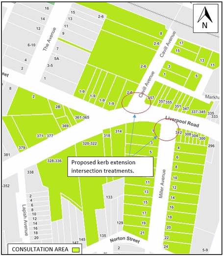
CONCLUSION
It is recommended that the design plan for the proposed kerb extensions and associated signs and line markings in Miller Avenue at Liverpool Road and Cavill Avenue at Liverpool Road, Ashfield (as per attached design plan Liverpool Road – Western Gateway (Footpath and Crossing Upgrade) be approved to improve pedestrian safety and accessibility at these locations.
|
1.⇩ |
Liverpool Road-Western Gateway proposal |
|
2.⇩ |
Liverpool Rd-Ashfield Gateway_Swept paths |
|
|
Local Traffic Committee Meeting 4 March 2019 |
Subject: McGill Street, Lewisham - Proposed Parking Restrictions (Damun Ward/Summer Hill Electorate/Inner West PAC)
Prepared By: Mary Bailey - Parking Planner
Authorised By: John Stephens - Traffic and Transport Services Manager
|
SUMMARY Following representation from residents Council is proposing to implement ‘No Parking’ restrictions in McGill Street, Lewisham in order to improve access to off-street parking and allow for improved thoroughfare in the narrow street. |
|
RECOMMENDATION
THAT:
1. The installation of ‘No Parking’ restrictions on the western side of McGill Street between existing ‘No Stopping’ restrictions and the boundary of property Nos.12 and 14 McGill Street be approved;
2. The installation of ‘No Parking’ restrictions on the eastern side of McGill Street, immediately north of the driveway of property Nos.7-15 McGill Street to the existing ‘No Stopping’ signpost be approved; and
3. The removal of ‘No Parking 9am-5pm Mon-Fri’ signage on the eastern side of McGill Street, outside property No.5 McGill Street be approved.
|
BACKGROUND
McGill Street, Lewisham is a short connecting street between Hudson Street and Old Canterbury Road. It is 110 metres long and 5.7 metres wide. Most of the properties on both sides of the street have either been redeveloped with multi story residential units or are currently under development.
Due to the narrowness of the street and the increased volumes of vehicles entering and exiting the new developments, it is not appropriate to have parking on both sides of the street as this creates obstruction for service and emergency vehicles as well as creating constraints on the ingress and egress from driveways associated with the multi-unit development car parking entrances. It is also proposed to remove an existing ‘No Parking 9am-5pm Mon-Fri’ sign as this is now no longer required since the redevelopment of the block at property No.5 McGill Street places a driveway in the space covered by the restriction. The proposal is illustrated in the following Figure 1; Figure 2 and Figure 3.
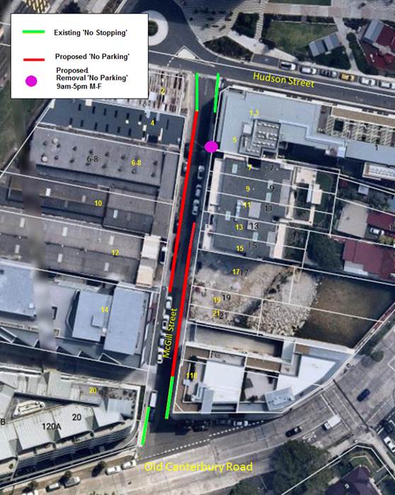
Figure 1: Existing and proposed parking restrictions for McGill Street
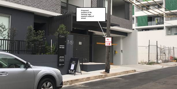
Figure 2. McGill Street – Eastern side – Proposed location of ‘No Parking’ signage immediately north of driveway of property Nos.7-15
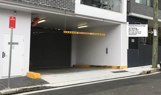
Figure 3:
McGill Street - Eastern side – Proposed removal of existing
‘No Parking’ 9am-5pm Mon-Fri’
Currently there are a number of issues that are affecting residents including parking on the footpath and issues with access to driveways due to parked vehicles as a result of the narrowness of the street. It should be noted that McGill Street has transitioned from an area where there was single unit residential dwellings to an area of high density dwellings. The number of vehicles accessing the street in order to access the parking in the multi-unit dwellings has increased significantly. Enforcement Officers are active in the area; however, it is foreseen that the installation of the proposed parking restrictions will improve compliance and provide improved access to off street parking for the multi-unit dwellings. An indication of current conditions can be seen in the photos in Figures 4, 5 and 6.
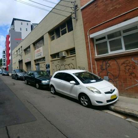
Figure 4: McGill Street – western side outside property Nos.4-10 showing parking on footpath.
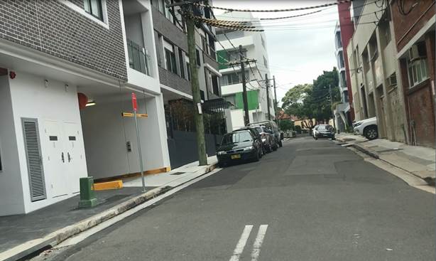
Figure 5: Photo showing driveways opposite cars parked on footpath in Figure 2.
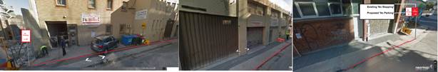
Figure 6. Photos of existing parking conditions opposite driveways property No.5 and property Nos.7-15 McGill Street.
It should be noted that there is a Development Application for the properties encompassing Nos.4-12 McGill Street. The proposal will involve a residential complex comprising of 92 dwellings and 101 parking spaces with access onto McGill Street. The location of the proposed development is shown in Figure 7 below.
Additionally, a Development Application has been received for the property at 2 McGill Street (DA201700611) to demolish existing improvements and construct a 6 storey mixed use development comprising 2 levels of basement parking, 2 commercial tenancies on the ground floor with 20 residential dwellings over 5 levels and a communal roof terrace.
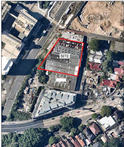
Figure 7: Site of proposed development at Nos.4-12 McGill Street.
FINANCIAL IMPLICATIONS
The cost of the supply and installation of the signage will be funded from Council’s budget for signs and line marking.
PUBLIC CONSULTATION
On 11 December 2018, there were 344 letters sent to affected owners and occupiers outlining the proposal and advising of the details of making submissions. Respondents were advised that submission closed Monday 17 February 2019.
The distribution of the letter is illustrated below in Figure 8.
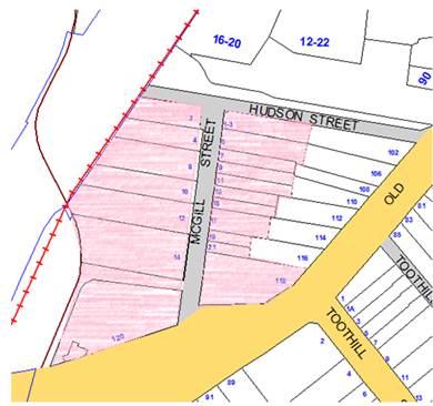
Figure 8: Area of Distribution of Proposal Letter to residents.
Prior to the consultation a number of letters were received from residents asking Council to address parking issues in McGill Street. All the correspondence has been incorporated into the feedback report.
All correspondence received supported Council introducing parking restrictions to ensure improved access and manoeuvrability. Nine (9) responses received were in favour of implementing parking changes in McGill Street to improve access and thoroughfare. There were no responses objecting to the proposal.
The feedback received is summarised in the Table 1 below.
Table 1: Summary of resident feedback
|
Support |
Officer Comment |
|
I'm writing in support of the proposed parking changes on McGill Street. As a resident on this street, the existing lack of parking signage has resulted in frequent illegal parking on pedestrian walkways or too close to residential apartment entries/exits.
Furthermore, the narrow street cannot support two way traffic when cars are parked on both sides. This situation has led to multiple motorist confrontations/conflicts when neither motorist is willing to reverse to allow for oncoming opposing traffic.
In addition to the proposed changes, please ensure the location of the no parking signage ensures enough space to allow residents to enter and exit apartment entries safely. |
The proposal will improve access and thoroughfare |
|
Driving through McGill street is becoming increasingly difficult due the cars being allowed to park on either side of the street.
We understand that due to new infrastructure within the suburb has led to an increase of people within the community but we urgently request if the matter regarding the parking along Mc Gill street can be investigated and if possible stopping signs be placed across the road from the above mentioned building.
|
|
|
Cars parking on both sides of McGill Street Lewisham are making it very hard to pass through. Is no parking zones on one side of the road an option? |
|
|
Over the past six months or so there has been daily occurrences of cars and vans illegally parking outside No. 2-14 (Even number) McGill street in Lewisham, blocking the road as well as the pavement (in the instances where cars park with two or even four wheels on the pavement) at all times of day.
Something must be done with regards to the parking situation on McGill St as it simply is not wide enough to support cars parking on both sides of the street. Goodness knows what will happen if an emergency vehicle is needed to attend the area as they could not get through the small gaps.
|
It is proposed to implement ‘No Parking’ in the section where there are reportedly vehicles currently parking on the footpath outside 2-14 McGill |
|
We would like to have loading zone on from no 4 to number to no 12 on the time 8:am to 6 pm on McGill St Lewisham. At the present we have so much problems with the same car park in front our drive way for days. Would you please put up the loading zone for us.
|
Spoke to affected party and met onsite to discuss. The owner of the property was satisfied with the proposal for ‘No Parking’ |
|
Concern over the current parking on McGill
Street and owners/residents having trouble turning out of the garage driveway
with congestion of parked vehicles on both sides of the street. |
Regarding difficulty in access and egress at driveway of 5 McGill Street, this will be dealt with separately. A site investigation was undertaken and it was determined that the existing signage is appropriate. Respondents will be advised of the Driveway Line marking option
The proposal addresses the issue of removing parking on one side of the street opposite the driveway, which will improve maneuverability for vehicles exiting the driveway of 5 McGill. |
|
Can you please do something about the stupid
parking arrangements in McGill St in Lewisham. People are parking on both
sides of the road and are blocking access. This is a safety concern. |
|
|
"Please study and improve parking regulation along McGill St Lewisham. Rampant double parking, parking on footpath, blocking driveways, and corner parking. |
Respondents have been advised to contact rangers in a timely manner if illegal parking is witnessed. |
|
McGill Street is a narrow road that has become
busier and obstructed by parking. |
The proposed restrictions will address thoroughfare issues. There is no plans to consider making McGill Street One Way |
CONCLUSION
Given that McGill Street is a narrow street (5.7m wide) and there is a significant increase in traffic volumes since multi-unit developments have replaced single unit dwellings; and that there is strong support from local residents to restrict parking in McGill Street; the proposal is supported.
|
|
Local Traffic Committee Meeting 4 March 2019 |
Subject: Cavey Street at Calvert Street, Marrickville - Proposed 10m 'No Stopping' restrictions (Midjuburi Ward/Summer Hill Electorate/Innerwest PAC)
Prepared By: Mary Bailey - Parking Planner
Authorised By: John Stephens - Traffic and Transport Services Manager
|
SUMMARY Following representations from the community, Council is proposing to signpost ‘No Stopping’ restrictions in Cavey Street at Calvert Street, Marrickville to improve manoeuvrability and sight lines at this intersection. |
|
RECOMMENDATION
THAT the installation of 10m ‘No Stopping’ zones on both the western and eastern sides of Cavey Street, south of Calvert Street be approved. |
BACKGROUND
Cavey Street is 7.3 metres wide. The narrowness of the street results in a constrained environment, especially for vehicles turning into and out of the street at its intersection with Calvert Street.
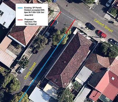
Figure 1: Existing and proposed parking restrictions
Council is proposing to implement ‘No Stopping’ zones in Cavey Street at its intersection with Calvert Street to improve manoeuvrability and sight lines at this location.
FINANCIAL IMPLICATIONS
The cost of the signposting will be covered from Council’s operating budget for signs and linemarking.
PUBLIC CONSULTATION
On 24 January 2019 letters were distributed to affected residents seeking feedback on the proposed parking restrictions. Residents were advised that the closing date for the submissions on the proposals was the 15 February 2019. The distribution area of the letter is illustrated in Figure 2 below.
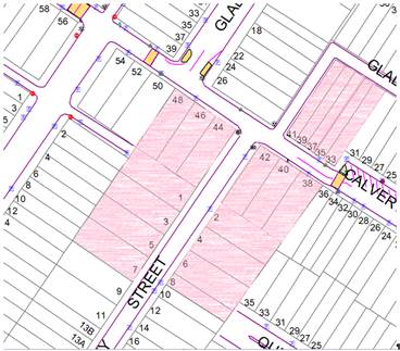
Figure 2: Distribution of proposals to highlighted properties
There was one (1) submission received. That submission was an objection to the proposal on the grounds that there is limited parking available in the area.
|
Resident Feedback |
Officer Comment |
|
Objection ‘I oppose the creation of the 10m no stopping zone because there is already a big enough issue with parking in the area. The last thing we need is less parking spaces. Surely 3m from the edge of Calvert St is enough.’
|
Given the narrowness of Cavey Street at its intersection with Calvert Street, it is deemed that 10m ‘No Stopping’ is required. |
CONCLUSION
Given the narrowness of Cavey Street and the reported manoeuvrability and safety issues at the intersection due to vehicles parked in Cavey Street too close to Calvert Street, the proposal to install 10m ‘No Stopping’ zones in Cavey Street (both sides) at its intersection with Calvert Street is supported.
|
|
Local Traffic Committee Meeting 4 March 2019 |
Subject: Fitzroy Lane, Newtown - Proposed parking restrictions (Damun Ward/Newtown Electorate/Inner West PAC)
Prepared By: Mary Bailey - Parking Planner
Authorised By: John Stephens - Traffic and Transport Services Manager
|
SUMMARY Following representations from the community Council has consulted with affected residents regarding implementation of parking restrictions in Fitzroy Lane, Newtown. The proposal for ‘No Parking’ and ‘No Stopping’ restrictions in the laneway between Australia Street and Brooks Lane will improve access to off-street parking and address resident concerns about damage to buildings. |
|
RECOMMENDATION
THAT: 1. Fitzroy Lane (southern side) – Alter the existing ‘No Parking 5am-10am Mondays’ to full time ‘No Parking’ restrictions between the existing ‘No Stopping’ zone at Australia Street and the existing ‘No Parking’ zone opposite Brooks Lane; and 2. Fitzroy Lane (northern side) – Install a 10m ‘No Stopping’ zone immediately east of Brooks Lane, be approved. |
BACKGROUND
According to Council’s Laneway Guidelines (December 2015) Laneways can be used for a variety of purposes which are listed below:
· Access for garbage collection trucks and deliveries where required
· Access to existing off-street parking within properties
· Access for emergency vehicles, pedestrians and cyclists
· Accessible parking for people with disabilities where appropriate
· Parking where space is available and access is maintained.
The Laneway Guidelines state that, “For parking to be allowed in a narrow laneway, the Australian Standards require that parallel parking spaces be at least 2.1 metres wide and NSW Road Rules requires that at least 3 metres must be available between a parked car and the kerb or edge of the laneway to allow moving vehicles to pass safely. Therefore, laneway widths that are less than 5.1 metres are too narrow to allow parking as any parked vehicle would prevent traffic from using the laneway.” Given the demand for parking and the support from the respondents, parking will be maintained on the northern side of the laneway (except on mornings when the rubbish is being collected – hence the proposal maintains a ‘No Parking 5am-10am Mondays’ restriction on the northern side of the laneway, as seen in Figure 1.)
Fitzroy Lane is a service lane that runs east west between Australia Street and Albert Street, Newtown. It is 4.9 meters wide. Parking in the lane was addressed as part of the Newtown/Enmore Parking Study endorsed by Council in March 2017. As a result of that study parking was restricted at the intersections with side lanes off Fitzroy Lane to allow for vehicles turning into and out of the laneways. At that time there was no support from the community for further restrictions. However, more recently there have been representations from the community and this proposal has been developed to address the representations to change the restrictions in the section of the laneway between Australia Street and Brooks Lane.
The existing restrictions in the subject section of Fitzroy Lane are as follows;
· Northern side - from the existing ‘No Stopping’ zones at Australia Street to the intersection of Brooks Lane ’No Parking 5am-10am Mondays
· Southern side - ‘’No Parking 5am-10am Mondays’ from the existing ‘No Stopping’ zone at Australia Street to the existing ’No Parking’ opposite the intersection with Brooks Lane.
Council canvassed affected residents with an initial proposal which was revised following feedback. The existing restrictions and the revised proposed restrictions are illustrated in Figure 1 below.
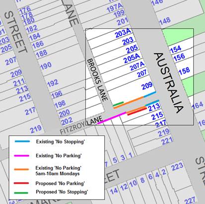
Figure 1: Revised Proposal for ‘No Parking’ on Southern side of Fitzroy Lane and ‘No Stopping’ northern side
Current parking conditions in the laneway are illustrated in the following Figure 1 and Figure 2.
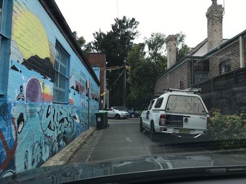
Figure 2: View of Fitzroy Lane (from Brooks Lane intersection).
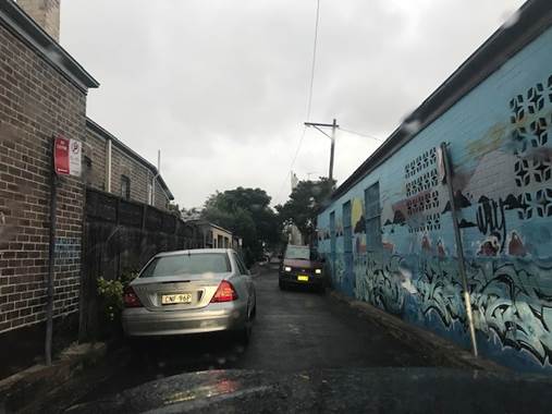
Figure 3: View of Fitzroy Lane (from Australia Street).
Brooks Lane is used by residents of both Australia Street and Denison Street to access off-street parking for their residences. To address concerns that access to off-street parking is being restricted because of parking in the laneway, the implementation of ‘No Stopping’ in Fitzroy Lane at the intersection with Brooks Lane will improve access and visibility at that intersection.
An initial proposal which was circulated to affected residents is shown below for information and reference. See Figure 4. The initial proposal was not supported and a revised proposal has been developed to address respondents concerns.
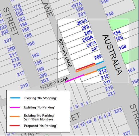
Figure 4: Initial proposal for ‘No Parking’ on northern side of Fitzroy Lane
The revised proposal (See Figure 1) is designed to address concerns regarding damage to the side of the building at No.209 Australia Street as illustrated in Figure 5 and Figure 6 below.
Figure 5: Damage to building on northern side of laneway (potentially due to camber)
Figure 6: Downpipe destroyed reportedly due to vehicles travelling along northern side of laneway (potentially as a result of camber of laneway)
Also the revised proposal addresses concerns expressed by residents that parking on the southern side of the laneway results in vehicles starting and idling directly outside and under the windows of the residential dwelling at 213 Australia Street. The windows are seen in Figure 7 below. Also please note the Also, please note that there is a substantial hedge growing on the southern side which impinges on the available parking space on the southern side taking up the kerb area in the subject section of the laneway. (See Figure 7). The kerb area on the northern side can be seen above in Figure 2 and is along the side of a building with no obstacles on the kerb.
Figure 7: View of southern side of laneway showing hedge on kerb and windows of residential dwelling.
One of the issues that has been reported by those affected residents is that installation of ‘No parking’ on the southern side as per the revised proposal, would hamper access to the off street parking of the garages at property Nos. 1 and 3 Albermarle Street. It is evident from the photo shown in Figure 8 below that there is sufficient maneuvering room for vehicles to utilise the space at the intersection of Fitzroy Lane and Brooks lane to effectively access/egress from the off-street parking spaces at property Nos. 1 and 3 Albermarle Street (green roller doors)
Figure 8: View from Brooks Lane of subject garages at property Nos 1 and 3 Albermarle Street (green roller doors) showing maneuvering room for access and egress
FINANCIAL IMPLICATIONS
The cost of the supply and installation of the signage will be funded from Council’s budget for signs and line marking.
PUBLIC CONSULTATION
Letters hand delivered to affected properties 25 January 2019 with a closing date for submissions of 18 February 2019. There were two responses to the initial proposal seeking to have it revised. A notification letter with the revised proposal was mailed to all affected residents. The distribution map for the letters is shown below in Figure 9.
In total there were responses from seven (7) households. Five (5) of those supported the original proposal and two (2) supported the revised proposal.
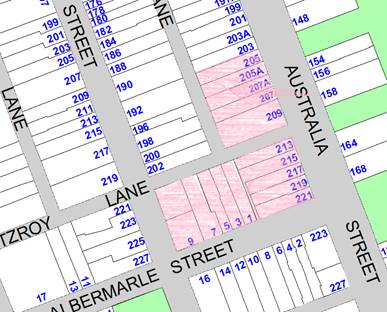
Figure 9: Distribution for proposal letters
The responses to the original and revised proposal are summarised in Table 1 below.
Table 1: Summary of Responses to Proposals
|
|
Resident Feedback |
Officer Comment |
|
Support for Revised Proposal – ‘No Parking’ southern side of laneway
Following input on the original proposal to have ‘No Parking’ on the northern side of the laneway, a revised proposal was developed and affected residents notified of the revised proposal and the details of the Traffic Committee meeting.
|
Two (2) residents who have properties directly affected by the proposed restrictions supported having the ‘No Parking’ restrictions on the southern side of Fitzroy Lane due to a number of issues including 1) reducing vehicle fumes in bedroom windows (see Figure 7 for photo of area outside the residential dwelling at No.213 Australia Street); and 2) reducing the potential of damage to building and gutters - partially due to the camber of the laneway surface towards the building at No.209 Australia Street. See Figures 7 and 8 for evidence of damage to this building. |
A site investigation by Council Officers confirmed that there is a camber on the laneway which falls away into the gutter on the northern side. This camber could be a contributing factor to the evident damage to the brick building wall and the destruction of the downpipe on the side of the building at 209 Australia Street.
The presence of the camber is one factor in support of having ‘No Parking’ on the southern side and allowing parking on the northern side of the laneway.
|
|
Support for Original Proposal ‘No Parking’ southern side of laneway |
One (1) resident of Australia Street, who accesses off-street parking via Brooks Lane, expressed a preference for ‘No Parking’ on the northern side of Fitzroy Lane. But that resident noted “However, should council decide ‘No Parking’ signs be placed on the southern side of Fitzroy Lane”, then a request was made to ensure vehicles were restricted from parking too close to Brookes Lane on the northern side of Fitzroy Lane”. |
The revised proposal although for restrictions on the non-preferred side does address the request for removal of vehicles in Fitzroy Lane at Brookes Lane by proposing 10m of ‘No Stopping’ at that location (see Figure 1). |
|
Two (2) residents access off-street parking in Fitzroy Lane opposite its intersection with Brooks Lane. Concerns were expressed about visibility and the speed of vehicles in the laneway while maneuvering into the off-street parking space. |
Given the narrowness of the laneway, the proximity to the intersection of Australia Street of the garage entrances, it is not deemed that there is an issue of speeding vehicles as such in the laneway.
Council Officers determined during a site investigation that there is ample room for vehicles to manoeuvre to access the subject garage entrances by using the turning space afforded by the intersection with Brooks Lane. (See Figure 8 above)
Installing ‘No Parking’ restrictions on the southern side of Fitzroy Lane (as per the revised proposal) will improve visibility for those vehicles accessing the garages in Fitzroy Lane opposite the intersection of Brooks Lane. Also the installation of the proposed 10m ‘No Stopping’ zone in Fitzroy Lane immediately east of Brooks Lane (as illustrated in Figure 1) will provide additional manoeuvring room for vehicles entering/existing the subject garages. |
|
|
One (1) resident whose property has rear lane access via a gate in Fitzroy Lane (to the west of Brooks Lane and outside the subject area) has expressed concern that if there is ‘No Parking’ on the southern side of the laneway that this will result in vehicles travelling at a higher speed in the laneway. The resident is concerned that children and dogs especially exiting the property would be affected by the vehicles travelling in the laneway. Also this resident has noted that there was damage to the rear fence of their property caused by vehicles travelling along the laneway |
Given the narrowness of the laneway, the proximity to the intersection of Australia Street of the garage entrances, it is not deemed that there is an issue of speeding vehicles as such in the laneway. |
CONCLUSION
Given that those respondents who are most directly affected support the revised proposal and that the issues raised by those objectors are deemed to be not relevant or addressed by the revised proposal, it is recommended to support the revised proposal.
|
|
Local Traffic Committee Meeting 4 March 2019 |
Subject: Pearl Lane, Newtown - Proposed 'No Parking' (Damun Ward/Newtown Electorate/Inner West PAC)
Prepared By: Mary Bailey - Parking Planner
Authorised By: John Stephens - Traffic and Transport Services Manager
|
SUMMARY Council has received reports that motorists are having difficulty navigating through the laneway without damaging a fence at the rear of a residence. In order to reduce the risk of damage and improve access and manoeuvrability, Council is proposing to install ‘No Parking’ in Pearl Lane (both sides) between Holmwood Lane and Dickson Street, Newtown. |
|
RECOMMENDATION
THAT the installation of ‘No Parking’ restrictions in Pearl Lane (both sides) between existing ‘No Stopping’ zones at Holmwood Lane and Dickson Street be approved.
|
BACKGROUND
According to Council’s Laneway Guidelines (December 2015) Laneways can be used for a variety of purposes which are listed below:
· Access for garbage collection trucks and deliveries where required
· Access to existing off-street parking within properties
· Access for emergency vehicles, pedestrians and cyclists
· Accessible parking for people with disabilities where appropriate
· Parking where space is available and access is maintained.
Pearl Lane is approximately 4.8 metres wide and runs north-south between Wells Street and Alice Lane, Newtown.
The Laneway Guidelines state that, “For parking to be allowed in a narrow laneway, the Australian Standards require that parallel parking spaces be at least 2.1 metres wide and NSW Road Rules requires that at least 3 metres must be available between a parked car and the kerb or edge of the laneway to allow moving vehicles to pass safely. Therefore, laneway widths that are less than 5.1 metres are too narrow to allow parking as any parked vehicle would prevent traffic from using the laneway.”
In this case, Council has received concerns that access is being restricted because of parking in the laneway. Furthermore, since the laneway is only is 4.8m wide, according to Council’s Laneway Guidelines, Pearl Lane is not wide enough to cater for parking.
Given the need to provide clear vehicular access through the laneway, it is recommended that full-time ‘No Parking’ restrictions be approved. The proposal is illustrated in Figure 1 below.
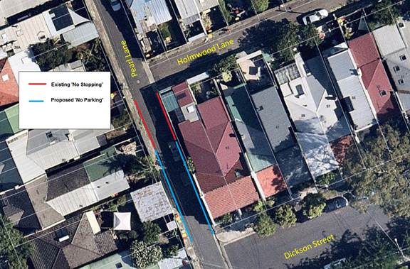
Figure 1: Existing and proposed restrictions in Pearl Lane
The photo below shows the conditions created by vehicles parking in the subject section of Pearl Lane. See Figure 2.
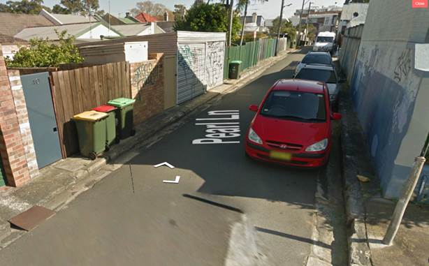
Figure 2: Vehicles parking in the subject section of Pearl Lane (looking north from Dickson Street to Holmwood Lane)
The damage reported to be caused by vehicles attempting to navigate through the laneway is illustrated in Figure 3 below.
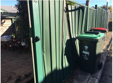
Figure 3: Photo of damage reported to be caused by vehicles navigating the laneway
FINANCIAL IMPLICATIONS
The cost of the supply and installation of the signage will be funded from Council’s signs and line markings budget.
PUBLIC CONSULTATION
On 23 January 2019, forty three (43) letters were sent to owners and occupiers of affected properties. The distribution of the letters is illustrated in Figure 4 below.
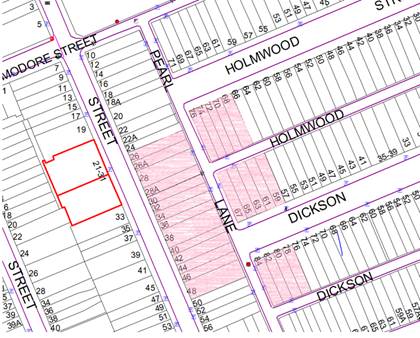
Figure 4: Distribution of letters (area highlighted in pink)
The letter advised residents of the proposal and committee meeting details and that submissions closed on Friday 15 February 2019.
In addition to the proponent seeking the ‘No Parking’ restrictions, two (2) submissions were received, one in support and one objecting.
|
Resident Response |
Officer Comment |
|
Support The submission in support gave the reason that the laneway is too narrow for parking and there is limited visibility and manoeuvrability, especially close to the intersection of Pearl Lane and Dickson Street. |
According to Council’s Laneway Guidelines, being less than 5.1m wide, the laneway is not suitable to accommodate parking |
|
Object The objector noted that parking is at a premium in the area and that the lane way parking provides additional opportunities for residents to park and suggested that service vehicles should be restricted from the lane |
The laneways are designed to provide access for service vehicles and allow access to off street parking. Parking is not a primary use for the laneways. |
CONCLUSION
Given the narrowness of the laneway and the reports of damage to property caused by vehicles accessing the laneway, the proposal to restrict parking in the laneway is supported.
|
|
Local Traffic Committee Meeting 4 March 2019 |
Subject: Cannon Lane, Stanmore - Proposed 'No Parking' (Damun Ward/Newtown Electorate/Inner West PAC)
Prepared By: Mary Bailey - Parking Planner
Authorised By: John Stephens - Traffic and Transport Services Manager
|
SUMMARY Following representation from residents regarding difficulty gaining access to off-street parking due to vehicles parked in the laneway, Council is proposing to implement ‘No Parking’ restrictions on both sides of Cannon Lane (between Margaret Street and Corunna Road). |
|
RECOMMENDATION
THAT the installation of ‘No Parking’ restrictions in Cannon Lane, Stanmore (both sides) between Margaret Street and Corunna Road, Stanmore be approved. |
BACKGROUND
According to Council’s Laneway Guidelines (December 2015) Laneways can be used for a variety of purposes which are listed below:
· Access for garbage collection trucks and deliveries where required
· Access to existing off-street parking within properties
· Access for emergency vehicles, pedestrians and cyclists
· Accessible parking for people with disabilities where appropriate
· Parking where space is available and access is maintained.
Cannon Lane is approximately 4.8 metres wide and runs north-south between Margaret Street and Corunna Road, Stanmore.
The Laneway Guidelines state that, “For parking to be allowed in a narrow laneway, the Australian Standards require that parallel parking spaces be at least 2.1 metres wide and NSW Road Rules requires that at least 3 metres must be available between a parked car and the kerb or edge of the laneway to allow moving vehicles to pass safely. Therefore, laneway widths that are less than 5.1 metres are too narrow to allow parking as any parked vehicle would prevent traffic from using the laneway.”
In this case, Council has received concerns that access is being restricted because of parking in the laneways. Furthermore, since the laneway is only is 4.8m wide, according to Council’s Laneway Guidelines, Cannon Lane is not wide enough to cater for parking.
Given the need to provide clear vehicular access through the laneway to facilitate access to off-street parking, it is recommended that full-time ‘No Parking’ restrictions be approved. The proposal is illustrated in the following Figure.
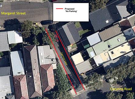
Figure : Proposed restrictions in Cannon Lane, Stanmore
FINANCIAL IMPLICATIONS
The cost of sign posting can be covered from Council’s operational budget for signs and linemarking.
PUBLIC CONSULTATION
On 23 January 2019, 17 letters were sent to owners/occupiers of properties affected by the proposed change in parking restrictions. Residents were advised that submissions closed by Friday 15 February 2019.
The proponent seeks to have consideration for access to off street parking noting, ’As a resident with garage access to that section of the lane, access to my garage has been restricted at times by vehicles parked in front of my garage.”
Following consultation, one submission was received.
|
Feedback |
Officer Comment |
|
Object “I disagree / strongly oppose the proposed 'No Parking' restrictions in Cannon Lane.” |
The lane is less than 5.1m wide and according to Council’s Laneway Guidelines is not suitable for parking, particularly in the case where there are reports that vehicles are blocking access to off-street parking spaces. |
CONCLUSION
Given the narrowness of the lane and the need for residents to access off-street parking spaces via the lane, the proposal is supported.
|
|
Local Traffic Committee Meeting 4 March 2019 |
Subject: Piper Lane (rear of 319 Annandale Street), Annandale - Proposed 'No Parking' zone (Baludarri Ward/Balmain Electorate/Leichhardt PAC)
Prepared By: David Yu - Engineer - Traffic and Parking Services
Authorised By: John Stephens - Traffic and Transport Services Manager
|
SUMMARY Council has received concerns regarding parked vehicles obstructing access to off-street parking in Piper Lane (rear of No.319 Annandale Street), Annandale. |
|
RECOMMENDATION
THAT a 3.3m ‘No Parking’ zone be installed on the eastern side of Piper Lane between two driveways and opposite rear boundary of No.319 Annandale Street, Annandale. |
BACKGROUND
Council received a concern from a resident of Annandale Street, Annandale regarding vehicles parking on the eastern side of Piper Lane, Annandale and subsequently obstructing rear driveway access for property No.319 Annandale Street.
Piper Lane is approximately 5.0m wide. There is an existing ‘No Parking’ zone on the eastern side of Piper Lane that is located to the north of the proposed restriction (at the rear of No.264 Johnston Street).
FINANCIAL IMPLICATIONS
Nil.
OTHER STAFF COMMENTS
It is proposed to signpost the eastern side of Piper Lane opposite No.319 Annandale Street as a ‘No Parking’ zone. The proposal is shown on the following plan.
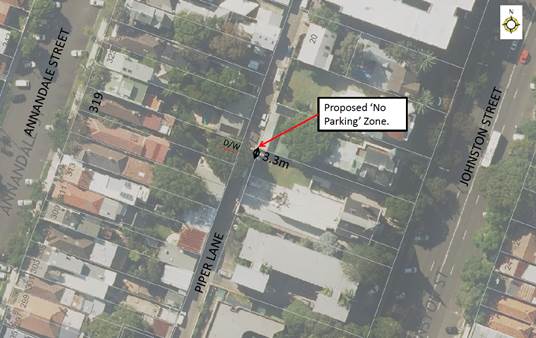
The proposal is expected to result in a loss of one on-street parking space.
PUBLIC CONSULTATION
|
A letter outlining the above proposal was mailed out to the affected properties (37 properties) in Piper Lane, Annandale Street and Johnston Street, Annandale. Two (2) responses were received, in support of the proposal. The table below shows the comments raised by the residents.
|
|
|
Residents’ Comments |
Officer Comments |
|
I write to support the proposal for the 'No Parking' zone on Piper Lane (rear of 319 Annandale Street, Annandale as I often see the owner of property 319 struggling to drive in and out of her garage due to cars blocking her access. |
It should be noted that a 3.3m ‘No Parking’ zone has been recommended for installation on the eastern side of Piper Lane (opposite No.319 Annandale Street), Annandale. |
|
I hope that the proposed 'No Parking' sign be erected opposite my garage. I'm 81 years old and have lived in this house for almost 80 yrs. |
CONCLUSION
Nil.
|
|
Local Traffic Committee Meeting 4 March 2019 |
Subject: Foucart Street at Easton Street, Rozelle - Proposed 'No Stopping'
zone (Baludarri Ward/Balmain Electorate/Leichhardt PAC)
Prepared By: David Yu - Engineer - Traffic and Parking Services
Authorised By: John Stephens - Traffic and Transport Services Manager
|
SUMMARY Council has received a request to signpost ‘No Stopping’ restrictions at the intersection of Foucart Street and Easton Street, Rozelle in order to prevent illegal parking and improve sight lines. |
|
RECOMMENDATION
THAT:
1. A 10m ‘No Stopping’ zone be installed on the northern side of Easton Street, east of Foucart Street, Rozelle;
2. A 10m ‘No Stopping’ zone be installed on the southern side of Easton Street, east of Foucart Street, Rozelle; and
3. A 10m ‘No Stopping’ zone be installed on the eastern side of Foucart Street, south of Easton Street, Rozelle
|
BACKGROUND
Concerns have been raised by residents regarding vehicles parking too close to the intersections of Foucart Street/Easton Street, Rozelle.
This illegal parking behaviour obstructs sight lines as well as access into and out of Foucart Street and Easton Street. It should be noted that there is unrestricted parking on both sides of Foucart Street and Easton Street.
FINANCIAL IMPLICATIONS
Nil.
OTHER STAFF COMMENTS
In order to alleviate the sight visibility and manoeuvring space issues, it is proposed to signpost the statutory 10m ‘No Stopping’ zones at the following locations:
· Northern side of Easton Street, east of Foucart Street, Rozelle
· Southern side of Easton Street, east of Foucart Street, Rozelle
· Eastern side of Foucart Street, south of Easton Street, Rozelle
The proposal is shown on the following plan:
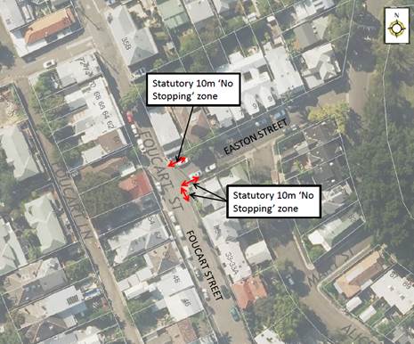
PUBLIC CONSULTATION
|
A letter outlining the above proposal was mailed out to the affected properties (16 properties) in Foucart Street and Easton Street, Rozelle. One (1) response was received, in objection of the proposal.
|
|
|
Residents’ Comments |
Officer Comments |
|
I am opposed to the proposal.
I have never seen an accident at the intersection of Easton/Foucart streets.
Because it's a T-intersection cars heading west on Easton street must stop no matter what.
I see no benefit to line-of-sight with No Stopping signs installed as it's the housing profiles that affect line-of-sight; not vehicles. |
Several concerns were received from residents of the area, regarding sight visibility issues when vehicles parked too close to the intersection within the statutory 10 metre road rule.
Our site investigation identified that vehicles parked close to the intersection impeded sight visibility. Signposting the statutory 10m ‘No Stopping’ zone is required to improve the safety for pedestrians and drivers at the intersection. |
CONCLUSION
Nil.
|
|
Local Traffic Committee Meeting 4 March 2019 |
Subject: Church Street, Petersham - Proposed 'No Parking Authorised Council Records Vehicles Excepted' Restrictions (Damun Ward/Newtown Electorate/Inner West PAC)
Prepared By: Scipio Tam - Engineer - Traffic and parking Services (South)
Authorised By: John Stephens - Traffic and Transport Services Manager
|
SUMMARY Council’s Business Information Services section is requesting a permanent loading area in Church Street, Petersham to accommodate staff with the unloading and transportation of hardcopy documents to Council’s Records Repository.
It is recommended that 'No Parking 8.30am-6pm Mon-Fri Authorised Council Records Vehicles Excepted’ restrictions be installed in Church Street, Petersham to assist Council’s Business Information Services staff with unimpeded access and ability to work within WH&S protocols. |
|
RECOMMENDATION
THAT the installation of ‘No Parking 8.30am-6pm Mon-Fri Authorised Council Records Vehicles Excepted’ restrictions (length of 6 metres) on the western side of Church Street, Petersham, in front of the basement entry (large double doors) to the Petersham Town Hall (directly opposite side boundary of property No.8 Frederick Street, Petersham) be approved.
|
BACKGROUND
Council’s Business Information Services (BIS) team recently acquired the basement of Petersham Town Hall as a records repository. At the point of amalgamation, Inner West Council had ten (10) record repository locations, with the long term plan of downsizing to two (2) locations i.e. St Peters Depot Building B and Petersham Town Hall facility.
With Council’s development of digitising hardcopy records, the BIS team regularly accesses the Petersham Town Hall repository several times a day, relocating and consolidating hardcopy documents and records from Balmain, Leichhardt and Ashfield. Large volumes of boxes are transported from the council vehicle through the basement doors with use of a trolley. With a designated parking space, staff would be able to work safer and within WH&S parameters, and avoid the disintegrating effects of wet weather to documents.
FINANCIAL IMPLICATIONS
The cost of the signposting will be funded from Council’s operational budget for signs and line marking.
OTHER STAFF COMMENTS
|
Street Name |
Church Street |
|
Section |
Between Frederick Street and Trafalgar Street |
|
Carriageway Width (m) |
6.4 |
|
Classification |
Two-way road with one travel lane for each direction. There is parking on both sides of the road |
|
Parking Arrangements |
Unrestricted parking on both sides of the road |
PUBLIC CONSULTATION
Community notification letters will be delivered to the surrounding eleven (11) properties, subject to Local Traffic Committee meeting support and Council endorsement.
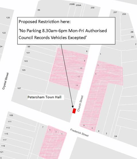
CONCLUSION
To ensure a safe and efficient work environment for Council’s Business Information Services team, the installation of a ‘No Parking 8.30am-6pm Mon-Fri Authorised Council Records Vehicles Excepted’ zone (total of 6 metres in length) on the western side of Church Street, Petersham, in front of the basement entry (large double doors) to the Petersham Town Hall (directly opposite side boundary of property No.8 Frederick Street, Petersham) is recommended.
|
|
Local Traffic Committee Meeting 4 March 2019 |
Subject: Henry Street, Ashfield - Proposed Installation of 10m 'No Stopping' zone (Djarrawunang Ward/Strathfield Electorate/Burwood PAC)
Prepared By: Scipio Tam - Engineer - Traffic and parking Services (South)
Authorised By: John Stephens - Traffic and Transport Services Manager
|
SUMMARY Council has received concerns of vehicles being parked too close to the intersections along Henry Street, Lucy Street, Earle Street and Page Avenue, Ashfield. These are intersections without ‘No Stopping’ restrictions being signposted.
This proposal is for 'No Stopping' zones to be installed at the specified intersection to address vehicle visibility and manoeuvrability issues. |
|
RECOMMENDATION
THAT the installation of 10m 'No Stopping' zones at the following locations be approved: 1. On the eastern side of Henry Street, south of Page Avenue and north of Earle Avenue, Ashfield; 2. On the western side of Henry Street, south of Lucy Street, Ashfield; and 3. On the northern side of Earle Avenue, east of Henry Street, Ashfield. |
BACKGROUND
Council has been advised that vehicles are being parked too close to some intersections along Henry Street, Lucy Street, Earle Street and Page Avenue, Ashfield.
The installation of the proposed ‘No Stopping’ restrictions in the subject streets is designed to discourage vehicles parking adjacent to corners, thus improving motorists’ visibility and maneuverability at the subject intersections.
FINANCIAL IMPLICATIONS
The cost of the signposting will be funded from Council’s operational budget for signs and line marking.
OTHER STAFF COMMENTS
Site inspection
Observation during site inspections undertaken in the morning and afternoon periods indicated that the on-street parking spaces along Henry Street and adjoining streets were highly utilised. At present, unrestricted parking is located predominantly on both sides of Henry Street and only the northern side of Earle Avenue, Page Avenue and Lucy Street as the street widths do not support parking on both sides.
Locality Map – Henry Street, Ashfield
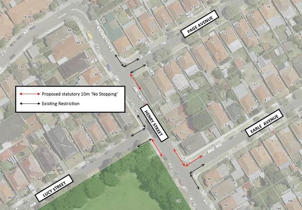
PUBLIC CONSULTATION
On 23rd January 2019, 35 letters were delivered to affected properties in the area. Residents were asked to make submissions by 8th February 2019. At the time of writing, two (2) supporting submissions were received. No objections were received. Any additional feedback received will be tabled at the meeting.
|
A letter outlining the above proposal was mailed out to the affected properties in Henry Street, Lucy Street, Page Avenue and Earle Avenue, Ashfield. Two responses in support of the proposal were received. |
|
|
Residents’ Comments |
Officer Comments |
|
Resident is in support of this proposal. Resident also commented on the poor planning done by WestConnex and the state government regarding parking for their staff, resulting in Henry Street, Lucy Street, Page Avenue and Earle Avenue being parked out all day and night as WestConnex staff park their personal vehicles during the day and “swap” over their work vehicles at night.
Resident is requesting Council implement a Residential Parking Scheme in the subject streets. |
Support is noted. Request has been forwarded to Council’s Parking Planner to investigate. |
|
Resident supports this traffic safety initiative
|
Support is noted |
CONCLUSION
The installation of 10m ‘No Stopping’ zones at the intersections along Henry Street will address the concerns raised and will improve visibility when approaching Henry Street, Ashfield from adjacent streets. Therefore, the proposal is supported.
|
|
Local Traffic Committee Meeting 4 March 2019 |
Subject: Edwin Street & Stanley Street, Tempe - Proposed Installation of 10m Statutory 'No Stopping' Signage (Midjuburi Ward/Heffron Electorate/Inner West PAC)
Prepared By: Scipio Tam - Engineer - Traffic and parking Services (South)
Authorised By: John Stephens - Traffic and Transport Services Manager
|
SUMMARY A request has been received from a local resident for the provision of ‘No Stopping’ restrictions to deter illegal parking on the southern side of Edwin Street and the adjacent corner of Stanley Street, Tempe. The resident has advised that vehicles are regularly parked too close to the intersection, restricting sightlines for motorists turning into Edwin Street from Stanley Street.
It is recommended that Statutory 10m ‘No Stopping’ restrictions be installed on the southern side of Edwin Street and the adjacent corners on Stanley Street in order to deter illegal parking, increase safety and improve visibility and access for turning motorists. |
|
RECOMMENDATION
THAT:
1. Installation of 10m ‘No Stopping’ signage on the southern side of Edwin Street, Tempe, both east and west from its intersection with Stanley Street (in front of No.6 and No.8 Edwin Street, Tempe); and 2. Installation of 10m Statutory ‘No Stopping’ signage on both sides of Stanley Street, Tempe, at the intersection with Edwin Street, (adjacent to side boundary of No.6 and No.8 Edwin Street, Tempe), be approved.
|
BACKGROUND
Council has received a request from a local resident for the provision of ‘No Stopping’ restrictions to deter illegal parking on the southern side of Edwin Street, Tempe, at its intersection with Stanley Street. The resident has advised that vehicles are parked too close to the intersection, restricting available sightlines and access for turning motorists.
FINANCIAL IMPLICATIONS
The cost of the signposting will be funded from Council’s operational budget for signs and line marking.
OTHER STAFF COMMENTS
Site location & road network
|
Street Name |
Edwin Street |
|
Section |
At Stanley Street, between Union Street and Tramway Street |
|
Carriageway Width (m) |
8.2 |
|
Carriageway Type |
Two-way road with one travel lane in each direction, in addition to kerbside parking lanes. |
|
Classification |
Local |
|
85th Percentile Speed (km/h) |
35.9 |
|
Reported Crash History (July 2011 – June 2016) |
No crashes recorded. |
|
Parking Arrangements |
Unrestricted parking on both sides of the road. |
Site inspection
A Council Officer has observed during site inspections undertaken in the morning and afternoon periods that the on-street parking spaces along Edwin Street were moderately utilised. At present, unrestricted parking is located predominantly on both sides of Edwin Street.
Raised thresholds are located along Edwin Street approximately 23 metres north and 125 metres south of its intersection with Stanley Street. Tempe Public School and Tempe High School are located nearby on Unwins Bridge Road, north of the subject intersection.
The increased traffic during school peak drop off/pick up hours may pose a higher risk of an incident occurring for motorists turning from Stanley Street and the proposed restrictions would assist motorists turning from Stanley Street into Edwin Street.
Locality Map – Edwin Street & Stanley Street, Tempe
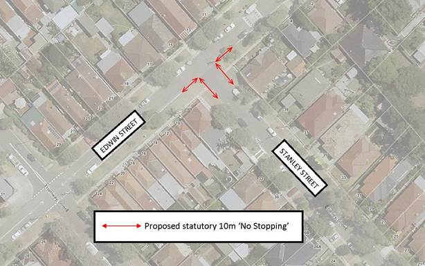
PUBLIC CONSULTATION
On 23rd January 2019, 51 letters were delivered to affected properties in the area. Residents were asked to make submissions by 8th February 2019. At the time of writing, three (3) submissions were received, one (1) in support and two (2) neutral feedback with alternative suggestions. No objections were received. Any additional feedback received will be tabled at the meeting.
|
A letter outlining the above proposal was mailed out to the affected properties in Edwin Street and Stanley Street, Tempe. Three responses were received. |
|
|
Residents’ Comments |
Officer Comments |
|
I have lived in the neighbourhood for over a year and traverse at this intersection on a daily basis. It is extremely rare for cars to be parked less than 10 metres from the intersection. In fact, car parking is very courteous because of the potential to block the Edwin Street footpath that’s a few metres from the intersection. The only time I’ve seen parking within 10 metres of the intersection is at school drop off/collection time. However, in 5-10 minutes after the school rush, local parking returns to the usual high standards. I suggest a more effective approach would be for Council to remind the parents of Tempe Public School students to park safely and legally in the local community. Furthermore, Council should consider installing ‘No Stopping’ signs in more dangerous intersections such as the intersection of Edwin Street and Gannon Street. |
Council Officers who have inspected the intersection on several occasions have identified it as a potential problem due to cars parked within 10m of the intersection. The proposed 'No Stopping' restrictions are intended to improve sight distance and manoeuvring at the subject intersection, increasing safety for the community.
Council’s Road Safety team has developed a range of information resources for schools to distribute to their students' families. |
|
I support Council’s proposal as I believe it will make a great difference to the safety of everyone that uses the intersection.
Over the years there is increased traffic in these streets as a result of demand for parking from the local bus depot, taxi business in Union St and local businesses in the immediate area parking. Moreover, when there are vehicles parked right up to the corner of these streets it may obstruct the vision from seeing into the next street.
Also, the children have to cross the street at this intersection to reach the local school a few metres up the end of Edwin St. |
Support is noted. |
|
I am one of the owners on Stanley St, the second house from the intersection. The parking spaces in Edwin St and Stanley St are always very scarce possibly as a result of boats and trucks that park at Stanley St for days. Moreover, many local dwellings do not have private car space.
I suggest Council to consider reducing the no parking distance to 5 metres as well as making the streets to 1 hr. parking only and finally, issuing parking permits to local residents. |
The proposed ‘No Stopping’ zones will provide improved sight lines for pedestrians and drivers.
There are no current plans to install 1 hour parking in Edwin or Stanley Street, Tempe and previous surveys of residents a few years ago in the area did not support resident parking.
|
CONCLUSION
The installation and enforcement of the statutory 10m ‘No Stopping’ signage at the intersection of Edwin Street and Stanley Street will address concerns expressed by residents regarding sightline visibility and is therefore recommended.
|
|
Local Traffic Committee Meeting 4 March 2019 |
Subject: Cannon Street, Stanmore - Proposed Installation of 10m Statutory 'No Stopping' Signage (Damun Ward/ Newtown Electorate/ Inner West PAC)
Prepared By: Scipio Tam - Engineer - Traffic and parking Services (South)
Authorised By: John Stephens - Traffic and Transport Services Manager
|
SUMMARY A request has been received from a local resident for the provision of ‘No Stopping’ restrictions to deter illegal parking on the western side of Cannon Street, Stanmore, at its intersection with Corunna Road. The resident has advised that vehicles are regularly parked too close to the intersection, restricting sightlines for motorists giving way to Cannon Street, before continuing along Corunna Road.
It is recommended that statutory 'No Stopping' restrictions be installed on all remaining un-signposted corners of Cannon Street and Corunna Road intersection, for a distance of 10 metres in order to deter illegal parking, increase safety and improve visibility and access for motorists. |
|
RECOMMENDATION
THAT the installation of 10m ‘No Stopping’ at the following locations be approved;
1. South-east corner of Cannon Street and Corunna Road, Stanmore, extending into both streets; 2. Western side of Cannon Street, Stanmore, extending north from its intersection with Corunna Road; and 3. Western side of Cannon Street, Stanmore, extending south from its intersection with Corunna Road. |
BACKGROUND
Council has received a request from a local resident for the provision of ‘No Stopping’ restrictions to deter illegal parking on Cannon Street, Stanmore, at its intersection with Corunna Road. The residents has advised that vehicles are parked too close to the intersection, restricting available sightlines and access for motorists.
FINANCIAL IMPLICATIONS
The cost of the signposting will be funded from Council’s operational budget for signs and line marking.
OTHER STAFF COMMENTS
Site location & road network
|
Street Name |
Cannon Street |
|
Section |
At Corunna Road between Margaret Street and Westbourne Street |
|
Carriageway Width (m) |
12.8 |
|
Carriageway Type |
Two-way road with one travel lane in each direction, in addition to kerbside parking lanes. |
|
Classification |
Local |
|
Reported Crash History (July 2013 – June 2017) |
No crashes recorded. |
|
Parking Arrangements |
Unrestricted parking on both sides of the road. |
Site inspection
Council Officers have observed during site inspections undertaken in the morning and afternoon periods that the on-street parking spaces along Cannon Street were highly utilised. At present, unrestricted parking is located predominantly on both sides of Cannon Street, with 1P restriction on eastern side of Cannon Street between Parramatta Road and Corunna Road. Several corners of the subject intersection have existing 10m ‘No Stopping’ restrictions signposted (refer to locality map illustrated below).
Technical Issues
In accordance with the Australian Road Rules, a ‘No Stopping’ zone is mandatory for a distance of 10 metres from an intersecting road. Pursuant to the RMS’ Technical Directions, it is stated that signposting at an unsignalised intersection (without pedestrian crossing) “should only be required where there is a compliance problem or there is adjoining signposting”. In this case, it is shown to be a compliance and safety problem for motorists attempting to turn.
Locality Map – Cannon Street, Stanmore
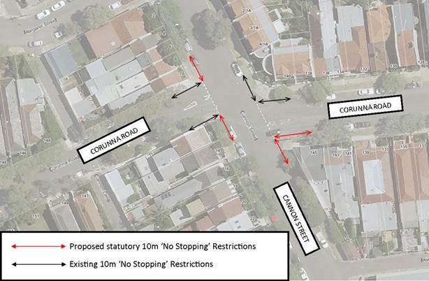
PUBLIC CONSULTATION
On 23 January 2019, 35 letters were delivered to affected properties in the area. Residents were advised to make submissions by 8 February 2019. At the time of consultation, two (2) queries were received and these were subsequently addressed. No feedback was received.
|
A letter outlining the above proposal was mailed out to the affected properties in Cannon Street and Corunna Road, Stanmore. No feedback was received. |
|
CONCLUSION
The installation of the statutory 10m ‘No Stopping’ signage at the intersection of Cannon Street and Corunna Road will address concerns expressed regarding sightline visibility. Therefore the proposal is supported.
|
|
Local Traffic Committee Meeting 4 March 2019 |
Subject: Susan
Street, Annandale - Motorbike Parking
(Gulgadya Ward/Balmain Electorate/Leichhardt PAC)
Prepared By: Brinthaban Baskaran - Student Traffic Engineer
Authorised By: John Stephens - Traffic and Transport Services Manager
|
SUMMARY Council has received concerns regarding blocked vehicular access to the driveway of No.27A and No.29 Susan Street, Annandale. In order to prevent vehicles impeding driveway access whilst making use of the short kerb space, it is proposed to convert the existing 4.0m ‘2P 8am-6pm’ resident parking space into a 4.0m 'Motor Bike Only’ parking between No.27A and No.29 Susan Street, Annandale. |
|
RECOMMENDATION
THAT the existing 4.0m parking space between No.27A and No.29 Susan Street, Annandale restricted as ‘2P 8am-6pm; Mon-Fri Permit Holders Excepted Area A1’ parking be signposted as a 4.0m ‘Motor Bike Only’ parking space.
|
BACKGROUND
Council has received concerns regarding blocked vehicular access to the driveway of No.27A and No.29 Susan Street, Annandale due to vehicles over-hanging the driveway.
The existing kerb space between No.27A and No.29 Susan Street is insufficient to accommodate a standard size vehicle without impeding driveway access to No.27A or No.29 Susan Street.
FINANCIAL IMPLICATIONS
Nil.
OTHER STAFF COMMENTS
In order to prevent vehicles impeding driveway access whilst making use of this redundant space, it is proposed to install a 4.0m ‘Motor Bike Only’ parking zone as detailed on the following plan.
PUBLIC CONSULTATION
A letter outlining the above proposal was mailed out to the affected properties (10 properties) in Susan Street, Annandale.
Three responses were received, two in support and one in objection of the proposal.
|
Residents’ Comments |
Officer Comments |
|
We support Council’s proposal as the space between 27a (my residence) and 29 Susan Street, Annandale is inadequate for a car to fit in without encroaching over both driveways. |
Noted. |
|
I do not object to Council’s proposal.
Could Council please consider installing a Resident Parking Scheme on the opposite side of Susan Street as the loss of the existing parking spot may result in further parking congestion. |
Council will investigate this matter separately. RPS was investigated back in March 2018 and it did not meet Council's requirements. The resident will be advised that further RPS investigation can be initiated with three requests from residents. |
|
I believe that the proposed area under review is suitable for a small car as it will be able to fit without impeding either of the driveways at 27A and 29 Susan Street. Council should consider installing a ‘small car only’ sign to regulate the space and utilize line markings to indicate whether the size of vehicles can comply with the space requirements. Furthermore, while I understand that larger cars do park in that space and overhang the line markings for the driveway at 27A Susan Street, this is due to a problematic minority of individual motorists that do not comply with regulations. |
There is no regulatory sign that allows parking for small cars. Therefore, it is recommended that the space should be converted to motorbike parking only.
|
CONCLUSION
Nil.
|
|
Local Traffic Committee Meeting 4 March 2019 |
Subject: Minor Traffic Facilities (All Wards/All Electorates/All PACs)
Prepared By: Vinoth Srinivasan - Engineer - Traffic and Parking Services
Authorised By: John Stephens - Traffic and Transport Services Manager
|
SUMMARY This report considers minor traffic facility applications received by Inner West Council, including ‘Disabled Parking’ and ‘Works Zone’ requests. |
|
RECOMMENDATION
THAT:
1. A 6m ‘Disabled Parking’ zone be removed in front of No.60 Catherine Street, Leichhardt;
2. A 6m ‘Disabled Parking’ zone be removed in front of No.5 Numa Street, Birchgrove;
3. A 6m ‘Disabled Parking’ zone be installed in front of No.32 Charlecot Street, Dulwich Hill;
4. A 6m ‘Disabled Parking’ zone be installed in front of properties No.29 and No.31 Spencer Street, Summer Hill;
5. A 6m ‘Disabled Parking’ zone be installed in front of No.47 Kays Avenue, Marrickville;
6. A 5.5m ‘Disabled Parking’ zone be installed in front of No.203 Sydenham Road, Marrickville;
7. A 16m ‘Works Zone 7.00am – 6.00pm Mon-Fri; 8.00am -1.00pm Sat' be installed in front of Nos.17-19 Wetherill Street, Croydon for 12 weeks;
8. A 11.5m ‘Works Zone 7.00am – 6.00pm Mon-Fri; 8.00am -1.00pm Sat' be installed in front of No.33 Smith Street, Summer Hill for 5 weeks;
9. A 10m ‘Works Zone 7.00am – 6.00pm Mon-Fri; 8.00am - 1.00pm Sat' be installed in front of No.44 Liverpool Road (Gower Street frontage) and No.35 Gower Street, Summer Hill for 12 weeks, subject to the applicant receiving the written concurrence from the owners of No.35 Gower Street; and
10. A 65m ‘Works Zone 7.00am – 5.30pm Mon - Sat' be installed in front of Nos.13-55 Edinburgh Road, Marrickville for 12 weeks.
|
BACKGROUND
This report considers minor traffic facility applications by Inner West Council, and includes ‘Disabled Parking’ and ‘Works Zone’ requests.
FINANCIAL IMPLICATIONS
Nil.
OTHER STAFF COMMENTS
1. Removal of ‘Disabled Parking’ restriction – Catherine Street, Leichhardt
A family member of the applicant of the ‘Disabled Parking’ zone in front of No.60 Catherine Street, Leichhardt has notified Council that the applicant has passed away and thus the ‘Disabled Parking’ zone is no longer required.
It is recommended that the 6m ‘Disabled Parking’ zone in front of No.60 Catherine Street, Leichhardt be removed.
2. Removal of ‘Disabled Parking’ restriction - Numa Street, Birchgrove
The applicant of the ‘Disabled Parking’ zone in front of No.5 Numa Street, Birchgrove has notified Council that the ‘Disabled Parking’ zone is no longer required.
It is recommended that the 6m ‘Disabled Parking’ space in front of No.5 Numa Street, Birchgrove be removed.
3. Installation of a ‘Disabled Parking’ restriction – Charlecot Street, Dulwich Hill
The resident of No.32 Charlecot Street, Dulwich Hill has requested the installation of 'Disabled Parking Zone’ in front of the resident’s property. A site investigation has revealed the property does not have off street parking and the applicant does not require the use of wheelchair.
It is recommended that a 6m 'Disabled Parking Zone’ be installed in front of 32 Charlecot Street, Dulwich Hill.
No. 32 Charlecot Street, Dulwich Hill
4. Installation of a ‘Disabled Parking’ restriction – Spencer Street, Summer Hill
The resident of No.29 Spencer Street, Summer Hill has requested the installation of a ‘Disabled Parking’ zone in front of the resident’s property. A site investigation has revealed the property has off street parking at the rear of the property. However, the applicant is unable to access the off-street parking due to a medical condition. Moreover, the property frontage is less than 6m and so there will be approximately 2.4m of overhang across the frontage of No.31 Spencer Street.
A consultation letter outlining this proposal was sent to the resident of No.31 Spencer Street and no response was received. The applicant does not require the use of a wheelchair.
It is recommended that a 6m ‘Disabled Parking’ zone be installed in front of No.29 Spencer Street, Summer Hill.
Nos.29-31 Spencer Street, Summer Hill
5. Installation of a ‘Disabled Parking’ restriction – Kays Avenue, Marrickville
The resident of No.47 Kays Avenue, Marrickville has requested the installation of 'Disabled Parking Zone’ in front of the resident’s property. A site investigation has revealed the property does not have off-street parking. The applicant does not require the use of wheelchair.
It is recommended that a parking 6m 'Disabled Parking Zone’ be installed in front of No.47 Kays Avenue, Marrickville.
No.47 Kays Avenue, Marrickville
6. Installation of a ‘Disabled Parking’ restriction – Sydenham Road, Marrickville
The resident of No.203 Sydenham Road, Marrickville has requested the installation of a 'Disabled Parking Zone’ in front of the resident’s property. A site investigation has revealed the property does not have off street parking. The applicant does not require the use of wheelchair.
It is recommended that a 5.5m 'Disabled Parking Zone’ be installed in front of No.203 Sydenham Road, Marrickville.
No.203 Sydenham Road, Marrickville
7. Installation of a ‘Works Zone’ restriction – Wetherill Street, Croydon
The applicant has requested the installation of a 16m temporary 'Works Zone 7.00am – 6.00pm Mon-Fri; 8.00am-1.00pm Sat' outside Nos.17-19 Wetherill Street, Croydon.
It is recommended that a 16m 'Works Zone 7.00am – 6.00pm Mon-Fri; 8.00am -1.00pm Sat' be installed in front of Nos.17-19 Wetherill Street, Croydon for 12 weeks.
Nos. 17-19 Wetherill Street, Croydon
8. Installation of ‘Works Zone’ restriction – Smith Street, Summer Hill
The applicant has requested the installation of an 11.5m temporary 'Works Zone 7.00am – 6.00pm Mon-Fri; 8.00am-1.00pm Sat' outside No.33 Smith Street, Summer Hill for 5 weeks.
It is recommended that an 11.5m 'Works Zone 7.00am – 6.00pm Mon-Fri; 8.00am -1.00pm Sat' be installed in front of No.33 Smith Street, Summer Hill for 5 weeks.
No. 33 Smith Street, Summer Hill
9. Installation of ‘Works Zone’ restriction – Gower Street, Summer Hill
The applicant (No.44 Liverpool Road) has requested the installation of a temporary 10m 'Works Zone 7.00am – 6.00pm Mon-Fri and 8.00am-1.00pm Sat' at its property boundary on Gower Street and No.35 Gower Street, Summer Hill.
It is recommended that a 10m 'Works Zone 7.00am – 6.00pm Mon-Fri and 8.00am -1.00pm Sat' be installed in front of No.44 Liverpool Road (Gower Street frontage) and No.35 Gower Street Summer Hill for 12 weeks. This is subject to the applicant receiving the written concurrence from the owners of No.35 Gower Street, Summer Hill.
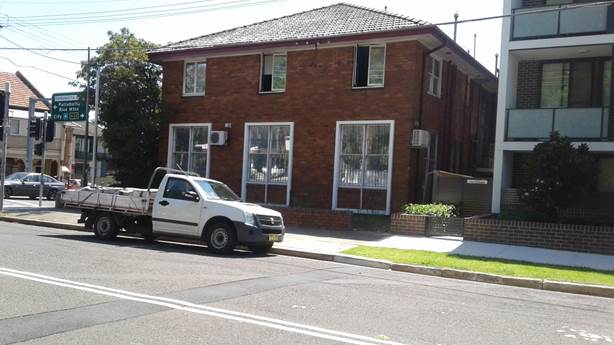
No.44 Liverpool Road (Gower Street frontage) and No.35 Gower Street, Summer Hill
10. Installation of a ‘Works Zone’ restriction – Nos.13-55 Edinburgh Road, Marrickville
The applicant has requested the installation of a temporary 65m 'Works Zone 7.00am – 5.30pm Mon - Sat' in front of Nos.13-55 Edinburgh Road, Marrickville.
It is recommended that a 65m 'Works Zone 7.00am – 5.30pm Mon - Sat' be installed in front of Nos.13-55 Edinburgh Road, Marrickville for 12 weeks.
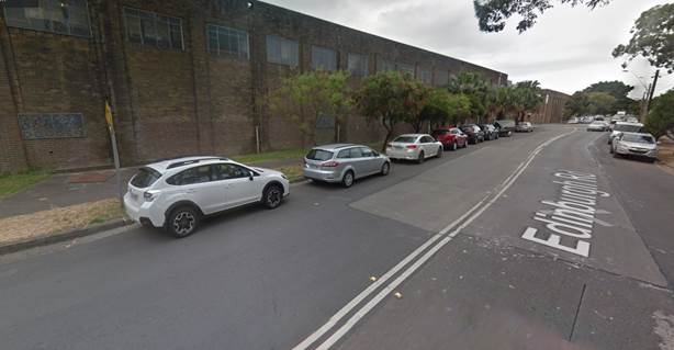
Nos.13-55 Edinburgh Road, Marrickville
PUBLIC CONSULTATION
Nil.
CONCLUSION
Nil.
|
|
Local Traffic Committee Meeting 4 March 2019 |
Subject: Australia Street, Stanmore - Proposed Time Restricted Parking (Damun Ward/Newtown Electorate/Inner West PAC)
Prepared By: Scipio Tam - Engineer - Traffic and parking Services (South)
Authorised By: John Stephens - Traffic and Transport Services Manager
|
SUMMARY Following representation from business owners on Australia Street, Council is proposing to implement timed parking restrictions along Australia Street, Camperdown; on the eastern side, from the Parramatta Road intersection to the frontage of No.8 Australia Street and on the western side, adjacent to No.1 Gantry Lane. |
|
RECOMMENDATION
THAT the following signage zones be approved:
1. Installation of a 10m ‘No Stopping’ zone on the eastern side of Australia Street from Parramatta Road to replace the existing ‘No Parking’ restriction at the intersection; 2. Installation of 14m ‘1/4P 8:30am-6pm’ zone on the eastern side of Australia Street, Camperdown immediately south of the proposed ‘No Stopping’ zone (i.e. 2 spaces between No.137 Parramatta Road and No.4 Australia Street); 3. Installation of 23m '2P 8:30am-6pm’ zone on the eastern side of Australia Street, Camperdown immediately south of the driveway of No.4 Australia Street (i.e. 3 spaces between No.4 Australia Street and No.8 Australia Street); and 4. Installation of a ‘2P 8:30am-6pm’ zone on the western side of Australia Street, Camperdown 10m south of Parramatta Road and adjacent to No.1 Gantry Lane. |
BACKGROUND
Council has received correspondence from the business owner at No.8 Australia Street, Camperdown requesting that the existing spaces of unrestricted parking on Australia Street, to the side boundary of No.137 Parramatta Road and in front of 2-8 Australia Street, Camperdown be altered to short term parking. The proposed timed parking restrictions are considered adequate for the parking needs of the surrounding businesses and visitors to the area.
The parking restrictions were chosen to increase the availability of parking spaces for people visiting the shops and businesses located on Australia Street, Camperdown during business operating hours.
At present, parking is unrestricted on both sides of Australia Street, Camperdown (in the vicinity of Parramatta Road).
FINANCIAL IMPLICATIONS
The cost of installing the parking signs will be met from Council’s operating budget for signs and linemarking.
OTHER STAFF COMMENTS
From on-site analysis and investigation conducted by Council Officers, the proposal for ‘1/4P 8.30am-6pm’ for approximately two (2) spaces and 2P 8.30am-6pm for approximately three (3) spaces along the Australia Street boundaries for No.137 Parramatta Road and Nos.2-8 Australia Street would provide short term parking opportunities to support the local businesses. Currently parking along this section of Australia Street, Camperdown has unrestricted parking on both sides which provides on-street parking opportunities for:
· Residents; houses and new apartment blocks
· Businesses
· Commuters; due to the proximity to Sydney CBD and bus stops
· Camperdown Park visitors
Australia Street has currently a mixture of 2P residential parking adjacent to the houses between Parramatta Road and Salisbury Road; ¼P parking for the long day care centre and unrestricted parking adjacent to Camperdown Park and newly built residential units closer to Parramatta Road.
The proposal is aimed at providing additional parking opportunities for the businesses along Parramatta Road and Australia Street in close proximity to their properties.
PUBLIC CONSULTATION
There were 238 letters sent out on 23rd January 2019 to business owners and property owners/occupiers within the vicinity of the proposal inviting comment. The community survey closed on 8th February 2019.
Council received one (1) submission supporting Council's proposal. Additionally, the respondent strongly requested that the ‘2P 8.30am-6pm’ restrictions should be extended further down the eastern side of Australia Street to accommodate parking for local businesses and to deter commuter parking in the area, to ensure ample parking opportunities for residents and business occupiers in the area.
It is considered that the addition of the 1/4P and 2P parking zones closer to Parramatta Road will address the need for parking turnover for the businesses, whilst balancing parking needs for other users of the area. It should be noted that short term parking opportunities already exist along Parramatta Road in close proximity to Australia Street.
|
A letter outlining the above proposal was mailed out to the nearby properties on Parramatta Road, Australia Street and Gantry Lane, Camperdown (Total of 238 letters mailed out). One (1) response was received in support of the proposal. |
|
|
Proposed Plan for time restricted parking along Australia Street, Camperdown. |
|
CONCLUSION
It is recommended that the existing unrestricted parking spaces along Australia Street, between No.137 Parramatta Road and No.8 Australia Street, on the eastern side and adjacent to 1 Gantry Lane on the western side to be changed to time restricted parking as per the plan shown above.
The restrictions are considered adequate for the parking needs of the surrounding businesses.
Additionally, it is recommended that a 10m 'No Stopping' restriction be installed on the north-eastern corner of Australia Street, at its intersection with Parramatta Road, Camperdown, replacing the existing ‘No Parking’ restriction in order to comply with NSW Road Rules.
|
|
Local Traffic Committee Meeting 4 March 2019 |
Subject: Birchgrove Road at Macquarie Terrace, Birchgrove - Proposed Linemarking and Signage Works (Baludarri Ward/Balmain Electorate/Leichhardt PAC)
Prepared By: David Yu - Engineer - Traffic and Parking Services
Authorised By: John Stephens - Traffic and Transport Services Manager
|
SUMMARY Council has received concerns from Birchgrove Public School P&C regarding pedestrian safety near the existing raised pedestrian crossing in Birchgrove Road at the intersection of Macquarie Terrace, Birchgrove. |
|
RECOMMENDATION
THAT the design plan for pedestrian safety improvement works, which includes signposting and linemarking in Birchgrove Road at the intersection of Macquarie Terrace, Birchgrove (as per the attached plan) be approved. |
BACKGROUND
Concerns have been raised by the school's P&C President and residents regarding pedestrian safety at and near the raised pedestrian crossing located in Birchgrove Road at the intersection of Macquarie Terrace, Birchgrove.
Traffic tube counts were undertaken on November 2018 in Birchgrove Road. The 85th precentile speed results are summarised below:
· between Macquarie Terrace and Cardwell Street – 26.7km/h (westbound) and 26.4km/h (eastbound).
· between Macquarie Terrace and Water Street – 39.5km/h (westbound) and 38.7km/h (eastbound).
These speed results are considered satisfactory and are under the 40km/h speed limit for the Balmain peninsular.
There are existing speed cushions located along Birchgrove Road and the school is supported with School Crossing Supervisors during school hours at the raised pedestrian (zebra) crossing.
FINANCIAL IMPLICATIONS
Nil.
OTHER STAFF COMMENTS
A site investigation has revealed that there were missing signs and linemarking. Therefore, it is proposed that the following improvement works be undertaken:
· Installation of double white (barrier) linemarking (BB line type) with raised reflective pavement markers (RRPMs);
· Installation of supplementary Give Way signage and associated linemarking (TB line type);
· Installation of ‘LOOK’ stencils;
· Installation of advanced warning Pedestrian Crossing left signpost (W6-2-1);
· Installation of flexible bollards; and
· Installation of edge linemarking.
The design plan for the proposed works is shown in the attachment.
All current vehicular access to adjoining properties will be retained.
PUBLIC CONSULTATION
Nil.
CONCLUSION
Nil.
|
1.⇩ |
Birchgrove Road at Macquarie Terrace, Birchgrove - Improvement Works Plan |
|
|
Local Traffic Committee Meeting 4 March 2019 |
Subject: Flood Street, Leichhardt - Road Occupancy (Gulgadya Ward/Balmain Electorate/Leichhardt PAC)
Prepared By: Vinoth Srinivasan - Engineer - Traffic and Parking Services
Authorised By: John Stephens - Traffic and Transport Services Manager
|
SUMMARY This report considers a request received from BreastScreen NSW for the temporary placement of their mobile lab unit on the western side of Flood Street adjacent to Leichhardt Market Place within the existing ‘Taxi Zone’, for the duration of eight (8) weeks starting from Friday, 21st June to Friday, 16th August 2019. |
|
RECOMMENDATION
THAT the road occupancy for the BreastScreen NSW mobile lab unit on the western side of Flood Street, adjacent to Leichhardt Market Place within the existing ‘Taxi Zone’, for the duration of eight (8) weeks starting from Friday, 21st June to Friday, 16th August 2019 be supported, subject to the following conditions:
1. That all affected businesses, residents and other occupants must be notified of the road occupancy and activities at least one week prior to the commencement of the event. Any concerns or requirements raised by business proprietors, residents and other occupants must be resolved or accommodated by the applicant;
2. That the applicant contact Energy Australia/Ausgrid in relation to power access to the mobile laboratory;
3. That the areas to be used for the activities must be maintained in a clean and tidy condition to the satisfaction of Council’s Group Manager Roads, Traffic and Stormwater, or else the applicant will be required to reimburse Council for any extraordinary cleansing costs;
4. That the Council and RMS must be indemnified against all claims for damage or injury that may result from either the activities or from the occupation of part of the public way during the activities. The applicant must therefore produce evidence of its public risk insurance cover (under which Council is indemnified) with a minimum policy value of at least $10,000,000;
5. That a copy of the Council approval letter must be made available on the site for inspection by relevant officers;
6. That the applicant must comply with any reasonable directive from Council’s Compliance Officers; and
7. That Council reserves the right to cancel this approval at any time.
|
BACKGROUND
BreastScreen NSW has requested approval to locate a mobile lab unit on the western side of Flood Street, adjacent to Leichhardt Market Place within the existing ‘Taxi Zone’ for the duration of eight (8) weeks from Friday, 21st June to Friday, 16th August 2019. The mobile lab unit will operate for screening from 8.45am to 4.00pm Monday to Friday. This location has been used in previous years without any issues and would not affect any businesses, see proposed location below:
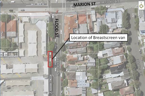
Note that the applicant has been requested to provide a copy of their public risk insurance.
FINANCIAL IMPLICATIONS
Nil.
OTHER STAFF COMMENTS
Nil.
PUBLIC CONSULTATION
Nil.
CONCLUSION
That the road occupancy for a BreastScreen NSW mobile lab unit on the western side of Flood Street, adjacent to Leichhardt Market Place be supported subject to the conditions listed in the officer’s recommendation.
|
|
Local Traffic Committee Meeting 4 March 2019 |
Subject: 2A Gladstone Street, Newtown - DA201700589 - For The Temporary Use Of The Site For A Multi-Use Creative Hub - Revised Traffic & Parking Impact Assessment (Damun Ward/Newtown Electorate/Inner West PAC)
Prepared By: Scipio Tam - Engineer - Traffic and parking Services (South)
Authorised By: John Stephens - Traffic and Transport Services Manager
|
SUMMARY Additional information has been received for a temporary application to use the existing buildings to create a multi-use creative hub containing creative work spaces (business and offices premise), market stalls, wholesale bakery and food truck with 24 portable/relocatable marquees for stall holders, 8 shipping containers four on the ground floor and 4 above, fold out stage to operate 7.00am to 7.00pm Mondays to Fridays, 6.00am to 6.00pm for the creative workspaces, 6.00am to 6.00pm Mondays to Sundays for the wholesale bakery, Saturdays 7.00am to 4.00pm and 6.00pm to 10.00pm for the market and 7.00am to 10.00pm for functions or creative performances
The application is required to be referred to the Pedestrian, Cyclist & Traffic Calming Advisory Committee for consideration under State Environmental Planning Policy (Infrastructure) 2007. |
|
RECOMMENDATION
THAT the findings of this report be received and noted.
|
BACKGROUND
Additional information has been received for a temporary application to use the existing buildings to create a multi-use creative hub containing creative work spaces (business and offices premise), market stalls, wholesale bakery and food truck with 24 portable/relocatable marquees for stall holders, 8 shipping containers four on the ground floor and 4 above, fold out stage to operate 7.00am to 7.00pm Mondays to Fridays, 6.00am to 6.00pm for the creative workspaces, 6.00am to 6.00pm Mondays to Sundays for the wholesale bakery, Saturdays 7.00am to 4.00pm and 6.00pm to 10.00pm for the market and 7.00am to 10.00pm for functions or creative performances
It is noted that previously the site has been occupied by an open yard area used for a metal recycling facility. Determination No. 14352, dated 4 June 1992 approved an application for the use of the property for the collection, dismantling, storage and wholesale of scrap metals, subject to conditions. Determination No. 201200505, dated 13 March 2013, approved an application under Section 96 to modify Determination No. 14352 dated 4 June 1992 to construct an awning, amend condition 4 relating to machinery to include an excavator and amend condition 9 to permit the storage of batteries.
Currently DA No. 201600060 for 2 and 2A Gladstone Street, Newtown was approved on 23 January 2017 to demolish existing improvements and construct a 4 storey mixed use development with creative commercial uses on the ground floor, first and second floors 18 dwellings (including 3 live work dwellings) on the upper floors with basement car parking and strata subdivision.
The applicant had submitted a revised Traffic and Parking Impact Assessment report on 1 June 2018, following the first Local Traffic Committee report submitted for this Development Application and brought forward to the meeting on 10 April, 2018.
The previous Local Traffic Committee report on 10 April 2018 had documented that the proposed development was not supported in its unrevised form because of the following issues:
· GFA uses/areas need to be identified more precisely. It is difficult to adequately determine parking provision and/or traffic generation rates for the proposed development. There is no mention of a ‘Residential’ component yet it is cited in the applicant’s SEE report as a ‘use’.
· The applicant’s Traffic report uses different criteria for parking and traffic generation analysis; ideally these should be consistently based.
· The proposed development does not comply with Council’s parking requirements. The proposition that ‘no on-site parking provision (or alternative off-street parking arrangement) is required’ is not acceptable. The ‘25-30 employed people/staff’ need parking spaces as will a fair portion of the ‘362 people operating and attending the markets’ will require parking.
The revised Traffic and Parking Impact Assessment report, submitted on 1 June, 2018 has the following changes:
· The removal of proposed stage with seating; and
· The inclusion of operating hours; and
· The change of market operating hours; and
· The addition of four (4) parking spaces and one (1) accessible space OUTSIDE of market operating hours; and
· The removal two (2) showering facilities for cyclists; and
· The inclusion of the proposed layout for Function/Community Centre (Artist studio) and Restaurant/ Takeaway Premises (wholesale bakery); and
· Parking Compliance Check of Off-street car parking spaces and accessible parking spaces.
The previous Local Traffic Committee report of 10 April, 2018 which documented background information of the Development Application and the shortcomings of the unrevised Traffic and Parking Impact Assessment report has been attached.
FINANCIAL IMPLICATIONS
Nil.
OTHER STAFF COMMENTS
With regards to vehicular facilities the applicant’s Traffic report states that one (1) motorcycle parking space and thirteen (13) bicycle spaces with end of trip facilities consisting of six (6) x lockers are to be provided on-site (initial proposal which included two (2) x showers have been removed from revised report). Four (4) car parking spaces and one (1) accessible car parking space will be provide on-site outside of the market operating hours. The report states that the vehicular access and loading area is capable of accommodating SRV-type vehicles for deliveries and providing access for food trucks.
Thus, the proposal is to retain the existing building and install a multi-use development area in the open courtyard area. This would include 24 market stalls, 1 pop-up food-truck kiosk, 8 artist studios, and a seating area. The site area is stated as being 1,445m2 with 1,084m2 for market use and it’s estimated that the site will accommodate 25-30 staff at peak times and a maximum of 362 patrons. Four (4) on-site vehicle parking spaces and one (1) accessible parking space are conditionally provided as part of this proposal with one (1) motor cycle parking and thirteen (13) bicycle spaces permanently provided.
Parking Provision
The site is located in Parking Area 1 under Part 2.10 of MDCP 2011. The parking demand generated by the proposal is shown in the table below.
|
Proposed Land Use |
Parking rate |
Parking required |
|
market (24 stalls) |
Minimum 2 spaces or desirable rate of 2.5 spaces per stall (excluding stallholders) based on RMS Guide to Traffic Generating Development. |
48 or a desirable rate of 60 |
|
bakery (167 m2)
|
1/300m2 GFA |
0.5 or 1 |
|
pop-up food truck/kiosk (restaurant & takeaway) (65m2) |
1/100 m2 GFA |
0.65 or 1 |
|
creative industry (business and office) (132 m2) |
1/100 m2 GFA |
1.32 or 1 |
|
TOTAL |
|
63 |
The proposed ‘market’ land use would be the greater parking generator. The proposal includes the provision of four car spaces on the site. However, when the site is in market mode the parking spaces would be removed to make way for temporary marquees, representing a shortfall of 63 car spaces.
The application is accompanied by a Traffic and Parking Assessment (TPA) Revision 3, dated 1 June 2018, prepared by Barker Ryan Stewart. The TPA significantly underestimates the parking demand associated with the market as it adopts the lower ‘community centre’ parking rate of 1 per 80m2 GFA. The Applicant’s TPA justifies the parking shortfall on the basis the site is proximate to public transport, the intermittent use of the market activities (i.e. once a week) and existing site constraints.
However, the TPA does not include a parking demand study to show whether or not there is spare parking capacity in the surrounding streets. In any event, the availability of on-street parking is at a premium and residents are currently competing with business and commuter parking despite the resident parking scheme. The TPA also fails to consider the parking demand generated by stallholder vehicles/trucks and the intensive activities associated with the artist studios, including exhibitions, classes and tours that are likely to attract high numbers of people to the site.
Traffic Generation
The proposed market will add approximately 50 vehicle trips per hour to the local street network based on RMS Guide to Traffic Generating Development. Given the narrow configuration of the local street network and the paucity of on-street parking in the area, the proposal is likely to result potential hazard for pedestrians in the vicinity of the site.
PUBLIC CONSULTATION
Consultation / notification regarding the proposal would normally be undertaken by Council’s Development and Planning Services as part of the development application process.
CONCLUSION
The proposal does not comply with the relevant requirements of Marrickville Local Environmental Plan 2011 (MLEP 2011) and Marrickville Development Control Plan 2011 (MDCP 2011).
The proposal represents is a significant intensification to the use of the site, which will result in adverse parking, traffic and noise impacts to the surrounding residential area.
|
1.⇩ |
Previous LTC report regarding DA201700589 - 10 April 2018 |
|
2.⇩ |
Revised version of Traffic and Parking Impact Assessment Report |