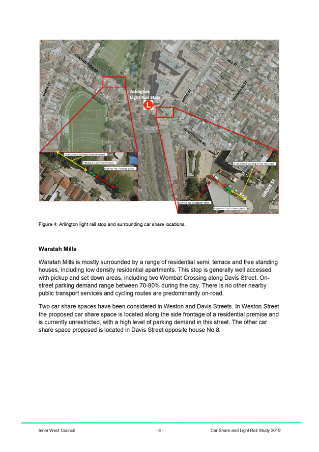
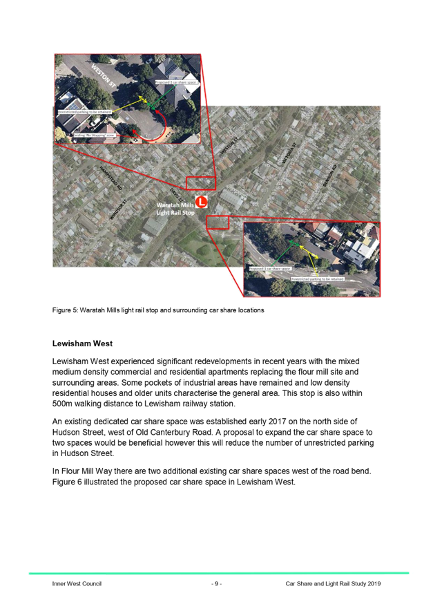
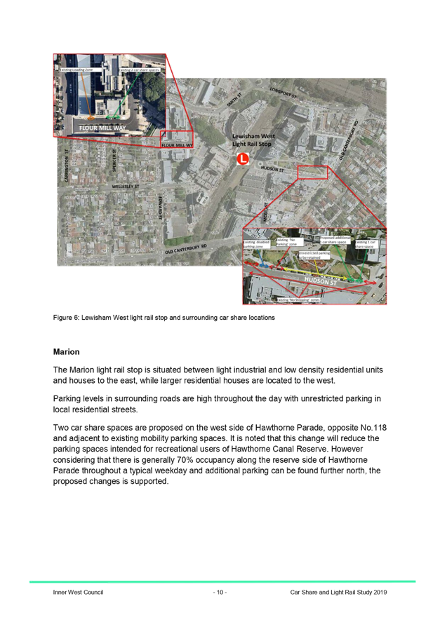
|
AGENDA R |

Local Traffic Committee Meeting
MONDAY 5 AUGUST 2019
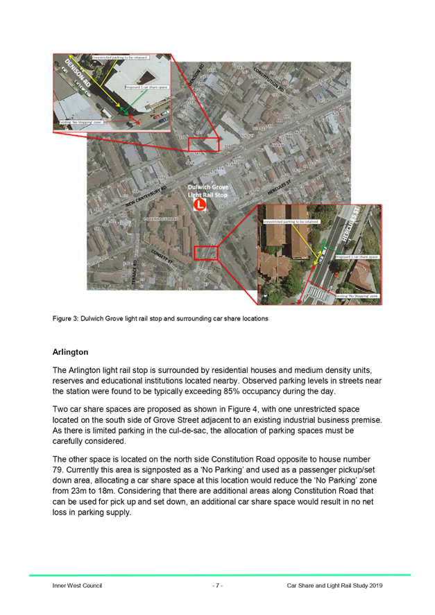
10.00am
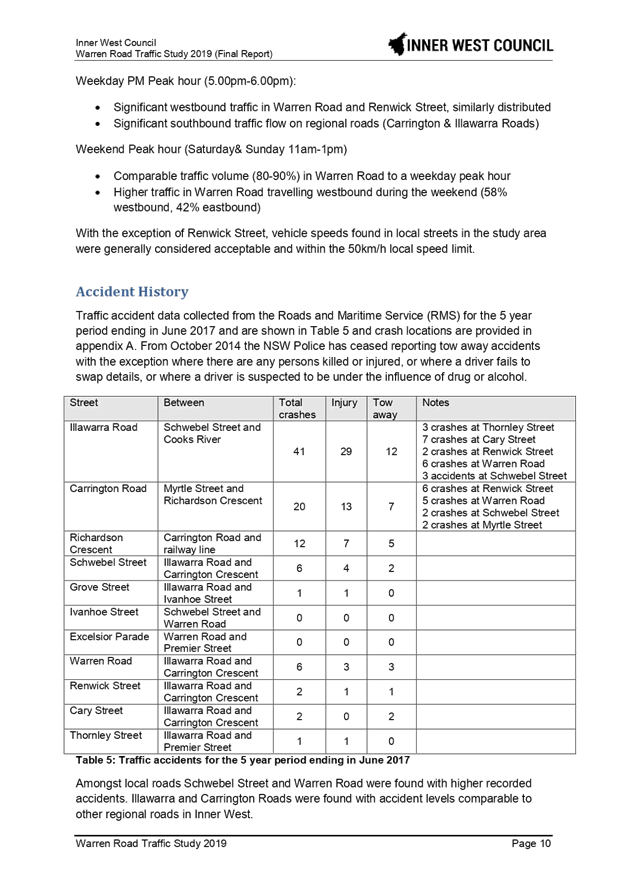
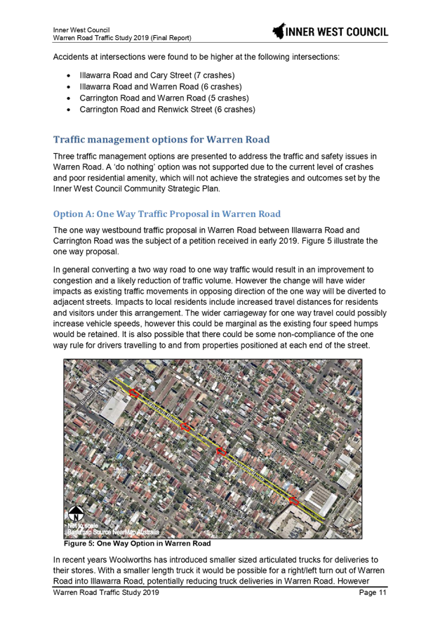
|
|
Local Traffic Committee Meeting 5 August 2019 |
Function of the Local Traffic Committee
Background
Roads and Maritime Services (RMS) is legislated as the Authority responsible for the control of traffic on all NSW Roads. The RMS has delegated certain aspects of the control of traffic on local roads to councils. To exercise this delegation, councils must establish a local traffic committee and obtain the advice of the RMS and Police. The Inner West Council Local Traffic Committee has been constituted by Council as a result of the delegation granted by the RMS pursuant to Section 50 of the Transport Administration Act 1988.
Role of the Committee
The Local Traffic Committee is primarily a technical review and advisory committee which considers the technical merits of proposals and ensures that current technical guidelines are considered. It provides recommendations to Council on traffic and parking control matters and on the provision of traffic control facilities and prescribed traffic control devices for which Council has delegated authority. These matters are dealt with under Part A of the agenda and require Council to consider exercising its delegation.
In addition to its formal role as the Local Traffic Committee, the Committee may also be requested to provide informal traffic engineering advice on traffic matters not requiring Council to exercise its delegated function at that point in time, for example, advice to Council’s Development Assessment Section on traffic generating developments. These matters are dealt with under Part C of the agenda and are for information or advice only and do not require Council to exercise its delegation.
Committee Delegations
The Local Traffic Committee has no decision-making powers. The Council must refer all traffic related matters to the Local Traffic Committee prior to exercising its delegated functions. Matters related to State Roads or functions that have not been delegated to Council must be referred directly to the RMS or relevant organisation.
The Committee provides recommendations to Council. Should Council wish to act contrary to the advice of the Committee or if that advice is not supported unanimously by the Committee members, then the Police or RMS have an opportunity to appeal to the Regional Traffic Committee.
Committee Membership & Voting
Formal voting membership comprises the following:
· one representative of Council as nominated by Council;
· one representative of the NSW Police from each Local Area Command (LAC) within the LGA, being Newtown, Marrickville, Leichhardt and Ashfield LAC’s.
· one representative from the RMS; and
· State Members of Parliament (MP) for the electorates of Summer Hill, Newtown, Heffron, Canterbury, Strathfield and Balmain or their nominees.
Where the Council area is represented by more than one MP or covered by more than one Police LAC, representatives are only permitted to vote on matters which effect their electorate or LAC.
Informal (non-voting) advisors from within Council or external authorities may also attend Committee meetings to provide expert advice.
Committee Chair
Council’s representative will chair the meetings.
Public Participation
Members of the public or other stakeholders may address the Committee on agenda items to be considered by the Committee. The format and number of presentations is at the discretion of the Chairperson and is generally limited to 3 minutes per speaker. Committee debate on agenda items is not open to the public.
|
|
Local Traffic Committee Meeting 5 August 2019 |
|
AGENDA |
1 Apologies
2 Disclosures of Interest
3 Confirmation of Minutes
Minutes of 1 July 2019 Local Traffic Committee Meeting 6
4 Matters Arising from Council’s Resolution of Minutes
5 Part A – Items Where Council May Exercise Its Delegated Functions
Traffic Matters
ITEM PAGE #
LTC0819 Item 1 Warren Road Traffic Study (Midjuburi - Marrickville Ward/Summer Hill Electorate/Inner West PAC) 29
LTC0819 Item 2 Terrace Road / Ness Avenue, Dulwich Hill – Temporary Full Road Closure of Rail Underpass just north of the roundabout at Ewart Street – Sydney Metro (SSJ) early enabling works on T3 Line (DJARRAWUNANG-ASHFIELD WARD / SUMMER HILL ELECTORATE / INNER WEST PAC) 61
LTC0819 Item 3 Burrows Avenue, Sydenham – Temporary Full Road Closures - Sydney Metro Sydenham Station and Junction (SSJ) Works (Midjuburi-Marrickville Ward / Heffron Electorate / Inner West PAC) 66
LTC0819 Item 4 Albermarle Street, Marrickville – Temporary Full Road Closure of Rail Overbridge south of Challis Street - Sydney Metro (SSJ) early enabling works on T3 Line (MIDJUBURI-MARRICKVILLE WARD / SUMMER HILL ELECTORATE / INNER WEST PAC) 71
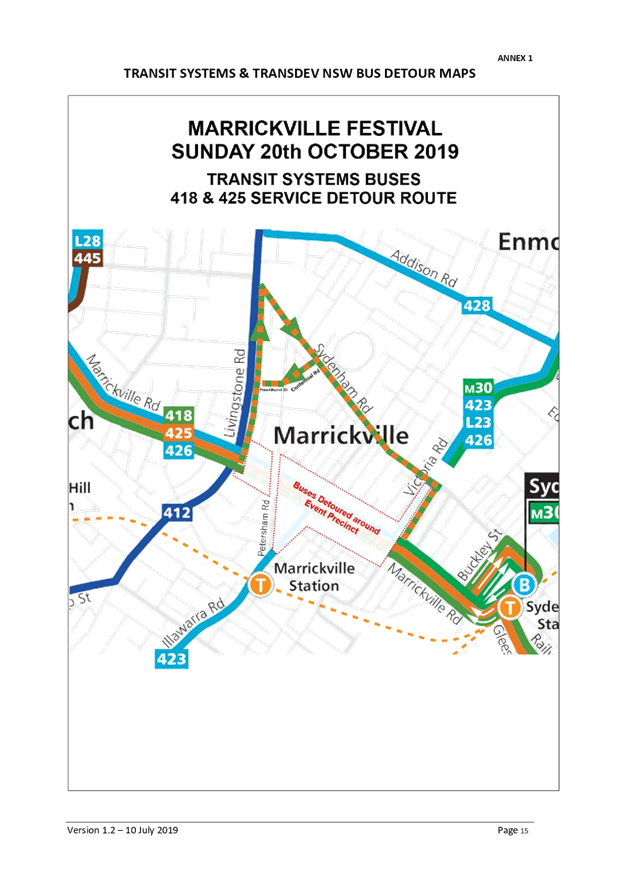
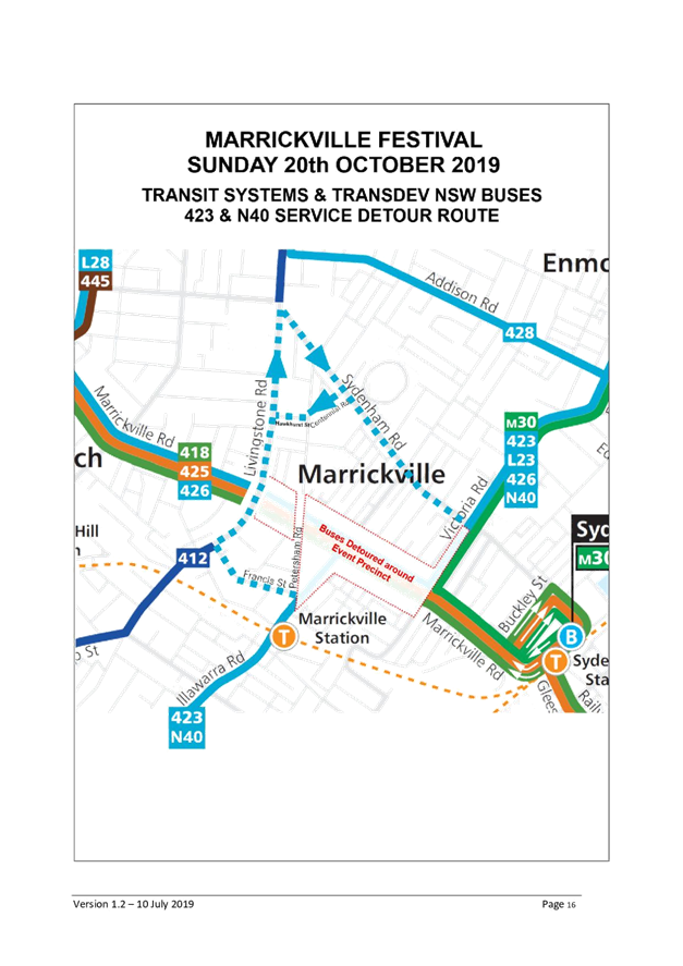
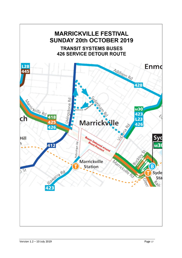
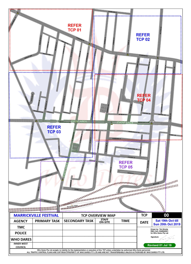
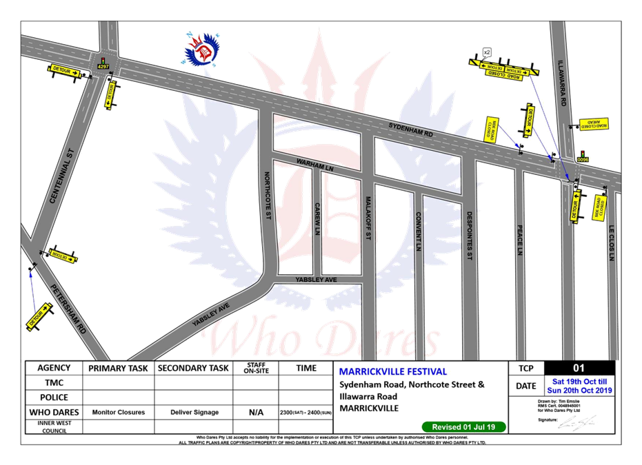
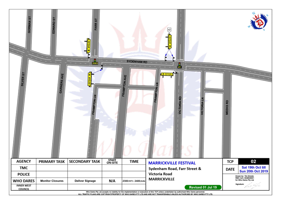
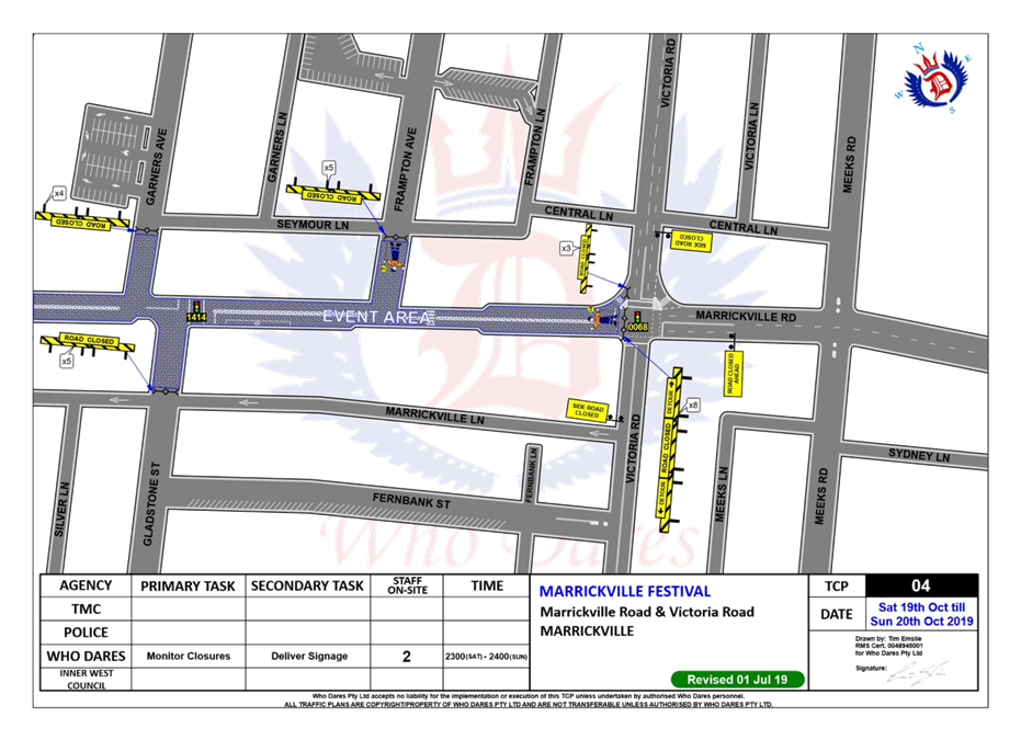
LTC0819 Item 5 Marrickville Road, Marrickville – Temporary full Road Closures for Marrickville Festival on Sunday 20 October 2019 – DA201700334 - (Midjuburi - Marrickville Ward / Summer Hill Electorate / Inner West PAC) 76
LTC0819 Item 6 Big Bike Day 2019 Special Event (Gulgadya-Leichhardt & Baludarri-Balmain Ward/ Balmain Electorate/ Leichhardt PAC) 112
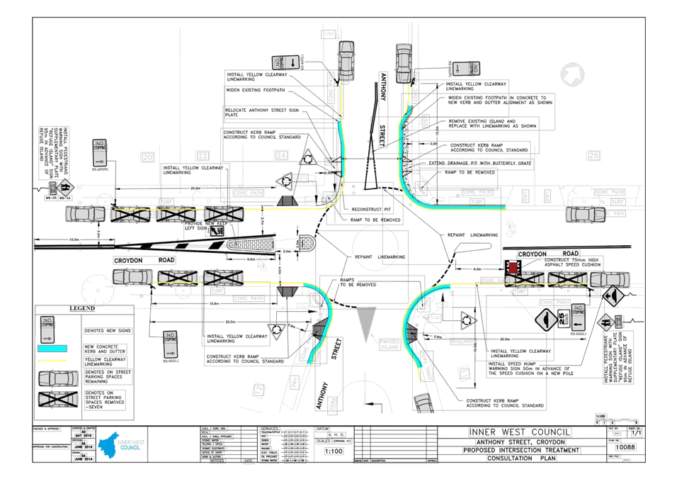
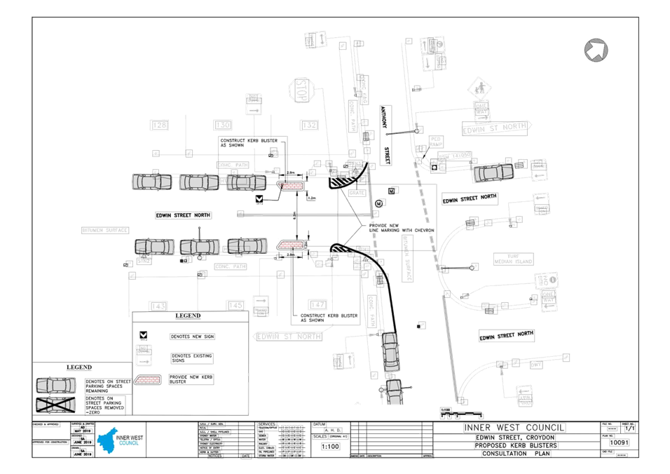
LTC0819 Item 7 Edwin
Street, Croydon at Anthony Street - Proposed Kerb Blisters & Croydon Road,
Croydon at Anthony Street - Proposed Pedestrian Refuge and Kerb Blisters
(Design Plans 10088 & 10091)
(Gulgadya Ward/ Strathfield Electorate/ Burwood PAC) 116
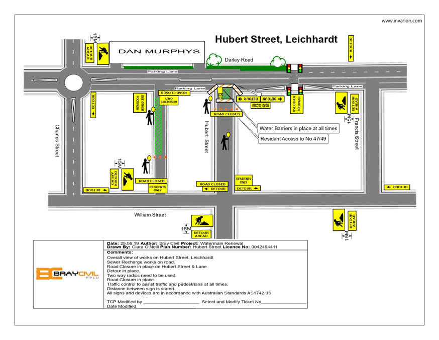
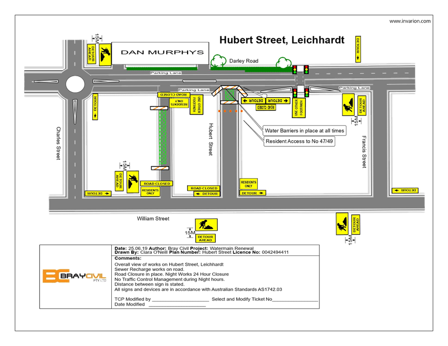
LTC0819 Item 8 Hubert Street and Unnamed Lane, Leichhardt - Temporary Full Road Closure for Road Opening (Gulgadya-Leichhardt Ward/ Balmain Electorate/ Leichhardt PAC) 127
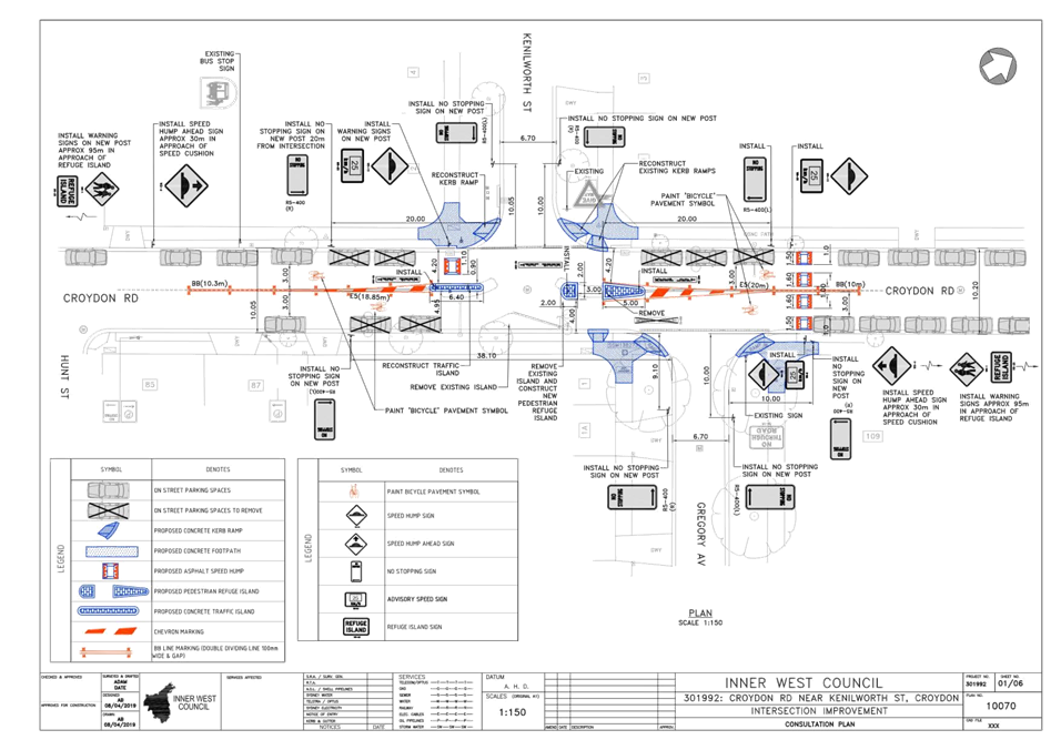
LTC0819 Item 9 Croydon
Road at Kenilworth Street & Gregory Avenue, Croydon - Proposed Traffic
Calming at the intersections including a new pedestrian refuge island on
Croydon Road - Design Plan 10070
(Gulgadya-Leichhardt Ward/Strathfield Electorate/Burwood PAC) 131
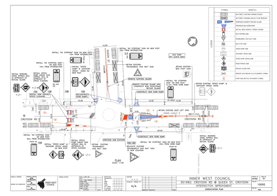
LTC0819 Item 10 Croydon
Road at Queen Street, Croydon - Proposed Traffic Calming at the intersection
including a new pedestrian refuge on Croydon Road - Design Plan 10092
(Gulgadya Ward/ Strathfield Electorate/ Burwood PAC) 139
LTC0819 Item 11 Minor Traffic Facilities (All Wards/All Electorates/All PACs) 145
Parking Matters
ITEM PAGE #
LTC0819 Item 12 Victoria Road, Marrickville - Proposed Change in Parking restriction to 'No Parking - Community Bus Excepted' (Midjuburri-Marrickville Ward/Newtown Electorate/Inner West PAC)) 154
LTC0819 Item 13 Chester Street and Guihen Street, Annandale - Proposed 'No Stopping' zone (Gulgadya - Leichhardt Ward/ Balmain Electorate/ Leichhardt PAC) 157
LTC0819 Item 14 Prospect Road, Summer Hill - Proposed Changes to Parking Restrictions outside Croatian Catholic Centre (Djarrawunang-Ashfield Ward/Summer Hill Electorate/Inner West PAC) 160
LTC0819 Item 15 Bay Street, Tempe - Proposed installation of statutory 'No Stopping' signage (Midjuburi-Marrickville Ward/Heffron Electorate/Inner West PAC) 164
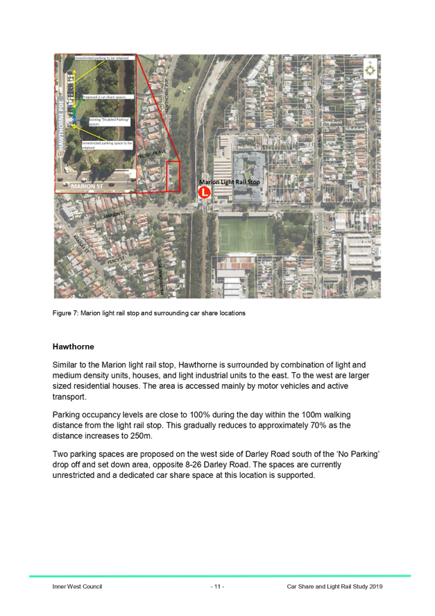
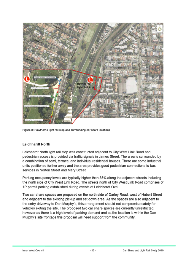
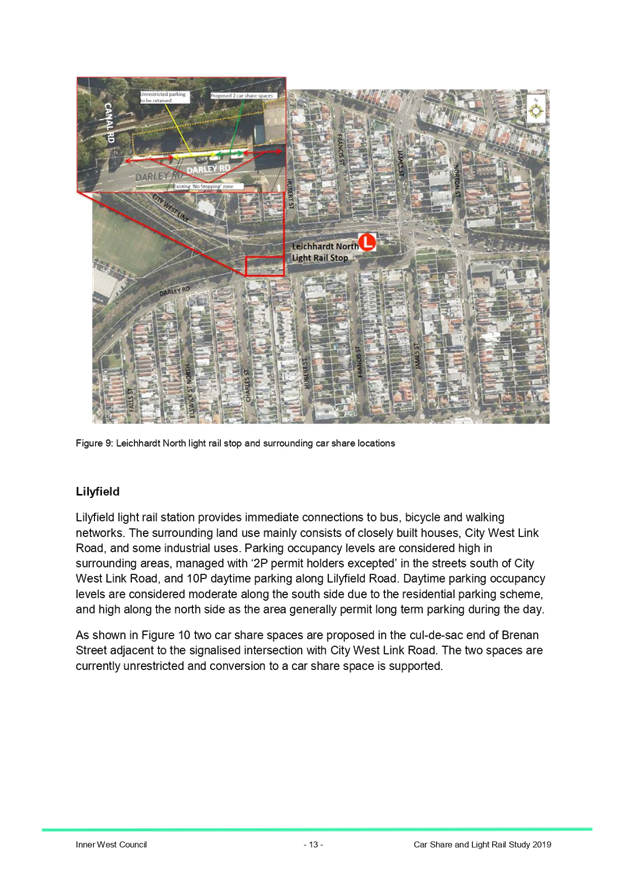
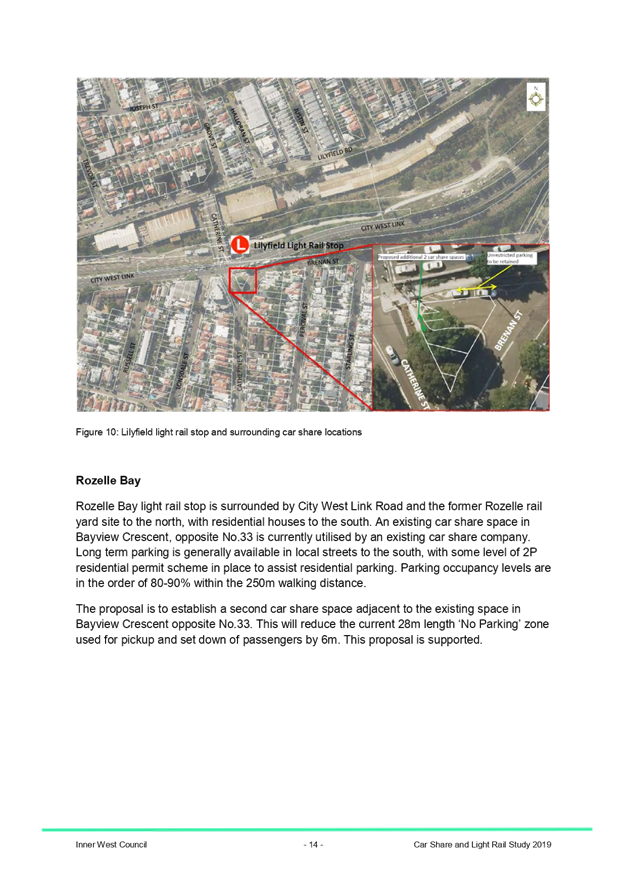
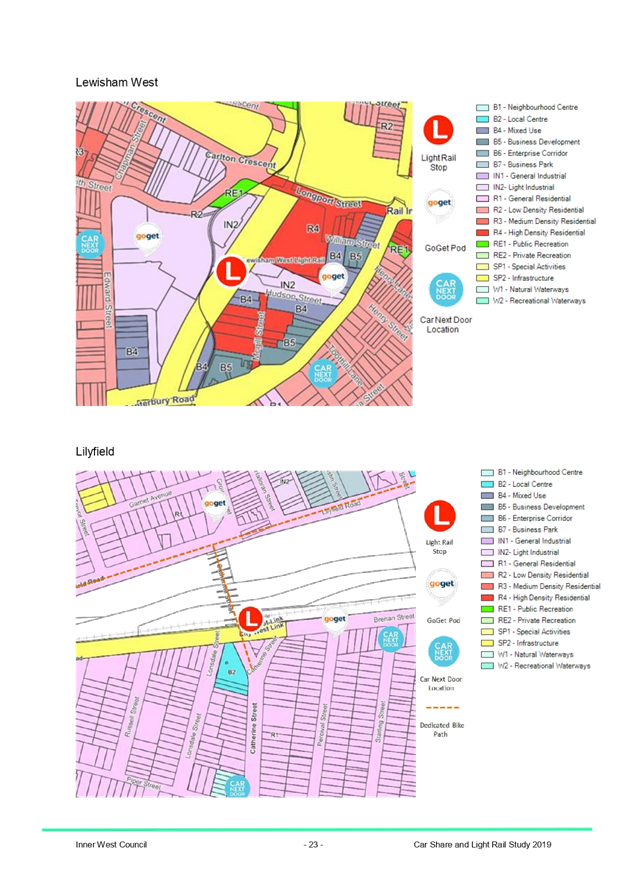
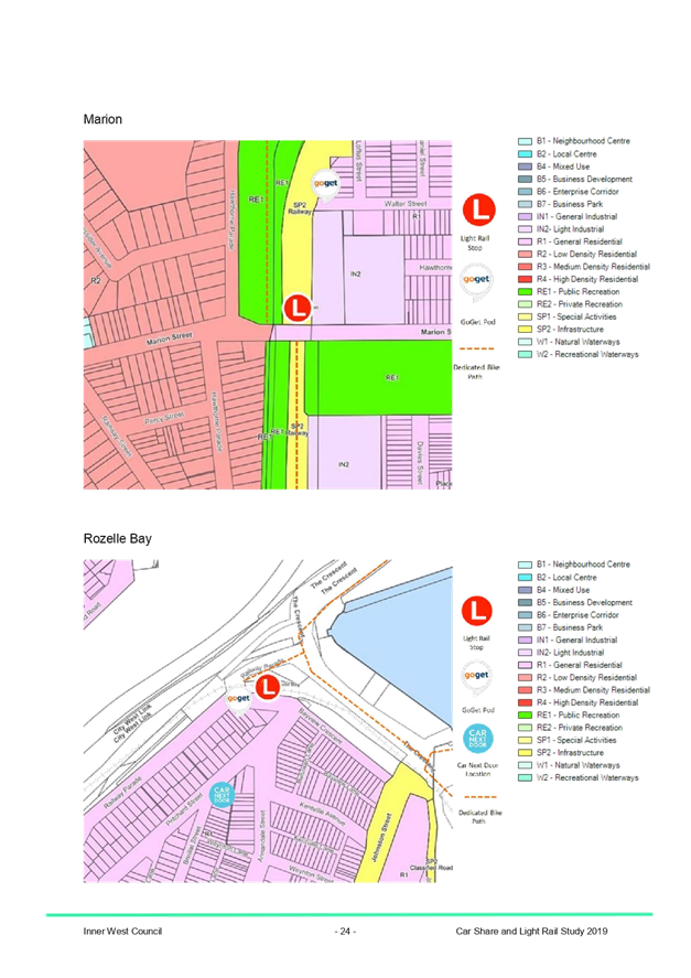
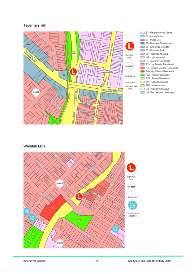
LTC0819 Item 16 Inner West Car Share and Light Rail Integration Pilot Program 167
Late Items
Nil at time of printing.
6 Part B - Items for Information Only
ITEM PAGE #
LTC0819 Item 17 Integrated Transport Plan - Presentation (All Wards / All Electorates / All PACs) 195
LTC0819 Item 18 Holden Street, between Liverpool Road and Norton Street, Ashfield – ‘No Stopping’ restrictions supplemented with yellow line marking (Djarrawunang - Ashfield Ward / Summer Hill Electorate / Burwood PAC) 196
7 Part C - Items for General Advice
ITEM PAGE #
LTC0819 Item 19 Holbeach Avenue, Tempe – Temporary Full Road Closures for MS Sydney to the Gong Bike Ride On Sunday 3 November 2019 – (Midjuburi-Marrickville Ward/Heffron Electorate/Inner West PAC) 198
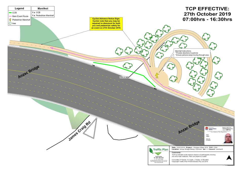
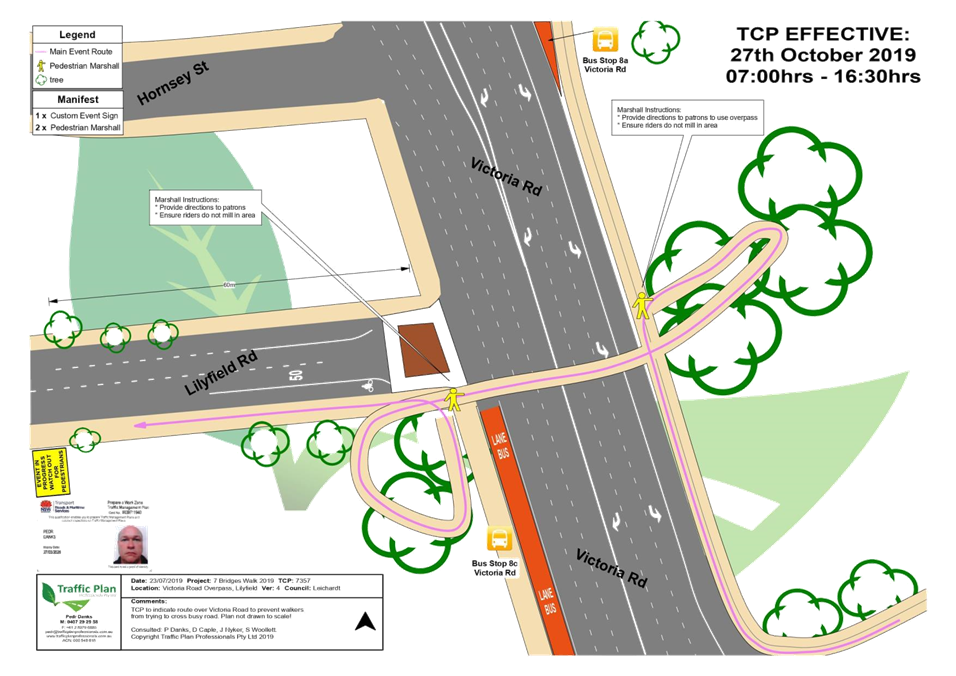
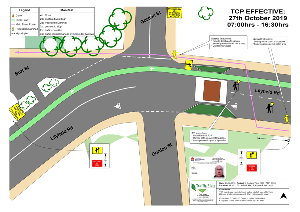
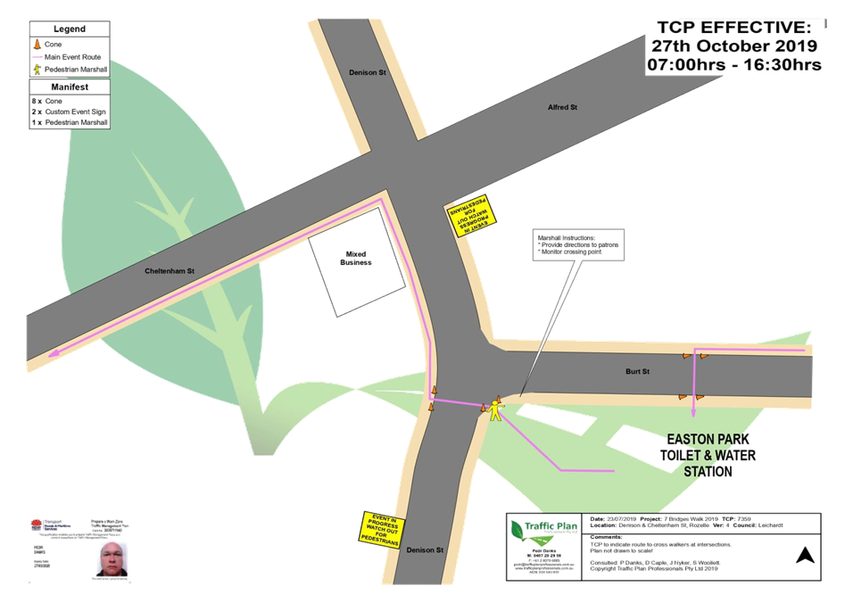
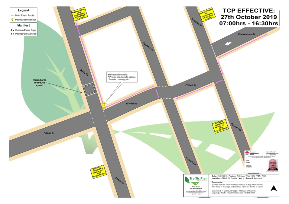
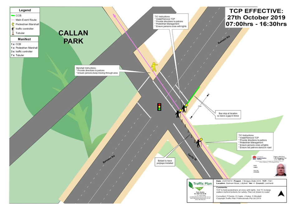
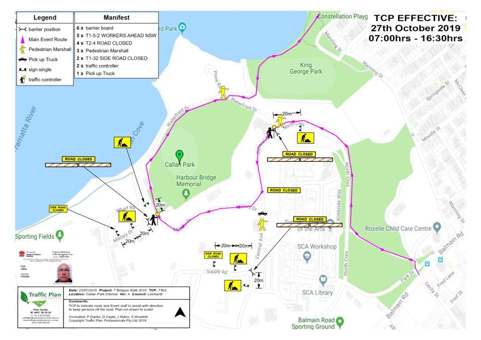
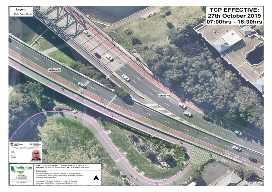
LTC0819 Item 20 Seven Bridges Walk - Special Event (Gulgadga - Leichhardt & Baludarri - Balmain Ward/ Balmain Electorate/ Leichhardt PAC) 213
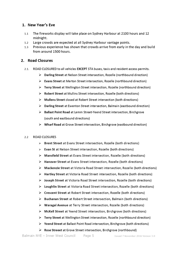
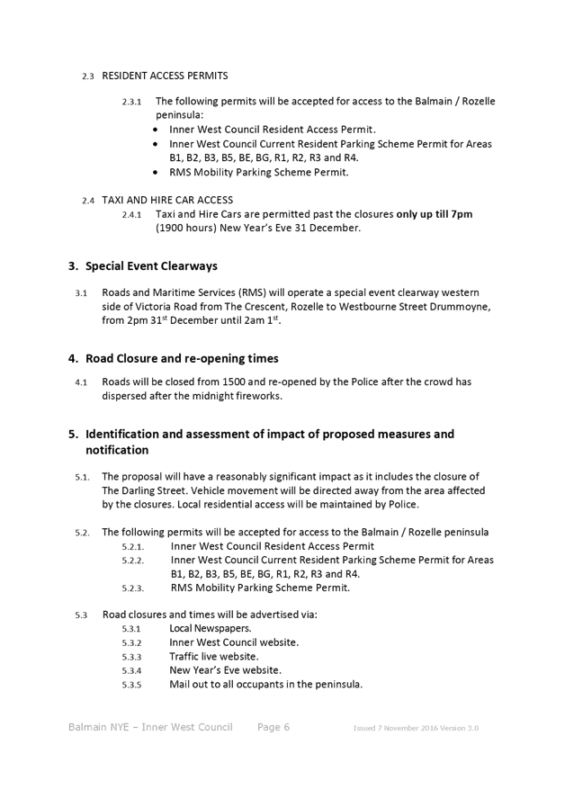
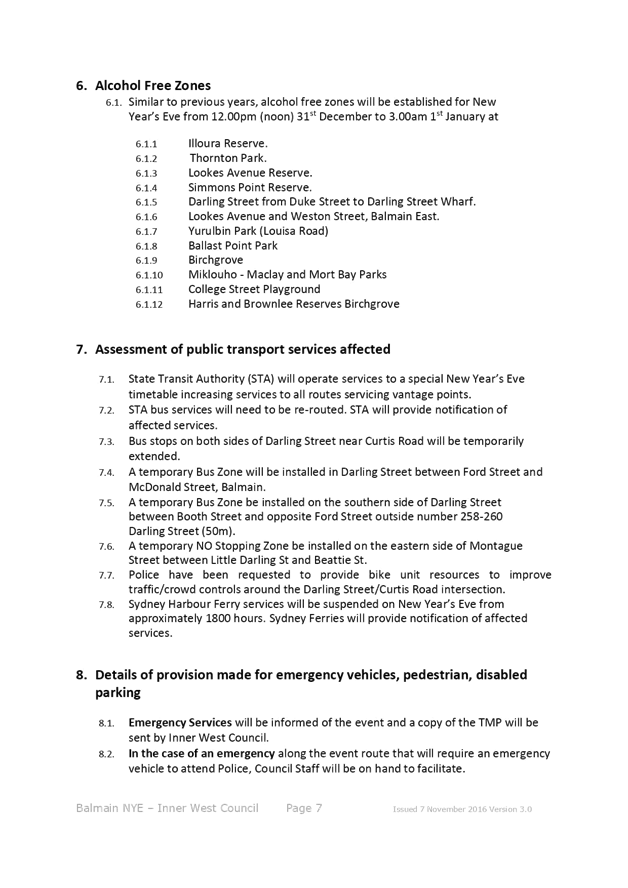
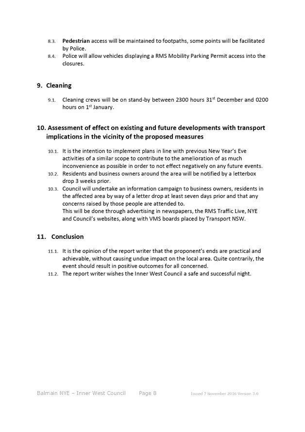
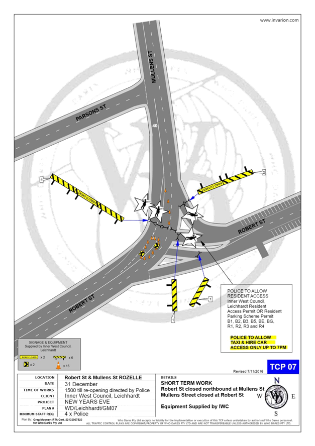
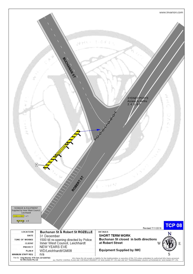
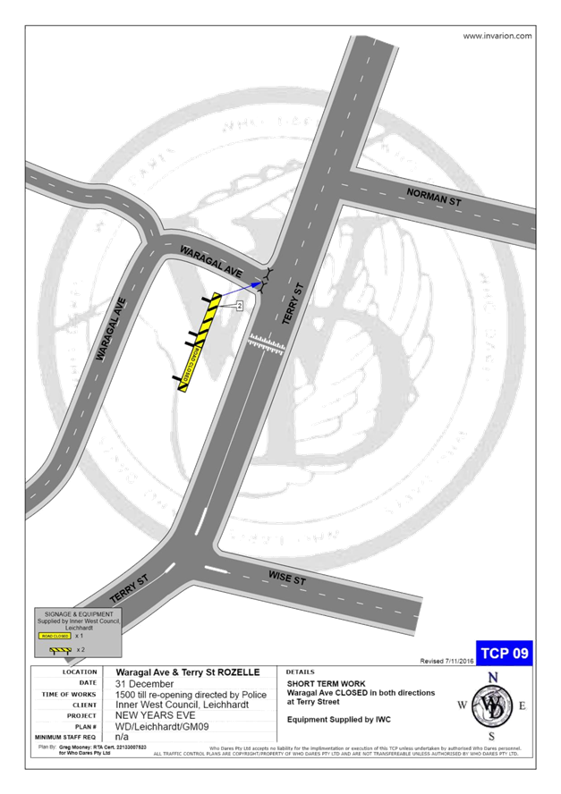
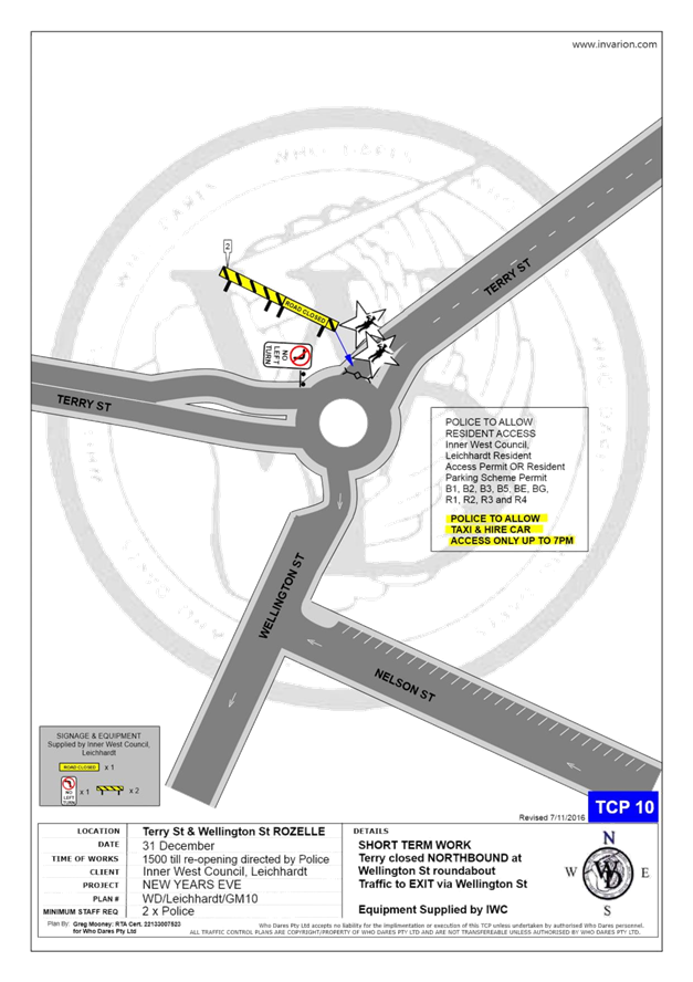
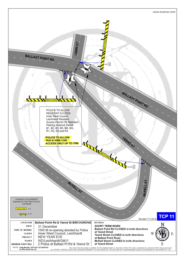
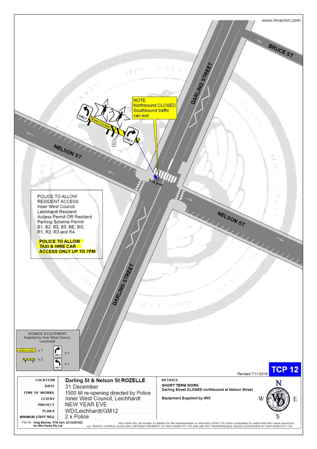
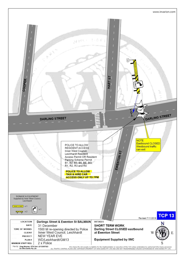
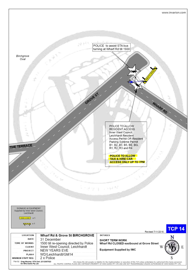
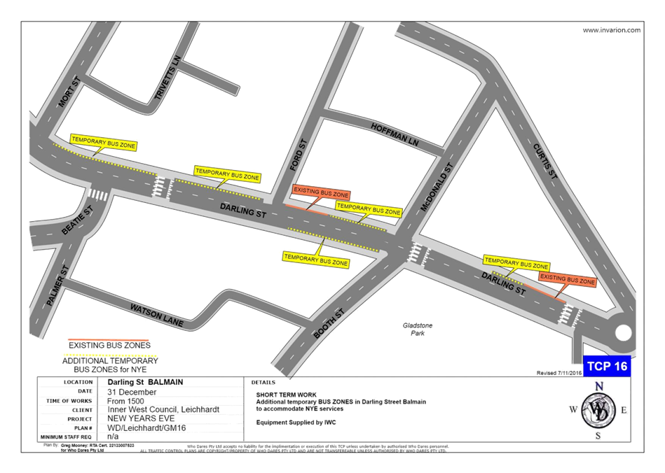
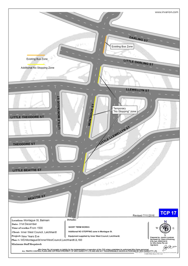
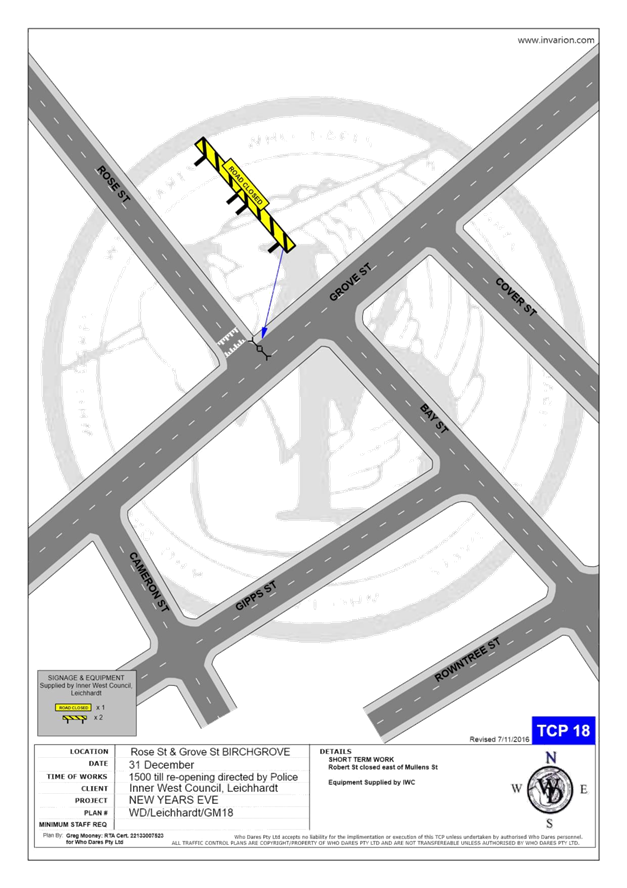
LTC0819 Item 21 Traffic
Management Plan for the 2019 New Year's Eve Event
(Baludarri - Balmain Ward/ Balmain Electorate/ Leichhardt PAC) 214
8 General Business
9 Close of Meeting
|
|
Local Traffic Committee Meeting 5 August 2019 Minutes from 1 July 2019 |
Minutes of Local Traffic Committee Meeting
Held at Petersham Service Centre on 1 July 2019
Meeting commenced at 10.00am
ACKNOWLEDGEMENT OF COUNTRY BY CHAIRPERSON
I acknowledge the Gadigal and Wangal people of the Eora nation on whose country we are meeting today, and their elders past and present.
COMMITTEE REPRESENTATIVES PRESENT
|
Clr Victor Macri |
Councillor – Midjuburi-Marrickville Ward (Chair) |
|
Bill Holliday |
Representative for Jamie Parker MP, Member for Balmain |
|
Chris Woods |
Representative for Ron Hoenig MP, Member for Heffron |
|
Zack Solomon |
Representative for Jo Haylen MP, Member for Summer Hill |
|
Sgt John Micallef |
NSW Police – Burwood Police Area Command |
|
LSC Marina Nestoriaros |
NSW Police – Leichhardt Police Area Command |
|
SC Tony Kenny |
NSW Police – Inner West Police Area Command |
|
Ryan Horne |
Roads and Maritime Services |
|
|
|
|
OFFICERS IN ATTENDANCE |
|
|
|
|
|
Sgt Paul Vlachos |
NSW Police – Inner West Police Area Command |
|
Asith Nagodavithane |
Transit Systems – Inner West Bus Services |
|
Bob Moore |
Inner West Bicycle Coalition |
|
Clr Marghanita da Cruz |
Councillor – Gulgadya-Leichhardt Ward |
|
Wal Petschler |
IWC’s Group Manager Roads, Traffic and Stormwater |
|
Manod Wickramasinghe |
IWC’s Acting Traffic and Transport Manager |
|
George Tsaprounis |
IWC’s Coordinator Traffic and Parking Services (South) |
|
Pierre Ayoub |
IWC’s Acting Design Services Coordinator |
|
Sunny Jo |
IWC’s Traffic and Parking Planner |
|
Boris Muha |
IWC’s Engineer – Traffic and Parking Services |
|
Kenneth Yuen |
IWC’s Student Engineer |
|
Christina Ip |
IWC’s Business Administration Officer |
|
|
|
|
VISITORS |
|
|
|
|
|
Rachel Davies |
Item 10 – Resident |
|
Sara Arthur |
Item 10 – Resident |
|
Justin Skowno |
Item 19 – Resident |
|
|
|
|
APOLOGIES: |
|
|
|
|
|
Cathy Peters |
Representative for Jenny Leong MP, Member for Newtown |
|
John Stephens |
IWC’s Traffic and Transport Services Manager |
DISCLOSURES OF INTERESTS
Nil.
CONFIRMATION OF MINUTES
|
Minutes of the Local Traffic Committee Meeting held on Monday, 3 June 2019 were confirmed. |
MATTERS ARISING FROM COUNCIL’S RESOLUTION OF MINUTES
The Local Traffic Committee recommendations of its meeting held on 3 June 2019 were adopted at Council’s meeting held on 11 June 2019. Council also resolved the following:
|
LTC0719 Item 1 Hartley Street at Victoria Road, Rozelle - Proposed 'STOP' Control (Baludarri-Balmain Ward/ Balmain Electorate/ Leichhardt LAC) |
|
SUMMARY
A number of residents have raised concerns regarding traffic conditions at the Hartley Street/Victoria Road T-intersection, which currently does not have signposted intersection control.
Officer’s Recommendation
THAT the intersection of Hartley Street and Victoria Road, Rozelle be upgraded to ‘STOP’ control.
DISCUSSION
The Committee members agreed with the Officer’s recommendation.
COMMITTEE RECOMMENDATION
THAT the intersection of Hartley Street and Victoria Road, Rozelle be upgraded to ‘STOP’ control.
For motion: Unanimous
|
|
LTC0719 Item 2 Newington Local Area Traffic Management Strategy (Damun- Stanmore/Midjuburi-Marrickville Wards/ Newtown Electorate/ Inner West PAC) |
|
SUMMARY
This is a recommendation to endorse the final Newington Local Area Traffic Management (LATM) report. The proposals within the report are based on community input and analysis of feedback from the Public Exhibition period in March and April 2019. There were 41 responses to the web survey undertaken by Council. The results indicate that there is general support for the proposed traffic management, with some changes suggested by 24 respondents. Once this recommendation is endorsed by Traffic Committee and Council, the projects will be incorporated into future design and construction programs.
Officer’s Recommendation
THAT:
1. The final Newington LATM report be endorsed for implementation including the following final LATM treatments: a. Speed cushions in Albert Street near Marr Playground; b. Two raised thresholds in Bright Street near No.26 and No.6 Bright Street; c. Change of priority at the intersection of Tupper Street and Newington Road, including removal of existing speed hump near No.36 Newington Road but excluding ‘No Parking 7am-7pm Mon-Fri’ opposite Tupper Street in Newington Street; d. Installation of ‘STOP’ sign at the intersection of Newington Road and Enmore Road; e. Pedestrian refuge island in Addison Road between Denby and Philpott Streets; f. Implementation of mixed traffic bicycle facilities within the study area; and g. Changes at signalised intersections at Enmore Road/Llewellyn Street, Enmore Road/Addison Road and Addison Road/Agar Street/Illawarra Road be referred to the RMS for implementation
DISCUSSION
It was noted that the current bus stop and shelter in Addison Road between Denby and Philpott Streets may be affected by the proposed pedestrian refuge island. Council Officers advised the Transit Systems representative that the relocation of the bus stop and shelter will be considered during detailed design and Transit Systems will be consulted.
The representative for the Inner West Bicycle Coalition stated that there has been a longstanding request for a crossing at Stanmore Road at John Street or Albert Street so that cyclists can avoid the intersection of Crystal Street and Stanmore Road; however, this crossing is not part of the proposed works. The RMS representative advised that Stanmore Road is a State Road and consideration of crossing improvements rests with RMS.
The Committee members agreed with the Officer’s recommendation.
COMMITTEE RECOMMENDATION
THAT:
1. The final Newington LATM report be endorsed for implementation including the following final LATM treatments: a. Speed cushions in Albert Street near Marr Playground; b. Two raised thresholds in Bright Street near No.26 and No.6 Bright Street; c. Change of priority at the intersection of Tupper Street and Newington Road, including removal of existing speed hump near No.36 Newington Road but excluding ‘No Parking 7am-7pm Mon-Fri’ opposite Tupper Street in Newington Street; d. Installation of ‘STOP’ sign at the intersection of Newington Road and Enmore Road; e. Pedestrian refuge island in Addison Road between Denby and Philpott Streets; f. Implementation of mixed traffic bicycle facilities within the study area; and g. Changes at signalised intersections at Enmore Road/Llewellyn Street, Enmore Road/Addison Road and Addison Road/Agar Street/Illawarra Road be referred to the RMS for implementation
For motion: Unanimous
|
|
LTC0719 Item 3 MINOR TRAFFIC FACILITIES (All Wards/All Electorates/All PACs) |
|
SUMMARY
This report considers minor traffic facility applications by Inner West Council, and includes ‘Disabled Parking’ and ‘Works ‘ zone requests.
Officer’s Recommendation
THAT:
1. A 6m 'Disabled Parking’ zone be installed in front of No. 21 Charlotte Avenue, Marrickville;
2. A 6m 'Disabled Parking’ zone be installed on Myrtle Street along the rear boundary of No. 10 Salisbury Road, Stanmore;
3. A 5.5m ‘Disabled Parking’ zone be installed in front of No. 30 Francis Street, Marrickville;
4. A 5.5m 'Disabled Parking’ zone be installed in back of No. 30 Thornley Street, Leichhardt;
5. A 5.5m 'Disabled Parking’ zone be installed in front of No. 105 Victoria Street, Lewisham;
6. A 5.5m 'Disabled Parking’ zone be installed in front of No. 12 Oak Street, Ashfield;
7. A 9m 'Works Zone 7.00am – 6.00pm Mon-Fri and 8.00am -1.00pm Sat' be installed in front of No.107 May Street, St Peters for 12 weeks, subject to the applicant obtaining consent from the neighbouring property owner; and
8. A 9.4m 'Works Zone 7.00am – 6.00pm Mon-Fri and 8.00am -1.00pm Sat' be installed in front of No.44 Wentworth Street, Tempe for 4 weeks.
DISCUSSION
The Committee members agreed with the Officer’s recommendation.
COMMITTEE RECOMMENDATION
THAT:
1. A 6m 'Disabled Parking’ zone be installed in front of No. 21 Charlotte Avenue, Marrickville;
2. A 6m 'Disabled Parking’ zone be installed on Myrtle Street along the rear boundary of No. 10 Salisbury Road, Stanmore;
3. A 5.5m ‘Disabled Parking’ zone be installed in front of No. 30 Francis Street, Marrickville;
4. A 5.5m 'Disabled Parking’ zone be installed in back of No. 30 Thornley Street, Leichhardt;
5. A 5.5m 'Disabled Parking’ zone be installed in front of No. 105 Victoria Street, Lewisham;
6. A 5.5m 'Disabled Parking’ zone be installed in front of No. 12 Oak Street, Ashfield;
7. A 9m 'Works Zone 7.00am – 6.00pm Mon-Fri and 8.00am -1.00pm Sat' be installed in front of No.107 May Street, St Peters for 12 weeks, subject to the applicant obtaining consent from the neighbouring property owner; and
8. A 9.4m 'Works Zone 7.00am – 6.00pm Mon-Fri and 8.00am -1.00pm Sat' be installed in front of No.44 Wentworth Street, Tempe for 4 weeks.
For motion: Unanimous
|
|
LTC0719 Item 4 Henry Street, between Railway Parade and George Street, and Railway Lane, between Henry Street and Hilton Avenue, Sydenham - Temporary Road Closure for ‘Edge Sydenham’ event on Saturday 10 August 2019 (Midjuburi-Marrickville Ward / Heffron Electorate / Inner West PAC) |
|
SUMMARY
Inner West Council is proposing to hold the ‘EDGE Sydenham’ event on Saturday, 10 August 2019 within Sydenham Green and Sydenham Skate Park and will require the closure of Henry Street, between Railway Parade and George Street, and Railway Lane, between Henry Street and Hilton Avenue, Sydenham to facilitate the event.
Officer’s Recommendation
THAT:
1. The proposed temporary full road closure of Henry Street (between Railway Parade and George Street) and Railway Lane (between Henry Street and Hilton Avenue), Sydenham for the ‘EDGE Sydenham’ Event on Saturday, 10 August 2019 between 1:00pm and 11:30pm be approved as per the submitted TMP and TCP;
2. A Road Occupancy License application be obtained from the Transport Management Centre;
3. All residents and businesses in and around the affected area, including the NSW Police Local Area Commander, Fire & Rescue NSW, SES and the NSW Ambulance Services to be notified of the temporary road closure in writing by the applicant in advance (at least 7 days prior to the event) with the applicant making reasonable provision for stakeholders; 4. A minimum four (4) metre unencumbered passage be available for emergency vehicles through the closed section; and 5. The occupation of the road carriageway must not occur until the road has been physically closed.
DISCUSSION
It was noted that because the event has been advertised to start at 5pm, affected residents and businesses may not realise that set up of the event starts at 1pm. Council Officers will notify organisers of request to notify set up time.
The Committee members agreed with the Officer’s recommendation.
COMMITTEE RECOMMENDATION
THAT:
1. The proposed temporary full road closure of Henry Street (between Railway Parade and George Street) and Railway Lane (between Henry Street and Hilton Avenue), Sydenham for the ‘EDGE Sydenham’ Event on Saturday, 10 August 2019 between 1:00pm and 11:30pm be approved as per the submitted TMP and TCP;
2. A Road Occupancy License application be obtained from the Transport Management Centre;
3. All residents and businesses in and around the affected area, including the NSW Police Local Area Commander, Fire & Rescue NSW, SES and the NSW Ambulance Services to be notified of the temporary road closure in writing by the applicant in advance (at least 7 days prior to the event) with the applicant making reasonable provision for stakeholders; 4. A minimum four (4) metre unencumbered passage be available for emergency vehicles through the closed section; and 5. The occupation of the road carriageway must not occur until the road has been physically closed.
For motion: Unanimous
|
|
LTC0719 Item 5 Fred Street, from Summer Hill Street to Eltham Street, Lewisham- Proposed road and footpath renewal civil works and garden beds/verge plantings – Design Plan 10065 (Damun- Stanmore Ward / Summer Hill Electorate / Inner West PAC) |
|
SUMMARY
As part of the Road and Footpath Capital Works Program this project proposes to improve the streetscape in Fred Street, Lewisham. The works include reconstruction of footpaths, kerb and gutter, and road re-sheeting. Along with the civil works, Council is also proposing to build three (3) mass planted garden beds, verge plantings, and a rain-garden. Fred Street is one of many Greenway streets that have been identified as ‘biodiversity and wildlife habitat corridors’. The works will be constructed in this financial year, 2019/20 subject to final funding allocations.
Officer’s Recommendation
THAT the detailed design plan for the three (3) kerb extensions, reduction of road width in two sections of the road and associated signs and line markings in Fred Street, Lewisham (as per Design Plan No.10065) be APPROVED.
DISCUSSION
The Committee members agreed with the Officer’s recommendation.
COMMITTEE RECOMMENDATION
THAT the detailed design plan for the three (3) kerb extensions, reduction of road width in two sections of the road and associated signs and line markings in Fred Street, Lewisham (as per Design Plan No.10065) be APPROVED.
For motion: Unanimous
|
|
LTC0719 Item 6 Merton Street at Trafalgar Street, Petersham - Proposed traffic calming at the intersection – Design Plan 10078 (Damun- Stanmore Ward / Newtown Electorate / Inner West PAC) |
|
SUMMARY
A detailed design plan has been finalised for the proposed speed calming treatment in Merton Street at Trafalgar Street, Petersham. The proposed works includes installation of a painted median with rumble bars and line marking to calm traffic and prevent motorists from making dangerous manoeuvres and/or ‘cutting the corner’ into Merton Street from Trafalgar Street, Petersham.
Officer’s Recommendation
THAT the detailed design plan for the installation of a painted median with rumble bars and line marking to calm traffic and prevent motorists from making dangerous manoeuvres and/or ‘cutting the corner’ into Merton Street from Trafalgar Street, Petersham (as per Design Plan No.10078) be APPROVED.
DISCUSSION
The Committee members agreed with the Officer’s recommendation.
COMMITTEE RECOMMENDATION
THAT the detailed design plan for the installation of a painted median with rumble bars and line marking to calm traffic and prevent motorists from making dangerous manoeuvres and/or ‘cutting the corner’ into Merton Street from Trafalgar Street, Petersham (as per Design Plan No.10078) be APPROVED.
For motion: Unanimous
|
|
LTC0719 Item 7 Illawarra Road at Cary Street, Marrickville – Proposed upgrading and relocation of existing pedestrian zebra crossing on Illawarra Road – Design Plan 10079 (Midjuburi - Marrickville Ward / Summer Hill Electorate / Inner West PAC) |
|
SUMMARY
A detailed design plan has been finalised for the proposal to upgrade the existing pedestrian (zebra) crossing on Illawarra Road, Marrickville near its intersection with Cary Street. The proposal to upgrade and relocate the existing raised pedestrian crossing with kerb extensions and associated signs and line markings will improve pedestrian safety and traffic conditions at this location. It is noted that the works require relocation to the south of the existing bus stop on the western side of Illawarra Road.
Consultation was undertaken with owners and occupiers of properties adjacent to Illawarra Road and Cary Street, regarding the proposal.
Officer’s Recommendation
THAT the design of the raised and relocated pedestrian (zebra) crossing with new kerb extensions and associated signs and line markings on Illawarra Road, Marrickville, at the intersection with Cary Street (as per the attached design plan No. 10079) be APPROVED.
DISCUSSION
It was noted that:
COMMITTEE RECOMMENDATION
THAT the design of the raised and relocated pedestrian (zebra) crossing with new kerb extensions and associated signs and line markings on Illawarra Road, Marrickville, at the intersection with Cary Street (as per the attached design plan No. 10079) be APPROVED, subject to amendments to include speed hump advance warning signs and cycle logos.
For motion: Unanimous
|
|
LTC0719 Item 8 Marrickville Road and Seaview Street, Marrickville – Temporary full Road Closures for Dulwich Hill Village Fair on Sunday 15 SEPTEMBER 2019 – S68201800008 (Djarrawunang-Ashfield Ward / Summer Hill Electorate / Inner West PAC) |
|
SUMMARY
‘Dulwich Hill Village Fair' is an annual event and this year it will be held on Sunday 15 September 2019. As per previous years the event will necessitate the temporary full road closure of Marrickville Road between New Canterbury Road and Durham Street, part of Seaview Street between Marrickville Road and property No. 26 Seaview Street, Caves Lane, and the Seaview Street car park (car park adjacent to Caves Lane), Dulwich Hill.
Officer’s Recommendation
THAT:
1. The proposed temporary full road closure of Marrickville Road (between New Canterbury Road and Durham Street), part of Seaview Street between Marrickville Road and property No. 26 Seaview Street, Caves Lane, and the Seaview Street car park (car park adjacent to Caves Lane), Dulwich Hill for the ‘Dulwich Hill Village Fair’ Event on Sunday 15 September 2019 between 3:00am and 8:00pm be approved as per the submitted TMP and TCP;
2. A Road Occupancy License application be obtained from the Transport Management Centre;
3. Notice of the proposed event be forwarded to the NSW Police Local Area Commander, Transit Systems, the NSW Fire Brigades and the NSW Ambulance Services;
4. All residents and businesses in and around the affected area are to be notified of the temporary road closure in writing by the applicant in advance (at least 7 days prior to the event) with the applicant making reasonable provision for stakeholders; 4. A minimum four (4) metre unencumbered passage be available for emergency vehicles through the closed section; and 5. The occupation of the road carriageway must not occur until the road has been physically closed.
DISCUSSION
The Committee members agreed with the Officer’s recommendation.
COMMITTEE RECOMMENDATION
THAT:
1. The proposed temporary full road closure of Marrickville Road (between New Canterbury Road and Durham Street), part of Seaview Street between Marrickville Road and property No. 26 Seaview Street, Caves Lane, and the Seaview Street car park (car park adjacent to Caves Lane), Dulwich Hill for the ‘Dulwich Hill Village Fair’ Event on Sunday 15 September 2019 between 3:00am and 8:00pm be approved as per the submitted TMP and TCP;
2. A Road Occupancy License application be obtained from the Transport Management Centre;
3. Notice of the proposed event be forwarded to the NSW Police Local Area Commander, Transit Systems, the NSW Fire Brigades and the NSW Ambulance Services;
4. All residents and businesses in and around the affected area are to be notified of the temporary road closure in writing by the applicant in advance (at least 7 days prior to the event) with the applicant making reasonable provision for stakeholders; 4. A minimum four (4) metre unencumbered passage be available for emergency vehicles through the closed section; and 5. The occupation of the road carriageway must not occur until the road has been physically closed.
For motion: Unanimous
|
|
LTC0719 Item 9 Road Occupancy - Lackey Street and Smith Street, Summer Hill - Temporary Road Closures for the annual 'Summer Hill Neighbourhood Feast' - Sunday 29 September 2019 (Djarrawunang - Ashfield Ward/ Summer Hill Electorate/ Burwood PAC) |
|
SUMMARY
In accordance to a Section S68 Development Application, Council seeks the support of the Committee for the temporary road closures of Lackey Street and Smith Street between Hardie Avenue and Nowraine Street, Summer Hill for the annual ‘Summer Hill Neighbourhood Feast’ festival on Sunday 29 September 2019.
Officer’s Recommendation
THAT:
1. The proposed temporary road closure of Lackey Street and Smith Street (between Hardie Avenue and Nowraine Street) from 5.00am to 7.00pm Sunday, 29 September 2019, for the holding of the “Summer Hill Neighbourhood Feast’ event, be supported, subject to the applicant seeking consent from RMS and forwarding a TMP;
2. A Road Occupancy License be obtained by Council from the Transport Management Centre;
3. All affected residents and businesses, including the NSW Police Local Area Commander, Fire & Rescue NSW and the NSW Ambulance Services be notified in writing, by Council, of the proposed temporary road closure at least 7 days in advance of the closure with Council making reasonable provision for stakeholders;
4. The occupation of the road carriageway must not occur until the road has been physically closed, and
5. A 4 metre wide emergency service access must be maintained through the closed road areas during the course of the event
DISCUSSION
The Committee members agreed with the Officer’s recommendation.
COMMITTEE RECOMMENDATION
THAT:
1. The proposed temporary road closure of Lackey Street and Smith Street (between Hardie Avenue and Nowraine Street) from 5.00am to 7.00pm Sunday, 29 September 2019, for the holding of the “Summer Hill Neighbourhood Feast’ event, be supported, subject to the applicant seeking consent from RMS and forwarding a TMP;
2. A Road Occupancy License be obtained by Council from the Transport Management Centre;
3. All affected residents and businesses, including the NSW Police Local Area Commander, Fire & Rescue NSW and the NSW Ambulance Services be notified in writing, by Council, of the proposed temporary road closure at least 7 days in advance of the closure with Council making reasonable provision for stakeholders;
4. The occupation of the road carriageway must not occur until the road has been physically closed, and
5. A 4 metre wide emergency service access must be maintained through the closed road areas during the course of the event;
For motion: Unanimous
|
|
LTC0719 Item 10 Croydon Road at Church Street, Croydon – Proposed traffic calming at the intersection including a new pedestrian refuge on Croydon Road – Design Plan 10090 (Gulgadya – Leichhardt Ward / Strathfield Electorate / Burwood PAC) |
|
SUMMARY
A detailed design plan has been finalised for the proposed pedestrian refuge in Croydon Road adjacent Church Street, Croydon. The proposed works aim to improve pedestrian and motorist safety and address residents’ concerns about speeding and driver behavior in Croydon Road. It is noted that these works are in addition to the intersection improvement works in Church Street (at Croydon Road) which was approved by Council on 26 February 2019. The proposed pedestrian refuge is subsequent to Council’s decision at its 26 February 2019 meeting to construct pedestrian safety measures in Croydon Road at its intersection with Church Street making an existing crossing point safer.
Officer’s Recommendation
THAT the detailed design plan for the proposed pedestrian refuge islands, kerb blisters, line marking and signs at the intersection of Croydon Road and Church Street, Croydon (as per attached design plan No. 10090) be APPROVED.
DISCUSSION
Public speakers: Rachel Davies and Sara Arthur attended at 10.02am
Ms Davies and Ms Arthur stated that they and other residents supported the proposed plan as it will improve pedestrian safety at the intersection.
(Ms Davies and Ms Arthur left at 10.07am)
The Committee members agreed with the Officer’s recommendation.
COMMITTEE RECOMMENDATION
THAT the detailed design plan for the proposed pedestrian refuge islands, kerb blisters, line marking and signs at the intersection of Croydon Road and Church Street, Croydon (as per attached design plan No. 10090) be APPROVED.
For motion: Unanimous
|
|
LTC0719 Item 11 2019 Spring Cycle Event (All Wards/ All Electorates/ All PACs) |
|
SUMMARY
Bicycle NSW has requested approval from the Local Traffic Committee and Council to conduct the 2019 Bicycle NSW Spring Cycle Event (its 36th year) on Sunday, 13 October 2019.
Officer’s Recommendation
THAT: 1. The 2019 Bicycle NSW Spring Cycle event to be held on Sunday, 13 October 2019 be supported, subject to:
(a) The Traffic Management Plan and Traffic Control Plans being approved by the Transport Management Centre; (b) The event organiser producing a current Public Liability Insurance Policy with Inner West Council being included as an Interested Party;
2. The organiser of the event be requested to advise the affected properties in Canal Road, Leichhardt regarding the event details to discourage traffic movements through the narrow section of Canal Road during the critical period of the event; and
3. The representative of Bicycle New South Wales be advised of the Committee’s recommendation.
DISCUSSION
The Committee members agreed with the Officer’s recommendation.
COMMITTEE RECOMMENDATION
THAT: 1. The 2019 Bicycle NSW Spring Cycle event to be held on Sunday, 13 October 2019 be supported, subject to:
(a) The Traffic Management Plan and Traffic Control Plans being approved by the Transport Management Centre; (b) The event organiser producing a current Public Liability Insurance Policy with Inner West Council being included as an Interested Party;
2. The organiser of the event be requested to advise the affected properties in Canal Road, Leichhardt regarding the event details to discourage traffic movements through the narrow section of Canal Road during the critical period of the event; and
3. The representative of Bicycle New South Wales be advised of the Committee’s recommendation.
For motion: Unanimous |
|
LTC0719 Item 12 Gould Lane, Petersham - Proposed 'No Parking' (Damun-Stamnore Ward/Summer Hill Electorate/Inner West PAC) |
|
SUMMARY
Council is proposing to implement parking restrictions in Gould Lane, Petersham to allow residents’ vehicles access to off-street parking and to allow for thoroughfare for emergency and service vehicles. The laneway does not meet Council’s guidelines for parking and there is support from residents for the proposal.
Officer’s Recommendation
THAT the Installation of ‘No Parking’ in Gould Lane (both sides) between Gould Avenue and Gould Lane be approved
DISCUSSION
The Committee members agreed with the Officer’s recommendation.
COMMITTEE RECOMMENDATION
THAT the Installation of ‘No Parking’ in Gould Lane (both sides) between Gould Avenue and Gould Lane be approved
For motion: Unanimous
|
|
LTC0719 Item 13 Unnamed Lane - off Lord Street, Newtown - Proposed 'No Parking' (Damun-Stanmore Ward/Newtown Electorate/Inner West PAC) |
|
SUMMARY
Council is proposing to implement parking restrictions in the unnamed lane off Lord Street, Newtown to allow residents’ vehicles access to off-street parking and to allow for thoroughfare for emergency and service vehicles. The laneway does not meet Council’s guidelines for parking and no objections have been received to the proposal.
Officer’s Recommendation
THAT the installation of ‘No Parking’ restrictions for a distance of 29 meters from the cul-de-sac on the west side of the unnamed lane off Lord Street, Newtown; be approved.
DISCUSSION
The Committee members agreed with the Officer’s recommendation.
COMMITTEE RECOMMENDATION
THAT the installation of ‘No Parking’ restrictions for a distance of 29 meters from the cul-de-sac on the west side of the unnamed lane off Lord Street, Newtown; be approved.
For motion: Unanimous
|
|
LTC0719 Item 14 Gordon Street, Rozelle - 'No Parking' zone removal (Baludarri- Balmain Ward/Balmain Electorate/Leichhardt PAC) |
|
SUMMARY
Council has received requests to review the existing parking restrictions on the eastern side of Gordon Street, Rozelle outside of St. Joseph’s Catholic Church to maximise the parking arrangement in the area.
Officer’s Recommendation
THAT the existing 18m ‘No Parking’ zone on the eastern side of Gordon Street, Rozelle outside of St. Joseph’s Catholic Church be removed.
DISCUSSION
The Committee members agreed with the Officer’s recommendation.
COMMITTEE RECOMMENDATION
THAT the existing 18m ‘No Parking’ zone on the eastern side of Gordon Street, Rozelle outside of St. Joseph’s Catholic Church be removed.
For motion: Unanimous
|
|
LTC0719 Item 15 Perry Street, Lilyfield - Proposed 'No Stopping' zone (Baludarri- Balmain Ward/ Balmain Electorate/ Leichhardt PAC) |
|
SUMMARY
Concerns have been raised regarding vehicles obstructing pedestrian access to a pram ramp by parking too close to the intersection of Perry Street at Mary Street, Lilyfield.
Officer’s Recommendation
THAT a 5.5m ‘No Stopping’ zone be installed on the southern side of the Perry Street slip lane, east of Mary Street, Lilyfield.
DISCUSSION
The Committee members agreed with the Officer’s recommendation.
COMMITTEE RECOMMENDATION
THAT a 5.5m ‘No Stopping’ zone be installed on the southern side of the Perry Street slip lane, east of Mary Street, Lilyfield.
For motion: Unanimous
|
|
LTC0719 Item 16 Mortley Street, Haberfield - Proposed Extension of Existing 'Bus Zone' (Gulgadya-Leichhardt Ward/ Summer Hill Electorate/ Burwood PAC) |
|
SUMMARY
A development application has been lodged for a driveway to be constructed at No.1A Mortley Avenue, Haberfield. The proposed location is within an existing ‘Bus Zone’ and conflicts with the existing concrete hardstand area, for pedestrian access onto buses.
Officer’s Recommendation
THAT the existing ‘Bus Zone’ on the western side of Mortley Avenue, Haberfield (in front of 1A Mortley Avenue) be extended by 1.8m to the north.
DISCUSSION
The Committee members agreed with the Officer’s recommendation.
COMMITTEE RECOMMENDATION
THAT the existing ‘Bus Zone’ on the western side of Mortley Avenue, Haberfield (in front of 1A Mortley Avenue) be extended by 1.8m to the north.
For motion: Unanimous
|
|
LTC0719 Item 17 Booth Street, Annandale - Proposed reduction of existing 'No Stopping' restriction (Gulgadya-Leichhardt Ward/ Balmain Electorate/ Leichhardt PAC) |
|
SUMMARY
Council is proposing to rationalise the existing ‘No Stopping’ zone on the southern side of Booth Street west of Annandale Street to accommodate one extra parking space.
Officer’s Recommendation
THAT the existing ‘No Stopping’ zone on the southern side of Booth Street, Annandale west of Annandale Street be reduced by 2.0m to achieve a 10m ‘No Stopping’ zone from the pedestrian refuge crossing point.
DISCUSSION
The Committee members agreed with the Officer’s recommendation.
COMMITTEE RECOMMENDATION
THAT the existing ‘No Stopping’ zone on the southern side of Booth Street, Annandale west of Annandale Street be reduced by 2.0m to achieve a 10m ‘No Stopping’ zone from the pedestrian refuge crossing point.
For motion: Unanimous
|
|
LTC0719 Item 18 Edwin Street North, Croydon - Proposed installation of a Disabled (Mobility) Parking Zone (Gulgadya - Leichhardt Ward/ Strathfield Electorate/ Burwood PAC) |
|
SUMMARY
Community representations have been received for the installation of a mobility parking space near the newly located Post Office in Edwin Street North, Croydon. The proposed position of the mobility parking space would be near midblock within the shopping strip between Hennessy Street and Elizabeth Street and would replace an existing part time 'Loading Zone'.
Officer’s Recommendation
THAT a 8.5m 'Disabled Parking 8.30am-6.00pm Mon-Fri., 8.30am-12.30pm Sat' zone with rear pram ramp, replace the existing ‘Loading Zone 8.30am – 6pm Mon-Fri, 8.30am-12.30pm Sat’ outside No.103 Edwin Street North, Croydon, just north of the existing midblock pedestrian crossing.
DISCUSSION
The Committee members agreed with the Officer’s recommendation.
COMMITTEE RECOMMENDATION
THAT a 8.5m 'Disabled Parking 8.30am-6.00pm Mon-Fri., 8.30am-12.30pm Sat' zone with rear pram ramp, replace the existing ‘Loading Zone 8.30am – 6pm Mon-Fri, 8.30am-12.30pm Sat’ outside No.103 Edwin Street North, Croydon, just north of the existing midblock pedestrian crossing.
For motion: Unanimous
|
|
LTC0719 Item 19 Smith Street, Annandale - Proposed 'No Parking 7AM-7PM Motor Vehicles Under 4.5t GVM Excepted' (Baludarri-Balmain Ward/Balmain Electorate/Leichhardt PAC) |
|
SUMMARY
Council has received a petition from residents in Young Street, Annandale requesting parking restrictions in Smith Street, Annandale to restrict long term boats and trailer parking.
Officer’s Recommendation
THAT ‘No Parking 7am-7pm Motor Vehicles under 4.5t GVM Excepted’ restrictions be installed on the west side of Smith Street, Annandale (between Gillies Street and Piper Street), including signage to reinforce the statutory 10m ‘No Stopping’ zone.
DISCUSSION
Public speaker: Justin Skowno attend at 10.28am.
Mr Skowno supported the proposed ‘No Parking 7am-7pm Motor Vehicles under 4.5t GVM Excepted’ restrictions as it would remove long-term boat and trailer parking and thus improve traffic flow and sightlines along Smith Street.
(Mr Skowno left at 10.33am)
Concerns raised regarding pedestrian safety at the corner of Piper and Smith Streets due to sightlines obstructed by a fence. Officer to consider installation of “Look” stencil.
The level of enforcement of boat parking in streets where motor vehicles over 4.5t GVM are banned was questioned. Council Officers advised that fines are issued and if boat is not moved and the owners are not contactable, the boat is investigated as an abandoned vehicle. Council Officers will investigate the abandoned vehicle on Charles Street, Lilyfield.
The Committee members agreed with the Officer’s recommendation.
COMMITTEE RECOMMENDATION
THAT ‘No Parking 7am-7pm Motor Vehicles under 4.5t GVM Excepted’ restrictions be installed on the west side of Smith Street, Annandale (between Gillies Street and Piper Street), including signage to reinforce the statutory 10m ‘No Stopping’ zone.
For motion: Unanimous
|
|
LTC0719 Item 20 Status Report - Leichhardt and Haberfield - Pedestrian Safety Measures (Gulgadya-Leichhardt Ward/ Summer Hill & Balmain Electorate/ Burwood & Leichhardt PAC) |
|
SUMMARY
Council officers have previously been requested to investigate pedestrian safety measures at several intersections in Haberfield and Leichhardt as an outcome of a Council resolution. This included the intersections along Marion Street, Leichardt; Flood Street, Leichhardt and Ramsay Street, Haberfield.
This resolution was then considered by Traffic Committee Meeting held 6 March 2018 and it was recommended that a further report be prepared detailing the investigation of 40km/h speed limits on Marion Street, Leichhardt and Ramsay Street, Haberfield.
Officer’s Recommendation
THAT this report be received and noted.
DISCUSSION
The Committee members agreed with the Officer’s recommendation.
COMMITTEE RECOMMENDATION
THAT this report be received and noted.
For motion: Unanimous
|
|
LTC0719 Item 21 Car Parks adjacent to the Petersham Service Centre (Damun- Stanmore Ward/ Newtown Electorate/ Inner West PAC) |
|
SUMMARY
Council has recently reviewed the parking arrangement at Petersham Service Centre as a result of concerns raised that the nearby car parks are utilised by long stay commuter parking.
A proposed plan to provide improved parking opportunities for visitors to the service centre and the surrounding commercial precinct was prepared. Since that time, Council has been advised that the Regent and Fisher Street car parks will no longer be available for public use due to discontinuation of the lease to Council previously established with the owner of the site. This report recommends changes to the remaining Crystal Street car park to provide improved parking capacity by discouraging long-stay commuter parking.
Officer’s Recommendation
THAT the Crystal Street Car Park be modified to: 1. Convert 9 of the existing ‘9P 8am-6pm Mon-Fri’ spaces to ‘3P 8am-6pm Mon-Fri’ parking in the row adjacent to Petersham Service Centre. 2. The remaining 50 ‘9P 8am-6pm Mon-Fri’ spaces be converted to ‘8P 8am-6pm Mon-Fri’ parking.
DISCUSSION
Council Officers advised that an additional comment was received which stated that the 8am start of restrictions was too late to deter commuter parking and Council Officers suggested that the start of restrictions be amended to 7am to address this. The Committee members agreed with the amendment to the recommendation.
COMMITTEE RECOMMENDATION
THAT the Crystal Street Car Park be modified to: 1. Convert 9 of the existing ‘9P 8am-6pm Mon-Fri’ spaces to ‘3P 7am-6pm Mon-Fri’ parking in the row adjacent to Petersham Service Centre. 2. The remaining 50 ‘9P 8am-6pm Mon-Fri’ spaces be converted to ‘8P 7am-6pm Mon-Fri’ parking.
For motion: Unanimous
|
|
LTC0719 Item 22 Maliyawul Street - Proposed Temporary Road Closure to Hold Bay Run Event on Sunday, 4 August 2019 (Baludari Ward/Balmain Electorate/Leichhardt PAC) |
|
SUMMARY
The Bay Run Committee has requested approval by the Local Traffic Committee and Council to conduct the annual Bay Run event (in its seventeenth year) on Sunday, 4 August 2019.
Officer’s Recommendation
THAT the proposed temporary road closure of Maliyawul Street, Lilyfield, 100m from the northern, dead-end of the street on Sunday, 4 August 2019 between 6.00am to 11.00am be approved subject to the following conditions:
1. The TMP and TCP being approved by RMS;
2. The applicant be advised to contact the Office of Environment and Heritage (OEH) to seek approval for the proposed temporary closure of Waterfront Drive, between Central Avenue and Military Drive for the event (within Callan Park, Lilyfield);
3. All affected residents and businesses, including the NSW Police Local Area Commander, Fire & Rescue NSW, NSW Ambulance Services, Le Montage, Leichhardt Park and Aquatic Centre, Leichhardt Rowing Club and Balmain Soccer Club be notified in writing, by the applicant, of the proposed temporary road closure at least 7 days in advance of the closure with the applicant making reasonable provision for stakeholders; and
4. The occupation of the road carriageway must not occur until the road has been physically closed.
DISCUSSION
The Committee members agreed with the Officer’s recommendation.
COMMITTEE RECOMMENDATION
THAT the proposed temporary road closure of Maliyawul Street, Lilyfield, 100m from the northern, dead-end of the street on Sunday, 4 August 2019 between 6.00am to 11.00am be approved subject to the following conditions:
1. The TMP and TCP being approved by RMS;
2. The applicant be advised to contact the Office of Environment and Heritage (OEH) to seek approval for the proposed temporary closure of Waterfront Drive, between Central Avenue and Military Drive for the event (within Callan Park, Lilyfield);
3. All affected residents and businesses, including the NSW Police Local Area Commander, Fire & Rescue NSW, NSW Ambulance Services, Le Montage, Leichhardt Park and Aquatic Centre, Leichhardt Rowing Club and Balmain Soccer Club be notified in writing, by the applicant, of the proposed temporary road closure at least 7 days in advance of the closure with the applicant making reasonable provision for stakeholders; and
4. The occupation of the road carriageway must not occur until the road has been physically closed.
For motion: Unanimous
|
LATE ITEM
|
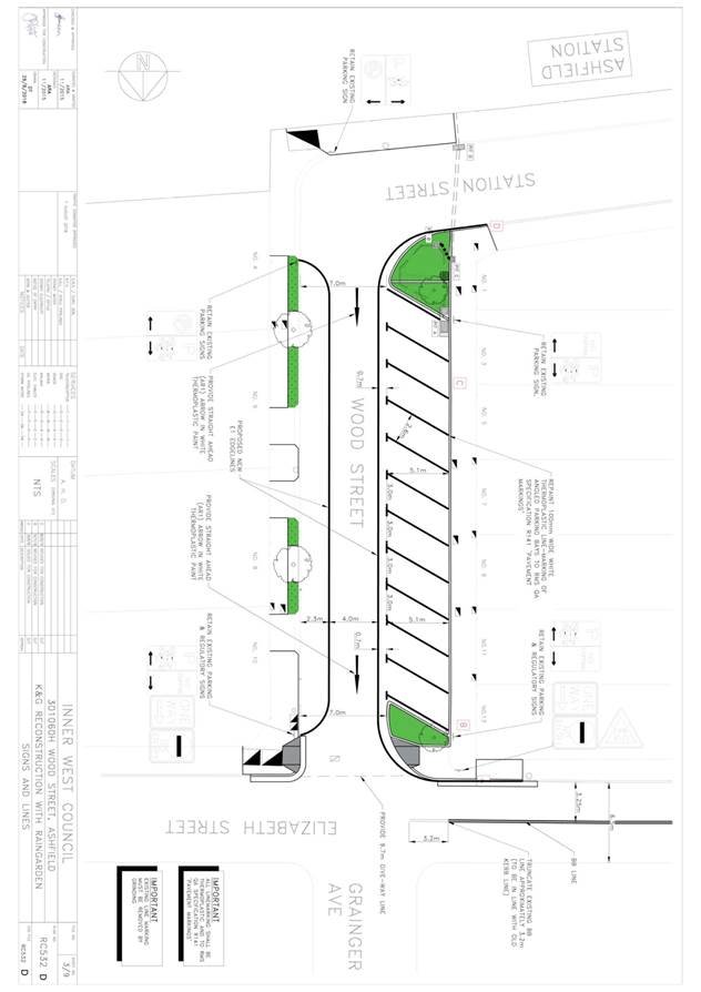
LTC0719 Item 23 Wood Street at Elizabeth Street, Ashfield - Associated delineation with kerb & gutter reconstruction (Gulgadya Ward/ Summer Hill Electorate/ Burwood PAC)
|
Prepared By: Scipio Tam - Engineer - Traffic and parking Services (South)
Authorised By: John Stephens - Traffic and Transport Services Manager
SUMMARY
Detailed design plans have been provided for the proposed delineation in Wood Street and Elizabeth Street, Ashfield. Detailed Design Plans for kerb extensions and a rain garden were originally approved at the Local Traffic Committee meeting on the 7th of August, 2018. The works have now been completed and issues have since arisen of vehicles now crossing the centre line in Elizabeth Street as a result of the works. In order to address this issue, modifications to the original design plan have been added.
|
Officer’s Recommendation
THAT the detailed design plans of the delineation in Wood Street and Elizabeth Street, Ashfield (as per attached design plan No. RC532D).
DISCUSSION
The Committee members agreed with the Officer’s recommendation.
COMMITTEE RECOMMENDATION
THAT the detailed design plans of the delineation in Wood Street and Elizabeth Street, Ashfield (as per attached design plan No. RC532D)
For motion: Unanimous
|
General Business
|
LTC0719 Item 24 Pram ramp on Parramatta Road and Bland Street, Ashfield
|
|
Clr da Cruz asked for an update regarding the pram ramp on the corner of Parramatta Road and Bland Street, Ashfield that is directing cyclists to the middle of the intersection. Council Officers advised that investigations are to be undertaken.
|
|
LTC0719 Item 25 Bike logo markings across Inner West area
|
|
The Inner West Bicycle Coalition commented that a number of bike logos across the LGA have faded and require replacement. Council Officers advised that a program to review bike logo markings will commence over the next 12 months.
|
|
LTC0719 Item 26 Request for red light camera at intersection of Edgeware Road and Stanmore Road, Enmore
|
|
A resident requested through Clr Macri for a red light camera at the signalised intersection of Edgware road and Stanmore Road as vehicles have been observed running through red signals. The RMS representative advised that locations for red light cameras can be submitted through the Centre for Road Safety website. Nominations are then referred to RMS for investigation.
|
|
LTC0719 Item 27 Signalised pedestrian crossing at the intersection of Railway Terrace and West Street, Petersham
|
|
Council Officers reported that Petersham Public School have raised concerns with safety at the signalised pedestrian crossing at Railway Terrace and West Street and vehicles not observing red lights. RMS are aware of the complaints and are investigating ways to improve the intersection. The RMS representative stated that the cycleway which will run along Railway Terrace may assist cyclist works.
|
|
LTC0719 Item 28 Bike signal phasing at Catherine Street and City-West Link, Lilyfield
|
|
The Inner West Bicycle Coalition representative commented that the bike lantern for northbound cyclists to cross City-West Link at Catherine Street is only triggered when a cyclist is detected and asked why the bike phase is not automatic. The RMS representative advised that the bike phase increases delay on City-West Link.
|
|
LTC0719 Item 29 Traffic arrangements for proposed Bunnings, Tempe
|
|
The representative for the Member for Heffron asked whether there will be new traffic arrangements for the proposed Bunnings in Tempe and when those arrangements will be presented to the Committee. The representative was advised that this information will be presented to the Committee as part of a LATM study prior to occupation.
|
Meeting closed at 11am.
This page has been left intentionally blank
|
|
Local Traffic Committee Meeting 5 August 2019 |
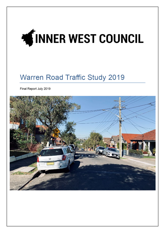
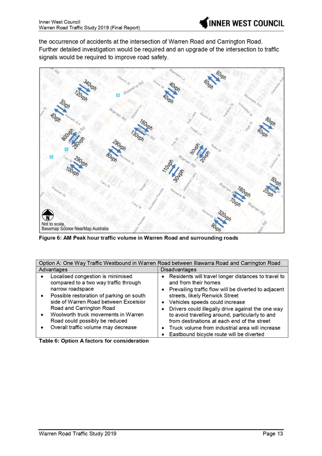
Subject: Warren Road Traffic Study (Midjuburi - Marrickville Ward/Summer Hill Electorate/Inner West PAC)
Prepared By: Sunny Jo - Traffic and Parking Planner
Authorised By: John Stephens - Traffic and Transport Services Manager
SUMMARY
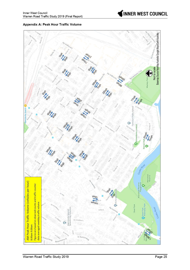
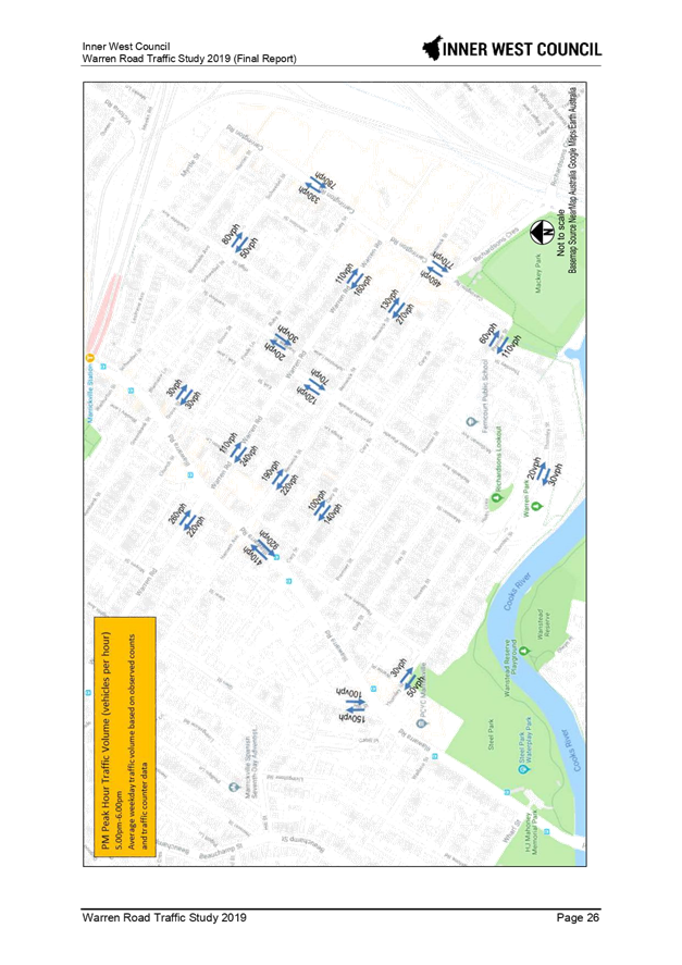
The Warren Road Traffic Study reviewed the one-way westbound proposal for Warren Road, Marrickville between Carrington and Illawarra Roads. The study considered three options to improve traffic flow and safety in Warren Road. Community engagement on the three options was undertaken in June 2019 and the results are presented within this report.
Having considered the community survey submissions and traffic and accident data, it is recommended that Council support the one-way proposal for Warren Road, including other recommendations to support the one-way changes.
|
THAT:
1. As a result of the level of support from the community, Council support in principle a westbound one-way traffic movement in Warren Road between Carrington Road and Illawarra Road;
2. A Traffic Management Plan for the one-way westbound traffic in Warren Road between Carrington Road and Illawarra Road be submitted to the Roads and Maritime Services (RMS) for approval;
3. Council submit amended traffic control signal design plans for the intersection of Warren Road and Illawarra Road to facilitate a one-way westbound traffic movement in Warren Road between Carrington Road and Illawarra Road to RMS for its approval;
4. Implementation of the one-way traffic change in Warren Road, including signposting and linemarking to facilitate a one-way westbound traffic movement in Warren Road between Carrington Road and Illawarra Road, be reported back to the Traffic Committee prior to implementation;
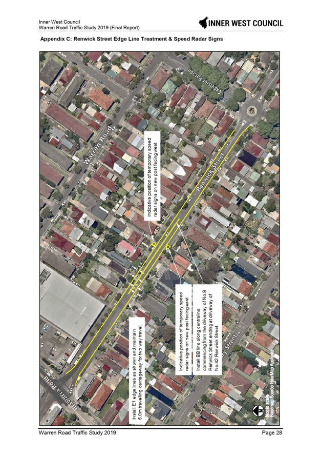
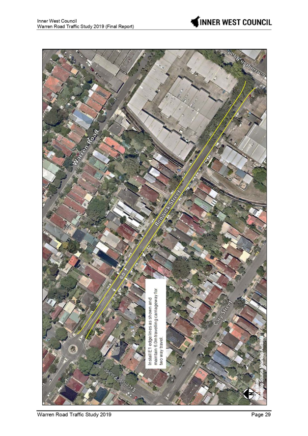
5. Renwick Street be marked with parking edge lines and centrelines as illustrated in Appendix C, and two temporary mid-block speed radar display signs between Excelsior Parade and Carrington Road be installed prior to the implementation of the one-way movement in Warren Road;
6. The 3 tonne load limit in Renwick Street be removed prior to the implementation of the one-way movement in Warren Road;
7. That Renwick Street be included in Council’s Slow Down in My Street program and Speed Radar program for implementation in the current year;
8. Woolworths Marrickville be requested to implement a more equitable spread of truck delivery times to the loading dock; and
9. That affected residents and businesses be advised of the traffic changes prior to implementation of the one-way movement in Warren Road. |
BACKGROUND
Representations were received from Warren Road residents in early 2019 regarding traffic flow and safety issues. A petition with signatures from residents was received including representations at Council meetings and Council on 12 February 2019 resolved the following:
C0219(2) Item 15 Notice of Motion: Warren Road, Marrickville
Motion: (Macri/Hesse)
THAT Council:
1. Complete the necessary study and investigations for a proposed conversion of Warren Road, Marrickville from its current two-way traffic flow operation to one-way; and
2. Recommendations be submitted to the Local Traffic Committee for consideration.
OTHER STAFF COMMENTS
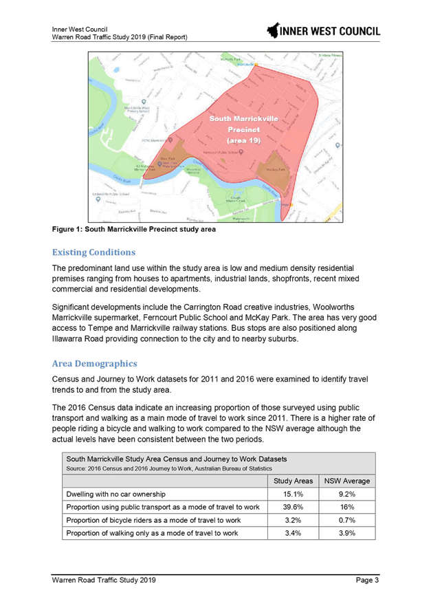
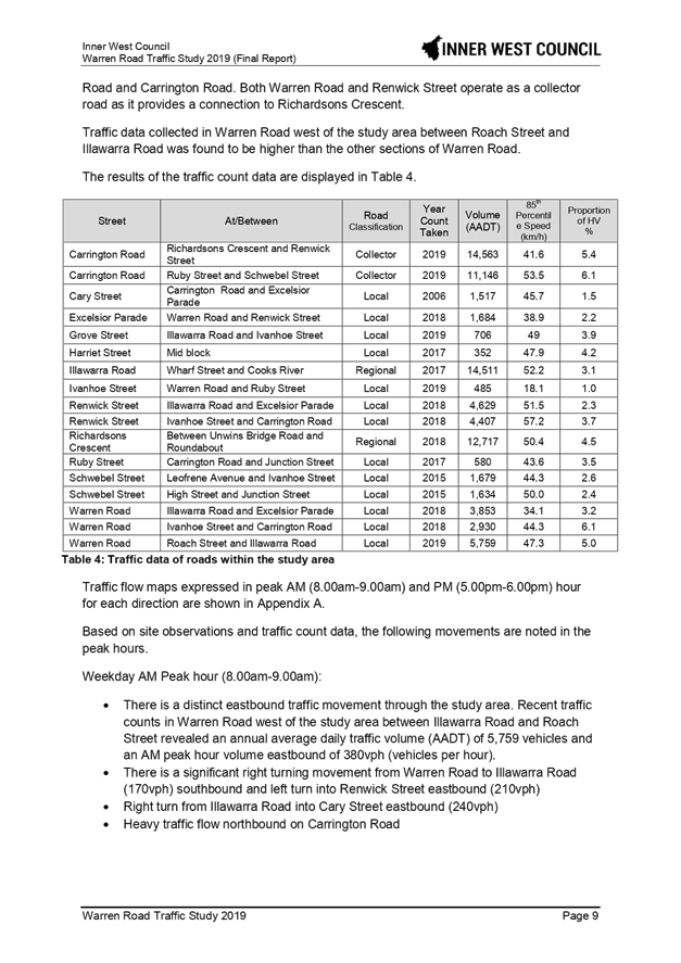
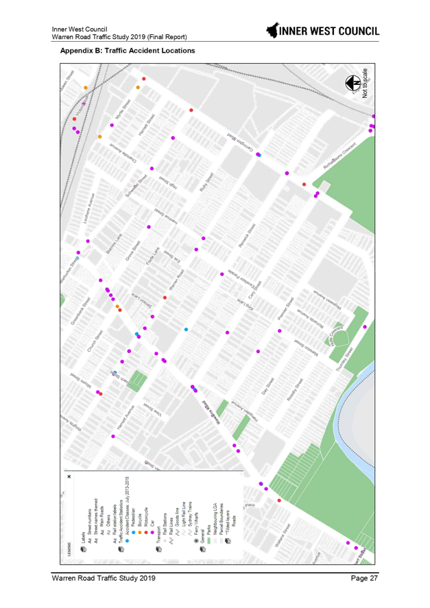
The Warren Road traffic study area is bounded by Illawarra Road, Cooks River, T3 Bankstown and T8 South Suburban Rail Lines. The study involved examining a request for a westbound one-way traffic flow in Warren Road. The work included examination of traffic data, traffic accident database provided by the Roads and Maritime Services, site observations during the peak hours and a review of the previous Local Area Traffic Management (LATM) study in 2011.
Three options were considered in the study and these three options were presented to the community to make a preference based on an information sheet outlining the options, which comprised of the following:
|
Option |
Description |
On-street parking loses |
|
Option A |
Westbound one-way traffic restriction in Warren Road between Carrington Road to Illawarra Road |
0 net loss |
|
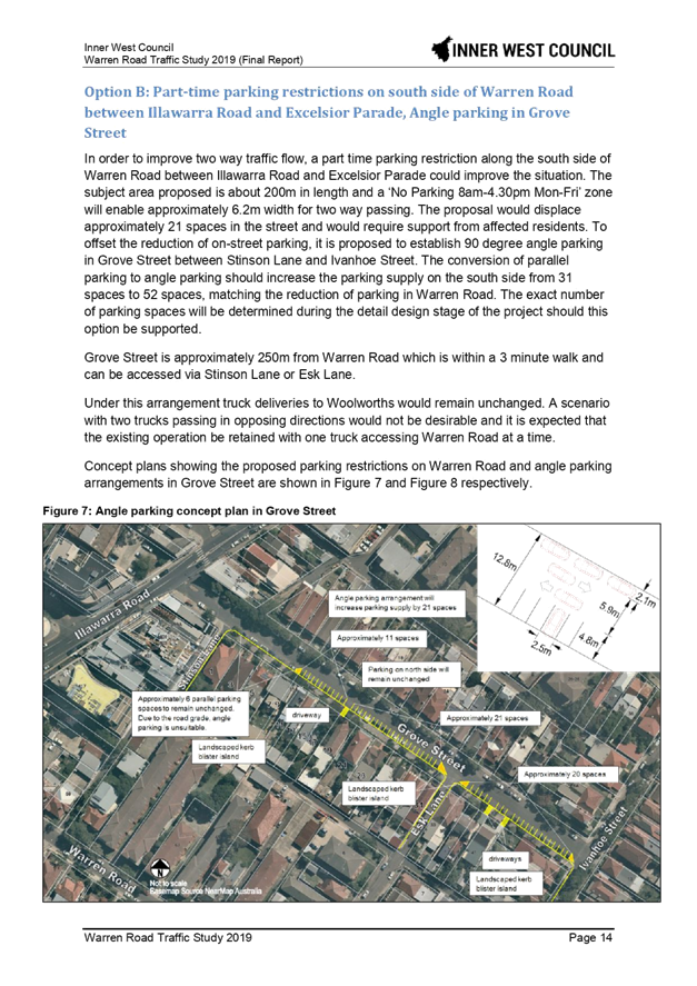
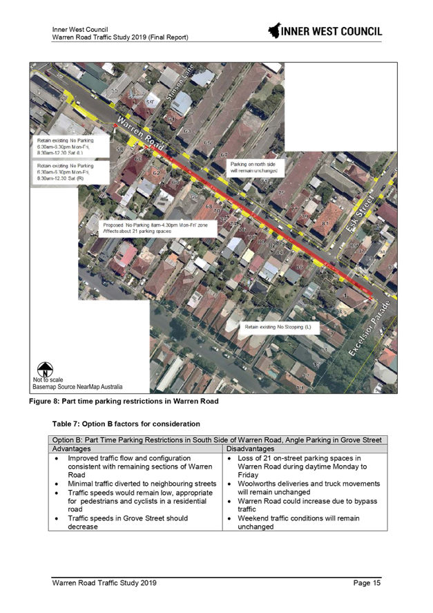
Option B |
Parking restrictions in Warren Road between Illawarra Road and Excelsior Parade and angle parking in Grove Avenue
|
No net loss, however loss of 21 on-street parking spaces during day time Monday to Friday on Warren Road. To offset this loss establish angle parking in Grove Street hence increase parking supply by 21 spaces. |
|
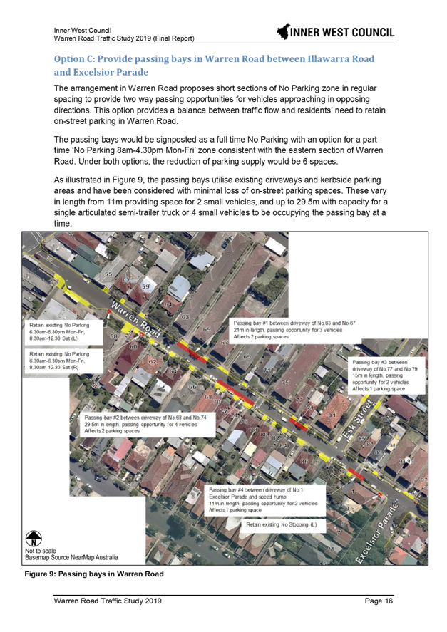
Option C |
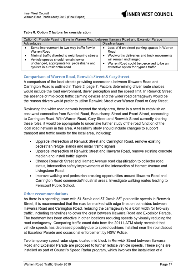
Provide passing bays in Warren Road between Illawarra Road and Excelsior Parade |
Loss of 6 on-street parking spaces in Warren Road |
One of the implications of the one-way traffic flow in Warren Road would be that the eastbound traffic demand would be mostly diverted to Renwick Street, with a marginal level of traffic increase expected in Grove Street and Schwebel Street.
The impacts resulting from the proposal are discussed in more detail in the attached report under the heading "Traffic Management Options for Warren Road".
During the 2011 study, Council proposed a number of speed cushions or humps along Renwick Street. Due to the low level of support from affected residents the proposal was not supported. In 2015 two speed cushions were installed in Renwick Street at each approach to the Excelsior Street roundabout.
As part of this proposal, it is recommended that parking edge lines be installed along the length of Renwick Street, and the street be included in Council’s speed radar program. Hence, two temporary speed radar display signs would be located mid-block in Renwick Street between Illawarra Road and Excelsior Parade that are proposed to further reduce vehicular speeds. These signs are installed as part of Council’s Speed Radar program, which involves the installation of a temporary speed radar sign that measures oncoming vehicle speed and displays the vehicular speed to assist in reducing vehicle speeding in the area.
PUBLIC CONSULTATION
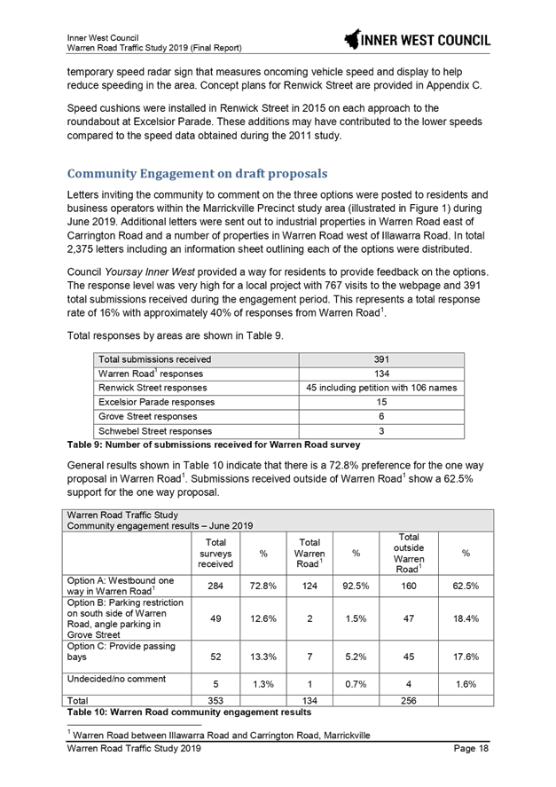
In June, Council arranged distribution of 2,375 letters to residents and businesses with an accompanying information sheet outlining the three options, and inviting recipients to log their preference online through Council’s Your Say Inner West website. The engagement period closed on 1 July 2019 with a total of 391 submissions received, which reflected a general response rate of 14%, and 40% were received from Warren Road residents and businesses. Separately, an online petition was also received against Option A with 106 names. As the petition request was outside of the 3 options presented, it could not be included in the summary results of the community engagement tabled below:
|
Warren Road Traffic Study Community engagement results – June 2019 |
||||||
|
|
Total surveys received |
% |
Total Warren Road* |
% |
Total outside Warren Road* |
% |
|
Option A: Westbound one-way in Warren Road* |
284 |
72.8% |
124 |
92.5% |
160 |
62.5% |
|
Option B: Parking restriction on south side of Warren Road, angle parking in Grove Street |
49 |
12.6% |
2 |
1.5% |
47 |
18.4% |
|
Option C: Provide passing bays |
52 |
13.3% |
7 |
5.2% |
45 |
17.6% |
|
Undecided/no comment |
5 |
1.3% |
1 |
0.7% |
4 |
1.6% |
|
Total |
390 |
|
134 |
|
256 |
|
*between Carrington Road and Illawarra Road, Marrickville
Notification in the Inner West Courier required under the Roads Act 1993 for the implementation of the one-way traffic proposal is currently underway and closes on 8 August 2019.
Having considered the submissions and the engagement results above, traffic data and accident database, it is recommended that option A westbound one-way traffic flow in Warren Road between Carrington Road and Illawarra Road be supported, with proposed treatments undertaken in Renwick Street.
FINANCIAL IMPLICATIONS
The implementation of the one-way will require modifications at the signalised intersection of Illawarra Road and Warren Road to facilitate truck movements and one-way traffic lanes out of Warren Road. An estimated cost of the design and implementation work will be determined as part of the detailed design process.
CONCLUSION
The changes to convert Warren Road between Carrington Road and Illawarra Road into a westbound one-way movement would result in traffic and safety improvements in Warren Road. Further changes to the traffic signals at Warren Road / Illawarra Road, linemarking, and signage changes to formalise the one-way traffic movement will be reported back to the Traffic Committee.
|
1.⇩ |
Warren Road Traffic Study |
|
Local Traffic Committee Meeting 5 August 2019 |
Subject: Terrace Road / Ness Avenue, Dulwich Hill – Temporary Full Road Closure of Rail Underpass just north of the roundabout at Ewart Street – Sydney Metro (SSJ) early enabling works on T3 Line (DJARRAWUNANG-ASHFIELD WARD / SUMMER HILL ELECTORATE / INNER WEST PAC)
Prepared By: Jennifer Adams - Engineer – Traffic and Parking Services
Authorised By: John Stephens - Traffic and Transport Services Manager
SUMMARY
An application has been received from Sydney Metro (SSJ) for the temporary full road closure of the rail underpass on Terrace Road / Ness Avenue just north of the roundabout at Ewart Street, Dulwich Hill for a two day period from 12am Saturday, 28 September until 11.50pm Sunday, 29 September 2019 in order to carry out early enabling works on the Rail bridge. The road will be temporarily closed to all vehicular traffic, including emergency vehicles and local residents. It is recommended that the proposed temporary full road closures be approved, subject to the conditions outlined in this report.
|
RECOMMENDATION
THAT the proposed temporary full road closure of the rail underpass on Terrace Road / Ness Avenue just north of the roundabout at Ewart Street, Dulwich Hill for a two day period being 12am Saturday, 28 September until 11.50pm Sunday, 29 September 2019 be approved, in order to carry out early enabling works on the Rail bridge subject to, but not limited to, the following conditions:
a) The application and TMP be submitted to RMS for approval;
b) A Road Occupancy License be obtained by the applicant from the Transport Management Centre;
c) All affected residents and businesses, including the NSW Police Local Area Commander, Fire & Rescue NSW and the NSW Ambulance Services be notified in writing, by the applicant, of the proposed temporary road closure at least 7 days in advance of the closure with the applicant making reasonable provision for stakeholders; and
d) The occupation of the road carriageway must not occur until the road has been physically closed.
|
BACKGROUND
Southwest Metro early works are now underway between Sydenham and Campsie to convert the existing rail to metro standards in preparation for the opening of Sydney Metro City & Southwest in 2024. The joint venture currently delivering the Sydney Metro upgrade to Sydenham Station (SSJ), John Holland Pty Ltd and Laing O’Rourke Australia Construction Pty Ltd, has been appointed to undertake early works along the T3 Bankstown Line like site geotechnical investigations, early design, and enabling works such as surveying and utilities investigations. Work also includes station and bridge investigations and the installation of cable routes, retaining walls and security fencing within the rail corridor.
As part of the Southern Corridor – Bankstown Line early investigation activities SSJ are about to undertake work to the Terrace Road / Ness Avenue rail overbridge which will require the use of an elevated work platform (EWP) and mobile crane, and this will require a full lane closure of both lanes at the Terrace Road / Ness Avenue, Dulwich Hill underpass.
Traffic movements will be managed in accordance with the submitted TCPs and Traffic controllers will be on duty to assist both pedestrians and vehicle movements. Pedestrian/cyclist access will be maintained.
It is noted that the works will be carried out to coincide with a Bankstown line possession weekend - (5am on the Saturday morning through to 2am on the Monday morning). For the temporary full road closure (28-29 September 2019) – SSJ will be working for the whole weekend.
Community notification by Sydney Metro (SSJ) will include:
· Residents within a 200m radius of the work area will have a targeted door knock completed 7 days prior to work commencing.
· A notification will be distributed via letterbox drop and email no later than 7 days prior to work commencing.
· A door knock of local businesses with the potential to be impacted will be carried out no later than 14 days before work commences.
FINANCIAL IMPLICATIONS
Under Council’s Fees & Charges, the applicant is to pay a fee for the temporary full road closure. This fee includes advertising the proposal in accordance with the Roads Act 1993.
OFFICER COMMENTS
Site location
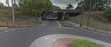

Terrace Road, between The Parade and Consett Street, carries around 1,388 vehicles per day. At the railway overbridge the width of the road is approximately 9 metres in width. It is noted that the full road closure will divert traffic to either Garnet Street to the west or Wardell Road to the east.
|
Street Name |
Terrace Road |
|
Section |
Between The Parade and Consett Street |
|
Carriageway Width (m) |
12.4 generally and 9.0 at underpass |
|
Carriageway Type |
Two-way road with one travel lane in each direction, in addition to kerbside parking on both sides. At underpass one travel lane in each direction. |
|
Classification |
Local |
|
Speed limit |
50.0 |
|
85th Percentile Speed (km/h) |
51.8 |
|
Vehicles Per Day (vpd) |
1,388 |
|
Reported Crash History (July 2013 – June 2018) |
3 injury crashes and one tow-away crash in locality of underpass/roundabout. The tow-away involved a car losing control at the underpass. Two of the 3 injury crashes involved motorcyclists going off the road and the other crash involved a cyclist being injured while making a U-turn. RUM codes – 81,70, 88 and 40. |
|
Heavy Vehicle Volume (%) |
2.9 |
|
Parking Arrangements |
No parking at underpass and unrestricted parking along each side of Terrace Road. |
The Traffic Control Plan submitted by the applicant is shown below.
PUBLIC CONSULTATION
The applicant is to notify all affected residents and businesses in writing at least 7 days prior to the commencement of works.
The proposed road closure has been advertised in the local newspaper in accordance with the Roads Act 1993
CONCLUSION
It is recommended that the proposed temporary full road closure be approved, subject to but not limited to the conditions outlined in this report.
|
|
Local Traffic Committee Meeting 5 August 2019 |
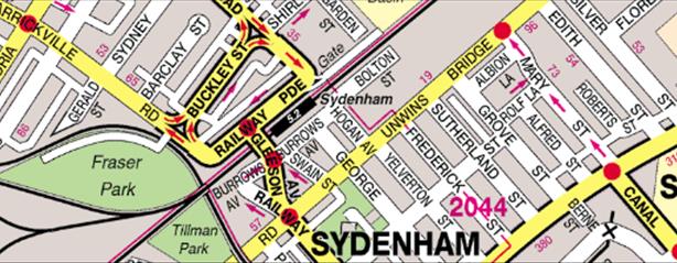
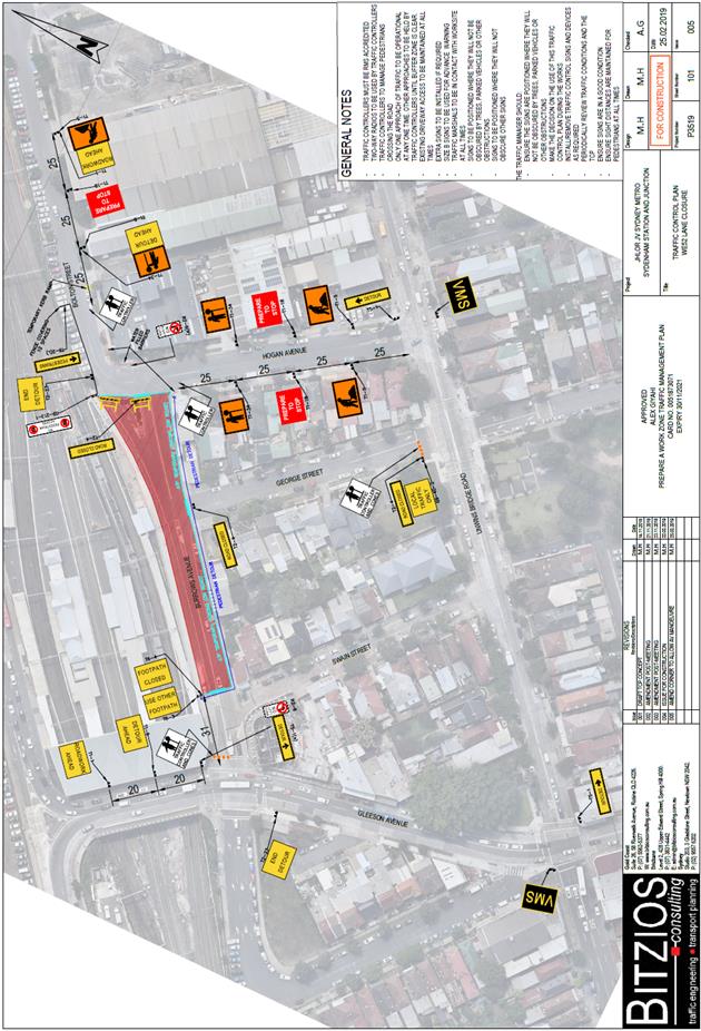
Subject: Burrows Avenue, Sydenham – Temporary Full Road Closures - Sydney Metro Sydenham Station and Junction (SSJ) Works (Midjuburi-Marrickville Ward / Heffron Electorate / Inner West PAC)
Prepared By: Jennifer Adams - Engineer – Traffic and Parking Services
Authorised By: John Stephens - Traffic and Transport Services Manager
SUMMARY
An application has been received from Sydney Metro Sydenham Station and Junction (SSJ) for the temporary full road closure of Burrows Avenue, between Hogan Avenue and Gleeson Avenue, Sydenham on 3 separate occasions from 9pm Friday, 30 August to 4.30am Monday, 2 September 2019; 9pm Friday, 25 October to 4.30am Monday, 28 October 2019 and 9pm Friday, 13 December to 4.30am Monday, 16 December 2019 in order to carry out upgrading works at Sydenham Station. The street will be temporarily closed to all vehicular traffic, including emergency vehicles and local residents. It is recommended that the proposed temporary full road closures be approved, subject to the conditions outlined in this report.
|
RECOMMENDATION
THAT the proposed temporary full road closure of Burrows Avenue, between Hogan Avenue and Gleeson Avenue, Sydenham on 3 separate occasions from 9pm Friday, 30 August to 4.30am Monday, 2 September 2019; 9pm Friday, 25 October to 4.30am Monday, 28 October 2019 and 9pm Friday, 13 December to 4.30am Monday, 16 December 2019 be approved, in order to carry out upgrading works at Sydenham Station, subject to the following conditions:
a) The application and TMP be submitted to RMS for approval;
b) A Road Occupancy License be obtained by the applicant from the Transport Management Centre;
c) All affected residents and businesses, including the NSW Police Local Area Commander, Fire & Rescue NSW and the NSW Ambulance Services be notified in writing, by the applicant, of the proposed temporary road closure at least 7 days in advance of the closure with the applicant making reasonable provision for stakeholders; and
d) The occupation of the road carriageway must not occur until the road has been physically closed.
|
BACKGROUND
John Holland Pty Ltd and Laing O’Rourke Australia Construction Pty Ltd are currently undertaking major railway work at Sydenham as part of Sydney Metro, including the upgrade of Sydenham Station. The station will be fully upgraded with a new aerial concourse over the existing platforms including lifts, stairs and level access between the platforms and trains.
The project is working within a live rail environment. For the safety of workers and customers a number of activities can only be carried out when trains are not operating. The project therefore relies on Sydney Trains rail shutdown weekends to deliver these activities.
The Sydenham Metro Upgrade will be working during a Sydney Trains rail shutdown weekend scheduled for Friday, 30 August to Monday, 2 September 2019. Work will commence on the roof canopy steel installation on Platforms 4 and 5. A crane will be used during this work to carry out related lifts and associated work activities.
To facilitate the crane placement, temporary full road closures are required on Burrows Avenue between Hogan Avenue and Gleeson Avenue, Sydenham. The first road closure is to commence from 9pm Friday, 30 August to 4.30am Monday, 2 September 2019.
Traffic movements will be managed in accordance with the attached TCP. Traffic controllers will be on duty to assist both pedestrians and vehicle movements. Access to private property will be maintained at all times. Access to and from Bolton Street will be available via Hogan Avenue.
Additional lane closures will also be required to complete the works. Initially, the steel will need to be delivered and assembled on site prior to the installation. To facilitate this, a lane closure is required along Burrows Avenue (rail side) between Hogan Avenue and George Street. Initially, lane closures will be required from 9pm Thursday, 29 August to 9pm Friday, 30 August 2019 to establish a laydown area and receive deliveries and from 4.30am Monday, 2 September to 4.30am Tuesday, 3 September 2019 to decommission the laydown area.
:
Additional dates, coinciding with a number of rail shutdown weekends, the temporary full road closure with associated lane closures will be required are:
· Friday, 25 October to Monday, 28 October 2019
· Friday, December 13 to Monday, 16 December 2019
FINANCIAL IMPLICATIONS
Under Council’s Fees & Charges, the applicant is to pay a fee for the temporary full road closure. This fee includes advertising the proposal in accordance with the Roads Act 1993.
OFFICER COMMENTS
Site location
The site location is adjacent Sydenham Railway Station. Burrows Avenue is a local road.
![]()
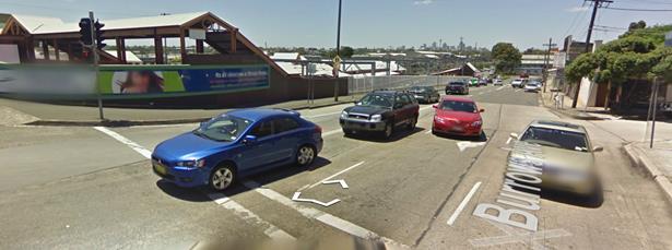
|
Street Name
|
Burrows Avenue |
|
Section |
Between Gleeson Avenue and George Street |
|
Carriageway Width (m) |
12.8 |
|
Carriageway Type |
Two-way road with one travel lane in each direction, in addition to kerbside parking lanes. |
|
Classification |
Local |
|
85th Percentile Speed (km/h) |
47.5 |
|
Vehicles Per Day (vpd) |
7,296 |
|
Reported Crash History (July 2011 - June 2016) |
No RMS recorded crashes. |
|
Heavy Vehicle Volume (%) |
5.1 |
|
Parking Arrangements |
Various on northern side of the road since Sydney Metro SSJ construction works being carried out. Southern side of the road consists of ‘No Parking’ restrictions with a section of ‘2P 8:30am-6pm Mon-Fri, 8:30am-12:30pm Sat’ restrictions. |
The Traffic Control Plan submitted by the applicant is reproduced below.
Vehicular access for local residents/businesses and emergency services will be maintained during the closure, where possible. Authorised Traffic Controllers will be on-site during the time of the road closure and are to be positioned at the closure points when required to provide vehicular access to local residents/businesses and ensure the safety of motorists and pedestrians.
Night work operations are necessary to get the required works completed during rail shutdown weekends. Residents within 100 metres of Sydenham Station will be notified prior to the road closure and a VMS board will be installed notifying road users of the road closure. In addition, Sydney Metro will be door knocking residents along Hogan Avenue/George Street/Swain Street including business owners along Hogan and Bolton Street.
Noise assessment will be carried out in accordance with the NSW Interim Construction Noise Guidelines and where required additional mitigation measures will be offered to identified sensitive receivers.
PUBLIC CONSULTATION
The applicant is to notify all affected residents and businesses in writing at least 7 days prior to the commencement of works.
The proposed road closure has been advertised in the local newspaper in accordance with the Roads Act 1993
CONCLUSION
It is recommended that the proposed temporary full road closures be approved, subject to but not limited to the conditions outlined in this report.
|
|
Local Traffic Committee Meeting 5 August 2019 |
Subject: Albermarle Street, Marrickville – Temporary Full Road Closure of Rail Overbridge south of Challis Street - Sydney Metro (SSJ) early enabling works on T3 Line (MIDJUBURI-MARRICKVILLE WARD / SUMMER HILL ELECTORATE / INNER WEST PAC)
Prepared By: Jennifer Adams - Engineer – Traffic and Parking Services
Authorised By: John Stephens - Traffic and Transport Services Manager
SUMMARY
An application has been received from Sydney Metro (SSJ) for the temporary full road closure of the rail over bridge on Albermarle Street just south of Challis Avenue, Marrickville for a ten day period scheduled from 12am Sunday, 2 September to 11.50pm Thursday, 12 September 2019 (contingency up to midnight Thursday, 19 September 2019) in order to carry out early enabling works on the Rail Overbridge. The road will be temporarily closed to all vehicular traffic, including emergency vehicles and local residents. It is recommended that the proposed temporary full road closures be approved, subject to the conditions outlined in this report.
|
RECOMMENDATION
THAT the proposed temporary full road closure of Albermarle Street (between Challis Avenue and Kays Avenue East), Marrickville for a ten day period scheduled from 12am Sunday 2 September to 11.50pm Thursday 12 September 2019 (contingency up to 11.50pm Thursday, 19 September 2019) be approved, in order to carry out early enabling works on the Rail Overbridge subject to, but not limited to, the following conditions:
a) The application and TMP be submitted to RMS for approval;
b) A Road Occupancy License be obtained by the applicant from the Transport Management Centre;
c) All affected residents and businesses, including the NSW Police Local Area Commander, Fire & Rescue NSW and the NSW Ambulance Services be notified in writing, by the applicant, of the proposed temporary road closure at least 7 days in advance of the closure with the applicant making reasonable provision for stakeholders; and
d) The occupation of the road carriageway must not occur until the road has been physically closed.
|
BACKGROUND
Southwest metro early works are now underway between Sydenham and Campsie to convert the existing rail to metro standards in preparation for the opening of Sydney Metro City & Southwest in 2024. The joint venture currently delivering the Sydney Metro upgrade to Sydenham Station (SSJ), John Holland Pty Ltd and Laing O’Rourke Australia Construction Pty Ltd, has been appointed to undertake early works along the T3 Bankstown Line like site geotechnical investigations, early design, and enabling works such as surveying and utilities investigations. Work also includes station and bridge investigations and the installation of cable routes, retaining walls and security fencing within the rail corridor.
As part of the Southern Corridor – Bankstown Line early investigation activities SSJ are about to undertake work constructing an underground services crossing for a railway signals system across Albermarle Street between Challis Avenue and Kays Avenue East. This will require a temporary full road closure on Albermarle Street of an area of 20 metres x 20 metres. The work is scheduled from 2/9/2019 to 12/9/2019 (contingency up to 19/9/2019).
Traffic movements will be managed in accordance with the attached TCP. Traffic controllers will be on duty to assist both pedestrians and vehicle movements. Pedestrian access will be diverted due to the spatial constraints of the worksite, as it is not safely feasible to accommodate pedestrians or cyclists adjacent to the area. Pedestrian and cyclist access to Kays Avenue East will be maintained.
For the temporary full road closure of Albermarle Street (2-13 September 2019) SSJ will be working normal construction hours of 7am to 6pm on week days and 8am to 6pm on Saturdays. It is possible some work may be conducted out of hours work on Sunday during the day; however, there will be no work at night. It is noted that the road closure will stay in place 24/7 regardless of the work hours for the safety of the local community and Sydney Metro JHLOR workers.
Community notification by Sydney Metro (SSJ) will include:
· Residents within a 200m radius of the works will be door knocked 7 days prior to any works commencing.
· Notification will be distributed 7 days prior to work commencing to the suburb and surrounding suburbs along the rail corridor.
· A door knock of local businesses with the potential to be impacted will be carried out 14 days before work commences.
FINANCIAL IMPLICATIONS
Under Council’s Fees & Charges, the applicant is to pay a fee for the temporary full road closure. This fee includes advertising the proposal in accordance with the Roads Act 1993.
OFFICER COMMENTS
Site location
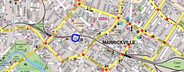
Albermarle Street, between Challis Avenue and Kays Avenue East, carries around 1,600 vehicles per day. At the railway overbridge the width of the road is approximately 5.7 metres in width. It is noted that the full road closure will divert traffic to either Wardell Road to the north or Livingstone Road to the south.
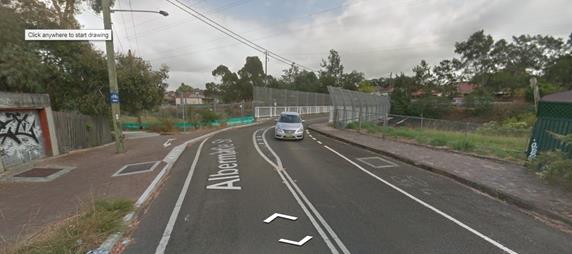
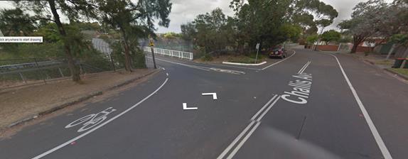
|
Street Name |
Albermarle Street |
|
Section |
Between Livingstone Road and Tamar Street |
|
Carriageway Width (m) |
5.7 at overbridge |
|
Carriageway Type |
Two-way road with one travel lane in each direction at overbridge. |
|
Classification |
Local |
|
Speed limit |
50.0 |
|
85th Percentile Speed (km/h) |
39.6 |
|
Vehicles Per Day (vpd) |
1,601 |
|
Reported Crash History (July 2013 – June 2018) |
Nil. |
|
Heavy Vehicle Volume (%) |
1.1 |
|
Parking Arrangements |
No parking at overbridge and unrestricted parking along each side of Albermarle Street. |
The Traffic Control Plan submitted by the applicant is shown below.
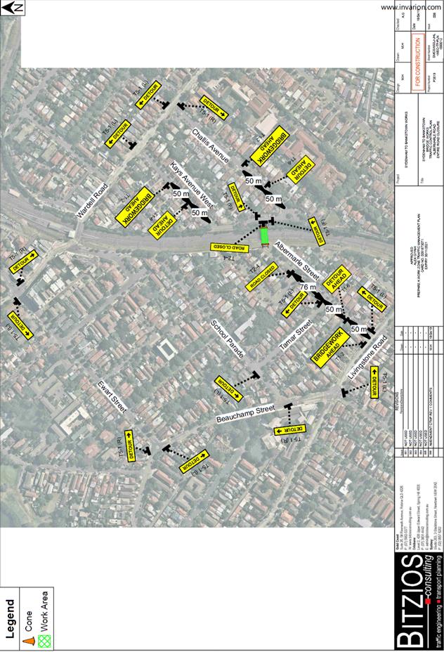
PUBLIC CONSULTATION
The applicant is to notify all affected residents and businesses in writing at least 7 days prior to the commencement of works.
The proposed road closure has been advertised in the local newspaper in accordance with the Roads Act 1993
CONCLUSION
It is recommended that the proposed temporary full road closure be approved, subject to but not limited to the conditions outlined in this report.
|
|
Local Traffic Committee Meeting 5 August 2019 |
Subject: Marrickville Road, Marrickville – Temporary full Road Closures for Marrickville Festival on Sunday 20 October 2019 – DA201700334 - (Midjuburi - Marrickville Ward / Summer Hill Electorate / Inner West PAC)
Prepared By: Jennifer Adams - Engineer – Traffic and Parking Services
Authorised By: John Stephens - Traffic and Transport Services Manager
|
RECOMMENDATION
THAT:
1. The proposed temporary full road closure of Marrickville Road (between Petersham Road and Victoria Road), Illawarra Road (between Sydenham Road and Petersham Road), Alex Travellion Plaza and the Calvert Street car park along with short sections of Malakoff Street, Despointes Street, Silver Street, Garners Avenue, Gladstone Street and Frampton Avenue where these streets intersect with Marrickville Road, Marrickville for the ‘Marrickville Festival’ Event on Sunday, 20 October 2019 between 11pm Saturday, 19 October to Midnight Sunday, 20 October 2019 be approved as per the submitted TMP and TCPs;
2. A Road Occupancy License application be obtained from the Transport Management Centre;
3. Notice of the proposed event be forwarded to the NSW Police Local Area Commander, Transit Systems, the NSW Fire Brigades and the NSW Ambulance Services;
4. All residents and businesses in and around the affected area are to be notified of the temporary road closure in writing by the applicant in advance (at least 7 days prior to the event) with the applicant making reasonable provision for stakeholders; 4. A minimum four (4) metre unencumbered passage be available for emergency vehicles through the closed section; and 5. The occupation of the road carriageway must not occur until the road has been physically closed.
|
BACKGROUND
The 'Marrickville Festival' is an annual event and this year will be held on Sunday, 20 October 2019. As in previous years, the event will necessitate the temporary full road closure of Marrickville Road (between Petersham Road and Victoria Road), Illawarra Road (between Sydenham Road and Petersham Road), Alex Travellion Plaza and the Calvert Street car park along with short sections of Malakoff Street, Despointes Street, Silver Street, Garners Avenue, Gladstone Street and Frampton Avenue where these streets intersect Marrickville Road, Marrickville. Development consent (DA201700334) has been granted for the holding of the event over a five year period (i.e. 22 October 2017, 21 October 2018, 20 October 2019, 18 October 2020 and 17 October 2021).
This year’s Marrickville Festival will run between 10:00am and 5:00pm on Sunday, 20 October 2019; however, the temporary full road closures are required from 11pm Saturday, 19 October to Midnight Sunday, 20 October 2019.
FINANCIAL IMPLICATIONS
Funding of $117,971 has been allocated by Council for organising the ‘Marrickville Festival’ event under the 2019/2020 Major Community Events Program.
OFFICER COMMENTS
The event area will be on Marrickville Road between Petersham Road and Victoria Road and Illawarra Road between Sydenham Road and Petersham Road (refer to the locality diagram below – Marrickville Festival Area). This year Council’s Event Coordinator has appointed ‘Who Dares Pty Ltd’ to prepare the Traffic Management Plan (TMP) and Traffic Control Plans (TCPs) for the event.
Locality Map – Marrickville Road & Illawarra Road, Marrickville - event area overview
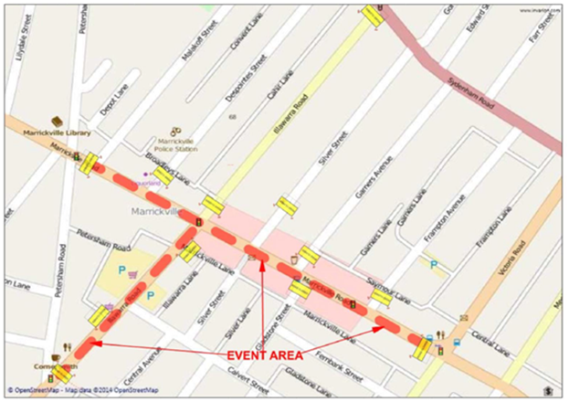
Temporary full road closures are planned at the following locations (refer to the traffic control plans – TCP 1, 2, 3, 4, 5A, 5B and 5C below and reproduced to a larger scale in the attached TMP):
• Marrickville Road between Petersham Road & Victoria Road
• Illawarra Road between Broadleys Lane & Petersham Road
• Malakoff Street between Broadleys Lane & Marrickville Road
• Despointes Street between Broadleys Lane & Marrickville Road
• Silver Street between Marrickville Road 25 metres north of Marrickville Road
• Garners Avenue between Seymour Lane & Marrickville Road
• Frampton Avenue between Seymour Lane & Marrickville Road
• Gladstone Street between Marrickville Road & Marrickville Lane
• Illawarra Lane between north of the carpark & Calvert Street
• Calvert Street between Illawarra Road & Illawarra Lane
• Calvert Street Carpark
• Illawarra Road between Sydenham Road Broadleys Lane (Resident Access Excepted)
Access around the event site will be maintained by a detour. The detour loop will include Petersham Road, Centennial Street, Sydenham Road, Victoria Road, Calvert Street, O’Hara Street, Byrnes Street and Illawarra Road.
Council barricades will be used to affect the road closures from 11pm Saturday, 19 October to Midnight Sunday, 20 October 2019 and a 4-metre wide emergency vehicle access will need to be maintained through the area during the course of the street festival.
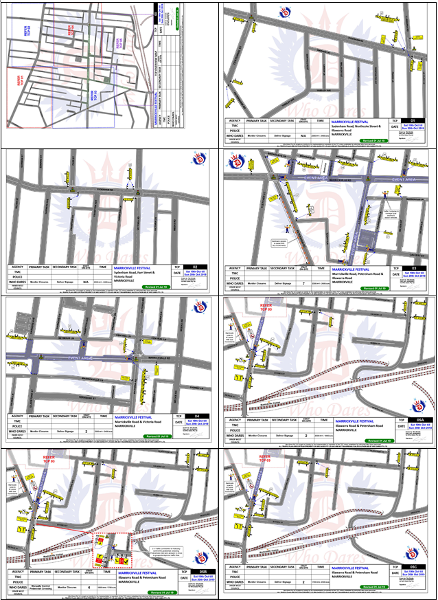
Special Event advance notice signs will be strategically installed at least two (2) weeks prior to the event to alert motorists of the proposed closures. In addition, 'No Parking - Special Event' signs will be affixed over all existing parking signs within the area of the festival and on Petersham Road between Illawarra Road and Marrickville Road on the afternoon of the day prior to the event - Saturday 19 October 2019.
This event is classified as a Class 2 event under the RMS’ Special Events Guide where it impacts local traffic and transport systems but does not impact major traffic and transport systems and it disrupts the non-event community in the area around the event but not over a wide area. The event requires the involvement of Police and Local Council and a detailed Transport Management Plan (TMP).
The temporary road closures are required to be advertised in the local newspaper providing 28 days’ notice for submissions.
Adequate vehicular traffic control shall be provided for the protection and convenience of pedestrians and motorists including appropriate signage and flagging. Workers shall be specially designated for this role (and carry appropriate certificates), as necessary to comply with this condition. This is to be carried out in accordance with the Australian Standard AS 1742.3 - Traffic Control Devices for works on roads.
Impacts on buses
Transit Systems services 418, 423, 425 and 426 and Transdev NSW N40 service will all be impacted by the event road closures. These services will be detoured around the event precinct. Existing bus stops on Illawarra Road (near Marrickville Station) and on Marrickville Road (outside St Brigid’s Church) are located close enough that intermediate/temporary bus stops will not be required. Refer to Annex 1 of the attached TMP for Transit Systems and Transdev Bus detour maps at a larger scale.
|
|
|
|
In order to provide bus drivers with adequate manoeuvring space, the following is recommended:
a) that the parking be banned in Petersham Road (between Illawarra Road and Marrickville Road) on the day of the Festival; and/or
b) that Traffic Controllers be located in Petersham Road to assist with the movement of the buses.
Impacts on Parking
There are off-street and on-street parking spaces available within the vicinity of the proposed road closures. The car park off Calvert Street has access through Calvert Street and has 37 parking spaces. Some festival activities are proposed to be located in the Calvert Street car park.
There is a roof-top parking area, Banana Joe's car park, (opposite the Calvert Street car park) which has access through Tuohy Lane with approximately 80 parking spaces. As a result of the road closure at Petersham Road, access to this car park will also be restricted during the event.
Due to the proposed road closures the following car parking spaces will be impacted:
Marrickville Road
North side - between Victoria Road and Petersham Road
28 Parking spaces and 2 Bus Zones
South side - between Victoria Road and Petersham Road
43 Parking spaces and 2 Bus Zones
Illawarra Road
East Side – Between Marrickville Road and Petersham Road
21 parking spaces
West Side - None (unrestricted parking)
Parking surveys undertaken in the festival area in previous festivals indicated that there are many on-street parking spaces available to cater for parking in close proximity to the Street event.
In relation to parking it is stated in the TMP that “Parking will only be available in surrounding residential streets and a few small public carparks around the event site. Parking will as such be limited, and the event organiser will be recommending public transport to all event patrons.”
Impacts on traffic
The traffic diverted from Marrickville Road and Illawarra Road as a result of the proposed road closures, does not coincide with the peak traffic, as the festival will be held on a Sunday when lower than weekday traffic volumes are expected. Therefore, the traffic generated as a result of the proposed festival will not have a major impact on the surrounding traffic network during the event. Furthermore, the arrival and departure of attendees of the festival is expected to be staggered as it is every year when this event takes place.
Police vehicles travelling to and from the Police Station located in Despointes Street will have no access to Marrickville Road during the event; however, access to Sydenham Road will be available.
At present, there are no indications of construction works that will be impact the event. There are no traffic calming devices or traffic generating developments along the route.
Marrickville Festival Site and Stall Maps
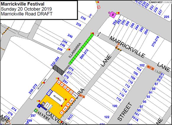
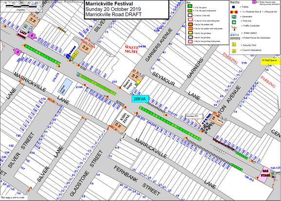
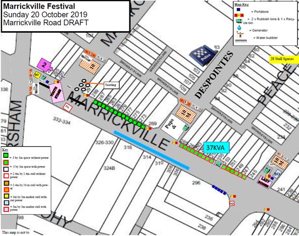
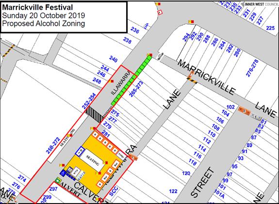
Traffic Management Plan and Traffic Control Plans
A Traffic Management Plan (TMP) has been supplied by Who Dares Pty Ltd, the scope of which includes the provision for the safe movement of vehicular traffic in and out of the event areas. The TMP and Traffic Control Plans (TCP) are reproduced in full at the end of this report.
The Traffic Management Plan is to be submitted to the RMS for consideration and approval and a Road Occupancy License application is to be submitted to the Transport Management Centre by Who Dares Pty Ltd.
PUBLIC CONSULTATION
The proposed temporary full road closures have been advertised in the local newspaper in accordance with the Roads Act 1993.
Advice of the proposed event must be forwarded to all the appropriate authorities, including emergency services.
The TMP states that: “All affected residents will be notified of the event through:
• Letterbox drop will be conducted for impacted residents within and near the road closure precinct at least two weeks prior to the event.
• 3 x Portable VMS boards will be used to advertise the road closures.
• Date & time specific corflute “Special Event – Road Closed” signs to be placed around the event precinct 14 days prior to the event.”
CONCLUSION
It is recommended that Council agree to the temporary full road closures on Sunday, 20 October 2019, subject to complying with the recommendations stated in this report along with all standard conditions for temporary full road closures as detailed in Condition 3 of the development consent for the event (Determination No. 201700334).
|
1.⇩ |
Transport Management Plan - Marrickville Festival Sunday 20 October 2019 |
|
Local Traffic Committee Meeting 5 August 2019 |
Subject: Big Bike Day 2019 Special Event (Gulgadya-Leichhardt & Baludarri-Balmain Ward/ Balmain Electorate/ Leichhardt PAC)
Prepared By: Felicia Lau - Engineer - Traffic and Parking Services
Authorised By: John Stephens - Traffic and Transport Services Manager
SUMMARY
For NSW Bike Week 2019, Council is running ‘Big Bike Day’, a celebration of cycling. Big Bike Day is to be held on Sunday, 22 September 2019.
|
RECOMMENDATION
THAT:
1. The Big Bike Day 2019 event proposed to be held on Sunday, 22 September 2019 be supported; and
2. Council’s Environmental Officer seeks consent from the Office of Environment and Heritage (OEH) for the portion of the route through Callan Park. |
BACKGROUND
Big Bike Day is an annual event held in September, for both avid and casual bike riders of all ages. The day features entertainment, activities, free bike workshops, bike maintenance, raffle prizes and two group bike rides, the Big Bike Ride around the bay (for adults as well as children 12+ accompanied by a carer) and the Kids Ride on Whites Creek Cycleway (aimed at children 6-12 and their carers).
Council’s Environmental Officer is organising the event and has requested approval for the proposed Big Bike Day 2019 to be held on Sunday, 22 September 2019 between 11:00am and 3:00pm, to coincide with the first weekend of NSW Bike Week 2019 (Saturday, 21 September to Sunday, 29 September 2019).
FINANCIAL IMPLICATIONS
There are no costs associated with participation in the guided bike ride. All costs associated with Big Bike Day 2019 are met by Inner West Council. Council has applied to RMS for grant funding relating to advertising Big Bike Day.
OTHER STAFF COMMENTS
This is considered as a Class 4 Event as per the Roads and Maritimes Services (RMS) Event Classification. Therefore, this event does not require submission of a Traffic and Transport Management Plan.
As part of the event, Council has submitted an application for RMS grant
funding as part of NSW Bike Week for promotion and advertising.
The event is organised by Council with the assistance of the Leichhardt Bicycle Users Group (BUG), Ashfield BUG and Marrickville BUG. The main objective of the event is to promote cycling and local cycling facilities. Big Bike Day has been a fixed event on Council’s annual events calendar since 1997.
Big Bike Day is an opportunity for bike riders and their families to ride on the streets of Leichhardt and to learn more about bike riding generally. Based at War Memorial Park the event will include:
· Free bike checks.
· A children’s bike track to practice bike skills.
· Cycling information booths.
· The Big Bike Ride (route plan enclosed) – a supervised, 7km ride around Leichhardt and Lilyfield.
· The Kids Ride (route plan enclosed) – a supervised, 2km ride on the separated Whites Creek Cycleway (parents/children will walk from War Memorial park to Cycleway and back).
The Big Bike Ride takes an identical route to the previous years’ – it was developed in collaboration with Leichhardt BUG and discussed with Police. The 2018 Big Bike Ride had no safety incidents reported.
The key features of the Big Bike Ride:
· It anticipates a maximum attendance of 200 people.
· Riders must be 12 years of age or older.
· All riders must bring and wear a helmet.
· Bike checks are offered to all riders.
· The ride commences at 12pm and concludes by 12:45pm.
· Start and finish from War Memorial Park.
· The Big Bike Ride route uses on-road and off-road facilities.
· Leichhardt BUG, Marrickville BUG and Ashfield BUG volunteers and members of the Bike Police Unit will escort the group during the ride.
Police assistance will be required during the ride at the following sections and intersections where the route utilises a busy public road:
· Crossing Balmain Road at Moore Street.
· Crossing Darley Road at Allen Street.
· Crossing Balmain Road at Cecily Street.
· Crossing City West Link at Catherine Street.
· Crossing Denison Road onto Lilyfield Road.
In previous years, the Leichhardt Police Area Command had agreed to support and provide assistance with their Bike Police Unit. Council's Environmental Officer has contacted the Police and gained their support for this year’s event.
Also, because part of the ride travels through Callan park, permission will be sought from the Office of Environment and Heritage for this stage of the ride.
Proposed Big Bike Ride route for Big Bike Day 2019
The key features of the Kids Ride:
· It anticipates a maximum attendance of 60 people for the ride.
· Riders must be 6 years of age or older.
· All riders must bring and wear a helmet.
· Bike checks are offered to all riders.
· The ride commences at 1:30pm and concludes by 2:30pm.
· Starts and ends in War Memorial Park, walking with bikes to/from the separated Whites Creek Cycleway.
· Riding a 1.8km course on the separated Whites Creek Cycleway.
· Leichhardt BUG, Marrickville BUG and Ashfield BUG volunteers and members of the Bike Police Unit will escort the group during the ride.
Proposed Kids Ride route for Big Bike Day 2019
PUBLIC CONSULTATION
The event will be advertised in local newspapers, digital news sites and social media.
CONCLUSION
It is recommended that the Big Bike Day 2019 event proposed to be held on Sunday, 22 September 2019 be supported and Council’s Environmental Officer to seek consent from the Office of Environment and Heritage (OEH) for the portion of the route through Callan Park.
|
|
Local Traffic Committee Meeting 5 August 2019 |
Subject: Edwin Street, Croydon at Anthony Street -
Proposed Kerb Blisters & Croydon Road, Croydon at Anthony Street - Proposed
Pedestrian Refuge and Kerb Blisters (Design Plans 10088 & 10091)
(Gulgadya Ward/ Strathfield Electorate/ Burwood PAC)
Prepared By: Scipio Tam - Engineer - Traffic and parking Services (South)
Authorised By: John Stephens - Traffic and Transport Services Manager
SUMMARY
Council is proposing a number of intersection improvements which will address issues of pedestrian safety and driver behavior. The improvements are as follows; (1) Croydon Road and Anthony Street, Croydon – Proposed pedestrian refuge, speed cushion and kerb blisters; and (2) Anthony Street at Edwin Street, Croydon – Proposed line marked blisters.
|
RECOMMENDATION
THAT the detailed design plans for the proposed intersection improvements along with associated signage and line marking at Croydon Road and Anthony Road, Croydon (Design Plan No.10088) and the proposed kerb blisters and associated signage and line marking on Edwin Street at Anthony Street, Croydon (Design Plan No.10091) be APPROVED.
|
BACKGROUND
A report proposing traffic calming treatments including the improvements to the intersections of Croydon Road and Anthony Street and Anthony Street and Edwin Street, Croydon was considered by Council at its meeting on 26 February, 2019. Council approved in principle intersection improvements at the two above intersections.
This report details the design plans for proposed intersection treatments at Croydon Road and Anthony Street, Croydon and proposed painted kerb blisters in Edwin Street and Anthony Street, Croydon.
FINANCIAL IMPLICATIONS
Funding is available to be allocated for the works under the 2019/2020 Capital Works Program for traffic facilities.
Site Location & Road network
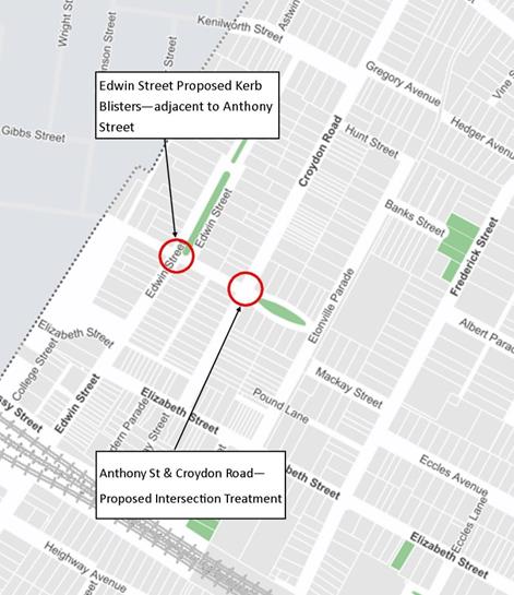
Figure 1 – Locality Map
A summary of the traffic data is provided in the tables below.
|
Street Name |
Anthony Street |
|
Section |
Between Edwin Street and Croydon Road |
|
Carriageway Width (m) kerb to kerb |
9.5 |
|
Carriageway Type |
Two-way road with one travel lane in each direction, in addition to kerbside parking on both sides. |
|
Classification |
Local |
|
Speed limit |
50 |
|
85th Percentile Speed (km/h) |
38.8 (2018) |
|
Vehicles Per Day (vpd) |
4,854 (2018) |
|
Reported Crash
History |
Anthony Street at Edwin Street – 1 Cross Traffic Crash – RUM 10 |
|
Heavy Vehicle Volume (%) |
2.9 |
|
Parking Arrangements |
Unrestricted parking along both sides of the road. |
|
Street Name |
Edwin Street |
|
Section |
Between Anthony Street and Elizabeth Street |
|
Carriageway Width (m) kerb to kerb |
10.3 |
|
Carriageway Type |
Two-way road with one travel lane in each direction, in addition to kerbside parking on both sides. |
|
Classification |
Local |
|
Speed limit |
50 |
|
85th Percentile Speed (km/h) |
49.4 (2009) |
|
Vehicles Per Day (vpd) |
3,872 (2009) |
|
Reported Crash
History |
See Anthony Street |
|
Heavy Vehicle Volume (%) |
N/A |
|
Parking Arrangements |
Unrestricted parking along both sides of the road. |
|
Street Name |
Croydon Road |
|
Section |
Between Elizabeth Street and Hunt Street |
|
Carriageway Width (m) kerb to kerb |
10.3 |
|
Carriageway Type |
Two-way road with one travel lane in each direction, in addition to kerbside parking on both sides. |
|
Classification |
Local |
|
Speed limit |
50 |
|
85th Percentile Speed (km/h) |
38.8 (2018) |
|
Vehicles Per Day (vpd) |
7,944 (2018) |
|
Reported Crash
History |
N/A |
|
Heavy Vehicle Volume (%) |
2 |
|
Parking Arrangements |
Unrestricted parking along both sides of the road. |
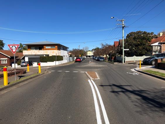
Figure 2 – Croydon Road intersection with Anthony Street
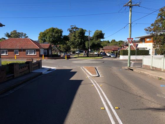
Figure 3 – Anthony Street intersection with Croydon Road
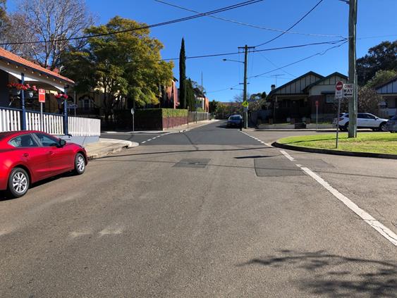
Figure 4 – Anthony Street intersection with Edwin Street
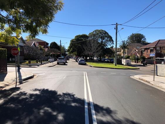
Figure 5 – Edwin Street intersection with Anthony Street
Design Plans
Detailed design plans for the proposed intersection treatment and associated signs and line markings at Croydon Road and Anthony Street (Design Plan 10088 – Attachment 1), and the proposed kerb blisters on Edwin Street, Croydon, adjacent to Anthony Street (Design Plan 10091 – Attachment 2) are submitted for consideration.
The proposed scope of works at Anthony Street and Croydon Road includes the following:
1. Croydon Road and Anthony Street, Croydon – Plan No. 10088
· Remove of current splitter island and construct new pedestrian refuge in Croydon Road;
· Realign the kerb and gutter on each corner of the intersection of Croydon Road and Anthony Street;
· Remove of current concrete splitter island in Anthony Street and replace with painted splitter island;
· Provide speed cushion in Croydon Road on approach to Anthony Street;
· Construct new kerb ramps on both sides of the proposed refuge island in Croydon Road and Anthony Street;
· Implement new line marking and signage to facilitate better traffic flow and for pedestrian safety.
· Lighting of the pedestrian refuge.
The proposal will result in the loss of seven (7) legal parking spaces in Croydon Road. The majority of the spaces will be lost as a result of design requirements for a pedestrian refuge in order to provided sufficient sight lines for both pedestrians and motorists alike. The previous concept plan that was forwarded to the local community indicated similar loss of parking at this location and was adopted by Council early this year.
2. Anthony Street and Edwin Street, Croydon – Plan No. 10091
· Provide painted kerb blisters adjacent to the existing kerb ramps in Edwin Street at its intersection with Anthony Street;
· Implement new line marking to facilitate better delineate approaches to the intersection.
PUBLIC CONSULTATION
Consultation was conducted between 28 June 2019 and 12 July 2019. A letter as well as a copy of the design plans were sent to the local residents in Croydon Road, Anthony Street and Edwin Street, Croydon as indicated in the consultation map below, (A total of 79 letters were distributed). Also, design details were placed on ‘Your Say’ on the Inner West website.
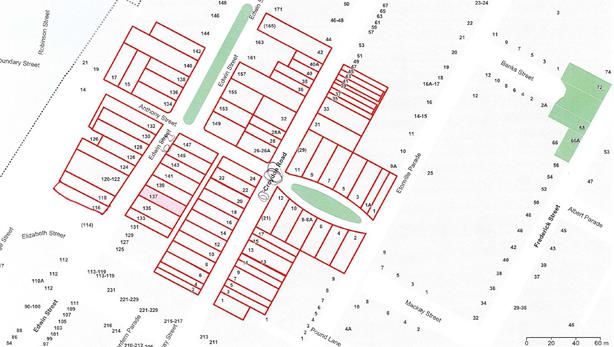
Figure 6 – Map of consulted properties for the proposed design plans
Four (4) responses were received to date with two responses against and two responses for the proposal. These are summarised below:
|
Residents’ Comments |
Officer’s Comments |
|
(Support) Resident Issues:
1. From the design plans, it appears there are no proposed speed cushions on the approach to the roundabout along Croydon Road, from Elizabeth Street. Resident states the speed of vehicles on Croydon Road from Elizabeth Street is a concern; 2. The lack of a pedestrian refuge on the northern side of the intersection on Croydon Road do not have the provisions for pedestrians to cross, especially young school children 3. The ‘Keep Left sign on the approach to the roundabout (outside No.22) has been knocked down many times; 4. Most accidents and near misses I witness (there are many) on the roundabout are caused by motorists speeding, driving through the roundabout from Elizabeth Street direction; 5. Resident expresses their concerns on the removal of parking and the current difficulty of parking on Croydon Road.
|
1. There is currently an existing speed hump on Croydon Road, between Elizabeth Street and the roundabout. Combined with the increased horizontal deflection required on approach to the roundabout, created by the larger pedestrian refuge, it is foreseen to effectively manage vehicle speeds on approach to the roundabout. 2. With the proposed designs including works on Anthony Road, near the corner of Edwin Street North, the pedestrian desire line will continue down the southern side of Anthony Road. With the provisions of a pedestrian refuge and removal of parking for sightlines, pedestrians are foreseen to be more likely to cross on the southern side of the roundabout on Croydon Road. Furthermore, site constraints make it difficult to implement a pedestrian refuge on the north side of the intersection. 3. The associated signs; including ‘Keep Left’ sign on the pedestrian refuge are installed in accordance to Australian and RMS standards. Vehicle swept path diagrams have been undertaken to ensure the proposed design facilitates vehicular movements past the pedestrian refuge. 4. Currently, there is a speed hump on Croydon Road, between Elizabeth Street and the roundabout which assists with slowing vehicles down. Additionally, the proposed pedestrian refuge is wider than the current splitter island, therefore motorists approaching from Elizabeth Street will require to approach with slower speeds due to the increased horizontal deflection. Furthermore, the speed cushion on the north side of Croydon Road will also control speeds into the roadabout. 5. Pedestrian safety, accessibility and minimum loss of on-street parking were major considerations during the development of the design plans. The proposed treatment will result in the loss of 7 legal on-street parking spaces as an outcome of the proposed ‘No Stopping’ restrictions in order to accommodate pedestrian safety. Moreover, RMS Technical Directions determine required ‘No Stopping’ zones around pedestrian refuges. |
|
(Against) Resident issues: 1. As the pram ramps on Anthony Street are not located at the intersection, they are required to travel up Anthony Street in order to cross. 2. The proposal will remove 7 legal parking spaces in Croydon Road and Anthony Street. Parking is already at a premium in our part of Croydon Road; 3. The proposal is to remove the roundabout and replace it with a painted roundabout. The current roundabout works quite efficiently and its size is a deterrent to motorists speeding around it. A painted roundabout simply will not do the job as efficiently as the current raised one. 4. Resident also notes the proposal includes provisions for a speed cushion. Croydon Road has enough speed humps; 5. Resident states never heard of a pedestrian being hit in this part of Croydon Road. Resident suggests an implementation of a pedestrian crossing instead.
|
1. The existing ramps at the intersection currently are directing pedestrians towards the travel lane within the roundabout, which is not safe. The proposed ramps are set back from the travel lanes of the roundabout, which is in accordance with Council’s standard and will provide a much safer option for the pedestrians. 2. The RMS Technical Directions determines ‘No Stopping’ zones around pedestrian refuges. Vehicle swept path diagrams have been undertaken for this design which has determined the positioning of the line-marking and ‘No Stopping’ zones shown in the design plans. Pedestrian safety, accessibility and minimum loss of on-street parking were major considerations during the development of the design plans. 3. There is no proposals to remove the roundabout and replace it with a painted roundabout. 4. A speed cushion was proposed to reduce entry speeds into the roundabout and to improve safety at this location. 5. The existing layout of the roundabout and crossing facilities do not adequately cater for safe pedestrian movements. The proposed design plan makes it safer for pedestrians to cross Croydon Road at this location as well as providing kerb ramps which are located away from the travel lane through the roundabout. The location doesn’t meet the warrant pedestrian crossing.
|
CONCLUSION
It is recommended that the detailed design plans of the proposed intersection treatments on Croydon Road and kerb blisters on Edwin Street North and all associated signs and line markings be approved to improve pedestrian and traffic conditions at this location.
|
1.⇩ |
10088 - Design Plan - Anthony Street Proposed Intersection Treatment |
|
2.⇩ |
10091 - Design Plan - Edwin Street North Proposed Kerb Blisters |
|
|
Local Traffic Committee Meeting 5 August 2019 |
Subject: Hubert Street and Unnamed Lane, Leichhardt - Temporary Full Road Closure for Road Opening (Gulgadya-Leichhardt Ward/ Balmain Electorate/ Leichhardt PAC)
Prepared By: David Yu - Engineer - Traffic and Parking Services
Authorised By: John Stephens - Traffic and Transport Services Manager
|
RECOMMENDATION
THAT:
1. The proposed temporary road closure of Hubert Street, Leichhardt (between Darley Road and William Street) and Unnamed laneway (between Darley Road and William Street, adjacent to Hubert Street and Charles Street), Leichhardt on Monday, 9 September 2019 to 18 November 2019 (10 weeks) with an additional four week contingency thereafter from 7:00am to 6:00pm (Monday to Friday) and 8:00am to 1:00pm (Saturdays) for emergency relief structure to be built at the intersection of Darley Road and Hubert Street and for sewer main to be removed and upsized in the Unnamed Laneway, be supported;
2. A Road Occupancy License be obtained by Council from the Transport Management Centre;
3. All affected residents and businesses, including the NSW Police Local Area Commander, Fire & Rescue NSW and the NSW Ambulance Services be notified in writing, by the applicant, of the proposed temporary road closure at least 7 days in advance of the closure with the applicant making reasonable provision for stakeholders; and
4. The occupation of the road carriageway must not occur until the road has been physically closed.
|
BACKGROUND
An application has been received from Comdain Civil Constructions for the temporary full road closure of Hubert Street (between Darley Road and William Street) and Unnamed Laneway (between Darley Road and William Street, adjacent to Hubert Street and Charles Street) from 9 September 2019 to 18 November 2019 (10 weeks) with a further 4 week contingency for emergency relief structure to be built at the intersection of Darley Road and Hubert Street and for sewer main to be removed and upsized in the Unnamed Laneway, Leichhardt
FINANCIAL IMPLICATIONS
The applicant has paid the fee for the temporary full road closure. This fee includes advertising the proposal in accordance with the Roads Act 1993.
OTHER STAFF COMMENTS
The Traffic Control Plans submitted by the applicant is provided in Attachment 1 and 2.
Vehicular access for local residents will be maintained during the closure, where possible. Authorised traffic controllers will be on-site during all shifts and are to be positioned at the closure points when required to provide vehicular access to local residents and ensure the safety of motorists and pedestrians.
PUBLIC CONSULTATION
The applicant is to notify all affected residents and businesses in writing at least 28 days prior to the commencement of works.
The proposed temporary road closure has been advertised in the local newspaper in accordance with the Roads Act 1993 for the period Tuesday, 30 July 2019 to Tuesday, 27 August 2019.
|
1.⇩ |
Hubert Street and Unname Laneway, Leichhardt - Traffic Control Plan (Day) |
|
2.⇩ |
Hubert Street and Unname Laneway, Leichhardt - Traffic Control Plan (Night) |
|
|
Local Traffic Committee Meeting 5 August 2019 |
Subject: Croydon Road at Kenilworth Street &
Gregory Avenue, Croydon - Proposed Traffic Calming at the intersections
including a new pedestrian refuge island on Croydon Road - Design Plan 10070
(Gulgadya-Leichhardt Ward/Strathfield Electorate/Burwood PAC)
Prepared By: Scipio Tam - Engineer - Traffic and parking Services (South)
Authorised By: John Stephens - Traffic and Transport Services Manager
SUMMARY
Council is proposing a number of intersection improvements along Croydon Road, which will address issues of pedestrian safety and driver behavior. A detailed design plan has been finalised for the proposed pedestrian refuge and splitter island on Croydon Road, Croydon, between the intersections with Kenilworth Street and Gregory Avenue. The proposed works aim to improve pedestrian and motorist safety and address concerns about speeding and driver behaviour along Croydon Road.
|
RECOMMENDATION
THAT the detailed design plan for the proposed pedestrian refuge island, splitter island, speed cushions, associated line marking and signage and the removal of horizontal deflection islands on Croydon Road, Croydon, between the intersections of Kenilworth Street and Gregory Avenue (as per attached design plan No. 10070) be APPROVED.
|
BACKGROUND
A report proposing traffic calming treatments along Croydon Road, including the improvements to the intersections of Kenilworth Street and Gregory Avenue, Croydon was considered by Council at its meeting on 26 February, 2019. Council approved in principle the treatments to the above intersection. This report details the design plan for the proposed intersection treatments on Croydon Road at Kenilworth Street and Gregory Avenue, Croydon.
FINANCIAL IMPLICATIONS
Funding is available to be allocated for the works under the 2019/2020 Capital Works Program for traffic facilities.
Site Location & Road network
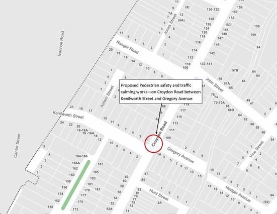
Figure 1 – Locality Map
|
Street Name |
Croydon Road |
|
Section |
Between Kenilworth Street and Gregory Avenue |
|
Carriageway Width (m) kerb to kerb |
10.5 |
|
Carriageway Type |
Two-way road with one travel lane in each direction, in addition to kerbside parking on both sides. |
|
Classification |
Local |
|
Speed limit |
50 |
|
85th Percentile Speed (km/h) |
38.8 (2018) |
|
Vehicles Per Day (vpd) |
8,153 (2018) |
|
Reported Crash History |
N/A |
|
Heavy Vehicle Volume (%) |
4.3 |
|
Parking Arrangements |
Unrestricted parking along both sides of the road. |
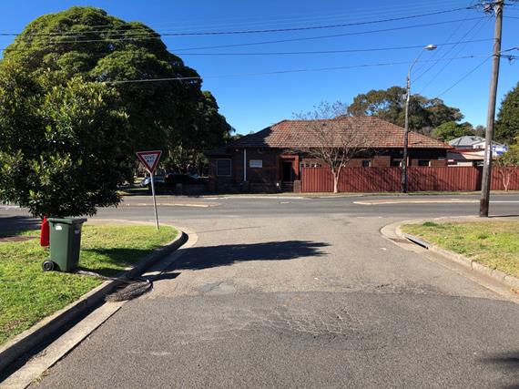
Figure 2 – Kenilworth Street intersection with Croydon Road
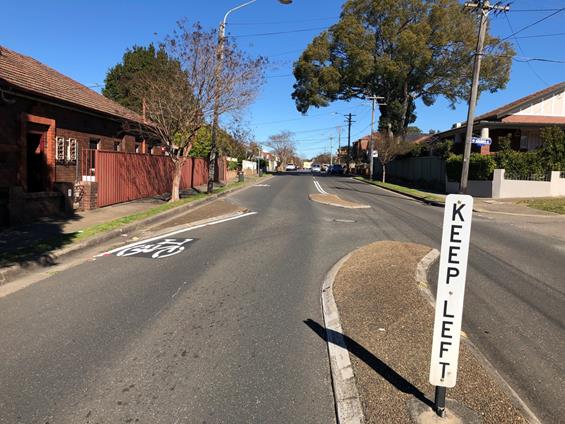
Figure 3 – Croydon Road intersection with Kenilworth Street
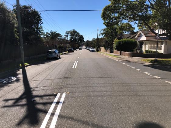
Figure 4 – Croydon Road intersection with Gregory Avenue
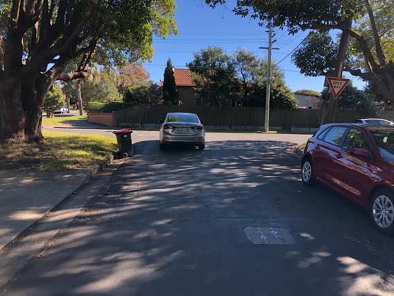
Figure 5 – Gregory Avenue intersection with Croydon Road
Design Plans
A detailed design plan for the proposed intersection treatment and associated signs and line markings on Croydon Road at Kenilworth Street and Gregory Avenue (Design Plan 10070 – Attachment 1) is submitted for consideration.
The proposed scope of works on Croydon Road between Kenilworth Street and Gregory Avenue includes the following:
· Removal of the horizontal deflection islands and replace with traffic island and new pedestrian refuge island facility;
· Install speed cushions on Croydon Road on both approaches to Kenilworth Street and Gregory Avenue;
· Reconstruct four (4) new kerb ramps;
· Reconstruct concrete footpath as required;
· Install associated pavement line marking and signage as required;
· Paint bicycle pavement symbols.
· Lighting of the pedestrian refuge
The proposal will result in the loss of six (6) legal parking spaces at this location on Croydon Road. The loss of these spaces is required for the design to meet current RMS design standards and for the treatment not to become a squeeze point for vehicles. The concept plan that was adopted early this year was forwarded to the local community indicated similar loss of parking at this location.
PUBLIC CONSULTATION
Consultation was conducted between 1 July 2019 and 17 July 2019. A letter as well as a copy of the design plan was sent to the local residents in Croydon Road, Kenilworth Street and Gregory Avenue, Croydon as indicated in the consultation map below, (A total of 26 letters were distributed). Also, design details were placed on ‘Your Say’ on the Inner West website.
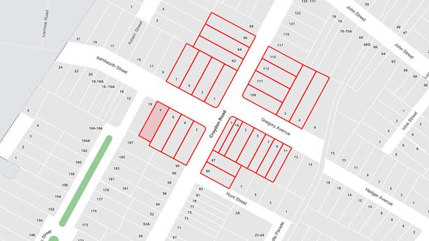
Figure 6 – Map of consulted properties for the proposed design plan
Three (3) responses have been received regarding this proposal and is summarised below. Two residents were against the proposal and one resident supported the proposal in part.
|
Residents’ Comments |
Officer’s Comments |
|
(Against) Resident issues: 1. Proposed loss of parking spaces and implementation of ‘No Stopping’ outside their property is an issue for them and proposed removal of parking spaces along Croydon Road will further impact the shortage of parking within the area. 2. Their driveway is short, narrow and steep, requiring them to exit their vehicle prior to entering and subsequent to leaving their off-street parking space to close and lock their gate; 3. Amend the ‘No Stopping’ outside their property, nearest to their gate, to a legal parking space. Resident’s driveway is the one located on Croydon Road, north of Kenilworth Street.
4. The impact may continue to cause parked vehicles to encroach on the resident’s driveway, causing them to take excessive and drastic measures to enter their off-street parking;
5. Resident is concerned they may not be able to park in front of their driveway anymore 6. Resident suggests an alternate proposal: chevron marks and bicycle pavement symbols instead;
7. Resident suggests implementing pedestrian facilities at the intersection of Croydon Road and John Street instead. |
1. The proposed treatment will result in the loss of 7 legal on-street parking spaces in order to accommodate the pedestrian refuge and supporting treatments on the approach to the pedestrian refuge. The RMS Technical Directions requires ‘No Stopping’ zones for pedestrian refuges. 2. Proposal only affects one driveway on Croydon Road and a parking space is provided adjacent to this driveway to accommodate a vehicle. Allowing unrestricted parking adjacent to the treatment will create a squeeze point for vehicles. 'No Stopping' restrictions on Gregory Street and Kenilworth Street have been set back at 10m from the intersections to allow for safe turning movements into theses streets. 3. The pedestrian refuge is located away from any driveway properties on Croydon Road, north of Kenilworth Street. However, the length of the ‘No Stopping’ zone on Croydon Road, north of Kenilworth Street can be reduced by one space. An updated plan to be presented to the Committee at the meeting. 4. Impact to movements to and from driveways along Croydon Road will be monitored following implementation. Any changes to the proposed parking restrictions can be reassessed at that time. 5. The proposed restrictions do not extend over any driveways. 6. The proposed treatment has been designed to cater for cyclists. Parking has been removed at places to remove squeeze points and allow for better transition of cyclists through the treatments at this location. 7. Similar works have been proposed for the intersection of Croydon Road and John Street to increase pedestrian safety and control the speed of vehicles within the area.
|
|
(Support) Resident Issues:
In support of the proposed pedestrian safety and traffic calming initiative, except for the following points:
1) Does not want the current ‘No Parking’ restrictions outside 85 & 87 Croydon Road to be altered as it was implemented to avoid a blind spot when exiting driveway;
2) Strongly opposed to the asphalt speed cushion on the south side of Croydon Road/Kenilworth St intersection.
|
1. The current ‘No Parking’ restrictions outside No. 87 Croydon Road, Croydon are to be retained and not modified.
2. Speed cushions are proposed on Croydon Road at the southern and northern approaches to Kenilworth Street and Gregory Avenue to assist in reducing the speed of vehicles on approach to the pedestrian refuge and to improve the safety of pedestrians crossing at this location. |
CONCLUSION
It is recommended that the detailed design plan of the proposed intersection treatments consisting of a pedestrian refuge island, splitter island, speed cushions and associated signs and line markings be approved to improve pedestrian and traffic conditions at this location.
|
1.⇩ |
10070 - Design Plan - Croydon Road between Kenilworth Street and Gregory Avenue |
|
|
Local Traffic Committee Meeting 5 August 2019 |
Subject: Croydon Road at Queen Street, Croydon -
Proposed Traffic Calming at the intersection including a new pedestrian refuge
on Croydon Road - Design Plan 10092
(Gulgadya Ward/ Strathfield Electorate/ Burwood PAC)
Prepared By: Scipio Tam - Engineer - Traffic and parking Services (South)
Authorised By: John Stephens - Traffic and Transport Services Manager
SUMMARY
A detailed design plan has been finalised for the proposed pedestrian refuge and speed cushions on Croydon Road, Croydon, adjacent to Queen Street. The proposed works aim to improve pedestrian and motorist safety and address residents’ concerns about speeding and driver behavior along Croydon Road.
|
RECOMMENDATION
THAT the detailed design plan for the proposed pedestrian refuge island, speed cushions and the removal of existing traffic island along with the associated line marking and signage at the intersection of Croydon Road and Queen Street, Croydon (as per attached design plan No. 10092) be APPROVED.
|
BACKGROUND
A report proposing traffic calming treatments along, including the improvements to the intersection of Croydon Road and Queen Street, Croydon was considered by Council at its meeting on 26 February, 2019 with Council approving in principle intersection improvements at the above intersection of Queen Street and Croydon Road.
This report details the design plan for proposed intersection treatments at Croydon Road and Queen Street, Croydon.
FINANCIAL IMPLICATIONS
Funding is available to be allocated for the works under the 2019/2020 Capital Works Program for traffic facilities.
Site Location & Road network
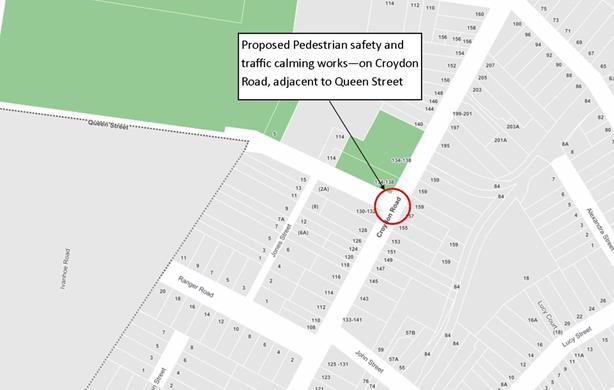
Figure 1 – Locality Map
|
Street Name |
Croydon Road |
|
Section |
Between John Street and Church Street |
|
Carriageway Width (m) kerb to kerb |
10.2 |
|
Carriageway Type |
Two-way road with one travel lane in each direction, in addition to kerbside parking on both sides. |
|
Classification |
Local |
|
Speed limit |
50 |
|
85th Percentile Speed (km/h) |
42.8 (2018) |
|
Vehicles Per Day (vpd) |
9,778 (2018) |
|
Reported Crash History |
Croydon Road at Queen Street - 4 injury crashes (RUM Codes
11,10, 13, 15) & 4 tow away crashes (RUM Codes 10,13, 11, 10) |
|
Heavy Vehicle Volume (%) |
2.4 |
|
Parking Arrangements |
Unrestricted parking along both sides of the road. |
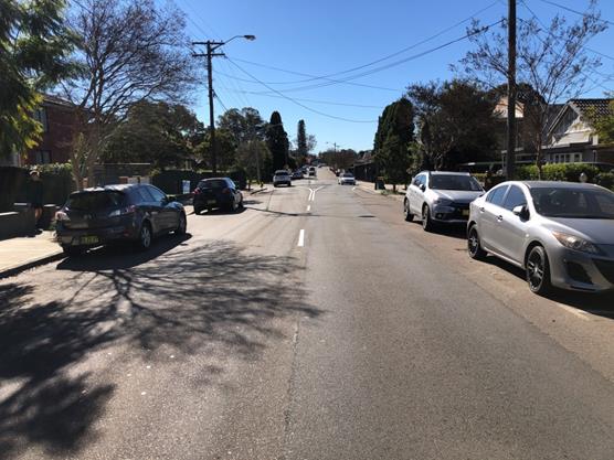
Figure 2 – Croydon Road intersection at Queen Street (south of Queen Street)
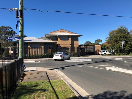
Figure 3 – Queen Street intersection at Croydon Road
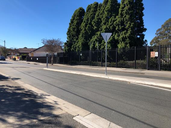
Figure 4 – Croydon Road intersection at Queen Street (north of Queen Street)
Design Plans
Detailed design plans for the proposed pedestrian refuge and associated signs and line markings on Croydon Road adjacent to Queen Street, Croydon (Design Plan 10092 – Attachment 1) is submitted for consideration.
The proposed scope of works includes the following:
· Removal of existing traffic island and replace with new pedestrian refuge island facility;
· Installation of speed cushions on Croydon Road on approach and departure to Queen Street, south-west of the roundabout;
· Reconstruction of four (4) new kerb ramps;
· Installation of associated pavement line marking and signage as required;
· Painting of bicycle pavement symbols.
· Lighting of the pedestrian refuge.
The proposal will result in the loss of four (4) legal parking spaces, three (3) on Queen Street and one (1) in Croydon Road. The loss of these spaces is to accommodate heavy vehicle movements through the intersection. The previous concept plan that was forwarded to the local community indicated similar loss of parking at this location and was adopted by Council early this year.
PUBLIC CONSULTATION
Consultation was conducted between 1 July 2019 and 16 July 2019. A letter as well as a copy of the design plan were sent to the local residents in Croydon Road and Queen Street, Croydon as indicated in the consultation plan below, (A total of 25 letters were distributed). Also, design details were placed on ‘Your Say’ on the Council's website.
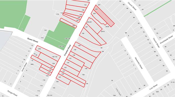
Figure 5 – Map of consulted properties for the proposed design plan
One (1) response was received so far regarding this proposal to date and is summarised below:
|
Residents’ Comments |
Officer’s Comments |
|
The resident expressed their support for the addition of extra pedestrian safety option, however questions whether a marked pedestrian crossing would be more suitable.
Resident stated that: · There aren’t any pedestrian crossings on Croydon Road; · Vehicles travel at speed along Croydon Road, especially during peak hours; · Pedestrians crossing the road may require
waiting for 2-3 minutes for a safe gap. |
Warrants for a marked (zebra) pedestrian crossing could not be met under the RMS guidelines. The proposed upgrade from the existing splitter island to a pedestrian refuge will enhance the safety for pedestrians at the intersection by providing a safe staged crossing of Croydon Road. Furthermore, the addition of speed cushions on approach to the roundabout will enhance driver and pedestrian safety. |
CONCLUSION
It is recommended that the detailed design plan of the proposed intersection treatments, including the pedestrian refuge island, speed cushions and associated signs and line markings be approved to improve pedestrian and traffic safety at this location.
|
1.⇩ |
10092 - Design Plan |
|
|
Local Traffic Committee Meeting 5 August 2019 |
Subject: Minor Traffic Facilities (All Wards/All Electorates/All PACs)
Prepared By: Davide Torresan - Coordinator - Road Access Services
Authorised By: John Stephens - Traffic and Transport Services Manager
SUMMARY
This report considers minor traffic facility applications by Inner West Council, and includes
‘Disabled Parking’ and ‘Works Zone’ requests.
|
RECOMMENDATION
THAT:
1. A 6m 'Disabled Parking’ zone be installed in front of No.13 Francis Street, Marrickville;
2. A 6m 'Disabled Parking’ zone be installed in front of No.54 North Street, Marrickville;
3. A 16m 'Works Zone 7.00am – 6.00pm Mon-Fri and 8.00am-1.00pm Sat' be installed at the rear of No.366C Darling Street, in Little Darling Street, Balmain for 8 weeks;
4. A 9m 'Works Zone 7.00am – 6.00pm Mon-Fri and 8.00am-1.00pm Sat' be installed at the front of No.97 Edith Street, Leichhardt, for 12 weeks;
5. A 9m 'Works Zone 7.00am – 6.00pm Mon-Fri and 8.00am-1.00pm Sat' be installed at the front of No.57 Evans Street, Balmain, for 12 weeks;
6. A 15m 'Works Zone 7.00am – 6.00pm Mon-Fri and 8.00am-1.00pm Sat' be installed in the side street of Goodsell Street, for Nos.641-657 King Street, St Peters, for 12 weeks;
7. A 11m 'Works Zone 7.00am – 6.00pm Mon-Fri and 8.00am-1.00pm Sat' be installed in front of No.117 Cavendish Street, Stanmore, for 12 weeks;
8. A 25m 'Works Zone 7.00am – 6pm Mon-Sat and 8.00am-1.00pm Sat' be installed in front of Nos.6-8 Waterloo Street, Rozelle, for 12 weeks, subject to the applicant obtaining consent from the neighbouring property owner; and
9. An 8m 'Works Zone 7.00am – 6.00pm Mon-Fri and 8.00am-1.00pm Sat' be installed in front of No.13 Cromwell Street, Croydon, for 8 weeks.
|
BACKGROUND
Requests have been received from residents within the Local Government Area (LGA) for the provision of mobility parking spaces outside their residence. It is recommended that the following 'Mobility Parking' spaces be approved as the applicant’s current medical conditions warrant the provision of these spaces and they have constrained or no off-street parking opportunities. For the mobility parking space requests, a copy of the RMS disability parking permit and a medical certificate in support of the applications was submitted to Council.
FINANCIAL IMPLICATIONS
Nil
OTHER STAFF COMMENTS
1. Installation of ‘Disabled Parking’ Restriction – Francis Street, Marrickville
The resident of No.13 Francis Street, Marrickville, has requested the installation of ‘Disabled Parking’ zone in front of their property. A site investigation has revealed the property does have off street parking although it is insufficient to accommodate a standard vehicle. The applicant does not require the use of wheelchair.
It is recommended that a 6m ‘Disabled Parking’ zone be installed in front of No.13 Francis Street, Marrickville.
No.13 Francis Street, Marrickville
2. Installation of ‘Disabled Parking’ Restriction – North Street, Marrickville
The resident of No.54 Francis Street, Marrickville, has requested the installation of ‘Disabled Parking’ zone in front of their property. The applicant requires the use of wheelchair. A site investigation has revealed the property does have off street parking; however, in order for the applicant to access the house there are a number of steps, which is impossible to do so with the wheelchair.
It is recommended that a 6m ‘Disabled Parking’ zone be installed in front of No.54 North Street, Marrickville, subject to the installation of a pram ramp at the applicant’s cost.
No.54 North Street, Marrickville
Technical Standards
Australian Standard AS2890.5-1993 “On-Street Parking” states the following in regards to the provision of parking for people with a disability:
“Parallel parking spaces shall not be marked as disabled spaces, nor included in the count of spaces available for people with disabilities unless –
i. A 3.2m wide space can be provided, e.g. by indenting the space into the footpath area; and
ii. Kerb ramps as shown in Figure 4.2(a) are also provided”.
It should be noted that due to the limited width of streets around the LGA, it is often difficult to comply with these requirements for the parking space dimensions. This may also result in the loss of some adjacent on-street parking spaces.
Mobility parking spaces are primarily intended for on-street and off-street parking at destinations, such as in commercial/retail areas and public car parks near hospitals, schools and public transport facilities where multiple usages can be expected. They were generally not intended for points of origin such as reserving on-street parking. As such, they are only proposed where required for wheelchair access at the cost of the applicants.
A mobility parking space is not intended for the sole use of one applicant, but rather a shared facility that can used by all authorised persons having a RMS mobility permit.
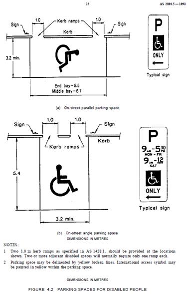
3. Installation of ‘Works Zone’ Restriction – Little Darling Street, Balmain
The applicant has requested the installation of a temporary 16m 'Works Zone 7.00am – 6.00pm Mon-Sat and 8.00am-1.00pm Sat' (unless noted otherwise on the Development Consent) for 8 weeks at the rear of No.366C Darling Street, in Little Darling Street, for development works at the property.
It is recommended that a 16m 'Works Zone 7.00am – 6.00pm Mon-Fri and 8.00am -1.00pm Sat' be installed at the rear of No.366C Darling Street, in Little Darling Street, Balmain for 8 weeks.
No.366C Darling Street, in Little Darling Street, Balmain.
4. Installation of ‘Works Zone’ Restriction – Edith Street, Leichhardt
The applicant has requested the installation of a temporary 9m 'Works Zone 7.00am – 6.00pm Mon-Sat and 8.00am-1.00pm Sat' (unless noted otherwise on the Development Consent) for 12 weeks at the front of No.97 Edith Street, Leichhardt, for development works at the property.
It is recommended that a 9m 'Works Zone 7.00am – 6.00pm Mon-Fri and 8.00am -1.00pm Sat' be installed at the front of No.97 Edith Street, Leichhardt, for 12 weeks.
No.97 Edith Street, Leichhardt
5. Installation of ‘Works Zone’ Restriction – Evans Street, Balmain
The applicant has requested the installation of a temporary 9m 'Works Zone 7.00am – 6.00pm Mon-Sat and 8.00am-1.00pm Sat' (unless noted otherwise on the Development Consent) for 12 weeks at the front of No.57 Evans Street, Balmain, for development works at the property.
It is recommended that a 9m 'Works Zone 7.00am – 6.00pm Mon-Sat and 8.00am-1.00pm Sat' be installed at the front of No.57 Evans Street, Balmain, for 12 weeks.
No.57 Evans Street, Balmain
6. Installation of ‘Works Zone’ Restriction – King Street, St Peters
The applicant has requested the installation of a temporary 15m 'Works Zone 7.00am – 6.00pm Mon-Sat and 8.00am-1.00pm Sat' (unless noted otherwise on the Development Consent) for 12 weeks in the side street of Goodsell Street for Nos.641-657 King Street, St Peters for development works at the property.
It is recommended that a 15m 'Works Zone 7.00am – 6.00pm Mon-Sat and 8.00am-1.00pm Sat' be installed in the side street of Goodsell Street for Nos.641-657 King Street, St Peters, for 12 weeks.
No.641-657 King Street, St Peters (In Goodsell Street)
7. Installation of ‘Works Zone’ Restriction – Cavendish Street, Stanmore
The applicant has requested the installation of a temporary 11m 'Works Zone 7.00am – 6.00pm Mon-Sat and 8.00am-1.00pm Sat' (unless noted otherwise on the Development Consent) for 12 weeks in front of No.117 Cavendish Street, Stanmore, for development works at the property.
It is recommended that an 11m 'Works Zone 7.00am – 6.00pm Mon-Sat and 8.00am-1.00pm Sat' be installed in front of No.117 Cavendish Street, Stanmore, for 12 weeks.
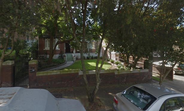
No.117 Cavendish Street, Stanmore
8. Installation of ‘Works Zone’ Restriction – Waterloo Street, Rozelle
The applicant has requested the installation of a temporary 25m 'Works Zone 7.00am – 6.00pm Mon-Sat and 8.00am-1.00pm Sat' (unless noted otherwise on the Development Consent) for 12 weeks in the front of Nos.6-8 Waterloo Street, Rozelle, for development works at the property, subject to the applicant obtaining consent from the neighbouring property owner.
It is recommended that a 25m 'Works Zone 7.00am – 6.00pm Mon-Sat and 8.00am-1.00pm Sat' be installed in front of Nos.6-8 Waterloo Street, Rozelle, for 12 weeks.
Nos.6-8 Waterloo Street, Rozelle
9. Installation of ‘Works Zone’ Restriction – Cromwell Street, Croydon
The applicant has requested the installation of a temporary 8m 'Works Zone 7.00am – 6.00pm Mon-Sat and 8.00am-1.00pm Sat' (unless noted otherwise on the Development Consent) for 8 weeks in the front of No.13 Cromwell Street, Croydon, for development works at the property.
It is recommended that an 8m 'Works Zone 7.00am – 6.00pm Mon-Sat and 8.00am-1.00pm Sat' be installed in front of No.13 Cromwell Street, Croydon, for 8 weeks.
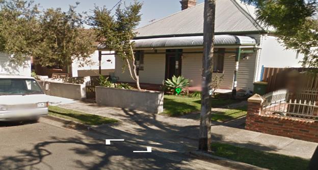 No.13 Cromwell Street,
Croydon
No.13 Cromwell Street,
Croydon
PUBLIC CONSULTATION
Nil
|
|
Local Traffic Committee Meeting 5 August 2019 |
Subject: Victoria Road, Marrickville - Proposed Change in Parking restriction to 'No Parking - Community Bus Excepted' (Midjuburri-Marrickville Ward/Newtown Electorate/Inner West PAC))
Prepared By: Mary Bailey - Parking Planner
Authorised By: John Stephens - Traffic and Transport Services Manager
|
SUMMARY Following representations from Connect Inner West Community Transport, including written permission of Marrickville Metro Shopping Centre management; Council is proposing to install ‘No Parking – Community Bus Excepted’ parking restrictions across a disused driveway at 34 Victoria Road adjacent to Marrickville Metro Shopping Centre. |
|
RECOMMENDATION
THAT an existing 'No Parking’ restriction across the driveway at 34 Victoria Road, Marrickville, adjacent to Marrickville Metro Shopping Centre, be changed to ‘No Parking-Community Bus Excepted’ restriction.
|
BACKGROUND
|
Street Name and Suburb |
Victoria Road, Marrickville |
|
Section |
Between Murray Street and cul-de-sac |
|
Carriageway Width (m) |
10m |
|
Carriageway Type |
Two-way street (cul-de-sac) |
|
Classification |
Local |
|
85th Percentile Speed (km/h) |
Not available |
|
Vehicles Per Day (vpd) |
Not Available |
|
Reported Crash History (July 2013 - June 2017) |
N/A |
|
Heavy Vehicle Volume (%) |
Not Available |
|
Parking Arrangements |
‘No Parking’ signposted across disused driveway |
Community transport buses currently provide about 6-8 services a week to the Marrickville Metro Shopping Centre, each time catering for about 7-8 passengers. Following changes to bus stops in the area of the Metro Shopping Centre which have effectively displaced the community transport buses, Inner West Community Transport management has expressed a desire to continue its practice of dropping off and picking up passengers at a disused driveway associated with the Marrickville Metro in Victoria Road. The driveway at the rear of the Marrickville Metro Shopping Centre is currently signposted with a ‘No Parking’ restriction. In order to facilitate this practice, Council has been approached to approve a signage change across the disused driveway to allow for community transport buses to park in the driveway to facilitate the drop off/pick up of passengers who may require assistance. The proposal is illustrated in Figure 1 below.
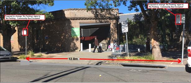
Figure 1: Proposal is for existing ‘No Parking’ signage across driveway to be replaced with ‘No Parking - Community Bus Excepted’
The community bus was observed using the driveway for pick up of passengers. The photos in Figure 2 and Figure 3 below illustrate this.
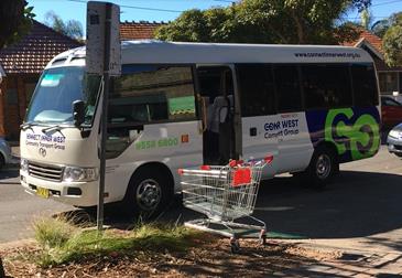
Figure 2: Community bus using driveway for drop off pick up
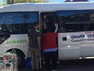
Figure 2: Driver assisting passenger boarding community bus
Marrickville Metro management has provided written support to Council for community transport buses to use the driveway for passenger drop off/pick up.
FINANCIAL IMPLICATIONS
The cost of signage associated with the proposal can be covered from Council’s operational budget for signs and linemarking.
PUBLIC CONSULTATION
Not applicable.
CONCLUSION
Given the driveway is currently signposted ‘No Parking’ and that the Inner West Community Transport Group is currently using the subject driveway for drop off/pick up of passengers, and that Marrickville Metro management has given written approval for the use of the driveway by the community bus, it is recommended that the proposal be supported.
|
|
Local Traffic Committee Meeting 5 August 2019 |
Subject: Chester Street and Guihen Street, Annandale - Proposed 'No Stopping' zone (Gulgadya - Leichhardt Ward/ Balmain Electorate/ Leichhardt PAC)
Prepared By: David Yu - Engineer - Traffic and Parking Services
Authorised By: John Stephens - Traffic and Transport Services Manager
|
RECOMMENDATION
THAT ‘No Stopping’ signage be installed to reinforce the statutory 10m ‘No Stopping’ distance at intersections, at the following locations:
a) the eastern side of Chester Street, north of Guihen Street, Annandale; b) the eastern side of Chester Street, south of Guihen Street, Annandale; and c) the northern side of Guihen Street, east of Chester Street, Annandale.
|
BACKGROUND
Concerns have been raised regarding vehicles parking too close to the intersection of Chester Street and Guihen Street, Annandale. This illegal parking behaviour obstructs sight lines as well as access into and out of Chester Street and Guihen Street.
The properties that surround this intersection are mainly industrial businesses.
It should be noted that parking on both sides of Chester Street and Guihen Street, Annandale is currently unrestricted.
|
Street Name(s) |
Chester Street and Guihen Street, Annandale |
|
Section |
Intersection |
|
Traffic Volume |
Not available |
|
Recorded Accident History (5 year) |
Nil. |
|
Recorded 85% speed |
Not available |
|
Speed Limit |
50km/h |
|
Carriageway width |
Chester Street – 8.2m Guihen Street – 7.9m |
|
Carriageway Type |
Chester Street - Two way with kerb side parking on both sides of the street Guihen Street - Two way with kerb side parking on both sides of the street |
FINANCIAL IMPLICATIONS
Nil
OTHER STAFF COMMENTS
In order to alleviate the sight visibility and manoeuvring space issues, it is proposed to signpost the statutory 10m ‘No Stopping’ zones at the following locations:
· Eastern side of Chester Street, north of Guihen Street, Annandale;
· Eastern side of Chester Street, south of Guihen Street, Annandale;
· Northern side of Guihen Street, east of Chester Street, Annandale.
The proposal is shown on the following plan:
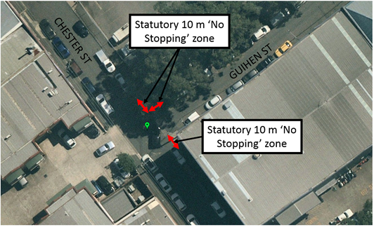
Considering that the area is industrial, it is expected that formalising the ‘No Stopping’ zones would improve truck manoeuvrability at this intersection.
‘No Stopping’ restrictions are already signposted on the southern side of Guihen Street, east of Chester Street, Annandale.
PUBLIC CONSULTATION
A letter outlining the above proposal was mailed out to the affected businesses (22 properties) in Chester Street, Guihen Street and Booth Street, Annandale (as indicated on the following plan).
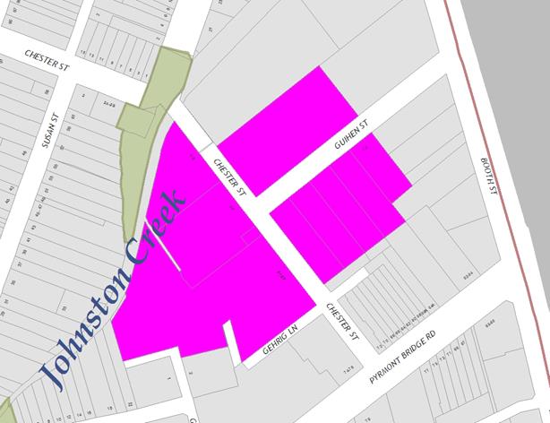
No responses were received.
|
|
Local Traffic Committee Meeting 5 August 2019 |
Subject: Prospect Road, Summer Hill - Proposed Changes to Parking Restrictions outside Croatian Catholic Centre (Djarrawunang-Ashfield Ward/Summer Hill Electorate/Inner West PAC)
Prepared By: Mary Bailey - Parking Planner
Authorised By: John Stephens - Traffic and Transport Services Manager
SUMMARY
Following representation from the Croatian Catholic Centre, Council is proposing to extend the parking restrictions outside the Centre in Norton Street, Summer Hill from ‘Monday to Friday’ to ‘Monday to Saturday’ in order to assist the church to cater for the official vehicles associated with the weddings and funerals taking place on a Saturday. Council Officers have undertaken community engagement and this has indicated that there are no objections to the proposal.
|
RECOMMENDATION
THAT parking restrictions outside the Croatian Catholic Centre in Norton Street, Summer Hill be changed from ‘No Parking 8:30am-2:30pm Monday to Friday; Wedding or Funeral Vehicles Excepted’ to ‘No Parking 8:30AM-2:30PM Monday to Saturday; Wedding or Funeral Vehicles Excepted’. |
BACKGROUND
|
Street Name and Suburb |
Norton Street, Summer Hill |
|
Section |
Between prospect Road and Victoria Street |
|
Carriageway Width (m) |
10m |
|
Carriageway Type |
Two-way street |
|
Classification |
Local |
|
85th Percentile Speed (km/h) |
Not available |
|
Vehicles Per Day (vpd) |
Not Available |
|
Reported Crash History (July 2013 - June 2017) |
N/A |
|
Heavy Vehicle Volume (%) |
Not Available |
|
Parking Arrangements |
Northern side - 10m No Stopping at prospect road - 23m (approx) ‘No Parking 8:30am-2:30pm Monday to Friday Wedding or Funeral Vehicles Excepted’ Southern side - 10m ‘No Stopping’ at Prospect Road and then Unrestricted |
The existing parking restrictions in Norton Street, Summer Hill outside the Croatian Catholic Centre are illustrated in Figure 1 and Figure 2 below. Representatives of the Centre have sought approval from Council to extend the parking restrictions to Saturday to allow for services which take place at the Centre. The proposed parking restrictions are illustrated in Figure 3 below.
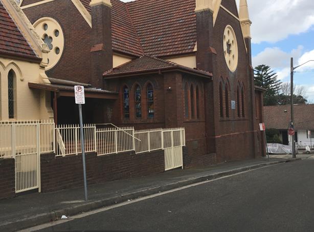
Figure 1: Existing parking restrictions in Norton Street outside Croatian Catholic Centre
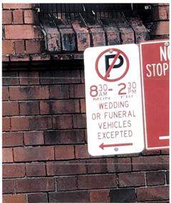
Figure 2: Detail of existing parking restriction
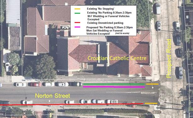
Figure 3: Existing and Proposed parking restrictions in Norton Street outside the Croatian Catholic Centre
FINANCIAL IMPLICATIONS
The cost of signage associated with the proposal can be covered from Council’s operational budget for linemarking and signs.
PUBLIC CONSULTATION
Letters seeking submissions on the proposal were sent to all affected properties. See Figure 4 below for the properties covered by the mail out. No submissions were received by Council in relation to the proposal.
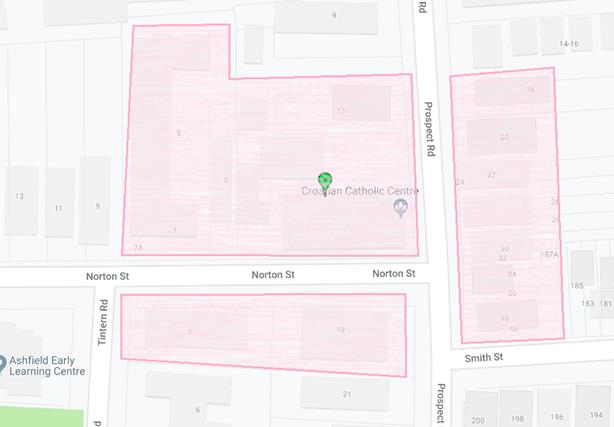
Figure 4. Map of area consulted.
CONCLUSION
Given the request from the Centre involves an extension to the existing parking restrictions to assist their management of events at the Centre and that there have been no objections received as a result of community engagement, it is recommended to approve the proposal.
|
|
Local Traffic Committee Meeting 5 August 2019 |
Subject: Bay Street, Tempe - Proposed installation of statutory 'No Stopping' signage (Midjuburi-Marrickville Ward/Heffron Electorate/Inner West PAC)
Prepared By: Scipio Tam - Engineer - Traffic and parking Services (South)
Authorised By: John Stephens - Traffic and Transport Services Manager
SUMMARY
Council is proposing to implement statutory 10 metre ‘No Stopping’ restrictions in Bay Street at the Princes Highway, Tempe following a request to deter illegal parking on both sides of Bay Street. An investigation has illustrated the difficulty to which parked vehicles, within 10m of the intersection have compromised the safety and manoeuvrability of vehicles attempting to access into and out of Bay Street due to the narrow width of the carriageway and the acute turning angle required for vehicles on Princes Highway negotiating the turn into Bay Street.
It is recommended that statutory 10m ‘No Stopping’ restrictions be approved on both sides of Bay Street, at the intersection with the Princes Highway, Tempe.
|
RECOMMENDATION
THAT implementation of Statutory ‘No Stopping’ restrictions on both sides of Bay Street, Tempe, 10m from its intersection with Princes Highway be approved. |
BACKGROUND
Following representation from the community, Council is proposing parking restrictions in Bay Street, Tempe in order to address safety and access issues.
|
Street Name and Suburb |
Bay Street, Tempe |
|
Section |
Between Princes Highway and Young Street |
|
Carriageway Width (m) |
6.4m |
|
Carriageway Type |
Two-way lane |
|
Classification |
Local |
|
85th Percentile Speed (km/h) |
Not available |
|
Vehicles Per Day (vpd) |
Not Available |
|
Reported Crash History (July 2013 - June 2017) |
N/A |
|
Heavy Vehicle Volume (%) |
N/A |
|
Parking Arrangements |
Unrestricted parking. |
FINANCIAL IMPLICATIONS
The cost of the signposting will be funded from Council’s operational budget for signs and line marking.
OTHER STAFF COMMENTS
Currently there are no parking restrictions in the section of Bay Street adjacent to the Princes Highway. The site was inspected on several occasions and on all occasions vehicles were observed parking within 10m of the intersection. Given that there is a high volume of traffic travelling southbound along the Princes Highway, any obstruction for vehicles turning off into Bay Street may pose a safety issue.
The proposal is illustrated in Figure 1 below.
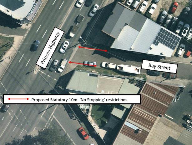
Figure 1: Proposed ‘No Stopping’ restrictions in Bay Street, Tempe
PUBLIC CONSULTATION
On 14 May 2019, 20 letters were delivered to affected properties in the area. Residents were asked to make submissions by 10 June 2019. At the time of writing, one (1) supporting submission was received and no objections were received.
|
A letter outlining the above proposal was mailed out to the affected properties in Bay Street, Princes Highway and Holbeach Avenue, Tempe. One response in support of the proposal was received. |
|
|
Residents’ Comments |
Officer Comments |
|
Resident is in support of this proposal. |
Support is noted. |
CONCLUSION
The implementation of statutory 10 metre ‘No Stopping’ restrictions in Bay Street, Tempe will address the concerns raised and will improve traffic safety for vehicles entering from and exiting to Princes Highway. Therefore, support for this proposal is recommended.
|
|
Local Traffic Committee Meeting 5 August 2019 |
Subject: Inner West Car Share and Light Rail Integration Pilot Program
Prepared By: Sunny Jo - Traffic and Parking Planner
Authorised By: John Stephens - Traffic and Transport Services Manager
SUMMARY
Council has reviewed the on-street parking areas near each Inner West Light Rail Stop for the provision of fixed car share spaces. The program integrates public and shared transport at a number of locations, providing more travel options and supporting shared and sustainable transport within the Inner West. Community engagement has been undertaken within the month of June 2019, with general support (60-77%) for the pilot program at 7 of the 10 light rail stops. It is recommended that Council implement 16 new car share spaces at these locations, with other locations not be supported due to the level of concern raised by the local community.
|
RECOMMENDATION
THAT:
1. A 24 month trial be implemented with dedicated car share spaces signposted as ‘No Parking, Authorised Car Share Vehicles Excepted’ near light rail stops at Dulwich Hill Interchange, Dulwich Grove, Arlington, Marion, Lilyfield, Rozelle Bay, Hawthorne, Leichhardt North and Lewisham West, as listed in the attached summary table;
2. Council review the car share spaces at the end of the trial period, utilising data provided from car share operators and the community and be reported back to the Traffic Committee; and
3. The costs of the installation, maintenance and removal of signage, marked parking bays, linemarking and wayfinding be met by the car share operator.
|
BACKGROUND
Council on 30 April 2019 resolved to review the submission from GoGet regarding a pilot program integrating car share with the Inner West light rail, including information supporting the need for additional spaces. The work included assessing areas near light rail stops and consulting with the community regarding the proposed spaces.
FINANCIAL IMPLICATIONS
Any dedicated car share spaces, in accordance with Council’s current car share policy will require the installation, maintenance and removal of parking signs, marked parking bays, linemarking, and wayfinding be undertaken by the car share operator.
OTHER STAFF COMMENTS
The Car Share and Light Rail research paper considered a number of different models of car share currently in place, as well those models available to car share operators. An assessment of car parking spaces as submitted by GoGet was undertaken with respect to the following factors:
· Existing kerbside occupancy rates, with a view to ensuring that parking demand is not transferred into adjacent residential areas
· Footpaths, kerb ramps, road crossing facility, and lighting levels between the proposed locations and light rail stops
· Surrounding land use and trip generators as shown in Appendix A
· Existing parking control near proposed locations
· Connections with other modes of transport (e.g. bus stop)
· Public transport use and links to other modes
The initial assessment reviewed the 20 car share spaces as requested and resulted in 18 car share spaces being included in the community engagement, undertaken in June 2019.
PUBLIC CONSULTATION
The community engagement for the pilot program resulted in 8,489 letters posted to surrounding areas near each proposed car share spaces. Letters were distributed to residents and businesses to participate in an online survey through Council's Your Say Inner West website. A total of 184 submissions were received online, including paper based submissions. The website also resulted in 422 online visits during the engagement period. A summary of the consultation results is tabled below.
|
Location |
Total submissions received |
|||||
|
Support |
% |
Not support |
% |
Unsure /Neutral |
% |
|
|
Dulwich Hill Interchange |
43 |
76.8% |
11 |
19.6% |
2 |
3.6% |
|
Dulwich Grove |
24 |
66.7% |
11 |
30.6% |
1 |
2.8% |
|
Arlington |
25 |
51.0% |
23 |
46.9% |
1 |
2.0% |
|
Waratah Mills |
22 |
47.8% |
22 |
47.8% |
2 |
4.3% |
|
Lewisham West |
27 |
71.1% |
9 |
23.7% |
2 |
5.3% |
|
Marion |
17 |
68.0% |
6 |
24.0% |
2 |
8.0% |
|
Hawthorne |
15 |
60.0% |
8 |
32.0% |
2 |
8.0% |
|
Leichhardt North |
28 |
62.2% |
16 |
35.6% |
1 |
2.2% |
|
Lilyfield |
26 |
72.2% |
8 |
22.2% |
2 |
5.6% |
|
Rozelle Bay |
26 |
66.7% |
11 |
28.2% |
2 |
5.1% |
|
Subtotal |
253 |
64.1% |
125 |
31.6% |
17 |
4.3% |
Whilst there has been a good level of support from the community regarding the program, some of the objections felt that the proposal will result in a reduction of car parking supply, especially in areas where residents find parking a daily issue and a challenge. Other submissions felt that reallocating public space to a car share operator is unfair.
Having considered the results, it is recommended to proceed with one space proposed in Constitution Road as this is currently used as a pickup and setdown area, resulting in no net loss of parking. The car share space in Grove Street is not supported. In Waratah Mills, due to the high level of concern received, it is recommended to proceed with one space in Davis Street, with the Weston Street space not supported.
Leichhardt North received some concern; however, as there was a good level of support (62.2%), it is recommended to implement the two spaces in Darley Road as proposed.
A summary table of the recommendation is provided below.
|
Light rail stop |
Requested number of spaces |
Location description |
Existing parking control |
Recommendation |
Recommended number of spaces |
|
Dulwich Hill interchange
|
2 |
Bedford Crescent , angle parking spaces adjacent to entrance to light rail stop |
2P Permit Holders Excepted Railway frontage |
Not supported. First 2 unrestricted parking spaces adjacent to existing 2P Permit Holders Excepted recommended to be converted to carshare spaces. |
2 |
|
2 |
Terrace Road , angle parking space on north side |
Unrestricted parking, spaces for recreational users to Shanahan Reserve Railway frontage |
Not supported as there are only 6 spaces intended for reserve use. |
0 |
|
|
Dulwich Grove |
1 |
Denison Road, east side, 10m north of New Canterbury Road |
Unrestricted parking In front of recent residential unit development |
Supported |
1 |
|
1 |
Hercules Street, west side |
Unrestricted parking In front of recent residential unit development |
Supported |
1 |
|
|
Arlington |
1 |
Constitution Road, north side |
No Parking – pickup/drop off zone Pickup zone will be reduced from 23m to 18m.
|
Supported |
1 |
|
1 |
Grove Street |
Unrestricted parking In front of industrial development |
Not supported |
0 |
|
|
Waratah Mills |
1 |
Davis Street service road south side, opposite No.8 |
Unrestricted |
Supported |
1 |
|
1 |
Weston Street east side opposite No.77 |
Unrestricted, adjacent to residential house |
Not supported |
0 |
|
|
Lewisham West |
1 |
Hudson Street, north side, adjacent to existing carshare space west of New Canterbury Road |
Unrestricted parking |
Supported |
1 |
|
Taverners Hill |
No spaces proposed |
||||
|
Marion |
2 |
Hawthorne Parade |
Unrestricted parking, for park users. Reserve side of Hawthorne Parade has approximately 70% occupancy levels during the day. |
Supported |
2 |
|
Hawthorne |
2 |
Darley Road, west side opposite 8-26 Darley Road, approx. 50m north of Allen Street
|
Unrestricted parking adjacent to Hawthorne Reserve |
Supported |
2 |
|
Leichhardt North |
2 |
Darley Road, north side, west of Hubert Street and adjacent to the existing pickup and setdown area |
Unrestricted parking, in front of Dan Murphy’s site frontage, and adjacent to entry driveway. |
Supported |
2 |
|
Lilyfield |
2 |
Catherine Street cul-de-sac end Adjacent to City West Link Road |
Unrestricted parking |
Supported |
2 |
|
Rozelle Bay |
1 |
Bayview Crescent, opposite Adjacent to existing car share space, opposite No.33 |
Currently No Parking drop off/set down area. Proposal will reduce No Parking zone from 28m to 22m. |
Supported |
1 |
|
1.⇩ |
Car Share and Light Rail Research Paper |
|
|
Local Traffic Committee Meeting 5 August 2019 |
Subject: Integrated Transport Plan - Presentation (All Wards / All Electorates / All PACs)
Prepared By: Manod Wickramasinghe - Coordinator – Traffic and Parking Services
Authorised By: John Stephens – Traffic and Transport Services Manager
|
RECOMMENDATION
THAT the Integrated Transport Strategy (ITS) presentation be received and noted.
|
BACKGROUND
‘Going Places’ is an Integrated Transport Strategy (ITS) for Inner West Council and is one of the key evidence-based strategies that will inform strategic planning in the LGA for the next 20 years.
It is a high-level framework for evaluating detailed transport initiatives and land use planning that will help Council build our future transport network.
A presentation by Council's Strategy Manager outlining the draft ITS will be held at the conclusion of the regular Traffic Committee business.
The draft ITS and further information can be found via the following link:
https://yoursay.innerwest.nsw.gov.au/integrated-transport-strategy
|
|
Local Traffic Committee Meeting 5 August 2019 |
Subject: Holden Street, between Liverpool Road and
Norton Street, Ashfield – ‘No Stopping’ restrictions
supplemented with yellow line marking
(Djarrawunang - Ashfield Ward / Summer Hill Electorate / Burwood PAC)
Prepared By: Jennifer Adams - Engineer – Traffic and Parking Services
Authorised By: John Stephens - Traffic and Transport Services Manager
SUMMARY
Due to continual vandalism of signage opposite Ashfield Mall entry, Council is proposing to install yellow line marking to supplement existing ‘No Stopping’ restrictions in Holden Street, between Liverpool Road and Norton Street, Ashfield.
|
RECOMMENDATION
THAT all existing 'No Stopping' signposting be supplemented with unbroken yellow lines to be installed on both sides of Holden Street, between Liverpool Road and Norton Street, Ashfield in order to deter illegal parking, increase safety and improve visibility and access.
|
BACKGROUND
Over time the ‘No Stopping’ signage in Holden Street opposite Ashfield Mall entry has been vandalised and Council is proposing to install yellow line marking to supplement existing ‘No Stopping’ restrictions in place in Holden Street, between Liverpool Road and Norton Street, Ashfield.
FINANCIAL IMPLICATIONS
The cost of the installation of the painted road markings associated with the existing ‘No Stopping’ zones can be met from Council’s operating budget.
OFFICER COMMENTS
A National Road Rule allowing yellow lines to replace ‘No Stopping’ signs was included in the Australian Road Rules 1999 and was written into NSW legislation in 2008 – Rule 169 (No Stopping on a road with a yellow edgeline). Thus, an unbroken continuous yellow line painted on the edge of a road can be used either instead of – or to reinforce – ‘No Stopping’ signs.
An unbroken yellow kerb line is a "NO STOPPING" line. You must not stop for any reason except a medical or similar emergency. The reasoning behind this road rule is that a yellow line would help reduce the ever increasing number of signs and other distractions on our roads and can reduce maintenance costs. Police and council parking officers can enforce this road rule, without any other road signs or indications required.
PUBLIC CONSULTATION
No consultation is required, as the proposed line markings would enforce the current NSW Road Rules. However, adjacent residents will be notified of the proposed changes prior to the installation of line markings.
CONCLUSION
It is recommended that all existing 'No Stopping' signposting be supplemented with unbroken yellow lines and be installed on both sides of Holden Street, between Liverpool Road and Norton Street, Ashfield in order to deter illegal parking, increase safety and improve visibility and access.
![]()
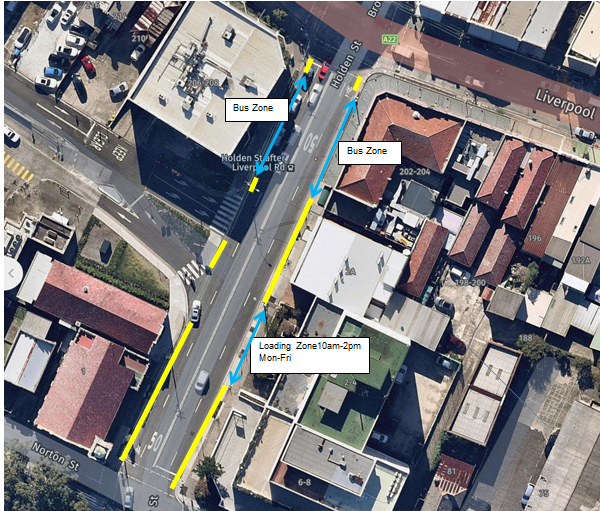
|
|
Local Traffic Committee Meeting 5 August 2019 |
Subject: Holbeach Avenue, Tempe – Temporary Full Road Closures for MS Sydney to the Gong Bike Ride On Sunday 3 November 2019 – (Midjuburi-Marrickville Ward/Heffron Electorate/Inner West PAC)
Prepared By: Jennifer Adams - Engineer – Traffic and Parking Services
Authorised By: John Stephens - Traffic and Transport Services Manager
SUMMARY
Council has received an application under Section 68 of the Local Government Act 1993 to use Holbeach Avenue and Tempe Recreation Reserve to hold the annual 'MS Sydney to the Gong Bike Ride' supported by Multiple Sclerosis (MS) Australia on Sunday, 3 November 2019. This event will necessitate the temporary full road closure of Holbeach Avenue, Tempe and southbound lane closures on Princes Highway from the car park entrance of IKEA to Cooks River along with closures (Residents Excepted) of South Street, Hart Street, Bay Street and Old Street, Tempe between the hours of 4:00am to 9:30am on Sunday, 3 November 2019.
It is recommended that the comments of the Local Traffic Committee be referred to Council’s Development Assessment Section for consideration in determining the Development Application.
|
RECOMMENDATION
THAT:
1. The proposed temporary full road closure of Holbeach Avenue, Tempe and southbound lane closures on Princes Highway from the car park entrance of IKEA to Cooks River along with closures (Residents Excepted) of South Street, Hart Street, Bay Street and Old Street, Tempe on Sunday, 3 November 2019 between the hours of 4:00am to 9:30am be supported as per the submitted TMP and TCPs;
2. All residents and businesses in and around the affected area are to be notified of the temporary road closure in writing by the applicant in advance (at least 7 days prior to the event) with the applicant making reasonable provision for stakeholders; and
3. The occupation of the road carriageway must not occur until the road has been physically closed.
|
BACKGROUND
Council has received an application under Section 68 of the Local Government Act 1993 to use Holbeach Avenue and Tempe Recreation Reserve to hold the annual 'MS Sydney to the Gong Bike Ride' supported by Multiple Sclerosis (MS) Australia on Sunday, 3 November 2019.
The application is required to be referred to the Local Traffic Committee for consideration under State Environmental Planning Policy (Infrastructure) 2007.
This year will be the 38th year that this event will operate and due to the construction of the WestConnex project, previous year’s start site at Sydney Park (City of Sydney Council) is no longer available. Tempe Reserve was successfully utilised as the start site in 2017.
This year’s course will mostly follow that of previous years with the 82Km start location in Tempe Recreation Reserve Tempe, and the 58Km start location in Cooper Reserve Engadine. The number of participant registrations for the 2018 Gong Bike Ride will remain capped at 10,000.
FINANCIAL IMPLICATIONS
Nil.
OFFICER COMMENTS
MS Australia will utilise the IKEA car park as a drop off zone and riders will ride down Princes Highway (southbound) to the starting location at Tempe Recreation Reserve. The traffic management company will put in an access lane along Princes Highway to keep riders safe while entering the event at Tempe Recreation Reserve where this location will be the start of the cycling course.
The event will start at Tempe Recreation Reserve, Tempe (see Figure below). On departing, cyclists will ride west on Holbeach Avenue and then turn left onto Princes Highway. Cyclists will then ride along the southbound lanes on Princes Highway as they make their way south over the Cooks River Bridge and beyond.
The applicant advised that support of the NSW Police and RMS will be sought and a detailed Traffic Management Plan has been forwarded to the RMS, NSW Police and relevant Councils and authorities.
NSW Police and the MS Australia Course Marshals will be at critical locations to ensure that participants and motorists follow all proposed traffic management measures. The event will be held on a Sunday morning where traffic volumes are expected to be lower than average.
It is proposed that the traffic control measures would be in place between 4:00am and no later than 9:30am as the event commences at 6.00am and is expected to be concluded by 9.00am. The 2018 Bump in and out plan is reproduced at the end of this report. Affected residents and businesses will be allowed access at Police discretion.
PUBLIC CONSULTATION
The applicant advised that the traffic control management on the day of the event will be controlled by NSW Police and MS Australia Course Marshals. The Traffic Control Plans for specific locations are reproduced at the end of this report.
A Traffic Management Plan will be submitted to the Roads and Maritime Services for consideration and approval as well as a Road Occupancy License application will be submitted to the Transport Management Centre.
CONCLUSION
It is proposed that the following traffic related comments be forwarded to Council’s Development Assessment section.
Based on the information presented in the applicant’s submission to Council with regards to the proposed cycling event on Sunday, 3 November 2019 with the inclusion of a temporary full road closure of Holbeach Avenue, Tempe, it is acknowledged that the event will be controlled by NSW Police and the MS Australia Course Marshals. Therefore, Council supports the temporary full road closure of Holbeach Avenue, Tempe during the course of the event subject to the applicant submitting a Traffic Management Plan to the RMS for consideration and approval, a Road Occupancy License be obtained from the Transport Management Centre and advice of the proposed event being forwarded all affected properties and to the appropriate authorities including emergency services.
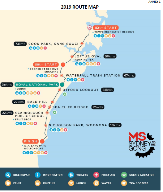
Location of start and Traffic Control Plans
![]()
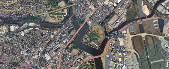
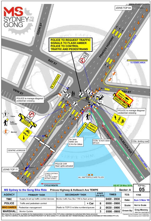
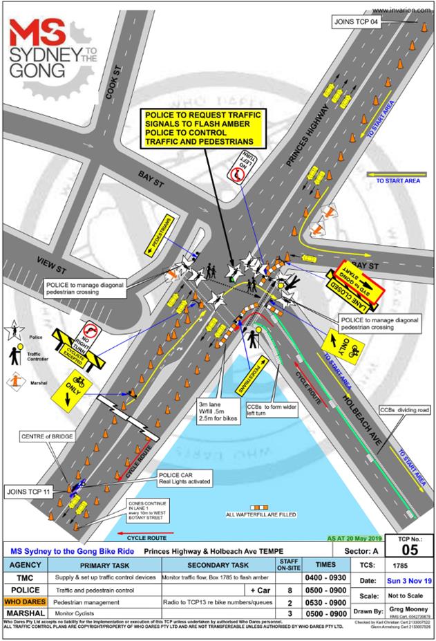
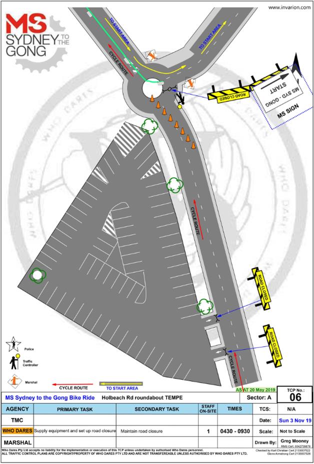
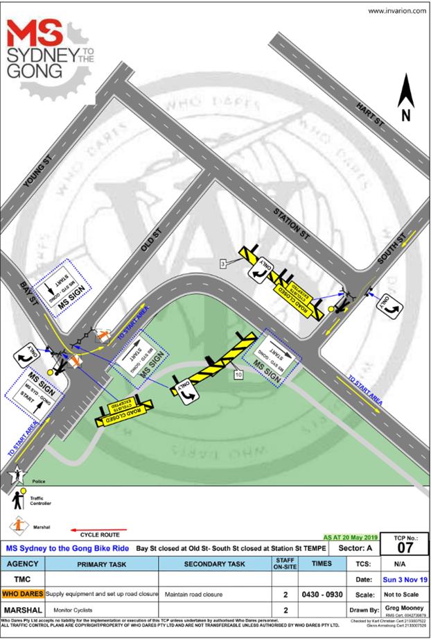
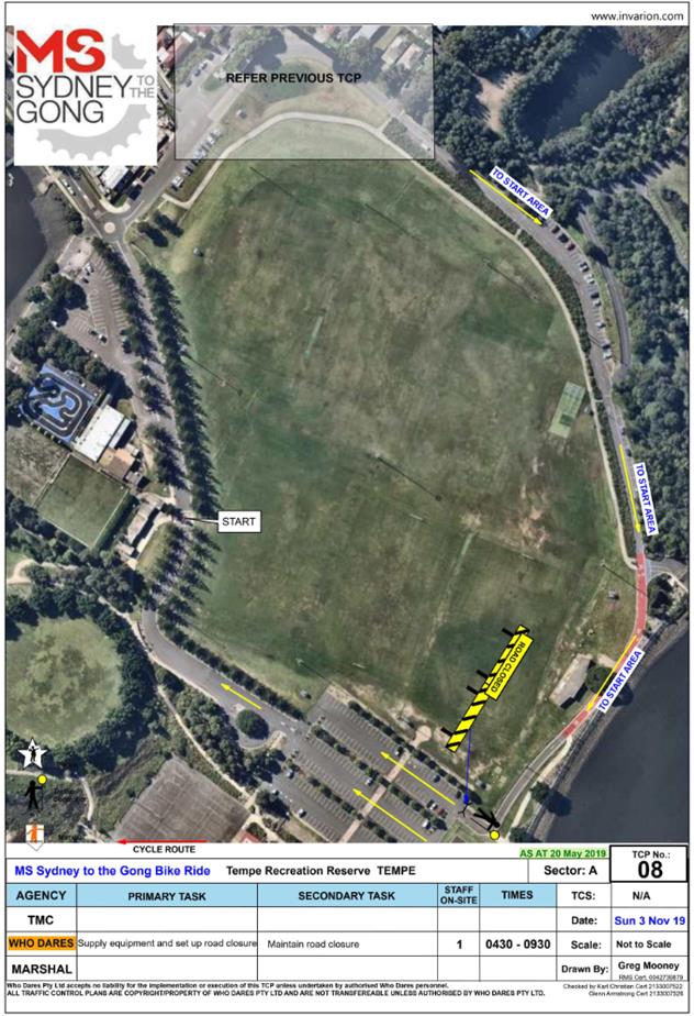
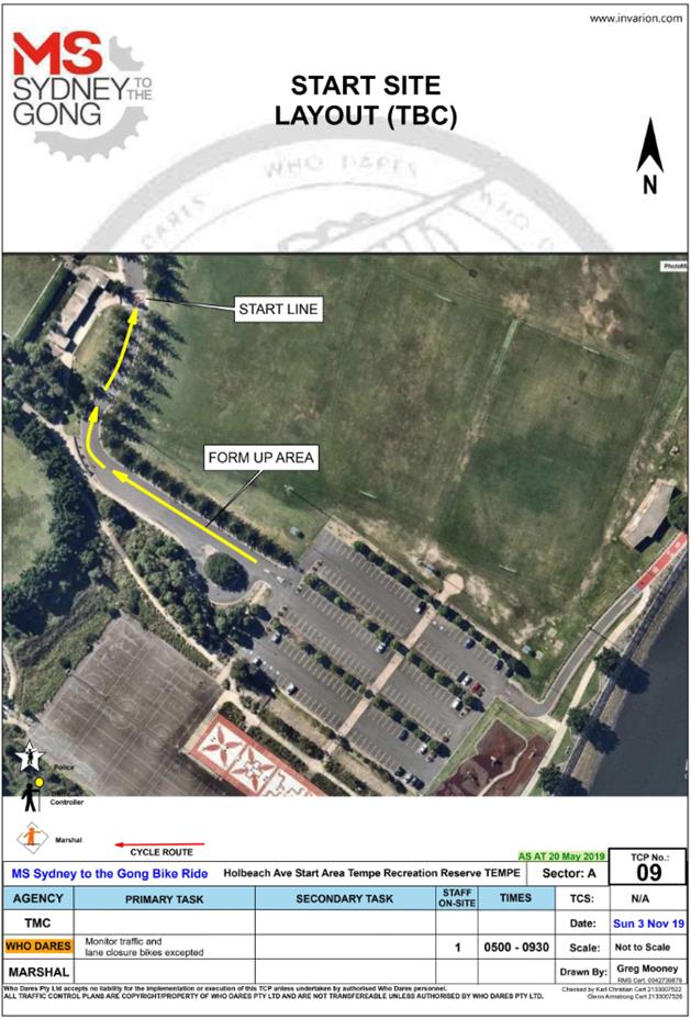
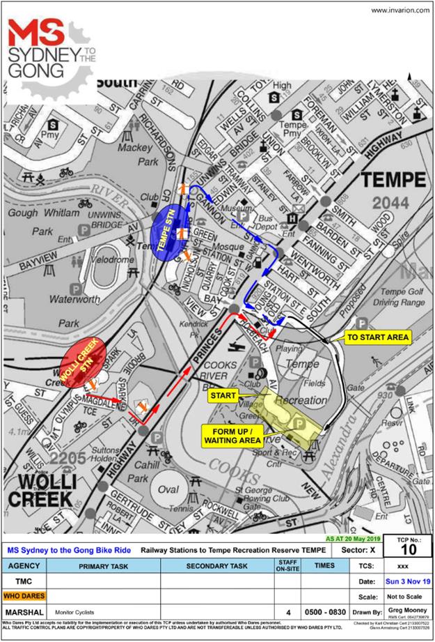
|
|
Local Traffic Committee Meeting 5 August 2019 |
Subject: Seven Bridges Walk - Special Event (Gulgadga - Leichhardt & Baludarri - Balmain Ward/ Balmain Electorate/ Leichhardt PAC)
Prepared By: Vinoth Srinivasan - Engineer - Traffic and Parking Services
Authorised By: John Stephens - Traffic and Transport Services Manager
SUMMARY
The Cancer Council NSW Seven Bridges Walk event will be held on Sunday, 27 October 2019 at various locations in Sydney, including areas within the Inner West Council. The Event is in its fourteenth year of operation and the applicant seeks approval again in 2019.
|
RECOMMENDATION
THAT the Cancer Council NSW Seven Bridges Walk to be held on Sunday, 27 October 2019 be approved, subject to a current Public Liability Insurance Policy which includes the Inner West Council being an interested party being submitted by the event organiser prior to the event. |
BACKGROUND
The Cancer Council NSW Seven Bridges Walk concept was created and developed by the Pedestrian Council of Australia (PCA) who will remain the owner of the event. The PCA has engaged Mothership Events to deliver the Event Operations and manage the marketing of the Event on behalf of PCA. The Cancer Council NSW Seven Bridges Walk can be regarded as an active opportunity to further enhance the councils' and stakeholders' charter toward promoting walking as a healthy activity and as an increasingly important means of active transport. In addition, the event will provide a significant contribution to the Cancer Council NSW (CCNSW).
It should be noted that the annual event, ‘Norton Street Italian Festa 2019’, will also be held on Sunday, 27 October 2019 in Norton Street, Leichhardt. As both these events operate in separate areas; Leichhardt and Rozelle, no traffic or pedestrian conflicts are expected.
FINANCIAL IMPLICATIONS
All costs associated with the Seven Bridges Walk are funded by the event organisers.
OTHER STAFF COMMENTS
Event Details
The course of CCNSW Seven Bridges Walk will open at 7:00am, and close at 4:30pm and it is estimated that it may attract up to 15,000 participants. The walking route is approximately 27km in length, and is a closed loop circuit that utilises pathways around the inner metropolitan region of Sydney that skirts the Sydney Harbour and includes the crossing of seven bridges. Special event buses will operate in both directions around the course, and will be provided free of charge to everyone holding an ‘event passport’.
Event Overview
Event Name: Cancer Council NSW Seven Bridges Walk [www.7bridgeswalk.com.au]
Event Owner: Pedestrian Council of Australia Ltd (PCA)
Date: Sunday, 27 October 2019
Course Opens: 7:00am via one of the 6 Villages located around the course
Course Closes: 4:30pm
Participation Target: 12,000 people throughout the day (Maximum capacity of 15,000 walkers)
Course Description:
The walking route is approximately 27km in length, and is a closed loop circuit that utilises pathways around the inner metropolitan region of Sydney that skirts the Sydney Harbour and includes the crossing of Seven Bridges.
The Seven Bridges are:
1. Sydney Harbour Bridge
2. Pyrmont Bridge
3. ANZAC Bridge
4. Iron Cove Bridge
5. Gladesville Bridge
6. Tarban Creek Bridge
7. Fig Tree Bridge
Village Locations:
Event ‘Villages’ are located around the course and will be used as check-in locations, First Aid points, drink stations, light catering and entertainment.
The 6 villages are:
1. Milsons Point Village (Burton Street at Alfred Street, Milsons Point)
2. Pyrmont Village (at Pyrmont Bay Park, Pirrama Rd, opposite The Star Casino)
3. Rozelle Village (at Waterfront Drive Sporting Ground - Callan Park)
4. Hunters Hill Village (at Hunters Hill Scout Hall, Durham St near the Church St overpass on Burns Bay Road, Hunters Hill)
5. Lane Cove Village (Blaxlands Corner – Central Park, William Edward St and Kenneth St, Lane Cove)
6. Wollstonecraft Village (at Brennan Park, Hazelbank St at King St, Wollstonecraft)
Impact on the Inner West LGA
The route through the Inner West LGA is via:
· ANZAC Bridge to Victoria Road
· Pedestrian bridge over Victoria Road
· Lilyfield Road
· Burt Street
· Denison Street
· Cheltenham Street
· O’Neill Street
· Cecily Street
· Through Callan Park to King George Park
· Byrnes Street to Victoria Road
Traffic and Pedestrian Management Plan (TMP)
This event does not require closure of any roads in the Inner West LGA. As the participants will be using footpaths and crossing the street network with assistance of traffic controllers, the Event does not cause significant impacts on traffic and transport systems. Therefore, the Event can be considered as Class 3. Hence, Council’s approval for the Traffic & Transport Management Plan is adequate.
The attached Pedestrian and Traffic Management Plan (TMP), when approved by the relevant authorities, becomes the prime document detailing with the traffic and transport arrangements under which this event is to proceed.
In case of emergencies, or for the management of incidents, the Police are not subject to the conditions of the TMP but will make every effort to inform the other agencies of the nature of the incident and the Police response.
The route for the proposed Seven Bridges Walk and the Traffic Control Plans (TCP) and Traffic Management Plan for Inner West Council LGA are attached.
|
1.⇩ |
Traffic Management Plan - Seven Bridges Walk 2019 |
|
2.⇩ |
Traffic Control Plan - Seven Bridges Walk 2019 |
|
Local Traffic Committee Meeting 5 August 2019 |
Subject: Traffic Management Plan for the 2019 New
Year's Eve Event
(Baludarri - Balmain Ward/ Balmain Electorate/ Leichhardt PAC)
Prepared By: Vinoth Srinivasan - Engineer - Traffic and Parking Services
Authorised By: John Stephens - Traffic and Transport Services Manager
SUMMARY
As instructed by the Police, access to the Balmain peninsula is closed to vehicular traffic every New Year’s Eve. This report outlines the traffic management associated with the event.
|
RECOMMENDATION
THAT:
1. The Traffic Management Plan (Attachment 1) detailing the traffic arrangements for the 2019 New Year’s Eve be supported;
2. The Traffic Management Plan (Attachment 1) be forwarded to Council’s Parks and Streetscapes Coordinator, Transport Management Centre and the Major Events & Incidents Group (NSW Police);
3. A temporary ‘No Stopping’ zone be installed on the eastern side of Montague Street between Darling Street and Beattie Street, Balmain;
4. That the following modifications to bus stops be approved: a. On the northern side of Darling Street: i. Install temporary ‘Bus Zones’ between Mort Street and Ford Street ii. Extend the ‘Bus Zone’ between Ford Street and McDonald Street iii. Extend the ‘Bus Zone’ between McDonald Street and Curtis Road, outside Nos.217-223 Darling Street b. On the southern side of Darling Street: i. Install a temporary ‘Bus Zone’ between Booth Street and Beattie Street, outside No. 244-270 Darling Street.
5. The Police representative be requested to provide bike unit resources to improve traffic/crowd controls around the Darling Street/Curtis Road intersection (roundabout);
6. The Police be requested to liaise directly with the Roads and Maritime Services in regards to the installation of variable message signs (“Balmain Peninsula is closed” and “Alcohol Free Zone”) on the main access roads into Balmain Peninsula a few days in advance of the event;
7. Confirmation be sought regarding the areas to be declared alcohol free and the Police and Transit Systems representatives be advised;
8. The Transit Systems representative be requested to place adequate notices on buses regarding the establishment of an alcohol free zone in the Balmain East area (details to be provided by Council);
9. The taxi/hire car access to the Peninsula be restricted from 7:00pm;
10. Taxis/hire cars carrying mobility impaired or infirmed residents be permitted access at all hours into the Peninsula; and
11. The NSW Taxi Council be advised of the Committee’s recommendation. |
BACKGROUND
It should be noted that the alcohol ban areas were extended following the 2014 event. Also, a temporary ban on taxi access to the peninsula after 7pm on New Year’s Eve was introduced to minimise traffic congestion in the peninsula and improve pedestrian safety.
FINANCIAL IMPLICATIONS
Funding for costs associated with New Year’s Eve including labour, notifications and permits have been budgeted for in the 2019-20 operational plan.
OTHER STAFF COMMENTS
Traffic Management
The following roads will be closed to all vehicular traffic between 3:00pm Tuesday, 31 December 2019 and 12:00am on Wednesday, 1 January 2020 to cater for the New Year’s Eve celebrations:
· Brent Street at Evans Street intersection, Rozelle (both directions)
· Mansfield Street at Evans Street intersection, Rozelle (both directions)
· Hanover Street at Evans Street intersection, Rozelle (both directions)
· Mackenzie Street at Victoria Road Street intersection, Rozelle (both directions)
· Hartley Street at Victoria Road Street intersection, Rozelle (both directions)
· Joseph Street at Victoria Road Street intersection, Rozelle (both directions)
· Loughlin Street at Victoria Road Street intersection, Rozelle (both directions)
· Crescent Street at Robert Street intersection, Rozelle (both directions)
· Buchanan Street at Robert Street intersection, Balmain (both directions)
· Waragal Avenue at Terry Street intersection, Rozelle (both directions)
· McKell Street at Yeend Street intersection, Birchgrove (both directions)
In addition, the following roads will be closed to all vehicular traffic except State Transit Authority/Transit Systems buses, Taxis, Hire Cars and Balmain Access Permit holders and will be manned by NSW Police officers between 3:00pm Tuesday, 31st December 2019 and 12:00am on Wednesday, 1st January 2020:
· Terry Street at Wellington Street intersection, Rozelle (northbound direction)
· Darling Street at Nelson Street intersection, Rozelle (northbound direction)
· Darling Street at Ewenton Street intersection, Balmain (eastbound direction)
· Evans Street at Merton Street intersection, Rozelle (northbound direction)
· Mullens Street at Robert Street intersection, Rozelle (both directions)
· Ballast Point Road at Lemm Street-Yeend Street intersection, Birchgrove (south and eastbound directions)
· Wharf Road at Grove Street intersection, Birchgrove (eastbound direction)
· Robert Street at Crescent Street, Rozelle (northbound direction)
· Grove Street at Rose Street, Birchgrove (eastbound direction)
The following plan indicates the road closure points.
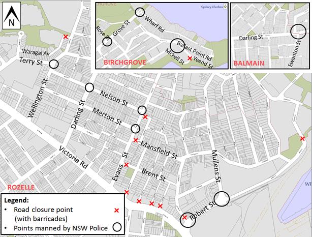
A Traffic Management Plan including Traffic Control Plans outlining the above road closures and the bus route changes is attached in Attachment 1.
Taxi Access
As previously recommended, the NSW Taxi Council will again be requested to inform their members of the proposed taxi access restriction after 7pm and to use the following drop-off point locations:
· Taxis entering Terry Street - In the unrestricted parking on the eastern side of Terry Street or ‘Bus Zone’ and timed kerbside parking along Wellington Street
· Taxis entering Darling Street - In the ticket parking areas along Darling Street and Nelson Street
· Taxis entering Robert Street – In the restricted parking area and ‘Bus Zone’
Public Transport Access
Transit Systems will be scheduling additional services into the Balmain peninsula to cater for the New Year’s Eve celebrations.
As such, temporary ‘Bus Zones’ will be installed at the following locations:
· Darling Street and the existing ‘Bus Zones’ on Darling Street between Mort Street and Curtis Road, Balmain
· Eastern side of Grove Street between Wharf Road and Bay Street, Birchgrove from 12 noon on New Year's Eve.
The ‘Bus Zones’ on Grove Street will be used by Transit Systems and the Police to store buses on New Year's Eve. This is required for the safe bump out of the general public from Birchgrove as identified from a debrief from a previous New Year's Eve event conducted in the Balmain Peninsular.
The signs defining the temporary restrictions be in place after 12 Noon on 31 December 2019 and will be removed the following day.
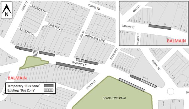
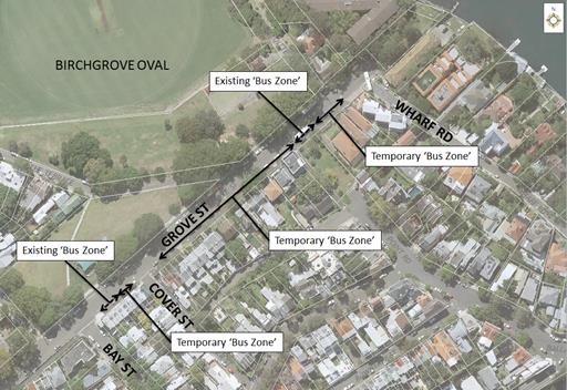
Based on discussions held in previous years regarding disruptions to bus services leaving Gladstone Park/Curtis Road roundabout due to the gathering of large crowds, the Glebe Local Area Command representative introduced Police bike units to manage the crowds in the area.
In addition, to avoid delays that occurred at the Robert Street/Mullens Street intersection (which is a Police check point), buses entering Robert Street from Victoria Road are proposed to use Crescent Street and Parsons Street to access Mullens Street (see TCP 06/07 in Attachment 1).
Temporary ‘No Stopping’ Restrictions
Following a previous year’s event, the Sydney Buses representative advised that several vehicles parked on Montague Street out from the kerb thus narrowing the carriageway and preventing buses from passing each other. Therefore, it is proposed to install temporary ‘No Stopping’ zone on the eastern side of Montague Street between Darling Street and Beattie Street. The residents will be advised of this arrangement in advance of the event.
Resident Access
To ensure resident access is maintained, the following permits will be accepted for access to the Balmain / Rozelle peninsula:
· Inner West Council Resident Access Permit.
· Inner West Council current Resident Parking Scheme Permit for Areas; B1, B2, B3, B5, BE, BG, R1, R2, R3 & R4.
· Australian Disability Parking permit
Alcohol Free Zones
Council will re-establish the Alcohol Free Areas for the New Year’s Eve celebrations in 2019, 2020, 2021 & 2022 at the following locations:
· Illoura Reserve
· 2-8 Weston Street
· Thornton Park
· Lookes Avenue Reserve
· Simmons Point Reserve
· Yurulbin Park
· Birchgrove Park
· Miklouho-Maclay Park
· Mort Bay Park
· College Street playground
· Harris Reserve
· Brownlee Reserves
· Darling Street from Duke Street to Darling Street Wharf
· Darling Street Wharf, Balmain East;
· Lookes Avenue
· Weston Street
These alcohol restrictions are proposed to be in place from 12.00pm (noon) 31 December 2019 to 3.00am 1 January 2020.
It should be noted that NSW Police introduced alcohol ban restrictions in 2014 at Ballast Point Park which is managed by the Sydney Harbour Foreshore Authority.
Matters arising from previous event
|
Residents’ Comments |
Officer Comments |
|
Every year police divert non-residents up Merton Street, Rozelle in a slow procession from 5pm onwards, causing issues for residents on Merton Street, Napoleon Street, Cross Street and Nelson Street. There is severe traffic in Merton Street from 5pm up to the 9pm fireworks. Leading up to the 12pm fireworks, drivers are looking for car spaces with vehicles often parking across driveways and in the ‘No Stopping’ restrictions at the intersection of Merton and Cross Street. Last year, an incident occurred on Merton Street at the conclusion of the 9pm fireworks. A group of people threw firecrackers straight down Cross Street which hit parked cars and went into a resident’s front yard. Immediately after, the group got into their car and drove off. Although a Police officer attended the scene shortly after the incident, he was unable to take any statements as he was the only officer manning the barricades into the Peninsula. By allowing non-residents of the peninsula to be diverted directly into Merton Street, it has caused a back log of traffic, illegal parking and dangerous behavior. We request that Council block off Merton Street and Cross Street to avoid similar issues from occurring in the future. |
Evans Street is one of several roads which permit residential access into the Balmain Peninsula (others include Terry Street, Darling Street and Robert Street). Local Traffic on Evans Street must pass a Police check point at Merton Street to proceed further into the Peninsula and non-resident traffic is redirected back to the State Road network via Merton Street and Darling Street.
Merton Street is one of several roads that act as a traffic redistribution route to remove this non-resident traffic entering the Balmain peninsular.
Merton Street is one way towards Darling Street and allows this traffic redistribution without significant vehicular conflict, noting the lack of opposing vehicle movements. Therefore, no changes to the TMP are proposed.
Council will review the locations of the Variable Message Signs (VMS) boards to assist in minimising the number of non-residents that enter Evans St with the intention of traveling further into the Peninsular.
The Police have also been notified of the anti-social behavior that occurred at last year’s event in Merton Street.
|
PUBLIC CONSULTATION
The road closures have been advertised in a local newspaper for a period of 28 days from 16 July to 13 August 2019. No comments have been received yet.
In December, the details of these traffic arrangements will be re-advertised in local newspapers, on Council’s website and via a mail out to all occupants in the Balmain peninsula.
The road closures and other event information will also be available on the Sydney New Year’s Eve Event website.
Similar to previous years, the TMC is requested to provide variable message signs: “Balmain Peninsula is closed” at the entry points from Victoria Road.
CONCLUSION
Nil.
|
1.⇩ |
New Year's Eve - Balmain - TMP |