|
AGENDA R |

Local Traffic Committee Meeting
MONDAY 3 FEBRUARY 2020
10.00am
|
AGENDA R |
Local Traffic Committee Meeting
MONDAY 3 FEBRUARY 2020
10.00am
|
Local Traffic Committee Meeting 3 February 2020 |
Function of the Local Traffic Committee
Background
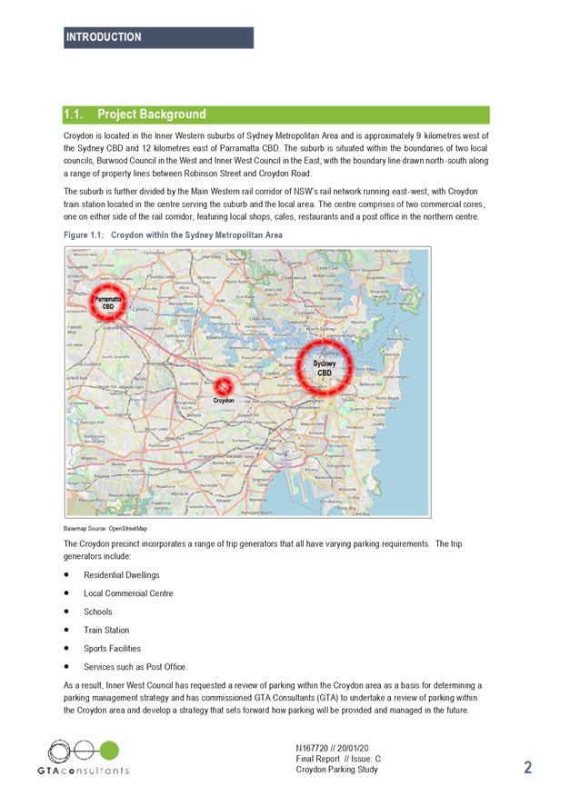
Roads and Maritime Services (RMS) is legislated as the Authority responsible for the control of traffic on all NSW Roads. The RMS has delegated certain aspects of the control of traffic on local roads to councils. To exercise this delegation, councils must establish a local traffic committee and obtain the advice of the RMS and Police. The Inner West Council Local Traffic Committee has been constituted by Council as a result of the delegation granted by the RMS pursuant to Section 50 of the Transport Administration Act 1988.
Role of the Committee
The Local Traffic Committee is primarily a technical review and advisory committee which considers the technical merits of proposals and ensures that current technical guidelines are considered. It provides recommendations to Council on traffic and parking control matters and on the provision of traffic control facilities and prescribed traffic control devices for which Council has delegated authority. These matters are dealt with under Part A of the agenda and require Council to consider exercising its delegation.
In addition to its formal role as the Local Traffic Committee, the Committee may also be requested to provide informal traffic engineering advice on traffic matters not requiring Council to exercise its delegated function at that point in time, for example, advice to Council’s Development Assessment Section on traffic generating developments. These matters are dealt with under Part C of the agenda and are for information or advice only and do not require Council to exercise its delegation.
Committee Delegations
The Local Traffic Committee has no decision-making powers. The Council must refer all traffic related matters to the Local Traffic Committee prior to exercising its delegated functions. Matters related to State Roads or functions that have not been delegated to Council must be referred directly to the RMS or relevant organisation.
The Committee provides recommendations to Council. Should Council wish to act contrary to the advice of the Committee or if that advice is not supported unanimously by the Committee members, then the Police or RMS have an opportunity to appeal to the Regional Traffic Committee.
Committee Membership & Voting
Formal voting membership comprises the following:
· one representative of Council as nominated by Council;
· one representative of the NSW Police from each Local Area Command (LAC) within the LGA, being Newtown, Marrickville, Leichhardt and Ashfield LAC’s.
· one representative from the RMS; and
· State Members of Parliament (MP) for the electorates of Summer Hill, Newtown, Heffron, Canterbury, Strathfield and Balmain or their nominees.
Where the Council area is represented by more than one MP or covered by more than one Police LAC, representatives are only permitted to vote on matters which effect their electorate or LAC.
Informal (non-voting) advisors from within Council or external authorities may also attend Committee meetings to provide expert advice.
Committee Chair
Council’s representative will chair the meetings.
Public Participation
Members of the public or other stakeholders may address the Committee on agenda items to be considered by the Committee. The format and number of presentations is at the discretion of the Chairperson and is generally limited to 3 minutes per speaker. Committee debate on agenda items is not open to the public.
|
|
Local Traffic Committee Meeting 3 February 2020 |
|
AGENDA |
1 Apologies
2 Disclosures of Interest
3 Confirmation of Minutes
Minutes of 2 December 2019 Local Traffic Committee Meeting 5
4 Matters Arising from Council’s Resolution of Minutes
5 Part A – Items Where Council May Exercise Its Delegated Functions
Traffic Matters
ITEM PAGE #
LTC0220 Item 1 The Esplanade/Markham Place and Charlotte Street, Ashfield- Bicycle Contra-Flow in One-Way Streets. (Diarrawunang-Ashfield Ward/Summer Hill Electorate/Burwood PAC) 23
LTC0220 Item 2 Bay Run at UTS Rowing Club, Haberfield - Proposed signage and pavement marking upgrade (Gulgadya-Leichhardt Ward/Summer Hill Electorate/ Burwood PAC) 36
LTC0220 Item 3 Murray Street, Marrickville – Road Occupancy – Request by Breastscreen NSW to Position a Mobile X-RAY Unit on Street Between Friday 10 April 2020 and Friday 5 June 2020 (MIDJUBURI - Marrickville Ward / Summer Hill Electorate / Marrickville PAC) 40
LTC0220 Item 4 Audley Street, Sadlier Crescent, Fisher Street, and parking lanes on New Canterbury Road Petersham – Temporary Full Road Closures For Special Event On Sunday 15 March 2020 – Bairro Portuguese Food and Wine Fair (Damum - Stanmore Ward / Newtown Electorate / Inner West PAC) 43
LTC0220 Item 5 Continous Footpath Treatment - Sorrie Street at the intersection of Booth Street, Balmain (Baludarri - Balmain Ward/Balmain Electorate/Leichhardt PAC) 67
LTC0220 Item 6 Minor Traffic Facilities (All Wards/All Electorates/All PACS) 71
LTC0220 Item 7 Pigott Lane, Marrickville – Request For ‘No Parking’ Restrictions (Midjuburi - Marrickville Ward / Summer Hill Electrorate / Inner West PAC) 85
LTC0220 Item 8 Lower Railway Parade, Sydenham - Proposed Installation of ‘No Stopping’ Signage (Midjuburi-Marrickville Ward / Heffron Electorate / Inner West PAC) 89
Parking Matters
ITEM PAGE #
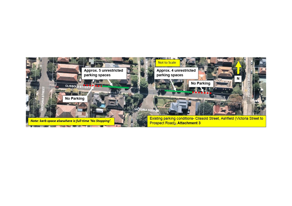
LTC0220 Item 9 Clissold Street, Ashfield- Investigation of Proposed Works from the Ashfield Traffic Management Strategy (Djarrawunang-Ashfield Ward/Summer Hill Electrorate/Burwood PAC) 93
LTC0220 Item 10 Lilyfield Road, Rozelle - Extension of Resident Parking Scheme (Baludarri-Balmain Ward/Balmain Electorate/Leichhardt PAC) 113
LTC0220 Item 11 Dalhousie Street, Haberfield - Removal of redundant bus stop facilities (Gulgadya-leichhardt ward/summer hill electorate/burwood PAC) 117
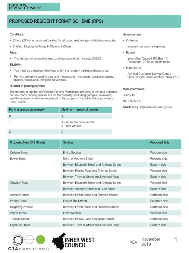
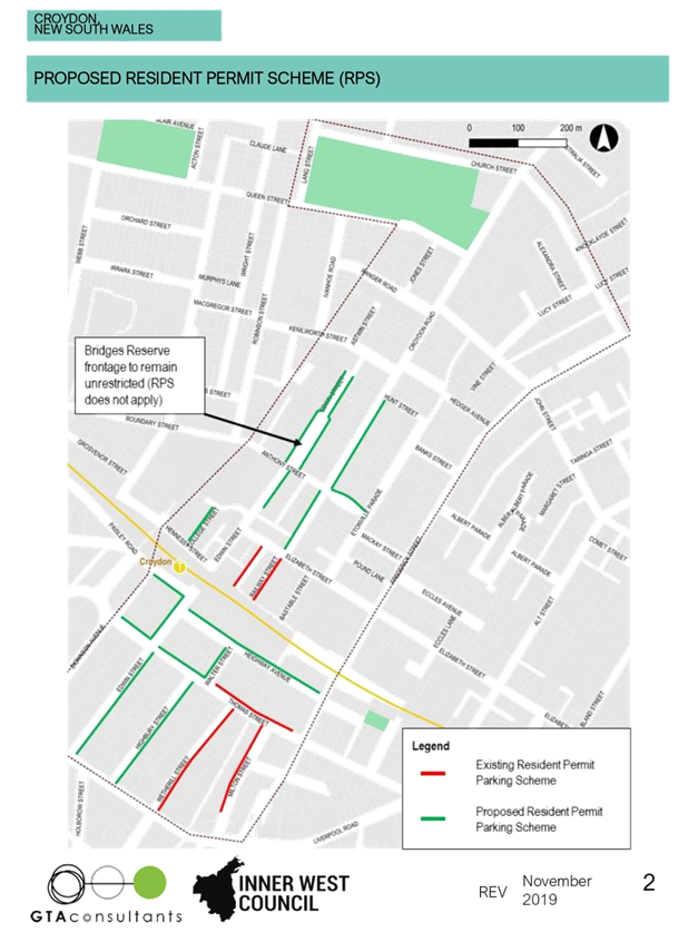
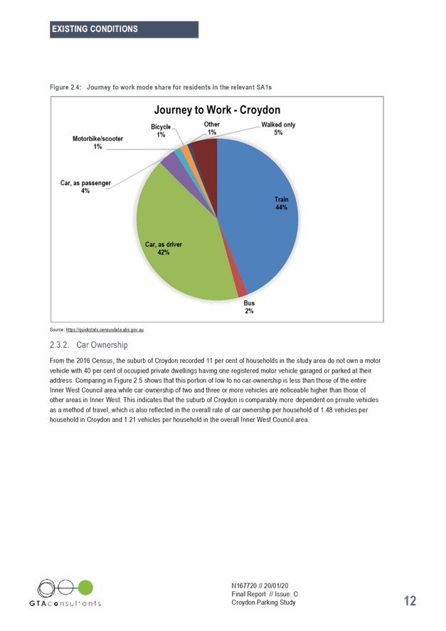
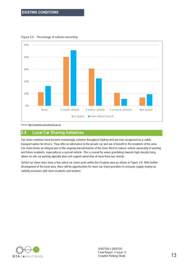
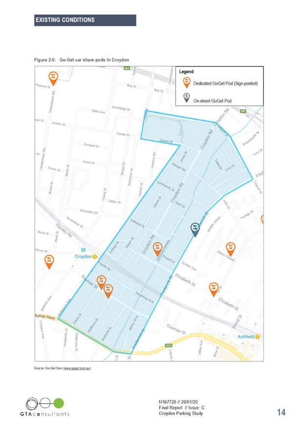
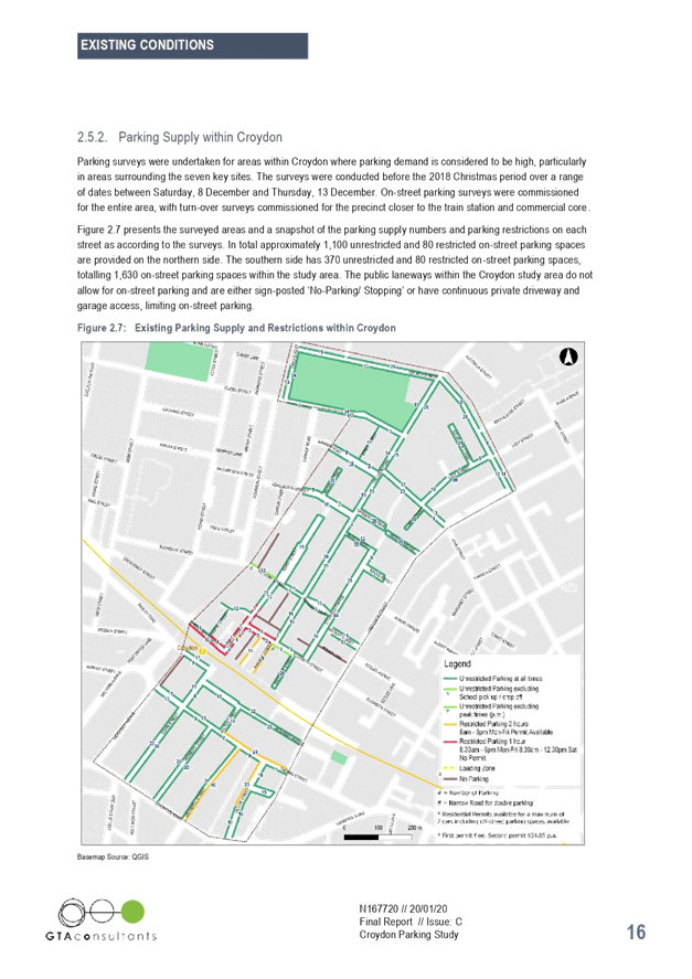
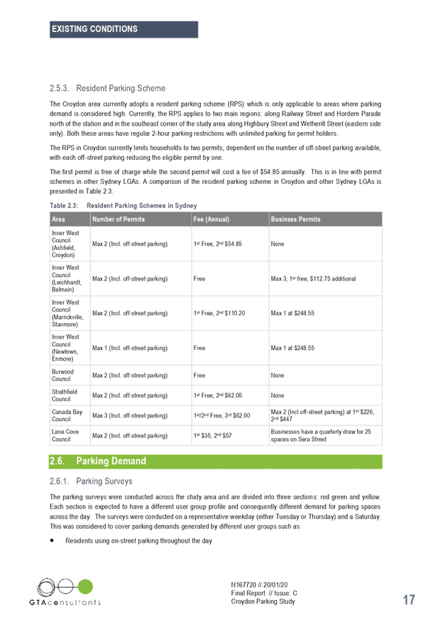
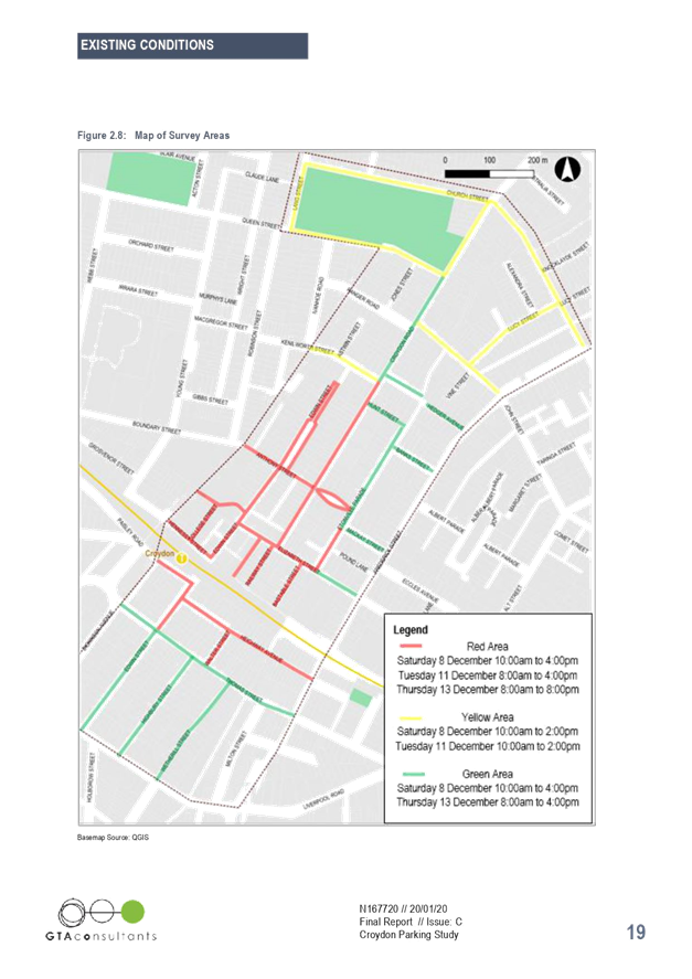
LTC0220 Item 12 Croydon Parking Study (Gulgadya-Leichhardt Ward/Summer Hill Electorate/Purwood PAC) 120
LTC0220 Item 13 William Street, Leichhardt - Proposed 'No Stopping' Restrictions (Gulgadya-Leichhardt/Balmain Electorate/Leichhardt PAC) 166
LTC0220 Item 14 Trinity Grammar School Prospect Road, Summer Hill - Proposed Extension of 'No Stopping' Restrictions (Djarrawunang - Ashfield Ward / Summer Hill Electorate / Burwood PAC) 169
LTC0220 Item 15 Morgan
Street, Petersham - Proposed Installation of Painted Island to Reinforce NSW
Road Rules at Road Closure
(Damun-Stanmore Ward/ Summer Hill Electorate/ Inner West PAC) 173
Late Items
Nil at time of printing.
6 Part B - Items for Information Only
Nil at the time of printing.
7 Part C - Items for General Advice
ITEM PAGE #
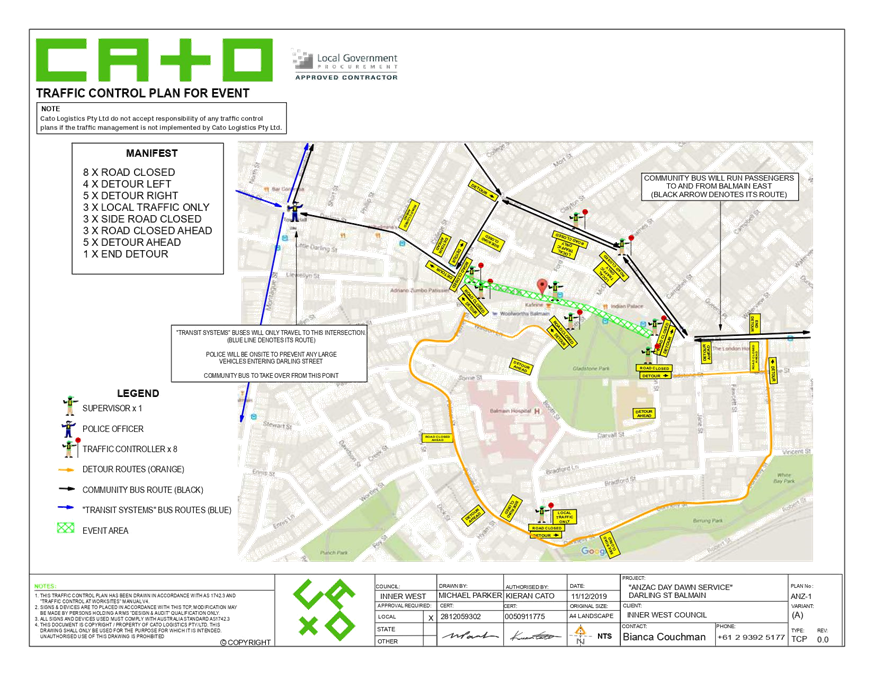
LTC0220 Item 16 Darling Street between Mort Street and Curtis Road, Balmain - Road Occupancy - ANZAC Day Dawn Service (Baludarri - Balmain Ward/Balmain Electorate/Leichhardt PAC 176
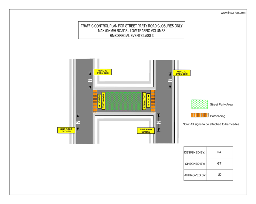
LTC0220 Item 17 Cary Street between Rofe Street and Elswick Street, Leichhardt - Road Occupancy - Street Party (Gulgadya - Leichhardt Ward/Balmain Electorate/Leichhardt PAC) 182
8 General Business
9 Close of Meeting
|
|
Local Traffic Committee Meeting 3 February 2020 Minutes from Meeting Held 2 December 2019 |
Minutes of Local Traffic Committee Meeting
Held at Petersham Service Centre on 2 December 2019
Meeting commenced at 10.07am
ACKNOWLEDGEMENT OF COUNTRY BY CHAIRPERSON
I acknowledge the Gadigal and Wangal people of the Eora nation on whose country we are meeting today, and their elders past and present.
COMMITTEE REPRESENTATIVES PRESENT
|
Clr Victor Macri |
Councillor – Midjuburi-Marrickville Ward (Chair) |
|
Bill Holliday |
Representative for Jamie Parker MP, Member for Balmain |
|
Chris Woods |
Representative for Ron Hoenig MP, Member for Heffron |
|
Cathy Peters |
Representative for Jenny Leong MP, Member for Newtown |
|
Sgt Paul Vlachos |
NSW Police – Inner West Police Area Command |
|
LSC Marina Nestoriaros |
NSW Police – Leichhardt Police Area Command |
|
Nazli Tzannes |
Transport for NSW (formerly Roads and Maritime Services) |
|
|
|
|
OFFICERS IN ATTENDANCE |
|
|
|
|
|
Asith Nagodavithane |
Transit Systems – Inner West Bus Services |
|
Colin Jones |
Inner West Bicycle Coalition |
|
Clr Marghanita da Cruz |
Councillor – Gulgadya-Leichhardt Ward |
|
Cathy Edwards-Davis |
IWC Director Infrastructure |
|
John Stephens |
IWC’s Outgoing Traffic and Transport Services Manager |
|
Manod Wickramasinghe |
IWC’s Acting Traffic and Transport Services Manager |
|
George Tsaprounis |
IWC’s Coordinator Traffic and Parking Services (South) |
|
Jenny Adams |
IWC’s Traffic Engineer |
|
Stephen Joannidis |
IWC’s Urban Amenity Improvement Delivery Manager |
|
Pierre Ayoub |
IWC’s Acting Design Services Coordinator |
|
Predrag Gudelj |
IWC’s Project Manager |
|
Christina Ip |
IWC’s Business Administration Officer |
|
|
|
|
VISITORS |
|
|
|
|
|
Monica Raju |
Item 13 – Consultant |
|
|
|
|
APOLOGIES: |
|
|
|
|
|
Germaine Grant |
NSW Police – Burwood & Campsie Police Area Command |
|
|
|
DISCLOSURES OF INTERESTS:
Nil.
CONFIRMATION OF MINUTES
|
The minutes of the Local Traffic Committee Meeting held on Monday, 4 November 2019 were confirmed. |
MATTERS ARISING FROM COUNCIL’S RESOLUTION OF MINUTES
The Local Traffic Committee recommendations of its meeting held on 4 November 2019 were adopted at Council’s meeting held on 26 November 2019. Council also noted in relation to Item 20 D3 Iron Cove to ANZAC Bridge Regional Cycleway Design that the community (over 2080 signatories) has raised concerns about WestConnex’s proposed alternate route connecting Lilyfield Road and ANZAC bridge from May 2020.
|
LTC1219 Item 1 Minor Traffic Facilities (All Wards/ All Electorates/All PACS) |
|
SUMMARY
This report considers minor traffic facility applications received by Inner West Council and includes ‘Disabled Parking’ and ‘Works Zone’ requests.
Officer’s Recommendation
THAT:
1. The 6m ‘Disabled Parking’ zone in front of No.95 Frederick Street, St Peters, be removed;
2. The 6m ‘Disabled Parking’ zone in front of No. 220 Darling Street, Balmain, be removed;
3. The 6m ‘Disabled Parking’ zone in front of No. 15 Goodsir Street, Rozelle, be removed;
4. A 'Disabled Parking’ zone be installed in Consett Street adjacent to No. 1-9 Terrace Road, Dulwich Hill, in the seventh angled parking bay from Terrace Road;
5. A 5.5m 'Disabled Parking’ zone be installed in front of No. 6/1 Merchant Street, Stanmore;
6. A 5.5m 'Disabled Parking’ zone be installed in front of No. 66 Gipps Street, Birchgrove;
7. A 9m 'Works Zone 7.00am – 6.00pm Mon-Fri and 8.00am - 1.00pm Sat' be installed at the front of No. 9 Allen Street, Leichardt, for 12 weeks;
8. A 33m 'Works Zone 7.00am – 6.00pm Mon-Fri and 8.00am - 1.00pm Sat' be installed at the front of No. 30-32 Murray Street, Marrickville, for 12 weeks;
9. a. A 31m 'Works Zone 7.00am – 6.00pm Mon-Fri and 8.00am - 1.00pm Sat' be installed at the front of No. 168 Norton Street, Leichhardt, for 12 weeks, temporarily replacing the existing bus stop; and b. That the Applicant ensure that proper notification is given to residents regarding the temporary closure of the bus stop, with the consent of Transit Systems;
10. A 10m 'Works Zone 7.00am – 6.00pm Mon-Fri and 8.00am - 1.00pm Sat' be installed at the front of No. 48 Susan Street, Annandale, for 12 weeks; and
11. A 15m 'Works Zone 7.00am – 6.00pm Mon-Fri and 8.00am - 1.00pm Sat' be installed at the front of No. 69 Renwick Street, Leichhardt, for 12 weeks
DISCUSSION
Clr da Cruz asked, in relation to part 9 of the recommendation, whether there will be signage directing commuters to the nearest bus stop for the duration of the work zone. The Transit Systems representative advised that such signage will be installed and provided that the applicant provides 5 weeks notice, Transit Systems will also include updated bus stop information on public transport apps.
The Committee members agreed with the Officer’s recommendation.
COMMITTEE RECOMMENDATION
THAT:
1. The 6m ‘Disabled Parking’ zone in front of No.95 Frederick Street, St Peters, be removed;
2. The 6m ‘Disabled Parking’ zone in front of No. 220 Darling Street, Balmain, be removed;
3. The 6m ‘Disabled Parking’ zone in front of No. 15 Goodsir Street, Rozelle, be removed;
4. A 'Disabled Parking’ zone be installed in Consett Street adjacent to No. 1-9 Terrace Road, Dulwich Hill, in the seventh angled parking bay from Terrace Road;
5. A 5.5m 'Disabled Parking’ zone be installed in front of No. 6/1 Merchant Street, Stanmore;
6. A 5.5m 'Disabled Parking’ zone be installed in front of No. 66 Gipps Street, Birchgrove;
7. A 9m 'Works Zone 7.00am – 6.00pm Mon-Fri and 8.00am - 1.00pm Sat' be installed at the front of No. 9 Allen Street, Leichardt, for 12 weeks;
8. A 33m 'Works Zone 7.00am – 6.00pm Mon-Fri and 8.00am - 1.00pm Sat' be installed at the front of No. 30-32 Murray Street, Marrickville, for 12 weeks;
9. a. A 31m 'Works Zone 7.00am – 6.00pm Mon-Fri and 8.00am - 1.00pm Sat' be installed at the front of No. 168 Norton Street, Leichhardt, for 12 weeks, temporarily replacing the existing bus stop; and b. That the Applicant ensure that proper notification is given to residents regarding the temporary closure of the bus stop, with the consent of Transit Systems;
10. A 10m 'Works Zone 7.00am – 6.00pm Mon-Fri and 8.00am - 1.00pm Sat' be installed at the front of No. 48 Susan Street, Annandale, for 12 weeks; and
11. A 15m 'Works Zone 7.00am – 6.00pm Mon-Fri and 8.00am - 1.00pm Sat' be installed at the front of No. 69 Renwick Street, Leichhardt, for 12 weeks
For motion: Unanimous
|
|
LTC1219 Item 2 Teakle Street at Drynan Street, Summer Hill - Proposed upgrade of at-grade pedestrian crossing to a raised crossing (Djarrawunang-Ashfield Ward/ Summer Hill Electorate/ Burwood PAC) |
|
SUMMARY
Design plans have been prepared for raising the at-grade pedestrian (zebra) crossing in Teakle Street, Summer Hill. Consultation was undertaken with nearby owners and occupiers in Teakle Street and Drynan Street regarding the proposal. It is recommended that the proposed detailed design plan be approved.
Officer’s Recommendation
THAT the detailed design plans for the proposed upgrade of the at-grade pedestrian (zebra) crossing to a raised pedestrian (zebra) crossing on Teakle Street, near Drynan Street (Design Plan No. 10081) be approved.
DISCUSSION
Clr da Cruz raised concerns with the distance between the pedestrian crossing and the intersection and requested for signage to warn drivers that they are approaching the crossing. Council Officers will arrange for the signage.
The Committee members agreed with the Officer’s recommendation.
COMMITTEE RECOMMENDATION
THAT the detailed design plans for the proposed upgrade of the at-grade pedestrian (zebra) crossing to a raised pedestrian (zebra) crossing on Teakle Street, near Drynan Street (Design Plan No. 10081) be approved.
For motion: Unanimous
|
|
LTC1219 Item 3 St Davids Road/Kingston Street and Ramsay Street, Haberfield - Proposed Speed Cushions (Gulgadya-Leichhardt Ward/Summer Hill Electorate/Burwood PAC) |
|
SUMMARY
A detailed design plan has been finalised for the proposed intersection treatment at St Davids Road/Kingston Street and Ramsay Street, Haberfield.
As part of the Traffic Capital Works Program, Council has prepared a design plan indicating speed cushions and a kerb blister for the roundabout at Ramsay Street and St Davids Road/ Kingston Street, Haberfield. The intention of the proposal is to slow traffic and improve road safety for pedestrians and motorists at the intersection.
Officer’s Recommendation
THAT the detailed design plan (Design Plan No.10107) for the installation of speed cushions, a kerb blister, and associated signs and line markings for the roundabout at Ramsay Street and St Davids Road/Kingston Street, Haberfield be approved.
DISCUSSION
The Committee members agreed with the Officer’s recommendation.
COMMITTEE RECOMMENDATION
THAT the detailed design plan (Design Plan No.10107) for the installation of speed cushions, a kerb blister, and associated signs and line markings for the roundabout at Ramsay Street and St Davids Road/Kingston Street, Haberfield be approved.
For motion: Unanimous
|
|
LTC1219 Item 4 Fox Lane, Ashfield - Proposed 10km/h Shared Zone (Djarrawunang-Ashfield Ward/Summer Hill Electorate/Burwood PAC) |
|
SUMMARY
As part of the Ashfield Town Centre Renewal – Public Domain Strategy, Council plans to improve Fox Lane, Ashfield by proposing to introduce a 10km/h ‘Shared Zone’ in the lane from Liverpool Road to The Esplanade.
Officer’s Recommendation
THAT:
a) the treatments associated with the proposed ‘10km/h Shared Zone’ in Fox Lane between Liverpool Road and The Esplanade (as shown under the signs and line marking plans 2458-FL-SL-001&002-Revision D) be approved; and
b) the proposal be submitted to RMS for approval of the 10km/h ‘Shared Zone’ and regulatory signage.
DISCUSSION
The Committee members agreed with the Officer’s recommendation.
COMMITTEE RECOMMENDATION
THAT:
a) the treatments associated with the proposed ‘10km/h Shared Zone’ in Fox Lane between Liverpool Road and The Esplanade (as shown under the signs and line marking plans 2458-FL-SL-001&002-Revision D) be approved; and
b) the proposal be submitted to RMS for approval of the 10km/h ‘Shared Zone’ and regulatory signage.
For motion: Unanimous
|
|
SUMMARY
The St Peters Interchange project results from a request by the RMS and WestConnex for Council to deliver two (2) active transport projects around the M5 WestConnex Interchange at St Peters. The provision of such walking and cycling facilities within 1km of the St Peters Interchange is a condition of consent for the WestConnex M5 project.
The options presented as part of this project are:
o Option A – One-way westbound separated cycleway on the southern side of Burrows Avenue with an on road mixed traffic facility for cyclists eastbound, on the northern side; o Option B – Two way separated cycleway on the southern side of Burrows Avenue.
o Widened shared path along Mary Street and upgrades to the existing on road cycle route along the other streets.
Following development of the concept designs and a community engagement process, Council is seeking the approval of the Local Traffic Committee to progress with the detailed design and implementation of the measures outlined herein.
Officer’s Recommendation
THAT: 1. the Committee approve the progression of the project to the detailed design and implementation stage as outlined herein, being Option A for Burrows Avenue, (one-way westbound separated cycleway on the southern side and mixed traffic facility eastbound on the northern side) and the options as proposed for the remainder of the route; and
2. The detailed design be brought back to the Committee for its consideration and support.
DISCUSSION
The representative for the Member for Newton asked whether separated cycleways were considered for this project’s cycle routes, given that this is the safest option and WestConnex is funding the project. Council Officers advised that whilst Council’s preference is for separated cycleways, low traffic volumes and the narrow width of George Street make on-road cycle routes more practical in this case. The representative emphasised the need for Council to implement the safest option for cycle routes.
The representative for the Member for Heffron commented that this project also provides an opportunity for Council to consider a dedicated cycleway and pedestrian pathway along Bolton Street.
The Committee members agreed with the Officer’s recommendation.
COMMITTEE RECOMMENDATION
THAT: 1. the Committee approve the progression of the project to the detailed design and implementation stage as outlined herein, being Option A for Burrows Avenue, (one-way westbound separated cycleway on the southern side and mixed traffic facility eastbound on the northern side) and the options as proposed for the remainder of the route; and
2. The detailed design be brought back to the Committee for its consideration and support.
For motion: Unanimous |
|
LTC1219 Item 6 Frazer Street at Gould Street, Dulwich Hill and Terrace Road at New Canterbury Road, Dulwich Hill – Proposed 'No Stopping, Australia Post Vehicles Excepted' zones (Djarrawunang-Ashfield/ Damun-Stanmore Ward / Summer Hill Electorate/ Inner West PAC) |
|
SUMMARY
Council has received a request from Australia Post for the installation of 'No Stopping - Australia Post Vehicles Excepted' zones at two unique locations; Frazer Street at Gould Street, Dulwich Hill and Terrace Road at New Canterbury Road, Dulwich Hill. The zones will provide a space for Australia Post vehicles to collect the mail from their Street Posting Boxes.
Officer’s Recommendation
THAT:
1. The last 5m of the existing 15m length of 'No Stopping’ restrictions on the northern side of Frazer Street east of Gould Street, Dulwich Hill be sign posted as 'No Stopping; Australia Post Vehicles Excepted'; and 2. The last 5m of the existing 19m length of ‘No Stopping’ restrictions on the western side of Terrace Road south of New Canterbury Road, Dulwich Hill be sign posted as ‘No Stopping; Australia Post Vehicles Excepted'; and
DISCUSSION
The Committee members agreed with the Officer’s recommendation.
COMMITTEE RECOMMENDATION
THAT:
1. The last 5m of the existing 15m length of 'No Stopping’ restrictions on the northern side of Frazer Street east of Gould Street, Dulwich Hill be sign posted as 'No Stopping; Australia Post Vehicles Excepted'; and 2. The last 5m of the existing 19m length of ‘No Stopping’ restrictions on the western side of Terrace Road south of New Canterbury Road, Dulwich Hill be sign posted as ‘No Stopping; Australia Post Vehicles Excepted'; and
For motion: Unanimous
|
|
LTC1219 Item 7 Williams Parade, Dulwich Hill – Proposed changes to existing Parking restrictions to allow short term parking opportunities on the weekends for park users (Djarrawunang - Ashfield Ward / Summer Hill Electorate / Inner West PAC) |
|
SUMMARY
Council is proposing to introduce new time restricted parking restrictions in Williams Parade, Dulwich Hill to allow improved short term parking opportunities during the weekends for park users. These restrictions include a mixture of 5min parking and 2hour parking restrictions near Arlington Oval.
Officer’s Recommendation
THAT:
1. The installation of 23 metres of ‘P5min 6pm – 9pm Mon – Fri 8am – 4pm Sat & Sun’ / ‘4P All other times’ restrictions on the western side of Williams Parade commencing from the ‘No Stopping’ restrictions south of Arlington Oval’s driveway be approved, in order to provide short term drop off / pick up opportunities during the weekends for park users;
2. The installation of 20m of ‘2P 8am-2pm Sat & Sun’ restrictions on the eastern side of Williams Parade south of its intersection with Constitution Road (first 8 parking spaces) be approved, in order to provide short term parking opportunities during the weekends for park users; and
3. The installation of a painted chevron marking south of Arlington Oval’s driveway be approved in order to reinforce existing ‘No Stopping’ restrictions.
DISCUSSION
Council Officers tabled six late submissions from residents who were generally not supportive of the proposal due to loss of parking. Council Officers advised that unrestricted angle parking will be provided in Williams Parade which will assist with the operation of the park and increase parking turnover on game days. Other issues raised in the submissions related to vehicles parking over the path which Council Officers will investigate as a separate matter. Trailer parking was also raised and this will be investigated with Council’s Rangers.
The Committee members agreed with the Officer’s recommendation.
COMMITTEE RECOMMENDATION
THAT:
1. The installation of 23 metres of ‘P5min 6pm – 9pm Mon – Fri 8am – 4pm Sat & Sun’ / ‘4P All other times’ restrictions on the western side of Williams Parade commencing from the ‘No Stopping’ restrictions south of Arlington Oval’s driveway be approved, in order to provide short term drop off / pick up opportunities during the weekends for park users;
2. The installation of 20m of ‘2P 8am-2pm Sat & Sun’ restrictions on the eastern side of Williams Parade south of its intersection with Constitution Road (first 8 parking spaces) be approved, in order to provide short term parking opportunities during the weekends for park users; and
3. The installation of a painted chevron marking south of Arlington Oval’s driveway be approved in order to reinforce existing ‘No Stopping’ restrictions.
For motion: Unanimous
|
|
LTC1219 Item 8 Carrington Road, Marrickville - Proposed Extension of 'No Stopping' zone adjacent to Pedestrian Refuge (Midjuburi - Marrickville Ward/ Summer Hill Electorate/ Inner West PAC) |
|
SUMMARY
A proposal has been developed for the extension of the ‘No Stopping’ zone on eastern side of Carrington Road, north of Renwick Street, Marrickville to provide a safer crossing environment for pedestrians, particularly school children. The extension of the ‘No Stopping’ zone adjacent to the pedestrian refuge, north of Renwick Street will address the concerns in relation to lack of visibility for pedestrians crossing Carrington Road from east to west and motorists heading southbound. It has been reported that when vehicles are parked up to the current ‘No Stopping’ sign, pedestrians are unable to observe on-coming vehicles without stepping into the trafficable lanes.
Officer’s Recommendation
THAT the extension of the existing ‘No Stopping’ restrictions on eastern side of Carrington Road, north of Renwick Street by 10 metres be approved.
DISCUSSION
The Committee members agreed with the Officer’s recommendation.
COMMITTEE RECOMMENDATION
THAT the extension of the existing ‘No Stopping’ restrictions on eastern side of Carrington Road, north of Renwick Street by 10 metres be approved.
For motion: Unanimous
|
|
LTC1219 Item 9 Wragge Street, Lilyfield (between Francis Street and Unnamed Laneway) - Proposed 'No Parking' restriction (Baludarri - Balmain Ward / Balmain Electorate / Leichhardt PAC) |
|
SUMMARY
A request for the installation of ‘No Parking’ restrictions in Wragge Street between Francis Street and the Unnamed Laneway, Lilyfield has been raised to address concerns from residents and Council’s Waste Collection officers regarding regular instances of parked vehicles restricting access for residents and waste collection vehicles. The proposal includes the installation of statutory ‘No Stopping’ zone at its intersections with Francis Street and the Unnamed Laneway.
Officer’s Recommendation
THAT:
1. The 10m statutory ‘No Stopping’ zones and a 14m ‘No Parking’ zone be installed on the northern side of Wragge Street, Lilyfield between Francis Street and the Unnamed Laneway; and
2. A 42m ‘No Parking’ zone be installed on the southern side of Wragge Street, Lilyfield between Francis Street and the Unnamed Laneway.
DISCUSSION
The representative for the Member for Balmain asked whether a parking space can be retained in the middle of the proposed 14m ‘No Parking’ zone on the northern side of Wragge Street. Council Officers advised that a ‘No Stopping’ zone is proposed for both sides of the street because Waste Collection Officers have difficulty travelling along the entire length of the proposed zone, in addition, parking demand in the street is low. However, Council Officers can consult with Waste Collection to determine whether a marked parking bay can be installed on the northern side of the street, whilst retaining access. The Committee members agreed to adopt part 2 of the recommendation and the ‘No Stopping’ zones in part 1, and defer the installation of the ‘No Parking’ restrictions on the northern side of Wragge Street, pending further consultation with Council’s Waste Collection section.
COMMITTEE RECOMMENDATION
1. The 10m statutory ‘No Stopping’ zones be installed on the northern side of Wragge Street, Lilyfield between Francis Street and the Unnamed Laneway.
2. The installation of a 14m ‘No Parking’ zone on the northern side of Wragge Street, Lilyfield between Francis Street and the Unnamed Laneway be deferred to investigate retaining one marked parking space on this section of Wragge Street.
3. A 42m ‘No Parking’ zone be installed on the southern side of Wragge Street, Lilyfield between Francis Street and the Unnamed Laneway.
For motion: Unanimous
|
|
LTC1219 Item 10 Local Traffic Committee Schedule for 2020 |
|
SUMMARY
The proposed schedule of the Local Traffic Committee meetings has been prepared for the 2020 calendar year. It is recommended that the proposed meeting schedule be received and noted.
Officer’s Recommendation
THAT the proposed schedule of meetings of the Local Traffic Committee for the 2020 calendar year be received and noted.
DISCUSSION
The Committee members agreed with the Officer’s recommendation.
COMMITTEE RECOMMENDATION
THAT the proposed schedule of meetings of the Local Traffic Committee for the 2020 calendar year be received and noted.
For motion: Unanimous
|
|
SUMMARY
The Urban Amenity Improvement Program (UAIP) aims to reverse the urban decay and lack of design cohesion along Parramatta Road and is a NSW State Government initiative. Within the Inner West Council LGA, the program comprises 10 separate locations as follows:
Following development and approval of the UAIP, Council is now progressing with the detailed design and aims to inform and seek approval of the Local Traffic Committee for the measures proposed under the program.
Officer’s Recommendation
THAT:
1. the design proposals be approved in-principle as discussed in this report and as indicated on the attached plans (Attachment 1) at the following locations: a. Rofe Street, Leichhardt – public domain upgrades and conversion to a one way road; b. Renwick Street, Leichhardt – public domain upgrades and provision of a 10km/hr shared zone; c. Norton Street, Leichhardt – public domain upgrades; d. Crystal Street, Petersham – public domain upgrades; e. Balmain Road, Leichhardt – public domain upgrades and cycleway connection; f. Catherine Street, Leichhardt – public domain upgrades and cycleway connection; g. Dot Lane, Leichhardt – new cycleway connection; h. Petersham Street, Petersham – new pocket park; i. Johnstons Creek and Wigram Road, Annandale – new pedestrian and cycleway connection; j. Pyrmont Bridge Road, Annandale – public domain upgrades and cycleway connection; and
2. Detailed reports on the individual street treatments be brought back to the Traffic Committee including final design plans and Traffic Management Plans (TMPs) etc as required.
DISCUSSION
The representative for the Member for Balmain requested for bicycles to be excepted to the proposed one-way restrictions on Renwick Street between Parramatta Road and Renwick Lane. The representative also requested that the sub-grade at approach to the Norton Street pedestrian crossing be strengthened to better withstand the weight of buses. Council Officers noted both requests.
The representative for the Member for Balmain commented that the one-directional cycleway proposed for Balmain Road between the footpath and the parking lane is unsafe as people will be opening doors onto the cycleway. The representative believes the cycle path currently on Balmain Road operates well. The representative also commented that the shared path for the Paramatta Road footpath between Balmain Road and Norton Street has not been shown on the plans.
Clr da Cruz raised concerns with the following issues:
The Transit Systems representative requested that swept path analysis be undertaken at the roundabout proposed for Wigram Road and Booth Street as buses will use the roundabout. The representative also asked that the threshold be a maximum of 75mm and that the design be submitted to TSA for approval. Council Officers noted this request and advised that the roundabout size will be the same as the existing roundabout.
The Committee members agreed with the Officer’s recommendation.
COMMITTEE RECOMMENDATION
THAT:
1. the design proposals be approved in-principle as discussed in this report and as indicated on the attached plans (Attachment 1) at the following locations: a. Rofe Street, Leichhardt – public domain upgrades and conversion to a one way road; b. Renwick Street, Leichhardt – public domain upgrades and provision of a 10km/hr shared zone; c. Norton Street, Leichhardt – public domain upgrades; d. Crystal Street, Petersham – public domain upgrades; e. Balmain Road, Leichhardt – public domain upgrades and cycleway connection; f. Catherine Street, Leichhardt – public domain upgrades and cycleway connection; g. Dot Lane, Leichhardt – new cycleway connection; h. Petersham Street, Petersham – new pocket park; i. Johnstons Creek and Wigram Road, Annandale – new pedestrian and cycleway connection; j. Pyrmont Bridge Road, Annandale – public domain upgrades and cycleway connection; and
2. Detailed reports on the individual street treatments be brought back to the Traffic Committee including final design plans and Traffic Management Plans (TMPs) etc as required.
For motion: Unanimous |
|
LTC1219 Item 12 Railway Avenue, Stanmore; Darley Road, Leichhardt; Lilyfield Road, Lilyfield – Status Report - ‘No Parking 7am – 7pm – Motor Vehicles under 4.5t GVM Excepted (All Wards / All Electorates / All LACs) |
|
SUMMARY
The Traffic Committee at its meeting held in July 2018 recommended the installation of ‘No Parking 7am-7pm – Motor Vehicles under 4.5t GVM Excepted’ restrictions in certain problematic locations. This report reviews the impact of these restrictions.
Officer’s Recommendation
THAT: 1. The existing ‘No Parking 7am-7pm – Motor Vehicles under 4.5t GVM Excepted’ restrictions be retained in Railway Avenue, Stanmore;
2. A request be sent to RMS to remove a section of the ‘No Parking 7am-7pm – Motor Vehicles under 4.5t GVM Excepted’ restrictions in Darley Road between William Street and the unnamed laneway (between Falls Street and Elswick Street North); and
3. The existing ‘No Parking 7am-7pm – Motor Vehicles under 4.5t GVM Excepted’ restrictions be further reviewed in Lilyfield Road, Lilyfield following completion of the WestConnex construction works.
DISCUSSION
The representative for the Member for Balmain commented that the restrictions in Darley Road appear to be working and should be retained. The representative stated that there are still a few trailers illegally parked in the ‘No Parking 7am-7pm – Motor Vehicles under 4.5t GVM Excepted’ zone that Council could take enforcement action on. Council Officers advised that Council’s Regulatory Services have made numerous attempts to contact the owners of the illegally parked trailers, however; the owners have not been responsive.
The Committee members agreed with the Officer’s recommendation.
COMMITTEE RECOMMENDATION
THAT: 1. The existing ‘No Parking 7am-7pm – Motor Vehicles under 4.5t GVM Excepted’ restrictions be retained in Railway Avenue, Stanmore;
2. A request be sent to RMS to remove a section of the ‘No Parking 7am-7pm – Motor Vehicles under 4.5t GVM Excepted’ restrictions in Darley Road between William Street and the unnamed laneway (between Falls Street and Elswick Street North); and
3. The existing ‘No Parking 7am-7pm – Motor Vehicles under 4.5t GVM Excepted’ restrictions be further reviewed in Lilyfield Road, Lilyfield following completion of the WestConnex construction works.
For motion: Unanimous
|
|
LTC1219 Item 13 Sydenham Road and Burrows Avenue, Sydenham – Sydney Metro SSJ Works – Signage and linemarking Plans – Package 220 drawings (Midjuburi – Marrickville Ward / Heffron Electorate / Inner West PAC) |
|
SUMMARY
The signs and line marking plans for the proposed traffic and/or parking changes in Sydenham Road and Burrows Avenue, Sydenham associated with Sydney Metro Sydenham Station and Junction (SSJ) works have been submitted to Council (Package 220 drawings It is recommended that the signs and line marking plans be approved. It is noted that Sydenham Road is a State Road therefore the road changes in Sydenham Road will be managed by the RMS.
Officer’s Recommendation
THAT the detailed signs and line marking plans for Sydenham Road and Burrows Avenue, Sydenham (as part of Sydney Metro’s Sydenham Station Upgrade works – Package 220 drawings) as per the attached plans - SSJ Works - Sydenham Road - Signs and Line marking Plan - SMCSWSSJ-JHL-WSS-CE-DWG-220161 and SSJ Works - Burrows Avenue - SMCSWSSJ-JHL-WSS-CE-DWG-220261 - signs and line marking plan) be approved.
DISCUSSION
Public speaker: Monica Raju, John Holland Pty Ltd and Laing O’Rourke Australia Construction Pty Ltd Joint Venture, attended at 10.31am.
The representative for the Member for Heffron asked if there are plans for a shared pathway for pedestrians and cyclists along Bolton Street. Ms Raju advised that a raised shared path for pedestrians through the intersection was considered, however; there were many concerns relating to the safe movement of vehicles and pedestrians when there is low visibility of pedestrians in the intersection.
The Transit Systems representative asked if there is scope to increase the length of the proposed bus zone on Railway Parade. Ms Raju advised that there are discussions on extending the path on Railway Parade which could provide scope to extend the bus zone.
Clr da Cruz asked whether the interactions between pedestrians and cyclists with buses and the train station has been studied. Ms Raju advised that Metro Sydney has undertaken pedestrian modelling and will see if the results can be provided.
Council Officers requested for rumble bars be installed on the proposed chevron markings at the intersection of Bolton Street and Hogan Avenue.
Concerns were raised regarding the two proposed mobility parking spaces on Bolton Street. Council Officers asked if swept path analysis of the two parking spaces has been undertaken as the spaces appear to be small and it could be difficult to manoeuvre into the space. Ms Raju stated that the swept path has been undertaken.
Council Officers stated that the ‘No Parking Authorised Car Share Vehicles Excepted’ zone proposed for Burrows Avenue was incorrectly signposted and signage needs to be amended to indicate where the zone ends. Ms Raju noted this request.
Ms Raju also agreed to follow up on a number of issues raised by the Committee and Council Officers including:
(Ms Raju left at 10.49am)
COMMITTEE RECOMMENDATION
THAT the detailed signs and line marking plans for Sydenham Road and Burrows Avenue, Sydenham (as part of Sydney Metro’s Sydenham Station Upgrade works – Package 220 drawings) as per the attached plans - SSJ Works - Sydenham Road - Signs and Line marking Plan - SMCSWSSJ-JHL-WSS-CE-DWG-220161 and SSJ Works - Burrows Avenue - SMCSWSSJ-JHL-WSS-CE-DWG-220261 - signs and line marking plan) be approved, subject to a review by Transport for NSW of issues raised in the meeting including; amendment to signage (specified by Council’s Traffic Engineer), information regarding shared path proposal along Bolton Street, extending the bus zone in Railway Parade and mechanisms employed to access bicycle lockers.
For motion: Unanimous
|
General Business
|
LTC1219 Item 14 Traffic signals at Addison Road and Enmore Road intersection
|
|
Clr Macri thanked the RMS for the adjusting the signal phasing at the corner of Addison Road and Enmore Road, Marrickville. Residents have reported that the red holding signal has shortened which has improved traffic flow.
|
|
LTC1219 Item 15 Chandos Street, Ashfield proposal
|
|
Clr Macri stated that residents of Chandos Street, Ashfield have requested for an update to the proposal in their street. Council Officers have raised the proposal with RMS and are awaiting confirmation. An update will be provided to the next Committee meeting.
|
|
LTC1219 Item 16 Resident parking in Hartley Street, Balmain
|
|
A number of residents in Hartley Street, Balmain have emailed Clr Macri requesting Council reconsider implementing a Resident Parking Scheme in Hartley Street, Balmain. Residents have previously been consulted on this issue twice, however; Council had proposed resident parking on one side of the street only, which was not supported by the residents. The Hartley Street residents that contacted Clr Macri requested for resident parking to be on both sides of the street, consistent with the surrounding streets that have an existing scheme.
In addition, Clr Macri requested that a ‘No Stopping’ sign be installed at the southern end of Hartley Street to prevent parking across the driveway of 71 Victoria Road. When a vehicle is parked illegally across the driveway and when residents cannot turn into Victoria Road due to the peak hour left turn ban, there is not enough space for drivers to turn around to travel to the northern end of Hartley Street.
Council Officers will investigate both these issues.
|
|
LTC1219 Item 17 Parking in laneways
|
|
Clr Macri stated that residents have been contacting him regarding high parking utilisation in laneways that prevent residents from accessing their garages. Clr Macri asked if Council can provide specifications for residents to paint lines on the road to delineate their driveway. Council Officers advised that residents can paint their own lines subject to residents following the specifications provided by Council or they can elect to have Council paint the lines. Council Officers will provide the specifications for Clr Macri to respond to residents. It was also noted that sometimes, obstruction to driveways is caused by vehicles parked opposite the driveway in a narrow lane and that type of obstruction cannot be resolved with driveway line marking. Council Officers assess these instances on a case by case basis and may install ‘No Parking’ opposite driveways.
|
|
LTC1219 Item 18 Warren Road, Marrickville proposal
|
|
Clr Macri stated that residents of Warren Road are becoming impatient with the progress of the proposal to improve safety and congestion in the street. Residents have reported more incidents of congestion and an accident that occurred. Council Officers advised that RMS is assessing Council’s Traffic Management Plan and Council has engaged a consultant to work on the signal design at the intersection of Illawarra Road and Warren Road. Council Officers will follow up and will provide an update to Clr Macri.
|
|
LTC1219 Item 19 Works in streets surrounding Croydon Road, Croydon
|
|
A resident has written to Clr Macri complaining that of a number of issues with the works being undertaken in streets surrounding Croydon Road including:
Council Officers advised that works are still underway and the outstanding items will be completed in the near future.
|
|
LTC1219 Item 20 Proposed 40km/h zone in Haberfield
|
|
Clr da Cruz asked about the proposed 40km/h zone in Haberfield. Council Officer advised that RMS have yet to respond to Council’s application.
|
|
LTC1219 Item 21 Proposal to split M3 Parking Area
|
|
The representative for the Member for Newtown asked for an update to the proposal to split the M3 Enmore/Camperdown permit zone in response to a petition submitted by residents in June 2019. Council Officers will follow up and provide an update to the representative.
|
|
LTC1219 Item 22 WestConnex worker parking in Dennison Street, Rozelle
|
|
A resident of Denison Street, Rozelle has written to the Member for Balmain complaining of high parking utilisation in the street from WestConnex workers and requested a Resident Parking Scheme. Council Officers advised that they are currently in discussion with WestConnex and RMS on this issue and WestConnex are proposing worker parking on the construction site. It was acknowledged that the street has been consulted on resident parking previously, however; the proposal was not supported by residents at the time.
|
|
LTC1219 Item 23 Speeding in Darley Road, Leichhardt
|
|
The representative for the Member for Balmain stated that a resident has complained about traffic speeding from James Street into Darley Road and reported that a pedestrian refuge in Charles Street was recently hit by a speeding vehicle. Council Officers will investigate this matter.
|
|
LTC1219 Item 24 Proposal for traffic signals on Edward Street at Old Canterbury Road, Summer Hill
|
|
The Inner West Bicycle Coalition representative asked for a progress update on the proposal for Edward Street traffic signals at Old Canterbury Road, Summer Hill. The representative was advised that the proposal is currently being considered by RMS. Council Officers will follow up with RMS.
|
|
LTC1219 Item 25 Update on the request for a temporary marked pedestrian crossing on Hogan Street, Sydenham
|
|
The RMS representative advised that the request to convert the temporary pedestrian refuge on Hogan Street to a marked pedestrian crossing was not supported as it did not meet the required pedestrian count within any three-hour period. The RMS advised that the refuge is safer than a temporary marked pedestrian crossing as pedestrians are more likely to check the road before crossing. Furthermore, installing a temporary marked pedestrian crossing and then removing after pedestrians become used to it can make the intersection less safe for them in the long term.
|
|
LTC1219 Item 26 Thanks and farewell to John Stephens
|
|
The Committee thanked Mr John Stephens for the service he has provided to the Committee over the years as the Manager for Traffic and Transport Services at the former Leichhardt Council and at Inner West Council. The Committee wished Mr Stephens well in his future endeavours.
|
Meeting closed at 11.27am.
|
|
Local Traffic Committee Meeting 3 February 2020 |
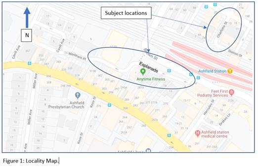
Subject: The Esplanade/Markham Place and Charlotte Street, Ashfield- Bicycle Contra-Flow in One-Way Streets. (Diarrawunang-Ashfield Ward/Summer Hill Electorate/Burwood PAC)
Prepared By: Boris Muha - Engineer – Traffic and Parking Services
Authorised By: Manod Wickramasinghe - Traffic and Transport Planning Manager
SUMMARY
The Ashfield Bicycle Users Group has requested that bicycle contra-flow arrangements be considered in the one-way streets of The Esplanade/Markham Place and Charlotte Street, Ashfield to allow for improved bicycle access to destinations within the Inner West Council.
Following investigations in line with the relevant standards and guidelines, together with the street environment and geometry, the following recommendations are therefore made.
|
RECOMMENDATION
THAT:
1. No further action be undertaken in relation to providing a bicycle contra-flow treatment in Charlotte Street, between Elizabeth Street and Station Street, Ashfield;
2. ‘Bicycle Excepted’ signage be installed in the one-way section of the access lane at the rear of the Ashfield Catholic Club, between Station Street and Elizabeth Street; and
3. A bicycle contra-flow treatment in Markham Place/The Esplanade, Ashfield, between Markham Lane and Fox Lane/Brown Street, be approved in principle and listed on Council’s future Capital Works Program.
|
BACKGROUND
The Ashfield Bicycle Users Group has provided Council with a priority list of cycle way items to be considered. Two items of request within the Ashfield CBD Area are:
1. Provide a contra-flow lane or arrangement in Charlotte Street, between Elizabeth Street and Station Street for ease of access leading from Ashfield Station and being able to cross Elizabeth Street from Charlotte Street.
2. Provide for a contra-flow lane or arrangement in Markham Place/The Esplanade, Ashfield, between Markham Lane and Fox’s Lane/Brown Street, for ease of access from Liverpool Road/Cavill Avenue to Brown Street.
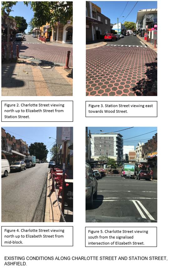
The following Locality plan, tables and photographic figures identify the existing conditions of the street and laneways in question.
1. Charlotte Street, between Elizabeth Street and Station Street, Ashfield.
|
Street Name(s) |
Charlotte Street |
|
Section |
Between Elizabeth Street and Station Street. |
|
Traffic Volume (vehicles per day)-vpd |
*1290 |
|
Recorded Accident History (5 year) |
At/near intersection- (1) Rear end- RUM 30 Elizabeth St, east of Charlotte St -non casualty(towaway)-2014. (1) opposing direction- RUM 29-at intersection-minor injury-2014. (1) Pedestrian- RUM 0-Elizabeth Street, west of Charlotte St-serious injury-2015. (1) Right Through-RUM 21- at intersection-non casualty (towaway). |
|
Recorded 85% speed |
26 km/h |
|
Speed Limit |
50km/h (north of the shared zone) |
|
Carriageway width |
Approx. 6.4m to 10.3m |
|
Carriageway Type |
One-way south with parking to both sides where wider than 6.4m. |
|
Road Classification (State, Regional, Local) |
Local |
|
Heavy vehicle percentage |
1% |
Note* maximum on the one day (traffic count reading 15 November 2019)
2. Markham Place/The Esplanade, Ashfield, between Markham Lane and Fox Lane/Brown Street, Ashfield.
|
Street Name(s) |
Markham Lane/The Esplanade |
|
Section |
Between Markham Lane & Fox’s Lane/Brown Street. |
|
Traffic Volume (vehicles per day)-vpd |
*700 |
|
Recorded Accident History (5 year) |
(1) Pedestrian walking with traffic-RUM 4-minor injury-2014 |
|
Recorded 85% speed |
32km/h |
|
Speed Limit |
40km/h |
|
Carriageway width |
The Esplanade approx. 3.7m, Markham Place 4.5-4.9m |
|
Carriageway Type |
One-way west, mainly No Stopping both sides with sections No Parking and Loading Zone in Markham Place |
|
Road Classification (State, Regional, Local) |
Local |
|
Heavy vehicle percentage |
5% |
Note* maximum on the one day (traffic count reading15 November 2019)
FINANCIAL IMPLICATIONS
The cost for signage associated with the work on the rear lane to the Ashfield Catholic Club, between Elizabeth Street and Station Street, Ashfield, can be covered from Council’s operational budget for line marking and signs.
The work of proposing a bicycle contra-flow treatment in Markham Place/The Esplanade, between Markham Lane and Fox Lane/Brown Street, Ashfield, be listed for funding on Council’s future Capital Works Program.
OTHER STAFF COMMENTS
Extracts from The RMS Technical directions TTD 2014/002 advise as follows when considering contra-flow movement.
A contra-flow bicycle facility may take the form of a marked lane or as a movement designated by signs only.
Contra-flow bicycle facilities should be assessed as a potential treatment on all local low speed, low volume one-way streets, including shared zones.
Ideally, all contra-flow bicycle movements will be delineated by a bicycle lane. A bicycle lane must be installed in locations where:
• Sight distances are restricted due to bends in the road or other features.
• Motor traffic volumes or speeds present a safety risk.
• Bicycle traffic volumes or speeds present a safety risk.
• The gradient and/or other road geometry increase the risk of collisions or unsafe driving or riding behaviours.
• The number or location of driveways present a safety risk.
Note: The NSW Road Rules prohibit parking in signposted bicycle lanes.
If the road space is too narrow to permit a marked bicycle lane and there is good sight distance, motor traffic volumes and speeds are low and the road geometry does not present an unacceptable safety risk, the contraflow movement can be provided by signage alone.
Because motor vehicle drivers will be focused on their own direction of travel, they may have a reduced awareness of the possibility of bicycles travelling in the opposite direction on one-way streets. Therefore, coloured pavement, pavement markings and warning signage may help to improve awareness and reduce conflict, particularly at intersections.
Contra-flow bicycle facilities will not be appropriate for every one-way street.
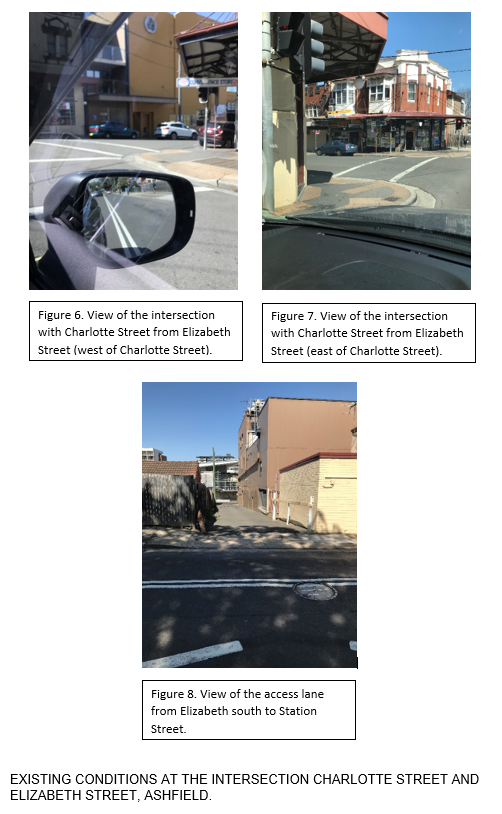
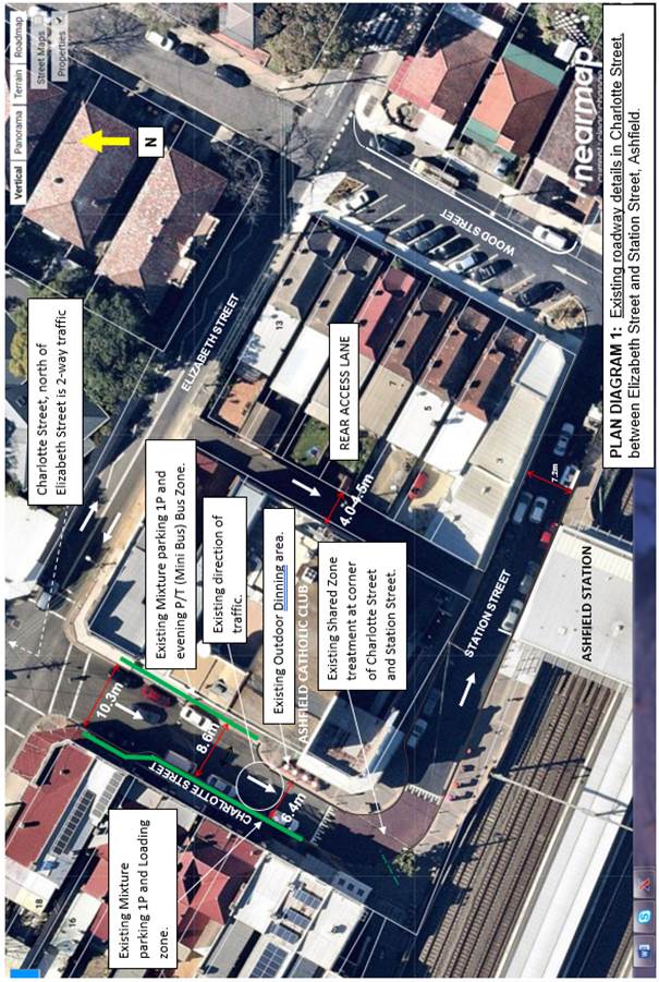
Taking in consideration of the above with reference also to the Australian Standard AS2890.5, Austroads: Cycling Aspects of Austroad Guides, and the RMS-NSW Bicycle guidelines, an existing roadway plan (diagram No1.) is shown in assistance to comment on the justification or feasibility in providing for a bicycle contra-flow facility in Charlotte Street, between Station Street and Elizabeth Street.
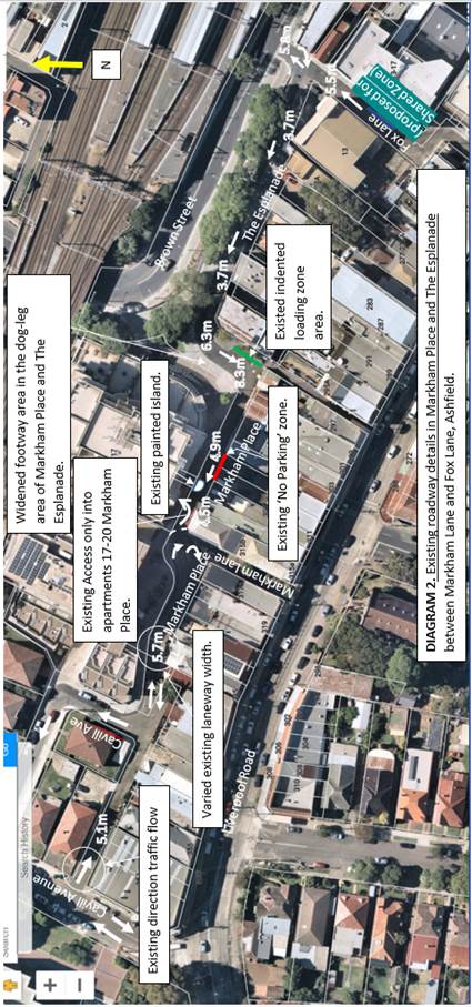
Similarly, an existing roadway plan (diagram No 2) is shown in assistance to comment on the justification or feasibility in providing a bicycle contra-flow facility in Markham Place and The Esplanade.
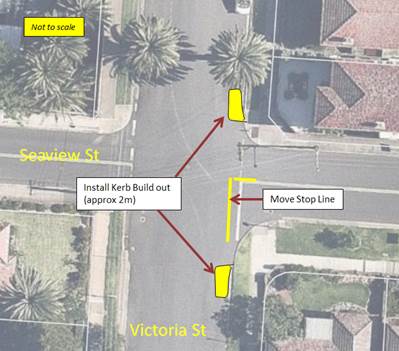
Under Diagram 1. For Charlotte Street.
Given that Charlotte Street is a main local street with commercial, business activities and service vehicle and customer parking necessities, and bearing in reference to the diagrammatic source below, the following points are raised.
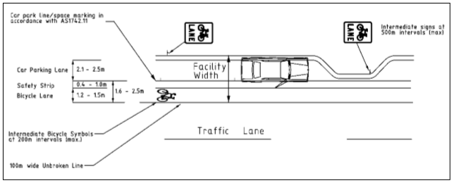
Typical bicycle/car parking lanes layout (parallel parking)
Figure 6: (Source: Austroads: Cycling Aspects of Austroads Guides)
Ø Charlotte Street between Elizabeth Street and Station Street is one way south with the road width varying from approx.10.3m down to 8.6m down to 6.4m kerb to kerb near Station Street.
Ø Traffic enters the above section of Charlotte Street via the signalised intersection of Charlotte Street and Elizabeth Street under single phase operation. The traffic then travels down Charlotte Street one-way south, then along the narrow sections of Station Street, one-way east, then one-way north up Wood Street to exit onto Elizabeth Street.
This one-way loop system has been well established over the years with ease of entry via the signalised intersection of Charlotte Street and Elizabeth Street.
Ø A painted contra-flow bicycle lane would need to be applied for this location considering the higher street volume and the need to designate the lane away from the parked vehicles and the approach to the traffic signals at Elizabeth Street. This lane would be marked from the start of the shared zone area going up to the traffic signals at Elizabeth Street.
Ø Parking lane designation would need to be a minimum of 2.3m to cater for cars and light commercial vehicles with likely parking of wide vehicles according to AS standards in this particular situation.
Under the above design criteria, the following cross-sectional diagrams (viewed north) would depict the position of the bicycle lane along the above section of Charlotte Street at carriageway locations measuring 6.4m, 8.6m to 10.3m near Elizabeth Street. The clear remaining travel lane areas would measure 2.3m to 2.2m to 3.9m respectively.
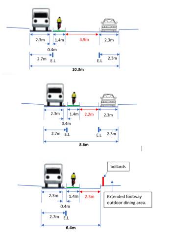
From this it is viewed that:
· The inclusion of a contra-flow bicycle lane would position the facility well within the designated travel lane, posing hazard and conflict with opposing traffic south bound. Traffic particularly with trucks at the signalised intersection of Elizabeth Street and Charlotte Street would infringe and ride over the bicycle lane when maneuvering and entering around the intersection.
· Sight view could be obstructed of bicyclists coming onto the shared zone with parked cars interfering with the view.
· Parking is a mixture of 1hour period parking and Loading Zones on the western side and 1hour period parking and Mini Bus Zone to cater for the Ashfield Catholic Club. This results in high turn-over in parking likely to conflict with the bicyclist movement in the area.
· Traffic may be forced closer to the eastern kerb side area of Charlotte in order to avoid bicyclists, hence posing conflict and danger to parked cars and the outdoor dining area of the Ashfield Catholic Club.
· Travel lane widths at two sections along the route are reduced to 2.2m and 2.3m respectively. These travel lane widths are below the acceptable range of 2.6-4.2m for Contra-flow bicycle lanes in narrow Streets- RMS’s NSW Bicycle guidelines. The travel lane widths should be more to the higher range given that this is a main town street environment.
For a contra-flow bicycle lane to be introduced in Charlotte Street, approximately 5-6 customer parking and loading zone spaces would need to be removed. The above section of Charlotte Street is not a designated bicycle route according to the Inner West Council Cycling Map and Guide.
It is recommended that no further action be undertaken to introduce a bicycle contra-flow lane in Charlotte Street, between Elizabeth Street and Station Street.
Alternatively, it is identified that there is a parallel rear access lane to the east of Charlotte Street. This services only rear access to the properties in Wood Street and the Club. The lane measures approx. 4-4.5 m wide and is one-way southbound preventing traffic to rat-run from Station Street to Elizabeth Street.
It is considered that bicyclists could contra-flow travel along this lane. The placement of regulatory ‘Bicyclists Excepted’ signage under the existing one-way signs is only required in this regard.
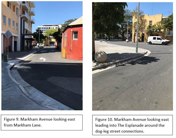
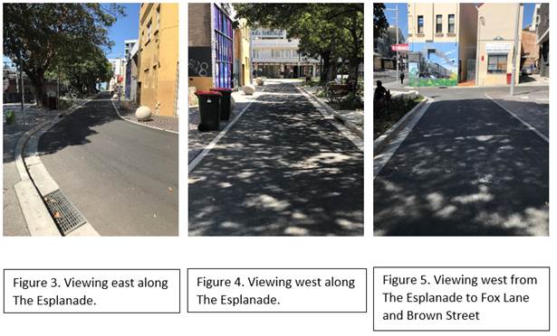
Under Diagram 2. For The Esplanade and Markham Place .
The Esplanade and Markham Place are rear lane accesses mainly to serve commercial/shop and residential properties. There is no vehicle parking along these lanes, bar that of an intended area for loading at the dog leg section. A small ‘No Parking’ zone exists in the area marked on the plan for drop-off and pick-up of passengers and/or goods.
The following points are further raised.
Ø The Esplanade leading into Markham Place (between Brown Street/Fox Lane and Markham Lane) measures in roadway width from approx. 3.7m to 8.3m (at the dog leg) down to 4.5 metres near Markham Place.
Ø The Esplanade and Markham Place (between Brown Street/Fox Lane and Markham Lane) is one-way westbound.
This one-way westbound system has been well established over the years and prevents traffic from rat-running from Liverpool Road to Brown Street.
Ø There is lesser traffic along these lanes than Charlotte Street. Under design, in this location, regulatory signage ‘Bicycles Excepted’ could be provided at the No Entry and one-way ends of the lanes.
Contra-flow bicycle logo and arrow pavement symbols would apply and marked to the left-hand side to designate travel along the kerb side. Relevant warning/advisory signs may also apply.
At the dog leg section, due to the lack of sight view, bicyclists would need to be directed onto the widened footpath area from Markham Place and back onto the roadway area of The Esplanade.
From this it is viewed that:
· A Bicycle contra-flow may be facilitated in these lanes provided that pavement bicycle logo and arrow markings, and relevant warning/advisory signs are provided in supplement to the regulatory ‘Bicycles Excepted’ signage within the lanes. The contra-flow bicycle logo and arrow markings would be of a small size and marked along the northern kerbside of Markham Place and The Esplanade. By doing so bicyclists keep to the far left hand side in view of opposing traffic.
· A marked bicycle and pedestrian shared path (with bicycles only in the contraflow direction) would need to be provided on the widened footway area at the dog leg section for bicyclists to come off from Markham Place and re-enter the roadway at The Esplanade. Bicycle ramps would be provided at the entry and exit points.
· The above section Markham Place/The Esplanade is not a designated bicycle route under the Inner West Council Cycling Map and Guide.
PUBLIC CONSULTATION
Community engagement will be undertaken during the design phase for the proposed contra flow treatments along Markham Place and The Esplanade.
CONCLUSION
In view of the above, no further action be undertaken in relation to providing a bicycle contra-flow treatment in Charlotte Street, between Elizabeth Street and Station Street, Ashfield.
However, it is proposed that ‘Bicycle Excepted’ signage be installed in the one-way section of the access lane at the rear of the Ashfield Catholic Club, between Station Street and Elizabeth Street, in alternative to providing some ease of access to Elizabeth Street.
It is recommended that the proposal for a bicycle contra-flow treatment in Markham Place/The Esplanade, Ashfield, between Markham Lane and Fox Lane/Brown Street, including a shared footpath arrangement (in the wide footway area of the dog leg of Markham Place and The Esplanade) be approved in principle, and that the project be listed for funding under Council’s Future Capital Works Program.
|
|
Local Traffic Committee Meeting 3 February 2020 |
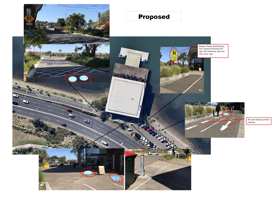
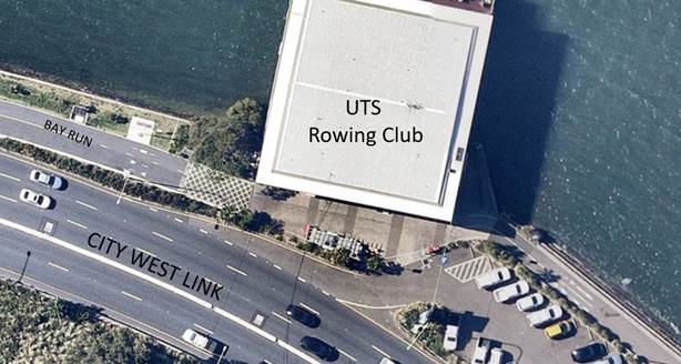
Subject: Bay Run at UTS Rowing Club, Haberfield - Proposed signage and pavement marking upgrade (Gulgadya-Leichhardt Ward/Summer Hill Electorate/ Burwood PAC)
Prepared By: Felicia Lau - Engineer - Traffic and Parking Services
Authorised By: Manod Wickramasinghe - Traffic and Transport Planning Manager
SUMMARY
Council have received concerns from Bay Run users regarding safety on the shared path in front of the UTS Rowing Club, Haberfield. Council has scheduled an upgrade for this section of the Bay Run and the detailed design for the upgrade will commence mid-2020. In the interim, it is proposed that signage and pavement markings upgrade works be undertaken.
|
RECOMMENDATION
THAT the proposed signage and pavement markings upgrade (Attachment 1) for the Bay Run around the UTS Haberfield Rowing Club building be approved. |
BACKGROUND
Bay Run users have raised concerns regarding pedestrian safety at the shared path in front of the UTS rowing club, Haberfield. It is alleged that cyclists are travelling on their bicycles across the shared path in an unacceptable speed to pedestrians and has resulted in a few near misses with pedestrians. Pedestrian are also mis-informed that cyclists have to dismount in the shared path in front of the UTS rowing club building where an advisory sign states ‘Please Walk Bicycles Past Carpark & Rowing Club’ facing westbound cyclists.
Currently the area in front of UTS Rowing Club is a shared path environment that does not delineate between eastbound and westbound movements or between pedestrians and cyclists. The recently widened section of the Bay Run to the west, does separate bicycle and pedestrian movements. The Bay Run to the east of the Rowing Club provides share paths that separate eastbound and westbound movements.
Council has scheduled to upgrade the Bay Run between the Rowing Club and Lilyfield Road and this will be an opportunity where potential safety measures can be considered more holistically. The detailed design stage of the project will commence mid-2020 and in the interim, it is proposed to upgrade signs and pavement markings.
FINANCIAL IMPLICATIONS
Nil.
OTHER STAFF COMMENTS
Site observations indicate that:
· Some areas require remarking or new pavement markings, especially markings that advise users that they are entering a shared path.
· Visitors to the UTS rowing club building appear to congregate near the front entrance, resulting in a reduced travel width for cyclist.
· A redundant ‘Please Walk Bicycles Past Carpark & Rowing Club’ sign advising cyclist to dismount in a shared path does not align with the function of a shared path.
The proposed interim design plan enclosed, aims to educate both pedestrians and cyclists of the shared area in front of the UTS Rowing Club building. It also proposes to remove the redundant sign that advises cyclist to dismount in a shared path by replacing it with advisory signs that informs the cyclist that they are entering a high pedestrian activity area and a slow speed environment.
Separately, the feasibility to relocate the radar speed display that is currently installed on the Bay Run, near King George Park will be investigated. It is expected that this would provide improved awareness of the speed for cyclists.
PUBLIC CONSULTATION
Nil.
CONCLUSION
It is recommended that the proposed interim signage and line marking works for this section of Bay Run be approved.
|
1.⇩ |
Bay Run at UTS Rowing Club, Haberfield - Interim Signage and Linemarking Plan |
|
|
Local Traffic Committee Meeting 3 February 2020 |
Subject: Murray Street, Marrickville – Road Occupancy – Request by Breastscreen NSW to Position a Mobile X-RAY Unit on Street Between Friday 10 April 2020 and Friday 5 June 2020 (MIDJUBURI - Marrickville Ward / Summer Hill Electorate / Marrickville PAC)
Prepared By: Jennifer Adams - Engineer – Traffic and Parking Services
Authorised By: Manod Wickramasinghe - Traffic and Transport Planning Manager
SUMMARY
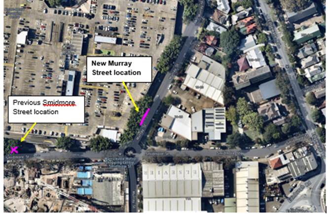
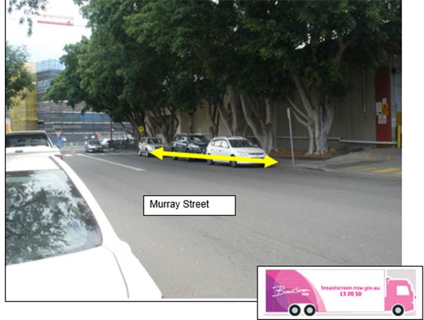
A request has been received from ‘BreastScreen New South Wales’ to position a mobile x-ray Unit within the existing ‘2P 8.30am – 6pm Mon – Fri 8.30am – 12.30pm Sat’ restrictions on the western side of Murray Street adjacent Marrickville Metro Shopping Centre, Marrickville, between Friday 10 April 2020 and Friday 5 June 2020 (a period of approximately eight (8) weeks). In previous years the van was annually located on Smidmore Street in the ‘No parking’ zone on the northern side of Smidmore Street adjacent Marrickville Metro Shopping Centre, Marrickville with no major problems being encountered. However, due to Marrickville Metro Expansion works this year a new location was required. It is recommended that the request be approved, on the basis of this being an annual occurrence with no major problems being encountered previously.
|
RECOMMENDATION
THAT the road occupancy for the BreastScreen NSW mobile x-ray unit on the western side of Murray Street, Marrickville approximately 30 metres north of Smidmore Street, adjacent Marrickville Metro Shopping Centre, be supported for a period of approximately 8 weeks from Friday 10 April 2020 and Friday 5 June 2020, subject to the following conditions:
1. The existing ‘2P 8.30am – 6pm Mon – Fri 8.30am – 12.30pm Sat’ restrictions be temporarily removed for the proposed duration (i.e. between Friday 10 April 2020 and Friday 5 June 2020); 2. That all affected businesses, residents and other occupants must be notified of the road occupancy and activities at least one week prior to the commencement of the event. Any concerns or requirements raised by business proprietors, residents and other occupants must be resolved or accommodated by the applicant; 3. That the applicant contact Energy Australia/Ausgrid in relation to power access to the mobile laboratory; 4. That a copy of the Council approval letter must be made available on the site for inspection by relevant officers; 5. That the applicant must comply with any reasonable directive from Council’s Compliance Officers; and 6. That Council reserves the right to cancel this approval at any time. |
BACKGROUND & OFFICER COMMENTS
The Health Promotion Officer for ‘Breast Screen New South Wales’ has submitted an application to Council dated 28 November 2019, seeking permission to position a mobile x-ray van on the northern side of Smidmore Street in close proximity to the Marrickville Metro Shopping Centre, as in previous years. However, due to current Marrickville Metro expansion works the preceding location in Smidmore Street is not available and a new location around the corner in Murray Street has been identified as being suitable. The new location is currently four on-street spaces of restricted parking ‘2P 8.30am – 6pm Mon – Fri 8.30am – 12.30pm Sat’. (Refer to the attached location map).
Other conditions, than those in the recommendation, that generally are relevant to such applications include:
· That the areas to be used for the activities must be maintained in a clean and tidy condition to the satisfaction of Council’s Director Infrastructure, or else the applicant will be required to reimburse Council for any extraordinary cleansing costs;
· That the Council and RMS must be indemnified against all claims for damage or injury that may result from either the activities or from the occupation of part of the public way during the activities. The applicant must therefore produce evidence of its public risk insurance cover (under which Council is indemnified) with a minimum policy value of at least $10,000,000;
The van would be on site for a period of approximately eight (8) weeks, from Friday 10 April 2020 and Friday 5 June 2020. It is noted that a copy of BreastScreen NSW public risk insurance has been provided.
FINANCIAL IMPLICATIONS
Nil
PUBLIC CONSULTATION
Affected businesses and residents will be notified prior to the zone being changed.
CONCLUSION
That the road occupancy for a Breast Screen NSW mobile x-ray Unit within the existing ‘2P 8.30am – 6pm Mon – Fri 8.30am – 12.30pm Sat’’ zone on the western side of Murray Street adjacent Marrickville Metro Shopping Centre, Marrickville, between Friday 10 April 2020 and Friday 5 June 2020, be supported subject to the conditions listed in the officer’s recommendation.
|
|
Local Traffic Committee Meeting 3 February 2020 |
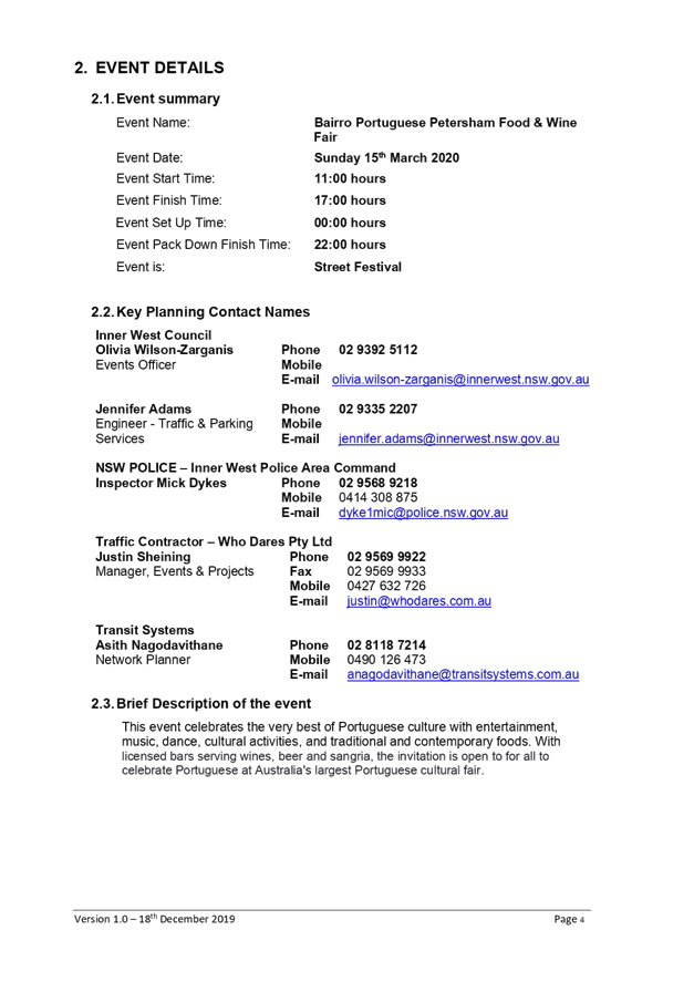
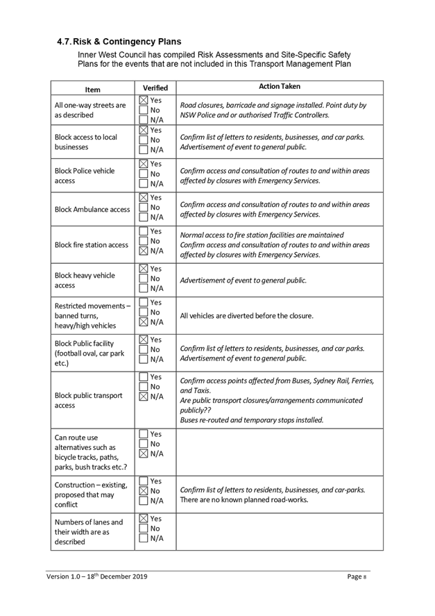
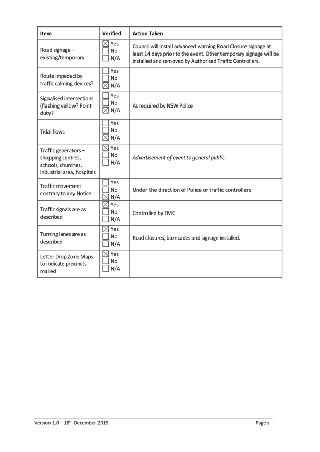
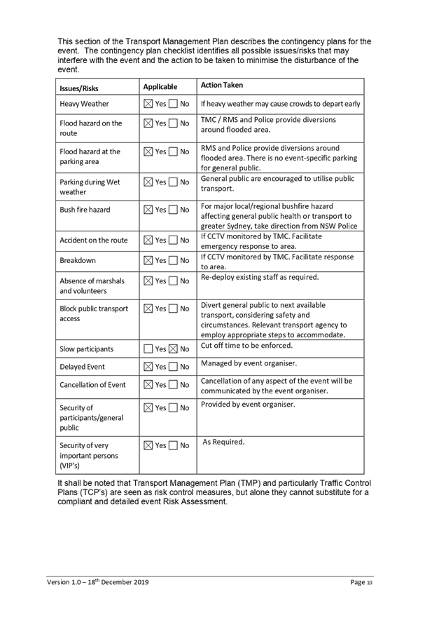
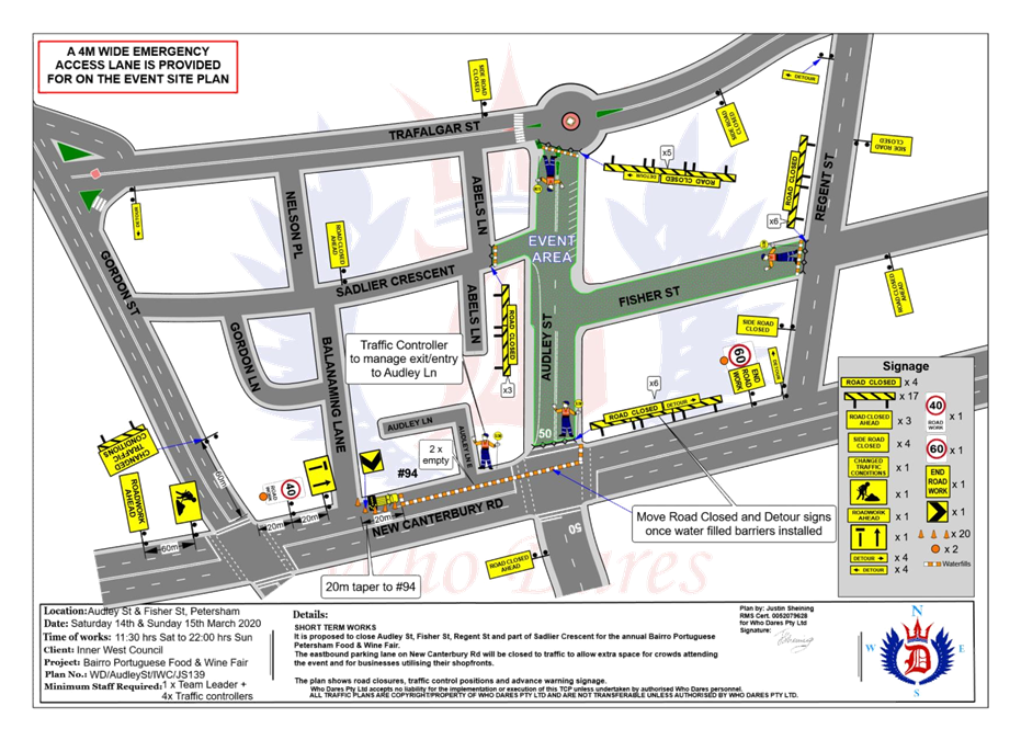
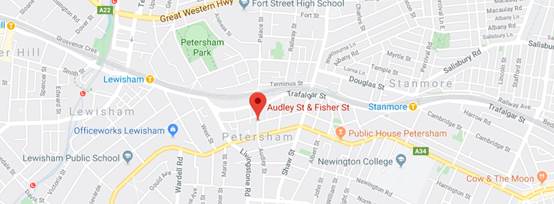
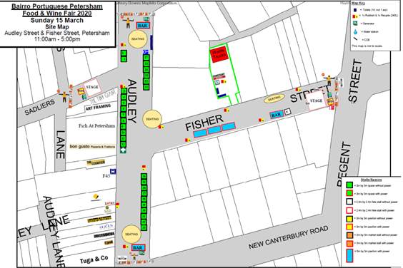
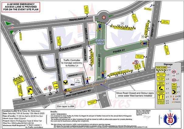
Subject: Audley Street, Sadlier Crescent, Fisher Street, and parking lanes on New Canterbury Road Petersham – Temporary Full Road Closures For Special Event On Sunday 15 March 2020 – Bairro Portuguese Food and Wine Fair (Damum - Stanmore Ward / Newtown Electorate / Inner West PAC)
Prepared By: Jennifer Adams - Engineer – Traffic and Parking Services
Authorised By: Manod Wickramasinghe - Traffic and Transport Planning Manager
SUMMARY
A Development Application (DA201700624) was approved in 2018 for the holding of the annual ‘Bairro Portuguese Food and Wine Fair’ for a five year period (i.e. 4 March 2018, 15 March 2019, 15 March 2020, 14 March 2021 and 13 March 2022).
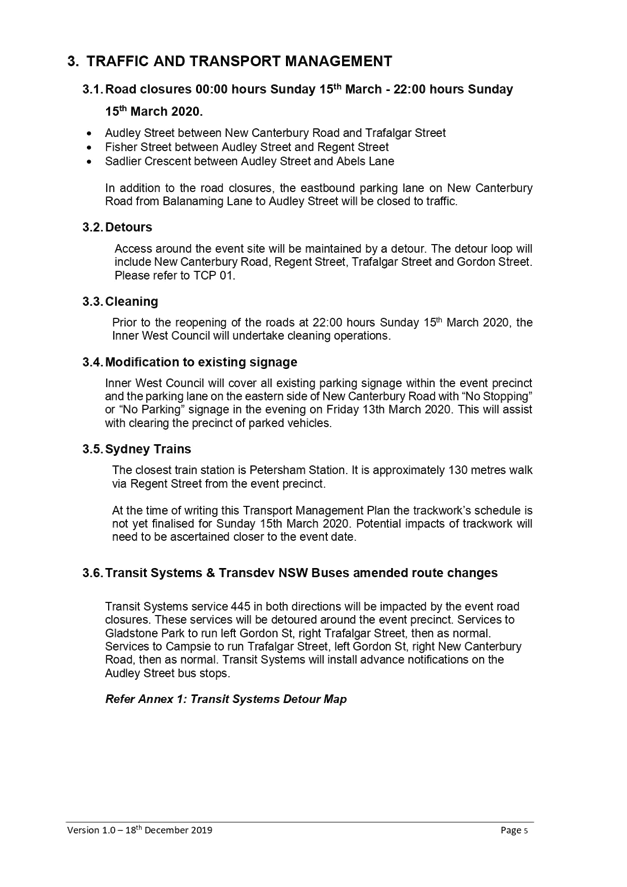
This year’s event will be held on Sunday 15 March 2020 and will necessitate the temporary closure of Audley Street (between Trafalgar Street and New Canterbury Road), Sadlier Crescent (between Audley Street and Abels Lane) and Fisher Street (between Audley Street and Regent Street), as well as the parking lanes on New Canterbury Road (between Gordon Street and Audley Street), Petersham from 1.00am until 12.00 midnight as in previous years.
|
THAT the proposed temporary road closure of Audley Street (between Trafalgar Street and New Canterbury Road), Sadlier Crescent (between Audley Street and Abels Lane) and Fisher Street (between Audley Street and Regent Street), as well as the parking lanes on New Canterbury Road (between Gordon street and Audley Street), Petersham, on Sunday, 15 March 2020, from 1.00am to 12.00 midnight, for the holding of the annual ‘Bairro Portuguese Food and Wine Fair’, be SUPPORTED subject to the applicant complying with but not limited to the following conditions;
1. A Traffic Management Plan (TMP) is submitted to and approved by Transport for NSW (formerly RMS); and an application for a Road Occupancy Licence and a temporary Speed Zone Authorisation is forwarded to and approved by the Transport Management Centre;
2. Notice of the proposed event is forwarded to all affected residents and businesses, including the NSW Police / Inner West Local Area Command, Fire and Rescue NSW, NSW Ambulance and Transit Systems;
3. Transit Systems – Inner West Bus Services be requested to implement a revised routing for scheduled bus services in Audley Street on the day of the event and install temporary bus stops as required;
4. A minimum four (4) metre unencumbered passage be available for emergency vehicles through the closed section; and
5. The occupation of the road carriageways must not occur until the roads have been physically closed. |
BACKGROUND
Temporary road closures have been implemented in previous years to hold the annual ‘Bairro Portuguese Food and Wine Fair’. This annual Fair, since its inception in 2003, aims to showcase Petersham's businesses and services, attracts people to the area and has a multicultural theme. On all previous occasions, the closures were successful and no major problems were experienced.
FINANCIAL IMPLICATIONS
Funding has been allocated by Council for organising the ‘Bairro Portuguese Food and Wine Fair’ event under the 2019/2020 Major Community Events Program.
OFFICERS COMMENTS
Event
This year’s event will be held on Sunday 15 March 2020 and will necessitate the temporary closure of Audley Street (between Trafalgar Street and New Canterbury Road), Sadlier Crescent (between Audley Street and Abels Lane) and Fisher Street (between Audley Street and Regent Street), as well as the parking lanes on New Canterbury Road (between Gordon Street and Audley Street), Petersham from 1.00am until 12.00 midnight as in previous years. Refer to the locality map and site map below.
This is an extension of a Class 2 Event under the RMS’ Special Events Guide where it impacts local traffic and transport systems but does not impact major traffic and transport systems and it disrupts the non-event community in the area around the event but not over a wide area. The event requires the involvement of Police and Local Council and a detailed Transport Management Plan (TMP).
A Traffic Management Plan (TMP) has been supplied by Who Dares Pty Ltd, the scope of which includes the provision for the safe movement of vehicular traffic in and out of the event areas at the Bairro Portuguese Food and Wine Fair on Sunday 15 March 2020. The TMP and Traffic Control Plans (TCP) are reproduced at the end of this report.
Access around the event site will be maintained by a detour. The detour loop will include New Canterbury Road, Regent Street, Trafalgar Street and Gordon Street. Please refer to TCP 01 below.
Lane closures of New Canterbury Road
As per previous events held, it is proposed to close the parking lanes on New Canterbury Road (between Gordon Street and Audley Street) as shown on the Traffic Control Plan (TCP) prepared by Who Dares Pty Ltd – TCP 01 reproduced above.
In previous years the event attracted in excess of 15,000 attendees prompting the event coordinators to look at ways to ease congestion at the main site and make access easier from New Canterbury Road. The closure of the parking lanes on New Canterbury Road improves access to the area where the main event is to be conducted and improves the amenity of the footpath dining outside a number of the eateries along New Canterbury Road which are adjacent to the closure.
There is significant improvement in access for people with disabilities as congestion will be reduced and there will be no obstacles such as tables, chairs, planter boxes, light/sign poles and bins in the closed lanes. The solid barriers will separate the pedestrians from the moving traffic on the adjacent lane and will also help prevent young children who may be separated from their custodians escaping onto the main thoroughfare and possibly being hit by passing traffic.
The TCP indicates that a reduced temporary speed limit of 40km/h is required on New Canterbury Road (between Gordon Street and Audley Street) during the closure of the parking lanes for the subject event. An application for a Road Occupancy Licence will be necessary.
The time-span for the road closure is necessary to allow stalls and stages to be set up before the event and dismantled after the event. The closure will be affected by the placement of barricades at the following locations:
· Junction of Audley Street and New Canterbury Road;
· Junction of New Canterbury Road and Gordon Street;
· Junction of Audley Street and Trafalgar Street;
· Junction of Fisher Street and Regent Street; and
· Junction of Sadlier Crescent and Abels Lane.
Special advance notice signs will be strategically installed at least two weeks prior to the event to alert motorists of the proposed closures. These signs will be installed at the following locations:-
· Junction of Railway Terrace and Gordon Street;
· Junction of New Canterbury Road and Audley Lane;
· Junction of Trafalgar Street and Audley Street;
· Junction of Regent and Fisher Streets; and
· Junction of Nelson Place and Sadlier Crescent.
In addition, 'No Parking - Special Event' signs will be affixed over all existing timed parking restrictions signs in the area to be closed on the afternoon before the day of the event. Residents in Fisher Street will be allowed access into and out of their properties.
Audley Street is used by scheduled Transit Systems bus services and they will need to implement the re-routing of services on the day as in previous years.
Impacts on buses
It is envisioned that the 445 Bus service diversions in place in 2019 during the event road closures of Audley and Fisher street will be similar for 2020:
· Services to Gladstone Park to run left Gordon St, right Trafalgar Street, then as normal
· Services to Campsie to run Trafalgar Street, left Gordon St, right New Canterbury Road, then as normal
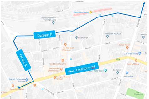
Transit Systems Detour Map – Route 445
The supplied TMP notes that “Transit Systems service 445 in both directions will be impacted by the event road closures. These services will be detoured around the event precinct. Services to Gladstone Park to run left Gordon St, right Trafalgar Street, then as normal. Services to Campsie to run Trafalgar Street, left Gordon St, right New Canterbury Road, then as normal. Transit Systems will install advance notifications on the Audley Street bus stops.”
Impacts on parking
In relation to parking it is stated in the TMP that “Parking will only be available in surrounding residential streets and a few small public carparks around the event site. Parking will as such be limited, and the event organiser will be recommending public transport to all event patrons.”
Impacts on traffic
The TMP states that “heavy vehicles may experience slight delays due to increased traffic around the event precinct. Heavy vehicles should follow signposted detours”. In relation to pedestrians and cyclists it states that “There will be no major effect to pedestrians in the area. Pedestrians will be able to use the existing pedestrian paths outside of and within the event area. There are no cycleways directly impacted by this event. Cyclists entering the event site will be requested to dismount.”
PUBLIC CONSULTATION
The proposed temporary full road closures for the event will be advertised in the local paper allowing for a period of 28 days for public submissions. The advertising period commenced on 10 December 2019 and concluded on 6 January 2020. The Traffic Management Plan is to be submitted to Transport for NSW (formerly RMS) for consideration and approval and a Road Occupancy License application is to be submitted to the Transport Management Centre by Who Dares Pty Ltd.
CONCLUSION
It is recommended that Council agree to the temporary full road closures on Sunday, 15 March 2020 subject to complying with the recommendations stated in this report along with all standard conditions for temporary full road closures as detailed in Conditions 3, 31 and 32 of the development consent for the event.
Other conditions that need to be complied with include:
· Advance notifications signs for the event are strategically installed at least two (2) weeks prior to the event;
· "No Parking - Special Event" signs are affixed over all existing timed parking restriction signs within the sections of streets to be closed on the afternoon of the day prior to the event;
· A 4-metre wide emergency vehicle access must be maintained through the closed road areas during the course of the event;
· The applicant is to consult with all affected residents and/or businesses in the area in writing and to conduct a letter box drop of surrounding properties at least two weeks prior to event; and
· Adequate vehicular traffic control shall be provided for the protection and convenience of pedestrians and motorists including appropriate signage and flagging. Workers shall be specially designated for this role (and carry appropriate certificates), as necessary to comply with this condition. This is to be carried out in accordance with the Australian Standard AS 1742.3 - Traffic Control Devices for works on roads.
|
1.⇩ |
Bairro Portuguese Petersham Food Wine Fair Traffic Management Plan Version 1.0 with Traffic Control Plan Version 1.0 |
|
|
Local Traffic Committee Meeting 3 February 2020 |
Subject: Continous Footpath Treatment - Sorrie Street at the intersection of Booth Street, Balmain (Baludarri - Balmain Ward/Balmain Electorate/Leichhardt PAC)
Prepared By: Vinoth Srinivasan - Engineer - Traffic and Parking Services
Authorised By: Manod Wickramasinghe - Traffic and Transport Planning Manager
SUMMARY
As part of the Capital Works Program, Council has finalised a design plan for the proposed continuous footpath treatment on Sorrie Street at the intersection of Booth Street, Balmain. The intention of the proposal is to improve road safety for pedestrians and motorists.
Consultation was undertaken with owners and occupiers of properties in Booth Street, Sorrie Street and Palmer Street regarding the proposal. A summary of the consultation results are presented in this report for consideration. It is recommended that the proposed detailed design plan be approved.
|
RECOMMENDATION
THAT the detailed design plan (Design Plan No.10114) for the installation of a proposed continuous footpath treatment on Sorrie Street at the intersection of Booth Street, Balmain be approved. |
BACKGROUND
At its meeting in August 2019, Council adopted a motion to develop a scope of footpath renewal works and pedestrian and traffic safety treatments required in the footpaths surrounding Balmain Hospital to ensure priority areas are addressed.
According to the RMS ‘Technical Directions (TDT 2013/05)’, there should be no more than 45 vehicles per hour moving through the intersection for a continuous footpath treatment to be installed.
Council’s Traffic Services section conducted pedestrian and traffic counts during morning, lunch and evening peak hours on 27 August 2019. Sorrie Street at the intersection of Booth Street, Balmain was identified as a suitable location for a continuous footpath treatment as it met requirements outlined in the RMS ‘Technical Directions (TDT 2013/05)’ with a maximum flow:
· 11 vehicles in the morning peak hour
· 4 vehicles during the mid-day peak hour
· 9 vehicles in the afternoon peak hour
Therefore, Council is planning to construct a continuous footpath treatment in Sorrie Street at the intersection of Booth Street, Balmain to increase safety for pedestrians and motorists.
Site location & Road Network
|
Street Name(s) |
Booth Street and Sorrie Street |
|
Section |
Intersection |
|
Traffic Volume |
Not available |
|
Recorded Accident History (5 year) |
Nil |
|
Recorded 85% speed |
Not available |
|
Speed Limit |
40km/h |
|
Carriageway width |
Booth Street – 9.9m Sorrie Street – 4.2m |
|
Carriageway Type |
Booth Street – Two way with kerb side parking on both sides of the street Sorrie Street – One way with kerb side parking on one side of the street |
FINANCIAL IMPLICATIONS
Funding of $38,000 has been allocated to this project for construction in the 2019/20 Capital Works Program.
OTHER STAFF COMMENTS
The detailed design plan shown in Attachment 1 outlines the proposed works on Sorrie Street at the intersection of Booth Street and includes the following treatments:
· Removal of existing kerb ramps and construction of continuous concrete footpath.
· Reconstruct kerb and gutter in Booth Street.
· Construction of landscaped verges in Booth Street.
· Installation of associated line markings.
This proposal will not result in the loss of any on-street parking spaces.
PUBLIC CONSULTATION
|
A letter outlining the proposal was mailed out to the affected properties (36 properties) in Booth Street, Sorrie Street and Palmer Street, Balmain, requesting residents’ views regarding the proposal (as indicated on the following plan).
Two (2) responses were received, both in support of the proposal.
|
|
|
Residents’ Comments |
Officer Comments |
|
We support the proposal but also ask Council to take further measures to improve pedestrian safety as there are vehicles speeding in an area where there is a hospital, a day care and two schools. Council should reduce the speed limit in Sorrie Street and convert the entire street into a shared zone. Further signage should be installed on the other end of Sorrie Street at the intersection of Palmer Street to inform vehicles that it is a one-way street. A traffic mirror should also be installed at this intersection to alert both drivers and pedestrians of their presence. There is a property on the eastern side of Palmer Street at the intersection of Sorrie Street which restricts visibility for pedestrians of oncoming vehicles. Council should consider implementing a similar continuous treatment at this intersection. |
Council does not install convex mirrors as they provide a distorted image of on-coming vehicles, possibly leading to misinterpretation by the reliant motorist. Also, at night, the lights from travelling vehicles and other sources, being reflected from these types of mirrors can cause confusion for motorists as to the location of oncoming traffic. This is exacerbated by the distorted image shown by convex mirrors.
The installation of further signage and a continuous footpath treatment at the intersection of Sorrie Street and Palmer Street and the implementation of a shared zone on Sorrie Street will be investigated as part of a separate investigation.
|
|
1.⇩ |
Detailed Design Plan - Sorrie Street at Booth Street, Balmain |
|
|
Local Traffic Committee Meeting 3 February 2020 |
Subject: Minor Traffic Facilities (All Wards/All Electorates/All PACS)
Prepared By: Davide Torresan - Coordinator - Road Access Services
Authorised By: Manod Wickramasinghe - Traffic and Transport Planning Manager
SUMMARY
This report considers minor traffic facility applications received by Inner West Council and includes ‘Disabled Parking’ and ‘Works Zone’ requests.
|
RECOMMENDATION
THAT:
1. The following ‘Disabled Parking’ zones be removed as they are no longer required; a. 6m ‘Disabled Parking’ zone in front of No. 136 Trafalgar St, Annandale, b. 6m ‘Disabled Parking’ zone in front of No. 32 High Street, Balmain, c. 6m ‘Disabled Parking’ zone in front of No. 76 Petersham Road, Marrickville, d. 6m ‘Disabled Parking’ zone in front of No. 136 Trafalgar Street, Annandale, and e. 6m ‘Disabled Parking’ zone in front of No. 54 Birchgrove Street, Balmain.
2. A 6.0m 'Disabled Parking’ zone be installed in front of No. 99 View Street, Annandale;
3. A 10m ‘No Stopping’ restriction be installed on the northern side of Mary Street, Rozelle, east of Alice Street followed by a 5.5m 'Disabled Parking Zone’ on the side boundary of No. 83 Denison Street, Rozelle;
4. A 6.0m 'Disabled Parking’ zone be installed adjacent to the existing ‘No Stopping zone’ on the south-eastern side of Wardell Road, on the side frontage of No. 70 Ewart Street, Dulwich Hill, south of Ewart Street;
5. A 10m 'Works Zone 7.00am – 6.00pm Mon-Fri and 8.00am - 1.00pm Sat' be installed at the front of No. 56 Young Street, Annandale, for 12 weeks;
6. A 9m 'Works Zone 7.00am – 6.00pm Mon-Fri and 8.00am - 1.00pm Sat' be installed at the front of No. 28 Waterloo Street, Rozelle, for 12 weeks;
7. A 9m 'Works Zone 7.00am – 6.00pm Mon-Fri and 8.00am - 1.00pm Sat' be installed in Charlotte Street at the rear of No. 172 Evans Street, Rozelle, for 12 weeks
8. A 10m ‘No Stopping’ restriction be installed on the eastern side of George Street, Balmain, south of Reynolds Street, followed by a 14m 'Works Zone 7.00am – 6.00pm Mon-Fri and 8.00am - 1.00pm Sat', on the side boundary of No. 11 Reynolds Street, Rozelle, for 12 weeks;
9. The following restrictions be installed in River Street, Birchgrove: a. A 9m 'Works Zone 7.00am – 6.00pm Mon-Fri and 8.00am - 1.00pm Sat'; ‘No Parking at other times’ restriction be installed on the western side of River Street in front of No. 14 River Street, Birchgrove, replacing the existing ‘No Parking’ restrictions for 12 weeks; and b. A ‘No Stopping’ zone be installed on the eastern side of River Street, north of Reuss Street at a statutory distance of 10m followed by a ‘No Parking 7.00am – 6.00pm Mon-Sat and 8.00am - 1.00pm Sat' restriction.
10. A 9m 'Works Zone 7.00am – 6.00pm Mon-Fri and 8.00am -1.00pm Sat' be installed in front of No. 12 Turner Avenue, Haberfield, for 12 weeks;
11. A 9m 'Works Zone 7.00am – 6.00pm Mon-Fri and 8.00am -1.00pm Sat' be installed in front of No. 2 Dickinson Avenue, Croydon, for 12 weeks;
12. A 18m 'Works Zone 7.00am – 6.00pm Mon-Fri and 8.00am -1.00pm Sat' be installed in front of No. 11a Moonbie Street, Summer Hill for 12 weeks; and
13. A 12m 'Works Zone 7.00am – 6.00pm Mon-Fri and 8.00am -1.00pm Sat' be installed in front of No. 5 George Street, Marrickville, for 12 weeks.
|
BACKGROUND
Requests have been received from residents within the Local Government Area (LGA) for the provision of mobility parking spaces outside their residence.
It is recommended that the following 'Mobility Parking' spaces be approved as the applicant’s current medical conditions warrant the provision of these spaces and they have constrained or no off-street parking opportunities. For the mobility parking space requests, a copy of the RMS disability parking permit and a medical certificate in support of the applications was submitted to Council.
The Disabled Parking Zones recommended for approval are installed under the following conditions:
1. The operation of the Disabled Parking Zone is valid for two (2) years from the date of installation.
2. The Disabled Parking Zone will be scheduled for review within two (2) years of the date of installation, then every twelve (12) months thereafter. The purpose of the reviews is to confirm that circumstances have not changed and as a result, the applicant may be requested to furnish a medical certificate and current Mobility Parking Scheme Permit to demonstrate the need for the continuation of the Mobility Parking Zone.
3. The Disabled Parking Zone is not exclusively reserved for the use of the applicant. It may also be used by any holder of a valid Mobility Parking Scheme Permit.
4. There is an obligation on the applicant to advise Council if circumstance change.
The following applications have also been received for ‘Work Zones’. The applications have been reviewed according to Council’s conditions of approval on the Work Zones application forms. It is also recommended that the following ‘Works Zones’ be approved.
FINANCIAL IMPLICATIONS
Nil.
OTHER STAFF COMMENTS
1. Removal of ‘Disabled Parking’ restrictions – Various
Residents have advised that the following ‘Disabled Parking’ zones are no longer required. Council staff have contacted the original applicants and they have confirmed that the ‘Disabled Parking’ zones are no longer required.
It is recommended that the following ‘Disabled Parking’ zones be removed:
a. 6m ‘Disabled Parking’ zone in front of No. 136 Trafalgar St, Annandale,
b. 6m ‘Disabled Parking’ zone in front of No. 32 High Street, Balmain,
c. 6m ‘Disabled Parking’ zone in front of No. 76 Petersham Road, Marrickville,
d. 6m ‘Disabled Parking’ zone in front of No. 136 Trafalgar Street, Annandale, and
e. 6m ‘Disabled Parking’ zone in front of No. 54 Birchgrove Street, Balmain.
2. Installation of ‘Disabled Parking’ Restriction – No. 99 View Street, Annandale
The resident of No. 99 View Street, Annandale, has requested the installation of 'Disabled Parking Zone’ in front of the resident’s property. A site investigation has revealed the property does not have an off street parking facility. The applicant does not require the use of wheelchair.
It is recommended that a 6m 'Disabled Parking’ zone be installed in front of No. 99 View Street, Annandale.
99 View Street, Annandale
3. Installation of ‘Disabled Parking’ Restriction – 83 Denison Street, Rozelle (In Mary Street)
The resident of No. 83 Denison Street, Rozelle, has requested the installation of 'Disabled Parking Zone’ in front of the resident’s property. A site investigation has revealed the property does not have an off-street parking facility. The applicant does not require the use of wheelchair.
It is recommended a 10m ‘No Stopping’ restriction be installed on the northern side of Mary Street, Rozelle, east of Alice Street followed by a 5.5m 'Disabled Parking Zone’ on the side boundary of No. 83 Denison Street, Rozelle
83 Denison Street, Rozelle – view of Mary Street from Alice Street
4. Installation of ‘Disabled Parking’ Restriction – No. 70 Ewart Street, Dulwich Hill
The resident of No. 70 Ewart Street, Dulwich Hill, has requested the installation of 'Disabled Parking Zone’ in front of the resident’s property. A site investigation has revealed the property does not have an off-street parking facility. The applicant does not require the use of wheelchair.
It is recommended that a 6.0m 'Disabled Parking’ zone be installed adjacent to the ‘No Stopping zone’ on the south-eastern side of Wardell Road, on the side boundary of No. 70 Ewart Street, Dulwich Hill, south of Ewart Street.
70 Ewart Street, Dulwich Hill – view from Wardell Road
Technical Standards
Australian Standard AS2890.5-1993 “On-Street Parking” states the following in regard to the provision of parking for people with a disability:
“Parallel parking spaces shall not be marked as disabled spaces, nor included in the count of spaces available for people with disabilities unless –
i. A 3.2m wide space can be provided, e.g. by indenting the space into the footpath area; and
ii. Kerb ramps as shown in Figure 4.2(a) are also provided”.
It should be noted that due to the limited width of streets around the LGA, it is often difficult to comply with these requirements for the parking space dimensions. This may also result in the loss of some adjacent on-street parking spaces.
Mobility parking spaces are primarily intended for on-street and off-street parking at destinations, such as in commercial/retail areas and public car parks near hospitals, schools and public transport facilities where multiple usages can be expected. They were generally not intended for points of origin such as reserving on-street parking. As such, they are only proposed where required for wheelchair access at the cost of the applicants.
A mobility parking space is not intended for the sole use of one applicant, but rather a shared facility that can used by all authorised persons having a RMS mobility permit.
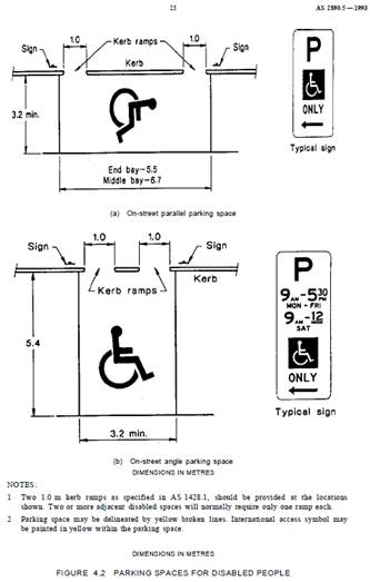
5. Installation of ‘Works Zone’ Restriction – 56 Young Street, Annandale
The applicant has requested the installation of a temporary 'Works Zone 7.00am – 6.00pm Mon-Sat and 8.00am - 1.00pm Sat' (unless noted otherwise on the Development Consent) for 12 weeks at the front of No. 56 Young Street, Annandale, for development works at the property. The proposed works zone has been requested for a length of approximately 6m of two angled parking bays.
It is recommended that a 'Works Zone 7.00am – 6.00pm Mon-Fri and 8.00am - 1.00pm Sat' be installed in the two angled parking bays at the front of No. 56 Young Street, Annandale, for 12 weeks.
56 Young Street, Annandale
6. Installation of ‘Works Zone’ Restriction – 28 Waterloo Street, Rozelle
The applicant has requested the installation of a temporary 9m 'Works Zone 7.00am – 6.00pm Mon-Sat and 8.00am - 1.00pm Sat' (unless noted otherwise on the Development Consent) for 12 weeks at the front of No. 28 Waterloo Street, Rozelle for development works at the property.
It is recommended that a 9m 'Works Zone 7.00am – 6.00pm Mon-Fri and 8.00am - 1.00pm Sat' be installed at the front of No. 28 Waterloo Street, Rozelle, for 12 weeks.
28 Waterloo Street, Rozelle
7. Installation of ‘Works Zone’ Restriction – 172 Evans Street, Rozelle (Charlotte Street)
The applicant has requested the installation of a temporary 9m 'Works Zone 7.00am – 6.00pm Mon-Sat and 8.00am - 1.00pm Sat' (unless noted otherwise on the Development Consent) for 12 weeks in Charlotte Street at the rear of No. 172 Evans Street, Rozelle for development works at the property.
It is recommended that a 9m 'Works Zone 7.00am – 6.00pm Mon-Fri and 8.00am - 1.00pm Sat' be installed in Charlotte Street at the rear of No. 172 Evans Street, Rozelle, for 12 weeks.
172 Evans Street, Rozelle – View from Charlotte Street
8. Installation of ‘Works Zone’ Restriction – 11 Reynolds Street, Rozelle (George Street)
The applicant has requested the installation of a temporary 14m 'Works Zone 7.00am – 6.00pm Mon-Sat and 8.00am - 1.00pm Sat' (unless noted otherwise on the Development Consent) for 12 weeks at the front of No. 11 Reynolds Street, Rozelle for development works at the property.
It is recommended that a ‘No Stopping (arrow left)’ sign be installed at a statutory distance of 10m and a 14m 'Works Zone 7.00am – 6.00pm Mon-Fri and 8.00am - 1.00pm Sat' be installed on the eastern side of George street, south of Reynolds Street, on the side boundary of No. 11 Reynolds Street, Rozelle, for 12 weeks.
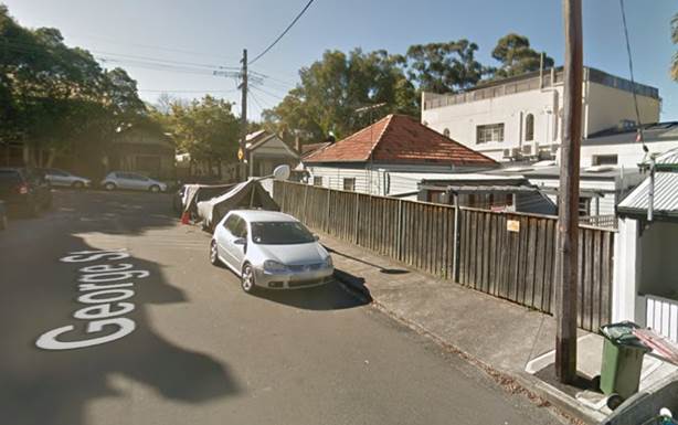
11 Reynolds Street, Balmain – view from George Street
9. Installation of ‘Works Zone’ Restriction – 14 River Street, Birchgrove
The applicant has requested the installation of a temporary 9m 'Works Zone 7.00am – 6.00pm Mon-Sat and 8.00am - 1.00pm Sat' (unless noted otherwise on the Development Consent) for 12 weeks in front of No. 14 River Street, Birchgrove, for development works at the property.
It is recommended that a 9m 'Works Zone 7.00am – 6.00pm Mon-Fri and 8.00am - 1.00pm Sat' ‘No Parking at other times’ restriction be installed on the western side of River Street in front of No. 14 River Street, Birchgrove, replacing the existing ‘No Parking’ restrictions for 12 weeks.
It is also recommended that a ‘No Stopping’ zone be installed on the eastern side of River Street, north of Reuss Street at a statutory distance of 10m followed by a ‘No Parking 7.00am – 6.00pm Mon-Sat and 8.00am - 1.00pm Sat' restriction. This will allow for vehicles to pass vehicles parked in the works zone and allow safe viewing of vehicles and pedestrians at the intersection follow. Traffic controllers will also be utilised when the ‘Works zone’ is being utilised.
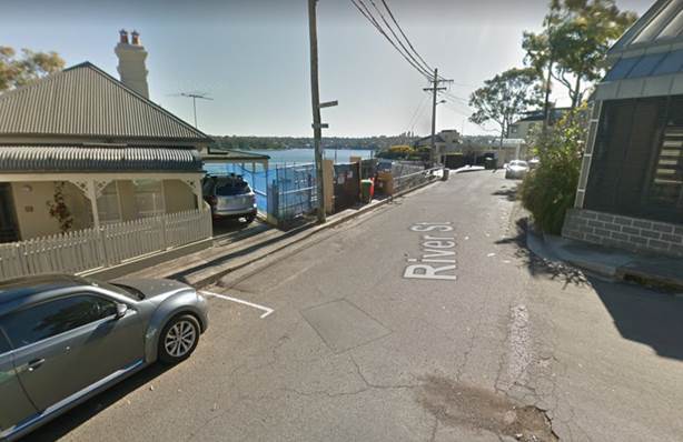
14 River Street, Birchgrove – Western side of River Street to the left side of photo
 14
River Street, Birchgrove – view of eastern side of River Street
14
River Street, Birchgrove – view of eastern side of River Street
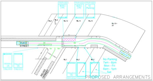
14 River Street, Birchgrove – proposed parking arrangements
10. Installation of ‘Works Zone’ Restriction – 12 Turner Avenue, Haberfield
The applicant has requested the installation of a temporary 9m 'Works Zone 7.00am – 6.00pm Mon-Fri and 8.00am-1.00pm Sat' for 12 weeks in the frontage of 12 Turner Avenue, Haberfield for the development works to No 12 Turner Avenue, Haberfield.
It is recommended that a 9m 'Works Zone 7.00am – 6.00pm Mon-Fri and 8.00am -1.00pm Sat' be installed in front of 12 Turner Avenue, Haberfield, for 12 weeks.
12 Turner Avenue Haberfield
11. Installation of ‘Works Zone’ Restriction – 2 Dickinson Avenue, Croydon
The applicant has requested the installation of a temporary 9m 'Works Zone 7.00am – 6.00pm Mon-Fri and 8.00am-1.00pm Sat' for 12 weeks in the frontage of No.2 Dickinson Avenue, Croydon for the development works to No 2 Dickinson Avenue, Croydon.
It is recommended that a 9m 'Works Zone 7.00am – 6.00pm Mon-Fri and 8.00am -1.00pm Sat' be installed in front of No. 2 Dickinson Avenue, Croydon, for 12 weeks.
2 Dickinson Avenue, Croydon
12. Installation of ‘Works Zone’ Restriction – 11a Moonbie Street, Summer Hill
The applicant has requested the installation of a temporary 18m 'Works Zone 7.00am – 6.00pm Mon-Fri and 8.00am-1.00pm Sat' for 12 weeks in the frontage of No. 11a Moonbie Street for the development works to No. 11a Moonbie Street, Summer Hill.
It is recommended that a 18m 'Works Zone 7.00am – 6.00pm Mon-Fri and 8.00am -1.00pm Sat' be installed in front of No.11a Moonbie Street, Summer Hill for 12 weeks.
11a Moonbie Street, Summer Hill
13. Installation of ‘Works Zone’ Restriction – 5 George Street, Marrickville
The applicant has requested the installation of a temporary 12m 'Works Zone 7.00am – 6.00pm Mon-Fri and 8.00am-1.00pm Sat' for 12 weeks in the frontage of No. 5 George Street, Marrickville for the development works to the property.
It is recommended that a 12m 'Works Zone 7.00am – 6.00pm Mon-Fri and 8.00am -1.00pm Sat' be installed in front of No.5 George Street, Marrickville, for 12 weeks.
5 George Street, Marrickville
|
|
Local Traffic Committee Meeting 3 February 2020 |
Subject: Pigott Lane, Marrickville – Request For ‘No Parking’ Restrictions (Midjuburi - Marrickville Ward / Summer Hill Electrorate / Inner West PAC)
Prepared By: Jennifer Adams - Engineer – Traffic and Parking Services
Authorised By: Manod Wickramasinghe - Traffic and Transport Planning Manager
SUMMARY
Representations have been received from a local resident for the installation of full time ‘No Parking’ restrictions in Pigott Lane, Marrickville (eastern side of Pigott Lane, 40 metres south of the junction of Beauchamp Street and Pigott Lane) to improve access to off-street parking as vehicular access is often blocked by parked vehicles in the laneway. Residents have been notified of the proposal. It is recommended that the proposal be approved.
|
RECOMMENDATION
THAT:
1. The installation of a 9 metre long full-time ‘No Parking’ zone on the eastern side of Pigott Lane, 40 metres southward of the junction of Beauchamp Street and Pigott Lane, adjacent to property No. 6 Beauchamp Street, Marrickville be APPROVED, in order to provide unobstructed vehicular access to the off-street car parking spaces; and
2. The applicant and Council’s Parking Officers be advised in terms of this report.
|
BACKGROUND
It is proposed to install a 9 metre length of ‘No Parking’ restrictions on the eastern side of Pigott Lane, 40 metres southward of the junction of Beauchamp Street and Pigott Lane, to improve access to off-street parking. (Refer to the following plan).
It should be noted that laneways were generally built to provide service access for properties and access into off-street parking facilities. Prohibiting parking in the subject location will help achieve this goal.
FINANCIAL IMPLICATIONS
The cost of the supply and installation of the signposting associated with the recommended ‘No Parking’ restrictions can be met from Council’s operating budget for signs and line marking.
OFFICER COMMENTS
Pigott Lane is a narrow laneway with a carriageway width of 4.9 metres. At present parking is unrestricted on both sides of the laneway.
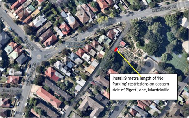
Proposed ‘No Parking’ restrictions (eastern side) in Pigott Lane, Marrickville
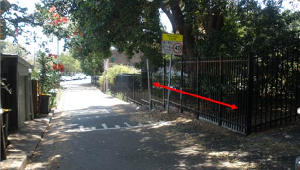
Parking in laneways
It was observed during the site inspection that the off-street parking facilities were utilised. It was also noted that there is a high demand for parking in the area when there are events/functions on at the adjacent school – Marrickville West Public School.
PUBLIC CONSULTATION
On 8 January 2020 a consultation letter was delivered to 27 premises in the locality that are adjacent to the subject section of Pigott Lane, Marrickville, including Marrickville West Public School. The closing date for submissions ended on 24 January 2020.
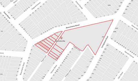
Resident survey findings - A total of two (2) responses were received from residents. One of these submissions supported the proposal and the other says they have no issues generally with cars parking in Pigott Lane.
|
Comments from respondent
|
Council Officer’s comments |
|
Resident noted that they use Pigott Lane to access their garage. “I don’t have an issue with cars parking in the area you are proposing to restrict. Generally cars are only parked there during school drop-off and pick-up times. Occasionally the odd car is parked there outside of these hours. It is handy for the parents who have kids at MWPS and if anything it stops cars from flying down Beauchamp St and turning left into Pigott Lane at high speeds (which they do). Having cars parked at the end of Pigott Lane doesn’t impinge, I always feel like there is enough room - I drive a large SUV and never have an issue driving up the lane when cars are parked there.”
|
Effectively managed laneways allow for adequate access while providing the maximum amount of on-street parking.
It should be noted that laneways were generally built to provide service access for properties and access into off-street parking facilities
Council’s preference is for residents to negotiate with each other to avoid implementing parking bans. Where problems occur, parking restrictions can be considered for individual laneways on a case-by-case basis.
Sometimes the issue in a laneway is not a vehicle parked over a driveway but a vehicle parked opposite a driveway/garage, which hinders/blocks access.
|
|
Resident’s comments include: “We have been inconvenienced repeatedly by people parking illegally opposite our garage driveway in Pigott Lane.” “ When this occurs, due to the narrowness of the lane, we are unable to get our car out of, or into, our garage. It has caused us to be late (or miss) appointments and incur taxi fares instead of using our car.”
|
It should be noted that laneways were generally built to provide service access for properties and access into off-street parking facilities
Sometimes the issue in a laneway, as in this case, is not a vehicle parked over a driveway but a vehicle parked opposite a driveway / garage, which hinders/blocks access. |
CONCLUSION
Pigott Lane is narrow and should a vehicle be parked close to or opposite a driveway, vehicle access can be impeded. No Parking’ restrictions would assist the resident with a rear garage area who may be experiencing access difficulties. Thus, in order to provide clear vehicular access to the applicant's off-street parking facility, it is recommended that a 9 metre length of full-time ‘No Parking’ restrictions on the eastern side of Pigott Lane, southward of the junction of Beauchamp Street and Pigott Lane, adjacent to property No.6 Beauchamp Street, Marrickville be approved.
Installation Diagram – Pigott Lane, Marrickville
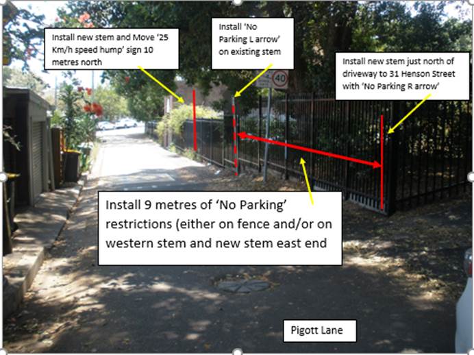
|
|
Local Traffic Committee Meeting 3 February 2020 |
Subject: Lower Railway Parade, Sydenham - Proposed Installation of ‘No Stopping’ Signage (Midjuburi-Marrickville Ward / Heffron Electorate / Inner West PAC)
Prepared By: Jennifer Adams - Engineer – Traffic and Parking Services
Authorised By: Manod Wickramasinghe - Traffic and Transport Planning Manager
SUMMARY
Council is proposing to install ‘No Stopping’ signage at 3 separate locations in Lower Railway Parade, Sydenham to reinforce NSW Road Rules relating to ‘No Stopping’ on a painted island.
|
RECOMMENDATION
THAT the proposed ‘No Stopping’ signage be installed, at the location of each of the 3 painted islands, on the southern side of Lower Railway Parade, Sydenham, in order to reinforce NSW Road Rules relating to parking on painted islands. |
BACKGROUND
Feedback from the community has indicated there is some confusion about parking over the painted islands placed in 3 locations on the southern side along the western end of Lower Railway Parade, Sydenham. Thus, Council is proposing to install ‘No Stopping’ signage at the 3 separate locations in Lower Railway Parade, Sydenham to reinforce NSW Road Rules relating to ‘No Stopping’ on a painted island.
The painted islands are pedestrian access points to the rear footpath.
FINANCIAL IMPLICATIONS
The cost of the signage will be funded from Council’s operating budget for signs and line marking.
OTHER STAFF COMMENTS
Site location & road network
Railway Parade is a two-level street running north-south between Sydenham and Marrickville Roads. The upper section, which operates ‘one-way’ in a southerly direction, is part of the State road system providing access to/from Gleeson Avenue (bridge over the Illawarra Railway line), Railway Road and Princes Highway. The lower section operates as a ‘two-way’ and provides front access to the commercial properties located along its western side. Almost the entire eastern side of this level is available for parking. (Refer to locality aerial below.)
Railway Parade lower is 10m in width and is classed as a local road. Parking arrangements on the northern side of the road consists of ‘2P 8.30am-6pm Mon Fri’ parallel-to-kerb parking. Southern side of the road consists of sections of ‘4P 8.30am-6pm Mon Fri’ 90 degree angle parking and unrestricted 90 degree angle parking.
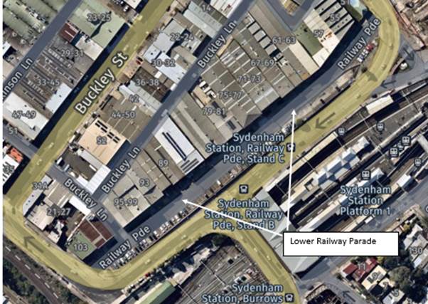
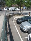
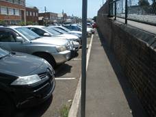
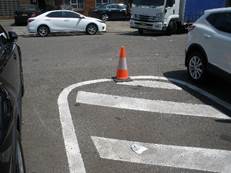
Technical Issues
In accordance with the NSW Road Rule 197 ‘Stopping on a path, dividing strip, nature strip or painted island’ a driver must not stop on a painted island.
Generally, no signage is necessary however for compliance reasons in this case it is recommended to install ‘No Stopping’ signage in Lower Railway Parade, Sydenham.
Future Works
It is noted that in the future Council will be undertaking footpath upgrading works on the southern side of Lower Railway Parade to upgrade the existing 150 metre length of footpath to current standards and provide wheel stops to protect the footpath from vehicle encroachment. These works are currently listed for funding in the 2020/2021 Traffic Facilities Program.
Proposed ‘No Stopping’ restrictions
Council is proposing to install ‘No Stopping’ signage in Lower Railway Parade, Sydenham to reinforce NSW Road Rules of no stopping on a painted island at 3 locations. (Refer to the following plan).
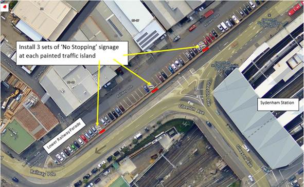
Proposed ‘No Stopping’ signage (southern side) in Lower Railway Parade, Sydenham
PUBLIC CONSULTATION
On 8 January 2020 a consultation letter was delivered to 30 premises in the locality that front Lower Railway Parade, Sydenham. The closing date for submissions ended on 24 January 2020.
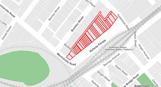
Survey findings - A total of three (3) responses were received from citizens.
|
Comments from respondent
|
Council Officer’s comments |
|
Citizen rang and just wanted to discuss the reason painted islands were in the street and questioned whether they were enforceable and neither supported or objected Council’s proposal to install ‘No Stopping’ signage. |
Received and noted.
|
|
Citizen unsure as to the purpose of the painted islands and stated that they once were free to park there without penalty. They noted that parking is a premium in the street and business customers have difficulty finding parking. |
Received and noted. Painted islands will remain access points to the rear footpath. Future works listed on Council’s Traffic Facilities Program are to upgrade and widen the footpath, install wheel stops and formalise a new crossing point connecting the northern side flowing onto the proposed Sydney Metro mid-block signalised crossing. |
|
Citizen who has worked in street for numerous years believes the cheapest and safest option is to paint out the 3 painted islands and let cars park there.
|
CONCLUSION
It is recommended that the Committee support the installation of ‘No Stopping’ signage at the subject locations in Lower Railway Parade, Sydenham to reinforce NSW Road Rules relating to not stopping on a painted island.
|
|
Local Traffic Committee Meeting 3 February 2020 |
Subject: Clissold Street, Ashfield- Investigation of Proposed Works from the Ashfield Traffic Management Strategy (Djarrawunang-Ashfield Ward/Summer Hill Electrorate/Burwood PAC)
Prepared By: Boris Muha - Engineer – Traffic and Parking Services
Authorised By: Manod Wickramasinghe - Traffic and Transport Planning Manager
|
SUMMARY The Former Ashfield Local Government Area Traffic Management Strategy as adopted by Council in August 2018 recommended investigation of a number of actions in the vicinity of Clissold Street and Seaview Street Ashfield, including treatments at intersections and an investigation of a one-way pair route for buses in Clissold Street and Seaview Street. This report details the investigations and presents recommendations based on liaison with key stakeholders, investigations of crash data, traffic surveys and site investigations (including constraints).
|
|
RECOMMENDATION
THAT:
1. The results of the investigation into the proposal of converting Clissold Street and Seaview Street as opposing directional one-way streets be noted, and that no further action be undertaken in relation to this matter;
2. The current parking arrangements in Clissold Street as previously adopted by the Former Ashfield Council in 2015 be retained, and that no further action be carried out to remove further parking in Clissold Street; and
3. The following works be adopted in principle and listed for consideration on the Capital Works Program:
a. Install kerb island build-outs on Prospect Road, north and south of Clissold Street, Ashfield and realignment of the north-western corner of the intersection;
b. Convert the existing at-grade pedestrian (zebra) crossing to a raised pedestrian (zebra) crossing in Clissold Street, west of Victoria Street;
c. Install kerb island build-outs on the east and west side of Victoria Street south of Clissold Street;
d. Install speed cushions, or speed humps in Queen Street on approaches to Clissold Street; and
e. Install kerb island build-outs on the east side of Victoria Street, north and south of Seaview Street and relocate the ‘STOP’ line out to align with the kerb islands.
|
BACKGROUND
The street sections and intersections covered by this report are highlighted in Figure 1 below. The location of local institutions, schools, aged care facilities and bus stops is also detailed in Figure 1.
|
Figure 1: Streets and Intersections covered by the report and key local services and institutions in vicinity |
The recommendations from the Ashfield Traffic Management Strategy (ATMS) covered in this report relate to the following streets;
1. Clissold Street from Holden Street to Prospect Road
2. Seaview Street from Queen Street to Prospect Road
3. Victoria Street from Clissold Street to Seaview Street
4. Queen Street from Clissold Street to Seaview Street
A summary of the key data related to each of the streets is outlined below in Tables 1-4.
Table 1: Clissold Street - Traffic Data Summary
|
Street Name and Suburb |
Clissold Street, Ashfield |
|
|
Section |
Between Holden Street and Prospect Road |
|
|
Carriageway Width (m) |
6-7 metres |
|
|
Carriageway Type |
Two-way street |
|
|
Classification |
local |
|
|
85th Percentile Speed (km/h) 2019 most recent count |
Street section |
85th %percentile weekday Average |
|
Tintern Road to Victoria Street |
43.1km/h |
|
|
Victoria Street to William St |
48.1 |
|
|
Fairleigh Street to Holden St |
42.6 |
|
|
Vehicles Per Day (vpd) |
Street section |
Weekday Average |
|
Tintern Road to Victoria St |
3145 |
|
|
Victoria Street to William St |
3520 |
|
|
Fairleigh Street to Holden St |
2836 |
|
|
Heavy Vehicle
Volume (%) |
Street section |
Weekday Average |
|
Tintern Road to Victoria Street |
4% |
|
|
Victoria Street to William Street |
5% |
|
|
Fairleigh Street to Holden Street |
4% |
|
|
*Reported Crash History (July 2014 - June 2018) |
Clissold Street at Queen Street – 2 injuries and 1 tow-away. Clissold Street between Holden Street and Prospect Road – full length – 3 injuries and 2 tow-away.
See Table 7 for further detail. |
|
|
Parking Arrangements |
On street (Staggered as of 2015) to allow for passage of vehicles two way - including buses) |
|
Table 2: Queen Street - Traffic Data Summary
|
Street Name and Suburb |
Queen Street, Ashfield |
|
|
Section |
Between Seaview Street and New Street |
|
|
Carriageway Width (m) |
10 metres (approx.) |
|
|
Carriageway Type |
Two-way street |
|
|
Classification |
local |
|
|
85th Percentile Speed (km/h) Feb 2018 most recent count |
Street section |
85th percentile weekday Average |
|
Seaview Street to Clissold Street |
50.9 km/h |
|
|
Clissold Street to New Street |
50.5 km/h |
|
|
|
|
|
|
Vehicles Per Day (vpd) |
Street section |
Weekday Average |
|
Seaview Street to Clissold Street |
4773 vpd |
|
|
Clissold Street to New Street |
4890 vpd |
|
|
Heavy Vehicle
Volume (%) |
Street section |
Weekday Average |
|
Clissold Street to New Street |
3% |
|
|
Clissold Street to Seaview Street |
4.4% |
|
|
*Reported Crash History (July 2014 - June 2018) |
Queen Street Between Seaview Street and New St – 1 injury, 1 non injury. See Table 7 for further detail. |
|
|
Parking Arrangements |
Unrestricted both sides |
|
Table 3: Seaview Street - Traffic Data Summary
|
Street Name and Suburb |
Seaview Street, Ashfield |
|
|
Section |
Between Holden Street and Prospect Road |
|
|
Carriageway Width (m) |
6-7m Holden Street to Victoria Street 8-8.3m Victoria Street to Prospect Road. |
|
|
Carriageway Type |
Two-way street |
|
|
Classification |
local |
|
|
85th Percentile Speed (km/h) 2019 most recent count |
Street section |
85th percentile weekday Average |
|
Victoria Sq to Prospect Road |
47.5km/h |
|
|
Queen Street to Yeo Avenue |
44.3km/h |
|
|
Queen Street to Fairleigh Street |
37.5km/h |
|
|
Vehicles Per Day (vpd) |
Street section |
Weekday Average |
|
Victoria Sq to Prospect Road |
2266 vpd |
|
|
Queen Street to Yeo Avenue |
1414 vpd |
|
|
Queen Street to Fairleigh Street |
733 vpd |
|
|
Heavy Vehicle
Volume (%) |
Street section |
Weekday Average |
|
Victoria Sq to Prospect Road |
4% |
|
|
Queen Street to Yeo Street |
2% |
|
|
Queen Street to Fairleigh Street |
5% |
|
|
*Reported Crash History (July 2014 - June 2018) |
Seaview Street at Victoria Street – 1 injury, I tow-away. See Table 7 for further detail. |
|
|
Parking Arrangements |
Unrestricted |
|
Table 4: Victoria Street - Traffic Data Summary
|
Street Name and Suburb |
Victoria Street, Ashfield |
|
|
Section |
Between Holwood Street and Robert Street |
|
|
Carriageway Width (m) |
12.5metres (approx.) |
|
|
Carriageway Type |
Two-way street |
|
|
Classification |
local |
|
|
85th Percentile Speed (km/h) 2016 most recent count |
Street section |
85th percentile weekday Average |
|
Seaview Street to Holwood Street |
50 km/h |
|
|
Clissold Street to Seaview Street |
56.7 km/h |
|
|
Vehicles Per Day (vpd) |
Street section |
Weekday Average |
|
Seaview Street to Holwood Street |
3590 vpd |
|
|
Clissold Street to Seaview Street |
3325 vpd |
|
|
Heavy Vehicle
Volume (%) |
Street section |
Weekday Average |
|
Seaview Street to Holwood Street |
2% |
|
|
Clissold Street to Seaview Street |
5% |
|
|
*Reported Crash History (July 2014 - June 2018) |
Victoria Street between Holwood Street and Robert Street – 1 tow-away. See Table 7 for further detail. |
|
|
Parking Arrangements |
Unrestricted |
|
Recommendations of Ashfield Traffic Management Strategy (ATMS)
The recommendations that have been made at locations in Clissold Street, Victoria Street, Queen Street and Prospect Road are made based on the principles of “local traffic management” and address specific issues identified at each location.
A summary of the recommendations from The Former Ashfield Local Government Area Traffic Management Strategy and the corresponding recommendation to the Local Traffic Committee (with brief rationale) is contained in Table 5 below. Further investigative treatments are also discussed in the table.
Table 5: Summary of ATMS recommendations and corresponding recommendation to LTC including further investigative treatments.
|
ATMS recommendations & further investigative treatments |
Discussion & Recommendation |
|
|
1. ATMS Recommendation: Investigate the potential to convert the length of Clissold Street to a one-way road in the westbound direction through modified signage and line marking. Also convert the length of Seaview Street to a one-way road in the eastbound direction, so a pair of opposite one-way streets exist to support movements in each direction.
The conversion of the road to a one-way road will require the bus stops on the northern side of the road to be relocated to another road. This will need to be investigated and coordinated with TfNSW.
|
Representations from residents indicate that there is an expectation that implementing a one-way movement particularly in Clissold Street would provide an opportunity to improve pedestrian amenity by providing a widening of the existing narrow footpath.
Council has been advised that Transport for NSW would not be supporting the change in arrangement of Clissold Street due to the significant impacts on walking access distances for local resident and major local institutions including Cardinal Freeman Village, The Sydney Private Hospital and a number of other retirement homes in the vicinity.
Given the large street block sizes and the distance between Clissold Street and Seaview Street (approx. 230m), splitting the inbound and outbound routes would result in substantial additional walking distances for residents, in particular for older residents with walking access difficulties, as well as making the bus route confusing and difficult to understand.
Impacts to school students on both the Bus Route 413 and 609s have been considered. (See Attachment 1 for bus route map)- at the end of the report.
Transit Systems also noted a number of potential bus movement/turning issues associated with changing the bus routes as follows; · The left turn from Holden Street to Seaview Street would be tight for buses, so the kerb would need to be realigned. · The potential right turn from Clissold Street into Queen Street is also tight, and the tail swing from buses may hit the power pole.
Recommendation
No further action be undertaken in respect of converting Clissold Street and Seaview Street to one-way streets.
|
|
|
|
||
|
2. ATMS recommendation: Investigate an entry threshold treatment to 40km/h school zone that includes kerb build-outs and a speed cushion on Clissold Street and Seaview Street at their intersections with Prospect Road.
|
Following site investigation and analysis of speed and crash data, speed cushions are not considered appropriate or justified in Clissold Street and Seaview Street at Prospect Road, due to the narrowness of these streets and lack of speeding and crash history to support speed reduction devices. The crash history shows only one (1) minor injury crash at the intersection of Clissold Street and Prospect Road, and no crash history at the intersection of Seaview Street and Prospect Road in the 5 year period of 2014-2018
Both Clissold Street and Seaview Street are too narrow to consider appropriate kerb build outs (or kerb blistering) at the intersection of Prospect Road, if two-way is maintained. Traffic, particularly buses, are required to manoeuvre around the corners of the intersection. Seaview Street, between Victoria Street and Prospect Road is a bus route interlinking main/school special bus movements via Victoria Street and Prospect Road.
Recommendation
|
|
|
Further investigation: Prospect Road at Clissold Street. |
Clissold Street is narrow and buses turning into Prospect Road are forced into oncoming traffic lane. This movement could be improved if the kerb is cut back on the north-west corner of the intersection. Build outs on the Prospect Road corners are proposed also at this location to improve the guidance and control of traffic/bus movement around the intersection and prevent vehicles from mounting over the corners.
Recommendation
Install kerb island build-outs on Prospect Road, north and south of Clissold Street, and realign the north-western corner of the intersection. Refer to Figure 2 for illustration of these recommendations.
|
|
|
Figure 2: Clissold Street and Prospect Road, Ashfield.
|
||
|
|
||
|
3. ATMS recommendation: Install a raised central island on the south approach to the Tintern Road/Clissold Street intersection. |
2019 speed counts show an AADT of 3,145 vpd and an 85th % percentile speed of 43km/h. There is no crash history in the five years from 2014-2018 at this intersection.
Given that there is not a speeding issue, or any crash history associated with this intersection and there are no reports of traffic movement/ sight line issues; it is not necessary to carry out any treatments.
Recommendation
No further action be undertaken in relation to this proposal.
|
|
|
|
||
|
4. ATMS Recommendation: Install speed cushions on Clissold Street and Seaview Street on each approach to intersections with Victoria Street and Queen Street. |
Speed cushions are not considered appropriate in Clissold Street and Seaview Street at the intersections with Victoria Street and Queen Street due to lack of evidence of speeding. The highest 85th percentile speed of 48.1km/h recorded in Clissold Street was between Victoria Street and Queen Street. It is likely that the speed is slightly higher in this section due to the fact that there is no parking on either side of the street, reducing friction and allowing for vehicles to achieve higher speeds.
The ATMS recommendation to install speed cushions in Clissold Street and Seaview Street on each approach to Queen Street is not supported.
Recommendation No further action be undertaken in respect of speed cushions in Clissold Street or Seaview Street at the intersections with Queen Street or Victoria Street.
|
|
|
Further investigation: Clissold Street.
|
The existing pedestrian (zebra) crossing west of Victoria Street in Clissold Street is difficult to access due to existing ramps and narrow footpath. Raising this pedestrian (zebra) crossing would improve pedestrian access and safety from the bus stop to the retirement village and visa versa.
Recommendation It is recommended that the existing pedestrian (zebra) crossing on Clissold Street, west of Victoria Street be upgraded into a raised pedestrian (zebra) crossing.
Refer to Figure 3 for illustration of this recommendation.
|
|
|
Further investigation: Victoria Street at Clissold Street.
|
The 85th percentile speed 56.7km/h between Clissold Street and Seaview Street is a matter of concern given the proximity of several aged and health services and bus stops.
Even though there is no crash history at this intersection, with the number of generators in the area, the speed of vehicles and the width of the street (approx. 12.5m), it is recommended to provide build-outs in Victoria Street immediately south of Clissold Street to improve amenity and safety for pedestrians, as well as improve sight lines for motorists.
Recommendation
It is recommended that kerb island build-outs be installed on both sides of Victoria Street, on the southern approach to Clissold Street. Refer to Figure 3 for illustration of this recommendation.
|
|
|
Figure 3: Clissold Street and Victoria Street, Ashfield.
|
||
|
|
||
|
Further investigation: Queen Street at Clissold Street.
|
The 85th percentile speeds on Clissold Street on approach to Queen Street are 34km/h on western approach and 40km/h on eastern approach. Given the lack of speed history, speed cushions in Clissold Street are not seen as necessary or desirable.
However, the 85% speeds on Queen Street on approach and departure to Clissold Street are between 49.5 to 52.2 km/h.
Recommendation
Given the noticeable accident history (4 incidents) and that the intersection is a major traffic and transport (bus) cross-over link in Clissold Street, the placement of speed cushions or full-width speed humps in Queen Street on both approach sides in close proximity to Clissold Street, is recommended to further reduce the speeds along Queen Street.
Refer to Figure 4 for illustration of this recommendation.
|
|
|
Figure 4: Clissold Street and Queen Street, Ashfield.
|
||
|
|
||
|
Further investigation: Victoria Street at Seaview Street |
There is a sight line issue caused by a large palm tree on the eastern side of Victoria Street on the northern approach to Seaview St. See Figure 5. In addition, there have been 2 accidents at this intersection.
In order to improve sight lines at this intersection, kerb built outs are proposed, and that the ‘STOP ’line be relocated out to align with the kerb islands.
Recommendation
Install kerb island build-outs on the east side of Victoria Street, north and south of Seaview Street and relocate the ‘STOP’ line out to align with the kerb islands
See Figure 5 for existing view and Figure 6 illustration of this recommendation.
|
|
|
Figure 5: Victoria at Seaview looking south July 2019 (cross traffic obscured on approach by large palm tree)
|
||
|
Figure 6: Victoria Street at Seaview Street, Ashfield.
|
||
|
|
||
|
5. ATMS Recommendation: Install kerb build-outs and a speed cushion on Clissold Street at its intersection with Holden Street. |
There is no crash history at this location. There are a number of traffic calming treatments in Holden Street north on the approach to Clissold Street, and parking exists either side of Holden Street, south of Clissold.
Site investigations revealed that the movement of buses and traffic through the area turning into and out of Clissold Street and Palace Street create informal traffic calming as buses have to wait for the intersection of Palace Street and Clissold Street to clear before turning in/out.
Given the lack of crash history, the existence of traffic calming measures, and the constrained conditions with low speeds in Clissold Street; no further treatments are proposed for this location.
Recommendation
No further action be undertaken in respect of treatments in Clissold Street at Holden Street. |
|
TRAFFIC SURVEYS
Summaries of speed and volume data collected between 2016 and 2019 are shown in Figure 7 and Table 6. Speed limit at all subject street locations is 50km/h. 85th percentile speeds in excess of the 50km/h were recorded at 4 locations in Victoria Street and Queen Street. There were no 85th % speeds over 50km/h recorded in Clissold Street or Seaview Street.
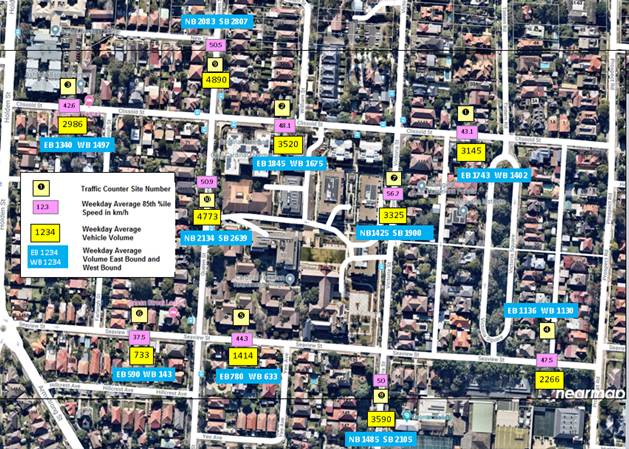
Figure 7: Summary of traffic speed and volume in Clissold Street, Seaview Street, Queen Street and Victoria Street
Table 6: Bidirectional 85th%ile Speeds in km/h at 10 counter locations
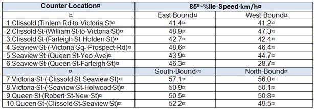
Crash History
The crash history in the subject streets and a summary of the crash data is illustrated in Figure 8. An analysis of crash data from Roads and Maritime Services (RMS) indicated that there were twelve (13) crashes in the 5 years from 2014-2018. Of those there were seven ‘right angle’ crashes, and four “leave the road” crashes. There was one pedestrian crash in 2015 where a pedestrian fell in the carriageway and was impacted by a vehicels resulting in a moderate injury. Speed was not cited as a factor in any of the crashes. There were no reports of heavy vehicles or buses involved in crashes.
The location and type of crash is illustrated below in Figure 8 and Table 7 below.
Figure 8: Map showing Location and type of Crash (RMS 2014 -2018)
Table 7: Location and Type of Crash (RMS 2014-2018)
|
|
Street |
Intersection |
Year |
Location |
Injury |
Type |
Dir Veh 1 & 2 |
Ref Fig.8 |
|
1. |
Clissold Street |
Queen St |
2018 |
on the spot |
serious injury |
right angle |
North/east |
6 |
|
2. |
Clissold Street |
Queen St |
2016 |
on the spot |
tow-away |
right angle |
North/west |
5 |
|
3. |
Clissold Street |
Queen St |
2014 |
on the spot |
moderate injury |
right angle |
East/north |
1 |
|
4. |
Clissold St |
Queen St |
2017 |
Queen St, north of Clissold St |
Tow away |
Left off carriageway into object |
North/on the spot |
13 |
|
5. |
Clissold St |
Victoria Street |
2015 |
West of Victoria St |
injury |
Vehicle into ped on road |
West/north |
4 |
|
6. |
Clissold St |
Prospect Rd |
2015 |
on the spot |
minor injury |
right angle |
East/north |
11 |
|
7. |
Clissold St |
Farleigh St |
2014 |
on the spot |
injury |
far left |
North/east |
3 |
|
8. |
Clissold St |
Victoria |
2014 |
on the spot |
tow away |
right angle |
East/south |
2 |
|
9. |
Queen Street |
Seaview St |
2014 |
on the spot |
injury |
right angle |
West/north |
7 |
|
10. |
Seaview St |
Victoria St |
2018 |
on the spot |
minor injury |
right angle |
East/south |
9 |
|
11. |
Seaview St |
Unnamed Lane |
2016 |
West of Prospect Road |
tow-away |
off road left into object |
East/on the spot |
8 |
|
12. |
Victoria St |
Seaview St |
2015 |
South of Seaview St |
tow-away |
off road left |
South/south |
10 |
|
13. |
Seaview St |
Queen St |
2016 |
East of Queen St |
injury |
off road left |
West/west |
12 |
FINANCIAL IMPLICATIONS
Estimates would be provided for works listed under the capital works program and identified under the future design stage.
OTHER STAFF COMMENTS
The following information is also provided to assist in the investigations.
1. Clissold Street has bus services travelling in both directions. If Clissold Street is made one-way, Seaview Street as the adjacent parallel street under the ATMS recommendations will need to be made also one-way in the opposing direction to accommodate any displaced bus service and traffic.
2. The Former Ashfield Council in 2015 resolved to remove a high degree of parking in Clissold Street, and strategically position and control remaining elements of parking along Clissold Street to maintain appropriate 2-way traffic flow under give-way, i.e. vehicles and buses pull aside between parking areas to allow opposing traffic to pass.
Additional diagrams as attachments 2A to 2C show existing unrestricted parking zones, Bus Zones and No Parking zones along Clissold Street from Holden Street to Prospect Road. The ‘No Parking’ zones provide for the opportunity for vehicles to stop and set down and pick up passengers and/or goods and assist in waste collection but avoids vehicles from parking in these locations for the sake of traffic movement and vehicle maneouvre around laneway or street intersections. The street everywhere else is signposted as ‘No Stopping’.
The location of the unrestricted parking zones are set well away from the major intersections to avoid/minimise traffic from queuing back into the main street intersections.
3. The current arrangement in Clissold Street was adopted as a compromised option between other options which considered the removal of all parking along Clissold Street to retain 2-way traffic movement. The benefits of this option is the retention of as much on-street parking as possible as well as retaining two-way traffic flow.
The current parking and traffic arrangement in Clissold Street have been well established over the last four years and that the Traffic survey above reflects over the period of time this arrangement has been in force. Parking where permitted lends to defacto traffic calming or friction to assist in speed reduction.
Through various observations, it is considered that the 2-way traffic generally flows satisfactorily in Clissold Street under this current arrangement. It should be noted that nearby adjacent developments have contributed to on-street parking pressures. Any option to remove further parking in Clissold Street would only exasperate parking problems. Any such proposal may shift the problem of undesirable/unwanted parking activity into the nearby side streets and may also result in the increase of speeding and inappropriate driver behaviour though Clissold Street.
4. Making Clissold Street and Seaview Street one-way will impact on residential and institutional property access.
PUBLIC CONSULTATION
The report is a follow up investigation on recommendations from the Ashfield Traffic Management Strategy in which community engagement was undertaken.
The proposed recommendations with regard to design proposals arising with this report will be consulted on during the design phase.
Previous respondents in Clissold Street have been notified of this report and recommendations.
CONCLUSION
The following findings are summarised leading up to the recommendations of this report.
1. Transport for NSW and Transit Systems are responsible in the planning and operation of bus services in Clissold Street. As relevant stakeholders, Transport of NSW and Transit Systems do not support re-directing bus services in the area if Clissold Street and Seaview Street are made One-Way for the following reasons;
· This would result in significant impacts on walking access distances for local residents and major local institutions e.g. the Cardinal Freeman Retirement Village, and the Sydney Private Hospital;
· There would be likely confusion/complaints from passengers and the community if bus routes are split;
· Problems would be encountered with buses turning at particular intersections;
· Transport for NSW would not support funding the cost of route changes if the changes would result in poorer service and amenity to passengers and the local community.
2. Seaview Street would need to be converted to one-way in the opposing direction if Clissold Street is made one-way to support displaced bus service and traffic. This would result in the need of Bus stop installations along Seaview Street, and possible loss of parking to accommodate Bus Stops. There may also need to be possible design changes to intersections with Seaview Street in order to service the buses.
3. Traffic survey investigations showed low recorded accident history along Clissold Street and Seaview Street in the last 5 years with low 85 percentile speeds ranging from 42.6 to 48.1 km/h in Clissold Street and 37.5 to 47.5 km/h in Seaview Street.
4. The current parking arrangement in Clissold Street (being 6-7metres wide) maintains appropriate 2-way traffic flow under give-way. Vehicles and buses pull aside between parking areas and allow opposing traffic to pass. The current parking and traffic arrangement have been well established over the last four years, and it is considered to operate satisfactorily. Parking where permitted lends to de-facto traffic calming or friction to assist in speed reduction.
5. Making Clissold Street and Seaview Street will impact on residential and institutional property access.
In view of the above, it is recommended that no further action be carried out to convert Clissold Street and Seaview Street to one-way in the opposing direction based on the above comments. Nor is there any further action to consider traffic calming along Clissold Street and Seaview Street based on the low recorded accident history and low speeds in the area. The recommended raising of the crossing in Clissold Street, west of Victoria Street, is an exception based mainly on pedestrian safety.
Various other treatments, in reference to the ATMS and/or traffic survey investigation, are proposed in this report to address accidents and traffic/pedestrian safety issues at the locations shown under the concept plan figures 2,3,4 and 6.
These treatments will be listed under a capital works program for future design and consultation with the affected residents.
|
1.⇩ |
Bus Route Map |
|
2.⇩ |
Existing parking in Clissold Street, Ashfield, between Holden Street and Victoria Street |
|
3.⇩ |
Existing parking in Clissold Street, Ashfield, between Victoria Street and Prospect Road. |
|
|
Local Traffic Committee Meeting 3 February 2020 |
Subject: Lilyfield Road, Rozelle - Extension of Resident Parking Scheme (Baludarri-Balmain Ward/Balmain Electorate/Leichhardt PAC)
Prepared By: Felicia Lau - Engineer - Traffic and Parking Services
Authorised By: Manod Wickramasinghe - Traffic and Transport Planning Manager
SUMMARY
Council has received requests from residents of Lilyfield Road, Rozelle between Gordon Street and Easton Park for a Resident Parking Scheme (RPS) to address issues with long term parking by non-resident vehicles and the increase of WestConnex workers parking in the area.
|
RECOMMENDATION
THAT a ‘2P 8am-10pm Mon-Fri, Permit Holders Excepted, Area R1’ parking restriction be installed on the northern side of Lilyfield Road west of Gordon Street, frontage of house Nos.59-65 Lilyfield Road, Rozelle. |
BACKGROUND
A number of residents from Lilyfield Road, Rozelle (west of Gordon Street) have requested the implementation of a resident parking scheme to deter long term parking by non-residents and WestConnex workers parking in the area.
Site Location & Road Network
|
Street Name(s) |
Lilyfield Road, Rozelle |
|
Section |
West of Gordon Street, frontage of house Nos.59-65 Lilyfield Road |
|
Recorded Crash History (5-Year) |
No reported crashes |
|
Posted Speed Limit |
50km/h |
|
Carriageway Width |
12.5m |
|
Carriageway Type |
Two-lane Two-way with unrestricted kerb-side parking |
|
Road Classification (State, Regional, Local) |
Regional |
FINANCIAL IMPLICATIONS
Nil.
OTHER STAFF COMMENTS
The properties (House Nos.59, 61, 63 and 65) along this section of Lilyfield Road generally do not have off-street parking and the adjacent residential streets are signposted with resident parking scheme restrictions, this includes Gordon Street, Burt Street and Lilyfield Road east of Gordon Street.
Site observation shows that with the increase of WestConnex workers parking in the area, the parking occupancy is generally at full capacity. Hence, an extension of the existing RPS to the northern side of Lilyfield Road, west of Gordon Street is proposed to alleviate parking conditions for these properties as shown in the figure enclosed.
It should be noted that Gordon Street (south of Lilyfield Road) is one of the primary entry points into the WestConnex (Rozelle interchange) works site and is a parking demand generator.
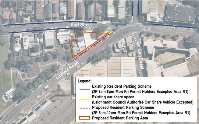
PUBLIC CONSULTATION
A letter outlining the above proposal was mailed out to the affected properties as indicated in the plan enclosed.
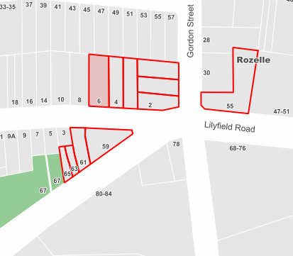
Consultation survey results are summarised as follows:
Number of properties within RPS - 4
Number of properties responded - 4
Number of properties supported - 4
Overall Response Rate - 100%
Overall Support Rate - 100%
All properties were in support of the proposal and no objections were received.
The table below shows some of the comments raised by the residents and the officer’s comments.
|
Residents’ Comments |
Officer’s Comments |
|
Require visitor parking permit for trades people. |
Visitor permits will not be issued as part of this scheme as there is a limited number of parking spaces that are proposed to be restricted with 2P parking restrictions (i.e. only one side of the street). The provision of additional (visitor) permits would result in an oversupply of permits compared to the restricted RPS kerb side parking supply.
Temporary Trades permits are available should they be required. |
CONCLUSION
It is recommended that a ‘2P 8am-10pm Mon-Fri, Permit Holders Excepted, Area R1’ parking restriction be installed on the northern side of Lilyfield Road west of Gordon Street, frontage of house Nos. 59-65 Lilyfield Road.
|
|
Local Traffic Committee Meeting 3 February 2020 |
Subject: Dalhousie Street, Haberfield - Removal of redundant bus stop facilities (Gulgadya-leichhardt ward/summer hill electorate/burwood PAC)
Prepared By: Felicia Lau - Engineer - Traffic and Parking Services
Authorised By: Manod Wickramasinghe - Traffic and Transport Planning Manager
SUMMARY
Council was notified by Transit Systems that two bus stops on Dalhousie Street, Haberfield (in front of House Nos. 29 and 34) have been made redundant and are no longer required. Removal of the bus zone will return unrestricted parking spaces to residents and visitors.
|
RECOMMENDATION
THAT the existing Bus Zones and pavement tactiles be removed at the following locations:
a) 23m ‘Bus Zone’ on the western side of Dalhousie Street, Haberfield (frontage of house No.34); and b) 20m ‘Bus Zone’ on the eastern side of Dalhousie Street, Haberfield (frontage of house No.29). |
BACKGROUND
Transit Systems has informed Council that two existing bus zones in front of house Nos. 29 and 34 Dalhousie Street, Haberfield, have been noted as being redundant following a recent bus stops audit and can be removed.
Site Location & Road Network
|
Street Name(s) |
Dalhousie Street, Haberfield |
|
Section |
Between Parramatta Road and Denman Avenue |
|
Traffic Volume (AADT) |
5,808 |
|
Recorded Crash History (5-year) |
One reported crash in 2015 |
|
Recorded 85th% Speed |
49km/h |
|
Posted Speed Limit |
50km/h |
|
Carriageway Width |
12.5m |
|
Carriageway Type |
Two-lane two-way street with unrestricted kerb-side parking. |
|
Road Classification (State, Regional, Local) |
Local |
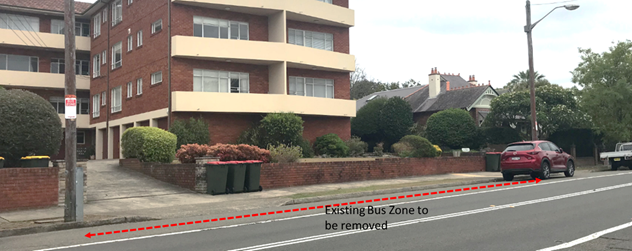
Frontage of No.34 Dalhousie Street, Haberfield
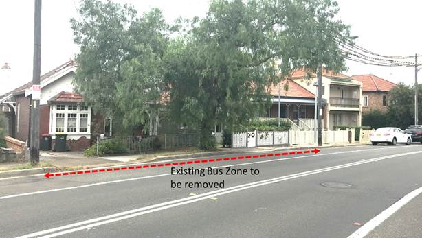
Frontage of No. 29 Dalhousie Street, Haberfield
FINANCIAL IMPLICATIONS
Nil.
OTHER STAFF COMMENTS
It is proposed to remove the existing redundant bus zones and pavement tactiles at the following locations:
· 23m ‘Bus Zone’ on the western side of Dalhousie Street, Haberfield (frontage of house No.34).
· 20m ‘Bus Zone’ on the eastern side of Dalhousie Street, Haberfield (frontage of house No.29).
This will allow the space to be converted to general on-street parking spaces for residents and visitors.
PUBLIC CONSULTATION
Nil.
Subject: Croydon Parking Study (Gulgadya-Leichhardt Ward/Summer Hill Electorate/Purwood PAC)
Prepared By: Sunny Jo - Traffic and Parking Planner
Authorised By: Manod Wickramasinghe - Traffic and Transport Planning Manager
SUMMARY
This is a recommendation to endorse the final Croydon Parking Study report. Council has recently undertaken Public Exhibition of the draft Croydon Parking Study through YourSay Inner West. The draft report proposed an expansion of the Resident Parking Scheme (RPS) on a number of streets in Croydon as shown in Attachment 1. The response results indicate that the community in general did not support the proposed strategy with a 73.6% non-support, as well as separate submissions and two petitions received during the public engagement. Several submissions requested a parking scheme with two free permits given to residents regardless of the number of off-street parking spaces. The views of the community on the proposed RPS areas indicate that whilst there is generally a desire to change the current parking management, concerns were raised with the proposed permit policy which has been used in other RPS areas in the Inner West.
In view of the high level of objections, it is recommended that the proposed Croydon Strategy not be supported at this time and further consideration for street specific RPS for the Croydon area cease for a period of 24 months until February 2022. Additionally, it is recommended that parking conditions be monitored on streets surrounding the Ashfield Aquatic Centre after its reopening in 2020. Any parking review is to be undertaken using data collected from the Croydon Parking Study.
|
RECOMMENDATION
THAT:
1. The final Croydon Parking Study be noted;
2. In view of the results of the Public Exhibition, stage 1 and 2 of the Croydon Parking Strategy not be supported at this time;
3. Further consideration of street specific resident parking scheme for the Croydon area cease for 24 months until February 2022;
4. Parking conditions be monitored on streets surrounding the Ashfield Aquatic Centre after its reopening in 2020; and
5. Any future parking review for the Croydon area is to be undertaken using data collected from the Croydon Parking Study. |
BACKGROUND
The Croydon Parking Study reviewed the location, supply, demand and distribution of both short and long stay parking, residential, employee and commuter parking. The work consisted of examining existing conditions including parking data, community submissions, and examining on-street as well as private off-street parking. A community survey was also undertaken to gauge the parking issues faced by different users. With consideration for future developments and access to public transport, including Burwood Council’s own parking strategy, a parking management strategy was then developed for the Croydon area.
The study was undertaken by GTA Consultants using parking data collected in December 2018, several site observations in 2019, and feedback received during the initial parking study survey undertaken in March 2019.
OTHER STAFF COMMENTS
Stage 1 of the parking management strategy proposed to extend area A2 and area A6 RPS ‘2P 8am-6pm Mon-Fri, Permit Holders Excepted’ on one side of College Street, Edwin Street between Elizabeth Street and Anthony Street, Croydon Road between Elizabeth Street and Anthony Street, Paisley Road east of The Strand, Edwin Street between Paisley Road and Thomas Street, Heighway Avenue between Edwin Street and Frederick Street, and Walter Street.
Streets identified for Stage 2 include ‘2P 8am-6pm Mon-Fri, Permit Holders Excepted’ restrictions on Edwin Street north of Anthony Street, one sides of Croydon Road between Anthony Street and Hunt Street, Anthony Street between Edwin Street and Etonville Parade, Edwin Street between Thomas Street and Liverpool Road, and Highbury Street between Thomas Street and Liverpool Road.
A map containing the proposed Stage 1 and 2 of the Strategy is shown in Attachment 1.
PUBLIC CONSULTATION
Following the endorsement of the Draft Croydon Parking Study, Council undertook Public Exhibition of the Strategy in November and December 2019.
Community engagement commenced on 8 November 2019 with 2,300 letters mailed out and distributed to residents and stakeholders located within and bordering the study area. Council’s YourSay website enabled stakeholders to access the draft report, maps of the proposed RPS changes, and the proposed permit eligibility criteria. The engagement period ended on 15 December 2019.
A total of 158 submissions were received comprising of 158 online responses and 18 responses received in other means (paper letters and emails) and two petitions.
The above represent a response rate of 8% from the community, which was lower than the initial survey response of 12% undertaken in 2019. Notably, approximately 30% of received submissions were from outside the proposed RPS areas. The following table summarise the submissions received during the Public Exhibition.

Two petitions were received during the engagement period and are presented below:
· Petition organised by Mr Sam Sciamaca and Mr Marcello Di Paolo, submitted with 36 names in support of the petition from 25 properties.
· Petition organised by Mr James Ding OAM, submitted with 14 names and signatures in support of the petition from 5 properties.
The issues raised as well as Council officer’s response is provided in the table below.
|
Issues raised |
Council officers’ response |
|
Residents are penalised for parking in their own street. The permit scheme should cater for all residents, not just those who have no off-street parking. Two permits should be issued per household regardless of whether they have off-street parking spaces or not. Third permit should require an explanation of need. |
The purpose of the RPS is to prioritise residents that have no or limited access to off-street parking. If eligibility criteria were loosened and applicable to all residents, this would eliminate the purpose of a RPS where the number of permits issued would outweigh the supply of parking spaces. Council intends to conform to the Roads and Maritime Services (RMS) guidelines for permit parking and eligibility criteria and this is outlined in Council’s current parking policies. |
|
Transferrable visitor permit to be made available to each household and linked to a residence. |
Under the former Ashfield Parking Policy, there are no visitor permits available. |
|
There is inconsistency in Thomas Street, with much higher concentration of parking on the south side, and none or a very few on the north side. Currently the north side has an RPS restriction and south side has unrestricted parking. Request for RPS to be extended to the south side of Thomas Street (generally between Frederick Street and Highbury Street), or similar to Brady Street, Croydon. |
RPS for the north side of Thomas Street was established circa 2015. The provision of RPS on one side of the street allows for a balance of parking security to residents while retaining unrestricted parking on the other side to provide opportunities for other users and those not eligible for permits. Under the Corydon Parking Study there are no changes proposed in this section of Thomas Street. |
|
A scheme that is issued 2 parking permits regardless of off-street parking provision, with free permits being transferable, and also free visitor’s permits to be issued to residents. |
See above response regarding RPS eligibility criteria. |
|
Scoped area not big enough |
The scoped area is based on where high parking occupancy is observed throughout typical weekdays and with long duration of stays during the daytime only (arriving in the morning, departing in the evening). Expanding the scope to areas that do not observe such behavior does not serve the purpose of a RPS. |
|
Scoped area (proposed RPS in general) too big/not necessary |
High parking occupancy is observed throughout typical weekdays and with long during of stays during the daytime only (arriving in the morning, departing in the evening) in the studied areas, with residents having difficulties finding a parking, a RPS will help alleviate some of these issues and prioritise parking for residents. |
|
Creates difficulties for all-day commuter/employee/guests parking |
The purpose of the RPS is to prioritise residents that have no or limited access to off-street parking. One side of each street will remain as unrestricted to provide for drivers requiring all-day parking for commuting, visiting or working in the area. |
Considering the significant level of objections raised for the proposed scheme, it is understood that the community desires for an RPS with different permit eligibility criteria to the one proposed by Council. As outlined above, it is intended that all parking schemes conform to the RMS guidelines for permit parking, which prioritise residents with no or limited off-street parking space. There are currently 42 RPS zones within the Inner West with all areas administered by Council and all meet the RMS permit guidelines. The existing zones have been operating for many years and has been an efficient parking management tool.
Having regard to the high level of objections from the community, it is recommended that stage 1 and 2 of the strategy not proceed. As the parking study has thoroughly reviewed streets within the study area, including a precinct wide Community Engagement, it is recommended that there be no further street specific review for a RPS for a period of 24 months, until February 2022.
Some stakeholders have raised concerns regarding the redevelopment of the Ashfield Aquatic Centre. The traffic and parking studies undertaken during the Development Application stage of the Centre has indicated that parking impacts from the proposed site is not considered significant. To ease community concerns, Council intend to monitor parking levels on nearby streets after the opening of the Ashfield Aquatic Centre. Any subsequent parking review for the Croydon area is to be undertaken using data collected from the Croydon Parking Study.
FINANCIAL IMPLICATIONS
Nil.
CONCLUSION
Parking continues to be a contentious issue for the community of Croydon. Understanding the community’s response, the proposed stage 1 and 2 strategy is not supported at this time and the Parking Study will remain a reference document that will assist in future parking reviews in the area.
|
1.⇩ |
Proposed Stage 1 and 2 Croydon Parking Strategy |
|
2.⇩ |
Croydon Parking Study - Final |
|
Local Traffic Committee Meeting 3 February 2020 |
Subject: William Street, Leichhardt - Proposed 'No Stopping' Restrictions (Gulgadya-Leichhardt/Balmain Electorate/Leichhardt PAC)
Prepared By: Felicia Lau - Engineer - Traffic and Parking Services
Authorised By: Manod Wickramasinghe - Traffic and Transport Planning Manager
SUMMARY
Council has received concerns from parents of St Columba’s Catholic Primary School and residents regarding vehicle sight line issues when exiting Elswick Street and turning right into William Street at the intersection of Elswick Street and William Street, Leichhardt. This occurs when vehicles park too close to the intersection.
|
RECOMMENDATION
THAT a ‘No Stopping’ restriction be installed on the southern side of William Street, east of Elswick Street, Leichhardt to reinforce the statutory 10m ‘No Stopping’ distance at the intersection.
|
BACKGROUND
Council has received concerns from parents of St Columba’s Catholic Primary School and residents regarding the obstruction of sight lines for vehicles right turning from Elswick Street to William Street, Leichhardt.
Site Location & Road network
|
Street Name(s) |
William Street, Leichhardt |
|
Section |
Elswick Street and William Street intersection |
|
Traffic Volume (AADT) |
2,437 |
|
Recorded Crash History (5-year) |
No reported crashes |
|
Recorded 85th% Speed |
54.7km/h |
|
Posted Speed Limit |
50km/h |
|
Carriageway Width |
12.5m |
|
Carriageway Type |
Two-lane Two-way Street with unrestricted kerb-side parking. |
|
Road Classification (State, Regional, Local) |
Local |
FINANCIAL IMPLICATIONS
Nil.
OTHER STAFF COMMENTS
In order to improve vehicle sight visibility, it is proposed to signpost the statutory 10m ‘No Stopping’ zone on the southern side of William Street, east of Elswick Street, Leichhardt.
The proposal is shown in the following plan.
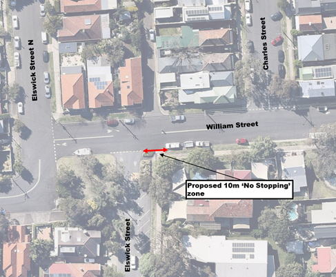
PUBLIC CONSULTATION
A letter outlining the above proposal was mailed out to the affected properties in Elswick Street and William Street, Leichhardt (as indicated in the following plan).
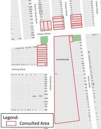
Three (3) responses were received with no objections to the proposal, feedback is summarised below.
|
Resident’s Comments |
Officer’s Comments |
|
Consider another sign to be placed on the western side of Elswick Street, south of William Street. |
The only conflict point for vehicles turning left from Elswick Street into William Street are vehicles travelling east along William Street. Therefore, ‘No Stopping’ restrictions on the western side of Elswick Street are not expected to improve sight visibility at this location.
|
|
Boats, trailer and caravan permanently parked in the area. Consider similar parking restriction in Darley Street for William Street to restrict boats, trailer, and caravan. |
The parking issue will be reviewed as part of a separate precinct parking study. |
CONCLUSION
It is recommended that a ‘No Stopping’ zone be installed on the southern side of William Street, east of Elswick Street, Leichhardt to reinforce the statutory 10m ‘No Stopping’ distance at the intersection.
|
|
Local Traffic Committee Meeting 3 February 2020 |
Subject: Trinity Grammar School Prospect Road, Summer Hill - Proposed Extension of 'No Stopping' Restrictions (Djarrawunang - Ashfield Ward / Summer Hill Electorate / Burwood PAC)
Prepared By: Brinthaban Baskaran - Graduate Traffic Engineer
Authorised By: Manod Wickramasinghe - Traffic and Transport Planning Manager
SUMMARY
Council has received concerns regarding vehicles obstructing sight lines between pedestrians and vehicles on approach to the existing pedestrian zebra crossing outside Trinity Grammar School, Prospect Road, Summer Hill.
The existing ‘No Stopping’ zone on approach to the mid-block pedestrian zebra crossing is not to the current RMS requirements. Therefore, it is proposed to extend the existing ‘No Stopping’ zone by 10metres (to a total of 20 metres).
|
RECOMMENDATION
That the existing ‘No Stopping’ zone be extended from 10m to 20 metres on the eastern side of Prospect Road, outside of 142-144 Prospect Road, Summer Hill (north of the pedestrian crossing). |
BACKGROUND
Council has received concerns regarding vehicles obstructing sight lines between pedestrians and vehicles on approach to the existing pedestrian zebra crossing outside Trinity Grammar School, Prospect Road, Summer Hill.
Site investigation has revealed that there is only a 10 metre ‘No Stopping’ zone on approach to the mid-block pedestrian zebra crossing in Prospect Road, Summer Hill.
It should be noted that as per current RMS requirements, a 20 metre ‘No Stopping’ zone should be placed on approach to the mid-block pedestrian zebra crossing without kerb extensions.
The existing at-grade pedestrian crossing is listed for investigation under a future capital works program for upgrade works such as kerb extensions and raising of the crossing facility.
Site Location & Road Network
|
Street Name(s) |
Prospect Road, Summer Hill |
|
Section |
Midblock |
|
Traffic Volume |
Not Available |
|
Recorded Accident History (5 year) |
Nil. |
|
Recorded 85% speed |
Not Available |
|
Speed Limit |
50km/h |
|
Carriageway width |
Approx. 10.0m |
|
Carriageway Type |
Two-way street with kerb side parking on both sides |
|
Road Classification (State, Regional, Local) |
Local |
FINANCIAL IMPLICATIONS
Nil.
OTHER STAFF COMMENTS
It is proposed to extend the existing ‘No Stopping’ zone by 10 metres (to a total 20 metres) on the eastern side of Prospect Road, outside of 142-144 Prospect Road, Summer Hill (north of the crossing) as shown on the following plan. One parking space will be removed as a result of this action.
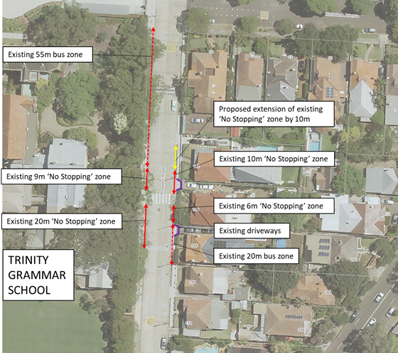
PUBLIC CONSULTATION
A letter outlining the above proposal was mailed out to the affected 8 properties in Prospect Road and Hurlstone Avenue as indicated on the attached map below requesting residents’ views regarding the proposal. Two (2) properties responded to the survey in support of the proposal with further requested changes or concerns.
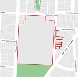
|
Residents’ Comments |
Officer Comments |
|
Relating to obstructing sight lines on approach to the pedestrian crossing, I am still surprised that the buses are still allowed to stop within 6 metres after the crossing.
A bus represents a much larger obstruction than a couple of
cars and its only 6 metres away. Whilst the regulation would seem to assume
that visibility of a pedestrian on the opposite side of the road is less
important than on the same side, perhaps it is not taking buses into
consideration.
|
A ‘No Stopping’ restriction is sign posted 6m on the departure side of the crossing, followed by a length of 20 metres of ‘Bus Zone’. The ‘Bus Zone’ extends over the driveway to No.146 Prospect Road. The RMS guidelines identify that ‘No Stopping’ on the departure side of a pedestrain crossing should normally be minimum of approximately 10 metres.
Buses are able to pull up over the driveway for a short period of time. This practice is not uncommon with short length bus zones over driveways. The Bus stop is of low frequency and is generally clear of parking to allow substantial sight view of the crossing for traffic approaching from the south. The bus operator Transit Systems has agreed and will move the “J” stem (where the buses pull up) another metre forward in aim to have buses pull up clear of the pedestrain crossing by approx. 10m. No further parking would be affected as a result of this.
With 20 metres proposed on approach to the crossing, buses will be able to lead in and pull up close to the kerb with the rear end much clearer of the crossing.
|
|
With the buses waiting and the cars parked, visibility is very limited if we have to enter or exit our driveway (No.142 Prospect Road), as well as there being little space to manoeuvre our cars.
Perhaps a 20m exclusion zone all around would be most appropriate to cover both our driveway, the crossing and the driveways of the properties either side of us. There are already 2 bus stops in place on that side so we think it would be a simple adjustment to meet the 20m exclusion. |
Proposed ‘No Stopping’ extension will assist and improve the visibility and maneuverability of vehicles accessing the driveway 142 Prospect Road.
It is only proposed to extend the ‘No Stopping’ to 20 metres on the approach side of the crossing for sight view under pedestrian safety. No further restrictions are proposed for sake of maintaining as much parking in the area as possible. |
|
|
Local Traffic Committee Meeting 3 February 2020 |
Subject: Morgan Street, Petersham - Proposed
Installation of Painted Island to Reinforce NSW Road Rules at Road Closure
(Damun-Stanmore Ward/ Summer Hill Electorate/ Inner West PAC)
Prepared By: Scipio Tam - Engineer – Traffic and Parking Services
Authorised By: Manod Wickramasinghe - Traffic and Transport Planning Manager
SUMMARY
Council is proposing to install a painted island on the eastern side of Morgan Street Road Closure, Petersham, to prevent vehicles parking at the point of entry for bicycles and simultaneously, reinforcing NSW Road Rules relating to parked vehicles obstructing cycleway.
|
RECOMMENDATION
THAT the proposed painted island on the eastern side of Morgan Street Road Closure, Petersham, at the point of entry for bicycles, in order to reinforce NSW Road Rules relating to parked vehicles obstructing cycleway, be APPROVED.
|
BACKGROUND
Morgan Street Road Closure at Napier Street, Petersham was implemented by Council following a Local Area Traffic Management review undertaken in 1996 due to a significant and high speed ‘rat-run’ between New Canterbury, Livingstone and Wardell Roads. However, cyclist thoroughfare had not been affected, with the southern end of the road closure serving as cyclist access through the road closure.
Council Officers have received concerns from cyclists, reporting vehicles parked at the road closure, obstructing cycle thoroughfare. Thus, Council is proposing to install painted island on the eastern side of Morgan Street Road Closure Cycle Access to reinforce NSW Road Rules relating to parked vehicles obstructing cycleway.
FINANCIAL IMPLICATIONS
The cost of the painted island will be funded from Council’s operating budget for signs and line marking.
OTHER STAFF COMMENTS
|
Street Name |
Morgan Street |
|
Section |
At Intersection with Napier Street |
|
Carriageway Width (m) kerb to kerb |
12.8 |
|
Carriageway Type |
Road closed off to vehicles. Only access for pedestrians and bicycles allowed. |
|
Classification |
Local |
|
Speed limit |
N/A |
|
85th Percentile Speed (km/h) |
N/A |
|
Vehicles Per Day (vpd) |
N/A |
|
Reported Crash History |
N/A |
|
Heavy Vehicle Volume (%) |
N/A |
|
Parking Arrangements |
Angle parking along the eastern side of the road closure is permitted, between the kerb and cycle access. |
The concept plan below illustrates a proposed painted island that would provide a visual separation between the parking area and cycleway access.
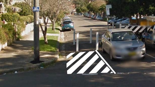
Figure 1: Proposed Painted Island at Morgan Street Road Closure, Petersham
Cycleway access on the western side of the road closure is generally unaffected as the kerb space along the front boundary of 20 Morgan Street, Petersham has been signposted as ‘No Stopping’.
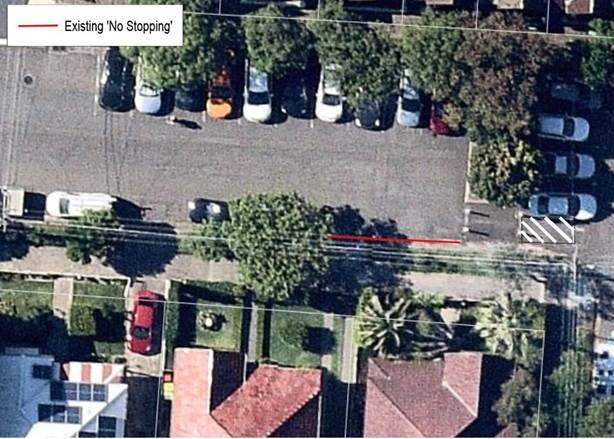
Figure 2: Existing ‘No Stopping’ west of Morgan Street Road Closure
PUBLIC CONSULTATION
Not applicable.
CONCLUSION
It is recommended that the Committee support the installation of a painted island on the eastern side of Morgan Street Road Closure, Petersham, at the point of entry for bicycles, to provide separation between the cycle path and on-street parking spaces and to reinforce NSW Road Rules at the location.
|
|
Local Traffic Committee Meeting 3 February 2020 |
Subject: Darling Street between Mort Street and Curtis Road, Balmain - Road Occupancy - ANZAC Day Dawn Service (Baludarri - Balmain Ward/Balmain Electorate/Leichhardt PAC
Prepared By: Vinoth Srinivasan - Engineer - Traffic and Parking Services
Authorised By: Manod Wickramasinghe - Traffic and Transport Planning Manager
SUMMARY
In preparation to mark the ANZAC Day Dawn Service 2020 on Saturday, 25 April 2020, Inner West Council is organising the ANZAC Day dawn Service at the Loyalty Square War Memorial, Balmain. To facilitate the event, it is proposed to close Darling Street between Mort Street and Curtis Road between 2:30am and 9:30am.
|
RECOMMENDATION
THAT the temporary road closure of Darling Street (Mort Street to Curtis Road), Balmain on Saturday, 25 April 2020 between 2.30am – 9.30am be supported, subject to the following conditions:
a. That an unencumbered passage minimum 3.0m wide be available for emergency vehicles through the closed section of Darling Street, Balmain;
b. The occupation of the road carriageway must not occur until the road has been physically closed; and
c. All affected residents and businesses, including the NSW Police Local Area Commander, Fire & Rescue NSW and NSW Ambulance Services be notified in writing, by the applicant, of the proposed temporary road closure at least 2 weeks in advance of the closure with the applicant making reasonable provision for stakeholders.
|
BACKGROUND
In preparation to mark the ANZAC Day Dawn Service 2020, Council is organising an event at the Loyalty Square memorial, Balmain.
The details of the event are as follows:
Day: Saturday, 25 April 2020
Commemorative Service: 6.00am – 7.00am
Venue: Loyalty Square, Balmain (outside Woolworths)
Procession: There will be no march down Darling Street for 2020
Site Location & Road Network
|
Street Name(s) |
Darling Street, Balmain |
|
Section |
Between Mort Street and Curtis Road |
|
Traffic Volume |
- |
|
Recorded Accident History (5 year) |
2 (2017 Series Injury) 6 (2016 Non-casualty) 2 (2014 Series Injury) |
|
Recorded 85% speed |
- |
|
Speed Limit |
40km/h |
|
Carriageway width |
Approx. 12.8m |
|
Carriageway Type |
Two-way street with kerb-side parking on both sides |
|
Road Classification (State, Regional, Local) |
Local |
FINANCIAL IMPLICATIONS
Nil.
OTHER STAFF COMMENTS
To facilitate the event, it is proposed to close Darling Street between Mort Street/Beattie Street and Curtis Road (approximately 260m) between 2.30am and 9.30am. This road closure will prevent all traffic travelling through this closed section and also will prevent any additional on-street parking on both sides of the subject section of Darling Street.
It should be noted that although the land uses in this area are predominantly retail/commercial, there are a number of residential properties in this section of Darling Street.
The Traffic Management Plan prepared for the event is attached.
All businesses/residents in the affected area will be advised to avoid parking in the subject section of Darling Street.
Based on the discussions held with the Transit Systems representative, buses would need to terminate at Darling Street/Rowntree Street/Montague Street intersection as Curtis Road is not suitable for bus movements. To maintain transport services between East Balmain and Balmain, Council will organise two shuttle bus services running between Balmain East and Darling Street/Rowntree Street/Montague Street. The shuttle bus service routes are shown on the attached TCP (Attachment 2).
Transit Systems will post notifications at all bus stops on Darling Street between Beattie Street and Balmain East wharf to advise passengers to use Council’s community buses on the morning of 25 April 2020. All other eastbound and westbound traffic will need to use Curtis Road or Palmer Street to access Balmain East.
The Transit Systems representative has also requested the temporary expansion of the bus turning area at Grove Street to accommodate additional buses. Therefore, it is proposed to temporarily remove three parking spaces on the northern side even numbered side (No. 22, 24, 26A) of Grove Street near Deloitte Avenue, Birchgrove. Affected residents will be notified.
PUBLIC CONSULTATION
The proposed temporary full-road closure has been advertised in the local newspaper for a period of 28 days from 14 January 2020 to 28 January 2020. No comments were received at the time of finalising the report. Should any objections be received, they would be reported to Council’s scheduled meeting.
Council’s Community Events Coordinator will organise a notification letter outlining the closure of Darling Street (Mort Street/ Beattie Street-Curtis Road) to all affected properties and the emergency services, including Balmain Hospital of the temporary road closure.
The road closures and alternate public transport options will be advertised on Council’s website and in local newspapers.
|
1.⇩ |
Treaffic Control Plan - Darling Street (Beattie Street - Curtis Road) ANZAC Day Dawn Service |
|
2.⇩ |
Traffic Management Plan - Darling Street (Beattie Street - Curtis Road) ANZAC Day Dawn Service |
|
Local Traffic Committee Meeting 3 February 2020 |
Subject: Cary Street between Rofe Street and Elswick Street, Leichhardt - Road Occupancy - Street Party (Gulgadya - Leichhardt Ward/Balmain Electorate/Leichhardt PAC)
Prepared By: Vinoth Srinivasan - Engineer - Traffic and Parking Services
Authorised By: Manod Wickramasinghe - Traffic and Transport Planning Manager
SUMMARY
Council is initiating a Play Streets program in a small number of local streets and laneways throughout the Local Government Area (LGA). The long term aim of the program is for communities to be empowered to run self-managed play streets events in their neighborhood with support and advice from Council. To facilitate the pilot event, it is proposed to close Cary Street, Leichhardt between Rofe Street and Elswick Street on Sunday, 15 March 2020 between 3.00pm and 5.00pm.
|
RECOMMENDATION
THAT the temporary road closure of Cary Street, Leichhardt between Rofe Street and Elswick Street, to conduct a Play Streets event (Street Party) on Sunday, 15 March 2020, from 3.00pm-5.00pm, be approved, subject to the conditions as set out as per the Street Party Application Form as well as the following additional conditions:
a. That an unencumbered passage minimum of 3.0m wide be available for emergency vehicles through Cary Street, Leichhardt between Rofe Street and Elswick Street;
b. The occupation of the road carriageway must not occur until the road has been physically closed; and
c. All affected residents and businesses, including the NSW Police Local Area Commander, Fire & Rescue NSW and NSW Ambulance Services be notified in writing, by the applicant, of the proposed temporary road closure at least 14 days in advance of the closure with the applicant making reasonable provision for stakeholders.
|
BACKGROUND
Council’s Play Streets program involves the temporary closure of a road to enable it to be used for play and socialising. Following a recommendation in the Recreation Needs Study: A Healthier Inner West, Council has been working to empower residents to run self-managed play streets events in their neighbourhood with support and advice from Council. After engaging with local residents, Cary Street, Leichhardt was selected as an appropriate pilot location with the majority of local residents supporting the initiative. In order to mitigate the impact of the event on local residents who were not supportive of the pilot, Council has adapted the ‘Play Streets’ pilot program to be a one-off event rather than a 6 month trial as previously planned, and altered the road closure point to limit the impact on these residents.
The street party is proposed to be held on Sunday, 15 March 2020 between 3.00pm and 5.00pm. Council is seeking permission for a temporary full road closure of Cary Street, Leichhardt between Rofe Street and Elswick Street.
Site Location & Road Network
|
Street Name(s) |
Cary Street, Leichhardt |
|
Section |
Between Rofe Street and Elswick Street |
|
Traffic Volume |
- |
|
Recorded Accident History (5 year) |
Nil. |
|
Recorded 85% speed |
- |
|
Speed Limit |
50km/h |
|
Carriageway width |
Approx. 9.8m |
|
Carriageway Type |
Two-way street with kerb-side parking on both sides |
|
Road Classification (State, Regional, Local) |
Local |
FINANCIAL IMPLICATIONS
Nil.
OTHER STAFF COMMENTS
The Play Streets event (Street Party) in Cary Street is a pilot event.
According to the RMS ‘Guide to Traffic and Transport Management for Special Events’ a small street party is considered as a ‘Class 3’ event.
Council encourages properly conducted neighbourhood street parties as a means of building community spirit and improving neighbourhood security. Fees for road occupancy are waived by Council for small community street parties.
Where the following conditions apply, organisers are only required to obtain approval for a street party involving a temporary road closure:
· The party is to be held outdoors for fewer than 100 people.
· No temporary structures or jumping castles are to be erected.
· Participants are to bring their own food and drinks, and food and drinks are not for sale.
· There will be no performers or amplified music involved.
For approved street parties and subject to availability Council will provide barricades and ‘Road Closed’ signs subject to the street party coordinator arranging collection from and return to Council’s Summer Hill depot.
PUBLIC CONSULTATION
The proposed closure of Cary Street, Leichhardt between Rofe Street and Elswick Street is currently being advertised in the local newspaper for a period of 28 days from 28 January 2020 to 25 February 2020.
No responses were received at the time of finalising the report. Should any objections be received, they would be reported to Council’s scheduled meeting.
|
1.⇩ |
Standard Street Party TCP |