Local Traffic Committee
Meeting
APRIL 2020
The April 2020 meeting of the Inner West Local Traffic
Committee will be held electronically with the Agenda emailed to Members for
review. All comments are requested to be returned to Council by 5.00pm Monday 6
April 2020.
|

|
Local Traffic
Committee Meeting
6 April 2020
|
Function of the Local
Traffic Committee
Background
Roads and Maritime
Services (RMS) is legislated as the
Authority responsible for the control of traffic on all NSW Roads. The RMS has
delegated certain aspects of the control of traffic on local roads to councils.
To exercise this delegation, councils must establish a local traffic committee
and obtain the advice of the RMS and Police. The Inner West Council Local Traffic
Committee has been constituted by Council as a result of the delegation granted
by the RMS pursuant to Section 50 of the Transport Administration Act 1988.
Role of the Committee
The Local
Traffic Committee is primarily a
technical review and advisory committee which considers the technical merits of
proposals and ensures that current technical guidelines are considered. It
provides recommendations to Council on traffic and parking control matters and
on the provision of traffic control facilities and prescribed traffic control
devices for which Council has delegated authority. These matters are dealt with
under Part A of the agenda and require Council to consider exercising
its delegation.
In
addition to its formal role as the Local Traffic Committee, the Committee may
also be requested to provide informal traffic engineering advice on traffic
matters not requiring Council to exercise its delegated function at that point
in time, for example, advice to Council’s Development Assessment Section
on traffic generating developments. These matters are dealt with under Part
C of the agenda and are for information or advice only and do not require
Council to exercise its delegation.
Committee Delegations
The Local
Traffic Committee has no decision-making
powers. The Council must refer all traffic related matters to the Local Traffic
Committee prior to exercising its delegated functions. Matters related to State
Roads or functions that have not been delegated to Council must be referred
directly to the RMS or relevant organisation.
The
Committee provides recommendations to Council. Should Council wish to act
contrary to the advice of the Committee or if that advice is not supported
unanimously by the Committee members, then the Police or RMS have an
opportunity to appeal to the Regional Traffic Committee.
Committee Membership & Voting
Formal
voting membership comprises the following:
·
one representative of Council as
nominated by Council;
·
one representative of the NSW
Police from each Local Area Command (LAC) within the LGA, being Newtown,
Marrickville, Leichhardt and Ashfield LAC’s.
·
one representative from the RMS; and
·
State Members of Parliament (MP)
for the electorates of Summer Hill, Newtown, Heffron, Canterbury, Strathfield
and Balmain or their nominees.
Where the Council area is represented by more than one
MP or covered by more than one Police LAC, representatives are only permitted to vote on matters which effect
their electorate or LAC.
Informal
(non-voting) advisors from within Council or external authorities may also
attend Committee meetings to provide expert advice.
Committee Chair
Council’s
representative will chair the meetings.
|
|
Local Traffic
Committee Meeting
6 April 2020
|
1 Apologies
2 Disclosures
of Interest
3 Confirmation
of Minutes Page
Minutes of 2 March 2020 Local Traffic
Committee Meeting 5
4 Matters
Arising from Council’s Resolution of Minutes
5 Part
A – Items Where Council May Exercise Its Delegated Functions
Traffic Matters
ITEM Page
LTC0420 Item 1 Minor
Traffic Facilities 20
LTC0420 Item 2 Dobroyd
Parade to Hawthorne Parade bicycle contraflow 23
LTC0420 Item 3 Greenway
on-road cycle route 28
LTC0420 Item 4 Probert
Street, Newtown – Proposal for Car Share Parking Space (Damum –
Stanmore Ward / Newtown Electorate / Inner West PAC) 42
LTC0420 Item 5 Victoria
Road, Marrickville – Temporary relocation of Taxi Zone during Marrickville
Metro Expansion Works – (Midjuburi – Marrickville Ward / Heffron
Electorate / Inner West PAC) 44
LTC0420 Item 6 Richardsons
Crescent, Marrickville - Proposed Pedestrian (zebra) Crossing - Design Plan
10116 (Midjuburi - Marrickville Ward/ Summer Hill Electorate/ Inner West PAC) 46
LTC0420 Item 7 Elizabeth
Street, Ashfield-Proposed Upgrade of Existing Pedestrian Crossing-Da Condition
Under Re-Development of the Ashfield Aquatic Centre (160-178 Elizabeth Street,
Ashfield) (Gulgadya-Leichhardt Ward/Summer Hill Electorate/Burwood PAC) 49
LTC0420 Item 8 James
Street, Summer Hill - Temporary Full Road Closure for substation electrical
conduit connection (Djarrawunang-Ashfield Ward/Summer Hill Electorate/Burwood
PAC) 54
LTC0420 Item 9 Terry
Street, Rozelle - Proposed extention of on-street bycycle path - (Baludarri-Balmain
Ward/Balmain Electorate/Leichhardt PAC) 66
Parking Matters
ITEM Page
LTC0420 Item 10 Intersection
of Cecil Street and Chandos Street, Ashfield- 'No Stopping' restrictions to
corners (Diarrawunang-Ashfield Ward/Summer Hill Electorate/Burwood PAC) 68
LTC0420 Item 11 Hercules
Street, Ashfield-Timed extension of disabled parking zone
(Djarrawunang-Ashfield Ward/Summer Hill Electorate/Burwood PAC) 70
LTC0420 Item 12 Darling
Street, Balmain - Proposed 'No Stopping' Restriction at Intersection with Ann
Street (Baludarri-Balmain Ward/Balmain Electorate/Leichhardt PAC) 72
LTC0420 Item 13 Balmain
Road, Lilyfied (between Perry Street and Lilyfield Road) - Proposed Bus Zones
(Baludarri - Balmain Ward / Balmain Electorate / Leichhardt PAC) 74
Late Items
Nil at time of printing.
6 Part B -
Items for Information Only
Nil at the time of printing.
7 Part
C - Items for General Advice
Nil at the time of printing.
8 General
Business
9 Close
of Meeting
|
|
Local Traffic
Committee Meeting
6 April 2020
|
Minutes
of Local Traffic Committee Meeting
Held
at Petersham Service Centre on 2 March 2020
Meeting
commenced at 10.02am
ACKNOWLEDGEMENT
OF COUNTRY BY CHAIRPERSON
I acknowledge
the Gadigal and Wangal people of the Eora nation on whose country we are
meeting today, and their elders past and present.
COMMITTEE REPRESENTATIVES PRESENT
|
|
|
|
Clr
Victor Macri
|
Councillor – Midjuburi-Marrickville Ward (Chair)
|
|
Bill Holliday
|
Representative
for Jamie Parker MP, Member for Balmain
|
|
Sgt John
Micallef
|
NSW Police
– Burwood Police Area Command
|
|
SC Stephen
Flanagan
|
NSW Police
– Leichhardt Police Area Command
|
|
Tanmila Samin
Islam
|
Transport for
NSW
|
|
|
|
|
OFFICERS
IN ATTENDANCE
|
|
|
|
|
Asith
Nagodavithane
|
Transit
Systems – Inner West Bus Services
|
|
Adrian
Pritchard
|
Transit
Systems – Inner West Bus Services
|
|
Clr Marghanita da Cruz
|
Councillor – Gulgadya-Leichhardt Ward
|
|
Cathy Edwards-Davis
|
IWC’s
Director Infrastructure
|
|
Manod Wickramasinghe
|
IWC’s
Traffic and Transport Services Manager
|
|
George Tsaprounis
|
IWC’s Coordinator Traffic and Parking Services (South)
|
|
Miia
Hynninen
|
IWC’s
Business Administration Officer
|
|
|
|
|
VISITORS
|
|
|
|
|
|
Alexander
Dilworth
|
LTC0220
Item 19 – Resident
|
|
|
|
|
APOLOGIES:
|
|
|
|
|
|
Sgt Paul
Vlachos
|
NSW Police
– Inner West Police Area Command
|
DISCLOSURES
OF INTERESTS:
Nil.
CONFIRMATION OF MINUTES
Public speaker:
Alexander Dilworth attended at 10.03am
Mr Dilworth, on behalf of
the Warren Road Action Group, spoke on LTC0220 Item 19 regarding the proposed
Warren Road, Marrickville upgrade. Mr Dilworth stated that since residents met
with Council on a number of occasions about the upgrade, the proposal has not
progressed any further. The Action Group had been advised that Transport for
NSW was reviewing the proposal but no further information has been relayed to
residents since then. Mr Dilworth stated that, in the meantime, numerous
accidents and near misses in Warren Road have been occurring on a weekly basis.
Mr Dilworth requested that the residents be shown some support to move forward
with making Warren Road safer.
(Mr Dilworth left at
10.08am)
The Transport
for NSW representative stated that they have no objections to the ‘One
Way’ concept on Warren Road in principle and welcome Council to organise
to make changes at the signalised intersection accordingly. The implementation
is dependent on the cost of upgrading the traffic signals and sourcing funding
for the upgrade. Council are waiting on a cost estimate for the signal upgrade
from contractors which is expected to be received shortly. Council Officers and
Transport for NSW can then discuss next steps. Clr Macri suggested that
residents can write to local State Members to help source funding.
|
The Minutes of
the Local Traffic Committee Meeting held on Monday, 3 February 2020 were
confirmed.
|
MATTERS ARISING FROM COUNCIL’S
RESOLUTION OF MINUTES
The
Local Traffic Committee recommendations of its meeting held on 2 December 2019
and 3 February 2020 were adopted at Council’s meeting held on 25 February
2020 with the following amendments:
a) December
2019 - LTC1219 Item 8 Carrington Road Marrickville, THAT a further report be
provided to Council to examine the provision of a pedestrian crossing on
Carrington Road near Renwick Street Marrickville to improve pedestrian safety,
particularly the safety of students attending Tempe High School;
b) February
2020 - LTC0220 Item 9 Clissold Street, Ashfield - Investigation of
Proposed Works from the Ashfield Traffic Management Strategy
(Djarrawunang-Ashfield Ward/Summer Hill Electorate/Burwood PAC) - THAT Council
write to Transport for NSW and Transit Systems and request that to ensure safe
traffic management they support the introduction of opposing directional
one-way streets in Clissold Street and Seaview Street, Ashfield, with the
associated changes to the 406 and 413 bus routes; and
c) That
traffic officers meet with Stockland Cardinal Freeman Village with the view to
have delivery and large vehicles enter from either Victoria Street or Queen
Street Ashfield.
|
LTC0320
Item 1 Minor Traffic Facilities (All Wards/All
Electorates/All LAC's)
|
|
SUMMARY
This report considers minor
traffic facility applications received by Inner West Council and includes
‘Disabled Parking’ and ‘Works Zone’ requests.
Officer’s
Recommendation
THAT:
1. The
following ‘Disabled Parking’ zones be removed as they are no longer
required;
a. 6m ‘Disabled Parking’ zone in front of No. 3
O`Hara Street, Marrickville;
2. A 6.0m 'Disabled
Parking’ zone be installed in front of No. 63 Pigott Street, Dulwich
Hill;
3. A
6.0m 'Disabled Parking’ zone be installed in front of No. 2 Starling
Street, Rozelle;
4. A
6.0m 'Disabled Parking’ zone be installed in front of No. 21 Pashley
Street, Balmain;
5. A
30m 'Works Zone 7.00am – 6.00pm Mon-Fri and 8.00am - 1.00pm Sat' be
installed on the north-western side of Dibble Avenue, on the side boundary of
No. 56 Ewart Street, Marrickville, for 12
weeks;
6. A 9m
'Works Zone 7.00am – 6.00pm Mon-Fri and 8.00am - 1.00pm Sat' be
installed in front of No 132. Evans Street, Rozelle, adjacent to the existing
‘No Stopping’ restriction, for development at No. 144 Evans
Street, for 12 weeks, subject to resident consultation; and
7. A
12m 'Works Zone 7.00am – 6.00pm Mon-Fri and 8.00am - 1.00pm Sat' be
installed on the western side of Norton Street, in front of No. 46 Norton
Street, Leichhardt, for 12 weeks, subject to resident notification.
DISCUSSION
The Committee members agreed
with the Officer’s recommendation.
COMMITTEE RECOMMENDATION
THAT:
1. The following ‘Disabled
Parking’ zones be removed as they are no longer required;
a. 6m ‘Disabled Parking’ zone in front of No. 3
O`Hara Street, Marrickville;
2. A 6.0m 'Disabled
Parking’ zone be installed in front of No. 63 Pigott Street, Dulwich
Hill;
3. A 6.0m 'Disabled Parking’ zone be installed in
front of No. 2 Starling Street, Rozelle;
4. A 6.0m 'Disabled Parking’ zone be installed in
front of No. 21 Pashley Street, Balmain;
5. A 30m 'Works Zone 7.00am – 6.00pm Mon-Fri and
8.00am - 1.00pm Sat' be installed on the north-western side of Dibble Avenue,
on the side boundary of No. 56
Ewart Street, Marrickville, for 12 weeks;
6. A 9m 'Works Zone 7.00am – 6.00pm Mon-Fri and 8.00am
- 1.00pm Sat' be installed in front of No 132. Evans Street, Rozelle,
adjacent to the existing ‘No Stopping’ restriction, for
development at No. 144 Evans Street, for 12 weeks, subject to resident
consultation; and
7. A 12m 'Works Zone 7.00am – 6.00pm Mon-Fri and
8.00am - 1.00pm Sat' be installed on the western side of Norton Street, in
front of No. 46 Norton Street, Leichhardt, for 12 weeks, subject to resident
notification.
For motion: Unanimous
|
|
LTC0320
Item 2 Premier Street, Marrickville – Request
for ‘Mobility’ parking
provision adjacent to Ferncourt Public School (Midjuburi -
Marrickville Ward / Summer Hill Electorate / Inner West
PAC)
|
|
SUMMARY
A request has been received
from the Principal of Ferncourt Public School for the provision of a
dedicated Mobility Parking space outside Ferncourt Public School, 74 Premier
Street, Marrickville and within the existing drop-off zone in order to
improve accessibility for students attending the school. The 'Mobility
Parking' restrictions will be applicable from '8.00-9.30 am and 2.30-4.00 pm
School Days’ only.
Officer’s
Recommendation
THAT a 6m
‘Mobility Parking; 8.00 - 9.30 am and 2.30 – 4.00 pm School Days,
Buses Excepted ' space be installed on the southern side of Premier Street,
Marrickville west of the western access gate adjacent to the Ferncourt Public
School and within the existing drop-off zone.
DISCUSSION
The Committee members agreed
with the Officer’s recommendation.
COMMITTEE RECOMMENDATION
THAT a 6m ‘Mobility Parking; 8.00 - 9.30 am and 2.30 – 4.00
pm School Days, Buses Excepted ' space be installed on the southern side of
Premier Street, Marrickville west of the western access gate adjacent to the
Ferncourt Public School and within the existing drop-off zone.
For motion: Unanimous
|
|
LTC0320
Item 3 Liberty Street and Bedford Street, Stanmore
– Temporary full road
closure to complete rail overbridge refurbishment works
– 20 and
21 June 20220 (Damun-Stanmore Ward / Newtown Electorate /
Inner
West PAC)
|
|
SUMMARY
An application has been received
from Sydney Trains (Transport for NSW - TfNSW) for the temporary full road
closure of Liberty Road (between Railway Avenue and Trafalgar Street) and
Bedford Street (between Liberty Street and Pierce Street), Stanmore from 4am
Saturday, 20 June to 4pm Sunday, 21 June 2020 in order to finish
refurbishment works on the Liberty Street Stanmore rail over bridge. The
streets will be temporarily closed to all vehicular traffic, including
emergency vehicles and local residents. It is recommended that the proposed
temporary full road closures be approved, subject to the conditions outlined
in this report.
Officer’s
Recommendation
THAT the proposed
temporary full road closure of Liberty Road (between Railway Avenue and
Trafalgar Street) and Bedford Street (between Liberty Street and Pierce
Street), Stanmore from 4am Saturday, 20 June to 4pm Sunday, 21 June 2020
be approved, in order to finish refurbishment works on the Liberty Street
Stanmore rail over bridge subject, but not limited to, the following conditions:
1. A
Road Occupancy License be obtained by the applicant from the Transport
Management Centre;
2. All
affected residents and businesses, including the NSW Police Local Area
Commander, Fire & Rescue NSW and the NSW Ambulance Services be notified
in writing, by the applicant, of the proposed temporary road closure at least
7 days in advance of the closure with the applicant making reasonable
provision for stakeholders; and
3. The
occupation of the road carriageway must not occur until the road has been
physically closed.
DISCUSSION
The Committee members agreed
with the Officer’s recommendation.
COMMITTEE RECOMMENDATION
THAT
the proposed temporary full road closure of Liberty Road (between
Railway Avenue and Trafalgar Street) and Bedford Street (between Liberty
Street and Pierce Street), Stanmore from 4am Saturday, 20 June to
4pm Sunday, 21 June 2020 be approved, in order to finish refurbishment
works on the Liberty Street Stanmore rail over bridge subject, but not
limited to, the following conditions:
1. A
Road Occupancy License be obtained by the applicant from the Transport
Management Centre;
2. All
affected residents and businesses, including the NSW Police Local Area
Commander, Fire & Rescue NSW and the NSW Ambulance Services be notified
in writing, by the applicant, of the proposed temporary road closure at least
7 days in advance of the closure with the applicant making reasonable
provision for stakeholders; and
3. The
occupation of the road carriageway must not occur until the road has been
physically closed.
For motion: Unanimous
|
|
LTC0320
Item 4 Haberfield Library Upgrade - Temporary Bus
Relocation and Work
Zone (Gulgadya-Leichhardt Ward/Summer Hill
Electorate/Burwood
PAC)
|
|
SUMMARY
Council Major Projects and
Facilities has received an approval for a Development Application (DA) to upgrade
the Haberfield Centre and Library. As part of the construction works, it is
proposed that a temporary ‘Work Zone’ be established in front of
the library at No. 78 Dalhousie Street. The existing bus stop will be
re-located approximately 20m south for approximately 37 weeks.
Officer’s
Recommendation
THAT:
1. A 20m ‘Work Zone 7:00am
-6:00pm Mon-Fri and 8:00am-1:00pm Sat be installed at the front of No.78
Dalhousie Street, Haberfield, for 37 weeks, temporarily replacing the
existing bus stop; and
2. The existing bus stop in front
of No. 78 Dalhousie Street, Haberfield be re-located 20m south, closer to the
traffic lights at Ramsay Street.
DISCUSSION
The Committee members agreed
with the Officer’s recommendation.
COMMITTEE RECOMMENDATION
THAT:
1. A 20m ‘Work Zone
7:00am -6:00pm Mon-Fri and 8:00am-1:00pm Sat be installed at the front of
No.78 Dalhousie Street, Haberfield, for 37 weeks, temporarily replacing the
existing bus stop; and
2. The existing bus stop in
front of No. 78 Dalhousie Street, Haberfield be re-located 20m south, closer
to the traffic lights at Ramsay Street.
For motion: Unanimous
|
|
LTC0320
Item 5 Ravenue Lane, Stanmore - Proposed 'No Parking
5am-10am
Monday' to improve vehicular access for Waste Collection
Vehicles
(Damun - Stanmore Ward/ Summer Hill Electorate/ Burwood
PAC)
|
|
SUMMARY
A proposal for the installation
of ‘No Parking 5am-10am Monday’ restrictions in Ravenue Lane,
between Lincoln Street and Stafford Street, Stanmore has been requested to
address concerns from residents and Council’s Waste Collection Officers
regarding regular instances of parked vehicles restricting access for waste
collection vehicles. The proposal is limited to waste collection days only
and will improve access for waste collection vehicles as well as reduce the
chance of property damage. The proposal includes statutory ‘No
Stopping’ zones at its intersections with Lincoln Street and Stafford
Street.
Officer’s
Recommendation
THAT:
1. ‘No
Parking 5am – 10am Monday’ restrictions be installed along the
northern side of Ravenue Lane, along the side boundary of Properties No. 75
Lincoln Street and No. 78 Stafford Street, Stanmore;
2. ‘No
Parking 5am – 10am Monday’ restrictions be installed along the
southern side of Ravenue Lane, along the rear of Properties No. 28 – 42
Railway Avenue, Stanmore;
3. 10m
statutory ‘No Stopping’ restrictions be signposted on the
northern and southern sides of Ravenue Lane west of Stafford Street,
Stanmore; and
4. 10m
statutory ‘No Stopping’ restrictions be signposted on the
northern and southern sides of Ravenue Lane east of Lincoln Street, Stanmore.
DISCUSSION
The Committee members agreed
with the Officer’s recommendation.
COMMITTEE RECOMMENDATION
THAT:
1. ‘No
Parking 5am – 10am Monday’ restrictions be installed along the
northern side of Ravenue Lane, along the side boundary of Properties No. 75
Lincoln Street and No. 78 Stafford Street, Stanmore;
2. ‘No
Parking 5am – 10am Monday’ restrictions be installed along the
southern side of Ravenue Lane, along the rear of Properties No. 28 – 42
Railway Avenue, Stanmore;
3. 10m
statutory ‘No Stopping’ restrictions be signposted on the
northern and southern sides of Ravenue Lane west of Stafford Street,
Stanmore; and
4. 10m
statutory ‘No Stopping’ restrictions be signposted on the
northern and southern sides of Ravenue Lane east of Lincoln Street, Stanmore.
For motion: Unanimous
|
|
LTC0320
Item 6 Myra Lane, Dulwich Hill - Proposed 'No
Stopping' Restrictions
(Djarrawunang- Ashfield Ward/ Summer Hill Electorate/
Inner West
PAC)
|
|
SUMMARY
Following representations from
the community regarding vehicles parking on the northern side of Myra Lane,
between Garnet Lane and Myra Road, impeding off-street parking access,
Council is proposing to introduce new ‘No Stopping’ restrictions
along the northern side of the lane.
Officer’s
Recommendation
THAT 16m ‘No
Stopping’ restrictions be installed in Myra Lane (Northern side), west
of the Myra Road, Dulwich Hill.
DISCUSSION
Council Officers tabled a late
submission from a resident who supported the recommendation.
The Committee members agreed
with the Officer’s recommendation.
COMMITTEE RECOMMENDATION
THAT 16m ‘No
Stopping’ restrictions be installed in Myra Lane (Northern side), west
of the Myra Road, Dulwich Hill.
For motion: Unanimous
|
|
LTC0320
Item 7 Pigott Street at The Boulevarde, Dulwich Hill
- Proposed Statutory
10-metre 'No Stopping' restrictions (Djarrawunang -
Ashfield Ward/
Summer Hill Electorate/ Inner West PAC)
|
|
SUMMARY
Council is proposing to
implement statutory 10-metre ‘No Stopping’ restrictions in Pigott
Street at The Boulevarde, Dulwich Hill following a request to deter illegal
parking on the northern side of Pigott Street. Vehicles parked on Pigott
Street, within 10 metres of the intersection with The Boulevarde, at times
hinder the sight line for vehicles entering the intersection.
Officer’s
Recommendation
THAT:
1. Implementation of 10m
statutory ‘No Stopping’ in Pigott Street (northern side), east of
its intersection with The Boulevarde, Dulwich Hill; and
2. Implementation of 10m
statutory ‘No Stopping’ in Pigott Street (northern side), west of
its intersection with The Boulevarde, Dulwich Hill, be approved.
DISCUSSION
The Committee members agreed
with the Officer’s recommendation.
COMMITTEE RECOMMENDATION
THAT:
1. Implementation of 10m
statutory ‘No Stopping’ in Pigott Street (northern side), east of
its intersection with The Boulevarde, Dulwich Hill; and
2. Implementation of 10m
statutory ‘No Stopping’ in Pigott Street (northern side), west of
its intersection with The Boulevarde, Dulwich Hill, be approved.
For motion: Unanimous
|
|
LTC0320
Item 8 Charlotte Street, Ashfield- Request to
convert 1P period parking to
1/2P period parking outside premises No's 18-20 Charlotte
Street,
Ashfield (Djarrawunang-Ashfield Ward/ Summer Hill
Electorate/
Burwood PAC)
|
|
SUMMARY
A request has been received by
the newsagent proprietor premises No. 18 Charlotte Street, Ashfield to have a
short section of 1-hour period parking zone outside the newsagent and
convenience store Nos. 18-20 Charlotte Street, converted to ½ hour
period parking. This will allow a higher turnover for customer parking in the
area particularly for the customers attending the above corner shops in
Charlotte Street.
Officer’s
Recommendation
THAT the existing 8m length of
‘1P 8.30am-6.00pm Mon-Sun’ outside premises Nos. 18-20 Charlotte
Street, Ashfield, be converted to ‘1/2 P 8.30am-6.00pm Mon-Sun’.
DISCUSSION
The Committee members agreed
with the Officer’s recommendation.
COMMITTEE RECOMMENDATION
THAT the existing 8m length
of ‘1P 8.30am-6.00pm Mon-Sun’ outside premises Nos. 18-20
Charlotte Street, Ashfield, be converted to ‘1/2 P 8.30am-6.00pm
Mon-Sun’.
For motion: Unanimous
|
|
LTC0320
Item 9 Railway Street, Petersham - Proposed
installation of Loading Zone
(Damun -Stanmore Ward/ Newtown Electorate/ Inner West PAC)
|
|
SUMMARY
A request has been received for
provision of a ‘Loading Zone’ in Railway Street, Petersham to
facilitate with loading and unloading at Property No. 30 Terminus Street,
Petersham.
Officer’s
Recommendation
THAT:
1. Implementation of
a sixteen (16) metre ‘Loading Zone 8.00am –
3.00pm Wednesday’ on western side of Railway Street, between Carrington
Lane and Terminus Street; and
2. Implementation
10m statutory ‘No Stopping’ on the western side of Railway Street
at Terminus Street, Petersham; be approved.
DISCUSSION
Council Officers tabled a late
submission from a resident who objected to the proposal as they believed that
the Resident Parking Scheme in Railway Street should be extended to both
sides of the street. Council’s Officers comments to the submission was
that Resident Parking Schemes have been introduced on one side of the road
for many areas to date. This allows for a balanced approach to the provision
of on-street parking which caters for all users.
The Committee members agreed
with the Officer’s recommendation.
COMMITTEE RECOMMENDATION
THAT:
1. Implementation
of a sixteen (16) metre ‘Loading Zone 8.00am
– 3.00pm Wednesday’ on western side of Railway Street, between
Carrington Lane and Terminus Street; and
2. Implementation 10m statutory ‘No Stopping’ on the
western side of Railway Street at Terminus Street, Petersham; be approved.
For motion: Unanimous
|
|
LTC0320
Item 10 Morris Street, Summer Hill- Request to remove 1/2 P
period
parking restrictions outside Nos. 24-28 Morris Street,
Summer Hill
(Djarrawunang - Ashfield Ward/Summer Hill
Electorate/Burwood PAC)
|
|
SUMMARY
Council has received a resident
request to remove an existing ½ hour period parking zone (2 car space
length) outside premise No’s. 24-26 Morris Street, Summer Hill as it is
not required by current land uses.
Officer’s
Recommendation
THAT the existing ½ hour
period parking zone of 2 spaces on the eastern side of Morris Street, Summer
Hill, outside premise No’s 24-26 Morris Street, be removed.
DISCUSSION
Council Officers tabled a late
submission from a resident objecting to the proposal on the basis that she
has mobility problems and the proposal would remove her ability to park in
front of her house. It was noted that the resident has a mobility parking
permit which would allow her to park unrestricted in the existing 2 hour
parking that is currently provided on Morris and Lorne Street, in addition to
the unrestricted parking that is proposed outside of No’s 24-26 Morris
Street. Residents can also apply for a mobility parking space should
they meet the criteria.
The Committee members agreed
with the Officer’s recommendation.
COMMITTEE RECOMMENDATION
THAT the existing
½ hour period parking zone of 2 spaces on the eastern side of Morris
Street, Summer Hill, outside premise No’s 24-26 Morris Street, be
removed.
For motion: Unanimous
|
|
LTC0320
Item 11 Renwick Street, Marrickville - Proposed
extension of short-term
parking restrictions (Midjuburi - Marrickville
Ward/ Summer Hill
Electorate/ Inner West PAC)
|
|
SUMMARY
Concerns were raised by a
business owner in the southern section of Renwick Street, Marrickville that
there was insufficient short stay parking in the locality that allows
motorists to park and visit businesses in the area. Allocating two presently
unrestricted on-street parking spaces on the northern side of Renwick Street,
immediately west of the current ‘P30 7.30am – 3pm Monday –
Friday’, near the intersection of Carrington Road, as additional short
term restricted parking would allow visitors to the area greater opportunity
to park for a short period of time.
Officer’s Recommendation
THAT the extension of
current ‘P30 min 7.30am – 3.00pm Monday - Friday’ parking
restrictions by twelve (12) metres westward along the northern side of
Renwick Street, Marrickville (between Carrington Road and Excelsior Parade)
be approved.
DISCUSSION
Council Officers tabled two
late submissions from residents who objected to the proposal as they believed
that removing unrestricted parking would adversely affect residents in
Renwick Street and neighbouring streets. An additional two late submissions
were also received in support of the proposal with a business owner
requesting that the restrictions be increased from P30 to 1P.
As a compromise, Council
Officers proposed a revised plan to replace the existing 12m
‘P30 7.30am – 3.00pm Monday-Friday’ parking
restrictions along the northern side of Renwick Street with an 18m ‘1P
7.30am – 3.00pm Monday to Friday’ restriction. Council Officers
have consulted with the business owner who requested for more short-stay
parking on this revised proposal.
The Committee members agreed
with the Officer’s revised recommendation.
COMMITTEE RECOMMENDATION
THAT the current twelve (12)
metre ‘P30 min 7.30am – 3.00pm Monday - Friday’ parking
restrictions and subsequent six (6) metres of unrestricted parking along the
northern side of Renwick Street, Marrickville (east of Carrington Road) be
replaced with an eighteen (18) metre ‘1P 7.30am – 3.00pm Monday -
Friday’ parking restriction.
For motion: Unanimous
|
|
LTC0320
Item 12 Hartley Street, Rozelle - Proposed 'No Stopping'
restriction at
intersection with Victoria Road (Baludarri-Balmain
Ward/Balmain
Electorate/Leichhardt PAC)
|
|
SUMMARY
Concerns have been raised
regarding illegal parking, restricting the ability of vehicles to turn around
at the southern end of Hartley Street, Rozelle.
Officer’s
Recommendation
That a 25m ‘No
Stopping’ zone be installed on the eastern side of Hartley Street,
north of Victoria Road, Rozelle.
DISCUSSION
The Committee members agreed
with the Officer’s recommendation.
COMMITTEE RECOMMENDATION
That a 25m ‘No
Stopping’ zone be installed on the eastern side of Hartley Street,
north of Victoria Road, Rozelle.
For motion: Unanimous
|
|
LTC0320
Item 13 Park Lane, Ashfield - Proposed 'No Parking'
restrictions
(Djarrawunang - Ashfield Ward/ Summer Hill
Electorate/ Burwood
PAC)
|
|
SUMMARY
Representations have been
received from a local resident for the provision of full time ‘No Parking’
restrictions in Park Lane, Ashfield to improve access to off-street parking
as vehicular access is often blocked by parked vehicles in the laneway.
Access issues for Waste Collection vehicles has also been observed on-site by
Council Officers undertaking the investigation. Residents have been notified
of the proposal.
Officer’s
Recommendation
THAT the implementation of
full-time ‘No Parking’ restrictions along the northern side of
Park Lane, Ashfield between Alma Street and west of the Park Lane road
closure, be approved.
DISCUSSION
Council Officers tabled a late
submission from a resident in support of the proposal.
The Committee members agreed
with the Officer’s recommendation.
COMMITTEE RECOMMENDATION
THAT the implementation of full-time
‘No Parking’ restrictions along the northern side of Park Lane,
Ashfield between Alma Street and west of the Park Lane road closure, be
approved.
For motion: Unanimous
|
|
LTC0320
Item 14 Carlisle Street between Norton Street and Unnamed
Laneway,
Leichhardt - Road Occupancy - ANZAC Day Event (Gulgadya -
Leichhardt Ward/Balmain Electorate/Leichhardt PAC)
|
|
SUMMARY
Council has received an
application from the licensee of The Royal Hotel in Leichhardt for approval
of a temporary full road closure in Carlisle Street between Norton Street and
the Unnamed Laneway adjacent to No.2 Carlisle Street to be held on Saturday,
25 April 2020 between the hours of 6am and 12 midnight. The road closure has
been requested to facilitate The Royal Hotel ANZAC Day Event.
Officer’s
Recommendation
THAT the temporary road closure
of Carlisle Street, Leichhardt between Norton Street and the Unnamed Laneway
adjacent to No.2 Carlisle Street to be held on Saturday, 25 April 2020
between the hours of 6am and 12 midnight be supported, subject to the
following conditions:
a. That an unencumbered passaged minimum of 4.0m wide be
available for emergency vehicles through the closed section of Carlisle
Street, Leichhardt;
b. The occupation of the road carriageway must not occur
until the road has been physically closed;
c. All affected residents and
businesses, including the NSW Police Local Area Commander, Fire & Rescue
NSW and NSW Ambulance Services be notified in writing, by the applicant, of
the proposed temporary road closure at least 2 weeks in advance of the closure
with the applicant making reasonable provision for stakeholders.
DISCUSSION
Council was requested to
forward the TMP and TCP to Transport for NSW for concurrence. Transport for
NSW also requested the TMP and TCP for the cluster events that were presented
to the Committee on 3 February 2020.
The Committee members agreed
with the Officer’s recommendation.
COMMITTEE RECOMMENDATION
THAT the temporary road
closure of Carlisle Street, Leichhardt between Norton Street and the Unnamed
Laneway adjacent to No.2 Carlisle Street to be held on Saturday, 25 April
2020 between the hours of 6am and 12 midnight be supported, subject to the
following conditions:
a. That an unencumbered passaged minimum of 4.0m wide
be available for emergency vehicles through the closed section of Carlisle
Street, Leichhardt;
b. The occupation of the road carriageway must not
occur until the road has been physically closed;
c. All affected residents and
businesses, including the NSW Police Local Area Commander, Fire & Rescue
NSW and NSW Ambulance Services be notified in writing, by the applicant, of
the proposed temporary road closure at least 2 weeks in advance of the
closure with the applicant making reasonable provision for stakeholders.
For motion: Unanimous
|
General
Business
|
LTC0320 Item 15 Booth Street,
Annandale – Request for timed parking
|
|
Clr Macri
received a request from a business owner for timed parking on Booth Street,
Annandale. The apartment blocks on the City of Sydney side of Booth Street,
between Johnstons Creek and Pyrmont Bridge Road, do not have resident parking
and as a result, residents are parking in front of the businesses opposite
the apartments. This takes away parking from patrons of the businesses.
Council Officers will investigate this request.
|
|
LTC0320 Item 16 Hawthorne Parade,
Haberfield – Request for traffic calming
measures
|
|
Clr Macri has
received a request for traffic calming measures on Hawthorne Parade,
Haberfield. The representative for Burwood PAC requested that any traffic
counts undertaken by Council in Hawthorne Parade be provided to them.
Clr da Cruz
requested that Hawthorne Parade be investigated for a 30km/hr speed
zone as cyclists ride on the road and it is a high pedestrian area. It
was noted that the community do not always like speed humps as a traffic
calming measure.
Clr da Cruz also
stated that residents have requested for a pedestrian crossing and refuges on
Lord Street.
|
|
LTC0320 Item 17 Roundabout intersection of
Edward Street and Smith Street,
Summer Hill – Request
for speed hump
|
|
Clr Macri
received a request for a speed hump to be installed on the Edward Street
approach to the roundabout at the intersection of Smith Street and Edward
Street. The resident stated sightlines of Edward Street from Smith Street is
poor and given that the intersection is part of a cycle route, it is
necessary to slow vehicles down. There is currently a speed hump on the Smith
Street entrance of the roundabout.
|
|
LTC0320 Item 18 Pedestrian
crossings and signal phasing
|
|
Clr da Cruz
raised an ongoing issue with pedestrian crossing signal phasing at several
intersections: Darling Street at Victoria Road; Parramatta Road at Johnston
Street; and Mallet Street at Parramatta Road. Clr da Cruz stated that the
green pedestrian signal is not on for long enough and that when the flashing
red pedestrian signal activates, the red left turn holding arrow is
deactivated at the same time allowing vehicles to turn when pedestrians are
only halfway across the road. Sometimes pedestrians are left waiting in the
middle of the road for turning motorists to pass when they do not give way to
the pedestrians. Clr da Cruz asked how driver behaviour could be improved at
crossings.
The Transport
for NSW representative advised that this signal phasing is an Australia-wide
standard and road rules state that motorists are to give way to pedestrians
at crossings. The representative advised that Transport for NSW have adjusted
signals at some sites to give pedestrians more time to cross before signals allow
motorists to turn. Transport for NSW will investigate the feasibility of
adjusting signal phasing at the intersections raised by Clr da Cruz.
Clr da Cruz
also stated that she has received complaints from residents that motorists
are not stopping and giving way at the pedestrian crossing on Darling Street
at Wise Street, Rozelle.
|
|
LTC0320 Item 19 Pedestrian
incident on Iron Cove Bridge, Rozelle
|
|
Clr da Cruz
stated that a pedestrian was reportedly taken to hospital after an incident
on the Iron Cove Bridge shared path. Clr da Cruz asked if there was a
strategy to address pedestrian safety on the shared path and commented that
scooters often speed along the footpath.
|
|
LTC0320 Item 20 Closure
of shared path on Lilyfield Road at Anzac Bridge, Rozelle
|
|
The
representative for the Member for Balmain raised concerns with the suggested
route from Victoria Road to the city after WestConnex closes the
pedestrian/cyclist bridge over Victoria Road at Lilyfield Road at Anzac
Bridge on 8 March 2020. The representative stated that the holding areas at
two signalised intersections on the suggested detour route are not wide
enough to accommodate the number of pedestrians and cyclists that will be
diverted to the route. The representative further stated that the suggested
route takes pedestrians up to Sommerville Road through a steep and narrow
pathway and will be mixing with cyclists. The representative commented that
the plan to close the Lilyfield Road pedestrian/cyclist bridge should have
been presented to the Committee and requested Transport for NSW to respond
regarding the safety of pedestrians on the suggested route. The Transport for
NSW representative will raise these concerns with WestConnex.
|
|
LTC0320 Item 21 Boat trailers
in Balmain Road, Leichhardt
|
|
The Leichhardt
PAC representative recently met with a resident on Balmain Road regarding
boat trailers parked long-term in the street. The representative asked what
Council’s policy is on trailer parking. Council Officers advised that
Council had not opted into utilising the impounding legislation due to the
high staff resources required and ineffective results. Instead, Council has
been installing signage prohibiting the parking of trailers. However, Council
has found that signposting a street, such as Balmain Road, often moves the
trailers into neighbouring residential streets which is more problematic than
parking them on a State Road.
|
|
LTC0320 Item 22 Parking
exemptions for Transit Systems
|
|
The Transit
Systems representatives stated that Council Rangers have been issuing fines
to Transit Systems marked cars when parked in a bus zone during the
changeover of bus drivers. Currently only buses are permitted to park in bus
zones. The representatives requested for an exemption for Transit System marked
cars. Council Officers will investigate the possibility of an exemption.
|
Meeting closed
at 10.44am.
|

|
Local Traffic
Committee Meeting
6 April 2020
|
Item No: LTC0420
Item 1
Subject: Minor Traffic Facilities
Prepared By: Davide
Torresan - Coordinator - Road Access Services
Authorised By: Manod
Wickramasinghe - Traffic and Transport Planning Manager
SUMMARY
This report considers minor
traffic facility applications received by Inner West Council and includes
‘Disabled Parking’ and ‘Works Zone’ requests.
|
RECOMMENDATION
THAT:
1. The following disabled
parking zones be removed as they are no longer required:
a) 6m ‘Disabled Parking’ zone in front of
No. 47 Alfred Street, Rozelle;
b) 6m ‘Disabled Parking’ zone in front of
No. 24 and 26 Cannon Street, Stanmore;
c) 6m ‘Disabled Parking’ zone in front of
No. 15 Tamar Street Marrickville;
d) 6m ‘Disabled Parking’ zone in front of
No. 5 Isabella Street, Balmain; and
e) 6m ‘Disabled Parking’ zone in front of
No. 29 Phillip street Newtown.
2. The following
‘Disabled Parking’ zones be approved and installed:
a) 6m 'Disabled Parking’ zone be installed in
front of No. 18 Carrington Street, Summer Hill;
b) 6.0m 'Disabled Parking’ zone and ‘No
Stopping (right)” zone at a statutory distance from Bruce Street be
installed in front of No. 143 Albany Road, Stanmore; and
c) 6.0m 'Disabled Parking’ zone be installed in
front of No. 38 Albert Street, Leichhardt.
3. The following ‘Works
Zone’ zones be approved and installed:
a) 30m 'Works Zone 7.00am – 6.00pm Mon-Fri and 8.00am
- 1.00pm Sat' be installed on the southern side of Gladstone Street, in front
of No. 2-2A Gladstone Street, Newtown, for 12 weeks;
b) 9m 'Works Zone 7.00am – 6.00pm Mon-Fri and 8.00am -
1.00pm Sat' be installed on the eastern side of Elswick Street, in front of
No. 73 Elswick Street, Leichhardt, for 12 weeks;
c) 9m 'Works Zone 7.00am – 6.00pm Mon-Fri and 8.00am -
1.00pm Sat' be installed on the northern side of Piper Street, on the side
boundary of No. 2 Lonsdale Street, Lilyfield, for 12 weeks;
d) 10m 'Works Zone 7.00am – 6.00pm Mon-Fri and 8.00am
- 1.00pm Sat' be installed on the south-eastern side of Wardell Road, in
front of No. 166 Wardell Road, Marrickville, for 12 weeks;
e) 12.5m 'Works Zone 7.00am – 6.00pm Mon-Fri and
8.00am - 1.00pm Sat' be installed on the north-western side of High Street,
in front of No. 39 High Street, Marrickville, for 12 weeks; and
f) 12m 'Works Zone 7.00am – 6.00pm Mon-Fri and 8.00am
- 1.00pm Sat' be installed on the northern side of Meeks Road, in front of
No. 141 Meeks Road, Marrickville, for 12 weeks.
|
BACKGROUND
See other
staff comments below for background and recommendations for ‘Disabled
Parking’ and ‘Work Zone’ recommendations.
FINANCIAL IMPLICATIONS
Nil.
OTHER
STAFF COMMENTS
1. Removal of ‘Disabled
Parking’ restrictions – Various
Residents have advised that the
following ‘Disabled Parking’ zones are no longer required. Council
staff have contacted the original applicants and they have confirmed that the
‘Disabled Parking’ zones are no longer required.
It is recommended that the following
‘Disabled Parking’ zones be removed:
a) 6m
‘Disabled Parking’ zone in front of No. 47 Alfred Street, Rozelle,
b) 6m
‘Disabled Parking’ zone in front of No. 24 and 26 Cannon Street,
Stanmore,
c) 6m
‘Disabled Parking’ zone in front of No. 15 Tamar Street
Marrickville,
d) 6m
‘Disabled Parking’ zone in front of No. 5 Isabella Street, Balmain,
e) 6m
‘Disabled Parking’ zone in front of No. 29 Phillip street Newtown,
2. Installation of ‘Disabled Parking’
Restriction – Various
Residents
have requested the installation of 'Disabled Parking’ zones for the
following properties.
It is recommended that the
following ‘Disabled Parking' zones be approved as the applicant’s
current medical conditions warrant the provision of these spaces and they have
constrained or no off-street parking opportunities. The ‘Disabled
Parking’ zones recommended for approval are installed under the following
conditions:
1. The
operation of the Disabled Parking Zone is valid for two (2) years from the date
of installation.
2. The
Disabled Parking Zone will be scheduled for review within two (2) years of the
date of installation, then every twelve (12) months thereafter. The purpose of
the reviews is to confirm that circumstances have not changed and as a result,
the applicant may be requested to furnish a medical certificate and current
Mobility Parking Scheme Permit to demonstrate the need for the continuation of
the Disabled Parking zone.
3. The
Disabled Parking Zone is not exclusively reserved for the use of the applicant.
It may also be used by any holder of a valid Mobility Parking Scheme Permit.
4. There
is an obligation on the applicant to advise Council if circumstance change.
It should be noted that due to the limited width of streets
around the LGA, it is often difficult to comply with the requirements for the
parking space dimensions as per AS2890.5-1993 “On-Street Parking”. The
installation of ramps may result in the loss of some adjacent on-street parking
spaces. As such, ramps are only proposed where required for wheelchair access and
at the applicants cost.
It is recommended that the
following ‘Disabled Parking’ zones be approved and installed:
a) 6m 'Disabled Parking’ zone be installed in front
of No. 18 Carrington Street, Summer Hill;
b) 6.0m 'Disabled Parking’ zone and “No
Stopping (right)” zone at a statutory distance from Bruce Street be
installed in front of No. 143 Albany Road, Stanmore; and
c) 6.0m 'Disabled Parking’ zone be installed in
front of No. 38 Albert Street, Leichhardt,
3. Installation of ‘Works Zone’ Restriction
– Various
Applications
have also been received for ‘Work Zones’. The applications have
been reviewed according to Council’s conditions of approval on the Work
Zones application forms. It is also recommended that the following ‘Works
Zones’ be approved for the period indicated, with the provision to be
extended upon request by the applicant and payment of additional ‘Works
Zone’ lease fees.
It is
recommended that the following ‘Works Zones’ be approved and
installed:
a) 30m 'Works Zone 7.00am – 6.00pm Mon-Fri and 8.00am -
1.00pm Sat' be installed on the southern side of Gladstone Street, in front of
No. 2-2A Gladstone Street, Newtown, for 12 weeks;
b) 9m 'Works Zone 7.00am – 6.00pm Mon-Fri and 8.00am -
1.00pm Sat' be installed on the eastern side of Elswick Street, in front of No.
73 Elswick Street, Leichhardt, for 12 weeks;
c) 9m 'Works Zone 7.00am – 6.00pm Mon-Fri and 8.00am -
1.00pm Sat' be installed on the northern side of Piper Street, on the side
boundary of No. 2 Lonsdale Street, Lilyfield, for 12 weeks;
d) 10m 'Works Zone 7.00am – 6.00pm Mon-Fri and 8.00am -
1.00pm Sat' be installed on the south-eastern side of Wardell Road, in front of
No. 166 Wardell Road, Marrickville, for 12 weeks;
e) 12.5m 'Works Zone 7.00am – 6.00pm Mon-Fri and 8.00am
- 1.00pm Sat' be installed on the north-western side of High Street, in front
of No. 39 High Street, Marrickville, for 12 weeks; and
f) 12m 'Works Zone
7.00am – 6.00pm Mon-Fri and 8.00am - 1.00pm Sat' be installed on the
northern side of Meeks Road, in front of No. 141 Meeks Road, Marrickville, for
12 weeks;
PUBLIC CONSULTATION
Nil
ATTACHMENTS
Nil.
|

|
Local Traffic
Committee Meeting
6 April 2020
|
Item No: LTC0420
Item 2
Subject: Dobroyd Parade to Hawthorne Parade bicycle
contraflow
Prepared By: Ryan
Hawken - Project Manager Greenway Delivery
Authorised By: Manod
Wickramasinghe - Traffic and Transport Planning Manager
SUMMARY
Detailed
design plans have been prepared for a contra-flow bicycle facility between
Dobroyd Parade and Hawthorne Parade, Haberfield. Consultation with affected
residents and owners was undertaken on the draft detailed design plans in
February and March 2020. It is recommended that the detail design plans are
approved for construction.
|
RECOMMENDATION
THAT:
1. The proposed diversion plan
for pedestrian and cyclists for future works along the Bay Run be noted; and
2. The plan (Attachment 1) for
a contra-flow cycle facility in the one-way link road between Dobroyd Parade
and Hawthorne Parade, Haberfield be approved for construction and be
implemented in advance of the Bay Run works.
|
BACKGROUND
In August
2018 Council adopted the Cooks to Cove Greenway Master Plan. Based on the
adopted Master Plan concept designs were developed and endorsed by Council in
May 2019. Council is now developing detailed design plans to facilitate
construction.
As part of
the works it is proposed to upgrade the Bay Run east of UTS rowers to Lilyfield
Road, including the Lilyfield Road bridge. To facilitate upgrade and widening
of the shared path through this section the seawall will be required to be
widened into Iron Cove.
Whilst
pedestrian and cyclist access will be maintained as much as possible, for
periods of the construction it will be necessary to divert all pedestrians and
cyclists. This would include, at a minimum; during construction of parts of the
seawall, construction of a widened ramp up to Lilyfield Road Bridge and
construction of a ramped connection to the Greenway.
There is no
room for pedestrians and cyclists to travel adjacent to the proposed works area
due to the proximity of the City West Link. As such a diversion route is
required.
Proposed pedestrian
and cyclist diversion plan.
Refer Attachment 1 for an overview of the proposed
diversion routes.
During the
works it is proposed that cyclists and pedestrians would be diverted from the
Bay Run at Timbrell Drive across the City West Link and up Mortley Avenue.
Access to the
UTS rowers would be retained from the café and along the existing path
west of the club and from the carpark.
From Timbrell
Drive, pedestrians would be diverted through Robson Park, along part existing
and part new path, and then along an existing path through the park lands
adjacent to the City West Link. From here pedestrians would travel along
Dobroyd Parade, Hawthorne Parade, and Canal Road to re-join the Bay Run at
Maliyawul Street. The total length of the diversion would be 1.6km. This
compares to the regular route of 1.0km.
The path
through Robson park is only 2.1m wide and would not be suitable for the high
numbers of cyclists using the Bay Run. Instead cyclists would be diverted on-road
up Mortley Avenue, down Boomerang Street and along Crescent Street. From here
cyclists would travel along Dobroyd Parade, Hawthorne Parade, and Canal Road to
re-join the Bay Run at Maliyawul Street.
The low
traffic numbers are generally suitable for an on-road route although it is
noted that less confident riders may ride through Robson Park and along the
shared path following the same route as pedestrians.
Based on
historic traffic counts, traffic numbers along the proposed diversion route are
as follows:
· Mortley Avenue:
5500 to 6000 AADT
· Boomerang Street
(north of Mortley Avenue): 1200 to 2000 AADT
· Crescent Street:
500 to 600 AADT
· Tillock Street:
500 to 600 AADT
· Hawthorne Parade
to Dobroyd Parade one-way link: 255 AADT
All roads
except Mortley Avenue have low traffic volumes suitable for an on-road cycle
route. Mortley Avenue forms part of an existing cycle route, but existing
conditions are suboptimal due to the mixed traffic and high traffic volumes
combined with a significant incline.
Further
investigation and designs to facilitate the diversion route will be undertaken
as part of the Bay Run upgrade detailed design. This is likely to entail
investigation of:
· Improvements to
the intersection of City West Link, Timbrell Drive and Mortley Ave
· Marked up-hill
shoulder lane and mixed traffic down-hill lane on Mortley Ave
· Extension of
Robson Park path network and conversion of the path through Robson Park to a
shared path
· Crossing point at
Boomerang Street
· Conversion
of the path link from Boomerang Street to Dobroyd Parade to a shared path
· Conversion of the
Dobroyd Parade to Hawthorne Parade one-way link to a contraflow
The
conversion of the Dobroyd Parade to Hawthorne Parade one-way link to a
contraflow bicycle facility is discussed in detail below.
Contraflow
link between Dobroyd Parade into Hawthorne Parade
A small stretch of the diversion cycle route between
Hawthorne Parade and Dobroyd Parade is one-way. The one-way link currently
prohibits vehicles travelling east bound from Dobroyd Parade into Hawthorne
Parade.
To enable the Bay Run diversion route to be viable for
cyclists, the one-way link would need to be modified to allow cyclists to
travel in both directions through this stretch.
In accordance
with RMS Technical Direction td14-02 a contra-flow bicycle facility may take
the form of a marked lane or as a movement designated by signs only. Both
facilities require combinations of regulatory and supplementary signage.
Pavement markings that raise awareness of bi-directional bicycle movements are
also recommended.
The one-way
road width is 4.2m wide at its narrowest point and widens at either end to over
6.0m.
A 1.4m wide
marked contra-flow bike lane could be implemented along the length of the
one-way section on the northern side; however, given the short distance (55m),
very low traffic volumes (255 AADT), adequate sight distance (30m) and low
speeds (35km/h 85%ile speed) it is considered movement designated by signs and
pavement markings only is appropriate.
The proposed signage and pavement marking changes are shown
in the detailed design plan in Attachment 2. This includes signage
changes at either end of the contra flow facility as well as a bicycle pavement
markings.
Associated
with this is modification to existing parking signage and line marking in
Hawthorne Parade just south of the proposed contra flow facility to enable
cyclists to transition from on-road to the Greenway path safely, whilst also
facilitating turn movements for vehicles. The proposed changes would result in
the loss of three car parking spaces.
Modifications
to the one-way link between Dobroyd and Haberfield Parade and parking in
Hawthorne Parade are proposed to be implemented as part of the Richard Murden
Reserve park upgrade. These works are anticipated to be undertaken in mid-2020.
It is
intended that the changes are retained on a permanent basis to facilitate shut
down of the Bay Run should it be required in future and provide a better
connected bicycle network.
FINANCIAL IMPLICATIONS
Nil
PUBLIC CONSULTATION
A notification letter and plan of
the proposed works was delivered to residents of properties within 100m of the
one-way link on Dobroyd and Hawthorne Parades on 17 Feb 2020. A total of 16
letters were distributed. Inner West Bike Coalition was also contacted for
comment.
One response was received from
Inner West Bike Coalition in support of the proposed works.
ATTACHMENTS
|
1.⇩
|
Bay Run Pedestrian and Cyclist Diversion Overview
|
|
2.⇩
|
Contraflow detailed design plan
|
|
|
Local Traffic
Committee Meeting
6 April 2020
|


Construction Site
|
|
Local Traffic
Committee Meeting
6 April 2020
|

|
|
Local Traffic
Committee Meeting
6 April 2020
|
Item No: LTC0420
Item 3
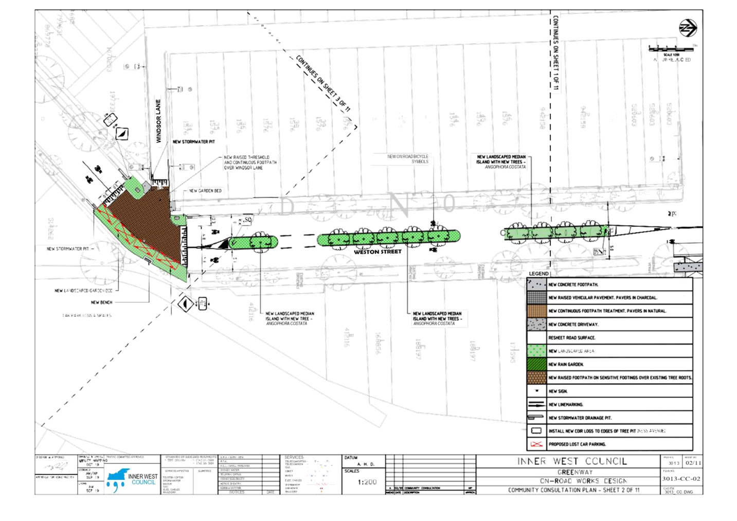
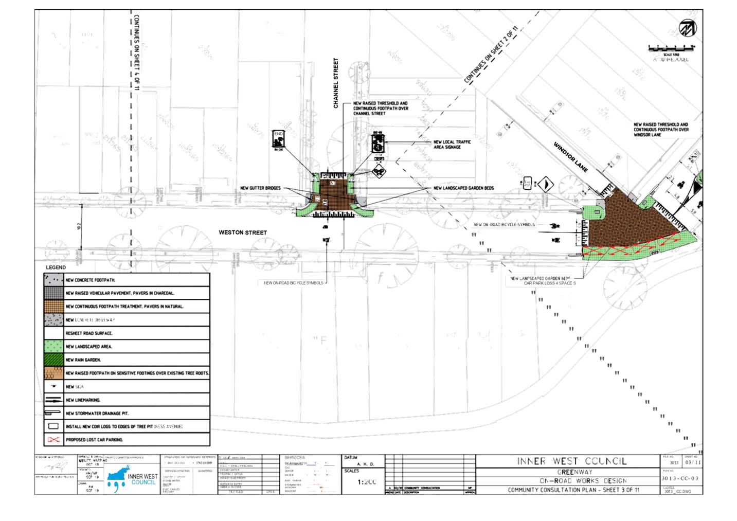
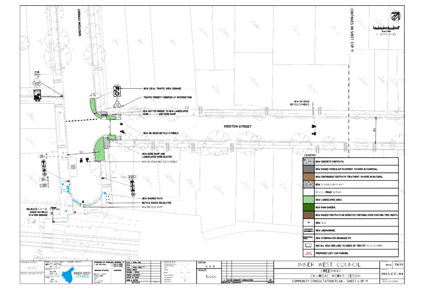
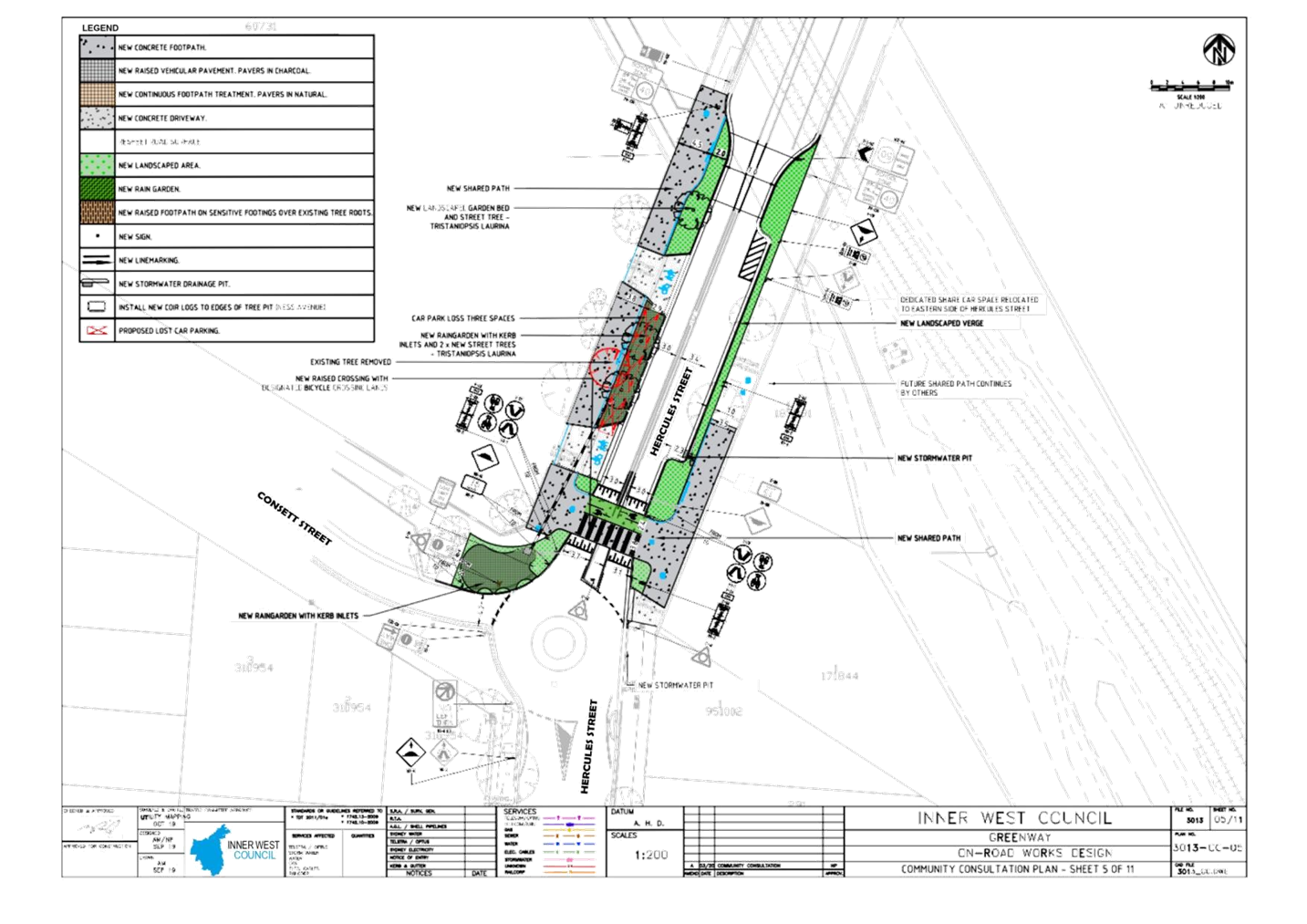
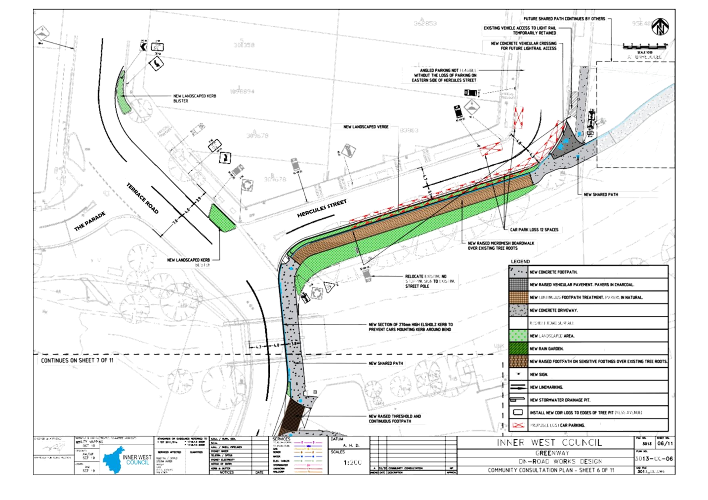
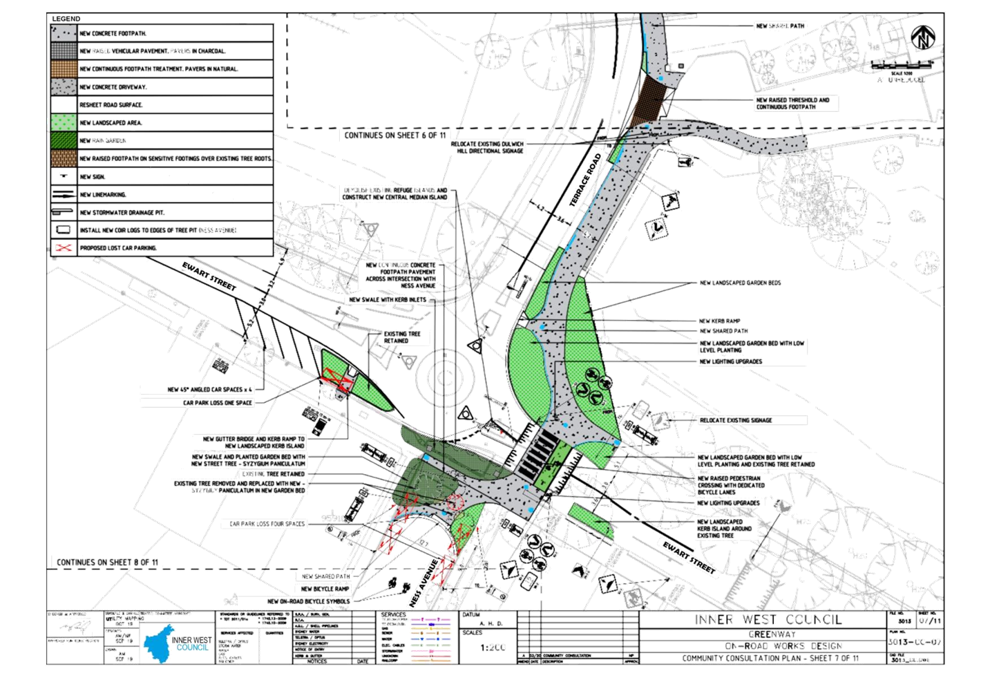
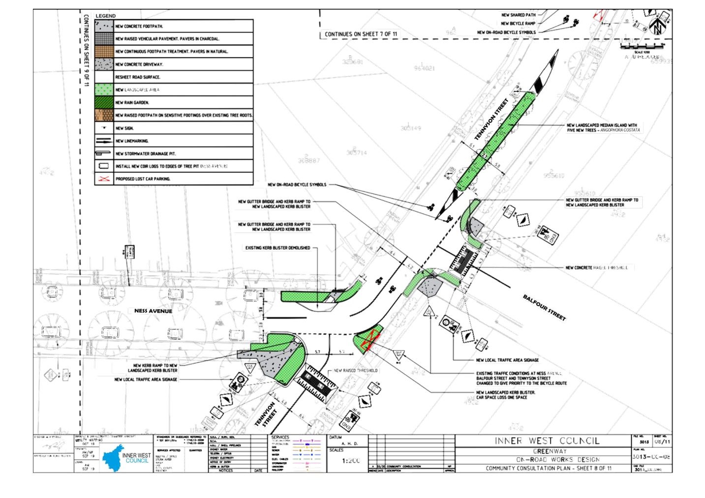
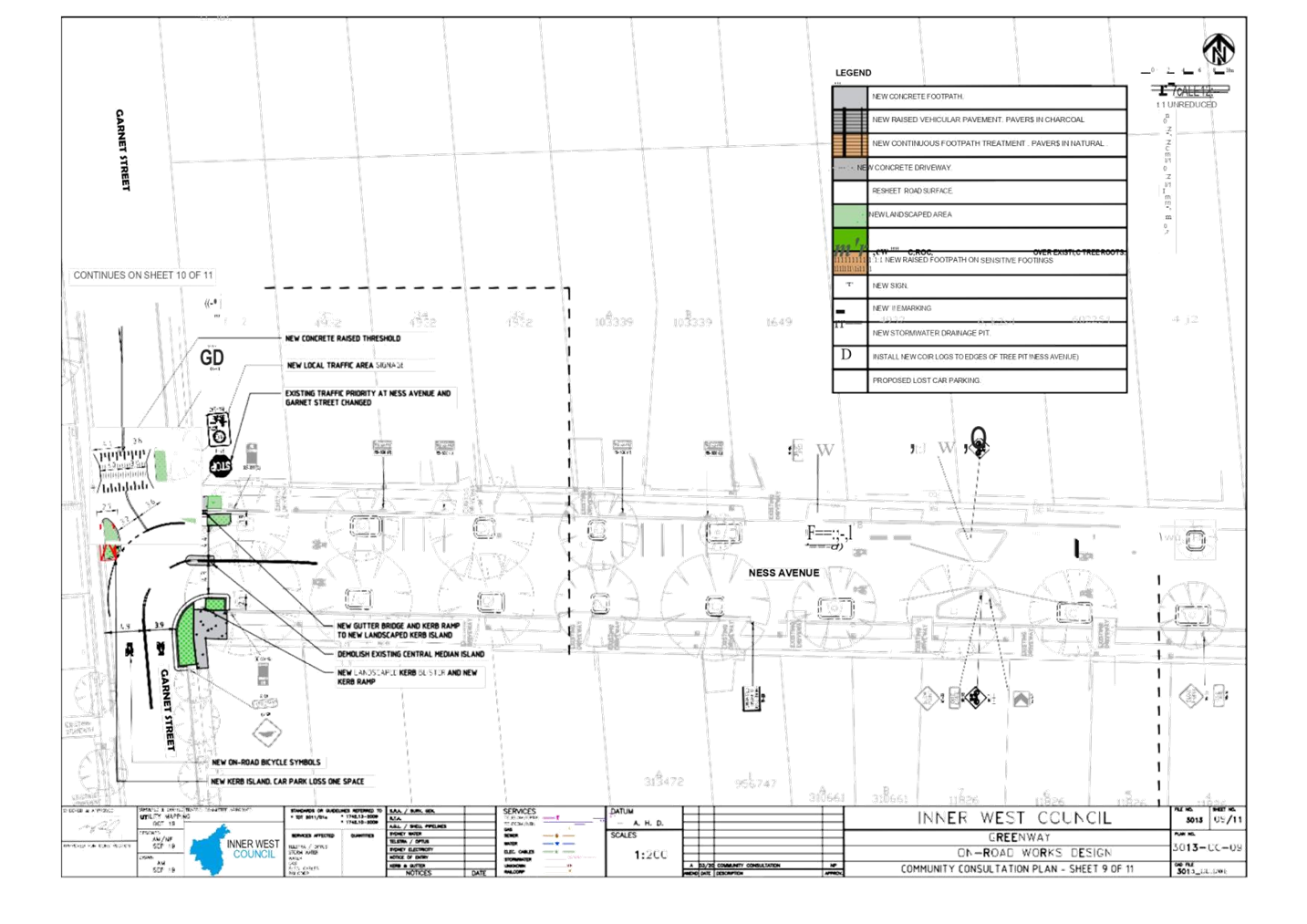
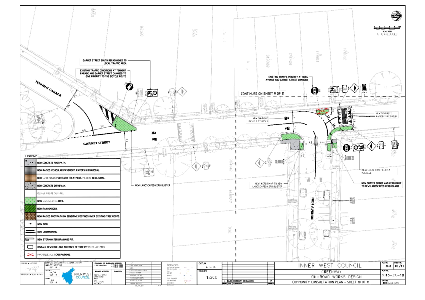
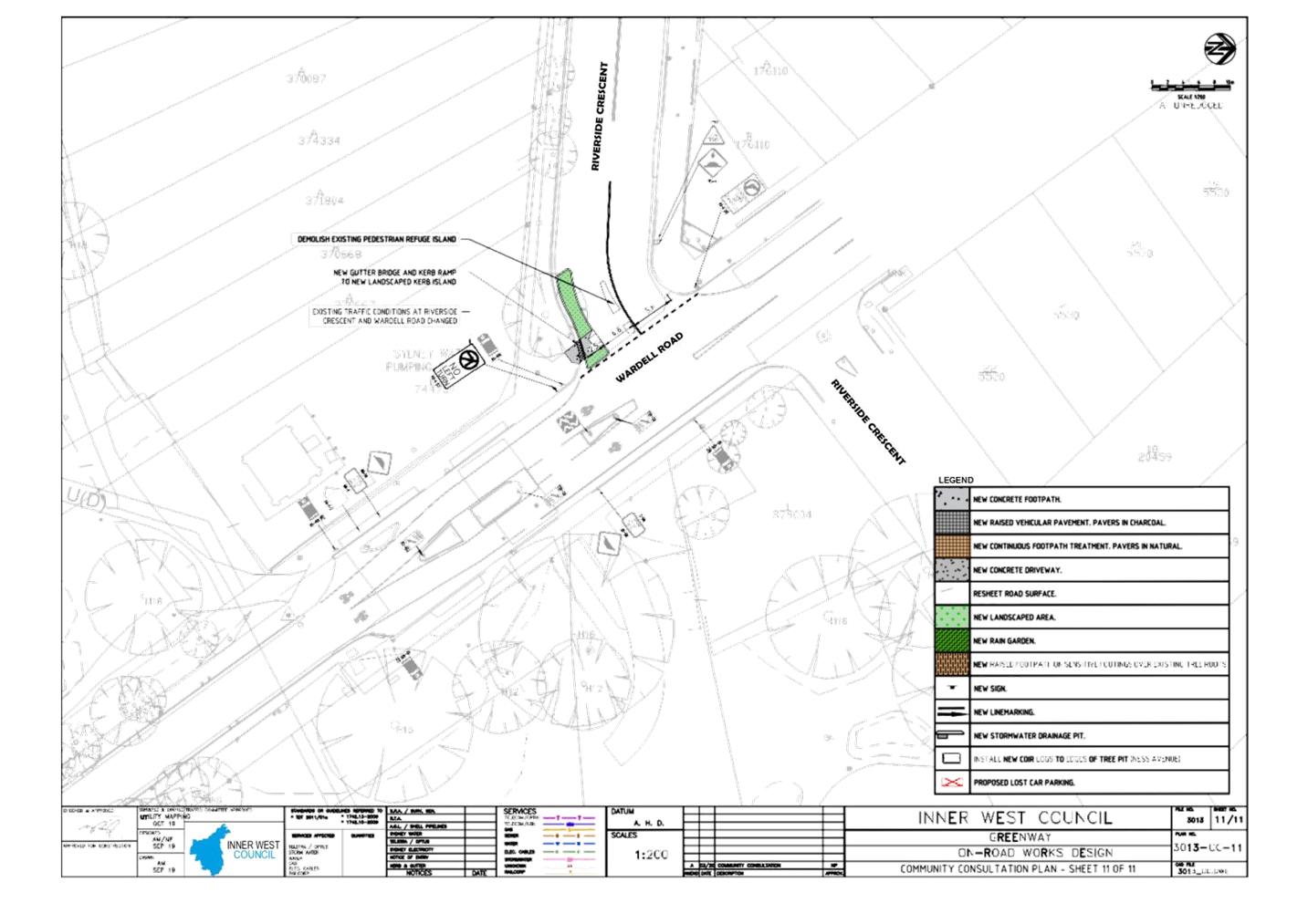
Subject: Greenway on-road cycle route
Prepared By: Ryan
Hawken - Project Manager Greenway Delivery
Authorised By: Manod
Wickramasinghe - Traffic and Transport Planning Manager
SUMMARY
Detailed
design plans have been prepared for Greenway On-Road works. The detailed design
plans are based on the Greenway Concept Designs endorsed by Council in May
2019. Consultation was undertaken across the corridor during the Concept Design
phase. Specific consultation to affected residents and owners was
undertaken on the draft detailed design plans. It is recommended that the
detail design plans are approved for construction.
|
RECOMMENDATION
THAT the detailed design
plans (Attachment 1) for the Greenway on-road works be approved for
construction
|
BACKGROUND
Inner West
Council is currently delivering the GreenWay from Iron Cove south through
Dulwich Hill to the Cooks River cycleway.
This includes
sections of walking and cycling routes along local roads including;
· along Weston
Street from Old Canterbury Road to the Waratah Mills light rail stop;
· across Hercules
Street near Consett Avenue;
· from the southern
end of Hercules Street via Terrace Road, Ness Avenue and Garnet Street to the
Cooks River.
In 2019, the
community provided feedback on concept designs and the final concept designs
were endorsed by Council in May 2019. Based on the concept designs Council has
now developed detailed design plans for the sections of the GreenWay along
local roads.
The detailed
design plans are included as Attachment 1.
FINANCIAL IMPLICATIONS
Nil. All works are funded from
the Greenway Capital Budget. Pending Council approval, it is anticipated that
construction of the on-road works will commence in late 2020.
PUBLIC CONSULTATION
A notification letter was sent to
owners and occupiers of properties directly impacted by the proposed works on
17 Feb 2020. A total of 770 letters were distributed. Inner West Bike Coalition
was also contacted for comment. The closing date for submissions was 8 March
2018.
Two phone calls and ten written
submissions were received. Three of the responses were of a general nature
enquiring into the Greenway and/or the proposed Sydenham to Bankstown active
travel corridor. The issues raised in the remaining submissions are outlined
below.
|
Residents comments
|
Officers comments
|
|
Weston
Street
|
|
One (1) resident raised
concerns that the raised threshold at the southern entrance to Weston Street
was awkward and suggested this should be moved to the intersection of Windsor
Road and Weston Street.
|
The intent of the raised
threshold was to slow traffic on approach to the bicycle boulevard and make
the movement to and from the light rail corridor to the on-road section of
Weston Street safer.
Due to the local
environment and short block length speeds in this area are low. In addition,
to aid priority of the bike boulevard, it is proposed to alter the give way
orientation, which will in turn reduce vehicles speeds as vehicles travelling
away from Windsor Road will no longer have priority. The proposed kerb
buildout will also reduce the width and allow the give way sign to be
positioned closer to the path of travel.
Given the awkward nature of
the intersection and driveways the design has been amended to exclude the
raised threshold at this location. Driver
behaviour can be assessed post implementation and a raised treatment
constructed later if the need warranted it.
|
|
Three (3) residents opposed
the proposed works in Weston Street due to the proposed loss of parking.
|
A net loss of six car parking
spaces is proposed in Weston Street.
The proposed treatment
along Weston Street as well other local roads results in the least parking
loss possible whilst meeting the multiple objects set out in the Greenway
Master Plan. This was considered in detail at the Master Plan and Concept
stages.
As per the Concept and
Master plan, in order to make the Greenway accessible to all, rest stops are
proposed at frequent intervals and the mid-point of Weston Street outside a
non-residential lot is considered the most suitable location on Weston
street. This also improves safety at the bend and increases greening and
habitat.
|
|
Terrace Road
and Ewart Street
|
|
One (1) resident raised
concerns about the calming of traffic travelling southbound on Terrace Road underneath
the railway bridges and suggested a safety barrier is needed.
|
An Elsholz kerb is proposed
around the bend in Terrace Street, south of Hercules Street. Elsholz kerbs
are specifically designed to deflect cars at low speeds (<60km/h) and thus
reduce the risk of cars mounting the kerb. Combined with the proposed traffic
islands, road narrowing and advisory 35km/h speed signs this is considered a
suitable treatment at this location.
It is noted that there is a
primary gas main in this location which precludes the use of a guardrail
which requires support posts.
|
|
One (1) resident raised
concerns that the shared path on Terrace Road under the disused goods line
bridge was not wide enough or well lit.
|
A wider path here would be
desirable. The design has been amended to provide a 3.8m wide path, which is
as wide as possible whilst still accommodating traffic movements around the
bend.
Path lighting will be
provided to meet the relevant standard, including a new luminaire below the
bridge.
|
|
Ness Ave,
Tennyson Street and Garnet Ave
|
|
One (1) resident opposed
the proposed works in Ness Avenue due to the proposed loss of parking.
|
A net loss of six car
parking spaces is proposed in the vicinity of Ness Avenue.
The proposed treatment
along Ness Ave as well other local roads results in the least parking loss
possible whilst meeting the multiple objects set out in the Greenway Master
Plan. This was considered in detail at the Master Plan and Concept stages.
|
|
One (1) resident raised
concerns of traffic speeds along Tennyson Street and specifically outside the
pocket park in the area, Betty Spears Playground.
|
The general intent of the
proposed changes in the precinct is to slow traffic and reduce traffic
volumes. The left turn ban from Wardell into Riverside is intended to reduce
the number of vehicles rat running through the precinct. The left turn ban
will work in tandem with the changed priority at intersections which means
cars using this route will have to yield more frequently, generally slowing
traffic speeds.
|
|
One (1) resident raised
safety concerns about routing the Greenway down Garnet Ave and along Tennent
Parade.
|
A detailed route options
analysis was undertaken at the Master Plan stage and endorsed by Council. The
detailed design, and concept design prior to this, is based on the endorsed
route.
The Greenway is proposed to
be on-road in Garnet Street and off road along Tennent Parade. It is noted
that this is the existing Greenway on-road route which has been in place for
five years.
|
|
One (1) resident questioned
whether south bound traffic on Wardell Road will still be able to turn right
into Riverside Crescent and what is to stop north bound traffic illegally
turning left at Riverside Crescent.
|
Traffic will be able to
turn right into Tennyson Street from Wardell Road. It is envisaged this will
be used by local residents only.
The geometry of the traffic
island will discourage illegal left turns. Compliance at this location can be
monitored after installation and if a significant proportion of illegal
movements are observed, consideration given to future half road closure. This
would also eliminate the right turn in for south bound traffic.
|
CONCLUSION
With consideration of the above analysis
and the outcomes of the community consultation, it is recommended that the
detailed design plan be approved for construction with amendments to exclude
the raised threshold at southern end of Weston Street and increase shared path
width in Terrace Road as noted.
ATTACHMENTS
|
1.⇩
|
Greenway on-road detailed design plans
|
|
|
Local Traffic
Committee Meeting
6 April 2020
|
|
|
Local Traffic
Committee Meeting
6 April 2020
|
Item No: LTC0420
Item 4
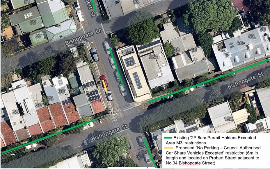
Subject: Probert Street, Newtown – Proposal for
Car Share Parking Space (Damum – Stanmore Ward / Newtown Electorate /
Inner West PAC)
Prepared By: Jennifer
Adams - Engineer – Traffic and Parking Services
Authorised By: Manod
Wickramasinghe - Traffic and Transport Planning Manager
SUMMARY
A request has been received from
a GoGet Car Share representative for the installation of an on-street dedicated
‘Car Share’ parking space in the vicinity of the intersection of
Probert Street and Bishopgate Street, Newtown for an existing floating car
share vehicle in the area.
|
RECOMMENDATION
THAT a 6 metre 'No Parking
Authorised Car Share Vehicles Excepted' restriction be installed on the
western side of Probert Street, adjacent to property No. 34 Bishopgate
Street, Newtown
|
BACKGROUND
Inner
West Council supports ‘Car Share’ schemes, as part of a holistic
approach to encourage more sustainable travel habits for residents and businesses.
Car share schemes reduce the need for members to own a private vehicle and may
ease the parking stress on-street. In support of this scheme, Council allocates
dedicated parking spaces for authorised ‘Car Share’ vehicles for
the resident and business use.
FINANCIAL
IMPLICATIONS
The costs of
the supply and installation of the regulatory signposting is to be borne by the
applicant in addition to annual fees.
OFFICER COMMENTS
It is proposed to provide a
dedicated parking space, on the western side of Probert Street, Newtown, adjacent
to property No. 34 Bishopgate Street, Newtown, replacing the existing
unrestricted parking as shown in the following map.
The
number of car share members living within 250 metres of the proposed location
is 223 and that vehicles nearby are in high demand.

PUBLIC CONSULTATION
A
consultation letter outlining the proposal was mailed out to 25 surrounding properties
and a total of seven (7) responses were received. Four were in support
of the proposal and three objected to the proposal. The comments are summarised
below:
· A
dedicated car share space will make it more efficient and attractive to use
instead of buying another car
· ‘No
Stopping’ restrictions should be installed at corners to make enforcement
easier
· Currently
parking in Probert and surrounding streets is at a premium due to RPA staff,
university and city commuters parking – this will exacerbate the
situation
· Residents
in this area have only one allocated permit per household. We therefore need to
use the unrestricted car parking spaces such as the one proposed to be
converted to a car share space
· Council
should not be assisting private business
CONCLUSION
It is
recommended that the installation of the proposed on-street dedicated car share
parking space be approved in order to provide improved parking opportunities
for local residents who participate in the car share scheme. Car
share parking is an efficient use of parking space because a single car share
vehicle can replace many private vehicles that would otherwise compete for
local parking. Council supports car sharing as a part of its drive to: reduce
greenhouse gas emissions; reduce on-street parking demand; and encourage active
lifestyles by reducing dependency on private cars
ATTACHMENTS
Nil.
|

|
Local Traffic
Committee Meeting
6 April 2020
|
Item No: LTC0420
Item 5
Subject: Victoria Road, Marrickville – Temporary
relocation of Taxi Zone during Marrickville Metro Expansion Works –
(Midjuburi – Marrickville Ward / Heffron Electorate / Inner West PAC)
Prepared By: Jennifer
Adams - Engineer – Traffic and Parking Services
Authorised By: Manod
Wickramasinghe - Traffic and Transport Planning Manager
SUMMARY
A request has been received from
MLA Transport Planning for the temporary relocation of the existing Taxi Zone
in Smidmore Street to Victoria Road, Marrickville outside the northern entrance
to Marrickville Metro during Marrickville Metro Expansion works. The relocation
will be temporary from early 2020 for a period of approximately 9 months, until
the new permanent Taxi Zone is relocated on the south side of Smidmore Street
within the new one-way system proposed for Smidmore Street, Marrickville.
|
RECOMMENDATION
THAT the
temporary relocation of the ‘Taxi Zone’ and associated signage from
the northern side of Smidmore Street (outside Marrickville Metro) to the
southern side of Victoria Road, Marrickville, replacing 25m of the existing
‘2P 8.30am–6pm Mon-Fri; 8.30am-12.30pm Sat’ parking
restrictions be approved.
|
OTHER
STAFF COMMENTS
In relation to the proposed temporary
relocation of the existing taxi zone in Smidmore Street to Victoria Road for up
to a 9 month period before it gets relocated back to a location in Smidmore
Street the applicant notes that the approval for the Marrickville Metro
Expansion works requires the upgrade of the eastern section of Smidmore Street
(between Murray Street and the current car park entry). While upgrade works are
taking place on Smidmore Street, the existing taxi zone on Smidmore Street is
to be relocated to an alternative location.
A shared zone on Smidmore Street
has also been conditioned in the approval together with making Smidmore Street
(between car park access and Murray Street) one way westbound. At the
conclusion of works in Smidmore Street the taxi zone will be permanently
relocated to the southern side of Smidmore Street in front of the new centre
when construction is completed which is expected to be late 2020. The permanent
taxi zone on Smidmore Street would be approximately 17metres accompanying up to
three taxis.
The temporary proposed relocated taxi zone will entail the
temporarily loss of 4 on-street parking spaces in Victoria Road adjacent the
north entrance to Marrickville Metro.
The site location is Victoria
Road between Edgeware Road and Murray Street, Marrickville as shown in the
applicant’s diagram reproduced below.
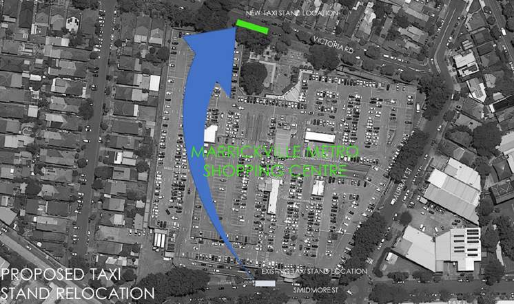
The following diagrams show the
proposed temporary changes to parking on the southern side of Victoria Street,
Marrickville outside Marrickville Metro.
FINANCIAL
IMPLICATIONS
All works and
costs of implementation works associated with the recommended temporary Taxi
Zone relocation will be borne by the applicant as will the reinstatement of any
of Council approved signage at the end of the temporary relocation period.
PUBLIC CONSULTATION
MLA Transport Planning has
consulted with the Taxi Council of NSW and stated that the Taxi Council have
endorsed the proposed temporary relocation.
They have also consulted with
surrounding residents / businesses within a 400 metre radius (750 letters) about
the proposal and no comments were received.
ATTACHMENTS
Nil.
|

|
Local Traffic
Committee Meeting
6 April 2020
|
Item No: LTC0420
Item 6
Subject: Richardsons Crescent, Marrickville - Proposed
Pedestrian (zebra) Crossing - Design Plan 10116 (Midjuburi - Marrickville Ward/
Summer Hill Electorate/ Inner West PAC)
Prepared By: Scipio
Tam - Engineer – Traffic and Parking Services
Authorised By: Manod
Wickramasinghe - Traffic and Transport Planning Manager
SUMMARY
Council has
approved the provision of a pedestrian (zebra) crossing on Richardsons
Crescent, Marrickville (adjacent to Mackey Park) to provide a safer crossing
environment for pedestrians, particularly school children. A detailed design
plan has been finalised for the proposed pedestrian crossing on Richardsons
Crescent, at the existing kerb blisters.
|
RECOMMENDATION
THAT the detailed design
plan for the proposed pedestrian (zebra) crossing, associated line marking
and signage on Richardsons Crescent, Marrickville (western leg), at the
existing kerb blisters (as per attached Design Plan 10116) be APPROVED.
|
BACKGROUND
See further information below.
OTHER
STAFF COMMENTS
A request was
received for the provisions of a pedestrian (zebra) crossing on Richardsons
Crescent, Marrickville to provide safe crossing opportunities for pedestrians,
particularly school children.
A report on
this matter was presented at the September 2019 Local Traffic Committee meeting
proposing a pedestrian (zebra) crossing along Richardsons Crescent,
Marrickville; this proposal was supported by the Traffic Committee and
subsequently approved by Council.
The proposed pedestrian (zebra)
crossing is to be located on the western leg of Richardsons Crescent between
Carrington Road and the Richardson Crescent roundabout (at the existing
blistered section along Richardsons Crescent).
The
detailed design plan for these approved works is provided in Attachment 1 and
includes implementation of ‘No Stopping’ restrictions along the
western side of Richardsons Crescent, east of the footpath widening; removing
three (3) legal car parking spaces. The loss of these spaces is to ensure
vehicles approaching from the roundabout have an unobstructed view of the pedestrian
crossing, especially since Richardsons Crescent has negative gradient from the
roundabout. It also includes the approved relocation the existing ‘No
Stopping’ sign located immediately west of the footpath widening (north
side of Richardsons Crescent) to a position immediately west of the adjoining
driveway as the length of kerb provided between the footpath widening and
driveway is less than a car space.
FINANCIAL IMPLICATIONS
Funding is available to be
allocated for the works under the Traffic Facilities Program 2020/21
PUBLIC CONSULTATION
Community engagement was
conducted previously and reported to the September 2019 traffic Committee
meeting, two responses were received in support of the proposal.
ATTACHMENTS
|
1.⇩
|
10116 - Design Plan - Richardsons Crescent at Kerb
Blisters
|
|

|
Local Traffic
Committee Meeting
6 April 2020
|
|
|
Local Traffic
Committee Meeting
6 April 2020
|
Item No: LTC0420
Item 7
Subject: Elizabeth Street, Ashfield-Proposed Upgrade of
Existing Pedestrian Crossing-Da Condition Under Re-Development of the Ashfield
Aquatic Centre (160-178 Elizabeth Street, Ashfield) (Gulgadya-Leichhardt
Ward/Summer Hill Electorate/Burwood PAC)
Prepared By: Boris
Muha - Engineer – Traffic and Parking Services
Authorised By: Manod
Wickramasinghe - Traffic and Transport Planning Manager
SUMMARY
Under
condition of Development Consent, the existing crossing outside the current
re-development of Ashfield Aquatic Centre, premises 160-178 Elizabeth Street,
is proposed to be upgraded to improve pedestrian safety in the area for patrons
attending the pool and the community in general.
|
RECOMMENDATION
THAT the detailed design
plan for the proposed upgrade of the existing at-grade pedestrian (zebra)
crossing in Elizabeth Street, Ashfield outside the Ashfield Aquatic Centre
160-178 Elizabeth Street, to a raised pedestrian (zebra) crossing (as per
plan 387086-MMD-00-CC-DR-C-8015 Rev (D)), be approved.
|
BACKGROUND
The Ashfield
Aquatic Centre facility was closed in early 2018 to enable investigations and
preparatory work for redevelopment of the facility. The new facility will
provide for new Olympic, water polo and children leisure pools with landscape
community green space. Café, change areas, gym, staff and retail space
are also provided. In addition to the above works, the car parking facilities
either side of the re-developed centre will provide for a total of
approximately 194 parking spaces.
The nearly
re-developed Ashfield Aquatic Centre is currently being constructed and is
anticipated to be completed around mid- 2020.

Figure 1.
Artist drawing of the newly re-developed Ashfield Aquatic Centre.
This report
entails the proposal to upgrade the existing at-grade pedestrian (zebra)
crossing in Elizabeth Street, as part of external works associated with the
pool facility under condition of Development Consent.
Site
location and Road Network.
|
Street Name(s)
|
Elizabeth Street
|
|
Section
|
Between Etonville Parade and Frederick Street.
|
|
Traffic Volume (Average
Annual Daily Traffic)-ADDT
|
9600
|
|
Recorded Accident History
(5 year)
|
Nil in vicinity of the crossing
|
|
Recorded 85% speed
|
48 km/h
|
|
Speed Limit
|
50km/h
|
|
Carriageway width
|
Approx. 10m
|
|
Carriageway Type
|
2-way, one lane of traffic in each direction, with
two (informal) lines of traffic at the western side approach to the
signalised intersection of Elizabeth Street and Frederick Street. ‘No
Stopping’ or ‘No Parking’ restrictions exist on both sides
of the above section of Elizabeth Street.
|
|
Road Classification (State,
Regional, Local)
|
Local-collector
|
|
Heavy vehicle percentage
|
3%
|
FINANCIAL IMPLICATIONS
The cost for the re-construction
of the crossing is from the Council’s Capital works program in
redevelopment of the Aquatic Centre funded from the special rates variation
adopted by Ashfield Council in 2015.
OTHER
STAFF COMMENTS
The Elizabeth
Street pedestrian crossing is being upgraded so the Elizabeth Street meets
accessibility and safety measures.
The
upgrade includes:
•
Raised crossing platform
•
Safety barricades
•
Small islands with landscaping fronting the crossing
•
New traffic signs
See
Attachments 1 and 2 for the locality and detailed design plan of the
crossing.
The following
comments are made in support of the proposed design improvements to the crossing.
· The kerb islands
are connected to the footway with gutter bridging for improved pram ramp
cross-over.
· The crossing in
this particular situation, is raised 75mm and lane widths through the crossing
made at 3.2m wide to assist and provide less severity upon school buses and
bicyclists in moving and mounting over the crossing.
· Traffic is
controlled in one lane movement each way through the crossing, and the kerb
islands provide safety to pedestrians to step out in view of the traffic.
· The raising and
provision of kerb (landscaped) islands to the crossing can provide improved
identification and presence of the crossing in view of traffic.
· The pedestrian
fencing (at existing long length) will be retained to the southern side of
crossing, and short length of pedestrian fencing shall be provided either side
of the crossing to the northern side to control and direct pedestrians in using
the crossing.
· The raising and
narrowing of the passage- way through the crossing (with kerb islands) will
also assist to control speeding in the area.
· The crossing (at
its existing location) is approximately 85m west of the signalised intersection
of Elizabeth Street and Frederick Street, well away from any conflict or
interference with the
intersection.
· No Parking is affected with the changes to the crossing.
PUBLIC CONSULTATION
A
letter outlining this proposal has been distributed to residents in the nearby
area. Directly affected residents adjacent to the crossing will be personally
notified on the matter.
ATTACHMENTS
|
1.⇩
|
Proposed upgrade of existing pedestrain crossing - locality
plan
|
|
2.⇩
|
Proposed upgrade of crossing - detail dimension plan with
signs and markings
|
|
|
Local Traffic
Committee Meeting
6 April 2020
|
|
|
Local Traffic
Committee Meeting
6 April 2020
|
|
|
Local Traffic
Committee Meeting
6 April 2020
|
Item No: LTC0420
Item 8
Subject: James Street, Summer Hill - Temporary Full
Road Closure for substation electrical conduit connection
(Djarrawunang-Ashfield Ward/Summer Hill Electorate/Burwood PAC)
Prepared By: Boris
Muha - Engineer – Traffic and Parking Services
Authorised By: Manod
Wickramasinghe - Traffic and Transport Planning Manager
SUMMARY
An
application has been received for the temporary full road closure of James
Street, Summer Hill, between Henson Street and Old Canterbury Road from 15 May
to 28 June 2020, between 7.00am-5.00pm Mon-Sat, to carry out major (high
voltage) HV underground electrical conduit connection to a new Zone Substation
being constructed on the corner of James Street and Old Canterbury Road.
|
RECOMMENDATION
THAT the proposed temporary
full road closure of James Street (between Henson Street and Old Canterbury
Road), Summer Hill, for major electrical conduit works be approved from 15
May to 28 June 2020, between 7.00am-5.00pm Mon-Sat (with an additional 2 week
contingency period thereafter); subject to, but not limited to, the following
conditions:
1. A Road Occupancy License be obtained by the applicant
from the Transport Management Centre;
2. All affected residents and businesses, including the NSW
Police Area Commander, Fire & Rescue NSW and the NSW Ambulance Services
be notified in writing, by the applicant, of the proposed temporary full road
closure at least 14 days in advance of the closure with the applicant making
reasonable provision for stakeholders; and
3. The occupation of the road carriageway must not occur
until the road has been physically closed.
|
OTHER
STAFF COMMENTS
Ultegra,
Utilities & Infrastructure Specialists are contracted out by Ausgrid to
install underground electrical conduiting to the surrounding area from a new
electrical Zone Substation on the north-western corner of James Street and Old
Canterbury Road, Summer Hill.
Deep
excavation is required to connect HV conduits from the new Substation across
James Street under full road closure. The work is expected to take a total of
1-2 weeks, weather permitting. A trench will be plated over the road opening
before and after work to allow reinstatement of traffic in James Street.
Conduit
works will continue and extend across/along Old Canterbury Road and the
surrounding street network under partial road closure.
James Street is a local street of low traffic,
approximately 7.5-8m wide with two-way traffic and parking on both sides of the
street. Traffic can detour via Old Canterbury Road, Henson Street and Herbert
Street. Vehicle access for the residents would be via Henson Street - See Attachments 1 and 2 for the Traffic Management Plan and
Traffic Control Plan respectively.
FINANCIAL IMPLICATIONS
The applicant contracted on-half
of Ausgrid (being a public utility Authority) is exempt of paying road
occupational fees under the Council fees and Charges. However, the applicant
has been charged the application fee to advertise the closure in accordance
with the Road Act 1993.
PUBLIC CONSULTATION
The
applicant has notified all affected residents regarding the general electrical
conduit works needing to be undertaken through the area and will continue to
update the residents on the progress of the works under partial and/or full
road closure.
ATTACHMENTS
|
1.⇩
|
Traffic Managememnt Plan - full road closure of James
Street
|
|
2.⇩
|
Traffic Control Plan - Full road closure of James Street
|
|
|
Local Traffic
Committee Meeting
6 April 2020
|
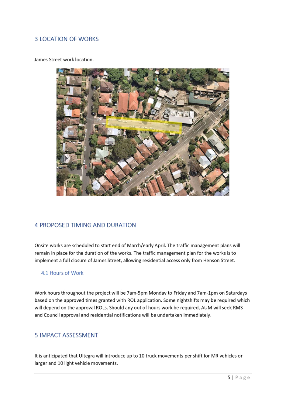
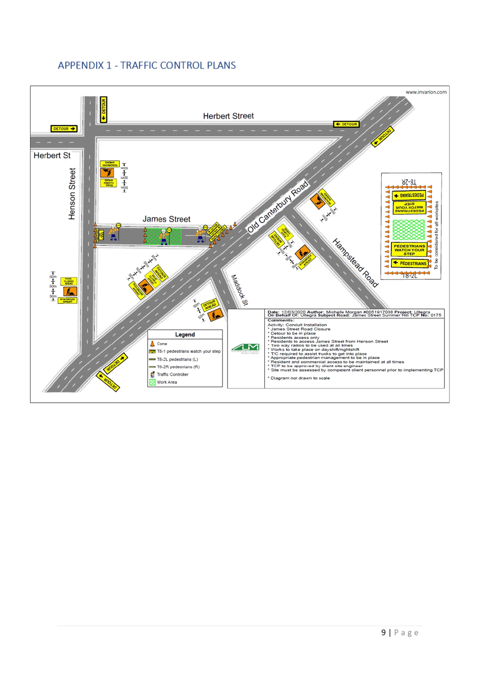
|
|
Local Traffic
Committee Meeting
6 April 2020
|
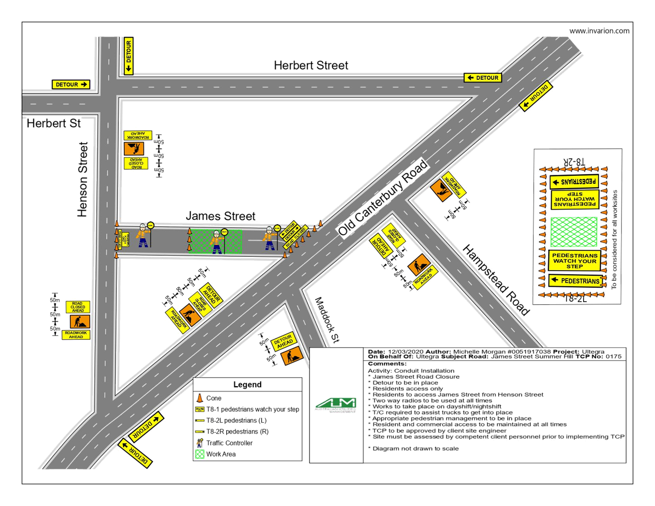
|
|
Local Traffic
Committee Meeting
6 April 2020
|
Item No: LTC0420
Item 9
Subject: Terry Street, Rozelle - Proposed extention of
on-street bycycle path - (BALUDARRI-BALMAIN WARD/BALMAIN ELECTORATE/LEICHHARDT
PAC)
Prepared By: Vinoth
Srinivasan - Engineer - Traffic and Parking Services
Authorised By: Manod
Wickramasinghe - Traffic and Transport Planning Manager
SUMMARY
Council has
finalised a design plan for the proposed extension of an on-street bicycle path
on Terry Street, between Victoria Road and Margaret Street, Rozelle to improve
road safety for road users.
|
RECOMMENDATION
THAT the detailed design
plan (Design Plan No.10123) for the proposed extension of the on-street cycle
path on Terry Street, between Victoria Road and Margaret Street, Rozelle be
approved.
|
OTHER
STAFF COMMENTS
Council
officers were requested at Council’s Bicycle Working Group to investigate
an extension of the existing on-street cycle path on the northern side of Terry
Street, between Victoria Road and Margaret Street in order to extend the full
length of the street block.
The existing
cycle path line marking is between Victoria Road and terminates opposite No.126
Terry Street and requires cyclists to merge into a mixed traffic treatment. It
is proposed that the existing cycle path be extended further eastwards along
Terry Street up to the intersection with Margaret Street. Cyclists will then be
required to merge prior to entering the roundabout at this intersection.
The detailed design plan shown in
Attachment 1 outlines the proposed works on Terry Street, between
Victoria Road and Margaret Street, Rozelle.
This
proposal will not result in the loss of any on-street parking spaces.
FINANCIAL IMPLICATIONS
The cost of the installation of
cycle path line marking will be funded from Council’s 2019/20 Operational
Budget for signs and line marking.
PUBLIC
CONSULTATION
Nil as there
is no impact on parking
ATTACHMENTS
|
1.⇩
|
Detailed Design Plan - Terry Street, Rozelle
|
|
|
Local Traffic
Committee Meeting
6 April 2020
|
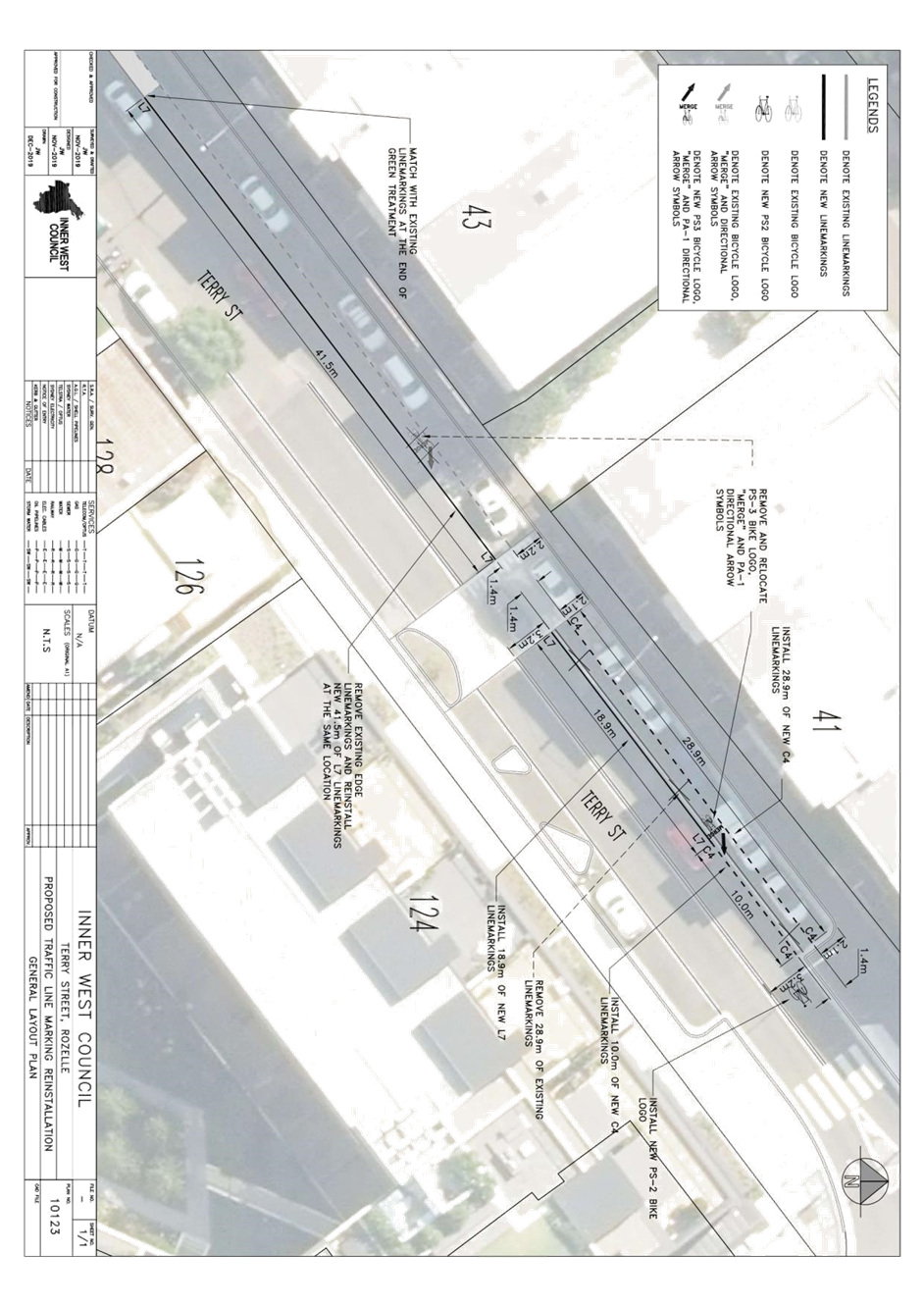
|
|
Local Traffic
Committee Meeting
6 April 2020
|
Item No: LTC0420
Item 10
Subject: Intersection of Cecil Street and Chandos
Street, Ashfield- 'No Stopping' restrictions to corners (Diarrawunang-Ashfield
Ward/Summer Hill Electorate/Burwood PAC)
Prepared By: Boris
Muha - Engineer – Traffic and Parking Services
Authorised By: Manod
Wickramasinghe - Traffic and Transport Planning Manager
SUMMARY
Council
has investigated resident complaints regarding vehicles continuously parking
too close to the corners of the intersection of Chandos Street and Cecil
Street, Ashfield.
|
RECOMMENDATION
THAT:
1. 10 metres of ‘No Stopping’ restriction
be placed on the northern side of Cecil Street, east of Chandos Street,
Ashfield;
2. 8.5 metres of ‘No Stopping’
restriction be placed on the southern side of Cecil Street, east of Chandos
Street, Ashfield (up to the existing street tree);
3. 8.0 metres of ‘No Stopping’
restriction be placed on the eastern side of Chandos Street, north of Cecil
Street (up to the existing street tree), followed by ‘No Stopping
Australia Post Vehicles Excepted’ between 8.0m and 17.8m north of Cecil
Street; and
4. 10.0 metres of ‘No Stopping’
restriction be placed on the eastern side of Chandos Street, south of Cecil
Street.
|
BACKGROUND
See further information below.
OTHER
STAFF COMMENTS
Vehicles have been identified as
parking too close to intersection of Chandos Street and Cecil Street, Ashfield
resulting in obstruction to the vision and movement of traffic and pedestrians
around the intersection.
It is proposed to signpost the
statutory 10 metre ‘No Stopping’ zones to make motorists aware of
the legal distance that vehicles cannot park at the corners of an intersection.
Certain corners are proposed with ‘No Stopping’ restrictions of
8-8.5m; however, parking within 10m at these locations is not possible due to
the presence of mature street trees in the road carriageway.
An existing
Australia Post Box facility exists on the eastern side of Chandos Street, north
of Cecil Street. The facility is currently signposted with the restriction of
‘No Stopping Australia Post Vehicles Excepted’ up to 17.8m north of
Cecil Street. It is proposed to signpost 8.0m of full time ‘No
Stopping’ from the intersection up to the front of the street tree, and
from 8.0m to 17.8m as ‘No Stopping Australia Post Vehicles
Excepted’.
The proposal is shown on the
following plan in addition to the consultation area.
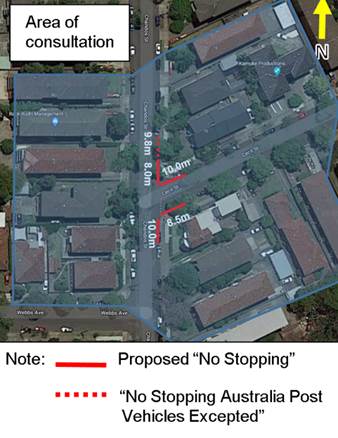
FINANCIAL IMPLICATIONS
The cost
of sign posting will be funded from Council’s Operational Budget for
signs and line marking.
PUBLIC CONSULTATION
A
consultation letter outlining the proposal was mailed out to 15 surrounding
residence and unit block complexes. Two (2) responses were received in
support of the proposal.
ATTACHMENTS
Nil.
|
|
Local Traffic Committee
Meeting
6 April 2020
|
Item No: LTC0420
Item 11
Subject: Hercules Street, Ashfield-Timed extension of
disabled parking zone (Djarrawunang-Ashfield Ward/Summer Hill
Electorate/Burwood PAC)
Prepared By: Boris
Muha - Engineer – Traffic and Parking Services
Authorised By: Manod
Wickramasinghe - Traffic and Transport Planning Manager
SUMMARY
Council has received requests to
have the existing (2 space) disabled parking zone on the eastern side of
Hercules Street, south of Brown Street, Ashfield extended in time to operate from
10.00am-8.00pm Mon-Sun” instead of “10.00am-6.00pm Mon-Sun”.
|
RECOMMENDATION
THAT the existing
‘Disabled Parking 10.00am-6.00pm Mon-Sun’ zone (2 spaces) on the
eastern side of Hercules Street, Ashfield, south of Brown Street, be modified
to ‘Disabled Parking 10.00am-8.00pm Mon-Sun’.
|
BACKGROUND
See further information below.
OTHER
STAFF COMMENTS
The extended time will allow
motorists holding Mobility Parking Scheme permits the ease and need to park and
attend the pharmacy and other shops in the area, servicing the needs of
customers having disability, after the time of 6.00pm.
The subject
area is an indented parking zone area shared with loading zone restrictions
operating between 6.00am-10.00am Mon -Fri and there after disabled parking
10am-6.00pm Mon-Sun.
The Pharmacy
and shops are within Hercules Street. Persons having disability can cross the
road at the signalised intersection of Hercules Street and Brown
Street.
FINANCIAL IMPLICATIONS
The cost of sign posting will be
funded from Council’s Operational Budget for signs and line marking.
PUBLIC CONSULTATION
A
consultation letter outlining the proposal was mailed out to (28) residence and
commercial/shop properties in Hercules Street. No responses have been
received.
ATTACHMENTS
Nil.
|
|
Local Traffic
Committee Meeting
6 April 2020
|
Item No: LTC0420
Item 12
Subject: Darling Street, Balmain - Proposed 'No
Stopping' Restriction at Intersection with Ann Street (Baludarri-Balmain
Ward/Balmain Electorate/Leichhardt PAC)
Prepared By: Brinthaban
Baskaran - Graduate Traffic Engineer
Authorised By: Manod
Wickramasinghe - Traffic and Transport Planning Manager
SUMMARY
Concerns have
been raised regarding illegal parking within the statutory 10m ‘No
Stopping’ zone, restricting the visibility of vehicles turning onto
Darling Street from Ann Street, Balmain.
|
RECOMMENDATION
That the statutory 10m
‘No Stopping’ zone be signposted on the southern side of Darling
Street, east of Ann Street.
|
BACKGROUND
See further information below.
OTHER
STAFF COMMENTS
Council has
received concern regarding vehicles obstructing sight lines by parking within
the statutory 10m ‘No Stopping’ zone at the intersection of Darling
Street at Ann Street, Balmain.
In order to alleviate this issue,
it is proposed to formalise by signposting the statutory 10m ‘No
Stopping’ zone on the southern side of Darling Street, immediately east
of Ann Street as shown on the attached plan.
FINANCIAL IMPLICATIONS
Nil.
PUBLIC CONSULTATION
A letter outlining the above
proposal was mailed out to the affected properties (11) in Darling Street and
Ann Street, Balmain. No responses were received.
ATTACHMENTS
|
1.⇩
|
No Stopping zone - Darling Street at Ann Street, Balmain
|
|

|
Local Traffic
Committee Meeting
6 April 2020
|
|
|
Local Traffic
Committee Meeting
6 April 2020
|
Item No: LTC0420
Item 13
Subject: Balmain Road, Lilyfied (between Perry Street
and Lilyfield Road) - Proposed Bus Zones (Baludarri - Balmain Ward / Balmain
Electorate / Leichhardt PAC)
Prepared By: David
Yu - Engineer - Traffic and Parking Services
Authorised By: Manod
Wickramasinghe - Traffic and Transport Planning Manager
SUMMARY
Transit Systems, in consultation
with Transport for NSW, has advised Council that three new bus zones are
proposed to be installed on Balmain Road, Lilyfield (between Perry Street and
Lilyfield Road) to provide improved service coverage and improvements to the
reliability of bus services.
BACKGROUND
Transit
Systems, in consultation with Transport for NSW, has informed Council that
three new bus zones are to be installed on Balmain Road, Lilyfield (between
Perry Street and Lilyfield Road) to accommodate improved service coverage and
improvements to the reliability of bus services.
The proposed locations are as
follows:
· 18m ‘Bus
Zone’ on the western side of Balmain Road, Lilyfield (north of Lilyfield
Road – adjacent to the driveway of 115 Lilyfield Road) replacing the
‘1P during sporting fixtures at Leichhardt Oval, Authorised Resident
Vehicles Excepted, Area LY’ restrictions;
· 24m ‘Bus
Zone’ on the western side of Balmain Road, Lilyfield (south of Perry
Street – opposite Point Street) replacing the unrestricted parking; and
· 18m ‘Bus Zone’
on the eastern side of Balmain Road, Lilyfield (south of Edward Street)
replacing the ‘Disabled Parking’ zone and ‘1P during sporting
fixtures at Leichhardt Oval, Authorised Resident Vehicles Excepted, Area
LY’ restrictions.
· Note, the impacted
‘Disabled Parking’ zone will be relocated to be immediately
adjacent to the proposed bus zone.
· The
location of the bus zones were selected to reduce the impact to residents and
to reduce the number of parking spaces required to be converted to a full time
bus zone. Bus zone locations are shown in Attachment 1.
FINANCIAL IMPLICATIONS
Nil
PUBLIC CONSULTATION
A letter outlining the above
proposal was mailed out to the affected properties in Balmain Road, Lilyfield,
requesting residents’ views regarding the proposal.
2 responses
were received in objection to the proposal. The main concerns are outlined
below.
· Loss of parking spaces for nearby residents, particularly
those with Mobility Parking Scheme permits who would struggle to walk long
distances.
· Buses are too close to existing driveways and adjacent
streets and will reduce sightlines for cars
· The two proposed
northbound bus stops are too close.
The Transit
Systems officer has provided the following comments in response:
· The proposal will reduce the dependency on private vehicles
and the locations have been chosen to reduce the number of parking spaces lost.
· The existing ‘Disabled Parking’ space will be
retained and relocated 18m south.
· Buses will only be dropping off/picking up passengers and
so sight lines for the driveway/intersections is expected to improve for the
majority of the day
· The proposed two northbound buses are required to provide a
catchment for both the Orange Grove area and Lilyfield Road.
ATTACHMENTS
|
1.⇩
|
Balmain Road, Lilyfield (Proposed Bus Zones) - Location
Plan
|
|
|
Local Traffic
Committee Meeting
6 April 2020
|