
Local Traffic Committee
Meeting
NOVEMBER 2020
The November 2020
meeting of the Inner West Local Traffic Committee will be held electronically
with the Agenda emailed to Members for review. All comments are requested to be
returned to Council by 5.00pm Monday 2 November 2020.
|

|
Local Traffic
Committee Meeting
2 November 2020
|
Function of the Local
Traffic Committee
Background
Roads and Maritime
Services (RMS) is legislated as the
Authority responsible for the control of traffic on all NSW Roads. The RMS has
delegated certain aspects of the control of traffic on local roads to councils.
To exercise this delegation, councils must establish a local traffic committee
and obtain the advice of the RMS and Police. The Inner West Council Local Traffic
Committee has been constituted by Council as a result of the delegation granted
by the RMS pursuant to Section 50 of the Transport Administration Act 1988.
Role of the Committee
The Local
Traffic Committee is primarily a
technical review and advisory committee which considers the technical merits of
proposals and ensures that current technical guidelines are considered. It
provides recommendations to Council on traffic and parking control matters and
on the provision of traffic control facilities and prescribed traffic control
devices for which Council has delegated authority. These matters are dealt with
under Part A of the agenda and require Council to consider exercising
its delegation.
In
addition to its formal role as the Local Traffic Committee, the Committee may
also be requested to provide informal traffic engineering advice on traffic
matters not requiring Council to exercise its delegated function at that point
in time, for example, advice to Council’s Development Assessment Section
on traffic generating developments. These matters are dealt with under Part
C of the agenda and are for information or advice only and do not require
Council to exercise its delegation.
Committee Delegations
The Local
Traffic Committee has no decision-making
powers. The Council must refer all traffic related matters to the Local Traffic
Committee prior to exercising its delegated functions. Matters related to State
Roads or functions that have not been delegated to Council must be referred
directly to the RMS or relevant organisation.
The
Committee provides recommendations to Council. Should Council wish to act
contrary to the advice of the Committee or if that advice is not supported
unanimously by the Committee members, then the Police or RMS have an
opportunity to appeal to the Regional Traffic Committee.
Committee Membership & Voting
Formal
voting membership comprises the following:
·
one representative of Council as
nominated by Council;
·
one representative of the NSW
Police from each Local Area Command (LAC) within the LGA, being Newtown,
Marrickville, Leichhardt and Ashfield LAC’s.
·
one representative from the RMS; and
·
State Members of Parliament (MP)
for the electorates of Summer Hill, Newtown, Heffron, Canterbury, Strathfield
and Balmain or their nominees.
Where the Council area is represented by more than one
MP or covered by more than one Police LAC, representatives are only permitted to vote on matters which effect
their electorate or LAC.
Informal
(non-voting) advisors from within Council or external authorities may also
attend Committee meetings to provide expert advice.
Committee Chair
Council’s
representative will chair the meetings.
|
|
Local Traffic
Committee Meeting
2 November 2020
|
1 Apologies
2 Disclosures
of Interest
3 Confirmation
of Minutes Page
Minutes of 6 October 2020 Local
Traffic Committee Meeting 5
4 Matters
Arising from Council’s Resolution of Minutes
5 Part
A – Items Where Council May Exercise Its Delegated Functions
Traffic Matters
ITEM Page
LTC1120 Item 1 Denison
Road, Lewisham - Temporary Full Road Closure
(Damun-Stanmore Ward/ Summer Hill Electorate/ Inner West PAC) 17
LTC1120 Item 2 Rose
Street, Marrickville Between Coronation Avenue And Unnamed Laneway West Of Park
Road - Temporary Full Road Closure For Street Party – Saturday 12
December 2020 (Midjuburi – Marrickville Ward / Newtown Electorate / Inner
West Pac) 34
LTC1120 Item 3 Wells
Street, Annandale - Christmas Street Party (Road Occupancy)(Gulgadya-Leichhardt
Ward/ Balmain Electorate/ Leichhardt PAC) 37
LTC1120 Item 4 Heighway
Avenue, Ashfield-Temporary road closure for Christmas Street Party. (Djarrawunang-Ashfield
Ward/Summer Hill Electrorate/Burwood PAC) 40
LTC1120 Item 5 Edinburgh
Street, Murray Street And Railway Parade, Marrickville – Marrickville
Metro Expansion Works – Notice Of Extension To Council Approved
Dates Of A 6 Week Period Temporary Full Road Closure In Order To Complete
Excavation Works For A Sewer Connection To Main Line (Midjuburi –
Marrickville Ward / Newtown Electorate / Inner West Pac) 45
Parking Matters
ITEM Page
LTC1120 Item 6 Unnamed
Laneway, Lilyfield (North of O'Neil Street) - Proposed 'No Stopping' and 'No
Parking' restrictions (Baludarri-Balmain Ward/Balmain Electrate/Leichhardt PAC) 67
LTC1120 Item 7 Juliett
Street, Marrickville - Proposal for Car Share Parking Space (Midjuburi-Marrickville
Ward/ Newtown Electorate/ Inner West PAC) 69
LTC1120 Item 8 Church
Street, St Peters – Proposed New 'No Parking' Restrictions And A Future
Section Of Rollover Kerb Parking (Midjuburi – Marrickville Ward / Heffron
Electorate / Inner West Pac) 71
Late Items
Nil at time of printing.
6 Part B -
Items for Information Only
ITEM Page
LTC1120 Item 9 Milton
Lane, Ashfield-Widening of Milton Lane-DA condition under Development of
380-382 Liverpool Road, Ashfield.
(Diarrawunang-Ashfield Ward/Summer Hill Electorate/Burwood PAC) 73
7 Part C -
Items for General Advice
ITEM Page
LTC1120 Item 10 Unnamed
Laneway between May Street and The Boulevarde,
Lilyfiled
- Christmas Street Party (Road Occupancy) (Balurdarri-
Balmain Ward/ Balmain Electorate/ Leichhardt PAC) 79
LTC1120 Item 11 James
Street, Leichhardt - Christmas Street Party (Gulgadya - Leichhardt Ward/
Balmain Electorate/ Leichardt PAC) 81
8 General
Business
9 Close
of Meeting
|
|
Local Traffic
Committee Meeting
2 November 2020
|
Minutes
of Local Traffic Committee Meeting
Held
electronically in October 2020
ACKNOWLEDGEMENT
OF COUNTRY BY CHAIRPERSON
I acknowledge
the Gadigal and Wangal people of the Eora nation on whose country we are
meeting today, and their elders past and present.
COMMITTEE REPRESENTATIVES PRESENT
|
Clr Victor
Macri
|
Councillor
– Midjuburi-Marrickville Ward (Chair)
|
|
SC
Tony Kenny
|
NSW
Police - Inner West Police Area Command
|
|
Tanmila Samin
Islam
|
Transport for
NSW (TfNSW)
|
|
|
|
|
OFFICERS
IN ATTENDANCE
|
|
|
|
|
Manod Wickramasinghe
|
IWC’s Traffic and Transport Planning Manager
|
|
Christina Ip
|
IWC’s
Business Administration Officer
|
|
|
|
|
VISITORS
|
|
|
|
|
|
Nil.
|
|
|
|
|
|
APOLOGIES:
|
|
|
|
|
|
Nil.
|
|
|
|
|
DISCLOSURES
OF INTERESTS:
Nil.
CONFIRMATION OF MINUTES
|
The minutes of the Local Traffic Committee meeting held in
September 2020 were confirmed.
|
MATTERS
ARISING FROM COUNCIL’S RESOLUTION OF MINUTES
The Local
Traffic Committee recommendations of its meeting held in September 2020 were
adopted at Council’s meeting held on 22 September 2020.
|
LTC1020
Item 1 Kingston Lane, Camperdown Between Marmion Street and Salisbury
Road - Temporary Full Road Closure for Street Party – Saturday 5
December 2020 (Damum-Stanmore Ward / Newtown Electorate / Inner West PAC)
|
|
SUMMARY
An application has been received from a
resident for the temporary full road closure of Kingston Lane, Camperdown between Marmion
Street and Salisbury Road for a period of five hours on Saturday, 5 December
2020 in order to hold a street party. It is recommended that the proposed
temporary road closure be approved, subject to the conditions outlined in
this report.
Officer’s
Recommendation
THAT the
proposed temporary full road closure of Kingston Lane,
Camperdown between Marmion Street and Salisbury Road for a period
of 5 hours on Saturday 5 December 2020 between 4.00pm and 9.00pm be APPROVED,
in order to hold a street party, subject to the Conditions of Approval as set
out in the Street Party Application Form and the following conditions:
1. Latest government and
health advice on Covid-19 is followed at the time of the event including
gatherings and/or social distancing restrictions;
2. All affected residents and
businesses, including the NSW Police Local Area Commander, Fire & Rescue
NSW and NSW Ambulance Services be notified in writing, by the applicant, of
the proposed temporary road closure at least 14 days in advance of the
closure with the applicant making reasonable provision for stakeholders;
3. The applicant is to set out
the road closure as per the attached typical Traffic Control Plan (TCP) and a
4-metre wide emergency vehicle access be maintained through the closed road
areas during the course of the event; and
4. The occupation of the road
carriageway must not occur until the road has been physically closed.
DISCUSSION
The
representative for Inner West PAC supported the recommendation provided that
the Public Health order is abided by in regards to outdoor public gatherings.
People can participate in outdoor public gatherings of no more than 20 people
and the representative stated that if information is obtained that more than
20 persons from a local street will be involved in a gathering, permission
should not be granted to hold such an event.
The Committee members agreed with the Officer’s
recommendation.
COMMITTEE RECOMMENDATION
THAT the
proposed temporary full road closure of Kingston Lane,
Camperdown between Marmion Street and Salisbury Road for a period
of 5 hours on Saturday 5 December 2020 between 4.00pm and 9.00pm be APPROVED,
in order to hold a street party, subject to the Conditions of Approval as set
out in the Street Party Application Form and the following conditions:
1. Latest government and
health advice on Covid-19 is followed at the time of the event including
gatherings and/or social distancing restrictions;
2. All affected residents and
businesses, including the NSW Police Local Area Commander, Fire & Rescue
NSW and NSW Ambulance Services be notified in writing, by the applicant, of
the proposed temporary road closure at least 14 days in advance of the
closure with the applicant making reasonable provision for stakeholders;
3. The applicant is to set out
the road closure as per the attached typical Traffic Control Plan (TCP) and a
4-metre wide emergency vehicle access be maintained through the closed road
areas during the course of the event; and
4. The occupation of the road
carriageway must not occur until the road has been physically closed.
For motion: Unanimous
|
|
LTC1020
Item 2 Probert Lane, Camperdown Between St Marys Street and Bishopgate
Lane - Temporary Full Road Closure for Street Party – Saturday 28
November 2020 (Damum-Stanmore Ward / Newtown Electorate / Inner West PAC)
|
|
SUMMARY
An
application has been received from a resident for the temporary full road
closure of Probert Lane, Camperdown between St
Marys Street and Bishopgate Lane for a period of five hours on Saturday, 28
November 2020 in order to hold a street party. It is recommended that the
proposed temporary road closure be approved, subject to the conditions
outlined in this report.
Officer’s
Recommendation
THAT the
proposed temporary full road closure of Probert Lane, Camperdown between
St Marys Street and Bishopgate Lane for a period of five hours on Saturday,
28 November 2020 between 2.00pm and 7.00pm be APPROVED, in order to hold
a street party, subject to the Conditions of Approval as set out in the
Street Party Application Form and the following conditions:
1. Latest government and
health advice on Covid-19 is followed at the time of the event including
gatherings and/or social distancing restrictions;
2. All affected residents and
businesses, including the NSW Police Local Area Commander, Fire & Rescue
NSW and NSW Ambulance Services be notified in writing, by the applicant, of
the proposed temporary road closure at least 14 days in advance of the
closure with the applicant making reasonable provision for stakeholders;
3. The applicant is to set out
the road closure as per the attached typical Traffic Control Plan (TCP) and a
4-metre wide emergency vehicle access be maintained through the closed road
areas during the course of the event; and
4. The occupation of the road
carriageway must not occur until the road has been physically closed.
DISCUSSION
The
representative for Inner West PAC supported the recommendation provided that
the Public Health order is abided by in regards to outdoor public gatherings.
People can participate in outdoor public gatherings of no more than 20 people
and the representative stated that if information is obtained that more than
20 persons from a local street will be involved in a gathering, permission
should not be granted to hold such an event.
The Committee members agreed with the Officer’s
recommendation.
COMMITTEE RECOMMENDATION
THAT the
proposed temporary full road closure of Probert Lane, Camperdown between
St Marys Street and Bishopgate Lane for a period of five hours on Saturday,
28 November 2020 between 2.00pm
and 7.00pm be APPROVED, in order to hold a street party, subject to the
Conditions of Approval as set out in the Street Party Application Form and
the following conditions:
1. Latest government and
health advice on Covid-19 is followed at the time of the event including
gatherings and/or social distancing restrictions;
2. All affected residents
and businesses, including the NSW Police Local Area Commander, Fire &
Rescue NSW and NSW Ambulance Services be notified in writing, by the
applicant, of the proposed temporary road closure at least 14 days in advance
of the closure with the applicant making reasonable provision for
stakeholders;
3. The applicant is to set
out the road closure as per the attached typical Traffic Control Plan (TCP)
and a 4-metre wide emergency vehicle access be maintained through the closed
road areas during the course of the event; and
4. The occupation of the
road carriageway must not occur until the road has been physically closed.
For motion: Unanimous
|
|
LTC1020
Item 3 Donnelly Street, Balmain - Proposed Speed Cushions (Baludarri-Balmain
Ward/Balmain Electorate/Leichhardt PAC)
|
|
SUMMARY
Council has finalised a design plan for the proposed
construction of speed cushions, reconstruction of existing kerb, gutter and
footpath, as well as resurfacing the road in Donnelly Street, Balmain. The
works are proposed to improve pedestrian and motorist safety in the area.
Officer’s
Recommendation
THAT the detailed design plan
(Design Plan No.10135_A) for reconstruction of existing kerb, gutter and
footpath, resurfacing of road and the proposed speed cushions with line
marking in Donnelly Street, Balmain (in front of property Nos. 11 &13) be
approved.
DISCUSSION
The Committee members agreed with the Officer’s
recommendation.
COMMITTEE RECOMMENDATION
THAT the detailed design plan
(Design Plan No.10135_A) for reconstruction of existing kerb, gutter and
footpath, resurfacing of road and the proposed speed cushions with line
marking in Donnelly Street, Balmain (in front of property Nos. 11 &13) be
approved.
For motion: Unanimous
|
|
LTC1020
Item 4 Marion Street, Leichhardt - Extension of Bus Zone (Gulgadga -
Leichhardt & Baludarri - Balmain Ward/ Balmain Electorate/ Leichhardt
PAC)
|
|
SUMMARY
Council
received a request from Transit Systems to extend the existing ‘Bus Zone’
on the southern side of Marion Street, Leichhardt (in front on the Leichhardt
Marketplace) to prevent buses from overhanging into the signalised pedestrian
crossing at Flood Street and impeding pedestrian movements.
Officer’s
Recommendation
THAT
the existing 5.8m ‘Disabled Parking’ zone on the southern side of
Marion Street, Leichhardt (in front on the Leichhardt Marketplace) be removed
and the existing 24.5m ‘Bus Zone’ be extended to 30.3m in length
(extending to the west).
DISCUSSION
The Committee members agreed with the Officer’s
recommendation.
COMMITTEE RECOMMENDATION
THAT
the existing 5.8m ‘Disabled Parking’ zone on the southern side of
Marion Street, Leichhardt (in front on the Leichhardt Marketplace) be removed
and the existing 24.5m ‘Bus Zone’ be extended to 30.3m in length
(extending to the west).
For motion: Unanimous
|
|
LTC1020
Item 5 Traffic Management Plan for the 2020 New Year's Eve Event
(Baludarri-Balmain Ward/ Balmain Electorate/ Leichhardt PAC)
|
|
SUMMARY
As instructed by the Police, access to the Balmain
peninsula is closed to vehicular traffic every New Year’s Eve. This
report outlines the traffic management associated with the event.
Officer’s
Recommendation
THAT:
1. The Traffic Management
Plan (Attachment 1) detailing the traffic arrangements for the 2020 New
Year’s Eve be supported;
2. The Traffic Management
Plan (Attachment 1) be forwarded to Council’s Parks and Streetscapes
Coordinator, Transport Management Centre and the Major Events & Incidents
Group (NSW Police);
3. A temporary ‘No
Stopping’ zone be installed on the eastern side of Montague Street
between Darling Street and Beattie Street, Balmain;
4. The following
temporary modifications to bus stops be approved:
a. On the northern side
of Darling Street:
i. Install temporary ‘Bus
Zones’ between Mort Street and Ford Street
ii. Extend the ‘Bus
Zone’ between Ford Street and McDonald Street
iii. Extend the ‘Bus
Zone’ between McDonald Street and Curtis Road, outside Nos.217-223
Darling Street
b. On the southern side
of Darling Street:
i. Install a temporary ‘Bus
Zone’ between Booth Street and Beattie Street, outside No. 244-270
Darling Street.
c. On the eastern side of
Grove Street between Wharf Road and Bay Street, Birchgrove.
5. The Transit Systems
representative be requested to place adequate notices on buses regarding the
establishment of an alcohol free zone in the Balmain East area (details to be
provided by Council);
6. The taxi/hire car
access to the Peninsula be restricted from 7:00pm;
7. Taxis/hire cars
carrying mobility impaired or infirmed residents be permitted access at all
hours into the Peninsula; and
8. The NSW Taxi Council
be advised of the Committee’s recommendation.
DISCUSSION
The
TfNSW representative requested that the recommendation specify the class of
the event. It was noted that the New Years Eve event is a Class 1 event and
the recommendation was amended to include the class.
COMMITTEE RECOMMENDATION
THAT:
1. The Traffic
Management Plan (Attachment 1) detailing the traffic arrangements for the
2020 New Year’s Eve (Class 1 Event) be supported;
2. The Traffic
Management Plan (Attachment 1) be forwarded to Council’s Parks and
Streetscapes Coordinator, Transport Management Centre and the Major Events
& Incidents Group (NSW Police);
3. A temporary
‘No Stopping’ zone be installed on the eastern side of Montague
Street between Darling Street and Beattie Street, Balmain;
4. The following
temporary modifications to bus stops be approved:
a. On the northern
side of Darling Street:
i. Install temporary ‘Bus
Zones’ between Mort Street and Ford Street
ii. Extend
the ‘Bus Zone’ between Ford Street and McDonald Street
iii. Extend the ‘Bus
Zone’ between McDonald Street and Curtis Road, outside Nos.217-223
Darling Street
b. On the southern
side of Darling Street:
i. Install
a temporary ‘Bus Zone’ between Booth Street and Beattie Street,
outside No. 244-270 Darling Street.
c. On the eastern side
of Grove Street between Wharf Road and Bay Street, Birchgrove.
5. The Transit Systems
representative be requested to place adequate notices on buses regarding the
establishment of an alcohol free zone in the Balmain East area (details to be
provided by Council);
6. The taxi/hire car
access to the Peninsula be restricted from 7:00pm;
7. Taxis/hire cars
carrying mobility impaired or infirmed residents be permitted access at all
hours into the Peninsula; and
8. The NSW Taxi
Council be advised of the Committee’s recommendation.
For motion: Unanimous
|
|
LTC1020
Item 6 Pedestrian Safety Improvement Works - Watson Lane at Booth
Street, Balmain (Baludarri-Balmain Ward/ Balmain Electorate/ Leichhardt PAC)
|
|
SUMMARY
Council has finalised a design plan for the proposed
continuous footpath treatment on Watson Lane at the intersection of Booth
Street, Balmain. The intention of the proposal is to address concerns about
pedestrian safety and driver behaviour in the area by slowing traffic and
prioritising pedestrians crossing Watsons Lane.
Officer’s
Recommendation
THAT the detailed design plan (Design Plan No.10145) for
the proposed continuous footpath treatment on Watson Lane at the intersection
of Booth Street, Balmain be approved.
DISCUSSION
The Committee members agreed with the Officer’s
recommendation.
COMMITTEE RECOMMENDATION
THAT the detailed design plan (Design Plan No.10145) for
the proposed continuous footpath treatment on Watson Lane at the intersection
of Booth Street, Balmain be approved.
For motion: Unanimous
|
|
LTC1020
Item 7 Red Lion Street, Rozelle - Annual Road Occupancy (Street Party)
(Baludarri-Balmain Ward/ Balmain Electorate/ Leichhardt PAC)
|
|
SUMMARY
Council has received an application from a resident for
approval of a temporary full road closure of Red Lion Street, between Darling
Street and Evans Street, Rozelle on Saturday, 19 December 2020 from 6:00pm
– 12:00midnight.
Officer’s
Recommendation
THAT the
proposed temporary full road closure of Red Lion Street, Rozelle between
Darling Street and Evans Street on Saturday, 19 December 2020 between
6:00pm and 12:00midnight be APPROVED, in order to hold a street party,
subject to the conditions of approval as set out in the Street Party
Application Form and the following conditions:
1. Latest government and
health advice on Covid-19 is followed at the time of the event including
gatherings and/or social distancing restrictions;
2. All affected residents and
businesses, including the NSW Police Area Command, Fire & Rescue NSW and
NSW Ambulance Services be notified in writing, by the applicant, of the
proposed temporary road closure at least 14 days in advance of the closure
with the applicant making reasonable provision for stakeholders;
3. The applicant is to set out
the road closure as per the attached typical Traffic Control Plan (TCP) and a
4-metre wide emergency vehicle access be maintained through the closed road
areas during the course of the event; and
4. The occupation of the road
carriageway must not occur until the road has been physically closed.
DISCUSSION
The Committee members agreed with the Officer’s
recommendation.
COMMITTEE RECOMMENDATION
THAT the
proposed temporary full road closure of Red Lion Street, Rozelle between
Darling Street and Evans Street on Saturday, 19 December 2020 between
6:00pm and 12:00midnight be APPROVED, in order to hold a street party,
subject to the conditions of approval as set out in the Street Party
Application Form and the following conditions:
1. Latest government and
health advice on Covid-19 is followed at the time of the event including
gatherings and/or social distancing restrictions;
2. All affected residents
and businesses, including the NSW Police Area Command, Fire & Rescue NSW
and NSW Ambulance Services be notified in writing, by the applicant, of the
proposed temporary road closure at least 14 days in advance of the closure
with the applicant making reasonable provision for stakeholders;
3. The applicant is to set
out the road closure as per the attached typical Traffic Control Plan (TCP)
and a 4-metre wide emergency vehicle access be maintained through the closed
road areas during the course of the event; and
4. The occupation of the
road carriageway must not occur until the road has been physically closed.
For motion: Unanimous
|
|
LTC1020
Item 8 Unnamed Lane (rear of 168 Norton Street) between Carlisle Street
and Macauley Street, Leichhardt - Road Occupancy (Gulgadga - Leichhardt &
Baludarri - Balmain Ward/ Balmain Electorate/ Leichhardt PAC)
|
|
SUMMARY
Council has received an application from Growth Built Pty
Ltd for approval of a temporary full road closure of the Unnamed Lane (rear
of 168 Norton Street), between Carlisle Street and Macauley Street,
Leichhardt from 23 November 2020 to 10 December 2020, between 7:00am-5:00pm
Monday to Friday and 8:00am-1:00pm Saturday (with a contingency period of two
weeks) for stormwater and retaining wall works at 168 Norton Street,
Leichhardt.
Officer’s
Recommendation
THAT the proposed temporary full road closure of
Unnamed Lane, between Carlisle Street and Macauley Street,
Leichhardt from 23 November 2020 to 10 December 2020, between
7:00am-5:00pm Monday to Friday and 8:00am-1:00pm Saturday (with a contingency
period of two weeks) be approved for stormwater and retaining wall works
at 168 Norton Street, Leichhardt subject to, but not limited to, the
following conditions:
1. A Traffic Management Plan (TMP) for the
attached Traffic Control Plan (TCP) be submitted to TfNSW prior to the start
of works;
2. A Road Occupancy License be obtained by the
applicant from the Transport Management Centre;
3. All affected residents and businesses,
including the WestConnex, NSW Police Area Command, Fire & Rescue NSW and
the NSW Ambulance Services be notified in writing, by the applicant, of the
proposed temporary full road closure at least 7 days in advance of the
closure with the applicant making reasonable provision for stakeholders; and
4. The occupation of the road carriageway must
not occur until the road has been physically closed.
DISCUSSION
The Committee members agreed with the Officer’s
recommendation.
COMMITTEE RECOMMENDATION
THAT the proposed temporary full road closure of
Unnamed Lane, between Carlisle Street and Macauley Street,
Leichhardt from 23 November 2020 to 10 December 2020, between
7:00am-5:00pm Monday to Friday and 8:00am-1:00pm Saturday (with a contingency
period of two weeks) be
approved for stormwater and retaining wall works at 168 Norton Street,
Leichhardt subject to, but not limited to, the following conditions:
1. A Traffic Management Plan (TMP) for the
attached Traffic Control Plan (TCP) be submitted to TfNSW prior to the start
of works;
2. A Road Occupancy License be obtained by the
applicant from the Transport Management Centre;
3. All affected residents and businesses,
including the WestConnex, NSW Police Area Command, Fire & Rescue NSW and
the NSW Ambulance Services be notified in writing, by the applicant, of the
proposed temporary full road closure at least 7 days in advance of the
closure with the applicant making reasonable provision for stakeholders; and
4. The occupation of the road carriageway must
not occur until the road has been physically closed.
For motion: Unanimous
|
|
LTC1020
Item 9 Charles Street (between Wallace Lane and Ewenton Street),
Balmain (Baludarri-Balmain Ward/Balmain Electorate/Leichhardt PAC)
|
|
SUMMARY
Council has received an application from Lendlease
Services Pty Ltd for approval of a temporary full road closure of Charles
Street (between Wallace Lane and Ewenton Street), Balmain, from 28
October 2020 to 31 October 2020, between 7:00am-6:00pm Monday to Friday and
8:00am-1:00pm Saturday with additional contingency dates of 2 November
2020 to 7 November 2020 for crane and Elevating Work Platform works
(mobile rooftop upgrade) at 156 Darling Street, Balmain.
Officer’s
Recommendation
THAT the proposed temporary full road closure of
Charles Street (between Wallace Lane and Ewenton Street), Balmain from 28
October 2020 to 31 October 2020, between 7:00am-6:00pm Monday to Friday and
8:00am-1:00pm Saturday with additional contingency dates of 2 November 2020
to 7 November 2020 be approved for the for crane and Elevating Work
Platform works (mobile rooftop upgrade) at 156 Darling Street,
Balmain subject to, but not limited to, the following conditions:
1. A Traffic Management Plan (TMP) for the
attached Traffic Control Plan (TCP) be submitted to TfNSW prior to the start
of works;
2. A Road Occupancy License be obtained by the
applicant from the Transport Management Centre;
3. All affected residents and businesses,
including the WestConnex, NSW Police Area Command, Fire & Rescue NSW and
the NSW Ambulance Services be notified in writing, by the applicant, of the
proposed temporary full road closure at least 7 days in advance of the
closure with the applicant making reasonable provision for stakeholders; and
4. The occupation of the road carriageway must
not occur until the road has been physically closed.
DISCUSSION
The Committee members agreed with the Officer’s
recommendation.
COMMITTEE RECOMMENDATION
THAT the proposed temporary full road closure of
Charles Street (between Wallace Lane and Ewenton Street), Balmain from 28
October 2020 to 31 October 2020, between 7:00am-6:00pm Monday to Friday and
8:00am-1:00pm Saturday with additional contingency dates of 2 November
2020 to 7 November 2020 be approved for the for crane and Elevating Work
Platform works (mobile rooftop upgrade) at 156 Darling Street,
Balmain subject to, but not limited to, the following conditions:
1. A Traffic Management Plan (TMP) for the
attached Traffic Control Plan (TCP) be submitted to TfNSW prior to the start
of works;
2. A Road Occupancy License be obtained by the
applicant from the Transport Management Centre;
3. All affected residents and businesses,
including the WestConnex, NSW Police Area Command, Fire & Rescue NSW and
the NSW Ambulance Services be notified in writing, by the applicant, of the
proposed temporary full road closure at least 7 days in advance of the
closure with the applicant making reasonable provision for stakeholders; and
4. The occupation of the road carriageway must
not occur until the road has been physically closed.
For motion: Unanimous
|
General
Business
|
LTC1020 Item 10 Signage at Paul Street and
Weston Street intersection, Balmain East
|
|
Clr Macri received a request for signage at the
intersection of Paul Street and Weston Street be investigated. The resident
making the request stated motorists travelling on Paul Street often believe
that the One-Way sign at the entry of Illoura Reserve applies to Weston
Street, leading them to turn right into the No Through Road side of Weston
Street. The resident suggested moving the One-Way sign to the southern side
of the Illoura Reserve entry to clear up the confusion. Council Officers will
investigate signage at the intersection.
|
|
LTC1020 Item 11 Request for timed parking
around Enmore Park
|
|
Clr Macri, on
behalf of a resident, requested that Council investigate installing timed
parking around Enmore Park to deter long-term parking from campers. Council
Officers will investigate this request.
|
|
LTC1020 Item 12 Petition for improvements
to Edward Street, Summer Hill
|
|
Clr Macri
tabled a petition from residents of The Flour Mill, Summer Hill, requesting
improvements to Edward Street and surrounding streets to address pedestrian
and road safety. The petitioners requested for:
- Improvements at the
intersection of Edward Street, Mungo Scott Place and Wellesley Street to
address poor visibility for vehicles exiting Mungo Scott Place;
- Traffic calming on Edward
Street;
- Marked (zebra) pedestrian
crossing on Edward Street;
- Resealing of Edward Street
road surface;
- The intersection of Old
Canterbury Road and Edward Street to be signalised in the future.
Council
Officers will investigate these requests.
|
This concluded the business of the meeting.
|

|
Local Traffic
Committee Meeting
2 November 2020
|
Item No: LTC1120
Item 1
Subject: Denison Road, Lewisham - Temporary Full Road
Closure
(Damun-Stanmore Ward/ Summer Hill Electorate/ Inner West PAC)
Prepared By: Scipio
Tam - Engineer – Traffic and Parking Services
Authorised By: Manod
Wickramasinghe - Traffic and Transport Planning Manager
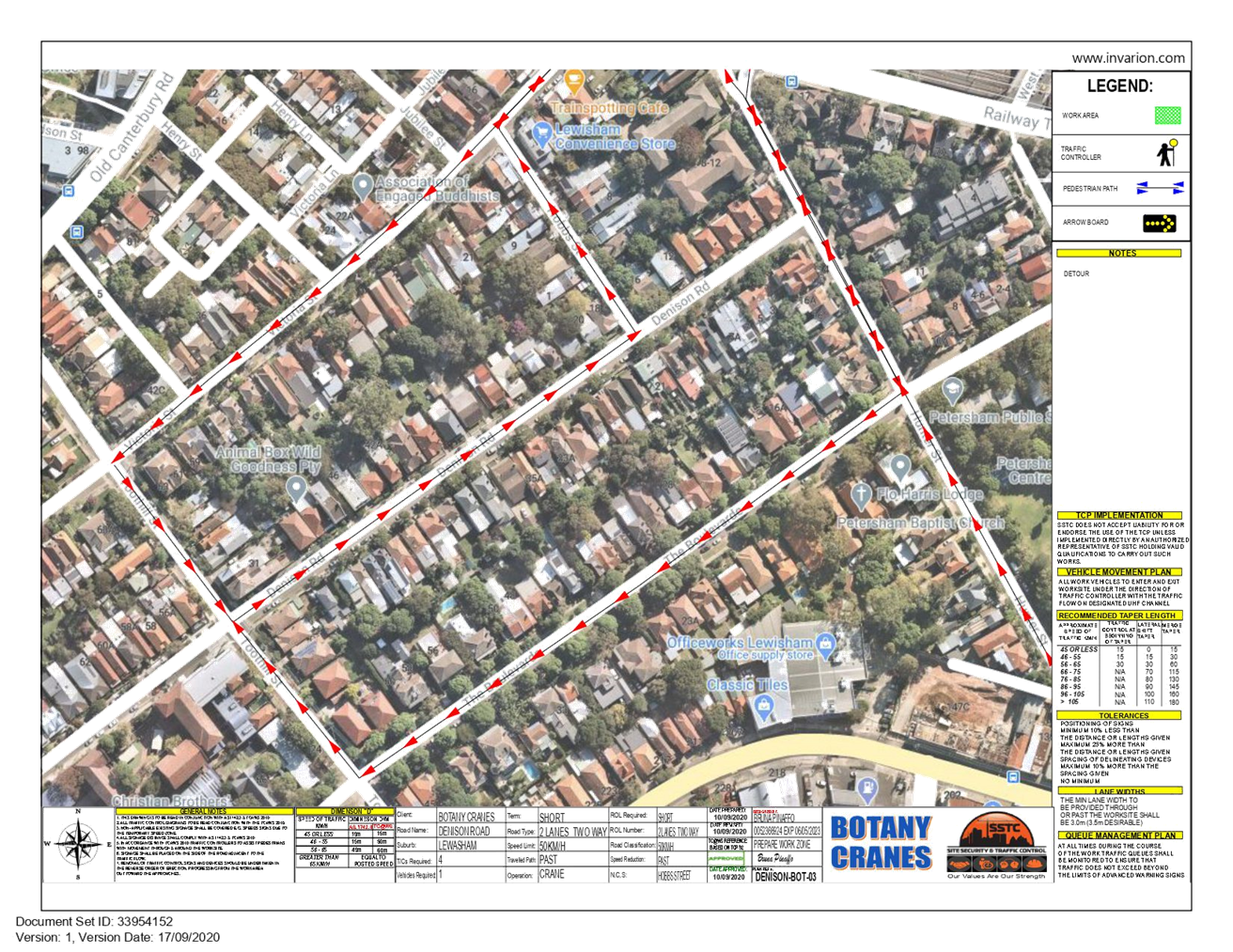
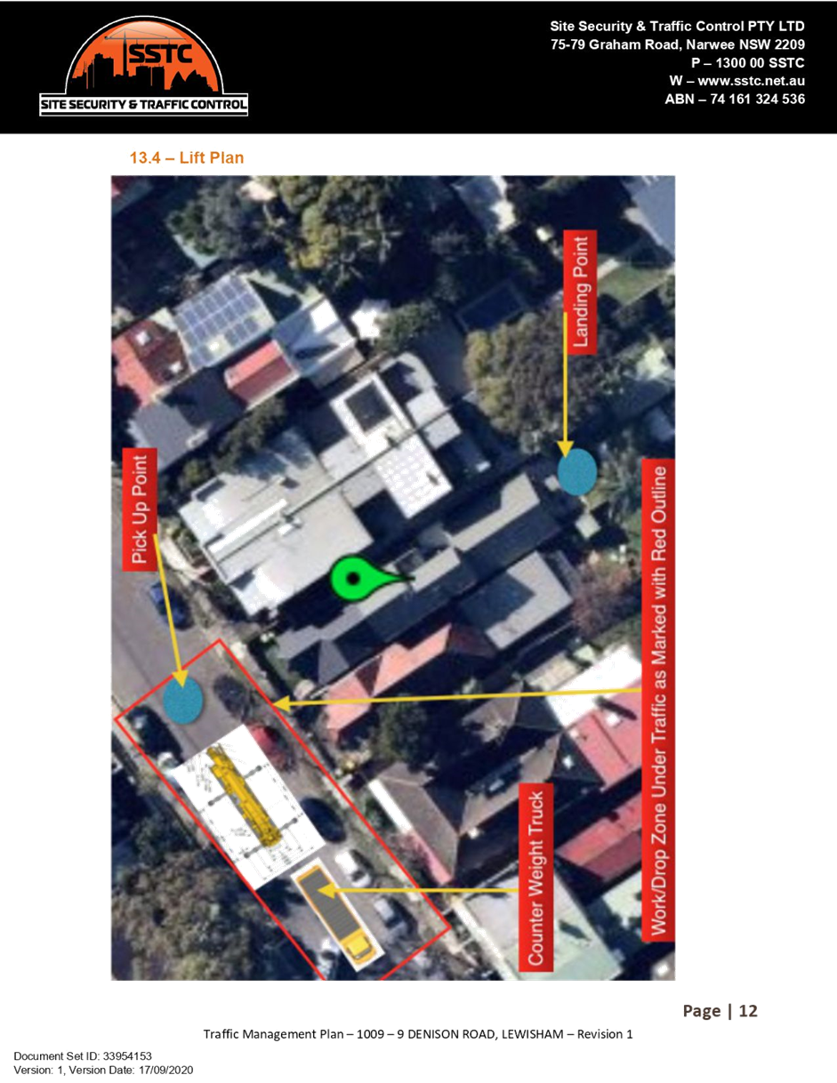
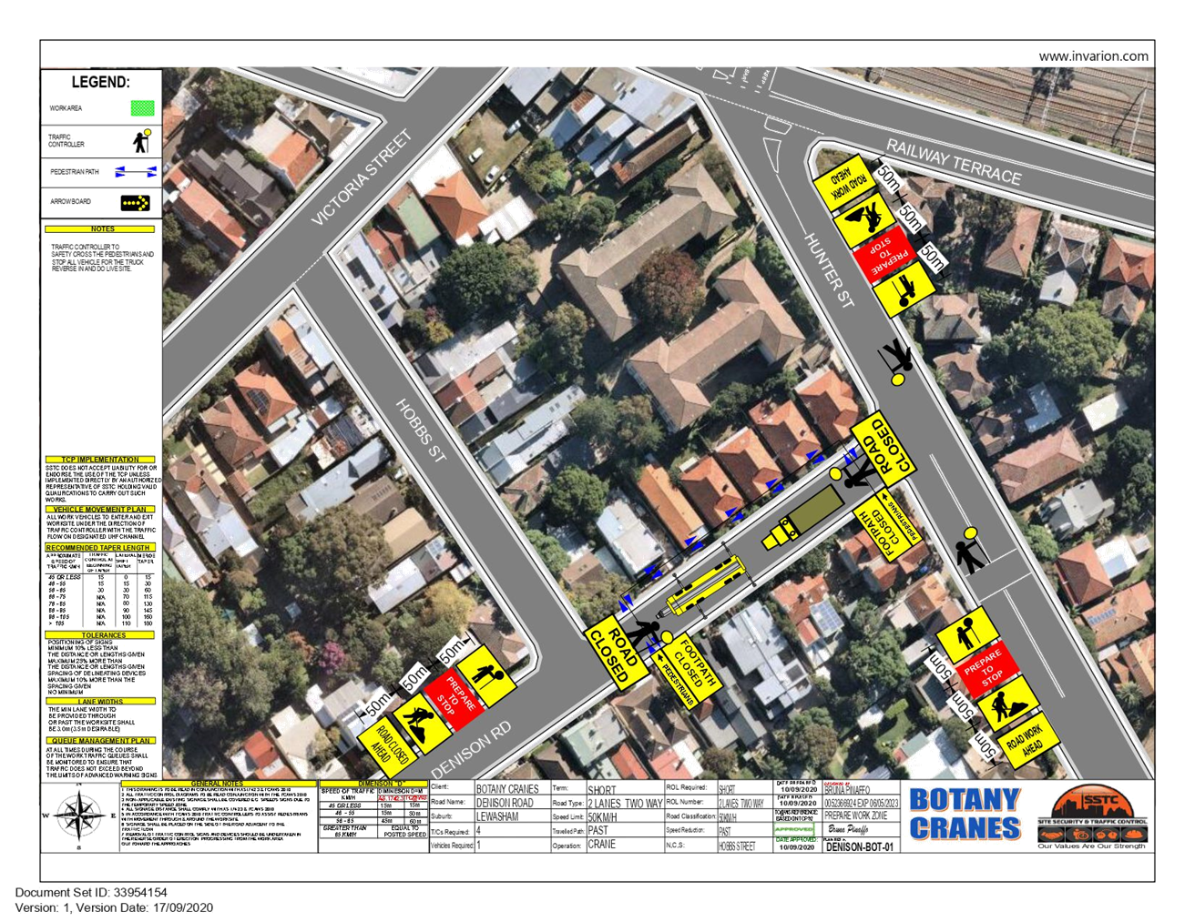
SUMMARY
An
application has been received from Site Security and Traffic Control (SSTC) for
the temporary full road closure of Denison Road (between Hunter Street and
Hobbs Street), Lewisham for the purpose of delivering a container unit via a
mobile crane into private property boundary. The closure is proposed to be
undertaken on Friday, 6 November 2020, between 7.00am to 5.00pm, with
contingency dates on either Thursday, 12 November 2020 or Friday, 13 November
2020. The streets will be temporarily closed to all vehicular traffic,
including emergency vehicles and local residents. It is recommended that the
proposed temporary full road closures be approved, subject to the conditions
outlined in this report.
|
RECOMMENDATION
THAT the proposed temporary
full road closure of Denison Road (between Hunter Street and Hobbs Street),
Lewisham on Friday, 6 November 2020, from 7.00am to 5.00pm, with one day
contingency on either Thursday, 12 November or Friday, 13 November 2020, be approved,
in order to deliver a container unit via a mobile crane into private property
boundary, subject, but not limited to the following conditions:
1. A
Road Occupancy License be obtained by the applicant from the Transport
Management Centre;
2. All
affected residents and businesses, including the NSW Police Local Area
Commander, Fire & Rescue NSW and the NSW Ambulance Services be notified
in writing, by the applicant, of the proposed temporary road closure at least
7 days in advance of the closure with the applicant making reasonable
provision for stakeholders; and
3. The
occupation of the road carriageway must not occur until the road has been
physically closed.
|
BACKGROUND
An
application has been received from SSTC for the temporary full road closure of Denison
Road, (between Hunter Street and Hobbs Street), Lewisham, on Friday, 6 November
2020, in order to deliver a container unit via a mobile crane into private
property boundary. Contingency dates have been provided; either Thursday, 12
November or Friday, 13 November 2020.
FINANCIAL IMPLICATIONS
Nil.
OTHER
STAFF COMMENTS
Denison Road, between Hunter
Street and Hobbs Street, Lewisham is a local road which carries around 1,000
vehicles per day, with two-way traffic and parking lanes on both directions.
Traffic intending to travel
westbound on Denison Road, will be able to detour via The Boulevarde and
traffic intending to travel via eastbound on Denison Road will be able to
access Railway Terrace via Hobbs Street and Hunter Street via The Boulevarde.
Vehicular access for local
residents of Denison Road, between Hunter Street and Hobbs Street, will not be
available during the work hours. Emergency vehicles approaching with emergency
lighting on will be given priority and, where safe, on-site traffic control
will escort the vehicles through.
PUBLIC
CONSULTATION
The applicant is to notify all
affected residents and businesses in writing of the required extension of
works.
The proposed road closure has
been advertised on Council’s website for a period of 28 days in
accordance with the Roads Act 1993.
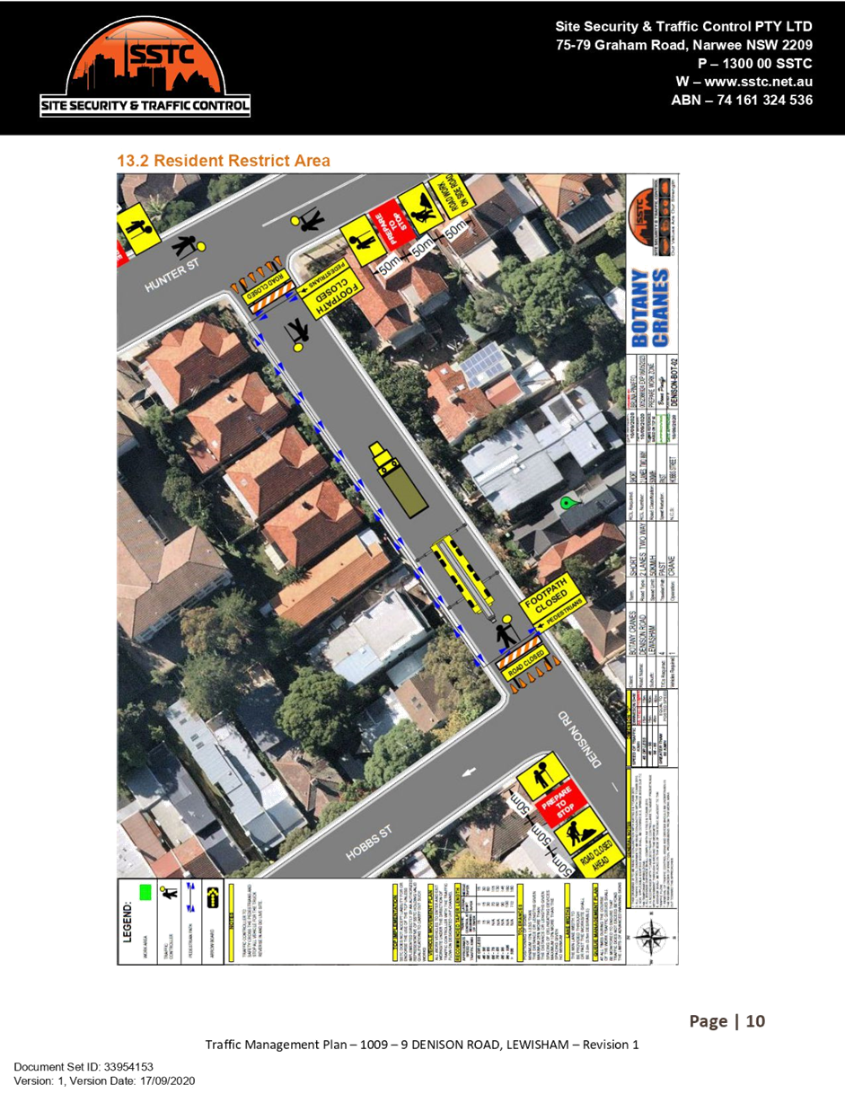
ATTACHMENTS
|
1.⇩
|
Detour Map
|
|
2.⇩
|
Traffic Management Plan
|
|
3.⇩
|
Traffic Control Plan
|
|

|
Local Traffic
Committee Meeting
2 November 2020
|
|

|
Local Traffic
Committee Meeting
2 November 2020
|

|

|
Local Traffic
Committee Meeting
2 November 2020
|
|
|
Local Traffic
Committee Meeting
2 November 2020
|
Item No: LTC1120
Item 2
Subject: ROSE STREET, MARRICKVILLE BETWEEN CORONATION
AVENUE AND UNNAMED LANEWAY WEST OF PARK ROAD - TEMPORARY FULL ROAD CLOSURE FOR
STREET PARTY – SATURDAY 12 DECEMBER 2020 (MIDJUBURI – MARRICKVILLE
WARD / NEWTOWN ELECTORATE / INNER WEST
PAC)
Prepared By: Jennifer
Adams - Engineer – Traffic and Parking Services
Authorised By: Manod
Wickramasinghe - Traffic and Transport Planning Manager
SUMMARY
An application has been received
from a resident for the temporary full road closure of Rose Street,
Marrickville between Coronation Avenue and Unnamed laneway west of Park Road for
a period of four hours on Saturday, 12 December 2020 in order to hold a street
party. It is recommended that the proposed temporary road closure be approved,
subject to the conditions outlined in this report.
|
RECOMMENDATION
THAT the proposed
temporary full road closure of Rose Street, Marrickville between
Coronation Avenue and Unnamed laneway west of Park Road for a period
of four hours on Saturday, 12 December 2020 between 4.00pm and 8.00pm
be APPROVED, in order to hold a street party, subject to the Conditions of
Approval as set out in the Street Party Application Form and the following
conditions:
1. Latest government and health advice on Covid-19 is
followed at the time of the event including gatherings and/or social
distancing restrictions;
2. All affected residents and businesses, including
the NSW Police Local Area Commander, Fire & Rescue NSW and NSW Ambulance
Services be notified in writing, by the applicant, of the proposed temporary
road closure at least 14 days in advance of the closure with the applicant
making reasonable provision for stakeholders;
3. The applicant is to set out the road closure as
per the attached typical Traffic Control Plan (TCP) and a 4-metre wide
emergency vehicle access be maintained through the closed road areas during
the course of the event; and
4. The occupation of the road carriageway must not
occur until the road has been physically closed.
|
BACKGROUND
Council encourages properly
conducted neighbourhood street parties as a means of building community spirit
and improving neighbourhood security. Fees for road occupancy are waived by
Council for small community street parties. For approved street parties and
subject to availability Council will provide barricades and ‘Road
Closed’ signs subject to the street party coordinator arranging
collection from and return to Council’s nominated depot.
Council’s Neighbourhood
Street Party Guidelines state, in relation to road closures, that:
“As a
guide, to be eligible for a road closure to hold a neighbourhood street party
your street: must be a local residential street block, cul-de-sac
or laneway; must not carry significant traffic volume; must not be a major
transport route or contain bus routes; must not provide access to railway
stations and associated parking; must not block access to shopping centres,
carparks or interfere with commercial or business operations.
Neighbourhood street parties are
non-commercial events and the following activities are prohibited: the
erection of temporary structures, jumping castles or other entertainment
devices; the sale of food or drink or fundraising; Live performers or amplified
music; road closure and road occupation after dark.”
FINANCIAL IMPLICATIONS
Nil.
OFFICER
COMMENTS
Rose Street is a local road that
runs west-east between Coronation Avenue and the Unnamed laneway west of Park
Road, Marrickville. It has no direct link to any significant road and is principally
used by residents to gain access to their properties. There are no parking
restrictions in place.
According to the RMS ‘Guide
to Traffic and Transport Management for Special Events’ a small street
party is considered as a ‘Class 3’ event. Impacts of the road
closure for the event are considered minimal. Vehicular access for
residents/businesses is to be maintained during the closure, where possible and
a 4-metre wide emergency vehicle access is to be maintained through the closed
road areas during the course of the event. A typical ‘standard’
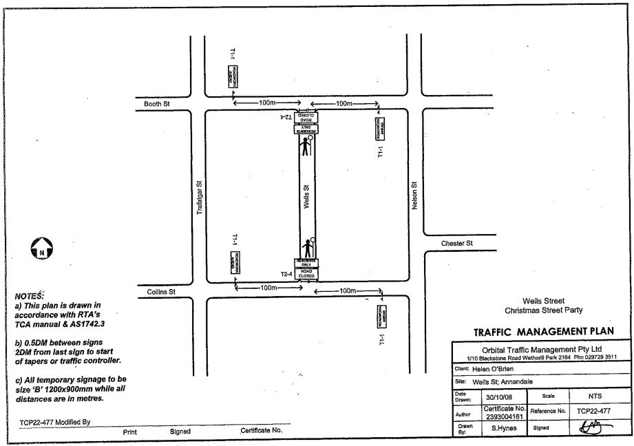
Traffic Control Plan (TCP) for the Closure is reproduced below.

PUBLIC CONSULTATION
The proposed temporary full road
closure of Rose Street, Marrickville between Coronation Avenue and Unnamed
laneway west of Park Road for a period of four hours on Saturday, 12
December 2020 has been advertised in accordance to the Roads Act.
ATTACHMENTS
Nil.
|

|
Local Traffic
Committee Meeting
2 November 2020
|
Item No: LTC1120
Item 3
Subject: Wells Street, Annandale - Christmas Street
Party (Road Occupancy)(Gulgadya-Leichhardt Ward/ Balmain Electorate/ Leichhardt
PAC)
Prepared By: David
Yu - Engineer - Traffic and Parking Services
Authorised By: Manod
Wickramasinghe - Traffic and Transport Planning Manager
SUMMARY
Council has received an
application for approval of an annual Christmas street party in Wells Street
between Booth Street and Collins Street, Annandale to be held on Sunday, 6
December 2020 between 4:00pm and 7:00pm.
|
RECOMMENDATION
THAT the temporary
road closure of Wells Street, Annandale between Booth Street and Collins
Street, to conduct an annual Christmas Street Party on Sunday, 6th December
2020, from 4:00pm - 7:00pm, be approved, subject to the conditions as
set out as per the Street Party Application Form as well as the following
additional conditions:
1. Latest government and health advice on Covid-19 is
followed at the time of the event including gatherings and/or social
distancing restrictions;
2. All affected residents and businesses, including
the NSW Police Area Command, Fire & Rescue NSW and NSW Ambulance Services
be notified in writing, by the applicant, of the proposed temporary road
closure at least 14 days in advance of the closure with the applicant making
reasonable provision for stakeholders;
3. The applicant is to set out the road closure as
per the attached typical Traffic Control Plan (TCP) and a 4-metre wide
emergency vehicle access be maintained through the closed road areas during
the course of the event; and
4. The occupation of the road carriageway must not
occur until the road has been physically closed.
|
BACKGROUND
& OTHER STAFF COMMENTS
Council has received an
application for approval of an annual Christmas street party in Wells Street
between Booth Street and Collins Street from a resident of Wells Street,
Annandale.
The street party is proposed to
be held on Sunday, 6th December 2020 between 4:00pm and 7:00pm. The applicant
is seeking permission for a temporary full road closure of Wells Street between
Booth Street and Collins Street, similar to previous years’ events.
The Traffic Control Plan for the
Closure is enclosed.
This is an annual event and no
significant issues have occurred in the past.
According to the RMS ‘Guide
to Traffic and Transport Management for Special Events’ a small street
party is considered as a ‘Class 3’ event.
Council encourages properly
conducted neighbourhood street parties as a means of building community spirit
and improving neighbourhood security. Fees for road occupancy are waived by
Council for small community street parties.
Where the following conditions
apply, organisers are only required to obtain approval for a street party
involving a temporary road closure:
· The
party is to be held outdoors for fewer than 100 people.
· No
temporary structures or jumping castles are to be erected.
· Participants
are to bring their own food and drinks, and food and drinks are not for sale.
· There
will be no performers or amplified music involved.
For approved
street parties and subject to availability Council will provide barricades and
‘Road Closed’ signs subject to the street party coordinator
arranging collection from and return to Council’s
depot.
FINANCIAL IMPLICATIONS
Nil.
PUBLIC CONSULTATION
The proposed road closure is
currently advertised on Council’s website in accordance with the Roads
Act 1993.
ATTACHMENTS
Nil.
|
|
Local Traffic
Committee Meeting
2 November 2020
|
Item No: LTC1120
Item 4
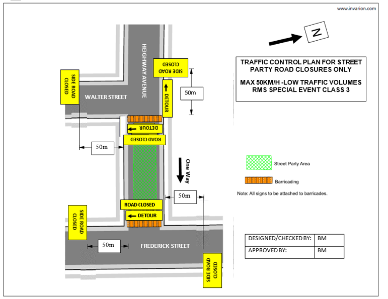
Subject: Heighway Avenue, Ashfield-Temporary road
closure for Christmas Street Party.
(Djarrawunang-Ashfield Ward/Summer Hill Electrorate/Burwood PAC)
Prepared By: Boris
Muha - Engineer – Traffic and Parking Services
Authorised By: Manod
Wickramasinghe - Traffic and Transport Planning Manager
SUMMARY
An
application has been received from a resident for the temporary full road
closure of Heighway Avenue, Ashfield, Between Walter Street and Frederick
Street for a period of three and a half (3.5) hours on Saturday 12 December
2020 in order to hold an annual Christmas street party. It is recommended that
the proposed temporary road closure be approved, subject to the conditions
outlined in this report.
|
RECOMMENDATION
THAT the proposed temporary
full road closure of Heighway Avenue, Ashfield, between Walter Street
and Frederick Street for a period of 3.5 hours on Saturday 12 December 2020
between 5.00pm and 8.30pm be APPROVED, in order to hold an annual Christmas street
party, subject to the Conditions of Approval as set out in the Street Party
Application Form and the following conditions:
1.
Latest government and health advice on
Covid-19 is followed at the time of the event including gatherings and/or
social distancing restrictions;
2.
All affected residents and businesses,
including the NSW Police Local Area Commander, Fire & Rescue NSW and NSW
Ambulance Services be notified in writing, by the applicant, of the proposed
temporary road closure at least 14 days in advance of the closure with the
applicant making reasonable provision for stakeholders;
3.
The applicant is to set out the road
closure as per the attached typical Traffic Control Plan (TCP) and a 4-metre
wide emergency vehicle access be maintained through the closed road areas
during the course of the event; and
4.
The occupation of the road carriageway
must not occur until the road has been physically closed.
|
BACKGROUND
Council
encourages properly conducted neighbourhood street parties as a means of
building community spirit and improving neighbourhood security. Fees for road
occupancy are waived by Council for small community street parties. For
approved street parties and subject to availability Council will provide
barricades and ‘Road Closed’ signs subject to the street party
coordinator arranging collection from and return to Council’s nominated
depot.
Council’s
Neighbourhood Street Party Guidelines state, in relation to road closures,
that:
“As
a guide, to be eligible for a road closure to hold a neighbourhood street party
your street: must be a local residential street block, cul-de-sac or laneway;
must not carry significant traffic volume; must not be a major transport route
or contain bus routes; must not provide access to railway stations and
associated parking; must not block access to shopping centres, carparks or
interfere with commercial or business operations. Neighbourhood street parties
are non-commercial events and the following activities are prohibited: the
erection of temporary structures, jumping castles or other entertainment
devices; the sale of food or drink or fundraising; Live performers or amplified
music; road closure and road occupation after dark.”
FINANCIAL IMPLICATIONS
Nil
OTHER
STAFF COMMENTS
Heighway Avenue between Walter
Street and Frederick Street is a narrow one-way Local Road approximately 7.5m
in width, which carries low volumes of traffic (around 850 vehicle per day) in
the easterly direction from Walter Street to Frederick Street.
The above section of Heighway
Avenue is one-way east bound with one travel lane and kerbside parking on both
sides of the street.
This event is held annually with
road closure arrangements being no different to past years. The road closure is
a category type “Class 3” minor event under the RMS “Guide to
Traffic and Transport Management for Special Events”. Impacts of the road
closure for the event are considered minimal.
Detouring can be made via the
surrounding streets of Walter Street,Thomas Street and Frederick Street. Local
traffic access can be maintained in the adjoining section of Heighway Avenue
and Walter Street.
Resident access through the
closed easterly one-way section of Heighway Avenue can be maintained from the
Walter Street end.
A Traffic Control Plan and
Traffic Management Plan are shown in Attachment 1 and 2.
PUBLIC CONSULTATION
The proposed temporary full road
closure of Heighway Avenue, Ashfield, between Walter Street and Frederick
Street for a period of three and a half (3.5) hours on Saturday, 12 December
2020 has been advertised for 28 days.
ATTACHMENTS
|
1.⇩
|
Traffic Contol Plan-TCP-Heighway Avenue Christmas Street
Party road closure 2020.
|
|
2.⇩
|
Traffic Management Plan-TMP-Heighway Avenue Christmas
Street Party road closure 2020.
|
|
|
Local Traffic
Committee Meeting
2 November 2020
|
|
|
Local Traffic
Committee Meeting
2 November 2020
|
TRAFFIC
MANAGEMENT PLAN
CLOSURE OF HEIGHWAY AVENUE, ASHFIELD, BETWEEN WALTER STREET AND FREDERICK STREET, FOR CHRISTMAS
STREET PARTY
SATURDAY 12 DECEMBER 2020 FROM 5.00PM –
8.30PM
The use of the
street would be for the residential community to conduct their annual Christmas
Street party.
Note: This
traffic management detail applies for this year’s event and may be
subject to alteration in future events. The event is similar to as in previous
years as approved by the Traffic Committee.
A Description
or detailed plan of proposed measures
Is
a detailed plan of the proposed measures necessary?
No,
a detailed plan of the proposed measures is not necessary.
Heighway Avenue is a local road, which carries low volumes of
traffic.
It is proposed to place portable Council barricades
with “Road Closed” and “Detour” signs at Walter Street
and at Frederick Street. Locations will be manned to allow resident access if
required. “Side Road Closed” signs will be placed in advance at
Walter, Thomas and Frederick Streets to warn and assist traffic away and around
the area of the road closure.
A TCP plan showing this is attached.
B Identification
and assessment of impact of proposed measures
Is
a detailed assessment required?
No,
a detailed assessment is not required.
There will be little traffic in Heighway Avenue on the
Saturday late afternoon/evening. Any traffic can be diverted via Walter,Thomas
and Frederick Streets. It will have little noticeable impact on these roads.
C Measures
to ameliorate the impact of re-assigned traffic.
Is
an assessment required?
No,
an assessment is not required. See comments in B) above.
(2)
D Assessment
of public transport services affected.
Is
an assessment required?
No, an assessment is not required. Heighway Avenue is
not a bus route.
E Details
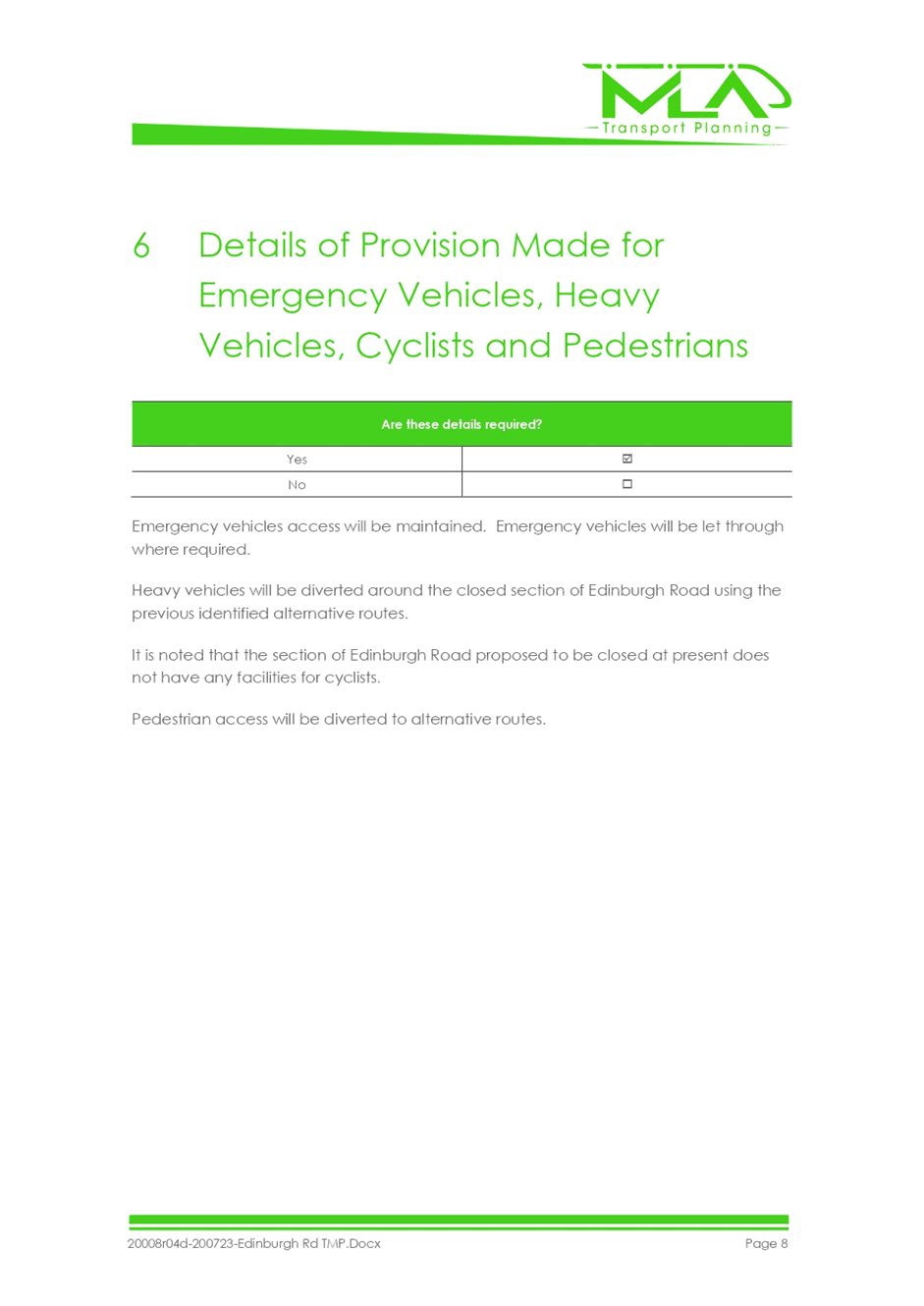
of provision made for emergency vehicles, heavy vehicles, cyclists and
pedestrians.
Are
these details required?
No,
these details are not required.
The
barricades will be portable and can easily be moved should emergency vehicles
require access. Pedestrians will be able to walk normally on the footpath or
between the barricades. Cyclists will be able to negotiate the barricades.
Heavy vehicles, if any, can detour via Thomas Street or Frederick Street.
F Assessment
of effect on existing and future developments with transport implications in
the vicinity of the proposed measures.
Is
an assessment required?
No,
it is not applicable to this street closure for Christmas Street party.
G Assessment
of effect of proposed measures on traffic movements in adjoining council areas.
Is
an assessment required?
No,
an assessment is not required.
The
boundary with Burwood Council runs along Dickson Avenue some 200 metres to the
west of the proposed closed section of Heighway Avenue between Walter Street and Frederick Street. No traffic will be directed into streets under the
control of Burwood Council.
H Public
Consultation Process
Is
a public consultation process required?
No,
a public consultation process is not required. The closure is for 3.5 hours on
a Saturday afternoon/evening for a Christmas street party. The event
co-ordinator is responsible to notify affected residents/businesses and
emergency services prior to the street being closed.
|
|
Local Traffic
Committee Meeting
2 November 2020
|
Item No: LTC1120
Item 5
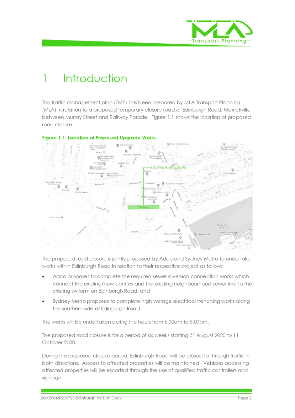
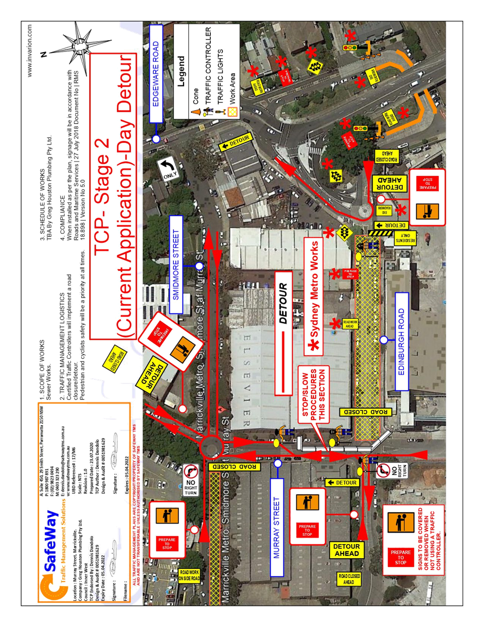
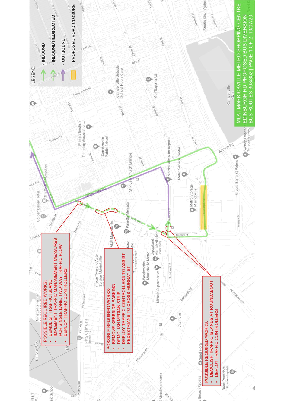
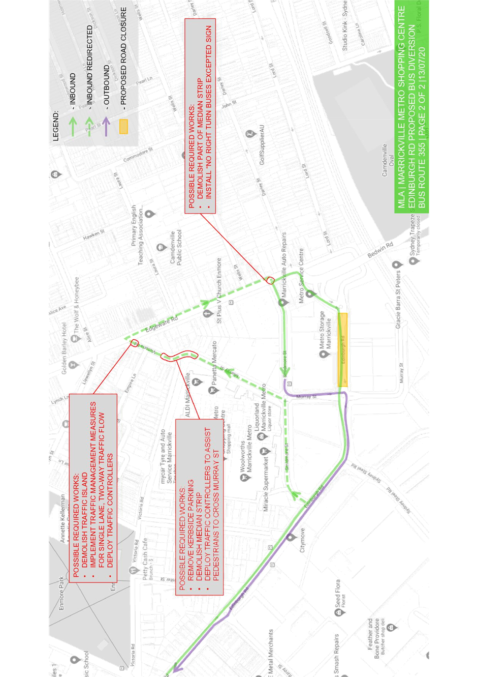
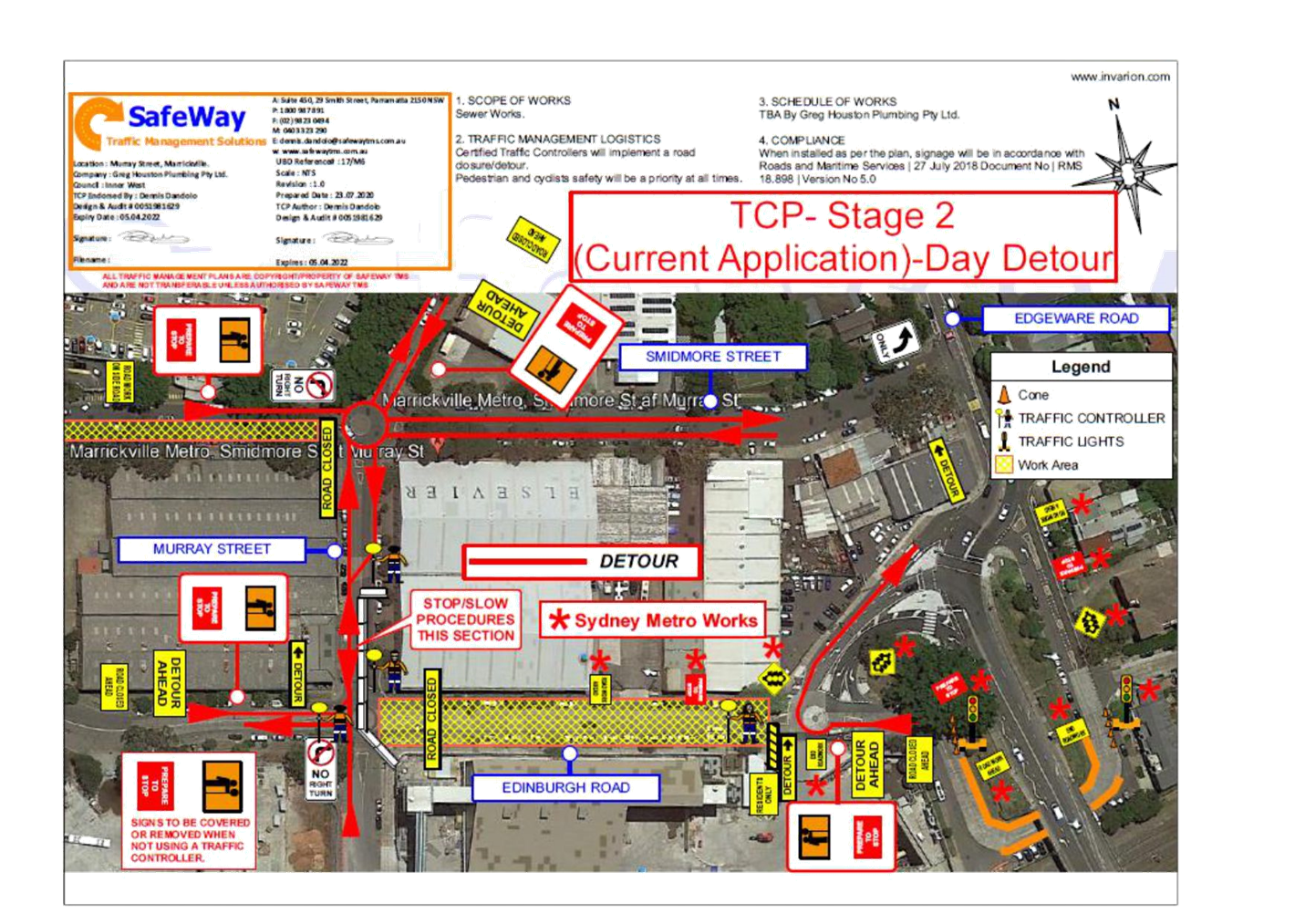
Subject: EDINBURGH STREET, MURRAY STREET AND RAILWAY
PARADE, MARRICKVILLE – MARRICKVILLE METRO EXPANSION WORKS –
NOTICE OF EXTENSION TO COUNCIL APPROVED DATES OF A 6 WEEK PERIOD TEMPORARY FULL
ROAD CLOSURE IN ORDER TO COMPLETE EXCAVATION WORKS FOR A SEWER CONNECTION TO
MAIN LINE (MIDJUBURI – MARRICKVILLE WARD / NEWTOWN ELECTORATE / INNER
WEST PAC)
Prepared By: Jennifer
Adams - Engineer – Traffic and Parking Services
Authorised By: Manod
Wickramasinghe - Traffic and Transport Planning Manager
SUMMARY
Council has received
notice from JRK (contractor to Marrickville Metro Shopping Centre
expansion works/ADCO) of a required extension to Council approved dates for the
6-week period temporary full road closure of a section of Edinburgh Road in
order to complete excavation works for a sewer connection to main line. It
is recommended that the proposed extension of dates for
the temporary full road closure be approved, subject to the
conditions outlined in this report.
|
RECOMMENDATION
THAT the proposed
extension period for the temporary full road closure of sections of Edinburgh
Street, Murray Street and Railway Parade, Marrickville from 25 September 2020 (original completion date) to 28 November 2020 be
approved for the purpose of completing sewer connection works relating to
Marrickville Metro Expansion works subject to, but not limited to, the
following conditions:
1. A new Road Occupancy License be obtained by
the applicant from the Transport Management Centre;
2. All affected residents and businesses,
including the NSW Police Area Commander, Fire & Rescue NSW and the NSW
Ambulance Services be notified in writing, by the applicant, of the proposed
extension to the Council approved dates of the temporary full road closure
with the applicant making reasonable provision for stakeholders;
3. The occupation of the road carriageway must
not occur until the road has been physically closed;
4. Subject to written concurrence from Sydney
Metro TSE Group and Transit Systems / Sydney Buses is provided to Council;
5. Subject to written concurrence from Transport
for New South Wales; and
6. The temporary
removal and reinstatement of any Council assets will be at the applicants
cost and to Council satisfaction.
|
BACKGROUND
The proposed road closures were previously
considered and supported at the 6 July 2020, 3 August 2020 and 7 September 2020
Local Traffic Committee meetings. On 21 October 2020 Council received the
following notice from JRK (contractor to Marrickville Metro Shopping
Centre expansion works/ADCO) of a required extension to Council approved dates
for the 6 week period temporary full road closure of a section of Edinburgh
Road in order to complete excavation works for a sewer connection to main
line:.
“JRK have completed our
underbore from Murray Street to Edinburgh Rd and subsequently constructed our
manhole on Murray St. However, when we excavated Edinburgh Rd to construct the
manhole it became apparent the oviform tunnel along Edinburgh Rd was not
directly underneath the existing manhole as described on the Sydney Water
documentation. As a result, the manhole had to be redesigned by the
Sydney Water coordinator and sent to Sydney Water for approval. The Sydney
Water coordinator has spoken with Sydney Water this week and has been advised
that the design will be reviewed in the coming days.”
JRK are hoping that the design will be approved shortly and
they expect the completion of work and reopening of Edinburgh Rd on Saturday 14th
November 2020. However, a two-week contingency period is reasonable and
included.
The previous Traffic Control Plan
(TCP) and Traffic Management Plan (TMP) is attached at the end of this report.
OTHER STAFF COMMENTS
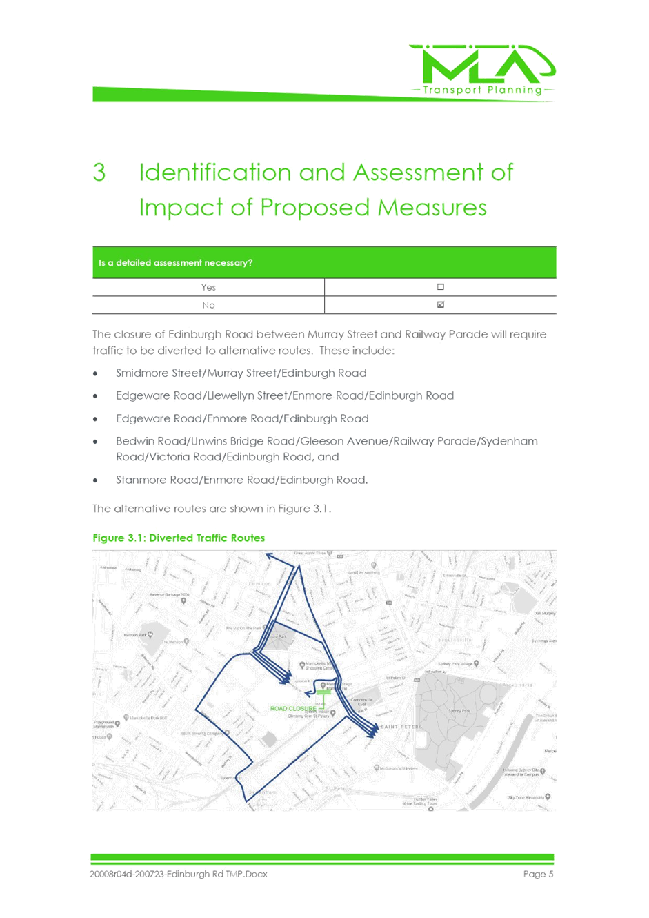
Edinburgh Road is a local road
and acts as a collector road between Victoria Road in the west and Edgeware
Road in the east. Between Murray Street and Edgeware Road, Edinburgh Road
carries an average 9151 vehicles per day. Along its length it is generally a
one lane two-way undivided roadway with kerbside parking on both sides of the
road. Its closure will continue to have a major impact especially with the
partial closure of Smidmore Street in place at the same time.
As outlined in previous reports
to Local Traffic Committee meetings on this same matter, it is noted that for
suitable bus access a number of Council’s assets were temporarily
removed, and that removal and reinstatement of Council assets will be at the applicants’ cost and to Council
satisfaction.
FINANCIAL
IMPLICATIONS
Under Council’s Fees &
Charges, the applicant is to pay a fee for the temporary full road closure
along with any other required road occupancy and/or road opening permit
fees.
All works and costs of
implementation will be borne by the applicant
PUBLIC CONSULTATION
The applicant is to notify all
affected residents and businesses in writing of the required extension of
works.
The proposed road closure has
been advertised on Council’s website in accordance with the Roads Act
1993.
ATTACHMENTS
|
1.⇩
|
20008r04D-200723-Edinburgh Rd TMP
|
|
2.⇩
|
TCP - 200723-Edinburgh Rd TMP
|
|

|
Local Traffic
Committee Meeting
2 November 2020
|


|
|
Local Traffic
Committee Meeting
2 November 2020
|
|
|
Local Traffic
Committee Meeting
2 November 2020
|
Item No: LTC1120
Item 6
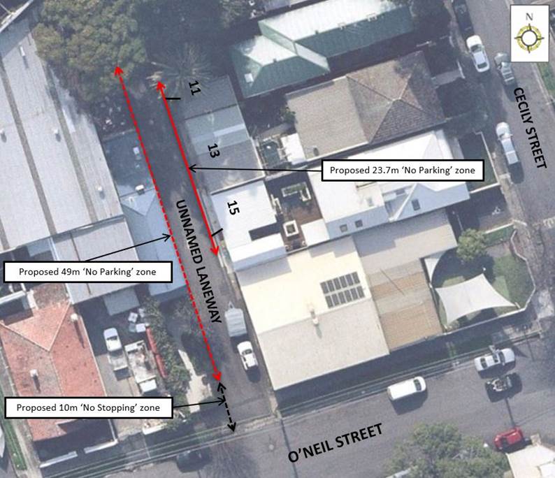
Subject: Unnamed Laneway, Lilyfield (North of O'Neil
Street) - Proposed 'No Stopping' and 'No Parking' restrictions
(Baludarri-Balmain Ward/Balmain Electrate/Leichhardt PAC)
Prepared By: Vinoth
Srinivasan - Engineer - Traffic and Parking Services
Authorised By: Manod
Wickramasinghe - Traffic and Transport Planning Manager
SUMMARY
Council has
received concerns from residents of Cecily Street, Lilyfield regarding vehicles
parking on the eastern side of the Unnamed Laneway, Lilyfield and subsequently
obstructing rear driveway access for properties Nos.11-15, Cecily Street,
Lilyfield.
|
RECOMMENDATION
THAT:
1. A 23.7m ‘No Parking’
zone be installed on the eastern side of the Unnamed Laneway, Lilyfield along
the rear boundaries of No.11, 13, 15 Cecily Street (between the points 3.2m
south of the driveway of No.15 Cecily Street and 1.7m north of the driveway
of No.11 Cecily Street).
2. A 10m statutory ‘No
Stopping’ zone and a subsequent 49m ‘No Parking’ zone be
installed on the western side of the Unnamed Laneway, north of O’Neil
Street.
|
BACKGROUND
& OTHER STAFF COMMENTS
Council is
proposing to install a 23.7m ‘No Parking’ zone on the eastern side
of the Unnamed Laneway, north of O’Neil Street and a 10m statutory
‘No Stopping’ zone and a subsequent 49m ‘No Parking’
zone on the western side of the Unnamed Laneway to ensure unobstructed rear
driveway access for properties No.11-15 Cecily Street, Lilyfield.
A swept path
analysis confirmed that a vehicle parked on the eastern side of the Unnamed
Laneway, directly south of the rear driveway of No.15 Cecily Street obstructs
driveway access.
The proposal
is shown in the following plan.
FINANCIAL IMPLICATIONS
Nil.
PUBLIC CONSULTATION
A letter outlining the proposal
was mailed out to the affected properties (7 properties) in Cecily Street and
O’Neil Street, Lilyfield. Three (3) responses were received, all in
objection to the proposal. The main concerns are outlined below:
· Signage
will be detrimental to the overall streetscape of the laneway.
· Restricting
parking in front of the driveways is going to make it hard to load/unload
passengers with mobility issues as access to the rear of these properties does
not require the use of steps.
Council has provided a response
in regard to the residents’ concerns. These are detailed below:
· The
signs that have been proposed are all required to ensure unobstructed access is
provided in the laneway and will be minimised where appropriate.
· The
area in front of driveways is a statutory ‘No Parking’ zone and
therefore the signage only formalises the restriction. ‘No parking’
zones can be used for drop off and pick up.
ATTACHMENTS
Nil.
|

|
Local Traffic
Committee Meeting
2 November 2020
|
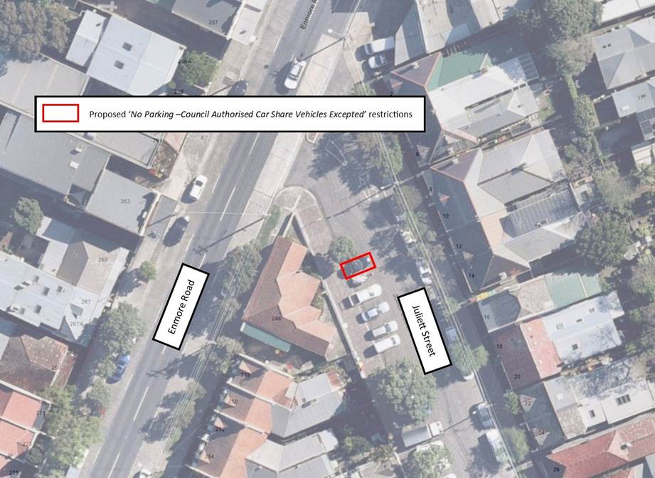
Item No: LTC1120
Item 7
Subject: Juliett Street, Marrickville - Proposal
for Car Share Parking Space
(Midjuburi-Marrickville Ward/ Newtown Electorate/ Inner West PAC)
Prepared By: Scipio
Tam - Engineer – Traffic and Parking Services
Authorised By: Manod
Wickramasinghe - Traffic and Transport Planning Manager
SUMMARY
A request has
been received from a GoGet representative for the installation of an on-street
dedicated car share parking space on Juliett Street, Marrickville.
It is
recommended that the installation of the proposed on-street dedicated car share
parking space be supported as detailed in this report.
|
RECOMMENDATION
THAT the installation of
2.5-metre ‘No Parking – Council Authorised Car Share Vehicles
Excepted’ restrictions on the first available angled on-street parking
space, located on the western side of Juliett Street, Marrickville, south of
its intersection with Enmore Road be approved.
|
BACKGROUND
Car Share Schemes are considered to
be a way of making vehicles available to local residents without the need for
them to own one. It has the potential to reduce private car ownership road
congestion and pollution, has benefits to the environment and increase the
mobility of people using the service.
Research indicates that each car
share space can replace up to 10 vehicles on the road. Council’s adopted
Car Share Policy will potentially reduce demand for on-street parking,
resulting in less cars on public roads, leading to less pollution and greenhouse
emissions. The policy is part of a holistic approach to transport planning,
along with improvements to public transport services and enhanced facilities
for cycling and walking.
Generally, car share schemes rely on
having convenient dedicated on-street parking spaces. The designated space will
be in operation 24 hours a day, 7 days a week, during which only specifically
marked car share vehicles will be permitted to park in this space.
FINANCIAL IMPLICATIONS
The costs of the supply and installation
of the signposting associated with the dedicated car share parking space is to
be borne by the applicant in accordance with Council’s Fees and Charges.
OTHER
STAFF COMMENTS
A request has been received from
GoGet representative for the installation of an on-street dedicated car share
parking space. The nominated location is the first available angled on-street
parking space, on the western side of Juliett Street, Marrickville, south of
its intersection with Enmore Road.
Upon site inspections conducted
by Council Officers, it was observed GoGet had 3 vehicles parked within the
vicinity of the proposed parking space. Therefore, this process of formalising
a dedicated car share parking space will make it easier for users’ to
find an available parking space within the area and ensure an improved parking
opportunity for a returning car share vehicle.
PUBLIC CONSULTATION
Community consultation was led by
GoGet representatives during the period between 31 August and 14 September
2020. A letter was distributed to the local residents in the area. A summary of
the consultation results was presented to Council.
A total of one (1) response in
support of the proposal was received.
ATTACHMENTS
Nil.
|
|
Local Traffic
Committee Meeting
2 November 2020
|
Item No: LTC1120
Item 8
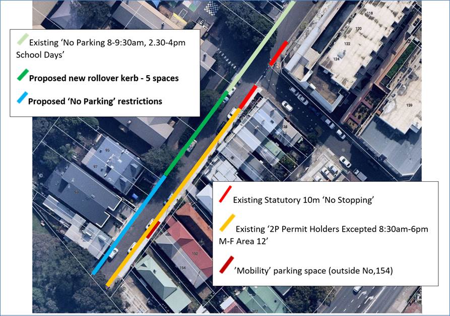
Subject: CHURCH STREET, ST PETERS – PROPOSED NEW
'NO PARKING' RESTRICTIONS AND A FUTURE SECTION OF ROLLOVER KERB PARKING
(MIDJUBURI – MARRICKVILLE WARD / HEFFRON ELECTORATE / INNER WEST PAC)
Prepared By: Jennifer
Adams - Engineer – Traffic and Parking Services
Authorised By: Manod
Wickramasinghe - Traffic and Transport Planning Manager
SUMMARY
Council received representations
from various parties in relation to Church Street, St Peters indicating that
parking on both sides of the street, especially in the section of Church Street
between Victoria Street and the dead end, is obstructing the safe passage of
vehicles including service vehicles and particularly emergency vehicles. The
road is narrow and vehicles which are parked on both sides of the roadway
frequently pose problems for vehicular access. The proposal removes 3 instead of a possible 8 on-street spaces on the
northern side of Church Street and it is recommended that the new ‘No
Parking’ restrictions be installed and the 5 space section of rollover
kerb be approved in principle and that the latter it be listed for funding
in a future Traffic Capital Works Program.
|
RECOMMENDATION
THAT:
1. Implementation
of ‘No Parking’ restrictions from property No. 95 to
property No. 103 Church Street, St Peters (northern side) be approved; and
2. A 5-space section of rollover kerb, between
the school entrance opposite Victoria Street and the eastern boundary of
property No. 95 Church Street, St Peters, be approved in
principle and that it be listed for funding in a future Traffic Capital Works
Program.
|
BACKGROUND
Church Street is a two-way street
which is 6.8 metres wide. The carriageway width along Church Street is
generally not sufficiently wide to accommodate parking on both sides. Parking
restrictions installed in the street need to reflect the narrowness of the
street and the demand for parking in the area by allowing for parking where
access and the movement of vehicles are not obstructed for the safe passage of
all vehicles including service and emergency vehicles along the thoroughfare.
The proposal to implement
‘No Parking’ on the northern side from property No. 95 to property
No. 103 Church Street, St Peters also encompasses the driveways of the
properties and is designed to reinforce the Road Rules prohibiting parking
across driveways and the obstruction of the passage of vehicles, including
service and potential emergency vehicles.
The proposal will result in the
removal of 3 instead of a possible 8 on-street parking spaces on the northern
side of Church Street when the 5 space section of rollover kerb is included.
The rollover kerb would allow vehicles to park legally and provide road width
for vehicles to access this section of Church Street safely. It should be noted
that the section of Church Street where the roll over kerb is proposed has very
little pedestrian activity and pedestrian access along the footpath would not
be hindered. The proposal is illustrated below.
FINANCIAL IMPLICATIONS
The costs of installation of the proposed parking
restrictions can be funded within Council’s signs and line marking
budget. Estimated cost of providing a roll over kerb for the required 5
parking spaces is approximately $25,000.
PUBLIC CONSULTATION
Letters were delivered to owners
and occupiers of 14 affected properties in Church Street. Five (5) responses
were received. Three were in support of the proposal and 2 opposed it.
One resident objected to any loss of parking citing also about the general lack
of parking available in the Inner West area and noted that many properties had
multiple vehicles. One long term resident cited that they used the space
outside their property, and it would be detrimental if they could not continue
to park there. Moreover, it is noted that this section of Church Street is
within the M12 parking area and should the resident not have any off-street
parking they would be eligible for a parking permit.
CONCLUSION
Given the narrowness of the
street, the proposal addresses the need for access and the safe use of the
thoroughfare with the loss of the minimum number of legal parking spaces; it is
therefore recommended that the proposal be supported.
ATTACHMENTS
Nil.
|
|
Local Traffic
Committee Meeting
2 November 2020
|
Item No: LTC1120
Item 9
Subject: Milton Lane, Ashfield-Widening of Milton
Lane-DA condition under Development of 380-382 Liverpool Road, Ashfield.
(Diarrawunang-Ashfield Ward/Summer Hill Electorate/Burwood
PAC)
Prepared By: Boris
Muha - Engineer – Traffic and Parking Services
Authorised By: Manod
Wickramasinghe - Traffic and Transport Planning Manager
SUMMARY
Under
condition of Development Consent 10.2012.269.4, and in line with Part
3-Ashfield West- Inner West DCP 2016, the east-west section of Milton Lane,
Ashfield, rear of 380-382 Liverpool Road will be widened to accommodate 2-way
traffic and pedestrian footpath for the current development of No.380-382
Liverpool Road, Ashfield.
Road widening
and footpath will be constructed on private land (right of way) as allocated by
the developer. This is shown in the approved DA plan LIVERPOOL380-CIV3 FINAL
DWG (Attachment 2) for the committee to note.
Minor
modifications are recommended to plan showing signposting, line marking and
traffic safety measures, by Council’s Traffic Engineer.
As Milton
Street, is a State Road, under the care and control of Transport for NSW
(TfNSW), the Committee is further advised that the road intersection design at
Milton Lane and Milton Street, will be assessed by the TfNSW for appropriate
traffic movement to and from the site.
|
RECOMMENDATION
THAT:
1. The following modifications to plan “Liverpool380-Civ3 Final Dwg” as shown in
Attachment 2 of this report be approved, including:
· Removal
of the painted dividing island in Milton Lane at the intersection of Milton
Street, Ashfield;
· Providing
‘No Parking’ restrictions in lieu of ‘No Stopping’
placed near mid-block on the southern side of the widened lane. This is to
assist short-term loading/unloading of goods or waste collection for current
or future development needs for No.40 Milton Street;
· Providing
edge line (E1) marking to designate and guide any traffic around the corner
of Milton Lane;
· Providing
guideposts to veer/guide traffic around the corner of Milton Lane; and
· Providing
STOP control line marking at the intersection of Milton Lane and Milton
Street.
2. The applicant be advised of these modifications
for the inclusion in proposed works within Milton Lane; and
3. The intersection design treatment for Milton
Street and Milton Lane be forwarded to TfNSW, by the applicant, for
consideration and approval.
|
BACKGROUND
No.380-382
Liverpool Road was approved by Council with the date of operational consent in
March 2015, for the demolition of existing structures, the construction of a 7
storey commercial and residential flat building with ground floor retail, two
levels of basement parking, lane widening and landscaping.
The
development comprises some 60 units and around 95 carparking spaces within the
carpark basement. It also provides an on-ground loading bay area. The carpark
and loading bay areas are accessed from the rear of the site via Milton Lane.
This report
entails the construction and widening of Milton Lane at the rear of the site to
accommodate 2-way traffic for the development to and from Milton Street. See
Attachment 1 and 2. The developer, under condition of Development Consent,
has allocated private land of some 3.8 metres (as right of way) to widen Milton
Lane to 6 m and provide 1.5m of footpath on the northern side of the lane.
FINANCIAL IMPLICATIONS
The cost
for the widening and construction of Milton Lane is borne by the developer
under condition of Development Consent.
OTHER
STAFF COMMENTS
· Milton Lane is a local
Street connecting from Norton Street to Milton Street. Milton Lane from Norton
Street heads north then bends left to go east to Milton Street. The full length
of Milton Lane is approximately 3.7-4.0m wide currently serving only
resident/business access to properties in the lane with low traffic volume
(below 300 vehicles per day). It provides for two-way traffic flow with
(private land) indented bay parking of 3-4 vehicle spaces on the southern side
of the east -west section of the lane, and (council land) indented bay parking
of 4 spaces on the western side of the north-south section of the lane. Speeds
are considered very low in the lane with no accidents recorded in the lane at
least in the last 5 years.
· Driveways and/or
council/private land areas aside of the lane provide lay over opportunities to
allow opposing traffic to pass by.
· Under Development
consent for 380 Liverpool Road, Ashfield.
“All traffic associated
with the development is to enter and exit from/out to Milton Street and not
access via the north-south section of Milton Lane from Norton Street.
An angled median island is to
be constructed within the confines of the road reserve area of the lane to the
south east corner of the site to physically direct all traffic coming out of
site towards the right and out into Milton Street. “All traffic
right” signage and “No right turn” signage is to be provided
to Council’s satisfaction to prevent any form of entry or exit via the
north-south section of the lane.
Additionally, “All
traffic left” signage is to be provided on the northern intersection of
Milton Street and Milton Lane.”
· Concern is raised with
the road design intersection of Milton Street and Milton Lane for entering
trucks to service 380 Liverpool Road. Although infrequent, trucks when entering
are likely to veer wide across the intersection of the lane. It is considered
that the painted island as shown on the plan be removed to prevent any
misconception that all vehicles turning in from Milton Street do so along the
northern side of the lane. The developer is to demonstrate that waste vehicle
movements can be accommodated, and this be submitted to the TfNSW for
assessment and approval.
· The intersection of
Milton Street and Milton Lane is within TfNSW road reserve which will be
landscaped under the development approval. Sight lines of traffic in Milton Street
will be improved for vehicles exiting out of Milton Lane.
· Painted solid
barrier/median edge lines in the middle of Milton Street prohibits vehicles
crossing over from Milton Street (right) into Milton Lane being a public
street. See Attachment 3.
· The road widening would
also benefit side access needs for the opposing building 40 Milton Street,
Ashfield with leased businesses to the front and rear of that building.
· The modifications as
required to the submitted plan by the applicant are as follows:
Ø Removal of the painted dividing
island in Milton Lane at the intersection of Milton Street Ashfield.
Ø Provide ‘No Parking’
restrictions in lieu of No Stopping placed near mid-block on the southern side
of the widened lane. This is to assist short-term loading/unloading of goods or
waste collection for current or future development needs for 40 Milton Street.
Ø Provide edge line (E1) marking to
designate and guide any traffic around the corner of Milton Lane.
Ø Provide guideposts to veer/guide
traffic around the corner of Milton Lane.
Ø Provide STOP control line marking
at the intersection of Milton Lane and Milton Street.
No loss of parking is associated with the widening of the
lane or the modification works above.
PUBLIC CONSULTATION
Affected
residents/businesses were consulted on the road widening under the DA approval.
The developer will notify/consult affected residents/businesses in advance
prior to road widening work and advise of any pending changes to the
intersection of Milton Street and Milton Lane as required by the
TfNSW.
CONCLUSION
It is recommended that the
attached plan “LIVERPOOL380-CIV3 FINAL
DWG” as shown in attachment 2 of this report be approved with the changes
as shown within the plan and discussed above.
ATTACHMENTS
|
1.⇩
|
Site plan identifying road widening of Milton Lane at rear
of 380-382 Liverpool Road, Ashfield.
|
|
2.⇩
|
Plan LIVERPOOL380-CIV3 FINAL DWG with modifications.
|
|
3.⇩
|
Street view of intersection of Milton Lane and Milton
Street-prior to and near completion of Developement.
|
|
|
Local Traffic
Committee Meeting
2 November 2020
|
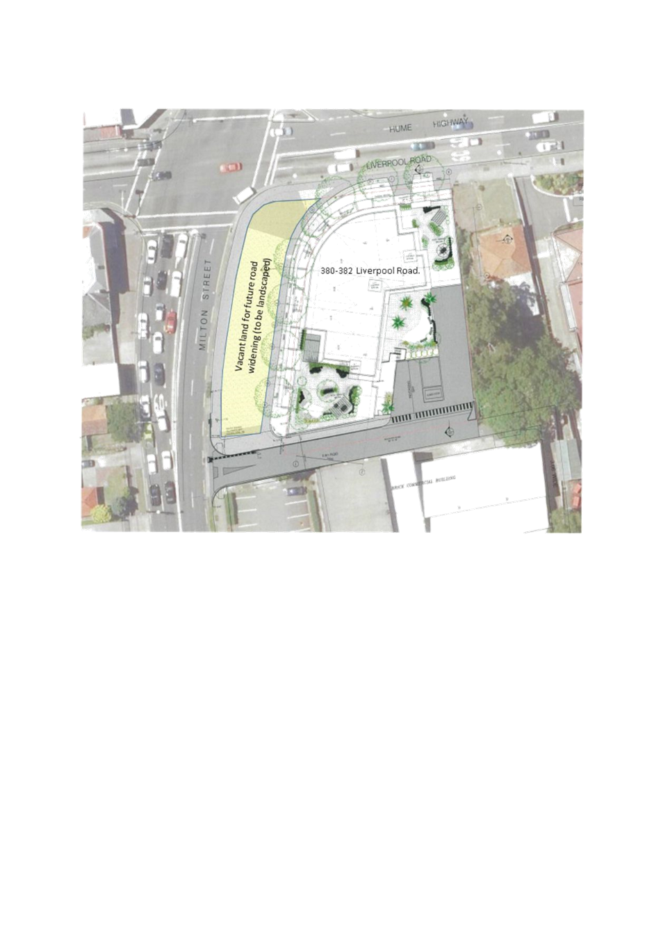
|
|
Local Traffic
Committee Meeting
2 November 2020
|
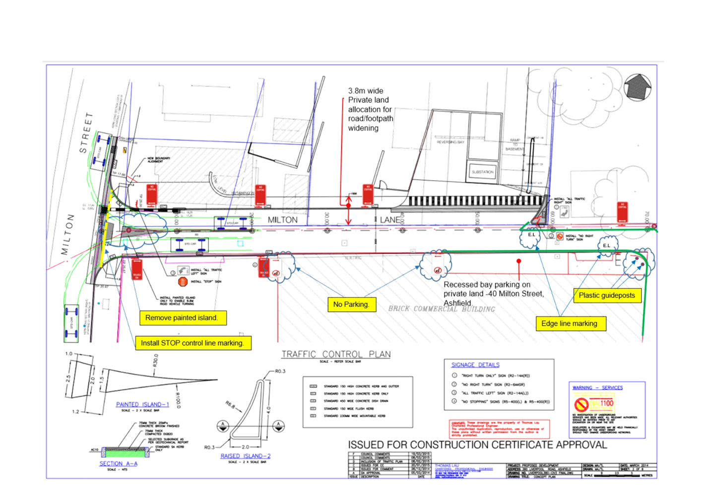
|
|
Local Traffic
Committee Meeting
2 November 2020
|
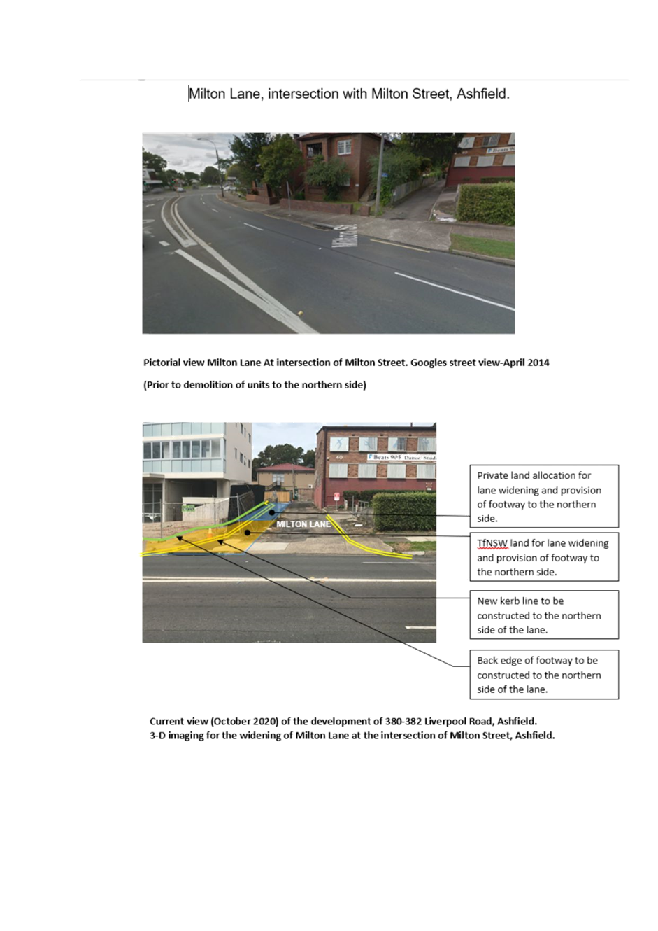
|

|
Local Traffic
Committee Meeting
2 November 2020
|
Item No: LTC1120
Item 10
Subject: Unnamed Laneway between May Street and The
Boulevarde, Lilyfiled - Christmas Street Party (Road Occupancy)
(Balurdarri-Balmain Ward/ Balmain Electorate/ Leichhardt PAC)
Prepared By: Vinoth
Srinivasan - Engineer - Traffic and Parking Services
Authorised By: Manod
Wickramasinghe - Traffic and Transport Planning Manager
SUMMARY
Council has received an
application for approval of an annual Christmas street party in the Unnamed
Laneway between May Street and The Boulevarde, Lilyfield to be held on Saturday,
12 December 2020 between 2:00pm and 11:00pm.
|
RECOMMENDATION
THAT the proposed temporary
road closure of the Unnamed Laneway, Lilyfield between May Street and The
Boulevarde (section at the rear of Nos.355-367 Balmain Road) on Saturday, 12 December
2020, from 2:00pm - 11:00pm (with a contingency date if Saturday, 19
December 2020) , be APPROVED, in order to hold a street party, subject
to the conditions of approval as set out in the Street Party Application Form
and the following additional conditions:
1. Latest government and health advice on Covid-19 is
followed at the time of the event including gatherings and/or social
distancing restrictions;
2. All affected residents and businesses,
including the NSW Police Local Area Command, Fire & Rescue NSW and NSW
Ambulance Services be notified in writing, by the applicant, of the proposed
temporary road closure at least 14 days in advance of the closure with the
applicant making reasonable provision for stakeholders;
3. The applicant is to set out the road closure as
per the attached typical Traffic Control Plan (TCP) and a 3-metre wide
emergency vehicle access be maintained through the closed road areas during
the course of the event; and
4. The occupation of the road carriageway must not
occur until the road has been physically closed.
|
BACKGROUND
& OTHER STAFF COMMENTS
The Unnamed Laneway street party
is an annual event and no significant issues have occurred in the past.
Council encourages properly
conducted neighbourhood street parties as a means of building community spirit
and improving neighbourhood security. Fees for road occupancy are waived by
Council for small community street parties. For approved street parties and
subject to availability Council will provide barricades and ‘Road
Closed’ signs subject to the street party coordinator arranging
collection from and return to Council’s depot.
According to the RMS ‘Guide
to Traffic and Transport Management for Special Events’ a small street
party is considered as a ‘Class 3’ event. Impacts of the road
closure for the event are considered minimal. Vehicular access for
residents/businesses is to be maintained during the closure, where possible. A
typical ‘standard’ Traffic Control Plan (TCP) for the Closure is
reproduced below.
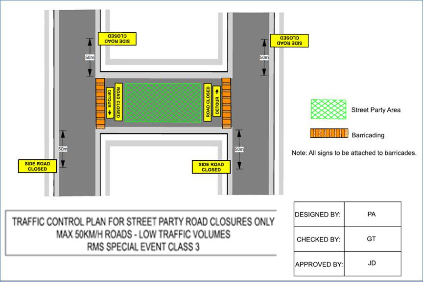
FINANCIAL IMPLICATIONS
Nil.
PUBLIC CONSULTATION
The proposed road closure is
currently advertised on Council’s website in accordance with the Roads
Act 1993.
ATTACHMENTS
Nil.
|
|
Local Traffic
Committee Meeting
2 November 2020
|
Item No: LTC1120
Item 11
Subject: James Street, Leichhardt - Christmas Street
Party (Gulgadya - Leichhardt Ward/ Balmain Electorate/ Leichardt PAC)
Prepared By: Vinoth
Srinivasan - Engineer - Traffic and Parking Services
Authorised By: Manod
Wickramasinghe - Traffic and Transport Planning Manager
SUMMARY
Council has received an
application for approval of an annual Christmas street party in James Street
between William Street and Allen Street, Leichhardt to be held on Saturday, 12 December
2020 between 2:00pm and 11:00pm.
|
RECOMMENDATION
THAT the proposed temporary
road closure of James Street, Leichhardt between William Street and Allen
Street on Saturday, 12 December 2020, from 2:00pm - 11:00pm, be APPROVED,
in order to hold a street party, subject to the conditions of approval as set
out in the Street Party Application Form and the following additional
conditions:
1. Latest government and health advice on Covid-19 is
followed at the time of the event including gatherings and/or social
distancing restrictions;
2. All affected residents and businesses,
including the NSW Police Local Area Command, Fire & Rescue NSW and NSW
Ambulance Services be notified in writing, by the applicant, of the proposed
temporary road closure at least 14 days in advance of the closure with the
applicant making reasonable provision for stakeholders;
3. The applicant is to set out the road closure as
per the attached typical Traffic Control Plan (TCP) and a 4-metre wide
emergency vehicle access be maintained through the closed road areas during
the course of the event; and
4. The occupation of the road carriageway must not
occur until the road has been physically closed.
|
BACKGROUND
& OTHER STAFF COMMENTS
The James Street Christmas street
party is an annual event and no significant issues have occurred in the past.
Council encourages properly
conducted neighbourhood street parties as a means of building community spirit and
improving neighbourhood security. Fees for road occupancy are waived by Council
for small community street parties. For approved street parties and subject to
availability Council will provide barricades and ‘Road Closed’
signs subject to the street party coordinator arranging collection from and
return to Council’s depot.
According to the RMS ‘Guide
to Traffic and Transport Management for Special Events’ a small street
party is considered as a ‘Class 3’ event. Impacts of the road
closure for the event are considered minimal. Vehicular access for
residents/businesses is to be maintained during the closure, where possible. A
typical ‘standard’ Traffic Control Plan (TCP) for the Closure is
reproduced below.
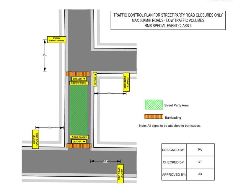
FINANCIAL IMPLICATIONS
Nil.
PUBLIC CONSULTATION
The proposed
road closure is currently advertised on Council’s website in accordance
with the Roads Act 1993.
ATTACHMENTS
Nil.